Indian Institute of Remote Sensing
40
Indian Institute of Remote Sensing M.Tech. M.Sc. PGD Brochure 2022 Placement Hkkjrh; lqnwj laosnu laLFkku nsgjknwu@Dehradun
-
Upload
khangminh22 -
Category
Documents
-
view
0 -
download
0
Transcript of Indian Institute of Remote Sensing

Indian Institute of Remote Sensing
M.Tech. M.Sc. PGD
Brochure2022Placement
Hkkjrh; lqnwj laosnu laLFkku
nsgjknwu@Dehradun

Vision“Achieve excellence and remain in the forefront for capacity building in Remote Sensing &
Geoinformatics and their applications”
Mission “Transfer technology through capacity building and research in the field of Remote Sensing and
Geoinformatics for sustainable Development”
Indian Institute of Remote Sensing (IIRS) under Indian Space Research Organisation (ISRO), Department of Space, Govt. of India is a premier training and educational Institute establishment in 1966 and committed to prepare Professionals in the field of Remote sensing, Geoinformatics and GPS Technology for Natural Resources, Environment and Disaster Management. The Institute also host's Centre for Space Science & Technology Education in Asia and Pacific (affiliated to United Nations) and conducts International Training Programmes.
The training and education programmes conducted by the Institute include: i) M.Tech (RS & GIS) in nine disciplines conducted in collaboration with Andhra University, Visakhapatnam, The course is approved by the All India Council for Technical Education (AICTE) ii) M.Sc. and PG Diploma courses in Geoinformatics conducted in collaboration with the Faculty of Geo-information Science & Earth Observation (ITC) of the University of Twente (UT), The Netherlands iii) Post-graduate
Diploma (PGD) in Remote Sensing and GIS in nine disciplines. The Institute also conducts various other courses, namely i) Certificate programmes (including NNRMS-ISRO sponsored programme for University faculty) ii) Special on-demand/tailor-made courses. The Institute has so far trained 13,324 professionals representing 104 countries from the Asia, Africa and South America.
Under the Outreach Programmes, the Institute conducts several courses for working professionals, researchers and students through state-of-the-art studio and e-learning concept. Currently, 3066 Institutes/Organizations spread across India are networked with IIRS. More than 4,86,611 lakh participants have benefitted so far from IIRS Outreach Programmes.
The Placement Brochure of 2022 includes the skills acquired by IIRS students through training/education and project work that they have carried out as a part of their Course Curricula. I am sure that the Placement Brochure shall be helpful to the Geospatial Industry, Academia and other Institutions to pick the talent and also provide opportunity to the course participants for their placement.
I wish very bright future and steady career for our students.
Director, IIRSDr. Prakash Chauhan
Indian Institute of Remote Sensing
DIRECTOR'S DESK

Indian Institute of Remote Sensing
Director's Desk
Contents
Profile of The Institute P
AG
E
1
IIRS - Groups and DepartmentsP
AG
E
3
M.Sc. Profile of The Batch 2020-2022P
AG
E
21
Training, Education & Capacity Building ProgrammesP
AG
E
2
M.Tech. Profile of The Batch 2020 - 2022P
AG
E
8
P.G.D. (Geoinformatics)Profile of The Batch 2021-2022P
AG
E
25
P.G.D. (RS&GIS)Profile of The Batch 2021-2022P
AG
E
29
PROFILE OF THE INSTITUTE
The Indian Institute of Remote Sensing (IIRS) is a constituent unit of Indian Space Research Organisation (ISRO), Department
of Space, Govt. of India. Since its establishment in 1966, IIRS is a key player for training and capacity building in geospatial
technologies and its applications through training, education and research in Southeast Asia. The training, education and
capacity building programmes of the Institute are designed to meet the requirements of Professionals at working levels, fresh
graduates, researchers, academia, and decision makers. IIRS is also one of the most sought after Institute for conducting
specially designed courses for the officers from Central and State Government Ministries and stakeholder departments for
the effective utilization of Earth Observation (EO) data. About 40 courses are conducted every year and 13324 professionals
and students have been trained/educated so far. About 50 researchers who have worked under IIRS faculty have received
PhD degrees till date from various Universities.
To widen its outreach, IIRS has started live and interactive Distance Learning Programme (DLP) since 2007. As on date, 3066
Institutes/Organizations are networked with IIRS and more than 4,84,611 participants have attended various basic and
advanced courses conducted by the Institute. IIRS has also launched e-learning course on Remote Sensing and Geo-
information Science since August, 2014.
The Institute has a strong, multi-disciplinary and solution-oriented research agenda that focuses on developing improved
methods/ techniques for processing, visualization and dissemination of EO data & Geo-information for various societal
applications and better understanding of Earth's system processes. Microwave, hyperspectral and high-resolution EO data
processing and their applications is the main research focus, currently. State-of-the-art laboratory and field-based
instrumentation and observatories network help meeting the research goals and objectives.
IIRS hosts headquarters of Centre for Space Science and Technology Education in Asia and the Pacific (CSSTEAP), affiliated
to the United Nations and provides support in conducting the Remote Sensing and GIS training and education programmes.
IIRS also plays a key role in the activities of Indian Society of Remote Sensing (ISRS), which is one of the largest non-
governmental Scientific Societies in the country.
1
Indian Institute of Remote Sensing

Indian Institute of Remote Sensing
Director's Desk
Contents
Profile of The Institute P
AG
E
1
IIRS - Groups and DepartmentsP
AG
E
3
M.Sc. Profile of The Batch 2020-2022P
AG
E
21
Training, Education & Capacity Building ProgrammesP
AG
E
2
M.Tech. Profile of The Batch 2020 - 2022P
AG
E
8
P.G.D. (Geoinformatics)Profile of The Batch 2021-2022P
AG
E
25
P.G.D. (RS&GIS)Profile of The Batch 2021-2022P
AG
E
29
PROFILE OF THE INSTITUTE
The Indian Institute of Remote Sensing (IIRS) is a constituent unit of Indian Space Research Organisation (ISRO), Department
of Space, Govt. of India. Since its establishment in 1966, IIRS is a key player for training and capacity building in geospatial
technologies and its applications through training, education and research in Southeast Asia. The training, education and
capacity building programmes of the Institute are designed to meet the requirements of Professionals at working levels, fresh
graduates, researchers, academia, and decision makers. IIRS is also one of the most sought after Institute for conducting
specially designed courses for the officers from Central and State Government Ministries and stakeholder departments for
the effective utilization of Earth Observation (EO) data. About 40 courses are conducted every year and 13324 professionals
and students have been trained/educated so far. About 50 researchers who have worked under IIRS faculty have received
PhD degrees till date from various Universities.
To widen its outreach, IIRS has started live and interactive Distance Learning Programme (DLP) since 2007. As on date, 3066
Institutes/Organizations are networked with IIRS and more than 4,84,611 participants have attended various basic and
advanced courses conducted by the Institute. IIRS has also launched e-learning course on Remote Sensing and Geo-
information Science since August, 2014.
The Institute has a strong, multi-disciplinary and solution-oriented research agenda that focuses on developing improved
methods/ techniques for processing, visualization and dissemination of EO data & Geo-information for various societal
applications and better understanding of Earth's system processes. Microwave, hyperspectral and high-resolution EO data
processing and their applications is the main research focus, currently. State-of-the-art laboratory and field-based
instrumentation and observatories network help meeting the research goals and objectives.
IIRS hosts headquarters of Centre for Space Science and Technology Education in Asia and the Pacific (CSSTEAP), affiliated
to the United Nations and provides support in conducting the Remote Sensing and GIS training and education programmes.
IIRS also plays a key role in the activities of Indian Society of Remote Sensing (ISRS), which is one of the largest non-
governmental Scientific Societies in the country.
1
Indian Institute of Remote Sensing

The training and capacity building
programmes of the Institute are designed
to meet the requirements of various
target/user groups, i.e., for professionals
at working, middle and supervisory levels,
fresh graduates, researchers, academia and
decision makers. The duration of courses
ranges from one-week to two-years. The
programmes are meticulously designed by
the domain experts, and are then approved
by the Board of Studies (BoS) and
Academic Council (AC) consisting of
eminent subject experts. A team of seventy
four dedicated scientists at IIRS contribute
in delivering the course contents. Guest
faculties from reputed organizations
Institutes in the country and abroad are
regularly invited to share their knowledge
and exper ience wi th the course
participants. The training and education
programmes conducted by the Institute
include:
1. M.Tech. (RS & GIS) in nine disciplines
conducted in collaboration with
Andhra University, Visakhapatnam.
(AICTE).
2. M.Sc. and PG Diploma (PGD) in
Geoinformat ics conducted in
collaboration with the Faculty of Geo-
in format ion Sc ience & Ear th
Observation (ITC) of the University of
Twente (UT), The Netherlands.
3. PGD in Remote Sensing and GIS in
nine disciplines,
The Institute also conducts various other
courses, namely i) Certificate programmes
(including NNRMS-ISRO sponsored
programme for University faculty),
ii) Special on-demand/tailor-made
courses. The Institute has so far trained
13,324 professionals representing 104
countries from the Asia, Africa and South
America.
Under the Outreach Programmes, the
Institute conducts several courses for
working professionals, researchers and
students through state-of-the-art studio
and e-learning concept. Currently, 3066
institutions and organizations spread
across India are networked with IIRS. More
than 4,84,611 participant have benefitted so
far from IIRS Outreach Programmes.
The Institute also provides opportunities
to external students to pursue their
research under the guidance of IIRS
faculty. IIRS is a recognized centre for
carrying out research leading to PhD by
Forest Research Institute (Deemed
University), University of Pune, Doon
U n i v e r s i t y , K u m a o n U n i v e r s i t y ,
Uttarakhand Technical University and IIT,
Roorkee. About 50 researchers who have
worked under IIRS faculty have received
Ph.D. degrees till date from different
universities. External Post-graduate/
Graduate students are also given
opportunity to conduct their project work
under the guidance of IIRS faculty.
Due to prevailing COVID-19 pandemic
situation in the country and health risk
involved in travel, selection of eligible self-
sponsored candidates for admissions in
M.Tech., M.Sc. and P.G. Diploma
programmes were based on online
interview and Academic career (in place of
Entrance Test).
TRAINING, EDUCATION & CAPACITY BUILDING PROGRAMMES
2
Indian Institute of Remote Sensing
Programme Planning and Evaluation Group
The Programme Planning and Evaluation Group (PPEG) coordinates the training, education and capacity building, human
resources development, budget, hostels, library, placements, etc. activities of the Institute. It also coordinates the inter-centre
activities and liaison with other institutions in the country and abroad. PPEG also maintains the IIRS alumni database. It is also
responsible for initiating and coordinating several other techno-managerial activities of the Institute.
Central Library
The Library is dedicated to serve the information needs of the scientists, researchers and students of the Institute. Few
highlights of IIRS Library are (i) Remote access to library e-resources (ii) Strengthening information resources (iii) Journal TOC
(iv) Collection development (v) Inter Library loan / delivery with local/DOS libraries (vi) User education/orientation.
IIRS - GROUPS AND DEPARTMENTS
Budget Planning and Monitoring Department
With the increasing responsibilities and mandates of the Institute it is pertinent to mention that the budgetary allocations have
increased in recent financial years. This has spearheaded gamut of techno-managerial and financial activities and other critical
correspondences with Hqs. The BPMD takes care of pertinent budget planning and monitoring related formalities and procedures
in the Institute.
3
Indian Institute of Remote Sensing
Academics and Respond Department
The ARD department takes care of academics related activities of PPEG/IIRS, i.e. Admissions, Results & Students' Affairs, as
well as activities related to Sponsored Research at IIRS. The sponsored research activities are carried out under various
umbrellas/categories such as RESPOND, Space Technology Cells, Regional Academic Centres (RAC-S) etc.

4
Indian Institute of Remote Sensing
Marine & Atmospheric
Sciences Department (MASD)
MASD was formed in year 1986 and offers training
& education courses and provides research
opportunities in the areas of coastal processes,
marine resources, ocean and atmospheric sciences
applications. The department has contributed in
different research and operational projects of
ISRO/DOS, such as National Action Plan for
Climate Change Project (NAPCCP), Land
Degradation Mapping on 1:50,000 scale, Oceansat-
II data utilization project, National Carbon Project
(NCP), SARAL-AltiKa project, etc. Some of the
research projects (ongoing/ completed) at MASD
are atmospheric pollution modeling, extreme
events forecasting, coastal hazards and their
mitigation, ocean color and primary productivity,
upper-ocean geophysical parameter retrieval,
aerosol radiative Forcing, etc.
Agriculture & Soils Department (ASD)
ASD is one of the oldest department established in 1966. ASD has carried out many R&D and consultancy projects in soil surveys, watershed prioritisation, land evaluation, agricultural resources inventory, agro-meteorology, soil moisture, etc. Some of the research projects (ongoing/ completed) at ASD are process based modeling for soil erosion, soil carbon sequestration, carbon accounting modeling by integrating flux observation, drought monitoring and climate change impact studies etc. The department is equipped with a variety of portable ground-truth equipment for quantitative measurements of bio-physical and physico-chemical properties of soils and crops, and a Soil Analysis Laboratory for the physico-chemical analysis of soils.
IIRS - GROUPS AND DEPARTMENTS
Forestry & Ecology Department (FED)
FED was established in 1966 with the aim of providing training and skills development on the utility of aero-space remote sensing for forest resource inventory, monitoring and management. Nationwide forest cover mapping, nationwide biome level characterization, Indian forests biodiversity characterization at landscape level are the major projects planned and executed by the department. A few other important research projects carried out by the department are growing stock and biomass assessment, ecosystem dynamics, wildlife habitat modelling, ecological and wildlife corridor modelling and connectivity analysis, national level carbon flux measurement and modelling, grassland mapping and carrying capacity estimation, etc.
Urban & Regional Studies
Department (URSD)
To meet the growing needs and challenges of urban areas
and towards regional development, URSD was
established in 1983 in collaboration with ITC, the
Netherlands. The department is working in close
coordination with Town and County Planning
Departments/ Urban Local Bodies with the aim to spread
the benefits of remote sensing technology at grassroots
level. It has developed expertise in the field of urban
sprawl and growth modeling, urban environment
analysis and regional analysis. Some of the research
projects (ongoing/completed) at URSD are urban micro-
climate zonation for sustainable Smart City planning,
modeling of urban air pollution, urban material detection
using hyperspectral RS data, urban flooding modeling,
solar energy potential assessment, etc. The department
regularly conducts special courses for town and country
planning officials from state and central government
departments.
IIRS - GROUPS AND DEPARTMENTS
Water Resource Department (WRD)
WRD was established in the year 1986 and since then it has
emerged as leader in capacity building and research in
various fields of hydrology and water resources
management. The department specializes in remote
sensing based hydrologic parameter retrieval and
modelling; data assimilation; watershed characterization
and conservation planning; snow and glacier melt runoff
modelling; data assimilation; watershed characterization
and conservation planning, snow and glacier melt runoff
modelling, Irrigation water management, flood mapping,
monitoring and modelling; drought assessment; soil
erosion, and sediment yield modelling; reservoir
sedimentation; , surface and ground water studies, climate
change impact assessment; and hydro-environmental
impact assessment and site suitability analysis of water
resources projects. The department has initiated advanced
research in field of flood early warning systems; polar
remote sensing; microwave and hyperspectral remote
sensing applications. The department is well equipped
with latest field and portable equipment. It regularly
conducts special courses for officials of state and central
water resources department.
5
Indian Institute of Remote Sensing

6
Indian Institute of Remote Sensing
Geospatial Technologies and Outreach Programme GroupGeospatial Technologies and Outreach Programme Group (GTOP) comprises of three departments namely, Photogrammetry & Remote Sensing, Geoinformatics, Geoweb Services, IT & Distance Learning Department
Photogrammetry & Remote Sensing Department (PRSD)PRSD established in 1966 is imparting professional training in the field of photogrammetry, cartography, remote sensing and image processing. It has successfully executed a number of studies/projects on large-scale surveys and preparation of photo-maps in different parts of the country, generation of national/global level database on land use/land cover, augmentation of forest cover information in India and Myanmar, generation of land surface parameters for monsoon variability studies using Regional Climate Model, etc. Recent research projects at PRSD are UAV data processing for terrain information extraction, LiDAR-RS, SAR Tomography, SAR calibration, hyperspectral remote sensing, automated features extraction, Large scale mapping, Machine Deep Learning, etc.
Geoinformatics Department (GID)This department was set-up in 1996 in collaboration with University of Twente, Faculty of Geo-information Science & Earth Observation (ITC), The Netherlands, for offering courses in the field of Geoinformation Science. The M.Sc. & PG Diploma course in course in Geo information Science and Earth Observation (specialisation in Geoinformatics) is one of its major programme offered since 2002 as a part of Joint Education Programme (JEP) of IIRS and ITC, The Netherlands. The department conducts training, education and research in field of Geoinformatics like GIS, Web GIS Geospatial modeling, 3-D City Models, Spatial Data Mining, Health GIS and machine learning and deep leading. GID is offering courses in the upcoming fields like Big data Analytics, AI based machine learning and deep learning algorithms, Tourism GIS and GIS for Supply Chain Management. The GID department has developed mobile app and dashboard like Swachh bharat abhiyaan, forest fire reporting for state forest department, geotagging for animal husbandary and kumbha mela applications.
Geoweb Services, IT & Distance Learning (GIT & DL)GIT&DL is recently formed department at IIRS to meet the increasing demand of capacity building. The department is involved in capacity building & R&D activities in Web-GIS, Mobile GIS, Location Based Services (LBS), Cloud GIS, etc. It is also carrying out capacity building in Geospatial technologies through Distance Learning mode (Live & interactive and e-learning), R&D activities on active learning, Digital contents creation, R&D activities on 2D and 3D simulations and virtualization, etc. It is also carrying out the IT Infrastructure development, set-up and operations for the Institute.
IIRS - GROUPS AND DEPARTMENTS
Geosciences and Disaster Management Studies Group
The Geosciences and Disaster Management Studies Group (GDMSG) consist of two department namely, (i) Geosciences Department
and (ii) Disaster Management Studies Department.
Geosciences Department (GSD)
GSD is, one of the oldest department of IIRS, was established in 1966 to provide professional training to scientists and technical staff of
Government and Public Sector organizations dealing with geoscientific applications such as geological survey and mapping, mineral
and oil exploration, engineering geological survey, ground water exploration, etc. It has successfully executed a large number of
projects which include Geodynamics of the Himalaya, Landslide modelling, Seismic hazard assessment, Active fault mapping,
Liquefaction modelling, Differential Interferometric SAR (DInSAR) based land surface displacement modelling, and Coal mine fire
and subsidence modelling. The present thrust areas of the department include microwave and hyperspectral image analysis, GNSS
and seismic data analysis, glacial dynamics, planetary geology, spaceborne gravity and ground based geophysical data analysis and
engineering geological studies.
Disaster Management Studies Department (DMSD)
DMSD is dedicated towards capacity building and research in assessment, monitoring and modelling of natural and anthropogenic
disasters with prime focus on prevention and mitigation measures leading to disaster risk reduction. The DMSD conducts PGD and
M.Tech. in RS and GIS applications in Natural Hazards and Disaster Management Studies with specialisation in Hydro-meteorology
and Geological hazards. Disaster Management supports, activities at IIRS carried out by several departments and significant activities
include Landslide modelling, Seismic Hazard Assessment, Forest Fire Risk Assessment, Flood modelling, extreme weather prediction
and atmospheric pollution studies. Present focus is on development of EWS and early detection techniques for various natural
hazards using EO and ground based observation.
IIRS - GROUPS AND DEPARTMENTS
7
Indian Institute of Remote Sensing

M.Tech. (RS&GIS)
The aim of the M.Tech. (RS&GIS) course is to provide in-depth understanding of remote sensing, satellite image analysis, Geographic Information System (GIS) and Global Navigation Satellite System (GNSS) & LiDAR technologies and their applications in natural resources survey and monitoring including Agriculture and Soils, Forestry and Ecology, Geology and Mineral Resources, Water Resources, Marine and Atmospheric Sciences, Urban and Regional Planning and Disaster Management.
It is a four-semester course in which first two semesters are devoted to exhaustive course work and other two semesters have a research project. The course work consists of 5 core papers in technology area, 4 core papers in subject specialization,1 core paper in research skill development and 3 choice based elective papers. Two elective papers, include advanced geospatial technology such as Web Technology, Geodata Visualization, Statistics & Programming of Geodata, Natural Resources Management, Environmental Monitoring and Climate Change Studies. In the third elective paper, a candidate needs to carry out a theme-specific interdisciplinary case study seminar out of the 60 topics offered from 9 specializations-
· Agriculture and Soils
· Forest Resources & Ecosystem Analysis
· Geoinformatics
· Geosciences
· Marine & Atmospheric Sciences
· Satellite Image Analysis & Photogrammetry
· Urban & Regional Studies
· Natural Hazards & Disaster Management
· Water Resources
M.Tech. Course Structure
Semester - I
Module – I(4.5 months)
Project Work(13.5 months)
Module – III(3 months)
*Module – II(3 months)
Semester - III & IVSemester - II
Compulsory(Core) Papers
· Remote
Sensing & Image Interpretation
· Digital Image
Processing
· Geographic
Information System
· Photogram-
metry & Cartography
Elective Papers
· Statistics &
Programming for Geodata
· Statistics & RS
Applications in NRM
EachSpecializationhas 4 subjects
· Agriculture &
Soils
· Forestry
Resources & Ecosystem Analysis
· Geoinformatics
· Geosciences
· Marine &
Atmospheric Science
· Satellite Image
Analysis & Photogr-ammetry
· Urban and
Regional Studies
· Water
Resources
· Natural
Hazards & Disaster Risk Management
Compulsory(Core) Papers
· Research Skills
Elective Papers
· Technology and Standards
for Geospatial
workflows
· Geospatial Technologies for Environmental Monitoring and Analysis
· Analytical
Cartography
and 3D GIS
· Climate Change Impact on Natural Resources
· Multi-DisciplinaryCase Study/Seminar
Project Work and Defence
M. TECH. Profile of the Batch2020 - 2022
*Core papers under each specialization as per table given on page no. 29
8
Qualifications
Area of Interest
Software Skills
Thesis
Abstract
M.Tech. in Remote Sensing & GIS (Specialization: Marine and Atmospheric Sciences)
M.Sc. (Oceanography), B.Sc. (Chemistry)
Ocean modelling, Bio-optical Oceanography, Ocean Biogeochemistry, Ocean Plastic Pollution, Climate Change Studies, Ocean-atmospheric Interaction, Satellite Image Processing and Analysis, Geospatial Application for
Natural Resource Management, Meteorology.
MATLAB, NCL, CDO, Ferret, Python, ArcGIS, QGIS, ERDAS Imagine, SeaDAS, ENVI, SNAP, GrADS, Photoshop, Google
Earth Engine, Grapher, SPSS Autocad-3D, Linux OS.
Study the Indian Ocean Dipole induced variability in the upper ocean dynamics and thermodynamics: An
investigation using numerical ocean modelling, in-situ,and satellite data.
The project aims to the configuration of Regional Ocean Modelling System (ROMS) over the Indian Ocean domain
for realistic simulation of physical oceanographic parameters on the surface and subsurface variability in response to different Indian Ocean Dipole (IOD) events.
The model simulated variables will be validated with the satellite and in-situ data to study the contrasting IOD
events and to investigate the dynamic and thermodynamic processes regulating the evolution of IOD events.
amitk
umar
jena
868@
gmai
l.com
Amit Kumar Jena
Qualifications
Area of Interest
Software Skills
Thesis
Abstract
M.Tech. in Remote Sensing & GIS (Specialization: Marine & Atmospheric Sciences)
M.A. (Geography), B.Sc. (Computer Science)
Application of Remote Sensing & GIS in Pollution Control, Climate Change, Meteorology, Fog analysis, Climatology,
Atmospheric and Cloud Modelling, Surveying and Cartography, Geomorphology, Geopolitical Dynamics,
Oceanography, Cultural Ecology.
Python, C, C++, R, MATLAB, ArcGIS, QGIS, ERDAS Imagine, Panoply, ENVI, SNAP, GrADS, Google
Earth Engine, SeaDas
Fog Retrieval Over Indo-Gangetic Plains Using INSAT-3DR Data
The study aims for the development of whole day Fog retrieval algorithm including dawn & dusk time using
random forest machine algorithm to detect fog over Indo-Gangetic plains using INSAT-3DR imager. Validation of the
same will be done from ground truth data, with test of various parameters for fog estimation.
aksh
sinh
a094
@gm
ail.c
om
Akshay Singh
9
Indian Institute of Remote Sensing
Qualifications
Area of Interest
Software Skills
Thesis
Abstract
M.Tech in Remote sensing and GIS (Specialization: Satellite image analysis and
photogrammetry)B.Tech (Electronics & Communication)
SAR Polarimetry, Radar Planetary Studies, Image processing Algorithms, Mathematical modelling,
Deep Learning, Cryosphere studies, Climate modelling
Python, Linux, C++, Snap, ArcGIS, Envi, Erdas, Matlab, Google Earth Engine, PolSARPro, ISIS
Polarimetric modeling for lunar surface characterization using Chandrayaan-2 L & S Band DFSAR data.
SAR is a powerful tool when it comes to extraterrestrial observation and with time, radar systems are evolving and providing more sensitive information about the target body. The goal of this study is to incorporate CH-2 DFSAR data for
polarimetric modeling. DFSAR works in dual frequency mode, one of them is L-band (1.25 GHz) and L-band has
higher penetration capabilities. Full polarimetric mode will provide complete scattering information of the target. These
two features of DFSAR are first ever in moon planetary missions therefore will bring out the new insight of the
lunar surface and sub-surface.
iikks
shhu
u@gm
ail.c
om
Aanchal Sharma

Qualifications
Area of Interest
Software Skills
Thesis
Abstract
M.Tech in Remote sensing and GIS (Specialization: Satellite image analysis and
photogrammetry)B.E. (Electronics & Telecommunication)
Digital Image Processing, Algorithm Development,Deep Learning applications on Satellite data, SAR Data
Processing, Crop Modelling
Python, C++, MATLAB, QGIS, ArcGIS, SNAP, ERDAS Imagine, Google Earth Engine, VHDL, Xilinx ISE,
Intel Quartus Prime, Keil, Arduino IDE, ModelSim, Atmel Studio, LabVIEW
CNN Based Deep Learning Vs Fuzzy Machine Learning For Medicinal Plant Mapping Using Dual-sensor Temporal
Remote Sensing Data
A major hurdle while specific crop mapping is the heterogeneity within class. The study aims at performing specific crop mapping using two different approaches i.e. CNN and Fuzzy Machine Learning. In order to highlight the target crop based on its phenology, dual sensor temporal data is utilized. The results are evaluated on the basis of efficiency while handling mixed pixel problem as well as
heterogeneity within the class.
anam
sabi
r133
1@gm
ail.c
om
Anam Sabir
10
Indian Institute of Remote Sensing
Qualifications
Area of Interest
Software Skills
Thesis
Abstract
M. Tech in Remote Sensing & GIS (Specialization: Geoinformatics)
B. Tech (Electronics & Communication Engineering)
Space Situational Awareness, SAR Remote Sensing,
Machine Learning, Image Processing, Automotive GIS.
Embedded C, Python, R, ArcGIS, QGIS, ERDAS Imagine,
ENVI, SNAP, AGI STK, Google Earth Engine, AUTOSAR,
CAN, Microsoft Office, JIRA.
Machine Learning based Spatiotemporal Multi-Sensor Data
Fusion for Surface Coalmine Fire Detection.
A systematic detection and monitoring system for surface
coalmine fires is very crucial to avert or slow down their
propagation and are extremely helpful for quantifying the
economic and environmental loss. The study aims at
utilizing machine learning algorithms to generate high
spatiotemporal resolution images from remote sensing
data for surface coalmine fire detection. The methodology
includes the development of a trained machine learning
algorithm utilizing enhanced convolutional neural networks
for spatiotemporal data fusion as well as algorithms for
surface coalmine fire detection.bi
joge
o494
@gm
ail.c
om
Bijo George Philip
Qualifications
Area of Interest
Software Skills
Thesis
Abstract
M.Tech in Remote sensing and GIS (Specialization: Natural Hazards and Disaster Risk Management)
B.Tech. (Civil Engineering)
Application of Remote Sensing and GIS in Natural hazards and Disaster Risk Management, Vulnerability and Hazard
assessment, Climate change, Disaster Risk Mitigation and Relief Management, Earthquake Precursors, Traffic Jam
analysis using GIS, Identification of best places for construction of DAM in Mountain region, Seismic Hazard analysis.
AutoCAD, Revit, Primavera, Staad Pro, Erdas Imagine, Qgis, ArcGIS, ENVI, SNAP, GrADS, Google Earth.
Study of Thermal and Ionospheric Anomalies as a Precursor of Earthquake.
Earthquakes are the natural hazards that happen suddenly. Though they can't be predicted, some of the signs that point to the impending earthquakes should be observed
before the earthquake hits. Earthquakes are usually preceded by minor changes in the atmosphere and the
ground, these changes are known as earthquake precursor. This study is an attempt to analyze the changes in the Total
Electron Content (TEC) in the Ionospheric region and the Thermal Anomalies on the ground for the earthquake
events that occurred in the past.
Anukrati Joshi
anuk
ratij
22@
gmai
l.com
Qualifications
Area of Interest
Software Skills
Thesis
Abstract
M.Tech. in Remote Sensing & GIS (Specialization: Natural Hazards and Disaster Risk Management)
M.Sc. (Applied Geology)B.Sc. (Geology, Chemistry, Statistics)
Disaster Risk Management, Environmental Impact Assessment, SAR applications in Flood Dynamics,
Hydrological modelling, Hydrogeology, Oceanography, Geomorphology, Impact of Climate change
ERDAS Imagine, ArcGIS, QGIS, SNAP, HEC-HMS, FwDET, ENVI, Google Earth Engine, SedLog, GRADISTAT, Microsoft
Office.
Investigating the Polarimetric and Interferometric characteristics of SAR data to assess the Flood Dynamics
of Kaziranga National Park, Assam
From the dawn of climate change the enraged flood conditions have become the ubiquitous reality. The Kaziranga National Park, a UNESCO world heritage site, situated in the flood
plains of Brahmaputra River basin, is a chronic flood prone area. It requires proper understanding and assessment of the flood condition to help the government to plan better
management and mitigation strategies. This research aims to utilize radar backscatter, InSAR coherence and other polarimetric parameters of C-band space-borne dual-pol
SAR data in machine learning approach to characterize the flood dynamics of Kaziranga National Park for the most
flooded years from 2017 to 2021.
elka
nna1
996@
gmai
l.com
Elka Siju
11
Indian Institute of Remote Sensing
Qualifications
Area of Interest
Software Skills
Thesis
Abstract
M.Tech. in Remote Sensing & GIS (Specialization: Urban and Regional Studies)
B.Plan (Urban Planning)
Hydrological modeling, Application of Thermal and Microwave RS, DEM Analysis, Damage Mapping, Urban
growth modeling, Smart cities, Rural Development, Urban and Regional Planning, Transportation Planning, Socio-
economic studies, Photography.
Python, R, Google Earth Engine, ArcGIS, QGIS, ENVI, SNAP, ERDAS Imagine, MIKE URBAN, SWMM, HEC-HMS,
HEC-RAS, AutoCAD, Microsoft Office.
Urban Flood Risk Modeling Based on Vegetation-Impervious Surface-Soil (V-I-S) Fraction Analysis and
Bivariate Techniques
Among the various factors that contribute to increasing flood risks, changes in climate and urban growth are the
most influential factors affecting hydrological characteristics in urban and extra-urban contexts that
challenge the current and future urban flood management strategies. This study aims to analyze a fluvial and a pluvial flood hazard individually, but also to develop a method for the analysis of a combined pluvial and fluvial flood hazard
estimating the hydrological outputs using MIKE URBAN, SWMM
godd
upav
ansa
igou
d@gm
ail.c
om
Goddu Pavan Sai Goud
ishw
arn9
3@gm
ail.c
om
Qualifications
Area of Interest
Software Skills
Thesis
Abstract
M.Tech. Remote Sensing & GIS (Specialization: Water Resources)B.Tech. (Agricultural Engineering)
Irrigation Water Management, Watershed Development, Watershed Prioritization, Hydrological Modelling,
Policy and Framework, Satellite Altimetry, Surface Energy Balance Algorithms.
R, R Studio, Google Earth Engine, ArcGIS, QGIS, ERDAS, ENVI, BRAT, HEC-HMS, HEC-RAS, EPANET, MODFLOW,
Microsoft Office Products.
Analyzing the Impact of Temporal Availability of Remote Sensing Data on Time Integration of Actual
Evapotranspiration for Better Irrigation Water Management
Evapotranspiration estimation plays very important role in water balance studies over an area. This work
includes derivation of actual evapotranspiration using Land Surface Energy Balance method to precisely
estimate Evapotranspiration using available Satellite data. This would further be used to establish the
correlation between what satellite temporal resolution and interpolation techniques can best estimate the
Evapotranspiration for a given area.
Ishwar Dattatray Nalawade

Qualifications
Area of Interest
Software Skills
Thesis
Abstract
M.Tech in Remote sensing and GIS (Specialization: Satellite image analysis and
photogrammetry)B.E. (Electronics & Telecommunication)
Digital Image Processing, Algorithm Development,Deep Learning applications on Satellite data, SAR Data
Processing, Crop Modelling
Python, C++, MATLAB, QGIS, ArcGIS, SNAP, ERDAS Imagine, Google Earth Engine, VHDL, Xilinx ISE,
Intel Quartus Prime, Keil, Arduino IDE, ModelSim, Atmel Studio, LabVIEW
CNN Based Deep Learning Vs Fuzzy Machine Learning For Medicinal Plant Mapping Using Dual-sensor Temporal
Remote Sensing Data
A major hurdle while specific crop mapping is the heterogeneity within class. The study aims at performing specific crop mapping using two different approaches i.e. CNN and Fuzzy Machine Learning. In order to highlight the target crop based on its phenology, dual sensor temporal data is utilized. The results are evaluated on the basis of efficiency while handling mixed pixel problem as well as
heterogeneity within the class.
anam
sabi
r133
1@gm
ail.c
om
Anam Sabir
10
Indian Institute of Remote Sensing
Qualifications
Area of Interest
Software Skills
Thesis
Abstract
M. Tech in Remote Sensing & GIS (Specialization: Geoinformatics)
B. Tech (Electronics & Communication Engineering)
Space Situational Awareness, SAR Remote Sensing,
Machine Learning, Image Processing, Automotive GIS.
Embedded C, Python, R, ArcGIS, QGIS, ERDAS Imagine,
ENVI, SNAP, AGI STK, Google Earth Engine, AUTOSAR,
CAN, Microsoft Office, JIRA.
Machine Learning based Spatiotemporal Multi-Sensor Data
Fusion for Surface Coalmine Fire Detection.
A systematic detection and monitoring system for surface
coalmine fires is very crucial to avert or slow down their
propagation and are extremely helpful for quantifying the
economic and environmental loss. The study aims at
utilizing machine learning algorithms to generate high
spatiotemporal resolution images from remote sensing
data for surface coalmine fire detection. The methodology
includes the development of a trained machine learning
algorithm utilizing enhanced convolutional neural networks
for spatiotemporal data fusion as well as algorithms for
surface coalmine fire detection.
bijo
geo4
94@
gmai
l.com
Bijo George Philip
Qualifications
Area of Interest
Software Skills
Thesis
Abstract
M.Tech in Remote sensing and GIS (Specialization: Natural Hazards and Disaster Risk Management)
B.Tech. (Civil Engineering)
Application of Remote Sensing and GIS in Natural hazards and Disaster Risk Management, Vulnerability and Hazard
assessment, Climate change, Disaster Risk Mitigation and Relief Management, Earthquake Precursors, Traffic Jam
analysis using GIS, Identification of best places for construction of DAM in Mountain region, Seismic Hazard analysis.
AutoCAD, Revit, Primavera, Staad Pro, Erdas Imagine, Qgis, ArcGIS, ENVI, SNAP, GrADS, Google Earth.
Study of Thermal and Ionospheric Anomalies as a Precursor of Earthquake.
Earthquakes are the natural hazards that happen suddenly. Though they can't be predicted, some of the signs that point to the impending earthquakes should be observed
before the earthquake hits. Earthquakes are usually preceded by minor changes in the atmosphere and the
ground, these changes are known as earthquake precursor. This study is an attempt to analyze the changes in the Total
Electron Content (TEC) in the Ionospheric region and the Thermal Anomalies on the ground for the earthquake
events that occurred in the past.
Anukrati Joshi
anuk
ratij
22@
gmai
l.com
Qualifications
Area of Interest
Software Skills
Thesis
Abstract
M.Tech. in Remote Sensing & GIS (Specialization: Natural Hazards and Disaster Risk Management)
M.Sc. (Applied Geology)B.Sc. (Geology, Chemistry, Statistics)
Disaster Risk Management, Environmental Impact Assessment, SAR applications in Flood Dynamics,
Hydrological modelling, Hydrogeology, Oceanography, Geomorphology, Impact of Climate change
ERDAS Imagine, ArcGIS, QGIS, SNAP, HEC-HMS, FwDET, ENVI, Google Earth Engine, SedLog, GRADISTAT, Microsoft
Office.
Investigating the Polarimetric and Interferometric characteristics of SAR data to assess the Flood Dynamics
of Kaziranga National Park, Assam
From the dawn of climate change the enraged flood conditions have become the ubiquitous reality. The Kaziranga National Park, a UNESCO world heritage site, situated in the flood
plains of Brahmaputra River basin, is a chronic flood prone area. It requires proper understanding and assessment of the flood condition to help the government to plan better
management and mitigation strategies. This research aims to utilize radar backscatter, InSAR coherence and other polarimetric parameters of C-band space-borne dual-pol
SAR data in machine learning approach to characterize the flood dynamics of Kaziranga National Park for the most
flooded years from 2017 to 2021.
elka
nna1
996@
gmai
l.com
Elka Siju
11
Indian Institute of Remote Sensing
Qualifications
Area of Interest
Software Skills
Thesis
Abstract
M.Tech. in Remote Sensing & GIS (Specialization: Urban and Regional Studies)
B.Plan (Urban Planning)
Hydrological modeling, Application of Thermal and Microwave RS, DEM Analysis, Damage Mapping, Urban
growth modeling, Smart cities, Rural Development, Urban and Regional Planning, Transportation Planning, Socio-
economic studies, Photography.
Python, R, Google Earth Engine, ArcGIS, QGIS, ENVI, SNAP, ERDAS Imagine, MIKE URBAN, SWMM, HEC-HMS,
HEC-RAS, AutoCAD, Microsoft Office.
Urban Flood Risk Modeling Based on Vegetation-Impervious Surface-Soil (V-I-S) Fraction Analysis and
Bivariate Techniques
Among the various factors that contribute to increasing flood risks, changes in climate and urban growth are the
most influential factors affecting hydrological characteristics in urban and extra-urban contexts that
challenge the current and future urban flood management strategies. This study aims to analyze a fluvial and a pluvial flood hazard individually, but also to develop a method for the analysis of a combined pluvial and fluvial flood hazard
estimating the hydrological outputs using MIKE URBAN, SWMM
godd
upav
ansa
igou
d@gm
ail.c
om
Goddu Pavan Sai Goud
ishw
arn9
3@gm
ail.c
om
Qualifications
Area of Interest
Software Skills
Thesis
Abstract
M.Tech. Remote Sensing & GIS (Specialization: Water Resources)B.Tech. (Agricultural Engineering)
Irrigation Water Management, Watershed Development, Watershed Prioritization, Hydrological Modelling,
Policy and Framework, Satellite Altimetry, Surface Energy Balance Algorithms.
R, R Studio, Google Earth Engine, ArcGIS, QGIS, ERDAS, ENVI, BRAT, HEC-HMS, HEC-RAS, EPANET, MODFLOW,
Microsoft Office Products.
Analyzing the Impact of Temporal Availability of Remote Sensing Data on Time Integration of Actual
Evapotranspiration for Better Irrigation Water Management
Evapotranspiration estimation plays very important role in water balance studies over an area. This work
includes derivation of actual evapotranspiration using Land Surface Energy Balance method to precisely
estimate Evapotranspiration using available Satellite data. This would further be used to establish the
correlation between what satellite temporal resolution and interpolation techniques can best estimate the
Evapotranspiration for a given area.
Ishwar Dattatray Nalawade

Qualifications
Area of Interest
Software Skills
Thesis
Abstract
M.Tech. in Remote Sensing & GIS (Specialization: Natural Hazard and Disaster Risk
Management)B. Plan.
Application of Thermal RS in Heat Stress studies, Disaster Risk Assessment and Management, Urban Micro-Climatic Modelling, Spatial Urban Planning,
Climate change studies.
Python (Basic), ArcGIS, QGIS, ERDAS Imagine, Google Earth Engine, ENVI, SNAP, Adobe Photoshop,
Microsoft Office.
Meso scale Spatio-Temporal Modelling of Heat Wave and Heat Stress across Agro-Climatic regions of India.
Vulnerability to heat waves and heat stress is increasing significantly. Urban areas with pre-existing urban heat
island effect along with the increasing temperature creates heat hotspots with minimal thermal comfort. Urban population which is large in number are hence
through put into risk to different natural disasters. Since heat stress studies using spatio-temporal temperature
data are scanty, the current study focuses on the spatial and temporal distribution and modelling of heat waves
and heat stress across India and in some selected hotspots.
laiv
yros
e@gm
ail.c
om
Laivy Rose Augustine
12
Indian Institute of Remote Sensing
Qualifications
Area of Interest
Software Skills
Thesis
Abstract
M.Tech. in Remote Sensing & GIS (Specialization: Urban and Regional Studies)
B.Tech. (Planning), B.A. (Major in Political Science)
Data Analytics, Machine Learning, Environmental & Atmospheric Studies, Project Planning, Socio-Economic
Studies, Public Policy, Statistics, Transportation Planning, Rural Development, Microwave & Thermal Remote
Sensing, UAV, LiDAR
R, Python, JavaScript, HTML, SQL, ArcGIS, QGIS, Google Earth Engine, SNAP, ERDAS Imagine, Blender, Fragstats,
WebGIS, eCognition, ENVI, Open Data Kit, SPSS, AutoCAD, Sketchup, Microsoft Office
A Study of Land Surface Temperature Downscaling Algorithms.
The study aims at downscaling of high temporal and low spatial resolution land surface temperature (LST) data to a
high temporal and high spatial resolution LST data. It focuses on a comparative analysis of traditional statistical
algorithms (TsHARP, GWR) and machine learning based algorithms. Suitability optical satellite data for downscaling the LST data will be found out. Incurring an optimum scale
for downscaled LST data by derivation of indices to showcase the urban heterogeneity will be
performed in the study.
jidny
asap
atil9
8@gm
ail.c
om
Jidnyasa Krishnarao Patil
Qualifications
Area of Interest
Software Skills
Thesis
Abstract
M.Tech. in Remote Sensing & GIS (Specialization: Forest Resources & Ecosystem Analysis)
M. Sc. (Botany)
Biodiversity assessment and conservation, Plant Taxonomy, Forest Spatial Ecology, Crop Monitoring, Biomass Assessment,
Habitat Suitability Analysis, Machine Learning.
Python, R, Google Earth Engine, ArcGIS, QGIS, ERDAS Imagine, ENVI, SNAP, MIDAS, Blender, eCognition, MaxEnt,
GeoServer, 3D Forest.
Spatial Prediction of Alpine Plant Diversity Patterns along Disturbance Gradients using Remote Sensing and Machine
Learning Algorithms
The Himalayan alpine region is sensitive to spatial environmental variability and various natural and
anthropogenic disturbances have significantly influenced the plant species diversity patterns. The study focuses on
the significance of essential remote sensing proxies in determining these diversity patterns along disturbance regimes and assessing their impact on plant diversity
patterns. It applies intensive ground data for training the machine-learning model and identifying suitable remote
sensing proxies for identifying and determining impacts of disturbance gradients on alpine plant diversity.
Joyal Mukesh Arya
arya
joya
l@gm
ail.c
om
Qualifications
Area of Interest
Software Skills
Thesis
Abstract
M.Tech in Remote Sensing & GIS (Specialization: Urban & Regional Studies)
B. Plan.
3D GIS and Remote Sensing, Web GIS, Urban micro-climate studies, Hyperspectral remote sensing, Thermal
remote sensing, Urban expansion analysis, Machine Learning, Urban Governance, Environmental Planning and
Infrastructure planning.
ArcGIS, QGIS, ERDAS Imagine, ENVI, Blender, SNAP (basic), Sketchup, AutoCAD, MS Office Suite, R,
Python (basic), ECognition, Google Earth Engine, Open Data Kit, Web GIS.
Estimation of urban energy fluxes using earth observation data and modelling approaches
Urbanization attracts morphological changes in cities influencing energy use and energy emissions. Due to this, the urban areas tend to have greater energy demand as compared to the rural areas and they end up generating more anthropogenic heat caused by higher emissions from industries, residential and commercial buildings,
vehicles, air conditioners etc. Therefore, the thesis aims to estimate and evaluate the urban energy fluxes using
earth observation dataset.
man
ushi
bhat
t199
5@gm
ail.c
om
Manushi Miteshbhai Bhatt
Qualifications
Area of Interest
Software Skills
Thesis
Abstract
M.Tech. in Remote Sensing & GIS (Specialization: Marine and Atmospheric Sciences)
M.Sc. (Atmospheric Sciences), B.Sc. (Physics)
Climate Dynamics and Modelling, Cloud Microphysics, Numerical Weather Prediction and Forecasting, Ocean Dynamics and Modelling, Precipitation
Microphysics, Dynamic Meteorology, Aeronomy, Aerosol science, Air Pollution
MATLAB, WRF-ARW, R, NCL, FORTRAN, GrADS, SeaDas, Panoply, C, C++, Google Earth Engine,
ArcGIS, QGIS, ERDAS Imagine, ENVI, SNAP, MySQL, Linux (Ubuntu), HYSPLIT
Response of the Indian Summer Monsoon System to the Variable Warming Scenarios
Under warming scenarios SSP2-45 and SSP 5-85, a detailed analysis of the Indian Summer Monsoon rainfall based on satellite observations and reanalysed datasets, historical and future simulation (pre- industrial control, 1% CO2 increase, abrupt 4XCO2 rise) using CMIP6 models will
be investigated. Validation of the historical and future simulation with the observational data and statistical tests
will be performed for assessing the accuracy and robustness of the models.
man
alis
aha0
612g
mai
l.com
Manali SahaQualifications
Area of Interest
Software Skills
Thesis
Abstract
M.Tech. in Remote Sensing & GIS(Specialization: Geoinformatics)
B.Tech. (Computer Science and Engineering)
Machine/Deep learning, Digital Image Processing, Unmanned Aerial Systems and their applications, Data Analytics, 3D Modelling and Visualization.
Python, R, C, SQL, HTML, JavaScript, MATLAB, QGIS, ERDAS Imagine, SNAP, Blender, PostgreSQL, Geoserver.
Inter-calibration of nighttime lights using conditional generative adversarial networks.
This study focuses on inter-calibration of time series nighttime light (NTL) imagery provided by Defense
Meteorological Satellite Program Operational Linescan System (DMSP-OLS) and Visible and Infrared Imaging Suite Day-Night Band (VIIRS-DNB). Short-term data
coverage in both these individual datasets hampers time-series observations. This calls for the integration of DMSP
and VIIRS NTL imagery by overcoming the challenges posed due to different spatial and radiometric resolution, overpass times, etc. The harmonization process is based
on a deep learning model, i.e., Generative Adversarial Networks (GAN) for simulating VIIRS NTL imagery. It
uses two competing neural networks, a Generator, and Discriminator, for generating synthetic data.
meh
akjin
dal1
998@
gmai
l.com
Mehak Jindal
13
Indian Institute of Remote Sensing

Qualifications
Area of Interest
Software Skills
Thesis
Abstract
M.Tech. in Remote Sensing & GIS (Specialization: Natural Hazard and Disaster Risk
Management)B. Plan.
Application of Thermal RS in Heat Stress studies, Disaster Risk Assessment and Management, Urban Micro-Climatic Modelling, Spatial Urban Planning,
Climate change studies.
Python (Basic), ArcGIS, QGIS, ERDAS Imagine, Google Earth Engine, ENVI, SNAP, Adobe Photoshop,
Microsoft Office.
Meso scale Spatio-Temporal Modelling of Heat Wave and Heat Stress across Agro-Climatic regions of India.
Vulnerability to heat waves and heat stress is increasing significantly. Urban areas with pre-existing urban heat
island effect along with the increasing temperature creates heat hotspots with minimal thermal comfort. Urban population which is large in number are hence
through put into risk to different natural disasters. Since heat stress studies using spatio-temporal temperature
data are scanty, the current study focuses on the spatial and temporal distribution and modelling of heat waves
and heat stress across India and in some selected hotspots.
laiv
yros
e@gm
ail.c
om
Laivy Rose Augustine
12
Indian Institute of Remote Sensing
Qualifications
Area of Interest
Software Skills
Thesis
Abstract
M.Tech. in Remote Sensing & GIS (Specialization: Urban and Regional Studies)
B.Tech. (Planning), B.A. (Major in Political Science)
Data Analytics, Machine Learning, Environmental & Atmospheric Studies, Project Planning, Socio-Economic
Studies, Public Policy, Statistics, Transportation Planning, Rural Development, Microwave & Thermal Remote
Sensing, UAV, LiDAR
R, Python, JavaScript, HTML, SQL, ArcGIS, QGIS, Google Earth Engine, SNAP, ERDAS Imagine, Blender, Fragstats,
WebGIS, eCognition, ENVI, Open Data Kit, SPSS, AutoCAD, Sketchup, Microsoft Office
A Study of Land Surface Temperature Downscaling Algorithms.
The study aims at downscaling of high temporal and low spatial resolution land surface temperature (LST) data to a
high temporal and high spatial resolution LST data. It focuses on a comparative analysis of traditional statistical
algorithms (TsHARP, GWR) and machine learning based algorithms. Suitability optical satellite data for downscaling the LST data will be found out. Incurring an optimum scale
for downscaled LST data by derivation of indices to showcase the urban heterogeneity will be
performed in the study.
jidny
asap
atil9
8@gm
ail.c
om
Jidnyasa Krishnarao Patil
Qualifications
Area of Interest
Software Skills
Thesis
Abstract
M.Tech. in Remote Sensing & GIS (Specialization: Forest Resources & Ecosystem Analysis)
M. Sc. (Botany)
Biodiversity assessment and conservation, Plant Taxonomy, Forest Spatial Ecology, Crop Monitoring, Biomass Assessment,
Habitat Suitability Analysis, Machine Learning.
Python, R, Google Earth Engine, ArcGIS, QGIS, ERDAS Imagine, ENVI, SNAP, MIDAS, Blender, eCognition, MaxEnt,
GeoServer, 3D Forest.
Spatial Prediction of Alpine Plant Diversity Patterns along Disturbance Gradients using Remote Sensing and Machine
Learning Algorithms
The Himalayan alpine region is sensitive to spatial environmental variability and various natural and
anthropogenic disturbances have significantly influenced the plant species diversity patterns. The study focuses on
the significance of essential remote sensing proxies in determining these diversity patterns along disturbance regimes and assessing their impact on plant diversity
patterns. It applies intensive ground data for training the machine-learning model and identifying suitable remote
sensing proxies for identifying and determining impacts of disturbance gradients on alpine plant diversity.
Joyal Mukesh Arya
arya
joya
l@gm
ail.c
om
Qualifications
Area of Interest
Software Skills
Thesis
Abstract
M.Tech in Remote Sensing & GIS (Specialization: Urban & Regional Studies)
B. Plan.
3D GIS and Remote Sensing, Web GIS, Urban micro-climate studies, Hyperspectral remote sensing, Thermal
remote sensing, Urban expansion analysis, Machine Learning, Urban Governance, Environmental Planning and
Infrastructure planning.
ArcGIS, QGIS, ERDAS Imagine, ENVI, Blender, SNAP (basic), Sketchup, AutoCAD, MS Office Suite, R,
Python (basic), ECognition, Google Earth Engine, Open Data Kit, Web GIS.
Estimation of urban energy fluxes using earth observation data and modelling approaches
Urbanization attracts morphological changes in cities influencing energy use and energy emissions. Due to this, the urban areas tend to have greater energy demand as compared to the rural areas and they end up generating more anthropogenic heat caused by higher emissions from industries, residential and commercial buildings,
vehicles, air conditioners etc. Therefore, the thesis aims to estimate and evaluate the urban energy fluxes using
earth observation dataset.
man
ushi
bhat
t199
5@gm
ail.c
om
Manushi Miteshbhai Bhatt
Qualifications
Area of Interest
Software Skills
Thesis
Abstract
M.Tech. in Remote Sensing & GIS (Specialization: Marine and Atmospheric Sciences)
M.Sc. (Atmospheric Sciences), B.Sc. (Physics)
Climate Dynamics and Modelling, Cloud Microphysics, Numerical Weather Prediction and Forecasting, Ocean Dynamics and Modelling, Precipitation
Microphysics, Dynamic Meteorology, Aeronomy, Aerosol science, Air Pollution
MATLAB, WRF-ARW, R, NCL, FORTRAN, GrADS, SeaDas, Panoply, C, C++, Google Earth Engine,
ArcGIS, QGIS, ERDAS Imagine, ENVI, SNAP, MySQL, Linux (Ubuntu), HYSPLIT
Response of the Indian Summer Monsoon System to the Variable Warming Scenarios
Under warming scenarios SSP2-45 and SSP 5-85, a detailed analysis of the Indian Summer Monsoon rainfall based on satellite observations and reanalysed datasets, historical and future simulation (pre- industrial control, 1% CO2 increase, abrupt 4XCO2 rise) using CMIP6 models will
be investigated. Validation of the historical and future simulation with the observational data and statistical tests
will be performed for assessing the accuracy and robustness of the models.
man
alis
aha0
612g
mai
l.com
Manali SahaQualifications
Area of Interest
Software Skills
Thesis
Abstract
M.Tech. in Remote Sensing & GIS(Specialization: Geoinformatics)
B.Tech. (Computer Science and Engineering)
Machine/Deep learning, Digital Image Processing, Unmanned Aerial Systems and their applications, Data Analytics, 3D Modelling and Visualization.
Python, R, C, SQL, HTML, JavaScript, MATLAB, QGIS, ERDAS Imagine, SNAP, Blender, PostgreSQL, Geoserver.
Inter-calibration of nighttime lights using conditional generative adversarial networks.
This study focuses on inter-calibration of time series nighttime light (NTL) imagery provided by Defense
Meteorological Satellite Program Operational Linescan System (DMSP-OLS) and Visible and Infrared Imaging Suite Day-Night Band (VIIRS-DNB). Short-term data
coverage in both these individual datasets hampers time-series observations. This calls for the integration of DMSP
and VIIRS NTL imagery by overcoming the challenges posed due to different spatial and radiometric resolution, overpass times, etc. The harmonization process is based
on a deep learning model, i.e., Generative Adversarial Networks (GAN) for simulating VIIRS NTL imagery. It
uses two competing neural networks, a Generator, and Discriminator, for generating synthetic data.
meh
akjin
dal1
998@
gmai
l.com
Mehak Jindal
13
Indian Institute of Remote Sensing
Qualifications
Area of Interest
Software Skills
Thesis
Abstract
M.Tech. in Remote Sensing & GIS (Specialization: Forest Resources & Ecosystem Analysis)
M.Sc. (Ecology & Environmental Sciences), B.Sc. (Honors-Botany)
Biodiversity assessment & conservation, Forest Hydrology, Biomass Assessment, Crop Monitoring,
Habitat Suitability Analysis, Carbon Sequestration, Climate Change, Ecosophy.
Python, R, Google Earth Engine, ArcGIS, QGIS, ERDAS Imagine, ENVI, SNAP, 3D Forest, eCognition, MaxEnt,
Geoserver, Panoply, SPSS, Canva, Open Data Kit.
Assessing the Potential of Sun-Induced Chlorophyll Fluorescence in Understanding Vegetation Dynamics.
Forests plays major role in the carbon and water cycle. This can be understood by estimating the Gross Primary
Productivity (GPP) and Evapotranspiration (ET) respectively. Various remote sensing derived indices are
extensively used to derive GPP and ET. Sun-Induced Chlorophyll Fluorescence (SIF), is considered more
superior in measuring GPP and ET. Relation between GPP and ET are synchronized. This study aims to improve the estimation of GPP and ET by understanding the influence
of different environmental variables on SIF.ku
mar
nikh
il4u@
gmai
l.com
Nikhil KumarQualifications
Area of Interest
Software Skills
Thesis
Abstract
M.Tech. in Remote Sensing & GIS (Specialization: Agriculture and Soils)
B.Tech. (Agriculture Information Technology)
Soil Quality, Spatial modelling, Artificial Intelligence in agriculture, Crop Phenology, Crop Classification and
monitoring, Hyperspectral Remote Sensing
Python, Anaconda, R Studio, ERDAS Imagine, ArcGIS, Quantum-GIS, SNAP, ENVI, Google Earth Engine,
GeoServer, Microsoft Office, SPSS, Minitab, Photoshop
Geospatial modelling for soil quality assessment in a watershed of hilly and mountainous landscape using
Machine Learning techniques.
Soil quality (SQ) is one of the most common concepts that has emerged over the last decades. The judgment of SQ depends on impacts of soil on crop yield, erosion, and
quality of surface and ground, food, and air. The objectives of study are, to characterize soil quality and terrain
parameters of the watershed using remote sensing and DEM. Analyzing soil quality parameters in relation to various land use/ land cover and landscape elements. Developing spatial prediction models for soil quality
mapping using soil-terrain variables and Machine Learning techniques.
nand
haku
mar
99m
@gm
ail.c
om
Nandhakumar M.
Qualifications
Area of Interest
Software Skills
Thesis
Abstract
M.Tech. in Remote Sensing & GIS (Specialization: Satellite Image Analysis and
Photogrammetry)M.Sc. (Physics), B.Sc. (Physics)
Remote Sensing, Image processing (Optical/Microwave), Synthetic Aperture Radar, GPS, Programming,
Geographical Information System, Optics.
Python, MATLAB, C/C++, SQL, QGIS, ERDAS Imagine, ENVI, SNAP, MS Office.
Analysis of Speckle noise characteristics in SAR images and its removal through Advance Speckle Filters
Speckle is a granular, “salt & pepper”- like noise found in SAR imagery which hampers the image quality. For SAR
image applications such as image classification, segmentation, change detection, speckle removal is vital. This study focusses on SAR speckle noise characteristics for different frequencies, targets, polarizations, etc. It also
discusses various speckle removal methods. Different advanced speckle filtering algorithms will be investigated
in detail. Advanced filters will be implemented using MATLAB. Their performance will be evaluated. We also aim to propose a new speckle filtering algorithm for SAR
imagery.
neel
imar
ajee
van1
@gm
ail.c
om
Neelima R.
14
Indian Institute of Remote Sensing
Qualifications
Area of Interest
Software Skills
Thesis
Abstract
M.Tech. in Remote Sensing & GIS (Specialization: Natural Hazards and Disaster Risk Management)
M.Sc. (Geology)
Land deformation studies (Land subsidence, Landslide, Snow Avalanche), Climate Change Studies, GIS and Image Processing, InSAR and DInSAR applications,
Natural Hazard mapping and monitoring.
R, Python, ArcGIS, QGIS, ERDAS Imagine, SNAP, MATLAB (Basics), Corel Draw.
Land Subsidence Mapping and Monitoring using Advanced Differential SAR Interferometry in Hasdeo Area of Sohagpur Coalfields, Madhya Pradesh and
Chhattisgarh, India.
PSI (Persistent Scatterer Interferometry) is an advanced time series interferometric technique used for Land
subsidence studies. But there are various limitations in detecting the motion due to presence of unwanted
phases. The current study will focus on the investigation of algorithms for various phase corrections and development of a methodological framework for
detection and mapping of land subsidence in rural regions of Hasdeo area of Sohagpur coalfields
(Madhya Pradesh and Chhattisgarh).
Pritha Dasmahapatra
prith
adas
mah
apat
ra@
gmai
l.com
Qualifications
Area of Interest
Software Skills
Thesis
Abstract
M. Tech. in Remote Sensing and GIS (Specialization: Agriculture and Soils)
B. Tech. (Agricultural Engineering)
Workflow management, Crop related programming and modelling, Satellite-based ET flux and yield prediction
GEE, Python, R, SPSS, Blender, Caesium, ERDAS, ENVI, SNAP, ArcGIS, QGIS, Camunda
Improvising the Yield Prediction of Sugarcane using Field-scale Evapotranspiration Estimates
Yield prediction is an essential component for decision making in agriculture. It helps farmers, scientists and decision makers to take appropriate actions for crop
conditioning, monitoring and policy making. This research principally focusses on improvising the current yield
prediction by integrating it with Evapotranspiration (ET) estimates at field scale. The modelling is executed through a combination of Machine Learning (ML) techniques and a pre-defined crop software (AquaCrop). With high precision ET in terms of spatial and temporal basis, harvest would be
tailored for Sugarcane. With the assimilation of ET estimates and ML algorithms, analyses could be drawn on
their impact over yield forecast.
Pooja N.
ryan
pooj
an3@
gmai
l.com
Qualifications
Area of Interest
Software Skills
Thesis
Abstract
M.Tech. in Remote Sensing & GIS (Specialization: Geosciences)
M.Sc. (Geology), B.Sc. (Honors – Geology)
Land Deformation studies (Landslides and Subsidence); InSAR and DInSAR data analysis and Processing;
Groundwater Quality and Hydrodynamics; Geomorphology and Landscape Evolution; Geophysical Investigation; GIS
and Image Processing.
ERDAS Imagine; ENVI; SNAP; ARCGIS; QGIS; Python; Google Earth Pro; Google Earth Engine; Adobe Illustrator;
SWAN: Software for MASW; MODFLOW; MS-Office
Assessment of Groundwater Depletion, its impacts on Aquifer-system Compaction and Land Subsidence in Luni-Ghaggar Drainage Basin by GRACE Gravity and DInSAR
Techniques
Groundwater is the world's most extracted raw material with India being one of the top five abstractors of the world.
This rapid groundwater depletion can lead to irreversible process of Aquifer compaction due to over-abstraction of groundwater resource and trigger phenomenon such as
Land Subsidence. This project aims at estabilishing relationship between GWS anomaly and Land Subsidence
using GRACE and SAR data in Luni-Ghaggar basin.
mis
hra.
prat
ibha
411@
gmai
l.com
Pratibha Mishra
15
Indian Institute of Remote Sensing

Qualifications
Area of Interest
Software Skills
Thesis
Abstract
M.Tech. in Remote Sensing & GIS (Specialization: Forest Resources & Ecosystem Analysis)
M.Sc. (Ecology & Environmental Sciences), B.Sc. (Honors-Botany)
Biodiversity assessment & conservation, Forest Hydrology, Biomass Assessment, Crop Monitoring,
Habitat Suitability Analysis, Carbon Sequestration, Climate Change, Ecosophy.
Python, R, Google Earth Engine, ArcGIS, QGIS, ERDAS Imagine, ENVI, SNAP, 3D Forest, eCognition, MaxEnt,
Geoserver, Panoply, SPSS, Canva, Open Data Kit.
Assessing the Potential of Sun-Induced Chlorophyll Fluorescence in Understanding Vegetation Dynamics.
Forests plays major role in the carbon and water cycle. This can be understood by estimating the Gross Primary
Productivity (GPP) and Evapotranspiration (ET) respectively. Various remote sensing derived indices are
extensively used to derive GPP and ET. Sun-Induced Chlorophyll Fluorescence (SIF), is considered more
superior in measuring GPP and ET. Relation between GPP and ET are synchronized. This study aims to improve the estimation of GPP and ET by understanding the influence
of different environmental variables on SIF.
kum
arni
khil4
u@gm
ail.c
om
Nikhil KumarQualifications
Area of Interest
Software Skills
Thesis
Abstract
M.Tech. in Remote Sensing & GIS (Specialization: Agriculture and Soils)
B.Tech. (Agriculture Information Technology)
Soil Quality, Spatial modelling, Artificial Intelligence in agriculture, Crop Phenology, Crop Classification and
monitoring, Hyperspectral Remote Sensing
Python, Anaconda, R Studio, ERDAS Imagine, ArcGIS, Quantum-GIS, SNAP, ENVI, Google Earth Engine,
GeoServer, Microsoft Office, SPSS, Minitab, Photoshop
Geospatial modelling for soil quality assessment in a watershed of hilly and mountainous landscape using
Machine Learning techniques.
Soil quality (SQ) is one of the most common concepts that has emerged over the last decades. The judgment of SQ depends on impacts of soil on crop yield, erosion, and
quality of surface and ground, food, and air. The objectives of study are, to characterize soil quality and terrain
parameters of the watershed using remote sensing and DEM. Analyzing soil quality parameters in relation to various land use/ land cover and landscape elements. Developing spatial prediction models for soil quality
mapping using soil-terrain variables and Machine Learning techniques.
nand
haku
mar
99m
@gm
ail.c
om
Nandhakumar M.
Qualifications
Area of Interest
Software Skills
Thesis
Abstract
M.Tech. in Remote Sensing & GIS (Specialization: Satellite Image Analysis and
Photogrammetry)M.Sc. (Physics), B.Sc. (Physics)
Remote Sensing, Image processing (Optical/Microwave), Synthetic Aperture Radar, GPS, Programming,
Geographical Information System, Optics.
Python, MATLAB, C/C++, SQL, QGIS, ERDAS Imagine, ENVI, SNAP, MS Office.
Analysis of Speckle noise characteristics in SAR images and its removal through Advance Speckle Filters
Speckle is a granular, “salt & pepper”- like noise found in SAR imagery which hampers the image quality. For SAR
image applications such as image classification, segmentation, change detection, speckle removal is vital. This study focusses on SAR speckle noise characteristics for different frequencies, targets, polarizations, etc. It also
discusses various speckle removal methods. Different advanced speckle filtering algorithms will be investigated
in detail. Advanced filters will be implemented using MATLAB. Their performance will be evaluated. We also aim to propose a new speckle filtering algorithm for SAR
imagery.
neel
imar
ajee
van1
@gm
ail.c
om
Neelima R.
14
Indian Institute of Remote Sensing
Qualifications
Area of Interest
Software Skills
Thesis
Abstract
M.Tech. in Remote Sensing & GIS (Specialization: Natural Hazards and Disaster Risk Management)
M.Sc. (Geology)
Land deformation studies (Land subsidence, Landslide, Snow Avalanche), Climate Change Studies, GIS and Image Processing, InSAR and DInSAR applications,
Natural Hazard mapping and monitoring.
R, Python, ArcGIS, QGIS, ERDAS Imagine, SNAP, MATLAB (Basics), Corel Draw.
Land Subsidence Mapping and Monitoring using Advanced Differential SAR Interferometry in Hasdeo Area of Sohagpur Coalfields, Madhya Pradesh and
Chhattisgarh, India.
PSI (Persistent Scatterer Interferometry) is an advanced time series interferometric technique used for Land
subsidence studies. But there are various limitations in detecting the motion due to presence of unwanted
phases. The current study will focus on the investigation of algorithms for various phase corrections and development of a methodological framework for
detection and mapping of land subsidence in rural regions of Hasdeo area of Sohagpur coalfields
(Madhya Pradesh and Chhattisgarh).
Pritha Dasmahapatra
prith
adas
mah
apat
ra@
gmai
l.com
Qualifications
Area of Interest
Software Skills
Thesis
Abstract
M. Tech. in Remote Sensing and GIS (Specialization: Agriculture and Soils)
B. Tech. (Agricultural Engineering)
Workflow management, Crop related programming and modelling, Satellite-based ET flux and yield prediction
GEE, Python, R, SPSS, Blender, Caesium, ERDAS, ENVI, SNAP, ArcGIS, QGIS, Camunda
Improvising the Yield Prediction of Sugarcane using Field-scale Evapotranspiration Estimates
Yield prediction is an essential component for decision making in agriculture. It helps farmers, scientists and decision makers to take appropriate actions for crop
conditioning, monitoring and policy making. This research principally focusses on improvising the current yield
prediction by integrating it with Evapotranspiration (ET) estimates at field scale. The modelling is executed through a combination of Machine Learning (ML) techniques and a pre-defined crop software (AquaCrop). With high precision ET in terms of spatial and temporal basis, harvest would be
tailored for Sugarcane. With the assimilation of ET estimates and ML algorithms, analyses could be drawn on
their impact over yield forecast.
Pooja N.
ryan
pooj
an3@
gmai
l.com
Qualifications
Area of Interest
Software Skills
Thesis
Abstract
M.Tech. in Remote Sensing & GIS (Specialization: Geosciences)
M.Sc. (Geology), B.Sc. (Honors – Geology)
Land Deformation studies (Landslides and Subsidence); InSAR and DInSAR data analysis and Processing;
Groundwater Quality and Hydrodynamics; Geomorphology and Landscape Evolution; Geophysical Investigation; GIS
and Image Processing.
ERDAS Imagine; ENVI; SNAP; ARCGIS; QGIS; Python; Google Earth Pro; Google Earth Engine; Adobe Illustrator;
SWAN: Software for MASW; MODFLOW; MS-Office
Assessment of Groundwater Depletion, its impacts on Aquifer-system Compaction and Land Subsidence in Luni-Ghaggar Drainage Basin by GRACE Gravity and DInSAR
Techniques
Groundwater is the world's most extracted raw material with India being one of the top five abstractors of the world.
This rapid groundwater depletion can lead to irreversible process of Aquifer compaction due to over-abstraction of groundwater resource and trigger phenomenon such as
Land Subsidence. This project aims at estabilishing relationship between GWS anomaly and Land Subsidence
using GRACE and SAR data in Luni-Ghaggar basin.
mis
hra.
prat
ibha
411@
gmai
l.com
Pratibha Mishra
15
Indian Institute of Remote Sensing

Qualifications
Area of Interest
Software Skills
Thesis
Abstract
M.Tech. in Remote sensing and GIS (Specialization: Satellite image analysis and
photogrammetry)B.Tech. (Electronics & Communication)
Synthetic Aperture RADAR (SAR), SAR interferometry, Satellite Image Processing, Machine Learning/Deep
Learning, Object Detection, Image Processing
C, Python, QGIS, ArcGIS, ArcGIS Pro, ERDAS imagine, ENVI, SNAP, eCognition software.
Improving SAR Interferometry based Digital Elevation Models using DEM fusion approaches.
The present work proposed is to generate Interferometry SAR based Digital Elevation Models using multiple SAR image pairs selected on the basis of crucial factors such
as Temporal and Perpendicular baselines, Coherence, Viewing angle and so on in two geographically different
areas. By combining multiple image pairs, we can retrieve best of the information for the terrain. The main objective
is to design a methodology for two level fusion of generated DEMs to improve its quality, first by pixel wise
comparison of coherence images to select best pixel depicting elevation and second to assimilate generated
InSAR based output DEMs using fusion techniques supported by neural network model.
priti
giro
hi14
04@
gmai
l.com
'
Priti Girohi
Qualifications
Area of Interest
Software Skills
Thesis
Abstract
M. Tech. in Remote Sensing & GIS (Specialization: Geoinformatics)
B. E. (Geoinformatics)
Fuzzy Machine Learning, WebGIS, 3D-GIS, Spatial Data Handling, Digital Image Processing, Ecological Niche
Modelling & Biodiversity Mapping, Plant Genetic Resource Management using GIS.
R, Python, IDL, MATLAB, Java, ArcGIS, QGIS, DIVA-GIS, ERDAS Imagine, ENVI, SNAP, PostgreSQL, GeoServer,
MaxEnt, Geoda, Weka, Netlogo, Blender
Study of Fuzzy Machine Learning Models for Specific Crop Mapping using Dual-Sensor Temporal Remote
Sensing Data
Thesis research work is primarily aimed at utilising the potential of fuzzy machine learning models – Possibilistic c-Means (PCM) and Noise Clustering (NC) in Pigeon Pea
crop mapping and prediction of acreage/yield. Dual-sensor temporal approach is adopted to overcome the issue of spectral overlap of the target crop with other crops and
vegetation patches. The ability of PCM and NC models to handle heterogeneity within the class is studied.
Priyadarsini Sivaraj
priy
as95
@gm
ail.c
om
Qualifications
Area of Interest
Software Skills
Thesis
Abstract
M.Tech. in Remote Sensing and GIS (Specialization: Geosciences)
M.Sc. (Geology), B.Sc. Hons. (Geology)
GIS & Digital Image Processing, Geodetic Technologies (GNSS/GPS), Fault Slip Modelling and Inversion Modelling
in Tectonics, Climate Change, Glacier Dynamics, Structural Geology, Geodynamics, Crustal Dynamics/ Tectonics, Exploration Geology, Hyperspectral Remote Sensing, InSAR & DInSAR Application, Hydrological
Modelling, Landslide Monitoring, Application of Machine Learning in Earth Science.
Python, ArcGIS, QGIS, ERDAS IMAGINE, SNAP, ENVI, ILWIS, GAMIT/GLOBK, GMTSAR, GMT, GG-MATLAB,
Globber Mapper, Microsoft Office.
Quantification of the inter-seismic coupling and strain budget modelling in Northwest Himalaya to study the
seismic hazard assessment.
Present study incorporates site velocity estimation from GPS and InSAR-SBAS derived deformation though which
subsurface modelling has been done.
sara
nshr
agha
v050
9@gm
ail.c
om
Saransh Raghav
16
Indian Institute of Remote Sensing
Qualifications
Area of Interest
Software Skills
Thesis
Abstract
M.Tech. in Remote Sensing & GIS (Specialization: Geosciences)
M.Sc. (Geology), B.Sc. (Hons. – Geology)
Planetary Geology, Hyperspectral Remote Sensing, Ore & Exploration Geology, Paleontology
R, ArcGIS, QGIS, ERDAS Imagine, SNAP, ENVI, Corel Draw, GrADS, Microsoft Office
Investigation of spinel bearing exposures on the Moon for their nature of occurrences, associated mineralogy and
morphological characteristics
Spinel is an important mineral reported from the lunar surface. The present study aims to study the spatial distribution, mineralogy, associated lithology, and
structural and tectonic-setting of the spinel-bearing exposures using multi-sensor hyperspectral and high-
resolution data from different lunar missions. This will help to understand their formation process that can provide significant clues to lunar crustal evolution with time.
shan
ta.p
anja
@gm
ail.c
om
Shanta Panja
Qualifications
Area of Interest
Software Skills
Thesis
Abstract
M.Tech. in Remote Sensing & GIS Specialization: Geosciences
M.Sc. (Geology), B.Sc. (Hons. – Geology)
Cryospheric Studies, Landslides and Geohazards, Climate Change, Geomorphology, Tectonics and Landscape
Evolution, Groundwater, Geophysical Prospecting, GIS and Image Processing.
Python, ArcGIS, QGIS, ERDAS Imagine, ENVI, SNAP, Google Earth Pro, Google Earth Engine, SWAN,
MS Office
Glacier hazards susceptibility and dynamics study of Rishiganga basin, Chamoli using remote sensing
techniques
Glacial hazards and the related phenomenon constitute major hazards in the Himalayas. Catastrophic geo-disasters have become more frequent in the Himalayan region due to
the global climate change, and pose threats to the local residents, infrastructure beside widespread devastation. Therefore, understanding the dynamics of changes and
constant monitoring of glaciers are important to predict the glacier related hazards. The present study investigates the dynamics of the Rishiganga basin and maps the locations
most vulnerable to glacier and landslide hazards.
Shubham Mishramis
hra.
shub
ham
181@
gmai
l.com
17
Indian Institute of Remote Sensing
Qualifications
Area of Interest
Software Skills
Thesis
Abstract
M.Tech. in Remote Sensing & GIS (Specialization: Marine & Atmospheric Sciences)
M.Sc. (Geography)
Pollution Studies, Climate Change Studies, Atmospheric and Cloud Modelling, Meteorology, Atmospheric Energy
Budget, Geospatial Application for Natural Resource Management, Air Quality Studies, Trace Gas Detection, Monsoon, Rainfall Variability, Atmospheric Chemistry
C++, Python, WRF-Chem, ArcGis, ERDAS, SNAP, ENVI, Google Earth Engine,Qgis, MATLAB, Panoply, FORTRAN,
Microsoft Office.
Development of a new emission Inventory over Indian Region using satellite data and WRF-Chem Model.
The project aims to create a new emission inventory to calculate NO2 emissions in India using WRF-Chem
Model. The current emission inventory underestimates the emission data for the Indian region. Using EDGAR
inventory data and improving the emission using TROPOMI satellite data, the errors in the model emissions are
reduced to give better emission inventory which can be applied over the Indian region.
sree
rajr
ames
h@gm
ail.c
om
Sreeraj R.
Qualifications
Area of Interest
Software Skills
Thesis
Abstract
M.Tech. in Remote sensing and GIS (Specialization: Satellite image analysis and
photogrammetry)B.Tech. (Electronics & Communication)
Synthetic Aperture RADAR (SAR), SAR interferometry, Satellite Image Processing, Machine Learning/Deep
Learning, Object Detection, Image Processing
C, Python, QGIS, ArcGIS, ArcGIS Pro, ERDAS imagine, ENVI, SNAP, eCognition software.
Improving SAR Interferometry based Digital Elevation Models using DEM fusion approaches.
The present work proposed is to generate Interferometry SAR based Digital Elevation Models using multiple SAR image pairs selected on the basis of crucial factors such
as Temporal and Perpendicular baselines, Coherence, Viewing angle and so on in two geographically different
areas. By combining multiple image pairs, we can retrieve best of the information for the terrain. The main objective
is to design a methodology for two level fusion of generated DEMs to improve its quality, first by pixel wise
comparison of coherence images to select best pixel depicting elevation and second to assimilate generated
InSAR based output DEMs using fusion techniques supported by neural network model.
priti
giro
hi14
04@
gmai
l.com
'
Priti Girohi
Qualifications
Area of Interest
Software Skills
Thesis
Abstract
M. Tech. in Remote Sensing & GIS (Specialization: Geoinformatics)
B. E. (Geoinformatics)
Fuzzy Machine Learning, WebGIS, 3D-GIS, Spatial Data Handling, Digital Image Processing, Ecological Niche
Modelling & Biodiversity Mapping, Plant Genetic Resource Management using GIS.
R, Python, IDL, MATLAB, Java, ArcGIS, QGIS, DIVA-GIS, ERDAS Imagine, ENVI, SNAP, PostgreSQL, GeoServer,
MaxEnt, Geoda, Weka, Netlogo, Blender
Study of Fuzzy Machine Learning Models for Specific Crop Mapping using Dual-Sensor Temporal Remote
Sensing Data
Thesis research work is primarily aimed at utilising the potential of fuzzy machine learning models – Possibilistic c-Means (PCM) and Noise Clustering (NC) in Pigeon Pea
crop mapping and prediction of acreage/yield. Dual-sensor temporal approach is adopted to overcome the issue of spectral overlap of the target crop with other crops and
vegetation patches. The ability of PCM and NC models to handle heterogeneity within the class is studied.
Priyadarsini Sivaraj
priy
as95
@gm
ail.c
om
Qualifications
Area of Interest
Software Skills
Thesis
Abstract
M.Tech. in Remote Sensing and GIS (Specialization: Geosciences)
M.Sc. (Geology), B.Sc. Hons. (Geology)
GIS & Digital Image Processing, Geodetic Technologies (GNSS/GPS), Fault Slip Modelling and Inversion Modelling
in Tectonics, Climate Change, Glacier Dynamics, Structural Geology, Geodynamics, Crustal Dynamics/ Tectonics, Exploration Geology, Hyperspectral Remote Sensing, InSAR & DInSAR Application, Hydrological
Modelling, Landslide Monitoring, Application of Machine Learning in Earth Science.
Python, ArcGIS, QGIS, ERDAS IMAGINE, SNAP, ENVI, ILWIS, GAMIT/GLOBK, GMTSAR, GMT, GG-MATLAB,
Globber Mapper, Microsoft Office.
Quantification of the inter-seismic coupling and strain budget modelling in Northwest Himalaya to study the
seismic hazard assessment.
Present study incorporates site velocity estimation from GPS and InSAR-SBAS derived deformation though which
subsurface modelling has been done.
sara
nshr
agha
v050
9@gm
ail.c
om
Saransh Raghav
16
Indian Institute of Remote Sensing
Qualifications
Area of Interest
Software Skills
Thesis
Abstract
M.Tech. in Remote Sensing & GIS (Specialization: Geosciences)
M.Sc. (Geology), B.Sc. (Hons. – Geology)
Planetary Geology, Hyperspectral Remote Sensing, Ore & Exploration Geology, Paleontology
R, ArcGIS, QGIS, ERDAS Imagine, SNAP, ENVI, Corel Draw, GrADS, Microsoft Office
Investigation of spinel bearing exposures on the Moon for their nature of occurrences, associated mineralogy and
morphological characteristics
Spinel is an important mineral reported from the lunar surface. The present study aims to study the spatial distribution, mineralogy, associated lithology, and
structural and tectonic-setting of the spinel-bearing exposures using multi-sensor hyperspectral and high-
resolution data from different lunar missions. This will help to understand their formation process that can provide significant clues to lunar crustal evolution with time.
shan
ta.p
anja
@gm
ail.c
om
Shanta Panja
Qualifications
Area of Interest
Software Skills
Thesis
Abstract
M.Tech. in Remote Sensing & GIS Specialization: Geosciences
M.Sc. (Geology), B.Sc. (Hons. – Geology)
Cryospheric Studies, Landslides and Geohazards, Climate Change, Geomorphology, Tectonics and Landscape
Evolution, Groundwater, Geophysical Prospecting, GIS and Image Processing.
Python, ArcGIS, QGIS, ERDAS Imagine, ENVI, SNAP, Google Earth Pro, Google Earth Engine, SWAN,
MS Office
Glacier hazards susceptibility and dynamics study of Rishiganga basin, Chamoli using remote sensing
techniques
Glacial hazards and the related phenomenon constitute major hazards in the Himalayas. Catastrophic geo-disasters have become more frequent in the Himalayan region due to
the global climate change, and pose threats to the local residents, infrastructure beside widespread devastation. Therefore, understanding the dynamics of changes and
constant monitoring of glaciers are important to predict the glacier related hazards. The present study investigates the dynamics of the Rishiganga basin and maps the locations
most vulnerable to glacier and landslide hazards.
Shubham Mishramis
hra.
shub
ham
181@
gmai
l.com
17
Indian Institute of Remote Sensing
Qualifications
Area of Interest
Software Skills
Thesis
Abstract
M.Tech. in Remote Sensing & GIS (Specialization: Marine & Atmospheric Sciences)
M.Sc. (Geography)
Pollution Studies, Climate Change Studies, Atmospheric and Cloud Modelling, Meteorology, Atmospheric Energy
Budget, Geospatial Application for Natural Resource Management, Air Quality Studies, Trace Gas Detection, Monsoon, Rainfall Variability, Atmospheric Chemistry
C++, Python, WRF-Chem, ArcGis, ERDAS, SNAP, ENVI, Google Earth Engine,Qgis, MATLAB, Panoply, FORTRAN,
Microsoft Office.
Development of a new emission Inventory over Indian Region using satellite data and WRF-Chem Model.
The project aims to create a new emission inventory to calculate NO2 emissions in India using WRF-Chem
Model. The current emission inventory underestimates the emission data for the Indian region. Using EDGAR
inventory data and improving the emission using TROPOMI satellite data, the errors in the model emissions are
reduced to give better emission inventory which can be applied over the Indian region.
sree
rajr
ames
h@gm
ail.c
om
Sreeraj R.

Qualifications
Area of Interest
Software Skills
Thesis
Abstract
M.Tech. in Remote Sensing & GIS (Specialization: Marine & Atmospheric Sciences)
M.Sc. (Geography)
Tropical Cyclone, Numerical Weather Prediction, Cyclonic Flood Assessment, Coastal Geomorphology,
Climate Change.
Python, R, RStudio, WRF-ARW, Shell script, Linux OS, GrADS, Google Earth Engine, ArcGIS, ERDAS Imagine
Assimilation Impact of INSAT-3DR Sounder Data in The Simulation of Recent Tropical Cyclones Tauktae and Yaas
The impact of tropical cyclones (TCs) over the North Indian Ocean is significantly high due to narrow ocean basins and densely populated coastline. Geostationary
satellites play an important role for monitoring and tracking by providing continuous observations. In the
present study, brightness temperature observations from geostationary satellite INSAT-3DR sounder will be used
through data assimilation to improve the Weather Research and Forecasting (WRF) model initial condition.
The impact of assimilation in the WRF model will be assessed on simulations of two TCs (Tauktae and Yaas) that formed over the North Indian Ocean (NIO) in 2021.
suka
nyam
ukhe
rjee
104@
gmai
l.com
Sukanya Mukherjee
Qualifications
Area of Interest
Software Skills
Thesis
Abstract
M.Tech. in Remote Sensing & GIS (Specialization: Water Resources)
B.E. (Civil Engineering)
Geospatial modelling for water resource management, disaster management/response, hydrological and
hydrodynamic modelling, water quality mapping and monitoring, surface water hydrology.
Python, R, Java Script, Google Earth Engine, Google Cloud Platform (GCP), ArcGIS, QGIS, ERDAS Imagine, ENVI, SNAP, ILWIS, HEC-RAS, HEC-HMS, VIC, SWAT.
Understanding Hydrological Extremes of Ganga River Basin.
Climate change is causing considerable changes in surface water dynamics, with a general tendency for hydrological extremes to become more intense. The
present work attempts to study these for the Ganga basin by integration of satellite-based observations with land
surface (VIC) model using data assimilation techniques to produce better large-scale estimates. Further the work seeks to forecast the basin's future water availability
under different climatic scenarios. The vision is to develop a methodology for evaluating the basin's
spatially and temporally explicit extreme discharge occurrences.
Surpiya Tiwari
supr
iya2
2tiw
ari@
gmai
l.com
18
Indian Institute of Remote Sensing
Qualifications
Area of Interest
Software Skills
Thesis
Abstract
M.Tech. in Remote Sensing and GIS (Specialisation : Agriculture & Soils)
B.Tech. (Agricultural Engineering)
Natural Resource Monitoring, Environmental Monitoring, Orchard Monitoring, Climate change, Soil Organic Carbon,
Drones in Agriculture
Google Earth Engine, Python, ARC GIS, ARC GIS PRO, ENVI, ERDAS, QGIS, E Cognition, SNAP
Mango Orchard Phenology Monitoring using SAR and Optical data.
Phenological stages of mango trees determine their yield and require constant monitoring. With the help of
microwave and optical data, orchard monitoring can be carried out throughout the year. This would aid in
protecting the orchards from pests, diseases and the impact of climate change. Phenology monitoring will also help to predict the yield of mangoes. The ability to predict the age of an orchard using remote sensing methods will be beneficial in the allocation of resources to orchards by
farmers, Government agencies and better yield estimation.
stee
sain
i@gm
ail.c
om
SteenaQualifications
Area of Interest
Software Skills
Thesis
Abstract
M.Tech. in Remote Sensing & GIS (Specialization: Water Resources)
B.Tech (Civil Engineering)
Cryosphere studies, Flood studies, Climate change studies, Hydrological and Hydrodynamic modelling, Microwave
remote sensing, Satellite image processing and analysis
Python, R, Google Earth Engine, HEC-HMS, HEC-RAS, ARC GIS, Q-GIS, ERDAS IMAGINE, ENVI, SNAP, CROPWAT,
ILWIS, BRAT, Microsoft Office Suite, Geoserver
Glacier change studies under changing climatic conditions: A geospatial approach
Himalayan glaciers provide water for agriculture, energy, drinking, sanitation, industry, and benefiting about 750 million people as well as the economies of neighboring
countries. Glaciers respond to changes in the environment by changing their extent. As a result, determining the
availability of freshwater requires a spatiotemporal study of glaciers. The purpose of this study is to see how glacier
extent, elevation, flow velocity, and melt runoff have changed over time, as well as how much uncertainty there
is in estimating these variables.
uday
kum
ar07
1119
4@gm
ail.c
om
Uday Kumar
Qualifications
Area of Interest
Software Skills
Thesis
Abstract
M.Tech. in Remote Sensing & GIS (Specialization: Natural Hazards and Disaster Risk Management)
M.Sc. (Environmental sciences)
Application of Remote Sensing and GIS in Natural hazards and Disaster Risk Management, Vulnerability and Damage
assessment, Flood Management, Landslide Hazard Zonation, Cryosphere Studies, Forest Fire Damage
Assessment, Environment Monitoring, Aerosol Monitoring, Water Quality Assessment, Air pollution, SAR Polarimetric
Applications in Agriculture and Cryosphere
Q-GIS, ARC-GIS, SNAP, POLSAR-PRO, ERDAS IMAGINE, Google Earth Engine, ENVI
Characterization of Flood Inundated Paddy Crop Areas in Darbhanga District, Bihar Using Multi-Temporal SAR and Optical images for Paddy Crop Vulnerability Assessment
The study focuses on the assessment of stage wise damage occurred to paddy crops due to floods using multi temporal SAR images and multispectral optical images in
Darbhanga District North Bihar Also focusing on the paddy phenology using dual polarized sentinel-1 for assessment of
flood onset and recession on different growth stages of paddy & paddy fields damaged due to lodging using SAR
Polarimetric Decomposition parameters
vaib
i190
592@
gmai
l.com
Vaibhav Dhawan
Qualifications
Area of Interest
Software Skills
Thesis
Abstract
M.Tech. in Remote Sensing & GIS (Specialization: Urban and Regional Studies)
B. Plan.
Data Driven Urban Management, Automation, Machine Learning & Data Science, WebGIS, Climate Change
Studies, Urban Climatology, New and Renewable Energy, Urban Growth Modelling, Urban Utility and Services
Management, Smart Cities, Urban Transport.
Python, R, JavaScript, Java, SQL, Google Earth Engine, ArcGIS, QGIS, Erdas Imagine, SPSS, Tableau,
Microsoft Office.
Understanding the Role of Biophysical and Climatic Variables in Surface Urban Heat Islands for Indian Cities.
Increasing urbanisation and associated Urban Heat Island (UHI) effect is a cause of global concern for climate
experts. Climate change leads to alteration in the thermal comfort of cities. The study focuses on quantifying the
degree of influence of biophysical and climatic variables on UHI for the 53 Million+ Indian Metropolitan Cities. Further, the trend and variability analysis of UHI is carried out from
2001 to 2019. The development of a Decision Support System aims to establish data-driven environmental
planning in India. The automation through programming achieved in this process adds to the replicability of the
study for cities across the world.
vina
mra
bhar
adw
aj24
6@gm
ail.c
om
Vinamra Bharadwaj
19
Indian Institute of Remote Sensing

Qualifications
Area of Interest
Software Skills
Thesis
Abstract
M.Tech. in Remote Sensing & GIS (Specialization: Marine & Atmospheric Sciences)
M.Sc. (Geography)
Tropical Cyclone, Numerical Weather Prediction, Cyclonic Flood Assessment, Coastal Geomorphology,
Climate Change.
Python, R, RStudio, WRF-ARW, Shell script, Linux OS, GrADS, Google Earth Engine, ArcGIS, ERDAS Imagine
Assimilation Impact of INSAT-3DR Sounder Data in The Simulation of Recent Tropical Cyclones Tauktae and Yaas
The impact of tropical cyclones (TCs) over the North Indian Ocean is significantly high due to narrow ocean basins and densely populated coastline. Geostationary
satellites play an important role for monitoring and tracking by providing continuous observations. In the
present study, brightness temperature observations from geostationary satellite INSAT-3DR sounder will be used
through data assimilation to improve the Weather Research and Forecasting (WRF) model initial condition.
The impact of assimilation in the WRF model will be assessed on simulations of two TCs (Tauktae and Yaas) that formed over the North Indian Ocean (NIO) in 2021.
suka
nyam
ukhe
rjee
104@
gmai
l.com
Sukanya Mukherjee
Qualifications
Area of Interest
Software Skills
Thesis
Abstract
M.Tech. in Remote Sensing & GIS (Specialization: Water Resources)
B.E. (Civil Engineering)
Geospatial modelling for water resource management, disaster management/response, hydrological and
hydrodynamic modelling, water quality mapping and monitoring, surface water hydrology.
Python, R, Java Script, Google Earth Engine, Google Cloud Platform (GCP), ArcGIS, QGIS, ERDAS Imagine, ENVI, SNAP, ILWIS, HEC-RAS, HEC-HMS, VIC, SWAT.
Understanding Hydrological Extremes of Ganga River Basin.
Climate change is causing considerable changes in surface water dynamics, with a general tendency for hydrological extremes to become more intense. The
present work attempts to study these for the Ganga basin by integration of satellite-based observations with land
surface (VIC) model using data assimilation techniques to produce better large-scale estimates. Further the work seeks to forecast the basin's future water availability
under different climatic scenarios. The vision is to develop a methodology for evaluating the basin's
spatially and temporally explicit extreme discharge occurrences.
Surpiya Tiwari
supr
iya2
2tiw
ari@
gmai
l.com
18
Indian Institute of Remote Sensing
Qualifications
Area of Interest
Software Skills
Thesis
Abstract
M.Tech. in Remote Sensing and GIS (Specialisation : Agriculture & Soils)
B.Tech. (Agricultural Engineering)
Natural Resource Monitoring, Environmental Monitoring, Orchard Monitoring, Climate change, Soil Organic Carbon,
Drones in Agriculture
Google Earth Engine, Python, ARC GIS, ARC GIS PRO, ENVI, ERDAS, QGIS, E Cognition, SNAP
Mango Orchard Phenology Monitoring using SAR and Optical data.
Phenological stages of mango trees determine their yield and require constant monitoring. With the help of
microwave and optical data, orchard monitoring can be carried out throughout the year. This would aid in
protecting the orchards from pests, diseases and the impact of climate change. Phenology monitoring will also help to predict the yield of mangoes. The ability to predict the age of an orchard using remote sensing methods will be beneficial in the allocation of resources to orchards by
farmers, Government agencies and better yield estimation.
stee
sain
i@gm
ail.c
om
SteenaQualifications
Area of Interest
Software Skills
Thesis
Abstract
M.Tech. in Remote Sensing & GIS (Specialization: Water Resources)
B.Tech (Civil Engineering)
Cryosphere studies, Flood studies, Climate change studies, Hydrological and Hydrodynamic modelling, Microwave
remote sensing, Satellite image processing and analysis
Python, R, Google Earth Engine, HEC-HMS, HEC-RAS, ARC GIS, Q-GIS, ERDAS IMAGINE, ENVI, SNAP, CROPWAT,
ILWIS, BRAT, Microsoft Office Suite, Geoserver
Glacier change studies under changing climatic conditions: A geospatial approach
Himalayan glaciers provide water for agriculture, energy, drinking, sanitation, industry, and benefiting about 750 million people as well as the economies of neighboring
countries. Glaciers respond to changes in the environment by changing their extent. As a result, determining the
availability of freshwater requires a spatiotemporal study of glaciers. The purpose of this study is to see how glacier
extent, elevation, flow velocity, and melt runoff have changed over time, as well as how much uncertainty there
is in estimating these variables.
uday
kum
ar07
1119
4@gm
ail.c
om
Uday Kumar
Qualifications
Area of Interest
Software Skills
Thesis
Abstract
M.Tech. in Remote Sensing & GIS (Specialization: Natural Hazards and Disaster Risk Management)
M.Sc. (Environmental sciences)
Application of Remote Sensing and GIS in Natural hazards and Disaster Risk Management, Vulnerability and Damage
assessment, Flood Management, Landslide Hazard Zonation, Cryosphere Studies, Forest Fire Damage
Assessment, Environment Monitoring, Aerosol Monitoring, Water Quality Assessment, Air pollution, SAR Polarimetric
Applications in Agriculture and Cryosphere
Q-GIS, ARC-GIS, SNAP, POLSAR-PRO, ERDAS IMAGINE, Google Earth Engine, ENVI
Characterization of Flood Inundated Paddy Crop Areas in Darbhanga District, Bihar Using Multi-Temporal SAR and Optical images for Paddy Crop Vulnerability Assessment
The study focuses on the assessment of stage wise damage occurred to paddy crops due to floods using multi temporal SAR images and multispectral optical images in
Darbhanga District North Bihar Also focusing on the paddy phenology using dual polarized sentinel-1 for assessment of
flood onset and recession on different growth stages of paddy & paddy fields damaged due to lodging using SAR
Polarimetric Decomposition parameters
vaib
i190
592@
gmai
l.com
Vaibhav Dhawan
Qualifications
Area of Interest
Software Skills
Thesis
Abstract
M.Tech. in Remote Sensing & GIS (Specialization: Urban and Regional Studies)
B. Plan.
Data Driven Urban Management, Automation, Machine Learning & Data Science, WebGIS, Climate Change
Studies, Urban Climatology, New and Renewable Energy, Urban Growth Modelling, Urban Utility and Services
Management, Smart Cities, Urban Transport.
Python, R, JavaScript, Java, SQL, Google Earth Engine, ArcGIS, QGIS, Erdas Imagine, SPSS, Tableau,
Microsoft Office.
Understanding the Role of Biophysical and Climatic Variables in Surface Urban Heat Islands for Indian Cities.
Increasing urbanisation and associated Urban Heat Island (UHI) effect is a cause of global concern for climate
experts. Climate change leads to alteration in the thermal comfort of cities. The study focuses on quantifying the
degree of influence of biophysical and climatic variables on UHI for the 53 Million+ Indian Metropolitan Cities. Further, the trend and variability analysis of UHI is carried out from
2001 to 2019. The development of a Decision Support System aims to establish data-driven environmental
planning in India. The automation through programming achieved in this process adds to the replicability of the
study for cities across the world.vi
nam
rabh
arad
waj
246@
gmai
l.com
Vinamra Bharadwaj
19
Indian Institute of Remote Sensing

20
Indian Institute of Remote Sensing
Qualifications
Area of Interest
Software Skills
Thesis
Abstract
M.Tech. in Remote Sensing and GIS (Specialization: Forest Resources and Ecosystem Analysis)
P.G.D. (Environmental Law)B.E. (Environmental Engineering)
Climate Change, Sustainable Development, Environmental Statistics, Environmental Impact Assessment,
Wildlife Studies, Waste Management, Energy, Ecosophy.
R, Python, Google Earth Engine, ArcGIS, QGIS, ERDAS Imagine, SNAP, ENVI, eCognition, MaxEnt, 3D Forest, GrADS.
Spatio-temporal Modelling of Forest Carbon Dynamics in a Shifting Cultivation Landscape of Northeast India.
Shifting cultivation is a primitive agricultural practice that involves using an arbitrarily cleared and burnt patch of
forest for bouts of intensive cropping, followed by fallow spells when vegetation is allowed to regenerate naturally.
In addition to other environmental and socio-economic impacts, shifting cultivation leads to carbon emissions
during the slash-and-burn phase, while the regeneration phase results in carbon uptake. The study aims to model
the spatial distribution of aboveground biomass in a shifting cultivation landscape by integrating optical, C-band SAR and spaceborne LiDAR data, analyze long-term trends in
forest disturbance and recovery, and model spatio-temporal forest aboveground carbon
dynamics associated with the same.
yam
inin
imay
@gm
ail.c
om
Yamini Bhat
M.Sc. in Geoinformatics
The Master of Science (M.Sc.) in Geo-information Science and Earth Observation (specialisation/domain: Geoinformatics) is offered within the framework of Joint Education Programme (JEP) of the Indian Institute of Remote Sensing (IIRS) and the Faculty of Geo-information Science and Earth Observation (ITC) of the University of Twente (UT), The Netherlands.
The course is of two year duration having eight quartiles. Students follow part of the course at IIRS and a part at the Faculty ITC, The Netherlands. Upon successful completion of the course students receive a Master's degree from UT-ITC. The UT-ITC degree has the name 'Master of Science degree in Geo-Information Science and Earth Observation'. The broad structure of the course is:
M.Sc. Profile of the Batch2020 - 2022
Year
1 Q1 Core IIRSAcademic Skills IIRS
1 Q2 Scientific Geocomputing IIRSAcquisition and Exploration of Geospatial Data IIRSAcademic Skills IIRS
1 Q3 Extraction, Analysis and Dissemination of Geospatial Information IIRSElective Course IIRSAcademic Skills IIRS
1 Q4 Global Challenges, Local Action IIRSElective course IIRSAcademic Skills IIRS
2 Q5-6 MSc Research (proposal), Individual study programme & MSc Research ITC
2 Q7-8 MSc Research and Thesis Defence IIRS
Module Course Location
21

Qualifications
Area of Interest
Software Skills
Thesis
Abstract
M.Sc. (Geoinformatics)B.Tech (Civil Engineering)
Remote sensing applications for Environmental Engineering, Cryosphere
studies, Glaciology, Glacier health studies, SAR, LIDAR, Machine learning, Climate
Change, Environmental impact assessment, Indoor and outdoor Air pollution monitoring, hydrological studies using remote sensing
techniques.
Python, Google earth engine, ArcGIS, Qgis, ERDAS Imagine, SNAP, ENVI, LPS
(Lidar processing), REVIT, AutoCAD
Glacier Facies classification, comparison and evaluation of velocity tracking
techniques using polarimetric, interferometric and time series of SAR
datasets.
Accelerated melting of mountainous glaciers and polar ice caps lead to disasters
like flash floods, rise in global mean sea level, change in local climate dynamics etc.
Hence, it is important to monitor their health.
iden
tity.
arav
ind@
gmai
l.com
Aravind M
Qualifications
Area of Interest
Software Skills
Thesis
Abstract
M.Sc. (Geoinformatics)B. Tech (Urban and Regional planning)
Remote sensing, Urban planning, Transportation planning, Land management, Machine/Deep Learning, Web GIS, Disaster
management, urban growth modelling, point cloud data.
Python, R studio, Google Earth Engine, ArcGIS, QGIS, ERDAS Imagine, MongoDB, SQL, PostgreSQL and PostGIS, ArcGIS Pro, e-cognition, AutoCAD, Envi, Space syntax,
Photoshop.
Web-Based Dissemination of Land use Land cover using satellite imagery.
This study aims to monitor ground truth data of LULC with development plans and
create a real-time web-based GIS application with the help of integrating spatial land records, Satellite imagery,
Web-Gis, MCE-CA and machine-learning techniques, CA-ANN, and PIQT-web/web-
based services.
badr
igar
irohi
th2@
gmai
l.com
Badri Gari Rohith
Qualifications
Area of Interest
Software Skills
Thesis
Abstract
M.Sc. (Geoinformatics), B.Plan (Urban & Regional Planning)
Geoinformatics, Regional Planning, Water resources, Digital Image Processing,
LULC Modelling, Hydrological Modelling, Machine Learning, Urban Planning, Earth
observation, Rural planning, Urban Hazards & Disaster Management, Site Suitability
Analysis, Risk mapping
Microsoft Office, AutoCAD, Arc GIS, Sketch Up Pro, Python, Qgis, ERDAS, Rstudio, Faro Scene, Google Earth Engine, ENVI and Basic
Web Development.
Water footprint assessment of inter-district transboundary using Machine Learning
technique.
The Water footprint is the consumption behaviour for the usage of water. The study tries to assess the water footprint within a
geographically delineated area and evaluates the machine learning techniques
for assessing water footprint. The study aims to understand the consumption
pattern of inter-district transboundary.
gaut
amee
.bav
iska
r@gm
ail.c
om
Gautamee Baviskar
Qualifications
Area of Interest
Software Skills
Thesis
Abstract
M.Sc. in Geo-information Science & Earth Observation
(Specialization: Geoinformatics)B.E Computer Engineering
Deep/Machine Learning, Computer Vision, Image Processing, Spatial Analysis,
RS and GIS Applications, Climate Change, Space Science
Python, Java, R, SQL, TensorFlow, Keras, Google Earth Engine, ArcGIS, QGIS,
ERDAS Imagine
Detection of Brick Kilns using Deep Learning Models from High-Resolution
Remote Sensing Images
Clay bricks are used as a basic building block in developing Asian countries such as India. The process of firing bricks produces exhaust fumes, which damage air quality and have a significant negative impact on
the vegetation and animals in the area. After suitable pre-processing, pictures from
Google Earth satellite imagery will be used to create the dataset.
jam
bhal
i199
8@gm
ail.c
om
Ketaki Vinay Jambhali
22
Indian Institute of Remote Sensing
Qualifications
Area of Interest
Software Skills
Thesis
Abstract
M.Sc. (Geoinformatics),B. Tech (Information Technology)
Remote sensing, GIS, Machine/Deep Learning, Nighttime lights, Forest fires,
Web GIS
Python, C, C++, Java, HTML Javascript, R, Google Earth Engine, ArcGIS, QGIS,
ERDAS Imagine, MongoDB, SQL, PostgreSQL and PostGIS
Detection of forest fires using Nighttime lights in Northeast India
Most of the forest fires that occur in India are due to the age-old tradition of shifting
cultivation. The research explores the capabilities of deep learning and nighttime lights in the detection of forest fires which
are many caused due to shifting cultivation. undersampling are explored. Finally, both these balancing techniques
are compared against each other to arrive at the best technique.
nara
yana
n.ne
ethu
1234
5@gm
ail.c
om
Neethu Narayanan
Qualifications
Area of Interest
Software Skills
Thesis
Abstract
M.Sc. (Geoinformatics), B.E (Geoinformatics)
Deep Learning, Machine Learning, Satellite Image Processing, Landuse Landcover
Classification, Feature Extraction, Remote Sensing for Agriculture, Crop Mapping, Multi- criteria decision Analysis, Flood
Prediction
Python, R, C++, Google Earth Engine, PostgreSQL- PostGIS, MongoDB, ArcGIS, QGIS, ERDAS Imagine, SNAP, eCognition,
ENVI, Photomod, Surveying (Theodolite, Total Station)
Deep Learning based Multi-Temporal Crop Type Mapping in High Crop Diversity
Regions
A major issue often ignored in crop type mapping is the problem of class imbalance.
A Fully Convolutional 3D-UNet, Deep Learning architecture capable of addressing
imbalanced class distribution problem in multi-temporal cropland mapping is
developed. In addition, data level balancing techniques such as oversampling and
undersampling are explored.
ashm
itham
arga
rret
98@
gmai
l.com
om
om
Margarret Ashmitha AQualifications
Area of Interest
Software Skills
Thesis
Abstract
M.Sc. (Geoinformatics),B. Tech in Agricultural Engineering.
Hydrological modelling, Data Science, Machine Learning, Forestry, Web GIS, PolSAR, PolInSAR, InSAR, Agriculture,
Spatial Data Infrastructure, Image processing.
Python, R, Google Earth Engine, SQL, ArcGIS, ERDAS Imagine, ENVI, GeoDA,
QGIS, PostgreSQL, PostGIS, ArcGIS Story Map, SNAP, MATLAB.
Sugarcane crop monitoring using multi-parametric SAR datasets.
Crop monitoring and biophysical parameter assessment from multi-parametric SAR data at various crop types/stages is a challenge to the scientific community. Starting from
emergence, tillers, pre-peak vegetative stage to advanced stage (grain/fruit formation) as per the dimension of the plant variable is a possible path to be explored by the scientific
community using various polarimetric/ interferometric /frequency bands inputs enhance the capability of modern-day global Agricultural monitoring. If these
parameters are retrieved by using multiparametric SAR (as mentioned above)
with frequency, in particular, it would reduce the dependency on climatic
variables to large extent.
omka
rjad
hav2
96@
gmai
l.com
Omkar Arvind Jadhav
Qualifications
Area of Interest
Software Skills
Thesis
Abstract
M.Sc. (Geoinformatics) M.A. in GeographyB.E. in Computer Science
Certification: UGC-NET 2019 (Geography)
Teaching, Geography, Forestry, Planetary Science, Data Science, Machine/ Deep
learning, Computer vision, Image analysis.
Python, R, Google Earth Engine, SQL, ArcGIS, ERDAS Imagine, ENVI, GeoDA,
QGIS, PostgreSQL, PostGIS, ArcGIS Story Map, SNAP, MATLAB.
Deep learning technique to count craters on the Moon.
The primary goal of this thesis work is to detect and count moon craters using deep learning techniques. This is a cutting-edge
technique used in space science to improve data exploration efficiency. This work is
blended with Remote sensing, Geology and Computer Science.
tiwar
i.pra
teet
@gm
ail.c
om.
Prateet Tiwari
23
Indian Institute of Remote Sensing
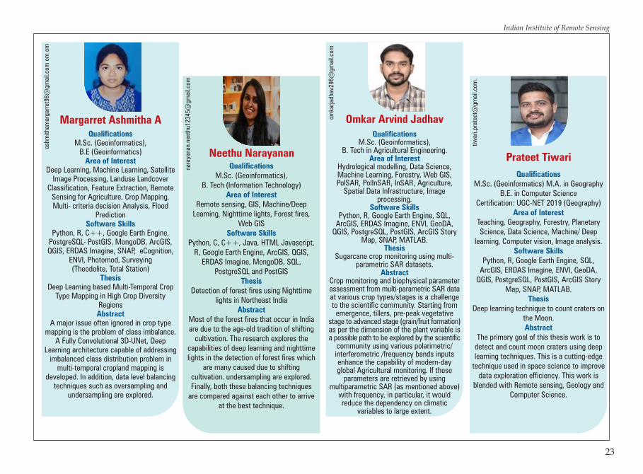
Qualifications
Area of Interest
Software Skills
Thesis
Abstract
M.Sc. (GeoinformaticsB.Tech (Electronics & Communication)
Remote Sensing, Cryospheric Studies, Geoinformatics, SAR Image Processing,
Machine Learning, Spatial Analysis, Web-based GIS, DBMS, Internet of Things (IoT),
Embedded Systems.
Python, R Studio, JavaScript, Google Earth Engine, GDAL, ArcGIS Products QGIS,
ERDAS, ESA SNAP, C, C++, Lua, MATLAB, HTML & CSS Linux, Git, PostGIS, MongoDB
Snow Depth and SWE estimation using multi-sensor microwave and optical time
series data for Indian Himalayas
The study of Snow Depth (SD) and Snow Water Equivalent (SWE) can play a
significant role in forecasting yearly water supplies, flood prediction, and general climate research. This project aims to
extract features using radar and optical data for SD and SWE applications in the north-western Himalayas region later to
develop a machine-learning-based model to estimate SD and SWE at efficient resolution using features obtained from the fusion of
high-resolution multi-sensor data.
writ
etos
hiva
ng@
gmai
l.com
Shivang Pandey
24
Indian Institute of Remote Sensing
PG Diploma in Geoinformatics
Post Graduate Diploma (PGD) in Geo-information Science and Earth Observation (specialisation/domain: Geoinformatics) is offered within the framework of Joint Education Programme (JEP) of the Indian Institute of Remote Sensing (IIRS) and the Faculty of Geo-information Science and Earth Observation (ITC) of the University of Twente (UT), The Netherlands. Upon successful completion of the course, the participants receive the Postgraduate Diploma in “Geo-information Science and Earth Observation (Geoinformatics)” awarded jointly by the Faculty ITC/ University of Twente and IIRS.
The course is of one year duration having four quartiles. Students follow the course at IIRS. The broad structure is:
Quartile Course
P.G.D. Profile of the Batch2021 - 2022
25
Q1 CoreAcademic Skills
Q3 Extraction, Analysis and Dissemination of Geospatial InformationElective CourseAcademic Skills
Q2 Scientific GeocomputingAcquisition and Exploration of Geospatial DataAcademic Skills
Q4 Individual Project, Report Writing, EvaluationAcademic Skills

26
Indian Institute of Remote Sensing
Qualifications
Area of Interest
Software Skills
PGD in Geoinformation Science & Earth Observation
(Specialization: Geoinformatics)M.Sc. Physics, B.Sc. Physics.
Health GIS, Web GIS, Machine Learning, Natural hazard and Disaster monitoring,
Wasteland Development, Meteorology GIS, Forest mapping and Monitoring, use of
GPS, Environmental Planning and Management, site suitability Analysis, Network Analysis, 3-D Modeling and
LiDAR Scanning.
ArcGIS, Python, Google Earth, Microsoft Office Suite, Photoshop, QGIS, SQL,
ERDAS Imagine, PostgreSQL, R
Qualifications
Area of Interest
Software Skills
PGD in Geoinformation Science & Earth Observation
(Specialization: Geoinformatics)M.Sc. Applied Physics, B.Sc. Physics (Hons.)
Remote Sensing Application in Climate Change (Extreme Events & Climate
Risks), Atmospheric and Ocean Dynamics and Modeling, Meteorology,
Environmental Impact AssessmentGIS, Urban & Regional Planning,
Cartography & 3-D Modeling
ESRI ArcGIS Pro, ESRI ArcMap, QGIS, ERDAS Imagine, Python, GDAL,
PosgreSQL, R programming, JavaScript, Google Earth, Google Earth Engine,
Adobe Photoshop, Adobe Illustrator, Autodesk Sketchbook, MS Office
Aayush Sharma
mai
laay
u96@
gmai
l.com
Deshmukhe Aishwarya Dayanand a
ishw
arya
desh
muk
he11
@gm
ail.c
om
Qualifications
Area of Interest
Software Skills
PGD in Geoinformation Science & Earth Observation
(Specialization: Geoinformatics)M.Sc. Geology, B.Sc. Geology.
Remote sensing and GIS application in geosciences, Natural hazards,
Meteorology. Application in Water resource management, Geo-technical engineering, Geophysical exploration, Urban planning,
Environmental hazards, Geological hazards, Resource management. Digital image
processing, LULC modelling, Hydrological modeling, LiDAR.
ArcGIS, QGIS, ERDAS imagine, Python, SedLog, GravMag, Microsoft office and
Google Earth Pro, R, SQL and PostgreSQL.
Qualifications
Area of Interest
Software Skills
PGD in Geoinformation Science & Earth Observation
(Specialization: Geoinformatics)M.Sc. Geology, B.Sc. Geology.
Application of RS and GIS in ground water, mineral and hydrocarbon exploration; Landslide modelling; Geomorphology; LULC modelling; Hydrological modelling; Web GIS,
Natural hazard mitigation and LiDAR.
Python, ArcGIS, QGIS, ERDAS Imagine, Google Earth Engine, Microsoft Office,
PostgreSQL, R, SQL and Autodesk.
Alishya Sebastianalis
hya.
seba
stia
n@gm
ail.c
om
Amruta Ganeshprasad Parte
part
eam
ruta
98@
gmai
l.com
Qualifications
Area of Interest
Software Skills
PGD in Geoinformation Science & Earth Observation
(Specialization: Geoinformatics)B. Tech. (Electrical Engineering)
Remote Sensing and GIS applications in planetary astronomy and Climate Studies.
C, Java, Matlab, HTML and CSS, Python, ArcGIS, MS Office, Google Earth, ERDAS
Imagine, PostgreSQL.
Qualifications
Area of Interest
Software Skills
PGD in Geoinformation Science & Earth Observation
(Specialization: Geoinformatics)M.Sc. Geology, B.Sc. Geology.
Mineral exploration and mining using GIS techniques, Remote Sensing and GIS applications in oil & gas industry (well planning, Volumetric data visualization, field operations), Subsurface mapping,
3D Modelling, Satellite Image Processing & Analysis, Geological feature mapping
and LiDAR.
ArcGIS, QGIS, ERDAS IMAGINE, SQL, PostGIS, Python, R,
Microsoft Office Suite
Ankini Borgohain
anki
nibo
rgoh
ain@
gmai
l.com
Avishek Ghosal
avi
shek
dd@
gmai
l.com
Qualifications
Area of Interest
Software Skills
PGD in Geoinformation Science & Earth Observation
(Specialization: Geoinformatics)B.Tech in Geoinformatics.
Remote Sensing, GIS Applications, High Performance computing, Web GIS, LiDAR.
C, Python, Web Programming, SQL, Windows Forms (.NET), Basics of CUDA programming, ArcGIS, QGIS, Google Earth
Engine, PyQGIS, GDAL, PostGIS
Qualifications
Area of Interest
Software Skills
PGD in Geoinformation Science & Earth Observation
(Specialization: Geoinformatics)M.Sc. (Hons.) Geology, B.Sc. (Hons.) Geology
RS and GIS application, Digital Image Processing, Geological survey and mapping, Machine learning, Hydro
geological modelling, Planetary Geology, Sedimentary basins analysis, Geo Hazard
mapping, Landslide modelling, Flood zone modelling, Exploration of Minerals
and Hydrocarbons, Climate change assessment and HealthGIS
ArcGIS, Python, ENVI, QGIS, ERDAS Imagine, MS Office, GDAL, Netlogo, R,
SQL and PostgreSQL
Ishita
imon
ga4@
gmai
l.com
Appalla Sai Manoj
smap
palla
@gm
ail.c
om
27
Indian Institute of Remote Sensing

Qualifications
Area of Interest
Software Skills
PGD in Geoinformation Science & Earth Observation
(Specialization: Geoinformatics)M.Sc. (Geography), B.Sc. (Geography).
GIS application in Military Strategy, GIS application in Meteorology and Natural
Hazards, Site Suitability Analysis, Application of Remote Sensing & GIS in Climate Change Mitigation and LiDAR.
C, QGIS, ArcGIS, ERDAS Imagine, Python, MS Office, Adobe Photoshop,
Google Earth Pro, R and SQL.
Sukalpa Changmai
suka
fa.5
609@
gmai
l.com
28
Indian Institute of Remote Sensing P.G.D. Profile of the Batch2021 - 2022
PG Diploma (RS&GIS)
The PG Diploma programme aims to provide in-depth understanding of remote sensing, satellite image analysis, GIS and Global GNSS technologies and their applications in various fields viz., Agriculture and Soils, Forestry & Ecology, Geosciences, Water Resources, Marine and Atmospheric Sciences, Urban and Regional Studies, Large-scale Mapping, Disaster Management Studies, etc.
The PG Diploma course is modular in structure. First module covers basics of geospatial technologies, second module deals with thematic disciplines, and third module contains pilot project work. The PG Diploma programme is conducted in following disciplines-
· Agriculture and Soils
· Forest Resources & Ecosystem Analysis #· Geoinformatics
· Geosciences· Marine & Atmospheric Sciences· Natural Hazards & Disaster Risk Management (NHDRM)· Satellite Image Analysis & Photogrammetry
· Urban & Regional Studies· Water Resources· Spatial Data Science
P.G. Diploma
Module-I(4 Months)
Module-III(3 Months)
Module-II(3 Months)
- Basic of Remote Sesning
- Basic ofPhotogrammetry
- Digital ImageProcessing
- GIS and GNSS- Statistics &
Programming
Project WorkSpecializations(Participants have to choose one
specialization from the following)- Agriculture and Soils- Forest Resources & Ecosystem Analysis - Geosciences- Marine & Atmospheric Sciences- Natural Hazards & Disaster Risk
Management- Satellite Image Analysis &
Photogrammetry - Urban & Regional Studies- Water Resources- Spatial Data Science
Subject
Agriculture & Soils · Land Use & Soil Resource Assessment· Agri-informatics· Environmental Soil Science· Satellite Agro-meteorology
Forest Resources and Ecosystem · Forest Mapping & MonitoringAnalysis · Forest Inventory
· Forest Informatics· Forest Eco-System Analysis
#Geoinformatics · Spatial Data Quality · Programming Skills Development for Geo-Processing · Spatial Database Handling, Modelling & GIS Implementing
Architectures · Geo-Statistics
Geosciences · Earth Science and Planetary Geology· Data Processing and Analysis for Geosciences· Applied and Tectonic Geomorphology· Engineering Geology and Groundwater
Marine & Atmospheric Sciences · Satellite Oceanography· Satellite Meteorology· Coastal Processes and Marine Ecology· Atmospheric and Ocean Dynamics
Natural Hazards & Disaster Risk · Natural Hazards and Disaster Management: ConceptsManagement (NHDRM) and Overview
· Image Interpretation and Analysis for Natural Hazards Assessment· Application of Geoinformatics to Environment Hazards· Application of Geoinformatics to Geological Hazards· Application of Geoinformatics to Hydro-meteorological Hazards
Satellite Image Analysis · Emerging Sensors and Data Processing & Photogrammetry · Image Processing Algorithms
· Digital Photogrammetry and Mapping · Mathematical Computing for Geospatial data analysis
Urban & Regional Studies · Fundamentals of Urban and Regional Planning· Geospatial Technologies for Urban & Regional Area Analysis· Urban Resources, Services and Facilities Analysis· Advanced Geospatial Technologies for Urban and Regional
Studies
Water Resources · Satellite Hydrology· Watershed Hydrology and Conservation Planning· Water Resources Development· Water Resources Planning Management
Spatial Data Science · Big Data Analysis· Machine Learning· Programming for Geodata Processing· Spatial Modelling and Data Assimilation
Thematic Specialization
*Core paper under each specialization in module II of M.Tech/P.G. Diploma
*Common with M.Tech. as per page no. 8#Offered under M.Tech. programme only 29

Qualifications
Area of Interest
Software Skill
PGD in Remote Sensing & GIS (Geosciences), M.Sc. in Geology
B.Sc. in Geolog
Application of Remote sensing and GIS in Groundwater studies, Watershed
resources, Engineering geology, Site investigation, Disaster management,
Structural geology, Environmental impact assessment, Planetary geology, Mineral
and Hydrocarbon exploration.
ArcGIS, QGIS, ERDAS Imagine, ENVI, SNAP, Python, R, MATLAB, SQL
ashu
roht
a@gm
ail.c
om
Ashutosh Rohta
Qualifications
Area of Interest
Software Skills
PGD in Remote Sensing & GIS (Specialization: Satellite Image Analysis &
Photogrammetry), B.E (I.T)
Database Management SystemData Structures
C, Python, MySQL, Java, C, C++, CSS, MATLAB, PostgreSQL, ArcGIS, QGIS,
ERDAS IMAGINE, SNAP, ENVI
salo
niav
agha
del1
999@
gmai
l.com
Awaghade Saloni Surendra
Qualifications
Area of Interest
Software Skills
PGD in Remote Sensing & GIS (Specialization: Natural Hazards & Disaster
Risk Management), M.Sc. Physics (Specialization : Astrophysics), B.Sc
Physics,Chemistry, Maths
Risk assessment and disaster management, Application of RS and GIS in natural
hazards, Hydrological hazards modelling, flood zone mapping, earth observation
satellites for disaster management, application of remote sensing in space exploration like finding of exoplanets, research of other planets in our Solar
System and astrophysical exploration.
PYTHON, C++, ArcGIS, QGIS, SNAP, ENVI, ERDAS imagine,, MATLAB, TOPCAT,
MS OFFICE, LATEX.
dioz
naja
mes
s28@
gmai
l.com
Dizna James
Qualifications
Area of Interest
Software Skills
PGD. in Remote Sensing & GIS (Specialization: Spatial Data Science), M.Sc Geoinformatics, B.Sc Physics
Data Science, Spatial Data Analytics/Modeling, Geodata Analytics, Machine Learning/ Deep Learning, Big Data, Potential Fishing Zone, Remote Sensing and GIS, Microwave Remote
Sensing, Hyper spectral remote sensing, Digital Image Processing
Skills: Python, Java, C, C++, RStudio, HTML, CSS, MATLAB, PostgreSQL,
ArcGIS, QGIS, ERDAS IMAGINE, SNAP, ENVI, Google Earth Engine, LuSIS
nava
bhi4
v@gm
ail.c
om
Abhinav A
30
Indian Institute of Remote Sensing
Qualifications
Area of Interest
Software Skills
PGD in Remote sensing & GIS (Specialization Forest Resources and
Ecosystem Analysis)B.Sc. – (Honors) (Forestry)
Biodiversity Conservation, mapping and monitoring forest inventory and ecosystem services, wild life
management, environmental resources & sustainability, environmental impact
assessment, climate change mitigation, Human Ecology and restoration ecology
ArcGIS, ERDAS Imagine, ENVI, SPSS, Google Earth Engine, R Programming,
Microsoft Office
pand
eyha
rish7
16@
gmai
l.com
Harish Pandey
Qualification
Area of Interest
Software Skills
PGD in Remote Sensing & GIS(Specialization : Spatial Data Science),
B.E (Electronics Engineering)
Spatial Data Analysis, Big Data, Digital Image Processing, GIS,
Machine Learning
C, C++, Python, Matlab, Java, SQL
kkha
mga
onka
r7@
gmai
l.com
Kalyani Mohan KhamgaonkarQualifications
Area of Interest
Software Skills
PGD in Remote Sensing & GIS (Specialization: Natural Hazard and
Disaster Management), M.Sc. (Geology), B.Sc. (Geology)
Geomorphology, Sedimentology, Metamorphic & Igneous Petrology, Climatology, Disaster Management,
Vulnerability assessment, Environmental Impact Assessment
ArcGIS, QGIS, SNAP, ENVI, ERDAS imagine
karis
hmad
oot9
8@gm
ail.c
om
Karishma
Qualification
Area of Interest
Software Skills
PGD in Remote Sensing and GIS (Agriculture and Soils)
Ph.D (Soil Science and Agricultural Chemistry)-(2009-2012), PGDTMA
(Technology Management in Agriculture)-(2015-2016), M.Sc. (Soil Science and
Agricultural Chemistry)-(2007-2009), B.Sc (Agriculture) –(2002-2006)
Big data Analysis, Application of Remote Sensing and GIS in Agriculture and Soils,
Microwave Remote Sensing, Hyperspectral Remote Sensing,
Digital Image Processing, GNSS/IRNSS, GPS, LiDAR, Aerial and Satellite
Photogrammetry
Arc GIS, QGIS, ERDAS Imagine, SNAP, Google Earth Engine, MS Office
karp
agam
jaga
nath
an18
@gm
ail.c
om
Karpagam Jaganathan
31
Indian Institute of Remote Sensing

Qualifications
Area of Interest
Software Skills
PGD in Remote Sensing & GIS(Geosciences)
M.Sc. in Applied GeologyB.Sc. in Geology
Remote Sensing & GUS and Paleontology
PYTHON, R, ERDAS Imagine,ArcGIS, QGIS
kund
umay
uri7
9@gm
ail.c
om
Mayuri Kundu
Qualifications
Area of Interest
Software Skills
PGD in Remote Sensing & GIS (Specialization: Geosciences),
M.Sc. Applied GeologyB.Sc. (Hons.) Geology
Application of Remote Sensing in Groundwater Hydrology, Natural Hazard Zonation Mapping, Risk Assessment and Mitigation, Glaciology and Polar Studies, Planetary Geology, Mineral Exploration,
Urban Heat Island and its Mitigation, Geodynamics and Plate Tectonics,
Geomorphology.
ArcGIS, ERDAS Imagine, QGIS, Python, R, Google Earth Engine, Google Earth
Pro, ENVI, SNAP, RADAN 7,
moh
itasw
a222
2@gm
ail.c
om
Mohit Singh
Qualifications
Area of Interest
Software Skills
PGD in Remote Sensing & GIS (Specialization: Urban and Regional
Studies), M.Tech (Urban and Regional Planning),
B.E (Civil Engineering)
Urban and Regional Planning, Urban Governance, Transportation
Planning, Sustainable City Planning, Solid Waste Management Planning,
Non-motorized Transport Planning, 3D City Modelling, Urban Flooding, Land use
Mapping and Planning, Urban Area Analysis, Urban Growth Modelling
(CA-ANN)
ArcGIS, QGIS, SNAP, ENVI, ERDAS Imagine, Sketch up, 3DS max,
Auto CAD, REVIT, FRAGSTATS, Python, Google Earth Engine, eCognition, IDRISI
nish
chay
shek
ar18
@gm
ail.c
om
Nishchay S
Qualification
Area of Interest
Software Skills
PGD in Remote Sensing & GIS (Specialization: Satellite Image Analysis
& Photogrammetry), M.Sc (Physics; specialization-
Astrophysics)B.Sc (Phy., Chemistry & Mathematics)
Emerging Sensors and Data Processing, Satellite Image Processing Aerial and
Satellite Photogrammetry, GIS and Applications,Remote sensong, GPS,
LiDAR, Cartography, Planetary Photogrammetry, Planetary Topographic
Mapping, Digital GISMapping, SAR & Hyperspectral Remote Sensing,
Environment Impact Assessment, GNSS/IRNSS Study, Radar Planetary
Sciences
Python, C, R, ArcGIS, QGIS, ERDAS Imagine, ENVI, SNAP, Google Earth
Engine, HTML, MATLAB, eCognition
Kavya Bonyal
kavy
a.bo
nyal
@gm
ail.c
om
32
Indian Institute of Remote Sensing
Qualifications
Area of Interest
Software Skills
PGD in Remote Sensing & GIS (Specialization: Forest Resources and
Ecosystem Analysis)M.Sc. Environment Management
B.Sc. (Honors) Zoology
Forest Ecology - Species Mapping and Monitoring; Forest Resource
Inventorization; Ecosystem Services Mapping; Carbon Stock and Flux
Monitoring; Climate Change Studies
QGIS, ERDAS Imagine, ENVI, Google Earth Engine, SPSS, MS Office,
risha
bhsr
ikar
.10@
gmai
l.com
Rishabh Srikar
Qualifications
Area of Interest
Software Skills
PGD. in Remote Sensing & GIS (Specialization: Forest Resources &
Ecosystem Analysis),M.Sc. (Wildlife Science),
B.Sc. (Forestry Hons.)
Application of Remote Sensing and GIS in forestry and wildlife, Forest ecology,
Biodiversity conservation, Wildlife management, Forest fire management, Climate change mitigation, Environment Impact Assessment, Landscape Ecology,
Forest Mapping and monitoring, Behavioural Ecology, Evolutionary
Ecology, High altitude rangeland studies, Microwave Remote Sensing, Hyper
spectral remote sensing, Digital Image Processing.
MS Office, DISTANCE, ArcGIS, ERDAS Imagine, SNAP, ENVI, QGIS, FRAGSTATS,
Google Earth, Python, R, MATLAB, SPSS, SQL, Google Earth Engine,
Adobe Photoshop.
shik
haja
zz78
6@gm
ail.c
om
Shikha JasrrotiaQualifications
Area of Interest
Software Skills
PGD in Remote Sensing & GIS (Specialization: Geosciences)
B.Sc. in Geology, Physics, Chemistry, M.Sc. in Geology
Application of Remote Sensing and GIS in Ground Water and Oil Exploration,
Mineral Exploration, Planetary Sciences, Natural Hazard and Disaster Management, Seismology,
Geomorphology, Structural Geology, Water Resource Management,
Engineering Geology.
ENVI, ArcGIS, QGIS, Erdas Imagine, SNAP, LiDAR 360 Google Earth Pro, Corel
darw, AUTOCAD, Microstation, Rockworks, MS Office, Python
Programming.
shiv
asha
rma.
geol
ogy@
gmai
l.com
Shiva Sharma
33
Indian Institute of Remote Sensing
Qualifications
Area of Interest
Software Skills
PGD in Remote Sensing & GIS (Specialization: Natural Hazard and
Disaster Risk Management), B.Tech : Civil Engineering
Earthquake hazard assessment, Application of remote sensing and GIS in
Natural Hazards, Disaster risk management, Vulnerability assessment,
Environmental impact assessment, Hazard zonation mapping, Earthquake
and flood zone mapping,SAR Interferometry, earth observation
satellites for disaster management, application of remote sensing in space
exploration, Disaster .resistant construction, Hydrology, Site planning,
ArcGIS, QGIS, SNAP, ERDAS Imagine, Auto CAD, Python, ETABS, STADD Pro,
PRIMAVERA, MATLAB
waq
uaru
lisla
m@
gmai
l.com
Waquar Ul Islam

Qualifications
Area of Interest
Software Skills
PGD in Remote Sensing & GIS(Geosciences)
M.Sc. in Applied GeologyB.Sc. in Geology
Remote Sensing & GUS and Paleontology
PYTHON, R, ERDAS Imagine,ArcGIS, QGIS
kund
umay
uri7
9@gm
ail.c
om
Mayuri Kundu
Qualifications
Area of Interest
Software Skills
PGD in Remote Sensing & GIS (Specialization: Geosciences),
M.Sc. Applied GeologyB.Sc. (Hons.) Geology
Application of Remote Sensing in Groundwater Hydrology, Natural Hazard Zonation Mapping, Risk Assessment and Mitigation, Glaciology and Polar Studies, Planetary Geology, Mineral Exploration,
Urban Heat Island and its Mitigation, Geodynamics and Plate Tectonics,
Geomorphology.
ArcGIS, ERDAS Imagine, QGIS, Python, R, Google Earth Engine, Google Earth
Pro, ENVI, SNAP, RADAN 7,
moh
itasw
a222
2@gm
ail.c
om
Mohit Singh
Qualifications
Area of Interest
Software Skills
PGD in Remote Sensing & GIS (Specialization: Urban and Regional
Studies), M.Tech (Urban and Regional Planning),
B.E (Civil Engineering)
Urban and Regional Planning, Urban Governance, Transportation
Planning, Sustainable City Planning, Solid Waste Management Planning,
Non-motorized Transport Planning, 3D City Modelling, Urban Flooding, Land use
Mapping and Planning, Urban Area Analysis, Urban Growth Modelling
(CA-ANN)
ArcGIS, QGIS, SNAP, ENVI, ERDAS Imagine, Sketch up, 3DS max,
Auto CAD, REVIT, FRAGSTATS, Python, Google Earth Engine, eCognition, IDRISI
nish
chay
shek
ar18
@gm
ail.c
om
Nishchay S
Qualification
Area of Interest
Software Skills
PGD in Remote Sensing & GIS (Specialization: Satellite Image Analysis
& Photogrammetry), M.Sc (Physics; specialization-
Astrophysics)B.Sc (Phy., Chemistry & Mathematics)
Emerging Sensors and Data Processing, Satellite Image Processing Aerial and
Satellite Photogrammetry, GIS and Applications,Remote sensong, GPS,
LiDAR, Cartography, Planetary Photogrammetry, Planetary Topographic
Mapping, Digital GISMapping, SAR & Hyperspectral Remote Sensing,
Environment Impact Assessment, GNSS/IRNSS Study, Radar Planetary
Sciences
Python, C, R, ArcGIS, QGIS, ERDAS Imagine, ENVI, SNAP, Google Earth
Engine, HTML, MATLAB, eCognition
Kavya Bonyal
kavy
a.bo
nyal
@gm
ail.c
om
32
Indian Institute of Remote Sensing
Qualifications
Area of Interest
Software Skills
PGD in Remote Sensing & GIS (Specialization: Forest Resources and
Ecosystem Analysis)M.Sc. Environment Management
B.Sc. (Honors) Zoology
Forest Ecology - Species Mapping and Monitoring; Forest Resource
Inventorization; Ecosystem Services Mapping; Carbon Stock and Flux
Monitoring; Climate Change Studies
QGIS, ERDAS Imagine, ENVI, Google Earth Engine, SPSS, MS Office,
risha
bhsr
ikar
.10@
gmai
l.com
Rishabh Srikar
Qualifications
Area of Interest
Software Skills
PGD. in Remote Sensing & GIS (Specialization: Forest Resources &
Ecosystem Analysis),M.Sc. (Wildlife Science),
B.Sc. (Forestry Hons.)
Application of Remote Sensing and GIS in forestry and wildlife, Forest ecology,
Biodiversity conservation, Wildlife management, Forest fire management, Climate change mitigation, Environment Impact Assessment, Landscape Ecology,
Forest Mapping and monitoring, Behavioural Ecology, Evolutionary
Ecology, High altitude rangeland studies, Microwave Remote Sensing, Hyper
spectral remote sensing, Digital Image Processing.
MS Office, DISTANCE, ArcGIS, ERDAS Imagine, SNAP, ENVI, QGIS, FRAGSTATS,
Google Earth, Python, R, MATLAB, SPSS, SQL, Google Earth Engine,
Adobe Photoshop.
shik
haja
zz78
6@gm
ail.c
om
Shikha JasrrotiaQualifications
Area of Interest
Software Skills
PGD in Remote Sensing & GIS (Specialization: Geosciences)
B.Sc. in Geology, Physics, Chemistry, M.Sc. in Geology
Application of Remote Sensing and GIS in Ground Water and Oil Exploration,
Mineral Exploration, Planetary Sciences, Natural Hazard and Disaster Management, Seismology,
Geomorphology, Structural Geology, Water Resource Management,
Engineering Geology.
ENVI, ArcGIS, QGIS, Erdas Imagine, SNAP, LiDAR 360 Google Earth Pro, Corel
darw, AUTOCAD, Microstation, Rockworks, MS Office, Python
Programming.sh
ivas
harm
a.ge
olog
y@gm
ail.c
om
Shiva Sharma
33
Indian Institute of Remote Sensing
Qualifications
Area of Interest
Software Skills
PGD in Remote Sensing & GIS (Specialization: Natural Hazard and
Disaster Risk Management), B.Tech : Civil Engineering
Earthquake hazard assessment, Application of remote sensing and GIS in
Natural Hazards, Disaster risk management, Vulnerability assessment,
Environmental impact assessment, Hazard zonation mapping, Earthquake
and flood zone mapping,SAR Interferometry, earth observation
satellites for disaster management, application of remote sensing in space
exploration, Disaster .resistant construction, Hydrology, Site planning,
ArcGIS, QGIS, SNAP, ERDAS Imagine, Auto CAD, Python, ETABS, STADD Pro,
PRIMAVERA, MATLAB
waq
uaru
lisla
m@
gmai
l.com
Waquar Ul Islam

Student Volunteers: Concept and Compiled by: For further details please contact:
Programme Planning and Evaluation Group, IIRS
· Dr. Swati Swaroop, Sci/Eng-SE, PPEG
· Dr. Puneet Swaroop, Sci/Eng-SF , BPMD
· Dr. Hari Shanker Srivastava, Sci/Eng-SG & GH, PPEG
& Head
· Ms. Yamini Bhat for M.Tech
· Ms. Kavya Bonyal for PGD
· Mr. Shivang Pandey for M.Sc. (GI)
· Mr. Nancharaiah for PGD (GI)
Dr. Hari Shanker SrivastavaGroup Head, PPEGIndian Institute of Remote Sensing, Dehradun-248 001Email: [email protected], Phone: (0135) 252 4105/ 4107/ 4106/ 4108/ 4109
N.B. : Credentials and Abstract details about students in this placement brochures are self declared by the respective student only.

Hkkjrh; lqnwj laosnu laLFkku4] dkyhnkl ekxZ] nsgjknwu
Indian Institute of Remote Sensing4, Kalidas Road, Dehradun
Department of Space and ISRO HQAntariksh Bhavan, New BEL Road, Bangalore 560 231
varfj{k foHkkx rFkk bljks eq[;ky;varfj{k Hkou] U;w chbZ,y ekxZ] csaxyw#&560 231