IEE: India: Rural Connectivity Investment Program - Asian ...
371
Initial Environmental Examination February 2012 IND: Rural Connectivity Investment Program Prepared by Assam Rural Road Development Agency (ARRDA) for the Asian Development Bank.
-
Upload
khangminh22 -
Category
Documents
-
view
2 -
download
0
Transcript of IEE: India: Rural Connectivity Investment Program - Asian ...
Initial Environmental Examination February 2012
IND: Rural Connectivity Investment Program Prepared by Assam Rural Road Development Agency (ARRDA) for the Asian Development Bank.
ii
CURRENCY EQUIVALENTS (as of 27 February 2012)
Currency unit – Indian rupee (Rs) Rs1.00 = $ 0.0204019178
$1.00 = Rs 49.015000
ABBREVIATIONS
ADB Asian Development Bank APO Accident Prevention Officer B.T. Black Top BIS Bureau of Indian Standards BGL Below Ground Level BOQ Bill of Quantity C.C. Cement Concrete CD Cross Drainage ARRDA Assam Rural Road Development Agency CGWA Central Ground Water Authority CGWB Central Ground Water Board Ch. Chainage COI Corridor Of Impact CTE Consent to Establish CTO Consent to Operate DPR Detailed Project Report DG Diesel Generating ECOP Environmental Code of Practices EIA Environmental Impact Assessment EARF Environmental Assessment Review Framework EMOP Environmental Monitoring Plan EMP Environmental Management Plan EO Environmental Officer FEO Field Environmental Officer GDP Gross Domestic Product GOI Government of India GSHAP Global Seismic Hazard Assessment Program HC Hydrocarbon HH House Hold IEE Initial Environmental Assessment IRC Indian Road Congress LHS Left Hand Side MCM Million Cubic Meter MFF Multi-Tranche Financing Facility MoEF Ministry of Environment and Forests MORD Ministry of Rural Development
iii
WEIGHTS AND MEASURES
hect hectare km kilometer
m meter
NOTE
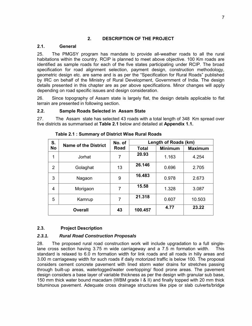
In this report, "$" refers to US dollars
MOSRTH Ministry of Road Transport & Highways NAAQS National Ambient Air Quality Standards NGO Non-government organization NOx Nitrogen Oxides NRRDA National Rural Road Development Authority NSDP Net State Domestic Product PIC Project Implementation Consultant PIU Project Implementation Unit PLF Plant Load Factor PM Particulate Matters PMGSY Pradhan Mantri Gram Sadak Yojna PPE Personal Protective Equipment‟s PPTA Project Preparation Technical Assistance RHS Right Hand Side RCIP Rural Connectivity Investment Program ROW Right of way RRS I Loan 2018-IND: Rural Roads Sector I Project RRS II Loan 2248-IND: Rural Roads Sector II Investment Program RSES ADB‟s Environmental Safeguard Division SBD Standard Bidding Documents SDP State Domestic Product SO2 Sulphur Dioxide SPCB State Pollution Control Board SPS ADB‟s Safeguard Policy Statement, 2009 SRRDA State Rural Road Development Authority STDs Sexually transmitted diseases TDS Total Dissolved Solids TSC Technical Support Consultants
UNESCO United Nations Educational, Scientific and Cultural Organization
WBM Water Bound Macadam
iv
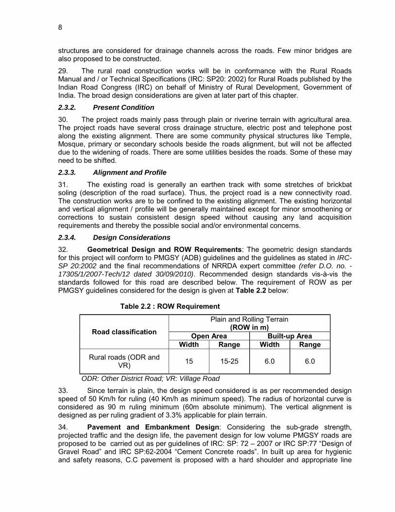
This initial environmental examination is a document of the borrower. The views expressed herein do not necessarily represent those of ADB's Board of Directors, Management, or staff, and may be preliminary in nature. In preparing any country program or strategy, financing any project, or by making any designation of or reference to a particular territory or geographic area in this document, the Asian Development Bank does not intend to make any judgments as to the legal or other status of any territory or area.
v
Table of Contents EXECUTIVE SUMMARY x 1. INTRODUCTION 1
1.1. Project Background.......................................................................................... 1 1.2. Project Roads Identification and Location ........................................................ 1 1.3. Rural Road Construction Proposal ................................................................... 2 1.4. ADB Safeguard Policies and Category of the Project ....................................... 2 1.5. Objectives and Approach for Environmental Assessment ................................ 3 1.6. IEE Methodology and Content ........................................................................ 3 1.7. Legal Framework and Legislative Requirements: ............................................. 4 1.8. Acknowledgement ........................................................................................... 6
2. DESCRIPTION OF THE PROJECT 7 2.1. General ............................................................................................................ 7 2.2. Sample Roads Selected in Assam State ......................................................... 7 2.3. Project Description ........................................................................................... 7
2.3.1. Rural Road Construction Proposals ............................................................. 7 2.3.2. Present Condition ........................................................................................ 8 2.3.3. Alignment and Profile ................................................................................... 8 2.3.4. Design Considerations ................................................................................. 8 2.3.5. Construction Methods .................................................................................. 9 2.3.6. Available Right of Way ................................................................................. 9 2.3.7. Traffic ......................................................................................................... 10 2.3.8. Economic Assessment ............................................................................... 10
3. DESCRIPTION OF THE ENVIRONMENT 11 3.1. Background ................................................................................................... 11 3.2. Physical Environment .................................................................................... 15
3.2.1. Meteorology and Climate ........................................................................... 15 3.2.2. Air Quality .................................................................................................. 15 3.2.4. Topography and Geomorphology ............................................................... 16 3.2.5. Geology/Soil .............................................................................................. 19 3.2.6. Soil ............................................................................................................. 19 3.2.7. Earthquake & Seismicity ............................................................................ 22 3.2.8. Land Use ................................................................................................... 22 3.2.9. Hydrology and Water quality ...................................................................... 24
3.3. Biological Environment / Ecological Resources .............................................. 26 3.3.1. Biological Environment / Ecological Resources of the State ....................... 26 Floral diversity of the state ..................................................................................... 26 3.3.2. Wildlife and Protected Areas: ..................................................................... 28 3.3.3. Aquatic Biology: ......................................................................................... 30
3.4. Socio-Economic Environment ........................................................................ 30 3.4.1. Demography .............................................................................................. 30 3.4.2. Healthcare ................................................................................................. 31 3.4.3. Literacy and Education ............................................................................... 31 3.4.4. Affluence .................................................................................................... 32 3.4.5. Economy .................................................................................................... 32 3.4.6. Agriculture .................................................................................................. 32 3.4.7. Industries, Cottage and Small Industries .................................................... 32
4. ANTICIPATED ENVIRONMENTAL IMPACTS AND ITS MITIGATION MEASURES 47
4.1. Common Impacts during Design and Construction Phase ............................. 47 4.1.1. Climate change .......................................................................................... 47
vi
4.1.2. Finalization of Alignment ............................................................................ 48 4.1.3. Land Acquisition ......................................................................................... 49 4.1.4. Protected Areas (National parks, wild life sanctuaries, Eco sensitive zones,
protected /historical monuments) and Forest Areas. .................................. 49 4.1.5. Land Clearing Operations .......................................................................... 50 4.1.6. Cut and Fill and Embankment construction ................................................ 50 4.1.7. Establishment of Construction Camp, Temporary office and Storage Area 50 4.1.8. Traffic Movement ....................................................................................... 52 4.1.9. Associated Impacts due to Construction Activities ..................................... 52
4.2. Common Impacts during Operation Phase .................................................... 56 4.2.1. Air Quality .................................................................................................. 56 4.2.2. Noise ......................................................................................................... 56 4.2.3. Land, Soil, Tree Plantation ......................................................................... 56 4.2.4. Groundwater .............................................................................................. 57 4.2.5. Hydrology and Drainage ............................................................................ 57 4.2.6. Socio-Economic Impact ............................................................................. 57
4.3. Road Specific Impacts ................................................................................... 58 5. ENVIRONMENTAL MANAGEMENT PLAN, INSTITUTIONAL ARRANGEMENTS AND GRIEVANCE ADDRESS MECHANISM 59
5.1. Environmental Management Plan .................................................................. 59 5.2. Environmental Monitoring Plan ...................................................................... 59 5.3. Institutional Arrangements and Responsibilities ............................................. 60 5.4. Institutional Environmental Responsibilities ................................................... 62 5.5. Environmental Assessment and Review Framework (EARF) for RCIP .......... 64 5.6. Capacity Building ........................................................................................... 66 5.7. Consultation and Information Disclosure ........................................................ 66 5.8. Grievance Redress Mechanism ..................................................................... 67
6. PUBLIC CONSULTATION AND INFORMATION DISCLOSURE 68 6.1. General .......................................................................................................... 68 6.2. Compliance with Relevant Regulatory Requirements ..................................... 68 6.3. Beneficiaries‟ Comments ............................................................................... 68
7. CONCLUSIONS AND RECOMMENDATIONS 71 7.1. Conclusions ................................................................................................... 71 7.2. Key Recommendations: ................................................................................. 72
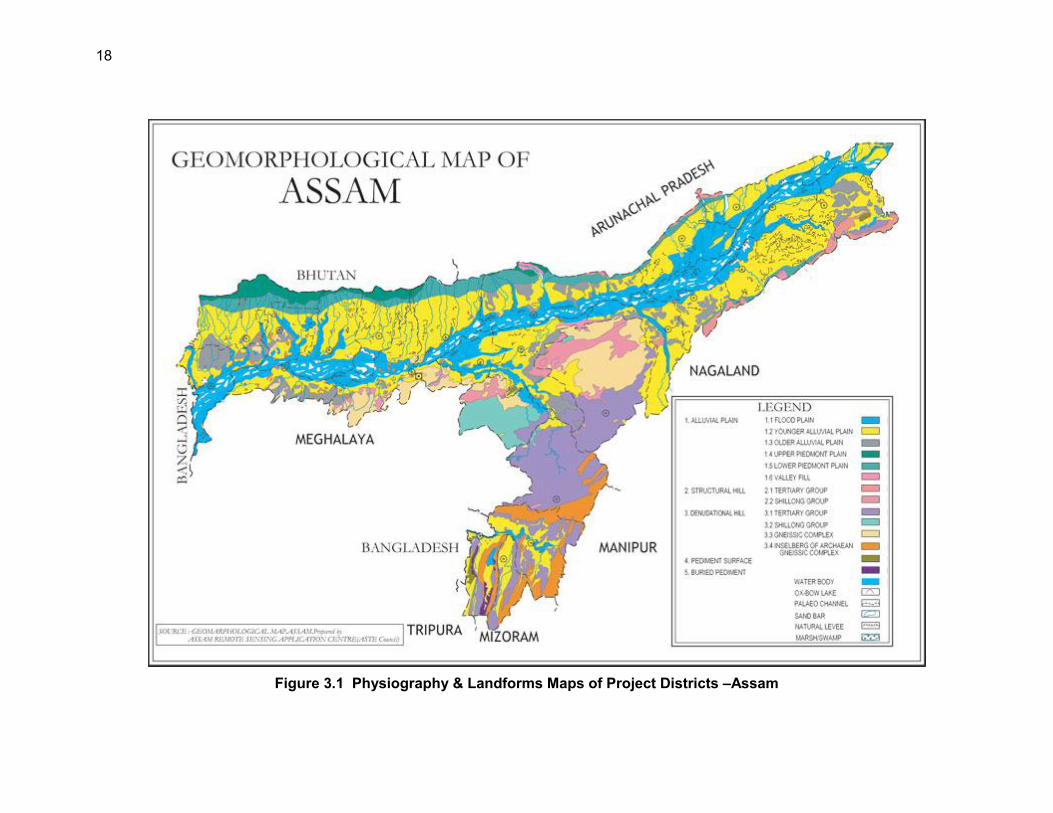
List of Tables Table 2.1 : Summary of District Wise Rural Roads .......................................................... 7 Table 2.2 : ROW Requirement ........................................................................................ 8 Table 3.1 : Summary Key Environmental Features of Sample Roads Districts .............. 12 Table 3.2 :Maximum observed Ambient Air Quality during 2008 ................................... 15 Table 3.3 Ambient Air Quality Status of Assam in Previous Years ................................. 16 Table 3.4 Land Use Pattern in the State ........................................................................ 23 Table 3.5 Hydro geological Conditions of Project District / Assam ................................ 25 Table 3.6 : Mammals Recorded In Guwahati City And Forest Area ............................... 26 Table 3.7 : List of Fauna ................................................................................................ 27 Table 3.8 : List of Protected Areas in Assam ................................................................. 28 Table 3.9 : Demographic Profile .................................................................................... 31 Table 3.10 : Salient Environmental Features of Sample Roads ..................................... 33 Table 4.1 : List Subproject Roads Prone to Flood ......................................................... 48 Table 6.1 : Addressal of Issues and Concerns under the Project................................... 70
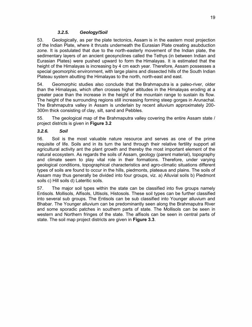
vii
List of Figures Figure 1.1 : Project Area of Rural Connectivity Investment Program ............................. viii Figure 1.2 : State and Project Districts Map of Assam .................................................... ix Figure 3.1 Physiography & Landforms Maps of Project Districts –Assam ...................... 18 Figure 3.2 Geological Map of Assam ............................................................................. 20 Figure 3.3 Soil map of Assam ....................................................................................... 21 Figure 3.4 : Hazard and Seismic Zone Map .................................................................. 22 Figure 3.5 : Landuse of Assam ...................................................................................... 23 Figure 3.6 Protected Areas of Assam ............................................................................ 30 Figure 5.1 : Institutional Arrangement for EMP Implementation ..................................... 61 List of Appendix Appendix 2.1: Details of Roads in Assam ...................................................................... 73 Appendix 2.2: Rapid Environmental Assessment Checklist ........................................... 75 Appendix 2.3: Rural Roads: Environmental Checklist .................................................... 81 Appendix 2.4: ECOPs of Sample Roads in Assam ........................................................ 85 A: ECOPS IN DISTRICT GOLAGHAT ........................................................................... 85 B: ECOPS IN DISTRICT JORAHAT ............................................................................ 122 C: ECOPS IN DISTRICT KAMRUP ............................................................................. 176 D: ECOPS IN DISTRICT MORIGAON......................................................................... 213 E: ECOPS IN DISTRICT NAGAON ............................................................................. 263 Appendix 4.1: Guidelines for Borrow Areas Management ........................................... 316 Appendix 5.1: Environmental Management Plan ......................................................... 320 Appendix 5.2: Environmental Monitoring Plan ............................................................. 339 Appendix 6.1: Public Consultation in Assam ............................................................... 354
viii
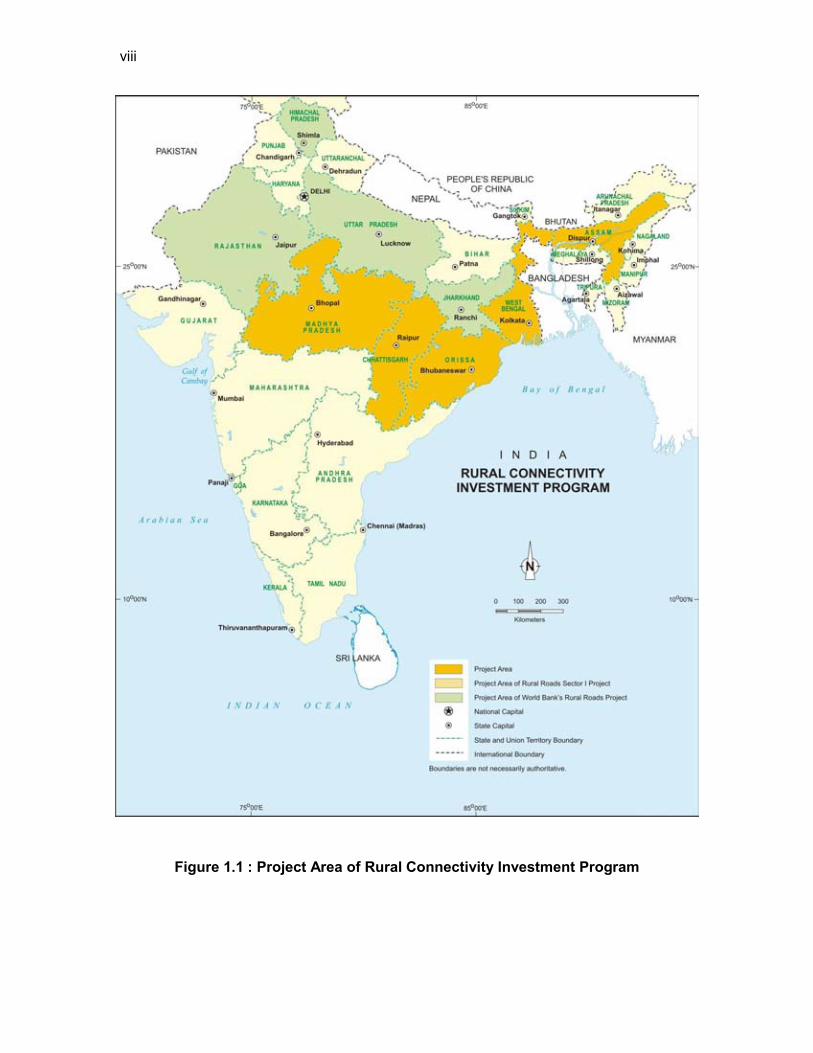
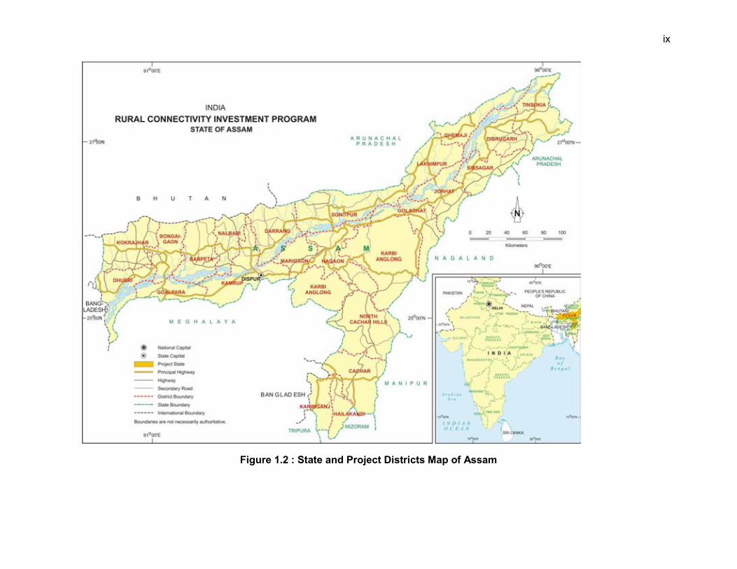
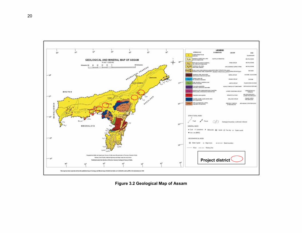
Figure 1.1 : Project Area of Rural Connectivity Investment Program
ix
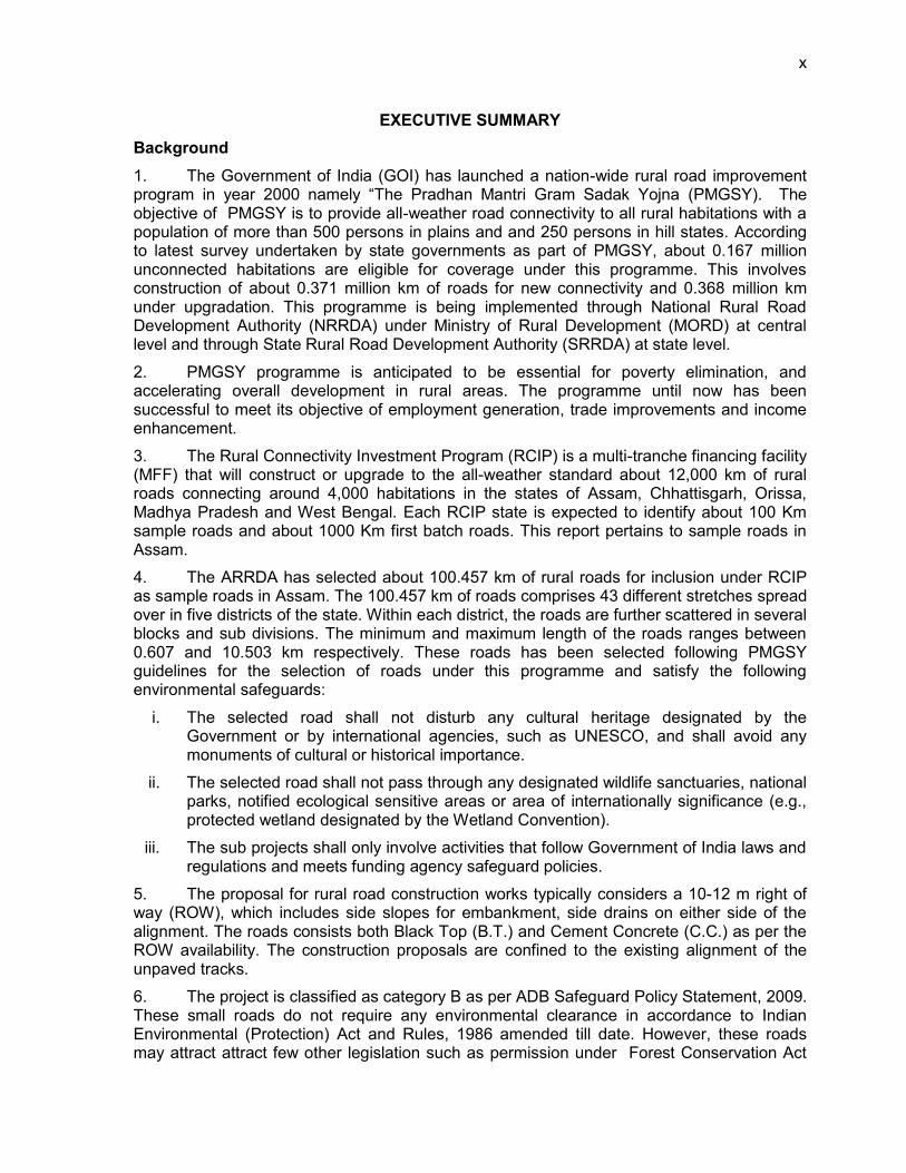
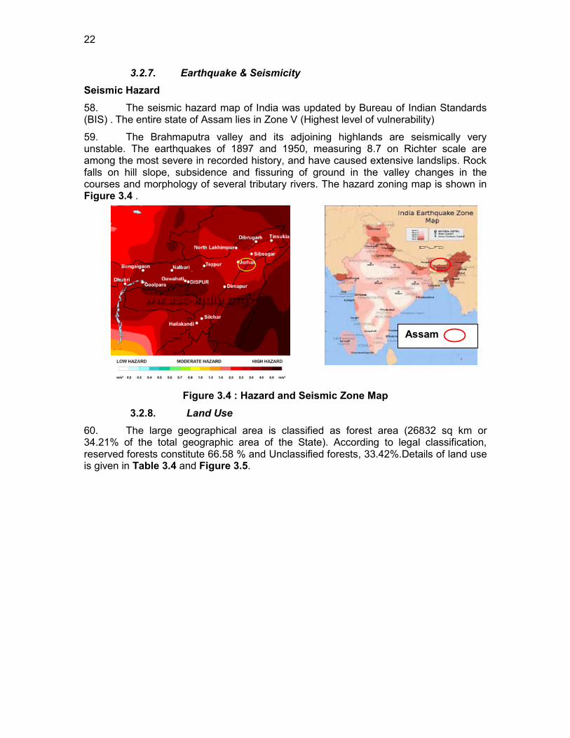
Figure 1.2 : State and Project Districts Map of Assam
x
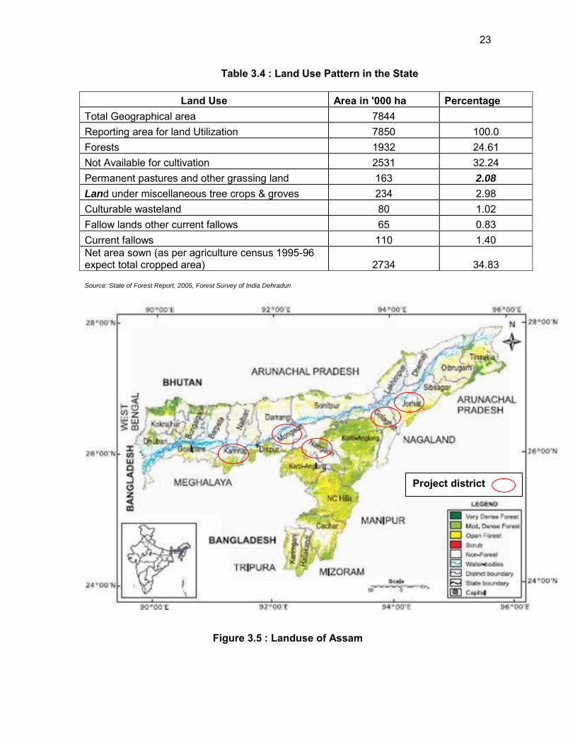
EXECUTIVE SUMMARY Background 1. The Government of India (GOI) has launched a nation-wide rural road improvement program in year 2000 namely “The Pradhan Mantri Gram Sadak Yojna (PMGSY). The objective of PMGSY is to provide all-weather road connectivity to all rural habitations with a population of more than 500 persons in plains and and 250 persons in hill states. According to latest survey undertaken by state governments as part of PMGSY, about 0.167 million unconnected habitations are eligible for coverage under this programme. This involves construction of about 0.371 million km of roads for new connectivity and 0.368 million km under upgradation. This programme is being implemented through National Rural Road Development Authority (NRRDA) under Ministry of Rural Development (MORD) at central level and through State Rural Road Development Authority (SRRDA) at state level.
2. PMGSY programme is anticipated to be essential for poverty elimination, and accelerating overall development in rural areas. The programme until now has been successful to meet its objective of employment generation, trade improvements and income enhancement.
3. The Rural Connectivity Investment Program (RCIP) is a multi-tranche financing facility (MFF) that will construct or upgrade to the all-weather standard about 12,000 km of rural roads connecting around 4,000 habitations in the states of Assam, Chhattisgarh, Orissa, Madhya Pradesh and West Bengal. Each RCIP state is expected to identify about 100 Km sample roads and about 1000 Km first batch roads. This report pertains to sample roads in Assam.
4. The ARRDA has selected about 100.457 km of rural roads for inclusion under RCIP as sample roads in Assam. The 100.457 km of roads comprises 43 different stretches spread over in five districts of the state. Within each district, the roads are further scattered in several blocks and sub divisions. The minimum and maximum length of the roads ranges between 0.607 and 10.503 km respectively. These roads has been selected following PMGSY guidelines for the selection of roads under this programme and satisfy the following environmental safeguards:
i. The selected road shall not disturb any cultural heritage designated by the Government or by international agencies, such as UNESCO, and shall avoid any monuments of cultural or historical importance.
ii. The selected road shall not pass through any designated wildlife sanctuaries, national parks, notified ecological sensitive areas or area of internationally significance (e.g., protected wetland designated by the Wetland Convention).
iii. The sub projects shall only involve activities that follow Government of India laws and regulations and meets funding agency safeguard policies.
5. The proposal for rural road construction works typically considers a 10-12 m right of way (ROW), which includes side slopes for embankment, side drains on either side of the alignment. The roads consists both Black Top (B.T.) and Cement Concrete (C.C.) as per the ROW availability. The construction proposals are confined to the existing alignment of the unpaved tracks. 6. The project is classified as category B as per ADB Safeguard Policy Statement, 2009. These small roads do not require any environmental clearance in accordance to Indian Environmental (Protection) Act and Rules, 1986 amended till date. However, these roads may attract attract few other legislation such as permission under Forest Conservation Act
xi
for diversion of forest land if involved, or tree cutting, Permission Air and Water (Prevention and Control of Pollution) Acts for establishment of temporary workshops, construction camps, hot and mix plants. Description of Project 7. The selected 43 roads are spread over Jorhat, Golaghat, Nagaon, Morigaon and Kamrup districts and the project roads mainly pass through plain or riverine terrain and agricultural area. The project roads have several cross drainage structures, electric posts and telephone post along the existing alignment. There are some community physical structures like Temple, Mosque, primary or secondary schools beside the roads alignment, but will not be affected due to the widening of roads. There are also some utilities besides the roads. Some of these may need shifting.
8. The proposed rural road construction work will provide 7.5 m roadway width (this may be reduced to 6 m as per latest guidelines) with 3.75 m carriageway in accordance with the IRC-SP 20: 2002 in plain terrain. The proposal considers a 3.75 m cement concrete pavement with lined storm water drains for stretches passing through built-up areas, waterlogged/water overtopping/ flood prone areas. The pavement design considers a base layer of variable thickness as per the design with granular sub base, 150 mm thick water bound macadam (WBM grade I & II) and finally topped with 20 mm thick bituminous pavement. Adequate cross drainage structures like pipe or slab culverts/bridge structures are considered for drainage channels across the roads. Few minor bridges are also proposed to be constructed.
9. Considering the sub-grade strength, projected traffic and the design life, the pavement design for low volume PMGSY roads are proposed to be carried out as per IRC guidelines IRC: SP: 72 – 2007 or IRC SP:77 “Design of Gravel Road” and IRC SP:62-2004 “Cement Concrete roads”. In built up area for hygienic and safety reasons, C.C pavement is proposed with a hard shoulder and appropriate line drain. A design life of 10 years is considered for the purpose of pavement design of flexible and granular pavements. The embankment height considered as 1m (average) from ground to crust except at the approaches of cross drainage structures. The embankment height will vary in flood prone area as per the HFL. The design speed considered is as per recommended design speed of 50 Km/h. Description of Environment 10. Assam is an important geographic location of North-East India. Assam is situated between lat 24° 07′ to 28°00′ N long 89° 42′ to 96°02′ E. Assam has a humid climatic condition (Tropical Monsoon Rainforest Climate) . The weather in Assam is dry in winter, hot, and wet in summer. Minimum temperature ranges from 06° to 08° C in winter to maximum Temperature in summer as 35° C. The annual rain fall vary from 70 inches in west and 120 inches in the east part of the state. All the five districts has similar climate with minor variation in temperatures and rainfall. The geographical area of the state is 78,438 km² (30,285 Sqm), which constitutes about 2.4 % of the total area of the country.
11. Most of the project area lies in vast open agricultural land and is largely free from air pollution sources. As such, the ambient air quality (for parameters SO2, RSPM and NOX) is expected to be within the limits in most of rural and semi urban areas. The ambient noise levels are also expected to be within the National Ambient Noise Standards due to absence of any high noise sources in proposed road vicinity.
12. The seismic hazard map of India was updated by Bureau of Indian Standards (BIS). The entire state of Assam lies in Zone V (Highest)
xii
13. Assam has extensive river system consisting of the Brahmaputra, the Kusiyara and the Barak and their tributaries. All the rivers in Assam are liable to floods, mainly because they receive heavy rainfall within a short time. The chronically flood prone areas within the state are mainly along the river Brahmaputra from eastern to western part of the state Sample road are mostly crossed by seasonal small channels. However many of the sample roads are located in close proximity of the rivers and are prone to flood.
14. The total forest area state is 26,748 78,438 Sq. Km. (2.4 % of Country). Reserved Forest 13,870 Sq. Km. (17.68% of State Geo Area) Protected Area is 3,925 Sq. Km. (5% of State's Geo Area. Assam is one of the richest biodiversity zones in the world. There are a number of tropical rainforests in Assam. Moreover, there are riverine grass lands, bamboo orchards and numerous wetland ecosystems. The Kaziranga and Manas are the two world heritage sites in the region. The Kaziranga is the home for the rare Indian Rhinoceros, while Manas is a project tiger area. None of the road passes through any of the protected or reserved forests areas. None of the roads consists of any rare, endangered or threatened floral or faunal species. Small number of tree is falling within ROW.
15. As per census state having highest population density among NE states, of 339 persons per sq. km. As against decadal growth rate of 21.54% at the national level, the population of the State has grown by 18.92% over the period 1991-2001. The sex ratio of Assam at 935 females to 1000 males is higher than the national average of 933. Female literacy of the State rose to 56.03% from 43.03% in 1991. There are so many major tribes and a number of sub-tribes inhabiting the area.
16. Postage and telephone system. Subprojects areas also has good access to these facilities. Educational facilities are available in the village areas as well. However, rural population has to depend on urban areas for undergraduate level education. The economy of Assam is primarily agriculture based. Agro-based industries of Assam include-tea industry, Sugar industry, Grain mill products industry-(Rice, Oil and Flour Mill), Food processing industry and Textile industry.
Anticipated Environmental Impacts and Mitigation Measures 17. Road improvements work brings substantial economic and social benefits to rural communities and national economies. However, it may also cause adverse environmental impacts though of smaller magnitude, since rural road subprojects are planned to follow the existing alignments and will be of 6 to 7.5 m width only. The impacts are largely expected to be during construction phase, which can be mitigated through engineering measures and adoption of best construction practices.
18. All sample roads included under RCIP were selected based on ecological and climate change consideration defined under EARF. Accordingly, none of the sample roads passes through protected areas or encroaches precious ecology (sensitive or protected areas) or any historical or archeologically protected areas. No forestland diversion is involved either.
19. Most of the sub project roads pass through agricultural fields and along the existing alignments with low embankment height of 1m (average) from ground to crust except at the approaches of cross drainage structures. As such, the sub project roads are unlikely to be vulnerable or increase the vulnerability of surrounding areas (with respect to population growth, settlement patterns, increasing runoff or landslides). Compensatory tree plantations (1:3) will be made to compensate the loss of trees cut for construction of sub project roads. Efforts shall be made to plant additional trees for increasing the carbon sink.
20. Impacts due to road alignment and design is expected to be minor and limited to shifting of some common utilities, community structures (temple, school) and trees located
xiii
along the road alignment. The road alignment is finalised considering availability of right of way. The ROW is reduced in built up area or constricted areas to minimize land acquisition. The road alignment has also been modified to avoid tree cutting, shifting of utilities or community structure to the extent feasible.
21. No land acquisition is involved due to various measures considered for finalisation of road alignment. Villagers have volunteered to donate their land if at certain stages land is required for geometrical correction or alignment adjustment for avoiding tree cutting or shifting of community structure
22. Inadequate alignment planning may increase the cut and fill requirement as well as need for more borrow earth for embankment formation leading to some impact on land use. The alignment design shall consider options to minimise excessive cuts and fills. The cut and fill quantities shall be used for embankment to minimise barrow earth requirement.
23. The congregation of labour population and technical staff in the subproject area during the construction phase is likely to put considerable stress on the limited resources of village areas. Some of the associated impacts are related to health, safety of the labourers at the construction campsites, availability of safe drinking water, and sanitation. Similarly, setting up hotmix plant and operation of construction equipment can cause air, noise and water pollution. Construction camp or hotmix plant will be set up at least 500 m away from habitat or forest areas. All required sanitation, occupational health and safety measures will be followed as suggested under environmental management plan.
24. Flooding is involved in fourteen roads from river flood or heavy rainwater. Water stagnation and water logging problem is also identified along many existing sample road areas. Adequate design measures for drainage, road levels shall be taken for prevention of water logging or water stagnation or road overtopping during rains. Low costs measures like using locally available bamboo or eucalyptus tree will be adopted for embankment protection and control of soil erosion. Other slop stabilisation measure like vegetative protection will be made additionally. Other slop stabilisation measure like vegetative protection will be made additionally.
Environmental Management Plan and Institutional Arrangements 25. Appropriate mitigation measures are identified for all rural road construction and operation activities. The identified impacts associated with rural roads and mitigative measures are largely common to most of the roads. The EMP (Appendix 5.1) provides action common to all roads at pre construction, construction and operation stage. Since IEE is carried out, prior to preparation of DPR, the EMP will be updated specific to road as per DPR requirements by PIU and included with DPR, which shall be available to contractor at the time of bidding. 26. The environmental monitoring program (Appendix 5.2) is prepared with aim to monitor the environmental performance of environmental management plan. For rural roads, Environmental Monitoring plan will be more observation oriented and it provides observation areas with frequency of monitoring at pre construction aspects construction stage and operation stage. 27. NRRDA/SRRDA has defined institutional setup including with specified responsibility for environmental management. Existing capacity of the State Rural Roads Development Agencies (SRRDAs) and Project Implementation Units (PIUs) for implementing environmental safeguard issues need substantial strengthening. The capacity enhancement is proposed through focused workshops and training session. Few workshops have already been conducted at participating states through ADB appointed Environmental specialist.
xiv
Trained and experienced in-house officials should carry out more raining in future periodically
28. Grievance Redress Mechanism is also defined for receiving public concerns at state, PIU and central level.
Public Consultation and Information Disclosure 29. The project has immense acceptability among the local people. They perceived that in addition to providing all weather connectivity, the sub-project road would bring positive socio-economic changes in the area. The project has tried its best to address all the issues raised during consultations under the constraints of suitability from engineering point of view.
Conclusion 30. The findings of Environment Assessment of sample roads indicate that impacts are mostly similar and subprojects are unlikely to cause any significant environmental impacts. While some of the impacts are negative, there are many bearing benefits to the area. Most of the impacts are likely to occur during construction stage, are temporary in nature, and can be mitigated with minor to negligible residual impacts. The implementation of prescribed mitigation measures will minimize/avoid the adverse impacts. Moreover, the impacts shall be monitored continually by implementing and updating the Environmental Management plan and Environmental Monitoring Plan. Executing agency shall ensure that updated road specific EMP forms part of DPR and is available to contractor at the time of bidding. . The contractor will specify the quantity and budget for various activities like rehabilitation of borrow earth pits, first aid and sanitation facilities at construction camp and temporary office/material storage place as per EMP requirements. The same shall be revised if there is any change in the project design. Any such change shall be reported to ADB as well.
31. Any major changes or any major additional work other than the proposed project activities will require updation of ECOPs and IEE. The updated ECOPs and IEE will have to be submitted to NRRDA and ADB for concurrence before civil works commence.
1. INTRODUCTION
1.1. Project Background 1. The Government of India (GOI) has launched a nation wide rural road improvement program in year 2000 namely “The Pradhan Mantri Gram Sadak Yojna (PMGSY). The objective of PMGSY is to provide all-weather road connectivity to all rural habitations with a population of more than 500 persons in plains and and 250 persons in hill states. . According to latest survey undertaken by state governments as part of PMGSY, about 0.167 million unconnected habitations are eligible for coverage under this programme. This involves construction of about 0.371 million km of roads for new connectivity and 0.368 million km under upgradation. This programme is being implemented through National Rural Road Development Authority (NRRDA) under Ministry of Rural Development (MORD) at central level and through State Rural Road Development Authority (SRRDA) at state level.
2. PMGSY programme is anticipated to be essential for poverty elimination, and accelerating overall development in rural areas. The programme until now has been successful to meet its objective. Some of the following findings of latest survey conducted in different state implementing PMGSY programme indicate the success and need for continuation of this programme:
Employment Generation: PMGSY roads have facilitated mobility to markets. Better access to markets have opened up avenues of employment both on-farm and off-farm as well as self-employment.
Trade Improvement: Better linkages with markets have resulted in an expansion of agricultural and allied trade, local industries and petty trade.
Income enhancement: The average household income1 has recorded increase in one year time by 7.7 percent to 10.6 percent
3. The Rural Connectivity Investment Program (RCIP) is continuation of Rural Road Sector Programme (RRS II) and is a multi-tranche financing facility (MFF) that will construct or upgrade to the all-weather standard about 12,000 km of rural roads connecting around 4,000 habitations in the states of Assam, Chhattisgarh, Orissa, Madhya Pradesh and West Bengal (RCIP states). The RCIP will also focus on improvement of institutional arrangements, business processes and associated capacity building, especially in relation to design, operation, safeguard, financial, road safety, and asset management matters.
4. Each RCIP state is expected to identify about 100 Km sample roads and about 1000 Km first batch roads. This report pertains to sample roads in Assam states. The Assam Rural Road Development Agency (ARRDA) is the implementation agency of PMGSY program in Assam. 1.2. Project Roads Identification and Location 5. PMGSY has prepared specific guidelines for the selection of roads under this programme. The key requirements is that any road will be eligible for construction or up-gradation only if it is part of the Core Network2 and satisfy the following environmental safeguards:
1 Based on the replies of 250 households directly/indirectly benefited from PMGSY programme. 2 Core Network is that minimal network of roads (routes) that is essential to provide access to essential social and economic services to all eligible habitations in the selected areas through at least single all-weather road connectivity. A core network comprises of through routes and link routes. Through routes are the ones, which collect traffic from several link roads or a long

2
iv. The selected road shall not disturb any cultural heritage designated by the Government or by international agencies, such as UNESCO, and shall avoid any monuments of cultural or historical importance.
v. The selected shall not pass through any designated wildlife sanctuaries, national parks, notified ecological sensitive areas or area of internationally significance (e.g., protected wetland designated by the Wetland Convention);
vi. The sub projects shall only involve activities that follow Government of India laws and regulations and meets funding agency safeguard policies.
6. The ARRDA has selected about 100.457 km of rural roads to be taken up under RCIP as sample subproject roads in Assam. The 100.457 km of roads comprises 36 different stretches spread over in five districts of the State. Within each district, the roads are further scattered in several blocks and sub divisions. The minimum and maximum length of the roads ranges between 0.696 and 10.503 km respectively. The list of 85.007 km roads with location and length is given in Appendix 1.1.
1.3. Rural Road Construction Proposal 7. The proposal for rural road construction works typically considers a 10-12 m right of way (ROW), which includes side slopes for embankment, side drains on either side of the alignment. The roads consists both Black Top (B.T.) and Cement Concrete (C.C.) as per the ROW availability.
8. The construction proposals are confined to the existing alignment of the unpaved tracks. Majority of these are foot/pathways traditionally used by the villagers and transformed into the present form of unpaved tracks/roads through minor construction works taken up by the communities, local bodies and state Government over the decades.
1.4. ADB Safeguard Policies and Category of the Project 9. The Asian Development Bank has defined its Safeguard requirements under its Safeguard Policy Statement, 2009 (SPS). The SPS require environmental assessment, mitigation and commitment towards environmental protection. The prime objectives of these safeguard policies are to (i) avoid adverse impacts of projects on the environment and affected people, where possible; and (ii) minimize, mitigate, and/or compensate for adverse project impacts on the environment and affected people when avoidance is not possible. ADB as per SPS classify a project into category A, B, or C depending on potential adverse environmental impacts.
10. The project has been evaluated considering outcome of Rapid Environmental Assessment Checklist3 and the same is enclosed as Appendix 1.2. All environmentally sensitive components along each subproject roads is critically analysed to assess the magnitude and extent of likely impacts. These sample subproject roads stretch does not pass through any protected areas nor located near any archeologically important monument. As per selection guidelines, none of the selected subproject road passes through reserved forests either. Few trees cutting though may be involved. The road primarily passes through agricultural and residential areas. Most of the roads follow existing village roads and unpaved movement paths. As such, land acquisition is also low. Hence, the project will fall under category B as per SPS. chain of habitations and lead it to marketing centres either directly or through the higher category roads i.e., the district roads or the state or national highways. Link routes are the roads connecting a single habitation or a group of habitations to through routes or district roads leading to market centres. Link routes generally have dead ends terminating on a habitation, while through routes arise from the confluence of two or more link routes and emerge on to a major road or to a market centre 3 REA checklist defined for Roads and Highways as per ADB Environmental Guidelines 2003
3
11. No categorisation is made under environmental legislation since these small roads do not require any environmental clearance in accordance to Indian Environmental (Protection) Act and Rules, 1986 amended till date.
1.5. Objectives and Approach for Environmental Assessment 12. The prime objectives of the environmental assessment is to identify the likely environmental impacts during design, construction and operation stage of each sub project and suggest cost effective mitigation and monitoring measures with institutional mechanism applicable to all the subprojects as well as specific to a subproject.
13. Since there is large number of subproject roads involved under RCIP and magnitude of each road is small, preparation of individual IEE‟s for each road will be difficult and time consuming. ADB had finalised Environmental Code of Practices (ECOP) checklist ( Appendix 1.3) under RRS II which is modified for RCIP. Subprojects specific Initial Environmental Assessment (IEE) is carried out as per this ECOP checklist. These completed ECOP checklist with annexures on tree, utility and community structures, strip maps and photographs for each selected sample road are enclosed as Appendix 1.4. 14. The findings of subproject specific assessment suggest that similar issues exist amongst the state roads with very few subproject specific issues. Therefore, state specific IEE report has been prepared based on ECOP checklist of selected sample subproject roads (about 100 km per state). This IEE approach will be followed for conducting environmental assessment for remaining subprojects under RCIP.
1.6. IEE Methodology and Content 15. The state specific IEE has been largely structured as per SPS, 2009 and ADB‟s Environmental Assessment Guidelines (2003). The IEE reports including EMPs, and monitoring plans, cover the most environmentally sensitive components in state as well as specific to subproject roads.
16. Corridor of Impact: The direct area of influence or the corridor of impact (COI) has been considered as, 10 m on either side of the proposed sample roads alignment Based on the proposed cross-section.
17. Field visits, Primary and Secondary Data Collection: Each selected sample road was visited along with concerned PIU officials for environmental assessment and identification of associated environmental issues. Each road specific strip map was prepared during the field visit to capture the information related to tree inventory, utility and community structures located along the proposed road alignment, surface water bodies, and ecological sensitivities. Secondary environmental information pertaining to the environmental issues, protected area, forests areas were collected from various government and non-governmental/research institutions for assessment of the baseline environment of the project locations, district and state as a whole.
18. Data Analysis, Impact identification and Mitigation Measures: Information collected was analyses and impact was identified using expert‟s assessment and following established practices. Mitigative measures are proposed common to larger roads and specific to the roads. EMP is prepared considering mitigative measures and institutional framework of SRRDA.
19. The IEE report includes following seven chapters including this introduction Chapter.
Chapter 1- Introduction Chapter 2- Description of Project
4
Chapter 3- Description of Environment Chapter 4- Anticipated Impacts and Mitigation Measures Chapter 5- Institutional Requirement and Environmental Monitoring Plan Chapter 6- Public Consultation and Information Disclosure Chapter 7- Conclusion and Recommendation
1.7. Legal Framework and Legislative Requirements: 20. India has well defined institutional and legislative framework. The legislation covers all components of environment viz air, water, soil, terrestrial and aquatic flora and fauna, natural resources, and sensitive habitats. India is also signatory to various international conventions and protocols.
21. As per Environment (Protection) Act, 1986; the Environmental Impact Assessment Notification, 2006; amended in 2009 defines the environmental impact assessment for defined development projects. All New or expansion of National and State Highways requires Environmental Impact Assessment and Environmental Clearance from central or state level Environmental Appraisal Authority. However, small roads projects as proposed under RCIP do not require environmental assessment or clearance as per above notification. Since above environmental assessment requirement is not applicable, the mainstream environmental concerns specific procedures that were formulated under Rural Roads Sector I (RRS I) and Rural Roads Sector II Investment Program (RRS II) will in any case be implemented.
22. In addition to above, new road construction or road improvement work attract many legislation including for diversion of forest land, tree cutting, opening of new quarry, establishment of temporary workshops, construction camps, hot mix plants, and use of vehicles for construction. The legislation applicable for sample RCIP roads are listed below:
Sl. No. Legislation Applicability
1. Environment (Protection) Act 1986-EIA Notification 2006 (Amended 2009)
Not applicable to these rural roads. It is applicable only to National and State highways.
2. Forests (Conservation) Act 1980 (Amended 1988), and Forest (Conservation) Rules, 1981, (Amended 2003)
As per above Act/Rules Forest Clearance from Department of Forests/Ministry of Environment and Forests Govt. of India is required for diversion of forest land (if any) for non-forest purpose. Prior permission is required from forests department to carry out any work within the forest areas and felling of roadside trees. Cutting of trees need to be compensated by compensatory afforestation as per permission condition.
3. The Wildlife (Protection) Act, 1972 (Amended 1993); Not applicable in this case. Since No roads will be selected
Not Applicable, since no sample road is selected if it passes through protected areas.

5
Sl. No. Legislation Applicability
passing through protected areas or sanctuaries
4. The Water (Prevention and Control of Pollution) Act 1972 (Amended 1988), and the Water (Prevention and Control of Pollution) Rules, 1974
Placement of hot-mix plants, quarrying and crushers, batch mixing plants, discharge of sewage from construction camps requires No Objection Certificate (Consent to Establish and Consent to Operate) from State Pollution Control Board prior to start of construction or setting up specific facility. Authorisation will also be required for disposal of Hazardous Waste like waste oil etc. from State Pollution Control Board
5. The Air (Prevention and Control of Pollution) Act, 1981, (Amended 1987), and the Air (Prevention and Control of Pollution) Rules, 1982
6. The Noise Pollution (Regulation and Control) Rules, 2000 (Amended 2002)
7. The Hazardous Waste (Management, Handling and Transboundary Movement) Rules 2008 (Amended 2009), and the Batteries (Management and Handling) Rule, 2001
8. Guidelines for Ground Water Extraction Prescribed by Central Ground Water Authority under the power granted under Environment (Protection) Act 1986
Permission from Central Ground Water Authority (CGWA) is required for extracting ground water for construction purposes, from declared as Semi-critical, Critical and Overexploited areas critical or semi critical from ground water potential prospective. For NOC, An application in the prescribed Performa is to be submitted to either to the Office of the Regional Director, Central Ground Water Board (CGWB) of the concerned state, or to Member Secretary, CGWA, New Delhi
23. The PMGSY Scheme and Guidelines (2004) No. 12025/8/2001-RC, Ministry of Rural Development (MORD) also defines environmental safeguards particularly with respect to sample road selection and regulatory compliance which is also to be complied with.
6
1.8. Acknowledgement 24. The PPTA consultants gratefully acknowledge the support received from NRRDA and ARRDA through out the environmental assessment process. We also acknowledge the assistance received from respective PIUs during field visits and other Govt. agencies for primary and secondary data collection as well during public consultation.
7
2. DESCRIPTION OF THE PROJECT 2.1. General 25. The PMGSY program has mandate to provide all-weather roads to all the rural habitations within the country. RCIP is planned to meet above objective. 100 Km roads are identified as sample roads for each of the five states participating under RCIP. The broad specification for road alignment selection, payment design, construction methodology, geometric design etc. are same and is as per the “Specification for Rural Roads” published by IRC on behalf of the Ministry of Rural Development, Government of India. The design details presented in this chapter are as per above specifications. Minor changes will apply depending on road specific issues and design consideration.
26. Since topography of Assam state is largely flat, the design details applicable to flat terrain are presented in following section.
2.2. Sample Roads Selected in Assam State 27. The Assam state has selected 43 roads with a total length of 348 Km spread over five districts as summarised at Table 2.1 below and detailed at Appendix 1.1.
Table 2.1 : Summary of District Wise Rural Roads
S. No Name of the District No. of
Road Length of Roads (km)
Total Minimum Maximum
1 Jorhat 7 20.93 1.163 4.254
2 Golaghat 13 26.146 0.696 2.705
3 Nagaon 9 16.483 0.978 2.673
4 Morigaon 7 15.58 1.328 3.087
5 Kamrup 7 21.318 0.607 10.503
Overall 43 100.457 4.77
23.22
2.3. Project Description 2.3.1. Rural Road Construction Proposals
28. The proposed rural road construction work will include upgradation to a full single-lane cross section having 3.75 m wide carriageway and a 7.5 m formation width. This standard is relaxed to 6.0 m formation width for link roads and all roads in hilly areas and 3.00 m carriageway width for such roads if daily motorized traffic is below 100. The proposal considers cement concrete pavement with lined storm water drains for stretches passing through built-up areas, waterlogged/water overtopping/ flood prone areas. The pavement design considers a base layer of variable thickness as per the design with granular sub base, 150 mm thick water bound macadam (WBM grade I & II) and finally topped with 20 mm thick bituminous pavement. Adequate cross drainage structures like pipe or slab culverts/bridge
8
structures are considered for drainage channels across the roads. Few minor bridges are also proposed to be constructed.
29. The rural road construction works will be in conformance with the Rural Roads Manual and / or Technical Specifications (IRC: SP20: 2002) for Rural Roads published by the Indian Road Congress (IRC) on behalf of Ministry of Rural Development, Government of India. The broad design considerations are given at later part of this chapter.
2.3.2. Present Condition
30. The project roads mainly pass through plain or riverine terrain with agricultural area. The project roads have several cross drainage structure, electric post and telephone post along the existing alignment. There are some community physical structures like Temple, Mosque, primary or secondary schools beside the roads alignment, but will not be affected due to the widening of roads. There are some utilities besides the roads. Some of these may need to be shifted.
2.3.3. Alignment and Profile
31. The existing road is generally an earthen track with some stretches of brickbat soling (description of the road surface). Thus, the project road is a new connectivity road. The construction works are to be confined to the existing alignment. The existing horizontal and vertical alignment / profile will be generally maintained except for minor smoothening or corrections to sustain consistent design speed without causing any land acquisition requirements and thereby the possible social and/or environmental concerns.
2.3.4. Design Considerations
32. Geometrical Design and ROW Requirements: The geometric design standards for this project will conform to PMGSY (ADB) guidelines and the guidelines as stated in IRC-SP 20:2002 and the final recommendations of NRRDA expert committee (refer D.O. no. - 17305/1/2007-Tech/12 dated 30/09/2010). Recommended design standards vis-à-vis the standards followed for this road are described below. The requirement of ROW as per PMGSY guidelines considered for the design is given at Table 2.2 below:
Table 2.2 : ROW Requirement
Road classification
Plain and Rolling Terrain (ROW in m)
Open Area Built-up Area Width Range Width Range
Rural roads (ODR and VR) 15 15-25
6.0
6.0
ODR: Other District Road; VR: Village Road
33. Since terrain is plain, the design speed considered is as per recommended design speed of 50 Km/h for ruling (40 Km/h as minimum speed). The radius of horizontal curve is considered as 90 m ruling minimum (60m absolute minimum). The vertical alignment is designed as per ruling gradient of 3.3% applicable for plain terrain.
34. Pavement and Embankment Design: Considering the sub-grade strength, projected traffic and the design life, the pavement design for low volume PMGSY roads are proposed to be carried out as per guidelines of IRC: SP: 72 – 2007 or IRC SP:77 “Design of Gravel Road” and IRC SP:62-2004 “Cement Concrete roads”. In built up area for hygienic and safety reasons, C.C pavement is proposed with a hard shoulder and appropriate line
9
drain. A design life of 10 years is considered for the purpose of pavement design of flexible and granular pavements. The embankment height considered as 1m (average) from ground to crust except at the approaches of cross drainage structures. The embankment height will vary in flood prone area as per the HFL.
35. Road side drain: As the insufficient drainage of surface water leads to rapid damage of road, road side drain (Figure 2.1 ) are provided on the locations of habitation areas with concrete pavement. The rain water will flow along the longitudinal slope and intermittent gaps in concrete curbs
36. Carriageway: The carriageway is proposed as 3.75 m as per IRC-SP20: 2002. It may be even restricted to 3.0 m, where traffic intensity is less than 100 motorised vehicles per day and where the traffic is not likely to increase due to situation, like dead end, low habitation and difficult terrain condition. The ROW requirement in built-up/constricted area may be even reduced to 5 m.
37. Shoulder: Earthen shoulder shall be constructed in layers and compacted to 100% of Proctor‟s Density. It is proposed to have 1.875 m wide shoulder (0.875 m hard shoulder and 1 m earthen shoulder) on either side of carriage way.
38. Surfacing: Slow setting bitumen emulsion will be applied as primer on water bound layer. Rapid setting bituminous emulsion shall be used for Tack coat. Premixed carpet 20 mm thick and mixed with equivalent viscosity grade bitumen shall be laid as surfacing course. 6 mm thick, Type B seal coat is considered for sealing of the premixed carpet.
39. Structural Works :Following grades of concrete are proposed for Structural works as per specified MORD and IRC specifications:
Concrete in superstructure of Slab Culvert – M-25 (RCC) Concrete in Abutment cap, Dirt wall of slab culverts – M-25 (PCC) Brickwork in Abutment, Return Wall, Headwall – Cement mortar (1:4) Concrete below Abutment, Return Wall, Headwall – M-10 (PCC) Concrete in pavement (on carriageway) – M-30 (PCC) Concrete in pavement (on shoulder and drain) – M-25 (PCC)
2.3.5. Construction Methods 40. Since these are smaller roads, NRRDA has framed specific guidelines for cost effective construction of these rural roads. As per the guideline of NRRDA, construction by more of manual means is preferred. Motor grader & tractor-towed rotavator shall be used for handling of bulk materials like spreading of aggregates in sub-base & base courses by mix-in-place method. Compaction of all items shall be done by ordinary smooth wheeled roller if the thickness of the compacted layer does not exceed 100 mm. It is also considered that, hot mix plant of medium type & capacity with separate dryer arrangement for aggregate shall be used for bituminous surfacing work that can be easily shifted. A self-propelled or towed bitumen pressure sprayer shall be used for spraying the materials in narrow strips with a pressure hand sprayer. For structural works, concrete shall be mixed in a mechanical mixer fitted with water measuring device. The excavation shall be done manually or mechanically using suitable medium size excavators.
2.3.6. Available Right of Way 41. As per the information available with Assam Public Work Division (PWD), ROW is largely available for all the sample roads. However, in most of the roads, the required ROW of 10-15 m is encroached and in some of the road, it is put to agricultural use by the adjacent
10
landowners. The private landowners along the proposed right of way (ROW) however, are voluntarily parting the encroached land and in some cases parted even their own private land without any compensation, anticipating the developmental benefits from the road construction works.
2.3.7. Traffic
42. The present traffic data on each of these rural roads typically vary between 10-25 vehicles per day on most of the rural stretches. The traffic largely comprises motor cycles/two wheelers, tractors, light commercial vehicles, animal drawn carts and bicycles.
2.3.8. Economic Assessment
43. The economic analysis carried out under the project has indicated that the rural road construction works will act as a catalyst for the rural economic growth and poverty alleviation of the community in the region.
11
3. DESCRIPTION OF THE ENVIRONMENT
3.1. Background 44. Baseline environmental conditions about all facets of environment viz. physical, biological and socio-economic have been established using both primary and secondary sources. Efforts have been made to collect the latest information both at regional as well as local level especially along the project corridor. This will help to predict likely changes in the environment due to the project and will serve as performance indicators for various components.
45. The baseline information is presented below at state level and district level. Road specific environmental salient features has also been summarised in this chapter.
46. Assam is located between Situated between lat 24° 07′ to 28°00′ N long 89° 42′ to 96°02′ E. The Geographical area of the state is 78,438 km² (30,285 Sq mi), which constitutes 2.4 % of the area of the country. The forest area of the state is 27,826 km² (10,743.68 Sq mi) constituting 35.48% of the geographical area of the state and 0.85% of the forest area of the country. The state boundary touches in the North and East by the Kingdom of Bhutan and Arunachal Pradesh. Along the South lie Nagaland, Manipur and Mizoram. Meghalaya lies to her South-West, Bengal and Bangladesh to her West. The selected Sample roads fall in Golaghat, Marigaon, Jorhat, Kamrup and Nagaon districts of the state. Summary key environmental features of these five districts are given in Error! Reference source not found..
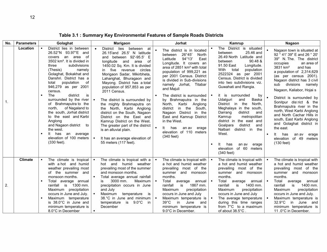
12
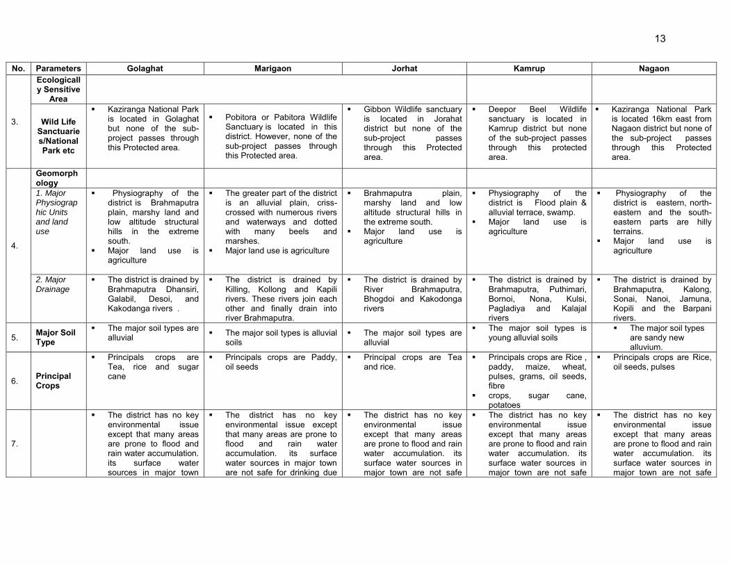
Table 3.1 : Summary Key Environmental Features of Sample Roads Districts No. Parameters Golaghat Marigaon Jorhat Kamrup Nagaon
1.
Location District lies in between 26.52°N 93.97°E and covers an area of 3502 km². It is divided in three subdivisions (Thesis) namely Golaghat, Bokakhat and Danshri. District has a total population of 946,279 as per 2001 census.
The district is surrounded by the river of Brahmaputra to the north, of Nagaland to the south, Jorhat district to the east and Karbi Anglong and Nagaon district to the west.
It has an average elevation of 100 meters (330 feet).
District lies between at 26.15'and 26.5' N latitude and between 92'-95.5' E longitude and area of 1450.02 Sq. Km. It is divided in five revenue circles Morigaon Sadar, Mikirbheta, Laharighat, Bhuragaon and Mayong. District has a total population of 957,853 as per 2011 Census.
The district is surrounded by
the mighty Brahmaputra on the North, Karbi Anglong district on the South, Nagaon District on the East and Kamrup District on the West. The greater part of the district is an alluvial plain.
It has an average elevation of 55 meters (117 feet).
The district is in located between 26°45′ North Latitude 94°13′ East Longitude. It covers an area of 2851 km² with total population of 999,221 as per 2001 Census. District is divided in Sub-divisions namely Jorhat, Titabar and Majuli
The district is surrounded by Brahmaputra in the North, Karbi Anglong district in the South, Nagaon District in the East and Kamrup District in the West.
It has an av erage elevation of 110 meters (340 feet)
The District is situated between 25.46 and 26.49 North Latitude and between 90.48 & 91.50 East Longitude. With total population 2522324 as per 2001 Census. District is divided into two subdivisions viz. Guwahati and Rangia.
it is surrounded by Udalguri and Baska District in the North, Meghalaya in the south, Darrang district and Kamrup metropolitan district in the east and Goalpara district and Nalbari district in the West.
It has an av erage elevation of 60 meters (340 feet)
Nagaon town is situated at 92 ° 41' 39" E and 26 ° 20' 39" N. The. The district occupies an area of 3831 km² and has a population of 2,314,629 (as per census 2001). Nagaon district has 3 c ivil sub divisions namely Nagaon, Kaliabor, Hojai s
District is surrounded by Sonitpur district & the Brahmaputra river in the north, West Karbi Anglong and North Cachar Hills in south, East Karbi Anglong and Golaghat district in the east.
It has an av erage elevation of 49 meters (130 feet)
2.
Climate The climate is tropical with a hot and humid weather prevailing most of the summer and monsoon months.
Total average annual rainfall is 1300 mm. Maximum precipitation occurs in June and July.
Maximum temperature is 38.0°C in June and minimum temperature is 8.0°C in December
The climate is tropical with a hot and humid weather prevailing most of the summer and monsoon months.
Total average annual rainfall is 3000 mm. Maximum precipitation occurs in June and July
Maximum temperature is 38.°C in June and minimum temperature is 9.0°C in December
The climate is tropical with a hot and humid weather prevailing most of the summer and monsoon months.
Total average annual rainfall is 1867 mm. Maximum precipitation occurs in June and July
Maximum temperature is 39°C in June and minimum temperature is 9.0°C in December.
The climate is tropical with a hot and humid weather prevailing most of the summer and monsoon months.
Total average annual rainfall is 1400 mm. Maximum precipitation occurs in June and July
The average temperature during this time ranges from 7°C to a maximum of about 38.5°C .
The climate is tropical with a hot and humid weather prevailing most of the summer and monsoon months.
Total average annual rainfall is 1400 mm. Maximum precipitation occurs in June and July.
Maximum temperature is 32.9°C in June and minimum temperature is 11 .0°C in December.
13
No. Parameters Golaghat Marigaon Jorhat Kamrup Nagaon
3.
Ecologically Sensitive
Area
Wild Life Sanctuaries/National Park etc
Kaziranga National Park is located in Golaghat but none of the sub-project passes through this Protected area.
Pobitora or Pabitora Wildlife Sanctuary is located in this district. However, none of the sub-project passes through this Protected area.
Gibbon Wildlife sanctuary is located in Jorahat district but none of the sub-project passes through this Protected area.
Deepor Beel Wildlife sanctuary is located in Kamrup district but none of the sub-project passes through this protected area.
Kaziranga National Park is located 16km east from Nagaon district but none of the sub-project passes through this Protected area.
4.
Geomorphology
1. Major Physiographic Units and land use
Physiography of the district is Brahmaputra plain, marshy land and low altitude structural hills in the extreme south.
Major land use is agriculture
The greater part of the district is an alluvial plain, criss-crossed with numerous rivers and waterways and dotted with many beels and marshes.
Major land use is agriculture
Brahmaputra plain, marshy land and low altitude structural hills in the extreme south.
Major land use is agriculture
Physiography of the district is Flood plain & alluvial terrace, swamp.
Major land use is agriculture
Physiography of the district is eastern, north- eastern and the south-eastern parts are hilly terrains.
Major land use is agriculture
2. Major Drainage
The district is drained by Brahmaputra Dhansiri, Galabil, Desoi, and Kakodanga rivers .
The district is drained by Killing, Kollong and Kapili rivers. These rivers join each other and finally drain into river Brahmaputra.
The district is drained by River Brahmaputra, Bhogdoi and Kakodonga rivers
The district is drained by Brahmaputra, Puthimari, Bornoi, Nona, Kulsi, Pagladiya and Kalajal rivers
The district is drained by Brahmaputra, Kalong, Sonai, Nanoi, Jamuna, Kopili and the Barpani rivers.
5. Major Soil Type
The major soil types are alluvial
The major soil types is alluvial soils
The major soil types are alluvial
The major soil types is young alluvial soils
The major soil types are sandy new alluvium.
6. Principal Crops
Principals crops are Tea, rice and sugar cane
Principals crops are Paddy, oil seeds
Principal crops are Tea and rice.
Principals crops are Rice , paddy, maize, wheat, pulses, grams, oil seeds, fibre
crops, sugar cane, potatoes
Principals crops are Rice, oil seeds, pulses
7.
The district has no key environmental issue except that many areas are prone to flood and rain water accumulation. its surface water sources in major town
The district has no key environmental issue except that many areas are prone to flood and rain water accumulation. its surface water sources in major town are not safe for drinking due
The district has no key environmental issue except that many areas are prone to flood and rain water accumulation. its surface water sources in major town are not safe
The district has no key environmental issue except that many areas are prone to flood and rain water accumulation. its surface water sources in major town are not safe
The district has no key environmental issue except that many areas are prone to flood and rain water accumulation. its surface water sources in major town are not safe
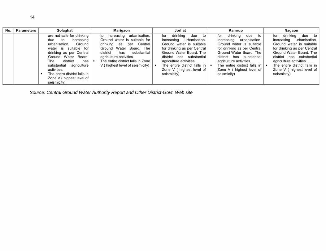
14
No. Parameters Golaghat Marigaon Jorhat Kamrup Nagaon are not safe for drinking due to increasing urbanisation. Ground water is suitable for drinking as per Central Ground Water Board. The district has substantial agriculture activities.
The entire district falls in Zone V ( highest level of seismicity)
to increasing urbanisation. Ground water is suitable for drinking as per Central Ground Water Board. The district has substantial agriculture activities.
The entire district falls in Zone V ( highest level of seismicity)
for drinking due to increasing urbanisation. Ground water is suitable for drinking as per Central Ground Water Board. The district has substantial agriculture activities.
The entire district falls in Zone V ( highest level of seismicity)
for drinking due to increasing urbanisation. Ground water is suitable for drinking as per Central Ground Water Board. The district has substantial agriculture activities.
The entire district falls in Zone V ( highest level of seismicity)
for drinking due to increasing urbanisation. Ground water is suitable for drinking as per Central Ground Water Board. The district has substantial agriculture activities.
The entire district falls in Zone V ( highest level of seismicity)
Source: Central Ground Water Authority Report and Other District-Govt. Web site
15
3.2. Physical Environment 3.2.1. Meteorology and Climate 47. Assam has a humid climatic condition (Tropical Monsoon Rainforest Climate). The weather in Assam is dry in winter, hot, and wet in summer. Its most distinguishing feature is the copious rainfall between March and May at a time when precipitation in upper India is at its minimum. The state has three main seasons :
Winter: November to February are t he months of winter during which the average temperatures range from 06° to 08° C (42° to 46° F).
Summer: The March-to-May season is hot and wet. Summers are hot, with an average temperature of 35° C (92° F) and a high temperature that at times reaches 39° C (102.2° F).
Monsoon season: This season brings relief from the scorching heat of the summers. The average annual rainfall in the state is around 70 inches in the west and around 120 inches in the east.
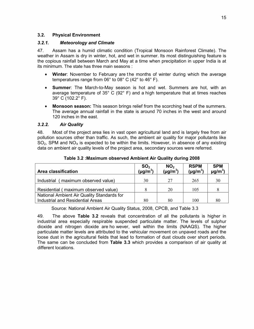
3.2.2. Air Quality 48. Most of the project area lies in vast open agricultural land and is largely free from air pollution sources other than traffic. As such, the ambient air quality for major pollutants like SO2, SPM and NOX is expected to be within the limits. However, in absence of any existing data on ambient air quality levels of the project area, secondary sources were referred.
Table 3.2 :Maximum observed Ambient Air Quality during 2008
Area classification SO2
(µg/m3) NO2
(µg/m3) RSPM
(µg/m3) SPM
µg/m3)
Industrial ( maximum observed value) 30 27 265 30
Residential ( maximum observed value) 8 20 105 8 National Ambient Air Quality Standards for Industrial and Residential Areas 80 80 100 80
Source: National Ambient Air Quality Status, 2008, CPCB, and Table 3.3
49. The above Table 3.2 reveals that concentration of all the pollutants is higher in industrial area especially respirable suspended particulate matter. The levels of sulphur dioxide and nitrogen dioxide are ho wever, well within the limits (NAAQS). The higher particulate matter levels are attributed to the vehicular movement on unpaved roads and the loose dust in the agricultural fields that lead to formation of dust clouds over short periods. The same can be concluded from Table 3.3 which provides a comparison of air quality at different locations.
16
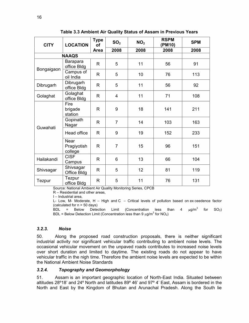
Table 3.3 Ambient Air Quality Status of Assam in Previous Years
CITY LOCATION Type
of Area
SO2 NO2 RSPM (PM10) SPM
2008 2008 2008 2008 NAAQS
Bongaigaon
Barapara office Bldg R 5 11 56 91
Campus of oil India R 5 10 76 113
Dibrugarh Dibrugarh office Bldg R 5 11 56 92
Golaghat Golaghat office Bldg R 4 11 71 108
Guwahati
Fire brigade station
R 9 18 141 211
Gopinath Nagar R 7 14 103 163
Head office R 9 19 152 233
Near Pragiyotish college
R 7 15 96 151
Hailakandi CISF Campus R 6 13 66 104
Shivsagar Shivsagar Office Bldg R 5 12 81 119
Tezpur Tezpur office Bldg R 5 11 76 131
Source: National Ambient Air Quality Monitoring Series, CPCB R – Residential and other areas, I – Industrial area, L- Low, M- Moderate, H – High and C – Critical levels of pollution based on ex ceedence factor (calculated for n > 50 days) BDL = Below Detection Limit (Concentration less than 4 g/m3 for SO2) BDL = Below Detection Limit (Concentration less than 9 g/m3 for NO2)
3.2.3. Noise 50. Along the proposed road construction proposals, there is neither significant industrial activity nor significant vehicular traffic contributing to ambient noise levels. The occasional vehicular movement on the unpaved roads contributes to increased noise levels over short duration and limited to daytime. The existing roads do not appear to have vehicular traffic in the nigh time. Therefore the ambient noise levels are expected to be within the National Ambient Noise Standards
3.2.4. Topography and Geomorphology 51. Assam is an important geographic location of North-East India. Situated between altitudes 28º18‟ and 24º North and latitudes 89º 46‟ and 97º 4‟ East, Assam is bordered in the North and East by the Kingdom of Bhutan and Arunachal Pradesh. Along the South lie

17
Nagaland, Manipur and Mizoram. Meghalaya lies to her South-West, Bengal and Bangladesh to her West.
52. The alluvial soils are extensively distributed over the Brahmaputra and Barak plain and are very fertile. The alluvial soils can further be divided into two main sub types-young alluvial and old alluvial soils. The young alluvial soils are characterized by modern alluvium deposits. The colour of these soils is generally gray to molted gray. On the other hand, the old alluvial soils occurs in some patches of Kokrajgar, Barpeta, Nalbari, Kamrup, darrang, Sonitpur, Lakhimpuir and Dhemaji district. Generally, the old alluvial soils are very deep with fine loams to coarce loams in texture. The piedmont soils are confined to the northern narrow zone along the piedmont zone of the Himalayan foothills. The soils are very deep and fine to coarse loamy in texture. The hill soils are generally found in the southern hill regions of the state. These soils are deep, dark grayish brown in colour and fine to coarse loamy in texture. The lateritic soils are extensively occurring in N. C. Hills district and in some parts of the southern Karbi Plateau. These soils are dark and finely textured with heavy loams. Geomorphological Map of Assam is given in Figure 3.1.
18
Figure 3.1 Physiography & Landforms Maps of Project Districts –Assam
19
3.2.5. Geology/Soil
53. Geologically, as per the plate tectonics, Assam is in the eastern most projection of the Indian Plate, where it thrusts underneath the Eurasian Plate creating asubduction zone. It is postulated that due to the north-easterly movement of the Indian plate, the sedimentary layers of an ancient geosynclines called the Tethys (in between Indian and Eurasian Plates) were pushed upward to form the Himalayas. It is estimated that the height of the Himalayas is increasing by 4 cm each year. Therefore, Assam possesses a special geomorphic environment, with large plains and dissected hills of the South Indian Plateau system abutting the Himalayas to the north, north-east and east.
54. Geomorphic studies also conclude that the Brahmaputra is a paleo-river, older than the Himalayas, which often crosses higher altitudes in the Himalayas eroding at a greater pace than the increase in the height of the mountain range to sustain its flow. The height of the surrounding regions still increasing forming steep gorges in Arunachal. The Brahmaputra valley in Assam is underlain by recent alluvium approximately 200-300m thick consisting of clay, silt, sand and Pebbles.
55. The geological map of the Brahmaputra valley covering the entire Assam state / project districts is given in Figure 3.2
3.2.6. Soil
56. Soil is the most valuable nature resource and serves as one of the prime requisite of life. Soils and in its turn the land through their relative fertility support all agricultural activity ant the plant growth and thereby the most important element of the natural ecosystem. As regards the soils of Assam, geology (parent material), topography and climate seem to play vital role in their formations. Therefore, under varying geological conditions, topographical characteristics and agro-climatic situations different types of soils are found to occur in the hills, piedmonts, plateaus and plains. The soils of Assam may thus generally be divided into four groups, viz. a) Alluvial soils b) Piedmont soils c) Hill soils d) Lateritic soils.
57. The major soil types within the state can be classified into five groups namely Entisols. Mollisols, Alfisols, Ultisols, Histosols. These soil types can be further classified into several sub groups. The Entisols can be sub classified into Younger alluvium and Bhabar. The Younger alluvium can be predominantly seen along the Brahmaputra River and some sporadic patches in southern parts of state. The Mollisols can be seen in western and Northern fringes of the state. The alfisols can be seen in central parts of state. The soil map project districts are given in Figure 3.3.
20
Figure 3.2 Geological Map of Assam
Project district
21
Figure 3.3 Soil map of Assam
Project district
22
3.2.7. Earthquake & Seismicity Seismic Hazard 58. The seismic hazard map of India was updated by Bureau of Indian Standards (BIS) . The entire state of Assam lies in Zone V (Highest level of vulnerability)
59. The Brahmaputra valley and its adjoining highlands are seismically very unstable. The earthquakes of 1897 and 1950, measuring 8.7 on Richter scale are among the most severe in recorded history, and have caused extensive landslips. Rock falls on hill slope, subsidence and fissuring of ground in the valley changes in the courses and morphology of several tributary rivers. The hazard zoning map is shown in Figure 3.4 .
Figure 3.4 : Hazard and Seismic Zone Map 3.2.8. Land Use
60. The large geographical area is classified as forest area (26832 sq km or 34.21% of the total geographic area of the State). According to legal classification, reserved forests constitute 66.58 % and Unclassified forests, 33.42%.Details of land use is given in Table 3.4 and Figure 3.5.
Assam
23
Table 3.4 : Land Use Pattern in the State
Source: State of Forest Report, 2005, Forest Survey of India Dehradun
Figure 3.5 : Landuse of Assam
Land Use Area in '000 ha Percentage Total Geographical area 7844 Reporting area for land Utilization 7850 100.0 Forests 1932 24.61 Not Available for cultivation 2531 32.24 Permanent pastures and other grassing land 163 2.08
Land under miscellaneous tree crops & groves 234 2.98 Culturable wasteland 80 1.02 Fallow lands other current fallows 65 0.83 Current fallows 110 1.40 Net area sown (as per agriculture census 1995-96 expect total cropped area) 2734 34.83
Project district
24
3.2.9. Hydrology and Water quality
61. Assam has extensive river system consisting of the Brahmaputra, the Kusiyara and the Barak and their tributaries. All the rivers in Assam are liable to floods, mainly because they receive heavy rainfall within a short time. These rivers are in their early stage of maturity and are very active agents of erosion. The river waters collect a tremendous amount of silt and other debris and raise the level of the river beds. Therefore, it becomes impossible for the main channel to cope with the vast volume of water received during the rains. The Brahmaputra River has a total drainage area of about 935,500 sq. km. So far, a total of 4, 77,163 hectares of land have been irrigated in Assam.
62. Sample road are mostly crossed by seasonal small channels. However many of the sample roads are located in close proximity of the rivers and are prone to flood. Ground water being extracted through hand pumps or tubewell and is the main source of water supply to villagers.
63. In Assam, pollution is increasing in most of surface water resources in major towns due to increasing urbanization trend. None of the water sources are safe for drinking or bathing without conventional water treatment. Rivers such as Bharmputra, Buridihing, Disang, Jhanji, Dhansiri, Subbansiri and Borakk etc. are found to be polluted at different stretches due to industrial, domestic and agricultural pollution. Among all the rivers, Bharmputra and Dhansiri River is the most polluted. The hydro geological conditions in both porous and fissured formations spread across project districts / state are given in Table 3.5
25
Table 3.5 Hydro geological Conditions of Project District / Assam
Dynamic Ground Water Resources
Annual Replenishable Ground water Resource 27.23 BCM Net Annual Ground Water Availability 24.89 BCM
Annual Ground Water Draft 5.44 BCM Stage of Ground Water Development 22 %
Ground Water Development & Management
Over Exploited NIL Critical NIL
Semi- critical NIL Artificial Recharge to Ground Water (AR) Feasible AR structures:
250 Check Dams, 500 weirs, 1000 Gabion structures, 250 development of springs 600
RWH in Urban Areas Ground Water Quality Problems
Contaminants Districts affected (in part)
Fluoride (>1.5 mg/l) Goalpapra, Kamrup, Karbi Anglong, Nagaon,
Iron (>1.0 mg/l) Cachar, Darrang, Dhemaji, Dhubri, Goalpapra, Golaghat, Hailakandi, Jorhat, Kamrup, Karbi Anglong, Karimganj, Kokrajhar, Lakhimpur,
Morigaon, Nagaon, Nalbari, Sibsagar, Sonitpur Arsenic (>0.05 mg/l ) Dhemaji
BCM: Billion Cubic meter, 64. Surface water Quality : Water resources of the State as a whole are substantial. About 8251 sq km, which is 10.5% of the total geographical area of the State, is occupied by surface water bodies. Of this about 6503 sq km is occupied by the river systems including the mighty Brahmaputra and 1748 sq km by natural wet lands including seasonal and permanent water logged and marshy areas and man-made reservoirs and tanks of size more than 2.5 ha. The total surface water resource of the State is estimated at about 600 billion cubic.
65. Groundwater Quality and Availability: The annual replenishable ground water resource of the state has been estimated as 27.23 billion cubic meter and net annual groundwater availability 24.89 billion cubic meter. The annual groundwater draft is estimated as 5.44 billion cubic meter of which 4.85 billion cubic meter is for irrigation and 0.59 billion cubic meter is for domestic and industrial uses. The overall stage of groundwater development in the state is 22% - with the lowest figure of 2% in Cachar district and highest 56%in Bongaigaon district .
66. Flood Affected Prone areas: The chronically flood prone areas within the state are mainly along the river Brahmaputra from eastern to western part of the state. The year 1988 witness worst flood when a total of 42.23 lakh hectares of land (including
26
11.20 lakh hectares of crop damage) affecting more then 8 million people in 8770 villages.
67. Hydrology: The Brahmaputra River and the 33 major tributaries joining it in Assam, including the main trans-Himalayan tributaries of Subansiri, Jia Bharali, and Manas, carry about 30% of the country‟s total surface water. Surface water bodies covering about 8,251 square kilometers (km²) account for 10.5% of the geographical area of the state. Of these, the river systems, including waterlogged areas, occupy 6,503 km². The annual surface water availability is more than 53 million hectare-meters. Brahmaputra valley in Assam has 3,513 wetlands, covering 1,012.3 km². Groundwater is also plentiful at shallow depth in the valley; utilizable groundwater is estimated to exceed 2 million hectare-meters.
3.3. Biological Environment / Ecological Resources 3.3.1. Biological Environment / Ecological Resources of the State
68. Assam is one of the richest biodiversity zones in the world. There are a number of tropical rainforests in Assam. Moreover, there are riverine grass lands, bamboo orchards and numerous wetland ecosystems. Many of these areas have been protected by developing national parks and reserved forests. The Kaziranga and Manas are the two World Heritage Sites in the region. The Kaziranga is the home for the rare Indian Rhinoceros, while Manas is a project tiger sanctuary area. However, no project roads pass through any of the protected areas.
Floral diversity of the state
Forest and forest type of State 69. Forestry in Assam is one of the most important economic activities of the state. This has been possible due to the vast stretch of forests in Assam. The forest in Assam can be described as : Tropical Wet Evergreen Forests, Tropical Semi Evergreen Forests, and Tropical Moist Deciduous Forests. The total forest area of state is 26,748 Sq. Km. (2.4 % of Country). Reserved Forest 13,870 Sq. Km. (17.68% of State Geo Area) Protected Area is 3,925 Sq. Km. (5% of State's Geo Area). 70. Although none of the road stretches passes through any forest land/area but still has trees, which might require felling during clearing up operations for construction of rural roads. In most of cases, tree cutting has been minimized by suitably modifying the alignment
Mammals
71. Macaca (Rhesus macaque), Golden langur (Trachypithecus geei), Bay bamboo rat (Connomys badius), Spotted Deer (Curvus axis), Otter (Aonyx congica), Indian Mongoose (Herpestes javanicus), Clouded leopard (Neofelis nebulosa) were reported in the forests of Guwahati. List of mammals is given in Table 3.6.
Table 3.6 : Mammals Recorded In Guwahati City And Forest Area
S.N Common Name Scientific Name 1. Spotted deer Axis axis 2. Swamp deer Rucervus duvaucelii
27
S.N Common Name Scientific Name 3. Clouded leopard Neofelis nebulosa 4. Golden langur Trachypithecus geei 5. Indian mongoose Herpestes javanicus 6. Bay bamboo rat Cannomys badius 7. Hog badger Arctonyx collaris 8. Rhesus macaque Macaca mulatta 9. Hoary bamboo rat Rhizomys pruinosus 10. Otter Lutra perspicillata 11 Ganges river dolphin Platanista gangetica Avifauna
72. Assam state supports rich avifauna, due to abundance of feeding, breeding and roosting places. In this state both endemic and exotic species were reported. Mainly endemic species were confined to upper Assam and exotic species were mainly migratory birds, which arrive in winter for roosting. Birds reported during the time of survey in Guwahati were cosmopolitan in distribution. No endangered species were noticed. Due to high abundance of avifauna, they were noticed along the roadside, in market places, along the banks of river, lakes and in human settlement areas. Majority of the birds recorded in core and buffer zone show short distance and local migration during the daytime (diurnal migration). Their migrations were mainly in search food and new feeding ground.
73. Birds recorded in large number were rock pigeon (Columba livia), house crow (Corvus splendens), cattle egret (Bubulcus ibis), House sparrow, Myna. Three subspecies of myna like pied myna, common myna and bank myna were commonly noticed. They represent species diversity. Table: 3.7 gives the list of avifauna found in Assam including part of subproject districts.
Table 3.7 : List of Fauna
S. N Scientific Name Common Name 1. Acridotheres tristis Common myna 2. Columba livia Blue rock pigeon 3. Corvus splendens House crow 4. Dicrurus adsimilis Black drango 5. Haleyon smyrensis White breasted kingfisher
6. Milvus migrans Pariah kite 7. Passer domesticus House sparrow 8. Streptopelia chinensis Spotted dove 9. Apus affinis House swift
10. Tringa hypoleucos Common sandpiper 11. Mirafra assamica Lark
28
S. N Scientific Name Common Name 12. Corvus Jungle Crow
macrorhynchos 13. Ocyceros birostris Indian Grey
hornbill 14. Dicrurus hottentottus Hair-crested
Drongo 15. Anthus rufulus Paddyfield pipit 16. Cercomela fusca Indian Chat 17. Coracias Indian Roller
benghalensis 18. Merops orientalis Green Bee Eater 19. Ardeola gravii Pond heron 20. Turdoides striata Red vented bulbul 21. Vanellus indicus Red wattled lapwing
22. Egretta garzetta Little egret 23. Ardeola grayigrayi Indian pond heron 24. Bubulcus ibis Cattle egret 25. Turdoides striata Jungle babbler 26. Acridotheres Bank myna
ginginianus 27. Gracupica contra Pied myna 28. Psittacula kramen Rose ring parakeet 29. Upupa epops Hoopoe
3.3.2. Wildlife and Protected Areas:
74. Table 3.8 provides details of National park and Sanctuaries corresponding to serial Number indicated at Figure 3.6. There is no wildlife Sanctuaries/National Parks, Tiger Reserves etc. along the project area.
Table 3.8 : List of Protected Areas in Assam
Name Area in Sq. km Main attraction
Kaziranga NP 858.98 Rhino, Tiger, Bears, Wild Buffalo, Swamp Deer, Gaur, Gibbon, Bengal Florican, Dolphin, Otter
Manas NP 500 Tiger, Asiatic Wild Buffalo, Asian Elephant, Gaur, Dhole Pigmy hog, Hispid hare, Golden langur, Bengal florican
Dibru-Saikhowa NP 340 Ferel horses, Asiatic Wild Buffalo, White winged wood duck and Salix swamp
Nameri NP 200 Tiger, 4 species of Hornbill, White Winged Wood duck, Golden Mahaseer
29
Name Area in Sq. km Main attraction
Rajiv Gandhi 78.91 Rhino, Tiger, Maljurias Bengal Florican, Otter Wildlife Sanctuaries Garampani 6.05 Elephant, Hot Water Springs
Laokhowa 70.13 Elephant, Tiger, Asiatic Wild Buffalo, Bengal Florican
Bornadi 26.22 Hispid Hare, Pygmy Hog, Dhole, Elephants, Tiger, Great Pied Hornbill, Peafowl
Chakrasila 45.5 Golden Langur, Gaur, Sambar, Barking deer
Burachapori 44.06 Elephants, Tiger, Wild buffalo, Aquatic Birds, Bengal Florican
Pani-Dihing 33.93 Stray Elephants; Birds Paradise
Hollongapar Gibbon 20.98
7 Primates (Hoolock Gibbon, Stump-tailed Macaque, Capped Langur, Pig –tailed Macaque, Assamese Macaque, Slow Loris and Rhesus Macaque ), Elephant, Leopard
Pobitora 38.8 Rhino, Leopards, Barking Deer, Migratory Birds
Sonai -Rupai 220 Elephant, Tiger, Gaur, Dhole, Sambar, White Winged Wood duck
Bherjan, Borajan- Padumoni 7.22
Hoolock Gibbon, Capped Langur, Pig-tailed Macaque, Slow Loris and Rhesus Macaque, Leopard
East Karbi Anglong 222 Gaur, Elephants, Tiger, Sambar, Barking Deer, Lesser Cats, Hoolock, Gibbon, Capped Langur, Wreathed Hornbill,
Nambor 37 Gaur, Elephants, Tiger, Sambar, Barking Deer, Lesser Cats, Hoolock Gibbon, Capped Langur, Wreathed Hornbill
Marat Longri 451 Tigers, Leopards, Gaur, Elephants, Hoolock Gibbon
Nambor- Doigurung 97.15 Gaur, Elephants, Tiger, Sambar, Barking Deer, Lesser Cats, Hoolock Gibbon, Capped Langur, Wreathed Hornbill
Amchang 78.64 Elephant, Gaur, Leopard, Lesser Cats, Slow Loris, Hoolock Gibbon, Capped Langur
Dehing Patkai 111.19 Elephants, Tiger, Hoolock Gibbon, White winged Wood Duck, Hornbills, Rain forests
Borail 326.25 Serow, Himalayan Black Bear, Hoolock Gibbon, Langur, Spectacled Monkey
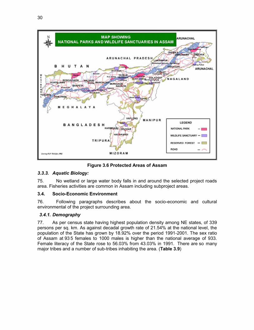
30
Figure 3.6 Protected Areas of Assam
3.3.3. Aquatic Biology: 75. No wetland or large water body falls in and around the selected project roads area. Fisheries activities are common in Assam including subproject areas.
3.4. Socio-Economic Environment 76. Following paragraphs describes about the socio-economic and cultural environmental of the project surrounding area.
3.4.1. Demography 77. As per census state having highest population density among NE states, of 339 persons per sq. km. As against decadal growth rate of 21.54% at the national level, the population of the State has grown by 18.92% over the period 1991-2001. The sex ratio of Assam at 93 5 females to 1000 males is higher than the national average of 933. Female literacy of the State rose to 56.03% from 43.03% in 1991. There are so many major tribes and a number of sub-tribes inhabiting the area. (Table 3.9)
31
Table 3.9 : Demographic Profile
Population (2001 census) 26655528 Males 13777037 Females 12878491 Urban population % 12.72 Literacy Rate (census 2001) in % 63.3 Male Literacy in % 71.3 Male Literate in numbers 8188697 Female Literacy in % 54.6 Female Literacy in numbers 5826657 Note: Figures in bracket indicate percentage Source: Census, 2001
3.4.2. Healthcare
78. The Total Fertility Rate of the State is 2.6. The Infant Mortality Rate is 64 and Maternal Mortality Ratio is 480 (SRS 2004 - 2006) which are higher than the National average. The Sex Ratio in the State is 935 (as compared to 933 for the country). Comparative figures of major health and demographic indicators are as follows:
79. Table I: Demographic, Socio-economic and Health profile of Assam State as compared to India figures
S. No. Item Assam India 1 Total population (Census 2001) (in million) 26.66 1028.61 2 Decadal Growth (Census 2001) (%) 18.92 21.54 3 Crude Birth Rate (SRS 2008) 23.9 22.8 4 Crude Death Rate (SRS 2008) 8.6 7.4 5 Total Fertility Rate (SRS 2008) 2.6 2.6 6 Infant Mortality Rate (SRS 2008) 64 53 7 Maternal Mortality Ratio (SRS 2004 - 2006) 480 254 8 Sex Ratio (Census 2001) 935 933 9 Population below Poverty line (%) 36.09 26.10 10 Schedule Caste population (in million) 1.83 166.64 11 Schedule Tribe population (in million) 3.31 84.33 12 Female Literacy Rate (Census 2001) (%) 54.6 53.7
3.4.3. Literacy and Education
80. The state as well as the central government gives primary focus on developing the state of the education in the state. Assam has the highest number of schools, colleges and universities in the region. There are a total number of 44,309 primary and middle schools, secondary schools, high schools, colleges for professional as well as general education, universities and other educational institutions in the state. There are some of the best known technical and professional institutes of international repute. These include; Cotton College, Centre for Plasma Physics, Indian Institute of Technology Guwahati, National Institute of Technology, Silchar, North Eastern Regional Institute of Water and Land Management, Defence

32
Research Laboratory, and others.
Universities 5 College of general education 431 College of professional education 34 High School 620 Secondary School 4607 Primary and Middle School 38,410 Other Institutions 202 Total 44,309
* Professional educational institutions include engineering, technology, architecture, medical and teacher training colleges.
3.4.4. Affluence
81. The percentage of pucca houses both in rural and urban areas of Assam is lower than the all India average. There has also been a reduction in the percentage of pucca houses in rural Assam between 1991 and 1993-94.House holds with semi pucca houses continued to be higher in urban Assam and lower in rural Assam than the corresponding all India averages. The percentage of households with semi pucca houses in urban Assam decreased between 1991 and 1993-94.
3.4.5. Economy
82. Agriculture is the main occupation of the people of the state. Since rice is the staple diet of the people, cultivation of rice is the main occupation of those practicing agriculture. Other than that, pulses, tea, jute and fruit are also cultivated in good quantity.
83. Approximately 15% of the world‟s tea production comes from this small state, which is its main source of revenue. Almost 75% of the tea gardens are upper Assam districts of Darrang, Sibsagar and Lakhimpur. Other than tea, fruits like oranges, bananas, guavas, pineapples and guavas are also grown. Forests are an important part of the economy. Timber and bamboo are major products from these forests that bring income to the state.
3.4.6. Agriculture
84. Agriculture accounts for more than a third of Assam‟s income and employs 69 percent of total workforce. Assam's biggest contribution to the world is its tea. Assam produces some of the finest and most expensive teas in the world. Other than the Chinese tea variety Camellia sinensis, Assam is the only region in the world that has its own variety of tea, called Camellia assamica. Assam tea is grown at elevations near sea level, giving it a malty sweetness and an earthy flavor, as opposed to the floral aroma of highland (e.g. Darjeeling, Taiwanese) teas. Assam also accounts for fair share of India‟s production of rice, rapeseed, mustard, jute, potato, sweet potato, banana, papaya, areca nut and turmeric. Assam is also a home of large varieties of citrus fruits, leaf vegetables, vegetables, useful grasses, herbs, spices, etc, which are mostly subsistence crops.
3.4.7. Industries, Cottage and Small Industries
85. Agro-based industries of Assam include-Tea industry, Sugar industry, Grain mill products industry-(Rice, Oil and Flour Mill), Food processing industry and Textile industry.
33
86. Assam was traditionally famous for its cottage industry, especially spinning and weaving. Pat or pure silk production is essentially confined to Assam. Assam produces about 10% of total natural silk of India. Assam also produces Muga, the golden silk. Weaving is an important cottage industry of Assam. It is a traditional industry, which can be traced back to very ancient times. Assam also has, agro-based industries which include-tea, sugar, grain mill products (Rice, Oil and Flour Mill), Food processing and Textile industries. Mineral-based industries of Assam includes-Railway workshop, engineering industry, re-rolling mill, steel work etc.
Table 3.10 : Salient Environmental Features of Sample Roads District Block Road Name
(length) Salient Environmental
Features
Golaghat
Gomaiguri G- 28 to Adarsha No. 1
Topography is plain There is river passes
through road alignment left Ch. 0.4 to 0.5.
The project road passes by a pond at left hand side namely in between at Ch.0.7,0.8,0.9 RHS and 1.3 on the LHS of the road
Inhabited areas between concentrated at Ch. Ch.0.0 to 0.2,0.4 to 0.8,1.1 to 1.4,1.8 to 1.9,2.6 to 2.7 both side and 1.5 to 1.8 on the LHS of the road Few tree cutting will be required
Few utility and community structures within 10m on either side of the alignment
Project road passes mainly through agricultural land and patches of barren land.
Water stagnant problem near chain age Ch. 0.1,0.2,1.3,1.5,2.1,2.5.
Gomaiguri
L 023 to Khutakata Phuloni(Phulonigaon ali)
Topography is plain Inhabited areas between
inhabited areas are concentrated at Ch.0 Ch.1.4 to 1.6 and 0.0 to 1.2 on the RHS of the road.
The project road passes by a couple of ponds at left hand side namely road at Ch.0.3 LHS and 1.7 on the RHS of the road.
Few tree cutting will be required
Temple chain age at 0.0
34
District Block Road Name (length)
Salient Environmental Features
LHS Few utility and community
structures within 10m on either side of the alignment
Project road passes mainly through agricultural land and no barren land.
Gomaiguri
T6 to Samukjan(Lakhimipathar Sarimari Ali)
Topography is plain. . Inhabited areas between
Ch.0.0 to 0.6 and 0.7 to 1.3 on both side of the road
The project road passes through agriculture land
There are many Ponds at Ch.0.3, 0.7, 0.8 on the RHS and 0.8, 0.9 on the LHS of the road.
Water stagnation problem near the road at Ch. 0.2, 1.6, 1.7, 1.9.
Few tree cutting and utility/community structure shifting will be required.
The project road passes through only agriculture land.
East Golaghat
T2 TO BOSAGAON L-23(NA-PAMOWA ALI)
Topography is flat. Inhabited areas are
concentrated between Ch.0.0 to 0.2 and 1.5 to 1.9.One Rivers (Ziladhari) is crossing the alignment and there are many Ponds at Ch.0.3,0.4,1.8,2.3 LHS and 0.9,1.3,1.9 on the RHS of the road Few tree cutting and utility/community structure shifting will be required.
Project road passes mainly through agricultural land.
Gomariguri T 1 to Titabor
Tongia (Torani Mazgaon)
Topography is plain. Inhabited areas Ch.0.0 to
0.2,1.3 to 1.8,1.9 to 2.0 both side, 1.8 to 1.9 RHS and 0.2 to 0.5,0.7 to 0.9 on the LHS of the road
The project road passes
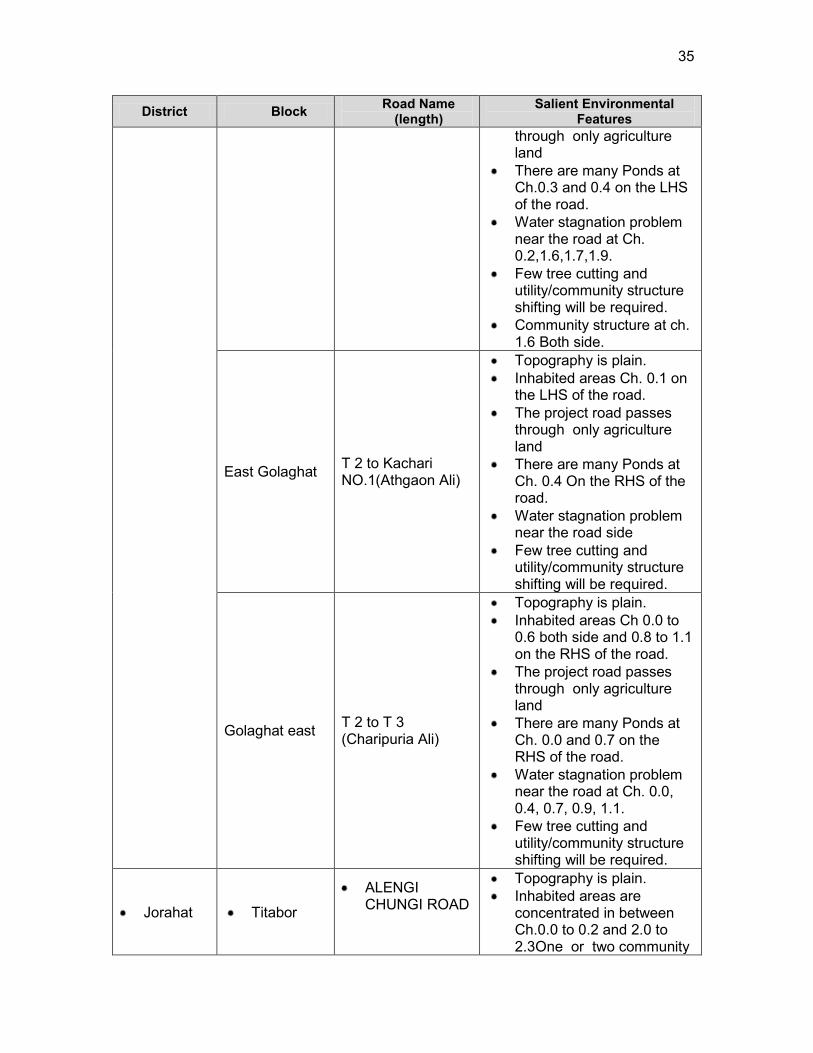
35
District Block Road Name (length)
Salient Environmental Features
through only agriculture land
There are many Ponds at Ch.0.3 and 0.4 on the LHS of the road.
Water stagnation problem near the road at Ch. 0.2,1.6,1.7,1.9.
Few tree cutting and utility/community structure shifting will be required.
Community structure at ch. 1.6 Both side.
East Golaghat T 2 to Kachari NO.1(Athgaon Ali)
Topography is plain. Inhabited areas Ch. 0.1 on
the LHS of the road. The project road passes
through only agriculture land
There are many Ponds at Ch. 0.4 On the RHS of the road.
Water stagnation problem near the road side
Few tree cutting and utility/community structure shifting will be required.
Golaghat east T 2 to T 3 (Charipuria Ali)
Topography is plain. Inhabited areas Ch 0.0 to
0.6 both side and 0.8 to 1.1 on the RHS of the road.
The project road passes through only agriculture land
There are many Ponds at Ch. 0.0 and 0.7 on the RHS of the road.
Water stagnation problem near the road at Ch. 0.0, 0.4, 0.7, 0.9, 1.1.
Few tree cutting and utility/community structure shifting will be required.
Jorahat
Titabor
ALENGI CHUNGI ROAD
Topography is plain. Inhabited areas are
concentrated in between Ch.0.0 to 0.2 and 2.0 to 2.3One or two community
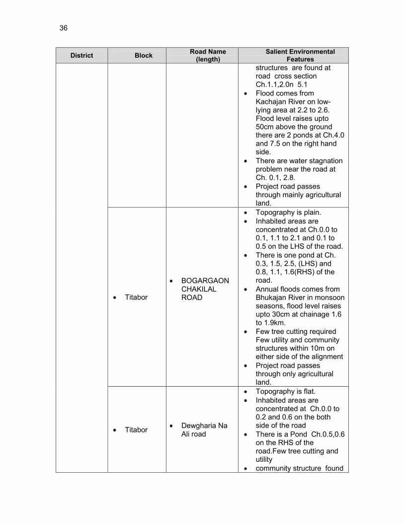
36
District Block Road Name (length)
Salient Environmental Features
structures are found at road cross section Ch.1.1,2.0n 5.1
Flood comes from Kachajan River on low-lying area at 2.2 to 2.6. Flood level raises upto 50cm above the ground there are 2 ponds at Ch.4.0 and 7.5 on the right hand side.
There are water stagnation problem near the road at Ch. 0.1, 2.8.
Project road passes through mainly agricultural land.
Titabor
BOGARGAON CHAKILAL ROAD
Topography is plain. Inhabited areas are
concentrated at Ch.0.0 to 0.1, 1.1 to 2.1 and 0.1 to 0.5 on the LHS of the road.
There is one pond at Ch. 0.3, 1.5, 2.5, (LHS) and 0.8, 1.1, 1.6(RHS) of the road.
Annual floods comes from Bhukajan River in monsoon seasons, flood level raises upto 30cm at chainage 1.6 to 1.9km.
Few tree cutting required Few utility and community structures within 10m on either side of the alignment
Project road passes through only agricultural land.
Titabor Dewgharia Na Ali road
Topography is flat. Inhabited areas are
concentrated at Ch.0.0 to 0.2 and 0.6 on the both side of the road
There is a Pond Ch.0.5,0.6 on the RHS of the road.Few tree cutting and utility
community structure found
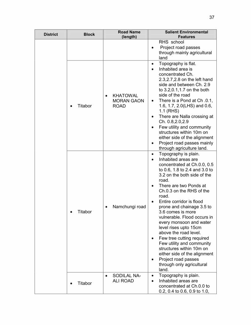
37
District Block Road Name (length)
Salient Environmental Features
RHS school Project road passes
through mainly agricultural land
Titabor
KHATOWAL MORAN GAON ROAD
Topography is flat. Inhabited area is
concentrated Ch. 2.3,2.7,2.8 on the left hand side and between Ch. 2.9 to 3.2,0.1,1.7 on the both side of the road
There is a Pond at Ch .0.1, 1.6, 1.7, 2.0(LHS) and 0.6, 1.1 (RHS)
There are Nalla crossing at Ch. 0.8,2.0,2.9
Few utility and community structures within 10m on either side of the alignment
Project road passes mainly through agriculture land.
Titabor Namchungi road
Topography is plain. Inhabited areas are
concentrated at Ch.0.0, 0.5 to 0.6, 1.8 to 2.4 and 3.0 to 3.2 on the both side of the road.
There are two Ponds at Ch.0.3 on the RHS of the road.
Entire corridor is flood prone and chainage 3.5 to 3.6 comes is more vulnerable. Flood occurs in every monsoon and water level rises upto 15cm above the road level.
Few tree cutting required Few utility and community structures within 10m on either side of the alignment
Project road passes through only agricultural land.
Titabor
SODILAL NA-ALI ROAD
Topography is plain. Inhabited areas are
concentrated at Ch.0.0 to 0.2, 0.4 to 0.6, 0.9 to 1.0,
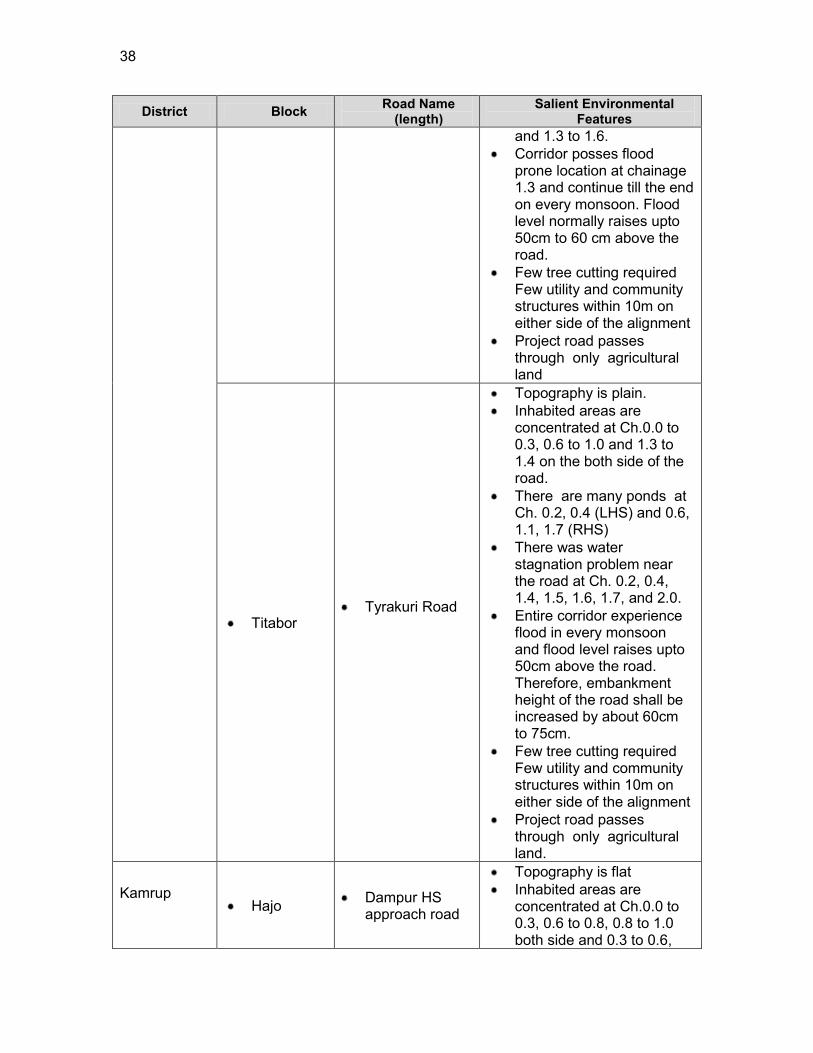
38
District Block Road Name (length)
Salient Environmental Features
and 1.3 to 1.6. Corridor posses flood
prone location at chainage 1.3 and continue till the end on every monsoon. Flood level normally raises upto 50cm to 60 cm above the road.
Few tree cutting required Few utility and community structures within 10m on either side of the alignment
Project road passes through only agricultural land
Titabor Tyrakuri Road
Topography is plain. Inhabited areas are
concentrated at Ch.0.0 to 0.3, 0.6 to 1.0 and 1.3 to 1.4 on the both side of the road.
There are many ponds at Ch. 0.2, 0.4 (LHS) and 0.6, 1.1, 1.7 (RHS)
There was water stagnation problem near the road at Ch. 0.2, 0.4, 1.4, 1.5, 1.6, 1.7, and 2.0.
Entire corridor experience flood in every monsoon and flood level raises upto 50cm above the road. Therefore, embankment height of the road shall be increased by about 60cm to 75cm.
Few tree cutting required Few utility and community structures within 10m on either side of the alignment
Project road passes through only agricultural land.
Kamrup
Hajo Dampur HS
approach road
Topography is flat Inhabited areas are
concentrated at Ch.0.0 to 0.3, 0.6 to 0.8, 0.8 to 1.0 both side and 0.3 to 0.6,
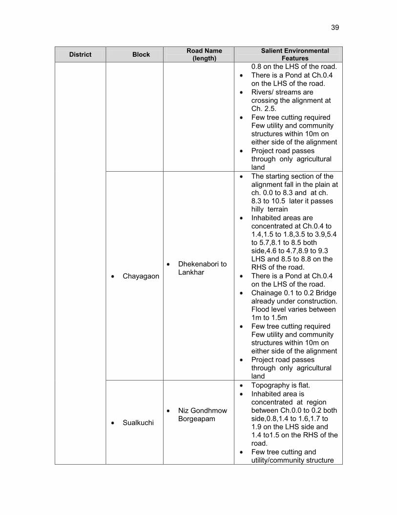
39
District Block Road Name (length)
Salient Environmental Features
0.8 on the LHS of the road. There is a Pond at Ch.0.4
on the LHS of the road. Rivers/ streams are
crossing the alignment at Ch. 2.5.
Few tree cutting required Few utility and community structures within 10m on either side of the alignment
Project road passes through only agricultural land
Chayagaon
Dhekenabori to Lankhar
The starting section of the alignment fall in the plain at ch. 0.0 to 8.3 and at ch. 8.3 to 10.5 later it passes hilly terrain
Inhabited areas are concentrated at Ch.0.4 to 1.4,1.5 to 1.8,3.5 to 3.9,5.4 to 5.7,8.1 to 8.5 both side,4.6 to 4.7,8.9 to 9.3 LHS and 8.5 to 8.8 on the RHS of the road.
There is a Pond at Ch.0.4 on the LHS of the road.
Chainage 0.1 to 0.2 Bridge already under construction. Flood level varies between 1m to 1.5m
Few tree cutting required Few utility and community structures within 10m on either side of the alignment
Project road passes through only agricultural land
Sualkuchi
Niz Gondhmow Borgeapam
Topography is flat. Inhabited area is
concentrated at region between Ch.0.0 to 0.2 both side,0.8,1.4 to 1.6,1.7 to 1.9 on the LHS side and 1.4 to1.5 on the RHS of the road.
Few tree cutting and utility/community structure
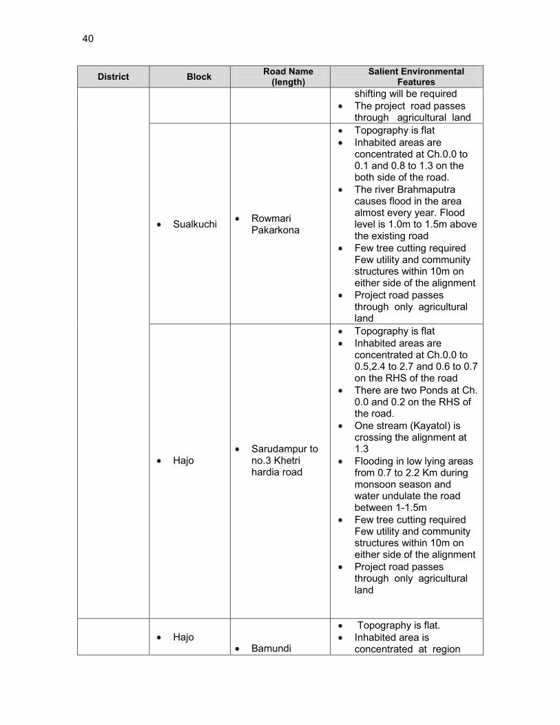
40
District Block Road Name (length)
Salient Environmental Features
shifting will be required The project road passes
through agricultural land
Sualkuchi Rowmari Pakarkona
Topography is flat Inhabited areas are
concentrated at Ch.0.0 to 0.1 and 0.8 to 1.3 on the both side of the road.
The river Brahmaputra causes flood in the area almost every year. Flood level is 1.0m to 1.5m above the existing road
Few tree cutting required Few utility and community structures within 10m on either side of the alignment
Project road passes through only agricultural land
Hajo
Sarudampur to no.3 Khetri hardia road
Topography is flat Inhabited areas are
concentrated at Ch.0.0 to 0.5,2.4 to 2.7 and 0.6 to 0.7 on the RHS of the road
There are two Ponds at Ch. 0.0 and 0.2 on the RHS of the road.
One stream (Kayatol) is crossing the alignment at 1.3
Flooding in low lying areas from 0.7 to 2.2 Km during monsoon season and water undulate the road between 1-1.5m
Few tree cutting required Few utility and community structures within 10m on either side of the alignment
Project road passes through only agricultural land
3.5.
Hajo
Bamundi
Topography is flat. Inhabited area is
concentrated at region
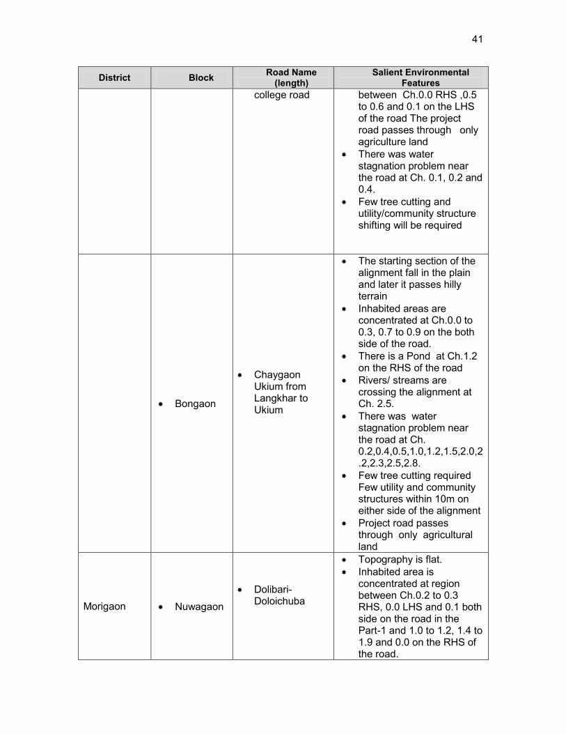
41
District Block Road Name (length)
Salient Environmental Features
college road
between Ch.0.0 RHS ,0.5 to 0.6 and 0.1 on the LHS of the road The project road passes through only agriculture land
There was water stagnation problem near the road at Ch. 0.1, 0.2 and 0.4.
Few tree cutting and utility/community structure shifting will be required
Bongaon
Chaygaon Ukium from Langkhar to Ukium
The starting section of the alignment fall in the plain and later it passes hilly terrain
Inhabited areas are concentrated at Ch.0.0 to 0.3, 0.7 to 0.9 on the both side of the road.
There is a Pond at Ch.1.2 on the RHS of the road
Rivers/ streams are crossing the alignment at Ch. 2.5.
There was water stagnation problem near the road at Ch. 0.2,0.4,0.5,1.0,1.2,1.5,2.0,2.2,2.3,2.5,2.8.
Few tree cutting required Few utility and community structures within 10m on either side of the alignment
Project road passes through only agricultural land
Morigaon Nuwagaon
Dolibari-Doloichuba
Topography is flat. Inhabited area is
concentrated at region between Ch.0.2 to 0.3 RHS, 0.0 LHS and 0.1 both side on the road in the Part-1 and 1.0 to 1.2, 1.4 to 1.9 and 0.0 on the RHS of the road.
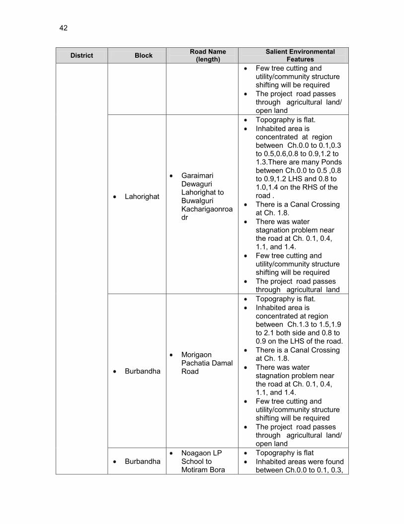
42
District Block Road Name (length)
Salient Environmental Features
Few tree cutting and utility/community structure shifting will be required
The project road passes through agricultural land/ open land
Lahorighat
Garaimari Dewaguri Lahorighat to Buwalguri Kacharigaonroadr
Topography is flat. Inhabited area is
concentrated at region between Ch.0.0 to 0.1,0.3 to 0.5,0.6,0.8 to 0.9,1.2 to 1.3.There are many Ponds between Ch.0.0 to 0.5 ,0.8 to 0.9,1.2 LHS and 0.8 to 1.0,1.4 on the RHS of the road .
There is a Canal Crossing at Ch. 1.8.
There was water stagnation problem near the road at Ch. 0.1, 0.4, 1.1, and 1.4.
Few tree cutting and utility/community structure shifting will be required
The project road passes through agricultural land
Burbandha
Morigaon Pachatia Damal Road
Topography is flat. Inhabited area is
concentrated at region between Ch.1.3 to 1.5,1.9 to 2.1 both side and 0.8 to 0.9 on the LHS of the road.
There is a Canal Crossing at Ch. 1.8.
There was water stagnation problem near the road at Ch. 0.1, 0.4, 1.1, and 1.4.
Few tree cutting and utility/community structure shifting will be required
The project road passes through agricultural land/ open land
Burbandha Noagaon LP
School to Motiram Bora
Topography is flat Inhabited areas were found
between Ch.0.0 to 0.1, 0.3,
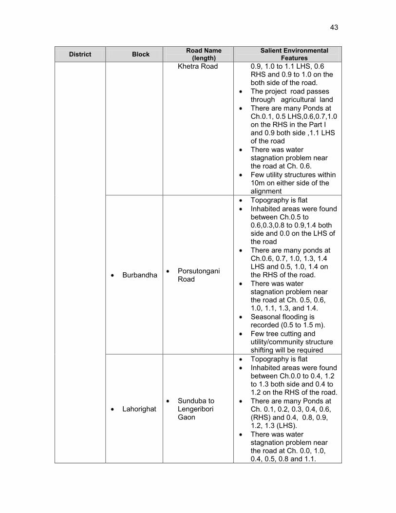
43
District Block Road Name (length)
Salient Environmental Features
Khetra Road 0.9, 1.0 to 1.1 LHS, 0.6 RHS and 0.9 to 1.0 on the both side of the road.
The project road passes through agricultural land
There are many Ponds at Ch.0.1, 0.5 LHS,0.6,0.7,1.0 on the RHS in the Part I and 0.9 both side ,1.1 LHS of the road
There was water stagnation problem near the road at Ch. 0.6.
Few utility structures within 10m on either side of the alignment
Burbandha Porsutongani Road
Topography is flat Inhabited areas were found
between Ch.0.5 to 0.6,0.3,0.8 to 0.9,1.4 both side and 0.0 on the LHS of the road
There are many ponds at Ch.0.6, 0.7, 1.0, 1.3, 1.4 LHS and 0.5, 1.0, 1.4 on the RHS of the road.
There was water stagnation problem near the road at Ch. 0.5, 0.6, 1.0, 1.1, 1.3, and 1.4.
Seasonal flooding is recorded (0.5 to 1.5 m).
Few tree cutting and utility/community structure shifting will be required
Lahorighat Sunduba to
Lengeribori Gaon
Topography is flat Inhabited areas were found
between Ch.0.0 to 0.4, 1.2 to 1.3 both side and 0.4 to 1.2 on the RHS of the road.
There are many Ponds at Ch. 0.1, 0.2, 0.3, 0.4, 0.6, (RHS) and 0.4, 0.8, 0.9, 1.2, 1.3 (LHS).
There was water stagnation problem near the road at Ch. 0.0, 1.0, 0.4, 0.5, 0.8 and 1.1.

44
District Block Road Name (length)
Salient Environmental Features
Few tree cutting and utility/community structure shifting will be required
Nagaon
Pakhimoria
Nonoi Dakhinpat road to Tulsimukh gaon
Topography is flat Inhabited areas are found
between ch. 0.0 to 0.4 (Both Sides) and0.6 to 0.7 on the RHS of the road.
There was water stagnation problem near the road at Ch. 0.1, 0.8 and 1.6.
Few tree cutting and utility structure shifting will be required
Pakhimoria
Dakhinpat Kampur Road to Borkula Adarshagaon via Singhgaon Rd
Topography is flat Inhabited areas were found
between Ch.0.0 to 0.3,0.4 to 0.5,0.7 to 1.1,12 to 1.3 on the both side and 1.1 to 1.2 on the RHS of the road.
There was water stagnation problem near the road at Ch. 0.1, 0.5, 0.3 and 1.3.
Few tree cutting and utility/community structure shifting will be required
Pakhimoria Nonoi
Dakhinpat Road to Pumoigaon
Topography is flat Inhabited area are found
between Ch. 0.0 to 0.8 both side and 0.8 to 0.9 on the RHS of the road.
There was water stagnation problem near the road at Ch. 0.5 and 0.8.
Few tree cutting and utility/community structure shifting will be required
Pakhimoria
Nagaon Deodhar PWD Road to Hatipara Village
Topography is flat Inhabited Area was found
between Ch. 0.0, 0.2 to 0.3, 0.4 to 0.5 on the both side and 0.5 to 1.3 on the LHS of the road.
There was water stagnation problem near the road at Ch.0.1.

45
District Block Road Name (length)
Salient Environmental Features
Few tree cutting and utility/community structure shifting will be required
Khagarijan Dhing road at
Goroimari to Uttar tokoubari
Topography is flat Inhabited areas were found
between Ch. 0.0 to 0.1, 0.1 to 0.3, 0.5 to1.0, 1.1 to 1.8, 1.8 to 2.1 on the both side and 0.3 to 0.5 on the RHS of the road.
There are many Ponds at Ch.0.0, 1.0, 1.1, 1.3 on the Both side, 0.1, 0.9, 1.2 on the RHS and 0.2, 1.4, 1.8 on the LHS of the road.
Few tree cutting and utility/community structure shifting will be required
Khagarijan Dhing Road to Simulguri
Topography is flat Inhabited areas were found
between Ch.0.0 to 0.6,1.7 to 1.9,1.9 to 2.5 on the both side and 0.9 to 1.4 on the RHS of the road.
There are many Ponds at Ch. 0.3, 0.6, 1.1, 1.2, 1.4 (LHS) and 0.3, 1.1, 1.4, 2.4 on the RHS of the road.
There was water stagnation problem near the road at Ch. 0.0, 1.5, and 2.6.
The project road passes through agriculture land.
Few tree cutting and utility/community structure shifting will be required
Barhampur
3.6.
Kumargaon Jatisajia Road to Darangial Road(Japisajia To Kathitoli Amlokhi Road)
Topography is flat Inhabited areas were found
at Ch. 1.1 to 1.2 on the both side and 1.8 to 1.9 on the LHS of the road.
There was water stagnation problem near the road at Ch. 0.2, 0.8, 0.9, 1.1, 1.7, and 1.9.
Few tree cutting and utility/community structure
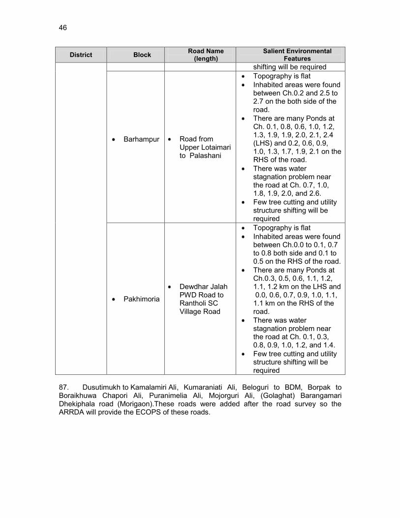
46
District Block Road Name (length)
Salient Environmental Features
shifting will be required
Barhampur
3.7.
Road from Upper Lotaimari to Palashani
Topography is flat Inhabited areas were found
between Ch.0.2 and 2.5 to 2.7 on the both side of the road.
There are many Ponds at Ch. 0.1, 0.8, 0.6, 1.0, 1.2, 1.3, 1.9, 1.9, 2.0, 2.1, 2.4 (LHS) and 0.2, 0.6, 0.9, 1.0, 1.3, 1.7, 1.9, 2.1 on the RHS of the road.
There was water stagnation problem near the road at Ch. 0.7, 1.0, 1.8, 1.9, 2.0, and 2.6.
Few tree cutting and utility structure shifting will be required
Pakhimoria
Dewdhar Jalah PWD Road to Rantholi SC Village Road
Topography is flat Inhabited areas were found
between Ch.0.0 to 0.1, 0.7 to 0.8 both side and 0.1 to 0.5 on the RHS of the road.
There are many Ponds at Ch.0.3, 0.5, 0.6, 1.1, 1.2, 1.1, 1.2 km on the LHS and 0.0, 0.6, 0.7, 0.9, 1.0, 1.1, 1.1 km on the RHS of the road.
There was water stagnation problem near the road at Ch. 0.1, 0.3, 0.8, 0.9, 1.0, 1.2, and 1.4.
Few tree cutting and utility structure shifting will be required
87. Dusutimukh to Kamalamiri Ali , Kumaraniati Ali, Beloguri to BDM, Borpak to Boraikhuwa Chapori Ali, Puranimelia Ali, Mojorguri Ali, (Golaghat) Barangamari Dhekiphala road (Morigaon).These roads were added after the road survey so the ARRDA will provide the ECOPS of these roads.
47
4. ANTICIPATED ENVIRONMENTAL IMPACTS AND ITS MITIGATION MEASURES
88. Road improvements work brings substantial economic and social benefits to rural communities and national economies. However, it may also cause adverse environmental impacts though of smaller magnitude, since rural road subprojects aligned along the existing road alignments and will be of 7.5 m width only. The impacts are expected largely during construction phase, which can be mitigated through engineering measures and adoption of best construction practices. This section outlines the identified impacts during design, construction and operation phases along with proposed mitigation measures for eliminating or minimizing the adverse impacts.
89. The associated environmental impacts are assessed considering present environmental setting of the project area, nature, and extent of the proposed activities. Impacts are analysed on both generic and specific nature and are classified as insignificant, minor, moderate and major.
90. Since the issues associated with most of the roads are similar, the impacts and mitigation measures given below are applicable to most of the subprojects. Any issue specific to a road, is separately mentioned.
4.1. Common Impacts during Design and Construction Phase 4.1.1. Climate change
91. Impact: The proposed roads are analysed considering climate change vulnerability screening checklist defined under EARF to RCIP. The resource (like barrow earth, aggregate, cement, concrete) requirements for these rural roads as such are minimal. None of these resources is likely to be affected by climate changes (such as changes in temperature and precipitation). None of the project roads passes through protected areas. Few sample roads are prone to flood from river and due to heavy rains (Table 4.1). Adequate engineering measures are adopted to protect this road. The entire Assam state fall under zone V indicating highest level of seismicity. All the subproject roads therefore are prone to earthquake. The habitation is less along these rural roads and as such, no exponential population growth is expected considering the generic trend of population migration from rural to urban areas. Most of the sample roads pass through agricultural fields and along the existing road alignments with low embankment height of 1m (average) from ground to crust except at the approaches to cross drainage structures. As such, the sub project roads are unlikely to be vulnerable or increase the vulnerability of surrounding areas (with respect to population growth, settlement patterns, increasing runoff or landslides).
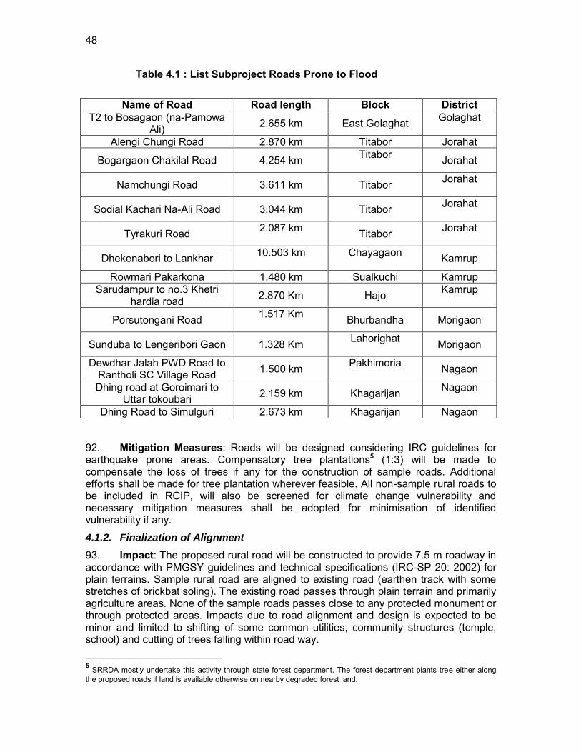
48
Table 4.1 : List Subproject Roads Prone to Flood
92. Mitigation Measures: Roads will be designed considering IRC guidelines for earthquake prone areas. Compensatory tree plantations5 (1:3) will be made to compensate the loss of trees if any for the construction of sample roads. Additional efforts shall be made for tree plantation wherever feasible. All non-sample rural roads to be included in RCIP, will also be screened for climate change vulnerability and necessary mitigation measures shall be adopted for minimisation of identified vulnerability if any.
4.1.2. Finalization of Alignment
93. Impact: The proposed rural road will be constructed to provide 7.5 m roadway in accordance with PMGSY guidelines and technical specifications (IRC-SP 20: 2002) for plain terrains. Sample rural road are aligned to existing road (earthen track with some stretches of brickbat soling). The existing road passes through plain terrain and primarily agriculture areas. None of the sample roads passes close to any protected monument or through protected areas. Impacts due to road alignment and design is expected to be minor and limited to shifting of some common utilities, community structures (temple, school) and cutting of trees falling within road way.
5 SRRDA mostly undertake this activity through state forest department. The forest department plants tree either along the proposed roads if land is available otherwise on nearby degraded forest land.
Name of Road Road length Block District T2 to Bosagaon (na-Pamowa
Ali) 2.655 km East Golaghat Golaghat
Alengi Chungi Road 2.870 km Titabor Jorahat
Bogargaon Chakilal Road 4.254 km Titabor Jorahat
Namchungi Road 3.611 km Titabor Jorahat
Sodial Kachari Na-Ali Road 3.044 km Titabor Jorahat
Tyrakuri Road 2.087 km Titabor Jorahat
Dhekenabori to Lankhar 10.503 km
Chayagaon Kamrup
Rowmari Pakarkona 1.480 km Sualkuchi Kamrup Sarudampur to no.3 Khetri
hardia road 2.870 Km Hajo Kamrup
Porsutongani Road 1.517 Km Bhurbandha Morigaon
Sunduba to Lengeribori Gaon 1.328 Km Lahorighat Morigaon
Dewdhar Jalah PWD Road to Rantholi SC Village Road 1.500 km Pakhimoria
Nagaon
Dhing road at Goroimari to Uttar tokoubari 2.159 km Khagarijan Nagaon
Dhing Road to Simulguri 2.673 km Khagarijan Nagaon
49
94. Mitigation Measures: The road alignment is finalised considering availability of right of way. The ROW is reduced in built up area or constricted areas to minimize land acquisition. The road alignment is modified to avoid tree cutting, shifting of utilities or community structure to the extent feasible. The road is designed to follow natural topography to avoid excessive cut and fill. All future roads to be included in RCIP will follow above measures. In addition these subprojects will comply with the following alignment finalisation criteria :
a. The road will be part of district core network and will comply with PMGSY guidelines
b. Subproject shall not disturb any cultural heritage designated by the government or by the international agencies, such as UNESCO, and shall avoid any monuments of cultural or historical importance.
c. Subproject will not pass through any designated wild life sanctuaries, national park, notified Eco sensitive areas or area of international significance such as protective wet land designated under Wetland Convention, and reserve forest area..
d. Subproject to comply with local and National legislative requirements (such as forest clearance for diversion of forest land ) and ADB‟s Safeguard Policy Statement 2009.
4.1.3. Land Acquisition
95. Impact: Minor impact, since no land acquisition is involved due to various measures considered for finalisation of road alignment. Villagers have volunteered to donate their land if at certain stages land is required for geometrical correction or alignment adjustment for avoiding tree cutting or shifting of community structure. There could be some impact on the encroachers; however, most of them have also volunteered to shift from the proposed alignment.
96. Mitigation Measures: All efforts shall be made to minimize the land acquisition while finalising the alignment. In an unavoidable situation, adopt suitable engineering measures to reduce the ROW requirement or donation of land from landowners. In the encroached areas, efforts shall be made to restricted road construction to the available space.
4.1.4. Protected Areas (National parks, wild life sanctuaries, Eco sensitive zones, protected /historical monuments) and Forest Areas.
97. Impact: Assam state including the project districts has many wild life sanctuaries but none of the sample road is located close to the sample project roads. None of the sample road passes through any forestland and as such, project has no impact on forest cover of the state/Country. Assam is also known to have several national parks and sanctuaries located in various parts of the state. However, none of them is located in close vicinity of sample project roads.
98. Mitigation Measures: As there are no protected/ecologically sensitive areas in the sub project areas, no such measures are proposed. In case of a diversion of forest land, prior forest clearance shall be obtained under Forest (Conservation) Act 1980 (amended 1988).

50
4.1.5. Land Clearing Operations
99. Impact: The site clearing operations may have impact on common utilities, community properties, land use and vegetation profile of the area if adequate considerations not given to road alignment finalisation, utility and community structure shifting plan, tree felling, and demolition waste disposal.
100. Mitigation Measures: The following steps shall be taken to minimise the associated impact with land clearing operations.
e. The land clearing operation should be undertaken as per the defined road alignment and community structure, utility and road furniture-shifting plan.
f. The road land width shall be clearly demarcated on the ground.
g. The utility and community structure shifting shall be as per plan and with consultations and concurrence of the community.
h. Tree felling shall be limited to those, which could not be saved even by design measures. The tree shall be cut with a permission of Forest department. The vegetable cover shall be removed and disposed in consultation with community.
i. All public utilities shall be shifted with a concurrence of respective agencies/authority and to the adjacent location approved by them.
j. The top soils shall be collected and preserved for reuse as a base for turfing of embankment slopes or development of barren areas along roadside. The top soil shall be preserved at identified location with the provision of watering /grass development on the heap surface to prevent air pollution.
4.1.6. Cut and Fill and Embankment construction
101. Impact: Inadequate alignment planning may increase the cut and fill requirement as well as need for more borrow earth for embankment formation leading to some impact on land use. Inadequate provision for drainage and embankment slop protection may lead to soil erosion. Due consideration is given to above aspect for alignment finalisation of sample road. With the adoption of appropriate mitigation measures, the impact due to above activity on land use and other environmental component is expected to be minimal.
102. Mitigation Measures: The alignment design shall consider options to minimise excessive cuts and fills. The cut and fill quantities shall be used for embankment to minimise barrow earth requirement. The design shall be as per relevant IRC provisions for cut and fill, slope protection and drainage. Adequate provision shall be made for cross drainage structures for maintaining natural drainage pattern in the subproject area and preventing soil erosion. The top soil of the cut and fill area shall be used for embankment slope protection. .
4.1.7. Establishment of Construction Camp, Temporary office and Storage Area
103. Impact: The congregation of labour population and technical staff in the subproject area during the construction phase is likely to put considerable stress on the limited resources of village areas. Some of the associated impacts are related to health, safety of the labourers at the construction campsites, availability of safe drinking water, and sanitation.
51
104. The establishment of construction camp temporary office and storage area will reduce land productivity if these are established on agricultural land. Loading and unloading of construction material, transportation of material, handling of fuel and waste disposal from these areas may have direct and indirect impact on soil, water and air quality
105. Mitigation Measures: The following steps shall be taken to minimise/reduce these impacts:
Construction campsites shall be located away from any local human settlements (minimum 1 km away) and preferably located on lands, which are not productive barren/waste lands presently. Similarly temporary office and storage areas shall be located away from human settlement areas (minimum 500 m).
The construction camps, office and storage areas shall have adequate water supply, sanitation and all requisite infrastructure facilities. This would minimize dependence of construction personnel on outside resources, presently being used by local populace and minimize undesirable social friction thereof.
The construction camps shall be located at a minimum 0.5 km from forest land/areas to deter the construction labour in trespassing. Similarly, temporary office and storage areas shall be located at a minimum 0.5 km from forest land/areas.
The construction camps, office and storage areas shall have septic tank/soak pit of adequate capacity so that it can function properly for the entire duration of its use.
All construction camps shall have rationing facilities particularly for kerosene/LPG so that dependence on firewood for cooking is avoided completely to the extent possible.
The construction camps, office and storage areas shall have health care facilities for adults, pregnant women and children.
All construction personnel shall be subjected to routine vaccinations and other preventive/healthcare measures.
Contractor shall arrange all personal protective equipment (PPEs) like helmet, boots, and earplugs for workers, first aid and fire fighting equipment at construction sites. An emergency plan shall be prepared to fight with any emergency like fire.
Garbage bins must be provided in the camp and regularly emptied and disposed off in a hygienic manner. Domestic solid waste shall be disposed of in a control manner. The recyclable waste shall be sold off and non-saleable and biodegradable waste shall be disposed through secured land filling.
All fuel oil/lubricant unloading and storage shall be made on the paved areas away from storm water drainage.
After completion of construction work, the camp /temporary office/storage areas sites shall be restored to its original condition.
52
4.1.8. Traffic Movement
106. Impact: Construction work along the existing road could cause disturbances to traffic movements. It will also pose risk of accident to motorist at night if these blockages and disruption are not clearly demarcated.
107. Mitigation Measures: The contractor will prepare appropriate traffic diversion scheme, which shall be implemented in different stretches of the road as per the progress of the construction work. This plan shall be approved by PIU and implemented before start of any construction work to avoid any inconvenience to the present road users. The diversion plan should ensure smooth flow of traffic, minimise accidents to road users during construction works. Adequate signboards shall be placed much ahead of diversion site to caution the road users. The road signs should be bold and visible and retro reflective in nature for day and night visibility.
4.1.9. Associated Impacts due to Construction Activities
4.1.9.1 Loss of productive soil, erosion and land-use
108. Impact: No land use will change due to the project, since required ROW is available throughout the alignment. Land use though will change temporarily of construction camp, temporary office storage areas for the period of construction. This will also result in loss of soil productivity. Soil erosion may take place along steep and un-compacted embankment slope, and wherever vegetation is cleared. Soil erosion may have cumulative effect viz. siltation, embankment damage, drainage clogging etc. The siltation, due to soil erosion may occur only in the ponds located close to the roads. There are 14 roads in Assam located near river or flood prone area. Erosion may increase due to proximity to these water bodies and flooding of the area. Loss of soil due to run off from earth stockpiles may also lead to siltation. Land use may also change due to borrowing the earth.
109. Mitigation Measures: It shall be ensured that the land taken on lease for access road, construction camp and temporary office of the storage facilities, is restored back to its original land use before handing it over back to land owner. The top soil from the productive land (borrow areas, road widening areas etc.) shall be preserved and reused for plantation purposes. It shall also be used as top cover of embankment slope for growing vegetation to protect soil erosion. Therefore, cut and fill shall be planned as per IRC provisions and rural road manual. All steep cuts shall be flattened and benched. Shrubs shall be planted in loose soil area. IRC: 56 -1974 recommended practice for treatment of embankment slopes for erosion control shall be taken into consideration. Soil erosion shall be visually checked on slopes and embankment areas. If soil erosion observed, suitable measures shall be taken to control it.
4.1.9.2 Borrow Areas and Quarries
Impact: Borrow areas if left un-rehabilitated may pose risk to people, particularly children and animals of accidentally falling into it. This may also become potential breeding ground for mosquitoes and vector born disease. Illegal quarrying may lead to unstable soil condition; destroy the landscape of the terrain, air and noise pollution. Mitigation Measures: Borrowing earth from agricultural land shall be minimised to the extent possible. Further, no earth shall be borrowed from already low-lying areas. The borrow earth shall be sourced from identified locations and with prior permission of landowner and with clear understanding for its rehabilitation. The Indian Road Congress
53
(IRC):10-1961 guideline should be used for selection of borrow pits and quantity that can be borrowed. The borrow area shall be located/ rehabilitated as per the guidelines given at Appendix 4.1. Fly ash shall also be used in road embankment as per IRC guidelines wherever thermal power plant is located within 100 km of the road alignment. The stone aggregate shall be sourced from existing licensed quarries only. The quarry should have requisite consent to operate from State Pollution Control Board. No new quarry shall be opened for the proposed project.
4.1.9.3 Hydrology and Drainage
110. Impact: The activities involved with proposed road development may alter the hydrology and drainage pattern of the area in absence of adequate provision for cross drainage structure, construction wastes disposal and drainage in habitat areas.
111. None of the sample roads is crossing any natural stream except T2 to bosagaon (na-pamowa Ali) in golaghat district, alengi chungi road and bogargaon chakilal road in jorhat district, which run close to Kachajan River, Jiladhari, and Bhukajan River respectively. Adequate engineering measures are proposed for protection of road from flood in Kachajan River, Jiladhari, and Bhukajan River. There are many other roads (Table 4.1) which are prone to flood due to accumulation of heavy rainwater. Certain project roads are crossing local and seasonal drains. Village ponds are also located close to few roads.. The impact on hydrology and drainage pattern is expected to be minimal.
112. Mitigation Measures: The provision of adequate cross drainage structures shall be made to ensure smooth passage of water and maintaining natural drainage pattern of the area. The discharge capacity of the CD structure shall be designed accordingly. Road levels shall be designed considering HFL. Low costs measures like using locally available bamboo or eucalyptus tree will be adopted for embankment protection and control of soil erosion. Other slop stabilisation measure like vegetative protection will be made additionally. The construction work shall be planned in dry season so that water quality of the water channel is not affected due to siltation. Elaborate drainage system shall be provided to drain the storm water from the roadway and embankment and to ensure minimum disturbance to natural drainage of surface and subsurface water of the area. Provision of additional cross drainage structures shall be made in the areas where nearby land is sloping towards road alignment in both the both sides.
113. Provision of CC road construction in habitat area with drainage of both side of the road shall be made as per the design specifications and with adequate slope to prevent any water logging.
4.1.9.4 Compaction and Contamination of Soil
114. Impact: Soil in the adjoining productive lands beyond the ROW, haulage roads, and construction camp area may be compacted due to movement of construction vehicles, machineries, equipments and construction camps/storage facilities. It may get contaminated due to inappropriate disposal of liquid waste, (lubricating oil and fuel spills, waste oil and lubricant and vehicle/equipment washing effluent) and solid waste (fuel filters, oily rags) likely to be generated from repair and maintenance of transport vehicles, construction equipment and machinery.
115. Mitigation Measures: To prevent soil compaction in the adjoining productive lands beyond the ROW, the movement of construction vehicles, machinery and equipment shall be restricted to the designated haulage route. The productive land shall be reclaimed after construction activity. Septic tank or mobile toilets fitted with anaerobic
54
treatment facility shall be provided at construction camp/temporary office/storage areas. Domestic solid waste at construction camp shall be segregated into biodegradable and non-biodegradable waste. The non-biodegradable and recyclable waste shall be sold off. Fuel and lubricants shall be stored at the predefined storage location. The storage area shall be paved with gentle slope to a corner and connected with a chamber to collect any spills of the oils. All efforts shall be made to minimise the waste generation. Unavoidable waste shall be stored at the designated place prior to disposal. To avoid soil contamination at the wash-down and re-fuelling areas, “oil interceptors” shall be provided. Oil and grease spill and oil soaked materials are to be collected and stored in labelled containers (Labelled: WASTE OIL; and hazardous sign be displayed) and sold off to SPCB/ MoEF authorized re-refiners.
4.1.9.5 Construction Debris and Wastes
116. Impact: Uncontrolled disposal of debris and waste may create unhygienic and unsafe condition around the disposal areas.
117. Mitigation Measures: All excavated materials from roadway, shoulders, verges, drains, cross drainage shall be used for embankments formation if feasible, filling pits, and landscaping. Unusable debris material should be suitably disposed off at pre-designated disposal locations, with approval of the concerned authority. The bituminous wastes shall be disposed in secure landfill sites only in environmentally accepted manner. MOSRTH guidelines shall be followed for debris, wastes removal and disposal at unproductive/wastelands which shall be selected with the consent of villagers and Panchayat. The dumping site should be of adequate capacity and to be located away from residential areas (at least 500m away). It should also be located away from water bodies to prevent any contamination of these bodies.
4.1.9.6 Air Quality
118. Impact: The potential sources of air emission during the construction phase of the project are given below which can cause localised air pollution.
Dust from earth works (during site preparation).
Emissions from the operation of construction equipment and machines.
Fugitive emissions from vehicles plying on the road, during the transport of construction materials.
Emissions other than dust particularly from the hot mix plants and laying of bitumen. Hot mix plant will generate carbon monoxide (CO), un-burnt hydrocarbon (HC), sulphur dioxide (SO2), particulate matters (PM), and nitrogen oxides (NOx) emissions.
Localised increased traffic congestion in construction areas. Most of the emissions will be in the form of coarse particulate matter, which will settle down in close vicinity of construction site. This may affect the air quality of nearby areas, especially, due to emission discharge from low height of the stack.
119. Mitigation Measures: All these impacts will be temporary and hence, no significant impact is envisaged. The following measures will be taken to minimise these:
Vehicles delivering loose and fine materials like sand and aggregates shall be covered.
55
Dust suppression measures like water sprinkling, shall be applied in all dust prone locations such as unpaved haulage roads6, earthworks, stockpiles and asphalt mixing plant areas.
Mixing plants and asphalt (hot mix) plants shall be located at least 0.5 km away and in downwind direction of the human settlements.
Material storage areas shall also be located downwind of the habitation area.
Hot mix plant shall be fitted with stack of adequate height (30 m) or as may be prescribed by state pollution control board (SPCB) to ensure enough dispersion of exit gases. Consent to establish and operate shall be obtained from State Pollution Control Board and comply with all consent conditions.
Diesel Generating (DG) sets shall also be fitted with stack of adequate height. Low sulphur diesel shall be used in DG sets and other construction machineries. Construction vehicles and machineries shall be periodically maintained.
The requisite PPE (helmet, mask, boot, hand gloves) shall be provided to the construction workers.
4.1.9.7 Noise Quality
120. Impact: Ambient noise level may increase temporarily in the close vicinity of various construction activities, maintenance workshops, vehicles movement and earthmoving equipment.
121. Mitigation Measures: The noise level will be intermittent and temporary and will attenuate fast with increase in distance from noise source. Further, vehicles and equipment should be fitted with silencers and maintained regularly. The workers shall be provided with personal protection devices such as earplugs and earmuffs. 4.1.9.8 Groundwater and Surface Water Quality and Availability
122. Impact: Water will be required for compaction of formation and domestic purposes in the workers camp. These requirements will be mainly sourced from groundwater. Any uncontrolled abstraction of ground water can deplete the ground water table fast. Contamination of groundwater is not envisaged since all construction camps will have septic tanks or mobile toilets depending on the number of workers in each camp. The drinking water supply to the habitat is primarily through hand pumps and bore wells. No significant impact is anticipated on surface water bodies except probability of siltation during construction. Due to non-perennial nature of surface water bodies, water requirements for drinking and construction purpose shall be met from ground water sources.
123. Mitigation Measures: Requisite permission shall be obtained for abstraction of groundwater from State Ground Water Board/Central Ground Water Authority7 if applicable. The contractor shall arrange for water required during construction in such a way that the water availability and supply to nearby communities remains unaffected. Water intensive activities shall not be undertaken during summer period to the extent feasible. Provision shall be made to link side drains with the nearby ponds for facilitating 6 Water suppression of fugitive dust can reduce emissions from 12% to 98% 7 As per Central Ground Water Authority (CGWA), there are 43 notified blocks in India where prior permission is required fro extraction of ground water. Currently there are no notified areas in Chhattisgarh state. CGWA is continually updating the list of notified areas.
56
water harvesting. Where ponds are not available, the water harvesting pits shall be constructed as per the requirement and rainfall intensity. Measures are already purposed in earlier section for prevention of siltation in water bodies.
4.1.9.9 Biological Environment
124. Impact: Since the sample roads are not passing through any protected areas or forest area, there is no diversion of forestland. The major adverse impacts will be due to tree cutting, Siltation and contamination of water bodies may affect the aquatic life particularly pond fisheries.
125. Mitigation Measures: All efforts shall be taken to avoid tree cutting wherever possible. Requisite permission from forest department shall be obtained for cutting of roadside trees. Compensatory Afforestation shall be made on 1:3.ratio basis. Additional trees shall be planted wherever feasible. All care shall be taken to avoid siltation/contamination of water bodies. Movement of herbivores like Cattle, Goats, Cows etc., have been observed in the surrounding agriculture fields. Disturbance to these animals will be avoided to the extent possible.
4.1.9.10 Impact on Common Property Resources
126. Impact: There are public utilities like Electric transformer, electric poles, and hand pumps all along the rural roads. The road construction may require shifting of these utilities. There are many community structures like school, playground village office temples.
127. Mitigation Measures: All efforts are made to minimize shifting of common utilities and community structures. ROW has been reduced in constricted areas with appropriate engineering measures to minimize land acquisition and shifting of community structures. The community structures/utilities which can not be saved will be shifted to adjacent area with the concurrence and in consultation with community.
4.2. Common Impacts during Operation Phase 4.2.1. Air Quality
128. Impact: Decrease in air quality due to increase in traffic, idling at congestions.
129. Mitigation Measures: The bad road condition is the main cause of poor air pollution at present. The improved road conditions will result in the improved ambient air quality. In addition, the subproject road is largely traversing through vast open agriculture areas, which will provide adequate dispersion to gaseous pollutants, generated from vehicles and will offset the increased pollutants.
4.2.2. Noise
130. Impact: During the operational phase, movement of traffic will be the prime source of noise. Traffic congestion and pedestrian interferences increase the use of horns. This may result in increased noise levels at habitat areas, nearby schools and religious places.
131. Mitigation Measures: Awareness signboard shall be provided for safe driving near the habitat areas. Speed limitation and honking restrictions may be enforced near sensitive locations.
4.2.3. Land, Soil, Tree Plantation
132. Impact: The better access can lead to conversion of agriculture land for residential and commercial purposes close to roads, which may result in loss of
57
productive land and agricultural produce. Since the rural road are aimed at connecting the villages, and with the general trend of migration of rural population to urban areas, the phenomena of conversion of agriculture land to residential area is unlikely to change.
133. The land occupied for construction camp /temporary office/material storage area will remain unproductive if it is not restored after completion of construction activities.
134. It shall be essential to ensure the survivability of the compensatory tree planted
135. Mitigation Measures It shall be ensured that all construction camp/temporary office/material storage areas are restored to its original conditions. The borrow area rehabilitation will also be ensured as per the agreed plan with the landowner. Contractor and PIC will ensure the same and obtained clearance from PIU before handling over the site to SRRDA.
136. The PIC will undertake survivability assessment and report to PIU the status of compensatory tree plantation at a stage of completion of construction with recommendation for improving the survivability of the tree if required.
4.2.4. Groundwater 137. No impact is anticipated on groundwater due to the project during operation phase, hence, no specific mitigation is proposed.
4.2.5. Hydrology and Drainage 138. Impact: Water accumulation incidence may occur due to inadequate availability of cross drainage structure or clogging of cross drainage structures.
139. Mitigation Measures: Regular removal/cleaning of deposited silt shall be done from drainage channels and outlet points before the monsoon season. Rejuvenation of the drainage system by removing encroachments/ congestions shall be regularly conducted.
4.2.6. Socio-Economic Impact 140. Assessment of project impact on socio-economic conditions point to the conclusions that positive benefits are many fold compared to its adverse impact.
141. Positive Impacts: The better road access is likely to contribute the overall economic condition of village community. With the quick access to urban market areas, the farmers are likely to get better prices for their farm produce. Children will also be able to access the school and education facilities in the near by urban areas.
142. Safety Measures shall be adopted as per NRRDA guidelines. Some of them are highlighted below :
Speed breakers (Rumble strips) as per IRC: 99-1988 shall be provided at sharp corves design and bends where the curve design speed is less than 40 km per hour in plain in rolling terrain.
Speed breakers shall also be provided at a threshold of habitation (as per NRRDA guidelines) at regular intervals (150-200 m) through habitation.
The speed breakers are provided and directional sight boards installed at sites where reverse horizontal curves are closely spaced and speed reduction is required.
58
Hazard markers to be installed at each end of all box culverts, river crossing causeways and similar CD structures
Shoulder side slopes shall not be steeper than 2h: 1V unless stone pitching of the slopes is provided.
Cement concrete pavement and V-shaped drain is constructed to the full width of the available roadway within densely populated habitation.
Directional sight board are installed on all sharp curves and bends
At main road, intersection or crossing “STOP” sign and „T-intersection‟ warning sign shall be installed on the village road.
4.3. Road Specific Impacts 143. The assessment of sample roads indicates that environmental issue associated with all the roads are similar except fourteen roads (Table 4.1), which are prone to flood. Hence, mitigation measures applicable to the entire road are also will be similar except variation in terms of magnitude, which will depend on length of the road, the presence various environmental components. These components may be assessed in terms of no of pond, number of community structure (mostly temples, playground, school, gram Panchayat office) likely to be shifted, number and type of common utilities (hand pump, water tank, electric transformer, electrical poles).
59
5. ENVIRONMENTAL MANAGEMENT PLAN, INSTITUTIONAL ARRANGEMENTS AND GRIEVANCE ADDRESS MECHANISM
5.1. Environmental Management Plan 144. The Environmental Management Plan (EMP) is prepared to facilitate effective implementation of recommended mitigations measures with defined roles and responsibility for implementation and monitoring, regulatory compliance requirements, stages of implementation with location, period and costs. The mitigation measures are proposed to eliminate or minimise the identified impact associated with design, construction and operation stages of the project, to acceptable level by adopting the most feasible options.
145. The EMP is prepared as per Environmental Management Standard (ECOP) applicable to rural road defined be ADB at RRS I stage.
146. The identified impacts are insignificant and are related to clearing operations of RoW, traffic diversions, setting and operation of construction camps, quarry and borrowing operations, transportation of materials, construction of cross drainage structures, air & noise pollution due to construction activities and operation of construction equipment, tree cutting and shifting of utilities and physical community structure.
147. Appropriate mitigation measures are identified for all rural road construction and operation activities. The identified impacts associated with rural roads and mitigative measures are largely common to most of the roads. The EMP is detailed at Appendix 5.1. It provides action common to all roads at pre construction, construction and operation stage. Since IEE is carried out, prior to preparation of DPR, the EMP will be updated specific to road as per DPR requirements by PIU and included with DPR, which shall be available to contractor at the time of bidding. The areas to be updated as per DPR provisions are highlighted under location column of EMP.
148. Since these are rural roads, the vehicular density and speed will be low. Movement of vehicles would be confined primarily for transfer of agricultural produce to market places. As such, no major emergency is anticipated. In any accidental eventuality, local administration can be reached quickly for help though Gram Panchayat (village administration) communication systems.
5.2. Environmental Monitoring Plan 149. The environmental monitoring program is prepared with aim to monitor the environmental performance of environmental management plan. The EMOP is planned with the focus on following objectives:
To the assess the effectiveness of mitigation measures proposed
To assess the change in environmental quality during construction and operation stage with respect to before the project scenario.
To assess compliance to regulatory requirements
To monitor the status of corrective action taken in case of deviation from the planned measures or regulatory requirements.
60
150. For rural roads, Environmental Monitoring plan will be more observation oriented and it provides observation areas with frequency of monitoring at pre construction aspects,8 construction stage and operation stage. A monitoring plan with monitoring indicator and frequency of monitoring is given at Appendix 5.2.
5.3. Institutional Arrangements and Responsibilities 5.3.1. Institutional Arrangement
151. NRRDA constituted by MORD is the nodal agency for the implementation of PMGSY in India. SRRDA is the state level agency responsible for implementation of PMGSY program in the state. NRRDA has developed various guidelines and defined institutional arrangements for effective and timely implementation of PMGSY program, which also covers measures for environmental and social safeguards. In line with the defined institutional requirements, each SRRDA has set up district level project implementation units (PIUs). NRRDA also appoints Technical Support Consultant (TSC) to provide technical support for capacity building in SRRDA/PIUs, facilitating them for environmental and social safeguard compliance monitoring and due diligence. SRRDA appoints PIC (project implementation consultant) for supervision of construction work. PIC also helps PIU in monitoring the EMP.
152. NRRDA is also responsible to coordinate with SRRDA and ensure compliance to ADB safeguard requirements.
153. The institutional arrangement at National Level and state level for implementation of PMGSY including RCIP is shown at Figure 5.1.
8 Aspects related to alignment selection for inclusion of new roads

61
Figure 5.1 : Institutional Arrangement for EMP Implementation
Ministry of Rural Development (MORD),
Government of India
National Rural Roads Development Authority (NRRDA) Project Implementation Authority
(National Level)
State Rural Development Agency (State Level)
Project Implementation Unit (PIU)
(District Level)
RCIP roads Project Implementation Consultant (PIC)
Contractor Environmental Officer (EO) (Provided by PIC –One Part
Time/ full Time on need basis) or appointed by SRRDA
Implementation of EMP
ADB
Technical Support Consultants (TSC)
Appointed by NRRDA
Environmental Expert of TSC
Monitoring Implementation of EMP
62
5.4. Institutional Environmental Responsibilities 154. The institutional environmental responsibilities for different level and function is elaborated below.
155. MORD9 the executing agency has the responsibility for monitoring implementation of the EMP for all subprojects and undertaking necessary due diligence. MORD ensure this through its Nodal Agency NRRDA (National Rural Road Development Authority). MORD will also ensure that
k. ADB is given access to undertake environmental due diligence for all subprojects, if and when needed as per EARF requirements.
l. SRRDA meet all environmental assessment requirements in accordance with EARF
m. It undertakes random monitoring of the implementation of the EMP
n. Ensure compliance to legislative requirements such as forest clearance for diversion of forest land for non-forest purposes and Consent to Establish/Operate for hot mix plant, batching plant
o. Appoint Technical Support Consultant (TSC) to assist SRRDA for various environmental aspect and safeguard compliances
156. SRRDA10will ensure that :
p. ECOP checklist is prepared for each road
q. The completed ECOP checklist is included in the DPR with the help of PIC.
r. Ensure that all required statutory environmental clearances are obtained and comply with clearance conditions;
s. Ensure that the subproject specific EMPs and respective budget are included in the bidding documents;
t. Ensure that the ECOP checklists and EMP (including general and site specific issues) are made available to the contractors;
u. Undertake routine monitoring of the implementation of the EMP including spot checks on site and prepare monitoring reports at least once a year; and
v. With the support of technical support consultants prepare satisfactory environmental due diligence reports of the earlier tranche/periodic financing request before implementing the next tranche.
w. Appoint Project Implementation Consultant (PIC) for construction supervision and assist PIUs for EMP implementation and related safeguard compliances.
157. PIU will be responsible to :
9 MoRD implements it through its nodal agency NRRDA which undertakes this with the help of Environmental Expert of Technical Support Consultant 10 With assistance from PIC ( Project Implementation Unit)
63
x. Complete the ECOP checklists and prepare subproject specific EMPs (including monitoring plan) for each subproject
y. Obtain necessary statutory environmental clearance prior to commencement of civil works
z. Update the respective ECOP checklists and EMPs if there are any changes in alignment of the subprojects
aa. To conduct monitoring of all subprojects and prepare pre-, during and post-construction monitoring checklists through the project implementation consultants,
bb. Prepare and submit to SRRDA annual monitoring report as per ADB defined format
158. The Technical Support Consultants (TSC) appointed by NRRDA. The Environmental Expert of TSC :
cc. Will provide technical assistance to SRRDA/PIU regarding environmental aspects, environmental permitting/clearances requirement,
dd. Periodically review EMP implementation status including spot site inspections.
ee. Conduct workshops/capacity building program at different level and functions.
ff. Prepare environmental Due Diligence report for each trench before implementing next trench
gg. Prepare state Level IEE reports and EMPs for non sample roads based on the ECOP checklist completed by the PIC
159. Project Implementation Consultant (PIC) is appointed by SRRDA. PIC will provide one Environmental Officer (EO). The EO will be responsible to ensure adherence and implementation of EMP at all stages of works by the contractor. The EO, if found warranting may also conduct field tests, independent of the contractor to determine the effectiveness of EMP under approval of PIC/PIU. The broad duties / responsibilities of the Environmental Officer will include:
Review of project design and specifications to ensure their adequacy and suitability with respect to the implementation of EMP.
Collection and dissemination of relevant environmental documents including amendments to environmental protection acts issued by the various agencies, namely, ADB, Government of India / State and local bodies;
Interact with the counterpart of the Contractor(s), review work progress/plans and ensure implementation of the EMP;
Co-ordination with the NGOs, community groups and Government departments on environmental issues, provide clarifications/ and obtain clearances during project implementation if any, as required from the regulatory authorities and/or submitting periodic compliance reports as required by the State Authorities;
64
Monitoring sensitive environmental attributes during construction and operation stages11 to ensure that the suggested mitigation measures in the EMP are implemented;
Facilitate PIU for preparation of annual monitoring report as per ADB defined format
Documentation of the environmental management/monitoring activities for the regular project implementation progress report, which will serve as the basis for the annual environmental monitoring reports.
Conducting environmental training/awareness programs for the contractors, the project implementation personnel and the communities.
160. Contractor is appointed by S RRDA for construction of road and ensures implementation of EMP proposed. The broad duties of contractor are as follows:
Make adequate costs provision for EMP requirements while biding
Ensure effective implementation of mitigative measures as per road specific EMP
Comply with all applicable legislative requirements and obtain necessary consents for to Establish/Operate before start of hot mix plant and batching plants. Comply with al permit conditions
Create awareness amongst workers for environment, occupational health and safety aspects. Participate in training and awareness programme along with its executives conducted by PIC.
Provide PPE and adequate resources for Environment Occupational Health and Safety
Follow all the guidelines for borrowing earth and restoration of borrow areas, setting up construction camps
Sourcing of quarry material from approved quarries only
Provide all required input to PIC for environmental monitoring as per EMP.
5.5. Environmental Assessment and Review Framework (EARF) for RCIP 161. ADB has prepared an Environmental Assessment and Review Framework (EARF) which identifies the broad scope of the MFF, outlines the policy, environmental screening and assessment, and institutional requirements for preparing the environmental assessments to be followed for subsequent batches and tranches. This EARF also specifies criteria for eligibility for selection rural roads under RCIP. The sample roads are selected following these criteria. The EMP, monitoring requirement, institutional aspects, capacity building, grievance redress mechanism presented in this chapter are developed in line with above EARF. The eligibility criteria for selection of 11 Normally PIC is supposed to undertake five site visits and f ive monitoring reports as per contracts being issued by different SRRDA. It is proposed that PIC shall submit the following five monitoring reports: (1) First report at pre construction stage, (2) Second report after three months of start of construction or on completion of 25% construction (3) Thrid report after seven months of start of construction or on completion of 75% of construction, (4) Fourth report after one month of completion of construction and first year of operation stage (5) Fifth report in second month of seond year of operation stage.
65
roads under RCIP, environmental assessment requirement for each trench and legal framework are given below:
5.5.1. Selection Criteria and Environmental Assessment Requirement
162. The following criteria will be followed for selection of non sample roads.
(i) No Category A (as per ADB‟s SPS) subproject will be included in the MFF.
(ii) Subprojects will be eligible for construction or upgrading in accordance with the PMGSY guidelines, and be included in the respective district core network.
(iii) The subprojects shall not disturb any cultural heritage designated by the Government or by international agencies, such as UNESCO, and shall avoid any monuments of cultural or historical importance.
(iv) The subproject will not pass through any designated wildlife sanctuaries, national parks, other sanctuaries, notified ecological sensitive areas or area of internationally significance (e.g., protected wetland designated by the Wetland Convention).
(v) The projects shall only involve activities that follow Government of India laws and regulations, ADB‟s Safeguard Policy Statement (2009)
163. The following environmental Assessment requirement will be followed roads included under RCIP
(i) ECOP checklists with annexes on trees, utility structures, community structures, strip plans and photographs will be completed for each and every road.
(ii) Based on the requirements of the PMGSY guidelines separate ECOP checklists will be prepared for bridges that are longer than 15 m.
(iii) Based on the completed ECOP checklists for roads and bridges, IEE reports will be prepared at a state level. These reports must contain a general EMP and a site specific EMP where there are site specific issues.
(iv) ADB‟s REA checklist for roads and highways will be completed based on the state level IEE reports prepared and submitted to ADB to confirm categorization
164. The vulnerable to climate change will also be screened following screening checklists, which was integrated in the ADB REA Checklists and corresponding mitigation measures will be prepared.
(i) Is the project area subject to hazards such as earthquakes, floods, landslides, tropical cyclone winds, storm surges, tsunami or volcanic eruptions and climate changes
(ii) Could changes in precipitation patterns or evaporation rates over the lifespan of the project affect its sustainability and cost (i.e., increased landslides increase maintenance costs)?
(iii) Does the project use or depend on resources which could be affected by climate changes such as changes in temperature, precipitation, wind (increased soil moisture content in the sub-grade)?
66
(iv) Are there any demographic or socioeconomic aspects of the subproject and project area (e.g., population growth, settlement patterns) that increase the vulnerability of the project and surrounding area?
(v) Could the subproject potentially increase the vulnerability of the surrounding area (i.e., by increasing runoff, encouraging settlement in earthquake zones)
5.5.2. Legal Framework
165. As per Indian legislation, an environmental clearance is not required for rural roads. However, it may attract provisions of Forest Conservation Act, Wild Life (Protection) Act, and other legislation related with Air, Water and Noise pollution controls and prevention. The legislative applicability screening is presented in chapter 1 of this report and it will apply for non-sample road as well. Additionally, to ensure conformance to ADB‟s Safeguard Policy Statement, 2009 (SPS), the subprojects will be subject to the following requirements:
(i) Submission of a completed Rapid Environment Assessment (REA) checklist for Roads and Highways and a categorization form for each state level IEE that is prepared.
(ii) An Initial Environmental Examination12 (IEE) report including the preparation of an Environmental Management Plan (EMP) and a Monitoring Plan.
(iii) Regular monitoring of implementation of the EMP and submission of monitoring reports and due diligence reports to ADB as necessary
5.6. Capacity Building 166. Existing capacity of the State Rural Roads Development Agencies (SRRDAs) and Project Implementation Units (PIUs) for implementing environmental safeguard issues need substantial strengthening. Capacity building activities will mainly comprise training workshops for SRRDA and PIU environmental officers on (i) completion of environmental code of practice (ECOP) checklists; (ii) preparation of environmental management plan (EMP) and monitoring plans; (iii) monitoring of EMP implementation and completion of pre-, during and post-construction monitoring checklists; and (iv) preparation of monitoring reports. These few workshops have already been conducted at participating states though ADB appointed Environmental specialist. Additional training will be carried out periodically, by In-house trained and experienced officials.
5.7. Consultation and Information Disclosure 167. During the preparation of ECOP and Detailed Project Report (DPR), the PIU has to ensure consultation, and addressal of concerns of the affected people.
168. All environmental assessment documents are subject to ADB‟s Public Communication Policy (2005) and will be made available to the public, upon request. The SRRDAs are responsible for ensuring that all environmental checklist documentation, including the environmental due diligence and monitoring reports, are properly and systematically kept as part of the Investment Program specific records. MORD must disclose state specific sample road IEE reports on its website.
12 As per selection criteria, no Category A subproject will be included under RCIP.
67
5.8. Grievance Redress Mechanism 169. PRI administered village level committee is the first contact point for any aggrieved person. This committee will try to settle the concern by them self or in consultation with contractor or PIU. The unresolved concerned are forwarded to PIU for further action. PIU resolves these concerns in consultation with PIC, SRRDA, and contractor as the situation demands. This is an established practice and is seen effective enough in RRS II. PIC will also collect concerns received by this committee in the intervening period and report the effectiveness of action taken.
170. At national level NRRDA has made provision of registering complain /suggestion through its website. NRRDA forwards these complains to concerned SRRDA for necessary actions. SRRDA directly or through concerned PIU initiate the appropriate action and update the complainant as well as NRRDA. It is proposed that NRRDA website will be cross-linked to each SRRDA website as well or SRRDA will also make provision of complain registry at its website.

68
6. PUBLIC CONSULTATION AND INFORMATION DISCLOSURE 6.1. General
171. Public consultation was undertaken consistent with the ADB requirements. All the five principles of information dissemination, information solicitation, integration, co-ordination and engagement into dialogue were incorporated in the consultation process. A framework of different environmental impacts likely from the project was strengthened and modified based on opinions of all those consulted, especially in the micro level by setting up dialogues with the village people from whom information on site facts and prevailing conditions were collected.
172. Stakeholder consultations were held with the intent to understand their concerns, apprehensions, overall opinion and solicit recommendations to improve project design. Informal meetings, interviews were organized covering the entire project stretch. The informal consultation generally started with explaining the sub projects, followed by an explanation to potential impacts. Participant‟s views were gathered with regard to loss of agricultural land, effect on air and noise quality of the area due to traffic, water availability, accident and risk.
173. The discussions were designed to receive maximum inputs from the participants regarding their acceptability and environmental concerns arising out of the sub-project. They were given the brief outline of the project to which their opinion was sought. Suggestions were also sought for mitigating any potential adverse impact.
6.2. Compliance with Relevant Regulatory Requirements 174. In India, public consultation is mandatory in case of Category A and B1 category projects13 in select conditions. Being a category B project as per ADB Environmental Guidelines 2003, consultation was carried out during the early stage of IEE report preparation. The requirement of public consultation during the implementation of the project has been proposed as part of the mitigation plan.
6.3. Beneficiaries’ Comments 175. The project has immense acceptability among the local people. They perceived that in addition to providing all weather connectivity, the sub-project road will bring positive socio-economic changes in the area. Local people mainly discussed on issues related to drainage and commencement of the construction work.
176. Some of the general issues raised during the different consultation sessions can be summed up as follows.
Construction Camp - The participants did not apprehend any adverse impact due to the construction camp ne ar to their villages. They responded positively towards providing support to these, if required, in terms of any food, water requirements.
Water Logging and Drainage - Participants informed about few low-lying areas particularly in along sample roads in Jorahat, Kamrup and Golaghat districts where water logging takes place during monsoon season. The villagers requested for provision of adequate drainage and cross drainage structures at
13 As per schedule I of EIA notification number S.O. 1533, dated 14th September 2006. This notification also defines when a public consultation is mandatory.
69
these locations. Villagers also reported for road overtopping in road where they have suggested to raise the road levels.
Loss of Livelihood and Income Restoration Options - This issue was raised by those who had encroached on the proposed alignment. However, they offered the encroached space for the proposed project, if demanded.
Road Safety - Safety issues did not raised concern among the inhabitants including women.
Land Acquisition - People were in full support of the project and were ready to donate their land for the same, if required.
Losses of Idols/Shrines - Participants supported the project and were willing to shift the idols, burial grounds and other religious structures observed at certain locations.
Loss of Trees Due to Road Construction - Respondents were of the opinion that trees cutting should be avoided or else minimised. For trees to be cut compensatory plantation should be done. Some villagers expected additional plantation should be done. Recommended tree species for plantation were other local varieties.
Impacts on Health - Separate consultation sessions were organised by social team to identify issues pertaining to health specifically for sexually transmitted diseases (STDs). Settlements along the rural roads were reported to be getting exposed to such diseases, as there are no long distance users on the project roads.
Ambient Air & Noise Quality – The respondents viewed that these are the problems of urban areas and their villages are still untouched from this aspect. They even do not anticipate any of these problems after the completion of the project.
Inconvenience during Construction - The participants viewed that they will manage it as it will be temporary phenomenon.
Employment during Construction - The locals expected that they should be given preference in employment during project implementation.
Perceptions and Expectations - Perceptions and expectations of the community recorded during the consultation sessions can be broadly listed as:
The public and the PAPs appreciated and supported the project with their open hearts.
Community at large appreciated overall benefits to them resulting from project development;
They were aware of the increased access, lesser commuting time after project implementation;
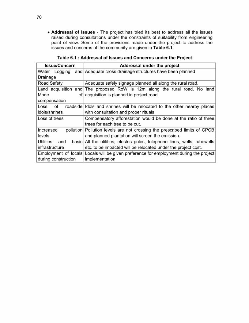
70
Addressal of Issues - The project has tried its best to address all the issues raised during consultations under the constraints of suitability from engineering point of view. Some of the provisions made under the project to address the issues and concerns of the community are given in Table 6.1.
Table 6.1 : Addressal of Issues and Concerns under the Project Issue/Concern Addressal under the project
Water Logging and Drainage
Adequate cross drainage structures have been planned
Road Safety Adequate safely signage planned all along the rural road. Land acquisition and Mode of compensation
The proposed RoW is 12m along the rural road. No land acquisition is planned in project road.
Loss of roadside idols/shrines
Idols and shrines will be relocated to the other nearby places with consultation and proper rituals
Loss of trees Compensatory afforestation would be done at the ratio of three trees for each tree to be cut.
Increased pollution levels
Pollution levels are not crossing the prescribed limits of CPCB and planned plantation will screen the emission.
Utilities and basic infrastructure
All the utilities, electric poles, telephone lines, wells, tubewells etc. to be impacted will be relocated under the project cost.
Employment of locals during construction
Locals will be given preference for employment during the project implementation
71
7. CONCLUSIONS AND RECOMMENDATIONS
7.1. Conclusions 177. The findings of Environment Assessment of sample roads indicate that impacts are mostly similar and subprojects are unlikely to cause any significant environmental impacts. While some of the impacts are negative, there are many bearing benefits to the area. Most of the impacts are likely to occur during construction stage, are temporary in nature, and can be mitigated with minor to negligible residual impacts.
178. The project received immense support from local people, as they perceive that this project will improve the overall connectivity and bring various economic opportunities to the people of the area.
179. All sample roads included under RCIP were selected based on ecological and climate change consideration defined under EARF. Accordingly, none of the sample roads passes through protected areas or encroaches precious ecology (sensitive or protected areas) or any historical or archeologically protected areas. As per selection guidelines, none of the selected sample road passes through reserved forests either. Few trees cutting though may be involved.
180. There are 14 sample project roads which are prone to flood due to river Proximity Rivers or due to accumulation of rainwater in and around project road area. Adequate engineering measures like cross drainage structures, slop stabilisation are proposed for the protection of road from the flood.
181. All the sample roads are aligned with existing village roads and unpaved movement paths. As such, land acquisition is nil or very minimal which is also acquired through donations from villagers.
182. Considering insignificant environmental sensitivity, the project is categorised as category B as per ADB Safeguard Policy Statement 09.
183. No categorisation is made under environmental legislation of India, since these small roads do not require any environmental clearance in accordance to Indian Environmental (Protection) Act and Rules, 1986 amended till date. However, clearance from Forest Department will be required for cutting of trees.
184. The impacts identified are mostly related to alignment selection, land clearing, borrowing earth, and cutting of trees, shifting of utilities and community structures, establishment of construction camp or material storage areas, transportation of material and operation of hot mix plant. All identified impacts are either eliminated or minimised through design consideration and suitable mitigative measures.
185. Environmental Management plan covering all stages of road construction (design, construction and operation) is prepared with defined responsibility for its implementation. Environmental Monitoring plan is also prepared to ensure effective implementation of EMPs.
186. NRRDA/SRRDA has defined institutional setup including with specified responsibility for environmental management. Existing capacity of the State Rural Roads Development Agencies (SRRDAs) and Project Implementation Units (PIUs) for implementing environmental safeguard issues need substantial strengthening. The capacity enhancement is proposed through focused workshops and training session. Few workshops have already been conducted at participating states through ADB
72
appointed Environmental specialist. Trained and experienced in-house officials should carry out more raining in future periodically.
187. The IEE also indicate that rural road construction works does not warrant further EIA study for subsequent rural road construction works in Assam.
7.2. Key Recommendations: 188. Any major changes or any major additional work other than the proposed project activities will require preparation of another environmental assessment. This additional assessment will have to be submitted to NRRDA, Concerned Government authorities and ADB for concurrence before civil works commence.
189. The implementation of prescribed mitigation measures will minimize/avoid the adverse impacts. Moreover, the impacts shall be monitored continually by implementing and updating the Environmental Management plan and Environmental Monitoring Plan.
190. These IEE is prepared based on ECOPs and feasibility stage. Subproject specific EMP shall be improved as per the final provisions made under DPRs. The updated EMP if there is any change shall also be sent to ADB for information.
191. Executing agency shall ensure that EMP and EMoP is included in Bill of Quantity (BOQ) and forms part of bid document and civil works contract. The contractor will specify the quantity and budget for various activities like rehabilitation of borrow earth pits, first aid and sanitation facilities at construction camp and temporary office/material storage place. The same shall be revised if necessary during project implementation or if there is any change in the project design. Any such change shall be reported to ADB as well.
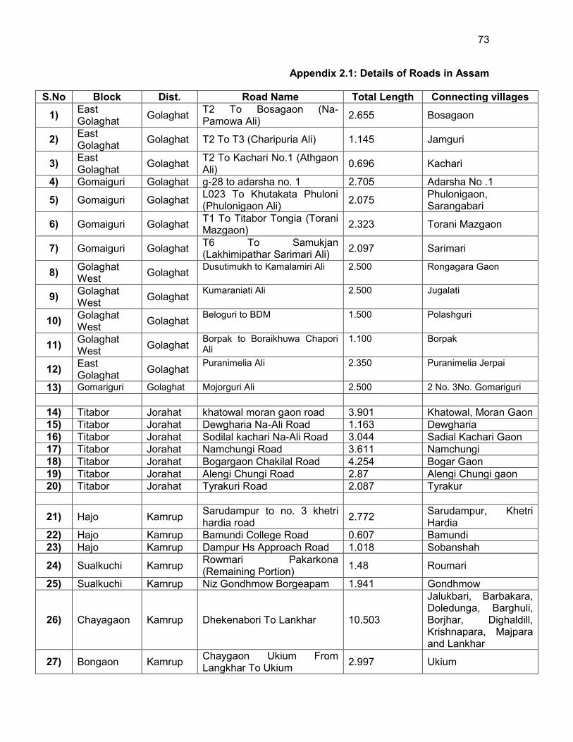
73
Appendix 2.1: Details of Roads in Assam
S.No Block Dist. Road Name Total Length Connecting villages
1) East Golaghat Golaghat T2 To Bosagaon (Na-
Pamowa Ali) 2.655 Bosagaon
2) East Golaghat Golaghat T2 To T3 (Charipuria Ali) 1.145 Jamguri
3) East Golaghat Golaghat T2 To Kachari No.1 (Athgaon
Ali) 0.696 Kachari
4) Gomaiguri Golaghat g-28 to adarsha no. 1 2.705 Adarsha No .1
5) Gomaiguri Golaghat L023 To Khutakata Phuloni (Phulonigaon Ali) 2.075 Phulonigaon,
Sarangabari
6) Gomaiguri Golaghat T1 To Titabor Tongia (Torani Mazgaon) 2.323 Torani Mazgaon
7) Gomaiguri Golaghat T6 To Samukjan (Lakhimipathar Sarimari Ali) 2.097 Sarimari
8) Golaghat West Golaghat Dusutimukh to Kamalamiri Ali
2.500
Rongagara Gaon
9) Golaghat West Golaghat Kumaraniati Ali 2.500 Jugalati
10) Golaghat West Golaghat Beloguri to BDM 1.500 Polashguri
11) Golaghat West Golaghat Borpak to Boraikhuwa Chapori
Ali 1.100 Borpak
12) East Golaghat Golaghat Puranimelia Ali 2.350 Puranimelia Jerpai
13) Gomariguri Golaghat Mojorguri Ali 2.500 2 No. 3No. Gomariguri
14) Titabor Jorahat khatowal moran gaon road 3.901 Khatowal, Moran Gaon 15) Titabor Jorahat Dewgharia Na-Ali Road 1.163 Dewgharia 16) Titabor Jorahat Sodilal kachari Na-Ali Road 3.044 Sadial Kachari Gaon 17) Titabor Jorahat Namchungi Road 3.611 Namchungi 18) Titabor Jorahat Bogargaon Chakilal Road 4.254 Bogar Gaon 19) Titabor Jorahat Alengi Chungi Road 2.87 Alengi Chungi gaon 20) Titabor Jorahat Tyrakuri Road 2.087 Tyrakur
21) Hajo Kamrup Sarudampur to no. 3 khetri hardia road 2.772 Sarudampur, Khetri
Hardia 22) Hajo Kamrup Bamundi College Road 0.607 Bamundi 23) Hajo Kamrup Dampur Hs Approach Road 1.018 Sobanshah
24) Sualkuchi Kamrup Rowmari Pakarkona (Remaining Portion) 1.48 Roumari
25) Sualkuchi Kamrup Niz Gondhmow Borgeapam 1.941 Gondhmow
26) Chayagaon Kamrup Dhekenabori To Lankhar 10.503
Jalukbari, Barbakara, Doledunga, Barghuli, Borjhar, Dighaldill, Krishnapara, Majpara and Lankhar
27) Bongaon Kamrup Chaygaon Ukium From Langkhar To Ukium 2.997 Ukium
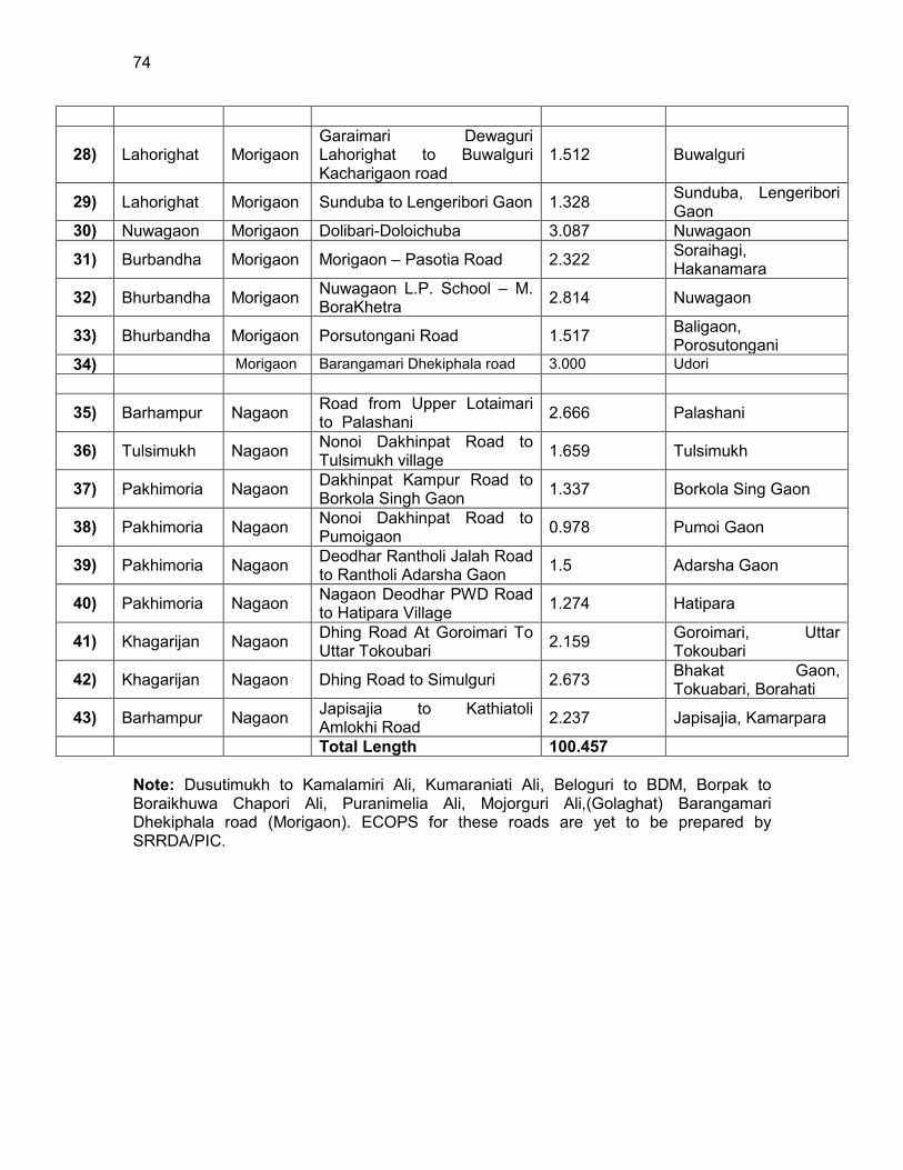
74
28) Lahorighat Morigaon Garaimari Dewaguri Lahorighat to Buwalguri Kacharigaon road
1.512 Buwalguri
29) Lahorighat Morigaon Sunduba to Lengeribori Gaon 1.328 Sunduba, Lengeribori Gaon
30) Nuwagaon Morigaon Dolibari-Doloichuba 3.087 Nuwagaon
31) Burbandha Morigaon Morigaon – Pasotia Road 2.322 Soraihagi, Hakanamara
32) Bhurbandha Morigaon Nuwagaon L.P. School – M. BoraKhetra 2.814 Nuwagaon
33) Bhurbandha Morigaon Porsutongani Road 1.517 Baligaon, Porosutongani
34) Morigaon Barangamari Dhekiphala road 3.000 Udori
35) Barhampur Nagaon Road from Upper Lotaimari to Palashani 2.666 Palashani
36) Tulsimukh Nagaon Nonoi Dakhinpat Road to Tulsimukh village 1.659 Tulsimukh
37) Pakhimoria Nagaon Dakhinpat Kampur Road to Borkola Singh Gaon 1.337 Borkola Sing Gaon
38) Pakhimoria Nagaon Nonoi Dakhinpat Road to Pumoigaon 0.978 Pumoi Gaon
39) Pakhimoria Nagaon Deodhar Rantholi Jalah Road to Rantholi Adarsha Gaon 1.5 Adarsha Gaon
40) Pakhimoria Nagaon Nagaon Deodhar PWD Road to Hatipara Village 1.274 Hatipara
41) Khagarijan Nagaon Dhing Road At Goroimari To Uttar Tokoubari 2.159 Goroimari, Uttar
Tokoubari
42) Khagarijan Nagaon Dhing Road to Simulguri 2.673 Bhakat Gaon, Tokuabari, Borahati
43) Barhampur Nagaon Japisajia to Kathiatoli Amlokhi Road 2.237 Japisajia, Kamarpara
Total Length 100.457 Note: Dusutimukh to Kamalamiri Ali, Kumaraniati Ali, Beloguri to BDM, Borpak to Boraikhuwa Chapori Ali, Puranimelia Ali, Mojorguri Ali,(Golaghat) Barangamari Dhekiphala road (Morigaon). ECOPS for these roads are yet to be prepared by SRRDA/PIC.
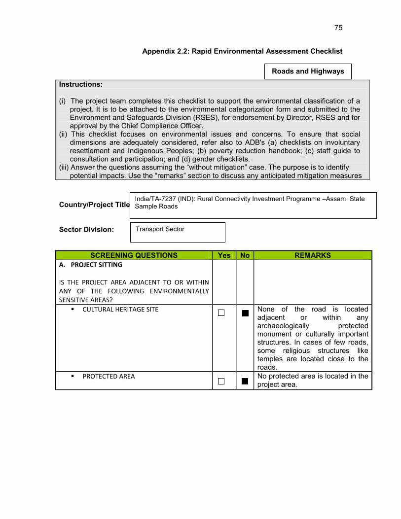
75
Appendix 2.2: Rapid Environmental Assessment Checklist
Instructions: (i) The project team completes this checklist to support the environmental classification of a
project. It is to be attached to the environmental categorization form and submitted to the Environment and Safeguards Division (RSES), for endorsement by Director, RSES and for approval by the Chief Compliance Officer.
(ii) This checklist focuses on environmental issues and concerns. To ensure that social dimensions are adequately considered, refer also to ADB's (a) checklists on involuntary resettlement and Indigenous Peoples; (b) poverty reduction handbook; (c) staff guide to consultation and participation; and (d) gender checklists.
(iii) Answer the questions assuming the “without mitigation” case. The purpose is to identify potential impacts. Use the “remarks” section to discuss any anticipated mitigation measures
Country/Project Title: Sector Division:
SCREENING QUESTIONS Yes No REMARKS A. PROJECT SITTING IS THE PROJECT AREA ADJACENT TO OR WITHIN ANY OF THE FOLLOWING ENVIRONMENTALLY SENSITIVE AREAS?
CULTURAL HERITAGE SITE
None of the road is located adjacent or within any archaeologically protected monument or culturally important structures. In cases of few roads, some religious structures like temples are located close to the roads.
PROTECTED AREA
No protected area is located in the project area.
Roads and Highways
India/TA-7237 (IND): Rural Connectivity Investment Programme –Assam State Sample Roads
Transport Sector

76
SCREENING QUESTIONS Yes No REMARKS
WETLAND
No protected or classified wet land is located close to any roads. Few village ponds are located close to following roads:
Bogargaon Chakilal Road
Dewgharia Na Ali road
Namchungi road
Tyrakuri Road
Dewdhar Jalah PWD Road to Rantholi SC Village Road
Water stagnation problem do exist in many roads.
MANGROVE
None of the roads is located in coastal areas.
ESTUARINE
No Estuarine is located in the project area.
BUFFER ZONE OF PROTECTED AREA
No such area is located in the project vicinity.
SPECIAL AREA FOR PROTECTING BIODIVERSITY
No such area is located in the project vicinity.
B. POTENTIAL ENVIRONMENTAL IMPACTS WILL THE PROJECT CAUSE…
Encroachment on historical/cultural areas; disfiguration of landscape by road embankments, cuts, fills, and quarries?
No encroachment on historical or cultural areas is expected in either of the roads. The topography of project roads is primarily flat. Project activity involves upgradation of unpaved village road to paved road. The roads are aligned as per the existing unpaved road alignment. The embankment height is low. The aggregate will be sourced only from existing quarries. B orrow earth will be borrowed from barren land or authorised places with provision of borrow area rehabilitation.
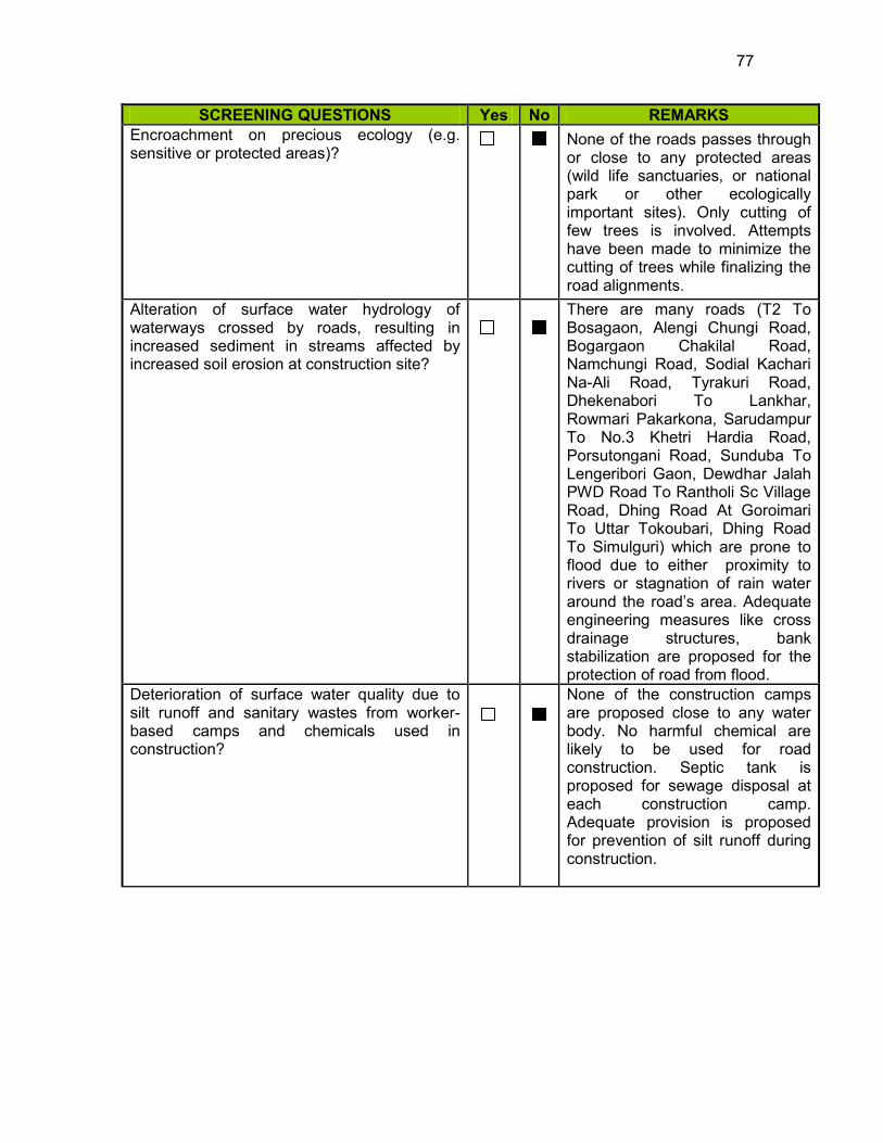
77
SCREENING QUESTIONS Yes No REMARKS Encroachment on precious ecology (e.g. sensitive or protected areas)?
None of the roads passes through or close to any protected areas (wild life sanctuaries, or national park or other ecologically important sites). Only cutting of few trees is involved. Attempts have been made to minimize the cutting of trees while finalizing the road alignments.
Alteration of surface water hydrology of waterways crossed by roads, resulting in increased sediment in streams affected by increased soil erosion at construction site?
There are many roads (T2 To Bosagaon, Alengi Chungi Road, Bogargaon Chakilal Road, Namchungi Road, Sodial Kachari Na-Ali Road, Tyrakuri Road, Dhekenabori To Lankhar, Rowmari Pakarkona, Sarudampur To No.3 Khetri Hardia Road, Porsutongani Road, Sunduba To Lengeribori Gaon, Dewdhar Jalah PWD Road To Rantholi Sc Village Road, Dhing Road At Goroimari To Uttar Tokoubari, Dhing Road To Simulguri) which are prone to flood due to either proximity to rivers or stagnation of rain water around the road‟s area. Adequate engineering measures like cross drainage structures, bank stabilization are proposed for the protection of road from flood.
Deterioration of surface water quality due to silt runoff and sanitary wastes from worker-based camps and chemicals used in construction?
None of the construction camps are proposed close to any water body. No harmful chemical are likely to be used for road construction. Septic tank is proposed for sewage disposal at each construction camp. Adequate provision is proposed for prevention of silt runoff during construction.

78
SCREENING QUESTIONS Yes No REMARKS Increased local air pollution due to rock crushing, cutting and filling works, and chemicals from asphalt processing?
Localised air pollution is expected. Dust separation measures like spraying of water on unpaved haulage routes are proposed to minimise the dust generation. Asphalt mixing plant will be located away from habitat area with adequate stack height for emission dispersion.
Risks and vulnerabilities related to occupational health and safety due to physical, chemical, biological, and radiological hazards during project construction and operation during project construction and operation?
Workers may get exposed to dust and noise during construction activities. However, the exposure levels are likely to be short and insignificant. Workers will be provided requisite PPEs to minimise such exposure and associated harmful occupational health effects. Traffic on these rural roads is expected to be low and as such no occupational health hazard is anticipated during operation phase.
Noise and vibration due to blasting and other civil works?
No blasting is involved. No significant noise generation is expected during construction activities except normal construction equipment operational noise. These noise level will be impulsive in nature and it impact will be confined within few meters of either side road.
Dislocation or involuntary resettlement of people
No involuntary resettlement of people is involved.
Dislocation and compulsory resettlement of people living in right-of-way?
No displacement of people is involved.
Disproportionate impacts on the poor, women and children, Indigenous Peoples or other vulnerable groups?
No such impact is anticipated. .
Other social concerns relating to inconveniences in living conditions in the project areas that may trigger cases of upper respiratory problems and stress?
None. Villagers are very supportive for the construction of these roads, as they believe that these roads will provide them better connectivity and will contribute in poverty alleviation.
79
SCREENING QUESTIONS Yes No REMARKS Hazardous driving conditions where construction interferes with pre-existing roads?
None. Measures will be taken to avoid any hazardous driving condition.
Poor sanitation and solid waste disposal in construction camps and work sites, and possible transmission of communicable diseases from workers to local populations
Provision is made for the disposal of sewage through septic tanks and solid waste through composting or controlled land burial, is planned. As such camp size will be small (about 50 workers) and no such transmission of diseases is expected. Periodic health check-up may be organised to this. Awareness will be created amongst the workers about hygiene and health protection.
Creation of temporary breeding habitats for mosquito vectors of disease?
No such condition is anticipated
Accident risks associated with increased vehicular traffic, leading to accidental spills of toxic materials and loss of life
Being rural road, traffic volume is expected low and probability of accident is minimal. Adequate traffic management measures will be taken to prevent hazardous traffic conditions during construction phase. Adequate signage, speed control measures will be taken close to sensitive locations such as schools, temple or hospitals.
Increased noise and air pollution resulting from traffic volume?
Air and noise pollution may increase during construction phase. However, the same is likely to be confined within few meters of either side of the road. Dust separation measures such as spraying of water and distribution of PPE to workers will be adopted. Impulsive but intermittent noise level increase may occur during operation phase. Air pollution level rather will reduce on paved road compared to unpaved road conditions.
Increased risk of water pollution from oil, grease and fuel spills, and other materials from vehicles using the road?
This possibility is minimal but cannot be ruled out. Adequate signage and crash barriers near water body will be proposed to prevent any such incident.
80
SCREENING QUESTIONS Yes No REMARKS Social conflicts if workers from other regions or countries are hired?
Most of the workers will be hired locally.
Large population influx during project construction and operation that causes increased burden on social infrastructure and services (such as water supply and sanitation systems)?
Most of the workers will be hired locally. Since average road length is 3-5 Km. No of construction camp per road is expected to be one with only 30-40 workers. This is unlikely to cause any significant burden on social infrastructure and services.
Risks to community health and safety due to the transport, storage, and use and/or disposal of materials such as explosives, fuel and other chemicals during construction and operation?
The construction material (aggregate from approved quarries, borrow earth, Bitumen) will be sourced from nearby sources/approved sources. No explosive or chemicals are likely to be used. Bitumen waste if any generated during construction will either recycled or disposed off in controlled manner.
Community safety risks due to both accidental and natural causes, especially where the structural elements or components of the project are accessible to members of the affected community or where their failure could result in injury to the community throughout project construction, operation and decommissioning.
No such impacts are anticipated. Safe access is provided to all villagers using the road. Adequate signage as well guide are posted at work place.
The Project is categorized as B.
81
Appendix 2.3: Rural Roads: Environmental Checklist
Road Name:
Block Name: District Name: Total Length of the Road:
A. Climatic Conditions Temperature High: Low: Humidity High: Low: Rainfall Rainy Season
mm/year to
B. Location of the Road and Generic description of Environment No. Type of
Ecosystem Yes No Explanation
1. Coastal area Mangrove (along roadside)
Distance from Coastline: km
( ) more than 50% ( ) less than 20%
2. Type of Terrain (Plain/Hilly/ Mountainous etc.) (Explain the topography of the area and how many km of the road are located in the hilly area)
Altitude:
4. Forest Area (Explain whether the road passes through forest areas or located along the forest areas and distance from shoulder to the forest area)?
Type of Vegetation: Legal Status of the Forest Area: (Reserved, National Park, Sanctuaries, Unclassified, etc.)
5. Wildlife (Explain whether there are any wildlife species in the project area)
Name of animals:
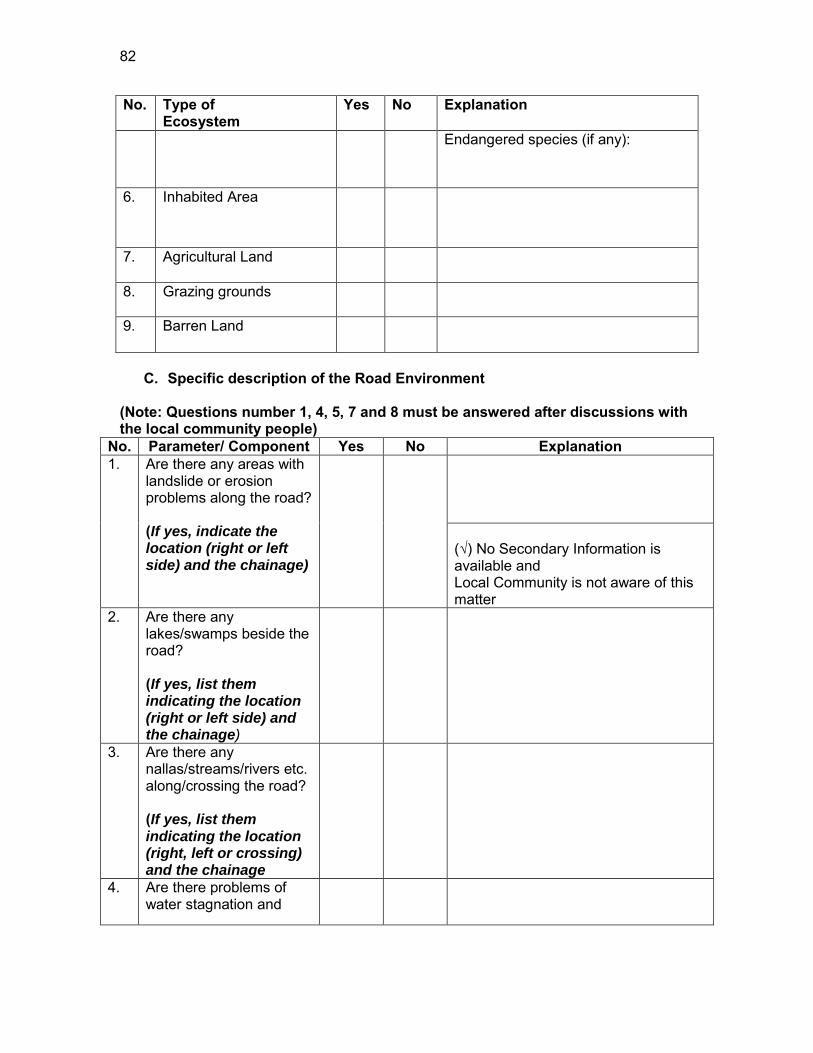
82
No. Type of Ecosystem
Yes No Explanation
Endangered species (if any):
6. Inhabited Area
7. Agricultural Land
8. Grazing grounds
9. Barren Land
C. Specific description of the Road Environment
(Note: Questions number 1, 4, 5, 7 and 8 must be answered after discussions with the local community people)
No. Parameter/ Component Yes No Explanation 1. Are there any areas with
landslide or erosion problems along the road? (If yes, indicate the location (right or left side) and the chainage)
(√) No Secondary Information is available and Local Community is not aware of this matter
2. Are there any lakes/swamps beside the road? (If yes, list them indicating the location (right or left side) and the chainage)
3. Are there any nallas/streams/rivers etc. along/crossing the road? (If yes, list them indicating the location (right, left or crossing) and the chainage
4. Are there problems of water stagnation and
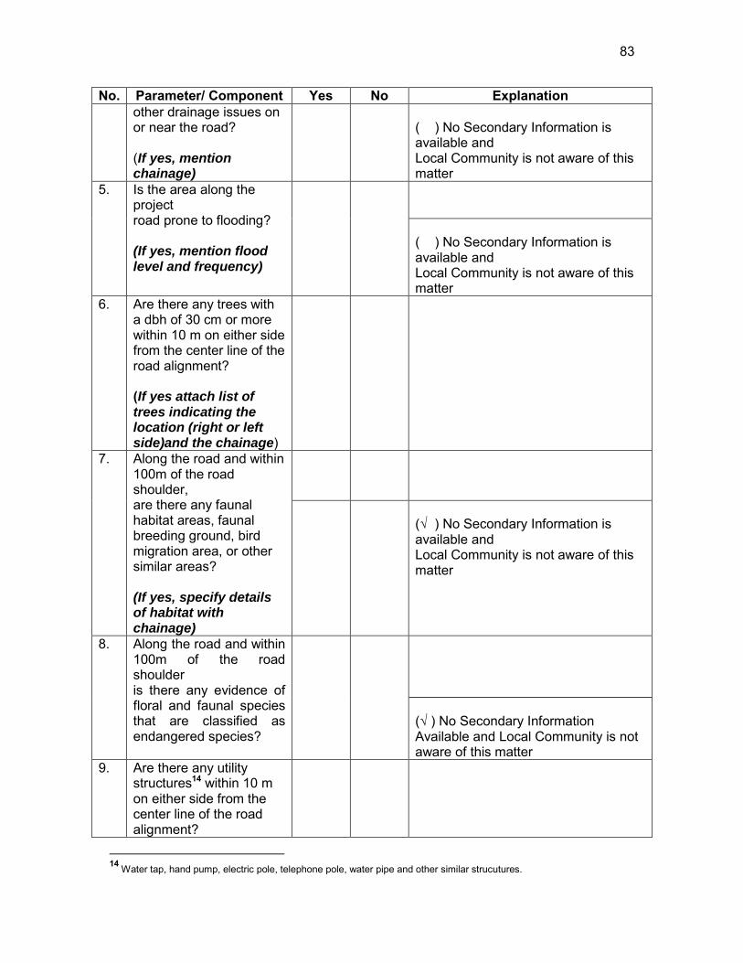
83
No. Parameter/ Component Yes No Explanation other drainage issues on or near the road? (If yes, mention chainage)
( ) No Secondary Information is available and Local Community is not aware of this matter
5. Is the area along the project road prone to flooding? (If yes, mention flood level and frequency)
( ) No Secondary Information is available and Local Community is not aware of this matter
6. Are there any trees with a dbh of 30 cm or more within 10 m on either side from the center line of the road alignment? (If yes attach list of trees indicating the location (right or left side)and the chainage)
7. Along the road and within 100m of the road shoulder, are there any faunal habitat areas, faunal breeding ground, bird migration area, or other similar areas? (If yes, specify details of habitat with chainage)
(√ ) No Secondary Information is available and Local Community is not aware of this matter
8. Along the road and within 100m of the road shoulder is there any evidence of floral and faunal species that are classified as endangered species?
(√ ) No Secondary Information Available and Local Community is not aware of this matter
9. Are there any utility structures14 within 10 m on either side from the center line of the road alignment?
14 Water tap, hand pump, electric pole, telephone pole, water pipe and other similar strucutures.
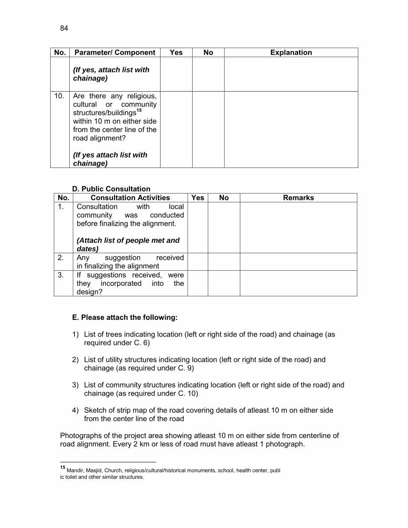
84
No. Parameter/ Component Yes No Explanation (If yes, attach list with chainage)
10. Are there any religious, cultural or community structures/buildings15 within 10 m on either side from the center line of the road alignment? (If yes attach list with chainage)
D. Public Consultation
No. Consultation Activities Yes No Remarks 1. Consultation with local
community was conducted before finalizing the alignment. (Attach list of people met and dates)
2. Any suggestion received in finalizing the alignment
3. If suggestions received, were they incorporated into the design?
E. Please attach the following: 1) List of trees indicating location (left or right side of the road) and chainage (as
required under C. 6) 2) List of utility structures indicating location (left or right side of the road) and
chainage (as required under C. 9) 3) List of community structures indicating location (left or right side of the road) and
chainage (as required under C. 10) 4) Sketch of strip map of the road covering details of atleast 10 m on either side
from the center line of the road Photographs of the project area showing atleast 10 m on either side from centerline of road alignment. Every 2 km or less of road must have atleast 1 photograph.
15 Mandir, Masjid, Church, religious/cultural/historical monuments, school, health center, publ ic toilet and other similar structures.
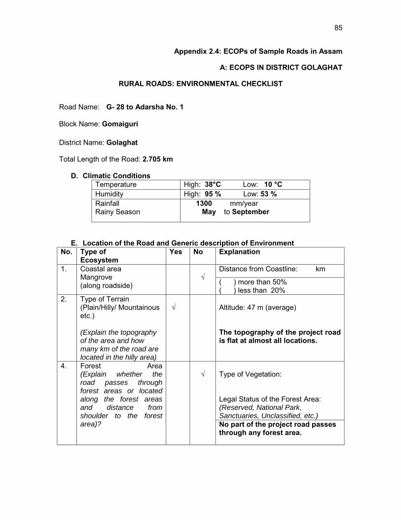
85
Appendix 2.4: ECOPs of Sample Roads in Assam
A: ECOPS IN DISTRICT GOLAGHAT
RURAL ROADS: ENVIRONMENTAL CHECKLIST
Road Name: G- 28 to Adarsha No. 1
Block Name: Gomaiguri District Name: Golaghat Total Length of the Road: 2.705 km
D. Climatic Conditions Temperature High: 38°C Low: 10 °C Humidity High: 95 % Low: 53 % Rainfall Rainy Season
1300 mm/year May to September
E. Location of the Road and Generic description of Environment No. Type of
Ecosystem Yes No Explanation
1. Coastal area Mangrove (along roadside)
√
Distance from Coastline: km
( ) more than 50% ( ) less than 20%
2. Type of Terrain (Plain/Hilly/ Mountainous etc.) (Explain the topography of the area and how many km of the road are located in the hilly area)
√
Altitude: 47 m (average) The topography of the project road is flat at almost all locations.
4. Forest Area (Explain whether the road passes through forest areas or located along the forest areas and distance from shoulder to the forest area)?
√
Type of Vegetation: Legal Status of the Forest Area: (Reserved, National Park, Sanctuaries, Unclassified, etc.) No part of the project road passes through any forest area.
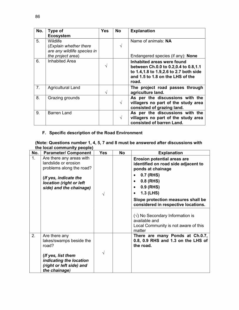
86
No. Type of Ecosystem
Yes No Explanation
5. Wildlife (Explain whether there are any wildlife species in the project area)
√
Name of animals: NA Endangered species (if any): None
6. Inhabited Area √
Inhabited areas were found between Ch.0.0 to 0.2,0.4 to 0.8,1.1 to 1.4,1.8 to 1.9,2.6 to 2.7 both side and 1.5 to 1.8 on the LHS of the road.
7. Agricultural Land √
The project road passes through agriculture land.
8. Grazing grounds √
As per the discussions with the villagers no part of the study area consisted of grazing land.
9. Barren Land √
As per the discussions with the villagers no part of the study area consisted of barren Land.
F. Specific description of the Road Environment
(Note: Questions number 1, 4, 5, 7 and 8 must be answered after discussions with the local community people)
No. Parameter/ Component Yes No Explanation 1. Are there any areas with
landslide or erosion problems along the road? (If yes, indicate the location (right or left side) and the chainage)
√
Erosion potential areas are identified on road side adjacent to ponds at chainage 0.7 (RHS) 0.8 (RHS) 0.9 (RHS) 1.3 (LHS)
Slope protection measures shall be considered in respective locations. (√) No Secondary Information is available and Local Community is not aware of this matter
2. Are there any lakes/swamps beside the road? (If yes, list them indicating the location (right or left side) and the chainage)
√
There are many Ponds at Ch.0.7, 0.8, 0.9 RHS and 1.3 on the LHS of the road.
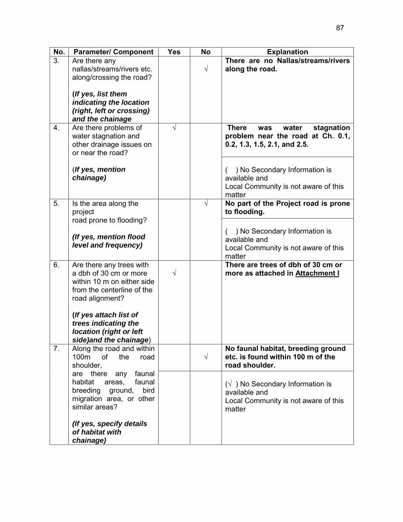
87
No. Parameter/ Component Yes No Explanation 3. Are there any
nallas/streams/rivers etc. along/crossing the road? (If yes, list them indicating the location (right, left or crossing) and the chainage
√
There are no Nallas/streams/rivers along the road.
4. Are there problems of water stagnation and other drainage issues on or near the road? (If yes, mention chainage)
√
There was water stagnation problem near the road at Ch. 0.1, 0.2, 1.3, 1.5, 2.1, and 2.5. ( ) No Secondary Information is available and Local Community is not aware of this matter
5. Is the area along the project road prone to flooding? (If yes, mention flood level and frequency)
√
No part of the Project road is prone to flooding. ( ) No Secondary Information is available and Local Community is not aware of this matter
6. Are there any trees with a dbh of 30 cm or more within 10 m on either side from the centerline of the road alignment? (If yes attach list of trees indicating the location (right or left side)and the chainage)
√
There are trees of dbh of 30 cm or more as attached in Attachment I
7. Along the road and within 100m of the road shoulder, are there any faunal habitat areas, faunal breeding ground, bird migration area, or other similar areas? (If yes, specify details of habitat with chainage)
√
No faunal habitat, breeding ground etc. is found within 100 m of the road shoulder.
(√ ) No Secondary Information is available and Local Community is not aware of this matter
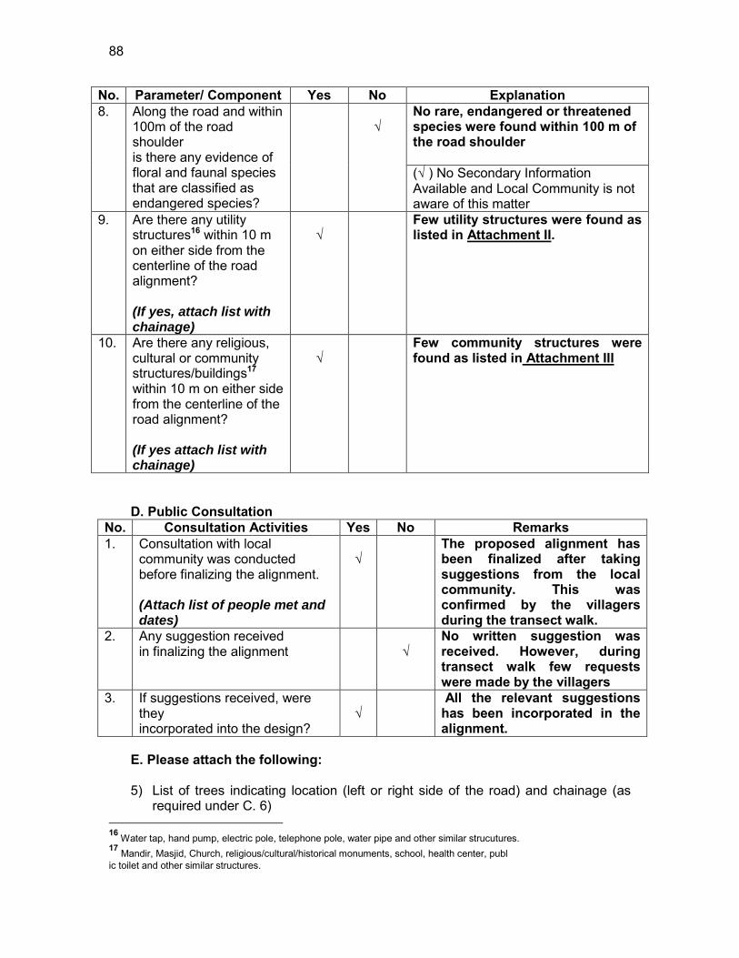
88
No. Parameter/ Component Yes No Explanation 8. Along the road and within
100m of the road shoulder is there any evidence of floral and faunal species that are classified as endangered species?
√
No rare, endangered or threatened species were found within 100 m of the road shoulder (√ ) No Secondary Information Available and Local Community is not aware of this matter
9. Are there any utility structures16 within 10 m on either side from the centerline of the road alignment? (If yes, attach list with chainage)
√
Few utility structures were found as listed in Attachment II.
10. Are there any religious, cultural or community structures/buildings17 within 10 m on either side from the centerline of the road alignment? (If yes attach list with chainage)
√
Few community structures were found as listed in Attachment III
D. Public Consultation
No. Consultation Activities Yes No Remarks 1. Consultation with local
community was conducted before finalizing the alignment. (Attach list of people met and dates)
√
The proposed alignment has been finalized after taking suggestions from the local community. This was confirmed by the villagers during the transect walk.
2. Any suggestion received in finalizing the alignment
√
No written suggestion was received. However, during transect walk few requests were made by the villagers
3. If suggestions received, were they incorporated into the design?
√
All the relevant suggestions has been incorporated in the alignment.
E. Please attach the following: 5) List of trees indicating location (left or right side of the road) and chainage (as
required under C. 6) 16 Water tap, hand pump, electric pole, telephone pole, water pipe and other similar strucutures. 17 Mandir, Masjid, Church, religious/cultural/historical monuments, school, health center, publ ic toilet and other similar structures.
89
6) List of utility structures indicating location (left or right side of the road) and
chainage (as required under C. 9) 7) List of community structures indicating location (left or right side of the road) and
chainage (as required under C. 10) 8) Sketch of strip map of the road covering details of atleast 10 m on either side
from the center line of the road
9) Photographs of the project area showing atleast 10 m on either side from centerline of road alignment. Every 2 km or less of road must have atleast 1 photograph.
90
Attachment I
List of Trees Chainage Left Right
0.0 2 4 0.1 2 4 0.2 1 6 0.4 3 3 0.5 3 4 0.6 3 2 0.7 2 - 0.8 - 5 0.9 - 12 1.0 5 - 1.1 4 3 1.2 - - 1.3 3 3 1.4 3 7 1.5 3 4 1.6 10 - 1.7 7 - 1.8 5 2 1.9 6 1 2.0 1 1 2.1 1 1 2.2 4 1 2.3 3 - 2.5 5 2 2.6 3 - 2.7 2 -
Total 81 65
91
Attachment II
List of Utilities
Chainage Hand pump LHS RHS
0.0 to 0.1 0 1 0.5 to 0.6 0 1 1.1 to 1.2 0 1 2.1 to 2.2 1 0 2.5 to 2.6 1 0
Total 2 4
Chainage Electric Poles
LHS RHS 0.0 to 0.2 3 0 0.2 to 0.4 2 0 0.4 to 0.6 4 0 0.6 to 0.8 3 0 0.8 to 1.0 2 1 1.0 to 1.2 2 1 1.2 to 1.4 5 1 1.4 to 1.6 5 0 1.6 to 1.8 1 1 1.8 to 2.0 0 0 2.0 to 2.2 3 1 2.2 to 2.4 1 3 2.4 to 2.6 1 3
Total 32 11
Chainage TRANSFORMER SIDE 0.4 1 LHS
92
Attachment III
List of Community Structures
Chainage No. Side Type
0.2 RHS 2 Temple
2.5 LHS Temple
93
Attachment IV
LHS RHS 8 to 10m
6 to 8m
4 to 6m 2 to 4m
0 to 2m
0 to 2m 2 to 4m 4 to 6m
6 to 8m 8 to 10m
A.L Settlement,2 Trees,2 EP 0 Settlement,4 Trees,HP A.L
A.L Settlement,2 Trees,EP 0.1 Settlement,4 Trees A.L
A.L Settlement,1 Tree,EP 0.2 Settlement,6 Trees A.L,Temple Temple
EP 0.3 11 Trees
Settlement,3 Trees, Transformer 0.4
Settlement,3 Trees
Settlement,3 Trees,4 EP 0.5 Settlement,4 Trees
Settlement,3 Trees,EP 0.6
Settlement,2 Trees HP
Settlement,2 trees,2 EP 0.7 Settlement Pond
A.L Settlement,EP 0.8 Settlement,5 Trees A.L Pond
A.L EP 0.9 12 Trees,EP A.L Pond
A.L 5 Trees,EP 1 EP A.L
A.L Settlement,4 Trees,EP 1.1 Settlement,3 Trees A.L
Settlement,3 EP 1.2 Settlement HP
Pond Settlement,3 Trees,2 EP 1.3 Settlement,3 Trees,EP
A.L Settlement,3 Trees 1.4 Settlement,7 Trees A.L
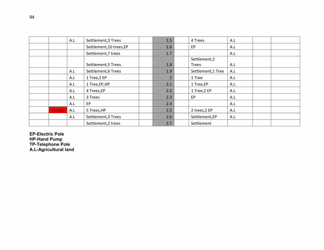
94
A.L Settlement,3 Trees 1.5 4 Trees A.L
Settlement,10 trees,EP 1.6 EP A.L
Settlement,7 trees 1.7 A.L
Settlement,5 Trees 1.8 Settlement,2 Trees A.L
A.L Settlement,6 Trees 1.9 Settlement,1 Tree A.L
A.L 1 Tree,2 EP 2 1 Tree A.L
A.L 1 Tree,EP,HP 2.1 1 Tree,EP A.L
A.L 4 Trees,EP 2.2 1 Tree,2 EP A.L
A.L 3 Trees 2.3 EP A.L
A.L EP 2.4 A.L
Temple A.L 5 Trees,HP 2.5 2 trees,2 EP A.L
A.L Settlement,3 Trees 2.6 Settlement,EP A.L
Settlement,2 trees 2.7 Settlement EP-Electric Pole HP-Hand Pump TP-Telephone Pole A.L-Agricultural land
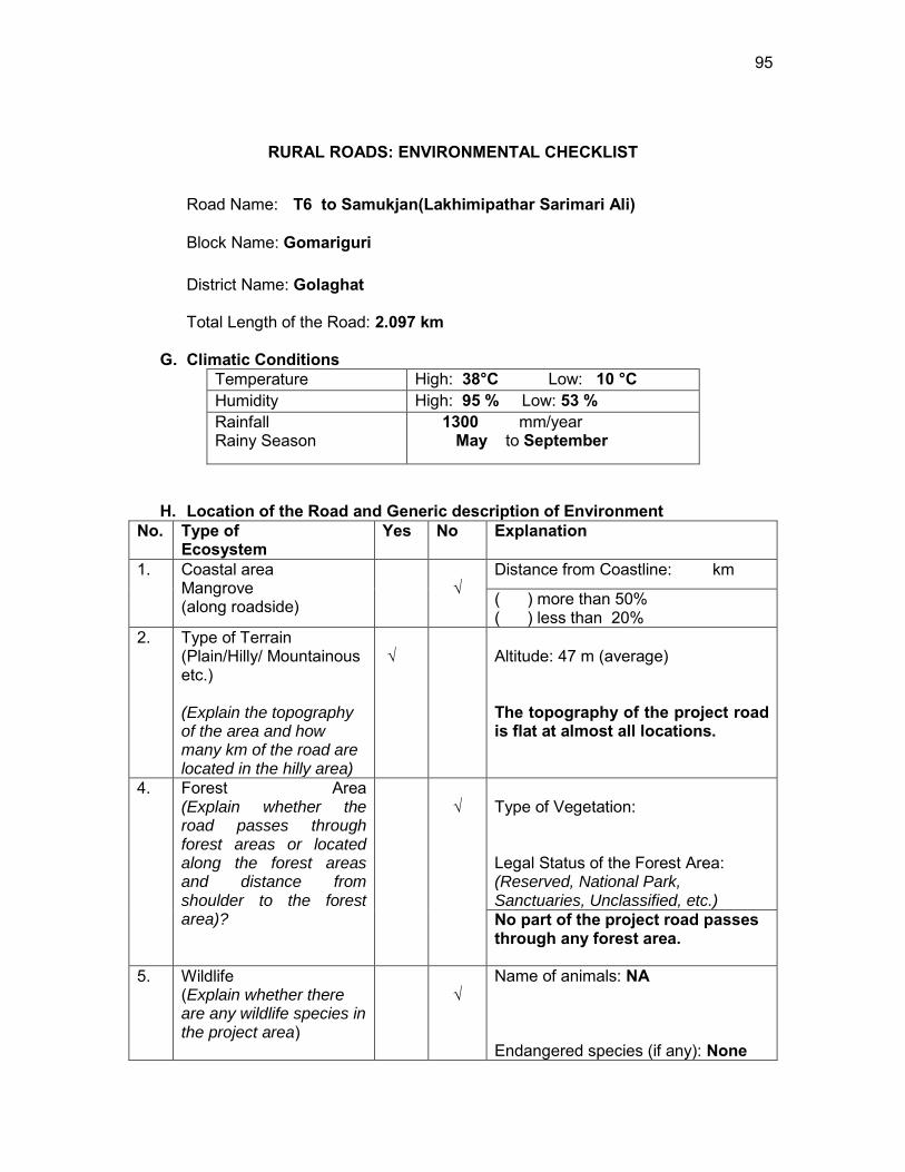
95
RURAL ROADS: ENVIRONMENTAL CHECKLIST
Road Name: T6 to Samukjan(Lakhimipathar Sarimari Ali)
Block Name: Gomariguri
District Name: Golaghat
Total Length of the Road: 2.097 km
G. Climatic Conditions Temperature High: 38°C Low: 10 °C Humidity High: 95 % Low: 53 % Rainfall Rainy Season
1300 mm/year May to September
H. Location of the Road and Generic description of Environment No. Type of
Ecosystem Yes No Explanation
1. Coastal area Mangrove (along roadside)
√
Distance from Coastline: km
( ) more than 50% ( ) less than 20%
2. Type of Terrain (Plain/Hilly/ Mountainous etc.) (Explain the topography of the area and how many km of the road are located in the hilly area)
√
Altitude: 47 m (average) The topography of the project road is flat at almost all locations.
4. Forest Area (Explain whether the road passes through forest areas or located along the forest areas and distance from shoulder to the forest area)?
√
Type of Vegetation: Legal Status of the Forest Area: (Reserved, National Park, Sanctuaries, Unclassified, etc.) No part of the project road passes through any forest area.
5. Wildlife (Explain whether there are any wildlife species in the project area)
√
Name of animals: NA Endangered species (if any): None
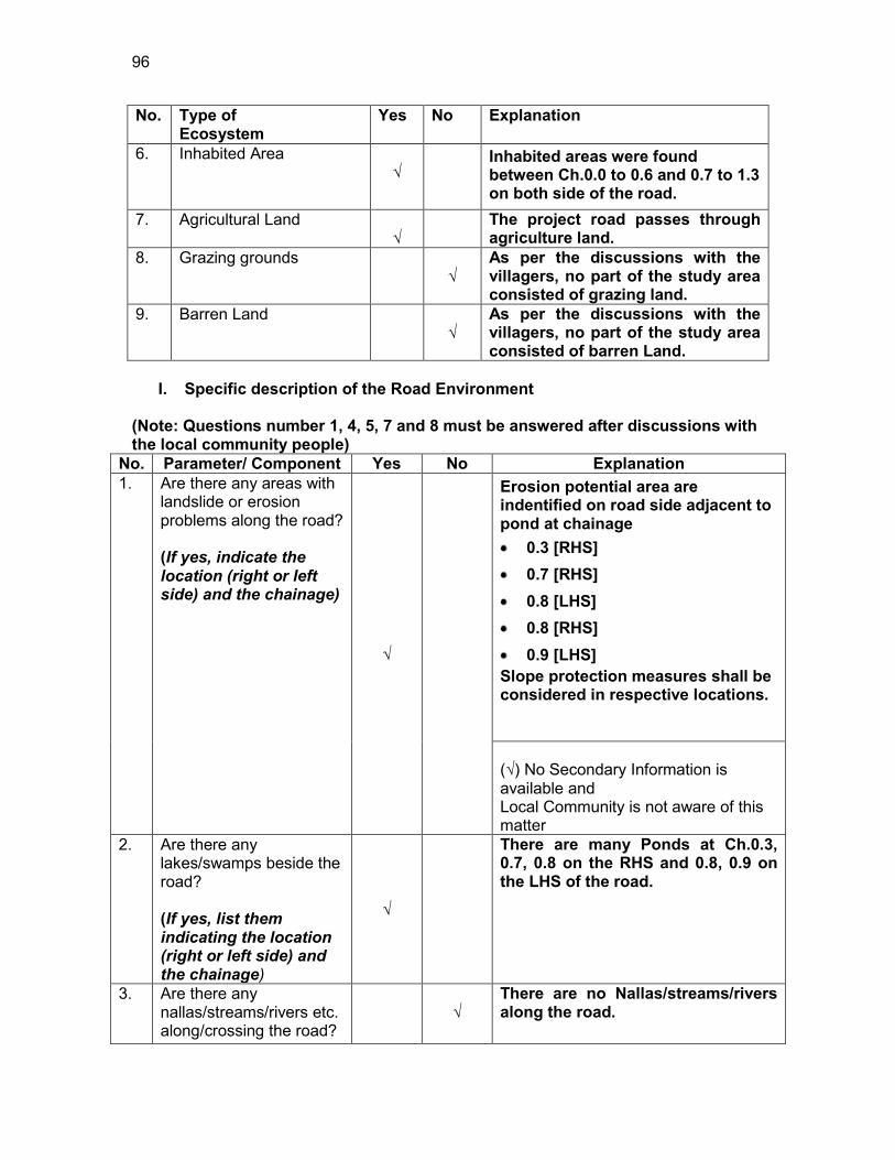
96
No. Type of Ecosystem
Yes No Explanation
6. Inhabited Area √
Inhabited areas were found between Ch.0.0 to 0.6 and 0.7 to 1.3 on both side of the road.
7. Agricultural Land √
The project road passes through agriculture land.
8. Grazing grounds √
As per the discussions with the villagers, no part of the study area consisted of grazing land.
9. Barren Land √
As per the discussions with the villagers, no part of the study area consisted of barren Land.
I. Specific description of the Road Environment
(Note: Questions number 1, 4, 5, 7 and 8 must be answered after discussions with the local community people)
No. Parameter/ Component Yes No Explanation 1. Are there any areas with
landslide or erosion problems along the road? (If yes, indicate the location (right or left side) and the chainage)
√
Erosion potential area are indentified on road side adjacent to pond at chainage 0.3 [RHS] 0.7 [RHS] 0.8 [LHS] 0.8 [RHS] 0.9 [LHS]
Slope protection measures shall be considered in respective locations. (√) No Secondary Information is available and Local Community is not aware of this matter
2. Are there any lakes/swamps beside the road? (If yes, list them indicating the location (right or left side) and the chainage)
√
There are many Ponds at Ch.0.3, 0.7, 0.8 on the RHS and 0.8, 0.9 on the LHS of the road.
3. Are there any nallas/streams/rivers etc. along/crossing the road?
√
There are no Nallas/streams/rivers along the road.
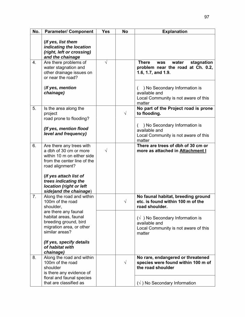
97
No. Parameter/ Component Yes No Explanation (If yes, list them indicating the location (right, left or crossing) and the chainage
4. Are there problems of water stagnation and other drainage issues on or near the road? (If yes, mention chainage)
√
There was water stagnation problem near the road at Ch. 0.2, 1.6, 1.7, and 1.9. ( ) No Secondary Information is available and Local Community is not aware of this matter
5. Is the area along the project road prone to flooding? (If yes, mention flood level and frequency)
√
No part of the Project road is prone to flooding. ( ) No Secondary Information is available and Local Community is not aware of this matter
6. Are there any trees with a dbh of 30 cm or more within 10 m on either side from the center line of the road alignment? (If yes attach list of trees indicating the location (right or left side)and the chainage)
√
There are trees of dbh of 30 cm or more as attached in Attachment I
7. Along the road and within 100m of the road shoulder, are there any faunal habitat areas, faunal breeding ground, bird migration area, or other similar areas? (If yes, specify details of habitat with chainage)
√
No faunal habitat, breeding ground etc. is found within 100 m of the road shoulder.
(√ ) No Secondary Information is available and Local Community is not aware of this matter
8. Along the road and within 100m of the road shoulder is there any evidence of floral and faunal species that are classified as
√
No rare, endangered or threatened species were found within 100 m of the road shoulder (√ ) No Secondary Information
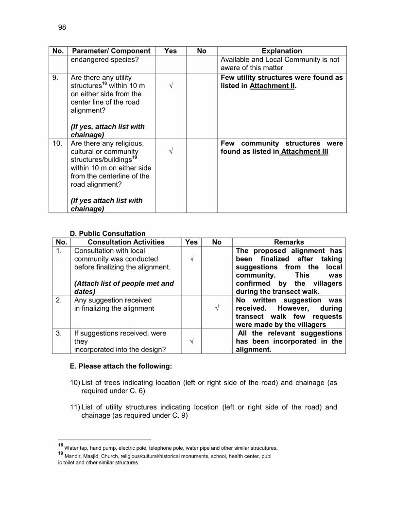
98
No. Parameter/ Component Yes No Explanation endangered species? Available and Local Community is not
aware of this matter 9. Are there any utility
structures18 within 10 m on either side from the center line of the road alignment? (If yes, attach list with chainage)
√
Few utility structures were found as listed in Attachment II.
10. Are there any religious, cultural or community structures/buildings19 within 10 m on either side from the centerline of the road alignment? (If yes attach list with chainage)
√
Few community structures were found as listed in Attachment III
D. Public Consultation
No. Consultation Activities Yes No Remarks 1. Consultation with local
community was conducted before finalizing the alignment. (Attach list of people met and dates)
√
The proposed alignment has been finalized after taking suggestions from the local community. This was confirmed by the villagers during the transect walk.
2. Any suggestion received in finalizing the alignment
√
No written suggestion was received. However, during transect walk few requests were made by the villagers
3. If suggestions received, were they incorporated into the design?
√
All the relevant suggestions has been incorporated in the alignment.
E. Please attach the following: 10) List of trees indicating location (left or right side of the road) and chainage (as
required under C. 6) 11) List of utility structures indicating location (left or right side of the road) and
chainage (as required under C. 9)
18 Water tap, hand pump, electric pole, telephone pole, water pipe and other similar strucutures. 19 Mandir, Masjid, Church, religious/cultural/historical monuments, school, health center, publ ic toilet and other similar structures.
99
12) List of community structures indicating location (left or right side of the road) and chainage (as required under C. 10)
13) Sketch of strip map of the road covering details of atleast 10 m on either side
from the center line of the road
14) Photographs of the project area showing atleast 10 m on either side from centerline of road alignment. Every 2 km or less of road must have atleast 1 photograph.
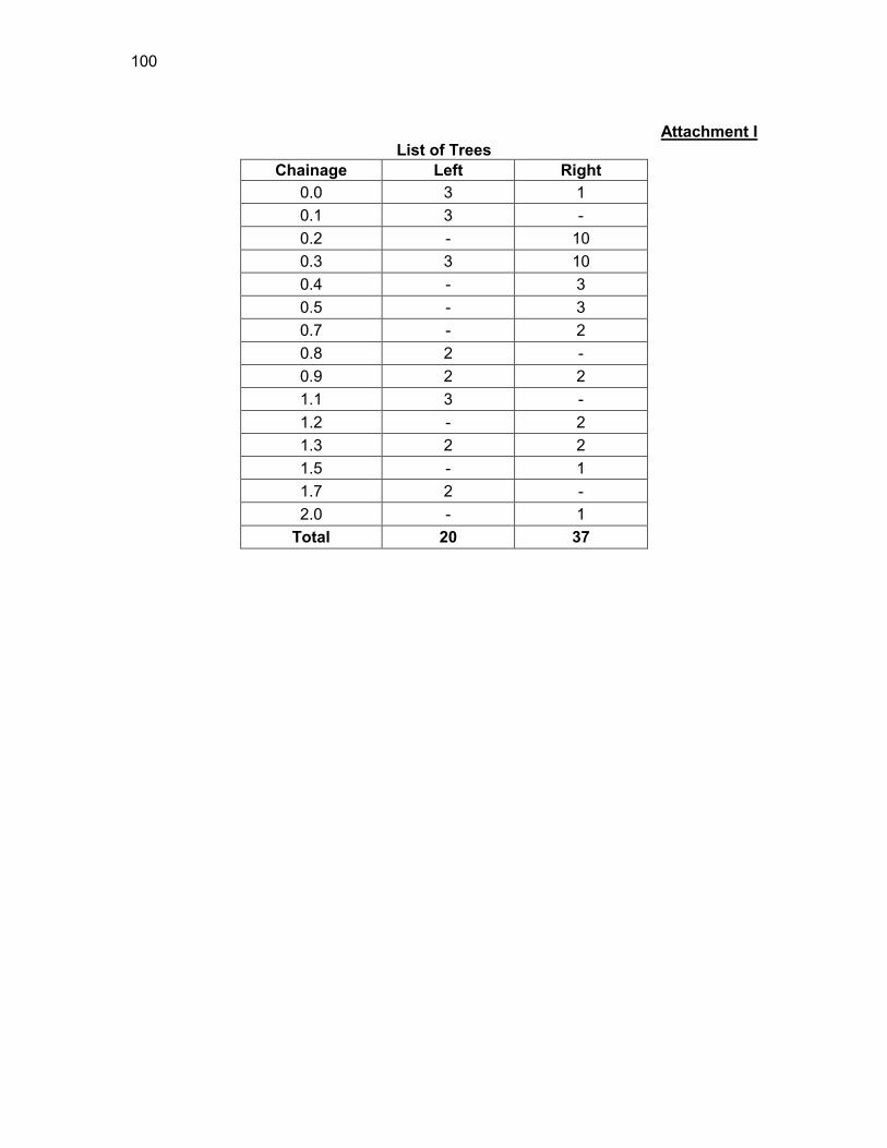
100
Attachment I
List of Trees Chainage Left Right
0.0 3 1 0.1 3 - 0.2 - 10 0.3 3 10 0.4 - 3 0.5 - 3 0.7 - 2 0.8 2 - 0.9 2 2 1.1 3 - 1.2 - 2 1.3 2 2 1.5 - 1 1.7 2 - 2.0 - 1
Total 20 37
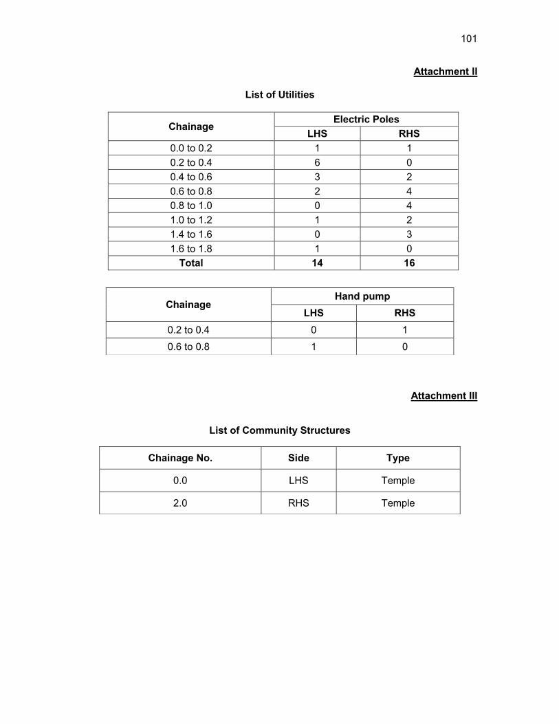
101
Attachment II
List of Utilities
Chainage Electric Poles
LHS RHS 0.0 to 0.2 1 1 0.2 to 0.4 6 0 0.4 to 0.6 3 2 0.6 to 0.8 2 4 0.8 to 1.0 0 4 1.0 to 1.2 1 2 1.4 to 1.6 0 3 1.6 to 1.8 1 0
Total 14 16
Attachment III
List of Community Structures
Chainage Hand pump
LHS RHS 0.2 to 0.4 0 1 0.6 to 0.8 1 0
Chainage No. Side Type
0.0 LHS Temple
2.0 RHS Temple
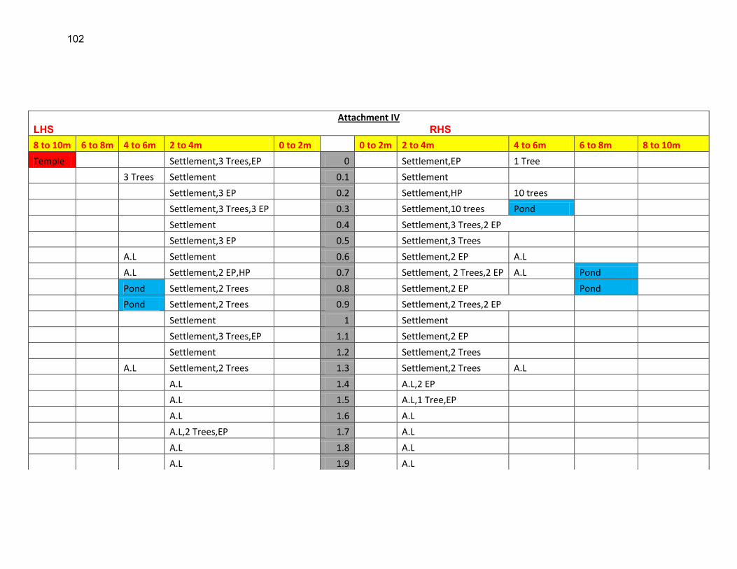
102
Attachment IV LHS RHS 8 to 10m 6 to 8m 4 to 6m 2 to 4m 0 to 2m 0 to 2m 2 to 4m 4 to 6m 6 to 8m 8 to 10m
Temple Settlement,3 Trees,EP 0 Settlement,EP 1 Tree
3 Trees Settlement 0.1 Settlement
Settlement,3 EP 0.2 Settlement,HP 10 trees
Settlement,3 Trees,3 EP 0.3 Settlement,10 trees Pond
Settlement 0.4 Settlement,3 Trees,2 EP
Settlement,3 EP 0.5 Settlement,3 Trees
A.L Settlement 0.6 Settlement,2 EP A.L
A.L Settlement,2 EP,HP 0.7 Settlement, 2 Trees,2 EP A.L Pond
Pond Settlement,2 Trees 0.8 Settlement,2 EP Pond
Pond Settlement,2 Trees 0.9 Settlement,2 Trees,2 EP
Settlement 1 Settlement
Settlement,3 Trees,EP 1.1 Settlement,2 EP
Settlement 1.2 Settlement,2 Trees
A.L Settlement,2 Trees 1.3 Settlement,2 Trees A.L
A.L 1.4 A.L,2 EP
A.L 1.5 A.L,1 Tree,EP
A.L 1.6 A.L
A.L,2 Trees,EP 1.7 A.L
A.L 1.8 A.L
A.L 1.9 A.L
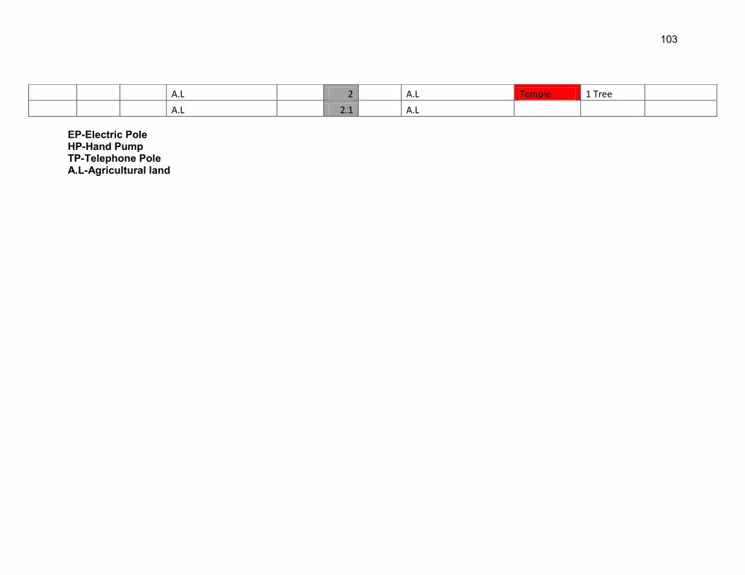
103
EP-Electric Pole HP-Hand Pump TP-Telephone Pole A.L-Agricultural land
A.L 2 A.L Temple 1 Tree
A.L 2.1 A.L
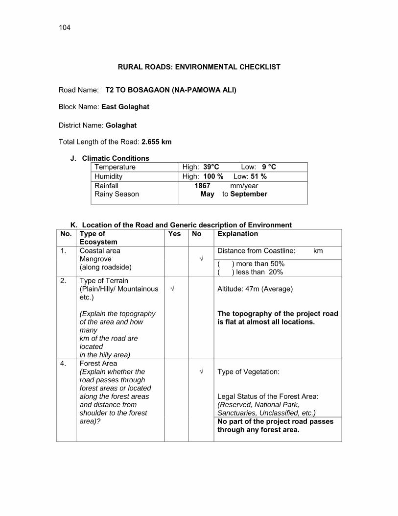
104
RURAL ROADS: ENVIRONMENTAL CHECKLIST
Road Name: T2 TO BOSAGAON (NA-PAMOWA ALI)
Block Name: East Golaghat District Name: Golaghat Total Length of the Road: 2.655 km
J. Climatic Conditions Temperature High: 39°C Low: 9 °C Humidity High: 100 % Low: 51 % Rainfall Rainy Season
1867 mm/year May to September
K. Location of the Road and Generic description of Environment No. Type of
Ecosystem Yes No Explanation
1. Coastal area Mangrove (along roadside)
√
Distance from Coastline: km
( ) more than 50% ( ) less than 20%
2. Type of Terrain (Plain/Hilly/ Mountainous etc.) (Explain the topography of the area and how many km of the road are located in the hilly area)
√
Altitude: 47m (Average) The topography of the project road is flat at almost all locations.
4. Forest Area (Explain whether the road passes through forest areas or located along the forest areas and distance from shoulder to the forest area)?
√
Type of Vegetation: Legal Status of the Forest Area: (Reserved, National Park, Sanctuaries, Unclassified, etc.) No part of the project road passes through any forest area.
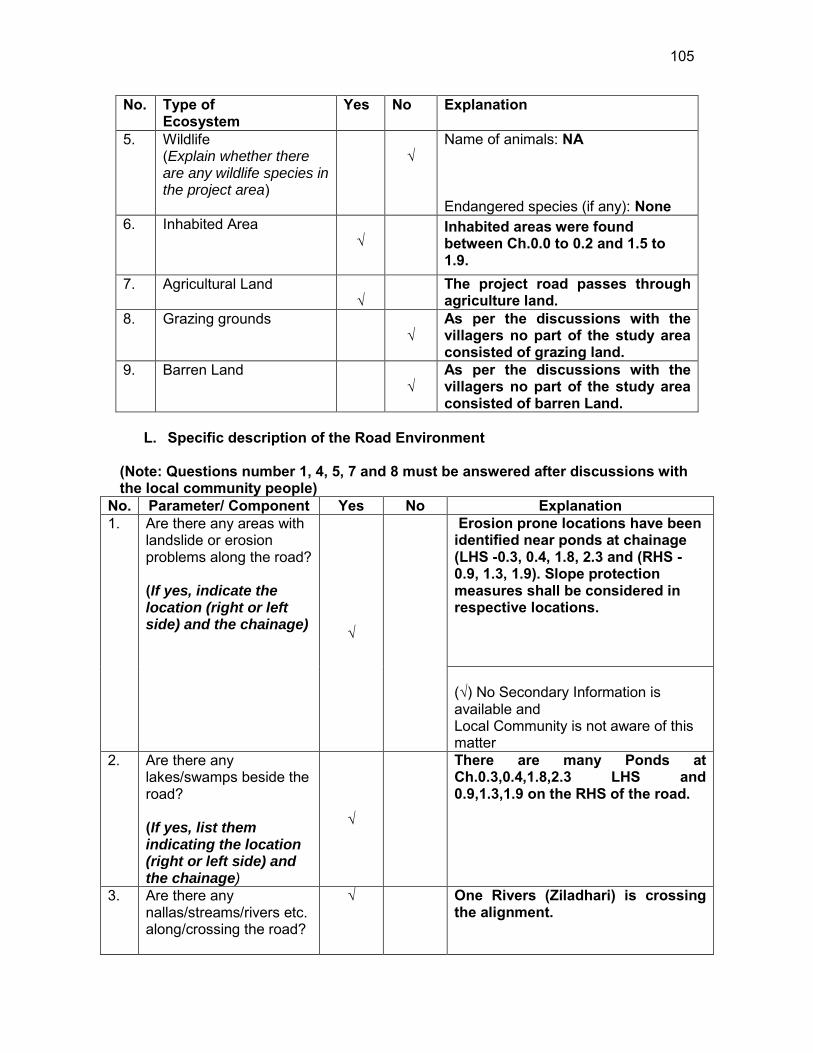
105
No. Type of Ecosystem
Yes No Explanation
5. Wildlife (Explain whether there are any wildlife species in the project area)
√
Name of animals: NA Endangered species (if any): None
6. Inhabited Area √
Inhabited areas were found between Ch.0.0 to 0.2 and 1.5 to 1.9.
7. Agricultural Land √
The project road passes through agriculture land.
8. Grazing grounds √
As per the discussions with the villagers no part of the study area consisted of grazing land.
9. Barren Land √
As per the discussions with the villagers no part of the study area consisted of barren Land.
L. Specific description of the Road Environment
(Note: Questions number 1, 4, 5, 7 and 8 must be answered after discussions with the local community people)
No. Parameter/ Component Yes No Explanation 1. Are there any areas with
landslide or erosion problems along the road? (If yes, indicate the location (right or left side) and the chainage) √
Erosion prone locations have been identified near ponds at chainage (LHS -0.3, 0.4, 1.8, 2.3 and (RHS -0.9, 1.3, 1.9). Slope protection measures shall be considered in respective locations. (√) No Secondary Information is available and Local Community is not aware of this matter
2. Are there any lakes/swamps beside the road? (If yes, list them indicating the location (right or left side) and the chainage)
√
There are many Ponds at Ch.0.3,0.4,1.8,2.3 LHS and 0.9,1.3,1.9 on the RHS of the road.
3. Are there any nallas/streams/rivers etc. along/crossing the road?
√
One Rivers (Ziladhari) is crossing the alignment.
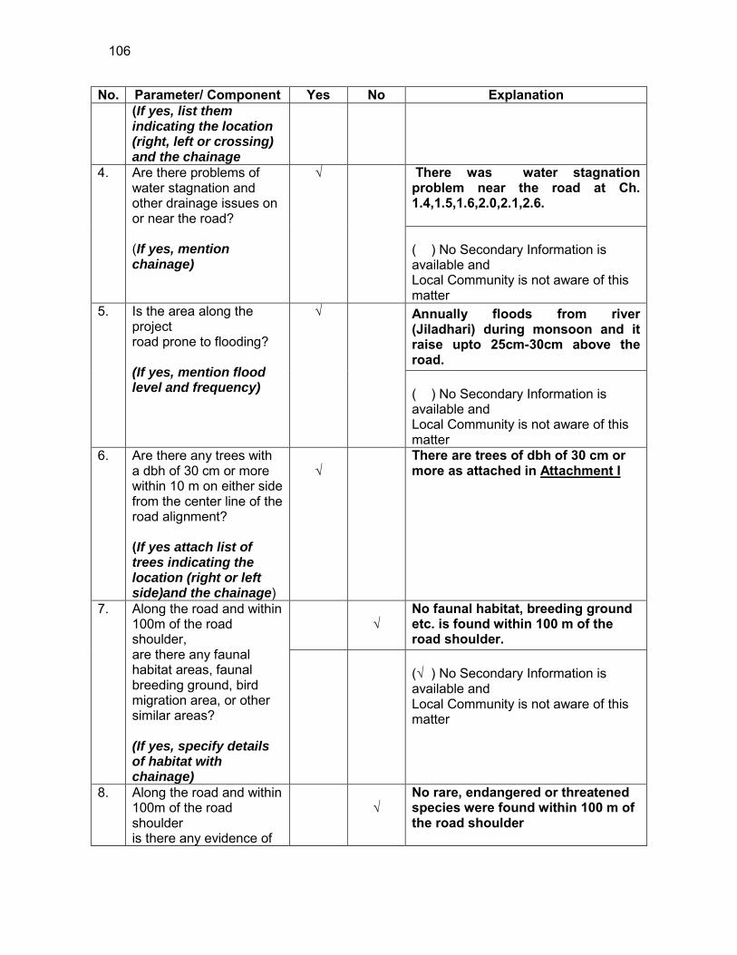
106
No. Parameter/ Component Yes No Explanation (If yes, list them indicating the location (right, left or crossing) and the chainage
4. Are there problems of water stagnation and other drainage issues on or near the road? (If yes, mention chainage)
√
There was water stagnation problem near the road at Ch. 1.4,1.5,1.6,2.0,2.1,2.6. ( ) No Secondary Information is available and Local Community is not aware of this matter
5. Is the area along the project road prone to flooding? (If yes, mention flood level and frequency)
√
Annually floods from river (Jiladhari) during monsoon and it raise upto 25cm-30cm above the road. ( ) No Secondary Information is available and Local Community is not aware of this matter
6. Are there any trees with a dbh of 30 cm or more within 10 m on either side from the center line of the road alignment? (If yes attach list of trees indicating the location (right or left side)and the chainage)
√
There are trees of dbh of 30 cm or more as attached in Attachment I
7. Along the road and within 100m of the road shoulder, are there any faunal habitat areas, faunal breeding ground, bird migration area, or other similar areas? (If yes, specify details of habitat with chainage)
√
No faunal habitat, breeding ground etc. is found within 100 m of the road shoulder.
(√ ) No Secondary Information is available and Local Community is not aware of this matter
8. Along the road and within 100m of the road shoulder is there any evidence of
√
No rare, endangered or threatened species were found within 100 m of the road shoulder
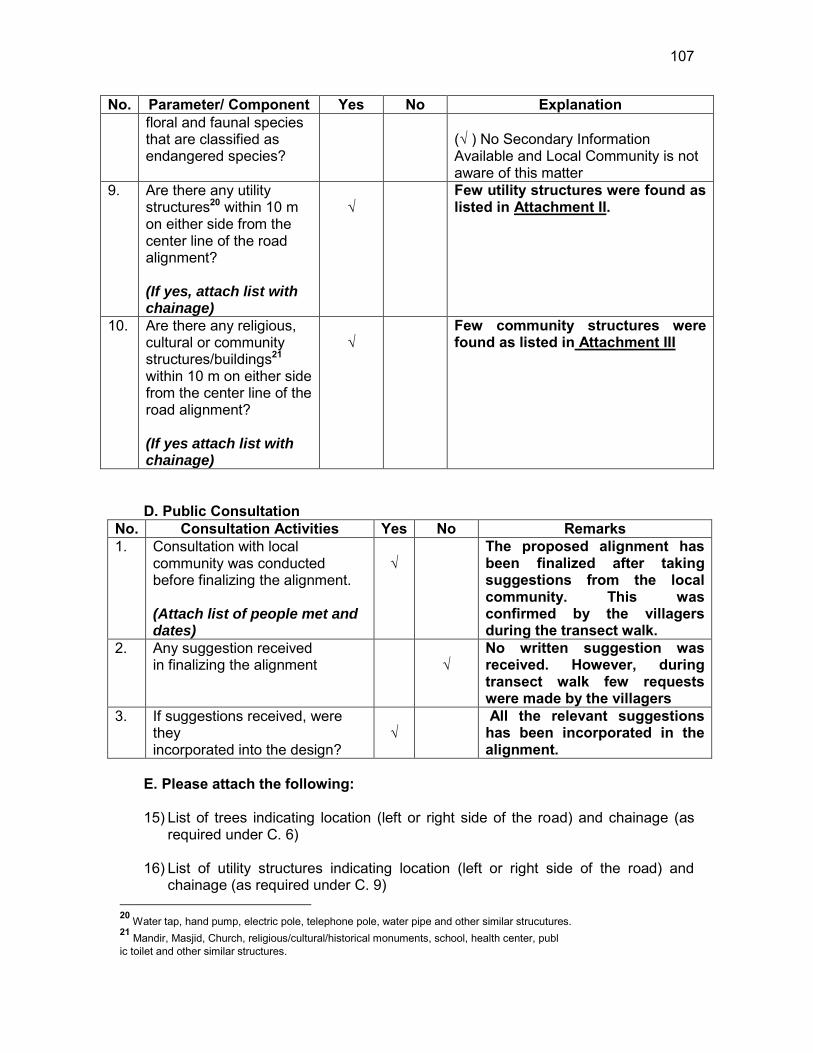
107
No. Parameter/ Component Yes No Explanation floral and faunal species that are classified as endangered species?
(√ ) No Secondary Information Available and Local Community is not aware of this matter
9. Are there any utility structures20 within 10 m on either side from the center line of the road alignment? (If yes, attach list with chainage)
√
Few utility structures were found as listed in Attachment II.
10. Are there any religious, cultural or community structures/buildings21 within 10 m on either side from the center line of the road alignment? (If yes attach list with chainage)
√
Few community structures were found as listed in Attachment III
D. Public Consultation
No. Consultation Activities Yes No Remarks 1. Consultation with local
community was conducted before finalizing the alignment. (Attach list of people met and dates)
√
The proposed alignment has been finalized after taking suggestions from the local community. This was confirmed by the villagers during the transect walk.
2. Any suggestion received in finalizing the alignment
√
No written suggestion was received. However, during transect walk few requests were made by the villagers
3. If suggestions received, were they incorporated into the design?
√
All the relevant suggestions has been incorporated in the alignment.
E. Please attach the following: 15) List of trees indicating location (left or right side of the road) and chainage (as
required under C. 6) 16) List of utility structures indicating location (left or right side of the road) and
chainage (as required under C. 9) 20 Water tap, hand pump, electric pole, telephone pole, water pipe and other similar strucutures. 21 Mandir, Masjid, Church, religious/cultural/historical monuments, school, health center, publ ic toilet and other similar structures.
108
17) List of community structures indicating location (left or right side of the road) and
chainage (as required under C. 10) 18) Sketch of strip map of the road covering details of atleast 10 m on either side
from the center line of the road
19) Photographs of the project area showing atleast 10 m on either side from center line of road alignment. Every 2 km or less of road must have atleast 1 photograph.
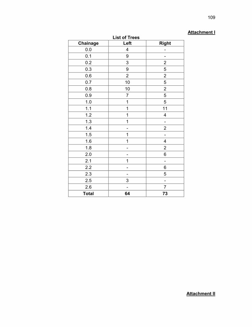
109
Attachment I List of Trees
Chainage Left Right 0.0 4 - 0.1 9 - 0.2 3 2 0.3 9 5 0.6 2 2 0.7 10 5 0.8 10 2 0.9 7 5 1.0 1 5 1.1 1 11 1.2 1 4 1.3 1 - 1.4 - 2 1.5 1 - 1.6 1 4 1.8 - 2 2.0 - 6 2.1 1 - 2.2 - 6 2.3 - 5 2.5 3 - 2.6 - 7
Total 64 73
Attachment II
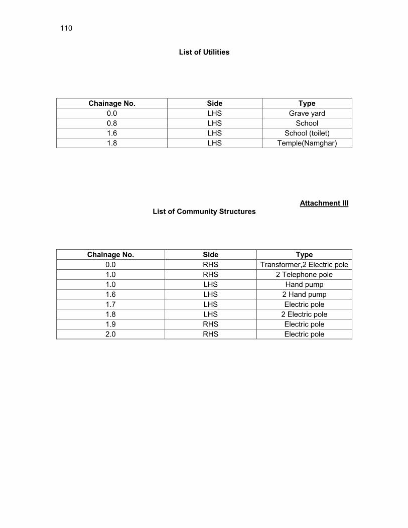
110
List of Utilities
Attachment III List of Community Structures
Chainage No. Side Type 0.0 RHS Transformer,2 Electric pole 1.0 RHS 2 Telephone pole 1.0 LHS Hand pump 1.6 LHS 2 Hand pump 1.7 LHS Electric pole 1.8 LHS 2 Electric pole 1.9 RHS Electric pole 2.0 RHS Electric pole
Chainage No. Side Type 0.0 LHS Grave yard 0.8 LHS School 1.6 LHS School (toilet) 1.8 LHS Temple(Namghar)
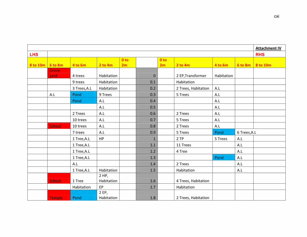
cxi
Attachment IV
LHS RHS
8 to 10m 6 to 8m 4 to 6m 2 to 4m 0 to 2m
0 to 2m 2 to 4m 4 to 6m 6 to 8m 8 to 10m
Grave yard 4 trees Habitation 0 2 EP,Transformer Habitation
9 trees Habitation 0.1 Habitation
3 Trees,A.L Habitation 0.2 2 Trees, Habitation A.L
A.L Pond 9 Trees 0.3 5 Trees A.L
Pond A.L 0.4 A.L
A.L 0.5 A.L
2 Trees A.L 0.6 2 Trees A.L
10 trees A.L 0.7 5 Trees A.L
School 10 trees A.L 0.8 2 Trees A.L
7 trees A.L 0.9 5 Trees Pond 6 Trees,A.L
1 Tree,A.L HP 1 2 TP 5 Trees A.L
1 Tree,A.L 1.1 11 Trees A.L
1 Tree,A.L 1.2 4 Tree A.L
1 Tree,A.L 1.3 Pond A.L
A.L 1.4 2 Trees A.L
1 Tree,A.L Habitation 1.5 Habitation A.L
School 1 Tree 2 HP, Habitation 1.6 4 Trees, Habitation
Habitation EP 1.7 Habitation
Temple Pond 2 EP, Habitation 1.8 2 Trees, Habitation

cxii
A.L Habitation 1.9 EP, Habitation Pond A.L
A.L 2 6 Trees EP,A.L
1 Tree,A.L 2.1 A.L
A.L 2.2 6 Trees A.L
A.L Pond 2.3 5 Trees A.L
A.L 2.4 A.L
A.L 3 Trees 2.5 A.L
A.L 2.6 7 Trees A.L
EP-Electric Pole HP-Hand Pump TP-Telephone Pole A.L-Agricultural land
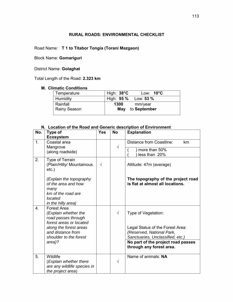
113
RURAL ROADS: ENVIRONMENTAL CHECKLIST
Road Name: T 1 to Titabor Tongia (Torani Mazgaon)
Block Name: Gomariguri District Name: Golaghat Total Length of the Road: 2.323 km
M. Climatic Conditions Temperature High: 38°C Low: 10°C Humidity High: 95 % Low: 53 % Rainfall Rainy Season
1300 mm/year May to September
N. Location of the Road and Generic description of Environment No. Type of
Ecosystem Yes No Explanation
1. Coastal area Mangrove (along roadside)
√
Distance from Coastline: km
( ) more than 50% ( ) less than 20%
2. Type of Terrain (Plain/Hilly/ Mountainous etc.) (Explain the topography of the area and how many km of the road are located in the hilly area)
√
Altitude: 47m (average) The topography of the project road is flat at almost all locations.
4. Forest Area (Explain whether the road passes through forest areas or located along the forest areas and distance from shoulder to the forest area)?
√
Type of Vegetation: Legal Status of the Forest Area: (Reserved, National Park, Sanctuaries, Unclassified, etc.) No part of the project road passes through any forest area.
5. Wildlife (Explain whether there are any wildlife species in the project area)
√
Name of animals: NA
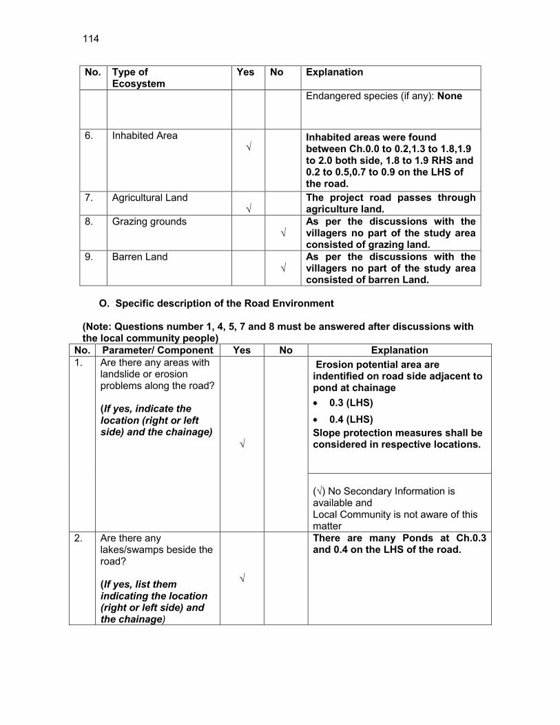
114
No. Type of Ecosystem
Yes No Explanation
Endangered species (if any): None
6. Inhabited Area √
Inhabited areas were found between Ch.0.0 to 0.2,1.3 to 1.8,1.9 to 2.0 both side, 1.8 to 1.9 RHS and 0.2 to 0.5,0.7 to 0.9 on the LHS of the road.
7. Agricultural Land √
The project road passes through agriculture land.
8. Grazing grounds √
As per the discussions with the villagers no part of the study area consisted of grazing land.
9. Barren Land √
As per the discussions with the villagers no part of the study area consisted of barren Land.
O. Specific description of the Road Environment
(Note: Questions number 1, 4, 5, 7 and 8 must be answered after discussions with the local community people)
No. Parameter/ Component Yes No Explanation 1. Are there any areas with
landslide or erosion problems along the road? (If yes, indicate the location (right or left side) and the chainage)
√
Erosion potential area are indentified on road side adjacent to pond at chainage 0.3 (LHS) 0.4 (LHS)
Slope protection measures shall be considered in respective locations. (√) No Secondary Information is available and Local Community is not aware of this matter
2. Are there any lakes/swamps beside the road? (If yes, list them indicating the location (right or left side) and the chainage)
√
There are many Ponds at Ch.0.3 and 0.4 on the LHS of the road.
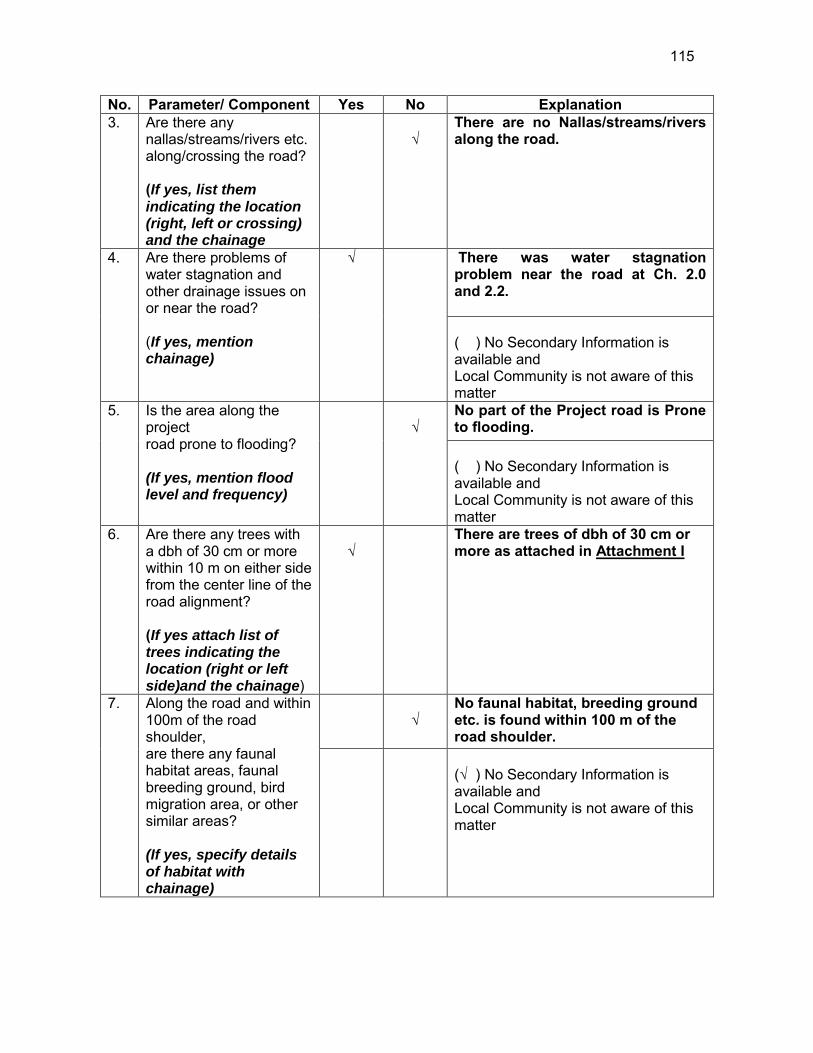
115
No. Parameter/ Component Yes No Explanation 3. Are there any
nallas/streams/rivers etc. along/crossing the road? (If yes, list them indicating the location (right, left or crossing) and the chainage
√
There are no Nallas/streams/rivers along the road.
4. Are there problems of water stagnation and other drainage issues on or near the road? (If yes, mention chainage)
√
There was water stagnation problem near the road at Ch. 2.0 and 2.2. ( ) No Secondary Information is available and Local Community is not aware of this matter
5. Is the area along the project road prone to flooding? (If yes, mention flood level and frequency)
√
No part of the Project road is Prone to flooding. ( ) No Secondary Information is available and Local Community is not aware of this matter
6. Are there any trees with a dbh of 30 cm or more within 10 m on either side from the center line of the road alignment? (If yes attach list of trees indicating the location (right or left side)and the chainage)
√
There are trees of dbh of 30 cm or more as attached in Attachment I
7. Along the road and within 100m of the road shoulder, are there any faunal habitat areas, faunal breeding ground, bird migration area, or other similar areas? (If yes, specify details of habitat with chainage)
√
No faunal habitat, breeding ground etc. is found within 100 m of the road shoulder.
(√ ) No Secondary Information is available and Local Community is not aware of this matter

116
No. Parameter/ Component Yes No Explanation 8. Along the road and within
100m of the road shoulder is there any evidence of floral and faunal species that are classified as endangered species?
√
No rare, endangered or threatened species were found within 100 m of the road shoulder (√ ) No Secondary Information Available and Local Community is not aware of this matter
9. Are there any utility structures22 within 10 m on either side from the centerline of the road alignment? (If yes, attach list with chainage)
√
Few utility structures were found as listed in Attachment II.
10. Are there any religious, cultural or community structures/buildings23 within 10 m on either side from the centerline of the road alignment? (If yes attach list with chainage)
√
Few community structures were found as listed in Attachment III
D. Public Consultation
No. Consultation Activities Yes No Remarks 1. Consultation with local
community was conducted before finalizing the alignment. (Attach list of people met and dates)
√
The proposed alignment has been finalized after taking suggestions from the local community. This was confirmed by the villagers during the transect walk.
2. Any suggestion received in finalizing the alignment
√
No written suggestion was received. However, during transect walk few requests were made by the villagers
3. If suggestions received, were they incorporated into the design?
√
All the relevant suggestions has been incorporated in the alignment.
E. Please attach the following:
22 Water tap, hand pump, electric pole, telephone pole, water pipe and other similar strucutures. 23 Mandir, Masjid, Church, religious/cultural/historical monuments, school, health center, publ ic toilet and other similar structures.
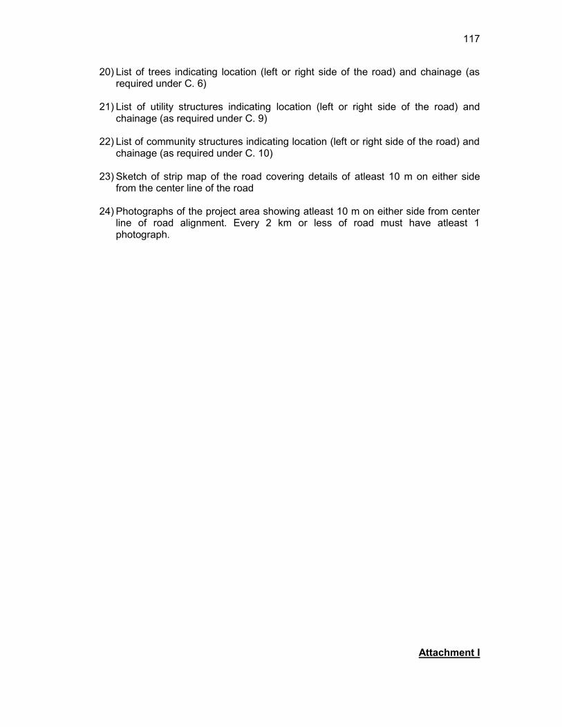
117
20) List of trees indicating location (left or right side of the road) and chainage (as required under C. 6)
21) List of utility structures indicating location (left or right side of the road) and
chainage (as required under C. 9) 22) List of community structures indicating location (left or right side of the road) and
chainage (as required under C. 10) 23) Sketch of strip map of the road covering details of atleast 10 m on either side
from the center line of the road
24) Photographs of the project area showing atleast 10 m on either side from center line of road alignment. Every 2 km or less of road must have atleast 1 photograph.
Attachment I
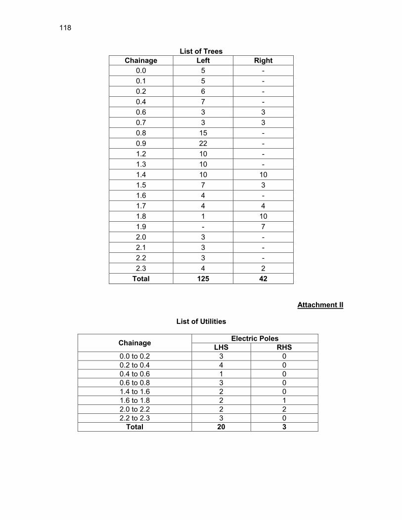
118
List of Trees Chainage Left Right
0.0 5 - 0.1 5 - 0.2 6 - 0.4 7 - 0.6 3 3 0.7 3 3 0.8 15 - 0.9 22 - 1.2 10 - 1.3 10 - 1.4 10 10 1.5 7 3 1.6 4 - 1.7 4 4 1.8 1 10 1.9 - 7 2.0 3 - 2.1 3 - 2.2 3 - 2.3 4 2
Total 125 42
Attachment II
List of Utilities
Chainage Electric Poles LHS RHS
0.0 to 0.2 3 0 0.2 to 0.4 4 0 0.4 to 0.6 1 0 0.6 to 0.8 3 0 1.4 to 1.6 2 0 1.6 to 1.8 2 1 2.0 to 2.2 2 2 2.2 to 2.3 3 0
Total 20 3
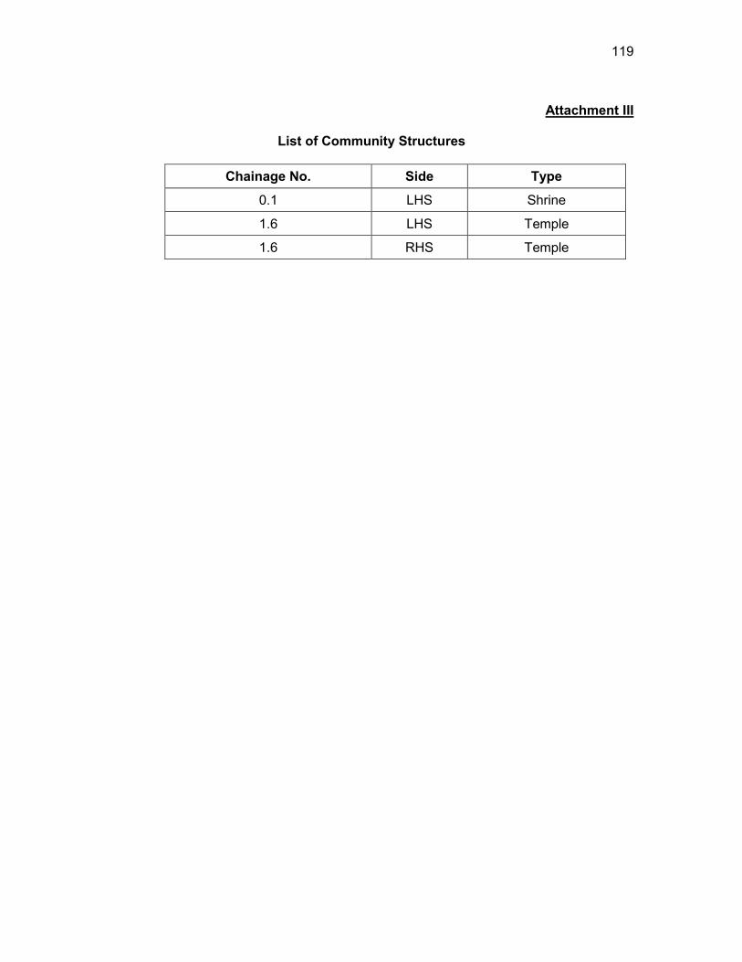
119
Attachment III
List of Community Structures
Chainage No. Side Type
0.1 LHS Shrine
1.6 LHS Temple
1.6 RHS Temple
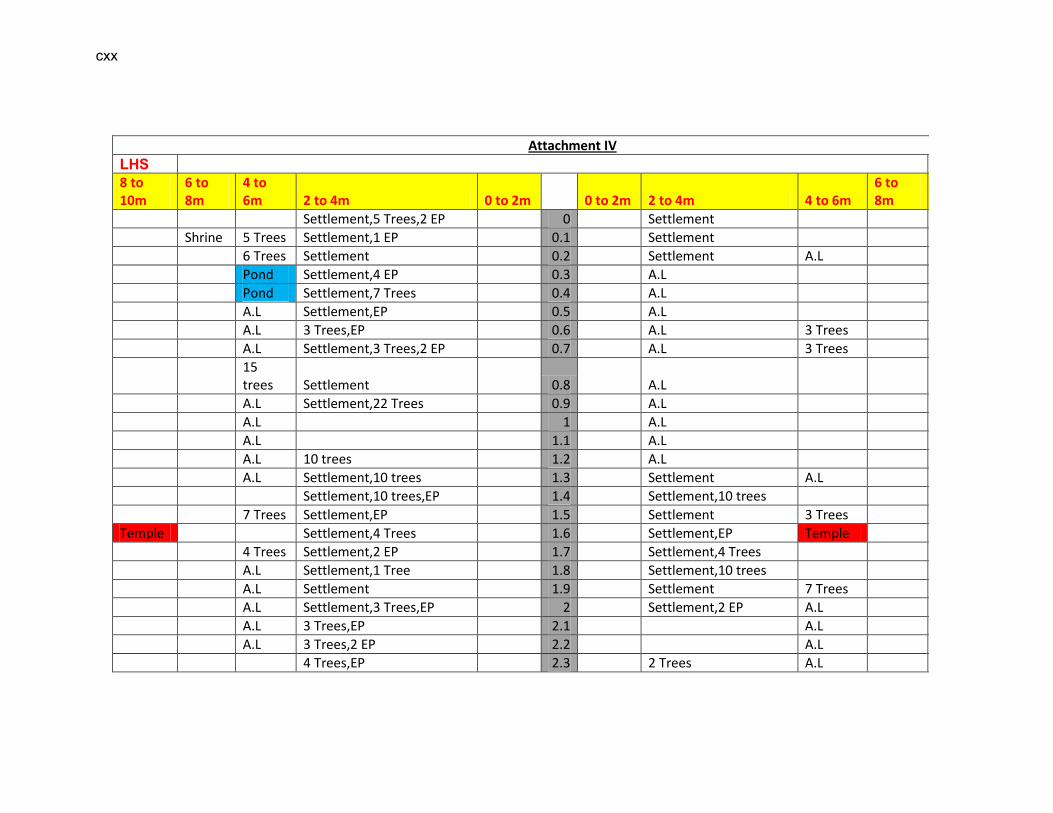
cxx
Attachment IV
LHS RHS 8 to 10m
6 to 8m
4 to 6m 2 to 4m 0 to 2m 0 to 2m 2 to 4m 4 to 6m
6 to 8m 8 to 10m
Settlement,5 Trees,2 EP 0 Settlement
Shrine 5 Trees Settlement,1 EP 0.1 Settlement
6 Trees Settlement 0.2 Settlement A.L
Pond Settlement,4 EP 0.3 A.L
Pond Settlement,7 Trees 0.4 A.L
A.L Settlement,EP 0.5 A.L
A.L 3 Trees,EP 0.6 A.L 3 Trees
A.L Settlement,3 Trees,2 EP 0.7 A.L 3 Trees
15 trees Settlement 0.8 A.L
A.L Settlement,22 Trees 0.9 A.L
A.L 1 A.L
A.L 1.1 A.L
A.L 10 trees 1.2 A.L
A.L Settlement,10 trees 1.3 Settlement A.L
Settlement,10 trees,EP 1.4 Settlement,10 trees
7 Trees Settlement,EP 1.5 Settlement 3 Trees
Temple Settlement,4 Trees 1.6 Settlement,EP Temple
4 Trees Settlement,2 EP 1.7 Settlement,4 Trees
A.L Settlement,1 Tree 1.8 Settlement,10 trees
A.L Settlement 1.9 Settlement 7 Trees
A.L Settlement,3 Trees,EP 2 Settlement,2 EP A.L
A.L 3 Trees,EP 2.1 A.L
A.L 3 Trees,2 EP 2.2 A.L
4 Trees,EP 2.3 2 Trees A.L

cxxi
EP-Electric Pole HP-Hand Pump TP-Telephone Pole A.L-Agricultural land
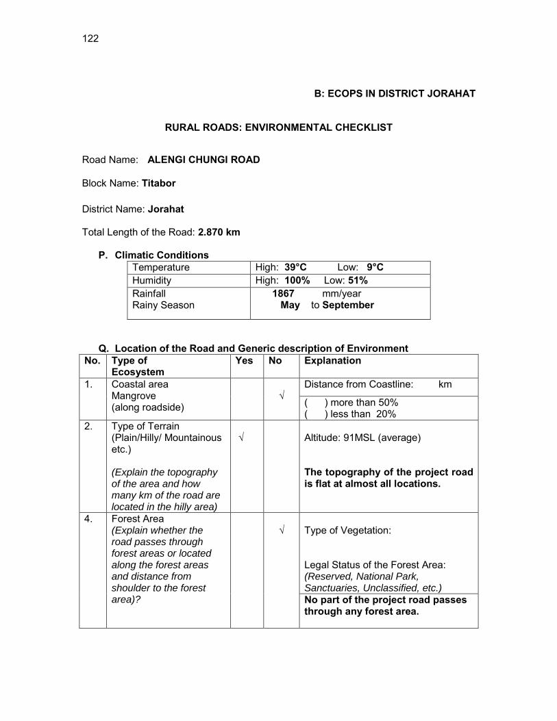
122
B: ECOPS IN DISTRICT JORAHAT
RURAL ROADS: ENVIRONMENTAL CHECKLIST
Road Name: ALENGI CHUNGI ROAD
Block Name: Titabor District Name: Jorahat Total Length of the Road: 2.870 km
P. Climatic Conditions Temperature High: 39°C Low: 9°C Humidity High: 100% Low: 51% Rainfall Rainy Season
1867 mm/year May to September
Q. Location of the Road and Generic description of Environment No. Type of
Ecosystem Yes No Explanation
1. Coastal area Mangrove (along roadside)
√
Distance from Coastline: km
( ) more than 50% ( ) less than 20%
2. Type of Terrain (Plain/Hilly/ Mountainous etc.) (Explain the topography of the area and how many km of the road are located in the hilly area)
√
Altitude: 91MSL (average) The topography of the project road is flat at almost all locations.
4. Forest Area (Explain whether the road passes through forest areas or located along the forest areas and distance from shoulder to the forest area)?
√
Type of Vegetation: Legal Status of the Forest Area: (Reserved, National Park, Sanctuaries, Unclassified, etc.) No part of the project road passes through any forest area.
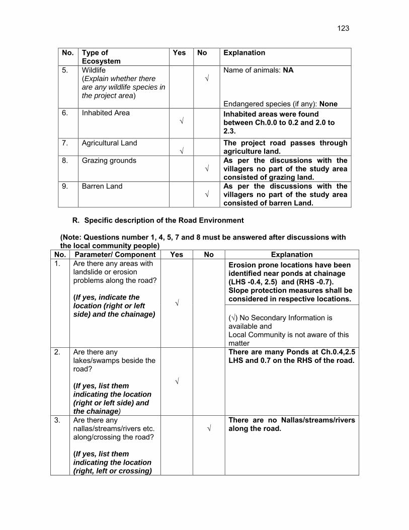
123
No. Type of Ecosystem
Yes No Explanation
5. Wildlife (Explain whether there are any wildlife species in the project area)
√
Name of animals: NA Endangered species (if any): None
6. Inhabited Area √
Inhabited areas were found between Ch.0.0 to 0.2 and 2.0 to 2.3.
7. Agricultural Land √
The project road passes through agriculture land.
8. Grazing grounds √
As per the discussions with the villagers no part of the study area consisted of grazing land.
9. Barren Land √
As per the discussions with the villagers no part of the study area consisted of barren Land.
R. Specific description of the Road Environment
(Note: Questions number 1, 4, 5, 7 and 8 must be answered after discussions with the local community people)
No. Parameter/ Component Yes No Explanation 1. Are there any areas with
landslide or erosion problems along the road? (If yes, indicate the location (right or left side) and the chainage)
√
Erosion prone locations have been identified near ponds at chainage (LHS -0.4, 2.5) and (RHS -0.7). Slope protection measures shall be considered in respective locations. (√) No Secondary Information is available and Local Community is not aware of this matter
2. Are there any lakes/swamps beside the road? (If yes, list them indicating the location (right or left side) and the chainage)
√
There are many Ponds at Ch.0.4,2.5 LHS and 0.7 on the RHS of the road.
3. Are there any nallas/streams/rivers etc. along/crossing the road? (If yes, list them indicating the location (right, left or crossing)
√
There are no Nallas/streams/rivers along the road.
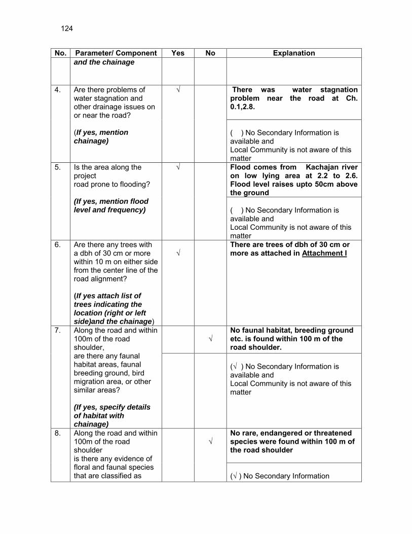
124
No. Parameter/ Component Yes No Explanation and the chainage
4. Are there problems of water stagnation and other drainage issues on or near the road? (If yes, mention chainage)
√
There was water stagnation problem near the road at Ch. 0.1,2.8. ( ) No Secondary Information is available and Local Community is not aware of this matter
5. Is the area along the project road prone to flooding? (If yes, mention flood level and frequency)
√
Flood comes from Kachajan river on low lying area at 2.2 to 2.6. Flood level raises upto 50cm above the ground ( ) No Secondary Information is available and Local Community is not aware of this matter
6. Are there any trees with a dbh of 30 cm or more within 10 m on either side from the center line of the road alignment? (If yes attach list of trees indicating the location (right or left side)and the chainage)
√
There are trees of dbh of 30 cm or more as attached in Attachment I
7. Along the road and within 100m of the road shoulder, are there any faunal habitat areas, faunal breeding ground, bird migration area, or other similar areas? (If yes, specify details of habitat with chainage)
√
No faunal habitat, breeding ground etc. is found within 100 m of the road shoulder.
(√ ) No Secondary Information is available and Local Community is not aware of this matter
8. Along the road and within 100m of the road shoulder is there any evidence of floral and faunal species that are classified as
√
No rare, endangered or threatened species were found within 100 m of the road shoulder (√ ) No Secondary Information

125
No. Parameter/ Component Yes No Explanation endangered species? Available and Local Community is not
aware of this matter 9. Are there any utility
structures30 within 10 m on either side from the center line of the road alignment? (If yes, attach list with chainage)
√
Few utility structures were found as listed in Attachment II.
10. Are there any religious, cultural or community structures/buildings31 within 10 m on either side from the center line of the road alignment? (If yes attach list with chainage)
√
Few community structures were found as listed in Attachment III
D. Public Consultation
No. Consultation Activities Yes No Remarks 1. Consultation with local
community was conducted before finalizing the alignment. (Attach list of people met and dates)
√
The proposed alignment has been finalized after taking suggestions from the local community. This was confirmed by the villagers during the transect walk.
2. Any suggestion received in finalizing the alignment
√
No written suggestion was received. However, during transect walk few requests were made by the villagers
3. If suggestions received, were they incorporated into the design?
√
All the relevant suggestions has been incorporated in the alignment.
E. Please attach the following: 25) List of trees indicating location (left or right side of the road) and chainage (as
required under C. 6) 26) List of utility structures indicating location (left or right side of the road) and
chainage (as required under C. 9)
30 Water tap, hand pump, electric pole, telephone pole, water pipe and other similar strucutures. 31 Mandir, Masjid, Church, religious/cultural/historical monuments, school, health center, publ ic toilet and other similar structures.
126
27) List of community structures indicating location (left or right side of the road) and chainage (as required under C. 10)
28) Sketch of strip map of the road covering details of atleast 10 m on either side
from the center line of the road
29) Photographs of the project area showing atleast 10 m on either side from center line of road alignment. Every 2 km or less of road must have atleast 1 photograph.
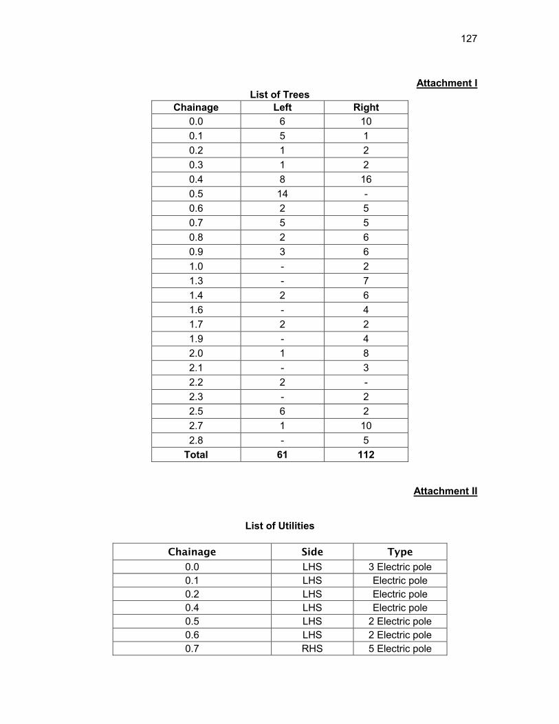
127
Attachment I
List of Trees Chainage Left Right
0.0 6 10 0.1 5 1 0.2 1 2 0.3 1 2 0.4 8 16 0.5 14 - 0.6 2 5 0.7 5 5 0.8 2 6 0.9 3 6 1.0 - 2 1.3 - 7 1.4 2 6 1.6 - 4 1.7 2 2 1.9 - 4 2.0 1 8 2.1 - 3 2.2 2 - 2.3 - 2 2.5 6 2 2.7 1 10 2.8 - 5
Total 61 112
Attachment II
List of Utilities
Chainage Side Type
0.0 LHS 3 Electric pole 0.1 LHS Electric pole 0.2 LHS Electric pole 0.4 LHS Electric pole 0.5 LHS 2 Electric pole 0.6 LHS 2 Electric pole 0.7 RHS 5 Electric pole
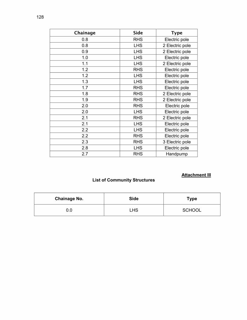
128
Chainage Side Type
0.8 RHS Electric pole 0.8 LHS 2 Electric pole 0.9 LHS 2 Electric pole 1.0 LHS Electric pole 1.1 LHS 2 Electric pole 1.2 RHS Electric pole 1.2 LHS Electric pole 1.3 LHS Electric pole 1.7 RHS Electric pole 1.8 RHS 2 Electric pole 1.9 RHS 2 Electric pole 2.0 RHS Electric pole 2.0 LHS Electric pole 2.1 RHS 2 Electric pole 2.1 LHS Electric pole 2.2 LHS Electric pole 2.2 RHS Electric pole 2.3 RHS 3 Electric pole 2.8 LHS Electric pole 2.7 RHS Handpump
Attachment III
List of Community Structures
Chainage No. Side Type
0.0 LHS SCHOOL
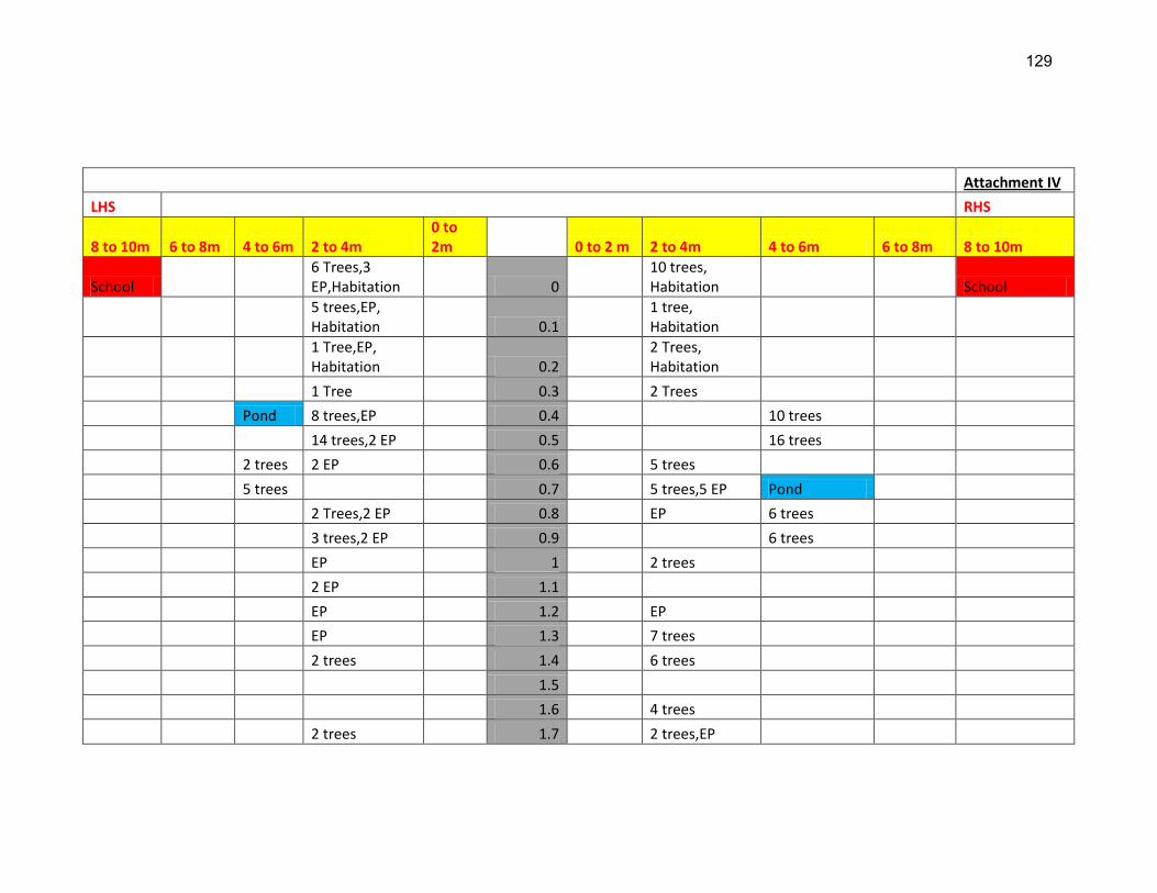
129
Attachment IV
LHS RHS
8 to 10m 6 to 8m 4 to 6m 2 to 4m 0 to 2m 0 to 2 m 2 to 4m 4 to 6m 6 to 8m 8 to 10m
School 6 Trees,3 EP,Habitation 0
10 trees, Habitation School
5 trees,EP, Habitation 0.1
1 tree, Habitation
1 Tree,EP, Habitation 0.2
2 Trees, Habitation
1 Tree 0.3 2 Trees
Pond 8 trees,EP 0.4 10 trees
14 trees,2 EP 0.5 16 trees
2 trees 2 EP 0.6 5 trees
5 trees 0.7 5 trees,5 EP Pond
2 Trees,2 EP 0.8 EP 6 trees
3 trees,2 EP 0.9 6 trees
EP 1 2 trees
2 EP 1.1
EP 1.2 EP
EP 1.3 7 trees
2 trees 1.4 6 trees
1.5
1.6 4 trees
2 trees 1.7 2 trees,EP
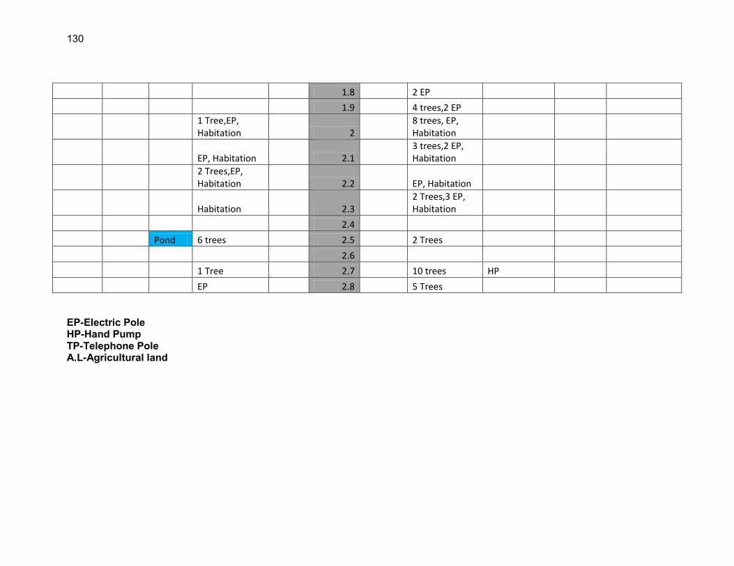
130
1.8 2 EP
1.9 4 trees,2 EP
1 Tree,EP, Habitation 2
8 trees, EP, Habitation
EP, Habitation 2.1 3 trees,2 EP, Habitation
2 Trees,EP, Habitation 2.2 EP, Habitation
Habitation 2.3 2 Trees,3 EP, Habitation
2.4
Pond 6 trees 2.5 2 Trees
2.6
1 Tree 2.7 10 trees HP
EP 2.8 5 Trees
EP-Electric Pole HP-Hand Pump TP-Telephone Pole A.L-Agricultural land
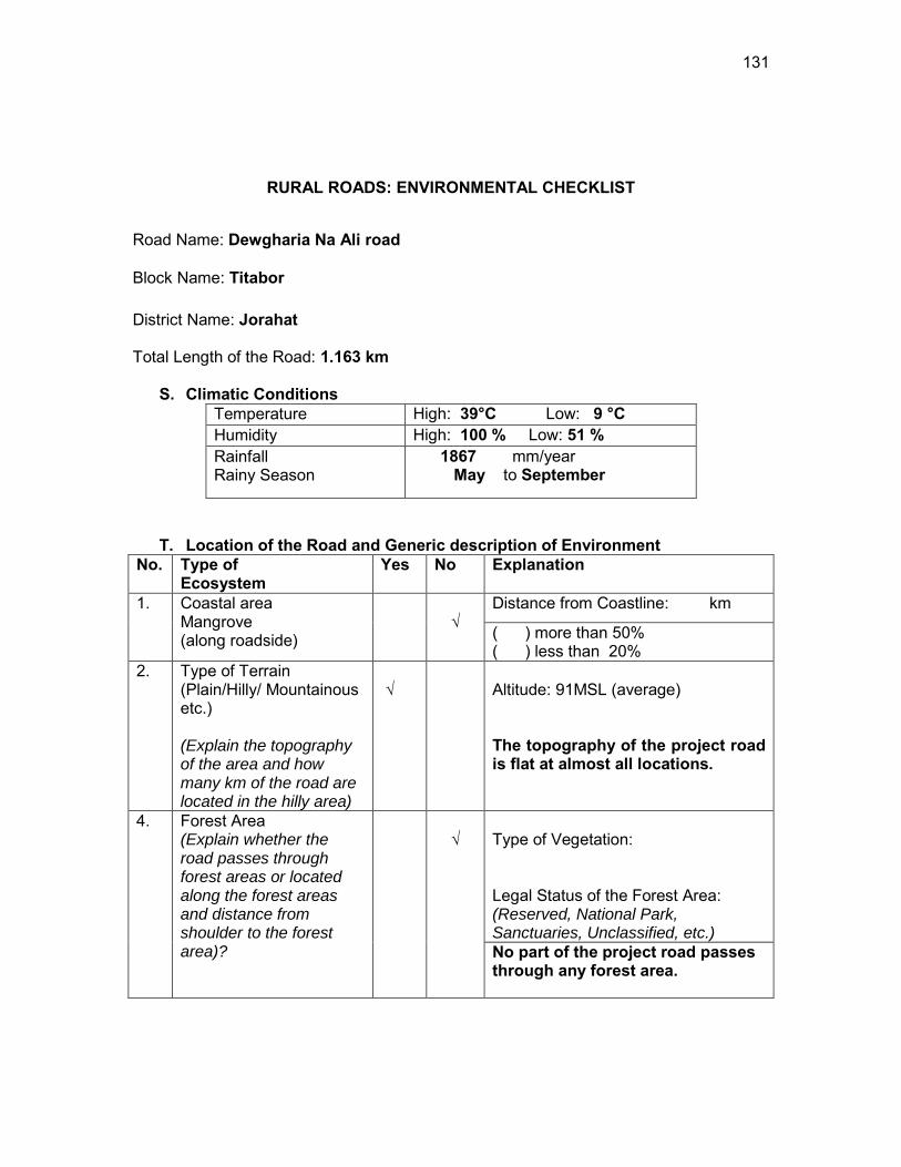
131
RURAL ROADS: ENVIRONMENTAL CHECKLIST
Road Name: Dewgharia Na Ali road
Block Name: Titabor District Name: Jorahat Total Length of the Road: 1.163 km
S. Climatic Conditions Temperature High: 39°C Low: 9 °C Humidity High: 100 % Low: 51 % Rainfall Rainy Season
1867 mm/year May to September
T. Location of the Road and Generic description of Environment No. Type of
Ecosystem Yes No Explanation
1. Coastal area Mangrove (along roadside)
√
Distance from Coastline: km
( ) more than 50% ( ) less than 20%
2. Type of Terrain (Plain/Hilly/ Mountainous etc.) (Explain the topography of the area and how many km of the road are located in the hilly area)
√
Altitude: 91MSL (average) The topography of the project road is flat at almost all locations.
4. Forest Area (Explain whether the road passes through forest areas or located along the forest areas and distance from shoulder to the forest area)?
√
Type of Vegetation: Legal Status of the Forest Area: (Reserved, National Park, Sanctuaries, Unclassified, etc.) No part of the project road passes through any forest area.
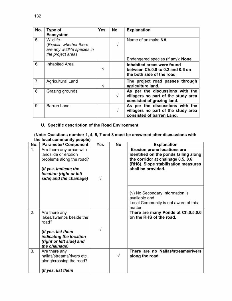
132
No. Type of Ecosystem
Yes No Explanation
5. Wildlife (Explain whether there are any wildlife species in the project area)
√
Name of animals: NA Endangered species (if any): None
6. Inhabited Area √
Inhabited areas were found between Ch.0.0 to 0.2 and 0.6 on the both side of the road.
7. Agricultural Land √
The project road passes through agriculture land.
8. Grazing grounds √
As per the discussions with the villagers no part of the study area consisted of grazing land.
9. Barren Land √
As per the discussions with the villagers no part of the study area consisted of barren Land.
U. Specific description of the Road Environment
(Note: Questions number 1, 4, 5, 7 and 8 must be answered after discussions with the local community people)
No. Parameter/ Component Yes No Explanation 1. Are there any areas with
landslide or erosion problems along the road? (If yes, indicate the location (right or left side) and the chainage) √
Erosion prone locations are identified on the ponds falling along the corridor at chainage 0.5, 0.6 (RHS). Slope stabilisation measures shall be provided. (√) No Secondary Information is available and Local Community is not aware of this matter
2. Are there any lakes/swamps beside the road? (If yes, list them indicating the location (right or left side) and the chainage)
√
There are many Ponds at Ch.0.5,0.6 on the RHS of the road.
3. Are there any nallas/streams/rivers etc. along/crossing the road? (If yes, list them
√
There are no Nallas/streams/rivers along the road.
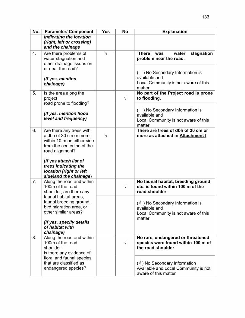
133
No. Parameter/ Component Yes No Explanation indicating the location (right, left or crossing) and the chainage
4. Are there problems of water stagnation and other drainage issues on or near the road? (If yes, mention chainage)
√
There was water stagnation problem near the road.
( ) No Secondary Information is available and Local Community is not aware of this matter
5. Is the area along the project road prone to flooding? (If yes, mention flood level and frequency)
√
No part of the Project road is prone to flooding. ( ) No Secondary Information is available and Local Community is not aware of this matter
6. Are there any trees with a dbh of 30 cm or more within 10 m on either side from the centerline of the road alignment? (If yes attach list of trees indicating the location (right or left side)and the chainage)
√
There are trees of dbh of 30 cm or more as attached in Attachment I
7. Along the road and within 100m of the road shoulder, are there any faunal habitat areas, faunal breeding ground, bird migration area, or other similar areas? (If yes, specify details of habitat with chainage)
√
No faunal habitat, breeding ground etc. is found within 100 m of the road shoulder.
(√ ) No Secondary Information is available and Local Community is not aware of this matter
8. Along the road and within 100m of the road shoulder is there any evidence of floral and faunal species that are classified as endangered species?
√
No rare, endangered or threatened species were found within 100 m of the road shoulder (√ ) No Secondary Information Available and Local Community is not aware of this matter

134
No. Parameter/ Component Yes No Explanation 9. Are there any utility
structures34 within 10 m on either side from the centerline of the road alignment? (If yes, attach list with chainage)
√
Few utility structures were found as listed in Attachment II.
10. Are there any religious, cultural or community structures/buildings35 within 10 m on either side from the center line of the road alignment? (If yes attach list with chainage)
√
Few community structures were found as listed in Attachment III
D. Public Consultation
No. Consultation Activities Yes No Remarks 1. Consultation with local
community was conducted before finalizing the alignment. (Attach list of people met and dates)
√
The proposed alignment has been finalized after taking suggestions from the local community. This was confirmed by the villagers during the transect walk.
2. Any suggestion received in finalizing the alignment
√
No written suggestion was received. However, during transect walk few requests were made by the villagers
3. If suggestions received, were they incorporated into the design?
√
All the relevant suggestions has been incorporated in the alignment.
E. Please attach the following: 30) List of trees indicating location (left or right side of the road) and chainage (as
required under C. 6) 31) List of utility structures indicating location (left or right side of the road) and
chainage (as required under C. 9) 32) List of community structures indicating location (left or right side of the road) and
chainage (as required under C. 10)
34 Water tap, hand pump, electric pole, telephone pole, water pipe and other similar strucutures. 35 Mandir, Masjid, Church, religious/cultural/historical monuments, school, health center, publ ic toilet and other similar structures.

135
33) Sketch of strip map of the road covering details of atleast 10 m on either side from the center line of the road
34) Photographs of the project area showing atleast 10 m on either side from
centerline of road alignment. Every 2 km or less of road must have atleast 1 photograph.
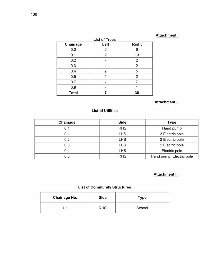
136
Attachment I List of Trees
Chainage Left Right 0.0 2 6 0.1 2 13 0.2 - 2 0.3 - 2 0.4 2 5 0.5 1 2 0.7 - 7 0.9 - 1
Total 7 38
Attachment II
List of Utilities
Attachment III
List of Community Structures
Chainage Side Type 0.1 RHS Hand pump 0.1 LHS 3 Electric pole 0.2 LHS 2 Electric pole 0.3 LHS 2 Electric pole 0.4 LHS Electric pole 0.5 RHS Hand pump, Electric pole
Chainage No. Side Type
1.1 RHS School

137
EP-Electric Pole HP-Hand Pump TP-Telephone Pole A.L-Agricultural land
Attachment IV
LHS RHS 8 to 10m
6 to 8m 4 to 6m 2 to 4m 0 to 2m 0 to 2 m 2 to 4m 4 to 6m
6 to 8m 8 to 10m
A.L Settlement,2 Trees 0 Settlement,6 Trees A.L
A.L Settlement,2 Trees,3 EP 0.1 Settlement,13 Trees,HP A.L
A.L Settlement,2 EP 0.2 Settlement,2 Trees A.L
A.L 2 EP 0.3 2 Trees A.L
A.L 2 Trees,EP 0.4 5 Trees A.L
A.L 1 Tree 0.5 Pond A.L,HP,EP 2 Trees
A.L Settlement 0.6 Settlement Pond A.L
A.L 0.7 7 Trees A.L
A.L 0.8 A.L
A.L 0.9 1 Tree A.L
A.L 1 A.L
A.L 1.1 School A.L
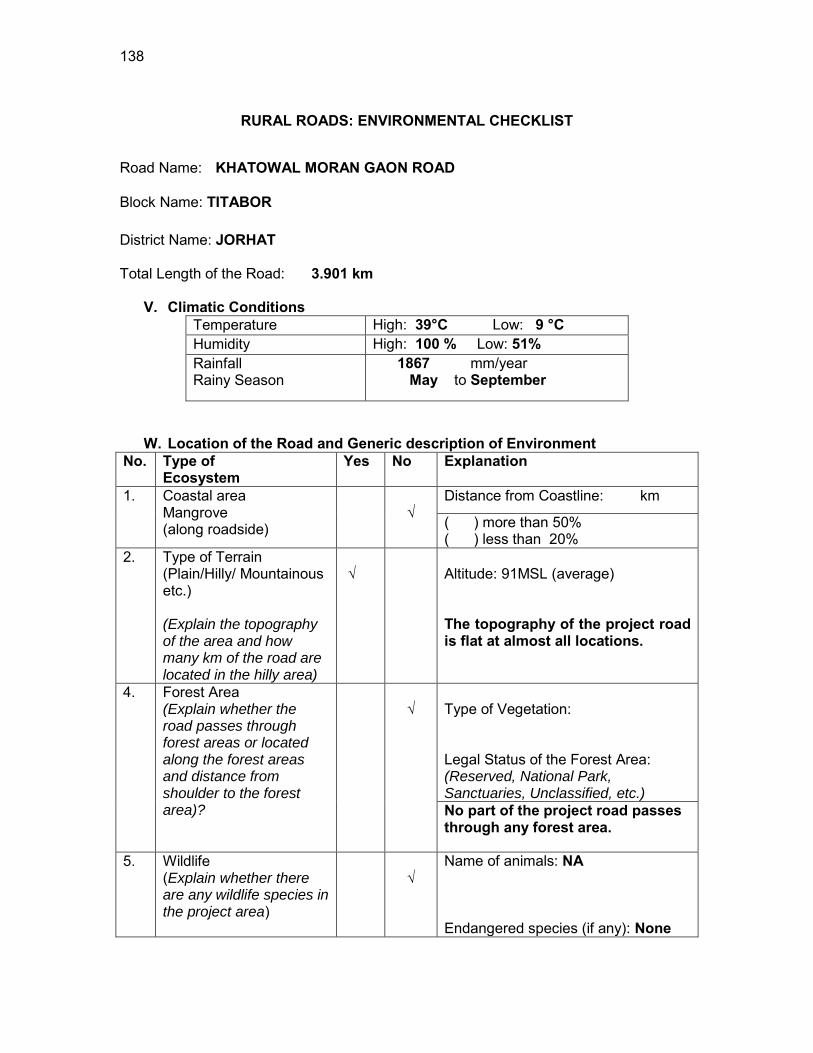
138
RURAL ROADS: ENVIRONMENTAL CHECKLIST
Road Name: KHATOWAL MORAN GAON ROAD
Block Name: TITABOR District Name: JORHAT Total Length of the Road: 3.901 km
V. Climatic Conditions Temperature High: 39°C Low: 9 °C Humidity High: 100 % Low: 51% Rainfall Rainy Season
1867 mm/year May to September
W. Location of the Road and Generic description of Environment No. Type of
Ecosystem Yes No Explanation
1. Coastal area Mangrove (along roadside)
√
Distance from Coastline: km
( ) more than 50% ( ) less than 20%
2. Type of Terrain (Plain/Hilly/ Mountainous etc.) (Explain the topography of the area and how many km of the road are located in the hilly area)
√
Altitude: 91MSL (average) The topography of the project road is flat at almost all locations.
4. Forest Area (Explain whether the road passes through forest areas or located along the forest areas and distance from shoulder to the forest area)?
√
Type of Vegetation: Legal Status of the Forest Area: (Reserved, National Park, Sanctuaries, Unclassified, etc.) No part of the project road passes through any forest area.
5. Wildlife (Explain whether there are any wildlife species in the project area)
√
Name of animals: NA Endangered species (if any): None
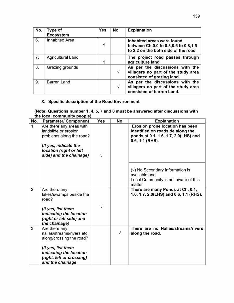
139
No. Type of Ecosystem
Yes No Explanation
6. Inhabited Area √
Inhabited areas were found between Ch.0.0 to 0.3,0.6 to 0.8,1.5 to 2.2 on the both side of the road.
7. Agricultural Land √
The project road passes through agriculture land.
8. Grazing grounds √
As per the discussions with the villagers no part of the study area consisted of grazing land.
9. Barren Land √
As per the discussions with the villagers no part of the study area consisted of barren Land.
X. Specific description of the Road Environment
(Note: Questions number 1, 4, 5, 7 and 8 must be answered after discussions with the local community people)
No. Parameter/ Component Yes No Explanation 1. Are there any areas with
landslide or erosion problems along the road? (If yes, indicate the location (right or left side) and the chainage) √
Erosion prone location has been identified on roadside along the ponds at 0.1, 1.6, 1.7, 2.0(LHS) and 0.6, 1.1 (RHS). (√) No Secondary Information is available and Local Community is not aware of this matter
2. Are there any lakes/swamps beside the road? (If yes, list them indicating the location (right or left side) and the chainage)
√
There are many Ponds at Ch. 0.1, 1.6, 1.7, 2.0(LHS) and 0.6, 1.1 (RHS).
3. Are there any nallas/streams/rivers etc. along/crossing the road? (If yes, list them indicating the location (right, left or crossing) and the chainage
√
There are no Nallas/streams/rivers along the road.
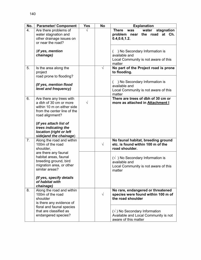
140
No. Parameter/ Component Yes No Explanation 4. Are there problems of
water stagnation and other drainage issues on or near the road? (If yes, mention chainage)
√
There was water stagnation problem near the road at Ch. 0.4,0.6,1.2. ( ) No Secondary Information is available and Local Community is not aware of this matter
5. Is the area along the project road prone to flooding? (If yes, mention flood level and frequency)
√
No part of the Project road is prone to flooding. ( ) No Secondary Information is available and Local Community is not aware of this matter
6. Are there any trees with a dbh of 30 cm or more within 10 m on either side from the center line of the road alignment? (If yes attach list of trees indicating the location (right or left side)and the chainage)
√
There are trees of dbh of 30 cm or more as attached in Attachment I
7. Along the road and within 100m of the road shoulder, are there any faunal habitat areas, faunal breeding ground, bird migration area, or other similar areas? (If yes, specify details of habitat with chainage)
√
No faunal habitat, breeding ground etc. is found within 100 m of the road shoulder.
(√ ) No Secondary Information is available and Local Community is not aware of this matter
8. Along the road and within 100m of the road shoulder is there any evidence of floral and faunal species that are classified as endangered species?
√
No rare, endangered or threatened species were found within 100 m of the road shoulder (√ ) No Secondary Information Available and Local Community is not aware of this matter
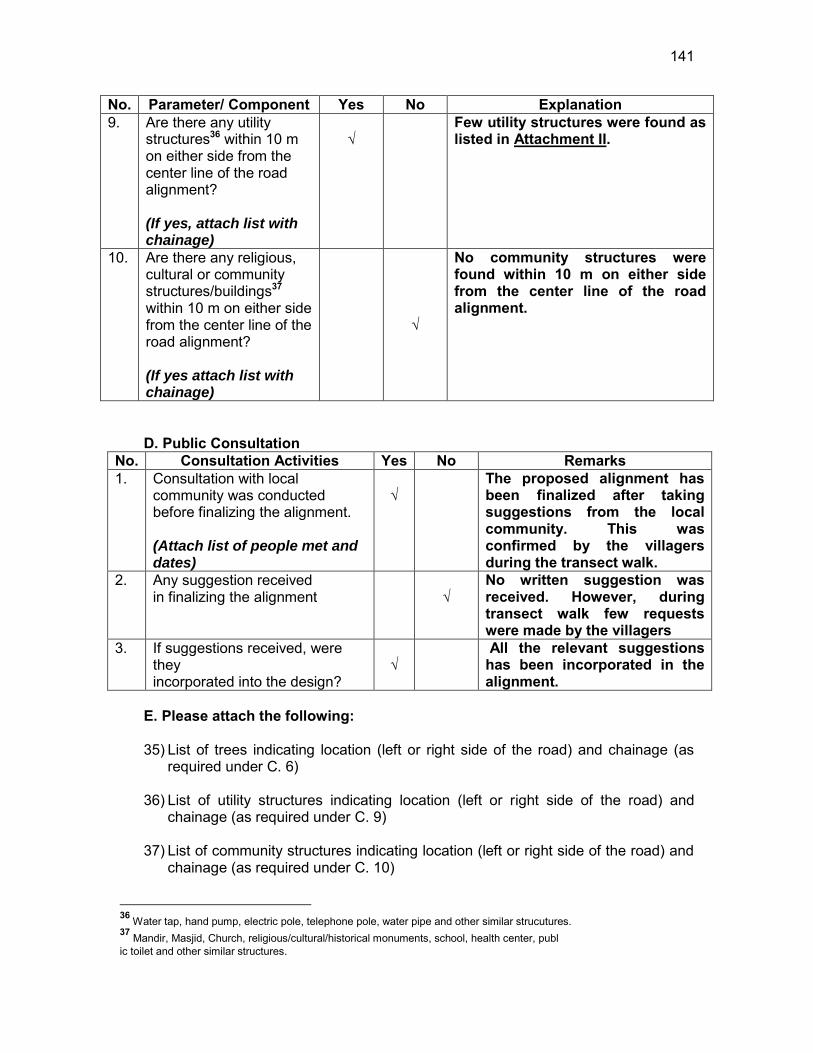
141
No. Parameter/ Component Yes No Explanation 9. Are there any utility
structures36 within 10 m on either side from the center line of the road alignment? (If yes, attach list with chainage)
√
Few utility structures were found as listed in Attachment II.
10. Are there any religious, cultural or community structures/buildings37 within 10 m on either side from the center line of the road alignment? (If yes attach list with chainage)
√
No community structures were found within 10 m on either side from the center line of the road alignment.
D. Public Consultation
No. Consultation Activities Yes No Remarks 1. Consultation with local
community was conducted before finalizing the alignment. (Attach list of people met and dates)
√
The proposed alignment has been finalized after taking suggestions from the local community. This was confirmed by the villagers during the transect walk.
2. Any suggestion received in finalizing the alignment
√
No written suggestion was received. However, during transect walk few requests were made by the villagers
3. If suggestions received, were they incorporated into the design?
√
All the relevant suggestions has been incorporated in the alignment.
E. Please attach the following: 35) List of trees indicating location (left or right side of the road) and chainage (as
required under C. 6) 36) List of utility structures indicating location (left or right side of the road) and
chainage (as required under C. 9) 37) List of community structures indicating location (left or right side of the road) and
chainage (as required under C. 10)
36 Water tap, hand pump, electric pole, telephone pole, water pipe and other similar strucutures. 37 Mandir, Masjid, Church, religious/cultural/historical monuments, school, health center, publ ic toilet and other similar structures.

142
38) Sketch of strip map of the road covering details of atleast 10 m on either side from the center line of the road
39) Photographs of the project area showing atleast 10 m on either side from center
line of road alignment. Every 2 km or less of road must have atleast 1 photograph.
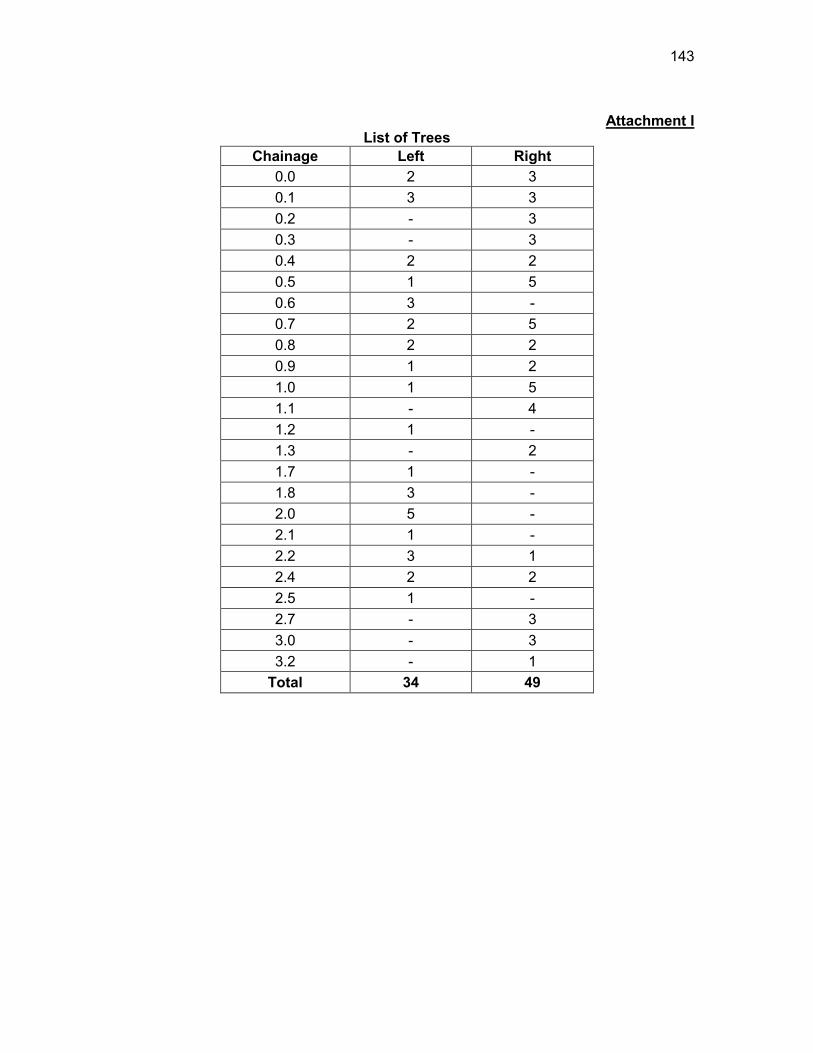
143
Attachment I
List of Trees Chainage Left Right
0.0 2 3 0.1 3 3 0.2 - 3 0.3 - 3 0.4 2 2 0.5 1 5 0.6 3 - 0.7 2 5 0.8 2 2 0.9 1 2 1.0 1 5 1.1 - 4 1.2 1 - 1.3 - 2 1.7 1 - 1.8 3 - 2.0 5 - 2.1 1 - 2.2 3 1 2.4 2 2 2.5 1 - 2.7 - 3 3.0 - 3 3.2 - 1
Total 34 49
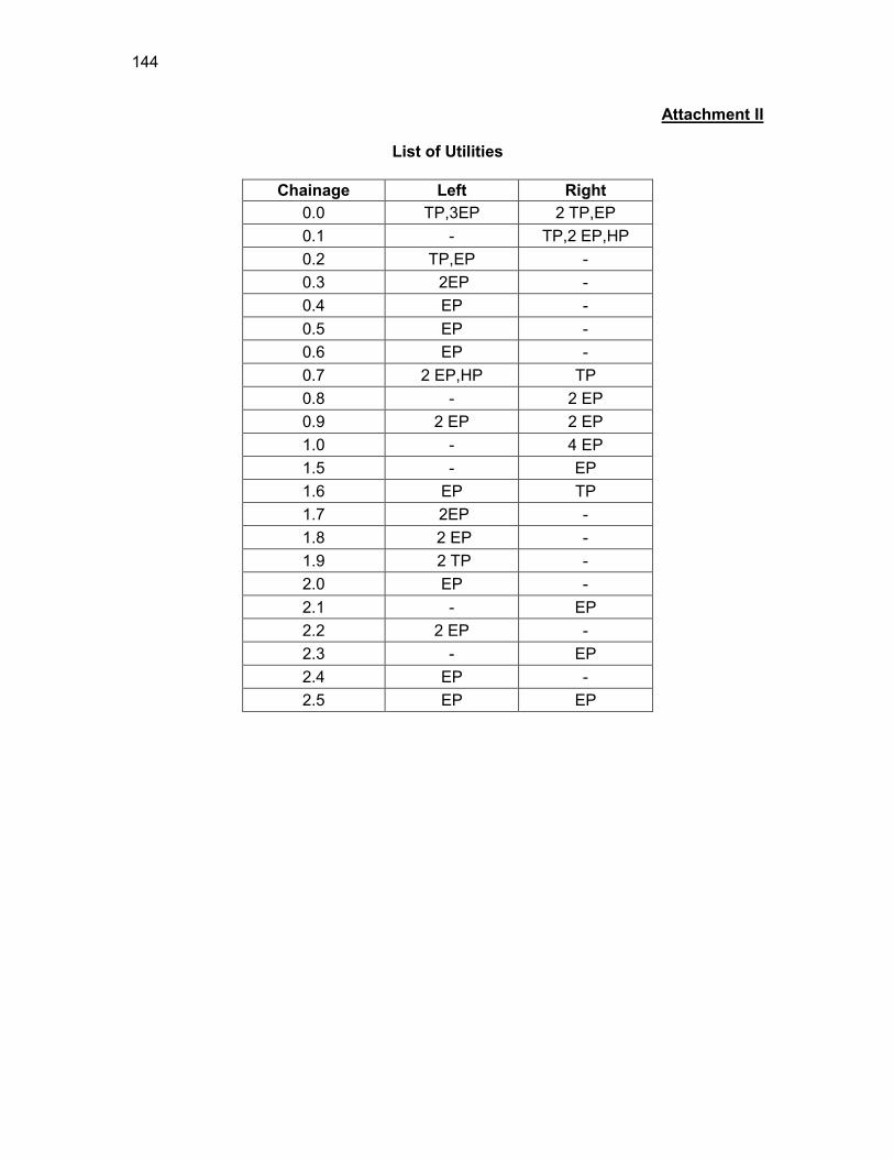
144
Attachment II
List of Utilities
Chainage Left Right 0.0 TP,3EP 2 TP,EP 0.1 - TP,2 EP,HP 0.2 TP,EP - 0.3 2EP - 0.4 EP - 0.5 EP - 0.6 EP - 0.7 2 EP,HP TP 0.8 - 2 EP 0.9 2 EP 2 EP 1.0 - 4 EP 1.5 - EP 1.6 EP TP 1.7 2EP - 1.8 2 EP - 1.9 2 TP - 2.0 EP - 2.1 - EP 2.2 2 EP - 2.3 - EP 2.4 EP - 2.5 EP EP
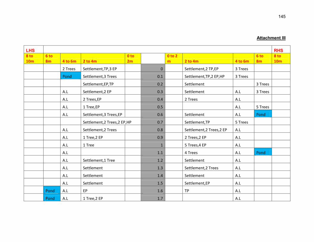
145
Attachment III
LHS RHS 8 to 10m
6 to 8m 4 to 6m 2 to 4m
0 to 2m
0 to 2 m 2 to 4m 4 to 6m
6 to 8m
8 to 10m
2 Trees Settlement,TP,3 EP 0 Settlement,2 TP,EP 3 Trees
Pond Settlement,3 Trees 0.1 Settlement,TP,2 EP,HP 3 Trees
Settlement,EP,TP 0.2 Settlement 3 Trees
A.L Settlement,2 EP 0.3 Settlement A.L 3 Trees
A.L 2 Trees,EP 0.4 2 Trees A.L
A.L 1 Tree,EP 0.5 A.L 5 Trees
A.L Settlement,3 Trees,EP 0.6 Settlement A.L Pond
Settlement,2 Trees,2 EP,HP 0.7 Settlement,TP 5 Trees
A.L Settlement,2 Trees 0.8 Settlement,2 Trees,2 EP A.L
A.L 1 Tree,2 EP 0.9 2 Trees,2 EP A.L
A.L 1 Tree 1 5 Trees,4 EP A.L
A.L 1.1 4 Trees A.L Pond
A.L Settlement,1 Tree 1.2 Settlement A.L
A.L Settlement 1.3 Settlement,2 Trees A.L
A.L Settlement 1.4 Settlement A.L
A.L Settlement 1.5 Settlement,EP A.L
Pond A.L EP 1.6 TP A.L
Pond A.L 1 Tree,2 EP 1.7 A.L
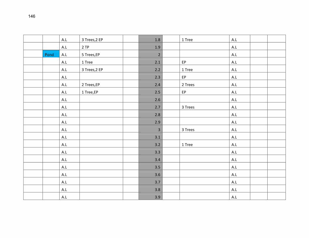
146
A.L 3 Trees,2 EP 1.8 1 Tree A.L
A.L 2 TP 1.9 A.L
Pond A.L 5 Trees,EP 2 A.L
A.L 1 Tree 2.1 EP A.L
A.L 3 Trees,2 EP 2.2 1 Tree A.L
A.L 2.3 EP A.L
A.L 2 Trees,EP 2.4 2 Trees A.L
A.L 1 Tree,EP 2.5 EP A.L
A.L 2.6 A.L
A.L 2.7 3 Trees A.L
A.L 2.8 A.L
A.L 2.9 A.L
A.L 3 3 Trees A.L
A.L 3.1 A.L
A.L 3.2 1 Tree A.L
A.L 3.3 A.L
A.L 3.4 A.L
A.L 3.5 A.L
A.L 3.6 A.L
A.L 3.7 A.L
A.L 3.8 A.L
A.L 3.9 A.L

147
EP-Electric Pole HP-Hand Pump TP-Telephone Pole A.L-Agricultural land
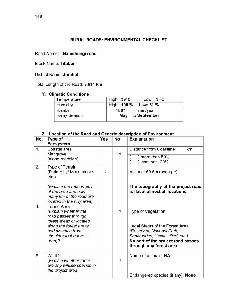
148
RURAL ROADS: ENVIRONMENTAL CHECKLIST
Road Name: Namchungi road
Block Name: Titabor District Name: Jorahat Total Length of the Road: 3.611 km
Y. Climatic Conditions Temperature High: 39°C Low: 9 °C Humidity High: 100 % Low: 51 % Rainfall Rainy Season
1867 mm/year May to September
Z. Location of the Road and Generic description of Environment No. Type of
Ecosystem Yes No Explanation
1. Coastal area Mangrove (along roadside)
√
Distance from Coastline: km
( ) more than 50% ( ) less than 20%
2. Type of Terrain (Plain/Hilly/ Mountainous etc.) (Explain the topography of the area and how many km of the road are located in the hilly area)
√
Altitude: 60.6m (average) The topography of the project road is flat at almost all locations.
4. Forest Area (Explain whether the road passes through forest areas or located along the forest areas and distance from shoulder to the forest area)?
√
Type of Vegetation: Legal Status of the Forest Area: (Reserved, National Park, Sanctuaries, Unclassified, etc.) No part of the project road passes through any forest area.
5. Wildlife (Explain whether there are any wildlife species in the project area)
√
Name of animals: NA Endangered species (if any): None
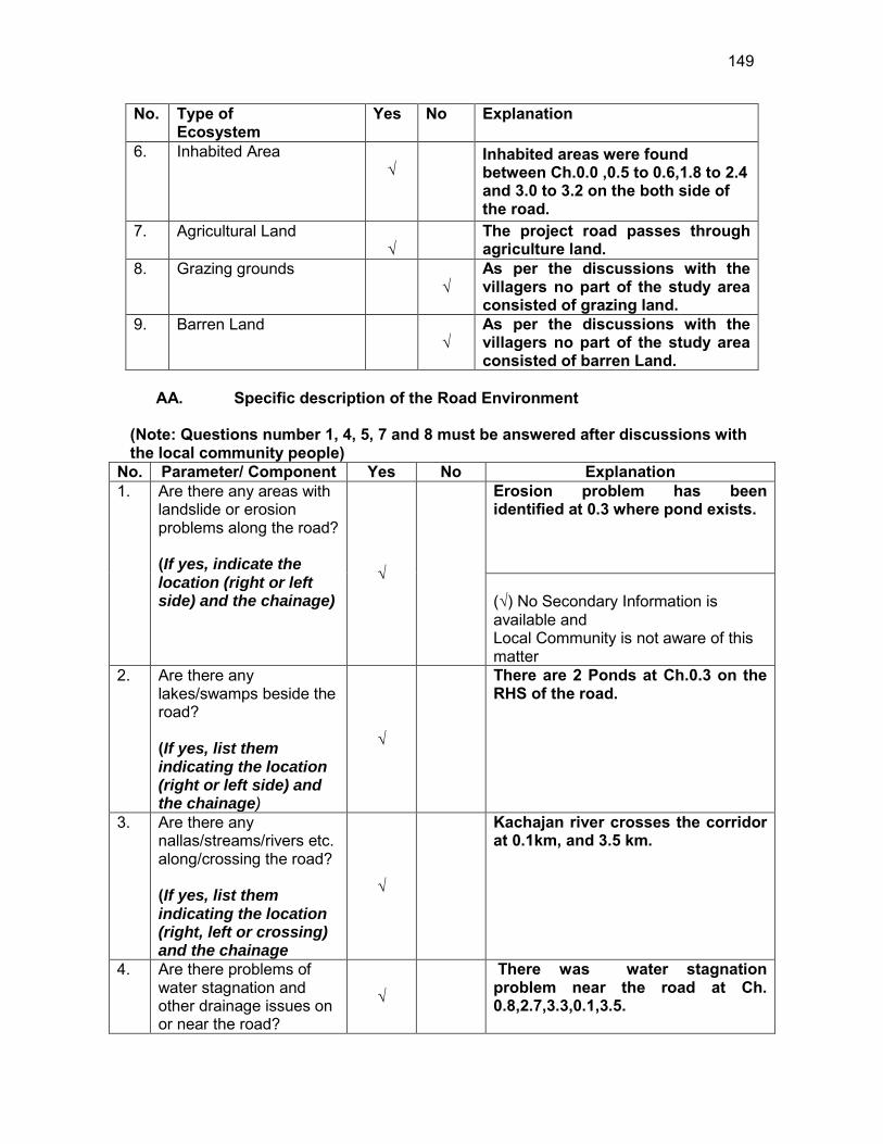
149
No. Type of Ecosystem
Yes No Explanation
6. Inhabited Area √
Inhabited areas were found between Ch.0.0 ,0.5 to 0.6,1.8 to 2.4 and 3.0 to 3.2 on the both side of the road.
7. Agricultural Land √
The project road passes through agriculture land.
8. Grazing grounds √
As per the discussions with the villagers no part of the study area consisted of grazing land.
9. Barren Land √
As per the discussions with the villagers no part of the study area consisted of barren Land.
AA. Specific description of the Road Environment
(Note: Questions number 1, 4, 5, 7 and 8 must be answered after discussions with the local community people)
No. Parameter/ Component Yes No Explanation 1. Are there any areas with
landslide or erosion problems along the road? (If yes, indicate the location (right or left side) and the chainage)
√
Erosion problem has been identified at 0.3 where pond exists. (√) No Secondary Information is available and Local Community is not aware of this matter
2. Are there any lakes/swamps beside the road? (If yes, list them indicating the location (right or left side) and the chainage)
√
There are 2 Ponds at Ch.0.3 on the RHS of the road.
3. Are there any nallas/streams/rivers etc. along/crossing the road? (If yes, list them indicating the location (right, left or crossing) and the chainage
√
Kachajan river crosses the corridor at 0.1km, and 3.5 km.
4. Are there problems of water stagnation and other drainage issues on or near the road?
√
There was water stagnation problem near the road at Ch. 0.8,2.7,3.3,0.1,3.5.
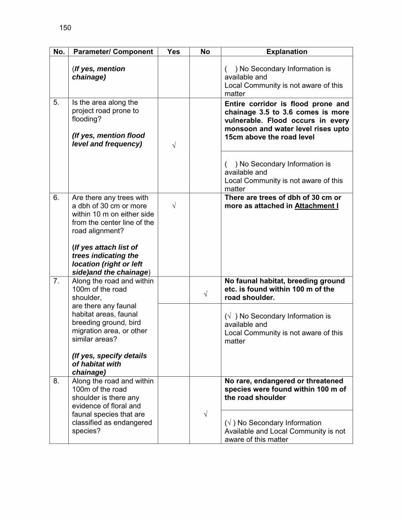
150
No. Parameter/ Component Yes No Explanation (If yes, mention chainage)
( ) No Secondary Information is available and Local Community is not aware of this matter
5. Is the area along the project road prone to flooding? (If yes, mention flood level and frequency) √
Entire corridor is flood prone and chainage 3.5 to 3.6 comes is more vulnerable. Flood occurs in every monsoon and water level rises upto 15cm above the road level ( ) No Secondary Information is available and Local Community is not aware of this matter
6. Are there any trees with a dbh of 30 cm or more within 10 m on either side from the center line of the road alignment? (If yes attach list of trees indicating the location (right or left side)and the chainage)
√
There are trees of dbh of 30 cm or more as attached in Attachment I
7. Along the road and within 100m of the road shoulder, are there any faunal habitat areas, faunal breeding ground, bird migration area, or other similar areas? (If yes, specify details of habitat with chainage)
√
No faunal habitat, breeding ground etc. is found within 100 m of the road shoulder.
(√ ) No Secondary Information is available and Local Community is not aware of this matter
8. Along the road and within 100m of the road shoulder is there any evidence of floral and faunal species that are classified as endangered species?
√
No rare, endangered or threatened species were found within 100 m of the road shoulder (√ ) No Secondary Information Available and Local Community is not aware of this matter

151
No. Parameter/ Component Yes No Explanation 9. Are there any utility
structures38 within 10 m on either side from the center line of the road alignment? (If yes, attach list with chainage)
√
Few utility structures were found as listed in Attachment II.
10. Are there any religious, cultural or community structures/buildings39 within 10 m on either side from the center line of the road alignment? (If yes attach list with chainage)
√
Few community structures were found as listed in Attachment III
D. Public Consultation
No. Consultation Activities Yes No Remarks 1. Consultation with local
community was conducted before finalizing the alignment. (Attach list of people met and dates)
√
The proposed alignment has been finalized after taking suggestions from the local community. This was confirmed by the villagers during the transect walk.
2. Any suggestion received in finalizing the alignment
√
No written suggestion was received. However, during transect walk few requests were made by the villagers
3. If suggestions received, were they incorporated into the design?
√
All the relevant suggestions has been incorporated in the alignment.
E. Please attach the following: 40) List of trees indicating location (left or right side of the road) and chainage (as
required under C. 6) 41) List of utility structures indicating location (left or right side of the road) and
chainage (as required under C. 9) 42) List of community structures indicating location (left or right side of the road) and
chainage (as required under C. 10)
38 Water tap, hand pump, electric pole, telephone pole, water pipe and other similar strucutures. 39 Mandir, Masjid, Church, religious/cultural/historical monuments, school, health center, publ ic toilet and other similar structures.

152
43) Sketch of strip map of the road covering details of atleast 10 m on either side from the center line of the road
44) Photographs of the project area showing atleast 10 m on either side from center
line of road alignment. Every 2 km or less of road must have atleast 1 photograph.
153
Attachment I
List of Trees Chainage Left Right
0.0 1 2 0.1 - 1 0.2 - 5 0.3 - 4 0.4 5 7 0.5 5 6 0.6 2 8 0.7 - 4 0.8 2 11 0.9 2 4 1.0 3 - 1.1 2 5 1.3 2 1 1.4 1 - 1.6 - 1 1.7 2 - 2.0 2 6 2.3 7 14 2.5 2 - 2.6 - 1 2.8 - 11 2.9 2 - 3.1 - 9 3.4 - 7 3.5 5 - 3.6 3 -
Total 49 106
Attachment II
List of Utilities
Chainage Side Type 0.0 LHS Electric Pole, Telephone Pole 0.4 RHS Handpump, Electric Pole 0.6 LHS Electric Pole 0.7 LHS 2 Electric Pole 0.8 RHS 2 Electric Pole
154
Chainage Side Type 0.9 LHS Electric Pole 1.0 LHS Handpump, Electric Pole 1.1 LHS 2 Electric Pole 1.1 RHS Electric Pole 1.2 LHS Electric Pole 1.8 RHS Electric Pole 1.9 RHS 3 Electric Pole, Handpump 1.9 LHS Telephone Pole 1.9 LHS 2 Electric Pole, Telephone Pole 2.0 RHS 2 Electric Pole 2.0 LHS 2 Electric Pole 2.1 LHS Telephone Pole 2.1 RHS 3 Electric Pole, Handpump, BSNL Tower 2.2 LHS 2 Electric Pole 2.3 R/L Handpump 2.4 RHS 2 Electric Pole 3.2 RHS Electric Pole 3.2 LHS Telephone Pole 3.3 LHS Electric Pole
Attachment III
List of Community Structures
Chainage No. Side Type
0.0 RHS School
1.1 RHS School
1.8 LHS Namghor
2.0 LHS Namghor
3.3 LHS Namghor
155
Attachment IV
LHS RHS
8 to 10m 6 to 8m 4 to 6m 2 to 4m 0 to 2m 0 to 2 m 2 to 4m
4 to 6m
6 to 8m 8 to 10m
A.L Settlement,1 Tree,EP,TP 0 Settlement,2 Trees A.L School
A.L 0.1 1 Tree A.L
A.L 0.2 5 Trees A.L
A.L 0.3 2 Ponds
A.L,4 Trees
A.L 5 Trees,EP 0.4 7 Trees,HP A.L
A.L Settlement,5 Trees
0.5 Settlement,6 trees A.L
A.L Settlement,2 Trees,EP
0.6 Settlement,8 Trees A.L
A.L 2 EP 0.7 4 Trees A.L
A.L 2 Trees 0.8 2 EP A.L,11 trees
A.L 2 Trees,EP 0.9 4 Trees A.L
A.L 3 Trees,HP,EP 1 A.L
A.L 2 Trees, 2 EP 1.1 5 Trees,EP A.L
School
A.L EP 1. A.L
156
2
2 Trees 1.3 1 Tree
1 Tree 1.4
1.5
1.6 1 Tree
2 Trees 1.7
Namghar Settlement
1.8 Settlement,EP
Settlement,2 TP,2 EP
1.9 Settlement,3 EP,HP
Namghar 2 Trees Settlement, 2 EP 2 Settlement,2 EP 6 Trees
Settlement,TP 2.1 Settlement,2 EP,HP BSNL Tower
Settlement, 2 EP 2.2 Settlement 1 Tree
7 Trees Settlement,HP 2.3 Settlement,HP
14 Trees
A.L Settlement 2.4 Settlement,2 EP A.L
A.L 2 Trees 2.5 A.L
A.L 2.6 1 Tree A.L
A.L 2.7 A.L

157
A.L 2.8 11 Trees A.L
A.L 2 Trees 2.9 A.L
A.L Settlement 3 Settlement A.L
Settlement 3.1 Settlement,9 Trees
A.L Settlement,TP 3.2 Settlement,EP A.L
Namghar A.L Pond EP
3.3 A.L
A.L 3.4 7 Trees A.L
A.L 5 Trees 3.5 A.L
A.L 3 Trees 3.6 A.L
EP-Electric Pole HP-Hand Pump TP-Telephone Pole A.L-Agricultural land
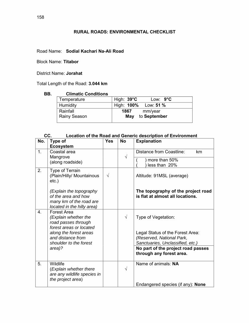
158
RURAL ROADS: ENVIRONMENTAL CHECKLIST
Road Name: Sodial Kachari Na-Ali Road
Block Name: Titabor District Name: Jorahat Total Length of the Road: 3.044 km
BB. Climatic Conditions Temperature High: 39°C Low: 9°C Humidity High: 100% Low: 51 % Rainfall Rainy Season
1867 mm/year May to September
CC. Location of the Road and Generic description of Environment No. Type of
Ecosystem Yes No Explanation
1. Coastal area Mangrove (along roadside)
√
Distance from Coastline: km
( ) more than 50% ( ) less than 20%
2. Type of Terrain (Plain/Hilly/ Mountainous etc.) (Explain the topography of the area and how many km of the road are located in the hilly area)
√
Altitude: 91MSL (average) The topography of the project road is flat at almost all locations.
4. Forest Area (Explain whether the road passes through forest areas or located along the forest areas and distance from shoulder to the forest area)?
√
Type of Vegetation: Legal Status of the Forest Area: (Reserved, National Park, Sanctuaries, Unclassified, etc.) No part of the project road passes through any forest area.
5. Wildlife (Explain whether there are any wildlife species in the project area)
√
Name of animals: NA Endangered species (if any): None
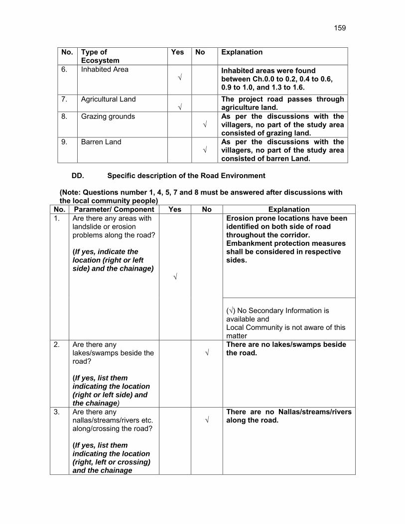
159
No. Type of Ecosystem
Yes No Explanation
6. Inhabited Area √
Inhabited areas were found between Ch.0.0 to 0.2, 0.4 to 0.6, 0.9 to 1.0, and 1.3 to 1.6.
7. Agricultural Land √
The project road passes through agriculture land.
8. Grazing grounds √
As per the discussions with the villagers, no part of the study area consisted of grazing land.
9. Barren Land √
As per the discussions with the villagers, no part of the study area consisted of barren Land.
DD. Specific description of the Road Environment
(Note: Questions number 1, 4, 5, 7 and 8 must be answered after discussions with the local community people)
No. Parameter/ Component Yes No Explanation 1. Are there any areas with
landslide or erosion problems along the road? (If yes, indicate the location (right or left side) and the chainage)
√
Erosion prone locations have been identified on both side of road throughout the corridor. Embankment protection measures shall be considered in respective sides. (√) No Secondary Information is available and Local Community is not aware of this matter
2. Are there any lakes/swamps beside the road? (If yes, list them indicating the location (right or left side) and the chainage)
√
There are no lakes/swamps beside the road.
3. Are there any nallas/streams/rivers etc. along/crossing the road? (If yes, list them indicating the location (right, left or crossing) and the chainage
√
There are no Nallas/streams/rivers along the road.
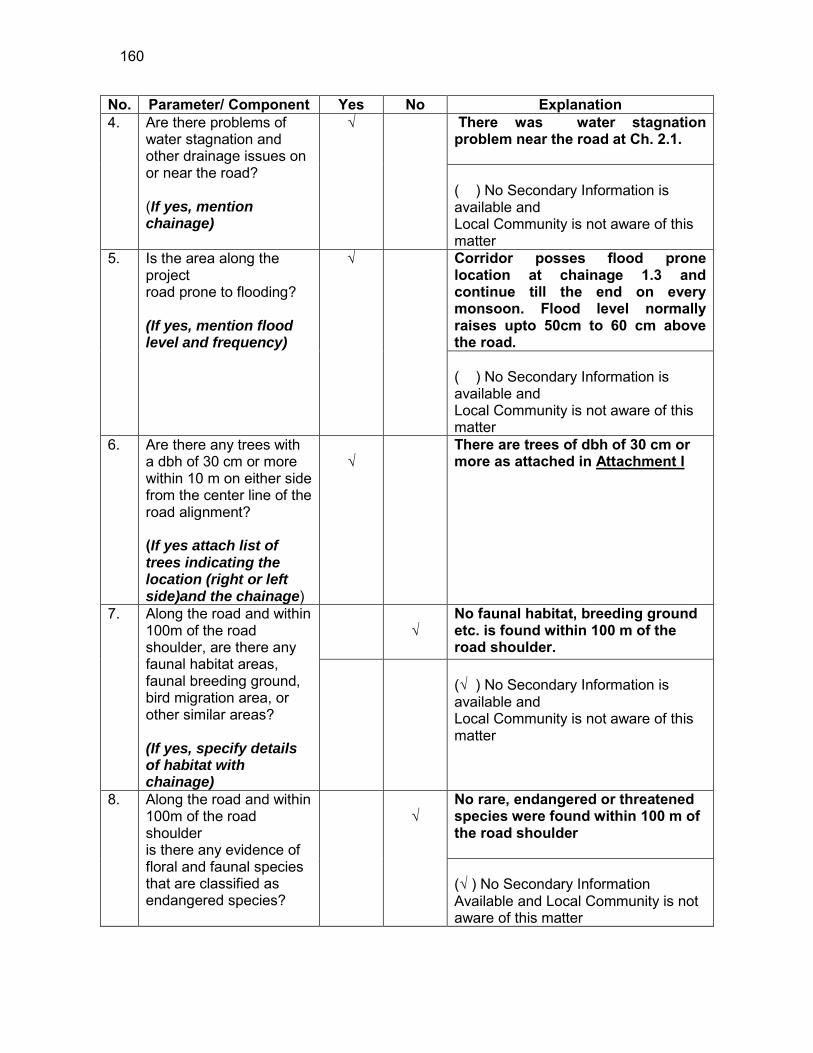
160
No. Parameter/ Component Yes No Explanation 4. Are there problems of
water stagnation and other drainage issues on or near the road? (If yes, mention chainage)
√
There was water stagnation problem near the road at Ch. 2.1. ( ) No Secondary Information is available and Local Community is not aware of this matter
5. Is the area along the project road prone to flooding? (If yes, mention flood level and frequency)
√
Corridor posses flood prone location at chainage 1.3 and continue till the end on every monsoon. Flood level normally raises upto 50cm to 60 cm above the road. ( ) No Secondary Information is available and Local Community is not aware of this matter
6. Are there any trees with a dbh of 30 cm or more within 10 m on either side from the center line of the road alignment? (If yes attach list of trees indicating the location (right or left side)and the chainage)
√
There are trees of dbh of 30 cm or more as attached in Attachment I
7. Along the road and within 100m of the road shoulder, are there any faunal habitat areas, faunal breeding ground, bird migration area, or other similar areas? (If yes, specify details of habitat with chainage)
√
No faunal habitat, breeding ground etc. is found within 100 m of the road shoulder.
(√ ) No Secondary Information is available and Local Community is not aware of this matter
8. Along the road and within 100m of the road shoulder is there any evidence of floral and faunal species that are classified as endangered species?
√
No rare, endangered or threatened species were found within 100 m of the road shoulder (√ ) No Secondary Information Available and Local Community is not aware of this matter

161
No. Parameter/ Component Yes No Explanation 9. Are there any utility
structures40 within 10 m on either side from the center line of the road alignment? (If yes, attach list with chainage)
√
Few utility structures were found as listed in Attachment II.
10. Are there any religious, cultural or community structures/buildings41 within 10 m on either side from the center line of the road alignment? (If yes attach list with chainage)
√
Few community structures were found as listed in Attachment III
D. Public Consultation
No. Consultation Activities Yes No Remarks 1. Consultation with local
community was conducted before finalizing the alignment. (Attach list of people met and dates)
√
The proposed alignment has been finalized after taking suggestions from the local community. This was confirmed by the villagers during the transect walk.
2. Any suggestion received in finalizing the alignment
√
No written suggestion was received. However, during transect walk few requests were made by the villagers
3. If suggestions received, were they incorporated into the design?
√
All the relevant suggestions has been incorporated in the alignment.
E. Please attach the following: 45) List of trees indicating location (left or right side of the road) and chainage (as
required under C. 6) 46) List of utility structures indicating location (left or right side of the road) and
chainage (as required under C. 9) 47) List of community structures indicating location (left or right side of the road) and
chainage (as required under C. 10)
40 Water tap, hand pump, electric pole, telephone pole, water pipe and other similar strucutures. 41 Mandir, Masjid, Church, religious/cultural/historical monuments, school, health center, publ ic toilet and other similar structures.

162
48) Sketch of strip map of the road covering details of atleast 10 m on either side from the center line of the road
49) Photographs of the project area showing atleast 10 m on either side from center
line of road alignment. Every 2 km or less of road must have atleast 1 photograph.
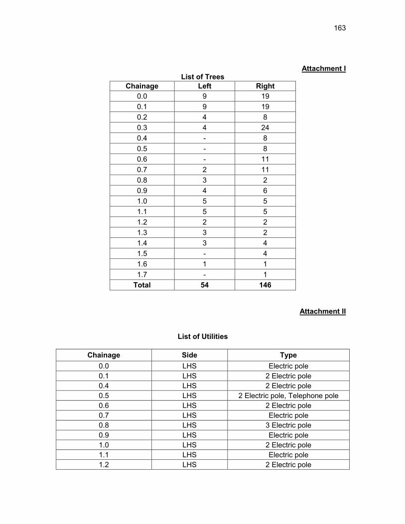
163
Attachment I List of Trees
Chainage Left Right 0.0 9 19 0.1 9 19 0.2 4 8 0.3 4 24 0.4 - 8 0.5 - 8 0.6 - 11 0.7 2 11 0.8 3 2 0.9 4 6 1.0 5 5 1.1 5 5 1.2 2 2 1.3 3 2 1.4 3 4 1.5 - 4 1.6 1 1 1.7 - 1
Total 54 146
Attachment II
List of Utilities
Chainage Side Type 0.0 LHS Electric pole 0.1 LHS 2 Electric pole 0.4 LHS 2 Electric pole 0.5 LHS 2 Electric pole, Telephone pole 0.6 LHS 2 Electric pole 0.7 LHS Electric pole 0.8 LHS 3 Electric pole 0.9 LHS Electric pole 1.0 LHS 2 Electric pole 1.1 LHS Electric pole 1.2 LHS 2 Electric pole
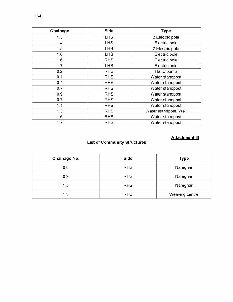
164
Chainage Side Type 1.3 LHS 2 Electric pole 1.4 LHS Electric pole 1.5 LHS 2 Electric pole 1.6 LHS Electric pole 1.6 RHS Electric pole 1.7 LHS Electric pole 0.2 RHS Hand pump 0.1 RHS Water standpost 0.4 RHS Water standpost 0.7 RHS Water standpost 0.9 RHS Water standpost 0.7 RHS Water standpost 1.1 RHS Water standpost 1.3 RHS Water standpost, Well 1.6 RHS Water standpost 1.7 RHS Water standpost
Attachment III List of Community Structures
Chainage No. Side Type
0.8 RHS Namghar
0.9 RHS Namghar
1.5 RHS Namghar
1.3 RHS Weaving centre
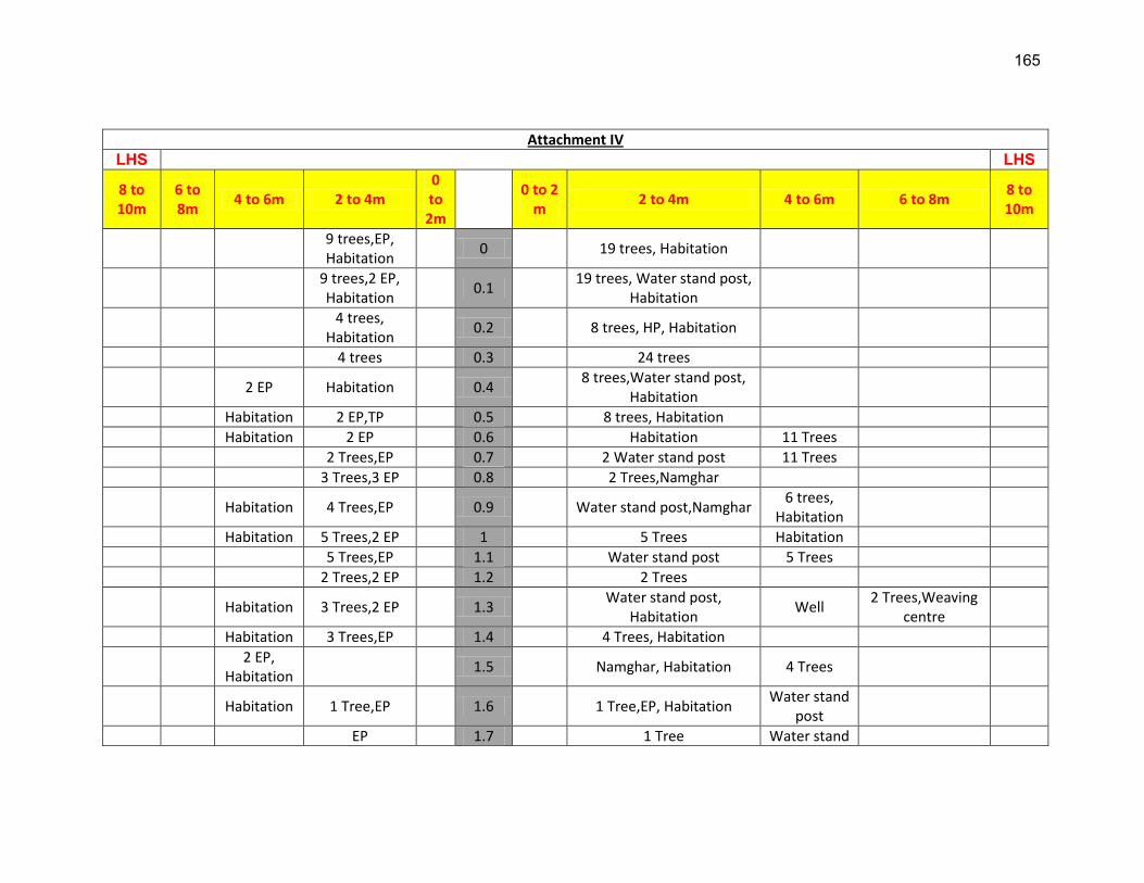
165
Attachment IV
LHS LHS
8 to 10m
6 to 8m
4 to 6m 2 to 4m 0 to 2m
0 to 2
m 2 to 4m 4 to 6m 6 to 8m
8 to 10m
9 trees,EP, Habitation
0 19 trees, Habitation
9 trees,2 EP, Habitation
0.1 19 trees, Water stand post,
Habitation
4 trees,
Habitation 0.2 8 trees, HP, Habitation
4 trees 0.3 24 trees
2 EP Habitation 0.4 8 trees,Water stand post,
Habitation
Habitation 2 EP,TP 0.5 8 trees, Habitation
Habitation 2 EP 0.6 Habitation 11 Trees
2 Trees,EP 0.7 2 Water stand post 11 Trees
3 Trees,3 EP 0.8 2 Trees,Namghar
Habitation 4 Trees,EP 0.9 Water stand post,Namghar 6 trees,
Habitation
Habitation 5 Trees,2 EP 1 5 Trees Habitation
5 Trees,EP 1.1 Water stand post 5 Trees
2 Trees,2 EP 1.2 2 Trees
Habitation 3 Trees,2 EP 1.3 Water stand post,
Habitation Well
2 Trees,Weaving centre
Habitation 3 Trees,EP 1.4 4 Trees, Habitation
2 EP,
Habitation 1.5 Namghar, Habitation 4 Trees
Habitation 1 Tree,EP 1.6 1 Tree,EP, Habitation Water stand
post
EP 1.7 1 Tree Water stand
166
post EP-Electric Pole, HP-Hand Pump, TP-Telephone Pole, A.L-Agricultural land
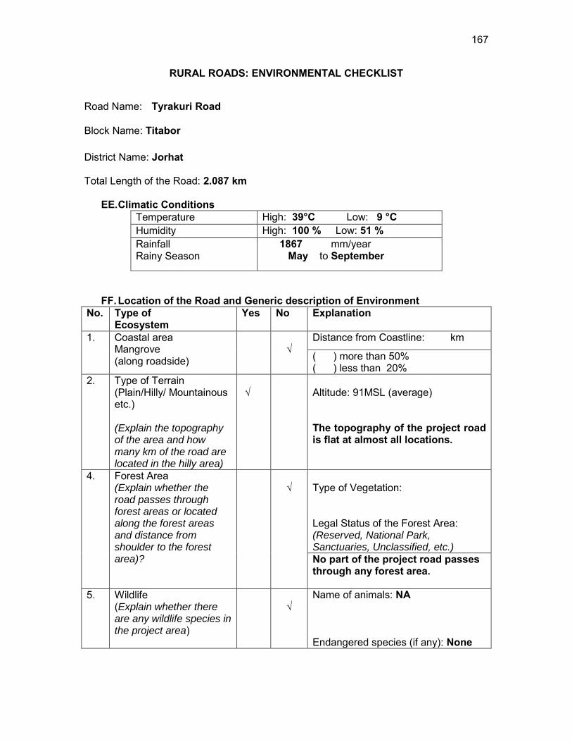
167
RURAL ROADS: ENVIRONMENTAL CHECKLIST
Road Name: Tyrakuri Road
Block Name: Titabor District Name: Jorhat Total Length of the Road: 2.087 km
EE. Climatic Conditions Temperature High: 39°C Low: 9 °C Humidity High: 100 % Low: 51 % Rainfall Rainy Season
1867 mm/year May to September
FF. Location of the Road and Generic description of Environment No. Type of
Ecosystem Yes No Explanation
1. Coastal area Mangrove (along roadside)
√
Distance from Coastline: km
( ) more than 50% ( ) less than 20%
2. Type of Terrain (Plain/Hilly/ Mountainous etc.) (Explain the topography of the area and how many km of the road are located in the hilly area)
√
Altitude: 91MSL (average) The topography of the project road is flat at almost all locations.
4. Forest Area (Explain whether the road passes through forest areas or located along the forest areas and distance from shoulder to the forest area)?
√
Type of Vegetation: Legal Status of the Forest Area: (Reserved, National Park, Sanctuaries, Unclassified, etc.) No part of the project road passes through any forest area.
5. Wildlife (Explain whether there are any wildlife species in the project area)
√
Name of animals: NA Endangered species (if any): None

168
No. Type of Ecosystem
Yes No Explanation
6. Inhabited Area √
Inhabited areas were found between Ch.0.0 to 0.3,0.6 to 1.0 and 1.3 to 1.4 on the both side of the road.
7. Agricultural Land √
The project road passes through agriculture land.
8. Grazing grounds √
As per the discussions with the villagers no part of the study area consisted of grazing land.
9. Barren Land √
As per the discussions with the villagers no part of the study area consisted of barren Land.
GG. Specific description of the Road Environment
(Note: Questions number 1, 4, 5, 7 and 8 must be answered after discussions with the local community people)
No. Parameter/ Component Yes No Explanation 1. Are there any areas with
landslide or erosion problems along the road? (If yes, indicate the location (right or left side) and the chainage)
√
Erosion prone locations are identified on the ponds falling along the corridor at chainage 0.2, 0.4 (LHS) and 0.6, 1.1, 1.7 (RHS). Slope stabilisation measures shall be provided. (√) No Secondary Information is available and Local Community is not aware of this matter
2. Are there any lakes/swamps beside the road? (If yes, list them indicating the location (right or left side) and the chainage)
√
There are many Ponds at Ch. 0.2, 0.4 (LHS) and 0.6, 1.1, 1.7 (RHS).
3. Are there any nallas/streams/rivers etc. along/crossing the road? (If yes, list them indicating the location (right, left or crossing)
√
There are no Nallas/streams/rivers along the road.
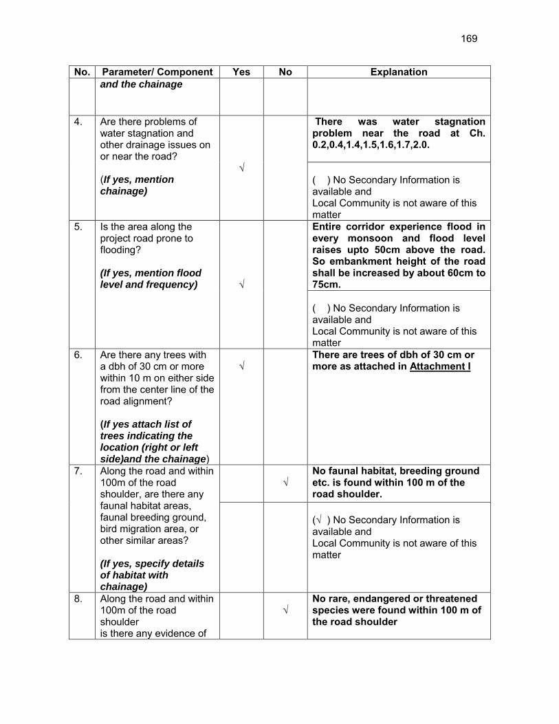
169
No. Parameter/ Component Yes No Explanation and the chainage
4. Are there problems of water stagnation and other drainage issues on or near the road? (If yes, mention chainage)
√
There was water stagnation problem near the road at Ch. 0.2,0.4,1.4,1.5,1.6,1.7,2.0. ( ) No Secondary Information is available and Local Community is not aware of this matter
5. Is the area along the project road prone to flooding? (If yes, mention flood level and frequency) √
Entire corridor experience flood in every monsoon and flood level raises upto 50cm above the road. So embankment height of the road shall be increased by about 60cm to 75cm. ( ) No Secondary Information is available and Local Community is not aware of this matter
6. Are there any trees with a dbh of 30 cm or more within 10 m on either side from the center line of the road alignment? (If yes attach list of trees indicating the location (right or left side)and the chainage)
√
There are trees of dbh of 30 cm or more as attached in Attachment I
7. Along the road and within 100m of the road shoulder, are there any faunal habitat areas, faunal breeding ground, bird migration area, or other similar areas? (If yes, specify details of habitat with chainage)
√
No faunal habitat, breeding ground etc. is found within 100 m of the road shoulder.
(√ ) No Secondary Information is available and Local Community is not aware of this matter
8. Along the road and within 100m of the road shoulder is there any evidence of
√
No rare, endangered or threatened species were found within 100 m of the road shoulder

170
No. Parameter/ Component Yes No Explanation floral and faunal species that are classified as endangered species?
(√ ) No Secondary Information Available and Local Community is not aware of this matter
9. Are there any utility structures42 within 10 m on either side from the center line of the road alignment? (If yes, attach list with chainage)
√
Few utility structures were found as listed in Attachment II.
10. Are there any religious, cultural or community structures/buildings43 within 10 m on either side from the center line of the road alignment? (If yes attach list with chainage)
√
Few community structures were found as listed in Attachment III
D. Public Consultation
No. Consultation Activities Yes No Remarks 1. Consultation with local
community was conducted before finalizing the alignment. (Attach list of people met and dates)
√
The proposed alignment has been finalized after taking suggestions from the local community. This was confirmed by the villagers during the transect walk.
2. Any suggestion received in finalizing the alignment
√
No written suggestion was received. However, during transect walk few requests were made by the villagers
3. If suggestions received, were they incorporated into the design?
√
All the relevant suggestions has been incorporated in the alignment.
E. Please attach the following: 50) List of trees indicating location (left or right side of the road) and chainage (as
required under C. 6) 51) List of utility structures indicating location (left or right side of the road) and
chainage (as required under C. 9) 42 Water tap, hand pump, electric pole, telephone pole, water pipe and other similar strucutures. 43 Mandir, Masjid, Church, religious/cultural/historical monuments, school, health center, publ ic toilet and other similar structures.

171
52) List of community structures indicating location (left or right side of the road) and
chainage (as required under C. 10) 53) Sketch of strip map of the road covering details of atleast 10 m on either side
from the center line of the road
54) Photographs of the project area showing atleast 10 m on either side from center line of road alignment. Every 2 km or less of road must have atleast 1 photograph.
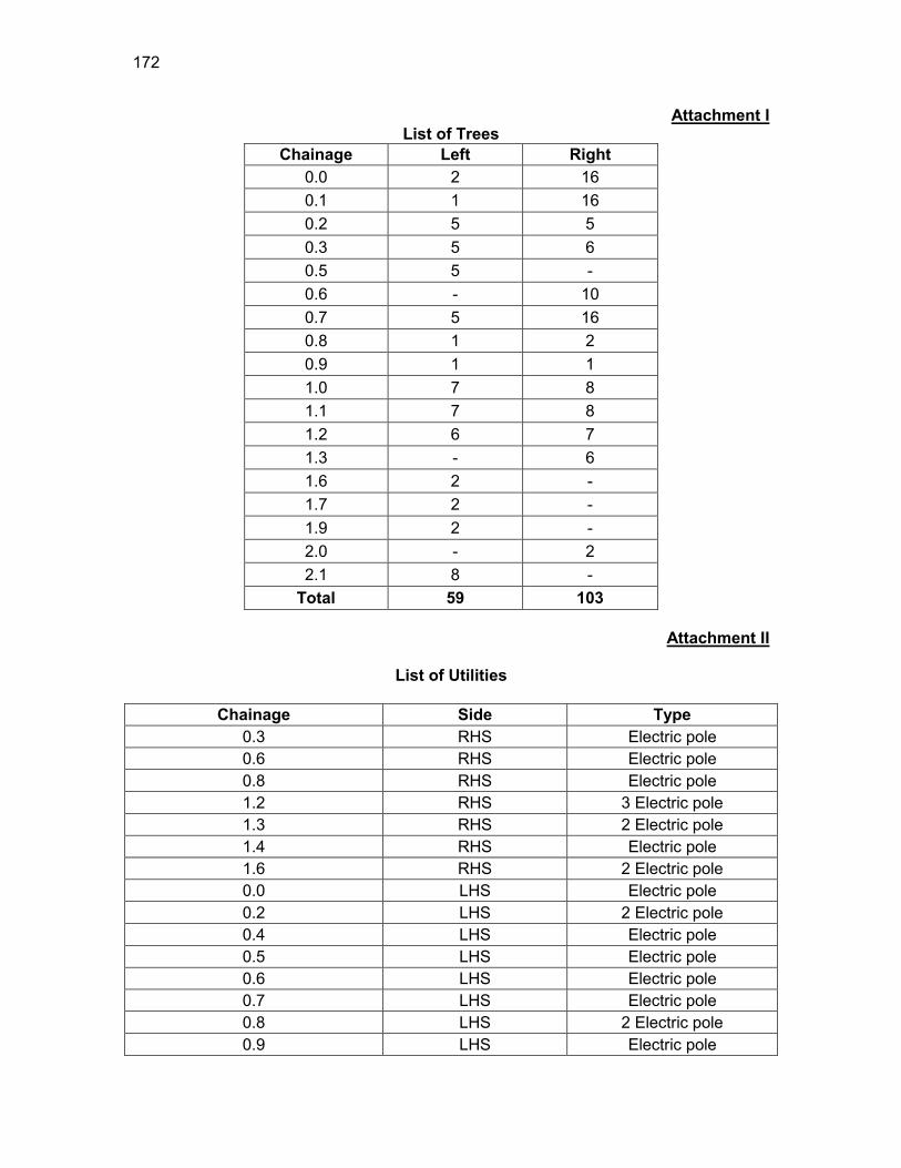
172
Attachment I List of Trees
Chainage Left Right 0.0 2 16 0.1 1 16 0.2 5 5 0.3 5 6 0.5 5 - 0.6 - 10 0.7 5 16 0.8 1 2 0.9 1 1 1.0 7 8 1.1 7 8 1.2 6 7 1.3 - 6 1.6 2 - 1.7 2 - 1.9 2 - 2.0 - 2 2.1 8 -
Total 59 103
Attachment II
List of Utilities
Chainage Side Type 0.3 RHS Electric pole 0.6 RHS Electric pole 0.8 RHS Electric pole 1.2 RHS 3 Electric pole 1.3 RHS 2 Electric pole 1.4 RHS Electric pole 1.6 RHS 2 Electric pole 0.0 LHS Electric pole 0.2 LHS 2 Electric pole 0.4 LHS Electric pole 0.5 LHS Electric pole 0.6 LHS Electric pole 0.7 LHS Electric pole 0.8 LHS 2 Electric pole 0.9 LHS Electric pole
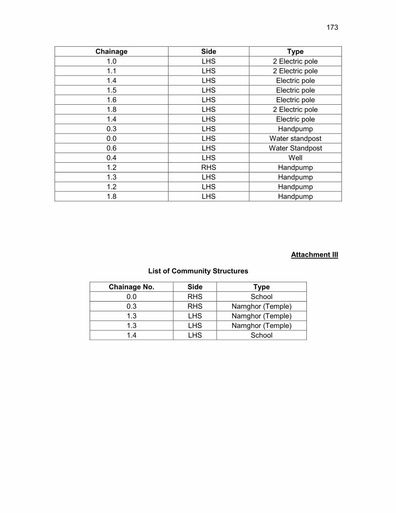
173
Chainage Side Type 1.0 LHS 2 Electric pole 1.1 LHS 2 Electric pole 1.4 LHS Electric pole 1.5 LHS Electric pole 1.6 LHS Electric pole 1.8 LHS 2 Electric pole 1.4 LHS Electric pole 0.3 LHS Handpump 0.0 LHS Water standpost 0.6 LHS Water Standpost 0.4 LHS Well 1.2 RHS Handpump 1.3 LHS Handpump 1.2 LHS Handpump 1.8 LHS Handpump
Attachment III
List of Community Structures
Chainage No. Side Type 0.0 RHS School 0.3 RHS Namghor (Temple) 1.3 LHS Namghor (Temple) 1.3 LHS Namghor (Temple) 1.4 LHS School
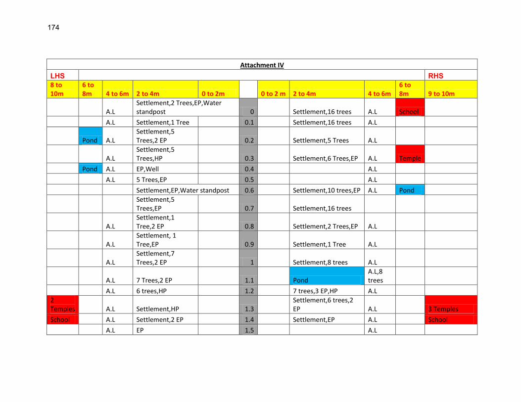
174
Attachment IV
LHS RHS 8 to 10m
6 to 8m 4 to 6m 2 to 4m 0 to 2m 0 to 2 m 2 to 4m 4 to 6m
6 to 8m 9 to 10m
A.L Settlement,2 Trees,EP,Water standpost 0 Settlement,16 trees A.L School
A.L Settlement,1 Tree 0.1 Settlement,16 trees A.L
Pond A.L Settlement,5 Trees,2 EP 0.2 Settlement,5 Trees A.L
A.L Settlement,5 Trees,HP 0.3 Settlement,6 Trees,EP A.L Temple
Pond A.L EP,Well 0.4 A.L
A.L 5 Trees,EP 0.5 A.L
Settlement,EP,Water standpost 0.6 Settlement,10 trees,EP A.L Pond
Settlement,5 Trees,EP 0.7 Settlement,16 trees
A.L Settlement,1 Tree,2 EP 0.8 Settlement,2 Trees,EP A.L
A.L Settlement, 1 Tree,EP 0.9 Settlement,1 Tree A.L
A.L Settlement,7 Trees,2 EP 1 Settlement,8 trees A.L
A.L 7 Trees,2 EP 1.1 Pond A.L,8 trees
A.L 6 trees,HP 1.2 7 trees,3 EP,HP A.L
2 Temples A.L Settlement,HP 1.3
Settlement,6 trees,2 EP A.L 3 Temples
School A.L Settlement,2 EP 1.4 Settlement,EP A.L School
A.L EP 1.5 A.L
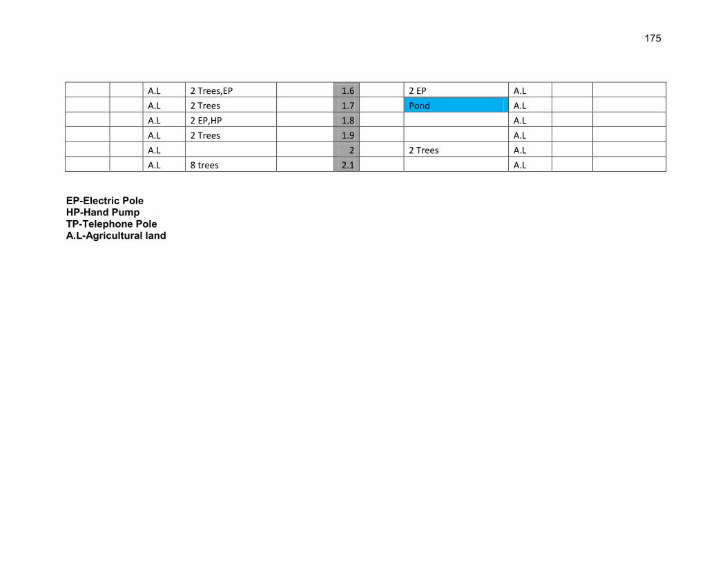
175
A.L 2 Trees,EP 1.6 2 EP A.L
A.L 2 Trees 1.7 Pond A.L
A.L 2 EP,HP 1.8 A.L
A.L 2 Trees 1.9 A.L
A.L 2 2 Trees A.L
A.L 8 trees 2.1 A.L EP-Electric Pole HP-Hand Pump TP-Telephone Pole A.L-Agricultural land
176
C: ECOPS IN DISTRICT KAMRUP
RURAL ROADS: ENVIRONMENTAL CHECKLIST
Road Name: Chaygaon Ukium from Langkhar to Ukium
Block Name: Bongaon District Name: Kamrup Total Length of the Road: 2.997 km
HH. Climatic Conditions Temperature High: 38.5°C Low: 7 °C Humidity High: 84 % Low: 69 % Rainfall Rainy Season
1400 mm/year May to September
II. Location of the Road and Generic description of Environment No. Type of
Ecosystem Yes No Explanation
1. Coastal area Mangrove (along roadside)
√
Distance from Coastline: km
( ) more than 50% ( ) less than 20%
2. Type of Terrain (Plain/Hilly/ Mountainous etc.) (Explain the topography of the area and how many km of the road are located in the hilly area)
√
Altitude: 55m (average) The starting section of the alignment fall in the plain and later it passes hilly terrain.
4. Forest Area (Explain whether the road passes through forest areas or located along the forest areas and distance from shoulder to the forest area)?
√
Type of Vegetation: Legal Status of the Forest Area: (Reserved, National Park, Sanctuaries, Unclassified, etc.) No part of the project road passes through any forest area.
177
No. Type of Ecosystem
Yes No Explanation
5. Wildlife (Explain whether there are any wildlife species in the project area)
√
Name of animals: NA Endangered species (if any): None
6. Inhabited Area √
Inhabited areas were found between Ch.0.0 to 0.3, 0.7 to 0.9 on the both side of the road.
7. Agricultural Land √
The project road passes through agriculture land.
8. Grazing grounds √
As per the discussions with the villagers, no part of the study area consisted of grazing land.
9. Barren Land √
As per the discussions with the villagers, no part of the study area consisted of barren Land.
JJ. Specific description of the Road Environment
(Note: Questions number 1, 4, 5, 7 and 8 must be answered after discussions with the local community people)
No. Parameter/ Component Yes No Explanation 1. Are there any areas with
landslide or erosion problems along the road? (If yes, indicate the location (right or left side) and the chainage) √
Erosion prone area is pond adjacent to roadside at chainage 1.2 on RHS. So slope protection measure shall be considered for this location. (√) No Secondary Information is available and Local Community is not aware of this matter
2. Are there any lakes/swamps beside the road? (If yes, list them indicating the location (right or left side) and the chainage)
√
There is a Pond at Ch.1.2 on the RHS of the road.
3. Are there any nallas/streams/rivers etc. along/crossing the road?
√
Rivers/ streams are crossing the alignment at Ch. 2.5.
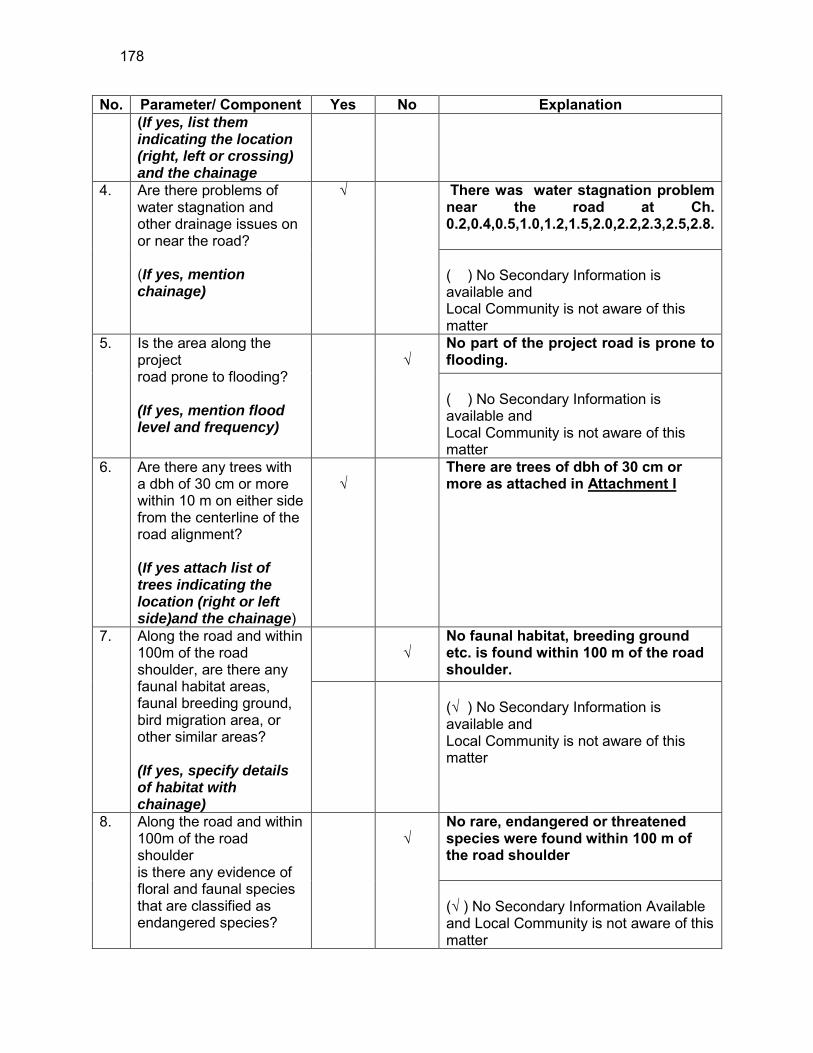
178
No. Parameter/ Component Yes No Explanation (If yes, list them indicating the location (right, left or crossing) and the chainage
4. Are there problems of water stagnation and other drainage issues on or near the road? (If yes, mention chainage)
√
There was water stagnation problem near the road at Ch. 0.2,0.4,0.5,1.0,1.2,1.5,2.0,2.2,2.3,2.5,2.8. ( ) No Secondary Information is available and Local Community is not aware of this matter
5. Is the area along the project road prone to flooding? (If yes, mention flood level and frequency)
√
No part of the project road is prone to flooding. ( ) No Secondary Information is available and Local Community is not aware of this matter
6. Are there any trees with a dbh of 30 cm or more within 10 m on either side from the centerline of the road alignment? (If yes attach list of trees indicating the location (right or left side)and the chainage)
√
There are trees of dbh of 30 cm or more as attached in Attachment I
7. Along the road and within 100m of the road shoulder, are there any faunal habitat areas, faunal breeding ground, bird migration area, or other similar areas? (If yes, specify details of habitat with chainage)
√
No faunal habitat, breeding ground etc. is found within 100 m of the road shoulder.
(√ ) No Secondary Information is available and Local Community is not aware of this matter
8. Along the road and within 100m of the road shoulder is there any evidence of floral and faunal species that are classified as endangered species?
√
No rare, endangered or threatened species were found within 100 m of the road shoulder (√ ) No Secondary Information Available and Local Community is not aware of this matter
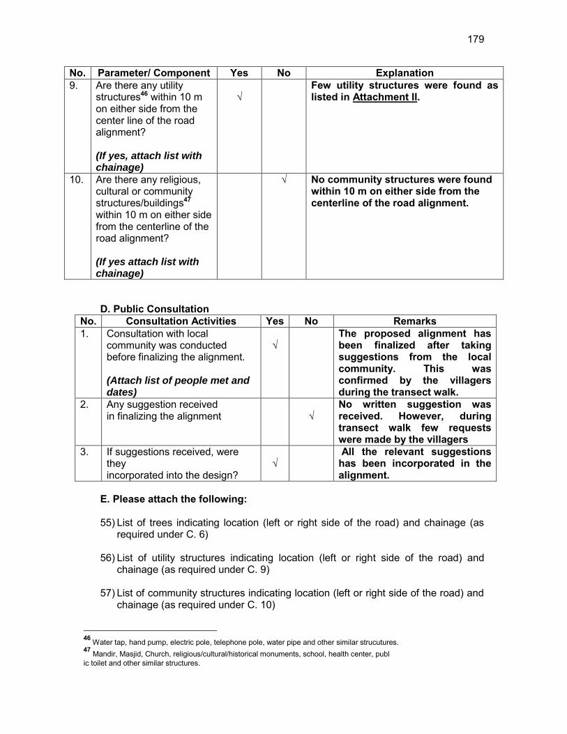
179
No. Parameter/ Component Yes No Explanation 9. Are there any utility
structures46 within 10 m on either side from the center line of the road alignment? (If yes, attach list with chainage)
√
Few utility structures were found as listed in Attachment II.
10. Are there any religious, cultural or community structures/buildings47 within 10 m on either side from the centerline of the road alignment? (If yes attach list with chainage)
√ No community structures were found within 10 m on either side from the centerline of the road alignment.
D. Public Consultation
No. Consultation Activities Yes No Remarks 1. Consultation with local
community was conducted before finalizing the alignment. (Attach list of people met and dates)
√
The proposed alignment has been finalized after taking suggestions from the local community. This was confirmed by the villagers during the transect walk.
2. Any suggestion received in finalizing the alignment
√
No written suggestion was received. However, during transect walk few requests were made by the villagers
3. If suggestions received, were they incorporated into the design?
√
All the relevant suggestions has been incorporated in the alignment.
E. Please attach the following: 55) List of trees indicating location (left or right side of the road) and chainage (as
required under C. 6) 56) List of utility structures indicating location (left or right side of the road) and
chainage (as required under C. 9) 57) List of community structures indicating location (left or right side of the road) and
chainage (as required under C. 10)
46 Water tap, hand pump, electric pole, telephone pole, water pipe and other similar strucutures. 47 Mandir, Masjid, Church, religious/cultural/historical monuments, school, health center, publ ic toilet and other similar structures.

180
58) Sketch of strip map of the road covering details of atleast 10 m on either side from the center line of the road
59) Photographs of the project area showing atleast 10 m on either side from center
line of road alignment. Every 2 km or less of road must have atleast 1 photograph.
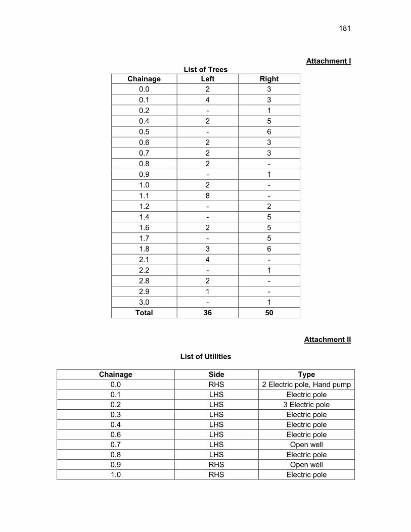
181
Attachment I
List of Trees Chainage Left Right
0.0 2 3 0.1 4 3 0.2 - 1 0.4 2 5 0.5 - 6 0.6 2 3 0.7 2 3 0.8 2 - 0.9 - 1 1.0 2 - 1.1 8 - 1.2 - 2 1.4 - 5 1.6 2 5 1.7 - 5 1.8 3 6 2.1 4 - 2.2 - 1 2.8 2 - 2.9 1 - 3.0 - 1
Total 36 50
Attachment II
List of Utilities
Chainage Side Type 0.0 RHS 2 Electric pole, Hand pump 0.1 LHS Electric pole 0.2 LHS 3 Electric pole 0.3 LHS Electric pole 0.4 LHS Electric pole 0.6 LHS Electric pole 0.7 LHS Open well 0.8 LHS Electric pole 0.9 RHS Open well 1.0 RHS Electric pole
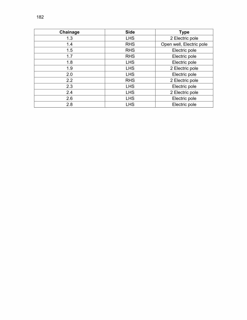
182
Chainage Side Type 1.3 LHS 2 Electric pole 1.4 RHS Open well, Electric pole 1.5 RHS Electric pole 1.7 RHS Electric pole 1.8 LHS Electric pole 1.9 LHS 2 Electric pole 2.0 LHS Electric pole 2.2 RHS 2 Electric pole 2.3 LHS Electric pole 2.4 LHS 2 Electric pole 2.6 LHS Electric pole 2.8 LHS Electric pole
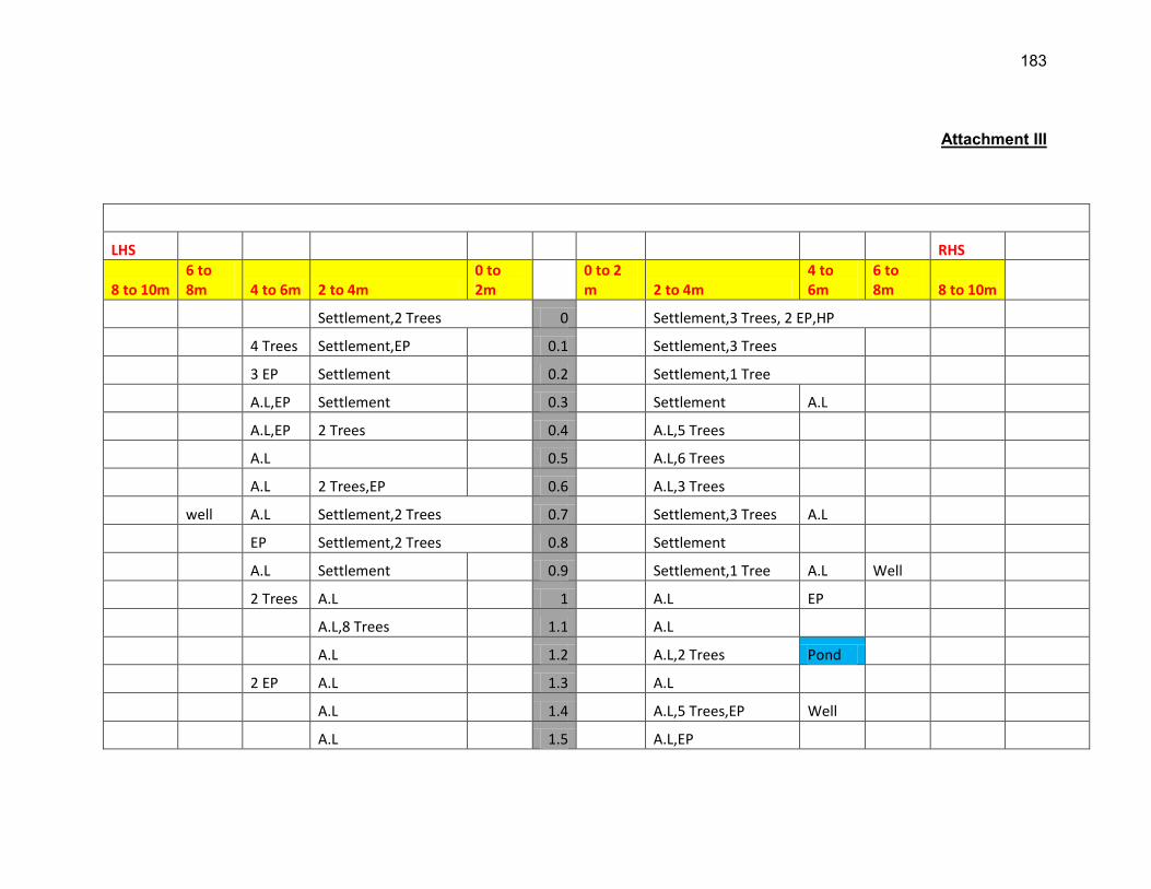
183
Attachment III
LHS RHS
8 to 10m 6 to 8m 4 to 6m 2 to 4m
0 to 2m
0 to 2 m 2 to 4m
4 to 6m
6 to 8m 8 to 10m
Settlement,2 Trees 0 Settlement,3 Trees, 2 EP,HP
4 Trees Settlement,EP 0.1 Settlement,3 Trees
3 EP Settlement 0.2 Settlement,1 Tree
A.L,EP Settlement 0.3 Settlement A.L
A.L,EP 2 Trees 0.4 A.L,5 Trees
A.L 0.5 A.L,6 Trees
A.L 2 Trees,EP 0.6 A.L,3 Trees
well A.L Settlement,2 Trees 0.7 Settlement,3 Trees A.L
EP Settlement,2 Trees 0.8 Settlement
A.L Settlement 0.9 Settlement,1 Tree A.L Well
2 Trees A.L 1 A.L EP
A.L,8 Trees 1.1 A.L
A.L 1.2 A.L,2 Trees Pond
2 EP A.L 1.3 A.L
A.L 1.4 A.L,5 Trees,EP Well
A.L 1.5 A.L,EP
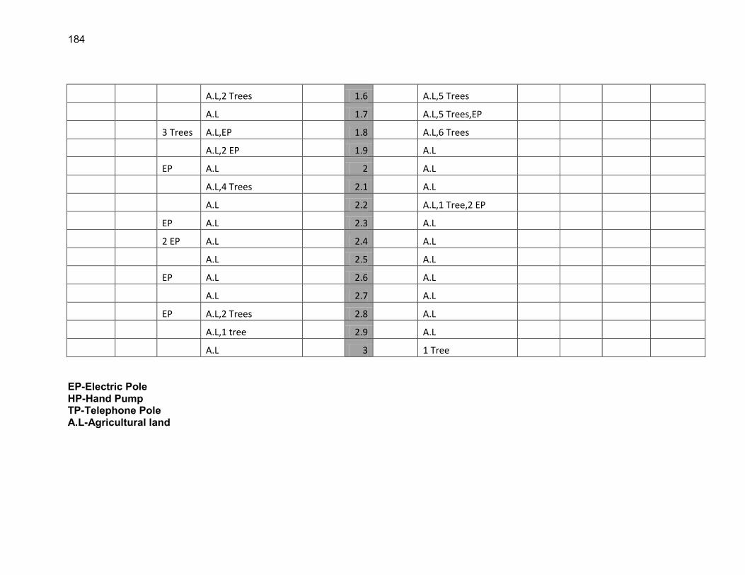
184
A.L,2 Trees 1.6 A.L,5 Trees
A.L 1.7 A.L,5 Trees,EP
3 Trees A.L,EP 1.8 A.L,6 Trees
A.L,2 EP 1.9 A.L
EP A.L 2 A.L
A.L,4 Trees 2.1 A.L
A.L 2.2 A.L,1 Tree,2 EP
EP A.L 2.3 A.L
2 EP A.L 2.4 A.L
A.L 2.5 A.L
EP A.L 2.6 A.L
A.L 2.7 A.L
EP A.L,2 Trees 2.8 A.L
A.L,1 tree 2.9 A.L
A.L 3 1 Tree EP-Electric Pole HP-Hand Pump TP-Telephone Pole A.L-Agricultural land
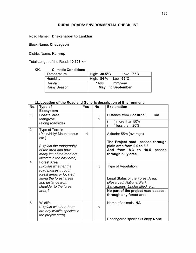
185
RURAL ROADS: ENVIRONMENTAL CHECKLIST
Road Name: Dhekenabori to Lankhar
Block Name: Chayagaon District Name: Kamrup Total Length of the Road: 10.503 km
KK. Climatic Conditions Temperature High: 38.5°C Low: 7 °C Humidity High: 84 % Low: 69 % Rainfall Rainy Season
1400 mm/year May to September
LL. Location of the Road and Generic description of Environment No. Type of
Ecosystem Yes No Explanation
1. Coastal area Mangrove (along roadside)
√
Distance from Coastline: km
( ) more than 50% ( ) less than 20%
2. Type of Terrain (Plain/Hilly/ Mountainous etc.) (Explain the topography of the area and how many km of the road are located in the hilly area)
√
Altitude: 55m (average) The Project road passes through plain area from 0.0 to 8.3 And from 8.3 to 10.5 passes through hilly area.
4. Forest Area (Explain whether the road passes through forest areas or located along the forest areas and distance from shoulder to the forest area)?
√
Type of Vegetation: Legal Status of the Forest Area: (Reserved, National Park, Sanctuaries, Unclassified, etc.) No part of the project road passes through any forest area.
5. Wildlife (Explain whether there are any wildlife species in the project area)
√
Name of animals: NA Endangered species (if any): None
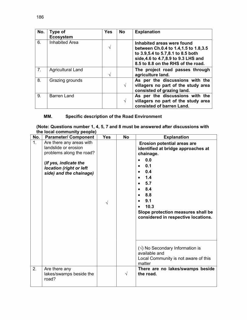
186
No. Type of Ecosystem
Yes No Explanation
6. Inhabited Area √
Inhabited areas were found between Ch.0.4 to 1.4,1.5 to 1.8,3.5 to 3.9,5.4 to 5.7,8.1 to 8.5 both side,4.6 to 4.7,8.9 to 9.3 LHS and 8.5 to 8.8 on the RHS of the road.
7. Agricultural Land √
The project road passes through agriculture land.
8. Grazing grounds √
As per the discussions with the villagers no part of the study area consisted of grazing land.
9. Barren Land √
As per the discussions with the villagers no part of the study area consisted of barren Land.
MM. Specific description of the Road Environment
(Note: Questions number 1, 4, 5, 7 and 8 must be answered after discussions with the local community people)
No. Parameter/ Component Yes No Explanation 1. Are there any areas with
landslide or erosion problems along the road? (If yes, indicate the location (right or left side) and the chainage)
√
Erosion potential areas are identified at bridge approaches at chainage. 0.0 0.1 0.4 1.4 5.7 8.4 8.8 9.1 10.3
Slope protection measures shall be considered in respective locations. (√) No Secondary Information is available and Local Community is not aware of this matter
2. Are there any lakes/swamps beside the road?
√
There are no lakes/swamps beside the road.
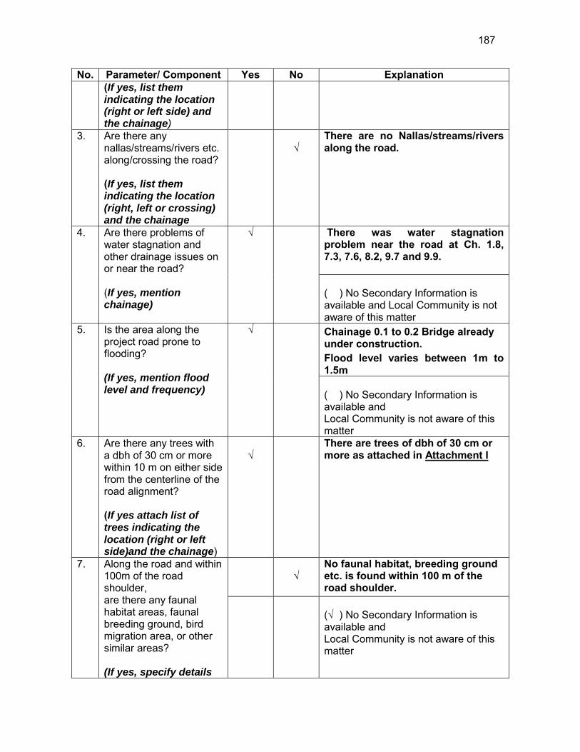
187
No. Parameter/ Component Yes No Explanation (If yes, list them indicating the location (right or left side) and the chainage)
3. Are there any nallas/streams/rivers etc. along/crossing the road? (If yes, list them indicating the location (right, left or crossing) and the chainage
√
There are no Nallas/streams/rivers along the road.
4. Are there problems of water stagnation and other drainage issues on or near the road? (If yes, mention chainage)
√
There was water stagnation problem near the road at Ch. 1.8, 7.3, 7.6, 8.2, 9.7 and 9.9. ( ) No Secondary Information is available and Local Community is not aware of this matter
5. Is the area along the project road prone to flooding? (If yes, mention flood level and frequency)
√
Chainage 0.1 to 0.2 Bridge already under construction. Flood level varies between 1m to 1.5m ( ) No Secondary Information is available and Local Community is not aware of this matter
6. Are there any trees with a dbh of 30 cm or more within 10 m on either side from the centerline of the road alignment? (If yes attach list of trees indicating the location (right or left side)and the chainage)
√
There are trees of dbh of 30 cm or more as attached in Attachment I
7. Along the road and within 100m of the road shoulder, are there any faunal habitat areas, faunal breeding ground, bird migration area, or other similar areas? (If yes, specify details
√
No faunal habitat, breeding ground etc. is found within 100 m of the road shoulder.
(√ ) No Secondary Information is available and Local Community is not aware of this matter
188
No. Parameter/ Component Yes No Explanation of habitat with chainage)
8. Along the road and within 100m of the road shoulder is there any evidence of floral and faunal species that are classified as endangered species?
√
No rare, endangered or threatened species were found within 100 m of the road shoulder (√ ) No Secondary Information Available and Local Community is not aware of this matter
9. Are there any utility structures50 within 10 m on either side from the centerline of the road alignment? (If yes, attach list with chainage)
√
Few utility structures were found as listed in Attachment II.
10. Are there any religious, cultural or community structures/buildings51 within 10 m on either side from the centerline of the road alignment? (If yes attach list with chainage)
√
Few community structures were found as listed in Attachment III
D. Public Consultation
No. Consultation Activities Yes No Remarks 1. Consultation with local
community was conducted before finalizing the alignment. (Attach list of people met and dates)
√
The proposed alignment has been finalized after taking suggestions from the local community. This was confirmed by the villagers during the transect walk.
2. Any suggestion received in finalizing the alignment
√
No written suggestion was received. However, during transect walk few requests were made by the villagers
3. If suggestions received, were they incorporated into the design?
√
All the relevant suggestions has been incorporated in the alignment.
50 Water tap, hand pump, electric pole, telephone pole, water pipe and other similar strucutures. 51 Mandir, Masjid, Church, religious/cultural/historical monuments, school, health center, publ ic toilet and other similar structures.
189
E. Please attach the following: 60) List of trees indicating location (left or right side of the road) and chainage (as
required under C. 6) 61) List of utility structures indicating location (left or right side of the road) and
chainage (as required under C. 9) 62) List of community structures indicating location (left or right side of the road) and
chainage (as required under C. 10) 63) Sketch of strip map of the road covering details of atleast 10 m on either side
from the center line of the road
64) Photographs of the project area showing atleast 10 m on either side from center line of road alignment. Every 2 km or less of road must have atleast 1 photograph.
190
Attachment I
List of Trees Chainage Left Right
0.0 2 2 0.1 2 - 0.3 - 1 0.4 1 4 0.6 - 3 0.7 2 - 0.9 5 6 1.0 2 2 1.2 2 3 1.4 2 5 1.7 - 2 1.9 2 6 2.0 2 - 2.3 3 - 2.5 1 3 2.6 1 - 2.8 2 - 2.9 1 - 3.2 2 - 3.4 2 - 3.6 3 - 3.9 3 - 4.2 3 - 4.4 2 2 4.9 1 - 5.3 1 - 5.5 - 2 6.2 2 - 6.3 - 3 6.4 - 2 6.6 3 3 6.8 - 2 6.9 - 5 7.3 2 - 7.5 - 1 7.7 3 - 8.3 2 -
191
8.4 2 - 8.5 - 5 8.6 - 5
Total 61 67
Attachment II
List of Utilities
Sl. No Chainage Electric Poles
LHS RHS
1 0.0 TO 1.0 13 4
2 1.0 TO 2.0 7 7
3 2.0 TO 3.0 13 5
4 3.0 TO 4.0 15 17
5 4.0 TO 5.0 14 1
6 5.0 TO 6.0 10 8
7 6.0 TO 7.0 7 2
8 7.0 TO 9.2 1 1
TOTAL 80 45
Attachment III List of Community Structures
Chainage No. Side Type 0.9 LHS Temple 1.6 LHS Temple 1.7 LHS Temple 5.4 RHS Church
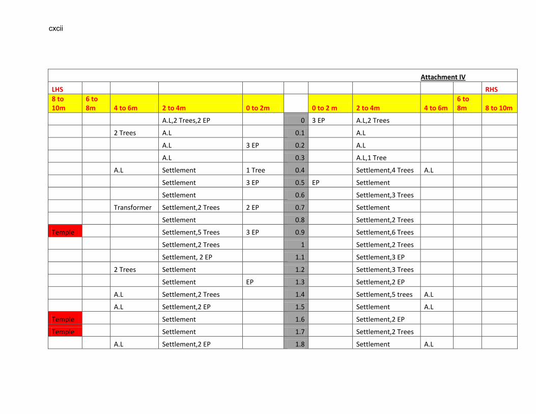
cxcii
Attachment IV
LHS RHS
8 to 10m
6 to 8m 4 to 6m 2 to 4m 0 to 2m 0 to 2 m 2 to 4m 4 to 6m
6 to 8m 8 to 10m
A.L,2 Trees,2 EP 0 3 EP A.L,2 Trees
2 Trees A.L 0.1 A.L
A.L 3 EP 0.2 A.L
A.L 0.3 A.L,1 Tree
A.L Settlement 1 Tree 0.4 Settlement,4 Trees A.L
Settlement 3 EP 0.5 EP Settlement
Settlement 0.6 Settlement,3 Trees
Transformer Settlement,2 Trees 2 EP 0.7 Settlement
Settlement 0.8 Settlement,2 Trees
Temple Settlement,5 Trees 3 EP 0.9 Settlement,6 Trees
Settlement,2 Trees 1 Settlement,2 Trees
Settlement, 2 EP 1.1 Settlement,3 EP
2 Trees Settlement 1.2 Settlement,3 Trees
Settlement EP 1.3 Settlement,2 EP
A.L Settlement,2 Trees 1.4 Settlement,5 trees A.L
A.L Settlement,2 EP 1.5 Settlement A.L
Temple Settlement 1.6 Settlement,2 EP
Temple Settlement 1.7 Settlement,2 Trees
A.L Settlement,2 EP 1.8 Settlement A.L
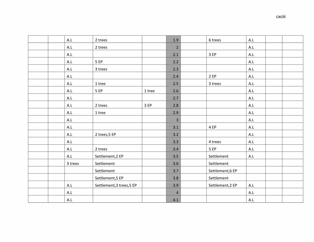
cxciii
A.L 2 trees 1.9 6 trees A.L
A.L 2 trees 2 A.L
A.L 2.1 3 EP A.L
A.L 5 EP 2.2 A.L
A.L 3 trees 2.3 A.L
A.L 2.4 2 EP A.L
A.L 1 tree 2.5 3 trees A.L
A.L 5 EP 1 tree 2.6 A.L
A.L 2.7 A.L
A.L 2 trees 3 EP 2.8 A.L
A.L 1 tree 2.9 A.L
A.L 3 A.L
A.L 3.1 4 EP A.L
A.L 2 trees,5 EP 3.2 A.L
A.L 3.3 4 trees A.L
A.L 2 trees 3.4 5 EP A.L
A.L Settlement,2 EP 3.5 Settlement A.L
3 trees Settlement 3.6 Settlement
Settlement 3.7 Settlement,6 EP
Settlement,5 EP 3.8 Settlement
A.L Settlement,3 trees,5 EP 3.9 Settlement,2 EP A.L
A.L 4 A.L
A.L 4.1 A.L
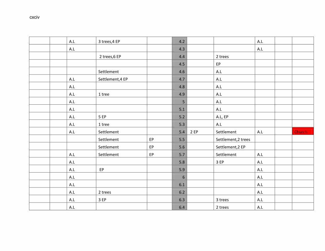
cxciv
A.L 3 trees,4 EP 4.2 A.L
A.L 4.3 A.L
2 trees,6 EP 4.4 2 trees
4.5 EP
Settlement 4.6 A.L
A.L Settlement,4 EP 4.7 A.L
A.L 4.8 A.L
A.L 1 tree 4.9 A.L
A.L 5 A.L
A.L 5.1 A.L
A.L 5 EP 5.2 A.L, EP
A.L 1 tree 5.3 A.L
A.L Settlement 5.4 2 EP Settlement A.L Church
Settlement EP 5.5 Settlement,2 trees
Settlement EP 5.6 Settlement,2 EP
A.L Settlement EP 5.7 Settlement A.L
A.L 5.8 3 EP A.L
A.L EP 5.9 A.L
A.L 6 A.L
A.L 6.1 A.L
A.L 2 trees 6.2 A.L
A.L 3 EP 6.3 3 trees A.L
A.L 6.4 2 trees A.L
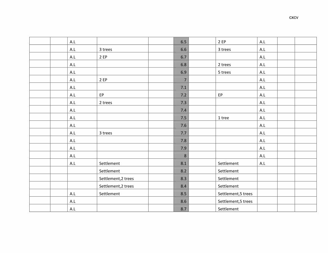
cxcv
A.L 6.5 2 EP A.L
A.L 3 trees 6.6 3 trees A.L
A.L 2 EP 6.7 A.L
A.L 6.8 2 trees A.L
A.L 6.9 5 trees A.L
A.L 2 EP 7 A.L
A.L 7.1 A.L
A.L EP 7.2 EP A.L
A.L 2 trees 7.3 A.L
A.L 7.4 A.L
A.L 7.5 1 tree A.L
A.L 7.6 A.L
A.L 3 trees 7.7 A.L
A.L 7.8 A.L
A.L 7.9 A.L
A.L 8 A.L
A.L Settlement 8.1 Settlement A.L
Settlement 8.2 Settlement
Settlement,2 trees 8.3 Settlement
Settlement,2 trees 8.4 Settlement
A.L Settlement 8.5 Settlement,5 trees
A.L 8.6 Settlement,5 trees
A.L 8.7 Settlement

cxcvi
A.L 8.8 Settlement
A.L Settlement 8.9 A.L
Settlement 9 A.L
Settlement 9.1 A.L
Settlement 9.2 A.L
A.L Settlement 9.3 A.L
A.L 9.4 A.L
A.L 9.5 A.L
A.L 9.6 A.L
A.L 9.7 A.L
A.L 9.8 A.L
A.L 9.9 A.L
A.L 10 A.L
A.L 10.1 A.L
A.L 10.2 A.L
A.L 10.3 A.L
A.L 10.4 A.L
A.L 10.5 A.L EP-Electric Pole HP-Hand Pump TP-Telephone Pole A.L-Agricultural land
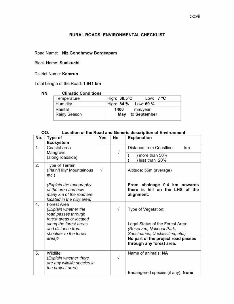
cxcvii
RURAL ROADS: ENVIRONMENTAL CHECKLIST
Road Name: Niz Gondhmow Borgeapam
Block Name: Sualkuchi District Name: Kamrup Total Length of the Road: 1.941 km
NN. Climatic Conditions Temperature High: 38.5°C Low: 7 °C Humidity High: 84 % Low: 69 % Rainfall Rainy Season
1400 mm/year May to September
OO. Location of the Road and Generic description of Environment No. Type of
Ecosystem Yes No Explanation
1. Coastal area Mangrove (along roadside)
√
Distance from Coastline: km
( ) more than 50% ( ) less than 20%
2. Type of Terrain (Plain/Hilly/ Mountainous etc.) (Explain the topography of the area and how many km of the road are located in the hilly area)
√
Altitude: 55m (average) From chainage 0.4 km onwards there is hill on the LHS of the alignment.
4. Forest Area (Explain whether the road passes through forest areas or located along the forest areas and distance from shoulder to the forest area)?
√
Type of Vegetation: Legal Status of the Forest Area: (Reserved, National Park, Sanctuaries, Unclassified, etc.) No part of the project road passes through any forest area.
5. Wildlife (Explain whether there are any wildlife species in the project area)
√
Name of animals: NA Endangered species (if any): None

cxcviii
No. Type of Ecosystem
Yes No Explanation
6. Inhabited Area √
Inhabited areas were found between Ch.0.0 to 0.2 both side,0.8,1.4 to 1.6,1.7 to 1.9 on the LHS side and 1.4 to1.5 on the RHS of the road.
7. Agricultural Land √
The project road passes through agriculture land.
8. Grazing grounds √
As per the discussions with the villagers no part of the study area consisted of grazing land.
9. Barren Land √
As per the discussions with the villagers no part of the study area consisted of barren Land.
PP. Specific description of the Road Environment
(Note: Questions number 1, 4, 5, 7 and 8 must be answered after discussions with the local community people)
No. Parameter/ Component Yes No Explanation 1. Are there any areas with
landslide or erosion problems along the road? (If yes, indicate the location (right or left side) and the chainage)
√
Chainage 0.0 to 0.1 RHS
(√) No Secondary Information is available and Local Community is not aware of this matter
2. Are there any lakes/swamps beside the road? (If yes, list them indicating the location (right or left side) and the chainage)
√
There are no lakes/swamps beside the road.
3. Are there any nallas/streams/rivers etc. along/crossing the road? (If yes, list them indicating the location (right, left or crossing) and the chainage
√
There are no Nallas/streams/rivers along the road.

cxcix
No. Parameter/ Component Yes No Explanation 4. Are there problems of
water stagnation and other drainage issues on or near the road? (If yes, mention chainage)
√
There was no water stagnation problem near the road at. ( ) No Secondary Information is available and Local Community is not aware of this matter
5. Is the area along the project road prone to flooding? (If yes, mention flood level and frequency)
√
No part of the Project road is prone to flooding. ( ) No Secondary Information is available and Local Community is not aware of this matter
6. Are there any trees with a dbh of 30 cm or more within 10 m on either side from the centerline of the road alignment? (If yes attach list of trees indicating the location (right or left side)and the chainage)
√
There are trees of dbh of 30 cm or more as attached in Attachment I
7. Along the road and within 100m of the road shoulder, are there any faunal habitat areas, faunal breeding ground, bird migration area, or other similar areas? (If yes, specify details of habitat with chainage)
√
No faunal habitat, breeding ground etc. is found within 100 m of the road shoulder.
(√ ) No Secondary Information is available and Local Community is not aware of this matter
8. Along the road and within 100m of the road shoulder is there any evidence of floral and faunal species that are classified as endangered species?
√
No rare, endangered or threatened species were found within 100 m of the road shoulder (√ ) No Secondary Information Available and Local Community is not aware of this matter
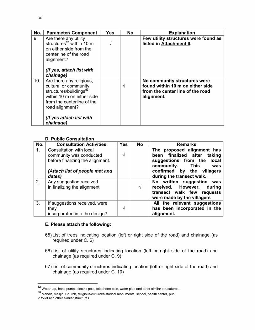
cc
No. Parameter/ Component Yes No Explanation 9. Are there any utility
structures52 within 10 m on either side from the centerline of the road alignment? (If yes, attach list with chainage)
√
Few utility structures were found as listed in Attachment II.
10. Are there any religious, cultural or community structures/buildings53 within 10 m on either side from the centerline of the road alignment? (If yes attach list with chainage)
√
No community structures were found within 10 m on either side from the center line of the road alignment.
D. Public Consultation
No. Consultation Activities Yes No Remarks 1. Consultation with local
community was conducted before finalizing the alignment. (Attach list of people met and dates)
√
The proposed alignment has been finalized after taking suggestions from the local community. This was confirmed by the villagers during the transect walk.
2. Any suggestion received in finalizing the alignment
√
No written suggestion was received. However, during transect walk few requests were made by the villagers
3. If suggestions received, were they incorporated into the design?
√
All the relevant suggestions has been incorporated in the alignment.
E. Please attach the following: 65) List of trees indicating location (left or right side of the road) and chainage (as
required under C. 6) 66) List of utility structures indicating location (left or right side of the road) and
chainage (as required under C. 9) 67) List of community structures indicating location (left or right side of the road) and
chainage (as required under C. 10)
52 Water tap, hand pump, electric pole, telephone pole, water pipe and other similar strucutures. 53 Mandir, Masjid, Church, religious/cultural/historical monuments, school, health center, publ ic toilet and other similar structures.

cci
68) Sketch of strip map of the road covering details of atleast 10 m on either side from the center line of the road
69) Photographs of the project area showing atleast 10 m on either side from
centerline of road alignment. Every 2 km or less of road must have atleast 1 photograph.
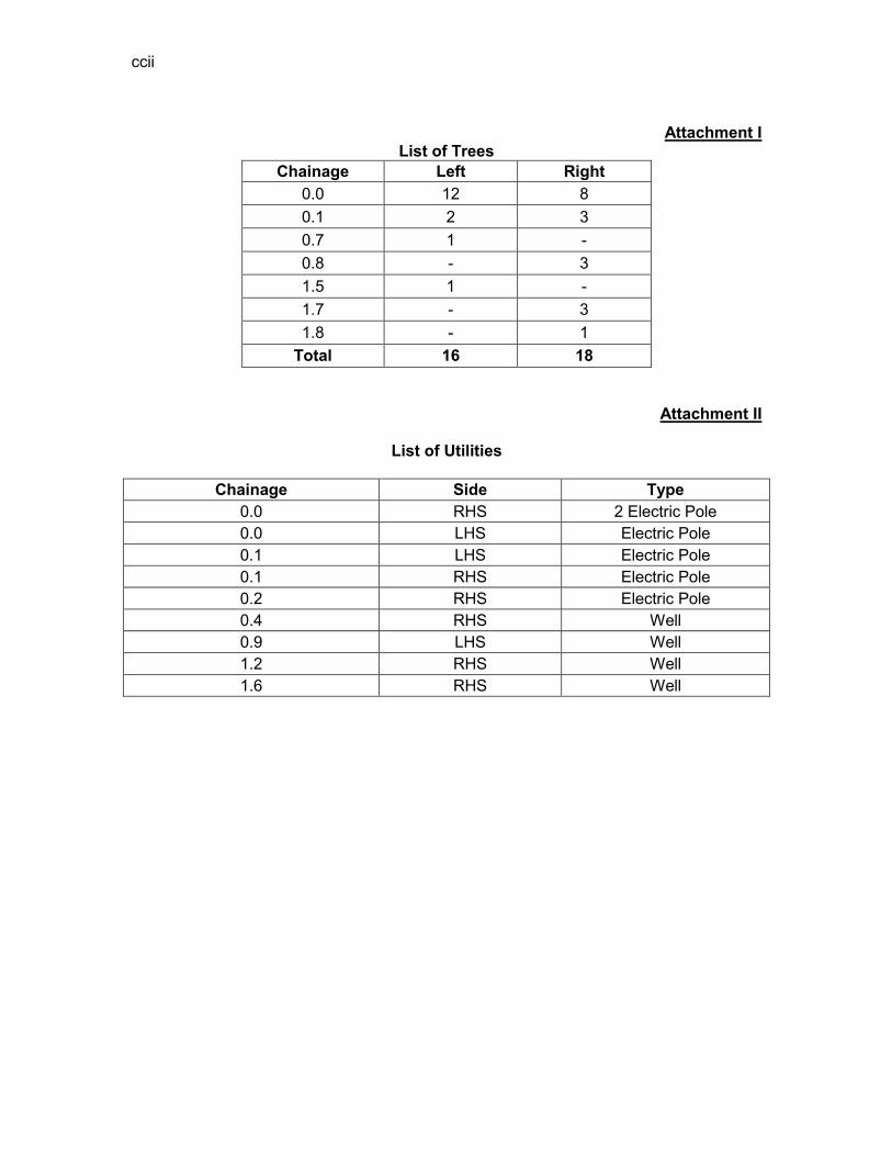
ccii
Attachment I
List of Trees Chainage Left Right
0.0 12 8 0.1 2 3 0.7 1 - 0.8 - 3 1.5 1 - 1.7 - 3 1.8 - 1
Total 16 18
Attachment II
List of Utilities
Chainage Side Type 0.0 RHS 2 Electric Pole 0.0 LHS Electric Pole 0.1 LHS Electric Pole 0.1 RHS Electric Pole 0.2 RHS Electric Pole 0.4 RHS Well 0.9 LHS Well 1.2 RHS Well 1.6 RHS Well
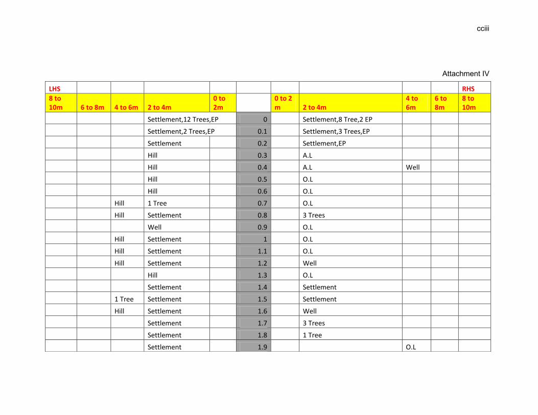
cciii
Attachment IV
LHS RHS
8 to 10m 6 to 8m 4 to 6m 2 to 4m
0 to 2m
0 to 2 m 2 to 4m
4 to 6m
6 to 8m
8 to 10m
Settlement,12 Trees,EP 0 Settlement,8 Tree,2 EP
Settlement,2 Trees,EP 0.1 Settlement,3 Trees,EP
Settlement 0.2 Settlement,EP
Hill 0.3 A.L
Hill 0.4 A.L Well
Hill 0.5 O.L
Hill 0.6 O.L
Hill 1 Tree 0.7 O.L
Hill Settlement 0.8 3 Trees
Well 0.9 O.L
Hill Settlement 1 O.L
Hill Settlement 1.1 O.L
Hill Settlement 1.2 Well
Hill 1.3 O.L
Settlement 1.4 Settlement
1 Tree Settlement 1.5 Settlement
Hill Settlement 1.6 Well
Settlement 1.7 3 Trees
Settlement 1.8 1 Tree
Settlement 1.9 O.L

cciv
EP-Electric Pole HP-Hand Pump TP-Telephone Pole A.L-Agricultural land
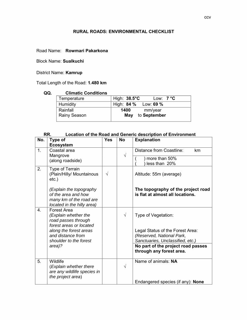
ccv
RURAL ROADS: ENVIRONMENTAL CHECKLIST
Road Name: Rowmari Pakarkona
Block Name: Sualkuchi District Name: Kamrup Total Length of the Road: 1.480 km
QQ. Climatic Conditions Temperature High: 38.5°C Low: 7 °C Humidity High: 84 % Low: 69 % Rainfall Rainy Season
1400 mm/year May to September
RR. Location of the Road and Generic description of Environment No. Type of
Ecosystem Yes No Explanation
1. Coastal area Mangrove (along roadside)
√
Distance from Coastline: km
( ) more than 50% ( ) less than 20%
2. Type of Terrain (Plain/Hilly/ Mountainous etc.) (Explain the topography of the area and how many km of the road are located in the hilly area)
√
Altitude: 55m (average) The topography of the project road is flat at almost all locations.
4. Forest Area (Explain whether the road passes through forest areas or located along the forest areas and distance from shoulder to the forest area)?
√
Type of Vegetation: Legal Status of the Forest Area: (Reserved, National Park, Sanctuaries, Unclassified, etc.) No part of the project road passes through any forest area.
5. Wildlife (Explain whether there are any wildlife species in the project area)
√
Name of animals: NA Endangered species (if any): None
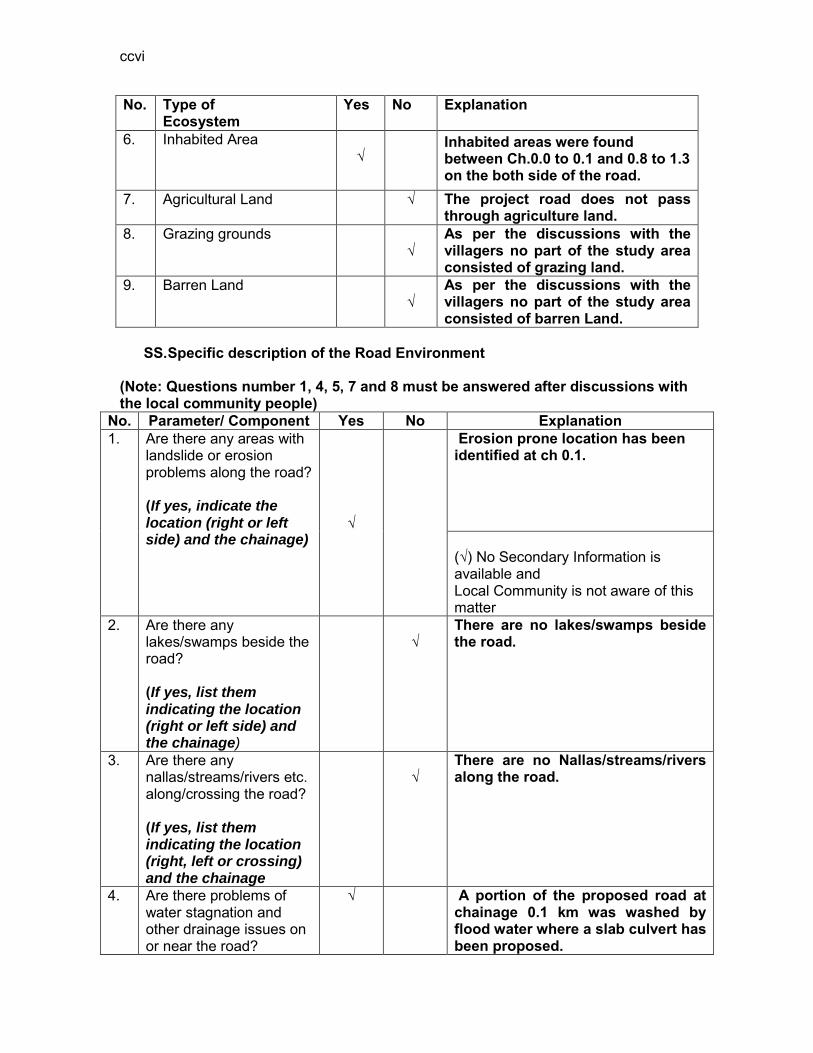
ccvi
No. Type of Ecosystem
Yes No Explanation
6. Inhabited Area √
Inhabited areas were found between Ch.0.0 to 0.1 and 0.8 to 1.3 on the both side of the road.
7. Agricultural Land
√ The project road does not pass through agriculture land.
8. Grazing grounds √
As per the discussions with the villagers no part of the study area consisted of grazing land.
9. Barren Land √
As per the discussions with the villagers no part of the study area consisted of barren Land.
SS. Specific description of the Road Environment
(Note: Questions number 1, 4, 5, 7 and 8 must be answered after discussions with the local community people)
No. Parameter/ Component Yes No Explanation 1. Are there any areas with
landslide or erosion problems along the road? (If yes, indicate the location (right or left side) and the chainage)
√
Erosion prone location has been identified at ch 0.1. (√) No Secondary Information is available and Local Community is not aware of this matter
2. Are there any lakes/swamps beside the road? (If yes, list them indicating the location (right or left side) and the chainage)
√
There are no lakes/swamps beside the road.
3. Are there any nallas/streams/rivers etc. along/crossing the road? (If yes, list them indicating the location (right, left or crossing) and the chainage
√
There are no Nallas/streams/rivers along the road.
4. Are there problems of water stagnation and other drainage issues on or near the road?
√
A portion of the proposed road at chainage 0.1 km was washed by flood water where a slab culvert has been proposed.
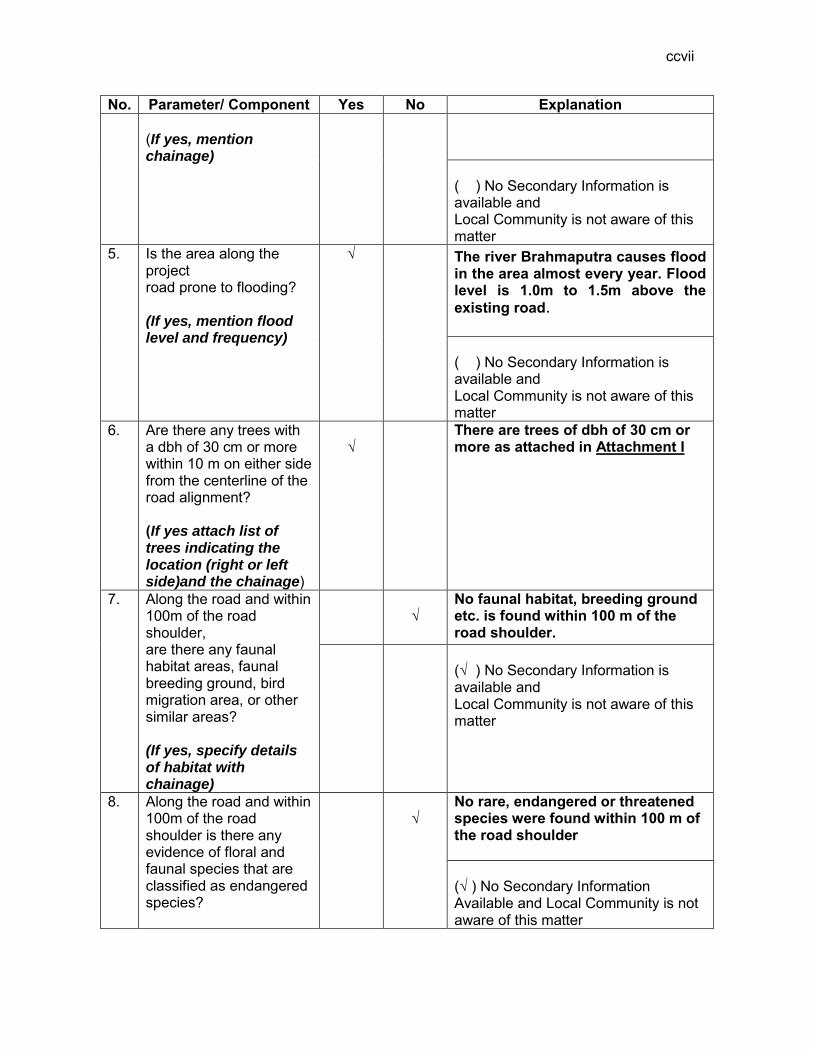
ccvii
No. Parameter/ Component Yes No Explanation (If yes, mention chainage)
( ) No Secondary Information is available and Local Community is not aware of this matter
5. Is the area along the project road prone to flooding? (If yes, mention flood level and frequency)
√
The river Brahmaputra causes flood in the area almost every year. Flood level is 1.0m to 1.5m above the existing road.
( ) No Secondary Information is available and Local Community is not aware of this matter
6. Are there any trees with a dbh of 30 cm or more within 10 m on either side from the centerline of the road alignment? (If yes attach list of trees indicating the location (right or left side)and the chainage)
√
There are trees of dbh of 30 cm or more as attached in Attachment I
7. Along the road and within 100m of the road shoulder, are there any faunal habitat areas, faunal breeding ground, bird migration area, or other similar areas? (If yes, specify details of habitat with chainage)
√
No faunal habitat, breeding ground etc. is found within 100 m of the road shoulder.
(√ ) No Secondary Information is available and Local Community is not aware of this matter
8. Along the road and within 100m of the road shoulder is there any evidence of floral and faunal species that are classified as endangered species?
√
No rare, endangered or threatened species were found within 100 m of the road shoulder (√ ) No Secondary Information Available and Local Community is not aware of this matter

ccviii
No. Parameter/ Component Yes No Explanation 9. Are there any utility
structures54 within 10 m on either side from the centerline of the road alignment? (If yes, attach list with chainage)
√
Few utility structures were found as listed in Attachment II.
10. Are there any religious, cultural or community structures/buildings55 within 10 m on either side from the centerline of the road alignment? (If yes attach list with chainage)
√
No community structures were found within 10 m on either side from the centerline of the road alignment.
D. Public Consultation
No. Consultation Activities Yes No Remarks 1. Consultation with local
community was conducted before finalizing the alignment. (Attach list of people met and dates)
√
The proposed alignment has been finalized after taking suggestions from the local community. This was confirmed by the villagers during the transect walk.
2. Any suggestion received in finalizing the alignment
√
No written suggestion was received. However, during transect walk few requests were made by the villagers
3. If suggestions received, were they incorporated into the design?
√
All the relevant suggestions has been incorporated in the alignment.
E. Please attach the following: 70) List of trees indicating location (left or right side of the road) and chainage (as
required under C. 6) 71) List of utility structures indicating location (left or right side of the road) and
chainage (as required under C. 9) 72) List of community structures indicating location (left or right side of the road) and
chainage (as required under C. 10)
54 Water tap, hand pump, electric pole, telephone pole, water pipe and other similar strucutures. 55 Mandir, Masjid, Church, religious/cultural/historical monuments, school, health center, publ ic toilet and other similar structures.

ccix
73) Sketch of strip map of the road covering details of atleast 10 m on either side from the center line of the road
74) Photographs of the project area showing atleast 10 m on either side from
centerline of road alignment. Every 2 km or less of road must have atleast 1 photograph.
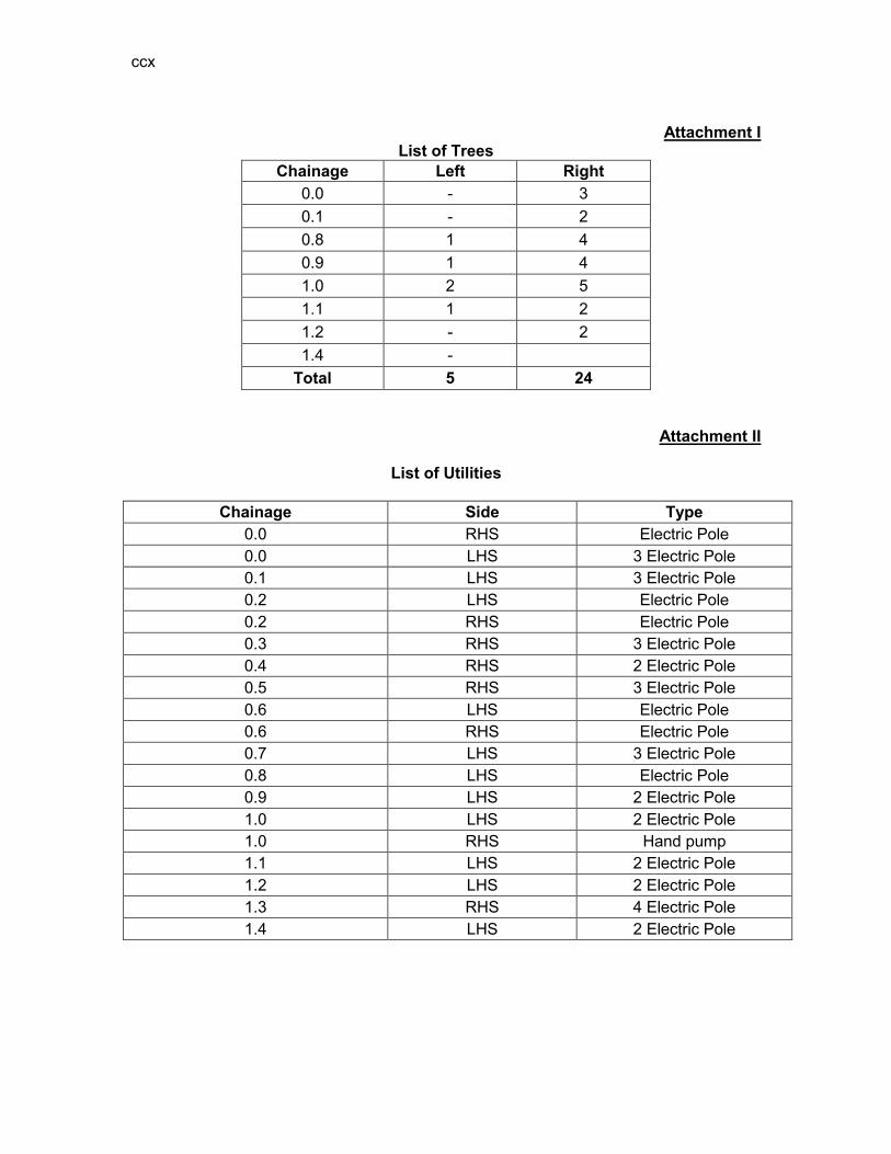
ccx
Attachment I
List of Trees Chainage Left Right
0.0 - 3 0.1 - 2 0.8 1 4 0.9 1 4 1.0 2 5 1.1 1 2 1.2 - 2 1.4 -
Total 5 24
Attachment II
List of Utilities
Chainage Side Type 0.0 RHS Electric Pole 0.0 LHS 3 Electric Pole 0.1 LHS 3 Electric Pole 0.2 LHS Electric Pole 0.2 RHS Electric Pole 0.3 RHS 3 Electric Pole 0.4 RHS 2 Electric Pole 0.5 RHS 3 Electric Pole 0.6 LHS Electric Pole 0.6 RHS Electric Pole 0.7 LHS 3 Electric Pole 0.8 LHS Electric Pole 0.9 LHS 2 Electric Pole 1.0 LHS 2 Electric Pole 1.0 RHS Hand pump 1.1 LHS 2 Electric Pole 1.2 LHS 2 Electric Pole 1.3 RHS 4 Electric Pole 1.4 LHS 2 Electric Pole
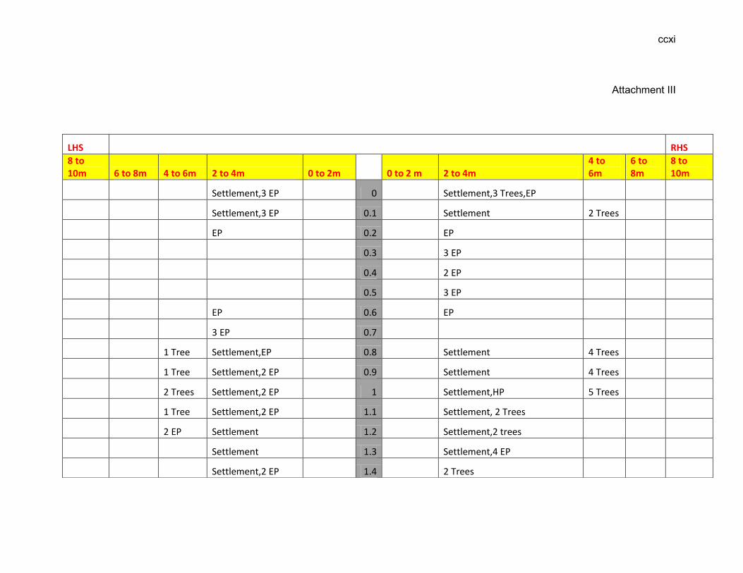
ccxi
Attachment III
LHS RHS
8 to 10m 6 to 8m 4 to 6m 2 to 4m 0 to 2m 0 to 2 m 2 to 4m
4 to 6m
6 to 8m
8 to 10m
Settlement,3 EP 0 Settlement,3 Trees,EP
Settlement,3 EP 0.1 Settlement 2 Trees
EP 0.2 EP
0.3 3 EP
0.4 2 EP
0.5 3 EP
EP 0.6 EP
3 EP 0.7
1 Tree Settlement,EP 0.8 Settlement 4 Trees
1 Tree Settlement,2 EP 0.9 Settlement 4 Trees
2 Trees Settlement,2 EP 1 Settlement,HP 5 Trees
1 Tree Settlement,2 EP 1.1 Settlement, 2 Trees
2 EP Settlement 1.2 Settlement,2 trees
Settlement 1.3 Settlement,4 EP
Settlement,2 EP 1.4 2 Trees

ccxii
EP-Electric Pole HP-Hand Pump TP-Telephone Pole A.L-Agricultural land

213
D: ECOPS IN DISTRICT MORIGAON
RURAL ROADS: ENVIRONMENTAL CHECKLIST
Road Name: Dolibari-Doloichuba
Block Name: Nuwagaon District Name: Morigaon Total Length of the Road: Part I is 1+100 km and Part II is 1+987 km
TT. Climatic Conditions Temperature High: 38°C Low: 9 °C Humidity High: 95 % Low: 40 % Rainfall Rainy Season
3000 mm/year May to September
UU. Location of the Road and Generic description of Environment No. Type of
Ecosystem Yes No Explanation
1. Coastal area Mangrove (along roadside)
√
Distance from Coastline: km
( ) more than 50% ( ) less than 20%
2. Type of Terrain (Plain/Hilly/ Mountainous etc.) (Explain the topography of the area and how many km of the road are located in the hilly area)
√
Altitude: 60.6m (average) The topography of the project road is flat at almost all locations.
4. Forest Area (Explain whether the road passes through forest areas or located along the forest areas and distance from shoulder to the forest area)?
√
Type of Vegetation: Legal Status of the Forest Area: (Reserved, National Park, Sanctuaries, Unclassified, etc.) No part of the project road passes through any forest area.
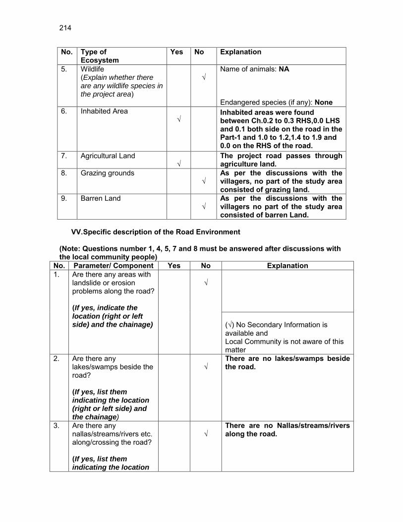
214
No. Type of Ecosystem
Yes No Explanation
5. Wildlife (Explain whether there are any wildlife species in the project area)
√
Name of animals: NA Endangered species (if any): None
6. Inhabited Area √
Inhabited areas were found between Ch.0.2 to 0.3 RHS,0.0 LHS and 0.1 both side on the road in the Part-1 and 1.0 to 1.2,1.4 to 1.9 and 0.0 on the RHS of the road.
7. Agricultural Land √
The project road passes through agriculture land.
8. Grazing grounds √
As per the discussions with the villagers, no part of the study area consisted of grazing land.
9. Barren Land √
As per the discussions with the villagers no part of the study area consisted of barren Land.
VV. Specific description of the Road Environment
(Note: Questions number 1, 4, 5, 7 and 8 must be answered after discussions with the local community people)
No. Parameter/ Component Yes No Explanation 1. Are there any areas with
landslide or erosion problems along the road? (If yes, indicate the location (right or left side) and the chainage)
√
(√) No Secondary Information is available and Local Community is not aware of this matter
2. Are there any lakes/swamps beside the road? (If yes, list them indicating the location (right or left side) and the chainage)
√
There are no lakes/swamps beside the road.
3. Are there any nallas/streams/rivers etc. along/crossing the road? (If yes, list them indicating the location
√
There are no Nallas/streams/rivers along the road.

215
No. Parameter/ Component Yes No Explanation (right, left or crossing) and the chainage
4. Are there problems of water stagnation and other drainage issues on or near the road? (If yes, mention chainage)
√
There was water stagnation problem near the road at Ch. 0.0,0.7,0.3. ( ) No Secondary Information is available and Local Community is not aware of this matter
5. Is the area along the project road prone to flooding? (If yes, mention flood level and frequency)
√
No part of the project road is prone to flooding. ( ) No Secondary Information is available and Local Community is not aware of this matter
6. Are there any trees with a dbh of 30 cm or more within 10 m on either side from the center line of the road alignment? (If yes attach list of trees indicating the location (right or left side)and the chainage)
√
There are trees of dbh of 30 cm or more as attached in Attachment I
7. Along the road and within 100m of the road shoulder, are there any faunal habitat areas, faunal breeding ground, bird migration area, or other similar areas? (If yes, specify details of habitat with chainage)
√
No faunal habitat, breeding ground etc. is found within 100 m of the road shoulder.
(√ ) No Secondary Information is available and Local Community is not aware of this matter
8. Along the road and within 100m of the road shoulder is there any evidence of floral and faunal species that are classified as endangered species?
√
No rare, endangered or threatened species were found within 100 m of the road shoulder (√ ) No Secondary Information Available and Local Community is not aware of this matter
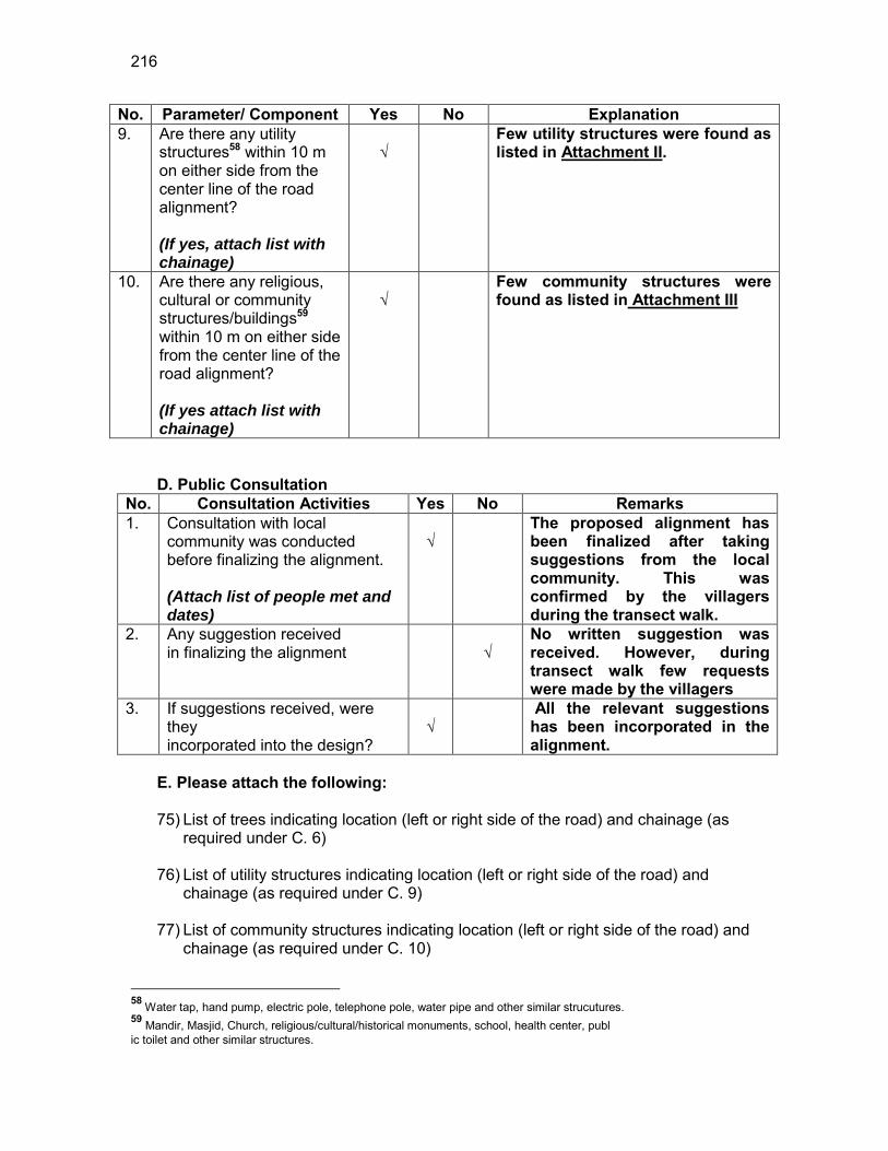
216
No. Parameter/ Component Yes No Explanation 9. Are there any utility
structures58 within 10 m on either side from the center line of the road alignment? (If yes, attach list with chainage)
√
Few utility structures were found as listed in Attachment II.
10. Are there any religious, cultural or community structures/buildings59 within 10 m on either side from the center line of the road alignment? (If yes attach list with chainage)
√
Few community structures were found as listed in Attachment III
D. Public Consultation
No. Consultation Activities Yes No Remarks 1. Consultation with local
community was conducted before finalizing the alignment. (Attach list of people met and dates)
√
The proposed alignment has been finalized after taking suggestions from the local community. This was confirmed by the villagers during the transect walk.
2. Any suggestion received in finalizing the alignment
√
No written suggestion was received. However, during transect walk few requests were made by the villagers
3. If suggestions received, were they incorporated into the design?
√
All the relevant suggestions has been incorporated in the alignment.
E. Please attach the following: 75) List of trees indicating location (left or right side of the road) and chainage (as
required under C. 6) 76) List of utility structures indicating location (left or right side of the road) and
chainage (as required under C. 9) 77) List of community structures indicating location (left or right side of the road) and
chainage (as required under C. 10)
58 Water tap, hand pump, electric pole, telephone pole, water pipe and other similar strucutures. 59 Mandir, Masjid, Church, religious/cultural/historical monuments, school, health center, publ ic toilet and other similar structures.

217
78) Sketch of strip map of the road covering details of atleast 10 m on either side from the center line of the road
79) Photographs of the project area showing atleast 10 m on either side from center
line of road alignment. Every 2 km or less of road must have atleast 1 photograph.
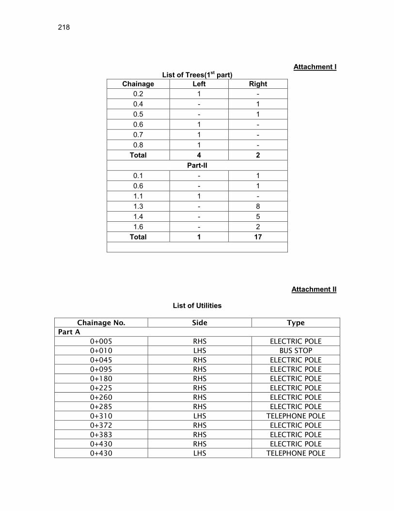
218
Attachment I List of Trees(1st part)
Chainage Left Right 0.2 1 - 0.4 - 1 0.5 - 1 0.6 1 - 0.7 1 - 0.8 1 -
Total 4 2 Part-II
0.1 - 1 0.6 - 1 1.1 1 - 1.3 - 8 1.4 - 5 1.6 - 2
Total 1 17
Attachment II
List of Utilities
Chainage No. Side Type
Part A
0+005 RHS ELECTRIC POLE
0+010 LHS BUS STOP
0+045 RHS ELECTRIC POLE
0+095 RHS ELECTRIC POLE
0+180 RHS ELECTRIC POLE
0+225 RHS ELECTRIC POLE
0+260 RHS ELECTRIC POLE
0+285 RHS ELECTRIC POLE
0+310 LHS TELEPHONE POLE
0+372 RHS ELECTRIC POLE
0+383 RHS ELECTRIC POLE
0+430 RHS ELECTRIC POLE
0+430 LHS TELEPHONE POLE
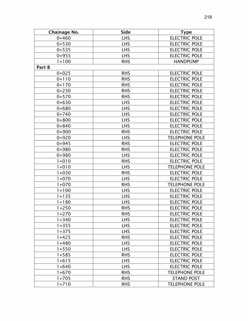
219
Chainage No. Side Type
0+460 LHS ELECTRIC POLE
0+530 LHS ELECTRIC POLE
0+535 LHS ELECTRIC POLE
0+955 LHS ELECTRIC POLE
1+100 RHS HANDPUMP
Part B
0+025 RHS ELECTRIC POLE
0+110 RHS ELECTRIC POLE
0+170 RHS ELECTRIC POLE
0+230 RHS ELECTRIC POLE
0+570 RHS ELECTRIC POLE
0+630 LHS ELECTRIC POLE
0+680 LHS ELECTRIC POLE
0+740 LHS ELECTRIC POLE
0+800 LHS ELECTRIC POLE
0+840 LHS ELECTRIC POLE
0+900 RHS ELECTRIC POLE
0+920 LHS TELEPHONE POLE
0+945 RHS ELECTRIC POLE
0+980 RHS ELECTRIC POLE
0+980 LHS ELECTRIC POLE
1+010 RHS ELECTRIC POLE
1+010 LHS TELEPHONE POLE
1+030 RHS ELECTRIC POLE
1+070 LHS ELECTRIC POLE
1+070 RHS TELEPHONE POLE
1+100 LHS ELECTRIC POLE
1+135 LHS ELECTRIC POLE
1+180 LHS ELECTRIC POLE
1+250 RHS ELECTRIC POLE
1+270 RHS ELECTRIC POLE
1+340 LHS ELECTRIC POLE
1+355 LHS ELECTRIC POLE
1+375 LHS ELECTRIC POLE
1+425 RHS ELECTRIC POLE
1+480 LHS ELECTRIC POLE
1+550 LHS ELECTRIC POLE
1+585 RHS ELECTRIC POLE
1+615 LHS ELECTRIC POLE
1+640 LHS ELECTRIC POLE
1+670 RHS TELEPHONE POLE
1+705 RHS STAND POST
1+710 RHS TELEPHONE POLE
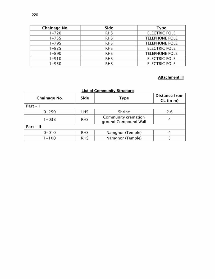
220
Chainage No. Side Type
1+720 RHS ELECTRIC POLE
1+755 RHS TELEPHONE POLE
1+795 RHS TELEPHONE POLE
1+825 RHS ELECTRIC POLE
1+890 RHS TELEPHONE POLE
1+910 RHS ELECTRIC POLE
1+950 RHS ELECTRIC POLE
Attachment III
List of Community Structure
Chainage No. Side Type Distance from
CL (in m)
Part – I
0+290 LHS Shrine 2.6
1+038 RHS Community cremation
ground Compound Wall 4
Part – II
0+010 RHS Namghor (Temple) 4
1+100 RHS Namghor (Temple) 5
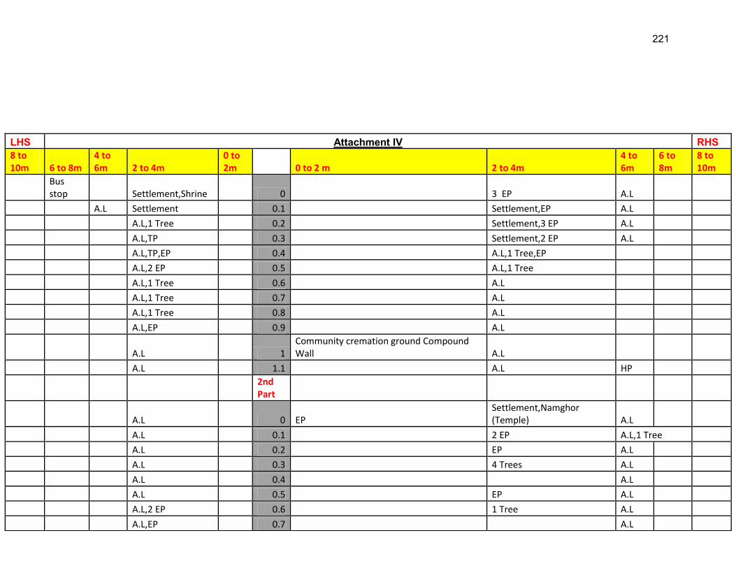
221
LHS Attachment IV RHS 8 to 10m 6 to 8m
4 to 6m 2 to 4m
0 to 2m 0 to 2 m 2 to 4m
4 to 6m
6 to 8m
8 to 10m
Bus stop Settlement,Shrine 0 3 EP A.L
A.L Settlement 0.1 Settlement,EP A.L
A.L,1 Tree 0.2 Settlement,3 EP A.L
A.L,TP 0.3 Settlement,2 EP A.L
A.L,TP,EP 0.4 A.L,1 Tree,EP
A.L,2 EP 0.5 A.L,1 Tree
A.L,1 Tree 0.6 A.L
A.L,1 Tree 0.7 A.L
A.L,1 Tree 0.8 A.L
A.L,EP 0.9 A.L
A.L 1 Community cremation ground Compound Wall A.L
A.L 1.1 A.L HP
2nd Part
A.L 0 EP Settlement,Namghor (Temple) A.L
A.L 0.1 2 EP A.L,1 Tree
A.L 0.2 EP A.L
A.L 0.3 4 Trees A.L
A.L 0.4 A.L
A.L 0.5 EP A.L
A.L,2 EP 0.6 1 Tree A.L
A.L,EP 0.7 A.L
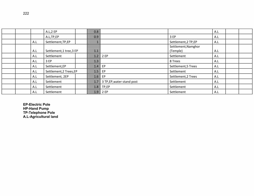
222
EP-Electric Pole HP-Hand Pump TP-Telephone Pole A.L-Agricultural land
A.L,2 EP 0.8 A.L
A.L,TP,EP 0.9 3 EP A.L
A.L Settlement,TP,EP 1 Settlement,2 TP,EP A.L
A.L Settlement,1 tree,3 EP 1.1 Settlement,Namghor (Temple) A.L
A.L Settlement 1.2 2 EP Settlement A.L
A.L 3 EP 1.3 8 Trees A.L
A.L Settlement,EP 1.4 EP Settlement,5 Trees A.L
A.L Settlement,2 Trees,EP 1.5 EP Settlement A.L
A.L Settlement, 2EP 1.6 EP Settlement,2 Trees A.L
A.L Settlement 1.7 3 TP,EP,water stand post Settlement A.L
A.L Settlement 1.8 TP,EP Settlement A.L
A.L Settlement 1.9 2 EP Settlement A.L
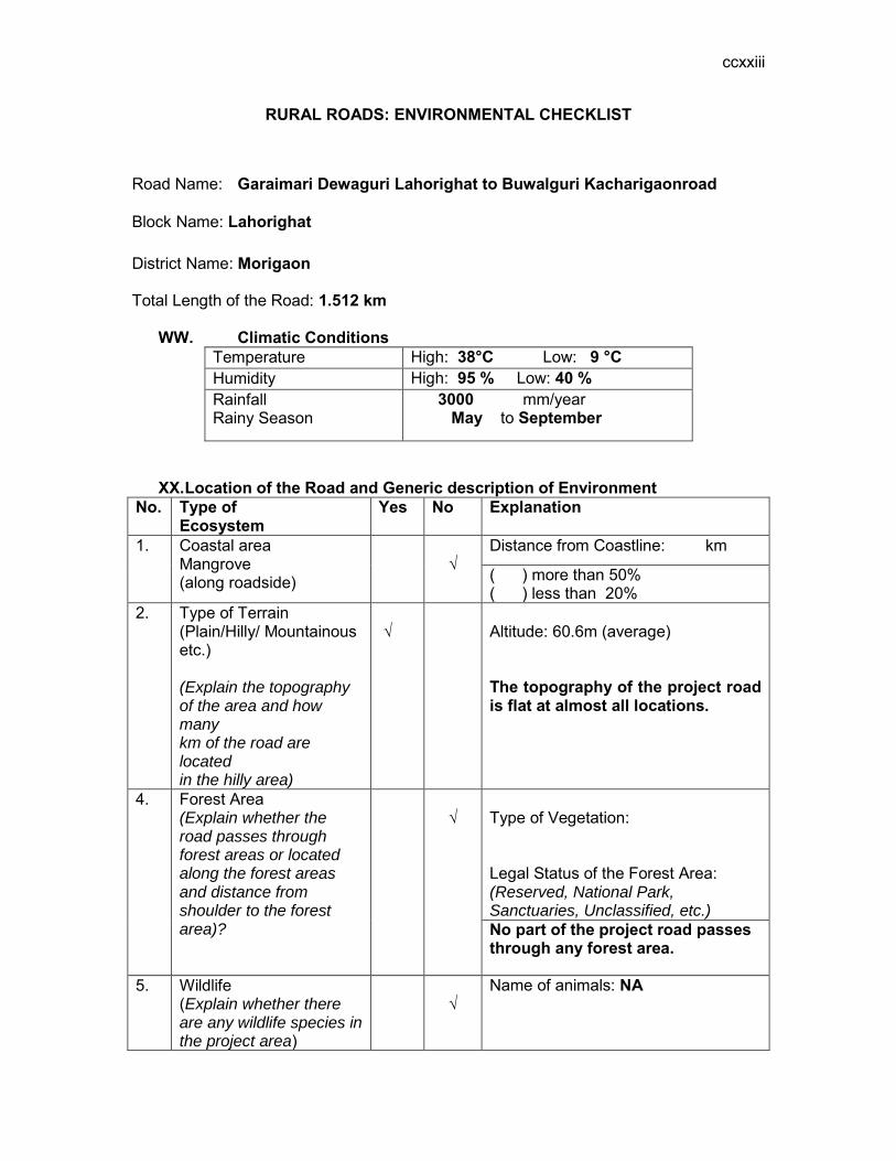
ccxxiii
RURAL ROADS: ENVIRONMENTAL CHECKLIST
Road Name: Garaimari Dewaguri Lahorighat to Buwalguri Kacharigaonroad
Block Name: Lahorighat District Name: Morigaon Total Length of the Road: 1.512 km
WW. Climatic Conditions Temperature High: 38°C Low: 9 °C Humidity High: 95 % Low: 40 % Rainfall Rainy Season
3000 mm/year May to September
XX. Location of the Road and Generic description of Environment No. Type of
Ecosystem Yes No Explanation
1. Coastal area Mangrove (along roadside)
√
Distance from Coastline: km
( ) more than 50% ( ) less than 20%
2. Type of Terrain (Plain/Hilly/ Mountainous etc.) (Explain the topography of the area and how many km of the road are located in the hilly area)
√
Altitude: 60.6m (average) The topography of the project road is flat at almost all locations.
4. Forest Area (Explain whether the road passes through forest areas or located along the forest areas and distance from shoulder to the forest area)?
√
Type of Vegetation: Legal Status of the Forest Area: (Reserved, National Park, Sanctuaries, Unclassified, etc.) No part of the project road passes through any forest area.
5. Wildlife (Explain whether there are any wildlife species in the project area)
√
Name of animals: NA
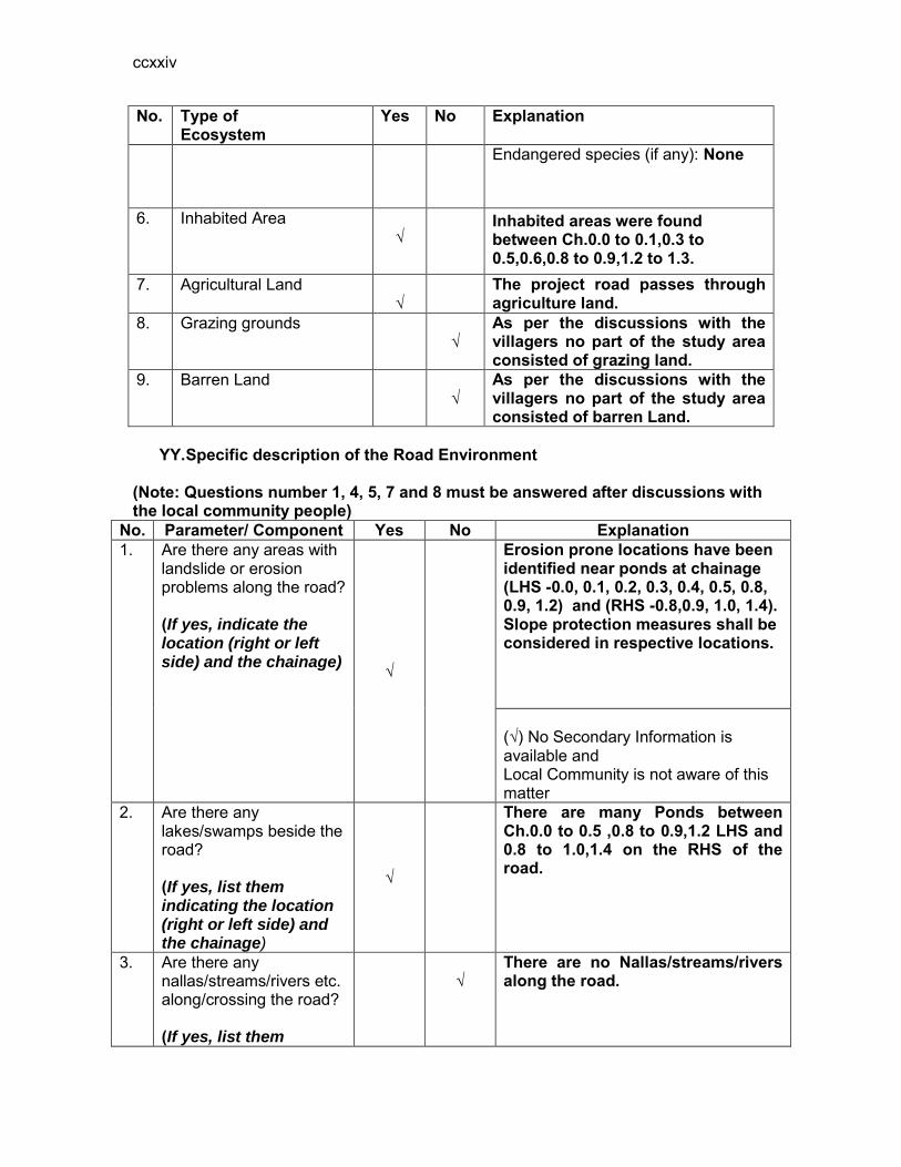
ccxxiv
No. Type of Ecosystem
Yes No Explanation
Endangered species (if any): None
6. Inhabited Area √
Inhabited areas were found between Ch.0.0 to 0.1,0.3 to 0.5,0.6,0.8 to 0.9,1.2 to 1.3.
7. Agricultural Land √
The project road passes through agriculture land.
8. Grazing grounds √
As per the discussions with the villagers no part of the study area consisted of grazing land.
9. Barren Land √
As per the discussions with the villagers no part of the study area consisted of barren Land.
YY. Specific description of the Road Environment
(Note: Questions number 1, 4, 5, 7 and 8 must be answered after discussions with the local community people)
No. Parameter/ Component Yes No Explanation 1. Are there any areas with
landslide or erosion problems along the road? (If yes, indicate the location (right or left side) and the chainage) √
Erosion prone locations have been identified near ponds at chainage (LHS -0.0, 0.1, 0.2, 0.3, 0.4, 0.5, 0.8, 0.9, 1.2) and (RHS -0.8,0.9, 1.0, 1.4). Slope protection measures shall be considered in respective locations. (√) No Secondary Information is available and Local Community is not aware of this matter
2. Are there any lakes/swamps beside the road? (If yes, list them indicating the location (right or left side) and the chainage)
√
There are many Ponds between Ch.0.0 to 0.5 ,0.8 to 0.9,1.2 LHS and 0.8 to 1.0,1.4 on the RHS of the road.
3. Are there any nallas/streams/rivers etc. along/crossing the road? (If yes, list them
√
There are no Nallas/streams/rivers along the road.
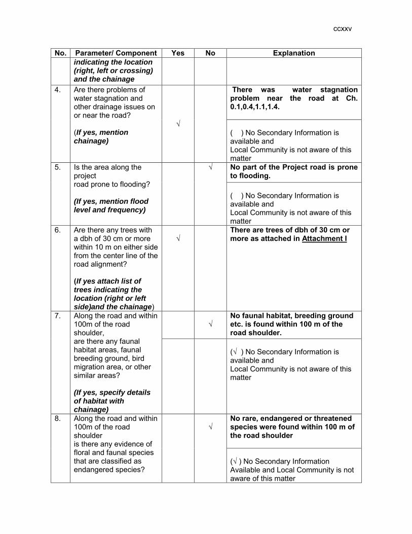
ccxxv
No. Parameter/ Component Yes No Explanation indicating the location (right, left or crossing) and the chainage
4. Are there problems of water stagnation and other drainage issues on or near the road? (If yes, mention chainage)
√
There was water stagnation problem near the road at Ch. 0.1,0.4,1.1,1.4. ( ) No Secondary Information is available and Local Community is not aware of this matter
5. Is the area along the project road prone to flooding? (If yes, mention flood level and frequency)
√
No part of the Project road is prone to flooding. ( ) No Secondary Information is available and Local Community is not aware of this matter
6. Are there any trees with a dbh of 30 cm or more within 10 m on either side from the center line of the road alignment? (If yes attach list of trees indicating the location (right or left side)and the chainage)
√
There are trees of dbh of 30 cm or more as attached in Attachment I
7. Along the road and within 100m of the road shoulder, are there any faunal habitat areas, faunal breeding ground, bird migration area, or other similar areas? (If yes, specify details of habitat with chainage)
√
No faunal habitat, breeding ground etc. is found within 100 m of the road shoulder.
(√ ) No Secondary Information is available and Local Community is not aware of this matter
8. Along the road and within 100m of the road shoulder is there any evidence of floral and faunal species that are classified as endangered species?
√
No rare, endangered or threatened species were found within 100 m of the road shoulder (√ ) No Secondary Information Available and Local Community is not aware of this matter

ccxxvi
No. Parameter/ Component Yes No Explanation 9. Are there any utility
structures60 within 10 m on either side from the center line of the road alignment? (If yes, attach list with chainage)
√
Few utility structures were found as listed in Attachment II.
10. Are there any religious, cultural or community structures/buildings61 within 10 m on either side from the center line of the road alignment? (If yes attach list with chainage)
√
Few community structures were found as listed in Attachment III
D. Public Consultation
No. Consultation Activities Yes No Remarks 1. Consultation with local
community was conducted before finalizing the alignment. (Attach list of people met and dates)
√
The proposed alignment has been finalized after taking suggestions from the local community. This was confirmed by the villagers during the transect walk.
2. Any suggestion received in finalizing the alignment
√
No written suggestion was received. However, during transect walk few requests were made by the villagers
3. If suggestions received, were they incorporated into the design?
√
All the relevant suggestions has been incorporated in the alignment.
E. Please attach the following: 80) List of trees indicating location (left or right side of the road) and chainage (as
required under C. 6) 81) List of utility structures indicating location (left or right side of the road) and
chainage (as required under C. 9) 82) List of community structures indicating location (left or right side of the road) and
chainage (as required under C. 10)
60 Water tap, hand pump, electric pole, telephone pole, water pipe and other similar strucutures. 61 Mandir, Masjid, Church, religious/cultural/historical monuments, school, health center, publ ic toilet and other similar structures.
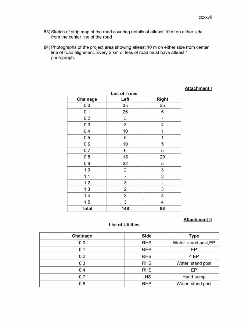
ccxxvii
83) Sketch of strip map of the road covering details of atleast 10 m on either side from the center line of the road
84) Photographs of the project area showing atleast 10 m on either side from center
line of road alignment. Every 2 km or less of road must have atleast 1 photograph.
Attachment I List of Trees
Chainage Left Right 0.0 35 25 0.1 26 5 0.2 3 - 0.3 3 4 0.4 10 1 0.5 5 1 0.6 10 5 0.7 6 5 0.8 15 20 0.9 22 5 1.0 2 3 1.1 - 3 1.2 3 - 1.3 2 3 1.4 3 4 1.5 3 4
Total 148 88
Attachment II List of Utilities
Chainage Side Type
0.0 RHS Water stand post,EP 0.1 RHS EP 0.2 RHS 4 EP 0.3 RHS Water stand post 0.4 RHS EP 0.7 LHS Hand pump 0.8 RHS Water stand post
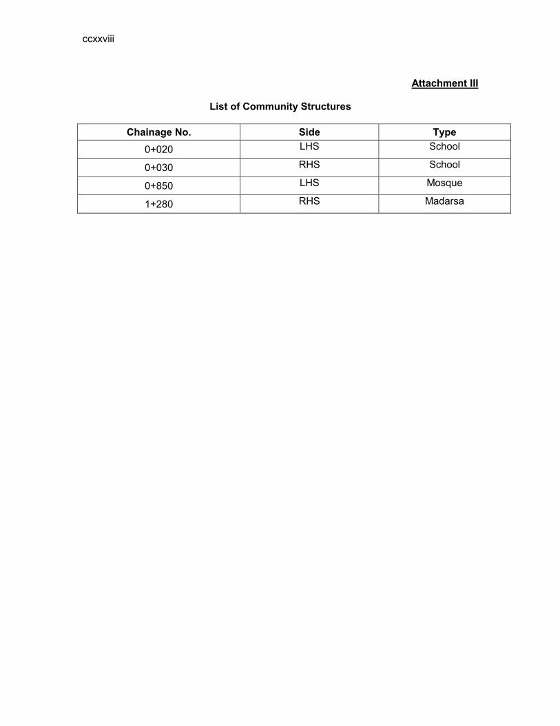
ccxxviii
Attachment III
List of Community Structures
Chainage No. Side Type
0+020 LHS School
0+030 RHS School
0+850 LHS Mosque
1+280 RHS Madarsa
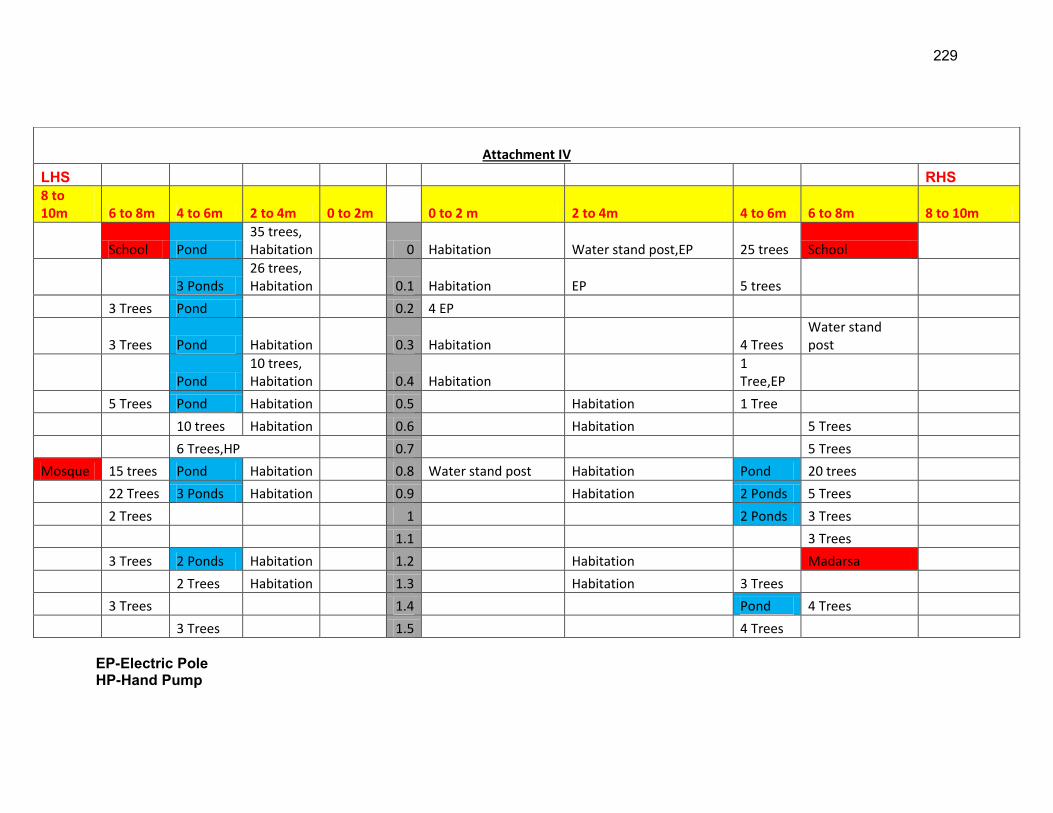
229
EP-Electric Pole HP-Hand Pump
Attachment IV
LHS RHS 8 to 10m 6 to 8m 4 to 6m 2 to 4m 0 to 2m 0 to 2 m 2 to 4m 4 to 6m 6 to 8m 8 to 10m
School Pond 35 trees, Habitation 0 Habitation Water stand post,EP 25 trees School
3 Ponds 26 trees, Habitation 0.1 Habitation EP 5 trees
3 Trees Pond 0.2 4 EP
3 Trees Pond Habitation 0.3 Habitation 4 Trees Water stand post
Pond 10 trees, Habitation 0.4 Habitation
1 Tree,EP
5 Trees Pond Habitation 0.5 Habitation 1 Tree
10 trees Habitation 0.6 Habitation 5 Trees
6 Trees,HP 0.7 5 Trees
Mosque 15 trees Pond Habitation 0.8 Water stand post Habitation Pond 20 trees
22 Trees 3 Ponds Habitation 0.9 Habitation 2 Ponds 5 Trees
2 Trees 1 2 Ponds 3 Trees
1.1 3 Trees
3 Trees 2 Ponds Habitation 1.2 Habitation Madarsa
2 Trees Habitation 1.3 Habitation 3 Trees
3 Trees 1.4 Pond 4 Trees
3 Trees 1.5 4 Trees

230
TP-Telephone Pole A.L-Agricultural land

231
RURAL ROADS: ENVIRONMENTAL CHECKLIST
Road Name: Morigaon Pachatia Damal Road
Block Name: Burbandha District Name: Morigaon Total Length of the Road: 2.322 km
ZZ. Climatic Conditions Temperature High: 38°C Low: 9 °C Humidity High: 95 % Low: 40 % Rainfall Rainy Season
3000 mm/year May to September
AAA. Location of the Road and Generic description of Environment No. Type of
Ecosystem Yes No Explanation
1. Coastal area Mangrove (along roadside)
√
Distance from Coastline: km
( ) more than 50% ( ) less than 20%
2. Type of Terrain (Plain/Hilly/ Mountainous etc.) (Explain the topography of the area and how many km of the road are located in the hilly area)
√
Altitude: 60.6m (average) The topography of the project road is flat at almost all locations.
4. Forest Area (Explain whether the road passes through forest areas or located along the forest areas and distance from shoulder to the forest area)?
√
Type of Vegetation: Legal Status of the Forest Area: (Reserved, National Park, Sanctuaries, Unclassified, etc.) No part of the project road passes through any forest area.
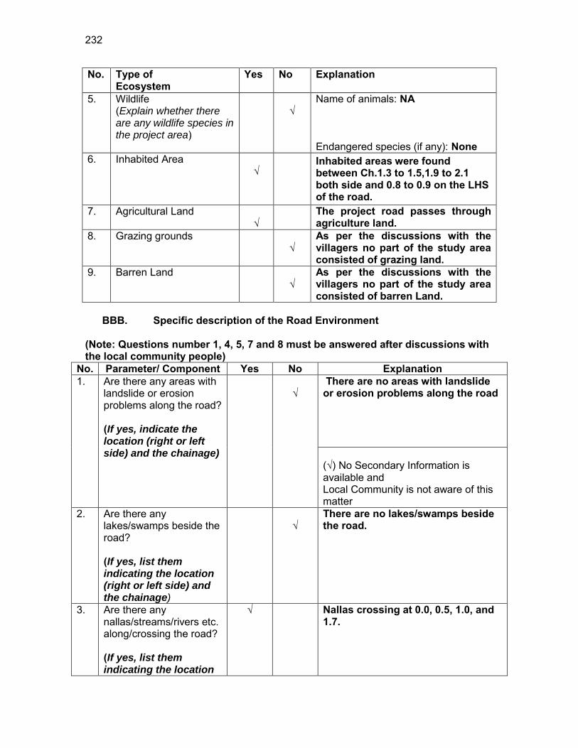
232
No. Type of Ecosystem
Yes No Explanation
5. Wildlife (Explain whether there are any wildlife species in the project area)
√
Name of animals: NA Endangered species (if any): None
6. Inhabited Area √
Inhabited areas were found between Ch.1.3 to 1.5,1.9 to 2.1 both side and 0.8 to 0.9 on the LHS of the road.
7. Agricultural Land √
The project road passes through agriculture land.
8. Grazing grounds √
As per the discussions with the villagers no part of the study area consisted of grazing land.
9. Barren Land √
As per the discussions with the villagers no part of the study area consisted of barren Land.
BBB. Specific description of the Road Environment
(Note: Questions number 1, 4, 5, 7 and 8 must be answered after discussions with the local community people)
No. Parameter/ Component Yes No Explanation 1. Are there any areas with
landslide or erosion problems along the road? (If yes, indicate the location (right or left side) and the chainage)
√
There are no areas with landslide or erosion problems along the road (√) No Secondary Information is available and Local Community is not aware of this matter
2. Are there any lakes/swamps beside the road? (If yes, list them indicating the location (right or left side) and the chainage)
√
There are no lakes/swamps beside the road.
3. Are there any nallas/streams/rivers etc. along/crossing the road? (If yes, list them indicating the location
√
Nallas crossing at 0.0, 0.5, 1.0, and 1.7.
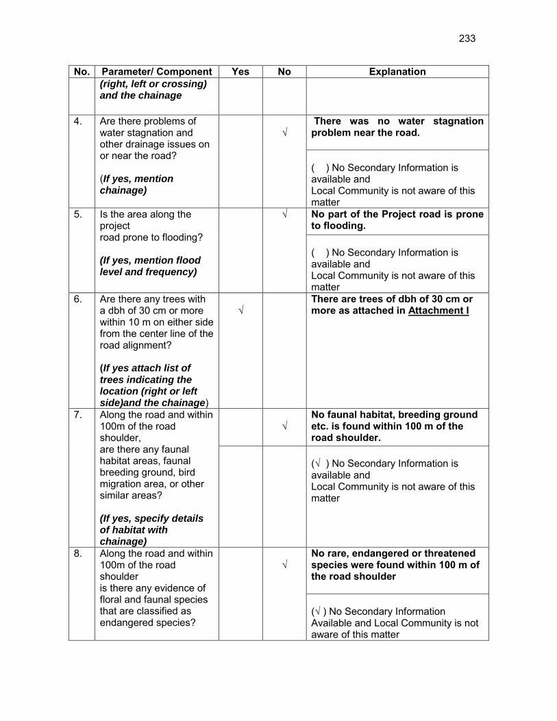
233
No. Parameter/ Component Yes No Explanation (right, left or crossing) and the chainage
4. Are there problems of water stagnation and other drainage issues on or near the road? (If yes, mention chainage)
√
There was no water stagnation problem near the road. ( ) No Secondary Information is available and Local Community is not aware of this matter
5. Is the area along the project road prone to flooding? (If yes, mention flood level and frequency)
√
No part of the Project road is prone to flooding. ( ) No Secondary Information is available and Local Community is not aware of this matter
6. Are there any trees with a dbh of 30 cm or more within 10 m on either side from the center line of the road alignment? (If yes attach list of trees indicating the location (right or left side)and the chainage)
√
There are trees of dbh of 30 cm or more as attached in Attachment I
7. Along the road and within 100m of the road shoulder, are there any faunal habitat areas, faunal breeding ground, bird migration area, or other similar areas? (If yes, specify details of habitat with chainage)
√
No faunal habitat, breeding ground etc. is found within 100 m of the road shoulder.
(√ ) No Secondary Information is available and Local Community is not aware of this matter
8. Along the road and within 100m of the road shoulder is there any evidence of floral and faunal species that are classified as endangered species?
√
No rare, endangered or threatened species were found within 100 m of the road shoulder (√ ) No Secondary Information Available and Local Community is not aware of this matter

234
No. Parameter/ Component Yes No Explanation 9. Are there any utility
structures62 within 10 m on either side from the center line of the road alignment? (If yes, attach list with chainage)
√
Few utility structures were found as listed in Attachment II.
10. Are there any religious, cultural or community structures/buildings63 within 10 m on either side from the center line of the road alignment? (If yes attach list with chainage)
√
No community structures were found within 10 m on either side from the center line of the road alignment.
D. Public Consultation
No. Consultation Activities Yes No Remarks 1. Consultation with local
community was conducted before finalizing the alignment. (Attach list of people met and dates)
√
The proposed alignment has been finalized after taking suggestions from the local community. This was confirmed by the villagers during the transect walk.
2. Any suggestion received in finalizing the alignment
√
No written suggestion was received. However, during transect walk few requests were made by the villagers
3. If suggestions received, were they incorporated into the design?
√
All the relevant suggestions has been incorporated in the alignment.
E. Please attach the following: 85) List of trees indicating location (left or right side of the road) and chainage (as
required under C. 6) 86) List of utility structures indicating location (left or right side of the road) and
chainage (as required under C. 9) 87) List of community structures indicating location (left or right side of the road) and
chainage (as required under C. 10)
62 Water tap, hand pump, electric pole, telephone pole, water pipe and other similar strucutures. 63 Mandir, Masjid, Church, religious/cultural/historical monuments, school, health center, publ ic toilet and other similar structures.
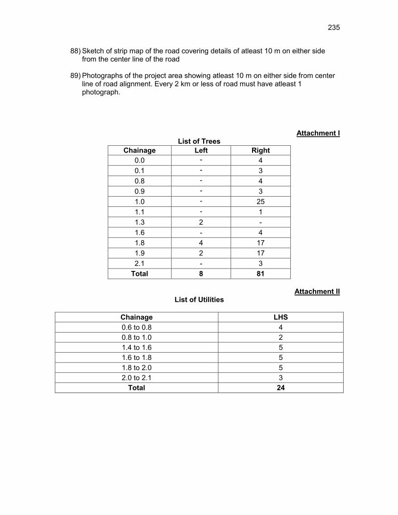
235
88) Sketch of strip map of the road covering details of atleast 10 m on either side from the center line of the road
89) Photographs of the project area showing atleast 10 m on either side from center
line of road alignment. Every 2 km or less of road must have atleast 1 photograph.
Attachment I List of Trees
Chainage Left Right 0.0 - 4 0.1 - 3 0.8 - 4 0.9 - 3 1.0 - 25 1.1 - 1 1.3 2 - 1.6 - 4 1.8 4 17 1.9 2 17 2.1 - 3
Total 8 81
Attachment II List of Utilities
Chainage LHS 0.6 to 0.8 4 0.8 to 1.0 2 1.4 to 1.6 5 1.6 to 1.8 5 1.8 to 2.0 5 2.0 to 2.1 3
Total 24
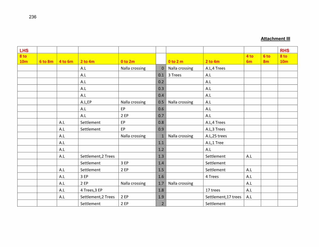
236
Attachment III
LHS RHS 8 to 10m 6 to 8m 4 to 6m 2 to 4m 0 to 2m 0 to 2 m 2 to 4m
4 to 6m
6 to 8m
8 to 10m
A.L Nalla crossing 0 Nalla crossing A.L,4 Trees
A.L 0.1 3 Trees A.L
A.L 0.2 A.L
A.L 0.3 A.L
A.L 0.4 A.L
A.L,EP Nalla crossing 0.5 Nalla crossing A.L
A.L EP 0.6 A.L
A.L 2 EP 0.7 A.L
A.L Settlement EP 0.8 A.L,4 Trees
A.L Settlement EP 0.9 A.L,3 Trees
A.L Nalla crossing 1 Nalla crossing A.L,25 trees
A.L 1.1 A.L,1 Tree
A.L 1.2 A.L
A.L Settlement,2 Trees 1.3 Settlement A.L
Settlement 3 EP 1.4 Settlement
A.L Settlement 2 EP 1.5 Settlement A.L
A.L 3 EP 1.6 4 Trees A.L
A.L 2 EP Nalla crossing 1.7 Nalla crossing A.L
A.L 4 Trees,3 EP 1.8 17 trees A.L
A.L Settlement,2 Trees 2 EP 1.9 Settlement,17 trees A.L
Settlement 2 EP 2 Settlement

237
Settlement EP 2.1 Settlement,3 Trees EP-Electric Pole HP-Hand Pump TP-Telephone Pole A.L-Agricultural land

238
RURAL ROADS: ENVIRONMENTAL CHECKLIST
Road Name: Noagaon LP School to Motiram Bora Khetra Road
Block Name: Bhurbandha District Name: Morigaon Total Length of the Road: Part A is 1+350 km and Part B is 1+464 km
CCC. Climatic Conditions Temperature High: 38°C Low: 9 °C Humidity High: 95 % Low: 40 % Rainfall Rainy Season
3000 mm/year June to September
DDD. Location of the Road and Generic description of Environment No. Type of
Ecosystem Yes No Explanation
1. Coastal area Mangrove (along roadside)
√
Distance from Coastline: km
( ) more than 50% ( ) less than 20%
2. Type of Terrain (Plain/Hilly/ Mountainous etc.) (Explain the topography of the area and how many km of the road are located in the hilly area)
√
Altitude: 60.6m (average) The topography of the project road is flat at almost all locations.
4. Forest Area (Explain whether the road passes through forest areas or located along the forest areas and distance from shoulder to the forest area)?
√
Type of Vegetation: Legal Status of the Forest Area: (Reserved, National Park, Sanctuaries, Unclassified, etc.) No part of the project road passes through any forest area.
5. Wildlife (Explain whether there are any wildlife species in the project area)
√
Name of animals: NA
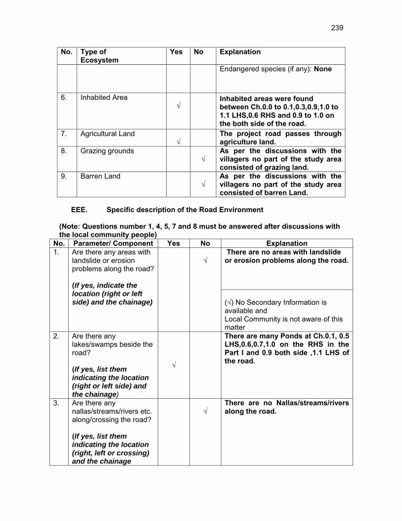
239
No. Type of Ecosystem
Yes No Explanation
Endangered species (if any): None
6. Inhabited Area √
Inhabited areas were found between Ch.0.0 to 0.1,0.3,0.9,1.0 to 1.1 LHS,0.6 RHS and 0.9 to 1.0 on the both side of the road.
7. Agricultural Land √
The project road passes through agriculture land.
8. Grazing grounds √
As per the discussions with the villagers no part of the study area consisted of grazing land.
9. Barren Land √
As per the discussions with the villagers no part of the study area consisted of barren Land.
EEE. Specific description of the Road Environment
(Note: Questions number 1, 4, 5, 7 and 8 must be answered after discussions with the local community people)
No. Parameter/ Component Yes No Explanation 1. Are there any areas with
landslide or erosion problems along the road? (If yes, indicate the location (right or left side) and the chainage)
√
There are no areas with landslide or erosion problems along the road. (√) No Secondary Information is available and Local Community is not aware of this matter
2. Are there any lakes/swamps beside the road? (If yes, list them indicating the location (right or left side) and the chainage)
√
There are many Ponds at Ch.0.1, 0.5 LHS,0.6,0.7,1.0 on the RHS in the Part I and 0.9 both side ,1.1 LHS of the road.
3. Are there any nallas/streams/rivers etc. along/crossing the road? (If yes, list them indicating the location (right, left or crossing) and the chainage
√
There are no Nallas/streams/rivers along the road.
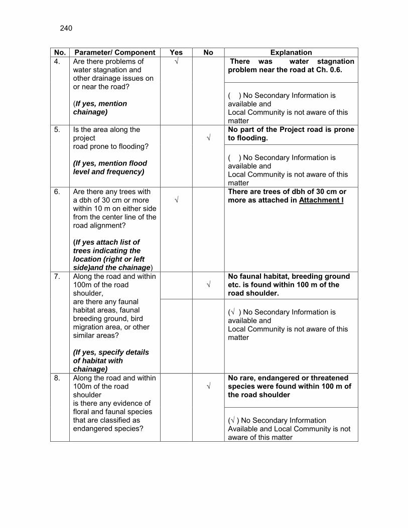
240
No. Parameter/ Component Yes No Explanation 4. Are there problems of
water stagnation and other drainage issues on or near the road? (If yes, mention chainage)
√
There was water stagnation problem near the road at Ch. 0.6. ( ) No Secondary Information is available and Local Community is not aware of this matter
5. Is the area along the project road prone to flooding? (If yes, mention flood level and frequency)
√
No part of the Project road is prone to flooding. ( ) No Secondary Information is available and Local Community is not aware of this matter
6. Are there any trees with a dbh of 30 cm or more within 10 m on either side from the center line of the road alignment? (If yes attach list of trees indicating the location (right or left side)and the chainage)
√
There are trees of dbh of 30 cm or more as attached in Attachment I
7. Along the road and within 100m of the road shoulder, are there any faunal habitat areas, faunal breeding ground, bird migration area, or other similar areas? (If yes, specify details of habitat with chainage)
√
No faunal habitat, breeding ground etc. is found within 100 m of the road shoulder.
(√ ) No Secondary Information is available and Local Community is not aware of this matter
8. Along the road and within 100m of the road shoulder is there any evidence of floral and faunal species that are classified as endangered species?
√
No rare, endangered or threatened species were found within 100 m of the road shoulder (√ ) No Secondary Information Available and Local Community is not aware of this matter
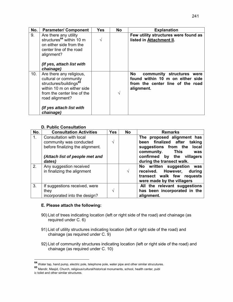
241
No. Parameter/ Component Yes No Explanation 9. Are there any utility
structures64 within 10 m on either side from the center line of the road alignment? (If yes, attach list with chainage)
√
Few utility structures were found as listed in Attachment II.
10. Are there any religious, cultural or community structures/buildings65 within 10 m on either side from the center line of the road alignment? (If yes attach list with chainage)
√
No community structures were found within 10 m on either side from the center line of the road alignment.
D. Public Consultation
No. Consultation Activities Yes No Remarks 1. Consultation with local
community was conducted before finalizing the alignment. (Attach list of people met and dates)
√
The proposed alignment has been finalized after taking suggestions from the local community. This was confirmed by the villagers during the transect walk.
2. Any suggestion received in finalizing the alignment
√
No written suggestion was received. However, during transect walk few requests were made by the villagers
3. If suggestions received, were they incorporated into the design?
√
All the relevant suggestions has been incorporated in the alignment.
E. Please attach the following: 90) List of trees indicating location (left or right side of the road) and chainage (as
required under C. 6) 91) List of utility structures indicating location (left or right side of the road) and
chainage (as required under C. 9) 92) List of community structures indicating location (left or right side of the road) and
chainage (as required under C. 10)
64 Water tap, hand pump, electric pole, telephone pole, water pipe and other similar strucutures. 65 Mandir, Masjid, Church, religious/cultural/historical monuments, school, health center, publ ic toilet and other similar structures.

242
93) Sketch of strip map of the road covering details of atleast 10 m on either side from the center line of the road
94) Photographs of the project area showing atleast 10 m on either side from center
line of road alignment. Every 2 km or less of road must have atleast 1 photograph.
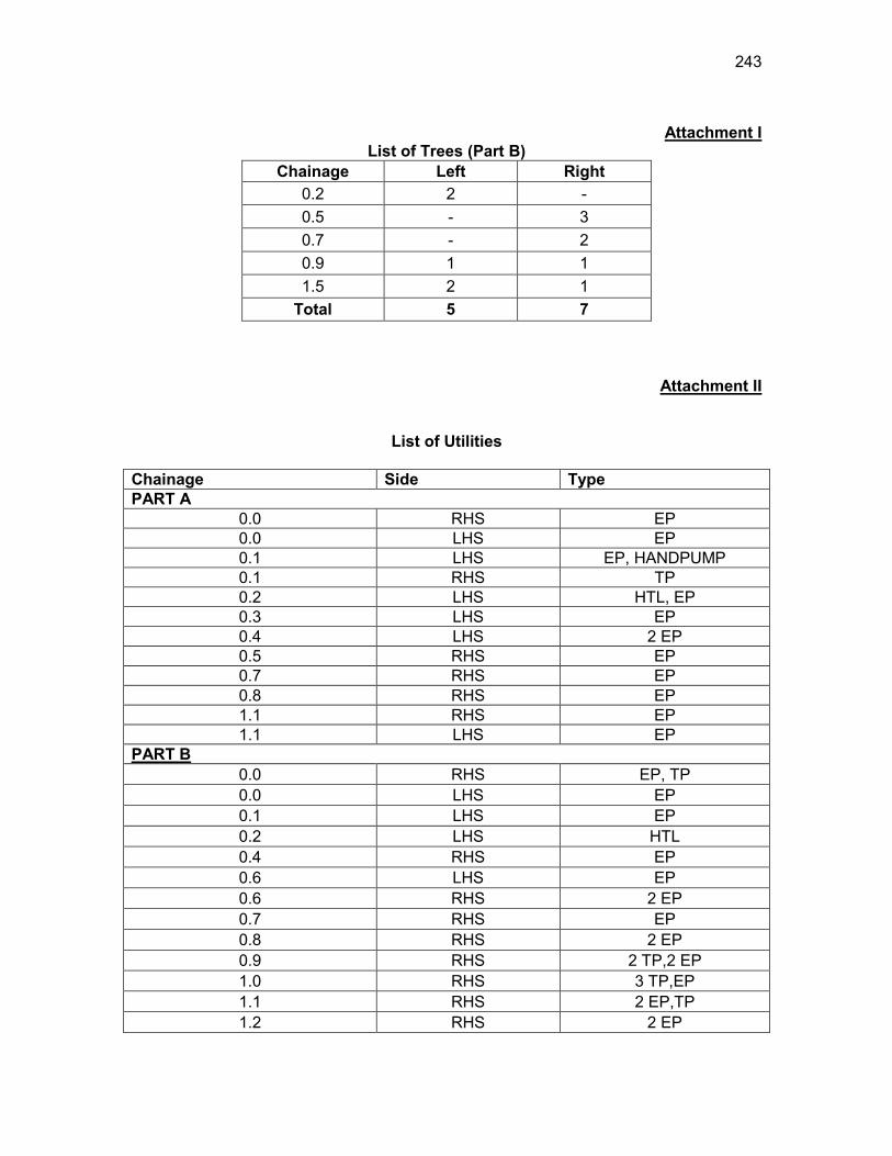
243
Attachment I
List of Trees (Part B) Chainage Left Right
0.2 2 - 0.5 - 3 0.7 - 2 0.9 1 1 1.5 2 1
Total 5 7
Attachment II
List of Utilities
Chainage Side Type PART A
0.0 RHS EP 0.0 LHS EP 0.1 LHS EP, HANDPUMP 0.1 RHS TP 0.2 LHS HTL, EP 0.3 LHS EP 0.4 LHS 2 EP 0.5 RHS EP 0.7 RHS EP 0.8 RHS EP 1.1 RHS EP 1.1 LHS EP
PART B
0.0 RHS EP, TP 0.0 LHS EP 0.1 LHS EP 0.2 LHS HTL 0.4 RHS EP 0.6 LHS EP 0.6 RHS 2 EP 0.7 RHS EP 0.8 RHS 2 EP 0.9 RHS 2 TP,2 EP 1.0 RHS 3 TP,EP 1.1 RHS 2 EP,TP 1.2 RHS 2 EP

244
Chainage Side Type 1.3 RHS TP,EP 1.4 RHS 2 EP,TP 1.4 LHS EP
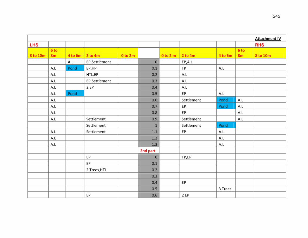
245
Attachment IV
LHS RHS
8 to 10m 6 to 8m 4 to 6m 2 to 4m 0 to 2m 0 to 2 m 2 to 4m 4 to 6m
6 to 8m 8 to 10m
A.L EP,Settlement 0 EP,A.L
A.L Pond EP,HP 0.1 TP A.L
A.L HTL,EP 0.2 A.L
A.L EP,Settlement 0.3 A.L
A.L 2 EP 0.4 A.L
A.L Pond 0.5 EP A.L
A.L 0.6 Settlement Pond A.L
A.L 0.7 EP Pond A.L
A.L 0.8 EP A.L
A.L Settlement 0.9 Settlement A.L
Settlement 1 Settlement Pond
A.L Settlement 1.1 EP A.L
A.L 1.2 A.L
A.L 1.3 A.L
2nd part
EP 0 TP,EP
EP 0.1
2 Trees,HTL 0.2
0.3
0.4 EP
0.5 3 Trees
EP 0.6 2 EP

246
0.7 EP 2 Trees
0.8 2 EP
Pond 1 Tree 0.9 2 TP,2EP,1 Tree Pond
1 3 TP,EP
Pond 1.1 2 EP,TP
1.2 2 EP
1.3 TP,EP
EP 1.4 2 EP,TP
2 Trees 1.5 1 Tree EP-Electric Pole HP-Hand Pump TP-Telephone Pole A.L-Agricultural land
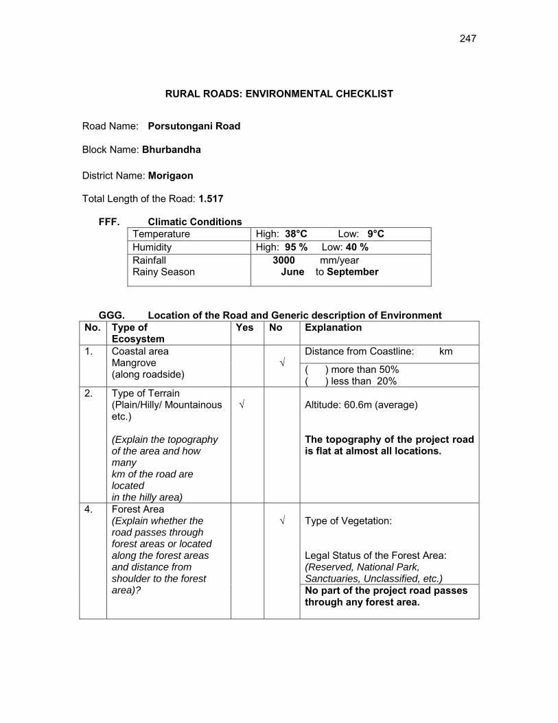
247
RURAL ROADS: ENVIRONMENTAL CHECKLIST
Road Name: Porsutongani Road
Block Name: Bhurbandha District Name: Morigaon Total Length of the Road: 1.517
FFF. Climatic Conditions Temperature High: 38°C Low: 9°C Humidity High: 95 % Low: 40 % Rainfall Rainy Season
3000 mm/year June to September
GGG. Location of the Road and Generic description of Environment No. Type of
Ecosystem Yes No Explanation
1. Coastal area Mangrove (along roadside)
√
Distance from Coastline: km
( ) more than 50% ( ) less than 20%
2. Type of Terrain (Plain/Hilly/ Mountainous etc.) (Explain the topography of the area and how many km of the road are located in the hilly area)
√
Altitude: 60.6m (average) The topography of the project road is flat at almost all locations.
4. Forest Area (Explain whether the road passes through forest areas or located along the forest areas and distance from shoulder to the forest area)?
√
Type of Vegetation: Legal Status of the Forest Area: (Reserved, National Park, Sanctuaries, Unclassified, etc.) No part of the project road passes through any forest area.
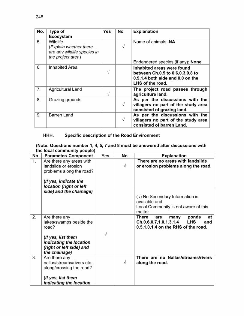
248
No. Type of Ecosystem
Yes No Explanation
5. Wildlife (Explain whether there are any wildlife species in the project area)
√
Name of animals: NA Endangered species (if any): None
6. Inhabited Area √
Inhabited areas were found between Ch.0.5 to 0.6,0.3,0.8 to 0.9,1.4 both side and 0.0 on the LHS of the road.
7. Agricultural Land √
The project road passes through agriculture land.
8. Grazing grounds √
As per the discussions with the villagers no part of the study area consisted of grazing land.
9. Barren Land √
As per the discussions with the villagers no part of the study area consisted of barren Land.
HHH. Specific description of the Road Environment
(Note: Questions number 1, 4, 5, 7 and 8 must be answered after discussions with the local community people)
No. Parameter/ Component Yes No Explanation 1. Are there any areas with
landslide or erosion problems along the road? (If yes, indicate the location (right or left side) and the chainage)
√
There are no areas with landslide or erosion problems along the road. (√) No Secondary Information is available and Local Community is not aware of this matter
2. Are there any lakes/swamps beside the road? (If yes, list them indicating the location (right or left side) and the chainage)
√
There are many ponds at Ch.0.6,0.7,1.0,1.3,1.4 LHS and 0.5,1.0,1.4 on the RHS of the road.
3. Are there any nallas/streams/rivers etc. along/crossing the road? (If yes, list them indicating the location
√
There are no Nallas/streams/rivers along the road.
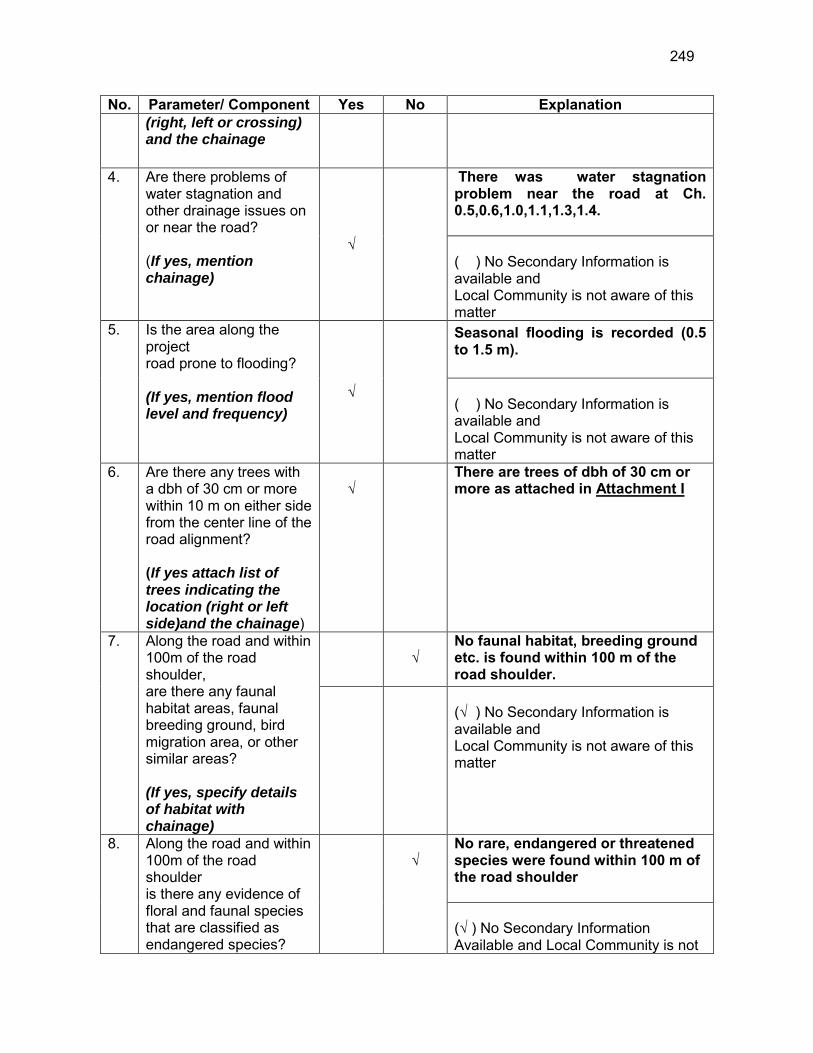
249
No. Parameter/ Component Yes No Explanation (right, left or crossing) and the chainage
4. Are there problems of water stagnation and other drainage issues on or near the road? (If yes, mention chainage)
√
There was water stagnation problem near the road at Ch. 0.5,0.6,1.0,1.1,1.3,1.4. ( ) No Secondary Information is available and Local Community is not aware of this matter
5. Is the area along the project road prone to flooding? (If yes, mention flood level and frequency)
√
Seasonal flooding is recorded (0.5 to 1.5 m). ( ) No Secondary Information is available and Local Community is not aware of this matter
6. Are there any trees with a dbh of 30 cm or more within 10 m on either side from the center line of the road alignment? (If yes attach list of trees indicating the location (right or left side)and the chainage)
√
There are trees of dbh of 30 cm or more as attached in Attachment I
7. Along the road and within 100m of the road shoulder, are there any faunal habitat areas, faunal breeding ground, bird migration area, or other similar areas? (If yes, specify details of habitat with chainage)
√
No faunal habitat, breeding ground etc. is found within 100 m of the road shoulder.
(√ ) No Secondary Information is available and Local Community is not aware of this matter
8. Along the road and within 100m of the road shoulder is there any evidence of floral and faunal species that are classified as endangered species?
√
No rare, endangered or threatened species were found within 100 m of the road shoulder (√ ) No Secondary Information Available and Local Community is not
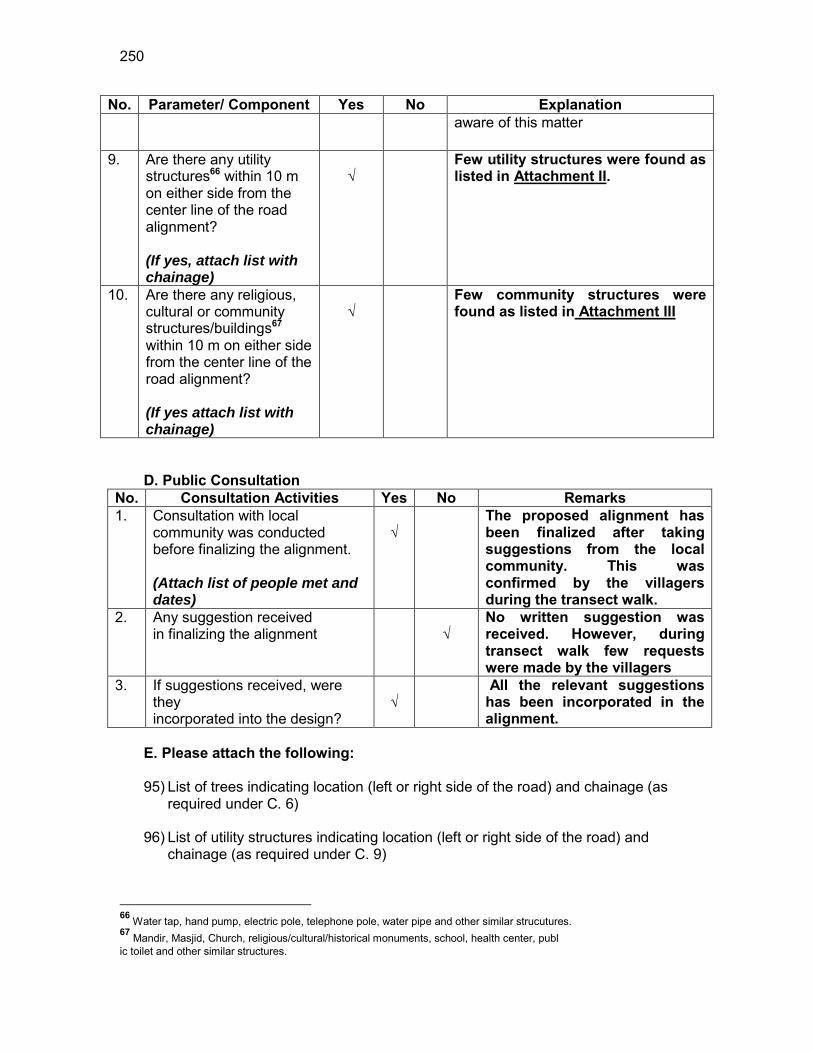
250
No. Parameter/ Component Yes No Explanation aware of this matter
9. Are there any utility structures66 within 10 m on either side from the center line of the road alignment? (If yes, attach list with chainage)
√
Few utility structures were found as listed in Attachment II.
10. Are there any religious, cultural or community structures/buildings67 within 10 m on either side from the center line of the road alignment? (If yes attach list with chainage)
√
Few community structures were found as listed in Attachment III
D. Public Consultation
No. Consultation Activities Yes No Remarks 1. Consultation with local
community was conducted before finalizing the alignment. (Attach list of people met and dates)
√
The proposed alignment has been finalized after taking suggestions from the local community. This was confirmed by the villagers during the transect walk.
2. Any suggestion received in finalizing the alignment
√
No written suggestion was received. However, during transect walk few requests were made by the villagers
3. If suggestions received, were they incorporated into the design?
√
All the relevant suggestions has been incorporated in the alignment.
E. Please attach the following: 95) List of trees indicating location (left or right side of the road) and chainage (as
required under C. 6) 96) List of utility structures indicating location (left or right side of the road) and
chainage (as required under C. 9)
66 Water tap, hand pump, electric pole, telephone pole, water pipe and other similar strucutures. 67 Mandir, Masjid, Church, religious/cultural/historical monuments, school, health center, publ ic toilet and other similar structures.
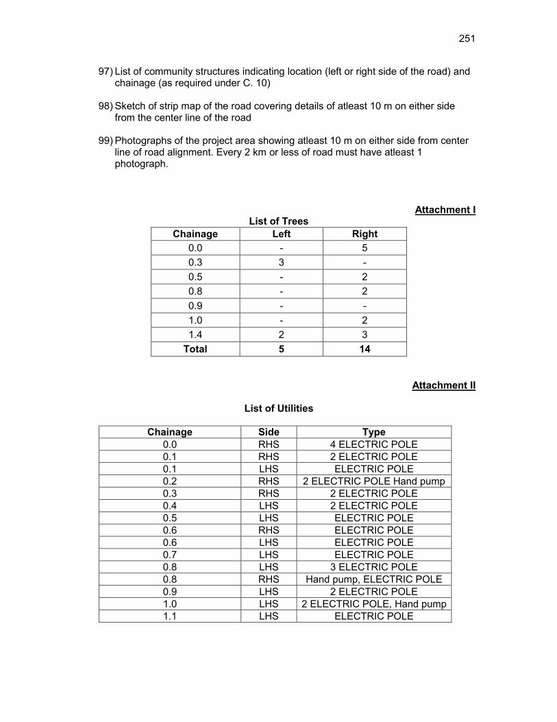
251
97) List of community structures indicating location (left or right side of the road) and chainage (as required under C. 10)
98) Sketch of strip map of the road covering details of atleast 10 m on either side
from the center line of the road
99) Photographs of the project area showing atleast 10 m on either side from center line of road alignment. Every 2 km or less of road must have atleast 1 photograph.
Attachment I List of Trees
Chainage Left Right 0.0 - 5 0.3 3 - 0.5 - 2 0.8 - 2 0.9 - - 1.0 - 2 1.4 2 3
Total 5 14
Attachment II
List of Utilities
Chainage Side Type 0.0 RHS 4 ELECTRIC POLE 0.1 RHS 2 ELECTRIC POLE 0.1 LHS ELECTRIC POLE 0.2 RHS 2 ELECTRIC POLE Hand pump 0.3 RHS 2 ELECTRIC POLE 0.4 LHS 2 ELECTRIC POLE 0.5 LHS ELECTRIC POLE 0.6 RHS ELECTRIC POLE 0.6 LHS ELECTRIC POLE 0.7 LHS ELECTRIC POLE 0.8 LHS 3 ELECTRIC POLE 0.8 RHS Hand pump, ELECTRIC POLE 0.9 LHS 2 ELECTRIC POLE 1.0 LHS 2 ELECTRIC POLE, Hand pump 1.1 LHS ELECTRIC POLE
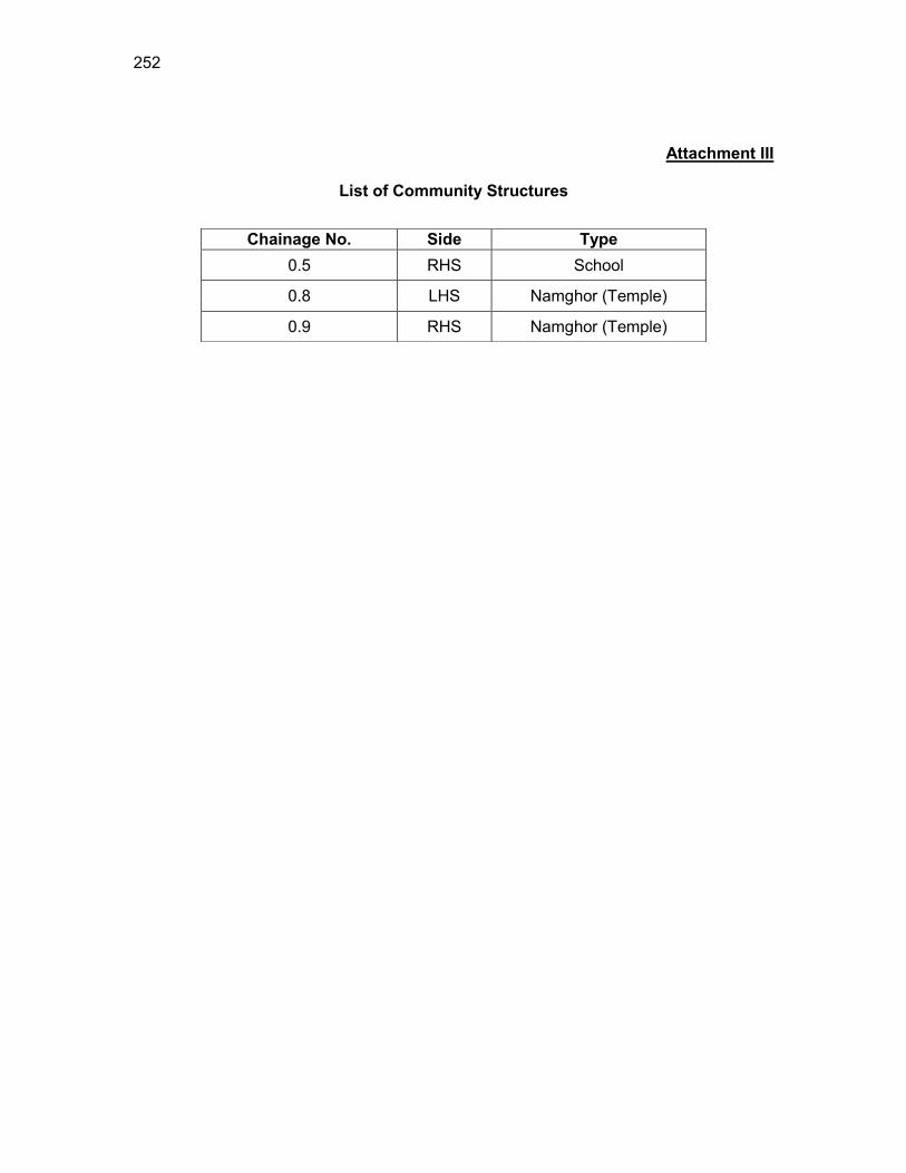
252
Attachment III
List of Community Structures
Chainage No. Side Type 0.5 RHS School
0.8 LHS Namghor (Temple)
0.9 RHS Namghor (Temple)
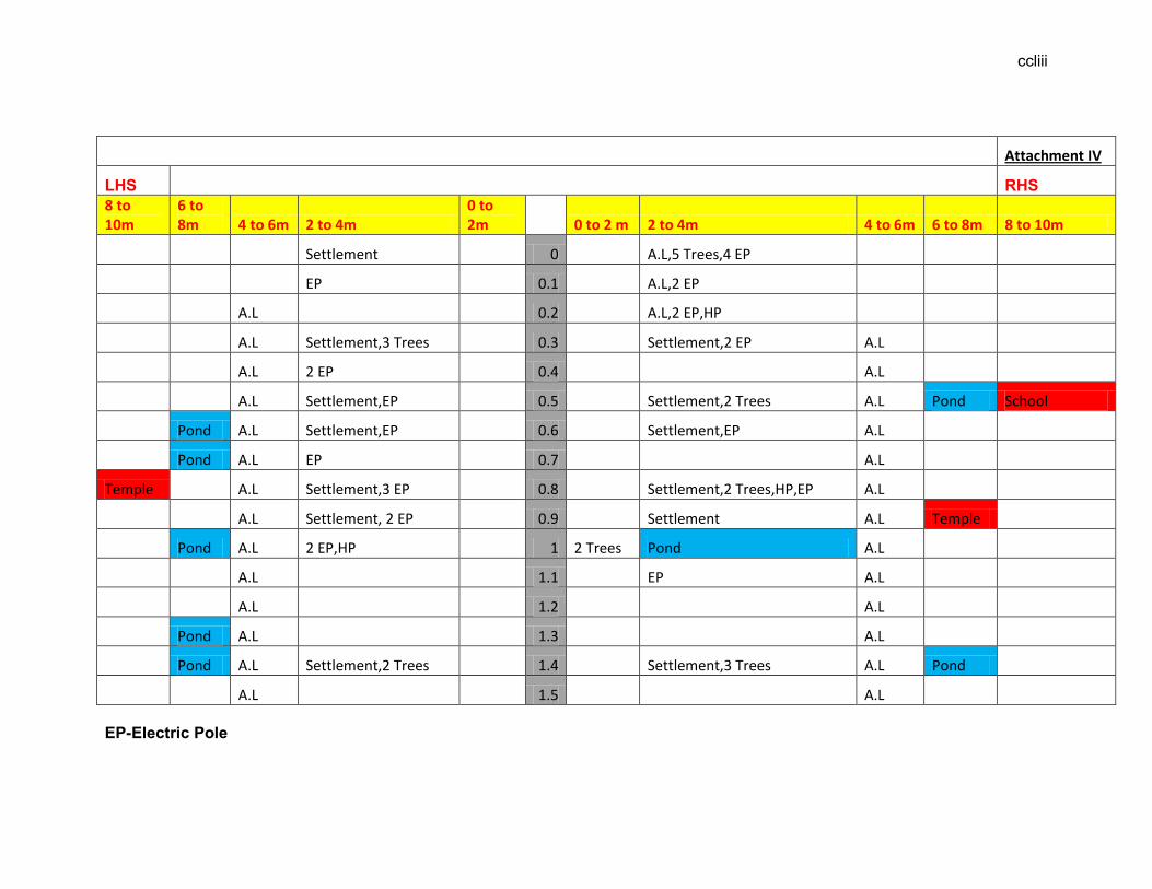
ccliii
EP-Electric Pole
Attachment IV
LHS RHS 8 to 10m
6 to 8m 4 to 6m 2 to 4m
0 to 2m 0 to 2 m 2 to 4m 4 to 6m 6 to 8m 8 to 10m
Settlement 0 A.L,5 Trees,4 EP
EP 0.1 A.L,2 EP
A.L 0.2 A.L,2 EP,HP
A.L Settlement,3 Trees 0.3 Settlement,2 EP A.L
A.L 2 EP 0.4 A.L
A.L Settlement,EP 0.5 Settlement,2 Trees A.L Pond School
Pond A.L Settlement,EP 0.6 Settlement,EP A.L
Pond A.L EP 0.7 A.L
Temple A.L Settlement,3 EP 0.8 Settlement,2 Trees,HP,EP A.L
A.L Settlement, 2 EP 0.9 Settlement A.L Temple
Pond A.L 2 EP,HP 1 2 Trees Pond A.L
A.L 1.1 EP A.L
A.L 1.2 A.L
Pond A.L 1.3 A.L
Pond A.L Settlement,2 Trees 1.4 Settlement,3 Trees A.L Pond
A.L 1.5 A.L

ccliv
HP-Hand Pump TP-Telephone Pole A.L-Agricultural land
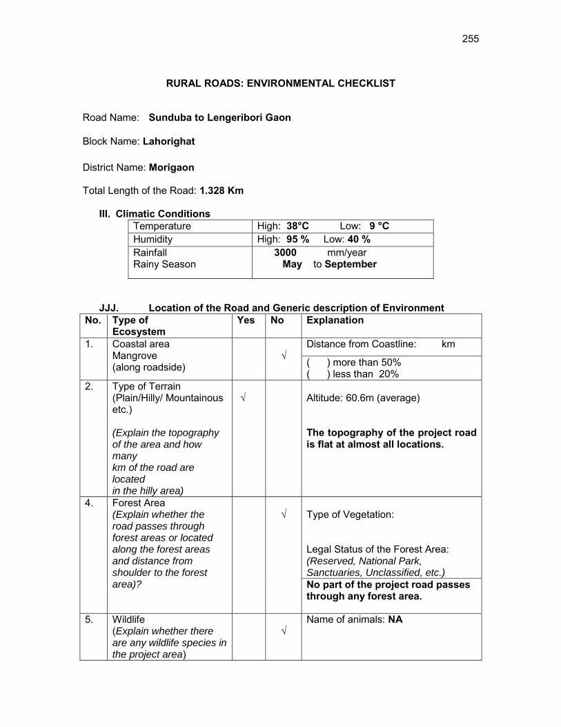
255
RURAL ROADS: ENVIRONMENTAL CHECKLIST
Road Name: Sunduba to Lengeribori Gaon
Block Name: Lahorighat District Name: Morigaon Total Length of the Road: 1.328 Km
III. Climatic Conditions Temperature High: 38°C Low: 9 °C Humidity High: 95 % Low: 40 % Rainfall Rainy Season
3000 mm/year May to September
JJJ. Location of the Road and Generic description of Environment No. Type of
Ecosystem Yes No Explanation
1. Coastal area Mangrove (along roadside)
√
Distance from Coastline: km
( ) more than 50% ( ) less than 20%
2. Type of Terrain (Plain/Hilly/ Mountainous etc.) (Explain the topography of the area and how many km of the road are located in the hilly area)
√
Altitude: 60.6m (average) The topography of the project road is flat at almost all locations.
4. Forest Area (Explain whether the road passes through forest areas or located along the forest areas and distance from shoulder to the forest area)?
√
Type of Vegetation: Legal Status of the Forest Area: (Reserved, National Park, Sanctuaries, Unclassified, etc.) No part of the project road passes through any forest area.
5. Wildlife (Explain whether there are any wildlife species in the project area)
√
Name of animals: NA
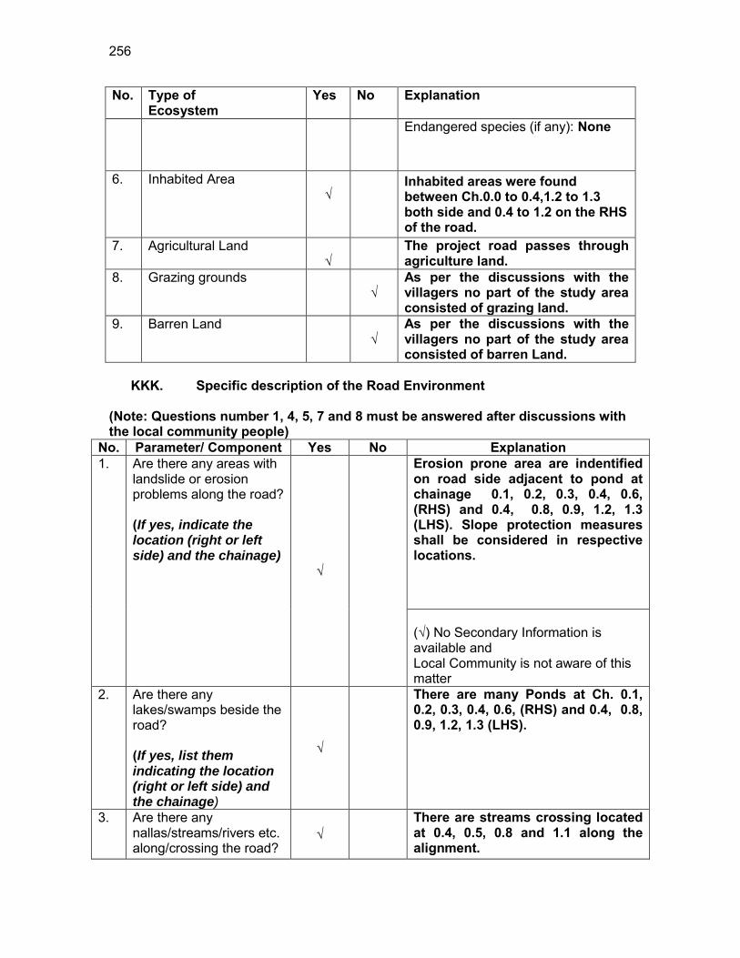
256
No. Type of Ecosystem
Yes No Explanation
Endangered species (if any): None
6. Inhabited Area √
Inhabited areas were found between Ch.0.0 to 0.4,1.2 to 1.3 both side and 0.4 to 1.2 on the RHS of the road.
7. Agricultural Land √
The project road passes through agriculture land.
8. Grazing grounds √
As per the discussions with the villagers no part of the study area consisted of grazing land.
9. Barren Land √
As per the discussions with the villagers no part of the study area consisted of barren Land.
KKK. Specific description of the Road Environment
(Note: Questions number 1, 4, 5, 7 and 8 must be answered after discussions with the local community people)
No. Parameter/ Component Yes No Explanation 1. Are there any areas with
landslide or erosion problems along the road? (If yes, indicate the location (right or left side) and the chainage)
√
Erosion prone area are indentified on road side adjacent to pond at chainage 0.1, 0.2, 0.3, 0.4, 0.6, (RHS) and 0.4, 0.8, 0.9, 1.2, 1.3 (LHS). Slope protection measures shall be considered in respective locations. (√) No Secondary Information is available and Local Community is not aware of this matter
2. Are there any lakes/swamps beside the road? (If yes, list them indicating the location (right or left side) and the chainage)
√
There are many Ponds at Ch. 0.1, 0.2, 0.3, 0.4, 0.6, (RHS) and 0.4, 0.8, 0.9, 1.2, 1.3 (LHS).
3. Are there any nallas/streams/rivers etc. along/crossing the road?
√
There are streams crossing located at 0.4, 0.5, 0.8 and 1.1 along the alignment.
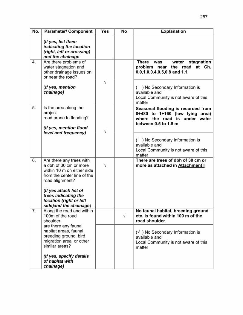
257
No. Parameter/ Component Yes No Explanation (If yes, list them indicating the location (right, left or crossing) and the chainage
4. Are there problems of water stagnation and other drainage issues on or near the road? (If yes, mention chainage)
√
There was water stagnation problem near the road at Ch. 0.0,1.0,0.4,0.5,0.8 and 1.1. ( ) No Secondary Information is available and Local Community is not aware of this matter
5. Is the area along the project road prone to flooding? (If yes, mention flood level and frequency) √
Seasonal flooding is recorded from 0+480 to 1+160 (low lying area) where the road is under water between 0.5 to 1.5 m ( ) No Secondary Information is available and Local Community is not aware of this matter
6. Are there any trees with a dbh of 30 cm or more within 10 m on either side from the center line of the road alignment? (If yes attach list of trees indicating the location (right or left side)and the chainage)
√
There are trees of dbh of 30 cm or more as attached in Attachment I
7. Along the road and within 100m of the road shoulder, are there any faunal habitat areas, faunal breeding ground, bird migration area, or other similar areas? (If yes, specify details of habitat with chainage)
√
No faunal habitat, breeding ground etc. is found within 100 m of the road shoulder.
(√ ) No Secondary Information is available and Local Community is not aware of this matter

258
No. Parameter/ Component Yes No Explanation 8. Along the road and within
100m of the road shoulder is there any evidence of floral and faunal species that are classified as endangered species?
√
No rare, endangered or threatened species were found within 100 m of the road shoulder (√ ) No Secondary Information Available and Local Community is not aware of this matter
9. Are there any utility structures68 within 10 m on either side from the center line of the road alignment? (If yes, attach list with chainage)
√
Few utility structures were found as listed in Attachment II.
10. Are there any religious, cultural or community structures/buildings69 within 10 m on either side from the center line of the road alignment? (If yes attach list with chainage)
√
Few community structures were found as listed in Attachment III
D. Public Consultation
No. Consultation Activities Yes No Remarks 1. Consultation with local
community was conducted before finalizing the alignment. (Attach list of people met and dates)
√
The proposed alignment has been finalized after taking suggestions from the local community. This was confirmed by the villagers during the transect walk.
2. Any suggestion received in finalizing the alignment
√
No written suggestion was received. However, during transect walk few requests were made by the villagers
3. If suggestions received, were they incorporated into the design?
√
All the relevant suggestions has been incorporated in the alignment.
E. Please attach the following:
68 Water tap, hand pump, electric pole, telephone pole, water pipe and other similar strucutures. 69 Mandir, Masjid, Church, religious/cultural/historical monuments, school, health center, publ ic toilet and other similar structures.
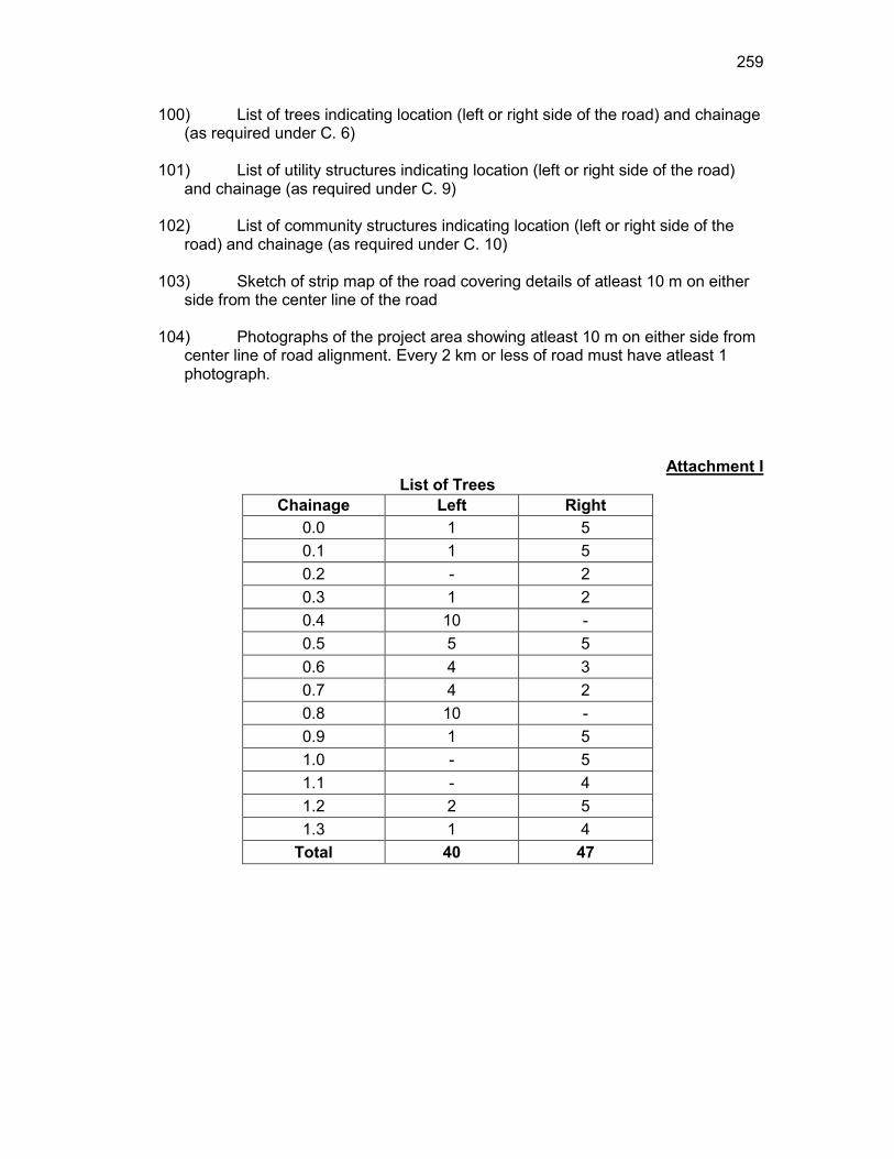
259
100) List of trees indicating location (left or right side of the road) and chainage (as required under C. 6)
101) List of utility structures indicating location (left or right side of the road)
and chainage (as required under C. 9) 102) List of community structures indicating location (left or right side of the
road) and chainage (as required under C. 10) 103) Sketch of strip map of the road covering details of atleast 10 m on either
side from the center line of the road
104) Photographs of the project area showing atleast 10 m on either side from center line of road alignment. Every 2 km or less of road must have atleast 1 photograph.
Attachment I List of Trees
Chainage Left Right 0.0 1 5 0.1 1 5 0.2 - 2 0.3 1 2 0.4 10 - 0.5 5 5 0.6 4 3 0.7 4 2 0.8 10 - 0.9 1 5 1.0 - 5 1.1 - 4 1.2 2 5 1.3 1 4
Total 40 47
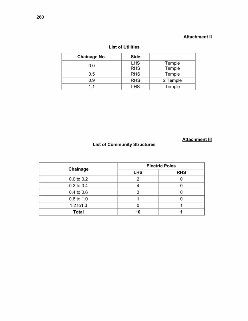
260
Attachment II
List of Utilities
Attachment III List of Community Structures
Chainage Electric Poles
LHS RHS 0.0 to 0.2 2 0 0.2 to 0.4 4 0 0.4 to 0.6 3 0 0.8 to 1.0 1 0 1.2 to1.3 0 1
Total 10 1
Chainage No. Side
0.0 LHS RHS
Temple Temple
0.5 RHS Temple 0.9 RHS 2 Temple 1.1 LHS Temple
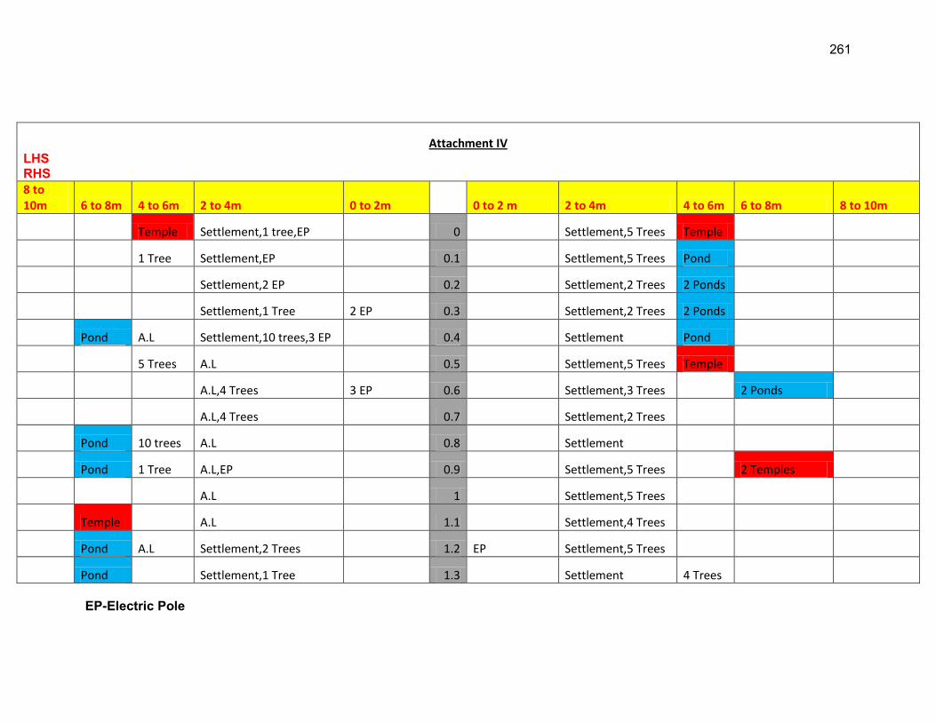
261
EP-Electric Pole
Attachment IV LHS RHS 8 to 10m 6 to 8m 4 to 6m 2 to 4m 0 to 2m 0 to 2 m 2 to 4m 4 to 6m 6 to 8m 8 to 10m
Temple Settlement,1 tree,EP 0 Settlement,5 Trees Temple
1 Tree Settlement,EP 0.1 Settlement,5 Trees Pond
Settlement,2 EP 0.2 Settlement,2 Trees 2 Ponds
Settlement,1 Tree 2 EP 0.3 Settlement,2 Trees 2 Ponds
Pond A.L Settlement,10 trees,3 EP 0.4 Settlement Pond
5 Trees A.L 0.5 Settlement,5 Trees Temple
A.L,4 Trees 3 EP 0.6 Settlement,3 Trees 2 Ponds
A.L,4 Trees 0.7 Settlement,2 Trees
Pond 10 trees A.L 0.8 Settlement
Pond 1 Tree A.L,EP 0.9 Settlement,5 Trees 2 Temples
A.L 1 Settlement,5 Trees
Temple A.L 1.1 Settlement,4 Trees
Pond A.L Settlement,2 Trees 1.2 EP Settlement,5 Trees
Pond Settlement,1 Tree 1.3 Settlement 4 Trees

262
HP-Hand Pump TP-Telephone Pole A.L-Agricultural land
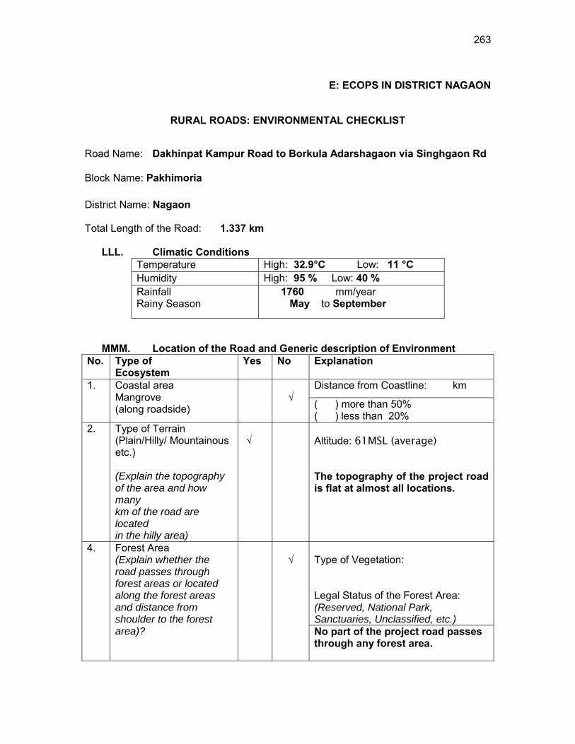
263
E: ECOPS IN DISTRICT NAGAON
RURAL ROADS: ENVIRONMENTAL CHECKLIST
Road Name: Dakhinpat Kampur Road to Borkula Adarshagaon via Singhgaon Rd
Block Name: Pakhimoria District Name: Nagaon Total Length of the Road: 1.337 km
LLL. Climatic Conditions Temperature High: 32.9°C Low: 11 °C Humidity High: 95 % Low: 40 % Rainfall Rainy Season
1760 mm/year May to September
MMM. Location of the Road and Generic description of Environment No. Type of
Ecosystem Yes No Explanation
1. Coastal area Mangrove (along roadside)
√
Distance from Coastline: km
( ) more than 50% ( ) less than 20%
2. Type of Terrain (Plain/Hilly/ Mountainous etc.) (Explain the topography of the area and how many km of the road are located in the hilly area)
√
Altitude: 61MSL (average)
The topography of the project road is flat at almost all locations.
4. Forest Area (Explain whether the road passes through forest areas or located along the forest areas and distance from shoulder to the forest area)?
√
Type of Vegetation: Legal Status of the Forest Area: (Reserved, National Park, Sanctuaries, Unclassified, etc.) No part of the project road passes through any forest area.
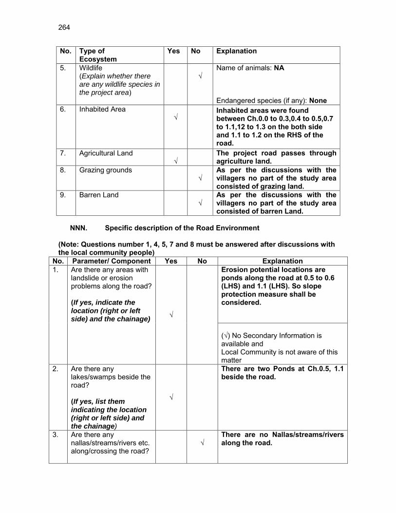
264
No. Type of Ecosystem
Yes No Explanation
5. Wildlife (Explain whether there are any wildlife species in the project area)
√
Name of animals: NA Endangered species (if any): None
6. Inhabited Area √
Inhabited areas were found between Ch.0.0 to 0.3,0.4 to 0.5,0.7 to 1.1,12 to 1.3 on the both side and 1.1 to 1.2 on the RHS of the road.
7. Agricultural Land √
The project road passes through agriculture land.
8. Grazing grounds √
As per the discussions with the villagers no part of the study area consisted of grazing land.
9. Barren Land √
As per the discussions with the villagers no part of the study area consisted of barren Land.
NNN. Specific description of the Road Environment
(Note: Questions number 1, 4, 5, 7 and 8 must be answered after discussions with the local community people)
No. Parameter/ Component Yes No Explanation 1. Are there any areas with
landslide or erosion problems along the road? (If yes, indicate the location (right or left side) and the chainage) √
Erosion potential locations are ponds along the road at 0.5 to 0.6 (LHS) and 1.1 (LHS). So slope protection measure shall be considered. (√) No Secondary Information is available and Local Community is not aware of this matter
2. Are there any lakes/swamps beside the road? (If yes, list them indicating the location (right or left side) and the chainage)
√
There are two Ponds at Ch.0.5, 1.1 beside the road.
3. Are there any nallas/streams/rivers etc. along/crossing the road?
√
There are no Nallas/streams/rivers along the road.
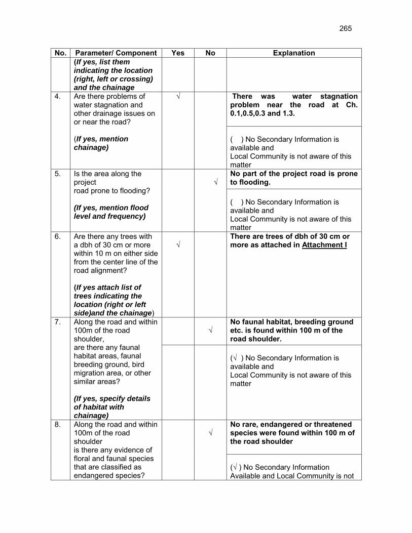
265
No. Parameter/ Component Yes No Explanation (If yes, list them indicating the location (right, left or crossing) and the chainage
4. Are there problems of water stagnation and other drainage issues on or near the road? (If yes, mention chainage)
√
There was water stagnation problem near the road at Ch. 0.1,0.5,0.3 and 1.3. ( ) No Secondary Information is available and Local Community is not aware of this matter
5. Is the area along the project road prone to flooding? (If yes, mention flood level and frequency)
√
No part of the project road is prone to flooding. ( ) No Secondary Information is available and Local Community is not aware of this matter
6. Are there any trees with a dbh of 30 cm or more within 10 m on either side from the center line of the road alignment? (If yes attach list of trees indicating the location (right or left side)and the chainage)
√
There are trees of dbh of 30 cm or more as attached in Attachment I
7. Along the road and within 100m of the road shoulder, are there any faunal habitat areas, faunal breeding ground, bird migration area, or other similar areas? (If yes, specify details of habitat with chainage)
√
No faunal habitat, breeding ground etc. is found within 100 m of the road shoulder.
(√ ) No Secondary Information is available and Local Community is not aware of this matter
8. Along the road and within 100m of the road shoulder is there any evidence of floral and faunal species that are classified as endangered species?
√
No rare, endangered or threatened species were found within 100 m of the road shoulder (√ ) No Secondary Information Available and Local Community is not
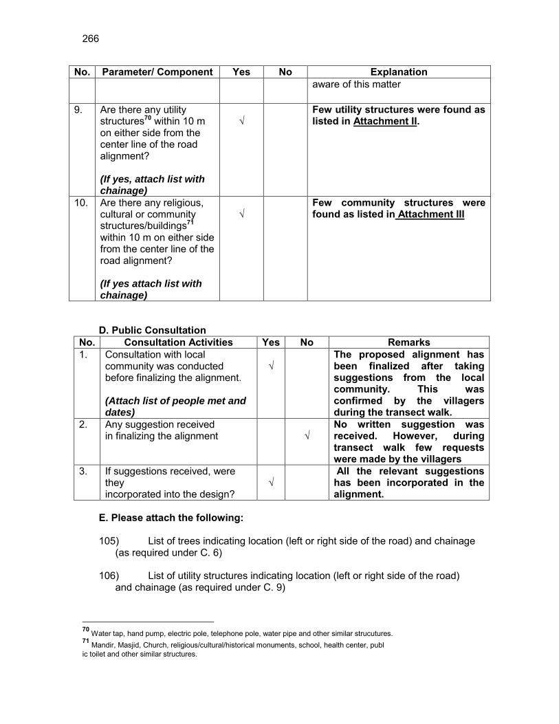
266
No. Parameter/ Component Yes No Explanation aware of this matter
9. Are there any utility structures70 within 10 m on either side from the center line of the road alignment? (If yes, attach list with chainage)
√
Few utility structures were found as listed in Attachment II.
10. Are there any religious, cultural or community structures/buildings71 within 10 m on either side from the center line of the road alignment? (If yes attach list with chainage)
√
Few community structures were found as listed in Attachment III
D. Public Consultation
No. Consultation Activities Yes No Remarks 1. Consultation with local
community was conducted before finalizing the alignment. (Attach list of people met and dates)
√
The proposed alignment has been finalized after taking suggestions from the local community. This was confirmed by the villagers during the transect walk.
2. Any suggestion received in finalizing the alignment
√
No written suggestion was received. However, during transect walk few requests were made by the villagers
3. If suggestions received, were they incorporated into the design?
√
All the relevant suggestions has been incorporated in the alignment.
E. Please attach the following: 105) List of trees indicating location (left or right side of the road) and chainage
(as required under C. 6) 106) List of utility structures indicating location (left or right side of the road)
and chainage (as required under C. 9)
70 Water tap, hand pump, electric pole, telephone pole, water pipe and other similar strucutures. 71 Mandir, Masjid, Church, religious/cultural/historical monuments, school, health center, publ ic toilet and other similar structures.
267
107) List of community structures indicating location (left or right side of the road) and chainage (as required under C. 10)
108) Sketch of strip map of the road covering details of atleast 10 m on either
side from the center line of the road
109) Photographs of the project area showing atleast 10 m on either side from center line of road alignment. Every 2 km or less of road must have atleast 1 photograph.
268
Attachment I List of Trees
Chainage Left Right 0.1 - 8 0.3 2 8 0.4 6 - 0.5 8 - 0.6 2 - 0.7 - 4 0.8 13 2 0.9 3 5 1.0 5 5 1.1 6 -
Total 45 32
Attachment II
List of Utilities
Chainage LHS RHS
From To
0.0 0.1 2 0 0.1 0.2 0 2 0.2 0.3 0 3 0.3 0.4 0 0 0.4 0.5 0 2 0.5 0.6 1 0 0.6 0.7 0 2 0.7 0.8 1 0 0.8 0.9 1 0 0.9 1.0 1 0 1.0 1.1 3 0 1.1 1.2 1 0 1.2 1.3 2 0
Total 12 9
269
Attachment II List of Community Structures
Chainage No. Side Type
0.0 LHS Namghor (Temple)
270
Attachment IV
LHS RHS 8 to 10m 6 to 8m 4 to 6m 2 to 4m
0 to 2m
0 to 2 m 2 to 4m 4 to 6m 6 to 8m 8 to 10m
Bamboo fencing
Namghor (Temple) Settlement,shop 2 EP 0 Settlement Bamboo fencing
Bamboo fencing Settlement 0.1 2 EP Settlement,shop
8 Trees,Bamboo fencing
Settlement 0.2 3 EP Settlement
2 Trees A.L 0.3 A.L 8 Trees
Bamboo fencing 6 Trees Settlement,A.L 0.4 Settlement,A.L 2 EP
Bamboo fencing
8 Trees,1 EP 1 Pond Settlement 0.5 Settlement
2 Trees 0.6 2 EP
1 EP Settlement 0.7 Settlement 4 Trees Bamboo fencing
1 EP 13 Trees Settlement 0.8 Settlement 2 Trees
Bamboo fencing 3 Trees Settlement 1 EP 0.9 Settlement 5 Trees
Bamboo fencing 5 Trees Settlement 3 EP 1 Settlement 5 Trees
1 Pond 6 Trees A.L 1 EP 1.1 Settlement
Settlement,A.L 2 EP 1.2 Settlement
Settlement 1.3 Settlement

271
EP-Electric Pole HP-Hand Pump TP-Telephone Pole A.L-Agricultural land

272
RURAL ROADS: ENVIRONMENTAL CHECKLIST
Road Name: Dewdhar Jalah PWD Road to Rantholi SC Village Road Block Name: Pakhimoria District Name: Nagaon Total Length of the Road: 1.500 km
OOO. Climatic Conditions Temperature High: 32.9°C Low: 11 °C Humidity High: 95 % Low: 40 % Rainfall Rainy Season
1760 mm/year May to September
PPP. Location of the Road and Generic description of Environment No. Type of
Ecosystem Yes No Explanation
1. Coastal area Mangrove (along roadside)
√
Distance from Coastline: km
( ) more than 50% ( ) less than 20%
2. Type of Terrain (Plain/Hilly/ Mountainous etc.) (Explain the topography of the area and how many km of the road are located in the hilly area)
√
Altitude: 61MSL (average) The topography of the project road is flat at almost all locations.
4. Forest Area (Explain whether the road passes through forest areas or located along the forest areas and distance from shoulder to the forest area)?
√
Type of Vegetation: Legal Status of the Forest Area: (Reserved, National Park, Sanctuaries, Unclassified, etc.) No part of the project road passes through any forest area.
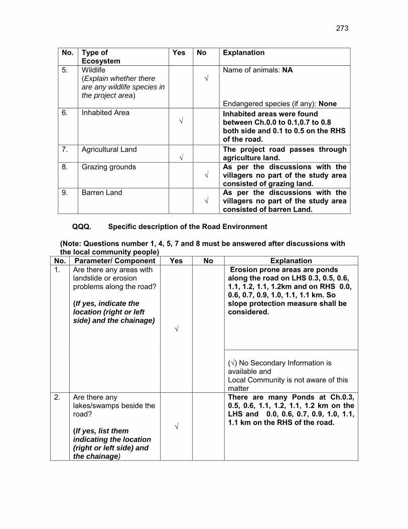
273
No. Type of Ecosystem
Yes No Explanation
5. Wildlife (Explain whether there are any wildlife species in the project area)
√
Name of animals: NA Endangered species (if any): None
6. Inhabited Area √
Inhabited areas were found between Ch.0.0 to 0.1,0.7 to 0.8 both side and 0.1 to 0.5 on the RHS of the road.
7. Agricultural Land √
The project road passes through agriculture land.
8. Grazing grounds √
As per the discussions with the villagers no part of the study area consisted of grazing land.
9. Barren Land √
As per the discussions with the villagers no part of the study area consisted of barren Land.
QQQ. Specific description of the Road Environment
(Note: Questions number 1, 4, 5, 7 and 8 must be answered after discussions with the local community people)
No. Parameter/ Component Yes No Explanation 1. Are there any areas with
landslide or erosion problems along the road? (If yes, indicate the location (right or left side) and the chainage)
√
Erosion prone areas are ponds along the road on LHS 0.3, 0.5, 0.6, 1.1, 1.2, 1.1, 1.2km and on RHS 0.0, 0.6, 0.7, 0.9, 1.0, 1.1, 1.1 km. So slope protection measure shall be considered. (√) No Secondary Information is available and Local Community is not aware of this matter
2. Are there any lakes/swamps beside the road? (If yes, list them indicating the location (right or left side) and the chainage)
√
There are many Ponds at Ch.0.3, 0.5, 0.6, 1.1, 1.2, 1.1, 1.2 km on the LHS and 0.0, 0.6, 0.7, 0.9, 1.0, 1.1, 1.1 km on the RHS of the road.
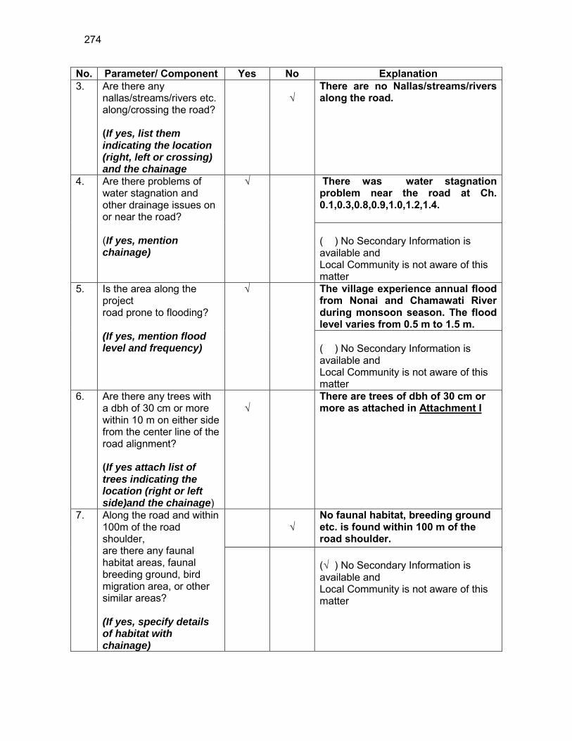
274
No. Parameter/ Component Yes No Explanation 3. Are there any
nallas/streams/rivers etc. along/crossing the road? (If yes, list them indicating the location (right, left or crossing) and the chainage
√
There are no Nallas/streams/rivers along the road.
4. Are there problems of water stagnation and other drainage issues on or near the road? (If yes, mention chainage)
√
There was water stagnation problem near the road at Ch. 0.1,0.3,0.8,0.9,1.0,1.2,1.4. ( ) No Secondary Information is available and Local Community is not aware of this matter
5. Is the area along the project road prone to flooding? (If yes, mention flood level and frequency)
√
The village experience annual flood from Nonai and Chamawati River during monsoon season. The flood level varies from 0.5 m to 1.5 m. ( ) No Secondary Information is available and Local Community is not aware of this matter
6. Are there any trees with a dbh of 30 cm or more within 10 m on either side from the center line of the road alignment? (If yes attach list of trees indicating the location (right or left side)and the chainage)
√
There are trees of dbh of 30 cm or more as attached in Attachment I
7. Along the road and within 100m of the road shoulder, are there any faunal habitat areas, faunal breeding ground, bird migration area, or other similar areas? (If yes, specify details of habitat with chainage)
√
No faunal habitat, breeding ground etc. is found within 100 m of the road shoulder.
(√ ) No Secondary Information is available and Local Community is not aware of this matter
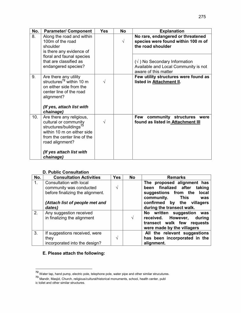
275
No. Parameter/ Component Yes No Explanation 8. Along the road and within
100m of the road shoulder is there any evidence of floral and faunal species that are classified as endangered species?
√
No rare, endangered or threatened species were found within 100 m of the road shoulder (√ ) No Secondary Information Available and Local Community is not aware of this matter
9. Are there any utility structures72 within 10 m on either side from the center line of the road alignment? (If yes, attach list with chainage)
√
Few utility structures were found as listed in Attachment II.
10. Are there any religious, cultural or community structures/buildings73 within 10 m on either side from the center line of the road alignment? (If yes attach list with chainage)
√
Few community structures were found as listed in Attachment III
D. Public Consultation
No. Consultation Activities Yes No Remarks 1. Consultation with local
community was conducted before finalizing the alignment. (Attach list of people met and dates)
√
The proposed alignment has been finalized after taking suggestions from the local community. This was confirmed by the villagers during the transect walk.
2. Any suggestion received in finalizing the alignment
√
No written suggestion was received. However, during transect walk few requests were made by the villagers
3. If suggestions received, were they incorporated into the design?
√
All the relevant suggestions has been incorporated in the alignment.
E. Please attach the following:
72 Water tap, hand pump, electric pole, telephone pole, water pipe and other similar strucutures. 73 Mandir, Masjid, Church, religious/cultural/historical monuments, school, health center, publ ic toilet and other similar structures.
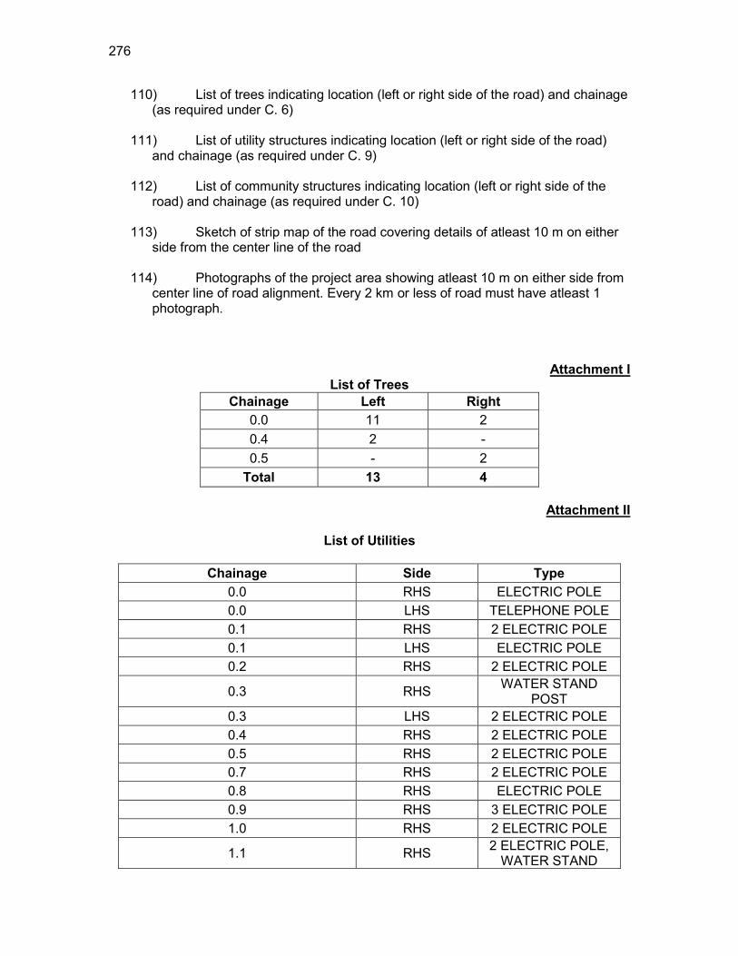
276
110) List of trees indicating location (left or right side of the road) and chainage (as required under C. 6)
111) List of utility structures indicating location (left or right side of the road)
and chainage (as required under C. 9) 112) List of community structures indicating location (left or right side of the
road) and chainage (as required under C. 10) 113) Sketch of strip map of the road covering details of atleast 10 m on either
side from the center line of the road
114) Photographs of the project area showing atleast 10 m on either side from center line of road alignment. Every 2 km or less of road must have atleast 1 photograph.
Attachment I List of Trees
Chainage Left Right 0.0 11 2 0.4 2 - 0.5 - 2
Total 13 4
Attachment II
List of Utilities
Chainage Side Type 0.0 RHS ELECTRIC POLE 0.0 LHS TELEPHONE POLE 0.1 RHS 2 ELECTRIC POLE 0.1 LHS ELECTRIC POLE 0.2 RHS 2 ELECTRIC POLE
0.3 RHS WATER STAND POST
0.3 LHS 2 ELECTRIC POLE 0.4 RHS 2 ELECTRIC POLE 0.5 RHS 2 ELECTRIC POLE 0.7 RHS 2 ELECTRIC POLE 0.8 RHS ELECTRIC POLE 0.9 RHS 3 ELECTRIC POLE 1.0 RHS 2 ELECTRIC POLE
1.1 RHS 2 ELECTRIC POLE, WATER STAND
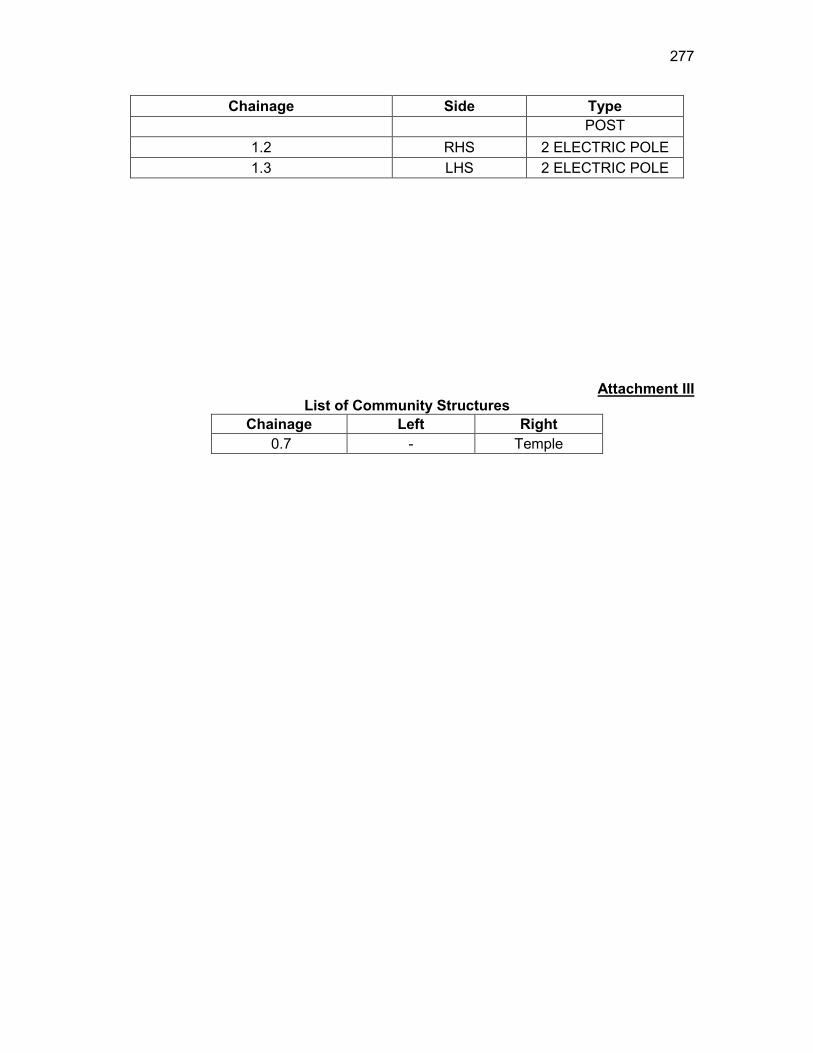
277
Chainage Side Type POST
1.2 RHS 2 ELECTRIC POLE 1.3 LHS 2 ELECTRIC POLE
Attachment III List of Community Structures
Chainage Left Right 0.7 - Temple
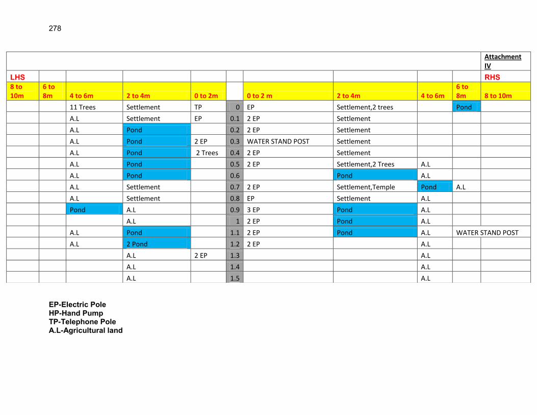
278
EP-Electric Pole HP-Hand Pump TP-Telephone Pole A.L-Agricultural land
Attachment IV
LHS RHS 8 to 10m
6 to 8m 4 to 6m 2 to 4m 0 to 2m 0 to 2 m 2 to 4m 4 to 6m
6 to 8m 8 to 10m
11 Trees Settlement TP 0 EP Settlement,2 trees Pond
A.L Settlement EP 0.1 2 EP Settlement
A.L Pond 0.2 2 EP Settlement
A.L Pond 2 EP 0.3 WATER STAND POST Settlement
A.L Pond 2 Trees 0.4 2 EP Settlement
A.L Pond 0.5 2 EP Settlement,2 Trees A.L
A.L Pond 0.6 Pond A.L
A.L Settlement 0.7 2 EP Settlement,Temple Pond A.L
A.L Settlement 0.8 EP Settlement A.L
Pond A.L 0.9 3 EP Pond A.L
A.L 1 2 EP Pond A.L
A.L Pond 1.1 2 EP Pond A.L WATER STAND POST
A.L 2 Pond 1.2 2 EP A.L
A.L 2 EP 1.3 A.L
A.L 1.4 A.L
A.L 1.5 A.L

279
RURAL ROADS: ENVIRONMENTAL CHECKLIST Road Name: Dhing road at Goroimari to Uttar tokoubari Block Name: Khagarijan District Name: Nagaon Total Length of the Road: 2.159 km
RRR. Climatic Conditions Temperature High: 32.9 °C Low: 11.2 °C Humidity High: 95 % Low: 40 % Rainfall Rainy Season
1760 mm/year May to September
SSS. Location of the Road and Generic description of Environment No. Type of
Ecosystem Yes No Explanation
1. Coastal area Mangrove (along roadside)
√
Distance from Coastline: km
( ) more than 50% ( ) less than 20%
2. Type of Terrain (Plain/Hilly/ Mountainous etc.) (Explain the topography of the area and how many km of the road are located in the hilly area)
√
Altitude: 61 MSL (average) The topography of the project road is flat at almost all locations.
4. Forest Area (Explain whether the road passes through forest areas or located along the forest areas and distance from shoulder to the forest area)?
√
Type of Vegetation: Legal Status of the Forest Area: (Reserved, National Park, Sanctuaries, Unclassified, etc.) No part of the project road passes through any forest area.
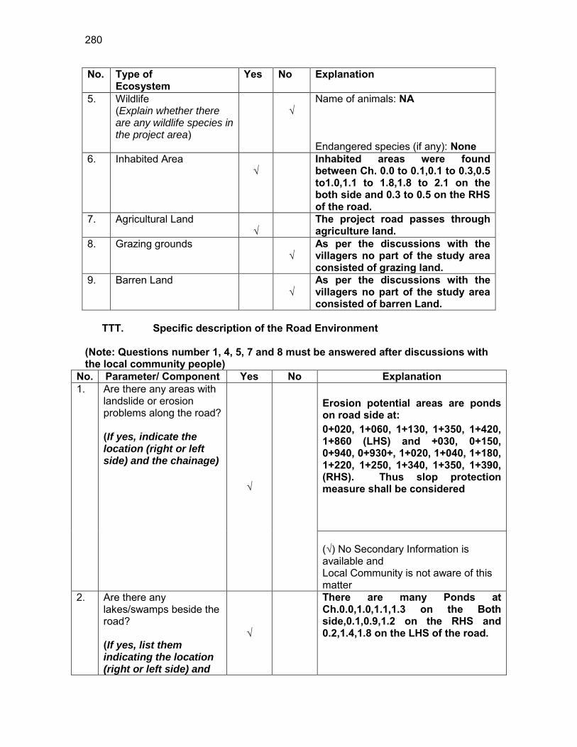
280
No. Type of Ecosystem
Yes No Explanation
5. Wildlife (Explain whether there are any wildlife species in the project area)
√
Name of animals: NA Endangered species (if any): None
6. Inhabited Area √
Inhabited areas were found between Ch. 0.0 to 0.1,0.1 to 0.3,0.5 to1.0,1.1 to 1.8,1.8 to 2.1 on the both side and 0.3 to 0.5 on the RHS of the road.
7. Agricultural Land √
The project road passes through agriculture land.
8. Grazing grounds √
As per the discussions with the villagers no part of the study area consisted of grazing land.
9. Barren Land √
As per the discussions with the villagers no part of the study area consisted of barren Land.
TTT. Specific description of the Road Environment
(Note: Questions number 1, 4, 5, 7 and 8 must be answered after discussions with the local community people)
No. Parameter/ Component Yes No Explanation 1. Are there any areas with
landslide or erosion problems along the road? (If yes, indicate the location (right or left side) and the chainage)
√
Erosion potential areas are ponds on road side at: 0+020, 1+060, 1+130, 1+350, 1+420, 1+860 (LHS) and +030, 0+150, 0+940, 0+930+, 1+020, 1+040, 1+180, 1+220, 1+250, 1+340, 1+350, 1+390, (RHS). Thus slop protection measure shall be considered (√) No Secondary Information is available and Local Community is not aware of this matter
2. Are there any lakes/swamps beside the road? (If yes, list them indicating the location (right or left side) and
√
There are many Ponds at Ch.0.0,1.0,1.1,1.3 on the Both side,0.1,0.9,1.2 on the RHS and 0.2,1.4,1.8 on the LHS of the road.
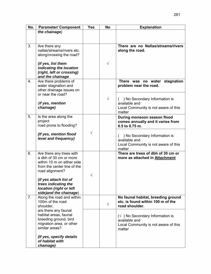
281
No. Parameter/ Component Yes No Explanation the chainage)
3. Are there any nallas/streams/rivers etc. along/crossing the road? (If yes, list them indicating the location (right, left or crossing) and the chainage
√
There are no Nallas/streams/rivers along the road.
4. Are there problems of water stagnation and other drainage issues on or near the road? (If yes, mention chainage)
√
There was no water stagnation problem near the road. ( ) No Secondary Information is available and Local Community is not aware of this matter
5. Is the area along the project road prone to flooding? (If yes, mention flood level and frequency)
√
During monsoon season flood comes annually and it varies from 0.5 to 0.75 m. ( ) No Secondary Information is available and Local Community is not aware of this matter
6. Are there any trees with a dbh of 30 cm or more within 10 m on either side from the center line of the road alignment? (If yes attach list of trees indicating the location (right or left side)and the chainage)
√
There are trees of dbh of 30 cm or more as attached in Attachment
7. Along the road and within 100m of the road shoulder, are there any faunal habitat areas, faunal breeding ground, bird migration area, or other similar areas? (If yes, specify details of habitat with chainage)
√
No faunal habitat, breeding ground etc. is found within 100 m of the road shoulder.
(√ ) No Secondary Information is available and Local Community is not aware of this matter

282
No. Parameter/ Component Yes No Explanation 8. Along the road and within
100m of the road shoulder is there any evidence of floral and faunal species that are classified as endangered species?
√
No rare, endangered or threatened species were found within 100 m of the road shoulder (√ ) No Secondary Information Available and Local Community is not aware of this matter
9. Are there any utility structures74 within 10 m on either side from the center line of the road alignment? (If yes, attach list with chainage)
√
Few utility structures were found as listed in Attachment II.
10. Are there any religious, cultural or community structures/buildings75 within 10 m on either side from the center line of the road alignment? (If yes attach list with chainage)
√
Few community structures were found as listed in Attachment III
D. Public Consultation
No. Consultation Activities Yes No Remarks 1. Consultation with local
community was conducted before finalizing the alignment. (Attach list of people met and dates)
√
The proposed alignment has been finalized after taking suggestions from the local community. This was confirmed by the villagers during the transect walk.
2. Any suggestion received in finalizing the alignment
√
No written suggestion was received. However, during transect walk few requests were made by the villagers
3. If suggestions received, were they incorporated into the design?
√
All the relevant suggestions has been incorporated in the alignment.
E. Please attach the following:
74 Water tap, hand pump, electric pole, telephone pole, water pipe and other similar strucutures. 75 Mandir, Masjid, Church, religious/cultural/historical monuments, school, health center, publ ic toilet and other similar structures.
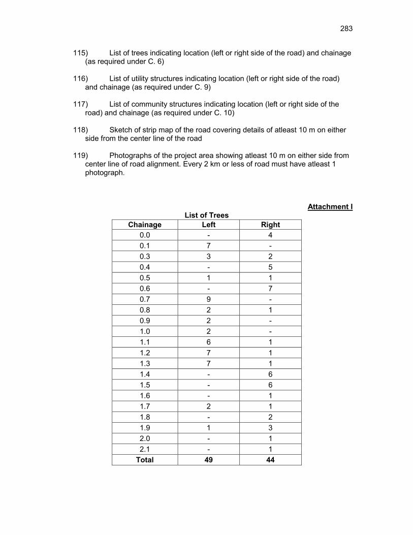
283
115) List of trees indicating location (left or right side of the road) and chainage (as required under C. 6)
116) List of utility structures indicating location (left or right side of the road)
and chainage (as required under C. 9) 117) List of community structures indicating location (left or right side of the
road) and chainage (as required under C. 10) 118) Sketch of strip map of the road covering details of atleast 10 m on either
side from the center line of the road
119) Photographs of the project area showing atleast 10 m on either side from center line of road alignment. Every 2 km or less of road must have atleast 1 photograph.
Attachment I List of Trees
Chainage Left Right 0.0 - 4 0.1 7 - 0.3 3 2 0.4 - 5 0.5 1 1 0.6 - 7 0.7 9 - 0.8 2 1 0.9 2 - 1.0 2 - 1.1 6 1 1.2 7 1 1.3 7 1 1.4 - 6 1.5 - 6 1.6 - 1 1.7 2 1 1.8 - 2 1.9 1 3 2.0 - 1 2.1 - 1
Total 49 44
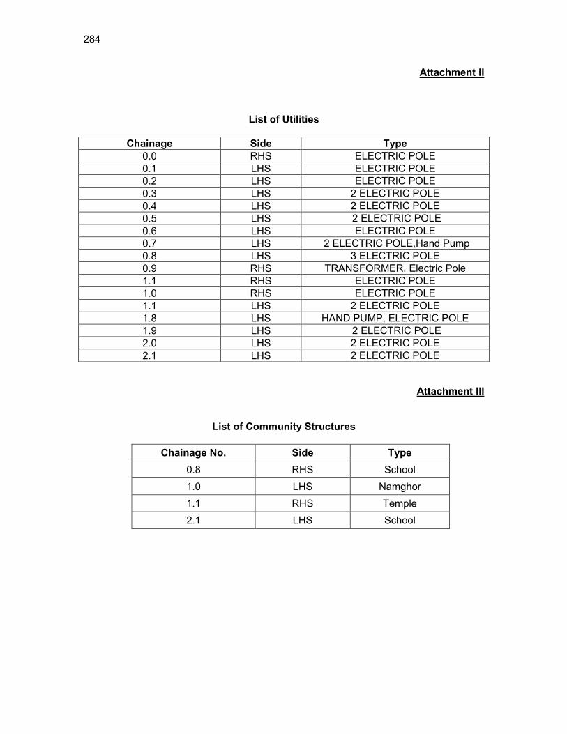
284
Attachment II
List of Utilities
Chainage Side Type 0.0 RHS ELECTRIC POLE 0.1 LHS ELECTRIC POLE 0.2 LHS ELECTRIC POLE 0.3 LHS 2 ELECTRIC POLE 0.4 LHS 2 ELECTRIC POLE 0.5 LHS 2 ELECTRIC POLE 0.6 LHS ELECTRIC POLE 0.7 LHS 2 ELECTRIC POLE,Hand Pump 0.8 LHS 3 ELECTRIC POLE 0.9 RHS TRANSFORMER, Electric Pole 1.1 RHS ELECTRIC POLE 1.0 RHS ELECTRIC POLE 1.1 LHS 2 ELECTRIC POLE 1.8 LHS HAND PUMP, ELECTRIC POLE 1.9 LHS 2 ELECTRIC POLE 2.0 LHS 2 ELECTRIC POLE 2.1 LHS 2 ELECTRIC POLE
Attachment III
List of Community Structures
Chainage No. Side Type 0.8 RHS School 1.0 LHS Namghor 1.1 RHS Temple 2.1 LHS School
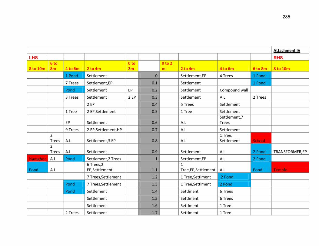
285
Attachment IV
LHS RHS
8 to 10m 6 to 8m 4 to 6m 2 to 4m
0 to 2m
0 to 2 m 2 to 4m 4 to 6m 6 to 8m 8 to 10m
1 Pond Settlement 0 Settlement,EP 4 Trees 1 Pond
7 Trees Settlement,EP 0.1 Settlement 1 Pond
Pond Settlement EP 0.2 Settlement Compound wall
3 Trees Settlement 2 EP 0.3 Settlement A.L 2 Trees
2 EP 0.4 5 Trees Settlement
1 Tree 2 EP,Settlement 0.5 1 Tree Settlement
EP Settlement 0.6 A.L Settlement,7 Trees
9 Trees 2 EP,Settlement,HP 0.7 A.L Settlement
2 Trees A.L Settlement,3 EP 0.8 A.L
1 Tree, Settlement School
2 Trees A.L Settlement 0.9 Settlement A.L 2 Pond TRANSFORMER,EP
Namghor A.L Pond Settlement,2 Trees 1 Settlement,EP A.L 2 Pond
Pond A.L 6 Trees,2 EP,Settlement 1.1
1 Tree,EP,Settlement A.L Pond Temple
7 Trees,Settlement 1.2 1 Tree,Settlment 2 Pond
Pond 7 Trees,Settlement 1.3 1 Tree,Settlment 2 Pond
Pond Settlement 1.4 Settlment 6 Trees
Settlement 1.5 Settlment 6 Trees
Settlement 1.6 Settlment 1 Tree
2 Trees Settlement 1.7 Settlment 1 Tree
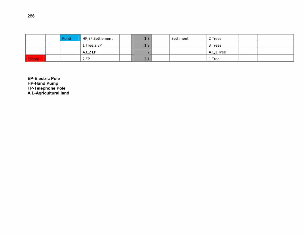
286
EP-Electric Pole HP-Hand Pump TP-Telephone Pole A.L-Agricultural land
Pond HP,EP,Settlement 1.8 Settlment 2 Trees
1 Tree,2 EP 1.9 3 Trees
A.L,2 EP 2 A.L,1 Tree
School 2 EP 2.1 1 Tree

287
RURAL ROADS: ENVIRONMENTAL CHECKLIST Road Name: Kumargaon Jatisajia Road to Darangial Road(Japisajia To Kathitoli Amlokhi Road) Block Name: Barhampur District Name: Nagaon Total Length of the Road: 2.237 km
UUU. Climatic Conditions Temperature High: 32.9 °C Low: 11 °C Humidity High: 95 % Low: 40 % Rainfall Rainy Season
1760 mm/year May to September
VVV. Location of the Road and Generic description of Environment No. Type of
Ecosystem Yes No Explanation
1. Coastal area Mangrove (along roadside)
√
Distance from Coastline: km
( ) more than 50% ( ) less than 20%
2. Type of Terrain (Plain/Hilly/ Mountainous etc.) (Explain the topography of the area and how many km of the road are located in the hilly area)
√
Altitude: 61MSL (average) The topography of the project road is flat at almost all locations.
4. Forest Area (Explain whether the road passes through forest areas or located along the forest areas and distance from shoulder to the forest area)?
√
Type of Vegetation: Legal Status of the Forest Area: (Reserved, National Park, Sanctuaries, Unclassified, etc.) No part of the project road passes through any forest area.
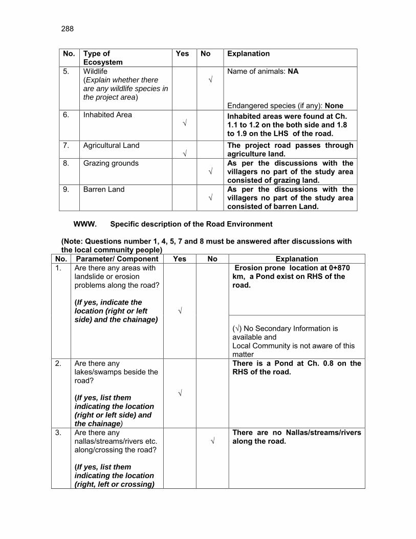
288
No. Type of Ecosystem
Yes No Explanation
5. Wildlife (Explain whether there are any wildlife species in the project area)
√
Name of animals: NA Endangered species (if any): None
6. Inhabited Area √
Inhabited areas were found at Ch. 1.1 to 1.2 on the both side and 1.8 to 1.9 on the LHS of the road.
7. Agricultural Land √
The project road passes through agriculture land.
8. Grazing grounds √
As per the discussions with the villagers no part of the study area consisted of grazing land.
9. Barren Land √
As per the discussions with the villagers no part of the study area consisted of barren Land.
WWW. Specific description of the Road Environment
(Note: Questions number 1, 4, 5, 7 and 8 must be answered after discussions with the local community people)
No. Parameter/ Component Yes No Explanation 1. Are there any areas with
landslide or erosion problems along the road? (If yes, indicate the location (right or left side) and the chainage)
√
Erosion prone location at 0+870 km, a Pond exist on RHS of the road. (√) No Secondary Information is available and Local Community is not aware of this matter
2. Are there any lakes/swamps beside the road? (If yes, list them indicating the location (right or left side) and the chainage)
√
There is a Pond at Ch. 0.8 on the RHS of the road.
3. Are there any nallas/streams/rivers etc. along/crossing the road? (If yes, list them indicating the location (right, left or crossing)
√
There are no Nallas/streams/rivers along the road.

289
No. Parameter/ Component Yes No Explanation and the chainage
4. Are there problems of water stagnation and other drainage issues on or near the road? (If yes, mention chainage)
√
There was water stagnation problem near the road at Ch. 0.2 ,0.8,0.9,1.1,1.7,1.9. ( ) No Secondary Information is available and Local Community is not aware of this matter
5. Is the area along the project road prone to flooding? (If yes, mention flood level and frequency)
√
No part of the road is prone to flooding as there are no rivers near the alignment. ( ) No Secondary Information is available and Local Community is not aware of this matter
6. Are there any trees with a dbh of 30 cm or more within 10 m on either side from the center line of the road alignment? (If yes attach list of trees indicating the location (right or left side)and the chainage)
√
There are trees of dbh of 30 cm or more as attached in Attachment I
7. Along the road and within 100m of the road shoulder, are there any faunal habitat areas, faunal breeding ground, bird migration area, or other similar areas? (If yes, specify details of habitat with chainage)
√
No faunal habitat, breeding ground etc. is found within 100 m of the road shoulder.
(√ ) No Secondary Information is available and Local Community is not aware of this matter
8. Along the road and within 100m of the road shoulder is there any evidence of
√
No rare, endangered or threatened species were found within 100 m of the road shoulder
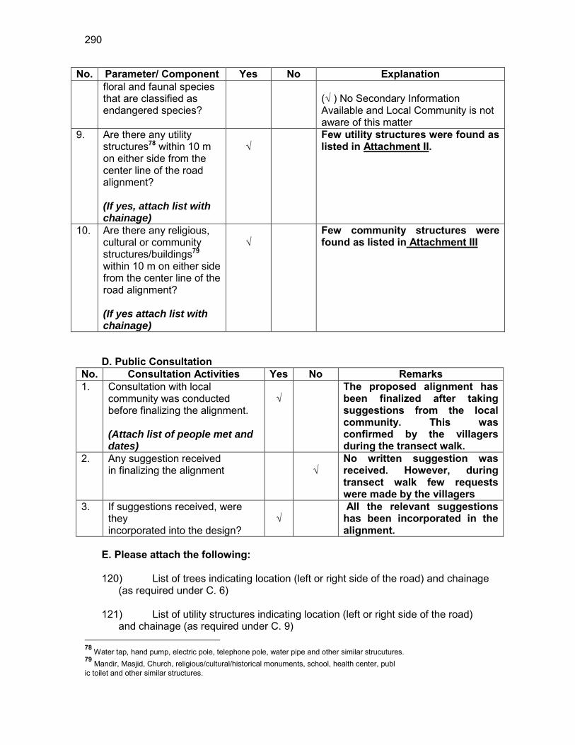
290
No. Parameter/ Component Yes No Explanation floral and faunal species that are classified as endangered species?
(√ ) No Secondary Information Available and Local Community is not aware of this matter
9. Are there any utility structures78 within 10 m on either side from the center line of the road alignment? (If yes, attach list with chainage)
√
Few utility structures were found as listed in Attachment II.
10. Are there any religious, cultural or community structures/buildings79 within 10 m on either side from the center line of the road alignment? (If yes attach list with chainage)
√
Few community structures were found as listed in Attachment III
D. Public Consultation
No. Consultation Activities Yes No Remarks 1. Consultation with local
community was conducted before finalizing the alignment. (Attach list of people met and dates)
√
The proposed alignment has been finalized after taking suggestions from the local community. This was confirmed by the villagers during the transect walk.
2. Any suggestion received in finalizing the alignment
√
No written suggestion was received. However, during transect walk few requests were made by the villagers
3. If suggestions received, were they incorporated into the design?
√
All the relevant suggestions has been incorporated in the alignment.
E. Please attach the following: 120) List of trees indicating location (left or right side of the road) and chainage
(as required under C. 6) 121) List of utility structures indicating location (left or right side of the road)
and chainage (as required under C. 9) 78 Water tap, hand pump, electric pole, telephone pole, water pipe and other similar strucutures. 79 Mandir, Masjid, Church, religious/cultural/historical monuments, school, health center, publ ic toilet and other similar structures.

291
122) List of community structures indicating location (left or right side of the
road) and chainage (as required under C. 10) 123) Sketch of strip map of the road covering details of atleast 10 m on either
side from the center line of the road
124) Photographs of the project area showing atleast 10 m on either side from center line of road alignment. Every 2 km or less of road must have atleast 1 photograph.
Attachment I
List of Trees Chainage Left Right
0.0 2 2 0.1 2 1 0.2 4 1 0.5 2 1 0.7 - 1 0.8 1 - 1.0 2 - 1.1 1 2 1.2 - 2 1.6 2 - 1.7 2 2 1.8 2 -
Total 20 11
Attachment II
List of Utilities
Chainage Side Type 0.0 LHS ELECTRIC POLE 0.1 LHS 2 ELECTRIC POLE 0.3 LHS ELECTRIC POLE
0.4 LHS 2 ELECTRIC POLE, HANDPUMP
0.5 LHS ELECTRIC POLE 0.6 RHS ELECTRIC POLE 0.6 LHS 2 ELECTRIC POLE
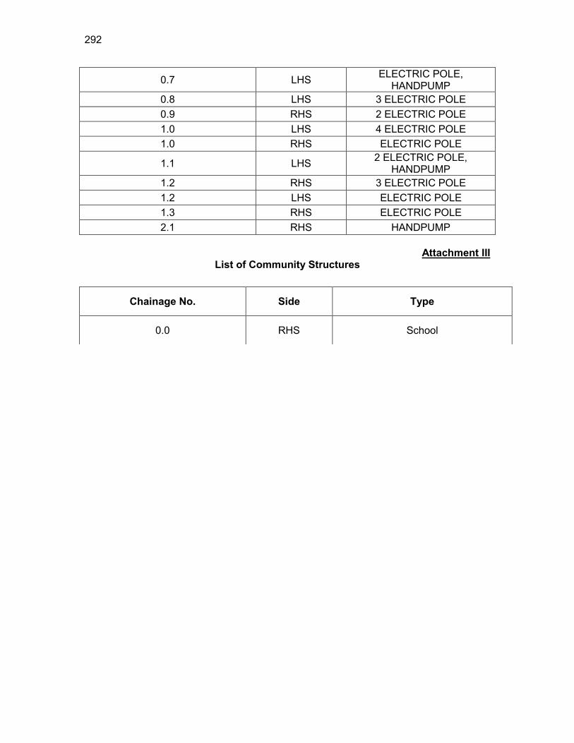
292
0.7 LHS ELECTRIC POLE, HANDPUMP
0.8 LHS 3 ELECTRIC POLE 0.9 RHS 2 ELECTRIC POLE 1.0 LHS 4 ELECTRIC POLE 1.0 RHS ELECTRIC POLE
1.1 LHS 2 ELECTRIC POLE, HANDPUMP
1.2 RHS 3 ELECTRIC POLE 1.2 LHS ELECTRIC POLE 1.3 RHS ELECTRIC POLE 2.1 RHS HANDPUMP
Attachment III
List of Community Structures
Chainage No. Side Type
0.0 RHS School
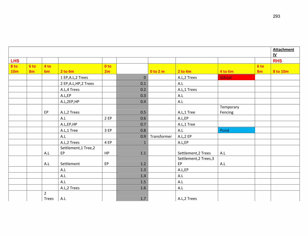
293
Attachment IV
LHS RHS 8 to 10m
6 to 8m
4 to 6m 2 to 4m
0 to 2m 0 to 2 m 2 to 4m 4 to 6m
6 to 8m 8 to 10m
1 EP,A.L,2 Trees 0 A.L,2 Trees School
2 EP,A.L,HP,2 Trees 0.1 A.L
A.L,4 Trees 0.2 A.L,1 Trees
A.L,EP 0.3 A.L
A.L,2EP,HP 0.4 A.L
EP A.L,2 Trees 0.5 A.L,1 Tree Temporary Fencing
A.L 2 EP 0.6 A.L,EP
A.L,EP,HP 0.7 A.L,1 Tree
A.L,1 Tree 3 EP 0.8 A.L Pond
A.L 0.9 Transformer A.L,2 EP
A.L,2 Trees 4 EP 1 A.L,EP
A.L Settlement,1 Tree,2 EP HP 1.1 Settlement,2 Trees A.L
A.L Settlement EP 1.2 Settlement,2 Trees,3 EP A.L
A.L 1.3 A.L,EP
A.L 1.4 A.L
A.L 1.5 A.L
A.L,2 Trees 1.6 A.L
2 Trees A.L 1.7 A.L,2 Trees
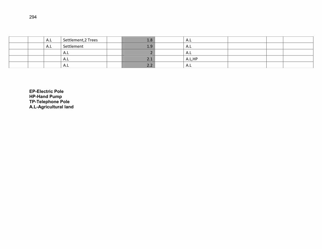
294
EP-Electric Pole HP-Hand Pump TP-Telephone Pole A.L-Agricultural land
A.L Settlement,2 Trees 1.8 A.L
A.L Settlement 1.9 A.L
A.L 2 A.L
A.L 2.1 A.L,HP
A.L 2.2 A.L

295
RURAL ROADS: ENVIRONMENTAL CHECKLIST
Road Name: Nagaon Deodhar PWD Road to Hatipara Village Block Name: Pakhimoria District Name: Nagaon Total Length of the Road: 1.274 Km
XXX. Climatic Conditions Temperature High: 32.9 °C Low: 11 °C Humidity High: 95 % Low: 40 % Rainfall Rainy Season
1760 mm/year May to September
YYY. Location of the Road and Generic description of Environment No. Type of
Ecosystem Yes No Explanation
1. Coastal area Mangrove (along roadside)
√
Distance from Coastline: km
( ) more than 50% ( ) less than 20%
2. Type of Terrain (Plain/Hilly/ Mountainous etc.) (Explain the topography of the area and how many km of the road are located in the hilly area)
√
Altitude: 61MSl (average) The topography of the project road is flat at almost all locations.
4. Forest Area (Explain whether the road passes through forest areas or located along the forest areas and distance from shoulder to the forest area)?
√
Type of Vegetation: Legal Status of the Forest Area: (Reserved, National Park, Sanctuaries, Unclassified, etc.) No part of the project road passes through any forest area.
5. Wildlife (Explain whether there are any wildlife species in the project area)
√
Name of animals: NA Endangered species (if any): None
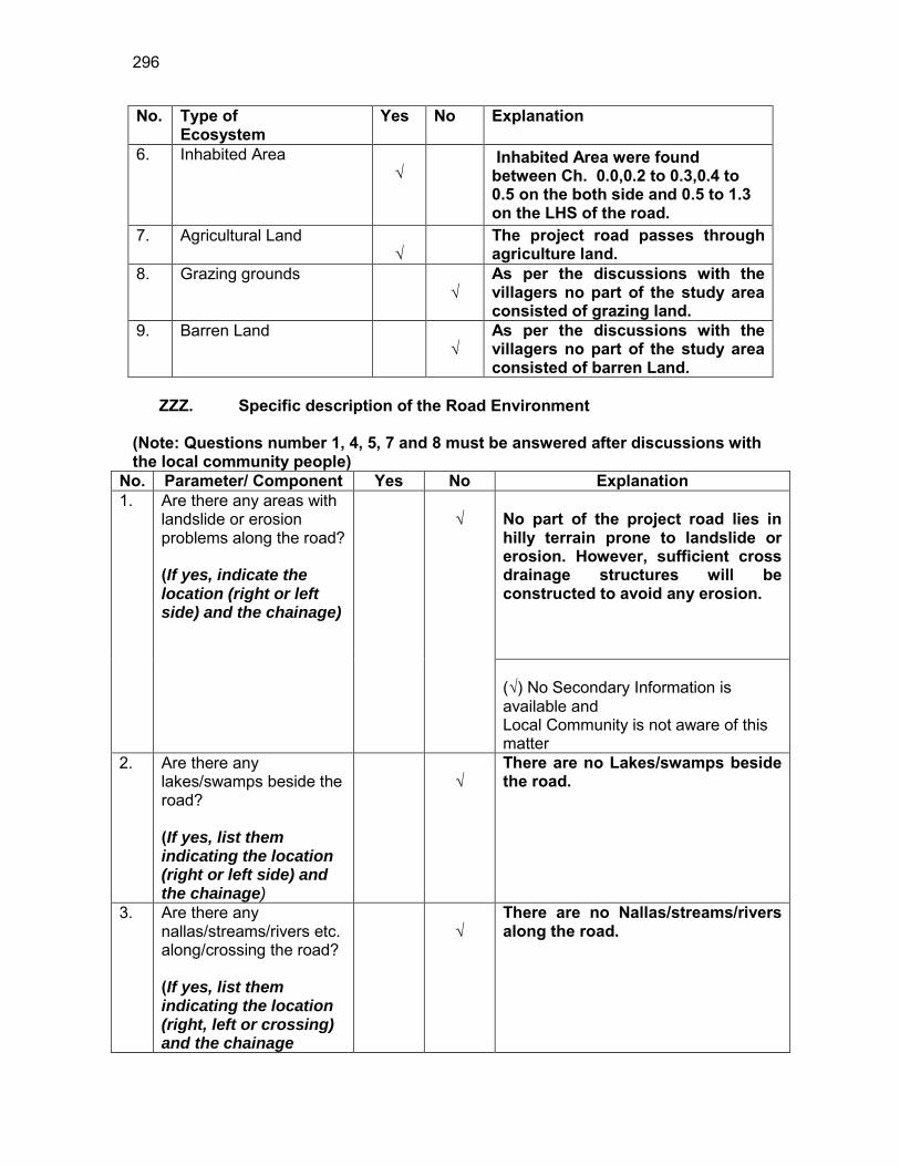
296
No. Type of Ecosystem
Yes No Explanation
6. Inhabited Area √
Inhabited Area were found between Ch. 0.0,0.2 to 0.3,0.4 to 0.5 on the both side and 0.5 to 1.3 on the LHS of the road.
7. Agricultural Land √
The project road passes through agriculture land.
8. Grazing grounds √
As per the discussions with the villagers no part of the study area consisted of grazing land.
9. Barren Land √
As per the discussions with the villagers no part of the study area consisted of barren Land.
ZZZ. Specific description of the Road Environment
(Note: Questions number 1, 4, 5, 7 and 8 must be answered after discussions with the local community people)
No. Parameter/ Component Yes No Explanation 1. Are there any areas with
landslide or erosion problems along the road? (If yes, indicate the location (right or left side) and the chainage)
√
No part of the project road lies in hilly terrain prone to landslide or erosion. However, sufficient cross drainage structures will be constructed to avoid any erosion. (√) No Secondary Information is available and Local Community is not aware of this matter
2. Are there any lakes/swamps beside the road? (If yes, list them indicating the location (right or left side) and the chainage)
√
There are no Lakes/swamps beside the road.
3. Are there any nallas/streams/rivers etc. along/crossing the road? (If yes, list them indicating the location (right, left or crossing) and the chainage
√
There are no Nallas/streams/rivers along the road.
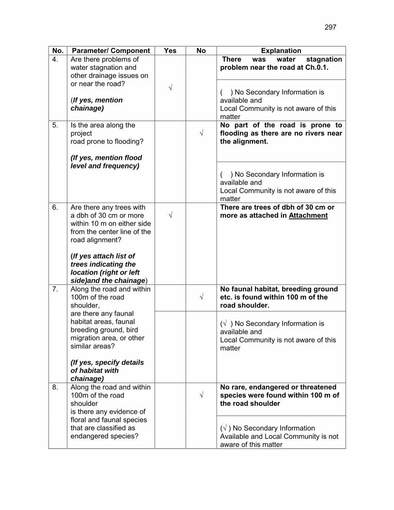
297
No. Parameter/ Component Yes No Explanation 4. Are there problems of
water stagnation and other drainage issues on or near the road? (If yes, mention chainage)
√
There was water stagnation problem near the road at Ch.0.1. ( ) No Secondary Information is available and Local Community is not aware of this matter
5. Is the area along the project road prone to flooding? (If yes, mention flood level and frequency)
√
No part of the road is prone to flooding as there are no rivers near the alignment. ( ) No Secondary Information is available and Local Community is not aware of this matter
6. Are there any trees with a dbh of 30 cm or more within 10 m on either side from the center line of the road alignment? (If yes attach list of trees indicating the location (right or left side)and the chainage)
√
There are trees of dbh of 30 cm or more as attached in Attachment
7. Along the road and within 100m of the road shoulder, are there any faunal habitat areas, faunal breeding ground, bird migration area, or other similar areas? (If yes, specify details of habitat with chainage)
√
No faunal habitat, breeding ground etc. is found within 100 m of the road shoulder.
(√ ) No Secondary Information is available and Local Community is not aware of this matter
8. Along the road and within 100m of the road shoulder is there any evidence of floral and faunal species that are classified as endangered species?
√
No rare, endangered or threatened species were found within 100 m of the road shoulder (√ ) No Secondary Information Available and Local Community is not aware of this matter

298
No. Parameter/ Component Yes No Explanation 9. Are there any utility
structures80 within 10 m on either side from the center line of the road alignment? (If yes, attach list with chainage)
√
Few utility structures were found as listed in Attachment II.
10. Are there any religious, cultural or community structures/buildings81 within 10 m on either side from the center line of the road alignment? (If yes attach list with chainage)
√
Few community structures were found as listed in Attachment III
D. Public Consultation
No. Consultation Activities Yes No Remarks 1. Consultation with local
community was conducted before finalizing the alignment. (Attach list of people met and dates)
√
The proposed alignment has been finalized after taking suggestions from the local community. This was confirmed by the villagers during the transect walk.
2. Any suggestion received in finalizing the alignment
√
No written suggestion was received. However, during transect walk few requests were made by the villagers
3. If suggestions received, were they incorporated into the design?
√
All the relevant suggestions has been incorporated in the alignment.
E. Please attach the following: 125) List of trees indicating location (left or right side of the road) and chainage
(as required under C. 6) 126) List of utility structures indicating location (left or right side of the road)
and chainage (as required under C. 9) 127) List of community structures indicating location (left or right side of the
road) and chainage (as required under C. 10)
80 Water tap, hand pump, electric pole, telephone pole, water pipe and other similar strucutures. 81 Mandir, Masjid, Church, religious/cultural/historical monuments, school, health center, publ ic toilet and other similar structures.
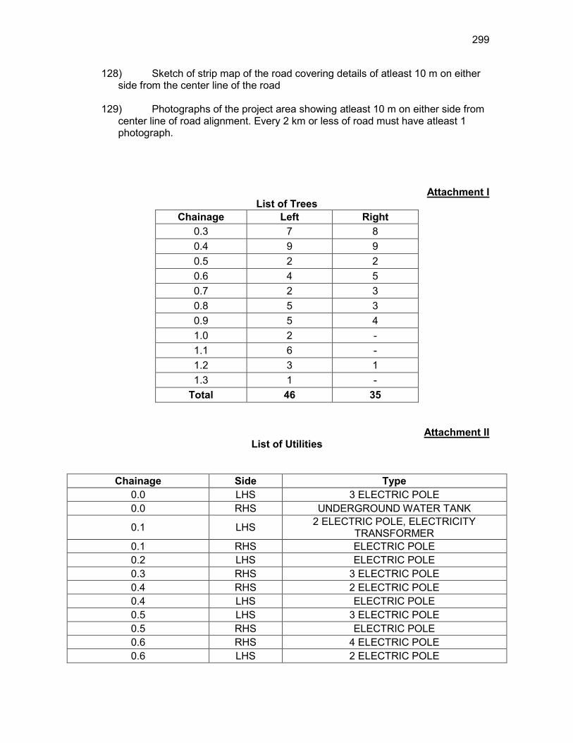
299
128) Sketch of strip map of the road covering details of atleast 10 m on either side from the center line of the road
129) Photographs of the project area showing atleast 10 m on either side from
center line of road alignment. Every 2 km or less of road must have atleast 1 photograph.
Attachment I List of Trees
Chainage Left Right 0.3 7 8 0.4 9 9 0.5 2 2 0.6 4 5 0.7 2 3 0.8 5 3 0.9 5 4 1.0 2 - 1.1 6 - 1.2 3 1 1.3 1 -
Total 46 35
Attachment II List of Utilities
Chainage Side Type 0.0 LHS 3 ELECTRIC POLE 0.0 RHS UNDERGROUND WATER TANK
0.1 LHS 2 ELECTRIC POLE, ELECTRICITY TRANSFORMER
0.1 RHS ELECTRIC POLE 0.2 LHS ELECTRIC POLE 0.3 RHS 3 ELECTRIC POLE 0.4 RHS 2 ELECTRIC POLE 0.4 LHS ELECTRIC POLE 0.5 LHS 3 ELECTRIC POLE 0.5 RHS ELECTRIC POLE 0.6 RHS 4 ELECTRIC POLE 0.6 LHS 2 ELECTRIC POLE
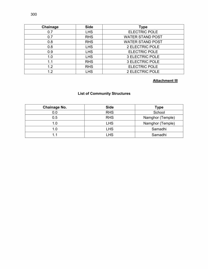
300
Chainage Side Type 0.7 LHS ELECTRIC POLE 0.7 RHS WATER STAND POST 0.8 RHS WATER STAND POST 0.8 LHS 2 ELECTRIC POLE 0.9 LHS ELECTRIC POLE 1.0 LHS 3 ELECTRIC POLE 1.1 RHS 3 ELECTRIC POLE 1.2 RHS ELECTRIC POLE 1.2 LHS 2 ELECTRIC POLE
Attachment III
List of Community Structures
Chainage No. Side Type 0.0 RHS School 0.5 RHS Namghor (Temple) 1.0 LHS Namghor (Temple) 1.0 LHS Samadhi 1.1 LHS Samadhi

301
EP-Electric Pole HP-Hand Pump TP-Telephone Pole A.L-Agricultural land
Attachment IV
LHS RHS 8 to 10m
6 to 8m 4 to 6m 2 to 4m
0 to 2m 0 to 2 m 2 to 4m 4 to 6m
6 to 8m 8 to 10m
A.L Settlement 3 EP 0 Settlement, water tank, School A.L
A.L 3 EP,Transformer 0.1 A.L
A.L Settlement EP 0.2 Settlement A.L
A.L,7 trees Settlement 0.3 3 EP Settlement A.L,8 Trees
A.L,9 Trees Settlement EP 0.4 2 EP Settlement A.L,9 Trees
2 Trees Settlement 3 EP 0.5 EP Settlement A.L,2 Trees Temple
4 Trees Settlement 2 EP 0.6 4 EP A.L,5 Trees
2 Trees Settlement EP 0.7 water stand post A.L,3 Trees
5 Trees Settlement 2 EP 0.8 water stand post 3 Trees A.L
5 Trees Settlement EP 0.9 4 Trees A.L
2 Trees,Samdhi Settlement, Temple 3 EP 1 A.L
6 Trees,Samdhi Settlement 1.1 3 EP A.L
3 Trees Settlement 2 EP 1.2 1 EP 1 Tree A.L
1 Tree Settlement 1.3 A.L

302
RURAL ROADS: ENVIRONMENTAL CHECKLIST Road Name: Nonoi Dakhinpat Road to Pumoigaon Block Name: Pakhimoria District Name: Nagaon Total Length of the Road: 0.978 Km
AAAA. Climatic Conditions Temperature High: 32.9°C Low: 11.2 °C Humidity High: 95 % Low: 40 % Rainfall Rainy Season
1760 mm/year May to September
BBBB. Location of the Road and Generic description of Environment No. Type of
Ecosystem Yes No Explanation
1. Coastal area Mangrove (along roadside)
√
Distance from Coastline: km
( ) more than 50% ( ) less than 20%
2. Type of Terrain (Plain/Hilly/ Mountainous etc.) (Explain the topography of the area and how many km of the road are located in the hilly area)
√
Altitude: 61MSL (average) The topography of the project road is flat at almost all locations.
4. Forest Area (Explain whether the road passes through forest areas or located along the forest areas and distance from shoulder to the forest area)?
√
Type of Vegetation: Legal Status of the Forest Area: (Reserved, National Park, Sanctuaries, Unclassified, etc.) No part of the project road passes through any forest area.
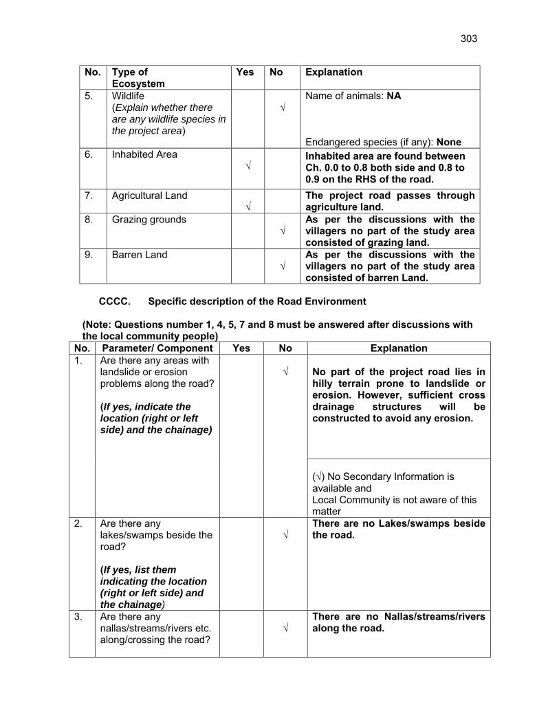
303
No. Type of Ecosystem
Yes No Explanation
5. Wildlife (Explain whether there are any wildlife species in the project area)
√
Name of animals: NA Endangered species (if any): None
6. Inhabited Area √
Inhabited area are found between Ch. 0.0 to 0.8 both side and 0.8 to 0.9 on the RHS of the road.
7. Agricultural Land √
The project road passes through agriculture land.
8. Grazing grounds √
As per the discussions with the villagers no part of the study area consisted of grazing land.
9. Barren Land √
As per the discussions with the villagers no part of the study area consisted of barren Land.
CCCC. Specific description of the Road Environment
(Note: Questions number 1, 4, 5, 7 and 8 must be answered after discussions with the local community people)
No. Parameter/ Component Yes No Explanation 1. Are there any areas with
landslide or erosion problems along the road? (If yes, indicate the location (right or left side) and the chainage)
√
No part of the project road lies in hilly terrain prone to landslide or erosion. However, sufficient cross drainage structures will be constructed to avoid any erosion. (√) No Secondary Information is available and Local Community is not aware of this matter
2. Are there any lakes/swamps beside the road? (If yes, list them indicating the location (right or left side) and the chainage)
√
There are no Lakes/swamps beside the road.
3. Are there any nallas/streams/rivers etc. along/crossing the road?
√
There are no Nallas/streams/rivers along the road.
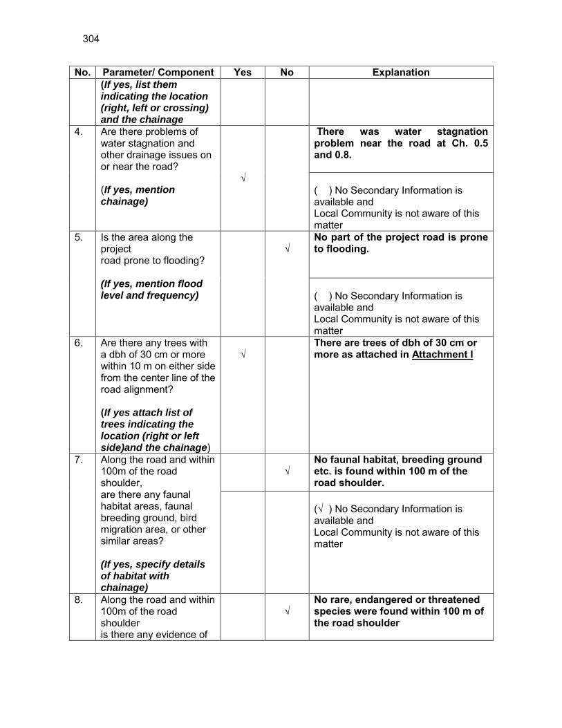
304
No. Parameter/ Component Yes No Explanation (If yes, list them indicating the location (right, left or crossing) and the chainage
4. Are there problems of water stagnation and other drainage issues on or near the road? (If yes, mention chainage)
√
There was water stagnation problem near the road at Ch. 0.5 and 0.8. ( ) No Secondary Information is available and Local Community is not aware of this matter
5. Is the area along the project road prone to flooding? (If yes, mention flood level and frequency)
√
No part of the project road is prone to flooding. ( ) No Secondary Information is available and Local Community is not aware of this matter
6. Are there any trees with a dbh of 30 cm or more within 10 m on either side from the center line of the road alignment? (If yes attach list of trees indicating the location (right or left side)and the chainage)
√
There are trees of dbh of 30 cm or more as attached in Attachment I
7. Along the road and within 100m of the road shoulder, are there any faunal habitat areas, faunal breeding ground, bird migration area, or other similar areas? (If yes, specify details of habitat with chainage)
√
No faunal habitat, breeding ground etc. is found within 100 m of the road shoulder.
(√ ) No Secondary Information is available and Local Community is not aware of this matter
8. Along the road and within 100m of the road shoulder is there any evidence of
√
No rare, endangered or threatened species were found within 100 m of the road shoulder

305
No. Parameter/ Component Yes No Explanation floral and faunal species that are classified as endangered species?
(√ ) No Secondary Information Available and Local Community is not aware of this matter
9. Are there any utility structures82 within 10 m on either side from the center line of the road alignment? (If yes, attach list with chainage)
√
Few utility structures were found as listed in Attachment II.
10. Are there any religious, cultural or community structures/buildings83 within 10 m on either side from the center line of the road alignment? (If yes attach list with chainage)
√
Few community structures were found as listed in Attachment III
D. Public Consultation
No. Consultation Activities Yes No Remarks 1. Consultation with local
community was conducted before finalizing the alignment. (Attach list of people met and dates)
√
The proposed alignment has been finalized after taking suggestions from the local community. This was confirmed by the villagers during the transect walk.
2. Any suggestion received in finalizing the alignment
√
No written suggestion was received. However, during transect walk few requests were made by the villagers
3. If suggestions received, were they incorporated into the design?
√
All the relevant suggestions has been incorporated in the alignment.
E. Please attach the following: 130) List of trees indicating location (left or right side of the road) and chainage
(as required under C. 6) 131) List of utility structures indicating location (left or right side of the road)
and chainage (as required under C. 9) 82 Water tap, hand pump, electric pole, telephone pole, water pipe and other similar strucutures. 83 Mandir, Masjid, Church, religious/cultural/historical monuments, school, health center, publ ic toilet and other similar structures.
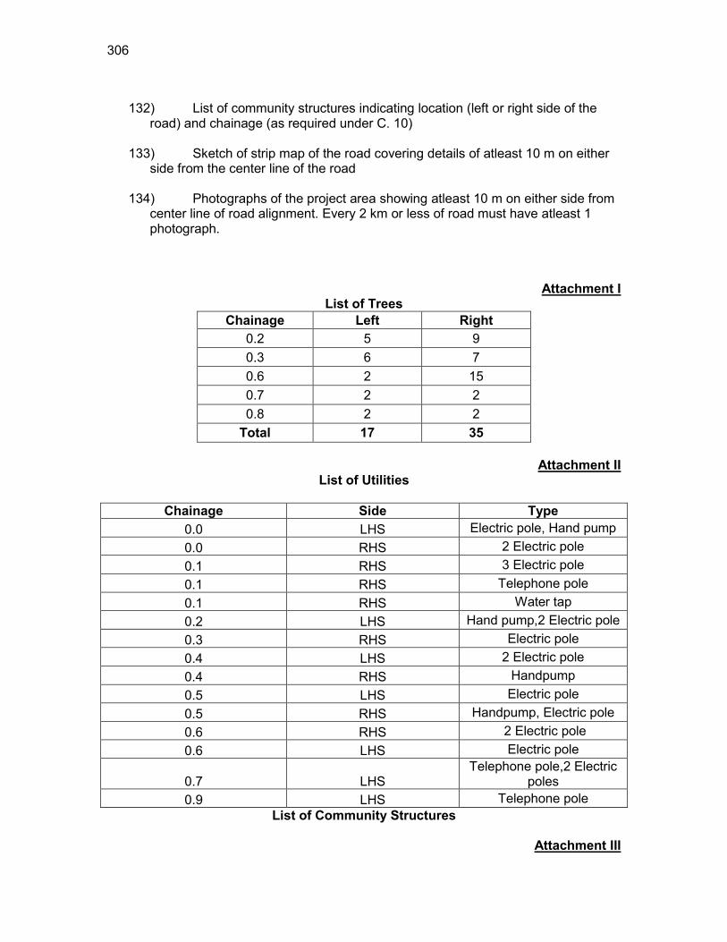
306
132) List of community structures indicating location (left or right side of the
road) and chainage (as required under C. 10) 133) Sketch of strip map of the road covering details of atleast 10 m on either
side from the center line of the road
134) Photographs of the project area showing atleast 10 m on either side from center line of road alignment. Every 2 km or less of road must have atleast 1 photograph.
Attachment I List of Trees
Chainage Left Right 0.2 5 9 0.3 6 7 0.6 2 15 0.7 2 2 0.8 2 2
Total 17 35
Attachment II List of Utilities
Chainage Side Type
0.0 LHS Electric pole, Hand pump 0.0 RHS 2 Electric pole 0.1 RHS 3 Electric pole 0.1 RHS Telephone pole 0.1 RHS Water tap 0.2 LHS Hand pump,2 Electric pole 0.3 RHS Electric pole 0.4 LHS 2 Electric pole 0.4 RHS Handpump 0.5 LHS Electric pole 0.5 RHS Handpump, Electric pole 0.6 RHS 2 Electric pole 0.6 LHS Electric pole
0.7 LHS Telephone pole,2 Electric
poles 0.9 LHS Telephone pole
List of Community Structures
Attachment III
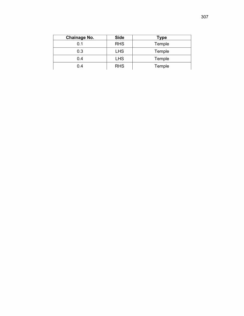
307
Chainage No. Side Type 0.1 RHS Temple
0.3 LHS Temple
0.4 LHS Temple
0.4 RHS Temple
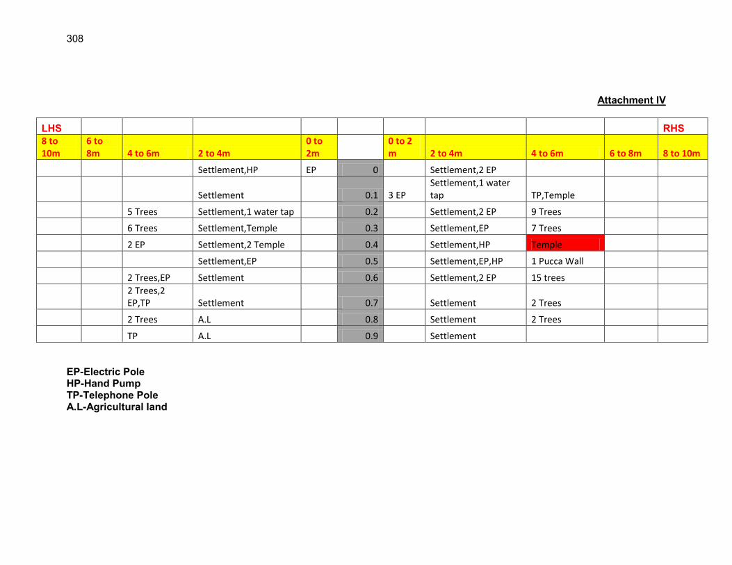
308
Attachment IV
LHS RHS 8 to 10m
6 to 8m 4 to 6m 2 to 4m
0 to 2m
0 to 2 m 2 to 4m 4 to 6m 6 to 8m 8 to 10m
Settlement,HP EP 0 Settlement,2 EP
Settlement 0.1 3 EP Settlement,1 water tap TP,Temple
5 Trees Settlement,1 water tap 0.2 Settlement,2 EP 9 Trees
6 Trees Settlement,Temple 0.3 Settlement,EP 7 Trees
2 EP Settlement,2 Temple 0.4 Settlement,HP Temple
Settlement,EP 0.5 Settlement,EP,HP 1 Pucca Wall
2 Trees,EP Settlement 0.6 Settlement,2 EP 15 trees
2 Trees,2 EP,TP Settlement 0.7 Settlement 2 Trees
2 Trees A.L 0.8 Settlement 2 Trees
TP A.L 0.9 Settlement EP-Electric Pole HP-Hand Pump TP-Telephone Pole A.L-Agricultural land
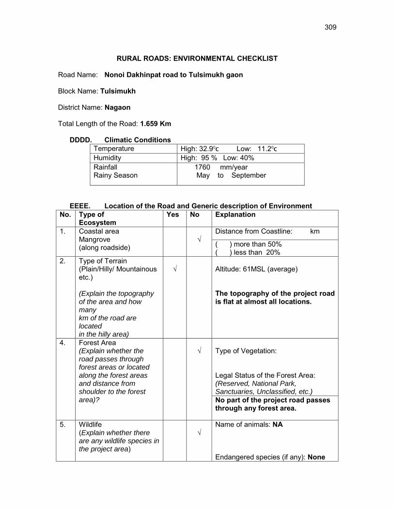
309
RURAL ROADS: ENVIRONMENTAL CHECKLIST
Road Name: Nonoi Dakhinpat road to Tulsimukh gaon Block Name: Tulsimukh District Name: Nagaon Total Length of the Road: 1.659 Km
DDDD. Climatic Conditions Temperature High: 32.90
c Low: 11.20
c Humidity High: 95 % Low: 40% Rainfall Rainy Season
1760 mm/year May to September
EEEE. Location of the Road and Generic description of Environment No. Type of
Ecosystem Yes No Explanation
1. Coastal area Mangrove (along roadside)
√
Distance from Coastline: km
( ) more than 50% ( ) less than 20%
2. Type of Terrain (Plain/Hilly/ Mountainous etc.) (Explain the topography of the area and how many km of the road are located in the hilly area)
√
Altitude: 61MSL (average) The topography of the project road is flat at almost all locations.
4. Forest Area (Explain whether the road passes through forest areas or located along the forest areas and distance from shoulder to the forest area)?
√
Type of Vegetation: Legal Status of the Forest Area: (Reserved, National Park, Sanctuaries, Unclassified, etc.) No part of the project road passes through any forest area.
5. Wildlife (Explain whether there are any wildlife species in the project area)
√
Name of animals: NA Endangered species (if any): None
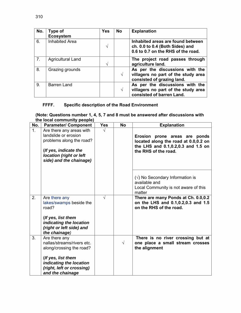
310
No. Type of Ecosystem
Yes No Explanation
6. Inhabited Area √
Inhabited areas are found between ch. 0.0 to 0.4 (Both Sides) and 0.6 to 0.7 on the RHS of the road.
7. Agricultural Land √
The project road passes through agriculture land.
8. Grazing grounds √
As per the discussions with the villagers no part of the study area consisted of grazing land.
9. Barren Land √
As per the discussions with the villagers no part of the study area consisted of barren Land.
FFFF. Specific description of the Road Environment
(Note: Questions number 1, 4, 5, 7 and 8 must be answered after discussions with the local community people)
No. Parameter/ Component Yes No Explanation 1. Are there any areas with
landslide or erosion problems along the road? (If yes, indicate the location (right or left side) and the chainage)
√
Erosion prone areas are ponds located along the road at 0.0,0.2 on the LHS and 0.1,0.2,0.3 and 1.5 on the RHS of the road. (√) No Secondary Information is available and Local Community is not aware of this matter
2. Are there any lakes/swamps beside the road? (If yes, list them indicating the location (right or left side) and the chainage)
√
There are many Ponds at Ch. 0.0,0.2 on the LHS and 0.1,0.2,0.3 and 1.5 on the RHS of the road.
3. Are there any nallas/streams/rivers etc. along/crossing the road? (If yes, list them indicating the location (right, left or crossing) and the chainage
√
There is no river crossing but at one place a small stream crosses the alignment
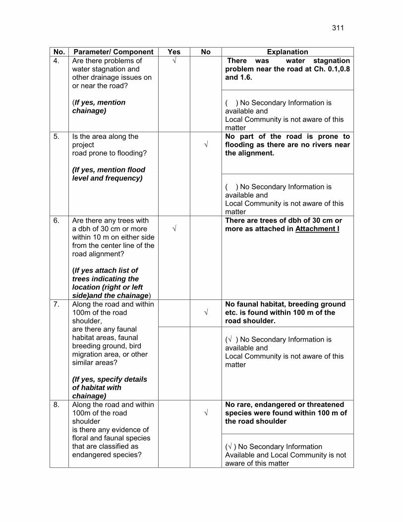
311
No. Parameter/ Component Yes No Explanation 4. Are there problems of
water stagnation and other drainage issues on or near the road? (If yes, mention chainage)
√
There was water stagnation problem near the road at Ch. 0.1,0.8 and 1.6. ( ) No Secondary Information is available and Local Community is not aware of this matter
5. Is the area along the project road prone to flooding? (If yes, mention flood level and frequency)
√
No part of the road is prone to flooding as there are no rivers near the alignment. ( ) No Secondary Information is available and Local Community is not aware of this matter
6. Are there any trees with a dbh of 30 cm or more within 10 m on either side from the center line of the road alignment? (If yes attach list of trees indicating the location (right or left side)and the chainage)
√
There are trees of dbh of 30 cm or more as attached in Attachment I
7. Along the road and within 100m of the road shoulder, are there any faunal habitat areas, faunal breeding ground, bird migration area, or other similar areas? (If yes, specify details of habitat with chainage)
√
No faunal habitat, breeding ground etc. is found within 100 m of the road shoulder.
(√ ) No Secondary Information is available and Local Community is not aware of this matter
8. Along the road and within 100m of the road shoulder is there any evidence of floral and faunal species that are classified as endangered species?
√
No rare, endangered or threatened species were found within 100 m of the road shoulder (√ ) No Secondary Information Available and Local Community is not aware of this matter

312
No. Parameter/ Component Yes No Explanation 9. Are there any utility
structures84 within 10 m on either side from the center line of the road alignment? (If yes, attach list with chainage)
√
Few utility structures were found as listed in Attachment II.
10. Are there any religious, cultural or community structures/buildings85 within 10 m on either side from the center line of the road alignment? (If yes attach list with chainage)
√ No community structures were found within 10 m on either side from the center line of the road alignment.
D. Public Consultation
No. Consultation Activities Yes No Remarks 1. Consultation with local
community was conducted before finalizing the alignment. (Attach list of people met and dates)
√
The proposed alignment has been finalized after taking suggestions from the local community. This was confirmed by the villagers during the transect walk.
2. Any suggestion received in finalizing the alignment
√
No written suggestion was received. However, during transect walk few requests were made by the villagers
3. If suggestions received, were they incorporated into the design?
√
All the relevant suggestions has been incorporated in the alignment.
E. Please attach the following: 135) List of trees indicating location (left or right side of the road) and chainage
(as required under C. 6) 136) List of utility structures indicating location (left or right side of the road)
and chainage (as required under C. 9) 137) List of community structures indicating location (left or right side of the
road) and chainage (as required under C. 10)
84 Water tap, hand pump, electric pole, telephone pole, water pipe and other similar strucutures. 85 Mandir, Masjid, Church, religious/cultural/historical monuments, school, health center, publ ic toilet and other similar structures.
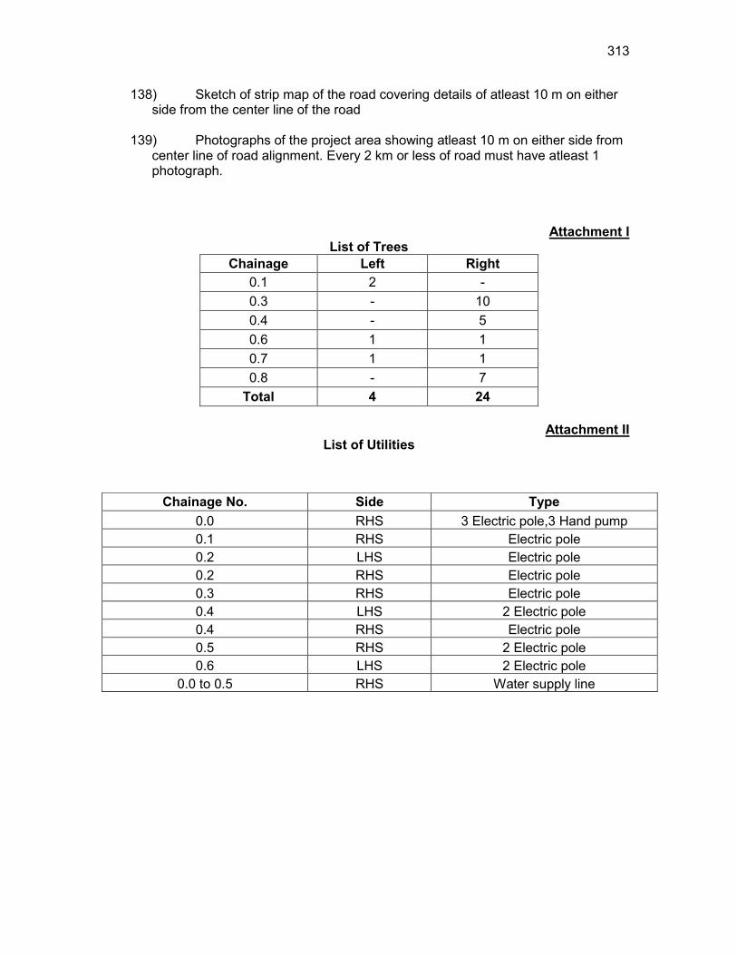
313
138) Sketch of strip map of the road covering details of atleast 10 m on either side from the center line of the road
139) Photographs of the project area showing atleast 10 m on either side from
center line of road alignment. Every 2 km or less of road must have atleast 1 photograph.
Attachment I List of Trees
Chainage Left Right 0.1 2 - 0.3 - 10 0.4 - 5 0.6 1 1 0.7 1 1 0.8 - 7
Total 4 24
Attachment II List of Utilities
Chainage No. Side Type 0.0 RHS 3 Electric pole,3 Hand pump 0.1 RHS Electric pole 0.2 LHS Electric pole 0.2 RHS Electric pole 0.3 RHS Electric pole 0.4 LHS 2 Electric pole 0.4 RHS Electric pole 0.5 RHS 2 Electric pole 0.6 LHS 2 Electric pole
0.0 to 0.5 RHS Water supply line
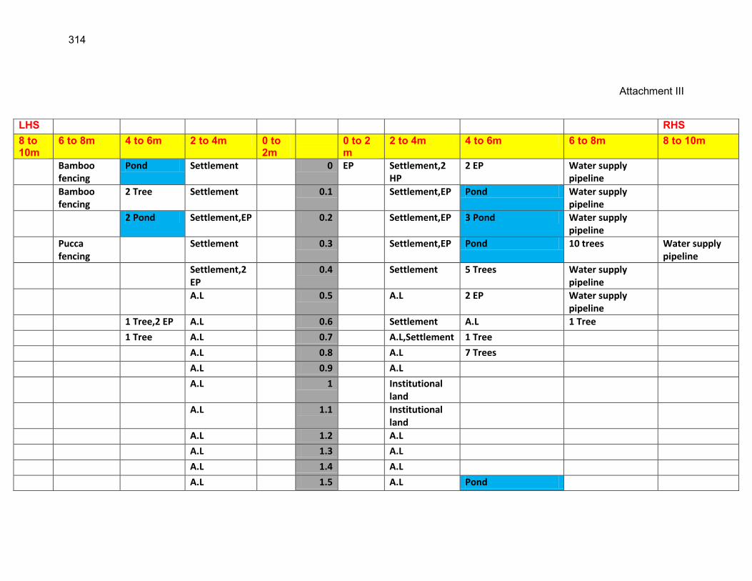
314
Attachment III
LHS RHS 8 to 10m
6 to 8m 4 to 6m 2 to 4m 0 to 2m
0 to 2 m
2 to 4m 4 to 6m 6 to 8m 8 to 10m
Bamboo fencing
Pond Settlement 0 EP Settlement,2 HP
2 EP Water supply pipeline
Bamboo fencing
2 Tree Settlement 0.1 Settlement,EP Pond Water supply pipeline
2 Pond Settlement,EP 0.2 Settlement,EP 3 Pond Water supply pipeline
Pucca fencing
Settlement 0.3 Settlement,EP Pond 10 trees Water supply pipeline
Settlement,2 EP
0.4 Settlement 5 Trees Water supply pipeline
A.L 0.5 A.L 2 EP Water supply pipeline
1 Tree,2 EP A.L 0.6 Settlement A.L 1 Tree
1 Tree A.L 0.7 A.L,Settlement 1 Tree
A.L 0.8 A.L 7 Trees
A.L 0.9 A.L
A.L 1 Institutional land
A.L 1.1 Institutional land
A.L 1.2 A.L
A.L 1.3 A.L
A.L 1.4 A.L
A.L 1.5 A.L Pond
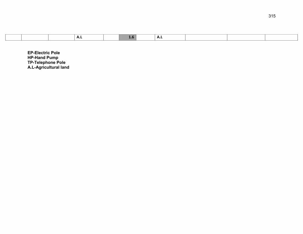
315
EP-Electric Pole HP-Hand Pump TP-Telephone Pole A.L-Agricultural land
A.L 1.6 A.L
316
Appendix 4.1: Guidelines for Borrow Areas Management
1. SELECTION OF BORROW AREAS Location of borrow areas shall be finalized as per IRC: 10-1961guidlines. The finalization of locations in case of borrows areas identified in private land shall depend upon the formal agreement between landowners and contractor. If, agreement is not reached between the contractor and landowners for the identified borrow areas sites, arrangement for locating the source of supply of material for embankment and sub-grade as well as compliance to environment requirements in respect of excavation and borrow areas as stipulated from time to time by the Ministry of Environment and Forests, Government of India, and local bodies, as applicable shall be the sole responsibility of the contractor.
The contractor in addition to the established practices, rules and regulation will also consider following criteria before finalizing the locations.
(1) The borrow area should not be located in agriculture field unless unavoidable i.e. barren land is not available.
(2) The borrow pits preferably should not be located along the roads.
(3) The loss of productive and agriculture soil should be minimum.
(4) The loss of vegetation is almost nil or minimum.
(5) The Contractor will ensure that suitable earth is available.
2. CONTRACTOR’S RESPONSIBILITY The Contractor shall obtain representative samples from each of the identified borrow areas and have these tested at the site laboratory following a testing program approved by the Engineer. It shall be ensured that the sub-grade material when compacted to the density requirements shall yield the design CBR value of the sub-grade. Contractor shall begin operations keeping in mind following;
(1) Haulage of material to embankments or other areas of fill shall proceed only when sufficient spreading and compaction plants is operating at the place of deposition.
(2) No excavated acceptable material other than surplus to requirements of the Contract shall be removed from the site. Contractor should be permitted to remove acceptable material from the site to suit his operational procedure, then shall make consequent deficit of material arising there from.
(3) Where the excavation reveals a combination of acceptable and un-acceptable materials, the Contractor shall, unless otherwise agreed by the Engineer, carry out the excavation in such a manner that the acceptable materials are excavated separately for use in the permanent works without contamination by the un-acceptable materials. The acceptable material shall be stockpiled separately.
317
3. BORROWING FROM DIFFERENT LAND-FORMS
A. Borrow Areas located in Agricultural Lands
(i) The preservation of topsoil will be carried out in stockpile. (ii) A 15 cm topsoil will be stripped off from the borrow pit and this will be
stored in stockpiles in a designated area for height not exceeding 2m and side slopes not steeper than 1:2 (Vertical: Horizontal).
(iii) Borrowing of earth will be carried out up to a depth of 1.5m from the existing ground level.
(iv) Borrowing of earth will not be done continuously through out the stretch. (v) Ridges of not less than 8m widths will be left at intervals not exceeding
300m. (vi) Small drains will be cut through the ridges, if necessary, to facilitate
drainage. (vii) The slope of the edges will be maintained not steeper than 1:4 (vertical:
Horizontal). (viii) The depth of borrow pits will not be more than 30 cm after stripping the 15
cm topsoil aside.
B. Borrow Areas located in Elevated Lands
(i) The preservation of topsoil will be carried out in stockpile. (ii) A 15 cm topsoil will be stripped off from the borrow pit and this will be
stored in stockpiles in a designated area for height not exceeding 2m and side slopes not steeper than 1:2 (Vertical: Horizontal).
(iii) At location where private owners desire their fields to be levelled, the borrowing shall be done to a depth of not more than 1.5m or up to the level of surrounding fields
C. Borrow Areas near River side
(i) The preservation of topsoil will be carried out in stockpile.
(ii) A 15 cm topsoil will be stripped off from the borrow pit and this will be stored in stockpiles in a designated area for height not exceeding 2m and side slopes not steeper than 1:2 (Vertical: Horizontal).
(iii) Borrow area near to any surface water body will be at least at a distance of 15m from the toe of the bank or high flood level, whichever is maximum.
D. Borrow Areas near Settlements
(i) The preservation of topsoil will be carried out in stockpile.
318
(ii) A 15 cm topsoil will be stripped off from the borrow pit and this will be stored in stockpiles in a designated area for height not exceeding 2m and side slopes not steeper than 1:2 (Vertical: Horizontal).
(iii) Borrow pit location will be located at least 0.75 km from villages and settlements. If un-avoidable, the pit will not be dug for more than 30 cm and drains will be cut to facilitate drainage.
(iv) Borrow pits located in such location will be re-developed immediately after borrowing is completed. If spoils are dumped, that will be covered with a l ayers of stockpiled topsoil in accordance with compliance requirements with respect MOEF/SPCB guidelines.
E. Borrow Pits along the Road
Borrow pits along the road shall be discouraged and if deemed necessary and permitted by the Engineer; following precautions are recommended
(i) The preservation of topsoil will be carried out in stockpile.
(ii) A 15 cm topsoil will be stripped off from the borrow pit and this will be stored in stockpiles in a designated area for height not exceeding 2m and side slopes not steeper than 1:2 (Vertical: Horizontal).
(iii) Ridges of not less than 8m widths should be left at intervals not exceeding 300m.
(iv) Small drains shall be cut through the ridges of facilitate drainage.
(v) The depth of the pits shall be so regulated that there bottom does not cut an imaginary line having a slope of 1 vertical to 4 horizontal projected from the edge of the final section of bank, the maximum depth of any case being limited to 1.5m.
(vi) Also, no pit shall be dug within the offset width from the toe of the embankment required as per the consideration of stability with a minimum width of 10m.
4. REHABILITATION OF BORROW AREAS The objective of the rehabilitation program is to return the borrow pit sites to a safe and secure area, which the public should be able to safely enter and enjoy. Securing borrow pits in a stable condition is fundamental requirement of the rehabilitation process. This could be achieved by filling the borrow pit floor to approximately the access road level. Re-development plan shall be prepared by the Contractor before the start of work inline with the owners will require and to the satisfaction of owner. The Borrow Areas shall be rehabilitated as per following;
Borrow pits shall be backfilled with rejected construction wastes and will be given a vegetative cover. If this is not possible, then excavation sloped will be smoothed and depression will be filled in such a way that it looks more or less like the original round surface.
Borrow areas might be used for aquaculture in case landowner wants such development. In that case, such borrow area will be photographed

319
after their post use restoration and Environment Expert of Supervision Consultant will certify the post use redevelopment.
The Contractor will keep record of photographs of various stages i.e., before using materials from the location (pre-project), for the period borrowing activities (construction Phase) and after rehabilitation (post development), to ascertain the pre and post borrowing status of the area.
320
Appendix 5.1: Environmental Management Plan
Road Name: Total length: Block Name: District Name:
(NOTE: Please refer to the ECOP checklists for individual roads and enter details under column on Location/numbers where indicated. This step will convert this standard EMP into a road specific EMP to be attached to the DPR for each road) SL. NO.
Project Action/Environmental Attributes
Mitigation Measures Location/numbers Costs Responsible for Implementing
Responsible for Monitoring
I Design and Preconstruction Stage 1.
Climate Change Consideration and Vulnerability screening
o Compliance to climate change vulnerability check point given under EARF and adoption of necessary mitigative measures as may be required
o Efforts shall be made to plant additional trees for increasing the carbon sink. The tree may be planted with help of PRI (Panchayati Raj Institution)
All through the alignment of each rural road
Design costs. PIU, Design consultants
PIU, SRRDA
2. Finalization of alignment
o The road will be part of district core network and will comply with PMGSY guidelines
o Subproject shall not disturb any cultural heritage designated by the government or by the international agencies, such as UNESCO, and shall avoid any monuments of cultural or historical importance.
o Subproject will not pass through any designated wild life sanctuaries, national park, notified Eco sensitive areas or area of international significance such as protective wet land designated under Wetland Convention, and reserve forest
All through the alignment of each rural road
Design costs PIU, Design consultants
PIU, SRRDA
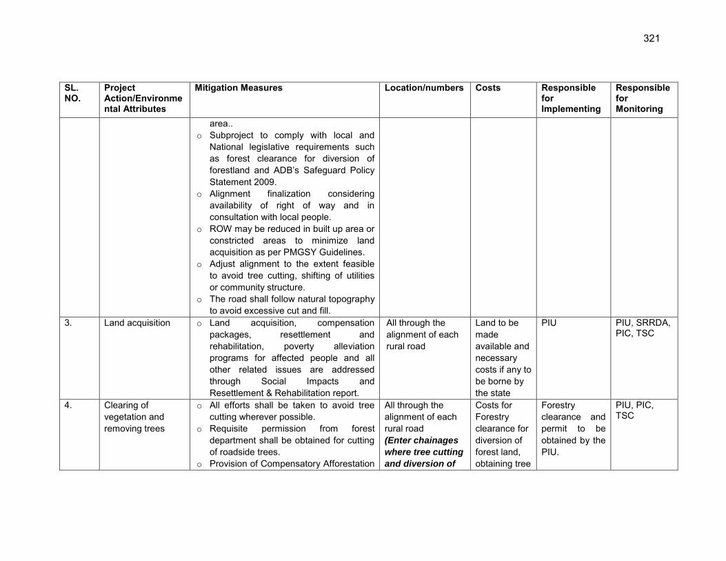
321
SL. NO.
Project Action/Environmental Attributes
Mitigation Measures Location/numbers Costs Responsible for Implementing
Responsible for Monitoring
area.. o Subproject to comply with local and
National legislative requirements such as forest clearance for diversion of forestland and ADB‟s Safeguard Policy Statement 2009.
o Alignment finalization considering availability of right of way and in consultation with local people.
o ROW may be reduced in built up area or constricted areas to minimize land acquisition as per PMGSY Guidelines.
o Adjust alignment to the extent feasible to avoid tree cutting, shifting of utilities or community structure.
o The road shall follow natural topography to avoid excessive cut and fill.
3. Land acquisition o Land acquisition, compensation packages, resettlement and rehabilitation, poverty alleviation programs for affected people and all other related issues are addressed through Social Impacts and Resettlement & Rehabilitation report.
All through the alignment of each rural road
Land to be made available and necessary costs if any to be borne by the state
PIU
PIU, SRRDA, PIC, TSC
4. Clearing of vegetation and removing trees
o All efforts shall be taken to avoid tree cutting wherever possible.
o Requisite permission from forest department shall be obtained for cutting of roadside trees.
o Provision of Compensatory Afforestation
All through the alignment of each rural road (Enter chainages
where tree cutting
and diversion of
Costs for Forestry clearance for diversion of forest land, obtaining tree
Forestry clearance and permit to be obtained by the PIU.
PIU, PIC, TSC
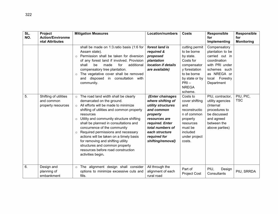
322
SL. NO.
Project Action/Environmental Attributes
Mitigation Measures Location/numbers Costs Responsible for Implementing
Responsible for Monitoring
shall be made on 1:3.ratio basis (1:6 for Assam state).
o Permission shall be taken for diversion of any forest land if involved. Provision shall be made for additional compensatory tree plantation.
o The vegetative cover shall be removed and disposed in consultation with community.
forest land is
required &
proposed
plantation
location if details
are available)
cutting permit to be borne by state. Costs for compensatory forestation to be borne by state or by PRI – NREGA scheme.
Compensatory plantation to be carried out in coordination with PRI under schemes such as NREGA or local Forestry Department
5. Shifting of utilities and common property resources
o The road land width shall be clearly demarcated on the ground.
o All efforts will be made to minimize shifting of utilities and common property resources
o Utility and community structure shifting shall be planned in consultations and concurrence of the community
o Required permissions and necessary actions will be taken on a timely basis for removing and shifting utility structures and common property resources before road construction activities begin.
(Enter chainages
where shifting of
utility structures
and common
property
resources are
required. Enter
total numbers of
each structure
required for
shifting/removal)
Costs to cover shifting and reconstruction of common property resources must be included under project costs.
PIU, contractor, utility agencies (Internal procedures to be discussed and agreed between the above parties)
PIU, PIC, TSC
6. Design and planning of embankment
o The alignment design shall consider options to minimize excessive cuts and fills.
All through the alignment of each rural road
Part of Project Cost
PIU, Design Consultants PIU, SRRDA
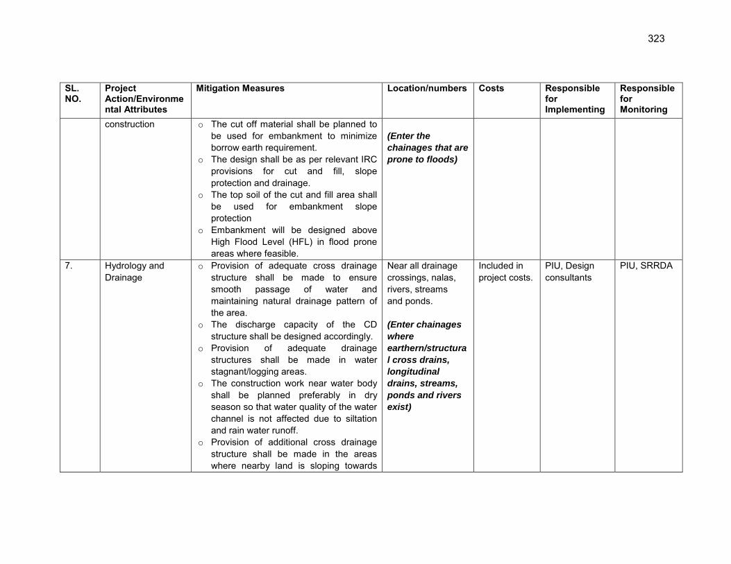
323
SL. NO.
Project Action/Environmental Attributes
Mitigation Measures Location/numbers Costs Responsible for Implementing
Responsible for Monitoring
construction o The cut off material shall be planned to be used for embankment to minimize borrow earth requirement.
o The design shall be as per relevant IRC provisions for cut and fill, slope protection and drainage.
o The top soil of the cut and fill area shall be used for embankment slope protection
o Embankment will be designed above High Flood Level (HFL) in flood prone areas where feasible.
(Enter the
chainages that are
prone to floods)
7. Hydrology and Drainage
o Provision of adequate cross drainage structure shall be made to ensure smooth passage of water and maintaining natural drainage pattern of the area.
o The discharge capacity of the CD structure shall be designed accordingly.
o Provision of adequate drainage structures shall be made in water stagnant/logging areas.
o The construction work near water body shall be planned preferably in dry season so that water quality of the water channel is not affected due to siltation and rain water runoff.
o Provision of additional cross drainage structure shall be made in the areas where nearby land is sloping towards
Near all drainage crossings, nalas, rivers, streams and ponds. (Enter chainages
where
earthern/structura
l cross drains,
longitudinal
drains, streams,
ponds and rivers
exist)
Included in project costs.
PIU, Design consultants
PIU, SRRDA
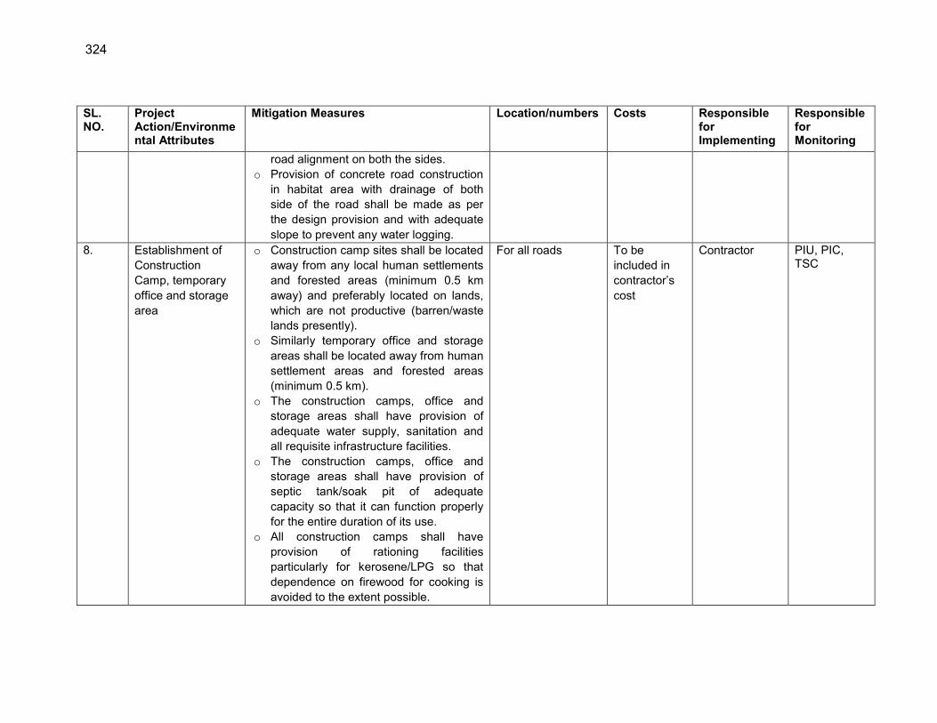
324
SL. NO.
Project Action/Environmental Attributes
Mitigation Measures Location/numbers Costs Responsible for Implementing
Responsible for Monitoring
road alignment on both the sides. o Provision of concrete road construction
in habitat area with drainage of both side of the road shall be made as per the design provision and with adequate slope to prevent any water logging.
8. Establishment of Construction Camp, temporary office and storage area
o Construction camp sites shall be located away from any local human settlements and forested areas (minimum 0.5 km away) and preferably located on lands, which are not productive (barren/waste lands presently).
o Similarly temporary office and storage areas shall be located away from human settlement areas and forested areas (minimum 0.5 km).
o The construction camps, office and storage areas shall have provision of adequate water supply, sanitation and all requisite infrastructure facilities.
o The construction camps, office and storage areas shall have provision of septic tank/soak pit of adequate capacity so that it can function properly for the entire duration of its use.
o All construction camps shall have provision of rationing facilities particularly for kerosene/LPG so that dependence on firewood for cooking is avoided to the extent possible.
For all roads
To be included in contractor‟s cost
Contractor PIU, PIC, TSC

325
SL. NO.
Project Action/Environmental Attributes
Mitigation Measures Location/numbers Costs Responsible for Implementing
Responsible for Monitoring
o The construction camps, office and storage areas shall have provision of health care facilities for adults, pregnant women and children.
o Personal Protective Equipments (PPEs) like helmet, boots, earplugs for workers, first aid and fire fighting equipments shall be available at construction sites before start of construction. An emergency plan shall be prepared to fight with any emergency like fire.
o Provision shall be made for domestic solid waste disposal in a controlled manner. The recyclable waste shall be sold off and non-saleable and biodegradable waste shall be disposed through secured land filling.
o Provision of paved area for unloading and storage of fuel oil, lubricant oil, away from storm water drainage.
9.
Traffic Management and Road Safety
o Identify the areas where temporary traffic diversion may be required.
o Prepare appropriate traffic movement plan approved by respective PIU for ensuring continued safe flow of traffic, pedestrians and all road users during construction.
o Wherever, cross drainage structure work require longer construction time and road is to be blocked for longer
As proposed under DPR and determined by contractor and approved by PIC/PIU/ (Enter the
chainages which
may require
traffic diversions
To be included in contractor‟s cost
Contractor PIU, PIC, TSC
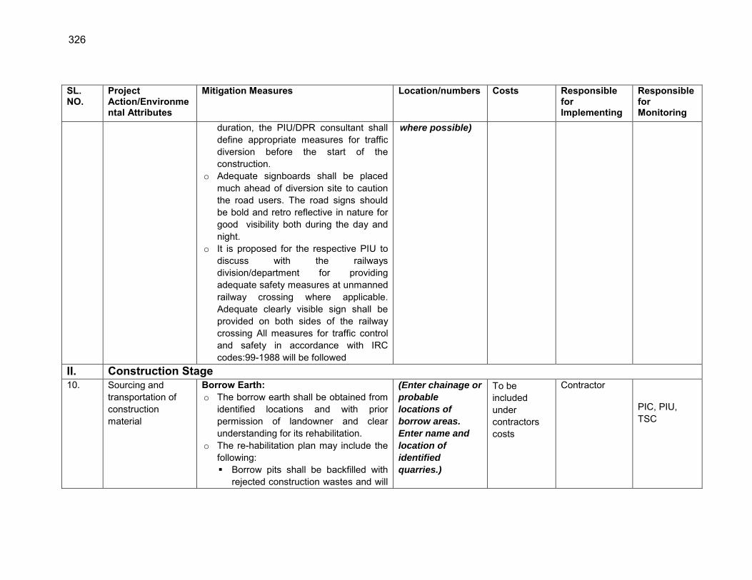
326
SL. NO.
Project Action/Environmental Attributes
Mitigation Measures Location/numbers Costs Responsible for Implementing
Responsible for Monitoring
duration, the PIU/DPR consultant shall define appropriate measures for traffic diversion before the start of the construction.
o Adequate signboards shall be placed much ahead of diversion site to caution the road users. The road signs should be bold and retro reflective in nature for good visibility both during the day and night.
o It is proposed for the respective PIU to discuss with the railways division/department for providing adequate safety measures at unmanned railway crossing where applicable. Adequate clearly visible sign shall be provided on both sides of the railway crossing All measures for traffic control and safety in accordance with IRC codes:99-1988 will be followed
where possible)
II. Construction Stage 10. Sourcing and
transportation of construction material
Borrow Earth: o The borrow earth shall be obtained from
identified locations and with prior permission of landowner and clear understanding for its rehabilitation.
o The re-habilitation plan may include the following: Borrow pits shall be backfilled with
rejected construction wastes and will
(Enter chainage or
probable
locations of
borrow areas.
Enter name and
location of
identified
quarries.)
To be included under contractors costs
Contractor PIC, PIU, TSC
327
SL. NO.
Project Action/Environmental Attributes
Mitigation Measures Location/numbers Costs Responsible for Implementing
Responsible for Monitoring
be given a vegetative cover. If this is not possible, then excavation sloped will be smoothed and depression will be filled in such a way that it looks more or less like the original ground surface.
Borrow areas might be used for aquaculture in case landowner wants such development.
o The Indian Road Congress (IRC):10-1961 guideline should be used for selection of borrow pits and amount that can be borrowed.
o Borrowing earth from agricultural land shall be minimized to the extent possible. Further, no earth shall be borrowed from already low-lying areas.
o A 15 cm topsoil will be stripped off from the borrow pit and this will be stored in stockpiles in a designated area for height not exceeding 2m and side slopes not steeper than 1:2 (Vertical: Horizontal).
o Borrowing of earth will not be done continuously through out the stretch.
o Ridges of not less than 8m widths will be left at intervals not exceeding 300m.
o Small drains will be cut through the ridges, if necessary, to facilitate drainage.
328
SL. NO.
Project Action/Environmental Attributes
Mitigation Measures Location/numbers Costs Responsible for Implementing
Responsible for Monitoring
o The slope of the edges will be maintained not steeper than 1:4 (vertical: Horizontal).
o The depth of borrow pits will not be more than 30 cm after stripping the 15 cm topsoil aside.
o Fly ash will be used in road embankment as per IRC guidelines wherever thermal power plant is located within 100 km of the road alignment.
Aggregate : o The stone aggregate shall be sourced
from existing licensed quarries o Copies of consent/ approval /
rehabilitation plan for use of existing source will be submitted to PIU.
o Topsoil to be stockpiled and protected for use at the rehabilitation stage
Transportation of Construction Material o Existing tracks / roads are to be used for
hauling of materials to the extent possible.
o Prior to construction of roads, topsoil shall be preserved and shall be used for other useful purposes like using in turfing of embankment.
o The vehicles deployed for material transportation shall be spillage proof to avoid or minimize the spillage of the material during transportation. In any
329
SL. NO.
Project Action/Environmental Attributes
Mitigation Measures Location/numbers Costs Responsible for Implementing
Responsible for Monitoring
case, the transportation links are to be inspected at least twice daily to clear accidental spillage, if any.
11. Loss of Productive Soil, erosion and land use change
o The top soil from the productive land (borrow areas, road widening areas etc.) shall be preserved and reused for plantation purposes.
o It shall also be used as top cover of embankment slope for growing vegetation to protect soil erosion.
o Cut and fill shall be planned as per IRC provisions and rural road manual.
o All steep cuts shall be flattened and benched.
o Shrubs shall be planted in loose soil area.
o IRC: 56 -1974 recommended practice for treatment of embankment slopes for erosion control shall be taken into consideration.
o It shall be ensured that the land taken on lease for access road, construction camp and temporary office of the storage facilities is restored back to its original land use before handing it over back to land owner.
All though the alignment of each project road
To be included under contractors costs
Contractor PIU / SRRDA
12.
Compaction and Contamination of Soil
o To prevent soil compaction in the adjoining productive lands beyond the ROW, the movement of construction vehicles, machinery and equipment
All though the alignment of each project road
To be included under contractors
Contractor, PIU, PIC, TSC
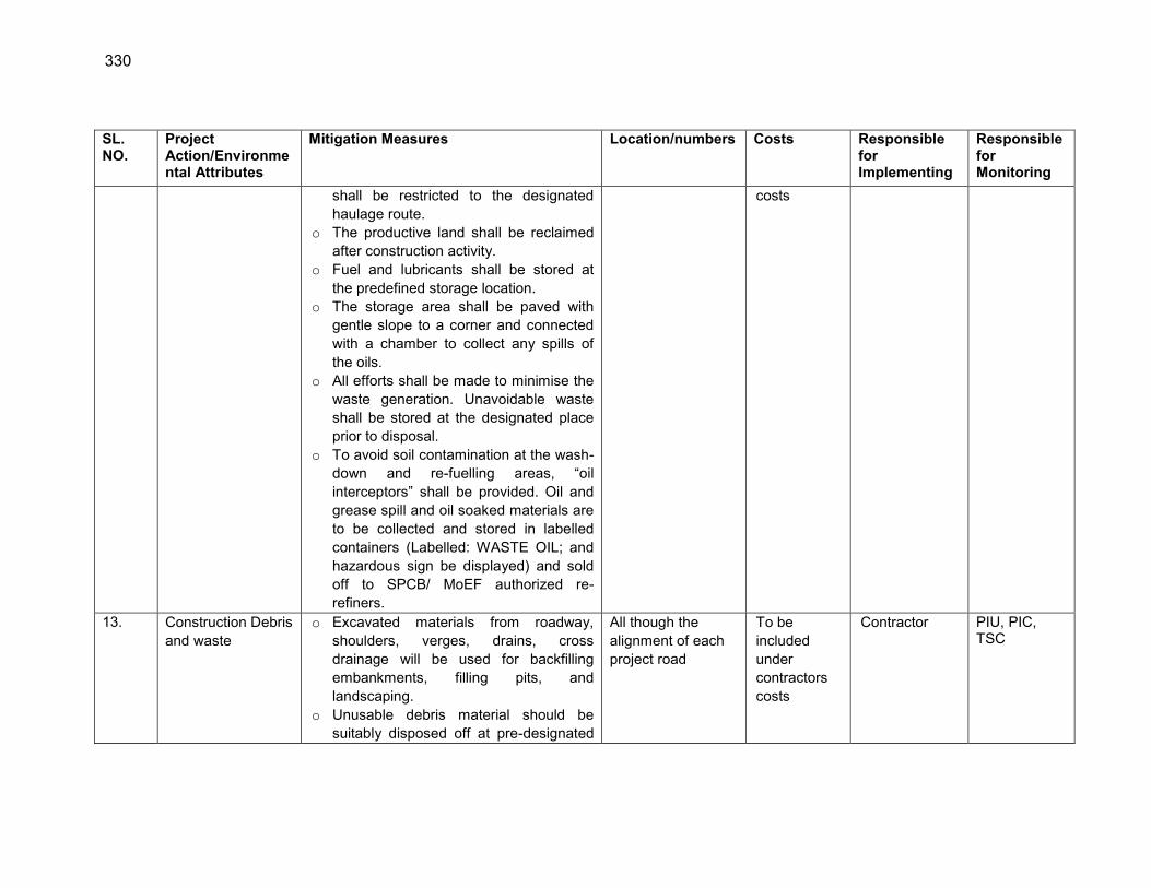
330
SL. NO.
Project Action/Environmental Attributes
Mitigation Measures Location/numbers Costs Responsible for Implementing
Responsible for Monitoring
shall be restricted to the designated haulage route.
o The productive land shall be reclaimed after construction activity.
o Fuel and lubricants shall be stored at the predefined storage location.
o The storage area shall be paved with gentle slope to a corner and connected with a chamber to collect any spills of the oils.
o All efforts shall be made to minimise the waste generation. Unavoidable waste shall be stored at the designated place prior to disposal.
o To avoid soil contamination at the wash-down and re-fuelling areas, “oil interceptors” shall be provided. Oil and grease spill and oil soaked materials are to be collected and stored in labelled containers (Labelled: WASTE OIL; and hazardous sign be displayed) and sold off to SPCB/ MoEF authorized re-refiners.
costs
13. Construction Debris and waste
o Excavated materials from roadway, shoulders, verges, drains, cross drainage will be used for backfilling embankments, filling pits, and landscaping.
o Unusable debris material should be suitably disposed off at pre-designated
All though the alignment of each project road
To be included under contractors costs
Contractor PIU, PIC, TSC

331
SL. NO.
Project Action/Environmental Attributes
Mitigation Measures Location/numbers Costs Responsible for Implementing
Responsible for Monitoring
disposal locations, with approval of the concerned authority.
o The bituminous wastes shall be disposed in secure manner at designated landfill sites only in an environmentally accepted manner.
o For removal of debris, wastes and its disposal MOSRTH guidelines should be followed. Unproductive/wastelands shall be selected with the consent of villagers and Panchayat for the same. The dumping site should be of adequate capacity. It should be located at least 500 m away from the residential areas. Dumping sites should be away from water bodies to prevent any contamination of these bodies.
14. Air and Noise Quality
o Vehicles delivering loose and fine materials like sand and aggregates shall be covered.
o Dust suppression measures like water sprinkling, shall be applied in all dust prone locations such as unpaved haulage roads, earthworks, stockpiles and asphalt mixing areas.
o Mixing plants and asphalt (hot mix) plants shall be located at least 0.5 km away and in downwind direction of the human settlements.
o Material storage areas shall also be
Throughout the project road section
To be included under contractors costs
Contractor PIU, SRRDA
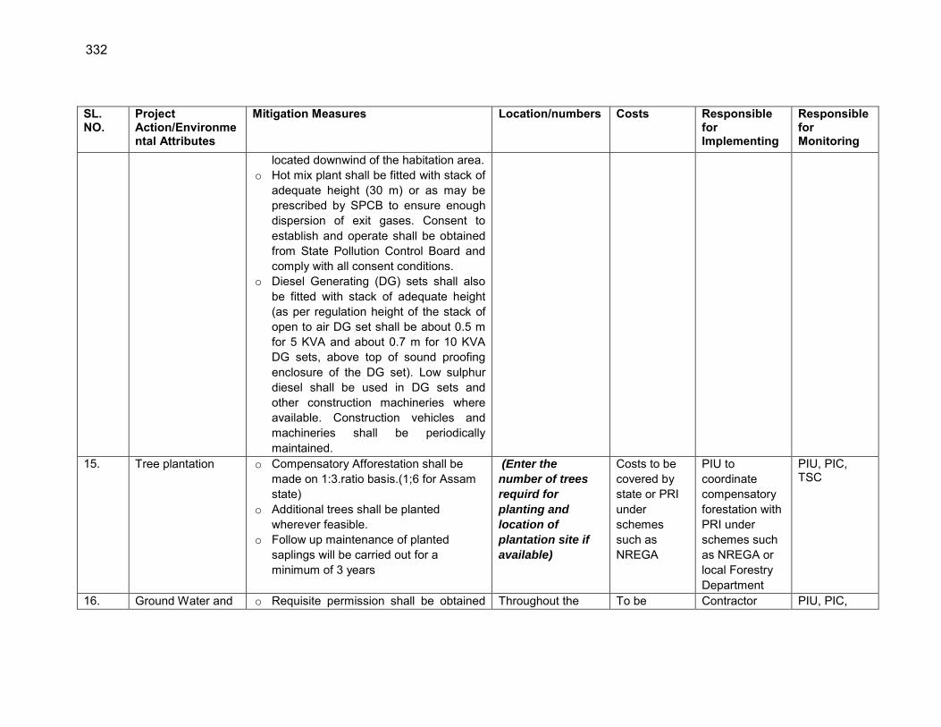
332
SL. NO.
Project Action/Environmental Attributes
Mitigation Measures Location/numbers Costs Responsible for Implementing
Responsible for Monitoring
located downwind of the habitation area. o Hot mix plant shall be fitted with stack of
adequate height (30 m) or as may be prescribed by SPCB to ensure enough dispersion of exit gases. Consent to establish and operate shall be obtained from State Pollution Control Board and comply with all consent conditions.
o Diesel Generating (DG) sets shall also be fitted with stack of adequate height (as per regulation height of the stack of open to air DG set shall be about 0.5 m for 5 KVA and about 0.7 m for 10 KVA DG sets, above top of sound proofing enclosure of the DG set). Low sulphur diesel shall be used in DG sets and other construction machineries where available. Construction vehicles and machineries shall be periodically maintained.
15. Tree plantation o Compensatory Afforestation shall be made on 1:3.ratio basis.(1;6 for Assam state)
o Additional trees shall be planted wherever feasible.
o Follow up maintenance of planted saplings will be carried out for a minimum of 3 years
(Enter the
number of trees
requird for
planting and
location of
plantation site if
available)
Costs to be covered by state or PRI under schemes such as NREGA
PIU to coordinate compensatory forestation with PRI under schemes such as NREGA or local Forestry Department
PIU, PIC, TSC
16. Ground Water and o Requisite permission shall be obtained Throughout the To be Contractor PIU, PIC,
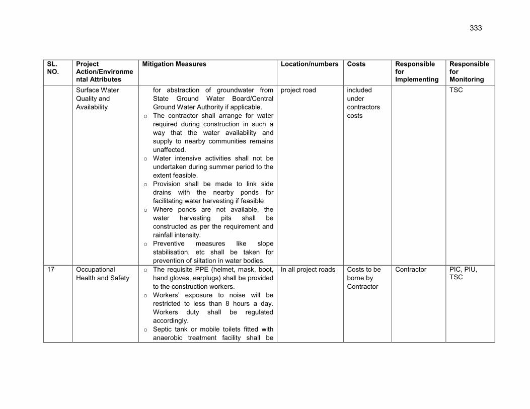
333
SL. NO.
Project Action/Environmental Attributes
Mitigation Measures Location/numbers Costs Responsible for Implementing
Responsible for Monitoring
Surface Water Quality and Availability
for abstraction of groundwater from State Ground Water Board/Central Ground Water Authority if applicable.
o The contractor shall arrange for water required during construction in such a way that the water availability and supply to nearby communities remains unaffected.
o Water intensive activities shall not be undertaken during summer period to the extent feasible.
o Provision shall be made to link side drains with the nearby ponds for facilitating water harvesting if feasible
o Where ponds are not available, the water harvesting pits shall be constructed as per the requirement and rainfall intensity.
o Preventive measures like slope stabilisation, etc shall be taken for prevention of siltation in water bodies.
project road included under contractors costs
TSC
17 Occupational Health and Safety
o The requisite PPE (helmet, mask, boot, hand gloves, earplugs) shall be provided to the construction workers.
o Workers‟ exposure to noise will be restricted to less than 8 hours a day. Workers duty shall be regulated accordingly.
o Septic tank or mobile toilets fitted with anaerobic treatment facility shall be
In all project roads Costs to be borne by Contractor
Contractor PIC, PIU, TSC
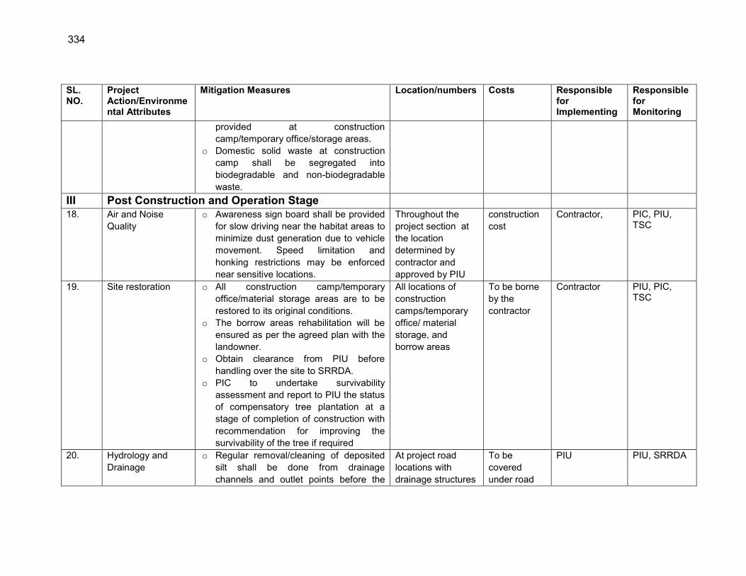
334
SL. NO.
Project Action/Environmental Attributes
Mitigation Measures Location/numbers Costs Responsible for Implementing
Responsible for Monitoring
provided at construction camp/temporary office/storage areas.
o Domestic solid waste at construction camp shall be segregated into biodegradable and non-biodegradable waste.
III Post Construction and Operation Stage 18. Air and Noise
Quality o Awareness sign board shall be provided
for slow driving near the habitat areas to minimize dust generation due to vehicle movement. Speed limitation and honking restrictions may be enforced near sensitive locations.
Throughout the project section at the location determined by contractor and approved by PIU
construction cost
Contractor, PIC, PIU, TSC
19. Site restoration o All construction camp/temporary office/material storage areas are to be restored to its original conditions.
o The borrow areas rehabilitation will be ensured as per the agreed plan with the landowner.
o Obtain clearance from PIU before handling over the site to SRRDA.
o PIC to undertake survivability assessment and report to PIU the status of compensatory tree plantation at a stage of completion of construction with recommendation for improving the survivability of the tree if required
All locations of construction camps/temporary office/ material storage, and borrow areas
To be borne by the contractor
Contractor PIU, PIC, TSC
20. Hydrology and Drainage
o Regular removal/cleaning of deposited silt shall be done from drainage channels and outlet points before the
At project road locations with drainage structures
To be covered under road
PIU PIU, SRRDA

335
SL. NO.
Project Action/Environmental Attributes
Mitigation Measures Location/numbers Costs Responsible for Implementing
Responsible for Monitoring
monsoon season. o Rejuvenation of the drainage system by
removing encroachments/ congestions shall be regularly conducted
maintenance costs.
Note : 1. Road specific measures may vary depending on its location and environmental setting around. The exact extent of activities and related
measures requires will depend on final alignment selection. Table 1 provides the list of common utilities, ponds, or community structures falling within 2-4 M of the road and may require shifting. Efforts shall be made to adopt the mitigative measures listed under respective section above including measures of aligning road on one end to save the the structures/trees as much as possible. The PIU will update this EMP before attaching it with the DPR and either list or refer to the section of DPR for highlighting the exact location with chainage of action areas (regarding shifting of common utilities, community structures, location of CD structures, embankment height in the flood prone areas, slope stabilization measures with locations near ponds or water bodies, tree cutting locations)
2. The information to be updated in the standard EMP before attaching it with DPR is highlighted under location column of the standard EMP.

336
Table 1: Assam : Environmental Features within 0-4 m from road edge which may require shifting/protection measures
S. No Block District Road name
Hand-pump
Electric poles Transformer
Telephone poles Trees Temple School Tap
Water tank
Ponds /well River Forest
Water logging
Flood prone
1 Gomaiguri Golaghat G- 28 to Adarsha No. 1 3 38 - - 139 - - - - - - -
Ch. 0.1,0.2,1.3,1.5,2.1,2.5. -
2 Gomaiguri Golaghat L 023 to Khutakata
Phuloni(Phulonigaon ali) - 20 - - 23 - - - - - - -
Ch. 0.0,0.2,0.8 and 1.6. -
3 Golaghat
T6 to Samukjan(Lakhimipathar
Sarimari Ali) 2 30 - - 41 - - - - - - -
Ch. 0.2,1.6,1.7,1.9. -
4 East
Golaghat Golaghat T2 TO BOSAGAON (NA-
PAMOWA ALI) 3 6 1 - 77 2 - - - -
Ch. 1.4,1.5,1.6,2.0,2.1,2.6. YES
5 Gomariguri Golaghat T 1 to Titabor Tongia
(Torani Mazgaon) - 23 - - - - - 114 - - - - Ch. 2.0 and 2.2. -
6 East
Golaghat Golaghat T 2 to Kachari
NO.1(Athgaon Ali) - 7 1 - 56 - - - - - - -
YES(Chainage missing) -
7 East
Golaghat Golaghat Gohainchuk Ali T 2 to T
3(Charipuria Ali) - 27 1 - 27 - - - - - - -
Ch. 0.0,0.4,0.7,0.9,1.1. -
8 Titabor Jorahat ALENGI CHUNGI ROAD - 42 - - 134 - - - - - - - Ch. 0.1,2.8 YES
9 Titabor Jorahat BOGARGAON CHAKILAL
ROAD 5 58 - 10 214 - - - - 2 - -
YES(Chainage missing) YES
10 Titabor Jorahat Dewgharia Na Ali road 1 8 - - 41 - 1 - - 2 - -
YES(Chainage missing) -
11 Titabor Jorahat KHATOWAL MORAN
GAON ROAD 2 38 - 9 60 - - - - - - -
Ch. 0.4,0.6,1.2. -
12 Titabor Jorahat Namchungi road 6 31 - 5 111 - - - - - - - Ch. 0.8,2.7,3. YES
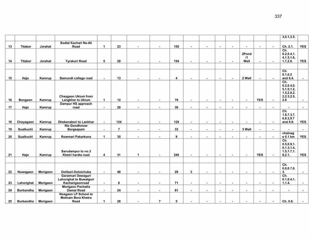
337
3,0.1,3.5.
13 Titabor Jorahat Sodial Kachari Na-Ali
Road 1 23 - - 155 - - - - - - - Ch. 2.1. YES
14 Titabor Jorahat Tyrakuri Road 5 28 - - 154 - - - -
2Pond/1
Well - -
Ch. 0.2,0.4,1.4,1.5,1.6,1.7,2.0. YES
15 Hajo Kamrup Bamundi college road - 13 - - 4 - - - - 2 Well - -
Ch. 0.1,0.2 and 0.4. -
16 Bongaon Kamrup Chaygaon Ukium from
Langkhar to Ukium 1 12 - - 76 - - - - - YES -
Ch. 0.2,0.4,0.5,1.0,1.2,1.5,2.0,2.2,2.3,2.5,2.8 -
17 Hajo Kamrup Dampur HS approach
road - 20 - - 30 - - - - - - - - -
18 Chayagaon Kamrup Dhekenabori to Lankhar - 124 - - 125 - - - - - - -
Ch. 1.8,7.3,7.6,8.2,9.7 and 9.9. YES
19 Sualkuchi Kamrup Niz Gondhmow
Borgeapam - 7 - - 33 - - - - 3 Well - - - -
20 Sualkuchi Kamrup Rowmari Pakarkona 1 35 - - 9 - - - - - - - chainage 0.1 km YES
21 Hajo Kamrup Sarudampur to no.3 Khetri hardia road 4 31 1 - 240 - - - - - YES -
Ch. 0.5,0.9,1.0,1.3,1.4,1.5,1.7,1.8,2.1. YES
22 Nuwagaon Morigaon Dolibari-Doloichuba - 48 - - 29 3 - - - - - -
Ch. 0.0,0.7,0.3. -
23 Lahorighat Morigaon
Garaimari Dewaguri Lahorighat to Buwalguri
Kacharigaonroad - 6 - - 71 - - - - - - -
Ch. 0.1,0.4,1.1,1.4. -
24 Burbandha Morigaon Morigaon Pachatia
Damal Road - 24 - - 81 - - - - - - - - -
25 Burbandha Morigaon
Noagaon LP School to Motiram Bora Khetra
Road 1 28 - 7 5 - - - - - - - Ch. 0.6. -
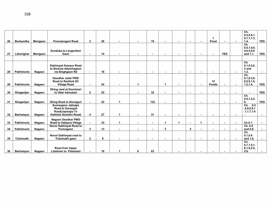
338
26 Burbandha Morigaon Porsutongani Road 3 26 - - 19 - - - - 1
Pond - -
Ch. 0.5,0.6,1.0,1.1,1.3,1.4. YES
27 Lahorighat Morigaon Sunduba to Lengeribori
Gaon - 14 - - - - - - - - YES
Ch. 0.0,1.0,0.4,0.5,0.8 and 1.1. YES
28 Pakhimoria Nagaon
Dakhinpat Kampur Road to Borkula Adarshagaon
via Singhgaon Rd - 16 - - - - - - - - - -
Ch. 0.1,0.5,0.3 and 1.3. -
29 Pakhimoria Nagaon
Dewdhar Jalah PWD Road to Rantholi SC
Village Road - 24 - 1 1 - - - 12
Ponds - -
Ch. 0.1,0.3,0.8,0.9,1.0,1.2,1.4. YES
30 Khagarijan Nagaon Dhing road at Goroimari
to Uttar tokoubari 2 25 - - 32 - - - - - - - - YES
31 Khagarijan Nagaon Dhing Road to Simulguri - 43 1 - 132 - - - - - - -
Ch. 0.0,1.5,2.6. YES
32 Barhampur Nagaon
Kumargaon Jatisajia Road to Darangial Road(Japisajia To
Kathitoli Amlokhi Road) 4 27 1 - 31 - - - - - - -
Ch. 0.2 ,0.8,0.9,1.1,1.7,1.9. -
33 Pakhimoria Nagaon Nagaon Deodhar PWD
Road to Hatipara Village - 33 1 - - 1 1 - 1 - - - Ch.0.1. -
34 Pakhimoria Nagaon Nonoi Dakhinpat Road to
Pumoigaon 3 13 - - - 3 2 - - - - Ch. 0.5 and 0.8. -
35 Tulsimukh Nagaon Nonoi Dakhinpat road to
Tulsimukh gaon 2 6 - - - - - - - - - -
Ch. 0.1,0.8 and 1.6. -
36 Barhampur Nagaon Road from Upper
Lotaimari to Palashani - 19 1 6 63 - - - - - - -
Ch. 0.7,1.0,1.8,1.9,2.0,2.6. -
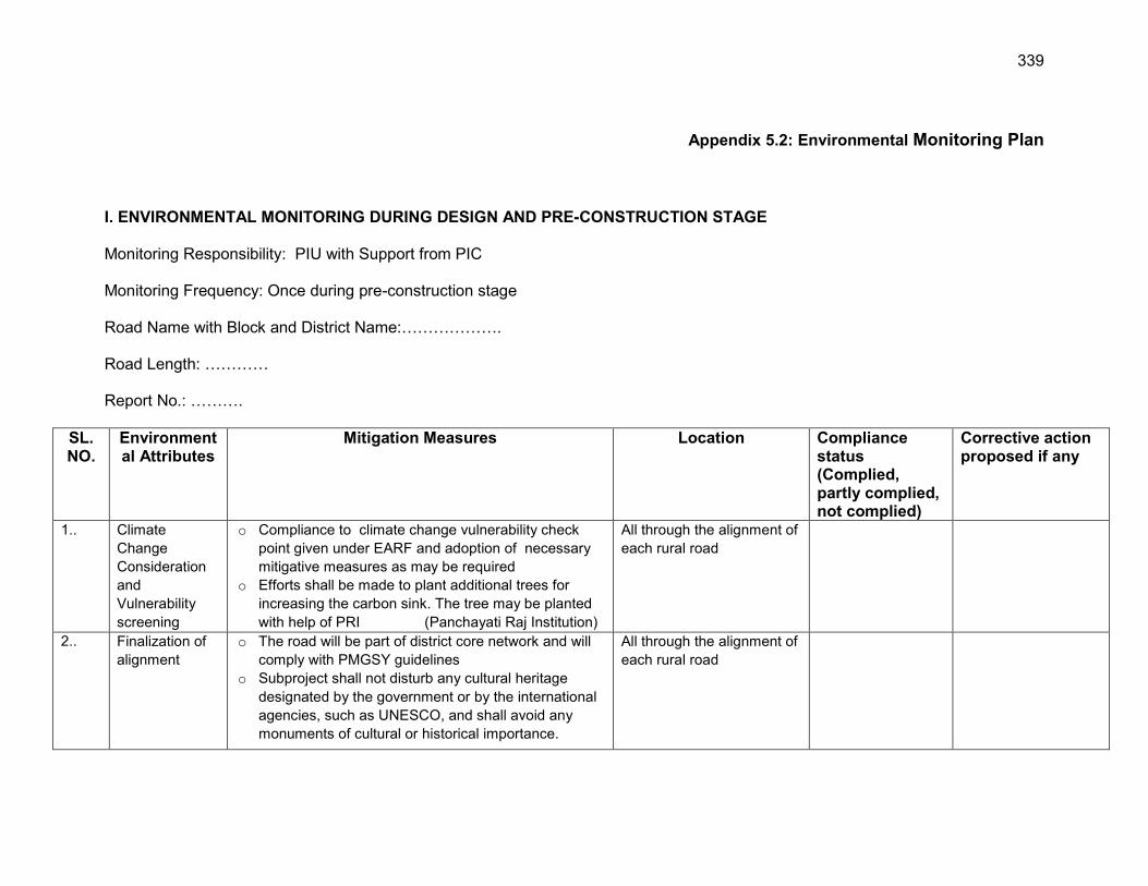
339
Appendix 5.2: Environmental Monitoring Plan
I. ENVIRONMENTAL MONITORING DURING DESIGN AND PRE-CONSTRUCTION STAGE Monitoring Responsibility: PIU with Support from PIC Monitoring Frequency: Once during pre-construction stage Road Name with Block and District Name:………………. Road Length: ………… Report No.: ……….
SL. NO.
Environmental Attributes
Mitigation Measures Location Compliance status (Complied, partly complied, not complied)
Corrective action proposed if any
1..
Climate Change Consideration and Vulnerability screening
o Compliance to climate change vulnerability check point given under EARF and adoption of necessary mitigative measures as may be required
o Efforts shall be made to plant additional trees for increasing the carbon sink. The tree may be planted with help of PRI (Panchayati Raj Institution)
All through the alignment of each rural road
2..
Finalization of alignment
o The road will be part of district core network and will comply with PMGSY guidelines
o Subproject shall not disturb any cultural heritage designated by the government or by the international agencies, such as UNESCO, and shall avoid any monuments of cultural or historical importance.
All through the alignment of each rural road
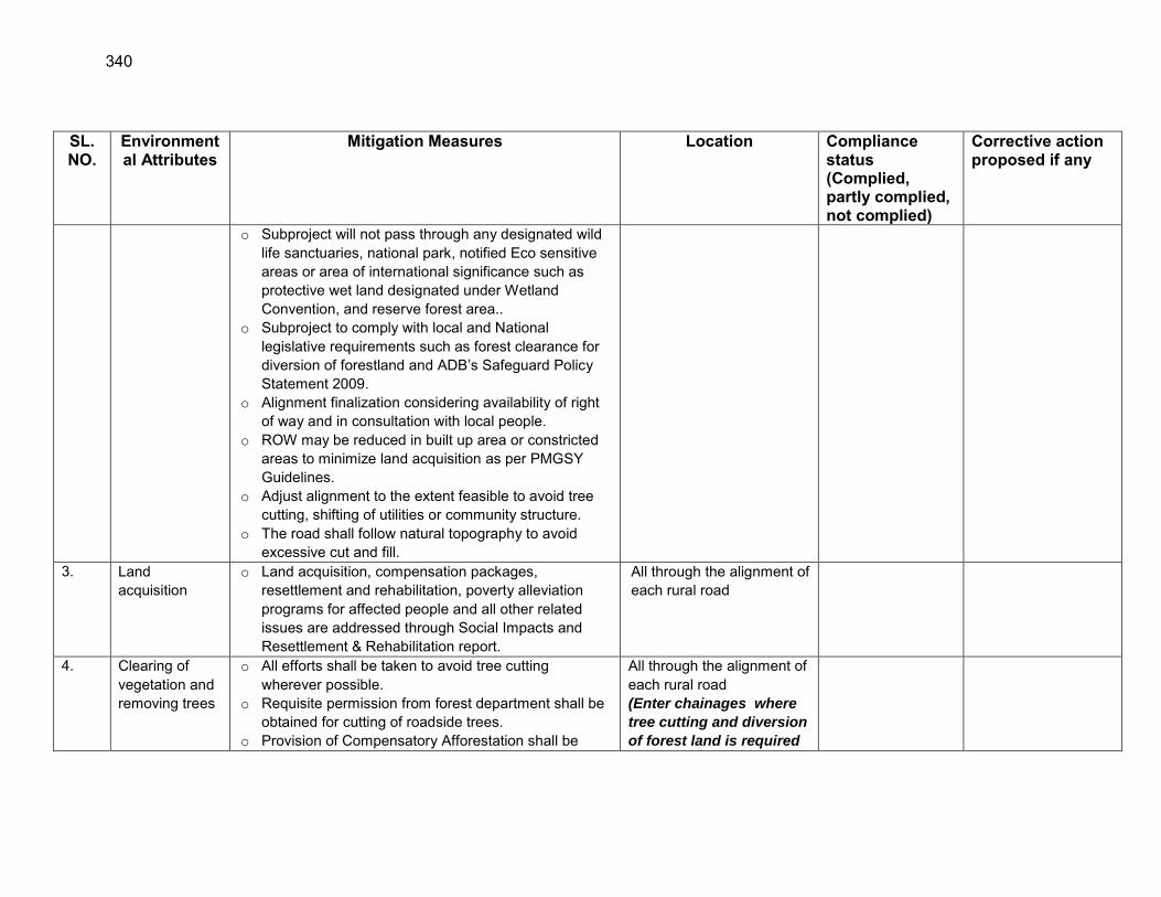
340
SL. NO.
Environmental Attributes
Mitigation Measures Location Compliance status (Complied, partly complied, not complied)
Corrective action proposed if any
o Subproject will not pass through any designated wild life sanctuaries, national park, notified Eco sensitive areas or area of international significance such as protective wet land designated under Wetland Convention, and reserve forest area..
o Subproject to comply with local and National legislative requirements such as forest clearance for diversion of forestland and ADB‟s Safeguard Policy Statement 2009.
o Alignment finalization considering availability of right of way and in consultation with local people.
o ROW may be reduced in built up area or constricted areas to minimize land acquisition as per PMGSY Guidelines.
o Adjust alignment to the extent feasible to avoid tree cutting, shifting of utilities or community structure.
o The road shall follow natural topography to avoid excessive cut and fill.
3. Land acquisition
o Land acquisition, compensation packages, resettlement and rehabilitation, poverty alleviation programs for affected people and all other related issues are addressed through Social Impacts and Resettlement & Rehabilitation report.
All through the alignment of each rural road
4. 7.77
Clearing of vegetation and removing trees
o All efforts shall be taken to avoid tree cutting wherever possible.
o Requisite permission from forest department shall be obtained for cutting of roadside trees.
o Provision of Compensatory Afforestation shall be
All through the alignment of each rural road (Enter chainages where
tree cutting and diversion
of forest land is required
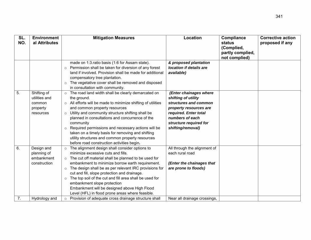
341
SL. NO.
Environmental Attributes
Mitigation Measures Location Compliance status (Complied, partly complied, not complied)
Corrective action proposed if any
made on 1:3.ratio basis (1:6 for Assam state). o Permission shall be taken for diversion of any forest
land if involved. Provision shall be made for additional compensatory tree plantation.
o The vegetative cover shall be removed and disposed in consultation with community.
& proposed plantation
location if details are
available)
5. Shifting of utilities and common property resources
o The road land width shall be clearly demarcated on the ground.
o All efforts will be made to minimize shifting of utilities and common property resources
o Utility and community structure shifting shall be planned in consultations and concurrence of the community
o Required permissions and necessary actions will be taken on a timely basis for removing and shifting utility structures and common property resources before road construction activities begin.
(Enter chainages where
shifting of utility
structures and common
property resources are
required. Enter total
numbers of each
structure required for
shifting/removal)
6. Design and planning of embankment construction
o The alignment design shall consider options to minimize excessive cuts and fills.
o The cut off material shall be planned to be used for embankment to minimize borrow earth requirement.
o The design shall be as per relevant IRC provisions for cut and fill, slope protection and drainage.
o The top soil of the cut and fill area shall be used for embankment slope protection Embankment will be designed above High Flood Level (HFL) in flood prone areas where feasible.
All through the alignment of each rural road (Enter the chainages that
are prone to floods)
7. Hydrology and o Provision of adequate cross drainage structure shall Near all drainage crossings,

342
SL. NO.
Environmental Attributes
Mitigation Measures Location Compliance status (Complied, partly complied, not complied)
Corrective action proposed if any
Drainage be made to ensure smooth passage of water and maintaining natural drainage pattern of the area.
o The discharge capacity of the CD structure shall be designed accordingly.
o Provision of adequate drainage structures shall be made in water stagnant/logging areas.
o The construction work near water body shall be planned preferably in dry season so that water quality of the water channel is not affected due to siltation and rain water runoff.
o Provision of additional cross drainage structure shall be made in the areas where nearby land is sloping towards road alignment on both the sides.
o Provision of concrete road construction in habitat area with drainage of both side of the road shall be made as per the design provision and with adequate slope to prevent any water logging.
nalas, rivers, streams and ponds. (Enter chainages where
earthern/structural cross
drains, longitudinal
drains, streams, ponds
and rivers exist)
8. Establishment of Construction Camp, temporary office and storage area
o Construction camp sites shall be located away from any local human settlements and forested areas (minimum 0.5 km away) and preferably located on lands, which are not productive (barren/waste lands presently).
o Similarly temporary office and storage areas shall be located away from human settlement areas and forested areas (minimum 0.5 km).
o The construction camps, office and storage areas shall have provision of adequate water supply, sanitation and all requisite infrastructure facilities.
For all roads
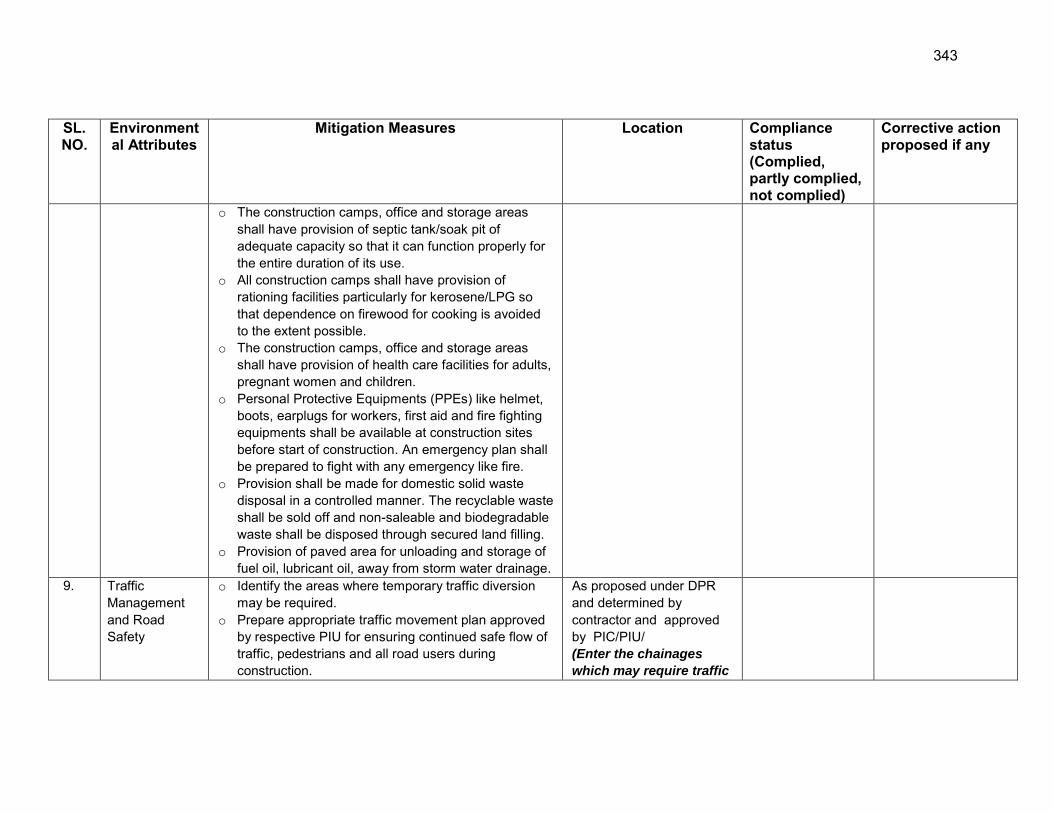
343
SL. NO.
Environmental Attributes
Mitigation Measures Location Compliance status (Complied, partly complied, not complied)
Corrective action proposed if any
o The construction camps, office and storage areas shall have provision of septic tank/soak pit of adequate capacity so that it can function properly for the entire duration of its use.
o All construction camps shall have provision of rationing facilities particularly for kerosene/LPG so that dependence on firewood for cooking is avoided to the extent possible.
o The construction camps, office and storage areas shall have provision of health care facilities for adults, pregnant women and children.
o Personal Protective Equipments (PPEs) like helmet, boots, earplugs for workers, first aid and fire fighting equipments shall be available at construction sites before start of construction. An emergency plan shall be prepared to fight with any emergency like fire.
o Provision shall be made for domestic solid waste disposal in a controlled manner. The recyclable waste shall be sold off and non-saleable and biodegradable waste shall be disposed through secured land filling.
o Provision of paved area for unloading and storage of fuel oil, lubricant oil, away from storm water drainage.
9. Traffic Management and Road Safety
o Identify the areas where temporary traffic diversion may be required.
o Prepare appropriate traffic movement plan approved by respective PIU for ensuring continued safe flow of traffic, pedestrians and all road users during construction.
As proposed under DPR and determined by contractor and approved by PIC/PIU/ (Enter the chainages
which may require traffic
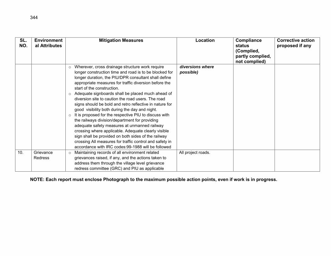
344
SL. NO.
Environmental Attributes
Mitigation Measures Location Compliance status (Complied, partly complied, not complied)
Corrective action proposed if any
o Wherever, cross drainage structure work require longer construction time and road is to be blocked for longer duration, the PIU/DPR consultant shall define appropriate measures for traffic diversion before the start of the construction.
o Adequate signboards shall be placed much ahead of diversion site to caution the road users. The road signs should be bold and retro reflective in nature for good visibility both during the day and night.
o It is proposed for the respective PIU to discuss with the railways division/department for providing adequate safety measures at unmanned railway crossing where applicable. Adequate clearly visible sign shall be provided on both sides of the railway crossing All measures for traffic control and safety in accordance with IRC codes:99-1988 will be followed
diversions where
possible)
10. Grievance Redress
o Maintaining records of all environment related grievances raised, if any, and the actions taken to address them through the village level grievance redress committee (GRC) and PIU as applicable
All project roads.
NOTE: Each report must enclose Photograph to the maximum possible action points, even if work is in progress.
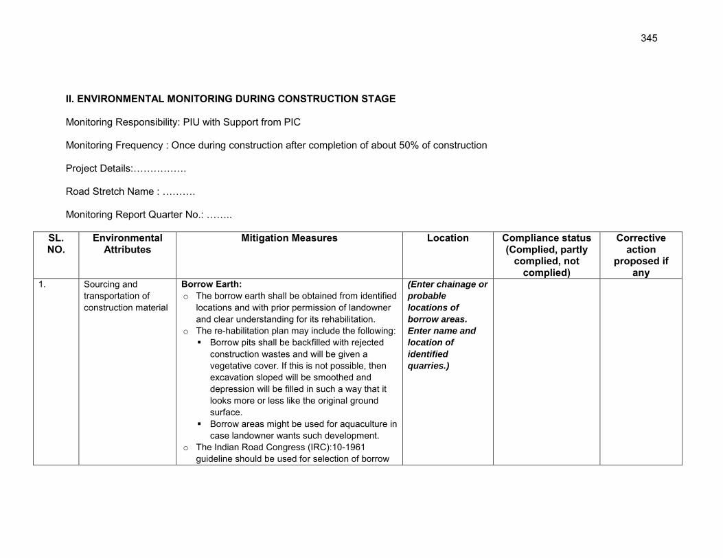
345
II. ENVIRONMENTAL MONITORING DURING CONSTRUCTION STAGE Monitoring Responsibility: PIU with Support from PIC Monitoring Frequency : Once during construction after completion of about 50% of construction Project Details:……………. Road Stretch Name : ………. Monitoring Report Quarter No.: ……..
SL. NO.
Environmental Attributes
Mitigation Measures Location Compliance status (Complied, partly
complied, not complied)
Corrective action
proposed if any
1.
Sourcing and transportation of construction material
Borrow Earth: o The borrow earth shall be obtained from identified
locations and with prior permission of landowner and clear understanding for its rehabilitation.
o The re-habilitation plan may include the following: Borrow pits shall be backfilled with rejected
construction wastes and will be given a vegetative cover. If this is not possible, then excavation sloped will be smoothed and depression will be filled in such a way that it looks more or less like the original ground surface.
Borrow areas might be used for aquaculture in case landowner wants such development.
o The Indian Road Congress (IRC):10-1961 guideline should be used for selection of borrow
(Enter chainage or
probable
locations of
borrow areas.
Enter name and
location of
identified
quarries.)
346
pits and amount that can be borrowed. o Borrowing earth from agricultural land shall be
minimized to the extent possible. Further, no earth shall be borrowed from already low-lying areas.
o A 15 cm topsoil will be stripped off from the borrow pit and this will be stored in stockpiles in a designated area for height not exceeding 2m and side slopes not steeper than 1:2 (Vertical: Horizontal).
o Borrowing of earth will not be done continuously through out the stretch.
o Ridges of not less than 8m widths will be left at intervals not exceeding 300m.
o Small drains will be cut through the ridges, if necessary, to facilitate drainage.
o The slope of the edges will be maintained not steeper than 1:4 (vertical: Horizontal).
o The depth of borrow pits will not be more than 30 cm after stripping the 15 cm topsoil aside.
o Fly ash will be used in road embankment as per IRC guidelines wherever thermal power plant is located within 100 km of the road alignment.
Aggregate : o The stone aggregate shall be sourced from
existing licensed quarries o Copies of consent/ approval / rehabilitation plan
for use of existing source will be submitted to PIU.
o Topsoil to be stockpiled and protected for use at the rehabilitation stage
Transportation of Construction Material o Existing tracks / roads are to be used for hauling
347
of materials to the extent possible. o Prior to construction of roads, topsoil shall be
preserved and shall be used for other useful purposes like using in turfing of embankment.
o The vehicles deployed for material transportation shall be spillage proof to avoid or minimize the spillage of the material during transportation. In any case, the transportation links are to be inspected at least twice daily to clear accidental spillage, if any.
2. Loss of Productive Soil, erosion and land use change
o The top soil from the productive land (borrow areas, road widening areas etc.) shall be preserved and reused for plantation purposes.
o It shall also be used as top cover of embankment slope for growing vegetation to protect soil erosion.
o Cut and fill shall be planned as per IRC provisions and rural road manual.
o All steep cuts shall be flattened and benched. o Shrubs shall be planted in loose soil area. o IRC: 56 -1974 recommended practice for
treatment of embankment slopes for erosion control shall be taken into consideration.
o It shall be ensured that the land taken on lease for access road, construction camp and temporary office of the storage facilities is restored back to its original land use before handing it over back to land owner.
All though the alignment of each project road
3. Compaction and Contamination of Soil
o To prevent soil compaction in the adjoining productive lands beyond the ROW, the movement of construction vehicles, machinery and equipment shall be restricted to the designated haulage route.
All though the alignment of each project road
348
o The productive land shall be reclaimed after construction activity.
o Fuel and lubricants shall be stored at the predefined storage location.
o The storage area shall be paved with gentle slope to a corner and connected with a chamber to collect any spills of the oils.
o All efforts shall be made to minimise the waste generation. Unavoidable waste shall be stored at the designated place prior to disposal.
o To avoid soil contamination at the wash-down and re-fuelling areas, “oil interceptors” shall be provided. Oil and grease spill and oil soaked materials are to be collected and stored in labelled containers (Labelled: WASTE OIL; and hazardous sign be displayed) and sold off to SPCB/ MoEF authorized re-refiners.
4.
Construction Debris and waste
o Excavated materials from roadway, shoulders, verges, drains, cross drainage will be used for backfilling embankments, filling pits, and landscaping.
o Unusable debris material should be suitably disposed off at pre-designated disposal locations, with approval of the concerned authority.
o The bituminous wastes shall be disposed in secure manner at designated landfill sites only in an environmentally accepted manner.
o For removal of debris, wastes and its disposal MOSRTH guidelines should be followed. Unproductive/wastelands shall be selected with the consent of villagers and Panchayat for the same. The dumping site should be of adequate capacity. It should be located at least 500 m away
All though the alignment of each project road
349
from the residential areas. Dumping sites should be away from water bodies to prevent any contamination of these bodies.
5. Air and Noise Quality o Vehicles delivering loose and fine materials like sand and aggregates shall be covered.
o Dust suppression measures like water sprinkling, shall be applied in all dust prone locations such as unpaved haulage roads, earthworks, stockpiles and asphalt mixing areas.
o Mixing plants and asphalt (hot mix) plants shall be located at least 0.5 km away and in downwind direction of the human settlements.
o Material storage areas shall also be located downwind of the habitation area.
o Hot mix plant shall be fitted with stack of adequate height (30 m) or as may be prescribed by SPCB to ensure enough dispersion of exit gases. Consent to establish and operate shall be obtained from State Pollution Control Board and comply with all consent conditions.
o Diesel Generating (DG) sets shall also be fitted with stack of adequate height (as per regulation height of the stack of open to air DG set shall be about 0.5 m for 5 KVA and about 0.7 m for 10 KVA DG sets, above top of sound proofing enclosure of the DG set). Low sulphur diesel shall be used in DG sets and other construction machineries where available. Construction vehicles and machineries shall be periodically maintained.
Throughout the project road section
6.
Tree plantation o Compensatory Afforestation shall be made on 1:3.ratio basis.(1;6 for Assam state)
o
(Enter the number of trees requird for
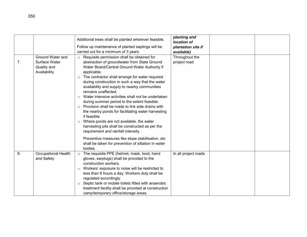
350
7.77
Additional trees shall be planted wherever feasible.
Follow up maintenance of planted saplings will be carried out for a minimum of 3 years
planting and
location of
plantation site if
available)
7. Ground Water and Surface Water Quality and Availability
o Requisite permission shall be obtained for abstraction of groundwater from State Ground Water Board/Central Ground Water Authority if applicable.
o The contractor shall arrange for water required during construction in such a way that the water availability and supply to nearby communities remains unaffected.
o Water intensive activities shall not be undertaken during summer period to the extent feasible.
o Provision shall be made to link side drains with the nearby ponds for facilitating water harvesting if feasible
o Where ponds are not available, the water harvesting pits shall be constructed as per the requirement and rainfall intensity.
Preventive measures like slope stabilisation, etc shall be taken for prevention of siltation in water bodies.
Throughout the project road
8. Occupational Health and Safety
o The requisite PPE (helmet, mask, boot, hand gloves, earplugs) shall be provided to the construction workers.
o Workers‟ exposure to noise will be restricted to less than 8 hours a day. Workers duty shall be regulated accordingly.
o Septic tank or mobile toilets fitted with anaerobic treatment facility shall be provided at construction camp/temporary office/storage areas.
In all project roads
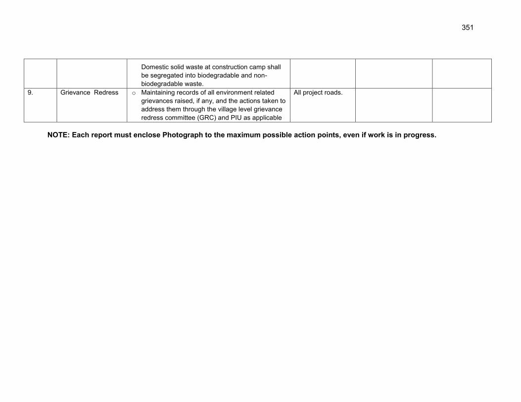
351
Domestic solid waste at construction camp shall be segregated into biodegradable and non-biodegradable waste.
9. Grievance Redress o Maintaining records of all environment related grievances raised, if any, and the actions taken to address them through the village level grievance redress committee (GRC) and PIU as applicable
All project roads.
NOTE: Each report must enclose Photograph to the maximum possible action points, even if work is in progress.
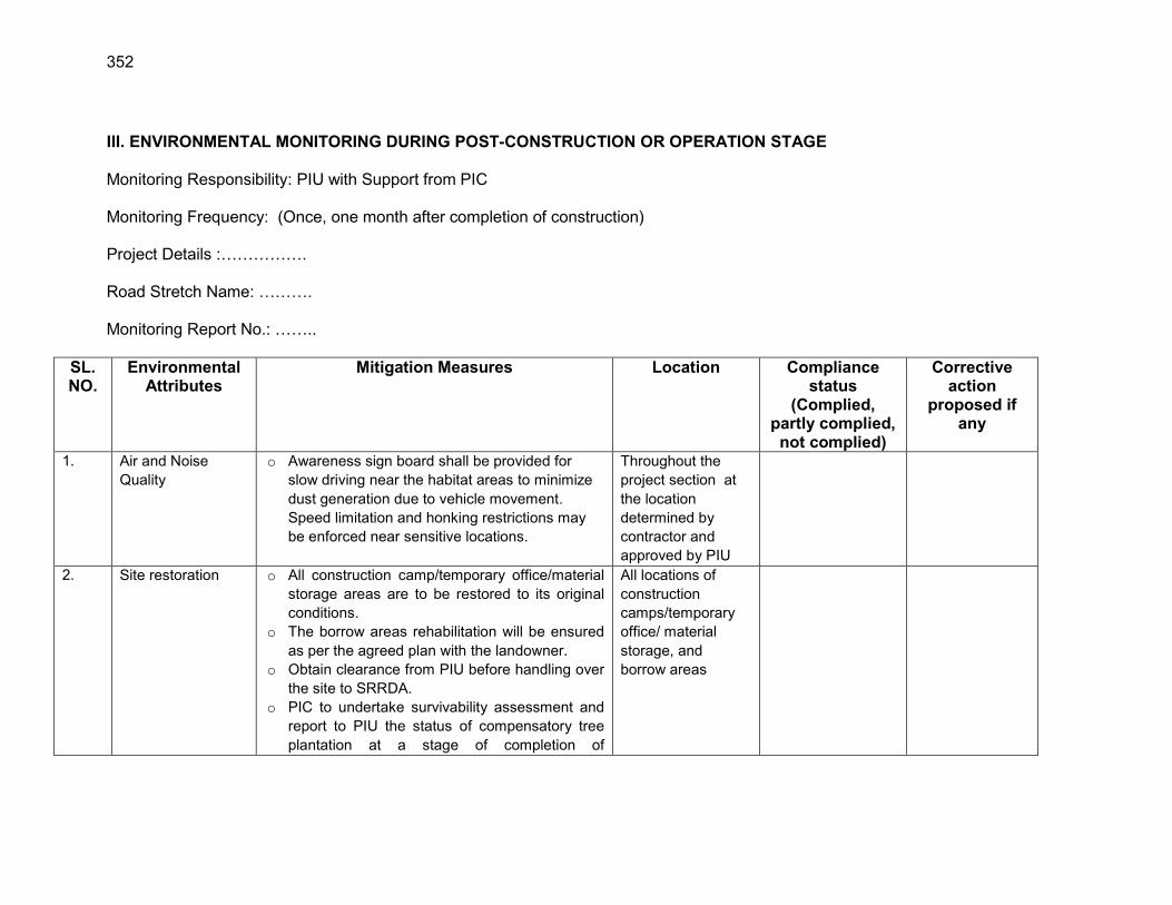
352
III. ENVIRONMENTAL MONITORING DURING POST-CONSTRUCTION OR OPERATION STAGE Monitoring Responsibility: PIU with Support from PIC Monitoring Frequency: (Once, one month after completion of construction) Project Details :……………. Road Stretch Name: ………. Monitoring Report No.: ……..
SL. NO.
Environmental Attributes
Mitigation Measures Location Compliance status
(Complied, partly complied, not complied)
Corrective action
proposed if any
1. Air and Noise Quality
o Awareness sign board shall be provided for slow driving near the habitat areas to minimize dust generation due to vehicle movement. Speed limitation and honking restrictions may be enforced near sensitive locations.
Throughout the project section at the location determined by contractor and approved by PIU
2. Site restoration o All construction camp/temporary office/material storage areas are to be restored to its original conditions.
o The borrow areas rehabilitation will be ensured as per the agreed plan with the landowner.
o Obtain clearance from PIU before handling over the site to SRRDA.
o PIC to undertake survivability assessment and report to PIU the status of compensatory tree plantation at a stage of completion of
All locations of construction camps/temporary office/ material storage, and borrow areas
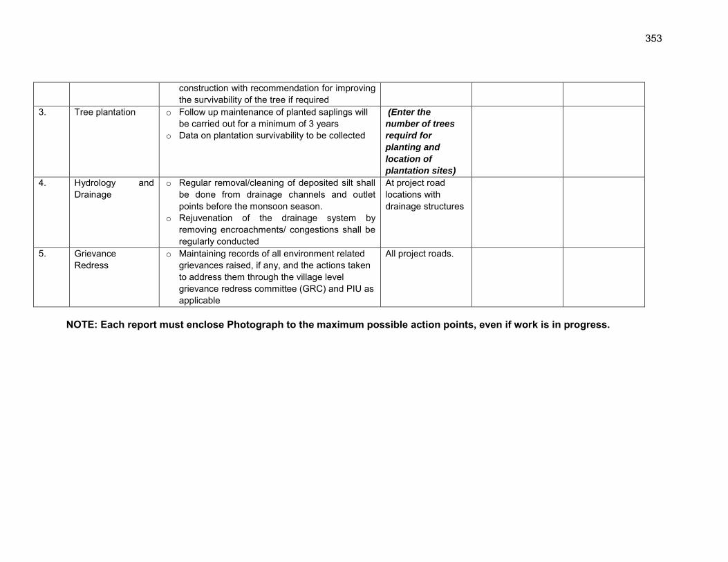
353
construction with recommendation for improving the survivability of the tree if required
3. Tree plantation o Follow up maintenance of planted saplings will be carried out for a minimum of 3 years
o Data on plantation survivability to be collected
(Enter the
number of trees
requird for
planting and
location of
plantation sites)
4.
Hydrology and Drainage
o Regular removal/cleaning of deposited silt shall be done from drainage channels and outlet points before the monsoon season.
o Rejuvenation of the drainage system by removing encroachments/ congestions shall be regularly conducted
At project road locations with drainage structures
5. Grievance Redress
o Maintaining records of all environment related grievances raised, if any, and the actions taken to address them through the village level grievance redress committee (GRC) and PIU as applicable
All project roads.
NOTE: Each report must enclose Photograph to the maximum possible action points, even if work is in progress.

354
Appendix 6.1: Public Consultation in Assam
Villagers
District Block Road Name Name of villagers
Nagaon
Pakhimoria Nonoi Dakhinpat
Road to Tulshimukh gaon
Mr. Someswar sut, mr. Jiten sut, dehi ram bora, mr. Chaki ram sut, suren sut, adhan saikia, khangai sut, madan saikia
Pakhimoria
Dakhinpat Kampur Road to Borkula Adarshagaon via
Singhgaon Rd
Mr. Ratna kanta laskar, mr. Kamal deka, kusha laskar, mr. Sathi deka, mr. Bubul hira
Pakhimoria Nonoi Dakhinpat Road To Pumoigaon
Rameswar Das, Sonaram Das, Kunja Mohan Das, Deben Das, Muluk Das, Chito Das, Kesari Nadiwal, Satram Das, Hudura Das
Pakhimoria
Deodhar Rantholi Jalah Road To
Rantholi Adarsha Gaon
-
Pakhimoria Nagaon Deodhar Pwd
Road To Hatipara Village
-
Khagarijan Dhing Road At
Goroimari To Uttar Tokoubari
Mr Abdul Hussain, Mr Abdul Jabbar, Mr Mahar Ali, Mr Sahar Ali, Mr Mofijuddin, Mr Asar Ali
Khagarijan Dhing Road To Simaluguri
Md. Aanisudin, mr. Bipra deuri, mr. Ganakanta deuri, tubuki koybatta, mr. Kalimay das, mr. Chakradhar bora
Barhampur Japisajia To Kathitoli Amlokhi Road MR. Powal Kumar
Barhampur Road from Upper
Lotaimari to Palashani
Mr. Pamadhar saikia, mr. Gautam borah, mrs. Iamini borah, mr. Bhupen
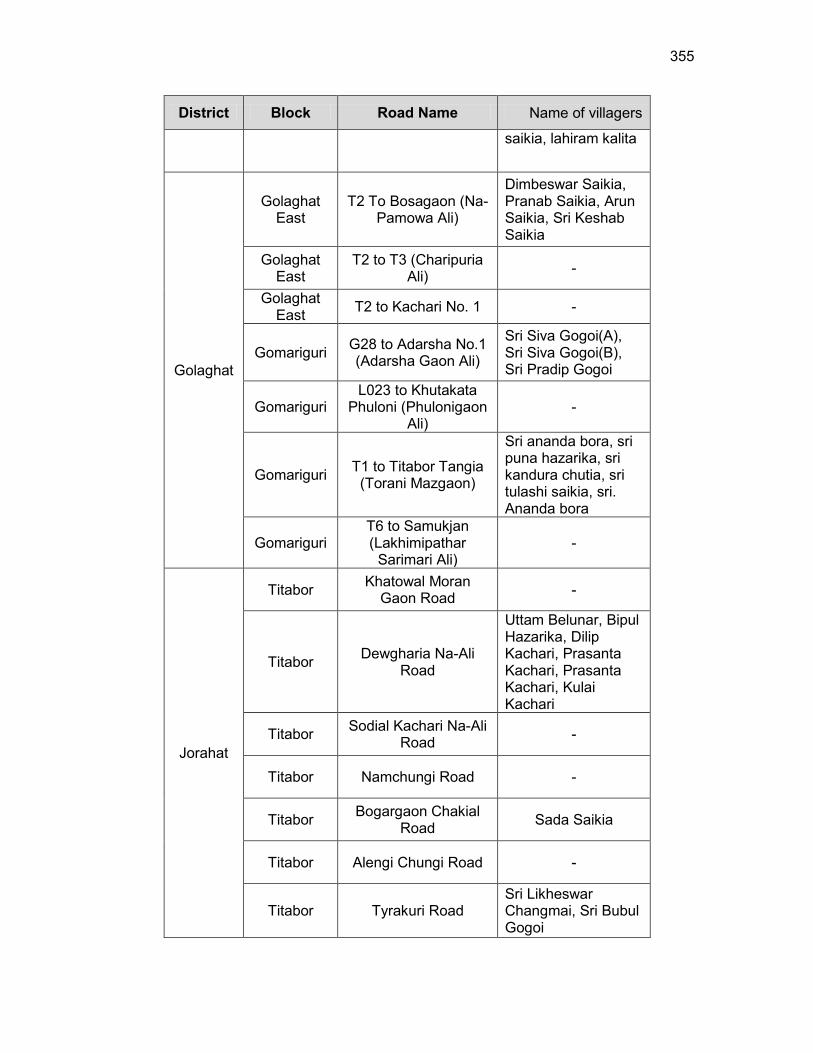
355
District Block Road Name Name of villagers
saikia, lahiram kalita
Golaghat
Golaghat East
T2 To Bosagaon (Na-Pamowa Ali)
Dimbeswar Saikia, Pranab Saikia, Arun Saikia, Sri Keshab Saikia
Golaghat East
T2 to T3 (Charipuria Ali) -
Golaghat East T2 to Kachari No. 1 -
Gomariguri G28 to Adarsha No.1 (Adarsha Gaon Ali)
Sri Siva Gogoi(A), Sri Siva Gogoi(B), Sri Pradip Gogoi
Gomariguri L023 to Khutakata
Phuloni (Phulonigaon Ali)
-
Gomariguri T1 to Titabor Tangia (Torani Mazgaon)
Sri ananda bora, sri puna hazarika, sri kandura chutia, sri tulashi saikia, sri. Ananda bora
Gomariguri T6 to Samukjan (Lakhimipathar
Sarimari Ali) -
Jorahat
Titabor Khatowal Moran Gaon Road -
Titabor Dewgharia Na-Ali Road
Uttam Belunar, Bipul Hazarika, Dilip Kachari, Prasanta Kachari, Prasanta Kachari, Kulai Kachari
Titabor Sodial Kachari Na-Ali Road -
Titabor Namchungi Road -
Titabor Bogargaon Chakial Road Sada Saikia
Titabor Alengi Chungi Road -
Titabor Tyrakuri Road Sri Likheswar Changmai, Sri Bubul Gogoi
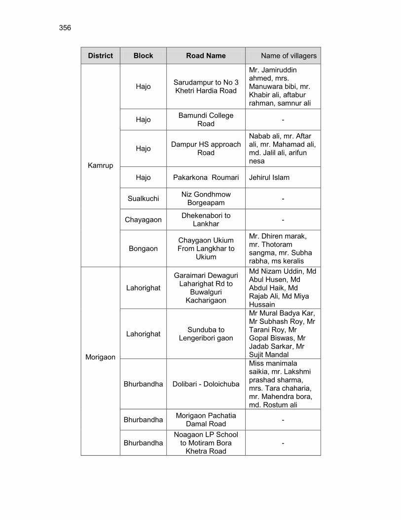
356
District Block Road Name Name of villagers
Kamrup
Hajo Sarudampur to No 3 Khetri Hardia Road
Mr. Jamiruddin ahmed, mrs. Manuwara bibi, mr. Khabir ali, aftabur rahman, samnur ali
Hajo Bamundi College Road -
Hajo Dampur HS approach Road
Nabab ali, mr. Aftar ali, mr. Mahamad ali, md. Jalil ali, arifun nesa
Hajo Pakarkona Roumari Jehirul Islam
Sualkuchi Niz Gondhmow Borgeapam -
Chayagaon Dhekenabori to Lankhar -
Bongaon Chaygaon Ukium From Langkhar to
Ukium
Mr. Dhiren marak, mr. Thotoram sangma, mr. Subha rabha, ms keralis
Morigaon
Lahorighat
Garaimari Dewaguri Laharighat Rd to
Buwalguri Kacharigaon
Md Nizam Uddin, Md Abul Husen, Md Abdul Haik, Md Rajab Ali, Md Miya Hussain
Lahorighat Sunduba to Lengeribori gaon
Mr Mural Badya Kar, Mr Subhash Roy, Mr Tarani Roy, Mr Gopal Biswas, Mr Jadab Sarkar, Mr Sujit Mandal
Bhurbandha Dolibari - Doloichuba
Miss manimala saikia, mr. Lakshmi prashad sharma, mrs. Tara chaharia, mr. Mahendra bora, md. Rostum ali
Bhurbandha Morigaon Pachatia Damal Road -
Bhurbandha Noagaon LP School
to Motiram Bora Khetra Road
-

357
District Block Road Name Name of villagers
Bhurbandha Porosutongani Road
Mr. Mohibur rahman, md. Sahab uddin, md. Anar ali, mrs. Khaiun nesa, mr. Kanak ch. Nath