IND: Rural Connectivity Investment Program – Project II - Early ...
295
Initial Environmental Examination (Draft) August 2013 IND: Rural Connectivity Investment Program – Project II Prepared by Madhya Pradesh Rural Road Development Agency, Government of India for the Asian Development Bank.
-
Upload
khangminh22 -
Category
Documents
-
view
0 -
download
0
Transcript of IND: Rural Connectivity Investment Program – Project II - Early ...

Initial Environmental Examination (Draft) August 2013
IND: Rural Connectivity Investment Program –
Project II
Prepared by Madhya Pradesh Rural Road Development Agency, Government of India for the Asian Development Bank.


CURRENCY EQUIVALENTS as of 16 August 2013
Currency unit –
Indian rupee (Rs)
Rs 1.00 = $ .01628 $1.00 = Rs 61.4250
ABBREVIATIONS ADB – Asian Development Bank APO – Accident Prevention Officer B.T. – Black Top BGL – Below Ground Level BIS – Bureau of Indian Standards BOQ – Bill of Quantity C.C. – Cement Concrete CD – Cross-drainage CGWA – Central Ground Water Authority CGWB – Central Ground Water Board Ch. – Chainage COI – Corridor Of Impact CPCB – Central Pollution Control Board CTE – Consent to Establish CTO – Consent to Operate DG – Diesel Generating DPR – Detailed Project Report EARF – Environmental Assessment Review Framework ECOP – Environmental Code of Practices EIA – Environmental Impact Assessment EMOP – Environmental Monitoring Plan EMP – Environmental Management Plan EO – Environmental Officer FEO – Field Environmental Officer GDP – Gross Domestic Product GOI – Government of India GSHAP – Global Seismic Hazard Assessment Program HC – Hydrocarbon HH – House Hold IEE – Initial Environmental Assessment IRC – Indian Road Congress LHS – Left Hand Side MCM – Million Cubic Meter MFF – Multi-Tranche Financing Facility MoEF – Ministry of Environment and Forests MORD – Ministry of Rural Development MOSRTH – Ministry of Road Transport & Highways MPRRDA – Madhya Pradesh Rural Road Development Authority NAAQS – National Ambient Air Quality Standards NGO – Non-government organization NOx – Nitrogen Oxides NRRDA – National Rural Road Development Authority NSDP – Net State Domestic Product

WEIGHTS AND MEASURES
ha km
– –
hectare kilometer
M mi
– –
meter mile
NOTE In this report, "$" refers to US dollars.
This initial environmental examination is a document of the borrower. The views expressed herein do not necessarily represent those of ADB's Board of Directors, Management, or staff, and may be preliminary in nature. Your attention is directed to the “terms of use” section of this website. In preparing any country program or strategy, financing any project, or by making any designation of or reference to a particular territory or geographic area in this document, the Asian Development Bank does not intend to make any judgments as to the legal or other status of any territory or area.
PIC – Project Implementation Consultant PIU – Project Implementation Unit PLF – Plant Load Factor PM – Particulate Matters PMGSY – Pradhan Mantri Gram Sadak Yojna PPE – Personal Protective Equipment’s PPTA – Project Preparation Technical Assistance PRI – Panchati Raj Institution ( Village Level Adminstration
Set-up) RCIP – Rural Connectivity Investment Program RHS – Right Hand Side ROW – Right of way RRS I – Loan 2018-IND: Rural Roads Sector I Project RRS II – Loan 2248-IND: Rural Roads Sector II Investment
Program RSES – ADB’s Environmental Safeguard Division SBD – Standard Bidding Documents SDP – State Domestic Product SO2 – Sulphur Dioxide SPCB – State Pollution Control Board SPS – ADB’s Safeguard Policy Statement, 2009 SRRDA – State Rural Road Development Authority STDs – Sexually transmitted diseases TDS – Total Dissolved Solids TSC – Technical Support Consultants UNESCO – United Nations Educational, Scientific and Cultural
Organization WBM – Water Bound Macadam

TABLE OF CONTENTS I. INTRODUCTION
A. Project Background ..................................................................................................... 1
B. Project Roads Identification and Location .................................................................... 1
C. Rural Road Construction Proposal ............................................................................... 2
D. ADB Safeguard Policies and Category of the Project................................................... 2
E. Objectives and Approach for Environmental Assessment ............................................ 3
F. IEE Methodology and Content .................................................................................... 3
G. Legal Framework and Legislative Requirements: ........................................................ 4
H. Acknowledgement ....................................................................................................... 5
II. DESCRIPTION OF THE PROJECT
A. General........................................................................................................................ 6
B. Sample Roads Selected in Madhya Pradesh State ...................................................... 6
C. Project Description ...................................................................................................... 6
III. DESCRIPTION OF THE ENVIRONMENT
A. Background ............................................................................................................... 11
B. Physical Environment ................................................................................................ 11
C. Ecological Resources ................................................................................................ 21
D. Socioeconomic Environment ..................................................................................... 27
E. Salient Environmental Features of Sample Roads ..................................................... 28
IV. ANTICIPATED ENVIRONMENTAL IMPACTS AND ITS MITIGATION MEASURES
A. Common Impacts during Design and Construction Phase ......................................... 49
B. Common Impacts during Post Construction and Operation Phase............................. 57
C. Road Specific Impacts ............................................................................................... 59
V. ENVIRONMENTAL MANAGEMENT PLAN, INSTITUTIONAL ARRANGEMENTS AND GRIEVANCE ADDRESS MECHANISM
A. Environmental Management Plan .............................................................................. 60
B. Environmental Monitoring Plan .................................................................................. 60
C. Institutional Arrangements and Responsibilities ......................................................... 61
D. Institutional Environmental Responsibilities ............................................................... 61
E. Environmental Assessment and Review Framework (EARF) for RCIP ...................... 64
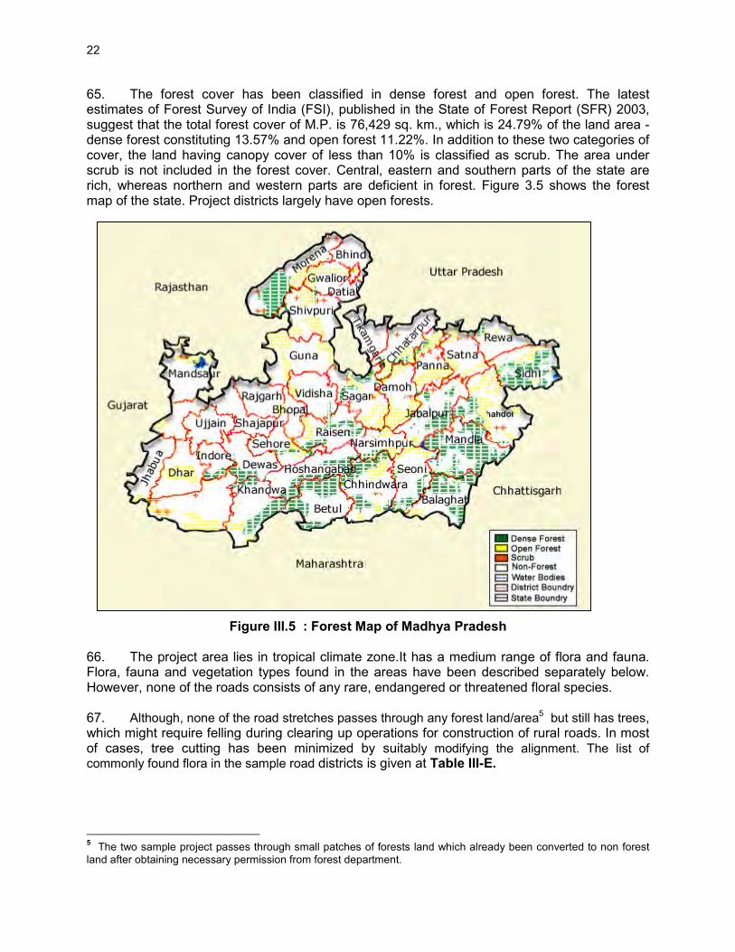
F. Capacity Building ....................................................................................................... 66
G. Consultation and Information Disclosure .................................................................... 66
H. Grievance Redress Mechanism ................................................................................. 66
VI. PUBLIC CONSULTATION AND INFORMATION DISCLOSURE
A. General...................................................................................................................... 68
B. Compliance with Relevant Regulatory Requirements ................................................ 68
C. Beneficiaries’ Comments ........................................................................................... 68
VII. CONCLUSIONS AND RECOMMENDATIONS A. Conclusions ............................................................................................................... 71
B. Key Recommendations .............................................................................................. 72
List of Tables Table II-B: ROW Requirement ................................................................................................. 7
Table III-A: Summary Key Environmental Features of the Sample Roads Districts .................12
Table III-B: Maximum Observed Ambient Air Quality during 2008 ............................................16
Table III-C: Ambient Air Quality Status of Madhya Pradesh in Previous Years .........................16
Table III-D: Land Use Pattern in the State ................................................................................20
Table III-E: List of Common Flora of Project Districts ...............................................................23
Table III-F: List of Common Fauna of Project Districts .............................................................24
Table III-G: List of Protected Areas in Madhya Pradesh ............................................................26

Table III-H: Demographic Profile ...............................................................................................27
Table III-I: Salient Environmental Features of Sample Roads .................................................29
Table VI-A: Addressal of Issues and Concerns under the Project .............................................69
List of Figures Figure II.1 : Typical Cross-section of Rural Roads ....................................................................10
Figure III.1 :Geographical / Geological Map of Madhya Pradesh ...............................................17
Figure III.2 : Seismic Zone Map ................................................................................................19
Figure III.3 : Hazard Zone Map .................................................................................................19
Figure III.4 : Decadal Water Table Conditions in the Project Districts ........................................21
Figure III.5 : Forest Map of Madhya Pradesh ............................................................................22
Figure III.6 : Protected Areas of Madhya Pradesh .....................................................................26
Figure V.1 : Institutional Arrangement for EMP Implementation ................................................62

1
I. INTRODUCTION A. Project Background 1. As one of the key features of the Government’s poverty reduction agenda for the rural sector, the Government of India (GOI) is implementing a nationwide rural road investment program, Pradhan Mantri Gram Sadak Yojana (PMGSY). PMGSY aims to provide all-weather road connectivity to currently unserved habitations in India’s rural areas, where 70% of the population live. The Government of India (GOI) launched “The Pradhan Mantri Gram Sadak Yojana (PMGSY)” in year 2000. The objective of PMGSY is to provide all-weather road connectivity to all rural habitations with a population of more than 500 persons in plains and and 250 persons in hill states. This program is being implemented through National Rural Road Development Authority (NRRDA) under Ministry of Rural Development (MORD) at central level and through State Rural Road Development Authority/Agencies (SRRDA) at state level. 2. The Rural Connectivity Investment Program (RCIP) is continuation of Rural Road Sector II Investment Program (RRS IIP) and is a multitranche financing facility (MFF) that will construct or upgrade to the all-weather standard about 9,000 km of rural roads connecting around 4,800 habitations in the states of Assam, Chhattisgarh, Orissa, Madhya Pradesh and West Bengal (RCIP states). The RCIP will also focus on improvement of institutional arrangements, business processes and associated capacity building. This will especially be done in relation with design, operation, safeguard, financial, road safety, and asset management matters. Investments in rural roads will improve connectivity, cut transport costs, and provide enabling infrastructure to areas currently with poor access to markets and urban towns, and thus contribute to growth and equity in the country’s largest sector. Project 1 (Loan 2881) totaling $252 million is currently ongoing. 3. The Government is now planning to submit to ADB the second Periodic Finance Request (PFR) that includes the proposal for about 654.05 km of rural roads in the state of Madhya Pradesh. MPRRDA is the implementing agency (IA) for ADB-funded subprojects in the state. The preparatory works for the proposed second batch of roads have been completed for the state. As per the requirements of ADB, it is mandatory that the subprojects under the programme comply with ADB's environmental safeguards. The project as per classification of ADB has been categorized as ‘Category B’ project and therefore requires an Initial Environmental Examination (IEE). The initial environmental examination (IEE) for the first batch has been prepared by using environmental checklist. The report has been prepared by M/s Operations Research Group (P) Ltd., the Technical Support Consultants (TSC) appointed by National Rural Road Development Agency (NRRDA) under the ADB loan assistance. B. Project Roads Identification and Location 4. PMGSY has prepared specific guidelines for the selection of roads under this programme. The key requirements is that any road will be eligible for construction or upgradation only if it is part of the Core Network1 and satisfy the following environmental safeguards:
1 Core Network is that minimal network of roads (routes) that is essential to provide access to essential social and
economic services to all eligible habitations in the selected areas through at least single all-weather road connectivity. A core network comprises of through routes and link routes. Through routes are the ones, which collect traffic from several link roads or a long chain of habitations and lead it to marketing centres either directly or through the higher category roads i.e., the district roads or the state or national highways. Link routes are the roads connecting a single habitation or a group of habitations to through routes or district roads leading to market centres. Link routes generally

2
i. The selected road shall not disturb any cultural heritage designated by the Government or by international agencies, such as UNESCO, and shall avoid any monuments of cultural or historical importance;
ii. The selected road shall not pass through any designated wildlife sanctuaries, national parks, notified ecological sensitive areas or area of internationally significance (e.g., protected wetland designated by the Wetland Convention); and
iii. The subprojects shall only involve activities that follow Government of India laws and regulations and meets funding agency safeguard policies.
5. The MPRRDA has selected about 654.05 km of rural roads to be taken up under RCIP as sample subproject roads in Madhya Pradesh. The 654.05 km of roads comprises 267 different stretches spread over in nine districts of the State. Within each district, the roads are further scattered in several blocks and sub divisions. In this batch of subprojects, the longest road is 11.00 km (M. N. Road to Badchapra in Ratlam Block of Ratlam district), while the shortest is 0.510 km (Khudel Road to Mundla Jetkaram in Indore block of Indore District), the average length works out to 2.54 km. The list of 654.05 km roads with location and length is given in Appendix 1.1. C. Rural Road Construction Proposal 6. The proposal for rural road construction works typically considers a 10-12 m right of way (ROW), which includes side slopes for embankment, side drains on either side of the alignment. The roads consists both Black Top (B.T.) and Cement Concrete (C.C.) as per the ROW availability. 7. The construction proposals are confined to the existing alignment of the unpaved tracks. Majority of these are foot/pathways traditionally used by the villagers and transformed into the present form of unpaved tracks/roads through minor construction works taken up by the communities, local bodies and state Government over the decades. D. ADB Safeguard Policies and Category of the Project 8. The Asian Development Bank has defined its Safeguard requirements under its ‘Safeguard Policy Statement 2009’ (SPS 2009). The SPS 2009 require environmental assessment, mitigation and commitment towards environmental protection. The prime objectives of these safeguard policies are to (i) avoid adverse impacts of projects on the environment and affected people, where possible; and (ii) minimize, mitigate, and/or compensate for adverse project impacts on the environment and affected people when avoidance is not possible. ADB as per SPS 2009 classify a project into category A, B or C depending on potential adverse environmental impacts. 9. The project has been evaluated considering outcome of Rapid Environmental Assessment Checklist2 and the same is enclosed as Appendix 1.2. All environmentally sensitive components along each subproject roads is critically analyzed to assess the magnitude and extent of likely impacts. These sample subproject roads stretches do not pass through any protected areas nor located near any archeologically important monument. As per selection guidelines, none of the selected subproject road passes through reserved forests
have dead ends terminating on a habitation, while through routes arise from the confluence of two or more link routes and emerge on to a major road or to a market centre. 2 REA checklist defined for Roads and Highways as per ADB Environmental Guidelines 2003.

3
either. Few tree-cutting though may be involved. The roads primarily pass through agricultural and residential areas. Most of the roads follow existing village roads and unpaved movement paths. As such, land acquisition is also low. Hence, the project will fall under category B as per ADB SPS 2009. 10. No categorization is made under environmental legislation since these small roads do not require any environmental clearance in accordance to Indian Environmental (Protection) Act and Rules, 1986 amended till date. E. Objectives and Approach for Environmental Assessment 11. The prime objectives of the environmental assessment is to identify the likely environmental impacts during design, construction and operation stage of each subproject and suggest cost effective mitigation and monitoring measures with institutional mechanism applicable to all the subprojects as well as specific to a subproject. 12. Since there is large number of subproject roads involved under RCIP and magnitude of each road is small, preparation of individual IEE’s for each road will be difficult and time consuming. ADB had finalized Environmental Code of Practices (ECOP) checklist (Appendix 1.3) under RRS III, which is modified for RCIP. Subprojects specific Initial Environmental Assessment (IEE) is carried out as per this ECOP checklist. These completed ECOP checklist with annexures on tree, utility and community structures, strip maps and photographs for each selected sample road are enclosed as Appendix 1.4. 13. The findings of subproject specific assessment suggest that similar issues exist amongst the state roads with very few subproject specific issues. Therefore, state specific IEE report has been prepared based on ECOP checklist of selected sample subproject roads (about 100 km per state). This IEE approach will be followed for conducting environmental assessment for remaining subprojects under RCIP. F. IEE Methodology and Content 14. The state specific IEE has been largely structured as per SPS, 2009 and ADB’s Environmental Assessment Guidelines (2003). The IEE reports EMPs, including EMPs, monitoring plans, cover the most environmentally sensitive components in state as well as specific to subproject roads. 15. Corridor of Impact: The direct area of influence or the corridor of impact (COI) has been considered as, 10 m on either side of the proposed sample roads alignment Based on the proposed cross-section. 16. Field visits, Primary and Secondary Data Collection: Each selected sample road was visited along with concerned PIU officials for environmental assessment and identification of associated environmental issues. Each road specific strip map was prepared during the field visit to capture the information related to tree inventory, utility and community structures located along the proposed road alignment, surface water bodies, and ecological sensitivities. Secondary environmental information pertaining to the environmental issues, protected area, forests areas were collected from various government and non-governmental/research institutions for assessment of the baseline environment of the project locations, district and state as a whole.

4
17. Data Analysis, Impact identification and Mitigation Measures: Information collected was analyzed and impact was identified using experts’ assessment and following established practices. Mitigative measures are proposed common to larger roads and specific to the roads. EMP is prepared considering mitigative measures and institutional framework of SRRDA. 18. The IEE report includes following seven chapters including this introduction Chapter.
• Chapter 1- Introduction • Chapter 2- Description of Project • Chapter 3- Description of Environment • Chapter 4- Anticipated Impacts and Mitigation Measures • Chapter 5- Institutional Requirement and Environmental Monitoring Plan • Chapter 6- Public Consultation and Information Disclosure • Chapter 7- Conclusion and Recommendation
G. Legal Framework and Legislative Requirements 19. India has well defined institutional and legislative framework. The legislation covers all components of environment viz air, water, soil, terrestrial and aquatic flora and fauna, natural resources, and sensitive habitats. India is also signatory to various international conventions and protocols. 20. As per Environment (Protection) Act, 1986; the Environmental Impact Assessment Notification, 2006; amended in 2009 defines the environmental impact assessment for defined development projects. All new or expansion of National and State Highways requires Environmental Impact Assessment and Environmental Clearance from central or state level Environmental Appraisal Authority. However, small roads projects as proposed under RCIP do not require environmental assessment or clearance as per above notification. Since above environmental assessment requirement is not applicable, the mainstream environmental concerns specific procedures that were formulated under Rural Roads Sector I (RRS I) and Rural Roads Sector III Investment Program (RRS III) will in any case be implemented. 21. In addition to above, new road construction or road improvement work attract many legislation including for diversion of forest land, tree cutting, opening of new quarry, establishment of temporary workshops, construction camps, hot mix plants, and use of vehicles for construction. The legislation applicable for sample RCIP roads are listed below:
Sl. No. Legislation Applicability
1. Environment (Protection) Act 1986-EIA Notification 2006 (Amended 2009)
Not applicable to these rural roads. It is applicable only to National and State highways.
2. Forests (Conservation) Act 1980 (Amended 1988), and Forest (Conservation) Rules, 1981, (Amended 2003)
As per above Act/Rules Forest Clearance from Department of Forests/Ministry of Environment and Forests Govt. of India is required for diversion of forest land (if any) for non-forest purpose. Prior permission is required from forests department to carry out any work within the forest areas and felling of roadside trees. Cutting of trees need to be compensated by compensatory afforestation as per permission condition.

5
Sl. No. Legislation Applicability
3. The Wildlife (Protection) Act, 1972 (Amended 1993); Not applicable in this case. Since No roads will be selected passing through protected areas or sanctuaries
Not Applicable, since no sample road is selected if it passes through protected areas.
4. The Water (Prevention and Control of Pollution) Act 1972 (Amended 1988), and the Water (Prevention and Control of Pollution) Rules, 1974
Placement of hot-mix plants, quarrying and crushers, batch mixing plants, discharge of sewage from construction camps requires No Objection Certificate (Consent to Establish and Consent to Operate) from State Pollution Control Board prior to start of construction or setting up specific facility. Authorisation will also be required for disposal of Hazardous Waste like waste oil etc. from State Pollution Control Board
5. The Air (Prevention and Control of Pollution) Act, 1981, (Amended 1987), and the Air (Prevention and Control of Pollution) Rules, 1982
6. The Noise Pollution (Regulation and Control) Rules, 2000 (Amended 2002)
7. The Hazardous Waste (Management, Handling and Transboundary Movement) Rules 2008 (Amended 2009), and the Batteries (Management and Handling) Rule, 2001
8. Guidelines for Ground Water Extraction Prescribed by Central Ground Water Authority under the power granted under Environment (Protection) Act 1986
Permission from Central Ground Water Authority (CGWA) is required for extracting ground water for construction purposes, from declared as Semi-critical, Critical and Overexploited areas from ground water potential prospective. For NOC, An application in the prescribed Performa is to be submitted either to the Office of the Regional Director, (CGWB) of the concerned state, or to Member Secretary, CGWA, New Delhi
22. The PMGSY Scheme and Guidelines (2004) No. 12025/8/2001-RC, Ministry of Rural Development (MORD) also defines environmental safeguards particularly with respect to sample road selection and regulatory compliance which is also to be complied with. H. Acknowledgement 23. The consultants gratefully acknowledge the support received from NRRDA and MPRRDA officials throughout the environmental assessment process. We also acknowledge the assistance received from respective PIUs during field visits and other Govt. agencies for primary and secondary data collection as well during public consultation.

6
II. DESCRIPTION OF THE PROJECT
A. General 24. The PMGSY program has mandate to provide all-weather roads to all the rural habitations within the country. RCIP is planned to meet above objective. The selection of roads in the five states for funding under the RCIP is done by the State Rural Roads Development Agencies by selecting roads from their core network that is decided by taking into account different parameters made by the respective state governments. The broad specification for road alignment selection, payment design, construction methodology, geometric designs are same and is as per the “Specification for Rural Roads” published by IRC on behalf of the Ministry of Rural Development, Govt. of India. The design details presented in this chapter are as per above specifications. Minor changes will apply depending on road specific issues and design consideration. 25. Since topography of selected project districts Madhya Pradesh state is largely flat, the design details applicable to flat terrain suit the requirements, and therefore do get mentioend in following section. B. Sample Roads Selected in Madhya Pradesh State 26. The Madhya Pradesh state has selected 267 roads with a total length of 654.05 Km spread over nine districts as summarised at Table II-A below and detailed at Appendix 1.1.
Table II-A: Summary of District Wise Rural Roads
Sl. No.
District No of Roads
Total Length
(km)
Average Road
Length (Km)
Road Length (Km)
Max Min
1 Bhopal 15 31.75 2.07 4.125 0.810 2 Damoh 41 104.10 2.60 9.5 0.7 3 Indore 36 110.81 3.09 5.6 0.510 4 Jabalpur 51 91.86 1.81 5.2 0.600 5 Mandsaur 19 47.60 2.42 4.40 0.700 6 Neemuch 25 61.36 2.15 3.40 0.750 7 Ratlam 26 75.475 3.008 11.00 0.800 8 Sehore 14 55.65 2.88 5.630 1.00 9 Tikamgarh 27 75.45 2.86 6.80 0.800 Total/Average 267 654.05 2.54 6.18 0.74
C. Project Description
1. Rural Road Construction Proposals
27. The proposed rural road construction work will provide 7.5 m roadway width3 with 3.75 m carriageway in accordance with the IRC-SP 20: 2002 in plain terrain. The proposal considers a 3.75 m cement concrete pavement with lined storm water drains for stretches passing through built-up areas, waterlogged/water overtopping/ flood-prone areas. The pavement design considers a base layer of variable thickness as per the design with granular sub-base, 150 mm
3 The road width may face reduction of width to 6m as per PMGSY recent decision.

7
thick water bound macadam (WBM grade I & II) and finally topped with 20 mm thick bituminous pavement. Adequate cross-drainage structures like pipe or slab culverts/bridge structures do get included for drainage channels across the roads. Few minor bridges will also need to be constructed. Figure 2.1 shows the typical cross section of the rural roads. 28. The rural road construction works will be in conformance with the Rural Roads Manual and/or Technical Specifications (IRC: SP20: 2002) for Rural Roads published by the Indian Road Congress (IRC) on behalf of Ministry of Rural Development, Government of India. The broad design considerations do get a mention at a later part of this chapter.
2. Present Condition
29. The project roads mainly pass through plain terrain and agricultural area. The project roads have several cross-drainage structure, electric post and telephone post along the existing alignment. There are some community physical structures like Temple, primary or secondary schools beside the roads alignment, but will not be affected due to the widening of roads. There are some utilities besides the roads. Some of these may need shifting.
3. Alignment and Profile
30. The existing road is generally an earthen track with some stretches of brickbat soling (description of the road surface). The construction works should adhere to the existing alignment. The existing horizontal and vertical alignment/profile will be generally maintained except for minor smoothening or corrections to sustain consistent design speed without causing any land acquisition requirements and thereby the possible social and/or environmental concerns.
4. Design Considerations
31. Geometrical Design and ROW Requirements: The geometric design standards for this project will conform to PMGSY (ADB) guidelines and the guidelines as stated in IRC-SP 20:2002 and the final recommendations of NRRDA expert committee (refer D.O. no. - 17305/1/2007-Tech/12 dated 30/09/2010). Recommended design standards vis-à-vis the standards followed for this road are described below. The requirement of ROW as per PMGSY guidelines considered for the design is given at Table II-B below:
Table II-B: ROW Requirement
Road classification
Plain and Rolling Terrain (ROW in m)
Open Area Built-up Area Width Range Width Range
Rural roads (ODR and VR)
15 15-25
6.0
6.0
ODR= other district road, VR= village road.
32. Since terrain is plain, the design speed considered is as per recommended design speed of 50 km/h for ruling terrain (40 km/h as minimum speed). The radius of horizontal curve will be 90 m ruling minimum (60m absolute minimum). The vertical alignment design is as per ruling gradient of 3.3% applicable for plain terrain.

8
33. Pavement and Embankment Design: Considering the sub-grade strength, projected traffic and the design life, the pavement design for low volume PMGSY roads are proposed to be carried out as per guidelines of IRC: SP: 72 – 2007 or IRC SP:77 “Design of Gravel Road” and IRC SP:62-2004 “Cement Concrete roads”. In built-up area for hygienic and safety reasons, C.C pavement is proposed with a hard shoulder and appropriate line drain. A design life of 10 years is considered for the purpose of pavement design of flexible and granular pavements. The embankment height considered as 1 m (average) from ground to crust except at the approaches of cross-drainage structures. The embankment height will vary in flood prone area as per the HFL. 34. Roadside drain: As the insufficient drainage of surface water leads to rapid damage of road, road side drain (Figure 2.1) are provided on the locations of habitation areas with concrete pavement. The rain water will flow along the longitudinal slope and intermittent gaps in concrete curbs. 35. Carriageway: The carriageway is proposed as 3.75 m as per IRC-SP20 : 2002. It may be even restricted to 3.0 m, where traffic intensity is less than 100 motorized vehicles per day and where the traffic is not likely to increase due to situation, like dead end, low habitation and difficult terrain condition. The ROW requirement in built-up/constricted area may be even reduced to 5 m. 36. Shoulder: Earthen shoulder shall be constructed in layers and compacted to 100% of Proctor’s Density. It is proposed to have 1.875 m wide shoulder (0.875 m hard shoulder and 1 m earthen shoulder) on either side of carriage way. In MP, the road width is considered as 6 m (3.75 carriageway and 1.125 m shoulder on either side). 37. Surfacing: Slow setting bitumen emulsion will be applied as primer on water bound layer. Rapid setting bituminous emulsion shall be used for Tack coat. Premixed carpet 20 mm thick and mixed with equivalent viscosity grade bitumen shall be laid as surfacing course. 6 mm thick, Type B seal coat is considered for sealing of the premixed carpet. 38. Structural Works :Following grades of concrete are proposed for Structural works as per specified MORD and IRC specifications:
• Concrete in superstructure of Slab Culvert – M-25 (RCC) • Concrete in Abutment cap, Dirt wall of slab culverts – M-25 (PCC) • Brickwork in Abutment, Return Wall, Headwall – Cement mortar (1:4) • Concrete below Abutment, Return Wall, Headwall – M-10 (PCC) • Concrete in pavement (on carriageway) – M-30 (PCC) • Concrete in pavement (on shoulder and drain) – M-25 (PCC)
5. Construction Methods
39. Since these are smaller roads, NRRDA has framed specific guidelines for cost-effective construction of these rural roads. As per the guideline of NRRDA, construction by more of manual means is preferred. Motor grader & tractor-towed rotavator shall be used for handling of bulk materials like spreading of aggregates in sub-base & base courses by mix-in-place method. Compaction of all items shall be done by ordinary smooth wheeled roller, if the thickness of the compacted layer does not exceed 100 mm. It is also considered that, hot mix plant of medium type & capacity with separate dryer arrangement for aggregate shall be used for bituminous

9
surfacing work that can be easily shifted. A self-propelled or towed bitumen pressure sprayer shall be used for spraying the materials in narrow strips with a pressure hand sprayer. For structural works, concrete shall be mixed in a mechanical mixer fitted with water measuring device. The excavation shall be done manually or mechanically using suitable medium size excavators.
6. Available Right of Way
40. As per the information available with Madhya Pradesh Rural Road Development Agency (MPRRDA), ROW (8-12m) is available for all the sample roads. In some of the road, it is put to agricultural use by the adjacent landowners. The private landowners along the proposed right of way (ROW) however, are voluntarily parting the encroached land and in some cases are ready to part even their own private land without any compensation if required, anticipating the developmental benefits from the road construction works.
7. Traffic
41. The present traffic data on each of these rural roads typically vary between 10-25 vehicles per day on most of the rural stretches. The traffic largely comprises motor cycles/two wheelers, tractors, light commercial vehicles, animal drawn carts and bicycles.
8. Economic Assessment
42. The economic analysis carried out under the project has indicated that the rural road construction works will act as a catalyst for the rural economic growth and poverty alleviation of the community in the region.

10
Figure II.1 : Typical Cross-section of Rural Roads

11
III. DESCRIPTION OF THE ENVIRONMENT A. Background 43. Baseline environmental conditions about all facets of environment viz. physical, biological and socioeconomic have been established using both primary and secondary sources, consultation with local people, and interaction with forests officials and other Government officials. Efforts have been made to collect the latest information both at regional as well as local level especially along the project roads alignment. This will help to predict likely changes in the environment due to the RCIP road construction and will serve as performance indicators for various components. 44. The baseline information is presented below at state level and district level. Road specific environmental salient features has also been summarised in this chapter. 45. Madhya Pradesh is located between lat. 21°04'N and long. 74°02' and 82°49' E, The geographical area of the state is 308,144 km2 (118,975 sq mi) which constitutes 9.38% of the land area of the country. The forest area of the state is 95,221 km2 (36,765 sq mi) constituting 31% of the geographical area of the state and 12.44% of the forest area of the country. The state boundary touches six states of the country, namely Chhattisgarh, Maharashtra, Andhra Pradesh, Orissa, Jharkhand & Uttar Pradesh. The selected Sample roads fall in Dhar, Sagar, Sidhi and Damoh districts of the state. Summary key environmental features of these three districts are given in Table III-A. B. Physical Environment
1. Meteorology and Climate
46. Madhya Pradesh has a topography that is crossed from north to south by plains separated by upland areas. The climate is extreme in the north of Madhya Pradesh. It is cool and breezy in the central parts and humid in the eastern and southern regions. Best time to visit is between Septembers to February. The state has three main seasons:
• Winter: November to February are the months of winter during which the average temperatures range from 10° to 27° C (50° to 81° F). Winters are usually pleasant and dry.
• Summer: The March-to-May season is hot and dry. Summers are hot, with an average temperature of 29°C (85°F) and a high temperature that at times reaches 48°C (118°F).
• Monsoon season: The climate is monsoonal between June to September. During the monsoon season temperatures average 19° to 30° C (66° to 86° F). Madhya Pradesh receives an average annual rainfall of about 1200 mm (nearly 50 in), of which 90 percent falls during the monsoon season.
2. Ambient Air Quality
47. Most of the project area lies in vast open agricultural land and is largely free from air pollution sources other than traffic and few brick-kilns existing in the area. These were located in open area and operate only for few months. As such, the ambient air quality (for parameters SO2, RSPM and NOX) is expected to be within the limits in most of rural and semi urban areas. However, in absence of any existing data on ambient air quality levels of the project area, secondary sources were referred.

12
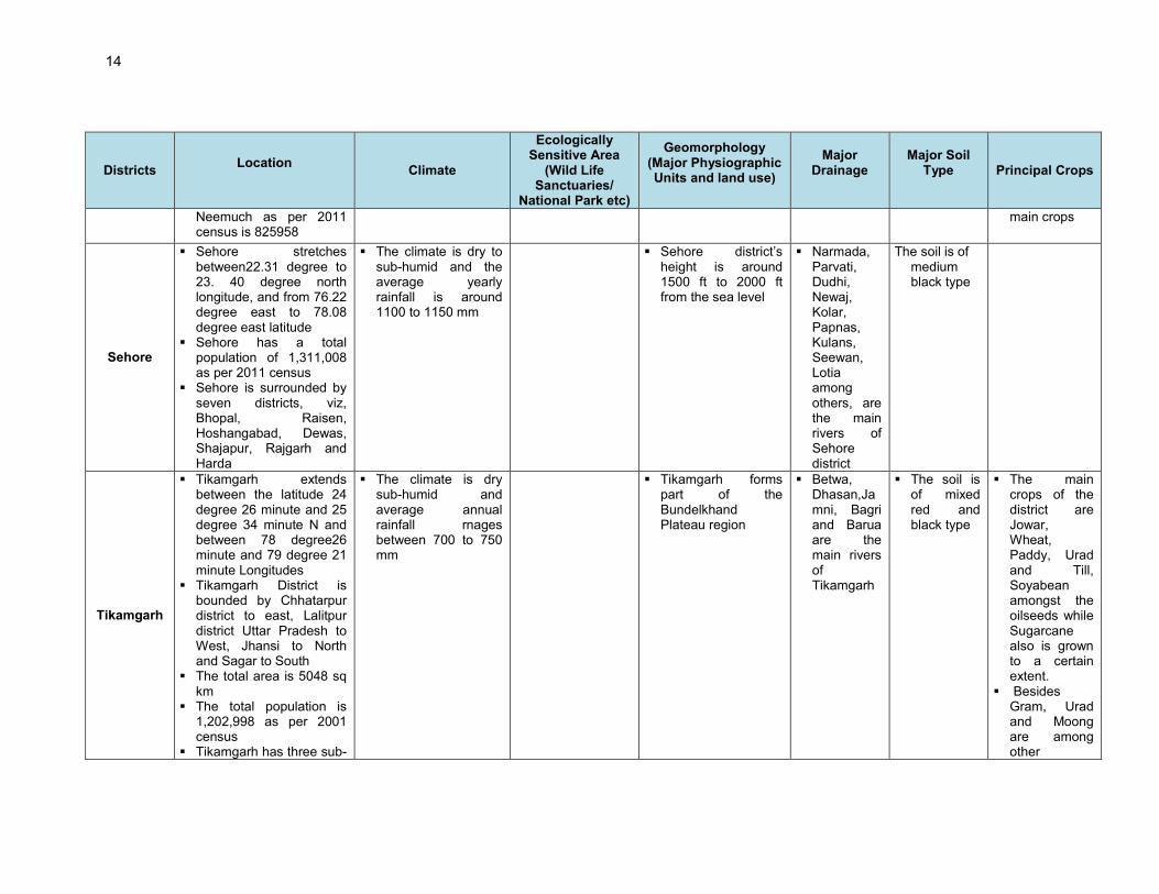
Table III-A: Summary Key Environmental Features of the Sample Road Districts
Districts Location
Climate
Ecologically Sensitive Area
(Wild Life Sanctuaries/
National Park etc)
Geomorphology (Major Physiographic Units and land use)
Major Drainage
Major Soil Type
Principal Crops
Bhopal
� Bhopal district has an area of 2772. 40 sq. km.
� Bhopal is divided into two sub-divisions-Berasia and Huzur
� Bhopal district has a total population of 2,368,145 as per 2011 census
� Bhopal is surrounded by Guna to the north, Vidisha in north-east, Raisen in East and South-East, Sehore in south and south-west and Rajgarh in the north-west zone
� The climate is dry to sub-humid and the average yearly rainfall is around 1130 mm.
� The district has 437.19km
2 area
under forest. � Van Vihar is a
forest area around Bhopal
� The district is part of the Vindhya Plateau
� The district falls mostly in the Parbati watershed area. Other smaller rivers are Halali, Bah, Sagar, Kolar etc.
� The soil is medium to shallow black
Indore
� Indore is situated on Malwa Plateau at 553 metres above sea-level
� It is located between 23o N longitude and 76o E latitude
� The total area of the district is 3898 sq kms
� Indore district’s total population is 3,272,335 as per 2011 census
� Indore is surrounded by Ujjain district in the north, Dewas in the east, Khargone (West Nimar) in the south and Dhar district in the west
� Indore district is divided
� The climate is semi-arid and the annual rainfall ranges between 850 to 900 mm
� Indore forms part of the Malwa and Nimar Plateau
� Chambal and Kshipra Rivers are the mian rivers of Indore
� Saraswat, Khan and Gambhir are the other rivers
� The soil is of medium to deep black type

13
Districts Location
Climate
Ecologically Sensitive Area
(Wild Life Sanctuaries/
National Park etc)
Geomorphology (Major Physiographic Units and land use)
Major Drainage
Major Soil Type
Principal Crops
into five Tehsils, namely Depalpur, Sanwar, MHOW, HATOD and Indore
Jabalpur
� Jabalpur is divided into four tehsils, namely Sihora, Patan, Jabalpur and Kundam
� The total population of Jabalpur district is 2,15,1203 as per 2001 census
� Jabalpur is surrounded by Katni in the north & north-east, Damoh in the north and norh-west, Narsimhapur in the south-west, Seoni in the south and Mandla in the south-east
� The climate is dry sub-humid and the average annual rainfall ranges between 1050 to 1100 mm
� Jabalpur forms part of the Kaimur Plateau and Satpura hills
� The district falls mostly in the Narmada watershed area. Other smaller rivers are Gaur, Hirann, Sindor etc.
The soil is of medium black type
Mandsaur
� Total Geographical area of Mandsaur district is 5521 Sq. Km
� The total population of Mandsaur district as per 2001 census is 1183274
� Mandsaur has four sub-divisions namely Mandsaur, Sitamau, Malhargarh and Garoth
� The climate is tropical to semi-arid dry, and average annual rainfall ranges between 850 and 900 mm
� Mandsaur forms part of the Malwa and Nimar Plateau
� Shivna river is main drainage system of Mandsaur
The soil is medium to deep black
Wheat, Jowar, Maize and pulses like Gram, Urad and Arhar are the main crops
Neemuch
� Neemuch lies between 24.15 and 24.35 degree north longitude, and between 74.45 & 75.37 degree east latitude
� The population of
� The climate is semi-arid and average annual rainfall rnages between 850 and 900 mm
� � Neemuch forms part of the Malwa and Nimar Plateau
� � The soil is medium to deep black
� Wheat, Jowar, Maize and pulses like Gram, Urad and Arhar are the
14
Districts Location
Climate
Ecologically Sensitive Area
(Wild Life Sanctuaries/
National Park etc)
Geomorphology (Major Physiographic Units and land use)
Major Drainage
Major Soil Type
Principal Crops
Neemuch as per 2011 census is 825958
main crops
Sehore
� Sehore stretches between22.31 degree to 23. 40 degree north longitude, and from 76.22 degree east to 78.08 degree east latitude
� Sehore has a total population of 1,311,008 as per 2011 census
� Sehore is surrounded by seven districts, viz, Bhopal, Raisen, Hoshangabad, Dewas, Shajapur, Rajgarh and Harda
� The climate is dry to sub-humid and the average yearly rainfall is around 1100 to 1150 mm
� Sehore district’s height is around 1500 ft to 2000 ft from the sea level
� Narmada, Parvati, Dudhi, Newaj, Kolar, Papnas, Kulans, Seewan, Lotia among others, are the main rivers of Sehore district
The soil is of medium black type
Tikamgarh
� Tikamgarh extends between the latitude 24 degree 26 minute and 25 degree 34 minute N and between 78 degree26 minute and 79 degree 21 minute Longitudes
� Tikamgarh District is bounded by Chhatarpur district to east, Lalitpur district Uttar Pradesh to West, Jhansi to North and Sagar to South
� The total area is 5048 sq km
� The total population is 1,202,998 as per 2001 census
� Tikamgarh has three sub-
� The climate is dry sub-humid and average annual rainfall rnages between 700 to 750 mm
� Tikamgarh forms part of the Bundelkhand Plateau region
� Betwa, Dhasan,Jamni, Bagri and Barua are the main rivers of Tikamgarh
� The soil is of mixed red and black type
� The main crops of the district are Jowar, Wheat, Paddy, Urad and Till, Soyabean amongst the oilseeds while Sugarcane also is grown to a certain extent.
� Besides Gram, Urad and Moong are among other

15
Districts Location
Climate
Ecologically Sensitive Area
(Wild Life Sanctuaries/
National Park etc)
Geomorphology (Major Physiographic Units and land use)
Major Drainage
Major Soil Type
Principal Crops
divisions namely Tikamgarh, Niwari and Jatara; and six tehsils namely, Niwari, Jatara, Tikamgarh, Prithvipur, Baldeogarh and Palera
important pulses of the district and are grown generally in Kharif
Ratlam
� Ratlam has an area of 4861 Km
2. It is in the
western border of Madhya Pradesh bordering Rajasthan.
� Ratlam has five tehsils,, nine towns and 1063 villages (2001 census), with a population of 1,454,483 (2011 census), population density of 299 persons per sq km and a sex ratio of 973 females per 1000 males
� The average temperature is 55 degree Fahrenheit and average rainfall is 90 cm, which occurs mainly between July and August every year
� Part of Malwa Plateau having basaltic flows and rocks, besides Alot blocks, Vindhyan sandstones
� Chambal and Shipra along with its tributaries, Khan and Gambhir are the major rivers in Ratlam
� The soil types range from medium balck to shallow black along with red and yellow soil. It is found sulphur deficient
� Wheat, Jowar Maize, pulses like Chana and Urad besides Soyabean and Groundnut are t he main crops. Cotton is also another main crop
Damoh
� Damoh is located between 23.09 Degree North Longitude and 79.03 Degree East Latitude. It has an area of 7306 sq kms
� Damoh has a population of 1,083,949 as per 2001 census with a population density of 173 per sq km and a sex ratio of 913 females per 1000 males. It has five towns, 1229 villages and seven blocks.
� The average temperature varies between 33.76-18.16 Degree Celsius with the highest and lowest temperature recorded being 38 and 6 Degree Celsius. Damoh has an average rainfall of 903.5 mm.
� The district has a forest area of 4135 sq kms
� The region is rich in limestone. However, the major part of the terrain is plain area, expect perhaps fora part of the Kaimur hills
� Kopra, Sonar, Gouraya and Bama are major rivers. Irrigation mainly depends upon monsoon rainfall
� Medium Black, Mixed Red and Black soil as well as Red and Yellow soil types are found in Ratlam district. The soil found is sulphur deficient
� Paddy, maize, black gram, green gram, soybean, pigeon pea are the major crops grown.
Source: Central Ground Water Authority Report and other District/Govt. Website.

16
Table III-B: Maximum Observed Ambient Air Quality during 2008
Area Classification SO2
(µg/m3)
NO2 (µg/m
3)
RSPM (µg/m
3)
Industrial ( maximum observed value) 30 27 265
Residential ( maximum observed value) 8 20 105
National Ambient Air Quality Standards for Industrial and Residential Areas 80 80 100
Source: National Ambient Air Quality Status, 2008, CPCB, and Table 3.3.
48. The above table reveals that the concentration of all the pollutants is higher in industrial areas especially respirable suspended particulate matter. The levels of sulphur dioxide and nitrogen dioxide are however, well within the limits (NAAQS). The higher particulate matter levels are attributed to the vehicular movement on unpaved roads and the loose dust in the agricultural fields that lead to formation of dust clouds over short periods. The same can be concluded from Table III-C, which provides a comparison of the air quality at different locations.
Table III-C: Ambient Air Quality Status of Madhya Pradesh in Previous Years
City Location Type of
Area
SO2 NO2 RSPM SPM
2008 2008 2008 2008
Bhopal Govindpura 1 7 17 91 205
Arera colony R BDL 34 129 356
Hamidia road R 9 20 124 308
T.T. Nagar R 5 11 62 120
Dewas Eid Parry(I)Ltd I 20 27 96 218
Vikas Nagar R 15 22 72 187
Gwalior Dindyal Nagar R 8 18 133 234
Maharaj Bada R 9 14 92 306
Indore Polo ground I 12 22 240 357
Kothari market R 12 22 217 325
Scheme no. 78 R 6 12 131 203
Jabalpur Vijay Nagar R BDL 25 136 297
Nagda Chem. D Labor club I 30 18 113 158
Grasim guest house no 2 R 15 25 92 132
Grasim Kalyan Kendra R 22 32 97 141
Sagar Pt. Deendayal Nagar R 3 17 115 232
Satna Sub divisional Off. I 4 BDL 265 410
Regional office R BDL BDL 115 166
Ujjain District office I 15 16 154 317
Regional office R 7 9 70 151
Mahakal temple S 12 12 82 174
Singrauli Jayant township R 78 386
NTPC Vidyanagar R 86 326
Waidhan R 49 227
National Ambient Air Quality Standards
Industrial Area ( I ) & Residential Area ( R) ( 24 hourly average)
80 80 80 100 Not
Prescribed
Source: National Ambient Air Quality Monitoring Series, CPCB R – Residential and other areas, I – Industrial area, L- Low, M- Moderate, H – High and C – Critical levels of pollution based on exceedence factor (calculated for n > 50 days).

17
3. Noise
49. Along the proposed road construction proposals, there is neither significant industrial activity nor significant vehicular traffic contributing to ambient noise levels. The occasional vehicular movement on the unpaved roads contributes to increased noise levels over short duration and limited to daytime. The existing roads do not appear to have vehicular traffic in the nigh time. Therefore the ambient noise levels are expected to be within the National Ambient Noise Standards.
4. Topography and Geomorphology
50. The State of Madhya Pradesh is the second largest state of the country. It covers an area of 30.82 million hectare, which constitutes 9.37% of the land area of the country. “Madhya Pradesh” by virtue of its geographical location can be termed as “Heart of India”. The state is surrounded by Gujarat in the West, Rajasthan in the North-West, Uttar Pradesh in the North-east, Chhattisgarh in the East and Maharashtra in the South. Landlocked in the central part of the country, Madhya Pradesh has topography that crossed from north to south by plains separated by upland areas. Geographically, Madhya Pradesh consists of a plateau with a mean elevation of 1,600 ft above sea level, interspersed with the mountains of the Vindhya and the Satpura ranges with the Chhattisgarh plains to the east. The hills give rise to the main river systems - the Narmada and the Tapti, running from east to west, and the Chambal, Sone, Betwa, Mahanadi, and the Indravati west to east. Ground elevation varies from 270 m to 750 m above mean sea level. 51. The soils of state are rich and fertile. The state has a variety of soils ranging from richclayey to gravely. The major groups of soils found in the state can be divided in to following four categories i.e. alluvial, medium & deep black; shallow & medium black; and mixed red & black. Categorically state has two agro-climatic zones namely (i) Central Plateau & Hill Region, and (ii) Western Plateau & Hill Region. These two zones have been further sub-grouped and the description regarding area and its soil &geological features.
Figure III.1 :Geographical / Geological Map of Madhya Pradesh

18
5. Geology/Soil
52. The geology /soil of the state of Madhya Pradesh is given below:
Zone Sub-group (Region)
District covered Rainfall
(mm) Climate Type of Soil
Central Plateau and Hill Region
Bundelkhand Chattarpur, Tikamgarh
Datia, 700 Dry sub-humid
Mixed red & Black
Chhattisgarh Hills
Mandla, Dindori 1570 Moist sub-
humid Red & Yellow
Kaimur Plateau &
Satpura Hills
Jabalpur, Panna, Satna, Rewa, Sidhi,
Seoni, Katni, Balaghat, Shahdol, Anuppur,
Umariya
1100 Dry sub-humid
Medium Black
Vindhya Plateau
Bhopal, Damoh, Raisen, Sagar, Sehore,
Vidisha 1130
Dry sub-humid
Shallow to Medium Black
Satpura Plateau
Betul, Chhindwara, Narsinghpur
1220 Dry sub-humid
Shallow to Medium Black
Central Narmada
Valley Hosangabad, Harda 1300
Dry sub-humid
Deep Black
Gird
Morena, Bhind, Gwalior, Guna,
Shivpuri, Ashoknagar , Sheopur
670 Semi-arid Medium Black
alluvial
Western Plateau and Hill Region
Jhabua Hills Jhabua 988 Semi-arid Medium
black to
deep
Malwa & Nimar Plateau
Indore, Dhar, Ujjain, Ratlam, Dewas, Mandsaur, Rajgarh, Shajapur, Khandwa, Khargone, Neemuch, Badwani, Burhanpur
874 Semi-arid Medium to deep black
53. Soil -The major soil types within the project districts can be classified into three groups namely vertisol, altisol, and entisols. These soil types are further classified into red yellow loamy, black cotton soils. The entisols is sub-classified into younger alluvial, and laterite soils. The Atlisols is sub-classified into lateritic and alluvial soils. The vertisol is sub-classified into baslic black cotton soil, older alluvial soils. Textures of soils are medium to heavy grained.
6. Earthquake & Seismicity
54. Seismic Hazard. The seismic hazard map of India was updated by Bureau of Indian Standards (BIS) in 2000.4 The main change was merging of Zones I & II. As per this updation, Zone II and III (low to moderate Risk) stretches across the length of the MP State (Figure 3.2). According to GSHAP data, the state of Madhya Pradesh falls in a region of low to moderate seismic hazard.
4 IS 1893 (Part 1): 2002 Indian Standard Criteria for Earthquake Resistant Design of Structures Part 1 General
Provisions and Buildings (Fifth Revision).

19
Source: Amateur Seismic Centre, Pune
Figure III.2 : Seismic Zone Map
Source: IS 1893 (Part 1) 2002
Figure III.3 : Hazard Zone Map
7. Land use 55. The most of the geographical area (307560 sq. km i.e. about 98 percent) of the state is available for utilization. Agriculture is the major land use in state followed by forests. The area under various land uses in the state is presented in the Table III-D. Land use pattern along the project road is also mixed type dominated by agriculture, barren forest land and residential areas. (Table 3.4).
Madhya Pradesh State

20
Table III-D: Land Use Pattern in the State
Source: State of Forest Report, 2005, Forest Survey of India Dehradun.
8. Hydrology and Water Quality 56. Madhya Pradesh is criss-crossed by India’s four major rivers namely Narmada, Tapti, Sone and Mahanadi along with their numerous tributaries. Availability of water in from these rivers to the state is more than 81000 million cubic meters annually, out of which approximately 56857million cubic meters i.e. 69.74% could be utilized. 57. None of the rural road crosses any natural stream except two roads, which crosses Keth River and Chamla rivers. Sample road are mostly crossed by seasonal small channels. Ground water being extracted through hand pumps or tubewell is the main source of water supply to villagers. 58. Surface Water Quality: In Madhya Pradesh, pollution is increasing in most of surface water resources in major towns due to increasing urbanization trend. The estimated surface water available for use is around 306682 Million Cubic Meter (MCM). None of the water sources are safe for drinking or bathing without conventional water treatment. Rivers such as Narmada, Sone,Tapti Chambal, ken and Betwa, etc. are found to be polluted at different stretches due to industrial, domestic and agricultural pollution. Among all the rivers, Narmada and Ken River is the most polluted. 59. Groundwater Quality and Availability: The total Net Ground Water availability of Madhya Pradesh (1998) is 31093575.60 ha of which total current Ground Water Draft is 1437520.00 ha. The state is currently exploiting 46% of the available ground water. On 70% dependable yield, groundwater usage is around 66%. In hilly and undulating regions, springs, rivulets and wells provide drinking water. Most households in rural areas now rely on hand pumps for their supply of drinking water. 60. Among the 50 districts of the state, current ground water condition is safe in 40 districts. In 10 districts the ground water condition is in critical in 5 blocks and overexploited in 24 blocks. In sample project districts, five blocks (Badnawar, Dhar, Manawar, Nalcha, and Tirla) in district Dar falls under overexploited category. 61. Fluoride, salinity and iron affect the quality of water in Madhya Pradesh. There are 4,018 villages with 7,746 sources in 22 districts that have been affected by fluoride; 562 villages with
Land Use Area in '000 ha Percentage
Total Geographical area 30,825 Reporting area for land Utilization 30,756 99.78 Forests 8683 28.17 Not Available for cultivation 3350 10.87 Permanent pastures and other grassing land 1360 4.41 Land under miscellaneous tree crops & groves 19 0.06 Culturable wasteland 1177 3.82 Fallow lands other current fallows 621 2.01 Current fallows 599 1.94 Net area sown (as per agriculture census 1995-96 expect total cropped area) 14,945 48.48

21
1,269 sources in 13 districts that have been affected by salinity; and 856 villages with1, 449 sources in eight districts that have been affected by iron. 62. As per the central ground water board (CGWB) report, the groundwater quality of all the project districts Sagar, Sidhi, Dhar and Damoh, in both shallow and deeper aquifers is good and suitable for drinking, irrigation and industrial purposes. The Decadal (1995-2005) water table condition during pre-monsoon is shown in Figure 3.4.
Central Ground Water Board Northern Region Bhopal
Figure III.4 : Decadal Water Table Conditions in the Project Districts 63. Hydrogeology: The largest State of the country is underlain by formations in age ranging from Achaean to Recent. One fifth of the area is occupied by granite gneisses and meta-sedimentary rocks, whereas one tenth by Gondwanas comprising sand stones, lime stones & marbles. The Deccan Trap covers a larger part of the State whereas the Quaternary alluvium covers 6% of the State area. The alluvial deposits form prolific aquifers where tube wells can yield in the range of 50-80 m3/hr. The yield of tube wells in sand stones of Gondwanas ranges between 20-30 m3/hr; whereas in limestone of Gondwanas, it varies between 50-80 m3/hr. The yield of tube wells in select area ranges between 20-30 m3/hr. C. Ecological Resources 64. Variability in climatic and edaphic conditions brings about significant difference in the forest types of the state. There are four important forest types viz. Tropical Moist, Tropical Dry, Tropical Thorn, Subtropical broad leaved hill forests. The forest area can also be classified based on the composition of forest and terrain of the area. Based on composition, there are three important forest formations namely Teak forest, Sal forest and miscellaneous forests. Bamboo bearing areas are widely distributed in the state. To obviate pressure on the natural forests, plantations have been undertaken in forest and non forest areas to supplement the availability of fuel wood, small timber, fodder, etc.
22
65. The forest cover has been classified in dense forest and open forest. The latest estimates of Forest Survey of India (FSI), published in the State of Forest Report (SFR) 2003, suggest that the total forest cover of M.P. is 76,429 sq. km., which is 24.79% of the land area - dense forest constituting 13.57% and open forest 11.22%. In addition to these two categories of cover, the land having canopy cover of less than 10% is classified as scrub. The area under scrub is not included in the forest cover. Central, eastern and southern parts of the state are rich, whereas northern and western parts are deficient in forest. Figure 3.5 shows the forest map of the state. Project districts largely have open forests.
Figure III.5 : Forest Map of Madhya Pradesh 66. The project area lies in tropical climate zone.It has a medium range of flora and fauna. Flora, fauna and vegetation types found in the areas have been described separately below. However, none of the roads consists of any rare, endangered or threatened floral species. 67. Although, none of the road stretches passes through any forest land/area5 but still has trees, which might require felling during clearing up operations for construction of rural roads. In most of cases, tree cutting has been minimized by suitably modifying the alignment. The list of commonly found flora in the sample road districts is given at Table III-E.
5 The two sample project passes through small patches of forests land which already been converted to non forest
land after obtaining necessary permission from forest department.

23
Table III-E: List of Common Flora of Project Districts
S. No. Local Name Botanical Name Family
Large Trees
1. Achar Buchanania lanzan (spreg) Anacardiaceae
2. Arjun Terminalia arjuna (Bedd) Combretaceae
3. Aam Mangifera indica (Linn) Anacardiaceae
4. Awla Emblica officinalis Euphorbiaceae
5. Imli Tamarindus indica (Linn) Caesalpiniaceae
6. Kardhai Anogeissus pendula Combrataceae
7. Kala siras Albizia lebbek Leguminosae (Mimoseae)
8. Kevlor Bauhinia purpurea Caesalpinaceae
9. Kumbhi Careya arborea Myrtaceae
10. Kullu Sterculia urens Stcrculiaceae
11. Kem Mitragyna parvifolia Rubiaceae
12. Khair Acacia catechu Leguminosae (Mimoseae)
13. Gular Ficus glomerata Moraceae
14. Gunja Gardenia pinnata Burseraceae
15. Jamun Syzygium cuimini Myrataceae
16. Tendu Diospyros melanoxeon Ebenaceae
17. Dhavda Anogeissus latifolia Combretaceae
18. Dhobin Dalbergia paniculata Leguminosae (Papilionaceae)
19. Nilgiri Eucalyptus spp Myrtaceae
20. Neem Azadirachta indica Meliaceae
21. Palas Butea monosperma Leguminosea (papilionaceae)
22. Pangra Erythrina Suberosa Leguminosae (Pipilionaceae)
23. Pipal Ficus religiosa Moraceae
24. Bad Ficus bengalensis Moraceae
25. Bahera Terminalia belerica Combretaceae
26. Babul Acacia nilotica Legumenosae (Mimoseae)
27. Bel Aegle marmelos Rutaceae
28. Bhirra Chloroxylon Swietenia Meliaceae
29. Maharukh Ailanthus excelsa Simarubiaceae
30. Mahua Madhuca indica Sapotaceae
31. Shisham Delbergia latifolia, Roxb Leguminosae (Papilionaceae)
32. Safed Siras Albizzia procera, Benth Leguminosae (Mimoseae)
33. Sagwan Tectona grandis Verbenaceae
34. Saj Terminalia tomentosa Combretaceae
35. Salai Boswellia serrata Burseraceae
36. Seja Lagerstroemia parviflora Lythraceae
37. Semal Bombax cieba Malvaceae
38. Haldu Adina Cardifolia Rubiaceae
Small Tree 39. Amaltash Cassia fistula Leguminosae (Caesalpiniaceae)
40. Astara Bauhinia malabarica Leguminosae (Caesalpiniaceae)

24
S. No. Local Name Botanical Name Family
41. Asta Bauhinia racermosa Leguminosae (Caesalpiniaceae)
42. Ghont Zizyphus xylopyra Rhamnaceae
43. Ber Zizyphus jujube Rhamnaceae
44. Lokhandi Ixora arborea Rubiaceae
45. Sehra Bauhinia retusa Leguminosae (Caesalpiniaceae)
Shrubs and Herbs 46. Adusa Adhatoda vasica Acanthaceae
47. Arandi Ricinus Communis Euphorbiaceae
48. Aak Calotropis gigantean Asclepiadaceae
49. Gokhru Tribulus terrestris Zygophllaceae
50. Zhadneri Zizyphus nummularia Rhamnaceae
51. Tulsi Ocimum Sanctum Labiatae
52. Thuar Euphorbia nerifolia Euphorbiaceae
53. Dhavai Woodfordia fruticosa Lythraceae
54. Nirgudi Vitex negundo Verbenaceae
55. Neel Indigofera pulchella Leguminosae
56. Pawar Cassia tora Leguminosae (Caesalpiniaceae)
57. Beshram Ipomoea pescaparae Convolvulaceae
58. Bhatkatiya Solanum nigrum Solanaceae
59. Vidyasini Lantana camara Verbenaceae
60. Shatavari Asparagus recemosus Liliaceae
61. Sitafal Anona Squamosa Anonaceae
62. Harsingar Nyctanthes arbortristis Oleacaae
63. Ratanjot Jatropha curacas Evphorbiaceae
64. Gunja Abrus precatorious Leguminosea
65. Amrbel Cuscuta reflexa Convolvulaceae
68. The clearance of the vegetation and felling of trees for the road construction is an environmental concern. However, very small number of tree is falling within ROW and which can be saved with design considerations.
1. Terrestrial/Avian fauna:
69. The general faunal assessment was carried out in subproject area. The species generally found are given in Table III.F.
Table III-F: List of Common Fauna of Project Districts S. No. Local Name Zoological Name Family
Mammals 1. Common Langur Presbytia entellus Colobidae
2. Rhesus macaque Macaca mulatta Circopthecidae
3. Common Mongoose Herpestes edwardsi Herpestidae 4. Common five Stripped squirrel Funambulus pennanti Sciuridae 5. Field rat Bandicota bengalensis Muridae 6. Common house rat Rattus rattus-refescena Muridae 7. Common Indian hare Lepus nigricollis Leporidae

25
S. No. Local Name Zoological Name Family
Reptiles
1. Python molurus Indian python Pythonidae 2. Mabuya carinata Common skink Scincidae 3. Ptyas mucosus Rat snake Colubridae
4. Hemidactyhus flaviviridis House Lizard Gekkonidae 5. Calotes versicolor Garden Lizard Agamidae 6. Naja naja Indian cobra Elapidae 7. Varanus bengalensis Moniter Lizard varanidae
Avifauna 1. White Egret Egretta alba Ardeidae
2. Little Egret Egretta garzetta Ardeidae 3. Common or Grey Quail Cotuenix coturnix Phasianidae 4. Red wattled Lapwing Vanellus indicus Charadridae 5. Blue Rock Pigeon Columba livia Collumbidae 6. Indian Ring Dove Streptopelia decaocto Collumbidae 7. Spotted Dove Streptopelia chinensis Collumbidae 8. Large Indian Parakeet Psittacula eupatria Psittacidae 9. Rose Ringed Parakeet Psittacula Krameri Psittacidae 10. Blossom Headed Parakeet Psittacula cyanocephala Psittacidae 11. Koel Eudynamys scolopaceae Cuculidae
12. Coucal Centropus sinensis Cuculidae
13. Small Blue King Fisher or Common Kingfisher
Alcedoatthis Alcedinidae
14. White Breasted Kingfisher Halcyon smyrnensis Alcedinidae 15. Green Bee Eater Merops orientalis Meropidae 16. Indian Pitta Pitta brachyuran Pittiade
17. King Crow; Black Drongo Dicrurus adsimilis Dicruidae
18. Large Racket tailed Drango Dicrurus paradiseus Dicruidae
19. Common Mynah Aeridotheres tristis Sturnidae 20. Jungle Mynah Aeridotheres Sturnidae 21. House Crow Corvus splendens Corvidae 22. Jungle Crow Corvus macrorhynchos Corvidae
23. Red vented Bulbul Pyenonotus cafer Pycnontidae 24. Jungle Babbler Turdoidesstriatus Muscicapidae Timalinae 25. Pied Bush Chat Saxicola caprata Muscicapidae 26. Magpie Robin Copsychus-saularis Muscicapidae Turdinae
27. Indian Robin Saxicola fulicatus Muscicapidae Turdinae 28. Grey Wagtail Motacilla cinerea Motacillidae 29. Purplesun Bird Nectarinia asiatica Nectarinidae
30. House Sparrow Passer-domesticus passerinae 31. Red Munia Estrilda amandava Estrildinae
2. Wild Life and Protected Areas
70. Madhya Pradesh is a pioneer state in the national movement for conservation of flora and fauna. Conservation oriented legal provisions were made in the erstwhile Acts regulating hunting of game-birds and wild animals. There are 9 national parks and 25 sanctuaries spread over an area of 10,862 sq. km constituting 11.40% of the total forest area and 3.52% of the geographical area of the state (Figure 3.6). Efforts are under way to increase the protected area network to 15% of the forest or 5% of the geographical area as suggested by State Wildlife Board. There is no wildlife Sanctuaries/National Parks, Tiger Reserves, etc. along the project area.

26
Legend: National Park Sanctuaries
SL No shown above are synchronised with Sl. No in the table
below
Figure III.6 : Protected Areas of Madhya Pradesh
71. Table III-G provides details of national park and sanctuaries corresponding to serial Number indicated at Figure 3.6 above.
Table III-G: List of Protected Areas in Madhya Pradesh I. List of National Park in M. P. (Sl. No. Below Correspond to Figure above)
S.No. Name and District of National Park Area in Sq.Km.
Fauna
1. Kanha National Park, District Mandla 940 km²
Tiger, Panther, Gaur, Chital, Sambar, Nilgai, Chinkara, Barking Deer, Swamp Deer, (Barasingha), Wild Boar & variety of upland birds.
2 Bandhavgarh National Park, District Umaria
437 km² Tiger, Panther, Gaur, Chital, Sambar, Nilgai, Chinkara, Barking Deer, Wild Boar & variety of upland birds.
3 Panna National Park, District Panna, Chhatarpur
543 km² Tiger, Chital, Chinkara, Sambar and the Sloth Bear
4 Pench Tiger Reserve, District Seoni, Chhindwara
293 km²
Tiger, Panther, Bison, Chital, Sambhar, Nilgai, Chinkara, Barking Deer, Chowsingha, Wild Boar & variety of upland birds.
5 Satpura National Park, District Pachmarhi
524 km²
Tiger, Leopard, Sambar, Chital, Bherki, Nilgai, Four-horned antelope, Chinkara, Bison (gour), Wild Boar, Wild Dog, Bear, Black Buck, Fox, Porcupine

27
I. List of National Park in M. P. (Sl. No. Below Correspond to Figure above)
S.No. Name and District of National Park Area in Sq.Km.
Fauna
6 Sanjay National Park, District Sidhi 1938 km² Tiger, Panther, Sambar, Chital, Gaur, etc.
7 Madhav National Park, DistrictShivpuri
354 km²
Panther, Chital, Sambar, Nilgai, Chinkara, Black Buck, Chausingha, Wild Boar, Crocodiles in lake, & variety of upland birds.
8 Van Vihar National Park, DistrictBhopal
4.45 km² Tiger, Panther, Lion, Bear, Hyena etc.
9 Mandla Plant Fossils National Park, District Mandla
0.27 km² Plant Fossils II. List of Wild Life Sanctuaries in M.P. (Sl. No. Below Correspond to Figure above)
S. No. Sanctuary SL. No. Sanctuary
1. Bori 13. Panpatha 2. Bagdara 14. Kuno 3. Phen 15. Pench 4. Ghatigaon 16. Ratapani 5. Gandhisagar 17. Sanjay Dubri 6. Karera 18. Singhori 7. Ken Ghariyal 19. Son Ghariyal 8. Kheoni 20. Sardarpur 9. Narsinghgarh 21. Sailana 10. N. Chambal 22. Ralamandal 11. Nauradehi 23. Orchha 12. Pachmari 24. Gangau 25. V. Durgawati
3. Aquatic Biology
72. No wetland or large water body falls in and around the selected project roads area. Fisheries activities are also minimal in subproject areas. D. Socioeconomic Environment
1. Demography
73. As per census 2001, Madhya Pradesh has a total population of 60 million persons. (Table III-H). It has one of the largest tribal populations in the country. Out of the 50 districts in the State, 19 are predominantly tribal. Eighty-nine blocks (approx. 28%) of the total 313 development blocks are tribal blocks.
Table III-H: Demographic Profile
Indicators Status Indicators Status
Population Literacy Total 6,03,85,218 Total 64.11% Male 3,14,56,973 (52%) Male 76.80% Female 2,89,28,245 (48%) Female 50.30% SC 15.17% SC 58.57% ST 20.27% ST 41.16%

28
Urban 1,61,02,400 (27%) Urban 79.40% Rural 4,42,82,528 (73%) Rural 57.80% Sex ratio 920
2. Literacy and Education
74. The State literacy rate presently is 64.11% (source: Census 2001), which is close to the national literacy rate of 64.8 %. While the female literacy has considerably improved over the last decade, a great disparity persists in the literacy rates of males and females. Some blocks such as Alirajpur, Jobat (district Jhabua), Karahal (district Sheopur), Jhirniya (district Khargaon), Sendhwa (district Badwani), and Bajna (district Ratlam) have literacy rates below 35%.
3. Affluence
75. About 18.8 million People is considered living below poverty line in Madhya Pradesh, which constitutes about 43% of total population.
4. Agricultural
76. Agriculture is the main occupation in the state. About half of the land area is cultivable. The extent of availability of cultivable land varies depending on topography, rainfall, and soils. The larger cultivable land is found in the Chambal valley, Malwa Plateau, Rewa Plateau, and Chhattisgarh Plain. 77. The prime crop of the state is Cereals (about 41%), followed by pulses (about 20%), oilseed (about 30%) and vegetables, fruits, fodder, and other horticultural crops (about 9%).
5. Industries, Cottage and small industries
78. The state has various industrially developed estates. The major industrial produce includes cement, pigiron, steel ingots, news print, and sugar. Industrialization is low in the subproject areas. However, there is high potentiality for the growth of cottage and small industries in subproject areas. Better communication and transport facilities may be contributory in this growth.
6. Public Facilities (Communication, health services, water supply, power)
79. State has well-developed postage and telephone system. Subprojects areas also has good access to these facilities. Educational facilities are available in the village areas as well. However, rural population has to depend on urban areas for undergraduate level education. The urban area has well organised water supply systems. However, rural areas including subproject areas still depends on hand pumps. 80. MP state has total power generation capacity of 6305 MW. However, state is still power deficient. About 97.43% villages in the state are electrified. E. Salient Environmental Features of Sample Roads 81. The salient environmental features of sample roads are summarized in Table III-I below:
29
Table III-I: Salient Environmental Features of Sample Roads Sl No
Name of District
Block Road Name
(Length, in Km) Salient Environmental Features
1 Ratlam Ratlam Mundri to
Sarwani Jagir (2.80 Km)
• The topography of the project road is flat at almost all locations.
• No part of the project road passes through any forest area and there are no endangered species
• Habitation area located between CH-2000m to CH-2400m, CH-2700m CH-2800m with connecting village Sarwani Jagir
• There was no grazing ground located on the chainage.
• Agriculture land lies between CH-00m to CH-2000m, CH-2400m to CH-2700m.
• There are no barren land on this road and it passes mostly through agricultural land
• No part of the project road lies in hilly terrain prone to landslide or erosion.
• Big ponds were found at CH-400-500m and CH-1700-1800m far away i.e. 300m from the proposed alignment
• There was found some water crossing structures at Ch-00m to Ch-100m, Ch-1200m to Ch-1300m, CH-1800m to CH-1900m, CH-2200m to CH-2300m has proposed CD.
• There are few points of water stagnation and other drainage issues on or near the road
• No flood prone area was found on the road • There are 39 trees of dbh of 30 cm or more that
were found on the road • No faunal habitat, breeding ground, rare,
endangered or threatened species etc. are found within 100 m of the road shoulder
• Some utility, community and religious structures are found along the road
2 Indore Sanwer
Indore Ujjain Road to
Brahman Khedi (3.10)
• The topography is flat at almost all locations • No part of the road passes through forest area,
nor any endangered species are found alongside the project road
• The project road passes through the target village, namely Brahmankhedi, at CH 2900 to 3100 mtrs.
• Agriculture land lies on both sides of the road between Ch 00m to Ch 2700M
• There are grazing grounds located between CH2700m till CH 2900m
• The project road does not pass through any barren land
• No part of the project road lies in hilly terrain that may be prone to landslides
• A few water crossing are there between CH500-600m, Ch 800-900m, Ch 1800-1900m and CH 2600-2700m. CD’s have been proposed on the

30
Sl No
Name of District
Block Road Name
(Length, in Km) Salient Environmental Features
above-mentioned locations • There are some points of water stagnation and
related issues on or near the road. • A total of 19 trees are there within 10m of the
center-line of the proposed alignment
3 Tikamgarh Tikamgarh
Tikamgarh Jatara Road to Laxmanpura
(0.95)
• The topography of the project road is flat at almost all locations.
• No forest area or endangered species are found along the project road
• The project road is passing through village namely Laxmanpura between CH-800m to CH-1000m.
• Agriculture land lies on both side of road between Ch-00m to CH-500m.
• The project road is not passing through grazing land or barren land.
• No part of the project road lies in hilly terrain prone to landslide or erosion.
• Some water crossings have been found between CH-00m to CH-100m, CH-400m to CH-500m, CH-700m to CH-800m at the proposed alignment.
• There are some points of water stagnation and other drainage issues on or near the road
• A total of 09 trees are falling within 10m of the center line of proposed alignment.
• No rare, endangered or threatened species are there within 100 m of the road shoulder.
• Some utility, community and religious structures are found along the road
4 Damoh Tendukhe
da Samnapur to Jamun (9.50)
• The topography of the road is flat in almost all the locations
• However, some hills area is found at CH-1600m to CH-9500m along the proposed alignment.
• Forestland is there at Ch-1400m to Ch-9500m at proposed alignment. However, no part of the chainage cuts thoruhg any forestland.
• Inhabited area starts at Ch-400m to Ch-1200m, Ch-7400m to Ch-7800m and Ch-9000mto Ch-9500m with connecting village Samnapur, Khari and Jamun respectively.
• Significant agricultural land was not found along the proposed alignment
• Grazing ground land is no there along the proposed alignment.
• No Barren land is there along the project road. • No part of the project road lies in hilly terrain
prone to landslide or erosion. However, sufficient cross-drainage structures will be constructed to avoid any erosion.
• There was not found any pond along the project road.

31
Sl No
Name of District
Block Road Name
(Length, in Km) Salient Environmental Features
• There was found at Ch-1400m to Ch-1600m, Ch-2600m to Ch-2800m, Ch-3600m to Ch-3800m, Ch-5400m to CH-5600m and Ch-7200m to Ch-7400m has been CD proposed and Ch-400m to Ch-600m Existing CD
• There are not at some points of water stagnation and other drainage issues on or near the road
• No flood prone area is there along the project road.
• There was not found any faunal habitat at 11000 m of the road shoulder.
• No rare, endangered or threatened species were found within 100 m of the road shoulder.
• Some utility structures, religious/cultural and community structures/buildings were found alongside the proposed road alignment
5 Damoh Damoh MDR(ATP) to
Rampura (1.00)
• Topography of the road is flat at almost all locations
• No part of the project road passes through any forest area.
• There are no endangered species on this alignment
• Inhabited area starts at Ch-00m to Ch-200m with connecting village Rampura
• Agriculture land lies between Ch-200m to Ch-700m
• No barren land or grazing ground were found along the proposed alignment
• No part of the project road lies in hilly terrain prone to landslide or erosion. However, sufficient cross-drainage structures will be constructed to avoid any erosion.
• There was not found any pond at proposed alignment.
• There was found some water crossing points at Ch-300m to Ch-400m
• There are at some points of water stagnation and other drainage issues on or near the road
• There are not found any flood prone area along the project road.
• There are 19 trees of dbh of 30 cm or more, on the proposed alignment
• There was not found any faunal habitat at 100 m of the road shoulder.
• Some utility structures, religious/cultural and community structures/buildings were found alongside the proposed road alignment
6 Damoh Tendukhe
da L118 to Oriya
Mal (2.00)
• The topography of the road is flat is almost all locations
• No part of the project road passes through any forest area
• Inhabited area starts at Ch-1600m to Ch-2000m

32
Sl No
Name of District
Block Road Name
(Length, in Km) Salient Environmental Features
starting village Oriya Mal • Agriculture land is at Ch00m to Ch-700m along
the proposed alignment. • No grazing gorund or barren land is there along
the proposed alignment. • No part of the project road lies in hilly terrain
prone to landslide or erosion. However, sufficient cross-drainage structures will be constructed to avoid any erosion.
• There was not found any pond along the proposed alignment.
• There was found water crossing points at Ch-100m to Ch-200m, Ch-400m to Ch-500m, Ch-1000m to Ch-1100m have Existing CD.
• There are at some points of water stagnation and other drainage issues on or near the road
• No flood prone area is there along the project road
• There are 09 trees of dbh of 30 cm or more, along the project road
• There was not found any faunal habitat at 100 m of the road shoulder.
• No rare, endangered or threatened species were found within 100 m of the road shoulder.
• Some community, utility, religious and cultural structures are found alongside the road alignment
7 Bhopal Berasiya Bhopal Beraisya
Road to Pardi (1.45)
• No part of the project road lies in hilly terrain prone to landlsides or erosion. However, sufficient cross-drainage structures will have to be constructed to avoid any erosion
• No pond was found along the proposed alignment
• Some water crossing structures a at CH 00m-100m, CH 200m-300m and CH 1200m-1300m. CD’s have been proposed at CH 500m-600m. CH 800m-900m has existing CD’s
• There are some points of water stagnation and other drainage issues on or near the road
• No flood prone area is found along the project road
• There are 27 trees of dbh 30 cm or more that are found along the road
• No rare, endangered or threatened species or faunal habitats were found within 100m of the road shoulder
• Utility structures and some religious cultural or community structures/buildings are found on the road.
8 Jabalpur Sehora
Sihora Silondi Road to
Chhanagawa (2.70)
• The topography of the project road is flat at almost all locations.
• No part of the project road passes through any forest area.

33
Sl No
Name of District
Block Road Name
(Length, in Km) Salient Environmental Features
• No endangered species are found along the project road
• Inhabited area starts at Ch-2200m to Ch-2700m with connecting village Chhanagawa.
• Agriculture land lies between Ch-00m to Ch-2100.
• Grazing ground was not found along the proposed alignment.
• No Barren land is there along the project road. • No part of the project road lies in hilly terrain
prone to landslide or erosion. However, sufficient cross-drainage structures will be constructed to avoid any erosion.
• There was found pond at Ch-2300m to Ch-2400m at the proposed alignment.
• Small nullahs, streams and chhanels are there at Ch-00m to 100m, Ch-200-300m, Ch-300m to Ch-400m, Ch-600m to CH-700m, Ch-900m to Ch-1000m, CH-1900m to Ch-2000m, Ch-2000m to Ch-2100m and Ch-2400m to Ch-2500m has been proposed CDs.
• There are at some points of water stagnation and other drainage issues on or near the road
• No flood prone area is there along the road • There are 34 trees of dbh of 30 cm or more,
along the road • There was not found any faunal habitat at 100 m
of the road shoulder. • No rare, endangered or threatened species
were found within 100 m of the road shoulder. • Utility structures are found. • Some of the religious cultural or community
structures/buildings are found.
9 Ratlam Ratlam Dosaigoan to Borana (1.2)
• The topography of the project road is flat at almost all locations.
• No part of the project road passes through any forest area.
• Inhabited area starts at Ch-00mto Ch-100m connecting village Dosaigaon and at Ch-800m to Ch-1200m with connecting village Borana.
• Agriculture land lies between Ch-100m to Ch-900m.
• Grazing ground was not found along the proposed alignment.
• No Barren land along the project road. • No part of the project road lies in hilly terrain
prone to landslide or erosion. However, sufficient cross-drainage structures will be constructed to avoid any erosion.
• There was not found any pond along the proposed alignment.
• There was some water crossing structures like

34
Sl No
Name of District
Block Road Name
(Length, in Km) Salient Environmental Features
streams, nullahs and rivulets found at Ch-200m to Ch-300m, Ch- 500m to Ch-600m, CH-700m to Ch-800m has proposed CD.
• There are at some points of water stagnation and other drainage issues on or near the road
• No flood prone area is there on the road • There are 48 trees of dbh of 30 cm or more, that
are there on the road. • There was not found any faunal habitat at 100 m
of the road shoulder. • No rare, endangered or threatened species
were found within 100 m of the road shoulder. • Some utility and religious cultural or community
structures/buildings were found on the road
10 Ratlam Ratlam R. S. Road to Nandlai (2.80)
• The topography of the project road is flat at almost all locations.
• No part of the project road passes through any forest area.
• Inhabited area starts at Ch-2000m to 2800m with connecting village Nandlai
• Agriculture land lies between Ch-00m to Ch-2000m at both side of the alignment.
• Grazing ground was not found along the proposed alignment.
• No barren land is there along the project road • No part of the project road lies in hilly terrain
prone to landslide or erosion. However, sufficient cross-drainage structures will be constructed to avoid any erosion.
• There was found at Ch-600m to Ch-700m, Ch-900m to Ch-1000m, Ch-1600m to Ch-1700m, Ch-2400m to CH-2500m, Ch-2700m to Ch-2800m pond the proposed alignment.
• There was found some water crossing point at Ch-100m to Ch-200m, Ch-300m to Ch-400m, Ch-600m to Ch-700m, Ch-900m to Ch-1000m, Ch-1100m to Ch-1200m, Ch-1500m to Ch-1600m, Ch-1600m to Ch-1700m & Ch-1900m to Ch-2000m proposed CD.
• There are some points of water stagnation and other drainage issues on or near the road.
• No flood prone area is found alongside the project road
• There are 22 trees of dbh of 30 cm or more that are there along the project road
• There was not found any faunal habitat at 100 m of the road shoulder.
• No rare, endangered or threatened species were found within 100 m of the road shoulder.
• Some of the utility structures, community structures and religious structures are found along the road.

35
Sl No
Name of District
Block Road Name
(Length, in Km) Salient Environmental Features
11 Mandsaur Sitamou Sitamou Basai to Larni (1.00)
• The topography of the project road is flat at almost all locations.
• No part of the project road passes through and forest area
• Inhabited area starts at Ch-700m to Ch-1000m with connecting village Larni.
• Agriculture land was not found along the proposed alignment
• No Barren land was found along the project road.
• No part of the project road lies in hilly terrain prone to landslide or erosion. However, sufficient cross-drainage structures will be constructed to avoid any erosion.
• No pond was found along the proposed alignment.
• Some water crossing points at Ch-300m to Ch-400m. CD has been proposed at this point.
• There are at some points of water stagnation and other drainage issues on or near the road
• No flood prone area is there along the project road
• There are 10 trees of dbh of 30 cm or more that are found alongside the project road
• No rare or endangered and threatened species or faunal habitat were found within 100m of the road shoulder
• Some utility structures and religious cultural or community structures/buildings were found alongside the road alignment
12 Sehore Ichhawar Gaji Khedi Road
to Ramgarh (5.60)
• The topography of the project road is flat at almost all locations.
• Unclassified forest area is there at Ch-600m to Ch-5000m along the proposed alignment.
• Inhabited area starts at Ch-00m to Ch-600m and Ch5200m to Ch-5600m with connecting village Gaji Khedi To Ramgarh.
• No agriculture land was found along the project road, neither were grazing ground or barren land found
• No part of the project road lies in hilly terrain prone to landslide or erosion. However, sufficient cross-drainage structures will be constructed to avoid any erosion.
• A river is there at Ch-5000m to Ch-5200m along the proposed alignment.
• There was found some water crossing points at Ch-200m to Ch-400m, Ch-600m to CH-800m, CH-1000m to 1200m, Ch-1200m to Ch-1400,m, Ch-1400m to Ch-1600m, Ch-2200mto Ch-2400m, CH-2600m to Ch-2800m, Ch-3000m to CH-3200m, Ch-3600m to Ch-3800m, Ch-4200m to CH-4400m has been CD proposed. At CH-

36
Sl No
Name of District
Block Road Name
(Length, in Km) Salient Environmental Features
5000m to CH-5200m has proposed bridge. • There were some points of water stagnation and
other drainage issues on or near the road • No flood prone area is there along the project
road • There are 45 trees of dbh of 30 cm or more that
are found along the project road • No faunal habitat is there at 100 m of the road
shoulder. • No rare, endangered or threatened species
were found within 100 m of the road shoulder. • Some religious cultural or community
structures/buildings are there along the project road
13 Sehore Sehore T11-Heerapur
Road to Alampura (1.60)
• The topography of the project road is flat at almost all locations.
• No part of the project road passes through any forest area.
• Inhabited area namely Barkhedi and Alampura are respectively located at Ch 00mto CH 100m, and CH 1100m to CH 1600m.
• Agriculture land lise between CH100-600m, CH800-900m LHS and CH 600-1000m RHS
• Grazing ground is there at CH 600-800m LHS alongside the proposed alignment.
• No barren land is there on the proposed alignment
• No part of the project road lies in hilly terrain prone to landslide or erosion.
• There is a small pond at CH 900-1000m along the road shoulder of the proposed alignment.
• Nullahs, stream and small rivulets are thereat CH 400-500m, CH 900-1000m and CH 1200-1300m. CD’s have been proposed for the above-mentioned chainages
• There are at some points of water stagnation and other drainage issues on or near the road
• No flood prone area is there along the project road.
• There are 5 trees of dbh of 30 cm or more that are found in the proposed alignment.
• There was not found any faunal habitat at 100 m of the road shoulder.
• No rare, endangered or threatened species were found within 100 m of the road shoulder.
• Some utility structures, religious cultural or community structures/buildings were found on the proposed alignment
14 Jabalpur Jabalpur NH-7 to Dhadra
(2.85)
• The topography of the project road is flat at almost all locations.
• There was found hilly area between Ch-2400m

37
Sl No
Name of District
Block Road Name
(Length, in Km) Salient Environmental Features
to Ch-2500m on the proposed alignment • No forest area is there along the proposed
alignment • The project road is passing through village
namely new habitation, Dhadra between Ch-1400m to Ch-1500m, Ch-2700m to Ch-2800m respectively.
• Agriculture land lies on both side of agriculture between Ch-00m to CH-1200m RHS and Ch-1700m to Ch-2200m both side.
• The project road is not passing through grazing land.
• The project road is not passing through the barren land.
• No part of the project road lies in hilly terrain prone to landslide or erosion.
• No pond is there on the proposed alignment. • Some water crossing points has been observed
between Ch-1700m to Ch-1800m, Ch-2400m to Ch-2500m, Ch-2600m to Ch-2700m has been CD proposed on above mentioned locations and Ch-2200m to Ch-2300m has been existing CD.
• There are some points of water stagnation and other drainage issues on or near the road
• A total of 04 trees are falling within 10m of the center line of proposed alignment.
• No rare, endangered or threatened species have been found within 100 m of the road shoulder.
• Some utility, community and religious structures are there on the proposed alignment
15 Neemuch Jawad Neemuch
Singoli Road to Gothada (1.00)
• The topography of the project road is flat at almost all locations.
• No part of the project road passes through any forest area.
• Inhabited area starts at Ch-800m to Ch-1000m with connecting village Gothada.
• Agriculture land was found at Ch-00m to Ch-800m both side of the alignment
• Grazing ground was not found along the proposed alignment.
• No Barren land is there along the project road. • No part of the project road lies in hilly terrain
prone to landslide or erosion. However, sufficient cross-drainage structures will be constructed to avoid any erosion.
• No pond is there along the proposeds alignment • Some water crossing points are there at Ch-00m
to Ch-100m, Ch-400m to Ch-500m, & Ch-700m to Ch-800. CD’s are proposed at these points.
• There are at some points of water stagnation

38
Sl No
Name of District
Block Road Name
(Length, in Km) Salient Environmental Features
and other drainage issues on or near the road. • No fold prone area is there along the project
road • There are 13 trees of dbh of 30 cm or more, on
the project road. • No faunal habitat, breeding ground etc. is found
within 100 m of the road shoulder. • No rare, endangered or threatened species
were found within 100 m of the road shoulder. • Some utility and religious/community/cultural
structures were found alongside the proposed road
16 Indore Sanwer Indore Ujjain
Road to Siloda Bujurg (13.70)
• The topography of the project road is flat at almost all locations.
• No forest area was found alongside the proposed alignment
• The project road passes through Siloda Bujurg (new habitation) spread in phases at CH400-600m and then at Ch 1800m (end-point).
• The project road passes through agriculture land on both sides at CH-00m to 400m and at CH- 700 to 1300m.
• Grazing ground is there at CH-1400to Ch-1600m.
• There is no barren land along the project road. • No part of the project road lies in hilly terrain
prone to landslide or erosion. • No pond is there along the project road • Some nallahs, stream, rivulets and other water
crossing are there at CH00-100m, Ch 1200-1300m and CH 1400-1500m. CD’s are proposed on these points However, CH1500-1600m has existing CD and CH 100-200m, CH 300-400m and CH 900-1000m have field crosses.
• There are few points of water stagnation and other drainage issues on or near the road
• The area along the project road is not flood prone.
• There was found 04 trees with a dbh of 30 cm are passing through the proposed alignment.
• No faunal habitat, breeding ground etc. is found within 100 m of the road shoulder.
• No rare, endangered or threatened species are found within 100 m of the road shoulder.
• Some utility and community structures were found alongside the proposed alignment
17 Mandsaur Mandsaur Mandsuar
Bypass Road to Aghoriya (2.95)
• The topography of the project road is flat at all locations.
• The proposed alignment does not pass through any forest area
• Inhabited area starts at Ch-2200m to Ch-2950m with connecting village Aghoriya.

39
Sl No
Name of District
Block Road Name
(Length, in Km) Salient Environmental Features
• Agriculture land was found at Ch-100m to Ch-2200m both side of the alignment
• Grazing ground was not found along the proposed alignment.
• No Barren land is there along the project road. • No part of the project road lies in hilly terrain
prone to landslide or erosion. However, sufficient cross-drainage structures will be constructed to avoid any erosion.
• No pond is there along the proposed alignment • There was found some water crossing points at
Ch-200m to Ch-300m, Ch-800m to Ch-900m, Ch-1900m to Ch-2000m, Ch-2700m to Ch-2800m has proposed CD and Ch-1500m to Ch-1600m and Ch-2100m to Ch-2200m pipe proposed.
• There are some points of water stagnation and other drainage issues on or near the road.
• No flood prone area is there along the project road.
• There are 46 trees with a dbh of 30 cm that are there along the proposed alignment
• There is no grazing ground along the project road.
• There is no barren land along the project road. • No part of the project road lies in hilly terrain
prone to landslide or erosion. • No faunal habitat, breeding ground etc. is found
within 100 m of the road shoulder. • No rare, endangered or threatened species are
found within 100 m of the road shoulder. • Some utility and community structures were
found alongside the proposed alignment
18 Jabalpur Jabalpur T05 to Pipariya
(2.60)
• The topography of the project road is flat at almost all locations.
• No part of the project road passes through any forest area.
• Inhabited area starts at Ch-900m to Ch-1100m, Ch-2000m to Ch-2200m with connecting village Pipariya tola and at ch-2600m connecting village Pipariya.
• Agriculture land lies between Ch-00m to Ch-200m, Ch-700m to Ch-900m, Ch-1400m to Ch-2000m and Ch-2300m to Ch-2600m.
• Grazing ground was found at Ch-200m to Ch-700m along the proposed alignment.
• No barren land is there on the project road. • No part of the project road lies in hilly terrain
prone to landslide or erosion. • No pond is there alongside the project road. • There was found at Ch-00m to 100m, Ch-100-
200m, Ch-600m to Ch-700m, Ch-800m-Ch-

40
Sl No
Name of District
Block Road Name
(Length, in Km) Salient Environmental Features
900m, Ch-1700m- Ch-1800m, Ch-1800m-Ch-1900m, Ch-2500m-2600m and where as Ch-1300m to Ch-1400m have existing causeway.
• There are some points of water stagnation and other drainage issues on or near the road.
• The proposed alignment is not flood prone in nature
• There are 24 trees of dbh of 30 cm or more that are there alongside the proposed alignment.
• No faunal habitat, breeding ground etc. is found within 100 m of the road shoulder.
• No rare, endangered or threatened species were found within 100 m of the road shoulder.
• Some utility and community structures were found along the proposed alignment.
19 Neemuch Jawad Neemuch
Singoli Road to Panoli (2.50)
• The topography of the project road is flat at all locations.
• Unclassified forest area is there at Ch-00m to Ch-1800m
• Inhabited area starts at Ch-2100m to Ch-2500m with connecting village Panoli.
• Agriculture land was not found along the proposed alignment.
• Grazing grounds was not found along the proposed alignment.
• There is no barren land along the project road. • No part of the project road lies in hilly terrain
prone to landslide or erosion. However, sufficient cross-drainage structures will be constructed to avoid any erosion.
• There was found at Ch-1300m to Ch-1400m RHS & Ch-1400m to Ch-1500m, Ch-1900m to Ch-2000m LHS pond which is far away 12-15m from the proposed alignment.
• There was found some water crossing points at Ch-00m to Ch-100m, Ch-300m to Ch-400m, Ch-900m to Ch-1000m & Ch-1300m to Ch-1400m has CD proposed
• There are at some points of water stagnation and other drainage issues on or near the road
• There are 04 trees of dbh of 30 cm or more that are found alongside the alignment
• There is no lake/swamp along the project road. • The area along the project road is not flood
prone. • No faunal habitat, breeding ground etc. is found
within 100 m of the road shoulder. • No rare, endangered or threatened species
were found within 100 m of the road shoulder. • Some utility and community structures were
found along the proposed alignment 20 Indore Mhow A. B. Road to • The topography of the project road is flat at

41
Sl No
Name of District
Block Road Name
(Length, in Km) Salient Environmental Features
Shahda (2.10) almost all locations. • No part of the project road passes through any
forest area. • The project road is passing through village
namely Shahda Ch-1800m to Ch-2100m • Agriculture land lies on both side of agriculture
between Ch-1300m to Ch-1700m both side of the proposed alignment.
• No grazing ground is there along the project road.
• Barren land is there along the Ch-500m to Ch-1200m on both sides of the proposed project road.
• No part of the project road lies in hilly terrain prone to landslide or erosion.
• No pond is there along the proposed alignment • A few water crossing has been observed
between at ch-1200m to Ch-1300m CD has been proposed on above mentioned locations
• There are some points of water stagnation and other drainage issues on or near the road
• A total of 40 trees is falling within 10m of the center line of proposed alignment.
• No rare, endangered or threatened species have been found within 100 m of the road shoulder.
• Some utility structures, religious, cultural or community structures/buildings are found on the proposed road alignment
21 Tikamgarh Tikamgarh
Baldevgarh Kakarwaha
Road to Atariya (6.10)
• The topography of the project road is flat at almost all locations.
• No part of the project road passes through any forest area.
• The project road is passing through village name Atariya between Ch-5400m to Ch-6000m
• Agriculture land lies on both side of agriculture between Ch-400m to Ch-4200m.
• The project road is passing through no grazing land.
• The project road is not passing through barren land.
• No part of the project road lies in hilly terrain prone to landslide or erosion.
• Some water crossing points are there at Ch-400m to Ch-600m, Ch-600 to Ch-800m, Ch-1600 to Ch-1800m has been proposed CDs on above mentioned locations and Ch- 2400m to 2600m, Ch-3200m to Ch-3400m, Ch-3800m to Ch-4000m, Ch-4400m to Ch-4600m has been existing CDs.
• There are some points of water stagnation and other drainage issues on or near the road

42
Sl No
Name of District
Block Road Name
(Length, in Km) Salient Environmental Features
• A total of 05 trees is falling within 10m of the center line of proposed alignment.
• No rare, endangered or threatened species have been found within 100 m of the road shoulder.
• Some community structures were found along the proposed alignment. However, there were no utility structures found.
22 Tikamgarh Baldevgarh
Patha Patori Road to Midawali (7.00)
• The topography of the project road is flat at almost all locations.
• No part of the project road passes through any forest area.
• The project road is passing through village namely Bagrun, Kheda and Mithawali between Ch-600m to Ch-800m, Ch-1400m to Ch-1600m, Ch-6800m to Ch-7000m respectively.
• Agriculture land lies on both sides between Ch-2400m to Ch-5800m.
• The project road is not passing through grazing land.
• The project road is not passing through the barren land.
• No part of the project road lies in hilly terrain prone to landslide or erosion.
• No rare or endangered species are there on the proposed alignment.
• A pond has been found between Ch-1800m to Ch-2000m and Ch- 6200m to Ch-6400m LHS along the proposed alignment
• Some water crossings are there between Ch-00m to Ch-200m, Ch-2200mto Ch-2400m, Ch-3200m to Ch-3400m, Ch-4600mto Ch-4800m, Ch-6200m to Ch-6400m CD have been proposed on above mentioned locations and between Ch-1800m to Ch-2000m, Ch-5400m to Ch-5600m has existing CDs and Ch-2800m to Ch-3000m, Ch-3400m to Ch-3600m, Ch-5000m to Ch-5200m field cross proposed.
• There are some points of water stagnation and other drainage issues on between Ch-1800m to Ch-2000m RHS.
• A total of 79 trees are falling within 10m of COI of proposed alignment.
• No rare, endangered or threatened species have been found within 100 m of the road shoulder.
• Some utility structures, religious and community structures are found along the project road
23 Indore Mhow Choraldam
Road to Buralia (5.60)
• The topography of the project road is flat is all locations
• There was found forest area between Ch-00m to Ch-3800m both side on the proposed alignment.
• No rare, endangered or threatened species

43
Sl No
Name of District
Block Road Name
(Length, in Km) Salient Environmental Features
have been found within 100 m of the road shoulder.
• The project road is passing through village namely Nachanvore and Buralia between Ch-4600m to Ch-4800m, and Ch-5400 to Ch-5600m respectively.
• Agriculture land lies between Ch-4000m to CH-5200m and RHS proposed alignment.
• The project road is not passing through any grazing land.
• The project road is not passing through any barren land.
• No part of the project road lies in hilly terrain prone to landslide or erosion.
• A pond is located on the of project road between Ch-4800m to 5400m which is far away 15m from the proposed alignment
• Some water crossings have been observed between Ch-00m to Ch-200m, Ch-200m to Ch-400m, Ch-600m to Ch-800m, Ch-800m to Ch-1000m, Ch-1200m to Ch-1400m, Ch-1400m to Ch-1600m, Ch-1600m to Ch-1800m, CH-2000m to Ch-2200m, Ch-2200m to Ch-2400m Ch-2600m to ch-2800m, Ch-2800m to Ch-3000m, Ch-3200m to Ch-3400m, Ch-3600m to Ch-3800m, Ch-3800m to Ch-4000m, Ch-4200m to Ch-4400m, Ch-4600m to Ch-4800m, Ch-5000m to Ch-5200m CDs have been proposed on above mentioned locations.
• There are some points of water stagnation and other drainage issues on or near the road.
• A total of 19 trees are falling within 10m of the center line of proposed alignment.
• Some utility and community structures were found along the proposed alignment
24 Mandsaur Mandsaur Dalauda Digon Road to Pinda
(3.10)
• The topography of the project road is flat at almost all locations.
• The proposed alignment does not pass through any forest area
• Inhabited area starts at Ch-2400m to Ch-3100m with connecting village Pinda
• Agriculture land was found at Ch-00m to Ch-3000m both side along the proposed alignment
• Grazing ground was not found along the proposed alignment.
• No Barren land is there along the project road. • No part of the project road lies in hilly terrain
prone to landslide or erosion. However, sufficient cross-drainage structures will be constructed to avoid any erosion.
• No pond is there along the proposed alignment.
• There was found some water crossing points at

44
Sl No
Name of District
Block Road Name
(Length, in Km) Salient Environmental Features
Ch-800m to Ch-900m has EX CD. • There are at some points of water stagnation
and other drainage issues on or near the road. • There are not found any flood prone area along
the project road. • There are 08 trees of dbh of 30 cm or more that
are there along the proposed alignment. • No faunal habitat, breeding ground etc. is found
within 100 m of the road shoulder. • No rare, endangered or threatened species are
found within 100 m of the road shoulder. • Some utility and community structures as well as
religious structures were found along the proposed alignment
25 Bhopal Berasiya
T-11( Arjunkhedi) to Khejra Ghat
(3.04)
• The topography of the project road is flat at almost all locations.
• No forest area was found along the proposed alignment
• Inhabited area starts at Ch-00m To Ch-100m With Connecting Arjunkhedi and at Ch-2200m To Ch-3040m Khejraghat.
• Agriculture land lies between Ch-100m to Ch-2100m.
• Grazing ground was not found along the proposed alignment.
• No Barren land is there along the project road. • No part of the project road lies in hilly terrain
prone to landslide or erosion. However, sufficient cross-drainage structures will be constructed to avoid any erosion.
• No pond is there along the proposed alignment. • There was found 13 water crossing structures at
Ch-00m to Ch-100m, Ch-100m to Ch-200m, Ch-200m to Ch-300m, Ch-300m to Ch-400m, Ch-400m to Ch-500m, Ch-500m to Ch-600m, Ch-600m to Ch-700m, Ch-800m to Ch-900m, Ch-900m to Ch-1000m, Ch-1300m to Ch-1400m, Ch-1500m to Ch-1600m, Ch-2000m to Ch-2100m, and Ch-2400m to Ch-2500m has proposed CD
• There are at some points of water stagnation and other drainage issues on or near the road
• There are not found any flood prone area along the project road.
• There are 13 trees of dbh of 30 cm or more that are there along the proposed alignment.
• There is no barren land along the project road. • No part of the project road lies in hilly terrain
prone to landslide or erosion. • No faunal habitat, breeding ground etc. is found
within 100 m of the road shoulder. • No rare, endangered or threatened species

45
Sl No
Name of District
Block Road Name
(Length, in Km) Salient Environmental Features
were found within 100 m of the road shoulder. • Some utility and community structures as well as
religious structures were found along the proposed alignment
26 Sehore Sehore
T08 (Jharkheda Ghati-Sehore
MDR) to Toonakhurd
(1.95)
• The topography of the project road is flat at almost all locations.
• No part of the project road passes through any forest area.
• Inhabited area starts at CH-1800m to Ch-1950m. It has the has connecting village Thunakhurd.
• Agriculture land lies between Ch-100m to Ch-1700m.
• Grazing ground is not there along the proposed alignment.
• No barren land is there along the proposed alignment
• No part of the project road lies in hilly terrain prone to landslide or erosion. However, sufficient cross-drainage structures will be constructed to avoid any erosion.
• There is a small pond at CH-00m to Ch-100m along the road shoulder at the proposed alignment.
• Some nullahs, streams and rivulets are there at Ch-00m to 100m, Ch-400-500m, CH-1300m to Ch-1400m, CH-1600m to Ch-1700m and Ch-1800m toCh-1900m has proposed CD.
• There are at some points of water stagnation and other drainage issues on or near the road
• There are not found any flood prone area along the project road.
• There are 40 trees of dbh of 30 cm or more that are there along the proposed alignment
• There was not found any faunal habitat at 100 m of the road shoulder.
• No rare, endangered or threatened species were found within 100 m of the road shoulder.
• Some utility and community structures as well as religious structures were found along the proposed alignment.
27 Ratlam Ratlam Dhatrawada to
Kankarwa (5.40)
• The topography of the project road is flat at almost all locations.
• Forest is located at Ch-2100m to Ch-2400m • Inhabited area starts at Ch-00m to Ch-400m,
Ch-5200m to Ch-5400m with connecting village Dhatrawada and Kankarwa.
• Agriculture land lies between Ch-800m to Ch-1900m Ch-3000m to CH-4100m at both side of the alignment.
• Grazing ground was found Ch-400m to Ch-800m, Ch-1900m to Ch-3000m and Ch-4100m to Ch-5200m along the proposed alignment.

46
Sl No
Name of District
Block Road Name
(Length, in Km) Salient Environmental Features
• Barren land was not found along the project road.
• No part of the project road lies in hilly terrain prone to landslide or erosion. However, sufficient cross-drainage structures will be constructed to avoid any erosion.
• Some lakes and swamps was found Ch-3100m to Ch-4100m pond along the proposed alignment.
• There was found few water crossing points at Ch-200m to Ch-300m, Ch-500m to Ch-600m, Ch-1500m to Ch-1600m, Ch-1700m to Ch-1900m, Ch-2200m to Ch-2300m, Ch-2900m to Ch-3000m, Ch-4300m to Ch-4400m, Ch-4500m to Ch-4600m & Ch-4700m to Ch-4800m proposed CD & Ch-3100m to Ch-3300m, Ch-3500m to Ch-3600m & Ch-4000m to Ch-4100m has EX CD.
• There are at some points of water stagnation and other drainage issues on or near the road
• There are not found any flood prone area along the project road.
• There are 133 trees of dbh of 30 cm or more that were found along the proposed alignment
• There was not found any faunal habitat at 100 m of the road shoulder.
• No rare, endangered or threatened species were found within 100 m of the road shoulder.
• Some utility and community structures as well as religious structures were found along the proposed alignment.
28 Bhopal Berasiya
Rampura Balachoun Road
to Goria Sankheda (3.35)
• The topography of the project road is flat at almost all locations.
• No immediate forest area is there near to the proposed alignment.
• Inhabited area starts at Ch-00m to CH-300m and Ch-3200m to CH-3350m with connecting village Rampura and Goria Sankheda.
• Agriculture land lies between Ch-400m to CH-2400m
• No part of the project road lies in hilly terrain prone to landslide or erosion. However, sufficient cross-drainage structures will be constructed to avoid any erosion.
• There was found small pond at Ch-2600m to Ch-2800m
• There was found some water crossing structures at Ch-00m t o Ch-200m, Ch-400m to CH-600m, CH-800m to Ch-1000m, CH-1200m to CH-1400m, Ch-1800m to CH-2000, CH-2200m to Ch-2400m and Ch-2400m to Ch-2600m has proposed CD.
• There are some points of water stagnation and

47
Sl No
Name of District
Block Road Name
(Length, in Km) Salient Environmental Features
other drainage issues on or near the road • There are not found any flood prone area along
the project road. • There are 25 trees of dbh of 30 cm or more that
are there along the proposed alignment • No rare, endangered or threatened species
were found within 100 m of the road shoulder. • Some utility and community structures as well as
religious structures were found along the proposed alignment.
CD proposed at CH-3400m Road Name:
Choraldam to Buraliya Block Name: Mhow District Name: Indore
Pond at RHS, CH-4000-4100M Road Name: Dhatrawada to Kankarwa
Block Name: Ratlam District Name: Ratlam
CD proposed at CH 1900-2000M Road Name:
Mandsaur Bypass Road to Aghoriya Block Name: Mandsaur
District Name: Mandsaur
Pond at CH 1600-1700M, LHS Road Name: R. S. Road to Nandlai Block Name: Ratlam
District Name: Ratlam

48
CD proposed at CH 2200M Road Name:
Rampura Balachhoun to Goria Sankheda Block Name: Berasiya District Name: Bhopal
Road environment at CH 100M Road Name: Sihora Silondi Road to Chhanagawa
Block Name: Sehora District Name: Jabalpur
Road condition at CH 400-500m, HP at LHS. Road Name: Sitamou Basai to Larni
Block Name: Sitamou District Name: Mandsaur
CD proposed at CH 00M, Starting Point Road Name: Tikamgarh Jatara Road to
Laxmanpura Block Name: Tikamgarh
District Name: Tikamgarh

49
IV. ANTICIPATED ENVIRONMENTAL IMPACTS AND ITS MITIGATION MEASURES 82. Road improvements work brings substantial economic and social benefits to rural communities and national economies. However, it may also cause adverse environmental impacts though of smaller magnitude, since rural road subprojects are planned to follow the existing alignments and will be of 7.5 m width only. The impacts are largely expected to be during construction phase, which can be mitigated through engineering measures and adoption of best construction practices. This section outlines the identified impacts during design, construction and operation phases along with proposed mitigation measures to eliminate or minimize the adverse impacts. 83. The associated environmental impacts have been assessed considering present environmental setting of the project area, nature, and extent of the proposed activities. Impacts are analyzed on both generic and specific nature and are being classified as being insignificant, minor, moderate and major. 84. Since the issues associated with most of the roads are similar, the impacts and mitigation measures given below are applicable to most of the subprojects. Issues specific to any sample roads have been separately indicated. A. Common Impacts during Design and Construction Phase
1. Climate change
85. Impact: The proposed roads are analyzed considering climate change vulnerability screening checklist defined under EARF to RCIP. The resource (like barrow earth, aggregate, cement, concrete) requirements for these rural roads as such are minimal. None of these resources is likely to be affected by climate changes such as changes in temperature and precipitation. None of the project roads is located in natural hazard area or passes through protected areas or flood-prone areas. Only three sample roads, Sawalkhedi to Semera Madho in Sagar district, Ratlam Gujri road to Jalod in Dhar district and SH 49 – Itwaheeralal in Damoh District are prone to flood from Keth River, Chamla River and Nala, respectively. The habitation is low along these rural roads and as such, no exponential population growth is expected considering the generic trend of population migration from rural to urban areas. Most of the subproject roads pass through agricultural fields and along the existing alignments with low embankment height of 1m (average) from ground to crust except at the approaches of cross-drainage structures. As such, the subproject roads are unlikely to be vulnerable or increase the vulnerability of surrounding areas (with respect to population growth, settlement patterns, increasing runoff or landslides). 86. Mitigation Measures: Compensatory tree plantations6 (1:3) will be made to compensate the loss of trees cut for construction of subproject roads. Efforts shall be made to plant additional trees for increasing the carbon sink. The tree may be planted with help of village Panchayat.7 All non-sample rural roads to be included in RCIP will also be screened for climate change vulnerability and necessary mitigation measures shall be adopted for minimisation of identified vulnerability if any.
6 SRRDA mostly undertake this activity through state forest department. The forest department plants tree either along the proposed roads if land is available otherwise on nearby degraded forest land. 7 Village Panchayats are planting trees at along rural roads with funding under Mahatma Gandhi National Rural Employment Act scheme. The PIUs may facilitate with them for planting trees along the road. Some of the PIUs in different states are already helping Village Panchayats for the same.

50
2. Finalization of Alignment
87. Impact: The proposed rural road will be constructed to provide 7.5 m roadway in accordance with PMGSY guidelines and technical specifications (IRC-SP 20: 2002) in plain terrains. Sample rural road construction works are proposed aligned to existing road (earthen track with some stretches of brickbat soling). The existing road passes through plain terrain and primarily agriculture areas. None of sample roads passes through any protected monument or protected areas. Impacts due to road alignment and design is expected to be minor and limited to shifting of some common utilities, community structures (temple, school) and trees located along the road alignment. 88. Mitigation Measures: The road alignment is finalized considering availability of right of way. The ROW is reduced in built up area or constricted areas to minimize land acquisition. The road alignment has also been modified to avoid tree cutting, shifting of utilities or community structure to the extent feasible. Some of the measures taken include widening of the road on one end to maintain the tree on the road edge to avoid its cutting, using retaining wall to minimize the road width to 5 m wherever required. The road is aligned to follow natural topography to avoid excessive cut and fill. All future roads to be included in RCIP will follow above measures. In addition these subprojects will comply with the following criteria for alignment finalization:
i. The road will be part of district core network and will comply with PMGSY guidelines ii. Subproject shall not disturb any cultural heritage designated by the government or by
the international agencies, such as UNESCO, and shall avoid any monuments of cultural or historical importance.
iii. Subproject will not pass through any designated wild life sanctuaries, national park, notified Eco sensitive areas or area of international significance such as protective wet land designated under Wetland Convention, and reserve forest area..
iv. Subproject to comply with local and National legislative requirements such as forest clearance for diversion of forest land and ADB’s Safeguard Policy Statement 2009.
3. Land Acquisition
89. Impact: Minor impact since no land acquisition is involved due to various measures considered for finalization of road alignment. Villagers have volunteered to donate their land if at certain stages land is required for geometrical correction or alignment adjustment for avoiding tree cutting or shifting of community structure. There could be some impact on the encroachers. However, most of them have also volunteered to shift from the proposed alignment. 90. Mitigation Measures: All efforts shall be made to minimize the land acquisition while finalising the alignment. In an unavoidable situation, first adopt suitable engineering measures to reduce the ROW requirement or donation of land from land owners. In the encroached areas, efforts shall be made to restricted road construction to the available space.
4. Protected Areas (National parks, wild life sanctuaries, Eco sensitive zones, protected /historical monuments) and forest areas.
91. Impact: Madhya Pradesh has many wild life protected areas. Some of these are present in those districts where subprojects are located (Figure 3.6 and Table III-A and Table III-G). However, none of sample roads passes through any of these protected areas.

51
92. None of the sample road passes through any forest land except two roads (Kalkuwa To Bachhama, and Hatta Sehora Rd. SH-51 to Belkhedi Patera) where small patch of forest land is acquired.8 As such, project has no impact on forest cover of the district/state/country. Madhya Pradesh is also known to have several archaeological monuments and historical monuments spread all over the state. However, none of them is located within 5 km of subproject roads. 93. Mitigation Measures: Since there are no impact protected/ecologically sensitive areas, no such measures are proposed. In case of any additional diversion of forest land is involved, prior forest clearance shall be obtained under Forest (Conservation) Act 1980 (amended 1988).
5. Land Clearing Operations
94. Impact: The site clearing operations may have impact on utilities, community properties a land use and vegetation profile of the area if adequate considerations not given to road alignment, utility and community structure shifting plan, tree felling, and demolition waste disposal. 95. Mitigation Measures: The following steps shall be taken to minimize the associated impact with land clearing operations.
i. The land clearing operation should be undertaken as per the defined road alignment and community structure, utility and road furniture shifting plan.
ii. The road land width shall be clearly demarcated on the ground. iii. The utility and community structure shifting shall be as per plan and with
consultations and concurrence of the community. iv. Tree felling shall be limited to those, which could not be saved even by design
measures. The tree shall be cut with a permission of Forest department. The vegetable cover shall be removed and disposed in consultation with community.
v. All public utilities shall be shifted with a concurrence of respective agencies/authority and to the adjacent location approved by them.
vi. The top soils shall be collected and preserved for reuse as a base for turfing of embankment slopes or development of barren areas along roadside. The top soil shall be preserved at identified location with the provision of watering /grass development on the heap surface to prevent air pollution.
6. Cut and Fill and Embankment construction
96. Impact: Inadequate alignment planning may increase the cut and fill requirement as well as need for more borrow earth for embankment formation leading to some impact on land use. Inadequate provision for drainage and embankment slop protection may lead to soil erosion, water logging. People have also raised concern of water stagnation along the road in certain section9 and undulating road sections. Inadequate balancing of cut and fill and poor drainage design may lead to excessive road earth/hillock cutting and poor drainage. 97. Mitigation Measures: The alignment design shall consider options to minimize excessive cuts and fills. The cut and fill quantities shall be used for embankment to minimize
8 Requisite permission has already been obtained from forest department for the diversion of the same vide its letter
no 963 dated 25-03-2011 and No 19 dated 01-01-2010. 9 Some of road were water stagnation problem is reported includes Road Hatta-Gaisabad to Devera, Hatta Sehera
Road SH-51 to Belkhedi Patre, Itwaheeralal to Shikarpura in Damoh district.

52
barrow earth requirement. The design shall be as per relevant IRC provisions for cut and fill, slope protection and drainage. Adequate provision shall be made for cross-drainage structure for maintaining natural drainage pattern in the subproject area and preventing soil erosion. Adequate drainage shall be provided to prevent water logging. The top soil of the cut and fill area shall be used for embankment slope protection. 98. Due consideration is given to above aspect for alignment finalization of sample road. With the adoption of appropriate mitigation measures, the impact due to above activity on land use and other environmental component is expected to be minimal.
7. Establishment of Construction Camp, Temporary office and Storage Area 99. Impact: The congregation of labor population and technical staff in the subproject area during the construction phase is likely to put considerable stress on the limited resources of village areas. Some of the associated impacts are related to health, safety of the laborers at the construction campsites, availability of safe drinking water, and sanitation. 100. The establishment of construction camp temporary office and storage area will reduce land productivity if these are established on agricultural land. Loading and unloading of construction material, transportation of material, handling of fuel and waste disposal from these areas may have direct and indirect impact on soil, water and air quality. 101. Mitigation Measures: The following steps are taken to minimize/reduce these impacts:
• Construction campsites shall be located away from any local human settlements (minimum 500m away) and preferably located on lands, which are not productive barren/waste lands presently. Similarly temporary office and storage areas shall be located away from human settlement areas (minimum 500 m).
• The construction camps, office and storage areas shall have adequate water supply, sanitation and all requisite infrastructure facilities. This would minimize dependence of construction personnel on outside resources, presently being used by local populace and minimize undesirable social friction thereof.
• The construction camps shall be located at a minimum 500 m from forest land/areas to deter the construction labor in trespassing. Similarly, temporary office and storage areas shall be located at a minimum 500 m from forest land/areas.
• The construction camps, office and storage areas shall have septic tank/soak pit of adequate capacity so that it can function properly for the entire duration of its use.
• All construction camps shall have rationing facilities particularly for kerosene/LPG so that dependence on firewood for cooking is avoided completely to the extent possible.
• The construction camps, office and storage areas shall have health care facilities for adults, pregnant women and children.
• All construction personnel shall be subjected to routine vaccinations and other preventive/healthcare measures.
• Contractor shall arrange all personal protective equipment (PPEs) like helmet, boots, earplugs for workers, first-aid and fire fighting equipment at construction sites. An emergency plan shall be prepared to fight with any emergency like fire.
• Garbage bins must be provided in the camp and regularly emptied and disposed off in a hygienic manner. Domestic solid waste shall be disposed of in a control manner. The recyclable waste shall be sold off and non-saleable and biodegradable waste shall be disposed through secured land filling.

53
• All fuel oil/lubricant unloading and storage shall be made on the paved areas away from storm water drainage.
• After completion of construction work, the camp /temporary office/storage areas sites shall be restored to its original condition.
8. Traffic Movement
102. Impact: Construction work along the existing road could cause disturbances to traffic movements. It will also pose risk of accident to motorist at night if these blockages and disruption are not clearly demarcated. 103. Mitigation Measures: The contractor will prepare appropriate traffic diversion scheme, which shall be implemented in different stretches of the road as per the progress of the construction work. This plan shall be approved by PIU and implemented before start of any construction work to avoid any inconvenience to the present road users. The diversion plan should ensure smooth flow of traffic, minimize accidents to road users during construction works. Adequate signboards shall be placed much ahead of diversion site to caution the road users. The road signs should be bold, visible, and retro-reflective in nature for the night visibility
9. Associated Impacts due to Construction Activities
a. Loss of productive soil, erosion and land-use
104. Impact: No land use will change due to the project since required ROW is available throughout the alignment. Land use though will change temporarily of construction camp, temporary office storage areas for the period of construction. This will also result in loss of soil productivity. Soil erosion may take place along steep and un-compacted embankment slope, and wherever vegetation is cleared. Soil erosion may have cumulative effect viz. siltation, embankment damage, drainage clogging etc. The siltation, due to soil erosion may occur only in the ponds located close to the roads. There are two roads in Damoh district and two roads in Dhar district where ponds are located close to the existing road. Loss of soil due to run off from earth stockpiles may also lead to siltation. Land use may also change due to borrowing the earth. 105. Mitigation Measures: It shall be ensured that the land taken on lease for access road, construction camp and temporary office of the storage facilities is restored back to its original land use before handing it over back to land owner. The top soil from the productive land (borrow areas, road widening areas, etc.) shall be preserved and reused for plantation purposes. It shall also be used as top cover of embankment slope for growing vegetation to protect soil erosion. The topography of all the sample roads throughout the stretch is plain except in case of two roads where it is undulating for some stretches and two roads where it is hilly terrain. Therefore, cut and fill shall be planned as per IRC provisions and rural road manual. All steep cuts shall be flattened and benched. Shrubs shall be planted in loose soil area. IRC: 56 -1974 recommended practice for treatment of embankment slopes for erosion control shall be taken into consideration. Soil erosion shall be visually checked on slopes and embankment areas. In case soil erosion is found, suitable measures shall be taken to control the soil erosion.
b. Borrow Areas and Quarries
106. Impact: Borrow areas if left un-rehabilitated may pose risk to people, particularly children and animals of accidentally falling into it as well as become potential breeding ground

54
for mosquitoes and vector born disease. Illegal quarrying may lead to unstable soil condition; destroy the landscape of the terrain, air and noise pollution. 107. Mitigation Measures: The project area is generally having a flat terrain. It is recommended that borrowing from agricultural land shall be minimized to the extent possible. Further, no earth shall be borrowed from already low-lying areas. The borrow earth shall be obtained from identified locations and with prior permission for landowner and clear understanding for its rehabilitation. The Indian Road Congress (IRC):10-1961 guideline should be used for selection of borrow pits and amount that can be borrowed. The borrow area shall be located/ rehabilitated as per the guidelines given at Appendix 4.1. Fly ash will also be used in road embankment as per IRC guidelines wherever thermal power plant is located within 100 km of the road alignment. Opening of new quarries is not envisaged due to the proposed project. The strong aggregate shall be sourced from existing licensed quarries.
c. Hydrology and Drainage
108. Impact: The activities involved with proposed road development may alter the hydrology and drainage of the area if adequate provision is not made for cross-drainage structure, control disposal of waste, adequate provision of drainage in habitat areas. 109. None of the sample roads is crossing any natural stream. Certain project roads are crossing local and seasonal drain. Village ponds are also located close to few roads. Due to poorer drainage water stagnation found during primary survey of the existing roads. Inadequate design and poor handling of construction material may aggravate the water logging situation. 110. Mitigation Measures: Adequate engineering measures like embankment height above high flood line, retaining wall, cros drainage structures are proposed for protection of sample roads from flood. Adequate provisions are also made for bank stabilisation (like toe wall, slop stabilisation), and prevention of silt runoff during construction and operational stages. 111. The provision of adequate cross-drainage structure shall be made to ensure smooth passage of water and maintaining natural drainage pattern of the area. Side drainage connecting to nearby natural drains like nala shall be made in water stagnant area. The discharge capacity of the CD structure shall be designed accordingly. The construction work shall be planned in dry season so that water quality of the water channel is not affected due to siltation. Elaborate drainage system shall be provided to drain the storm water from the roadway and embankment and to ensure minimum disturbance to natural drainage of surface and subsurface water of the area. Provision of additional cross-drainage structure shall be made in the areas where nearby land is sloping towards road alignment in both the both sides. 112. Provision of concrete road construction in habitat area with drainage of both side of the road shall be made as per the design provision and with adequate slope to prevent any water logging.
d. Compaction and Contamination of Soil
113. Impact: Soil in the adjoining productive lands beyond the ROW, haulage roads, and construction camp area may be compacted due to movement of construction vehicles, machineries, equipments and construction camps/storage facilities. It may get contaminated due to inappropriate disposal of liquid waste, (lubricating oil and fuel spills, waste oil and lubricant and vehicle/equipment washing effluent) and solid waste (fuel filters, oily rags) likely to

55
be generated from repair and maintenance of transport vehicles, construction equipment and machinery. 114. Mitigation Measures: To prevent soil compaction in the adjoining productive lands beyond the ROW, the movement of construction vehicles, machinery and equipment shall be restricted to the designated haulage route. The productive land shall be reclaimed after construction activity. Septic tank or mobile toilets fitted with anaerobic treatment facility shall be provided at construction camp/temporary office/storage areas. Domestic solid waste at construction camp shall be segregated into biodegradable and non-biodegradable waste. The non-biodegradable and recyclable waste shall be sold off. Fuel and lubricants shall be stored at the predefined storage location. The storage area shall be paved with gentle slope to a corner and connected with a chamber to collect any spills of the oils. All efforts shall be made to minimize the waste generation. Unavoidable waste shall be stored at the designated place prior to disposal. To avoid soil contamination at the wash-down and re-fuelling areas, “oil interceptors” shall be provided. Oil and grease spill and oil soaked materials are to be collected and stored in labelled containers (Labelled: WASTE OIL; and hazardous sign be displayed) and sold off to SPCB/ MoEF authorized re-refiners.
e. Construction Debris and Wastes
115. Impact: Uncontrolled disposal of debris and waste may create unhygienic and unsafe condition around the disposal areas. 116. Mitigation Measures: All excavated materials from roadway, shoulders, verges, drains, cross-drainage will be used for backfilling embankments, filling pits, and landscaping. Unusable debris material should be suitably disposed off at pre-designated disposal locations, with approval of the concerned authority. The bituminous wastes shall be disposed in secure landfill sites only in environmentally accepted manner. For removal of debris, wastes and its disposal MOSRTH guidelines should be followed. Unproductive/wastelands shall be selected with the consent of villagers and Panchayat. The dumping site should be of adequate capacity. It should be located at least 1000 m away from the residential areas. Dumping sites should be away from water bodies to prevent any contamination of these bodies.
f. Air Quality
117. Impact: The potential sources of air emission during the construction phase of the project are:
• Dust from earth works (during site preparation). • Emissions from the operation of construction equipment and machines. • Fugitive emissions from vehicles plying on the road, during the transport of
construction materials. • Emissions other than dust particularly from the hot mix plants and laying of bitumen.
Hot mix plant will generate carbon monoxide (CO), un-burnt hydrocarbon (HC), sulphur dioxide (SO2), particulate matters (PM), and nitrogen oxides (NOx) emissions.
• Localised increased traffic congestion in construction areas. Most of the emissions will be in the form of coarse particulate matter, which will settle down in close vicinity of construction site. This may affect the air quality of nearby areas, especially, due to emission discharge from low height of the stack.

56
118. Mitigation Measures: All these impacts will be temporary and hence, no significant impact is envisaged. The following measures will be taken to minimize these:
• Vehicles delivering loose and fine materials like sand and aggregates shall be covered. • Dust suppression measures like water sprinkling, shall be applied in all dust prone
locations such as unpaved haulage roads10, earthworks, stockpiles and asphalt mixing plant areas.
• Mixing plants and asphalt (hot mix) plants shall be located at least 0.5 km away and in downwind direction of the human settlements.
• Material storage areas shall also be located downwind of the habitation area. • Hot mix plant shall be fitted with stack of adequate height (30 m) or as may be
prescribed by state pollution control board (SPCB) to ensure enough dispersion of exit gases. Consent to establish and operate shall be obtained from State Pollution Control Board and comply with all consent conditions.
• Diesel Generating (DG) sets shall also be fitted with stack of adequate height. Low sulphur diesel shall be used in DG sets and other construction machineries. Construction vehicles and machineries shall be periodically maintained.
• The requisite PPE (helmet, mask, boot, hand gloves) shall be provided to the construction workers.
• Permits: Contractor must obtain “Consent to Establish” before setting up Hot Mix plant, batching plants. The consent can be obtained by applying to State Pollution Control Board in prescribed format and with requisite fee. The consent to establish must be converted to ‘Consent to Operate” once condition of consent to establish is complied with.
g. Noise Quality
119. Impact: Ambient noise level may increase temporarily in the close vicinity of various construction activities, maintenance workshops and vehicles and earthmoving equipment. Blasting for cutting of hill areas may intermittently increase the ambient noise level.
120. Mitigation Measures: The noise level will be intermittent and temporary and will attenuate fast with increase in distance from noise source. Further, vehicles and equipment should be fitted with silencers and maintained regularly. No blasting shall be made for cutting the hillock areas. The workers shall be provided with personal protection devices such as earplugs and earmuffs. Workers’ exposure to noise will be restricted to less than 8 hours a day. Workers duty shall be regulated accordingly.
h. Groundwater and Surface Water Quality and Availability
121. Impact: Water will be required for compaction of formation and domestic purposes in the workers camp. These requirements will be mainly sourced from groundwater. Also, the depth to water table in some part is depleting annually. Any uncontrolled abstraction can further deteriorate the situation. Contamination of groundwater is not envisaged since all construction camps will have septic tanks or mobile toilets depending on the number of workers in each camp. The drinking water supply to the habitat is primarily through hand pumps and bore wells. No significant impact is anticipated on surface water bodies except probability of siltation during construction. Due to non-availability of required water from surface water bodies, water requirements for drinking and construction purpose shall be met from ground water sources.
10 Water suppression of fugitive dust can reduce emissions from 12% to 98%.

57
122. Mitigation Measures: Requisite permission shall be obtained for abstraction of groundwater from State Ground Water Board/Central Ground Water Authority11 if applicable. The contractor shall arrange for water required during construction in such a way that the water availability and supply to nearby communities remains unaffected. Water-intensive activities shall not be undertaken during summer period to the extent feasible. Provision shall be made to link side drains with the nearby ponds for facilitating water harvesting. Where ponds are not available, the water harvesting pits shall be constructed as per the requirement and rainfall intensity. Measures are already purposed in earlier section for prevention of siltation in water bodies.
i. Biological Environment
123. Impact: Since the sample roads are not passing through any protected areas or forest area, there is no diversion of forest land. The major adverse impacts will be due to tree cutting, Siltation and contamination of as water bodies may affect the aquatic life. Since there are only ponds and non-perennial water bodies (Kath River and few canals), the aquatic life is minimal and no significant impact is anticipated on aquatic life. 124. Mitigation Measures: All efforts shall be taken to avoid tree cutting wherever possible. Requisite permission from forest department shall be obtained for cutting of roadside trees. Compensatory afforestation shall be made on 1:3 ratio basis. Additional trees shall be planted wherever feasible. All care will be taken to avoid siltation/contamination of water bodies. Movement of herbivores like cattle, goats, cows, etc., have been observed in the surrounding agriculture fields. Disturbance to these animals will be avoided to the extent possible.
j. Impact on Common Property Resources
125. Impact: There are public utilities like Electric transformer, electric poles, and hand pumps all along the rural roads. The road construction may require shifting of these utilities. There are many community structures like school, playground village office temples. 126. Mitigation Measures: All efforts are made to minimize shifting of common utilities and community structures. ROW has been reduced in constricted areas with appropriate engineering measures to minimize land acquisition and shifting of community structures. The community structures/utilities which cannot be saved will be shifted to adjacent area with the concurrence and in consultation with community. F. Common Impacts during Post Construction and Operation Phase
1. Air Quality
127. Impact: Decrease in air quality due to increase in traffic, idling at congestions. 128. Mitigation Measures: The bad road conditions the main cause of poor air pollution at present. The improved road conditions will result in the improved ambient air quality. Also, the subproject road is largely traversing through vast open agriculture areas which will provide
11
As per Central Ground Water Authority (CGWA), there are 43 notified blocks in India where prior permission is required fro extraction of ground water. Currently Dhar Block, Manawar Block Mandsaur Block, Sitamau Block, Neemuch Block, Jaora, and Indore block are notified in Madhya Pradesh. None of subproject area falls under notified block area.

58
adequate dispersion to gaseous pollutants generated from vehicles and will offset the increased pollutants.
2. Noise
129. Impact: During the operational phase, movement of traffic will be the prime source of noise. Traffic congestion and pedestrian interferences increase the use of horns. This may result in increased noise levels at habitat areas, nearby schools and religious places. 130. Mitigation Measures: Awareness signboard shall be provided for safe driving near the habitat areas. Speed limitation and honking restrictions may be enforced near sensitive locations.
3. Land, Soil, Tree Plantation
131. Impact: The better access can lead to conversion of agriculture land for residential and commercial purposes close to roads, which may result in loss of productive land and agricultural produce. Since the rural road are aimed at connecting the villages, and with the general trend of migration of rural population to urban areas, the phenomena of conversion of agriculture land to residential area is unlikely to change. 132. The land occupied for construction camp /temporary office/material storage area will remain unproductive if it is not restored after completion of construction activities. 133. It shall be essential to ensure the survivability of the compensatory tree planted. 134. Mitigation Measures It shall be ensured that all construction camp/temporary office/material storage areas are restored to its original conditions. The borrow area rehabilitation will also be ensured as per the agreed plan with the land owner. Contractor and PIC will ensure the same and obtained clearance from PIU before handling over the site to SRRDA. 135. The PIC will undertake survivability assessment and report to PIU the status of compensatory tree plantation at a stage of completion of construction with recommendation for improving the survivability of the tree if required.
4. Groundwater
136. No impact is anticipated on groundwater due to the project during operation phase, hence, no specific mitigation is proposed.
5. Hydrology and Drainage
137. Impact: Water accumulation incidence may occur due to inadequate availability of cross-drainage structure or clogging of cross-drainage structures. 138. Mitigation Measures: Regular removal/cleaning of deposited silt shall be done from drainage channels and outlet points before the monsoon season. Rejuvenation of the drainage system by removing encroachments/ congestions shall be regularly conducted.
6. Socioeconomic Impact

59
139. Assessment of project impact on socioeconomic conditions point to the conclusions that positive benefits are many fold compared to its adverse impact. 140. Positive Impacts: The better road access is likely to contribute the overall economic condition of village community. With the quick access to urban market areas, the farmers are likely to get better prices for their farm produce. Children will also be able to access the school and education facilities in the nearby urban areas. 141. Safety Measures shall be adopted as per NRRDA guidelines. Some of them are highlighted below :
• Speed breakers (rumble strips) as per IRC: 99-1988 shall be provided at sharp curves design and bends where the curve design speed is less than 40 km per hour in plain in rolling terrain.
• Speed breakers shall also be provided at a threshold of habitation (as per NRRDA guidelines) at regular intervals (150-200 m) through habitation.
• The speed breakers are provided and directional sight boards installed at sites where reverse horizontal curves are closely spaced and speed reduction is required.
• Hazard markers to be installed at each end of all box culverts, river crossing causeways and similar CD structures
• Shoulder side slopes shall not be steeper than 2h:1V unless stone pitching of the slopes is provided.
• Cement concrete pavement and V-shaped drain is constructed to the full width of the available roadway within densely populated habitation.
• Directional sight board are installed on all sharp curves and bends • At a main road, intersection or crossing “STOP” sign and ‘T-intersection’ warning
sign shall be installed on the village road.
G. Road Specific Impacts 142. Many adverse impacts of road projects can be avoided or minimized by applying environmentally sound design, construction and operation and maintenance practises. The review of the environmental salient features specific to sample roads given in chapter III identify that mitigation measures applicable to all the road are same except variation in terms of magnitude of the measures which depends on length of the road, presence of pond, number of community structure (mostly temples, playground, school) likely to be shifted, number and type of common utility (hand pump, water tank, electric transformer, electrical poles). The requisite forest clearance has already been obtained for diversion of some forestlands. However, more tree cutting may be involved in the areas where compensatory Afforestation will be undertaken. The appropriate design measures shall be taken for correcting the profile of the road or aligning the roads such that the cut and fill requirement is minimal. 143. Flooding is involved in three roads. Water stagnation and water logging problem is also identified along many existing sample road areas. Adequate design measures for drainage, road levels shall be taken for prevention of water logging or water stagnation or road overtopping during rains.

60
V. ENVIRONMENTAL MANAGEMENT PLAN, INSTITUTIONAL ARRANGEMENTS AND GRIEVANCE ADDRESS MECHANISM
A. Environmental Management Plan 144. The Environmental Management Plan (EMP) is prepared to facilitate effective implementation of recommended mitigations measures with defined roles and responsibility for implementation and monitoring, regulatory compliance requirements, stages of implementation with location, timeframe and costs. The mitigation measures are proposed to eliminate or minimize the identified impact associated with design, construction and operation stages of the project, to acceptable level by adopting the most feasible options. 145. The EMP is prepared as per Environmental Management Standard (ECOP) applicable to rural road defined be ADB in the EARF for RCIP. 146. The identified impacts are insignificant and are related to clearing operations of RoW, traffic diversions, setting and operation of construction camps, quarry and borrowing operations, transportation of materials, construction of cross-drainage structures, air & noise pollution due to construction activities and operation of construction equipment, tree cutting and shifting of utilities and physical community structure. 147. Appropriate mitigation measures are identified for all rural road construction and operation activities. The identified impacts associated with rural roads and mitigative measures are largely common to most of the roads. The EMP is detailed at Appendix 5.1. It provides action common to all roads at pre construction, construction and operation stage. Since IEE is carried out prior to preparation of DPR, the EMP will be updated specific to road as per DPR requirements by PIU and included with DPR which shall be available to contractor at the time of bidding. The areas to be updated as per DPR provisions are highlighted under location column of EMP. 148. Since, these are rural road, the vehicular density and speed will be low. Movement of vehicles would be confined primarily for transfer of agricultural produce to market places. As such, no major emergency is anticipated. In any accidental eventuality, local administration can be reached quickly for help though Gram Panchayat (village administration) communication systems. B. Environmental Monitoring Plan 149. The environmental monitoring program is prepared with aim to monitor the environmental performance of environmental management plan. The EMOP is planned with the focus on following objectives:
• To the assess the effectiveness of mitigation measures proposed • To assess the change in environmental quality during construction and operation
stage with respect to before the project scenario. • To assess compliance to regulatory requirements • To monitor the status of corrective action taken in case of deviation from the
planned measures or regulatory requirements.

61
150. For rural roads, Environmental Monitoring plan will be more observation oriented and it provides observation areas with frequency of monitoring at pre construction aspects,12 construction stage and operation stage. A monitoring plan with monitoring indicator and frequency of monitoring is given at Appendix 5.2. C. Institutional Arrangements and Responsibilities
1. Institutional Arrangement 151. NRRDA constituted by MORD is the nodal agency for the implementation of PMGSY in India. SRRDA is the state level agency responsible for implementation of PMGSY program in the state. NRRDA has developed various guidelines and defined institutional arrangements for effective and timely implementation of PMGSY program, which also covers measures for environmental and social safeguards. In line with the defined institutional requirements, each SRRDA has set up district level project implementation units (PIUs). NRRDA also appoints Technical Support Consultant (TSC) to provide technical support for capacity building in SRRDA/PIUs, facilitating them for environmental and social safeguard compliance monitoring and due diligence. SRRDA appoints PIC (project implementation consultant) for supervision of construction work. PIC also helps PIU in monitoring the EMP. 152. NRRDA is also responsible to coordinate with SRRDA and ensure compliance to ADB safeguard requirements. 153. The institutional arrangement at National Level and state level for implementation of PMGSY including RCIP is shown at Figure 5.1. D. Institutional Environmental Responsibilities 154. The institutional environmental responsibilities for different level and function is elaborated below. 155. MORD13 the executing agency has the responsibility for monitoring implementation of the EMP for all subprojects and undertaking necessary due diligence. MORD ensure this through its Nodal Agency NRRDA (National Rural Road Development Authority). MORD will also ensure that:
i. ADB is given access to undertake environmental due diligence for all subprojects, if and when needed as per EARF requirements
ii. SRRDA meet all environmental assessment requirements in accordance with EARF iii. It undertakes random monitoring of the implementation of the EMP iv. Ensure compliance to legislative requirements such as forest clearance for diversion
of forest land for non-forest purposes and Consent to Establish/Operate for hot mix plant, batching plant
v. Appoint Technical Support Consultant (TSC) to assist SRRDA for various environmental aspect and safeguard compliances
12
Aspects related to alignment selection for inclusion of new roads. 13
MoRD implements it through its nodal agency NRRDA which undertakes this with the help of Environmental Expert of Technical Support Consultant
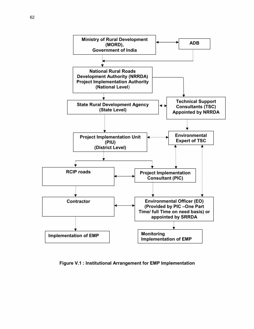
62
Figure V.1 : Institutional Arrangement for EMP Implementation
Ministry of Rural Development (MORD),
Government of India
National Rural Roads Development Authority (NRRDA) Project Implementation Authority
(National Level)
State Rural Development Agency (State Level)
Project Implementation Unit (PIU)
(District Level)
RCIP roads Project Implementation Consultant (PIC)
Contractor Environmental Officer (EO) (Provided by PIC –One Part
Time/ full Time on need basis) or appointed by SRRDA
Implementation of EMP
ADB
Technical Support Consultants (TSC)
Appointed by NRRDA
Environmental Expert of TSC
Monitoring Implementation of EMP

63
156. SRRDA14 will ensure that: i. ECOP checklist is prepared for each road ii. The completed ECOP checklist is included in the DPR with the help of PIC. iii. Ensure that all required statutory environmental clearances are obtained and
comply with clearance conditions; iv. Ensure that the subproject specific EMPs and respective budget are included in
the bidding documents; v. Ensure that the ECOP checklists and EMP (including general and site specific
issues) are made available to the contractors vi. Undertake routine monitoring of the implementation of the EMP including spot
checks on site and prepare monitoring reports at least once a year vii. With the support of technical support consultants prepare satisfactory
environmental due diligence reports of the earlier tranche/periodic financing request before implementing the next tranche
viii. Appoint Project Implementation Consultant (PIC) for construction supervision and assist PIUs for EMP implementation and related safeguard compliances
157. PIU will be responsible to:
i. Complete the ECOP checklists and prepare subproject specific EMPs (including monitoring plan) for each subproject
ii. Obtain necessary statutory environmental clearance prior to commencement of civil works
iii. Update the respective ECOP checklists and EMPs if there are any changes in alignment of the subprojects
iv. To conduct monitoring of all subprojects and prepare pre-, during and post-construction monitoring checklists through the project implementation consultants
v. Prepare and submit to SRRDA annual monitoring report as per ADB defined format
158. The Technical Support Consultants (TSC) appointed by NRRDA. The Environmental Expert of TSC :
i. Will provide technical assistance to SRRDA/PIU regarding environmental aspects, environmental permitting/clearances requirement
ii. Periodically review EMP implementation status including spot site inspections iii. Conduct workshops/capacity building program at different level and functions iv. Prepare environmental Due Diligence report for each tranche before
implementing next tranche v. Prepare state Level IEE reports and EMPs for non sample roads based on the
ECOP checklist completed by the PIC
159. Project Implementation Consultant (PIC) is appointed by SRRDA. PIC will provide one Environmental Officer (EO). The EO will be responsible to ensure adherence and implementation of EMP at all stages of works by the contractor. The EO, if found warranting may also conduct field tests, independent of the contractor to determine the effectiveness of EMP under approval of PIC/PIU. The broad duties/responsibilities of the Environmental Officer will include:
14
With assistance from PIU (Project Implementation Unit).

64
• Review of project design and specifications to ensure their adequacy and suitability with respect to the implementation of EMP
• Collection and dissemination of relevant environmental documents including amendments to environmental protection acts issued by the various agencies, namely, ADB, Government of India / State and local bodies
• Interact with the counterpart of the Contractor(s), review work progress/plans and ensure implementation of the EMP
• Coordination with the NGOs, community groups and Government departments on environmental issues, provide clarifications/ and obtain clearances during project implementation if any, as required from the regulatory authorities and/or submitting periodic compliance reports as required by the State Authorities
• Monitoring sensitive environmental attributes during construction and operation stages15 to ensure that the suggested mitigation measures in the EMP are implemented
• Facilitate PIU for preparation of annual monitoring report as per ADB defined format
• Documentation of the environmental management/monitoring activities for the regular project implementation progress report; which will serve as the basis for the annual environmental monitoring reports
• Conducting environmental training/awareness programs for the contractors, the project implementation personnel and the communities
160. Contractor is appointed by SRRDA for construction of road and ensure implementation of EMP proposed. The broad duties of contractor are as follows:
• Make adequate costs provision for EMP requirements while biding • Ensure effective implementation of mitigative measures as per road specific EMP • Comply with all applicable legislative requirements and obtain necessary
consents for to Establish/Operate before start of hot mix plant and batching plants. Comply with al permit conditions
• Create awareness amongst workers for environment, occupational health and safety aspects. Participate in training and awareness programme along with its executives conducted by PIC
• Provide PPE and adequate resources for Environment Occupational Health and Safety
• Follow all the guidelines for borrowing earth and restoration of borrow areas, setting up construction camps
• Sourcing of quarry material from approved quarries only • Provide all required input to PIC for environmental monitoring as per EMP.
E. Environmental Assessment and Review Framework (EARF) for RCIP 161. ADB has prepared an Environmental Assessment and Review Framework (EARF) which identifies the broad scope of the MFF, outlines the policy, environmental screening and
15
Normally PIC is supposed to undertake five site visits and five monitoring reports as per contracts being issued by different SRRDA. It is proposed that PIC shall submit the following five monitoring reports: (1) First report at pre construction stage, (2) Second report after three months of start of construction or on completion of 25% construction, (3) Third report after seven months of start of construction or on completion of 75% of construction, (4) Fourth report after one month of completion of construction and first year of operation stage, and (5) Fifth report in second month of second year of operation stage.

65
assessment, and institutional requirements for preparing the environmental assessments to be followed for subsequent batches and tranches. This EARF also specifies criteria for eligibility for selection of rural roads under RCIP. The sample roads are selected following these criteria. The EMP, monitoring requirement, institutional aspects, capacity building, grievance redress mechanism presented in this chapter are developed in line with above EARF. The eligibility criteria for selection of roads under RCIP, environmental assessment requirement for each tranche and legal framework are given below:
2. Selection Criteria and Environmental Assessment Requirement 162. The following criteria will be followed for selection of non sample roads:
(i) No Category A (as per ADB’s SPS) subproject will be included in the MFF (ii) Subprojects will be eligible for construction or upgrading in accordance with the
PMGSY guidelines, and be included in the respective district core network (iii) The subprojects shall not disturb any cultural heritage designated by the
Government or by international agencies, such as UNESCO, and shall avoid any monuments of cultural or historical importance
(iv) The subproject will not pass through any designated wildlife sanctuaries, national parks, other sanctuaries, notified ecological sensitive areas or area of internationally significance (e.g., protected wetland designated by the Wetland Convention)
(v) The projects shall only involve activities that follow Government of India laws and regulations, ADB’s Safeguard Policy Statement (2009)
163. The following environmental Assessment requirement will be followed roads included under RCIP: (i) ECOP checklists with annexes on trees, utility structures, community structures,
strip plans and photographs will be completed for each and every road (ii) Based on the requirements of the PMGSY guidelines separate ECOP checklists
will be prepared for bridges that are longer than 15 m (iii) Based on the completed ECOP checklists for roads and bridges, IEE reports will
be prepared at a state level. These reports must contain a general EMP and a site specific EMP where there are site specific issue.
(iv) ADB’s REA checklist for roads and highways will be completed based on the state level IEE reports prepared and submitted to ADB to confirm categorization
164. The vulnerable to climate change will also be screened following screening checklists, which was integrated in the ADB REA Checklists and corresponding mitigation measures will be prepared. (i) Is the project area subject to hazards such as earthquakes, floods, landslides,
tropical cyclone winds, storm surges, tsunami or volcanic eruptions and climate changes
(ii) Could changes in precipitation patterns or evaporation rates over the lifespan of the project affect its sustainability and cost (i.e., increased landslides increase maintenance costs)?
(iii) Does the project use or depend on resources which could be affected by climate changes such as changes in temperature, precipitation, wind (increased soil moisture content in the sub-grade)?
(iv) Are there any demographic or socioeconomic aspects of the subproject and project area (e.g., population growth, settlement patterns) that increase the vulnerability of the project and surrounding area?

66
(v) Could the subproject potentially increase the vulnerability of the surrounding area (i.e., by increasing runoff, encouraging settlement in earthquake zones)
3. Legal Framework
165. As per Indian legislation, an environmental clearance is not required for rural roads. However, it may attract provisions of Forest Conservation Act, Wildlife (Protection) Act, and other legislation related with Air, Water and Noise pollution controls and prevention. The legislative applicability screening is presented in chapter 1 of this report and it will apply for non-sample road as well. Additionally, to ensure conformance to ADB’s Safeguard Policy Statement, 2009 (SPS), the subprojects will be subject to the following requirements:
(i) Submission of a completed Rapid Environment Assessment (REA) checklist for Roads and Highways and a categorization form for each state level IEE that is prepared.
(ii) An Initial Environmental Examination16 (IEE) report including the preparation of an Environmental Management Plan (EMP) and a Monitoring Plan.
(iii) Regular monitoring of implementation of the EMP and submission of monitoring reports and due diligence reports to ADB as necessary
F. Capacity Building
166. Existing capacity of the State Rural Roads Development Agencies (SRRDAs) and Project Implementation Units (PIUs) for implementing environmental safeguard issues need substantial strengthening. Capacity building activities will mainly comprise training workshops for SRRDA and PIU environmental officers on (i) completion of environmental code of practice (ECOP) checklists; (ii) preparation of environmental management plan (EMP) and monitoring plans; (iii) monitoring of EMP implementation and completion of pre-, during and post-construction monitoring checklists; and (iv) preparation of monitoring reports. These few workshops have already been conducted at participating states though ADB appointed Environmental specialist. Additional training will be carried out periodically, by In-house trained and experienced officials. G. Consultation and Information Disclosure 167. During the preparation of ECOP and Detailed Project Report (DPR), the PIU has to ensure consultation, and attending to concerns of the affected people. 168. All environmental assessment documents are subject to ADB’s Public Communication Policy (2011) and will be made available to the public, upon request. The SRRDAs are responsible for ensuring that all environmental checklist documentation, including the environmental due diligence and monitoring reports, are properly and systematically kept as part of the Investment Program specific records. MORD must disclose state specific sample road IEE reports on its website. H. Grievance Redress Mechanism 169. PRI administered village level committee is the first contact point for any aggrieved person. This committee will try to settle the concern by them self or in consultation with contractor or PIU. The unresolved concerned are forwarded to PIU for further action. PIU
16
As per selection criteria, no Category A subproject will be included under RCIP.

67
resolves these concerns in consultation with PIC, SRRDA, and contractor as the situation demands. This is an established practice and is seen effective enough in RRS II. PIC will also collect concerns received by this committee in the intervening period and report the effectiveness of action taken. 170. At national level NRRDA has made provision of registering complain /suggestion through its website. NRRDA forwards these complains to concerned SRRDA for necessary actions. SRRDA directly or through concerned PIU initiate the appropriate action and update the complainant as well as NRRDA. It is proposed that NRRDA website will be cross-linked to each SRRDA website as well or SRRDA will also make provision of complain registry at its website.

68
VI. PUBLIC CONSULTATION AND INFORMATION DISCLOSURE
A. General 171. Public consultation was undertaken consistent with the ADB requirements. All the five principles of information dissemination, information solicitation, integration, coordination and engagement into dialogue were incorporated in the consultation process. A framework of different environmental impacts likely from the project was strengthened and modified based on opinions of all those consulted, especially in the micro level by setting up dialogues with the village people from whom information on site facts and prevailing conditions were collected. 172. Stakeholder’s consultations were held with the intent to understand their concerns, apprehensions, overall opinion and solicit recommendations to improve project design. Informal meetings, interviews were organized covering the entire project stretch. The informal consultation generally started with explaining the subprojects, followed by an explanation to potential impacts. Participant’s views were gathered with regard to loss of agricultural land, effect on air and noise quality of the area due to traffic, water availability, accident and risk. 173. The discussions were designed to receive maximum inputs from the participants regarding their acceptability and environmental concerns arising out of the subproject. They were given the brief outline of the project to which their opinion was sought. Suggestions were also sought for mitigating any potential adverse impact. B. Compliance with Relevant Regulatory Requirements 174. In India, public consultation is mandatory in case of Category A and B1 category projects17 in select conditions. Being a category B project as per ADB Environmental Guidelines 2003, consultation was carried out during the early stage of IEE report preparation. The requirement of public consultation during the implementation of the project has been proposed as part of the mitigation plan. C. Beneficiaries’ Comments 175. The project has immense acceptability among the local people. They perceived that in addition to providing all weather connectivity, the subproject road would bring positive socioeconomic changes in the area. Local people mainly discussed on issues related to drainage and commencement of the construction work. 176. Some of the general issues raised during the different consultation sessions can be summed up as follows:
• Construction Camp - The participants did not apprehend any adverse impact due to the construction camp near to their villages. They responded positively towards providing support to these, if required, in terms of any food, water requirements.
• Water Logging and Drainage - Participants informed about few low-lying areas in sample roads where water logging takes place during monsoon season. The villagers requested for provision of adequate drainage and cross-drainage
17
As per schedule I of EIA notification number S.O. 1533, dated 14th
September 2006. This notification also defines when a public consultation is mandatory.

69
structures at these locations. Villagers also reported for road overtopping in one road where they have suggested to raise the road levels.
• Loss of Livelihood and Income Restoration Options - This issue was raised by those who had encroached on the proposed alignment. However, they offered the encroached space for the proposed project, if demanded.
• Road Safety - Safety issues did not raised concern among the inhabitants including women.
• Land Acquisition - People were in full support of the project and were ready to donate their land for the same, if required.
• Losses of Idols/Shrines - Participants supported the project and were willing to shift the idols, burial grounds and other religious structures observed at certain locations.
• Loss of Trees Due to Road Construction - Respondents were of the opinion that trees cutting should be avoided or else minimized. For trees to be cut compensatory plantation should be done. Some villagers expected additional plantation should be done. Recommended tree species for plantation were other local varieties.
• Impacts on Health - Separate consultation sessions were organised by social team to identify issues pertaining to health specifically for sexually transmitted diseases (STDs). Settlements along the rural roads were reported to be getting exposed to such diseases.
• Ambient Air & Noise Quality – The respondents viewed that these are the problems of urban areas and their villages are still untouched from this aspect. They even do not anticipate any of these problems after the completion of the project.
• Inconvenience during Construction - The participants viewed that they will manage it, as it will be temporary.
• Employment during Construction - The locals expected that they should be given preference in employment during project implementation.
• Perceptions and Expectations - Perceptions and expectations of the community recorded during the consultation sessions can be broadly listed as: � The public and the affected persons appreciated and supported the
project with their open hearts. � Community at large appreciated overall benefits to them resulting from
project development; � They were aware of the increased access, lesser commuting time after
project implementation;
• Addressal of Issues - The project has tried its best to address all the issues raised during consultations under the constraints of suitability from engineering point of view. Some of the provisions made under the project to address the issues and concerns of the community are given in Table VI-A.
Table VI-A: Addressal of Issues and Concerns under the Project
Issue/Concern Addressal under the project
Water Logging and
Drainage
There is provision of adequate cross-drainage structures. Road level
are also planed where water overtopping exists.
Road Safety Adequate safely signage planned all along the rural road.
Land acquisition and The proposed RoW is 12m along the rural road. No land acquisition

70
Issue/Concern Addressal under the project
Mode of
compensation
is planned in project road.
Loss of roadside
idols/shrines
Roadside Shrines/Temples shall be relocated after consultations with
villagers
Loss of trees Compensatory afforestation will occur at the ratio of three trees for
each tree that fell.
Increased pollution
levels
Pollution levels are not crossing the prescribed limits of CPCB and
planned plantation will screen the emission.
Utilities and basic
infrastructure
All the utilities, electric poles, telephone lines, wells, tube wells etc. to
be affected will be relocated under the project cost.
Employment of locals
during construction
Locals will be given preference for employment during the project
implementation

71
VII. CONCLUSIONS AND RECOMMENDATIONS A. Conclusions
177. The findings of Environment Assessment of sample roads indicate that impacts are mostly similar and subprojects are unlikely to cause any significant environmental impacts. While some of the impacts are negative, there are many bearing benefits to the area. Most of the impacts are likely to occur during construction stage, are temporary in nature, and can be mitigated with minor to negligible residual impacts. 178. The project received immense support from local people as they perceive that this project will improve the overall connectivity and bring various economic opportunities to the people of the area. 179. All sample roads included under RCIP were selected based on ecological and climate change consideration defined under EARF. Accordingly, none of the sample roads passes through protected areas or encroaches precious ecology (sensitive or protected areas) or any historical or archeologically protected areas. As per selection guidelines, none of the selected sample road passes through reserved forests either. Few trees cutting though may be involved. 180. None of the rural road crosses any natural stream. However, in case it is so then adequate engineering measures are proposed for the protection of road from the flood. 181. All the sample roads are aligned with existing village roads and unpaved movement paths. As such, land acquisition is nil or very minimal which is also acquired through donations from villagers. 182. Considering insignificant environmental sensitivity, the project is categorized as category B as per ADB Safeguard Policy Statement 09. 183. No categorization is made under environmental legislation of India, since these small roads do not require any environmental clearance in accordance to Indian Environmental (Protection) Act and Rules, 1986 amended till date. However, clearance from Forest Department will be required for cutting of trees. 184. The impacts identified are mostly related to alignment selection, land clearing, borrowing earth, cutting of trees, shifting of utilities and community structures, establishment of construction camp or material storage areas, transportation of material and operation of hot mix plant. All identified impacts are either eliminated or minimized through design consideration and suitable mitigative measures. 185. Environmental Management plan covering all stages of road construction (design, construction and operation) is prepared with defined responsibility for its implementation. Environmental Monitoring plan is also prepared to ensure effective implementation of EMPs. 186. NRRDA/SRRDA has defined institutional setup including with specified responsibility for environmental management. Existing capacity of the State Rural Roads Development Agencies (SRRDAs) and Project Implementation Units (PIUs) for implementing environmental safeguard issues need substantial strengthening. The capacity enhancement is proposed through focused workshops and training session. Few workshops have already been conducted at participating

72
states through ADB appointed Environmental specialist. Trained and experienced in-house officials should carry out more raining in future periodically. 187. The IEE also indicate that rural road construction works does not warrant further EIA study for subsequent rural road construction works in MP State. B. Key Recommendations 188. Any major changes or any major additional work other than the proposed project activities will require updation of ECOP and IEE. The updated ECOP and IEE will have to be submitted to NRRDA, and ADB for concurrence before civil works commence. 189. The implementation of prescribed mitigation measures will minimize/avoid the adverse impacts. Moreover, the impacts shall be monitored continually by implementing and updating the Environmental Management plan and Environmental Monitoring Plan. 190. These IEE is prepared based on ECOPs and feasibility stage. Subproject specific EMP shall be improved as per the final provisions made under DPRs. The updated EMP if there is any change, shall also be sent to ADB for information. 191. Executing agency shall ensure that updated road specific EMP forms part of DPR and is available to contractor at the time of bidding. . The contractor will specify the quantity and budget for various activities like rehabilitation of borrow earth pits, first aid and sanitation facilities at construction camp and temporary office/material storage place as per EMP requirements. The same shall be revised if there is any change in the project design. Any such change shall be reported to ADB as well.

73
Appendix 2.1: Details of Roads in Madhya Pradesh
S.No. District Blocks Name of Roads Length (kms.)
1 2 3 4 5
Bhopal
1
Bhopal Berasiya
MDR to Mangalgarh 0.81
2 MDR to Ankia 1.8
3 Sukaliya to Pipaliya Kadim 1.3
4 Berasiya Sironj road to Khejra Misar 1.55
5 SH-18 - Dhaturia road to Dohaya 2.3
6 Bhopal Berasiya road to Khadampur 3.95
7 Rampura Balachoun to Goria Sankheda 3.35
8 Bhopal Berasiya road to Tanda 2.5
9 Arjunkhedi to Khejra Ghat 3.04
10 Berasiya Najirabad road to Hinotiya Piran 0.925
11 Badli-Bhilkho road to Damila 1.525
12 Lalriya Babchiya road to Chhapryai 1.6
13 Bhopal Berasiya road to Pardi 1.45
14 Behrawal- Barkhedi road to Bhatni 1.525
15 Runha to Bhakwaha 4.125
15 Roads Bhopal Total 31.75
Damoh 16
Damoh
Batiyagarh
Bhatera to Barkhera Nahar 1.5
17 Phutera to Menwar 3
18 To2 to Mahuakheda 2.5
19 L092 (Aanjani-Agara road) to Bandha 3.5
20
Damoh
Arthkheda to Dasonda 3
21 T04 Hinoti Jhapan to Hardua 1
22 Adhrota to Hatri 3
23 Bilai to Patouha 3.5
24 Mudiya To Bari 3.1
25 MDR (ATP) To Rampura 1
26 T03 Km 117/2 To Khairuwa 1.6
27 Hindoria Bilai Road To Chhapri Thakur 3
28
Hatta
Hatta-Gaisabad Road to Kuluwakalan 6.4
29 Madiyado-Bandha Road to Kanakpura 2
30 Madiyado-Bardha Road to Tidni Madiyado 2.2
31 Madiyado-Chouraiya Road to Ghogra 1.5
32
Damoh
Hatta Madiyado-Bardha Road to Digi 2
33 Patera Raneh Road To Barkhera Chain 1.2
34
Jabera
Abhana-Tendukheda-Patan Road to Muderi Tejgarh 1.5
35 Sakha-Bhajiya to Kanepur 2.5
36 Dugani to Bhineni 3.1
37 Singhpur-Bhajiya to Salaiya Badi 0.7
38 Imaliya to Rampura 2.5
39 Abhana-Patan Road To Bhainsakhar 4
40
Patera
Damoh-Patera Road to Harpalpura 1
41 Nayagon-Kota App. Road to Muari 3
42 Saliya to Deori Chhoti 3
43 Harpalpur to Sarangpura 3
44 Muari to Munda 1.8
45 Hatta-Sehora Road to Pala Arjuni 1.4
46 Pathariya (SH-14) To3 to Mahantpur 2.2

74
S.No. District Blocks Name of Roads Length (kms.)
47 Satouwa to Shahpur 3.2
48 Narisingarh to Mahuna 3.5
49 Jortala to Abookhedi 2.9
50
Damoh
Pathariya Jerat to Berkhera Jaisingh 3
51 Berkhera Jaisingh to Guda 2
52
Tendukheda
L118 to Oriya Mal 2
53 T02 to Baheriya Mal 2.6
54 Tejgarh Pura Road to Keolari Upadhyay 1.3
55 Samnapur to Jamun 9.5
56 Bamnoda To Keolari 1.8
41 Roads Damoh Total 104.1
Jabalpur 57
Jabalpur
Kundam
T02 to Jhirna 1.5
58 T 09 to Sunawal 1.8
59 Kastra (L066) to Rampurikala 2.3
60 SH22 (T08) to Dehrikala 1
61 Dewari Jamdori 3
62 SH 22 (T08) to Tikariya 1.05
63 T-01 to Jungh 2.05
64 T-10 to Karanpura 1.55
65 Karaghat(L-034) to Bisanpura 1.9
66 T-01 to Chhirpani 2.25
67
Patan
Pondikala to Pondikhurd 2.15
68 MDR (Sakara) to Chhiturha 1.875
69 ORD-3 to Rampura 0.85
70
Jabalpur
Shahpura
L 043 to Maili 5.2
71 NH12 to Dharampura 0.95
72 NH 12 to Khari 1.05
73 L-021 to Bamhori 1.3
74 T-02 MDR Tilwara-Chargawan Rd Sukha to Sagada 2.5
75 T-02 MDR Tilwara-Chargawan Rd Sukha to Bharatpur 0.95
76 NH-12 to Barkheda 2
77
Sihora
Sihora Silondi Road to Chhangawa 2.675
78 Sihora Silondi Road to Deori Naveen 2.05
79 Sihora Silondi Road to Deori Kanhai 0.78
80 NH-7 to Gorakoni 1.5
81 NH-7 to Ghugri Naween 2.3
82 Phanwani Kumhi to Junwani 1
83 Sihora Silondi Road to Budari 0.6
84 NH-7 to Gunharu 0.8
85 Keolari to Deorikala 1.35
86
Panagar
Singod Road to Nunikala 2.8
87 ODR to Gurgaon 1.73
88 LPR to Bandhi 1.6
89 LPR to Tilgavan 3.375
90 Padariya Road to Tidni 1.85
91 Sonpur to Veerner 1.1
92
Jabalpur
(L 123) Chargaon to Sivni 1.5
93 T08 to Pipariya 0.92
94 T05 Pipariya 2.625
95 NH7 to Bamhni 3.55
96 T 04 to Padariya 1.6

75
S.No. District Blocks Name of Roads Length (kms.)
97 Harrai to Dhora 2.125
98 L-083 to Thana 0.75
99 T-08 to Padua 0.6
100 NH-7 to Dhadra 2.85
101
Majholi
Indrana to Mudari 1.525
102 Sihora Road to Sagodi 2
103 Lamkana Road to Richhi Pindrai 1.2
104
Jabalpur Majholi
SH 37 to Jamuniya 1.1
105 Harsinghi to Jhingrai 4.1
106 Suhajani to Gathora 1.95
107 Padwar Road to Dungriya 1
51 Roads Jabalpur Total 91.855
Neemuch
108
Neemuch
Jawad
Neemuch Singoli Rd (SarwaniaMaharaj) To Upreda 3.3
109 Neemuch Singoli Rd To Kachhala 1
110 Neemuch Singoli Rd (Phusaria) To Lalganj 2.7
111 Jat - Gwaliorkala Rd To Daulatpura Jat 2.5
112 Neemuch Singoli Rd To Gothada 1
113 Ruppura To Ranawat Kheda 2.9
114 Bolkheda Rd To Akli 3.4
115 Neemuch Singoli Rd To Kheda Bhangota 1
116 Jawad - Morvan Rd To Lodh 1.5
117 Neemuch Singoli Rd To Panoli 2.5
118 Lalpura To Ghati 2.6
119
Manasa
Manasa Jharda Rd To Gaganyakhedi 0.75
120 Chandarpura Kanjarda To Bilwas 3
121 Rampura - Bhasara Rd To Basi Block 2.9
122 Piplya handi MalahedaRd To Aranyadhani 1
123 Dudlai Dewaran To Badodiya Buzurg 2.5
124 Rampura-Bhanpura Rd To Barwadiya 1
125 Manasa - Jharda Rd. To Sarsi 1
126 Manasa Rmpura Rd To Amad Amargarh Block 2.8
127
Neemuch
Berkheda hada To Champi 2
128 Kothdi Istmurar To Dalawada 3
129 Neemuch To Chauthkheda 3.4
130 Neemuch-Manasa road To Dulakheda 1.5
131 Lawasa choraha To Lewada 1
132 Lasudi tanwar To Umaheda 2.3
25 Roads Neemuch Total 61.36
Ratlam
133
Ratlam
Alot
Panthpiploda to Tajkheda 2.8
134 Mandawal to Kothadi (K) 2
135 Alote Barod Rd. to Dhapna 3
136 Lasudia Surjamal to Nimbakhedi 2.5
137 Pipliya Thukhar to Kammakhedi 2
138 Alot Gogarpur Rd. Jahanabad 5.5
139 Khajuri Devra to Garda 4.8
140 Alot- Barod Rd. to Kamlakhedi 3.7
141
Jaora
Dhatrawada to Kankarwa 4.5
142 Khokra to Khimakhedi 2.2
143 Barkhedi to Nagdi 2.4
144 Mhow Neemuch Rd. to Parvalia 0.6

76
S.No. District Blocks Name of Roads Length (kms.)
145 Mallakhedi to Bhanpur 3.9
146 Rola to Ranayara (D) 2.05
147 Ringnod to Manyakhedi 4.05
148
Piploda
Sukheda to Dhaturiya 4.5
149 Shakkerkhedi to Bilandpur 3
150 Shukheda to Bhakerkhedi 4.3
151
Ratlam
M.N.Road to Badchapra 11
152 Bati Badodiya to Nalkui 1.3
153 Becha to Laptiya 2
154 R.S.Road to Nandlai 1.7
155 Mundri to Sarwani Jagir 4
156
Ratlam Ratlam
M.N Road to Amleti 2.1
157 Namli to Bharoda 1
158 Kanari To Dantora 0.8
26 Roads Ratlam Total 75.475
Sehore
159
Sehore
Astha
Astha Kannod Road To Guradiya Sirajjudin 2.5
160 Astha Shujalpur Road Dhanana 3.33
161 Guradiya Vajyapat To Magarkhedi 3.7
162 Rampurkalan To Awlikheda (Kerpani) 3.25
163
Sehore
Silkheda (T03) Mungawali 3.4
164 Hirapur road to Alampura 1.25
165 Jherkheda Ghati Sehore Road to Thoona Khurd 1.55
166 Sehor Sewaniya Road To Bakhtal (Molga) 5.63
167 Sehore Charnal Chandbad Road To Manpura 1.5
168 Khari to Awalikheda 3.05
169
Ichhawar
Gajikhedi To Ramgarh 4.7
170 Ichhawar To Mogra 4.05
171 Diwadiya Chainpura To Shahpura (Jamoniya Fatehpur) 3.4
172 Brijeshnagar To Kaneriya 1.95
14 Roads Sehore Total 55.65
Tikamgarh
173
Tikamgarh
Niwari
Mau Jhansi Road to Kalothra 3.4
174 Niwari-Teharka Road to Raipura Khas 2.5
175 Orcha-Chakarpur road to Radhapur 0.8
176
Prithvipur
Jeron Road To Bamroli 4.27
177 Simra Road to Mahuabag 1.2
178 Simra Jeron to Patariya 1.95
179 Jeron Road to Nayakhera 1.6
180 Orchha Road to Tenipura 2.4
181 Pathariya Road to Digwankala 3.7
182 Jatara
Lidhora to Antpura 3.35
183 Malpitha to Lakhepura 1.35
184
Palera
Ratanguwan to Alopa 3.2
185 Dinau Road to Kankanpura 4.45
186 Syawani Jawar Road to Banpura 0.9
187
Baldevgarh
Sirora to Shyampura 2.25
188 Tikamgarh-Chhatarpur Road to Dudiankhera 1.7
189 Futer-Teela Road to Bachhoda 0.9
190 Baisa to Banpura Khurd 3.1
191 Patha-Pathori Road to Midawali 6.8
192 Jatara-Khargapur Road to Banpura Sapon 1.6

77
S.No. District Blocks Name of Roads Length (kms.)
193
Tikamgarh
Baldevgarh-Kakarwaha road to Attariya 5.85
194 Baldevgarh-Kakarwaha road to Sunda Dharmapura 1.65
195 Tikamgarh-Jatara Road to Bamhori Nakiwan 1.9
196 Sukwaha Road to Shyampura 2.75
197 Darguwa Gudanwara road to Nagara 3
198 Tikamgarh-Jatara Road to Laxmanpura 0.95
199 Baldevgarh Kakarwaha Road to Rashankhera 3.1
27 Roads Tikamgarh Total 75.45
Mandsaur
200
Mandsour
Bhanpura Garoth Bhanpura Road to Dhabla (Manohar) 1
201
Garoth
Sathkheda to Ranayara 3.5
202 Panwadi to Piplya Raja 2.6
203 Shamgarh to Junapani Dhornya 4.4
204 Malhargarh
Sokri to Kheda khadan 2.6
205 Hingoria to Akyamedi 2.5
206
Mandsour
Mandsour
Dalauda-Digon road ot Pinda 3.1
207 Katlar to PipalKhedi 1.6
208 Nandwel to Balodiya 2.8
209 NH-79 to Lakhmakhedi 0.7
210
Sitamou
Sitamou Basai road to Larni 1
211 Sitamou Basai road to Padli 3
212 Kachanara to Khajurimanda 2.9
213 Titrod to Gangakhedi 2.85
214 Sitamou Basai road to Khatrukhedi 1.8
215 Suwasara Shamgarh road to Hanspura 2.4
216 Suwasara Dokerkhedi Road to Lakhwa 2.1
217 Guradiyavijay to Dhanadakheda 2.4
218 Guradiyavijay to Kanakheda 2.9
19 Roads Mandsaur Total 47.595
Indore
219
Indore
Depalpur
Kishanpura (Machal) to Bajarangpura 4.15
220 Piranwas to Gadibillod 1.8
221 Limbodapar to Palasiyapar 4
222 Girota road to Parinalwasa (Pirnlwasa) 3.4
223 Atahada to Deora khedi 3.4
224 Dep.-Gautam. to Chitoda 3.8
225 Agra-Ataheda Road.to Nogawan Surf 0.7
226 Pirnawasa to Osara 4.9
227 Indore
Semliya Chau to Jalod Kau 3.75
228 Khudel Road to Mundla Jetkaram 0.51
229
Mhow
Bagdi Manpur Road to Julwanya 3.1
230 Gawloo Khandwa Road to Surtipura 2.6
231 Choraldam Road to Buralia 5.6
232 Mhow Mandleshwar to Jamniya 3
233 Jambuzurg to Ghodakhor 2.7
234 Rampuriya Manpur Road to Olani 4.3
235 A.B. Road to Shahda 2.1
236 Khurda Manpur Road to Rai Kunda 2.7
237 A.B. Road (Umaria) to Pipliya Malhar 1.9
238 Kadwali to Rampuriya 2.1
239 A.B. Road (Yeshwant) to Gol Kheda 4.3
240 Sanwer Jambodi Sarvar to Ajnoti 4

78
S.No. District Blocks Name of Roads Length (kms.)
241 Gawala to Kamod Kamlya 3.85
242 Indore Ujjain Road to Siloda Bujurg 1.8
243 Indore Ujjain Road to Brahman Khedi 3.1
244 Jamodi to Solsindi 4.2
245 Kachaliya to Rang Karadia 4.2
246 Sanwer Road to Bawaliya Khedi 2.3
247 Kachaliya to Pipliya Kaysha (Kaystha) 4.1
248 Shahna to Mundla Husain 2.5
249 Faraspura to Bhondwas 2.1
250 Faraspura to Melkalma 3.6
251 Chituoda to Magar Khedi 2.1
252 Ajnod to Balghara 2.3
253 Indore Ujjain Road to Padriya (Padliya) Bajrang 5.1
254 Indore Ujjain Road to Amli Kheda 0.75
36 Roads Indore Total 104.96
254 Grand Total 654.05

79
Appendix 2.3 Rural Roads Environment Check List
RURAL ROADS: ENVIRONMENTAL CHECKLIST

80

81

82

83

84

85

86

87

88

89

90

91
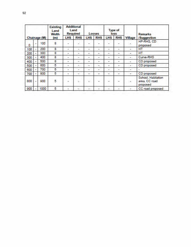
92

93

94

95

96

97
98

99

100

101

102

103

104

105

106

107

108

109

110

111

112

113

114

115

116

117

118

119

120

121

122

123

124

125

126

127

128

129

130

131

132

133

134
Chainage wise Transect Walk Findings

135

136

137

138

139

140

141

142

143

144

145

146

147

148

149

150

151

152

153

154
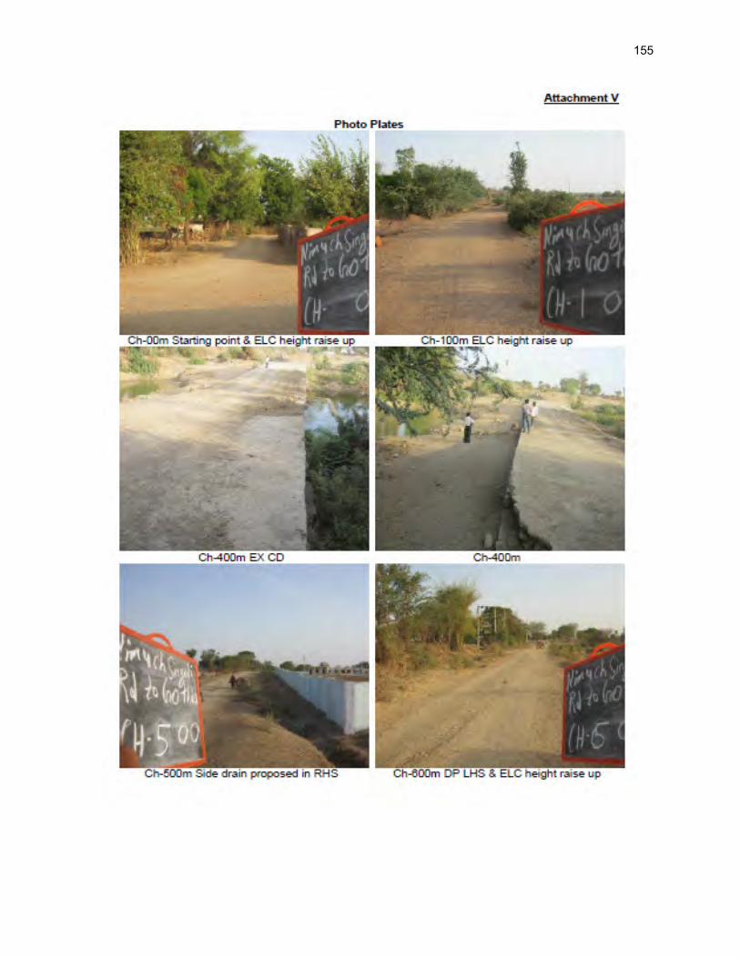
155

156

157

158

159

160

161

162

163

164

165

166

167

168

169

170

171

172

173

174

175

176

177

178

179

180

181

182
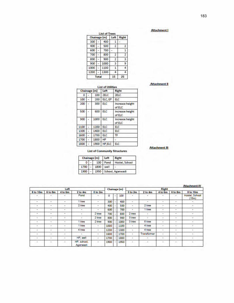
183

184

185

186

187

188

189

190

191

192

193

194

195

196

197

198

199

200

201

202

203

204

205
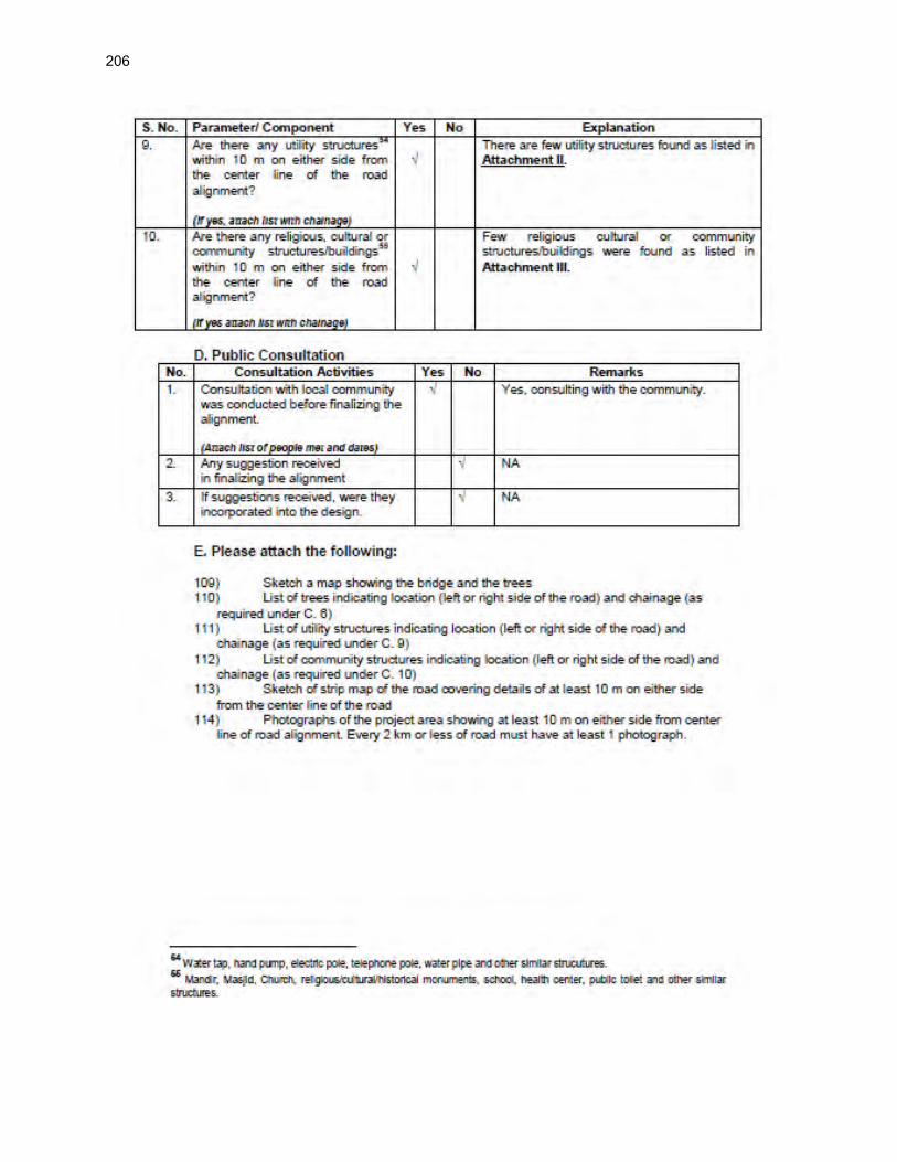
206

207

208

209

210

211
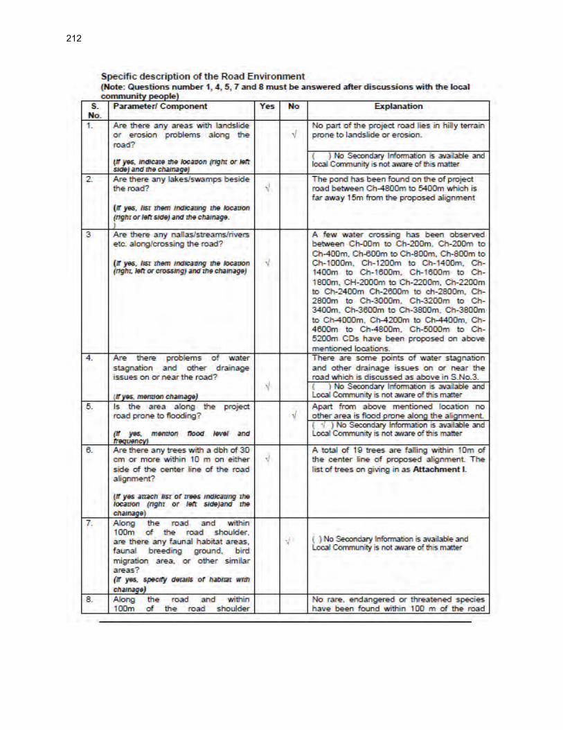
212

213

214

215

216

217

218

219

220

221
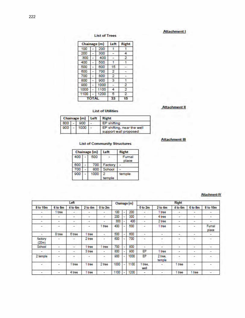
222

223

224

225

226

227

228

229

230

231
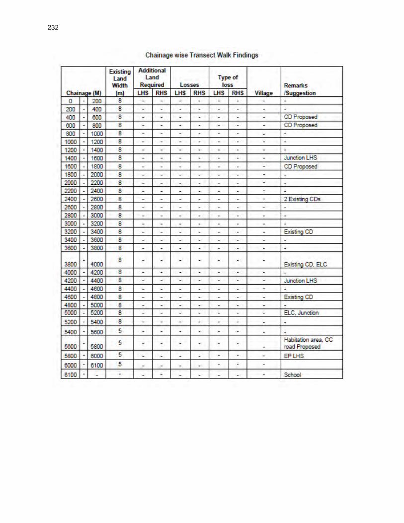
232

233

234

235

236

237

238

239

240

241

242
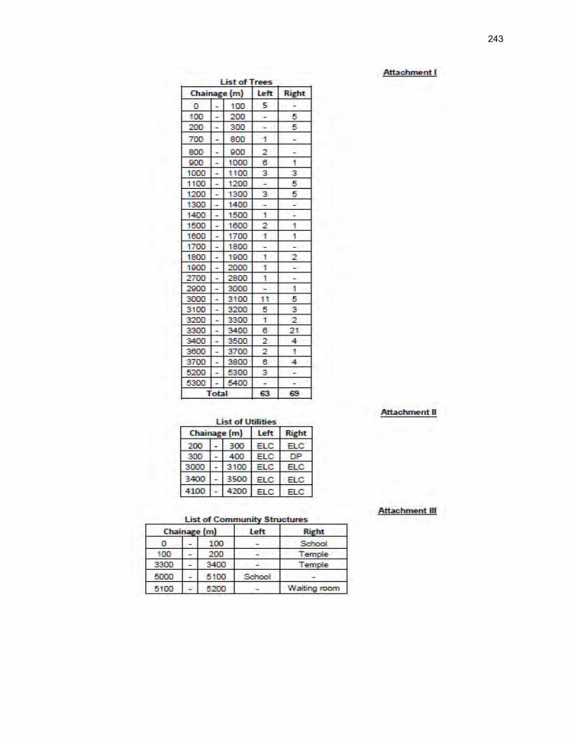
243

244

245

246

247

248

249
Appendix 4.1: Guidelines for Borrow Areas Management
I. SELECTION OF BURROUGH AREAS
1. Location of borrow areas shall be finalized as per IRC: 10-1961guidlines. The finalization of locations in case of borrows areas identified in private land shall depend upon the formal agreement between landowners and contractor. If, agreement is not reached between the contractor and landowners for the identified borrow areas sites, arrangement for locating the source of supply of material for embankment and sub-grade as well as compliance to environment requirements in respect of excavation and borrow areas as stipulated from time to time by the Ministry of Environment and Forests, Government of India, and local bodies, as applicable shall be the sole responsibility of the contractor.
2. The contractor in addition to the established practices, rules and regulation will also consider following criteria before finalizing the locations.
i. The borrow area should not be located in agriculture field unless unavoidable i.e. barren land is not available.
ii. The borrow pits preferably should not be located along the roads.
iii. The loss of productive and agriculture soil should be minimum.
iv. The loss of vegetation is almost nil or minimum.
v. The Contractor will ensure that suitable earth is available.
II. CONTRACTOR’S RESPONSIBILITY
3. The Contractor shall obtain representative samples from each of the identified borrow areas and have these tested at the site laboratory following a testing program approved by the Engineer. It shall be ensured that the sub-grade material when compacted to the density requirements shall yield the design CBR value of the sub-grade. Contractor shall begin operations keeping in mind following;
i. Haulage of material to embankments or other areas of fill shall proceed only when sufficient spreading and compaction plants is operating at the place of deposition.
ii. No excavated acceptable material other than surplus to requirements of the Contract shall be removed from the site. Contractor should be permitted to remove acceptable material from the site to suit his operational procedure, then shall make consequent deficit of material arising there from.
iii. Where the excavation reveals a combination of acceptable and un-acceptable materials, the Contractor shall, unless otherwise agreed by the Engineer, carry out the excavation in such a manner that the acceptable materials are excavated separately for use in the permanent works without contamination by the un-acceptable materials. The acceptable material shall be stockpiled separately.

250
III. BORROWING FROM DIFFERENT LAND-FORMS
A. Borrow Areas located in Agricultural Lands
(i) The preservation of topsoil will be carried out in stockpile. (ii) A 15 cm topsoil will be stripped off from the borrow pit and this will be stored in
stockpiles in a designated area for height not exceeding 2m and side slopes not steeper than 1:2 (Vertical: Horizontal).
(iii) Borrowing of earth will be carried out up to a depth of 1.5m from the existing ground level.
(iv) Borrowing of earth will not be done continuously through out the stretch.
(v) Ridges of not less than 8m widths will be left at intervals not exceeding 300m.
(vi) Small drains will be cut through the ridges, if necessary, to facilitate drainage.
(vii) The slope of the edges will be maintained not steeper than 1:4 (vertical: Horizontal).
(viii) The depth of borrow pits will not be more than 30 cm after stripping the 15 cm topsoil aside.
B. Borrow Areas located in Elevated Lands
(i) The preservation of topsoil will be carried out in stockpile. (ii) A 15 cm topsoil will be stripped off from the borrow pit and this will be stored in
stockpiles in a designated area for height not exceeding 2m and side slopes not steeper than 1:2 (Vertical: Horizontal).
(iii) At location where private owners desire their fields to be levelled, the borrowing shall be done to a depth of not more than 1.5m or up to the level of surrounding fields
C. Borrow Areas near River side
(i) The preservation of topsoil will be carried out in stockpile. (ii) A 15 cm topsoil will be stripped off from the borrow pit and this will be stored in
stockpiles in a designated area for height not exceeding 2m and side slopes not steeper than 1:2 (Vertical: Horizontal).
(iii) Borrow area near to any surface water body will be at least at a distance of 15m from the toe of the bank or high flood level, whichever is maximum.
D. Borrow Areas near Settlements
(i) The preservation of topsoil will be carried out in stockpile. (ii) A 15 cm topsoil will be stripped off from the borrow pit and this will be stored in
stockpiles in a designated area for height not exceeding 2m and side slopes not steeper than 1:2 (Vertical: Horizontal).
(iii) Borrow pit location will be located at least 0.75 km from villages and settlements. If un-avoidable, the pit will not be dug for more than 30 cm and drains will be cut to facilitate drainage.
(iv) Borrow pits located in such location will be re-developed immediately after borrowing is completed. If spoils are dumped, that will be covered with a layers

251
of stockpiled topsoil in accordance with compliance requirements with respect MOEF/SPCB guidelines.
E. Borrow Pits along the Road 4. Borrow pits along the road shall be discouraged and if deemed necessary and permitted by the Engineer. The following precautions are recommended:
(i) The preservation of topsoil will be carried out in stockpile.
(ii) A 15 cm topsoil will be stripped off from the borrow pit and this will be stored in stockpiles in a designated area for height not exceeding 2m and side slopes not steeper than 1:2 (Vertical: Horizontal).
(iii) Ridges of not less than 8m widths should be left at intervals not exceeding 300m.
(iv) Small drains shall be cut through the ridges of facilitate drainage.
(v) The depth of the pits shall be so regulated that there bottom does not cut an imaginary line having a slope of 1 vertical to 4 horizontal projected from the edge of the final section of bank, the maximum depth of any case being limited to 1.5m.
(vi) Also, no pit shall be dug within the offset width from the toe of the embankment required as per the consideration of stability with a minimum width of 10m.
IV. REHABILITATION OF BORROW AREAS 5. The objective of the rehabilitation program is to return the borrow pit sites to a safe and secure area, which the public should be able to safely enter and enjoy. Securing borrow pits in a stable condition is fundamental requirement of the rehabilitation process. This could be achieved by filling the borrow pit floor to approximately the access road level.
6. Re-development plan shall be prepared by the Contractor before the start of work inline with the owners will require and to the satisfaction of owner. The Borrow Areas shall be rehabilitated as per following;
• Borrow pits shall be backfilled with rejected construction wastes and will be given a vegetative cover. If this is not possible, then excavation sloped will be smoothed and depression will be filled in such a way that it looks more or less like the original round surface.
• Borrow areas might be used for aquaculture in case landowner wants such development. In that case, such borrow area will be photographed after their post use restoration and Environment Expert of Supervision Consultant will certify the post use redevelopment.
7. The Contractor will keep record of photographs of various stages i.e., before using materials from the location (pre-project), for the period borrowing activities (construction Phase) and after rehabilitation (post development), to ascertain the pre and post borrowing status of the area.

252
Appendix 5.1: Environmental Management Plan
SL. No.
Project Action/Environmental
Attributes
Mitigation Measures Location Time Frame
Cost Responsible for
Implementing
Responsible for Monitoring
Measures common to all sample roads
Design and Pre Construction Stage
1.
Climate Change
Consideration and
Vulnerability
screening
o Compliance to climate change
vulnerability check point given
under EARF and adoption of
necessary mitigative measures as
may be required
o Efforts shall be made to plant
additional trees for increasing the
carbon sink. The tree may be
planted with help of PRI ( Panchati
Raj Institution)
All through
the alignment
of each rural
road
Pre
Construct
ion
Phase
Part of
Project
Cost
Project
Preparation
Consultant/
design
consultant
PIU/ MPRRDA
2.
Finalization of
alignment
o The road will be part of district core
network and will comply with
PMGSY guidelines
o Subproject shall not disturb any
cultural heritage designated by the
government or by the international
agencies, such as UNESCO, and
shall avoid any monuments of
cultural or historical importance.
o Subproject will not pass through
any designated wild life
sanctuaries, national park, notified
Eco sensitive areas or area of
international significance such as
protective wet land designated
under Wetland Convention, and
reserve forest area..
o Subproject to comply with local and
National legislative requirements
o All
through
the
alignment
of each
rural road
Pre
Construct
ion
Phase
Part of
Project
Cost
Project
Preparation
Consultant/
design
consultant
PIU/ MPRRDA

253
SL. No.
Project Action/Environmental
Attributes
Mitigation Measures Location Time Frame
Cost Responsible for
Implementing
Responsible for Monitoring
such as forest clearance for
diversion of forestland and ADB’s
Safeguard Policy Statement 2009.
o Alignment finalization considering
availability of right of way and in
consultation with local people.
o ROW may be reduced in built up
area or constricted areas to
minimize land acquisition as per
PMGSY Guidelines.
o Adjust alignment to the extent
feasible to avoid tree cutting,
shifting of utilities or community
structure.
o The road shall follow natural
topography to avoid excessive cut
and fill.
3.
Land acquisition o Avoid or minimize land acquisition.
o Land acquisition, compensation
packages, resettlement and
rehabilitation, poverty alleviation
programs for affected people and
all other related issues are
addressed through Social Impacts
and Resettlement & Rehabilitation
report.
o All
through
the
alignment
of each
rural road
Pre
Construct
ion
Phase
Land to be
made
available
by the
state
Governme
nt
PIU, Govt. of
Madhya
Pradesh , and
other
Environmental officer under the PIC will also coordinate and ensure implementation
4. Biological
environment - Tree
planting
o All efforts shall be taken to avoid
tree cutting wherever possible.
o Requisite permission from forest
department shall be obtained for
cutting of roadside trees.
o Provision of Compensatory
Afforestation shall be made on
Throughout
the project
section of
the road.
(Highlight
Tree cutting
locations &

254
SL. No.
Project Action/Environmental
Attributes
Mitigation Measures Location Time Frame
Cost Responsible for
Implementing
Responsible for Monitoring
1:3.ratio basis.
o Permission shall be taken for
diversion of any forest land if
involved. Provision shall be made
for additional compensatory tree
plantation.
proposed
likely
plantation
location)
5.
Planning for land
clearing
o The road land width shall be clearly
demarcated on the ground.
o The utility and community structure
shifting shall be planned in
consultations and concurrence of
the community.
o Tree felling shall be limited to
those, which could not be saved
even by design measures. The tree
shall be cut with a prior permission
of Forest department.
o The vegetable cover shall be
removed and disposed in
consultation with community.
o All public utilities shifting shall be
planned with prior concurrence of
respective agencies/authority and
to the adjacent location approved
by them
All through
the Rural
roads
excepting in
stretches of
habitations
(Attach or
Refer to
specific
sections of
DPR for the
utilities to be
shifted along
with
chainages for
the location
of such
structures)
Pre
Construct
ion
Phase
Necessary
cost
provisions
have been
made.
All other
costs are
included
under
project
cost.
PIC, PIU,
Forest
Department
NGOs (shifting
of utilities shall
be carried out
by respective
governmental
bodies at cost
to be
reimbursed by
project,
implementing
agency).
To increase
survival rate of
new saplings, a
core Tree
Management
Committee is to
be created to
ensure
complete
retrieval of
vegetative
cover and
timely
Environmental officer under the PIC will coordinate and ensure Officials of Forest Department, Contractor and local NGOs and coordinated by Environmental officer of Construction Supervision Consultant for specific package.

255
SL. No.
Project Action/Environmental
Attributes
Mitigation Measures Location Time Frame
Cost Responsible for
Implementing
Responsible for Monitoring
replacement of
perished
plantations.
implementation
Unit (PIU) of
MPRRDA,
8.
Shifting on Common
Properties
Resources
o All efforts are made to minimize
shifting of common utilities and
community structures.
o The community structures/utilities
which can not be saved will be
shifted to adjacent area with the
concurrence and in consultation
with community.
As
determined
by contractor
under
approval of
PIC /PIU
(Attach or
Refer to
specific
sections of
DPR for
community
structures to
be shifted
along with
chainages for
the location
of such
structures)
Construct
ion
Phase
Borne by
Contractor
Contractor is
responsible for
ensuring
provision of
facilities under
approval by
PIC / PIU
Environmental officer and other team members of PIC will monitor and ensure appropriate implementation Environmental officer will regularly interact with the local people who are likely to be affected to ensure that their interests are protected and no social resentment sets in.
6.
Cut and Fill and
Embankment
Construction design
& planning
o The alignment design shall
consider options to minimize
excessive cuts and fills.
o The cut and fill quantities shall be
used for embankment to minimize
barrow earth requirement.
o The design shall be as per relevant
All through
the alignment
of each rural
road
(Highlight the
high flood
Pre
Construct
ion
Phase
Part of
Project
Cost
Project
Preparation
Consultant/
design
consultant
PIU/ MPRRDA

256
SL. No.
Project Action/Environmental
Attributes
Mitigation Measures Location Time Frame
Cost Responsible for
Implementing
Responsible for Monitoring
IRC provisions for cut and fill, slope
protection and drainage.
o Adequate provision shall be made
for cross-drainage structure for
maintaining natural drainage
pattern in the subproject area and
preventing soil erosion.
o Side drain for channelizing water to
nearby natural drain in water
stagnation /logging prone area.
o The top soil of the cut and fill area
shall be used for embankment
slope protection
o Embankment will be designed
above High Flood Level (HFL)
wherever, area is prone to flood.
level,
chainage for
action and
linkages to
DPR section)
7. Hydrology and
Drainage
o Provision of adequate cross-
drainage structure shall be made to
ensure smooth passage of water
and maintaining natural drainage
pattern of the area. The discharge
capacity of the CD structure shall
be designed accordingly.
o Provision of adequate side
drainage shall be made in water
stagnant/logging areas.
o The construction work near water
body shall be planned preferably in
dry season so that water quality of
the water channel is not affected
due to siltation and rain water
runoff.
o Elaborate drainage system shall be
Near all
drainage
crossing,
nalas and
river
crossings
etc.
(indicate HFL
Level and
Highlight the
chainage for
action and
linkages to
DPR section)

257
SL. No.
Project Action/Environmental
Attributes
Mitigation Measures Location Time Frame
Cost Responsible for
Implementing
Responsible for Monitoring
provided to drain the storm water
from the roadway and embankment
to ensure minimum disturbance to
natural drainage of surface and
subsurface water of the area.
o Provision of additional cross-
drainage structure shall be made in
the areas where nearby land is
sloping towards road alignment on
both the sides.
o Provision of concrete road
construction in habitat area with
drainage of both side of the road
shall be made as per the design
provision and with adequate slope
to prevent any water logging.
o Road level shall be fixed above
HFL. Embankment slope
stabilization measures shall be
planned. Stabilization measures
may include vegetative treatment,
stone pitching, retaining wall where
feasible, low cost options such as
bamboo / eucalyptus tree pilling .
8. Establishment of
Construction Camp,
temporary office and
storage area
o Construction camp sites shall be
located away from any local human
settlements (minimum 0.5 km
away) and preferably located on
lands, which are not productive
barren/waste lands presently.
o Similarly temporary office and
storage areas shall be located
away from human settlement areas
As
determined
by contractor
under
approval of
PIC/PIU/
(ref-
Labelled:
WASTE OIL;
Pre-
constructi
on and
constructi
on
stage
To be
included
in
contractor’
s cost
All facilities are
to be planned
and
implemented
by contractor
under approval
by PIU / PIC
PIU

258
SL. No.
Project Action/Environmental
Attributes
Mitigation Measures Location Time Frame
Cost Responsible for
Implementing
Responsible for Monitoring
(minimum 500 m).
o The construction camps, office and
storage areas shall have provision
of adequate water supply,
sanitation and all requisite
infrastructure facilities.
o The construction camps shall be
located at a minimum 0.5 km from
forest land/areas to deter the
construction labor in trespassing.
Similarly, temporary office and
storage areas shall be located at a
minimum 0.5 km from forest
land/areas.
o The construction camps, office and
storage areas shall have provision
of septic tank/soak pit of adequate
capacity so that it can function
properly for the entire duration of its
use.
o All construction camps shall have
provision of rationing facilities
particularly for kerosene/LPG so
that dependence on firewood for
cooking is avoided completely to
the extent possible.
o The construction camps, office and
storage areas shall have provision
of health care facilities for adults,
pregnant women and children.
o Personal Protective Equipments
(PPEs) like helmet, boots, earplugs
for workers, first aid and fire fighting
and
hazardous
sign be
displayed at
oil handling
areas and
sold off to
SPCB/
MoEF
authorized
re-refiners).
(Contractor
to specify the
cost
provision
made for
PPE and
other
environment
al sanitation
measures
required per
construction
camp /
temporary
office /
storage
area)

259
SL. No.
Project Action/Environmental
Attributes
Mitigation Measures Location Time Frame
Cost Responsible for
Implementing
Responsible for Monitoring
equipments shall be available at
construction sites before start of
construction. An emergency plan
shall be prepared to fight with any
emergency like fire.
o Provision shall be made for
domestic solid waste disposal in a
control manner. The recyclable
waste shall be sold off and non-
saleable and biodegradable waste
shall be disposed through secured
land filling.
o Provision of paved area for
unloading and storage of fuel oil,
lubricant oil, away from storm water
drainage.
9.
Traffic Movement o The contractor will identify the
areas were temporary traffic
diversion may be required. He
would prepare appropriate traffic
movement plan for ensuring
continued flow of traffic during
construction phase. This may
include movement of the traffic from
the site of the construction area.
This kind of a temporary diversion
shall be finalized with the
concurrence of respective PIU.
o Wherever, cross-drainage structure
work require longer construction
time and road is to be blocked for
longer duration, the PIU / DPR
Consultant shall define appropriate
As proposed
under DPR
and
determined
by contractor
and
approved by
PIC/PIU/
(Highlight the
chainages
which may
require traffic
diversions)
Pre-
constructi
on and
constructi
on
stage
To be
included
in
contractor’
s cost
All facilities are
to be planned
and
implemented
by contractor
under approval
by PIU / PIC
PIU

260
SL. No.
Project Action/Environmental
Attributes
Mitigation Measures Location Time Frame
Cost Responsible for
Implementing
Responsible for Monitoring
measures for traffic diversion
before the start of the construction.
o The diversion plan should ensure
smooth flow of traffic, minimize
accidents to road users during
construction works.
o Adequate signboards shall be
placed much ahead of diversion
site to caution the road users. The
road signs should be bold and retro
reflective in nature for good
visibility in day and night both.
10. Occupational Health
and Safety
o Speed breakers (Rumble strips) as
per IRC: 99-1988 shall be provided
at sharp corves design and bends
where the curve design speed is
less than 40 km per hour in plain
and rolling terrain.
o Speed breakers shall also be
provided at a threshold of habitation
(as per NRRDA guidelines) at
regular intervals (150-200 m)
through habitation and near schools
or religious places.
o The speed breakers shall be
provided and directional sign
boards installed at sites where
reverse horizontal curves are
closely spaced and speed reduction
is required.
o Provision shall be made for Hazard
markers at each end of all box
culverts, river crossing causeways
Throughout
the project
section at
the location
determined
by contractor
and
approved by
PIU
(Highlight the
location with
chainage for
such
requirements
)

261
SL. No.
Project Action/Environmental
Attributes
Mitigation Measures Location Time Frame
Cost Responsible for
Implementing
Responsible for Monitoring
and similar CD structures
o Shoulder side slopes shall not be
steeper than 2h:1V unless stone
pitching of the slopes is provided.
o Cement concrete pavement and V-
shaped drain shall be constructed
to the full width of the available
roadway within densely populated
habitation and as per feasibility.
o Provision shall be made for
Directional sight board shall be
installed on all sharp curves and
bends
o At a main road, intersection or
crossing “STOP” sign and ‘T-
intersection’ warning sign shall be
installed on the village road.
o It is proposed to approach railways
for adequate safety at unmanned
railway crossing where applicable.
Adequate clearly visible sign shall
be provided on both side of the
railway crossing
Construction Stage
11.
Sourcing and
transportation of
construction material
( aggregates , earth)
Borrow Earth:
o The borrow earth shall be obtained
from identified locations and with
prior permission for landowner and
clear understanding for its
rehabilitation. The Indian Road
Congress (IRC):10-1961 guideline
should be used for selection of
borrow pits and amount that can be
As Borrow sites and quarries (if required) location.
(List the
probable
locations for
During
Design
and
constructi
on Stage
Engineeri
ng cost
The selection
of quarries and
material
selection will be
the
responsibility of
contractor
under approval
of PIC
PIC /PIU/TSC
Environmental officer and other team members of PIC will monitor

262
SL. No.
Project Action/Environmental
Attributes
Mitigation Measures Location Time Frame
Cost Responsible for
Implementing
Responsible for Monitoring
borrowed.
o Borrowing earth from agricultural
land shall be minimized to the
extent possible. Further, no earth
shall be borrowed from already low-
lying areas.
o A 15 cm topsoil will be stripped off
from the borrow pit and this will be
stored in stockpiles in a designated
area for height not exceeding 2m
and side slopes not steeper than
1:2 (Vertical: Horizontal).
o Borrowing of earth will not be done
continuously throughout the stretch.
o Ridges of not less than 8m widths
will be left at intervals not
exceeding 300m.
o Small drains will be cut through the
ridges, if necessary, to facilitate
drainage.
o The slope of the edges will be
maintained not steeper than 1:4
(vertical: Horizontal).
o The depth of borrow pits will not be
more than 30 cm after stripping the
15 cm topsoil aside.
o Fly ash will also be used in road
embankment as per IRC guidelines
wherever thermal power plant is
located within 100 km of the road
alignment.
o The borrow area shall be
rehabilitated as per the
borrow
areas.
(Highlight the
identified
quarries, if
already
identified.
Contractors
should also
indicate the
quarry they
are likely to
use if not
already
identified at
DPR stag)
/PIU/TSC
Environmental
officer and
other team
members of
PIC will ensure
appropriate
implementation
of mitigation
actions.

263
SL. No.
Project Action/Environmental
Attributes
Mitigation Measures Location Time Frame
Cost Responsible for
Implementing
Responsible for Monitoring
understanding arrived with the land-
owner. The rehabilitation plan may
include the following:
� Borrow pits shall be backfilled
with rejected construction
wastes and will be given a
vegetative cover. If this is not
possible, then excavation
sloped will be smoothed and
depression will be filled in such
a way that it looks more or less
like the original ground surface.
� Borrow areas might be used for
aquaculture in case landowner
wants such development.
Aggregate :
o The stone aggregate shall be
sourced from existing licensed
quarries
o Copies of consent/ approval /
rehabilitation plan for use of
existing source will be submitted to
PIU.
o Topsoil to be stockpiled and
protected for use at the
rehabilitation stage
Transportation of Construction
Material
o Existing tracks / roads are to be
used for hauling of materials to the
extent possible.
o Prior to construction of roads,

264
SL. No.
Project Action/Environmental
Attributes
Mitigation Measures Location Time Frame
Cost Responsible for
Implementing
Responsible for Monitoring
topsoil shall be preserved or at
least shall be used for any other
useful purposes like using in turfing
of embankment rather than allowing
its loss by construction activities.
o The vehicles deployed for material
transportation shall be spillage
proof to avoid or minimize the
spillage of the material during
transportation. In any case, the
transportation links are to be
inspected at least twice daily to
clear accidental spillage, if any.
12.
Loss of Productive
Soil, erosion and
land use change
o It shall be ensured that the land
taken on lease for access road,
construction camp and temporary
office of the storage facilities is
restored back to its original land
use before handing it over back to
land owner.
o The top soil from the productive
land (borrow areas, road widening
areas etc.) shall be preserved and
reused for plantation purposes.
o It shall also be used as top cover of
embankment slope for growing
vegetation to protect soil erosion.
o Cut and fill shall be planned as per
IRC provisions and rural road
manual.
o All steep cuts shall be flattened and
benched.
o Shrubs shall be planted in loose
Thought out
the road
section
(The
contractor
shall include
the cost for
the measures
as part of the
construction
cost)
During
the
Construct
ion stage
Included
in project
cost
Design
Consultant and
Contractor
PIU / MPRRDA

265
SL. No.
Project Action/Environmental
Attributes
Mitigation Measures Location Time Frame
Cost Responsible for
Implementing
Responsible for Monitoring
soil area.
o IRC: 56 -1974 recommended
practice for treatment of
embankment slopes for erosion
control shall be taken into
consideration.
o Soil erosion shall be visually
checked on slopes and
embankment areas. In case soil
erosion is found, suitable measures
shall be taken to control the soil
erosion
13.
Compaction and
Contamination of Soil
o To prevent soil compaction in the
adjoining productive lands beyond
the ROW, the movement of
construction vehicles, machinery
and equipment shall be restricted to
the designated haulage route.
o The productive land shall be
reclaimed after construction activity.
o Septic tank or mobile toilets fitted
with anaerobic treatment facility
shall be provided at construction
camp/temporary office/storage
areas.
o Domestic solid waste at
construction camp shall be
segregated into biodegradable and
non-biodegradable waste.
o The non-biodegradable and
recyclable waste shall be sold off.
o Fuel and lubricants shall be stored
at the predefined storage location.
Throughout
the project
section of
the road s
(The
contractor
shall include
the cost for
the
measures as
part of the
construction
cost)
• Design
and
constru
ction
stage
• Project preparation cost and construction cost
• Design
consultant
and
Contractor,
PIU

266
SL. No.
Project Action/Environmental
Attributes
Mitigation Measures Location Time Frame
Cost Responsible for
Implementing
Responsible for Monitoring
o The storage area shall be paved
with gentle slope to a corner and
connected with a chamber to collect
any spills of the oils.
o All efforts shall be made to
minimize the waste generation.
Unavoidable waste shall be stored
at the designated place prior to
disposal.
o To avoid soil contamination at the
wash-down and re-fuelling areas,
“oil interceptors” shall be provided.
Oil and grease spill and oil soaked
materials are to be collected and
stored in labelled containers
(Labelled: WASTE OIL; and
hazardous sign be displayed) and
sold off to SPCB/ MoEF authorized
re-refiners.
14.
Construction Debris
and waste
o All excavated materials from
roadway, shoulders, verges, drains,
cross-drainage will be used for
backfilling embankments, filling pits,
and landscaping.
o Unusable debris material should be
suitably disposed off at pre-
designated disposal locations, with
approval of the concerned
authority.
o The bituminous wastes shall be
disposed in secure manner at
designated landfill sites only in an
environmentally accepted manner.
• Throughou
t the
project
section of
the road
• Design
and
constru
ction
stage
• Project
prepara
tion
cost
and
constru
ction
cost
• Design
consultant
and
Contractor,
PIU

267
SL. No.
Project Action/Environmental
Attributes
Mitigation Measures Location Time Frame
Cost Responsible for
Implementing
Responsible for Monitoring
o For removal of debris, wastes and
its disposal MOSRTH guidelines
should be followed.
Unproductive/wastelands shall be
selected with the consent of
villagers and Panchayat for the
same. The dumping site should be
of adequate capacity. It should be
located at least 500 m away from
the residential areas. Dumping sites
should be away from water bodies
to prevent any contamination of
these bodies.
15.
Air and Noise Quality o Vehicles delivering loose and fine
materials like sand and aggregates
shall be covered.
o Dust suppression measures like
water sprinkling, shall be applied in
all dust prone locations such as
unpaved haulage roads,
earthworks, stockpiles and asphalt
mixing areas.
o Mixing plants and asphalt (hot mix)
plants shall be located at least 0.5
km away and in downwind direction
of the human settlements.
o Material storage areas shall also be
located downwind of the habitation
area.
o Hot mix plant shall be fitted with
stack of adequate height (30 m) or
as may be prescribed by SPCB to
ensure enough dispersion of exit
• Near all
drainage
crossing ,
nalas and
river
crossings
etc.
• During
Constr
uction
stage
• Include
d in
enginee
ring
cost
Contractor PIU/ MPRRDA

268
SL. No.
Project Action/Environmental
Attributes
Mitigation Measures Location Time Frame
Cost Responsible for
Implementing
Responsible for Monitoring
gases. Consent to establish and
operate shall be obtained from
State Pollution Control Board and
comply with all consent conditions.
o Diesel Generating (DG) sets shall
also be fitted with stack of adequate
height ( as per regulation height of
the stack of open to air DG set shall
be about 0.5 m for 5 KVA and
about 0.7 m for 10 KVA DG sets,
above top of sound proofing
enclosure of the Dg set). . Low
sulphur diesel shall be used in DG
sets and other construction
machineries. Construction vehicles
and machineries shall be
periodically maintained.
o The requisite PPE (helmet, mask,
boot, hand gloves, earplugs) shall
be provided to the construction
workers.
o Workers’ exposure to noise will be
restricted to less than 8 hours a
day. Workers duty shall be
regulated accordingly.
16.
Biological
environment - Tree
planting
o Compensatory Afforestation shall
be made on 1:3.ratio basis as per
the plannings.
o Additional trees shall be planted
wherever feasible.
Throughout
the project
section of
the road
(Highlight
Tree cutting
locations &
proposed
during
the
design
and
Construct
ion stage
Part of
engineerin
g work
cost
included
DFO and
MPRRDA
PIU and MPRRDA

269
SL. No.
Project Action/Environmental
Attributes
Mitigation Measures Location Time Frame
Cost Responsible for
Implementing
Responsible for Monitoring
likely
plantation
location)
17.
Ground Water and
Surface Water
Quality and
Availability
o Requisite permission shall be
obtained for abstraction of
groundwater from State Ground
Water Board/Central Ground Water
Authority if applicable.
o The contractor shall arrange for
water required during construction
in such a way that the water
availability and supply to nearby
communities remains unaffected.
o Water intensive activities shall not
be undertaken during summer
period to the extent feasible.
o Provision shall be made to link side
drains with the nearby ponds for
facilitating water harvesting if
feasible
o Where ponds are not available, the
water harvesting pits shall be
constructed as per the requirement
and rainfall intensity.
o Preventive measures like slop
stabilisation, etc shall be taken for
prevention of siltation in water
bodies.
Throughout
the project
section of
the road
(The
contractor
shall include
the cost for
the measures
as part of the
construction
cost)
constructi
on stage
constructi
on cost
Contractor, PIC/PIU
19.
Occupational Health
and Safety
o Verification of implementation of
provision made at planning stage.
o Each worker is provided with
requisite PPE
o Directional sight board shall be

270
SL. No.
Project Action/Environmental
Attributes
Mitigation Measures Location Time Frame
Cost Responsible for
Implementing
Responsible for Monitoring
installed on all sharp curves and
bends
o At a main road, intersection or
crossing “STOP” sign and ‘T-
intersection’ warning sign shall be
installed on the village road.
o
Operation Stage
19.
Air and Noise Quality o Awareness sign board shall be
provided for slow driving near the
habitat areas to minimize dust
generation due vehicle movement..
Speed limitation and honking
restrictions may be enforced near
sensitive locations.
Throughout
the project
section at
the location
determined
by contractor
and
approved by
PIU
Operatio
n stage
stage
constructi
on cost
Contractor, PIC/PIU
Site restoration o All construction camp/temporary
office/material storage areas are to
be restored to its original
conditions.
o The borrow areas rehabilitation will
be ensured as per the agreed plan
with the landowner.
o Obtained clearance from PIU
before handling over the site to
SRRDA.
o PIC to undertake survivability
assessment and report to PIU the
status of compensatory tree
plantation at a stage of completion
of construction with
recommendation for improving the
(The
contractor
shall include
the cost for
the measures
as part of the
construction
cost)

271
SL. No.
Project Action/Environmental
Attributes
Mitigation Measures Location Time Frame
Cost Responsible for
Implementing
Responsible for Monitoring
survivability of the tree if required
20.
Hydrology and
Drainage
o Regular removal/cleaning of
deposited silt shall be done from
drainage channels and outlet points
before the monsoon season.
o Rejuvenation of the drainage
system by removing
encroachments/ congestions shall
be regularly conducted
Throughout
the project
section at
the location
determined
by contractor
and
approved by
PIU
Operatio
n stage
stage
constructi
on cost
Contractor, PIC/PIU
21.
Occupational Health
and Safety
o Directional sight board shall be
installed on all sharp curves and
bends
o At a main road, intersection or
crossing “STOP” sign and ‘T-
intersection’ warning sign shall be
installed on the village road.
Throughout
the project
section at
the location
determined
by contractor
and
approved by
PIU
Operatio
n stage
stage
constructi
on cost
Contractor, PIC/PIU
Note : 1. Road specific measures may vary depending on its location and environmental setting around. The exact extent of activities and related
measures requires will depend on final alignment selection. Table 1 provides the list of common utilities, ponds, or community structures falling
within 2-4 M of the road and may require shifting. Efforts shall be made to adopt the mitigative measures listed under respective section above
including measures of aligning road on one end to save the the structures/trees as much as possible. The PIU will update this EMP before
attaching it with the DPR and either list or refer to the section of DPR for highlighting the exact location with chainage of action areas
(regarding shifting of common utilities, community structures, location of CD structures, embankment height in the flood prone areas, slope
stabilization measures with locations near ponds or water bodies, tree cutting locations)
2. The information to be updated in the standard EMP before attaching it with DPR is highlighted under location column of the standard EMP.

272
Table 1: Madhya Pradesh: Environmental Features Within 0-4 m from Road Edge That May Require Shifting /Protection Measures
S.No Block Road Name Hand Pump
Electric Poles
Trans-former
Telephone poles
Trees Temple School Water Tank Ponds /Well
River Forest Water
logging Flood prone
Ratlam District
1. Ratlam Mundri to
Sarwani Jagir - - - - 25 - - - - - - - -
2. Ratlam R. S. Road to
Nandlai - - - - 20 2 - - - - - - -
3.
Ratlam Dosaigaon to
Borana - 2 - - 25 1 - - 1 well - - - -
4. Ratlam Dhatrawada to
Kankarwa - - 1DP - 32 - - - - - - - -
Indore District
5. Sanwer Indore Ujjain
Road to Brahmankhedi
3 10 - - 15 1 1 - - - - - -
6. Sanwer Indore Ujjain
Road to Siloda Bujurg
- - - - 2 - - - - - - - -
7. Mhow A. B. Road to
Shahda - - - - - - 1 - - - - - -
8. Mhow Choraldam Road
to Buralia - - - - - - - - - - - - -
Tikamgarh District
9. Tikamgarh Tikamgarh
Jatara Road tp Laxmanpura
- - - - 5 - - - - - - - -
10. Tikamgarh Baldevgarh
Kakarwaha Road to Atariya
- 1 - - 5 - - - - - - - -
11. Baldevgarh Patha Patori
Road to Midawali
- - - - 13 - - - - - - - -
Damoh District
12. Tendukhe
da Samnapur to
Jamun - - - - 54
1 hospital
2 - 1 Well - - - -
13. Damoh MDR(ATP) to
Rampura - - - - - - - - - - - - -
14. Tendukhe
da L118 to Oriya
Mal 1 - - - 6 1 - - - - - - -
Jabalpur District
15. Sihora Sihora Silondi
Road to Chhanagawa
2 - - - 34 1 1 - 1 Pond - - - -
16. Jabalpur NH-7 to Dhadra - - - - 1 - - - - - - - -
17. Jabalpur T05 to Pipariya 3 - - - 24 - 1 - - - - - -

273
S.No Block Road Name Hand Pump
Electric Poles
Trans-former
Telephone poles
Trees Temple School Water Tank Ponds /Well
River Forest Water
logging Flood prone
Mandsaur District
18. Sitamou Sitamou Basai to
Larni 1 - - - 1 - - - - - - - -
19. Mandsaur Mandsaur
Bypass Road to Aghoriya
- - 1 - 6 - - - - - - - -
20. Mandsaur Dalauda Digon Road to Pinda
- - - - 1 - - - - - - - -
Sehore District
21. Ichhawar Gajikhedi Road
to Ramgarh 3 - - - 37 1 1
Panchayat Bhawan
1 well - - - -
22. Sehore
T08 (Jharkheda Ghati-Sehorew
MDR) to Toonakhurd
2 - 1 - 39 - 1 1 Anganwadi
Centre 1 Well 1 Pond
- - - -
23. Sehore Heerapur Road
(T11) to Alampura
3 - 1 - 3 - 1 - - - - - -
Neemuch District
24. Jawad Neemuch Singoli Road to Gothada
1 2 1 DP - - - - - - - - - -
25. Jawad Neemuch Singoli Road to Panoli
- 1 - - 1 - - - - - - - -
Bhopal District
26. Berasiya T11-Arjunkhedi Road to Khejra
Ghat 1 - - - 13 1 - - 1 Well - - - -
27. Berasiya
Rampura Balachhoun
Road to Goria Sankheda
1 - - - 26 - - - - - - - -
28. Berasiya Bhopal Berasiya
Road to Pardi 1 - - - 26 - - - - - - - -

274
Appendix 5.2: Environmental Monitoring Plan
I. ENVIRONMENTAL MONITORING DURING DESIGN AND PRE-CONSTRUCTION STAGE Monitoring Responsibility: PIU with Support from PIC Monitoring Frequency: Once prior to start of construction Road Name with Block and District Name:XXXXXX. Road Length: XXXX Report No.: XXX.
SL. No.
Environmental Attributes
Mitigation Measures Location Additional Monitoring Indicator if applicable
Compliance status
Corrective action proposed in case of delay
1.
Climate Change Consideration and Vulnerability screening
o Compliance to climate change vulnerability check point given under EARF and adoption of necessary mitigative measures as may be required
o Efforts shall be made to plant additional trees for increasing the carbon sink. The tree may be planted with help of PRI ( Panchati Raj Institution)
All through the alignment
No. of Additional Tree plantation Proposed
2.
Finalization of alignment
o The road will be part of district core network and will comply with PMGSY guidelines
o Subproject shall not disturb any cultural heritage designated by the government or by the international agencies, such as UNESCO, and shall avoid any monuments of cultural or historical importance.
o Subproject will not pass through any designated wild life sanctuaries, national park, notified Eco sensitive areas or area of international significance such as protective wet land designated under Wetland Convention, and reserve forest.
o Subproject to comply with local and National legislative requirements such as forest clearance for diversion of forestland and ADB’s Safeguard Policy Statement 2009.
o Alignment finalization considering availability of right of way and in consultation with local people.
o ROW may be reduced in built up area or constricted areas to minimize land acquisition as per PMGSY Guidelines.
All through the alignment of each rural road
Compliance to Conditions of Forest Clearance if applicable

275
SL. No.
Environmental Attributes
Mitigation Measures Location Additional Monitoring Indicator if applicable
Compliance status
Corrective action proposed in case of delay
o Adjust alignment to the extent feasible to avoid tree cutting, shifting of utilities or community structure.
o The road shall follow natural topography to avoid excessive cut and fill.
3. Land acquisition
o Avoid or minimize land acquisition. o Land acquisition, compensation packages, resettlement and
rehabilitation, poverty alleviation programs for affected people and all other related issues are addressed through Social Impacts and Resettlement & Rehabilitation report.
All through the alignment of each rural road
4.
Biological environment - Tree planting
o All efforts shall be taken to avoid tree cutting wherever possible.
o Requisite permission from forest department shall be obtained for cutting of roadside trees.
o Provision of Compensatory Afforestation shall be made on 1:3.ratio basis.
o Permission shall be taken for diversion of any forest land if involved. Provision shall be made for additional compensatory tree plantation.
Throughout the project section of the road
5.
Planning for land clearing
o The road land width shall be clearly demarcated on the ground.
o The utility and community structure shifting shall be planned in consultations and concurrence of the community.
o Tree felling shall be limited to those, which could not be saved even by design measures. The tree shall be cut with a prior permission of Forest department.
o The vegetable cover shall be removed and disposed in consultation with community.
o All public utilities shifting shall be planned with prior concurrence of respective agencies/authority and to the adjacent location approved by them
All through the Rural roads excepting in stretches of habitations
Tree cutting permission from Forests or Revenue department as applicable Permission of concerned utility Authorities No. and proposed location of compensatory trees plantation, Concurrence from community for utility, community

276
SL. No.
Environmental Attributes
Mitigation Measures Location Additional Monitoring Indicator if applicable
Compliance status
Corrective action proposed in case of delay
structure, and vegetation cover removal
6.
Shifting on Common Properties Resources
o All efforts are made to minimize shifting of common utilities and community structures.
o The community structures/utilities which can not be saved will be shifted to adjacent area with the concurrence and in consultation with community.
As determined by contractor under approval of PIC /PIU
7.
Cut and Fill and Embankment Construction design and planning
o The alignment design shall consider options to minimize excessive cuts and fills.
o The cut and fill quantities shall be used for embankment to minimize barrow earth requirement.
o The design shall be as per relevant IRC provisions for cut and fill, slope protection and drainage.
o Adequate provision shall be made for cross-drainage structure for maintaining natural drainage pattern in the subproject area and preventing soil erosion.
o Side drain for channelizing water to nearby natural drain in water stagnation /logging prone area.
o The top soil of the cut and fill area shall be used for embankment slope protection
o Embankment will be designed above High Flood Level wherever, area is prone to flood.
All through the alignment of each rural road
8.
Hydrology and Drainage
o Provision of adequate cross-drainage structure shall be made to ensure smooth passage of water and maintaining natural drainage pattern of the area. The discharge capacity of the CD structure shall be designed accordingly.
o Provision of adequate side drainage shall be made in water stagnant/logging areas.
o The construction work near water body shall be planned preferably in dry season so that water quality of the water channel is not affected due to siltation and rain water runoff.
o Elaborate drainage system shall be provided to drain the storm water from the roadway and embankment to ensure minimum disturbance to natural drainage of surface and
Near all drainage crossing , nalas and river crossings etc.

277
SL. No.
Environmental Attributes
Mitigation Measures Location Additional Monitoring Indicator if applicable
Compliance status
Corrective action proposed in case of delay
subsurface water of the area. o Provision of additional cross-drainage structure shall be
made in the areas where nearby land is sloping towards road alignment on both the sides.
o Provision of concrete road construction in habitat area with drainage of both side of the road shall be made as per the design provision and with adequate slope to prevent any water logging.
o Road level shall be fixed above HFL. Embankment slope stabilization measures shall be planned. Stabilization measures may include vegetative treatment, stone pitching, retaining wall where feasible, low cost options such as bamboo / eucalyptus tree pilling .
9.
Establishment of Construction Camp, temporary office and storage area
o Construction camp sites shall be located away from any local human settlements (minimum 0.5 km away) and preferably located on lands, which are not productive barren/waste lands presently.
o Similarly temporary office and storage areas shall be located away from human settlement areas (minimum 500 m).
o The construction camps, office and storage areas shall have provision of adequate water supply, sanitation and all requisite infrastructure facilities.
o The construction camps shall be located at a minimum 0.5 km from forest land/areas to deter the construction labor in trespassing. Similarly, temporary office and storage areas shall be located at a minimum 0.5 km from forest land/areas.
o The construction camps, office and storage areas shall have provision of septic tank/soak pit of adequate capacity so that it can function properly for the entire duration of its use.
o All construction camps shall have provision of rationing facilities particularly for kerosene/LPG so that dependence on firewood for cooking is avoided completely to the extent possible.
o The construction camps, office and storage areas shall have provision of health care facilities for adults, pregnant women
As determined by contractor under approval of PIC/PIU/ (ref- Labelled: WASTE OIL; and hazardous sign be displayed at oil handling areas and sold off to SPCB/ MoEF authorized re-refiners).
Location of Construction camp with planning of requisite facilities and making provision of such facilities prior to start of construction. Availability of consent to establish from pollution control board for setting up the camp.

278
SL. No.
Environmental Attributes
Mitigation Measures Location Additional Monitoring Indicator if applicable
Compliance status
Corrective action proposed in case of delay
and children. o Personal Protective Equipments (PPEs) like helmet, boots,
earplugs for workers, first aid and fire fighting equipments shall be available at construction sites before start of construction. An emergency plan shall be prepared to fight with any emergency like fire.
o Provision shall be made for domestic solid waste disposal in a control manner. The recyclable waste shall be sold off and non-saleable and biodegradable waste shall be disposed through secured land filling.
o Provision of paved area for unloading and storage of fuel oil, lubricant oil, away from storm water drainage.
10.
Traffic Movement
o The contractor will prepare appropriate traffic diversion scheme approved by respective PIU. This shall be implemented prior to start of construction to avoid any inconvenience to the present road users. This shall be implemented in other stretches of the road as per the progress of the construction work.
o The diversion plan should ensure smooth flow of traffic, minimize accidents to road users during construction works.
o Adequate signboards shall be placed much ahead of diversion site to caution the road users. The road signs should be bold and retro reflective in nature for good visibility in day and night both.
As proposed under DPR and determined by contractor and approved by PIC/PIU/
11.
Occupational Health and Safety
o Speed breakers (Rumble strips) as per IRC: 99-1988 shall be provided at sharp corves design and bends where the curve design speed is less than 40 km per hour in plain and rolling terrain.
o Speed breakers shall also be provided at a threshold of habitation (as per NRRDA guidelines) at regular intervals (150-200 m) through habitation.
o The speed breakers shall be provided and directional sign boards installed at sites where reverse horizontal curves are closely spaced and speed reduction is required.
o Provision shall be made for Hazard markers at each end of
Throughout the project section at the location determined by contractor and approved by PIU

279
SL. No.
Environmental Attributes
Mitigation Measures Location Additional Monitoring Indicator if applicable
Compliance status
Corrective action proposed in case of delay
all box culverts, river crossing causeways and similar CD structures
o Shoulder side slopes shall not be steeper than 2h:1V unless stone pitching of the slopes is provided.
o Cement concrete pavement and V-shaped drain shall be constructed to the full width of the available roadway within densely populated habitation and as per feasibility.
o Provision shall be made for Directional sight board shall be installed on all sharp curves and bends
o At a main road, intersection or crossing “STOP” sign and ‘T-intersection’ warning sign shall be installed on the village road.
o It is proposed to approach railways for adequate safety at unmanned railway crossing where applicable. Adequate clearly visible sign shall be provided on both side of the railway crossing
1111112. Grievance Redress
o Obtaining information from Village level Grievance redress committee, PIU as applicable
Each Sample road once.
Note: Each report must enclose Photograph to the maximum possible action points, even if work is in progress.

280
II. ENVIRONMENTAL MONITORING DURING CONSTRUCTION STAGE Monitoring Responsibility : PIU with Support from PIC Monitoring Frequency : (First Report after third month of start of construction or 25% construction . Second report after ninth month of construction or 75% construction). Project Details:XXXXX. Road Stretch Name : XXX. Monitoring Report Quarter No.: XX..
SL. No.
Environmental Attributes
Mitigation Measures Location Additional Monitoring Indicator if applicable
Compliance status
Corrective action
proposed in case of delay
1.
Sourcing and transportation of construction material ( aggregates , earth)
Borrow Earth: o The borrow earth shall be obtained from identified
locations and with prior permission for landowner and clear understanding for its rehabilitation. The Indian Road Congress (IRC):10-1961 guideline should be used for selection of borrow pits and amount that can be borrowed.
o Borrowing earth from agricultural land shall be minimized to the extent possible. Further, no earth shall be borrowed from already low-lying areas.
o A 15 cm topsoil will be stripped off from the borrow pit and this will be stored in stockpiles in a designated area for height not exceeding 2m and side slopes not steeper than 1:2 (Vertical: Horizontal).
o Borrowing of earth will not be done continuously through out the stretch.
o Ridges of not less than 8m widths will be left at intervals not exceeding 300m.
o Small drains will be cut through the ridges, if necessary, to facilitate drainage.
o The slope of the edges will be maintained not steeper than 1:4 (vertical: Horizontal).
o The depth of borrow pits will not be more than 30 cm after stripping the 15 cm topsoil aside.
o Fly ash will also be used in road embankment as per IRC guidelines wherever thermal power plant is located within 100 km of the road alignment.
At Borrow sites and quarries (if required) location.
Compliance to IRC guidelines and stated criteria, Permission from land owners, Rehabilitation of borrow areas Availability of valid consent of quarries

281
SL. No.
Environmental Attributes
Mitigation Measures Location Additional Monitoring Indicator if applicable
Compliance status
Corrective action
proposed in case of delay
o The borrow area shall be rehabilitated as per the understanding arrived with the land-owner. The re-habilitation plan may include the following: � Borrow pits shall be backfilled with rejected
construction wastes and will be given a vegetative cover. If this is not possible, then excavation sloped will be smoothed and depression will be filled in such a way that it looks more or less like the original ground surface.
� Borrow areas might be used for aquaculture in case landowner wants such development.
Aggregate : o The stone aggregate shall be sourced from existing
licensed quarries o Copies of consent/ approval / rehabilitation plan for use of
existing source will be submitted to PIU. o Topsoil to be stockpiled and protected for use at the
rehabilitation stage
Transportation of Construction Material o Existing tracks / roads are to be used for hauling of
materials to the extent possible. o Prior to construction of roads, topsoil shall be preserved or
at least shall be used for any other useful purposes like using in turfing of embankment rather than allowing its loss by construction activities.
o The vehicles deployed for material transportation shall be spillage proof to avoid or minimize the spillage of the material during transportation. In any case, the transportation links are to be inspected at least twice daily to clear accidental spillage, if any.
2.
Loss of Productive Soil, erosion and land use change
o It shall be ensured that the land taken on lease for access road, construction camp and temporary office of the storage facilities is restored back to its original land use before handing it over back to land owner.
Thought out the road section

282
SL. No.
Environmental Attributes
Mitigation Measures Location Additional Monitoring Indicator if applicable
Compliance status
Corrective action
proposed in case of delay
o The top soil from the productive land (borrow areas, road widening areas etc.) shall be preserved and reused for plantation purposes.
o It shall also be used as top cover of embankment slope for growing vegetation to protect soil erosion.
o Cut and fill shall be planned as per IRC provisions and rural road manual.
o All steep cuts shall be flattened and benched. o Shrubs shall be planted in loose soil area. o IRC: 56 -1974 recommended practice for treatment of
embankment slopes for erosion control shall be taken into consideration.
o Soil erosion shall be visually checked on slopes and embankment areas. In case soil erosion is found, suitable measures shall be taken to control the soil erosion
3.
Compaction and Contamination of Soil
o To prevent soil compaction in the adjoining productive lands beyond the ROW, the movement of construction vehicles, machinery and equipment shall be restricted to the designated haulage route.
o The productive land shall be reclaimed after construction activity.
o Septic tank or mobile toilets fitted with anaerobic treatment facility shall be provided at construction camp/temporary office/storage areas.
o Domestic solid waste at construction camp shall be segregated into biodegradable and non-biodegradable waste.
o The non-biodegradable and recyclable waste shall be sold off.
o Fuel and lubricants shall be stored at the predefined storage location.
o The storage area shall be paved with gentle slope to a corner and connected with a chamber to collect any spills of the oils.
o All efforts shall be made to minimize the waste generation. Unavoidable waste shall be stored at the designated place
• Throughout the project section of the road s

283
SL. No.
Environmental Attributes
Mitigation Measures Location Additional Monitoring Indicator if applicable
Compliance status
Corrective action
proposed in case of delay
prior to disposal. o To avoid soil contamination at the wash-down and re-
fuelling areas, “oil interceptors” shall be provided. Oil and grease spill and oil soaked materials are to be collected and stored in labelled containers (Labelled: WASTE OIL; and hazardous sign be displayed) and sold off to SPCB/ MoEF authorized re-refiners.
4.
Construction Debris and waste
o All excavated materials from roadway, shoulders, verges, drains, cross-drainage will be used for backfilling embankments, filling pits, and landscaping.
o Unusable debris material should be suitably disposed off at pre-designated disposal locations, with approval of the concerned authority.
o The bituminous wastes shall be disposed in secure manner at designated landfill sites only in an environmentally accepted manner.
o For removal of debris, wastes and its disposal MOSRTH guidelines should be followed. Unproductive/wastelands shall be selected with the consent of villagers and Panchayat for the same. The dumping site should be of adequate capacity. It should be located at least 500 m away from the residential areas. Dumping sites should be away from water bodies to prevent any contamination of these bodies.
• Throughout the project section of the road
5.
Air and Noise Quality
o Vehicles delivering loose and fine materials like sand and aggregates shall be covered.
o Dust suppression measures like water sprinkling, shall be applied in all dust prone locations such as unpaved haulage roads, earthworks, stockpiles and asphalt mixing areas.
o Mixing plants and asphalt (hot mix) plants shall be located at least 0.5 km away and in downwind direction of the human settlements.
o Material storage areas shall also be located downwind of the habitation area.
o Hot mix plant shall be fitted with stack of adequate height
• Near all drainage crossing , nalas and river crossings etc.

284
SL. No.
Environmental Attributes
Mitigation Measures Location Additional Monitoring Indicator if applicable
Compliance status
Corrective action
proposed in case of delay
(30 m) or as may be prescribed by SPCB to ensure enough dispersion of exit gases. Consent to establish and operate shall be obtained from State Pollution Control Board and comply with all consent conditions.
o Diesel Generating (DG) sets shall also be fitted with stack of adequate height ( as per regulation height of the stack of open to air DG set shall be about 0.5 m for 5 KVA and about 0.7 m for 10 KVA DG sets, above top of sound proofing enclosure of the Dg set). . Low sulphur diesel shall be used in DG sets and other construction machineries. Construction vehicles and machineries shall be periodically maintained.
o The requisite PPE (helmet, mask, boot, hand gloves, earplugs) shall be provided to the construction workers.
o Workers’ exposure to noise will be restricted to less than 8 hours a day. Workers duty shall be regulated accordingly.
6. Biological environment - Tree planting
o Compensatory Afforestation shall be made on 1:3.ratio basis as per the plannings.
o Additional trees shall be planted wherever feasible.
Throughout the project section of the road
7.
Ground Water and Surface Water Quality and Availability
o Requisite permission shall be obtained for abstraction of groundwater from State Ground Water Board/Central Ground Water Authority if applicable.
o The contractor shall arrange for water required during construction in such a way that the water availability and supply to nearby communities remains unaffected.
o Water intensive activities shall not be undertaken during summer period to the extent feasible.
o Provision shall be made to link side drains with the nearby ponds for facilitating water harvesting if feasible
o Where ponds are not available, the water harvesting pits shall be constructed as per the requirement and rainfall intensity.
o Preventive measures like slop stabilisation, etc shall be taken for prevention of siltation in water bodies.
Throughout the project section of the road

285
SL. No.
Environmental Attributes
Mitigation Measures Location Additional Monitoring Indicator if applicable
Compliance status
Corrective action
proposed in case of delay
8.
Occupational Health and Safety
o Verification of implementation of provision made at planning stage.
o Each worker is provided with requisite PPE o Directional sight board shall be installed on all sharp
curves and bends o At a main road, intersection or crossing “STOP” sign and
‘T-intersection’ warning sign shall be installed on the village road.
Throughout the project section at the location determined by contractor and approved by PIU
9. Grievance Redress o Obtaining information from Village level Grievance redress committee, PIU as applicable
Each Sample road once.
Note: Each report must enclose Photograph to the maximum possible action points, even if work is in progress.

286
III. ENVIRONMENTAL MONITORING DURING OPERATION STAGE Monitoring Responsibility: PIU with Support from PIC Monitoring Frequency: ( On completion of construction and after one month of first and second year of maintenance period) Project Details:XXXXX. Road Stretch Name: XXX Monitoring Report No.: XX..
SL. No.
Environmental Attributes
Mitigation Measures Location Additional Monitoring Indicator if applicable
Compliance status
Corrective action
proposed in case of delay
1. Air and Noise Quality
o Awareness signboard shall be provided for slow driving near the habitat areas to minimize dust generation due vehicle movement. Speed limitation and honking restrictions may be enforced near sensitive locations.
Throughout the project section at the location determined by contractor and approved by PIU
2. Site restoration o All construction camp/temporary office/material storage
areas are to be restored to its original conditions. o The borrow areas rehabilitation will be ensured as per
the agreed plan with the landowner. o Obtained clearance from PIU before handling over the
site to SRRDA. o PIC to undertake survivability assessment and report to
PIU the status of compensatory tree plantation at a stage of completion of construction with recommendation for improving the survivability of the tree if required
Throughout the road stretch
Survivability report, land owner concurrence of land reversal
Hydrology and Drainage
o Regular removal/cleaning of deposited silt shall be done from drainage channels and outlet points before the monsoon season.
o Rejuvenation of the drainage system by removing encroachments/ congestions shall be regularly conducted
Throughout the project section at the location determined by contractor and approved by PIU

287
SL. No.
Environmental Attributes
Mitigation Measures Location Additional Monitoring Indicator if applicable
Compliance status
Corrective action
proposed in case of delay
3.
Occupational Health and Safety
o Directional sight board shall be installed on all sharp curves and bends
o At a main road, intersection or crossing “STOP” sign and ‘T-intersection’ warning sign shall be installed on the village road.
Throughout the project section at the location determined by contractor and approved by PIU
4. Grievance Redress
o Obtaining information from Village level Grievance redress committee, PIU as applicable
Each Sample road once.
NOTE: Each report must enclose Photograph to the maximum possible action points, even if work is in progress.

288
Appendix 6.1: Public Consultation in Madhya Pradesh
MPRRDA Officials:
Name Designation
Aniruddh D Kapaley & H. P. Shivhare Chief General Managers
Mr A. K. Nagaria General Manager (Tech)
In-charge PIU Respective District/Blocks
Villagers
District Block Road Name Name of Villagers
Ratlam Ratlam Mundri to Sarwani Jagir Kanhaiyalal Patidar, Yadavlal Patidar
Indore Sanwer Indore Ujjain Road to Brahman Khedi
Bishnu Patel, Bhim Patel, Mohanlal, Bhim, Liladhar Patel
Tikamgarh Tikamgarh Tikamgarh Jatara Road to Laxmanpura
Ms Sudha Acharkar, Kamla Bai, Babulal, Ram Vilas, Moti Bai
Damoh Tendukheda Samnapur to Jamun Sheela Rani (Sarpanch), Dhanu BAi, Ravishankar, Anaar Bai, Shashi Bai
Damoh Damoh MDR(ATP) to Rampura Ms Janaki Rani Yadav (Sarpanch), Parshuram Yadav (Panchayat Secretary), Delan Singh Thakur, Mohan Yadav, Vaijayanti Bai
Damoh Tendukheda L118 To Oriya Mal Manoj, Liladhar, Ram Pyari, Munni Bai, Shyamlal Patel (Sarpanch)
Bhopal Berasiya T08-Bhopal Berasiya Road to Pardi
Munni Bai (Anganwadi worker), Dalpat Singh, Lalit Vishwakarma, Kumal Singh Bishnoi (Sarpanch)
Jabalpur Sehora Sihora Silondi Road to Chhanagawa
Rajesh, Bhuramal, Umesh Singh Lodhi, Delan Singh
Ratlam Ratlam Dosaigoan to Borana Ms Bhagwantaa (Sarpanch), Madan Lal, Jagdish, Radheshyam, Chhagan Lal, Ms Ramkanya (Anganwadi worker)
Ratlam Ratlam R.S. Road to Nandlai Bangdi Ram (AP), Ashok, Mohan Lal Jain
Mandsaur Sitamou Sitamou Basai to Lami Karan Singh, Ratan Singh, Mohan Lal, Smt Heera Bai (Sarpanch) Radheshyam Solanki (Panchayat Secretary), Mohanlal Solanki (Panchayat member)
Sehore Ichhawar Gaji Khedi Road to Ramgarh
Munnalal, Ram Lal, Harikishan, Devi Singh, Ram Kunwar
Sehore Sehore T11-Heerapur Road to Alampura
Amit, Ritesh Parmar, Bharat Parmar, Ankit Parmar, Ms Ritu Mewra (Sarpanch), Satish Parmar (Panchayat Secretary), Prahlad Parmar
Jabalpur Jabalpur NH-7 to Dhadra Ms Ram Bai, Jayanti Bai, Jeera Bai, Ms Usha Mishra (Sarpanch), Chhotan Singh, Mahendra Singh
Neemuch Jawad Neemuch Singoli Road to Gothada
Prahlad Meena, Dheeraj Painter, Kasturi Bai, Ms Shyam Kala (Sarpanch), Rafique Mohammad Rangrej (Panchayat Secretary)
Indore Sanwer Indore Ujjian Road to Siloda Bujurg
Puran Singh Jat (Sarpanch), Madan Lal Malviya, Azam Khan, Rashid Sheikh, Ms Sayeeda Bi Pathan
Mandsaur Mandsaur Mandsaur Bypass Road to Aghoriya
Ms Pabitra Bai (Sarpanch), Chandra Prakash Baishnav, Lila Bai, Gita Bai, Balram
Jabalpur Jabalpur T05 to Pipariya Gulab Singh Tekam, Manoj Agarwal, Ramesh Patel, Hira Patel, Hukum Dube
Neemuch Jawad Neemuch Singoli Road to Panoli
Ms Kanku Bai (Sarpanch), Balram Patidar, Shyamlal, Sunil Patidar, Sindri Bai
Indore Mhow A. B. Road to Shahda Ms Geeta (Sarpanch), Ms Tabassum, Kallu Khan, Ismail, Ms Parveen Bano
Tikamgarh Tikamgarh Baldevgarh Kakarwaha Road to Atariya
Ashok Napit (Sarpanch), Prahlad Patel, Ballu Adivasi, Sarwar Ahirwar, Yashpal Dangi, Vasant Kuswaha, Sarju Singh, Aman Kuswaha
Tikamgarh Baldevgarh Patha-Pathori Road to Mukesh, Gajraj Singh, Kamlesh, Bhagwan Das Lodhi,

289
District Block Road Name Name of Villagers
Midawali Bablu Lodhi, Ms Komal Singh, Munnilal Lodhi
Indore Mhow Choraldam Road to Buralia
Dhara Singh (Sarpanch), Indu Singh, Naresh Singh, Ms Sabita, Ms Sushila, Mukesh
Mandsaur Mandsaur Dalauda Digon road to Pinda
Krishna Patidar, Omprakash Patil (Sarpanch), Rekha Patidar, Durga Bai, Manju Bai, Kumari Usha Patidar, Mangilal Patidar
Bhopal Berasiya T11 (Arjunkhedi) to Khejra Ghat
Mahendra Singh, Khub Singh, Rahguram Singh, Rahup Khan, Amol Singh, Ms Ram PyariBai, Ms Kusum Bai
Sehore Sehore T08 (Jherkheda Ghati Sehore MDR) to Toona Khurd
Dindayal Malviya, Mangi Lal Sharma, Niraj Vishwakarma, Ms Vidya Malviya (Sarpanch), Dinesh Vishwakarma
Ratlam Jaora Dhatrawada to Kankarwa Narayan (Sarpanch), Tulsiram Suryavanshi, Ms Shivkanya, Ms Anita, Ram Lal Malviya, Ms Hemlata, Kaushalya Bai
Bhopal Berasiya Rampura Balachoun Road to Goria Sankheda
Shivraj, Bhupendra, Mangilal, Shivraj, Kesar Bai, Rekha Bai, Dariya Bai