IND: SASEC Road Connectivity Investment Program - Asian ...
347
Environmental Impact Assessment December 2013 IND: SASEC Road Connectivity Investment Program (formerly SASEC Road Connectivity Sector Project) Asian Highway 2 (India /Nepal Border to India/Bangladesh Border) Asian Highway 48 (India/Bhutan Border to India/Bangladesh Border) Prepared by Ministry of Roads Transport and Highways, Government of India and Public Works Department, Government of West Bengal for the Asian Development Bank. This is a revised version of the draft originally posted in July 2013 available on http://www.adb.org/projects/47341- 001/documents.
-
Upload
khangminh22 -
Category
Documents
-
view
0 -
download
0
Transcript of IND: SASEC Road Connectivity Investment Program - Asian ...

Environmental Impact Assessment
December 2013
IND: SASEC Road Connectivity Investment Program (formerly SASEC Road Connectivity Sector Project)
Asian Highway 2 (India /Nepal Border to India/Bangladesh Border) Asian Highway 48 (India/Bhutan Border to India/Bangladesh Border)
Prepared by Ministry of Roads Transport and Highways, Government of India and Public Works Department, Government of West Bengal for the Asian Development Bank. This is a revised version of the draft originally posted in July 2013 available on http://www.adb.org/projects/47341- 001/documents.

CURRENCY EQUIVALENTS (As of 30 April 2013)
Currency unit – Indian rupee (INR) INR1.00 = $ 0.01818
$1.00 = INR 55.00
ABBREVIATION
AADT Annual Average Daily Traffic AAQ Ambient air quality AAQM Ambient air quality monitoring ADB Asian Development Bank AH Asian Highway ASI Archaeological Survey of India BDL Below detectable limit BGL Below ground level BOD Biochemical oxygen demand BOQ Bill of quantity CCE Chief Controller of Explosives CGWA Central Ground Water Authority CITES Convention on International Trade in Endangered Species CO Carbon monoxide COD Chemical oxygen demand CPCB Central Pollution Control Board CSC Construction Supervision Consultant DFO Divisional Forest Officer DG Diesel generating set DO Dissolved oxygen DPR Detailed project report E&S Environment and social EA Executing agency EAC Expert Appraisal Committee EFP Environmental Focal Person EHS Environment Health and Safety EIA Environmental impact assessment EMOP Environmental monitoring plan EMP Environmental management plan ESCAP United Nations Economic and Social Commission for Asia and
Pacific GHG Greenhouse gas GIS Geographical information system GOI Government of India GRC Grievance redress committee GRM Grievance redress mechanism HFL Highest flood level IA Implementing Agency IMD Indian Meteorological Department IRC Indian Road Congress IUCN International Union for Conservation of Nature IVI Important value index

JDA Jalpaiguri Development Authority LCS Land Custom Station LHS Left hand side LPG Liquefied petroleum gas Max Maximum Min Minimum MJB Major bridge MNB Minor bridge MOEF Ministry of Environment and Forests MORSTH/
MORTH Ministry of Road Surface Transport and Highways
MPRSD Master Plan Road Sector Development N, S, E, W,
NE, SW, NW
Wind Directions (North, South, East, West or combination of Two directions like South West, North West)
NBU North Bengal University NGO Non-governmental organization NH National Highway NOC No Objection Certificate NOx Oxides of nitrogen NPL National Physical Laboratory, U.K. NWBI National Wildlife Board of India PAH Project Affected Household PAP Project Affected Persons PAS Protected Areas PCC Portland Cement Concrete PCR Public Community Resources PCU Passenger Car Units PD Project Director PM Particulate Matter PIU Project Implementation Unit PPE Personal protective equipment PPT Parts per trillion PPTA Project Preparedness Technical Assistance PUC Pollution Under Control PWD Public Works Department R & R Rehabilitation and Resettlement RCC Reinforced cement concrete RHS Right hand side ROB Road Over Bridge ROW Right of way RSPM Respiratory suspended particulate matter SAARC South Asian Association for Regional Corporation SC Scheduled Cast – Name of a community in India SEIAA State Environmental Impact Assessment Authority SEMU Social and Environmental Management Unit SH State highway SIA Social Impact Assessment SJDA Siliguri Jalpaiguri Development Authority SO2 Sulphur Dioxide

SOI Survey of India SPCB State Pollution Control Board SPL Sound Pressure Level SPM Suspended Particulate Matter SPS ADB Safeguard Policy Statement, 2009 ST Scheduled Tribes TA Technical assistance TDS Total dissolved solids TSS Total Suspended Solids UA Urban Agglomeration UIDSSMT Urban Infrastructure Development Scheme for Small and
Medium Towns UNESCO
United Nations Educational, Scientific and Cultural
Organization USEPA United States Environmental Protection Agency UT Union Territories WBHDC West Bengal Highway Development Corporation WBPWD West Bengal Public Works Department WBSPCB Waste Bengal State Pollution Control Board WHC Water holding capacity WWF World Wildlife Fund ZSI Zoological survey of India
WEIGHTS AND MEASURES
dB(A) – A-weighted decibel ha – hectare km – kilometre
km2 – square kilometre KWA – kilowatt ampere Leq – equivalent continuous noise level µg – microgram m – meter MW (megawatt) – megawatt PM 2.5 or 10 – Particulate Matter of 2.5 micron or 10 micron size
NOTE
In this report, "$" refers to US dollars. This environmental assessment and review framework is a document of the borrower. The views expressed herein do not necessarily represent those of ADB's Board of Directors, Management, or staff and may be preliminary in nature. Your attention is directed to the “terms of use” section of this website. In preparing any country program or strategy, financing any project, or by making any designation of or reference to a particular territory or geographic area in this document, the Asian Development Bank does not intend to make any judgments as to the legal or other status of any territory or area.

CONTENTS Page EXECUTIVE SUMMARY i
A. Introduction i B. Description of the Tranche I Subprojects iii C. Description of the Environment iv D. Anticipated Environmental Impacts and Mitigation Measures vii E. Alternative Analysis x F. Environmental Management Plan and Grievances Redress Mechanism x G. Public Consultation and Information Disclosure xi H. Conclusions and Recommendations xii
I. INTRODUCTION 1
A. Project Background 1
B. Policy, Legal and Administrative Framework 7
C. Asian Development Bank Safeguard Policies and Category of the project 16
II. SUB-PROJECT DESCRIPTION 18
A. Location and Magnitude of the Sub-Projects 18
B. Design Criteria and Salient Features 21
D. Characteristics of Existing Road 23
E. Proposed Improvements and Project Activities 27
F. Recommended Lane Configurations and Typical Cross-Sections: 28
G. Geometric Improvements 30
H. Intersection Improvements 30
I. Vertical Alignment Improvement 31
J. Bridge and Culvert Improvement 32
K. Road Safety Barriers 34
L. Construction Material and Sources 34
M. Relocation of Utilities and Land Acquisition 34
N. Cost Estimate 34
O. Proposed Implementation Schedule 35
P. Strip Maps 35
III. DESCRIPTION OF THE ENVIRONMENT 36
A. General 36
B. Baseline Environmental Conditions 36
C. Physical Environment 38
D. Biological Environment 72

E. Socio-Economic Environment 100
IV. ANTICIPATED ENVIRONMENTAL IMPACTS AND MITIGATION MEASURES 111
A. Impact on Physical Environment 111
B. Design Stage 111
C. Construction Stage Impacts 125
D. Operation Phase 137
V. CLIMATE CHANGE SCREENING AND MITIGATION 142
VI. ALTERNATIVE ANALYSIS 145
A. Alternatives to the Project 145
B. Alternative Analysis of Bypasses/Realignment 146
C. Conclusion 152
VI. ENVIRONMENTAL MANAGEMENT PLAN AND GRIEVANCES REDRESS MECHANISM 153
A. The EMP 153
A. Responsibilities of MORTH and WBHDC at the Executing Agency level 155
b. Responsibilities of WBPWD as Implementing Agency 155
B. Environmental Monitoring Plan (EMoP) 157
C. Institutional Capacity 158
E. Mitigation, Monitoring and Institution Strengthening Cost 158
F. Grievance Redress Mechanism 159
VII. INFORMATION DISCLOSURE, CONSULTATION, AND PARTICIPATION 161
A. Consultation Method Applied 161
B. Public Consultation Milestones 162
C. Information Disclosed 163
D. Compliance with Applicable Regulatory Requirements for Public Consultation 164
E. Major Comments Received and Community Acceptability of the Project 164
F. Integration of Comments into the EIA 166
G. Post EIA Consultation 166
VIII. CONCLUSIONS AND RECOMMENDATIONS 168
A. Conclusions 168
B. Recommendations 170
Appendixes: Appendix 1.1: Rapid Environmental Assessment Checklist ........................................................ 172 Appendix 2.1 : Bridge Inventory – Nepal Bangladesh Road ( AH-02) ......................................... 178 Appendix 2.2 : Bridge Inventory – (Additional Corridor VIA Rangapani) ( AH-02) ....................... 179 Appendix 2.3 : Bridge Inventory – Bhutan Bangladesh Road ( AH-48) ....................................... 180 Appendix 2.4 : Strip Maps and Alignment Features (AH-2) ........................................................ 181

Appendix 2.5: Strip Maps and Alignment Features (AH-48) ....................................................... 185 Appendix 3.1: Ambient Air Quality and Noise Level Sampling Methodology .............................. 191 Appendix 3.2: Details of Faunal Species with IUCN Status found in in AH-02 and AH-48 Road
Area .................................................................................................................................... 194 Appendix 3.3 : Inventory of Community Infrastructure ................................................................ 206 Appendix 4.1.: Climate Change Study Report ............................................................................ 211 Appendix 4.2: Drawings for Elephant Underpass proposed in AH-48 ......................................... 228 Appendix 4.3: Notification of Jaldapara NP, Elephant Conservation Area and Elephant Movement
Corridor ............................................................................................................................... 231 Appendix 5.1: Calculations on Passenger Car Unit per Day………………………………………..235 Appendix 6.1: Environmental Management Plan ........................................................................ 236 Appendix 6.2 : Tree Plantation and Management Guidelines ..................................................... 265 Appendix 6.3 : Guidelines for Borrow Earth Management .......................................................... 267 Appendix 6.4 : Guidelines For On Site and Off Site Emergency Management ........................... 269 Appendix 6.5 : Guidelines for Debris and Solid Waste Management .......................................... 272 Appendix 6.6 : EMP Implementation Schedule .......................................................................... 273 Appendix 6.7 : Environmental Monitoring Plan (EMoP) .............................................................. 274 Appendix 6.8 : Training and Awareness ..................................................................................... 278 Appendix 6.9 : Environmental Budget ........................................................................................ 281 Appendix 7.1 : Public Consultation Questionnaire ...................................................................... 287 Appendix 7.2 : Summary of Public Consultation ......................................................................... 289 Appendix 7.3 : Public Consultation Photographs ........................................................................ 305 Appendix 7.4: List of Participants with Signature of Public consultation ..................................... 309


i
EXECUTIVE SUMMARY
A. INTRODUCTION
1. Need of the Project
1. ADB has a regional cooperation program in four South Asian countries: Bangladesh, Bhutan, India and Nepal, called South Asia Economic Cooperation (SASEC1), which has been supporting regional cooperation in the transport sector through SAARC2 and BIMSTEC3 over a decade. Major contributions in this regard include assisting the SAARC Regional Multimodal Transport Study (SRMTS) 4 and BIMSTEC Transport Infrastructure and Logistics Study (BTILS).5 A series of SASEC Trade Facilitation and Transport Working Group meetings have endorsed ADB preparation of a project to improve the most critical corridors connecting Nepal, India, Bangladesh and Bhutan in the northern part of West Bengal, so called the “chicken neck” area of India. 2. The transport division of the United Nations Economic and Social Commission for Asia and Pacific (ESCAP) has initiated the Asian Highway Network with the aim of promoting the development of international road transport in the region. The regional road connectors between Nepal and Bangladesh through India are designated as Asian Highway No.2 (AH-2) and between Bhutan and Bangladesh through India is designated as Asian Highway No.48 (AH-48). These road sections provide the shortest distance through the chicken neck part of West Bengal State of India. Trade and people movement is gradually increasing through these selected corridors. Improved road conditions will help people save substantial time of commuting and garner lager economic gains. The proposed investment pgoram will upgrade high priority trade corridors comprising National Highways (NH) connecting five countries, namely: Bangladesh, Bhutan, India, Myanmar and Nepal in the north-eastern part of India including North Bengal. Given the large scale of the program and the need to carefully study priority corridors particularly in the India - Bangladesh - Myanmar region, a multi tranche financing facility (MFF) approach is proposed to finance the project. Five road corridors have been identified for financing under the SASEC Road Connectivity Investment Program (SRCIP), Tranche-1 covers two road corridors as provided in Table 1.
Table 1 : List of Sub-Projects Under SRCIP No. Name of Road/Facility Length (km)
Tranche-1 1. AH-2: Panitanki (Nepal border) – Fulbari (Bangladesh border) 37.271 2. AH-48: Jaigaon (Bhutan border) – Changrabandha (Bangladesh border) 90.56
Sub-Total 127.831 Indicative Sub-Projects for Suceeding Tranches
1. Imphal – Moreh (Manipur) 107 2. Imphal-Wangjiang-Heirok-Machi-Khudengthabi (Manipur) 120 3. Imphal-Kanchup-Tamenglong-Tousem-Haflong (Manipur) 80
1 South Asia Economic Cooperation (SASEC). Member countries are Bangladesh, Bhutan, India and Nepal 2 South Asian Association for Regional Cooperation (SAARC). Member countries are Afghanistan, Bangladesh, Bhutan, India, Maldives, Nepal, Pakistan and Sri Lanka 3 Bay of Bengal Initiative for Multi-Sectoral Technical and Economic Cooperation (BIMSTEC). Member countries are Bangladesh, Bhutan, India, Myanmar, Nepal, Sri Lanka and Thailand 4 SAARC Secretariat. 2007. Regional Multimodal Transport Study. Kathmandu. 5 ADB. 2008. Final Report of RETA6335: BIMSTEC Transport Infrastructure and Logistics Study. Manila.

ii
No. Name of Road/Facility Length (km) 4. Greater Imphal Ring Road 37.72 5. Mechi bridge (West Bengal) 0.600
Sub-Total (APPROXIMATE) 290.32 TOTAL (APPROXIMATE) 418.151
2. Project Location
3. Tranche-1 sub-projects traverse the northern part of West Bengal and mostly pass through rural areas and few urban areas. Both these corridors will be improved to standard two-lane roadways with some sections being expanded to four-lane. Few bypasses at Panitanki, Pasakha, and Hasimara are proposed to avoid populated areas. The locations of Tranche-1 sub-project alignments are shown in Figure 1 and 2.
3. Environmental Regulatory Requirement and Project Category
4. The project has been screened using the ADB Rapid Environmental Assessment (REA) checklist. All environmentally sensitive areas along the proposed alignment were analysed to assess the magnitude and extent of likely impacts. AH-48 passes through Jaldapara National Park for approximately 2.6 km, reserved forests for approximately 2 km., and includes construction of a new bypass road of about 6.6 km which falls within 10-km of the Buxa Tiger Reserve. 5. No environmentally sensitive areas exist in AH-02. 6. Both sub-project roads are not required to secure an environmental clearance under the EIA notification based on the most recent amendment by the MoEF. Starting 22.08.2013 Expansion of National Highways less than 100 km involving additional right of way or land acquisition less than 40m on existing alignments and 60m on re-alignments or by-passes do not require an environmental clearance. 7. Approval from the Wildlife Board for diversion of forest land to non-forest purpose will be required for AH-48 for the sections passing through the national park and reserved forests. Certain sections in both roads involve expansion double to four lane standard road where substantial land use change and earthworks are involved. Some stretches cross water bodies and acquisition of land is involved at few stretches. Due to these environmental sensitivities the project falls under category A as per ADB Safeguard Policy Statement 2009 and this environmental impact assessment was carried out and documented in this report.
4. Purpose and Extent of EIA Study
8. This report primarily focuses on the environmental impacts of the proposed tranche I road corridors improvement and associated developments including design, construction and operation stages impacts and their mitigation. The impacts are identified for all project activities on physical, terrestrial, and aquatic ecology. Environmental management plan (EMP) and envronemntal monitoring plan (EMoP) were designed to be implementedto minimise these impacts and sustain the benefits. Institutional mechanism was also framed for effective implementation of EMP and EMoP.

iii
B. DESCRIPTION OF THE TRANCHE I SUB-PROJECTS
1. The key project components and activities
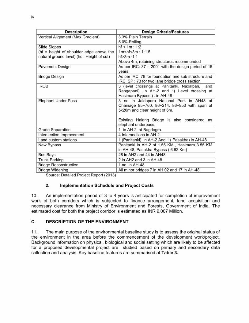
9. The proposed roadway improvement will include upgrading the AH-2 and AH-48 roads corridor to National Highway Standards for two lane configuration for most of the road sections and four lane configuration at some sections. Both corridors traverse through north-eastern part of India through rural areas and few urban areas. The total length of AH-2: Panitanki-Fulbari sub-project is 37.271 km while AH-48: Jaigaon-Chandrabandha is about 90.56 km including additional corridor of about 11.3 Km in AH-2. Both these corridors will be two lane roadways with a number of major at-grade intersections. Four lanes are proposed at two sections in AH-2 with total 11.110 Km length and one section6 of 13.7 Km length in AH-48 to meet the high projected traffic volumes. Road over bridges and grade separations are proposed at select railroad level crossings, and congested intersections. The design criteria and salient features of the project are given at Table 2.
Table 2 : Design Criteria and Salient Features Description Design Criteria/Features
Cross Section Details for two lane (Typical) ( Rural)
Carriage way : 7m (3.5m X 2) Paved Shoulder : 1.5m X 2 Unpaved shoulder : 1.0m X2 Roadway width : 12m ROW7 : 45 m
Cross Section Details for two lane (Typical) (Village/semi urban)
Carriage way : 7m (3.5m X 2) Paved Shoulder : 2.0m X 2 Unpaved shoulder : 0.5 m X2 Roadway width : 12m ROW : 30 m
Cross Section Details for two lane (Typical) (Urban)
Carriage way : 7m (3.5m X 2) Paved Shoulder : 2.250m X 2 Unpaved shoulder :2.25 m X2 Roadway width : 16m ROW : 30 m
Cross section Details for four lane (Typical)
Carriage way : 14m (7m X 2) Paved Shoulder : 1.5m X 2 Unpaved shoulder : 1.0m X 2 Median : 2 - 4.5m
Design Service Volume (PCU/day) ( for Level of Service B as per IRC : 64-1990)
15,000 two Lane with earthen Shoulder 17250 two lane with .1.5 m paved shoulder (Plain Terrain) 40000 four lane with 1.5 m paved shoulder (Plain Terrain)
Design Speed (km/h) Rural Section : 100-80 Urban Section : 50
Super Elevation Limited to 7% (Two land Carriageway) Limited to 5% (Four land Divided Carriageway)
Minimum radii of curves (m) in (Plain Terrain)
360m @ 100 km/h design speed 240m @ 80 km/h design speed 150m @ 65 km/h design speed
6 This section between Mainaguri – Dhupguri bypass junction falls under NHAI jurisdiction and may developed by them and hence may not be included under this project. 7 ROW will be restricted to minimum construction width to avoid fresh land acquisition.
iv
Description Design Criteria/Features Vertical Alignment (Max Gradient) 3.3% Plain Terrain
5.0% Rolling Slide Slopes (hf = height of shoulder edge above the natural ground level) (hc : Height of cut)
hf < 1m : 1:2 1m<hf<3m : 1:1.5 hf>3m :1:1 Above 4m, retaining structures recommended
Pavement Design As per IRC: 37 – 2001 with the design period of 15 years.
Bridge Design As per IRC: 78 for foundation and sub structure and IRC SP : 73 for two lane bridge cross section
ROB 3 (level crossings at Panitanki, Naxalbari, and Rangapani). In AH-2 and 1( Level crossing at Hasimara Bypass ) . in AH-48
Elephant Under Pass 3 no in Jaldapara National Park in AH48 at Chainage 85+760, 86+214, 86+953 with span of 5x20m and clear height of 6m. Existing Halang Bridge is also considered as elephant underpass.
Grade Separation 1 in AH-2 at Bagdogra Intersection Improvement 4 Intersections in AH-2 Land custom stations 1 (Panitanki) in AH-2 And 1 ( Pasakha) in AH-48 New Bypass Panitanki in AH-2 of 1.55 KM,, Hasimara 3.55 KM
in AH-48, Pasakha Bypass ( 6.62 Km) Bus Bays 28 in AH2 and 44 in AH48 Truck Parking 2 in AH2 and 3 in AH 48 Bridge Reconstruction 1 no. in AH-48 Bridge Widening All minor bridges 7 in AH 02 and 17 in AH-48
Source: Detailed Project Report (2013)
2. Implementation Schedule and Project Costs
10. An implementation period of 3 to 4 years is anticipated for completion of improvement work of both corridors which is subjected to finance arrangement, land acquisition and necessary clearance from Ministry of Environment and Forests, Government of India. The estimated cost for both the project corridor is estimated as INR 9,007 Million. C. DESCRIPTION OF THE ENVIRONMENT
11. The main purpose of the environmental baseline study is to assess the original status of the environment in the area before the commencement of the development work/project. Background information on physical, biological and social setting which are likely to be affected for a proposed developmental project are studied based on primary and secondary data collection and analysis. Key baseline features are summarised at Table 3.

v
Table 3 : Summary of Key Environmental Features
S. No.
Environmental Features
AH-2 AH-48
Within 100 m of either side, from centre of road
Within 5 km either side, from centre of road
Within 100 m of either side, from centre of road
Within 5 km either side, from centre of road
1 Ecological Environment
a. Presence of Wildlife Sanctuary/ National Park
None, however movement of Elephant is seen near tea gardens, Naxalbari
None, however occasional movement of wild life is noticed
Jaldapara National Park. About 3 Km length of road passes through the National Park.
Jaldapara National Park and Buxa Tiger Reserve
b. Reserved Forests None Yes Yes, about 2 Km length of the road run along the reserved forests before Jaldapara National Park.
Yes
c. Wetland None None None None
d. Migratory route for wild animals
None, Occasional movement of elephant is seen in Tree garden near Naxalbari
None Yes in Jaldapara National park.
Yes in Jaldapara National park and Buxa Tiger Reserve
e. Migratory routes for birds
None None None None
f. Migratory routes for fishes
None None None None
g. Presence of schedule 1 8 animal including in rivers
No habitat. Occasional movement of elephant is seen
None Yes in the Jaldapara National Park
Yes in Jaldapara and Buxa Tiger Reserve
h. Tree cover Yes good amount of tree cover along the road
Yes good amount of tree and tea gardens
Yes good amount of tree cover along the road
Yes good amount of tree and tea gardens
i. Aquatic Sensitivity
Minimal, Local specifies are present
Minimal, Local specifies are present
Minimal, Local specifies are present
Minimal, Local specifies are present
j. Birds Nesting None None None None 2. Physical Environment
Topography Plain Topography Plain
Topography Plain Topography Plain
Topography
Seismicity High damaged risk zone as per Seismic Zonal Map of India
High damaged risk zone as per Seismic Zonal Map of India
High damaged risk zone as per Seismic Zonal Map of India
High damaged risk zone as per Seismic Zonal Map of India
Surface Water Resources ( Rivers)
Manza, Changa, Decomani, Tepu, Hali, and Laskar, rivers mostly perennial in nature.
Manza, Changa, Decomani, Tepu, Hali, Laskar Michi and Teesta rivers, mostly perennial in
Torsha, Halang, Mujnai, Birpara, Dimdima, and Jaldhoka, rivers mostly perennial in nature.
Torsha, Halang, Mujnai, Birpara, Dimdima, Jaldhoka, and Raidak Rivers mostly perennial in nature.
8 Schedule I as per Wildlife (Protection) Act 1972 requires list the Rare and Endangered animals requiring protection.

vi
S. No.
Environmental Features
AH-2 AH-48
Within 100 m of either side, from centre of road
Within 5 km either side, from centre of road
Within 100 m of either side, from centre of road
Within 5 km either side, from centre of road
nature.
Groundwater Falls in Safe Zone as per Central Ground Water Authority9
Falls in Safe Zone as per Central Ground Water Authority
Falls in Safe Zone as per Central Ground Water Authority
Falls in Safe Zone as per Central Ground Water Authority
Soil and Land-use Mixed sandy loam and loamy soil. Land use in 500m of road is primarily agricultural fallow land (55%), vegetation cover (11%), agriculture land (22%) and Settlements ( 7%)
Mixed sandy loam and loamy soil. Land use in 5 Km of road is primarily agricultural fallow land ( 52%), vegetation cover including dense forests (18%), agriculture land including tea gardens (10%) and settlements ( 14%)
Alluvial soil to sandy and clayey soil. Land use in 500m of road is primarily agricultural fallow land (36%), vegetation cover including dense forests (17%), agriculture land including tea gardens (37%), and settlements (8%)
Alluvial soil to sandy and clayey soil. Land use in 5 Km of road is primarily agricultural fallow land (48%), vegetation cover including dense forests (21%), agriculture land including tea gardens (19%) and settlements ( 2%)
3. Social Environment
Physical Setting Urban Rural
Settings Urban Rural Settings
Urban Rural Settings Urban Rural Settings
Physically sensitive receptors
Yes (Temples, Schools, Hospitals)
Yes (Temples, Schools, Hospitals)
Yes (Temples, Schools, Hospitals)
Yes (Temples, Schools, Hospitals)
Archaeological Monuments
None None None None
12. The northern region of Bengal, which lies between West Bengal, Bangladesh Nepal and Bhutan, experiences a varied climatic condition throughout the year. In general, the weather of this region varies from sub-humid to pre-humid. The annual rainfall is about 900 mm in the project road area. The region is close to tropic of cancer which partly explains its higher temperature range. The advent of Monsoon from June to August initiates a tremendous increase in their discharge volume, causing most rivers to swell overflowing their banks. Naxalbari, Naukaghat, Dhupguri, and Mainaguri are major flood prone areas along the project corridor. Ambient air Quality meets the prescribed National Ambient Air Quality Standards at most of the locations. An ambient Noise level exceeds the prescribed National Ambient Noise Quality Standards at various monitoring locations located close to the road.
9 Central Ground Water Authority classify the ground water availability scenario in five category viz safe, semi critical, critical, over exploited and notified. No permission is required for withdrawal of water upto 100 KLD in an area or plant.

vii
D. ANTICIPATED ENVIRONMENTAL IMPACTS AND MITIGATION MEASURES
13. Environmental impacts have been assessed considering present environmental setting of the project area, nature, and extent of the proposed activities. Suitable approach and methodology was adopted to ascertain likely impacts during design and construction and operation stage.
1. Impacts and Mitigation during Design Stage
14. Physical Environment: Developmental projects like Asian Highway, which is passing through forests and adjoining areas and requiring felling or clearing of trees and vegetation may alter the local micro-climate. Both the project corridor is located in seismic zone IV which is high damage risk zone. This may cause failure of civil structures in the event of earthquake if design consideration related to seismicity is not taken into consideration. Road widening may affect roadside water pipes and telecommunication cables which are mostly located in urban areas. The road widening and increase traffic may damage drainage system and create safety concern to people residing along the road. Noise level may increase during construction and operation stages of project near the sensitive receptors like hospitals, schools. It is assessed that incremental noise level due to current traffic and project traffic is of the order of only 2 dB(A). Since, widening is planned within ROW except bypasses no significant adverse environmental impact is anticipated on the land use pattern. No significant impact is anticipated on any of the river water due to bridge re-construction or minor bridges widening. However, siltation of river water may affect the aquatic life of the river. Cutting of large number of trees may alter the local micro-climate. 15. Biological Environment: 2.6 km of AH-48 road corridor passes through the Jaldapara National Park causing disturbance and loss of fauna. This section also falls within Asian Elephant migratory corridor. Various other animals like deer and bison cross the road which increases human-animal conflict. Asian Elephant also crosses the road near Kiran Chand Tea estate, Naxalbari in AH-2. Improved road condition with increased speed will worsen the situation.
16. About 4910 and 15997 trees will be cleared for widening and improvement of AH-2 and AH-48, respectively which would lead to substantial loss of local flora. About 5.0 ha of Khairbari reserved forest land and 3 ha land within Jaldapara National Park will be diverted to accommodate the road improvement and construction of elephant underpasses. Vulnerable species Delonix regia (Gulmohar) the only vulnerable specie may get affected due to project activity. Gulmohar more commonly called as Royal Poinciana, Flamboyant, or Flame Tree is commonly found in tropical areas and mainly grown as ornamental. 17. Socio-Economic Environment: About 2,336 project affected households (PAH) comprising 11,610 people, 771 structures completely, and 1208 structures partially are expected to be affected in AH-02. Similarly about 1978 PAH comprising 9910 people, 585 structures completely, and 858 structures partially are expected to be affected in AH-48. In general, people have raised concern on safety during public consultation stage. Many accident cases are reported in the past which is a major concern near schools and hospitals. The significant impacts during design stage are mainly associated with alterations in local micro-climate due to felling of trees and dislocation of households.
viii
18. A separate SIA and R & R study is undertaken as per SPS 2009. This aspect will be dealt with as per finding or these assessments. The provision of Land compensation Act 1898, National Highway Act 1956 and National R & R policy 2007 and ADB SPS09 provision will be followed for land acquisition. Adequate provision will be made in project design for safety near schools, hospitals and other sensitive locations. Provision of adequate caution signage near school, sensitive locations, will be fixed at appropriate locations. These will be preferably of PCC with Retro-reflective paints. Common property resources structures even falling within ROW but out of required formation width will be saved to the extend feasible through engineering measures.
19. Mitigation: Faunal Protection: Protection of Asian Elephant and other wild animals is given high priority in the project. Consultations with and technical adivse was sought from concerned wildlife authorities and forests officials. Consultations were also held with local Non Governmental Organizations (NGOs) and international NGOs active in that area such as the World Wildlife Fund (WWF). As per the inputs and acceptance of wildlife authorities and concurrence from NGOs following measures are proposed for the protection of wildlife:
Provision of Elephant under Passes: Asian Elephant crosses the road at three
locations in Jaldapara NP section of AH-48. Accordingly three underpasses will be constructed at chainage 85+760, 86+214, 86+953. Each underpass will be 100m wide with five span of 20m width each and height of 6m. The existing Halang Bridge is also considered as elephant underpass. Guide rails will be installed along both sides of the underpass to direct the elephant and other wildlife movement to the underpass. Camouflaging plantations will be made along the rails to minimize disturbance to elephants. Top soil of the diverted area inside the reserved forests or National Park will be preserved and used for reforestation activates as these are very rich in nutrients.
Provision of Warning Sign Boards: Retro-reflective warning sign boards will be provided in the elephant movement areas near Kiran Chand Tea estate in AH-2 and between Hasimara and Pasakha Bypass area in AH-48.
20. Floral Protection: The project envisages approximately 105,000 trees as a compensatory plantation on 1:5 basis against cutting of 20,907 trees for both road sub-projects. These trees will be planted with the involvement of Village Panchayats (Village Administration) and women self-help group under the supervision of Social Forestry Department for plantation over PWD’s and Irrigation Department’s lands. Plantation in forest area and forests land will be made through the Forests Department. Delonix Regia (Gulmohar) will be planted more in numbers. Strong monitoring mechanism is proposed to ensure tree survivability rate of minimum 70%. To maintain and further enhance the micro climate and aesthetics, avenue plantation of at least one row will be done along roadside during up-gradation of the project road. 21. Trees will be planted as a natural barrier to noise propagation along the road. The provision of noise barriers (24 nos.) are made for all schools and hospitals located within 200 ft of the sub-project roads. 22. Construction of bridges on water body will be undertaken during dry period. Flow of water will be maintained in a channel with a pond and puddle upstream (about 50 m) for aquatic flora and fauna. Provision of adequate cross drainage structure is to be made in the all

ix
the bypass road sections. Additional balancing culverts will be provided in flood prone areas. The embankment height will be designed consistent with the existing topography of the region and will be higher than the high flood level (HFL). 23. Relevant India Stadard (IS) codes will be adopted while designing the civil structures to sustain the earthquake of highest magnitude in Seismic zone IV.
2. Impacts and Mitigation during Construction Stage
24. The significant impacts during construction are mainly associated with: (i) dust from earth works (during site preparation), (ii) emissions from the operation of construction equipment and machines, (iii) fugitive emissions from vehicles plying on the road, (iv) fugitive emissions during the transport of construction materials, (v) air emissions other than dust arise from combustion of hydrocarbons particularly from the hot mix plants, and (vi) localised increased traffic congestion in construction areas. Ambient noise level may increase temporarily in the close vicinity of various construction activities, maintenance workshops and vehicles and earthmoving equipment. Some impacts on soil and land use like loss of borrow areas, soil erosion, soil contamination due to inappropriate disposal of liquid waste (lubricating oil and fuel spills, waste oil and lubricant and vehicle/equipment washing effluent), and domestic solid waste and sewage from construction camps. Construction material and waste may contaminate or clog small drains if stored or disposed close to water body or pond. 25. To control fugitive dust, materials will be transported using covered trucks, and regular spraying of water on earthworks including unpaved roads and materials handling. Noise making equipment like diesel generating sets will be fitted with silencers. Provision of temporary noise barrier (barricading) will be made near sensitive locations or near the noise and dust source during construction. Care will be taken to prevent activities which are likely to generate noise related disturbance during night time especially near the sensitive locations. Excavation of borrow areas will be excavated as per the Indian Road Congress (IRC):10-1961. Fuel and lubricants will be stored at the predefined storage location and away from drainage channels. The bituminous and construction wastes will be landfilled in environmentally accepted manner and away from water bodies. Construction camps will be located on unproductive land and at least 1 km away from habitat areas. All construction camps will be provided with sanitary latrines and urinals with septic tanks attached with soak pits or mobile toilets fitted with anaerobic digestion system. Storm water drains will be provided around the camp to collect rain and surface runoff and course to the nearest natural drain. No wastewater will be disposed without prior treatment. During the construction phase, contractors will be required to adopt and maintain safe working practices. Contractor will provide PPEs for workers, first aid and fire fighting equipment at construction sites.
3. Impacts and Mitigation During Operation Stage
26. No adverse climatic changes/impacts are anticipated during operation stage other than GHG (CO2) emission due to increased traffic, which would be largely offset with proposed plantation, better fuel efficiency and reduced vehicle idling due to improved road conditions. During the operational stage, movement of traffic will be the prime source of noise causing nuisance to nearby schools and religious places. Provision of tree plantation and noise barrier as designed will substantially reduce noise.

x
27. Positive impacts on terrestrial ecology are expected during the project operation stage due to the increase in vegetation and landscaping along the state highway. The project will coordinate with the local communities to maintain and enhance the trees planted along the state road. No adverse impact is anticipated during operation stage except accidental damages or absence of proper tree management. Post project scenario is expected to reduce the human-animal conflict. However, strict vigil will be required to prevent such conflicts. 28. The improved road will provide better connectivity in terms of: (i) reduction in travel time; (ii) increase in better and frequency of transport; (iii) enhance access to social services such as health care facilities, educational and other infrastructural facilities; (iv) facilitate tourism activities and boost the local economy; (v) better investment climate for industries creating more employment opportunities to local people. Important issues related to safety during operational phase are monitoring of emergencies and establishing procedures to carry out rescues during sudden emergency such as accidents. Adequate caution signage near school, sensitive locations, speed control, caution notes will be fixed at appropriate locations. These will be preferably of portland concrete cement (PCC) with retro-reflective paints. Crash barriers and speed breakers will be installed at appropriate locations particularly near schools and religious places. 29. Induced Environmental Impacts: Changed in landuse beyond the ROW, risk of increase in trasboundary movement of hazardous and toxic materials, and the beneficial increase in trade among neighboring countries are unavoidable induced environmental impacts attributable to the project. The negative impacts can be mitigated through better land use controls and vigilant customs procedure to ensure proper handling and transport of hazardous wastes and toxic materials. E. ALTERNATIVE ANALYSIS
30. This project is site specific and involves improvement of roads along the existing road alignment. Required ROW is mostly available along the proposed project road sections of AH-2 and AH-48. Therefore, no alternative analysis on the general road alignment were made. 31. Alternatives in the form of 3 bypasses were evaluated during the feasibility study stage, and these are the Panitanki, Hasimara, and Jaigaon/Pasakha bypasses. These bypasses avoided built-up area and reduced social impacts and allowed needed road geometric improvements. The roadis very congested due high traffic and limited ROW mainly due to encroachers at Panitanki (Nepal Border), Hasimara town, and Pasakha Access (Bhutan Border). 32. Considering the environmental, social and technical consideration of the proposed bypass alternatives at Panitanki (1.55 Km long along Mechi river and agricultural area), Hasimara Bypass (3.55 Km, along western side of existing alignment) and Pasaka Bypass (6.22 Km long starting right hand side of BRO road at Km 102.700 and ending at Barsa river Bank) is considered to be most suitable and is are recommended as preferred options. F. ENVIRONMENTAL MANAGEMENT PLAN AND GRIEVANCES REDRESS
MECHANISM
33. The Environmental Management Plan (EMP) consists of a set of mitigation, monitoring, and institutional measures to be taken up during the design, construction and operation stages

xi
of the project. The major components of the EMP are mitigation of potentially adverse impacts, monitoring during project implementation and operation, institutional capacity building and training, implementation schedule and environmental cost estimates, and grievance redress mechanism 34. The environmental budget is estimated as INR 352.275M or US$ 6.40. The mitigation cost including monitoring is estimated as INR. 245.75M during design and construction phase and INR 30.78M during operation phase. The costs of establishment, and training and awareness are estimated as INR 58.97M. The environmental budget includes costs for compensatory tree plantation at the rate of 1:5, diversion of forests land for non-forestry purposes, development of floral nurseries, and various other mitigative measures such as dust management, soil contamination prevention, water and waste water management, noise berries and environmental monitoring. The costs towards engineering measures such as elephant underpass in Jaldapara National Park is considered part engineering costs and not included in above EMP budget.
35. An officer in Ministry of Road Transport and Highways (MORTH) at the Executing Agency (EA) level with the support from the West Bengal Public Works Department (WBPWD) at the Implementing Agency (IA) level will be responsible for ensuring that all environment safeguard requirements are complied with during implementation of the project. WBPWD at the IA level will be directly responsible for implementing the detailed requirements of the EIA and EMP.
36. Grievances related to the implementation of the project, particularly regarding the environmental management plan will be acknowledged, evaluated, and responded to the complainant at an expedient manner with corrective action proposed using understandable and transparent processes that are gender responsive, culturally appropriate, and readily accessible to all segments of the affected people. Records of grievances received, corrective actions taken and their outcomes will be properly maintained and form part of the semi-annual environmental monitoring report to ADB G. PUBLIC CONSULTATION AND INFORMATION DISCLOSURE
37. Public consultations were carried out at through out the project preparation as per ADB safeguard requirements. The first stage of consultations were conducted early in the project design stage most involving Panchayats, local stakeholders, local NGOs, and local environmental and wildlife authorities. The second stage of consutations on the draft EIA involved state and national level stakeholders. 38. The different stakeholders viz govt. officials, NGOs, village Panchayats (Village Administration), people (male, female) were consulted during the course of the study. Stakeholders were informed about the project components and likely environmental impacts before seeking their views. In each consultation all efforts were made to have adequate participation from women as well. The community members, government officials, and NGO members voiced that the proposed project will contribute in social and economic development of the region. The proposed project will contribute to increase employment opportunities for the local people during and after project implementation. The communities welcomed the project and all were in favour of the project. The community raised few concerned regarding air, and noise impact, safety and human–animal conflict. Villagers suggested making provision for safe passage of student and people near sensitive locations. They have also suggested provide air

xii
pollution control and noise barrier near sensitive locations like schools and religious places. The Pradhan (President) of the Gram Panchayats on both sub-projects suggested that widening will be done for four lanes instead of two lanes at this stage itself since land acquisition and all other activities may be difficult in second phase. NGOs have raised concern for tree loss and human–animal conflict and suggested to plant trees on minimum 1:3 ratio. Wildlife authorities have suggested to provide elephant underpass in the Jaldapara National Park. 39. In the second stage consultation, EIA findings were presented to the participants in the three separate workshops. The participants support the findings and recomemndations of the EIA and suggested to further strengthen the compensatory tree implementation mechanism through Village Panchayts and women self-help groups participation. International NGOs active in the area such as WWF were also consulted and their suggestions were incorporated in the project design. 40. Each of the issues raised by stakeholders was analysed for practical and scientific basis, and guided the identification of impacts and development of management and monitoring plan. H. CONCLUSIONS AND RECOMMENDATIONS
41. The project in general is unlikely to cause significant environmental impacts as the road upgrading will mostly be undertaken on existing alignment and available ROW. However, significant adverse impacts may result inside protected areas particularly in conflict with the elephant movement and habitat. As per findings of detailed EIA, the environmental impacts are largely temporary in nature in most of the section of the roads except in forests and protected areas. Impacts can be mitigated with minimal residual impacts in all impacted areas. The project involves land acquisition, diversion of forests land, and movement of elephant, shifting of physical cultural structures and borrowing of earth. Most major impacts are associated with these activities. 42. The EIA was prepared during the feasibility study stage and and initial finding of DPR preparation stage. Since the contract awards for the project will follow an Engineering Procurement and Construction (EPC) modality, preparation of the the final detailed engineering design will be part of the contractor’s responsibility. Close coordination with the engineering design team ensured that any changes, if there are, will be inconsequential and will not alter the key findings, EMP, and EMoP. Minor changes in the design that warrants revision in the EMP and EMoP will be handled during bid document preparation, civil works mobilization, and even during implementation as part of the Engineer’s work instructions. 43. Adequate provision is made for occupational and community safety in the EMP budget. The mitigation measures proposed will form part of BOQ for the contractor for its effective implementation. 44. Mechanisms to monitor the tree plantation and effectiveness of measures for preventing human-animal conflict will be strengthened during the pre-construction stage. It is proposed to form committee consisting of concerned senior official, district forest office (DFO) and one officer from Revenue Department who will oversee the implementation of floral and faunal measures.

xiii
45. For effective implementation of the project in an environmentally sustainable manner, the construction supervision consultant will develop environmental guidelines and EHS management system supported by environmental management information software/system. Performance indicators in consonance with the EMoP will be developed as part of these guidelines to monitor and assess the effectiveness of the mitigation measures. 46. Adequate training will be imparted as proposed under environmental management plan to enhance the capability of concerned EA and IA officials. Awareness programme for contractor and workers will also be organised for effective implementation of EMP. EMP implementation progress and monitoring report will be sent to ADB on a semi-annual basis.


1
I. INTRODUCTION
A. Project Background
1. Need of the Project
1. ADB has a regional cooperation program in four South Asian countries: Bangladesh, Bhutan, India and Nepal, called South Asia Economic Cooperation (SASEC10), which has been supporting regional cooperation in the transport sector through SAARC11 and BIMSTEC12 over a decade. Major contributions in this regard include assisting the SAARC Regional Multimodal Transport Study (SRMTS) 13 and BIMSTEC Transport Infrastructure and Logistics Study (BTILS).14 A series of SASEC Trade Facilitation and Transport Working Group meetings have endorsed ADB preparation of a project to improve the most critical corridors connecting Nepal, India, Bangladesh and Bhutan in the northern part of West Bengal, so called the “chicken neck” area of India. Further, to initiate connectivity between South Asia and South East Asia and as a follow on activity of the BTILS, strategic roads connecting Bangladesh, India and Myanmar are currently being studied. 2. Regional Cooperation: The transport division of the United Nations Economic and Social Commission for Asia and Pacific (ESCAP) has initiated the Asian Highway Network with the aim of promoting the development of international road transport in the region. The regional road connectors between Nepal and Bangladesh through India are designated as Asian Highway No.2 (AH-2) and between Bhutan and Bangladesh through India is designated as Asian Highway No.48 (AH-48). These road sections (sub-projects) selected for improvement under Tranche-1 of the SASEC Road Connectivity Investment Program (SRCIP) provide the shortest distance connectivity through chicken neck part of West Bengal State of India. These areas are also transit points for air, road and rail traffic to the neighbouring countries of Nepal, Bhutan, and Bangladesh. The improvement of these roads is essential to promote trade, tourism, local investment and social development border countries Nepal, Bangladesh, Bhutan and India. All these bordering countries are also member of SAARC (South Asian Association for Regional Cooperation) and are committed to promote regional cooperation and trade for overall development of their countries. 3. Increasing Trade and Economic Activities: The trade and people movement is on rise through these selected corridors. The improved road conditions will save substantial time of commuting and garner larger economic gains. The traffic volumes in the Nepal – Bangladesh and Bangladesh-Bhutan national highway corridor are expected to increase in future. The detail of existing and project traffic scenario is presented in Chapter 2. This increasing traffic also establishes the need for improvement of above road corridors. 4. The proposed SASEC Road Connectivity Investment Program (SRCIP) will upgrade high priority national highway trade corridors connecting five countries, namely: Bangladesh, Bhutan, India, Myanmar, and Nepal in the north-eastern part of India including North Bengal. Given the
10 South Asia Economic Cooperation (SASEC). Member countries are Bangladesh, Bhutan, India and Nepal 11 South Asian Association for Regional Cooperation (SAARC). Member countries are Afghanistan, Bangladesh, Bhutan, India, Maldives, Nepal, Pakistan and Sri Lanka 12 Bay of Bengal Initiative for Multi-Sectoral Technical and Economic Cooperation (BIMSTEC). Member countries are Bangladesh, Bhutan, India, Myanmar, Nepal, Sri Lanka and Thailand 13 SAARC Secretariat. 2007. Regional Multimodal Transport Study. Kathmandu. 14 ADB. 2008. Final Report of RETA6335: BIMSTEC Transport Infrastructure and Logistics Study. Manila.

2
large scale of the program and the need to carefully study priority corridors particularly in the India - Bangladesh - Myanmar region, an MFF modality is proposed to finance the project. 5. Five road corridors and one bridge have been identified for financing under the SRCIP. Two sub-projects, namely: AH-2: Kakarbita/Panitangki-Fulbari and AH-48: Jaigaon-Changrabandha are covered in the environmental impact assessment the list of SRCIP subprojects are provided below in Table 1.
Table 1: List of Subprojects under SRCIP No. Name of Road/Facility Length (km)
Tranche-1 1. AH-2: Panitanki (Nepal border) – Fulbari (Bangladesh border) 37.271 2. AH-48: Jaigaon (Bhutan border) – Changrabandha (Bangladesh
border) 90.56
Sub-Total 145.7 Indicative Sub-Projects for Suceeding Tranches
1. Imphal – Moreh (Manipur) 107 2. Imphal-Wangjing-Heirok-Machi-Khudenthabi (Manipur) 120 3. Imphal-Kanchuo-Tamenglong-Tousem-Haflong (Manipur) 80 4. Greater Imphal Ring Road 37.72 5. Mechi bridge (West Bengal) 0.600
Sub-Total (APPROXIMATE) 345.32 TOTAL (APPROXIMATE) 491.02
2. Project Location/Setting
6. SRCIP Tranche-I will improve two existing road corridors connecting Nepal Border (Kakarbita/Panitanki) to Bangladesh Border (Fulbari) and Bhutan Border (Jaigaon) to Bangladesh Border (Changrabandha). Both national highway corridors traverse through the northern part of West Bengal state in India passing through rural areas and few urban areas. Both these corridors will be improved to standard two lane roadways with some sections being expanded to four lane roadways. Few bypasses at Panitanki, Pasakha and Hasimara are proposed to avoid populated areas. The location of project alignment with other project component is shown at Figure 1 and 2.

3
Figure 1. Project Location Map Source: DPR, 2013
Figure 2. Project Alignments for AH-2 and AH-48
Source: DPR, 2013
AH-2 Road Corridor
AH-48 Road Corridor

4
3. Key Project Components
7. The project involves improvement of existing national highways with the following key features:
• Improvement of existing road to two lane roadways of 37.271 Km of AH-2 and 90.56 Km of AH-48.
• New bypasses at Panitanki, (AH-2: 1.55 Km), Hasimara (AH-48: 3.5km) and Pasakha (AH-48: 6.62 km)
• Additional corridor of 11.3 Km in AH-2. • Road Over Bridges (4 Nos.) and grade separation (1 Nos.) at identified locations of
AH-2 and AH-48. • Intersection improvement (4 No. in AH2 ) • Bridge reconstruction (1 No. in AH48) and bridge widening (all minor bridges) 7 in
AH-02 and 17 in AH-48 8. Detailed information on design criteria, project components are given in Chapter 2.
4. Purpose of the Report
9. This report focuses on defining environmental impacts associated with the proposed national highways improvement design, construction and operation stages. The impacts are identified for all project activities on physical, ecological and social environment. The report also defines the needed mitigation and enhancement measures, environmental management and monitoring programme required to minimise these impacts and sustain benefits. Institutional mechanism is also developed for effective implementation of EMP and EMoP.
5. Extent of the EIA Study
10. The environmental assessment was done in tandem with the preparation of the feasibility report and detailed project report (DPR). The EIA is based on up-to-date project details provided by the ADB PPTA feasibility assessment team and Design Team.
6. Team Composition and Acknowledgement
11. The environmental assessment has been carried out by S K Jain, Environmental Expert. He was supported by environmental specialists from EQMS India Pvt Ltd and other organisations consisting of Dr M.A Khalid - Climate Change and Bio-Diversity Expert, Dr Sudhanshu Kumar - Air quality and Noise Modelling Expert, Mr Anil Kumar - GIS and Land Use Analysis Expert, Mr Bhrigu Saikia - Wild Life Expert, Mr T. G. Ekende - Public Consultation and Social expert, Ms Subhashree Adhikary - Ecologist, Mr Kaleem Ahmad - Data Analyst and field monitoring staff. 12. The environmental team acknowledges the support extended by the executing agency, PPTA design consultant, State Forests and Wildlife Authorities concerned, Irrigation Department, Pollution Control Boards, and other Government Departments and NGOs.
7. EIA Content
13. This EIA report is presented in nine chapters following this introduction chapter:

5
• Chapter 2: Description of Project: This chapter provide in detail the various components of the project
• Chapter 3: Description of Environment (Environmental Profile and Base Line of the
project and study area): This provide background information based on primary and secondary information for Physical, Biological, social and cultural resources of project corridors and study areas.
• Chapter 4: Anticipated Environmental Impacts and Mitigation Measures:
• Chapter 5: Analysis of Alternatives: This covers analysis of various alternatives
considered to minimise the overall impacts of proposed development and suggest most appropriate alternatives based on detailed analysis of impact and risk associated with each alternative.
• Chapter 6: Environmental Management Plan and Grievances Redress Mechanism:
This chapter provide the details on management aspects with defined roles and responsibilities, and resource requirements for effective implementation and monitoring of mitigative measures. It also defines the institutional aspects and capacity building requirements of the project.
• Chapter 7: Information Disclosure, Consultation, and Participation: Covers the
details of public consultation carried out with public, NGO, Government bodies at various stage of report preparation. It also covers details of information disclosure and integration of outcome of public consultation in project design.
• Chapter 8: Conclusions and Recommendations: This chapter provide the summary
of findings and concluding remarks.
8. Methodology
14. The EIA study was carried out using reconnaissance survey, review of previous studies, field visits, consultation with stakeholders and NGOs, review of existing data and primary data collection. 15. Extensive use of geographic information system is made to analyse the road corridor improvement and bypass areas, analyse the land use, develop the drainage pattern and identify the borrow earth areas. Also, GIS was used in defining the magnitude of mitigation measures needed to minimise the impacts on land use, landscape, terrestrial ecology and physical cultural resources. Topo-sheets (scale 1:50,000) procured from Survey of India as available and Google maps were used for the above. 16. The scope of the EIA extends well beyond the vicinity of the proposed alignment i.e. 5 kilometres radius around the alignment is considered as the general impact zone. The immediate 100-meter corridor centred along the proposed corridor was considered as the primary impact zone where most of the adverse impacts are likely to occur. The decision to expand the environmental assessment impact zone to 5-kilometre radius is based on the following considerations: i) provide a comprehensive environmental baseline information and ensure that environmental impacts associated with the project are extensively identified and assessed, ii)

6
identify appropriate locations for construction camps and other temporary activities, and (iii) identify the probable borrow areas and other construction material sources. 17. Alternate analysis was limited to the by-passes as the the proposed improvements on AH-2 and AH-48 are confined on the existing ROW and alignment. The by-passes were evaluated based on physical, biological and socio-economic impacts and technical and financial feasibility. 18. Trend analysis, expert assessment, stakeholders’ perception and concerns, resource availability were employed to identify potential impact associated with the proposed project activities. Appropriate tools and techniques like air quality and noise prediction models were used to identify and predict the magnitude of the impacts. Suitable mitigation measures are suggested based on the intensity of the impacts identified. The EMP and EMoP were prepared to ensure effective implementation of the mitigation measures proposed.
9. Data Collection
19. The objective of data collection is to provide a database of existing conditions as basis for predicting the likely impacts and to monitoring such changes. The first step was to undertake a project scoping exercise, identify the parameters to be considered, and outline the activities for collecting data on identified parameters. Sources of data were identified. Relevant available data pertaining to physical, biological, and socio-economic aspects of the environment was collected from various secondary sources supported by primary data collection. 20. Primary data were collected with focus on sensitive receptors like religious places, schools, hospitals, habitat areas, and commercial places. Enviromental quality was also charaterized by gathering ambient noise, water quality (ground and surface water), and soil. Sampling and analyses were compliant to National Ambient Air Quality Standards cognizant of urban and rural setting, sensitive locations, and located at varying distances along the road alignment. Ambient air quality monitoring stations (6 in AH-2 and 8 in AH-48) were selected along road length to get representative data of urban, commercial, village setting, sensitive locations like school, forests and protected areas. Similarly diurnal ambient noise level were monitored near sensitive locations, residential, forests and urban area at varying distances from the road. Water quality was monitored on select major rivers crossing the road alignment. Ground water samples were collected at varying distance over the length of the road to get representative ground water quality information. The primary data gathering was conducted between March to May 2012.
10. Public Consultation
21. Local knowledge about the ecosystem and problems associated linear development were carefully recorded and considered in impact assessment and development of EMP. Consultations were held to facilitate description of environmental features, important physical cultural resource, environmental sensitive ecosystems or areas that may be affected by the project. Formal institutional level public consultation and opportunistic informal meetings involving local villagers who are likely to be affected. Interactions were also made with various local and international NGOs and concerned government officials. A detailed description of the public consultation is presented in Chapter 7.

7
B. Policy, Legal and Administrative Framework
22. India has well defined institutional and legislative framework. The legislation covers all components of environment viz. air, water, soil, terrestrial and aquatic flora and fauna, natural resources, and sensitive habitats. India is also signatory to various international conventions and protocols. The environmental legislations in India are framed to protect the valued environmental components and comply with its commitment to international community under various conventions and protocols. Asian Development Bank has also defined its environmental and social safeguard policies. ADB has defined its environmental and social safeguard policies under its Safeguard Policy Statement of 2009 (SPS 2009). The following is an assessment of applicable policies, laws and regulations, conventions, and protocols.
• Overview of Key Indian Environmental Legislation and Legal Administrative Framework
• Applicability of various national and local laws and regulations at different stages of project implementations
• Social Regulatory Requirements • ADB safeguard policies and categorisation of the project • International treaties with its relevance to the project
1. Overview of Key Indian Environmental Legislation and Legal Administrative
Framework
23. The Government of India has framed various laws and regulations for protection and conservation of natural environment. The legislations are broadly divided under following categories:
• Environmental Protection • Forests Conservation • Wild Life Protection
24. The umbrella legislation under each of above category is highlighted below:
• The Environment (Protection) Act 1986 was enacted with the objective of providing for the protection and improvement of the environment. It empowers the Central Government to establish authorities charged with the mandate of preventing environmental pollution in all its forms and to tackle specific environmental problems that are peculiar to different parts of the country. Various rules are framed under this Act for grant of environmental clearance for any developmental project, resources conservation and waste management.
• The Forest Conservation Act 1980 was enacted to help conserve the country's
forests. It strictly restricts and regulates the de-reservation of forests or use of forest land for non-forest purposes without the prior approval of Central Government. To this end the Act lays down the pre-requisites for the diversion of forest land for non-forest purposes.
• Wild Life (Protection) Act 1972 amended 2003 was enacted with the objective of
effectively protecting the wild life of this country and to control poaching, smuggling and illegal trade in wildlife and its derivatives. It defines rules for the protection of wild life and ecologically important protected areas.

8
25. The MoEF and the pollution control boards (CPCB - Central Pollution Control Board and SPCBs - State Pollution Control Boards) together form the regulatory and administrative core of the part. Other Ministries/Statutory Bodies/Departments responsible for ensuring environmental compliance and granting various clearances includes State Ministry/Dept. of environment, regional offices of MoEF and state forests/wildlife departments. Their key roles and responsibilities and interface among them have been concisely depicted in the following diagram.
Figure 3. : Environmental Legal and Administrative Framework
2. Environmental Regulatory Requirements of Government of India and State
A review of environmental rules and regulation that governs road development was conducted to ensure compliance of the project and summarised in Table 2 while needed approvals and monitoring framework are depicted in Figure 3. Although there are no state-specific environmental laws pertinent to the project, pollution control Acts for air and water are enforced by the State Pollution Control Board. The regulatory compliance assessment revealed the following: i) the sub-project roads are not required to secure an environmental clearance as provided in 22.08.2013 amendment to the EIA notification, ii) the AH-48 sub-project needs to secure permission for diversion of Jaldapara National Park land for non-park purposes and reserved forests land for non-forests purposes, and iii) both sub-projects need to comply with pollution control Acts for air and water.

9
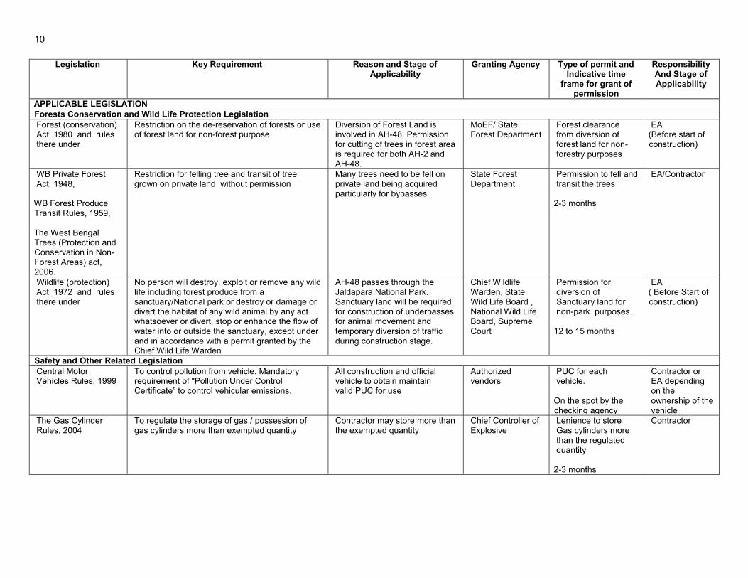
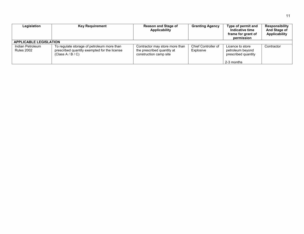
Table 2: Summary of Environmental and Other Legislation Legislation Key Requirement
Reason and Stage of
Applicability Granting Agency Type of permit and
Indicative time frame for grant of
permission
Responsibility And Stage of Applicability
APPLICABLE LEGISLATION I. Environmental Protection Legislation
Environmental (Protection) Act, 1986 and rules there under including EIA Notification, 2006. amended 22.08.2013
Amendment to EIA notification date 22.08.2013 provides Environmental Clearance is required only to the projects expansion of National Highways greater than 100 km involving additional right of way or land acquisition greater than 40m on existing alignments and 60m on re-alignments or by-passes.
Not required. AH-2 is less than 100 kms while the Mainaguri-Dhupguri section of the AH-48 measuring 20.2 kms has secured EC under the NHAI. Hence, remaining road length without EC is less than 100km
MoEF/ SEIAA Environmetal clearance
MoRTH and WBPWD
Air (prevention and control of pollution) Act, 1981 and rules there under
An Act to prevent and control of Air Pollution
Applicable during construction stage for the operation of air polluting units like Hot Mix Plant
SPCB Consent to Establish and Consent to Operate 3-4 months
Contractor (To obtain Prior to setting up polluting units )
Water (prevention and control of pollution) Act, 1974 and rules there under
An Act to Prevent and Control of Water Pollution
Applicable during construction stage for discharge of waste from construction camps or maintenance of construction equipment
-do- Consent to Establish and Consent to Operate 3-4 months
Contractor (To obtain Prior to establishment)
Noise Pollution (Regulation And Control) Act, 2000
Ambient Noise Standards for different area/zone
Primarily Applicable during construction Stage
MoEF/SPCB No specific permission is required. To ensure compliance to the standard Norms
EA/Contractor
Hazardous Wastes (Management, Handling and Trans Boundary Movement,) Rules, 2008
Protection to the general public against improper handling, storage and disposal of hazardous wastes
Hazardous wastes are likely to be generated in the form of waste oil and paints.
State Pollution Control Board
Authorization (3-4 Months)
Contractor (To obtain Prior to generation of Hazardous waste)
The Bio Medical Waste (Management and Handling rules) 1998
To control storage, transportation and disposal of Bio Medical Waste.
Applicable for the disposal of Bio Medical waste from First Aid Centre and Dispensaries.
Disposal through authorized disposal agency
No specific permit is required. Comply with the handling and disposal requirements of the rule
Contractor (During Construction Activities)
The Batteries (Management and Handling) Rules 2001
To regulate the disposal and recycling of lead acid batteries
Disposal of used lead acid batteries if likely to be used in any equipment during construction and operation stage
MoEF
No specific registration required. Compulsion to buy and sell through registered vendor only.
Contractor/EA
10
Legislation Key Requirement
Reason and Stage of Applicability
Granting Agency Type of permit and Indicative time
frame for grant of permission
Responsibility And Stage of Applicability
APPLICABLE LEGISLATION II. Forests Conservation and Wild Life Protection Legislation
Forest (conservation) Act, 1980 and rules there under
Restriction on the de-reservation of forests or use of forest land for non-forest purpose
Diversion of Forest Land is involved in AH-48. Permission for cutting of trees in forest area is required for both AH-2 and AH-48.
MoEF/ State Forest Department
Forest clearance from diversion of forest land for non-forestry purposes
EA (Before start of construction)
WB Private Forest Act, 1948,
WB Forest Produce Transit Rules, 1959, The West Bengal Trees (Protection and Conservation in Non-Forest Areas) act, 2006.
Restriction for felling tree and transit of tree grown on private land without permission
Many trees need to be fell on private land being acquired particularly for bypasses
State Forest Department
Permission to fell and transit the trees
2-3 months
EA/Contractor
Wildlife (protection) Act, 1972 and rules there under
No person will destroy, exploit or remove any wild life including forest produce from a sanctuary/National park or destroy or damage or divert the habitat of any wild animal by any act whatsoever or divert, stop or enhance the flow of water into or outside the sanctuary, except under and in accordance with a permit granted by the Chief Wild Life Warden
AH-48 passes through the Jaldapara National Park. Sanctuary land will be required for construction of underpasses for animal movement and temporary diversion of traffic during construction stage.
Chief Wildlife Warden, State Wild Life Board , National Wild Life Board, Supreme Court
Permission for diversion of Sanctuary land for non-park purposes.
12 to 15 months
EA ( Before Start of construction)
III. Safety and Other Related Legislation Central Motor Vehicles Rules, 1999
To control pollution from vehicle. Mandatory requirement of "Pollution Under Control Certificate” to control vehicular emissions.
All construction and official vehicle to obtain maintain valid PUC for use
Authorized vendors
PUC for each vehicle.
On the spot by the checking agency
Contractor or EA depending on the ownership of the vehicle
The Gas Cylinder Rules, 2004
To regulate the storage of gas / possession of gas cylinders more than exempted quantity
Contractor may store more than the exempted quantity
Chief Controller of Explosive
Lenience to store Gas cylinders more than the regulated quantity
2-3 months
Contractor
11
Legislation Key Requirement
Reason and Stage of Applicability
Granting Agency Type of permit and Indicative time
frame for grant of permission
Responsibility And Stage of Applicability
APPLICABLE LEGISLATION Indian Petroleum Rules 2002
To regulate storage of petroleum more than prescribed quantity exempted for the license (Class A / B / C)
Contractor may store more than the prescribed quantity at construction camp site
Chief Controller of Explosive
Licence to store petroleum beyond prescribed quantity
2-3 months
Contractor

12
26. In addition the MoEF, GoI issues various Office Memorandum (OM) clarifying certain provision of the above legislations or defining certain procedural aspects to be followed for grant of various clearances and permission. One of the most important legislations with frequent updates and changes in requirements is the EIA notification under the Environmental Protection Act. Key relevant OM’s issued under the notification are as follows:
a. OM dated 18th December 2012: Separate Environmental Clearance for mining of soil/earth from borrow areas which are part of highway project is not required. However, the detailed defined under this OM to be submitted at the time of submitting application for the approval of TOR for EIA and grant of EC stages.
b. OM dated 24th June 2013: Borrow area will be categorised as B2 and developer will not be required to follow detailed environmental clearance procedure provide the borrow area is less than 5 ha, and minimum distance of 500 m is maintained between two borrow areas and earth excavation guidelines defined in the OM is followed.
c. OM Dated 19th March 2013 : Environmental clearance to linear projects involving forests land may be issued on the following conditions (i) Work on non-forest land may only be executed' up to such point (to be selected by the user agency) on either side of forest land if it is explicitly certified by the user agency that in case approval under the Forest (Conservation) Act, 1980 for diversion of forest land is declined, it is technically feasible to execute the project along an alternate alignment without involving diversion of forest land. (ii) Commencement of work on non-forest land will not confer any right on the user agency with regard to grant of approval under the Forest (Conservation) Act, 1980 (iii) The projects involving widening or up-gradation of existing roads will only be allowed to be executed on the entire stretch located in non- forest land, provided the user agency submits an undertaking that execution of work on non-forest land will not be cited as a reason for grant of approval under the Act and in case approval under the Act for diversion of forest land is declined, width of the portion of road falling in the forest land will be maintained at its existing level
d. OM Dated 22nd August, 2013: All expansion of national highways that are longer than 100km and involve additional right of way or land acquisition greater than 40m on existing alignment and 60m on realignment or bypass fall under category A and require environmental clearance from the Ministry of Environment and Forests.
3. Procedural Requirements for Obtaining Various Clearance
27. The procedural requirements for granting of wildlife and forestry clearances are given in Figures 4 and 5 respectively. These schematic sketches were drawn from the information available on MoEF website www.moef.nic.in and analysis of legislation. The information has also been extracted from document “Guidelines for taking non-forestry activities in wildlife habitat.”

13
Figure 4. Procedural Requirement for Wild Life Clearance
Source: Developed by consultant based on analysis of legislation
Five proformas prescribed by MOEF which are required to be filled in by user agency; concerned divisional forest officer/Park manager; concerned chief conservator of forests; concerned chief wildlife warden and forest secretary
The user agency is required to submit part-I and part-II of the proforma duly filled in to the concerned forest officer. (Chief Conservator of Forests)
Chief wildlife warden State board for wildlife
Recommendation from chief wildlife warden
GOVT. of India/ the standing committee of NBW chaired by Minister of State (I/C) Environment and Forests
If the site is small and Impact on wild life is limited than Recommendation by standing committee of NBWL
The user agency/ state government is required to approach Hon’ble Supreme Court for final clearance
If the site is large and impact on wildlife is serious than site visit and inspection
Recommendation by NBWL

14
Figure 5: Procedure for Forest Clearance

15
4. Social Regulatory Requirements of the Government of India and State
28. There are numerous rules and regulations framed by the Government of India for the protection of workers. Most of these legislations will be applicable to contractors while the WBPWD will ensure compliance contractual obligation. These legislations include The Building and Other Construction Workers (Regulation of Employment and Conditions of Service) Act, 1996, Child Labour (Prohibition and Regulation) Act; 1986, Minimum Wages Act; 1948, Workmen Compensation Act 1923, Payment of Gratuity Act 1972, Employee State Insurance Act, Employees P.F. and Miscellaneous Provision Act 1952, Maternity Benefit Act 1951, Payment of Wages Act 1936, Equal Remuneration Act 1979, Inter-State Migrant Workmen’s (Regulation of Employment & Conditions of Service) Act 1979, and Equal Remuneration Act 1979.
5. International Treaties and Relevance to the Project
29. Government of India has signed many international treaties. GOI has also framed various laws, regulations and guidelines to meet country’s obligations under these treaties. A screening was carried out of these treaties regarding its applicability to this project and the results are shown in Table 3.
Table 3: International Treaties and its Relevance to the Project S. No.
Convention Key Features Year of ratification/
support 1 Kyoto Protocol to the
United Nations Framework Convention on Climate Change15
The Kyoto Protocol is an international agreement linked to the United Nations Framework Convention on Climate Change. The major feature of the Kyoto Protocol is that it sets binding targets for 37 industrialized countries and the European community for reducing greenhouse gas (GHG) emissions .These amount to an average of five per cent against 1990 levels over the five-year period 2008-2012.
1997
2 Convention Concerning the Protection of the World Cultural and Natural Heritage 16 (World Heritage Convention)
The most significant feature of the 1972 World Heritage Convention is that it links together in a single document the concepts of nature conservation and the preservation of cultural properties. The Convention recognizes the way in which people interact with nature, and the fundamental need to preserve the balance between the two.
1972
3 Convention on Biological Diversity
The objectives of this Convention are the conservation of biological diversity, the sustainable use of its components and the fair and equitable sharing of the benefits arising out of the utilization of genetic resources, including appropriate access to genetic resources, appropriate transfer of relevant technologies, and taking into account all rights over those resources and to technologies, and by appropriate funding.
1992
15 (http://unfccc.int/2860.php http://unfccc.int/resource/docs/convkp/kpeng.pdf) 16 (http://whc.unesco.org/en/convention/ )

16
S. No.
Convention Key Features Year of ratification/
support 4 Convention on Wetlands
(popularly known as the Ramsar Convention)
It is an intergovernmental treaty that provides the framework for national action and international cooperation for the conservation and wise use of wetlands and their resources. The Convention's mission is "the conservation and wise use of all wetlands through local and national actions and international cooperation, as a contribution towards achieving sustainable development throughout the world".
1971
5 Convention on International Trade in Endangered Species of Wild Fauna and Flora (CITES)
The CITES aims to ensure that international trade in specimens of wild animals and plants does not threaten their survival. Through its three appendices, the Convention accords varying degrees of protection to more than 30,000 plant and animal species.
1975
6 Bonn Convention on Conservation of Migratory Species of wild animals (CMS).
The Convention aims to conserve terrestrial, aquatic and avian migratory species throughout their range. It is an intergovernmental treaty, concluded under the aegis of the United Nations Environment Programme, concerned with the conservation of wildlife and habitats on a global scale. Since the Convention's entry into force, its membership has grown steadily to include 119 (as of 1 April 2013) Parties from Africa, Central and South America, Asia, Europe and Oceania.
1979
Source: MoEF GOI C. Asian Development Bank Safeguard Policies and Category of the project
30. The Asian Development Bank has defined its Safeguard requirements under its ‘Safeguard Policy Statement 2009 (SPS 2009). The prime objectives of safeguard policy are to: (i) avoid adverse impacts of projects on the environment and affected people, where possible; and (ii) minimize, mitigate, and/or compensate for adverse project impacts on the environment and affected people when avoidance is not possible. This policy requires assessment, mitigation and commitment towards environmental protection. The extent of assessment depends on the category of the project. ADB’s SPS 2009 classify projects based on the following three categories.
• Category A: A proposed project is classified as category A if it is likely to have significant adverse environmental impacts that are irreversible, diverse, or unprecedented. These impacts may affect an area larger than the sites or facilities subject to physical works. An environmental impact assessment is required.
• Category B: A proposed project is classified as category B if its potential adverse
environmental impacts are less adverse than those of category A projects. These impacts are site-specific, none or very few of them are irreversible, and in most cases mitigation measures can be designed more readily than for category A projects. An initial environmental examination is required.
17
• Category C: A proposed project is classified as category C if it is likely to have minimal or no adverse environmental impacts. No environmental assessment is required although environmental implications need to be reviewed.
1. Category of the Project
31. Tranche-1 is classified as Category A based on the outcome of the ADB Rapid Environmental Assessment (REA) checklist as provided in Appendix 1.1. All environmentally sensitive areas along the proposed alignment have been analysed to define the magnitude and extent of likely impacts. Sub-project AH-48: Jaigaon-Changrabandha passes through a protected area (Jaldapara National Park) for approximately 2.6 km (between chainage 85 Km to 87 KM), government reserved forests for approximately 2 km and includes construction of a new bypass road of about 6.6km which falls within 10 km of the Buxa Tiger Reserve. No environmentally sensitive areas exist in the other road subproject AH-02: Panitanki-Fulbari. 32. The 22.08.2013 amendment to the EIA notification does not require both the sub-project roads, classified as national highways, to secure environmental clearances as the individual lengths are less than 100 km and required additional ROW is less than 40m on existing alignment and less than 60m on by-passes. Approval from the Wild Life Board for diversion of forest land to non-forest purpose will be required for AH-48 for the sections passing through the national park and government reserved forests.
18
II. SUB-PROJECT DESCRIPTION
A. Location and Magnitude of the Sub-Projects
33. The proposed sub-project roads under SRCIP Tranche-1 are two exiting road corridors.
• Road connecting Nepal Border (Kakarbita) to Bangladesh Border (Fulbari Border) which forms part of Asian Highway No. 2
• Road connecting Bhutan Border (Jaigaon) to Bangladesh border (Chandrabandha Border) which forms part of Asian Highway No. 48
34. Both sub-project corridor roads traverse the north-eastern part of India mostly through rural areas and few urban areas. The total length of AH-2: Panitanki-Fulbari sub-project is is 37.271 km while AH-48: Jaigaon-Changrabandha sub-project is about 90.56 km. Both sub-project roads will have two-lane roadways with a number of major at-grade intersections. Four laning is proposed at four sections in AH-2 with total 17.970 Km length and one section of 13.70 Km length in AH-48 to address the increase in projected traffic volumes. Road over bridges and grade separations are proposed at select railroad level crossings, and congested intersections. The road location with road alignments and other project components are shown in Figure 6 and Figure 7. 35. The initial 1.2 km stretch of AH-2 sub-project road runs from Kakarbitta at the Nepal border and joins NH 31C at Panitanki and takes north-east direction to reach Naxalbari and proceeds easterly joining NH 31 at Bagdogara. This section from Panitanki to Bagdogra is NH31C and has a 2 lane carriageway. The project road continues on NH 31 and 31C to Shivmandir More in easterly direction with a 2 lane blacktopped road. From Shivmandir More, sub-project road turns southeast along the PWD road traversing Shivmandir More, Medical More, Naukhaghat, Teenbhatti More, Fulbari junction reaching the Bangladesh border. The existing surfacing is a black topped 2 lane road up to Fulbari junction. The last section from Fulbari junction to the Bangladesh border is a 2 km concrete road. 36. The AH-48 sub-project road corridor from Bhutan Border at Phuentsholing to Bangladesh border at Changrabandha comprising of the Phuentsholing – Jaigaon – Hasimara – Dhupguri – Mainaguri - Changrabandha – Burimari (about 97 km) with a proposed Pasakha access road is situated in northeastern India. Access is also available from Siliguri by road is via NH31 (approximately 58 km). The project road is formed by joining segments of SH12A, NH31D and NH31C. The SH12A segment of the project road starting from Changrabandha at Bangladesh border proceeding in northwest direction to reach Maynaguri is under PWD, Jalpaiguri. The NH31D section of the project road from Maynaguri to Dhupguri is under NHAI and is proposed to be widened to 4-lane configuration as part of the capacity expansion of Ghoshpukur to Falakata corridor. This section is about 13.7km. From Dhupguri, the sub-project road proceeds north towards Goyerkata then east to Birpara through NH 31C and then north to Madarihat and then east along NH31C, and then in north-easterly direction to Hasimara along NH31C. Further the project road proceeds north to Jaigaon and Phuentsholing.

19
Figure 6. : Road Alignment and Lane Configuration of AH-2
HS : Homogenous Section HS No 3,6,7 are four lane and other two lane sections.
Source: DPR Interim Report
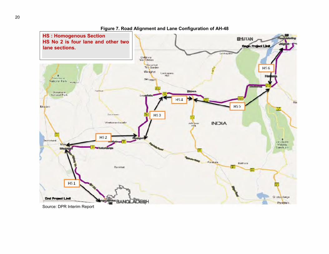
20
Figure 7. Road Alignment and Lane Configuration of AH-48
HS : Homogenous Section HS No 2 is four lane and other two lane sections.
Source: DPR Interim Report

21
37. The proposed road widening was based on engineering aspects like available land, gradient, traffic projections, hydrological aspects, safety considerations, and environmental/social aspects. B. Design Criteria and Salient Features
38. The design criteria and salient features of the proposed road upgrading are provided in Table 4.
Table 4 : Design Criteria and Salient Features Description Design Criteria/Features Cross Section Details for two lane (Typical) ( Rural)
Carriage way : 7m (3.5m X 2) Paved Shoulder : 1.5m X 2 Unpaved shoulder : 1.0m X2 Roadway width : 12m ROW17 : 45 m
Cross Section Details for two lane (Typical) (Village/semi urban)
Carriage way : 7m (3.5m X 2) Paved Shoulder : 2.0m X 2 Unpaved shoulder : 0.5 m X2 Roadway width : 12m ROW : 30 m
Cross Section Details for two lane (Typical) (Urban)
Carriage way : 7m (3.5m X 2) Paved Shoulder : 2.250m X 2 Unpaved shoulder :2.25 m X2 Roadway width : 16m ROW : 30 m
Cross section Details for four lane (Typical)
Carriage way : 14m (7m X 2) Paved Shoulder : 1.5m X 2 Unpaved shoulder : 1.0m X 2 Median : 2 - 4.5m
Design Service Volume (PCU/day) ( for Level of Service B as per IRC : 64-1990)
15,000 two Lane with earthen Shoulder 17250 two lane with .1.5 m paved shoulder (Plain Terrain) 40000 four lane with 1.5 m paved shoulder (Plain Terrain)
Design Speed (km/h) Rural Section : 100-80 Urban Section : 50
Super Elevation Limited to 7% (Two land Carriageway) Limited to 5% (Four land Divided Carriageway)
Minimum radii of curves (m) in (Plain Terrain)
360m @ 100 km/h design speed 240m @ 80 km/h design speed 150m @ 65 km/h design speed
Vertical Alignment (Max Gradient) 3.3% Plain Terrain 5.0% Rolling
Slide Slopes (hf = height of shoulder edge above the natural ground level) (hc : Height of cut)
hf < 1m : 1:2 1m<hf<3m : 1:1.5 hf>3m :1:1 Above 4m, retaining structures recommended
Pavement Design As per IRC: 37 – 2001 with the design period of 15 years.
Bridge Design As per IRC: 78 for foundation and sub structure and IRC SP : 73 for two lane bridge cross section
ROB 3 level crossings at Panitanki, Naxalbari, Rangapani in AH-2 and 1 level crossing at Hasimara Bypass in AH-48
17 ROW will be restricted to minimum construction width to avoid fresh land acquisition.

22
Description Design Criteria/Features Animal Underpass also called Elephant underpass
3 no in Jaldapara National Park in AH-48 at Chainage 85+760, 86+214, 86+953 with span of 5x20m and clear height of 6m. Existing Halang Bridge is also considered as elephant underpass.
Grade Separation 1 in AH-2 at Bagdogra Intersection Improvement 4 Intersections in AH-2 New Bypass Panitanki in AH-2 of 1.55 KM,, Hasimara 3.55 KM
in AH-48, Pasakha Bypass ( 6.62 Km) Bus Bays 28 in AH2 and 44 in AH48 Truck Parking 2 in AH-2 and 3 in AH-48 Bridge Reconstruction 1 no. in AH-48 Bridge Widening All minor bridges 7 in AH 02 and 17 in AH-48
Source: Feasibility Report 2012 and updation through interim DPR report 2013 39. Existing Traffic: Both the corridors have mix traffic consisting of fast and slow vehicles. The traffic volume in the Nepal-Bangladesh Corridor is significantly higher, i.e. almost 4 times more than the traffic volume in the Bhutan-Bangladesh Corridor. Cars and Two wheelers (scooters) constitute the majority of the vehicle that ply these routes. In the Nepal-Bangladesh Corridor, cars and scooters form more than 60% of the traffic volume whereas in the Bhutan-Bangladesh corridor, these vehicle types constitute about 50% of the traffic volume. Truck volumes are higher in the Nepal to Bangladesh corridor (2,755) compared to the truck volumes in Bhutan-Bangladesh corridor (1,564). However, in terms of percentage of total daily traffic, the truck percentage in the Bhutan-Bangladesh corridor (26.1%) is higher compared to the truck percentage in the Nepal-Bangladesh corridor (13.6%). The percentage of slow vehicles in both corridors is rather small, 9.3% in the Nepal-Bangladesh corridor, and 15.6% in the Bhutan-Bangladesh corridor. The Annual Average Daily Traffic (AADT) for individual Segments is given at Table 5. 40. Future Traffic: Future traffic depends on border traffic and local traffic. Majority of the traffic along this corridor is generated locally in India and supplemented by traffic from the neighbouring countries of Bangladesh, Bhutan and Nepal. The future traffic projections is made based on weighted average growth rate of approximately 4.64% which is arrived at considering the higher traffic of two corridors which is higher in case of Nepal- Bangladesh corridor. The projected traffic of both the corridors is shown at Table 5.
Table 5 : Existing and Future Traffic (PCU) Road
section Name of National Highway/Section
Section Length (km)
2013 2014 2018 2028
AH-2 HS1 India/Nepal border to
Panitanki 1.3 21673 22253 24640 31442
HS2 Panitanki junction to Bagdogra junction
17.25 8494 10086 11864 17020
HS3 Bagdogra junction to Shivmandir junction
5.9 35632 37582 45548 67866
HS4 Shivmandir junction to Medical junction
2.6 8318 8771 10618 15725
HS5 Medical junction to Naukhaghat junction
4.6 12287 12928 15544 22794
HS6 Naukhaghat to Fulbari junction
4.4 27249 28746 34835 51830
HS7 Fulbari junction to Banglabandha
2.7 3438 3546 3986 5273

23
Road section
Name of National Highway/Section
Section Length (km)
2013 2014 2018 2028
HS8 Goltuli junction to Fulbari junction
5.5 19434 20612 25413 38975
HS9 Medical junction to Goltuli junction
6.2 7862 8261 9887 14442
AH-48 HS1 Changrabandha to
Indira junction 20.6 9322 9839 11944 17827
HS2 Indira junction to Dhupguri
18.3 15471 16350 19929 29937
HS3 Dhupguri to Telipara junction
17.4 7959 8300 15012 21881
HS4 Telipara junction to Birpara junction
8 9086 9514 15639 23192
HS5 Birpara junction to Hasimara junction
26 7049 7369 12437 18345
HS6 Hasimara junction to end of project road
18.3 6412 6709 9009 13066
Source: DPR, 2013 D. Characteristics of Existing Road
41. Right of way18 and carriage way width: The existing carriage way is two lane carriage way with 5.5m to 7m width in poor condition. The width of earthen shoulders varies from 0.5 m to 3.0 m. The ROW in general is about 30 to 40m on NH sections adequate in SH sections to accommodate most of the widening requirements except where four lanes are proposed. The available road width ranges from 12 to 25m in most urban areas with considerable encroachments in the form of semi-permanent shops. The minimum formation width is 8m in AH-48 and 7m in AH-2. The section of AH-48 passing through the Jaldapara National Park has an ROW equal to the existing road formation width only. 42. Pavement and carriage way conditions: The pavements and carriageway in both the road is generaly bad (see Figure 9) where cracking, excessive stripping, and potholes were observed. In some stretches the aggregate base is visible. The existing pavement conditions of both the corridors are given at Table 6.
Table 6 : Existing pavement condition of AH-2 and AH-48 sub-projects
Project Corridor Aggregate base visible, Top Bituminous layer
chipped (Length in km)
Striping, Potholes
(length in km)
Good Condition
(length in km) Nepal to Bangladesh 9.0 30.9 8.5 Bhutan to Bangladesh 13.2 48.8 47.5
Source: Feasibility Report 2012
18 As per the feasibility study, the right of way availability assessment was made on estimation basis due to non-availability of field markers at various locations needs to be re-ascertained.

24
Figure 8. View of existing road conditions at AH-2 and AH-48 locations
Aggregate base layer visible (Bhutan‐Bangladesh Corridor at Sta 21+000
Potholes, Cracking, Striping (Nepal‐Bangladesh Corridor, Sta 28+000,
Huge Potholes, Striping (Bhutan‐Bangladesh Corridor (Dhupguri‐Mainaguri) at Sta 89+900,
Good Pavement Condition (Nepal‐Bangladesh Corridor (Shiv Mandir‐Medical
More) at Sta 22+800,
43. Alignment and Geometry: About 70% of horizontal curves in AH-2 and 85% of horizontal curves can support the design speed of 80 to 100 Km/h. The sections tat are not able to tolerate this design speed are located in uran areas where a lower design speed of 50km/hr was applied. There are certain acute curves including 90o turn near Hasimara which needs to be improved. The gradient steeper than ruling maximum gradient is not present in the project roads. 44. Cross drainage structure: The AH-2: Panitanki-Fulbari sub-project has 25 structures constituting of 18 minor bridges, 4 major bridges, 1 road-under-bridge (RUB), 1 road over bridge (ROB), and 1 barrage (Mahananda). AH-48: Jaigaon-Changrabandha has 47 structures constituting of 36 minor bridges, 10 major bridges, and 1 road-over-bridge (ROB) (Table 7).

25
Table 7 :Summary of bridge classification for SRCIP Tranche-1
S.No.
Bridge Type Bridge Length (m)
>6‐10 - >10‐20
>20‐30 >30‐40 >40‐50 >50‐60 >60 Sub total AH-2: Panitanki-Fulbari
1 Minor Bridges(>6‐60m) 4 5 2 2 1 4 18 2 Major Bridges (>60m) 4 4 3 RUB 1 1 4 ROB 1 1 5 Barrage 1 1
Total 25 AH-48: Jaigaon-Changrabandha
1 Minor Bridges(> 6‐60m) 10 4 9 8 0 5 36 2 Major Bridges(> 60m) 10 10 3 ROB 1 1
Total 47 Source: Feasibility Report 2012 45. A total of 188 (91 in AH-2 and 97 in AH-48) culverts consisting of pipe, slab or box type exist or an average of one culvert exists per kilometre. Except for the the Mahananda barrage, all bridges have poor footpath conditions, deteriorated wearing coat, and damaged or missing handrail. (Figure 9). The detailed inventory of existing bridges and culverts with conditions is given at Appendix 2.1, 2.2 and 2.3.
Figure 9. : A View of Select Existing Railway Level Crossing, Bridges and Culverts
Mahananda Barrage along additional corridor via
Rangapani (Nepal‐ Bangladesh, Sta 351+00). Jaladaka Bridge (Bhutan‐Bangladesh Corridor
at Sta 77+00, November 20, 2011)
Existing Culvert to be Widened (Nepal‐Bangladesh
corridor, Sta 24+691) Partially Clogged Culvert with debris (Bhutan‐Bangladesh Corridor, Hasimara‐
Birpara, Sta 29+950) 46. Terrain and Land use: The land use around both the road corridor is largely agricultural with flat terrain. The AH-48 passes through Jaldapara National Park, tea

26
gardens, residential, and commercial areas. About 3km road segment of AH-48 passes through foothills of Phuentsholing having undulating to rolling terrain while the Mainaguri- Chandrabandha section is located in low-lying area flood prone area. 47. Road intersections: The sub-project roads have seeral major at-grade intersection (Figure 10) that are signalized, non-signalized, or round-about. Most intersections have three approaches and are congested. AH-2 and AH-48 also pass through railway level crossings: AH-48 has three while AH2 has 6. AH-48 has 11 major and 56 minor junctions while AH-2 has 9 major and 29 minor junctions. All major intersections require engineered improvements.
48. Existing Bus Stops and Truck Lay-bys: There are 14 bus stops in the AH-2 and 42 in AH-48, and 3 truck lay-bys are in AH-48. On AH-2 sub-project, there is a truck terminal at Fulbari near the border area.
Figure 10. View of select existing intersections at AH-2 and AH-48
Intersection at Behar More, Bagdogra (Nepal‐
Bangladesh at Sta 18+900) Intersection at Changrabandha Bypass (Bhutan‐
Bangladesh at Sta 106+720)
Intersection at Medical More (Nepal‐Bangladesh
at Sta 26+250). Roundabout at Fulbari Truck Terminal (Nepal‐
Bangladesh at Sta 35+180)
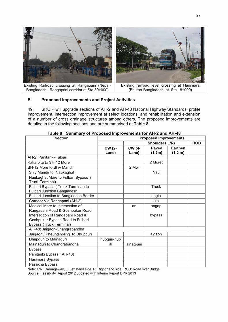
27
Existing Railroad crossing at Rangapani (Nepal‐
Bangladesh, Rangapani corridor at Sta 30+000) Existing railroad level crossing at Hasimara
(Bhutan‐Bangladesh at Sta 18+900)
E. Proposed Improvements and Project Activities
49. SRCIP will upgrade sections of AH-2 and AH-48 National Highway Standards, profile improvement, intersection improvement at select locations, and rehabilitation and extension of a number of cross drainage structures among others. The proposed improvements are detailed in the following sections and are summarised at Table 8.
Table 8 : Summary of Proposed Improvements for AH-2 and AH-48 Section Proposed Improvements
Shoulders L/R) ROB CW (2‐
Lane) CW (4‐Lane)
Paved (1.5m)
Earthen (1.0 m)
AH-2: Panitanki-Fulbari Kakarbita to SH‐12 More 2 Moret SH‐12 More to Shiv Mandir 2 Mor Shiv Mandir to Naukaghat Nau Naukaghat More to Fulbari Bypass ( Truck Terminal)
Fulbari Bypass ( Truck Terminal) to Fulbari Junction Bangladesh
Truck
Fulbari Junction to Bangladesh Border angla Corridor Via Rangapani (AH‐2) ulb Medical More to Intersection of Rangapani Road & Goshpukur Road
an angap
Intersection of Rangapani Road & Goshpukur Bypass Road to Fulbari Bypass (Truck Terminal)
bypass
AH-48: Jaigaon-Changrabandha Jaigaon / Pheuntsholing to Dhupguri aigaon Dhupguri to Mainaguri hupguri‐hup Mainaguri to Chandrabandha ai ainag‐ain Bypass Panitanki Bypass ( AH-48) Hasimara Bypass Pasakha Bypass
Note: CW: Carriageway, L: Left hand side, R: Right hand side, ROB: Road over Bridge Source: Feasibility Report 2012 updated with Interim Report DPR 2013

28
F. Recommended Lane Configurations and Typical Cross-Sections:
50. The recommended lane configuration chainage wise for AH-2 and AH-48 sub-projects is given in Table 9 below.
Table 9 : Recommended Lane Configuration for AH-2 and AH-48 Chainage Section Lane Configuration/
Improvementproposal Length
(km) Recommended Lane Configuration for AH-2 0+000 - 0+640 Mechi Bridge No improvement 0.64 0+640 – 2+000 Panitanki area and
bypass Four lane required – two lane along the bypass and two lane along existing alignment (no geometric improvement considered along existing alignment to minimize social impact)
1.36
2+000 – 16+900
Panitanki bypass to near SH-12 More
Two lane configuration (Rural or Village/semi-Urban cross section provided)
14.9
16+900 - 23+360
Near SH 12, More to Shiv Mandir More
Four lane configuration (with service road for first 2780 m and without service road for remaining length)
6.46
23+360 - 30+450
Shiv Mandir to Naukhagat More
Two lane configuration (Village/semi- Urban cross section)
7.09
30+450 - 35+100
Naukhaghat More to Fulbari
Four lane configuration (w/oservice road ) 4.65
35+100 - 37+100
Fulbari to Bangladesh Border
Two lane configuration (Village/semi- Urban cross section)
2
Corridor via Rangapani 0+000 – 6+000 Medical More to
Goshpukur Road Junction
Two lane configuration (Urban or Village/semi-Urban cross section)
6
6+000 – 11+500
Goshpukur Road Junction to Fulbari
Four lanes required because of high truck traffic. However NHAI is developing new 4-lane corridor parallel to this link and therefore only Two lane configuration proposed (Urban or Village/semi-Urban cross section)
5.5
Recommended Lane Configuration for AH-48 0+000 – 22+600
Changrabandha (Bangladesh border) to NH 31 at Mainaguri
Two lane configuration (Rural or Village/semi-Urban cross section provided)
22.6
22+600 –36+300
Mainaguri – Dhupguri bypass junction (NHAI section)
Four lane required – This is being implemented by NHAI and not included under this project
13.7
36+300–40+300 65+600-89+600
Dhupguri bypass junction - Dhupguri town – Birpara - Hasimara bypass start
Two lane configuration (Rural or Village/semi-Urban or Urban cross section)
53.3
89+600-94+400 Hasimara bypass Two lane configuration (Rural cross section) 4.765 94+400 – 108+800
Hasimara bypass end to Bhutan border along Pasakha Access road
Two lane configuration (Rural or Village/semi-Urban cross section)
14.4
Source: Interim DPR Report 51. Typical road section and configuration: The typical cross-sections for different scenarios are proposed in line with planned improvements. Certain sections will only require paved shoulder and earthen shoulder improvements with a carriageway of 7m wide in two lane configuration and 7 X 2m in four lane configuration. The paved shoulder will be 1.5m and earthen shoulder of 1m. Service road on either side of a four lane facility will be

29
provided for about 3.2km length in AH-2. The typical cross sections are shown at Figure 11 to 14.
Figure 11. Typical Two Lane Road Cross Section in Rural Area
Figure 12. Typical Two Lane Road Cross Section in Urban Area
Figure 13. Typical Four Lane Road Cross Section in Rural Area
Source: DPR Interim Report
Source: DPR Interim Report

30
Figure 14. Typical Four Lane Road Cross Section in Urban Area
G. Geometric Improvements
52. The existing alignment of AH-2: Panitanki – Fulbari sub-project requires several horizontal curve imrpovements. However, at some locations like the curve on Medical more (Sta 24+200) where land acquisition for ROW is extremely difficult, the existing alignment will be retained. While AH-48: Jaigaon-Changrabandha sub-project will only require improvements at four locations (Table 10) where horizontal radius of curve will be improved from 112 to 300m to 300 to 800m.
Table 10 : Horizontal Alignment Improvements for Bhutan‐Bangladesh Corridor (AH-48)
Chainage Location Existing Condition Proposed Improvements 48+900 to 49+100 Birpara R = 190 m, 300 m R = 400 m 51+600 to 51+800 Kali Mandir R = 160 m R = 300 m 87+200 to 87+600 Mainaguri R = 112 m R = 300 m
109+700 to 110+000 Chandrabandha Junction
R = 120, 200 m R = 800 m
Note: R ‐ Horizontal radius of curve Source: Feasibility Report 2012 H. Intersection Improvements
53. To prevent traffic jam, accidents, and ensure smooth movement of increasing traffic, selected intersection along the sub-project roads will be improved (Table 11), to include redesign, signalisation, grade separation, and road-over-bridge (ROB) at railway crossings. 54. In AH-2 sub-project, grade separation is proposed at Bagdogra where heavy traffic from NH-31 intersects NH-31C. Three legged signalised intersections are proposed at Medical More and Fulbari Truck Terminal while the existing roundabout at Fulbari Truck Terminal will be redesigned to T-intersection with signals. Two ROB with service roads are proposed at Naxalbari and Rangapani railway level crossings. At other railroad level crossings minor widening of railway, gates and fence is proposed. 55. In AH-48 sub-project, grade separation is proposed at the intersection of NH-31 with AH-48 at Birpara and a re-design of the existing intersection at Changrabandha bypass on SH-12A.
Source: DPR Interim Report

31
56. The proposed ROBs will have intermediate service lanes on both sides of the mainline to provide access to the local streets via at grade crossings. To limit additional land acquisition, retaining walls are proposed along the approach roads of each ROB. Typical section of the proposed ROB is shown in Figure 15.
Table 11 : Summary of Intersection Improvements AH-2 and AH-48 Location Improvement Type
AH-02 Panitanki ( Proposed Bypass Alignment) Road Over Bridge (ROB Naxalbari Road Over Bridge (ROB)
Bagdogra to Shiv Mandir Interchange with Grade Separation ( Flyover)
Medical More Signalized Intersection Fulbari Truck Terminal Signalized Intersection Rangapani ROB Road Over Bridge (ROB AH-48 Hasimara ( On bypass alignment) Road Over Bridge (ROB Birpara Interchange with Grade Separation Chandrabandha Bypass Intersection Redesign
Source: Feasibility Report 2012 and updated with Interim DPR report 2013
Figure 15. : Typical Section for Proposed ROB
I. Vertical Alignment Improvement
57. About 70% of AH-2 and 46% of AH-48 sub-project roads have embankment height of less than 1m (Table 12). If the alignment is passing through expansive clays, the road embankment needs to be raised suitably in addition to meeting the criteria of minimum clearance for high flood level (HFL) of 0.6m for existing subgrade bottom and 1m for new subgrade bottom. Also, road embankment may need to be raised to provide adequate clearance above the pipe culverts where needed.
Table 12 : Height of Embankment Embankment Height
(m) Project Length (%)
(AH 48) Project Length (%)
(AH 02) 0 - 1 46 70
1.50 13 9 2 - 3. 34 19 3 - 4. 4 1
Source: Final Feasibility Report

32
Embankment Height (m)
Project Length (%) (AH 48)
Project Length (%) (AH 02)
4 - 6. 2 1 6 - 12. 2 0
Source: Feasibility report 2012 and updated with interim report 2013 58. The Project area received medium to very heavy rainfall resulting to overflows of major rivers such as Mechi, Balason, Mahananda, Torsa, Dudua, Jaladaka, Dharaikari and Jarda resulting to localied flooding. 59. NH-2 sub-project falls within Mahananda river sub-basin with a recorded highest flood level of Mahananda River, 2nd Bridge Hill Cart Road, Siliguri at 117.075m which occurred in 1958 and was made basis in the design of the needed vertical alignment improvement. Historical records has indicated Naxalbari, Naukaghat, Dhupguri and Mainaguri are major flood prone areas. The sub-project road section between Medical More and Naukaghat which is in low lying area and may require raising of the profile. 60. NH-48 sub-project roas is within Torsa and Jaladakha River sub-basins. The danger levels for Torsa Gauge station at Hasimara of 116.30 m and for Jaladakha Gauge station at NH -31 crossing of 80.0m were considered in designing the vertical alignment improvement. This road corridor is generally built on high embankment except for Mainaguri- Chandrabandha section which is a low lying area and will require raising of profile. 61. As general design criteria, all existing the sub-project road sections will maintain at least 600 mm clearance above HFL from bottom of the existing subgrade as stipulated in IRC SP 73, section 4.2. For all bypasses, the bottom of subgrade will be placed at a minimum, of 1 m height above HFL. J. Bridge and Culvert Improvement
62. Along the two-lane sections, all bridges will be widened on both ends to incorporate the paved shoulders and additional footpath while the culverts are recommended for extension or reconstruction depending on existing condition. 63. Along the proposed 4‐lane sections, all bridges and culverts will be widened to four lanes and at select locations would be widened to incorporate additional service roads. Bridges adjacent to proposed ROBs will either be reconstructed or widened accordingly. Minor repair work is proposed to to address broken railings and deteriorated footpaths. Improvements may not be needed for bridge over Mechi River on Kakarbita‐Panitanki road segment (570 m) since the existing annual average daily traffic (AADT) is significantly lower than the capacity. The existing roadway width on two Teesta canal bridges and Mahananda Barrage is 7.5 m in addition to 1.5 m footpath on either side. This width is adequate for a 2‐lane highway plus pedestrian or bicycle movements. However, repair work to the footpath and railing for the structures is recommended. There are 7 major bridges, 17 minor bridges, 2 RUB and ROB in AH-2. Similarly, there are 10 major bridges, 36 minor bridges, 2 RUB & ROB in AH-48 The sub-projects will require extension of 58 culverts and 14 culverts for reconstruction. Along the proposed Pasakha Bypass, a new culvert is proposed. The major deficiencies observed in the culverts are blockage of vent ways and missing hand‐rails. Table 13 and Table 14 summarise proposed improvements on bridges and culverts.

33
Table 13 : Summary of Proposed Improvements for Bridges and Other Structures in AH-2 and AH-48
Type of Structures
AH-02 AH-48 Total
Structures Retained Widening New/
Reconstruction Total
Structures Retained Widening/Deck
Replacement New/
Reconstruction Major Bridges 7 7 - - 10 10 - - Minor Bridges 17 10 7 - 36 17 15+1 2+1 ROB & RUB 2 2 - - 2 2 - - Flyover 0 - - 1 0 - - - Level Crossings 4 - - 3 1 - - 1
Source: Feasibility Report 2012 and updated with Interim DPR report, 2013
Table 14 : Summary of Proposed Improvements for Culverts for AH-2 and AH-48 Corridor Extension Reconstruction New Cleardebris Headwall Others
Nepal‐Bangladesh (AH-2) 59 15 - 6 0 7 Bhutan‐Bangladesh (AH-48) 58 14 1 9 2 13
Source: Feasibility Report 2012

34
K. Road Safety Barriers
64. As per guidelines, provision will be made to construct safety barriers using steel guardrails (IRC 103) with strong post. Following modified criteria is recommended in addition to provisions of IRC SP 73 as per international standards. For roads where cars travel in excess of 50 km/h following safety features will be adopted :
Sections with embankment height >2 metre on sharp curve where the side slope is steeper than 1 in 2 if any;
Where there is a risk that vehicles could fall into a body of water deeper than 1 m or onto a rail track;
Safety barriers recommended to be installed on bridge approaches at least for 50m on approaching side and 30m on the leaving sides on both ends.
Safety barriers are recommended in all rail crossings for 50m length on either side. L. Construction Material and Sources
65. The details of the material to be used for construction and its sources are yet to be finalized by the design team at the time of writing. However, discussions with MoRTH and WBPWD revealed that construction material like stone aggregate, sand in general will be exclusively obtained from licence mines of bed material of the river near the sub-project areas. The borrow earth requirement of about 250,000 m3 for embankment raising and 350,000 m3 for sub-grade for each of the sub-project road will be sourced from nearby fields. Tentatively, 9 borrow areas in AH-2 and 25 borrow area in AH-48 have been identified by DPR team located at short distance from the road alignment. These locations will be finalised after testing and analysis. The aggregates requirements of about 1.21M tones for AH-2 sub-project and about 1.27M tons for AH-48 sub-project will be sourced from Pakur Quarry, West Bengal. 66. Construction water requirements will be generally sourced from the ground or surface water bodies with due permission from the Central Ground Water Authority. The project corridor area does not fall in the water stressed area. M. Relocation of Utilities and Land Acquisition
67. Water pipes and telecommunication cables which are largely located in urban areas may require shifting at various locations. However, the details of utilities to be shifted will be finalized at the detailed design stage. Land acquisition is involved for widening of the road from two- to four-lanes and construction of three bypasses of Panitanki Bypass in AH-2 and Hasimara and Pasakha bypass in AH-48. About 12ha of land (9ha government and 3ha private land) will need to be acquired for AH-2 and 55ha (35 ha government and 20 ha private land) for AH-48. N. Cost Estimate
68. The estimated cost for both the project corridor is estimated (2012 and feasibility stage estimate) as INR 9,007.0 Million equal to about USD $ 155.3 million. The cost for each project corridor is as given below: Nepal to Bangladesh Corridor - INR 3,833.1 million (USD 66.1 million) Bhutan to Bangladesh Corridor - INR 5,173.9 million (USD 89.2 million)

35
O. Proposed Implementation Schedule
69. The implementation period is anticipated as 3 years for completion of improvement work of both the corridor which is subjected to finance arrangement, land acquisition and necessary environmental clearance. P. Strip Maps
70. Environmental strip maps were prepared to provide pictorial view of environmental features along the sub-project road corridor. These are given at Appendix 2.4 and 2.5.

36
III. DESCRIPTION OF THE ENVIRONMENT
A. General
71. West Bengal is the only state in India which extends from the snowy peaks Himalayan ranges in the north to the Bay of Bengal in the South. The state shows significant diversity in terms of environmental settings and agro climatic zone profile distinct ecosystems, geology and physiography. 72. North Bengal is comprised of Jalpaiguri, Darjeeling, Dinajpur, and Cooch Behar districts that lies along Himalayan foothills. The area is covered with moist and dense riverine forests of the Bengal Dooars (Duars) and the stark foothills of the snow-capped Kanchenjunga range. Bhutan and Nepal are two countries having easy access to North Bengal. B. Baseline Environmental Conditions
73. The natural environment is comprised of physical (air, water, soil, noise and climate aspects), biological (terrestrial and aquatic floral and faunal aspects) and socio-economic aspects. Environemntal baseline characterization which establish the present physical, biological, and socio-economic sitations will allow a more accurate and comprehensive impact assessment of road construction and operation. Summary of key environmental features are provided in Table 15.
Table 15 : Summary of key environmental features S.
No. Environmental
Features AH-2 AH-48
Within 100 m of either side, from centre of road
Within 5 km either side, from centre of road
Within 100 m of either side, from centre of road
Within 5 km either side, from centre of road
1 Ecological Environment Presence of
Wildlife Sanctuary/ National Park
None, however movement of Elephant is seen near tea gardens, Naxalbari
None, however occasional movement of wild life is noticed
Jaldapara National Park. About 3 Km length of road passes through the National Park. (A critical habitat19)
Jaldapara National Park and Buxa Tiger Reserve
Reserved Forests None Yes Yes, about 2 Km length of the road run along the reserved forests before Jaldapara National Park.
Yes
Wetland None None None None Migratory route for
wild animals None, Occasional movement of elephant is seen in Tea garden near Naxalbari
None Yes in section passing through Jaldapara National park.
Yes in Jaldapara National park
Migratory routes for birds
None None None None
Migratory routes for fishes
None, None None None
19 As per ADB SPS09 : Source Book for safeguard requirement 1: Environment

37
S. No.
Environmental Features
AH-2 AH-48 Within 100 m of either side, from centre of road
Within 5 km either side, from centre of road
Within 100 m of either side, from centre of road
Within 5 km either side, from centre of road
Presence of schedule 1 20 animal including in rivers
No habitat. Occasional movement of elephant is seen
No habitat. Occasional movement of elephant is seen
Yes in the Jaldapara National Park
Yes in Jaldapara and Buxa Tiger Reserve
Tree cover Yes good amount of tree cover along the road
Yes good amount of tree and tea gardens
Yes good amount of tree cover along the road
Yes good amount of tree and tea gardens
Aquatic Sensitivity Minimal, Local specifies are present
Minimal, Local specifies are present
Minimal, Local specifies are present
Minimal, Local specifies are present
2. Physical Environment Topography Plain Topography Plain Topography Plain Topography Plain
Topography Seismicity High damage risk
zone as per Seismic Zonal Map of India
High damage risk zone as per Seismic Zonal Map of India
High damage risk zone as per Seismic Zonal Map of India
High damage risk zone as per Seismic Zonal Map of India
Surface Water Resources (Rivers)
Manza, Changa, Decomani, Tepu, Hali, and Laskar, rivers mostly perennial in nature.
Manza, Changa, Decomani, Tepu, Hali, Laskar Mechi and Teesta rivers, mostly perennial in nature.
Torsha, Halang, Mujnai, Birpara, Dimdima, and Jaldhoka, rivers mostly perennial in nature.
Torsha, Halang, Mujnai, Birpara, Dimdima, Jaldhoka, and Raidak Rivers mostly perennial in nature.
Groundwater Falls in Safe Zone as per Central Ground Water Authority21
Falls in Safe Zone as per Central Ground Water Authority
Falls in Safe Zone as per Central Ground Water Authority
Falls in Safe Zone as per Central Ground Water Authority
Soil and Land-use Mixed sandy loam and loamy soil. Land use in 500m of road is primarily agricultural fallow land (55%), vegetation cover (11%), agriculture land (22%) and Settlements (7%)
Mixed sandy loam and loamy soil. Land use in 5 Km of road is primarily agricultural fallow land (52%), vegetation cover including dense forests (18%), agriculture land including tea gardens (10%) and settlements (14%)
Alluvial soil to sandy and clayey soil. Land use in 500m of road is primarily agricultural fallow land (36%), vegetation cover including dense forests (17%), agriculture land including tea gardens (37%), and settlements (8%)
Alluvial soil to sandy and clayey soil. Land use in 5 Km of road is primarily agricultural fallow land (48%), vegetation cover including dense forests (21%), agriculture land including tea gardens (19%) and settlements (2%)
3. Social Environment Physical Setting Urban Rural
Settings Urban Rural Settings
Urban Rural Settings
Urban Rural Settings
Physical Sensitive Yes Yes (Temples, Yes (Temples, Yes (Temples,
20 Schedule I to Wildlife (Protection) Act 1972 lists the Rare and Endangered animals requiring protection. 21 Central Ground Water Authority classify the ground water availability scenario in five categories viz safe, semi critical, critical, over exploited and notified. No permission is required for withdrawal of water upto 100 KLD in safe area.

38
S. No.
Environmental Features
AH-2 AH-48 Within 100 m of either side, from centre of road
Within 5 km either side, from centre of road
Within 100 m of either side, from centre of road
Within 5 km either side, from centre of road
Receptors (Temples, Schools, Hospitals)
Schools, Hospitals)
Schools, Hospitals) Schools, Hospitals)
Archaeological Monuments None None None None Source: EQMS, 2013 C. Physical Environment
1. Climate Profile
74. The northern region of Bengal, which lies between West Bengal, Bangladesh Nepal and Bhutan, experiences varied climatic condition throughout the year. In general the weather of this region vary from sub-humid to pre-humid. The region is close to tropic of cancer which partly explains the higher temperature range in the study zone. The Himalayan Mountains in the north, Bay of Bengal in south, and extensive network of rivers, and canals in its surroundings, do not allow extreme climatic conditions to prevail in the state. The following climatic description was based on observations compiled by the regional weather station of Northern Indian Metrological Department, Since the sub-project roads traverse primarily through Darjeeling, Jalpaiguri22 and Cooch Behar districts, climatic details have been provided focusing on these two districts. 75. Temperature: The northern part of the state including the mountain region in the Himalayas, temperature range from freezing to 10°C during winter. January is the coldest month and winter starts from the end of November and extends to February. Darjeeling has a normal mean temperature of 5.8°C to 20°C where snowfall occurs occasionally. The lowest temperature recorded in Darjeeling district of of -5Co occurred in 1905 was attributed to cold winds from Himalayas. In Jalpaiguri the average temperature ranges from 15 oC to 30 oC and in Coch Behar January is the coldest month with temperature varying between 9.6oC to 24.1oC with April is the hottest month with mean daily maximum of 31.7oC and mean daily minimum of 20.1oC. The mean temperature of 1901 to 2000 is summarized at Table 16 and monthly annual temperature between 2006 to 2010 is shown at Figure 16.
Table 16 : Monthly Mean Temperature and Mean Rainfall based upon 1901-2000 data District/Month Period Mean Temperature oC Mean Rainfall in mm Cooch Behar District Maximum Minimum January 1901-2000 23.7 9.6 8.3 February 1901-2000 25.8 11.6 13.1 March 1901-2000 29.9 15.8 40.7 April 1901-2000 31.7 20.1 127.9 May 1901-2000 31.0 22.2 377.6 June 1901-2000 31.1 24.1 766.8 July 1901-2000 31.3 24.9 813.4 August 1901-2000 31.6 25.1 620.5 September 1901-2000 31.3 24.3 519.0 October 1901-2000 30.5 21.2 179.8 November 1901-2000 28.1 15.4 9.7 December 1901-2000 25.2 11.2 4.0 Darjeeling District January 1901-2000 9.4 1.8 19.7 February 1901-2000 10.4 2.9 24.1
22 Jalpaiguri district was part of Darjeeling district in the past.

39
District/Month Period Mean Temperature oC Mean Rainfall in mm March 1901-2000 14.4 6.3 47.7 April 1901-2000 17.4 9.4 115.8 May 1901-2000 18.5 11.5 197.2 June 1901-2000 19.3 13.6 570.0 July 1901-2000 19.4 14.3 781.7 August 1901-2000 19.6 14.2 635.3 September 1901-2000 19.2 13.3 437.3 October 1901-2000 18.0 10.3 122.5 November 1901-2000 14.7 6.3 23.5 December 1901-2000 11.5 3.3 7.0
Source: Indian Metrological Department
Figure 16. : Temperature of Project Road Districts
76. Rainfall & Humidity: During monsoon season, the air is generally very damp with relative humidity ranging between 80 and 90% over a greater part of the State. The annual rainfall is generally >900 mm at the foothill region on the north which reaches to 4000 mm along the south facing slopes of the Himalayas in Darjeeling. The maximum average annual rainfall in the state from 2009-2010 is about 1,100 mm with Darjeeling showing higher rainfall followed by Jalpaiguri and Koch Behar. A gradual increase is noticed from June to July which is followed by a decreasing trend with the offset of the monsoon season. The annual humidity of the project area is above 50% throughout the year from 1961-1990. The humidity range for Darjeeling district is higher comparatively than Koch Behar and Jalpaiguri which remains above 80% from May to Oct. The annual rain fall in project road districts is given in Table 17 and Figure 17.

40
Table 17 : Annual Rainfall in West Bengal by District as seen in 2010 District Annual Rainfall in West Bengal by District during year 2010 (in mm)
Jan Feb Mar Apr May Jun Jul Aug Sep Oct Nov Dec Darjeeling 72 355 896 1142 876 456 188 33 Jalpaiguri 2 74 159 396 900 1044 688 539 70 10 Cooch Behar
30 385 600 711 863 525 496 61 2
Source: Bureau of Applied Economics and Statistics, W.B.
Figure 17. : Annual Rainfall and Humidity Levels in Project Road Districts
Source: IMD Data
77. Flood: State of West Bengal has a flood prone area of 2.65 million hectares. The major rivers flowing through the project corridor are Mechi, Balason, Mahananda, Torsa, Jaldhoka, Dharaikari, and Jardha. These rivers emanate from the Himalayas, gathering both surface runoffs and subsurface flows as they traverse North Bengal before merging with the Ganga or entering Bangladesh. During the lean period these rivers are fed by melting glaciers from the Himalayas. The advent of monsoon from June to August initiates a tremendous increase in their discharge volume, causing most rivers to swell, overflowing their banks. Naxalbari, Naukaghat, Dhupguri and Mainaguri are flood prone areas located along the project corridor. Flood susceptible areas in West Bengal are shown in Figure 18.

41
Figure 18. Flood Susceptible Area for State of West Bengal
Source: Irrigation & Waterways Dept. Govt. of West Bengal, www.wbiwd.gov.in
78. Wind Speed and Direction: As per the climatological data from 1961-1980, the monthly mean wind speed varies from 1- 23 km/hr in Koch Behar, 0-7 Km/Hr in Darjeeling, and 11-25 Km/Hr in Jalpaiguri. High wind speeds are recorded from March to September in Koch Behar and Jalpaiguri Districts whereas the wind speed remains low for Darjeeling district almost throughout the year. The annual pattern for wind speed and wind direction has been represented in Figure 19. It can be seen from the graphs that the predominant
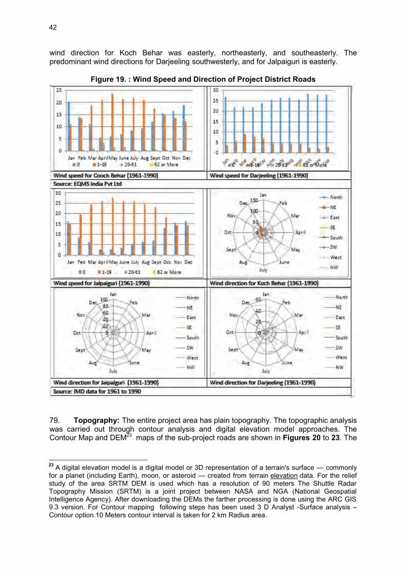
42
wind direction for Koch Behar was easterly, northeasterly, and southeasterly. The predominant wind directions for Darjeeling southwesterly, and for Jalpaiguri is easterly.
Figure 19. : Wind Speed and Direction of Project District Roads
79. Topography: The entire project area has plain topography. The topographic analysis was carried out through contour analysis and digital elevation model approaches. The Contour Map and DEM23 maps of the sub-project roads are shown in Figures 20 to 23. The
23 A digital elevation model is a digital model or 3D representation of a terrain's surface — commonly for a planet (including Earth), moon, or asteroid — created from terrain elevation data. For the relief study of the area SRTM DEM is used which has a resolution of 90 meters The Shuttle Radar Topography Mission (SRTM) is a joint project between NASA and NGA (National Geospatial Intelligence Agency). After downloading the DEMs the farther processing is done using the ARC GIS 9.3 version. For Contour mapping following steps has been used 3 D Analyst -Surface analysis – Contour option.10 Meters contour interval is taken for 2 km Radius area.

43
elevation difference between the entire AH-2 and AH-48 subproject roads are is 110 mean seal level (msl) to 160 msl, and 72msl to 220msl, respectively.
Figure 20. : Contour Map of AH-2 Road Alignment

44
Figure 21. : Digital Elevation Map of AH-2 Road Alignment
Figure 22. : Digital Elevation Map of AH-48 Road Alignment

45
Figure 23. : Contour Map of AH-48 Road Alignment
80. Geology: The State of West Bengal consists of 19 districts and 340 blocks and ranges from Himalayan region in north to Bay of Bengal in south. The total coverage area of the state is 88,752 Km2 and the entire area falls under major river basins. Out of this total area, 73,858 Km2. is occupied by the unconsolidated sedimentary deposits of the Quaternary period. Hard rocks ranging in age from the Precambrian to the Tertiary periods, which are decidedly older than the sedimentary formations forms the remaining area. 81. Seismicity: As per the Seismic Zonal Map of India, all the 3 Districts Darjeeling, Jalpaiguri, and Cooch Behar are located in Zone IV as shown in below Figure 24. This zone is categorized as high seismic zone.

46
Figure 24. : Seismic Zone Map of India
82. Hydrology and Drainage: Hydrology: West Bengal is a land of rivers. Some of these are the tributaries and the others are the distributaries. By such connectivity, the rivers of West Bengal constitute three major river systems, namely, the Ganges, the Brahmaputra, and the Subarnarekha. The river basins of West Bengal is shown at Figure 25. AH-2 and AH-48 sub-projects are located in Torsha, Jaldhaka, and Teesta river basins.

47
Figure 25. : River Basins of West Bengal
Source: http://cgwb.gov.in
Name of sub Basin 1. Sankosh River Basin 2. Raidak River Sub Basin 3. Torsha River Sub Basin 4. Jaldhaka River Sub Basin 5. Teesta River Sub Basin 6. Mahananda River Sub Basin 7. Punarbhaba River Sub Basin 8. Atrai River Sub Basin 9. Pagla Bansloi Sub Basin 10. Brahmani-Dwarka Sub Basin 11. Mayurakshi River Sub Basin 12. Ajoy River Sub Basin 13. Damodar River Sub Basin 14. Darakeswar River Sub Basin 15. Silabati River Sub Basin 16. Kangsabati River Sub Basin 17. Kaliaghai River Sub Basin 18. Jalangi River Sub Basin 19. Churni River Sub Basin 20. Bhagirathi-HooghlySub Basin 21. Rupnarayan River Sub Basin 22. Subarnarekha River Basin 23. 24 Parganas & Calcutta Part
Drainage Basin 24. Pichabhange Drainage Basin 25. Rasulpur Drainage Basin 26. Haldi Drainage Basin
83. Drainage Pattern: A drainage basin is the topographic region from which a stream receives runoff, through flow, and groundwater flow. The drainage pattern of the study area is Dendritic24 drainage pattern of both the sub-project areas are shown at Figure 26 and 27.
24 Dendritic drainage systems (from Greek δενδρίτης, dendrites, "of or pertaining to a tree") are the most common form of drainage system. In a dendritic system, there are many contributing streams (analogous to the twigs of a tree), which are then joined together into the tributaries of the main river (the branches and the trunk of the tree, respectively). They develop where the river channel follows the slope of the terrain. Dendritic systems form in V-shaped valleys; as a result, the rock types must be impervious and non-porous

48
Figure 26. : Drainage Pattern Map of AH-2
Figure 27. : Drainage Pattern Map of AH-48

49
84. Water Resources: Surface water: Major River flows in the AH-2 sub-project area are River Mechi, Manza, and many other rivers, which flows from north to southeast. Similarly the major rivers in AH-48 sub-project Teesta, Jaldhaka, Mujha, and Torsha, which flows from north to southeast. Both sub-project road areas are drained by a large number of perennial rivers. The lists of river crossings are given at Table 18 and Table 19.
Table 18 : Rivers crossing AH-2 road alignment Sl. No. River Chainage River Type AH-2 1. Kamchi Nala 6.3 km - 2. Pond 7.2 - 3. Manza River 10.4 km Perennial 4. Canal 12.6 km - 5. Changa River 11.3 km Perennial 6. Decomani River 12.3 km Perennial 7. Lalpha River 13.2 km Perennial 8. Tepu River 14.6 km Perennial 9. Canal 15.3 Km - 10. Halai River 19.00 km Perennial 11. Bwabalanb River 19.4 km Perennial 12. Laskar River 21.00 km Perennial 13. Tista Main Canal 34.00 Km -
Table 19 : Rivers crossing AH-48 road alignment
85. Ground Water: On the basis of physiographic features and geologic set-up, the state of West Bengal is broadly classified into three distinct groundwater-bearing zones as following (Refer Table 20 for details):
Sl. No. River Chainage River Type AH-48 1. Torsha River 87.70 to 88.10 km Perennial 2. Halang River 85.40 km Perennial 3. Mujnai river 73.8 km Perennial 4. Daldati River 72.9 km Perennial 5. Ekti River 72.00 km Perennial 6. Karjee River 69.9 km Perennial 7. Birpara zora River 67.7 km Perennial 8. Birpara River 65.9 km Perennial 9. Dimdima River 61.5 km Perennial 10. Kalua River 57.9 km Perennial 11. Mechka River 47.1 Km Perennial 12. Gilandi River 43.8 km Perennial 13. Bimani River 41.7 km Perennial 14. Kumlai River 40.3 km Perennial 16. Jhumer River 36.3 Km Perennial 17. Jaldhoka River 33.1 to 33.3 km Perennial 18. Churabandar River 29.00 km Perennial 19. Jhajangi River 28.00 km Perennial 20. Halhali River 26.2 km Perennial 21. Jordha River 21.3 km Perennial

50
• Himalayan and Sub-Himalayan zones of Darjeeling and parts of the Jalpaiguri and Cooch Behar districts lying in the north,
• Crystalline or compact rocky uplands of Purulia and the western fringes of Bankura, Birbhum, Burdhaman and Medinipur districts including marginal lateritic tracts, and
• The low lying alluvial plains of the northern, central and southern parts of the state encompassed within the districts of Jalpaiguri, Cooch Behar, West Dinajpur, Malda, Murshidabad, Nadia, Hugli, Howrah, the eastern parts of Burdhaman, Bankura and Medinipur, and 24-Parganas.
86. The entire project area falls under safe zone, no permission is required for extraction of water no more than 100 KLD per day.
Table 20 : Ground Water Situation In Districts of West Bengal Formation District Findings Remarks/ Recommendations
Consolidated/ Semi consolidated/ Hard Crystalline rocks
Purulia, Bankura, Medinipur, Burdhaman, Birbhum
Ground water occurs in : Weathered residuum within 10mbgl. Fractures within 65mbgl having discharge within 20 m3/hr.
In this water scarce area, topographic lows, zone of intersection of regionally extended joints & fractures (to be identified by resistivity survey) are the suitable locales for ground water development through dug and dug cum-bore wells.
Gondwana Sandstone
Purulia, Burdhaman, Birbhum
Ground water occurs in the fractured zone within 100mbgl generally discharging 10 m3/hr with maximum discharge of 22m3/hr.
Bore wells within 100m depth is found suitable. Location of the well site should be pinpointed after detailed geophysical survey.
Unconsolidated /Recent Alluvium
Darjeeling, Jalpaiguri, Cooch Behar, Uttar Dinajpur, Dakshin Dinajpur, Malda, Murshidabad, Nadia, North 24 Parganas, Hugli, Howrah, Medinipur, Burdhaman, Bankura, Birbhum
Ground water occurs both under unconfined & confined condition within the explored depth of maximum 600mbgl. Aquifers are fairly thick& regionally extensive with large yield prospect of about 150m3/hr. In Birbhum and Bankura districts aquifers beyond 136 mbgl upto the drilled depth of 350mbgl in the Tertiary formation are found under auto flow condition. The occurrence of Arsenic in ground water in the depth span of 20-80 mbgl restricted mainly in the eastern part of Bhagirathi river has posed a serious problem. In view of the situation exploration work has been undertaken in the arsenic infested areas & arsenic free deeper aquifers could be identified beneath a thick clay bed in Nadia district.
Ground water can be utilised through heavy-duty tube wells within 120mbgl & willow tube wells within 60mbgl. In arsenic infested area development of willow aquifers should be avoided.
87. Jalpaiguri: The soil in this region ranges from alluvial to sandy and clayey. The soil can be broadly classified as either: a) the terai soils covering almost the entire district, or b)

51
brown forest soil covering the northern foot hills of the district. Soil foud in the sub-projects are predominantly sandy with low water holding capacity. The alluvial soil is fertile and sustains crops like paddy, jute, and tea. This kind of soil is brought down by hilly rivers like Teesta, Torsa and Mahananda. The rivers often overflow their banks depositing layers of fertile soil on the banks on either side. In the upper region to the north of the Duars, the soil is mainly hard, black, and clayey suitable for growing tea which is a major cash crop of this region. In the lower plain land the soil consists of a mixture of both clay and sand. The soil Map of Jalpaiguri district is shown at Figure 28 and Table 21.
Figure 28. Soil Map of Jalpaiguri
Source: NBSS & LUP Regional Centre, Kolkata
Table 21 : Soil Types of Jalpaiguri Major Soils (common names like red sandy loam deep soils (etc.,)*
Area (‘000 ha)
Percent (%) of total Geographical area
1. Willow to moderately coarse loam soils 268.028 43.04 2. Deep to very deep clay loamy soils 121.486 19.05 3. Deep to very deep clayey soils 195.461 31.38
Source: www.crida.in cp-20 2 ... WestBengal 20 -Darjeeling-3 . 2 .20 .pdf 88. Darjeeling: The soils of Darjeeling Hill in general were developed by both fluvial action and lithological disintegration. The soils that have developed in the Kalimpong area are predominantly reddish in colour. Occasional dark soils are found due to extensive existence of phyletic and schists. Soils in the highlands stretching from the west to the east of the district along most of the inter-fluvial areas are mainly mixed sandy loam and loamy, while those on the southern slopes of Mirik and Kurseong are mainly clayey loam and reddish in colour. Sandy soils are mainly found in the east of the river Teesta. 89. All are dacidic in nature with the tendency to increase slightly in depth in most cases indicating the lacking of bases from surface and accumulation in the lower horizons. The weathering of lateritic type is the substantial mechanism in the transformation of the substratum. The variable thickness of the regolith and soils depend on the rate of weathering and gradient of the longitudinal slope profiles and intensity / gravity of mass movements. The basic soil types are yellow soils, red brown soils and brown forest soils. Red and yellow soils have developed on gneiss while brown on schists and shales. Coarse

52
pale yellow to red brown soils are found on the Siwaliks while clayey dark soils are developed on Daling series. 90. The character of the bedrock is reflected only in the grain size composition of the soil. On the Darjeeling gneiss, very coarse-grained (50% -80%) particles are found. In Damuda and Daling series percentage of sandy and coarse particles in the soils are high. On the Siwaliks, silty – clay fraction is higher. The chemical content of the soil over Darjeeling gneiss is characterized by a high proportion of potassium derived from feldspar and muscovite mica. This soil is poor in lime, magnesium, iron oxides, phosphorous and nitrogen. Therefore lime is used in the tea plantation areas. The soil Map of Jalpaiguri district is shown in Figure 29 and soil type in Table 22.
Figure 29. : Soil map of Darjeeling District
Source: NBSS & LUP Regional Centre, Kolkata
Table 22 : Soil types of Darjeeling District Major Soils (common names like red sandy
loam deep soils (etc.,)* Area (‘000 ha) Percent (%) of total
geographical area Medium deep to very deep fine loamy soils (hill-brown forest soils)
110.48 35.0
Sandy loam soils (Medium lands to foot hills) 109.31 34.7 Willow to medium deep Loamy soils(plains) 95.10 30.0
Source: NBSS & LUP Regional Centre, Kolkata 91. Koch Behar: A gentle slope from northwest to southeast is characteristic of this district. The geological formation is the alluvium of recent times deposited by Teesta and Mahananda rivers, mostly sandy and loose. The surface soil is loam and hardly any good clay is found. The soil moisture regime is mostly Ustic, while soil temperature regime is Hyper-thermic. The length of moisture availability (LGP) ranges between 270-300 days in a year. The principal crops are Paddy, Jute, Tobacco and Vegetables. The soil Map of Jalpaiguri district is shown in Figure 30 and soil type in Table 23.

53
Figure 30. : Soil map of Koch Behar
Source: NBSS & LUP Regional Centre, Kolkata
Table 23 : Soil types of Koch Behar District
Source www.crida.in cp-20 2 ... WestBengal 2 0 -Darjeeling-3 . 2 .20 .pdf D. Land-Use
1. Land use of West Bengal
92. Abou 66 % of land is being used for agriculture purposes, 3.6 % under current fallow and 13.5% for forest covers 13.5 %. Table 24 provides district wise land use classification of the state.
Major Soils (common names like red sandy loam deep soils (etc.,)*
Area (‘000 ha) Percent (%) of total
1. Sandy 49.1 1.4 2. Coarse loamy 1061.3 31.3 3. Deep to very deep Fine loamy 1812.0 53.4 4. Fine 260.3 7.7 5. Miscellaneous 204.3 6.2

54
Table 24 : Project District Wise and of State Specific Land Use Statistics (2007-08) (in hectares)
S.No District Reporting Area
Forest Area
Area Under Non Agricultural Use
Current Fallow
Net Area
Others
1 Jalpaiguri 622,700 28.7% 13.6% 2.4% 53.7% 1.5% 2 Darjeeling 325,469 38.3% 11.4% 3.7% 43.2% 3.3% 3 Cooch Behar 331,565 1.3% 20.1% 0.4% 74.8% 3.3% 4 17 West Bengal 8,684,113 13.5% 20.3% 3.6% 61.0% 1.6%
18 Source: Economic Review, 2008-09
2. Land use of Study Area 93. A systematic digital image interpretation approach was used to delineate the land use classes. The present study was focused on demarcating boundaries of different land use/land cover units from an analysis of different types of colour registrations of land use/land cover units from satellite imagery in 500m and 5 Km area. GIS software (ARC GIS 9.3) was used for the study. The digital image processing is done in Image processing software ERDAS 9.1. Multi-spectral supervised classification using the maximum likelihood algorithm followed by smoothing and editing of pixels was performed in that platform. The Satellite data which is used to make Land use and land cover of the area is LISS III (23.5 meters) and Landsat 4-5 thematic mapper (30 meters resolution). 94. The land use in both the road corridors falls under agriculture fellow land classification followed by agriculture. The details of land use classification of both the corridors within 500m and 5 km both side of the road is given at Table 24 (AH-02) and Table 25 (AH-48) and Figure 31 to 35 (AH02) and Figure 36 to 39 ( AH48).
Table 24 : Land Use Classification Details of AH-2 Road corridor
Class(500 meters Radius) Area (Km2) Class(5 km) Area ( Km2) Agricultural land 10.18 Agricultural Land 41.9 Agri fallow land 25.03 Agricultural Fallow land 222.55 Vegetation 5.01 Open land 4.89 Dry river bed 1.24 Water body 10.87 Water body 0.97 Settlement 57.63 Settlement 3.05 Dry river bed 11.03 Total 45.48 Vegetation 75.07
Total 423.94

55
Figure 31. : Land use Analysis of AH-02 in 500 m Radius
Figure 32. : Land use Analysis of AH-02 in 5 km Radius
Agricultural land 22%
Agri fallow land 55%
Vegetation 11%
Dry river bed 3%
Waterbody 2%
Settelement 7%
Landuse analysis(500 meters)
Agricultural Land 10%
Agricultural.Fallow land 52% Open land
1%
Water body 2%
Settlement 14%
Dry river bed 3%
Vegetation 18%
Landuse Analysis(5 km)

56
Figure 34. Land use of AH-02 in 500m radius

57
Figure 35. Land use of AH-02 in 5 km radius

58
Table 25 : Land Use Classification of AH-48 Class (500 meters) Area (Km2) Class (5 km) Area (Km2) Agriculture Land 38.54 Agricultural land 199.96 Agriculture Fallow Land
37.12 Agri. Fallow land 511.85
Settlement 7.75 Settlement 22.52 Water body 1.77 Water body 24.80 Vegetation 17.63 Vegetation 225.97 Total 102.81 Open Land 15.73 Dry River Bed 58.57
Total 1, 059.4
Figure 36. Land use Analysis of AH-48 in 500 m Radius
Figure 37. Land use Analysis of AH-48 in 5 km Radius
A.L 37%
A.F.L 36%
Settlement 8%
waterbody 2%
Vegetation 17%
Landuse Analysis (500 meters)
Waterbody 2%
Settlement 2%
A.L 19%
O.L 2%
Vegetation 21% Dry
river bed 6%
A.F.L 48%
Landuse Analysis (5 km)

59
Figure 38. Land use of AH-48 in 500m Radius
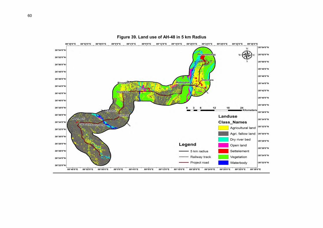
60
Figure 39. Land use of AH-48 in 5 km Radius

61
95. Environmental Quality: Environmental quality analysis media-specific condition from which impact assessment is anchored and also provide reference values if the environmental quality deterioration will occur due to the sub-project roads. In absence of available secondary data, primary data were gathered for assessing the baseline environmental quality. Monitoring was carried out at various locations along the sub-project roads for air, noise, soil surface and ground water. The monitoring locations are shown in Figure 40 for AH-02 subproject and Figure 41 for AH-48 sub-project. The monitoring methodology is introduced in Chapter 1 and detailed at Appendix 3.1. The monitored baseline levels are presented in the following sections.
Figure 40. :Environmental Quality Monitoring, Sampling Locations (AH-02)

62
Figure 41. : Environmental Quality Monitoring, Sampling Locations (AH-48)

63
96. Air Quality: Ambient Air quality and background concentrations of criteria pollutions have been obtained for the study zone through monitoring of these pollutants according to the methodology prescribed Cetral Pollution Control Board (CPCB) standards. These criteria pollutants or classical pollutants include oxides of sulphur (SO2), nitrogen dioxide, (NOx2), particulates matter of 2.5 and 10 micron sizes (PM2.5 and PM10). Organic pollutant like carbon monoxide have also been monitored since it is considered and reported to be an important class of air pollutant emitted largely from automobiles/vehicles and other combustion sources. These pollutants have been measured and monitored at residential, commercial and at sensitive zones which include Naxalbari school along AH-2, near Jaldapara National Park and near a school at Pacchim Kherbari situated along AH-48. The locations at AH-2 corridor include Kakarbita, Naxalbari School, Bagdogra, Medical, Fulbari Village , Rangapani, while the monitoring locations at AH-48 corridor include namely Chandrabandha, Mainaguri, Jaldhaka Park, Magurmari, Birpara, Pacchim Kherbari, Jaldapara Forest, Jaigaon. 97. The air quality monitoring stations were selected to gather representative data for rural, urban and sensitive locations (like school, hospital). Monitoring was carried out following BIS standard monitoring and testing protocol. Monitoring was carried out twice at each location for 24-hours except for carbon monoxide. The minimum and maximum concentrations of SO2, NO2, CO are within the prescribed standards at all the chosen sampling sites of AH-2 and AH-48 corridors. The average concentrations of SO2, NO2, CO range from 4.7- 0 .5 μg m3, 16.3-20. 7 μg m3, 0.2 mg m3 respectively for the AH-2 corridor. Whereas the average concentrations of SO2, NO2, CO ranges from 5.3- .7 μg /m3, 15.3-25.2 μg m3, 0.20-0.44 mg /m3 respectively for the AH-48 corridor.
98. The average concentrations of PM2.5, PM10 is within the prescribed National Ambient Air Quality Standards at most of the locations in both the road corridors except at Jaigaon which may be due to heavy traffic and congestion. The ambient air quality results are given in Table 26 and 27.
Table 26 : Ambient Air Quality Levels for AH-2 Location Category Pollutants in g/m3
SO₂ NOx PM10 PM 2.5 CO Kakarbhitta/ Panitanki Commercial/ urban 6.8 16.3 66.8 27.2 450
7.5 19.5 70.2 30.5 340 Naxalbari School School/urban 10.5 22.6 93.3 40.2 235
8.5 20.7 85.2 42.6 310 Bagdogra Village 6.5 15.6 76.4 38.4 390
9.2 17.1 72.5 33.8 370 Medical (Thikni kata) Village 8.3 20.8 84.3 36.4 250
6.4 15.8 80.6 32.7 265 Fulbari Village Village 4.7 17.3 57.5 28.1 360
5.3 14.7 60.4 33.2 305 Rangapani (alternative Road) Village 8.1 18.2 81.8 41.3 280
7.4 16.3 76.9 37.0 300 NAAQ Standards, g/m3 (for Industrial, Residential, Rural and Other areas) for 24 hrs
80 80 100 60 2000
Source : Primary Data Collection
Table 27 : Ambient Air Quality Levels for AH-48 Location Category Pollutants in g/m3
SO2 NOx PM10 PM 2.5 CO Changrabandha Village 5.3 15.6 61.3 29.2 235
6.6 14.8 70.2 33.5 270 Maynaguri Near (Road) 10.3 21.7 89.7 38.6 325
8.5 19.3 92.2 40.8 360

64
Location Category Pollutants in g/m3 SO2 NOx PM10 PM 2.5 CO
Jaldhaka Park Village 6.8 18.6 66.2 27.6 240 8.2 16.2 78.6 30.7 200
Magurmari Village 7.8 17.6 75.6 38.8 250 6.6 15.3 92.5 32.5 210
Birpara Village 8.0 16.5 88.4 30.2 265 7.5 18.0 82.1 36.6 290
Pacchim Kherbari Near (School) 7.9 19.5 75.8 33.0 280 6.5 17.1 82.4 37.5 265
Jaldapara Forest/ sanctuary area
Forest Area 8.4 20.4 80.3 36.5 205 8.0 18.1 92.5 40.2 235
Jaigaon Commercial 11.8 25.2 105.1 47.2 440 9.2 22.2 117.5 43.3 410
NAAQ Standards, g/m3 (for Industrial, Residential, Rural and Other areas) for 24 hrs 80 80 100 60 2000
Source : Primary Data collection * Two Samples at each location basis 99. Noise: The environmental assessment of noise from the industrial and construction activities and vehicular traffic can be undertaken by taking into consideration various factors like potential damage to hearing, physiological responses, and annoyance and general community responses. 100. A preliminary reconnaissance survey was undertaken to identify the major noise generating sources in the area which has been identified based on the activities in the village area and traffic. The noise monitoring has been conducted for determination of ambient noise levels in the study area. Noise level was monitored following Indian standard guidelines for ambient noise monitoring (detailed noise monitoring sampling methodology is given at Appendix 3.1). The day noise levels have been monitored during 6 am to 10 pm and night levels during 10 pm to 6 am at all the locations within study area. The hourly noise levels monitored during day time and night time are presented in Table 28 and 29. Noise levels are higher than prescribed CPCB ambient noise level standards during night and day time at certain locations due to heavy traffic movement in the highway zone or due to traffic intersecting at monitoring location. This higher noise level phenomenon is more prevalent in AH-2.

65
Table 28 : Ambient Noise Levels [dB(A)] in the Study Area along alignment AH-2 Location Category Day Time Night Time Remarks
Noise Levels in dB(A) L Max L Min Leq Prescribed Ambient
Noise Standards
L Max L Min Leq Prescribed Ambient
Noise Standards
Panitanki More near road
Commercial 75.4 54.8 65.4 65 70.3 50.2 62.6 55 Ambient Noise levels are higher than the prescribed Ambient Noise Level standards during day and night time due to heavy traffic
Kakarbhitta (Panitanki Border area)
Commercial 65.4 36.6 56.6 65 53.1 33.3 46.8 55 Ambient Noise levels are within prescribed limits
Naxalbari (near road)
Residential
73.6 58.3 68.3 55 68.4 55.9 65.5 45 Ambient Noise levels are higher than the prescribed Ambient Noise Level standards during day and night time due to heavy traffic
Naxalbari School Silence 66.2 32.7 48.8 50 51.5 30.5 39.3 40 Ambient Noise levels are within prescribed limits
Medical More, Road Intersection
Commercial 77.8 60.5 70.6 50 72.3 52.1 64.3 55 Ambient Noise levels are higher than the prescribed Ambient Noise Level standards during day and night time due to heavy traffic
Medical (Thikni kata) Near Rangapani Village
Residential 62.5 30.5 58.2 55 55.5 28.4 47.3 45 Ambient Noise levels are higher than prescribed Ambient Noise Level standards due to the merging traffic from different directions
Fulbari Village Residential 58.7 30.8 54.4 55 52.6 29.7 44.2 45 Ambient Noise levels are within prescribed limits
Source: EQMS, 2013

66
Table 29 : Ambient Noise Levels [dB(A)] in the Study Area along AH-48 road alignment Location Category (zone) Day time Night Time Remarks
Noise Levels in dB(A) L Max L Min Leq Prescribed Ambient
Noise Standards
L Max L Min Leq Prescribed Ambient
Noise Standards
Jaigaon (near roadside)
commercial 77.2 62.3 71.3 65 70.8 60.2 66.6 55 Ambient Noise level is higher than the prescribed standards during day and night time due to traffic and commercial activities
Jaigaon temple Residential 68.6 35.6 58.3 55 52.7 33.6 45.5 45 Ambient Noise level is higher than the prescribed standards Ambient Noise Level standard during day and night time due to traffic
Hasimara village Village 61.7 31.5 48.7 55 45.4 28.6 42.4 45 Ambient Noise levels are within prescribed limits
Jaldapara village (near road)
residential 72.5 48.3 63.6 55 68.5 53.1 58.3 45 Ambient Noise level is higher than the prescribed standards Ambient Noise Level standard during day and night time due to heavy traffic and bad road condition
Jaldapara National Park
silence 59.6 45.9 49.7 50 46.2 36.7 40.9 40 Ambient Noise levels are within prescribed limits
Pacchim Kherbari Near Road
Commercial 75.1 60.2 70.2 65 70.8 58.3 67.8 55 Ambient Noise level is higher than the prescribed standards Ambient Noise Level standard during day and night time due to heavy traffic
Pacchim Kherbari near school
silence 59.2 30.6 48.2 50 48.7 28.3 39 40 Ambient Noise levels are within prescribed limits
Jaldhaka Park commercial 68.8 48.7 60.1 55 71.2 50.6 66.1 45 Ambient Noise levels are high due to traffic movement
Jaldhaka Park village
Residential 63.3 29.7 49.3 55 46.3 27.8 41.6 45 Ambient Noise levels are within prescribed limits
Maynaguri village Residential 58.8 30.5 47.5 55 49.6 31.2 43.4 45 Ambient Noise levels are within prescribed limits
Changrabandha near road and border area
Commercial 67.3 40.8 55.8 65 65.7 45.4 53.3 55 Ambient Noise levels are high due to traffic congestion, addition of traffic from border regions
Changrabandha near village
Village 58.3 30.5 47.5 55 46.5 28.7 42.8 45 Ambient Noise levels are within prescribed limits
Source: EQMS, 2013

67
101. It can be observed from the previous Tables that noise levels are within prescribed national ambient noise standard vaues at some locations along AH-2 whereas noise levels are observed higher than prescribed standards at Panitanki More, Naxalbari near roadside, Medical (Thikni kata) near Rangapani due to heavy traffic movement of commercial and private vehicles, connecting roads, and intersections at these locations. The conditions are similar at AH-48 sub-project where noise levels have been observed within limits apart from locations like Jaigaon (near roadside), Jaldapara village, Pacchim Kherbari village, Jaldhaka Park, and Chandrabandha near road and border area. The higher noise levels at these locations are mainly due to higher traffic density and poor road condition resulting slower movement of vehicles with more jerks. 102. Water quality: There are many rivers crossed by the sub-project roads. Waters from these rivers were analysed to assess quality and suitability for drinking and construction activities. Various rivers flowing in the area are of same river basin, hence, representative water sample were taken from major water stream following standard sampling, preserving and testing techniques as defined by the Bureau of India Standrads (BIS). Five surface water samples from major water streams and six ground water samples from different locations were collected and analysed. The test results are given in Tables 30 to 33.
103. Most of the surface water quality parameters are within the prescribed standards along AH-2 subp-project road whereas along AH-48 sub-project road bacteriological parameters expressed as total coliform were recorded 1,157 MPN/100 ml, 2,965 MPN/100 ml, and 1,898 MPN/100 ml in Torsha, Jaldhaka and Angravassa rivers, respectively. These values are higher than the prescribed Indian Standards (IS: 2296) for total coliform of 500 MPN/100 ml. Other parameters are found to be within the prescribed standards. Similarly all the monitored and sampled ground water quality parameters along AH-2 and AH-48 sub-projects are observed to be within the prescribed Indian Standards10500. Largely, surface water quality meets the water quality standards of class A for most of parameters means suitable for drinking water after conventional treatment and disinfection. The ground water quality meets the drinking water standard.
Table 30 : Surface Water Quality along Proposed AH-2 Alignment Sr. No. Parameters
Teesta Canal
Manza River Surface Water Quality Standards (as per IS: 2296)
Physical Parameters A B C D E
1 pH 7.4 7.9 6.5-8.5 6.5-8.5 6.5-8.5 6.5-8.5 6.5-8.5
2 Temperature, 0C 18 18 - - - - -
3 Dissolved Oxygen, mg/l 7.5 7.7 6
(min.) 5 (min.) 4 (min.) 4 (min.) - 4 Total Suspended Solids, mg/l 5 8 - - - - - 5 Conductivity, µmho/cm 180 172 - - - 1000 2250
Chemical Parameters 6 Total Alkalinity, mg/l 70 62 - - - - - 7 Total Dissolved Solids, mg/l 134 131 500 - 1500 - 2100
8 Total Hardness as CaCO3, mg/l 64 60 300 - - - -
9 Calcium Hardness as CaCO3, mg/l 30 35 - - - - -
10 Magnesium Hardness as CaCO3, mg/l 34 25 - - - - -
11 Chloride as Cl, mg/l 5.8 8.8 250 - 600 - 600 12 Phosphate as PO4, mg/l Nil Nil - - - - - 13 Nitrate as NO3, mg/l 0.05 0.06 20 - 50 - - 14 Sulphate as SO4, mg/l 18 12.2 400 - 400 - 100 15 Sodium as Na, mg/l 10 9 - - - - - 16 Potassium as K, mg/l 5 7 - - - - - 17 Chemical Oxygen Demand, <4 <4 - - - - -
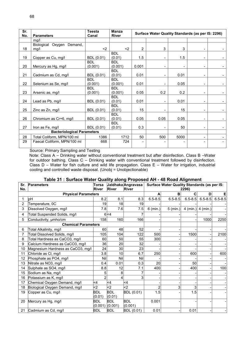
68
Sr. No. Parameters
Teesta Canal
Manza River Surface Water Quality Standards (as per IS: 2296)
mg/l
18 Biological Oxygen Demand, mg/l <2 <2 2 3 3 - -
19 Copper as Cu, mg/l BDL (0.01) BDL (0.01) 1.5 - 1.5 - -
20 Mercury as Hg, mg/l BDL (0.001)
BDL (0.001) 0.001 - - - -
21 Cadmium as Cd, mg/l BDL (0.01) BDL (0.01) 0.01 - 0.01 - -
22 Selenium as Se, mg/l BDL (0.001)
BDL (0.001) 0.01 - 0.05 - -
23 Arsenic as, mg/l BDL (0.001)
BDL (0.001) 0.05 0.2 0.2 - -
24 Lead as Pb, mg/l BDL (0.01) BDL (0.01) 0.01 - 0.01 - -
25 Zinc as Zn, mg/l BDL (0.01) BDL (0.01) 15 - 15 - -
26 Chromium as Cr+6, mg/l BDL (0.01) BDL (0.01) 0.05 0.05 0.05 - -
27 Iron as Fe, mg/l BDL (0.01) BDL (0.01) 0.3 - 50 - -
Bacteriological Parameters 28 Total Coliform, MPN/100 ml 1386 1712 50 500 5000 - - 29 Faecal Coliform, MPN/100 ml 668 724 - - - - -
Source: Primary Sampling and Testing Note: Class A – Drinking water without conventional treatment but after disinfection. Class B –Water for outdoor bathing. Class C – Drinking water with conventional treatment followed by disinfection. Class D – Water for fish culture and wild life propagation. Class E – Water for irrigation, industrial cooling and controlled waste disposal. (Unobj = Unobjectionable)
Table 31 : Surface Water Quality along Proposed AH - 48 Road Alignment Sr. No.
Parameters Torsa River
Jaldhaka River
Angravasa River
Surface Water Quality Standards (as per IS: 2296)
Physical Parameters A B C D E 1 pH 8.2 8.1 8.3 6.5-8.5 6.5-8.5 6.5-8.5 6.5-8.5 6.5-8.5 2 Temperature, 0C 19 18 19 - - - - - 3 Dissolved Oxygen, mg/l 7.8 7.6 7.5 6 (min.) 5 (min.) 4 (min.) 4 (min.) - 4 Total Suspended Solids, mg/l 6 <4 7 - - - - - 5 Conductivity, µmho/cm 158 160 166 - - - 1000 2250
Chemical Parameters 6 Total Alkalinity, mg/l 60 48 52 - - - - - 7 Total Dissolved Solids, mg/l 105 104 122 500 - 1500 - 2100 8 Total Hardness as CaCO3, mg/l 60 50 55 300 - - - - 9 Calcium Hardness as CaCO3, mg/l 36 20 32 - - - - - 10 Magnesium Hardness as CaCO3, mg/l 24 30 23 - - - - - 11 Chloride as Cl, mg/l 3.8 10 6.7 250 - 600 - 600 12 Phosphate as PO4, mg/l Nil Nil Nil - - - - - 13 Nitrate as NO3, mg/l 0.4 0.01 0.3 20 - 50 - - 14 Sulphate as SO4, mg/l 8.8 12 7.1 400 - 400 - 100 15 Sodium as Na, mg/l 5 8 7 - - - - - 16 Potassium as K, mg/l 2 4 3 - - - - - 17 Chemical Oxygen Demand, mg/l <4 <4 <4 - - - - - 18 Biological Oxygen Demand, mg/l <2 <2 <2 2 3 3 - - 19 Copper as Cu, mg/l BDL
(0.01) BDL (0.01)
BDL (0.01) 1.5 - 1.5 - -
20 Mercury as Hg, mg/l BDL (0.001)
BDL (0.001)
BDL (0.001)
0.001 - - - -
21 Cadmium as Cd, mg/l BDL BDL BDL (0.01) 0.01 - 0.01 - -

69
Sr. No.
Parameters Torsa River
Jaldhaka River
Angravasa River
Surface Water Quality Standards (as per IS: 2296)
(0.01) (0.01) 22 Selenium as Se, mg/l BDL
(0.001) BDL (0.001)
BDL (0.001)
0.01 - 0.05 - -
23 Arsenic as As, mg/l BDL (0.001)
BDL (0.001)
BDL (0.001)
0.05 0.2 0.2 - -
24 Lead as Pb, mg/l BDL (0.01)
BDL (0.01)
BDL (0.01) 0.01 - 0.01 - -
25 Zinc as Zn, mg/l BDL (0.01)
BDL (0.01)
BDL (0.01) 15 - 15 - -
26 Chromium as Cr+6, mg/l BDL (0.01)
BDL (0.01)
BDL (0.01) 0.05 0.05 0.05 - -
27 Iron as Fe, mg/l BDL (0.01)
BDL (0.01)
BDL (0.01) 0.3 - 50 - -
Bacteriological Parameters 28 Total Coliform, MPN/100 ml 1157 2065 1898 50 500 500 - - 29 Faecal Coliform, MPN/100 ml 540 892 820 - - - - -
Source: EQMS, 2013
Table 32 : Ground Water Quality along Proposed AH 2 Alignment Parameter Panitanki Naxalbari Shive
Mandir More
Fulbari Desirable Limit as per BIS 10500
Permissible limit as per BIS 10500 in
absence of alternate source
pH 7.9 7.1 7.3 7.5 6.5-8.5 No Relaxation Colour 5 5 5 5 - - Odour Odourless Odourless Odourless Odourless - - Turbidity (NTU) 3 4 4 3 5 10 TSS 5.32 6.12 6.58 5.18 - - Total Dissolve solids (mg/l)
186 165 176 170 500 2000
Conductivity (m mhos/cm) 312 270 286 265 Total Hardness (mg/l) 139 154 152 163 300 600 Total Alkalinity(mg/l) 8.48 9.56 8.92 7.52 200 600 Total Iron (mg/l) 4.55 4.02 4.68 4.98 0.3 1 Chlorides as Cl(mg/l) 12 18 16 15 250 1000 Sulphates as SO4 (mg/l) 34 42 39 35 200 400 Nitrate as NO3 (mg/l) 8 13 16 12 45 100 Nitrite as NO2 (mg/l) Not
deducted Not
deducted Not
deducted Not
deducted - -
Fluorides as F (mg/l) 0.72 0.81 0.78 0.88 1 1.5 Phosphate as PO4 (mg/l) 0.78 0.92 0.68 0.84 - - Magnesium as Mg (mg/l) 17 16 22 22 30 100 Calcium as Ca ( mg/l) 42 29 26 30 Lead as Pb (mg/l) <0.05 <0.05 <0.05 <0.05 0.05 No Relaxation Zinc as Zn (mg/l) 0.18 0.15 0.16 0.14 5 15 Chromium as Cr (mg/l) <0.05 <0.05 <0.05 <0.05 0.05 No Relaxation Arsenic (mg/l) <0.001 <0.001 <0.001 <0.001 - - Copper as Cu( mg/l) <0.02 <0.02 <0.02 <0.02 - - Nickel as Ni ( mg/l) <0.03 <0.03 <0.03 <0.03 - - Total Coli/100ml) <1.0 <1.1 <1.0 <1.0 - - B.O.D. ( mg/l ) <5.0 <5.0 <5.0 <5.0 - - C.O.D ( mg/l) 12 14 13 12 - - Dissolved Oxygen (mg/l) 6.8 7.2 6.6 6.4 - - Manganese as Mn (mg/l) <0.02 <0.02 <0.02 <0.02 - - Oil and Grease ( mg/l) 1 1.2 1.11 1 - -

70
Parameter Panitanki Naxalbari Shive Mandir More
Fulbari Desirable Limit as per BIS 10500
Permissible limit as per BIS 10500 in
absence of alternate source
Ammonical Nitrogen (mg/l)
0.05 0.046 0.042 0.054 - -
Source: DPR Interim Report
Table 33 : Ground Water Quality along the Proposed Alignment (AH-48)
Parameters Changra bandha Mynaguri Dhupguri Madarihat Hasimara Bholan
Chaupaty Jaigaon Kokoladevrani Village
Colour (Hazen) 1 1 1 1 1 1 1 1 Conductivity (µmhos/cm) 226 628 338 1038 362 423 620 502 Turbidity (NTU) 3.8 8.2 7.5 1.2 2.5 1.2 1.1 1.1 Total Dissolved Solid (mg/l)
148 403 218 669
240 280 406 324
Total Suspended Solid (mg/l)
BDL BDL BDL BDL
BDL BDL BDL BDL
pH 7.1 7.12 7.2 7.1 7.1 7.12 7.2 7.2 Oil & Grease (mg/l) BDL BDL BDL BDL BDL BDL BDL BDL Alkalinity (mg/l) 40 104.0 64.0 268 80 100.0 144.0 108 Total Hardness (mg/l) 60 188 96 320 104 132 184 164 Residual Chlorine (mg/l) BDL BDL BDL BDL BDL BDL BDL BDL Nitrate (mg/l) 1.2 1.8 1.38 1.12 2.1 1.5 1.8 1.5 Fluoride (mg/l) BDL BDL BDL BDL BDL BDL BDL BDL Ammoniacal Nitrogen (mg/l) BDL BDL BDL BDL BDL BDL BDL BDL Chloride (mg/l) 29.35 48.92 23.48 29.35 17.61 9.78 15.65 15.65 Sulphate (mg/l) 5.25 32 10.75 29 8 18 20.5 26.5 Phosphate (mg/l) 0.12 0.58 0.13 0.39 0.11 0.61 0.11 0.11 Dissolved Oxygen 7.4 7 7.4 7 6.8 7.2 7.2 7.4 COD (mg/l) BDL BDL BDL BDL BDL BDL BDL BDL BOD (mg/l BDL BDL BDL BDL BDL BDL BDL BDL Calcium (mg/l) 16.03 51.3 19.24 78.56 25.65 32.06 24.86 36.87 Magnesium (mg/l) 4.8 14.4 11.52 29.76 9.6 12.48 19.2 17.28 Manganese (mg/l) BDL BDL BDL BDL BDL BDL BDL BDL Zinc (mg/l) 0.03 0.02 0.02 0.73 1.64 0.03 0.03 0.02 Iron (mg/L) 0.18 0.23 0.12 0.29 0.62 0.17 0.18 0.16 Total Chromium (mg/l) BDL BDL BDL BDL BDL BDL BDL BDL Copper (mg/l) BDL BDL BDL BDL BDL BDL BDL BDL Nickel (mg/l) BDL BDL BDL BDL BDL BDL BDL BDL Lead (mg/l) BDL BDL BDL BDL BDL BDL BDL BDL Total Coliform / 100 ml. <100 8.2x10² 7.6x10² < 100 <100 <100 <100 <100 Fecal Coliform /100 ml. <100 3.2x10² 2.1x10² <100 < 100 < 100 <100 <100
Source: DPR Interim Report, BDL: Below Detection Limit.
104. Soil Quality: Soil fertility is an aspect of the soil-plant relationship. Fertility status of the soils is primarily and importantly dependent upon both the macro and micronutrient reserve of that soil. Continued removal of nutrients by crops, with little or no replacement will increase the nutrient stress in plants and ultimately lowers the productivity. The fertility status of the soils mainly depends on the nature of vegetation, climate, and topography, texture of soil and decomposition rate of organic matter. Optimum productivity of any cropping systems depends on adequate supply of plant nutrients. The fertility of the soil depends on the concentration of N, P, K, organic and inorganic materials and water. Nitrogen is required for growth of plant and is a constituent of chlorophyll, plant protein, and

71
nucleic acids. Phosphorus is most often limiting nutrients remains present in plant cell nuclei and act as energy storage. It helps in transfer of energy. Potassium is found in its mineral form and affect plant cell division, carbohydrate formation, translocation of sugar, various enzyme actions and resistance to certain plant disease, over 60 enzymes are known to require potassium for activation. It is essential to determine the potential of soil in the area to identify the current impacts of urbanization and industrialization on soil quality and also predict impacts, which may arise due to the project operations. Accordingly assessment of the baseline soil quality has been carried out. 105. For studying soil profile of the region, two sampling locations were selected along proposed alignment AH-2 and three locations along proposed AH-48. The samples have been collected from three different depths from 5 to 15 cm and representative samples were prepared by thoroughly mixing samples drawn at each location. The homogenized samples were analysed for physical and chemical characteristics. The soil quality results for AH-2 and AH-48 are presented at Table 34 and 35.
Table 34 : Soil Test Results Along Project Road Alignment AH-2 S. No.
Soil Parameters
Location Fulbari Naxalbari
1 Bulk density (g/cc) 1.41 1.38 2 Organic Matter % 5.2 4.6 3 Water Holding Capacity % 22.8 27.6 4 pH(20% slurry) 8.2 8.3 5 Colour Gray Brown 6 Texture Sandy loam Sandy loam 7 Porosity % v/v 6 6 8 Carbonate mg/kg 164 202 9 Bicarbonate mg/kg Nil Nil 10 Chlorides mg/kg 148 151 11 Conductivity (20% slurry) 95.3 92.8 12 Potassium mg/kg 32 38 13 Phosphorous mg/kg 220 245 14 Nitrogen mg/kg 250 236 Source: Primary Data Collection
Table 35 Soil Test Results Along Project Road alignment AH-48 S. No. Soil Parameters Location
Jaigaon Madarihat Chandrabandha 1 Bulk density (g/cc) 1.34 1.33 1.34 2 Organic Matter % 4.9 2.1 3.9 3 Water Holding Capacity % 22.7 21.9 16.2 4 pH(20% slurry) 7.9 7.7 7.4 5 Colour Dark Grass Gray Brown 6 Texture Sandy loam Sandy loam Sandy loam 7 Porosity % v/v 5 7 8 8 Carbonate mg/kg 158 164 224 9 Bicarbonate mg/kg Nil Nil Nil
10 Chlorides mg/kg 144 172 156 11 Conductivity (20% slurry) 92.8 96.8 92.4 12 Potassium mg/kg 36 39 31 13 Phosphorous mg/kg 255 270 269 14 Nitrogen mg/kg 201 209 211
Source: Primary Data Collection

72
106. Interpretation of Soil Characteristic25 has been dwelled in following sub-sections.
i. Soil Texture: The soils of study area are alluvial soil. Thus the soil texture ranges from clay to Sandy loam as per triangular classification of soil texture.
ii. Soil Reaction: Soil pH is an important soil property, which affects the availability of several plant nutrients. It is a measure of acidity and alkalinity and reflects the status of base saturation. The soil pH ranges from 8.2-8.3 and 7.4 to 7.9 in AH-2 and AH-48 respectively, thereby indicating the soil is moderately alkaline along both the road corridors.
iii. Macronutrients: Nutrients like nitrogen (N), phosphorus (P) and potassium (K) are considered as primary nutrients and sulphur (S) as secondary nutrient. These nutrients help in proper growth, development and yield differentiation of plants and are generally required by plants in large quantity.
iv. The available nitrogen content ranges between 236-250 mg/kg and 201-211 mg/kg in AH-2 and AH-48 respectively thereby indicating that soils are high in available nitrogen content along both the road corridors. Similarly phosphorus content ranges between 220-245 mg/kg and 255-270 mg/kg in AH-2 and AH-48 respectively thereby indicating that soils are medium in available phosphorus content along both the road corridors. The available potassium content ranges between 31-36 mg/kg and 32-39 mg/kg in AH-2 and AH-48, respectively indicating that soils are low to medium in potassium content.
D. Biological Environment
1. Biodiversity of West Bengal and Project area.
107. The climate and physiography of the State supports a huge diversity of life forms. Covering just 2.7% of the Indian landmass, it is home to 12.27% of Indian biodiversity known to date. The state has more than 7,000 species of flora including bacteria, algae, fungi, bryophytes, pteridophytes, and angiosperms and more than 10,000 species of described fauna. 108. The forests of West Bengal are classified into seven categories viz., Tropical Semi-Evergreen Forest, Tropical Moist Deciduous Forest, Tropical Dry Deciduous Forest, Littoral and Swampy Forest, Sub -Tropical Hill Forest, Eastern Himalayan Wet Temperate Forest, and Alpine Forest. The state has a recorded forest land of 11,879 sq. km., of which 7,054 sq. km. is Reserved Forest, 3,772 sq. km. is Protected Forest and 1,053 sq. km. is Unclassified State Forest, thus constituting 13.38% of the geographical area. Under the conservation and protection regime the State has one Biosphere Reserve, two Tiger 25 Soil Reaction Classes and Critical Limits for Macro and Micro Nutrients in Soil : According to Soil Survey Manual (IARI, 1970), the soils are grouped under different soil reaction classes viz extremely acidic (pH<4.5), very strongly acidic (pH 4.5 – 5.0 ), strongly acidic (pH 5.1 – 5.5), moderately acidic (pH 5.6-6.0), slightly acidic (pH 6.1-6.5), neutral (pH 6.6- 7.3), slightly alkaline (pH 7.4-7.8), moderately alkaline (pH 7.9-8.4), strongly alkaline (pH 8.5-9.0).The soils are rated as low (below 0.50 %), medium (0.50-0.75 %) and high (above 0.75 %) in case of organic carbon, low (<280 kg ha-1), medium (280 to 560 kg ha-1) and high (>560 kg ha-1) in case of available nitrogen, low (< 10 kg ha-1), medium (10 to 25 kg ha-1) and high (> 25 kg ha-1) for available phosphorus, low (< 108 kg ha-1), medium (108 to 280 kg ha-1) and high (> 280 kg ha-1) for available potassium and low (<10 mg kg-1), medium (10-20 mg kg-1) and high (> 20 mg kg-1) for available sulphur (Singh et. al. 2004, Mehta et. al.1988). Critical limits of Fe, Mn, Zn, Cu and B, which separate deficient from non-deficient soils followed in India are 4.5, 2.0, 0.5, 0.2 and 0.5 mg kg-1 respectively. (Follet and Lindsay, 1970 and Berger and Truog, 1940).

73
Reserves, five National Parks and 15 Wildlife Sanctuaries (West Bengal State Action Plan on Climate Change report, Government of India, 2010). 109. North Bengal is extremely rich in forests which has 1 National Park, 1 Tiger Reserve, and 3 sanctuaries and is one of the important elephant habitat housing nearly 500+ resident elephants which is 1.5% of the total elephant population in India. This region is also habitat of large mammals like Rhinoceros, Tiger, Gaur and many other smaller vertebrates. There are 16 mammals listed in Red Data Book of IUCN; 18 mammals occurring here are listed in the CITES (Appendix 3.2). The Notified Protected Areas in north Bengal cover 1225 sq. km (about 55% of the forests in Northern Bengal). (Figure 42) (WWF, India) 110. Protected Area along AH-2 and AH-48 sub-project roads: There are number of protected areas West Bengal (Refer Figure 46). However, no protected area is located in and around AH-2 subproject road. About 2.6 Km road section of AH-48 sub project road, between chainage 85 to 87 km, traverse through Jaldapara National park which can be classified as critical habitat area as per SPS, 2009. The location of the Jaldapara National Park which fall within Jalpaiguri district jurisdiction, is shown at Figure 43. The area between Bhutan Border, Buxa Tiger reserve, and Jaldapara National Park is also declared as elephant conservation reserve (Refer Appendix 4.3 for Notification). The developmental activities in this area will require prior permission from Wild Life authorities. Pasakha Bypass area passes through this conservation reserve area.
111. Jaldapara National Park falls under critical habitat category based on ADB SPS 2009 since this area is legally protected and has significance for survival of endangered and migratory species.
Figure 42. : Location Map of Protected Areas and Reserve Forests of North Bengal excluding Cooch Behar
Source: West Bengal Forests Department, 2013

74
Figure 43. : Location of the Jaldapara National Park in the Jalpaiguri District
112. Jaldapara National Park: Established n 1941, Jaldapara National Park is one of the oldest wildlife sanctuaries in India and was formally declared as National Park in 2012 vide notification No. 975-FOR/FR/0/IIM/44/11 dated 27/04/2012 by order of Government of West Bengal (Refer Appendix 10 for notification). It is situated at the foothills of Eastern Himalayas in Jalpaiguri District of West Bengal State. Jaldapara National Park is rich in biodiversity and supports several endangered mammals like Rhino, Elephants, Tiger, and Bison along with a good population of herbivores, birds, reptiles, and insects. The existing population of Rhinoceros in Jaldapara Wildlife Sanctuary is 108 (2006 Census) which is about 3 % of its global population. Jaldapara National Park lies in bio geographical zone 7B (Lower gangetic plain) as recognised by Rodgers and Panwar, 1988 (Wildlife Institute of India, Dehra Dun). It has significance presence of species listed under Schedule-I26 of the Wild Life (Protection) Act, 1972 (Table 36).
Table 36 : Important Wild Animals of Jaldapara National Park SL.No. Common Name Scientific Name
1 Rhinoceros Rhinoceros unicornis 2 Gaur Bos gaurus 3 Elephant Elephas maximus 4 Sloth Bear Melursus ursinus 5 Tiger Panthera tigris 6 Leopard Panthera pardus 7 Hog badger Arctonyx collaris 8 Hispid hare Caprolagus hispidus 9 Bengal florican Eupodotis bengalensis 10 Python Python reticulatus 11 Indian Pangolin Manis crassicaudata
Source: Jaldapara Management Plan 1995, West Bengal Forest Department
113. Jaldapara National Park (JNP) is comprised of grasslands and open canopy forest spread in an area of 216 sq. km. with the river Torsa running through the park. JNP is a 26 This Schedule I of Wild Life (Protection) Act lists the species which are protetecd under the law and any harm to these species are punshibale under this act.
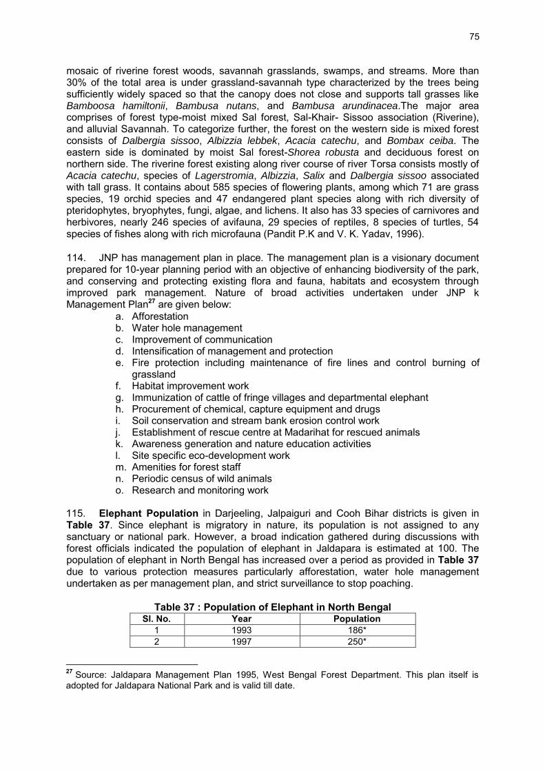
75
mosaic of riverine forest woods, savannah grasslands, swamps, and streams. More than 30% of the total area is under grassland-savannah type characterized by the trees being sufficiently widely spaced so that the canopy does not close and supports tall grasses like Bamboosa hamiltonii, Bambusa nutans, and Bambusa arundinacea.The major area comprises of forest type-moist mixed Sal forest, Sal-Khair- Sissoo association (Riverine), and alluvial Savannah. To categorize further, the forest on the western side is mixed forest consists of Dalbergia sissoo, Albizzia lebbek, Acacia catechu, and Bombax ceiba. The eastern side is dominated by moist Sal forest-Shorea robusta and deciduous forest on northern side. The riverine forest existing along river course of river Torsa consists mostly of Acacia catechu, species of Lagerstromia, Albizzia, Salix and Dalbergia sissoo associated with tall grass. It contains about 585 species of flowering plants, among which 71 are grass species, 19 orchid species and 47 endangered plant species along with rich diversity of pteridophytes, bryophytes, fungi, algae, and lichens. It also has 33 species of carnivores and herbivores, nearly 246 species of avifauna, 29 species of reptiles, 8 species of turtles, 54 species of fishes along with rich microfauna (Pandit P.K and V. K. Yadav, 1996). 114. JNP has management plan in place. The management plan is a visionary document prepared for 10-year planning period with an objective of enhancing biodiversity of the park, and conserving and protecting existing flora and fauna, habitats and ecosystem through improved park management. Nature of broad activities undertaken under JNP k Management Plan27 are given below:
a. Afforestation b. Water hole management c. Improvement of communication d. Intensification of management and protection e. Fire protection including maintenance of fire lines and control burning of
grassland f. Habitat improvement work g. Immunization of cattle of fringe villages and departmental elephant h. Procurement of chemical, capture equipment and drugs i. Soil conservation and stream bank erosion control work j. Establishment of rescue centre at Madarihat for rescued animals k. Awareness generation and nature education activities l. Site specific eco-development work m. Amenities for forest staff n. Periodic census of wild animals o. Research and monitoring work
115. Elephant Population in Darjeeling, Jalpaiguri and Cooh Bihar districts is given in Table 37. Since elephant is migratory in nature, its population is not assigned to any sanctuary or national park. However, a broad indication gathered during discussions with forest officials indicated the population of elephant in Jaldapara is estimated at 100. The population of elephant in North Bengal has increased over a period as provided in Table 37 due to various protection measures particularly afforestation, water hole management undertaken as per management plan, and strict surveillance to stop poaching.
Table 37 : Population of Elephant in North Bengal Sl. No. Year Population
1 1993 186* 2 1997 250*
27 Source: Jaldapara Management Plan 1995, West Bengal Forest Department. This plan itself is adopted for Jaldapara National Park and is valid till date.

76
Sl. No. Year Population 3 2002 292* 4 2007-2008 300-350* 5 2010 529**
Source: *MoEF (Website: moef.nic.in) ** the telegraph (Tuesday, May 17, 2011) and Census 2010 of West Bengal Forests Department
116. Forests and Floral Species: Out of total forest area of West Bengal about 26% or 11,879 km2 area lies in Darjeeling, Jalpaiguri, and Cooch Behar districts. Most of these forests type are Northern Tropical Wet Evergreen Forests and Moist Deciduous Forests (Table 39). Both the sub-project roads are either passing through or are running close to forests areas. Figures 44 and 45 depicts the forests located in AH-2 and AH-48 sub-project road vicinities.
Table 38 : District Wise Area under Forests by Legal Status in West Bengal (Area in Km2)
Sl. No.
Reserved Forests
Protected Forests
Unclassed State Forests & others
Total Area District
- 1 Darjeeling 1,115 - 89 1,204 - 2 Jalpaiguri 1,483 217 90 1,790 - 3 Cooch Behar - 42 15 57
Source: State Forest Report West Bengal 2010-2011
Table 39 : Major Forests Types of West Bengal Group Name Location Sites Species
Group 1B: Northern Tropical Wet Evergreen Forests
Plains of North Bengal upto 150 m. altitude.
Bagdogra range of Kurseong division, Khutimari areas of Jalpaiguri division, Damanpur, Cheko, Gadadhar, Rajabhatkhawa, Rydak of Buxa Tiger Reserve.
Sal, Nageshwar, Jam, Kainjal, Lator, Malagiri, Lali & Canes.
Group 2B: Northern Sub-Tropical Semi-Evergreen Forests
North Bengal
Sumbong, Peshok, Buxaduar
Champ, Panisaj, Gokul, and Angare.
Group 3C: North India Moist Deciduous Forests
North Bengal
Almost entire duars and terai area
The most important forests of the State are in this sub-montane belt consisting of Sal with Champ, Chilauni, Chikrassi, Gamar, Lali, Lasune, Panisaj, Paccasaj interspresed with riverian forests of Khair, Sissoo, Simul, Toon etc., representing succession from riverian to climax sal.
Source: State Forest Report West Bengal 2010-2011

77
Figure 44. : Map Indicating Forests Located in AH-2 Road Vicinity

78
Figure 45. : Map Indicating Forests Located in AH-48 Road Vicinity
2. Terrestrial Ecology
117. Methodology and assessment of floral diversity: The study was carried out in March and May 2012. A detailed investigation was made to analyse overall vegetation profile and floral resource characteristics within 10m from the edge of AH-2 and AH-48 sub-project roads. The land use and vegetation type were visually observed supported with secondary data. Forest working plans and various published and unpublished reports were used as the secondary source of data. During surveys, attempts were also made to identify medicinal and economically important plants. Personal interviews were conducted to capture local knowledge and their perception of likely impacts on the ecology due to proposed road improvement activities.
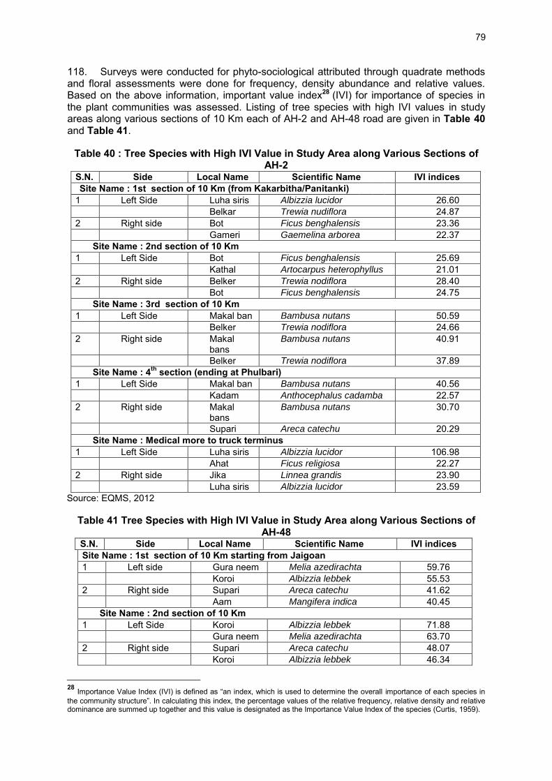
79
118. Surveys were conducted for phyto-sociological attributed through quadrate methods and floral assessments were done for frequency, density abundance and relative values. Based on the above information, important value index28 (IVI) for importance of species in the plant communities was assessed. Listing of tree species with high IVI values in study areas along various sections of 10 Km each of AH-2 and AH-48 road are given in Table 40 and Table 41.
Table 40 : Tree Species with High IVI Value in Study Area along Various Sections of AH-2
S.N. Side Local Name Scientific Name IVI indices Site Name : 1st section of 10 Km (from Kakarbitha/Panitanki)
1 Left Side Luha siris Albizzia lucidor 26.60 Belkar Trewia nudiflora 24.87 2 Right side Bot Ficus benghalensis 23.36 Gameri Gaemelina arborea 22.37
Site Name : 2nd section of 10 Km 1 Left Side Bot Ficus benghalensis 25.69 Kathal Artocarpus heterophyllus 21.01 2 Right side Belker Trewia nodiflora 28.40 Bot Ficus benghalensis 24.75
Site Name : 3rd section of 10 Km 1 Left Side Makal ban Bambusa nutans 50.59 Belker Trewia nodiflora 24.66 2 Right side Makal
bans Bambusa nutans 40.91
Belker Trewia nodiflora 37.89 Site Name : 4th section (ending at Phulbari)
1 Left Side Makal ban Bambusa nutans 40.56 Kadam Anthocephalus cadamba 22.57 2 Right side Makal
bans Bambusa nutans 30.70
Supari Areca catechu 20.29 Site Name : Medical more to truck terminus
1 Left Side Luha siris Albizzia lucidor 106.98 Ahat Ficus religiosa 22.27 2 Right side Jika Linnea grandis 23.90 Luha siris Albizzia lucidor 23.59
Source: EQMS, 2012
Table 41 Tree Species with High IVI Value in Study Area along Various Sections of AH-48
S.N. Side Local Name Scientific Name IVI indices Site Name : 1st section of 10 Km starting from Jaigoan 1 Left side Gura neem Melia azedirachta 59.76 Koroi Albizzia lebbek 55.53 2 Right side Supari Areca catechu 41.62 Aam Mangifera indica 40.45
Site Name : 2nd section of 10 Km 1 Left Side Koroi Albizzia lebbek 71.88 Gura neem Melia azedirachta 63.70 2 Right side Supari Areca catechu 48.07 Koroi Albizzia lebbek 46.34
28 Importance Value Index (IVI) is defined as “an index, which is used to determine the overall importance of each species in the community structure”. In calculating this index, the percentage values of the relative frequency, relative density and relative dominance are summed up together and this value is designated as the Importance Value Index of the species (Curtis, 1959).

80
S.N. Side Local Name Scientific Name IVI indices Site Name : 3rd section 10 Km
1 Left Side Semul Bombax ceiba 35.987 Belker Trewia nodiflora 33.75 2 Right side Semul Bombax ceiba 58.35 Belkar Trewia nudiflora 42.98
Site Name : 4th section of 10 KM 1 Left Side Kola Musa sps. 46.53 Barua bans Bambusa arundinacea 21.04 2 Right side Kola Musa sps. 62.77 Belkar Trewia nudiflora 17.36
Site Name : 5th section of 10 Km 1 Left Side Makal ban Bambusa nutans 76.15 Bot Ficus benghalensis 22.30 2 Right side Makal bans Bambusa nutans 47.65 Bot Ficus benghalensis 23.07
Site Name : 6th section of 10 Km 1 Left Side Barua bans Bambusa arundinacea 57.08 Acacia Acacia auriculiformis 16.54 2 Right side Acacia Acacia auriculiformis 33.90 Ajar Largerstoemia speciosa 17.79
Site Name : 7th section of 10 Km 1 Left Side Acacia Acacia auriculiformis 61.48 Bot Ficus benghalensis 24.47 2 Right side Kola Musa sps. 57.34 Acacia Acacia auriculiformis 28.62
Site Name : 8th section of 10 Km 1 Left Side Bijli bans Bambusa pallida 48.67 Bot Ficus benghalensis 28.17 2 Right side Acacia Acacia auriculiformis 65.32 Bot Fius benghalensis 44.47
Site Name : 9th section of 10 Km 1 Left Side Kola Musa sps. 69.34 Bot Ficus benghalensis 30.49 2 Right side Kola Musa sps. 42.82 Bijli bans Bambusa pallida 23.47
Site Name : 10th section of 10 Km 1 Left Side Kola Musa sps. 35.31 Makal ban Bambusa nutans 31.19 2 Right side Makal bans Bambusa nutans 38.59 Barua bans Bambusa arundinacea 24.99
Site Name : 11th section (upto changrabahda) 1 Left Side Kola Musa sps. 60.11 Aam Mangifera indica 2 Right side Makal bans Bambusa nutans 32.47 Kola Musa sps. 25.98
Source: EQMS, 2012 119. The details of identified species and number of trees in AH-2 sub-project are detailed in Table 42 and Table 43.

81
Mossaic forest along the AH-2 Forest Plantation along the road
Table 42 : Tree inventory within Right of Way of Sub-project Road AH-2 Chainage (10 Km Band) No of trees on left side of the
road within 10m from canter of the road
No of Trees on right side of the road within 10 M from canter of the road
0-10 Km 492 452 11-20 Km 564 585 21-30 Km 935 621 31-38 Km 811 692
Truck terminus to Medical more 0-11 Km
123 2451
Table 43 : List of Flora Species Observed along Road Alignment AH-2 Scientific Name of the Floral
species Local Name of the
Floral species Status & Use
Mangifera Indica Aam Fruit, Timber Acacia auriculiformis Acacia Medicinal, Timber Ficus religiosa Ahat Religious Ailanthus sp. Ailanthus Timber, fire wood Lagerstroemia speciosa Ajar Timber Cassia fistula Amaltas/ Sunaru Ornamental, Timber Calotropis procera Akan Medicinal Annona squamosa Atafal Fruit Mimusops elengi Bakul Medicinal Bambusa arundinacea Barua Bans Misc. use Oroxylum indicum Batgila Medicinal, Timber Aegle marmelos Bel Medicinal Trewia nodiflora Belker Timber Salix tetrasperma Bher Timber Callistemon sp. Bottle brush Ornamental Ficus benghalensis Bot Religious Dillenia indica Chalta Medicinal, Fruit Caryota urens Chaur Ornamental Polyanthia longifolia Dabdaru Timber, ornamental Ficus lepidosa Dumur Fodder Eucalyptus maculata Eucalyptus Timber Ficus sp. Ficus Religious Gamelina arborea Gameri Timber, Medicinal Delonix regia Gulmohor Ornamental Melia azedirachta Gura Neem Timber Ficus sp. Jagya Dumur Religious Syzygium cumini Jamun Fruit, Timber

82
Scientific Name of the Floral species
Local Name of the Floral species
Status & Use
Linnea grandis Jika Fire wood Anthocephalus cadamba Kadam Timber, Fire wood Bamboosa hamiltonii Kako Bans Misc.use Artocarpus heterophyllus Kathal Fruits, Timber Pithecellobium angulatum Khori Fire wood Albizzia lebbek Koroi Timber, Fire wood Ziziphus jujuba Kul Fruits Litchi chinensis Lichi Fruits Albizzia lucidor Luha siris Timber Erythrina indica Madar No particular use Bambusa nutans Makal bans Misc. use Cocos nucifera Narikol Fruits Azadirecta indica Neem Medicinal, Timber Butea monosperma Palas Medicinal, Timber Psidium guajava Piyara Fruits Chukrassia tabularis Poma Timber Hevea brasilliensis Rubber Ornamental Tectona grandis Sagun Timber Moringa oleifera Sajna Vegetable Alstonia scholaris Satiana Medicinal, Timber Bombex cebia Semul Medicinal, Timber Samanea saman Siris/Beladuba Timber Dalbergia sisoo Sissoo Timber Areca catechu Supari Fruit Tamarindus indica Tetul Fruits, Timber
Tea Garden Home for small mammals

83
NBU –Home for small mammals, birds, butterflies and
herpetofauna along the AH-2
Rural area faunal habitat
120. Among the plant species observed along the proposed AH-48 sub-project the most abundant floral species are silk cotton (Bombax ceiba), Bael (Aegle marmelos), and Ber (Ziziphus jujube) etc. (Table 44 and Table 45).
Table 44 : Trees within Right of Way of Project Road AH-48 Chainage (10 Km Band starting from Bhutan Border)
No of trees on left side of the road within 10m from canter of the road
No of Trees on right side of the road within 10 M from canter of the road
0-10 Km 1,141 2,209 11-20 Km 2,309 1,132 21-30 Km 2,308 1,136 31-40 Km 1,283 874 41-50 Km 893 1,991 51- 60 Km 1,456 970 61- 70 Km 4,067 2,906 71- 80 Km 2,106 1,568 81- 90 Km 478 348 91-100 Km 180 325

84
Chainage (10 Km Band starting from Bhutan Border)
No of trees on left side of the road within 10m from canter of the road
No of Trees on right side of the road within 10 M from canter of the road
101-110 Km 228 249 Alternate I (0- 7 Km) 5,642 5,698 Alternate II (0- 7 Km) 344 284
Source: EQMS, 2012
Table 45 : List of Floral Species Observed along AH-48 sub-project S. No. Scientific Name of the
species Local Name of the
species Status & Use
1. Mangifera Indica Aam Fruit, Timber 2.
Acacia auriculiformis Acacia Medicinal, Timber
3. Ficus religiosa Ahat Religious 4. Lagerstroemia speciosa Ajar Timber 5.
Cassia fistula Amaltas/ Sunaru Ornamental, Timber
6. Phyllanthus emblica Amla Fruit 7. Ananas comosus Anaras Fruit 8. Terminalia arjuna
Arjun Medicinal, Timber
9. Annona squamosa Atafal Fruit 10. Mimusops elengi Bakul Medicinal 11. Bambusa arundinacea Barua Bans Misc. use 12.
Oroxylum indicum Batgila Medicinal, Timber
13. Aegle marmelos Bel Medicinal 14. Trewia nodiflora Belker Timber 15. Salix tetrasperma Bher Timber 16. Terminalia belerica
Bhera Medicinal, Timber
17. Bamboosa pallida Bijli Bans Misc.use 18. Ficus benghalensis Bot Religious 19. Dillenia indica Chalta Medicinal, Fruit 20. Caryota urens Chaur Ornamental 21.
Polyanthia longifolia Dabdaru Timber, ornamental
22. Ficus lepidosa Dumur Fodder 23. Eucalyptus maculata Eucalyptus Timber 24. Ficus sp. Ficus Religious 25.
Gamelina arborea Gameri Timber, Medicinal
26. Delonix regia Gulmohor Ornamental 27. Melia azedirachta Gura Neem Timber 28. Hibiscus rosa sinensis Jaba phul Ornamental 29. Ficus sp. Jagya Dumur Religious 30. Eleocarpus floribundus Jalpai Fruit 31. Citrus aurantifolia Jambura Fruit 32. Syzygium cumini Jamun Fruit, Timber 33. Linnea grandis Jika Fire wood 34.
Anthocephalus cadamba Kadam Timber, Fire wood
35. Bamboosa hamiltonii Kako Bans Misc.use 36. Brugiera gymnorrhiza Kakra Fire wood 37. Averrhoa carambola Kamranga Fruit

85
S. No. Scientific Name of the species
Local Name of the species
Status & Use
38. Bauhinia purpurea Kanchan Ornamental 39. Artocarpus heterophyllus Kathal Fruits, Timber 40. Phoenix dactylifera Khajur Fruits 41. Pithecellobium angulatum Khori Fire wood 42.
Albizzia lebbek Koroi Timber, Fire wood
43. Ziziphus jujuba Kul Fruits 44. Litchi chinensis Lichi Fruits 45. Albizzia lucidor Luha siris Timber 46. Erythrina indica Madar No particular use 47. Bambusa nutans Makal bans Misc. use 48. Cocos nucifera Narikol Fruits 49.
Azadirecta indica Neem Medicinal, Timber
50. Butea monosperma Palas
Medicinal, Timber
51. Carica papaya Papaya Fruits 52. Codiaeum variegatum Pata Bahar Ornamental 53. Psidium guajava Piyara Fruits 54. Chukrassia tabularis Poma Timber 55. Hevea brasilliensis Rubber Ornamental 56. Tectona grandis Sagun Timber 57. Moringa oleifera Sajna Vegetable 58.
Alstonia scholaris Satiana Medicinal, Timber
59. Bombex cebia
Semul Medicinal, Timber
60. Samanea saman Siris/Beladuba Timber 61. Dalbergia sisoo Sissoo Timber 62. Areca catechu Supari Fruit 63. Borassus flabelliformis Tal Fruits 64. Tamarindus indica Tatul Fruits, Timber 65. Thuja elastica Thuja Ornamental Source: EQMS, 2012
121. Threatened, Rare and Endangered and Medicinal Plants: An assessment of rare, threatened, endangered (RET), and medicinal plants were carried out in both sub-project roads and results are shown in Tables 46 and 47. Most of the species are observed to be endemic with very few are exotic like Acacia, Gulmohar, Khori and Eucalyptus, Bottlebrush etc. Among these only Delonix regia (Gulmohar) was listed as vulnerable by the IUCN.
Table 46 : Species Identified along AH-2 Road Alignment with RET Status S.N. Scientific Name of the species Status (Endemic / Exotic) IUCN Status 1. Mangifera Indica Endemic - 2. Acacia auriculiformis Exotic Least Concern 3. Ficus religiosa Endemic - 4. Ailanthus sp. Endemic - 5. Lagerstroemia speciosa Endemic - 6. Cassia fistula Endemic - 7. Calotropis procera Endemic - 8. Annona squamosa Endemic - 9. Mimusops elengi Endemic - 10. Bambusa arundinacea Endemic - 11. Oroxylum indicum Endemic -
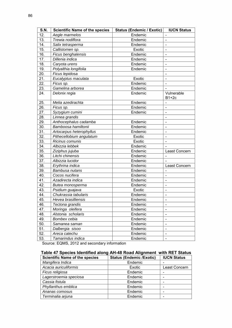
86
S.N. Scientific Name of the species Status (Endemic / Exotic) IUCN Status 12. Aegle marmelos Endemic - 13. Trewia nodiflora Endemic - 14. Salix tetrasperma Endemic - 15. Callistomen sp. Exotic - 16. Ficus benghalensis Endemic - 17. Dillenia indica Endemic - 18. Caryota urens Endemic - 19. Polyalthia longifolia Endemic - 20. Ficus lepidosa - 21. Eucalyptus maculata Exotic - 22. Ficus sp. Endemic - 23. Gamelina arborea Endemic - 24. Delonix regia Endemic Vulnerable
B1+2c 25. Melia azedirachta Endemic - 26. Ficus sp. Endemic - 27. Syzygium cumini Endemic - 28. Linnea grandis - 29. Anthocephalus cadamba Endemic - 30. Bamboosa hamiltonii Endemic - 31. Artocarpus heterophyllus Endemic - 32. Pithecellobium angulatum Exotic - 33. Ricinus comunis Exotic - 34. Albizzia lebbek Endemic - 35. Ziziphus jujuba Endemic Least Concern 36. Litchi chinensis Endemic - 37. Albizzia lucidor Endemic - 38. Erythrina indica Endemic Least Concern 39. Bambusa nutans Endemic - 40. Cocos nucifera Endemic - 41. Azadirecta indica Endemic - 42. Butea monosperma Endemic - 43. Psidium guajava Exotic - 44. Chukrassia tabularis Endemic - 45. Hevea brasilliensis Endemic - 46. Tectona grandis Endemic - 47. Moringa oleifera Endemic - 48. Alstonia scholaris Endemic - 49. Bombex cebia Endemic - 50. Samanea saman Endemic - 51. Dalbergia sisoo Endemic - 52. Areca catechu Endemic - 53. Tamarindus indica Endemic -
Source: EQMS, 2012 and secondary information
Table 47 Species Identified along AH-48 Road Alignment with RET Status Scientific Name of the species Status (Endemic /Exotic) IUCN Status Mangifera Indica Endemic - Acacia auriculiformis Exotic Least Concern Ficus religiosa Endemic - Lagerstroemia speciosa Endemic - Cassia fistula Endemic - Phyllanthus emblica Endemic - Ananas comosus Endemic - Terminalia arjuna Endemic -

87
Scientific Name of the species Status (Endemic /Exotic) IUCN Status Annona squamosa Endemic - Mimusops elengi Endemic - Bambusa arundinacea Endemic - Oroxylum indicum Endemic - Aegle marmelos Endemic - Trewia nodiflora Endemic - Salix tetrasperma Endemic - Terminalia belerica Endemic - Bamboosa pallida Endemic - Ficus benghalensis Endemic - Dillenia indica Endemic - Caryota urens Endemic - Polyanthia longifolia Endemic - Ficus lepidosa Endemic - Eucalyptus maculata Exotic - Ficus sp. Endemic - Gamelina arborea Endemic - Delonix regia Exotic Vulnerable
B1+2c Melia azedirachta Endemic - Hibiscus rosa sinensis Endemic - Ficus sp. Endemic - Elaceocarpus floribundus Endemic - Citrus aurantifolia Endemic - Syzygium cumini Endemic - Linnea grandis Endemic - Anthocephalus cadamba Endemic - Bamboosa hamiltonii Endemic - Averrhoa carambola Exotic - Bauhinia purpurea Endemic Least Concern Artocarpus heterophyllus Endemic - Phoenix dactylifera Endemic - Pithecellobium angulatum Exotic - Albizzia lebbek Endemic - Ziziphus jujuba Endemic Least Concern Litchi chinensis Endemic - Albizzia lucidor Endemic - Erythrina indica Endemic Least Concern Bambusa nutans Endemic - Cocos nucifera Endemic - Azadirecta indica Endemic - Butea monosperma Endemic - Carica papaya Endemic - Codiaeum variegatum Endemic - Psidium guajava Endemic - Chukrassia tabularis Endemic - Hevea brasilliensis Endemic - Tectona grandis Endemic - Moringa oleifera Endemic - Alstonia scholaris Endemic Lower Risk/
least concern Bombex cebia Endemic - Samanea saman Endemic - Dalbergia sisoo Endemic - Areca catechu Endemic -

88
Scientific Name of the species Status (Endemic /Exotic) IUCN Status Borassus flabelliformis Endemic - Tamarindus indica Endemic - Thuja elastica Exotic -
Source: EQMS, 2012 and secondary information
3. Terrestrial Fauna
122. Methodology of Baseline Data Collection: Animal species data were collected along the the sub-project roads through direct sighting methods, indirect evidences, and information obtained from local inhabitants. Detailed surveys and samplings were conducted at various locations within a stretch of 7 km parallel along the highways to enumerate animal abundance. Along with the primary survey, local inhabitants were interviewed to confirm the species occurrence. Remains of body parts of animal and dung were also taken into consideration for animal identification. The criteria of IUCN (2008), Wildlife Protection Act (1972) and CITES categorization were followed to describe the conservation status of the species. Identification of mammalian, avian, or reptilian species were made based published materials29, 30, 31. Analysis was done based on standard methods32,33. 123. Animal Data Collection: Both AH-2 and AH-48 sub-project roads pass through the urban, semi -urban, rural, roadside mosaic forest, and plantation areas. The entire stretch was divided into three distinct representative type of habitat i.e., urban, semi-urban, rural and forests. Data on the faunal diversity were collected within the 50-, 100-, and 150-meter on both sides of the road. The methods which were followed during the faunal survey are given below:
• The forest working plans of project area were used as the secondary information source for wildlife. Also various published and unpublished reports were consulted
• Personnel Interview of local people for extracting data on the presence and relative abundance of various animal species within the project area.
• Information on habitat conditions, animal presence both through direct sighting and indirect evidences
124. Methodology for Birds: For the survey of the avian species, line transects was found to be best suited in randomly selected areas of the sub-projects. The birds were detected, identified, and counted in the field. A detailed survey of birds was carried out in the sub-project sites and catchment area usings the literatures of Ali and Ripley, 1987. Usually birds were surveyed in the morning hours (Burnham et.al., 1980). 125. Methodology for Butterfly: Survey was carried out for butterflies at various sites in the sub-project areas using line transect methods. Butterflies were detected, identified, and counted in the field (Burnham et.al., 1980). Surveys were done during the noon hours.
29 Menon, B. (2003). A Field Gudie to Indian Mammals, D. K. Publication, Delhi, pp. 201. 30 Ali, S. and Riplley, S. D. (1987). Handbook of Birds of India and Pakistan, 2nd edition, Delhi: Oxford University Press, Oxford, pp. 700. 31 Ahmed M.F, Das, A. and Dutta S.K.(2009) Amphibians and Reptiles of North East India, A Photographic Guide. Aaranyak, Guwahati ,Assam. 32 Magurran, A. E. (1988). Ecological Diversity and its Measurement, London: Chapman and Hall, pp. 179 33 Dytham, C. (1999). Choosing and Using Statistics, A Biologist’s Guide, Blackwell Science Ltd. Osney Mead, Oxford OX2 OEL, pp. 218

89
126. Methodology for Fish Fauna Study: To study the fish fauna in the rivers, common fishing methods were. For fish identification, the publication of Talwar and Jhingran were referred (Source: Inland fishes of India and adjacent countries-Vol. 1, Oxford and IBH Publishing Co. Pvt. Ltd company, New Delhi, 541 pp., 1991) 127. Results of the Faunal Survey : The animals observed along proposed alignments AH-2 and AH-48 are mainly mammals, reptile, amphibian and butterflies which are as listed in Appendix 3.2 128. Mammal species observed along AH-2 and AH-48 alignments: Civets and bats were the prominent mammals observed in the project area. Other mammals found were Mongoose, weasel, dogs etc. (Figure 46 and 47). ( Appendix 3.2)
Figure 46. : Mammal species observed along AH-2 sub-project
Figure 47. : Mammal species observed along AH-48 sub-project
129. Birds species observed along AH-2 and AH-48 alignments: Altogether, 84 species of avian fauna belonging to 34 families were found along the AH-2 sub-project alignment and 109 species of avian fauna belonging to 34 families were found in AH-48 sub-project alignment (Appendix 3.2). Most of the birds were found residential though several migratory birds join the fleet during the winter season. Among migratory birds were ducks, geese, and waders recorded at the rivers. (Figure 48 to 49).

90
Figure 48. : Bird species observed along AH-2
Figure 49. : Bird species observed along AH-48
130. Reptiles species observed along AH-2 and AH-48 alignment: Altogether, 24 reptilian species were recorded which includes 13 snakes, 9 lizards, and 4 turtles in AH-2 sub-project. A total of 30 reptilian species were recorded which includes 15 snake, 9 lizards, and 6 turtles in AH-48 sub-project. The comprehensive list of reptilian fauna is presented in Appendix 3.2. 131. Amphibian Fauna observed along AH-2 and AH-48 alignment: There were altogether 7 amphibian species recorded in AH-2 sub-project and 13 amphibian species recorded in AH-48 sub-project. The comprehensive list of amphibian fauna is presented in Appendix 9.1. The diversity of the herpetofauna is shown in Figures 50 and 51.

91
Figure 50. : Amphibians species observed along AH-2 sub-project
Figure 51. : Amphibians species observed along AH-48 sub-project
132. Butterfly species observed along AH-2 and AH-48 sub-project alignments: There were 56 species of butterflies in AH-2 sub-project, among them 9 species were from the family Papillonidae, 9 from Pieridae, 12 Lycaenidae, and 26 from Nymphalidae. There were 107 species of butterflies were found in AH-48 sub-project, among them 15 species were from the family Papillonidae, 12 from Pieridae, 24 Lycaenidae, 43 from Nymphalidae and 13 from Hesperildae (Appendix 3.2) and (Figure 52 and 53).
Figure 52. : Butterfly species observed along AH-2

92
Figure 53. : Butterfly species observed along AH-48
133. Faunal Species Diversity (Diversity Index (H) 34 along proposed AH-2 sub-project alignment. The species diversity index of mammal, birds, reptiles, and amphibians was highest in the forested/tea garden areas. The species diversity of the mammals along the proposed high way is highest after 150 meter on each side; whereas the species diversity and abundance of herpetofauna, butterflies and birds were found to be high near to the proposed alignment of the AH-2 sub-project within 50 meters on each side (Table 48). 134. Faunal activity pattern like foraging by the birds, herpetofauna and mammals were found to be high near the road side in the forested areas.
Table 48 : Species Diversity Index of Terrestrial Fauna in Different Location of Study area35 along Project Road Alignment of AH-2
Fauna Value of H Distance from Road (Transect) Shanon wiener Index 50 meter 100 meter 150 meter
Mammals H 1.762 2.123 2.058 Variance H 0.009282 0.002144 0.001577
Birds H 4.199 3.672 3.809 Variance H 0.000161 0.002185 0.005083
Herpetofauna H 2.779 3.16 3.071 Variance H 0.004209 0.000725 0.000607
Butterfly H 3.908 3.804 3.721 Variance H 0.000114 0.000443 0.00433
135. Faunal Species Diversity (Diversity Index (H) Along AH-48 Sub-project Road Alignment: Species diversity index of terrestrial fauna in different location of study area36 . The species diversity index of mammal, birds, reptiles, and amphibian was highest in the
34 Shannon–Weaver (1963) index of diversity: It is used to calculate the diversity of species in an area. The formula for calculating the Shannon diversity index is H’ = –Σpi logpi . Pi is the proportion of species i (individual). Variance H denotes the variation of diversity of species. These indexes and variation denotes the species diversity level over varying distance from edge of the road. 35 The study area for the terrestrial fauna like mammals, Aves, reptiles, amphibian was selected in the urban areas, per-urban areas, rural areas and forester areas through which the AH 2 road is passing through. 36 The study area for the terrestrial fauna like mammals, aves, reptiles, and amphibian was selected in the urban areas, per-urban areas, rural areas and forester areas through which the AH 48 road is passing through.
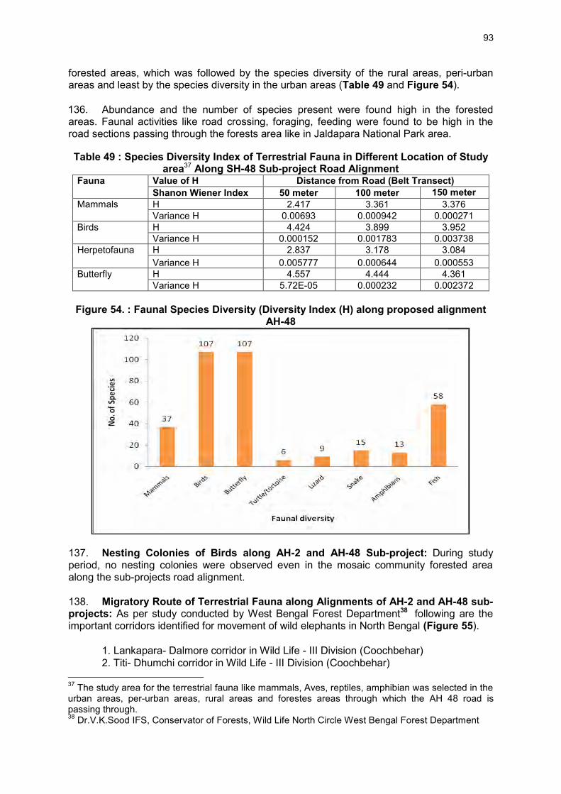
93
forested areas, which was followed by the species diversity of the rural areas, peri-urban areas and least by the species diversity in the urban areas (Table 49 and Figure 54). 136. Abundance and the number of species present were found high in the forested areas. Faunal activities like road crossing, foraging, feeding were found to be high in the road sections passing through the forests area like in Jaldapara National Park area.
Table 49 : Species Diversity Index of Terrestrial Fauna in Different Location of Study area37 Along SH-48 Sub-project Road Alignment
Fauna Value of H Distance from Road (Belt Transect) Shanon Wiener Index 50 meter 100 meter 150 meter
Mammals H 2.417 3.361 3.376 Variance H 0.00693 0.000942 0.000271
Birds H 4.424 3.899 3.952 Variance H 0.000152 0.001783 0.003738
Herpetofauna H 2.837 3.178 3.084 Variance H 0.005777 0.000644 0.000553
Butterfly H 4.557 4.444 4.361 Variance H 5.72E-05 0.000232 0.002372
Figure 54. : Faunal Species Diversity (Diversity Index (H) along proposed alignment
AH-48
137. Nesting Colonies of Birds along AH-2 and AH-48 Sub-project: During study period, no nesting colonies were observed even in the mosaic community forested area along the sub-projects road alignment. 138. Migratory Route of Terrestrial Fauna along Alignments of AH-2 and AH-48 sub-projects: As per study conducted by West Bengal Forest Department38 following are the important corridors identified for movement of wild elephants in North Bengal (Figure 55). 1. Lankapara- Dalmore corridor in Wild Life - III Division (Coochbehar) 2. Titi- Dhumchi corridor in Wild Life - III Division (Coochbehar) 37 The study area for the terrestrial fauna like mammals, Aves, reptiles, amphibian was selected in the urban areas, per-urban areas, rural areas and forestes areas through which the AH 48 road is passing through. 38 Dr.V.K.Sood IFS, Conservator of Forests, Wild Life North Circle West Bengal Forest Department
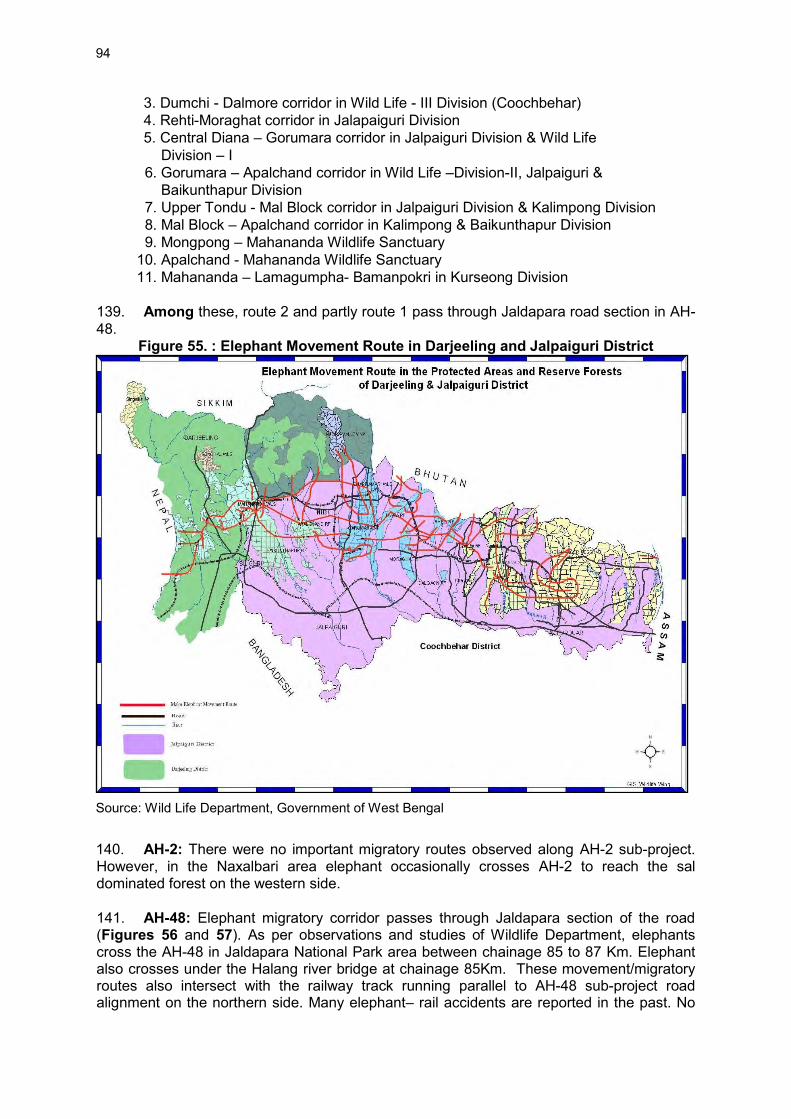
94
3. Dumchi - Dalmore corridor in Wild Life - III Division (Coochbehar) 4. Rehti-Moraghat corridor in Jalapaiguri Division 5. Central Diana – Gorumara corridor in Jalpaiguri Division & Wild Life Division – I 6. Gorumara – Apalchand corridor in Wild Life –Division-II, Jalpaiguri & Baikunthapur Division 7. Upper Tondu - Mal Block corridor in Jalpaiguri Division & Kalimpong Division 8. Mal Block – Apalchand corridor in Kalimpong & Baikunthapur Division 9. Mongpong – Mahananda Wildlife Sanctuary 10. Apalchand - Mahananda Wildlife Sanctuary 11. Mahananda – Lamagumpha- Bamanpokri in Kurseong Division 139. Among these, route 2 and partly route 1 pass through Jaldapara road section in AH-48.
Figure 55. : Elephant Movement Route in Darjeeling and Jalpaiguri District
Source: Wild Life Department, Government of West Bengal
140. AH-2: There were no important migratory routes observed along AH-2 sub-project. However, in the Naxalbari area elephant occasionally crosses AH-2 to reach the sal dominated forest on the western side. 141. AH-48: Elephant migratory corridor passes through Jaldapara section of the road (Figures 56 and 57). As per observations and studies of Wildlife Department, elephants cross the AH-48 in Jaldapara National Park area between chainage 85 to 87 Km. Elephant also crosses under the Halang river bridge at chainage 85Km. These movement/migratory routes also intersect with the railway track running parallel to AH-48 sub-project road alignment on the northern side. Many elephant– rail accidents are reported in the past. No
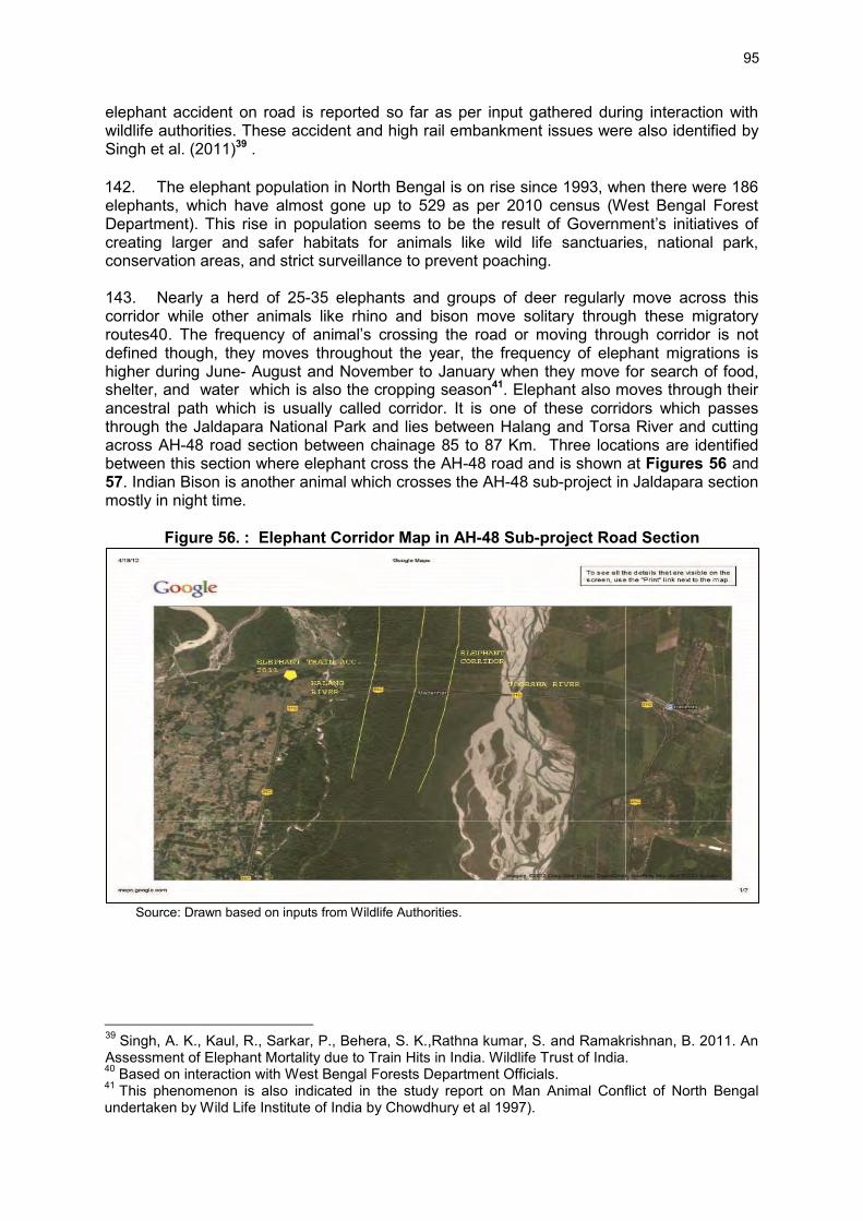
95
elephant accident on road is reported so far as per input gathered during interaction with wildlife authorities. These accident and high rail embankment issues were also identified by Singh et al. (2011)39 . 142. The elephant population in North Bengal is on rise since 1993, when there were 186 elephants, which have almost gone up to 529 as per 2010 census (West Bengal Forest Department). This rise in population seems to be the result of Government’s initiatives of creating larger and safer habitats for animals like wild life sanctuaries, national park, conservation areas, and strict surveillance to prevent poaching.
143. Nearly a herd of 25-35 elephants and groups of deer regularly move across this corridor while other animals like rhino and bison move solitary through these migratory routes40. The frequency of animal’s crossing the road or moving through corridor is not defined though, they moves throughout the year, the frequency of elephant migrations is higher during June- August and November to January when they move for search of food, shelter, and water which is also the cropping season41. Elephant also moves through their ancestral path which is usually called corridor. It is one of these corridors which passes through the Jaldapara National Park and lies between Halang and Torsa River and cutting across AH-48 road section between chainage 85 to 87 Km. Three locations are identified between this section where elephant cross the AH-48 road and is shown at Figures 56 and 57. Indian Bison is another animal which crosses the AH-48 sub-project in Jaldapara section mostly in night time.
Figure 56. : Elephant Corridor Map in AH-48 Sub-project Road Section
Source: Drawn based on inputs from Wildlife Authorities. 39 Singh, A. K., Kaul, R., Sarkar, P., Behera, S. K.,Rathna kumar, S. and Ramakrishnan, B. 2011. An Assessment of Elephant Mortality due to Train Hits in India. Wildlife Trust of India. 40 Based on interaction with West Bengal Forests Department Officials. 41 This phenomenon is also indicated in the study report on Man Animal Conflict of North Bengal undertaken by Wild Life Institute of India by Chowdhury et al 1997).

96
Figure 57. : Locations of the Elephant Crossing (AH-48 road section ) in Jaldapara National Park Area
Source: Drawn based on inputs from Wildlife Authorities
144. Human-Elephant Conflicts: The elephant habitat in North Bengal is characterized by a high degree of habitat fragmentation and severe human-elephant conflict resulting to loss of agricultural crops, property, and several human lives every year42. 145. Due to the depredation, some retaliatory killing of elephant occurs in India and Nepal by electrocution, poisoning, bullet injury, or through arrow. In the year 2007, 3 elephants died, then during the months of June-July of 2008 another one died through electrocution. In 2009 alone, gun shots accounted for 10 elephant injuries. In July 2008, 3 elephants died in Mahananda Wildlife Sanctuary adjoining to the Simulbarie Tea Estate by poisoning through pesticide. The following Table 50 illustrates the trend in human casualty and elephant deaths over the last few years.
Table 50 : Human Casualties and Elephant Deaths over the last few years Years Human Casualties Elephant Deaths 2002-2003 - - 20 2004-05 27 26 2004-05 16 18 2005-06 37 16 2006-07 31 34 2007-08 39 39
42 Refer study paper by Lahiri choudhury, 1975; Choudhury, 1997

97
Years Human Casualties Elephant Deaths 2008-09 31 22 2009-10 till date 15 5 Source: Dr.V.K.Sood IFS, Conservator of Forests Wildlife North Circle
146. Accidental Death of Mammals along proposed AH-2 and AH-48 sub-projects: As per data available from West Bengal Forest Department, most of the accidental deaths to elephant and spotted deer were casued by train collision (Figure 58).
Table 51 : Accidental Death of Mammals in North Bengal Sl. No. Species Number
1 Wild elephants 19 2 Leopard 1 3 Indian Bison 4 4 Spotted deer 18 5 Barking Deer 1 6 Civet Cat 1 7 Langur 3 Data Source: "State Forest Report 2010-11" Published by Government of West Bengal Directorate of Forests Office of The Principal Chief Conservator of Forests, Kolkata.
147. Elephant Mortality on Railway Tracks in Northern Bengal (1958-2008): A total of 39 elephant deaths were reported from 1958–2008. Twenty-nine deaths took place during the operation of meter gauge over a period of 44 years from 1958–2002 (0.6 incidents/year). Ten deaths were reported after gauge conversion in a time span of just 4 years from 2004–2008 (2.5 incidents/year). The reasons for increase in elephant death are the increase in elephant population and increase in train speed after gauge conversion.
Figure 58. Elephant Movement across New Jalpaiguri to New Alipurduar Railway Line in the Jaldapara National Park
Source: Photograph by Mr Arun Karmakar 148. Rhinoceros in Jaldapara National Park: The Rhinoceros unicornis is the flagship species for the Jaldapara National Park (Figure 59. As per the recent census in the park, there are around 184 rhinos which include males, females and calves in suitable proportion as compared to 149 rhinos in 2011. According to forest sources, maximum number of rhinos were spotted in Jaldapara east range (97 andividuals). West and north ranges had 36 and 34 rhinos, respectively. Fifteen rhinos were spotted in Kodalbusty range and two in
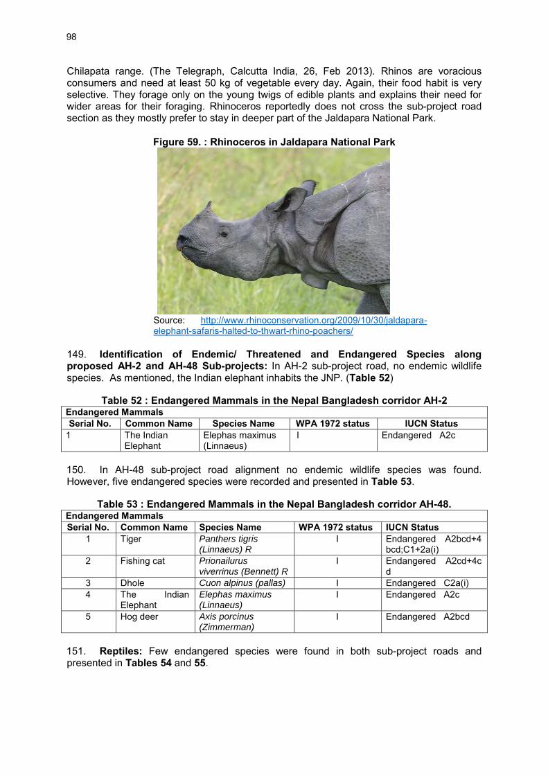
98
Chilapata range. (The Telegraph, Calcutta India, 26, Feb 2013). Rhinos are voracious consumers and need at least 50 kg of vegetable every day. Again, their food habit is very selective. They forage only on the young twigs of edible plants and explains their need for wider areas for their foraging. Rhinoceros reportedly does not cross the sub-project road section as they mostly prefer to stay in deeper part of the Jaldapara National Park.
Figure 59. : Rhinoceros in Jaldapara National Park
Source: http://www.rhinoconservation.org/2009/10/30/jaldapara-elephant-safaris-halted-to-thwart-rhino-poachers/
149. Identification of Endemic/ Threatened and Endangered Species along proposed AH-2 and AH-48 Sub-projects: In AH-2 sub-project road, no endemic wildlife species. As mentioned, the Indian elephant inhabits the JNP. (Table 52)
Table 52 : Endangered Mammals in the Nepal Bangladesh corridor AH-2 Endangered Mammals Serial No. Common Name Species Name WPA 1972 status IUCN Status
1 The Indian Elephant
Elephas maximus (Linnaeus)
I Endangered A2c
150. In AH-48 sub-project road alignment no endemic wildlife species was found. However, five endangered species were recorded and presented in Table 53.
Table 53 : Endangered Mammals in the Nepal Bangladesh corridor AH-48. Endangered Mammals Serial No. Common Name Species Name WPA 1972 status IUCN Status
1 Tiger Panthers tigris (Linnaeus) R
I Endangered A2bcd+4bcd;C1+2a(i)
2 Fishing cat Prionailurus viverrinus (Bennett) R
I Endangered A2cd+4cd
3 Dhole Cuon alpinus (pallas) I Endangered C2a(i) 4 The Indian
Elephant Elephas maximus (Linnaeus)
I Endangered A2c
5 Hog deer Axis porcinus (Zimmerman)
I Endangered A2bcd
151. Reptiles: Few endangered species were found in both sub-project roads and presented in Tables 54 and 55.

99
Table 54 : Endangered Reptiles in the Nepal Bangladesh Corridor AH-2 Endangered Reptiles Sl.No. Common Name Scientific Name WPA Status IUCN Status
1 Bengal monitor Lizard Varanus bengalensis (Daudin)
Schedule II Endangered
2 Water monitor Varanus salvator Laurenti Schedule II Endangered 3 Indian rock Python Python molurus Linnaeus Schedule IV Endangered
Table 55 : Endangered reptiles in the Bhutan-India-Bangladesh AH-48. Endangered Reptiles S. No. Common Name Scientific Name WPA Status IUCN Status 1 Bengal monitor
Lizard Varanus bengalensis (Daudin)
Schedule II, Endangered Endangered
2 Water monitor Varanus salvator Laurenti Schedule II, Endangered Endangered 3 Indian rock Python Python molurus Linnaeus Schedule IV Endangered 152. Wetlands along proposed alignments of AH-2 and AH-48 sub-project: No prominent wetlands found along AH-2 and AH-48 sub-projects. 153. Peoples Dependence on Flora and Fauna along proposed alignments AH-2 and AH-48 sub-projects: Agriculture is the man source of livelihood along the sub-project roads. Very few people were found dependent on selling fuel woods from neighbouring protected forest or naturally growing tree species along AH-2.
4. Aquatic Ecology
154. Fish Species Diversity observed along proposed alignment: In AH-2 sub-project, among the 29 species of fish identified in the study area (Appendix 3.2) Carp species, Tor putitora species were predominant in the river Mahananda and Mechi River on the India Nepal Border. Tor was more dominant in the flood seasons. 155. In AH-48 sub-project, among the 61 species of fish identified in the study area (Appendix 3.2) Carp species, Tor putitora species were predominant in the river Torsa. Tor was found to be more dominant in the flood seasons because it migrates through the deep channels of the river Torsa. 156. Migratory Route of Aquatic Fauna (Fish): In AH-2, fish species like Tor sps shows migratory behaviour through the deeper channels of the river Mahananda and in the Mechi River at the Kakarbita (Nepal Border Bridge) during the monsoon season from upstream to downstream. In AH-48, fish species like Tor shows migratory behaviour in river Torsa and usually migrate upstream for spawning. 157. Spawning and Breeding Grounds along sub-project roads: Along AH-2 sub-project alignment, spawning and breeding grounds of major and minor carps were recorded in the Mahananda River. Along proposed AH-48 sub-project alignment spawning and breeding ground were recorded for major and minor carps in the Torsa River. 158. Identification of Endemic/ Threatened and Endangered Species: Along sub-project roads only Tor putitora was found to be the only fish species which is an endangered category according to National Bureau of Fish and Genertic Resources (NBFGR) found in rivers Mahananda and Torsa.

100
E. Socio-Economic Environment
159. The socio-economic profile of Jalpaiguir, Darjeeling, and Cooch Behar districts were analysed and presented in this section.
1. Settlement along the sub-project roads
160. Both sub-project road corridors pass mostly through rural areas and few urban areas. The list of villages and urban wards along both the road corridors are given at Table 56 and 57.
Table 56 : AH-2 Sub-project List of Villages / Urban Areas Sr. No. DistanceKm Name ofVillage Block District
Urban Area 1 0 Mechi - River
Kakarbita Naxalbari Darjeeling
2 1 Panitanki Naxalbari Darjeeling 3 1.4 Uttar Ramj yot Naxalbari Darjeeling 4 3.8 Rathkhala Naxalbari Darjeeling 5 3.9 Naxalbari Naxalbari Darjeeling 6 8.5 Vijaynagar TE Naxalbari Darjeeling 7 8.8 Hatishal Naxalbari Darjeeling 8 10 Atal Naxalbari Darjeeling 9 15.5 Upper Bagdogra Naxalbari Darjeeling 10 18 Bagdogra Naxalbari Darjeeling 11 20.5 Buriwalason +
University Naxalbari Darjeeling
12 22 Shiv Mandir Matigara Darjeeling 13 22 Kadamtala Matigara Darjeeling 14 22 Thiknikatta Matigara Darjeeling 15 22 Kawakhali Matigara Darjeeling 16 22 Ward Naukaghat Siliguri Darjeeling 17 24 Ward No. 31 Siliguri Siliguri Darjeeling 18 28 Ward No. 32 Siliguri Siliguri Darjeeling 17 36.8 Tinabhatti Rajganj Jalpaiguri 18 38.4 Kamanagaguri Rajganj Jalpaiguri 19 39.8 Fulbari Rajganj Jalpaiguri 20 50 Rangapani Matigara Darjeeling 0 54.6 Medical More Matigara Darjeeling
Table 57 . AH-48 Sub-project List of Villages Located Along the Road Sr. No.
Chainage in Km Name of Village / urban area – wards
Block District
0 Bangladesh Border Mekhliganj Cooch Behar 1 1.8 Changlabandh Mekliganj Cooch Behar 2 2.4 Kalasibandha Mekliganj Cooch Behar 3 12.6-14.6 Ghoskadanga Mayanaguri Jalpaiguri 4 17.5-18 Madhudanga Mayanaguri Jalpaiguri 5 20.6 Govindhanagar Mayanaguri Jalpaiguri 6 22.3 Mayanaguri Mayanaguri Jalpaiguri 7 23.6 Takatuli Mayanaguri Jalpaiguri 8 32.6 Jaldhaka Dhupguri Jalpaiguri 9 40.6 Dhupguri Dhupguri Jalpaiguri 10 43 Magurmari Dhupguri Jalpaiguri 11 43.7 Galandimor Dhupguri Jalpaiguri 12 45.8 Mallik Sova Dhupguri Jalpaiguri

101
Sr. No.
Chainage in Km Name of Village / urban area – wards
Block District
13 47.5 Sonakhali Dhupguri Jalpaiguri 14 50.5 Dangiapara Dhupguri Jalpaiguri 15 53-54.5 Gairkata Dhupguri Jalpaiguri 16 87 Kasiyajhora Dhupguri Jalpaiguri 17 66.4 Birpara Birpara Jalpaiguri 18 72.2 Madhya Rengali
Bajana Rangalibazana Jalpaiguri
19 73.4 Rengali Bajana Rangalibazana Jalpaiguri 20 75.2 Paschim Khairwadi Rangalibazana Jalpaiguri 21 80.4 Madari Hat Birpara Jalpaiguri 22 80.7 Shishibadi Birpara Jalpaiguri 23 82.9 Madarhat Birpara Jalpaiguri 24 93.1 Hasimori Jaigaon Jalpaiguri 25 94-99 Dalsingpara Jaigaon Jalpaiguri 26 102-109 Jaigaon Jaigaon Jalpaiguri 0 109 Bhutan Gate Jaigaon Jalpaiguri
2. Brief District Profiles
161. Darjeeling District: Darjeeling the northernmost district of the Jalpaiguri division is sharing its boundary with Nepal, Bhutan, and Jalpaiguri district of West Bengal. Total geographical area of the district is 3,149 sq. km. Darjeeling district has two distinct regions: one is the hilly areas and other one is plains. The AH-2 sub-project road passes through the Siliguri region. The Darjeeling hill area was formed from comparatively recent rock structure that has a direct bearing on landslides particularly during heavy monsoon. The rivers in the district are: Teesta, Great Rangit, Mechi, Balason, Mahananda, Lish, Gish, Chel, Ramman, Murti, and Jaldhaka. The district receives annual rainfall of about 3,092 mm in 126 rainy days between June to November every year. However, Siliguri plain area receives an annual rainfall of 3,620 mm in 113 number of days in a year between June – November. 162. Jalpaiguri District: Jalpaiguri district shares its boundary with Bhutan, Bangladesh, Cooch Behar and Darjeeling district. The location of the district with international frontiers on the north with Bhutan and bangladesh on south makes it vulnerable to international exposures. Large section of AH-48 sub-project and a small section of AH-2 sub-project traverse through this district. The total geographical area of the district is 6,227 sq. km. The district has an average length of 144 Km from east to west and an average breath of 40 km from north to south. The main rivers are Teesta, Torsa, Jaldhaka and Raidak and Sankosh. The district is sharply divided by the river Teesta. 163. Cooch Behar District: The Cooch Bihar District shares its boundary with Bangladesh, Assam State, and district Jalpaiguri. The district has a geographical area of 3,387 sq. km. Large area of the district is agricultural in nature. The total of cultivable land in the district is 2,530.63 sq. km. The main rivers are Jaldhaka and Torsa. A highly humid climate / atmosphere and abundant rains characterize the climate of the district with temperature seldom excessive. Average annual aainfall is 5,348.8 mm. 164. Administrative Set up of the districts: Jalpaiguri district is the largest district in the project area however, Cooch Behar district has maximum number of villages. Darjeeling District has one municipal corporation – Siliguri through which AH-2 crosses. Jalpaiguri and Cooch Behar have 4 and 6 municipalities, respectively. The number of blocks sub-divisions among the districts are almost the same. Details of the administrative set up of these district are summarized at Table 58.

102
Table 58 : Administrative Set up of the Districts Sr. No.
Administrative Set Up
Unit
Districts Jalpaiguri Darjeeling Cooch Behar
1 Area Sq. km 6227 3149 3387 2 Sub divisions No 3 4 5 3 Inhabited villages No 742 640 1138 4 Police Stations No 17 17 11 5 Mouzas No 756 708 1202 6 Municipal Corporations No -- 1 -- 7 Municipality No 4 4 6 8 Blocks No 13 12 12 9 Panchayat Samity No 13 12 12
10 Gram Panchayats No 146 134 128 11 Gram Sansad No 2075 1390 1714 Source: District Statistical Handbooks – Cooch Behar, Darjeeling and Jalpaiguri 2005-06
3. Demographic profile of the project districts
165. Population: District wise demographic details are given at Table 59. Jalpaiguri has a population of 34.01 lakhs, the highest among the three districts. Household size in ll districts is almost the same at around 5 persons. Darjeeling District has 32.34% urban population compared to the lowest of 9.1% in Cooch Behar and 17.84% in Jalpaiguri district. Sex ratio varies - from lowest 937 female per 1,000 male in Darjeeling district and 948 and 942 female per 1000 males in Cooch Behar and Jalpaiguri districts, respectively. In Darjeeling district 71.8% of the population is literate, 62.9% in Jalpaiguri and 66.3% in Cooch Behar districts. Female literacy is lower across all districts compared to males. Cooch Behar district has 50.11% population belonging to SC, 36,71% in Jalpaiguri, and Darjeeling district has 16.09% SC population. ST populations are 18.87%, 12.68% and 0.57% in Jalpaiguri, Darjeeling, and Cooch Behar, respectively.
Table 59 : District wise Demographic Details Sr. No.
Demographic Details Units Districts Jalpaiguri Darjeeling Cooch Behar
1 Total Population (2001) No 34,01,173 16,09,172 24,79,155 2 No of households (2001) No. 6,88,139 3,18,737 5,17,878 3 Average Household size No. 4.95 5.04 4.78 4 Urban Population % 17.84 32.34 9.1 5 Population Density per Sq.
Km 546 511 732
6 Sex Ratio Female per 1000 males
942 937 948
7 Literate population % 62.9 71.8 66.3 8 Literate Male % 72.8 80.1 75.9 9 Literate Female % 52.2 62.9 56.1
10 Proportion of SC population
% 36.71 16.09 50.11
11 Proportion of ST population
% 18.87 12.69 0.57
Source: District Statistical Handbooks – Cooch Behar, Darjeeling and Jalpaiguri 2005-06 166. Languages: Nepali, Hindi, Bengali, and English are the prevailing languages in all these districts. Bengali is the language of the plains. Tribal people located in the district have their own dialect.
103
167. Religion: Hinduism, Buddhism, and to an extent Christianity are the dominant religions in these districts. 168. Occupation: A bit more than one third of the population in all the project districts is recorded as total workers. Less than 8% of the population is categorized as marginal workers, translating to a high proportion of non-workers in all project districts. 169. Cultivators and agricultural labour constitute about 66% in Cooch Behar, 38% in Jalpaiguri, and 25.7% Darjeeling. Darjeeling district has more than 71% working population in other activities i.e. employment and services. Population in Cooch Behar and Jalpaiguri district is predominantly dependent on agriculture labour and cultivation. District wise occupational profile is given at Table 60.
Table 60 : District wise Occupation Profile Sr. No.
Occupation Pattern Unit Districts Jalpaiguri Darjeeling Coochbehar
1 Total Workers % to pop. 38.31 35.4 38.99 2 Marginal Workers % to pop. 8.16 5.6 8.57 3 Non workers % to pop. 61.69 64.6 61.01 4 Cultivators % to total
workers 20.72 15.5 37.43
5 Agricultural Labourers
% to total workers
17.66 10.2 29.53
6 Household Industry workers
% to total workers
2.06 2.8 4.06
7 Other Workers % to total workers
59.56 71.5 28.98
Source: District Statistical Handbooks – Cooch Behar, Darjeeling and Jalpaiguri 2005-06.
4. District Land Use
170. The district of Jalpaiguri is the largest among the three project districts accounting for almost 50% of the aggregated geographical areas. Darjeeling district has more than one third area under forest while Jalpaiguri and Cooch Behar has less than 5%. Cooch Behar has more than 2/3rd of its area as net sown against approximately 50% area in Darjeeling and Jalpaiguri districts. The district wise land use pattern is given in Table 61. 171. The land use in the Darjeeling is influenced by high density of population. There is very limited scope for extension of agricultural land to cope up with increasing pressure of population. As a result, pressure on forested and other restricted areas is gradually increasing. The road corridor area in Darjeeling district is characterized by high density of population, tea estates, and urban area wards. In contrast, in other districts however, tea estates are found and urban population is not expansive except in Dhupguri and Jaigaon areas.
Table 61 : District Wise Land Use Pattern Sr. No
Land use
Unit
Districts Jalpaiguri Darjeeling Cooch Behar
1 Reporting Area Ha 6,22,700 3,25,469 3,31,570 2 Forest Area Ha 17,900 1,24,574 4,260 3 Area under non agri use Ha 84,650 33,785 64,940 4 Barren / uncultivable land Ha 3,360 4,925 2,350
5 Permanent Pasture/grazing Ha 0 909 10
6 Culturable Waste land Ha 60 1,376 1,770

104
Sr. No
Land use
Unit
Districts Jalpaiguri Darjeeling Cooch Behar
7 Fallow land other than current fallow. Ha 60 3,804 670
8 Land under misc. tree groves Ha 0 1,942 7,460
8 Current Fallow Land Ha 14,810 11,149 670 9 Net Area sown Ha 3,34,650 1,43,003 2,46,940 10 Area under irrigation Ha 1,11,750 9,260 1,06,500
Source: District Statistical Handbooks – Cooch Behar, Darjeeling and Jalpaiguri 2005-06.
5. Economy
172. The cash crops of the region are fruits, tea, and cardamom. Tourism contributes in a great way to the economy of the districts 173. Agriculture: The cereal crops are the dominant crops with fibre, oilseeds, cash crops, wheat, and pulses are associated activites. The mixed cropping patterns with commercial crops including tea were also observed. Cooch Behar is leading in the agricultural activities. The details of cropping pattern and crop productivity is given in Table 62.
Table 62 : Cropping Pattern in the District Sr. No.
Particulars
Unit
Districts Jalpaiguri Darjeeling Cooch Behar
1 Cropped area Ha 334,650 143,000 246,940 2 Irrigated Area % to total 33.39 6.48 43.13 3 Principal crops A Rice Ha 236,600 35,300 280,400 B Wheat Ha 16,800 2,900 14000 C Pulses Ha 4,100 1700 9200 D Oil seeds -Mustard, linseed Ha 15,900 500 22,500 E Fibre – Jute, Mesta Ha 41,400 2,700 70,600
F Cash crops Sugar cane, Potato Ha 39,800 9,200 44,400
Tobacco, chilly, ginger G Tea Ha 77,300 36,800 200 H Fruits Ha 9410 10,560 5,130 I Vegetables Ha 52,520 21,560 938,370
Source: District Statistical Handbooks – Cooch Behar, Darjeeling and Jalpaiguri 2005-06 174. Jalpaiguri district Potato productivity figure exceeds state productivity level. However, the data on productivity and yield rates for selected other major crops indicates that the productivity is poor in comparison with the state productivity levels as mentioned in the Table 63 below:
Table 63 : Crop Productivity of the Selective Major Crops Grown Sr. Crops Productivity Kg per ha No. Jalpaiguri Darjeeling Cooch Behar State
1 Rice 1578 1835 - 1918 - 2509 2 Wheat 2329 1683 - 1683 - 2109 3 Pulses 943 -- - 892 - 911 4 Oil seeds -Mustard, linseed 665 328 - 468 - 909 5 Fibre - Jute, Mesta 2268 1908 - 1980 - 2573 6 Cash crops -potato 27864 15050 - 10100 - 2105

105
Sr. Crops Productivity Kg per ha No. Jalpaiguri Darjeeling Cooch Behar State
3 7 Tea cultivation 2018 1761 - 1889 - 1887
Source: District Statistical Handbooks – Cooch Behar, Darjeeling and Jalpaiguri 2005-06 175. Livestock: Rural areas depend on the livestock alternative and supporting livelihood. The following Table 64 indicates the size and scale of livestock operations:
Table 64 : Livestock in the Districts Sr. Particulars Units Districts No. Jalpaiguri Darjeeling Cooch Behar
1 Milch Cattle i Cows No 379,574 84,468 326,588 ii Buffaloes No 4,028 2,864 1,441 2 Draft Animal No 270,831 162,576 266,946 3 Sheep/Goats No 622,541 300,546 559,042 4 Pigs No 123,956 61,205 19,629 5 Other No 118,494 -- 95,045 6 Poultry - Fowls, duck No 2,143,252 697,149 1,667,453 Production a Milk Tons 127,000 144,000 131,000 b Eggs Thousands 92,605 57,323 103,003 Source: District Statistical Handbooks – Cooch Behar, Darjeeling and Jalpaiguri 2005-06.
176. Nearly every household in the three districts depends on livestock to augment income. There is a scope for further development in the field of livestock with improved production, husbandry practices and more focus on processing of livestock produce such as meat, eggs, milk, and wool. 177. Industry: Local variety of tea is world renowned for its flavour, which is unequalled by other tea producing areas. All three three districts still manufacture tea by the traditional or orthodox method. Most of the small scale and cottage industries found in the districts are of recent origin that include rice mills, wheat flour mills, and oil mills, saw mills, carpentry, stone crushing, leather works, bidi (a local variety of crude ciggarette) making, cane and bamboo works. 178. All three districts have vast resources of commercially exploitable forest and there is good scope for development of timber based industries including manufacturing of tea boxes. 179. The rapid expansion of tea over the years changed the the demographic character of the project district. Greater part of the primeval forest has disappeared and has been replaced by tea gardens and human habitation especially after the partition. (Refer Table 65)
Table 65 : Industries and Employment Generated in Industrial Sector in the Project District
Sr. No.
Particulars No of units in Districts Jalpaiguri Darjeeling Cooch Behar
01 Registered working factories 526 281 40 02 Micro, Small and Medium scale industrial
establishments 1265 8203 5331
03 Employment generated in registered working factories
29304 13282 2138

106
Sr. No.
Particulars No of units in Districts Jalpaiguri Darjeeling Cooch Behar
04 Employment generated in small, micro, medium enterprises
9380 44617 27328
05 Employment in Govt. offices 15207 19306 9804 Source: District Statistical Handbooks – Cooch Behar, Darjeeling and Jalpaiguri 2005-06.
180. Tea Industry: The tea plantation is dominant activity in Jalpaiguri and Darjeeling districts generating significant employment. Tea plantation and processing industry is the single source of livelihood for majority of the households in Jalpaiguri and Darjeeling. The number of tea gardens with land under tea cultivation and employment generation details are summarized at Table 66.
Table 66 : Tea Industry in the Project Districts Sr. Particulars Units Districts No. Jalpaiguri Darjeeling Cooch Behar
1 No of Gardens No 158 100 24 2 Land under cultivation Ha 72673 24784 1417.32 3 No of persons employed No 169278 67746 1433 4 Average Tea Yield Kg per ha 1769 2695 1292
Source: District Statistical Handbooks – Cooch Behar, Darjeeling and Jalpaiguri 2005-06. 181. Tourism: Tourism contributes greately to the economies of the project districts. There are two tourism hot spots; Jaldapara National park and Jaldhaka River. Numerous of temples on both subproject roads roads attract tourists. Jaigaon and Panitanki are considered as “Gateway” to enter Bhutan and Nepal, respectively. Siliguri also play an important role for the tourist visiting Sikkim. Bagdogra airport located close to the road corridor is also transfer point for Sikkim as well as Nepal and Bhutan. There are number of lodging facilities either developed by West Bengal Tourism Development Corporation or private entrepreneurs at most of these locations (Table 67).
Table 67 : Tourism Activity in the Districts Sr. No.
Location Type of tourist spot Average No of tourist visited in last three years
No of households dependent on
tourists AH 48 01 Jaldapara National Park 20,000 500 02 Jaldhaka, Birpara Recreation Parks 5,000 250 03 Jaigaon Gateway to Bhutan 50,000 1,000 04 Temples Hasimara,
Dhupguri, -10 more etc. People gather for festivals and prayers
50,000 1,000
Sub Total 1,25,000 2,750 AH 02 05 Siliguri Gateway to Sikkim 50,000 1,000 06 Panitanki Gateway to Nepal 30,000 750 07 Bagdogra Airport 50,000 1,000 Sub Total 130,000 Total 1,80,000 2,750 Source: Focus Group Discussions with the community members 2012 182. Trade: Import and Export: The passenger movement as well as import and export trade between India, Bhutan, Nepal, and Bangladesh has been growing in recent past at a rate of 136% in value of import goods at Chandrabandha check post. On an average 40,000 passengers, tourists, students have been traveling thorugh this point, a 4% growth in passenger movement over last three years. Coal, stone boulders, fresh fruits, commercial

107
plywood, maize, jute seeds, medicine, aluminium, readymade garments, melamine tableware are the key export to neighbouring countries through this region. Bricks, cotton, yarn waste, synthetic, net fabrics, flat glass, head gear, readymade garments, table ware and synthetic and fruit juices, fresh fruits, dolomite chips, dolomite powder, quartzite chips, lime stone lumps are key imports neighbouring countries in this region.
6. Infrastructure
183. Education: Almost every village in theproject districts have primary school at the maximum distance of less than 2 km form the village /urban area. In a cluster of 5-8 villages with maximum distance of about 5-6 km, higher secondary schools are found. Colleges, however are located farther at least 15 km. More than 20 large size schools (1,000+ students) were found along the highways in both corridors. Details of educational institutions of the districts are given at Table 68.
Table 68 : Educational Institutions in the Project Districts Sr. No Type of facilities Jalpaiguri Darjeeling Cooch Behar
01 Primary 2037 1842 1812 02 Middle 33 81 60 03 High 179 133 127 04 Higher Secondary 140 77 93 05 College 13 15 10 06 University/ Technical -- 4 1
Source: District Statistical Handbook, Jalpaiguri, Cooch Behar and Darjeeling 2004-05 184. Health: Different levels of health facilities are located in the project districts, at a distance no more than 5 km from any village on the both sub-project roads. (Table 69).
Table 69 : Health Facilities in the Project Districts Sr. No. Type of facilities No of health facilities in the districts
Jalpaiguri Darjeeling Cooch-Behar 01 Hospital 8 38 10 02 Rural Hospitals 6 47 41 03 Block PHC 8 160 8 04 PHC/Private facilities 90 25 398 05 Total beds 3147 2763 1430
Source: District Statistical Handbook – Jalpaiguri, Cooch Behar and Darjeeling 2005-08. 185. Road Infrastructure: The project districts have vast road network maintained by Public Works Department, District Administration (Zila Parishad) and Village Administration (Gram Panchyat), city/municipalities, and Rural Road Authority under Prime Minister Rural Road Scheme (Prime Minister Gram Sarak Yojana). The villages and urban areas are well connected with the road network in these districts. The following Table 70 gives an account of length of roads in project districts.
Table 70 : District Road Length (in Km) (Maintained by Different Departments) Sr. No. Type of road maintained by
authorities: District Wise Road length in km
Jalpaiguri Darjeeling Cooch Behar 01 PWD Roads A National Highway 305 168 65 B State Highways 222 181 131 C District Roads 505 179 323 D Village Roads 234 88 289 - Sub Total 1266 616 808
02 Zilla Parishad Surfaced Roads 1164 509 109

108
Sr. No. Type of road maintained by authorities:
District Wise Road length in km Jalpaiguri Darjeeling Cooch Behar
03 Zilla Parishad Unsurfaced Roads
978 1170 240
04 Gram Panchayat Surfaced 1124 -- 263 05 Gram Panchayat unsurfaced 3249 -- 5735 06 Prime Minister Gram Sarak
Yojana 396 -- 294
07 Roads maintained by Municipalities
458 601 67
Total 8635 2896 7516 Source: District Statistical Handbook – Jalpaiguri, Cooch Behar and Darjeeling 2005-08.
186. Drinking Water Facilities – Sanitation and hygiene: Piped-water to the households are available only in selected urban settlements. In most villages water source is either from bore well or river. The water availability is year round with exceptional occasions of getting water bit dirty especially when flooding takes place in rainy season. Drainage and sanitation facilities are mostly developed in urban areas. In rural areas sanitation facilities are developed in few villages 187. Access to electricity: More than 95% villages are electrified in Jalpaiguri and Cooch Behar District and 78% in Darjeelin. Vhe villages and urban wards in plain areas of the districts are mostly electrified (Table 71).
Table 71 : No of Villages (Mouzas) Electrified in the Project District Sr. No. Particulars Districts
Jalpaiguri Darjeeling Cooch Behar 01 No of Mouzas in the district 742 708 1202 02 No of Mouzas electrified 756 537 1150 03 % of Mouzas electrified 99.73 77.93 95.67
Source: District Statistical Handbook – Jalpaiguri, Cooch Behar and Darjeeling 2005-08.
7. Road Safety and People’s Perception
188. Increasing traffic and population of registered vehicle has caused large number of accident in the area. Between 2005 -2008 around 622 road crashes happened in Jalpaiguri district alone out of which 252 person died (Table 72).
Table 72 : Number of accidents on roads in the project district Sr. No. Particulars Districts No of cases
Jalpaiguri Darjeeling Cooch Behar 01 No of accident occurred (average five years) 622 333 216 02 No of persons injured (average five years) 781 498 214 03 No of persons died average five year 252 139 83 Source: District Statistical Handbook – Jalpaiguri, Cooch Behar and Darjeeling 2005-08. 189. During community consultations, the enumerators tried to capture the community perception of prevailing road crash patterns in the last three years. The main concern raised by the school management and heads regard safe passage and approach to school when accidents occurred in the past. A summary of perception analysis is presented in Table 73.

109
Table 73 : Community Perception of prevailing Accident Patterns in Last Three Years Sr. No. Particulars AH 2 AH48 Total
Locations 01 No of locations 12 Locations
(Upper Bagdogra, Bihar More, Shivmandir,
Naukaghat and 8 schools locations)
16 Locations (Mayanaguri, crossing,
Dhupguri, Gairkata, Telipara, Dalsingpara, Jaigaon and 10 school
Locations)
28
02 No of accident prone locations 12 16 28 03 No of accidents Nature – Fatal 2 4 6 04 No of accident –Grievous 15 12 27 05 No of accidents simple injury 20 18 38 Source: Focus Group Discussions with the village / urban communities 2012
8. Inventory of Physical and Cultural Resources:
190. The inventory of physical and cultural resources (PCRs) was carried out on both the road corridors. A total of 87 PCRs are identified along the road. These PCRs are schools, religious places, cremation ground, hospitals and dispensaries, parks, recreation facilities. The summary of PCRs is given in Table 74 below:
Table 74 : Summary of PCRs on AH 02 and AH48 Sub-projects. Sr. No. PCR
Total No of PCRs on highways AH 02 AH48 Total
1 Schools 6 16 22 2 Temples 5 14 19 3 Mosque 0 3 3 4 Church 1 1 2 5 Market 3 4 7 6 University 1 0 1 7 College 1 0 1 8 Govt. Off 5 3 8 9 Playground/club 1 1 2
10 Cremation 1 5 6 11 Park / Gardens 0 2 2 12 Community Hall 1 0 1 13 Canal 1 0 1 14 PHC / Hospital 1 5 6 15 Shop Mall 0 1 1 16 Parking Place 1 2 3 17 BDO Office 0 2 2
Total 28 59 87 191. There are 17 educational institutions, 6 major temples, 13 public utilities such as land custom offices, recreation parks, market, hospitals, Gram Panchayat Samity office, Teesta canal, public limited company/factory office, cremation grounds were identified along AH-2 sub-project. Similarly on the AH-48 sub-project, majority of the resources were schools, hospitals, PHCs, cremation ground, church, mosque, temple, and parks. The lists of PCRs are given in Appendix 3.3.
9. Archaeological Important Monuments in the Project Area
192. No archaeological protected monument is located in the close vicinity of the sub-project roads. There are two protected monument in Jalpaiguri District, namely Jatileswar

110
Siva Temple located at a distance of about 3.5 Km from AH-48 and Historical Fort and Prison on Mountain Cliff at Buxa located at about 13 Km from AH-48. There are three protected monument in Cooch Behar district, however, these are more than 30 Km away from AH-2.
10. Land acquisition and Project Affected Persons
193. Though required ROW is available along most of the section of both the project corridors, the land will be required for bypasses, realignment and improvement of curves. A total of 9.156 ha of land is required to be acquired for the AH-2 subproject. This comprises 2.138 ha of private land, 1.8 ha of government land and 5.218 ha of tea garderns. For AH-48 a total of 50.89 ha of land is required to be acquired. This comprises 6.91 ha of private land, 19.15 ha of government land, 23.64 ha of tea gardens and 1.165 ha of land with unknown status. About 2,336 of Project Affected Households (PAH) comprising 11610 people, 771 structures completely and 1208 structures partially are expected to be affected in AH-02 sub-project. Similarly about 1,978 PAHs, comprising 9,910 people, 585 structures completely and 858 structures partially are expected to be affected in AH-48 sub-project. These figures are based on the Resettlement Plan prepared for the two roads.

111
IV. ANTICIPATED ENVIRONMENTAL IMPACTS AND MITIGATION MEASURES
194. Impact analysis is carried out for all stages of project viz, design construction and operation. Impact analysis is carried out for all three broad aspect of environment namely physical, biological and socio-economic aspects. Key issue identified requiring greater attention are related to elephant movement, wildlife protection, human-animal conflict, effect on floral diversity due to cutting of a large number of trees, diversion of forests land, noise pollution, air pollution and safety of people. Impacts are identified for both AH-2 and AH-48 sub-projects. A. Impact on Physical Environment
195. Environmental impacts have been assessed considering present environmental setting of the sub-project areaa, nature, and extent of the proposed activities. Suitable approach and methodology was adopted to ascertain likely impacts both during design and construction and operation stage. Valued environmental components were identified during initial site visit followed by its detailed investigation during later stage of the study. B. Design Stage
1. Climate
196. Climate consideration has been made (Refer Climate Change Study Report at Appendix 4.1). Key findings with design recommendations are as follows:
Developmental projects like Asian Highway, which is passing through forests and adjoining areas and requiring felling or clearing of trees and vegetation, may alter the local micro-climate.
Climate change predictions strongly suggest increase in events like erratic and intense rainfall and temperature increase. All these, together can cause repercussions on developmental projects like that of Asian Highway Network. The areas more prone to flooding as per the climate change study (appendix 12.1) are few zones in Naxalbari, North Bengal Medical area, Fulbari, Rangapani in AH-2 sub-project and Changrabandha, Dhupguri, Jaldapara, Madarihat in AH-48 sub-project which requires better planning and management from climate change perspective through watershed and drainage management and by raising culverts/road.
Both aspect and slope maps of AH-48 indicates that overall 4 sections i.e. sections at 10, 30, 70 & 80 km chainages as detailed in Appendix 12.1 may be impacted due to flooding.
Assuming that total 1,258 woody tree species (according to our assumption of more carbon sequestrating species), within 2km stretch of Jaldapara Section of AH-48 alignment are to be cut, which may lead to a loss of 2152 tC.
197. A GHG emission assessment is carried out based on with and without project scenarios in chapter V. As per the assessment road improvement work will result in GHG emission reduction of about 5,246 MT per year and 22,3209 MT per year in AH-2 and AH-48 respectively in 2028 which is the mid point of the project life period of 20 years.

112
198. Mitigation Measures: The project envisages approximately 105,000 trees as a compensatory plantation on total 1:5 basis against cutting of 20,907 trees for both road sections. The tree plantation will include plantation of fodder and shade trees for elephant habitat improvement, avenue plantation along the road and in community areas. Plantation for habitat enhancement is proposed to be carried out through wildlife authorities and forests department, while plantation along the road and in community areas will be carried out through the local Panchayat and women self help groups. This compensatory plantation does not include plantation to be made by forest department for diversion of forests land for road construction purposes. An additional budgetary provision equal to Net Present Value (NPV) is also made in the EMP budget.
2. Natural Hazard
199. Impact: Both the project corridor is located in high seismic zone I. This may cause failure of civil structures in the event of earthquake if design consideration related to seismicity is not taken into consideration. 200. Mitigation Measures: Relevant IS codes for structures (bridge) will be adopted while designing the civil structures to sustain the earthquake of highest magnitude in Seismic zone IV.
3. Road Widening, Utilities shifting and Safety Planning
201. The sub-project roads in general have enough ROW to accommodate planned upgrading. Most of the proposed road improvement work will be undertaken along existing alignment and within available land except in the bypass road sections. Road widening may affect various utilities which are largely located in urban areas and limited to water pipes and telecommunication cables. Certain structures belonging to encroachers and squatters will be shifted. The proposed road widening and increase traffic may damage drainage system and create safety concern to people residing along the road and will require due design considerations at DPR stage. 202. Mitigation Measures: Widening planning will be made considering minimum effects to trees, utilities, community structure, drainage system, and wildlife habitat. Pavement design selection will have adequate provisions of drainage in habitat areas. Road level will be raised above the neighbouring areas with provision of adequate side drains to evacuate rain water and domestic discharges to prevent damage to road and flooding. Provision of adequate cross drainage structure will be made to ensure natural surface water flow across the road. 203. Adequate safety provisions like crash barriers at accident prone areas, rumble strips in community areas to calm speed, retro-reflective warning sign boards nears school, hospital, religious places will be made. Utilities, primarily water wipes and telecommunications will be shifted before start of construction. The Contractor will ensure ensure supply of water and power to communities are sustained with minimal disruption.
4. Air Quality
204. The stone aggregate are planned to be sourced from licensed quarries in Pakur, West Bengal. No new quarries wil be required for the project. Pollution related aspects to these quarries are to be independently complied by the quarry owner. The aggregate will be transported in the covered haul trucks.
5. Noise

113
205. Noise level may increase during construction and operation stages of project near the sensitive receptors like hospitals, schools, and temples/shrines. An assessment of likely noise levels was made based on existing and predicted traffic level of 2025 in consonance to the Technical Guides - Calculation of Road Traffic Noise 198843. The modelling results are presented in Table 75 and Figure 60. It was concluded that the incremental noise level due to current traffic and project traffic is about 2 dB(A). The current spot measurement level at various sensitive receptors is much lower compared to the traffic-based assessment indicating noise is being attenuated by various existing barriers like trees. The current and predicted noise level at select sensitive receptors of both the roads are presented in Table 76 and Table 77.
43 The guidelines published by National Physical Laboratory is UK’s National Measurement Institute. This provides a basic platform for calculating road traffic noise levels for non-complex situations through computer aided modelling techniques. Models consider the speed nature of vehicle heavy or light and gradient.

114
Table 75 : Noise Level Prediction Results based on current and predicted Traffic levels.
AH-2 Subproject Distance from Road Edge, m 0 30 40 50 60 70 80 90 100 125 150 200 250 300 400 500 1000 2000 Current (2011) Estimated impact, dB(A) 72.5 66.8 65.2 64 62.9 62.1 61.3 60.6 60 58.7 57.6 55.9 54.6 53.5 51.8 50.5 46.3 42.1 Projected (2025) Estimated impact, dB(A) 74.5 68.8 67.2 66 64.9 64.1 63.3 62.6 62 60.7 59.6 57.9 56.6 55.5 53.8 52.5 48.3 44.1
AH-48 Sub-project Distance from Road Edge, m 0 30 40 50 60 70 80 90 100 125 150 200 250 300 400 500 1000 2000 Current (2011) Estimated impact, dB(A) 68.5 62.8 61.2 60 58.9 58.1 57.3 56.6 56 54.7 53.6 51.9 50.6 49.5 47.8 46.5 42.3 38.1 Projected (2025) Estimated impact, dB(A) 70.5 64.8 63.2 62 60.9 60.1 59.3 58.6 58 56.7 55.6 53.9 52.6 51.5 49.8 48.5 44.3 40.1 Reference: Technical Guides - Calculation of Road Traffic Noise 1988
Source: Primary Data and Modelling Result

115
Figure 60. : Noise Attenuation Pattern
72.5 66.8 65.2 64 62.9 62.1 61.3 60.6 60 58.7 57.6 55.9 54.6 53.5 51.8 50.5
46.3 42.1
74.5 68.8 67.2 66 64.9 64.1 63.3 62.6 62 60.7 59.6 57.9 56.6 55.5 53.8 52.5
48.3 44.1
0
10
20
30
40
50
60
70
80
Esti
mat
ed
no
ise
leve
l, d
B(A
)
Distance, meter
AH02 : Nepal - Bangladesh corridor
Current (2011) Estimated impact, dB(A)
Projected (2025) Estimated impact, dB(A)
68.5 62.8 61.2 60 58.9 58.1 57.3 56.6 56 54.7 53.6 51.9 50.6 49.5 47.8 46.5
42.3 38.1
70.5 64.8 63.2 62 60.9 60.1 59.3 58.6 58 56.7 55.6 53.9 52.6 51.5 49.8 48.5
44.3 40.1
0
10
20
30
40
50
60
70
80
Esti
mat
ed
no
ise
leve
l, d
B(A
)
Distance, meter
AH-48 : Bhutan - Bangladesh corridor
Current (2011) Estimated impact, dB(A)
Projected (2025) Estimated impact, dB(A)

116
Table 76 : Current and Predicted Noise Level at Select Sensitive locations in AH-2 Sub-project
Chainage (AH-2)(Km)
Receptors Distance from edge of the
road ( meters)
Maximum Measured
Noise level in dB(A)
Incremental predicted noise
level based on 2025 traffic in dB(A)
Predicted Noise levels
by 2025 in dB(A)
4.94 Shishu Niketan 10 65 2 67 7.10 Hindi Higher
Secondary School 5 65 2 67
8.53 School - Durga Temple Mangal.
10 62 2 64
16.40 Shishu Shiksha Kendra
5 63 2 65
16.80 Hebron High School 10 62 2 64 17.00 Bagdogra Balika
Vidyalaya 2 67 2 69
19.70 College Kalipad Vidyalaya
50 71 2 73
21.80 North Bengal University Dep. Law
10 76 2 78
22.57 St Paul School 2 76 2 78 24.20 Durga Mandir 20 66 2 68 24.50 Sanyasi Baba Mandir 5 63 2 65 27.00 North Bengal Medical
College 100 62 2 64
27.2 Kali Temple 2 62 2 64 27.36 Jr.High School 2 65 2 67 32.00 Mata Maya Kali Mandir 10 60 2 62 45.00 (alternative road)
Nimtala Smashan 40 61 2 63
47.00 (alternative road)
Ranidanga Kalaram High School
5 68 2 70
48.00 (alternative road)
Ranidanga Jr. Girls High School
5 65 2 67
Source: EQMS, 2012

117 Table 77 : Current and Resultant Noise Level at Select Sensitive locations of AH-48
Sub-project Chainage
(Km) Receptors Distance
from edge of the road ( meters)
Maximum Measured
Noise level in dB(A)
Incremental predicted
noise level based on 2025
traffic in dB(A)
Predicted Noise levels
by 2025 in dB(A)
0.42 Temple (Shani) 2 72 2 74 0.40 Jr. Girls High School 35 70 2 72 1.8 School St Johns 5 52 2 54 2.4 Temple 2 75 2 77 12.6 School 10 62 2 64 14.6 School 100 58 2 60 17.5 Temple (Kalibari) 20 58 2 60 18.00 Temple -Bateswar 10 73 2 75 18.00 Jr. Basic School 20 72 2 74 20.6 SP Primary School 40 68 2 70 23.6 Temple, Juba Club 40 63 2 65 40.6 Temple 50 67 2 69 43 School 200 60 2 62 43.7 Cremation Ground 20 60 2 62 45.8 Raj Mohan h. School 5 61 2 63 54.5 Ajay Ghosh P.School 10 60 2 62 66.4 Shiv Mandir 2 66 2 68 72.1 Temple 10 60 2 62 73.4 Mahakali Temple 10 46 2 48 80.9 Public Health Centre 10 57 2 59
Source: EQMS, 2012 206. Mitigation Measures: Trees will be planted along the road to act as natural barrier to noise. Further, 20 units of physical noise barriers have been provided in the project. Thes physical noise barriers can be constructed from earth, concrete, masonry, wood, metal, and other materials. To effectively reduce sound transmission through the barrier, the material chosen must be rigid and sufficiently dense (at least 20 kilograms/square meter). To effectively reduce the noise coming around its ends, a barrier should be at least eight times as long as the distance from the home or receiver to the barrier (Reference NPL technical Guidelines).
6. Land and Soil
207. The proposed up-gradation of the sub-project roads will be largely be undertaken within existing ROW except in bypasses. About 9.156 ha (2.138 ha of private land, and 1.8 ha of private land) is requried to be acquired for AH-2 sub-project and 50.89ha (6.91ha of private land and 19.15ha of private land) are required for acquisition. Although this acquisition will permanently change the land use of the acquired land, no significant adverse environmental impact is anticipated on the land use pattern. All efforts will be made to minimise the land acquisition during construction. 208. Land use may temporarily change at the borrow areas but the same will be done as per the agreement with land owner and as such this change will also be insignificant in nature.
7. Ground Water
209. Water will be required primarily for compaction of formation and for domestic purpose in the workers camp. Water for construction activities and domestic purpose for workers camp will be mainly sourced from groundwater. The project road area falls under

118
safe zone as per Central Ground Water Authority classification of ground water resources in India.
8. Surface Water Bodies
210. The project roads cross seeral perennial rivers mostly perennial, and canals wih seasonal flow. Most of the existing bridges are retained and only 3 new minor bridges are proposed in AH-48 sub-project road. Construction of bridges on water body will be undertaken during dry period only to minimize impact on quality and siltation. 211. Mitigation Measures: No specific design considerations are required. The measures required relate to construction stage. Continues flow of the water in a channel with a pond and puddle upstream (about 50 m) will be be maintained for aquatic flora and fauna.
9. Hydrology and Drainage
212. Impact: The project road will be up-graded within existing ROW along the existing alignment except bypasses. Localized flooding may occur in the bypass aresa if adequate provisions of cross drainage structure are not made. 213. The project road will not alter any water body and no impact is anticipated on the hydrology of the area. Diversion of water channels during construction of cross drainage structures is not envisaged. 214. Mitigation Measures: Provision of adequate cross drainage structure in the all three bypass road sections. Additional balancing culverts will be provided in flood prone areas. The road embankment height will be atleast 0.6 m higher than the HFL while all by-passes will be at least 1.0m freeboard from the HFL. 215. The climate change assessment (appendix 12.1) revealed that Naxalbari, North Bengal Medical area, Fulbari, Rangapani in AH-2 and Chengrabandha, Dhupguri, Jaldapara, Madarihat in AH-48 are flood prone areas. 216. Effective drainage system will be provided to ensure minimum disturbance to natural drainage of surface and subsurface water of the area. 217. The design of drainage system such as surface and sub-surface drainage will be carried out as per IRC: SP: 42 and IRC: SP: 50. Surface runoff from the main highway, embankment slopes, and the service roads will be discharged through longitudinal drains, designed for adequate cross section, bed slopes, invert levels and the outfalls. If necessary, the walls of the drains will be designed to retain the adjoining earth. 218. IRC: 34-1970: Recommendations for road construction in waterlogged area and IRC: 75 and MORSTH guidelines for Design of High Embankments will be strictly complied.
10. Terrestrial Ecology: Flora
219. Impact: There is no national park, wildlife sanctuaries or any other similar eco-sensitive areas within 10 km distance of the AH-2 sub-project road alignment. However, AH-48 sub-project road passes through Jaldapara National Park and Khairbari reserved forests. The impact and mitigation on terrestrial flora is discussed below:

119
• About 4,910 and 15,997 trees are proposed to be cleared for widening and improvement of sub-project road AH-2 and AH-48,
• About 5 ha of Khairbari reserved forestland outside Jaldapara National Park and 3 ha of land within Jaldapara National Park will be diverted for non-forest purposes for the road improvement and construction of animal underpasses for elephant and other animal’s movement. This will lead to ecological disturbances and soil erosion. The construction of animal underpass will divert the part of forests land but is considered as improvement measures from wild animal’s movement perspective. This aspect is discussed in details under faunal section.
• Vulnerable species Delonix Regia (Gulmohar), the only vulnerable specie may get affected due to project activity.
220. Mitigation Measures:
• As required, the diverted forests land will be forested through the forests department for diversion of 5.0 ha of Khairbari reserved forest land and 3 ha of Jaldapara National Park land. Prior forest clearance will be obtained for diversion of forest land. Adequate budgetary provision is made in EMP for above compensatory forestation and net present value as per Forest (Conservation) Act.
• The project envisages plantation of approximately 105,000 trees at a rate of 1:5. This will include plantation of fodder and shade trees for elephant habitat improvement, avenue plantation along the road and in community areas.. Further, plantation will be made on banks near bridge sites to enhance the aesthetics and check soil erosion. Plantation of trees along the road, in community areas, and near bridge sites will be carried out through the Village Panchayats (Village Administration) and women self-help groups under the supervision of Social Forestry Department. Plantation in forest area and forests land will be made through forests department. Strong monitoring mechanism will be put in place to ensure tree survivability rate of minimum 70%.
• A range of 10-15 m centre-to-centre distance is recommended for spacing of trees (parallel to the road). Setback distance of trees in different situations will be based on IRC: SP: 21 and IRC: 66. The distance between the kerb, if any, and the nearest edge of tree trunk will be at least 2 m.
• For safe traffic operation, vertical clearance between the crown of the carriageway and lowest part of overhang of the tree available across the roadway will conform to the standards laid down in IRC: SP: 21. The pit size, fencing, watering, and manuring requirements will also conform to the above standard. The use of pesticides will be avoided or minimised to the extent possible. Planting will be such that it does not obstruct the visibility of traffic from any side and will be pleasing in appearance.
• Local species will be planted. Vulnerable species Delonix Regia (Gulmohar) will be planted more in numbers.
11. Terrestrial Ecology: Fauna
221. Impact: AH-02 sub-project road does not pass through or close to any protected area. However AH-48 sub-project road passes through Jaldapara National Park between chainage 85 to 87 Km and through Eastern Dooars Elephant Reserve between Hasimara, and Psakaha bypass area. The impact and mitigation on terrestrial fauna is discussed below:
The section of AH-48 traversing through the Jaldapara National Park also falls within elephant movement corridors. Elephants cross this stretch at four identified locations. One of the four locations is Halang River Bridge. No

120
elephant accident44 is reported in this stretch so far. The traffic though always disturbs their movement.
Indian Bison is the other animal which crosses the AH-48 road in Jaldapara
section mostly in night time. Occasionally deer also crosses the road in this section. Rhinoceros reportedly does not cross this road section as they prefer to stay in deeper part of the Jaldapara National Park. This leads to accident and man-animal conflict. Improved road condition with higher speed will increased man animal conflict incidences45.
This area is already disturbed. A railway line about 2 km north of the project
road alignment also runs parallel. The rail and road embankments act as barrier to animal movement. The rail movement has resulted in elephant and other animal accidents. AH-48 sub-project road acts as another barrier to animal movement and the area between railway lines and road creates confined area situation. To minimise accidents, it is essential to provide safe passage for animal movement. The increased traffic and speed may increase the human-elephant conflict incidences.
Some portion of AH-48 sub-project road between Hasimara to Jaigaon and
Pasakha access roasd fall within boundaries of Elephant Conservation area named as “Eastern Dooars Elephant Reserve” (Refer Appendix 4.3 for notification). The intention of declaration is to undertake development activities and improvement measures in the home range of migratory and resident elephant primarily and for containing the elephants within the forests area with sole idea of reducing human-elephant conflict. The reserve area covers 12 forests blocks listed in the notification. The buffer area consists of various forests block including forest blocks of Jaigaon and Hasimara. The zone of influence covers an area of 1,800 sq. km. AH-48 sub-project road alignment and Pasakha bypass are located in Jaigaon and Hasimara areas, these does not passes through any of the listed notified forests. The alignment of Pasakha bypass was selected to avoid the forest and elephant movement area of these forest blocks and no adverse impacts are expected. The elephantss in this area usualy crosses the road near Dalsingpara tea estate. The elephant movement occurs mostly during the summer season i.e. June to August, and winter season i.e. November to January. Elephant mostly deviate from its defined path passing through Torsa and Dalsingpara tea estate for want of fodder and water. The construction of Pasakha bypass road and improved road conditions may increase the elephant-human conflict incidences in this area.
An area of 3ha is proposed to be diverted for non-forestry purposes for the
construction of three elephant underpasses, considered as improvement measures for providing safe passage as required by the forests department. An area of 30m on both sides of the existing road is proposed to be diverted for construction of animal underpasses. The area being diverted largely consists of local varieties of trees with no rare, endangered or threatened category and does not have habitat of wild animals. The area to be diverted for the purpose on elephant crossing is small enough not to affect the carrying capacity of the Jaldapara National Park. Further, the diverted forestland area will be compensated at 1:2 area by the Wildlife authorities. Budgetary provision to this
44 Many accident elephant death is reported due to train movement which runs parallel to AH-48 about 1 Km away from this road. 45 The man animal conflict incidences or animal accident data specific to this stretch is not available. However table 52 provides details of man – animal incidence data of north Bengal.

121
effect is made in the Environmental Budget. The road formation width at the road surface is 12m only, the larger portion of the diverted area is proposed to be used for construction vehicle and diverted traffic movement during construction of the underpass. This area will also get vegetated and ultimately become part of the forest.
222. Mitigation Measures: The mitigation measures are derived in consultation with wildlife authorities, local NGOs, and international NGOs –WWF and with the aim of achieving ‘No Net Biodiversity Loss’. All proposed measures were discussed and finalise with due acceptance of Jaldapara wildlife authorities. The mitigation measures focus on minimising human-animal conflicts, and conservation of animal habitat. While identifying the mitigation measures, the Jaldapara Wild Life Sanctuary Management Plan which is still being used for renamed Jaldapara National Park, and considered valid till date, was also referred.
Provision of Animal under Passes (referred by Wild Life Authorities as
Elephant under Pass): It is observed that Asian Elephant crosses the AH-48 sub-project road at three locations in Jaldapara National Park. Accordingly three underpasses will be constructed for safe passage at chainage 85+760, 86+214, 86+953. Each underpass will be 100m wide with five span of 20m width each and height of 6m. The existing Halang River Bridge is also considered as elephant underpass by the wildlife department. Exclusion fencing and guide rails will be installed along both side of the underpass to direct the elephant and other wildlife movement to the underpass. Camouflaging plantations will be made along the guide rails to minimize disturbance to the elephants. Provision will be made in the road design to preserve and use top soil of the diverted area of the reserved forests or National Park for reforestation activates as these soil are very rich in nutrients. Pictorial view of type of underpass is shown in Figures 61 and 62. A further detailed engineering drawing on the underpass is given in Appendix 4.2. However, exact design will be finalized at DPR stage.
The railways authority is also in the process of constructing three animal underpasses. The location of animal’s underpasses in AH-48 sub-project are aligned with railways underpasses to facilitate wildlife movement in a continuous manner and eliminate the confined area effect between rail and road in this area.
Wildlife Clearance will be obtained for construction of underpasses, diversion of
land in the Jaldapara National Park and road improvement in the elephant conservation areas between Hasimara and Pasakha bypass areas.
Provision for Compensatory Tree Plantation/ Afforestation: As per legislative requirement, budgetary provision is to be made to compensate the forest loss equal to the twice the forest area diverted. This compensatory afforestation is carried out through forests department. Compensatory land is allocated on the request of forests department by revenue authorities or degraded forests are added to the Park. Compensatory Tree plantation equal to minimum thrice the loss is also carried out by forests department. Budgetary provision equal to net present value is made in the EMP budget as per law.
Provision of Warning Sign Boards: Provision is made for fixing retro-reflective warning sign boards in the elephant movement area near Kiran Chand tea estate in AH-2 sub-project, Jaldapara National Park area and near

122
Hasimara and Pasakha Bypass areas near Dalsingpara tea estate in AH-48 sub-project.
Speed Control and other restrictions: Speed limit will be defined in consultation with wild life authorities for elephant movement areas in AH-48 and AH-2 sub-projects. Restriction of horn and light may not be imposed as light and horn may pre warn the animal and it may reduce the human-animal conflict.
223. Habitat Improvement measures: To restrict and minimise the tendency of elephant movement across the road, it is proposed to plant fodder and shade trees in the area prior to the road crossing points. Provision of earthen water bodies of about 1,000 m2 will be made in the area along elephant movement paths and prior to their road crossing points in AH-2 sub-project near near Kiran Chand Tea Estate, and AH-48 sub-project in Jaldapara National Park and between Hasimara and Pasakha Bypass areas. The water hole management is also priority activity under Jaldapara National Park Management Plan. The additional tree plantation of 1:2 translating to 41,814 trees are proposed to be planted through forest department for increasing fodder, comouflaging trees to conceal elephant movement, and minimizing road crossing. These were suggested by the WWF active in this area to minimise human- animal conflict.
Figure 61. View of Elephant Underpass Location
Figure 62. : Pictorial View of Elephant Underpass in Jaldapara National Park Area
Chainage 85 to 87 Km

123
12. No net loss of biodiversity: Analysis Summary
224. All efforts are made to not only ensure no net loss of biodiversity but also enhance the biodiversity. The Table 78 below summaries the analysis and measures for the same.
Table 78 : Analysis Summary : No Net Loss of Biodiversity Sl. No.
Current Situation and Impacts
Action required/Mitigation Measures Net Bio-Diversity loss Assessment
1 Railway Line and Road have already impacted the Jaldapara National Park Area. Many incidents of train elephant accident and human – animal conflicts
Wildlife authorities required the construction of underpasses for railway and road. Railway have developed programme of constructing three underpasses in Jaldapara National Park area. Provision is made for constructing three underpasses aligning with railway underpasses in recognition of the migratory/forage routes AH-48 sub-project road section passing through Jaldapara National Park Area. Exclusion fencing and guide rails will be installed along both sides of the underpass to direct the elephant and other wildlife movement. Camouflaging plantation will be made along the rails to conceal elephant movement.
Construction of underpasses will help reduce human-elephant conflict.
2 Diversion of 3ha of Jaldapara National Park land and 5 ha of Reserve forests land for underpass construction.
Twice the area diverted will be forested by forests department. Revenue department usually assigns degraded forests land for compensatory afforestation. Budgetary provision is made under EMP.
This will help in enhancing the net forests area in long run.
New Level
New Level
Ramp-1
Ramp- 2 Ramp- 3
Old Level
Old
Level
Elephant
Corridor
To excavate
Elephant
Corridor Elephant Corridor
To excavate To excavate
Each underpass: 100m wide with 5x20m span and 6m height
Chainage : 85+760 Km
Chainage : 86+214 Km
Chainage : 86+953 Km

124
Sl. No.
Current Situation and Impacts
Action required/Mitigation Measures Net Bio-Diversity loss Assessment
The area being diverted is proposed to be used for underpass construction, and allow movement of construction vehicles and traffic diversion. The temporary used areas wll be restored once construction of underpasses is over. No endangered or threatened species of flora and fauna affected due to this diversion. Trees to be cut are of locally available species.
3 Loss of 20,907 trees to be cut for road improvement work
It is proposed to undertake compensatory tree planation of 104535 on 1:5 basis. The guidelines requires plantation on 1:3 basis only.
Increased tree plantation will help in achieving a no loss of biodiversity in long run.
4 Elephant Habitat Protection
Elephant moves in defined path but it also deviate in search of food and water. Provision of earthen water bodies of about 1,000 m2 is made in the area along elephant movement paths and prior to their road crossing points Planting of 41,814 trees fodder and shade trees in forest areas and along elephant movement path and prior to their road crossing points.
This will help in preventing animals diverting to agriculture field to the extent possible
5 Effectiveness of implementation and other measures
WBPWD through this project will engage experts and forests department to develop wild life management plan in to ensure effectiveness of the measures taken also protecting animals from accidental deaths. Provisions of periodic monitoring and auditing the effectiveness of measures in the EMoP.
This will ensure that measures proposed are implemented and there is no net loss to bio diversity.
13. Aquatic Ecology
225. Insignificant impact is anticipated on the aquatic life provided the Contractor observes proper material storage and location of construction camps away from water bodies. Temporary sedimentation and water quality deterioration is expected from the sub-project during the construction stage. Accidental spill of materials, chemicals, and fuels may also deteriorate receiving water quality. 226. Mitigation Measures:
No construction camp or material storage site will be located close to water bodies.
Provision will be made to release fish fries and fingerlings in perennial rivers to enhance local fishery with the help of fishery department as an enhancement measures.

125
14. Socio-Economic Impact
227. About 2,336 PAH comprising 11,610 people, 771 structures completely and 1,208 structures partially are likely to be affected in AH-02 sub-project. Similarly about 1,978 PAH comprising 9,910 people, 585 structures completely and 858 structures partially are likely to be affected in AH-48 sub-project. 228. People at large have raised concern of safety during public consultation stage. Many accident cases are reported in the past safety, which is of major concern around schools and hospitals. 229. Mitigation Measures: A separate social impact assessment (SIA) and rehabilitation and resettlement (R&R) assessment and planning study are undertaken as per ADB SPS 2009. This aspect will be dealt with as per finding of these assessments. The provision of Land Compensation Act 1898, National Highway Act 1956, National R & R Policy 2007 and ADB SPS 2009 provision will be followed for land acquisition. 230. Adequate provision will be made in project design to promote road safety near schools, hospitals, and other sensitive sites. This include caution steel based signage near school, sensitive locations, made of PCC with retro-reflective paints, crash barrier, and speed breakers. C. Construction Stage Impacts
1. Climate
231. For up-gradation of the project road, cutting of approximately 20,907 trees will have minor to negligible impact on microclimate of the region. However, this aspect is already covered under design stage measures.
2. Air Quality
232. Construction Stage: The potential sources of air emission during the construction phase of the project are: (i) dust from earth works (during site preparation), (ii) emissions from the operation of construction equipment and machines, (iii) fugitive emissions from vehicles plying on the road, (iv) fugitive emissions during the transport of construction materials, (v) air emissions other than dust arise from combustion of hydrocarbons particularly from the hot mix plants, and (vi) localised increased traffic congestion in construction areas. Most of the emissions will be in the form of coarse particulate matter, which will settle down in close vicinity of construction site. Installation of crusher unit will also lead to air pollution. Hot mix plant will generate carbon monoxide (CO), un-burnt hydrocarbon, sulphur dioxide, particulate matters, and nitrogen oxides (NOx) emissions. This may affect the air quality of nearby areas especially due to emission discharge from low height stack. Area where concentration level is already higher will worsen during construction activities. These areas in particular are Naxalbari school, Medical (Thikni kata) and Rangapani in AH-2 sub-project and Jaigaon, Magurmari, Maynaguri in AH-48 sub-project (Table 26 and 27). However, this will be a temporary phenomenon and hence, no significant impact is envisaged. 233. Mitigation Measures: Following measures are proposed to minimise the dust and emission generation.
Road design and pavement roughness will be as per IRC specifications.

126
Geometric adjustment will be made if required and technically safe, to minimise cutting of trees. Undertake additional plantation as feasible on riverbanks, borrow areas, sensitive locations to increase green cover as well as improve aesthetics.
Vehicles delivering loose and fine materials like sand and aggregates will be covered.
Loading and unloading of construction materials will be made at designated locations in project area with provisions of water fogging around these locations.
Storage areas should be located downwind of the habitation area. Water will be sprayed on earthworks periodically Regular maintenance of machinery and equipment. Vehicular pollution check
will be made mandatory. Mixing plants and asphalt (hot mix) plants will be located at least 1 km
downwind of the human settlements. The asphalt plants, crushers and the batching plants will be sited at least 500m in the downwind direction from the nearest settlement and after securing a No-Objection Certificate (NOC) from the West Bengal State Pollution Control Board (WBSPCB). Hot mix plant will be fitted with stack of adequate height as may be prescribed by SPCB to ensure enough dispersion of exit gases.
Feasibility will be explored to adopt cold mix technology instead of hot mix technology.
Bitumen emulsion and bitumen heaters should be used to the extent feasible. Only crushers licensed by PCB will be used. LPG should be used as fuel source in construction camps instead of wood.
Tree cutting will not be allowed for fuel wood. Regular water sprinkling of unpaved haulage roads. Mask and other PPE (Personal protective equipment) will be provided to the
construction workers. Diesel Generating (DG) sets will be fitted with stack of adequate height as per
regulations (Height of stack = height of the building + 0.2 √ KVA. Low sulphur diesel will be used in DG sets as well as construction machineries. Air quality monitoring should be carried out during construction phase. If
monitored parameters are above the prescribed limit, suitable control measures will be taken.
3. Noise
234. Ambient noise level may increase temporarily in the close vicinity of various construction activities, maintenance workshops and vehicles and earthmoving equipment. These construction activities are expected to generate noise levels in the range of 80 - 95 dB(A) at a distance of about 5 m from the source. 235. Although this level of noise is higher than the permissible limit for residential/commercial areas, this will occur only intermittently and temporarily. This noise level will attenuate fast with increase in distance from noise source. Impact due to noise during construction activities will be minimal to inhabitants since most of the built-up areas are located at a distance from the road. 236. Along the sub-project roads, various schools, hospitals and religious facilities are located, which may experience increased noise levels due the construction of the project road.
127 237. Mitigation Measures: All noise generating equipment will be fitted with silencers and properly maintained to minimize its operational noise. Noise level will be one of the considerations in equipment selection, which will favour lower sound power levels. Stationary noise making equipment will not be placed along inhabited stretches. 238. The timing for construction activities will be regulated such that all noise generating construction activities happen after school hours. The provision of temporary noise barrier (barricading) will be made near identified sensitive locations listed under Table 76 and 77 or near the noise source during construction. Plantation along the boundary wall will be made at start of construction itself. 239. Protection devices (earplugs or earmuffs) will be provided to the workers operating near high noise generating machines. Construction equipment and machinery will be fitted with silencers and maintained properly. Noise measurements wll be carried out to ensure the effectiveness of mitigation measures and develop a mechanism to record and respond to complaints on noise.
4. Impact on Land and Soil
240. Loss of Productive Soil and Change in Land use: Borrow areas may loose its productivity if top soil is not preserved. Similarly, land area used for locating construction camp may loose its productivity, if it is not restored to its original condition after construction is over. 241. Mitigation Measures: The top soil from the productive land will be preserved and reused as top cover of embankment slope bio-turfing to prevent soil erosion. All land taken on lease for access road and construction camp will be restored before handing back to land owner. 242. Soil Erosion: Soil erosion may take place at locations of sharp bend near bridge construction locations, along steep and uncompacted embankment slope, and wherever vegetation is cleared. Soil erosion may have cumulative effect viz. siltation, embankment damage, and drainage problem. Loss of soil due to run off from earth stockpiles may also lead to siltation of nearby water bodies. The intensity of soil erosion at different locations46 will be influenced by the lithology, topography, soil type and climatic condition (mainly rainfall) and drainage pattern. 243. Mitigation Measures : Following mitigation measures are proposed for prevention of soil erosion:
Bank protection measures will be taken at erosion prone areas. The protection measures may include use of geo-textiles matting, bio (vegetative) turfing.
Provision of side drain to guide the water to natural outfalls. Stone pitching wherever necessary. When soil is spread on slopes for permanent disposal, it will be buttressed at
the toe by retaining walls. Side slopes of the embankment will not be steeper than 2H: 1V. Turfing of
embankment slopes will be done along the stretch. Shrubs will be planted in loose soil area. In rural stretches, longitudinal side drains will be intercepted by drains serving
as outlet channels to reduce the erosion.
46 The soil erosion locations are not identified at this stage as it will depend on construction work planning. There are areas like between Hasimara and Jaigaon where very sharp curve is available which can be prone for soil erosion.

128
IRC: 56 -1974 recommended practice for treatment of embankment slopes for erosion control will be taken into consideration.
Soil erosion will be visually checked on slopes and high embankment areas. In case soil erosion is found, suitable measures will be taken to control the soil erosion.
While planning or executing excavations, contractor will take all adequate precautions against soil erosion.
The earth stockpiles to be located downwind and provided with gentle slopes to prevent soil erosion
244. Borrow Areas and Quarries: The project area is flat terrain. Farmers47 are willing to provide earth from their field up to certain depth on adequate compensation, it is recommended that borrowing from agricultural land will be minimised to the extent possible. 245. Borrow areas48 if left un-rehabilitated may pose risk to people, particularly children and animals of accidentally falling into it, and it may also become potential breeding ground for mosquitoes and vector born disease. 246. Illegal quarrying may lead to unstable soil condition; destroy the landscape of the terrain, air and noise pollution. Opening of new quarries is not envisaged due to the proposed project. Quarry material 49 will be sourced from existing nearby quarries. 247. Mitigation Measures. Borrow pits will be selected from barren land/wasteland to the extent possible. Borrow areas will not be located on cultivable lands except in the situations where land owners desires to level the land. All top soil will be preserved and depth will be restricted to the desired level. 248. Borrow areas should be excavated as per the intended end use by the owner. The Indian Road Congress (IRC):10-1961 guideline should be used for selection of borrow pits. 249. The depths in borrow pits to be regulated so that the sides will not be steeper than 25%. To the extent possible, borrow areas will be sited away from inhabited areas. Borrow areas will be levelled with salvaged material or other filling materials which do not pose contamination of soil. In addition, it will be converted into fishpond in consultation with fishery department and if desired by land owner/community. The borrow area will be rehabilitated following the broad guidelines given at Appendix 6.3. 250. Aggregates will be sourced from existing licensed quarries. Copies of consent/ approval / rehabilitation plan for a new quarry or use of existing source will be submitted to PIU. The contractor will develop a Quarry Redevelopment Plan, as per the Mining Rules of the state and submit a copy of the approval to EA if new quarries are proposed to be opened. 47 Farmers in general were willing to give soil particularly in Naxalbari area of AH-2. Farmers though mentioned that it will be from Agricultural Fallow land. 48 Tentatively 9 borrow areas in AH-2 and 25 borrow areas in AH-48 are identified by DPR team located at short distance from the road alignment. These locations will be finalised after testing and analysis. The aggregate about 1.21 Mn tones for AH-2 and about 1.27 Mn Tons for AH-48 will be sourced from Pakur Quarry located within the state of West Bengal 49 Tentatively 9 borrow areas in AH-2 and 25 borrow areas in AH-48 are identified by DPR team located at short distance from the road alignment. These locations will be finalised after testing and analysis. The aggregate about 1.21 Mn tones for AH-2 and about 1.27 Mn Tons for AH-48 will be sourced from Pakur Quarry located within the state of West Bengal
129 251. Compaction and Contamination of Soil: Soil in the adjoining productive lands beyond the ROW, haulage roads, and construction camp area may be compacted due to movement of construction vehicles, machineries and equipment, and due to sitting of construction camps and workshops. Approach road either paved or unpaved is available for most the bridge approaches. However, for some bridges approach road has to be constructed. 252. Soil may be contaminated due to inappropriate disposal of liquid waste, (lubricating oil and fuel spills, waste oil and lubricant and vehicle/equipment washing effluent) and solid waste (fuel filters, oily rags) likely to be generated from repair and maintenance of transport vehicles, construction equipment and machinery. Soil may be contaminated due to inappropriate disposal of domestic solid waste and sewage from construction camps. 253. Mitigation Measures: Fuel and lubricants will be stored at the predefined storage location and away from drainage channels. The storage area will be paved with gentle slope to a corner and connected with a chamber to collect any spills of the oils. Construction vehicles and equipment will be maintained and refuelled in such a fashion that oil/diesel spillage does not contaminate the soil. 254. All efforts will be made to minimise the waste generation. Unavoidable waste will be stored at the designated place prior to disposal. To avoid soil contamination at the wash-down and re-fuelling areas, “oil interceptors” will be provided. Oil and grease spill and oil soaked materials are to be collected and stored in labelled containers (Labelled: WASTE OIL; and hazardous sign be displayed) and sold off to SPCB/ MoEF authorized Waste Oil Recycler. 255. To prevent soil compaction in the adjoining productive lands beyond the ROW, the movement of construction vehicles, machinery and equipment will be restricted to the designated haulage route. • Approach roads will be designed along the barren and hard soil area to reduce the
compaction induced impact on soil. • The productive land will be reclaimed after construction activity. • Septic tank or mobile toilets fitted with anaerobic treatment facility will be provided
at construction camp. • Domestic solid waste at construction camp will be segregated into biodegradable
and non-biodegradable waste. The non-biodegradable and recyclable waste will be sold off.
• Efforts will be made that biodegradable waste will be composted in the mechanized and movable composter by the contractor. Non-biodegradable and non-saleable waste will be disposed off to authorized landfill site. Non-bituminous wastes to be dumped in borrow pits with the concurrence of landowner and covered with a layer of topsoil conserved from opening the pit.
• Bituminous wastes will be disposed off in an identified dumping site approved by the State Pollution Control Board
256. Construction waste constitutes debris, which are generated due to dismantling of pavement quarry dust and unused iron bars or damaged support structures. Uncontrolled disposal of these wastes may affect soil and even receiving water bodies may cause contamination of soil, and landscape of the area. 257. Mitigation measures: Construction waste will be disposed of in environmentally acceptable manner. Some of the measures are as follows:

130
• The existing bitumen surface can be utilized for paving of cross roads, access roads, and paving works in construction sites and camps, temporary traffic diversions, and haulage routes. All excavated materials from roadway, shoulders, drains, cross drainage should be used for backfilling embankments, filling pits, and landscaping. Unusable debris material should be suitably disposed off at pre designated disposal locations, with approval of the concerned authority.
• The bituminous wastes will be disposed in secure landfill sites only in environmentally accepted manner. For removal of debris, wastes and its disposal MoRSTH guidelines should be followed.
258. The locations of dumping sites should be selected with following considerations and guidelines presented in Appendix 6.5.
Unproductive/wastelands will be selected for dumping sites. Away from residential areas and located at least 1000 m downwind side of
these locations, Dumping sites do not contaminate any water sources, rivers Dumping sites have adequate capacity equal to the amount of debris
generated. Public perception and consent from the village Panchayats about the location
of debris disposal site will be obtained before finalizing the location.
5. Groundwater
259. Contamination of groundwater is not envisaged since construction camps will have septic tanks or mobile toilets depending on the number of workers in each camp. 260. Mitigation Measure: The contractor will arrange for water required for construction in such a way that the water availability and supply to nearby communities remain unaffected. Water intensive activities will not be undertaken during summer season.
6. Surface Water Bodies
261. Temporary pollution of water bodies may occur due to spillage of chemicals and oil at construction sites and disposal of waste from construction camps. 262. Mitigation Measure: To prevent siltation of roadside ponds, provision of slope stabilisation measures is made along the road for the ponds located next to the road50. As enhancement measures, efforts will be made to increase the water holding capacity of the ponds (other than those affected) in the region by using the bed material as borrow earth. Following measures will be followed additionally:
Bridge construction activity including piling is recommended during non-monsoon (October to end of May) period.
All chemicals and oil will be stored away from water and concreted platform with catchment pit for spills collection.
All equipment operators, drivers, and warehouse personnel will be trained in immediate response for spill containment and eventual clean-up.
Readily available, simple to understand and preferably written in the local language emergency response procedure, including reporting, will be provided by the contractors.
50 Ponds gets created post rainy season due to accumulation of water in the depression areas along the road. These ponds get dried during summer season. Since filed study was carried out in summer season practically no ponds were found along the road barring a few location.

131
Silt fencing and/or brush barrier will be installed for collecting sediments before letting them into the water body. Silt/sediment should be collected and stockpiled for possible reuse as surfacing of slopes where they have to be re-vegetated.
All wastes arising from the construction should be disposed in an environmentally accepted manner so as not to block the flow of water in the channels. The wastes should be collected, stored and transported to approved disposal sites.
No vehicles or equipment should be parked or refuelled near water bodies, so as to avoid contamination from fuel and lubricants
Substructure construction should be limited to the dry season and cofferdams may be constructed and utilized to lift the spoil directly out of it and carried to the riverbank for land disposal.
Construction camps will be located away from habitation (at least 1 Km Away) and water bodies. Sewage from labour camps will be treated through septic tanks. No untreated/treated sanitary wastewater will be discharged into surface water bodies as these are used for bathing and washing purpose.
The borrow areas may also be converted into ponds with the concurrence of the landowners. Fisheries activity can be encouraged in such ponds through institutional support from concerned department
7. Hydrology and Drainage
263. Construction material and waste may contaminate or clogged the small drains if stored or disposed close to water body or pond 264. Mitigation Measures: No construction material will be stored or disposed near any after body except for reusing it for enhancement measures such as embankment raising.
8. Impact on Biological Environment
265. Terrestrial Ecology - Flora: The impact and mitigation due to tree cutting has been discussed in the design stage impacts. Cutting of trees may create hazardous traffic situation if cutting is not undertaken in a planned manner. 266. Various tea gardens are located in close vicinity of road corridor. The tea garden may get affected due to construction activities. 267. Mitigation Measures: Requisite permission from Forest Department will be obtained for cutting of roadside trees. 268. Tree cutting will be well planned to avoid any kind of inconvenience to local people and traffic.
269. It will be ensured that tea crop is not affected beyond the acquired area. Construction truck and equipment will move only in the designated area and without affecting the adjacent tea garden crops. No construction waste will be dumped in the tea gardens.
270. Compensatory tree plantation will start during construction. Tree plantation on PWD and irrigation lands will prioritized with the help of village Panchayats and women self-help groups under the supervision of the forest department51. The suggested tree 51 Forest departments undertake Tree plantation through Compensatory Afforestation Fund Management and Planning Authority (CAMPA) are meant to promote afforestation and

132
species for plantation along AH-2 and AH-48 sub-projects are given below in Tables 78 and 79. Guidelines presented in Appendix 6.2 will be followed.
Table 79 : Suggested Species Tree Plantation for AH-2 Sub-project Scientific Name of the species Local Name of the species
Mangifera Indica Aam Acacia auriculiformis Acacia Ficus religiosa Ahat Ailanthus sp. Ailanthus Lagerstroemia speciosa Ajar Cassia fistula Amaltas/ Sunaru Mimusops elengi Bakul Oroxylum indicum Batgila Aegle marmelos Bel Trewia nodiflora Belker Salix tetrasperma Bher Callistomen sp. Bottle brush Ficus benghalensis Bot Polyanthia longifolia Dabdaru Eucalyptus maculata Eucalyptus Gamelina arborea Gameri Delonix regia Gulmohor Melia azedirachta Gura Neem Syzygium cumini Jamun Linnea grandis Jika Anthocephalus cadamba Kadam Artocarpus heterophyllus Kathal Pithecellobium angulatum Khori Albizzia lebbek Koroi Ziziphus jujuba Kul Albizzia lucidor Luha siris Azadirecta indica Neem Butea monosperma Palas Chukrassia tabularis Poma Tectona grandis Sagun Alstonia scholaris Satiana Bombex cebia Semul Samanea saman Siris/Beladuba Dalbergia sisoo Sissoo Tamarindus indica Tetul
Table 80 Suggested Tree Species Plantation for AH-48 Sub-project Scientific Name of the species Local Name of the species Mangifera Indica Aam Acacia auriculiformis Acacia Ficus religiosa Ahat Lagerstroemia speciosa Ajar Cassia fistula Amaltas/ Sunaru Terminalia arjuna Arjun Mimusops elengi Bakul
Oroxylum indicum Batgila
regeneration activities as a way of compensating for forest land diverted to non-forest uses. Under CAMPA the funds accumulated from various developmental project compensations are diverted for afforestation, wildlife conservation and management etc.

133
Aegle marmelos Bel Trewia nodiflora Belker Salix tetrasperma Bher Terminalia belerica Bhera Ficus benghalensis Bot
Polyanthia longifolia Dabdaru Eucalyptus maculate Eucalyptus Gamelina arborea Gameri Delonix regia Gulmohor Melia azedirachta Gura Neem Syzygium cumini Jamun Linnea grandis Jika Anthocephalus cadamba Kadam Bauhinia purpurea Kanchan Artocarpus heterophyllus Kathal Pithecellobium angulatum Khori Albizzia lebbek Koroi Ziziphus jujube Kul Albizzia lucidor Luha siris Azadirecta indica Neem Butea monosperma Palas Chukrassia tabularis Poma Tectona grandis Sagun Alstonia scholaris Satiana Bombex cebia Semul
Samanea saman Siris/Beladuba Dalbergia sisoo Sissoo Tamarindus indica Tatul
271. Terrestrial Ecology: Fauna
Construction activities are likely to cause some disturbance to the wildlife population particularly inside Jaldapara National Park.
The operation of various construction equipment is likely to generate significant noise. Noise disturbance may cause migration of the animals to other areas which may increase the probability of human-animal conflicts.
Setting of construction camp near forests or protected area may generally disturb surrounding fauna.
Poaching incidence may increase harming the animals. 272. Mitigation Measures
Signage for no-noise zones, wildlife conservation boards should be installed at the required project sites.
Noise generating equipment like DG set, compressors will have acoustic enclosures. These will not be installed at least in one km area of National Park or Reserved forests. Noise generating activities should not be permitted during night.
Drivers should be warned to move slowly in the wild life movement areas. If any elephants come within the vicinity of 100m from the construction site
construction works must immediately stop and resume only after the elephants have moved away
Provisions of signage as a precautionary measure to provide awareness about animal movement will be made to avoid accidents

134
No construction activity will be undertaken in the elephant movement area between November to January and May to July. All efforts must be made to construct the underpasses as quickly as possible, as delaying the works to more than one season will disrupt the movement of elephant and other wildlife
Minimization of any untoward incidence and probable harm due to poaching activities from immigrant labour population. Strict anti-poaching surveillance measures need to be implemented, especially during project construction phase in the areas of Jaldapara national park.
273. Aquatic Ecology: Temporary sedimentation and water quality deterioration is expected from the project during the construction stage. Accidental spill of materials, chemicals, and fuels may also deteriorate receiving water quality. The local fish Tor sps have shown migratory behaviour through deeper channel of river Mahananda, Mechi River and Torsa River during monsoon season. No bridge construction activity is proposed above these rivers and no impact is anticipated on fish movement. 274. Mitigation Measures: The construction activities over rivers or near water bodies will be undertaken during summer season when most are practically dry. Best construction practices will be adopted to prevent increase in siltation level of the water. All precautionary efforts will be taken as given under surface water section to prevent accidental deterioration of water quality.
275. To avoid disturbances to local fish fauna during construction and post construction following measures will be undertaken:
No construction activity will be undertaken close to water body to prevent siltation of water. A deeper channel of the river will be maintained all the time.
Machineries should be avoided for making the diversion channels for running water towards temporary ponds and instead manual labourers with hand held equipment like spade and sickels should be used.
Disturbance to aquatic fauna from dust and noise pollution should be avoided. To enhance migratory fishes and other local fish fauna, their fries and
fingerlings should be introduced in these water bodies post construction. For this fish hatchery/farm should be established with state fisheries department and near to the project site.
9. Socio-Economic Impact
276. The project road may have both positive and negative impact on socioeconomic aspects as narrated below.
1. Positive Impacts
277. Economic activities supporting transport like fuel stations, automotive repair shops, lodging, and restaurants are expected to increase with increase of traffic and induced development of the area. The improved road will provide better connectivity which will result in: (i) deduction in travel time; (ii) better mode and frequency of transport; (iii) access to quality health care facilities, educational and other infrastructural facilities; (iv) enhanced tourism activities in the area and state which in many terms will boost the local economy; and (v) better investment climate for industries creating more employment opportunities to local people. In short term also local people are likely to be benefited due to small contracts for transportation, material handling, labour jobs availability, supply of daily consumable for construction camps.
2. Anticipated Negative Impacts
135 278. The only irreversible minor impact is removal of encroacher, squatter and kiosk. The number of affected encroacher, squatter and kiosk will be known through the social survey to be undertaken separately at DPR stage. The other impacts are expected due to sitting and operation of construction camp, loss of common property resources and safety of road users during and after construction. 279. Labour and Construction Camp: Construction workers expected to be about 150 per day per package are likely to be employed during construction. Most of the workers will be employed locally. However, some may be from nearby areas. This will cause additional burden on local resources. However, this impact will be temporary and will not have the potential for changes in the demographic scenarios of the area. The outside workers will be housed at the construction camp, which is expected to one per package. Poor sitting and improper management of construction camp may lead to several adverse impacts on environment viz. (i) loss of vegetation due to use of wood as fuel source for cooking, (ii) deterioration in nearby surface water bodies’ quality, (iii) compaction and contamination of soil due to uncontrolled disposal of solid waste, (iv) poor sanitation may result in transmission of communicable diseases among the workers and the host communities. This includes the possible spread of sexually transmitted disease, diseases from improper handling and supply of foodstuffs, poor water supply, and insect-borne diseases. 280. Mitigation measures: Construction camp will be sited at such locations to utilise the existing infrastructure. No productive land should be utilised for construction camp. All sites must be graded, ditched and rendered free from depressions to avoid water stagnation. Accommodation and ancillary facilities including recreational facility for workers will be erected and maintained to standards and scales approved by PIU. All camps should maintain minimum distance of 1,000 m from habitation and water bodies. 281. All construction camps will be provided sanitary latrines and urinals with provision of septic tanks attached with soak pits or mobile toilets fitted with anaerobic digestion system. Storm water drains will be provided for the flow of used water outside the camp. Drains and ditches will be treated with bleaching powder on a regular basis. Garbage bins must be provided in the camp and regularly emptied and disposed off in a hygienic manner. LPG cylinders will be provided as fuel source for cooking to avoid any tree cutting. 282. The Contractor will ensure the following:
The good health and hygiene of all workers to prevent sickness and epidemics. These include the HIV/AIDS prevention program to reduce the risk and transfer of HIV virus between and among the workers and community, promote early diagnosis and assist affected individuals. Activities under the program include monthly information, education, and consultation communication campaigns to workers, drivers, delivery crew, and communities on the risk, dangers, and impacts of STD and HIV/AIDS. Contractor will also provide first aid facilities at the camp and organise regular health check-up camps as well.
Availability of safe drinking water and sufficient supply of suitable and hygienically prepared food at reasonable price is available to the workers.
Adoption of all precautions to protect the workers from insect and pest to reduce the risk to health. This includes the use of insecticides, which should comply with local regulations.
Prohibition on supply or availability of alcoholic liquor or prohibited drugs at the camp.
Regular health check-up and immunization camps will also be organized for the workers and nearby population.

136
283. Safety: The road construction activities may create various unsafe situations. This will require attention to the following safety aspects viz. (i) safety of construction workers, (ii) safety of road users including pedestrians and cyclists (iii) safety to cattle; (iv) safety of local community (iv) unsafe/ hazardous traffic conditions due to construction vehicle movement need to be considered during design and construction stage. 284. Mitigation measures: During the construction phase, contractors will be required to adopt and maintain safe working practices. Internationally accepted and widely used safety procedures should be followed during (i) road works (ii) handling of large construction equipment and machineries, (iii) handling of chemicals and hazardous materials and inflammable substances (iii) welding and (iv) electrical works. Contractor will also arrange required PPEs for workers, first aid and fire fighting equipment at construction sites. Contractor will also prepare an emergency preparedness plan, which will be duly approved by EA to respond to any emergency and unsafe conditions. To avoid disruption of the existing traffic due to construction activities, comprehensive traffic management plan will be drawn up by the contractor. Retro-reflectorized traffic caution signs will be used during construction. Regular safety audit or periodic review will be made to assess the effectiveness of safety measures adopted during construction. 285. Adequate caution signage near school, sensitive locations, speed control, caution notes will be fixed at appropriate locations. These will be preferably of PCC with Retro-reflective paints. Steel base signage will be avoided to prevent theft of the same. Crash barrier will also be installed at appropriate locations particularly near school to provide safety to school children. Provision of sped breakers will be made near schools and religious places. 286. Obstruction and Disruption of Traffic: Disruption of access to infrastructure or social resource due to construction activity will cause nuisance and to a certain extent additional cost to the public in terms of longer travel period due to diversion or traffic. It will also pose risk of accident to motorist at night if these blockages and disruption are not clearly demarcated. 287. Mitigation Measures: The road widening will happen with traffic movement on one part of the road while widening work will continue in parallel. In such a situation, shoulder will be provided on one side of the existing road by the contractor with the following minimum requirements:
At least one 3.5 m lane to remain open to traffic at all times The surface used by the through traffic will be firm bituminous compacted
surface free of defect The maximum continuous length over which construction under traffic may take
place is limited to 750 meters. Construction activity will be restricted to only one side of the existing road.
288. On stretches where it is not possible to divert traffic within the existing carriageway, temporary gravelled diversions will be constructed. These diversions will comply with standards on junctions and temporary cross drainage. The contractor will submit a traffic plan to the concerned nodal officer of the field unit at least two weeks before the construction starts for such diversions. The plan will list all measures like diversion route, traffic management, safety aspects of the pedestrians and workers and delineation of the roadway at night, design of barricades, delineators, signs, markings, lights, and flagmen, among others.

137 289. While constructing animal (elephant) underpass, the Contractor will explore the possibility of identifying the alternate route for diverting the traffic. Necessary permission under Wildlife Protection Act will also be taken in advance for diversion of park land for temporary diversion of traffic.
3. Impact on Common Property Resources
290. There are various types of community structures/facilities/utilities along the project alignment. Geometric adjustments have been made to minimize the loss to any such facilities. Any such structures even falling within ROW but out of required formation width will be saved. List of Common Property Resources is given at Appendix 8.3. These resources are located at varying distances from the road. Resources within 10m from the road edge may get affected. Alternate access has to be provided to these structures during construction stage. All community structures likely to be dismantled will be suitably relocated. 291. Precautionary Measures: Various measures are suggested in previous section concerning, air, water, Noise and soil pollution as well as safety aspects which will be followed while undertaking any construction activities close to habitat and areas important to community like religious structures, hospitals. Certain additional precautionary measures will be followed while shifting the common property resources:
Shifting of any community structure will be made with concurrence of the community
Area will be barricaded with requisite caution sign. No waste accumulation will be allowed close to such place Guard will be placed to regulate the traffic at such places. Demolition waste either will be used for rebuilding the structure at relocation
place or reuse for land filling All safety caution will be followed such as use of PPEs, placing warning board
before starts of demolition D. Operation Phase
292. The subproject road is located in vast open agricultural land, which will provide adequate dispersion of gaseous emission from vehicle. Further, proposed plantation will ameliorate/enhance the micro climate. No adverse climatic changes/impacts are anticipated during operation stage other than GHG (CO2) emission due to increased traffic, which would be largely offset with better fuel efficiency and reduced vehicle idling due to improved road conditions.
1. Air Quality
293. With a design life of approximately 20 years, the project roads life is expected to span from 2018 to 2038. For calculating the greenhouse gas emissions from the project the midpoint of the design life or 2028 has been taken in order to meet the ADB SPS requirements on greenhouse gas emissions. 294. The greenhouse gas emission attributed to increase in projected traffic by year 2028 was estimated based of fuel consumption provided in the DPR, 2013 on the assumption of 30:70 split on gasoline and diesel consumption. Emission factors for CO2, CH4, and N2O of 2,289, 0.4, and 0.5 g/litre for gasoline or petrol fed vehicles and 2,663, 0.08, and 0.22 g/litre for diesel-fed vehicles were adopted using the GHG Emission Quantification Guideline of Environment Canada. For AH-2, the greenhouse gas emission
138
expressed in CO2e with the project was estimated at 17,833 tons and for AH-48 is about 1.4 M tons. 295. According to the SPS requirements on GHG, the total emissions from both AH-2 and AH-48 exceed the gross emissions of 100,000 ton per annum threshold52. Detailed calculation sheet is provided in appendix 12.2. Therefore continued monitoring of GHG emissions during project operation will be required for both roads as required by the SPS. 296. Since road corridor is passing through vast open agricultural land area, dispersion level will be high. As such insignificant air pollution is anticipated due to vehicular emission. In addition with improved road condition, traffic dust generation level will reduced substantially resulting in improved Ambient Air quality with respect to particulate matters. 297. Mitigation Measures: Road will be maintained well to avoid dust generation from damaged roads. Plantation is one of the preferred solutions to check air pollution. Plants serve as a sink for pollutants, reduce the spread of dust. Tree plantation along roadsides and other places will include pollution absorbent species. Awareness signboards will be installed at prominent location to educate drivers for good driving and vehicle maintenance practices. 298. GHG emissions monitoring on an annual basis will be carried out for both roads for atleast three years during project operation.
2. Noise
299. During the operational Stage, movement of traffic will be the prime source of noise. Traffic congestion and pedestrian interferences increase the use of horns. This may result in increased noise levels at nearby schools and religious places. 300. Mitigation Measures: Effective traffic management and good riding conditions will be maintained to reduce the noise level throughout the stretch. Speed limitation and honking restrictions may be enforced near sensitive locations. Increased plantation along the road and boundary wall will also work as noise barrier. Since most of the schools buildings are away from the road, therefore impact of noise is expected to be insignificant. Since improved road conditions and multi-layered plantation will be helpful in attenuation of noise levels, the effectiveness of these measures will be monitored. If noise levels are still found higher than the prescribed ambient noise standards at these sensitive receptors, adequate noise barrier will be fixed.
3. Land and Soil
301. The better access can lead to conversion of agriculture land for residential and commercial purposes close to roads and especially in rural and urban area. 302. Mitigation Measures: The EA may keep larger surveillance of road management and restrict the access to road only through predefined junctions. No new road connectivity is allowed from unplanned development areas along the road without permission from the concerned road development authorities. This may act a small deterrent to unplanned and unrestricted access to road. 52 Following the guidance on GHG calculations based on the passenger car unit (pcu) per day given in the draft ADB Environment Safeguards Good Practice Sourcebook, December 2012, it was found that the weighted average pcu per day for AH-2 with a total length of about 50.45 km was 28,281 and about 20,234 for AH-48 with a total length of about 110km. The figures for both roads exceed the threshold given in table 6, para 228 of the sourcebook.

139
4. Soil Erosion
303. No impact on soil is anticipated during operation phase of the project except bridge approaches where unexpected rainfall may erode the embankment formation and deterioration of borrow areas if not rehabilitated properly. 304. Mitigation measures: Embankment stabilisation will be check periodically during operation stage and suitable stabilisation measures will be taken wherever any erosion is identified. Borrow areas will also be rehabilitated following the guidelines given at Appendix 6.3.
5. Groundwater
305. No impact is anticipated on groundwater due to the project during operation phase of the project hence, no specific mitigation measure is proposed.
6. Surface Water Bodies
306. No major or long-term impact is anticipated during the operation phase on the surface water bodies due to the project implementation activities. Oil contaminated runoff from the road during monsoon will have minimal impacts considering their low concentration.
7. Hydrology and Drainage
307. Regular removal/cleaning of deposited silt will be done from drainage channels and outlet points before the monsoon season. Rejuvenation of the drainage system by removing encroachments/ congestions will be regularly conducted.
8. Impact on Biological Environment
308. Terrestrial ecology – Flora: Positive impacts on terrestrial ecology are expected during the project operation stage due to the increase in vegetation and landscaping along the state highway. The project will coordinate with the local communities to maintain and enhance the trees planted along the state road. ”No adverse impact is anticipated during operation stage except accidental damages or absence of proper tree management. 309. Mitigation Measures: Arrangement will be made to ensure survivability of the tree plantation. Budgetary provision is made for tree plantation and maintenance of newly planted sampling for next three years. Respective agency Village Panchayat or Forests department as the case be accountable to ensure minimum survivability rate of 70%. Forest department as well as village Panchayat will also be advised to submit compensatory tree plantation plan in advance which can be audited for performance tracking. The tree survivability audit will also be conducted at least once in a year to assess the effectiveness of the programme. Audit will be carried out with the help of experts either through supervision consultant or external monitor. 310. Terrestrial Ecology - Fauna: Post project scenario is expected to reduce the Man-Animal conflict. However, strict vigil will be required to prevent such conflicts. It is also proposed to develop wild life management plan in consultation with forests department. Budgetary provision for the same is made in the EMP budget. 311. Mitigation Measures: It is proposed to carry periodic visual check of functionality of underpasses and other measures taken for the protection of animals. Periodic data pertaining to animals accidents and animal as well human deaths, movement frequency of

140
elephant and other animals, route followed by animals, usability of underpass will be collected from wild life authorities for atleast three years during operation stage.53 Suitable corrective actions like maintenance of guide rails, clearing obstructions if any in the underpass will be initiated in-case conflict level is found increasing or usability of underpasses are found ineffective. Relevant expertise under the CSC or external monitor or others may be employed for this. 312. Aquatic Ecology: No impact is envisaged during operation phase of the project and hence no mitigation proposed. However, periodic surveillance will be conducted to check erosion and siltation in major water bodies.
9. Socio-Economic Impact
313. Economic activities supporting transport like fuel stations, automotive repair shops, lodging, and restaurants are expected to increase with increase of traffic and induced development of the area. The improved road will provide better connectivity which will result in (i) Reduction in travel time (ii) better mode and frequency of transport (iii) access to quality health care facilities, educational and other infrastructural facilities (iv) enhanced tourism activities in the area and state which in many terms will boost the local economy (v) better investment climate for industries creating more employment opportunities to local people.
10. Safety
314. Important issues related with safety during operational phase are monitoring of emergencies and establishing procedures to carry out rescues during sudden emergency such as accidents. 315. Mitigation Measures: Adequate caution signage near school, sensitive locations, speed control, caution notes will be fixed at appropriate locations. These will be preferably of PCC with Retro-reflective paints. Steel base signage will be avoided to prevent theft of the same. Crash barrier will also be installed at appropriate locations particularly near school to provide safety to school children. Provision of sped breakers will be made near schools and religious places. 316. Arrangements with emergercy responders and hospitals will be made to ensure the health care including ambulance services to ferry patients will be made by the Contractor. Centralized and easy to remember toll free telephone number will be designated for the emergency health care. Medical College Hospital at Siliguri has volunteered to provide this service during public consultation. Guidelines for onsite and offsite Emergency Management presented at Appendix 6.4 will also be referred to handling off an emergency. 317. Induced and Cumulative Environmental Impacts: An assessment is made of likely induced impacts due to improved project activities. The trade level between border countries is on rise since a very long period. The damaged road condition have little deterrent on trade in the past through, it has posed substantial inconvenience to people and trading community. The region to which both the road traverse is already developed in terms of industry and trade aspects for supply of commodities required by neighbouring countries. The improved road is expected to increase transport through this region but is unlikely to trigger exponential development in this region. Setting up few new industries
53 Experiences in other countries such as Australia show that it takes atleast 3 years for animals to adapt and start using underpasses. Hence, it will be necessary to continue monitoring the effectivity of the underpasses for atleast three years during the operation stage of the project.

141 and increase in trade volume though cannot be ruled out. As such no significant induced environmental impact is anticipated due to proposed project activity. Few of the probable positive and negative induced impact are indicated below:
a) Positive Induced Impacts: Increased Trade Opportunities Increase in Per Capita Income Easy access to cross country education and employment opportunities Increased competition requiring better products at least costs, forcing
entrepreneur adoption of technologically advanced systems and process resulting in efficient resource utilisation.
Link infrastructural development
b) Negative Induced Impacts: May stress the available limited resources May lead to conversion of more and more agricultural areas to non-
agricultural uses May have cultural changes due to movement of people from different
caste and culture May lead to faster growth of urban population putting larger pressure on
municipal infrastructure. May result in deterioration of air, water and soil quality due to
inappropriate disposal of municipal waste and increase of vehicle population in satellite township areas.

142
V. CLIMATE CHANGE SCREENING AND MITIGATION
318. The ADB has classified the SRCIP as high risk Category A primarily due to high risk of earthquake on all subsequent tranches indicative sub-projects with historical peak ground acceleration above 8 mm/sec. 319. Tranche 1 sub-projects received a Category C or low risk with the following screening results:
AH-2 and AH-48 have low risk for earthquake, no risk for land slide triggered by earthquake or precipitation
No risk of forest fire AH-2 sub-project has medium risk for flooding while AH-48 has medium to high
risk. Flood risk is expected to aggravate. Annual precipitation is projected to increase only marginally, however, “wet extremes are projected to become more severe in many areas where mean precipitation is projected to increase. In the Asian monsoon region and other tropical areas there will be more flooding” (IPCC, 200754)
320. Road and bridge designs have incorporated features consistent with the earthquake seismicity. To address risk of flooding, all existing roads upgrading will have road surface at least 0.6 meter higher that HFL while all by-passes will be at least 1.0m freeboard from the HFL. Details of the climate change assessment carried out is provided in Appendix 5.1. 321. Construction works under tranche I are anticipated to start in 2014. With a planned construction period of about three to four years from 2014 to 2017, project operation is expected to start in 2018. With a design life of approximately 20 years, the project roads life is expected to span from 2018 to 2038. For calculating the greenhouse gas emissions from the project the midpoint of the design life or 2028 has been taken in order to meet the ADB SPS requirements on greenhouse gas emissions. 322. The greenhouse gas emission attributed to increase in projected traffic by year 2028 was estimated based of fuel consumption provided in the DPR, 2013 on the assumption of 30:70 split on gasoline and diesel consumption. Emission factors for CO2, CH4, and N2O of 2,289, 0.4, and 0.5 g/litre for gasoline or petrol fed vehicles and 2,663, 0.08, and 0.22 g/litre for diesel-fed vehicles were adopted using the GHG Emission Quantification Guideline of Environment Canada. For AH-2, the greenhouse gas emission expressed in CO2e with the project was estimated at 17,833 tons and for AH-48 is about 1.4 M tons. The calculations are provided in Table 81 and 82.
54 http://www.ipcc.ch/publications_and_data/ar4/wg1/en/faq-10-1.html.
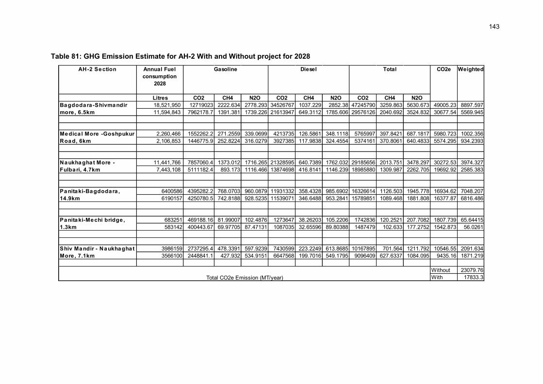
143
AH-2 Section Annual Fuel consumption
2028
Litres CO2 CH4 N2O CO2 CH4 N2O CO2 CH4 N2O18,521,950 12719023 2222.634 2778.293 34526767 1037.229 2852.38 47245790 3259.863 5630.673 49005.23 8897.59711,594,843 7962178.7 1391.381 1739.226 21613947 649.3112 1785.606 29576126 2040.692 3524.832 30677.54 5569.945
2,260,466 1552262.2 271.2559 339.0699 4213735 126.5861 348.1118 5765997 397.8421 687.1817 5980.723 1002.3562,106,853 1446775.9 252.8224 316.0279 3927385 117.9838 324.4554 5374161 370.8061 640.4833 5574.295 934.2393
11,441,766 7857060.4 1373.012 1716.265 21328595 640.7389 1762.032 29185656 2013.751 3478.297 30272.53 3974.3277,443,108 5111182.4 893.173 1116.466 13874698 416.8141 1146.239 18985880 1309.987 2262.705 19692.92 2585.383
6400586 4395282.2 768.0703 960.0879 11931332 358.4328 985.6902 16326614 1126.503 1945.778 16934.62 7048.2076190157 4250780.5 742.8188 928.5235 11539071 346.6488 953.2841 15789851 1089.468 1881.808 16377.87 6816.486
683251 469188.16 81.99007 102.4876 1273647 38.26203 105.2206 1742836 120.2521 207.7082 1807.739 65.64415583142 400443.67 69.97705 87.47131 1087035 32.65596 89.80388 1487479 102.633 177.2752 1542.873 56.0261
3986159 2737295.4 478.3391 597.9239 7430599 223.2249 613.8685 10167895 701.564 1211.792 10546.55 2091.6343566100 2448841.1 427.932 534.9151 6647568 199.7016 549.1795 9096409 627.6337 1084.095 9435.16 1871.219
Without 23079.76With 17833.3
Bagdodara -Shivmandir more , 6.5km
Medica l More -Goshpukur Road, 6km
Naukhaghat More - Fulbari, 4.7km
Panitaki-Mechi bridge , 1.3km
Panitaki-Bagdodara , 14.9km
Shiv Mandir - Naukhaghat More , 7.1km
Total CO2e Emission (MT/year)
CO2e WeightedGasoline Diesel Total
Table 81: GHG Emission Estimate for AH-2 With and Without project for 2028

144
AH-48 Section CO2e Weighted
CO2 CH4 N2O CO2 CH4 N2O CO2 CH4 N2O13,607,693.8 9,344,403.3 1,632.9 2,041.2 25,366,102.0 762.0 2,095,584.8 34,710,505.4 2,395.0 2,097,626.0 659,862.9 153,582.9 12,556,287.0 8,622,402.3 1,506.8 1,883.4 23,406,174.6 703.2 1,933,668.2 32,028,576.9 2,209.9 1,935,551.6 608,878.2 141,716.2
47,626,890.2 32,705,385.5 5,715.2 7,144.0 88,781,286.1 2,667.1 7,334,541.1 121,486,671.6 8,382.3 7,341,685.1 2,309,518.4 1,315,307.6 40,535,169.3 27,835,500.7 4,864.2 6,080.3 75,561,609.1 2,270.0 6,242,416.1 103,397,109.8 7,134.2 6,248,496.3 1,965,627.4 1,119,456.2
15,255,925.9 10,476,244.3 1,830.7 2,288.4 28,438,571.5 854.3 2,349,412.6 38,914,815.8 2,685.0 2,351,701.0 739,788.8 146,281.6 13,640,301.3 9,366,794.9 1,636.8 2,046.0 25,426,885.7 763.9 2,100,606.4 34,793,680.6 2,400.7 2,102,652.5 661,444.1 130,790.2
Without 1,615,172.1 With 1,391,962.6 Total CO2e Emission (MT/year)
Changrabandha - NH 31 a t Ma inaguri, 22.6
Dhupguri bypass - Hasimara bypass, 55.3 km
Hasimara to Bhutan border, 19.2 km
Annua l Fue l consumption 2028, lite rs
Gasoline Diese l T ota l
Table 82: GHG Emission Estimate for AH-48 With and Without Project for 2028

145
VI. ALTERNATIVE ANALYSIS
323. ADB has a regional cooperation program in four South Asian countries: Bangladesh, Bhutan, India and Nepal, called South Asia Economic Cooperation (SASEC55), which has been supporting regional cooperation in the transport sector through SAARC 56 and BIMSTEC 57 over a decade. Major contributions in this regard include assisting the SAARC Regional Multimodal Transport Study (SRMTS)58 and BIMSTEC Transport Infrastructure and Logistics Study (BTILS).59 In addition to these efforts the transport division of the United Nations Economic and Social Commission for Asia and Pacific (ESCAP) has initiated the Asian Highway Network with the aim of promoting the development of international road transport in the region. The regional road connectors between Nepal and Bangladesh through India are designated as Asian Highway No.2 (AH-2) and between Bhutan and Bangladesh through India is designated as Asian Highway No.48 (AH-48). It is in this context that the two subprojects under tranche I have been selected for improvement. 324. Since the main alignment of the Tranche-1 road are already existing detailed alternative alignments analysis was carried out only for the bypasses. A. Alternatives to the Project
1. ‘Without Project’ Option:
325. Physical Environment. In the ‘without project’ scenario, the capacity of road will remain constrained particularly in heavy built areas with limited ROW availability. Continued pressure on poorly designed roads will deteriorate the road conditions further resulting to slower traffic movement, traffic jams which will continue to deteriorate air quality, increase noise levels caused by idling of vehicles, and dust generation at damaged road locations. 326. Biological Environment. In the ‘without the project’ scenario, human - animal conflict will continue along corridors in Jaldapara National Park stretch. 327. Socio-economic Environment. Without the project, the agricultural produce may not move from field to market places in a timely manner, which may result in loss of income to farmers. Public at large will continue to waste time waiting at traffic jams triggered at railway crossing and congested road locations.
2. ‘With Project’ Option:
328. Physical Environment. In the “with project” scenario, air quality and noise levels are likely to improve around the railway crossings, and congestion will improve due to the provision of ROBs, grade separation, junction improvement and bypasses /realignment and improved road design at most of such locations. The project improve address needed capacity for fast transport of goods between border locations. The air pollution and noise level are likely to increase during construction phase but will be confined in close vicinity of
55 South Asia Economic Cooperation (SASEC). Member countries are Bangladesh, Bhutan, India and Nepal 56 South Asian Association for Regional Cooperation (SAARC). Member countries are Afghanistan, Bangladesh, Bhutan, India, Maldives, Nepal, Pakistan and Sri Lanka 57 Bay of Bengal Initiative for Multi-Sectoral Technical and Economic Cooperation (BIMSTEC). Member countries are Bangladesh, Bhutan, India, Myanmar, Nepal, Sri Lanka and Thailand 58 SAARC Secretariat. 2007. Regional Multimodal Transport Study. Kathmandu. 59 ADB. 2008. Final Report of RETA6335: BIMSTEC Transport Infrastructure and Logistics Study. Manila.

146
construction sites and will be temporary in nature. Water withdrawal from ground will not stress the ground water resources significantly as the area fall in safer zone as per Central Ground Water Assessment. 329. Biological Environment. In the ‘with project’ scenario, the overall impact of the project is likely to be insignificant on the biological environment except in terms of loss of trees which will be minimised and also regenerate over a period of time due to proposed compensatory tree plantation. ‘With Project’ Scenario will help in minimising human-animal conflict in Jaldapara National Park area. 330. Socioeconomic Environment. The ‘with project’ scenario will bring large investment to the project area and host of employment and business opportunities resulting in substantial improvement in the overall socio-economic conditions of the area. This will also ease the problem of traffic jams and long wait at congested areas preventing loss of productive man-hours. 331. Conclusion: During the EIA, a number of public consultations have also been carried out with the local communities and stakeholders. The overall findings of the consultations are that most of the people consider this project as timely and much needed. They are in favour of the ‘with-project’ option. Though, proposed project is for widening to two-lane configuration, public at large in AH-2 sub-project rather prefer for four lane configuration, which is not feasible due to traffic projection and economic consideration at this stage. 332. Under the circumstance, and in light of the assessment of the available alternatives, the ‘with-project’ option is deemed as the optimal solution. B. Alternative Analysis of Bypasses/Realignment
333. Alternative Analysis is carried out for following bypass/realignment locations:
1. Panitanki Realignment (NH-31C to Nepal Border of AH-2) 2. Pasakha Realignment of AH-48 3. Hasimara Bypass of AH-48
334. The alternate options with length and route for each of above bypass/realignment is given at Table 83.
Table 83 : Route and Length of Various Bypass/Realignment Alternatives Option Starting Point End Point Route Length (in km) Panitanki Realignment Alternative –I : Existing Alignment and preferred option As per feasibility report
Kakarbita NH-31 C Kakarbita to NH-31C junction to NH-31
1.850
Alternative-II Kakarbita NH-31 C Kakarbita –parallel to Mechi river-to semi urban area to NH-31C
1.550
Pasakha Realignment Alternative-I : as per feasibility report
Bhoolan Chowpathy (Chainage 102.700 of AH-48)
High Tension Line Crossing at lowest mountain point on the mountainous Bhutan Road in
Bhoolan Chowpathy -traverse along the existing concrete road – river bridge – turn north eastern direction - existing road on the Bhutan side near
7.42

147
Option Starting Point End Point Route Length (in km) Pasakha Area the high tension line crossing at
Pasakha area Alternative-II start
immediately before the major bridge avoiding the river crossing and the blind sharp curve before the Bhoolan Chowpathy junction
High tension line crossing at lowest mountain point on the mountainous Bhutan Road in Pasakha Area
Passing through dense habitation
6.62
Hasimara Bypass Alternative I : Existing Alignment and preferred option as per feasibility report
Start before Hasimara town
End after new Hasimara settlement
The existing road alignment on eastern side of Hasimara railway station.
5.5
Alternatives II Start before Hasimara town
End after Hasimara town
Western side of existing road 3.55
1. Panitanki Realignment
335. Alternative – I: Existing alignment: Kakarbita is the starting point of the AH-2 sub-project separated by Mechi River. The bridge across Mechi River is 7m wide and major portion of the bridge is on the Indian side. From the bridge, state highway connects to the NH 31 C and the distance from the Nepal border to NH 31C junction is about 1200 m. Passenger crossing at the border is mainly using slow moving vehicles or by walk. There is also a large pedestrian traffic crossing the bridge. A railway line runs parallel and close to the NH 31 C and a level crossing is provided on this state highway section. The existing state highway alignment between NH 31C and Nepal border is highly congested with narrow right of way, large commercial activity and large scale encroachments. The view of existing alignments is shown at Figure 63.
Figure 63. : View of the alignment

148
336. Alternative – II: Bypass: The proposed bypass t moves on the northern side60 of the existing alignment. The alignment run parallel to Mechi river initially and then turns right to join NH 31C. A ROB is proposed at the level crossing and NH 31C. The ROB approach in eastern side turn north east and run along NH 31C. The view of the alignment is shown at Figure 64.
Figure 64. : View of the alignment
Table 84 : Summary of Alternative Analysis of Panitanki Realignment S.
No. Issues Alternative–I: Existing
Alignment and preferred option As per feasibility
report
Alternative-II
I. Environmental Aspects 1. Ecological Impact (Loss of
trees, impact on forests) Very less no. of trees are likely to be cut.
About 140 trees may need to be cut mostly near Mechi riverbank.
2. Wildlife and its movement None specific None specific 3 Environmental Impacts (Air,
Water, noise & vibration) Airquality likely to be affected during construction stage but will be temporary in nature.
Air quality likely to be affected during construction stage but comparatively impact will be minimal due to open agriculture land.
4 Loss of natural resources (water bodies, minerals)
None, though alignment crosses one natural drain near railway crossing
None, though alignment crosses one natural drain near railway crossing
5 Traffic Management during construction
The construction work will create hazardous traffic situations due to congested road and built-up area
No major traffic issue since most of the road alignment is passing through agriculture field
6 Environmental Legislative Implications
None Construction of new re-alignment will be classified as state highway and would require environmental clearance under Environmental Impact Assessment Notification 2006.
Environmentally Preferred Option Preferred Option II. Social Aspects 1 Land Use Change No private agriculture land is
required to be acquired. About 2.83 ha of land need to be acquired. Out of this 1.51 ha is private agriculture land is involved.
2 Rehabilitation & Resettlement About 367 households may loose residence, livelihood, or both.
About 46 households may loose residence or livelihood or both
3 Loss of community structures 5 community structures (Places of No community structure is likely to be
60 The alignment on southern side of the existing alignment just after the LCS was examined but this was not considered considering the significant resettlement issue and impact on forest land.

149
S. No.
Issues Alternative–I: Existing Alignment and preferred option As per feasibility
report
Alternative-II
worship, Bus shelter and Public toilets) may be affected.
affected.
4 Public Acceptability Public acceptability for improvement of road but great assistance for loss of households.
Acceptable comparatively to Alternative – I.
III. Engineering Aspects 1 Technical Feasibility Apart from the large resettlement
impact, the alignment has substandard curves. The traffic capacity analysis indicated the requirement of 4-lane carriageway, which will have much larger settlement impact. The provision of grade separation at the level crossing is technically not feasible at this location without large resettlement impact.
This option will have good highway geometry but the skew angle with the railway line is 600 which will increase the cost of ROB.
2 Financial Feasibility Exists Exists Recommended Option Preferred Option
2. Pasakha Realignment of AH-48 :
337. The existing alignment up to Jaigaon is in good condition and will be part of the proposed road improvement project. The alternative analysis is carried out for access options to a propsed LCS61 and connectivity to Pasakha of Bhutan. Two alternatives were analysed for environmental, social and engineering consideration to identity the most preferred option (Table 85). 338. Alternative – I: The feasibility study recommended this bypass with the proposed LCS located on the bypass alignment and then connecting to Pasakha in Bhutan to avoid the congested Jaigaon and Phuntsholing commercial areas. It starts at chainage 102.700 km towards Jaigaon from Bhoolan Chowpathy and traverse initially along the existing concrete road having built-up area on either side of the alignment and after crossing the river it turns towards north eastern direction and finally connects the existing road on the Bhutan side near the high tension line crossing at Pasakha area. The view of the alignment is shown at Figure 65. 339. Alternative – II: Alignment starts immediately before the major bridge avoiding the river crossing and the blind sharp curve before the Bhoolan Choupathi junction. This alignment bypasses the built-up location of Bhoolan Choupathi area and takes off on the right hand side of the BRO road at km 102.700 and passes through tea plantation of Torsa Tea Estate and then through open land, largely uncultivated before it meets the Option I alignment after the causeway location. After joining the Option I alignment, it traverses slightly north of Option I alignment to have sufficient clearance from high tension line through open land where cultivation is intense, before joining the Barsa river bank along the Bangu settlement. The view of the alignment is shown at Figure 66.
61 Land Custom Stations( LCS) are proposed to be constructed at panitanki and Pasakha. Though LCS construction is excluded from the scope of this project but consideration is made for access to proposed lLCS while selecting the bypass alignment.

150
Figure 65. : View of the alignment
Table 85 : Summary of Alternative Analysis of Pasakha Realignment of AH-48 S.
No. Issues Alternative–I: Existing
Alignment and preferred option As per feasibility report
Alternative-II
I. Environmental Aspects 1. Ecological Impact (Loss of
trees, impact on forests) About 700 trees may need to be cut. The tea garden plantation and about 250
trees may need to be cut. 2. Wildlife and its movement The area falls in the elephant
movement area and may lead to man animal conflict.
The area falls in the elephant movement area and may lead to man animal conflict. However, this possibility is much lesser compared to Alternative - I
3 Environmental Impacts (Air, Water, noise & vibration)
Air quality likely to be affected during construction stage but comparatively impact will be minimal due to open agriculture land except in the built-up area.
Air quality likely to be affected during construction stage but comparatively impact will be minimal due to open agriculture land.
4 Loss of natural resources (water bodies, minerals)
None, though the alignment crosses same river twice.
None, though the alignment crosses two small local drains.
5 Traffic Management during construction
The construction work will create traffic disturbances in the built-up area
No major traffic issue since most of the road alignment is passing through tea garden land
6 Environmental Legislative Implications
Construction of new re-alignment will classify under the category of state highway and would require environmental clearance under Environmental Impact Assessment Notification 2006. The area is also considered falling within the elephant corridor would require permission National Wildlife Board and Supreme Court.
Construction of new re-alignment will classify under the category of state highway and would require environmental clearance under Environmental Impact Assessment Notification 2006. Since the entire region including this section considered being part of elephant movement, the permission from National Wildlife Board and Supreme Court would be required.
Environmentally Preferred Option
Preferred Option

151
II. Social Aspects 1 Land Use Change About 21.64 ha land need to be
acquired. No private land is involved. Most of the land is under tea garden (the govt. encroached land)
About 31.15 ha land need to be acquired. No private land is involved. Most of the land is under tea garden (the govt. encroached land)
2 Rehabilitation & Resettlement
About 115 households may loose residence, livelihood, or both.
About 20 households may loose residence or livelihood or both
3 Loss of community structures
3 community structures (Places of worship) may be affected.
No community structure is likely to be affected.
4 Public Acceptability Public acceptability for improvement of road but may have resistance from project affected households.
Acceptable comparatively to Alternative – I.
III. Engineering Aspects 1 Technical Feasibility The alignment apart from the
resettlement impact also has substandard curves but technically considered feasible.
It involves additional land from tea estate but gives good geometry and is almost 800 m shorter. Technically this option is considered more feasible then alternative - I
2 Financial Feasibility Exists Exists Recommended Option Preferred Option
3. Hasimara Bypass of AH-48:
340. Alternative – I: Existing Alignment: This alignment follows the existing alignment and traverse through New Hasimara, a relatively new settlement abetting the Hasimara railway station, with an available right-of-way (building to building) of about 17m; and Old Hasimara, the heavily built-up settlement with significant commercial activity where the available right-of-way is about 11m. This alignment has presence of sharp curves, level crossing and narrow right of way with ribbon development along either side of the alignment. The view of existing alignments is shown at Figure 66. 341. Alternative – II Bypass.: This alignment is located on western side of the existing alignment. It starts before the Old Hasimara settlement and crosses the railway line after the railway curves and joins the existing road after the New Hasimara settlements. The view of the alignment is shown at Figure 66.
Figure 66. : View of the Alternate Alignment
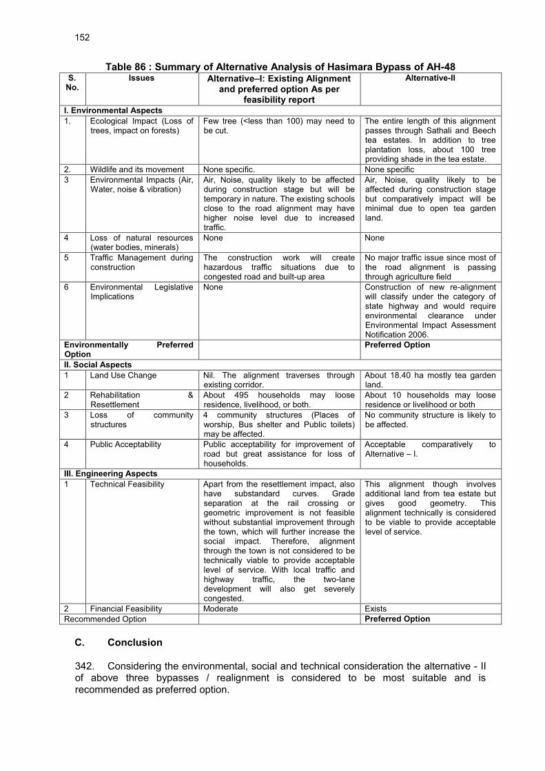
152
Table 86 : Summary of Alternative Analysis of Hasimara Bypass of AH-48 S.
No. Issues Alternative–I: Existing Alignment
and preferred option As per feasibility report
Alternative-II
I. Environmental Aspects 1. Ecological Impact (Loss of
trees, impact on forests) Few tree (<less than 100) may need to be cut.
The entire length of this alignment passes through Sathali and Beech tea estates. In addition to tree plantation loss, about 100 tree providing shade in the tea estate.
2. Wildlife and its movement None specific. None specific 3 Environmental Impacts (Air,
Water, noise & vibration) Air, Noise, quality likely to be affected during construction stage but will be temporary in nature. The existing schools close to the road alignment may have higher noise level due to increased traffic.
Air, Noise, quality likely to be affected during construction stage but comparatively impact will be minimal due to open tea garden land.
4 Loss of natural resources (water bodies, minerals)
None None
5 Traffic Management during construction
The construction work will create hazardous traffic situations due to congested road and built-up area
No major traffic issue since most of the road alignment is passing through agriculture field
6 Environmental Legislative Implications
None Construction of new re-alignment will classify under the category of state highway and would require environmental clearance under Environmental Impact Assessment Notification 2006.
Environmentally Preferred Option
Preferred Option
II. Social Aspects 1 Land Use Change Nil. The alignment traverses through
existing corridor. About 18.40 ha mostly tea garden land.
2 Rehabilitation & Resettlement
About 495 households may loose residence, livelihood, or both.
About 10 households may loose residence or livelihood or both
3 Loss of community structures
4 community structures (Places of worship, Bus shelter and Public toilets) may be affected.
No community structure is likely to be affected.
4 Public Acceptability Public acceptability for improvement of road but great assistance for loss of households.
Acceptable comparatively to Alternative – I.
III. Engineering Aspects 1 Technical Feasibility Apart from the resettlement impact, also
have substandard curves. Grade separation at the rail crossing or geometric improvement is not feasible without substantial improvement through the town, which will further increase the social impact. Therefore, alignment through the town is not considered to be technically viable to provide acceptable level of service. With local traffic and highway traffic, the two-lane development will also get severely congested.
This alignment though involves additional land from tea estate but gives good geometry. This alignment technically is considered to be viable to provide acceptable level of service.
2 Financial Feasibility Moderate Exists Recommended Option Preferred Option
C. Conclusion 342. Considering the environmental, social and technical consideration the alternative - II of above three bypasses / realignment is considered to be most suitable and is recommended as preferred option.

153
VI. ENVIRONMENTAL MANAGEMENT PLAN AND GRIEVANCES REDRESS MECHANISM
343. The aim of the Environmental Management Plan (EMP) is to ensure implementation of the recommended mitigations measures effectively. The mitigation measures are designed either to prevent impacts or by mitigating those to reduce the effect to an acceptable level by adopting the most suitable techno-economic option. The EMP also ensures that the positive impacts are conserved and enhanced. A. The EMP
344. The EMP consists of a set of mitigation, monitoring and institutional measures to be taken up during the design, construction and operation stages of the project. The plan also includes the actions needed for implementation of these measures. The major components of the EMP are:
Mitigation of potentially adverse impacts Monitoring during project implementation and operation Institutional Capacity Building and Training Implementation Schedule and Environmental Cost Estimates Integration of EMP with Project planning, design, construction and operation
345. The EMP is detailed in Appendix 6.1. 346. The two sub-project roads are classified as National Highway (NH). The executing agency is the MORTH and and the implementing agency (IA) will be the West Bengal Public Works Department (WBPWD). 347. The MoRTH can take guidance on environmental assessment, management and reporting from the Environmental Impact Assessment Guidance Manual for Highways 2010 issued by MOEF and the IRC Guidelines for Environmental Impacts Assessment (IRC:104-1988) of highway projects issued by MORTH. As part of the EMP, the Contractors are required to develop more detailed environmental health and safety (EHS) management plan. Few sample technical guidelines are included as Appendices 6.2 to 6.5. The sample guidelines cover the following aspects: (i) borrow area management, (ii) tree plantation, (iii) solid waste and debris disposal, and (iv) emergency preparedness. Each EHS management plan will contain:
Areas of concern in the package Graphical representation of location of borrow areas with current use and
rehabilitation plan Expected quantity of solid waste and debris generation and proposed reuse and
disposal plan. It should also include disposal plan for domestic solid waste likely to be generated from construction camps.
Water sourcing and conservation plan Waste water generated from construction camp or construction site treatment
and disposal plan Measures proposed to comply with various legislation like no use of child labour,
providing safe drinking water to workers at construction camps, provision of first aid facilities.
Regulatory approval status such as Consents from State Pollution Control Board for setting up Hot Mix Plan
Auditing, monitoring and reporting compliance preparedness plan

154
348. Other impacts during construction are generation of dust from earthworks; noise and exhaust from operation of equipment/machinery/vehicles; generation of construction waste as well as wastes from construction and worker camps; water contamination and water supply issues; occupational health and safety issues with the workers and local communities; issues of erosion and siltation and removal of trees. Mitigation measures to address above issues are defined in EMP.
1. EMP Implementation Timetable
349. The construction period is considered as 36 months starting from 2014 and operational design life as approximately 20 years. (Appendix 6.6).
2. Social Development Program
350. A separate social impact assessment study is undertaken and social development programme is addressed as per SIA. The various impacts having significant impact of social nature like agriculture have also been addressed under this study.
3. Contingency Response Plan
351. Field study, public consultation, and consultant's experience reveal that this project may have only one environmental emergency i.e. accidents of trucks carrying Chemicals or petroleum. 352. It is suggested that the communication and response system be developed and practiced to minimize the response time. This should be covered under environmental guidelines to be prepared by EA for effective implementation of mitigative measures. As part of guidelines it is also proposed to develop wildlife Management Plan which will be developed in consultation with forests and wild life authorities. EA should ensure accidental spill management either by developing in-house capabilities or by associating with any competent third party.
4. Authorities and Their Responsibilities for Implementation of the EMP
353. An officer in MORTH and WBPWD will be responsible for ensuring that all environment safeguard requirements are complied with during implementation of the project. This officer will be designated to serve as the overall authority on formal approval and endorsement of all reports, forwarding letters, communications and any document related to environment safeguards under the project. WBPWD as the IA will be directly responsible for implementing the detailed requirements of the EIA and EMP at the site level to be supported by environmental specialists under Construction Supervision Consultants (CSC), and contractor’s environmental focal person (EFP). Since this is an environment Category ‘A’ subproject an external monitor to conduct annual third party monitoring will also be engaged. 354. During implementation of the project MORTH and WBPWD will be responsible to fulfil all environment safeguard requirements applicable to road section falling under their jurisdiction, in a proper, timely and efficient manner.

155
a. Responsibilities of MORTH and WBHDC at the Executing Agency level
355. The MoRTH will focus on national or state level environment safeguard issues and decisions concerning the sub-projects. Specific responsibilities on environment safeguards at the EA level are:
i. Ensure that all environment safeguard requirements as given in the ADB SPS 2009, and applicable laws and rules under MOEF are being complied with during all stages of the project.
ii. Reviewing and approving all environment safeguards related documents such as EIA or IEE, monitoring reports etc. prepared under the project with recommendations and clarifications from the IA where necessary.
iii. Timely endorsement and signing of key documents and forwarding to the respective agency such as those required for processing of environmental clearance, forestry clearance etc. and disclosure on ADB website.
iv. Taking proactive and timely measures to address any environment safeguards related challenges at the national or state level such as delays in processing of clearances (during pre-construction stage), significant grievances (during construction stage)
v. Recruiting an external monitor to conduct annual third party environmental monitoring
b. Responsibilities of WBPWD as Implementing Agency
356. The IA’s responsibilities will mainly be focussed on implementing environment safeguard requirements in accordance with the EIA and EMP at the project and site level. Specific responsibilities on environment safeguards at the IA level are:
i. Review the budgetary needs for complying with the environmental budget ii. Prepare forms, reports and all documents etc. for processing of environmental,
forestry and related clearances in a timely manner and submit them for further review and signing to the respective authorized officer
iii. If any problems or long delays are encountered when processing the clearance documents, immediately alert the authorized officer at the EA level and seek ways resolve the problem at the soonest
iv. Ensure that all necessary regulatory clearances are obtained prior to commencing any civil work of the respective contract package or road section;
v. Ensure that the EMP which include required mitigation measures and monitoring requirements with defined Bill of Quantity, forms part of bidding document;
vi. Ensure that contractors have access to the EIA report including EMP of the subprojects;
vii. Ensure that contractors understand their responsibilities to mitigate environmental problems associated with their construction activities
viii. Ensure and Monitor that all required permits, no objection certificates etc. are obtained by the contractor for establishment and operation of equipment and facilities
ix. With the support of the EFP of the contractors and CSC ensure that the contractor implements the EMP including Environmental Monitoring Plan as given in chapter VI;
x. In case of unanticipated environmental impacts during project implementation stage, with the support of CSC prepare and implement an updated EMP to account for such impacts after seeking concurrence from ADB. The updating will

156
be carried out after due consultation with the stake holders and concerned government agencies;
xi. In case during project implementation a sub-project needs to be realigned, review the environmental classification and revise accordingly, and identify whether supplementary EIA study is required. If it is required, prepare the TOR for undertaking supplementary EIA and hire an environment consultant to carry out the study;
xii. Ensure that construction workers work under safe and healthy working environment;
xiii. Ensure effective implementation of Grievance Redress Mechanism to address affected people’s concerns and complaints,
xiv. Submit semi-annual environmental monitoring reports on the implementation of all environment safeguard requirements including the EMP to ADB and make these reports available for public disclosure; and
xv. The authorities and responsibilities for the implementation of the environmental management plans will be tiered based on the activity. The suggested hierarchy and information flow as given at Figure 67.
357. All the policy decisions, including incorporation of the EMP requirements in compliance to loan covenants will be the responsibility of the EA.
Figure 67. Proposed Organisation Structure for EMP Implementation
5. Construction Supervision Consultant (CSC)
358. The Environmental specialist under the CSC will be responsible for the following:
(EA level) MORTH
Designated Authority for Environmental Safeguards
(IA level) WBPWD
Environmental Focal Person (EFP) (can be under the SEMU)
Contractor EFP for each contract package
CSC
Environmental Specialist
CSC
Site level EFP
ADB MOEF, SPCB
Jaldhapara National Park, Local Forestry
Department
External Monitor Environmental
Specialist

157
i. Oversee the implementation of Environment Health and Safety (EHS) plan submitted by respective contractors and EA’s commitments as per EIAs and EMP.
ii. Facilitate in updating the EIA/EMP reports depending on site requirements. iii. Supervising the implementation of EMPs iv. Undertaking audit independently and submit to SEMU v. Preparing the draft semi-annual monitoring plan on environment safeguards vi. Recommending payments to contractor linked with the EMP
6. External Monitor
i. Conduct external monitoring on implementation of environmental safeguards requirements the project during project construction and operation
ii. Provide technical advise and guidance on project activities concerning wildlife such as construction of underpass, plantation of fodder and shade trees, creation of water holes etc.
iii. During the project operation period for atleast three years monitor the effectivity of the wildlife underpasses and other wildlife related activities implemented
iv. During the project operation period for atleast three years monitor the GHG emissions from the increased traffic
7. Mechanisms for Feedback and Adjustment
359. WBPWD through the CSC and contractors will maintain monthly progress report on implementation level of EMP. Any deviation from the contract requirements with respect to proposed EMP will be documented, corrective measures implemented, and compliance monitoringconducted to ensure the project maintains in-compliance.. 360. As part of the feedback mechanism, the EFP with the support of the CSC environmental specialist will monitor project compliance with respect to:
Environmental Management Plan Applicable laws, rules and regulations
361. Public involvement will be encouraged and ensured throughout the lifecycle of the project. The PIU will gather and maintain information on any damage or public concern that may be raised by the local people, NGOs and local authorities. While immediate solutions are to be worked out with the help of contractor, a detailed report will be submitted to the EFP for information or detailed consideration, as the case may be. The PIU will be responsible to bring it to the notice of the EFP. Resulting decisions will be communicated back to PIU and contractor for correction and future implementation. An operation-period workshop may be required for effective implementation of the EMP. 362. The external monitor will work in close coordination with MORTH, WBPWD, and CSC to conduct third party technical monitoring and provide feedback and technical advice to enhance the effectiveness of implementation of the EMP B. Environmental Monitoring Plan (EMoP)
363. The aim of environmental monitoring during the construction and operation phases is to compare the monitored data against the baseline condition collected during the study period to assess the effectiveness of the mitigation measures and the protection of the ambient environment based on national standards. Two key environmental issues under this project is traversing of the Jaldhpara National Park and elephant migratory routes by AH-48 and increase in GHG emissions beyond the 100,000 ton/year also by the same road.

158
Specific efforts will be made to continue monitoring the effectiveness of the elephant underpasses and monitoring GHG emissions during project operation for atleast three years. 364. A monitoring schedule has been drawn up based on the environmental components that may be affected during the construction and operation of the project. Since project is likely to have impact on various components of environment, a comprehensive monitoring plan covering soil erosion, drainage congestion, tree plantation, air quality, water quality, noise, wild life movement and human -Animal accidents, are provided in Appendix 6.7. Monitoring Plan has been separately suggested for construction phase and operation phase.
1. Authorities and their Responsibilities for Implementation of EMoP
365. The most essential stage of environmental management is the effective implementation of the EMP. The CSC and EPF-Contractors will be responsible for timely monitoring of various parameters and compliance with the mitigative measure proposed. C. Institutional Capacity
366. The proposed organisation structure to implement the Project and the environmental management plan is shown in Figure 67. 367. To enhance the capacity of the EA (of SEMU and PIU) for effective implementation of proposed mitigation measures and monitoring the resultant effect, some training programs are proposed. The detailed training plan is provided at Appendix 6.8. E. Mitigation, Monitoring and Institution Strengthening Cost
368. The environmental budget has been worked out for the entire project and summarised in the Table 87 below. The mitigation cost, inclusive of monitoring cost and training during the project life cycle (construction and operation phase) amounts is estimated to be a total of Rs 352.275 Mn or US $ 6.40 Million62 . This is approximately 4% of total project costs based feasibility study estimates. Of the total environmental costs, Rs 112.29M (US$ 2.04 M) is for AH-2 subproject and Rs. 240.5 Mn (US$4.37 M) is for AH-48 sub-project. Approximately 29% of the costs under AH-2 sub-project is part of the civil works cost for items which concerns environmental issues. Similarly approximately 22% of the costs under AH-48 are part of the civil works costs. 369. The mitigation cost including monitoring is estimated as Rs. 245.75 M during design and construction phase and Rs. 30.78 Mi during operation phase. The costs of establishment and training are estimated as Rs 58.97 million. The detailed break up is given at Appendix 6.9 under Environmental Budget.
Table 87 : Summary of Mitigative, Monitoring and Institutional Costs Sl. No.
Description Budget ( INR in Million)
1. Design and Construction Stage 245.75 Technical Support for preparation of environmental Guidelines, wild life management plan and performance indicators
2.50
Compensatory Tree plantation @1:5 ( total tree plantation 104535 against 20907 trees to be cut)
a. Compensatory tree plantation: as per legal requirement @ 126.76
62 Total project cost estimated at feasibility study stage is 420.5 million. US$1

159
Sl. No.
Description Budget ( INR in Million)
1:3 ( 62910 trees) b. Additional Tree plantation @ 1:2 (41814 trees) (considering woody trees requirement of 34% for climate change consideration and plantation of fodder and shade trees for elephant habitat improvement purposes)
84.51
Diversion of Forest land for Non forestry Purposes (Diversion of Reserved Forests and National Park land
7.263
Development of earthen water bodies ( ponds upstream of the road of elephant crossing area) for Elephant habitat improvement
1.8
Developing floral Nurseries and Fisheries 7.8 Health Check-up Camps for construction workers and Safety signage
2.00
Environmental Monitoring during Construction Stage 7.66 Installation of Oil and Grease traps and waste water collection and disposal system at construction camp, construction of noise barrier. The costs towards various mitigative measures such dust management, soil contamination prevention, drainage congestion and disposal of accumulated water, water management, and safety aspects are considered part of engineering costs and not separately indicated as EMP costs
2.4
Provision of noise barriers 2.16 Provision of proper signages in wildlife areas 0.96 2. Operation Stage 30.78
Costs of visual Checks are considered part of project management costs and separately identified as EMP costs
-
Emergency Preparedness – Provision of Ambulances 25.5 Environmental Monitoring during operation stage 5.28 3. Training and Awareness 4.60 4. Establishment & Management systems 54.3764 5. Contingencies (@5%) 16.77
Total 352.275 Or
US $ 6.4 ( @ 1 US $ = INR 55)
F. Grievance Redress Mechanism
370. Grievances related to the implementation of the project, particularly regarding the environmental management plan will be acknowledged, evaluated, and responded to the complainant with corrective action proposed using understandable and transparent processes that are gender responsive, culturally appropriate, and readily accessible to all segments of the affected people. Records of grievances received, corrective actions taken and their outcomes will be properly maintained and form part of the semi-annual environmental monitoring report to ADB. 371. Depending on the nature and significance of the grievances or complaints, the grievance redress mechanism (GRM) (Figure 68) will comprise procedures to address grievances: i) first by the SEMU at the PIU level and ii) second at the EA level and iii) third at the Grievance Redress Committee (GRC). Most serious complaints which cannot be addressed at the EA level will be forwarded to the GRC. The GRC will comprise members from the EA, IA, CSC, contractor, local community and local forestry authority. Grievances 63 Payment of NPV at the rate of INR 900,000 per ha for 8 has (5 ha in Khairabari RF and 3 ha in Jaldhapara National Park) 64 Includes budget for employment of Implementation Support Consultant and External Monitoring Agency

160
at the PIU level will be addressed within 30 days of the receipt of the complaint. The time for addressing grievances received at the EA and GRC level will be dependent on the nature of complaint received. However, all efforts will be made to respond to the grievances efficiently with a corrective action plan and not take longer than 30 days from the receipt of grievance at the respective level. Hence, to the extent possible corrective action plans along with clear timeline will be communicated to the complainant within 30 days of the receipt of a complaint within the respective level.
Figure 68. : Grievance Redress Mechanism
Resolution of Concern within 30 days or intimation within 30 days if referred to GRC
Grievance Redresses Committee. (GRC)
SEMU at PIU
P.D. or Designated Offiecr at EA
Public
Two way Interaction with Public if required
Register of
Concern
Register of Concern
Resolution Of Concern within 30 Days
Ressolution of concern through GRC where required

161
VII. INFORMATION DISCLOSURE, CONSULTATION, AND PARTICIPATION
A. Consultation Method Applied
1. Purpose
372. The purposes of the Public consultation in conformity with ADB policy on environment are as follows:
To inform the community, Govt. officials and NGOs on the project impact on the socio economic and environment in the project area.
To assess positive as well as adverse socio economic and environmental impacts in the area through participatory methods such as walk through and focus group discussions
To understand suggestions and opinions of the community, Government officials and NGOs on mitigation measures to counter and check the adverse and negative impact that threaten the socio economic environment in the area.
2. Methodology
373. The mode of consultation employed during the course of the study was both formal and informal consultations. The attempts were made to encourage participation in the consultation process of the Government officials from different departments that have relevance to the project. Same way, local people from different socio economic backgrounds in the villages as well as urban areas along the road alignment and at detours, residents near the existing road, local commuters, and other concerned were also consulted. Public consultations were held during the different site visits from March-May 2012 in different stages of EIA report preparation including before and after impact prediction. The inputs and feedback received during these consultations was helpful. A final round of consultation for both roads involving all relevant stakeholders such as the local community representative, women representatives, NGO’s, forestry department, national park warden are held within July 2013. The purpose of this consultation was to present the draft EIA report and seek their feedback. 374. The team prepared a check list for data collection in the field and also prepared a questionnaire to be filled in. (Appendix 7.1). The questionnaire was useful in listing of the physical and cultural resources along the road. It was decided to list all the resources within the width of 50 m from the centre of the existing road. The questionnaire was also helpful as a checklist to disclose information and take note of the suggestions and opinions on mitigation measures to counter the adverse impact on the socio economic environment in the project area. 375. Following steps were followed:
a) Preparatory Activities including getting up to date road maps. Before beginning field work involving participation of the community and other stakeholders, the team consulted the project documents to understand the project alignment and components. Additional section of Fulbari to Medical More section via Rangapani on AH 02 and Additional Section of Bholanchupati to Phuntsholing via Pasakha road on AH 48 was also studies.
b) Contacted Govt. officials to understand their point of view and also invite them in the public consultation exercises. The officials from Project Management Unit, Forest Department, Revenue Department, and Block

162
Development Officers were contacted and informed about the project. They were also invited for the public consultation at both at the roadside as well as in their offices.
c) Reconnaissance visit was undertaken for both the road corridor. During the visit, all the public community structures were identified and listed with GPS coordinates. Photographs were also snapped at each location for record and documentation purpose. This was followed by identification of sensitive location such as schools temples with high number of followings. A total of 41 locations on AH 48 and 15 locations on AH-02 out of total 87 PCR were identified as sensitive locations for public consultation.
d) Conducting Public Consultations with participation of the Govt. officials, NGOs and the community members along the road. Public Consultations were held at each of the sensitive location.
e) Data collected was collated, analysed for assessment and mitigative measures identification. Mitigative measures were shared with key stakeholders. Finalised measures were incorporated in the project design and environmental management plan.
B. Public Consultation Milestones
376. The different stakeholders viz Govt. officials, NGOs , Village Panchayats (Village Administration), people (male, female) were contacted and consulted during the course of the study. The mode of consultation employed during the course of the study was informal consultation. Government officials from different departments that have relevance to the project were consulted. Meaningful consultations were held before and after EIA report preparation. Local people from different socio economic backgrounds in the villages along the alignment were consulted during EIA report preparation and post EIA consultation workshops between April 2012 and July 2013. The inputs and feedback received during these consultations were very helpful in EMP preparation. Respondent profile is shown at Figure 69 and 70.
Figure 69. : Respondent Profile
10 1 12 1
134
65
0102030405060708090
100110120130140
Male Female Male Female Male Female
Govt. NGO Public
Respondent Profile
Govt. Male
Govt. Female
NGO Male
NGO Female
Public Male
Public Female

163
Figure 70. : Respondent Gender Ratio
C. Information Disclosed
377. During each of the public consultations, the Enumerators and Consultants introduced themselves and informed about the project to the participants. In the first phase, the road will be renovated and constructed as Asian Highway connecting Nepal and Bhutan with Bangladesh. The AH 48 and AH 02 will provide a road corridor for movements of goods and passenger traffic. After having made clear the purpose of environment impact assessment was explained. Initially the Consultants made an attempt to build successfully the rapport with the community members / Government officers and NGO members so that they are encouraged to participate in the consultation process. After having discussions on the brief outline of the project, the participants were requested to reflect on the project and give their opinion. Environmental issues and nature of impacts were conveyed including air -noise – water pollution, loss of trees, accident and safety issues, movement of animals, and movement of wild animals. The participants were requested to provide their concern in any of these issues and sought their suggestions to minimize the adverse impact.
5% 6%
89%
Respondent Profile
Govt NGO Public
70%
30%
Respondent Gender Ratio
Male Female

164
D. Compliance with Applicable Regulatory Requirements for Public Consultation
378. MoEF GOI Requirements: In India, public consultation is mandatory only in case of Category A and B projects65 in select conditions. As per regulation, public hearing (formal public consultation) is required for the proposed project under the environmental impact notification, 2006 and amendments thereof. The requirement of public consultation during the implementation of the project is proposed as part of the mitigation plan. 379. ADB Safeguard Requirements: Public consultation was undertaken as per the ADB SPS09 requirements. All the five principles of information dissemination, information solicitation, integration, coordination and engagement into dialogue were incorporated during the task. A framework of different environmental impacts likely from the project was strengthened and modified based on opinions of all those consulted, especially in the micro level by setting up dialogues with the village people from whom information on site facts and prevailing conditions were collected. 380. As per ADB safeguard requirement, public consultation is to be carried out before and after impact identification. Public consultation was carried out twice with key stakeholders particularly with wild life authorities and NGOs. In the second stage consultation, mitigative measures were discussed and concurrence of stakeholders was obtained. Man-Animal conflict in Jaldapara National Park area.is the main concern under this project. Various options were proposed and consensus was arrived for construction of underpass for the movement of elephant and other animals. E. Major Comments Received and Community Acceptability of the Project
381. In all the public consultations the community members, Government officials and NGO members voiced that the proposed project will contribute in social and economic development of the region. No negative social impact is anticipated except minor land acquisition and relocation of few structures. The proposed project will contribute to increase employment opportunities for the local people during and after project implementation. The communities welcomed the project and all were in favour of the project. The level of acceptance is shown at Figure 71.
Figure 71. Project Acceptance Level
65 As per schedule I of EIA notification number S.O. 1533, dated 14th September 2006 and amendments thereof. This notification also defines when a public consultation is mandatory. As per this notification, any new National or State highway construction will require environmental clearance and public hearing. Public hearing is to be conducted under the chairman ship of district commissioner in each district through which road is passing. Public hearing notice is to be advertised in the two leading daily newspaper, 30 days in advance.
95%
5%
Project Acceptance Level
Accepted Non Decided

165 382. The participants mentioned that there will be no adverse impact of the project on agriculture, drinking water facilities and local economy. Few raised concern regarding air, and noise impact, safety and Man –animal conflict. Nature of comments received are also summarised below and shown at Figure 72:
Figure 72. : Summary of Nature of Comments Received
383. Government officials and Pradhan (President) of the Gram Panchayats on both the highways suggested that widening will be done for four lane instead of two lane at this stage itself since land acquisition and all other activities may be difficult in second phase.
Man-Animal Conflict is major issue in Jaldapara National Park, Hasimara and Naxalbari area. Wild life authorities have made suggestion for construction of underpass for elephant movement in the Jaldapara Wild National Park. Provision of caution sign and speed control are also proposed.
Villagers have suggested making provision for safe passage of student and people near sensitive locations. The main bottleneck surfaced is at the schools / hospitals require some safety measures such as signal, safe passage, and road over bridge to cross the highway, and speed breakers. At some sensitive locations and where habitation on both sides provision of underpasses will reduce accident risks and improve social interaction between communities.
Medical College Hospital Superintendent at Shushruta Nagar suggested to upgrade the present emergency ward facility with more space and equipped with Trauma Ward, necessary supplies, equipment and staff to deal with road accident situations.
Public have suggested making measures for air pollution and noise barrier near sensitive locations. The structures like temple and other religious places including cremation grounds etc. are managed by local committees. These committees are willing to discuss with authorities the impact and mitigation measures such as relocation, provision noise barrier as may be required.
In both road corridors, the Government officials, custom officials, community members, and all concerned requested for an early implementation of the proposed road project due to present very bad road conditions.
NGOs have raised concern for tree los and Man – Animal conflict. They have suggested to plant trees on minimum 1:3 ratio. Village Panchayat have volunteers to contribute for compensatory tree plantation.
166
384. The details of informal consultation held with various stakeholders with outcome are summarized in Appendix 7.2. F. Integration of Comments into the EIA
385. During discussions, notes were taken for any issue raised and suggestions made. References have been taken from public opinion where no official data were available for understanding of the study area characteristics. Each of the issues were then analysed for practical and scientific basis. The opinions were used for identifying impacts and developing management and monitoring plan, depending on their importance and practicality. For any significant concern, preventive or mitigative measures have been suggested drawing points from all the suggested measures. G. Post EIA Consultation
386. Post EIA consultation was conducted through formal approach at three workshops organised in the month of July 2013. The finding of the EIA report was presented to the workshop participants. Efforts were made to involve women, NGOs, public leaders and concerned Government officials. An international consultant WWF was also consulted at this stage. The details and outcome of these consultations are given below:
1. Public Consultation Stage-II : Workshops at Naxalbari and Maynaguri, North Bengal
387. These workshops were held at Naxalbari and Maynaguri; areas of North Bengal where the findings of EIA study were discussed with local people, stakeholders. Efforts were made to involve women, NGOs, self-help groups and other stakeholders. These consultation workshops were held on 23rd July, 2013 at Naxalbari United club and on 26th July at Maynaguri Sparsh Welfare Society where. The workshops were organized through an NGO Naxalbari Integrated Development Society and Sparsh Welfare Society. The workshop saw huge participation of women (Refer Appendix 7.: List of Participants and Appendix 7.3 for Photographs) as out of total 94 numbers of participants, 74 were women who belonged to different NGOs, self-help groups and societies namely: Panitanki Rural Development Education Society, Panitanki Baagan Mahel Dal, Janiti Saw Niran Dal, Naxalbari Women and Child Development Society, Aparagita, Radhagovinda, Dream P, Tulsi, Janani, Bhalababa, Baba Loknath (all local NGOs). 388. All the participants supported the project. They made following suggestion. Relevant suggestions were suitably addressed under mitigative measures and EMP.
Participants requested that tree plantation should be undertaken through Gram
Panchayats with the involvement of self-help groups (women) and NGOs. They suggested that strict vigil will be made for maintenance of the trees as they have noticed poor plantation management in previous similar projects.
They suggested that drainage will be maintained. Cross drainage structure will not allowed to be clogged with construction debris.
Some of participants suggested to make provision of adequate lighting Belgachi tea state about 7-8 Km away from the project road for protection from Elephants.
They suggested that project affected people should be duly and timely compensated.
Participants suggest making adequate measures for safety in rural and urban areas.
2. Public Consultation Stage-II : Work Shop at Siliguri, North Bengal

167 389. Third workshop was held on 27th July, 2013 with the help of WBPWD. All leading NGO, Forests and Wild Life Officials, and other stakeholders were invited for the workshop. The workshop was attended by participants from NGOs, self-help groups, Government Officials and few local people who while accepting the project gave valuable suggestions for the improvement of the project. The program was presided by Mr. A.R. Modak, Superintending engineer, Highway circle-III. Other dignitaries were Mr. Nirmal Mondal, Executive Engineer, National Highways, Siliguri, Mr. R. Nair, DPR Team Leader. The presentation was made by Mr. S.K. Jain, Environment consultant, ADB Project. Following are important issues which were raised during the workshop:
Proper guidelines and procedure will be followed. Selection of species and number will be pre-planned before start of plantation. It was agreed that plantation would be made through village Panchayat with the active participation of self-help group and under supervision of Social Forestry Department of West Bengal Forests Department.
Suggestion was made that contractor be insisted under contract to employ local labourers to the maximum possible. .
Suggestion emerged that supervision for effective implementation of EMP is made.
Suggestion emerged that adequate provision will be made for the protection of health of the labourers and prevention of communicable disease which may be carried by outside labourers. Pre-employment check will also be undertaken.
Suggestion was made to effective implementation measures pertaining to borrow area rehabilitation, selection of construction camp site (minimum 1 Km away from habitat).
Suggestion was made that education and awareness programme for public will also be conducted on environmental and animal protection.
Suggestion was made that land acquisition will be made with all transparency and following National R & R policy.
3. Public Consultation Stage-II : Interaction With International NGO WWF
390. A meeting was held on 31st July 2013 at WWF office at Delhi with Dr G Ghose Director Species and Landscape programme and who is actively working in North Bengal. He is satisfied with the underpass measures provided the length and width specification proposed is actually implemented. He suggested to take measures for elephant habitat improvement by making provision of plantation of fodder and shade trees and water body so that elephant do not have to cross over the roads. WWF suggestion was duly integrated under EIA.

168
VIII. CONCLUSIONS AND RECOMMENDATIONS
A. Conclusions
391. The project is aimed at improving the project road (AH-2 and AH-48) along the existing alignment to standard two lane roadways with some section being expanded to four lane roadways. Most of the existing alignment passes through agricultural and tea garden areas. AH-2 road (37.271 Km long) connects Nepal at Panitanki with Bangladesh at Fulbari and AH-2 road (90.56Km long) connects Bhutan at Jaigaon with Bangladesh at Changrabandha. 392. The project is unlikely to cause significant environmental impacts except in protected area where it will have impact on elephant and other animal movement and its land use. As per findings of detailed EIA, the environmental impacts are largely temporary in nature in most of the section of the roads except in forests & protected areas. Impacts can be mitigated with minimal residual impacts in all impacted areas. The project involves land acquisition, diversion of forests land, and movement of elephant, shifting of physical cultural structures and borrowing of earth. Most major impacts are associated with these activities. 393. The project is classified as category ‘A’ by ADB SPS 09 due to its impact on Elephant Movement and diversion of forest land of Jaldapara National Park (critical Habitat as per SPS). Some sections of the roads also involve substantial widening and earthworks from two lane to four lane standard. 394. The EIA study was carried out between April 2012 to May 2013 based on feasibility Study and interim DPR inputs. It is based on primary and secondary base line information and analysis of project information. The environmental study covered the project area, as well as the area of direct and indirect impacts. The environmental assessment report was prepared in accordance with relevant applicable laws and regulations of the Government of India; and in conformity with the ADB SPS.
1. Potential Negative Impacts, Mitigation, Management and Monitoring
395. Significant Impact during design stage is mainly associated with climate change consideration, diversion of Reserve Forests and National Park land, tree cutting, and disruption to elephant movement, and traffic noise. Some of measures suggested include:
• The compensatory afforestation will be undertaken on 1:3 basis as a mandatory requirement under Forestry regulations. An additional plantation on 1:2 basis will be undertaken to meet 34% woodey species tree requirement for climate change consideration and for Elephant Habitant improvement purpose. About 41814 fodder and shade trees will be planted in elephant movement area prior to their road crossing point. In total 104535 compensatory trees will be planted.
• Provision is made to construct three animal underpasses in consultation and agreement with concerned Jaldapara National Park Authorities for safe passage on elephant and other wild animals. These underpasses are aligned with underpass locations for railway line which is running parallel to road about 2 Km away from it, for providing continuous safe passage to elephant and other animals.
• Provision of animal exclusion fencing and guide rails on either side of underpass to ensure use of underpasses by the elephants and other wildlife
• Provisions of Warning signage, speed control are made in AH-2 and Hasimara and Pasakha Bypass road sections to minimise man- animal conflict.

169
• Increased surveillance by forest department and additional guard to be deputed for larger surveillance to prevent poaching during construction stage in the Jaldapara National Park section.
• Provision of noise barrier is made for noise sensitive facilities located close to the road such as school, hospitals and temples.
• Provision is made to bypass the congested area of Panitanki and shifting the proposed Pasakha bypass somehow away from elephant movement area to the extent feasible.
396. The significant impact during construction is mainly associated with minor increase in dust borne air pollution, increased noise level, nuisance due to movement and operation of vehicles, establishment of temporary facilities and hindrance in accessibility to common property resources. The mitigative measures have been suggested to eliminate or minimise the impacts. Some of the measures suggested include: 397. Key measures suggested to control increased noise level during construction include provision of temporary noise barriers and measures such as regulating construction timings near sensitive locations. Sitting and management of temporary construction facilities i.e. construction camp, workers camp, hot mix plant, batching plant, dumping sites, will be done in an environmentally acceptable manner as mentioned in EIA 398. A proper traffic management plan will be in place well before the start of construction. Access to community structures/resources will not get affected during any stage of the project. 399. Soil erosion along embankment slope, bridge approaches, and river/canal banks will be checked regularly as per EMoP suggested in EIA. Dismantled material will be reused to the extent possible. Leftover debris will be disposed off in an environmentally acceptable method and at designated sites as per the guidelines suggested in the EIA. 400. Borrow area will be rehabilitated as per EMP. IRC: 10-1961: guidelines will be followed regarding identification; usage and rehabilitation of borrow area. 401. With the implementation of suggested mitigative measures, no significant impacts are anticipated during operation stage.
2. Post EIA Surveillance and Monitoring
402. While an EIA is meant to provide a comprehensive understanding of the environment status of the area under the study, post EIA surveillance is the means to ensure that the significant impacts identified are adequately mitigated as per the proposed mitigation plan. The Environmental Management Plan includes a detailed monitoring plan for three years each for construction and operation phases. Monitoring programmes defines monitoring parameters, monitoring frequency, and performance indicators, with regard to vital environmental components such as air quality, surface and ground water quality, noise levels, soil erosion, tree survivability, and effectiveness of measures proposed to ensure no net loss of biodiversity which includes measures for wild life protection, critical habitat protection, and elephant habitat Improvement. Any deviation from stated performance level will require initiation of corrective and preventive action by concerned agency (contractor or technical supervision consultant or EA as per the responsibility already defined).

170
3. Irreplaceable Resources
403. The Jaldapara National Park area is classified as critical Habitat as per SPS09. The road is passing through the National Park. A railway line about 2 km north of the road alignment also runs parallel to the roads. This area is already impacted. The rail movement is resulting in elephant and other animal’s accident. AH-48 road acts as an additional barrier for animals’ movement. To minimise accidental impacts, it is essential to provide safe passage for animal’s movement. Three underpasses are being constructed by railways. Aligned with railways underpass and as per consultation with wildlife authorities three animal underpasses are proposed in road section passing through Jaldapara National Park section of the AH-48 road. The animal underpass construction will require 3 ha of Jaldapara National Park land to be diverted for non-forests purposes. This will lead to permanent change of land use of small land parcel of Jaldapara National Park. Though the floral diversity of this area will be lost but all the floral species found in these area is available in abundance in other parts of the park and no threatened or endangered species is likely to be affected. Compensatory tree plantation for twice the area (6ha) will be undertaken to compensate the loss. The compensatory tree plantation is carried out by forest department as per the standard procedure and it is general expectation that forest department ensures regeneration of the vegetation more than the loss. The construction of underpasses, regeneration of vegetation twice the loss is expected to improve impacted area, reduce animal accidents and ensure no net loss of biodiversity.
4. Public Consultations
404. Although, there is displacement of people, still the project received unanimous support and consent from all local people. Large numbers of people raise the concern of Man – Animal conflict and safety of people. Very few people raised the concern of air pollution due to damaged road and noise pollution. People have suggested fixing caution signage in the elephant movement area, speed control and underpasses as feasible. People have also suggested to make provision of safe passage of student and public to minimise the accident on the road. Public consultation was organised through formal and informal methods and in two stages (before EIA report preparation and post EIA preparation). In additional to local NGOs, the international NGO WWF active in this area were consulted. Their input like Elephant Habitat Improvement measures was adopted. B. Recommendations
405. The EIA was carried out based on feasibility study and updated with interim DPR inputs. Since this project is following an EPC modality and the contractor will also be required to prepare the detailed engineering design any major changes during detailed design, or any major additional work other than the proposed project activities will require updating of this environmental assessment and approval from ADB before civil works commence. 406. Mechanisms to monitor the tree plantation and effectiveness of measures for preventing man-animal conflict will be strengthened during project implementation. It is proposed to form committee consisting of concerned EA Sr. official, DFO and one officer from revenue department who will oversee the implementation of floral and faunal measures.
407. The mitigation measures proposed will form part of BOQ for construction contract for its effective implementation. For effective implementation of the project in an environmentally sustainable manner, it is recommended to develop environmental guidelines, wildlife management plan and EHS management system supported by Environmental Management Information software/system. Performance indicators may also

171 be developed as part of these guidelines/plans to monitor and assess the effectiveness of the mitigation measures. 408. Adequate training will be imparted as proposed under environmental management plan to enhance the capability of concerned EA officials. Awareness programme for contractor and workers will also be organised for effective implementation of EMP. EMP implementation progress and monitoring report will be sent to ADB on a semi annual basis

172 Appendix 1
Appendix 1.1: Rapid Environmental Assessment Checklist
ROADS AND HIGHWAYS Instructions (i) The project team completes this checklist to support the environmental classification of a
project. It is to be attached to the environmental categorization form and submitted to the Environment and Safeguards Division (RSES), for endorsement by Director, RSES and for approval by the Chief Compliance Officer.
(ii) This checklist focuses on environmental issues and concerns. To ensure that social
dimensions are adequately considered, refer also to ADB's (a) checklists on involuntary resettlement and Indigenous Peoples; (b) poverty reduction handbook; (c) staff guide to consultation and participation; and (d) gender checklists.
(iii) Answer the questions assuming the “without mitigation” case. The purpose is to identify
potential impacts. Use the “remarks” section to discuss any anticipated mitigation measures.
Country / Project Title: India: SASEC Road Connectivity Sector Project
Sector Division: Transport Sector
Screening questions Yes No Remarks A. Project Siting Is the project area adjacent to or within any of the following environmentally sensitive areas?
Cultural heritage site X No archaeologically protected monument or cultural heritage site in located within the road ROW or even within 2 Km distance from the road. Though, few religious structures like temple are located close to the roads.
Protected Area X AH-48 passes through Jaldapara National park (A Critical Habitat as per SPS 09) and Elephant Conservation area. The road is crossed by migrating elephants at two – three locations.
Wetland X Seasonal Waterlogged type wet land is located near Rangapani. However, even the same is unlikely to be affected by the project activities.
Mangrove X Project road is not located in coastal areas.
Estuarine X No Estuarine is located in the project area.
Buffer zone of protected area X No such area is located in the project vicinity.
Special area for protecting biodiversity
X No such area is located in the project vicinity.
B. Potential Environmental Impacts Encroachment on historical/cultural areas; disfiguration of landscape by
X The topography of project road is mainly plain. There is no encroachment of

Appendix 1 173
Screening questions Yes No Remarks road embankments, cuts, fills, and quarries?
historical places. However community structure like temple, mosque, Schools, and Graveyards exists along the project road which may require relocation at certain locations. New bypasses at Pasakha, construction of land custom stations and widening of road from two lane to four lane would require additional land and change in land use which would need to change in land scale of these areas. Opening of new Quarries is not envisaged. Only operational and licensed quarry will be used for road construction. Earth material will be sourced from pre identified areas (located within 25 to 30 Km from the road) and with the consent of landowner. All borrow areas will be suitably rehabilitated.
Encroachment on precious ecology (e.g. Sensitive or protected areas)?
X Improvement of the road and increase in traffic speed may lead to man and animal conflict in Jaldapara National park area and elephant reserve area, in absence of adequate mitigation measures Large number of road side trees cutting is involved. Attempts have been made to minimising the cutting of trees while finalising the road widening options.
Alteration of surface water hydrology of waterways crossed by roads, resulting in increased sediment in streams affected by increased soil erosion at construction site?
X
The proposed alignment is crossing through various major rivers and drains. Some of these rivers are perennial in nature. However most of the bridge required repair and widening work except one where re-construction is proposed. The construction for widening activities is proposed in lean water flow period. Appropriate measures are proposed to prevent any contaminated to water resources.
Deterioration of surface water quality due to silt runoff and sanitary wastes from worker-based camps and chemicals used in construction?
X Adequate sanitary facilities including sewage treatment facilities will be provided at construction camps, which will be set-up away from habitat and water bodies. No harmful ingredients are likely to be used in the construction activities. As

174 Appendix 1
Screening questions Yes No Remarks such, no impact on surface water quality is anticipated due to construction. Measures like embankment slop stabilisation, RCC retaining walls are proposed to prevent siltation of ponds located next to the road due to surface runoff.
Increased local air pollution due to rock crushing, cutting and filling works, and chemicals from asphalt processing?
X
Localised air pollution level is likely to increase for short duration during construction period due to construction vehicle movement and asphalt processing. The asphalt mixing plant (hot mix plant) will be located away from inhabited areas with adequately high stack for effective dispersion of likely emissions. Dust separation measures like spraying of water on unpaved vehicle movement areas are proposed to minimise the dust generation.
Risks and vulnerabilities related to occupational health and safety due to physical, chemical, biological, and radiological hazards during project construction and operation?
X
Workers may get exposed to dust and noise during construction activities. However the exposure levels are likely to be short and insignificant. Workers will be provided requisite PPEs to minimise such exposure and associated harmful occupational health effects. Appropriate measures will be proposed to reduce exposure to noise to the occupants of sensitive locations like schools, hospitals located near the road corridors. As such, no other occupational health hazard is anticipated during operation phase.
Noise and vibration due to blasting and other civil works?
X
No Blasting is involved. No significant noise generation is expected during construction activities except normal construction equipment operational noise. These noise levels will be impulsive in nature and its impact will be confined within few meters of either side of the road. All stationary noise making sources equipment like DG set, compressors will be installed with acoustic enclosures. There are few noise sensitive locations especially schools close to the alignment where noise level may increase due to increased traffic during operation stage. Provision of noise berries will be made

Appendix 1 175
Screening questions Yes No Remarks wherever noise level is likely to increase beyond the prescribed ambient noise levels.
Dislocation or involuntary resettlement of people
X
The project affected persons are expected to be less. This aspect will be addressed as per Govt. rules and ADB’s Social Safeguard Policies (SPS09) separately in a Resettlement Plan.
Dislocation and compulsory resettlement of people living in right-of-way?
X
Displacement of few persons may be involved. However This aspect will be addressed as per Govt. rules and ADB’s Social Safeguard Policies (SPS09) separately in a Resettlement Plan.
Disproportionate impacts on the poor, women and children, Indigenous Peoples or other vulnerable groups?
X No such impact is anticipated.
Other social concerns relating to inconveniences in living conditions in the project areas that may trigger cases of upper respiratory problems and stress?
X
No such social concern is expected. Concern may arise during construction stage due to increase in ambient air pollution levels, which is expected to be localised and temporary in nature. This aspect will be effectively controlled with the proposed dust suppression and other mitigation measures. As such people at large are supportive of project.
Hazardous driving conditions where construction interferes with existing roads?
X
Hazardous driving condition may arise around bridge/culvert widening / re-construction areas and at locations of road interface with non-project roads. To minimized the impact suitable traffic management plan will be designed and implement by the contractor to prevent any hazardous driving condition in above situations.
Poor sanitation and solid waste disposal in construction camps and work sites, and possible transmission of communicable diseases from workers to local populations?
X
Proper provisions for sanitation (sewage treatment), health care (drinking water supply and periodic health check-ups) and solid waste disposal (through composting) facilities will be made at each construction camp. Awareness will be created amongst the workers about hygiene and health protection.
Creation of temporary breeding habitats for mosquito vectors of disease?
X
No such condition is anticipated. Each borrow area will be rehabilitated as per pre agreed used and rehabilitation plan.
Accident risks associated with increased vehicular traffic, leading to accidental spills of toxic materials and loss of life?
X
Adequate safety measures will be adopted to avoid accidents during construction and operation stages. Measures, like signage, speed control;

176 Appendix 1
Screening questions Yes No Remarks crash barriers will be taken close to sensitive locations such as schools, temple or hospitals.
Increased noise and air pollution resulting from traffic volume?
X
Increase in noise and air pollution is expected during construction phase but is likely to be confined within few meters of either side of the road. Adequate mitigation measures will be adopted to minimise the same. During operation phase, vehicular traffic will be the main source of air and noise pollution. Improved road conditions, plantation along the road and provision of noise barrier will reduce the noise and air pollution impact. Moreover, most of the road stretch passes through open agricultural land, which will provide adequate dispersion to vehicular emission.
Increased risk of water pollution from oil, grease and fuel spills, and other materials from vehicles using the road?
X
This possibility is minimal but cannot be ruled out. Controlled construction activities and proper drainage system will reduce this possibility. Provision is made for adequate signage and crash barriers near water bodies, which will minimise the possibilities of accidental water pollution.
Social conflicts if workers from other regions or countries are hired?
X
Most of the workers will be hired locally.
Large population influx during project construction and operation that causes increased burden on social infrastructure and services (such as water supply and sanitation systems)?
X Most of the workers will be hired locally. One construction camp is anticipated for every 50km stretch with expected workers population of only 50-60. This is unlikely to cause any significant burden on social infrastructure and services.
Risks to community health and safety due to the transport, storage, and use and/or disposal of materials such as explosives, fuel and other chemicals during construction and operation?
X The construction material (aggregate from approved quarries, borrow earth, bitumen) will be sourced from nearby and approved sources. No explosive or chemicals are likely to be used. Bitumen waste if any generated during construction will either recycled or disposed off in controlled manner.
Community safety risks due to both accidental and natural causes, especially where the structural
X No such impacts are anticipated. Adequate awareness will be created amongst people and workers through

Appendix 1 177
Screening questions Yes No Remarks elements or components of the project are accessible to members of the affected community or where their failure could result in injury to the community throughout project construction, operation and decommissioning.
information disclosure, safety signage and public consultation about safety aspects.
Based on above assessment and the project is categorized as ‘A’

178 Appendix 2.1
Appendix 2.1 : Bridge Inventory – Nepal Bangladesh Road ( AH-02)
Source: Feasibility Report 2012
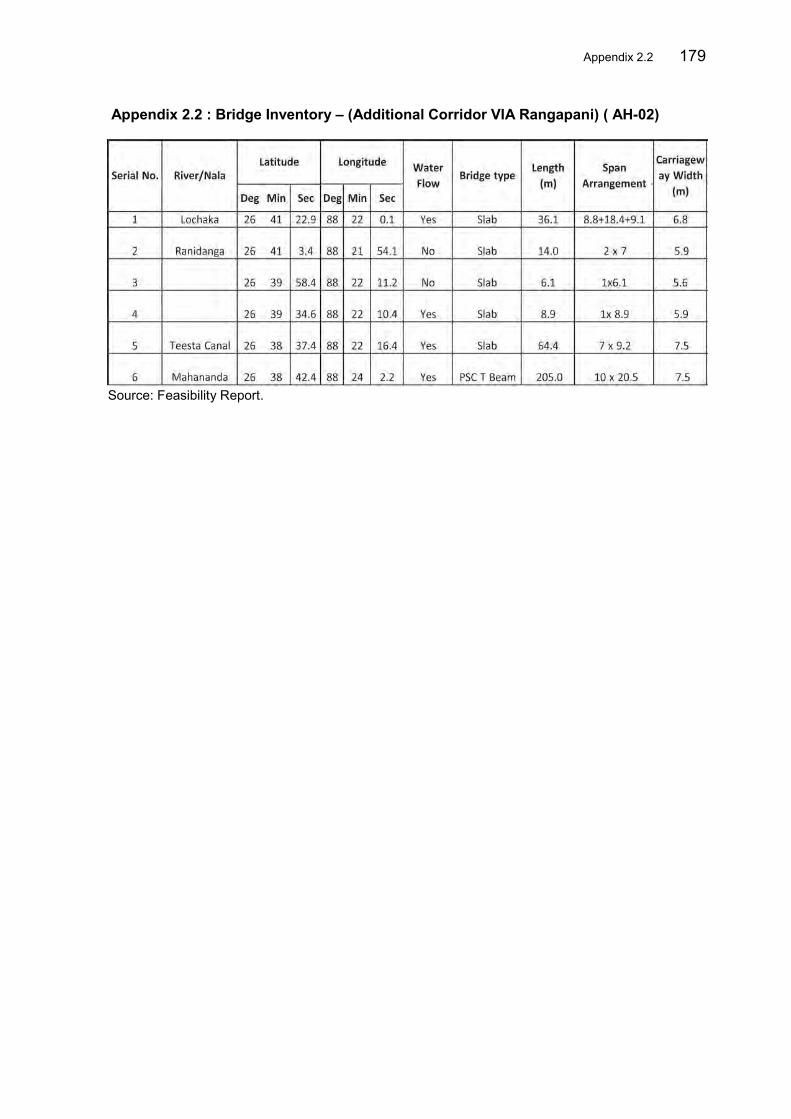
Appendix 2.2 179
Appendix 2.2 : Bridge Inventory – (Additional Corridor VIA Rangapani) ( AH-02)
Source: Feasibility Report.

180 Appendix 2.3
Appendix 2.3 : Bridge Inventory – Bhutan Bangladesh Road ( AH-48)
Source: Feasibility Report 2012
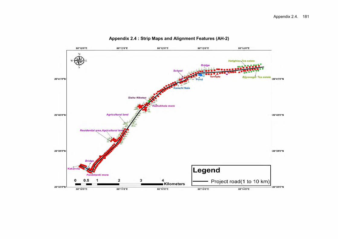
Appendix 2.4. 181
Appendix 2.4 : Strip Maps and Alignment Features (AH-2)

182 Appendix 2.4

Appendix 2.4. 183

184 Appendix 2.4

Appendix 2.5 185
Appendix 2.5: Strip Maps and Alignment Features (AH-48)

186 Appendix 2.5

Appendix 2.5 187

188 Appendix 2.5

Appendix 2.5 189

190 Appendix 2.5

Appendix 3.1 191
Appendix 3.1: Ambient Air Quality and Noise Level Sampling Methodology
I. Sampling Methodology for PM2.5 Instrument Used The Envirotech APM 550 instrument was used for sampling fine particles (PM2.5 fraction) which is based on impactor designs standardized by USEPA for ambient air quality monitoring. Ambient air enters the APM 550 system through an omni-directional inlet designed to provide a clean aerodynamic cut-point for particles greater than 10 microns. Particles in the air stream finer than 10 microns proceed to a second impactor that has an aerodynamic cut point at 2.5 microns. The air sample and fine particulates exiting from the PM2.5 impactor is passed through a 47mm diameter Teflon filter membrane that retains the FPM. The instrument allows removal of the PM2.5 impactor from the sample stream so that the same system may be optionally used as a PM10 Sampler. Principle Air is drawn through a size selective inlet & through a filter. Particulates with diameter less than 2.5µm in ambient air are collected by the filter. The mass of these particles is determined by the difference in filter weights prior to and after sampling. The concentration of PM 2.5 in the designated size range is calculated by dividing the weight gain of the filter by the volume of air sampled. Procedure After sampling place the exposed filters in controlled temperature & relative humidity environment (15°C to 27°C) for 24 hours prior to weighing & then takes the wt. on balance. Record it as the final wt. of filter. Calculations Calculation of volume of air sampled
V = QT V = Volume of air sampled in m3 Q = Average flow rate in m3/minute T = Total sampling time in minute
Calculation of PM 2.5 in ambient air
(Wr - Wi) x 106 PM 2.5 = ----------------------------
V Where: PM 2.5 = Mass concentration of particulate matter less than 10 micron diameter in µg/m3 Wi = Initial wt. of filter in g Wf = Final wt. of filter in g V = Volume of air sampled in m3 106 = Conversion of g to µg

192 Appendix 3.1 II. Sampling Methodology for SPM, RSPM, SO2 and NOX Instrument Used Air quality monitoring was undertaken using Respirable Dust Samplers (Envirotech Model APM 460) with thermoelectrically cooled impinger attachment for gaseous sampling. The APM 460 sampler uses an improved cyclone with sharper cut-off (D50 at 10 microns) to separate the coarser particulates from the air stream before filtering it on the glass microfiber filter. By using the APM 460, measurement of Respirable Particulate Matter can be done accurately and TSPM can also be assessed by collection of dust retained in the cyclone cup. Principle SPM and RSPM – Gravimetric Method using Respirable Dust Sampler SO2 – Absorption in dilute NaOH and then estimated calorimetrically with sulphanilamide and N (I-Nepthyle) Ethylene diamine Dihydrochloride and Hydrogen Peroxide (Central Pollution Control Board (CPCB) Method). NOX – Absorption in Potassium Tetra Chloromercurate followed by Chlorimetric estimation using P-Rosaniline hydrochloride and Formaldehyde (IS: 5182 Part - II). Procedure 24-hourly ambient air samples were collected for SPM, RSPM, SO2 and NOX. These samplers were operated at an average flow rate of 1.1 – 1.2 m3/min. as per IS: 5182 Part II for sampling/collection of SPM and RSPM levels. The particulate matter is collected through high efficiency cyclone which retains the dust particles greater than 10 micron size and allow only fines (less than 10 micron particles) to reach the glass micro-fibre filter where these particles are retained. The instrument provides instantaneous flow rate and the period of operation (on-time) for calculation of air volume passed through the filter. Amount of particulates collected is determined by measuring the change in weight of the cyclone cup and filter paper. The passage of air entering in the cyclone is designed to prevent heavier settleable particles from reaching in the cyclone. For SO2, NOX, ambient air samples were collected using above sampler with impinger attachment provided with specific absorbing solutions, which were operated at an average flow rate of 0.2-0.51 lit./min. as per IS: 5182, Parts IV & VI. The impinger samples (containing SO2, NOX in specific absorbing solutions) were analyzed spectro-photometrically using UV-VIS Shimadzu Spectrophotometer (UV-265). The samples were tested as per standard methods prescribed by CPCB.
III. Methodology for Sound Monitoring Instrument Used Ambient Sound levels were measured using an Integrating sound level meter manufactured by Cygnet (Model No. 2031). It has an indicating mode of Lp and Leq. Keeping the mode in Lp for few minutes and setting the corresponding range and the weighting network in “A” weighting set the

Appendix 3.1 193
sound level meter was run for one hour time and Leq was measured at all locations. Principle The intensity of sound energy in the environment is measured in a logarithmic scale and is expressed in a decibel, dB (A) scale. Ordinary sound level meter measures the sound energy that reaches the microphone by converting it into electrical energy and then measures the magnitude in dB(A). In a sophisticated type of sound level meter, an additional circuit (filters) is provided, which modifies the received signal in such a way that it replicates the sound signal as received by the human ear and the magnitude of sound level in this scale is denoted as dB (A). The sound levels are expressed in dB (A) scale for the purpose of comparison of noise levels, which is universally accepted by the international community. Procedure The day noise levels have been monitored during 6.00am to 10.00pm and night noise levels, during 10.00 pm to 6.00 am in the study area.

194 Appendix 3.2 Appendix 3.2: Details of Faunal Species with IUCN Status found in in AH-02 and AH-48
Road Area
I. Along AH-2 Sub Project Road Alignment List-I: Mammals
Common Name Species Name
WPA 1972 status IUCN Status
A. APES MONKEYS, LEMURS 1 Rhesus Macaque Macaca mulatta (Zinunerman) C
Least Concern
K. ELEPHANT 2 The Indian Elephant Elephas maximus (Linnaeus) I Endangered A2c
C. CIVET 3 The large Indian civet Viverra zibetha (Linnaeus) R
Near Threatened
4 The small India civet ViverricuLa indica (Desmarest)
Least concern
5 Common palm civet Paradoxurus hermaphroditus
(Pallas) 6 Himalaya palm civet Paguma larvata (Hamilton-smith) D. MONGOOSE
7 Common mongoose Herpestes edwasdsi (Geoffroy) 8 Small Indian mongoose Herpestes javanicus (Hoggson) E. DOG
9 Indian fox Vulpes bengalensis (Shaw)
Least concern I.BATS
10 Fulvous Fruit bat Rousettus lescheneulu
(Dosmarest)
Least concern 11 Indian flying fox Pteropus giganteus (Brunnich)
Least concern
12 Shortnosed fruit bat Cynopterus sphinx (Vahl)
Least concern
List-II: Reptiles Sl. No. Common Name Scientific Name WPA Status IUCN Status
Turtle/tortoise 1 Red crowned roof turtle Kachuga kachuga
2 Indian tent Turtle Kachuga tecta Schedule I Vulnearble
3 Narrow-headed softshell turtle Chitra indica (Gray) Schedule IV
4
Indian Peacock soft-shell Turtle Aspideretes hurum (Gray) Schedule I Vulnearble
Lizard
7 Khasi Hills bent-toed gecko Cyrtodactylus khasiensis
(Jerdon) 8 Gecko Gekko verticillatus 9 House gecko Hemidactylus brooki Gray
10 Yellow -green house Gecko Hemidactylus flaviviridis
Ruppell 11 South Asian house Gecko Hemidactylus frenatus Schlegel 12 Indian garden lizard Calotes versicolor (Daudin)
13 Indian Chameleon Chamaeleon zeylanicus
(Laurenti) 14 Bengal monitor Lizard Varanus bengalensis (Daudin) Schedule II Endangered
15 Water monitor Varanus salvator Laurenti Schedule II Endangered Snake
16 Beaked worm snake Typhlops acutus Schedule IV 17 Wall’s worm snake Typhlops oligolepis Wall Schedule IV 18 Indian rock Python Python molurus Linnaeus Schedule IV Endangered
19 Buff-striped keelback. Amphiesma stolata (Linnaeus) Schedule IV
20 Common smooth water Snake Enhydris enhydris (Schneider) Schedule IV

Appendix 3.2 195
Sl. No. Common Name Scientific Name WPA Status IUCN Status 21 Common Wolf Snake Lycodon aulicus (Linnaeus) Schedule IV
22
Checked keelback water snake Xenochrophis piscator Schedule IV
23 Himalayan krait Bungarus bungaroides (Cantor) Schedule IV 24 Banded Krait Bungarus fasciatus (Schneider) Schedule IV 25 Monocled Cobra Naja naja kaoutchia (Linnaeus) Schedule II 26 King Kobra Ophiophagus hannah (Cantor) Schedule II 27 Russell’s viper Vipera russelli (Shaw) Schedule II
List-III: Amphibians Sl. No. Common Name Scientific Name WPA Status IUCN Status
Amphibians 1 Common Indian Toad Duttaphrynus melanostictus Schedule IV
3 Indian Bull Frog Hoplobatrachus tigerinus Schedule IV 4 Jerdon's Bull Frog Hoplobatrachus crassus Schedule IV 5 Skittering Frog Euphlyctis cyanophlyctis Schedule IV 6 Long-tongued Frog Sylvirana leptoglossa Schedule IV 7 Terai Tree Frog Polypedates teraiensis Schedule IV
List-IV: Birds Family Common Name Scientific Name
PHALACROCORACIDAE 1 Little Cormorant Phalacrocorax niger
ARDEIDAE 2 Large Egret Ardea alba
3 Intermediate Egret Egretta intermedia
4 Little Egret Egretta garzetta
5 Cattle Egret Bubulcus ibis
6 Indian Pond Heron Ardeola grayii
ANATIDAE 7 Lesser Whistling Teal Dendrocygna javanica
8 Common Teal Anas crecca
9 Mallard Anas platyrhynchos
10 Northern Pintail Anas acuta
11 Northern Shoveler Anas clypeata
12 Garganey Anas querquedula
13 Common Pochard Aythya ferina
ACCPITRIDAE 14 Pied Harrier Circus melanoleucos
15 Black Kite Milvus migrans govinda
16 Pied Harrier Circus melanoleucos
PHASIANIDAE 17 Indian Peafowl Pavo cristatus
18 Red Jungle Fowl Gallus gallus
CHARADRIIDAE 19 Red-wattled Lapwing Vanellus indicus
20 Pacific Golden Plover Pluvialis fulva
21 River Lapwing Vanellus duvaucelii
22 Little Ringed Plover Charadrius dubius
23 Greater Sand Plover Charadrius leschenaultia
COLUMBIDAE 24 Oriental Turtle Dove Streptopelia orientalis
25 Spotted Dove Streptopilia chinensis
26 Eurasian Collared dove Streptopelia decaocto

196 Appendix 3.2
Family Common Name Scientific Name 27 Yellow-footed Green Pigeon Treron phoenicoptera
PSITTACIDAE 28 Red-breasted Parakeet Psittacula alexandri
CUCULIDAE 29 Common Hawk Cuckoo Hierococcyx varius
CICONIIDAE 30 Open Bill Stork Anastomus oscitans
JACANIDAE 31 Bronze-winged Jacana Metopidius indicus
RECURVIROSTRIDAE 32 Pied Avocet Recurvirostra avosetta
PODICIPEDIDAE 33 Little Grebe Tachybaptus ruficollis
34 Great Crested Grebe Podiceps cristatus
RALLIDAE 35 Common Coot Fulica atra
36 Purple Swamphen Porphyrio porphyrio
ALCEDINIDAE 37 Common Kingfisher Alcedo atthis
38 Ruddy Kingfisher Halcyon coromanda
MOTACILLIDAE 39 Yellow Wagtail Motacilla flava
40 White Wagtail Motacilla alba
41 Citrine Wagtail Motacilla citreola
42 Grey Wagtail Motacilla cinerea
LARIDAE 43 Black-headed Gull Larus ridibundus
44 Whiskered Tern Chlidonias hybridus
HIRUNDINIDAE 45 Barn Swallow Hirundo rustica
FALCONIDAE 46 Common Kestrel Falco tinnunculus
MEROPIDAE 47 Green Bee-eater Merops orientalis
CORACIDAE 48 Indian Roller Coracias bengalensis
CAPITONIDAE 49 Blue-throated Barbet Megalaima asiatica
50 Lineated Barbet Megalaima lineata
PICIDAE 51 Black-rumped Flameback Dinopium benghalense
LANIIDAE 52 Long-tailed Shrike Lanius schach
53 Grey-backed Shrike Lanius tephronotus
ORIOLIDAE 54 Black-hooded oriole Oriolus xanthornus
DICRURIDAE 55 Ashy Drongo Dicrurus leocucephalus
56 Bronzed Drongo Dicrurus aeneus
57 Crow-billed Drongo Dicrurus annectans
STURNIDAE 58 Common Myna Acridotheres tristis
59 Asian Pied Starling Sturnus contra
CAMPEPHAGIDAE
60 Long-tailed Minivet Pericrocotus ethologus

Appendix 3.2 197
Family Common Name Scientific Name SYLVINAE
61 Yellow-browed Warbler Phylloscopus inornatus
62 Plain Prinia Prinia subflava
63 Jungle warbler Turdoides striatus
64 Striated Grassbird Megalurus palustris
65 Golden-spectacled Warbler Seicercus burkii
MUSCICAPINAE 66 Grey-headed Canary Flycatcher Culicicapa ceylonensis
67 Little Pied Flycatcher Ficedula westermanni
CORVIDAE 68 Rufous Tree Pie Dendrocitta vagabunda
69 Large-billed crow Corvus macrorhynchos
PYCNONOTIDAE 70 Red-vented Bulbul Pycnonotus cafer
TURDINAE 71 White rumped Shama Copsychus malabaricus
72 White-capped Water Redstart Chaimarrornis leucocephalus
PLOCEIDAE 73 Eurasian Tree Sparrow Passer montanus
74 Scaly-breasted Munia Lonchura punctulata
SCOLOPACIDAE 75 Jack Snipe Lymnocryptes minimus
76 Common Snipe Gallinago gallinago
77 Marsh Sandpiper Tringa stagnatilis
78 Green Sandpiper Tringa ochropus
79 Wood Sandpiper Tringa glareola
80 Common Sandpiper Actitis hypoleucos
81 Common Green Shank Tringa nebularia
82 Little Stint Calidris minuta
List-V: Butterfly
Sl. No. Common Name Scientific Name Distribution Status Family: Papillonidae
1 Common Bluebottle Graphium sarpendon (Linnaeus) common 2 Common Jay Graphium doson common 3 Tailed Jay Graphium ararmemnon common 4 Yellow Helen Papilio nephelus common 5 Spangle Papilio protenor common 6 Commom Batwing Troides helena common 7 Lime Butterfly Papilio demoleus common 8 Common Rose Atrophaneura aristolochiae common 9 Great Mormon Papilio memnon common
Family: Pieridae 10 Common Grass Yellow Eurema hecabe common 11 Common Emigrant Catopsilia Pomona common 12 Mottled Emigrant Catopsilia pyranthe common 13 Great Orange Tip Hebomoia glaucippe common 14 Chocolate Albatross Appias lyncida common 15 Common Gull Cepora nerissa common 16 Psyche Leptosia nine common 17 Indian cabbage White Pieris canidie common 18 Yellow Orange Tip Ixias pyrene common
FAMILY: Lycaenidae 19 Large Oakblue Arhopala arnantes Common 20 Yarnfly Loxura atymnus common

198 Appendix 3.2
21 Common Imperial Chentra freja common 22 Common Tit Hypolycaena erylus common 23 Fluffy Tit Zeltus arnasa common 24 Slate Flash Rapala manea common 25 Common Silverline Spindasis valcanus common 26 Common Ciliate Blue Anthene emolus common 27 Common Lineblue Prosotas nora common 28 Purple Sapphire Heliophorus epicles common 29 Common hedge Blue Acytolepsis puspa common 30 Angled Sunbeam Curetis acuta common
Family: Nymphalidae 31 Dark Blue Tiger Tirumala septentrionis common 32 Blue Tiger Tirumala limniace common 33 Striped Tiger Danaus genutia common 34 Glassy Tiger Parantica aglea common 35 Plain Tiger Danaus chrysippus common 36 Common Nawab Polyura athamas common 37 Tawny Rajah Charaxes bernadus common 38 Banded Treebrown Lethe confusa common 39 Common Palmfly Elymnias hypermnestra common 40 Common Leopard Phalanta phalanta common 41 Commander Moduza procris common 42 Common Lascar Pantoporia hordonia common 43 Common Baron Euthalia aconthea common 44 Grey Count Tanaecia lepidea common 45 Common Map Cyrestis thyodamas common 46 Chocolate pansy Junonia lphita common 47 Grey pansy Junonia atlites common 48 Lemon Pansy Junonia lemonias common 49 Peacock Pansy Junonia almana common 50 Great Eggfly Hypolimnas bolina common 51 Indian Skipper Spialia galba common 52 Common Small Flat Sarangesa dasahara common 53 Rice Swift Borbo cinnara common 54 Dark Palm Dart Telicota ancilla common 55 Grass Demon Udapspes folus common 56 Restricted Demon Notocrypya curvi fascia common
(Source-Primary and Secondary Data)
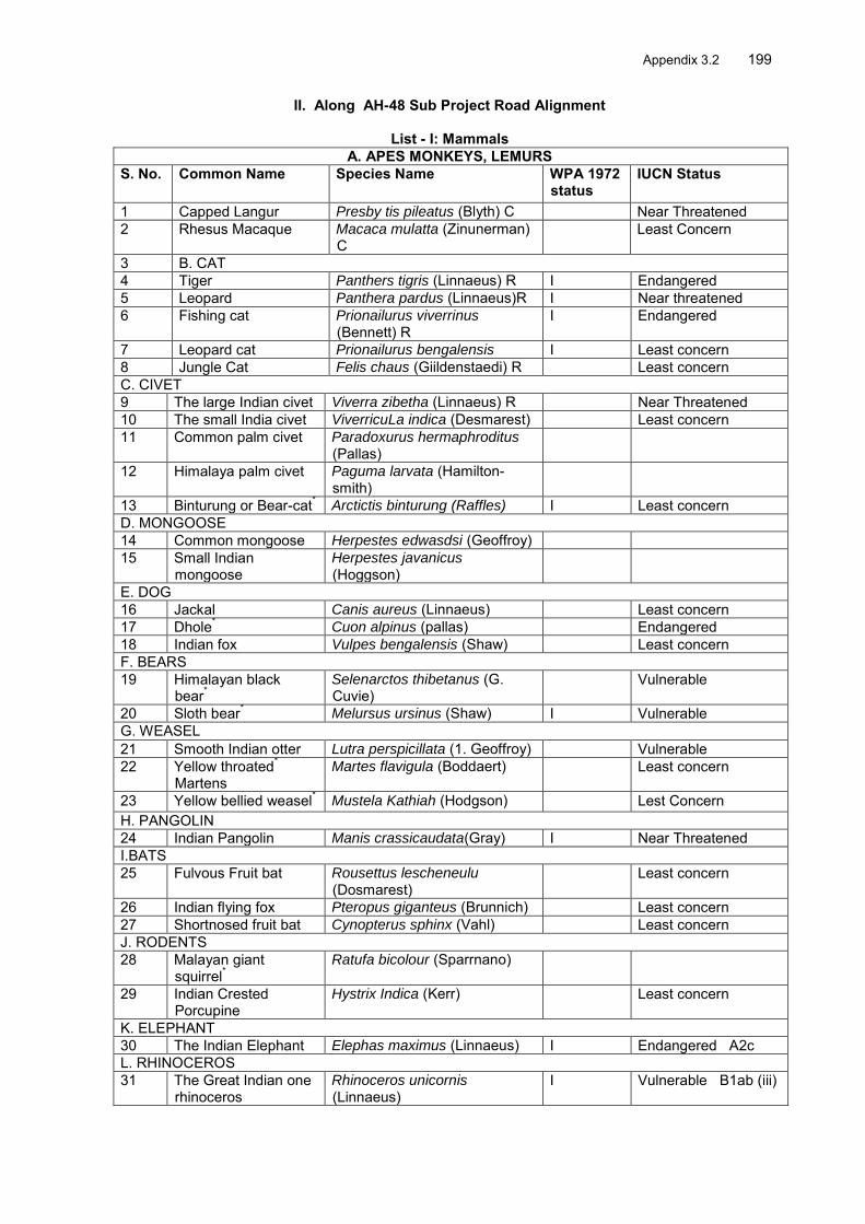
Appendix 3.2 199
II. Along AH-48 Sub Project Road Alignment
List - I: Mammals A. APES MONKEYS, LEMURS
S. No. Common Name Species Name WPA 1972 status
IUCN Status
1 Capped Langur Presby tis pileatus (Blyth) C Near Threatened 2 Rhesus Macaque Macaca mulatta (Zinunerman)
C Least Concern
3 B. CAT 4 Tiger Panthers tigris (Linnaeus) R I Endangered 5 Leopard Panthera pardus (Linnaeus)R I Near threatened 6 Fishing cat Prionailurus viverrinus
(Bennett) R I Endangered
7 Leopard cat Prionailurus bengalensis I Least concern 8 Jungle Cat Felis chaus (Giildenstaedi) R Least concern C. CIVET 9 The large Indian civet Viverra zibetha (Linnaeus) R Near Threatened 10 The small India civet ViverricuLa indica (Desmarest) Least concern 11 Common palm civet Paradoxurus hermaphroditus
(Pallas)
12 Himalaya palm civet Paguma larvata (Hamilton-smith)
13 Binturung or Bear-cat* Arctictis binturung (Raffles) I Least concern D. MONGOOSE 14 Common mongoose Herpestes edwasdsi (Geoffroy) 15 Small Indian
mongoose Herpestes javanicus (Hoggson)
E. DOG 16 Jackal Canis aureus (Linnaeus) Least concern 17 Dhole* Cuon alpinus (pallas) Endangered 18 Indian fox Vulpes bengalensis (Shaw) Least concern F. BEARS 19 Himalayan black
bear* Selenarctos thibetanus (G. Cuvie)
Vulnerable
20 Sloth bear* Melursus ursinus (Shaw) I Vulnerable
G. WEASEL 21 Smooth Indian otter Lutra perspicillata (1. Geoffroy) Vulnerable 22 Yellow throated*
Martens Martes flavigula (Boddaert) Least concern
23 Yellow bellied weasel* Mustela Kathiah (Hodgson) Lest Concern H. PANGOLIN 24 Indian Pangolin Manis crassicaudata(Gray) I Near Threatened I.BATS 25 Fulvous Fruit bat Rousettus lescheneulu
(Dosmarest) Least concern
26 Indian flying fox Pteropus giganteus (Brunnich) Least concern 27 Shortnosed fruit bat Cynopterus sphinx (Vahl) Least concern J. RODENTS 28 Malayan giant
squirrel* Ratufa bicolour (Sparrnano)
29 Indian Crested Porcupine
Hystrix Indica (Kerr) Least concern
K. ELEPHANT 30 The Indian Elephant Elephas maximus (Linnaeus) I Endangered A2c L. RHINOCEROS 31 The Great Indian one
rhinoceros Rhinoceros unicornis (Linnaeus)
I Vulnerable B1ab (iii)

200 Appendix 3.2 M. WILD OX, SHEEP, GOATS 32 The Gaur or Indian
Bison Bos gaurus Vulnerable A2cd+3c
d+4cd N. DEER 33 Sambar Cervus unioclor (Kerr) Vulnerable A2cd+3c
d+4cd 34 Hog deer Axis porcinus (Zimmerman) Endangered A2bcd 35 Spotted deer Axis axis Least concern 36 Muntjak or Barking
deer Muntiacus muntjak (Zimmerman)
Least concern
P.PIG, ETC. 37 Wild boar Sus scrofa (Linnaeus) Least concern *Data were collected based on secondary information provided by the local people near the Jaldapara National Park.
List II-Reptiles
Sl. No.
Common Name Scientific Name WPA Status IUCN Status
Turtle/tortoise 1 Red crowned roof turtle Kachuga kachuga 2 Indian tent Turtle Kachuga tecta Schedule I Vulnearble 3 Tricarinate hill turtle Melanochelys tricarinata Schedule I 4 Elongated tortoise Geochelone elongata (Blyth) 5 Narrow-headed softshell
turtle Chitra indica (Gray) Schedule IV
6 Indian Peacock soft-shell Turtle
Aspideretes hurum (Gray) Schedule I Vulnearble
Lizard 7 Khasi Hills bent-toed gecko. Cyrtodactylus khasiensis
(Jerdon)
8 Gecko Gekko verticillatus 9 House gecko Hemidactylus brooki Gray 10 Yellow -green house Gecko Hemidactylus flaviviridis
Ruppell
11 South Asian house Gecko Hemidactylus frenatus Schlegel 12 Indian garden lizard Calotes versicolor (Daudin) 13 Indian Chameleon Chamaeleon zeylanicus
(Laurenti)
14 Bengal monitor Lizard Varanus bengalensis (Daudin) Schedule II Endangered 15 Water monitor Varanus salvator Laurenti Schedule II Endangered Snake 16 Beaked worm snake Typhlops acutus Schedule IV 17 Wall’s worm snake Typhlops oligolepis Wall Schedule IV 18 Indian rock Python Python molurus Linnaeus Schedule IV Endangered 19 Buff-striped keelback. Amphiesma stolata (Linnaeus) Schedule IV 20 Copper-headed trinket snake. Elaphae radiata (Schegel) Schedule IV 21 Common smooth water
Snake Enhydris enhydris (Schneider) Schedule IV
22 Common Wolf Snake Lycodon aulicus (Linnaeus) Schedule IV 23 Western rat Snake Ptyas mucosus (Linnaeus) Schedule IV 24 Himalayan keelback Rhabdophis himalayana
Gunther Schedule IV
25 Checked keelback water snake
Xenochrophis piscator Schedule IV
26 Himalayan krait Bungarus bungaroides (Cantor) Schedule IV 27 Banded Krait Bungarus fasciatus
(Schneider) Schedule IV
28 Monocled Cobra Naja naja kaoutchia (Linnaeus) Schedule II

Appendix 3.2 201
29 King Kobra Ophiophagus hannah (Cantor) Schedule II 30 Russell’s viper Vipera russelli (Shaw) Schedule II
List III - Amphibian
Sl. No. Common Name Scientific Name WPA Status IUCN Status Amphibians 1 Common Indian Toad Duttaphrynus melanostictus Schedule IV
2 Ornate Narrow-mouthed Frog Microhyla ornata Schedule IV 3 Painted Frog Kaloula taprobanica Schedule IV 4 Balloon Frog Uperodon globulosus Schedule IV 5 Indian Bull Frog Hoplobatrachus tigerinus Schedule IV 6 Jerdon's Bull Frog Hoplobatrachus crassus Schedule IV 7 Skittering Frog Euphlyctis cyanophlyctis Schedule IV 8 Long-tongued Frog Sylvirana leptoglossa Schedule IV 9 Bright Frog Sylvirana humeralis Schedule IV 10 Reed Frog Hylarana tytleri Schedule IV 11 Terai Cricket Frog Fejervarya teraiensis Schedule IV 12 Small Cricket Frog Fejervarya pierrei Schedule IV 13 Terai Tree Frog Polypedates teraiensis Schedule IV
List IV- Aves Family Common Name Scientific Name PHALACROCORACIDAE 1 Little Cormorant Phalacrocorax niger ARDEIDAE 2 Large Egret Ardea alba
3 Intermediate Egret Egretta intermedia
4 Little Egret Egretta garzetta
5 Cattle Egret Bubulcus ibis
6 Grey Heron Ardea cinerea
7 Indian Pond Heron Ardeola grayii
CICONIIDAE 8 Lesser Adjutant Stork Leptoptilos javanicus
9 Asian Openbill Anastomus oscitans
ANATIDAE 10 Gadwall Anas strepera
11 Lesser Whistling Teal Dendrocygna javanica
12 Eurasian Wigeon Anas penelope
13 Baer’s Pochard Aythya baeri
14 Common Teal Anas crecca
15 Mallard Anas platyrhynchos
16 Northern Pintail Anas acuta
17 Northern Shoveler Anas clypeata
18 Red-crested Pochard Netta rufina
19 Ferruginous Duck Aythya nyroca
20 Garganey Anas querquedula
21 Common Pochard Aythya ferina
22 Tufted Duck Aythya fuligula
ACCPITRIDAE 23 Pied Harrier Circus melanoleucos
24 Eastern Marsh Harrier Circus spilonotus
25 Osprey Pandion haliaetus
26 Eurasian Sparrowhawk Accipiter nisus
27 Greater Spotted Eagle Aquila clanga
28 Black Kite Milvus migrans govinda
29 Red-headed vulture Sarcogyps calvus
30 Pied Harrier Circus melanoleucos
PHASIANIDAE
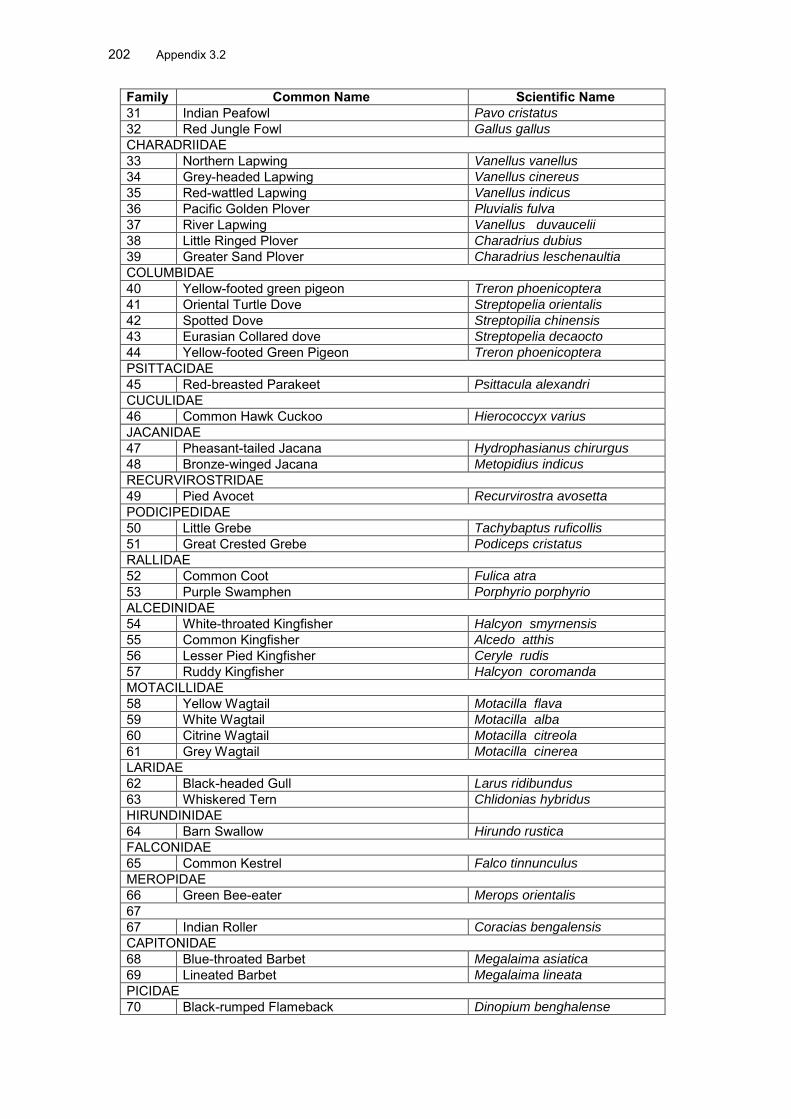
202 Appendix 3.2
Family Common Name Scientific Name 31 Indian Peafowl Pavo cristatus
32 Red Jungle Fowl Gallus gallus
CHARADRIIDAE 33 Northern Lapwing Vanellus vanellus 34 Grey-headed Lapwing Vanellus cinereus
35 Red-wattled Lapwing Vanellus indicus
36 Pacific Golden Plover Pluvialis fulva
37 River Lapwing Vanellus duvaucelii
38 Little Ringed Plover Charadrius dubius
39 Greater Sand Plover Charadrius leschenaultia
COLUMBIDAE 40 Yellow-footed green pigeon Treron phoenicoptera
41 Oriental Turtle Dove Streptopelia orientalis
42 Spotted Dove Streptopilia chinensis
43 Eurasian Collared dove Streptopelia decaocto
44 Yellow-footed Green Pigeon Treron phoenicoptera
PSITTACIDAE 45 Red-breasted Parakeet Psittacula alexandri CUCULIDAE 46 Common Hawk Cuckoo Hierococcyx varius JACANIDAE 47 Pheasant-tailed Jacana Hydrophasianus chirurgus
48 Bronze-winged Jacana Metopidius indicus
RECURVIROSTRIDAE 49 Pied Avocet Recurvirostra avosetta PODICIPEDIDAE 50 Little Grebe Tachybaptus ruficollis
51 Great Crested Grebe Podiceps cristatus
RALLIDAE 52 Common Coot Fulica atra
53 Purple Swamphen Porphyrio porphyrio
ALCEDINIDAE 54 White-throated Kingfisher Halcyon smyrnensis
55 Common Kingfisher Alcedo atthis
56 Lesser Pied Kingfisher Ceryle rudis
57 Ruddy Kingfisher Halcyon coromanda
MOTACILLIDAE 58 Yellow Wagtail Motacilla flava
59 White Wagtail Motacilla alba
60 Citrine Wagtail Motacilla citreola
61 Grey Wagtail Motacilla cinerea
LARIDAE 62 Black-headed Gull Larus ridibundus
63 Whiskered Tern Chlidonias hybridus
HIRUNDINIDAE 64 Barn Swallow Hirundo rustica FALCONIDAE 65 Common Kestrel Falco tinnunculus MEROPIDAE 66 Green Bee-eater Merops orientalis 67 67 Indian Roller Coracias bengalensis CAPITONIDAE 68 Blue-throated Barbet Megalaima asiatica
69 Lineated Barbet Megalaima lineata
PICIDAE 70 Black-rumped Flameback Dinopium benghalense

Appendix 3.2 203
Family Common Name Scientific Name LANIIDAE 71 Long-tailed Shrike Lanius schach
72 Grey-backed Shrike Lanius tephronotus
ORIOLIDAE 73 Black-hooded oriole Oriolus xanthornus DICRURIDAE 74 Ashy Drongo Dicrurus leocucephalus
75 Bronzed Drongo Dicrurus aeneus
76 Greater Racket tailed Drongo Dicrurus paradiseus
77 Crow-billed Drongo Dicrurus annectans
STURNIDAE 78 Common Myna Acridotheres tristis
79 Asian Pied Starling Sturnus contra
CAMPEPHAGIDAE 80 Long-tailed Minivet Pericrocotus ethologus SYLVINAE 81 Yellow-browed Warbler Phylloscopus inornatus
82 Plain Prinia Prinia subflava
83 Jungle warbler Turdoides striatus
84 Striated Grassbird Megalurus palustris
85 Golden-spectacled Warbler Seicercus burkii
MUSCICAPINAE 86 Black-naped Monarch Hypothymeus azurea
87 Grey-headed Canary Flycatcher Culicicapa ceylonensis
88 Little Pied Flycatcher Ficedula westermanni
CORVIDAE 89 Rufous Tree Pie Dendrocitta vagabunda
90 Large-billed crow Corvus macrorhynchos
BUCEROTIDAE 91 Oriental Pied Hornbill Anthracoceros albirostris
92 Great Hornbill Buceros bicornis
PYCNONOTIDAE 93 Red-vented Bulbul Pycnonotus cafer
TURDINAE 94 White rumped Shama Copsychus malabaricus
95 White-capped Water Redstart Chaimarrornis leucocephalus
PLOCEIDAE 96 Eurasian Tree Sparrow Passer montanus
97 Scaly-breasted Munia Lonchura punctulata
SCOLOPACIDAE 98 Jack Snipe Lymnocryptes minimus
99 Common Snipe Gallinago gallinago
100 Marsh Sandpiper Tringa stagnatilis
101 Green Sandpiper Tringa ochropus
102 Wood Sandpiper Tringa glareola
103 Common Sandpiper Actitis hypoleucos
104 Common Green Shank Tringa nebularia
105 Little Stint Calidris minuta
ROSTRATULIDAE 106 Painted Snipe Rostratula benghalensis PHASIANIDAE 107 Jungle Bush Quail Perdicula asiatica
List IV - Butterfly Sl. No. Common Name Scientific Name Distribution Status Family: Papillonidae 1 Common Bluebottle Graphium sarpendon (Linnaeus) common

204 Appendix 3.2 Sl. No. Common Name Scientific Name Distribution Status 2 Common Jay Graphium doson common 3 Tailed Jay Graphium ararmemnon common 4 Five-bar Swordtail Graphium antiphates common 5 Common Mormon Papilio polytes common 6 Red Helen Papilio helenus Rare 7 Yellow Helen Papilio nephelus common 8 Spangle Papilio protenor common 9 Common Batwing Atrophaneura varuna Rare 10 Commom Batwing Troides helena common 11 Lime Butterfly Papilio demoleus common 12 Common Rose Atrophaneura aristolochiae common 13 Great Mormon Papilio memnon common 14 Paris Peacock Papilio paris Not Common 15 Common Raven Papilio castor Not Common Family: Pieridae 16 Common Grass Yellow Eurema hecabe common 17 Tree Yellow Gandaca harina Rare 18 Common Emigrant Catopsilia Pomona common 19 Mottled Emigrant Catopsilia pyranthe common 20 Great Orange Tip Hebomoia glaucippe common 21 Chocolate Albatross Appias lyncida common 22 Striped Albatross Appias libythea Not Common 23 Common Gull Cepora nerissa common 24 Psyche Leptosia nine common 25 Redspot Jezebel Delias descombesi Not Common 26 Indian cabbage White Pieris canidie common 27 Yellow Orange Tip Ixias pyrene common FAMILY: Lycaenidae 28 Large Oakblue Arhopala arnantes Common 29 Common Acacia Blue Surendra quercetorum Not Common
30 Yellow-disc Tailless Oakblue Arhopala perimuta Rare
31 Yarnfly Loxura atymnus common 32 Blue Imperial Ticherra acte Not Common 33 Common Imperial Chentra freja common 34 Chocolate Royal Ramelane jangala Rare 35 White-banded Royal Dacalana cotys Not Common 36 Common Tit Hypolycaena erylus common 37 Fluffy Tit Zeltus arnasa common 38 Orchid Tit Ch;iaria othona Rare/ Schedule I 39 Slate Flash Rapala manea common 40 Common Silverline Spindasis valcanus common 41 Common Ciliate Blue Anthene emolus common 42 Elbowed Pierrot Caleta elna common 43 Common Pierrot Castalius rosimon common 44 Opaque 6-lineblue Nacaduba beroe Not Common 45 Common Lineblue Prosotas nora common 46 Dingy Lineblue Petrelaea dana Not Common 47 Purple Sapphire Heliophorus epicles common 48 Common hedge Blue Acytolepsis puspa common 49 Tailless Lineblue Prosotas dubiosa indica Not Common 50 Angled Sunbeam Curetis acuta common 51 Quaker Neopithecops zalmora Not Common Family: Nymphalidae 52 Dark Blue Tiger Tirumala septentrionis common 53 Blue Tiger Tirumala limniace common 54 Striped Tiger Danaus genutia common
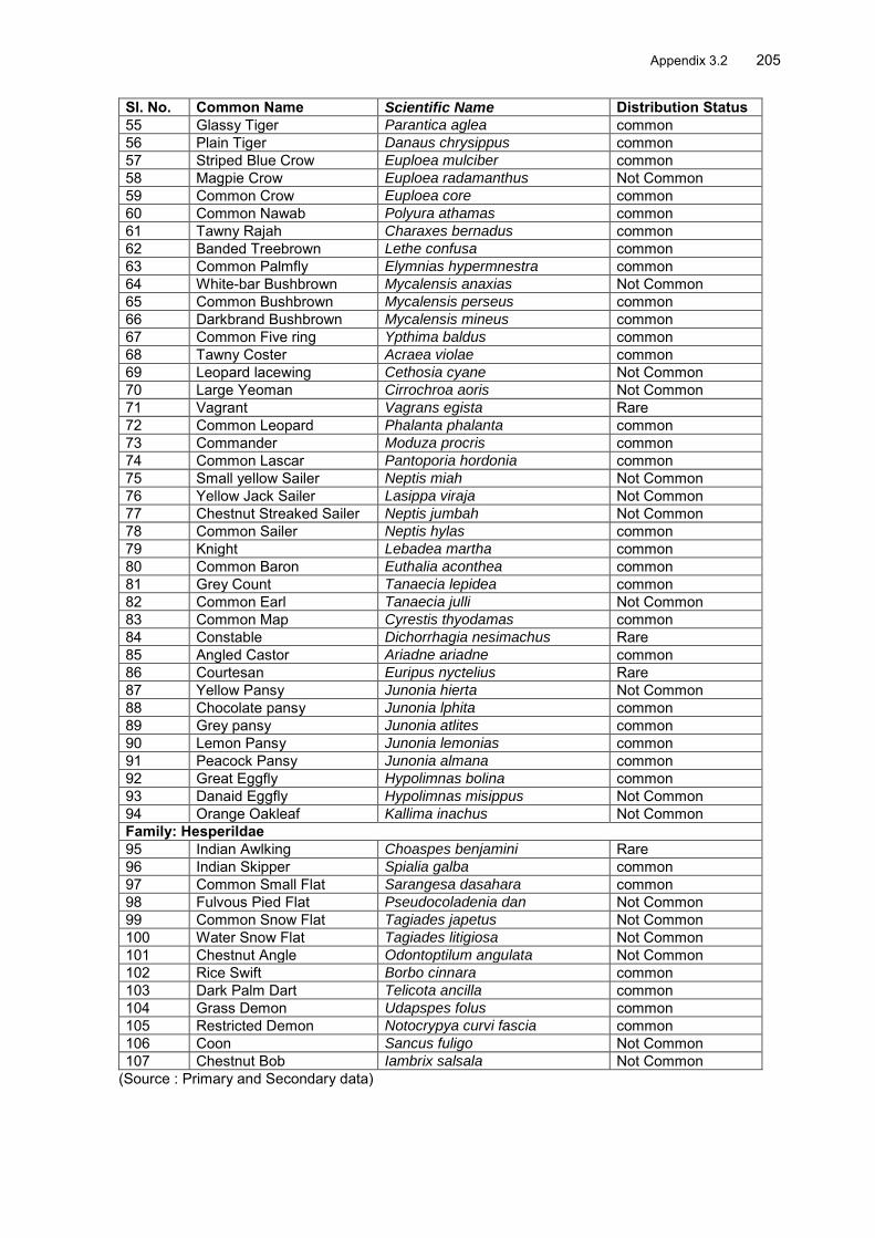
Appendix 3.2 205
Sl. No. Common Name Scientific Name Distribution Status 55 Glassy Tiger Parantica aglea common 56 Plain Tiger Danaus chrysippus common 57 Striped Blue Crow Euploea mulciber common 58 Magpie Crow Euploea radamanthus Not Common 59 Common Crow Euploea core common 60 Common Nawab Polyura athamas common 61 Tawny Rajah Charaxes bernadus common 62 Banded Treebrown Lethe confusa common 63 Common Palmfly Elymnias hypermnestra common 64 White-bar Bushbrown Mycalensis anaxias Not Common 65 Common Bushbrown Mycalensis perseus common 66 Darkbrand Bushbrown Mycalensis mineus common 67 Common Five ring Ypthima baldus common 68 Tawny Coster Acraea violae common 69 Leopard lacewing Cethosia cyane Not Common 70 Large Yeoman Cirrochroa aoris Not Common 71 Vagrant Vagrans egista Rare 72 Common Leopard Phalanta phalanta common 73 Commander Moduza procris common 74 Common Lascar Pantoporia hordonia common 75 Small yellow Sailer Neptis miah Not Common 76 Yellow Jack Sailer Lasippa viraja Not Common 77 Chestnut Streaked Sailer Neptis jumbah Not Common 78 Common Sailer Neptis hylas common 79 Knight Lebadea martha common 80 Common Baron Euthalia aconthea common 81 Grey Count Tanaecia lepidea common 82 Common Earl Tanaecia julli Not Common 83 Common Map Cyrestis thyodamas common 84 Constable Dichorrhagia nesimachus Rare 85 Angled Castor Ariadne ariadne common 86 Courtesan Euripus nyctelius Rare 87 Yellow Pansy Junonia hierta Not Common 88 Chocolate pansy Junonia lphita common 89 Grey pansy Junonia atlites common 90 Lemon Pansy Junonia lemonias common 91 Peacock Pansy Junonia almana common 92 Great Eggfly Hypolimnas bolina common 93 Danaid Eggfly Hypolimnas misippus Not Common 94 Orange Oakleaf Kallima inachus Not Common Family: Hesperildae 95 Indian Awlking Choaspes benjamini Rare 96 Indian Skipper Spialia galba common 97 Common Small Flat Sarangesa dasahara common 98 Fulvous Pied Flat Pseudocoladenia dan Not Common 99 Common Snow Flat Tagiades japetus Not Common 100 Water Snow Flat Tagiades litigiosa Not Common 101 Chestnut Angle Odontoptilum angulata Not Common 102 Rice Swift Borbo cinnara common 103 Dark Palm Dart Telicota ancilla common 104 Grass Demon Udapspes folus common 105 Restricted Demon Notocrypya curvi fascia common 106 Coon Sancus fuligo Not Common 107 Chestnut Bob Iambrix salsala Not Common
(Source : Primary and Secondary data)

206 Appendix 3.3
Appendix 3.3 : Inventory of Community Infrastructure
AH 2 Nepal Bangladesh: List of villages / urban areas Sr. Chainage Location Name of Tahsil District Particulars of Infrastructure No. Distance from road village Type / title Running Utility :Purpose L Side R side urban area length along
the road Purpose Usag
e Owner
1 0 0 0 Nepal O point Kharibari Darjeeling Kakarbhita 0 Custom Govt 2 0.5 Panitanki Kharibari Darjeeling India check post Custom Govt 3 1 5 Panitanki Naxalbari Darjeeling Market place -
Panitanki 100 School 100 Committee
4 4.8 10 Rathkhola Naxalbari Darjeeling Shishu Niketan School Private 5 7.2 5 -- Naxalbari Naxalbari Darjeeling Hindi Higher
Secondary School 100 School 600 Committee
6 10 Borojhoro Naxalbari Darjeeling School - Durga Temple Mangal.
20 School 100 Committee
7 Hatighisa Naxalbari Darjeeling Hatighisa TE Factory Private 8 5 Hatighisa Naxalbari Darjeeling Shishu Shiksha
Kendra 50 School 100 Committee
9 Bijaynagar TE Naxalbari Darjeeling Bijoynagar TE Factory Private 10 0 0 Atal Naxalbari Darjeeling Village Atal - Tea
Estate Paharguri Factory Private
11 0 0 Sanyasi Naxalbari Darjeeling Playgorund Recreation Private 12 10 -- Upper
Bagdogra Naxalbari Darjeeling Hebron High School 100 School 1750 Private
13 16.8 - 2 Upper Bagdogra
Naxalbari Darjeeling Bagdogra Balika Vidyalaya
50 School 900 Govt
14 17 0 -- Upper Bagdogra
Naxalbari Darjeeling Market Market Committee
15 17.8 5 Bagdogara Naxalbari Darjeeling Gate No. 1 NBU 10 University 5000 Govt 16 10 -- Bagdogara Naxalbari Darjeeling North Bengal
University Dep. Law 100 College 500 Govt
17 50 -- Budiwalason Naxalbari Darjeeling College Kalipad Vidyalaya
100 College 1000 Society
18 22.7 0 0 Shivmandir Matigara Darjeeling St Paul 20 School 200 Private 19 -- 100 Kadamtala Matigara Darjeeling International Lapers
Rehabilitation 100 Hospital 100 Committee
20 20 -- Kadamtala Matigara Darjeeling Durga Mandir 100 Temple 100 Committee 21 -- 5 Kadamtala Matigara Darjeeling Sanyasi Baba Mandir 10 Temple 80 Committee 22 -- 2 Kadamtala Matigara Darjeeling Kali Temple 5 Temple 50 Committee

Appendix 3.3 207
AH-48 Bhutan – Bangladesh Inventory of PCRs
23 100 -- Kadamtala Matigara Darjeeling North Bengal Medical College
300 Hospital 2000 Govt
24 10 -- Kadamtala Matigara Darjeeling Kadam. Gram Sahayak Hall
20 GP 100 GP
25 25.3 2 -- Kawakhali Matigara Darjeeling Jr.High School 100 School 250 Govt 26 30.8 -- 10 Kamagaguri Siliguri MC Jalpaiguri Mata Maya Kali Mandir 20 Temple 100 Committee 27 0 0 Fulbari Siliguri MC Jalpaiguri Canal Teesta 10 Canal Govt 28 -- 100 Fulbari Siliguri MC Jalpaiguri Truck Terminal 300 Transport Govt 29 39 0 0 Bangladesh
O pt Naxalbari Darjeeling Bangladesh Zero Point Custom Govt
31 0 0 Canal Barrage
Naxalbari Darjeeling Teesta Canal Barrage Canal Govt
32 0 100 Teesta Canal Naxalbari Darjeeling Basil Fund World 300 Recreation 100 Private 33 44 -- 40 Rangapani Naxalbari Darjeeling Nimtala Smashan -
cremation Cremation Committee
34 -- 25 Boropathar Naxalbari Darjeeling NRL - Petrol Supply Depot
300 Company 100 Private
35 5 -- Ranidanga Naxalbari Darjeeling Ranidanga Kalaram High School
200 School 2000 Society
36 49 5 -- Ranidanga Naxalbari Darjeeling Ranidanga Jr. Girls High School
100 School 450 Govt
S.N Chai- Location Running Name of Tahsil District Nature of Utility :Purpose nage Distance length m Village Infrastructur
e Purpose Usage Owner
from road L Side R side urban area Type / title 1 2 3 1 -- 0 1.5 Changlabandh Mekhliganj Cooch Behar Temple (Shani) August Union 4 1 35 30 Changlabandh Mekhliganj Cooch Behar Jr. Girls High
School School 8 months Govt
5 1 5 0 40 Changlabandh Mekhliganj Cooch Behar Shopping Mall Mall Yet to open
Govt
6 1 5 0 300 Changlabandh Mekhliganj Cooch Behar Parking Place Parking Truckers Govt 7 1 -- 40 100 Changlabandh Mekhliganj Cooch Behar Primary Health
Centre Dispensary 110
patients Govt
8 1 -- 0 1.5 Changlabandh Mekhliganj Cooch Behar Temple (Shani) School Few Public 9 1.8 5 -- 10 Changlabandh Mekhliganj Cooch Behar School St Johns Temple 100 Private
10 24 -- 2 5 Kalasibandha Mekhliganj Cooch Behar Temple Few Committee

208 Appendix 3.3
11 12.6 -- 10 100 Ghoskadanga Mayanaguri Jalpaiguri School School 300 Govt 12 13.5 -- 15 20 Ghoskadanga Mayanaguri Jalpaiguri Sports Club Sports 34 Committee 13 14.6 -- 100 100 Ghoskadanga Mayanaguri Jalpaiguri Bholanath H/S School 650 Govt 14 17.5 -- 20 50 Madhudanga Mayanaguri Jalpaiguri Temple
(Kalibari) Temple Few Private
15 18 -- 10 50 Madhudanga Mayanaguri Jalpaiguri Temple -Bateswar
Temple Few Private
16 18 -- 20 50 Madhudanga Mayanaguri Jalpaiguri Jr. Basic School School 80 ZP 17 20.6 40 -- 100 Govindhanagar Mayanaguri Jalpaiguri SP Primary
School School 100 ZP
18 22.3 -- 5 200 Mayanaguri Mayanaguri Jalpaiguri BDO Office Govt Office Public Govt. 19 -- 5 100 Mayanaguri Mayanaguri Jalpaiguri BDO Office Govt. Off. 200 Govt 20 -- 5 100 Mayanaguri Mayanaguri Jalpaiguri BDO Office Govt. Off. 200 Govt 21 23.6 40 -- 20 Takatuli Mayanaguri Jalpaiguri Temple, Juba
Club Sports 165 Committee
22 32.6 -- 30 300 Jaldhaka Dhupguri Jalpaiguri Public Park Park Public ZP 23 40.6 -- 50 30 Dhupguri Dhupguri Jalpaiguri Temple Temple Public Committee 24 43 -- 200 200 Magurmari Dhupguri Jalpaiguri School School 440 Committee 25 43.7 20 -- 10 Galandimor Dhupguri Jalpaiguri Cremation
Ground Public Public Govt
26 45.8 5 -- 200 Mallik Sova - Gosairhat
Dhupguri Jalpaiguri Raj Mohan h. School
School 2200 Govt
27 47.5 -- 40 100 Sonakhali Dhupguri Jalpaiguri Mazar Sharif Masjid Public Committee 28 50.5 10 -- 10 Dangiapara Dhupguri Jalpaiguri PHC PHC Public ZP 29 53.8 -- 5 10 Gairkata Dhupguri Jalpaiguri Gram
Panchayat office
GP Public ZP
31 54.5 10 -- 30 Gairkata Dhupguri Jalpaiguri Ajay Ghosh P.School
School 188 ZP
32 87 5 -- 100 Kasiyajhora Dhupguri Jalpaiguri Cremation Ground
Cremation Public GP
33 66.4 10 -- 200 Birpara Birpara Jalpaiguri Play Ground Sports Public Club 34 66.2 20 200 Birpara Birpara Jalpaiguri Forest Park Park Public Govt 35 66.4 -- 2 1 Birpara Birpara Jalpaiguri Shiv Mandir Temple Public Private 36 72.1 10 -- 10 Shishibadi Birpara Jalpaiguri Temple Temple Public Govt 37 72.2 20 -- 80 Madhya Rengali
Bajana Rangalibazana Jalpaiguri GP Office GP Public ZP
38 73.4 -- 10 10 Rengali Bajana Rangalibazana Jalpaiguri Mahakali Temple
Temple Public Committee
39 75.2 -- 40 30 Paschim Khairwadi
Rangalibazana Jalpaiguri GP Office GP Public ZP

Appendix 3.3 209
40 75.2 -- 15 15 Paschim Khairwadi
Rangalibazana Jalpaiguri PHC (New) PHC Public ZP
41 80.4 30 -- 20 Madari Hat Birpara Jalpaiguri BDO Office Govt Office Public ZP 42 80.7 40 10 Shishibadi Birpara Jalpaiguri Cremation
Ground Cremation Public Govt
43 80.9 10 -- 50 Madari Hat Birpara Jalpaiguri PHC PHC Public Govt 44 5 200 Madarihat Madarihat Jalpaiguri Mad. Hat H.S.
School School 1100 Govt
45 5 100 Madarihat Madarihat Jalpaiguri BDO Office Govt. Off. 200 Govt 46 40 100 Madarihat Madarihat Jalpaiguri PHC Govt. Off. 300 47 100 Hasimora
Farmalangi Kalchini Jalpaiguri Toorsa
Smashan Kali Tem.
Temple 100 Govt
48 93 Hasimori Kalchini Jalpaiguri Cremation Ground
Cremation Committee
49 93 Hasimori Kalchini Jalpaiguri Kali temple Temple 50 Committee 50 50 Hasimora Kalchini Jalpaiguri Laxmi Narayan
Temple Temple 100 Committee
51 93 Hasimori Kalchini Jalpaiguri Old Hasimori Market
Public 200 Committee
52 94 Dalsingpara Kalchini Jalpaiguri High School/club
100 Govt
53 5 0 50 Dalsingpara Kalchini Jalpaiguri Masjid-e-Mohammadi
Masjid 30 Committee
54 50 Dalsingpara Kalchini Jalpaiguri Dalsingpara Public School
School 120 Committee
55 5 100 Dalsingpara Kalchini Jalpaiguri Sri Ganesh H/S Committee 2621 Private 56 5 0 50 Dalsingpara Kalchini Jalpaiguri Bahrut-Ul-
Shame Ghousia Masjid 150 Committee
57 99 Dalsingpara Kalchini Jalpaiguri Church Church 100 Committee 58 103 Jaigaon Kalchini Jalpaiguri Temple Temple 50 Committee
59 Bypass 5 200 Khokla Kalchini Jalpaiguri Sarswati Primary Sch.
School 200 Committee
60 Bypass 0 300 Khokla Kalchini Jalpaigur Sarswati Nepali Pri.Sc.
School 500 Govt
61 Bypass 0 300 Khokla Kalchini Jalpaigur Sarswati Nepali Pri.Sc.
School 500 Govt
62 Bypass 25 50 Mangalbari Kalchini Jalpaiguri St Pauls School School 300 Govt 63 107 5 50 Dargaon Kalchini Jalpaiguri New Ero High
School Closed --- Private
64 108 5 0 100 Jaigaon Jaigaon Jalpaiguri Jaigaon School 1200 Private

210 Appendix 3.3
Vedvyas H/S 65 108 0 50 Jaigaon Jaigaon Jalpaiguri Kali Mandir Temple 100 Committee 66 109 0 0 Bhutan Gate Kalchini Jalpaiguri Gate Gate Committee

Appendix 4.1 211
Appendix 4.1.: Climate Change Study Report
Climate Change threats for Northern Districts of West Bengal (Study Led by Dr M A Khalid, Expert Biodiversity and Climate Change, EQMS India
Pvt. Ltd. Delhi) A. BACKGROUND 1. Intergovernmental Panel on Climate Change (IPCC) in its 4th Assessment Report indicated that with current rate of Green House Gas (GHG) emissions, the ecosystems by 2100 will be exposed to an atmospheric CO2 level (Fig. 1), which would alter the functioning of ecosystems and reduce biodiversity impacting ecosystem services being provided by forests etc. As per the IPCC, anthropogenic activities have warmed the climate as observed in the past century, that the Earth has warmed on an average by 0.76 °C and the rate of warming is increasing. According to WMO, the year 2010, was the warmest year on record. The Global average temperature in 2010 was 0.53 degrees Celsius above the average level during 1961-90, and it is higher than the two previous warmest years 1998 and 2005 in the last decade. Climate change models, driven by a variety of socio economic scenarios project that the global average temperature may rise by 1.8 to 4.0°C by 2100.
Fig. 1: Scenarios for GHG emissions from 2000-2100 (Source: IPCC 4th Assessment Report) 2. Climate Change is an important issue taken seriously in India as evident from recent initiative of government in launching National Action Plan on Climate Change (NAPCC). Under NAPCC, eight national missions viz National Solar Mission, National Mission for Enhanced Energy Efficiency, National Mission on Sustainable Habitat, National Water Mission, National Mission for Sustaining the Himalayan Ecosystem, National Mission for Green India, National Mission for Sustainable Agriculture and National Mission on Strategic Knowledge for Climate Change have been formed to tackle climate change in India involving various ministries and organizations. Various states have come up with their respective state level action plans. Also various organizations/individuals conducted studies on vulnerability and assessment of climatic hazards especially in areas like health, agriculture, tourism, water resources, sea level
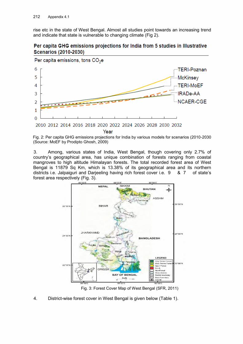
212 Appendix 4.1 rise etc in the state of West Bengal. Almost all studies point towards an increasing trend and indicate that state is vulnerable to changing climate (Fig 2).
Fig. 2: Per capita GHG emissions projections for India by various models for scenarios (2010-2030 (Source: MoEF by Prodipto Ghosh, 2009) 3. Among, various states of India, West Bengal, though covering only 2.7% of country’s geographical area, has unique combination of forests ranging from coastal mangroves to high altitude Himalayan forests. The total recorded forest area of West Bengal is 11879 Sq Km, which is 13.38% of its geographical area and its northern districts i.e. Jalpaiguri and Darjeeling having rich forest cover i.e. 9 & 7 of state’s forest area respectively (Fig. 3).
Fig. 3: Forest Cover Map of West Bengal (SFR, 2011)
4. District-wise forest cover in West Bengal is given below (Table 1).

Appendix 4.1 213
Table 1: District-wise forest cover in West Bengal (SFR, 2011)
B. CLIMATIC THREATS IN NORTH BENGAL 5. North Bengal is prone to both floods as well as droughts. Historically, the region has faced some of the severest floods and even a few droughts in spite of good forest cover in the area.
1. Floods in North Bengal Districts
6. The North Bengal districts have fast flowing turbulent rivers like Torsa, Raidak, Teesta, Jaldhaka and Mahananda, which bring down heavy quantities of boulders, sand and silt. The Northern flood plain of North Bengal called Terai Teesta flood plain is further subdivided into various plains i.e. Piedmont Plains (where due to sudden fall in gradient river channels deposit transported material at the foothills), Dilluvial Plains (basically flood prone zone, which is formed from materials eroded from piedmont fans and mountains); Northern Riverine Plains (constituting of true riverine plain with flooding and deposition of sand). Following is map showing flood prone areas in West Bengal (Fig. 4)

214 Appendix 4.1
Fig 4: Flood prone areas in West Bengal (Source: WBPCB, 2009)
7. Recent rains (July 20 2 ) have affected nearly 80,000 people in West Bengal’s three districts alone i.e. Darjeeling, Jalpaiguri and Cooch Behar.
(Courtesy: RPAPCC, WWF-India) 8. Following table (Table 2) shows record of large floods in West Bengal.
Table 2: Records of large Floods in West Bengal Period Description
1978 Major flood. Affected 235 blocks in Midnapore, Howrah Hooghly Murshidabad, Nadia, 24 Parganas, Bankura, Burdwan, Birbhum, Malda, Puruliya. Human Life lost: 1,370; Houses Damaged 13,61,338; Population Affected: 156.25 lakhs.
18/10/1985 - 20/10/1985
Caused by tropical cyclones.
22/09/1986 - 10/10/1986
Flooding due to heavy rains in some areas of Kolkata, Hooghly, Howrah, the Parganas and Midnapore.
23/08/1988 - 09/15/1988
Monsoonal rains caused flooding in areas of Balurghat and Dinajpur lying under the purview of the Ganges and Churani rivers.
03/07/1990 - Flooding due to monsoonal rain.

Appendix 4.1 215
Period Description 24/07/1990 14/09/1991 - 15/09/1991
Flash floods caused damage 35,000 houses.
08/07/1993 - 13/08/1993
Flooding observed in Jalpaiguri district.
26/09/1995 - 02/10/1995
Flooding triggered by heavy rains caused erosion, severe agricultural damage and outbreak of diseases.
10/07/1996 - 24/07/1996
Flooding due to monsoonal rains.
01/08/1997 - 01/08/1997
Flooding due to monsoonal rains.
05/07/1998 - 02/09/1998
Monsoon rains caused flooding of the Ganges river.
11/07/1999 - 03/08/1999
Flooding due to monsoonal rains.
24/10/1999 - 12/11/1999
Tropical cyclones caused destruction of an estimated number of 1,500 villages. Floods due to brief torrential rains affected areas of Kolkata, Burdwan and Birbhum.
02/08/2000 - 01/10/2000
Besides flash floods triggered by incessant torrential storms, disaster is also accredited to the opening of sluice gates of dams. The fatalities counted to the tune of 1,262 besides affecting millions of people.
31/07/2001 - 01/09/2001
Monsoonal rains caused flooding in Kolkata.
21/06/2002 - 28/08/2002
Flooding in Jalpaiguri, Cooch Behar and Jalpaiguri in north Bengal due to monsoonal rains. Flash floods swamped ten villages, causing four deaths and 11,000 displacements.
11/06/2003 - 10/10/2003
Monsoonal rains caused floods affecting the regions of Darjeeling, Jalpaiguri, Malda and Murshidabad.
20/06/2004 - 07/10/2004
Heavy monsoonal rains affected several districts Heavy rains caused floods in many areas. About 3,000 coastal villages were inundated and 60,000 huts and many roads washed away.
07/07/2005 - 27/07/2005
Heavy monsoon rains triggered flash floods and landslides.
24/06/2006 - 03/08/2006
The regions of Birbhum, Burdwan and Murshidabad were affected mainly from continuous monsoonal downpour.
18/09/2006 - 05/10/2006
Monsoonal rains and tropical cyclone-driven storms in the Bay of Bengal hit India and Bangladesh. West Bengal recorded 50 deaths, 300 were injured and 30,000 mud houses destroyed. Heavy rains left large parts of Kolkata city under water; subsequently 2,000 people were evacuated from the city.
03/07/2007 - 22/09/2007
The hazard affected Kolkata and several other districts. Eighty-three deaths were reported, and millions of people were marooned in 3,000 villages in coastal areas of the state.
22/09/2007 - 08/10/2007
Heavy rain from tropical depression in the Bay of Bengal caused flooding leading to 51 deaths, and affecting 3.2 million people.
(Source: Department of Disaster Management, Govt of West Bengal & SIAG, West Bengal) 9. West Bengal is highly prone to floods as shown in the Flood Hazard Map (Fig 5), and north Bengal districts like Jalpaiguri have faced this reality many times in the past.

216 Appendix 4.1
Fig. 5: Flood hazard map of India
(Source: Department of Disaster Management, Govt of West Bengal) 10. Rainfall pattern for 5 years average in Gangetic plains including North West Bengal has seen an overall increase, which is not uniformly distributed as trend shows a decline in rainfall in months of June, whereas a mild increase in months of July to August (Fig ) . Also winter month’s precipitation has seen significant decline.
Fig. 6: Last 5 years' average Precipitation in Gangetic Flood Plain compared with long term trend
(Courtesy: RPAPCC, WWF-India) 11. The similar observation was seen for annual rainfall in northern districts of West Bengal for the year 2010 (Table 3). Among these Darjeeling and Jalpaiguri had higher rains, which also boosts of highest forest cover in the state.

Appendix 4.1 217
Table 3: Annual Rainfall in West Bengal by District as seen in 2010 District Annual Rainfall in West Bengal by District during year 2010 (in mm)
Jan Feb Mar Apr May Jun Jul Aug Sep Oct Nov Dec Darjeeling 72 355 896 1142 876 456 188 33 Jalpaiguri 2 74 159 396 900 1044 688 539 70 10 Cooch Behar 30 385 600 711 863 525 496 61 2
(Source: Bureau of Applied Economics and Statistics, W.B.) 12. Floods are most severe of threats due to climate change in north Bengal as West Bengal’s 43 of geographical area is under threat as compared to all-India average of 12.17%. North Bengal is prone to flooding due to fast flowing rivers from snow fed rivers in Ganga-Brahmaputra basin and glacial lake outbursts. Table 4 below shows flood affected area and years in West Bengal. Table 4: Flood years and affected area during floods in West Bengal between 1960-
2000
(Courtesy: RPAPCC, WWF-India)
2. Droughts in North Bengal
13. Temperatures in West Bengal over last 100 years have risen to almost maximum 1 degree C as compared to eastern India, where average temperature rose by 0.6 degrees. The uncertainty in rainfall pattern and rising temperatures has added drought woes to the state. There is prediction for an increasing trend with respect to annual surface air temperature in West Bengal in 2030s. Various climate change models (BIOME, PRECIS, HadCM etc have been used for predictions. In a recent estimate by the government, nearly rupees 800 crores loss has been incurred in north Bengal alone due to droughts. Southern districts are more prone to droughts as compared to northern districts as shown in map of West Bengal drought affected blocks (Fig 6).

218 Appendix 4.1
Fig 6: Drought affected blocks in West Bengal (Source: WBPCB, 2009)
14. Droughts are caused when a region constantly receives below average precipitation. Also there are changes in surface air temperatures due to drier conditions. In West Bengal, there has been a predictive increase in the annual surface air temperature for 2030s (Fig 7).
Fig 7: Changes in the annual surface air temperature in 2030s with respect 1970s
15. PRECIS models have predicted changes in summer monsoon precipitation towards 2030s for India, in which significant changes in precipitation pattern both positive and negative, have been observed for West Bengal (Fig 8).

Appendix 4.1 219
Fig 8: Percentage change in the summer monsoon precipitation by three PRECIS runs towards
2030s with respect to 1970s 16. Studies (Kar et al, 2012) also showed that drought intensity has increased over years in West Bengal as observed in 2001 was high in few northern districts of West Bengal (Fig 9).
Fig 9: Drought Years with various intensities (SPI value) (Ref: Kar et al, 2012)

220 Appendix 4.1 17. The modelling studies have also shown that frequency of rainy days in 2030s is significantly impacting the climate at various places in India Fig 10).
Fig 10: The change in the frequency of rainy days in 2030s with respect to 1970s
(Source: IITM, 2010 ppt for MoEF workshop) 18. Also, there are changes predicted for intensity of rainy days in 2030s (Fig 11)
Fig 11: The change in the intensity of rainy days in 2030s with respect to 1970s
19. In Jalpaiguri district of West Bengal a comparison of magnitudes of Extreme Precipitation Rainfall Event (EPRE) before and after 1980 showed 39 events up to 1980 and 47 events between 1980 and 2010 (Ref: State Disaster Management Department, Govt of West Bengal).
3. Impacts on Wildlife in North Bengal
20. Habitat Loss: Various studies draw inference that with increasing temperatures, the sensitive animals of high altitude like Red Panda may face habitat loss. Also flooding due to glacier melt & rivers would inundate presently suitable habitats in plains within protected areas and render many species homeless. 21. Forest fires: Severe heat would dry up soil and forest floors impacting forests, which would be prone to forest fires causing huge loss to vegetation as well as killing/displacing wild animals.

Appendix 4.1 221
22. Changes in vegetation structure & patterns: Temperature sensitive species like Orchids would be hard hit with temperature rise and there would be changes in existing vegetation structures to cope with rising temperatures. Climate Change may trigger changes in the net Primary Productivity (NPP) status of the forests, which is likely to increase. 23. Landslides in the hills: Incessant rains may trigger landslides on hills, further escalating the existing land-use of the hills. 24. Changes in Phenology: Temperature anomalies may trigger early flowering and thus changes in phenology of the vegetation, which would also impact the dependent wildlife.
4. Changes in Micro-climate
25. North Bengal has a unique micro-climate due to its forest cover and numerous wildlife sanctuaries and National Parks, which has created local variability in the climate of the region. As per IPCC and State Action Plan reports, West Bengal would be facing issues of rising temperature and uncertainties in precipitation patterns. 26. The current micro-climate especially in northern districts of West Bengal due to changing temperature and precipitation would alter local forest ecosystem and thus bringing changes in habit and habitat of wildlife and biodiversity. The wildlife most impacted would be larger mammals like elephants, rhinos and gaur, which are solely dependent on vegetation species occurring in the region seasonally as seasonality patterns will change causing migration and movement of animals outside of their forest boundaries. This may lead to enhanced conflicts with man especially in agriculture lands and tea gardens. 27. Also, developmental projects like Asian Highway, which is passing through forests and adjoining areas and requiring felling or clearing of trees and vegetation, may alter the local micro-climate if trees felled are in substantial numbers. C. REPERCUSSIONS OF CLIMATE CHANGE ON ASIAN HIGHWAY PROJECT IN NORTH BENGAL 28. Climate Change predictions strongly suggest increase in events like erratic and intense rainfall and temperature increase. All these, together can cause repercussions on developmental projects like that of Asian Highway Network. 29. Proposed road Corridors of AH-2 and AH-48 are passing through or from nearby areas of wildlife sanctuaries/national parks/reserve forests, where increased transportation will have its impacts on the biodiversity of the area. The AH-48 corridor is connecting Bhutan with Bangladesh through North Bengal area of India and is passing through Jaldapara National Park, which is famous for its one-horned Rhinoceros (Rhinoceros unicornis) and Elephant population. 30. The corridor also passes through Hasimara, Birpara, Goyerkata, Telipara, Falakata, Dhupguri and Maynaguri, which are areas having proximity to forests and wildlife corridors.
1. Floods hazard mapping for AH projects

222 Appendix 4.1 31. The northern states of West Bengal, where Asian Highway project is proposed are prone to regular floods as it has number of rivers from north to south and at places cutting across the proposed highway. To understand the proposed impacts, an analysis was done by overlaying rivers, its drainage and road network on landsat data. For analysis purpose, we have divided the road into sections of 10 km each all along the length. Section 1 starting from Panitanki for AH-2 and at Chengrabanda for AH-48. 32. A Slope Map is prepared to assess steepness or degree of inclination of a feature relative to the horizontal plane, which can be conveniently calculated from contour lines on a topographic map. For the slope study of the area very high quality ASTER (Advanced Spaceborne Thermal Emission and Reflection Radiometer) DEM is downloaded. These DEMs of the Terra satellite is freely available for 99% of the globe, and represents elevation at a 30 meter resolution. After downloading the DEMs, further processing is done using the ARC GIS 9.3 version. Also 30 m interval contours are generated using the 3 D Analyst -Surface analysis-slope Slope map of 1 km radius from the road is made in ARC GIS software by using Spatial Analyst tool. Aspect Map shows the direction of slope as an Aspect Value of 0 means that the slope is facing the North. Here, we have prepared an Aspect Map of 1 km radius from the road is made in ARC GIS software using spatial analysis tool. Also, False Colour Composite (FCC) Landsat data was used for the study. The outcome is Slope map and Aspect map, which helped in deducing flood hazards for areas on AH-2 (Fig 14 & 15) and AH-48 (Fig 16 & 17) as explained below.
2. Flood hazards for AH-2 33. For assessment of flood hazard for AH-2, we have taken the actual alignment of the road and made a buffer of 500 meters on both the side of the road assuming if there is a flood in the river than 500 meters radius area from the road will be effected. For this assessment, major rivers considered were Mechi, Balason and Mahananda, for whom 500 meters radius buffer was generated. The sections impacted and the number of trees which will be affected by the flood is shown in the following table 5.
Table 5: Results of flood hazard mapping for AH-2 Effected Road
alignment (Section) Number of
trees Remarks
0 to 10 Km (Panitanki, Naxalbari)
Upper Side (492), Lower
side (452)
Part of this section may be impacted due to floods from river. Also trees impacted on both upper and lower side of road. Corrective action requires watershed management and drainage culvert / road elevation.
20 to 30 km (Shiv Mandir, North
Bengal Medical College)
Upper Side (935)
Part of this Section may be impacted due to floods and soil erosion and siltation from impacted trees on upper side of the road. Require drainage management and culvert/road elevation
30 to 40 km (Bangladesh
Border/Fulbari)
Lower side of the road (692)
Section 3 may be impacted by flooding. Also soil erosion due to impacted trees on the lower side of the road Needs management of drainage/culvert
Alternative road (Rangapani area)
Upper side (2451) Lower
side (123)
Alternative road may be impacted by flooding. Soil erosion due to impacted trees on upper and lower side. Needs watershed management and soil/silt management through raised culverts/road

Appendix 4.1 223
Map 14: Aspect Map AH-2
Fig 15: Slope Map AH-2 34. The analysis shows that for AH-2, three sections i.e. section 1, 2 & 3 along with alternative roads may be impacted more for flooding among all the sections of the road.
3. Flood hazards for AH-48
35. For studies on AH-48, we have taken the actual alignment of the road and made a buffer of 500 meters from the both side of the road, which shows if there is a flood in the river than the 500 meters radius area from the road will be effected. For assessment, we have taken the major rivers of the Project area Like Teesta, Jaldhaka, Mujha, Torsha and

224 Appendix 4.1 a 500 meters radius buffer is generated for these rivers and assessment made for road alignment and number of trees which will be affected by the flood. The results are shown in the following table 6.
Table 6: Results of flood hazard mapping for AH-48 Effected Road
alignment (Section)
Number of trees impacted
Remarks / Corrective actions
0 to 10 km (Chengrabandha)
Lower side of the road (2209)
Part of this section may be impacted due to flooding and siltation from rivers as there may be soil erosion due to trees impacted on lower side of section. Corrective action may require elevated drainage culverts /road
30 to 40 km (Dhupguri area)
Upper side of the road(1283), Lower side of the road(874)
Part of this section may be impacted by incessant flooding from river. Also trees on both lower and upper side of roads may be impacted. Corrective action may require elevated drainage culverts/road
70 to 80 km (Jaldapara National Park)
Upper side of the road (2106), Lower side of the road (1568)
Part of this section may be impacted by flooding from river on both the sides of the road i.e. upper and lower. Also soil erosion due to impacted trees may lead to siltation and flooding. Corrective action requires watershed management and elevated drainage culverts / road
80 to 90 km (Madarihat area)
Upper side of the road(478), Lower side of the road(348)
Part of this section may be impacted due to flooding and also erosion due to impacted trees on upper and lower side of road. Corrective action requires elevated drainage culverts / road
Fig 16: Aspect map of the proposed AH-48 area
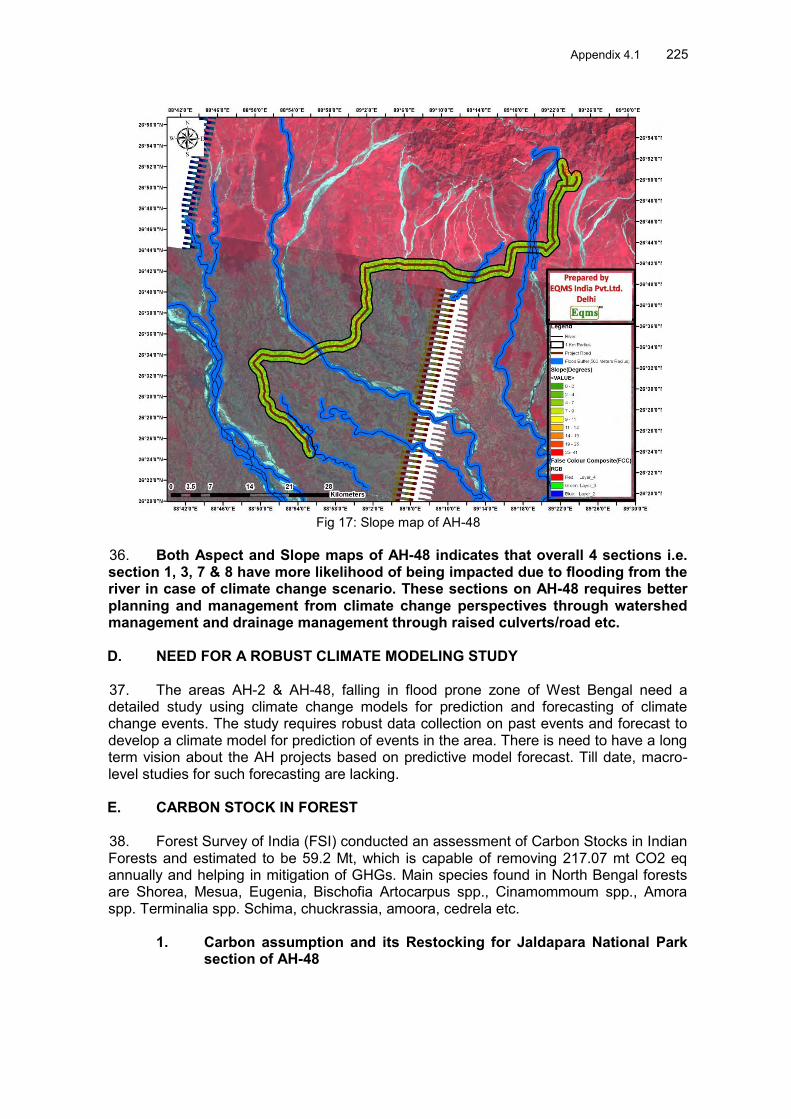
Appendix 4.1 225
Fig 17: Slope map of AH-48
36. Both Aspect and Slope maps of AH-48 indicates that overall 4 sections i.e. section 1, 3, 7 & 8 have more likelihood of being impacted due to flooding from the river in case of climate change scenario. These sections on AH-48 requires better planning and management from climate change perspectives through watershed management and drainage management through raised culverts/road etc. D. NEED FOR A ROBUST CLIMATE MODELING STUDY 37. The areas AH-2 & AH-48, falling in flood prone zone of West Bengal need a detailed study using climate change models for prediction and forecasting of climate change events. The study requires robust data collection on past events and forecast to develop a climate model for prediction of events in the area. There is need to have a long term vision about the AH projects based on predictive model forecast. Till date, macro-level studies for such forecasting are lacking. E. CARBON STOCK IN FOREST 38. Forest Survey of India (FSI) conducted an assessment of Carbon Stocks in Indian Forests and estimated to be 59.2 Mt, which is capable of removing 217.07 mt CO2 eq annually and helping in mitigation of GHGs. Main species found in North Bengal forests are Shorea, Mesua, Eugenia, Bischofia Artocarpus spp., Cinamommoum spp., Amora spp. Terminalia spp. Schima, chuckrassia, amoora, cedrela etc.
1. Carbon assumption and its Restocking for Jaldapara National Park section of AH-48

226 Appendix 4.1 39. Just for sample, an assumption of Carbon for woody tree species in Jaldapara National Park section of Alignment AH-48 was done. Following important species were observed during field data collection (Table 7).
Table 7: Important woody species along with estimated Organic C-Value S. No
Common name
Scientific name Number of trees
Rough Organic Carbon Value (t/tree)
Estimated Organic Carbon (tC)
1 Aam Mangifera indica 96 3.59* 344.64 2 Bot Ficus relogiosa 14 4.91* 68.74 3 Neem Azadirecta indica 73 2.08* 151.84 4 Ficus sp. Ficus sp. 33 4.46* 147.18 5 Jamun Syzygium cumini 44 1.3** 57.2 6 Koroi Albizzia lebbek 121 1.35* 163.35 7 Semul Bombax ceiba 578 1.53*** 884.34 8 Tatul Tamarindus indica 177 1.42* 251.34 9 Acacia Acacia sp. 122 0.69** 84.18
Data Source: *B. L. Chavan et. al. Sequestered standing carbon stock in selective tree species grown in University campus at Aurangabad, Maharashtra, India/ International Journal of Engineering Science and Technology Vol. 2(7), 2010, 3003-3007. **Hangarge L. M., D. K. Kulkarni, V. B. Gaikwad, D. M. Mahajan and Nisha Chaudhari; Carbon Sequestration potential of tree species in Somjaichi Rai (Sacred grove) at Nandghur village, in Bhor region of Pune District, Maharashtra State, India ***Mohammed Alamgir, M. Al-Amin; Organic carbon storage in trees within different Geopositions of Chittagong (South) Forest Division, Bangladesh, September 2007, Volume 18, Issue 3, pp 174-180 ;Journal of Forestry Research 40. Assuming that total 1258 woody tree species (according to our assumption of more C sequestrating species), within 20km stretch of Jaldapara Section of AH-48 Alignment are to be cut, which may lead to a loss of 2152 tC. Considering in terms of Carbon value, trees of high Organic Carbon contents need to be planted more for faster recovery of C loss. 41. Therefore, Considering average life cycle of trees as 30 years, the number of trees to be planted against loss should be 30 times to recover in one year, but, it is not feasible practically, thus ratio of 1:5 times for tree plantation should be undertaken to recover the C-loss in approximately 6-7 years period (based on favourable ecological conditions). 42. Based on total i.e. 3674 tree present in Jaldapara National Park section, above selected woody species constitute 34% approx, thus recommended to plant total 34% of woody trees in the ratio 1:5 for replenishment of C stock in 7-8 years. F. SUGGESTED MEASURES TO COMBAT CLIMATE CHANGE IMPACTS
Reforestation of catchment areas and slope stabilization of landslide and Flash flood prone areas.
Conduct studies on climate modeling at macro-level for forecasting of climatic events in the area.
A carbon assessment of trees would help in planning for its mitigation measures in the event of increased vehicular numbers and its movement by suggesting GHG emission reduction measures, which needs detailed field data collection and subsequent modeling of scenarios for future.

Appendix 4.1 227
Revival/safeguarding of wildlife corridors as connectivity between disjointed patches of forests in North Bengal for wildlife
Provide biodiesel/CNG as alternatives to vehicles running on the highway for reduced carbon emissions
Educate & aware forest dependent communities to participate in GHG reduction measures and provide suitable alternatives to them
As carbon enhancement measures, the ratio of woody trees to be planted for compensation of felled trees comes around 1:5 as compared to proposed 1:3 ratio for general afforestation of trees.
BIBLIOGRAPHY Biswajit Kar, Joydeep Saha, Joy Deep Saha, 2012
Analysis of Meteorological Drought: The Scenario of West Bengal. Indian Journal of Spatial Science Vol - 3.0 No. 2 Winter Issue 2012 pp1 – 11
B. L. Chavan et. al. Sequestered standing carbon stock in selective tree species grown in University campus at Aurangabad, Maharashtra, India/ International Journal of Engineering Science and Technology Vol. 2(7), 2010, 3003-3007.
Demography of the Flood plain regions of West Bengal (Modified after Census, 2001) (Courtesy: RPAPCC, WWF-India)
Hangarge L. M., D. K. Kulkarni, V. B. Gaikwad, D. M. Mahajan and Nisha Chaudhari; Carbon Sequestration potential of tree species in Somjaichi Rai (Sacred grove) at Nandghur village, in Bhor region of Pune District, Maharashtra State, India
India’s Second National Communication to the United Nations Framework Convention on Climate Change. Ministry of Environment Forests, Government of India, 2012
K. Krishna Kumar, Ashwini Kulkarni, Savita Patwardhan, Nayana Deshpande, K. Kamala, Koteshwara Rao, 2010 . Climate Change scenarios 2030. National Workshop. India: Climate Change in India- A 4x4 Assessment. Nov 16, 2010, New Delhi
Mohammed Alamgir, M. Al-Amin; Organic carbon storage in trees within different Geopositions of Chittagong (South) Forest Division, Bangladesh, September 2007, Volume 18, Issue 3, pp 174-180 ;Journal of Forestry Research

228 Appendix 4.2
Appendix 4.2: Drawings for Elephant Underpass proposed in AH-48 .

Appendix 4.2 229

230 Appendix 4.2

Appendix 4.3 231
Appendix 4.3: Notification of Jaldapara NP, Elephant Conservation Area and Elephant Movement Corridor

232 Appendix 4.3
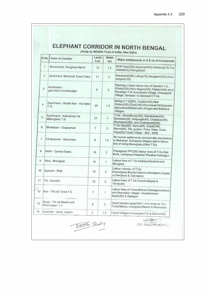
Appendix 4.3 233

234 Appendix 4.3

Appendix 5.1 235
Appendix 5.1: Calculations on Passenger Car Unit per Day
Road sections 2013 2014 2015 2016 2017 2018 2028
AH-2 km HS1 India/Nepal border to Panitanki 1.3 21673 22253 22860 23429 24023 24640 31442 HS2 Panitanki junction to Bagdogra junction 17.25 8494 10086 10540 10964 11403 11864 17020
HS3 Bagdogra junction to Shivmandir junction 5.9 35632 37582 39651 41521 43483 45548 67866
HS4 Shivmandir junction to Medical junction 2.6 8318 8771 9250 9686 10141 10618 15725
HS5 Medical junction to Naukhaghat junction 4.6 12287 12928 13609 14223 14867 15544 22794
HS6 Naukhaghat to Fulbari junction 4.4 27249 28746 30332 31759 33257 34835 51830 HS7 Fulbari junction to Banglabandha 2.7 3438 3546 3657 3762 3871 3986 5273 HS8 Goltuli junction to Fulbari junction 5.5 19434 20612 21856 22981 24169 25413 38975 HS9 Medical junction to Goltuli junction 6.2 7862 8261 8686 9068 9466 9887 14442 50.45 Weighted average for 2028 28,281.63 AH-48 HS1 Changrabandha to Indira junction 20.6 9322 9839 10383 10878 11401 11944 17827 HS2 Indira junction to Dhupguri 18.3 15471 16350 17282 18120 19000 19929 29937 HS3 Dhupguri to Telipara junction 17.4 7959 8300 13200 13774 14375 15012 21881 HS4 Telipara junction to Birpara junction 8 9086 9514 13610 14254 14933 15639 23192 HS5 Birpara junction to Hasimara junction 26 7049 7369 10861 11361 11889 12437 18345
HS6 Hasimara junction to end of project road 18.3 6412 6709 7915 8265 8628 9009 13066
108.6 Weighted average for 2028 20234.1298
Note: The weighted average pcu/day for both roads exceed the limit of 23,000 pcu/day for a 50km road and 11,000 pcu/day for
a 100km road as given in table 6 of the draft Environment Safeguards Sourcebook, December 2012

236 Appendix 6.1
Appendix 6.1: Environmental Management Plan
Environmental Issue/ Component
Remedial Measure
Reference to Laws /Guidelines
Approximate Location
Mitigation Cost
Institutional Responsibility Implementation Supervision
A. Design and Pre - Construction Stage 1. Design Considerations Legislative approvals Considering the proposed
project activities the following legislative approvals will be required in advance: 1. Obtain Forests Clearance for diversion of about 8 Ha of reserved forests and National Park land 2. Obtain Permission under Wild Life Protection Act the project and for the diversion of National Park Land for construction of underpass for the movement of elephant.- in AH-48 3.Obtain permission from forest as applicable for cutting of trees 4 Obtain concurrence from Gram Panchyats for shifting or demolition of community structure 5. Obtain permission from concerned authorities for shifting of utilities ( like electric pole, telephone lines, hand pumps, water pipelines) 6. Obtain connect to establish Hot Mix plant, batching plant, quarry operation if new quarry to be opened, and setting up construction
Legislative requirements
Ah-2 and AH-48 Road
project and
Part of Design costs
Design Consultant/SEMU
PIU/CSC
Utility Relocation Utilities relocation will be reasonably completed before construction starts and without affecting any essential supplies to habitat like water supply..
Design requirement As per widening plan
Included in construction cost
Design Consultant
PIU

Appendix 6.1 237
Environmental Issue/ Component
Remedial Measure
Reference to Laws /Guidelines
Approximate Location
Mitigation Cost
Institutional Responsibility Implementation Supervision
Shifting of Community Structure
Community structures, like, religious structures will be shifted appropriately, as required.
Design requirement As per widening plan
Included in construction
cost
Design Consultant
PIU/CSC
Climate Change and Removal of trees
Approximately 20907 trees may need to be cut within proposed ROW for up-gradation of the project road and bypasses before the commencement of construction with prior Clarence from the Forest Department/District Authorities as applicable. Compensatory afforestation 1:3 trees will be planted for each tree felled as per regulatory compliance. Geometric adjustment to reduce tree cutting.
Local Forest Rule Within RoW or on Govt.
/Panchayat Land
Rs 135,2 Mn ( @ Rs 2100 per tree for 62910 tree with three years of maintenance) through village Panchhyats
Through Forest Department/Village Panchayats
PIU/CSC
Additional Tree plantation @ 1:2 basis (for climate change consideration of woody trees of 34% and Plantation of Fodder and Shade Trees for Elephant Habitat improvement purposes in upper area of the road crossing points : like north of Kiran Chand Tea Estate in AH-2)
Local Forests Rule and Climate Change Considerations
-do- Rs 89.9 Mn ( @ Rs 2100 per tree for 41814 tree with three years of maintenance)
Through Forest Department/Village Panchayats
PIU/CSC
Development of earthen water bodies through forests department/nwildlife authorities for ensuring availability of water for elephant and wild animals
Wild Life ( Protection) ACT
Forest Area on the path of elephant
movement.
Rs 1.8 Mn ( @ Rs 300 per M2 for 1000 M2 for dug –up and soil stabilization )
Diversion of Forests Land for Non Forestry Purposes
Forests ( Conservation) Act
Khairbari reserved Forests and Jaldapara National Park
15.2 Ha + NPV ( 16 Ha @Rs 9,00,000 per ha
SEMU/Design Consultant
PIU/CSC
Ecology- Fauna Some portion of AH-48 road Wild Life Protection Jaldapara Part of SEMU/Contracto Supervision

238 Appendix 6.1
Environmental Issue/ Component
Remedial Measure
Reference to Laws /Guidelines
Approximate Location
Mitigation Cost
Institutional Responsibility Implementation Supervision
passes through Jaldapara National Park and Elephant movement path. Provision of three underpasses is made to allow safe passage of the animal Elephant also crosses AH_2 road near Kiran Chand Tea Estate and Near Hasimara and Pasakha a locations. Adequate signage would be fixed in the Elephant movement areas of AH-2 and AH-48.
Act -do-
National Park, Near Kiran Chand Tea estate of AH-2 and Near Hasimara and Pasakha bypass area.
Design costs r Consultant/PIU/CSC
Ecology –Aquatic and Terrestrial
Siltation of Water bodies may affect aquatic fauna of the river. No construction camp or material storage site will be selected close to water bodies Provision will be made to release fish fries and fingerlings in perennial rivers to enhance local fishery with the help of fishery department as an enhancement measures Development fisheries and tree nurseries
- Construction CAMP sites and close to river
Rs 7.8 Mn ( Rs 4.3 Mn for Nurseries and Rs 3.5 Mn for fisheries)
Contractor/CECSEMU
PIU/CSC/SEMU
Land Use and Land Cover
Land use may partially change at the borrow areas but the same will be done as per the agreement with land owner Identification of Borrow Areas will be done before start of construction. Borrow earth will be sourced as per this plan.
- Through the Project Roads
Part of Construction costs.
Contractor Supervision consultant/ SEMU//PIU/
CSC
Land Acquisition and R & R
12 Ha (9 Ha government land and 3 ha private land) for AH-2 and 55 Ha (35 HA
Land compensation Act 1898, National Highway Act 1956
As per Design requirement ,particularly at
Part of Land Acquisition and R & R
SEMU SEMU/PIU/CSC

Appendix 6.1 239
Environmental Issue/ Component
Remedial Measure
Reference to Laws /Guidelines
Approximate Location
Mitigation Cost
Institutional Responsibility Implementation Supervision
government land and 20 Ha private land) is required for the AH-48. About 2,336 PAH, 771 structures completely and 1208 structures partially are likely to be affected in AH-02. Similarly about 1978 PAH and 585 structures completely and 858 structures partially are likely to be affected in AH-48. Adequate provision for compensation as per R & R Policy SPS09 will be made.
and National R & R policy 2007 and ADB SPS09 provisions
by Passes costs
Social and Safety Adequate provision will be made in project design for safety near schools, hospitals and other sensitive locations. Provision of adequate caution signage near school, sensitive locations, will be fixed at appropriate locations. These will be preferably of PCC with Retro-reflective paints. Steel base signage will be avoided to prevent theft of the same. Crash barrier will also be installed at appropriate locations particularly near school to provide safety to school children. Provision of speed breakers will also be made near schools and religious places.
-IRC Guidelines on Road Safety.
Sensitive locations, like school
Part of Design and construction costs.
Design Consultant,/ Contractor
PIU/CSC
Air Quality and Noise Pollution
No new Quarry is to be opened. All material to be transported under covered lorry. The increased traffic may increase Ambient Noise level of upto 2 dB(A) at 2025 predicted traffic level. Provision of noise barrier is
Design requirement
Sensitive receptor locations requiring noise barrier
Included in construction costs Rs 2.162 Mn Provision of 24 barrier in each road @ Rs 1500 per
Design Consultant/Contractor
SEMU/Supervision
consultant and
PIU/CSC

240 Appendix 6.1
Environmental Issue/ Component
Remedial Measure
Reference to Laws /Guidelines
Approximate Location
Mitigation Cost
Institutional Responsibility Implementation Supervision
made for those locations which may experience higher traffic noise level.
square meter for av 60 square meter per barrier)
Water Resources, Hydrology and Drainage, inadequate drainage provision in habitat area
Water flow should not be stopped fully. Continues flow of the water in a channel with a pond and puddle upstream (about 50 m) will be maintained for aquatic flora and fauna. . Elaborate drainage system will be provided to drain the storm water from the roadway and embankment and to ensure minimum disturbance to natural drainage of surface and subsurface water of the area. Selection of widening option (left aligned, right aligned or centric widening) to be decided based on the least cutting of tree, minimum loss of structure and embankment design considerations. Raise road level as feasible, above the nearby areas with provision of adequate side drains to evacuate the rain water and domestic discharges (drained by habitats occasionally) to prevent damage to road and rain water entry to habitats’ houses. Raise Road level in flood prone area of the road.
Design requirement All habitat areas throughout the alignment
Included in construction cost
Design Consultant
PIU/CSC

Appendix 6.1 241
Environmental Issue/ Component
Remedial Measure
Reference to Laws /Guidelines
Approximate Location
Mitigation Cost
Institutional Responsibility Implementation Supervision
Safety along the proposed alignment
Adequate safety provisions like crash barriers at accident prone areas, rumble strips in habitat areas to regulate speed, retro-reflective warning sign boards nears school, hospital, religious places (Preferably PCC boards with retro- reflective paints to avoid its theft) will be made.
Design requirement
Crash barriers are proposed at sensitive locations like school, medical centers, along the project corridor Rumble strips are proposed at the all the settlements and crossing points
Included in construction cost
Design Consultant
PIU/CSC
2. Natural Hazards Protection from damage from Earthquake
Adoption of relevant IS codes for design embankment/structures suitable to withstand earthquake of highest magnitude in high Damage risk zone Iv ( Seismic Zone II level as per Indian classification).
IRC:34 Recommendations for road construction in waterlogged area and IRC: 75 and MoRSTH guidelines for Design of High Embankments
Throughout the stretch especially bridge structures
Project preparation and construction costs Cost
Design Consultant
PIU/CSC
B. Construction Stage 3. Climate and Air Quality Local Weather conditions Additional Plantation on river
banks, borrow areas and sensitive locations to increase the green cover and improve the aesthetics
Kyoto Protocol, Environmental Protection Act, 1986; The Air (Prevention and Control of Pollution) Act, 1981 + IRC and MORSTH Specifications for Road and Bridge works Air (Prevention and Control of Pollution )
Throughout project corridor, mainly at haulage roads, earthwork, construction sites, loading areas, storage areas, transport route.
Road Side Plantations in the ratio of 1:3
Design Consultant and Contractor
PIU/CSC
Poor air quality due to compromise in design
Road design and Pavement roughness as per IRC specifications. congestion free movement of traffic with provision of junctions improvement at major intersections
Included in construction costs
Design Consultant and Contractor
PIU/CSC

242 Appendix 6.1
Environmental Issue/ Component
Remedial Measure
Reference to Laws /Guidelines
Approximate Location
Mitigation Cost
Institutional Responsibility Implementation Supervision
Dust Generation due to construction activities and transport, storage and handling of construction materials
Transport, of loose and fine materials through covered vehicles and paved roads to the extent feasible. Loading and unloading of construction materials will be made at designated locations in project area with provisions of water fogging around these locations Storage areas to be located downwind of the habitation area. Water spraying on earthworks, unpaved haulage roads and other dust prone areas. Provision of PPEs to
workers.
Act 1974 and Central Motor and Vehicle Act 1988
CSC / PMU
Emission from vehicle, equipment and machinery
Regular maintenance of machinery and equipment. Hot Mix Plant will be located at least 1 km downwind of the human settlement. Batching plants and crushers at downwind (0.5km) direction from the nearest settlement. Hot mix plant to be fitted with adequate stack height. Obtain consent to establish (NOC) from PCB before setting up these plants. Only crushers licensed by the PCB will be used
Asphalt mixing plants, crushers, DG sets locations
Included in construction costs Included in monitoring cost
Contractor Supervision consultant (PMU)/PIU/CSC

Appendix 6.1 243
Environmental Issue/ Component
Remedial Measure
Reference to Laws /Guidelines
Approximate Location
Mitigation Cost
Institutional Responsibility Implementation Supervision
DG sets with stacks of adequate height and use of low sulphur diesel as fuel. Use LPG as fuel at construction camps Undertake periodic ambient air quality monitoring as per EMOP
4 . Noise Noise from construction vehicle, equipment and machinery.
Provision is made for installing need base noise barrier near sensitive locations like hospitals, schools. All equipment will be fitted with silencers and will be properly maintained to minimize its operational noise. Stationary noise making equipment will be placed along uninhabited stretches. The timing for construction activities will be regulated such that all noise generating construction activities happen after school hours. The provision of temporary noise barrier (Barricading) will be made near identified sensitive locations or near the noise source during construction. Plantation along the boundary wall will be made at start of construction itself.
Legal requirement Noise Pollution (Regulation and Control) Rules, 2000 and amendments thereof + MoRSTH Specifications for Road and Bridge works
Throughout the road.
Cost for Plantation already indicated above. Rest part of construction costs Monitoring Cost as indicated In EMoP.
Contractor/Supervision Consultant
PIU/CSC

244 Appendix 6.1
Environmental Issue/ Component
Remedial Measure
Reference to Laws /Guidelines
Approximate Location
Mitigation Cost
Institutional Responsibility Implementation Supervision
Protection devices (ear plugs or ear muffs) will be provided to the workers operating near high noise generating machines Noise measurements as per EMoP should be carried out to ensure the effectiveness of mitigation measures and develop a mechanism to record and respond to complaints on noise Noise monitoring as per
EMoP. 5. Land and Soil Land use Change and Loss of productive/top soil
The top soil from the productive land will be preserved and reused for plantation purposes as top cover of embankment slope for growing vegetation to protect soil erosion. The land taken on lease for access road and construction camp will be is restored back to its original land use before handing it over back to land owner.
Project requirement Throughout the project section and borrow areas
Included in construction cost
Contractor PIU/CSC
Slope protection and Soil erosion due to construction activities, earthwork, and cut and fill
Bank protection measures will be taken at erosion prone areas. The protection measures may include use of geo-textiles matting, bio ( vegetative) - turfing Side slopes of the embankment will not be steeper than 2H:1V. Provision of side drain to
IRC: 56 -1974 recommended practice for treatment of embankment slopes for erosion control Clause No. 306 and 305.2.2 MoRSTH Specifications for Road and Bridge
At high embankment area
Construction cost
Design consultant and Contractor,
/ PIU/CSC
Appendix 6.1 245
Environmental Issue/ Component
Remedial Measure
Reference to Laws /Guidelines
Approximate Location
Mitigation Cost
Institutional Responsibility Implementation Supervision
guide the water to natural outfalls. In rural stretches, longitudinal side drains will be intercepted by drains serving as outlet channels to reduce the erosion. Soil spread on slopes for permanent disposal will be buttressed at the toe by retaining walls. Turfing of embankment slopes will be done along the stretch. Stone pitching wherever necessary. Shrubs will be planted in loose soil area. Soil erosion will be visually checked on slopes and high embankment areas. In case soil erosion is found, suitable measures will be taken to control the soil erosion further including bio-turfing While planning or executing excavations the Contractor will take all adequate precautions against soil erosion as per MoRSTH.
works Guidelines IX for Soil erosion
Soil erosion at earth stockpiles
The earth stockpiles to be provided with gentle slopes to prevent soil erosion and stock piles to be located downwind.
At earth stockpiles
Construction cost
Contractor PIU/CSC
Borrow areas Non-productive, barren lands, wasteland will be used for borrowing earth with the necessary permissions/ consents.
IRC Guidelines (No. IRC:10-1961) on borrow areas selection and amount to be extracted
Borrow sites location.
Construction cost
Contractor PIU/CSC

246 Appendix 6.1
Environmental Issue/ Component
Remedial Measure
Reference to Laws /Guidelines
Approximate Location
Mitigation Cost
Institutional Responsibility Implementation Supervision
Borrow areas should not be located on cultivable lands except in the situations where land owners desires to level the land. The top soil will be preserved and depth will be restricted to the desired level and the slop will not be steeper than 25%. Borrow areas will be sited away from inhabited areas. To the extent possible, To the extent borrow areas will be sited away from inhabited areas. Borrow areas will be leveled with salvaged material or other filling materials which do not pose contamination of soil. Else, it will be converted into fishpond in consultation with fishery department and land owner/community. Rehabilitation of the borrow areas as per Guidelines for redevelopment of Borrow Areas.
For quarries (Environmental Protection Act and Rules, 1986; Water Act, Air Act) + Clause No. 305.2.2 MoRSTH
Specifications for Road and Bridge
works Guidelines V for Borrow Areas Management
Quarry Operations Aggregates will be sourced from existing licensed quarries. Copies of consent/ approval / rehabilitation plan for a new quarry or use of existing source will be submitted to EO, PIU. The contractor will develop a Quarry Redevelopment plan, as per the Mining Rules of the state and submit a copy of the approval to EA if new quarries are to be opened. .
MoRSTH Specifications for Road and Bridge works Guidelines VI for Quarry Areas Management

Appendix 6.1 247
Environmental Issue/ Component
Remedial Measure
Reference to Laws /Guidelines
Approximate Location
Mitigation Cost
Institutional Responsibility Implementation Supervision
Compaction of soil and impact on quarry haul roads due to movement of vehicles and equipment
Construction vehicles, machinery, and equipment to be stationed in the designated ROW to avoid compaction. Approach roads/haulage roads will be designed along the barren and hard soil area to reduce the compaction. Transportation of quarry material to the dumping site through heavy vehicles will be done through existing major roads to the extent possible to restrict wear and tear to the village/minor roads. Land taken for construction camp and other temporary facility will be restored to its original conditions.
Design requirement
Parking areas, Haulage roads and construction yards.
Included in construction cost
Contractor CSC / PMU
Contamination of soil and construction waste management
Fuel and lubricants will be stored at the predefined storage location away from drainage channels. The storage area will be paved with gentle slope to a corner and connected with a chamber to collect any spills of the oils Construction vehicles and equipment will be maintained and refueled in such a fashion that oil/diesel spillage does not contaminate the soil. All efforts will be made to minimize the waste generation. Unavoidable
Design requirement
Fuelling station, construction sites, and construction camps and disposal location.
Rs 1.2 Mn Contractor PIU/CSC

248 Appendix 6.1
Environmental Issue/ Component
Remedial Measure
Reference to Laws /Guidelines
Approximate Location
Mitigation Cost
Institutional Responsibility Implementation Supervision
waste will be stored at the designated place prior to disposal. To avoid soil contamination at the wash-down and re-fuelling areas, “oil interceptors” will be provided. Oil and grease spill and oil soaked materials are to be collected and stored in labeled containers (Labelled: WASTE OIL; and hazardous sign be displayed) and sold off to SPCB/ MoEF authorized Waste Oil Recycler Septic tank or mobile toilets fitted with anaerobic treatment facility will be provided at construction camp. Domestic solid waste at construction camp will be segregated into biodegradable and non-biodegradable waste. The non-biodegradable and recyclable waste will be sold off. Efforts will be made that biodegradable waste will be composted in the mechanized and movable composter by the contractor. Non bio-degradable and non-saleable waste will be disposed off to authorized land fill site. All excavated materials from roadway, shoulders, drains, cross drainage should be used for backfilling

Appendix 6.1 249
Environmental Issue/ Component
Remedial Measure
Reference to Laws /Guidelines
Approximate Location
Mitigation Cost
Institutional Responsibility Implementation Supervision
embankments, filling pits, and landscaping. Unusable debris material should be suitably disposed off at pre designated disposal locations, with approval of the concerned authority. Unproductive/wastelands will be selected for dumping sites. Away from residential areas and located at least 1KM downwind side of these locations, Dumping sites will not be close to water body and contaminate any water sources, rivers. Dumping sites should have adequate capacity equal to the amount of debris generated. Public perception and consent from the village Panchayats about the location of debris disposal site will be obtained before finalizing the location. The bituminous wastes will be disposed in secure landfill sites only in environmentally accepted manner. For removal of debris, wastes and its disposal MoRSTH guidelines should be followed. Soil quality monitoring will be

250 Appendix 6.1
Environmental Issue/ Component
Remedial Measure
Reference to Laws /Guidelines
Approximate Location
Mitigation Cost
Institutional Responsibility Implementation Supervision
carried out as per EMoP. 6. Water Resources Construction water
Requisite permission as applicable will be obtained for abstraction of groundwater. The contractor will make arrangements for water required for construction without affecting the water availability and supply to nearby communities. Water intensive activities will not be undertaken during summer season. Provisions will be made to connect road side drains with exiting nearby ponds.
MoRSTH Specifications for Road and Bridge
works
Throughout the Project section
Included in construction cost
Contractor PIU/CSC

Appendix 6.1 251
Environmental Issue/ Component
Remedial Measure
Reference to Laws /Guidelines
Approximate Location
Mitigation Cost
Institutional Responsibility Implementation Supervision
Alteration in surface water hydrology due to embankment
Existing drainage system to be maintained and further enhanced. Adequate cross drainage structures will be provided. Additional balancing culverts will be provided in flood prone areas. The embankment height will be designed consistent with the existing topography of the region and will be higher than the HFL. Elaborate drainage system will be provided to drain the storm water from the roadway and embankment and to ensure minimum disturbance to natural drainage of surface and subsurface water of the area. Surface runoff from the main road and embankment slopes will be discharged through longitudinal drains, designed for adequate cross section, and the outfalls. No construction material will be stored or disposed near any water body except for reusing it for enhancement measures such as embankment raising.
MoRSTH Specifications for Road and Bridge. IRC SP 42 and 50 for design of surface and subsurface
Near all drainage channels, river crossings etc.
Included in construction cost
Contractor PIU/CSC
Siltation in water bodies due to construction activities/ earthwork
Embankment slopes to be modified suitably to restrict the soil debris entering water bodies. Provision of Silt fencing will
MoRSTH Specifications for Road and Bridge works and worldwide best
Near Mahanadi and Joke River bodies, embankment slopes.
Included in construction cost
Contractor CSC / PMU

252 Appendix 6.1
Environmental Issue/ Component
Remedial Measure
Reference to Laws /Guidelines
Approximate Location
Mitigation Cost
Institutional Responsibility Implementation Supervision
be made at water bodies. Silt/sediment should be collected and stockpiled for possible reuse as surfacing of slopes where they have to be re-vegetated. Earthworks and stone works to be prevented from impeding natural flow of rivers, streams and existing drainage system. Provision of retaining wall is made along the road for the ponds located next to the road to prevent soil erosion and siltation of pond
practices
Deterioration in Surface water quality due to leakage from vehicles and equipment.
No vehicles or equipment should be parked or refueled near water-bodies, so as to avoid contamination from fuel and lubricants. Oil and grease traps and fuelling platforms to be provided at re-fuelling locations. All chemicals and oil will be stored away from water and on concreted platform with catchment pit for spills collection. All equipment operators, drivers, and warehouse personnel will be trained in immediate response for spill containment and eventual cleanup. Readily available, simple to understand and preferably written in the local
The Water (Prevention and Control of Pollution) Act, 1974 and amendments thereof.
Water bodies, refueling stations, construction camps.
Construction cost
Contractor PIU/CSC

Appendix 6.1 253
Environmental Issue/ Component
Remedial Measure
Reference to Laws /Guidelines
Approximate Location
Mitigation Cost
Institutional Responsibility Implementation Supervision
language emergency response procedure, including reporting, will be provided by the contractors Construction camp to be sited away from water bodies. Wastes must be collected, stored and taken to approve disposal site only. Water quality will be monitored periodically.
7. Flora and Fauna Terrestrial and Aquatic l Flora and Fauna
Requisite permission from Forest Department will be obtained for cutting of roadside trees. Tree cutting will be well planned to avoid any kind of inconvenience to local people and traffic Minimization of any untoward incidence and probable harm due to poaching activities from immigrant labour population. Strict anti-poaching surveillance measures need to be implemented, especially during project construction phase in the areas of Jaldapara national park. Signage for no-noise zones, wildlife conservation boards should be installed at the required project sites. It is proposed to develop Wild Life Management plan covering above aspects as part of environmental
Forest Conservation Act 1980 + IRC SP: 21 and IRC SP:66
Throughout project corridor
Indicated above
Contrcator/Supervision Consultant/SEMU
PIU/CSC

254 Appendix 6.1
Environmental Issue/ Component
Remedial Measure
Reference to Laws /Guidelines
Approximate Location
Mitigation Cost
Institutional Responsibility Implementation Supervision
guidelines Noise generating equipment like DG set, compressors will have acoustic enclosures. These should not be installed at least in one Km area of National Park or Reserved forests. Noise generating activities should not be permitted during night. Drivers should be warned to move slowly in the wild life movement areas. Provisions of signage as a precautionary measure to provide awareness about animal movement will be made to avoid accidents The construction activities over rivers or near water, bodies will be undertaken during summer season when most of rivers and water ponds are practically dry. Best construction practices will be adopted to prevent increase in siltation level of the water. All precautionary efforts will be taken as given under surface water section to prevent accidental damage of water quality Construction works for the underpasses will be avoided during the elephant migratory season of November to December and May to July to the extent possible.

Appendix 6.1 255
Environmental Issue/ Component
Remedial Measure
Reference to Laws /Guidelines
Approximate Location
Mitigation Cost
Institutional Responsibility Implementation Supervision
8. Construction Camps Impact associated with location
All camps should maintain minimum distance from following: # 1000 m from habitation # 500 m from water bodies
Design Requirement
Both construction camps
Rs 1.2 Mn for camp sanitation
Contractor PIU/CSC
The location, layout and basic facility provision of each labor camp will be submitted to CSC prior to their construction. The construction will commence only after approval of CSC concurrence The contractor will maintain necessary living accommodation and ancillary facilities in functional and hygienic manner as approved by the EA. Preventive medical care to be provided to workers. Disposal of solid waste on regular basis at identified locations. The Contractor will take all precautions to protect the workers from insect and pest to reduce the risk to health. This includes the use of insecticides which should comply with local regulations. No alcoholic liquor or prohibited drugs will be imported to, sell, give, and barter to the workers of host community. Provision of day crèche for

256 Appendix 6.1
Environmental Issue/ Component
Remedial Measure
Reference to Laws /Guidelines
Approximate Location
Mitigation Cost
Institutional Responsibility Implementation Supervision
children Limited recreation and sporting facilities for the staff and workers.
Immunization to immigrant workers/local community against communicable and sexually transmitted diseases.
The Building and Other Construction workers (Regulation of Employment and Conditions of Service) Act 1996 and The Water (Prevention and Control of Pollution) Act, 1974 and amendments thereof
All construction camps
Part of the Contract
Contractor PIU/CSC
9. Management of Construction Waste/Dismantled Debris Selection of Dumping Sites
Unproductive/wastelands will be selected for dumping sites. Away from residential areas and water bodies Dumping sites have adequate capacity equal to the amount of debris generated. Public perception and consent from the village Panchayats has to be obtained before finalizing the location.
Design Requirement and MoRSTH guidelines
At all Dumping Sites
Part of the contract
Contractor. PIU/CSC

Appendix 6.1 257
Environmental Issue/ Component
Remedial Measure
Reference to Laws /Guidelines
Approximate Location
Mitigation Cost
Institutional Responsibility Implementation Supervision
Reuse and disposal of construction and dismantled waste
The existing bitumen surface will be utilized for paving of cross roads, access roads, and paving works in construction sites and camps, temporary traffic diversions, and haulage routes. All excavated materials from roadway, shoulders, verges, drains, cross drainage will be used for backfilling embankments, filling pits, and landscaping. Unusable debris material should be suitably disposed off at pre-designated disposal locations, with approval of the concerned authority. The bituminous wastes will be disposed in secure landfill sites only in environmentally accepted manner. For removal of debris, wastes and its disposal MORSTH guidelines should be followed. Unusable and surplus materials, as determined by the Project Engineer, will be removed and disposed off-site.
10. Accessibility, Traffic Management, Accident and Safety Risks Design requirement and Traffic Planning During Construction Stage
Temporary traffic diversion will be planned by the contractor and approved by PIU/CSC The traffic control plans will contain details of diversions;
Design requirement and IRC SP:55
Throughout the project corridor especially at intersections.
Project preparation and construction cost
Contractor PIU/CSC

258 Appendix 6.1
Environmental Issue/ Component
Remedial Measure
Reference to Laws /Guidelines
Approximate Location
Mitigation Cost
Institutional Responsibility Implementation Supervision
traffic safety arrangements during construction; safety measures for nighttime traffic and precautions for transportation of hazardous materials. Traffic control plans will be prepared in line with requirements of IRC’s SP 55 document’. The Contractor will ensure that the diversion/detour is always maintained in running condition, particularly during the monsoon to avoid disruption to traffic flow. On stretches where it is not possible to pass the traffic on the part width of existing carriageway, temporary paved diversions will be constructed. The contractor will inform local community of changes to traffic routes, and pedestrian access arrangements with assistance from CSC and Nodal officer concerned Use of adequate signage to ensure traffic management and safety. Conduct of regular safety audit on safety measures.
Pedestrians, animal and Vehicular movement,
All measures for the safety of traffic during construction viz. signs, markings, flags, lights and flagmen as proposed in the Traffic Control Plan/Drawings will be taken. Temporary access and diversion, with proper
Design requirement and IRC: SP: 27 -1984
Report Containing Recommendations of IRC Regional Workshops on
Near habitation on both sides of schools, temples, hospitals, construction sites, haulage roads,
Included in construction cost.
Contractor in consultation with Forest department and PIU/CSC
PIU/CSC

Appendix 6.1 259
Environmental Issue/ Component
Remedial Measure
Reference to Laws /Guidelines
Approximate Location
Mitigation Cost
Institutional Responsibility Implementation Supervision
drainage facilities. Access facility to the schools located adjacent to the highway.
Highway Safety IRC:SP: 32 -1988
Road Safety for Children (5-12 Years Old)
IRC:SP: 44 -1994 Highway Safety Code
IRC: SP: 55 -2001 Guidelines for Safety in Construction Zones
The Building and other Construction workers Act 1996 and Cess Act of 1996
Factories Act 1948
diversion sites.
Accident risk from construction activities
Contractors to adopt and maintain safe working practices. Usage of fluorescent and retro-reflective signage, in local language at the construction sites Training to workers on safety procedures and precautions. Provision of PPEs to
workers. Provision of a readily available first aid unit including an adequate supply of dressing materials. Ensure ready access to ambulance, nursing staff, and doctor when needed. The contractor will not employ any person below the age of 14 years for any work and no woman will be employed on the work of painting with products containing lead in any form. Clear demarcation of areas for restricted accesses to avoid accidents.
Construction sites
Included in construction cost
Obligation of Contractor
PIU/CSC
11. Common Property Resources and other Utilities

260 Appendix 6.1
Environmental Issue/ Component
Remedial Measure
Reference to Laws /Guidelines
Approximate Location
Mitigation Cost
Institutional Responsibility Implementation Supervision
Damage to Common Property Resources and Utilities
Ensure that no construction material dumped close to such facilities and all precautions are taken such that no damage happens to any of common property resources and utilities.
Environment Protection Requirement
Throughout the corridor
Construction cost
Contractor
PIU/CSC
Access to common property resources
The area will be barricaded for safety prospective. It will be ensured that access to these area ensure for people to visit such places.
Environment Protection Requirement
Throughout the corridor
Construction cost
Contractor PIU/CSC
12. Contractor Demobilization Clean-up Operations, Restoration and Rehabilitation
Contractor will prepare site restoration plans, which will be approved by the CSC. The cleanup and restoration operations are to be implemented by the contractor prior to demobilization. All construction zones including river-beds, culverts, road-side areas, camps, hot mix plant sites, crushers, batching plant sites and any other area used/affected by the project will be left clean and tidy, at the contractor's expense, to the satisfaction of the Environmental officer. All the opened borrow areas will be rehabilitated .and CSC will certify in this regard.
Project requirement Throughout the Corridor and borrow areas
---- Contractor PIU/CSC
B. Operation Stage 1. Climate and Air quality Air pollution due to due to vehicular movement
Roadside tree plantations will be maintained. Regular maintenance of the road will be done to ensure
Environmental Protection Act, 1986; The Air
(Prevention and
Throughout the Corridor
Indicated In EMoP costs
PIU/CSC

Appendix 6.1 261
Environmental Issue/ Component
Remedial Measure
Reference to Laws /Guidelines
Approximate Location
Mitigation Cost
Institutional Responsibility Implementation Supervision
good surface condition Ambient air quality monitoring will be carried out as per EMoP. If monitored parameters are above the prescribed limit, suitable control measures must be taken. Road signs will be provided reminding the motorist to properly maintain their vehicles to economize on fuel consumption and protect the environment.
Control of Pollution) Act, 1981
2 Noise Environment Noise due to movement of traffic
Effective traffic management and good riding conditions will be maintained to reduce the noise level throughout the stretch and speed limitation and honking restrictions may be enforced near sensitive locations. The effectiveness of the noise barrier will be monitored.
Noise Pollution (Regulation and Control) Rules, 2000 and amendments thereof
In all settlement areas
Included in EMOP costs
PIU/CSC
3. Land and Soil Soil erosion at embankment during heavy rain fall.
Periodic checking to be carried to assess the effectiveness of the stabilization measures viz. turfing, stone pitching, river training structures etc.
Project requirement At bridge locations and embankment slopes and other probable soil erosion areas.
Included in Operation/ Maintenance cost
PIU/CSC
Soil erosion at borrow areas
Visual monitoring and inspection of soil erosion at borrow areas, quarries (if closed and rehabilitated), embankments and other places expected to be affected, will be carried out
Project requirement At bridge locations and embankment slopes and other probable soil erosion areas.
Included in Operation/ Maintenance cost
PIU/CSC

262 Appendix 6.1
Environmental Issue/ Component
Remedial Measure
Reference to Laws /Guidelines
Approximate Location
Mitigation Cost
Institutional Responsibility Implementation Supervision
once in every six months as suggested in monitoring plan.
4. Water Resources Contamination of surface water quality due to leakage of oil
Monitoring of surface water bodies
Near drains /natural streams
Indicated in EMoP
PIU/CSC
Siltation Regular visual checks will be made to observe any incidence of blockade of drains/culverts. Regular checks will be made for soil erosion and turfing conditions of river training structures for its effective maintenance. . .
5. Flora and Fauna Terrestrial and Aquatic
Flora and Fauna Arrangement will be made to ensure survivability of the tree plantation. The tree survivability audit will also be conducted at least once in a year to assess the effectiveness of the programme. It is proposed to carry periodic visual check of functionality of underpasses and other measures taken for the protection of animals. Periodic data will be collected from wild life authorities regarding Man Animal conflicts and suitable corrective action will be initiated in-case conflict level is found increasing. Periodic surveillance will be conducted to check erosion and siltation in major water bodies.
Forest Conservation Act 1980
Throughout the corridor
Indicated in Monitoring cost in EMoP
PIU/CSC

Appendix 6.1 263
Environmental Issue/ Component
Remedial Measure
Reference to Laws /Guidelines
Approximate Location
Mitigation Cost
Institutional Responsibility Implementation Supervision
6. Flooding/ inundation Road inundation due to choking of drainage channels
Field Unit will ensure that all drains (side drains and all cross drainages) are periodically cleared especially before monsoon season to facilitate the quick passage of rainwater and avoid flooding.
Project operation requirement
In settlement area
Overall Operation cost
PIU/CSC
7. Right-of-Way Maintenance Accident Risk due to uncontrolled growth of vegetation
The construction site will be kept completely clear of vegetation. Regular maintenance of plantation Invasive plant not to be planted near the road. Controlled use of herbicide/pesticide The designated ROW will be maintained free of any encroachment.
Project requirement Throughout the Project route
Included in operation/ Maintenance cost
PIU/CSC
8. Accidents and Safety Accident risks associated with traffic movement.
Traffic control measures, including speed limits, will be enforced strictly. Further encroachment and squatting within the ROW will be prevented. Monitor/ensure that all safety provisions included in design and construction phase are properly maintained
IRC:SP:55 Throughout the Project route
Included in operation/ Maintenance cost
PIU/CSC
Transport of Dangerous Goods
Preparation of spill prevention and control and emergency preparedness
Throughout the project stretch
Included in operation/ Maintenance
PIU/CSC

264 Appendix 6.1
Environmental Issue/ Component
Remedial Measure
Reference to Laws /Guidelines
Approximate Location
Mitigation Cost
Institutional Responsibility Implementation Supervision
and responsive plans based on an analysis of hazards, implementation of presentation and control measures.
cost.
9. Monitoring Operation Performance Monitoring Operation Performance
Monitor the operational performance of the mitigation/ enhancement measures carried out as a part of the project The indicators selected for monitoring include the survival rate of trees; utility of enhancement provision, status of rehabilitation of borrow areas, Air quality, water quality, noise levels, soil quality, drainage pattern. The monitoring and reporting to be carried out as per EMoP
Throughout the corridor
Included in EMoP
PIU/CSC

Appendix 6.2. 265
Appendix 6.2 : Tree Plantation and Management Guidelines
A. Guidelines:
1. Preparation of the Plantation Area: For plantation in new areas it always economical and comfortable to plant trees in blocks. The open areas near the AH-2 and AH-48 road will be identified and selected. During the selection of the block plantation sites, the availability of the water in nearby areas will be taken into consideration as the survival of the tree saplings depends on the availability of water or watering facilities. 2. Preparation of Pits and Sapling Transplantation: The location of each plantation pit will be marked according to the design and distance of the plantation. The size of the plantation pit varies depending upon the species of the plants, height of the saplings. Trees will be planted on the alternate rows in a straight line for the prevention of the horizontal dispersion of the pollutants. Hence the pit will be dig accordingly. During the time of placing the tree saplings the roots will be freed from plastic or any type of cover which is normally use for the transplantation of the tree saplings from the seed bed to the tree plantation pits. This exercise will help the root hairs to reach the soil. 3. Spacing: For the survivability of the tree species planted spacing between the saplings should be maintained. Spacing which are usually used for teak planting are 2 x 2 m2, 3 x 1 m2, 3 x 3 m2, 4 x 2 m2 and 4 x 4 m2, depending on site condition. However, wider spacing of 6 x 1 m2 can also be adopted sometimes where the survivability is high. Closer spacing is used for straight timber of good quality. 4. Time of Plantation: As per the normal practices followed under the silvicultural guidelines plantation of the tree sapling to be done only after the first shower during the rainy season. The best time for plantation is after 15 days from the day of first shower during rainy season. 5. Protection of Tree saplings: Circular tree guard should be placed after the plantation of the saplings for the protection of these young plants from the ravages of cattle, sheep and goat and other animals. If tree saplings died or damage occur after placing the circular tree guard, timely replacements of damaged plant and thereafter care is important. 6. Selection of Tree Species: The selection of the tree species to be planted plays a crucial role for higher survivability rate. This is always better to choose the local and Vulnerable, endemic species. 7. Maintenance (include thinning): Weeding: Low pruning at 6 months, Thinning: Thinning will start after the stand is 3-4 years old and repeated every 4 years until the stand is 15 years old. Between 15-25 years old, thinning should be conducted every 5 years and after 25 years old, thinning will be done after every 10 years. When the canopy closes, at about 6 years, 30-40% of the stems will be thinned to selectively remove suppressed, diseased and badly formed trees. 8. Survivability: Periodic assessment will be carried for survivability of the trees. Minimum 70% survival rate will be achieved. B. Records:
9. The following records will be maintained:
266 Appendix 6.2
Record of Tree plantation Record of Survivability rate
C. Reporting:
10. The tree plantation and survivability report will be sent to EA six monthly
D. Responsibility:
11. Prime Responsibility: PIU through contractor or Forest Department Contractor will be responsible for tree cutting or plantation. 12. Supervisory Responsibility: Supervision Consultant to check compliance of above guidelines.

Appendix 6.3 267
Appendix 6.3 : Guidelines for Borrow Earth Management
A. Guidelines
1. Selection and Rehabilitation of Borrow Pits: Guidelines for selection of borrow pits, amount that can be borrowed and its rehabilitation in line with The Indian Road Congress (IRC):10-1961 will be followed and are as follows: 2.
Contractor must identify the borrow area before start of construction and submit these details with rehabilitation plan.
Borrow areas will not be located on cultivable lands. However, if it becomes necessary to borrow earth from temporarily acquired cultivated lands, their depth will not exceed 45 cm. The topsoil to a depth of 15cm will be stripped and set aside. Thereafter, soil may be dug out to a further depth not exceeding 30 cm and used in forming the embankment.
A 15 cm topsoil will be stripped off from the borrow pit and this will be stored in stockpiles in a designated area for height not exceeding 2m and side slopes not steeper than 1:2 (Vertical: Horizontal).
Ridges of not less than 8m widths will be left at intervals not exceeding 300m. Small drains will be cut through the ridges, if necessary, to facilitate drainage. The slope of the edges will be maintained not steeper than 1:4 (vertical: Horizontal).
Borrow pit will be selected from wasteland ; Priority will be given to the borrowing from humps above the general ground level
within the road land; Priority will be given to the borrowing by excavating/enlarging existing tanks; Borrowing will be from land acquired temporarily and located at least 500m away
from the road; Borrowing will be from mounds resulting from the digging of well and lowering of
agricultural fields in vicinity of the road; Borrow area near to any surface water body will be at least at a distance of 15m
from the toe of the bank or high flood level, whichever is maximum. In case of settlements, borrow pits will not be selected within a distance 800 m
from towns or villages. If unavoidable, earth excavation will not exceed 30cm in depth;
The haulage distance from site will not be too far. Redevelopment plan will be prepared by the contractor before the start of work
which should be duly agreed upon by land owner. Borrow pits will be backfilled with rejected construction wastes and covered with
vegetation. Borrow areas might be used for aquaculture in case landowner wants such
development. Borrow pits located near habitat areas will be re-developed immediately after
borrowing is completed. If spoils are dumped, that will be covered with a layers of stockpiled topsoil in accordance with compliance requirements with respect MOEF/SPCB guidelines.
B. Records: 3. The following records will be maintained:

268 Appendix 6.3
List of Borrow areas identification with capacity and rehabilitation plan Agreement with land owners Details of Earth excavated Closure report of rehabilitated borrow pits.
C. Reporting: 4. The Borrow area opening, earth borrowed and borrow area rehabilitation details will form part of half yearly report to EA
D. Responsibility: 5. Prime Responsibility: Contractor will be responsible for waste management and reporting 6. 7. Supervisory Responsibility: Supervision Consultant to check compliance of above guidelines.

Appendix 6.4 269
Appendix 6.4 : Guidelines For On Site and Off Site Emergency Management
8. 1. Many emergencies can occur on any construction site and need to be effectively handled. The environmental and occupational health and safety aspects and related emergency can includes incidence such as Collapse / subsidence of soil / Fire / Explosion / Gas Leak, Collapse of Building / Equipment and other Occupational Accidents. On site and off site emergency management plan will be developed to effectively handle them. The following guidelines can be used to develop these plans
A. Guidelines:
Availability of ‘On-Site Emergency Plan’ 9.
Every contractor will have a written on-site emergency plan. The contractor should submit a copy of this plan to PIU and Supervision consultant before the start of the work.
10. Contractor will develop the onsite emergency plan considering the potential
environmental, occupational health and safety emergency situation at site. 11.
Contractor will include a list of these potential emergency situations in the onsite emergency preparedness & response plan.
12. Identification of Potential Environmental and Occupational Emergency Situations
during construction, operation and maintenance stages 13.
The potential emergency situations have been defined below for guidance purposes. The contractors can follow these for developing site specific on site emergency preparedness plan.
Emergency conditions / situations
Sources
Collapse / subsidence of soil Civil structures Bulk spillage Hazardous substance / inflammable liquid storage
Vehicular movement on highway Fire and explosion Inflammable Storage Areas
Gas Cylinder Storage Areas Electrical Circuits Isolated Gas Cylinders (LPG / DA) Welding / Gas Cutting Activity
Electrical Shock HT line LT distribution Electrically Operated Machines / Equipment / Hand
Tools / Electrical Cables Gaseous Leakage Gas Cylinder Storage Areas
Gas Cylinder used in Gas Cutting / Welding Purposes

270 Appendix 6.4
Accidents due to Vehicles Heavy Earth Moving Machinery Cranes Fork Lifts Trucks Workman Transport Vehicles (cars / scooters /
motor cycles / cycles) Collapse, toppling or collision of transport
equipment Slips & Falls (Man & Material)
Work at Height (Roof Work, Steel Erection, Scaffold, Repair & Maintenance, Erection of equipment, Excavation etc.)
Slips (Watery surfaces due to rain) Lifting tools & Tackles (Electric Hoist & Forklifts)
Collision with stationary / moving objects
Vehicular movement on highway
Other Hazards Cuts & Wounds Confined Space (under & inside machinery etc.) Hot Burns Pressure Impacts (Plant contains several Pressure
Vessels & pipefitting containing CO2, Air, Water, product & Steam, which can cause accidents & injuries to person around.)
B. Design of ‘On-Site Emergency Plan’
14. 2. The ‘On-site emergency plan’ to be prepared by contractor for each railway line will include minimum the following information :
a) Name & Address of Contractor b) Updation sheet c) Project Location d) Name, Designation & Contact Numbers of the organization, nearby
hospitals, fire agencies etc. and key personnel including their assigned responsibilities in case of an emergency.
e) The roles and responsibilities of executing personnel f) Site Layout Diagram g) Identification of Potential Emergencies Situations/ preventive measures /
control & response measures h) Location of Emergency Control Centre (or designated area for emergency
control / coordination) with requisite facilities. i) Medical services / first aid j) List of emergency equipment including fire extinguishers, fire suits etc.
3. Emergency Control Centre. The emergency control centre will be equipped with following facilities
a) Copy of current on-site emergency plan b) Display of the name of site emergency controller c) Two numbers of artificial respiratory sets d) Two numbers of Stretchers e) Vehicle for 24 hours (for large construction sites)

Appendix 6.4 271
f) Inter personnel/section telephone (2 numbers) g) Site layout diagram with entry and exit routes / Assembly points h) Directory of internal / external emergency phone Numbers i) A set of fire extinguishers (DCP type / Foam Type / CO2) j) List of fire extinguishers installed in the construction site including
maintenance record k) A set of personal protective equipment (PPE) l) Two numbers of first-aid boxes with prescribed first-aid medicines m) List of competent first-aiders n) List of fire trained personnel o) Two numbers of blankets p) Drinking water q) Two numbers of rescue ropes r) Two numbers of high beam torches s) Two numbers of gas leak detectors t) Life boat & jackets ( if working in or near water course)
C. Records: 4. The following records will be maintained:
a) Record of emergency preparedness plan with emergency contact numbers b) Mock drill/emergency preparedness exercise records c) Corrective preventive action record after emergency is occurred
D. Reporting: 5. The accident and incident records and emergency preparedness drill reports will form part of quarterly report to EA E. Responsibility: 6. Prime Responsibility: Contractor will be responsible for waste management and reporting. 7. Supervisory Responsibility: Supervision Consultant to check compliance of above guidelines

272 Appendix 6.5
Appendix 6.5 : Guidelines for Debris and Solid Waste Management
Guideline for Dumping Debris & Solid Waste Material
1. Management and disposal of construction waste is one of the major issues during construction work of railways. The following preparations are suggested for disposal of waste material.
A. Guidelines:
The debris disposal site should be identified which are preferably barren or low-lying
areas away from habitat. The same will be notified to EA and Supervision consultant Prior concurrence will be taken from concerned Govt. Authorities or land owner Due care should be taken during site clearance and disposal of debris so that public/
private properties are not damage or effected, no traffic are interrupted. All efforts should be made to use debris in road construction or any other public utilities. The debris should be stored at site ensuring that existing water bodies and drains within
or adjacent to the site are kept safe and free and no blocking of drains occurs. All dust prone material should be transported in a covered truck. All liquid waste like oils and paint waste should be stored at identified locations and
preferably on a cemented floor. Provision of spill collection pit will be made in the floor to collect the spilled oil or paint. These should be sold off to authorized recyclers.
All domestic waste generated at construction camp preferably be composted in portable mechanized composter. The composted material will be used as manure. In case composting is not feasible, the material will either be disposed off though municipal waste disposal system or disposed of through land burial. The dump site must be covered up with at least six inch thick layer of soil.
All efforts should be made that no chemical/ oily waste spill over to ground or water bodies.
All precautions should be followed for emergency preparedness and occupational health & safety during construction and handling a waste.
Provision of fire extinguishers will be made at the storage area Adequate traffic control signals and barriers should be used in case traffic is to be
diverted during debris disposal. All efforts should be made to ensure avoidance of traffic jam, which otherwise results in air pollution, noise pollution and public unrest.
B. Records: 2. The following records will be maintained:
Generation and disposal quantity with location of disposal Recyclables waste generation and disposal Domestic waste disposal locations details
C. Reporting: 3. The waste generation and disposal details will form part of quarterly report to EA D. Responsibility: 4. Prime Responsibility: Contractor will be responsible for waste management and reporting 5. Supervisory Responsibility: Supervision Consultant to check compliance of above guidelines

Appendix 6.6 273
Appendix 6.6 : EMP Implementation Schedule
Environmental Issue EMP Component
Time line Construction
Phase Operation Phase
1 2 3 4
5/6 1 2 3 4 5 6 7 8 9
10
11
12
13
14
15 ~
25
Technical Support
Preparation of Environmental guidelines and development of EHS management System
Flora and Fauna
Minimization of Tree cutting and Compensatory afforestation (Minimum 1:3) (Plantation and maintenance for three year) Construction of Underpass
Drainage Pattern, Water logging , Soil Erosion and Borrow Area Management
Monitoring of water logging, Monitoring of Soil Erosion at bridge approaches, river embankments, corridor embankment, Siltation level in the river Borrow Area Rehabilitation
Land Compensation against land acquisition
Water & Drinking
Water Supply
Installation of grease traps at construction sites Construction of soak pits at construction sites & Rehabilitation sites Monitoring of Surface Water Quality Monitoring of Ground Water Quality
Air Quality & Dust
Management
Water Spraying/ Watering
Monitoring of Ambient Air Quality Construction
Safety Provision of PPEs Health Issues Health Check-up Camps
Faunal Monitoring
Monitoring of Wild Life Movement, Functionality of Underpasses and effectiveness of warning sign boards
Tree & noise monitoring
Monitoring of Tree Felling & Plantation Maintenance of tree (Additional two years) Provision of additional tree plantation Monitoring of Noise
Establishments
Construction Stage, with requisite facilities for sanitation, solid waste management, prevention of soil contamination,
Training Environmental training & Awareness
MIS Establishment and operation Legends
Critical High priority Medium priority Low priority

274 Appendix 6.7
Appendix 6.7 : Environmental Monitoring Plan (EMoP)
Environmental Component
Project stage
Parameter Standards Location Duration / Frequency
Cost (Rs.)
Implementation
Supervision
Terrestrial and aquatic fauna
Construction Stage
Surveillance Audit for status of wild life movement in project areas, and Aquatic fauna in rivers as per EMP
None specific
Near Jaldapara National Park, Near Naxalbari and Hasimara. River next to Jaldapara National Park during construction of underpasses in this area
During construction stage)
24,00,000 ( 12 person days per audit *RS 25000 per person day * 2 times a year for three year + Rs 200000 for travel per year)
Independent subject Expert
PIU/CSC/SEMU
Operation Stage
Surveillance Audit for status of wild life movement in project areas, and Aquatic fauna in rivers as per EMP
None Specific
Above Locations First years after construction
16,00,000 ( 12 person days per audit* Rs 25,000 per person day * twice a year in first year and once a year in next two year Rs 4,00,000 for travel in three year)
Independent subject Experts
PIU/CSC/SEMU
Air Quality Construction Phase
PM 10 and PM2.5 SO2, NOx, CO
National Ambient Air Quality Standards
Within 100 m of Hot mix plant, construction camp, crusher and near sensitive locations/ settlement 6-8 locations
Continuous 24-hourly, twice a week, for two weeks once per half yearly
19,20,000 (@RS 10,000 per sample *twice a week*two week*8 locations per year * two time a year for three year)
Independent Environmental Laboratories approved by SPCB/ MoEF
PIU/CSC/SEMU

Appendix 6.7 275
Environmental Component
Project stage
Parameter Standards Location Duration / Frequency
Cost (Rs.)
Implementation
Supervision
Operation Phase
PM 10 and PM2.5 SO2, NOx, CO
National Ambient Air Quality Standards
7-8 locations Near Jaldapara National Park, bypass roads, Naxalbari, near school and select urban and rural areas.
Continuous 24-hourly, twice a week, for one week, once in winter and Summer at 8 locations
9,60,000 ((@RS 10,000 per sample *twice a week*one week week*8 locations per year * twice a year for three year)
Independent Environmental Laboratories approved by SPCB/ MoEF
PIU/CSC/SEMU
Surface Water Quality
Construction Stage
pH, BOD, COD, TDS , TSS, DO, Oil & Grease
As per CPCB Water Quality Criteria
Rivers and canals (from all the water bodies where construction work is going in close vicinity)
Twice a year ( about 12 locations)
4,32,000 (@ Rs 6000 per ample * 2 samples per year* 12 locations*3 year.)
Independent Environmental Laboratories approved by SPCB/ MoEF
PIU/CSC/SEMU
Operation Phase
pH, BOD, COD, TDS , TSS, DO, Oil & Grease
As per CPCB Water Quality Criteria
Rivers and canals
Once during the dry season after six month of construction
1,50,000 (@ Rs 6,000* 25 locations)
Independent Environmental Laboratories approved by SPCB/ MoEF
PIU/CSC/SEMU
Ground water and Drinking Water Quality
Construction Stage
pH, BOD,DO, total coliform, As, Cd, Mn and Ground Water levels
As per IS 10500:1991
Construction site, service areas,
Once at the start of construction ( 5 locations)
90,000 (@Rs 6,000 per sample for five locations for three years)
Independent Environmental Laboratories approved by SPCB/ MoEF
PIU/CSC/SEMU

276 Appendix 6.7
Environmental Component
Project stage
Parameter Standards Location Duration / Frequency
Cost (Rs.)
Implementation
Supervision
Operation Phase
pH, BOD, DO, total coliform, As, Cd, Mn and water levels
As per IS 10500:1991
Construction site, service areas,
Once after six month of completion of construction at construction camp site areas (about 5 locations)
30,000 (@Rs 6,000 per sample * 5 locations)
Independent Environmental Laboratories approved by SPCB/ MoEF
PIU/CSC/SEMU
Noise Construction Phase
Noise level in dB (A)
As per National Standards for Noise
Near the construction sites and sensitive locations close to Road alignment
Day and Night levels once in a quarter at sensitive locations and close construction activity areas ( say 20 locations per quarter)
7,20,000 (Rs 3000 per sample*20 locations* four times a year for three years)
Independent Monitoring Agency
PIU/CSC/SEMU
Operation Phase
Noise Level in dB (A)
As per National Standards for Noise
Near the habitats close to protected area of Jaldapara and sensitive locations
Once after six month of construction at about 20 locations.
60,000 (Rs 3000 per sample*once at 20 locations)
Independent monitoring agency
PIU/CSC/SEMU
Soil Erosion and siltation
Construction Phase
Visual check for Soil erosion and siltation
-- Near the bridge approaches, borrow areas , embankment areas and near underpasses areas
After first precipitation
Part of routine action of Project Management Team
Design Team/Environmental supervision consultant
PIU/CSC/SEMU
Operation Phase
Study of Soil erosion and siltation
-- Near the bridge approaches, borrow areas , embankment areas and near underpasses areas
Once during operation of 1st year
Part of routine action of Project Management Team
Design Team/Environmental supervision consultant
PIU/CSC/SEMU
Drainage Pattern and Water Logging
Construction Phase
Visual check
-- All along the road alignment
After first year of year of construction.
Part of routine action of Project Management Team
Design Team/Environmental supervision consultant
PIU/CSC/SEMU

Appendix 6.7 277
Environmental Component
Project stage
Parameter Standards Location Duration / Frequency
Cost (Rs.)
Implementation
Supervision
Operation Phase
Visual check
-- All along the road alignment
Once during operation of 1st year
Part of routine action of Project Management Team
Design Team/Environmental supervision consultant/CMU
PIU/CSC/SEMU
Tree Plantation Construction Phase
Surveillance monitoring of trees felling
As laid out in the detailed design for project
Entire stretch of the road alignment
During site clearance in construction phase
14,00,000 ( @ 6 person days per quarter *Rs 25000 per person * four times a year for two year + Rs 2,00,000 for travel)
Environmental supervision consultant or SEMU appointed consultants
PIU/CSC/SEMU
Operation Phase
Survival rate of trees success of re-plantation
The survival rate should be at least 70% below which re-plantation will be done.
Entire stretch of the road alignment
Every year for 5 years Once a year
20,00,000 ( @ 12 person days*Rs 25,000 per person * once a year* 5 years + Rs 3,00,000 for travel)
Environmental supervision consultant or SEMU appointed consultants
PIU/CSC/SEMU
Total Costs of monitoring construction stage Rs 69,62,000 Total Costs of monitoring operation Stage Rs48,00,000 Contingencies @ 10% Rs. 11,76,000 Total cost of monitoring Rs. 1,29,38,000
Or say 12.93 million Or Say US $ (US $ = INR 55) Or Say US$ 0.235 Mn

278 Appendix 6.8
Appendix 6.8 : Training and Awareness
Details of Proposed Training & Awareness Program with Budget S. No.
Target group Subject(s) Method Time Frame and Estimated Cost
( INR or Rs)
Basis for Costs Estimation Training Material
Preparation
Training Delivery
1 All Project Staff of EA involved in implementation of the project
Environmental Overview: Environmental Regulations, sub-project related provisions of various Acts/ Guidelines, process and methodology for EIA EMPs
Lectures cum interaction
Before beginning of the implementation of the sub-project. Rs 0.624 Mn
@ Rs 0.2 Mn Reproduction of Training Material Rs 24,000 (@ Rs. 400 per set for 60 sets ) Training Delivery: Honorarium and travel cost of the faculty Rs 0.2 Mn (@ 1,00,000 per programme for 2 programmes) Venue and other facility costs Rs).2 Mn ( @ Rs 1,00,000 per programme with 25 participants in each)
2 PIU staff at site responsible for implementation of EMP, Supervision Consultant’s Environmental Specialists and Select NGOs
Implementation of EMPs: Basic features of an EMP, Planning, designing and execution of environmental mitigation and enhancement measures, monitoring and evaluation of environmental conditions – during construction and operation
Workshops and Seminars
Before the construction begins Rs 0.624 Mn
@ Rs 0.20 Mn
-do-
3 Environmental officers, design team, Supervision Consultant Construction Contractors’ staff
Environmentally Sound Construction Practices: Clean construction technology, alternatives materials and techniques for construction, Waste Management and minimization in construction, pollution control devices and methods for construction sites
Workshops and Site visits
Before the construction Rs 0.624 Mn
@ Rs 0.3 Mn -do-
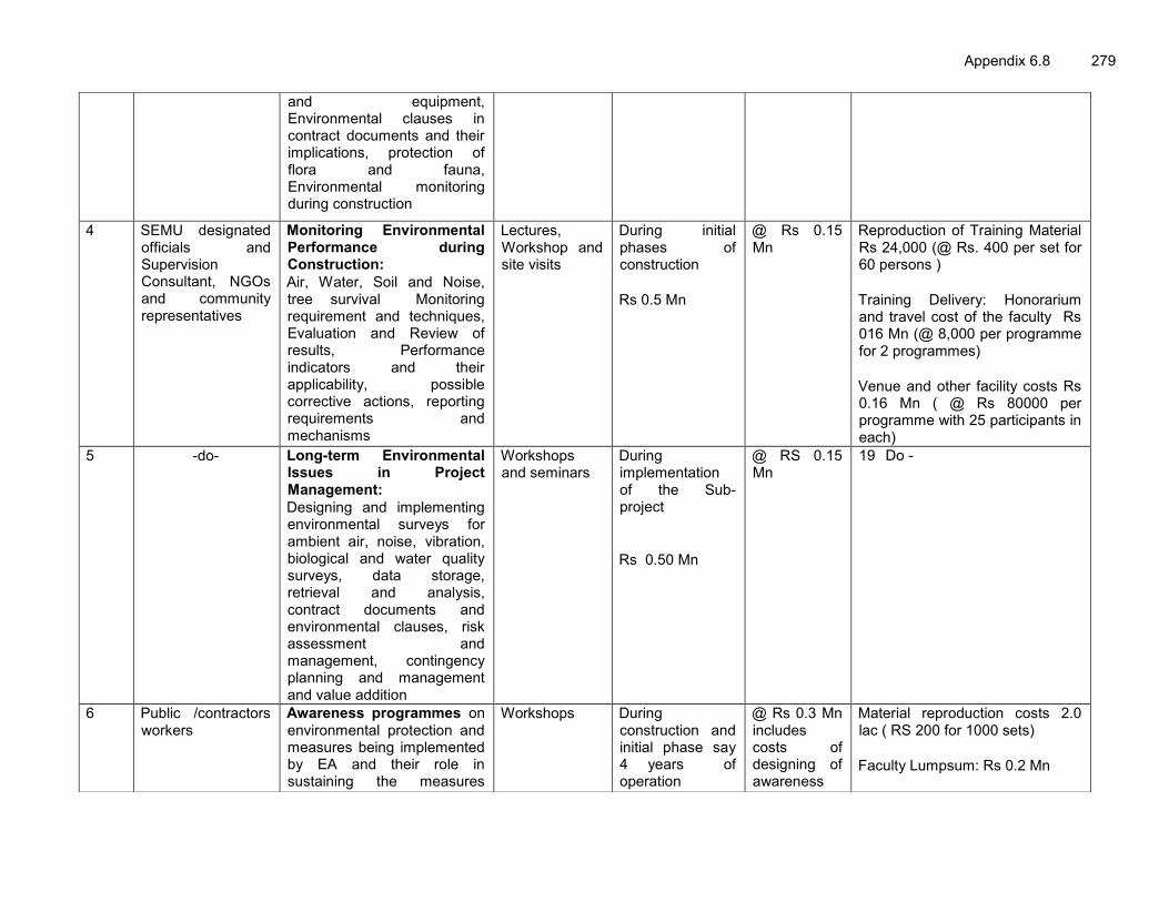
Appendix 6.8 279
and equipment, Environmental clauses in contract documents and their implications, protection of flora and fauna, Environmental monitoring during construction
4 SEMU designated officials and Supervision Consultant, NGOs and community representatives
Monitoring Environmental Performance during Construction: Air, Water, Soil and Noise, tree survival Monitoring requirement and techniques, Evaluation and Review of results, Performance indicators and their applicability, possible corrective actions, reporting requirements and mechanisms
Lectures, Workshop and site visits
During initial phases of construction Rs 0.5 Mn
@ Rs 0.15 Mn
Reproduction of Training Material Rs 24,000 (@ Rs. 400 per set for 60 persons ) Training Delivery: Honorarium and travel cost of the faculty Rs 016 Mn (@ 8,000 per programme for 2 programmes) Venue and other facility costs Rs 0.16 Mn ( @ Rs 80000 per programme with 25 participants in each)
5 -do- Long-term Environmental Issues in Project Management: Designing and implementing environmental surveys for ambient air, noise, vibration, biological and water quality surveys, data storage, retrieval and analysis, contract documents and environmental clauses, risk assessment and management, contingency planning and management and value addition
Workshops and seminars
During implementation of the Sub-project Rs 0.50 Mn
@ RS 0.15 Mn
19 Do -
6 Public /contractors workers
Awareness programmes on environmental protection and measures being implemented by EA and their role in sustaining the measures
Workshops During construction and initial phase say 4 years of operation
@ Rs 0.3 Mn includes costs of designing of awareness
Material reproduction costs 2.0 lac ( RS 200 for 1000 sets)
Faculty Lumpsum: Rs 0.2 Mn

280 Appendix 6.8
taken including for noise pollution, air pollution, safety, soil conservation, and tree plantation, tree plantation and importance of tree loss prevention to minimise C-loss.
Rs 0.13 Mn
booklets/material
Delivery Lumpsum 6.0 ( two hours workshops)
7 PIU Project Staff, Supervision Consultant, Engineering Staff of Contractor. DFO
Restoration of sites viz borrow areas, construction Camps, Occupational health and safety, management systems, tree plantation, Faunal protection and sustainability. tree plantation and importance of tree loss prevention to minimise C-loss Reporting Formats/procedure
Lecture/Presentations
before Contractor Demobilization Rs 0.43 Mn
@ Rs 0.10 Mn
Reproduction of Training Material Rs 10,000 (@ Rs. 200 per set for 50 persons ) Training Delivery: Honorarium and travel cost of the faculty Rs 016 Mn (@ 80,000 per programme for 2 programmes) Venue and other facility costs Rs 0.16 Mn ( @ Rs 80000 per programme with 25 participants in each)
Total Training Costs
Rs 4.60 Mn

Appendix 6.9 281
Appendix 6.9 : Environmental Budget
Component Item Unit Quantity Rate
AH-2 (million Rs)
AH-48 Amount (million Rs)
TOTAL Amount (million Rs)
DESIGN AND CONSTRUCTION STAGE
Technical Support
Preparation of Environmental guidelines including wild life management plan and performance indicators, code of practices
Lump sum - Rs 2.50 million ( Professional input @ Rs 0.3 Mn per
person month for 5 month and
organization, travel, meetings and
printing, and office overhead @ Rs 0.2
Mn per month for five month)
2.50 2.50
Flora
Diversion of Forest land for Non forestry Purposes (Diversion of Reserved Forests and National Park land
Rs per ha 8 ha ( NPV)
Rs 9,00,000 per ha 0.00
7.2 7.2
Clearing of plantation km Covered in engineering costs
Compensatory afforestation (Minimum 1:3) ( Plantation and maintenance for five year) ( This includes plantation of fodder and shade trees for elephant habitat improvement)
No of tree 62910 ( AH-2:
4910, AH-48 :15997)
Rs. 202166 per tree with circular guard
and maintenance for 3 years
29.77
96.99
126.76
66 Sapling cost + fencing material +labor cost = 821, watering, pesticide = Rs. 100 per tree per quarter for 12 quarter (900 +1200=2021)

282 Appendix 6.9
Component Item Unit Quantity Rate
AH-2 (million Rs)
AH-48 Amount (million Rs)
TOTAL Amount (million Rs)
Additional Tree plantation for climate change consideration of 1:2 basis ( This includes plantation through forests department of fodder and shade trees for elephant habitat improvement)
No of Trees
41814 Rs. 2021 per tree with circular guard
and maintenance for 3 years
19.85
64.66 84.51
Floral
Developing Floral nursery for facilitating tree plantation
Lump sum Depending on site
conditions
Lump sum (Development Rs
2.50 Mn and maintenance @ Rs 0.60 Mn per year for
three year)
4.3 4.3
Faunal
Developing Fisheries Lump sum Depending on site conditions
Lump sum ( Development Rs
2.00 Mn and maintenance @ Rs 0.50 Mn per year for
three year)
3.5 3.5
Drainage Congestion and disposal of accumulated water
Provision of adequate surveillance
Covered in project design and engineering cost
Erosion & Sedimentation
Embankment, bridge approaches and River/canal Bank Protection Measures
Covered in project design and engineering cost
Land Compensation against
land acquisition and Rehabilitation
Covered in R&R Budget

Appendix 6.9 283
Component Item Unit Quantity Rate
AH-2 (million Rs)
AH-48 Amount (million Rs)
TOTAL Amount (million Rs)
Soil
Soil contamination protection ( Septic tanks, grease taps etc) and rehabilitation of borrow areas
Covered in project design and engineering cost
Noise
Provision Noise Barriers and thick tree plantation around sensitive receptors.
Provision of Temporary Noise and dust barrier during construction
24 noise barrier in each road @ Rs 1500 per square meter for av 60 square meter per barrier
Temporary Noise and dust barrier ( Barricading
along the construction area considered as part of construction costs and not separately considered
here)
2.16 2.16
Water
Installation of oil and grease traps at construction sites and Waste Water Collection & Disposal system
Estimated @ RS 2,00,000 per camp estimated six camp
0.4 (2 camps)
0.8 (4 camps)
1.2
Construction of soak pits at construction sites
Estimated @ RS 2,00,000 per camp estimated six camp
0.4 (2 camps)
0.8 (4 camps)
1.2
Development of earthen water bodies ( ponds upstream of the road of elephant crossing area) for Elephant habitat improvement
Development of water earthen water bodies through forests department/wildlife authorities for ensuring availability of water for elephant and wild animals ( Provision of 6 water bodies of average 1000m2 size @ Rs 300 per square meter dug up
and side stabilization average costs)
0.00 1.8 1.8
Dust Management during construction
Water Sprayer / Watering Covered in project design and engineering cost

284 Appendix 6.9
Component Item Unit Quantity Rate
AH-2 (million Rs)
AH-48 Amount (million Rs)
TOTAL Amount (million Rs)
Safety Provision of Retro-Reflective signage Animal Movement Areas Near Naxalbari, Jaldapara National Park and Hasimara – Pasakha bypass area
16 Signage per site four sites @ Rs 15,000 per signage
0.24 (16 signs)
0.72 (48 signs)
0.96
Caution Signage, Speed Breaker and Crash Barrier
Covered in project design and engineering cost
Accident risks in construction activity
Covered in project design and engineering and cost
General Safety (provision of PPE like ear muffs, gloves etc.)
Average 300/labour/year for construction period or five years
To be part of
contractors costs
Health Health checkup camps for construction workers
camps 1 camp /year
Rs 0.2 million/camp for five years one
camp per road
1.00 1.00 2.00
Environmental Monitoring in the construction phase
Terrestrial and Aquatic Fauna
Cost as mentioned in monitoring plan
7.66
Ambient Air Quality Surface Water Quality Ground Water
/Drinking Water Quality
Noise & Vibration Soil Erosion & Siltation Drainage Pattern and
Water Logging Monitoring Tree
Felling & Plantation SUB TOTAL (DESIGN AND CONSTRUCTION STAGE) 245.75 OPERATION STAGE Erosion Control and landscaping
Visual Check Lump Sump
To be part of Regular maintenance and operation costs
-

Appendix 6.9 285
Component Item Unit Quantity Rate
AH-2 (million Rs)
AH-48 Amount (million Rs)
TOTAL Amount (million Rs)
Emergency Preparedness: Accident Response
Ambulance equipped with requisite emergency medical aid facility
Rs per Ambulanc
e
5 Ambulances with One doctor and one Para medical staff and one
driver. @ Rs 1.5 Mn per ambulance with 1.2 Mn per ambulance per year operational costs for three year.
5.1 (1
ambulance)
20.4 (4 ambulances)
25.5
Monitoring of performance indicators
Terrestrial and Aquatic Fauna including surveillance audit
Cost as mentioned in the Monitoring plan
5.28
Ambient Air Quality Surface Water Quality Ground Water
/Drinking Water Quality
Noise & Vibration Soil Erosion & Siltation Drainage Pattern and
Water Logging Monitoring Tree
Felling & Plantation SUB TOTAL ( OPERATION PHASE) 30.78 TRAINING and AWARENESS Training Environmental training
& awareness Lump sum As per
training details
- 4.6
ESTABLISHMENT AND SYSTEMS Establishment Supervision
Consultant and External Monitoring Agency
Lump sum 1 Lump sum 41.47
Construction Stage (Site Environmental officer )
Per son months
1 person for five years
Rs 75,000 per person month + plus need based subject
expert support (lump sum Rs 1.0 Million)
5.5

286 Appendix 6.9
Component Item Unit Quantity Rate
AH-2 (million Rs)
AH-48 Amount (million Rs)
TOTAL Amount (million Rs)
Operation Stage Per son Months
person for 1 year
Rs 75,000 per person month plus need based subject
experts support( lump sum Rs 0.5
million)
1.4
Management Systems
Adoption of EHS management systems
Lump sum Project Director
Office and site
- 4.0
Management Information and tracking system
Lump sum - - 2.0
SUBTOTAL (ESTABLISHMENT & TRAINING and MANAGEMENT SYSTEM) 58.97 SUB TOTAL ( Construction, and Operation and mobilization ) 335.5
CONTINGENCIES @ 5 % on total Environmental Costs 16.77 GRAND TOTAL (in Rs) 352.275
GRAND TOTAL ( in US$) (@ 1 US $ = Rs. 55)
US $ 6.4 Million or say US $ 6.4
million

Appendix 7.1 287
Appendix 7.1 : Public Consultation Questionnaire
Road Corridor: Sr. No. …………Date ……………Time ………………………………. Name of Enumerator ………………………………………………………………………… 1. Location Section (Km) Name of Village/
Urban Ward
Chainage in m City / urban area Taluka District Block Landmark Location (Distance in M from centre of road)
GPS Coordinates
Left side Right Side Lat Lon Noise Level Time Reading
2. Particulars of Community Infrastructure
Title ……………………………………………………………………………………. Running length along the road ……………………………………………………
3. Utility / Purpose …………………………..…………………………………………………………………
4. Usage Daily timing ..………………………………………………………………….. Seasonal – months …………………………………………………………………….. Annual functions ………………………………………………………………………... 5. Owner …………………………………………………………………………………….. 6. Type of User ……………………………………………………………………………. Public Consultation Date ………………………………………….. Time ………………………. Attendance Total number Men Women (Please note name of the participants) Venue……………………………………………………………………….. Facilitators ………………………………………………………………….. Nature of Impacts Conveyed Sr. No.
Particulars Response
01 Air Pollution 02 Noise Pollution 03 Water Pollution 04 Willingness to give soil for borrow earth 05 Loss of Trees

288 Appendix 7.1
06 Accident or Safety 07 Movements of Animals 08 Movement of Wild Animals 09 Suggestions for the Concerns Overall Public Opinion captured during public consultation ………………………………………………………………………………………….. …………………………………………………………………………………………… Specific Opinions and suggestions captured during public consultations if any
………………………………………………………………………………………….. Signature of the Enumerator

Appendix 7.2 289
Appendix 7.2 : Summary of Public Consultation
Date Location, Name and Address of the person/agency met
Issues discussed Comments/Recommendations of Persons Met
Actions of Comments/ Recommendations
Government Departments April 2012 and May
2012,
Kakarbita Custom Office, Mr. T.K. Misir, Custom Superintendent Mr. Uttam Gurung, Custom Superintendent Mr. Ravinder
Traffic congestion, air and water pollution, movement of hazardous material and flood, bypass alignment
No issue of flood, water is available easily however groundwater has high iron content. Market is congested, needs to be bypass or alternate engineering solutions to prevent vehicle idling and air pollution. The current trucks movement is of the order of more than 100 per day from India to Nepal and 50 to 60 per day from Nepal to India which is on the rise but no hazardous material movement and no accidents scenario.
Bypass to Exiting alignment is proposed
April 2012
NTP Forest Division, Siliguri. Mr. D. K. Dutta, Additional District Forest Officer,
Tree cutting and Forest conservation, animal movement,
The cutting of trees should be avoided. Tree should be planted for a minimum of 1:3. Tree cutting require permissions of forest department even if tree is located in a non-forest land. The road side plantation is not classified as protected forest except in the forest land area as per the West Bengal Tree Protection and Preservation Act, 2008-09.
Provision is made to undertake compensatory tree plantation on minimum 1:3 ratio.
April 2012 and May 2012
West Bengal State Pollution Control Board, Regional Office, Siliguri Parivesh Bhawan, Paribhan Nagar, Matigara, Siliguri. Mr. Subrito Ghosh, Chief Engineer Mr. Gautan Kumar Pal,
Environmental Issues been faced in the area and issue associated with the improvement of the road corridor
There is no issue of river water quality or air, noise and soil pollution in the project district areas. No water logging. However, vehicular pollution is a concern in urban areas. The road design and maintenance should be such that idling of the vehicle could be prevented and tree cutting could be avoided.
Provision of bypasses is proposed with improved road design. The area of traffic jams are either being bypasses, or provision of ROB, grade separation and junction improvement is proposed. System of regular maintenance is proposed to be enhanced.
May 2012
Office of the Wildlife (North) West Bengal, Govt. Saw Mill Complex,
Animal movement and road
The road development is a welcome step; however, it is not desirable or
Enhancement measures are proposed to plant more

290 Appendix 7.2
Date Location, Name and Address of the person/agency met
Issues discussed Comments/Recommendations of Persons Met
Actions of Comments/ Recommendations
Mahananda Para, Siliguri, District Darjeeling, West Bengal., Dr. Brij Raj Sharma, Chief Conservator of Forests
development feasible to widen the road in Jaldapara Sanctuary area. The development has fragmented the home area of elephants which love to move long distances in a group. Elephants in this area moves from East to West (Nepal to Baxua Tiger Reserve and back). Elephants do cross the road in Jaldapara Sanctuary Area. To protect animals migratory routes “Eastern Dooars Elephant Reserve” which covers the core area of Jaldapara and Buxa Tiger Reserve and other forest areas. Following suggested cautions will be considered for road improvement aspects:
1. Elephant specific improvements like creation of water bodies, bamboo plantations can be created in core areas to restrict their movement towards urban / rural areas for search of water.
2. Electric fencing can be consider along the both side of the road as well as creating of animal trench to guide the elephant for the specific crossing route.
Bamboo tree and water bodies in conservation areas
May 2012, Office of the Wildlife Division –II, Jalpaiguri. Mrs. Sumita Ghatak, Divisional Forest Officer
Animal movement and road
development
Death of elephants in road accident is nil. No forest or other animal issue in AH-2 road segment (Kakarbhita to Phulwari). Only elephant crossing is confined to Naxalbari Tea Estate area. The elephant moves from Nepal to Assam and Assam to Nepal between May to June for maize crop season and September to December for wheat crop season which result in conflict with people. About 40 persons killed in last few years by elephant and about 800
Measures are proposed to for adequate signage, speed control and undivided road carriageway.

Appendix 7.2 291
Date Location, Name and Address of the person/agency met
Issues discussed Comments/Recommendations of Persons Met
Actions of Comments/ Recommendations
people injured in last 5 to 7 years. Tree felling in non-forest areas also is a matter of concern. Following suggestions are made:
1. Adequate signage will be placed in the elephant area cautioning elephant movement zone with pictures.
2. Under pass may or may not serve the purpose of ensuring animal movements through the underpass for road crossing. However, it is still a preferred option if its height is kept for more than 10 ft. and with wider opening.
3. Speed breakers and signage is preferred option additional as this will help to protect animal’s accidents with vehicles.
4. No divider will be provided in the road as it hinders the fast movement of animals.
5. No fluorescent lights will be installed in the animal crossing area of the road since animal gets distracted from the light because the reflected light give a fire feeling to the animals.
6. Maximum possible tree plantation will be made.
April,2012 and May
2012,
Field Directors Office, Alipur Duar, Jalpaiguri. Mr. R.P.Saini, Field Director, Buxa Tiger Reserve. Mr. V. Salimath, IFS, Deputy Field Director, Buxa Tiger Reserve (West) Mr. Bhaskar J.V. IFS, Deputy Field Director (East)
Animal movement and road
development
The undisturbed elephant movement has to be ensured while any development takes place with the fast moving vehicle, elephant gets scared and comes and stand on the road. For elephant crossing in the Jaldapara National park, four under passes at identified crossing areas is desired with the trench on either side to divert elephant to the under pass locations. No separate data is available on the accident of Bison. In addition to the
Provision of Underpass in Jaldapara National made. Alternative alignment is suggested to shift the bypass somehow away from Hashimara town to minimise the Man-Animal conflict. Measures are proposed to regulate traffic in the event of elephant movement. Official were inclined to the proposed
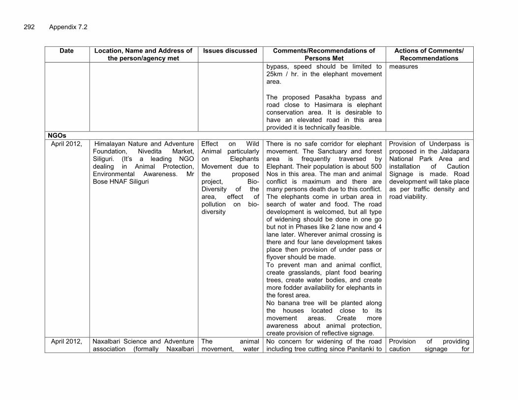
292 Appendix 7.2
Date Location, Name and Address of the person/agency met
Issues discussed Comments/Recommendations of Persons Met
Actions of Comments/ Recommendations
bypass, speed should be limited to 25km / hr. in the elephant movement area. The proposed Pasakha bypass and road close to Hasimara is elephant conservation area. It is desirable to have an elevated road in this area provided it is technically feasible.
measures
NGOs April 2012, Himalayan Nature and Adventure
Foundation, Nivedita Market, Siliguri. (It’s a leading NGO dealing in Animal Protection, Environmental Awareness. Mr Bose HNAF Siliguri
Effect on Wild Animal particularly on Elephants Movement due to the proposed project, Bio- Diversity of the area, effect of pollution on bio-diversity
There is no safe corridor for elephant movement. The Sanctuary and forest area is frequently traversed by Elephant. Their population is about 500 Nos in this area. The man and animal conflict is maximum and there are many persons death due to this conflict. The elephants come in urban area in search of water and food. The road development is welcomed, but all type of widening should be done in one go but not in Phases like 2 lane now and 4 lane later. Wherever animal crossing is there and four lane development takes place then provision of under pass or flyover should be made. To prevent man and animal conflict, create grasslands, plant food bearing trees, create water bodies, and create more fodder availability for elephants in the forest area. No banana tree will be planted along the houses located close to its movement areas. Create more awareness about animal protection, create provision of reflective signage.
Provision of Underpass is proposed in the Jaldapara National Park Area and installation of Caution Signage is made. Road development will take place as per traffic density and road viability.
April 2012, Naxalbari Science and Adventure association (formally Naxalbari
The animal movement, water
No concern for widening of the road including tree cutting since Panitanki to
Provision of providing caution signage for

Appendix 7.2 293
Date Location, Name and Address of the person/agency met
Issues discussed Comments/Recommendations of Persons Met
Actions of Comments/ Recommendations
vigyan club). Mr. Dhruba Jyoti Rao (Secretary) and Mr. Pran Govinda Nag. (It’s a leading NGO dealing in afforestation and sanitation)
availability, sanitation, tree plantation and afforestation
Bagdogra has enough RoW. There is a small no. of tree plantation in this stretch. To increase the tree density should be increased through social forestry. Only local variety of trees will only be grown. The tree like eucalyptus will be avoided. The afforestation will be carried out on 1:3 basis and each tree plantation will be protected with iron wire mesh. The elephant crosses the road near Kiran Chand Tea Estate between Panitanki and Naxalbari in the month of October to November and May to June. The elephant enters the agriculture field for eating the rice crop. They come from Tukari Range Reserve Forest and go upto Bagdogra Forest Range. The water is available. The ground water table is at 20 to 25 feet below the ground level and as such water and sanitation is not an issue in the area.
elephant movement with adequate lighting will be made in the elephant movement area. Provision is made for compensatory tree plantation on 1:3 basis.
April 2012
Naxalbari Integrated Development Society, Village Satbhya, Naxalbari. Mr. Pradeep Prasad, General Secretary and founder. Ms. Manjula Begum, founder member Mr. Sanjay Prasad, Advisor.
The animal movement, water availability, sanitation, tree plantation and afforestation.
The road development is a long awaited demand and the road widening should happen at the earliest. The bad condition of the road is also responsible for high air pollution near the road. Due to bad conditions of the road there are substantial instances of road accidents, bus over topping. There is no issue of flood or animal accident however quality of drinking water is an issue due to presence of arsenic and iron presence. Elephant crosses the road between Satbhiya to Sanasi Tea Estate. The
-do-

294 Appendix 7.2
Date Location, Name and Address of the person/agency met
Issues discussed Comments/Recommendations of Persons Met
Actions of Comments/ Recommendations
movement of animal is very limited is once or twice in summer and winter.
April 2012,
Jalpaiguri Science and Nature Club, Nivadita Marg, Naya Basti, Jalpaiguri. Mr. Raja Routh, Joint Secretary. (Its an NGO focusing on Natural Conservation, Wildlife conservation and creating awareness among the people.)
Proposed Road Development, Wildlife Protection and Conservation of Natural resources.
The organization always supports infrastructure development provided adequate safeguards are incorporated in the project design for the protection of animals. The development of road increases the possibilities of Man and Animal conflict particularly of Bison, Elephant, and Leopard in Jaldapara Range area. Suggestion made by them includes :
1. Creating awareness among various stakeholders (Students, Forest native people, villagers and drivers) on nature and animal protection.
2. Create adequate safe animal crossing passages, either in the form of under passes or speed limits.
Provision of Underpass is made in the Jaldapara National Park area. Provision of awareness is made.
May 2012,
Science & Nature Group, Jalpaiguri, Mr. Kunal Banergee, Mr. Raja Rao Mr. Nihar Ranjan Ghosh And Mr. Pran Dapinder
Environmental Impact of the road development with its emphasis on Air Pollution, Water Pollution, Flora and Fauna
No major impact is expected on Air, Water Noise or Fauna from this road development except in the animal road crossing locations in Jaldapara National park Areas where adequate provision for safe passes of animals will be made. No migration of birds is seen in project road area. No spawning or breeding ground in both the road alignment areas.
-do-
May , 2012 Mr. Nehar Rajan Bose, Social Worker and Environmental Activists cum Reporter, Uttar Banga Sangbad, Jalpaiguri
Environmental Impact of the road development with its emphasis on Air Pollution, Water Pollution, Flora and Fauna
Road development will improve air quality due to reduction in dust generation after road improvement. No much impact is anticipated due to cutting of roadside trees. No impact is anticipated on wild life. No Wildlife death/ damage reported in
Adequate signage will be placed. Compensatory Tree plantation is proposed on 1:3 ratio itself.

Appendix 7.2 295
Date Location, Name and Address of the person/agency met
Issues discussed Comments/Recommendations of Persons Met
Actions of Comments/ Recommendations
recent past excepting rare cases of Deer death/ damage (4-5) cases seen within Tursa river to Madarihat area (7 Km. Stretch). Elephant and Bison accidental death is frequent with railways but leopard death is rare (2-3 case in last 10 years). Main migratory period of elephant is June to September from 6 P.M to 4- 5 A.M. Very few cases of Rhino and Bison movement above road. Snake death/ damage in both Railway and road occur. Alert zone should be identified and notified to prevent man – animal conflict. Speed limit will be fixed between Tursa river to Madarihat area (7 Km. Stretch) to minimise animal accident. Tree of religious importance will be cut in consultation with communities concerned. Compensatory tree will be undertaken on minimum 1:3 ratio. Plantations will be selected with less canopy cover and small leaf species like Debdaru, Gulmohor. No impact is anticipated on noise and water resources.
May 2012 Social Worker and Environmental Activists, Sur Natya Sangathan & Part Time Lecturer, Jaigaon College, Jaigaon
Environmental Impact of the road development with its emphasis on Air Pollution, Water Pollution, Flora and
Elephants move within Hasimara to Madarihat area for fodder mainly due to grown crops. Exceptionally, Samber, deer, bison comes outside the park for sufficient Fodder from agriculture land. No road animal accident occurred in
Enhancement measures are proposed for availability of fodder inside the park.

296 Appendix 7.2
Date Location, Name and Address of the person/agency met
Issues discussed Comments/Recommendations of Persons Met
Actions of Comments/ Recommendations
Fauna this region in last few years. No large canopy plants should be planted. No plants of aromatic and fodder plants should be planted to invite wild animals towards road. Fodder plants should be planted inside park for reimbursement of plant cuttings. Water facility inside the park should also be improved. Religious tree will be cut with concurrence from the community.
Village Panchayat (Village Administration and Public) April 2012, and May
2012
Naxalbari Panchayat, Mr. Anil Burgani, President, Male (3) female (10) villagers and Panchayat members. ( Names of villagers not given)
Impact on various components of environmental quality and water and tree plantation issue.
No environmental issue particularly with respect to air quality, noise levels and soil quality. No issue of flood from Mechi river due to high embankment barriers on Indian side of the river. No issue of water logging since rain water easily drained out. They suggested to take adequate measure like caution signage and speed control for preventing Man – Animal conflict. The road has many instances of soil erosion and subsidence. Therefore road embankment should be well strengthened and well stabilized. Village Panchayat will be ready to plant extra trees for compensatory afforestation purposes on the extra land available under its control. They are also ready to provide workers for plantation purposes.
Road Embankment will be strengthened through slope stabilisation techniques and required design measures. Wild life protection measures suggested under EMP Larger participation of Panchayat is proposed for tree plantation
April’ 20 2 Raniganj Gram Panchayat, Village Impact on various Members welcome the initiative of ROB is proposed at railway

Appendix 7.2 297
Date Location, Name and Address of the person/agency met
Issues discussed Comments/Recommendations of Persons Met
Actions of Comments/ Recommendations
Panchayat Office. Mr. Handru Oraom, Pradhan (President) Mrs. Bina Mandal, Vice Pradhan Mr. Narendra Nath Sinha, Executive Assistant, Mr. Abhijeet Chaudhary, G.P. Assistant Mr. Madhusudan Sarkar, G.P. Member and 3 females villagers ( Name of village female not given)
components of environmental quality and water and tree plantation issue.
widening the road. No issue of water, air, noise or soil pollution. Concern with tree cutting and congestion at railway line crossing. Suggested the following :
1. The road alignment may be taken from inner road to bypass railway crossing and Naxalbari Market area, otherwise ROB will be constructed to avoid traffic congestion at railway crossing.
2. Culverts will be provided close to the road at various locations depending on drainage flow and ensure periodic maintenance to prevent its siltation.
3. Trees should be saved to the maximum possible and temples can be shifted close to tree line areas.
4. Surveillance posts will be created at a distance of 200m each for 1km stretch of elephant movement to prevent man and animal conflict.
5. The Panchayat is ready to plant compensatory trees through various government schemes along the road and PMGSY road.
crossing to avoid congestion. Bypass to Pantitanki is proposed on the Northern Side of the existing alignment. Design measures are being taken to avoid tree cutting as much as possible. Larger participation of Panchayat is proposed for tree plantation
May-2012 GP office, Paschim, Khairwadi, Rangalibazana, Jalpaiguri Mr. Pulok Roy, Mr. Uttam Dey, Ms. Modhumita
Environmental Impact of Road development with respect to Air pollution, Noise pollution, water availability and pollution, loss of trees, shifting of community structure, animal movement, soil erosion, flood, safety and
In favour of the project, no environmental concern due the project development. Ready to cooperate for tree plantation. Water availability is not a concern. Suggested to minimize tree cutting as much as possible. Also suggested to stabilize road embankment and exercise cautioned for hazardous traffic situations during construction.
Measures are proposed to minimize tree cutting through design measures. Measures are also proposed for embankment slope stabilization and traffic control during construction stage.

298 Appendix 7.2
Date Location, Name and Address of the person/agency met
Issues discussed Comments/Recommendations of Persons Met
Actions of Comments/ Recommendations
acceptability to the road development project
AH-48 May-2012 Opposite Railway Station and near
temple and hospital, Changlabandh, Nekliganj, Cooch Behar, Ms. Nandita, Mr. Tapan Dam, Mr. Rajib Sorkar, Mr. Laxman Saha, Ms. Laboni, Mr. Sanjib Bose, Mr. Arun Sarkar, Trinayan
-do- Very much in favour of the road improvement. Impact with respect to Air and noise pollution may be there but of lesser magnitude and have very little concern for the same. Suggested to plan more no. of trees. The temple may be impacted however; they are ready to shift the temple.
Provision of more tree plantation is proposed.
April-2012 Temple, Kalasibandha, Nekliganj, Cooch Behar Mr. Nirmal Roy, Vrishti
-do- In favour of the project consider little impact due to the project.
-
April-2012 Club, Ghoskadanga, Mayanaguri, Jalpaiguri Mr. Govind Barman, Mr. Parimal Roy, Mr. Madhab Roy, Mr. Ratan Roy, Mr. Doram Roy, Mr. Uttam Roy, Bandana
-do- In favour of the project, no environmental concern due the project development. Suggested to have good mechanism for period road maintenance.
Measures are proposed for sustenance of environmental measures during operation stage.
April-2012 School, Ghoskadanga, Mayanaguri, Jalpaiguri Mr. Tapan Das, Mr.Jayanto Roy, Mr. Alok Roy, Shila Das
-do- In favour of the project, no environmental concern due the project development. Suggested to take measures for the safety of students
-
May-2012 Temple, Madhudanga, Mayanaguri, Jalpaiguri Mr. Gonesh Saha, Mr. Paridosh Roy, Lata Saha, Mr. Bisnudeb Nath, Mr. Chanan Deb Nath Mr.Anashav Roy, Sagarika
-do- In favour of the project, no environmental concern due the project development
-
May-2012 Bateshwar, Madhudanga, Mayanaguri, Jalpaiguri Mr. Hirondas, Mr. Chandon Das, Mr. Prakash Roy, Pinki Roy, Indrayani
-do- In favour of the project, no environmental concern due the project development
-
May-2012 BDO Office, Mayanaguri, Mayanaguri, Jalpaiguri
-do- In favour of the project, no environmental concern due the project
-

Appendix 7.2 299
Date Location, Name and Address of the person/agency met
Issues discussed Comments/Recommendations of Persons Met
Actions of Comments/ Recommendations
Mr. Samrat Chakroborty BDO, Mr. Rajiv Dutta Choudhari Asst. BDO,
development. Suggested to have a development upto 4 lane not itself
May-2012 BDO Office, Mayanaguri, Mayanaguri, Jalpaiguri New BDO Mr. Kalyan Baruah, Mr. An.N. Raichur Office Superintendent,
-do- In favour of the project, no environmental concern due the project development
-
May-2012 Club, Takatuli, Mayanaguri, Jalpaiguri Mr. Dipakar Sarkar, Mr. Gokul Das, Mr. Deepal Pandal, Mr. Gopal Sen, Mr. Amit Dutta, Mr. Dilip Paul, Ms Rachana Roy
-do- In favour of the project, no environmental concern due the project development
-
May-2012 Jaldhaka bridge, Jaldhaka, Dhupguri, Jalpaiguri Mr. Bipil Roy, Mr. Bikram Singh, Ms. Dhurjati Das
-do- In favour of the project, no environmental concern due the project development
-
May-2012 Convent, Magurmari, Dhupguri, Jalpaiguri Mr. Fr. Alberto, Ms. Brinda,
-do- In favour of the project, no environmental concern due the project development. Concerned for road safety and suggested to provide signal, passes for cycle.
Measure for safety are proposed under EMP
May-2012 Cremation, Galandimor, Dhupguri, Jalpaiguri Mr. Chinta Adhikari, Mr. Krishna Das, Ms. Bijoya Das
-do- In favour of the project, no environmental concern due the project development
-
May-2012 School, Mallik Sova – Gosairhat, Dhupguri, Jalpaiguri Mr. Abel Tirki, Mr.Bimal Roy, Mr. Jia Ul Haque, Mr. Purbi Roy, Mr. Tapaskumar Bhadra Principal,
-do- In favour of the project, no environmental concern due the project development. Little concern for air and noise impacts. Considered this area as an accident prone since few accidents happened in the past. Suggested to provide safe passes for the students and cyclists at this location
Measure for safety are proposed under EMP
May-2012 Mazar Sharif, Sonakhali, Dhupguri, Jalpaiguri Mr. Samsul Alam, Mr. Mushtaq, Ms. Rehana
-do- In favour of the project, no environmental concern due the project development
-

300 Appendix 7.2
Date Location, Name and Address of the person/agency met
Issues discussed Comments/Recommendations of Persons Met
Actions of Comments/ Recommendations
May-2012 Shakovajhora, Dangiapara, Dhupguri, Jalpaiguri Ms. Gitarani Ghosh, Mr.Nikhil Pal, Mr. Ranjit Roy, Mr. Bimal Pal, Ms. Mita Pal
-do- In favour of the project, no environmental concern due the project development
-
May-2012 School, Gairkata, Dhupguri, Jalpaiguri Mr. Priyalal Debnath, Mr. Shantanu Dey, Ms. Radharani, Ms. Tara Dey
-do- In favour of the project, no environmental concern due the project development. Concerned for student safety and suggested for speed breakers
Measure for safety are proposed under EMP
May-2012 PHC, Paschim Khairwadi, Rangalibazana, Jalpaiguri Pulok Roy, Uttam Dey, Kajoli, Usha, Uttara
-do- In favour of the project, no environmental concern due the project development. Suggested for measures for air and noise pollution due to the projects.
Measures for noise and air pollution control are proposed under EMP.
May-2012 High School, Madarihat, Madarihat, Jalpaiguri Mr. Bidyutkar Sarkar, Mr. Ranjit Das, Mr. Saban Das, Mr. Raju Roy, Mohd. Rahim, Mr. Samar Saha, Ms. Indrani, Ms. Joyeeta
-do- In favour of the project, no environmental concern due the project development. Concern for the safety and suggested for signalling system.
Measure for safety are proposed under EMP
May-2012 BDO Office, Madarihat, Madarihat, Jalpaiguri Mr. Hiruk Mandal, BDO,
-do- In favour of the project, no environmental concern due the project development. Concern for the safety and suggested for signalling system.
Measure for safety are proposed under EMP
May-2012 PHC, Madarihat, Madarihat, Jalpaiguri Mr. Sushant Bhattacharya Mr. Ranjan Chakraborty, Ms. Bharani Sarkar
-do- In favour of the project, no environmental concern due the project development. Concern for the safety and suggested for signalling system.
Measure for safety are proposed under EMP
May-2012 Cremation Temple, Hasimora Farmalangi, Kalchini, Jalpaiguri Mr. Gopal Khetri, Mr. Bimal Chakraborty,
-do- In favour of the project, no environmental concern due the project development
-
May-2012 Temple, Hasimora, Kalchini, Jalpaiguri Mr. Dilip Muzumdar, Mr. Iswardas Aggarwal
-do- In favour of the project, no environmental concern due the project development
-

Appendix 7.2 301
Date Location, Name and Address of the person/agency met
Issues discussed Comments/Recommendations of Persons Met
Actions of Comments/ Recommendations
May-2012 Masjid, Dalsingpara, Kalchini, Jalpaiguri Mohd. Wasi Aktha, Shaikh Abdulla,
-do- In favour of the project, no environmental concern due the project development
-
May-2012 School, Dalsingpara, Kalchini, Jalpaiguri Mr. Ranjeet Jaiswal, Mr Thomas Principal, Ms. Arudra Dey
-do- In favour of the project, no environmental concern due the project development.
-
May-2012 High School, Dalsingpara, Kalchini, Jalpaiguri Mr. Kansal Kishori Head Master, Mr. Chandrabhanu Sharma, Mr. Rajkumar, Mr. Sambhu Jaiswal, Mr. Pradhan Dalsingpara,
-do- In favour of the project, no environmental concern due the project development. Concerned for likely increase in Noise and Air pollution and safety of students. Also, is in favour of one time development of upto 4 lane highway.
Measures for noise and air pollution control and safety are proposed under EMP.
May-2012 Masjid, Dalsingpara, Kalchini, Jalpaiguri Mohd Emamul Haque, Mohd. Akram Haque, Janab Pir Mohemmed,
-do- In favour of the project, no environmental concern due the project development
-
May-2012 Primary School, Khokla, Kalchini, Jalpaiguri Mr. Bharat Sharma, Mr. Vikram Lama, Mr.Sipnal Saha, Ms. Ashlesha Roy, Mr. Atish Gurum, Mr. Gopal Khatri, Mr. Santosh Lama, Mr. Rajesh Pradhan, Ms. Magha Dey, Mr. Robin Lama, Mr. Pritam Sewa, Ms. Bimla Darjee, Sujata Darjee, P.Phalguni
-do- In favour of the project, no environmental concern due the project development. Concerned for likely increase in Noise and Air pollution and safety of students.
Measures for noise and air pollution control and safety are proposed under EMP
May-2012 Convent School, Mangalbari, Kalchini, Jalpaiguri Mr. Purna Subba, Mr. Amar Bahadur, Mr. Lal Bahadur Bishwa, Mr. Ram Bahadur. Ms. U.Phalguni
-do- In favour of the project, no environmental concern due the project development. However, is concerned about the safety of students.
-
May-2012 Market Jaigaon, Jaigaon, Jalpaiguri Mr. Ganesh Bahadur Pradhan, Mr.
-do- In favour of the project, no environmental concern due the project development
-

302 Appendix 7.2
Date Location, Name and Address of the person/agency met
Issues discussed Comments/Recommendations of Persons Met
Actions of Comments/ Recommendations
Pawan Rayamajhi, Ms. Hastha AH-02
May-2012 Kakarbhita, Nepal O point, Kharibari, Darjeeling
In favour of the project, no environmental concern due the project development. Ready to cooperate for tree plantation. Water availability is not a concern. Suggested to minimize tree cutting as much as possible. Also suggested to stabilize road embankment and exercise cautioned for hazardous traffic situations during construction.
Measures are proposed to minimize tree cutting through design measures. Measures are also proposed for embankment slope stabilization and traffic control during construction stage.
May-2012 Check Post India, Panitanki, Kharibari, Darjeeling, Mr. Amal Singh, Mr. Mantu Mandal, Pradhan, Mr. Handur Orao, Shonalika, tumpa, shriti, monali, Mr. Ranjit Basak, Mr. Prabin Chhetri, Rajan PO Bahundangi, Dist Chapa Nepal, Ms. Neerajana, Ms. Sneha,
-do- In favour of the project, no environmental concern due the project development. Suggested to carry out all kind of development one time only. If road is to be widened to four lane, the same will be carried out this time only. Traffic congestions problem will be resolved.
Design Measures are proposed under EMP for minimising the problem of congestion.
May-2012 Railway crossing, Naxalbari, Naxalbari, Darjeeling Mr. D.K. Mishra, Principal, Mr. Anil Barman Pradhan
-do- In favour of the project, no environmental concern due the project development. Suggested to construct flyover at railway crossing to minimise traffic congestion.
Provision of ROB is made in the project design
May-2012 School / Temple, Borojhoro, Naxalbari, Darjeeling Mr. Mangal Singh, Mr. Phulan Singh,
-do- In favour of the project, no environmental concern due the project development. Concern for likely increase of Noise level if increase in traffic is high. Suggested to regulate speed around school and temple
Safety measures proposed in the EMP. Provision of Noise barrier made based on predicted noise level for such situation in the EMP
May-2012 Primary School, Hatighisa, Naxalbari, Darjeeling Mr. Rajesh Kindo Mr. Ienius Kindo, Ms. Baijayanti;
-do- In favour of the project, no environmental concern due the project development. Safety measures will be taken for students safety
Safety measures are proposed under EMP
May-2012 Godadhar Puli, Upper Bagdogra, Naxalbari, Darjeeling
-do- In favour of the project, no environmental concern due the project
-

Appendix 7.2 303
Date Location, Name and Address of the person/agency met
Issues discussed Comments/Recommendations of Persons Met
Actions of Comments/ Recommendations
Mr. Fr. Gorge Mathews, Mr. Fr. Monnen Joseph Director Ms. Drishti
development
May-2012 Market, Bagdogra Balika Vidyalaya, Upper Bagdogra, Naxalbari, Darjeeling Mrs.Smriti Roy, Mrs. Durba Roy, Ms. Panchali Roy, Ms. Samali
-do- In favour of the project, no environmental concern due the project development. Concerned for safety of Students. Suggested to make provision of Flyover for the safety of students and minimise congestion.
Safety measures are proposed under EMP
May-2012 University, Bagdogara, Naxalbari, Darjeeling Prof. Dr. A. P. Das Dept. of Botany NBU,
-do- In favour of the project, no environmental concern due the project development
-
April-2012 Budiwalason, Naxalbari, Darjeeling Mr. Narayan Das, Ms. Darpana Das
-do- In favour of the project, no environmental concern due the project development
-
May-2012 Shushrutanagar, Kadamtala, Matigara, Darjeeling, North Bengal Medical College Dr. Sabyasachi Das Med. Superintendent, Dr. Tapas Pal Asst. Superintendent, Mr. Chandan Dhar HC,Ms. Taneesha Banerjee, Ms. Mausami Dey
-do- In favour of the project, no environmental concern due the project development. Suggested to take measures for minimise the noise and air pollution around Hospital area. Regulate the traffic especially during construction stage
Measures for pollution control and traffic regulations are proposed under EMP
April-2012 Kawakhali, Matigara, Darjeeling, Jr High School Dr. Mandal, Krishna Barma, Mr. Dhiraj Shah, Mr. Deepesh Roy, Mr. Asid Barma, Mr. Tapeshkr. Mr. Mandal, Ms. Nilima, Ms.Sudipta Roy. Ms. Geetanjali Roy
-do- In favour of the project, no environmental concern due the project development. Concern for safety of student
Safety measures are proposed under EMP
April-2012 Naukaghat cros, Kamagaguri, Siliguri MC, Jalpaiguri Mr. Amit Sarkar, Ms. Ekantika Roy, Ms. Himani Chatterjee
-do- In favour of the project, no environmental concern due the project development
-
April-2012 Teesta Canal, Naxalbari, Darjeeling Mr. Sidam Sarkar, Ms. Shomili
-do- In favour of the project, no environmental concern due the project development
-
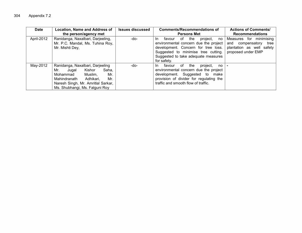
304 Appendix 7.2
Date Location, Name and Address of the person/agency met
Issues discussed Comments/Recommendations of Persons Met
Actions of Comments/ Recommendations
April-2012 Ranidanga, Naxalbari, Darjeeling, Mr. P.C. Mandal, Ms. Tuhina Roy, Mr. Mishti Dey,
-do- In favour of the project, no environmental concern due the project development. Concern for tree loss. Suggested to minimise tree cutting. Suggested to take adequate measures for safety.
Measures for minimising and compensatory tree plantation as well safety proposed under EMP
May-2012 Ranidanga, Naxalbari, Darjeeling Mr. Jugal Kishor Saha, Mohammad Muslim, Mr. Mahindranath Adhikari, Mr. Naresh Singh, Mr. Amritlal Sarkar, Ms. Shubhangi, Ms. Falguni Roy
-do- In favour of the project, no environmental concern due the project development. Suggested to make provision of divider for regulating the traffic and smooth flow of traffic.
-

Appendix 7.3 305
Appendix 7.3 : Public Consultation Photographs
Public Consultation Stage-I: with NGOs, Village Panchayats, and Public
Public consultation at Naxalbari, Village Panchayat
Office Public consultation at Naxalbari, Village Panchayat
Office
Discussion with Leading NGO at Siliguri Interaction With Leading NGO at Naxalbari
Public Consultation with villagers
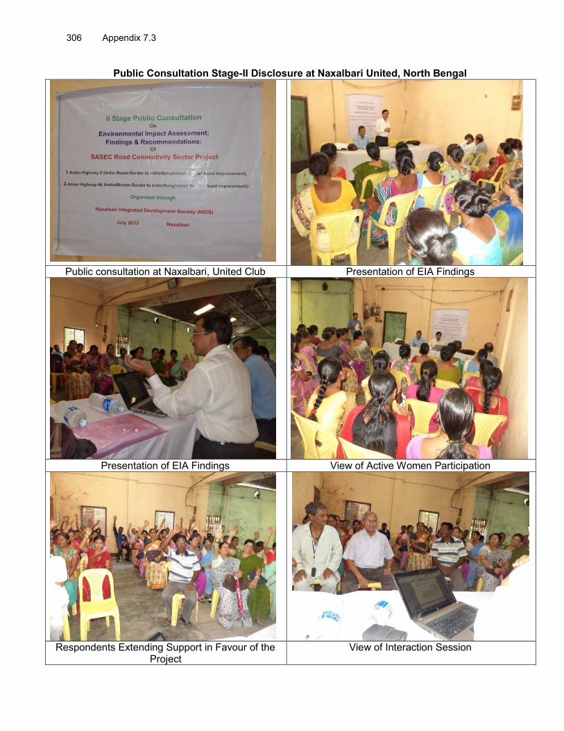
306 Appendix 7.3
Public Consultation Stage-II Disclosure at Naxalbari United, North Bengal
Public consultation at Naxalbari, United Club Presentation of EIA Findings
Presentation of EIA Findings View of Active Women Participation
Respondents Extending Support in Favour of the
Project View of Interaction Session

Appendix 7.3 307
Public Consultation Stage-II Disclosure meetings at Maynaguri, North Bengal
Presentation of EIA Finding Respondents Extending Support in Favour of the
Project
View of Interaction Session View of Active Women Participation
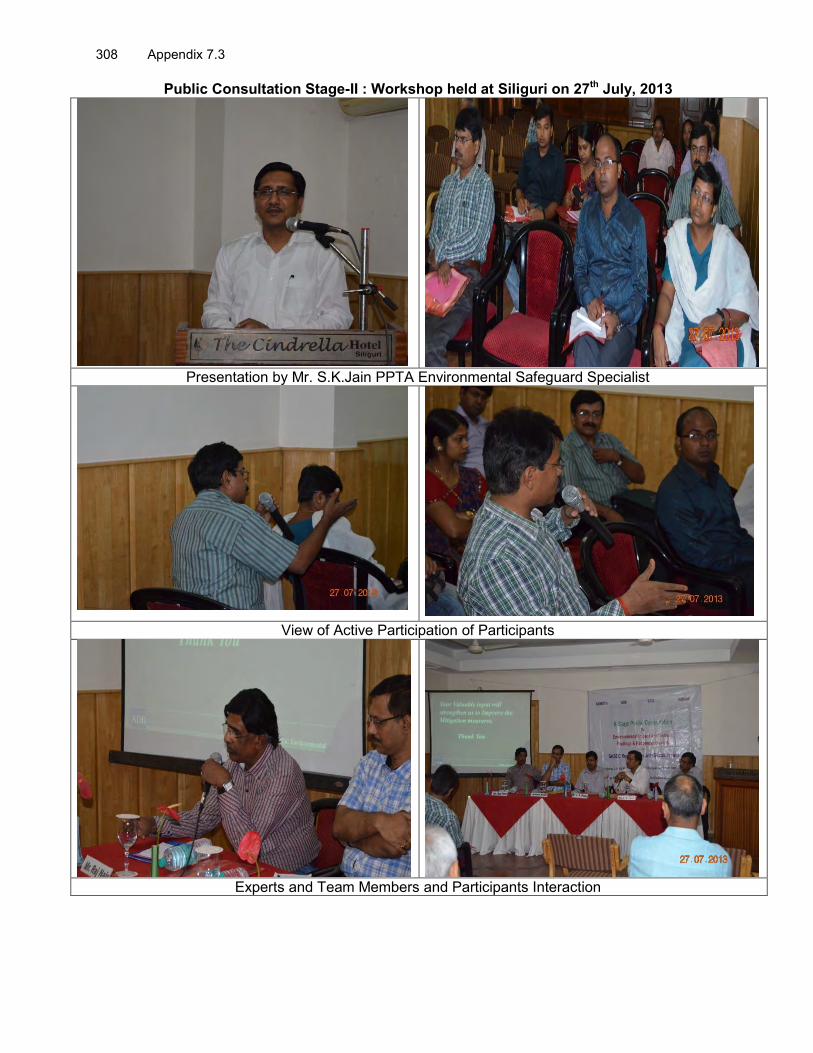
308 Appendix 7.3
Public Consultation Stage-II : Workshop held at Siliguri on 27th July, 2013
Presentation by Mr. S.K.Jain PPTA Environmental Safeguard Specialist
View of Active Participation of Participants
Experts and Team Members and Participants Interaction

Appendix 7.4 309
Appendix 7.4: List of Participants with Signature of Public consultation

310 Appendix 7.4

Appendix 7.4 311

312 Appendix 7.4

Appendix 7.4 313

314 Appendix 7.4

Appendix 7.4 315

316 Appendix 7.4
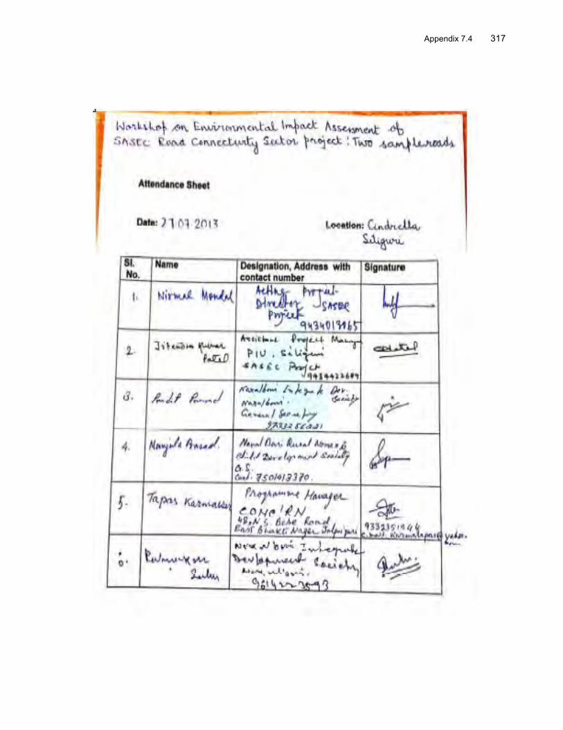
Appendix 7.4 317

318 Appendix 7.4

Appendix 7.4 319

320 Appendix 7.4

Appendix 7.4 321

322 Appendix 7.4

Appendix 7.4 323

324 Appendix 7.4

Appendix 7.4 325