IND: Rural Connectivity Investment Program – Project II
290
Initial Environmental Examination (Draft) August 2013 IND: Rural Connectivity Investment Program – Project II West Bengal Prepared by West Bengal State Rural Road Development Agency for the Asian Development Bank.
-
Upload
khangminh22 -
Category
Documents
-
view
0 -
download
0
Transcript of IND: Rural Connectivity Investment Program – Project II

Initial Environmental Examination (Draft)
August 2013
IND: Rural Connectivity Investment Program –
Project II
West Bengal
Prepared by West Bengal State Rural Road Development Agency for the Asian Development Bank.


CURRENCY EQUIVALENTS as of 16 August 2013
Currency unit – Indian rupee (Rs) Rs 1.00 = $ .01628
$1.00 = Rs 61.4250
ABBREVIATIONS ADB – Asian Development Bank MORD – Ministry of Rural Development MORD – Ministry of Rural Development APO – Accident Prevention Officer B.T. – Black Top BGL – Below Ground Level BIS – Bureau of Indian Standards BOQ – Bill of Quantity C.C. – Cement Concrete CD – Cross Drainage CGWA – Central Ground Water Authority CGWB – Central Ground Water Board Ch. – Chainage COI – Corridor Of Impact CPCB – Central Pollution Control Board CTE – Consent to Establish CTO – Consent to Operate DG – Diesel Generating DPR – Detailed Project Report EARF – Environmental Assessment Review Framework ECOP – Environmental Code of Practices EIA – Environmental Impact Assessment EMOP – Environmental Monitoring Plan EMP – Environmental Management Plan EO – Environmental Officer FEO – Field Environmental Officer GDP – Gross Domestic Product GOI – Government of India GSHAP – Global Seismic Hazard Assessment Program HC – Hydrocarbon HH – House Hold IEE – Initial Environmental Assessment IRC – Indian Road Congress LHS – Left Hand Side MCM – Million Cubic Meter MFF – Multi-Tranche Financing Facility MoEF – Ministry of Environment and Forests MoRD – Ministry of Rural Development MOSRTH – Ministry of Road Transport & Highways NAAQS – National Ambient Air Quality Standards NGO – Non-government organization NOx – Nitrogen Oxides NRRDA – National Rural Road Development Agency NSDP – Net State Domestic Product

WEIGHTS AND MEASURESlakh 100 thousand = 100,000
crore 100 lakh = 10,000,000 µg/m3 micrograms per cubic meter km kilometer lpd liters per day m meter mg/l milligrams per liter mm millimeter ppm parts per million million Million = 10 lakh = 1,000,000
NOTE{S}
In this report, "$" refers to US dollars. This initial environmental examination is a document of the borrower. The views expressed herein do not necessarily represent those of ADB's Board of Directors, Management, or staff, and may be preliminary in nature. Your attention is directed to the “terms of use” section of this website. In preparing any country program or strategy, financing any project, or by making any designation of or reference to a particular territory or geographic area in this document, the Asian Development Bank does not intend to make any judgments as to the legal or other status of any territory or area.
PIC – Project Implementation Consultant PIU – Project Implementation Unit PLF – Plant Load Factor PM – Particulate Matters PMGSY – Pradhan Mantri Gram Sadak Yojna PPE – Personal Protective Equipment’s PPTA – Project Preparation Technical Assistance RCIP – Rural Connectivity Investment Program RHS – Right Hand Side ROW – Right of way RRS I – Loan 2018-IND: Rural Roads Sector I Project RRS II – Loan 2248-IND: Rural Roads Sector II Investment Program RSES – ADB’s Environmental Safeguard Division SBD – Standard Bidding Documents SDP – State Domestic Product SO2 – Sulphur Dioxide SPCB – State Pollution Control Board SPS – ADB’s Safeguard Policy Statement,2009 SRRDA – State Rural Road Development Agency STDs – Sexually transmitted diseases TDS – Total Dissolved Solids TSC – Technical Support Consultants UNESCO – United Nations Educational, Scientific and Cultural Organization WBM – Water Bound Macadam WBSRRDA – West Bengal State Rural Road Development Agency


TABLE OF CONTENTS
I. INTRODUCTION 1
A. Project Background................................................................................................... 1 B. Project Roads Identification and Location ................................................................. 1 C. Rural Road Construction Proposal ............................................................................ 2 D. ADB’s Safeguard Policies and Category of the Project ............................................. 3 E. Objectives and Approach for Environnemental Assessment ..................................... 3 F. IEE Methodology and Content .................................................................................. 4 G. Legal Framework and Legislative Requirements ....................................................... 4 H. Acknowledgement .................................................................................................... 6
II. DESCRIPTION OF THE PROJECT 7 A. General ..................................................................................................................... 7 B. Sample Roads Selected in West Bengal State .......................................................... 7 C. Project Description .................................................................................................... 8
III. DESCRIPTION OF THE ENVIRONMENT 12 A. General ................................................................................................................... 12 B. Physical Environment ............................................................................................. 12 C. Biological Environment ........................................................................................... 28 D. Socioeconomic Environment ................................................................................... 32 E. Salient Environmental Features of Sample Roads .................................................. 36
IV. ANTICIPATED ENVIRONMENTAL IMPACTS AND ITS MITIGATION MEASURES 44
A. Common Impacts during Design and Construction Phase ...................................... 44 B. Common Impacts during Post Construction and Operation Phase .......................... 52 C. Road Specific Impacts ............................................................................................ 54
V. ENVIRONMENTAL MANAGEMENT PLAN, INSTITUTIONAL ARRANGEMENTS AND GRIEVANCE ADDRESS MECHANISM 57
A. Environmental Management Plan ........................................................................... 57 B. Environmental Monitoring Plan ............................................................................... 57 C. Institutional Arrangements and Responsibilities ...................................................... 58 D. Institutional Environmental Responsibilities ............................................................ 58 E. Environmental Assessment and Review Framework (EARF) for RCIP ................... 61 F. Capacity Building .................................................................................................... 63 G. Consultation and Information Disclosure ................................................................. 63 H. Grievance Redress Mechanism .............................................................................. 64
VI. PUBLIC CONSULTATION AND INFORMATION DISCLOSURE 65 A. General ................................................................................................................... 65 B. Compliance with Relevant Regulatory Requirements .............................................. 65 C. Beneficiaries’ Comments ........................................................................................ 65
VII. CONCLUSIONS AND RECOMMENDATIONS 69 A. Conclusions ............................................................................................................ 69 B. Key Recommendations ........................................................................................... 70
List of Tables Table I.1 : RCIP: Tranche II - List of Qualified Roads in West Bengal ..................................... 2 Table I.2 : Applicable Rules and Regulations for RCIP Roads ................................................ 5 Table II.1: Summary of District Wise Rural Roads .................................................................. 7 Table II.2: Details of Sample Roads ....................................................................................... 7 Table II.3: ROW Requirement ................................................................................................ 9 Table III.1: Summary Key Environmental Features of the Sample Roads Districts .................13

Table III.2: Ambient Air Quality during 2010 ...........................................................................21 Table III.3: Ambient Air Quality Status of West Bengal in 2010 ...............................................21 Table III.4: Physiographic Characteristics of different districts ................................................23 Table III.5: The soil pattern in the state ...................................................................................25 Table III.6: Land Utilization in project Districts – 2009-10 (In ha) ............................................26 Table III.7: List of common plant species available in the study area ......................................28 Table III.9: Demographic Profile of the Project Districts ..........................................................32 Table III.10: Human Development Indicators of West Bengal ....................................................33 Table III.11: Literacy Rate of project districts .............................................................................33 Table III.12: Indicators of Affluence ...........................................................................................34 Table III.13: Physical Infrastructure ...........................................................................................35 Table III.14: Salient Environmental Features of Sample Roads .................................................36 Table IV.1: Impacts on biological environment, utility, community and religious structures ......55 Table VI.1: Addressal of Issues and Concerns under the Project ............................................67 Table VI.2: Summary of Issues and Findings at Various Locations .........................................68 List of Figures Figure II.1 : Cross-section of Rural Roads .................................................................................11 Figure III.2 : Geological Map of West Bengal ............................................................................24 Figure III.3 : Hazard Zone Map .................................................................................................26 Figure III.4 : Protected Areas of West Bengal ...........................................................................30 Figure V.1: Institutional Arrangement for EMP Implementation .................................................59 List of Appendixes Appendix 1.1: Details of Roads in West Bengal ........................................................................71 Appendix 1.2: ECOPS of Sample Roads in West Bengal............................................................71 Appendix 1.3: Photo Illustration of Sample Roadsl .................................................................. 236 Appendix 4.1: Guidelines for Borrow Areas Management ....................................................... 240 Appendix 4.2: Impacts on Biological Environment, Utility, Community and Religious Structures-
All Roads Under Tranche II .............................................................................................. 243 Appendix 5.1: Environmental Management Plan ..................................................................... 253 Appendix 5.2: Environmental Monitoring Plan ......................................................................... 263 Appendix 6.1: List of Persons for Public Consultation................................................................271

Map 1: State and Project Districts Map of West Bengal
Project Districts

EXECUTIVE SUMMARY
A. Background
1. The Government of India (GOI) has launched a nationwide rural road improvement program in year 2000 namely “The Pradhan Mantri Gram Sadak Yojna (PMGSY)”. The objective of PMGSY is to provide all-weather road connectivity to all rural habitations with a population of more than 500 persons in plains and 250 persons in hill states. According to latest survey undertaken by state governments as part of PMGSY, about 0.167 million unconnected habitations are eligible for coverage under this programme. This involves construction of about 0.371 million km of roads for new connectivity and 0.368 million km under up-gradation. This programme is being implemented through National Rural Road Development Authority (NRRDA) under Ministry of Rural Development (MoRD) at central level and through State Rural Road Development Authority (SRRDA) at state level.
2. PMGSY programme is anticipated to be essential for poverty elimination, and accelerating overall development in rural areas. The programme until now has been successful to meet its objective of employment generation, trade improvements and income enhancement.
3. The Rural Connectivity Investment Program (RCIP) is a multitranche financing facility (MFF) that will construct or upgrade to the all-weather standard about 12,000 km of rural roads connecting around 4,000 habitations in the states of Assam, Chhattisgarh, Orissa, Madhya Pradesh, and West Bengal. This report pertains to sample roads in West Bengal State.
4. The WBRRDA has selected about 930 km of rural roads to be taken up under RCIP Tranche II subproject roads in West Bengal. The 930 km of roads comprises 130 different stretches spread over in ten districts of the State. Within each district, the roads are further scattered in several blocks and sub divisions. The minimum and maximum length of the roads ranges between 1.237 km and 26.29 km respectively.
5. Subprojects specific Initial Environmental Assessment (IEE) is carried out as per this ECOP checklist for sample roads. These completed ECOP checklist with annexure on tree, utility and community structures, strip plans and selected photographs for 19 sample roads are enclosed as Appendix 1.2 and Appendix 1.3 respectively. The findings of 19 sample subproject specific assessment suggest that similar issues exist amongst the other 109 roads with very few subproject specific issues. Therefore, IEE report has been prepared based on ECOP checklist of selected sample subproject roads (19 roads of 109.58 km) covering atleast 10% of total roads of each district. Impact is assessed for all the 130 roads under.
6. The subproject roads has been selected following PMGSY guidelines for the selection of roads under this programme and satisfy the following environmental safeguards:
i. The selected road shall not disturb any cultural heritage designated by the Government or by international agencies, such as UNESCO, and shall avoid any monuments of cultural or historical importance.
ii. The selected road shall not pass through any designated wildlife sanctuaries, national parks, notified ecological sensitive areas or area of internationally significance (e.g., protected wetland designated by the Wetland Convention).

ii
iii. The subprojects shall only involve activities that follow Government of India laws and regulations and meets funding agency safeguard policies.
7. The proposal for rural road construction works typically considers a 10-12 m right of way (ROW), which includes side slopes for embankment, side drains on either side of the alignment. The roads consists both Black Top (B.T.) and Cement Concrete (C.C.) as per the ROW availability. The construction proposals are confined to the existing alignment of the paved tracks and mostly upgradation.
8. The project is classified as category B as per ADB Safeguard Policy Statement 2009. These small roads do not require any environmental clearance in accordance to Indian Environmental (Protection) Act and Rules, 1986 amended till date. However, these roads may attract few other legislation such as permission under Forest Conservation Act for diversion of forest land if involved, or tree cutting, Permission Air and Water (Prevention and Control of Pollution) Acts for establishment of temporary workshops, hot/ spot mix plants etc.
B. Description of Project
9. The selected 130 roads are spread over 10 districts namely North 24 Parganas, Bankura. Purulia, Purba Medinipore, Burdwan, Pashim Medinipore, Jalpaiguri, Darjeeling, Malda and Uttar Dinajpur and roads mainly pass through plain terrain and agricultural area, except roads at Darjeeling district. The project roads have several cross drainage structure, common utility strictures (like electric post, telephone post, transformer and hand pumps) and community physical structures (like temple, schools, health centers and religious structures) along the existing alignment. All efforts are made to save these structures while finalizing the alignment but some of these may need to be shifted.
10. The proposed rural road construction work will provide 7.5 m roadway width (this may be reduced to 6 m as per latest guidelines) with 3.75 m carriageway in accordance with the IRC-SP 20: 2002 in plain terrain. The proposal considers a 3.75 m cement concrete pavement with lined storm water drains for stretches passing through built-up areas, waterlogged/water overtopping/ flood prone areas. The pavement design considers a base layer of variable thickness as per the design with granular sub base, 150 mm thick water bound macadam (WBM grade I & II) and finally topped with 20 mm thick bituminous pavement. Adequate cross drainage structures like pipe or slab culverts/bridge structures are considered for drainage channels across the roads. Few minor bridges are also proposed to be constructed.
11. Considering the sub-grade strength, projected traffic and the design life, the pavement design for low volume PMGSY roads are proposed to be carried out as per IRC guidelines IRC: SP: 72 – 2007 or IRC SP:77 “Design of Gravel Road” and IRC SP:62-2004 “Cement Concrete roads”. In built up area for hygienic and safety reasons, C.C pavement is proposed with a hard shoulder and appropriate line drain. A design life of 10 years is considered for the purpose of pavement design of flexible and granular pavements. The embankment height considered as 1m (average) from ground to crust except at the approaches of cross drainage structures. The embankment height will vary in flood prone area as per the HFL. The design speed considered is as per recommended design speed of 50 Km/h.
C. Description of Environment
12. The climate of the West Bengal state, except the Himalayan and sub-Himalayan region in the northern part of the state has a tropical climate. The minimum annual temperature in the

iii
northern districts (Himalayan foot hill region) varies from freezing point to 17°C and over 18°C in other parts of the state. The annual mean maximum temperature ranges from 28°C in the Himalayan region to 33°C in the plains. Normally, May to October months are humid and January to April are dry. The relative humidity (expressed in percentage) is more in northern and southern part of State as compared to western and eastern parts of the state. The maximum relative humidity ranges from 75 to 95% in morning hours and 50 to 65% in the evening hours. As per seismic zonation map, western sections of the northern districts of Jalpaiguri and Coochbehar lie in Zone V (high seismicity). The remaining parts of these two districts, and other districts (Darjeeling, Uttar Dinajpur, Dakshin Dinajpur, Maldah, and South 24 Parganas) lie in Zone IV. The rest of the state including the city of Kolkata lies in Zone III.
13. Most of the project area lies in vast open agricultural land and is largely free from air pollution sources other than traffic and few brick-kilns, small scale industries existing in the area. As such, the ambient air quality (for parameters SO2, RSPM and NOX) is expected to be within the limits in most of rural and semi urban areas. The ambient noise levels are also expected to be within the National Ambient Noise Standards due to absence of any high noise sources in proposed road vicinity.
14. The land use within state broadly comprises of cultivable land, uncultivable land, forest land, waste land, urban area and industrial area. Land use pattern along the project road is mixed type dominated by agriculture, barren land, and residential areas.
15. West Bengal State has three major river basins, namely Ganga, Brahmaputra and Subarnarekha. Among these, Ganga is the largest and covers almost 80% of the state, whereas the Brahmaputra basin covers about 15% of the area and Subarnarekha basin covers about 5% of the geographical area of the State. The rural road construction proposals are normally cross small drainage channels, which eventually join the major channels/rivulets. All of these channels generally remain dry for most part of the year and drain the storm water for few weeks only during or after the monsoon. The West Bengal has both chronically draught prone and flood affected areas within the state. The chronically drought prone area is, part of Bankura district. Chronically flood affected areas are parts of North 24 districts, purba and pashim Medinipore district and Malda district.
16. The ground water is largely being used for drinking purposes in the rural areas which is being extracted through hand pumps. The entire region has a very good potential for ground water development with estimated present ground water utilization at less than 50% of the available resources. The entire West Bengal falls under safe category as per Central Ground Water Board (CGWB) guidelines.
17. The west Bengal state owing to the varying altitude from the Himalayas to the coastal plains, the flora and fauna of the state is diverse. Forests make up 27% of the geographical area of West Bengal, which is more than the national average of 23%. Protected forests cover 4% of the state area. Part of the world's largest mangrove forest Sundarbans is located in southern West Bengal. None of the road stretches passes through any forest land/area. The tree density within ROW of sample road project alignment is about 2-3 trees per km. West Bengal has 5 National Parks and 15 Wildlife sanctuaries spread over an area of 2754.39 Sq. Km.
There is no wildlife Sanctuaries/National Parks, Tiger Reserves etc. along the project road area. No wetland or large water body falls near sample roads. Fisheries activities are quite common in subproject areas. None of the sample roads consists of any rare, endangered or threatened floral or faunal species. Small number of tree is falling within ROW.

iv
18. West Bengal has a total population of 90 million persons which is largely rural (73%). Tribal constitute about 5.8% of the population. The state has made considerable progress in the literacy level of the state. The literacy rate of the state is almost the same as national average. The percentage of population below the poverty is high at 32%. In both rural and urban areas of West Bengal, the proportion of households having access to safe drinking water is also less compared to the all-India scenario. Agriculture is the leading occupation in West Bengal. Rice is the state's principal food crop. Other food crops are pulses, oil seeds, wheat, tobacco, sugarcane and potatoes. Manufacturing industries playing an important economic role are engineering products, electronics, electrical equipment, cables, steel, leather, textiles, jewellery, frigates, automobiles, railway coaches, and wagons. West Bengal is nearly three percent of the nation's cultivable land. It produces more than eight per cent of the food of the country. West Bengal has well-developed road and rail network. The road density per 100 km in West Bengal is more than the National average
D. Anticipated Environmental Impacts and Mitigation Measures
19. Road improvements work brings substantial economic and social benefits to rural communities and national economies. However, it may also cause adverse environmental impacts though of smaller magnitude, since rural road subprojects are planned to follow the existing alignments and will be of 6 to 7.5 m width only. The impacts are largely expected to be during construction phase, which can be mitigated through engineering measures and adoption of best construction practices.
20. All sample roads included under Tranche II were selected based on ecological and climate change consideration defined under EARF. Accordingly, none of the sample roads passes through protected areas or encroaches precious ecology (sensitive or protected areas) or any historical or archeologically protected areas.
21. Most of the subproject roads pass through agricultural fields and along the existing alignments with low embankment height of 1m (average) from ground to crust except at the approaches of cross drainage structures. As such, the subproject roads are unlikely to be vulnerable or increase the vulnerability of surrounding areas (with respect to population growth, settlement patterns, increasing runoff or landslides). Compensatory tree plantations (1:3) will be made to compensate the loss of trees cut for construction of subproject roads. Efforts shall be made to plant additional trees for increasing the carbon sink.
22. Impacts due to road alignment and design is expected to be minor and limited to shifting of some common utilities, community structures (temple, school) and trees located along the road alignment. The road alignment is finalized considering availability of right of way. The ROW is reduced in built up area or constricted areas to minimize additional land requirement. The road alignment has also been modified to avoid tree cutting, shifting of utilities or community structure to the extent feasible.
23. No land acquisition is involved due to various measures considered for finalisation of road alignment. Villagers have volunteered to donate their land if at certain stages land is required for geometrical correction, to accommodate alignment at narrow stretch or alignment adjustment for avoiding tree cutting or shifting of community structure
24. Inadequate alignment planning may increase the cut and fill requirement as well as need for more borrow earth for embankment formation leading to some impact on land use. The

v
alignment design shall consider options to minimize excessive cuts and fills. The cut and fill quantities shall be used for embankment to minimize barrow earth requirement.
25. The congregation of labour population and technical staff in the subproject area during the construction phase is likely to put considerable stress on the limited resources of village areas. Some of the associated impacts are related to health, safety of the labourers at the construction camp sites, availability of safe drinking water, and sanitation. Similarly setting up hot/ spot mix plant and operation of construction equipment can cause air, noise and water pollution. Construction camp or hot/spot mix plant will be set up at least 500 m away from habitat or forest areas. All required sanitation, occupational health and safety measures will be followed as suggested under environmental management plan.
26. Water stagnation and water logging problem (due to poor drainage) is identified along few of the sample roads. Adequate design measures for drainage, road levels, slope stabilisation shall be taken for prevention of water logging or water stagnation or road overtopping during rains.
E. Environmental Management Plan and Institutional Arrangements
27. Appropriate mitigation measures are identified for all rural road construction and operation activities. The identified impacts associated with rural roads and mitigation measures are largely common to most of the roads. The EMP (Appendix 5.1) provides action common to all roads at pre construction, construction and operation stage. Before bidding road specific EMP should be prepare by PIC and which needs to be included in DPR.
28. The environmental monitoring program (Appendix 5.2) is prepared with aim to monitor the environmental performance of environmental management plan. For rural roads, Environmental Monitoring plan will be more observation oriented and it provides observation areas with frequency of monitoring at pre construction aspects, construction stage and operation stage.
29. NRRDA/WBSRRDA has defined institutional setup including with specified responsibility for environmental management. Existing capacity of the West Bengal State Rural Roads Development Agency (WBSRRDA) and Project Implementation Units (PIUs) for implementing environmental safeguard issues need substantial strengthening. The capacity enhancement is proposed through focused workshops and training session. Few workshops have already been conducted at participating states through ADB appointed Environmental specialist. Trained and experienced in-house officials should carry out more training in future periodically.
30. Grievance Redress Mechanism is also defined for receiving public concerns at state, PIU and central level.
F. Public Consultation and Information Disclosure
31. The project has immense acceptability among the local people. They perceived that in addition to providing all weather connectivity, the subproject road would bring positive socioeconomic changes in the area. The project has tried its best to address all the issues raised during consultations under the constraints of suitability from engineering point of view.
G. Conclusion

vi
32. The findings of Environment Assessment of sample roads indicate that impacts are mostly similar and subprojects are unlikely to cause any significant environmental impacts. While some of the impacts are negative, there are many bearing benefits to the area. Most of the impacts are likely to occur during construction stage, are temporary in nature, and can be mitigated with minor to negligible residual impacts. The implementation of prescribed mitigation measures will minimize/avoid the adverse impacts. Moreover, the impacts shall be monitored continually by implementing and updating the Environmental Management plan and Environmental Monitoring Plan. Executing agency shall ensure that updated road specific EMP forms part of DPR and is available to contractor at the time of bidding. The contractor will specify the quantity and budget for various activities like rehabilitation of borrow earth pits, first aid and sanitation facilities at construction camp and temporary office/material storage place as per EMP requirements. The same shall be revised if there is any change in the project design. Any such change shall be reported to ADB as well.
33. Any major changes or any major additional work other than the proposed project activities will require updation of ECOP and IEE. The updated ECOP and IEE will have to be submitted to NRRDA, and ADB for concurrence before civil works commence.
1
I. INTRODUCTION
A. Project Background
1. The Government of India (GOI) has launched a nation-wide rural road improvement program in year 2000 namely “The Pradhan Mantri Gram Sadak Yojna (PMGSY). The objective of PMGSY is to provide all-weather road connectivity to all rural habitations with a population of more than 500 persons in plains and 250 persons in hill states. According to latest survey undertaken by state governments as part of PMGSY, about 0.167 million unconnected habitations are eligible for coverage under this programme. This involves construction of about 0.371 million km of roads for new connectivity and 0.368 million km under up-gradation. This programme is being implemented through National Rural Road Development Agency (NRRDA) under Ministry of Rural Development (MORD) at central level and through State Rural Road Development Agency (SRRDA) at state level.
2. PMGSY programme is anticipated to be essential for poverty elimination, and accelerating overall development in rural areas. The programme until now has been successful to meet its objective. Some of the following findings of latest survey conducted in different state implementing PMGSY programme indicate the success and need for continuation of this programme:
• Employment Generation: PMGSY roads have facilitated mobility to markets. Better accesses to markets have opened up avenues of employment both on-farm and off-farm as well as self-employment.
• Trade Improvement: Better linkages with markets have resulted in an expansion of agricultural and allied trade, local industries and petty trade.
• Income enhancement: The average household income1 has recorded increase in one year time by 7.7 percent to 10.6 percent
3. The Rural Connectivity Investment Program (RCIP) is continuation of Rural Road Sector Programme (RRS II) and is a multi-tranche financing facility (MFF) that will construct or upgrade to the all-weather standard about 12,000 km of rural roads connecting around 4,000 habitations in the states of Assam, Chhattisgarh, Orissa, Madhya Pradesh and West Bengal (RCIP states). The RCIP will also focus on improvement of institutional arrangements, business processes and associated capacity building, especially in relation to design, operation, safeguard, financial, road safety, and asset management matters.
4. RRDA, Govt. of West Bengal selected 930.084 km road for Tranche II funding. DPR and safeguard documents for 130 nos. covering 930.084 km roads spread over 10 districts have been prepared. This report pertains to sample roads in West Bengal State after selected site observation and review of ECOP documents. The West Bengal State Rural Road Development Agency (WBSRRDA) is the implementation agency of PMGSY program in West Bengal.
B. Project Roads Identification and Location
5. PMGSY has prepared specific guidelines for the selection of roads under this programme. The key requirements is that any road will be eligible for construction or
1 Based on the replies of 250 households directly/indirectly benefited from PMGSY programme.

2
upgradation only if it is part of the Core Network2 and satisfy the following environmental safeguards:
• The selected road shall not disturb any cultural heritage designated by the Government or by international agencies, such as UNESCO, and shall avoid any monuments of cultural or historical importance;
• The selected shall not pass through any designated wildlife sanctuaries, national parks, notified ecological sensitive areas or area of internationally significance (e.g., protected wetland designated by the Wetland Convention); and
• The subprojects shall only involve activities that follow Government of India laws and regulations and meets funding agency safeguard policies.
6. The WBSRRDA has selected about 930.08 km of rural roads to be taken up under RCIP Tranche II subproject roads in West Bengal. The 930 km of roads comprises 130 different stretches spread over in ten districts of the State. Within each district, the roads are further scattered in several blocks and sub divisions. The minimum and maximum length of the roads ranges between 1.237 km and 26.29 km respectively. The list of 930.084 km roads with location and length is given in Appendix 1.1 and the location map of the districts is shown in Map 1.
7. Table I.1 shows the summary of roads district wise qualified for Tranche II funding.
Table I.1 : RCIP: Tranche II - List of Qualified Roads in West Bengal
S. No Name of the District No. of Roads Tranche-II
(Km)
1 North 24 Pargana 75 428.797
2 Bankura 4 32.124
3 Purulia 1 6.441
4 Purba Medinipur 1 7.718
5 Burdwan 2 11.050
6 Pashim Medinipur 19 215.109
7 Darjeeling 9 73.130
8 Jalpaiguri 15 129.174
9 Malda 3 22.370
10 Uttar Dinajpur 1 4.171
Overall 130 930.084
C. Rural Road Construction Proposal
8. The proposal for rural road construction works typically considers a 10-12 m right of way (ROW), which includes side slopes for embankment, side drains on either side of the alignment. The roads consists both Black Top (B.T.) and Cement Concrete (C.C.) as per the ROW availability.
2 Core Network is that minimal network of roads (routes) that is essential to provide access to essential social and economic services to all eligible habitations in the selected areas through at least single all-weather road connectivity. A core network comprises of through routes and link routes. Through routes are the ones, which collect traffic from several link roads or a long chain of habitations and lead it to marketing centres either directly or through the higher category roads i.e., the district roads or the state or national highways. Link routes are the roads connecting a single habitation or a group of habitations to through routes or district roads leading to market centres. Link routes generally have dead ends terminating on a habitation, while through routes arise from the confluence of two or more link routes and emerge on to a major road or to a market centre.

3
9. The construction proposals are confined to the existing alignment of the unpaved / partly paved tracks. Majority of these are pathways traditionally used by the villagers and transformed into the present form of unpaved tracks/roads through minor construction works taken up by the communities, local bodies and state Government over the decades.
D. ADB’s Safeguard Policies and Category of the Project
10. The Asian Development Bank has defined its Safeguard requirements under its ‘Safeguard Policy Statement 2009’ (SPS 2009). The SPS 2009 require environmental assessment, mitigation and commitment towards environmental protection. The prime objectives of these safeguard policies are to (i) avoid adverse impacts of projects on the environment and affected people, where possible; and (ii) minimize, mitigate, and/or compensate for adverse project impacts on the environment and affected people when avoidance is not possible. ADB as per SPS 2009 classify a project into category A, B or C depending on potential adverse environmental impacts.
11. All environmentally sensitive components along each subproject roads is critically analysed to assess the magnitude and extent of likely impacts. These sample subproject roads stretches do not pass through any protected areas nor located near any archeologically important monument. As per selection guidelines, none of the selected subproject road passes through reserved forests either. Few trees cutting though may be involved. The road primarily passes through agricultural and residential areas. Most of the roads follow existing village roads and unpaved movement paths. As such, additional land requirement is also low. Hence, the project falls under category B as per ADB Safeguard Policy Statement 2009.
12. No categorisation is made under environmental legislation since these small roads do not require any environmental clearance in accordance to Indian Environmental (Protection) Act and Rules, 1986 amended till date.
E. Objectives and Approach for Environnemental Assessment
13. The prime objectives of the environmental assessment is to identify the likely environmental impacts during design, construction and operation stage of each subproject and suggest cost effective mitigation and monitoring measures with institutional mechanism applicable to all the subprojects as well as specific to a subproject.
14. Since there is large number of subproject roads involved under RCIP and magnitude of each road is small, preparation of individual IEE’s for each road will be difficult and time consuming. ADB had finalized Environmental Code of Practices (ECOP) checklist under RRS II, which is modified for RCIP. Subprojects specific Initial Environmental Assessment (IEE) is carried out as per this ECOP checklist for sample roads. These completed ECOP checklist with annexure on tree, utility and community structures, strip plans and selected photographs for 19 sample roads are enclosed as Appendix 1.2 and Appendix 1.3 respectively.
15. The findings of 19 sample subproject specific assessment suggest that similar issues exist amongst the other 109 roads with very few subproject specific issues. Therefore, IEE report has been prepared based on ECOP checklist of selected sample subproject roads (19 roads of 109.58 km) covering atleast 10% of total roads of each district. Impact is assessed for all the 130 roads under Tranche II. This IEE approach will be followed for conducting environmental assessment for remaining Tranches under RCIP.

4
F. IEE Methodology and Content
16. Initial Environmental Examination has been largely structured as per SPS, 2009 and ADB’s Environmental Assessment Guidelines (2003). The IEE reports includes EMPs, monitoring plans; cover the most environmentally sensitive components in state as well as specific to sample roads.
17. Corridor of Impact: The direct area of influence or the corridor of impact (COI) has been considered as, 10 m on either side of the proposed roads alignment Based on the proposed cross-section.
18. Field visits, Primary and Secondary Data Collection: Few of the selected sample roads was visited along with concerned PIU officials and PIC for environmental assessment and identification of associated environmental issues. Each road specific strip map was prepared during the field visit to capture the information related to tree inventory, utility and community structures located along the proposed road alignment, surface water bodies, and ecological sensitivities. Secondary environmental information pertaining to the environmental issues, protected area, forests areas were collected from various government and non-governmental / research institutions for assessment of the baseline environment of the project locations, district and state as a whole. Finally IEE is prepared after site observation and review of all collected relevant documents.
19. Data Analysis, Impact identification and Mitigation Measures: Information collected were analysed and impact was identified using expert’s assessment and following established practices. Mitigation measures are proposed common to larger roads and specific to the roads. EMP is prepared considering mitigation measures and institutional framework of WBSRRDA.
20. The IEE report includes following seven chapters including this introduction Chapter.
• Chapter 1- Introduction
• Chapter 2- Description of Project
• Chapter 3- Description of Environment
• Chapter 4- Anticipated Impacts and Mitigation Measures
• Chapter 5- Institutional Requirement and Environmental Monitoring Plan
• Chapter 6-Public Consultation and Information Disclosure
• Chapter 7- Conclusion and Recommendation
G. Legal Framework and Legislative Requirements
21. India has well defined institutional and legislative framework. The legislation covers all components of environment viz air, water, soil, terrestrial and aquatic flora and fauna, natural resources, and sensitive habitats. India is also signatory to various international conventions and protocols.
22. As per Environment (Protection) Act, 1986; the Environmental Impact Assessment Notification, 2006; amended in 2009 defines the environmental impact assessment for defined development projects. All New or expansion of National and State Highways requires Environmental Impact Assessment and Environmental Clearance from central or state level Environmental Appraisal Authority. However, small roads projects as proposed under RCIP do not require environmental assessment or clearance as per above notification. Since above environmental assessment requirement is not applicable, the mainstream environmental

5
concerns specific procedures that were formulated under Rural Roads Sector I (RRS I) and Rural Roads Sector II Investment Program (RRS II) will in any case be implemented.
23. In addition to above, new road construction or road improvement work attract many legislation including for diversion of forest land, tree cutting, opening of new quarry, establishment of temporary workshops, construction camps, hot/spot mix plants, and use of vehicles for construction. The legislation applicable for RCIP roads are listed below:
Table I.2 : Applicable Rules and Regulations for RCIP Roads
Sl. No. Legislation Applicability
1. Environment (Protection) Act 1986-EIA Notification 2006 (Amended 2009)
Not applicable to these rural roads. It is applicable only to National and State highways.
2. Forests (Conservation) Act 1980 (Amended 1988), and Forest (Conservation) Rules, 1981, (Amended 2003)
As per above Act/Rules Forest Clearance from Department of Forests/Ministry of Environment and Forests Govt. of India is required for diversion of forest land (if any) for non-forest purpose. Prior permission is required from forests department to carry out any work within the forest areas and felling of roadside trees. Cutting of trees need to be compensated by compensatory afforestation as per permission condition.
3. The Wildlife (Protection) Act, 1972 (Amended 1993); Not applicable in this case. Since No roads will be selected passing through protected areas or sanctuaries
Not Applicable, since no roads is selected if it passes through protected areas.
4. The Water (Prevention and Control of Pollution) Act 1972 (Amended 1988), and the Water (Prevention and Control of Pollution) Rules, 1974
Placement of hot-mix/ spot mix plants, quarrying and crushers, batch mixing plants, discharge of sewage from construction camps requires No Objection Certificate (Consent to Establish and Consent to Operate) from State Pollution Control Board prior to start of construction or setting up specific facility. Authorisation will also be required for disposal of Hazardous Waste like waste oil etc. from State Pollution Control Board
5. The Air (Prevention and Control of Pollution) Act, 1981, (Amended 1987), and the Air (Prevention and Control of Pollution) Rules, 1982
6. The Noise Pollution (Regulation and Control) Rules, 2000 (Amended 2002)
7. The Hazardous Waste (Management, Handling and Transboundary Movement) Rules

6
2008 (Amended 2009), and the Batteries (Management and Handling) Rule, 2001
8. Guidelines for Ground Water Extraction Prescribed by Central Ground Water Authority under the power granted under Environment (Protection) Act 1986
Permission from Central Ground Water Authority (CGWA) is required for extracting ground water for construction purposes, from declared as Semi-critical, Critical and Overexploited areas critical or semi critical from ground water potential prospective. For NOC, An application in the prescribed Performa is to be submitted to either to the Office of the Regional Director, Central Ground Water Board (CGWB) of the concerned state, or to Member Secretary, CGWA, New Delhi
24. The PMGSY Scheme and Guidelines (2004) No. 12025/8/2001-RC, Ministry of Rural Development (MoRD) also defines environmental safeguards particularly with respect to sample road selection and regulatory compliance which is also to be complied with. H. Acknowledgement
25. The TSC gratefully acknowledge the support received from NRRDA and WBSRRDA throughout the environmental assessment process. We also acknowledge the assistance received from respective PIUs and PIC and other Govt. agencies for primary and secondary data collection as well during public consultation.

7
II. DESCRIPTION OF THE PROJECT
A. General 26. The PMGSY program has mandate to provide all-weather roads to all the rural habitations within the country. RCIP is planned to meet above objective. 109.58 km roads (19 nos.) are identified as sample roads for West Bengal under Tranche II of RCIP. The broad specification for road alignment selection, payment design, construction methodology, geometric design etc. are same and is as per the “Specification for Rural Roads” published by IRC on behalf of the Ministry of Rural Development, Government of India. The design details presented in this chapter are as per above specifications. Minor changes will apply depending on road specific issues and design consideration. 27. Since topography of project districts of West Bengal state is largely flat and few patches are undulated, the design details applicable to flat terrain are presented in following section. B. Sample Roads Selected in West Bengal State 28. The West Bengal state has selected 130 roads with a total length of 930.084 km spread over 10 districts for Tranche II funding. Details shown in Appendix 1.1. District-wise summary is given in Table II.1.
Table II.1: Summary of District Wise Rural Roads
S. No Name of the
District
No. of
Roads
Length of Roads (km)
Total Minimum Maximum
1 North 24 Pargana 75 428.797 1.237 15.385
2 Bankura 4 32.124 5.867 9.742
3 Purulia 1 6.441 - -
4 Purba Medinipur 1 7.718 - -
5 Burdwan 2 11.050 3.207 7.843
6 Pashim Medinipur 19 215.109 2.993 26.29
7 Darjeeling 9 73.130 1.433 11.442
8 Jalpaiguri 15 129.174 1.911 18.591
9 Malda 3 22.370 6.175 8.692
10 Uttar Dinajpur 1 4.171 - -
Overall 130 930.084 1.237 26.29
29. For preparation of IEE 19 sample roads (109.58 km) covering at least 10% of the total roads of the each district have been considered. All 10 districts are covered for selection of sample roads. Details are given in Table below.
Table II.2: Details of Sample Roads
Sr.
No. District Block Package No. Road Name
Length
(km)
1 North 24
Parganas
Rajarhat WB-01-ADB 79 Dakshin Nayabad to Patharghata Bazar 4.666
2 Barasat-I WB-01-ADB 105 Kalianai Purbapara to Kilispur
Paschimpara 7.576
3 Amdanga WB-01-ADB 114 Mathura to Bodai Purba 2.424
4 North 24
Parganas
Deganga WB-01-ADB 107 Mollapara to Uttar chakla 2.408
5 Basirhat-I WB-01-ADB 53 Nimdaria to Ramnagar More 8.095

8
Sr.
No. District Block Package No. Road Name
Length
(km)
6 Swarupnagar WB-01-ADB 66 Taranipur Purba to Sarapul Bazar 4.978
7 Barasat-II WB-01-ADB 71 Teghoria Dakshin to Balipur Dakshin 3.449
8 Barasat-II WB-01-ADB 95 Teghoria Dakshin to Sankargachi Purba 2.238
8 Roads 35.834
9 Bankura Joypur WB-03-ADB 47 Belia to Shyamnagar 9.742
10 Purulia Jhalda WB-16-AD 17 Barahan Kol to Simni Road 6.441
11 Purba
Medinipur Panskura II WB-19-ADB 19
T04_Uttar Brindaban Chack to Uttar
Narayan Pakuria 7.718
12 Burdwan Purbasthali II WB-05-ADB 18 Uttar Lakshmipur to Tamaghata Bazar 3.207
13 Pashim
Medinipur
Narayangarh WB-20-ADB 41 Gopinathpur to Kotaijiageria 11.876
14 Pingla WB-20-ADB 47 Pratapchak to Barakhelna 5.405
2 Roads 17.281
15 Darjeeling Darjeeling
Pulbazar WB07-ADB 23 Kaijalay to Goke via Kolbong 6.13
16
Jalpaiguri
Alipurduar II WB-10-ADB 39 T01 at Taleswarguri to T01 at Samuktala 4.774
17 Alipurduar II WB-10-ADB 42 T18 at NH31C to T7 at Parakota GP
Office 6.779
2 Roads 11.553
18 Malda English Bazar WB-11-ADB 27 Atgama to Mobarakpur 7.503
19 Uttar
Dinajpur Itahar WB-15-ADB 21 Uzani to Pakabari 4.171
19 Roads in 10 Districts 109.58
C. Project Description
1. Rural Road Construction Proposals
30. The proposed rural road construction work will provide 7.5 m roadway width3 with 3.75 m carriageway in accordance with the IRC-SP 20: 2002 in plain terrain. The proposal considers a 3.75 m cement concrete pavement with lined storm water drains for stretches passing through built-up areas, waterlogged/water overtopping/ flood prone areas. The pavement design considers a base layer of variable thickness as per the design with granular sub base, 150 mm thick water bound macadam (WBM grade I & II) and finally topped with 20 mm thick bituminous pavement. Adequate cross drainage structures like pipe or slab culverts/bridge structures are considered for drainage channels across the roads. Figure II.1 shows the typical cross section of the rural roads.
31. The rural road construction works will be in conformance with the Rural Roads Manual and/or Technical Specifications (IRC: SP20: 2002) for Rural Roads published by the Indian
3 The road width may be reduced 6m as per PMGSY recent decision.

9
Road Congress (IRC) on behalf of Ministry of Rural Development, Government of India. The broad design considerations are given at later part of this chapter.
2. Present Condition
32. The project roads mainly pass through plain terrain except roads at Darjeeling district and agricultural area. The project roads have several cross drainage structure, electric post and telephone post along the existing alignment. There are some community physical structures like Temple, Mosque, primary or secondary schools beside the roads alignment, but will not be affected due to the widening of roads. There are some utilities besides the roads. Some of these may need to be shifted.
3. Alignment and Profile
33. The existing road is generally a murram/brick/partly bituminous track with some stretches of brickbat soling (description of the road surface). Thus, the project road is an upgraded road. The construction works are to be confined to the existing alignment. The existing horizontal and vertical alignment/profile will be generally maintained except for minor smoothening or corrections to sustain consistent design speed without causing any voluntary land acquisition requirements and thereby the possible social and/or environmental concerns.
4. Design Considerations
34. Geometrical Design and ROW Requirements: The geometric design standards for this project will conform to PMGSY (ADB) guidelines and the guidelines as stated in IRC-SP 20:2002 and the final recommendations of NRRDA expert committee (refer D.O. no. - 17305/1/2007-Tech/12 dated 30/09/2010). Recommended design standards vis-à-vis the standards followed for this road are described below. The requirement of ROW as per PMGSY guidelines considered for the design is given at Table 2.3 below:
Table II.3 : ROW Requirement
Road classification
Plain and Rolling Terrain (ROW in m)
Open Area Built-up Area
Width Range Width Range
Rural roads (ODR and VR)
15 15-25
6.0
6.0
ODR= other district road, VR= village road.
35. Since terrain is plain mostly, the design speed considered is as per recommended design speed of 50 km/h for ruling (40 km/h as minimum speed). The radius of horizontal curve is considered as 90 m ruling minimum (60m absolute minimum). The vertical alignment is designed as per ruling gradient of 3.3% applicable for plain terrain.
36. Pavement and Embankment Design: Considering the sub-grade strength, projected traffic and the design life, the pavement design for low volume PMGSY roads are proposed to be carried out as per guidelines of IRC: SP: 72 – 2007 or IRC SP:77 “Design of Gravel Road” and IRC SP:62-2004 “Cement Concrete roads”. In built-up area for hygienic and safety reasons, C.C pavement is proposed with a hard shoulder and appropriate line drain. A design life of 10

10
years is considered for the purpose of pavement design of flexible and granular pavements. The embankment height considered as 1m (average) from ground to crust except at the approaches of cross drainage structures. The embankment height will vary in flood prone area as per the HFL.
37. Road side drain: As the insufficient drainage of surface water leads to rapid damage of road, road side drain (Figure 2.1) are provided on the locations of habitation areas with concrete pavement. The rainwater will flow along the longitudinal slope and intermittent gaps in concrete curbs
38. Carriageway: The carriageway is proposed as 3.75 m as per IRC-SP20: 2002. It may be even restricted to 3.0 m, where traffic intensity is less than 100 motorized vehicles per day and where the traffic is not likely to increase due to situation, like dead end, low habitation and difficult terrain condition. The ROW requirement in built-up/constricted area may be even reduced to 5 m.
39. Shoulder: Earthen shoulder shall be constructed in layers and compacted to 100% of Proctor’s Density. It is proposed to have 1.875 m wide shoulder (0.875 m hard shoulder and 1 m earthen shoulder) on either side of carriage way.
40. Surfacing: Slow setting bitumen emulsion will be applied as primer on water bound layer. Rapid setting bituminous emulsion shall be used for Tack coat. Premixed carpet 20 mm thick and mixed with equivalent viscosity grade bitumen shall be laid as surfacing course. 6 mm thick, Type B seal coat is considered for sealing of the premixed carpet.
41. Structural Works: Following grades of concrete are proposed for Structural works as per specified MORD and IRC specifications:
• Concrete in superstructure of Slab Culvert – M-25 (RCC)
• Concrete in Abutment cap, Dirt wall of slab culverts – M-25 (PCC)
• Brickwork in Abutment, Return Wall, Headwall – Cement mortar (1:4)
• Concrete below Abutment, Return Wall, Headwall – M-10 (PCC)
• Concrete in pavement (on carriageway) – M-30 (PCC)
• Concrete in pavement (on shoulder and drain) – M-25 (PCC)
5. Construction Methods
461. Since these are smaller roads, NRRDA has framed specific guidelines for cost-effective construction of these rural roads. As per the guideline of NRRDA, construction by more of manual means is preferred. Motor grader & tractor-towed rotavator shall be used for handling of bulk materials like spreading of aggregates in sub-base & base courses by mix-in-place method. Compaction of all items shall be done by ordinary smooth wheeled roller if the thickness of the compacted layer does not exceed 100 mm. It is also considered that, hot mix/ spot mix plant of medium type & capacity with separate dryer arrangement for aggregate shall be used for bituminous surfacing work that can be easily shifted. A self-propelled or towed bitumen pressure sprayer shall be used for spraying the materials in narrow strips with a pressure hand sprayer. For structural works, concrete shall be mixed in a mechanical mixer fitted with water measuring device. The excavation shall be done manually or mechanically using suitable medium size excavators.

11
6. Available Right of Way
42. As per the information available with West Bengal State Rural Road Development Agency (WBSRRDA), ROW is largely available for all the sample roads. In some of the road, it is put to agricultural use by the adjacent landowners. The private landowners along the proposed right of way (ROW) however, are voluntarily parting the encroached land and in some cases parted even their own private land without any compensation, anticipating the developmental benefits from the road construction works.
7. Traffic
43. The present traffic data on each of these rural roads typically vary between 10-15 vehicles per day on most of the rural stretches. The traffic largely comprises motorcycles/two wheelers, tractors, light commercial vehicles, animal drawn carts and bicycles.
8. Economic Assessment
44. The economic analysis carried out under the project has indicated that the rural road construction works will act as a catalyst for the rural economic growth and poverty alleviation of the community in the region.
Figure II.1 : Cross-section of Rural Roads

12
III. DESCRIPTION OF THE ENVIRONMENT
A. General 45. Baseline environmental conditions about all facets of environment viz. physical, biological and socioeconomic have been established using both primary and secondary sources, consultation with local people, and interaction with forests officials and other Government officials. Efforts have been made to collect the latest information both at regional as well as local level especially along the project roads alignment. This will help to predict likely changes in the environment due to the RCIP road construction and will serve as performance indicators for various components.
46. The baseline information is presented below at state level and district level. Road specific environmental salient features has also been summarised in this chapter.
47. West Bengal is located between lat. 20°31'N and 27°12'N and long. 85°50' and 89°52' E. The geographical area of the state is 88,752 km2 (34,267 sq mi). The state boundary touches five states of the country, namely Assam, Sikkim, Orissa, Jharkhand and Bihar. It also share boundary with three countries namely Nepal, Bhutan, and Bangladesh. The state forms the ethno-linguistic region of Bengal. The capital of the state is Kolkata, the third largest urban agglomeration and the third largest city in India. The selected Sample roads fall in North 24 Parganas, Bankura, Purulia, Purba Medinipur, Bardhaman, Pashim Medinipur, Darjeeling, Jalpaiguri, Malda and Uttar Dinajpur districts. Summary key environmental features of these the districts are given in Table III.1. B. Physical Environment
1. Meteorology and Climate
48. The climate of the West Bengal state, except the Himalayan and sub-Himalayan region in the northern part of the state has a tropical climate. The tropic of cancer passes through the middle Burdwan districts and northern parts of Bankura district
49. Temperature: The minimum annual temperature in the northern districts (Himalayan foot hill region) varies from freezing point to 17°C and over 18°C in other parts of the state. The annual mean maximum temperature ranges from 28°C in the Himalayan region to 33°C in the plains. In certain parts of the state, occasionally the mean maximum temperature can rise up to 43°C.
50. Rainfall: The average rainfall in the State is 1,750 mm. In the Himalayan Region i.e in northern part the average rainfall ranges from 2,500 – 6,000 mm. In the southern part average rainfall ranges from 1,125 – 1,900 mm.
51. Relative Humidity: Normally, May to October months are humid and January to April are dry. The relative humidity (expressed in percentage) is more in northern and southern part of State as compared to western and eastern parts of the state. The maximum relative humidity ranges from 75 to 95% in morning hours and 50 to 65% in the evening hours.

13
Table III.1: Summary Key Environmental Features of the Sample Roads Districts
S. No.
Parameters North 24 Parganas Bankura Purulia Purba
Medinipore Burdwan
1. Location
• The district lies between 22º11´6´´N to 23º15´2´´ N and 88º20´ E to 89º5´ E and covers an area of 4094 sq. Km.
• The district is bordered to Nadia by north, to Bangladesh (Khulna Division) by north and east, to South 24 Parganas and Kolkata by south and to Kolkata, Howrah and Hoogly by west.
• The district lies between 22° 38’ and 23° 38’ N and 86° 36’ and 87° 46’ E and covers an area of 6882 sq.km
• The district is surrounded by Purulia, Burdwan, Pashim Medenipur and Hooghly districts in east, northeast, southeast and west respectively.
• Purulia lies between 22°60’ and 23°50’ N and 85°75’ and 86°65’ E. The geographical area of the district is 6259 km².
• This district is bordered on the east by Bankura, Paschim Medinipur districts, on the north by Burdwan district of West Bengal state and Dhanbad district of Jharkhand state, on the west by Bokaro and Ranchi districts of Jharkhand state and on the south by West Singhbhum and East Singhbhum districts of Jharkhand state.
• Purba Medinipore lies between 22°57’10” and 21°36’35”” N and 88°12’40” and 86°33’50” E. This District spread over 4295 Sq. km
• Purba Medinipur is located in the southern part of West Bengal. It is bounded to the north by Paschim Medinipur and Howrah Districts, east by Howrah and South 24 Parganas Districts and Bay of Bengal, South by Bay of Bengal and West by Paschim Medinipur District and State of Orissa. The south west corner of this District shares a common border with the State of Orissa.
• Burdwan district extends from 22o56' to 23o53' North latitude and from 86o48' to 88o25' East longitudes. District has an area of 7,024 km².
• Lying within Burdwan Division, the district is bounded on the north by Dumka (of Jharkhand), Birbhum and Murshidabad, on the east by Nadia, on the south by Hooghly, Bankura and Purulia and on the west by Dhanbad (of Jharkhand) districts.
2. Climate
• The district has tropical climate with temperature ranging from 10°C in January to 41°C in May. The relative humidity ranges from 50% in March to 90% in July. The district receives about 1579 mm rainfall.
• The climate of the district is humid and tropical. Mean maximum temperature reaches about 35.80C in April – May, while mean minimum temperature of about 16.30C reaches in December – January.
• The annual rainfall is about 1330mm, which peaks in the month of July to August.
• Purulia is one of the drought prone districts of West Bengal. It has a sub tropical climate nature and is characterized by high evaporation and low precipitation.
• Temperature is very high in summer and low in winter which varies from 3.8 degrees in winter to 52 degrees in summer thus causes dryness in moisture. Record highest temperature is 54 degrees. South west monsoon is the principal source of rainfall in the district
• Average annual rainfall varies between 1100 and 1500 mm. The relative humidity is high in monsoon
• The district has tropical climate with temperature-Mean Maximum temperature 32.05o Celsius. Mean Minimum temperature 20.83o Celsius.
• Average Total Rainfall 1703 mm
• Average temperature in hot season is 30oC while at the cold season is 20oC. And average rainfall is 1500 mm

14
S. No.
Parameters North 24 Parganas Bankura Purulia Purba
Medinipore Burdwan
season, being 75% to 85%. But in hot summer it comes down to 25% to 35%
3. Wildlife Sanctuaries/ National Park etc
• Bibhuti Bhusan Wildlife Sanctuary
• However, none of subproject roads passes through this sanctuary.
None None None
• Ramnabagan Wildlife Sanctuary located in the district
• However, none of subproject roads passes through this sanctuary.
4
Geomorphology -.Major Physiographic Units and land use
• The physiography of the region is that of a typical alluvial plain with gentle ups and downs. The terrain is essentially composed of soft river borne sediments deposited under fluviatile environment. The general slope is from North West to southeast.
▪ Major land use is agriculture
▪ The district has three distinct geomorphic characteristic, namely the
✓ hilly terrain in the west, ✓ the eastern plain land ✓ marginal undulating
topography ▪ Major land use is
agriculture
▪ The district has three distinct geomorphic characteristic, namely the
✓ hilly terrain in the west, ✓ the eastern plain land ✓ marginal undulating
topography
• Due to undulated topography nearly 50% of the rainfall flows away as runoff. The district is covered by mostly residual soil formed by weathering of bed rocks
▪ Major land use is agriculture
▪ The physiography of the region is that of a typical alluvial plain with gentle ups and downs. The terrain is essentially composed of soft river borne sediments deposited under fluviatile environment. The general slope is from north west to south east.
▪ Major land use is agriculture
▪ District with its varied tectonic elements and riverine features, is a transitional zone between the Jharkhand plateau which constitutes a portion of peninsular shield in the west and Ganga-Brahamaputra alluvial plain in the north and east. In general the Jharkhand plateau consists of the meta-sedimentary rocks of precambrian age, Gondwana sedimentary rocks, Rajmahal basalts and upper tertiary sediments. Laterite has developed on these older rocks as well as on early Quaternary sediments. Towards south, the alluvial plain merges with Damodar-kasain-Subarnarekha deltaic plains.
▪ Major land use is agriculture
Geomorphology Major Drainage
▪ The district lies within the Ganges-Brahmaputra delta.
▪ The river Ganges flows along the entire west border of the district. There are many other rivers, which include the Ichhamati
▪ The Drainage of the district is mainly controlled by Damodar, the Dwarakeswar and the Kangsabati River along with their network of tributaries. They have in general south easterly flow. The courses of the principal
▪ Several rivers flow across Purulia. Among these Kangsabati, Kumari, silabati(silai),Dwarakeswar, Subarnarekha and Damodar are the important ones. Although several rivers flows across the district, 50% of the water run off due to the undulated topography. There
▪ The Drainage of the district is mainly controlled by by River (1) Rupnarayan (2) Kangsabati (3) Haldi (4) Keleghai (5) Chandia (6) Rosulpur.
▪ Bay of Bengal is located at the southern part of the District.
▪ The river system in Burdwan includes the Bhagirathi-Hooghly in the east, the Ajoy and its tributaries in the north and the Dwarakeswar, the Damodar and its branches in the south-west. Besides, there are innumerable Khals and old river beds all

15
S. No.
Parameters North 24 Parganas Bankura Purulia Purba
Medinipore Burdwan
rivers are approximately parallel to each other.
are also several Small dams like Murguma, Pardi, Burda, Gopalpur, which are mainly used for irrigation of agriculture field. Saheb Bandh is one of the popular and famous water bodies of Purulia. It is located in the heart of the purulia town. It is a shelter of the migratory birds which comes from Bangladesh, Myanmar, Pakistan, Baluchistan during December to March
over the area..
5 Major Soil Type ▪ Alluvial soil ▪ Clay Loam texture mostly
▪ Red soil, Alluvial soil and Lateritic soil
▪ Red soil, and Lateritic soil ▪ Soil erosion is the most
prominent phenomenon of this district resulting huge deposition of fertile soil in the valley region. As a result Purulia District is facing crisis due to depletion of top fertile soil and water loss.
▪ Red soil, Alluvial soil and Lateritic soil
▪ In the west coarse gritty soil blended with rock fragments is formed from the weathering of pegmatites, quartz veins and conglomeratic sandstones, where as sandy soil characteristic of granitic rocks and sandstones. This soil is of reddish colour, medium to coarse in texture, acidic in reaction, low in nitrogen, calcium, phosphate and other plant nutrients. Water holding capacity of this soil increases with depth as well as with the increase of clay portions.
▪ Towards the east alluvial soil attains an enormous thickness in the low level plains to the east. This alluvial soil is formed of alluvium brought down by the Ajay, Damodar, Bhagirathi and numerous other rivers. These soils are sandy, well drained and slightly acidic in nature.
6 Principal Crops ▪ Rice, Wheat, barley, Maize are
major crops ▪ Rice, Wheat, Oil seeds
and Vegetables are major agricultural
▪ Cultivation of this district is predominantly monocropped. About 60 % of the total
▪ Main Agricultural products: - Rice, Wheat, Mustard, Ground Nut and
▪ Main Agricultural products:- Rice, vegetables, mustard

16
S. No.
Parameters North 24 Parganas Bankura Purulia Purba
Medinipore Burdwan
products cultivated land is upland. ▪ Paddy is the primary crop of
the district. 50% of the total land is under net-cropped area and only 17% of the net cropped area is under multi crop cultivation.
▪ Rice, Wheat, Oil seed, Sugarcane & Potato
Paan.
7
Hydrogeology ▪ The entire district found the Unconfined aquifer available upto a depth of 200 m. Deeper confined aquifers are present.
▪ Water level of the district varies from 7 to 17 m BGL, No falling trend of water level in fully unconfined condition., in case of semi confined aquifer both falling and stable condition observed
▪ The diverse geology setup of Bankura district controls the Hydro geological condition of the district. In the area underline by hard crystalline and Gandwana rock, ground water occurs under un confined condition in the weathered residuum
▪ Gondwana sedimentary rocks, Rajmahal basalts and upper tertiary sediments. Laterite has developed on these older rocks as well as on early Quaternary sediments. Towards south, the alluvial plain merges with Damodar-Kasain-Subarnarekha deltaic plains.
▪ Areas with limited yield prospect (yield less than 50m3hr)
▪ Geological set up of the district found that, these stone-formations belong to ‘recent’ (Holocene), Pleistocene, Pliocene, Miocene, etc. Almost in 2/3 part of this region, ‘recent aluvium’ can be found. And then ‘laterite’. Other rocks are conglomerate, epidiorite and niche
▪ Ground water occurs in this formation both under water table and confined condition.
▪ Most of the areas with moderate yield (yield between 50 - 150m3hr)
8
Existing Environmental Issues
▪ The district has no key environmental issue except that its ground water is contaminated with Arsenic. The district has substantial agriculture, fisheries and small scale industrial activities. Its forest covers is limited to 43 sq km against total area of the district as 4094 sq. km. (i.e only 1.08%)
▪ The district has no key environmental issues. The environmental issue are localised and may be associated with development of mines and minerals based industries, which play a vital role in the economy of Bankura. Mines and minerals based ventures have already come up on the stretch of land from Bankura to Saltora. Other industrial development is confined to cottage & small-scale industry, which also constitutes a major segment of district's economy and as such does not cause any significant environmental concern. Its forest covers is
▪ The district has no key environmental issues. The environmental issue are localized with development of industries like thermal power plant, steel plant. Its forest covers is limited to 876 sq km against total area of the district as 6259 sq. km. (i.e only 14 %)
▪ The district has no key environmental issues. Other than industrial emission impact natural hazards from drought and flood is common. Since sea coast exist in this district erosion is always an environment issue. Its forest covers is limited to 83 sq km against total area of the district as 4295 sq. km. (i.e only 1.93%)
▪ The district has no key environmental issues. The environmental issue are localised and may be associated with development of Industries. The western part of the district, chiefly Asansol, is rich in coal and other mineral resources. This part is highly industrialised and contains various factories based on iron and steel processing, as well as many cement factories. Durgapur, Burnpur, and Kulti are in the western part of the district. It also contains power plants at Durgapur and Dishergarh.
▪ It is reported that Purbasthali I & II Blocks of Burdwan District contains Arsenic above the permissible limit. Its forest

17
S. No.
Parameters North 24 Parganas Bankura Purulia Purba
Medinipore Burdwan
limited to 1482 sq km, which constitutes 21.5% of the total geographical area of the district. Its forest covers is limited to 43 sq km against total area of the district as 4094 sq. km. (i.e only 1.08%)
covers is limited to 277 sq km against total area of the district as 7024 sq. km. (i.e only 3.94 %)
Table 3.1 Contd...
S. No.
Parameters Pashim Medinipur Darjeeling Jalpaiguri Malda Uttar Dinajpur
1 Location
▪ It is situated between 220 57' 10" and 210 36' 35" North latitude and between 880 12' 40" and 860 33' 50" East longitude. Geographical area of the district is 9295.28 Sq. Km
▪ Paschim Medinipur is bounded by Bankura district from the northern side and Purba Medinipur district from the south-eastern side The southern boundary of the district is merged with Balasore and Mayurbhanj district of Orissa and western boundary is merged with Singbhum and east district of Jharkhand
▪ It is situated between 27 Deg. 13 Min. N to 26 Deg. 27 Min. N Latitude and 88 Deg. 53 Min. E to 87 Deg. 59 Min. E Longitude . Geographical area of 3,149 km2
▪ Northern most districts. Of the state. North of North Dinajpur, west of Jalpaiguri, International boundaries are Nepal (west), People’s Republic of China, Bhutan (north) & Bangladesh (east)
▪ The district lies between 26'.16'' and 27'.0' N and 88'.4' N and 89'.53'' E and covers an area of 6245 sq. km . It is located in the middle of the vast fertile plains (Terai) south of the Himalayas, and is considered as gateway to the entire North Eastern States and Bhutan.
▪ The district share borders with Bhutan and Bangladesh in north and south respectively. It is surrounded by Assam state in east and district Darjeeling in west.
▪ The District is situated between the Latitude and Longitude of 24040’20”N to 25032’08”N and 88028’10”E to 87045’50”E respectively and covers an area of 3733 sq km
▪ District surrounded by Bangladesh and South Dinajpur in the east, Santal Parganas of Jharkhand state in the west, Uttar Dinajpur in the north and Murshidabad in the south. Malda, the southern most of the North Bengal district is comprised within the Jalpaiguri Division.
▪ The District lies between latitude 25o11' N to 26o49' N and longitude 87o49' E to 90o00' E occupying an area of 3142 Sq. Km
▪ Enclosed by Bangladesh on the East, Bihar on the West, Darjeeling & Jalpaiguri District on the North and Malda District on the South.
2. Climate
▪ The climate follows a hot tropical monsoon
▪ weather pattern. Summers last from April to mid-June with diurnal highs ranging from the upper 30°C to the mid 40°C and lows in the low 30°C. Daily heat is often followed by evening rains known as kalboishakhis or dust-storms (loo). Monsoon
▪ The mean annual temperature fluctuate from 240C in the plains and drops below 120c on the ridge. During summer month the temperature reaches 160C-170C on the ridge and during winter drops at 50C-60C
▪ The southern slopes of the ridges get much
▪ The district has tropical climate with temperature ranging from 6°C in winter season to 37°C in summer season. The district receive about 3736 mm
▪ The climate of the district is rather Extreme-very hot and sultry during summer season, with plentiful rains and moisture in the air throughout the year. Temperature in Summers: 460 C (Maximum), 250 C (Minimum)
▪ It is Hot in summer. Dinajpur Uttar District summer highest day temperature is in between 29 ° C to 42° C. Average temperatures of January is 18 ° C , February is 22 ° C , March is 28 ° C , April is 30 ° C , May is 30 ° C . Average Rainfall - 1448 mm

18
S. No.
Parameters Pashim Medinipur Darjeeling Jalpaiguri Malda Uttar Dinajpur
rains can last from mid-June to late August or even September with rains from the southeast monsoon contributing the lions-share of the annual rainfall of around 1500 mm. Winters last for 2 to 3 months and are mild; typical lows are from 8 °C - 14 °C.
higher (4000-5000mm) precipitation than the leeward sides (2000-2500mm). The next main ridge with Tiger Hill gets 3000mm. Annual total rainfall in Darjeeling fluctuates between 1870-3690mm.
Winters: 200 C (Maximum), 40 C (Minimum)
▪ The normal rainfall is 1453.1 mm.
3. Wildlife
Sanctuaries/ National Park etc
▪ None
▪ Neora Valley National Park, Singhalila National Park, Jorepokhri Wildlife sanctuary, Mahananda Wildlife Sanctuary and Senchal Wildlife sanctuary are located in the district.
▪ However, none of subproject roads passes through any of the above protected areas.
▪ Gorumara and Buxa National park, Jaldapara, Chapramari and Buxa Wildlife Sanctuaries.
▪ However, none of subproject roads passes through any of the above protected areas.
▪ None
▪ Raiganj Wildlife sanctuary ▪ However, none of
subproject roads passes through any of the above protected areas
4
Geomorphology -. Major
Physiographic Units and land use
▪ This region with its varied tectonic elements and riverine features is a transitional zone between the Jharkhand plateau which constitutes a portion of peninsular shield in the west and Ganga-Brahamaputra alluvial plain in the north and east. In general the Jharkhand plateau consists of the meta-sedimentary rocks of precambrian age, Gondwana sedimentary rocks, Rajmahal basalts and upper tertiary sediments. Laterite has developed on these older rocks as well as on early Quaternary sediments. Towards south, the alluvial plain merges with Damodar-Kasain-Subarnarekha deltaic plains.
▪ Major land use is agriculture
▪ In Darjeeling District, Pre-Cambrian is represented by the Darjeeling Gneiss, Lingtse Gneiss and Daling group of rocks. Apart from the Precambrian formations, there exist some sedimentary rocks of the Gondwana period and also of Siwalik formations of the late Tertiary period.
▪ The physiographic nature of the district is Upper portion of the region is hilly terrain, Himalayan and sub Himalayan and rises abruptly from less than 100 m to 3500 m above msl. The lower part of this region is generally flat with gentle ups and down locally. The area is sloping towards south.
▪ Major land use is agriculture
▪ The district consists mainly of low - lying plains, sloping towards the south with undulating areas on the northeast. The river Mahananda divides the district into two regions-the eastern region., consisting mainly of old alluvial and relatively unfertile soil, is commonly known as "Barind". The western region is further subdivided by the river Kalindri into two areas, the northern area is known as "Tal " - it is low laying and vulnerable to inundation during rainy season, the southern area consists of very fertile land and is thickly populated, being commonly known as " Diara "
▪ The Distict forms a part of the basin lying between Rajmahal hills on the East. The older alluvium is estimated to be Pleistocene age

19
S. No.
Parameters Pashim Medinipur Darjeeling Jalpaiguri Malda Uttar Dinajpur
▪ Major land use is agriculture
Geomorphology Major Drainage
▪ The river system of Paschim Medinipur district codrainage nsists of the Rupnarayan, the Kansai and the Subarnarekha which enters this district from Singbhum and passes into the Balasore district, where it falls into the Bay of Bengal. The principal tributary of the Rupnarayan is the Silai or Silabati. This river enters Midnapore from the Manbhum district on the north, and follows a tortuous course.
▪ Teesta, Rangeet, Mechi, Balason, Mahananda, Lish, Gish, Chel, Ramman, Murti and Jaldhaka are the important drainage rivers of the district.
▪ The Testa, Torsa, Jaldhaka, Raidak, Dyna, Neora, Sankosh etc main river flowing is the district
▪ The river Ganges flow along the south-western boundary of district. Other important rivers are Kalindri, Tangoan , Punarbhaba, Pagla and Bhagirathi.
▪ River Nagar and Kulik are the major drainage river
5 Major Soil Type
▪ Soils near the Kangsabati River are alluvial
▪ with a high-degree of clay or sand, whereas soils towards Rangamati are lateritic.
▪ In general the soils have been developed by both fluvial action and lithological disintegration. The soils that have developed in the Kalimpong area are predominantly reddish in color. Occasional dark soils are found due to extensive existence of phyllitic and schists. Soils in the highlands stretching from the west to the east of the district along most of the interfluvial areas are mainly mixed sandy loam and loamy, while those on the southern slopes of Mirik and Kurseong are mainly clayey loam and reddish in color. Sandy soils are mainly found in the east of the river Tista.
▪ Sandy-to-Sandy loam. ▪ Partly Gangetic alluvium
and rest red lateritic
▪ Uttar Dinajpur is bestowed with a very fertile soil. The soil is very rich in nature due to the alluvial deposition which helps to grow Paddy, Jute, Mesta and Sugarcane etc.
6 Principal Crops ▪ Rice, followed by vegetables,
potato, mustard, til, and wheat
▪ Famous for Tea, Others are Aman Paddy, Maize, Millet, Wheat, Barley, Cardamom and Ginger
▪ Tea, Rice & Jute are principal crops
▪ Apart from being known for its silk and mango production, the Malda is also renowned for its
▪ Diverse and surplus production of various crops like Tea, Jute, Potato, Ginger, Spices and

20
S. No.
Parameters Pashim Medinipur Darjeeling Jalpaiguri Malda Uttar Dinajpur
surplus rice, jute, wheat and cotton productions.
Pineapple etc. the district has a strong base for agro based and horticulture- based industry
7 Hydrogeology
▪ In this lateritic part occurring in parts of Pashim Medinipur district, individual aquifers being of limited thickness and discontinuous nature.
▪ Areas with moderate yield(yield between 50 - 150m3hr) to limited yield prospect (yield less than 50m3hr)
▪ Ground water occurs both under unconfined & confined condition within the explored depth of maximum 600mbgl. Aquifers are fairly thick & regionally extensive with large yield prospect of about 150m3/hr.
▪ Ground water occurs both under unconfined & confined condition Areas with moderate yield (yield between 50 - 150m3hr)
▪ Ground water occurs both under unconfined & confined condition Areas with moderate yield (yield between 50 - 150m3hr)
8 Existing
Environmental Issues
▪ The district has no key environmental issues. The environmental issue are localised and may be associated with industrial area is Kharagpur and several small scale clusters are found in Midnapore, Chandrakona, Jhargram, and Garhbeta.
▪ The experiences of drought and flood are common in the district.
▪ Its forest covers is limited to 1626 sq km against total area of the district as 9295.28 sq. km. (i.e about 17.5 %)
▪ Very rich in bio-diversity ▪ Due to unprecedented
growth of population during the last few decades in the Darjeeling hill areas, nature has started reacting sharply to the accumulated human guilt. Landslide hazards, especially during rainy season have become a common factor to the people of the hill.
▪ Its forest covers is limited to 43 sq km against total area of the district as 4094 sq. km. (i.e only 1.08%)
▪ Key environmental issue of the district is “rich in bio-diversity”. However, the protected area and movement of fauna is confined to defined area on one end of the district. The key economic activity is agriclutral ( tea farming) and tourism.
▪ Its forest covers is limited to 1214 sq km against total area of the district as 3149 sq. km. (i.e about 38.23 %)
▪ Key environmental issue in Malda is natural river bank erosion. Malda district in West Bengal has lost a lot of land to the river Ganga, as thousands of people are rendered homeless
▪ Soil erosion in the left bank of the river Ganga has rendered more then 3,500 people homeless in Malda district of West Bengal.
▪ Huge amount of fly ash releases from the chimneys of brick -field. The ash will kill the inflorescence of Mango tree and hamper the Mango cultivation.
▪ Its forest covers is limited to 20 sq km against total area of the district as 3733 sq. km. (i.e only 0.55%)
▪ The district has no key environmental issues. Common problems related to urbanization. Its forest covers is limited to 10 sq km against total area of the district as 3140 sq. km. (i.e only 0.32%)
Source: District Handbook, District Human Development Report, Central Ground Water Authority Report and other District/Govt., India Meteorological Department website, West Bengal: a study in urban geography, Z.T. Khan, Northern Book Centre, Delhi, 1994, pp. 221, District website of all districts, Wikipedia, State Forest Report, Govt. of West Bengal (2010)

21
2. Ambient Air Quality
52. Most of the project area lies in vast open agricultural land and is largely free from air pollution sources other than traffic and few brick-kilns & small scale industries existing in the area. These were located in open rural area and operate only for few months. As such, the ambient air quality for major pollutants like SO2, RSPM and NOX is expected to be within the limits. However, in absence of any existing data on ambient air quality levels of the project area, secondary sources were referred.
Table III.2: Ambient Air Quality during 2010
Area Classification SO2
(µg/m3) NO2
(µg/m3) RSPM (µg/m3)
Industrial ( maximum observed value) 22 80 207
Residential ( maximum observed value) 12 73 117
National Ambient Air Quality Standards for Industrial and Residential Areas 80 80 100
Source: National Ambient Air Quality Monitoring Series- Status and Trends in India, 2010, CPCB, MoEF
53. The above Table reveals that the concentration of all the pollutants is higher in industrial areas especially respirable suspended particulate matter. The levels of sulphur dioxide and nitrogen dioxide are largely within the limits (NAAQS) except few reading of NOx. The higher particulate matter levels are attributed to the vehicular movement on unpaved roads and the loose dust in the agricultural fields that lead to formation of dust clouds over short periods. The same can be concluded from Table III.3 which provides a comparison of the air quality at different locations. All the locations are within the urban environment with industrial contribution at few of them.
Table III.3: Ambient Air Quality Status of West Bengal in 2010
City Location Type of
Area SO2
(µg/m3) NOx
(µg/m3) RSPM (µg/m3)
Asansol (Burdwan Dist.)
Asansol MC I 8 68 132
Durgpur (Burdwan Dist.)
Dew India I 9 73 207
Kwality Hotel I 8 69 136
PCBL club R 7 60 90
Haldia (Purba Medinipore Ddist.)
Super Market I 13 50 47
WBIIDC I 15 53 60
Howrah
Bandhaghat I 15 85 127
Howrah MC I 12 80 127
Bator R 9 63 102
Naskarpara R 12 73 117
Kolkata
Behala chowrasta I 9 72 98
Cossipore P S I 22 65 142
Dunlop bridge I 8 67 100
Balshanbghata R 6 52 77
National Ambient Air Quality Standards
Industrial Area ( I ) & Residential Area ( R) ( 24 hourly average)
80 80 100
Source: National Ambient Air Quality Monitoring Series- Status and Trends in India, 2010, CPCB, MoEF R – Residential and other areas, I – Industrial area.

22
3. Noise
54. Along the proposed road construction proposals, there is neither significant industrial activity nor significant vehicular traffic contributing to ambient noise levels. The occasional vehicular movement on the unpaved roads contributes to increased noise levels over short duration limited to daytime. The existing roads do not appear to have vehicular traffic in the night time. Therefore, the ambient noise levels are expected to be within the National Ambient Noise Standards.
4. Physiography and Geology
55. The West Bengal state can be divided into four distinct physiographic divisions (Figure 3.1) as here under;
• Hilly Districts like Darjeeling, Jalpaiguri and Coochbehar in Himalayan region
• Central part of the state like, Murshidabad is mainly being alluvial plains.
• Districts like Bardhaman and Bankura districts forming a fringe of western plateau.
• Lower Gangetic plain of North 24 Parganas district forming the part of deltaic zone
56. Detail of physiographic characteristics in three distinct regions which cover 19 sample roads of 10 districts is elaborated in Table III.4.
Figure 3.1: Physiography Map of Project Districts –West Bengal

23
Table III.4: Physiographic Characteristics of different districts
Districts Physiographic Characteristics
Drjeeling, Jalpaiguri, Coochbehar, Uttar Dinajpur
In Darjeeling and Jalpaiguri Districts, Pre-Cambrian is represented by the Darjeeling Gneiss, Lingtse Gneiss and Daling group of rocks. Apart from the Precambrian formations, there exist some sedimentary rocks of the Gondwana period and also of Siwalik formations of the late Tertiary period.
A belt of alluvial detritus of Tertiary age occurs in the Terai region of the northern part of Jalpaiguri, Coochbehar and Darjeeling districts. This area consists of alluvium terrain underlain by lithified soft Quaternary Formation comprising sand, silt and clay with fine texture. Flood plain deposits are noticed in and around the meander belt of different rivers.
Burdwan, Bankura, Birbhum, Purulia and West Medinipur
This region with its varied tectonic elements and riverine features is a transitional zone between the Jharkhand plateau which constitutes a portion of peninsular shield in the west and Ganga-Brahamaputra alluvial plain in the north and east. In general the Jharkhand plateau consists of the meta-sedimentary rocks of precambrian age, Gondwana sedimentary rocks, Rajmahal basalts and upper tertiary sediments. Laterite has developed on these older rocks as well as on early Quaternary sediments. Towards south, the alluvial plain merges with Damodar-Kasain-Subarnarekha deltaic plains.
The western half of the district resembles a promontory jutting out from the hill ranges of Chotonagpur plateau and consists of barren, rocky and rolling country with a laterite soil rising into rocky hillocks, the highest being 227 m. These diversify the otherwise monotonous landscape and lend a special charm to the skyline around Asansol subdivision.
In Purulia district due to undulated topography nearly 50% of the rainfall flows away as runoff. The district is covered by mostly residual soil formed by weathering of bed rocks.
South 24 Parganas, North 24 Parganas, Howrah, Hooghly, East Medinipur and Sundarban
The physiography of the region is that of a typical alluvial plain with gentle ups and downs. The terrain is essentially composed of soft river borne sediments deposited under fluviatile environment. The general slope is from north west to south east. As the area is situated very near to the out fall, the dominant slope of the land is towards south with average elevation varying from 3.5 m to 2.5 m above MSL. The region is criss-crossed by a network of small streams and rivulets without falls either at river Hooghly or Haldi. Since these rivers are connected to the sea, the channels suffer daily fluctuations in water level due to tidal influence. Hence, estuarine conditions prevail here with problems of salinity and coastal hazards especially along the banks and river fronts.

24
57. The Gondwana rocks show extensive development in the Burdwan district and extend into adjoining parts of Bankura and Puruliya districts and also occur as small basins in Birbhum district. The Gondwanas rest unconformably over the Precambrians. Subsequently the rocks have suffered a series of block faulting. The coalfield has a faulted contact with the Precambrians. A boulder bed, at the base of the sequence is considered to be of glacial origin. A thick series of shale and sandstones with inter-calatines of a number of coal seams overlie the boulder bed. Coal seams are mainly confined to Barakar and Raniganj formations. The Gondwana rocks are intruded by dykes and sills of dolomite, mica-peridotite and amprodite. 58. North 24 Parganas district is underlain by Quaternary sediments consisting of clay, silt and various grades of sand gravel and pebble. No hard rock geological formation is found here. Lithological log indicates the presence of a clay bed at the top of the geological succession with thickness varying from 10-40 m. Alternate clay and sand bed exists further in the downward direction. A group of granular aquifer is found between 250-650 m below ground level. The geological map of West Bengal is shown at Figure 3.2.
Figure III.2 : Geological Map of West Bengal

25
5. Soils
59. The major soil types within West Bengal can be classified into five groups namely ultisols, entisols, aridisols, mollisols and alfisols. These soil types can be further classified into several sub groups. The ultisols is sub-classified into brown, red, yellow and laterite soils. The entisols is sub-classified into younger alluvial, coastal alluvial and bhabar soils. The aridisols is sub-classified into saline and saline alkali soils. The mollisols is sub-classified into Tarai soils and mountain meadow soils. The alfisols is sub-classified into deltaic alluvial soils, older alluvial soils, red gravel soils, red sandy soils, and red loamy and mixed red black soils.
Table III.5: The soil pattern in the state
Agro climatic Zone ( District wise) Soil type
Entire North Bengal ( Darjeeling, Jalpaiguri & Cooch Behar) Acidic
Gangetic alluvium ( N&S Dinajpur, Murshidabad, Malda, Nadia, Hugli, Haora,
Birbhum , N & S 24 Parganas) Alluvial
Vindhyan family soil ( Barddhaman, Murshidabad, Medinipur (W), Haora,
Birbhum & West Dinajpur) Alluvial
Lateritic Red Soil (Birbhum, Barddhaman, Medinipur, Bankura, Puruliya, Malda,
North & South Dinajpur) Alluvial
Coastal Soil (South 24 Parganas, North 24 Parganas and East Medinipur) Coastal Saline
6. Seismicity
60. The seismic hazard map of India was updated by Bureau of Indian Standards (BIS) in 20004 . The main change was merging of Zones I & II. As per this map, western sections of the northern districts of Jalpaiguri and Coochbehar lie in Zone V (high seismicity). The remaining parts of these two districts, and other districts (Darjeeling, Uttar Dinajpur, Dakshin Dinajpur, Maldah, and South 24 Parganas) lie in Zone IV. The rest of the state including the city of Kolkata lies in Zone III. The Hazard and Seismic Zoning map is shown in Figure 3.3 and Figure 3.4 respectively.
7. Land use
61. The distribution of land utilization within the entire state broadly comprises of cultivable land, uncultivable land, forest land, waste land, urban area and industrial area. Land use pattern along the project road is mixed type dominated by agriculture, barren land, forest land and barren areas. Table III.6 indicates the land use pattern of project districts.
4 IS 1893 (Part 1): 2002 Indian Standard Criteria for Earthquake Resistant Design of Structures Part 1 General Provisions and Buildings (Fifth Revision).

26
Source: Amateur Seismic Centre, Pune
Figure III.3 : Hazard Zone Map
Table III.6: Land Utilization in project Districts – 2009-10 (In ha)
Sr. No.
District Area according to village papers
Area not available for cultivation*
Other uncultivated land excluding current fallows**
Area under forest
Current fallows
Net area sown
1 North 24 Parganas
386524 123290 4475 - 39125 219634
2 Bankura 687998 149315 7284 148930 32317 350152
3 Purulia 625646 109784 18703 75048 102703 319408
4 Purba Medinipore
396594 102355 2497 899 1789 289054
5 Burdwan 698762 209893 8616 21165 4978 454110
6 Pashim Medinipur
928581 161822 17741 171935 12690 564393
7 Darjeeling 325469 42300 8660 124575 17666 132268
8 Jalpaiguri 622700 91029 5456 179000 11441 335774
9 Malda 370682 86623 3854 1679 60709 215997
10 Uttar Dinajpur
312466 32734 2248 580 1394 275510
Source: Statistical Handbook Govt. of West Bengal: 2010 * Area under non-agricultural uses, barren and unculturable land

27
** Area under permanent pastures & other grazing lands, land under misc. Tree groves not included in net area sown, culturable waste lands, fallow lands and other than current fallows
8. Hydro-geology and Hydrology
62. Hydro-geology: Based on the geological and geomorphological set up, characteristics of the aquifers and chemical character of ground water the State can be divided into two broad units.
• Fissured Formations: Groundwater occurs in these formations in the upper weathered mantle (thickness 5-10 m) and at deeper levels (60-100 m depth) in the fractures, fissures and joints where limited quantities of ground water (less than 20 m3/hr) maybe available from bore wells and large dia dug wells.
• Porous Formations: Groundwater occurs in this formation both underwater table and confined condition. In Nadia, Murshidabad (except Kandi Sub-division) districts down to 150m there is absence of any significant clay beds making the entire aquifer upto 150m depth to occur under water table condition. In the Bhabar Zone (foothills of Himalayan trench) aquifers are having very deep water table and are characterised by high seasonal variation of water table to the tune of 10-12 m. In this lateritic part occurring in parts of Birbhum, barddhaman, Bankura & Medinipur districts, individual aquifers being of limited thickness and discontinuous nature. The potentiality of this aquifer is very poor. By and large yield of the tube well(down to 100-400mbgl) varies from80-100m3/hr.
• Based on the yield prospects the State can be divided into three parts namely: ▪ Areas of prolific ground water resources (yield is more than 150m3/hr) :
Jalpaiguri, Coochbihar, Medinipur,N&S 24- Parganas districts ▪ Areas with moderate yield (yield between 50 - 150m3/hr) : Comprising
part of Malda, Uttar & Dakshin Dinajpur, western part of Murshidabad, marginal tract of Birbhum, Burdwan, Bankura and Medinipur districts.
▪ Areas with limited yield prospect (yield less than 50m3/hr) : Extreme marginal tracts of Medinipur, Bankura, Purulia
63. The sand zones occurring within the depth range of 127 to 290 m bgl are more pronounced and attain fairly good thickness (often 25 or more) and laterally extensive as well. These grayish micaceous sand beds which are fine to coarse grained in texture are very important from the point of ground water storage. The sand beds are separated generally by fairly persistent clayey layers. Below the depth of 290 m, the unconsolidated sediments are generally argillaceous and do not hold much scope for ground water development. 64. The ground water development in West Bengal is generally occurring through shallow tube wells (yield up to 30 cum per hour), medium tube wells (yield up to 100 cum per hour) and deep heavy tube wells (yield up to 200 cum per hour). The entire region has a very good potential for ground water development with estimated present ground water utilization at less than 50% of the available resources. The entire West Bengal falls under safe category as per Central Ground Water Board (CGWB) guidelines.
65. In the coastal tract of East Medinipur, S 24- Parganas, southern part of N 24- Parganas, Bidhannagar and some parts of Haora lying in the active delta of the Ganga --- the Bhagirathi river system ground water occurs under a characteristic hydrochemical situation in which fresh water group of aquifers occurs within span of 120-300 m sandwitched between saline to

28
brackish aquifers. Yield of the tube well varies from 100-150 m3/hr. Some of the hot springs (35-410C) from deep seated fractured zones of older rocks occurs around Bakreswar, Birbhum districts. 66. Hydrology: West Bengal State has three major river basins, namely Ganga, Brahmaputra and Subarnarekha. Among these, Ganga is the largest and covers almost 80% of the state, whereas the Brahmaputra basin covers about 15% of the area and Subarnarekha basin covers about 5% of the geographical area of the State.
67. The rural road construction proposals are normally cross small drainage channels, which eventually join the major channels/rivulets. All of these channels generally remain dry for most part of the year and drain the storm water for few weeks only during or after the monsoon. 68. Several hand operated tube wells are seen along side of the existing tracks in many of the proposed road construction proposals. These tube wells are the main source of drinking water for rural communities in the region.
69. Flood Affected and Drought Prone areas: The West Bengal has both chronically draught prone and flood affected areas within the state. The chronically drought prone area is, part of Bankura, Purulia district. Chronically flood affected areas are parts of North 24 parganas, Purba & Pashim Medinipore, Burdwan, and Malda districts. 70. Water Quality: State Pollution Control Board carries out the water quality monitoring in West Bengal. pH of groundwater is observed in the range of 7.1-8.37 and meets the water quality criteria. Conductivity varies from 589-1,983 µmhos/cm and meeting the criteria for beneficial uses. BOD is observed in the range of 0.2-1.8mg/l. Arsenic contamination is also seen in certain part of state. Total Coliform varies from 2-1,600 MPN/100 ml and meeting the desired criteria at all the locations. The quality of surface water is generally good and can be used for drinking water with physio-chemical treatment. C. Biological Environment 71. The west Bengal state owing to the varying altitude from the Himalayas to the coastal plains, the flora and fauna of the state is diverse. As on 2010 forests make up more than 27% of the geographical area of West Bengal, which is higher than the national average of 23%. Total recorded forest land in the state is 11,879 sq.km, of which 7,054 sq km is Reserved Forest, 3,772 sq.km. is Protected Forest and 1,053 sq.km. is Unclassified State Forest, thus constituting 13.38% of the geographical area of the state. Part of the world's largest mangrove forest Sundarbans is located in southern West Bengal.
1. Terrestrial flora
72. During the field investigations, the most dominant terrestrial flora within the project districts was recorded. The dominant flora comprised generally the trees planted along side of the rural road proposals, particularly the stretches along agricultural lands. Many of these are planted by the adjacent landowners and often perceived, as a fence to their respective lands. The common trees observed alongside of the road projects are presented in Table III.7
Table III.7: List of common plant species available in the study area
S.No. Botanical Name Local Name

29
1. Acacia auriculiformis Akashmani
2. Acacia catechu Khair
3. Acacia mangium Akashpradip
4. Ailanthus grandis Gokul
5. Anthocephalus kadamba Kadam
6. Artocarpus chaplasha Lator
7. Bischofia javanica Kainjal
8. Bombax ceiba Simul
9. Casaurina equisetifolia Jhau
10. Casaurina intertropica Jhau
11. Chukrasia tabularis Chikrassi
12. Cordia alleodora Bohori
13. Dalbergia sissoo Sissoo
14. Dipterocarpus macrocarpus Garjan
15. Duabanga sonneritiodes Lampate
16. Eucalyptus camaldulensis Eucalyptus
17. Eucalyptus citriodora Eucalyptus
18. Eucalyptus hybrida Eucalyptus
19. Eucalyptus tereticornis Eucalyptus
20. Gmelina arborea Gamar
21. Lagerostroemia microcarpa Benteak
22. Lagerostroemia parviflora Sidha
23. Lagerostroemia speciosa Jarul
24. Leucaena leucocephala Subabool
25. Madhuca latifolia Mahua
26. Michelia champaca Champ
27. Schima wallichii Chilouni
28. Shorea robusta Sal
29. Tectona grandis Teak
30. Terminalia arjuna Arjun
31. Terminalia myriocarpa Panisaj
32. Terminalia tomentosa Pacasaj
33. Xylia dolabriformis Lohakat
34. Ziziphus mauritiana Narkeli
73. None of the road stretches passes through any reserved and protected forest land/area. No sample road passes through the designated forest area. The tree density within ROW of sample road project alignment is about 2-3 trees per km.
2. Wildlife and Protected Areas
74. West Bengal has 5 National Parks and 15 Wildlife sanctuaries spread over an area of
2754.39 sq km (Figure 3.5). There is no wildlife Sanctuaries/National Parks, Tiger Reserves etc. along the sample project road area.

30
Figure III.4 : Protected Areas of West Bengal
Table III.8 provides details of National park and Sanctuaries corresponding to serial Number indicated at Figure 3.5 above.
Table III.8: List of Protected Areas in West Bengal
No.* Name Area (km2)
District Fauna
National Parks
2 Buxa NP 117.1 Jalpaiguri Asian Elephant, Tiger, Gaur, Wild boar, Sambar
2 Gorumara NP 79.45 Jalpaiguri Tiger, Gaur, Wild boar, Sambar
1 Neora Valley NP 88 Darjeeling
clouded leopard, red panda, musk deer, black bear, sloth bear, golden cat, wild boar, leopard cat, goral, serow, barking deer, sambar, Himalayan flying squirrel, Rufous-throated Partridge, Satyr Tragopan, Crimson-breasted Woodpecker, Darjeeling Woodpecker, Bay Woodpecker, Golden-throated Barbet, Hodgson's Hawk Cuckoo,

31
No.* Name Area (km2)
District Fauna
1 Singhalila NP 78.6 Darjeeling
Red Panda, Leopard Cat, Barking Deer, Yellow-throated Marten, Wild Boar, Pangolin, Himalayan Black Bear, Leopard, Clouded Leopard, Serow and Takin. Tigers, Scarlet Minivet, Kalij Pheasant, Blood Pheasant, Satyr Tragopan
14,18 Sunderbans NP 1330.1 North &
South 24-Paraganas
Royal Bengal Tiger; Fishing Cats, Macaques, Wild Boar, Common Grey Mongoose, Fox, Jungle Cat, Flying Fox, Pangolin, Chital
Wildlife Sanctuaries
7 Ballavpur WLS 2 Birbhum Blackbuck and Spotted deer, jackals, foxes and a variety of water birds
10 Bethuadahari WLS 0.67 Nadia
Spotted deer, Jackal, Bengal fox, Porcupine, Common Langur, Parakeets, Indian Cuckoo, Barbets Barbets and other smaller birds and pythons
14 Bibhutibhusan WLS 0.64 North 24-
Paraganas spotted deer and the sanctuary is also rich in common birds
2 Buxa WLS 251.89 Jalpaiguri Asian Elephant, Tiger, Gaur, Wild boar, Sambar
2 Chapramari WLS 9.49 Jalpaiguri Royal Bengal Tiger, elephant, varieties of deer, reptiles and other animals
18 Haliday Island WLS 5.95 South 24-Paraganas
wild boar, barking and spotted deer, and rhesus monkeys
2,3 Jaldapara WLS 216.51 Jalpaiguri & Cooch Behar
Royal Bengal Tigers, elephants, deers, sambhar, barking deer, spotted deer and hog deer, wild pig, bisons
1 Jorepokhri WLS 0.04 Darjeeling Himalayan Salamander (Tylototriton verrucosus), locally known as 'Gora'
18 Lothian Island WLS 38 South 24-Paraganas
smaller birds, specially Paradise Flycatcher,
1 Mahananda WLS 127.22 Darjeeling Royal Bengal Tiger, Indian elephants, Indian bison, chital (spotted deer), barking deer, sambar, Rhesus monkey
18 Narendrapur WLS 0.1 South 24-Paraganas
Smaller birds, specially Paradise Flycatcher, Oriole
4 Raiganj WLS 1.3 North
Dinajpur
Asian openbill, open-bill storks, egrets, night herons and cormorants, kites, flycatchers, owls, kingfishers, woodpeckers, drongoes
9 Ramnabagan WLS 0.14 Burdwan Spotted deer and Common Langur. Black Buck
18 Sajnekhali WLS 362.4 South 24-Paraganas
Spotted deer, Rhesus Macaques, wild boar, tigers, Water Monitor Lizards, Fishing Cats, otters, crocodiles, Batagur Terrapins, and migratory birds
1 Senchal WLS 38.88 Darjeeling
Barking deer, wild pig, himalayan black bear, leopard, jungle cat, common rhesus monkey, Assam macaque, Himalayan flying squirrel, etc.
* Nos. Correspon to legend given in Fig 3.5

32
75. Fauna of the districts comprise leopard, wolf, hyaena, jackal and other smaller species, but hyaenas and leopards are not common. Wolves are scarce, and are mostly found in the jungles north of Kanksa. Wild pigs and monkeys are numerous throughout the districts. In the hilly areas, poisonous snakes (several kinds of cobra, the karait and the deadly Russell's viper) and species of harmless grass snakes are very common. Python is also found but very occasionally.
76. The common avifauna of the districts are pea-fowl, jungle-fowl, jungle crow, house crow, treepie, common babbler, common jora, gold-fronted chloropsis, red-vented babul, red-whiskered bulbul, red spotted bluethroat, brown-backed robin, Shama, Tickell's blue flycatcher, paradise flycatcher, wood shrike, black drongo, tailor bird, streaked fantail warbler, golden oriole, common mayna, pied mayna, white-backed munia, white-throated munia, spitted munia, red munia, yellow-throated sparrow, house sparrow, woodpecker, India cuckoo, pied crested cuckoo, koel, parakeet, nilkantha, bee-eater, kingfisher, hornbill, hoopoe, horned owl, spotted owlet, jungle owlet, griffon vulture, long-billed vulture, scavenger vulture, lagger falcon, small spotted eagle, brahminy kite, pariah kite, sparrow hawk, various types of pigeon and dove, goose, duck, teal, lapwing, white necked stork and several varieties of egret and heron. The low-lying swampy areas of Burdwan being in line of migration provide a very good sheltering place for the migratory birds in winter.
3. Aquatic Biology
77. No wetland or large water body falls within the sample roads. Fisheries activities are quite common in subproject areas.
D. Socioeconomic Environment
1. Demography
78. It is a state with several unique features, such as abundant natural resources, rich biodiversity, and rich cultural diversity. The population of about 90 million is largely rural (73%). Tribal constitute about 5.8% of the population, and scheduled castes form about 28.6%. The welfare and development of tribal is an important focus area for the state government. The gender ratio of the state is higher than the national average. Table III.9 shows the demographic profile of the project districts.
Table III.9: Demographic Profile of the Project Districts
Sl. No.
State/ District
Area (Km2)
Population 2001 (in 000)
Population 2011 (in 000)
Population Density Per
Sq. Km.
P M F P M F 2001 2011
West Bengal 88,752 80176 41466 38710 91348 46927 44420 903 1029
1 N 24 Parganas 4,094 8934 4639 4296 10083 5172 4911 2182 2463
2 Bankura 6,882 3193 1636 1557 3596 1841 1756 464 523
3 Purulia 6,259 2537 1298 1238 2928 1498 1430 405 468
4 Purba Medinipore
4,736 4417 2268 2149 5094 2631 2463 933 1076
5 Bardhaman 7,024 6896 3588 3307 7724 3975 3748 982 1100
6 Pashim Medinipur
9,345 5193 2648 2545 5943 3033 2911 556 636

33
7 Darjeeling 3,149 1609 831 779 1842 935 907 511 585
8 Jalpaiguri 6,227 3401 1751 1650 3870 1980 1890 546 621
9 Malda 3,733 3291 1689 1601 3998 2062 1936 881 1071
10 Uttar Dinajpur 3,140 2448 1260 1182 3001 1550 1451 778 956 P- Total, M- Male, F- Female Source: Census, 2011
2. Healthcare
79. The healthcare system in the state is well establish and is undergoing for further upgradation through public private partnership. West Bengal’s network of healthcare facilities comprises 433 Governmental & non-Governmental hospitals. West Bengal has established some of the most modern & extremely well equipped healthcare facilities such as Apollo Gleneagles Hospital, AMRI –Apollo & BM Birla Heart Research Centre.
3. Literacy and Education
80. The state has made considerable progress in the literacy level of the state. The literacy rate of the state is almost the same as national average. Table III.10 shows human development indicators of West Bengal. The gross enrolment ratios for boys and girls are higher than the all-India average. The number of primary schools per 100 thousand population is above the average all-India level. Table III.11 shows the literacy rate of project districts of West Bengal.
Table III.10: Human Development Indicators of West Bengal
Indicators Year Unit West Bengal All India
Infant Mortality Rate 2002 Per’000 live birth 40 63
Life Expectancy at Birth
Male 2003 Years 65 63.87
Female 2003 Years 69 66.91
Death Rate 2002 Per ‘000 pop. 6.6 8.1
Gross Enrolment Ratio (Classes I-IV)
Boys 2002-03 Per cent 98.60 97.53
Girls 2002-03 Per cent 85.60 93.07
Total 2002-03 Per cent 92.20 95.39
Primary School 2002-03 Per Lakh Pop. 50.25 63.42
Source: Census, 2011
Table III.11: Literacy Rate of project districts
District Literates 2011
Literates 2001
Literacy Rate (%) (Excluding 0-6 age
group) 2011
Literacy Rate (%) (Excluding 0-6
age group) 2001
West Bengal 62614556 47196401 77.08 68.64
N 24 Parganas 7798722 6151527 84.95 78.07
Bankura 2264013 1734222 70.95 63.44
Purulia 1656940 1182284 65.38 55.57
Purba Medinipore 3969750 3037106 87.66 80.16
Bardhaman 5350197 4205146 77.15 70.18
Pashim Medinipur 4173522 3127210 79.04 70.41
Darjeeling 1328218 1008288 79.92 71.79

34
District Literates 2011
Literates 2001
Literacy Rate (%) (Excluding 0-6 age
group) 2011
Literacy Rate (%) (Excluding 0-6
age group) 2001
Jalpaiguri 2527018 1810083 73.79 62.85
Malda 2136898 1332704 62.71 50.28
Uttar Dinajpur 1521933 923477 60.13 47.89 Source: Census, 2011
4. Affluence
81. The percentage of population below the poverty is high at 32%. On an average, the level of affluence of a household in West Bengal is lower than that of a household in the rest of the country (Table III.12). In both rural and urban areas of West Bengal, the proportion of households having access to safe drinking water is also less compared to the all-India scenario.
Table III.12: Indicators of Affluence
Source: Census of India, 2001
5. Economy
82. Agriculture is the leading occupation in West Bengal. Rice is the state's principal food crop. Other food crops are pulses, oil seeds, wheat, tobacco, sugarcane and potatoes. Jute is the main cash crop of the region. Tea is also produced commercially; the region is well known for Darjeeling and other high quality teas. However, the service sector is the largest contributor to the gross domestic product of the state, contributing 51% of the state domestic product compared to 27% from agriculture and 22% from industry.
83. Manufacturing industries playing an important economic role are engineering products, electronics, electrical equipment, cables, steel, leather, textiles, jewellery, frigates, automobiles, railway coaches, and wagons. The Durgapur centre has established a number of industries in the areas of tea, sugar, chemicals and fertilizers. Natural resources like tea and jute in and nearby parts has made West Bengal a major centre for the jute and tea industries.
6. Agriculture
84. West Bengal is nearly three percent of the nation's cultivable land. It produces more than eight per cent of the food of the country. The agricultural sector is characterized by the predominance of small and marginal farmers. The average size of holding here is also less than one hectare.
Indicators Year Unit West Bengal All India
HH in houses with concrete roof 2001 Per cent 2.1 19.8
HH with drinking water in premises 2001 Per cent 32.1 39.0
HH with open drainage for waste water 2001 Per cent 23.4 33.9
HH having access to safe Rural 2001 Per cent 36.2 73.2
Drinking water Urban 58.8 90.0
Total 47 77.9

35
7. Mineral Resources
85. West Bengal stands third in the country in terms of mineral production. The state contributes about one-fifth to the total production of minerals in the country. Coal constitutes 99% of the minerals extracted in West Bengal; fireclay, kaolin, limestone, copper, iron, wolfram, manganese and dolomite are mined in small quantities. There are good possibilities of obtaining mineral oil and natural gas in the areas near the Bay of Bengal, in Purba Medinipur, Sundarbans, South 24 Parganas and North Bengal plains. Research is undergoing for finding natural gas in various places.
86. West Bengal is the third largest state for coal production, accounting for about half of India's total. Coal is extracted from about 228 mines in the Raniganj and Asansol region of Burdwan district. High garde bituminous coal is mined at Raniganj, Dishergarh, Santaldih, Kulti, Barakar, Ghushik, Kajora. Coalfields stretch over an area of about 1,550 km2 (598 sq mi). The coalfields of Raniganj support the Asansol-Durgapur industrial belt by providing fuel to the industries as well as generation of thermal power. Lignite mined in Darjeeling is used to make briquettes. Coal deposits are also found along the Ajoy river in Birbhum district.
87. West Bengal ranks next to Bihar and Madhya Pradesh in production of fireclay. Most of this mineral is extracted in the Raniganj region along with few amount is also extracted from Birbhum and Purulia. Kaolin used in the pottery, paper, textile, rubber and paint industries are unearthed at Mohammad Bazar in Birbhum and Mejia in Bankura. Rest of the production comes from Purulia, Burdwan, Darjeeling and Jalpaiguri.
88. Limestone used in cement industry is mined in Bankura, Purulia, Darjeeling and Jalpaiguri. There are copper mines in Jalpaiguri and Darjeeling. Small quantities of low quality iron-ore are mined in Bardhaman, Purulia, Birbhum and Darjeeling There are manganese in the Jhargramregion of Paschim Medinipur, Purulia and Burdwan. Wolfram is mined at Jhilimili in Bankura. The state’s production of dolomite comes from the Dooars region of Jalpaiguri.
89. No sample roads are located near mines.
8. Physical Infrastructure
90. West Bengal has well-developed road and rail network. As of 2012, the total length of surface road in West Bengal is over 92,023 km (57,180 mi); national highways comprise 2,578 km (1,602 mi) and state highways 2,393 km (1,487 mi). As of 2006, the road density of the state is 103.69 km per 100 km² (166.92 mi per 100 sq mi), higher than the national average of 74.7 km per 100 km² (120 mi per 100 sq mi). Average speed on state highways varies between 40–50 km/h (25–31 mi/h); in villages and towns, speeds are as low as 20–25 km/h (12–16 mi/h) due to the substandard quality of road constructions and low maintenance. As of 2012, the total railway route length is around 4,481 km (2,784 mi). Table III.13 shows physical infrastructure of the state.
Table III.13: Physical Infrastructure
Indicators Year Unit West Bengal All India
Road Density 2006 Per ‘00 sq.km. 103.69 74.7
Railway route length 2001 Per‘000 sq. km. 3.68 19.17
Village electrification 2004 Per cent 83.6 83.8

36
Indicators Year Unit West Bengal All India
HH with electricity for lighting 2001 Per cent 24.34 55.8
No. of post offices 2002 Per Lakh Pop. 204 15.08
Tele density 2003 Per ‘00 Pop. 6.96 6.6
91. Power: The percentage of villages electrified is about 87% in the entire state. However, the percentage of households with electricity is only 27%. West Bengal has been a pioneer in power development over the years. NASSCOM-Gartner ranks West Bengal’s power infrastructure as the best in the country. There has been an installed capacity of 9,629.9 MW in the State in 2008-09.
9. Religious and Cultural festivals
92. The festivals of West Bengal embody the robust and composite cultural heritage of India. Various communities of the Indian subcontinent celebrate as many as forty festivals with complete communal concordance. The most important festivals of West Bengal are Durga Puja, Sarasvati Puja, Kali Puja and Dol Purnima.
93. There are few temples, mosque located along the project roads. Some of these may need to be shifted.
E. Salient Environmental Features of Sample Roads
94. The salient environmental features of sample roads are summarized in Table III.14 below:
Table III.14: Salient Environmental Features of Sample Roads
District Block Road Name (length)
Salient Environmental Features
N 24 Paraganas
Rajarhat Dakshin Nayabad to Patharghata Bazar (4.666 km)
• Topography is plain
• Inhabited areas are Hudarhait at Ch. 570m-760m, Kada Village Ch1025m-1550m , Akanda Kesari Ch 2500m-2900m & 3140m-3450m, Patharghata Ch 3525m-4000m and Chapna 4300m-End.
• Swampy area exists beside the alignment near Ch. 1780m-1980 (LHS). More than 30 ponds are located outside the impact zone
• Bagjola side canal crosses the alignment at Ch. 860m, one small canal exists beside the alignment from 1681m-2400m (RHS)
• Water stagnation problem has been observed at Ch. 1773m, on either side of the cross drainage structure.
• 42 Nos. of trees and few utility structures (41 nos.) are located within 10m on either side of the alignment. 4 nos. trees need to be cut and few utility structures need shifting
• There are 6 nos. of community structures (School, Temple Health Centre, etc.) within 10m on either side of the alignment. No impact is expected on community structure.

37
District Block Road Name (length)
Salient Environmental Features
• Project road passes mainly through agricultural land
North 24 Paraganas
Barasat-I
Kalianai Purbapara to Kilispur Paschimpara (7.576 km)
• Topography is plain and the project road passes mainly through agricultural land
• Small villages namely Kalianai (0m-700m), Khorki (700m-1700m), Nakhasa (1700m-3000m), Jafarpur (4100m-4800m), Kalispur (4800m-5600m) exist beside the alignment.
• There is no lake or swampy area beside the alignment but many small & big ponds (58 Nos.) exist beside the alignment.
• There is no nalla/ stream/ river along or crossing the road.
• Stagnant water has been observed within the side drain throughout the alignment.
• There are 213 Nos. of trees are located within 10m on either side of the alignment. But no trees need to be cut
• Few utility structures within 10m on either side of the alignment, but there is no need of shifting of utility
• There are 13 nos. of community structures (School, Club, Mosque, Temple ) within 10m on either side of alignment. No impact is expected on community structure.
North 24 Paraganas
Amdanga Mathura to Bodai Purba (2.424 km)
• Topography is plain
• The project road passes through the inhabited area like Mathura (0m – 800m) and Bodai (820m – 2400m).
• There is no lakes / swamps along the project road alignment. There are few ponds / or shallow depth water bodies found
• There is no water stagnation problems found during transect walk.
• There are 86 Nos. of trees are located within 10m on either side of the alignment. Few of them needs to be cut
• There are 91 nos. of utility structures including electric poles, hand pump etc. within 10m on either side the center line of the road alignment. Few of them need to be shifted
• There are religious, cultural or community structures at Ch. 140m, P. School at 250m and 2380m, ICDS at 1780m, SSK at 2400m (LHS) and Burial ground at 310m, School / Playground at 810m – 900m, School at 920m, Club house at 1040m, Temples at 1970m, Temple at 2510m (R.H.S). No community structure will be affected
North 24 Paraganas
Deganga Mollapara to Uttar chakla (2.408 km)
• Topography is plain
• There are small villages namely Mollapara (0m-300m), Kharati Subarnapur (300m-1000m), Pukurati Subarnapur (1000m-2075m)
• There are no lakes / swamps falling beside the side of the project road alignment. Low-laying area exists beside the road near Ch. 2250m & Ch. 2600m. Other than these some small & big ponds exist beside the alignment.
• There are small nallas existing beside the

38
District Block Road Name (length)
Salient Environmental Features
alignment & crossing the alignment near Ch. 0210m, 1100m respectively
• Water stagnation problem exists beside the alignment near Ch. 0610m, again, near Ch. 0550m water flows on the road near rainy season.
• There are 77 Nos. of trees are located within 10m on either side of the alignment. 7 of them needs to be cut
• There are 37 Nos. of utility structures (EP, TP, HP, etc.) within 10m on either side of thecentre line of road alignment. No shifting is required
• There are 4 nos. of community structures (School, Burial Ground, etc.) within 10m on either side of the alignment. Burial Ground Ch. 200m and Mosque Ch. 1310m (RHS).Primary School at Ch. 835m and Community Toilet at Ch. 1310m (LHS). No community structure will be affected.
• Agricultural land exists beside the alignment near Ch. 1830m-2500m. Land type up to 1830m is of mixed nature.
North 24 Paraganas
Basirhat-I Nimdaria to Ramnagar More (8.095)
• Topography is plain
• Small villages namely Nimdaria (000m, - 1000m ),Sripur (1000m – 2200m), Higla (2200m – 2780m) Khiderpur (2780m- 3500m ) Kathur (3500m – 3750m) Devoke (3750m – 59000m) Atkoria (5900m – 8200m) existing beside the alignment.
• There is no lake or swampy area beside the alignment but many small & big ponds / Water body were found
• There is no road side nalla
• There are 38 Nos. of trees are located within 10m on either side of the alignment. 5 of them needs to be cut
• There are 167 nos. utility structures (EP, TP, HP) within 10m on either side of the alignment Shifting is required for few of them
• There are a total of 35 community / religious, cultural structures within 10m on either side from the center line of the road alignment No community structure will be affected.
• Agricultural land exists beside the alignment
North 24 Paraganas
Swarupnagar Taranipur Purba to Sarapul Bazar (4.978)
• Topography is plain
• Inhabited areas are concentrated near Ch. 0960m-1540m (Taranipur), 2760m-3157m (PurbaPalta) 3200m-3400m (PurbaPalta 4100m-5000m (Nalabara).
• Swampy area exists beside the road near Ch. 3690m (RHS). Other than this few ponds exist beside the road
• One canal crosses & flows along the alignment near Ch. 4157m. Other than this there are CD structures at Ch. 2000m, 4334m, 4370m.
• No water stagnation problem
• There are 59 Nos. of trees are located within

39
District Block Road Name (length)
Salient Environmental Features
10m on either side of the alignment. No tree needs to be cut
• There are 43 Nos. of utility structures (EP, TP, HP, etc.) within 10m on either side of the centre line of road alignment. There is requirement of shifting of only one EP only.
• There are 7nos. of community religious structures (School, Temple Health Centre, etc.) within 10m on either side of the alignment. No community structure will be affected.
• Agricultural area exists beside the alignment at Ch. 0425m-0530m (RHS), 695m (LHS), 1730m-2510m (Both Side), 3740m-3935m (Both Side), 4050m-4090m (Both Side).
North 24 Paraganas
Barasat-II Teghoria Dakshin to Balipur Dakshin (3.499)
• Topography is plain
• Small villages namely, Uttar Bahira ( 0m - 1991 m ), Dakshin Bahira ( 1991m – 3470 m), exists beside the alignment.
• There is no lake or swampy area beside the alignment but many small & big ponds / Water body were found
• There is no road side nalla
• There are 108 Nos. of trees are located within 10m on either side of the alignment. 24 of them needs to be cut
• There are 109 nos. utility structures (EP, TP, HP) within 10m on either side of the alignment Shifting is required for few of them
• There are a total of 13 community / religious, cultural structures within 10m on either side from the center line of the road alignment No community structure will be affected.
• Agricultural land exists beside the alignment
North 24 Paraganas
Barasat-II Teghoria Dakshin to Sankargachi Purba (2.238)
• Topography is plain
• Small villages namely Teghoria (000m, - 567m), Sankargachi (567m – 1770m), Kaziright (1770m – 2264m) existing beside the alignment.
• There is no lake or swampy area beside the alignment but many small & big ponds / Water body were found
• There are 63 Nos. of trees are located within 10m on either side of the alignment. 31 of them needs to be cut
• There are 79 nos. utility structures (EP, TP, HP) within 10m on either side of the alignment Shifting is required for few of them
• There are a total of 11 community / religious, cultural structures within 10m on either side from the center line of the road alignment 1 mosque is located within the impact zone
• Agricultural land exists beside the alignment
Bankura Joypur Belia to Shyamnagar (9.742 km)
• Topography is plain
• There are small villages namely Gossainpur (0m-999m),Mobarakpur(999m-4335m),Kheraiboni (4335m-6478m),Belia (6478m-9822m) .Existing beside the alignment.

40
District Block Road Name (length)
Salient Environmental Features
• There is no lake or swampy area beside the alignment but many small & big ponds / Water body were found
• There are few water courses(presently dry in nature) crossing the alignment at Ch 3801m, 4335m, 5845m and the river Darakeswar flows parallel to the alignment between Ch4180 to5774m.
• There are 50 Nos. of trees are located within 10m on either side of the alignment. 23 of them needs to be cut
• There are 57 nos. utility structures (EP, TP, HP) within 10m on either side of the alignment Shifting is required for few of them
• There are a total of 9 community / religious, cultural structures within 10m on either side from the center line of the road alignment No community structure will be affected.
• There is a barren land at Ch700-936m(both side),1433-1445m(LHS),
• Scattered agricultural land exists beside the alignment
Purulia Jhalda Barahan Kol to Simni Road (6.441 km)
• Topography is plain
• The inhabited areas are Barahankol Ch. 0m to 250m, Oldi Village Ch. 260m to 1000m, Khari Village Ch. 1050m to 1400m, Jhilinglohar Ch. 1450m to 2280m, Panrra Ch. 2300m to 3500m, Simni Ch. 5740m to 6441m.
• There is no lake or swampy area beside the alignment but many small & big ponds / Water body were found
• There are 32 Nos. of trees are located within 10m on either side of the alignment. No tree needs to be cut
• There are 52 nos. utility structures (EP, TP, HP) within 10m on either side of the alignment Shifting is not required
• There are a total of 10 community / religious, cultural structures within 10m on either side from the center line of the road alignment No community structure will be affected.
• Scattered agricultural land exists beside the alignment
Purba Medinipur
Panskura II
T04_Uttar Brindaban Chack to Uttar Narayan Pakuria (7.718 km)
• Topography is plain
• The proposed road passes through the inhabited area like Tahala ((0-632m), Nahala (632-770m), Sarda Basan (2306-2462m), Dakshin Sagarbar (2462-2833m), Chandpur (2910-3708m), Deulpur (3708-5450m), Dakshin Jiada (5450-6600m), Narayan Pakuria (6600-7235m).
• There is a swampy area from Ch. (7280-7338m).
• There is canal exist along the road from (126m-2306m) LHS and (126m-2110m) RHS. Again (2462m-2910m) LHS, (3708m to 6758m).
• There are 16 Nos. of trees are located within 10m on either side of the alignment. No tree

41
District Block Road Name (length)
Salient Environmental Features
needs to be cut
• There are 31 nos. utility structures (EP, TP, HP) within 10m on either side of the alignment Shifting is required for few of them
• There are a total of 5 community / religious, cultural structures within 10m on either side from the center line of the road alignment No community structure will be affected.
• Some portion of the project road passes through agricultural land at Ch. (2000m-2440m), (3708m-4252m), (5450m-6600m) RHS.
Burdwan Purbasthali II
Uttar Laxmipur - Tamaghata Ferryghat (3.207 km)
• Topography is plain
• There are small villages namely Uttar lakshmipur (000m-1000m), Tamaghata (1000m-3054m).
• There is no lake or swampy area beside the alignment but few small ponds exist
• There is no road side nalla/ canal rtc.
• There are 30 Nos. of trees are located within 10m on either side of the alignment. 11 trees need to be cut
• There are 71 nos. utility structures (EP, TP, HP) within 10m on either side of the alignment Shifting is required for few of them
• There are a total of 5 community / religious, cultural structures within 10m on either side from the center line of the road alignment No community structure will be affected.
• Some portion of the project road passes through agricultural land
Pashim Medinipur
Narayangarh Gopinathpur to Kotaijiageria (11.876 km)
• Topography is plain
• There are small villages namely Balichaturi, DakshinKotai, Harinageria, Jagannathgour, KismatKubirpur, Kubirpur, KushdaMadhabchak, Saubarikbar, Sarisa, Tosra
• There is no lake or swampy area beside the alignment but few small ponds exist
• There is no road side nalla/ canal rtc.
• There are more than 1000 Nos. of trees are located within 10m on either side of the alignment. But no trees need to be cut
• There are 192 nos. utility structures (EP, TP, HP, TF) within 10m on either side of the alignment. Shifting is required for few of them
• There are a total of 14 community / religious, cultural structures within 10m on either side from the center line of the road alignment No community structure will be affected.
• Some portion of the project road passes through agricultural land
Pashim Medinipur
Pingla Pratapchak to Barakhelna (5.405 km)
• Topography is plain
• There are small villages namely Barakheina, Jaganathpur, NayaPaschim, Tungur
• There is no lake or swampy area beside the alignment but few small ponds exist
• There is no road side nalla/ canal rtc.

42
District Block Road Name (length)
Salient Environmental Features
• There are 377 nos. of trees are located within 10m on either side of the alignment. But no trees need to be cut
• There are 93 nos. utility structures (EP, TP, HP, TF) within 10m on either side of the alignment. Shifting is required for few of them
• There are a total of 6 community / religious, cultural structures within 10m on either side from the center line of the road alignment No community structure will be affected.
• Some portion of the project road passes through agricultural land
Darjeeling Darjeeling Pulbazar
Kaijalay to Goke via Kolbong (6.130 km)
• Topography is hilly – ups and downs
• There are small habitation areas namely Sirisey, Bararey, Kolbong, Padeng, Malatang, Murmidang, Upper Nezi, Lower Nezi.
• The area along the project road is not prone to landslide.
• There is no lake / swamps falling by the side of the road but, there are some natural streams crossing the alignment.
• Few nalla crosses the road
• There are 166 nos. of trees are located within 10m on either side of the alignment. But no trees need to be cut
• There are 98 nos. utility structures (EP, TP, HP, TF) within 10m on either side of the alignment. Shifting is required for few of them
• There is a Health Centre at Ch. 3+150 on RHS.There is aSchool at Ch. 1+475on LHS and GP office at Ch. 1+475 on LHS. No structure will be affected
Jalpaiguri Alipurduar II T01 at Taleswarguri to T01 at Samuktala (4.774 km)
• Topography is plain
• Habitation areas are Baniagaon South , Banidabari South, Banidabari West, Samuktala North
• There is no lake / swamps falling by the side of the road but there are some water bodies at Ch.0+630, 4+120 on RHS and at Ch. 4+210 on LHS.
• No stream / nallah / river were found crossing the alignment.
• There are 25 nos. of trees are located within 10m on either side of the alignment. No trees need to be cut
• There are 105 nos. utility structures (EP, TP, HP, TF) within 10m on either side of the alignment. Shifting is required for few of them
• There are a total of 4 community / religious, cultural structures within 10m on either side from the center line of the road alignment No community structure will be affected.
• The major portion of the road has agricultural land on both sides except in the built up area.
Jalpaiguri Alipurduar II T18 at NH31C to T7 at Parakota GP Office (6.779 km)
• Topography is plain
• Habitation areas are Uttar Parokata, Madhya Parokata (East, West), DakshinParokata

43
District Block Road Name (length)
Salient Environmental Features
• There is no lake or swampy area beside the alignment but few small ponds exist
• There are some nallah/streams crossing the road at Ch. 0+320, 1+857, 2+415, 3+237, 4+535, 5+530, and 6+230.
• There are 166 nos. of trees are located within 10m on either side of the alignment. 106 nos. of trees need to be cut
• There are 82 nos. utility structures (EP, TP, HP, TF) within 10m on either side of the alignment. Shifting is required for few of them
• There are a total of 10 community / religious, cultural structures within 10m on either side from the center line of the road alignment No community structure will be affected.
• The major portion of the road has agricultural land on both sides except in the builtup area.
Malda English bazaar Atgama to Mobarakpur (7.503 km)
• Topography is plain
• Habitation areas are Atgama, Gosainpur, Mobarakpur, Satgharia, Uttar Milki
• There is no lake / swamps falling by the side of the road but there are some water bodies like ponds are located
• Few stream / nallahs cross the alignment.
• There are 252 nos. of trees are located within 10m on either side of the alignment. No trees need to be cut
• There are 44 nos. utility structures (EP, TP, HP, TF) within 10m on either side of the alignment. Shifting is required for few of them
• There is a School at Ch. 0+200 on LHS and graveyard at Ch.0+700 on the LHS. No community structure will be affected..
Uttar Dinajpur Itahar Uzani to Pakabari (4.171 km)
• Topography is plain
• Few habitation areas nearby the project road are Belul, Dohal, Keotal, Palaibari North, Palaibari South
• There is no lake / swamps falling by the side of the road but there are some water bodies like ponds are located
• Few stream / canal crosses the alignment.
• There are 170 nos. of trees are located within 10m on either side of the alignment. 8 nos. trees need to be cut
• There are 107 nos. utility structures (EP, TP, HP, TF) within 10m on either side of the alignment. Shifting is required for few of them
• There are a total of 8 community / religious, cultural structures within 10m on either side from the center line of the road alignment No community structure will be affected.
• The major portion of the road has agricultural land on both sides except in the built up area.

44
IV. ANTICIPATED ENVIRONMENTAL IMPACTS AND ITS MITIGATION MEASURES 95. Road improvements work brings substantial economic and social benefits to rural communities and national economies. However, it may also cause adverse environmental impacts though of smaller magnitude, since rural road subprojects aligned along the existing road alignments and will be of 7.5 m width only. The impacts are expected largely during construction phase, which can be mitigated through engineering measures and adoption of best construction practices. This section outlines the identified impacts during design, construction and operation phases along with proposed mitigation measures for eliminating or minimizing the adverse impacts.
96. The associated environmental impacts are assessed considering present environmental setting of the project area, nature, and extent of the proposed activities. Impacts are analysed on both generic and specific nature and are classified as insignificant, minor, moderate and major.
97. Since the issues associated with most of the roads are similar, the impacts and mitigation measures given below are applicable to rest of the subprojects. Any issue specific to a road, is separately mentioned.
A. Common Impacts during Design and Construction Phase
1. Climate change
98. Impact: The proposed roads are analysed considering climate change vulnerability screening checklist defined under EARF to RCIP. The resource (like barrow earth, aggregate, cement, concrete) requirements for these rural roads as such are minimal. None of these resources is likely to be affected by climate changes (such as changes in temperature and precipitation). None of the project roads is located in natural hazard areas or passes through protected areas or flood prone areas. None of the sample roads is prone to flood. The habitation is less along these rural roads and as such, no exponential population growth is expected considering the generic trend of population migration from rural to urban areas. Most of the sample roads pass through agricultural fields (except few roads at Darjeeling) and along the existing road alignments with low embankment height of 1m (average) from ground to crust except at the approaches to cross drainage structures. As such, the subproject roads are unlikely to be vulnerable or increase the vulnerability of surrounding areas (with respect to population growth, settlement patterns, increasing runoff).
99. Mitigation Measures: Compensatory tree plantations5 (1:3) will be made to compensate the loss of trees if any for the construction of subproject roads and maintaining the tree cover. Efforts shall be made to plant additional trees for increasing the carbon sink. The tree may be planted with help of village Panchayat6. All non-sample rural roads to be included in RCIP, will also be screened for climate change vulnerability and necessary mitigation measures shall be adopted for minimisation of identified vulnerability if any.
5 SRRDA mostly undertake this activity through state forest department. The forest department plants tree either along the proposed roads if land is available otherwise on nearby degraded forest land. 6 Village Panchayats are planting trees at along rural roads with funding under Mahatma Gandhi National Rural Employment Guarantee Act (NREGA) scheme. The PIUs may facilitate with them for planting trees along the road. Some of the PIUs in different states are already helping Village Panchayats for the same.

45
2. Finalization of Alignment
100. Impact: The proposed rural road will be constructed to provide 7.5 m roadway in accordance with PMGSY guidelines and technical specifications (IRC-SP 20: 2002) for plain terrains. Sample rural road are aligned to existing road (murram, some stretches of brickbat soling or broken bituminous track). Basically present roads are considered for upgradation. The existing road passes through plain terrain except roads at Darjeeling district and primarily agriculture areas. None of the sample roads passes close to any protected monument or through protected areas. Impacts due to road alignment and design is expected to be minor and limited to shifting of some common utilities, community structures (temple, school) and cutting of trees falling within road way.
101. Mitigation Measures: The road alignment is finalized considering availability of right of way. The ROW is reduced in built up area or constricted areas to minimize land acquisition. The road alignment is modified to avoid tree cutting, shifting of utilities or community structure to the extent feasible. Some of the measures taken include widening of the road on one end to maintain the tree on the road edge to avoid its cutting, using retaining wall to minimize the road width to 5m wherever required. The road is designed to follow natural topography to avoid excessive cut and fill. All future roads to be included in RCIP will follow above measures. In addition these subprojects will comply with the following alignment finalisation criteria :
• The road will be part of district core network and will comply with PMGSY guidelines
• Subproject shall not disturb any cultural heritage designated by the government or by the international agencies, such as UNESCO, and shall avoid any monuments of cultural or historical importance.
• Subproject will not pass through any designated wildlife sanctuaries, national park, notified Eco sensitive areas or area of international significance such as protective wet land designated under Wetland Convention, and reserve forest area..
• Subproject to comply with local and National legislative requirements (such as forest clearance for diversion of forest land) and ADB’s Safeguard Policy Statement 2009.
3. Land Acquisition
102. Impact: Minor impact, since no land acquisition is involved due to various measures considered for finalisation of road alignment. Villagers have volunteered to donate their land if at certain stages land is required for geometrical correction or alignment adjustment for avoiding tree cutting or shifting of community structure. At narrow stretch volunteered land donation is absolutely required. There could be some impact on the encroachers; however, most of them have also volunteered to shift from the proposed alignment.
103. Mitigation Measures: All efforts shall be made to minimize the land requirement while finalising the alignment. In an unavoidable situation, adopt suitable engineering measures to reduce the ROW requirement or donation of land from landowners. In the encroached areas, efforts shall be made to restricted road construction to the available space.
4. Protected Areas (National parks, Wildlife sanctuaries, Eco sensitive zones, protected /historical monuments) and Forest Areas
104. Impact: West Bengal state has many wildlife sanctuaries but none of them is located within 10 km radius of the sample project roads. None of the sample road passes through any forest land and as such, project has no impact on forest cover of the state/Country. Village

46
social forestry is located near few roads but outside the impact zone. West Bengal is also known to have several archaeological monuments and historical monuments spread all over the state. However, none of them is located within 5 km of sample roads.
105. Mitigation Measures: As there are no Protected/Ecologically sensitive areas in the subproject areas, no such measures are proposed. In case of a diversion of forest land, prior forest clearance shall be obtained under Forest (Conservation) Act 1980 (amended 1988).
5. Land Clearing Operations
106. Impact: The site clearing operations may have impact on common utilities, community properties, land use and vegetation profile of the area if adequate considerations not given to road alignment finalisation, utility and community structure shifting plan, tree felling, and demolition waste disposal.
107. Mitigation Measures: The following steps shall be taken to minimize the associated impact with land clearing operations.
• The land clearing operation should be undertaken as per the defined road alignment and community structure, utility and road furniture shifting plan.
• The road land width shall be clearly demarcated on the ground.
• The utility and community structure shifting shall be as per plan and with consultations and concurrence of the community.
• Tree felling shall be limited to those, which could not be saved even by design measures. The tree shall be cut with a permission of Forest department. The vegetable cover shall be removed and disposed in consultation with community.
• All public utilities shall be shifted with a concurrence of respective agencies/authority and to the adjacent location approved by them.
• The top soils shall be collected and preserved for reuse as a base for turfing of embankment slopes or development of barren areas along roadside. The top soil shall be preserved at identified location with the provision of watering /grass development on the heap surface to prevent air pollution.
6. Cut and Fill and Embankment construction
108. Impact: Inadequate alignment planning may increase the cut and fill requirement as well as need for more borrow earth for embankment formation leading to some impact on land use. Inadequate provision for drainage and embankment slope protection may lead to soil erosion. Due consideration is given to above aspect for alignment finalisation of sample road. With the adoption of appropriate mitigation measures, the impact due to above activity on land use and other environmental component is expected to be minimal.
109. Mitigation Measures: The alignment design shall consider options to minimize excessive cuts and fills. The cut and fill quantities shall be used for embankment to minimize barrow earth requirement. The design shall be as per relevant IRC provisions for cut and fill, slope protection and drainage. Adequate provision shall be made for cross drainage structures for maintaining natural drainage pattern in the subproject area and preventing soil erosion. The top soil of the cut and fill area shall be used for embankment slope protection.

47
7. Establishment of Construction Camp, Temporary office and Storage Area
110. Impact: The congregation of labour population and technical staff in the subproject area during the construction phase is likely to put considerable stress on the limited resources of village areas. Some of the associated impacts are related to health, safety of the labourers at the construction camp sites, availability of safe drinking water, and sanitation.
111. The establishment of construction camp temporary office and storage area will reduce land productivity if these are established on agricultural land. Loading and unloading of construction material, transportation of material, handling of fuel and waste disposal from these areas may have direct and indirect impact on soil, water and air quality
112. Mitigation Measures: The following steps shall be taken to minimize/reduce these impacts:
• Construction camp sites shall be located away from any local human settlements (minimum 500m away) and preferably located on lands, which are not productive barren/waste lands presently. Similarly temporary office and storage areas shall be located away from human settlement areas (minimum 500 m).
• The construction camps, office and storage areas shall have adequate water supply, sanitation and all requisite infrastructure facilities. This would minimize dependence of construction personnel on outside resources, presently being used by local populace and minimize undesirable social friction thereof.
• The construction camps shall be located at a minimum 500 m from forest land/areas to deter the construction labour in trespassing. Similarly, temporary office and storage areas shall be located at a minimum 500 m from forest land/areas.
• The construction camps, office and storage areas shall have septic tank/soak pit of adequate capacity so that it can function properly for the entire duration of its use.
• All construction camps shall have rationing facilities particularly for kerosene/LPG so that dependence on firewood for cooking is avoided completely to the extent possible.
• The construction camps, office and storage areas shall have health care facilities for adults, pregnant women and children.
• All construction personnel shall be subjected to routine vaccinations and other preventive/healthcare measures.
• Contractor shall arrange all personal protective equipment (PPEs) like helmet, gloves, boots, and earplugs for workers, first aid and fire fighting equipment at construction sites. An emergency plan shall be prepared to fight with any emergency like fire.
• Garbage bins must be provided in the camp and regularly emptied and disposed off in a hygienic manner. Domestic solid waste shall be disposed of in a control manner. The recyclable waste shall be sold off and non saleable and biodegradable waste shall be disposed through secured land filling.
• All fuel oil/lubricant unloading and storage shall be made on the paved areas away from storm water drainage.
• After completion of construction work, the camp /temporary office/storage areas sites shall be restored to its original condition.

48
8. Traffic Movement
113. Impact: Construction work along the existing road could cause disturbances to traffic movements. It will also pose risk of accident to motorist at night if these blockages and disruption are not clearly demarcated.
114. Mitigation Measures: The contractor will prepare appropriate traffic diversion scheme, which shall be implemented in different stretches of the road as per the progress of the construction work. This plan shall be approved by PIU and implemented before start of any construction work to avoid any inconvenience to the present road users. The diversion plan should ensure smooth flow of traffic, minimize accidents to road users during construction works. Adequate signboards shall be placed much ahead of diversion site to caution the road users. The road signs should be bold and visible and retro reflective in nature for day and night visibility.
9. Associated Impacts due to Construction Activities
a. Loss of productive soil, erosion and land-use
115. Impact: No land use will change due to the project, since required ROW is available throughout the alignment. Land use though will change temporarily of construction camp, temporary office storage areas for the period of construction. This will also result in loss of soil productivity. Soil erosion may take place along steep and un-compacted embankment slope, and wherever vegetation is cleared. Soil erosion may have cumulative effect viz. siltation, embankment damage, drainage clogging etc. The siltation, due to soil erosion may occur only in the ponds located close to the roads. There are 159 ponds are located very near to ROW of 19 roads in Wes Bengal, where protection work is needed
116. Mitigation Measures: It shall be ensured that the land taken on lease for access road, construction camp and temporary office of the storage facilities, is restored back to its original land use before handing it over back to land owner. The top soil from the productive land (borrow areas, road widening areas etc.) shall be preserved and reused for plantation purposes. It shall also be used as top cover of embankment slope for growing vegetation to protect soil erosion. All steep cuts shall be flattened and benched. Shrubs shall be planted in loose soil area.IRC: 56 -1974 recommended practice for treatment of embankment slopes for erosion control shall be taken into consideration. Soil erosion shall be visually checked on slopes and embankment areas. If soil erosion observed, suitable measures shall be taken to control it.

49
b. Borrow Areas and Quarries
117. Impact: Borrow areas if left un-rehabilitated may pose risk to people, particularly children and animals of accidentally falling into it. This may also become potential breeding ground for mosquitoes and vector born disease. Illegal quarrying may lead to unstable soil condition; destroy the landscape of the terrain, air and noise pollution.
118. Mitigation Measures: Borrowing earth from agricultural land shall be minimized to the extent possible. Further, no earth shall be borrowed from already low-lying areas. The borrow earth shall be sourced from identified locations and with prior permission of landowner and with clear understanding for its rehabilitation. The Indian Road Congress (IRC):10-1961 guideline should be used for selection of borrow pits and quantity that can be borrowed. The borrow area shall be located/ rehabilitated as per the guidelines given at Appendix 4.1. Fly ash shall also be used in road embankment as per IRC guidelines wherever thermal power plant is located within 100 km of the road alignment. The stone aggregate shall be sourced from existing licensed quarries only. The quarry should have requisite consent to operate from State Pollution Control Board. No new quarry shall be opened for the proposed project.
c. Hydrology and Drainage
119. Impact: The activities involved with proposed road development may alter the hydrology and drainage pattern of the area in absence of adequate provision for cross drainage structure, construction wastes disposal and drainage in habitat areas.
120. Few of the sample roads is crossing or running close to (outside impact zone) any natural stream or river (Ref. Table 3.14). In some cases project roads are crossing local and seasonal drains. Village ponds are also located close to few roads. There as impact on Hydrology and Drainage Pattern is expected to be minimal. Flooding of road due to water stagnation and road overtopping or flooding may occur near water stagnation areas.
121. Mitigation Measures: Adequate provisions are proposed for bank stabilization and prevention of silt run-off during construction and operational stage. The provision of adequate cross drainage structures shall be made to ensure smooth passage of water and maintaining natural drainage pattern of the area. The discharge capacity of the CD structure shall be designed accordingly. The construction work shall be planned in dry season so that water quality of the water channel is not affected due to siltation. It will be ensured that natural flow of water along the road to nearby Provision of additional cross drainage structures shall be made in the areas where nearby land is sloping towards road alignment in both sides. Bank stabilisation measures like bamboo or eucalyptus tree piling based support may be used where long road stretch get are involved and CC wall are not feasible.
122. Provision of CC road construction in habitat area with drainage of both side of the road shall be made as per the design specifications and with adequate slope to prevent any water logging.
d. Compaction and Contamination of Soil
123. Impact: Soil in the adjoining productive lands beyond the ROW, haulage roads, and construction camp area may be compacted due to movement of construction vehicles,

50
machineries, equipments and construction camps/storage facilities. It may get contaminated due to inappropriate disposal of liquid waste, (lubricating oil and fuel spills, waste oil and lubricant and vehicle/equipment washing effluent) and solid waste (fuel filters, oily rags) likely to be generated from repair and maintenance of transport vehicles, construction equipment and machinery.
124. Mitigation Measures: To prevent soil compaction in the adjoining productive lands beyond the ROW, the movement of construction vehicles, machinery and equipment shall be restricted to the designated haulage route. The productive land shall be reclaimed after construction activity. Septic tank or mobile toilets (fitted with anaerobic treatment) facility shall be provided at construction camp/temporary office/storage areas. Domestic solid waste at construction camp shall be segregated into biodegradable and non-biodegradable waste. The non-biodegradable and recyclable waste shall be sold off. Fuel and lubricants shall be stored at the predefined storage location. The storage area shall be paved with gentle slope to a corner and connected with a chamber to collect any spills of the oils. All efforts shall be made to minimize the waste generation. Unavoidable waste shall be stored at the designated place prior to disposal. To avoid soil contamination at the wash-down and re-fuelling areas, “oil interceptors” shall be provided. Oil and grease spill and oil soaked materials are to be collected and stored in labelled containers (Labelled: WASTE OIL; and hazardous sign be displayed) and sold off to SPCB/ MoEF authorized re-refiners.
e. Construction Debris and Wastes
125. Impact: Uncontrolled disposal of debris and waste may create unhygienic and unsafe condition around the disposal areas.
126. Mitigation Measures: All excavated materials from roadway, shoulders, verges, drains, cross drainage shall be used for embankments formation if feasible, filling pits, and landscaping. Unusable debris material should be suitably disposed off at pre-designated disposal locations, with approval of the concerned authority. The bituminous wastes shall be disposed in secure landfill sites only in environmentally accepted manner. MOSRTH guidelines shall be followed for debris, wastes removal and disposal at unproductive/wastelands which shall be selected with the consent of villagers and Panchayat. The dumping site should be of adequate capacity and to be located away from residential areas (at least 1,000 m away). It should also be located away from water bodies to prevent any contamination of these bodies.
f. Air Quality
127. Impact: The potential sources of air emission during the construction phase of the project are given below which can cause localised air pollution.
• Dust from earth works (during site preparation).
• Emissions from the operation of construction equipment and machines.
• Fugitive emissions from vehicles plying on the road, during the transport of construction materials.
• Emissions other than dust particularly from the hot mix plants and laying of bitumen. Hot mix plant will generate carbon monoxide (CO), un-burnt hydrocarbon (HC), sulphur dioxide (SO2), particulate matters (PM), and nitrogen oxides (NOx) emissions.
• Localized increased traffic congestion in construction areas. Most of the emissions will be in the form of coarse particulate matter, which will settle down in close vicinity

51
of construction site. This may affect the air quality of nearby areas, especially, due to emission discharge from low height of the stack.
128. Mitigation Measures: All these impacts will be temporary and hence, no significant impact is envisaged. The following measures will be taken to minimize these:
• Vehicles delivering loose and fine materials like sand and aggregates shall be covered.
• Dust suppression measures like water sprinkling, shall be applied in all dust prone locations such as unpaved haulage roads7, earthworks, stockpiles and asphalt mixing plant areas.
• Mixing plants and asphalt (hot/spot mix) plants shall be located at least 0.5 km away and in downwind direction of the human settlements.
• Material storage areas shall also be located downwind of the habitation area.
• Hot mix plant shall be fitted with stack of adequate height (30 m) or as may be prescribed by state pollution control board (SPCB) to ensure enough dispersion of exit gases.
• Diesel Generating (DG) sets shall also be fitted with stack of adequate height. Low sulphur diesel shall be used in DG sets and other construction machineries. Construction vehicles and machineries shall be periodically maintained.
• The requisite PPE (helmet, mask, boot, hand gloves) shall be provided to the construction workers.
• Permits: Contractor must obtain “Consent to Establish” before setting up Hot Mix plant, batching plants. The consent can be obtained by applying to State Pollution Control Board in prescribed format and with requisite fee. The consent to establish must be converted to ‘Consent to Operate” once condition of consent to establish is complied with.
g. Noise Quality
129. Impact: Ambient noise level may increase temporarily in the close vicinity of various construction activities, maintenance workshops, vehicles movement and earthmoving equipment.
130. Mitigation Measures: The noise level will be intermittent and temporary and will attenuate fast with increase in distance from noise source. Further, vehicles and equipment should be fitted with silencers and maintained regularly. The workers shall be provided with personal protection devices such as earplugs and earmuffs. Workers exposure to noise will be restricted to less than 8 hours a day. Workers duty shall be regulated accordingly.
h. Groundwater and Surface Water Quality and Availability
131. Impact: Water will be required for compaction of formation and domestic purposes in the workers camp. These requirements will be mainly sourced from groundwater. Any uncontrolled abstraction of ground water can deplete the ground water table fast. Contamination of groundwater is not envisaged since all construction camps will have septic tanks or mobile toilets depending on the number of workers in each camp. The drinking water supply to the habitat is primarily through hand pumps and bore wells. No significant impact is anticipated on surface water bodies except probability of siltation during construction. Due to non-perennial
7 Water suppression of fugitive dust can reduce emissions from 12% to 98%

52
nature of surface water bodies, water requirements for drinking and construction purpose shall be met from ground water sources.
132. Mitigation Measures: Requisite permission shall be obtained if applicable for abstraction of groundwater from State Ground Water Board/Central Ground Water Authority8 if applicable. The contractor shall arrange for water required during construction in such a way that the water availability and supply to nearby communities remains unaffected. Water intensive activities shall not be undertaken during summer period to the extent feasible. Provision shall be made to link side drains with the nearby ponds for facilitating water harvesting. Where ponds are not available, the water harvesting pits shall be constructed as per the requirement and rainfall intensity. Measures are already purposed in earlier section for prevention of siltation in water bodies.
i. Biological Environment
133. Impact: Since the sample roads are not passing through any protected areas or forest area, there is no diversion of forest land. The major adverse impacts will be due to tree cutting, Siltation and contamination of water bodies may affect the aquatic life. Since there are only ponds and non-perennial water the aquatic life is minimal and no significant impact is anticipated on aquatic life. As per estimation there will be 228 nos. tree felling will be required for construction of 19 sample roads (Ref Table IV.1). Appendix 4.2 shows total number of tree felling for construction of 130 roads for entire Tranche II.
134. Mitigation Measures: All efforts shall be taken to avoid tree cutting wherever possible. Requisite permission from forest department shall be obtained for cutting of roadside trees. Compensatory Afforestation shall be made on 1:3 ratio basis. Additional trees shall be planted wherever feasible. All care shall be taken to avoid siltation/contamination of water bodies. Movement of herbivores like cattle, goats, cows etc., have been observed in the surrounding agriculture fields. Disturbance to these animals will be avoided to the extent possible.
j. Impact on Common Property Resources
135. Impact: There are public utilities like electric transformer, electric poles, telephone poles and hand pumps all along the rural roads. The road construction may require shifting of these utilities. There are many community structures like school, playground village office temples. Possible impact to common property for 19 sample roads is shown in Table IV.1. Appendix 4.2 shows total impact for construction of 130 roads for entire Tranche II.
136. Mitigation Measures: All efforts are made to minimize shifting of common utilities and community structures. ROW has been reduced in constricted areas with appropriate engineering measures to minimize land possession and shifting of community structures. The community structures/utilities which cannot be saved will be shifted to adjacent area with the concurrence and in consultation with community.
B. Common Impacts during Post Construction and Operation Phase
8 As per Central Ground Water Authority (CGWA), there are 43 notified blocks in India where prior permission is required fro extraction of ground water. Currently there are no notified areas in West Bengal. CGWA is continually updating the list of notified areas.

53
1. Air Quality
137. Impact: Decrease in air quality due to increase in traffic, idling at congestions.
138. Mitigation Measures: The bad road conditions the main cause of poor air pollution at present. The improved road conditions will result in the improved ambient air quality. Also, the subproject road is largely traversing through vast open agriculture areas, which will provide adequate dispersion to gaseous pollutants, generated from vehicles and will offset the increased pollutants.
2. Noise
139. Impact: During the operational phase, movement of traffic will be the prime source of noise. Traffic congestion and pedestrian interferences increase the use of horns. This may result in increased noise levels at habitat areas, nearby schools and religious places.
140. Mitigation Measures: Awareness signboard shall be provided for safe driving near the habitat areas. Speed limitation and honking restrictions may be enforced near sensitive locations.
3. Land, Soil, Tree Plantation
141. Impact: The better access can lead to conversion of agriculture land for residential and commercial purposes close to roads, which may result in loss of productive land and agricultural produce. Since the rural road are aimed at connecting the villages, and with the general trend of migration of rural population to urban areas, the phenomena of conversion of agriculture land to residential area is unlikely to change.
142. The land occupied for construction camp /temporary office/material storage area will remain unproductive if it is not restored after completion of construction activities.
143. It shall be essential to ensure the survivability of the compensatory tree planted
144. Mitigation Measures It shall be ensured that all construction camp/temporary office/material storage areas are restored to its original conditions. The borrow area rehabilitation will also be ensured as per the agreed plan with the landowner. Contractor and PIC will ensure the same and obtained clearance from PIU before handling over the site to WBSRRDA.
145. The PIC will undertake survivability assessment and report to PIU the status of compensatory tree plantation at a stage of completion of construction with recommendation for improving the survivability of the tree if required.
4. Groundwater
146. No impact is anticipated on groundwater due to the project during operation phase, hence, no specific mitigation is proposed.
5. Hydrology and Drainage

54
147. Impact: Water accumulation incidence may occur due to inadequate availability of cross drainage structure or clogging of cross drainage structures.
148. Mitigation Measures: Regular removal/cleaning of deposited silt shall be done from drainage channels and outlet points before the monsoon season. Rejuvenation of the drainage system by removing encroachments/ congestions shall be regularly conducted.
6. Socioeconomic Impact
149. Assessment of project impact on socioeconomic conditions point to the conclusions that positive benefits are many fold compared to its adverse impact.
150. Positive Impacts: The better road access is likely to contribute the overall economic condition of village community. With the quick access to urban market areas, the farmers are likely to get better prices for their farm produce. Children will also be able to access the school and education facilities in the nearby urban areas.
151. Safety Measures shall be adopted as per NRRDA guidelines. Some of them are highlighted below :
• Speed breakers (Rumble strips) as per IRC: 99-1988 shall be provided at sharp curves design and bends where the curve design speed is less than 40 km per hour in plain in rolling terrain.
• Speed breakers shall also be provided at a threshold of habitation (as per NRRDA guidelines) at regular intervals (150-200 m) through habitation.
• The speed breakers are provided and directional sight boards installed at sites where reverse horizontal curves are closely spaced and speed reduction is required.
• Hazard markers to be installed at each end of all box culverts, river crossing causeways and similar CD structures
• Shoulder side slopes shall not be steeper than 2h:1V unless stone pitching of the slopes is provided.
• Cement concrete pavement and V-shaped drain is constructed to the full width of the available roadway within densely populated habitation.
• Directional sight board are installed on all sharp curves and bends At main road, intersection or crossing “STOP” sign and ‘T-intersection’ warning sign shall be installed on the village road.
C. Road Specific Impacts
152. The Many adverse impacts of road projects can be avoided or minimized by applying environmentally sound design, construction and operation and maintenance practises. The review of the environmental salient features specific to sample roads given in chapter III identify that mitigation measures applicable to all the road are similar in nature except variation in terms of magnitude of the measures which depends on length of the road, presence of pond, number of community structure (mostly temples, school) likely to be shifted, number and type of common utility (hand pump, electric transformer, electrical poles).
153. Water stagnation and water logging problem is not identified along the sample road areas. If problems arise for rest of the roads adequate design measures for drainage, road levels shall be taken for prevention of water logging.

55
154. Table IV.1 provides the list of common utilities, ponds, religious structures, trees falling within 2.75 M of the either side of centreline of the sample roads (19 nos.) which may be affected and needs shifting. Boundary wall of few schools is also located near the alignment. Effort shall be made to adopt the mitigation measures listed under respective section above including measures of aligning road on one end to save the structures/trees as much as possible.
155. Appendix 4.2 shows the impact status for all the 130 roads under Tranche II.
Table IV.1: Impacts on biological environment, utility, community and religious
structures
Sl No.
District Name of Road Length (km)
Passing through Forest Area
Need for Utility shifting* (EP, TP, HP
etc.)
No. of trees
affected
Religious Structures and
Community structure
Presence of Water Body (River/Lake)
1
N 24 Parganas
Mathura to Bodai Purba 2.424 No EP-17, TP-5, HP-1,
TF-1 9 Nil Nil
2 Kalianai Purbapara to Kilispur Paschimpara
7.576 No Nil Nil Nil Nil
3 Teghoria Dakshin to Balipur Dakshin
3.449 No EP-14(LHS), EP-14 (RHS), HP-2 (RHS),
TF-2 (RHS) 24 Nil
Pond-7 (LHS),
Pond-13 (RHS)
4 Teghoria Dakshin to Sankargachi Purba
2.238 No EP-8 (RHS), EP-5
(LHS), HP-2 (RHS), HP-1 (LHS)
31 ICDS (LHS) MOSQUE
(LHS) POND-22
5 Mollapara to Uttar chakla
2.408 No Nil 7 Nil Nil
6 Taranipur Purba to Sarapul Bazar
4.978 No EP-1 (LHS) Nil Nil Nil
7 Dakshin Nayabad to Patharghata Bazar
4.666 No EP-1 (RHS), EP-1 (LHS), TF-1 (RHS)
4 Nil Nil
8 Nimdaria to Ramnagar More
8.095 No EP-5 (RHS), EP-1 (LHS), HP-1 (LHS),
HP-1 (RHS) 5 Nil
Pond-36 (LHS),
Pond-32 (RHS)
9 Darjeeling Kaijalay to Goke via Kolbong
6.130 No EP- 21(LHS), EP- 9
(RHS), TF- 1(RHS) Nil Nil Nil
10
Jalpaiguri
T01 at Taleswarguri to T01 at Samuktala
4.774
No EP-22(LHS), TP-4(LHS), HP-1(LHS), EP-26 (RHS), TP-
4(RHS),
Nil Nil Nil
11 T18 at NH31C to T7 at Parakota GP Office
6.779 No EP-23 (LHS) EP-25
(RHS) 106 Nil Pond-
1(RHS)
12 Paschin
Medinipur
Gopinathpur to Kotaijiageria
11.876
No EP-53 (LHS), TF-5(LHS), EP-63
(RHS), TF-6 (RHS)
Nil Nil Pond-1 (LHS) pond-
1(RHS)
13 Pratapchak to Barakhelna
5.405 No TF-1 (LHS) Nil Nil Nil
14 Bankura Belia to Shyamnagar 9.742 No EP-5 (LHS), EP-3
(RHS), TF-2 (RHS), HP-1 (RHS)
23 Nil
Pond-2 (RHS), Pond-2 (LHS)
15 Burdwan Uttar Laxmipur - Tamaghata Ferryghat
3.207 No EP-3 (LHS), EP-1
(RHS), HP-1 (RHS), 11 Nil Nil
16 Purba
Medinipur Uttar Bindabanchak - Uttar Narayan Pakuria
7.718 No EP-2 (LHS), EP-1
(RHS), TP-1 (LHS), Nil Nil Nil
17 Malda Atgama to Mobarakpur 7.503 No EP-2 (LHS), TF-
1(LHS), EP-4 (RHS), HP-1(RHS)
Nil Nil Nil
18 Purulia Barahan Kol to Simni Road
6.441 No Nil Nil Nil Nil

56
Sl No.
District Name of Road Length (km)
Passing through Forest Area
Need for Utility shifting* (EP, TP, HP
etc.)
No. of trees
affected
Religious Structures and
Community structure
Presence of Water Body (River/Lake)
19 Uttar
Dinajpur Uzani - Pakaibari 4.171
No EP-35 (LHS), HP-1(LHS), EP- 24
(RHS)
8 Nil Nil
Total 19 Sample Roads in 10 Districts 109.58 No Total EP: 389,
TP:14, TF:20, HP: 12
228 1 Mosque
1 office- ICDS 159 Ponds
EP: Electric poles, TP: Telephone Poles, TF: Transformer, HP: Hand pumps

57
V. ENVIRONMENTAL MANAGEMENT PLAN, INSTITUTIONAL ARRANGEMENTS AND GRIEVANCE ADDRESS MECHANISM
A. Environmental Management Plan
156. The Environmental Management Plan (EMP) is prepared to facilitate effective implementation of recommended mitigations measures with defined roles and responsibility for implementation and monitoring, regulatory compliance requirements, stages of implementation with location, time frame and costs. The mitigation measures are proposed to eliminate or minimize the identified impact associated with design, construction and operation stages of the project, to acceptable level by adopting the most feasible options.
157. The EMP is prepared as per Environmental Management Standard (ECOP) applicable to rural road defined by ADB in the EARF for RCIP.
158. The identified impacts are insignificant and are related to clearing operations of RoW, traffic diversions, setting and operation of construction camps, quarry and borrowing operations, transportation of materials, construction of cross drainage structures, air & noise pollution due to construction activities and operation of construction equipment, tree cutting and shifting of utilities and physical community structure.
159. Appropriate mitigation measures are identified for all rural road construction and operation activities. The identified impacts associated with rural roads and mitigation measures are largely common to most of the roads. The EMP is detailed at Appendix 5.1. It provides action common to all roads at pre construction, construction and operation stage. Before bidding road specific EMP will be prepared by PIC and which will be attached in final DPR.
160. Since, these are rural road, the vehicular density and speed will be low. Movement of vehicles would be confined primarily for transfer of agricultural produce to market places. As such, no major emergency is anticipated. In any accidental eventuality, local administration can be reached quickly for help though Gram Panchayat (village administration) communication systems.
B. Environmental Monitoring Plan
161. The environmental monitoring program is prepared with aim to monitor the environmental performance of environmental management plan. The EMOP is planned with the focus on following objectives:
• To the assess the effectiveness of mitigation measures proposed
• To assess the change in environmental quality during construction and operation stage with respect to before the project scenario.
• To assess compliance to regulatory requirements To monitor the status of corrective action taken in case of deviation from the planned measures or regulatory requirements.
162. For rural roads, Environmental Monitoring plan will be more observation oriented and it provides observation areas with frequency of monitoring at pre construction aspects,9
9 Aspects related to alignment selection for inclusion of new roads.

58
construction stage and operation stage. A monitoring plan with monitoring indicator and frequency of monitoring is given at Appendix 5.2.
C. Institutional Arrangements and Responsibilities
Institutional Arrangement
163. NRRDA constituted by MoRD is the nodal agency for the implementation of PMGSY in India. SRRDA is the state level agency responsible for implementation of PMGSY program in the state. NRRDA has developed various guidelines and defined institutional arrangements for effective and timely implementation of PMGSY program, which also covers measures for environmental and social safeguards. In line with the defined institutional requirements, each SRRDA has set up district level project implementation units (PIUs). NRRDA also appoints Technical Support Consultant (TSC) to provide technical support for capacity building in SRRDA/PIUs, facilitating them for environmental and social safeguard compliance monitoring and due diligence. SRRDA appoints PIC (project implementation consultant) for supervision of construction work. PIC also helps PIU in monitoring the EMP.
164. NRRDA is also responsible to coordinate with SRRDA and ensure compliance to ADB safeguard requirements.
165. The institutional arrangement at National Level and state level for implementation of PMGSY including RCIP is shown at Figure 5.1.
D. Institutional Environmental Responsibilities
166. The institutional environmental responsibilities for different level and function is elaborated below
167. MoRD10 the executing agency has the responsibility for monitoring implementation of the EMP for all subprojects and undertaking necessary due diligence. MoRD ensure this through its Nodal Agency NRRDA (National Rural Road Development Agency). MoRD will also ensure that
• ADB is given access to undertake environmental due diligence for all subprojects, if and when needed as per EARF requirements.
• SRRDA meet all environmental assessment requirements in accordance with EARF
• It undertakes random monitoring of the implementation of the EMP
• Ensure compliance to legislative requirements such as forest clearance for diversion of forest land for non-forest purposes and Consent to Establish/Operate for hot mix plant, batching plant
• Appoint Technical Support Consultant (TSC) to assist SRRDA for various environmental aspect and safeguard compliances
10 MoRD implements it through its nodal agency NRRDA which undertakes this with the help of Environmental Expert of Technical Support Consultant.

59
Figure V.1: Institutional Arrangement for EMP Implementation
Ministry of Rural Development (MORD),
Government of India
National Rural Roads Development Agency (NRRDA)
Project Implementation Authority (National Level)
State Rural Development Agency (State Level)
Project Implementation Unit (PIU)
(District Level)
RCIP roads Project Implementation Consultant (PIC)
Contractor Environmental Officer (EO) (Provided by PIC –One Part
Time/ full Time on need basis) or appointed by SRRDA
Implementation of EMP
ADB
Technical Support Consultants (TSC)
Appointed by NRRDA
Environmental Expert of TSC
Monitoring Implementation of EMP

60
168. SRRDA11 will ensure that:
• ECOP checklist is prepared for each road;
• The completed ECOP checklist is included in the DPR with the help of PIC;
• Ensure that all required statutory environmental clearances are obtained and comply with clearance conditions;
• Ensure that the subproject specific EMPs and respective budget are included in the bidding documents;
• Ensure that the ECOP checklists and EMP (including general and site specific issues) are made available to the contractors;
• Undertake routine monitoring of the implementation of the EMP including spot checks on site and prepare monitoring reports at least once a year;
• With the support of technical support consultants prepare satisfactory environmental due diligence reports of the earlier tranche/periodic financing request before implementing the next tranche; and
• Appoint Project Implementation Consultant (PIC) for construction supervision and assist PIUs for EMP implementation and related safeguard compliances.
169. PIU will be responsible to:
• Complete the ECOP checklists and prepare subproject specific EMPs (including monitoring plan) for each subproject;
• Obtain necessary statutory environmental clearance prior to commencement of civil works;
• Update the respective ECOP checklists and EMPs if there are any changes in alignment of the subprojects;
• To conduct monitoring of all subprojects and prepare pre-, during and post-construction monitoring checklists through the project implementation consultants; and
• Prepare and submit to SRRDA annual monitoring report as per ADB defined format.
170. The Technical Support Consultants (TSC) appointed by NRRDA. The Environmental Expert of TSC:
• Will provide technical assistance to SRRDA/PIU regarding environmental aspects, environmental permitting/clearances requirement;
• Periodically review EMP implementation status including spot site inspections;
• Conduct workshops/capacity building program at different level and functions;
• Prepare environmental Due Diligence report for each tranche before implementing next tranche; and
• Prepare state Level IEE reports.
171. Project Implementation Consultant (PIC) is appointed by SRRDA. PIC will provide one Environmental Officer (EO). The EO will be responsible to ensure adherence and implementation of EMP at all stages of works by the contractor. The EO, if found warranting may also conduct field tests, independent of the contractor to determine the effectiveness of EMP under approval of PIC/PIU. The broad duties/responsibilities of the Environmental Officer will include:
11 With assistance from PIU (Project Implementation Unit).

61
• Review of project design and specifications to ensure their adequacy and suitability with respect to the implementation of EMP;
• Collection and dissemination of relevant environmental documents including amendments to environmental protection acts issued by the various agencies, namely, ADB, Government of India/State and local bodies;
• Interact with the counterpart of the Contractor(s), review work progress/plans and ensure implementation of the EMP;
• Coordination with the NGOs, community groups and Government departments on environmental issues, provide clarifications/ and obtain clearances during project implementation if any, as required from the regulatory authorities and/or submitting periodic compliance reports as required by the State Authorities;
• Monitoring sensitive environmental attributes during construction and operation stages to ensure that the suggested mitigation measures in the EMP are implemented;
• Facilitate PIU for preparation of annual monitoring report as per ADB defined format;
• Documentation of the environmental management/monitoring activities for the regular project implementation progress report; which will serve as the basis for the annual environmental monitoring reports; and
• Conducting environmental training/awareness programs for the contractors, the project implementation personnel and the communities.
172. Contractor is appointed by SRRDA for construction of road and ensures implementation of EMP proposed. The broad duties of contractor are as follows:
• Make adequate costs provision for EMP requirements while biding;
• Ensure effective implementation of mitigation measures as per road specific EMP;
• Comply with all applicable legislative requirements and obtain necessary consents for to Establish/Operate before start of hot mix plant and batching plants. Comply with al permit conditions;
• Create awareness amongst workers for environment, occupational health and safety aspects. Participate in training and awareness programme along with its executives conducted by PIC;
• Provide PPE and adequate resources for Environment Occupational Health and Safety;
• Follow all the guidelines for borrowing earth and restoration of borrow areas, setting up construction camps;
• Sourcing of quarry material from approved quarries only; and Provide all required input to PIC for environmental monitoring as per EMP.
E. Environmental Assessment and Review Framework (EARF) for RCIP
173. ADB has prepared an Environmental Assessment and Review Framework (EARF) which identifies the broad scope of the MFF, outlines the policy, environmental screening and assessment, and institutional requirements for preparing the environmental assessments to be followed for subsequent batches and tranches. This EARF also specifies criteria for eligibility for selection rural roads under RCIP. The sample roads are selected following these criteria. The EMP, monitoring requirement, institutional aspects, capacity building, grievance redress mechanism presented in this chapter are developed in line with above EARF. The eligibility criteria for selection of roads under RCIP, environmental assessment requirement for each tranche and legal framework are given below:

62
1. Selection Criteria and Environmental Assessment Requirement
174. The following criteria will be followed for selection of non sample roads:
(i) No Category A (as per ADB’s SPS) subproject will be included in the MFF.
(ii) Subprojects will be eligible for construction or upgrading in accordance with the PMGSY guidelines, and be included in the respective district core network.
(iii) The subprojects shall not disturb any cultural heritage designated by the Government or by international agencies, such as UNESCO, and shall avoid any monuments of cultural or historical importance.
(iv) The subproject will not pass through any designated wildlife sanctuaries, national parks, other sanctuaries, notified ecological sensitive areas or area of internationally significance (e.g., protected wetland designated by the Wetland Convention).
(v) The projects shall only involve activities that follow Government of India laws and regulations, ADB’s Safeguard Policy Statement (2009).
175. The following environmental Assessment requirement will be followed roads included under RCIP:
(i) ECOP checklists with annexes on trees, utility structures, community structures, strip plans and photographs will be completed for each and every road.
(ii) Based on the requirements of the PMGSY guidelines separate ECOP checklists will be prepared for bridges that are longer than 50 m.
(iii) Based on the completed ECOP checklists for roads and bridges, IEE reports will be prepared at a state level. These reports must contain a general EMP and a site specific EMP where there are site specific issues.
(iv) ADB’s REA checklist for roads and highways will be completed based on the state level IEE reports prepared and submitted to ADB to confirm categorization.
176. The vulnerable to climate change will also be screened following screening checklists, which was integrated in the ADB REA Checklists and corresponding mitigation measures will be prepared.
(i) Is the project area subject to hazards such as earthquakes, floods, landslides, tropical cyclone winds, storm surges, tsunami or volcanic eruptions and climate changes?
(ii) Could changes in precipitation patterns or evaporation rates over the lifespan of the project affect its sustainability and cost (i.e., increased landslides increase maintenance costs)?

63
(iii) Does the project use or depend on resources which could be affected by climate changes such as changes in temperature, precipitation, wind (increased soil moisture content in the sub-grade)?
(iv) Are there any demographic or socioeconomic aspects of the subproject and project area (e.g., population growth, settlement patterns) that increase the vulnerability of the project and surrounding area?
(v) Could the subproject potentially increase the vulnerability of the surrounding area (i.e., by increasing runoff, encouraging settlement in earthquake zones)?
2. Legal Framework
177. As per Indian legislation, an environmental clearance is not required for rural roads. However, it may attract provisions of Forest Conservation Act, Wildlife (Protection) Act, and other legislation related with Air, Water and Noise pollution controls and prevention. The legislative applicability screening is presented in chapter 1 of this report and it will apply for non-sample road as well. Additionally, to ensure conformance to ADB’s Safeguard Policy Statement, 2009 (SPS), the subprojects will be subject to the following requirements:
(i) An Initial Environmental Examination12 (IEE) report including the preparation of an Environmental Management Plan (EMP) and a Monitoring Plan.
(ii) Regular monitoring of implementation of the EMP and submission of monitoring reports and due diligence reports to ADB as necessary.
F. Capacity Building
178. Existing capacity of the West Bengal State Rural Roads Development Agencies (WBSRRDA) and Project Implementation Units (PIUs) for implementing environmental safeguard issues need substantial strengthening. Capacity building activities will mainly comprise training workshops for WBSRRDA and PIU environmental officers on (i) completion of environmental code of practice (ECOP) checklists; (ii) preparation of environmental management plan (EMP) and monitoring plans; (iii) monitoring of EMP implementation and completion of pre-, during and post-construction monitoring checklists; and (iv) preparation of monitoring reports. These few workshops have already been conducted at participating states though ADB appointed Environmental specialist. Additional training will be carried out periodically, by In-house trained and experienced officials.
G. Consultation and Information Disclosure
179. During the preparation of ECOP and detailed project report (DPR), the PIU has to ensure consultation, and addressal of concerns of the affected people.
180. All environmental assessment documents are subject to ADB’s Public Communication Policy (2011) and will be made available to the public, upon request. The WBSRRDA are responsible for ensuring that all environmental checklist documentation, including the environmental due diligence and monitoring reports, are properly and systematically kept as part of the Investment Program specific records. MoRD must disclose sample road IEE report on its website.
12 As per selection criteria, no Category A subproject will be included under RCIP.

64
H. Grievance Redress Mechanism
181. PRI administered village level committee is the first contact point for any aggrieved person. This committee will try to settle the concern by them self or in consultation with contractor or PIU. The unresolved concerned are forwarded to PIU for further action. PIU resolves these concerns in consultation with PIC, WBSRRDA, and contractor as the situation demands. This is an established practice and is seen effective enough in RRS II. PIC will also collect concerns received by this committee in the intervening period and report the effectiveness of action taken.
182. At national level NRRDA has made provision of registering complain /suggestion through its website. NRRDA forwards these complains to concerned SRRDA for necessary actions. SRRDA directly or through concerned PIU initiate the appropriate action and update the complainant as well as NRRDA. It is proposed that NRRDA website will be cross-linked to WBSRRDA website as well or WBSRRDA will also make provision of complain registry at its website.

65
VI. PUBLIC CONSULTATION AND INFORMATION DISCLOSURE
A. General 183. Public consultation was undertaken consistent with the ADB’s requirements. All the five principles of information dissemination, information solicitation, integration, coordination and engagement into dialogue were incorporated in the consultation process. A framework of different environmental impacts likely from the project was strengthened and modified based on opinions of all those consulted, especially in the micro level by setting up dialogues with the village people from whom information on site facts and prevailing conditions were collected.
184. Stakeholder’s consultations were held with the intent to understand their concerns, apprehensions, overall opinion and solicit recommendations to improve project design. Informal meetings, interviews were organized covering the entire project stretch. The informal consultation generally started with explaining the subprojects, followed by an explanation to potential impacts. Participant’s views were gathered with regard to loss of agricultural land, effect on air and noise quality of the area due to traffic, water availability, accident and risk.
185. The discussions were designed to receive maximum inputs from the participants regarding their acceptability and environmental concerns arising out of the subproject. They were given the brief outline of the project to which their opinion was sought. Suggestions were also sought for mitigating any potential adverse impact.
B. Compliance with Relevant Regulatory Requirements
186. In India, public consultation is mandatory in case of Category A and B1 category projects13 in select conditions. Being a category B project as per ADB Environmental Guidelines 2003, consultation was carried out during the early stage of IEE report preparation. The requirement of public consultation during the implementation of the project has been proposed as part of the mitigation plan.
C. Beneficiaries’ Comments
187. The project has immense acceptability among the local people. They perceived that in addition to providing all weather connectivity, the subproject road will bring positive socioeconomic changes in the area. Locals mainly discussed on issues related to drainage and commencement of the construction work.
188. Some of the general issues raised during the different consultation sessions can be summed up as follows.
• Construction Camp - Impacts from the establishment and operation of the construction camps like generation and disposal of solid wastes, sewage, potable water requirements, health/hygiene, and safety is part of the contractor’s responsibility highlighting the need for compliance with applicable laws. Waste and material use minimization will be promoted to decrease the volume of wastes that will be generated.
13 As per schedule I of EIA notification number S.O. 1533, dated 14th September 2006. This notification also defines when a public consultation is mandatory.

66
• The participants did not apprehend any adverse impact due to the construction camp near to their villages. They responded positively towards providing support to these, if required, in terms of any food, water requirements.
• Water Logging and Drainage - Participants informed about few low lying areas where water logging takes place during monsoon season. The villagers requested for provision of adequate cross drainage structures at these locations.
• Loss of Livelihood and Income Restoration Options - This issue was raised by those who had encroached on the proposed alignment. However, they offered the encroached space for the proposed project, if demanded.
• Road Safety - Safety issues did not raised concern among the inhabitants including women.
• Land Acquisition through voluntary donation - People were in full support of the project and were ready to donate their land for the same, if required.
• Losses of Idols/Shrines - Participants supported the project and were willing to shift the idols, burial grounds and other religious structures observed at certain locations. During construction of road contractor will try their best to save religious structure.
• Loss of Trees Due to Road Construction - Respondents were of the opinion that trees cutting should be avoided or else minimized. For trees to be cut compensatory plantation should be done. Some villagers expected additional plantation should be done. Recommended tree species for plantation were other local varieties.
• Impacts on Health - Separate consultation sessions were organised by social team to identify issues pertaining to health specifically for sexually transmitted diseases (STDs). Settlements along the rural roads were reported to be getting exposed to such diseases, as there are no long distance users on the project roads.
• Ambient Air & Noise Quality – The respondents viewed that these are the problems of urban areas and their villages are still untouched from this aspect. They even do not anticipate any of these problems after the completion of the project.
• Inconvenience during Construction - The participants viewed that they will manage it as it will be temporary.
• Employment during Construction - The locals expected that they should be given preference in employment during project implementation.
• Perceptions and Expectations - Perceptions and expectations of the community recorded during the consultation sessions can be broadly listed as:
➢ The public and the affected persons appreciated and supported the project with their open hearts
➢ Community at large appreciated overall benefits to them resulting from project development

67
➢ They were aware of the increased access, lesser commuting time after project implementation
• Addressal of Issues - The project has tried its best to address all the issues raised during consultations under the constraints of suitability from engineering point of view. Some of the provisions made under the project to address the issues and concerns of the community are given in Table VI.1.
Table VI.1: Addressal of Issues and Concerns under the Project
Issue/Concern Addressal under the project
Water Logging and
Drainage Adequate cross drainage structures have been planned
Road Safety Adequate safely signage is planned all along the rural road.
Land acquisition and
Mode of
compensation
The proposed RoW is 10-12m along the rural road. No land acquisition is
planned in project road.
Loss of roadside
idols/shrines
Idols and shrines will be relocated to the other nearby places with
consultation and proper rituals
Loss of trees Compensatory afforestation would be done at the ratio of three trees for
each tree to be cut.
Excavation and back
filling Monitor adherence to contract specifications
Erosion Monitor proper management of excavated soil/silt including timely
removal of material from project site
Storage and
transportation of
construction materials,
excavated soil and silt
Monitor adequacy of measures undertaken to prevent fugitive dust
Increased pollution
levels
Pollution levels are not crossing the prescribed limits of CPCB and planned
plantation will screen the emission.
Noise and emissions
from construction
vehicle
Monitor ‘Pollution under Control’ certificate are current for construction
vehicles
Utilities and basic
infrastructure
All the utilities, electric poles, telephone lines, wells, tube wells etc. to be
impacted will be relocated under the project cost.
Employment of locals
during construction
Locals will be given preference for employment during the project
implementation
Health check up of
workers
Monitor adequacy of health check up service provided including attendance
of the physician retained and the extent to which the workforce is availing
this service
Health and safety
requirement Monitor adherence to all occupational and safety requirements
189. The issues raised and their incorporation in the design has been explained in Table VI.2.
190. List of participants in public consultation is attached as Appendix 6.1.

68
Table VI.2: Summary of Issues and Findings at Various Locations
Location Issues Participants Comments and Suggestions
North 24 Parganas, Bankura, Purulia, Purba Medinipur, Burdwan, Pashim Medinipore, Darjeeling, Jalpaiguri, Malda and Uttar Dinajpur
• People’s Perception about the Project
• Air, Water Quality
• Noise level
• Water Source
• Health and Environment
• Road Alignment
• Drainage
• Soil Conservation
• Accidents
• The Villagers are in favour of the Project as they see a job opportunity and faster transport.
• Air and Water especially drinking water qualities are not polluted.
• Primary water sources are hand pump and open well and these should be relocated first if affected.
• No construction activity will be taken at night in village area.
• Affected water sources will be relocated first and then there will be dismantling of the existing sources.
• The villagers required proper traffic control at the road junctions to prevent accidents.
• Villagers are sound in health
• Villagers are agreeing to provide the land but not soil.
• Renovation of the wood bridge.
• Proper mitigation to design the road for avoiding water lodging. Identify low lying pockets and other basic need like undertaking canal rehabilitation to achieve greater benefits out of sewerage and drainage project.
• Review and monitor road safety records to ensure all project related road accidents are being properly investigated and reported

69
VII. CONCLUSIONS AND RECOMMENDATIONS
A. Conclusions 191. The findings of Environment Assessment of sample roads indicate that impacts are mostly similar and subprojects are unlikely to cause any significant environmental impacts. While some of the impacts are negative, there are many bearing benefits to the area. Most of the impacts are likely to occur during construction stage, are temporary in nature, and can be mitigated with minor to negligible residual impacts.
192. The project received immense support from local people as they perceive that this project will improve the overall connectivity and bring various economic opportunities to the people of the area.
193. All sample roads included under Tranche II were selected based on ecological and climate change consideration defined under EARF. Accordingly, none of the sample roads passes through protected areas or encroaches precious ecology (sensitive or protected areas) or any historical or archeologically protected areas. As per selection guidelines, none of the selected sample road passes through reserved forests either. Few trees cutting though may be involved.
194. None of the rural road crosses any natural stream and river. However, none of these roads is prone to flood.
195. All the sample roads are aligned with existing village roads and unpaved movement paths. As such, additional land requirement is very minimal which is also acquired through donations from villagers.
196. Considering insignificant environmental sensitivity, the project is categorised as category B as per ADB Safeguard Policy Statement 2009.
197. No categorisation is made under environmental legislation of India, since these small roads do not require any environmental clearance in accordance to Indian Environmental (Protection) Act and Rules, 1986 amended till date. However, clearance from Forest Department will be required for cutting of forest trees.
198. The impacts identified are mostly related to alignment selection, land clearing, borrowing earth, cutting of trees, shifting of utilities and community structures, establishment of construction camp or material storage areas, transportation of material and operation of hot mix plant. All identified impacts are either eliminated or minimized through design consideration and suitable mitigation measures.
199. Environmental Management plan covering all stages of road construction (design, construction and operation) is prepared with defined responsibility for its implementation. Environmental Monitoring plan is also prepared to ensure effective implementation of EMPs.
200. NRRDA/WBSRRDA has defined institutional setup including with specified responsibility for environmental management. Existing capacity of the West Bengal State Rural Roads Development Agencies (WBSRRDA) and Project Implementation Units (PIUs) for implementing environmental safeguard issues need substantial strengthening. The capacity enhancement is proposed through focused workshops and training session. Few workshops have already been

70
conducted at participating states through ADB appointed Environmental specialist. Trained and experienced in-house officials should carry out more raining in future periodically.
201. The IEE also indicate that rural road construction works does not warrant further EIA study for subsequent rural road construction works in West Bengal.
B. Key Recommendations
202. Any major changes or any major additional work other than the proposed project activities will require updation of ECOP and IEE. The updated ECOPs and IEE will have to be submitted to NRRDA and ADB for concurrence before civil works commence.
203. The implementation of prescribed mitigation measures will minimize/avoid the adverse impacts. Moreover, the impacts shall be monitored continually by implementing and updating the Environmental Management plan and Environmental Monitoring Plan.
204. These IEE is prepared based on ECOPs. Subproject specific EMP shall be improved as per the final provisions made under DPRs. The updated EMP if there is any change, shall also be sent to ADB for information.
205. Executing agency shall ensure that updated road specific EMP forms part of DPR and is available to contractor at the time of bidding. The contractor will specify the quantity and budget for various activities like rehabilitation of borrow earth pits, first aid and sanitation facilities at construction camp and temporary office/material storage place as per EMP requirements. The same shall be revised if there is any change in the project design. Any such change shall be reported to ADB as well.

71
Appendix 1.1: Details of Roads in West Bengal
Sl No.
District Package Block Name of Road Length
(km)
Estimated Cost
(Rs. lakh)
1 2 3 3 4 5 6
1 N 24 Parganas WB-01-ADB 47 Amdanga Durlavpur to Srirampur 5.09 274.030
2 N 24 Parganas WB-01-ADB 100 Amdanga Rahana More to Panchghoria
West 3.240 174.170
3 N 24 Parganas WB-01-ADB 101 Amdanga Urla East to Sadhanpur 6.648 353.690
4 N 24 Parganas WB-01-ADB 114 Amdanga Mathura to Bodai Purba 2.424 127.180
5 N 24 Parganas WB-01-ADB 48 Baduria Narayanpur to Jadurhati
Hospital 4.744 253.240
6 N 24 Parganas WB-01-ADB 78 Baduria Iswarigachha to Kolsur Madhya
(upto Mamudpur) 8.187 443.460
7 N 24 Parganas WB-01-ADB 106 Baduria Jasaikhati Atghara GP to
Atghara Monmdal Para 6.343 346.460
8 N 24 Parganas WB-01-ADB 82 Bagdah Helencha Paschim Para to
Patkelpota 10.637 570.100
9 N 24 Parganas WB-01-ADB 83 Bagdah Helencha to beara Dakshin 6.721 363.730
10 N 24 Parganas WB-01-ADB 56 Bagdah Khorda Kulberia to Bagdah
Bazar BDO Office 9.294 515.730
11 N 24 Parganas WB-01-ADB 62 Barasat -I Raghubirpur Purbapara to Bora
Paschim 6.344 284.750
12 N 24 Parganas WB-01-ADB 105 Barasat- I Kalianai Purbapara to Kilispur
Paschimpara 7.576 410.040
13 N 24 Parganas WB-01-ADB 113 Barasat- I Behera Dakshin to Duttapukur 1.260 67.540
14 N 24 Parganas WB-01-ADB 71 Barasat -II Teghoria Dakshin to Balipur
Dakshin 3.449 185.530
15 N 24 Parganas WB-01-ADB 95 Barasat -II Teghoria Dakshin to
Sankargachi Purba 2.238 118.550
16 N 24 Parganas WB-01-ADB 50 Barackpore-
I Dariwala to Palla Daha Purba 5.589 335.500
17 N 24 Parganas WB-01-ADB 63 Barackpore-I
Rajendrapur Uttar to
Mamudpur 3.549 189.330
18 N 24 Parganas WB-01-ADB 84 Barackpore-I
Mukundapur uttar to Keutia
Dakshin 6.626 355.650
19 N 24 Parganas WB-01-ADB 65 Barackpore-
I Hatkhola to Ruiya Schoolpara 5.064 257.380
20 N 24 Parganas WB-01-ADB 72 Barackpore-
II Jaffarpur to Telenipara 5.570 293.110
21 N 24 Parganas WB-01-ADB 91 Barackpore-
II
Ruiya F.P. School to Mohanpur
Dakshin 2.262 119.490
22 N 24 Parganas WB-01-ADB 118 Barackpore-
II
Pathulia Bera Bazar to Ruiya
Ajamtala 1.435 75.730
23 N 24 Parganas WB-01-ADB 94 Bongaon 17 no. rail gate to Sahispur 7.823 427.640
24 N 24 Parganas WB-01-ADB 52 Bongaon Ambikapur Mamudpur to Huda
Bishnupur 19.709 1047.760

72
Sl No.
District Package Block Name of Road Length
(km)
Estimated Cost
(Rs. lakh)
25 N 24 Parganas WB-01-ADB 69 Bongaon Purba Arsingri to Gobrapota 6.062 334.330
26 N 24 Parganas WB-01-ADB 86 Bongaon Ganeshpur to Harishpur 5.704 294.760
27 N 24 Parganas WB-01-ADB 96 Deganga Rampur to Mirjapur 7.132 377.020
28 N 24 Parganas WB-01-ADB 107 Deganga Mollapara to Uttar chakla 2.408 130.510
29 N 24 Parganas WB-01-ADB 57 Deganga Paschim Kaukipara to
Nachimpur 8.082 400.940
30 N 24 Parganas WB-01-ADB 61 Deganga Deganga market to Jhikra 6.627 335.080
31 N 24 Parganas WB-01-ADB 104 Deganga Nimtala to Biswanathpur
Womens Camp 2.684 141.330
32 N 24 Parganas WB-01-ADB 58 Gaighata Sekhati to B M Pally 10.478 549.450
33 N 24 Parganas WB-01-ADB 102 Gaighata Goribpur to Dakshinpara 5.244 248.700
34 N 24 Parganas WB-01-ADB 73 Gaighata Bisnupur to panchpota West 14.225 752.020
35 N 24 Parganas WB-01-ADB 89 Gaighata Gopalpur to Ichhapur market 2.858 154.220
36 N 24 Parganas WB-01-ADB 90 Gaighata Sanapara to Ramchandrapur 6.327 316.130
37 N 24 Parganas WB-01-ADB 112 Habra - I (T05) Badar to Habra
Municipality Border 3.577 166.910
38 N 24 Parganas WB-01-ADB 108 Habra- I Sahebbari to Tinmatha Natun
Pally 5.577 273.620
39 N 24 Parganas WB-01-ADB 49 Habra - I
Khosdelpur Municipal End to
Maligram, Border Beliaghata
Road
5.735 292.830
40 N 24 Parganas WB-01-ADB 98 Habra - II Samudrapur to Berabari 2.946 157.330
41 N 24 Parganas WB-01-ADB 54 Habra - II
Nawa Para Charitable Disp.to
Rahana NH34 within Amdanga
Block
4.174 221.210
42 N 24 Parganas WB-01-ADB 87 Habra - II Kamarpur to KHD Sahara 8.811 465.160
43 N 24 Parganas WB-01-ADB 68 Habra - II Guma Chowmatha to Dogachia 3.577 177.640
44 N 24 Parganas WB-01-ADB 66 Swarupnag
ar
Taranipur Purba to Sarapul
Bazar 4.978 267.750
45 N 24 Parganas WB-01-ADB 46 Swarupnag
ar Duttapara to Boyerghata 4.522 243.770
46 N 24 Parganas WB-01-ADB 59 Sandeshkh
ali - II
Dakshin Sitlia To Hatgachha
bazar 6.388 463.490
47 N 24 Parganas WB-01-ADB 76 Sandeshkh
ali - II Bowthakurani to Dakshin sitalia 5.745 394.480
48 N 24 Parganas WB-01-ADB 77 Sandeshkh
ali - II
L036 Metiakhali To chaital
Within minakhan block 10.513 699.070
49 N 24 Parganas WB-01-ADB 97 Rajarhat Chandpur to Khariberia RD
(Noai Khal dhar) 3.193 167.740
50 N 24 Parganas WB-01-ADB 111 Rajarhat Ghoshpara to Langolpota 2.992 158.170
51 N 24 Parganas WB-01-ADB 79 Rajarhat Dakshin Nayabad to
Patharghata Bazar 4.666 242.590
52 N 24 Parganas WB-01-ADB 110 Rajarhat Kashinathpur to Patharghata
Purba Panchayet Office 2.768 146.370
53 N 24 Parganas WB-01-ADB 80 Basirhat I Jirakpur More to Dandirhat 3.695 201.490

73
Sl No.
District Package Block Name of Road Length
(km)
Estimated Cost
(Rs. lakh)
54 N 24 Parganas WB-01-ADB-70 Basirhat I Sluice Gate to Merudaudi 1.995 110.400
55 N 24 Parganas WB-01-ADB 53 Basirhat I Nimdaria to Ramnagar More 8.095 463.660
56 N 24 Parganas WB-01-ADB 55 Basirhat I Raghunathpur to Ghorarash 15.385 866.340
57 N 24 Parganas WB-01-ADB 103 Basirhat I Uttar Gobila to Uttar Kankra 5.426 296.540
58 N 24 Parganas WB-01-ADB 85 Haroa Baganti to Dakshin Bakjuri 5.342 285.270
59 N 24 Parganas WB-01-ADB 51 Hinjalganj Dharmberia to Bhanderkali
(PhII) 13.680 950.610
60 N 24 Parganas WB-01-ADB 74 Minakhan Bachhra FG to Muchikhola 8.845 556.790
61 N 24 Parganas WB-01-ADB 93 Minakhan Ramjoy Gheri to Bockchora 9.813 704.020
62 N 24 Parganas WB-01-ADB 75
Barasat -I Rangapur to Janapara (upto
Miruthi) (Part-A) 6.493 343.280
Barasat -I Rangapur (From Miruthi) to
Janapara (Part-B) 4.847 256.780
63 N 24 Parganas WB-01-ADB 92
Barasat -I Dubgaria to Mallikpara (upto
Jafrabad) (Part- A) 2.719 140.090
Barasat -I Dubgaria (From Jafrabad) to
Mallikpara (Part- B) 1.237 65.350
64 N 24 Parganas WB-01- ADB 88 Barasat -I Mondalganthi Bamanpara
(Muruli) to Parjapur 3.695 195.590
65 N 24 Parganas WB-01- ADB 45 Barasat -I Joypul to Gopalpur 3.185 164.430
66 N 24 Parganas WB-01- ADB 67 Habra - I Kharo Mathpara to
Chirsthanpara 5.242 272.540
67 N 24 Parganas WB-01- ADB117 Habra - I Ichspur Kolupsrs to Sarai
Paschim 3.034 159.830
68 N 24 Parganas WB-01- ADB116 Habra - I Raghabpur Colony to Kumro
Bijoypur 2.174 113.740
69 N 24 Parganas WB-01- ADB115 Habra - I Kumargram Panchyet to
Ankhola 1.937 99.870
70 N 24 Parganas WB-01- ADB109 Gaighata Paschimpara to Amkola 3.887 200.220
71 N 24 Parganas WB-01- ADB 99 Habra - II Nurpur to Buzruk Digha (Asudi
Dakshin) 2.172 110.020
72 N 24 Parganas WB-01- ADB 64 Sandeshkh
ali -I
Gazikhali Nazat Ferry Ghat to
Patharghata FP School
connected to 24 PGS (S)
11.276 594.370
73 N 24 Parganas WB-01- ADB 60 Barasat -II Beliaghata to F Malrampur
Purba 4.808 236.710
Grand Total of 75 roads of North 24 Parganas District 428.797 23550.350
74 Darjeeling WB-07-ADB 17 Garubathan Sombaray South to Kumami
Munsi Line 8.443 647.660
75 Darjeeling WB-07-ADB 21 Garubathan Upper Fagu to Sherpa Tar 7.671 566.810
76 Darjeeling WB-07-ADB 16 Kalimpong -
I
Relly Road Kazi Compound to
Bagrakote (Uttar Fulbari) 11.442 902.120
77 Darjeeling WB-07-ADB 20 Kalimpong -
I
Pedong to Pitamchen via
Lingsey 7.208 539.610
78 Darjeeling WB-07-ADB 24 Rangli 6 th Mile of SH 12 to Teesta 11.085 780.810

74
Sl No.
District Package Block Name of Road Length
(km)
Estimated Cost
(Rs. lakh)
Rangliot Bazar via Takda
79 Darjeeling WB-07-ADB 25 Mirik Dhudhia New Bridge to
Panighatta 1.433 104.920
80 Darjeeling WB-07-ADB 22 Darjeeling
Pulbazar
Darjeeling to Majutar
(Samtikalyan) 11.393 822.860
81 Darjeeling WB-07-ADB 23 Darjeeling
Pulbazar Kaijalay to Goke via Kolbong 6.130 451.850
82 Darjeeling WB-07-ADB 19 Kueseong Ambotia via Baseri to Namsu
Bridge 8.325 661.060
Grand Total of 9 roads of Darjeeling District 73.130 5477.700
83 Jalpaiguri WB-10-ADB 30 Dhupguri T04 at NH31 at Mallikshova to
T05 at PWD rd near Duramari 14.591 511.060
84 Jalpaiguri WB-10-ADB 31 Jalpaiguri
Sadar
T02 at Jalpaiguri at Jalpaiguri
Haldibari road to T05 at pucca
road at Panga Saheb Bari
6.473 298.900
85 Jalpaiguri WB-10-ADB 32 Kalchini T08 at NH31 at Bomdong
Bazar to T01 at Gudambari HS 7.113 251.690
86 Jalpaiguri WB-10-ADB 33 Maynaguri T10 at SH 12A near Maynaguri
road to T05 at Balapara 12.616 418.750
87 Jalpaiguri WB-10-ADB 34 Alipurduar –
II
NH-31C near Chaltatala to
Alipurduar Volka PWD road 5.295 214.730
88 Jalpaiguri WB-10-ADB 35 Alipurduar –
II
T18 at Alipurduar Kumargram
road to T01 at NH-31C via.
Taleswarguri
1.911 76.840
89 Jalpaiguri WB-10-ADB 36 Jalpaiguri
Sadar
T05 at PWD road near
Charakdangi to T03 at
Jalpaiguri Siliguri Road at
Panga Bottala
6.492 262.890
90 Jalpaiguri WB-10-ADB 37 Matiali NH31C at Chalsha to Junction
line at SamsingTG 7.992 372.470
91 Jalpaiguri WB-10-ADB 38 Kumargram
T12 at NH 31C at Telipara
Choupathi to T06 at Pacca
road at Gajendhani
4.314 173.520
92 Jalpaiguri WB-10-ADB 39 Alipurduar –
II
T01 at Taleswarguri to T01 at
Samuktala 4.774 185.220
93 Jalpaiguri WB-10-ADB 40 Jalpaiguri
Sadar
T03 at Siliguri Jalpaiguri road
at Golghumti to T01 at PWD
road near Joram
18.591 790.090
94 Jalpaiguri WB-10-ADB 41 Alipurduar –
II
T18 at Samuktala to T01 at
Tufanganj road 5.511 214.050
95 Jalpaiguri WB-10-ADB 42 Alipurduar –
II
T18 at NH31C to T7 at
Parakota GP Office 6.779 255.000
96 Jalpaiguri WB-10-ADB 43 Malbazar R7 at NH31C at Mal to R8 at
NH31 near Lataguri 11.56 409.100
97 Jalpaiguri WB-10-ADB 44 Dhupguri T04 at NH31C at Banarhat to 15.162 541.110

75
Sl No.
District Package Block Name of Road Length
(km)
Estimated Cost
(Rs. lakh)
T06 at PWD road at Dakshin
Salbari
Grand Total of 15 roads of Jalpaiguri District 129.174 4975.420
98 Paschin Medinipur WB-20-ADB 41 Naryangarh Gopinathpur to Kotaijiageria 11.876 572.300
99 Paschin Medinipur WB-20-ADB 55 Naryangarh Makrampur to Nayapukur -
Keshiary Block 11.242 594.450
100 Paschin Medinipur WB-20-ADB 58 Jhargram Jhargram to Manikpara (T01) 15 625.260
101 Paschin Medinipur WB-20-ADB 59 Kharagpur -
II Rambhadrapur to Asudchak 24.446 1167.350
102 Paschin Medinipur WB-20-ADB 56 Binpur- II Belpahari to Chakadoba 3.317 178.260
103 Paschin Medinipur WB-20-ADB 57 Medinipur
Sadar Pachkhuri to Raghunathpur 12.698 569.120
104 Paschin Medinipur WB-20-ADB 42 Chandrakon
a – I Srinagar to Dinapur 6.531 308.950
105 Paschin Medinipur WB-20-ADB 43 Chandrakon
a – II Atghara to Pinglash 12.52 627.510
106 Paschin Medinipur WB-20-ADB 44 Datan-II Gokulpur to Srikrishnapur 5.242 304.230
107 Paschin Medinipur WB-20-ADB 45 Datan-II Jahalda to Bhatpara 6.186 346.600
108 Paschin Medinipur WB-20-ADB 46 Pingla Pingla to Kalukhanra 2.993 154.910
109 Paschin Medinipur WB-20-ADB 47 Pingla Pratapchak to Barakhelna 5.405 283.240
110 Paschin Medinipur WB-20-ADB 48 Sankrail Jangalkurchi to Murakati 19.763 1053.230
111 Paschin Medinipur WB-20-ADB 49 Sankrail Rohini to Harapariya 7 344.630
112 Paschin Medinipur WB-20-ADB 50 Debra Fatebar to Radhamohanpur 8.819 509.280
113 Paschin Medinipur WB-20-ADB 51 Daspur -II Marishgata to Ajurya 9.573 528.730
114 Paschin Medinipur WB-20-ADB 52 Daspur -II Ranichak Paschimpara to
Jotghaneshyan 14.767 776.070
115 Paschin Medinipur WB-20-ADB 53 Daspur -II Chaksultan to Uttarbar 11.441 611.400
116 Paschin Medinipur WB-20-ADB 54 Daspur -II Dubrajpur to Jot Ghanashyam 26.29 1388.620
Grand Total of 19 roads of Paschim Medinipur District 215.109 10944.140
117 Bankura WB-03-ADB 45 Bankura -II Bikna to Ailtha 8.417 429.750
118 Bankura WB-03-ADB 46 Bankura -II Kanchanpur to Nabanda 8.098 405.810
119 Bankura WB-03-ADB 47 Joypur Belia to Shyamnagar 9.742 514.430
120 Bankura WB-03-ADB 48 Taldanga Katpara to Chanchurya 5.867 308.070
Grand Total of 4 roads of Bankura District 32.124 1658.060
121 Burdwan WB-05-ADB 19 Ausgram-I Joykrishnapur to Gobindapur 7.843 447.020
122 Burdwan WB-05-ADB 18 Purbasthali
-II
Uttar Laxmipur – Tamaghata
FG 3.207 167.370
Grand Total of 2 roads of Burdwan District 11.050 614.390
123 Purba Medinipur WB-19-ADB 19 Panskura -
II
Uttar Bindabanchak - Uttar
Narayan Pakuria 7.718 396.070
Grand Total of 2 roads of Purba Medinipur District 7.718 396.070
124 Malda WB-11-ADB 27 Englishbaza
r Atgama to Mobarakpur 7.503 347.960
125 Malda WB-11-ADB 28 Kaliachak -
II
Balugram to Panchanandapur-I
Colony 6.175 326.280

76
Sl No.
District Package Block Name of Road Length
(km)
Estimated Cost
(Rs. lakh)
126 Malda WB-11-ADB 29 Kaliachak -
III Baburbona to Baribona 8.692 450.430
Grand Total of 3 roads of Malda District 22.370 1124.670
127 Purulia WB-16-AD 17 Jhalda Barahan Kol to Simni Road 6.441 330.620
Grand Total of 1 road of Purulia District 6.441 330.620
128 Uttar Dinajpur WB-15-ADB 21 Itahar Uzani - Pakaibari 4.171 224.030
Grand Total of 1 road of Uttar Dinajpur District 4.171 224.030
Grand Total of 130 Roads 930.084 49295.450

77
Appendix 1.2: ECOPS OF SAMPLE ROADS IN WEST BENGAL
RURAL ROADS: ENVIRONMENTAL CHECKLIST Road Name: Dakshin Nayabad to Patharghata Bazar Block Name: Rajarhat District Name: North 24 Paraganas Total Length of the Road: 4.666 Km Package No. : WB-01-ADB 79
A. Climatic Conditions
Temperature High: 36°C (May) Low: 14°C(Dec)
Humidity High: 92% in July Low: 65% in March
Rainfall Rainy Season
1550mm/year June to mid-September
B. Location of the Road and Generic description of Environment
No. Type of Ecosystem Yes No Explanation
1. Coastal area Mangrove (along roadside)
√
Distance from Coastline: km. The area is far away from coastal belt.
( ) more than 50% ( ) less than 20%
2. Type of Terrain(Plain/Hilly/ Mountainous etc.) (Explain the topography of the area and how many km of the road are located in the hilly area)
√
Altitude: 12.7m The topography of the area is flat in nature.
3. Forest Area (Explain whether the road passes through forest areas or located along the forest areas and distance from shoulder to the forest area)?
√
Type of Vegetation: There is no forest area beside or away from the alignment. Legal Status of the Forest Area: (Reserved, National Park, Sanctuaries, Unclassified, etc.)
No part of the project road passes through any forest area.
4. Wildlife (Explain whether there are any wildlife species in the project area)
√
Name of animals: N.A. Endangered species (if any):None
5. Inhabited Area √
Inhabited areas are concentrated between Ch. 570m-760m (Hudarhait), 1025m-1550m (Kada Village), 2500m-2900m (Akanda Kesari), 3140m-3450m (Akandakesari), 3525m-4000m (Patharghata), 4300m-End (Chapna).
6. Agricultural Land √
Agricultural land exists between Ch. 060m-560m (LHS), 570m-700m (RHS), 1570m-1680m (Both Side), 2030m (LHS), 2965-3000m (RHS).
7. Grazing Grounds √
Grazing Ground exists beside the alignment near Ch. 62m (LHS), 1681m (LHS), 2176m (RHS) and 4018m (LHS).
8. Barren Land √ No part beside the alignment consists of barren land.

78
C. Specific description of the Road Environment
(Note: Questions number 1, 4, 5, 7 and 8 must be answered after discussions with the local community people)
No. Parameter/ Component Yes No Explanation
1. Are there any areas with landslide or erosion problems along the road? (If yes, indicate the location (right or left side) and the chainage)
√
There is no such area since the topography of the area is flat in nature.
( ) No Secondary Information is available and Local Community is not aware of this matter
2. Are there any lakes/swamps beside the road? (If yes, list them indicating the location (right or left side)and the chainage)
√
Swampy area exists beside the alignment near Ch. 1780m-1980 (LHS). Small & big Ponds exist near Ch. 0m, 1220m, 1382m, 2200m, 2250m, 2333m, 2439m, 2450m, 2470m, 2750m, 2950m, 3030m, 3150m, 3300m, 3480m, 3600m, 4180m, 4495m, 4530m (LHS) and Ch. 1240m, 1476m, 1550m, 2450m, 2470m, 2600m, 2687m, 2800m, 3123m, 3300m, 3480m, 3600m, 3700m, 3800m, 4000m, 4070m, 4100m, 4180m, 4450m, 4495m, 4650m (RHS).
3. Are there any nallas/streams/rivers etc. along/crossing the road? (If yes, list them indicating the location (right, left or crossing) and the chainage
√
Bagjola side canal crosses the alignment at Ch. 860m, one small canal exists beside the alignment from 1681m-2400m (RHS). Other than these there are CD structures at Ch. 1773m, 3500m, 4491m, 4636m.
4. Are there problems of water stagnation and other drainage issues on or near the road? (If yes, mention chainage)
√
Water stagnation problem has been observed at Ch. 1773m, on either side of the cross drainage structure.
( ) No Secondary Information is available and Local Community is not aware of this matter
5. Is the area along the project road prone to flooding? (If yes, mention flood level and frequency)
√
The area is not prone to flooding.
( ) No Secondary Information is available and Local Community is not aware of this matter
6. Are there any Trees with a dbh of 30 cm or more within 10 m on either side from the center line of the road alignment? (If yes attach list of Trees indicating the location (right or left side)and the chainage)
√
There are 42 Nos. of Trees with a dbh of 30m or more within 10m on either side of the alignment. (List attached)
7. Along the road and within 100m of the road shoulder, are there any faunal habitat areas, faunal breeding Ground, bird migration area, or other similar areas? (If yes, specify details of habitat with chainage)
√
There are no such areas within 100m from the road shoulder.
( ) No Secondary Information is available and Local Community is not aware of this matter
8. Along the road and within 100m of the road shoulder is there any evidence of floral and faunal species that are classified as endangered species?
√
There is no evidence of endangered species of flora or fauna.
( ) No Secondary Information Available and Local Community is not aware of this matter

79
No. Parameter/ Component Yes No Explanation
9. Are there any utility structures14 within 10 m on either side from the center line of the road alignment? (If yes, attach list with chainage)
√
There are 41 nos. of utility structures (EP, TP, HP, TF etc.) within 10m on either side of the road alignment. (List attached)
10. Are there any religious, cultural or community structures/buildings15 within 10 m on either side from the center line of the road alignment? (If yes attach list with chainage)
√
There are 6 nos. of community structures (School, Temple Health Centre, etc.) within 10m on either side of the alignment. (List attached)
14 Water tap, hand pump, electric pole, telephone pole, water pipe and other similar structures. 15 Mandir, Masjid, Church, religious/cultural/historical monuments, school, health center, public toilet and other similar structures.

80
D. Public Consultation
No. Consultation Activities Yes No Remarks
1. Consultation with local community was conducted before finalizing the alignment. (Attach list of people met and dates)
√
Consultation with local community was conducted on 02.11.2012.(List of people attached)
2. Any suggestion received in finalizing the alignment
√
Suggestions were received (Provision of culverts, speed breakers etc.) from the community.
3. If suggestions received, were they incorporated into the design?
√
Final decision will be taken after discussion with respective PIUs.
E. Please attach the following: 1) List of Trees indicating location (left or right side of the road) and chainage (as required under C. 6).
2) List of utility structures indicating location (left or right side of the road) and chainage (as required under C. 9).
3) List of community structures indicating location (left or right side of the road) and chainage (as required under
C. 10).
4) Sketch of strip map of the road covering details of atleast 10 m on either side from the center line of the road.
5) Photographs of the project area showing atleast 10 m on either side from center line of road alignment. Every
2 km or less of road must have atleast 1 photograph.

81
Block : RAJARHAT Road Name Dakshin Nayabad to Patharghata Bazar Package No. : WB-01-ADB 79
Attachment I Attachment II List of Trees List of Utilities
Left
(No. of Trees) Chainage
(M) Right
(No. of Trees)
Left Chainage(M) Right
- 23m Tree EP 23m -
- 225m Tree - 41m EP
Tree 386m Tree - 275m EP
- 450m Tree EP 300m -
- 560m Tree - 570m EP
- 765m Tree EP 680m -
Tree 771m Tree EP 700m -
Tree 776m - EP 760m -
- 810m Tree EP 810m -
- 825m Tree - 847m HP
Tree 900m - HP 1043m TF
- 910m Tree - 1060m EP
- 920m Tree - 1220m HP
- 925m Tree EP 1247m -
- 935m Tree HP 1440m -
- 1100m Tree EP 1510m -
Tree 1490m - - 2540m HP
Tree 2243m - - 2630m EP
Tree 2276m - EP 2750m -
Tree 2490m - - 2880m HP
Tree 2500m - EP 2950m -
Tree 2940m - - 3270m HP
Tree 2990m - HP 3400m -
Tree 3000m - - 4150m HP
Tree 3073m - - 4180m EP
Tree 3123m - - 4280m HP
- 3140m Tree - 4300m HP
- 3430m Tree TF 4400m -
Tree 4000m - EP 4430m EP
Tree 4018m - - 4450m EP
Tree 4150m - EP 4470m -
- 4200m Tree - 4540m HP
- 4220m Tree 4EP 4660m-4666m 2 EP, 1 HP
- 4228m Tree
- 4235m Tree Attachment III
List of Community Structures
- 4250m Tree Left Chainage(M) Right
- 4370m Tree Temple 650m -
- 4470m Tree - 1247m ICDS
Tree 4520m - Club 2740m -
1 Tree 4660m-4666m - 3073m Temple
Club 3140m -
Burial Ground 4200m -

82
Attachment IV
8m to 10m 6m to 8m 4m to 6m 2.75m to 4m 0m to 2.75m Chainage
(M) 0m to 2.75m 2.75m to 4m 4m to 6m 6m to 8m 8m to 10m CD
EP 23m Tree
41m EP
225m Tree
275m EP
EP 300m
Tree 386m Tree
450m Tree
560m Tree
570m EP
Temple 650m
EP 680m
EP 700m
EP 760m
765m Tree
Tree 771m Tree
Tree 776m
EP 810m Tree
825m Tree
847m HP
860m CD
Tree 900m
910m Tree
920m Tree
925m Tree
935m Tree
HP 1043m TF
1060m EP
1100m Tree
1210m Pond
Pond 1220m HP
EP 1247m ICDS
Pond 1382m
HP 1440m
1476m Pond
Tree 1490m
EP 1510m
1550m Pond
1773m CD
Pond Tree 2243m
Pond Tree 2276m
Pond 2333m
Pond 2450m Pond
Pond 2470m Pond
Tree 2490m
Tree 2500m

83
83
8m to 10m 6m to 8m 4m to 6m 2.75m to 4m 0m to 2.75m Chainage
(M) 0m to 2.75m 2.75m to 4m 4m to 6m 6m to 8m 8m to 10m CD
2540m HP
2600m Pond
2630m EP
2687m Pond
Pond Club 2740m
EP 2750m
2800m Pond
2880m HP
2890m CD
Tree 2940m
Pond EP 2950m
Tree 2990m
Tree 3000m
Pond 3030m
Tree 3073m Temple
Tree 3123m
Club 3140m Tree
Pond 3150m
3270m HP
Pond 3300m Pond
HP 3400m
3430m Tree
Pond 3480m Pond
3500m CD
Pond 3600m Pond
3700m Pond
3800m Pond
Tree 4000m Pond
Tree 4018m
4070m Pond
4100m Pond
Tree 4150m HP
4180m EP
Buriall Ground 4200m Tree
4220m Tree
4228m Tree
4235m Tree
4250m Tree
4280m HP
4300m HP
4370m Tree
TF 4400m
4410m CD
EP 4430m EP
4450m EP Pond
EP 4470m Tree

84
8m to 10m 6m to 8m 4m to 6m 2.75m to 4m 0m to 2.75m Chainage
(M) 0m to 2.75m 2.75m to 4m 4m to 6m 6m to 8m 8m to 10m CD
4490m CD
Pond 4495m Pond
Tree 4520m
Pond 4530m
4540m HP
4636m CD
4650m Pond
4EP, 1 Tree 4660m-4666m 2 EP, 1 HP
EP - Electric Pole; TP - Telephone Post; H.P - Hand Pump: A.L - Agriculture Land; C.D - Cross Drainage Structure

85
RURAL ROADS: ENVIRONMENTAL CHECKLIST
Road Name: Kalianai Purbapara to Kilispur Paschimpara (T10) Block Name: Barasat-I District Name: North 24 Parganas Total Length of the Road: 7.576km Package No. : WB-01-ADB 105 A. Climatic Conditions
Temperature High: 35°C, Low: 14°C
Humidity High: 90% in July Low: 69% in March
Rainfall Rainy Season
1550 mm/year June to mid-September
B. Location of the Road and Generic description of Environment
No. Type of Ecosystem Yes No Explanation
1. Coastal area Mangrove (along roadside)
√
The area is far away from CRZ (Coastal Regulation Zone).
( ) more than 50% ( ) less than 20%
2. Type of Terrain (Plain/Hilly/ Mountainous etc.) (Explain the topography of the area and how many km of the road are located in the hilly area)
√
Altitude: The topography of the area is flat in nature.
4. Forest Area (Explain whether the road passes through forest areas or located along the forest areas and distance from shoulder to the forest area)?
√
Type of Vegetation: N.A Legal Status of the Forest Area: (Reserved, National Park, Sanctuaries, Unclassified, etc.)
There is no forest area beside or always from the alignment.
5. Wildlife (Explain whether there are any wildlife species in the project area)
√
Name of animals: NA Endangered species (if any):None
6. Inhabited Area √
Small villages namely Kalianai (0m-700m), Khorki (700m-1700m), Nakhasa (1700m-3000m), Jafarpur (5376m-6076m), Kalispur (6076m-6876m) exist beside the alignment.
7. Agricultural Land √ Agricultural land exist beside the alignment between Ch. 3100m to 3500m & 7076m to 7576m.
8. Grazing Grounds √ There is no grazing Ground beside the alignment.
9. Barren Land √ There is no barren land beside the alignment.
C. Specific description of the Road Environment (Note: Questions number 1, 4, 5, 7 and 8 must be answered after discussions with the local community people)
No. Parameter/ Component Yes No Explanation
1. Are there any areas with landslide or erosion problems along the road? (If yes, indicate the location (right or left side) and the chainage)
√
There is no such area with land slide or erosion problem.
( ) No Secondary Information is available and Local Community is not aware of this matter

86
No. Parameter/ Component Yes No Explanation
2. Are there any lakes/swamps beside the road? (If yes, list them indicating the location (right or left side)and the chainage)
√
There is no lake or swampy area beside the alignment but many Ponds/ water body were found at Ch. 40m, 45m, 80m, 130m, 255m, 430m, 520m, 690m, 705m, 780m, 810m, 915m, 1215m, 1625m, 1760m, 1875m, 2065m, 2145m, 2285m, 2505m, 3020m, 3170m, 3730m, 3753m, 3810m, 3910m, 4010m, 4060m & so on (R.H.S.) Ch. 520m, 940m, 1190m, 1240m, 1360m, 1780m, 2220m, 3420m, 4000m, 4060m & so on (L.H.S.). Exist beside the alignment.
3. Are there any nallas/ streams /rivers etc. along/crossing the road? (If yes, list them indicating the location (right, left or crossing) and the chainage
√
There is no nalla/ stream/ river along the side along the road alignment. However few cross drainage structure were notice at Ch. 285m, 755m, 1110m, 5646m & so on crossing the road.
4. Are there problems of water stagnation and other drainage issues on or near the road? (If yes, mention chainage)
√
Stagnant water has been observed within the side drain throughout the alignment.
( ) No Secondary Information is available and Local Community is not aware of this matter
5. Is the area along the project road prone to flooding? (If yes, mention flood level and frequency)
√
The area is not flood prone.
( ) No Secondary Information is available and Local Community is not aware of this matter
6. Are there any Trees with a dbh of 30 cm or more within 10 m on either side from the center line of the road alignment? (If yes attach list of Trees indicating the location (right or left side)and the chainage)
√
There are 213 nos. of Trees with a dbh of 30 cm or more within 10 m on either side of the road alignment.
7. Along the road and within 100m of the road shoulder, are there any faunal habitat areas, faunal breeding Ground, bird migration area, or other similar areas? (If yes, specify details of habitat with chainage)
√
There are no such areas within 100m from the road shoulder.
√
( ) No Secondary Information is available and Local Community is not aware of this matter
8. Along the road and within 100m of the road shoulder is there any evidence of floral and faunal species that are classified as endangered species?
√
There is no endangered species of flora or fauna within 100m from the road shoulder.
( ) No Secondary Information Available and Local Community is not aware of this matter
9. Are there any utility structures16 within 10 m on either side from the center line of the road alignment? (If yes, attach list with chainage)
√
There are 122 nos. utility structures (EP, TP, HP) within 10m on either side of the alignment.
10. Are there any religious, cultural or community structures/ buildings17 within 10 m on either side from the center line of the road alignment? (If yes attach list with chainage)
√
There are 14 nos. of community structures (School, Club, Mosque, Temple) within 10m on either side of alignment.
16 Water tap, hand pump, electric pole, telephone pole, water pipe and other similar structures. 17 Mandir, Masjid, Church, religious/cultural/historical monuments, school, health center, public toilet and other similar structures.

87
D. Public Consultation
No. Consultation Activities Yes No Remarks
1. Consultation with local community was conducted before finalizing the alignment. (Attach list of people met and dates)
√
Consultation with local community was conducted before finalizing the alignment. Date of consultation 19/09/2012 (List of people attached).
2. Any suggestion received in finalizing the alignment
√
Villagers suggested to provide speed breaker, protection wall etc. wherever required.
3. If suggestions received, were they incorporated into the design?
√
Suggestion will be incorporated after discussion with PIU.
E. Please attach the following:
1. List of Trees indicating location (left or right side of the road) and chainage (as required under C. 6)
2. List of utility structures indicating location (left or right side of the road) and chainage (as required under C. 9)
3. List of community structures indicating location (left or right side of the road) and chainage (as required under
C. 10)
4. Sketch of strip map of the road covering details of at least 10 m on either side from the centre line of the road
5. Photographs of the project area showing at least 10 m on either side from centre line of road alignment.
Every 2 km or less of road must have at least 1 photograph.

88
Attachment I
List of Trees Left
(No.of Trees) Chainage
(M) Right
(No. of Trees)
Left Chainage(M) Right
3 Tree 50-60 2420 1 Tree
2 Tree 215-220 2 Tree 2430-2495 4 Tree
230 1 Tree 2 Tree 2520-2570 3 Tree
1 Tree 260 6 Tree 2 640-2670
2 Tree 320-330 3 Tree 2705-2725 2 Tree
335 1 Tree 2755-2795 7 Tree
345 1 Tree 7 Tree 2800-2900 4 Tree
1 Tree 410 4 Tree 2900-3000
415-420 2 Tree 5 Tree 3000-3100
8 Tree 460-500 6 Tree 3200-3300
1 Tree 560-580 4 Tree 1 Tree 3300-3400 2 Tree
1 Tree 630 1 Tree 3540
1 Tree 685 3 Tree 3840-3860
6 Tree 710-745 3955-3970 2 Tree
3 Tree 815-830 1 Tree 5446-5461 2 Tree
1 Tree 1015 1 Tree 5476
1 Tree 1050 5486-5506 2 Tree
1 Tree 1160-1190 4 Tree 1 Tree 5526
2 Tree 1220-1230 1 Tree 5536-5546 2 Tree
1 Tree 1280 1 Tree 5591
1 Tree 1310 1 Tree 5606
1420 1 Tree 2 Tree 5616-5626 2 Tree
1505 1 Tree 1 Tree 5656 1 Tree
1 Tree 1515 5666 1 Tree
1570 1 Tree 2 Tree 5701-5711
1575 1 Tree 5721-5731 2 Tree
1 Tree 1580 1 Tree 5766
1 Tree 1605 1 Tree 5786
1715-1730 2 Tree 3 Tree 5816-5846
2 Tree 1735-1745 4 Tree 5886-5956
1755 1 Tree 5986 1 Tree
1 Tree 1765 5996 1 Tree
1835 1 Tree 6026-6046 2 Tree
1840 1 Tree 2 Tree 6131-6146 1 Tree
1 Tree 1890 1 Tree 6271 1 Tree
1 Tree 1910 6341 1 Tree
1955 1 Tree 1 Tree 6346
1960 1 Tree 6381-6396 2 Tree
1 Tree 1970 1 Tree 6466
2065 1 Tree 6756-6771 2 Tree
2120 1 Tree 6781 1 Tree
4 Tree 2145-2190 1 Tree 6826
2250 1 Tree 6831-6851 2 Tree
3 Tree 2300-2320 1 Tree 6896
2 Tree 2340-2350 1 Tree 6916
4 Tree 2370-2390 1 Tree 1 Tree 6956
2405 1 Tree 3 Tree 6976-7076 3 Tree
Attachment II List of Utilities
Left Chainage (M) Right Left Chainage (M) Right
3 EP EP 2080
30 EP 2130 EP
1EP 50 HP 2285
90 EP EP 2290
EP II5 2300-2320 EP

89
Left Chainage (M) Right Left Chainage (M) Right
EP 140 EP 2360
EP 190 2420 HP
EP 210 EP 2740
250 EP EP 3580
EP 280 EP 3880
340 HP 3940 EP
370 EP HP 3950
450 EP 3980 EP
EP 505 EP 4000
515 HP 4020 EP
555 EP 4040 EP
EP 610 EP/TF TP 5396
EP 650 EP EP 5416
EP 670 5436 EP
EP 690 5521 EP
EP 770 5566 HP
EP 850 EP 5571
EP 900 5596 EP
910 EP EP 5636
EP 915 EP 5666
EP 950 EP 5696
970 EP 5746 EP
TF 980 EP 5806
EP 1040 TF 5856
HP 1045 EP 5861
EP 1160-1190 5886-5956 EP
1215 EP EP 5996
1245 EP 6066 EP
EP 1320 EP 6116
EP 1340 6121 EP
1360 EP 6126 HP
EP 1380 6161 EP
1440 EP EP 6196
EP 1480 TP 6236
1550 EP 6306 HP
EP 1600 6336 EP
1615 EP 6361 EP
EP 1645 6416 EP
1665 EP 6471 EP
EP 1680 6496 EP
1710 EP/TF EP 6576
1735-1745 EP 6606 EP
EP 1770 HP 6626
EP 1820 TF 6646
EP 1845
1855 EP
EP 1980 Attachment III
2015 HP List of Community Structures
EP 2510 Left Chainage (M) Right
HP 6681 Temple 310
6696 EP 385 Temple
6746 EP 945 Mosque
6811 HP Madrasa Sch. 970
6816 EP 1140 Health Center
6826 EP 1935 Club
EP 6856 Temple 2210
TP 6861 2240 Temple
HP 6866 ICDS 2250
6896 HP Primary Sch. 2780
6916 EP Mosque 3920
6956 EP 6236 Temple
EP 2605 6516 Temple

90
Left Chainage (M) Right Left Chainage (M) Right
2730 EP 6631 Temple
2750 EP

91
Attachment IV
8m to 10m 6m to 8m 4m to 6m 2.75m to 4m 0m to 2.75m Chainage(M) 0m to 2.75m 2.75m to 4m 4m to 6m 6m to 8m 8m to 10m CD
3 EP
30 EP
40 Pond
45 Pond
1EP 50
3 Tree 50-60
80 Pond
90 EP
EP 115
130 Pond
EP 140
EP 190
EP 210
2Tree 215-220
230 1Tree
250 EP
255 Pond
1 Tree 260
EP 280
285 CD
Temple 310
2 Tree 320-330
335 1 Tree
340 HP
345 1 Tree
370 EP
385 Temple
1 Tree 410
415-420 2 Tree
430 Pond
450 EP
8 Tree 460-500
EP 505
515 HP
Pond 520 Pond
555 EP
1 Tree 560-580 4 Tree
EP 610 EP/TF
1 Tree 630
EP 650 EP
EP 670
1 Tree 685
EP 690 Pond
705 Pond

92
8m to 10m 6m to 8m 4m to 6m 2.75m to 4m 0m to 2.75m Chainage(M) 0m to 2.75m 2.75m to 4m 4m to 6m 6m to 8m 8m to 10m CD
6 Tree 710-745
755 CD
EP 770
780 Pond
810 Pond
3 Tree 815-830
EP 850
EP 900
910 EP
EP 915 Pond
Pond 940
945 Mosque
EP 950
Madrasa Sch. 970 EP
TF 980
Pond, 1 Tree 1015
EP 1040
HP 1045
1 Tree 1050
1110 CD
1140 Health Center
1 Tree Pond, EP 1160-1190 4 Tree
1215 EP
2 Tree 1220-1230
Pond 1240
1245 EP
1250 Pond
1 Tree 1280
1 Tree 1310
EP 1320
EP 1340
Pond 1360 EP
EP 1380
1420 1 Tree
1440 EP
EP 1480
1505 1 Tree
1 Tree 1515
1550 EP
1570 1 Tree
1575 1 Tree
1 Tree 1580
EP 1600
1 Tree 1605
1615 EP
1625 Pond
EP 1645

93
8m to 10m 6m to 8m 4m to 6m 2.75m to 4m 0m to 2.75m Chainage(M) 0m to 2.75m 2.75m to 4m 4m to 6m 6m to 8m 8m to 10m CD
1665 EP
EP 1680
1710 EP/TF
1715-1730 2 Tree
2 Tree 1735-1745 EP
1755 1 Tree
1760 Pond
1 Tree 1765
EP 1770
Pond 1780
EP 1820
1835 1 Tree
1840 1 Tree
EP 1845
1855 EP
1875 Pond
1 Tree 1890
1 Tree 1910
1935 Club
Pond 1945
1955 1 Tree
1960 1 Tree
1 Tree 1970
EP 1980
2015 HP
2065 1 Tree
2065 Pond
EP 2080
2120 1 Tree
2130 EP
4 Tree 2145-2190 Pond
Temple 2210
Pond 2220 Pond
2240 Temple
ICDS 2250 1 Tree
HP 2285
EP 2290
3 Tree 2300-2320 EP, Pond
2 Tree 2340-2350
EP 2360
4 Tree 2370-2390 1 Tree
2405 1 Tree
2420 1 Tree HP
2 Tree 2430-2495 4 Tree
2505 Pond
EP 2510
2 Tree 2520-2570 3 Tree
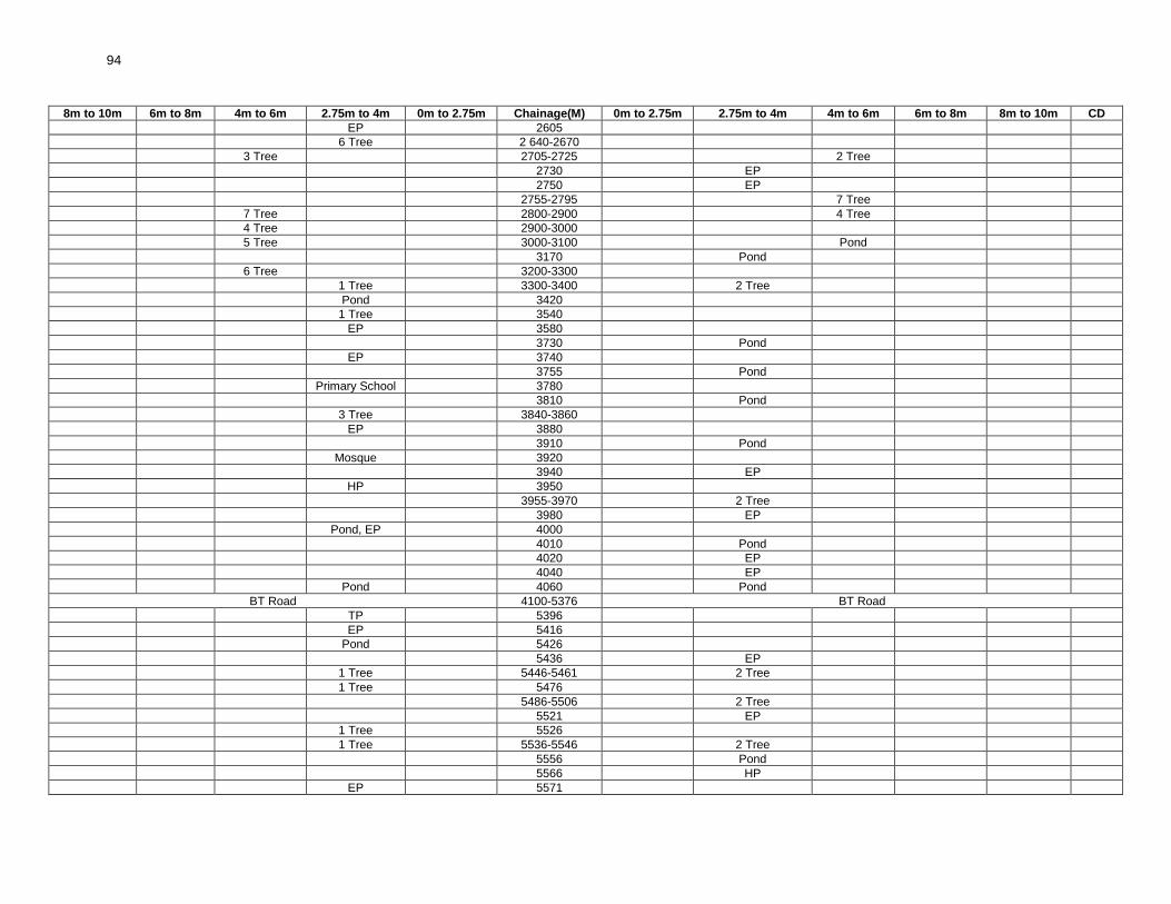
94
8m to 10m 6m to 8m 4m to 6m 2.75m to 4m 0m to 2.75m Chainage(M) 0m to 2.75m 2.75m to 4m 4m to 6m 6m to 8m 8m to 10m CD
EP 2605
6 Tree 2 640-2670
3 Tree 2705-2725 2 Tree
2730 EP
2750 EP
2755-2795 7 Tree
7 Tree 2800-2900 4 Tree
4 Tree 2900-3000
5 Tree 3000-3100 Pond
3170 Pond
6 Tree 3200-3300
1 Tree 3300-3400 2 Tree
Pond 3420
1 Tree 3540
EP 3580
3730 Pond
EP 3740
3755 Pond
Primary School 3780
3810 Pond
3 Tree 3840-3860
EP 3880
3910 Pond
Mosque 3920
3940 EP
HP 3950
3955-3970 2 Tree
3980 EP
Pond, EP 4000
4010 Pond
4020 EP
4040 EP
Pond 4060 Pond
BT Road 4100-5376 BT Road
TP 5396
EP 5416
Pond 5426
5436 EP
1 Tree 5446-5461 2 Tree
1 Tree 5476
5486-5506 2 Tree
5521 EP
1 Tree 5526
1 Tree 5536-5546 2 Tree
5556 Pond
5566 HP
EP 5571

95
8m to 10m 6m to 8m 4m to 6m 2.75m to 4m 0m to 2.75m Chainage(M) 0m to 2.75m 2.75m to 4m 4m to 6m 6m to 8m 8m to 10m CD
Pond 5586
1 Tree 5591
5596 EP
Pond, 1 Tree 5606 Pond
2 Tree 5616-5626 2 Tree
EP 5636
Pond 5641
5646 CD
1 Tree 5656 1 Tree
EP 5666 1 Tree
EP 5696
2 Tree 5701-5711
5716 CD
5721-5731 2 Tree
5746 EP
1 Tree 5766
1 Tree 5786
EP 5806
3 Tree 5816-5846
TF 5856
EP 5861
5876 Pond
4 Tree 5886-5956 EP
5966 CD
Pond 5976
5986 1 Tree
EP 5996 1 Tree
6026-6046 2 Tree
6066 EP
Pond 6096
EP 6116
6121 EP
6126 HP, Pond
2 Tree 6131-6146 1 Tree
6161 EP
6166 CD
Pond 6176
6181 Pond
EP 6196
Pond 6206
TP 6236 Temple
1 Tree 6271 1 Tree
6306 HP
6336 EP
6341 1 Tree
1 Tree 6346 Pond
6361 EP

96
8m to 10m 6m to 8m 4m to 6m 2.75m to 4m 0m to 2.75m Chainage(M) 0m to 2.75m 2.75m to 4m 4m to 6m 6m to 8m 8m to 10m CD
6381-6396 2 Tree
6416 EP
1 Tree 6466
6471 EP
6496 EP
6516 Temple
6526 CD
Pond 6536 Pond
6581 Pond
EP 6576
6606 EP
HP 6626
6631 Temple
TF 6646
Pond 6656
HP 6681
6696 EP
6716 Pond
6746 EP
6756-6771 2 Tree
6781 1 Tree
6796 Pond
6811 HP
6816 EP
1 Tree 6826 EP
6831-6851 2 Tree
EP 6856
TP 6861
HP 6866
1 Tree 6896 HP
1 Tree 6916 EP
1 Tree 6956 EP
3 Tree 6976-7076 3 Tree
End Point 7576 End Point

97
RURAL ROADS: ENVIRONMENTAL CHECKLIST Road Name: Mathura To Bodai Purba (T-09) Block Name: Amdanga District Name: North 24 Paraganas Total Length of the Road: 2.424Km Package No. : WB-01-ADB 114
A. Climatic Conditions
Temperature High: 36°C Low: 14°C
Humidity High: 90% in July Low: 69% in March
Rainfall Rainy Season
1550mm/year June to mid-September
B. Location of the Road and Generic description of Environment
No. Type of Ecosystem Yes No Explanation
1. Coastal area Mangrove (along roadside)
√
Distance from Coastline: km. The proposed road is far away from CRZ. (Coastal Regulation Zone)
( ) more than 50% ( ) less than 20%
2. Type of Terrain (Plain/Hilly/ Mountainous etc.) (Explain the topography of the area and how many km of the road are located in the hilly area)
√
Altitude: 12.5m The area along the project road is flat in nature. The topography of the project road is flat at all locations.
3. Forest Area (Explain whether the road passes through forest areas or located along the forest areas and distance from shoulder to the forest area)?
√
Type of Vegetation: The road is not passed through any forest area. Legal Status of the Forest Area: (Reserved, National Park, Sanctuaries, Unclassified, etc.)
No part of the project road passes through any forest area.
4. Wildlife (Explain whether there are any wildlife species in the project area)
√
Name of animals: There is no wildlife species in the project areas as there is no forest. Endangered species (if any):None
5. Inhabited Area √
The project road passes through the inhabited area like Mathura (0m – 800m) and Bodai (820m – 2400m).
6. Agricultural Land √
Some portion of project road passes through agricultural area at Ch. 540m – 850m (LHS) and 600m – 700m (RHS).
7. Grazing Grounds √ There is no grazing Ground in the project road.
8. Barren Land √ There is no barren land in the project road area.
C. Specific description of the Road Environment
(Note: Questions number 1, 4, 5, 7 and 8 must be answered after discussions with the local community people)
No. Parameter/ Component Yes No Explanation
1. Are there any areas with landslide or erosion problems along the road? (If yes, indicate the location (right or left side) and the chainage)
√
There is no land slide or erosion problem along the road.
( ) No Secondary Information is available and Local Community is not aware of this matter
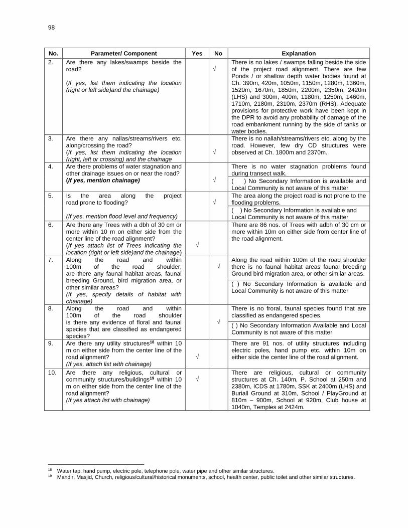
98
No. Parameter/ Component Yes No Explanation
2. Are there any lakes/swamps beside the road? (If yes, list them indicating the location (right or left side)and the chainage)
√
There is no lakes / swamps falling beside the side of the project road alignment. There are few Ponds / or shallow depth water bodies found at Ch. 390m, 420m, 1050m, 1150m, 1280m, 1360m, 1520m, 1670m, 1850m, 2200m, 2350m, 2420m (LHS) and 300m, 400m, 1180m, 1250m, 1460m, 1710m, 2180m, 2310m, 2370m (RHS). Adequate provisions for protective work have been kept in the DPR to avoid any probability of damage of the road embankment running by the side of tanks or water bodies.
3. Are there any nallas/streams/rivers etc. along/crossing the road? (If yes, list them indicating the location (right, left or crossing) and the chainage
√
There is no nallah/streams/rivers etc. along by the road. However, few dry CD structures were observed at Ch. 1800m and 2370m.
4. Are there problems of water stagnation and other drainage issues on or near the road? (If yes, mention chainage)
√
There is no water stagnation problems found during transect walk.
( ) No Secondary Information is available and Local Community is not aware of this matter
5. Is the area along the project road prone to flooding? (If yes, mention flood level and frequency)
√
The area along the project road is not prone to the flooding problems.
( ) No Secondary Information is available and Local Community is not aware of this matter
6. Are there any Trees with a dbh of 30 cm or more within 10 m on either side from the center line of the road alignment? (If yes attach list of Trees indicating the location (right or left side)and the chainage)
√
There are 86 nos. of Trees with adbh of 30 cm or more within 10m on either side from center line of the road alignment.
7. Along the road and within 100m of the road shoulder, are there any faunal habitat areas, faunal breeding Ground, bird migration area, or other similar areas? (If yes, specify details of habitat with chainage)
√
Along the road within 100m of the road shoulder there is no faunal habitat areas faunal breeding Ground bird migration area, or other similar areas.
( ) No Secondary Information is available and Local Community is not aware of this matter
8. Along the road and within 100m of the road shoulder is there any evidence of floral and faunal species that are classified as endangered species?
√
There is no froral, faunal species found that are classified as endangered species.
( ) No Secondary Information Available and Local Community is not aware of this matter
9. Are there any utility structures18 within 10 m on either side from the center line of the road alignment? (If yes, attach list with chainage)
√
There are 91 nos. of utility structures including electric poles, hand pump etc. within 10m on either side the center line of the road alignment.
10. Are there any religious, cultural or community structures/buildings19 within 10 m on either side from the center line of the road alignment? (If yes attach list with chainage)
√
There are religious, cultural or community structures at Ch. 140m, P. School at 250m and 2380m, ICDS at 1780m, SSK at 2400m (LHS) and Buriall Ground at 310m, School / PlayGround at 810m – 900m, School at 920m, Club house at 1040m, Temples at 2424m.
18 Water tap, hand pump, electric pole, telephone pole, water pipe and other similar structures. 19 Mandir, Masjid, Church, religious/cultural/historical monuments, school, health center, public toilet and other similar structures.

99
D. Public Consultation
No. Consultation Activities Yes No Remarks
1. Consultation with local community was conducted before finalizing the alignment. (Attach list of people met and dates)
√
Consultation with local community was conducted before finalizing the alignment (list of people attached).
2. Any suggestion received in finalizing the alignment
√
Suggestion received in finalizing the alignment.
3. If suggestions received, were they incorporated into the design?
√
It will be incorporated after consulting with respective PIU.
E. Please attach the following:
1. List of Trees indicating location (left or right side of the road) and chainage (as required under C. 6).
2. List of utility structures indicating location (left or right side of the road) and chainage (as required under C.
9).
3. List of community structures indicating location (left or right side of the road) and chainage (as required
under C. 10).
4. Sketch of strip map of the road covering details of atleast 10 m on either side from the center line of the
road.
5. Photographs of the project area showing atleast 10 m on either side from center line of road alignment.
Every 2 km or less of road must have atleast 1 photograph.

100
Attachment I Attachment II List of Trees List of Utilities
Left (No. of Trees)
Chainage (M)
Right (No. of Trees)
Left Chainage
(M) Right
Tree 0m 25m HP
10m Tree 35m EP
15m Tree 100m EP
20m Tree 120m EP
2Tree 30m-45m 150m EP
90m Tree EP 195m
3 Tree 160m-170m EP 215m
3 Tree 180m-190m HP 230m
315m Tree EP 250m
Tree 330m 300m EP
Tree 400m 315m HP
Tree 425m 330m EP
Tree 450m TP 375m
810m-900m 12 Tree 395m EP
1020m Tree EP 405m-416m HP+TP
Tree 1060m 460m EP
2 Tree 1080m-1100m TF 540m
2Tree 1160m-1170m EP 610m-690m 4 EP
1180m-1190m 3 Tree EP+TF 810m-900m
Tree 1205m EP 920m
1240m Tree 990m EP
3 Tree 1260m-1270m 4 Tree EP 1000m
2 Tree 1265m-1285m HP+TP 1040m
4 Tree 1295m-1300m EP 1080m-1100m EP
2 Tree 1320m-1360m 1115m TP
2 Tree 1380m 1205m EP
1390m 1 Tree EP 1250m
1415m 1 Tree TP 1275m-1285m EP+2 HP
1540m 1 Tree 1295m-1300m EP+2 HP
1 Tree 1550m 2 EP+TP 1320m-1360m HP
1 Tree 1640m-1650m TP 1390m
1 Tree 1680m 1440m EP
1 Tree 1820m EP+TP 1475m
1 Tree 1850m-1880m 1500m HP
1900m-1950m 5 Tree EP 1540m
2035m-2060m 2 Tree 1550m EP
3 Tree 2210m-2240m 1 Tree 1570m EP
4 Tree 2290m-2300m 1580m HP
2320m-2330m 2 Tree 1600m HP
2400m-2424m 3 Tree 1640m-1650m EP
TP 1670m
1680m EP
TP 1735m EP
HP 1770m
2 TP+EP 1850m-1880m
EP 1900m-1950m HP
1960m EP
1975m HP
TP 1978m
2005m EP

101
Attachment II
List of Utilities (Contd.)
Chainage(M) Left Right
2035m TF
2045m EP
2070m EP
2080m-2090m EP EP
2130m-2150m EP EP
2180m-2190m EP+HP
2210m-2220m 2 EP
2250m EP
2300m-2400m 2EP 2EP
2400m-2424m EP+TP EP
Attachment II
List of Community Structures
Chainage(M) Left Right
140m Resort -
250m P. School -
310m - Burial Ground
810m-900m - P. School, Play Ground
920m - H. School
1040m - Club
1780m Icds -
2300M-2400m P. School, S.S.K. -
2400m-2424m - Temple

102
Attachment IV
8m to 10m 6m to 8m 4m to 6m 2.75m to 4m 0m to 2.75m Chainage (M) 0m to 2.75m 2.75m to 4m 4m to 6m 6m to 8m 8m to 10m CD
Tree 0m
10m Tree
15m Tree
20m Tree
25m HP
Tree 30m
Tree 35m-44m EP
90m Tree
100m EP
120m EP
Resort 140m
150m EP
3 Tree 160m-170m
3 Tree 180m-190m
EP 195m
EP 215m
Hp 230m
P. School EP 250m
300m EP
310m Buriall Ground
315m HP+Tree
Tree 330m EP
TP 375m
Pond 390m
395m EP
Tree 400m
EP 405m-416m HP+TP
Tree 425m
Tree 450m
460m EP
TF 540m
EP 610m-690m 4 EP
TF EP 810m-900m 12 Tree P. Sch, Play Grd
EP 920m H. School
990m EP
EP 1000m
1020m Tree
HP+TP 1040m Club
Tree 1060m
Pond 1070m
2 Tree EP 1080m-1100m EP
1115m TP
Tree 1160m
Pond Tree 1170m

103
8m to 10m 6m to 8m 4m to 6m 2.75m to 4m 0m to 2.75m Chainage (M) 0m to 2.75m 2.75m to 4m 4m to 6m 6m to 8m 8m to 10m CD
1180m-1190m 3 Tree
Tree 1205m EP
1240m Tree
EP 1250m
3 Tree 1260m-1270m 4 Tree
2 Tree TP 1275m-1285m EP+2 HP
3 Tree Tree 1295m-1300m EP+2 HP
2 Tree 2 EP+TP 1320m-1360m HP
2 Tree 1380m
TP 1390m 1 Tree
1415m 1 Tree
1440m EP
1460m Pond
EP+TP 1475m
1500m HP
EP 1540m 1 Tree
1 Tree 1550m EP
1570m EP
1580m HP
1600m HP
1 Tree 1640m-1650m EP
TP 1670m
1 Tree 1680m EP
Pond 1710m
TP 1735m EP
HP 1770m
ICDS 1780m
1800m CD
1 Tree 1820m
1830m Pond
1 Tree 2 TP+EP 1850m-1880m
EP 1900m-1950m 2 Tree HP 3 Tree
1960m EP
1970m Temple
1975m HP
TP 1978m
1980m Pond
2005m EP
2035m TF 1 Tree
2045m EP
EP 2060M-2070m Tree
EP 2080m-2090m EP
EP 2130m-2150m EP
2180m-2190m EP+HP
Pond 2200m
2 EP 2210m-2220m 1 Tree
EP 3 Tree 2240M-2250m

104
8m to 10m 6m to 8m 4m to 6m 2.75m to 4m 0m to 2.75m Chainage (M) 0m to 2.75m 2.75m to 4m 4m to 6m 6m to 8m 8m to 10m CD
4 Tree 2290m-2300m
P. Sch. SSK. 2 EP 2300m-2400m 2 EP Pond, 2 Tree CD
Pond, EP, TP 2400m-2424m 3 Tree Temple
EP - Electric Pole; TP - Telephone Post; H.P - Hand Pump: A.L - Agriculture Land; C.D - Cross Drainage Structure

105
RURAL ROADS: ENVIRONMENTAL CHECKLIST
Road Name: Mollapara To Uttar Chakla (T13) Block Name:DEGANGA District Name: North 24 Paraganas Total Length of the Road: 2.408km Package No. : WB-01-ADB 107
A. Climatic Conditions Temperature High: 36°C (May) Low: 14°C(Dec)
Humidity High: 92% in July Low: 65% in March
Rainfall Rainy Season
1550mm/year June to mid-September
B. Location of the Road and Generic description of Environment
No. Type of Ecosystem Yes No Explanation
1. Coastal area Mangrove (along roadside)
√
Distance from Coastline: km. The area is far away from CRZ (Coastal Regulation Zone).
( ) more than 50% ( ) less than 20%
2. Type of Terrain(Plain/Hilly/ Mountainous etc.) (Explain the topography of the area and how many km of the road are located in the hilly area)
√
Altitude: 11.8m The topography of the area is flat in nature.
3. Forest Area (Explain whether the road passes through forest areas or located along the forest areas and distance from shoulder to the forest area)?
√
Type of Vegetation: There is no forest area beside the alignment. Legal Status of the Forest Area: N.A. (Reserved, National Park, Sanctuaries, Unclassified, etc.)
No part of the project road passes through any forest area.
4. Wildlife (Explain whether there are any wildlife species in the project area)
√
Name of animals: N.A. Endangered species (if any):None
5. Inhabited Area √
There are small villages namely Mollapara (0m-300m), Kharati Subarnapur (300m-1000m), Pukurati Subarnapur (1000m-2075m).
6. Agricultural Land √
Agricultural land exists beside the alignment near Ch. 1830m-2408m. Land type up to 1830m is of mixed nature.
7. Grazing Grounds √ Grazing Ground exists beside the alignment near Ch. 2375m.
8. Barren Land √ There is no barren land beside the alignment.
C. Specific description of the Road Environment (Note: Questions number 1, 4, 5, 7 and 8 must be answered after discussions with the local community people)
No. Parameter/ Component Yes No Explanation
1. Are there any areas with landslide or erosion problems along the road? (If yes, indicate the location (right or left side) and the chainage)
√
There is no landslide or erosion problem along the road.
( ) No Secondary Information is available and Local Community is not aware of this matter

106
No. Parameter/ Component Yes No Explanation
2. Are there any lakes/swamps beside the road? (If yes, list them indicating the location (right or left side)and the chainage)
√
There are no lakes but swampy area& low-laying area exists beside the road near Ch. 2250m & Ch. 2300m respectively. Other than these some small & big Ponds exist beside the alignment at Ch. 0025m, 0280m, 0480m, 0880m, 1150m, 1230m, 1320m, 1500m, 1550m, 1590m.
3. Are there any nallas/streams/rivers etc. along/crossing the road? (If yes, list them indicating the location (right, left or crossing) and the chainage
√
There are small nallas existing beside the alignment & crossing the alignment near Ch. 0210m, 1100m respectively.
4. Are there problems of water stagnation and other drainage issues on or near the road? (If yes, mention chainage)
√
Water stagnation problem exists beside the alignment near Ch. 0610m, again, near Ch. 0550m water flows on the road during rainy season.
( ) No Secondary Information is available and Local Community is not aware of this matter
5. Is the area along the project road prone to flooding? (If yes, mention flood level and frequency)
√
The area is not prone to flooding.
( ) No Secondary Information is available and Local Community is not aware of this matter
6. Are there any Trees with a dbh of 30 cm or more within 10 m on either side from the center line of the road alignment? (If yes attach list of Trees indicating the location (right or left side)and the chainage)
√
There are 77 Nos. of Trees with a dbh of 30m or more within 10m on either side of the alignment. (List attached)
7. Along the road and within 100m of the road shoulder, are there any faunal habitat areas, faunal breeding Ground, bird migration area, or other similar areas? (If yes, specify details of habitat with chainage)
√
There are no such areas within 100m from the road shoulder.
( ) No Secondary Information is available and Local Community is not aware of this matter
8. Along the road and within 100m of the road shoulder is there any evidence of floral and faunal species that are classified as endangered species?
√
There is no evidence of endangered species of flora & fauna within 100m from road shoulder.
( ) No Secondary Information Available and Local Community is not aware of this matter
9. Are there any utility structures20 within 10 m on either side from the center line of the road alignment? (If yes, attach list with chainage)
√
There are 37 Nos. of utility structures (EP, TP, HP, etc.) within 10m on either side of the centre line of road alignment. (List attached)
10. Are there any religious, cultural or community structures/buildings21 within 10 m on either side from the center line of the road alignment? (If yes attach list with chainage)
√
There are 4 nos. of community structures (School, Buriall Ground, etc.) within 10m on either side of the alignment. Buriall Ground Ch. 200m and Mosque Ch. 1310m (RHS).Primary School at Ch. 835m and Community Toilet at Ch. 1310m (LHS). (List attached).
20 Water tap, hand pump, electric pole, telephone pole, water pipe and other similar structures. 21 Mandir, Masjid, Church, religious/cultural/historical monuments, school, health center, public toilet and other similar
structures.

107
D. Public Consultation
No. Consultation Activities Yes No Remarks
1. Consultation with local community was conducted before finalizing the alignment. (Attach list of people met and dates)
√
Consultation with local community was conducted on 26.09.2012.(List attached)
2. Any suggestion received in finalizing the alignment
√
Community suggested to construct culverts, speed breakers, pilling work wherever required.
3. If suggestions received, were they incorporated into the design?
√ Suggestions will be incorporated after discussion with respective PIU.
E. Please attach the following: 1. List of Trees indicating location (left or right side of the road) and chainage (as required under C. 6).
2. List of utility structures indicating location (left or right side of the road) and chainage (as required under
C. 9).
3. List of community structures indicating location (left or right side of the road) and chainage (as required
under C. 10).
4. Sketch of strip map of the road covering details of at least 10 m on either side from the center line of the
road.
5. Photographs of the project area showing at least 10 m on either side from center line of road alignment.
Every 2 km or less of road must have at least 1 photograph.

108
Attachment I List of Trees
Left (No. of Trees)
Chainage (M)
Right (No. of Trees)
Left (No. of Trees)
Chainage (M)
Right (No. of Trees)
Tree 25m -
- 1810m Tree
Tree 40m -
- 1830m Tree
Tree 50m -
Tree 1860m -
Tree 60m -
Tree 1880m -
Tree 90m -
Tree 1930m -
Tree 130m -
Tree 2020m -
Tree 140m -
Tree 2080m -
Tree 150m -
- 2120m Tree
- 190m Tree
- 2170m Tree
- 210m Tree
- 2320m Tree
- 240m Tree
Tree 2340m -
- 250m Tree
3Tree 2395m-2408m
- 265m Tree
Tree 300m -
Attachment II
Tree 365m -
List of Utilities
Tree 415m -
Left Chainage (M) Right
Tree 440m -
- 10m EP
- 580m Tree
HP 65m -
- 610m Tree
- 70m EP
Tree 615m -
TP 75m -
- 640m Tree
TP 90m -
Tree 650m -
- 100m EP
Tree 670m -
EP 110m -
- 700m Tree
HP 160m -
Tree 755m -
- 175m TF
- 760m Tree
EP 210m -
Tree 770m -
- 255m TP
- 780m Tree
- 270m EP
Tree 790m -
EP 340m -
- 820m Tree
- 390m EP
- 840m Tree
EP 460m -
- 870m Tree
HP 550m EP
- 910m Tree
EP 600m -
Tree 950m Tree
- 630m HP
- 980m Tree
- 660m EP
- 990m Tree
- 670m TP
- 1020m Tree
- 690 EP
Tree 1120m -
- 730m HP
Tree 1140m -
EP 740m -
Tree 1150m Tree
- 930m EP
Tree 1160m Tree
- 1040m EP
Tree 1180m -
- 1280m EP
- 1185m Tree
EP 1350m -
Tree 1190m -
EP 1420m -
- 1220m Tree
HP 1460m -
Tree 1230m -
- 1625m HP
Tree 1410m -
- 1660m HP
Tree 1430m Tree
TF 1710m -
Tree 1440m -
EP 2120m -
- 1460m Tree
EP 2390m -
- 1480m Tree
EP 2395m-2408m EP
Tree 1560m -
- 1580m Tree
Attachment III
- 1610m Tree
List of Community Structures
- 1680m Tree
Left Chainage (M) Right
- 1690m Tree
- 200m Buriall Ground
- 1720m Tree
P. School 835m -
Tree 1760m -
Comm. Toilet 1310m Mosque
Tree 1780m -
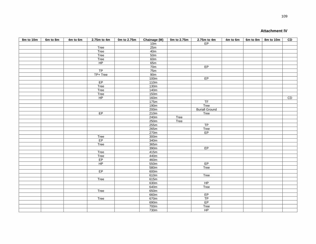
109
Attachment IV
8m to 10m 6m to 8m 4m to 6m 2.75m to 4m 0m to 2.75m Chainage (M) 0m to 2.75m 2.75m to 4m 4m to 6m 6m to 8m 8m to 10m CD
10m EP
Tree 25m
Tree 40m
Tree 50m
Tree 60m
HP 65m
70m EP
TP 75m
TP+ Tree 90m
100m EP
EP 110m
Tree 130m
Tree 140m
Tree 150m
HP 160m CD
175m TF
190m Tree
200m Buriall Ground
EP 210m Tree
240m Tree
250m Tree
255m TP
265m Tree
270m EP
Tree 300m
EP 340m
Tree 365m
390m EP
Tree 415m
Tree 440m
EP 460m
HP 550m EP
580m Tree
EP 600m
610m Tree
Tree 615m
630m HP
640m Tree
Tree 650m
660m EP
Tree 670m TP
690m EP
700m Tree
730m HP

110
8m to 10m 6m to 8m 4m to 6m 2.75m to 4m 0m to 2.75m Chainage (M) 0m to 2.75m 2.75m to 4m 4m to 6m 6m to 8m 8m to 10m CD
EP 740m
Tree 755m
760m Tree
Tree 770m
780m Tree
Tree 790m
820m Tree
P. School 835m
840m Tree
870m Tree
910m Tree
930m EP
Tree 950m Tree
980m Tree
990m Tree
1020m Tree
1040m EP
1100m CD
Tree 1120m
Tree 1140m
Tree 1150m Tree
Tree 1160m Tree
Tree 1180m
1185m Tree
Tree 1190m
1220m Tree
Tree 1230m
1280m EP
Comm. Toilet 1310m Mosque
EP 1350m
Tree 1410m
EP 1420m
Tree 1430m Tree
Tree 1440m
HP 1460m Tree
1480m Tree
Tree 1560m
1580m Tree
1610m Tree
1625m HP
1660m HP
1680m Tree
1690m Tree
TF 1710m
1720m Tree
Tree 1760m
Tree 1780m

111
8m to 10m 6m to 8m 4m to 6m 2.75m to 4m 0m to 2.75m Chainage (M) 0m to 2.75m 2.75m to 4m 4m to 6m 6m to 8m 8m to 10m CD
1810m Tree
1830m Tree
Tree 1860m
Tree 1880m
Tree 1930m
Tree 2020m
Tree 2080m
EP 2120m Tree
2170m Tree
2320m Tree
Tree 2340m
EP 2390m
3 Tree, 1 EP 2395m-2408m EP
EP - Electric Pole; TP - Telephone Post; H.P - Hand Pump: A.L - Agriculture Land; C.D - Cross Drainage Structure

112
RURAL ROADS: ENVIRONMENTAL CHECKLIST
Road Name: Nimdaria To Ramnagar More Block Name: BASIRHAT-I District Name: North 24 Parganas Total Length of the Road: 8.095km Package: WB-01-ADB 53
A. Climatic Conditions Temperature High: 35°C, Low: 14°C
Humidity High: 90% in July Low: 69% in March
Rainfall Rainy Season
1550 mm/year June to mid-September
B. Location of the Road and Generic description of Environment
No. Type of Ecosystem Yes No Explanation
1. Coastal area Mangrove (along roadside)
√
The area is far away from CRZ (Coastal Regulation Zone).
( ) more than 50% ( ) less than 20%
2. Type of Terrain (Plain/Hilly/ Mountainous etc.) (Explain the topography of the area and how many km of the road are located in the hilly area)
√
Altitude: 12.3 m The topography of the area is flat in nature.
3. Forest Area (Explain whether the road passes through forest areas or located along the forest areas and distance from shoulder to the forest area)?
√
Type of Vegetation: N.A Legal Status of the Forest Area: (Reserved, National Park, Sanctuaries, Unclassified, etc.)
There is no forest area beside or away from the alignment.
4. Wildlife (Explain whether there are any wildlife species in the project area)
√
Name of animals: NA Endangered species (if any):None
5. Inhabited Area √
Small villages namely Nimdaria (000m-1000m ), Sripur (1000m–2200m), Higla (2200m–2780m) Khiderpur (2780m-3500m) Kathur (3500m–3750m) Devoke (3750m–59000m) Atkoria (5900m–8095m) existing beside the alignment.
6. Agricultural Land √
There are few patches where there are agricultural land beside the alignment, 900m – 950m 1410m – 1950m, 3500m – 3770m, 4980m – 5000m, 6790m- 6995m, 7200m – 7800m (LHS) and 000m – 720m, 900m – 950m, 1420m – 1900m, 3280m – 3300m, 3500m –3675m,6800m –6900m, 7200m–7800m, 7890m–7950m, (RHS).
7. Grazing Grounds √ There is no grazing Ground beside the alignment.
9. Barren Land √ There is no barren land beside the alignment.

113
C. Specific description of the Road Environment
(Note: Questions number 1, 4, 5, 7 and 8 must be answered after discussions with the local community people)
No. Parameter/ Component Yes No Explanation
1. Are there any areas with landslide or erosion problems along the road? (If yes, indicate the location (right or left side) and the chainage)
√
There is no such area with landslide or erosion problem.
( ) No Secondary Information is available and Local Community is not aware of this matter
2. Are there any lakes/swamps beside the road? (If yes, list them indicating the location (right or left side)and the chainage)
√
There is no lake or swampy area beside the alignment but many small & big Ponds / Water body were found at Ch. 115m, 262m, 264m, 380m, 635m, 886m, 1020m, 1220m, 1325m, 1340m, 1505m, 1532m, 2000m, 2198m, 2577m, 2670m, 2788m, 2953m, 3000m, 3189m, 3315m, 3678m, 4192m, 4247m, 4500m, 4740m, 4857m, 4900m, 5000m, 5197m, 6450m, 6600m, 7065m, 7197m, 7800m, 7980m, (LHS) on the other hand, 592m, 720m, 1050m, 1494m, 1938m, 2180m, 2294m, 2312m, 2349m, 2388m, 2477m, 2685m, 2800m, 3000m, 3215m, 3300m, 3410m, 3572m, 3678m, 3885m, 4200m, 4337m, 4805m, 5208m, 5288m, 5300m, 5696m, 5785m, 7082m, 7100m, 7180m, 8050m,(RHS). exists beside the alignment.
3. Are there any nallas/ streams /rivers etc. along/crossing the road? (If yes, list them indicating the location (right, left or crossing) and the chainage
√
There are no road side nallas / streams / rivers noticed along the road alignment. However, few CD structures were noticed at Ch. 688m, 840m, 900m, 1950m, 2780m, 3830m, 3935m, 5000m, 6115m, 6200m, 6270m, 7008m, 8070m
4. Are there problems of water stagnation and other drainage issues on or near the road? (If yes, mention chainage)
√
There is no problem of any water stagnation and other drainage issues observed.
( ) No Secondary Information is available and Local Community is not aware of this matter
5. Is the area along the project road prone to flooding? (If yes, mention flood level and frequency)
√
The area is not flood prone.
( ) No Secondary Information is available and Local Community is not aware of this matter
6. Are there any Trees with a dbh of 30 cm or more within 10 m on either side from the canter line of the road alignment? (If yes attach list of Trees indicating the location (right or left side)and the chainage)
√
There are 38 nos. of Trees with a dbh of 30 cm or more within 10 m on either side of the road alignment.(List Attached)
7. Along the road and within 100m of the road shoulder, are there any faunal habitat areas, faunal breeding Ground, bird migration area, or other similar areas? (If yes, specify details of habitat with chainage)
√
There are no such areas within 100m from the road shoulder.
√
( ) No Secondary Information is available and Local Community is not aware of this matter
8. Along the road and within 100m of the road shoulder
There is no endangered species of flora or fauna within 100m from the road shoulder.

114
No. Parameter/ Component Yes No Explanation
is there any evidence of floral and faunal species that are classified as endangered species?
√ ( ) No Secondary Information Available and Local Community is not aware of this matter
9. Are there any utility structures within 10 m on either side from the canter line of the road alignment? (If yes, attach list with chainage)
√
There are 167 nos. utility structures (EP, TP, HP) within 10m on either side of the alignment.(List Attached)
10. Are there any religious, cultural or community structures/buildings within 10 m on either side from the canter line of the road alignment? (If yes attach list with chainage)
√
There are a total of 35 community / religious, cultural structures within 10m on either side from the center line of the road alignment Primary school at 754m, 5378m, ICDS 1172m, 5088m, 6187m, Temple 1285m, Buriall Ground 2895m, 3200m, 3995m, 4458m, 5200m, 6995m, Mosque 4100m, 6670m, 7985m, Samiti 4452m, (LHS) on the other hand SSk 115m, Mosque 728m, 2275m, 2577m, Ration Shop 754m, ICDS 2249m, 4228m, Buriall Ground 2450m, 2930m, 3205m, 5025m, 5197m, Primary school 3462m, 5378m, 6650m, Health Center 5286m, Temple 5649m (RHS).
D. Public Consultation
No. Consultation Activities Yes No Remarks
1. Consultation with local community was conducted before finalizing the alignment. (Attach list of people met and dates)
√
Consultation with local community was conducted on 06.12.2012. List of people attached.
2. Any suggestion received in finalizing the alignment
√
Villagers suggested to provide speed breaker, protection wall etc. wherever required.
3. If suggestions received, were they incorporated into the design?
√
Suggestion will be incorporated after discussion with PIU.
E. Please attach the following: 1. List of Trees indicating location (left or right side of the road) and chainage (as required under C.
6) 2. List of utility structures indicating location (left or right side of the road) and chainage (as required
under C. 9) 3. List of community structures indicating location (left or right side of the road) and chainage (as
required under C. 10) 4. Sketch of strip map of the road covering details of atleast 10 m on either side from the centre line
of the road 5. Photographs of the project area showing atleast 10 m on either side from centre line of road
alignment. Every 2 km or less of road must have at least 1 photograph.

115
Attachment I Attachment II
List of Trees List of Utilities
Left (No.of Trees) Chainage(M)
Right (No. of Trees)
Left Chainage(M) Right
Tree 80 70 EP
Tree 90 260 EP
Tree 263 263 EP
Tree 280 340 EP
Tree 800 380 EP
Tree 1010 400 EP
Tree 1018 HP 590
1175 Tree 595 EP
1180 Tree 700 EP
1185 Tree HP 730
Tree 1240 800 EP
1248 Tree 825 EP
Tree 1380 830 EP
2 Tree 1415 EP 845
Tree 2244 EP 870
Tree 2260 910 EP
Tree 2290 EP 980 EP
2 Tree 2294 EP 1000
Tree 2349 EP 1015 EP
Tree 2380 1018 EP
Tree 2675 1050
2953 Tree EP 1090 EP
Tree 2985 1100 HP
Tree 3090 1145
2 Tree 3215 1160 EP
Tree 4194 1166 EP
Tree 4196 EP 1170 EP
Tree 4332 EP 1192 EP
Tree 4335 EP 1230
5430 Tree HP 1248
Tree 6000 1275
Tree 6005 1290
Tree 6010 1300 EP
Tree 6190 EP 1340 EP
8095 Tree 1360 EP
EP 1430
1488 EP
EP 1492
1530 EP
HP 1700
1830 EP
2040
2100 EP
2150 EP
EP 2178 EP
EP 2198 EP
2280 HP
EP 2395
EP 2400 EP
2565
EP 2570
2577
2580
2650 EP
2670
2675
2780
EP 2788

116
2790 EP
2870
2880 EP
Attachment II (Contd.)
Left Chainage(M) Right Left Chainage(M) Right
EP 2900
6000 EP
EP 2930 HP 6025
2960 EP EP 6110
2980 HP 6180 EP
2990 EP 6250 EP
HP 3015 HP 6260 EP
3030 EP EP 6320 EP
EP 3130 EP 6360
3191 HP EP 6380
3194 EP EP 6496
3345 EP 6515 EP
EP 3360 EP 6560
3380 EP EP 6660
HP 3465 6675 EP
3560 EP HP 6680
3750 HP EP 6695
3800 HP +EP 6700 EP
EP 3880 EP 6750
3945 EP TF 6780
HP 3950 EP 6820
EP 4160 EP EP 6870
HP 4244 EP 6900
4247 EP 6935 EP
EP 4410 HP 7000
4454 HP 7080 EP
4458 EP EP 7085
EP 4600 EP 7120
EP 4700 EP 7480
EP 4800 EP 7530 EP
EP 4897 7580 EP
EP 4910 7610 EP
EP 4920 HP 7830 EP
EP 4940 7900 EP
4950 EP 7970 EP
EP 4960 HP 7995 EP
4980 TF 8072 EP
EP 5030 EP 8088
EP 5070 EP 8095
5080 EP
EP 5100
5200 HP
5280 EP
EP 5288
EP 5300
HP 5370 EP
EP 5384
EP 5388
TF 5400
EP 5430
EP 5450
EP 5488
EP 5500
EP 5547 EP
EP 5552
EP 5588 HP
5710 EP
5800 EP

117
EP 5827
5864 EP
EP 5900
5980 EP
Attachment III
List of Community Structures
Chainage (M) Left Right
115 Ssk
728 Mosque
754 P.School Ration Shop
1172 ICDS
1200 Club
1285 Kali Temple
2275 Mosque
2450 Buriall Ground
2577 Mosque
2895 Buriall Ground
2930 Buriall Ground
3200 Buriall Ground
3345 High School
3395 Buriall Ground
3462 P.School
4095 Burial Ground
4100 Mosque
4190 Club
4228 ICDS
4452 Samiti
4458 Buriall Ground
5025 Buriall Ground
5088 ICDS
5197 Buriall Ground
5200 Buriall Ground
5286 Helth Center
5378 Police Staction P.School
5649 Temple
6187 ICDS
6650 P.School
6670 Mosque
6995 Buriall Ground
7985 Mosque

118
Attachment IV
8m to 10m 6m to 8m 4m to 6m 2.75m to 4m 0m to 2.75m Chainage(M) 0m to 2.75m 2.75m to 4m 4m to
6m 6m to 8m 8m to 10m CD
70 EP
Tree 80
Tree 90
Pond 115 SSK
260 EP
Pond 262
Tree 263 EP
Pond 264
Tree 280
340 EP
Pond 380 EP
400 EP
HP 590
592 Pond
595 EP
Pond 635
688 CD
700 EP
720 Pond
728 Mosque
HP 730
P.School 754 Ration shop
Tree 800 EP
825 EP
830 EP
840 CD
EP 845
EP 870
Pond 886
900 CD
910 EP
EP 980 EP
EP 1000
Tree 1010
1015 EP
Tree 1018 EP
Pond 1020
EP 1050 Pond
1090 EP
1100 HP
EP 1145
1160 EP
PHE 1166 EP
1170 EP
ICDS 1172

119
8m to 10m 6m to 8m 4m to 6m 2.75m to 4m 0m to 2.75m Chainage(M) 0m to 2.75m 2.75m to 4m 4m to
6m 6m to 8m 8m to 10m CD
1175 Tree
1180 Tree
1185 Tree
1192 EP
Club 1200
Pond 1220
EP 1230
Tree 1240
EP 1248 Tree
EP 1275
Kali Temple 1285
HP 1290
1300 EP
Pond 1325
Pond 1340 EP
1360 EP
Tree 1380
2 Tree 1415
EP 1430
1488 EP
EP 1492
1494 Pond
Pond 1500
1530 EP
Pond 1532
EP 1700
1830 EP
1938 Pond
1950 CD
Pond 2000
HP 2040
2100 EP
2150 EP
2178 EP
2180 Pond
Pond 2198 EP
Tree 2244
2248 ICDS
Tree 2260
2275 Mosque
EP 2280 HP
Tree 2290
2 Tree 2294 Pond
2312 Pond
Tree 2349 Pond
Tree 2380

120
8m to 10m 6m to 8m 4m to 6m 2.75m to 4m 0m to 2.75m Chainage(M) 0m to 2.75m 2.75m to 4m 4m to
6m 6m to 8m 8m to 10m CD
2388 Pond
EP 2395
2400 EP
2450 Burial Ground
2477 Pond
EP 2565
EP 2570
Pond 2577 Mosque
EP 2580
2650 EP
Pond 2670
Tree 2675
2685 Pond
2780 CD
Pond 2788
2790 EP
2800 Pond
EP 2870
2880 EP
Burial Ground 2895
EP 2900
EP 2930 Burial Ground
Pond 2953 Tree
2960 EP
2980 HP
Tree 2985
2990 EP
Pond 3000 Pond
HP 3015
3030 EP
Tree 3090
EP 3130
Pond 3189
3191 HP
3194 EP
Burial Ground 3200
3205 Burial Ground
2 Tree 3215 Pond
3300 Pond
3345 EP High School
3350 Pond
EP 3360
3380 EP
Burial Ground 3395
3410 Pond
3462 P.School

121
8m to 10m 6m to 8m 4m to 6m 2.75m to 4m 0m to 2.75m Chainage(M) 0m to 2.75m 2.75m to 4m 4m to
6m 6m to 8m 8m to 10m CD
HP 3465
3560 EP
3572 Pond
Pond 3678 Pond
3750 HP
3800 HP EP
3830 CD
EP 3880
3885 Pond
3935 CD
3945 EP
HP 3950
Burial Ground 4095
Mosque 4100
EP 4160 EP
Club 4190
Pond 4192
Tree 4194
Tree 4196
4200 Pond
4228 ICDS
HP 4244
Pond 4247 EP
Tree 4332
Tree 4335
4337 Pond
EP 4410
Samiti 4452
4454 HP
Burial Ground 4458 EP
Pond 4500
EP 4600
EP 4700
Pond 4740
EP 4800 EP
4805 Pond
Pond 4857
EP 4897
Pond 4900
EP 4910
EP 4920 HP
EP 4940
4950 EP
EP 4960
4980 TF
Pond 5000

122
8m to 10m 6m to 8m 4m to 6m 2.75m to 4m 0m to 2.75m Chainage(M) 0m to 2.75m 2.75m to 4m 4m to
6m 6m to 8m 8m to 10m CD
5001 CD
5025 Burial Ground
EP 5030
EP 5070
5080 EP
ICDS 5088
EP 5100
Pond 5197 Burial Ground
Burial Ground 5200 HP
5208 Pond
5280 EP
5286 Health Center
EP 5288 Pond
EP 5300 Pond
HP 5370 EP
Police Station 5378 P. School
PHE 5382
EP 5384
EP 5388
TF 5400
EP 5430 Tree
EP 5450
EP 5488
EP 5500
EP 5547 EP
EP 5552
EP 5588 HP
5649 Temple
5696 Pond
5710 EP
5785 Pond
5800 EP
EP 5827
5864 EP
Pond+ EP 5900
5980 EP
Tree 6000 EP
Tree 6005
Tree 6010
HP 6025
6035 CD
EP 6110
6115 CD
6180 EP
ICDS 6187 Play Ground
Tree 6190

123
8m to 10m 6m to 8m 4m to 6m 2.75m to 4m 0m to 2.75m Chainage(M) 0m to 2.75m 2.75m to 4m 4m to
6m 6m to 8m 8m to 10m CD
6200 CD
6250 EP
HP 6260 EP
6270 CD
EP 6320 EP
EP 6360
EP 6380
Pond 6450
EP 6496
Pond 6500
6515 EP
EP 6560
Pond 6600
6650 P. School
EP 6660
Mosque 6670
6675 EP
HP 6680
EP 6695
6700 EP
EP 6750
TF 6780
EP 6820
EP 6870
EP 6900
6935 EP
Burial Ground 6995
HP 7000
7008 CD
Pond 7065
7080 EP
7082 Pond
EP 7085
7100 Pond
EP 7120
Pond 7180 Pond
Pond 7197
EP 7480
7530 EP
7580 EP
7610 EP
Pond 7800
7830 EP
7900 EP
7970 EP
Pond 7980

124
8m to 10m 6m to 8m 4m to 6m 2.75m to 4m 0m to 2.75m Chainage(M) 0m to 2.75m 2.75m to 4m 4m to
6m 6m to 8m 8m to 10m CD
Mosque 7985
HP 7995 EP
8050 Pond
8070 CD
8072 EP
EP 8088
EP 8095 Tree

125
RURAL ROADS: ENVIRONMENTAL CHECKLIST Road Name: Taranipur Purba to Sarapul Bazar Block Name: Swarupnagar District Name: North 24 Paraganas Total Length of the Road: 4.978Km Package No. : WB-01-ADB 66
A. Climatic Conditions
Temperature High: 36°C (May) Low: 14°C(Dec)
Humidity High: 92% in July Low: 65% in March
Rainfall Rainy Season
1550mm/year June to mid-September
B. Location of the Road and Generic description of Environment
No. Type of Ecosystem Yes No Explanation
1. Coastal area Mangrove (along roadside)
√
Distance from Coastline: km. The road is far away from CRZ. (Coastal Regulation Zone)
( ) more than 50% ( ) less than 20%
2. Type of Terrain (Plain/Hilly/ Mountainous etc.) (Explain the topography of the area and how many km of the road are located in the hilly area)
√
Altitude: 12.4m The topography of the area is flat in nature.
3. Forest Area (Explain whether the road passes through forest areas or located along the forest areas and distance from shoulder to the forest area)?
√
Type of Vegetation: There is no forest area besidethe alignment. Legal Status of the Forest Area: (Reserved, National Park, Sanctuaries, Unclassified, etc.)
No part of the project road passes through any forest area.
4. Wildlife (Explain whether there are any wildlife species in the project area)
√
Name of animals:N.A. (There is no forest area beside or near the project road). Endangered species (if any):None
5. Inhabited Area √
Inhabited areas are concentrated near Ch. 0960m-1540m (Taranipur), 2760m-3157m (Purba Palta) 3200m-3400m (Purba Palta) 4100m-4978m (Nalabara).
6. Agricultural Land √
Agricultural area exists beside the alignment at Ch. 0425m-0530m (RHS), 695m (LHS), 1730m-2510m (Both Side), 3740m-3935m (Both Side), 4050m-4090m (Both Side).
7. Grazing Grounds √
Grazing Ground exists beside the road near Ch. 3607m (RHS).
8. BarrenLand √ There is no barren land beside the alignment.

126
C. Specific description of the Road Environment (Note: Questions number 1, 4, 5, 7 and 8 must be answered after discussions with the local community people)
No. Parameter/ Component Yes No Explanation
1. Are there any areas with landslide or erosion problems along the road? (If yes, indicate the location (right or left side) and the chainage)
√
There is no such problem along the road.
( ) No Secondary Information is available and Local Community is not aware of this matter
2. Are there any lakes/swamps beside the road? (If yes, list them indicating the location (right or left side)and the chainage)
√
Swampy area exists beside the road near Ch. 3690m (RHS). Other than this Ponds exist beside the road at Ch. 2630m, 2915m, 3370m, 3986m, 4700m (LHS) & Ch. 1344m, 1576m, 3157m (RHS).
3. Are there any nallas/streams/rivers etc. along/crossing the road? (If yes, list them indicating the location (right, left or crossing) and the chainage
√
One canal crosses & flows along the alignment near Ch. 4157m. Other than this there are CD structures at Ch. 2000m, 4334m & 4370m.
4. Are there problems of water stagnation and other drainage issues on or near the road? (If yes, mention chainage)
√
Water stagnation problem has not been noted on or near the road.
( ) No Secondary Information is available and Local Community is not aware of this matter
5. Is the area along the project road prone to flooding? (If yes, mention flood level and frequency)
√
The area is not prone to flooding.
( ) No Secondary Information is available and Local Community is not aware of this matter
6. Are there any Trees with a dbh of 30 cm or more within 10 m on either side from the center line of the road alignment? (If yes attach list of Trees indicating the location (right or left side)and the chainage)
√
There are 59 Nos. of Trees with a dbh of 30m or more within 10m on either side of the alignment. (List attached)
7. Along the road and within 100m of the road shoulder, are there any faunal habitat areas, faunal breeding Ground, bird migration area, or other similar areas? (If yes, specify details of habitat with chainage)
√
There are no such areas within 100mof the road shoulder.
( ) No Secondary Information is available and Local Community is not aware of this matter
8. Along the road and within 100m of the road shoulder is there any evidence of floral and faunal species that are classified as endangered species?
√
There is no evidence of endangered species of flora or fauna within 100m of the road shoulder.
( ) No Secondary Information Available and Local Community is not aware of this matter

127
9. Are there any utility structures22 within 10 m on either side from the center line of the road alignment? (If yes, attach list with chainage)
√
There are 43 nos. of utility structures (EP, TP, HP, TF etc.) within 10m on either side of the road alignment. (List attached)
10. Are there any religious, cultural or community structures/buildings23 within 10 m on either side from the center line of the road alignment? (If yes attach list with chainage)
√
There are 8 nos. of community religious structures (School, Temple Health Centre, etc.) within 10m on either side of the alignment. (List attached)
D. Public Consultation
No. Consultation Activities Yes No Remarks
1. Consultation with local community was conducted before finalizing the alignment. (Attach list of people met and dates)
√
Consultation with local community was conducted on 06.11.2012. (List of people attached)
2. Any suggestion received in finalizing the alignment
√
Community suggested for provision of protective works (pilling) speed breakers, safety signage etc.
3. If suggestions received, were they incorporated into the design?
√
Suggestions will be incorporated into design after discussion with respective PIU.
E. Please attach the following: 1. List of Trees indicating location (left or right side of the road) and chainage (as required under C.
6). 2. List of utility structures indicating location (left or right side of the road) and chainage (as required
under C. 9). 3. List of community structures indicating location (left or right side of the road) and chainage (as
required under C. 10). 4. Sketch of strip map of the road covering details of atleast 10 m on either side from the center line
of the road. 5. Photographs of the project area showing atleast 10 m on either side from center line of road
alignment. Every 2 km or less of road must have atleast 1 photograph.
22
Water tap, hand pump, electric pole, telephone pole, water pipe and other similar structures. 23
Mandir, Masjid, Church, religious/cultural/historical monuments, school, health center, public toilet and other similar structures.

128
Attachment-I Attachment-II List of Trees List of Utilities
Left (No.of Trees) Chainage (M) Right (No. of Trees) Left Chainage(M) Right
Tree 70m - EP 40m -
- 100m Tree - 60m EP
- 120m Tree EP 120m -
Tree 175m - - 175m EP
Tree 200m - - 260m EP
Tree 295m - EP 350m EP
Tree 390m - - 390m EP
Tree 405m - - 500m EP
Tree 425m - - 530m EP
Tree 470m - - 600m EP
Tree 510m - EP 680m -
Tree 530m - EP 700m -
- 580m Tree - 730m EP
Tree 690m - EP 760m -
Tree 695m - TF 818m -
- 840m Tree - 825m TF
- 860m Tree EP 835m -
Tree 870m - - 890m EP
Tree 930m - EP 910m -
- 960m Tree EP 940m -
- 990m Tree EP 1040m -
- 1160m Tree EP 1070m -
- 1225m Tree HP 1100m -
- 1344m Tree EP 1130m -
- 1500m Tree - 1322m HP
- 1590m Tree - 1330m EP
- 1610m Tree EP 1360m -
Tree 1730m - - 1380m EP
Tree 1760m - - 1470m HP
Tree 1800m - EP 1576m -
Tree 1820m - - 2510m EP
Tree 1850m - - 2550m EP
Tree 1970m - EP 2760m -
Tree 2510m - - 2890m HP
Tree 2530m - HP 2900m -
- 2650m Tree HP 2950m HP
- 2690m Tree EP 3025m -
- 2710m Tree - 3110m EP
- 2800m Tree - 3250m EP
- 2860m Tree EP 4700m -
Tree 3050m - EP 4880m -
Tree 3060m -
Tree 3080m -
Tree 3100m - Attachment III
Tree 3110m - List of Community Structures
Tree 3120m - Left Chainage(M) Right
Tree 3157m - - 985m P. School
Tree 3160m Tree Burial Ground 1025m -
Tree 3170m - - 1214m Mosque
- 3400m Tree - 1540m Club
Tree 3990m - - 1680m Idgah
Tree 4000m - Mosque 2925m -
- 4010m Tree - 4595m Temple
Tree 4050m - Temple 4978m -
Tree 4080m -
Tree 4330m -
Tree 4580m Tree

129
Attachment-IV 8m to 10m 6m to 8m 4m to 6m 2.75m to 4m 0m to 2.75m Chainage (m) 0m to 2.75m 2.75m to 4m 4m to 6m 6m to 8m 8m to 10m CD
EP 40m
60m EP
Tree 70m
100m Tree Poultry Farm
EP 120m Tree
Tree 175m EP
Tree 200m
260m EP
Tree 295m
EP 350m EP
Tree 390m EP
Tree 405m
Tree 425m
Poultry Farm 450m
Tree 470m
500m EP
Tree 510m
Tree 530m EP
580m Tree
600m EP
EP 680m
Tree 690m
Tree 695m
EP 700m
730m EP
EP 760m
TF 818m
825m TF
EP 835m
840m Tree
860m Tree
Tree 870m
890m EP
EP 910m
Tree 930m
EP 940m
960m Tree
985m P. School
990m Tree
Burial Ground 1025m
EP 1040m
EP 1070m
HP 1100m
EP 1130m
1160m Tree
1214m Mosque

130
8m to 10m 6m to 8m 4m to 6m 2.75m to 4m 0m to 2.75m Chainage (m) 0m to 2.75m 2.75m to 4m 4m to 6m 6m to 8m 8m to 10m CD
1225m Tree
1322m HP
1330m EP
1344m Tree Pond
EP 1360m
1380m EP
1470m HP
1500m Tree
1540m Club
EP 1576m Pond
1590m Tree
1610m Tree
1680m Idgah
Tree 1730m
Tree 1760m
Tree 1800m
Tree 1820m
Tree 1850m
Tree 1970m
2000m CD
Tree 2510m EP
Tree 2530m
2550m EP
Pond 2630m
2650m Tree
2690m Tree
2710m Tree
EP 2760m
2800m Tree
2860m Tree
2890m HP
HP 2900m
Pond 2910m
Mosque 2925m
HP 2950m HP
EP 3025m
Tree 3050m
Tree 3060m
Tree 3080m
Tree 3100m
Tree 3110m EP
Tree 3120m
Tree 3157m Pond
Tree 3160m Tree
Tree 3170m
3250m EP
Pond 3370m

131
8m to 10m 6m to 8m 4m to 6m 2.75m to 4m 0m to 2.75m Chainage (m) 0m to 2.75m 2.75m to 4m 4m to 6m 6m to 8m 8m to 10m CD
3400m Tree
Pond 3986m
Tree 3990m
Tree 4000m
4010m Tree
Tree 4050m
Tree 4080m
4100m Poultry Farm
4157m CD
Tree 4330m
4334m CD
4370m CD
Tree 4580m Tree
4595m Temple
Pond, EP 4700m
EP 4880m
Temple 4978m
EP - Electric Pole; TP - Telephone Post; H.P - Hand Pump: A.L - Agriculture Land; C.D - Cross Drainage Structure

132
RURAL ROADS: ENVIRONMENTAL CHECKLIST
Road Name: TEGHORIA DAKSHIN TO BALIPUR DAKSHIN Block Name: BARASAT-II District Name: North 24 Parganas Total Length of the Road: 3.449km Package No.: WB-01-ADB 71
A. Climatic Conditions
Temperature High: 35°C, Low: 14°C
Humidity High: 90% in July Low: 69% in March
Rainfall Rainy Season
1550 mm/year June to mid-September
B. Location of the Road and Generic description of Environment
No. Type of Ecosystem Yes No Explanation
1. Coastal area Mangrove (along roadside)
√
The area is far away from CRZ (Coastal Regulation Zone).
(...........) more than 50% ( ) less than 20%
2. Type of Terrain (Plain/Hilly/ Mountainous etc.) (Explain the topography of the area and how many km of the road are located in the hilly area)
√
Altitude: 12.3 m The topography of the area is flat in nature.
3. Forest Area (Explain whether the road passes through forest areas or located along the forest areas and distance from shoulder to the forest area)?
√
Type of Vegetation: N.A Legal Status of the Forest Area: (Reserved, National Park, Sanctuaries, Unclassified, etc.)
There is no forest area beside or away from the alignment.
4. Wildlife (Explain whether there are any wildlife species in the project area)
√
Name of animals: NA Endangered species (if any):None
5. Inhabited Area √
Small villages namely, Uttar Bahira ( 0m - 1991 m ), Dakshin Bahira ( 1991m – 3449 m), exists beside the alignment.
6. Agricultural Land √ Few patches of agricultural land beside the alignment between 10m -968m, 1520m -1566m, 1875m - 1919m, 2480m - 2625m, 3175m - 3220m, 3292m – 3345m, (LHS) and 115m – 928m, 1719m – 1885m, 2915 – 3005m, 3390m – 3429m (RHS).
7. Grazing Grounds √ There is no grazing Ground beside the alignment.
9. Barren Land √ There is no barren land beside the alignment.
C. Specific description of the Road Environment
(Note: Questions number 1, 4, 5, 7 and 8 must be answered after discussions with the local community people)
No. Parameter/ Component Yes No Explanation
1. Are there any areas with landslide or erosion problems along the road? (If yes, indicate the location (right or
There is no such area with landslide or erosion problem.

133
No. Parameter/ Component Yes No Explanation
left side) and the chainage) √ ( ) No Secondary Information is available and Local Community is not aware of this matter
2. Are there any lakes/swamps beside the road? (If yes, list them indicating the location (right or left side)and the chainage)
√
There is no lake or swampy area beside the alignment but many small & big Ponds / Water body were found at Ch. 112m, 203m, 1130m, 1200m, 1365m, 1445m, 2202m, 2226m, 2330m, 2420m, 2690m, 2890m, 2950m, 3005m, 3042m, 3075m, 3230m (LHS) and 1130m, 1200m, 1287m, 1375m, 1451m, 1540m, 1640m, 2168m, 2276m, 2420m, 2449m, 2482m, 2514m, 2530m, 2650m, 2666m, 2830m, 2915m, 3050m, 3085m, 3150m, 3250m (RHS). exists beside the alignment.
3. Are there any nallas/ streams /rivers etc. along/crossing the road? (If yes, list them indicating the location (right, left or crossing) and the chainage
√
There are no road side nallas / streams / rivers noticed along the road alignment. However, few CD structures were noticed at Ch. 529m, 705m, 1185m, 1566m, 2473m, 3429m..
4. Are there problems of water stagnation and other drainage issues on or near the road? (If yes, mention chainage)
√
There is no problem of any water stagnation and other drainage issues observed.
( ) No Secondary Information is available and Local Community is not aware of this matter
5. Is the area along the project road prone to flooding? (If yes, mention flood level and frequency)
√
The area is not flood prone.
( ) No Secondary Information is available and Local Community is not aware of this matter
6. Are there any Trees with a dbh of 30 cm or more within 10 m on either side from the canter line of the road alignment? (If yes attach list of Trees indicating the location (right or left side)and the chainage)
√
There are 108 nos. of Trees with a dbh of 30 cm or more within 10 m on either side of the road alignment.(List Attached)
7. Along the road and within 100m of the road shoulder, are there any faunal habitat areas, faunal breeding Ground, bird migration area, or other similar areas? (If yes, specify details of habitat with chainage)
√
There are no such areas within 100m from the road shoulder.
√
( ) No Secondary Information is available and Local Community is not aware of this matter
8. Along the road and within 100m of the road shoulder is there any evidence of floral and faunal species that are classified as endangered species?
√
There is no endangered species of flora or fauna within 100m from the road shoulder.
( ) No Secondary Information Available and Local Community is not aware of this matter
9. Are there any utility structures within 10 m on either side from the canter line of the road alignment? (If yes, attach list with chainage)
√
There are 109 nos. utility structures (EP, TP, HP) within 10m on either side of the alignment.(List Attached)

134
No. Parameter/ Component Yes No Explanation
10. Are there any religious, cultural or community structures/buildings within 10 m on either side from the canter line of the road alignment? (If yes attach list with chainage)
√
There are a total of 13 community / religious, cultural structures within 10m on either side from the center line of the road alignment Party office at 1967m, Temple at 2240m, Club at 2365m, SSK at 2980m (LHS) on the other hand Primary school at 694m, 1235m, 2357m, Mosque at 1216m, ICDS at 1904m, Temple at 2208m, 2352m, Buriall Ground at 3066m, High School at 3300m (RHS).

135
D. Public Consultation
No. Consultation Activities Yes No Remarks
1. Consultation with local community was conducted before finalizing the alignment. (Attach list of people met and dates)
√
Consultation with local community was conducted on 02.11.2012. List of pepole attached.
2. Any suggestion received in finalizing the alignment
√
Villagers suggested to provide speed breaker, protection wall etc. wherever required.
3. If suggestions received, were they incorporated into the design?
√
Suggestion will be incorporated after discussion with PIU.
E. Please attach the following:
1. List of Trees indicating location (left or right side of the road) and chainage (as required under C. 6)
2. List of utility structures indicating location (left or right side of the road) and chainage (as required under C.
9)
3. List of community structures indicating location (left or right side of the road) and chainage (as required
under C. 10)
4. Sketch of strip map of the road covering details of atleast 10 m on either side from the centre line of the road
5. Photographs of the project area showing atleast 10 m on either side from centre line of road alignment.
Every 2 km or less of road must have atleast 1 photograph.

136
Attachment I List of Trees
Left (No.of Trees) Chainage(M) Right (No. of Trees) Left (No.of Trees) Chainage(M) Right (No. of Trees)
Tree 20 2343 Tree
Tree 52 Tree 2352
Tree 97 Tree 2375
Tree 109 Tree 2398
112 Tree Tree 2400
Tree 130 Tree 2405
Tree 139 Tree 2410
166 Tree 2 Tree 2420
Tree 184 Tree 2449
203 Tree Tree 2507
Tree 222 Tree 2514
Tree 251 Tree 2519 Tree
262 Tree Tree 2573
275 Tree 2625 Tree
3 TreeE 303-307 Tree 2635
Tree 310 Tree 2670 Tree
Tree 312 Tree Tree 2809
Tree 316 Tree Tree 2880
Tree 332 Tree 3080 Tree
Tree 342 Tree Tree 3224
350 Tree Tree 3389
355 Tree Tree 3392
Tree 380 Tree Tree 3400
Tree 406 Tree 3435 Tree
3 Tree 418 Tree 3443 Tree
446 Tree
Tree 464 Attachment II
475 Tree List of Utilities
488 Tree Left Chainage(M) Right
500 Tree 43 EP
513 Tree EP 85 HP
527 Tree HP 88
532 Tree 100
554 Tree 141 EP
Tree 565 Tree 172 EP
586 Tree 285 EP
Tree 592 542 EP
Tree 598 592 EP
Tree 612 Tree 650 EP
Tree 615 Tree EP 730 EP
630 Tree EP 765
647 Tree 798
Tree 709 844 EP
Tree 730 Tree 877 EP
Tree 747 928 EP
791 Tree 968 EP
874 Tree HP 1000 EP
Tree 928 EP 1020
Tree 1054 1035
Tree 1057 1054 EP
Tree 1060 1060 EP
Tree 1451 1075 EP
Tree 1716 EP 1080 EP
Tree 1733 1112
1840 Tree EP 1123 EP
1847 Tree 1158
1875 Tree EP 1210 EP+HP
1890 Tree EP 1255 TF
1894 Tree 1273 EP
1950 Tree EP 1287
1964 Tree EP 1301
1988 Tree EP 1318

137
2276 Tree EP 1332
2330 Tree 1357
2337 Tree EP 1386 EP
Attachment II List of Utilities (Contd.)
Left Chainage(M) Right Left Chainage(M) Right
1415 EP 2573
EP 1445 EP 2597
1464 2662
EP 1477 EP 2666
EP 1511 2712 HP
1520 EP 2720
1566 HP EP 2745
EP 1613 EP 2757 EP
1657 2809 EP
1675 HP EP 2847
1704 EP EP 2855
EP 1752 EP 2874
EP 1768 EP 2877
EP 1799 2904 EP
EP 1834 2964 EP
1872 EP HP 2995
EP 1919 3005 EP
EP 1964 EP 3035
EP 2079 3038 EP
EP 2084 3075 EP
2111 EP EP 3111
EP 2129 EP 3126
2159 EP 3143 EP
2194 EP EP 3158
EP 2224 EP 3179
EP 2256 EP 3220
EP 2263 3255 EP
HP 2281 EP 3292
EP 2285 EP 3344
2293 EP 3397 EP
2319 EP
2321 EP
HP 2357 EP
EP 2362 EP
EP 2367 TF
EP 2396 EP
2442 EP
2485
2491 EP
2494 TF
2527 EP
Attachment III
List of Community Structures
Chainage(M) Left Right
694 Primary School
1216 Mosque
1235 Primary School
1904 ICDS
1967 Party Office
2208 Temple
2240 Temple
2352 Temple
2357 Primary School
2365 Club

138
Chainage(M) Left Right
2980 SSK
3066 Burial Ground
3300 High School

139
Attachment IV
8m to 10m 6m to 8m 4m to 6m 2.75m to
4m 0m to 2.75m Chainage (M) 0m to 2.75m 2.75m to 4m 4m to 6m 6m to 8m
8m to 10m CD
Tree 20
43 EP
Tree 52
85 HP
EP 88
Tree 97
HP 100
Tree 109
Pond 112 Tree
Tree 130
Tree 139
141 EP
PUMP House 160
166 Tree
172 EP
Tree 184
Pond 203 Tree
Tree 222
Tree 251
262 Tree
275 Tree
285 EP
3 Tree 303-307
Tree 310 Tree
Tree 312 Tree
Tree 316 Tree
Tree 332 Tree
Tree 342 Tree
350 Tree
355 Tree
Tree 380 Tree
Tree 406 Tree
3 Tree 418 Tree
446 Tree
Tree 464
475 Tree
488 Tree
500 Tree
513 Tree
527 Tree
529 CD
532 Tree
542 EP

140
8m to 10m 6m to 8m 4m to 6m 2.75m to
4m 0m to 2.75m Chainage (M) 0m to 2.75m 2.75m to 4m 4m to 6m 6m to 8m
8m to 10m CD
554 Tree
Tree 565 Tree
586 Tree
Tree 592 EP
Tree 598
Tree 612 Tree
Tree 615 Tree
630 Tree
647 Tree
650 EP
694 Primary School
705 CD
Tree 709
Tree 730 EP+Tree
Tree 747
EP 765
791 Tree
EP 798
844 EP
874 Tree
877 EP
Tree 928 EP
968 EP
1000 EP
HP 1020
EP 1035
Tree 1054 EP
Tree 1057
Tree 1060 EP
1075 EP
1080 EP
EP 1112
1123 EP
Pond 1130 Pond
EP 1158
1185 CD
Pond 1200 Pond
1210 EP+HP
1216 Mosque
1235 Primary School
EP 1255 TF
EP 1273 EP
1287 Pond
EP 1301
EP 1318
EP 1332

141
8m to 10m 6m to 8m 4m to 6m 2.75m to
4m 0m to 2.75m Chainage (M) 0m to 2.75m 2.75m to 4m 4m to 6m 6m to 8m
8m to 10m CD
EP 1357
Pond 1365
1375 Pond
1386 EP
EP 1415
Pond 1445 EP
Tree 1451 Pond
EP 1464
1477 EP
EP 1511
EP 1520
1540 Pond
1566 HP CD
1613 EP
1640 Pond
EP 1657
1675 HP
1704 EP
Tree 1716
Tree 1733
EP 1752
EP 1768
EP 1799
EP 1834
1840 Tree
1847 Tree
1872 EP
1875 Tree
1890 Tree
1894 Tree
1904 ICDS
EP 1919
1950 Tree
EP 1964 Tree
Party Office 1967
1988 Tree
Bahira Kalibari Station
1991 Bahira Kalibari Station
EP 2079
EP 2084
2111 EP
EP 2129
2159 EP
2168 Pond
2194 EP
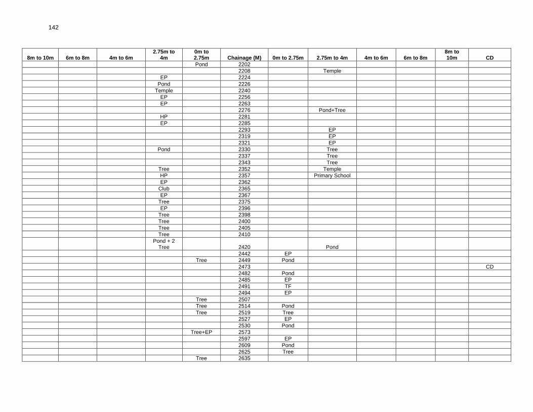
142
8m to 10m 6m to 8m 4m to 6m 2.75m to
4m 0m to 2.75m Chainage (M) 0m to 2.75m 2.75m to 4m 4m to 6m 6m to 8m
8m to 10m CD
Pond 2202
2208 Temple
EP 2224
Pond 2226
Temple 2240
EP 2256
EP 2263
2276 Pond+Tree
HP 2281
EP 2285
2293 EP
2319 EP
2321 EP
Pond 2330 Tree
2337 Tree
2343 Tree
Tree 2352 Temple
HP 2357 Primary School
EP 2362
Club 2365
EP 2367
Tree 2375
EP 2396
Tree 2398
Tree 2400
Tree 2405
Tree 2410
Pond + 2
Tree 2420 Pond
2442 EP
Tree 2449 Pond
2473 CD
2482 Pond
2485 EP
2491 TF
2494 EP
Tree 2507
Tree 2514 Pond
Tree 2519 Tree
2527 EP
2530 Pond
Tree+EP 2573
2597 EP
2609 Pond
2625 Tree
Tree 2635

143
8m to 10m 6m to 8m 4m to 6m 2.75m to
4m 0m to 2.75m Chainage (M) 0m to 2.75m 2.75m to 4m 4m to 6m 6m to 8m
8m to 10m CD
2650 Pond
2662 TF
2666 Pond+EP
2670 Tree
Pond 2690
2712 HP
EP 2720
EP 2745
2757 EP
Tree 2809 EP
2830 Pond
EP 2847
EP 2855
EP 2874
EP 2877
Tree 2880
Pond 2890
2904 EP
2915 Pond
Pond 2950
2964 EP
SSK 2980
HP 2995
Pond 3005 EP
EP 3035
3038 EP
Pond 3042
3050 Pond
3066 Burial Ground
Pond 3075 EP
3080 Tree
3085 Pond
EP 3111
EP 3126
3143 EP
3150 Pond
EP 3158
EP 3179
EP 3220
Tree 3224
Pond 3230
3250 Pond
3255 EP
EP 3292
3300 High School
EP 3344

144
8m to 10m 6m to 8m 4m to 6m 2.75m to
4m 0m to 2.75m Chainage (M) 0m to 2.75m 2.75m to 4m 4m to 6m 6m to 8m
8m to 10m CD
Tree 3389
Tree 3392
3397 EP
Tree 3400
3429 CD
3435 Tree
3443 Tree
End Point 3449 End Point

145
RURAL ROADS: ENVIRONMENTAL CHECKLIST
Road Name: TEGHORIA DAKSHIN TO SANKARGACHI PURBA Block Name: BARASAT-II District Name: North 24 Parganas Total Length of the Road: 2.238km Package No.: WB-01-ADB 95
A. Climatic Conditions Temperature High: 35°C, Low: 14°C
Humidity High: 90% in July Low: 69% in March
Rainfall Rainy Season
1550 mm/year June to mid-September
B. Location of the Road and Generic description of Environment
No. Type of Ecosystem Yes No Explanation
1. Coastal area Mangrove (along roadside)
√
The area is far away from CRZ (Coastal Regulation Zone).
( ) more than 50% ( ) less than 20%
2. Type of Terrain (Plain/Hilly/ Mountainous etc.) (Explain the topography of the area and how many km of the road are located in the hilly area)
√
Altitude: 12.3 m The topography of the area is flat in nature.
3. Forest Area (Explain whether the road passes through forest areas or located along the forest areas and distance from shoulder to the forest area)?
√
Type of Vegetation: N.A Legal Status of the Forest Area: (Reserved, National Park, Sanctuaries, Unclassified, etc.)
There is no forest area beside or away from the alignment.
4. Wildlife (Explain whether there are any wildlife species in the project area)
√
Name of animals: NA Endangered species (if any):None
5. Inhabited Area √
Small villages namely Teghoria (000m, - 567m ), Sankargachi (567m – 1770m), Kaziright (1770m – 2238m) existing beside the alignment.
6. Agricultural Land √
There are few patches where there are agricultural land beside the alignment, 500m -665m, 1156m - 1194m, 1251m - 1356m, 1414m – 1730m, (LHS) and 500m – 651m, 1595m - 1632m, 1740m - 1883m (RHS).
7. Grazing Grounds √ There is no grazing Ground beside the alignment.
9. Barren Land √ There is no barren land beside the alignment.
C. Specific description of the Road Environment
(Note: Questions number 1, 4, 5, 7 and 8 must be answered after discussions with the local community people)
No. Parameter/ Component Yes No Explanation
1. Are there any areas with landslide or erosion problems along the road?
There is no such area with landslide or erosion problem.

146
No. Parameter/ Component Yes No Explanation
(If yes, indicate the location (right or left side) and the chainage)
√
( ) No Secondary Information is available and Local Community is not aware of this matter
2. Are there any lakes/swamps beside the road? (If yes, list them indicating the location (right or left side)and the chainage)
√
There is no lake or swampy area beside the alignment but many small & big Ponds / Water body were found at Ch. 10m, 52m, 846m, 955m, 977m, 1099m, 1140m, 1275m, 1938m, 1965m, 2048m. (LHS) and 19m, 52m, 92m, 360m, 390m, 560m, 950m, 981m, 1156m, 1201m, 1270m, 1298m, 1366m, 1370m, 1439m, 1460m, 1525m, 1588m, 1690m, 2106m, (RHS). exists beside the alignment.
3. Are there any nallas/ streams /rivers etc. along/crossing the road? (If yes, list them indicating the location (right, left or crossing) and the chainage
√
There are no road side nallas / streams / rivers noticed along the road alignment. However, few CD structures were noticed at Ch. 35m, 343m, 567m, 1006m, 1029m, 1046m, 1097m, 1102m, 2075m.
4. Are there problems of water stagnation and other drainage issues on or near the road? (If yes, mention chainage)
√
There is no problem of any water stagnation and other drainage issues observed.
( ) No Secondary Information is available and Local Community is not aware of this matter
5. Is the area along the project road prone to flooding? (If yes, mention flood level and frequency)
√
The area is not flood prone.
( ) No Secondary Information is available and Local Community is not aware of this matter
6. Are there any Trees with a dbh of 30 cm or more within 10 m on either side from the canter line of the road alignment? (If yes attach list of Trees indicating the location (right or left side)and the chainage)
√
There are 63 nos. of Trees with a dbh of 30 cm or more within 10 m on either side of the road alignment.(List Attached)
7. Along the road and within 100m of the road shoulder, are there any faunal habitat areas, faunal breeding Ground, bird migration area, or other similar areas? (If yes, specify details of habitat with chainage)
√
There are no such areas within 100m from the road shoulder.
√
( ) No Secondary Information is available and Local Community is not aware of this matter
8. Along the road and within 100m of the road shoulder is there any evidence of floral and faunal species that are classified as endangered species?
√
There is no endangered species of flora or fauna within 100m from the road shoulder.
( ) No Secondary Information Available and Local Community is not aware of this matter

147
No. Parameter/ Component Yes No Explanation
9. Are there any utility structures within 10 m on either side from the canter line of the road alignment? (If yes, attach list with chainage)
√
There are 79 nos. utility structures (EP, TP, HP) within 10m on either side of the alignment.(List Attached)
10. Are there any religious, cultural or community structures/buildings within 10 m on either side from the canter line of the road alignment? (If yes attach list with chainage)
√
There are a total of 11 community / religious, cultural structures within 10m on either side from the center line of the road alignment ICDS at 193m, Mosque at 1010m, Idgha at 1120m, High Madrasha at 2187m, Bus Stand at 2234m. (LHS) on the other hand Club at 77m, Madrasha at 266m, & 1138m, Primary school at 1560m, Mosque at 1801m, Burial Ground at 2184m (RHS).
D. Public Consultation
No. Consultation Activities Yes No Remarks
1. Consultation with local community was conducted before finalizing the alignment. (Attach list of people met and dates)
√
Consultation with local community was conducted on 05.11.2012.List of people attached.
2. Any suggestion received in finalizing the alignment
√
Villagers suggested to provide speed breaker, protection wall etc. wherever required.
3. If suggestions received, were they incorporated into the design?
√
Suggestion will be incorporated after discussion with PIU.
E. Please attach the following:
1. List of Trees indicating location (left or right side of the road) and chainage (as required under C. 6)
2. List of utility structures indicating location (left or right side of the road) and chainage (as required under C. 9)
3. List of community structures indicating location (left or right side of the road) and chainage (as required under C. 10)
4. Sketch of strip map of the road covering details of atleast 10 m on either side from the centre line of the road
5. Photographs of the project area showing atleast 10 m on either side from centre line of road alignment. Every 2 km or less of road must have atleast 1 photograph.

148
Attachment I List of Trees
Left (No.of Trees) Chainage(M) Right (No. of Trees) Left Chainage(M) Right
13 Tree 80 HP
19 Tree 108 EP
24 Tree EP 114
30 Tree 2EP 148
37 Tree EP 150
48 Tree 176 EP
50 Tree 193 EP
51 Tree EP 216
60 Tree 245 EP
115 Tree 247 EP
120 Tree 274 HP
129 Tree 278 HP
178 Tree 290 EP
4 Tree 266-276 318 EP
272 Tree 346 EP
276 Tree 651 EP
280 Tree 665 EP
285 Tree EP 689
356 Tree 717 EP
Tree 365 735 EP
410 Tree 744 EP
Tree 418 Tree EP 772
431 Tree 804 EP
435 Tree EP 836 EP
Tree 450 EP 862
Tree 457 HP 865
Tree 474 EP 892
Tree 697 906 TF
Tree 715 935 EP
Tree 717 EP 970
772 Tree 1004 HP
5 Tree 775-804 1010 EP
Tree 990 1033 HP
Tree 1004 EP 1062
Tree 1033 HP 1076
1384 Tree 1080 EP
1770 Tree 1120 EP
1816 Tree EP 1156
1824 Tree EP 1194
Tree 1834 EP 1195
1868 Tree EP 1212
1872 Tree EP 1251
Tree 1883 Tree 1259 HP
1887 Tree 1261 EP
1903 Tree EP 1270
Tree 1908 1292 EP
Tree 1915 1346 EP
Tree 1922 EP 1396
1934 Tree EP 1414
1938 Tree 1426 HP
1960 Tree 1444 EP
Tree 2219 EP 1452
2222 Tree EP 1515
2234 Tree EP 1545
Attachment II 1582 EP

149
List of Utilities HP 1585
TF 35 1632 EP
EP 37 EP 1694
75 EP 1746 EP
Attachment II
List of Utilities Contd.
Left Chainage(M) Right Left Chainage(M) Right
EP 1776 EP 2038
HP 1797 EP 2069
EP 1827 2131 EP
1863 EP EP 2184
EP 1903 2215 EP
EP 1953 HP 2222
1989 EP 2236 EP
EP 2012
Attachment II List of Community Structures
Left Chainage(M) Right
77 Club
ICDS 193
266 Madrasha
Mosque 1010
Idgha 1120
1138 madrasha
1560 Primary School
1801 Mosque
2184 Burial Ground
High Madrasha 2187
Bus Stand 2234

150
Attachment IV
8m to 10m 6m to 8m 4m to 6m 2.75m to 4m 0m to 2.75m Chainage(M) 0m to 2.75m 2.75m to 4m 4m to 6m 6m to 8m 8m to 10m CD
Pond 10
13 Tree
19 Tree Pond
24 Tree
30 Tree
TF 35 CD
EP 37 Tree
48 Tree
50 Tree
51 Tree
Pond 52 Pond
60 Tree
75 EP
77 Club
80 HP
92 Pond
108 EP
EP 114
115 Tree
120 Tree
129 Tree
2EP 148
EP 150
176 EP
178 Tree
ICDS 193 EP
EP 216
245 EP
247 EP
266 Madrasha
4 Tree 266-276
272 Tree
274 HP
276 Tree
278 HP
280 Tree
285 Tree
290 EP
318 EP
343 CD
346 EP
356 Tree
360 Pond

151
8m to 10m 6m to 8m 4m to 6m 2.75m to 4m 0m to 2.75m Chainage(M) 0m to 2.75m 2.75m to 4m 4m to 6m 6m to 8m 8m to 10m CD
Tree 365
390 Pond
410 Tree
Tree 418 Tree
431 Tree
435 Tree
Tree 450
Tree 457
Tree 474
560 Pond
567 CD
651 EP
665 EP
EP 689
Tree 697
Tree 715
Tree 717 EP
735 EP
744 EP
EP 772 Tree
5 Tree 775-804
804 EP
EP 836 EP
Pond 846
EP 862
HP 865
EP 892
906 TF
935 EP
950 Pond
Pond 955
EP 970
Pond 977
981 Pond
Tree 990
Tree 1004 HP
1006 CD
Mosque 1010 EP
1029 CD
Tree 1033 HP
1046 CD
EP 1062
HP 1076
1080 EP
1097 CD
Pond 1099

152
8m to 10m 6m to 8m 4m to 6m 2.75m to 4m 0m to 2.75m Chainage(M) 0m to 2.75m 2.75m to 4m 4m to 6m 6m to 8m 8m to 10m CD
1102 CD
Idgha 1120 EP
1138 Madrasha
Pond 1140
EP 1156 Pond
EP 1194
EP 1195
1201 Pond
EP 1212
EP 1251
1259 HP
1261 EP
EP 1270 Pond
Pond 1275
1292 EP
1298 Pond
1346 EP
1366 Pond
1370 Pond
1384 Tree
EP 1396
EP 1414
1426 HP
1439 Pond
1444 EP
EP 1452
1460 Pond
EP 1515
1525 Pond
EP 1545
1560 Primary School
1582 EP
HP 1585
1588 Pond
1632 EP
1690 Pond
EP 1694
1746 EP
1770 Tree
EP 1776
HP 1797
1801 Mosque
1816 Tree
1824 Tree
EP 1827
Tree 1834

153
8m to 10m 6m to 8m 4m to 6m 2.75m to 4m 0m to 2.75m Chainage(M) 0m to 2.75m 2.75m to 4m 4m to 6m 6m to 8m 8m to 10m CD
1863 EP
1868 Tree
1872 Tree
Tree 1883 Tree
1887 Tree
EP 1903 Tree
Tree 1908
Tree 1915
Tree 1922
1934 Tree
Pond 1938 Tree
EP 1953
1960 Tree
Pond 1965
1989 EP
EP 2012
EP 2038
Pond 2048
EP 2069
2075 CD
2106 Pond
2131 EP
EP 2184 Burial Ground
High Madrasha 2187
2215 EP
Tree 2219
HP 2222 Tree
Bus Stand 2234 Tree
2236 EP
End Point 2238 End Point

154
RURAL ROADS: ENVIRONMENTAL CHECKLIST
Road Name: Belia to Shyamnagar Block Name: Joypur District Name: Bankura Total Length of the Road: 9.742 km Package No,: WB-03-ADB 47
A. `Climatic Conditions
Temperature High: 42°C Low: 10°C
Humidity High: 67% in July Low: 32% in March
Rainfall Rainy Season
1550 mm/year June to September
N.S. – Not Specified B. Location of the Road and Generic description of Environment
No. Type of Ecosystem Yes No Explanation
1. Coastal area Mangrove (along roadside)
√
The area is for away from CRZ.(coastal regulation zone).
( ) more than 50% ( ) less than 20%
2. Type of Terrain (Plain/Hilly/ Mountainous etc.) (Explain the topography of the area and how many km of the road are located in the hilly area)
√
Altitude:77.8 m The topography is partly flat in nature.
4. Forest Area (Explain whether the road passes through forest areas or located along the forest areas and distance from shoulder to the forest area)?
√
There is .forest land beside the alignment between Ch 1445-1842m &between 2190-3240m (LHS) Legal Status of the Forest Area: (Reserved, National Park, Sanctuaries, Unclassified, etc.)
5. Wildlife (Explain whether there are any wildlife species in the project area)
√
Name of animals: There are no wildlife species found in the project area. Endangered species (if any):None
6. Inhabited Area √
There are small villages namely Gossainpur (0m-999m), Mobarakpur (999m-4335m), Kheraiboni (4335m-6478m), Belia (6478m-7687m). Existing beside the alignment.
7. Agricultural Land √
Agricultural land exists beside the alignment near at Ch 0-48m (LHS). 217-651m (both side), 1445-1943m (RHS) 1842-2260m (LHS) 2498-2652m (RHS), 3240-3801m (both side), 4300-5521m (LHS), 4705-5521m(RHS),6478-7020m (both side), 7020-7218m (RHS), 7687-8011m (both side), 8494-9742m (both side) in scattered manner.
8. Grazing Grounds √
Grazing Ground exists beside the alignment at Ch. 3865m.
9. Barren Land √
There is a barren land at Ch. 700m-936m (both side), 1433m-1445m (LHS),

155
C. Specific description of the Road Environment (Note: Questions number 1, 4, 5, 7 and 8 must be answered after discussions with the local community people)
No. Parameter/ Component Yes No Explanation
1. Are there any areas with landslide or erosion problems along the road? (If yes, indicate the location (right or left side) and the chainage)
√
No such problem has been observed along the road since no part of the project road comprises of hilly terrain.
( ) No Secondary Information is available and Local Community is not aware of this matter
2. Are there any lakes/ swamps beside the road? (If yes, list them indicating the location (right or left side)and the chainage)
√
There is no lake or swampy area beside the alignment. But many small & big Ponds exists beside the alignment at Ch. 1134m, 3941m, 4114m, 5574m, 5643m, 5762m, 5925m, 6290m & 8482m, (LHS) and 1134m, 3908m, 3978m, 6188m & 8268m (RHS)
3. Are there any nallas/ streams/rivers etc. along/ crossing the road? (If yes, list them indicating the location (right, left or crossing) and the chainage
√
There are few water courses(dry in nature) crossing the alignment at Ch 3801m, 4335m, 5845m and the river Darakeswar flows parallel to the alignment between Ch4180 to5774m. Other than these cross drainage structures exist throughout the alignment near Ch 378, 452, 510, 651, 999, 1254, 1433, 2260m and so on
4. Are there problems of water stagnation and other drainage issues on or near the road? (If yes, mention chainage)
√
Water stagnation problem has not been observed.
( ) No Secondary Information is available and Local Community is not aware of this matter
5. Is the area along the project road prone to flooding? (If yes, mention flood level and frequency)
√
The area along the project road is not prone to flooding.
( ) No Secondary Information is available and Local Community is not aware of this matter
6. Are there any Trees with a dbh of 30 cm or more within 10 m on either side from the center line of the road alignment? (If yes attach list of Trees indicating the location (right or left side)and the chainage)
√
There are 50 nos. of Trees with a dbh of 30 cm or more within 10m on either side of the alignment. (Annexure-I)
7. Along the road and within 100m of the road shoulder, are there any faunal habitat areas, faunal breeding Ground, bird migration area, or other similar areas? (If yes, specify details of habitat with chainage)
√
There are no such areas within 100m from the road shoulder.
( ) No Secondary Information is available and Local Community is not aware of this matter
8. Along the road and within 100m of the road shoulder is there any evidence of floral and faunal species that are classified as endangered species?
√
There are no rare or endangered species of flora or fauna within 100m from the road shoulder.
( ) No Secondary Information Available and Local Community is not aware of this matter
9. Are there any utility structures within 10 m on either side from the centre line of the road alignment? (If yes, attach list with chainage)
√
There are 57 nos. of utility structures (EP, TP, HP) within 10m on either side of the road alignment. (Annexure-II)

156
No. Parameter/ Component Yes No Explanation
10. Are there any religious, cultural or community structures/buildings within 10 m on either side from the center line of the road alignment? (If yes attach list with chainage)
√
There are 9 nos. community structures within 10m on either side of the alignment as follows: Ch. 4057m (LHS) Temple ,7560m(LHS) P. School, 7590m (LHS) High School, 37m, 4697 (RHS) P. School. 4044m, 4098m, 5683m (RHS) Temple. 2331m (RHS) High School. (Annexure-III)
D. Public Consultation
No. Consultation Activities Yes No Remarks
1. Consultation with local community was conducted before finalizing the alignment. (Attach list of people met and dates)
√
Consultation with local community was conducted before finalization of alignment, on 28/2/2013 & 1/3/2013. (list of people attached)
2. Any suggestion received in finalizing the alignment
√
Suggestions (providing retaining wall, speed breaker, employment of local people) were received during finalisation.
3. If suggestions received, were they incorporated into the design?
√
Final decision will be taken after discussion with PIU.
E. Please attach the following:
1. List of Trees indicating location (left or right side of the road) and chainage (as required under C. 6)
2. List of utility structures indicating location (left or right side of the road) and chainage (as required under C. 9)
3. List of community structures indicating location (left or right side of the road) and chainage (as required under C. 10)
4. Sketch of strip map of the road covering details of atleast 10 m on either side from the center line of the road
5. Photographs of the project area showing atleast 10 m on either side from center line of road alignment. Every 2 km or less of road must have atleast 1 photograph.

157
Attachment I Attachment II List of Trees list of Utilities
Chainage (M)
Left (No.of Trees)
Right (No. of Trees)
Chainage
(M) Left Right
1231 Tree 48 EP
1403 Tree 84 EP
1411 Tree 101 HP
1433 Tree 153 EP
1445 Tree 217 EP
3542 Tree 264 TF
3573 Tree 1043 HP
3958 Tree 1071 EP
3976 Tree 1104 EP
4037 Tree 1129 EP
4114 Tree 1157 EP
4146 Tree 1168 HP
4161 Tree 1170 EP
4172 Tree 1213 EP
4635 Tree 1263 TF
4697 Tree 1288 EP
5155-5211 5 Tree 1317 EP
5233-5521 6 Tree 3 Tree 1342 HP
5739 Tree 1372 EP
5774 Tree 1397 EP
6221 Tree 1435 EP
7182 Tree 1943 High-tension(EP)
7205 Tree 2652 High-tension(EP)
7218 Tree 3893 EP
7471 Tree 3962 EP/HP
7495-7512 3 Tree 4040 HP
7658 Tree 4075 EP
7695-7724 3 Tree 4125 EP EP
8051-8192 3 Tree 3 Tree 4153 TF
4154 HP
4561 EP
Attachment III 4598 EP
List of Community Structures 4718 TF/EP
Chainage(M) Left Right 4769 EP
37 P. School 5608 TF
2331 High School 5643 EP
4044 Temple 5762 EP
4057 Temple 5815 EP
4098 Temple 5896 TF
4697 P.School 5925 EP
5683 Temple 6167 EP
7560 P.School 6195 EP
7590 High School 6229 HP
6233 EP
6259 EP
6478 EP
6590 EP
6651 EP
7580 EP
7613 EP
7642 HP
7645 EP
7687 EP
8670 TF

158
Attachment IV
8m to 10m 6m to 8m 4m to 6m 2.75m to
4m 0m to 2.75m Chainage(M) 0m to 2.75m
2.75m to 4m 4m to 6m 6m to 8m 8m to 10m CD
37 p.school
EP 48
EP 84
101 HP
153 EP
EP 217
264 TF
378 CD
452 CD
510 CD
651 CD
999 CD
1043 HP
EP 1071
1104 EP
EP 1129
1134 Pond
1157 EP
1168 HP
1170 EP
1213 EP
1231 Tree
1254 CD
1263 TF
1288 EP
1317 EP
HP 1342
1372 EP
1397 EP
1403 Tree
1411 Tree
1433 Tree CD
1435 EP
1445 Tree
1943 High Tension
2260 CD
2331 High School
HighTENTION 2652
2896 CD
3542 Tree
3573 Tree
3801 CD
3865 Graging Ground
EP 3893

159
8m to 10m 6m to 8m 4m to 6m 2.75m to
4m 0m to 2.75m Chainage(M) 0m to 2.75m
2.75m to 4m 4m to 6m 6m to 8m 8m to 10m CD
3908 Pond
Pond 3941
Tree 3958
EP/HP 3962
3964 CD
3976 Tree
3978 Pond
4037 Tree
4040 HP
4044 Temple
Temple 4057
4075 EP
4098 Temple
4114 Tree
EP 4125 EP
Tree 4146
4153 TF
Pond 4154 HP
Tree 4161
Tree 4172
4335 CD
EP 4561
EP 4598
4635 Tree
4697 Tree P.School
TF/EP 4718
EP 4769
4797 CD
4915 CD
5008 CD
5147 CD
5 Tree 5155-5211
5228 CD
6 Tree 5233-5521 3 Tree
5559 CD
Pond 5574
5608 TF
Pond 5643 EP
5683 Temple
Tree 5739
Pond 5762 EP
Tree 5774
5815 EP
5845 CD
5896 TF
Pond 5925 EP

160
8m to 10m 6m to 8m 4m to 6m 2.75m to
4m 0m to 2.75m Chainage(M) 0m to 2.75m
2.75m to 4m 4m to 6m 6m to 8m 8m to 10m CD
6117 CD
6167 EP
6188 Pond
EP 6195
6221 Tree
6229 HP CD
6233 EP
EP 6259
Pond 6290
6478 EP CD
EP 6590
6651 EP
7182 Tree
Tree 7205
Tree 7218
Tree 7471
3 Tree 7495-7512
P.School 7560
EP 7580
High School 7590
7613 EP
HP 7642
EP 7645
7658 Tree
EP 7687
7695-7724 3 Tree
8011 CD
3 Tree 8051-8192 3 Tree
8213 CD
8268 Pond
Pond 8482
8494 CD
TF 8670
8880 CD
9445 CD
End Point 9742 End Point

161
RURAL ROADS: ENVIRONMENTAL CHECKLIST Road Name: Barahankol to Simni (T-07) Block Name: Jhalda-2 District Name: Purulia Total Length of the Road: 6.441 km Package No.: WB-16-ADB 17
A. Climatic Conditions
Temperature High: 42°C Low: 15°C
Humidity High: 89% in July Low: 25% in Feb
Rainfall Rainy Season
1395mm/year July to September
B. Location of the Road and Generic description of Environment
No. Type of Ecosystem Yes No Explanation
1. Coastal area Mangrove (along roadside)
√
The area along the project road is far away from coastal area.
2. Type of Terrain (Plain/Hilly/ Mountainous etc.) (Explain the topography of the area and how many km of the road are located in the hilly area)
√
Altitude: The topography of the area is mainly plain in nature.
3. Forest Area (Explain whether the road passes through forest areas or located along the forest areas and distance from shoulder to the forest area)?
√
Type of Vegetation: Legal Status of the forest area: (Reserved, National Park, Sanctuaries, unclassified, etc.)
4. Wildlife (Explain whether there are any wildlife species in the project area)
√
Name of animals: N/A Endangered species (if any) : None
5. Inhabited Area √
The inhabited area starts basically from Barahankol Ch. 0m to 250m, Oldi Village Ch. 260m to 1000m, Khari Village Ch. 1050m to 1400m, Jhilinglohar Ch. 1450m to 2280m, Panrra Ch. 2300m to 3500m, Simni Ch. 5740m to 6441m.
6. Agricultural Land √ The agriculture land exists beside the project road.
7. Grazing Grounds √ As per the discussions with the villagers there is no grazing Ground.
8. Barren Land √ There is no barren land.
C. Specific description of the Road Environment
(Note: Questions number 1, 4, 5, 7 and 8 must be answered after discussions with the local community people)
No. Parameter/ Component Yes No Explanation
1. Are there any areas with landslide or erosion problems along the road? (If yes, indicate the location (right or left side) and the chainage)
√
There is no problem of land slide or erosion along the road.
( ) No Secondary Information is available and Local Community is not aware of this matter

162
No. Parameter/ Component Yes No Explanation
2. Are there any lakes/ swamps beside the road? (If yes, list them indicating the location (right or left side)and the chainage)
√
As such there are no lakes/Swamps beside the project road alignment. However, few Ponds or water bodies were found to be existing at Ch.-1450m (LHS), Ch.-1720m (L.H.S.), Ch.-2300m (L.H.S.), Ch.-3180m (L.H.S.), Ch.-3700m (L.H.S.), Ch.-2810m (Both Side), Ch.-2010m (R.H.S.), Ch.- 3200m (R.H.S.), Ch.-3300m (R.H.S.), Ch.-3550m (R.H.S.), Ch.-4020m (R.H.S.), Ch.-4950m (R.H.S.) Ch.-5530m (R.H.S.) and Ch.-5920m (RHS).
3. Are there any nallas/ streams/rivers etc. along/ crossing the road? (If yes, list them indicating the location (right, left or crossing) and the chainage
√
There were no streams nallas/ streams/ rivers found crossing the road. However, the existing cross drainages were noticed at Ch. 300m, 3820m, 4600m.
4. Are there problems of water Stagnation and other drainage issues on or near the road? (If yes, mention chainage)
√
There is no problem of water stagnation and other drainage issues on or near the road
( ) No Secondary Information is available and Local Community is not aware of this matter
5. Is the area along the project road prone to flooding? (If yes, mention flood level and frequency)
√
The area along the project road is not flood prone.
( ) No Secondary Information is available and Local Community is not aware of this matter
6. Are there any Trees with a dbh of 30 cm or more within 10 m on either side from the center line of the road alignment? (If yes attach list of Trees indicating the location (right or left side)and the chainage)
√
There are altogether 32 nos. of Trees with dbh of 30cm or more within 10m on either side from the centre line of the road alignment.
7. Along the road and within 100m of the road shoulder, are there any faunal habitat areas, faunal breeding Ground, bird migration area, or other similar areas? (If yes, specify details of habitat with chainage)
√
No faunal habitat areas or faunal breeding Ground exists along the road within 100m of the road shoulder
√ ( ) No Secondary Information is available and Local Community is not aware of this matter
8. Along the road and within 100m of the road shoulder is there any evidence of floral and faunal species that are classified as endangered species?
√
Along the road and within 100m of the road shoulder there is no evidence of floral and faunal species that are classified as endangered species.
( ) No Secondary Information Available and Local Community is not aware of this matter
9. Are there any utility structures1 within 10 m on either side from the centre line of the road alignment? (If yes, attach list with chainage)
√
There are 52 nos. of EP (including transformer) and 7 nos. of HP within 10m on either side from the centre line of the road alignment.
10. Are there any religious, cultural or community structures/buildings2 within 10 m on either side from the centre line of the road alignment? (If yes attach list with chainage)
√
In case of religious of cultural or community structures, there are School at Ch. 1120m (R.H.S.), 1380m (R.H.S.), 2700m (R.H.S.), 3510m (R.H.S.), 1890m (L.H.S.) and 6441m (at the end point). There are also Temples at Ch. 6010m (RHS) & Ch. 6115m (LHS), Post Office at Ch. 6205m (LHS), Tomb at Ch. 3250m (RHS) and Community Hall at Ch. 5860m (LHS).
D. Public Consultation
1Water tap, hand pump, electric pole, telephone pole, water pipe and other similar structures.
2 Mandir, Masjid, Church, religious/cultural/historical monuments, school, health center, public toilet and other similar
structures.

163
No. Consultation Activities Yes No Remarks
1. Consultation with local community was conducted before finalizing the alignment. (Attach list of people met and dates)
√
The proposed alignment has been finalized after taking suggestions from the local community. This was confirmed by the villagers during the transect walk as shown in Attachment IV.
2. Any suggestion received in finalizing the alignment
√
Suggestion received in finalizing the alignment.
3. If suggestions received, were they incorporated into the design?
√
Suggestion will be incorporated after consulting with respective PIU.
E. Please attach the following:
1. List of Trees indicating location (left or right side of the road) and chainage (as required under C. 6) 2. List of utility structures indicating location (left or right side of the road) and chainage (as required under C.
9) 3. List of community structures indicating location (left or right side of the road) and chainage (as required
under C. 10) 4. Sketch of strip map of the road covering details of atleast 10 m on either side from the center line of the
road
5. Photographs of the project area showing atleast 10 m on either side from center line of road alignment.
Every 2 km or less of road must have atleast 1 photograph.

164
Attachment I Attachment II List of Trees list of Utilities
Chainage (M)
Left (No.of Trees)
Right (No. of Trees)
Chainage
(M) Left Right
1550m - 2 Tree 5m - 1EP
1890m - 1 Tree 35m - 1EP
2750m 1 Tree - 70m 1EP -
3300m - 1 Tree 100m - 1EP
3400m 1 Tree - 135m 1EP -
3700m - 1 Tree 170m - 1EP
4700m-4800m 2 Tree 4 Tree 220m 1EP -
4800m-5000m 3 Tree 3 tree 380m - 1EP
5000m-5200m 3 Tree 5 Tree 420m 1HP -
5700m - 1 Tree 440m 1EP -
5840m 1 Tree - 500m - 1EP
5910m 1 Tree - 570m - 1EP
6060m - 1 Tree 670m EP -
6210m - 1 Tree 700m - 1EP
730m - 1EP
Attachment III 780m - 1EP
List of Community Structures 820m 1EP -
Chainage(M) Left Right 860m - 1EP
1120m - School 900m 1EP -
1380m - School 950m 1EP -
1890m S.S.K. - 975m 1TF 1EP
2700m - School 1050m - 1EP
3250m - Tomb 1080m 1EP -
3510m - School 1100m 1EP -
5860m Community Hall - 1110m - 1EP
6010m - Temple 1150m 1EP 1HP
6115m Temple - 1170m - 1EP
6205m Post Office - 1190m 1EP 1HP
1240m 1EP -
1280m 1EP -
1340m 1EP -
4598 EP 1360m
4718 TF/EP 1380m
2080m 1HP -
2170m 1EP -
2650m - 1EP
3100m 1EP -
3300m - 1EP
3385m - 1EP
3400m 1TF -
3430m - 1EP
3460m - 1EP
5630m - 1EP
5650m - 1HP
5670m 1EP -
5740m - 1EP
5780m 1EP -
5840m - 1EP
5860m 1EP -
6030m 1TF+1EP 1HP
6060m 1EP -
6110m - 1EP
6115m 1EP -
6110m-6200m 1EP -
6210m - 1EP
6205m-6380m 2EP -
6400m - 1EP
6415m 1EP -
6430m - 1EP

165
Attachment- IV 8m to 10m 6m to 8m 4m to 6m 2m to 4m 0m to 2m Chainage(M) 0m to 2m 2m to 4m 4m to 6m 6m to 8m 8m to 10m CD
5m 1EP
35m 1EP
1EP 70m
House 100m 1EP
1EP 135m
170m 1EP House
B.Wall 185m-200m
1EP 220m
300m E.B.C.
House 340m
House 380m 1EP
2House 400m
1HP 420m
1EP 440m
500m 1EP
570m 1EP
585m Bou. Wall
2 House 620m
EP 670m
700m 1EP
730m 1EP
3 House 730m-750m House
780m 1EP
1EP 820m
House 860m 1EP
1EP 900m
1EP 950m
1TF 975m 1EP
House 1000m
1050m 1EP
1EP 1080m
1EP 1100m
1110m 1EP
1120m P.School
1EP 1150m 1HP
1170m 1EP
1EP 1190m 1HP
1200m 2House
1EP 1240m B.Wall
1EP 1280m
1EP 1340m
1360m 1EP House
1380m 1HP School
Pond 1440m

166
8m to 10m 6m to 8m 4m to 6m 2m to 4m 0m to 2m Chainage(M) 0m to 2m 2m to 4m 4m to 6m 6m to 8m 8m to 10m CD
A.L. 1500m A.L.
1550m 2Tree
1600m-1700m 2 House
Pond 1740m
House 1760m
House 1800m
S.S.K. 1890m 1Tree
2020m Pond
House 2060m
1HP 2080m
House 2100m
House 2140m
1EP 2170m
2House 2180m
Pond 2300m
2390m
2650m 1EP
2700m School
1Tree 2750m
Pond 2810m Pond
1EP 3100m 2 House
Pond 3190m
Side Drain 3200m Pond
House 3250m Tomb
3300m 1EP Pond
House 3310m
House 3385m 1EP
1Tree 1TF 3400m
2House 3430m 1EP
House 3460m 1EP
House 3470m House
3510m School
Pond 3700m 1Tree
3820m E.P.C.
4040m Pond
4590m E.B.C.
2Tree 4700m-4800m 4Tree
3Tree 4800m-5000m 3Tree Pond
3Tree 5000m-5200m 5Tree
5440m P.P.C
5630m 1EP
5650m 1HP
1EP 5670m
5700m 1Tree
5740m 1EP

167
8m to 10m 6m to 8m 4m to 6m 2m to 4m 0m to 2m Chainage(M) 0m to 2m 2m to 4m 4m to 6m 6m to 8m 8m to 10m CD
1EP 5780m
1Tree 5840m 1EP
Community Hall 1EP 5860m
1Tree 5910m Pond
House 6000m
6010m Temple
Pond 1TF 1EP 6030m 1HP
1EP 6060m 1Tree
House House 6050m-6100m 2House
6110m 1EP
Temple 1EP 6115m
2House 1EP 6110m-6200m 1Tree 3 House
2House 6210m 1EP 1Tree
P.O. 6205m
5House 2EP 6205m-6380m 10House
House 6390m 2 House
6400m 1EP
1EP 6415m
6430m 1EP

168
RURAL ROADS: ENVIRONMENTAL CHECKLIST
Road Name: Uttar Brindaban Chak to Uttar Narayan Pakuria Block Name: Panskura-II District Name: Purba Midnapur Total Length of the Road: 7.718Km Package No.: WB-19-ADB 19
A. Climatic Condition
Temperature High: 38°C Low: 20°C
Humidity High: 88% in July Low: 32% in March
Rainfall Rainy Season
1400mm/year June to mid-September
B. Location of the Road and Generic description of Environment
No. Type of Ecosystem Yes No Explanation
1. Coastal area Mangrove (along roadside)
√
Distance from Coastline: km. The proposed road is far away from Coastal Regulation Zone (CRZ).
( ) more than 50% ( ) less than 20%
2. Type of Terrain (Plain/Hilly/ Mountainous etc.) (Explain the topography of the area and how many km of the road are located in the hilly area)
√
Altitude: 9.0m The area along the project road is flat in nature.
3. Forest Area (Explain whether the road passes through forest areas or located along the forest areas and distance from shoulder to the forest area)?
√
Type of Vegetation: The proposed road is not passed through any forest area. Legal Status of the Forest Area: The road neither passed through any forest area not located along the forest area. (Reserved, National Park, Sanctuaries, Unclassified, etc.
4. Wildlife (Explain whether there are any wildlife species in the project area)
√
Name of animals: There is no wild-life species in the project area.(as there is no forest) Endangered species (if any):None
5. Inhabited Area √
The proposed road passes through the inhabited area like Tahala ((0-632m), Nahala (632-770m), Sarda Basan (2306-2462m), Dakshin Sagarbar (2462-2833m), Chandpur (2910-3708m), Deulpur (3708-5450m), Dakshin Jiada (5450-6600m), Narayan Pakuria (6600-7265m).
6. Agricultural Land √
Some portion of the project road passes through agricultural land at Ch. (2000m-2440m), (3708m-4252m), (5450m-6600m) RHS.
7. Grazing Grounds √ There is no grazing Ground in the project site area.
8. Barren Land √ There is no barren land in the project site area.
C. Specific description of the Road Environment
(Note: Questions number 1, 4, 5, 7 and 8 must be answered after discussions with the local community people)
No. Parameter/ Component Yes No Explanation
1. Are there any areas with landslide or erosion problems along the road?
√
The area along the project road is not prone to the landslide or erosion problems.

169
No. Parameter/ Component Yes No Explanation
(If yes, indicate the location (right or left side) and the chainage)
( ) No Secondary Information is available and Local Community is not aware of this matter
2. Are there any lakes/swamps beside the road? (If yes, list them indicating the location (right or left side)and the chainage)
√
There is a swampy area from Ch. (7280-7335m). There is no lake falling by the side of the road.
3. Are there any nallas/ streams/ rivers etc. along/crossing the road? (If yes, list them indicating the location (right, left or crossing) and the chainage
√
There is no nallas/ streams/ rivers etc. Along/ crossing by the road but there is canal exist along the road from (126m-2306m) LHS and (126m-2110m) RHS. Again (2462m-2910m) LHS, (3708m to 6758m).
4. Are there problems of water stagnation and other drainage issues on or near the road? (If yes, mention chainage)
√
There is no water stagnation problem or any other drainage issue on or near the road.
( ) No Secondary Information is available and Local Community is not aware of this matter
5. Is the area along the project road prone to flooding? (If yes, mention flood level and frequency)
√
The area along the project road is not prone to the flooding problems.
( ) No Secondary Information is available and Local Community is not aware of this matter
6. Are there any Trees with a dbh of 30 cm or more within 10 m on either side from the center line of the road alignment? (If yes attach list of Trees indicating the location (right or left side)and the chainage)
√
There are 16 Nos. of Trees with a dbh of 30cm or more within 10m on either side from the centre line of the road alignment. (Moreover there is a series of Trees below the dbh of 30 cm. on either side of the road alignment, out of which 100Trees to be felled) (List of Trees indicating the location has been attached in Attachment-I)
7. Along the road and within 100m of the road shoulder, are there any faunal habitat areas, faunal breeding Ground, bird migration area, or other similar areas? (If yes, specify details of habitat with chainage)
√
Along the road and within 100m of the road shoulder, there are no faunal habitat areas faunal breading Ground, bird migration areas or other similar areas.
( ) No Secondary Information is available and Local Community is not aware of this matter
8. Along the road and within 100m of the road shoulder is there any evidence of floral and faunal species that are classified as endangered species?
√
Along the road and within 100m of the road shoulder, there is no evidence of floral and faunal species that are classified as endangered species.
( ) No Secondary Information Available and Local Community is not aware of this matter
9. Are there any utility structures26 within 10 m on either side from the center line of the road alignment?
(If yes, attach list with chainage)
√
There are 31 nos. of utility structures (EP, TP, HP, Tap, TF etc.) within 10m on either side from the center line of the road alignment. (List of utility has been attached with chainage in Attachment-II)
10. Are there any religious, cultural or community structures/buildings27 within 10 m on either side from the center line of the road alignment? (If yes attach list with chainage)
√
There are 5 nos. Of religious, cultural or community structures buildings within 10m on either side from the center line of the road alignment. (List has been attached in Attachment-III)
26
Water tap, hand pump, electric pole, telephone pole, water pipe and other similar structures. 27
Mandir, Masjid, Church, religious/cultural/historical monuments, school, health center, public toilet and
other similar structures.

170
D. Public Consultation
No. Consultation Activities Yes No Remarks
1. Consultation with local community was conducted before finalizing the alignment. (Attach list of people met and dates)
√
Consultation with local community was conducted before finalizing the alignment. Date of consultation 20/03/2013 (List of people attached)
2. Any suggestion received in finalizing the alignment
√
Suggestion has been received before finalizing the alignment.
3. If suggestions received, were they incorporated into the design?
√
It will be decided after consulting with respective PIU.
E. Please attach the following: 1. List of Trees indicating location (left or right side of the road) and chainage (as required under C. 6).
2. List of utility structures indicating location (left or right side of the road) and chainage (as required under
C. 9).
3. List of community structures indicating location (left or right side of the road) and chainage (as required under C. 10).
4. Sketch of strip map of the road covering details of atleast 10 m on either side from the center line of the road.
5. Photographs of the project area showing atleast 10 m on either side from center line of road alignment. Every 2 km or less of road must have atleast 1 photograph.

171
Attachment I
List of Trees Chainage(M) Left (No.of Trees) Right (No. of Trees)
482 Tree
632 Tree
770 Tree
2000 Tree
2795 Tree
2844 Tree
2850 Tree
2851 Tree
2880 Tree
2890 Tree
2900 Tree
3265 Tree
3714 Tree
3836 Tree
6900 Tree
6990 Tree
Attachment II
List of Utilities Chainage(M) Left Right
0 EP
12 EP EP
20 HP
645 EP
2526 EP
2533 EP
2599 TF EP
2636 EP
2690 EP
2758 TF
2775 EP
2833 EP
2851 EP
2880 TP
2890 TF
2900 EP EP
3050 EP
3100 EP
3149 EP
3240 EP
3280 TF
3319 TP
3348
3370 EP
3375 TAP
3421 EP
3467 EP
7100 2 EP
Attachment III
List of Community Structures
Chainage(M) Left Right
2636 ICDS
2833 S.S.K.
3348 Party Office
3375 Sishu Bikash Kendra
3435 ICDS

172
Attachment IV
8m to 10m 6m to 8m 4m to 6m 2.75m to 4m 0m to 2.75m Chainage (M) 0m to 2.75m 2.75m to 4m 4m to 6m 6m to 8m 8m to 10m CD
0 EP
EP 12 EP
HP 20
67 CD
482 Tree
632 Tree
645 EP
770 Tree
900 Pond
935 Pond
1618 CD
2000 Tree
2462 CD
2526 EP
EP 2533
TF 2599 EP
ICDS 2636 EP
EP 2690
TF 2758
2775 EP
2795 Tree
S.S.K. 2833 EP
2844 Tree
Tree 2850
Tree 2851 EP
Tree 2880 TP
Tree 2890 TF
Tree EP 2900 EP
EP 3050
EP 3100
EP 3149
3240 EP
3265 Tree
3280 TF
TP 3319
3348 Party Office
EP 3370
TAP 3375 Sishu Bikash
Kendra
EP 3421
3435 ICDS
3467 EP
3708 CD

173
8m to 10m 6m to 8m 4m to 6m 2.75m to 4m 0m to 2.75m Chainage (M) 0m to 2.75m 2.75m to 4m 4m to 6m 6m to 8m 8m to 10m CD
Tree 3714
Tree 3836
4252 Big Pond
4730 CD
6900 Tree
6990 Tree
7100 2 EP
7265 CD
End Point 7718 End Point
EP - Electric Pole; TP - Telephone Post; H.P - Hand Pump: A.L - Agriculture Land; C.D - Cross Drainage Structure

174
RURAL ROADS: ENVIRONMENTAL CHECKLIST Road Name: Uttar lakshmipur To Tamaghata ferryghat Block Name: Purbasthali II District Name:Burdwan Total Length of the Road: 3.2 km Package No.: WB-05-ADB 18
A. Climatic Conditions
Temperature High: 36°C (May) Low: 14°C(Dec)
Humidity High: 92% in July Low: 65% in March
Rainfall Rainy Season
1550mm/year June to mid-September
B. Location of the Road and Generic description of Environment
No. Type of Ecosystem Yes No Explanation
1. Coastal area Mangrove (along roadside)
√
Distance from Coastline: km. The area is far away from CRZ (Coastal Regulation Zone).
( ) more than 50% ( ) less than 20%
2. Type of Terrain(Plain/Hilly/ Mountainous etc.) (Explain the topography of the area and how many km of the road are located in the hilly area)
√
Altitude: 11.8m The topography of the area is flat in nature.
3. Forest Area (Explain whether the road passes through forest areas or located along the forest areas and distance from shoulder to the forest area)?
√
Type of Vegetation: There is no forest area beside the alignment. Legal Status of the Forest Area: (Reserved, National Park, Sanctuaries, Unclassified, etc.)
No part of the project road passes through any forest area.
4. Wildlife (Explain whether there are any wildlife species in the project area)
√
Name of animals:N.A. Endangered species (if any):None
5. Inhabited Area √
There are small villages namely Uttar lakshmipur(000m-1000m),Tamaghata(1000m-3054m).
6. Agricultural Land √
Some part of the project road passes through agriculture land at following ch. 414-980m(LHS). 430m- 577m(RHS). 2179m-2418m(LHS)2200m-2418(RHS)
7. Grazing Grounds
√ As per the discussions with the villagers no part of the study area consisted of grazing land.
8. Barren Land √ There is no barren land beside the alignment.
C. Specific description of the Road Environment
(Note: Questions number 1, 4, 5, 7 and 8 must be answered after discussions with the local community people)
No. Parameter/ Component Yes No Explanation
1. Are there any areas with landslide or erosion problems along the road?
(If yes, indicate the location (right or left side) and the chainage)
√
There is no landslide or erosion problem along the road.
( ) No Secondary Information is available and Local Community is not aware of this matter

175
No. Parameter/ Component Yes No Explanation
2. Are there any lakes/swamps beside the road?
(If yes, list them indicating the location (right or left side)and the chainage)
√
There is no lakes/swamps beside the road, but there are Ponds at Ch. 345m, 425m, 998m, (RHS) 407m, 998m, (LHS).
3. Are there any nallas/ streams/ rivers etc. along/crossing the road? (If yes, list them indicating the location (right, left or crossing) and the chainage
√
There are no nallahs/streams/rivers etc. crossing by the road but there are some cross drainage structures at Ch. 20m, 413m, 1819m, 1880m, 2139m.
4. Are there problems of water stagnation and other drainage issues on or near the road? (If yes, mention chainage)
√
There is no water stagnation problems in the project road.
( ) No Secondary Information is available and Local Community is not aware of this matter
5. Is the area along the project road prone to flooding? (If yes, mention flood level and frequency)
√
The area is not prone to flooding.
( ) No Secondary Information is available and Local Community is not aware of this matter
6. Are there any Trees with a dbh of 30 cm or more within 10 m on either side from the center line of the road alignment? (If yes attach list of Trees indicating the location (right or left side)and the chainage)
√
There are 30 Nos. of Trees with a dbh of 30m or more within 10m on either side of the alignment. (List attached)
7. Along the road and within 100m of the road shoulder, are there any faunal habitat areas, faunal breeding Ground, bird migration area, or other similar areas? (If yes, specify details of habitat with chainage)
√
No faunal habitat, breeding Ground etc. Has been found within 100 m of the road shoulder.
( ) No Secondary Information is available and Local Community is not aware of this matter
8. Along the road and within 100m of the road shoulder is there any evidence of floral and faunal species that are classified as endangered species?
√
There is no evidence of endangered species of flora & fauna within 100m from road shoulder.
( ) No Secondary Information Available and Local Community is not aware of this matter
9. Are there any utility structures1 within 10 m on either side from the center line of the road alignment? (If yes, attach list with chainage)
√
There are 71 Nos. of utility structures (EP, TP, HP, etc.) within 10m on either side of the centre line of road alignment. (List attached)
10. Are there any religious, cultural or community structures/buildings2 within 10 m on either side from the center line of the road alignment? (If yes attach list with chainage)
√
There are 5 nos. of community structures (School, club, Temple Grave yard, etc.) within 10m on either side of the alignment. (List attached)
1Water tap, hand pump, electric pole, telephone pole, water pipe and other similar structures.
2Mandir, Masjid, Church, religious/cultural/historical monuments, school, health center, public toilet and other similar structures.

176
D. Public Consultation
No. Consultation Activities Yes No Remarks
1. Consultation with local community was conducted before finalizing the alignment. (Attach list of people met and dates)
√
Consultation with local community was conducted on 08.03.2013.(list of people attached).
2. Any suggestion received in finalizing the alignment
√
Community suggested to construct culverts, speed breakers, pilling work wherever required.
3. If suggestions received, were they incorporated into the design?
√ Suggestions will be incorporated after discussion with respective PIU.
Please attach the following: 1. List of Trees indicating location (left or right side of the road) and chainage (as required under C. 6). 2. List of utility structures indicating location (left or right side of the road) and chainage (as required under
C. 9). 3. List of community structures indicating location (left or right side of the road) and chainage (as required
under C. 10). 4. Sketch of strip map of the road covering details of atleast 10 m on either side from the center line of the
road. 5. Photographs of the project area showing atleast 10 m on either side from center line of road alignment.
Every 2 km or less of road must have atleast 1 photograph.

177
Attachment I Attachment II List of Trees list of Utilities (Contd.)
Chainage (M)
Left (No.of Trees)
Right (No. of Trees)
Chainage
(M) Left Right
346M Tree 4718 TF/EP 1528M
577M Tree 1538M TRF
628M Tree 1545M EP
818M Tree 1581M EP
1165M
Tree 1639M EP
1169M Tree 1684M EP
1204M Tree Tree 1774M EP
1288M Tree 1809M EP
1305M Tree 1866M EP
1312M Tree 1899M EP
1541M Tree 1939M EP
1720M Tree 1940M TP
1743M Tree 1979M EP
1746M Tree 2021M EP
1748M Tree 2469M EP
1822M Tree 2531M EP
1843M Tree 2546M HP
1881M Tree 2550M EP
2037M Tree 2608M EP
2589M Tree 2640M EP
2591M Tree 2645M EP
2617M Tree 2647M TRF
2657M Tree 2650M EP
2696M Tree 2676M EP
2736M Tree 2692M EP
2935M Tree 2746M EP
2988M Tree 2750M EP
3031M Tree Tree 2810M EP
2820M EP
2849M EP
Attachment II 2860M EP
List of Utilities 2875M HP
Chainage (M) Left Right 2929M EP
2M TP 2956M EP
10M
HP 2962M EP
15M EP 2987M EP
48M EP 3022M EP
90M EP 3030M HP
103M HP
105M EP Attachment III
130M HP List of Community Structures 157M EP Chainage(M) Left Right
186M TP 40M Club
188M EP 800M ICDS
238M EP 1549M Idgah
285M EP 2900M Samabay Samity
329M HP 3030M School
334M EP 3510m - School
650M EP 5860m Community Hall -
707M EP 6010m - Temple
763M EP 6115m Temple -
807M EP 6205m Post Office -
865M EP
902M HP
980M EP
1232M EP
1279M EP
1322M
EP
1342M HP
1386M EP
1429M EP
1465M EP
1480M EP
1498M EP
4598 EP 1510M

178
Attachment IV 8m to 10m 6m to 8m 4m to 6m 2.75m to 4m 0m to 2.75m Chainage (M) 0m to 2.75m 2.75m to 4m 4m to 6m 6m to 8m 8m to 10m CD
TP 2M
10M HP
15M EP
20M CD
40M Club
48M EP
EP 90M
103M HP
105M EP
HP 130M
EP 157M
TP 186M
188M EP
220M-330M Brick Klins
EP 238M
285M EP
329M HP
EP 334M
345M Pond
Tree 346M
Pond 407M
413M CD
425M Pond
430M-511M A.L
A.L 414M-980M
577M Tree
628M Tree
650M EP
EP 707M
EP 763M
800M ICDS
EP 807M
818M Tree
EP 865M
902M HP
EP 980M
Pond 998M Pond
1165M Tree
Tree 1169M
Tree 1204M Tree
1232M EP
EP 1279M
1288M Tree
1305M Tree

179
8m to 10m 6m to 8m 4m to 6m 2.75m to 4m 0m to 2.75m Chainage (M) 0m to 2.75m 2.75m to 4m 4m to 6m 6m to 8m 8m to 10m CD
1312M Tree
1322M EP
1342M HP
1350M
EP 1386M
1429M EP
1465M EP
EP 1480M
EP 1498M
1510M HP
TRF EP 1528M
1538M TRF
Tree 1541M
1545M EP
1549M Idgah
1581M EP
EP 1639M
EP 1684M
Tree 1720M
Tree 1743M
Tree 1746M
Tree 1748M
EP 1774M
EP 1809M
1819M CD
1822M Tree
1843M Tree
1866M EP
1880M CD
Tree 1881M
1899M EP
EP 1939M
1940M TP
EP 1979M
2021M EP
Tree 2037M
2139M CD
A.L 2179M-2418M
2200M-2418M A.L
2469M EP
EP 2531M
2546M HP
2550M EP
Tree 2589M
2591M Tree

180
8m to 10m 6m to 8m 4m to 6m 2.75m to 4m 0m to 2.75m Chainage (M) 0m to 2.75m 2.75m to 4m 4m to 6m 6m to 8m 8m to 10m CD
EP 2608M
2617M Tree
EP 2640M
2645M EP
2647M TRF
2650M EP
2657M Tree
EP 2676M
2692M EP
Tree 2696M
2736M Tree
EP 2746M
2750M EP
2810M EP
EP 2820M
2849M EP
EP 2860M
HP 2875M
Samabay
Samity 2900M
EP 2929M
Tree 2935M
EP 2956M
2962M EP
2987M EP
2988M Tree
EP 3022M
School 3030M HP
Tree 3031M Tree
End Point 3207 M End Point
EP - Electric Pole; TP - Telephone Post; H.P - Hand Pump: A.L - Agriculture Land; C.D - Cross Drainage Structure

181
RURAL ROADS: ENVIRONMENTAL CHECKLIST
Road Name: Gopinathpur to Kotaijiageria Block Name: Narayangarh District Name: Paschim Medinipur Total Length of the Road: 11.876Km Package No.: WB-20-ADB 41
A. Climatic Conditions Temperature C. High:32°C low:18°C
Humidity D. High: 81% low: 43%
Rainfall Rainy Season
1450 mm/year June to September
B. Location of the Road and Generic description of Environment No. Type of Ecosystem Yes No Explanation
1. Coastal area Mangrove (along roadside)
√
The project road is far away from CRZ (Costal Regulation Zone)
2. Type of Terrain(Plain/Hilly/ Mountainous etc.) (Explain the topography of the area and how many km of the road are located in the hilly area)
√
Altitude:23 m The project road passes through plain land.
3. Forest Area (Explain whether the road passes through forest areas or located along the forest areas and distance from shoulder to the forest area)?
√
The road does not pass through any forest area.
No secondary information is available and local community is not aware of this matter
4. Wildlife (Explain whether there are any wildlife species in the project area)
√
There is no wildlife as there is no forest area. Endangered species (if any): None
5. Inhabited Area √
Balichaturi, DakshinKotai, Harinageria, Jagannathgour, KismatKubirpur, Kubirpur, KushdaMadhabchak, Saubarikbar, Sarisa, Tosra.
6. Agricultural Land √ The road is passing through agricultural land
7. Grazing Grounds √ There is no grazing Ground in the project road
8. BarrenLand √ There is no barren land
C. Specific description of the Road Environment
(Note: Questions number 1, 4, 5, 7 and 8 must be answered after discussions with the local community people) No. Parameter/ Component Yes No Explanation
1. Are there any areas with landslide or erosion problems along the road? (If yes, indicate the location (right or left side) and the chainage)
√
The area along the project road is not prone to landslide or erosion problems
No secondary information is available and local community is not aware of this matter
2. Are there any lakes/swamps beside the road? (If yes, list them indicating the location (right or left side)and the chainage)
√
There is no lake / swamps except other water bodies like Pond falling by the side of the road atCh. 0+126, 8+892 and 11+320 on LHS and at Ch. 1+892, 2+940, 4+015, 5+221, 7+490 and 10+042 on RHS
3. Are there any nallas/streams/rivers etc. along/crossing the road? (If yes, list them indicating the location (right, left or crossing) and the chainage
√
There are some water crossing the road at Ch. 0+220, 0+302, 0+552, 0+609, 1+024, 1+621, 2+043, 2+288, 2+511, 2+709, 3+207, 3+422, 3+671, 3+707, 3+902, 3+946, 3+994, 4+089, 4+145, 4+508, 4+532, 4+612, 4+823, 4+896, 4+950, 5+011, 6+722, 7+765, 7+942, 8+056, 8+875, 8+956, 9+751, 9+856, 9+912, 10+156, 10+880.

182
No. Parameter/ Component Yes No Explanation
4. Are there problems of water stagnation and other drainage issues on or near the road? (If yes, mention chainage)
√
There is no water stagnation area found in the project road.
No secondary information is available and local community is not aware of this matter
5. Is the area along the project road prone to flooding? (If yes, mention flood level and frequency)
√
The area along the project road is not flood prone.
No secondary information is available and local community is not aware of this matter
6. Are there any Trees with a dbh of 30 cm or more within 10 m on either side from the center line of the road alignment? \ (If yes attach list of Trees indicating the location (right or left side)and the chainage)
√
There are 1011 Trees with dbh of 30m or more within 10m on either side of the alignment.
7. Along the road and within 100m of the road shoulder, are there any faunal habitat areas, faunal breeding Ground, bird migration area, or other similar areas? (If yes, specify details of habitat with chainage)
√
Along the road and within 100m of the road shoulder there is no faunal habitat areas faunal breeding Ground bird migration area or similar area.
No secondary information is available and local community is not aware of this matter
8. Along the road and within 100m of the road shoulder is there any evidence of floral and faunal species that are classified as endangered species?
√
Along the road and within 100m of the road shoulder there is no evidence of floral and faunal species that are classified as endangered species
9. Are there any utility structures within 10 m on either side from the center line of the road alignment? (If yes, attach list with chainage)
√
There are (TP- 10, EP- 71, HP- 4, Transformer- 5, SP- 2)nos.on LHS and (TP- 5, EP- 71, HP- 13, Transformer- 6, SP- 2) nos. on RHS within 10m on either side of the road alignment.
10. Are there any religious, cultural or community structures/buildings within 10 m on either side from the center line of the road alignment? (If yes attach list with chainage)
√
There are schools at Ch. 0+060 and 2+960 on LHS and at Ch.0+942, 5+803, 5+823, 5+831 and 7+059 on RHS. There are Temples at Ch. 3+790 on LHS and at Ch. 1+076 and 7+352 on RHS. There are Banks at Ch. 5+795, 5+803 on LHS and at Ch.6+141 on RHS. There is Post Office and Club at Ch. 5+795 and 9+716 respectively on LHS.
D. Public Consultation
No. Consultation Activities Yes No Remarks
1. Consultation with local community was conducted before finalizing the alignment. (Attach list of people met and dates)
√ Consultation with local community was conducted before finalizing the alignment.
2. Any suggestion received in finalizing the alignment
√ Suggestions received during finalizing the alignment
3. If suggestions received, were they incorporated into the design?
√ It will be decided after consulting with respective PIU
Please attach the following: 1. List of Trees indicating location (left or right side of the road) and chainage (as required under C. 6). 2. List of utility structures indicating location (left or right side of the road) and chainage (as required under
C. 9). 3. List of community structures indicating location (left or right side of the road) and chainage (as required
under C. 10). 4. Sketch of strip map of the road covering details of atleast 10 m on either side from the center line of the
road. Photographs of the project area showing atleast 10 m on either side from center line of road alignment.
Every 2 km or less of road must have atleast 1 photograph.

183
Attachment I List of Trees
Chainage (M)
Left (No.of Trees)
Right (No. of Trees)
Chainage
(M) Left
(No. of Trees) Right
(No. of Trees)
60 Tree- 1 5682 Tree- 4
71 Tree- 3 5726 Tree- 6
96 Tree- 6 5776 Tree- 2
329 Tree- 2 5783 Tree- 1
361 Tree- 1 Tree- 1 5823 Tree- 4
550 Tree- 20 Tree- 27 5876 Tree- 6
636 Tree- 7 Tree- 21 5904 Tree- 1 Tree- 7
716 Tree- 5 Tree- 16 5904 Tree- 2 Tree- 8
766 Tree- 8 Tree- 8 5953 Tree- 6 Tree- 9
810 Tree- 5 Tree- 4 6010 Tree- 5
844 Tree- 5 Tree- 2 6104 Tree- 3
887 Tree- 3 Tree- 13 6126 Tree- 2
924 Tree- 3 6216 Tree- 4
978 Tree- 3 Tree- 7 6260 Tree- 1 Tree- 2
988 Tree- 10 6265 Tree- 9
1011- 1035 Tree- 6 6409 Tree- 26 Tree- 3
1035 Tree- 11 6594 Tree- 4
1076 Tree- 13 6620 Tree- 15
1123 Tree- 4 Tree- 2 6650 Tree- 5 Tree- 8
1168 Tree- 11 Tree- 6 6708 Tree- 3, Tree- 15
1211 Tree- 7 Tree- 6 6716 Tree- 6
1241 Tree- 3 Tree- 6 6853 Tree- 3 Tree- 6
1279 Tree- 9 6865 Tree- 2
1309 Tree- 4 Tree- 6 6868 Tree- 3
1332 Tree- 1 Tree- 3 6891 Tree- 1
1378 Tree- 6 6900 Tree- 10
1415- 1444 Tree- 8 Tree- 1 6954 Tree- 4
1430 Tree- 4 6999 Tree- 1
1478 Tree- 2 7037 Tree- 6
1514 Tree- 4 Tree- 2 7059 Tree- 4 Tree- 2
1553 Tree- 3 7084 Tree- 4
1588 Tree- 6 Tree- 2 7121 Tree- 3
1621 Tree- 4 7164 Tree- 1
1652 Tree- 1 7203 Tree- 3
1785 Tree- 2 7223 Tree- 6 Tree- 2
1879 Tree- 8 7266 Tree- 4 Tree-4
1968 Tree- 22 7352 Tree- 2 Tree- 4
2056 Tree- 5 8070 Tree- 1 Tree- 4
2587 Tree- 3 8701 Tree- 8
2756 Tree- 6 Tree- 3 8728 Tree- 2
2759 Tree- 2 8746 Tree- 1 Tree- 2
2786 Tree- 3 Tree- 6 8767 Tree- 2
2824 Tree- 4 Tree- 1 8813 Tree- 4 Tree- 6
2828 Tree- 2 8838 Tree- 2 Tree- 4
2867 Tree- 6 8866 Tree- 1
2930 Tree- 3 Tree- 2 8882 Tree- 1
3030 Tree- 2 8929 Tree- 2
3051 Tree- 3 Tree- 2 8984 Tree- 2
3118 Tree- 4 9011 Tree- 2
3138 Tree- 3 9022 Tree- 5 Tree- 2
3160 Tree- 3 Tree- 3 9055 Tree- 6
3165 Tree- 6 9135 Tree- 3 Tree- 2
3195 Tree- 3 9152 Tree- 2
3239 Tree- 2 9193 Tree- 6
3260 Tree- 2 9383 Tree- 3 Tree- 2
4433 Tree- 3 9404 Tree- 8
4449 Tree- 1 9429 Tree- 3 Tree- 2
4524 Tree- 2 9583 Tree- 6
4545 Tree- 1 Tree- 4 9639 Tree- 2 Tree- 2
4628 Tree- 2 9716 Tree- 9 Tree- 4
4632 Tree- 3 9725 Tree- 1
4649 Tree- 11 9757 Tree- 8
4653 Tree- 3 9791 Tree- 7 Tree- 3
4779 Tree- 52 Tree- 21 9822 Tree- 2 Tree- 1
4840 Tree- 9 Tree- 20 9849 Tree- 2
5614 Tree- 8 10019 Tree- 4

184
5644 Tree- 4 10045 Tree- 5
10166 Tree- 10 Tree- 6
Attachment I (Contd.) Attachment I I (Contd.)
Chainage (M)
Left (No.of Trees)
Right (No. of Trees)
Chainage (M) Left Right
3195 EP
10444 Tree- 2 3239 EP EP
10215 Tree- 2 3260 HP
10340 Tree- 1 Tree- 3 3279 EP
10373 Tree- 2 4354 Transformer
4381 EP-2
Attachment II 4433 EP- 2 EP
List of Utilities 4470 EP
Chainage (M) Left Right 4524 HP
4 TP 4545 EP
43 EP 4600 EP EP
96 EP 4628 HP
116 TP 4649 EP
117 TP 4653 TP
145 EP 4850 EP EP
151 EP 5545 EP-2
192 EP 5585 EP
239 EP 5644 EP EP, HP
263 EP 5682 EP
290 EP 5726 TP
296 EP 5776 EP
316 EP 5795 TP
340 EP 5823 SP
716 EP 5831 HP EP
766 EP 5849 TP
810 EP 5904 EP
844 EP 5904 EP
887 EP 5953 EP
924 HP 6003 SP
935 EP, TP 6048 EP
942 TP TP 6104 HP
978 TP 6126 Transformer EP
988 EP 6180 EP
993 EP 6197 EP Transformer
1076 EP 6216 EP
1123 EP 6265 EP
1173 EP TP 6511 EP Transformer
1241 EP 6594 EP
1279 EP 6620 EP- 2
1309 EP 6650 EP
1332 EP 6708 EP
1337- 1374 HP 6865 EP
1378 EP 6868 EP
1444 EP 6891 EP
1514 EP 6900 EP EP
1553 EP EP 6954 HP
1621 EP EP 6960 EP EP
1652 Transformer 7084 EP-2 EP
1677 EP
7089 HP, EP-2,
Transformer
1739 EP 7127 EP
1785 EP 7164 EP
2553 EP 7203 EP
2636 EP EP-2 7243 Transformer
2695 EP 7266 EP-2
2723 EP 8701 EP-2
2756 HP 8776 EP,Transformer EP
2759 EP 8813 EP EP
2786 HP 8866 HP, EP-2
2828 EP 8882 EP-2
2870 Transformer 8929 EP-2
2873 EP-2 9011 EP
2890 TP 9022 EP
2930 EP 9055 HP
2960 EP 9152 EP

185
3051 EP 9193 EP
3118 EP 9383 EP
3160 EP 9583 EP
Attachment I I (Contd.) Attachment III
Chainage (M) Left Right List of Community Structures
9725 EP Chainage(M) Left Right
9757 EP 60 School
9822 EP 935
9849 EP 942 School
9940 EP 1076 Temple
10045 HP 2960 School
10052 EP 3790 Temple
10080 EP 5795 Post Office, Bank
10126 EP EP 5803 Bank School
10444 EP EP, Transformer 5823 School
10215 EP 5831 School
10340 EP 6141 Bank
10343 HP 7059 School
10373 SP 7352 Temple
10395 HP 9716 Club
10411 EP
10438 EP
10454 SP
10476 EP
10560 EP
10566 TP
10602 TP
11876 Transformer, EP-3 EP-5

186
ATTACHMENT- IV 8m to 10m 6m to 8m 4m to 6m 2+75m to 4m 0m to 2+75m Chainage(M) 0m to 2+75m 2+75m to 4m 4m to 6m 6m to 8m 8m to 10m
TP 4
EP 43
School 60 Tree
71 Tree- 3
Tree- 6 96 EP
102
TP 116
117 TP
145 EP
151 EP
155
192 EP
205
239 EP
263 EP
283
290 EP
296 EP
316 EP
322
329 Tree- 2
340 EP
Tree 361 Tree
Tree- 20 550 Tree- 27
Tree- 7 636 Tree- 21
Tree- 5 716 EP, Tree- 16
Tree- 8 766 EP, Tree- 8
Pond EP, Tree- 5 810 Tree- 4, Pond
Tree- 5, Pond 844 Tree- 2, EP
Pond EP, Tree-3 887 Tree- 13
Pond 924 Tree- 3, HP
Pond EP, TP 935 School
TP 942 TP School
Tree- 3, TP 978 Tree- 4 Tree- 2 Tree- 1
Tree- 3 Tree- 2 Tree- 5, EP 988
991
EP 993
Tree- 6 Pond 1011- 1035
1035 EP Tree- 8 Tree- 3
EP Tree- 13 1076 Temple
EP Tree- 4 1123 Tree- 2
Tree- 11, Pond 1168 Tree- 6
EP 1173 TP
Tree- 7 1211 Tree- 6, Pond

187
8m to 10m 6m to 8m 4m to 6m 2+75m to 4m 0m to 2+75m Chainage(M) 0m to 2+75m 2+75m to 4m 4m to 6m 6m to 8m 8m to 10m
Tree- 3 EP 1241 Tree- 6, Pond
EP 1279 Tree- 6 Tree-3 Pond
EP Tree- 4 1309 Pond, Tree- 6
EP Tree 1332 Tree- 3
HP 1337- 1374 Pond
1378 EP Tree- 6
Tree- 8 1415- 1444 Pond Tree- 1
Tree- 4 1430
EP 1444
1478 Tree- 2
Tree- 4 EP 1514 Tree- 2
Tree- 3 EP 1553 EP Pond
Tree- 6 1588 Tree- 2
Tree- 4
EP 1621 EP
Transformer Pond 1652 Tree- 1
EP 1677
1699
1739 EP
Tree- 2 1785 EP
Tree- 8 1879
1968 Tree- 22
1988 Pond
2056 Tree- 5
2480
2528
2553 EP
Tree- 3 2587
EP 2636 EP-2
EP 2695
EP 2723
Tree- 6 2756 HP, Tree- 3
Tree- 2 EP 2759
Tree- 3 2786 HP, Tree- 6
2802 Pond
Tree- 4 2824 Tree- 1
Tree- 2 EP 2828
2867 Tree- 4 Tree- 2
2870 Transformer
2873 EP-2
TP 2890
2920 Pond Pond
Tree- 3 EP 2930 Tree- 2
School EP 2960
Tree- 2 3030 Pond
Tree- 3 3051 EP, Tree- 2

188
8m to 10m 6m to 8m 4m to 6m 2+75m to 4m 0m to 2+75m Chainage(M) 0m to 2+75m 2+75m to 4m 4m to 6m 6m to 8m 8m to 10m
3080
EP- Tree- 4 3118 Pond
Pond 3138 Tree- 3
EP- Tree- 3 3160 Tree- 3
3165 Tree- 6
EP 3195 Tree- 3
EP 3239 EP, Tree- 2
Tree- 2, Pond 3260 HP
Pond 3279 EP
Temple 3790
3791
4255
Pond Transformer 4354
4365
4381 EP-2
4400 Pond
T- 3 EP-2 4433 EP Tree- 3
Pond 4449 Tree
EP 4470
Pond 4505
Pond 4524 Tree- 2, HP
Tree- 1 EP 4545 Tree- 4
Pond 4586 Pond
Pond EP 4600 EP
Tree- 2 4628 HP
Tree- 3 4632
4649 EP Tree- 11
Tree- 3 4653 TP Pond
Tree- 2 Tree- 6 Tree- 44 4779 Tree- 21
Tree- 9, Pond 4840 Tree- 20
Pond EP 4850 EP
EP-2 5545
EP 5585
Tree- 8 5614
Tree- 4 EP 5644 EP HP
EP 5682 Tree- 4
TP 5726 Tree- 6 Tree- 2
EP 5776 Tree- 2
Tree- 1 5783
TP, PO, Bank 5795 School
Bank 5803 School
SP Tree- 4 5823 School
HP 5831 EP
TP 5849
5853

189
8m to 10m 6m to 8m 4m to 6m 2+75m to 4m 0m to 2+75m Chainage(M) 0m to 2+75m 2+75m to 4m 4m to 6m 6m to 8m 8m to 10m
5864
5876 Tree- 6
Tree- 1 5904 EP Tree- 4
Tree- 2 5904 EP Tree- 5
Tree- 6 EP 5953 Tree- 2
6003 SP
6010 Tree- 2 Tree- 3
EP 6048
HP 6104 Tree- 3
Transformer 6126 EP Tree- 2
6141 Bank
6180 EP
EP 6197 Transformer
Tree- 4 EP 6216
Tree- 1 6260 Tree- 2
Tree- 9 6265 EP
6292
6354
6384 Pond, Tree- 6
Tree- 26 6409 Tree- 3
EP 6511 Transformer
6543
EP Tree- 4 6594
EP- 2 Tree- 15 6620
Tree- 5 6650 EP Tree- 8
Tree- 3, EP 6708 Tree- 13 Tree- 2
6716 Tree- 6
Tree- 3 6853 Tree- 6
Tree- 2 6865 EP
Tree- 1 Tree- 2 6868 EP
Tree- 1 6891 EP
Tree- 10 EP 6900 EP
Tree- 4 6954 HP
EP 6960 EP
6999 Tree- 1
7037 Tree- 6
Tree- 4 7059 School Tree- 2
Tree- 4 EP-2 7084 EP
7089 EP-2, Transformer HP
Tree- 3, HP 7121
7127 EP
Tree- 1 EP 7164 Pond
Tree- 3 EP 7203
Tree- 6 7223 Tree- 2
7243 Transformer

190
8m to 10m 6m to 8m 4m to 6m 2+75m to 4m 0m to 2+75m Chainage(M) 0m to 2+75m 2+75m to 4m 4m to 6m 6m to 8m 8m to 10m
Tree- 4 7266 EP-2 Tree-4
Tree- 2 7352 Tree- 4, Temple
Tree- 1 8070 Tree- 4
8520
EP-2 8701 Tree- 8
Pond, Tree- 2 8728
Tree- 1 8746 Tree- 2
Tree- 2 8767
EP, Transformer 8776 EP
Tree- 4 EP 8813 EP Tree- 6
Tree- 2 8838 Tree- 4
Tree- 1 8866 EP-2 HP
Tree- 1 8882 EP-2
Tree- 2 EP-2 8929 Pond
Pond 8984 Tree- 2
EP 9011 Tree- 2
Tree- 2 Tree- 3 9022 Tree- 2 EP
Tree- 3 Tree- 3 9055 HP
Pond Tree- 3 9135 Tree- 2
Tree- 1 Tree- 1 9152 EP
Tree- 2 Tree- 1 Tree- 3 9193 EP
Tree- 1 Tree- 2 9383 EP Tree- 2
Tree- 4 Tree- 4 9404
Tree- 1 Tree- 2 9429 Tree- 2
Tree- 3 Tree- 3 9583 EP
Tree- 2 9639 Tree- 2
Tree- 5 Club, Tree- 4 9716 Tree- 1 Tree- 2 Tree- 3
Tree- 1 9725 EP
Tree- 6 Tree- 2 9757 EP
Tree- 4 Tree- 3 9791 Tree- 3
Tree- 2 EP 9822 Tree- 1
9849 EP Tree- 2
9859 Pond
Tree- 10, EP 9940 Pond
Pond 10019 Pond, Tree- 4
Tree- 1 Tree- 6 10030 Pond
Tree- 1 10045 HP, Tree- 5
Tree- 4 10052 EP
10080 EP Pond
Tree- 4 10120
EP 10126 EP
Tree- 2 Pond, Tree- 8 10166 Tree- 4 Tree- 2
10209
Tree- 2 EP 10444 EP, Transformer-1 EP
10288

191
8m to 10m 6m to 8m 4m to 6m 2+75m to 4m 0m to 2+75m Chainage(M) 0m to 2+75m 2+75m to 4m 4m to 6m 6m to 8m 8m to 10m
10215 EP, Tree- 2
Tree- 1 EP 10340 Tree- 3
10343 HP
Tree- 2 10373 SP, Pond
Tree- 1, HP 10395
EP 10411 Tree- 2
EP, Tree- 2 10438
SP 10454 Tree- 1
Pond EP 10476
EP 10512
Tree- 5 10543 Tree- 4, Pond
Tree- 2 10560 EP
10566 TP
TP, Tree- 1 10602 Tree- 4
11000
EP-3, Transformer-
1 11876 EP-5

192
RURAL ROADS: ENVIRONMENTAL CHECKLIST Road Name: Pratapchak to Barakhelna Block Name: Pingla District Name: PaschimMedinipur Total Length of the Road: 5+405 Km Package No: WB-20-ADB 47
A. Climatic Conditions
Temperature E. High:32°C low:18°C
Humidity F. High: 81% low: 43%
Rainfall Rainy Season
1450 mm/year June to September
B. Location of the Road and Generic description of Environment
No. Type of Ecosystem Yes No Explanation
1. Coastal area Mangrove (along roadside)
√
The project road is far away from CRZ (Costal Regulation Zone)
2. Type of Terrain(Plain/Hilly/ Mountainous etc.) (Explain the topography of the area and how many km of the road are located in the hilly area)
√
Altitude:23mtr The project road passes through plain land.
3. Forest Area (Explain whether the road passes through forest areas or located along the forest areas and distance from shoulder to the forest area)?
√
The road does not pass through any forest area.
No secondary information is available and local community is not aware of this matter
4. Wildlife (Explain whether there are any wildlife species in the project area)
√ There is no wildlife as there is no forest area. Endangered species (if any): None
5. Inhabited Area √ Barakheina, Jaganathpur, NayaPaschim, Tungur
6. Agricultural Land √ The road is passing through agricultural land
7. Grazing Grounds √ There is no grazing Ground in the project road
8. Barren Land √ There is no barren land
C. Specific description of the Road Environment
(Note: Questions number 1, 4, 5, 7 and 8 must be answered after discussions with the local community people) No. Parameter/ Component Yes No Explanation
1. Are there any areas with landslide or erosion problems along the road? (If yes, indicate the location (right or left side) and the chainage)
√
The area along the project road is not prone to landslide or erosion problems
No secondary information is available and local community is not aware of this matter
2. Are there any lakes/swamps beside the road? (If yes, list them indicating the location (right or left side)and the chainage)
√
There is no lake / swamps except other water bodies like Pond falling by the side of the road at Ch. 0+324, 0+613, 0+835, 0+908, 1+471, 1+613, 1+782, 1+788, 2+655, 2+717, 3+888, 3+960, 3+991, 4+039, 4+358, 4+421, 4+544, 4+615, 4+683, 4+882, 5+325, 5+382.
3. Are there any nallas/streams/rivers etc. along/crossing the road? (If yes, list them indicating the location (right, left or crossing) and the chainage
√
There are some water crossing on the road at Ch. 0+300, 0+150, 0+602, 0+733, 1+651, 1+945, 2+001, 2+214, 2+355, 2+427, 2+629, 4+174, 4+678 and 5+048.

193
No. Parameter/ Component Yes No Explanation
4. Are there problems of water stagnation and other drainage issues on or near the road? (If yes, mention chainage)
√
There is no water stagnation area found in the project road.
No secondary information is available and local community is not aware of this matter
5. Is the area along the project road prone to flooding? (If yes, mention flood level and frequency)
√
The area along the project road is not flood prone.
No secondary information is available and local community is not aware of this matter
6. Are there any Trees with a dbh of 30 cm or more within 10 m on either side from the center line of the road alignment? \ (If yes attach list of Trees indicating the location (right or left side)and the chainage)
√
There are 377 Trees with dbh of 30m or more within 10m on either side of the alignment.
7. Along the road and within 100m of the road shoulder, are there any faunal habitat areas, faunal breeding Ground, bird migration area, or other similar areas? (If yes, specify details of habitat with chainage)
√
Along the road and within 100m of the road shoulder there is no faunal habitat areas faunal breeding Ground bird migration area or similar area.
No secondary information is available and local community is not aware of this matter
8. Along the road and within 100m of the road shoulder is there any evidence of floral and faunal species that are classified as endangered species?
√
Along the road and within 100m of the road shoulder there is no evidence of floral and faunal species that are classified as endangered species
9. Are there any utility structures within 10 m on either side from the center line of the road alignment? (If yes, attach list with chainage)
√
There are (EP-42, TP-12, SP-3, Transformer-3) nos. on LHS and (EP-24, HP-5, TP-3, SP-1) on RHS within 10m on either side of the road alignment.
10. Are there any religious, cultural or community structures/buildings within 10 m on either side from the center line of the road alignment? (If yes attach list with chainage)
√
There are schools at Ch. 2+017, 2+033 on LHS and at Ch. 4+022 on RHS. There are Temples at Ch. 4+758 on LHS and at Ch. 3+779 and 3+809 on RHS.
D. Public Consultation
No. Consultation Activities Yes No Remarks
1. Consultation with local community was conducted before finalizing the alignment. (Attach list of people met and dates)
√
Consultation with local community was conducted before finalizing the alignment.
2. Any suggestion received in finalizing the alignment
√ Suggestions received during finalizing the alignment
3. If suggestions received, were they incorporated into the design?
√ It will be decided after consulting with respective PIU
Please attach the following: 1. List of Trees indicating location (left or right side of the road) and chainage (as required under C. 6). 2. List of utility structures indicating location (left or right side of the road) and chainage (as required under
C. 9). 3. List of community structures indicating location (left or right side of the road) and chainage (as required
under C. 10). 4. Sketch of strip map of the road covering details of atleast 10 m on either side from the center line of the
road. 5. Photographs of the project area showing atleast 10 m on either side from center line of road alignment.
Every 2 km or less of road must have atleast 1 photograph

194
Attachment I List of Trees
Chainage (M)
Left (No.of Trees)
Right (No. of Trees)
Chainage
(M) Left
(No. of Trees) Right
(No. of Trees)
50 Tree 3647 Tree- 2 Tree- 5
90 Tree 3690 Tree- 2
115 Tree 3090 Tree- 6
548 Tree 3758 Tree- 8
562 Tree 3817 Tree- 2
581 Tree 3850 Tree- 2
605 Tree 3868 Tree
620 Tree 3885 Tree- 8 Tree- 2
632 Tree 3906 Tree- 2
648 Tree 3926 Tree- 4 Tree- 2
659 Tree 3945 Tree- 3
675 Tree Tree 3964 Tree- 2
956 Tree 3979 Tree- 2
968 Tree- 2 4009 Tree- 4 Tree- 5
985 Tree 4022 Tree- 4
1007 Tree- 4 4033 Tree- 4
1031 Tree 4051 Tree- 2
1034 Tree 4070 Tree
1045 Tree 4099 Tree- 2
1140 Tree- 2 4171 Tree- 10
1181 Tree- 4 4202 Tree- 3
1200 Tree 4562 Tree- 4
1277 Tree- 4 4588 Tree- 4
1349 Tree- 17 4803 Tree- 26
1355 Tree- 5 4975 Tree- 2
1449 Tree- 6 Tree- 2 5009 Tree- 4 Tree- 5
1480 Tree- 5 5073 Tree- 2
1504 Tree- 6 Tree- 12 5161 Tree Tree- 4
1537 Tree- 4 Attachment II
1656 Tree List of Utilities
1777 Tree Tree- 2 Chainage (M) Left Right
1861 Tree- 6 0 TP
1914 Tree 50 EP
1928 Tree 63 EP
1984 Tree 90 EP
2017 Tree- 4 112 EP
2020 Tree- 2 150 EP
2025 Tree- 3 156 Transformer
2030 Tree- 2 199 EP
2033- 2087 Tree- 2 243 EP
2041 Tree 247 EP-2
2079 Tree- 8 Tree- 4 290 EP
2186 Tree- 3 348 EP
2205 Tree- 2 726 EP
2245 Tree- 2 762 EP
2319 Tree- 5 845 EP
2369 Tree- 6 Tree- 4 928 EP
2411 Tree- 6 Tree- 4 1449 TP EP- 2
2432- 2450 Tree- 4 1534 EP
2434 Tree 1756 EP
2450 Tree- 6 1793 EP
2474 Tree 1828 EP
2490 Tree- 4 Tree- 2 1964 TP
2507 Tree 1984 EP
2532 Tree- 3 Tree- 6 1994 EP
2550 Tree- 2 2030 TP
2583 Tree- 2 2174 EP
2597 Tree 2205 EP
2611 Tree- 3 2245 EP
2615 Tree 2285 EP
2623 Tree- 3 2319 EP
2671 Tree- 2 2369 EP
2701 Tree- 12 2411 EP
2801 Tree- 9 2432- 2450 EP
3413 Tree- 4 2434 TP

195
3489 Tree- 3 2450 SP
2474 EP

196
Attachment II
List of Utilities (Contd.)
Chainage (M) Left Right
2490 EP
2507 HP
2510 EP
2532 TP
2550 EP
2557 EP- 2, SP
2597 EP
2611 EP
2615 Transformer
2623 SP
2628 EP
2701 EP, HP
2714 EP
2717 EP, Transformer
3413 EP
3445 EP
3489 EP
3555 EP
3647 EP
3090 EP
3779 TP
3805 EP
3809 HP
3850 EP
3868 TP
3926 EP
3964 EP
4009 EP
4033 HP
4099 TP
4149 TP
4171 TP
4280 TP
4562 EP
4588 EP
4696 TP
4851 EP
4944 EP
4975 EP
5009 EP- 2
5043 HP
5047 EP- 2
5073 EP
5078 EP
5119 HP
5130 EP, SP
5161 EP
5170 TP
5213 TP
Attachment III
List of Community Structures Chainage(M) Left Right
2017 School
2033 School
3758 Temple
3779 Temple
3809 Temple
4022 School

197
Attachment IV 6m to 8m 4m to 6m 2+75m to 4m 0m to 2+75m Chainage(M) 0m to 2+75m 2+75m to 4m 4m to 6m 6m to 8m 8m to 10m CD
TP 0
Statue 16
EP, Tree 50
EP 63
EP 90 Tree
EP 112
Tree 115
EP 150
Transformer 156
EP 199
EP 243
247 EP-2
290 EP
EP 348
434
548 Tree
Tree 562
581 Tree
Tree 605
620 Tree
632 Tree
648 Tree
659 Tree
Tree 675 Tree
EP 726
EP 762
EP 845
EP 928
956 Tree
Tree- 2 968
Tree 985
1007 Tree- 4
Tree 1031
1034 Tree
Tree 1045
1140 Tree Tree
Tree- 2 Tree- 2 1181
Tree 1200
Tree- 4 1277
Tree- 2 Tree- 2 Tree- 13 1349
Tree Tree- 4 1355
1412
TP, Tree- 6 1449 Pond EP Tree- 2, EP
Tree- 5 1480

198
6m to 8m 4m to 6m 2+75m to 4m 0m to 2+75m Chainage(M) 0m to 2+75m 2+75m to 4m 4m to 6m 6m to 8m 8m to 10m CD
Tree- 6 1504 Tree- 12
EP Tree- 4 1534
Pond, Tree- 4 1537
Tree 1656
Tree 1777 Pond Pond Tree- 2
Pond 1756 EP
EP 1793
1828 EP
Tree- 6 1861
1914 Tree
Tree 1928
Temple 1939
Pond 1957
TP 1964
EP, Tree 1984
1994 EP
School 2017 Tree- 2 Tree- 2
2020 Tree- 2
2025 Tree- 3
TP 2030 Tree- 2
School Boundary 2033- 2087 Tree- 2
2041 Tree
Tree- 8 2079 Tree- 4
EP 2174
2186 Tree- 3
EP 2205 Tree- 2
2245 EP, Tree- 2
Pond 2261
EP 2285
Tree Tree- 4 2319 EP
Tree- 6, EP 2369 Tree- 4
Tree- 6 2411 EP, Tree- 4
EP, Tree- 4 2432- 2450 Pond
TP, Tree 2434
SP, Tree- 6 2450
EP, Tree 2474 Pond
Tree- 4 EP 2490 Tree- 2
HP, Tree 2507 HP
EP 2510
TP, Tree- 3 2532 Pond, Tree- 6
EP 2550 Tree- 2
EP EP
2557
SP 2583 Pond, Tree- 2
2597 Tree EP
EP Tree- 3 2611

199
6m to 8m 4m to 6m 2+75m to 4m 0m to 2+75m Chainage(M) 0m to 2+75m 2+75m to 4m 4m to 6m 6m to 8m 8m to 10m CD
Transformer Tree 2615
Tree- 3, SP 2623
EP 2628
2671 Tree- 2
2701 EP, Tree- 6 Tree- 6 HP
EP 2714
EP 2717
2801 Tree- 9
2805 -3371 Plantation
3152
3371
3382
Tree- 4 3413 EP
3445 EP
Tree- 3 TF 3489 EP
3517
3555 Pond EP
EP Tree- 2 3647 Tree- 3 Tree- 2
Tree- 2, Pond 3690 Pond
3090 EP Tree- 6
Temple 3758 Tree- 6 Tree- 2
TP 3779 Temple
EP 3805
3809 HP Temple
3817 Tree- 2, Pond
EP, Pond 3850 Tree- 2
TP 3868 Tree
Pond, Tree- 8 3885 Tree- 2 Pond
Tree- 2 3906
EP, Tree- 2 Tree- 2 3926 Tree- 2
Pond 3945 Tree- 3
Pond, EP, Tree-
2 3964
Tree- 2 3979
Tree- 1 EP, Tree- 3 4009 Tree- 2 Tree- 3
Tree- 2 Tree- 2 4022 School
4033 Tree Tree- 3 HP
4051 Tree- 2
4070 Tree
TP 4099 Tree- 2
4149 TP
4171 Tree- 2, TP Tree- 4 Tree- 2 Tree- 2
4202 Pond, Tree- 3
TP 4280
Tree- 4 4562 EP

200
6m to 8m 4m to 6m 2+75m to 4m 0m to 2+75m Chainage(M) 0m to 2+75m 2+75m to 4m 4m to 6m 6m to 8m 8m to 10m CD
4588 EP, Tree- 4
TP 4696
Tree- 26 4803
4851 EP
4944 EP
EP 4975 Tree- 2
EP- 2 Tree- 4 5009 Tree- 2 Tree- 3
5043 HP
EP EP 5047
EP 5073 Tree- 2
5078 EP
HP 5119
5130 EP, SP
EP, Tree 5161 Tree- 4
5170 TP
TP 5213
5405

201
RURAL ROADS: ENVIRONMENTAL CHECKLIST
Road Name: Kaijalay toGoke Via Kolbong Block Name: DarjeelingPulbazar District Name:Darjeeling Total Length of the Road: 6+130 Km Package No.: WB07-ADB 23
A. Climatic Conditions
Temperature G. High:20°C low:08°C
Humidity H. High: 85% low: 65%
Rainfall Rainy Season
2750 mm/year June to September
B. Location of the Road and Generic description of Environment
No. Type of Ecosystem Yes No Explanation
1. Coastal area Mangrove (along roadside)
√
The project road is far away from CRZ (Costal Regulation Zone)
2. Type of Terrain(Plain/Hilly/ Mountainous etc.) (Explain the topography of the area and how many km of the road are located in the hilly area)
√
Altitude:2134 m The project road passes through hilly area
3. Forest Area (Explain whether the road passes through forest areas or located along the forest areas and distance from shoulder to the forest area)?
√
The road does not pass through any forest area.
No secondary information is available and local community is not aware of this matter
4. Wildlife (Explain whether there are any wildlife species in the project area)
√
There is no wildlife as there is no forest area. Endangered species (if any): None
5. Inhabited Area √
Sirisey, Bararey, Kolbong, Padeng, Malatang, Murmidang, Upper Nezi, Lower Nezi.
6. Agricultural Land √ The road is passing through Agricultural Land.
7. Grazing Grounds √ There is no grazing Ground in the project road
8. Barren Land √ There is no barren land
C. Specific description of the Road Environment
(Note: Questions number 1, 4, 5, 7 and 8 must be answered after discussions with the local community people)
No. Parameter/ Component Yes No Explanation
1. Are there any areas with landslide or erosion problems along the road? (If yes, indicate the location (right or left side) and the chainage)
√
The area along the project road is not prone to landslide.
No secondary information is available and local community is not aware of this matter
2. Are there any lakes/swamps beside the road? (If yes, list them indicating the location (right or left side)and the chainage)
√
There is no lake / swamps falling by the side of the road but, there are some Natural streams crossing the alignment.
3. Are there any nallas/streams/rivers etc. along/crossing the road? (If yes, list them indicating the location (right, left or crossing) and the chainage
√
There are some streams / nallas crossing the road at Ch. 0+230, 0+511, 0+626, 0+690, 0+839, 0+876, 1+084, 1+225, 1+635, 1+658, 1+722, 1+832, 1+962, 2+019, 2+087, 2+278, 2+372, 2+720, 2+825, 2+866, 2+940, 2+975, 3+293, 3+454, 3+729, 3+784, 4+679, 4+755, 4+880, 5+107, 5+255, 5+318, 5+400, 5+427, 5+696, 5+833,

202
No. Parameter/ Component Yes No Explanation
5+915
4. Are there problems of water stagnation and other drainage issues on or near the road? (If yes, mention chainage)
√
There is no water stagnation area found in the project road.
No secondary information is available and local community is not aware of this matter
5. Is the area along the project road prone to flooding? (If yes, mention flood level and frequency)
√
The area along the project road is not flood prone.
No secondary information is available and local community is not aware of this matter
6. Are there any Trees with a dbh of 30 cm or more within 10 m on either side from the center line of the road alignment? \ (If yes attach list of Trees indicating the location (right or left side)and the chainage)
√
There are 166 Trees with dbh of 30m or more within 10m on either side of the alignment.
7. Along the road and within 100m of the road shoulder, are there any faunal habitat areas, faunal breeding Ground, bird migration area, or other similar areas? (If yes, specify details of habitat with chainage)
√
Along the road and within 100m of the road shoulder there is no faunal habitat areas faunal breeding Ground bird migration area or similar area.
No secondary information is available and local community is not aware of this matter
8. Along the road and within 100m of the road shoulder is there any evidence of floral and faunal species that are classified as endangered species?
√
Along the road and within 100m of the road shoulder there is no evidence of floral and faunal species that are classified as endangered species
9. Are there any utility structures within 10 m on either side from the center line of the road alignment? (If yes, attach list with chainage)
√
There are EP-78nos. on LHS and (EP-17, Transformer-3) nos. on RHS within 10m on either side of the road alignment.
10. Are there any religious, cultural or community structures/buildings within 10 m on either side from the center line of the road alignment? (If yes attach list with chainage)
√
There is a Health Centre at Ch. 3+150 on RHS.There is aSchool at Ch. 1+475on LHS and GP office at Ch. 1+475 on LHS.
D. Public Consultation
No. Consultation Activities Yes No Remarks
1. Consultation with local community was conducted before finalizing the alignment. (Attach list of people met and dates)
√
Consultation with local community was conducted before finalizing the alignment.
2. Any suggestion received in finalizing the alignment
√
Suggestions received during finalizing the alignment
3. If suggestions received, were they incorporated into the design?
√ It will be decided after consulting with respective PIU
Please attach the following: 1. List of Trees indicating location (left or right side of the road) and chainage (as required under C. 6). 2. List of utility structures indicating location (left or right side of the road) and chainage (as required under
C. 9). 3. List of community structures indicating location (left or right side of the road) and chainage (as required
under C. 10). 4. Sketch of strip map of the road covering details of atleast 10 m on either side from the center line of the
road. 5. Photographs of the project area showing atleast 10 m on either side from center line of road alignment.
Every 2 km or less of road must have atleast 1 photograph.

203
Attachment I Attachment II List of Trees List of Utilities (Contd.)
Chainage (M)
Left (No.of Trees)
Right (No. of Trees)
Chainage
(M) Left Right
300
Tree-2 3200 EP-3
400 Tree-5 3400 EP-2
500 Tree-4 3500 EP-1 EP-2
600 Tree-2 3600 EP-2
700 Tree-2 3700 Transformer
800 Tree-2 3900 EP-2
900 Tree-4 4000 EP-1
1000 Tree-3 4100 EP-2
1100 Tree-2 4200 EP-1
1300 Tree-5 4500 EP-1
1500 Tree-1 Tree-8 4600 EP-2
1600 Tree-6 5200 EP-1
1700 Tree-2 5700 EP-2
2100 Tree-1 Tree- 1 5800 EP-2
2300 Tree-8 5900 EP-1
2500 Tree-2 6100 EP-2
2600 Tree-6 6130
2900 Tree-3
3200 Tree-1 Attachment III
3300
Tree-6 List of Utilities
3600 Tree-6 Chainage(M) Left Right
3700 Tree-1 1475 School, GP
3800 Tree-2 3150 Health center
4000 Tree-1
4100 Tree-2 Tree-7
4300 Tree-11 Tree-5
4400 Tree-2 Tree-1
4600 Tree-1 Tree-4
4700 Tree-2 Tree-5
4800 Tree-1 Tree-3
5100 Tree-2 Tree-5
5200 Tree-6 Tree-2
5300 Tree-5 Tree-1
5400 Tree-1
5500 Tree-5
5700 Tree-4 Tree-2
5900 Tree-2
6130 Tree-1
Attachment II List of Utilities
Chainage (M) Left Right
300 EP-2
400 EP-3 EP-1
500 EP-2
600 EP-2 EP-1
700 EP-2 EP-1
800 EP-2 EP, Transformer
900 EP-1 EP-1
1300 EP-3
1400 EP-3 EP-1
1500 EP-2
1600 EP-4 EP-1
1700 EP-2 EP-1
1800 EP-2
1900 EP-2 EP-1
2000 EP-2 EP-1
2100 EP-3 EP-1
2300 EP-2
2400 EP-2 EP-1
2500 EP-2 EP-1
2600 EP-3 EP-1
2800 EP-3
3000 EP-2 EP-1
3100 EP-2 Transformer

204

205
ATTACHMENT- IV 8m to 10m 6m to 8m 4m to 6m 2+75m to 4m 0m to 2+75m Chainage(M) 0m to 2+75m 2+75m to 4m 4m to 6m 6m to 8m 8m to 10m CD
0
EP-2 300 Tree-2
EP-1 EP-2 400 Tree-5, EP
EP-2 500 Tree-4
EP-2 600 Tree-2, EP
EP-2 700 Tree-2, EP
EP-2 800 EP-1 Tree-2,
Transformer
EP-1 900 EP-1 Tree-4
1000 Tree-3
Tree-2 1100
1200
EP-2 EP-1 1300 Tree-5
EP-2 EP-1 1400 EP-1 EP
School, Gram
Panchayat 1475
EP-2, Tree-1 1500 Tree-8
EP-2 EP-2 1600 EP-1 Tree-6, EP
EP-2, Tree-2 1700 EP
EP-2 1800
EP-2 1900 EP-1
EP-2 2000 EP
EP-3, Tree-1 2100 EP, Tree
2200
Tree-8 EP-2 2300
EP-1 EP-1 2400 EP
Tree-2 EP-1 EP-1 2500 EP
EP-2 EP-1 2600 EP Tree-6
EP-2 2700 EP-2
EP-1 EP-2 2800
Tree-3 2900
EP-2 3000 EP
EP-2 EP-1 3100 Transformer
3150 Health center
Tree-1 EP-2 EP-1 3200
3300 Tree-6
EP-2 3400
EP-1 3500 EP-1 EP
Tree-6 EP-2 3600
3700 Tree-1,
Transformer
Tree-2 3800
EP-2 3900

206
8m to 10m 6m to 8m 4m to 6m 2+75m to 4m 0m to 2+75m Chainage(M) 0m to 2+75m 2+75m to 4m 4m to 6m 6m to 8m 8m to 10m CD
EP-1 4000 Tree-1
Tree-2 EP-1 EP-1 4100 Tree-7
EP-1 4200
Tree-11 4300 Tree-5
Tree-2 4400 Tree-1
EP-1 4500 EP-1
Tree-1 EP-1 EP-1 4600 Tree-4
Tree-2 4700 Tree-5
Tree-1 4800 Tree-3
4900
5000
Tree-2 5100 Tree-5
Tree-6 EP-1 5200 Tree-2
Tree-5 5300 Tree-1
Tree-1 5400
5500 Tree-5
5600
Tree-4 EP-2 5700 Tree-2
EP-2 5800
EP-1 5900 Tree-2
6000
EP-2 6100
Tree-1 6130

207
RURAL ROADS: ENVIRONMENTAL CHECKLIST
Road Name: Taleswarguri to Samuktala Block Name: Alipurduar II District Name: Jalpaiguri Total Length of the Road: 4+774 Km Package No.: WB-10-ADB 39
A. Climatic Conditions
Temperature I. High:32°C low: 19°C
Humidity J. High: 90% low: 70%
Rainfall Rainy Season
3767 mm/year June to September
B. Location of the Road and Generic description of Environment
No. Type of Ecosystem Yes No Explanation
1. Coastal area Mangrove (along roadside)
√
The project road is far away from CRZ (Costal Regulation Zone)
2. Type of Terrain(Plain/Hilly/ Mountainous etc.) (Explain the topography of the area and how many km of the road are located in the hilly area)
√
Altitude:75m The project area is flat in nature.
3. Forest Area (Explain whether the road passes through forest areas or located along the forest areas and distance from shoulder to the forest area)?
√
The road does not pass through any forest area.
4. Wildlife (Explain whether there are any wildlife species in the project area)
√
There is no wildlife as there is no forest area. Endangered species (if any): None
5. Inhabited Area √
Baniagaon South , Banidabari South, Banidabari West, Samuktala North
6. Agricultural Land √
The major portion of the road has agricul tural land on both side except in the built-up area.
7. Grazing Grounds √ There is no grazing Ground in the project road
8. BarrenLand √ There is no barren land
C. Specific description of the Road Environment
(Note: Questions number 1, 4, 5, 7 and 8 must be answered after discussions with the local community people)
No. Parameter/ Component Yes No Explanation
1. Are there any areas with landslide or erosion problems along the road?
(If yes, indicate the location (right or left side) and the chainage)
√
There is no area along the project road is prone to landslide or erosion problems
No secondary information is available and local community is not aware of this matter
2. Are there any lakes/swamps beside the road? (If yes, list them indicating the location (right or left side)and the chainage)
√
There is no lake / swamps falling by the side of the road but there aresome water bodies at Ch.0+630, 4+120 on RHS and at Ch. 4+210 on LHS.
3. Are there any nallas/streams/rivers etc. along/crossing the road? (If yes, list them indicating the location (right, left or crossing) and the chainage
√
Nostream / nallah / river was found crossing the alignment.

208
No. Parameter/ Component Yes No Explanation
4. Are there problems of water stagnation and other drainage issues on or near the road?
(If yes, mention chainage)
√
There is no water stagnation area found in the project road.
No secondary information is available and local community is not aware of this matter
5. Is the area along the project road prone to flooding? (If yes, mention flood level and frequency)
√
The area along the project road is not flood prone.
No secondary information is available and local community is not aware of this matter
6. Are there any Trees with a dbh of 30 cm or more within 10 m on either side from the center line of the road alignment? \ (If yes attach list of Trees indicating the location (right or left side)and the chainage)
√
There are 25 Trees with dbh of 30m or more within 10m on either side of the alignment.
7. Along the road and within 100m of the road shoulder, are there any faunal habitat areas, faunal breeding Ground, bird migration area, or other similar areas? (If yes, specify details of habitat with chainage)
√
Along the road and within 100m of the road shoulder there is no faunal habitat areas faunal breeding Ground bird migration area or similar area.
No secondary information is available and local community is not aware of this matter
8. Along the road and within 100m of the road shoulder is there any evidence of floral and faunal species that are classified as endangered species?
√
Along the road and within 100m of the road shoulder there is no evidence of floral and faunal species that are classified as endangered species.
9. Are there any utility structures within 10 m on either side from the center line of the road alignment? (If yes, attach list with chainage)
√
There are (EP-48, TP-5, HP-2, TF-3)nos. of utility structures on LHS and (EP-43, TP-4, TF-1) nos. within 10m on either side of the road alignment.
10. Are there any religious, cultural or community structures/buildings within 10 m on either side from the center line of the road alignment? (If yes attach list with chainage)
√
There is a PHE at Ch. 0+700 and a School at Ch. 4+700 on RHS. There are two PO’s at Ch. 2+105 on both LHS and RHS.
D. Public Consultation
No. Consultation Activities Yes No Remarks
1. Consultation with local community was conducted before finalizing the alignment. (Attach list of people met and dates)
√
Consultation with local community was conducted before finalizing the alignment.
2. Any suggestion received in finalizing the alignment
√
Suggestions received during finalizing the alignment.
3. If suggestions received, were they incorporated into the design?
√
It will be decided after consulting with respective PIU.
Please attach the following: 1. List of Trees indicating location (left or right side of the road) and chainage (as required under C. 6). 2. List of utility structures indicating location (left or right side of the road) and chainage (as required under
C. 9). 3. List of community structures indicating location (left or right side of the road) and chainage (as required
under C. 10). 4. Sketch of strip map of the road covering details of atleast 10 m on either side from the center line of the
road. 5. Photographs of the project area showing atleast 10 m on either side from center line of road alignment.
Every 2 km or less of road must have atleast 1 photograph

209
ATTACHMENT- I Attachment II List of Trees List of Utilities (Contd.) Chainage
(M) Left
(No.of Trees) Right
(No. of Trees) Chainage (M) Left Right
530- 633 Tree- 21 2160 EP
570 Tree 2190 EP
725 Tree 2250 EP
2110 Tree 2330 EP
3090 Tree 2400 EP
2440 EP
ATTACHMENT-II 2475 EP
List of Utilities 2530 EP
Chainage (M) Left Right 2635 EP
0 TP 2685 EP
160 EP 2725 EP
215 EP 2790 EP
250 EP 2870
270 EP 3045 EP
355 EP 3055 Transformer
495 EP 3090 EP
422 EP 3110 EP
470 EP 3150 EP
590 HP 3201 EP
520 EP 3230 EP
640 Transformer 3250 EP
665 EP 3275 EP
670 EP 3325 EP
710 EP 3390 EP
780 EP 3440 EP
802 EP 3510 EP
850 EP 3600 EP
895 EP 3625 EP
995 EP 4015 TP
1080 EP EP 4040 EP
1130 EP 4090 EP
1167 EP 4120 TP EP
1220 EP 4170 TP EP
1260 EP 4210 EP
1315 EP 4215 EP
1370 EP 4260 EP, Transformer TP
1386 EP 4300 EP TP
1410 EP 4320 EP TP
1455 EP 4345 EP
1490 EP 4365 EP
1530 EP 4375 EP
1570 EP 4420 TP EP
1610 EP 4460 EP
1645 EP 4525 EP TP
1690 EP 4560 EP
1750 EP 4570 EP
1755 HP 4654 EP- 3
1775 Transformer 4700 EP- 2
1820 EP
1925 EP
1950 EP
1990 EP
2040 EP
2050 EP EP
2110 EP
ATTACHMENT- III LIST OF COMMUNITY STRUCTURES
Chainage(M) Left Right
700 PHE
2105 PO PO
4700 School
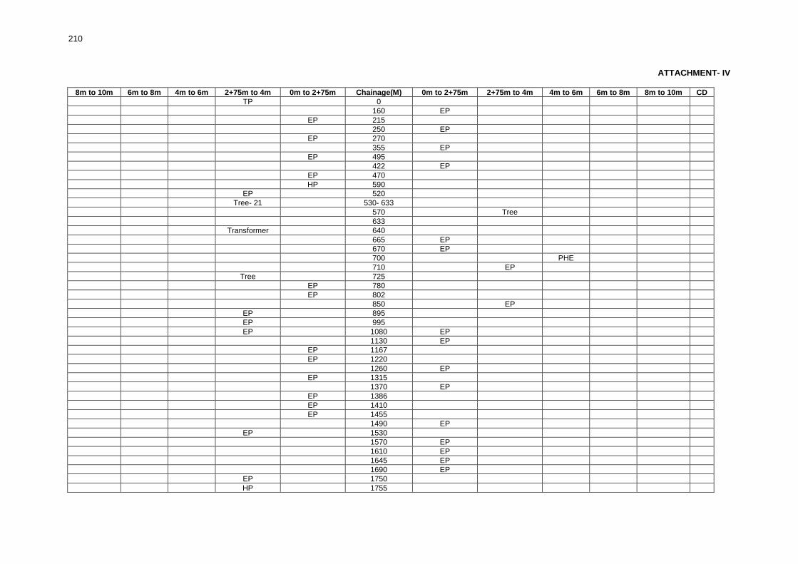
210
ATTACHMENT- IV
8m to 10m 6m to 8m 4m to 6m 2+75m to 4m 0m to 2+75m Chainage(M) 0m to 2+75m 2+75m to 4m 4m to 6m 6m to 8m 8m to 10m CD
TP 0
160 EP
EP 215
250 EP
EP 270
355 EP
EP 495
422 EP
EP 470
HP 590
EP 520
Tree- 21 530- 633
570 Tree
633
Transformer 640
665 EP
670 EP
700 PHE
710 EP
Tree 725
EP 780
EP 802
850 EP
EP 895
EP 995
EP 1080 EP
1130 EP
EP 1167
EP 1220
1260 EP
EP 1315
1370 EP
EP 1386
EP 1410
EP 1455
1490 EP
EP 1530
1570 EP
1610 EP
1645 EP
1690 EP
EP 1750
HP 1755

211
8m to 10m 6m to 8m 4m to 6m 2+75m to 4m 0m to 2+75m Chainage(M) 0m to 2+75m 2+75m to 4m 4m to 6m 6m to 8m 8m to 10m CD
1775 Transformer
1820 EP
EP 1925
EP 1950
EP 1990
EP 2040
EP 2050 EP
PO 2105 PO
EP, Tree 2110
2160 EP
2190 EP
EP 2250
2300
EP 2330
2400 EP
2440 EP
EP 2475
2530 EP
EP 2635
EP 2685
EP 2725 Tree
EP 2790
2870
3045 EP
Transformer 3055
EP 3090 Tree
EP 3110
EP 3150
EP 3201
3230 EP
3250 EP
EP 3275
EP 3325
EP 3390
3440 EP
3510 EP
3600 EP
3625 EP
TP 4015
EP 4040
EP 4090
TP 4120 EP
TP 4170 EP
4210 EP
EP 4215
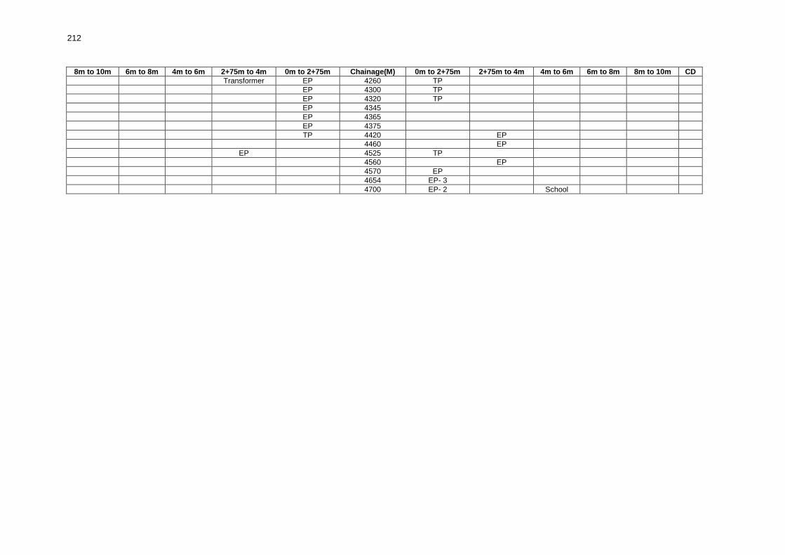
212
8m to 10m 6m to 8m 4m to 6m 2+75m to 4m 0m to 2+75m Chainage(M) 0m to 2+75m 2+75m to 4m 4m to 6m 6m to 8m 8m to 10m CD
Transformer EP 4260 TP
EP 4300 TP
EP 4320 TP
EP 4345
EP 4365
EP 4375
TP 4420 EP
4460 EP
EP 4525 TP
4560 EP
4570 EP
4654 EP- 3
4700 EP- 2 School

213
RURAL ROADS: ENVIRONMENTAL CHECKLIST
Road Name:HN31C to Parakota GF Office. Block Name: Alipurduar II District Name: Jalpaiguri Total Length of the Road: 6+779 Km Package No.: WB-10-ADB 42
A. Climatic Conditions
Temperature K. High:32°C low: 19°C
Humidity L. High: 90% low: 70%
Rainfall Rainy Season
3767 mm/year June to September
B. Location of the Road and Generic description of Environment
No. Type of Ecosystem Yes No Explanation
1. Coastal area Mangrove (along roadside)
√
The project road is far away from CRZ (Costal Regulation Zone)
2. Type of Terrain(Plain/Hilly/ Mountainous etc.) (Explain the topography of the area and how many km of the road are located in the hilly area)
√
Altitude:75m The project road passes through plain area.
3. Forest Area (Explain whether the road passes through forest areas or located along the forest areas and distance from shoulder to the forest area)?
√
The road does not pass through any forest area.
No secondary information is available and local community is not aware of this matter
4. Wildlife (Explain whether there are any wildlife species in the project area)
√
There is no wildlife as there is no forest area. Endangered species (if any): None
5. Inhabited Area √
Uttar Parokata, Madhya Parokata (East, West), DakshinParokata
6. Agricultural Land √ The major portion of the road has agricultural land on both sides except in the builtup area.
7. Grazing Grounds √ There is no grazing Ground in the project road
8. Barren Land √ There is no barren land
C. Specific description of the Road Environment
(Note: Questions number 1, 4, 5, 7 and 8 must be answered after discussions with the local community people)
No. Parameter/ Component Yes No Explanation
1. Are there any areas with landslide or erosion problems along the road? (If yes, indicate the location (right or left side) and the chainage)
√
There is no area along the project road is prone to landslide or erosion problems.
No secondary information is available and local community is not aware of this matter
2. Are there any lakes/swamps beside the road? (If yes, list them indicating the location (right or left side)and the chainage)
√
There is no lake / swamps falling by the side of the road but there aresome water bodies at Ch.1+500, 2+750, 4+600, 5+400, 5+900, 6+300 on LHS and 4+000, 4+370, 5+200, 5+850, 6+100, 6+200, 6+300, 6+400, 6+770 on RHS.

214
No. Parameter/ Component Yes No Explanation
3. Are there any nallas/streams/rivers etc. along/crossing the road? (If yes, list them indicating the location (right, left or crossing) and the chainage
√
There are some nallah/streams crossing the road at Ch. 0+320, 1+857, 2+415, 3+237, 4+535, 5+530, and 6+230.
4. Are there problems of water stagnation and other drainage issues on or near the road? (If yes, mention chainage)
√
There is no water stagnation area found in the project road.
No secondary information is available and local community is not aware of this matter
5. Is the area along the project road prone to flooding? (If yes, mention flood level and frequency)
√
The area along the project road is not flood prone.
No secondary information is available and local community is not aware of this matter
6. Are there any Trees with a dbh of 30 cm or more within 10 m on either side from the center line of the road alignment? \ (If yes attach list of Trees indicating the location (right or left side)and the chainage)
√
There are 166 Trees with dbh of 30m or more within 10m on either side of the alignment.
7. Along the road and within 100m of the road shoulder, are there any faunal habitat areas, faunal breeding Ground, bird migration area, or other similar areas? (If yes, specify details of habitat with chainage)
√
Along the road and within 100m of the road shoulder there is no faunal habitat areas faunal breeding Ground bird migration area or similar area.
No secondary information is available and local community is not aware of this matter
8. Along the road and within 100m of the road shoulder is there any evidence of floral and faunal species that are classified as endangered species?
√
Along the road and within 100m of the road shoulder there is no evidence of floral and faunal species that are classified as endangered species
9. Are there any utility structures30 within 10 m on either side from the centerline of the road alignment? (If yes, attach list with chainage)
√
There are (EP-32, HP-4, TP-3, Transformer-3) nos. on LHS and (EP-33, TP-4, HP-1, Transformer-2) on RHS within 10m on either side of the road alignment.
10. Are there any religious, cultural or community structures/buildings31 within 10 m on either side from the center line of the road alignment? (If yes attach list with chainage)
√
There are Schools at Ch. 2+273 on LHS and Ch. 5+525 on RHS and Temples at Ch.2+325, 2+682, 6+585 on RHS and at Ch. 6+338 on LHS. There are PHE’s at Ch. 0+815, 1+340 and 2+240 on RHS and a GP office at Ch. 6+755 on LHS.
D. Public Consultation
No. Consultation Activities Yes No Remarks
1. Consultation with local community was conducted before finalizing the alignment. (Attach list of people met and dates)
√
Consultation with local community was conducted before finalizing the alignment.
2. Any suggestion received in finalizing the alignment
√
Suggestions received during finalizing the alignment
3. If suggestions received, were they incorporated into the design?
√
It will be decided after consulting with respective PIU
Please attach the following: 1. List of Trees indicating location (left or right side of the road) and chainage (as required under C. 6). 2. List of utility structures indicating location (left or right side of the road) and chainage (as required under
C. 9).
30
Water tap, hand pump, electric pole, telephone pole, water pipe and other similar structures. 31
Mandir, Masjid, Church, religious/cultural/historical monuments, school, health center, public toilet and other similar
structures.

215
3. List of community structures indicating location (left or right side of the road) and chainage (as required under C. 10).
4. Sketch of strip map of the road covering details of atleast 10 m on either side from the center line of the road.
5. Photographs of the project area showing atleast 10 m on either side from center line of road alignment. Every 2 km or less of road must have atleast 1 photograph

216
ATTACHMENT- I List of Trees
Chainage
(M) Left (No.of
Trees) Right (No. of Trees)
Chainage (M)
Left (No.of Trees)
Right (No. of Trees)
85 Tree-1 3570 Tree-1
97 Tree-1 3580 Tree-1
103 Tree-1 3860 Tree-1
120 Tree-1 3975 - 4025 Tree-11
128 Tree-1 4152 Tree-1
132 Tree-1 4535 Tree-1
135 Tree-1 4540 Tree-1
141 Tree-1 4645 Tree-1
161 Tree-1 4652 Tree-1
146 Tree-1 4850 Tree-1
192 Tree-1 4870 Tree-1
270 Tree-1 5065 Tree-1
279 Tree-1 5070 Tree-1
300 Tree-1 5081 Tree-1
378 Tree-1 5087 Tree-1
382 Tree-1 5093 Tree-1
395 Tree-1 5100 Tree-1
396 Tree-1 5125 Tree-1
412 Tree-1 5150 Tree-1
415 Tree-1 5180 Tree-1
445 Tree-1 5204 Tree-1
900 Tree-1 5220 Tree-1
926 Tree-1 5410 Tree-1
935 Tree-2 5420 Tree-1
1125 Tree-1 5436 Tree-1
1130 Tree-1 5495 Tree-1
1135 Tree-1 5658 Tree-1
1138 Tree-1 5660 Tree-1
1142 Tree-1 5725 Tree-1
1155 Tree-1 5760 Tree-1
1222 Tree-1 5780 Tree-1
1278 Tree-1 5805 Tree-1
1546 Tree-1 5855 Tree-1
1595 Tree-1 5845 Tree-1
1604 Tree-1 5900 Tree-1
1608 Tree-1 5925 -5982 Tree-6
1613 Tree-1 6010 Tree-1
1625 Tree-1 6115 Tree-1
1650 -1700 Tree-14 6130 Tree-1
1720 Tree-1 6150 Tree-1
1735 Tree-1 6025 Tree-1
1750 Tree-1 6175 Tree-1
1765 Tree-1 6205 Tree-1
1815 Tree-1 6280 Tree-1
1905 Tree-1 6290 Tree-1
1915 Tree-1 6295 Tree-1
1930 Tree-1 6315 Tree-1
1973 Tree-1 6320 Tree-1
2075 -2120 Tree-1 Tree-26 6330 Tree-1
2165 Tree-1 6380 Tree-1
2180 Tree-1 6385 Tree-1
2232 Tree-1 6395 Tree-1
2254 Tree-1 6400 Tree-1
2280 Tree-1 6410 Tree-1
2348 Tree-1 6453 Tree-1
2355 Tree-1 6460 Tree-1
2374 Tree-1 6454 Tree-1
2376 Tree-1 6470 Tree-1
2444 Tree-1 6480 Tree-1
2455 Tree-1 6500 Tree-1
2680 Tree-1 6508 Tree-1
2700 Tree-1 6522 Tree-1

217
3240 Tree-1 6526 Tree-1
3300 Tree-1 6530 Tree-1
ATTACHMENT- I ATTACHMENT- II
List of Trees (Contd.) List of Utilities (Contd.)
Chainage (M)
Left (No.of Trees)
Right (No. of Trees)
Chainage(M) Left Right
6534 Tree-1 2846 EP
6538 Tree-1 3175 Transformer EP
6542 Tree-1 3200 EP
6546 Tree-1 3205 EP
6551 Tree-1 3240 EP
6566 Tree-1 3255 EP
6585 Tree-1 3285 EP
6605 Tree-1 3475 EP
6615 Tree-1 3590 EP
6338 Tree-1 5114 EP
6723 Tree-1 5170 EP
6770 Tree-1 5212 EP
6778 Tree-1 5240 EP
5278 EP
Attachment II 5320 EP
List of Sructures 5370 EP
Chainage(M) Left Right 5430 EP
3 EP 5480 EP
35 EP 5510 EP
146 EP 6380 EP
174 EP 6415 EP
215 EP 6453 EP
265 EP 6466 EP
290 HP 6518 EP
355 EP 6550 HP
405 EP 6615 TP
438 EP 6617 EP-2
790 Transformer 6660 EP
792 TP 6675 HP
865 EP 6708 EP
913 EP 6735 TP
935 EP
960 EP EP
974 EP Attachment III
984 EP List of Community Sructures
1000 EP Chainage(M) Left Right
1025 Transformer 815 PHE
1110 EP 1340 PHE
1156 EP 2240 PHE
1186 EP 2273 School
1125 EP 2325 Temple
1275 EP TP 2682 Temple
1316 EP 5525 Primary School
1338 EP 6585 Temple
1340 Transformer 6338 Temple
2210 HP 6755 GP Office
2220 Transformer
2240 TP
2273 EP
2285 TP
2310 EP
2348 EP
2390 EP
2415 TP
2431 EP EP
2484 EP
2500 EP
2511 EP
2534 EP
2585 EP
2595 EP

218
2680 EP
2760 EP
2827 HP

219
ATTACHMENT- IV 8m to 10m 6m to 8m 4m to 6m 2+75m to 4m 0m to 2+75m Chainage(M) 0m to 2+75m 2+75m to 4m 4m to 6m 6m to 8m 8m to 10m CD
3 EP
35 EP
Tree 85
97 Tree
103 Tree
Tree 120
128 Tree
132 Tree
Tree 135
141 Tree
161 Tree
Tree 146 EP
174 EP
192 Tree
Tree Tree 270
Tree Tree 279
Tree 300
Tree
396
EP 405
Tree 412
Tree 415
EP 438
Tree 445
Transformer 790
TP
792
815 PHE
818
865 EP
Tree 900
913 EP
926 Tree
EP 935 Tree Tree
EP 960 EP
974 EP
984 EP
1000 EP
1025 Transformer
1110 EP
1125 Tree
1130 Tree
1135 EP Tree
1138 Tree
1142 Tree
1155 Tree

220
8m to 10m 6m to 8m 4m to 6m 2+75m to 4m 0m to 2+75m Chainage(M) 0m to 2+75m 2+75m to 4m 4m to 6m 6m to 8m 8m to 10m CD
EP 1156
EP 1186
1222 Tree
1125 Bamboo, EP
EP 1275 TP
Tree 1278
1316 EP
1338 EP
Transformer 1340 PHE
Pond 1402
1545 Pond
1546 Tree
1595 Tree
1604 Tree
1608 Tree
1613 Tree
1625 Tree
1650 -1700 Tree-6 Tree-8
1720 Tree
1735 Tree
1750 Tree
1765 Tree
1815 Tree
1905 Tree
1915 Tree
1930 Tree
1973 Tree
Bamboo 1973 -2075
Tree 2075 -2120 Tree-26
Tree 2165
2180 Tree
HP 2210
2220
Transformer
Tree 2232
TP 2240 PHE
2254 Tree
School 2273 EP
Tree 2280
2285 TP TP
2310 EP
2325 Temple
2348 EP Tree
2355 Tree
Tree 2374
Tree 2376

221
8m to 10m 6m to 8m 4m to 6m 2+75m to 4m 0m to 2+75m Chainage(M) 0m to 2+75m 2+75m to 4m 4m to 6m 6m to 8m 8m to 10m CD
2390 EP
TP 2415
EP 2431 EP
2435
2444 Tree
2455 Tree
EP 2484
EP 2500
EP 2511
EP 2534
EP 2585
EP 2595
Tree
2680
2680 EP
2682 Temple
Tree 2700
2760 EP
HP 2827
2846 EP
Transformer 3175 EP
3200 EP
EP 3205
Tree, EP 3240
EP 3255
EP 3285
3300 Tree
3350 Pond
3475 EP
Tree 3570
3580 Tree
EP 3590
Bamboo 3600 - 3760
3860 Tree
3975 - 4025 Tree-11 Pond
4152 Tree
4535 Tree
4540 Tree
Tree 4645
Tree 4652
Tree 4850
Tree 4870
Tree 5065
Tree 5070
Tree 5081
Tree 5087
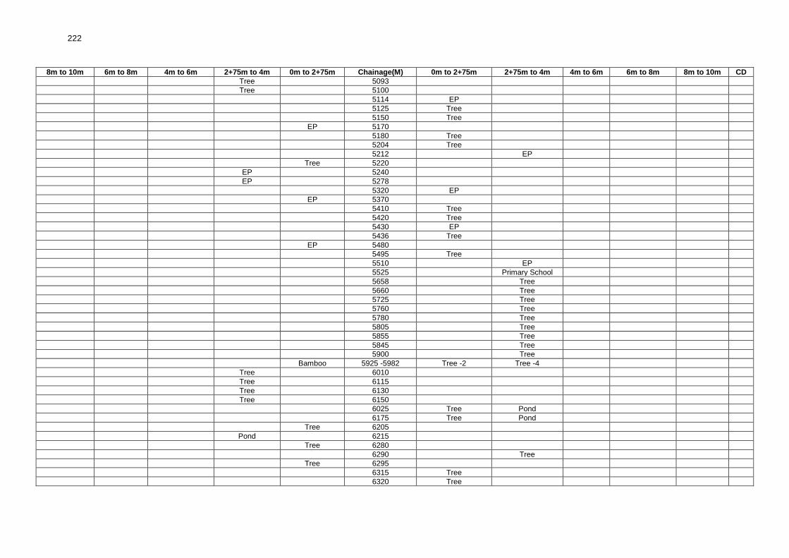
222
8m to 10m 6m to 8m 4m to 6m 2+75m to 4m 0m to 2+75m Chainage(M) 0m to 2+75m 2+75m to 4m 4m to 6m 6m to 8m 8m to 10m CD
Tree 5093
Tree 5100
5114 EP
5125 Tree
5150 Tree
EP 5170
5180 Tree
5204 Tree
5212 EP
Tree 5220
EP 5240
EP 5278
5320 EP
EP 5370
5410 Tree
5420 Tree
5430 EP
5436 Tree
EP 5480
5495 Tree
5510 EP
5525 Primary School
5658 Tree
5660 Tree
5725 Tree
5760 Tree
5780 Tree
5805 Tree
5855 Tree
5845 Tree
5900 Tree
Bamboo 5925 -5982 Tree -2 Tree -4
Tree 6010
Tree 6115
Tree 6130
Tree 6150
6025 Tree Pond
6175 Tree Pond
Tree 6205
Pond 6215
Tree 6280
6290 Tree
Tree 6295
6315 Tree
6320 Tree

223
8m to 10m 6m to 8m 4m to 6m 2+75m to 4m 0m to 2+75m Chainage(M) 0m to 2+75m 2+75m to 4m 4m to 6m 6m to 8m 8m to 10m CD
6330 Tree
EP 6380 Tree
6385 Tree
6395 Tree
6400 Tree
6410 Tree
EP 6415
EP EP 6453 Tree
6460 Tree
6454 Tree
EP 6466
6470 Tree
6480 Tree
6500 Tree
6508 Tree
EP 6518
6522 Tree
6526 Tree
6530 Tree
6534 Tree
6538 Tree
6542 Tree
6546 Tree
6550 HP
Tree 6551
Tree 6566
6585 Temple
6585 Tree
6605 Tree
Tree 6615 TP
6617 EP
Temple Tree 6338
EP 6660
HP 6675
6708 EP
Tree 6723 Pond
6735 TP
GP Office 6755
6770
Tree
6779 Tree

224
RURAL ROADS: ENVIRONMENTAL CHECKLIST Road Name: Atgama to Mobarakpur Block Name: English Bazar District Name: Malda Total Length of the Road: 7+503 Km Package No.: WB-11-ADB 27
A. Climatic Conditions
Temperature M. High:32°C low: 19°C
Humidity N. High: 90% low: 70%
Rainfall Rainy Season
3767 mm/year June to September
B. Location of the Road and Generic description of Environment
No. Type of Ecosystem Yes No Explanation
1. Coastal area Mangrove (along roadside)
√
The project road is far away from CRZ (Costal Regulation Zone)
2. Type of Terrain(Plain/Hilly/ Mountainous etc.) (Explain the topography of the area and how many km of the road are located in the hilly area)
√
Altitude:400m The project road passes through plain area.
3. Forest Area (Explain whether the road passes through forest areas or located along the forest areas and distance from shoulder to the forest area)?
√
The road does not pass through any forest area.
No secondary information is available and local community is not aware of this matter
4. Wildlife (Explain whether there are any wildlife species in the project area)
√
There is no wildlife as there is no forest area. Endangered species (if any): None
5. Inhabited Area √ Keotal, Palaibari North, Palaibari South, Belul, Dohal
6. Agricultural Land
√
The major portion of the road passes through agricultural land on both sides.
7. Grazing Grounds √ There is no grazing Ground in the project road
8. BarrenLand √ There is no barren land
C. Specific description of the Road Environment
(Note: Questions number 1, 4, 5, 7 and 8 must be answered after discussions with the local community people)
No. Parameter/ Component Yes No Explanation
1. Are there any areas with landslide or erosion problems along the road? (If yes, indicate the location (right or left side) and the chainage)
√
There is no area along the project road is prone to landslide or erosion problems
No secondary information is available and local community is not aware of this matter
2. Are there any lakes/swamps beside the road? (If yes, list them indicating the location (right or left side)and the chainage)
√
There is no lake / swamps / other than water bodies found by the side of the road at Ch. 0+667, 1+158, 1+475, 1+781 and 1+970 on LHS and at Ch. 0+078, 0+138, 0+599, 0+860, 0+994 and 1+422 on RHS
3. Are there any nallas/streams/rivers etc. along/crossing the road? (If yes, list them indicating the location (right, left or crossing) and the chainage
√
There isstream / nallahcrossing on the alignment at Ch.0+205, 0+760, 0+829, 1+205, 1+656, 2+125, 2+325, 2+874, 3+105, and 3+450
4. Are there problems of water stagnation and other drainage issues on or near the road? (If yes, mention chainage)
√
There is no water stagnation area found in the project road.
No secondary information is available and local community is not aware of this matter

225
No. Parameter/ Component Yes No Explanation
5. Is the area along the project road prone to flooding? (If yes, mention flood level and frequency)
√
The area along the project road is not flood prone.
No secondary information is available and local community is not aware of this matter
6. Are there any Trees with a dbh of 30 cm or more within 10 m on either side from the center line of the road alignment? \ (If yes attach list of Trees indicating the location (right or left side)and the chainage)
√
There are 252 Trees with dbh of 30m or more within 10m on either side of the alignment.
7. Along the road and within 100m of the road shoulder, are there any faunal habitat areas, faunal breeding Ground, bird migration area, or other similar areas? (If yes, specify details of habitat with chainage)
√
Along the road and within 100m of the road shoulder there is no faunal habitat areas faunal breeding Ground bird migration area or similar area.
No secondary information is available and local community is not aware of this matter
8. Along the road and within 100m of the road shoulder is there any evidence of floral and faunal species that are classified as endangered species?
√
Along the road and within 100m of the road shoulder there is no evidence of floral and faunal species that are classified as endangered species
9. Are there any utility structures1 within 10 m on either side from the center line of the road alignment? (If yes, attach list with chainage)
√
There are (EP-12, TP-3, TF-1)nos. on LHS and (EP-22, TP-5, Tubewell-1) nos. on RHS of utility structures within 10m on either side of the road alignment.
10. Are there any religious, cultural or community structures/buildings2 within 10 m on either side from the center line of the road alignment? (If yes attach list with chainage)
√
There is a School at Ch. 0+200 on LHS and graveyard at Ch.0+700 on the LHS.
D. Public Consultation
No. Consultation Activities Yes No Remarks
1. Consultation with local community was conducted before finalizing the alignment. (Attach list of people met and dates)
√
Consultation with local community was conducted before finalizing the alignment.
2. Any suggestion received in finalizing the alignment
√
Suggestions received during finalizing the alignment
3. If suggestions received, were they incorporated into the design?
√
It will be decided after consulting with respective PIU
Please attach the following: 1. List of Trees indicating location (left or right side of the road) and chainage (as required under C. 6). 2. List of utility structures indicating location (left or right side of the road) and chainage (as required under
C. 9). 3. List of community structures indicating location (left or right side of the road) and chainage (as required
under C. 10). 4. Sketch of strip map of the road covering details of atleast 10 m on either side from the center line of the
road. 5. Photographs of the project area showing atleast 10 m on either side from center line of road alignment.
Every 2 km or less of road must have atleast 1 photograph
1 Water tap, hand pump, electric pole, telephone pole, water pipe and other similar structures. 2 Mandir, Masjid, Church, religious/cultural/historical monuments, school, health center, public toilet and other similar structures.

226
ATTACHMENT- I
List of Trees
Chainage (M)
Left (No.of Trees)
Right (No. of Trees)
Chainage(M) Left Right
100 5300 Tree-4 Tree-1
200 5400 Tree-1 Tree-1
300 Tree-1 Tree-2 5500 Tree-6
400 Tree-1 Tree-4 5600 Tree-1 Tree-4
500 Tree-1 Tree-1 5700 Tree-3
600 Tree-5 Tree-5 5800 Tree-4
700 Tree-3 5900
800 Tree-4 Tree-4 6000 Tree-1
900 Tree-2 Tree-3 6100
1000 Tree-5 6200
1100 6300
1200 Tree-3 Tree-2 6400 Tree-2
1300 Tree-4 Tree-2 6500 Tree-2 Tree-2
1400 Tree-5 6600 Tree-2 Tree-1
1500 Tree-5 6700
1600 Tree-1 6800 Tree-1
1700 Tree-5 Tree-1 6900 Tree-1 Tree-2
1800 Tree-3 Tree-4 7000 Tree-1 Tree-1
1900 Tree-2 Tree-4 7100
2000 Tree-6 Tree-4 7200 Tree-4 Tree-4
2100 Tree-7 Tree-2 7300 Tree-1
2200 Tree-5 Tree-4 7400
2300 Tree-7 Tree-2 7503
2400 Tree-2 Tree-2
2500 Tree-1 Tree-4 Attachment II
2600 Tree-4 Tree-1 List of Utilities
2700 Tree-2 Chainage(M) Left Right
2800 Tree-2 Tree-3 100 EP-2, TP-2
2900 Tree-1 Tree-1 200 EP-2 EP-1, TP-1
3000 300 EP-2 EP-1
3100 400 EP-4
3200 Tree-1 Tree-3 500 TF EP-3
3300 Tree-4 600 EP-1 EP-1, Tubewell
3400 Tree-1 1000 TP-3
3500 Tree-1 4600 EP-3, TP-1
3600 Tree-1 4700 EP-1 EP-1
3700 4800 EP-1 EP-1, TP-1
3800 4900
3900 Tree-3 5000 EP-2
4000 Tree-1 Tree-2 5100 EP-2
4100 Tree-2 5200 EP-1 EP-1
4200 Tree-3 5300 EP-1
4300 Tree-2 Tree-2 5700 EP-1
4400 Tree-2 Tree-5 7200 EP-1
4500 Tree-4 Tree-1 7500 EP-1
4600 Tree-3
4700 Attachment III
4800 List of Community Structures
4900 Tree-1 Chainage(M) Left Right
5000 Tree-5 Tree-2 200 Graveyard
5100 Tree-3 700 School
5200 Tree-6 Tree-2

227
ATTACHMENT- IV
8m to 10m 6m to 8m 4m to 6m 2+75m to 4m 0m to 2+75m Chainage(M) 0m to 2+75m 2+75m to 4m 4m to 6m 6m to 8m 8m to 10m CD
100 EP EP, TP-2
EP-2 School 200 EP TP-1
Tree-1, EP EP 300 Tree-2, EP-1
Tree-1, EP-3 EP 400 Tree-4
Tree-1 TF 500 EP-3 Tree-1 Tree-4 Tree-1, EP-1 600 EP-1 Tree-1 Tree-4
Graveyard 700 Tubewell Tree-3
Tree-4 800 Tree-2 Tree-2
Tree-2 900 Tree-3
Tree-5 TP-3 1000
1100
Tree-3 1200 Tree-2
Tree-4 1300 Tree-2
Tree-5 1400
Tree-5 1500
Tree-1 1600
Tree-3 Tree-2 1700 Tree-1
Tree-3 1800 Tree-2 Tree-2
Tree-2 1900 Tree-1 Tree-3
Tree-6 2000 Tree-4
Tree-6 2100 Tree-2
Tree-5 2200 Tree-4
Tree-4 Tree-2 Tree-1 2300 Tree-2
Tree-2 2400 Tree-2
Tree-1 2500 Tree-4
Tree-4 2600 Tree-1
Tree-2 2700
Tree-2 2800 Tree-3
Tree-1 2900 Tree-1
3000
3100
Tree-1 3200 Tree-3
Tree-2 Tree-2 3300
Tree-1 3400
Tree-1 3500
Tree-1 3600
3700
3800
3900 Tree-3
Tree-1 4000 Tree-2
Tree-2 4100
4200 Tree-3

228
8m to 10m 6m to 8m 4m to 6m 2+75m to 4m 0m to 2+75m Chainage(M) 0m to 2+75m 2+75m to 4m 4m to 6m 6m to 8m 8m to 10m CD
Tree-2 4300 Tree-2
Tree-2 4400 Tree-5
Tree-4 4500 Tree-1
4600 EP-3 Tree-3, TP-1
EP-1 4700 EP-1
EP-1 4800 EP-1, TP-1
Tree-1 4900
Tree-5 5000 EP-2 Tree-2
Tree-3 5100 EP-2
Tree-4 Tree-2, EP-1 5200 Tree-2, EP-1
Tree-4 5300
Tree-1
Tree-1 5400 Tree-1
5500
Tree-6
Tree-1 5600 Tree-4
5700
Tree-3
5800 Tree-4
5900
Tree-1 6000
6100 EP
6200
6300
6400 Tree-2
Tree-2 6500 EP Tree-2
Tree-2 6600 Tree-1
6700
6800 Tree-1
Tree-1 6900 Tree-2
Tree-1 7000 Tree-1
7100
Tree-4 7200 EP-1 Tree-4
7300 Tree-1
7400
7503 EP-1

229
RURAL ROADS: ENVIRONMENTAL CHECKLIST
Road Name :Uzani to Pakaibari Block Name: Itahar District Name:Uttar Dinajpur Total Length of the Road: 4.171 Km Package No.: WB-15-ADB 21
A. Climatic Conditions
Temperature O. High:37°C low:8°C
Humidity P. High: 81% low: 43%
Rainfall Rainy Season
1970 mm/year June to September
B. Location of the Road and Generic description of Environment
No. Type of Ecosystem Yes No Explanation
1. Coastal area Mangrove (along roadside)
√
The project road is far away from CRZ (Costal Regulation Zone)
2. Type of Terrain(Plain/Hilly/ Mountainous etc.) (Explain the topography of the area and how many km of the road are located in the hilly area)
√
Altitude:53 m The project road passes through plain land
3. Forest Area (Explain whether the road passes through forest areas or located along the forest areas and distance from shoulder to the forest area)?
√
The road does not pass through any forest area.
4. Wildlife (Explain whether there are any wildlife species in the project area)
√
There is no wildlife as there is no forest area. Endangered species (if any): None
5. Inhabited Area √
Keotal, Palaibari North, Palaibari South, Belal & Dohal
6. Agricultural Land √ The road is passing through agricultural land
7. Grazing Grounds √ There is no grazing Ground in the project road
8. Barren Land √ There is no barren land
C. Specific description of the Road Environment
(Note: Questions number 1, 4, 5, 7 and 8 must be answered after discussions with the local community people)
No. Parameter/ Component Yes No Explanation
1. Are there any areas with landslide or erosion problems along the road? (If yes, indicate the location (right or left side) and the chainage)
√
The area along the project road is not prone to landslide or erosion problems
No secondary information is available and local community is not aware of this matter
2. Are there any lakes/swamps beside the road? (If yes, list them indicating the location (right or left side)and the chainage)
√
There is no lake / swamps except other water bodies like Pond falling by the side of the road at km0+078, 0+138, 0+600, 0+860, 0+994 and 1+429on RHS and at km0+667, 1+158, 1+475, 1+781and 1+970 on LHS
3. Are there any nallas/ streams/ rivers etc. along/crossing the road? (If yes, list them indicating the location (right, left or crossing) and the chainage
√
There are somecross drainage (nallas) at km. 0+205, 0+829, 1+205 and 2+125.
4. Are there problems of water stagnation and other drainage issues on or near the road?
There is no water stagnation area found in the project road.

230
No. Parameter/ Component Yes No Explanation
(If yes, mention chainage)
√ No secondary information is available and local community is not aware of this matter
5. Is the area along the project road prone to flooding? (If yes, mention flood level and frequency)
√
The area along the project road is not flood prone.
No secondary information is available and local community is not aware of this matter
6. Are there any Trees with a dbh of 30 cm or more within 10 m on either side from the center line of the road alignment? \ (If yes attach list of Trees indicating the location (right or left side)and the chainage)
√
There are 170 Trees and social forestry with dbh of 30cm or more within 10m on either side of the alignment.
7. Along the road and within 100m of the road shoulder, are there any faunal habitat areas, faunal breeding Ground, bird migration area, or other similar areas?
(If yes, specify details of habitat with chainage)
√
Along the road and within 100m of the road shoulder there is no faunal habitat areas faunal breeding Ground bird migration area or similar area.
No secondary information is available and local community is not aware of this matter
8. Along the road and within 100m of the road shoulder is there any evidence of floral and faunal species that are classified as endangered species?
√
Along the road and within 100m of the road shoulder there is no evidence of floral and faunal species that are classified as endangered species
No secondary information is available and local community is not aware of this matter
9. Are there any utility structures1 within 10 m on either side from the center line of the road alignment? (If yes, attach list with chainage)
√
There are (EP-49, TP-1, TW - 2) nos. on LHS and (EP-39, TF-6) nos.on RHS of utility structures within 10m on either side of the road alignment.
10. Are there any religious, cultural or community structures/ buildings2 within 10 m on either side from the center line of the road alignment? (If yes attach list with chainage)
√
There are one Madrasa school at Ch. 1+750 on RHS, one GP office at0+467 on RHS, one Mosque at Ch 0+327 on RHS, one Temple at CH 1+562 on LHS and three graveyards at Ch. 1+565, 2+034 & 4+126 on RHS, respectively.
D. Public Consultation
No. Consultation Activities Yes No Remarks
1. Consultation with local community was conducted before finalizing the alignment.
√
Consultation with local community was conducted before finalizing the alignment.
2. Any suggestion received in finalizing the alignment
√ Suggestions received during finalizing the alignment
3. If suggestions received, were they incorporated into the design?
√
It will be decided after consulting with respective PIU
Please attach the following: 1. List of Trees indicating location (left or right side of the road) and chainage (as required under C. 6). 2. List of utility structures indicating location (left or right side of the road) and chainage (as required under
C. 9). 3. List of community structures indicating location (left or right side of the road) and chainage (as required
under C. 10). 4. Sketch of strip map of the road covering details of atleast 10 m on either side from the center line of the
road. 5. Photographs of the project area showing atleast 10 m on either side from center line of road alignment.
Every 2 km or less of road must have atleast 1 photograph
1 Water tap, hand pump, electric pole, telephone pole, water pipe and other similar structures.
2 Mandir, Masjid, Church, religious/cultural/historical monuments, school, health center, public toilet and other similar
structures.

231
Attachment I Attachment II List of Trees List of Utilities
Chainage (M)
Left (No. of Trees)
Right (No. of Trees)
Chainage (M) Left Right
13 Tree-1 0 EP
19 Tree-6 22 EP
43 Tree-1 84 EP
177 Tree-1 117 EP
327 Tree-3 215 EP
467 Tree-1 268 EP
474 Tree-2 308 EP
722 Tree-1 371 EP
986 Tree-4 400 EP
1000 Tree-3 429 EP Transformer
1046 Tree-3 458 EP
1058 Tree-2 496 EP
1069 Tree-1 519 EP
1081 Tree-1 673 EP
1100 Tree-2 722 EP
1410 Tree-1 772 EP EP
1427 Tree-1 823 EP EP
1433 Tree-1 Tree-1 939 EP
1445 Tree-1 986 EP
1452 Tree-1 1000 EP
1562 Tree-3 1046 EP
1582 Tree-1 Tree-2 1093 EP EP
1597 Tree-1 1100 EP
1611 Tree-1 1154 EP EP
1825 Tree-6 Tree-1 1157 EP
1867 Tree-2 1220 EP EP
1942 Tree-4 1277 EP EP
1949 Tree-1 1427 Transformer
2034 Tree-2 1433 EP
2118 Tree-7 1503 EP EP
2154 Tree-3 1524 EP EP-2
2265 Tree-1 1555 EP-2
2286 Tree-2 Tree-7 1565 EP
2327 Tree-1 1573 EP
2407 Tree-6 Tree-3 1602 EP, Transformer
2529 Tree-1 1609 TP
2558 Tree-1 1778 EP-2
2645 Tree-3 1825 EP
2733 Tree-1 Tree-1 1867 EP
3148 Tree-2 Tree-1 1896 TW
3267 Tree-2 1907 EP
3270 Tree-1 1940 Transformer
3532 Tree-2 1942 EP
3585 Tree-4 2118 EP
3593 Tree-4 Tree-1 2154 TW
3627 Tree-1 2171 EP-2
3664 Tree-7 2278 EP Transformer
3666 Tree-1 2327 EP-2
3688 Tree-5 Tree-3 2335 EP
3695 Tree-3 Tree-2 2474 EP
3715 Tree-4 Tree-3 2529 EP
3752 Tree-7 2532 EP EP
3903 Tree-4 Tree-5 2570 EP, Transformer
3953 Tree-4 Tree-2 2573 EP
4060 Tree-2 2645 EP
4124 Tree-1 2733 EP
4145 Tree-1 3148 EP
3267 EP EP
3270 EP
3532 EP
3585 EP
3627 EP EP
3664 EP-2
3666 EP

232
Chainage (M)
Left (No. of Trees)
Right (No. of Trees)
Chainage (M) Left Right
3715 EP
3752 EP
3803 EP
Attachment II List of Utilities (Contd.)
Chainage(M) Left Right
3853 EP
3903 EP
3953 EP
3997 EP
4045 EP
4060 EP
4086 EP
4124 EP-2
4162 EP
Attachment III
List of Community Structures Chainage (M) Left Right
327 Mosque
335 Edgah
467 GP Office
1562 Temple
1565 Graveyard
1750 Madrasa
2034 Graveyard
4126 Graveyard

233
Attachment IV
8m to 10m 6m to 8m 4m to 6m 2.75m to 4m 0m to 2.75m Chainage (M) 0m to 2.75m 2.75m to 4m 4m to 6m 6m to 8m 8m to 10m CD
EP 0
Tree-1 13
Tree-6 19
EP+TR 22
Tree-1 43
84 EP
117 EP
177 Tree-1
205 CD
EP 215
268 EP
EP 308
Mosque 327 Tree-3
335 Edgah
EP 371
EP 400
EP 429 Transformer
EP 458
467 Tree-1 GP Office
474 Tree-1 Tree-1
EP 496
EP 519
EP 673
EP 722 Tree-1
760 CD
EP 772
EP 823 EP
829 CD
939 EP
Tree-4 986 EP
EP 1000 Tree-3
EP 1046 Tree-2 Tree-1
1058 Tree-1 Tree-1
1069 Tree-1
1081 Tree-1
EP 1093 EP
1100 Tree-1 Tree-1 EP
EP 1154 EP
EP 1157
1205 CD
EP 1220 EP
EP 1277 EP
1410 Tree-1
1427 Tree-1 Transformer

234
8m to 10m 6m to 8m 4m to 6m 2.75m to 4m 0m to 2.75m Chainage (M) 0m to 2.75m 2.75m to 4m 4m to 6m 6m to 8m 8m to 10m CD
Tree-1, EP 1433 Tree-1
1445 Tree-1
1452 Tree-1
EP 1503 EP
EP 1524 EP EP
EP EP 1555
Temple 1562 Tree-3
EP 1565 Graveyard
EP 1573
Tree-1 1582 Tree-2
Tree-1 1597
1602 EP Transformer
TP 1609
Tree-1 1611
1656 CD
1750 Madrasa
Temple 1778 EP-2
Tree-6 EP 1825 Tree-1
Tree-2, EP 1867
TW 1896
EP 1907
1940 Transformer
Tree-4 1942 EP
Tree-1 1949
2034 Tree-2,
Graveyard
Tree-3 Tree-4 2118 EP
2125 CD
TW 2154 Tree-3
EP EP 2171
2265 Tree-1
EP 2278 Transformer
Tree-1 Tree-1 2286 Tree-7
2325 CD
EP-2 2327 Tree-1
EP 2335
Tree-6 2407 Tree-3
EP 2474
EP 2529 Tree-1
EP 2532 EP
Tree-1 2558
2570 EP
Transformer
2573 EP
EP 2645 Tree-3
EP Tree-1 2733 Tree-1
2874 CD
3015 CD

235
8m to 10m 6m to 8m 4m to 6m 2.75m to 4m 0m to 2.75m Chainage (M) 0m to 2.75m 2.75m to 4m 4m to 6m 6m to 8m 8m to 10m CD
Tree-2 3148 Tree-1 EP
EP 3267 EP Tree-2
EP Tree-1 3270
3450 CD
Tree-2 3532 EP
3585 EP Tree-4, EP
Tree-4
3593 Tree-1
Tree-1 EP 3627 EP
Tree-3 Tree-4 3664 EP EP
Tree-1 3666 Tree-1 EP
Tree-3 Tree-2 3688 Tree-1 Tree-3
Tree-2 Temple Tree-1 3695 Tree-2
Tree-4 EP 3715 Tree-3
Tree-7 3752 EP
EP 3803
EP 3853
Tree-4 3903 EP Tree-5
Tree-4 EP 3953 Tree-2
3997 EP EP
4045 EP
Tree-2 4060 EP Tree-1
EP 4086 EP
4124 EP
Tree-1, EP
4126 Graveyard
4145 Tree-1
EP 4162

236
Appendix 1.3: Photo Illustration of Sample Roads
Photo 1: Road in North 24 Pgs- Mathura to Bodai Purba considered for upgradation
Photo 2: Public consultation at Bodai Gram Panchyat
Photo 3: Ponds near road Mathura to Bodai Purba
Photo 4: Dakshin Nayabad to Patharghata Bazar Road at North 24 Pgs
Photo 5: Public consultation at Patharghata GP
Photo 6: Road in North 24 Pgs -Teghoria Dakshin to Balipur Dakshin considered for upgradation

237
Photo 7: Public consultation in the road Teghoria Dakshin to Balipur Dakshin
Photo 8: Road stretch Teghoria Dakshin to Sankargachi Purba
Photo 9: Road stretch Mollapara to Uttar chakla in North 24 Pgs
Photo 10: Water stagnation on road Mollapara to Uttar chakla in North 24 Pgs
Photo 11: School near Mollapara to Uttar chakla
Photo 12: Road stretch Taranipur Purba to Sarapul Bazar- pond nearby the road

238
Photo 13: Uttar Lakshmipur to Tamaghata Bazar road at Burdwan
Photo 14: Public consultation at Uttar Lakshmipur to Tamaghata Bazar road at Burdwan
Photo 15: Road stretch Belia to Shyamnagar at Bankura
Photo 16: Temple near road Belia to Shyamnagar
Photo 17: Road stretch Pratapchak to Barakhelna in Pashim Medinipore
Photo 18: Public consultation at GP in Pashim Medinipore

239
Photo 19: Road - T04_Uttar Brindaban Chack to Uttar Narayan Pakuria at Purba Medinipore – Plantation near road noted
Photo 20: Road stretch Gopinathpur to Kotaijiageria in Pashim Medinipore
Photo 21: Public consultation at Gramraj GP for Gopinathpur to Kotaijiageria road in Pashim Medinipore
Photo 22: Temple away from the impact zone in the road Pratapchak to Barakhelna at Pashim Medinipore

240
Appendix 4.1: Guidelines for Borrow Areas Management
I. SELECTION OF BORROW AREAS
1. Location of borrow areas shall be finalized as per IRC: 10-1961guidlines. The finalization of locations in case of borrows areas identified in private land shall depend upon the formal agreement between landowners and contractor. If, agreement is not reached between the contractor and landowners for the identified borrow areas sites, arrangement for locating the source of supply of material for embankment and sub-grade as well as compliance to environment requirements in respect of excavation and borrow areas as stipulated from time to time by the Ministry of Environment and Forests, GoI, and local bodies, as applicable shall be the sole responsibility of the contractor.
2. The contractor in addition to the established practices, rules and regulation will also consider following criteria before finalizing the locations.
• The borrow area should not be located in agriculture field unless unavoidable i.e. barren land is not available.
• The borrow pits preferably should not be located along the roads.
• The loss of productive and agriculture soil should be minimum.
• The loss of vegetation is almost nil or minimum.
• The Contractor will ensure that suitable earth is available.
II. CONTRACTOR’S RESPONSIBILTY
3. The Contractor shall obtain representative samples from each of the identified borrow areas and have these tested at the site laboratory following a testing programme approved by the Engineer. It shall be ensured that the sub-grade material when compacted to the density requirements shall yield the design CBR value of the sub-grade. Contractor shall begin operations keeping in mind following:
• Haulage of material to embankments/ other areas of fill shall proceed only when sufficient spreading and compaction plants operating at the place of deposition.
• No excavated acceptable material other than surplus to requirements of the Contract shall be removed from the site. Contractor should be permitted to remove acceptable material from the site to suit his operational procedure, then shall make consequent deficit of material arising there from.
• Where the excavation reveals a combination of acceptable and un-acceptable materials, the Contractor shall, unless otherwise agreed by the Engineer, carry out the excavation in a manner that the acceptable materials are excavated separately for use in the permanent works without contamination by the unacceptable materials. The acceptable material shall be stockpiled separately.
• The Contractor shall ensure that he does not adversely affect the stability of excavation or fills by the methods of stockpiling materials, use of plants are siting of temporary buildings or structures.

241
III. BORROWING FROM DIFFERENT LAND FORMS A. Borrow Areas located in Agricultural Lands
(i) The preservation of topsoil will be carried out in stockpile.
(ii) A 15 cm topsoil will be stripped off from the borrow pit and this will be stored in stockpiles in a designated area for height not exceeding 2 m and side slopes not steeper than 1:2 (Vertical: Horizontal).
(iii) Borrowing of earth will be carried out up to a depth of 1.5 m from the existing ground level.
(iv) Borrowing of earth will not be done continuously through out the stretch.
(v) Ridges of not less than 8 m widths will be left at intervals not exceeding 300 m.
(vi) Small drains will be cut through the ridges, if necessary, to facilitate drainage.
(vii) The slope of the edges will be maintained not steeper than 1:4 (vertical: Horizontal).
(viii) The depth of borrow pits will not be more than 30 cm after stripping the 15 cm topsoil aside.
B. Borrow Areas located in Elevated Lands
(i) The preservation of topsoil will be carried out in stockpile.
(ii) A 15 cm topsoil will be stripped off from the borrow pit and this will be stored in stockpiles in a designated area for height not exceeding 2m and side slopes not steeper than 1:2 (Vertical: Horizontal).
(iii) At location where private owners desire their fields to be levelled, the borrowing shall be done to a depth of not more than 1.5m or up to the level of surrounding fields.
C. Borrow Areas near River side
(i) The preservation of topsoil will be carried out in stockpile.
(ii) A 15 cm topsoil will be stripped off from the borrow pit and this will be stored in stockpiles in a designated area for height not exceeding 2m and side slopes not steeper than 1:2 (Vertical: Horizontal).
(iii) Borrow area near to any surface water body will be at least at a distance of 15m from the toe of the bank or high flood level, whichever is maximum.
D. Borrow Areas near Settlements
(i) The preservation of topsoil will be carried out in stockpile.
(ii) A 15 cm topsoil will be stripped off from the borrow pit and this will be stored in stockpiles in a designated area for height not exceeding 2m and side slopes not steeper than 1:2 (Vertical: Horizontal).
(iii) Borrow pit location will be located at least 0.75 km from villages and settlements. If un-avoidable, the pit will not be dug for more than 30 cm and drains will be cut to facilitate drainage.

242
(iv) Borrow pits located in such location will be re-developed immediately after borrowing is completed. If spoils are dumped, that will be covered with a layers of stockpiled topsoil in accordance with compliance requirements with respect MOEF/PPCB guidelines.
IV. Borrow Pits along the Road
4. Borrow pits along the road shall be discouraged and if deemed necessary and permitted by the Engineer; following precautions are recommended:
(i) The preservation of topsoil will be carried out in stockpile.
(ii) A 15 cm topsoil will be stripped off from the borrow pit and this will be stored in stockpiles in a designated area for height not exceeding 2 m and side slopes not steeper than 1:2 (Vertical: Horizontal).
(iii) Ridges of not less than 8m widths should be left at intervals not exceeding 300 m.
(iv) Small drains shall be cut through the ridges of facilitate drainage.
(v) The depth of the pits shall be so regulated that there bottom does not cut an imaginary line having a slope of 1 vertical to 4 horizontal projected from the edge of the final section of bank, the maximum depth of any case being limited to 1.5 m.
(vi) Also, no pit shall be dug within the offset width from the toe of the embankment required as per the consideration of stability with a minimum width of 10 m.
V. REHABILITATION OF BORROW AREAS
5. The objective of the rehabilitation programme is to return the borrow pit sites to a safe and secure area, which the general public should be able to safely enter and enjoy. Securing borrow pits in a stable condition is fundamental requirement of the rehabilitation process. This could be achieved by filling the borrow pit floor to approximately the access road level.
6. Re-development plan shall be prepared by the Contractor before the start of work inline with the owners will require and to the satisfaction of owner. The Borrow Areas shall be rehabilitated as per following;
• Borrow pits shall be backfilled with rejected construction wastes and will be given a vegetative cover. If this is not possible, then excavation sloped will be smoothed and depression will be filled in such a way that it looks more or less like the original round surface.
• Borrow areas might be used for aquaculture in case landowner wants such development. In that case, such borrow area will be photographed after their post use restoration and Environment Expert of Supervision Consultant will certify the post use redevelopment.
7. The Contractor will keep record of photographs of various stages i.e., before using materials from the location (pre-project), for the period borrowing activities (construction Phase) and after rehabilitation (post development), to ascertain the pre and post borrowing status of the area.

243
Appendix 4.2: Impacts on Biological Environment, Utility, Community and Religious Structures- All Roads Under Tranche II
Sl No.
District Package Block Name of Road Length
(km)
Passing through Forest Area
Need for Utility
shifting* (EP, TP, HP etc.)
No. of trees
affected
Religious &
community Structures
Presence of Water Body (River/Lake)
1 2 3 4 5 6 7 8 9 10 11
1 North 24 Parganas
WB-01-ADB 47 Amdanga Durlavpur to Srirampur 5.09 No Nil Nil Nil Nil
2 North 24 Parganas
WB-01-ADB 100 Amdanga Rahana More to Panchghoria West
3.240 No Nil Nil Nil Nil
3 North 24 Parganas
WB-01-ADB 101 Amdanga Urla East to Sadhanpur 6.648 No EP-8 (LHS),
EP-16 (RHS), TF-1 (LHS)
4 Nil Nil
4 North 24 Parganas
WB-01-ADB 114 Amdanga Mathura to Bodai Purba 2.424 No EP-17, TP-5, HP-1, TF-1
9 Nil Nil
5 North 24 Parganas
WB-01-ADB 48 Baduria Narayanpur to Jadurhati Hospital
4.744 No EP-3 (LHS), TP-1 (LHS)
3 Nil Nil
6 North 24 Parganas
WB-01-ADB 78 Baduria Iswarigachha to Kolsur Madhya (upto Mamudpur)
8.187 No EP-4 (LHS), EP-1 (RHS), TF-1 (LHS)
3 Nil Nil
7 North 24 Parganas
WB-01-ADB 106 Baduria Jasaikhati Atghara GP to Atghara Monmdal Para
6.343 No Nil Nil Nil Nil
8 North 24 Parganas
WB-01-ADB 82 Bagdah Helencha Paschim Para to Patkelpota
10.637 No EP-7 (LHS), TP-3 (LHS)
30 Nil Nil
9 North 24 Parganas
WB-01-ADB 83 Bagdah
Helencha to beara Dakshin
6.721 No EP-4 (LHS), EP-2 (RHS), TP-2 (LHS)
1 Nil Pond-1
10 North 24 Parganas
WB-01-ADB 56 Bagdah Khorda Kulberia to
Bagdah Bazar BDO Office 9.294 No Nil 1 Nil Nil
11 North 24 Parganas
WB-01-ADB 62 Barasat -I Raghubirpur Purbapara to Bora Paschim
6.344 No EP-1 (LHS) Nil Nil Nil
12 North 24 Parganas
WB-01-ADB 105 Barasat- I Kalianai Purbapara to
Kilispur Paschimpara 7.576 No Nil Nil Nil Nil
13 North 24 Parganas
WB-01-ADB 113 Barasat- I Behera Dakshin to
Duttapukur 1.260 No EP-4 (LHS) Nil Nil Nil
14 North 24 Parganas
WB-01-ADB 71 Barasat -II Teghoria Dakshin to Balipur Dakshin
3.449 No
EP-14(LHS), EP-14 (RHS), HP-2 (RHS), TF-2 (RHS)
24 Nil
Pond-7 (LHS),
Pond-13 (RHS)
15 North 24 Parganas
WB-01-ADB 95 Barasat -II Teghoria Dakshin to Sankargachi Purba
2.238 No
EP-8 (RHS), EP-5 (LHS), HP-2 (RHS), HP-1 (LHS)
31 ICDS (LHS) MOSQUE
(LHS) POND-22
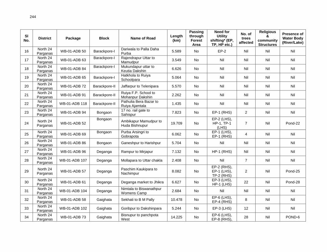
244
Sl No.
District Package Block Name of Road Length
(km)
Passing through Forest Area
Need for Utility
shifting* (EP, TP, HP etc.)
No. of trees
affected
Religious &
community Structures
Presence of Water Body (River/Lake)
16 North 24 Parganas
WB-01-ADB 50 Barackpore-I Dariwala to Palla Daha Purba
5.589 No EP-2 Nil Nil Nil
17 North 24 Parganas
WB-01-ADB 63 Barackpore-I Rajendrapur Uttar to
Mamudpur 3.549 No Nil Nil Nil Nil
18 North 24 Parganas
WB-01-ADB 84 Barackpore-I Mukundapur uttar to
Keutia Dakshin 6.626 No Nil Nil Nil Nil
19 North 24 Parganas
WB-01-ADB 65 Barackpore-I Hatkhola to Ruiya Schoolpara
5.064 No Nil Nil Nil Nil
20 North 24 Parganas
WB-01-ADB 72 Barackpore-II Jaffarpur to Telenipara 5.570 No Nil Nil Nil Nil
21 North 24 Parganas
WB-01-ADB 91 Barackpore-II Ruiya F.P. School to Mohanpur Dakshin
2.262 No Nil Nil Nil Nil
22 North 24 Parganas
WB-01-ADB 118 Barackpore-II Pathulia Bera Bazar to Ruiya Ajamtala
1.435 No Nil Nil Nil Nil
23 North 24 Parganas
WB-01-ADB 94 Bongaon 17 no. rail gate to Sahispur
7.823 No EP-1 (RHS) 2 Nil Nil
24 North 24 Parganas
WB-01-ADB 52 Bongaon
Ambikapur Mamudpur to Huda Bishnupur
19.709 No EP-2 (LHS), HP-1, TP-1
(LHS) 7 Nil Pond-22
25 North 24 Parganas
WB-01-ADB 69 Bongaon Purba Arsingri to
Gobrapota 6.062 No
EP-1 (LHS), EP-1 (RHS)
4 Nil Nil
26 North 24 Parganas
WB-01-ADB 86 Bongaon Ganeshpur to Harishpur 5.704 No Nil Nil Nil Nil
27 North 24 Parganas
WB-01-ADB 96 Deganga Rampur to Mirjapur 7.132 No HP-1 (RHS) Nil Nil Nil
28 North 24 Parganas
WB-01-ADB 107 Deganga Mollapara to Uttar chakla 2.408 No Nil 7 Nil Nil
29 North 24 Parganas
WB-01-ADB 57 Deganga Paschim Kaukipara to Nachimpur
8.082 No EP-2 (RHS), EP-1 (LHS), TP-2 (RHS)
2 Nil Pond-25
30 North 24 Parganas
WB-01-ADB 61 Deganga Deganga market to Jhikra 6.627 No EP-3 (LHS), HP-1 (LHS)
22 Nil Pond-28
31 North 24 Parganas
WB-01-ADB 104 Deganga Nimtala to Biswanathpur Womens Camp
2.684 No Nil Nil Nil Nil
32 North 24 Parganas
WB-01-ADB 58 Gaighata Sekhati to B M Pally 10.478 No EP-6 (LHS), EP-4 (RHS)
8 Nil Nil
33 North 24 Parganas
WB-01-ADB 102 Gaighata Goribpur to Dakshinpara 5.244 No EP-3 (LHS) 12 Nil Nil
34 North 24 Parganas
WB-01-ADB 73 Gaighata Bisnupur to panchpota West
14.225 No EP-6 (LHS), EP-8 (RHS),
28 Nil POND-6

245
Sl No.
District Package Block Name of Road Length
(km)
Passing through Forest Area
Need for Utility
shifting* (EP, TP, HP etc.)
No. of trees
affected
Religious &
community Structures
Presence of Water Body (River/Lake)
TP-3 (LHS), TP-1 (RHS)
35 North 24 Parganas
WB-01-ADB 89 Gaighata Gopalpur to Ichhapur market
2.858 No EP-1 (RHS) 6 Nil Nil
36 North 24 Parganas
WB-01-ADB 90 Gaighata Sanapara to Ramchandrapur
6.327 No Nil 11 Nil Nil
37 North 24 Parganas
WB-01-ADB 112 Habra - I (T05) Badar to Habra Municipality Border
3.577 No Nil Nil Nil Nil
38 North 24 Parganas
WB-01-ADB 108 Habra- I Sahebbari to Tinmatha Natun Pally
5.577 No EP-4 (RHS), EP-3 (LHS)
10 Nil Nil
39 North 24 Parganas
WB-01-ADB 49 Habra - I Khosdelpur Municipal End to Maligram, Border Beliaghata Road
5.735 No Nil Nil Nil Nil
40 North 24 Parganas
WB-01-ADB 98 Habra - II Samudrapur to Berabari 2.946 No
EP-2 (RHS), EP-5 (LHS), TP-1 (LHS), TP-3 (RHS)
8 Nil Nil
41 North 24 Parganas
WB-01-ADB 54 Habra - II
Nawa Para Charitable Dispensary to Rahana NH34 within Amdanga Block
4.174 No EP-1 (RHS), EP-7 (LHS), TP-1 (LHS)
2 Nil Nil
42 North 24 Parganas
WB-01-ADB 87 Habra - II Kamarpur to KHD Sahara 8.811 No EP-2 (LHS) 2 Nil Nil
43 North 24 Parganas
WB-01-ADB 68 Habra - II Guma Chowmatha to Dogachia
3.577 No Nil Nil Nil Nil
44 North 24 Parganas
WB-01-ADB 66 Swarupnagar Taranipur Purba to Sarapul Bazar
4.978 No EP-1 (LHS) Nil Nil Nil
45 North 24 Parganas
WB-01-ADB 46 Swarupnagar Duttapara to Boyerghata 4.522 No EP-1 (RHS) 1 Nil Nil
46 North 24 Parganas
WB-01-ADB 59 Sandeshkhali -
II Dakshin Sitlia To Hatgachha bazar
6.388 No Nil 1 Nil Nil
47 North 24 Parganas
WB-01-ADB 76 Sandeshkhali -
II Bowthakurani to Dakshin sitalia
5.745 No EP-3 (RHS), EP-2 (LHS)
Nil Nil Nil
48 North 24 Parganas
WB-01-ADB 77 Sandeshkhali -
I L036 Metiakhali To chaital Within minakhan block
10.513 No EP-18 (LHS), EP-8 (RHS),
3 Nil Nil
49 North 24 Parganas
WB-01-ADB 97 Rajarhat Chandpur to Khariberia RD (Noai Khal dhar)
3.193 No EP-2 (LHS) 2 Nil Nil
50 North 24 Parganas
WB-01-ADB 111 Rajarhat Ghoshpara to Langolpota 2.992 No EP-1 (RHS), EP-1 (LHS)
1 Nil Nil
51 North 24 WB-01-ADB 79 Rajarhat Dakshin Nayabad to 4.666 No EP-1 (RHS), 4 Nil Nil

246
Sl No.
District Package Block Name of Road Length
(km)
Passing through Forest Area
Need for Utility
shifting* (EP, TP, HP etc.)
No. of trees
affected
Religious &
community Structures
Presence of Water Body (River/Lake)
Parganas Patharghata Bazar EP-1 (LHS), TF-1 (RHS)
52 North 24 Parganas
WB-01-ADB 110 Rajarhat Kashinathpur to Patharghata Purba Panchayet Office
2.768 No EP-2 (LHS), EP-1 (RHS), TF-1 (RHS)
3 Nil Nil
53 North 24 Parganas
WB-01-ADB 80 Basirhat I Jirakpur More to Dandirhat 3.695 No EP-2 (LHS), EP-2 (RHS)
8 Nil
Pond-16 (LHS),
Pond-27 (RHS)
54 North 24 Parganas
WB-01-ADB-70 Basirhat I Sluice Gate to Merudaudi 1.995 No EP-7 (LHS), EP-4 (RHS), TP-1 (LHS)
4 Nil Pond-25
55 North 24 Parganas
WB-01-ADB 53 Basirhat I Nimdaria to Ramnagar More
8.095 No
EP-5 (RHS), EP-1 (LHS), HP-1 (LHS), HP-1 (RHS)
5 Nil
Pond-36 (LHS),
Pond-32 (RHS)
56 North 24 Parganas
WB-01-ADB 55 Basirhat II Raghunathpur to Ghorarash
15.385 No EP-4 (RHS), EP-2 (LHS), HP-1 (RHS)
3 Nil Pond-25
(RHS), 12 (LHS)
57 North 24 Parganas
WB-01-ADB 103 Basirhat II Uttar Gobila to Uttar Kankra
5.426 No
EP-2 (LHS), EP-2 (RHS), HP-2 (LHS), HP-1 (RHS)
9 Nil Pond-35
58 North 24 Parganas
WB-01-ADB 85 Haroa Baganti to Dakshin Bakjuri 5.342 No EP-4 (LHS), EP-13 (RHS)
12 Nil Pond-7
59 North 24 Parganas
WB-01-ADB 51 Hinjalganj Dharmberia to Bhanderkali (Phase II)
13.680 No EP-1 (RHS), EP-1 (LHS)
5 Nil Nil
60 North 24 Parganas
WB-01-ADB 74 Minakhan Bachhra ferry ghat to Muchikhola
8.845 No EP-5 (LHS), EP-3 (RHS)
15 Nil Pond-1
61 North 24 Parganas
WB-01-ADB 93 Minakhan Ramjoy Gheri to Bockchora
9.813 No EP-16 (LHS), EP-6 (RHS)
1 Nil Nil
62 North 24 Parganas
WB-01-ADB 75
Barasat -I Rangapur to Janapara (upto Miruthi) (Part-A)
6.493
No EP-2 (LHS) EP-4 (RHS)
3 Nil Nil
Barasat -I Rangapur (From Miruthi) to Janapara (Part-B)
4.847
63 North 24 Parganas
WB-01-ADB 92
Barasat -I Dubgaria to Mallikpara (upto Jafrabad) (Part- A)
2.719
No Nil 1 Nil Nil
Barasat -I Dubgaria (From Jafrabad) to Mallikpara (Part- B)
1.237
64 North 24 WB-01- ADB 88 Barasat -I Mondalganthi Bamanpara 3.695 No EP-7 (LHS), 7 Nil POND-5

247
Sl No.
District Package Block Name of Road Length
(km)
Passing through Forest Area
Need for Utility
shifting* (EP, TP, HP etc.)
No. of trees
affected
Religious &
community Structures
Presence of Water Body (River/Lake)
Parganas (Muruli) to Parjapur EP-3 (RHS), HP-1 (RHS)
65 North 24 Parganas
WB-01- ADB 45 Barasat -I Joypul to Gopalpur 3.185 No EP-2 (LHS), TAP-2 (RHS)
Nil Nil POND-7
66 North 24 Parganas
WB-01- ADB 67 Habra - I Kharo Mathpara to Chirsthanpara
5.242 No Nil Nil Nil Nil
67 North 24 Parganas
WB-01- ADB117 Habra - I Ichspur Kolupsrs to Sarai Paschim
3.034 No Nil Nil Nil Nil
68 North 24 Parganas
WB-01- ADB116 Habra - I Raghabpur Colony to Kumro Bijoypur
2.174 No Nil Nil Nil Nil
69 North 24 Parganas
WB-01- ADB115 Habra - I Kumargram Panchyet to Ankhola
1.937 No EP-5 (RHS), TP-3 (LHS), TF-1 RHS)
6 Nil Nil
70 North 24 Parganas
WB-01- ADB109 Gaighata Paschimpara to Amkola 3.887 No EP-1 (LHS), TF-1 (LHS)
7 Nil Nil
71 North 24 Parganas
WB-01- ADB 99 Habra - II Nurpur to Buzruk Digha (Asudi Dakshin)
2.172 No EP-2 1 Nil Pond-1
72 North 24 Parganas
WB-01- ADB 64 Sandeshkhali -
I
Gazikhali Nazat Ferry Ghat to Patharghata FP School connected to 24 PGS (S)
11.276 No Nil 1 Nil Nil
73 North 24 Parganas
WB-01- ADB 60 Barasat -II Beliaghata to F Malrampur Purba
4.808 No EP-3 (LHS), EP-7 (RHS), HP-2 (RHS)
7 Nil POND-11, BHERI-3
Grand Total of 73 roads of North 24 Parganas District 428.797
74 Darjeeling WB-07-ADB 17 Garubathan Sombaray South to Kumami Munsi Line
8.443 No EP-6(LHS) No No No
75 Darjeeling WB-07-ADB 21 Garubathan Upper Fagu to Sherpa Tar 7.671 No EP-20(LHS) EP-10(RHS)
No No No
76 Darjeeling WB-07-ADB 16 Kalimpong - I Relly Road Kazi Compound to Bagrakote (Uttar Fulbari)
11.442 No No No No No
77 Darjeeling WB-07-ADB 20 Kalimpong - I Pedong to Pitamchen via Lingsey
7.208 No
EP-1 (LHS), TP-1 (LHS), EP-3 (RHS), TP-2(RHS)
No No No
78 Darjeeling WB-07-ADB 24 Rangli
Rangliot 6 th Mile of SH 12 to Teesta Bazar via Takda
11.085 No EP-11(LHS),
TF-1(LHS) 2 No No
79 Darjeeling WB-07-ADB 25 Mirik Dhudhia New Bridge to Panighatta
1.433 No No No No No

248
Sl No.
District Package Block Name of Road Length
(km)
Passing through Forest Area
Need for Utility
shifting* (EP, TP, HP etc.)
No. of trees
affected
Religious &
community Structures
Presence of Water Body (River/Lake)
80 Darjeeling WB-07-ADB 22 Darjeeling Pulbazar
Darjeeling to Majutar (Samtikalyan)
11.393
No EP- 2 (LHS), TP- 3(LHS), TF- 2(LHS),
EP- 38 (RHS), TP-1(RHS), TF-2(RHS)
12 No No
81 Darjeeling WB-07-ADB 23 Darjeeling Pulbazar
Kaijalay to Goke via Kolbong
6.130 No EP- 21(LHS)
EP- 9 (RHS), TF- 1(RHS)
No No No
82 Darjeeling WB-07-ADB 19 Kueseong Ambotia via Baseri to Namsu Bridge
8.325
No EP-5 (LHS), Resting place-
1(LHS) EP-1 (RHS),
Resting place-4(RHS)
No No No
Grand Total of 9 roads of Darjeeling District 73.130
83 Jalpaiguri WB-10-ADB 30 T04 at NH31 at Mallikshova to T05 at PWD road near Duramari
14.591
No EP-57(LHS) EP-55 (RHS), TP-1(RHS), TF-1(RHS)
No No No
84 Jalpaiguri WB-10-ADB 31 Jalpaiguri
Sadar
T02 at Jalpaiguri at Jalpaiguri Haldibari road to T05 at pucca road at Panga Saheb Bari
6.473
No EP-9 (LHS), HP-6 (LHS)
EP-14 (RHS), TP-2 (RHS)
No No No
85 Jalpaiguri WB-10-ADB 32 Kalchini T08 at NH31 at Bomdong Bazar to T01 at Gudambari High School
7.113 No
EP-29(LHS), TP-7(LHS),
EP-17 (RHS), TP-5 (RHS)
2 No No
86 Jalpaiguri WB-10-ADB 33 Maynaguri T10 at SH 12A near Maynaguri road to T05 at Balapara
12.616 No
EP-28(LHS), TP-1(LHS),
EP- 42 (RHS), HP-1(RHS)
15 No Pond-3 (RHS)
87 Jalpaiguri WB-10-ADB 34 Alipurduar – II NH-31C near Chaltatala to Alipurduar Volka PWD Rd.
5.295 No EP-15(LHS), EP-14 (RHS)
47 No Pond-1 (RHS)
88 Jalpaiguri WB-10-ADB 35 Alipurduar – II
T18 at Alipurduar Kumargram road to T01 at NH-31C via. Taleswarguri
1.911 No
EP-15(LHS), TP- 4(LHS), HP-1(LHS)
EP-14(RHS), TF-1(RHS), HP-4(RHS)
6 No No

249
Sl No.
District Package Block Name of Road Length
(km)
Passing through Forest Area
Need for Utility
shifting* (EP, TP, HP etc.)
No. of trees
affected
Religious &
community Structures
Presence of Water Body (River/Lake)
89 Jalpaiguri WB-10-ADB 36 Jalpaiguri
Sadar
T05 at PWD road near Charakdangi to T03 at Jalpaiguri Siliguri Road at Panga Bottala
6.492 No
EP-20 (LHS) (LHS), TF-14 (LHS), EP-
17(RHS), TF-12(RHS)
No No No
91 Jalpaiguri WB-10-ADB 38 Kumargram T12 at NH 31C at Telipara Choupathi to T06 at Pacca road at Gajendhani
4.314 No
EP-18(LHS), HP-1(LHS)
EP-38 (RHS), HP-1(RHS)
1 No No
92 Jalpaiguri WB-10-ADB 39 Alipurduar – II T01 at Taleswarguri to T01 at Samuktala
4.774 No
EP-22(LHS), TP-4(LHS), HP-1(LHS)
EP-26 (RHS), TP- 4(RHS),
No No No
93 Jalpaiguri WB-10-ADB 40 Jalpaiguri
Sadar
T03 at Siliguri Jalpaiguri road at Golghumti to T01 at PWD road near Joram
18.591
No EP-155 (LHS),TF-3
(LHS), EP-148 (RHS), TF-
1(RHS),
1 No No
94 Jalpaiguri WB-10-ADB 41 Alipurduar – II T18 at Samuktala to T01 at Tufanganj road
5.511
No EP-12 (LHS), TP-7(LHS), TF-4 (LHS),
EP-14 (RHS), TP-2 (RHS), TF-2 (RHS)
38 No Pond-1(RHS)
95 Jalpaiguri WB-10-ADB 42 Alipurduar – II T18 at NH31C to T7 at Parakota GP Office
6.779 No EP-23 (LHS)
EP-25 (RHS) 106 PHE-1 Pond-
1(RHS)
96 Jalpaiguri WB-10-ADB 43 Malbazar R7 at NH31C at Mal to R8 at NH31 near Lataguri
11.56
No EP- 34 (LHS), TF-1(LHS),
EP- 55 (RHS), TF-5 (RHS), HP-1(RHS)
No LHS- Masjid-1
No
97 Jalpaiguri WB-10-ADB 44 Dhupguri T04 at NH31C at Banarhat to T06 at PWD road at Dakshin Salbari
15.162
No EP- 52 (LHS),TF-
1(LHS), EP- 28 (RHS), TP-
1 No No

250
Sl No.
District Package Block Name of Road Length
(km)
Passing through Forest Area
Need for Utility
shifting* (EP, TP, HP etc.)
No. of trees
affected
Religious &
community Structures
Presence of Water Body (River/Lake)
1(RHS)
Grand Total of 15 roads of Jalpaiguri District 129.174
98 Paschin
Medinipur WB-20-ADB 41 Naryangarh
Gopinathpur to Kotaijiageria
11.876
No EP-53 (LHS), TF-5(LHS)
EP-63 (RHS), TF-6 (RHS)
No No Pond-1 (LHS) pond-
1(RHS)
99 Paschin
Medinipur WB-20-ADB 55 Naryangarh
Makrampur to Nayapukur - Keshiary Block
11.242
No EP-45 (LHS),, TP-18 (LHS), EP-47(RHS), TP-10 (RHS)
No No No
100 Paschin
Medinipur WB-20-ADB 58 Jhargram
Jhargram to Manikpara (T 01)
15 No No No No No
101 Paschin
Medinipur WB-20-ADB 59 Kharagpur - II
Rambhadrapur to Asudchak
24.446 No No No No No
102 Paschin
Medinipur WB-20-ADB 56 Binpur- II Belpahari to Chakadoba 3.317
No EP-15 (LHS) EP-12 (RHS)
No No No
103 Paschin
Medinipur WB-20-ADB 57
Medinipur Sadar
Pachkhuri to Raghunathpur
12.698
No EP-30 (LHS), TP-23 (LHS), EP-62 (RHS),
TP-5(RHS)
No No No
104 Paschin
Medinipur WB-20-ADB 42
Chandrakona – I
Srinagar to Dinapur 6.531 No EP-28 (LHS)
EP-37 (RHS) No No No
105 Paschin
Medinipur WB-20-ADB 43
Chandrakona – II
Atghara to Pinglash 12.52 No EP-24 (LHS)
EP-41(RHS) No No No
106 Paschin
Medinipur WB-20-ADB 44 Datan-II Gokulpur to Srikrishnapur 5.242
No EP-2 (LHS) EP-1(RHS)
No No No
107 Paschin
Medinipur WB-20-ADB 45 Datan-II Jahalda to Bhatpara 6.186
No EP-31(LHS) EP-34(RHS)
No No No
108 Paschin
Medinipur WB-20-ADB 46 Pingla Pingla to Kalukhanra 2.993
No No No No No
109 Paschin
Medinipur WB-20-ADB 47 Pingla Pratapchak to Barakhelna 5.405
No TF-1 (LHS) No No No
110 Paschin
Medinipur WB-20-ADB 48 Sankrail Jangalkurchi to Murakati 19.763
No EP-34 (LHS) EP-31(RHS)
No No No
111 Paschin
Medinipur WB-20-ADB 49 Sankrail Rohini to Harapariya 7
No EP-9 (LHS) EP-20 (RHS)
No No No
112 Paschin
Medinipur WB-20-ADB 50 Debra
Fatebar to Radhamohanpur
8.819 No EP -35 (LHS)
EP -30 (RHS) 127 No No
113 Paschin WB-20-ADB 51 Daspur -II Marishgata to Ajurya 9.573 No EP-29 (LHS) No No No

251
Sl No.
District Package Block Name of Road Length
(km)
Passing through Forest Area
Need for Utility
shifting* (EP, TP, HP etc.)
No. of trees
affected
Religious &
community Structures
Presence of Water Body (River/Lake)
Medinipur EP-23 (RHS), TF-2 (RHS)
114 Paschin
Medinipur WB-20-ADB 52 Daspur -II
Ranichak Paschimpara to Jotghaneshyan
14.767 No EP-32 (LHS)
EP-33 (RHS) No No No
115 Paschin
Medinipur WB-20-ADB 53 Daspur -II Chaksultan to Uttarbar 11.441
No EP-36 (LHS) EP-29 (RHS)
No No No
116 Paschin
Medinipur WB-20-ADB 54 Daspur -II
Dubrajpur to Jot Ghanashyam
26.29 No EP-23 (LHS),
EP-19 (RHS) No No No
Grand Total of 19 roads of Paschim Medinipur District 215.109
117 Bankura WB-03-ADB 45 Bankura -II Bikna to Ailtha 8.417 No EP-4 (LHS), EP-4 (RHS)
2 Nil Nil
118 Bankura WB-03-ADB 46 Bankura -II Kanchanpur to Nabanda 8.098 No EP-5 (LHS), EP-9 (RHS)
1
TEMPLE-2 (LHS),
TEMPLE-1 (RHS)
POND-5, WELL-1
119 Bankura WB-03-ADB 47 Joypur Belia to Shyamnagar 9.742 No
EP-5 (LHS), EP-3 (RHS), TF-2 (RHS), HP-1 (RHS)
23 Nil
Pond-2 (RHS), Pond-2 (LHS)
120 Bankura WB-03-ADB 48 Taldanga Katpara to Chanchurya 5.867 No Nil Nil Nil Nil
Grand Total of 4 roads of Bankura District 32.124
121 Burdwan WB-05-ADB 19 Ausgram-I Joykrishnapur to Gobindapur
7.843 No Nil Nil Nil Nil
122 Burdwan WB-05-ADB 18 Purbasthali -II Uttar Laxmipur - Tamaghata Ferryghat
3.207 No EP-3 (LHS), EP-1 (RHS), HP-1 (RHS),
11 Nil Nil
Grand Total of 2 roads of Burdwan District 11.050
123 Purba
Medinipur WB-19-ADB 19 Panskura - II
Uttar Bindabanchak - Uttar Narayan Pakuria
7.718 No EP-2 (LHS), EP-1 (RHS), TP-1 (LHS),
Nil Nil Nil
Grand Total of 1 roads of Purba Medinipur District 7.718
124 Malda WB-11-ADB 27 Englishbazar Atgama to Mobarakpur 7.503
No EP-2 (LHS), TF-1(LHS)
EP-4 (RHS), HP-1(RHS)
No No No
125 Malda WB-11-ADB 28 Kaliachak - II Balugram to Panchanandapur-I Colony
6.175
No EP-4 (LHS), TF-2 (LHS) , HP-3 (LHS), EP-3 (RHS), TF-1(RHS),
2 No No

252
Sl No.
District Package Block Name of Road Length
(km)
Passing through Forest Area
Need for Utility
shifting* (EP, TP, HP etc.)
No. of trees
affected
Religious &
community Structures
Presence of Water Body (River/Lake)
HP-4(RHS)
126 Malda WB-11-ADB 29 Kaliachak -III Baburbona to Baribona 8.692
No EP-7(LHS), TF-2 (LHS), EP-4(RHS), TF-3(RHS), HP-1(RHS)
No No No
Grand Total of 3 roads of Malda District 22.370
127 Purulia WB-16-AD 17 Jhalda Barahan Kol to Simni Road
6.441 No No No No No
Grand Total of 1 road of Purulia District 6.441
128 Uttar
Dinajpur WB-15-ADB 21 Itahar Uzani - Pakaibari 4.171
No EP-35 (LHS), HP-1(LHS)
EP- 24 (RHS)
8 No No
Grand Total of 1 road of Uttar Dinajpur District 4.171
Grand Total of 130 Roads 930.084

253
Appendix 5.1: Environmental Management Plan
SL. NO.
Project Action/ Environmental Attributes
Mitigation Measures Location/numbers Costs Responsible for Implementing
Responsible for Monitoring
I Design and Preconstruction Stage
1.
Climate Change
Consideration and
Vulnerability
screening
o Compliance to climate change vulnerability check
point given under EARF and adoption of necessary
mitigative measures as may be required
o Efforts shall be made to plant additional trees for
increasing the carbon sink. The tree may be planted
with help of PRI
All through the alignment of
each rural road
Design costs. PIU, Design
consultants
PIU, WBSRRDA
2. Finalization of
alignment
o The road will be part of district core network and will
comply with PMGSY guidelines
o Subproject shall not disturb any cultural heritage
designated by the government or by the international
agencies, such as UNESCO, and shall avoid any
monuments of cultural or historical importance.
o Subproject will not pass through any designated
wildlife sanctuaries, national park, notified Eco sensitive
areas or area of international significance such as
protective wet land designated under Wetland
Convention, and reserve forest area..
o Subproject to comply with local and National
legislative requirements such as forest clearance for
diversion of forestland and ADB’s Safeguard Policy
Statement 2009.
o Alignment finalization considering availability of right
of way and in consultation with local people.
o ROW may be reduced in built up area or constricted
areas to minimize land acquisition as per PMGSY
Guidelines.
o Adjust alignment to the extent feasible to avoid tree
cutting, shifting of utilities or community structure.
o The road shall follow natural topography to avoid
excessive cut and fill.
All through the alignment
of each rural road
Design costs PIU, Design
consultants
PIU, WBSRRDA
3. Land acquisition o Land acquisition, compensation packages,
resettlement and rehabilitation, poverty alleviation
programs for affected people and all other related
All through the alignment
of each rural road
Land to be
made available
and necessary
PIU
PIU, WBSRRDA, PIC, TSC

254
SL. NO.
Project Action/ Environmental Attributes
Mitigation Measures Location/numbers Costs Responsible for Implementing
Responsible for Monitoring
issues are addressed through Social Impacts and
Resettlement & Rehabilitation report.
costs if any to
be borne by the
state
4. Clearing of
vegetation and
removing trees o All efforts shall be taken to avoid tree cutting
wherever possible.
o Requisite permission from forest department shall
be obtained for cutting of roadside trees.
o Provision of Compensatory Afforestation shall be
made on 1:3.ratio basis
o Permission shall be taken for diversion of any forest
land if involved. Provision shall be made for additional
compensatory tree plantation.
o The vegetative cover shall be removed and
disposed in consultation with community.
All through the alignment of
each rural road
(Enter chainages where
tree cutting and
diversion of forest land is
required & proposed
plantation location if
details are available)
Costs for
Forestry
clearance for
diversion of
forest land,
obtaining tree
cutting permit to
be borne by
state. Costs for
compen-satory
foresta-tion to
be borne by
state or by PRI
– NREGA
Forestry
clearance and
permit to be
obtained by the
PIU.
Compensatory
plantation to be
carried out in
coordination with
PRI under
schemes such as
NREGA or local
Forestry
Department
PIU, PIC, TSC
5. Shifting of utilities
and common
property resources
o The road land width shall be clearly demarcated on
the ground.
o All efforts will be made to minimize shifting of utilities
and common property resources
o Utility and community structure shifting shall be
planned in consultations and concurrence of the
community
o Required permissions and necessary actions will be
taken on a timely basis for removing and shifting utility
structures and common property resources before road
construction activities begin.
(Enter chainages where
shifting of utility
structures and common
property resources are
required. Enter total
numbers of each
structure required for
shifting/removal)
Costs to cover
shifting and
reconstruction
of common
property
resources must
be included
under project
costs.
PIU, contractor,
utility agencies
(Internal
procedures to be
discussed and
agreed between
the above
parties)
PIU, PIC, TSC
6. Design and
planning of
embankment
construction
o The alignment design shall consider options to
minimize excessive cuts and fills.
o The cut off material shall be planned to be used for
embankment to minimize borrow earth requirement.
o The design shall be as per relevant IRC provisions
for cut and fill, slope protection and drainage.
o The top soil of the cut and fill area shall be used for
embankment slope protection
All through the alignment of
each rural road
(Enter the chainages that
are prone to floods)
Part of Project
Cost
PIU, Design
Consultants PIU, WBSRRDA

255
SL. NO.
Project Action/ Environmental Attributes
Mitigation Measures Location/numbers Costs Responsible for Implementing
Responsible for Monitoring
o Embankment will be designed above High Flood
Level (HFL) in flood prone areas where feasible.
7. Hydrology and
Drainage
o Provision of adequate cross drainage structure shall
be made to ensure smooth passage of water and
maintaining natural drainage pattern of the area.
o The discharge capacity of the CD structure shall be
designed accordingly.
o Provision of adequate drainage structures shall be
made in water stagnant/logging areas.
o The construction work near water body shall be
planned preferably in dry season so that water quality
of the water channel is not affected due to siltation and
rain water runoff.
o Provision of additional cross drainage structure shall
be made in the areas where nearby land is sloping
towards road alignment on both the sides.
o Provision of concrete road construction in habitat
area with drainage of both side of the road shall be
made as per the design provision and with adequate
slope to prevent any water logging.
Near all drainage
crossings, nalas, rivers,
streams and ponds.
(Enter chainages where
earthern/structural cross
drains, longitudinal
drains, streams, ponds
and rivers exist)
Included in
project costs.
PIU, Design
consultants
PIU, WBSRRDA
8. Establishment of
Construction Camp,
temporary office
and storage area
o Construction camp sites shall be located away from
any local human settlements and forested areas
(minimum 0.5 km away) and preferably located on
lands, which are not productive (barren/waste lands
presently).
o Similarly temporary office and storage areas shall be
located away from human settlement areas and
forested areas (minimum 0.5 km).
o The construction camps, office and storage areas
shall have provision of adequate water supply,
sanitation and all requisite infrastructure facilities.
o The construction camps, office and storage areas
shall have provision of septic tank/soak pit of adequate
capacity so that it can function properly for the entire
duration of its use.
o All construction camps shall have provision of
rationing facilities particularly for kerosene/LPG so that
For all roads
To be included
in contractor’s
cost
Contractor PIU, PIC, TSC

256
SL. NO.
Project Action/ Environmental Attributes
Mitigation Measures Location/numbers Costs Responsible for Implementing
Responsible for Monitoring
dependence on firewood for cooking is avoided to the
extent possible.
o The construction camps, office and storage areas
shall have provision of health care facilities for
adults, pregnant women and children.
o Personal Protective Equipments (PPEs) like helmet,
boots, earplugs for workers, first aid and fire fighting
equipments shall be available at construction sites
before start of construction. An emergency plan
shall be prepared to fight with any emergency like
fire.
o Provision shall be made for domestic solid waste
disposal in a controlled manner. The recyclable
waste shall be sold off and non-saleable and
biodegradable waste shall be disposed through
secured land filling.
o Provision of paved area for unloading and storage
of fuel oil, lubricant oil, away from storm water
drainage.
9.
Traffic
Management and
Road Safety
o Identify the areas where temporary traffic diversion
may be required.
o Prepare appropriate traffic movement plan approved
by respective PIU for ensuring continued safe flow of
traffic, pedestrians and all road users during
construction.
o Wherever, cross drainage structure work require
longer construction time and road is to be blocked for
longer duration, the PIU/DPR consultant shall define
appropriate measures for traffic diversion before the
start of the construction.
o Adequate signboards shall be placed much ahead of
diversion site to caution the road users. The road signs
should be bold and retro reflective in nature for good
visibility both during the day and night.
o It is proposed for the respective PIU to discuss with
the railways division/department for providing adequate
safety measures at unmanned railway crossing where
As proposed under DPR
and determined by
contractor and approved
by PIC/PIU/
(Enter the chainages
which may require traffic
diversions where
possible)
To be included
in contractor’s
cost
Contractor PIU, PIC, TSC

257
SL. NO.
Project Action/ Environmental Attributes
Mitigation Measures Location/numbers Costs Responsible for Implementing
Responsible for Monitoring
applicable. Adequate clearly visible sign shall be
provided on both sides of the railway crossing All
measures for traffic control and safety in accordance
with IRC codes:99-1988 will be followed
II. Construction Stage
10. Sourcing and
transportation of
construction
material
Borrow Earth:
o The borrow earth shall be obtained from identified
locations and with prior permission of landowner and
clear understanding for its rehabilitation.
o The re-habilitation plan may include the following:
▪ Borrow pits shall be backfilled with rejected
construction wastes and will be given a
vegetative cover. If this is not possible, then
excavation sloped will be smoothed and
depression will be filled in such a way that it
looks more or less like the original ground
surface.
▪ Borrow areas might be used for aquaculture in
case landowner wants such development.
o The Indian Road Congress (IRC):10-1961 guideline
should be used for selection of borrow pits and amount
that can be borrowed.
o Borrowing earth from agricultural land shall be
minimized to the extent possible. Further, no earth shall
be borrowed from already low-lying areas.
o A 15 cm topsoil will be stripped off from the borrow
pit and this will be stored in stockpiles in a designated
area for height not exceeding 2m and side slopes not
steeper than 1:2 (Vertical: Horizontal).
o Borrowing of earth will not be done continuously
through out the stretch.
o Ridges of not less than 8m widths will be left at
intervals not exceeding 300m.
o Small drains will be cut through the ridges, if
necessary, to facilitate drainage.
o The slope of the edges will be maintained not
steeper than 1:4 (vertical: Horizontal).
(Enter chainage or
probable locations of
borrow areas.
Enter name and location
of identified quarries.)
To be included
under
contractors
costs
Contractor PIC, PIU, TSC

258
SL. NO.
Project Action/ Environmental Attributes
Mitigation Measures Location/numbers Costs Responsible for Implementing
Responsible for Monitoring
o The depth of borrow pits will not be more than 30 cm
after stripping the 15 cm topsoil aside.
o Fly ash will be used in road embankment as per IRC
guidelines wherever thermal power plant is located
within 100 km of the road alignment.
Aggregate :
o The stone aggregate shall be sourced from existing
licensed quarries
o Copies of consent/ approval / rehabilitation plan for
use of existing source will be submitted to PIU.
o Topsoil to be stockpiled and protected for use at the
rehabilitation stage
Transportation of Construction Material
o Existing tracks / roads are to be used for hauling of
materials to the extent possible.
o Prior to construction of roads, topsoil shall be
preserved and shall be used for other useful purposes
like using in turfing of embankment.
o The vehicles deployed for material transportation
shall be spillage proof to avoid or minimize the spillage
of the material during transportation. In any case, the
transportation links are to be inspected at least twice
daily to clear accidental spillage, if any.
11. Loss of Productive
Soil, erosion and
land use change
o The top soil from the productive land (borrow areas,
road widening areas etc.) shall be preserved and
reused for plantation purposes.
o It shall also be used as top cover of embankment
slope for growing vegetation to protect soil erosion.
o Cut and fill shall be planned as per IRC provisions
and rural road manual.
o All steep cuts shall be flattened and benched.
o Shrubs shall be planted in loose soil area.
o IRC: 56 -1974 recommended practice for treatment
of embankment slopes for erosion control shall be
taken into consideration.
o It shall be ensured that the land taken on lease for
access road, construction camp and temporary office of
All though the alignment of
each project road
To be included
under
contractors
costs
Contractor PIU / WBSRRDA

259
SL. NO.
Project Action/ Environmental Attributes
Mitigation Measures Location/numbers Costs Responsible for Implementing
Responsible for Monitoring
the storage facilities is restored back to its original
land use before handing it over back to land owner.
12. Compaction and
Contamination of
Soil
o To prevent soil compaction in the adjoining
productive lands beyond the ROW, the movement of
construction vehicles, machinery and equipment shall
be restricted to the designated haulage route.
o The productive land shall be reclaimed after
construction activity.
o Fuel and lubricants shall be stored at the predefined
storage location.
o The storage area shall be paved with gentle slope to
a corner and connected with a chamber to collect any
spills of the oils.
o All efforts shall be made to minimize the waste
generation. Unavoidable waste shall be stored at the
designated place prior to disposal.
o To avoid soil contamination at the wash-down and
re-fuelling areas, “oil interceptors” shall be provided. Oil
and grease spill and oil soaked materials are to be
collected and stored in labelled containers (Labelled:
WASTE OIL; and hazardous sign be displayed) and
sold off to SPCB/ MoEF authorized re-refiners.
All though the alignment of
each project road
To be included
under
contractors
costs
Contractor, PIU, PIC, TSC
13. Construction Debris
and waste
o Excavated materials from roadway, shoulders,
verges, drains, cross drainage will be used for
backfilling embankments, filling pits, and landscaping.
o Unusable debris material should be suitably
disposed off at pre-designated disposal locations, with
approval of the concerned authority.
o The bituminous wastes shall be disposed in secure
manner at designated landfill sites only in an
environmentally accepted manner.
o For removal of debris, wastes and its disposal
MOSRTH guidelines should be followed.
Unproductive/wastelands shall be selected with the
consent of villagers and Panchayat for the same.
The dumping site should be of adequate capacity. It
should be located at least 500 m away from the
All though the alignment of
each project road
To be included
under
contractors
costs
Contractor PIU, PIC, TSC

260
SL. NO.
Project Action/ Environmental Attributes
Mitigation Measures Location/numbers Costs Responsible for Implementing
Responsible for Monitoring
residential areas. Dumping sites should be away
from water bodies to prevent any contamination of
these bodies.
14. Air and Noise
Quality
o Vehicles delivering loose and fine materials like
sand and aggregates shall be covered.
o Dust suppression measures like water sprinkling,
shall be applied in all dust prone locations such as
unpaved haulage roads, earthworks, stockpiles and
asphalt mixing areas.
o Mixing plants and asphalt (hot/spot mix) plants shall
be located at least 0.5 km away and in downwind
direction of the human settlements.
o Material storage areas shall also be located
downwind of the habitation area.
o Hot mix plant shall be fitted with stack of adequate
height (30 m) or as may be prescribed by SPCB to
ensure enough dispersion of exit gases. Consent to
establish and operate shall be obtained from State
Pollution Control Board and comply with all consent
conditions.
o Diesel Generating (DG) sets shall also be fitted with
stack of adequate height (as per regulation height of
the stack of open to air DG set shall be about 0.5 m
for 5 KVA and about 0.7 m for 10 KVA DG sets,
above top of sound proofing enclosure of the DG
set). Low sulphur diesel shall be used in DG sets
and other construction machineries where available.
Construction vehicles and machineries shall be
periodically maintained.
Throughout the project
road section
To be included
under
contractors
costs
Contractor PIU, WBSRRDA
15. Tree plantation o Compensatory Afforestation shall be made on
1:3.ratio basis
o Additional trees shall be planted wherever feasible.
o Follow up maintenance of planted saplings will be
carried out for a minimum of 3 years
(Enter the number of
trees requird for planting
and location of plantation
site if available)
Costs to be
covered by
state or PRI
under schemes
such as
NREGA
PIU to coordinate
compensatory
forestation with
PRI under
schemes such as
NREGA or local
Forestry
Department
PIU, PIC, TSC

261
SL. NO.
Project Action/ Environmental Attributes
Mitigation Measures Location/numbers Costs Responsible for Implementing
Responsible for Monitoring
16. Ground Water and
Surface Water
Quality and
Availability
o Requisite permission shall be obtained for
abstraction of groundwater from State Ground
Water Board/Central Ground Water Authority if
applicable.
o The contractor shall arrange for water required
during construction in such a way that the water
availability and supply to nearby communities
remains unaffected.
o Water intensive activities shall not be undertaken
during summer period to the extent feasible.
o Provision shall be made to link side drains with the
nearby ponds for facilitating water harvesting if
feasible
o Where ponds are not available, the water harvesting
pits shall be constructed as per the requirement and
rainfall intensity.
o Preventive measures like slope stabilisation, etc
shall be taken for prevention of siltation in water
bodies.
Throughout the project
road
To be included
under
contractors
costs
Contractor PIU, PIC, TSC
17 Occupational
Health and Safety
o The requisite PPE (helmet, mask, boot, hand
gloves, earplugs) shall be provided to the
construction workers.
o Workers’ exposure to noise will be restricted to less
than 8 hours a day. Workers duty shall be regulated
accordingly.
o Septic tank or mobile toilets fitted with anaerobic
treatment facility shall be provided at construction
camp/temporary office/storage areas.
o Domestic solid waste at construction camp shall be
segregated into biodegradable and non-
biodegradable waste.
In all project roads Costs to be
borne by
Contractor
Contractor PIC, PIU, TSC
III Post Construction and Operation Stage
18. Air and Noise
Quality
o Awareness sign board shall be provided for slow
driving near the habitat areas to minimize dust
generation due to vehicle movement. Speed
limitation and honking restrictions may be enforced
near sensitive locations.
Throughout the project
section at the location
determined by contractor
and approved by PIU
construction
cost
Contractor, PIC, PIU, TSC

262
SL. NO.
Project Action/ Environmental Attributes
Mitigation Measures Location/numbers Costs Responsible for Implementing
Responsible for Monitoring
19. Site restoration o All construction camp/temporary office/material
storage areas are to be restored to its original
conditions.
o The borrow areas rehabilitation will be ensured as
per the agreed plan with the landowner.
o Obtain clearance from PIU before handling over the
site to WBSRRDA.
o PIC to undertake survivability assessment and
report to PIU the status of compensatory tree
plantation at a stage of completion of construction
with recommendation for improving the survivability
of the tree if required
All locations of construction
camps/temporary office/
material storage, and
borrow areas
To be borne by
the contractor
Contractor PIU, PIC, TSC
20. Hydrology and
Drainage
o Regular removal/cleaning of deposited silt shall be
done from drainage channels and outlet points
before the monsoon season.
o Rejuvenation of the drainage system by removing
encroachments/ congestions shall be regularly
conducted
At project road locations
with drainage structures
To be covered
under road
maintenance
costs.
PIU PIU, WBSRRDA
21 Community Safety o Directional sight board shall be installed on all
sharp curves and bends
o At a main road, intersection or crossing “STOP” sign
and ‘T-intersection’ warning sign shall be installed
on the village road.
Throughout the project
section at the location
determined by contractor
and approved by PIU
construction
cost
Maintenance
Contractor, PIU
PIC/PIU

263
Appendix 5.2: Environmental Monitoring Plan
I. ENVIRONMENTAL MONITORING DURING DESIGN AND PRE-CONSTRUCTION STAGE Monitoring Responsibility: PIU with Support from PIC Monitoring Frequency: Once prior to start of construction Road Name with Block and District Name:………………. Road Length: ………… Report No.: ……….
SL. NO.
Environmental Attributes
Mitigation Measures Location Compliance status (Complied, partly
complied, not complied)
Corrective action proposed if any
1..
Climate Change
Consideration
and Vulnerability
screening
o Compliance to climate change vulnerability check point given
under EARF and adoption of necessary mitigative measures as
may be required
o Efforts shall be made to plant additional trees for increasing the
carbon sink. The tree may be planted with help of PRI
(Panchayati Raj Institution)
All through the
alignment of each rural
road
2..
Finalization of
alignment
o The road will be part of district core network and will comply with
PMGSY guidelines
o Subproject shall not disturb any cultural heritage designated by
the government or by the international agencies, such as
UNESCO, and shall avoid any monuments of cultural or historical
importance.
o Subproject will not pass through any designated wildlife
sanctuaries, national park, notified Eco sensitive areas or area of
international significance such as protective wet land designated
under Wetland Convention, and reserve forest area..
o Subproject to comply with local and National legislative
requirements such as forest clearance for diversion of forestland
and ADB’s Safeguard Policy Statement 2009.
o Alignment finalization considering availability of right of way and
in consultation with local people.
o ROW may be reduced in built up area or constricted areas to
minimize land acquisition as per PMGSY Guidelines.
o Adjust alignment to the extent feasible to avoid tree cutting,
shifting of utilities or community structure.
o The road shall follow natural topography to avoid excessive cut
All through the
alignment of each rural
road

264
SL. NO.
Environmental Attributes
Mitigation Measures Location Compliance status (Complied, partly
complied, not complied)
Corrective action proposed if any
and fill.
3. Land acquisition o Land acquisition, compensation packages, resettlement and
rehabilitation, poverty alleviation programs for affected people
and all other related issues are addressed through Social Impacts
and Resettlement & Rehabilitation report.
All through the
alignment of each rural
road
4.
7.77
Clearing of
vegetation and
removing trees
o All efforts shall be taken to avoid tree cutting wherever possible.
o Requisite permission from forest department shall be obtained for
cutting of roadside trees.
o Provision of Compensatory Afforestation shall be made on
1:3.ratio basis
o Permission shall be taken for diversion of any forest land if
involved. Provision shall be made for additional compensatory
tree plantation.
o The vegetative cover shall be removed and disposed in
consultation with community.
All through the
alignment of each rural
road
(Enter chainages
where tree cutting and
diversion of forest
land is required &
proposed plantation
location if details are
available)
5. Shifting of utilities
and common
property
resources
o The road land width shall be clearly demarcated on the ground.
o All efforts will be made to minimize shifting of utilities and
common property resources
o Utility and community structure shifting shall be planned in
consultations and concurrence of the community
o Required permissions and necessary actions will be taken on a
timely basis for removing and shifting utility structures and
common property resources before road construction activities
begin.
(Enter chainages
where shifting of
utility structures and
common property
resources are
required. Enter total
numbers of each
structure required for
shifting/removal)
6. Design and
planning of
embankment
construction
o The alignment design shall consider options to minimize
excessive cuts and fills.
o The cut off material shall be planned to be used for embankment
to minimize borrow earth requirement.
o The design shall be as per relevant IRC provisions for cut and fill,
slope protection and drainage.
o The top soil of the cut and fill area shall be used for embankment
slope protection
Embankment will be designed above High Flood Level (HFL) in
flood prone areas where feasible.
All through the
alignment of each rural
road
(Enter the chainages
that are prone to
floods)
7. Hydrology and
Drainage
o Provision of adequate cross drainage structure shall be made to
ensure smooth passage of water and maintaining natural
Near all drainage
crossings, nalas, rivers,

265
SL. NO.
Environmental Attributes
Mitigation Measures Location Compliance status (Complied, partly
complied, not complied)
Corrective action proposed if any
drainage pattern of the area.
o The discharge capacity of the CD structure shall be designed
accordingly.
o Provision of adequate drainage structures shall be made in water
stagnant/logging areas.
o The construction work near water body shall be planned
preferably in dry season so that water quality of the water channel
is not affected due to siltation and rain water runoff.
o Provision of additional cross drainage structure shall be made in
the areas where nearby land is sloping towards road alignment
on both the sides.
o Provision of concrete road construction in habitat area with
drainage of both side of the road shall be made as per the design
provision and with adequate slope to prevent any water logging.
streams and ponds.
(Enter chainages
where
earthern/structural
cross drains,
longitudinal drains,
streams, ponds and
rivers exist)
8. Establishment of
Construction
Camp, temporary
office and
storage area
o Construction camp sites shall be located away from any local
human settlements and forested areas (minimum 0.5 km away)
and preferably located on lands, which are not productive
(barren/waste lands presently).
o Similarly temporary office and storage areas shall be located
away from human settlement areas and forested areas (minimum
0.5 km).
o The construction camps, office and storage areas shall have
provision of adequate water supply, sanitation and all requisite
infrastructure facilities.
o The construction camps, office and storage areas shall have
provision of septic tank/soak pit of adequate capacity so that it
can function properly for the entire duration of its use.
o All construction camps shall have provision of rationing facilities
particularly for kerosene/LPG so that dependence on firewood for
cooking is avoided to the extent possible.
o The construction camps, office and storage areas shall have
provision of health care facilities for adults, pregnant women and
children.
o Personal Protective Equipments (PPEs) like helmet, boots,
earplugs for workers, first aid and fire fighting equipments shall be
available at construction sites before start of construction. An
emergency plan shall be prepared to fight with any emergency
For all roads

266
SL. NO.
Environmental Attributes
Mitigation Measures Location Compliance status (Complied, partly
complied, not complied)
Corrective action proposed if any
like fire.
o Provision shall be made for domestic solid waste disposal in a
controlled manner. The recyclable waste shall be sold off and
non-saleable and biodegradable waste shall be disposed through
secured land filling.
o Provision of paved area for unloading and storage of fuel oil,
lubricant oil, away from storm water drainage.
9. Traffic
Management and
Road Safety
o Identify the areas where temporary traffic diversion may be
required.
o Prepare appropriate traffic movement plan approved by
respective PIU for ensuring continued safe flow of traffic,
pedestrians and all road users during construction.
o Wherever, cross drainage structure work require longer
construction time and road is to be blocked for longer duration,
the PIU/DPR consultant shall define appropriate measures for
traffic diversion before the start of the construction.
o Adequate signboards shall be placed much ahead of diversion
site to caution the road users. The road signs should be bold and
retro reflective in nature for good visibility both during the day
and night.
o It is proposed for the respective PIU to discuss with the railways
division/department for providing adequate safety measures at
unmanned railway crossing where applicable. Adequate clearly
visible sign shall be provided on both sides of the railway crossing
All measures for traffic control and safety in accordance with IRC
codes:99-1988 will be followed
As proposed under
DPR and determined
by contractor and
approved by PIC/PIU/
(Enter the chainages
which may require
traffic diversions
where possible)
10. Grievance
Redress
o Maintaining records of all environment related grievances raised,
if any, and the actions taken to address them through the village
level grievance redress committee (GRC) and PIU as applicable
All project roads.
NOTE: Each report must enclose Photograph to the maximum possible action points, even if work is in progress.

267
II. ENVIRONMENTAL MONITORING DURING CONSTRUCTION STAGE
Monitoring Responsibility: PIU with Support from PIC Monitoring Frequency : Once during construction after completion of about 50% of construction Project Details:……………. Road Stretch Name : ………. Monitoring Report Quarter No.: ……..
Sl. No.
Environmental Attributes
Mitigation Measures Location Compliance status (Complied, partly complied, not complied)
Corrective action
proposed if any
1. Sourcing and
transportation of
construction material
Borrow Earth:
o The borrow earth shall be obtained from identified locations and
with prior permission of landowner and clear understanding for its
rehabilitation.
o The re-habilitation plan may include the following:
▪ Borrow pits shall be backfilled with rejected construction
wastes and will be given a vegetative cover. If this is not
possible, then excavation sloped will be smoothed and
depression will be filled in such a way that it looks more or
less like the original ground surface.
▪ Borrow areas might be used for aquaculture in case
landowner wants such development.
o The Indian Road Congress (IRC):10-1961 guideline should be
used for selection of borrow pits and amount that can be
borrowed.
o Borrowing earth from agricultural land shall be minimized to the
extent possible. Further, no earth shall be borrowed from already
low-lying areas.
o A 15 cm topsoil will be stripped off from the borrow pit and this will
be stored in stockpiles in a designated area for height not
exceeding 2m and side slopes not steeper than 1:2 (Vertical:
Horizontal).
o Borrowing of earth will not be done continuously through out the
stretch.
o Ridges of not less than 8m widths will be left at intervals not
exceeding 300m.
o Small drains will be cut through the ridges, if necessary, to
facilitate drainage.
o The slope of the edges will be maintained not steeper than 1:4
(vertical: Horizontal).
(Enter chainage or
probable locations of
borrow areas.
Enter name and location
of identified quarries.)

268
Sl. No.
Environmental Attributes
Mitigation Measures Location Compliance status (Complied, partly complied, not complied)
Corrective action
proposed if any
o The depth of borrow pits will not be more than 30 cm after
stripping the 15 cm topsoil aside.
o Fly ash will be used in road embankment as per IRC guidelines
wherever thermal power plant is located within 100 km of the road
alignment.
Aggregate :
o The stone aggregate shall be sourced from existing licensed
quarries
o Copies of consent/ approval / rehabilitation plan for use of existing
source will be submitted to PIU.
o Topsoil to be stockpiled and protected for use at the rehabilitation
stage
Transportation of Construction Material
o Existing tracks / roads are to be used for hauling of materials to
the extent possible.
o Prior to construction of roads, topsoil shall be preserved and shall
be used for other useful purposes like using in turfing of
embankment.
o The vehicles deployed for material transportation shall be spillage
proof to avoid or minimize the spillage of the material during
transportation. In any case, the transportation links are to be
inspected at least twice daily to clear accidental spillage, if any.
2. Loss of Productive Soil,
erosion and land use
change
o The top soil from the productive land (borrow areas, road widening
areas etc.) shall be preserved and reused for plantation purposes.
o It shall also be used as top cover of embankment slope for
growing vegetation to protect soil erosion.
o Cut and fill shall be planned as per IRC provisions and rural road
manual.
o All steep cuts shall be flattened and benched.
o Shrubs shall be planted in loose soil area.
o IRC: 56 -1974 recommended practice for treatment of
embankment slopes for erosion control shall be taken into
consideration.
o It shall be ensured that the land taken on lease for access road,
construction camp and temporary office of the storage facilities is
restored back to its original land use before handing it over back
to land owner.
All though the alignment of
each project road

269
Sl. No.
Environmental Attributes
Mitigation Measures Location Compliance status (Complied, partly complied, not complied)
Corrective action
proposed if any
3. Compaction and
Contamination of Soil
o To prevent soil compaction in the adjoining productive lands
beyond the ROW, the movement of construction vehicles,
machinery and equipment shall be restricted to the designated
haulage route.
o The productive land shall be reclaimed after construction activity.
o Fuel and lubricants shall be stored at the predefined storage
location.
o The storage area shall be paved with gentle slope to a corner and
connected with a chamber to collect any spills of the oils.
o All efforts shall be made to minimize the waste generation.
Unavoidable waste shall be stored at the designated place prior to
disposal.
o To avoid soil contamination at the wash-down and re-fuelling
areas, “oil interceptors” shall be provided. Oil and grease spill and
oil soaked materials are to be collected and stored in labelled
containers (Labelled: WASTE OIL; and hazardous sign be
displayed) and sold off to SPCB/ MoEF authorized re-refiners.
All though the alignment of
each project road
4.
Construction Debris
and waste
o Excavated materials from roadway, shoulders, verges, drains,
cross drainage will be used for backfilling embankments, filling
pits, and landscaping.
o Unusable debris material should be suitably disposed off at pre-
designated disposal locations, with approval of the concerned
authority.
o The bituminous wastes shall be disposed in secure manner at
designated landfill sites only in an environmentally accepted
manner.
o For removal of debris, wastes and its disposal MOSRTH
guidelines should be followed. Unproductive/wastelands shall be
selected with the consent of villagers and Panchayat for the same.
The dumping site should be of adequate capacity. It should be
located at least 500 m away from the residential areas. Dumping
sites should be away from water bodies to prevent any
contamination of these bodies.
All though the alignment of
each project road
5. Air and Noise Quality o Vehicles delivering loose and fine materials like sand and
aggregates shall be covered.
o Dust suppression measures like water sprinkling, shall be applied
Throughout the project
road section

270
Sl. No.
Environmental Attributes
Mitigation Measures Location Compliance status (Complied, partly complied, not complied)
Corrective action
proposed if any
in all dust prone locations such as unpaved haulage roads,
earthworks, stockpiles and asphalt mixing areas.
o Mixing plants and asphalt (hot mix) plants shall be located at least
0.5 km away and in downwind direction of the human settlements.
o Material storage areas shall also be located downwind of the
habitation area.
o Hot mix plant shall be fitted with stack of adequate height (30 m)
or as may be prescribed by SPCB to ensure enough dispersion of
exit gases. Consent to establish and operate shall be obtained
from State Pollution Control Board and comply with all consent
conditions.
o Diesel Generating (DG) sets shall also be fitted with stack of
adequate height (as per regulation height of the stack of open to
air DG set shall be about 0.5 m for 5 KVA and about 0.7 m for 10
KVA DG sets, above top of sound proofing enclosure of the DG
set). Low sulphur diesel shall be used in DG sets and other
construction machineries where available. Construction vehicles
and machineries shall be periodically maintained.
6. Tree plantation o Compensatory Afforestation shall be made on 1:3.ratio basis.
o Additional trees shall be planted wherever feasible.
o Follow up maintenance of planted saplings will be carried out for a
minimum of 3 years
(Enter the no. of trees
requird for planting and
location of plantation
site if available)
7.
Ground Water and
Surface Water Quality
and Availability
o Requisite permission shall be obtained for abstraction of
groundwater from State Ground Water Board/Central Ground
Water Authority if applicable.
o The contractor shall arrange for water required during construction
in such a way that the water availability and supply to nearby
communities remains unaffected.
o Water intensive activities shall not be undertaken during summer
period to the extent feasible.
o Provision shall be made to link side drains with the nearby ponds
for facilitating water harvesting if feasible
o Where ponds are not available, the water harvesting pits shall be
constructed as per the requirement and rainfall intensity.
o Preventive measures like slope stabilisation, etc shall be taken for
prevention of siltation in water bodies.
Throughout the project
road

271
Sl. No.
Environmental Attributes
Mitigation Measures Location Compliance status (Complied, partly complied, not complied)
Corrective action
proposed if any
8. Occupational Health
and Safety
o The requisite PPE (helmet, mask, boot, hand gloves, earplugs)
shall be provided to the construction workers.
o Workers’ exposure to noise will be restricted to less than 8 hours a
day. Workers duty shall be regulated accordingly.
o Septic tank or mobile toilets fitted with anaerobic treatment facility
shall be provided at construction camp/temporary office/storage
areas.
o Domestic solid waste at construction camp shall be segregated
into biodegradable and non-biodegradable waste.
In all project roads
9. Grievance Redress o Maintaining records of all environment related grievances raised, if
any, and the actions taken to address them through the village
level grievance redress committee (GRC) and PIU as applicable
All project roads.
NOTE: Each report must enclose Photograph to the maximum possible action points, even if work is in progress.

272
III. ENVIRONMENTAL MONITORING DURING OPERATION STAGE
Monitoring Responsibility: PIU with Support from PIC
Monitoring Frequency: Once, one month after completion of construction
Project Details :……………. Road Stretch Name: ………. Monitoring Report No.: ……..
Sl. No.
Environmental Attributes
Mitigation Measures Location Compliance status (Complied, partly
complied, not complied)
Corrective action
proposed if any
1. Air and Noise
Quality
o Awareness sign board shall be provided for slow driving near the
habitat areas to minimize dust generation due to vehicle movement.
Speed limitation and honking restrictions may be enforced near
sensitive locations.
Throughout the project section
at locations determined by
contractor/ approved by PIU
2. Site restoration o All construction camp/temporary office/material storage areas are
to be restored to its original conditions.
o The borrow areas rehabilitation will be ensured as per the agreed
plan with the landowner.
o Obtain clearance from PIU before handling over the site to
WBSRRDA.
o PIC to undertake survivability assessment and report to PIU the
status of compensatory tree plantation at a stage of completion of
construction with recommendation for improving the survivability of
the tree if required
All locations of construction
camps/temporary office/
material storage, and borrow
areas
3. Tree plantation o Follow up maintenance of planted saplings will be carried out for a
minimum of 3 years
o Data on plantation survivability to be collected
(Enter the number of trees
requird for planting and
location of plantation sites)
4. Hydrology and
Drainage
o Regular removal/cleaning of deposited silt shall be done from
drainage channels and outlet points before the monsoon season.
o Rejuvenation of the drainage system by removing encroachments/
congestions shall be regularly conducted
At project road locations with
drainage structures
5 Community
safety
o Directional sight board shall be installed on sharp curves/bends
o At a main road, intersection or crossing “STOP” sign and ‘T-
intersection’ warning sign shall be installed on the village road.
Throughout the project section
at locations determined by
contractor/ approved by PIU
6 Grievance
Redress
o Maintaining records of all environment related grievances raised,
if any, and the actions taken to address them through the village
level grievance redress committee (GRC) and PIU as applicable
All project roads.
NOTE: Each report must enclose Photograph to the maximum possible action points, even if work is in progress.

273
APPENDIX 6.1: List of Persons for Public Consultation
WBSRRDA and Gram Panchyat Officials:
District Name Designation
North 24 parganas
Mr.Kalyan Das Ex.Engineer, PIU/WBSRDA N.24 Pargnas
Mr. Sudip Mukherjee Asst. Engineer PIU/WBSRDA N.24 Pargnas
Mr. Biswaranjan Sarkar Sub Assit. Engineer, PIU/WBSRDA N.24 Pargnas
Mr. Biplab Sarkar Sub Assit. Engineer, PIU/WBSRDA N.24 Pargnas
Mr. Suprobhat Nath Sub Assit. Engineer, PIU/WBSRDA N.24 Pargnas
Mr. N. Molla Upa-Prodhan, Chandpur, Gram Panchayet
Mr. Ashok Naskar Prodhan. Patharghata, Gram Panchayet
Md. Isha Prodhan, Kotra, Gram Panchayet
Mr. Prabir Samanta Prodhan, Bodai, Gram Panchayet
Mr. Arshed Ali Prodhan, Dadpur, Gram Panchayet
Mr. Abdul Hai Mondal Pradhan, Chakla Gram Panchayet
Mr. Govinda Mondal Prodhan, Sarapul-Nirman Gram Panchayet
Mr. Swapan Sapui Upa-Pradhan, Govindapur, Gram Panchayet
Mr. Najrul Islam Mondal Prodhan, Nimdaria, Gram Panchayet
Bankura Mr. Bankim Sarkar Sub Assit. Engineer, WBSRDA, Bankura
Mr. Pradip Lohar Prodhan, Shyamnagar, Gram Panchayet
Purulia
Mr. Partha Bauri Assistant Engineer, WBSRDA, Purulia
Mr. Mukta Ruidas Prodha, Chakka, Gram Panchayet
Mr. Rasmoni Mahato Prodhan, Majidi, Gram Panchayet
Purba Medinipore
Mr. G.S. Pathik Assistant Engineer, WBSRDA, Purba Medinipore
Mr. Surajit Mait Prodhan, Sagarbar Gram Panchayet,
Mr. Sukumar Sahu Prodhan, Bhogpur Gram Panchayet
Mr. Sajal Maity Prodhan, Siddha-I Gram Panchayet
Burdwan Mr. Shyamal Sarkar Executive Engineer, Burdwan, Zila Parishad
Mr. Chandan Biswas Prodhan, Majida, Gram Panchayet
Pashim Medinipore
Mr. Pulak Saha Asstt Engg. WBSRDA, West Midnapur
Mr. Sarkar, Asstt Engg NH Div, West Midnapur
Mr. Gour Singh Pradhan, Gram Raj, GP
Mr Salaram Tudu Pradhan, Kunarpur, GP,
Mr. Kantu Roy Pradhan, Khushli GP
Jalpaiguri
Mr D Das Shikdar Sub Asst. Engineer, WBSRDA, Jalpaiguri Div.
Mr Prallad Debnath Executive Asst., Samuktala GP
Mr Monoranjan Barman Pradhan, Parokata, GP
Mr Rahabeam Kisku Pradhan, Samuktala GP
Darjeeling Mr Naresh Chetri Sub Asst. Engineer, WBSRDA (GTA), Darjeeling
Mrs Ranjana Subha, Exe. Asstt. /Sec.-in-Charge. Kaijalay GP
Malda
Mr.Debasish Das Sub Asst. Engineer, WBSRDA, Malda,
Mh. Tarek Ali Pradhan, Milki GP
Mh. Seikh, Akimuddin Upopradhan, Binodhpur, GP
Mh. Abdul Matim Siksha Karmadhaksha, Malda ZilaParishad

274
Villagers:
District Block Road Name Name of villagers
North 24 Parganas
Rajarhat T-06_Dakshin Nayabad to Patharghata Bazar
Sudip Chakraborty
Shyamal Mondal
Soma Mondal
Naren Naskar
Dipankar Mondal
Sunil Mondal
Habibur Rahman
Shila Mondal
Manan Molla
Yakub Ali Molla
Sudip Chakraborty
North 24 Parganas
Barasat-I T10_Kalianai Purbapara To Kilispur Paschimpara
Md. Satar Gazi
Ariful Islam
Rafiuddin
Sadhan Das
Maskura Bibi
Manirul Hai
Naim
Saiful Islam
Deden Das
Abdul Kalam Molla
North 24 Parganas
Amdanga T09_Mathura To Bodai Purba
Kakali Bag
Raju Jana
Munna Khalid
Ajit Samanto
Habibul Gazi
Md. Arif Mondal
Nabkumar Maity
Shibani Mondal
Uttam Mondal
Niranjan Banik
North 24 Parganas
Barasat II T-10_Teghoria Dakshin To Balipur Dakshin
Nur Alam
Monojit Ghosh
Tazmera Bibi
Tapas Biswas
Khadija Bibi
Gautam Ghosh
Juman Ali
Jannat Ali
Anil Ghosh
Hamid Sardar
Rashid Ali
North 24 Parganas
Barasat II T-09_Teghoria Dakshin To Sankargachi Purba
Majit Ali
Ismile
Rajina Bibi
Sariful
Mosena Bibi
Ahid Box
Jamaluddin
Akbar Ali
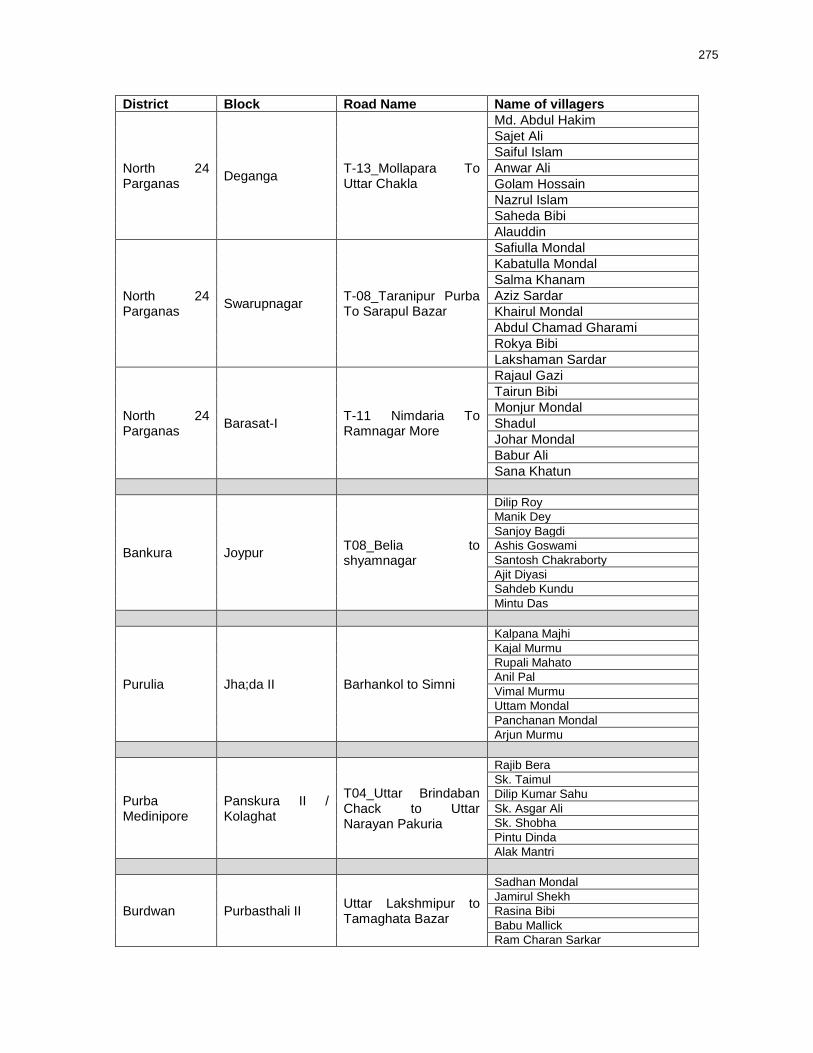
275
District Block Road Name Name of villagers
North 24 Parganas
Deganga T-13_Mollapara To Uttar Chakla
Md. Abdul Hakim
Sajet Ali
Saiful Islam
Anwar Ali
Golam Hossain
Nazrul Islam
Saheda Bibi
Alauddin
North 24 Parganas
Swarupnagar T-08_Taranipur Purba To Sarapul Bazar
Safiulla Mondal
Kabatulla Mondal
Salma Khanam
Aziz Sardar
Khairul Mondal
Abdul Chamad Gharami
Rokya Bibi
Lakshaman Sardar
North 24 Parganas
Barasat-I T-11 Nimdaria To Ramnagar More
Rajaul Gazi
Tairun Bibi
Monjur Mondal
Shadul
Johar Mondal
Babur Ali
Sana Khatun
Bankura Joypur T08_Belia to shyamnagar
Dilip Roy
Manik Dey
Sanjoy Bagdi
Ashis Goswami
Santosh Chakraborty
Ajit Diyasi
Sahdeb Kundu
Mintu Das
Purulia Jha;da II Barhankol to Simni
Kalpana Majhi
Kajal Murmu
Rupali Mahato
Anil Pal
Vimal Murmu
Uttam Mondal
Panchanan Mondal
Arjun Murmu
Purba Medinipore
Panskura II / Kolaghat
T04_Uttar Brindaban Chack to Uttar Narayan Pakuria
Rajib Bera
Sk. Taimul
Dilip Kumar Sahu
Sk. Asgar Ali
Sk. Shobha
Pintu Dinda
Alak Mantri
Burdwan Purbasthali II Uttar Lakshmipur to Tamaghata Bazar
Sadhan Mondal
Jamirul Shekh
Rasina Bibi
Babu Mallick
Ram Charan Sarkar

276
District Block Road Name Name of villagers
Pashim Medinipore
Naryangarh Gopinathpur to Kotaijiageria
Swapan Kumar Das
Subol Maity
Purna Chanda Das
Lakshmi Kanta Bera
Sidheswar Roy
Aparna Bera
Sudarshan Samanta
Pashim Medinipore
Pingla Pratapchak to Barakhelna
Subol Dey
Shekh Abdul
Pradip Datta
Mithun Manna
Mahadeb Barman
Ajit Atta
Dipa Bhuia
Banamali Singh
Jalpaiguri Alipurduar II T18 at NH31C to T7 at Parakota GP Office
Tarani Barman
Subrata Biswas
Susanta Das
Ranjit Das
Dulal Barman
Khoka Dakua
Sunil Das
Jalpaiguri Alipurduar II T01 at Taleswarguri to T01 at Samuktala
Luis Hasda
Lolo Mandi
Ludong Durung,
Lapsap Tudu
Solemon Soren
Uttar Dinajpur Itahar Uzani to Pakabari
Dipant Limpo
Santa Chetri
Mina Kala
Sharmila Chetri
Shyam Thapa
Megha Rai
Pramila Subba
Malda Englishbazar Atgama to Mobarakpur
Sanatan Mondal
Mh. Saiful
Begam Faridabibi
Ranjit Karmakar
Mh. Rafikul Seikh
Sarnali Ghosh
Amit Pramanik
Jagai Mondal