"@1" special projects payroll B.V. 70880565 "SOLIZE ... - IND
Upload
khangminh22Category
view
0download
0
Initial Environmental Examination
May 2015
IND: Rural Connectivity Investment Program – Project 3 Batch 3 Roads, West Bengal
Prepared by Ministry of Rural Development, Government of India for the Asian Development Bank.

CURRENCY EQUIVALENT as of May 2015
Currency unit — Indian rupee (Rs) Rs 1.00 = $ .01572
$1.00 = Rs 63.5981
ABBREVIATIONS
ADB Asian Development Bank MORD Ministry of Rural Development
MORD Ministry of Rural Development
APO Accident Prevention Officer
B.T. Black Top
BGL Below Ground Level
BIS Bureau of Indian Standards
BOQ Bill of Quantity C.C. Cement Concrete
CD Cross Drainage
CGWA Central Ground Water Authority
CGWB Central Ground Water Board
Ch. Chainage
COI Corridor Of Impact
CPCB Central Pollution Control Board
CTE Consent to Establish
CTO Consent to Operate
DG Diesel Generating
DPR Detailed Project Report EARF Environmental Assessment Review Framework
ECOP Environmental Code of Practices
EIA Environmental Impact Assessment
EMOP Environmental Monitoring Plan
EMP Environmental Management Plan
EO Environmental Officer
FEO Field Environmental Officer
GDP Gross Domestic Product
GOI Government of India
GSHAP Global Seismic Hazard Assessment Program
HC Hydrocarbon
HH House Hold IEE Initial Environmental Assessment
IRC Indian Road Congress
LHS Left Hand Side
MCM Million Cubic Meter
MFF Multi-Tranche Financing Facility
MoEF Ministry of Environment and Forests
MoRD Ministry of Rural Development
MOSRTH Ministry of Road Transport & Highways
NAAQS National Ambient Air Quality Standards
NGO Non-government organization
NOx Nitrogen Oxides

This initial environmental examination is a document of the borrower. The views expressed herein do not necessarily represent those of ADB's Board of Directors, Management, or staff, and may be preliminary in nature. Your attention is directed to the “terms of use” section of this website. In preparing any country program or strategy, financing any project, or by making any designation of or reference to a particular territory or geographic area in this document, the Asian Development Bank does not intend to make any judgments as to the legal or other status of any territory or area.
NRRDA National Rural Road Development Agency
NSDP Net State Domestic Product
PIC Project Implementation Consultant
PIU Project Implementation Unit
PLF Plant Load Factor
PM Particulate Matters
PMGSY Pradhan Mantri Gram Sadak Yojna
PPE Personal Protective Equipment’s
PPTA Project Preparation Technical Assistance RCIP Rural Connectivity Investment Program
RHS Right Hand Side
ROW Right of way
RRS I Loan 2018-IND: Rural Roads Sector I Project
RRS II Loan 2248-IND: Rural Roads Sector II Investment Program RSES ADB’s Environmental Safeguard Division
SBD Standard Bidding Documents
SDP State Domestic Product
SO2 Sulphur Dioxide
SPCB State Pollution Control Board
SPS ADB’s Safeguard Policy Statement,2009
SRRDA State Rural Road Development Agency STDs Sexually transmitted diseases
TDS Total Dissolved Solids
TSC Technical Support Consultants
UNESCO United Nations Educational, Scientific and Cultural Organization WBM Water Bound Macadam
WBSRRDA West Bengal State Rural Road Development Agency

CONTENTS
EXECUTIVE SUMMARY ............................................................................................................. i A. Background ...................................................................................................................... i B. Description of Project ....................................................................................................... i C. Description of Environment .............................................................................................. ii D. Anticipated Environmental Impacts and Mitigation Measures ......................................... iii E. Environmental Management Plan and Institutional Arrangements ................................... v F. Public Consultation and Information Disclosure ............................................................... v G. Conclusion ...................................................................................................................... v I. INTRODUCTION ............................................................................................................. 1 A. Project Background ......................................................................................................... 1 B. Project Road Identification and Location .......................................................................... 1 C. Rural Road Construction Proposal .................................................................................. 2 D. ADB’s Safeguard Policies and Category of the Project .................................................... 3 E. Objectives and Approach for Environnemental Assessment ............................................ 3 F. IEE Methodology and Content ......................................................................................... 3 G. Legal Framework and Legislative Requirements: ............................................................ 4 H. Acknowledgement ........................................................................................................... 6 II. DESCRIPTION OF THE PROJECT ................................................................................ 0 A. General ........................................................................................................................... 0 B. Sample Roads Selected in West Bengal State ................................................................ 0 C. Project Description .......................................................................................................... 1 III. DESCRIPTION OF THE ENVIRONMENT ....................................................................... 5 A. General ........................................................................................................................... 5 B. Physical Environment .................................................................................................... 12 C. Biological Environment .................................................................................................. 20 D. Socio-Economic Environment ........................................................................................ 24 E. Salient Environmental Features of Sample Roads ......................................................... 27 IV. ANTICIPATED ENVIRONMENTAL IMPACTS AND ITS MITIGATION MEASURES ..... 38 A. Common Impacts during Design and Construction Phase ............................................. 38 B. Common Impacts during Post Construction and Operation Phase ................................ 49 C. Socio-Economic Impact ................................................................................................. 51 D. Road Specific Impacts ................................................................................................... 51 V. CLIMATE RISK SCREENING AND ADAPTATION MEASURES ................................... 54 A. Climate Change Projection ............................................................................................ 54 B. Natural Hazards and Climate Risks ............................................................................... 55 C. Climate Change Adaptation Measures .......................................................................... 56 VI. ENVIRONMENTAL MANAGEMENT PLAN, INSTITUTIONAL ARRANGEMENTS AND GRIEVANCE ADDRESS MECHANISM .................................................................................... 57 A. Environmental Management Plan .................................................................................. 57 B. Environmental Monitoring Plan ...................................................................................... 57 C. Institutional Arrangements and Responsibilities ............................................................. 58 D. Institutional Environmental Responsibilities ................................................................... 58 E. Environmental Assessment and Review Framework (EARF) for RCIP .......................... 61 F. Capacity Building ........................................................................................................... 63 G. Consultation and Information Disclosure ....................................................................... 63 H. Grievance Redress Mechanism ..................................................................................... 63 VII. PUBLIC CONSULTATION AND INFORMATION DISCLOSURE ................................... 65 A. General ......................................................................................................................... 65 B. Compliance with Relevant Regulatory Requirements .................................................... 65

C. Beneficiaries’ Comments ............................................................................................... 65 VIII. CONCLUSIONS AND RECOMMENDATIONS .............................................................. 68 A. Conclusions .................................................................................................................. 68 B. Key Recommendations ................................................................................................. 69
Appendices Appendix 1: Details of Roads in West Bengal RCIP Batch III (Tranche III) ................................70 Appendix 2: ECOPs of Sample Roads in West Bengal .............................................................72 Appendix 3: Photo Illustration of Sample Roads in West Bengal ............................................ 115 Appendix 4: Guidelines for Borrow Areas Management .......................................................... 117 Appendix 5: Environmental Management Plan ........................................................................ 120 Appendix 6: Environmental Monitoring Plan ............................................................................ 129 Appendix 7: List of Person for Public Consultation .................................................................. 140 List of Tables Table 1: RCIP: Tranche III Roads in West Bengal ...................................................................... 2 Table 2: Applicable Rules and Regulations for RCIP Roads ...................................................... 5 Table 3: Summary of District Wise Rural Roads – Tranche III .................................................... 0 Table 4: Details of Sample Roads .............................................................................................. 0 Table 5: ROW Requirement ....................................................................................................... 2 Table 6: Summary Key Environmental Features of the Sample Roads Districts ......................... 6 Table 7: Ambient Air Quality during 2012 ..................................................................................12 Table 8: Ambient Air Quality Status of West Bengal in 2010-11 ................................................13 Table 9: Physiographic Characteristics of different districts .......................................................15 Table 10: The soil pattern in the state .......................................................................................16 Table 11: Utilization of Land in project Districts of West Bengal ................................................18 Table 12: List of common plant species available in the study area ..........................................20 Table 13: List of Protected Areas in West Bengal .....................................................................22 Table 14: Demographic Profile of the Project Districts ...............................................................24 Table 15: Human Development Indicators of West Bengal ......................................................24 Table 16: Literacy Rate of project districts .................................................................................25 Table 17: Indicators of Affluence ...............................................................................................25 Table 18: Physical Infrastructure ...............................................................................................27 Table 19: Salient Environmental Features of Sample Roads .....................................................27 Table 20: Impacts on biological environment, utility, community and religious structures ..........53 Table 21: Addressal of Issues and Concerns under the Project ................................................67 List of Figures Figure 1: State and Project Districts Map of West Bengal .......................................................... 1 Figure 2: Cross-section of Rural Roads...................................................................................... 4 Figure 3: Physiography Map of Project Districts –West Bengal .................................................14 Figure 4: Geological Map of West Bengal .................................................................................16 Figure 5: Hazard Zone Map ......................................................................................................17 Figure 6: Seismic Zone Map .....................................................................................................17 Figure 7: Protected Areas of West Bengal ................................................................................21 Figure 8: Predicted Change in Annual Average Maximum Temperature, A2, 2046-2065 ..........39 Figure 9: Predicted Future Trend in Annual Maximum Temperature , A2, 2046-2065 ...............39 Figure 10: Predicted Change in Annual Total Precipitation, A2, 2046-2065 ..............................39 Figure 11: Predicted Future Trend in Annual Total Precipitation, A2, 2046-2065 ......................39 Figure 12: Predicted Change in Annual Average Maximum Temperature, A2, 2046-2065 ........54 Figure 13: Predicted Future Trend in Annual Maximum Temperature , A2, 2046-2065 .............54

Figure 14: Predicted Change in Annual Total Precipitation, A2, 2046-2065 ..............................55 Figure 15: Predicted Future Trend in Annual Total Precipitation, A2, 2046-2065 ......................55 Figure 16: Flood Frequency Map, Assam ..................................................................................56 Figure 17:Landslide Prone Map, Assam....................................................................................56 Figure 18: Institutional Arrangement for EMP Implementation ...................................................59
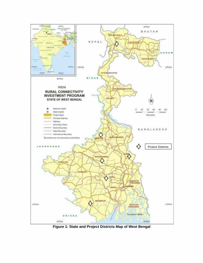
Figure 1: State and Project Districts Map of West Bengal
Project Districts


i
EXECUTIVE SUMMARY
A. Background
1. The Government of India (GOI) launched PMGSY in year 2000 with the objective of providing all-weather road connectivity to all rural habitations with a population of more than 500 persons in plains and 250 persons in hill states. This program is being implemented through National Rural Road Development Authority (NRRDA) under Ministry of Rural Development (MORD) at central level and through State Rural Road Development Authority/Agencies (SRRDA) at state level. The Rural Connectivity Investment Program (RCIP) is continuation of Rural Road Sector II Program (RRS IIP) and is a multi-tranche financing facility (MFF) that aims to construct or upgrade to the all-weather standard about 9,000 km of rural roads connecting around 4,800 habitations in the states of Assam, Chhattisgarh, Odisha, Madhya Pradesh and West Bengal. Under RCIP Project 1 (Loan 2881-IND) sub-projects cover about 3,530 km in total (426.43 km in Assam, 1,009 km in Chhattisgarh, 1,187 km in Madhya Pradesh, 757 km in Odisha, and 151 km in West Bengal) while the RCIP Project 2 (Loan 3065-IND) covers about 3,693 km in total (499 km in Assam, 429 km in Chhattisgarh, 654 km in Madhya Pradesh, 1,184 km in Odisha, and 930 km in West Bengal). The amount funded for the states under ADB RCIP Project 1 is approximately $381.44 million while funding under Project 2 is about $275 million. The subprojects are at various stages of implementation. 2. The Government is now planning to submit to ADB the Third Periodic Finance Request (PFR) that includes the proposal for about 76 rural roads totalling to 637.574 km in the state of West Bengal spread over in 6 districts. The West Bengal Rural Road Development Agency (WBRRDA) is the implementing agency (IA) for the ADB funded subprojects in the state. Tranche III as per classification of ADB has been categorised as ‘Category B’ project and therefore requires an Initial Environmental Examination (IEE). 3. These roads has been selected following PMGSY guidelines for the selection of roads under this programme and satisfy the following environmental safeguards: i) the selected road shall not disturb any cultural heritage designated by the Government or by international agencies, such as UNESCO, and shall avoid any monuments of cultural or historical importance; ii) the selected road shall not pass through any designated wildlife sanctuaries, national parks, notified ecological sensitive areas or area of internationally significance (e.g., protected wetland designated by the Wetland Convention); and iii) the sub projects shall only involve activities that follow Government of India laws and regulations and meets funding agency safeguard policies
B. Description of Project
4. The proposal for rural road construction works typically considers a 10-12 m right of way (ROW), which includes side slopes for embankment, side drains on either side of the alignment. The roads consists both Black Top (B.T.) and Cement Concrete (C.C.) as per the ROW availability. The construction proposals are confined to the existing alignment of the unpaved tracks. The broad specifications for road alignment selection, pavement design, construction methodology, and geometric design are in accordance with the “Specification for Rural Roads” published by IRC on behalf of the Ministry of Rural Development, Government of India (GoI). The design details presented in this chapter highlights the PMGSY specifications. Minor changes will apply depending on road specific issues and design consideration. Since topography of Assam state is largely flat, the design details applicable to flat terrain.
ii
5. The proposed rural road construction work will provide 7.5 m roadway width (this may be reduced to 6 m as per latest guidelines) with 3.75 m carriageway in accordance with the IRC-SP 20: 2002 in plain terrain. The proposal considers a 3.75 m cement concrete pavement with lined storm water drains for stretches passing through built-up areas, waterlogged/water overtopping/ flood prone areas. The pavement design considers a base layer of variable thickness as per the design with granular sub base, 150 mm thick water bound macadam (WBM grade I & II) and finally topped with 20 mm thick bituminous pavement. Adequate cross drainage structures like pipe or slab culverts/bridge structures are considered for drainage channels across the roads. Few minor bridges are also proposed to be constructed. 6. Considering the sub-grade strength, projected traffic and the design life, the pavement design for low volume PMGSY roads are proposed to be carried out as per IRC guidelines IRC: SP: 72 – 2007 or IRC SP:77 “Design of Gravel Road” and IRC SP:62-2004 “Cement Concrete roads”. In built up area for hygienic and safety reasons, C.C pavement is proposed with a hard shoulder and appropriate line drain. A design life of 10 years is considered for the purpose of pavement design of flexible and granular pavements. The embankment height considered as 1m (average) from ground to crust except at the approaches of cross drainage structures. The embankment height will vary in flood prone area as per the HFL. The design speed considered is as per recommended design speed of 50 Km/h.
C. Description of Environment
7. West Bengal is located between lat. 20°31'N and 27°12'N and long. 85°50' and 89°52' E. The geographical area of the state is 88,752 km2 (34267 sq mi). The state boundary touches five states of the country, namely Assam, Sikkim, Orissa, Jharkhand and Bihar. It also share boundary with three countries namely Nepal, Bhutan, and Bangladesh. The state forms the ethno-linguistic region of Bengal. 8. The climate of the West Bengal state, except the Himalayan and sub-Himalayan region in the northern part of the state has a tropical climate. The minimum annual temperature in the northern districts (Himalayan foot hill region) varies from freezing point to 17°C and over 18°C in other parts of the state. The annual mean maximum temperature ranges from 28°C in the Himalayan region to 33°C in the plains. Normally, May to October months are humid and January to April are dry. The relative humidity (expressed in percentage) is more in northern and southern part of State as compared to western and eastern parts of the state. The maximum relative humidity ranges from 75 to 95% in morning hours and 50 to 65% in the evening hours. As per seismic hazard map of India updated by Bureau of Indian Standards The project region falls in Zones III & V i.e moderate to high risk zone. 9. Most of the project area lies in vast open agricultural land and is largely free from air pollution sources other than traffic and few brick-kilns existing in the area. As such, the ambient air quality (for parameters SO2, RSPM and NOX ) is expected to be iv within the limits in most of rural and semi urban areas. The ambient noise levels are also expected to be within the National Ambient Noise Standards due to absence of any high noise sources in proposed road vicinity. 10. The land use within state broadly comprises of cultivable land, uncultivable land, forest land, waste land, urban area and industrial area. Land use pattern along the project road is mixed type dominated by agriculture, barren land, forest land and residential areas. The district Jalpaiguri, has substantial area covered under forests.

iii
11. West Bengal State has three major river basins, namely Ganga, Brahmaputra and Subarnarekha. Among these, Ganga is the largest and covers almost 80% of the state, whereas the Brahmaputra basin covers about 15% of the area and Subarnarekha basin covers about 5% of the geographical area of the State. The rural road construction proposals are normally cross small drainage channels, which eventually join the major channels/rivulets. All of these channels generally remain dry for most part of the year and drain the storm water for few weeks only during or after the monsoon.\ 12. The west Bengal state owing to the varying altitude from the Himalayas to the coastal plains, the flora and fauna of the state is diverse. Forests make up 14% of the geographical area of West Bengal, which is lower than the national average of 23%. Protected forests cover 4% of the state area. Part of the world's largest mangrove forest Sundarbans is located in southern West Bengal. None of the road stretches passes through any forest land/area. The tree density within ROW of sample road project alignment is about 5-10 trees per Km. West Bengal has 5 National Parks and 15 Wild life sanctuaries spread over an area of 2754.39 Sq. Km. There is no wildlife Sanctuaries/National Parks, Tiger Reserves etc. along the project area. No wetland or large water body falls except large water stagnant area in one or two roads. Fisheries activities are quite common in subproject areas. None of the roads consists of any rare, endangered or threatened floral or faunal species. Small number of tree is falling within ROW. 13. West Bengal has a total population of about 90 million is largely rural (73%). Tribal constitute about 5.8% of the population, and scheduled castes form about 28.6%. The healthcare system in the state is well establish and is undergoing for further upgradation through public private partnership. West Bengal’s network of healthcare facilities comprises 433 Governmental & non-Governmental hospitals.The state has made considerable progress in the literacy level of the state increasing from 68.64% in 2001 to 77.08 in 2011. The percentage of population below the poverty is high at 32%. 14. Agriculture is the leading occupation in West Bengal. Rice is the state's principal food crop. Other food crops are pulses, oil seeds, wheat, tobacco, sugarcane and potatoes. Manufacturing industries playing an important economic role are engineering products, electronics, electrical equipment, cables, steel, leather, textiles, jewellery, frigates, automobiles, railway coaches, and wagons. West Bengal is nearly three percent of the nation's cultivable land. It produces more than eight per cent of the food of the country. West v Bengal has well-developed road and rail network.
D. Anticipated Environmental Impacts and Mitigation Measures
15. Road improvements work brings substantial economic and social benefits to rural communities and national economies. However, it may also cause adverse environmental impacts though of smaller magnitude, since rural road subprojects are planned to follow the existing alignments and will be of 6 to 7.5 m width only. The impacts are largely expected to be during construction phase, which can be mitigated through engineering measures and adoption of best construction practices. 16. All project roads are subjected to environmental screening using the ECOP checklist. A sample size of 10% was selected by the WBRRDA with support from the Project Implementation Consultant (PIC) from which this state level IEE was based. Separate environmental checklist were prepared for bridges with length greater than 50m. All sample roads included under RCIP were selected based on ecological and climate change
iv
consideration defined under EARF. Accordingly, none of the sample roads passes through protected areas or encroaches precious ecology (sensitive or protected areas) or any historical or archeologically protected areas. No forestland diversion is involved either. 17. By the 2050s, downscaled global climate models predicts a general warming in the West Bengal. The annual average maximum temperature is expected to increase by 0.89oC-3.05oC and the maximum temperature is expected to increase by 0.5oC to 2.86oC. However, there was no agreement of the GCM ensemble on the projected change in rainfall. Nonetheless, in areas where a significant probability (>95%) in predicted future rainfall exists, annual rainfall will increase in Hoogli and Barddhaman. The cost of addressing flooding and erosion for the RCIP Tranche 3 in the State is Rs 116.042 million of which RS9.544M is for constructing cross and side drains, Rs1.076M is for bridges and culverts, Rs103.263M is for increasing road embankment height, and Rs2.158M is for slope stabilization. 18. No land acquisition is involved due to various measures considered for finalisation of road alignment. Villagers have volunteered to donate their land if at certain stages land is required for geometrical correction or alignment adjustment for avoiding tree cutting or shifting of community structure. None of the sample road passes through any forest land, however about 83 avenue trees will be cleared from 16 sample roads There are 43 ponds are located very near to ROW of 16 roads in Wes Bengal, where protection work is needed to avoid damage an \d encroachment to private properties. 19. Site clearing operations may have impact on common utilities, community properties, and land use. These will be avoided by limiting most of the construction activities along the alignment and strictly implementing the utility and road furniture shifting plan; ground staking of RoW; prior informed consent on vegetation clearing, tree felling with permission from Forest Department, and utility shifting; and preservation and re-use of all topsoil. 20. Impacts related to health, safety of the labourers at the construction campsites, availability of safe drinking water, sanitation, and collection, storage, and disposal of oily wastes addressed in the EMP mostly through good housekeeping and linking with local health protection programs. All construction camps and hotmix plant will be set up at least 500 m away from habitat or forest areas. The contractor will prepare appropriate traffic diversion scheme, which shall be implemented in different stretches of the road as per the progress of the construction work to avoid or minimize disturbance to existing traffic. All excavated materials from roadway, shoulders, verges, drains, cross drainage shall be used for embankments formation if feasible, filling pits, and landscaping. Unusable debris material should be suitably disposed off at pre-designated disposal locations, with approval of the concerned authority. The bituminous wastes shall be disposed in secure landfill sites only in environmentally accepted manner. To minimize deterioration of air quality during construction the following will be implemented as part of the civil works: i) use of covered haul trucks, ii) regular sprinkling of water on active construction fronts and materials storage areas; iii) hot mix plants and diesel generating sets comply with stack height requirements and secure clearance from the State Pollution Control Board, and iv) mandatory use of PPEs to all construction workers. 21. Borrowing earth from agricultural land shall be minimised to the extent possible. Further, no earth shall be borrowed from already low-lying areas. The borrow earth shall be sourced from identified locations and with prior permission of landowner and with clear understanding for its rehabilitation. The Indian Road Congress (IRC):10-1961 guideline should be used for selection of borrow pits and quantity that can be borrowed. Balance cut and fill will be followed to the extent possible to minimize borrowing. Adequate provision shall be made for cross

v
drainage structures for maintaining natural drainage pattern in the subproject area and preventing soil erosion. 22. The provision of adequate cross drainage structures shall be made to ensure smooth passage of water and maintaining natural drainage pattern of the area. The discharge capacity of the CD structure shall be designed accordingly. Road levels shall be designed considering HFL. Low costs measures like use of bamboo or eucalyptus tree will be adopted for embankment protection and control of soil erosion. Other slope stabilisation measure like vegetative protection will be installed when necessary as deemed by the PIC. None of the sample roads is crossing any natural stream except NH-55 to Siridihi (A) road in Dhenkanal district, which crosses Sarapa Nallah.
E. Environmental Management Plan and Institutional Arrangements
23. Appropriate mitigation measures are identified for all rural road construction and operation activities. The identified impacts associated with rural roads and mitigative measures are largely common to most of the roads. The EMP provides action common to all roads at pre construction, construction and operation stage. Since IEE is carried out, prior to preparation of DPR, the EMP will be updated specific to road as per DPR requirements by PIU and included with DPR, which shall be available to contractor at the time of bidding. 24. The environmental monitoring program is prepared with aim to monitor the environmental performance of environmental management plan. For rural roads, Environmental Monitoring plan will be more observation oriented and it provides observation areas with frequency of monitoring at pre construction aspects construction stage and operation stage. 25. NRRDA/SRRDA has defined institutional setup including with specified responsibility for environmental management. Existing capacity of the State Rural Roads Development Agencies (SRRDAs) and Project Implementation Units (PIUs) for implementing environmental safeguard issues need substantial strengthening. The capacity enhancement is proposed through focused workshops and training session. Few workshops have already been conducted at participating states through ADB appointed Environmental specialist. 26. Grievance Redress Mechanism is also defined for receiving public concerns at state, PIU, and central level.
F. Public Consultation and Information Disclosure
27. The project has immense acceptability among the local people. They perceived that in addition to providing all weather connectivity, the sub-project road would bring positive socioeconomic changes in the area. The project has tried its best to address all the issues raised during consultations under the constraints of suitability from engineering point of view.
G. Conclusion
28. The findings of Environment Assessment of sample roads indicate that impacts are mostly similar and subprojects are unlikely to cause any significant environmental impacts. While some of the impacts are negative, there are many bearing benefits to the area. Most of the impacts are likely to occur during construction stage, are temporary in nature, and can be mitigated with minor to negligible residual impacts. The implementation of prescribed mitigation measures will minimize/avoid the adverse impacts. Moreover, the impacts shall be monitored

vi
continually by implementing and updating the Environmental Management plan and Environmental Monitoring Plan. Executing agency shall ensure that updated road specific EMP forms part of DPR and is available to contractor at the time of bidding. The contractor will specify the quantity and budget for various activities like rehabilitation of borrow earth pits, first aid and sanitation facilities at construction camp and temporary office/material storage place as per EMP requirements. The same shall be revised if there is any change in the project design. Any such change shall be reported to ADB as well. 29. Any major changes or any major additional work other than the proposed project activities will require updation of ECOPs and IEE. The updated ECOPs and IEE will have to be submitted to NRRDA and ADB for concurrence before civil works commence.

1
I. INTRODUCTION
A. Project Background
1. Pradhan Mantri Gram Sadak Yojana (PMGSY) aims to provide all-weather road connectivity to currently unserved habitations in India’s rural areas, where 70% of the population live. The Government of India (GOI) launched “The Pradhan Mantri Gram Sadak Yojna (PMGSY) in year 2000 The objective of PMGSY is to provide all-weather road connectivity to all rural habitations with a population of more than 500 persons in plains and and 250 persons in hill states. This program is being implemented through National Rural Road Development Authority (NRRDA) under Ministry of Rural Development (MORD) at central level and through State Rural Road Development Authority/Agencies (SRRDA) at state level.
2. The Rural Connectivity Investment Program (RCIP) is continuation of Rural Road Sector II Program (RRS IIP) and is a multi-tranche financing facility (MFF) that will construct or upgrade to the all-weather standard about 9,000 km of rural roads connecting around 4,800 habitations in the states of Assam, Chhattisgarh, Orissa, Madhya Pradesh and West Bengal (RCIP states). The RCIP will also focus on improvement of institutional arrangements, business processes and associated capacity building. This will especially be done in relation with design, operation, safeguard, financial, road safety, and asset management matters. Investments in rural roads will improve connectivity, cut transport costs, and provide enabling infrastructure to areas currently with poor access to markets and urban towns, and thus contribute to growth and equity in the country’s largest sector
3. RCIP Tranche 1 was to finance part of the cost of (i) construction of 3,461 km of rural roads in the five project states (ii) the related consultancy services to provide support for subprojects under Tranche 1 and (iii) capacity building of implementing agencies by establishing rural connectivity training and research centers (RCTRCs) and rural roads network management units (RRNMUs). The Loan for Tranche 1 (Ln 2881-IND) totalling $252 million was signed in April 2013 and became effective on 5 June 2013. RCIP Tranche 2 (Ln 3065-IND) totaling $275 million was approved on 25 November 2013. Under RCIP Tranche I till May 2014; 515 out of 532 (or about 97%) contracts have been awarded while for RCIP Tranche II; 498 out of 716 (or about 70%) contracts have been awarded.
4. The Government is now planning to submit to ADB the Third Periodic Finance Request (PFR) that includes the proposal for about 76. rural roads totalling to 637.574 km in the state of West Bengal. WBSRRDA is the implementing agency (IA) for the ADB funded subprojects in the state. The preparatory works for the proposed roads under the third tranche have been completed for the state. As per the requirements of ADB, it is mandatory that the subprojects under the programme comply with ADB's environmental safeguards. The project as per classification of ADB has been categorised as ‘Category B’ project and therefore requires an Initial Environmental Examination (IEE). The Initial environmental examination (IEE) report has been prepared by using environmental checklist. The report has been prepared by M/s Operations Research Group (P) Ltd., the Technical Support Consultants (TSC) appointed by National Rural Road Development Agency (NRRDA) under the ADB loan assistance.
B. Project Road Identification and Location
5. PMGSY has prepared specific guidelines for the selection of roads under this programme. The key requirements is that any road will be eligible for construction or up-

2
gradation only if it is part of the Core Network1 and satisfy the following environmental safeguards:
• The selected road shall not disturb any cultural heritage designated by the Government or by international agencies, such as UNESCO, and shall avoid any monuments of cultural or historical importance.
• The selected shall not pass through any designated wildlife sanctuaries, national parks, notified ecological sensitive areas or area of internationally significance (e.g., protected wetland designated by the Wetland Convention);
• The sub projects shall only involve activities that follow Government of India laws and regulations and meets funding agency safeguard policies.
6. The WBSRRDA has selected about 637.574 km of rural roads to be taken up under RCIP Tranche III subproject roads in West Bengal. The 637.574 km of roads comprises 76 different stretches spread over in 6 districts of the State. Within each district, the roads are further scattered in several blocks and sub divisions. The minimum and maximum length of the roads ranges between 2.26 km and 20.543 km respectively. The list of 637.574 km roads with location and length is given in Appendix 1 and the location map of the districts is shown in Figure 1.
7. Table 1 shows the summary of roads district wise qualified for Project 3 funding.
Table 1: RCIP: Tranche III Roads in West Bengal
Sl no District No of Roads Total Road Length (Km)
1 Siliguri M.P. 10 10
2 Birbhum 7 7
3 Burdwan 16 16
4 Hooghly 12 12
5 Nadia 20 20
6 Purba Medinipur 11 11
Total 76 637.6
C. Rural Road Construction Proposal
8. The proposal for rural road construction works typically considers a 10-12 m right of way (ROW), which includes side slopes for embankment, side drains on either side of the alignment. The roads consists both Black Top (B.T.) and Cement Concrete (C.C.) as per the ROW availability.
9. The construction proposals are confined to the existing alignment of the unpaved / partly paved tracks. Majority of these are pathways traditionally used by the villagers and transformed into the present form of unpaved tracks/roads through minor construction works taken up by the communities, local bodies and state Government over the decades.
1Core Network is that minimal network of roads (routes) that is essential to provide access to essential social and economic services to all eligible habitations in the selected areas through at least single all-weather road connectivity. A core network comprises of through routes and link routes. Through routes are the ones, which collect traffic from several link roads or a long chain of habitations and lead it to marketing centres either directly or through the higher category roads i.e., the district roads or the state or national highways. Link routes are the roads connecting a single habitation or a group of habitations to through routes or district roads leading to market centres. Link routes generally have dead ends terminating on a habitation, while through routes arise from the confluence of two or more link routes and emerge on to a major road or to a market centre

3
D. ADB’s Safeguard Policies and Category of the Project
10. The Asian Development Bank has defined its Safeguard requirements under its ‘Safeguard Policy Statement 2009’ (SPS 2009). The SPS 2009 require environmental assessment, mitigation and commitment towards environmental protection. The prime objectives of these safeguard policies are to (i) avoid adverse impacts of projects on the environment and affected people, where possible; and (ii) minimize, mitigate, and/or compensate for adverse project impacts on the environment and affected people when avoidance is not possible. ADB as per SPS 2009 classify a project into category A, B or C depending on potential adverse environmental impacts.
11. All environmentally sensitive components along each subproject roads is critically analysed to assess the magnitude and extent of likely impacts. These sample subproject roads stretches do not pass through any protected areas nor located near any archeologically important monument. As per selection guidelines, none of the selected subproject road passes through reserved forests either. Few trees cutting though may be involved. The road primarily passes through agricultural and residential areas. Most of the roads follow existing village roads and unpaved movement paths. As such, additional land requirement is also low. Hence, the project falls under category B as per ADB Safeguard Policy Statement 2009.
12. No categorisation is made under environmental legislation since these small roads do not require any environmental clearance in accordance to Indian Environmental (Protection) Act and Rules, 1986 amended till date.
E. Objectives and Approach for Environnemental Assessment
13. The prime objectives of the environmental assessment is to identify the likely environmental impacts during design, construction and operation stage of each sub project and suggest cost effective mitigation and monitoring measures with institutional mechanism applicable to all the sub projects as well as specific to a subproject.
14. Since there is large number of subproject roads involved under RCIP and magnitude of each road is small, preparation of individual IEE’s for each road will be difficult and time consuming. ADB had finalised Environmental Code of Practices (ECOP) checklist under RRS II, which is modified for RCIP. Subprojects specific Initial Environmental Assessment (IEE) is carried out as per this ECOP checklist for sample roads. These completed ECOP checklist with annexure on tree, utility and community structures, strip plans and selected photographs for 16 sample roads are enclosed as Appendix 2 and Appendix 3 respectively.
15. The findings of 16 sample subproject specific assessment suggest that similar issues exist amongst the other 60 roads with very few subproject specific issues. Therefore, IEE report has been prepared based on ECOP checklist of selected sample subproject roads (16 roads of 116.237 km) covering 21% of total roads in the state. Impact is assessed for all the 76 roads under Tranche III. This IEE approach will be followed for conducting environmental assessment for other Tranches under RCIP.
F. IEE Methodology and Content
16. Initial Environmental Examination has been largely structured as per SPS, 2009 and ADB’s Environmental Assessment Guidelines (2003). The IEE report includes EMPs, monitoring

4
plans; cover the most environmentally sensitive components in state as well as specific to sample roads.
17. Corridor of Impact: The direct area of influence or the corridor of impact (COI) has been considered as, 10 m on either side of the proposed roads alignment Based on the proposed cross-section.
18. Field visits, Primary and Secondary Data Collection: Few of the selected sample roads was visited along with concerned PIU officials and PIC for environmental assessment and identification of associated environmental issues. Each road specific strip map was prepared during the field visit to capture the information related to tree inventory, utility and community structures located along the proposed road alignment, surface water bodies, and ecological sensitivities. Secondary environmental information pertaining to the environmental issues, protected area, forests areas were collected from various government and non-governmental / research institutions for assessment of the baseline environment of the project locations, district and state as a whole. Finally IEE is prepared after site observation and review of all collected relevant documents.
19. Data Analysis, Impact identification and Mitigation Measures: Information collected were analysed and impact was identified using expert’s assessment and following established practices. Mitigation measures are proposed common to larger roads and specific to the roads. EMP is prepared considering mitigation measures and institutional framework of WBSRRDA.
20. The IEE report includes following seven chapters including this introduction Chapter.
• Chapter 1- Introduction
• Chapter 2- Description of Project
• Chapter 3- Description of Environment
• Chapter 4- Anticipated Impacts and Mitigation Measures
• Chapter 5- Institutional Requirement and Environmental Monitoring Plan
• Chapter 6-Public Consultation and Information Disclosure
• Chapter 7- Conclusion and Recommendation
G. Legal Framework and Legislative Requirements:
21. India has well defined institutional and legislative framework. The legislation covers all components of environment viz air, water, soil, terrestrial and aquatic flora and fauna, natural resources, and sensitive habitats. India is also signatory to various international conventions and protocols.
22. As per Environment (Protection) Act, 1986; the Environmental Impact Assessment Notification, 2006; amended in 2009 defines the environmental impact assessment for defined development projects. All New or expansion of National and State Highways requires Environmental Impact Assessment and Environmental Clearance from central or state level Environmental Appraisal Authority. However, small roads projects as proposed under RCIP do not require environmental assessment or clearance as per above notification. Since above environmental assessment requirement is not applicable, the mainstream environmental concerns specific procedures that were formulated under Rural Roads Sector I (RRS I) and Rural Roads Sector II Investment Program (RRS II) will in any case be implemented.

5
23. In addition to above, new road construction or road improvement work attract many legislation including for diversion of forest land, tree cutting, opening of new quarry, establishment of temporary workshops, construction camps, hot/spot mix plants, and use of vehicles for construction. The legislation applicable for RCIP roads are listed below:
Table 2: Applicable Rules and Regulations for RCIP Roads Sl. No. Legislation Applicability
1. Environment (Protection) Act 1986-EIA Notification 2006 (Amended 2009)
Not applicable to these rural roads. It is applicable only to National and State highways.
2. Forests (Conservation) Act 1980 (Amended 1988), and Forest (Conservation) Rules, 1981, (Amended 2003)
As per above Act/Rules Forest Clearance from Department of Forests/Ministry of Environment and Forests Govt. of India is required for diversion of forest land (if any) for non-forest purpose. Prior permission is required from forests department to carry out any work within the forest areas and felling of roadside trees. Cutting of trees need to be compensated by compensatory afforestation as per permission condition.
3. The Wildlife (Protection) Act, 1972 (Amended 1993); Not applicable in this case. Since No roads will be selected passing through protected areas or sanctuaries
Not Applicable, since no roads is selected if it passes through protected areas.
4. The Water (Prevention and Control of Pollution) Act 1972 (Amended 1988), and the Water (Prevention and Control of Pollution) Rules, 1974
Placement of hot-mix/ spot mix plants, quarrying and crushers, batch mixing plants, discharge of sewage from construction camps requires No Objection Certificate (Consent to Establish and Consent to Operate) from State Pollution Control Board prior to start of construction or setting up specific facility. Authorisation will also be required for disposal of Hazardous Waste like waste oil etc. from State Pollution Control Board
5. The Air (Prevention and Control of Pollution) Act, 1981, (Amended 1987), and the Air (Prevention and Control of Pollution) Rules, 1982
6. The Noise Pollution (Regulation and Control) Rules, 2000 (Amended 2002)
7. The Hazardous Waste (Management, Handling and Transboundary Movement) Rules 2008 (Amended 2009), and the Batteries (Management and Handling) Rule, 2001
8. Guidelines for Ground Water Extraction Prescribed by Central Ground Water Authority under the power granted under Environment (Protection) Act 1986
Permission from Central Ground Water Authority (CGWA) is required for extracting ground water for construction purposes, from declared as Semi-critical, Critical and Overexploited areas critical or semi critical from ground water potential prospective. For NOC, An application in the prescribed Performa is to be submitted to either to the Office of the Regional Director, Central Ground Water Board (CGWB) of the concerned state, or to Member Secretary, CGWA, New Delhi

6
24. The PMGSY Scheme and Guidelines (2004) No. 12025/8/2001-RC, Ministry of Rural Development (MoRD) also defines environmental safeguards particularly with respect to sample road selection and regulatory compliance which is also to be complied with.
H. Acknowledgement
25. The TSC gratefully acknowledge the support received from NRRDA and WBSRRDA throughout the environmental assessment process. We also acknowledge the assistance received from respective PIUs and PIC and other Govt. agencies for primary and secondary data collection as well during public consultation.


0
II. DESCRIPTION OF THE PROJECT
A. General
26. The PMGSY program has mandate to provide all-weather roads to all the rural habitations within the country. RCIP is planned to meet above objective. 116.237 Km roads (16 nos.) are identified as sample roads for West Bengal under Tranche III of RCIP. The broad specification for road alignment selection, payment design, construction methodology, geometric design etc. are same and is as per the “Specification for Rural Roads” published by IRC on behalf of the Ministry of Rural Development, Govt. of India. The design details presented in this chapter are as per above specifications. Minor changes will apply depending on road specific issues and design consideration.
27. Since topography of project districts of West Bengal state is largely flat and few patches are undulated, the design details applicable to flat terrain are presented in following section.
B. Sample Roads Selected in West Bengal State
28. The West Bengal state has selected 76 roads with a total length of 637.6 Km spread over 5 districts and 1 mahakuma parishad for Tranche III funding. Details shown in Appendix 1. District wise Summary is given in Table 3.
Table 3: Summary of District Wise Rural Roads – Tranche III Sl no District No. of
Packages No of Roads
Total Road Length (Km)
Maximum Road Length
(Km)
Minimum Road Length
(Km)
1 Siliguri M.P. 10 10 43.578 7.2 2.5
2 Birbhum 7 7 50.550 18.5 2.26
3 Burdwan 16 16 137.200 13.75 4.6
4 Hooghly 12 12 87.930 14.72 3.16
5 Nadia 20 20 218.100 20.543 5.145
6 Purba Medinipur 11 11 100.300 15.6 5.2
Total 76 76 637.6 20.543 2.26
29. For preparation of IEE, 16 sample roads (116.237 km) covering more than 20% of the total roads in the state have been considered. All 6 districts have been covered for selection of sample roads. Details are given in Table below
Table 4: Details of Sample Roads
Sl. No. District Name Road Name Length (Km)
1 Birbhum Dakshingram to Saithia Rampurhat road at Battala via Ratma Sibgram
4.821
2 Birbhum Barutia to Chottorigram Road via Radhanagar 2.381
3 Burdwan Radhakantapur More to Sahajadpur 5.250
4 Burdwan Bhota to Karanji 13.650
5 Hooghly Kumarganj To Balitakundu Part Of Pundahit Rathtala To Balitakundu Po Salikana To Shripur Jn
4.084
6 Hooghly
Mukundapur busstop to Blacktop road part of singhtimore Ichanagar Rangupur RD
3.600
7 Hooghly Keshab Chak Bank toTarakeswar Padmapukur More 5.880
1
Sl. No. District Name Road Name Length (Km)
8 Nadia Nimtala Bazar To Rustam Nagar 6.564
9 Nadia Hanskhali To Nidhirpota 5.302
10 Nadia Kalinagar To Sahapur 19.925
11 Nadia Kharer Math To Gobindapur 6.275
12 Purba Medinipur Jasar To Brindabanchak 11.000
13 Purba Medinipur Gorsafat To Asnan (Arang Kyarana) 9.750
14 Purba Medinipur Dakshin Kalamdan To Tikashi 9.100
15 Siliguri M.P. Goyaltuli more to Bidhannagar via Tufandangi 6.134
16 Siliguri M.P. Balaijhora (NH31C) to Bhogvita 2.521
Total 16 roads in 6 districts 116.237
C. Project Description
1. Rural Road Construction Proposals
30. The proposed rural road construction work will provide 7.5 m roadway width2 with 3.75 m carriageway in accordance with the IRC-SP 20: 2002 in plain terrain. The proposal considers a 3.75 m cement concrete pavement with lined storm water drains for stretches passing through built-up areas, waterlogged/water overtopping/ flood prone areas. The pavement design considers a base layer of variable thickness as per the design with granular sub base, 150 mm thick water bound macadam (WBM grade I & II) and finally topped with 20 mm thick bituminous pavement. Adequate cross drainage structures like pipe or slab culverts/bridge structures are considered for drainage channels across the roads. 0 shows the typical cross section of the rural roads.
31. The rural road construction works will be in conformance with the Rural Roads Manual and / or Technical Specifications (IRC: SP20: 2002) for Rural Roads published by the Indian Road Congress (IRC) on behalf of Ministry of Rural Development, Government of India. The broad design considerations are given at later part of this chapter.
2. Present Condition
32. The project roads mainly pass through plain terrain and agricultural area. The project roads have several cross drainage structure, electric post and telephone post along the existing alignment. There are some community physical structures like Temple, Mosque, primary or secondary schools beside the roads alignment, but will not be affected due to the widening of roads. There are some utilities besides the roads. Some of these may need to be shifted.
3. Alignment and Profile
33. The existing road is generally a murram/brick/partly bituminous track with some stretches of brickbat soling (description of the road surface). Thus, the project road is an upgraded road. The construction works are to be confined to the existing alignment. The existing horizontal and vertical alignment / profile will be generally maintained except for minor smoothening or corrections to sustain consistent design speed without causing any voluntary land acquisition requirements and thereby the possible social and/or environmental concerns.
2 The road width may be reduced 6m as per PMGSY recent decision.

2
4. Design Considerations
34. Geometrical Design and ROW Requirements: The geometric design standards for this project will conform to PMGSY (ADB) guidelines and the guidelines as stated in IRC-SP 20:2002 and the final recommendations of NRRDA expert committee (refer D.O. no. - 17305/1/2007-Tech/12 dated 30/09/2010). Recommended design standards vis-à-vis the standards followed for this road are described below. The requirement of ROW as per PMGSY guidelines considered for the design is given at Table 5 below:
Table 5: ROW Requirement
Road classification
Plain and Rolling Terrain (ROW in m)
Open Area Built-up Area
Width Range Width Range
Rural roads (ODR and VR) 15 15-25 6.0 6.0
ODR: Other District Road; VR: Village Road
35. Since terrain is plain mostly, the design speed considered is as per recommended design speed of 50 Km/h for ruling (40 Km/h as minimum speed). The radius of horizontal curve is considered as 90 m ruling minimum (60m absolute minimum). The vertical alignment is designed as per ruling gradient of 3.3% applicable for plain terrain.
36. Pavement and Embankment Design: Considering the sub-grade strength, projected traffic and the design life, the pavement design for low volume PMGSY roads are proposed to be carried out as per guidelines of IRC: SP: 72 – 2007 or IRC SP:77 “Design of Gravel Road” and IRC SP:62-2004 “Cement Concrete roads”. In built up area for hygienic and safety reasons, C.C pavement is proposed with a hard shoulder and appropriate line drain. A design life of 10 years is considered for the purpose of pavement design of flexible and granular pavements. The embankment height considered as 1m (average) from ground to crust except at the approaches of cross drainage structures. The embankment height will vary in flood prone area as per the HFL.
37. Road side drain: As the insufficient drainage of surface water leads to rapid damage of road, road side drain (Figure 2.1) are provided on the locations of habitation areas with concrete pavement. The rain water will flow along the longitudinal slope and intermittent gaps in concrete curbs
38. Carriageway: The carriageway is proposed as 3.75 m as per IRC-SP20: 2002. It may be even restricted to 3.0m, where traffic intensity is less than 100 motorised vehicles per day and where the traffic is not likely to increase due to situation, like dead end, low habitation and difficult terrain condition. The ROW requirement in built-up/constricted area may be even reduced to 5 m.
39. Shoulder: Earthen shoulder shall be constructed in layers and compacted to 100% of Proctor’s Density. It is proposed to have 1.875 m wide shoulder (0.875 m hard shoulder and 1 m earthen shoulder) on either side of carriage way.
40. Surfacing: Slow setting bitumen emulsion will be applied as primer on water bound layer. Rapid setting bituminous emulsion shall be used for Tack coat. Premixed carpet 20 mm thick and mixed with equivalent viscosity grade bitumen shall be laid as surfacing course. 6 mm thick, Type B seal coat is considered for sealing of the premixed carpet.

3
41. Structural Works :Following grades of concrete are proposed for Structural works as per specified MORD and IRC specifications:
• Concrete in superstructure of Slab Culvert – M-25 (RCC)
• Concrete in Abutment cap, Dirt wall of slab culverts – M-25 (PCC)
• Brickwork in Abutment, Return Wall, Headwall – Cement mortar (1:4)
• Concrete below Abutment, Return Wall, Headwall – M-10 (PCC)
• Concrete in pavement (on carriageway) – M-30 (PCC)
• Concrete in pavement (on shoulder and drain) – M-25 (PCC)
5. Construction Methods
42. Since these are smaller roads, NRRDA has framed specific guidelines for cost effective construction of these rural roads. As per the guideline of NRRDA, construction by more of manual means is preferred. Motor grader & tractor-towed rotavator shall be used for handling of bulk materials like spreading of aggregates in sub-base & base courses by mix-in-place method. Compaction of all items shall be done by ordinary smooth wheeled roller if the thickness of the compacted layer does not exceed 100 mm. It is also considered that, hot mix/ spot mix plant of medium type & capacity with separate dryer arrangement for aggregate shall be used for bituminous surfacing work that can be easily shifted. A self-propelled or towed bitumen pressure sprayer shall be used for spraying the materials in narrow strips with a pressure hand sprayer. For structural works, concrete shall be mixed in a mechanical mixer fitted with water measuring device. The excavation shall be done manually or mechanically using suitable medium size excavators.
6. Available Right of Way
43. As per the information available with West Bengal State Rural Road Development Agency (WBSRRDA), ROW is largely available for all the sample roads. In some of the road, it is put to agricultural use by the adjacent landowners. The private landowners along the proposed right of way (ROW) however, are voluntarily parting the encroached land and in some cases parted even their own private land without any compensation, anticipating the developmental benefits from the road construction works.
7. Traffic
44. The present traffic data on each of these rural roads typically vary between 10-15 vehicles per day on most of the rural stretches. The traffic largely comprises motor cycles/two wheelers, tractors, light commercial vehicles, animal drawn carts and bicycles.
8. Economic Assessment
45. The economic analysis carried out under the project has indicated that the rural road construction works will act as a catalyst for the rural economic growth and poverty alleviation of the community in the region.

4
Figure 2: Cross-section of Rural Roads

5
III. DESCRIPTION OF THE ENVIRONMENT
A. General
46. Baseline environmental conditions about all facets of environment viz. physical, biological and socio-economic have been established using both primary and secondary sources, consultation with local people, and interaction with forests officials and other Government officials. Efforts have been made to collect the latest information both at regional as well as local level especially along the project roads alignment. This will help to predict likely changes in the environment due to the RCIP road construction and will serve as performance indicators for various components.
47. The baseline information is presented below at state level and district level. Road specific environmental salient features has also been summarised in this chapter.
48. West Bengal is located between lat. 20°31'N and 27°12'N and long. 85°50' and 89°52' E. The geographical area of the state is 88,752 km2 (34267 sq mi). The state boundary touches five states of the country, namely Assam, Sikkim, Orissa, Jharkhand and Bihar. It also share boundary with three countries namely Nepal, Bhutan, and Bangladesh. The state forms the ethno-linguistic region of Bengal. The capital of the state is Kolkata, the third-largest urban agglomeration and the third-largest city in India. The selected Sample roads fall in Birbhum, Burdwan, Hooghly, Nadia, Putba Medinipur and Siliguri MP. Summary key environmental features of these districts are given in Table 6.

6
Table 6: Summary Key Environmental Features of the Sample Roads Districts
S. No.
Parameters Siliguri MP Birbhum Hooghly Purba Medinipore Burdwan Nadia
1. Location
• Siliguri Mahakuma Parishad (MP) has been formed in 1989 for the plains of Darjeeling district i.e Siliguri subdivision. It has a geographical area of 837.45 sq km and lies between the latitude 26027' N.and 26057'N.and the longitude 88007' E. and 88031' E.
• It is bounded on the north by the Sub-Himalayan ranges of Darjeeling district and on the south by Bangladesh, Uttar Dinajpur & Bihar. On the east, lies Jalpaiguri district and Kalimpong Sub-division of Darjeeling district, and is bounded on the west by Nepal.
• Birbhum is the northernmost District of the Burdwan Division. It lies between 23° 32' 30" and 24° 35' 0" north latitude and 88° 1' 40" and 87° 5' 25" east longitude. and cover an area of 4545 sq.km
• The district is surrounded by Murshidabad in east, Burdwan in south and state of Jharkhand in west
• Hooghly district is located between latitudes 23° 01‘ 20” and 22° 39‘ 32” N. The eastern most proximity of the district is marked by 88° 30‘ 15” east longitude and its western most proximity by 87° 30‘ 20”east longitude. It is situated on the western bank of river Bhagirathi or Hooghly bordering Barddhaman and Nadia district in the north, Howrah and Purba Medinipur in the South, North 24 Parganas and Nadia in the east and Bankura and Paschim Medinipur district in the west.
• The district is a completely flat land with no place having more than an elevation of 200 meters. The River Hooghly borders it to the east. Another major river is 'Damodar'. The district is bordered by Howrah District to the south, Bardhaman District to the north, and to the east by the River Hooghly. Bankura District lies to the north-west, with Medinipur District to the south-west.
• Purba Medinipore lies between 22°57’10” and 21°36’35”” N and 88°12’40” and 86°33’50” E. This District spread over 4295 Sq. km
• Purba Medinipur is located in the southern part of West Bengal. It is bounded to the north by Paschim Medinipur and Howrah Districts, east by Howrah and South 24 Parganas Districts and Bay of Bengal, South by Bay of Bengal and West by Paschim Medinipur District and State of Orissa. The south west corner of this District shares a common border with the State of Orissa.
• Burdwan district extends from 22o56' to 23o53' North latitude and from 86o48' to 88o25' East longitudes. District has an area of 7,024 km².
• Lying within Burdwan Division, the district is bounded on the north by Dumka (of Jharkhand), Birbhum and Murshidabad, on the east by Nadia, on the south by Hooghly, Bankura and Purulia and on the west by Dhanbad (of Jharkhand) districts.
• The district located between north latitude 24011’ and 22053’, and east longitude 89022’ and 8809’.
• The district is bounded on the North and North-west by the district of Murshidabad. On the North-east it is bounded by the Republic of Bangladesh, in the south and south east, by the district of North 24 Parganas.
2. Climate
• Siliguri has three distinct seasons: summer, winter and monsoon. In summer the temperature
• The climate of the district is generally dry, mild and healthy.
• The climate on the western side is dry and extreme, but
• Hooghly has a tropical savanna climate. The annual mean temperature is 26.8 C, although monthly mean temperatures range from 16 C to 33 C and
• The district has tropical climate with temperature-Mean Maximum temperature 32.05o Celsius. Mean Minimum temperature
• Average temperature in hot season is 30oC while at the cold season is 20oC. And average rainfall is 1500 mm
• The Climate of Nadia is characterized by an oppressively hot summer, high humidity all the

7
S. No.
Parameters Siliguri MP Birbhum Hooghly Purba Medinipore Burdwan Nadia
reaches 35 degree Celsius. Winters are generally chilled and cool when temperature goes down to 2 to 3 degree Celsius
• Mean annual maximum temperature: 34.8o
C, Mean annual minimum temperature: 12.8oC. Whereas Annual mean humidity: 81%. Average annual rainfall : 3620 mm & Average no. of rainy days 113
is relatively milder on the eastern side. During summer, the temperature can shoot well above 40 °C (104 °F) and in winters it can drop to around 10 °C (50 °F). It has been observed that rainfall is higher in the western areas as compared to the eastern areas.
• The annual average rainfall varies from 1,405 to 1,212 mm, mostly in the monsoon months (June to October).
maximum temperatures in Hooghly often exceed 380 C. The main seasonal influence upon the climate is the monsoon. Maximum rainfall occurs during the monsoon in August and the average annual total is above 1,500mm. Moderate northwesterly to northeasterly winds prevails for most of the year with a high frequency of calms. Summer is dominated by strong southwesterly monsoon winds. Winters are comfortable with temperatures lying between11 to 170C.
20.83o Celsius.
• Average Total Rainfall 1703 mm
year round and well-distributed rainfall during the monsoon. The winter sets in the middle of November and continues till the end of February. The rainfall during the monsoon months from June to September constitutes about 71 percent of the annual rainfall. Maximum rain occurs in the months of July-August. Temperature ranges from 27o C to 42o C (minimum to maximum) with a maximum humidity of 96 percent.
3.
Wild Life Sanctuaries/ National Park etc
• No Wildlife sanctuary within Siliguri MP.
• Ballavpur Wild Life Sanctuary located near Santinekaton at Bolpur sub division
• However, none of subproject roads passes through this sanctuary.
None None
• Ramnabagan Wild Life Sanctuary located in the district
• However, none of subproject roads passes through this sanctuary.
• Bethuadahari Wild Life Sanctuary located in the district
• However, none of subproject roads passes through this sanctuary.
4
Geomorphology -. Major Physiographic Units and land use
• Except for the lesser Himalayan zone of Siwalik deposits of Tertiary Age in the northern part, the main geologic formation
• This region of the district with its varied tectonic elements and riverine features is a transitional zone between the Jharkhand plateau
• The physiography of the region is that of a typical alluvial plain with gentle ups and downs. The terrain is essentially composed of soft river borne sediments deposited under fluviatile
• The physiography of the region is that of a typical alluvial plain with gentle ups and downs. The terrain is essentially composed of soft river borne
• District with its varied tectonic elements and riverine features, is a transitional zone between the Jharkhand plateau
• The physiography of the region is that of a typical alluvial plain with gentle ups and downs. The terrain is
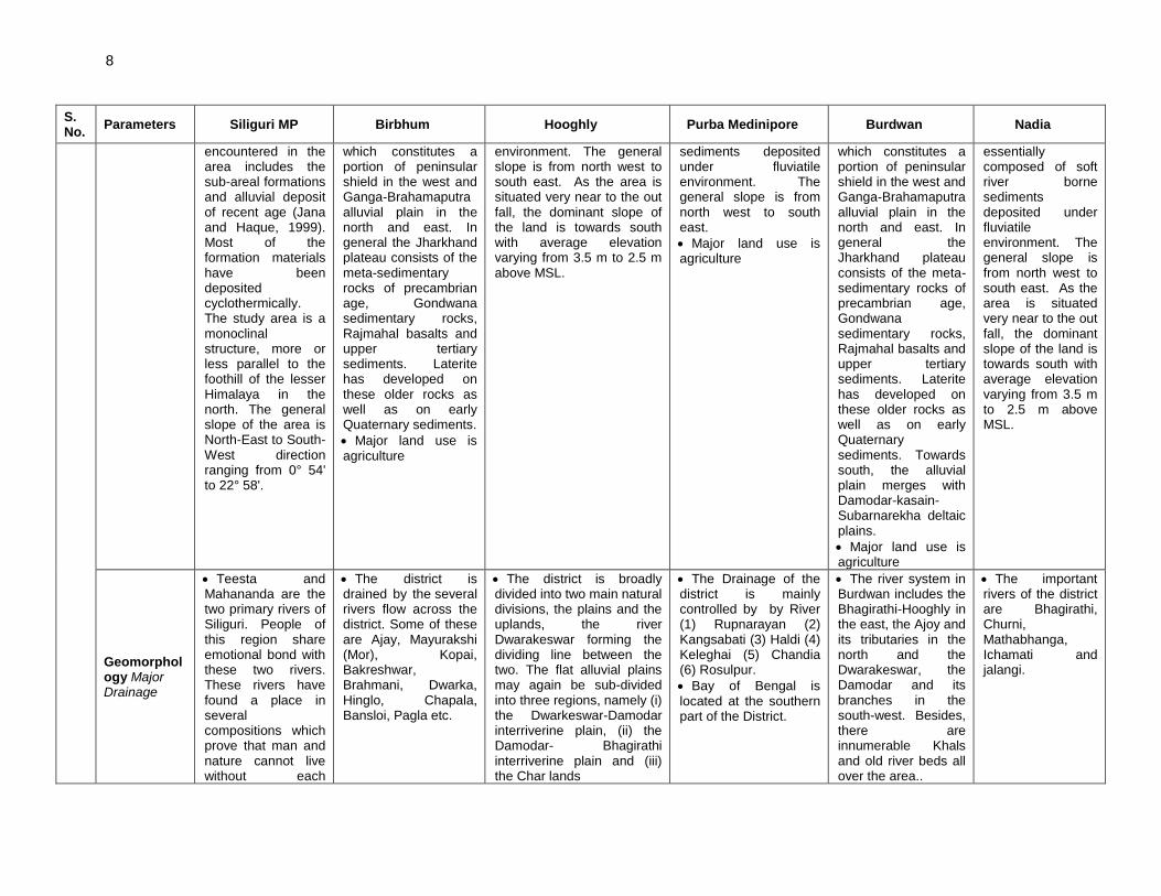
8
S. No.
Parameters Siliguri MP Birbhum Hooghly Purba Medinipore Burdwan Nadia
encountered in the area includes the sub-areal formations and alluvial deposit of recent age (Jana and Haque, 1999). Most of the formation materials have been deposited cyclothermically. The study area is a monoclinal structure, more or less parallel to the foothill of the lesser Himalaya in the north. The general slope of the area is North-East to South-West direction ranging from 0° 54' to 22° 58'.
which constitutes a portion of peninsular shield in the west and Ganga-Brahamaputra alluvial plain in the north and east. In general the Jharkhand plateau consists of the meta-sedimentary rocks of precambrian age, Gondwana sedimentary rocks, Rajmahal basalts and upper tertiary sediments. Laterite has developed on these older rocks as well as on early Quaternary sediments.
• Major land use is agriculture
environment. The general slope is from north west to south east. As the area is situated very near to the out fall, the dominant slope of the land is towards south with average elevation varying from 3.5 m to 2.5 m above MSL.
sediments deposited under fluviatile environment. The general slope is from north west to south east.
• Major land use is agriculture
which constitutes a portion of peninsular shield in the west and Ganga-Brahamaputra alluvial plain in the north and east. In general the Jharkhand plateau consists of the meta-sedimentary rocks of precambrian age, Gondwana sedimentary rocks, Rajmahal basalts and upper tertiary sediments. Laterite has developed on these older rocks as well as on early Quaternary sediments. Towards south, the alluvial plain merges with Damodar-kasain-Subarnarekha deltaic plains.
• Major land use is agriculture
essentially composed of soft river borne sediments deposited under fluviatile environment. The general slope is from north west to south east. As the area is situated very near to the out fall, the dominant slope of the land is towards south with average elevation varying from 3.5 m to 2.5 m above MSL.
Geomorphology Major Drainage
• Teesta and Mahananda are the two primary rivers of Siliguri. People of this region share emotional bond with these two rivers. These rivers have found a place in several compositions which prove that man and nature cannot live without each
• The district is drained by the several rivers flow across the district. Some of these are Ajay, Mayurakshi (Mor), Kopai, Bakreshwar, Brahmani, Dwarka, Hinglo, Chapala, Bansloi, Pagla etc.
• The district is broadly divided into two main natural divisions, the plains and the uplands, the river Dwarakeswar forming the dividing line between the two. The flat alluvial plains may again be sub-divided into three regions, namely (i) the Dwarkeswar-Damodar interriverine plain, (ii) the Damodar- Bhagirathi interriverine plain and (iii) the Char lands
• The Drainage of the district is mainly controlled by by River (1) Rupnarayan (2) Kangsabati (3) Haldi (4) Keleghai (5) Chandia (6) Rosulpur.
• Bay of Bengal is located at the southern part of the District.
• The river system in Burdwan includes the Bhagirathi-Hooghly in the east, the Ajoy and its tributaries in the north and the Dwarakeswar, the Damodar and its branches in the south-west. Besides, there are innumerable Khals and old river beds all over the area..
• The important rivers of the district are Bhagirathi, Churni, Mathabhanga, Ichamati and jalangi.

9
S. No.
Parameters Siliguri MP Birbhum Hooghly Purba Medinipore Burdwan Nadia
other.These rivers are the lifelines of the people of this region. There are other tiny river systems such as the Panchanadi and Balasun.
• Major drainage river of
the district - Bhagirathi
(western bank), Damodaar, Mundeswari, Darakeswar
5 Major Soil Type
• All the soils are definitely acidic in nature with the tendency to increase slightly in depth in most cases indicating the lacking of bases from surface and accumulation in the lower horizons. The weathering of lateritic type is the substantial mechanism in the transformation of the substratum.
• The predominant soil types are old alluvial and red lateritic with low to medium in organic carbon & phosphate content and medium to high in potash. The soil is acidic in nature with pH range of 5.0 to 6.5
• As this district lies in Gangetic alluvial plains the predominant group of soil is sandy loam to loamy soils covering area of 32.0% and 48.0% cultivated of total area respectively. Clay soil persists in 8% area and clay loam in 12.0% area of the total cultivated areas.
• Red soil, Alluvial soil and Lateritic soil
• In the west coarse gritty soil blended with rock fragments is formed from the weathering of pegmatites, quartz veins and conglomeratic sandstones, where as sandy soil characteristic of granitic rocks and sandstones. This soil is of reddish colour, medium to coarse in texture, acidic in reaction, low in nitrogen, calcium, phosphate and other plant nutrients. Water holding capacity of this soil increases with depth as well as with the increase of clay portions.
• Towards the east alluvial soil attains an enormous thickness in the low level plains to the east. This alluvial soil is formed of alluvium brought down by the Ajay, Damodar, Bhagirathi
• Alluvium of sub-recent to recent origin consists of alternate beds of compacted clay; silt and sand and are mostly confined to the bandhs and beds of present day river channels. Texture of the materials and occurrence of mica ferruginous and calcium carbonate concretions developed from different types of alluvium. Illite is the dominant clay mineral and Kaolinite and illite as mixed clay minerals are also found in the soil of this area. The soil is fine loamy mixed gray mottled, slightly acidic sandy loam.

10
S. No.
Parameters Siliguri MP Birbhum Hooghly Purba Medinipore Burdwan Nadia
and numerous other rivers. These soils are sandy, well drained and slightly acidic in nature.
6 Principal Crops
• Rice, Tea etc. • Rice is the major crop of this district and occupies about 70% of the grossed cropped area. The other important crops are wheat, potato, mustard, vegetables, sugarcane and pulses.
• Rice is the major crop of this district and occupies about 70% of the grossed cropped area. The other important crops are wheat, potato, mustard, vegetables, sugarcane and pulses.
• Main Agricultural products: - Rice, Wheat, Mustard, Ground Nut and Paan.
• Main Agricultural products:- Rice, vegetables, mustard
• Main Agricultural products: - Rice, Wheat, oil seed, potato & vegetables
7 Hydrogeology
• District areas with moderate yield (yield between 50 - 150m3hr)
• Based on the geological and geomorphologic set up Birbhum district falls within hydro geological unit namely fissured formations. Groundwater restricted to weathered residum fracture zone having secondary porosity. Groundwater Potential: 3.6 - 18 cum/hour (1 - 5 Ips)
• District areas with moderate yield (yield between 50 - 150m3hr)
• Geological set up of the district found that, these stone-formations belong to ‘recent’ (Holocene), Pleistocene, Pliocene, Miocene, etc. Almost in 2/3 part of this region, ‘recent aluvium’ can be found. And then ‘laterite’. Other rocks are conglomerate, epidiorite and niche
• Ground water occurs in this formation both under water table and confined condition.
• Most of the areas with moderate yield (yield between 50 - 150m3hr)
• Ground water occurs in this formation both under water table and confined condition. In Nadia district down to 150m there is absence of any significant clay beds making the entire aquifer upto 150m depth to occur under water table condition
8 Existing Environmental Issues
• The district has no key environmental issue
• As Siliguri is not a planned city, it has been experiencing problems in meeting present demand with its social and physical infrastructure. The streets of Siliguri is almost choked by
• The district has no key environmental issue except that its ground water is contaminated with Fluoride. The district economy is primarily agriculture with only small scale industries. Big industries like thermal power plant are also located in Birbhum. Its forest
• Almost in every year the district is affected by flood in major areas of Khanakul - II, Khanakul - I, Arambagh Sub-division & Tarakeswar & Balagarh Blocks under Chandernagore & Sadar Sub-division. Specially Khanakul - I & Khanakul – II remain water logged for a long days due to heavy rainfall as well as due to discharge of DVC water
• The district has no key environmental issues. Other than industrial emission impact natural hazards from drought and flood is common. Since sea coast exist in this district erosion is always an environment issue. Its forest covers is limited to 83 sq km against total area of the
• The district has no key environmental issues. The environmental issue are localised and may be associated with development of Industries. The western part of the district, chiefly Asansol, is rich in coal and other mineral resources.
• One of the major environmental issue of the district is presence of Arsenic in ground water
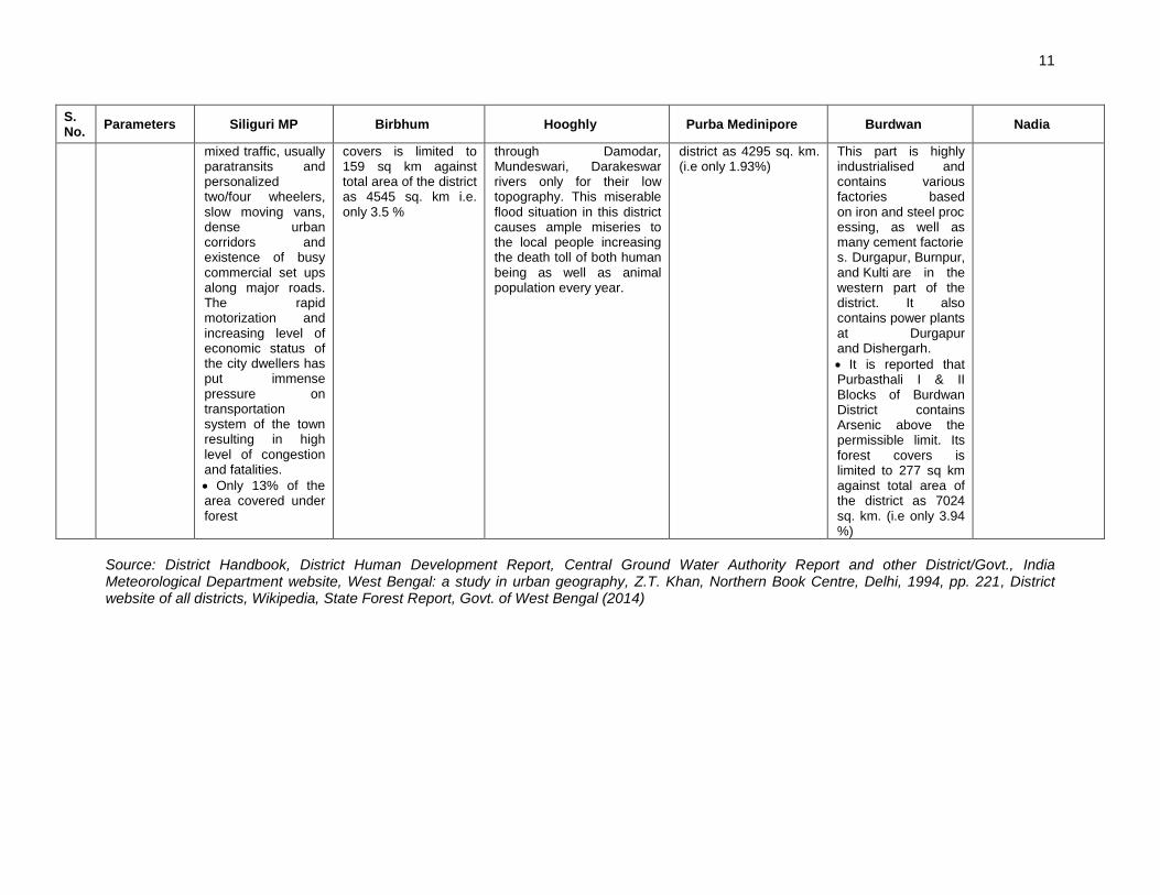
11
S. No.
Parameters Siliguri MP Birbhum Hooghly Purba Medinipore Burdwan Nadia
mixed traffic, usually paratransits and personalized two/four wheelers, slow moving vans, dense urban corridors and existence of busy commercial set ups along major roads. The rapid motorization and increasing level of economic status of the city dwellers has put immense pressure on transportation system of the town resulting in high level of congestion and fatalities.
• Only 13% of the area covered under forest
covers is limited to 159 sq km against total area of the district as 4545 sq. km i.e. only 3.5 %
through Damodar, Mundeswari, Darakeswar rivers only for their low topography. This miserable flood situation in this district causes ample miseries to the local people increasing the death toll of both human being as well as animal population every year.
district as 4295 sq. km. (i.e only 1.93%)
This part is highly industrialised and contains various factories based on iron and steel processing, as well as many cement factories. Durgapur, Burnpur, and Kulti are in the western part of the district. It also contains power plants at Durgapur and Dishergarh.
• It is reported that Purbasthali I & II Blocks of Burdwan District contains Arsenic above the permissible limit. Its forest covers is limited to 277 sq km against total area of the district as 7024 sq. km. (i.e only 3.94 %)
Source: District Handbook, District Human Development Report, Central Ground Water Authority Report and other District/Govt., India Meteorological Department website, West Bengal: a study in urban geography, Z.T. Khan, Northern Book Centre, Delhi, 1994, pp. 221, District website of all districts, Wikipedia, State Forest Report, Govt. of West Bengal (2014)
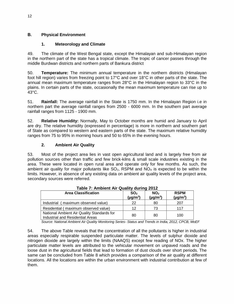
12
B. Physical Environment
1. Meteorology and Climate
49. The climate of the West Bengal state, except the Himalayan and sub-Himalayan region in the northern part of the state has a tropical climate. The tropic of cancer passes through the middle Burdwan districts and northern parts of Bankura district
50. Temperature: The minimum annual temperature in the northern districts (Himalayan foot hill region) varies from freezing point to 17°C and over 18°C in other parts of the state. The annual mean maximum temperature ranges from 28°C in the Himalayan region to 33°C in the plains. In certain parts of the state, occasionally the mean maximum temperature can rise up to 43°C.
51. Rainfall: The average rainfall in the State is 1750 mm. In the Himalayan Region i.e in northern part the average rainfall ranges from 2500 - 6000 mm. In the southern part average rainfall ranges from 1125 - 1900 mm.
52. Relative Humidity: Normally, May to October months are humid and January to April are dry. The relative humidity (expressed in percentage) is more in northern and southern part of State as compared to western and eastern parts of the state. The maximum relative humidity ranges from 75 to 95% in morning hours and 50 to 65% in the evening hours.
2. Ambient Air Quality
53. Most of the project area lies in vast open agricultural land and is largely free from air pollution sources other than traffic and few brick-kilns & small scale industries existing in the area. These were located in open rural area and operate only for few months. As such, the ambient air quality for major pollutants like SO2, RSPM and NOX is expected to be within the limits. However, in absence of any existing data on ambient air quality levels of the project area, secondary sources were referred.
Table 7: Ambient Air Quality during 2012 Area Classification SO2
(µg/m3) NO2
(µg/m3) RSPM (µg/m3)
Industrial ( maximum observed value) 22 80 207
Residential ( maximum observed value) 12 73 117
National Ambient Air Quality Standards for Industrial and Residential Areas
80 80 100
Source: National Ambient Air Quality Monitoring Series- Status and Trends in India, 2012, CPCB, MoEF
54. The above Table reveals that the concentration of all the pollutants is higher in industrial areas especially respirable suspended particulate matter. The levels of sulphur dioxide and nitrogen dioxide are largely within the limits (NAAQS) except few reading of NOx. The higher particulate matter levels are attributed to the vehicular movement on unpaved roads and the loose dust in the agricultural fields that lead to formation of dust clouds over short periods. The same can be concluded from Table 8 which provides a comparison of the air quality at different locations. All the locations are within the urban environment with industrial contribution at few of them.

13
Table 8: Ambient Air Quality Status of West Bengal in 2010-11 City Location Type
of Area
SO2
(µg/m3) NOx
(µg/m3) RSPM (µg/m3)
2010 2010 2010
Asansol (Burdwan Dist.) Asansol MC I 8 68 132
Durgpur (Burdwan dist.) Dew India I 9 73 207
Kwality Hotel I 8 69 136
PCBL club R 7 60 90
Haldia (Purba Medinipore dist.)
Super Market I 13 50 47
WBIIDC I 15 53 60
Howrah Bandhaghat I 15 85 127
Howrah MC I 12 80 127
Bator R 9 63 102
Naskarpara R 12 73 117
Kolkata Behala chowrasta I 9 72 98
Cossipore police station I 22 65 142
Dunlop bridge I 8 67 100
Balshanbghata R 6 52 77
National Ambient Air Quality Standards
Industrial Area ( I ) & Residential Area ( R) ( 24 hourly average)
80 80 100
Source: National Ambient Air Quality Monitoring Series- Status and Trends in India, 2011, CPCB, MoEF R – Residential and other areas, I – Industrial area,
3. Noise
55. Along the proposed road construction proposals, there is neither significant industrial activity nor significant vehicular traffic contributing to ambient noise levels. The occasional vehicular movement on the unpaved roads contributes to increased noise levels over short duration limited to daytime. The existing roads do not appear to have vehicular traffic in the night time. Therefore, the ambient noise levels are expected to be within the National Ambient Noise Standards.
4. Physiography and Geology
56. The West Bengal state can be divided into four distinct physiographic divisions (Figure 3) as under:
• Hilly Districts like Darjeeling, Jalpaiguri and Coochbehar in Himalayan region
• Central part of the state like, Murshidabad is mainly being alluvial plains.
• Districts like Bardhaman, Birbhum and Bankura districts forming a fringe of western plateau.
• Lower Gangetic plain of North 24 Parganas, Hooghly, Nadia districts forming the part of deltaic zone
57. Detail of physiographic characteristics in three distinct regions which cover 16 sample roads of 6 districts is elaborated in Table 9.

14
.
Figure 3: Physiography Map of Project Districts –West Bengal
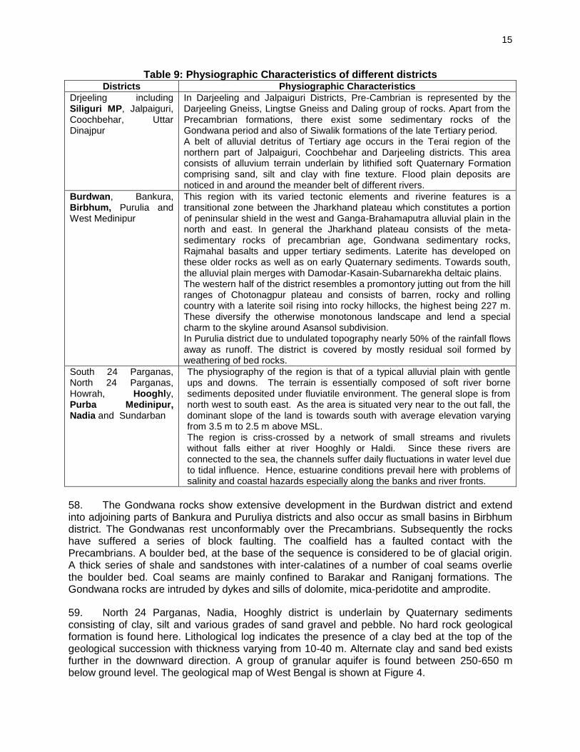
15
Table 9: Physiographic Characteristics of different districts Districts Physiographic Characteristics
Drjeeling including Siliguri MP, Jalpaiguri, Coochbehar, Uttar Dinajpur
In Darjeeling and Jalpaiguri Districts, Pre-Cambrian is represented by the Darjeeling Gneiss, Lingtse Gneiss and Daling group of rocks. Apart from the Precambrian formations, there exist some sedimentary rocks of the Gondwana period and also of Siwalik formations of the late Tertiary period. A belt of alluvial detritus of Tertiary age occurs in the Terai region of the northern part of Jalpaiguri, Coochbehar and Darjeeling districts. This area consists of alluvium terrain underlain by lithified soft Quaternary Formation comprising sand, silt and clay with fine texture. Flood plain deposits are noticed in and around the meander belt of different rivers.
Burdwan, Bankura, Birbhum, Purulia and West Medinipur
This region with its varied tectonic elements and riverine features is a transitional zone between the Jharkhand plateau which constitutes a portion of peninsular shield in the west and Ganga-Brahamaputra alluvial plain in the north and east. In general the Jharkhand plateau consists of the meta-sedimentary rocks of precambrian age, Gondwana sedimentary rocks, Rajmahal basalts and upper tertiary sediments. Laterite has developed on these older rocks as well as on early Quaternary sediments. Towards south, the alluvial plain merges with Damodar-Kasain-Subarnarekha deltaic plains. The western half of the district resembles a promontory jutting out from the hill ranges of Chotonagpur plateau and consists of barren, rocky and rolling country with a laterite soil rising into rocky hillocks, the highest being 227 m. These diversify the otherwise monotonous landscape and lend a special charm to the skyline around Asansol subdivision. In Purulia district due to undulated topography nearly 50% of the rainfall flows away as runoff. The district is covered by mostly residual soil formed by weathering of bed rocks.
South 24 Parganas, North 24 Parganas, Howrah, Hooghly, Purba Medinipur, Nadia and Sundarban
The physiography of the region is that of a typical alluvial plain with gentle ups and downs. The terrain is essentially composed of soft river borne sediments deposited under fluviatile environment. The general slope is from north west to south east. As the area is situated very near to the out fall, the dominant slope of the land is towards south with average elevation varying from 3.5 m to 2.5 m above MSL. The region is criss-crossed by a network of small streams and rivulets without falls either at river Hooghly or Haldi. Since these rivers are connected to the sea, the channels suffer daily fluctuations in water level due to tidal influence. Hence, estuarine conditions prevail here with problems of salinity and coastal hazards especially along the banks and river fronts.
58. The Gondwana rocks show extensive development in the Burdwan district and extend into adjoining parts of Bankura and Puruliya districts and also occur as small basins in Birbhum district. The Gondwanas rest unconformably over the Precambrians. Subsequently the rocks have suffered a series of block faulting. The coalfield has a faulted contact with the Precambrians. A boulder bed, at the base of the sequence is considered to be of glacial origin. A thick series of shale and sandstones with inter-calatines of a number of coal seams overlie the boulder bed. Coal seams are mainly confined to Barakar and Raniganj formations. The Gondwana rocks are intruded by dykes and sills of dolomite, mica-peridotite and amprodite.
59. North 24 Parganas, Nadia, Hooghly district is underlain by Quaternary sediments consisting of clay, silt and various grades of sand gravel and pebble. No hard rock geological formation is found here. Lithological log indicates the presence of a clay bed at the top of the geological succession with thickness varying from 10-40 m. Alternate clay and sand bed exists further in the downward direction. A group of granular aquifer is found between 250-650 m below ground level. The geological map of West Bengal is shown at Figure 4.

16
Figure 4: Geological Map of West Bengal
5. Soils
60. The major soil types within West Bengal can be classified into five groups namely ultisols, entisols, aridisols, mollisols and alfisols. These soil types can be further classified into several sub groups. The ultisols is sub-classified into brown, red, yellow and laterite soils. The entisols is sub-classified into younger alluvial, coastal alluvial and bhabar soils. The aridisols is sub-classified into saline and saline alkali soils. The mollisols is sub-classified into Tarai soils and mountain meadow soils. The alfisols is sub-classified into deltaic alluvial soils, older alluvial soils, red gravel soils, red sandy soils, and red loamy and mixed red black soils.
Table 10: The soil pattern in the state
Agro climatic Zone ( District wise) Soil type
Entire North Bengal ( Darjeeling, Jalpaigur, Siliguri & Cooch Behar) Acidic
Gangetic alluvium ( N&S Dinajpur, Murshidabad, Malda, Nadia, Hugli, Haora, Birbhum , N & S 24 Parganas)
Alluvial
Vindhyan family soil ( Barddhaman, Murshidabad, Medinipur (W), Haora, Birbhum & West Dinajpur)
Alluvial
Lateritic Red Soil (Birbhum, Burdwan, Medinipur, Bankura, Puruliya, Malda, North & South Dinajpur)
Alluvial
Coastal Soil (South 24 Parganas, North 24 Parganas and East Medinipur) Coastal Saline
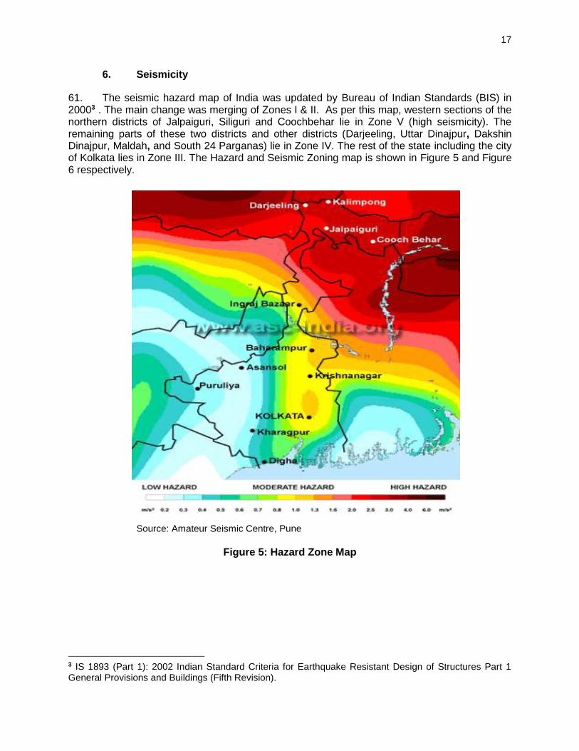
17
6. Seismicity
61. The seismic hazard map of India was updated by Bureau of Indian Standards (BIS) in 20003 . The main change was merging of Zones I & II. As per this map, western sections of the northern districts of Jalpaiguri, Siliguri and Coochbehar lie in Zone V (high seismicity). The remaining parts of these two districts and other districts (Darjeeling, Uttar Dinajpur, Dakshin Dinajpur, Maldah, and South 24 Parganas) lie in Zone IV. The rest of the state including the city of Kolkata lies in Zone III. The Hazard and Seismic Zoning map is shown in Figure 5 and Figure 6 respectively.
Source: Amateur Seismic Centre, Pune
Figure 5: Hazard Zone Map
3 IS 1893 (Part 1): 2002 Indian Standard Criteria for Earthquake Resistant Design of Structures Part 1 General Provisions and Buildings (Fifth Revision).

18
7. Land use
62. The distribution of land utilization within the entire state broadly comprises of cultivable land, uncultivable land, forest land, waste land, urban area and industrial area. Land use pattern along the project road is mixed type dominated by agriculture, barren land, forest land and barren areas. Table 11 indicates the land use pattern of project districts.
Table 11: Utilization of Land in project Districts of West Bengal (In ha, 2010-11) (area in ha)
Sr. No.
District Area according to village papers
Area under forest
Area under non Agricultural use
Barren & unculturable land
Land under Misc. Tree groves not include in net area sown
Culturable waste land
Fallow land other than current fallow
Current fallows
Net area sown
1 Birbhum 451118 15853 101191 281 824 2815 2696 7331 319956
2 Burdwan 698762 21165 211566 858 1986 4876 1237 4352 452462
3 Hooghly 313379 530 96526 89 1588 1518 119 594 212407
4 Nadia 390655 1216 90220 54 3729 631 113 4181 290447
5 Purba Medinipur
396594 899 102236 689 2149 296 237 1856 288052
6 Darjeeling (Siliguri
MP within Darjeeling)
325469 124575 40527 2465 2350 1487 3216 16437 133582
Source: Economic Review, Govt. of West Bengal: 2013
8. Hydro-geology and Hydrology
63. Hydro-geology: Based on the geological and geomorphological set up, characteristics of the aquifers and chemical character of ground water the State can be divided into two broad units.
• Fissured Formations: Ground water occurs in these formations in the upper weathered mantle (thickness 5-10m) and at deeper levels (60-100m depth) in the fractures, fissures and joints where limited quantities of ground water (less than 20m3/hr) may be available from bore wells and large dia dug wells.
• Porous Formations: Ground water occurs in this formation both under water table and confined condition. In Nadia, Murshidabad (except Kandi Sub-division) districts down to 150m there is absence of any significant clay beds making the entire aquifer upto 150m depth to occur under water table condition. In the Bhabar Zone (foothills of Himalayan trench) aquifers are having very deep water table and are characterised by high seasonal variation of water table to the tune of 10-12m. In this lateritic part occurring in parts of Birbhum, Burdwan, Bankura & Medinipur districts, individual aquifers being of limited thickness and discontinuous nature. The potentiality of this aquifer is very poor. By and large yield of the tube well (down to 100-400mbgl) varies from80-100m3/hr.
64. Based on the yield prospects the State can be divided into three parts namely:
• Areas of prolific ground water resources (yield is more than 150m3//hr) : Jalpaiguri, Coochbihar, Medinipur,N&S 24- Parganas districts

19
• Areas with moderate yield(yield between 50 - 150m3hr) : Comprising part of Malda, Uttar & Dakshin Dinajpur, western part of Murshidabad, marginal tract of Birbhum, Burdwan, Bankura, Nadia, Hooghly and Medinipur districts.
• Areas with limited yield prospect (yield less than 50m3hr) : Extreme marginal tracts of Medinipur, Bankura, Purulia
65. The sand zones occurring within the depth range of 127 to 290 m bgl are more pronounced and attain fairly good thickness (often 25 or more) and laterally extensive as well. These grayish micaceous sand beds which are fine to coarse grained in texture are very important from the point of ground water storage. The sand beds are separated generally by fairly persistent clayey layers. Below the depth of 290 m, the unconsolidated sediments are generally argillaceous and do not hold much scope for ground water development.
66. The ground water development in West Bengal is generally occurring through shallow tube wells (yield up to 30 cum per hour), medium tube wells (yield up to 100cum per hour) and deep heavy tube wells (yield up to 200 cum per hour). The entire region has a very good potential for ground water development with estimated present ground water utilization at less than 50% of the available resources. The entire West Bengal falls under safe category as per Central Ground Water Board (CGWB) guidelines.
67. In the coastal tract of East Medinipur, S 24- Parganas, southern part of N 24- Parganas, Bidhannagar and some parts of Haora lying in the active delta of the Ganga --- the Bhagirathi river system ground water occurs under a characteristic hydrochemical situation in which fresh water group of aquifers occurs within span of 120-300m sandwitched between saline to brackish aquifers. Yield of the tube well varies from 100-150m3//hr. Some of the hot springs (35-410C) from deep seated fractured zones of older rocks occurs around Bakreswar, Birbhum districts.
68. Hydrology: West Bengal State has three major river basins, namely Ganga, Brahmaputra and Subarnarekha. Among these, Ganga is the largest and covers almost 80% of the state, whereas the Brahmaputra basin covers about 15% of the area and Subarnarekha basin covers about 5% of the geographical area of the State.
69. The rural road construction proposals are normally cross small drainage channels, which eventually join the major channels/rivulets. All of these channels generally remain dry for most part of the year and drain the storm water for few weeks only during or after the monsoon.
70. Several hand operated tube wells are seen along side of the existing tracks in many of the proposed road construction proposals. These tube wells are the main source of drinking water for rural communities in the region.
71. Flood Affected and Drought Prone areas: The West Bengal has both chronically draught prone and flood affected areas within the state. The chronically drought prone area is, part of Bankura, Purulia district. Chronically flood affected areas are parts of North 24 parganas, Purba & Pashim Medinipore, Burdwan, Hooghly and Malda districts.
72. Water Quality: SPCB carries out the water quality monitoring in West Bengal. pH of groundwater is observed in the range of 7.1-8.37 and meets the water quality criteria. Conductivity varies from 589-1983 µmhos/cm and meeting the criteria for beneficial uses. BOD is observed in the range of 0.2-1.8mg/l. Arsenic contamination is also seen in certain part of state. Total Coliform varies from 2-1,600 MPN/100 ml and meeting the desired criteria at all the

20
locations. The quality of surface water is generally good and can be used for drinking water with physio-chemical treatment.
C. Biological Environment
73. The west Bengal state owing to the varying altitude from the Himalayas to the coastal plains, the flora and fauna of the state is diverse. As on 2011 forests make up more than 27% of the geographical area of West Bengal, which is higher than the national average of 23%. Total recorded forest land in the state is 11,879 sq.km, of which 7,054 sq.km is Reserved Forest, 3,772 sq.km. is Protected Forest and 1,053 sq.km is Unclassified State Forest, thus constituting 13.38% of the geographical area of the state. Part of the world's largest mangrove forest Sundarbans is located in southern West Bengal.
1. Terrestrial flora
74. During the field investigations, the most dominant terrestrial flora within the project districts was recorded. The dominant flora comprised generally the trees planted along side of the rural road proposals, particularly the stretches along agricultural lands. Many of these are planted by the adjacent landowners and often perceived, as a fence to their respective lands. Hence the habitat type is mainly modified habitat in accordance with the ADB SPS. The common trees observed alongside of the road projects are presented in Table 12.
Table 12: List of common plant species available in the study area S.No. Botanical Name Local Name
1. Acacia auriculiformis Akashmani
2. Acacia catechu Khair
3. Acacia mangium Akashpradip
4. Ailanthus grandis Gokul
5. Anthocephalus kadamba Kadam
6. Artocarpus chaplasha Lator
7. Bischofia javanica Kainjal
8. Bombax ceiba Simul
9. Casaurina equisetifolia Jhau
10. Casaurina intertropica Jhau
11. Chukrasia tabularis Chikrassi
12. Cordia alleodora Bohori
13. Dalbergia sissoo Sissoo
14. Dipterocarpus macrocarpus Garjan
15. Duabanga sonneritiodes Lampate
16. Eucalyptus camaldulensis Eucalyptus
17. Eucalyptus citriodora Eucalyptus
18. Eucalyptus hybrida Eucalyptus
19. Eucalyptus tereticornis Eucalyptus
20. Gmelina arborea Gamar
21. Lagerostroemia microcarpa Benteak
22. Lagerostroemia parviflora Sidha
23. Lagerostroemia speciosa Jarul
24. Leucaena leucocephala Subabool
25. Madhuca latifolia Mahua
26. Michelia champaca Champ
27. Schima wallichii Chilouni
28. Shorea robusta Sal

21
29. Tectona grandis Teak
30. Terminalia arjuna Arjun
31. Terminalia myriocarpa Panisaj
32. Terminalia tomentosa Pacasaj
33. Xylia dolabriformis Lohakat
34. Ziziphus mauritiana Narkeli
75. None of the road stretches passes through any reserved and protected forest land/area. No sample road passes through the designated forest area. The tree density within ROW of sample road project alignment is about 2-3 trees per Km.
2. Wild Life and Protected Areas
76. West Bengal has 5 National Parks and 15 Wild life sanctuaries spread over an area of 2754.39 Sq. Km (Figure 7). There is no wildlife Sanctuaries/National Parks, Tiger Reserves etc. along the sample project road area.
Figure 6: Protected Areas of West Bengal

22
77. Table 13 provides details of National park and Sanctuaries corresponding to serial Number indicated at Figure 7 above.
Table 13: List of Protected Areas in West Bengal No. Corresponding to legend given in Fig 3.5
Name Area (km2)
District Fauna
National Parks
2 Buxa NP 117.1 Jalpaiguri Asian Elephant, Tiger, Gaur, Wild boar, Sambar
2 Gorumara NP 79.45 Jalpaiguri Tiger, Gaur, Wild boar, Sambar
1 Neora Valley NP
88 Siliguri (Darjeeling)
clouded leopard, red panda, musk deer, black bear, sloth bear, golden cat, wild boar, leopard cat, goral, serow, barking deer, sambar, Himalayan flying squirrel, Rufous-throated Partridge, Satyr Tragopan, Crimson-breasted Woodpecker, Darjeeling Woodpecker, Bay Woodpecker, Golden-throated Barbet, Hodgson's Hawk Cuckoo,
1 Singhalila NP 78.6 Siliguri (Darjeeling)
Red Panda, Leopard Cat, Barking Deer, Yellow-throated Marten, Wild Boar, Pangolin, Himalayan Black Bear, Leopard, Clouded Leopard, Serow and Takin. Tigers, Scarlet Minivet, Kalij Pheasant, Blood Pheasant, Satyr Tragopan
14,18 Sunderbans NP
1330.1 North & South 24-Paraganas
Royal Bengal Tiger; Fishing Cats, Macaques, Wild Boar, Common Grey Mongoose, Fox, Jungle Cat, Flying Fox, Pangolin, Chital
Wildlife Sanctuaries
7 Ballavpur WLS
2 Birbhum Blackbuck and Spotted deer, jackals, foxes and a variety of water birds
10 Bethuadahari WLS
0.67 Nadia Spotted deer, Jackal, Bengal fox, Porcupine, Common Langur, Parakeets, Indian Cuckoo, Barbets Barbets and other smaller birds and pythons
14 Bibhutibhusan WLS
0.64 North 24-Paraganas
spotted deer and the sanctuary is also rich in common birds
2 Buxa WLS 251.89 Jalpaiguri Asian Elephant, Tiger, Gaur, Wild boar, Sambar
2 Chapramari WLS
9.49 Jalpaiguri Royal Bengal Tiger, elephant, varieties of deer, reptiles and other animals
18 Haliday Island WLS
5.95 South 24-Paraganas
wild boar, barking and spotted deer, and rhesus monkeys
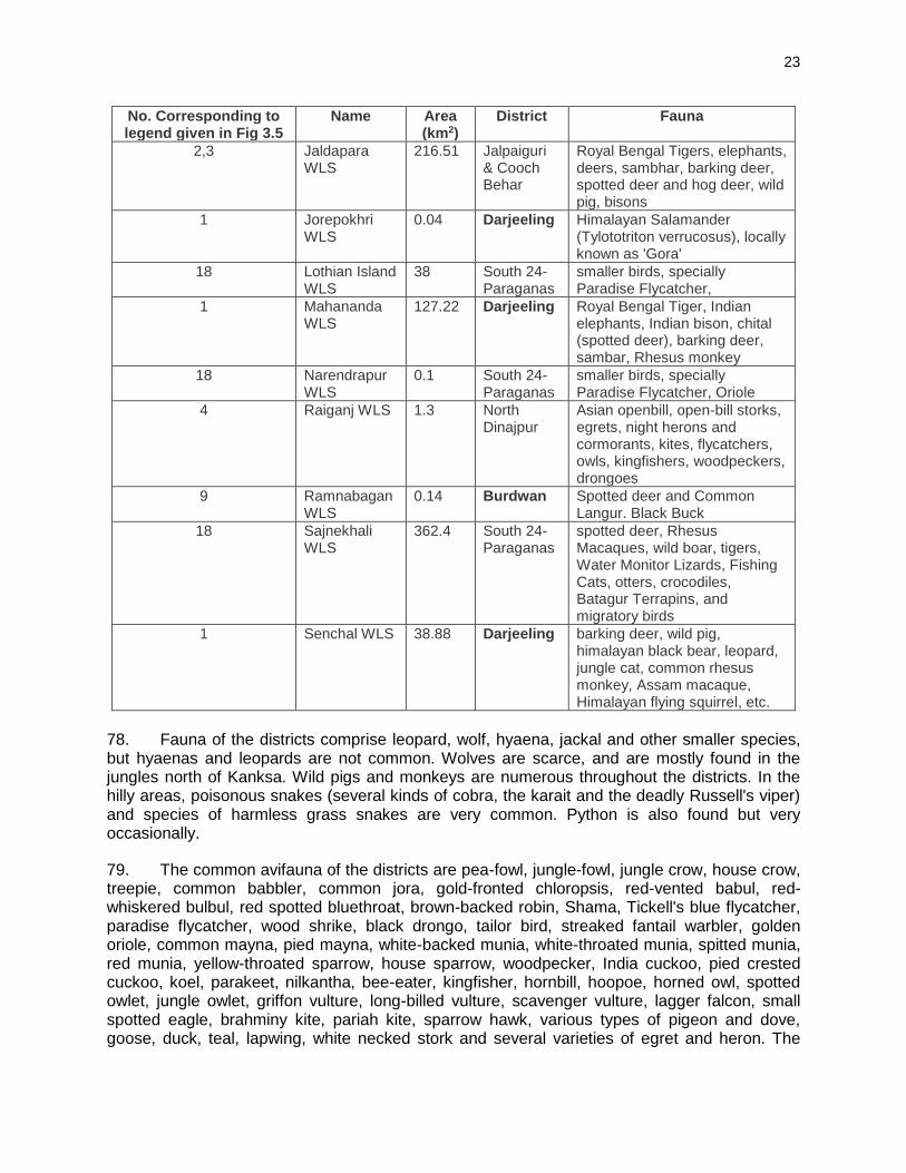
23
No. Corresponding to legend given in Fig 3.5
Name Area (km2)
District Fauna
2,3 Jaldapara WLS
216.51 Jalpaiguri & Cooch Behar
Royal Bengal Tigers, elephants, deers, sambhar, barking deer, spotted deer and hog deer, wild pig, bisons
1 Jorepokhri WLS
0.04 Darjeeling Himalayan Salamander (Tylototriton verrucosus), locally known as 'Gora'
18 Lothian Island WLS
38 South 24-Paraganas
smaller birds, specially Paradise Flycatcher,
1 Mahananda WLS
127.22 Darjeeling Royal Bengal Tiger, Indian elephants, Indian bison, chital (spotted deer), barking deer, sambar, Rhesus monkey
18 Narendrapur WLS
0.1 South 24-Paraganas
smaller birds, specially Paradise Flycatcher, Oriole
4 Raiganj WLS 1.3 North Dinajpur
Asian openbill, open-bill storks, egrets, night herons and cormorants, kites, flycatchers, owls, kingfishers, woodpeckers, drongoes
9 Ramnabagan WLS
0.14 Burdwan Spotted deer and Common Langur. Black Buck
18 Sajnekhali WLS
362.4 South 24-Paraganas
spotted deer, Rhesus Macaques, wild boar, tigers, Water Monitor Lizards, Fishing Cats, otters, crocodiles, Batagur Terrapins, and migratory birds
1 Senchal WLS 38.88 Darjeeling barking deer, wild pig, himalayan black bear, leopard, jungle cat, common rhesus monkey, Assam macaque, Himalayan flying squirrel, etc.
78. Fauna of the districts comprise leopard, wolf, hyaena, jackal and other smaller species, but hyaenas and leopards are not common. Wolves are scarce, and are mostly found in the jungles north of Kanksa. Wild pigs and monkeys are numerous throughout the districts. In the hilly areas, poisonous snakes (several kinds of cobra, the karait and the deadly Russell's viper) and species of harmless grass snakes are very common. Python is also found but very occasionally.
79. The common avifauna of the districts are pea-fowl, jungle-fowl, jungle crow, house crow, treepie, common babbler, common jora, gold-fronted chloropsis, red-vented babul, red-whiskered bulbul, red spotted bluethroat, brown-backed robin, Shama, Tickell's blue flycatcher, paradise flycatcher, wood shrike, black drongo, tailor bird, streaked fantail warbler, golden oriole, common mayna, pied mayna, white-backed munia, white-throated munia, spitted munia, red munia, yellow-throated sparrow, house sparrow, woodpecker, India cuckoo, pied crested cuckoo, koel, parakeet, nilkantha, bee-eater, kingfisher, hornbill, hoopoe, horned owl, spotted owlet, jungle owlet, griffon vulture, long-billed vulture, scavenger vulture, lagger falcon, small spotted eagle, brahminy kite, pariah kite, sparrow hawk, various types of pigeon and dove, goose, duck, teal, lapwing, white necked stork and several varieties of egret and heron. The
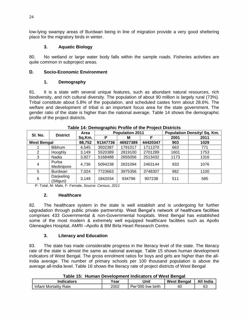
24
low-lying swampy areas of Burdwan being in line of migration provide a very good sheltering place for the migratory birds in winter.
3. Aquatic Biology
80. No wetland or large water body falls within the sample roads. Fisheries activities are quite common in subproject areas.
D. Socio-Economic Environment
1. Demography
81. It is a state with several unique features, such as abundant natural resources, rich biodiversity, and rich cultural diversity. The population of about 90 million is largely rural (73%). Tribal constitute about 5.8% of the population, and scheduled castes form about 28.6%. The welfare and development of tribal is an important focus area for the state government. The gender ratio of the state is higher than the national average. Table 14 shows the demographic profile of the project districts.
Table 14: Demographic Profile of the Project Districts
Sl. No. District Area
Sq.Km.
Population 2011 Population Density/ Sq. Km.
P M F 2001 2011
West Bengal 88,752 91347736 46927389 44420347 903 1029
1 Bibhum 4,545 3502387 1791017 1711370 663 771
2 Hooghly 3,149 5520389 2819100 2701289 1601 1753
3 Nadia 3,927 5168488 2655056 2513432 1173 1316
4 Purba Medinipore
4,736 5094238 2631094 2463144 933 1076
5 Burdwan 7,024 7723663 3975356 3748307 982 1100
6 Darjeeling (Siliguri)
3,149 1842034 934796 907238 511 585
P- Total, M- Male, F- Female, Source: Census, 2011
2. Healthcare
82. The healthcare system in the state is well establish and is undergoing for further upgradation through public private partnership. West Bengal’s network of healthcare facilities comprises 433 Governmental & non-Governmental hospitals. West Bengal has established some of the most modern & extremely well equipped healthcare facilities such as Apollo Gleneagles Hospital, AMRI –Apollo & BM Birla Heart Research Centre.
3. Literacy and Education
83. The state has made considerable progress in the literacy level of the state. The literacy rate of the state is almost the same as national average. Table 15 shows human development indicators of West Bengal. The gross enrolment ratios for boys and girls are higher than the all-India average. The number of primary schools per 100 thousand population is above the average all-India level. Table 16 shows the literacy rate of project districts of West Bengal
Table 15: Human Development Indicators of West Bengal Indicators Year Unit West Bengal All India
Infant Mortality Rate 2002 Per’000 live birth 40 63
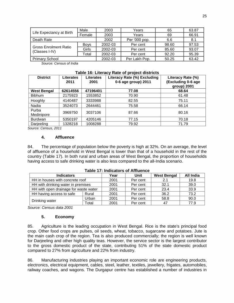
25
Life Expectancy at Birth Male 2003 Years 65 63.87
Female 2003 Years 69 66.91
Death Rate 2002 Per ‘000 pop. 6.6 8.1
Gross Enrolment Ratio (Classes I-IV)
Boys 2002-03 Per cent 98.60 97.53
Girls 2002-03 Per cent 85.60 93.07
Total 2002-03 Per cent 92.20 95.39
Primary School 2002-03 Per Lakh Pop. 50.25 63.42 Source: Census of India
Table 16: Literacy Rate of project districts
District Literates 2011
Literates 2001
Literacy Rate (%) Excluding 0-6 age group) 2011
Literacy Rate (%) (Excluding 0-6 age
group) 2001
West Bengal 62614556 47196401 77.08 68.64
Bibhum 2175923 1553852 70.90 61.48
Hooghly 4140487 3333988 82.55 75.11
Nadia 3524073 2644461 75.58 66.14
Purba Medinipore
3969750 3037106 87.66 80.16
Burdwan 5350197 4205146 77.15 70.18
Darjeeling 1328218 1008288 79.92 71.79 Source: Census, 2011
4. Affluence
84. The percentage of population below the poverty is high at 32%. On an average, the level of affluence of a household in West Bengal is lower than that of a household in the rest of the country (Table 17). In both rural and urban areas of West Bengal, the proportion of households having access to safe drinking water is also less compared to the all-India scenario.
Table 17: Indicators of Affluence Indicators Year Unit West Bengal All India
HH in houses with concrete roof 2001 Per cent 2.1 19.8 HH with drinking water in premises 2001 Per cent 32.1 39.0 HH with open drainage for waste water 2001 Per cent 23.4 33.9 HH having access to safe Rural 2001 Per cent 36.2 73.2
Drinking water Urban 2001 Per cent 58.8 90.0
Total 2001 Per cent 47 77.9
Source: Census data 2001
5. Economy
85. Agriculture is the leading occupation in West Bengal. Rice is the state's principal food crop. Other food crops are pulses, oil seeds, wheat, tobacco, sugarcane and potatoes. Jute is the main cash crop of the region. Tea is also produced commercially; the region is well known for Darjeeling and other high quality teas. However, the service sector is the largest contributor to the gross domestic product of the state, contributing 51% of the state domestic product compared to 27% from agriculture and 22% from industry. 86. Manufacturing industries playing an important economic role are engineering products, electronics, electrical equipment, cables, steel, leather, textiles, jewellery, frigates, automobiles, railway coaches, and wagons. The Durgapur centre has established a number of industries in

26
the areas of tea, sugar, chemicals and fertilizers. Natural resources like tea and jute in and nearby parts has made West Bengal a major centre for the jute and tea industries.
6. Agriculture 87. West Bengal is nearly three percent of the nation's cultivable land. It produces more than eight per cent of the food of the country. The agricultural sector is characterized by the predominance of small and marginal farmers. The average size of holding here is also less than one hectare.
7. Mineral Resources 88. West Bengal stands third in the country in terms of mineral production. The state contributes about one-fifth to the total production of minerals in the country. Coal constitutes 99% of the minerals extracted in West Bengal; fireclay, kaolin, limestone, copper, iron, wolfram, manganese and dolomite are mined in small quantities. There are good possibilities of obtaining mineral oil and natural gas in the areas near the Bay of Bengal, in Purba Medinipur, Sundarbans, South 24 Parganas and North Bengal plains. Research is undergoing for finding natural gas in various places. 89. West Bengal is the third largest state for coal production, accounting for about half of India's total. Coal is extracted from about 228 mines in the Raniganj and Asansol region of Burdwan district. High garde bituminous coal is mined at Raniganj, Dishergarh, Santaldih, Kulti, Barakar, Ghushik, Kajora. Coalfields stretch over an area of about 1,550 km2 (598 sq mi). The coalfields of Raniganj support the Asansol-Durgapur industrial belt by providing fuel to the industries as well as generation of thermal power. Lignite mined in Darjeeling is used to make briquettes. Coal deposits are also found along the Ajoy river in Birbhum district. 90. West Bengal ranks next to Bihar and Madhya Pradesh in production of fireclay. Most of this mineral is extracted in the Raniganj region along with few amount is also extracted from Birbhum and Purulia. Kaolin used in the pottery, paper, textile, rubber and paint industries are unearthed at Mohammad Bazar in Birbhum and Mejia in Bankura. Rest of the production comes from Purulia, Burdwan, Darjeeling and Jalpaiguri. 91. Limestone which is used in cement industry is mined in Bankura, Purulia, Darjeeling and Jalpaiguri There are copper mines in Jalpaiguri and Darjeeling. Small quantities of low quality iron-ore are mined in Bardhaman, Purulia, Birbhum and Darjeeling There are manganese in the Jhargram region of Paschim Medinipur, Purulia and Burdwan. Wolfram is mined at Jhilimili in Bankura. The state’s production of dolomite comes from the Dooars region of Jalpaiguri. 92. No sample roads are located near mines.
8. Physical Infrastructure 93. West Bengal has well-developed road and rail network. As of 2012, the total length of surface road in West Bengal is over 92,023 km (57,180 mi); national highways comprise 2,578 km (1,602 mi) and state highways 2,393 km (1,487 mi). As of 2006, the road density of the state is 103.69 km per 100 km² (166.92 mi per 100 sq mi), higher than the national average of 74.7 km per 100 km² (120 mi per 100 sq mi). Average speed on state highways varies between 40–50 km/h (25–31 mi/h); in villages and towns, speeds are as low as 20–25 km/h (12–16 mi/h) due to the substandard quality of road constructions and low maintenance. As of 2012, the total

27
railway route length is around 4,481 km (2,784 mi). Table 18 shows physical infrastructure of the state.
Table 18: Physical Infrastructure Indicators Year Unit West Bengal All India
Road Density 2006 Per ‘00 sq.km. 103.69 74.7
Railway route length 2001 Per‘000 sq. km. 3.68 19.17
Village electrification 2004 Per cent 83.6 83.8
HH with electricity for lighting 2001 Per cent 24.34 55.8
No. of post offices 2002 Per Lakh Pop. 204 15.08
Tele density 2003 Per ‘00 Pop. 6.96 6.6
94. Power: The percentage of villages electrified is about 87% in the entire state. However, the percentage of households with electricity is only 27%. West Bengal has been a pioneer in power development over the years. NASSCOM-Gartner ranks West Bengal’s power infrastructure as the best in the country. There has been an installed capacity of 9629.9 MW in the State in 2011.
9. Religious and Cultural festivals
95. The festivals of West Bengal embody the robust and composite cultural heritage of India. Various communities of the Indian subcontinent celebrate as many as forty festivals with complete communal concordance. The most important festivals of West Bengal are Durga Puja, Sarasvati Puja, Kali Puja and Dol Purnima. 96. There are few temples, mosque located along the project roads. Some of these may need to be shifted.
E. Salient Environmental Features of Sample Roads
97. The salient environmental features of sample roads are summarized in Table 19 below:
Table 19: Salient Environmental Features of Sample Roads
District Block Road Name
(length) Salient Environmental Features
Birbhum Mayuresweri – I Dakshingram to Saithia Rampurhat road at Battala via Ratma Sibgram (4.821 km)
• Topography is plain
• Inhabited areas of the small villages namely, Dakshingram, Ratma, Sibgram, exists near Ch (0m – 745m), (1176m – 2037m), (3480m – 3984m) in scattered manner respectively beside the alignment.
• There is no lake or swampy area beside the alignment but many small & big ponds / Water body were found
• There are no road side nallas / streams / rivers noticed along the road alignment.
• No water stagnation wirhin the proposed road alignment
• There are 33 Nos. of trees are located within 10m on either side of the alignment. 4 nos. need to be cut

28
District Block Road Name
(length) Salient Environmental Features
• Few utility structures (102 nos.) within 10m on either side of the alignment, few (6 nos.) of them needs shifting
• There are 21 nos. of community structures (School, Religious place, Health Centre, etc.) within 10m on either side of the alignment. Few of them need to be shifted or alignment to be adjusted
• Project road passes mainly through agricultural land
Birbhum Mayuresweri – II Barutia to Chottorigram Road via Radhanagar (2.381 km)
• Topography is plain
• Small villages namely, Barutia Radhanagar Chottori (413m – 477m), (1280m – 1380m), (1782m - 2196m), (2196m – 2381m) respectively beside the alignment
• There is no lake or swampy area beside the alignment but many small & big ponds / Water body were found
• There are no road side nallas / streams / rivers noticed along the road alignment.
• No water stagnation wirhin the proposed road alignment
• There are 26 Nos. of trees are located within 10m on either side of the alignment. 1 no. need to be cut
• Few utility structures (52 nos.) within 10m on either side of the alignment, few (3 nos.) of them needs shifting
• There are a total of 7 community / religious, cultural structures within 10m on either side from the center line of the road alignment Club at Ch Burial Ground at Ch 1837m, Samabay Smite at Ch 1913m, P. School at Ch 2370m, (LHS) on the other hand High School at Ch 1562m, SSK at Ch 1569m, Health Canter at Ch 2076m, Mosque at Ch 2293m, (RHS). No impact is expected.
• Project road passes mainly through agricultural land
Burdwan Memari –II Radhakantapur More to Sahajadpur (5.25 km)
• Topography is plain
• Small villages exist such as Bohar (0-475m),Golampara, (675-1030m) Sidhuria (1375-1685m), Bishnupur (3500-4170) and sahajadpur (4175-5250m) in scattered manner.
• There is no lake or swampy area beside the alignment but many small & big ponds / Water body were found
• There are some nallas crossed by the road
• No water stagnation wirhin the proposed

29
District Block Road Name
(length) Salient Environmental Features
road alignment
• There are 8 Nos. of trees are located within 10m on either side of the alignment. No trees need to be cut
• Few utility structures (35 nos.) within 10m on either side of the alignment, few (7 nos.) of them needs shifting
• There are a total of 7 community / religious, cultural structures within 10m on either side from the center line of the road alignment. No impact on community structure is expected.
• Project road passes mainly through agricultural land
Burdwan Ausgram -I Bhota to Karanji (13.65 km)
• Topography is plain
• There are few villages namely Takipur (442m-970m), Chowari (1005m-1430m) Asinda (2552m-3150m) Brojopur adibasipara (3470m-3820m) Brojopur (4100m-4750m) Bhada (10745m-11180m) Karanji (12227m-13250m)
• There is no lake or swampy area beside the alignment but many small & big ponds / Water body were found
• There are no road side nallas / streams / rivers noticed along the road alignment.
• No water stagnation wirhin the proposed road alignment
• There are 138 Nos. of trees are located within 10m on either side of the alignment. No trees need to be cut
• Few utility structures (150 nos.) within 10m on either side of the alignment. No utility needs to be shifted
• There are 39 nos. of community structures (School, club, Temple Grave yard, etc.) within 10m on either side of the alignment. No impact on community structure is expected
• Some part of the project road passes through agriculture land at following ch. 000m-260m, 1675m-2552m, 4150m-7000m, 8065m-9900m, 11180m-12227m.
Hooghly Goghat-II Kumarganj To Balitakundu Part of Pundahit Rathtala To Balitakundu Po Salikana To Shripur Jn (4.048 km)
• Topography is plain
• Inhabited areas of the small villages namely, Pundahit, Masidbera, Paschim Chakla exists near starting, Ch 64m – 307m, 2439m – 2870m, 3183m – 3547m, in scattered manner respectively beside the alignment.
• There is no forest area beside or away from the alignment. Plantation area

30
District Block Road Name
(length) Salient Environmental Features
exists beside the alignment near Ch. 2695m – 2735m, 3010m – 3105m, (LHS) & 270m - 300m, 2655m – 2697m, 2865m – 2875m, 2950m – 3005m, 3122m – 3190m, 3220m – 3392m, 3407m – 3428m, 3655m – 3900m. Plantation area wil be not affected
• There is no lake or swampy area beside the alignment but many small & big ponds / Water body were found
• There are no road side nallas / streams / rivers noticed along the road alignment.
• No water stagnation wirhin the proposed road alignment
• There are 37 Nos. of trees are located within 10m on either side of the alignment. 6 nos. need to be cut
• Few utility structures (37 nos.) within 10m on either side of the alignment, few (8 nos.) of them needs shifting
• There are a total of 8 community / religious, cultural structures within 10m on either side from the canter line of the road alignment Temple at Ch 248m, 2765m, Play Ground at 2630m, ICDS at 2692m, (LHS) on the other hand Temple at 2439m, GP Office at 2604m, Primary School at 2610m, Burial Ground at 2870m (RHS). No impact on community structure is expected
• There are few patches where there are agricultural land beside the alignment between Ch 0m – 35m, 420m – 2502m, 3547m – 4081m (LHS). & 0m – 37m, 323m – 2439m, 3547m – 4081m (RHS).
Hooghly Jangipara Mukundapur busstop to Blacktop road part of singhtimore Ichanagar Rangupur RD (3.6 km)
• Topography is plain
• Inhabited areas of the small villages namely, Mukundapur, Moral, exists near Ch 345m – 588m, 650m – 983m, 1055m – 1203m, in scattered manner respectively beside the alignment.
• There is no lake or swampy area beside the alignment but many small & big ponds / Water body were found
• There are no road side nallas / streams / rivers noticed along the road alignment.
• No water stagnation wirhin the proposed road alignment
• There are 28 Nos. of trees are located within 10m on either side of the alignment. 10 nos. need to be cut
• Few utility structures (28 nos.) within 10m on either side of the alignment. No

31
District Block Road Name
(length) Salient Environmental Features
shifting is required
• There are a total of 11 community / religious, cultural structures within 10m on either side from the centre line of the road alignment Idgha at Ch 359m, Burial Ground at 379m, Health Canter at 413m, Club at 503m, 1203m, ICDS at 760m, Mosque at 775m, Temple at 882m, 1100m, (LHS) on the other hand Burning Hut at Ch 1424m, Temple at 1737m, (RHS). No impact on community structure is expected
• There are few patches where there are agricultural land beside the alignment between Ch 0m – 345m, 890m – 1055m, 1215m – 3570m (LHS). & 0m – 506m, 1127m – 1215m, 2072m – 3600m, (RHS).
• Grazing ground exists beside the alignment near Ch 1375m (RHS)
Hooghly Tarakeshwar Keshab Chak Bank toTarakeswar Padmapukur More (5.880 km)
• Topography is plain
• There are few villages namely Keshab Chak(000m-230m)Talpur(736-935m) Ketra (2848m-3650m) Noyapara (4318m-4770m) Vata (5237m-5721m)
• There is swampy area at ch.1613m-1960m (RHS). Besides this there are some ponds and water bodies are exist
• The DVC canel crossed by the road at ch. 994m. Other than this few cross drainage structures are located
• No water stagnation wirhin the proposed road alignment
• There are 25 Nos. of trees are located within 10m on either side of the alignment. 3 nos. need to be cut
• Few utility structures (89 nos.) within 10m on either side of the alignment. 5 nos. of utility structure need to be shifted
• There are 6 nos of religious, cultural or community structures within 10m on either side of the alignment. No impact is expected on community structure
• Some part of the project road passes through agriculture land
Nadia Haringhata Nimtala Bazar To Rustam Nagar (6.564 km)
• Topography is plain
• Small villages namely, Nimtalabazar, Majhdia, Ghoshpara, Kaharpara, Bagpara, Singhpara, Kanapukur, Rustamnagar 0m – 210m, 210m – 1102m, 1102m – 1577m, 1577m – 1720m, 1720m – 2490m, 2490m – 2870m, 2870m – 3890m, 3890m –

32
District Block Road Name
(length) Salient Environmental Features
6576m, respectively beside the alignment.
• There is no lake or swampy area beside the alignment but many small & big ponds / Water body were found
• There are no road side nallas / streams / rivers noticed along the road alignment.
• No water stagnation wirhin the proposed road alignment
• There are 49 Nos. of trees are located within 10m on either side of the alignment. 3 nos. need to be cut
• Few utility structures (130 nos.) within 10m on either side of the alignment. 3 nos. of utility structure need to be shifted
• There are a total of 7 community / religious, cultural structures within 10m on either side from the center line of the road alignment Club at Ch Burial Ground at Ch 1837m, Samabay Smite at Ch 1913m, P. School at Ch 2370m, (LHS) on the other hand High School at Ch 1562m, SSK at Ch 1569m, Health Canter at Ch 2076m, Mosque at Ch 2293m,(RHS).
• Some part of the project road passes through agriculture land
Nadia Hanskhali Hanskhali To Nidhirpota (5.302 km)
• Topography is plain
• Inhabited areas of the small villages namely Kalipara, Batikamari exists near Ch 0m – 1500m and 3825-5259m in scattered manner respectively beside the alignment.
• There is no lake or swampy area beside the alignment but many small & big ponds / Water body were found
• Small stream crosses the road near CH 5290 m where water flows towards the river Churni.
• No water stagnation wirhin the proposed road alignment
• There are 38 Nos. of trees are located within 10m on either side of the alignment. 1 no. need to be cut
• Few utility structures (62 nos.) within 10m on either side of the alignment. 12 nos. of utility structure need to be shifted
• There are 3 numbers of community / religious structures within 10m on either side from the centre line of the road alignment. Temple exists at Ch 276m (RHS), 3802m (RHS). Batikamari primary school exists at ch. 4427m (RHS). No

33
District Block Road Name
(length) Salient Environmental Features
impact on community structure
• There are few patches where there are agricultural land beside the alignment between Ch 1170m – 1192m (LHS), 1360m – 3810m (LHS), 1560m – 3780m (RHS).
Nadia Hanskhali Kalinagar To Sahapur (19.925 km)
• Topography is plain
• Inhabited areas of the small villages are concentrated beside the alignment near Ch. 0584m.–0797m.(Kalinagar),Ch.0799m.-2306m (Madhyanatungram) 2306m -3374m(Natungram) , Ch.3435m.-4700m. (Benali), 5387m.-5520m,5680-5710m,5830-5890m,5997-6070m,6280-6395 m, 6962-7236m (Bilpara), 7730-8100m,8160-8294m.(Berhaskhali) and so on.
• Swampy area was observed beside the alignment from ch 4640 to 5884 m(LHS) which are the remnants of one ancient river . Some small & big ponds exist beside the project road
• Small canal crosses the road at CH 562M, 17076m.Other than these cross drainage structures and irrigation conduits exist
• Water stagnation problem was observed beside the alignment near ch 770m,8612m
• There are 235 Nos. of trees are located within 10m on either side of the alignment. 39 no. need to be cut
• Few utility structures (293 nos.) within 10m on either side of the alignment. 83 nos. of utility structure need to be shifted
• There are 26 nos. of religious / cultural / community structures (School, Temple Health Centre, etc.) within 10m on either from the center line of the road alignment. 1 temple likely to be affected
• Some part of the project road passes through agriculture land
• Grazing ground exists beside the alignment near Ch. 4114m (LHS), 10530m (LHS).
Nadia Hanskhali Kharer Math To Gobindapur (6.275 km)
• Topography is plain
• Inhabited areas of the small villages namely, Surendranathpur, Avaynagar, Kharermath, Bareagobindapur, exists near Ch 000m – 1575m, 1575m – 3515m, 3515m – 5590m, 5590m- 6268m, in scattered manner respectively

34
District Block Road Name
(length) Salient Environmental Features
beside the alignment.
• There is no lake or swampy area beside the alignment but many small & big ponds / Water body were found
• There are no road side nallas / streams / rivers noticed along the road alignment.
• No water stagnation wirhin the proposed road alignment
• There are 26 Nos. of trees are located within 10m on either side of the alignment. No tree needs to be cut
• Few utility structures (118 nos.) within 10m on either side of the alignment. No utility shifting is required
• There are a total of 16 community / religious, cultural structures within 10m on either side from the centre line of the road alignment ICDDS at Ch 612m, 2505m, 3022m, Mosque at 711m, 3000m, Primary School at 915m, Samity at 5882m, (LHS) on the other hand Samity at Ch 10m, ICDS at 315m, 6242m, Primary School at 2716m, Flood Canter at 2731m, High School at 5860m, Club at 5865m, Temple at 6202m, (RHS). No community structure will be affected
• Some part of the project road passes through agriculture land
Purba Medinipore
Panskura -II Jasar To Brindabanchak (11.0 km)
• Topography is plain
• There are small villages namely Kulhunda (o-1600m), Kashigoria (1600-2200m), Kellagachia (2200-3700m), Durbachati (3700-4400m) Padimachak (4400-6500m), Kismatkhayra (6500-7700m), Nij khoyra (7700-8700m), Roychak (8700-9500m), Bakshitala (9500-9820m), Keshetrahut (9820-10200m), Kajichak (10200-11000m)
• There is no lake or swampy area beside the alignment but many small & big ponds / Water body were found
• The river Kansabati flows along the road on RHS from ch 1600m to 2300m. Other than this there are some irrigational lockgate at Ch 327m, 2493m, 3734m, 5058m, 6885m, 9267m, & 10269m.
• No water stagnation wirhin the proposed road alignment
• There are 35 Nos. of trees are located within 10m on either side of the alignment. No tree needs to be cut
• Few utility structures (207 nos.) within
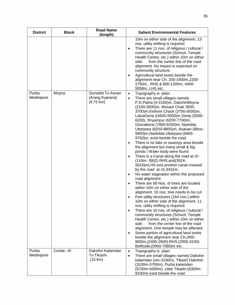
35
District Block Road Name
(length) Salient Environmental Features
10m on either side of the alignment. 13 nos. utility shifting is required
• There are 11 nos. of religious / cultural / community structures (School, Temple Health Centre, etc.) within 10m on either side from the center line of the road alignment. No impact is expected on community structure.
• Agricultural land exists beside the alignment near Ch. 200-1600m,2200-2750m, RHS & 800-1200m, 4400-5058m, LHS etc.
Purba Medinipore
Moyna Gorsafat To Asnan (Arang Kyarana) (9.75 km)
• Topography is plain
• There are small villages namely P.D.Patna (0-2100)m, DakshinMoyna (2100-3500)m, Mosam Chak 3500-3700)m,Kishore Chack (3700-4500)m, LaluaGeria ((4500-5000)m Deoly (5000-6200), Shyampur (6200-7700)m, Ghoraberia (7800-8200)m, Narkitda Uttarpara (8200-8800)m, Asanan (88oo-9400)m,Narikitda Uttarpara (9400-9750)m, exist beside the road.
• There is no lake or swampy area beside the alignment but many small & big ponds / Water body were found
• There is a Canal along the road at ch (110m- 3902) RHS,and(3924-5024)mLHS and another canal crossed by the road at ch.3431m.
• No water stagnation wirhin the proposed road alignment
• There are 69 Nos. of trees are located within 10m on either side of the alignment. 10 nos. tree needs to be cut
• Few utility structures (164 nos.) within 10m on either side of the alignment. 11 nos. utility shifting is required
• There are 16 nos. of religious / cultural / community structures (School, Temple Health Centre, etc.) within 10m on either side from the center line of the road alignment. One temple may be affected.
• Some portion of agricultural land exists beside the alignment near Ch.(400-900)m,(2400-2600).RHS,(2900-3100) Bothside,(5900-7080)m etc.
Purba Medinipore
Contai –III Dakshin Kalamdan To Tikashi (15 km)
• Topography is plain
• There are small villages namely Dakshin kalamdan (om-3100m), Tikashi Dakshin (3100m-5700m), Purba kalamdan (5700m-6300m), Uttar Tikashi (6300m-9100m) exist beside the road.

36
District Block Road Name
(length) Salient Environmental Features
• There is no lake or swampy area beside the alignment but many small & big ponds / Water body were found
• There is a Canal crossed by the road at Ch 2944m
• No water stagnation wirhin the proposed road alignment
• There are 27 Nos. of trees are located within 10m on either side of the alignment. 1 no. tree needs to be cut
• Few utility structures (108 nos.) within 10m on either side of the alignment. 5 nos. utility shifting is required
• There are 10 nos. of religious / cultural / community structures (School, Temple Health Centre, etc.) within 10m on either side from the center line of the road alignment. No impact is expected on religious structure.
• Some portion of agricultural land exists beside the alignment near Ch(.(0m-1612m) LHS, (1200m-2100m)RHS, (3200m-4200m) Bothside (7000-7800)m etc.
Siliguri MP Phassidewa Goyaltuli more to Bidhannagar via Tufandangi (6.134 km)
• Topography is plain
• There are few villages namely Goyaltuli (000m-293m), Kuchiamora (421m-935m) Matigara (1935m-2352m) Jor pakhri (3960m-4690m)
• There is no lake or swampy area beside the alignment but many small & big ponds / Water body were found
• Tista river crosses the project road at ch. 225m-268m
• No water stagnation wirhin the proposed road alignment
• There are 39 Nos. of trees are located within 10m on either side of the alignment. 3 nos. tree needs to be cut
• Few utility structures (62 nos.) within 10m on either side of the alignment. 1 no. utility shifting is required
• There are 7 nos. of religious / cultural / community structures (School, Temple Health Centre, etc.) within 10m on either side from the center line of the road alignment. No impact is expected on religious structure.
• Some portion of agricultural land exists beside the alignment
Siliguri MP Kharibari Balaijhora (NH31C) to Bhogvita (2.521 km)
• Topography is plain
• There are few villages namely Durga mandir (000m-411m), Sukarujote
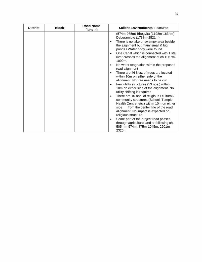
37
District Block Road Name
(length) Salient Environmental Features
(574m-985m) Bhogvita (1198m-1634m) Deburamjote (1738m-2521m)
• There is no lake or swampy area beside the alignment but many small & big ponds / Water body were found
• One Canal which is connected with Tista river crosses the alignment at ch 1067m-1099m.
• No water stagnation wirhin the proposed road alignment
• There are 46 Nos. of trees are located within 10m on either side of the alignment. No tree needs to be cut
• Few utility structures (53 nos.) within 10m on either side of the alignment. No utility shifting is required
• There are 10 nos. of religious / cultural / community structures (School, Temple Health Centre, etc.) within 10m on either side from the center line of the road alignment. No impact is expected on religious structure.
• Some part of the project road passes through agriculture land at following ch. 505mm-574m. 875m-1045m. 2201m-2326m
38
IV.ANTICIPATED ENVIRONMENTAL IMPACTS AND ITS MITIGATION MEASURES 98. Road improvements work brings substantial economic and social benefits to rural communities and national economies. However, it may also cause adverse environmental impacts though of smaller magnitude, since rural road subprojects aligned along the existing road alignments and will be of 7.5 m width only. The impacts are expected largely during construction phase, which can be mitigated through engineering measures and adoption of best construction practices. This section outlines the identified impacts during design, construction and operation phases along with proposed mitigation measures for eliminating or minimizing the adverse impacts. 99. The associated environmental impacts are assessed considering present environmental setting of the project area, nature, and extent of the proposed activities. Impacts are analysed on both generic and specific nature and are classified as insignificant, minor, moderate and major. 100. Since the issues associated with most of the roads are similar, the impacts and mitigation measures given below are applicable to rest of the subprojects. Any issue specific to a road, is separately mentioned. A. Common Impacts during Design and Construction Phase
1. Climate Change Projection 101. Temperature. By the 2050s, there is a general warming in the West Bengal. The annual average maximum temperature is expected to increase by 0.89oC-3.05oC and the maximum temperature is expected to increase by 0.5oC to 2.86oC. The increase in temperature rom historical records is more pronounce during the months of August and September when the chances of future monthly maximum temperatures will exceed the top 10% recorded temperature by 15%-80%, and 21%-66% of the time, respectively. Warmer temperatures will be felt in the northern districts of Maldah, Dakshin Dinajpur, Uttar Dinajpur, Darjeeling, Jalpaiguri, and Koch Bihar with an increase if at least 2oC. 102. Precipitation. There was no agreement of the GCM ensemble on the projected change in rainfall ranging from a decrease of 471.7 mm/year to an increase of 600.29 mm/year. Nonetheless, in areas where a significant probability (>95%) in predicted future rainfall exists, annual rainfall will increase in Hoogli and Barddhaman. Finally, with a marginally significant probability (>90% but <95%confidence) the northernmost tip of the State particularly Darjeeling, Jalpaiguri, and Koch Bihar will experience increase in rainfall by as much as 400mm/year with an increase in rainfall intensity index to 2.6.
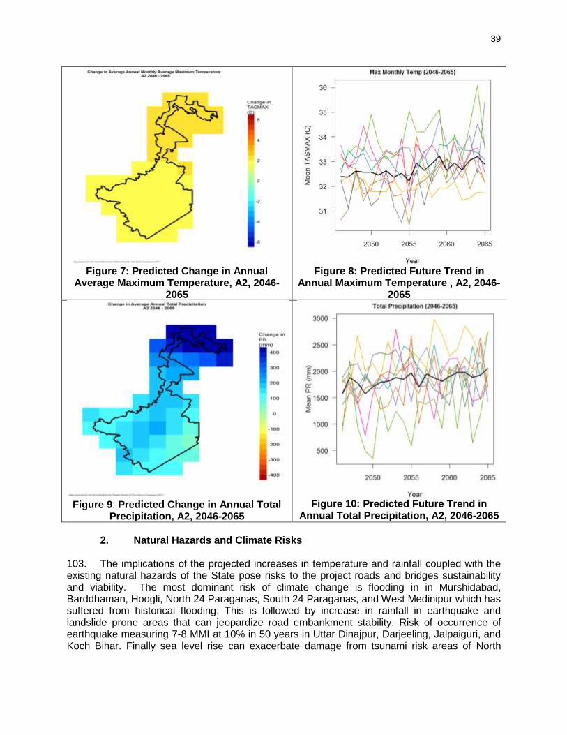
39
Figure 7: Predicted Change in Annual
Average Maximum Temperature, A2, 2046-2065
Figure 8: Predicted Future Trend in
Annual Maximum Temperature , A2, 2046-2065
Figure 9: Predicted Change in Annual Total
Precipitation, A2, 2046-2065
Figure 10: Predicted Future Trend in
Annual Total Precipitation, A2, 2046-2065
2. Natural Hazards and Climate Risks
103. The implications of the projected increases in temperature and rainfall coupled with the existing natural hazards of the State pose risks to the project roads and bridges sustainability and viability. The most dominant risk of climate change is flooding in in Murshidabad, Barddhaman, Hoogli, North 24 Paraganas, South 24 Paraganas, and West Medinipur which has suffered from historical flooding. This is followed by increase in rainfall in earthquake and landslide prone areas that can jeopardize road embankment stability. Risk of occurrence of earthquake measuring 7-8 MMI at 10% in 50 years in Uttar Dinajpur, Darjeeling, Jalpaiguri, and Koch Bihar. Finally sea level rise can exacerbate damage from tsunami risk areas of North

40
Paraganas, South 24 Paraganas and to a limited extent in West Medinipur. Barddhaman, Hoogli, North 24 Paraganas, South 24 Paraganas, and West Medinipur. 104. Impact: The proposed roads are analysed considering climate change vulnerability screening checklist defined under EARF to RCIP. The resource (like barrow earth, aggregate, cement, concrete) requirements for these rural roads as such are minimal. None of these resources is likely to be affected by climate changes (such as changes in temperature and precipitation). None of the project roads is located in natural hazard areas or passes through protected areas or flood prone areas. None of the sample roads is prone to flood. The habitation is less along these rural roads and as such, no exponential population growth is expected considering the generic trend of population migration from rural to urban areas. Most of the sample roads pass through agricultural fields and along the existing road alignments with low embankment height of 1m (average) from ground to crust except at the approaches to cross drainage structures. As such, the sub project roads are unlikely to be vulnerable or increase the vulnerability of surrounding areas (with respect to population growth, settlement patterns, increasing runoff). 105. Mitigation Measures. The succeeding Table presents the civil works component that address identified climate change risks. Although no attempt was made to segregate additional cost implications due to climate change from standard engineering design practices as stipulated in the IRC, the cost of addressing flooding and erosion for the RCIP Tranche 3 in the State is Rs 116.042 million of which RS9.544M is for constructing cross and side drains, Rs1.076M is for bridges and culverts, Rs103.263M is for increasing road embankment height, and Rs2.158M is for slope stabilization. 106. Compensatory tree plantations4 (1:3) will be made to compensate the loss of trees cut for construction of subproject roads. Efforts shall be made to plant additional trees for increasing the carbon sink. The tree may be planted with help of village Panchayat.5 All non-sample rural roads to be included in RCIP will also be screened for climate change vulnerability and necessary mitigation measures shall be adopted for minimization of identified vulnerability if any.
4 SRRDA mostly undertake this activity through state forest department. The forest department plants tree either along the proposed roads if land is available otherwise on nearby degraded forest land. 5 Village Panchayats are planting trees at along rural roads with funding under Mahatma Gandhi National Rural Employment Act scheme. The PIUs may facilitate with them for planting trees along the road. Some of the PIUs in different states are already helping Village Panchayats for the same.

41
S.L. No.
Road Name District Project Cost in the DPR (Lakhs)
Length (m) Located in
Flood Prone Area
Length (m) Located in Landslide
Prone Area
Length (m) Located in Tsunami
Prone Area
Cost of Design Measures to Address the Risks (Rs.)
Cost of Cross and
Side Drains
Cost of Bridges/ culverts
Increasing Embankment
height
Slope Stabilization
(Pitching, turfing etc.)
1 Radhakantapur More to Sahajadpur ( From Bohar Gadaitala to sahajadpur) (WB - 05 - ADB - 20)
Burdwan 274.58 2600 - - 1043450 - 2694000 157374
2 Bamungoria to Haripur (WB - 05 - ADB - 26)
275.34 2880 - - - 1076268 2984202 63130
3 Chatnai (at STKK Rd.) to Kashipur (WB - 05 - ADB - 35)
546.11 2069 - - 844144 - 2143921 123160
4 Mohanpur Betari More to Jagothpur part of Vikdas Saora Road (WB 08 ADB 21)
Hooghly 202.281 2300 - - 422098 - 1718610 -
5 Kumarganj to Balitakundu part of Pundahit Rathtala to Balitakundu PO Salikana to Shripur JN (WB 08 ADB 22)
208.631 2650 - - 424690 - 1942810 -
6 Chatrashal to Chabbispur (WB 08 ADB 34)
653.461 7000 - - 1081785 - 5230215 -
7 Gorsafat to Asnan (Arang Kyarana) (WB-19-ADB-20)
Purba Medinipur
567.78 9750 - - 831237 - 12040186 284975
8 Jasar to Brindaban Chak (WB-19-ADB-21)
631.25 11000 - - 869947 - 17848322 323101
9 Khalsiberia to Paschim Sarpai (WB-19-ADB-22)
Purba Medinipur
907.87 15600 - - 871483 - 16862470 308297
10 Bararamkua to Gaurangabar (WB-19-ADB-26)
446.21 6900 - - 867411 - 8486623 202379
11 Diglabarh to Bankura Chak (WB-19-ADB-27)
628.34 10400 - - 815822 - 15549146 305213
12 Chandipur to Bar Baharpota (WB-19-ADB-28)
458.54 8100 - - 813803 - 9643112 237861
13 Kaur Maishali (from Chakrasul) to Pania via Chakrasul (WB-19-ADB-32)
329.18 5200 - - 658068.002 - 6119835 152562

42
107. Compensatory tree plantations6 (1:3) will be made to compensate the loss of trees if any for the construction of subproject roads and maintaining the tree cover. Efforts shall be made to plant additional trees for increasing the carbon sink. The tree may be planted with help of village Panchayat7. All non-sample rural roads to be included in RCIP, will also be screened for climate change vulnerability and necessary mitigation measures shall be adopted for minimisation of identified vulnerability if any.
3. Finalization of Alignment 108. Impact: The proposed rural road will be constructed to provide 7.5 m roadway in accordance with PMGSY guidelines and technical specifications (IRC-SP 20: 2002) for plain terrains. Sample rural road are aligned to existing road (murram, some stretches of brickbat soling or broken bituminous track). Basically present roads are considered for upgradation. The existing road passes through plain terrain and primarily agriculture areas. None of the sample roads passes close to any protected monument or through protected areas. Impacts due to road alignment and design is expected to be minor and limited to shifting of some common utilities, community structures (religious structure, school) and cutting of trees falling within road way. 109. Mitigation Measures: The road alignment is finalised considering availability of right of way. The ROW is reduced in built up area or constricted areas to minimize land acquisition. The road alignment is modified to avoid tree cutting, shifting of utilities or community structure to the extent feasible. Some of the measures taken include widening of the road on one end to maintain the tree on the road edge to avoid its cutting, using retaining wall to minimise the road width to 5m wherever required. The road is designed to follow natural topography to avoid excessive cut and fill. All future roads to be included in RCIP will follow above measures. In addition these subprojects will comply with the following alignment finalisation criteria :
• The road will be part of district core network and will comply with PMGSY guidelines
• Subproject shall not disturb any cultural heritage designated by the government or by the international agencies, such as UNESCO, and shall avoid any monuments of cultural or historical importance.
• Subproject will not pass through any designated wild life sanctuaries, national park, notified Eco sensitive areas or area of international significance such as protective wet land designated under Wetland Convention, and reserve forest area..
• Subproject to comply with local and National legislative requirements (such as forest clearance for diversion of forest land) and ADB’s Safeguard Policy Statement 2009.
4. Land Acquisition 110. Impact: No land acquisition is involved due to various measures considered for finalisation of road alignment. Villagers have volunteered to donate their land if at certain stages land is required for geometrical correction or alignment adjustment for avoiding tree cutting or
6SRRDA mostly undertake this activity through state forest department. The forest department plants tree either along the proposed roads if land is available otherwise on nearby degraded forest land. 7 Village Panchayats are planting trees at along rural roads with funding under Mahatma Gandhi National Rural Employment Guarantee Act (NREGA) scheme. The PIUs may facilitate with them for planting trees along the road. Some of the PIUs in different states are already helping Village Panchayats for the same.

43
shifting of community structure. There could be some impact on the encroachers; however, most of them have also volunteered to shift from the proposed alignment. Due diligence on these aspects have been conducted separately and reported in the social compliance reports. 111. Mitigation Measures: All efforts shall be made to minimize the land requirement while finalising the alignment. In an unavoidable situation, adopt suitable engineering measures to reduce the ROW requirement or donation of land from landowners. In the encroached areas, efforts shall be made to restricted road construction to the available space.
5. Protected Areas (National parks, Wild life sanctuaries, Eco sensitive zones, protected /historical monuments) and Forest Areas
112. Impact: West Bengal state has many wild life sanctuaries but none of them is located within 10 km radius of the sample project roads. None of the sample road passes through any forest land and as such, project has no impact on forest cover of the state/Country. Village social forestry is located near few roads but outside the impact zone. West Bengal is also known to have several archaeological monuments and historical monuments spread all over the state. However, none of them is located within 5 km of sample roads. 113. Mitigation Measures: As there are no Protected/Ecologically sensitive areas in the sub project areas, no such measures are proposed. In case of a diversion of forest land, prior forest clearance shall be obtained under Forest (Conservation) Act 1980 (amended 1988).
6. Land Clearing Operations 114. Impact: The site clearing operations may have impact on common utilities, community properties, land use and vegetation profile of the area if adequate considerations not given to road alignment finalisation, utility and community structure shifting plan, tree felling, and demolition waste disposal. 115. Mitigation Measures: The following steps shall be taken to minimise the associated impact with land clearing operations.
• The land clearing operation should be undertaken as per the defined road alignment and community structure, utility and road furniture shifting plan.
• The road land width shall be clearly demarcated on the ground.
• The utility and community structure shifting shall be as per plan and with consultations and concurrence of the community.
• Tree felling shall be limited to those, which could not be saved even by design measures. The tree shall be cut with a permission of Forest department. The vegetable cover shall be removed and disposed in consultation with community.
• All public utilities shall be shifted with a concurrence of respective agencies/authority and to the adjacent location approved by them.
• The top soils shall be collected and preserved for reuse as a base for turfing of embankment slopes or development of barren areas along roadside. The top soil shall be preserved at identified location with the provision of watering /grass development on the heap surface to prevent air pollution.
7. Cut and Fill and Embankment construction

44
116. Impact: Inadequate alignment planning may increase the cut and fill requirement as well as need for more borrow earth for embankment formation leading to some impact on land use. Inadequate provision for drainage and embankment slope protection may lead to soil erosion. Due consideration is given to above aspect for alignment finalisation of sample road. With the adoption of appropriate mitigation measures, the impact due to above activity on land use and other environmental component is expected to be minimal. 117. Mitigation Measures: The alignment design shall consider options to minimise excessive cuts and fills. The cut and fill quantities shall be used for embankment to minimise barrow earth requirement. The design shall be as per relevant IRC provisions for cut and fill, slope protection and drainage. Adequate provision shall be made for cross drainage structures for maintaining natural drainage pattern in the subproject area and preventing soil erosion. The top soil of the cut and fill area shall be used for embankment slope protection. .
8. Establishment of Construction Camp, Temporary office and Storage Area 118. Impact: The congregation of labour population and technical staff in the subproject area during the construction phase is likely to put considerable stress on the limited resources of village areas. Some of the associated impacts are related to health, safety of the labourers at the construction camp sites, availability of safe drinking water, and sanitation. 119. The establishment of construction camp temporary office and storage area will reduce land productivity if these are established on agricultural land. Loading and unloading of construction material, transportation of material, handling of fuel and waste disposal from these areas may have direct and indirect impact on soil, water and air quality. 120. Mitigation Measures: The following steps shall be taken to minimise/reduce these impacts:
• Construction camp sites shall be located away from any local human settlements (minimum 1 km away) and preferably located on lands, which are not productive barren/waste lands presently. Similarly temporary office and storage areas shall be located away from human settlement areas (minimum 500 m).
• The construction camps, office and storage areas shall have adequate water supply, sanitation and all requisite infrastructure facilities. This would minimize dependence of construction personnel on outside resources, presently being used by local populace and minimize undesirable social friction thereof.
• The construction camps shall be located at a minimum 500m from forest land/areas to deter the construction labour in trespassing. Similarly, temporary office and storage areas shall be located at a minimum 500m from forest land/areas.
• The construction camps, office and storage areas shall have septic tank/soak pit of adequate capacity so that it can function properly for the entire duration of its use.
• All construction camps shall have rationing facilities particularly for kerosene/LPG so that dependence on firewood for cooking is avoided completely to the extent possible.
• The construction camps, office and storage areas shall have health care facilities for adults, pregnant women and children.
• All construction personnel shall be subjected to routine vaccinations and other preventive/healthcare measures.

45
• Contractor shall arrange all personal protective equipment (PPEs) like helmet, gloves, boots, and earplugs for workers, first aid and fire fighting equipment at construction sites. An emergency plan shall be prepared to fight with any emergency like fire.
• Garbage bins must be provided in the camp and regularly emptied and disposed off in a hygienic manner. Domestic solid waste shall be disposed of in a control manner. The recyclable waste shall be sold off and non saleable and biodegradable waste shall be disposed through secured land filling.
• All fuel oil/lubricant unloading and storage shall be made on the paved areas away from storm water drainage.
• After completion of construction work, the camp /temporary office/storage areas sites shall be restored to its original condition.
9. Traffic Movement 121. Impact: Construction work along the existing road could cause disturbances to traffic movements. It will also pose risk of accident to motorist at night if these blockages and disruption are not clearly demarcated. 122. Mitigation Measures: The contractor will prepare appropriate traffic diversion scheme, which shall be implemented in different stretches of the road as per the progress of the construction work. This plan shall be approved by PIU and implemented before start of any construction work to avoid any inconvenience to the present road users. The diversion plan should ensure smooth flow of traffic, minimise accidents to road users during construction works. Adequate signboards shall be placed much ahead of diversion site to caution the road users. The road signs should be bold and visible and retro reflective in nature for day and night visibility.
10. Associated Impacts due to Construction Activities
a. Loss of productive soil, erosion and land-use
123. Impact: No land use will change due to the project, since required ROW is available throughout the alignment. Land use though will change temporarily of construction camp, temporary office storage areas for the period of construction. This will also result in loss of soil productivity. Soil erosion may take place along steep and un-compacted embankment slope, and wherever vegetation is cleared. Soil erosion may have cumulative effect viz. siltation, embankment damage, drainage clogging etc. The siltation, due to soil erosion may occur only in the ponds located close to the roads. There are 43 ponds are located very near to ROW of 16 roads in Wes Bengal, where protection work is needed 124. Mitigation Measures: It shall be ensured that the land taken on lease for access road, construction camp and temporary office of the storage facilities, is restored back to its original land use before handing it over back to land owner. The top soil from the productive land (borrow areas, road widening areas etc.) shall be preserved and reused for plantation purposes. It shall also be used as top cover of embankment slope for growing vegetation to protect soil erosion. All steep cuts shall be flattened and benched. Shrubs shall be planted in loose soil area.IRC: 56 -1974 recommended practice for treatment of embankment slopes for erosion control shall be taken into consideration. Soil erosion shall be visually checked on slopes and embankment areas. If soil erosion observed, suitable measures shall be taken to control it.

46
b. Borrow Areas and Quarries
125. Impact: Borrow areas if left un-rehabilitated may pose risk to people, particularly children and animals of accidentally falling into it. This may also become potential breeding ground for mosquitoes and vector born disease. Illegal quarrying may lead to unstable soil condition; destroy the landscape of the terrain, air and noise pollution. 126. Mitigation Measures: Borrowing earth from agricultural land shall be minimised to the extent possible. Further, no earth shall be borrowed from already low-lying areas. The borrow earth shall be sourced from identified locations and with prior permission of landowner and with clear understanding for its rehabilitation. The Indian Road Congress (IRC):10-1961 guideline should be used for selection of borrow pits and quantity that can be borrowed. The borrow area shall be located/ rehabilitated as per the guidelines given at Appendix 4. Fly ash shall also be used in road embankment as per IRC guidelines wherever thermal power plant is located within 100 km of the road alignment. The stone aggregate shall be sourced from existing licensed quarries only. The quarry should have requisite consent to operate from State Pollution Control Board. No new quarry shall be opened for the proposed project.
c. Hydrology and Drainage
127. Impact: The activities involved with proposed road development may alter the hydrology and drainage pattern of the area in absence of adequate provision for cross drainage structure, construction wastes disposal and drainage in habitat areas. 128. Few of the sample roads is crossing or running close to (outside impact zone) any natural stream or river (Ref. Table 6). In some cases project roads are crossing local and seasonal drains. Village ponds are also located close to few roads. There as impact on Hydrology and Drainage Pattern is expected to be minimal. Flooding of road due to water stagnation and road overtopping or flooding may occur near water stagnation areas. 129. Mitigation Measures: Adequate provisions are proposed for bank stabilisation and prevention of silt runoff during construction and operational stage. The provision of adequate cross drainage structures shall be made to ensure smooth passage of water and maintaining natural drainage pattern of the area. The discharge capacity of the CD structure shall be designed accordingly. The construction work shall be planned in dry season so that water quality of the water channel is not affected due to siltation. It will be ensured that natural flow of water along the road to nearby Provision of additional cross drainage structures shall be made in the areas where nearby land is sloping towards road alignment in both sides. Bank stabilisation measures like bamboo or eucalyptus tree piling based support may be used where long road stretch get are involved and CC wall are not feasible. 130. Provision of CC road construction in habitat area with drainage of both side of the road shall be made as per the design specifications and with adequate slope to prevent any water logging.
d. Compaction and Contamination of Soil
131. Impact: Soil in the adjoining productive lands beyond the ROW, haulage roads, and construction camp area may be compacted due to movement of construction vehicles, machineries, equipments and construction camps/storage facilities. It may get contaminated due to inappropriate disposal of liquid waste, (lubricating oil and fuel spills, waste oil and

47
lubricant and vehicle/equipment washing effluent) and solid waste (fuel filters, oily rags) likely to be generated from repair and maintenance of transport vehicles, construction equipment and machinery. 132. Mitigation Measures: To prevent soil compaction in the adjoining productive lands beyond the ROW, the movement of construction vehicles, machinery and equipment shall be restricted to the designated haulage route. The productive land shall be reclaimed after construction activity. Septic tank or mobile toilets (fitted with anaerobic treatment) facility shall be provided at construction camp/temporary office/storage areas. Domestic solid waste at construction camp shall be segregated into biodegradable and non-biodegradable waste. The non-biodegradable and recyclable waste shall be sold off. Fuel and lubricants shall be stored at the predefined storage location. The storage area shall be paved with gentle slope to a corner and connected with a chamber to collect any spills of the oils. All efforts shall be made to minimise the waste generation. Unavoidable waste shall be stored at the designated place prior to disposal. To avoid soil contamination at the wash-down and re-fuelling areas, “oil interceptors” shall be provided. Oil and grease spill and oil soaked materials are to be collected and stored in labelled containers (Labelled: WASTE OIL; and hazardous sign be displayed) and sold off to SPCB/ MoEF authorized re-refiners.
e. Construction Debris and Wastes
133. Impact: Uncontrolled disposal of debris and waste may create unhygienic and unsafe condition around the disposal areas. 134. Mitigation Measures: All excavated materials from roadway, shoulders, verges, drains, cross drainage shall be used for embankments formation if feasible, filling pits, and landscaping. Unusable debris material should be suitably disposed off at pre-designated disposal locations, with approval of the concerned authority. The bituminous wastes shall be disposed in secure landfill sites only in environmentally accepted manner. MOSRTH guidelines shall be followed for debris, wastes removal and disposal at unproductive/wastelands which shall be selected with the consent of villagers and Panchayat. The dumping site should be of adequate capacity and to be located away from residential areas (at least 1000 m away). It should also be located away from water bodies to prevent any contamination of these bodies.
f. Air Quality
135. Impact: The potential sources of air emission during the construction phase of the project are given below which can cause localised air pollution.
• Dust from earth works (during site preparation).
• Emissions from the operation of construction equipment and machines.
• Fugitive emissions from vehicles plying on the road, during the transport of construction materials.
• Emissions other than dust particularly from the hot mix plants and laying of bitumen. Hot mix plant will generate carbon monoxide (CO), un-burnt hydrocarbon (HC), sulphur dioxide (SO2), particulate matters (PM), and nitrogen oxides (NOx) emissions.
• Localised increased traffic congestion in construction areas. Most of the emissions will be in the form of coarse particulate matter, which will settle down in close vicinity of construction site. This may affect the air quality of nearby areas, especially, due to emission discharge from low height of the stack.

48
136. Mitigation Measures: All these impacts will be temporary and hence, no significant impact is envisaged. The following measures will be taken to minimise these:
• Vehicles delivering loose and fine materials like sand and aggregates shall be covered.
• Dust suppression measures like water sprinkling, shall be applied in all dust prone locations such as unpaved haulage roads8, earthworks, stockpiles and asphalt mixing plant areas.
• Mixing plants and asphalt (hot/spot mix) plants shall be located at least 0.5 km away and in downwind direction of the human settlements.
• Material storage areas shall also be located downwind of the habitation area.
• Hot mix plant shall be fitted with stack of adequate height (30 m) or as may be prescribed by state pollution control board (SPCB) to ensure enough dispersion of exit gases.
• Diesel Generating (DG) sets shall also be fitted with stack of adequate height. Low sulphur diesel shall be used in DG sets and other construction machineries. Construction vehicles and machineries shall be periodically maintained.
• The requisite PPE (helmet, mask, boot, hand gloves) shall be provided to the construction workers.
• Permits: Contractor must obtain “Consent to Establish” before setting up Hot Mix plant, batching plants. The consent can be obtained by applying to State Pollution Control Board in prescribed format and with requisite fee. The consent to establish must be converted to ‘Consent to Operate” once condition of consent to establish is complied with. g. Noise Quality
137. Impact: Ambient noise level may increase temporarily in the close vicinity of various construction activities, maintenance workshops, vehicles movement and earthmoving equipment. 138. Mitigation Measures: The noise level will be intermittent and temporary and will attenuate fast with increase in distance from noise source. Further, vehicles and equipment should be fitted with silencers and maintained regularly. The workers shall be provided with personal protection devices such as earplugs and earmuffs. Workers exposure to noise will be restricted to less than 8 hours a day. Workers duty shall be regulated accordingly.
h. Groundwater and Surface Water Quality and Availability
139. Impact: Water will be required for compaction of formation and domestic purposes in the workers camp. These requirements will be mainly sourced from groundwater. Any uncontrolled abstraction of ground water can deplete the ground water table fast. Contamination of groundwater is not envisaged since all construction camps will have septic tanks or mobile toilets depending on the number of workers in each camp. The drinking water supply to the habitat is primarily through hand pumps and bore wells. No significant impact is anticipated on surface water bodies except probability of siltation during construction. Due to non-perennial nature of surface water bodies, water requirements for drinking and construction purpose shall be met from ground water sources.
8Water suppression of fugitive dust can reduce emissions from 12% to 98%

49
140. Mitigation Measures: Requisite permission shall be obtained if applicable for abstraction of groundwater from State Ground Water Board/Central Ground Water Authority9 if applicable. The contractor shall arrange for water required during construction in such a way that the water availability and supply to nearby communities remains unaffected. Water intensive activities shall not be undertaken during summer period to the extent feasible. Provision shall be made to link side drains with the nearby ponds for facilitating water harvesting. Where ponds are not available, the water harvesting pits shall be constructed as per the requirement and rainfall intensity. Measures are already purposed in earlier section for prevention of siltation in water bodies.
i. Biological Environment
141. Impact: Since the sample roads are not passing through any protected areas or forest area, there is no diversion of forest land. The major adverse impacts will be due to tree cutting, Siltation and contamination of water bodies may affect the aquatic life. Since there are only ponds and non-perennial water the aquatic life is minimal and no significant impact is anticipated on aquatic life. As per estimation there will be 83 nos. tree felling will be required for construction of 16 sample roads (Ref Table 20). 142. Mitigation Measures: All efforts shall be taken to avoid tree cutting wherever possible. Requisite permission from forest department shall be obtained for cutting of roadside trees. Compensatory Afforestation shall be made on 1:3.ratio basis. Additional trees shall be planted wherever feasible. All care shall be taken to avoid siltation/contamination of water bodies. Movement of herbivores like Cattle, Goats, Cows etc., have been observed in the surrounding agriculture fields. Disturbance to these animals will be avoided to the extent possible.
j. Impact on Common Property Resources
143. Impact: There are public utilities like electric transformer, electric poles, telephone poles and hand pumps all along the rural roads. The road construction may require shifting of these utilities. There are many community structures like school, playground village office temples. Possible impact to common property for 16 sample roads is shown in Table 20. 144. Mitigation Measures: All efforts are made to minimize shifting of common utilities and community structures. ROW has been reduced in constricted areas with appropriate engineering measures to minimize land possession and shifting of community structures. The community structures/utilities which cannot be saved will be shifted to adjacent area with the concurrence and in consultation with community. . B. Common Impacts during Post Construction and Operation Phase
1. Air Quality 145. Impact: Decrease in air quality due to increase in traffic, idling at congestions. 146. Mitigation Measures: The bad road conditions the main cause of poor air pollution at present. The improved road conditions will result in the improved ambient air quality. Also, the
9As per Central Ground Water Authority (CGWA), there are 43 notified blocks in India where prior permission is required fro extraction of ground water. Currently there are no notified areas in West Bengal. CGWA is continually updating the list of notified areas.
50
subproject road is largely traversing through vast open agriculture areas, which will provide adequate dispersion to gaseous pollutants, generated from vehicles and will offset the increased pollutants.
2. Noise 147. Impact: During the operational phase, movement of traffic will be the prime source of noise. Traffic congestion and pedestrian interferences increase the use of horns. This may result in increased noise levels at habitat areas, nearby schools and religious places. 148. Mitigation Measures: Awareness signboard shall be provided for safe driving near the habitat areas. Speed limitation and honking restrictions may be enforced near sensitive locations.
3. Land, Soil, Tree Plantation 149. Impact: The better access can lead to conversion of agriculture land for residential and commercial purposes close to roads, which may result in loss of productive land and agricultural produce. Since the rural road are aimed at connecting the villages, and with the general trend of migration of rural population to urban areas, the phenomena of conversion of agriculture land to residential area is unlikely to change. 150. The land occupied for construction camp/temporary office/material storage area will remain unproductive if it is not restored after completion of construction activities. 151. Since the habitat in the project area is already modified and the only vegetation that will be planted are the trees for purposes of compensatory plantation, it will be essential to ensure the survivability of the compensatory tree planted. 152. Mitigation Measures It shall be ensured that all construction camp/temporary office/material storage areas are restored to its original conditions. The borrow area rehabilitation will also be ensured as per the agreed plan with the landowner. Contractor and PIC will ensure the same and obtained clearance from PIU before handling over the site to WBSRRDA. 153. The PIC will undertake survivability assessment and report to PIU the status of compensatory tree plantation at a stage of completion of construction with recommendation for improving the survivability of the tree if required.
4. Groundwater 154. No impact is anticipated on groundwater due to the project during operation phase, hence, no specific mitigation is proposed.
5. Hydrology and Drainage 155. Impact: Water accumulation incidence may occur due to inadequate availability of cross drainage structure or clogging of cross drainage structures.

51
156. Mitigation Measures: Regular removal/cleaning of deposited silt shall be done from drainage channels and outlet points before the monsoon season. Rejuvenation of the drainage system by removing encroachments/ congestions shall be regularly conducted. C. Socio-Economic Impact 157. Assessment of project impact on socio-economic conditions point to the conclusions that positive benefits are many fold compared to its adverse impact. 158. Positive Impacts: The better road access is likely to contribute the overall economic condition of village community. With the quick access to urban market areas, the farmers are likely to get better prices for their farm produce. Children will also be able to access the school and education facilities in the nearby urban areas. 159. Safety Measures shall be adopted as per NRRDA guidelines. Some of them are highlighted below :
• Speed breakers (Rumble strips) as per IRC: 99-1988 shall be provided at sharp curves design and bends where the curve design speed is less than 40 km per hour in plain in rolling terrain.
• Speed breakers shall also be provided at a threshold of habitation (as per NRRDA guidelines) at regular intervals (150-200 m) through habitation.
• The speed breakers are provided and directional sight boards installed at sites where reverse horizontal curves are closely spaced and speed reduction is required.
• Hazard markers to be installed at each end of all box culverts, river crossing causeways and similar CD structures
• Shoulder side slopes shall not be steeper than 2h:1V unless stone pitching of the slopes is provided.
• Cement concrete pavement and V-shaped drain is constructed to the full width of the available roadway within densely populated habitation.
• Directional sight board are installed on all sharp curves and bends
• At main road, intersection or crossing “STOP” sign and ‘T-intersection’ warning sign shall be installed on the village road.
D. Road Specific Impacts 160. The Many adverse impacts of road projects can be avoided or minimized by applying environmentally sound design, construction and operation and maintenance practises. The review of the environmental salient features specific to sample roads given in chapter III identify that mitigation measures applicable to all the road are similar in nature except variation in terms of magnitude of the measures which depends on length of the road, presence of pond, number of community structure (mostly temples, school) likely to be shifted, number and type of common utility (hand pump, electric transformer, electrical poles). 161. Water stagnation and water logging problem is not identified along the sample road areas. If problems arise for rest of the roads adequate design measures for drainage, road levels shall be taken for prevention of water logging. 162. Table 20 provides the list of common utilities, ponds, religious structures, trees falling within 2.75 M of the either side of centreline of the sample roads (16 nos.) which may be

52
affected and needs shifting. Boundary wall of few schools is also located near the alignment. Effort shall be made to adopt the mitigation measures listed under respective section above including measures of aligning road on one end to save the structures/trees as much as possible.
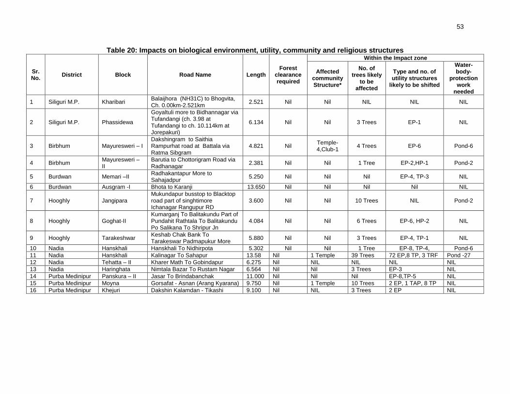
53
Table 20: Impacts on biological environment, utility, community and religious structures
Sr. No.
District Block Road Name Length Forest
clearance required
Within the Impact zone
Affected community Structure*
No. of trees likely
to be affected
Type and no. of utility structures
likely to be shifted
Water-body-
protection work
needed
1 Siliguri M.P. Kharibari Balaijhora (NH31C) to Bhogvita, Ch. 0.00km-2.521km
2.521 Nil Nil NIL NIL NIL
2 Siliguri M.P. Phassidewa
Goyaltuli more to Bidhannagar via Tufandangi (ch. 3.98 at Tufandangi to ch. 10.114km at Jorepakuri)
6.134 Nil Nil 3 Trees EP-1 NIL
3 Birbhum Mayuresweri – I Dakshingram to Saithia Rampurhat road at Battala via Ratma Sibgram
4.821 Nil Temple-4,Club-1
4 Trees EP-6 Pond-6
4 Birbhum Mayuresweri – II
Barutia to Chottorigram Road via Radhanagar
2.381 Nil Nil 1 Tree EP-2,HP-1 Pond-2
5 Burdwan Memari –II Radhakantapur More to Sahajadpur
5.250 Nil Nil Nil EP-4, TP-3 NIL
6 Burdwan Ausgram -I Bhota to Karanji 13.650 Nil Nil Nil Nil NIL
7 Hooghly Jangipara Mukundapur busstop to Blacktop road part of singhtimore Ichanagar Rangupur RD
3.600 Nil Nil 10 Trees NIL Pond-2
8 Hooghly Goghat-II Kumarganj To Balitakundu Part of Pundahit Rathtala To Balitakundu Po Salikana To Shripur Jn
4.084 Nil Nil 6 Trees EP-6, HP-2 NIL
9 Hooghly Tarakeshwar Keshab Chak Bank To Tarakeswar Padmapukur More
5.880 Nil Nil 3 Trees EP-4, TP-1 NIL
10 Nadia Hanskhali Hanskhali To Nidhirpota 5.302 Nil Nil 1 Tree EP-8, TP-4, Pond-6
11 Nadia Hanskhali Kalinagar To Sahapur 13.58 Nil 1 Temple 39 Trees 72 EP,8 TP, 3 TRF Pond -27
12 Nadia Tehatta – II Kharer Math To Gobindapur 6.275 Nil NIL NIL NIL NIL
13 Nadia Haringhata Nimtala Bazar To Rustam Nagar 6.564 Nil Nil 3 Trees EP-3 NIL
14 Purba Medinipur Panskura – II Jasar To Brindabanchak 11.000 Nil Nil Nil EP-8,TP-5 NIL
15 Purba Medinipur Moyna Gorsafat - Asnan (Arang Kyarana) 9.750 Nil 1 Temple 10 Trees 2 EP, 1 TAP, 8 TP NIL
16 Purba Medinipur Khejuri Dakshin Kalamdan - Tikashi 9.100 Nil NIL 3 Trees 2 EP NIL
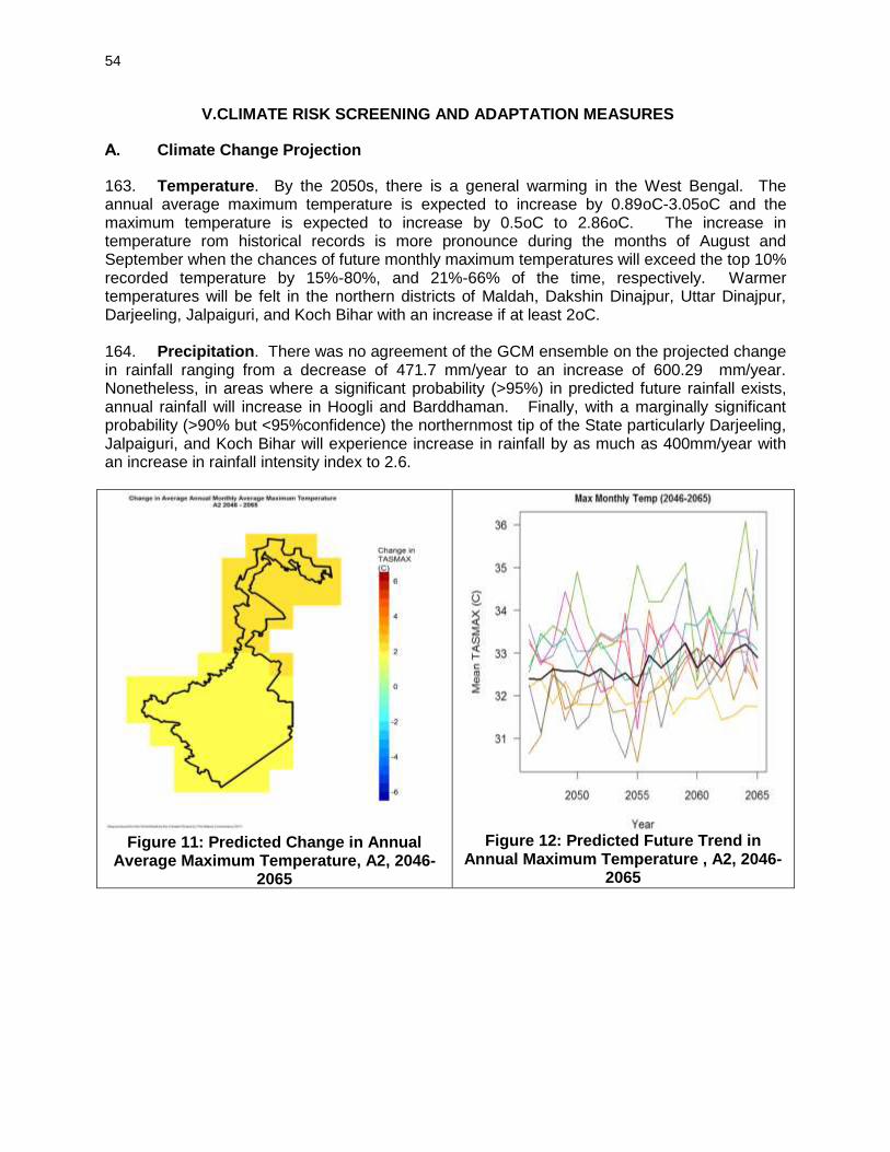
54
V.CLIMATE RISK SCREENING AND ADAPTATION MEASURES
A. Climate Change Projection
163. Temperature. By the 2050s, there is a general warming in the West Bengal. The annual average maximum temperature is expected to increase by 0.89oC-3.05oC and the maximum temperature is expected to increase by 0.5oC to 2.86oC. The increase in temperature rom historical records is more pronounce during the months of August and September when the chances of future monthly maximum temperatures will exceed the top 10% recorded temperature by 15%-80%, and 21%-66% of the time, respectively. Warmer temperatures will be felt in the northern districts of Maldah, Dakshin Dinajpur, Uttar Dinajpur, Darjeeling, Jalpaiguri, and Koch Bihar with an increase if at least 2oC. 164. Precipitation. There was no agreement of the GCM ensemble on the projected change in rainfall ranging from a decrease of 471.7 mm/year to an increase of 600.29 mm/year. Nonetheless, in areas where a significant probability (>95%) in predicted future rainfall exists, annual rainfall will increase in Hoogli and Barddhaman. Finally, with a marginally significant probability (>90% but <95%confidence) the northernmost tip of the State particularly Darjeeling, Jalpaiguri, and Koch Bihar will experience increase in rainfall by as much as 400mm/year with an increase in rainfall intensity index to 2.6.
Figure 11: Predicted Change in Annual
Average Maximum Temperature, A2, 2046-2065
Figure 12: Predicted Future Trend in
Annual Maximum Temperature , A2, 2046-2065

55
Figure 13: Predicted Change in Annual Total
Precipitation, A2, 2046-2065
Figure 14: Predicted Future Trend in Annual Total Precipitation, A2, 2046-2065
B. Natural Hazards and Climate Risks
165. The state has several natural hazards that can be exacerbated by the predicted changes in temperature and rainfall. North Paraganas, South 24 Paraganas, and to a limited extent West Medinipur are prone to tsunami. Flood risks exists in Murshidabad, Barddhaman, Hoogli, North 24 Paraganas, South 24 Paraganas, and West Medinipur. The districts of Uttar Dinajpur, Darjeeling, Jalpaiguri, and Koch Bihar are prone to earthquake with 10% probability of having 7-8 MMI in 50 years. 166. The implications of the projected increases in temperature and rainfall coupled with the existing natural hazards of the State pose risks to the project roads and bridges sustainability and viability. The most dominant risk of climate change is flooding along the Brahamaputra River. All areas adjacent to the Brahamaputra River are prone to flood risks with historical records of greater than 50 events per 100 year and major tributaries at 5-50 occurrences. Flooding in Guwahati, Barpeta, Nalbari, Dhuburi, Kokrajhar, Darang, Golaghat, Dibrugarh, and Dhemaji exposes more than 1,000 persons per year resulting to extreme mortality risk. The projected increase in total rainfall and intensity both upstream and downstream of the Brahmaputra within the State of Assam may result to more severe flooding. This is followed by increase in rainfall in earthquake and landslide prone areas that can jeopardize road embankment stability. Almost the entire State has experienced events between 5.0-6.0 intensities with Dimapur experiencing the most severe earthquakes between 7.1-8.0. Silchar has experienced the most serious ground shaking and most frequent earthquake occurrences at 8-9 Modified Mercali Intensity (MMI) and 0.2-0.4 events/year, respectively. Very high landslide risk areas are found along the Manipur and Nagaland border particularly in Dhuburi and Goalpara districts. The predicted 200-300 mm/year increase in rainfall, also increase the risk of rainfall triggered landslide in this area that can weaken road embankments. Finally, the predicted increase in maximum temperature also increases the risk of vegetation fire which is highest in Dibrugarh with a recorded 300-1,000 events per pixel (see Map) followed by Kamrup with 100-300 events, and low risk of less than 30 events in the Cachar, North Cachar, Anglong, Karbi Anglong, and Golaghat. Bitumen heating and camp site location should ensure that wildfire is avoided particularly near the Marat Longri Wildlife Reserve in Karbi Anglong Autonomous District Council, Borail Sanctuary in Cachar, and all reserved forests.

56
Figure 15: Flood Frequency Map, Assam
Figure 16:Landslide Prone Map, Assam
C. Climate Change Adaptation Measures
a) Enumerate the roads and mention the total number and length located in flood prone areas.
b) Enumerate the roads and mention the total number and length located in landslide prone areas.
c) Discuss the design measures to address these two risks (Road Design Standards) and summarize the costs involved broken down as follows: a. Cost of Cross and Side Drains b. Cost of Bridges c. Cost of increasing embankment height

57
VI.ENVIRONMENTAL MANAGEMENT PLAN, INSTITUTIONAL ARRANGEMENTS AND GRIEVANCE ADDRESS MECHANISM
A. Environmental Management Plan
167. The Environmental Management Plan (EMP) is prepared to facilitate effective implementation of recommended mitigations measures with defined roles and responsibility for implementation and monitoring, regulatory compliance requirements, stages of implementation with location, time frame and costs. The mitigation measures are proposed to eliminate or minimise the identified impact associated with design, construction and operation stages of the project, to acceptable level by adopting the most feasible options. 168. The EMP is prepared as per Environmental Management Standard (ECOP) applicable to rural road defined be ADB at RRS I and RRS II stages. 169. The identified impacts are insignificant and are related to clearing operations of RoW, traffic diversions, setting and operation of construction camps, quarry and borrowing operations, transportation of materials, construction of cross drainage structures, air & noise pollution due to construction activities and operation of construction equipment, tree cutting and shifting of utilities and physical community structure. 170. Appropriate mitigation measures are identified for all rural road construction and operation activities. The identified impacts associated with rural roads and mitigation measures are largely common to most of the roads. The EMP is detailed at Appendix 5. It provides action common to all roads at pre construction, construction and operation stage. Before bidding road specific EMP will be prepared by PIC and which will be attached in final DPR. 171. Since, these are rural road, the vehicular density and speed will be low. Movement of vehicles would be confined primarily for transfer of agricultural produce to market places. As such, no major emergency is anticipated. In any accidental eventuality, local administration can be reached quickly for help though Gram Panchayat (village administration) communication systems.
B. Environmental Monitoring Plan
172. The environmental monitoring program is prepared with aim to monitor the environmental performance of environmental management plan. The EMOP is planned with the focus on following objectives:
• To the assess the effectiveness of mitigation measures proposed
• To assess the change in environmental quality during construction and operation stage with respect to before the project scenario.
• To assess compliance to regulatory requirements
• To monitor the status of corrective action taken in case of deviation from the planned measures or regulatory requirements.
173. For rural roads, Environmental Monitoring plan will be more observation oriented and it provides observation areas with frequency of monitoring at pre construction aspects10, construction stage and operation stage. A monitoring plan with monitoring indicator and frequency of monitoring is given at Appendix 6.
10
Aspects related to alignment selection for inclusion of new roads
58
C. Institutional Arrangements and Responsibilities
174. NRRDA constituted by MoRD is the nodal agency for the implementation of PMGSY in India. SRRDA is the state level agency responsible for implementation of PMGSY program in the state. NRRDA has developed various guidelines and defined institutional arrangements for effective and timely implementation of PMGSY program, which also covers measures for environmental and social safeguards. In line with the defined institutional requirements, each SRRDA has set up district level project implementation units (PIUs). NRRDA also appoints Technical Support Consultant (TSC) to provide technical support for capacity building in SRRDA/PIUs, facilitating them for environmental and social safeguard compliance monitoring and due diligence. SRRDA appoints PIC (project implementation consultant) for supervision of construction work. PIC also helps PIU in monitoring the EMP. 175. NRRDA is also responsible to coordinate with SRRDA and ensure compliance to ADB safeguard requirements. 176. The institutional arrangement at National Level and state level for implementation of PMGSY including RCIP is shown at Figure 8.
D. Institutional Environmental Responsibilities
177. The institutional environmental responsibilities for different level and function is elaborated below. 178. MoRD11 the executing agency has the responsibility for monitoring implementation of the EMP for all subprojects and undertaking necessary due diligence. MoRD ensure this through its Nodal Agency NRRDA (National Rural Road Development Agency). MoRD will also ensure that
• ADB is given access to undertake environmental due diligence for all subprojects, if and when needed as per EARF requirements.
• SRRDA meet all environmental assessment requirements in accordance with EARF
• It undertakes random monitoring of the implementation of the EMP
• Ensure compliance to legislative requirements such as forest clearance for diversion of forest land for non-forest purposes and Consent to Establish/Operate for hot mix plant, batching plant
• Appoint Technical Support Consultant (TSC) to assist SRRDA for various environmental aspect and safeguard compliances.
11
MoRD implements it through its nodal agency NRRDA which undertakes this with the help of Environmental Expert of Technical
Support Consultant

59
Figure 17: Institutional Arrangement for EMP Implementation
Ministry of Rural Development (MORD),
Government of India
National Rural Roads Development Agency (NRRDA)
Project Implementation Authority (National Level)
State Rural Development Agency (State Level)
Project Implementation Unit (PIU)
(District Level)
RCIP roads Project Implementation Consultant (PIC)
Contractor Environmental Officer (EO) (Provided by PIC –One Part
Time/ full Time on need basis) or appointed by SRRDA
Implementation of EMP
ADB
Technical Support Consultants (TSC)
Appointed by NRRDA
Environmental Expert of TSC
Monitoring Implementation of EMP
60
179. SRRDA12will ensure that :
• .ECOP checklist is prepared for each road
• The completed ECOP checklist is included in the DPR with the help of PIC.
• Ensure that all required statutory environmental clearances are obtained and comply with clearance conditions;
• Ensure that the subproject specific EMPs and respective budget are included in the bidding documents;
• Ensure that the ECOP checklists and EMP (including general and site specific issues) are made available to the contractors;
• Undertake routine monitoring of the implementation of the EMP including spot checks on site and prepare monitoring reports at least once a year; and
• With the support of technical support consultants prepare satisfactory environmental due diligence reports of the earlier tranche/periodic financing request before implementing the next tranche.
• Appoint Project Implementation Consultant (PIC) for construction supervision and assist PIUs for EMP implementation and related safeguard compliances.
180. PIU will be responsible to :
• Complete the ECOP checklists and prepare subproject specific EMPs (including monitoring plan) for each subproject
• Obtain necessary statutory environmental clearance prior to commencement of civil works
• Update the respective ECOP checklists and EMPs if there are any changes in alignment of the subprojects
• To conduct monitoring of all subprojects and prepare pre-, during and post-construction monitoring checklists through the project implementation consultants,
• Prepare and submit to SRRDA annual monitoring report as per ADB defined format
181. The Technical Support Consultants (TSC) appointed by NRRDA. The Environmental Expert of TSC :
• Will provide technical assistance to SRRDA/PIU regarding environmental aspects, environmental permitting/clearances requirement,
• Periodically review EMP implementation status including spot site inspections.
• Conduct workshops/capacity building program at different level and functions.
• Prepare environmental Due Diligence report for each trench before implementing next trench
• Prepare state Level IEE reports
182. Project Implementation Consultant (PIC) is appointed by SRRDA. PIC will provide one Environmental Officer (EO). The EO will be responsible to ensure adherence and implementation of EMP at all stages of works by the contractor. The EO, if found warranting may also conduct field tests, independent of the contractor to determine the effectiveness of EMP under approval of PIC/PIU. The broad duties / responsibilities of the Environmental Officer will include:
• Review of project design and specifications to ensure their adequacy and suitability with respect to the implementation of EMP.
12
With assistance from PIC ( Project Implementation Unit)
61
• Collection and dissemination of relevant environmental documents including amendments to environmental protection acts issued by the various agencies, namely, ADB, Government of India / State and local bodies;
• Interact with the counterpart of the Contractor(s), review work progress/plans and ensure implementation of the EMP;
• Co-ordination with the NGOs, community groups and Government departments on environmental issues, provide clarifications/ and obtain clearances during project implementation if any, as required from the regulatory authorities and/or submitting periodic compliance reports as required by the State Authorities;
• Monitoring sensitive environmental attributes during construction and operation stages to ensure that the suggested mitigation measures in the EMP are implemented;
• Facilitate PIU for preparation of annual monitoring report as per ADB defined format
• Documentation of the environmental management/monitoring activities for the regular project implementation progress report; which will serve as the basis for the annual environmental monitoring reports.
• Conducting environmental training/awareness programs for the contractors, the project implementation personnel and the communities.
183. Contractor is appointed by SRRDA for construction of road and ensures implementation of EMP proposed. The broad duties of contractor are as follows:
• Make adequate costs provision for EMP requirements while biding
• Ensure effective implementation of mitigation measures as per road specific EMP
• Comply with all applicable legislative requirements and obtain necessary consents for to Establish/Operate before start of hot mix plant and batching plants. Comply with al permit conditions
• Create awareness amongst workers for environment, occupational health and safety aspects. Participate in training and awareness programme along with its executives conducted by PIC.
• Provide PPE and adequate resources for Environment Occupational Health and Safety
• Follow all the guidelines for borrowing earth and restoration of borrow areas, setting up construction camps
• Sourcing of quarry material from approved quarries only
• Provide all required input to PIC for environmental monitoring as per EMP.
E. Environmental Assessment and Review Framework (EARF) for RCIP 184. ADB has prepared an Environmental Assessment and Review Framework (EARF) which identifies the broad scope of the MFF, outlines the policy, environmental screening and assessment, and institutional requirements for preparing the environmental assessments to be followed for subsequent batches and tranches. This EARF also specifies criteria for eligibility for selection rural roads under RCIP. The sample roads are selected following these criteria. The EMP, monitoring requirement, institutional aspects, capacity building, grievance redress mechanism presented in this chapter are developed in line with above EARF. The eligibility criteria for selection of roads under RCIP, environmental assessment requirement for each trench and legal framework are given below:

62
1. Selection Criteria and Environmental Assessment Requirement 185. The following criteria will be followed for selection of non sample roads.
(i) No Category A (as per ADB’s SPS) subproject will be included in the MFF. (ii) Subprojects will be eligible for construction or upgrading in accordance with the
PMGSY guidelines, and be included in the respective district core network. (iii) The subprojects shall not disturb any cultural heritage designated by the
Government or by international agencies, such as UNESCO, and shall avoid any monuments of cultural or historical importance.
(iv) The subproject will not pass through any designated wildlife sanctuaries, national parks, other sanctuaries, notified ecological sensitive areas or area of internationally significance (e.g., protected wetland designated by the Wetland Convention).
(v) The projects shall only involve activities that follow Government of India laws and regulations, ADB’s Safeguard Policy Statement (2009)
186. The following environmental Assessment requirement will be followed roads included under RCIP
(i) ECOP checklists with annexes on trees, utility structures, community structures, strip plans and photographs will be completed for each and every road.
(ii) Based on the requirements of the PMGSY guidelines separate ECOP checklists will be prepared for bridges that are longer than 50 m.
(iii) Based on the completed ECOP checklists for roads and bridges, IEE reports will be prepared at a state level. These reports must contain a general EMP and a site specific EMP where there are site specific issues.
(iv) ADB’s REA checklist for roads and highways will be completed based on the state level IEE reports prepared and submitted to ADB to confirm categorization
187. The vulnerable to climate change will also be screened following screening checklists, which was integrated in the ADB REA Checklists and corresponding mitigation measures will be prepared.
(i) Is the project area subject to hazards such as earthquakes, floods, landslides, tropical cyclone winds, storm surges, tsunami or volcanic eruptions and climate changes
(ii) Could changes in precipitation patterns or evaporation rates over the lifespan of the project affect its sustainability and cost (i.e., increased landslides increase maintenance costs)?
(iii) Does the project use or depend on resources which could be affected by climate changes such as changes in temperature, precipitation, wind (increased soil moisture content in the sub-grade)?
(iv) Are there any demographic or socioeconomic aspects of the subproject and project area (e.g., population growth, settlement patterns) that increase the vulnerability of the project and surrounding area?
(v) Could the subproject potentially increase the vulnerability of the surrounding area (i.e., by increasing runoff, encouraging settlement in earthquake zones)
2. Legal Framework
188. As per Indian legislation, an environmental clearance is not required for rural roads. However, it may attract provisions of Forest Conservation Act, Wild Life (Protection) Act, and other legislation related with Air, Water and Noise pollution controls and prevention. The legislative applicability screening is presented in chapter 1 of this report and it will apply for non-

63
sample road as well. Additionally, to ensure conformance to ADB’s Safeguard Policy Statement, 2009 (SPS), the subprojects will be subject to the following requirements:
(i) An Initial Environmental Examination13 (IEE) report including the preparation of an Environmental Management Plan (EMP) and a Monitoring Plan.
(ii) Regular monitoring of implementation of the EMP and submission of monitoring reports and due diligence reports to ADB as necessary
F. Capacity Building 189. Existing capacity of the West Bengal State Rural Roads Development Agencies (WBSRRDA) and Project Implementation Units (PIUs) for implementing environmental safeguard issues need substantial strengthening. Capacity building activities will mainly comprise training workshops for WBSRRDA and PIU environmental officers on (i) completion of environmental code of practice (ECOP) checklists; (ii) preparation of environmental management plan (EMP) and monitoring plans; (iii) monitoring of EMP implementation and completion of pre-, during and post-construction monitoring checklists; and (iv) preparation of monitoring reports. These few workshops have already been conducted at participating states though ADB appointed Environmental specialist. Additional training will be carried out periodically, by In-house trained and experienced officials. G. Consultation and Information Disclosure 190. During the preparation of ECOP and Detailed Project Report (DPR), the PIU has to ensure consultation, and addressal of concerns of the affected people. 191. All environmental assessment documents are subject to ADB’s Public Communication Policy (2005) and will be made available to the public, upon request. The WBSRRDA are responsible for ensuring that all environmental checklist documentation, including the environmental due diligence and monitoring reports, are properly and systematically kept as part of the Investment Program specific records. MoRD must disclose sample road IEE report on its website. H. Grievance Redress Mechanism 192. PRI administered village level committee is the first contact point for any aggrieved person. This committee will try to settle the concern by them self or in consultation with contractor or PIU. The unresolved concerned are forwarded to PIU for further action. PIU resolves these concerns in consultation with PIC, WBSRRDA, and contractor as the situation demands. This is an established practice and is seen effective enough in RRS II. PIC will also collect concerns received by this committee in the intervening period and report the effectiveness of action taken. 193. Experience in earlier tranches of the progranIn shows that village level grievance redress committees comprising the sarpanch, panchayat secretary and other prominent citizens of the village were in place. However, as the site selection and project design process involved participation and full consultation with the community, there was hardly any grievance by the APs and no complaint was received by any of the village committees.
13 As per selection criteria, no Category A subproject will be included under RCIP.

64
194. At national level NRRDA has made provision of registering complain /suggestion through its website. NRRDA forwards these complains to concerned SRRDA for necessary actions. SRRDA directly or through concerned PIU initiate the appropriate action and update the complainant as well as NRRDA. It is proposed that NRRDA website will be cross-linked to WBSRRDA website as well or WBSRRDA will also make provision of complain registry at its website.

65
VII.PUBLIC CONSULTATION AND INFORMATION DISCLOSURE
A. General
195. Public consultation was undertaken consistent with the ADB’s requirements. All the five principles of information dissemination, information solicitation, integration, co-ordination and engagement into dialogue were incorporated in the consultation process. A framework of different environmental impacts likely from the project was strengthened and modified based on opinions of all those consulted, especially in the micro level by setting up dialogues with the village people from whom information on site facts and prevailing conditions were collected. 196. Stakeholder’s consultations were held with the intent to understand their concerns, apprehensions, overall opinion and solicit recommendations to improve project design. Informal meetings, interviews were organized covering the entire project stretch. The informal consultation generally started with explaining the sub projects, followed by an explanation to potential impacts. Participant’s views were gathered with regard to loss of agricultural land, effect on air and noise quality of the area due to traffic, water availability, accident and risk. 197. The discussions were designed to receive maximum inputs from the participants regarding their acceptability and environmental concerns arising out of the sub-project. They were given the brief outline of the project to which their opinion was sought. Suggestions were also sought for mitigating any potential adverse impact.
B. Compliance with Relevant Regulatory Requirements
198. In India, public consultation is mandatory in case of Category A and B1 category projects14 in select conditions. Being a category B project as per SPS 2009, consultation was carried out during the early stage of IEE report preparation. The requirement of public consultation during the implementation of the project has been proposed as part of the mitigation plan. This will involve regular communications between the PIU, PIC and the grievance redressal committee’s and community leaders. Consultations carried out and grievances addressed will be recorded in the annual environmental monitoring report which will be submitted for disclosure on the ADB website.
C. Beneficiaries’ Comments
199. The project has immense acceptability among the local people. They perceived that in addition to providing all weather connectivity, the sub-project road will bring positive socio-economic changes in the area. Local people mainly discussed on issues related to drainage and commencement of the construction work. 200. Some of the general issues raised during the different consultation sessions can be summed up as follows.
• Construction Camp - Impacts from the establishment and operation of the construction camps like generation and disposal of solid wastes, sewage, potable water requirements, health/hygiene, and safety is part of the contractor’s responsibility highlighting the need for compliance with applicable laws. Waste
14 As per schedule I of EIA notification number S.O. 1533, dated 14th September 2006. This notification also defines when a public consultation is mandatory.

66
and material use minimization will be promoted to decrease the volume of wastes that will be generated.
• The participants did not apprehend any adverse impact due to the construction camp near to their villages. They responded positively towards providing support to these, if required, in terms of any food, water requirements.
• Water Logging and Drainage - Participants informed about few low lying areas where water logging takes place during monsoon season. The villagers requested for provision of adequate cross drainage structures at these locations.
• Loss of Livelihood and Income Restoration Options - This issue was raised by those who had encroached on the proposed alignment. However, they offered the encroached space for the proposed project, if demanded.
• Road Safety - Safety issues did not raised concern among the inhabitants including women.
• Land Acquisition through voluntary donation - People were in full support of the project and were ready to donate their land for the same, if required.
• Losses of Idols/Shrines - Participants supported the project and were willing to shift the idols, burial grounds and other religious structures observed at certain locations. During construction of road contractor will try their best to save religious structure.
• Loss of Trees Due to Road Construction - Respondents were of the opinion that trees cutting should be avoided or else minimised. For trees to be cut compensatory plantation should be done. Some villagers expected additional plantation should be done. Recommended tree species for plantation were other local varieties.
• Impacts on Health - Separate consultation sessions were organised by social team to identify issues pertaining to health specifically for sexually transmitted diseases (STDs). Settlements along the rural roads were reported to be getting exposed to such diseases, as there are no long distance users on the project roads.
• Ambient Air & Noise Quality – The respondents viewed that these are the problems of urban areas and their villages are still untouched from this aspect. They even do not anticipate any of these problems after the completion of the project.
• Inconvenience during Construction - The participants viewed that they will manage it as it will be temporary.
• Employment during Construction - The locals expected that they should be given preference in employment during project implementation.
• Perceptions and Expectations - Perceptions and expectations of the community recorded during the consultation sessions can be broadly listed as: - The public and the affected persons appreciated and supported the
project with their open hearts. - Community at large appreciated overall benefits to them resulting from
project development; - They were aware of the increased access, lesser commuting time after
project implementation;
• Addressal of Issues - The project has tried its best to address all the issues raised during consultations under the constraints of suitability from engineering point of view. Some of the provisions made under the project to address the issues and concerns of the community are given in Table 21.

67
Table 21: Addressal of Issues and Concerns under the Project
Issue/Concern Addressal under the project
Water Logging and Drainage Adequate cross drainage structures have been planned
Road Safety Adequate safely signage is planned all along the rural road.
Land acquisition and Mode of compensation
The proposed RoW is 10-12m along the rural road. No land acquisition is planned in project road.
Loss of roadside idols/shrines Idols and shrines will be relocated to the other nearby places with consultation and proper rituals
Loss of trees Compensatory afforestation would be done at the ratio of three trees for each tree to be cut.
Excavation and back filling Monitor adherence to contract specifications
Erosion Monitor proper management of excavated soil/silt including timely removal of material from project site
Storage and transportation of construction materials, excavated soil and silt
Monitor adequacy of measures undertaken to prevent fugitive dust
Increased pollution levels Pollution levels are not crossing the prescribed limits of CPCB and planned plantation will screen the emission.
Noise and emissions from construction vehicle
Monitor ‘Pollution under Control’ certificate are current for construction vehicles
Utilities and basic infrastructure
All the utilities, electric poles, telephone lines, wells, tube wells etc. to be impacted will be relocated under the project cost.
Employment of locals during construction
Locals will be given preference for employment during the project implementation
Health check up of workers Monitor adequacy of health check up service provided including attendance of the physician retained and the extent to which the workforce is availing this service
Health and safety requirement Monitor adherence to all occupational and safety requirements

68
VIII.CONCLUSIONS AND RECOMMENDATIONS
A. Conclusions
201. The findings of Environment Assessment of sample roads indicate that impacts are mostly similar and subprojects are unlikely to cause any significant environmental impacts. While some of the impacts are negative, there are many bearing benefits to the area. Most of the impacts are likely to occur during construction stage, are temporary in nature, and can be mitigated with minor to negligible residual impacts. 202. The project received immense support from local people as they perceive that this project will improve the overall connectivity and bring various economic opportunities to the people of the area. 203. All sample roads included under Tranche III were selected based on ecological and climate change consideration defined under EARF. Accordingly, none of the sample roads passes through protected areas or encroaches precious ecology (sensitive or protected areas) or any historical or archeologically protected areas. As per selection guidelines, none of the selected sample road passes through reserved forests either. Few trees cutting though may be involved. 204. Few of the rural roads cross natural streams and rivers. However, none of these roads is prone to flood. 205. All the sample roads are aligned with existing village roads and unpaved movement paths. As such, additional land requirement is very minimal which is also acquired through donations from villagers. 206. Considering insignificant environmental sensitivity, the project is categorised as category B as per ADB Safeguard Policy Statement 2009. 207. No categorisation is made under environmental legislation of India, since these small roads do not require any environmental clearance in accordance to Indian Environmental (Protection) Act and Rules, 1986 amended till date. For felling of trees permission needs to be taken up from gram panchyat. 208. The impacts identified are mostly related to alignment selection, land clearing, borrowing earth, cutting of trees, shifting of utilities and community structures, establishment of construction camp or material storage areas, transportation of material and operation of hot mix plant. All identified impacts are either eliminated or minimised through design consideration and suitable mitigation measures. 209. Environmental Management plan covering all stages of road construction (design, construction and operation) is prepared with defined responsibility for its implementation. Environmental Monitoring plan is also prepared to ensure effective implementation of EMPs. 210. NRRDA/WBSRRDA has defined institutional setup including with specified responsibility for environmental management. Existing capacity of the West Bengal State Rural Roads Development Agencies (WBSRRDA) and Project Implementation Units (PIUs) for implementing environmental safeguard issues need substantial strengthening. The capacity enhancement is proposed through focused workshops and training session. Few workshops have already been

69
conducted at participating states through ADB appointed Environmental specialist. Trained and experienced in-house officials should carry out more raining in future periodically. 211. The IEE also indicate that rural road construction works does not warrant further EIA study for subsequent rural road construction works in West Bengal.
B. Key Recommendations
212. Any major changes or any major additional work other than the proposed project activities will require updation of ECOP and IEE. The updated ECOPs and IEE will have to be submitted to NRRDA and ADB for concurrence before civil works commence. 213. The implementation of prescribed mitigation measures will minimize/avoid the adverse impacts. Moreover, the impacts shall be monitored continually by implementing and updating the Environmental Management plan and Environmental Monitoring Plan. 214. These IEE is prepared based on ECOPs. Subproject specific EMP shall be improved as per the final provisions made under DPRs. The updated EMP if there is any change, shall also be sent to ADB for information. 215. Executing agency shall ensure that updated road specific EMP forms part of DPR and is available to contractor at the time of bidding. The contractor will specify the quantity and budget for various activities like rehabilitation of borrow earth pits, first aid and sanitation facilities at construction camp and temporary office/material storage place as per EMP requirements. The same shall be revised if there is any change in the project design. Any such change shall be reported to ADB as well.

70 Appendix 1
Appendix 1: Details of Roads in West Bengal RCIP Batch III (Tranche III)
PIU/Dist Package Name of Road Length (km) Approx Cost (Rs. In lakh)
Siliguri M.P. WB 17 ADB 15 Howdavita(NH31) to Tetulguri ((ch. 0.00km - 3.904km)
3.904 207.159
Siliguri M.P. WB 17 ADB 17 Balaijhora (NH31C) to Bhogvita, Ch. 0.00km-2.521km
2.521 155.951
Siliguri M.P. WB 17 ADB 19 NH31C (near Bapujipath) to Dangarvita via Manjoyjote, ch. 0.00km-2.767km
2.767 170.885
Siliguri M.P. WB 17 ADB 20 NH31 (near Bagdogra Airport) to Church More via Tarbanda (ch. 2.355km at Digravita - 8.071km at Saldangi)
5.716 304.46
Siliguri M.P. WB 17 ADB 23 NH31(near Ayappa Temple) to Alokjhari via Putimari (ch. 0.00km-2.507km)
2.507 142.737
Siliguri M.P. WB 17 ADB 25 NH31C Chowpukuria to Bhariadangar Chhat (ch. 0.00km -6.534km)
6.534 344.339
Siliguri M.P. WB 17 ADB 28 NH 31C Rupsingh to Dhemal (ch. 0.00km-6.534km)
7.2 436.899
Siliguri M.P. WB 17 ADB 29 Goyaltuli more to Bidhannagar via Tufandangi (ch. 3.98 at Tufandangi to ch. 10.114km at Jorepakuri)
6.134 353.8
Siliguri M.P. WB 17 ADB 35 NH31C(near Sathbhaiya) to Naxalbari Tea Estate (ch. 0.00km-3.795km)
3.795 203.417
Siliguri M.P. WB 17 ADB 37 Mangalsingh(NH31C) to Sebdella (ch. 0.00km-2.50km)
2.5 157.051
Grand Total of 10 roads of Siliguri M.P District 43.578 2476.698
Birbhum WB 04 ADB 24 Pahareswar More To Kharui More 18.5 1050.74
Birbhum WB 04 ADB 23 Gerupahari To Babuijore 8.515 516.4
Birbhum WB 04 ADB 25 Layekbazar to Karpatikuri Busstand via Donaipur Padmabatipur bye pass
6.99 402.41
Birbhum WB 04 ADB 26 Maldiha to Chatrisapara 2.26 120.45
Birbhum WB 04 ADB 27 Ayas Dharmatala G.P. Office to Chamtibagan ADB Road via Nachhia Debogram Lambodarpur
7.078 349.44
Birbhum WB 04 ADB 28 Dakshingram to Saithia Rampurhat road at Battala via Ratma Sibgram
4.821 281.76
Birbhum WB 04 ADB 29 Barutia to Chottorigram Road via Radhanagar 2.381 138.34
Grand Total of 7 roads of Birbhum District 50.545 2859.54
Burdwan WB 05 ADB 27 Mougram to Naihati 9.225 479.47
Burdwan WB 05 ADB 20 Radhakantapur More to Sahajadpur 5.250 299.33
Burdwan WB 05 ADB 35 Chatni (At STKK Rd.) to Kashipur 12.225 614.96
Burdwan WB 05 ADB 24 Chelod to Chanda 7.445 336.48
Burdwan WB 05 ADB 21 Ura to Dadpur 8.650 480.82
Burdwan WB 05 ADB 22 Galsi to Dakshinvasapur 7.900 441.32
Burdwan WB 05 ADB 26 Bamungoria to Haripur 5.925 311.25
Burdwan WB 05 ADB 23 Chhora to Bishnupur 5.550 272.21
Burdwan WB 05 ADB 29 Dignagar to Shibda 6.900 358.3
Burdwan WB 05 ADB 28 Bhota to Karanji 13.650 692.23
Burdwan WB 05 ADB 30 Gopalmath to Sonai 6.150 327.71
Burdwan WB 05 ADB 31 Deslopa to Sankarpur 13.750 618.02
Burdwan WB 05 ADB 25 Harishpur J.K. Ropeways to Sidhuli 10.000 444.17
Burdwan WB 05 ADB 32 Debipur (NH2) at Panagarah to NH2 at Rajbandh to Manikara
12.200 626.66
Burdwan WB 05 ADB 33 Gutulia to Madhaiganj 7.750 361.11
Burdwan WB 05 ADB 34 Raniganj (O.D.R.) to Baktar Nagar Vill.( Upto N.H) 4.600 242.72
Grand Total of 16 roads of Burdwan District 137.170 6906.76
Hooghly WB 08 ADB 25 Haripal station to Shipaigachi - part of mosai More to Illipur
14.720 1049.21
Hooghly WB 08 ADB 23 Mukundapur busstop to Blacktop road part of singhtimore Ichanagar Rangupur RD
3.600 261.28
Hooghly WB 08 ADB 30 Baradigrui Bus stand to majpur jarapar part of Pursurah Baradigrui
3.160 227.08
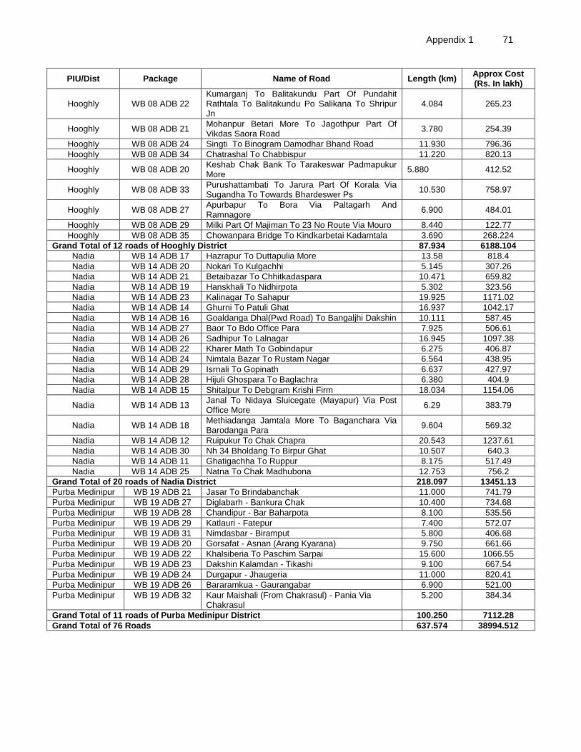
Appendix 1 71
PIU/Dist Package Name of Road Length (km) Approx Cost (Rs. In lakh)
Hooghly WB 08 ADB 22 Kumarganj To Balitakundu Part Of Pundahit Rathtala To Balitakundu Po Salikana To Shripur Jn
4.084 265.23
Hooghly WB 08 ADB 21 Mohanpur Betari More To Jagothpur Part Of Vikdas Saora Road
3.780 254.39
Hooghly WB 08 ADB 24 Singti To Binogram Damodhar Bhand Road 11.930 796.36
Hooghly WB 08 ADB 34 Chatrashal To Chabbispur 11.220 820.13
Hooghly WB 08 ADB 20 Keshab Chak Bank To Tarakeswar Padmapukur More
5.880 412.52
Hooghly WB 08 ADB 33 Purushattambati To Jarura Part Of Korala Via Sugandha To Towards Bhardeswer Ps
10.530 758.97
Hooghly WB 08 ADB 27 Apurbapur To Bora Via Paltagarh And Ramnagore
6.900 484.01
Hooghly WB 08 ADB 29 Milki Part Of Majiman To 23 No Route Via Mouro 8.440 122.77
Hooghly WB 08 ADB 35 Chowanpara Bridge To Kindkarbetai Kadamtala 3.690 268.224
Grand Total of 12 roads of Hooghly District 87.934 6188.104
Nadia WB 14 ADB 17 Hazrapur To Duttapulia More 13.58 818.4
Nadia WB 14 ADB 20 Nokari To Kulgachhi 5.145 307.26
Nadia WB 14 ADB 21 Betaibazar To Chhitkadaspara 10.471 659.82
Nadia WB 14 ADB 19 Hanskhali To Nidhirpota 5.302 323.56
Nadia WB 14 ADB 23 Kalinagar To Sahapur 19.925 1171.02
Nadia WB 14 ADB 14 Ghurni To Patuli Ghat 16.937 1042.17
Nadia WB 14 ADB 16 Goaldanga Dhal(Pwd Road) To Bangaljhi Dakshin 10.111 587.45
Nadia WB 14 ADB 27 Baor To Bdo Office Para 7.925 506.61
Nadia WB 14 ADB 26 Sadhipur To Lalnagar 16.945 1097.38
Nadia WB 14 ADB 22 Kharer Math To Gobindapur 6.275 406.87
Nadia WB 14 ADB 24 Nimtala Bazar To Rustam Nagar 6.564 438.95
Nadia WB 14 ADB 29 Isrnali To Gopinath 6.637 427.97
Nadia WB 14 ADB 28 Hijuli Ghospara To Baglachra 6.380 404.9
Nadia WB 14 ADB 15 Shitalpur To Debgram Krishi Firm 18.034 1154.06
Nadia WB 14 ADB 13 Janal To Nidaya Sluicegate (Mayapur) Via Post Office More
6.29 383.79
Nadia WB 14 ADB 18 Methiadanga Jamtala More To Baganchara Via Barodanga Para
9.604 569.32
Nadia WB 14 ADB 12 Ruipukur To Chak Chapra 20.543 1237.61
Nadia WB 14 ADB 30 Nh 34 Bholdang To Birpur Ghat 10.507 640.3
Nadia WB 14 ADB 11 Ghatigachha To Ruppur 8.175 517.49
Nadia WB 14 ADB 25 Natna To Chak Madhubona 12.753 756.2
Grand Total of 20 roads of Nadia District 218.097 13451.13
Purba Medinipur WB 19 ADB 21 Jasar To Brindabanchak 11.000 741.79
Purba Medinipur WB 19 ADB 27 Diglabarh - Bankura Chak 10.400 734.68
Purba Medinipur WB 19 ADB 28 Chandipur - Bar Baharpota 8.100 535.56
Purba Medinipur WB 19 ADB 29 Katlauri - Fatepur 7.400 572.07
Purba Medinipur WB 19 ADB 31 Nimdasbar - Biramput 5.800 406.68
Purba Medinipur WB 19 ADB 20 Gorsafat - Asnan (Arang Kyarana) 9.750 661.66
Purba Medinipur WB 19 ADB 22 Khalsiberia To Paschim Sarpai 15.600 1066.55
Purba Medinipur WB 19 ADB 23 Dakshin Kalamdan - Tikashi 9.100 667.54
Purba Medinipur WB 19 ADB 24 Durgapur - Jhaugeria 11.000 820.41
Purba Medinipur WB 19 ADB 26 Bararamkua - Gaurangabar 6.900 521.00
Purba Medinipur WB 19 ADB 32 Kaur Maishali (From Chakrasul) - Pania Via Chakrasul
5.200 384.34
Grand Total of 11 roads of Purba Medinipur District 100.250 7112.28
Grand Total of 76 Roads 637.574 38994.512
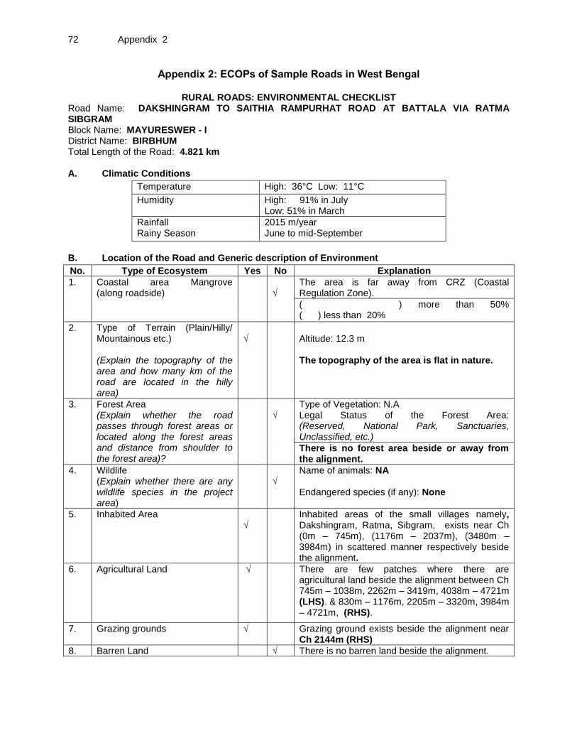
72 Appendix 2
Appendix 2: ECOPs of Sample Roads in West Bengal
RURAL ROADS: ENVIRONMENTAL CHECKLIST Road Name: DAKSHINGRAM TO SAITHIA RAMPURHAT ROAD AT BATTALA VIA RATMA SIBGRAM Block Name: MAYURESWER - I District Name: BIRBHUM Total Length of the Road: 4.821 km A. Climatic Conditions
Temperature High: 36°C Low: 11°C
Humidity High: 91% in July Low: 51% in March
Rainfall Rainy Season
2015 m/year June to mid-September
B. Location of the Road and Generic description of Environment
No. Type of Ecosystem Yes No Explanation
1. Coastal area Mangrove (along roadside)
√
The area is far away from CRZ (Coastal Regulation Zone).
( ) more than 50% ( ) less than 20%
2. Type of Terrain (Plain/Hilly/ Mountainous etc.) (Explain the topography of the area and how many km of the road are located in the hilly area)
√
Altitude: 12.3 m The topography of the area is flat in nature.
3. Forest Area (Explain whether the road passes through forest areas or located along the forest areas and distance from shoulder to the forest area)?
√
Type of Vegetation: N.A Legal Status of the Forest Area: (Reserved, National Park, Sanctuaries, Unclassified, etc.)
There is no forest area beside or away from the alignment.
4. Wildlife (Explain whether there are any wildlife species in the project area)
√
Name of animals: NA Endangered species (if any): None
5. Inhabited Area √
Inhabited areas of the small villages namely, Dakshingram, Ratma, Sibgram, exists near Ch (0m – 745m), (1176m – 2037m), (3480m – 3984m) in scattered manner respectively beside the alignment.
6. Agricultural Land √ There are few patches where there are agricultural land beside the alignment between Ch 745m – 1038m, 2262m – 3419m, 4038m – 4721m (LHS). & 830m – 1176m, 2205m – 3320m, 3984m – 4721m, (RHS).
7. Grazing grounds √ Grazing ground exists beside the alignment near Ch 2144m (RHS)
8. Barren Land √ There is no barren land beside the alignment.
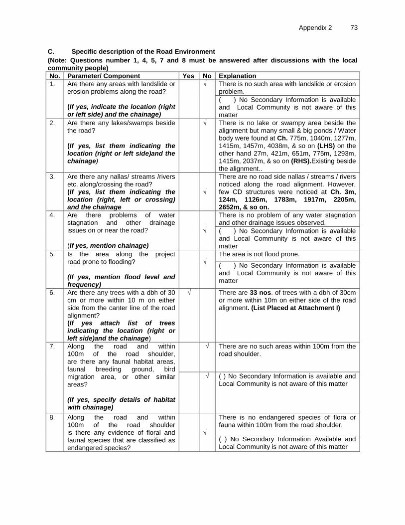
Appendix 2 73
C. Specific description of the Road Environment
(Note: Questions number 1, 4, 5, 7 and 8 must be answered after discussions with the local community people)
No. Parameter/ Component Yes No Explanation
1. Are there any areas with landslide or erosion problems along the road? (If yes, indicate the location (right or left side) and the chainage)
√ There is no such area with landslide or erosion problem.
( ) No Secondary Information is available and Local Community is not aware of this matter
2. Are there any lakes/swamps beside the road? (If yes, list them indicating the location (right or left side)and the chainage)
√ There is no lake or swampy area beside the alignment but many small & big ponds / Water body were found at Ch. 775m, 1040m, 1277m, 1415m, 1457m, 4038m, & so on (LHS) on the other hand 27m, 421m, 651m, 775m, 1293m, 1415m, 2037m, & so on (RHS).Existing beside the alignment..
3. Are there any nallas/ streams /rivers etc. along/crossing the road? (If yes, list them indicating the location (right, left or crossing) and the chainage
√
There are no road side nallas / streams / rivers noticed along the road alignment. However, few CD structures were noticed at Ch. 3m, 124m, 1126m, 1783m, 1917m, 2205m, 2652m, & so on..
4. Are there problems of water stagnation and other drainage issues on or near the road? (If yes, mention chainage)
√
There is no problem of any water stagnation and other drainage issues observed.
( ) No Secondary Information is available and Local Community is not aware of this matter
5. Is the area along the project road prone to flooding? (If yes, mention flood level and frequency)
√
The area is not flood prone.
( ) No Secondary Information is available and Local Community is not aware of this matter
6. Are there any trees with a dbh of 30 cm or more within 10 m on either side from the canter line of the road alignment? (If yes attach list of trees indicating the location (right or left side)and the chainage)
√ There are 33 nos. of trees with a dbh of 30cm or more within 10m on either side of the road alignment. (List Placed at Attachment I)
7. Along the road and within 100m of the road shoulder, are there any faunal habitat areas, faunal breeding ground, bird migration area, or other similar areas? (If yes, specify details of habitat with chainage)
√ There are no such areas within 100m from the road shoulder.
√ ( ) No Secondary Information is available and Local Community is not aware of this matter
8. Along the road and within 100m of the road shoulder is there any evidence of floral and faunal species that are classified as endangered species?
√
There is no endangered species of flora or fauna within 100m from the road shoulder.
( ) No Secondary Information Available and Local Community is not aware of this matter
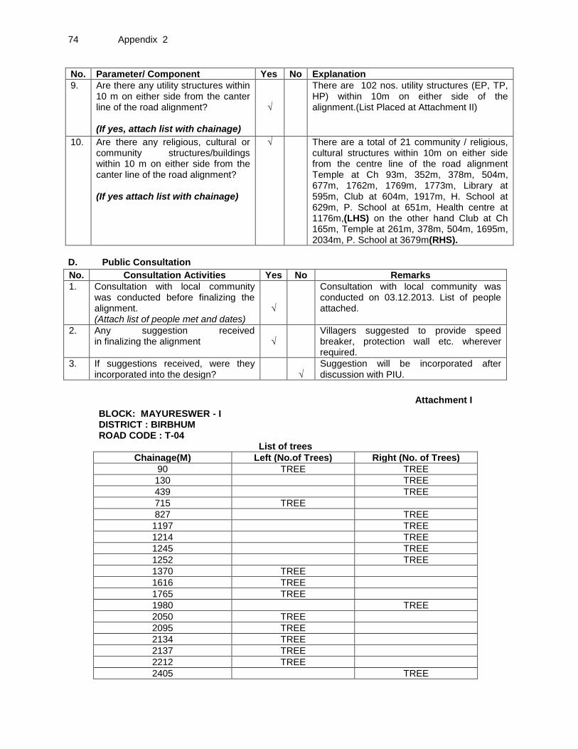
74 Appendix 2
No. Parameter/ Component Yes No Explanation
9. Are there any utility structures within 10 m on either side from the canter line of the road alignment? (If yes, attach list with chainage)
√
There are 102 nos. utility structures (EP, TP, HP) within 10m on either side of the alignment.(List Placed at Attachment II)
10. Are there any religious, cultural or community structures/buildings within 10 m on either side from the canter line of the road alignment? (If yes attach list with chainage)
√ There are a total of 21 community / religious, cultural structures within 10m on either side from the centre line of the road alignment Temple at Ch 93m, 352m, 378m, 504m, 677m, 1762m, 1769m, 1773m, Library at 595m, Club at 604m, 1917m, H. School at 629m, P. School at 651m, Health centre at 1176m,(LHS) on the other hand Club at Ch 165m, Temple at 261m, 378m, 504m, 1695m, 2034m, P. School at 3679m(RHS).
D. Public Consultation
No. Consultation Activities Yes No Remarks
1. Consultation with local community was conducted before finalizing the alignment. (Attach list of people met and dates)
√
Consultation with local community was conducted on 03.12.2013. List of people attached.
2. Any suggestion received in finalizing the alignment
√
Villagers suggested to provide speed breaker, protection wall etc. wherever required.
3. If suggestions received, were they incorporated into the design?
√
Suggestion will be incorporated after discussion with PIU.
Attachment I
BLOCK: MAYURESWER - I DISTRICT : BIRBHUM ROAD CODE : T-04 List of trees
Chainage(M) Left (No.of Trees) Right (No. of Trees)
90 TREE TREE
130 TREE
439 TREE
715 TREE
827 TREE
1197 TREE
1214 TREE
1245 TREE
1252 TREE
1370 TREE
1616 TREE
1765 TREE
1980 TREE
2050 TREE
2095 TREE
2134 TREE
2137 TREE
2212 TREE
2405 TREE

Appendix 2 75
2414 TREE TREE
3352 TREE
3387 TREE TREE
3408 TREE
3419 TREE
3489 TREE
3626 TREE
3820 TREE
3829 2 TREE
3860 TREE
Attachment II BLOCK: MAYURESWER - I
DISTRICT : BIRBHUM ROAD CODE : T-04 List of Utilities
Chainage (M) Left Right
0 TF
56 EP
99 EP + TP
139 EP
173 EP + TP
205 HP
210 EP
236 EP
258 EP
260 EP
280 EP + TP
304 EP + TP
310 EP
326 EP
341 EP
370 TP
384 TP EP
430 EP
444 HP
460 TP
471 EP
488 EP
497 TP
524 EP
580 EP
626 EP
651 EP
677 EP
715 EP
745 EP
1126 EP
1142 EP
1187 EP
1266 EP
1283 EP
1332 EP
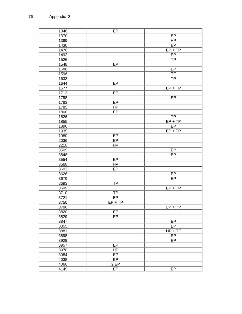
76 Appendix 2
1348 EP
1370 EP
1389 HP
1436 EP
1476 EP + TP
1492 EP
1526 TP
1548 EP
1586 EP
1596 TF
1633 TP
1644 EP
1677 EP + TP
1712 EP
1758 EP
1783 EP
1785 HP
1800 EP
1826 TP
1855 EP + TP
1896 EP
1935 EP + TP
1980 EP
2036 EP
2210 HP
3509 EP
3548 EP
3554 EP
3560 HP
3603 EP
3626 EP
3679 EP
3693 TP
3699 EP + TP
3710 TP
3721 EP
3750 EP + TP
3786 EP + HP
3820 EP
3829 EP
3847 EP
3855 EP
3881 HP + TF
3898 EP
3929 EP
3957 EP
3970 HP
3984 EP
4038 EP
4066 2 EP
4149 EP EP

Appendix 2 77
Attachment III
BLOCK: MAYURESWER - I
DISTRICT : BIRBHUM ROAD CODE : T-04 List of Community Structures
Chainage(M) Left Right
93 TEMPLE
165 CLUB
261 TEMPLE
352 TEMPLE
378 TEMPLE TEMPLE
504 TEMPLE TEMPLE
595 LIBRARY
604 CLUB
629 HIGH SCHOOL
651 PRIMARY SCHOOL
677 TEMPLE
1176 HELTHCENTER
1762 TEMPLE
1769 TEMPLE
1773 TEMPLE
1917 CLUB
2034 TEMPLE

78 Appendix 2
Attachment IV
BLOCK: MAYURESWER - I DISTRICT : BIRBHUM
ROAD CODE : T-04
8m to 10m
6m to 8m 4m to 6m 2.75m to 4m
0m to 2.75m Chainage(M)
0m to 2.75m
2.75m to 4m
4m to 6m
6m to 8m
8m to 10m CD
0 TF
3 CD
27 POND
EP 56
TREE 90 TREE
TEMPLE 93
EP + TP 99
124 CD
130 TREE
139 EP
165 CLUB
173 EP + TP
205 HP
EP 210
EP 236
258 EP
EP 260
261 TEMPLE
EP + TP 280
EP + TP 304
310 EP
EP 326
EP 341
TEMPLE 352
TP 370
TEMPLE 378 TEMPLE
TP 384 EP
421 POND
EP 430

Appendix 2 79
439 TREE
444 HP
TP 460
471 EP
488 EP
497 TP
TEMPLE 504 TEMPLE
524 EP
545 CD
EP 580
LIBRARY 595
CLUB 604
EP 626
HIGH SCHOOL 629
PRIMARY SCHOOL
651 EP + POND
TEMPLE 677 EP + POND
TREE + EP 715
EP 745
760 CD
POND 775 POND
827 TREE
POND 1040
EP 1126 CD
EP 1142
HELTHCENTER 1176
EP 1187
1197 TREE
1214 TREE
1245 TREE
1252 TREE
EP 1266
POND 1277
1283 EP
1293 POND
EP 1332
EP 1348
1362 CD
TREE 1370 EP

80 Appendix 2
1389 HP
POND 1415 POND
1436 EP
POND 1457
1476 EP + TP
1492 EP
1526 TP
EP 1548
1586 EP
1596 POND +
TF
TREE 1616 POND
1633 TP
EP 1644
1677 EP + TP
1695
EP 1712
1758 EP
TEMPLE 1762
TREE 1765
TEMPLE 1769
TEMPLE 1773
EP 1783 CD
HP 1785
EP 1800
1826 TP
1855 EP + TP
1896 EP
1905 CD
CLUB 1917
POND 1935 EP + TP
POND 1960 CD
EP 1980 TREE
2034 TEMPLE
EP 2036
2037 POND
TREE 2050
POND 2083
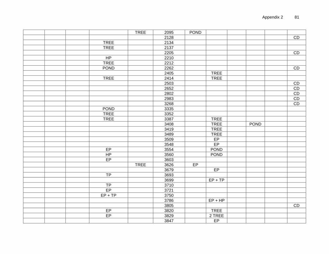
Appendix 2 81
TREE 2095 POND
2128 CD
TREE 2134
TREE 2137
2205 CD
HP 2210
TREE 2212
POND 2262 CD
2405 TREE
TREE 2414 TREE
2503 CD
2652 CD
2802 CD
2983 CD
3268 CD
POND 3335
TREE 3352
TREE 3387 TREE
3408 TREE POND
3419 TREE
3489 TREE
3509 EP
3548 EP
EP 3554 POND
HP 3560 POND
EP 3603
TREE 3626 EP
3679 EP
TP 3693
3699 EP + TP
TP 3710
EP 3721
EP + TP 3750
3786 EP + HP
3805 CD
EP 3820 TREE
EP 3829 2 TREE
3847 EP
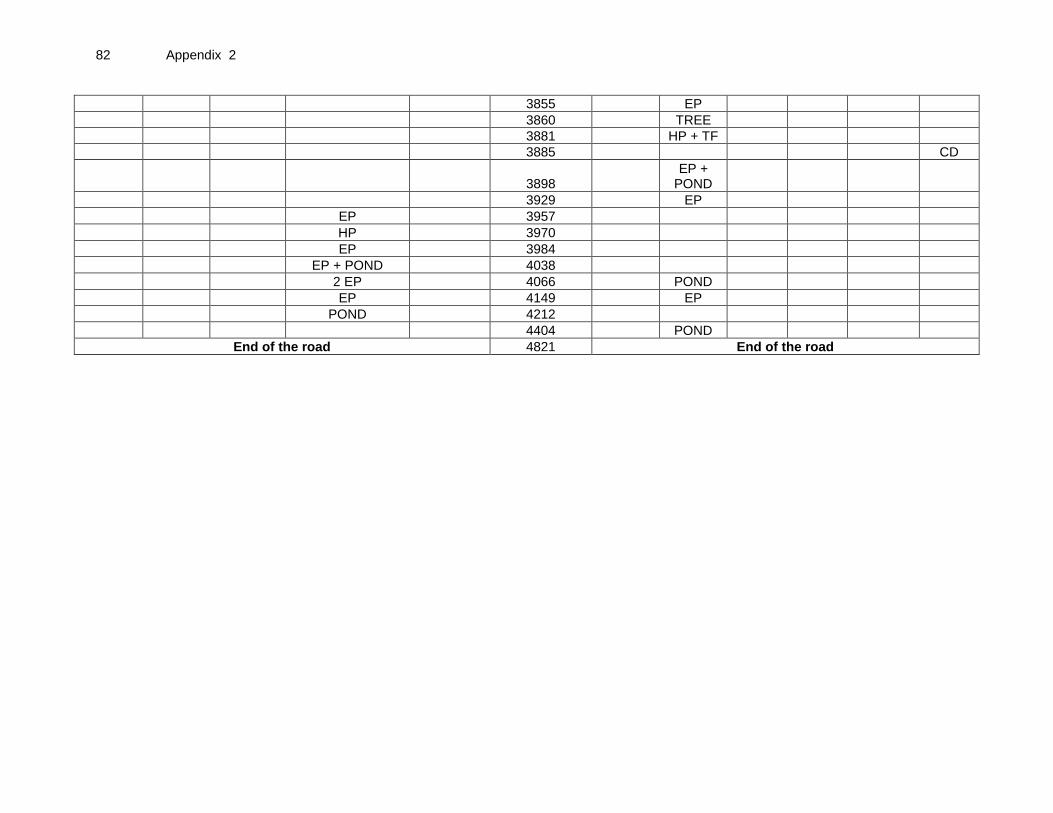
82 Appendix 2
3855 EP
3860 TREE
3881 HP + TF
3885 CD
3898 EP +
POND
3929 EP
EP 3957
HP 3970
EP 3984
EP + POND 4038
2 EP 4066 POND
EP 4149 EP
POND 4212
4404 POND
End of the road 4821 End of the road

Appendix 2 83
Road Name: BARUTIA TO CHOTTORIGRAM ROAD VIA RADHANAGAR Block Name: MAYURESWER - II District Name: BIRBHUM Total Length of the Road: 2.381km A. Climatic Conditions
Temperature High: 36°C Low: 11°C
Humidity High: 91% in July Low: 51% in March
Rainfall Rainy Season
2015 m/year June to mid-September
N.S. – Not Specified
B. Location of the Road and Generic description of Environment
No. Type of Ecosystem Yes No Explanation
1. Coastal area Mangrove (along roadside)
√
The area is far away from CRZ (Coastal Regulation Zone).
( ) more than 50% ( ) less than 20%
2. Type of Terrain (Plain/Hilly/ Mountainous etc.) (Explain the topography of the area and how many km of the road are located in the hilly area)
√
Altitude: 54.5m. The topography of the area is flat in nature.
3. Forest Area (Explain whether the road passes through forest areas or located along the forest areas and distance from shoulder to the forest area)?
√
Type of Vegetation: N.A Legal Status of the Forest Area: (Reserved, National Park, Sanctuaries, Unclassified, etc.)
There is no forest area beside or away from the alignment.
4. Wildlife (Explain whether there are any wildlife species in the project area)
√
Name of animals: NA Endangered species (if any):None
5. Inhabited Area √
Small villages namely, Barutia Radhanagar Chottori (413m – 477m), (1280m – 1380m), (1782m - 2196m), (2196m – 2381m) respectively beside the alignment.
6. Agricultural Land √ There are few patches where there are agricultural land beside the alignment between Ch 70m – 413m, 477m – 1280m, 1380m – 1782m (LHS), & 55m – 437m, 477m – 1280m, 1284m – 1658m, 2034m – 2143m (RHS)
7. Grazing grounds √ Grazing ground exists beside the alignment near Ch 22m (LHS)
8. Barren Land √ There is no barren land beside the alignment.
C. Specific description of the Road Environment
(Note: Questions number 1, 4, 5, 7 and 8 must be answered after discussions with the local community people)

84 Appendix 2
No. Parameter/ Component Yes No Explanation
1. Are there any areas with landslide or erosion problems along the road? (If yes, indicate the location (right or left side) and the chainage)
√
There is no such area with landslide or erosion problem.
( ) No Secondary Information is available and Local Community is not aware of this matter
2. Are there any lakes/swamps beside the road? (If yes, list them indicating the location (right or left side)and the chainage)
√
There is no lake or swampy area beside the alignment but many small & big ponds / Water body were found at Ch. 1258m, 1782m, 1960m, (LHS) on the other hand 22m, 140m, 203m, 2180m, & so on (RHS). Existing beside the alignment.
3. Are there any nallas/ streams /rivers etc. along/crossing the road? (If yes, list them indicating the location (right, left or crossing) and the chainage
√
There are no road side nallas / streams / rivers noticed along the road alignment. However, few CD structures were noticed at Ch. 7m, 269m, 964m, 1213m, 1443m, & so on.
4. Are there problems of water stagnation and other drainage issues on or near the road? (If yes, mention chainage)
√
There is no problem of any water stagnation and other drainage issues observed.
( ) No Secondary Information is available and Local Community is not aware of this matter
5. Is the area along the project road prone to flooding? (If yes, mention flood level and frequency)
√
The area is not flood prone.
( ) No Secondary Information is available and Local Community is not aware of this matter
6. Are there any trees with a dbh of 30 cm or more within 10 m on either side from the canter line of the road alignment? (If yes attach list of trees indicating the location (right or left side)and the chainage)
√
There are 26 nos. of trees with a dbh of 30cm or more within 10m on either side of the road alignment.(List Placed at Attachment I)
7. Along the road and within 100m of the road shoulder, are there any faunal habitat areas, faunal breeding ground, bird migration area, or other similar areas? (If yes, specify details of habitat with chainage)
√
There are no such areas within 100m from the road shoulder.
√
( ) No Secondary Information is available and Local Community is not aware of this matter
8. Along the road and within 100m of the road shoulder is there any evidence of floral and faunal species that are classified as endangered species?
√
There is no endangered species of flora or fauna within 100m from the road shoulder.
( ) No Secondary Information Available and Local Community is not aware of this matter
9. Are there any utility structures within 10 m on either side from the canter line of the road alignment? (If yes, attach list with chainage)
√
There are 52 nos. utility structures (EP, TP, HP) within 10m on either side of the alignment.(List Placed at Attachment II)

Appendix 2 85
No. Parameter/ Component Yes No Explanation
10. Are there any religious, cultural or community structures/buildings within 10 m on either side from the canter line of the road alignment? (If yes attach list with chainage)
√
There are a total of 7 community / religious, cultural structures within 10m on either side from the center line of the road alignment Club at Ch Burial Ground at Ch 1837m, Samabay Smite at Ch 1913m, P. School at Ch 2370m, (LHS) on the other hand High School at Ch 1562m, SSK at Ch 1569m, Health Canter at Ch 2076m, Mosque at Ch 2293m,(RHS).
D. Public Consultation
No. Consultation Activities Yes No Remarks
1. Consultation with local community was conducted before finalizing the alignment. (Attach list of people met and dates)
√
Consultation with local community was conducted on 10.12.2013. List of people attached.
2. Any suggestion received in finalizing the alignment
√
Villagers suggested to provide speed breaker, protection wall etc. wherever required.
3. If suggestions received, were they incorporated into the design?
√
Suggestion will be incorporated after discussion with PIU.
Attachment I
BLOCK: MAYURESWER - II DISTRICT : BIRBHUM ROAD CODE : T-05 List of trees
Chainage(M) Left (No.of Trees) Right (No. of Trees)
22 TREE
73 2 TREE
105 TREE
120 TREE
400 - 413 5 TREE
480 TREE
485 TREE
542 TREE
559 TREE
1284 TREE
1744 TREE PLANTATION
1932 5 TREE
2034 TREE
2040 TREE
2180 4TREE
TOTAL 18 8
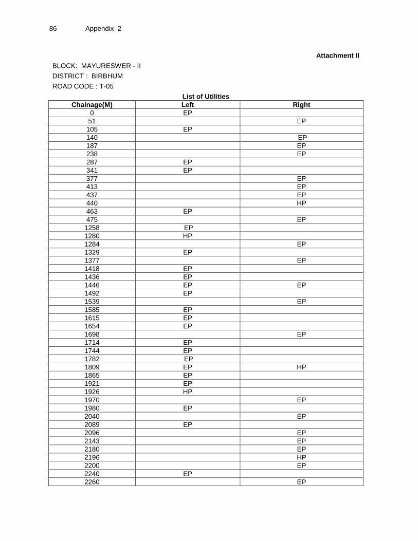
86 Appendix 2
Attachment II
BLOCK: MAYURESWER - II DISTRICT : BIRBHUM
ROAD CODE : T-05 List of Utilities
Chainage(M) Left Right
0 EP
51 EP
105 EP
140 EP
187 EP
238 EP
287 EP
341 EP
377 EP
413 EP
437 EP
440 HP
463 EP
475 EP
1258 EP
1280 HP
1284 EP
1329 EP
1377 EP
1418 EP
1436 EP
1446 EP EP
1492 EP
1539 EP
1585 EP
1615 EP
1654 EP
1698 EP
1714 EP
1744 EP
1782 EP
1809 EP HP
1865 EP
1921 EP
1926 HP
1970 EP
1980 EP
2040 EP
2089 EP
2096 EP
2143 EP
2180 EP
2196 HP
2200 EP
2240 EP
2260 EP
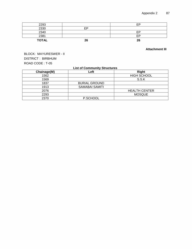
Appendix 2 87
2293 EP
2330 EP
2340 EP
2381 EP
TOTAL 26 26
Attachment III
BLOCK: MAYURESWER - II DISTRICT : BIRBHUM ROAD CODE : T-05 List of Community Structures
Chainage(M) Left Right
1562 HIGH SCHOOL
1569 S.S.K
1837 BURIAL GROUND
1913 SAMABAI SAMITI
2076 HEALTH CENTER
2293 MOSQUE
2370 P.SCHOOL

88 Appendix 2
Attachment IV
BLOCK: MAYURESWER - II DISTRICT : BIRBHUM
ROAD CODE : T-05 8m to
10m 6m to
8m 4m to
6m 2.75m to 4m 0m to 2.75m
Chainage (M)
0m to 2.75m 2.75m to 4m 4m to 6m 6m to 8m
8m to 10m CD
EP 0
7 CD
Grazing grounds 22
POND, TREE
51 EP
2 TREE 73
EP + TREE 105
TREE 120
140 POND + EP
187 EP
203 POND
238 EP
269 CD
EP 287
EP 341
377 EP
5 TREE 400 - 413
413 EP
437 EP
440 HP
EP 463
475 EP
TREE 480
TREE 485
538 CD
542 TREE
559 TREE
581 CD
964 CD
1213 CD
POND + EP 1258
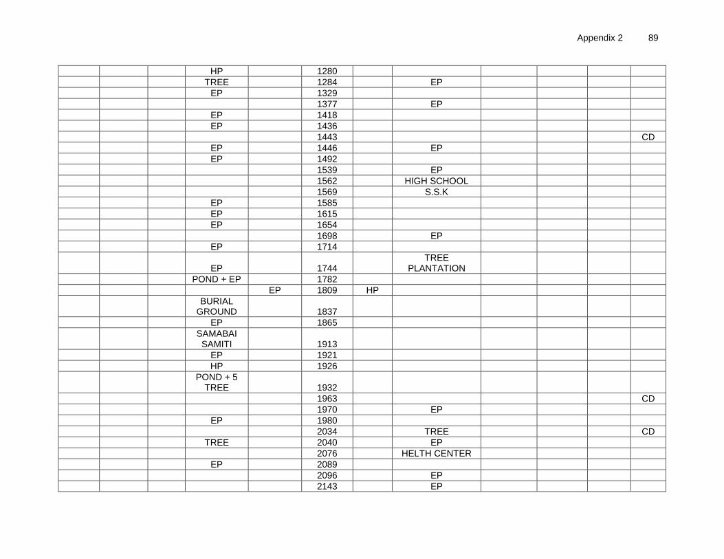
Appendix 2 89
HP 1280
TREE 1284 EP
EP 1329
1377 EP
EP 1418
EP 1436
1443 CD
EP 1446 EP
EP 1492
1539 EP
1562 HIGH SCHOOL
1569 S.S.K
EP 1585
EP 1615
EP 1654
1698 EP
EP
1714
EP 1744 TREE
PLANTATION
POND + EP 1782
EP 1809 HP
BURIAL
GROUND 1837
EP 1865
SAMABAI SAMITI 1913
EP 1921
HP 1926
POND + 5
TREE 1932
1963 CD
1970 EP
EP 1980
2034 TREE CD
TREE 2040 EP
2076 HELTH CENTER
EP 2089
2096 EP
2143 EP

90 Appendix 2
2180 EP+4TREE+POND
2196 HP
2200 EP
EP 2240
2260 EP
2293 EP MOSQUE
EP 2330 POND
2340 EP
P.SCHOOL 2370
Endof the road 2381 EP Endof the road

Appendix 2 91
Road Name:Radhakantapur more to Sahajadpur Block Name:Memari-II District Name:Burdwan Total Length of the Road:5.250 km A. Climatic Conditions
Temperature High: 36°C (May) Low: 14°C(Dec)
Humidity High: 92% in July Low: 65% in March
Rainfall Rainy Season
1550mm/year June to mid-September
N.S. – Not Specified B. Location of the Road and Generic description of Environment
No. Type of Ecosystem Yes No Explanation
1. Coastal area Mangrove (along roadside)
√
Distance from Coastline: km. There is away from CRZ (Coastal Regulation Zone).
( ) more than 50% ( ) less than 20%
2. Type of Terrain(Plain/Hilly/ Mountainous etc.) (Explain the topography of the area and how many km of the road are located in the hilly area)
√
Altitude: 39.7m The topography of the area is flat in nature.
3. Forest Area (Explain whether the road passes through forest areas or located along the forest areas and distance from shoulder to the forest area)?
√
Type of Vegetation: There is no forest beside the project road. Legal Status of the Forest Area: (Reserved, National Park, Sanctuaries, Unclassified, etc.)
No part of the project road passes through any forest area.
4. Wildlife (Explain whether there are any wildlife species in the project area)
√
Name of animals: N.A. Endangered species (if any): None, as there is no forest area.
5. Inhabited Area √
Small villages exist such as Bohar (0-475m),Golampara, (675-1030m) Sidhuria (1375-1685m), Bishnupur (3500-4170) and sahajadpur (4175-5250m) in scattered manner.
6. Agricultural Land √
Agricultural land exists beside the alignment near Ch 470-675),(1030-1375),(1920-3470),(4225-5040)
7. Grazing grounds
√ There is no Grazing ground beside the alignment.
8. Barren Land √ There is no barren land beside the alignment.
C. Specific description of the Road Environment
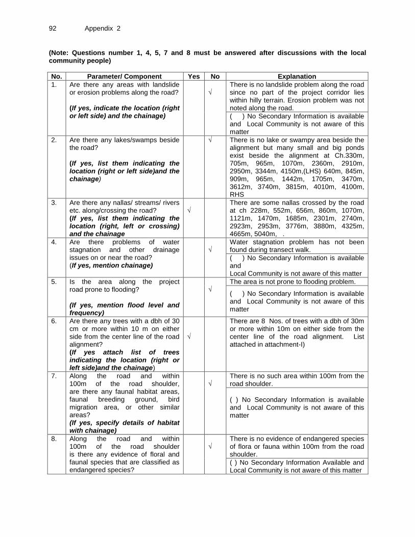
92 Appendix 2
(Note: Questions number 1, 4, 5, 7 and 8 must be answered after discussions with the local community people)
No. Parameter/ Component Yes No Explanation
1. Are there any areas with landslide or erosion problems along the road? (If yes, indicate the location (right or left side) and the chainage)
√
There is no landslide problem along the road since no part of the project corridor lies within hilly terrain. Erosion problem was not noted along the road.
( ) No Secondary Information is available and Local Community is not aware of this matter
2. Are there any lakes/swamps beside the road? (If yes, list them indicating the location (right or left side)and the chainage)
√ There is no lake or swampy area beside the alignment but many small and big ponds exist beside the alignment at Ch.330m, 705m, 965m, 1070m, 2360m, 2910m, 2950m, 3344m, 4150m,(LHS) 640m, 845m, 909m, 965m, 1442m, 1705m, 3470m, 3612m, 3740m, 3815m, 4010m, 4100m, RHS
3. Are there any nallas/ streams/ rivers etc. along/crossing the road? (If yes, list them indicating the location (right, left or crossing) and the chainage
√
There are some nallas crossed by the road at ch 228m, 552m, 656m, 860m, 1070m, 1121m, 1470m, 1685m, 2301m, 2740m, 2923m, 2953m, 3776m, 3880m, 4325m, 4665m, 5040m, .
4. Are there problems of water stagnation and other drainage issues on or near the road? (If yes, mention chainage)
√
Water stagnation problem has not been found during transect walk.
( ) No Secondary Information is available and Local Community is not aware of this matter
5. Is the area along the project road prone to flooding? (If yes, mention flood level and frequency)
√
The area is not prone to flooding problem.
( ) No Secondary Information is available and Local Community is not aware of this matter
6. Are there any trees with a dbh of 30 cm or more within 10 m on either side from the center line of the road alignment? (If yes attach list of trees indicating the location (right or left side)and the chainage)
√
There are 8 Nos. of trees with a dbh of 30m or more within 10m on either side from the center line of the road alignment. List attached in attachment-I)
7. Along the road and within 100m of the road shoulder, are there any faunal habitat areas, faunal breeding ground, bird migration area, or other similar areas? (If yes, specify details of habitat with chainage)
√
There is no such area within 100m from the road shoulder.
( ) No Secondary Information is available and Local Community is not aware of this matter
8. Along the road and within 100m of the road shoulder is there any evidence of floral and faunal species that are classified as endangered species?
√
There is no evidence of endangered species of flora or fauna within 100m from the road shoulder.
( ) No Secondary Information Available and Local Community is not aware of this matter
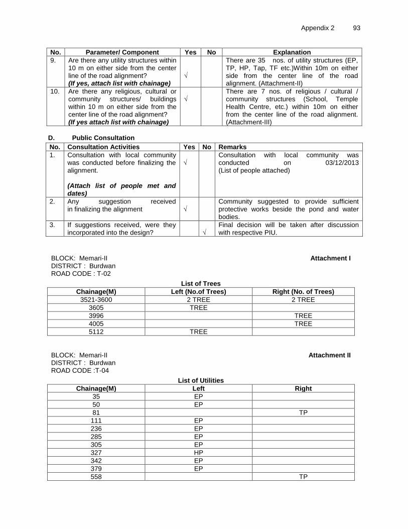
Appendix 2 93
No. Parameter/ Component Yes No Explanation
9. Are there any utility structures within 10 m on either side from the center line of the road alignment? (If yes, attach list with chainage)
√
There are 35 nos. of utility structures (EP, TP, HP, Tap, TF etc.)Within 10m on either side from the center line of the road alignment. (Attachment-II)
10. Are there any religious, cultural or community structures/ buildings within 10 m on either side from the center line of the road alignment? (If yes attach list with chainage)
√
There are 7 nos. of religious / cultural / community structures (School, Temple Health Centre, etc.) within 10m on either from the center line of the road alignment. (Attachment-III)
D. Public Consultation
No. Consultation Activities Yes No Remarks
1. Consultation with local community was conducted before finalizing the alignment. (Attach list of people met and dates)
√
Consultation with local community was conducted on 03/12/2013 (List of people attached)
2. Any suggestion received in finalizing the alignment
√
Community suggested to provide sufficient protective works beside the pond and water bodies.
3. If suggestions received, were they incorporated into the design?
√
Final decision will be taken after discussion with respective PIU.
BLOCK: Memari-II
Attachment I DISTRICT : Burdwan
ROAD CODE : T-02 List of Trees
Chainage(M) Left (No.of Trees) Right (No. of Trees)
3521-3600 2 TREE 2 TREE
3605 TREE
3996 TREE
4005 TREE
5112 TREE
BLOCK: Memari-II
Attachment II DISTRICT : Burdwan
ROAD CODE :T-04 List of Utilities
Chainage(M) Left Right
35 EP
50 EP
81 TP
111 EP
236 EP
285 EP
305 EP
327 HP
342 EP
379 EP
558 TP
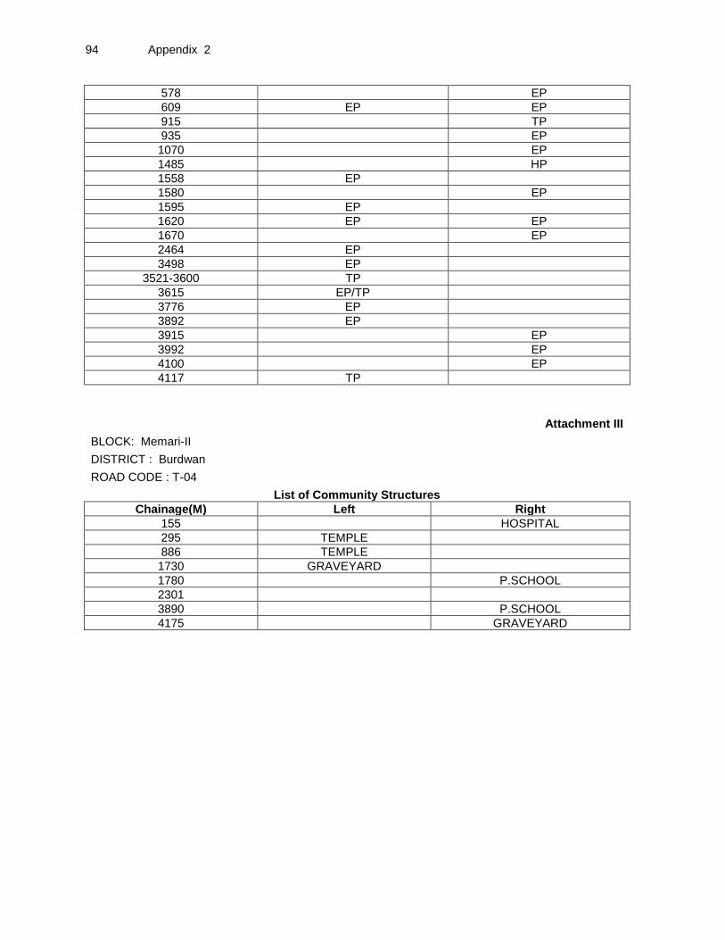
94 Appendix 2
578 EP
609 EP EP
915 TP
935 EP
1070 EP
1485 HP
1558 EP
1580 EP
1595 EP
1620 EP EP
1670 EP
2464 EP
3498 EP
3521-3600 TP
3615 EP/TP
3776 EP
3892 EP
3915 EP
3992 EP
4100 EP
4117 TP
Attachment III
BLOCK: Memari-II DISTRICT : Burdwan ROAD CODE : T-04 List of Community Structures
Chainage(M) Left Right
155 HOSPITAL
295 TEMPLE
886 TEMPLE
1730 GRAVEYARD
1780 P.SCHOOL
2301
3890 P.SCHOOL
4175 GRAVEYARD

Appendix 2 95
BLOCK:
Memari-II
Attachment IV
DISTRICT : Burdwan
ROAD CODE : T-02
8m to 10m
6m to 8m
4m to 6m 2.75m to 4m 0m to 2.75m
Chainage(M) 0m to 2.75m
2.75m to 4m 4m to 6m 6m to
8m 8m to 10m
CD
EP 35
EP 50
81 TP
EP 111
155 HOSPITAL
228 CD
EP 236
EP 285
TEMPLE 295
EP 305
HP 327
POND 330
EP 342
EP 379
552 CD
558 TP
578 EP
EP 609 EP
640 POND
656 CD
POND 705
845 POND
860 CD
TEMPLE 886
909 POND
915 TP
935 EP
POND 965 POND
1070 EP CD
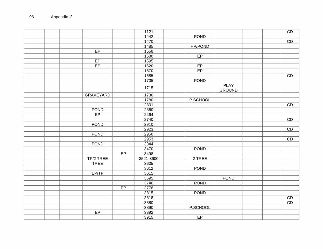
96 Appendix 2
1121 CD
1442 POND
1470 CD
1485 HP/POND
EP 1558
1580 EP
EP 1595
EP 1620 EP
1670 EP
1685 CD
1705 POND
1715 PLAY
GROUND
GRAVEYARD 1730
1780 P.SCHOOL
2301 CD
POND 2360
EP 2464
2740 CD
POND 2910
2923 CD
POND 2950
2953 CD
POND 3344
3470 POND
EP 3498
TP/2 TREE 3521-3600 2 TREE
TREE 3605
3612 POND
EP/TP 3615
3695 POND
3740 POND
EP 3776
3815 POND
3818 CD
3880 CD
3890 P.SCHOOL
EP 3892
3915 EP

Appendix 2 97
3992 EP
3996 TREE
4005 TREE
4010 POND
4075 POND
4100 EP
TP 4117
POND 4150
4175 GRAVEYARD
4325 CD
4665 CD
5040 CD
TREE 5112
END
POINT 5250 END POINT
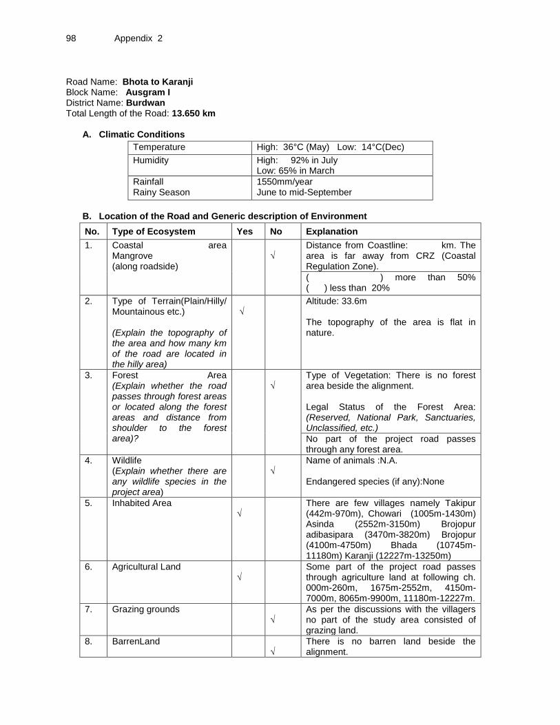
98 Appendix 2
Road Name: Bhota to Karanji Block Name: Ausgram I District Name: Burdwan Total Length of the Road: 13.650 km
A. Climatic Conditions
Temperature High: 36°C (May) Low: 14°C(Dec)
Humidity High: 92% in July Low: 65% in March
Rainfall Rainy Season
1550mm/year June to mid-September
B. Location of the Road and Generic description of Environment
No. Type of Ecosystem Yes No Explanation
1. Coastal area Mangrove (along roadside)
√
Distance from Coastline: km. The area is far away from CRZ (Coastal Regulation Zone).
( ) more than 50% ( ) less than 20%
2. Type of Terrain(Plain/Hilly/ Mountainous etc.) (Explain the topography of the area and how many km of the road are located in the hilly area)
√
Altitude: 33.6m The topography of the area is flat in nature.
3. Forest Area (Explain whether the road passes through forest areas or located along the forest areas and distance from shoulder to the forest area)?
√
Type of Vegetation: There is no forest area beside the alignment. Legal Status of the Forest Area: (Reserved, National Park, Sanctuaries, Unclassified, etc.)
No part of the project road passes through any forest area.
4. Wildlife (Explain whether there are any wildlife species in the project area)
√
Name of animals :N.A. Endangered species (if any):None
5. Inhabited Area √
There are few villages namely Takipur (442m-970m), Chowari (1005m-1430m) Asinda (2552m-3150m) Brojopur adibasipara (3470m-3820m) Brojopur (4100m-4750m) Bhada (10745m-11180m) Karanji (12227m-13250m)
6. Agricultural Land √
Some part of the project road passes through agriculture land at following ch. 000m-260m, 1675m-2552m, 4150m-7000m, 8065m-9900m, 11180m-12227m.
7. Grazing grounds
√
As per the discussions with the villagers no part of the study area consisted of grazing land.
8. BarrenLand √
There is no barren land beside the alignment.

Appendix 2 99
C. Specific description of the Road Environment
(Note: Questions number 1, 4, 5, 7 and 8 must be answered after discussions with the local community people)
No. Parameter/ Component Yes No Explanation
1. Are there any areas with landslide or erosion problems along the road? (If yes, indicate the location (right or left side) and the chainage)
√
There is no landslide or erosion problem along the road.
( ) No Secondary Information is available and Local Community is not aware of this matter
2. Are there any lakes/swamps beside the road? (If yes, list them indicating the location (right or left side)and the chainage)
√
There is no lakes/swamps beside the road, but there are ponds at Ch. 475m-505m, 527m-565m, 1350m-1360m 1415m-1428m, 1675m, 2500m-2530m, 2870m, 3665m-3820m, 4315m & so on.
3. Are there any nallas/streams/rivers etc. along/crossing the road? (If yes, list them indicating the location (right, left or crossing) and the chainage
√
There are no nallahs/streams/rivers etc. crossing by the road but there are some cross drainage structures at Ch. 8065m, 8500m, 8880m, 10665m, 11150m, 11182m, 11580m, 11660m, 12400m, 12632m, 12940m.
4. Are there problems of water stagnation and other drainage issues on or near the road? (If yes, mention chainage)
√
There is no water stagnation problem in the project road.
( ) No Secondary Information is available and Local Community is not aware of this matter
5. Is the area along the project road prone to flooding? (If yes, mention flood level and frequency)
√
The area is not prone to flooding.
( ) No Secondary Information is available and Local Community is not aware of this matter
6. Are there any trees with a dbh of 30 cm or more within 10 m on either side from the center line of the road alignment? (If yes attach list of trees indicating the location (right or left side)and the chainage)
√
There are 138 Nos. of trees with a dbh of 30m or more within 10m on either side of the alignment. (List placed at Attachment I)
7. Along the road and within 100m of the road shoulder, are there any faunal habitat areas, faunal breeding ground, bird migration area, or other similar areas? (If yes, specify details of habitat with chainage)
√
No faunal habitat, breeding ground etc. Has been found within 100 m of the road shoulder.
( ) No Secondary Information is available and Local Community is not aware of this matter
8. Along the road and within 100m of the road shoulder is there any evidence of floral and faunal species that are classified as endangered species?
√
There is no evidence of endangered species of flora & fauna within 100m from road shoulder.
( ) No Secondary Information Available and Local Community is not aware of this matter
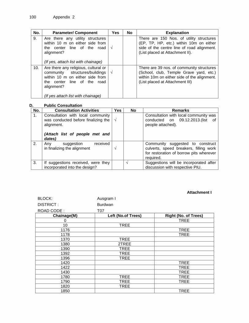
100 Appendix 2
No. Parameter/ Component Yes No Explanation
9. Are there any utility structures within 10 m on either side from the center line of the road alignment? (If yes, attach list with chainage)
√
There are 150 Nos. of utility structures (EP, TP, HP, etc.) within 10m on either side of the centre line of road alignment. (List placed at Attachment II).
10. Are there any religious, cultural or community structures/buildings within 10 m on either side from the center line of the road alignment? (If yes attach list with chainage)
√
There are 39 nos. of community structures (School, club, Temple Grave yard, etc.) within 10m on either side of the alignment. (List placed at Attachment III)
D. Public Consultation
No. Consultation Activities Yes No Remarks
1. Consultation with local community was conducted before finalizing the alignment. (Attach list of people met and dates)
√
Consultation with local community was conducted on 09.12.2013.(list of people attached).
2. Any suggestion received in finalizing the alignment
√
Community suggested to construct culverts, speed breakers, filling work for restoration of borrow pits wherever required.
3. If suggestions received, were they incorporated into the design?
√ Suggestions will be incorporated after discussion with respective PIU.
Attachment I
BLOCK: Ausgram I DISTRICT : Burdwan ROAD CODE : T07 Chainage(M) Left (No.of Trees) Right (No. of Trees)
0 TREE 10 TREE
1176 TREE 1178 TREE 1370 TREE 1380 2TREE 1390 TREE 1392 TREE 1396 TREE 1420 TREE 1422 TREE 1430 TREE 1780 TREE TREE 1790 TREE TREE 1820 TREE 1850 TREE
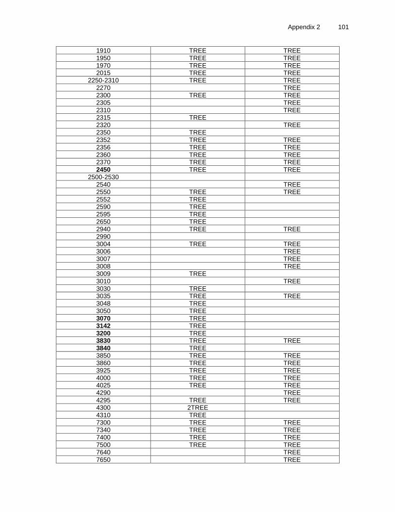
Appendix 2 101
1910 TREE TREE 1950 TREE TREE 1970 TREE TREE 2015 TREE TREE
2250-2310 TREE TREE 2270 TREE 2300 TREE TREE 2305 TREE 2310 TREE 2315 TREE 2320 TREE 2350 TREE 2352 TREE TREE 2356 TREE TREE 2360 TREE TREE 2370 TREE TREE 2450 TREE TREE
2500-2530 2540 TREE 2550 TREE TREE 2552 TREE 2590 TREE 2595 TREE 2650 TREE 2940 TREE TREE 2990 3004 TREE TREE 3006 TREE 3007 TREE 3008 TREE 3009 TREE 3010 TREE 3030 TREE 3035 TREE TREE 3048 TREE 3050 TREE 3070 TREE 3142 TREE 3200 TREE 3830 TREE TREE 3840 TREE 3850 TREE TREE 3860 TREE TREE 3925 TREE TREE 4000 TREE TREE 4025 TREE TREE 4290 TREE 4295 TREE TREE 4300 2TREE 4310 TREE 7300 TREE TREE 7340 TREE TREE 7400 TREE TREE 7500 TREE TREE 7640 TREE 7650 TREE
102 Appendix 2
7655 TREE 7660 TREE 7670 TREE 7715 TREE 7810
TREE
7883-7930 TREE 7920 TREE 7970 TREE 8000 TREE 8015 TREE 9290 TREE 9350 TREE
10350 TREE 10750 TREE 10775 TREE 10777 TREE 10900
TREE
10910 TREE 10920 TREE 11130 TREE 11136 TREE 11140 TREE 11179 TREE 11180 TREE 11200 TREE TREE 11210 TREE 11270 TREE 11300 TREE TREE 11350 TREE TREE 11400 TREE 12300 TREE TREE 12310 TREE 12370 TREE 12430 TREE
Attachment II
BLOCK: Ausgram I DISTRICT : Burdwan ROAD CODE : T07 List of Utilities
Chainage(M) Left Right 20 HP 158 EP 240 TRF 442 EP 505 EP TP/EP 515 TP 522 EP 570 EP/TP 590 EP EP 625 TP 740 TP 800 EP 830 EP

Appendix 2 103
920 EP 930 EP TP 970 EP 1110 EP 1340 T.P 1570 EP 2540 EP 2552 EP 2560 TP 2562 EP HP 2565 EP 2570 TP 2690 EP 2750 TP 2870 HP EP 2990 EP 3010 TP/EP 3080 EP 3090 EP
3125-3150 EP 3470 EP 3630 HP/EP 3760 HP/EP 4170 EP 4200 EP 4270 EP 4300 EP 4305 HP TP 4312 HP 4320 EP EP/TP 4350 EP 4370 EP 4450 EP 4530 EP/TP 4542 TP 4560 EP 4562 EP 4580 TP
4590-4600 HP/TP 4615 TP 4620 EP 6370 EP 7050 TP EP 7150 EP TP 7510 EP/TP 7530 EP/TP 7580 TP 7600 TP 7620 EP TP 7630 EP 7640 TRF 7650 EP/TP 7655 EP 7750 EP 7880 EP 7905 EP
104 Appendix 2
7950 EP 7957 EP 7990 HP 8000 EP 8015 TRF 8120 EP 8220 EP EP 9050 EP 9120 EP 9200 TRF 9250 EP 9260 EP 9290 EP 9340 EP 9400 EP 9720 EP 9725 EP 9730 EP 9750 EP 9760 EP 9800 EP EP 9820 EP EP 9900 EP EP
10000 EP 10125 TRF 10710 EP 10750 EP 10777 EP 10800 EP/HP 10905 EP 10922 EP 10925 EP/TP 10930 EP 10940 EP/TP 11010 HP EP 11145 EP 11177 EP EP 11300 EP 11400 EP 11420 EP 11450 EP 11470 EP 12140 EP EP 12410 EP 12420 EP 12430 EP 13000 EP 13500 EP 13520 TRF 13550 EP

Appendix 2 105
Attachment III
BLOCK: Ausgram I DISTRICT : Burdwan ROAD CODE : T07 List of Community Structures
Chainage(M) Left Right 0 Bishramgar
520 TEMPLE 550 TEMPLE 715 TEMPLE 770 SOMABYSOMETY 1300 F.P.SCHOOL
106 Appendix 2
2250-2310 Play ground 2650 TEMPLE 3004 TEMPLE 3015 ICDS
3125-3150 F.P.SCHOOL 3570 ICDS CLUB 3670 TEMPLE S.S.K. 4100 F.P.SCHOOL
4135-4210 PLAYGROUND 4270 CLUB 4510 TEMPLE 4550 TEMPLE 4620 ICDS
4745-4750 ASHRAM 7715 CLUB 8810
ASHRAM
8950-9020
PLAYGROUND 9715 ICDS
10300 ICDS 10690 F.P.School 10775 TEMPLE 10800 ICDS 11000 TEMPLE 11136 TEMPLE 11500 TEMPLE 12200 HelthCentre 12227 F.P.School 13400 F.P.School 13456 Mosque 13510 GRAVEYARD 13575 Bishramagar
Appendix 2 107
Attachment IV
BLOCK: Ausgram I DISTRICT : Burdwan ROAD CODE : T07
8m to 10m 6m to 8m 4m to 6m 2.75m to 4m
0m to 2.75m
Chainage (M)
0m to 2.75m
2.75m to 4m
4m to 6m 6m to 8m 8m to 10m
CD
Bishramgar 0 Tree
Tree 10
HP 20
158 EP
240 TRF
260 CD
300
442 EP
475-505 POND
EP 505 TP/EP
TP 515
520 TEMPLE
522 EP
527-565 POND
550 TEMPLE
570 EP/TP
EP 590 EP
TP 625
TEMPLE 715
TP 740
EP 800
SOMABYSOMETY
770
800
830 EP
880 CD
920 EP
EP 930 TP
970 EP
1105 CD
1110 EP
1150 CD
1176 TREE
108 Appendix 2
8m to 10m 6m to 8m 4m to 6m 2.75m to 4m
0m to 2.75m
Chainage (M)
0m to 2.75m
2.75m to 4m
4m to 6m 6m to 8m 8m to 10m
CD
1177
1178 TREE
1179
1180
1190
1200 CD
1285
F.P.SCHOOL
1300
T.P 1340
POND 1350-1360
TREE 1370
2TREE 1380
POND 1390-1395
TREE 1390
TREE 1392
TREE 1396
POND 1415-1428
1420 TREE
1422 TREE
1430 TREE
1555
EP 1570
POND 1675 CD
1780
1790
1792-1795
TREE 1780 TREE
TREE
1790 TREE
TREE 1820
1850 TREE
TREE 1910 TREE
TREE 1950 TREE
TREE 1970 TREE
TREE 2015 TREE
TREE 2250-2310 TREE PLAYGRO
UND
2270 TREE
TREE 2300 TREE
2305 TREE

Appendix 2 109
8m to 10m 6m to 8m 4m to 6m 2.75m to 4m
0m to 2.75m
Chainage (M)
0m to 2.75m
2.75m to 4m
4m to 6m 6m to 8m 8m to 10m
CD
2310 TREE
TREE 2315
2320 TREE
TREE 2350
TREE 2352 TREE
TREE 2356 TREE
TREE 2360 TREE
TREE 2370 TREE
TREE 2450 TREE
POND 2500-2530
EP 2540 TREE
TREE 2550 TREE
TREE 2552 EP
TP 2560
EP 2562 HP
EP 2565
2570 TP CD
2575
TREE 2590
TREE 2595
TREE 2650 TEMPLE
EP 2690
TP 2750
HP 2870 EP POND
TREE 2940 TREE
2990 EP
TREE 3004 TREE TEMPLE
3006 TREE
3007 TREE
3008 TREE
TREE 3009
TP/EP 3010 TREE
ICDS 3015
TREE 3030
TREE 3035 TREE
TREE 3048
TREE 3050
TREE 3070
3080 EP

110 Appendix 2
8m to 10m 6m to 8m 4m to 6m 2.75m to 4m
0m to 2.75m
Chainage (M)
0m to 2.75m
2.75m to 4m
4m to 6m 6m to 8m 8m to 10m
CD
EP 3090
EP 3125-3150 F.P.SCHOOL
TREE 3142
3150 CD
TREE 3200
3430 CD
EP 3470
ICDS 3570 CLUB
3615 CD
3630 HP/EP
TEMPLE 3670 S.S.K.
3750 CD
HP/EP 3760
POND 3765-3820
TREE 3830 TREE
TREE 3840
TREE 3850 TREE
TREE 3860 TREE
3900 CD
TREE 3925 TREE
PUMPHOUSE TREE 4000 TREE
TREE 4025 TREE
4050 CD
4100 F.P.SCHOOL
POND 4135-4210 PLAYGROUND
4170 EP
4200 EP
4250 CD
CLUB 4270 EP
PUMPHOUSE
4290 TREE
TREE 4295 TREE
2TREE 4300 EP
HP 4305 TP
TREE 4310
4312 HP
POND 4315
EP 4320 EP/TP
4340 CD

Appendix 2 111
8m to 10m 6m to 8m 4m to 6m 2.75m to 4m
0m to 2.75m
Chainage (M)
0m to 2.75m
2.75m to 4m
4m to 6m 6m to 8m 8m to 10m
CD
4350 EP
4370 EP
EP 4450
4500 CD
TEMPLE 4510
EP/TP 4530
4542 TP
TEMPLE 4550
EP 4560
4562 EP
4580 TP
POND/HP/TP
4590-4600
4615 TP
ICDS 4620 EP
4745-4750 ASHRAM
4770
4810 CD
4918 CD
5560-5575 POND
6320 CD
EP 6370
TP 7050 EP
EP 7150 TP
TREE 7300 TREE
TREE 7340 TREE
TREE 7400 TREE
TREE 7500 TREE
7510 EP/TP
EP/TP 7530
TP 7580
TP 7600
EP 7620 TP
7630 EP
TRF 7640 TREE
EP/TP 7650 TREE
EP 7655 TREE
7660 TREE
7670 TREE
CLUB 7715 TREE

112 Appendix 2
8m to 10m 6m to 8m 4m to 6m 2.75m to 4m
0m to 2.75m
Chainage (M)
0m to 2.75m
2.75m to 4m
4m to 6m 6m to 8m 8m to 10m
CD
POND 7750 EP
7810 TREE
EP 7880
POND 7883-7930 TREE
TREE 7920
7905 EP
7935
7950 EP
7955
7957 EP
TREE 7970
HP 7990
EP 8000 TREE
TRF 8015 TREE
8065 CD
8120 EP
EP 8220 EP
8500 CD
8810 ASHRAM
8880 CD
8950-9020 PLAYGRO
UND
EP 9050
EP 9120
TRF 9200
EP 9250
9260 EP
EP 9290 TREE
EP 9340
9350 TREE
EP 9400
ICDS 9715
EP 9720
9725 EP
EP 9730
EP 9750
9760 EP
EP 9800 EP
EP 9820 EP
Appendix 2 113
8m to 10m 6m to 8m 4m to 6m 2.75m to 4m
0m to 2.75m
Chainage (M)
0m to 2.75m
2.75m to 4m
4m to 6m 6m to 8m 8m to 10m
CD
EP 9900 EP
EP 10000
TRF 10125
10300 ICDS
10350 TREE
10665 CD
10690 F.P.School
EP 10710
TREE 10750 EP
TEMPLE 10775 TREE
TREE 10777 EP
ICDS 10800 EP/HP
10900 TREE
10905 EP
10910 TREE
TREE 10920
10922 EP
EP/TP 10925
10930 EP
EP/TP 10940
TEMPLE 11000
HP 11010 EP
TREE 11130
TREE 11136 TEMPLE
TREE 11140
EP 11145
11150 CD
11175
EP 11177 EP
11178
11179 TREE
11180 TREE
11182 CD
TREE 11200 TREE
TREE 11210
TREE 11270
EP/TREE 11300 TREE
TREE 11350 TREE
EP 11400 TREE

114 Appendix 2
8m to 10m 6m to 8m 4m to 6m 2.75m to 4m
0m to 2.75m
Chainage (M)
0m to 2.75m
2.75m to 4m
4m to 6m 6m to 8m 8m to 10m
CD
11420 EP
11450 EP
EP 11470
11500 TEMPLE
11580 CD
11660 CD
EP 12140 EP
12200 HelthCentre
F.P.School 12227
TREE 12300 TREE
TREE 12310
TREE 12370
12400 CD
EP 12410
12420 EP
EP 12430 TREE
12470 Poulty farm
12632 CD
12940 CD
EP 13000
F.P.School 13400
13456 Mosque
13500 EP
GRAVEYARD
13510
13520 TRF
13550 EP
Bishramagar
13575

Appendix 3 115
Appendix 3: Photo Illustration of Sample Roads in West Bengal
Barutia to Chottorigram Road via Radhanagar – sample road at Burdwan district
Public consultation for the sample road at Burdwan district
Starting point of Dakshingram to Saithia Rampurhat road at Birbhum
Public consultation for the sample road at Birbhum district
Small temple besides the road {Gorsafat To Asnan (Arang Kyarana)} at Purba Medinipur
Minor bridge over canal - {Gorsafat To Asnan (Arang Kyarana)} road at Purba Medinipur
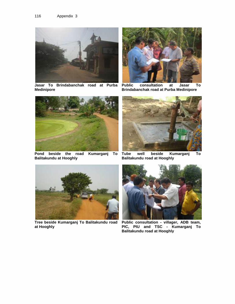
116 Appendix 3
Jasar To Brindabanchak road at Purba Medinipore
Public consultation at Jasar To Brindabanchak road at Purba Medinipore
Pond beside the road Kumarganj To Balitakundu at Hooghly
Tube well beside Kumarganj To Balitakundu road at Hooghly
Tree beside Kumarganj To Balitakundu road at Hooghly
Public consultation - villager, ADB team, PIC, PIU and TSC - Kumarganj To Balitakundu road at Hooghly

Appendix 4 117
Appendix 4: Guidelines for Borrow Areas Management A. SELECTION OF BORROW AREAS
1. Location of borrow areas shall be finalized as per IRC: 10-1961guidlines. The finalization of locations in case of borrows areas identified in private land shall depend upon the formal agreement between landowners and contractor. If, agreement is not reached between the contractor and landowners for the identified borrow areas sites, arrangement for locating the source of supply of material for embankment and sub-grade as well as compliance to environment requirements in respect of excavation and borrow areas as stipulated from time to time by the Ministry of Environment and Forests, Government of India, and local bodies, as applicable shall be the sole responsibility of the contractor. 2. The contractor in addition to the established practices, rules and regulation will also consider following criteria before finalizing the locations.
a) The borrow area should not be located in agriculture field unless unavoidable i.e. barren land is not available.
b) The borrow pits preferably should not be located along the roads. c) The loss of productive and agriculture soil should be minimum. d) The loss of vegetation is almost nil or minimum. e) The Contractor will ensure that suitable earth is available.
B. CONTRACTOR’S RESPONSIBILTY
3. The Contractor shall obtain representative samples from each of the identified borrow areas and have these tested at the site laboratory following a testing programme approved by the Engineer. It shall be ensured that the sub-grade material when compacted to the density requirements shall yield the design CBR value of the sub-grade. Contractor shall begin operations keeping in mind following;
a) Haulage of material to embankments or other areas of fill shall proceed only when sufficient spreading and compaction plants is operating at the place of deposition.
b) No excavated acceptable material other than surplus to requirements of the Contract shall be removed from the site. Contractor should be permitted to remove acceptable material from the site to suit his operational procedure, then shall make consequent deficit of material arising there from.
c) Where the excavation reveals a combination of acceptable and un-acceptable materials, the Contractor shall, unless otherwise agreed by the Engineer, carry out the excavation in such a manner that the acceptable materials are excavated separately for use in the permanent works without contamination by the un-acceptable materials. The acceptable material shall be stockpiled separately.
d) The Contractor shall ensure that he does not adversely affect the stability of excavation or fills by the methods of stockpiling materials, use of plants are siting of temporary buildings or structures.
C. BORROWING FROM DIFFERENT LAND-FORMS
1. Borrow Areas located in Agricultural Lands (i) The preservation of topsoil will be carried out in stockpile.

118 Appendix 4
(ii) A 15 cm topsoil will be stripped off from the borrow pit and this will be stored in stockpiles in a designated area for height not exceeding 2m and side slopes not steeper than 1:2 (Vertical: Horizontal).
(iii) Borrowing of earth will be carried out up to a depth of 1.5m from the existing ground level.
(iv) Borrowing of earth will not be done continuously through out the stretch. (v) Ridges of not less than 8m widths will be left at intervals not exceeding 300m. (vi) Small drains will be cut through the ridges, if necessary, to facilitate drainage. (vii) The slope of the edges will be maintained not steeper than 1:4 (vertical:
Horizontal). (viii) The depth of borrow pits will not be more than 30 cm after stripping the 15 cm
topsoil aside.
2. Borrow Areas located in Elevated Lands
(i) The preservation of topsoil will be carried out in stockpile. (ii) A 15 cm topsoil will be stripped off from the borrow pit and this will be stored in
stockpiles in a designated area for height not exceeding 2m and side slopes not steeper than 1:2 (Vertical: Horizontal).
(iii) At location where private owners desire their fields to be levelled, the borrowing shall be done to a depth of not more than 1.5m or up to the level of surrounding fields
3. Borrow Areas near River side
(i) The preservation of topsoil will be carried out in stockpile. (ii) A 15 cm topsoil will be stripped off from the borrow pit and this will be stored in
stockpiles in a designated area for height not exceeding 2m and side slopes not steeper than 1:2 (Vertical: Horizontal).
(iii) Borrow area near to any surface water body will be at least at a distance of 15m from the toe of the bank or high flood level, whichever is maximum.
4. Borrow Areas near Settlements
(i) The preservation of topsoil will be carried out in stockpile. (ii) A 15 cm topsoil will be stripped off from the borrow pit and this will be stored in
stockpiles in a designated area for height not exceeding 2m and side slopes not steeper than 1:2 (Vertical: Horizontal).
(iii) Borrow pit location will be located at least 0.75 km from villages and settlements. If un-avoidable, the pit will not be dug for more than 30 cm and drains will be cut to facilitate drainage.
(iv) Borrow pits located in such location will be re-developed immediately after borrowing is completed. If spoils are dumped, that will be covered with a layers of stockpiled topsoil in accordance with compliance requirements with respect MOEF/PPCB guidelines.
5. Borrow Pits along the Road 4. Borrow pits along the road shall be discouraged and if deemed necessary and permitted by the Engineer; following precautions are recommended
(i) The preservation of topsoil will be carried out in stockpile.
Appendix 4 119
(ii) A 15 cm topsoil will be stripped off from the borrow pit and this will be stored in stockpiles in a designated area for height not exceeding 2m and side slopes not steeper than 1:2 (Vertical: Horizontal).
(iii) Ridges of not less than 8m widths should be left at intervals not exceeding 300m. (iv) Small drains shall be cut through the ridges of facilitate drainage. (v) The depth of the pits shall be so regulated that there bottom does not cut an
imaginary line having a slope of 1 vertical to 4 horizontal projected from the edge of the final section of bank, the maximum depth of any case being limited to 1.5m.
(vi) Also, no pit shall be dug within the offset width from the toe of the embankment required as per the consideration of stability with a minimum width of 10m.
D. REHABILITATION OF BORROW AREAS
5. The objective of the rehabilitation programme is to return the borrow pit sites to a safe and secure area, which the general public should be able to safely enter and enjoy. Securing borrow pits in a stable condition is fundamental requirement of the rehabilitation process. This could be achieved by filling the borrow pit floor to approximately the access road level.
6. Re-development plan shall be prepared by the Contractor before the start of work inline with the owners will require and to the satisfaction of owner. The Borrow Areas shall be rehabilitated as per following;
• Borrow pits shall be backfilled with rejected construction wastes and will be given a vegetative cover. If this is not possible, then excavation sloped will be smoothed and depression will be filled in such a way that it looks more or less like the original round surface.
• Borrow areas might be used for aquaculture in case landowner wants such development. In that case, such borrow area will be photographed after their post use restoration and Environment Expert of Supervision Consultant will certify the post use redevelopment.
7. The Contractor will keep record of photographs of various stages i.e., before using materials from the location (pre-project), for the period borrowing activities (construction Phase) and after rehabilitation (post development), to ascertain the pre and post borrowing status of the area.
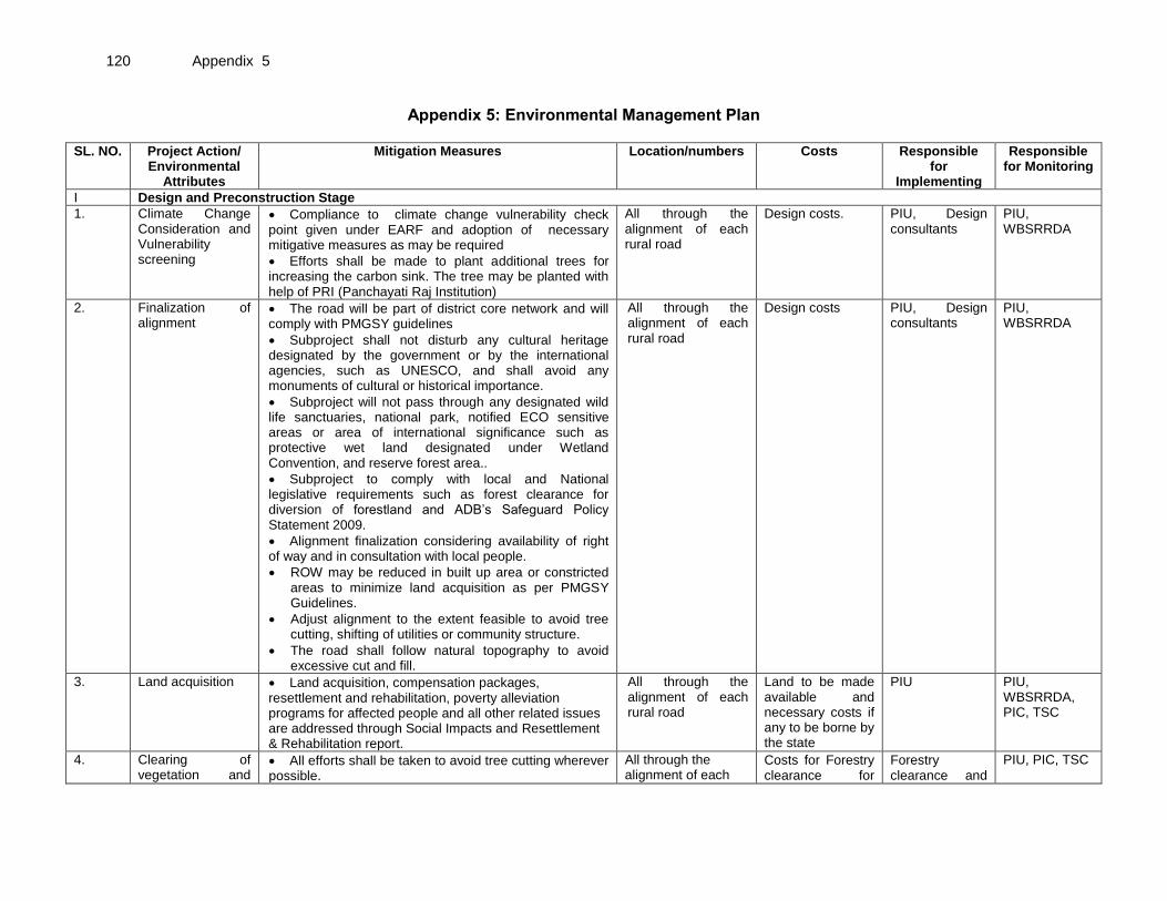
120 Appendix 5
Appendix 5: Environmental Management Plan
SL. NO. Project Action/ Environmental
Attributes
Mitigation Measures Location/numbers Costs Responsible for
Implementing
Responsible for Monitoring
I Design and Preconstruction Stage
1. Climate Change Consideration and Vulnerability screening
• Compliance to climate change vulnerability check point given under EARF and adoption of necessary mitigative measures as may be required
• Efforts shall be made to plant additional trees for increasing the carbon sink. The tree may be planted with help of PRI (Panchayati Raj Institution)
All through the alignment of each rural road
Design costs. PIU, Design consultants
PIU, WBSRRDA
2. Finalization of alignment
• The road will be part of district core network and will comply with PMGSY guidelines
• Subproject shall not disturb any cultural heritage designated by the government or by the international agencies, such as UNESCO, and shall avoid any monuments of cultural or historical importance.
• Subproject will not pass through any designated wild life sanctuaries, national park, notified ECO sensitive areas or area of international significance such as protective wet land designated under Wetland Convention, and reserve forest area..
• Subproject to comply with local and National legislative requirements such as forest clearance for diversion of forestland and ADB’s Safeguard Policy Statement 2009.
• Alignment finalization considering availability of right of way and in consultation with local people.
• ROW may be reduced in built up area or constricted areas to minimize land acquisition as per PMGSY Guidelines.
• Adjust alignment to the extent feasible to avoid tree cutting, shifting of utilities or community structure.
• The road shall follow natural topography to avoid excessive cut and fill.
All through the alignment of each rural road
Design costs PIU, Design consultants
PIU, WBSRRDA
3. Land acquisition • Land acquisition, compensation packages, resettlement and rehabilitation, poverty alleviation programs for affected people and all other related issues are addressed through Social Impacts and Resettlement & Rehabilitation report.
All through the alignment of each rural road
Land to be made available and necessary costs if any to be borne by the state
PIU PIU, WBSRRDA, PIC, TSC
4. Clearing of vegetation and
• All efforts shall be taken to avoid tree cutting wherever possible.
All through the alignment of each
Costs for Forestry clearance for
Forestry clearance and
PIU, PIC, TSC
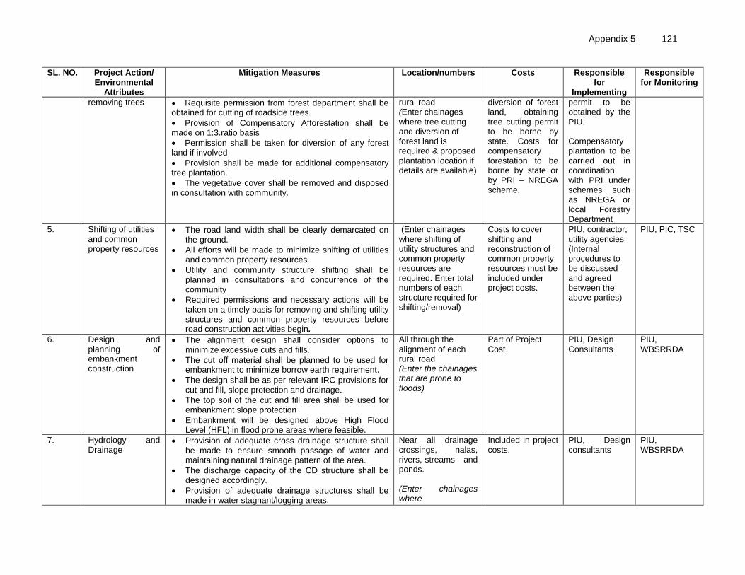
Appendix 5 121
SL. NO. Project Action/ Environmental
Attributes
Mitigation Measures Location/numbers Costs Responsible for
Implementing
Responsible for Monitoring
removing trees • Requisite permission from forest department shall be obtained for cutting of roadside trees.
• Provision of Compensatory Afforestation shall be made on 1:3.ratio basis
• Permission shall be taken for diversion of any forest land if involved
• Provision shall be made for additional compensatory tree plantation.
• The vegetative cover shall be removed and disposed in consultation with community.
rural road (Enter chainages where tree cutting and diversion of forest land is required & proposed plantation location if details are available)
diversion of forest land, obtaining tree cutting permit to be borne by state. Costs for compensatory forestation to be borne by state or by PRI – NREGA scheme.
permit to be obtained by the PIU. Compensatory plantation to be carried out in coordination with PRI under schemes such as NREGA or local Forestry Department
5. Shifting of utilities and common property resources
• The road land width shall be clearly demarcated on the ground.
• All efforts will be made to minimize shifting of utilities and common property resources
• Utility and community structure shifting shall be planned in consultations and concurrence of the community
• Required permissions and necessary actions will be taken on a timely basis for removing and shifting utility structures and common property resources before road construction activities begin.
(Enter chainages where shifting of utility structures and common property resources are required. Enter total numbers of each structure required for shifting/removal)
Costs to cover shifting and reconstruction of common property resources must be included under project costs.
PIU, contractor, utility agencies (Internal procedures to be discussed and agreed between the above parties)
PIU, PIC, TSC
6. Design and planning of embankment construction
• The alignment design shall consider options to minimize excessive cuts and fills.
• The cut off material shall be planned to be used for embankment to minimize borrow earth requirement.
• The design shall be as per relevant IRC provisions for cut and fill, slope protection and drainage.
• The top soil of the cut and fill area shall be used for embankment slope protection
• Embankment will be designed above High Flood Level (HFL) in flood prone areas where feasible.
All through the alignment of each rural road (Enter the chainages that are prone to floods)
Part of Project Cost
PIU, Design Consultants
PIU, WBSRRDA
7. Hydrology and Drainage
• Provision of adequate cross drainage structure shall be made to ensure smooth passage of water and maintaining natural drainage pattern of the area.
• The discharge capacity of the CD structure shall be designed accordingly.
• Provision of adequate drainage structures shall be made in water stagnant/logging areas.
Near all drainage crossings, nalas, rivers, streams and ponds. (Enter chainages where
Included in project costs.
PIU, Design consultants
PIU, WBSRRDA

122 Appendix 5
SL. NO. Project Action/ Environmental
Attributes
Mitigation Measures Location/numbers Costs Responsible for
Implementing
Responsible for Monitoring
• The construction work near water body shall be planned preferably in dry season so that water quality of the water channel is not affected due to siltation and rain water runoff.
• Provision of additional cross drainage structure shall be made in the areas where nearby land is sloping towards road alignment on both the sides.
• Provision of concrete road construction in habitat area with drainage of both side of the road shall be made as per the design provision and with adequate slope to prevent any water logging.
earthern/structural cross drains, longitudinal drains, streams, ponds and rivers exist)
8. Establishment of Construction Camp, temporary office and storage area
• Construction camp sites shall be located away from any local human settlements and forested areas (minimum 0.5 km away) and preferably located on lands, which are not productive (barren/waste lands presently).
• Similarly temporary office and storage areas shall be located away from human settlement areas and forested areas (minimum 0.5 km).
• The construction camps, office and storage areas shall have provision of adequate water supply, sanitation and all requisite infrastructure facilities.
• The construction camps, office and storage areas shall have provision of septic tank/soak pit of adequate capacity so that it can function properly for the entire duration of its use.
• All construction camps shall have provision of rationing facilities particularly for kerosene/LPG so that dependence on firewood for cooking is avoided to the extent possible.
• The construction camps, office and storage areas shall have provision of health care facilities for adults, pregnant women and children.
• Personal Protective Equipments (PPEs) like helmet, boots, earplugs for workers, first aid and fire fighting equipments shall be available at construction sites before start of construction. An emergency plan shall be prepared to fight with any emergency like fire.
• Provision shall be made for domestic solid waste disposal in a controlled manner. The recyclable waste shall be sold off and non-saleable and biodegradable
For all roads To be included in contractor’s cost
Contractor PIU, PIC, TSC
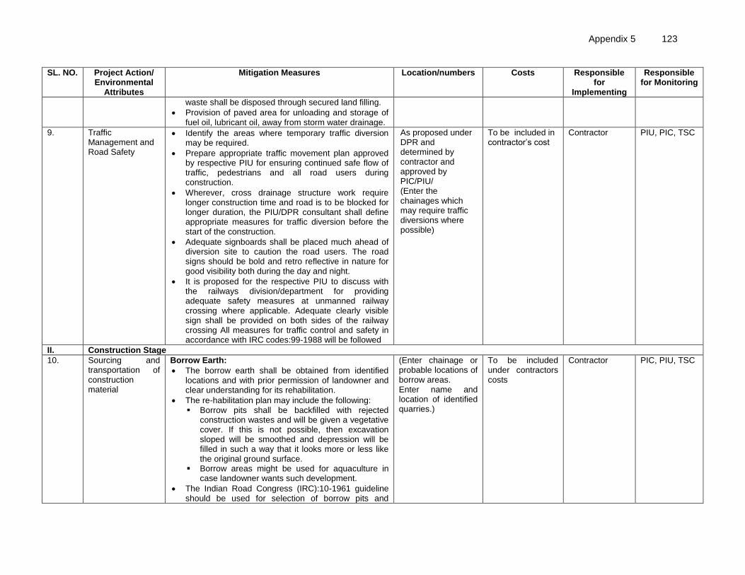
Appendix 5 123
SL. NO. Project Action/ Environmental
Attributes
Mitigation Measures Location/numbers Costs Responsible for
Implementing
Responsible for Monitoring
waste shall be disposed through secured land filling.
• Provision of paved area for unloading and storage of fuel oil, lubricant oil, away from storm water drainage.
9. Traffic Management and Road Safety
• Identify the areas where temporary traffic diversion may be required.
• Prepare appropriate traffic movement plan approved by respective PIU for ensuring continued safe flow of traffic, pedestrians and all road users during construction.
• Wherever, cross drainage structure work require longer construction time and road is to be blocked for longer duration, the PIU/DPR consultant shall define appropriate measures for traffic diversion before the start of the construction.
• Adequate signboards shall be placed much ahead of diversion site to caution the road users. The road signs should be bold and retro reflective in nature for good visibility both during the day and night.
• It is proposed for the respective PIU to discuss with the railways division/department for providing adequate safety measures at unmanned railway crossing where applicable. Adequate clearly visible sign shall be provided on both sides of the railway crossing All measures for traffic control and safety in accordance with IRC codes:99-1988 will be followed
As proposed under DPR and determined by contractor and approved by PIC/PIU/ (Enter the chainages which may require traffic diversions where possible)
To be included in contractor’s cost
Contractor PIU, PIC, TSC
II. Construction Stage
10. Sourcing and transportation of construction material
Borrow Earth:
• The borrow earth shall be obtained from identified locations and with prior permission of landowner and clear understanding for its rehabilitation.
• The re-habilitation plan may include the following: ▪ Borrow pits shall be backfilled with rejected
construction wastes and will be given a vegetative cover. If this is not possible, then excavation sloped will be smoothed and depression will be filled in such a way that it looks more or less like the original ground surface.
▪ Borrow areas might be used for aquaculture in case landowner wants such development.
• The Indian Road Congress (IRC):10-1961 guideline should be used for selection of borrow pits and
(Enter chainage or probable locations of borrow areas. Enter name and location of identified quarries.)
To be included under contractors costs
Contractor PIC, PIU, TSC

124 Appendix 5
SL. NO. Project Action/ Environmental
Attributes
Mitigation Measures Location/numbers Costs Responsible for
Implementing
Responsible for Monitoring
amount that can be borrowed.
• Borrowing earth from agricultural land shall be minimized to the extent possible. Further, no earth shall be borrowed from already low-lying areas.
• A 15 cm topsoil will be stripped off from the borrow pit and this will be stored in stockpiles in a designated area for height not exceeding 2m and side slopes not steeper than 1:2 (Vertical: Horizontal).
• Borrowing of earth will not be done continuously through out the stretch.
• Ridges of not less than 8m widths will be left at intervals not exceeding 300m.
• Small drains will be cut through the ridges, if necessary, to facilitate drainage.
• The slope of the edges will be maintained not steeper than 1:4 (vertical: Horizontal).
• The depth of borrow pits will not be more than 30 cm after stripping the 15 cm topsoil aside.
• Fly ash will be used in road embankment as per IRC guidelines wherever thermal power plant is located within 100 km of the road alignment.
Aggregate :
• The stone aggregate shall be sourced from existing licensed quarries
• Copies of consent/ approval / rehabilitation plan for use of existing source will be submitted to PIU.
• Topsoil to be stockpiled and protected for use at the rehabilitation stage
Transportation of Construction Material
• Existing tracks / roads are to be used for hauling of materials to the extent possible.
• Prior to construction of roads, topsoil shall be preserved and shall be used for other useful purposes like using in turfing of embankment.
• The vehicles deployed for material transportation shall be spillage proof to avoid or minimize the spillage of the material during transportation. In any case, the transportation links are to be inspected at least twice daily to clear accidental spillage, if any.
11. Loss of Productive Soil, erosion and
• The top soil from the productive land (borrow areas, road widening areas etc.) shall be preserved and
All though the alignment of each
To be included under contractors
Contractor PIU / WBSRRDA

Appendix 5 125
SL. NO. Project Action/ Environmental
Attributes
Mitigation Measures Location/numbers Costs Responsible for
Implementing
Responsible for Monitoring
land use change reused for plantation purposes.
• It shall also be used as top cover of embankment slope for growing vegetation to protect soil erosion.
• Cut and fill shall be planned as per IRC provisions and rural road manual.
• All steep cuts shall be flattened and benched.
• Shrubs shall be planted in loose soil area.
• IRC: 56 -1974 recommended practice for treatment of embankment slopes for erosion control shall be taken into consideration.
• It shall be ensured that the land taken on lease for access road, construction camp and temporary office of the storage facilities is restored back to its original land use before handing it over back to land owner.
project road
costs
12.
Compaction and Contamination of Soil
• To prevent soil compaction in the adjoining productive lands beyond the ROW, the movement of construction vehicles, machinery and equipment shall be restricted to the designated haulage route.
• The productive land shall be reclaimed after construction activity.
• Fuel and lubricants shall be stored at the predefined storage location.
• The storage area shall be paved with gentle slope to a corner and connected with a chamber to collect any spills of the oils.
• All efforts shall be made to minimise the waste generation. Unavoidable waste shall be stored at the designated place prior to disposal.
• To avoid soil contamination at the wash-down and re-fuelling areas, “oil interceptors” shall be provided. Oil and grease spill and oil soaked materials are to be collected and stored in labelled containers (Labelled: WASTE OIL; and hazardous sign be displayed) and sold off to SPCB/ MoEF authorized re-refiners.
All though the alignment of each project road
To be included under contractors costs
Contractor, PIU, PIC, TSC
13. Construction Debris and waste
• Excavated materials from roadway, shoulders, verges, drains, cross drainage will be used for backfilling embankments, filling pits, and landscaping.
• Unusable debris material should be suitably disposed off at pre-designated disposal locations, with approval of the concerned authority.
• The bituminous wastes shall be disposed in secure
All though the alignment of each project road
To be included under contractors costs
Contractor PIU, PIC, TSC

126 Appendix 5
SL. NO. Project Action/ Environmental
Attributes
Mitigation Measures Location/numbers Costs Responsible for
Implementing
Responsible for Monitoring
manner at designated landfill sites only in an environmentally accepted manner.
• For removal of debris, wastes and its disposal MOSRTH guidelines should be followed. Unproductive/wastelands shall be selected with the consent of villagers and Panchayat for the same. The dumping site should be of adequate capacity. It should be located at least 500 m away from the residential areas. Dumping sites should be away from water bodies to prevent any contamination of these bodies.
14. Air and Noise Quality
• Vehicles delivering loose and fine materials like sand and aggregates shall be covered.
• Dust suppression measures like water sprinkling, shall be applied in all dust prone locations such as unpaved haulage roads, earthworks, stockpiles and asphalt mixing areas.
• Mixing plants and asphalt (hot/spot mix) plants shall be located at least 0.5 km away and in downwind direction of the human settlements.
• Material storage areas shall also be located downwind of the habitation area.
• Hot mix plant shall be fitted with stack of adequate height (30 m) or as may be prescribed by SPCB to ensure enough dispersion of exit gases. Consent to establish and operate shall be obtained from State Pollution Control Board and comply with all consent conditions.
• Diesel Generating (DG) sets shall also be fitted with stack of adequate height (as per regulation height of the stack of open to air DG set shall be about 0.5 m for 5 KVA and about 0.7 m for 10 KVA DG sets, above top of sound proofing enclosure of the DG set). Low sulphur diesel shall be used in DG sets and other construction machineries where available. Construction vehicles and machineries shall be periodically maintained.
Throughout the project road section
To be included under contractors costs
Contractor PIU, WBSRRDA
15. Tree plantation • Compensatory Afforestation shall be made on 1:3.ratio basis
• Additional trees shall be planted wherever feasible.
• Follow up maintenance of planted saplings will be
(Enter the number of trees requird for planting and location of plantation site if
Costs to be covered by state or PRI under schemes such as
PIU to coordinate compensatory forestation with
PIU, PIC, TSC
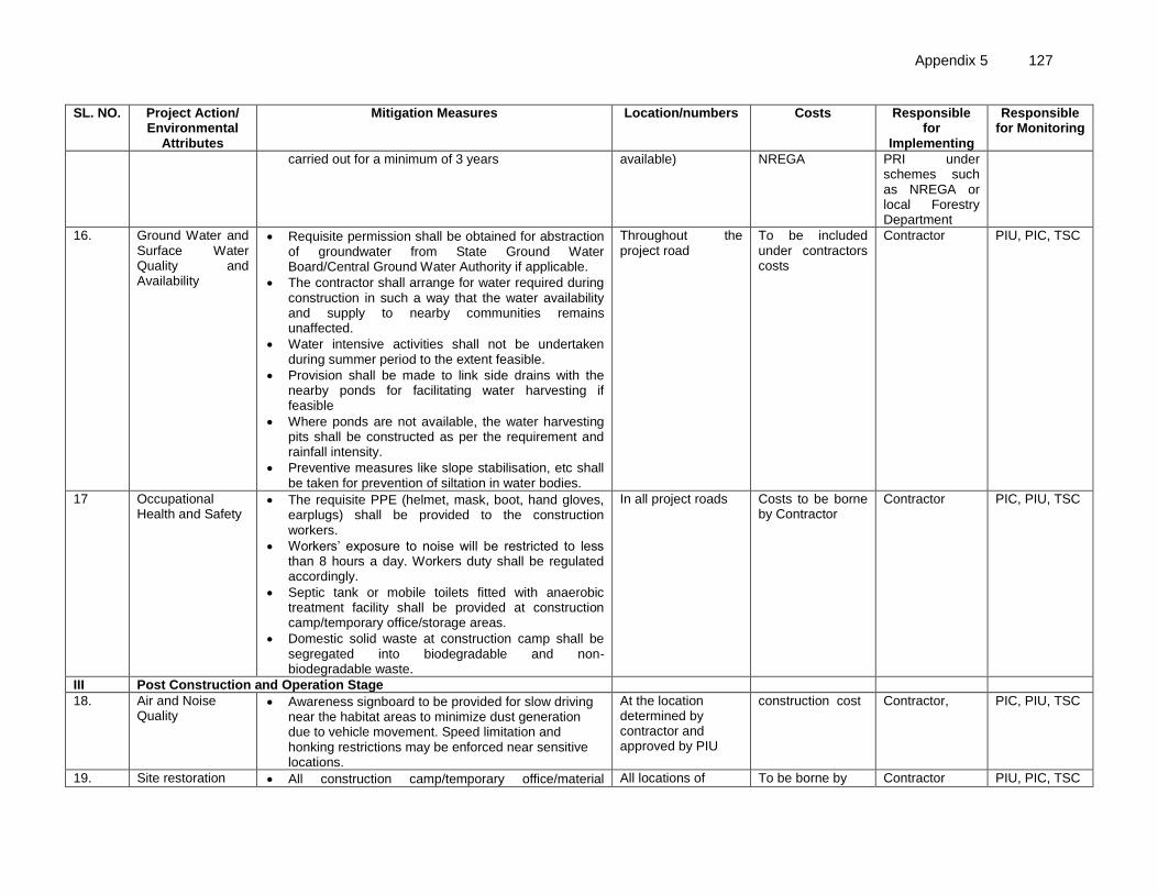
Appendix 5 127
SL. NO. Project Action/ Environmental
Attributes
Mitigation Measures Location/numbers Costs Responsible for
Implementing
Responsible for Monitoring
carried out for a minimum of 3 years available) NREGA PRI under schemes such as NREGA or local Forestry Department
16. Ground Water and Surface Water Quality and Availability
• Requisite permission shall be obtained for abstraction of groundwater from State Ground Water Board/Central Ground Water Authority if applicable.
• The contractor shall arrange for water required during construction in such a way that the water availability and supply to nearby communities remains unaffected.
• Water intensive activities shall not be undertaken during summer period to the extent feasible.
• Provision shall be made to link side drains with the nearby ponds for facilitating water harvesting if feasible
• Where ponds are not available, the water harvesting pits shall be constructed as per the requirement and rainfall intensity.
• Preventive measures like slope stabilisation, etc shall be taken for prevention of siltation in water bodies.
Throughout the project road
To be included under contractors costs
Contractor PIU, PIC, TSC
17 Occupational Health and Safety
• The requisite PPE (helmet, mask, boot, hand gloves, earplugs) shall be provided to the construction workers.
• Workers’ exposure to noise will be restricted to less than 8 hours a day. Workers duty shall be regulated accordingly.
• Septic tank or mobile toilets fitted with anaerobic treatment facility shall be provided at construction camp/temporary office/storage areas.
• Domestic solid waste at construction camp shall be segregated into biodegradable and non-biodegradable waste.
In all project roads Costs to be borne by Contractor
Contractor PIC, PIU, TSC
III Post Construction and Operation Stage
18. Air and Noise Quality
• Awareness signboard to be provided for slow driving near the habitat areas to minimize dust generation due to vehicle movement. Speed limitation and honking restrictions may be enforced near sensitive locations.
At the location determined by contractor and approved by PIU
construction cost Contractor, PIC, PIU, TSC
19. Site restoration • All construction camp/temporary office/material All locations of To be borne by Contractor PIU, PIC, TSC

128 Appendix 5
SL. NO. Project Action/ Environmental
Attributes
Mitigation Measures Location/numbers Costs Responsible for
Implementing
Responsible for Monitoring
storage areas are to be restored to its original conditions.
• The borrow areas rehabilitation will be ensured as per the agreed plan with the landowner.
• Obtain clearance from PIU before handling over the site to WBSRRDA.
• PIC to undertake survivability assessment and report status to PIU of compensatory tree plantation (at completion of construction) with recommendation for improving the survivability of the tree if required
construction camps/temporary office/ material storage, and borrow areas
the contractor
20. Hydrology and Drainage
• Regular removal/cleaning of deposited silt shall be done from drainage channels and outlet points before the monsoon season.
• Rejuvenation of the drainage system by removing encroachments/ congestions shall be regularly conducted
At project road locations with drainage structures
To be covered under road maintenance costs.
PIU PIU, WBSRRDA
21 Community Safety • Directional sight board shall be installed on all sharp curves and bends
• At a main road, intersection or crossing “STOP” sign and ‘T-intersection’ warning sign shall be installed on the village road.
Throughout the project section at the location determined by contractor and approved by PIU
construction cost
Maintenance Contractor, PIU
PIC/PIU
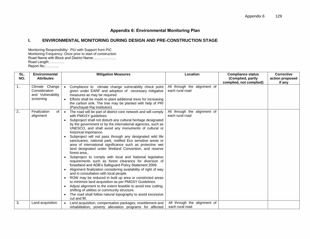
Appendix 6 129
Appendix 6: Environmental Monitoring Plan I. ENVIRONMENTAL MONITORING DURING DESIGN AND PRE-CONSTRUCTION STAGE Monitoring Responsibility: PIU with Support from PIC Monitoring Frequency: Once prior to start of construction Road Name with Block and District Name:………………. Road Length: ………… Report No.: ……….
SL. NO.
Environmental Attributes
Mitigation Measures Location Compliance status (Complied, partly
complied, not complied)
Corrective action proposed
if any
1.. Climate Change Consideration and Vulnerability screening
• Compliance to climate change vulnerability check point given under EARF and adoption of necessary mitigative measures as may be required
• Efforts shall be made to plant additional trees for increasing the carbon sink. The tree may be planted with help of PRI (Panchayati Raj Institution)
All through the alignment of each rural road
2.. Finalization of alignment
• The road will be part of district core network and will comply with PMGSY guidelines
• Subproject shall not disturb any cultural heritage designated by the government or by the international agencies, such as UNESCO, and shall avoid any monuments of cultural or historical importance.
• Subproject will not pass through any designated wild life sanctuaries, national park, notified Eco sensitive areas or area of international significance such as protective wet land designated under Wetland Convention, and reserve forest area..
• Subproject to comply with local and National legislative requirements such as forest clearance for diversion of forestland and ADB’s Safeguard Policy Statement 2009.
• Alignment finalization considering availability of right of way and in consultation with local people.
• ROW may be reduced in built up area or constricted areas to minimize land acquisition as per PMGSY Guidelines.
• Adjust alignment to the extent feasible to avoid tree cutting, shifting of utilities or community structure.
• The road shall follow natural topography to avoid excessive cut and fill.
All through the alignment of each rural road
3. Land acquisition • Land acquisition, compensation packages, resettlement and rehabilitation, poverty alleviation programs for affected
All through the alignment of each rural road
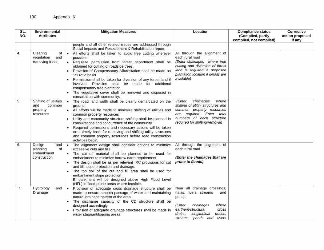
130 Appendix 6
SL. NO.
Environmental Attributes
Mitigation Measures Location Compliance status (Complied, partly
complied, not complied)
Corrective action proposed
if any
people and all other related issues are addressed through Social Impacts and Resettlement & Rehabilitation report.
4. 7.77
Clearing of vegetation and removing trees
• All efforts shall be taken to avoid tree cutting wherever possible.
• Requisite permission from forest department shall be obtained for cutting of roadside trees.
• Provision of Compensatory Afforestation shall be made on 1:3.ratio basis
• Permission shall be taken for diversion of any forest land if involved. Provision shall be made for additional compensatory tree plantation.
• The vegetative cover shall be removed and disposed in consultation with community.
All through the alignment of each rural road (Enter chainages where tree cutting and diversion of forest land is required & proposed plantation location if details are available)
5. Shifting of utilities and common property resources
• The road land width shall be clearly demarcated on the ground.
• All efforts will be made to minimize shifting of utilities and common property resources
• Utility and community structure shifting shall be planned in consultations and concurrence of the community
• Required permissions and necessary actions will be taken on a timely basis for removing and shifting utility structures and common property resources before road construction activities begin.
(Enter chainages where shifting of utility structures and common property resources are required. Enter total numbers of each structure required for shifting/removal)
6. Design and planning of embankment construction
• The alignment design shall consider options to minimize excessive cuts and fills.
• The cut off material shall be planned to be used for embankment to minimize borrow earth requirement.
• The design shall be as per relevant IRC provisions for cut and fill, slope protection and drainage.
• The top soil of the cut and fill area shall be used for embankment slope protection Embankment will be designed above High Flood Level (HFL) in flood prone areas where feasible.
All through the alignment of each rural road (Enter the chainages that are prone to floods)
7. Hydrology and Drainage
• Provision of adequate cross drainage structure shall be made to ensure smooth passage of water and maintaining natural drainage pattern of the area.
• The discharge capacity of the CD structure shall be designed accordingly.
• Provision of adequate drainage structures shall be made in water stagnant/logging areas.
Near all drainage crossings, nalas, rivers, streams and ponds. (Enter chainages where earthern/structural cross drains, longitudinal drains, streams, ponds and rivers

Appendix 6 131
SL. NO.
Environmental Attributes
Mitigation Measures Location Compliance status (Complied, partly
complied, not complied)
Corrective action proposed
if any
• The construction work near water body shall be planned preferably in dry season so that water quality of the water channel is not affected due to siltation and rain water runoff.
• Provision of additional cross drainage structure shall be made in the areas where nearby land is sloping towards road alignment on both the sides.
• Provision of concrete road construction in habitat area with drainage of both side of the road shall be made as per the design provision and with adequate slope to prevent any water logging.
exist)
8. Establishment of Construction Camp, temporary office and storage area
• Construction camp sites shall be located away from any local human settlements and forested areas (minimum 0.5 km away) and preferably located on lands, which are not productive (barren/waste lands presently).
• Similarly temporary office and storage areas shall be located away from human settlement areas and forested areas (minimum 0.5 km).
• The construction camps, office and storage areas shall have provision of adequate water supply, sanitation and all requisite infrastructure facilities.
• The construction camps, office and storage areas shall have provision of septic tank/soak pit of adequate capacity so that it can function properly for the entire duration of its use.
• All construction camps shall have provision of rationing facilities particularly for kerosene/LPG so that dependence on firewood for cooking is avoided to the extent possible.
• The construction camps, office and storage areas shall have provision of health care facilities for adults, pregnant women and children.
• Personal Protective Equipments (PPEs) like helmet, boots, earplugs for workers, first aid and fire fighting equipments shall be available at construction sites before start of construction. An emergency plan shall be prepared to fight with any emergency like fire.
• Provision shall be made for domestic solid waste disposal in a controlled manner. The recyclable waste shall be sold off and non-saleable and biodegradable waste shall be disposed through secured land filling.
• Provision of paved area for unloading and storage of fuel oil, lubricant oil, away from storm water drainage.
For all roads

132 Appendix 6
SL. NO.
Environmental Attributes
Mitigation Measures Location Compliance status (Complied, partly
complied, not complied)
Corrective action proposed
if any
9. Traffic Management and Road Safety
• Identify the areas where temporary traffic diversion may be required.
• Prepare appropriate traffic movement plan approved by respective PIU for ensuring continued safe flow of traffic, pedestrians and all road users during construction.
• Wherever, cross drainage structure work require longer construction time and road is to be blocked for longer duration, the PIU/DPR consultant shall define appropriate measures for traffic diversion before the start of the construction.
• Adequate signboards shall be placed much ahead of diversion site to caution the road users. The road signs should be bold and retro reflective in nature for good visibility both during the day and night.
• It is proposed for the respective PIU to discuss with the railways division/department for providing adequate safety measures at unmanned railway crossing where applicable. Adequate clearly visible sign shall be provided on both sides of the railway crossing All measures for traffic control and safety in accordance with IRC codes:99-1988 will be followed
As proposed under DPR and determined by contractor and approved by PIC/PIU/ (Enter the chainages which may require traffic diversions where possible)
10. Grievance Redress
• Maintaining records of all environment related grievances raised, if any, and the actions taken to address them through the village level grievance redress committee (GRC) and PIU as applicable
All project roads.
NOTE: Each report must enclose Photograph to the maximum possible action points, even if work is in progress.

Appendix 6 133
II. ENVIRONMENTAL MONITORING DURING CONSTRUCTION STAGE Monitoring Responsibility: PIU with Support from PIC Monitoring Frequency : Once during construction after completion of about 50% of construction Project Details:……………. Road Stretch Name : ………. Monitoring Report Quarter No.: ……..
SL. NO. Environmental Attributes
Mitigation Measures Location Compliance status (Complied, partly
complied, not complied)
Corrective action proposed if any
1.
Sourcing and transportation of construction material
Borrow Earth:
• The borrow earth shall be obtained from identified locations and with prior permission of landowner and clear understanding for its rehabilitation.
• The re-habilitation plan may include the following: ▪ Borrow pits shall be backfilled with rejected
construction wastes and will be given a vegetative cover. If this is not possible, then excavation sloped will be smoothed and depression will be filled in such a way that it looks more or less like the original ground surface.
▪ Borrow areas might be used for aquaculture in case landowner wants such development.
• The Indian Road Congress (IRC):10-1961 guideline should be used for selection of borrow pits and amount that can be borrowed.
• Borrowing earth from agricultural land shall be minimized to the extent possible. Further, no earth shall be borrowed from already low-lying areas.
• A 15 cm topsoil will be stripped off from the borrow pit and this will be stored in stockpiles in a designated area for height not exceeding 2m and side slopes not steeper than 1:2 (Vertical: Horizontal).
• Borrowing of earth will not be done continuously through out the stretch.
• Ridges of not less than 8m widths will be left at intervals not exceeding 300m.
• Small drains will be cut through the ridges, if necessary, to facilitate drainage.
• The slope of the edges will be maintained not steeper than 1:4 (vertical: Horizontal).
• The depth of borrow pits will not be more than 30 cm after stripping the 15 cm topsoil aside.
(Enter chainage or probable locations of borrow areas. Enter name and location of identified quarries.)

134 Appendix 6
SL. NO. Environmental Attributes
Mitigation Measures Location Compliance status (Complied, partly
complied, not complied)
Corrective action proposed if any
• Fly ash will be used in road embankment as per IRC guidelines wherever thermal power plant is located within 100 km of the road alignment.
Aggregate :
• The stone aggregate shall be sourced from existing licensed quarries
• Copies of consent/ approval / rehabilitation plan for use of existing source will be submitted to PIU.
• Topsoil to be stockpiled and protected for use at the rehabilitation stage
Transportation of Construction Material
• Existing tracks / roads are to be used for hauling of materials to the extent possible.
• Prior to construction of roads, topsoil shall be preserved and shall be used for other useful purposes like using in turfing of embankment.
• The vehicles deployed for material transportation shall be spillage proof to avoid or minimize the spillage of the material during transportation. In any case, the transportation links are to be inspected at least twice daily to clear accidental spillage, if any.
2.
Loss of Productive Soil, erosion and land use change
• The top soil from the productive land (borrow areas, road widening areas etc.) shall be preserved and reused for plantation purposes.
• It shall also be used as top cover of embankment slope for growing vegetation to protect soil erosion.
• Cut and fill shall be planned as per IRC provisions and rural road manual.
• All steep cuts shall be flattened and benched.
• Shrubs shall be planted in loose soil area.
• IRC: 56 -1974 recommended practice for treatment of embankment slopes for erosion control shall be taken into consideration.
• It shall be ensured that the land taken on lease for access road, construction camp and temporary office of the storage facilities is restored back to its original land use before handing it over back to land owner.
All though the alignment of each project road
3.
Compaction and Contamination of Soil
• To prevent soil compaction in the adjoining productive lands beyond the ROW, the movement of construction vehicles, machinery and equipment shall be restricted to the designated haulage route.
All though the alignment of each project road

Appendix 6 135
SL. NO. Environmental Attributes
Mitigation Measures Location Compliance status (Complied, partly
complied, not complied)
Corrective action proposed if any
• The productive land shall be reclaimed after construction activity.
• Fuel and lubricants shall be stored at the predefined storage location.
• The storage area shall be paved with gentle slope to a corner and connected with a chamber to collect any spills of the oils.
• All efforts shall be made to minimise the waste generation. Unavoidable waste shall be stored at the designated place prior to disposal.
• To avoid soil contamination at the wash-down and re-fuelling areas, “oil interceptors” shall be provided. Oil and grease spill and oil soaked materials are to be collected and stored in labelled containers (Labelled: WASTE OIL; and hazardous sign be displayed) and sold off to SPCB/ MoEF authorized re-refiners.
4.
Construction Debris and waste
• Excavated materials from roadway, shoulders, verges, drains, cross drainage will be used for backfilling embankments, filling pits, and landscaping.
• Unusable debris material should be suitably disposed off at pre-designated disposal locations, with approval of the concerned authority.
• The bituminous wastes shall be disposed in secure manner at designated landfill sites only in an environmentally accepted manner.
• For removal of debris, wastes and its disposal MOSRTH guidelines should be followed. Unproductive/wastelands shall be selected with the consent of villagers and Panchayat for the same. The dumping site should be of adequate capacity. It should be located at least 500 m away from the residential areas. Dumping sites should be away from water bodies to prevent any contamination of these bodies.
All though the alignment of each project road
5. Air and Noise Quality • Vehicles delivering loose and fine materials like sand and aggregates shall be covered.
• Dust suppression measures like water sprinkling, shall be applied in all dust prone locations such as unpaved haulage roads, earthworks, stockpiles and asphalt mixing areas.
• Mixing plants and asphalt (hot mix) plants shall be located at least 0.5 km away and in downwind direction
Throughout the project road section

136 Appendix 6
SL. NO. Environmental Attributes
Mitigation Measures Location Compliance status (Complied, partly
complied, not complied)
Corrective action proposed if any
of the human settlements.
• Material storage areas shall also be located downwind of the habitation area.
• Hot mix plant shall be fitted with stack of adequate height (30 m) or as may be prescribed by SPCB to ensure enough dispersion of exit gases. Consent to establish and operate shall be obtained from State Pollution Control Board and comply with all consent conditions.
• Diesel Generating (DG) sets shall also be fitted with stack of adequate height (as per regulation height of the stack of open to air DG set shall be about 0.5 m for 5 KVA and about 0.7 m for 10 KVA DG sets, above top of sound proofing enclosure of the DG set). Low sulphur diesel shall be used in DG sets and other construction machineries where available. Construction vehicles and machineries shall be periodically maintained.
6. 7.77
Tree plantation • Compensatory Afforestation shall be made on 1:3.ratio basis.
• Additional trees shall be planted wherever feasible.
• Follow up maintenance of planted saplings will be carried out for a minimum of 3 years
(Enter the number of trees requird for planting and location of plantation site if available)
7.
Ground Water and Surface Water Quality and Availability
• Requisite permission shall be obtained for abstraction of groundwater from State Ground Water Board/Central Ground Water Authority if applicable.
• The contractor shall arrange for water required during construction in such a way that the water availability and supply to nearby communities remains unaffected.
• Water intensive activities shall not be undertaken during summer period to the extent feasible.
• Provision shall be made to link side drains with the nearby ponds for facilitating water harvesting if feasible
• Where ponds are not available, the water harvesting pits shall be constructed as per the requirement and rainfall intensity. Preventive measures like slope stabilisation, etc shall be taken for prevention of siltation in water bodies.
Throughout the project road
8. Occupational Health and Safety
• The requisite PPE (helmet, mask, boot, hand gloves, earplugs) shall be provided to the construction workers.
• Workers’ exposure to noise will be restricted to less
In all project roads

Appendix 6 137
SL. NO. Environmental Attributes
Mitigation Measures Location Compliance status (Complied, partly
complied, not complied)
Corrective action proposed if any
than 8 hours a day. Workers duty shall be regulated accordingly.
• Septic tank or mobile toilets fitted with anaerobic treatment facility shall be provided at construction camp/temporary office/storage areas.
• Domestic solid waste at construction camp shall be segregated into biodegradable and non-biodegradable waste.
9. Grievance Redress • Maintaining records of all environment related grievances raised, if any, and the actions taken to address them through the village level grievance redress committee (GRC) and PIU as applicable
All project roads.
NOTE: Each report must enclose Photograph to the maximum possible action points, even if work is in progress.
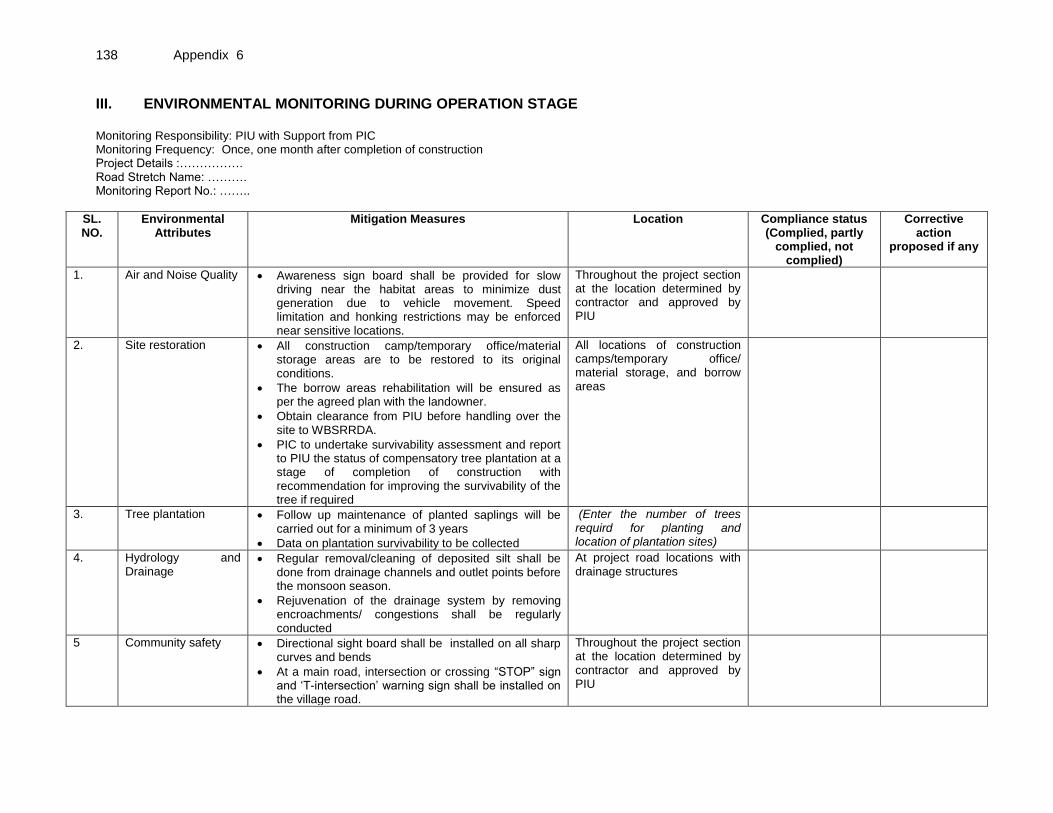
138 Appendix 6
III. ENVIRONMENTAL MONITORING DURING OPERATION STAGE Monitoring Responsibility: PIU with Support from PIC Monitoring Frequency: Once, one month after completion of construction Project Details :……………. Road Stretch Name: ………. Monitoring Report No.: ……..
SL. NO.
Environmental Attributes
Mitigation Measures Location Compliance status (Complied, partly
complied, not complied)
Corrective action
proposed if any
1. Air and Noise Quality • Awareness sign board shall be provided for slow driving near the habitat areas to minimize dust generation due to vehicle movement. Speed limitation and honking restrictions may be enforced near sensitive locations.
Throughout the project section at the location determined by contractor and approved by PIU
2. Site restoration • All construction camp/temporary office/material storage areas are to be restored to its original conditions.
• The borrow areas rehabilitation will be ensured as per the agreed plan with the landowner.
• Obtain clearance from PIU before handling over the site to WBSRRDA.
• PIC to undertake survivability assessment and report to PIU the status of compensatory tree plantation at a stage of completion of construction with recommendation for improving the survivability of the tree if required
All locations of construction camps/temporary office/ material storage, and borrow areas
3. Tree plantation • Follow up maintenance of planted saplings will be carried out for a minimum of 3 years
• Data on plantation survivability to be collected
(Enter the number of trees requird for planting and location of plantation sites)
4.
Hydrology and Drainage
• Regular removal/cleaning of deposited silt shall be done from drainage channels and outlet points before the monsoon season.
• Rejuvenation of the drainage system by removing encroachments/ congestions shall be regularly conducted
At project road locations with drainage structures
5 Community safety • Directional sight board shall be installed on all sharp curves and bends
• At a main road, intersection or crossing “STOP” sign and ‘T-intersection’ warning sign shall be installed on the village road.
Throughout the project section at the location determined by contractor and approved by PIU

Appendix 6 139
SL. NO.
Environmental Attributes
Mitigation Measures Location Compliance status (Complied, partly
complied, not complied)
Corrective action
proposed if any
6 Grievance Redress • Maintaining records of all environment related grievances raised, if any, and the actions taken to address them through the village level grievance redress committee (GRC) and PIU as applicable
All project roads.
NOTE: Each report must enclose Photograph to the maximum possible action points, even if work is in progress.
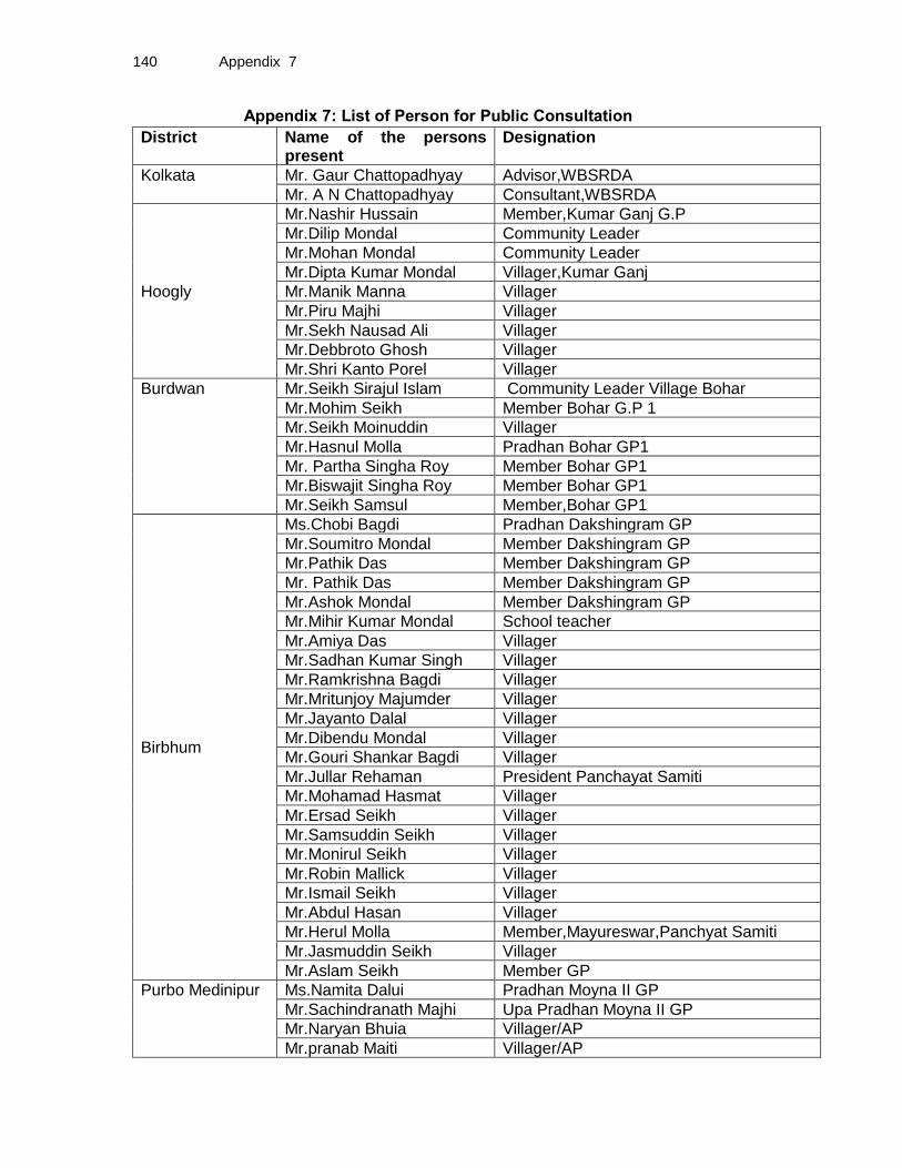
140 Appendix 7
Appendix 7: List of Person for Public Consultation
District Name of the persons present
Designation
Kolkata Mr. Gaur Chattopadhyay Advisor,WBSRDA
Mr. A N Chattopadhyay Consultant,WBSRDA
Hoogly
Mr.Nashir Hussain Member,Kumar Ganj G.P
Mr.Dilip Mondal Community Leader
Mr.Mohan Mondal Community Leader
Mr.Dipta Kumar Mondal Villager,Kumar Ganj
Mr.Manik Manna Villager
Mr.Piru Majhi Villager
Mr.Sekh Nausad Ali Villager
Mr.Debbroto Ghosh Villager
Mr.Shri Kanto Porel Villager
Burdwan Mr.Seikh Sirajul Islam Community Leader Village Bohar
Mr.Mohim Seikh Member Bohar G.P 1
Mr.Seikh Moinuddin Villager
Mr.Hasnul Molla Pradhan Bohar GP1
Mr. Partha Singha Roy Member Bohar GP1
Mr.Biswajit Singha Roy Member Bohar GP1
Mr.Seikh Samsul Member,Bohar GP1
Birbhum
Ms.Chobi Bagdi Pradhan Dakshingram GP
Mr.Soumitro Mondal Member Dakshingram GP
Mr.Pathik Das Member Dakshingram GP
Mr. Pathik Das Member Dakshingram GP
Mr.Ashok Mondal Member Dakshingram GP
Mr.Mihir Kumar Mondal School teacher
Mr.Amiya Das Villager
Mr.Sadhan Kumar Singh Villager
Mr.Ramkrishna Bagdi Villager
Mr.Mritunjoy Majumder Villager
Mr.Jayanto Dalal Villager
Mr.Dibendu Mondal Villager
Mr.Gouri Shankar Bagdi Villager
Mr.Jullar Rehaman President Panchayat Samiti
Mr.Mohamad Hasmat Villager
Mr.Ersad Seikh Villager
Mr.Samsuddin Seikh Villager
Mr.Monirul Seikh Villager
Mr.Robin Mallick Villager
Mr.Ismail Seikh Villager
Mr.Abdul Hasan Villager
Mr.Herul Molla Member,Mayureswar,Panchyat Samiti
Mr.Jasmuddin Seikh Villager
Mr.Aslam Seikh Member GP
Purbo Medinipur Ms.Namita Dalui Pradhan Moyna II GP
Mr.Sachindranath Majhi Upa Pradhan Moyna II GP
Mr.Naryan Bhuia Villager/AP
Mr.pranab Maiti Villager/AP
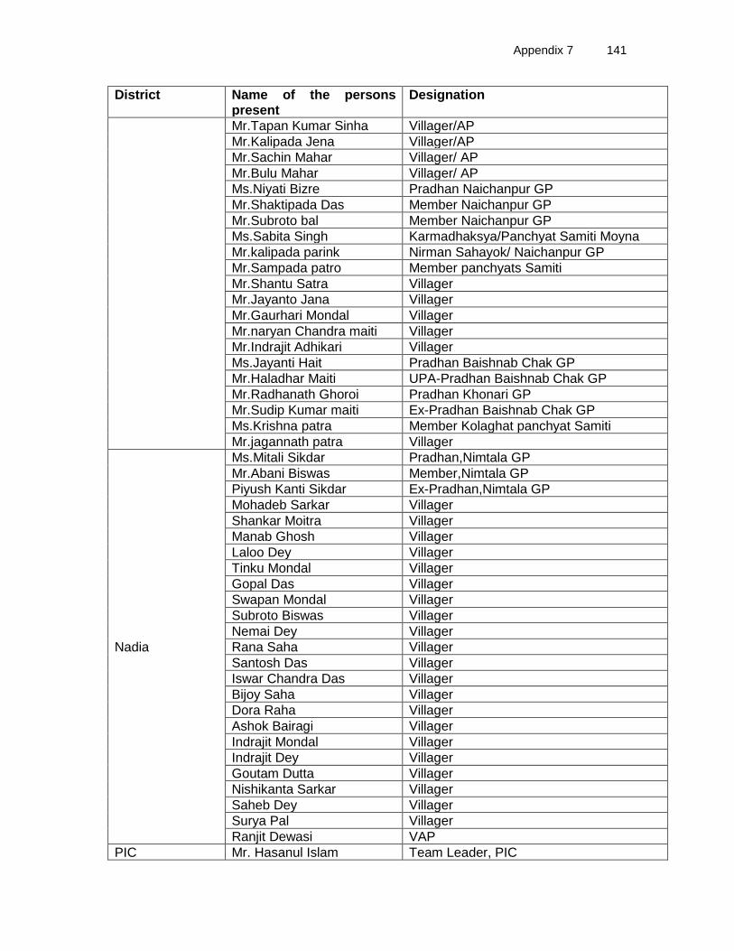
Appendix 7 141
District Name of the persons present
Designation
Mr.Tapan Kumar Sinha Villager/AP
Mr.Kalipada Jena Villager/AP
Mr.Sachin Mahar Villager/ AP
Mr.Bulu Mahar Villager/ AP
Ms.Niyati Bizre Pradhan Naichanpur GP
Mr.Shaktipada Das Member Naichanpur GP
Mr.Subroto bal Member Naichanpur GP
Ms.Sabita Singh Karmadhaksya/Panchyat Samiti Moyna
Mr.kalipada parink Nirman Sahayok/ Naichanpur GP
Mr.Sampada patro Member panchyats Samiti
Mr.Shantu Satra Villager
Mr.Jayanto Jana Villager
Mr.Gaurhari Mondal Villager
Mr.naryan Chandra maiti Villager
Mr.Indrajit Adhikari Villager
Ms.Jayanti Hait Pradhan Baishnab Chak GP
Mr.Haladhar Maiti UPA-Pradhan Baishnab Chak GP
Mr.Radhanath Ghoroi Pradhan Khonari GP
Mr.Sudip Kumar maiti Ex-Pradhan Baishnab Chak GP
Ms.Krishna patra Member Kolaghat panchyat Samiti
Mr.jagannath patra Villager
Nadia
Ms.Mitali Sikdar Pradhan,Nimtala GP
Mr.Abani Biswas Member,Nimtala GP
Piyush Kanti Sikdar Ex-Pradhan,Nimtala GP
Mohadeb Sarkar Villager
Shankar Moitra Villager
Manab Ghosh Villager
Laloo Dey Villager
Tinku Mondal Villager
Gopal Das Villager
Swapan Mondal Villager
Subroto Biswas Villager
Nemai Dey Villager
Rana Saha Villager
Santosh Das Villager
Iswar Chandra Das Villager
Bijoy Saha Villager
Dora Raha Villager
Ashok Bairagi Villager
Indrajit Mondal Villager
Indrajit Dey Villager
Goutam Dutta Villager
Nishikanta Sarkar Villager
Saheb Dey Villager
Surya Pal Villager
Ranjit Dewasi VAP
PIC Mr. Hasanul Islam Team Leader, PIC

142 Appendix 7
District Name of the persons present
Designation
Mr Jyanta Banerjee Supervisor PIC (Environment )
Mr. Himangshu Bhowmik Supervisor PIC (Environment )
Mr. Tilak Banerjee Supervisor PIC (Social)
Mr. Buddha paul Supervisor PIC (Social)
Mr. Prasenjit Thakur DPR consultant
Copyright © 2022 FDOKUMEN