Hydro-geomorphic hazards and impact of man-made structures during the catastrophic flood of June...
27
Hydro-geomorphic hazards and impact of man-made structures during the catastrophic flood of June 2000 in the Upper Guil catchment (Queyras, Southern French Alps) Gilles Arnaud-Fassetta * , Etienne Cossart, Monique Fort Equipe TDynamique des Milieux et Risquesr de Paris 7, UMR 8586 PRODIG (CNRS), Case 7001, Universite ´ Denis-Diderot, 2 Place Jussieu, 75 251 Paris Cedex 05, France Received 2 January 2003; received in revised form 17 July 2003; accepted 4 March 2004 Available online 19 November 2004 Abstract The Guil River Valley (Queyras, Southern French Alps) is prone to catastrophic floods, as the long historical archives and Holocene sedimentary records demonstrate. In June 2000, the upper part of this valley was affected by a b30-year Q recurrence interval (R.I.) flood. Although of lower magnitude and somewhat different nature from that of 1957 (N100-year R.I. flood), the 2000 event induced serious damage to infrastructure and buildings on the valley floor. Use of methods including high-resolution aerial photography, multi-date mapping, hydraulic calculations and field observations made possible the characterisation of the geomorphic impacts on the Guil River and its tributaries. The total rainfall (260 mm in four days) and maximum hourly intensity (17.3 mm h 1 ), aggravated by pre-existing saturated soils, explain the immediate response of the fluvial system and the subsequent destabilisation of slopes. Abundant water and sediment supply (landsliding, bank erosion), particularly from small catchment basins cut into slaty, schist bedrock, resulted in destructive pulses of debris flow and hyperconcentrated flows. The specific stream power of the Guil and its tributaries was greater than the critical stream power, thus explaining the abundant sediment transport. The Guil discharge was estimated as 180 m 3 s 1 at Aiguilles, compared to the annual mean discharge of 6 m 3 s 1 and a June mean discharge of 18 m 3 s 1 . The impacts on the Guil valley floor (flooding, aggradation, generalised bank erosion and changes in the river pattern) were widespread and locally influenced by variations in the floodplain slope and/or channel geometry. The stream partially reoccupied former channels abandoned or modified in their geometry by various structures built during the last four decades, as exemplified by the Aiguilles case study, where the worst damage took place. A comparative study of the geomorphic consequences of both the 1957 and 2000 floods shows that, despite their poor maintenance, the flood control structures built after the 1957 event were relatively efficient, in contrast to unprotected places. The comparison also demonstrates the role of land-use changes (conversion from traditional agro-pastoral life to a ski/hiking- based economy, construction of various structures) in reducing the Guil channel capacity and, more generally, in increasing the vulnerability of the human installations. The efficiency of the measures taken after the 2000 flood (narrowing and digging out of the channel) is also assessed. Final evaluation suggests that, in such high mountainous environments, there is a need to keep 0169-555X/$ - see front matter D 2004 Elsevier B.V. All rights reserved. doi:10.1016/j.geomorph.2004.03.014 * Corresponding author. Tel./fax: +33 1 44277669. E-mail addresses: [email protected] (G. Arnaud-Fassetta), [email protected] (M. Fort). Geomorphology 66 (2005) 41 – 67 www.elsevier.com/locate/geomorph
-
Upload
independent -
Category
Documents
-
view
1 -
download
0
Transcript of Hydro-geomorphic hazards and impact of man-made structures during the catastrophic flood of June...

www.elsevier.com/locate/geomorph
Geomorphology 66
Hydro-geomorphic hazards and impact of man-made structures
during the catastrophic flood of June 2000 in the Upper Guil
catchment (Queyras, Southern French Alps)
Gilles Arnaud-Fassetta*, Etienne Cossart, Monique Fort
Equipe TDynamique des Milieux et Risquesr de Paris 7, UMR 8586 PRODIG (CNRS), Case 7001, Universite Denis-Diderot,
2 Place Jussieu, 75 251 Paris Cedex 05, France
Received 2 January 2003; received in revised form 17 July 2003; accepted 4 March 2004
Available online 19 November 2004
Abstract
The Guil River Valley (Queyras, Southern French Alps) is prone to catastrophic floods, as the long historical archives and
Holocene sedimentary records demonstrate. In June 2000, the upper part of this valley was affected by a b30-year Q recurrenceinterval (R.I.) flood. Although of lower magnitude and somewhat different nature from that of 1957 (N100-year R.I. flood), the
2000 event induced serious damage to infrastructure and buildings on the valley floor. Use of methods including high-resolution
aerial photography, multi-date mapping, hydraulic calculations and field observations made possible the characterisation of the
geomorphic impacts on the Guil River and its tributaries. The total rainfall (260 mm in four days) and maximum hourly
intensity (17.3 mm h�1), aggravated by pre-existing saturated soils, explain the immediate response of the fluvial system and
the subsequent destabilisation of slopes. Abundant water and sediment supply (landsliding, bank erosion), particularly from
small catchment basins cut into slaty, schist bedrock, resulted in destructive pulses of debris flow and hyperconcentrated flows.
The specific stream power of the Guil and its tributaries was greater than the critical stream power, thus explaining the abundant
sediment transport. The Guil discharge was estimated as 180 m3 s�1 at Aiguilles, compared to the annual mean discharge of 6
m3 s�1 and a June mean discharge of 18 m3 s�1. The impacts on the Guil valley floor (flooding, aggradation, generalised bank
erosion and changes in the river pattern) were widespread and locally influenced by variations in the floodplain slope and/or
channel geometry. The stream partially reoccupied former channels abandoned or modified in their geometry by various
structures built during the last four decades, as exemplified by the Aiguilles case study, where the worst damage took place. A
comparative study of the geomorphic consequences of both the 1957 and 2000 floods shows that, despite their poor
maintenance, the flood control structures built after the 1957 event were relatively efficient, in contrast to unprotected places.
The comparison also demonstrates the role of land-use changes (conversion from traditional agro-pastoral life to a ski/hiking-
based economy, construction of various structures) in reducing the Guil channel capacity and, more generally, in increasing the
vulnerability of the human installations. The efficiency of the measures taken after the 2000 flood (narrowing and digging out of
the channel) is also assessed. Final evaluation suggests that, in such high mountainous environments, there is a need to keep
0169-555X/$ - s
doi:10.1016/j.ge
* Correspondi
E-mail addr
(2005) 41–67
ee front matter D 2004 Elsevier B.V. All rights reserved.
omorph.2004.03.014
ng author. Tel./fax: +33 1 44277669.
esses: [email protected] (G. Arnaud-Fassetta), [email protected] (M. Fort).

G. Arnaud-Fassetta et al. / Geomorphology 66 (2005) 41–6742
most of the 1957 flooded zone clear of buildings and other structures (aside from the existing villages and structures of
particular economic interest), in order to enable the river to migrate freely and to adjust to exceptional hydro-geomorphic
conditions without causing major damage.
D 2004 Elsevier B.V. All rights reserved.
Keywords: Fluvial geomorphology; Extreme flood; Hydro-geomorphic impact; River basin management; Guil River; Southern French Alps
1. Introduction
Unglaciated Mediterranean or sub-Mediterranean
mountains are frequently subject to hydro-climatic
events resulting in ephemeral, flash floods (Harvey,
1984; Gallart and Clotet-Perarnau, 1988; Ballandras,
1993; Macklin et al., 1995; White et al., 1997;
Poesen and Hooke, 1997; Guttierez et al., 1998;
Maas and Macklin, 2002). These are rather common,
being related to typical meteorological situations in
which warm, humid air masses formed above the
Mediterranean Sea, are cooled by uplift over the
adjacent landmass, releasing intense rainfall. Such
events are not unexpected by the local population,
who are well aware of the potential dangers related
to a rapid rise of water levels in the river channels.
For this reason, villages are generally sited on
elevated spurs or ridges, foot slopes or edges of
tributary torrential fans, as places considered rela-
tively safe from flood risk. However, some floods
are more intense than others and, through the
important amount of geomorphic work they can
accomplish in a very short time, they may be a
source of significant damage and serious loss to
human infrastructures.
In the upper valleys, the high altitude environment
may create specific flood conditions in relation to a
higher runoff concentration and the abundant produc-
tion of debris. The Guil River (Hautes-Alpes, France)
drains a valley that is representative of the cata-
strophic floods that occur in the southern French Alps.
Though mostly influenced by humid air masses from
the Atlantic, this area is occasionally subject to storms
derived from humid Mediterranean air masses, as the
origin of such floods. The most documented cata-
strophic flood occurred in June 1957. It consisted of
an exceptional, low-frequency (more than 100-year
recurrence interval, R.I.), high-magnitude hydro-geo-
morphic event, which also affected the adjacent
Ubaye, Cerveyrette and Maurienne valleys. The
effects of this event were thoroughly analysed by
Tricart (1958, 1961a,b). The damage associated with
the 1957 flood was such (~15 million euros) that the
French Government took important measures to repair
destroyed structures, and built at considerable cost
new protective structures (embankments, canals,
dikes) where, and only where, it was considered that
people and/or buildings were potentially under threat.
These measures remained the only flood control
structures in the Guil hydro-system in 2000. In fact,
the 1957 flood is considered to be the reference flood
used in hydraulic models and/or management plan-
ning in the Guil Valley (Parc Naturel Regional du
Queyras, 2002).
In June 2000, the Upper Guil Valley was again
affected by a major, 30-year R.I. hydro-geomorphic
event. Although of lower magnitude and of a some-
what different nature from that of 1957, this recent
flood caused serious damage to infrastructure and
buildings along the valley floor (~4.6 million euros),
because of the many land-use changes (conversion
from traditional agro-pastoral life to a ski/hiking-
based economy, construction of various structures)
that have taken place during the past four decades.
The aims of the present study are as follows: (1) to
document the geomorphic and hydrological character-
istics of the June 2000 flood; (2) to compare the
impacts of the 30-year R.I. June 2000 flood with those
of the N100-year R.I. 1957 flood in the context of
land-use change; (3) to assess the efficiency of the
flood control structures built after 1957 against recent
land-use changes; and finally (4) to suggest some
recommendations bearing upon river management. In
this study, particular attention is accorded to Aiguilles
village and its surroundings, given that it was the most
severely affected area. Following a description of the
main characteristics of the Guil catchment, the
characteristics of the June 2000 event and its impact
upon both the tributaries and the main Guil Valley are
set out. Finally, the different factors that contributed to
G. Arnaud-Fassetta et al. / Geomorphology 66 (2005) 41–67 43
material losses greater than those generated in 1957
are evaluated.
2. The Guil catchment: an area prone to
catastrophic floods
Located in the southern French Alps, adjacent to the
Italian border northwest of Mt. Viso (3841 m), the Guil
River, a left bank tributary of the Durance River, drains
a 730-km2 catchment (Fig. 1). Elevations range from
897 m to over 3300 m.
This paper focuses on the Upper Guil catchment
(317 km2), upstream of Chateau-Queyras. From the
Italian border down to the Roche Ecroulee (1780 m),
the Guil River is a steep mountain stream, with an
average slope of 15% (varying between 58% and 4–
5%). Downstream the Roche Ecroulee, the slope
progressively decreases from 6% to 1.8% (Chateau-
Queyras) and becomes more regular, whereas the
valley widens, with a few narrower and steeper sections
(downstream of Ristolas; Preyt gorges upstream of
Aiguilles; gorges upstream of Ville-Vieille). The slope
of the main tributaries (Segure, Peynin) is steeper (17–
20% on average), varying between 10% and 50%. The
geomorphic attributes of the Guil catchment can be
considered as representative of this part of theAlps, and
are dominated (1) by snow avalanches, the major
transporting agent for sediment from slopes to talwegs,
and (2) by river incision, transfer and aggradation. In
addition, infrequent, yet destructive torrential floods
may occur. Several predisposing factors (climate,
topography, lithostructural context) explain the recur-
rent torrential flow events and the resulting difficulty
for local managers, who also have to cope with the
legislation and management procedures of the Parc
Naturel Regional du Queyras (PNRQ). The permanent
population does not exceed 1000 inhabitants, but
during the peak tourist season, the resident population
can approach 6000. Owing to the scarcity of land
suitable for building, the pressure on land on the lower
slopes has increased progressively during the past few
decades, and has led to a notable amount of con-
struction on the flat, vulnerable floodplain of the Guil
River. Major villages are Ristolas (1604 m; 78
inhabitants), Abries (1536 m; 354 residents), Aiguilles
(1456 m; 441 inhabitants), and Ville-Vieille/Chateau-
Queyras (1379 m/1328 m; 350 people).
2.1. Physical setting
The torrential nature of the drainage in this
unglaciated sub-Mediterranean mountain area is
chiefly controlled by the climatic and lithostructural
characteristics of the catchment.
The Guil Valley belongs to the inner part of the
western Alps, influenced to some degree by con-
tinentality. Mean annual precipitation is 828 mm in
Abries and 714 mm in Chateau-Queyras. Snowfall
predominates in the valley bottom during winter,
whereas storms, partly related to northward trans-
gressions of Mediterranean air masses, can result in
substantial rainfalls within a short time. More
specifically, in some meteorological situations known
as the bLombardeQ type, the existence of perturbationscentred above the Gulf of Genoa favours the
advection of humid air masses northwards; when
these reach the Alps, they are vigorously uplifted,
causing both frontal and orographic rains. Such events
occur mostly during late spring or early autumn. Their
effect is at a maximum in the vicinity of Mt. Viso and
along the surrounding mountain crest lines.
The hydrographic network has a generally rectan-
gular pattern (sensu Howard, 1967), partly controlled
by the underlying substratum (general west–northwest
dip of the Alpine thrust sheets). With an average relief
not exceeding 1500 m, the Upper Guil Valley is
characterised by asymmetrical structural slopes related
to the late Alpine reverse folding of the Pennine nappes
(Lemoine and Tricart, 1988). Gentle dip slopes,
generally deforested, are covered by a regolithic mantle
and are subject to superficial translational landslides.
These contrast with the steep, rocky, northeast to
southeast facing counterdip slopes, covered by larch
forests and densely dissected by mixed avalanche/
torrent tracks (N50% slope), forming small, first-order
catchments with areas of less than 1 km2; these are
prone to accelerated runoff and a short hydro-geo-
morphic response time following intense rainfall.
The lithological context of the Upper Guil Valley
corresponds to the bschistes lustresQ belt of the inner
Alps, in which olistolites of ophiolitic rocks are
included. The schists, representing 90–95% of the
total outcrops, may vary locally in their facies
(sandstones, calcschists), but generally have the form
of impervious, tectonised, frost-sensitive bedrock.
Easily shattered, the schists supply abundant, flattened
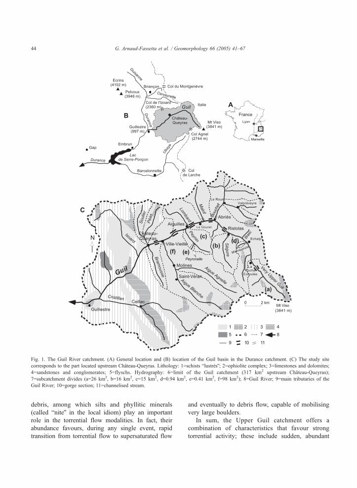
Fig. 1. The Guil River catchment. (A) General location and (B) location of the Guil basin in the Durance catchment. (C) The study site
corresponds to the part located upstream Chateau-Queyras. Lithology: 1=schists blustresQ; 2=ophiolite complex; 3=limestones and dolomites;
4=sandstones and conglomerates; 5=flyschs. Hydrography: 6=limit of the Guil catchment (317 km2 upstream Chateau-Queyras);
7=subcatchment divides (a=26 km2, b=16 km2, c=15 km2, d=0.94 km2, e=0.41 km2, f=98 km2); 8=Guil River; 9=main tributaries of the
Guil River; 10=gorge section; 11=channelised stream.
G. Arnaud-Fassetta et al. / Geomorphology 66 (2005) 41–6744
debris, among which silts and phyllitic minerals
(called bniteQ in the local idiom) play an important
role in the torrential flow modalities. In fact, their
abundance favours, during any single event, rapid
transition from torrential flow to supersaturated flow
and eventually to debris flow, capable of mobilising
very large boulders.
In sum, the Upper Guil catchment offers a
combination of characteristics that favour strong
torrential activity; these include sudden, abundant

G. Arnaud-Fassetta et al. / Geomorphology 66 (2005) 41–67 45
and intense rain falling on steep slopes that have been
dissected into small subcatchments in which accel-
erated runoff and a short response time trigger flash-
flood events.
2.2. A long record of catastrophic floods
Historical records mention several important
events, which variously affected different parts of
the Upper Guil Valley (Table 1). Some of them were
Table 1
Records of historical floods in the Upper Guil Valley (upstream of Chatea
Yeara Month/day Streams affected by flood
2002 July 15–16 GU, SE, BO, AA
2000 October 13–15 GU, BO
2000 June 10–14 GU, BO, PE, AA
1994 June 26 AA
1973 Spring AA
1957 June 13–15 GU, SE, BO, LO, PE, AA
1954 August 21 BR
1953 September 29 GU
1953 June 8 GU, PE
1952 July 24 BR
1948 May 12–15 GU, BO
1947 August 12 BR
1946 August 29 BR
1941 June 22 BR
1920 September 19–25 GU
1897 July GU
1858 – GU
1852 August 5 AA
1810 September or October 13 GU and its tributaries
1810 January 16 GU
1791 October 9–11 GU and its tributaries
1788 September 7 GU
1739 December 3–5 AA
1728 May 19–21 GU, LO
1704 – LO
1651 January 10–14 AA
1469 May 23 GU, SE
1431 June 4–24 GU, SE, BO, LO
1419 – GU
1412 – GU
1409 – GU
1408 – GU, SE, BO, LO
1370 – GU
1332 – GU
a Bold values correspond to large flood events.b GU=Guil; SE=Segure; BO=Bouchet; LO=Lombard; PE=Peynin; AAc ECH=Echalp; RIS=Ristolas; ABR=Abries; LER=Le Roux; GOU=L
Vieille; MOL=Molines.d 1=RTM Archives; 2=Tivollier and Isnel, 1938; 3=Tricart, 1958; 4=T
1988; 7=SOGREAH Archives; 8=Fanthou, 1994; 9=PNRQ; 10=Fort et al
of a quite local extent, mostly at the confluence of the
Guil River and its tributaries. Others were more
widespread affecting the whole valley including all
the villages of Queyras. Houses, churches and grave-
yards have been flooded, and much agricultural land,
and many mills and trails were washed away in events
dating from 1408, 1431, 1791, 1810, 1948 and 1957
[Restauration des Terrains en Montagne (RTM
archives); Tivollier and Isnel, 1938; Tricart, 1958;
Fanthou, 1994].
u-Queyras)
ingb Localities affected by flood hazardc Sourcesd
ECH, GOU 9
RIS, ABR, LER, AIG, CVV 9; 10
ECH, RIS, ABR, LER, AIG, CVV 9; 10
CVV 1
Upstream of VV 4
RIS, ABR, LER, AIG, CVV 1; 3
CVV 1
AIG 1
AIG 1
CVV 1
ABR, LER, AIG, CVV 1; 3
CVV 1
CVV 1
CVV 1
ABR 3
AIG 7
– 2
CVV 1
RIS, ABR, AIG, CVV 1; 2; 7; 11
ECH, RIS 1; 7
RIS, ABR, AIG 1; 3
AIG, CVV 1
– 3; 11
ABR, AIG, CVV 1; 2; 3
AIG 1
MOL 3; 11
RIS 3; 11
RIS, ABR, AIG, CVV 1; 2; 5
AIG, CVV 1
AIG, CVV 1
AIG, CVV 1; 2
RIS, ABR, AIG, CVV 1; 2
CVV 2; 6
CVV 2; 6; 8
=Aigue Agnelle; BR=Brasc.
e Gouret; AIG=Aiguilles; CVV=Chateau-Ville-Vieille; VV=Ville-
ricart, 1974; 5=Lapeyre and Lapeyre, 1982; 6=Lemoine and Tricart,
., 2002; 11=Chaillet, 2002.

G. Arnaud-Fassetta et al. / Geomorphology 66 (2005) 41–6746
Also, various artefacts clearly indicate a high
level of concern about the flood menace within the
village communities. At Abries for instance, a carved
stone, dating from about 1768, was discovered
emplaced at the top of an embankment bordering
the Bouchet stream, probably having been set there
in order to protect the village from future floods (M.
Blanchet, oral communication). Similarly, many
chapels (Chateau-Queyras, Valpreveyre) have been
erected in the past to obtain divine protection against
floods.
Holocene sedimentary and other records (fossil
tree-trunks) of prehistoric floods also provide good
evidence of recurrent torrential activity at least
during the last 4000 years (Fort et al., 2002). The
presence of very thick coarse deposits, cut-and-filled
by the 1957 or 2000 deposits, reflects the existence
of episodes of catchment destabilisation related to
detritic crisis (the bcrises detritiquesQ of Jorda, 1985).
Fig. 2. Selected sites displaying the impacts of the 1957 flood at the main c
accumulation on alluvial fans and channel widening along the Guil River,
fan (1604 m); (B) Guil/Peynin confluence, downstream of Aiguilles (1456
Chateau-Queyras, damming effect upstream the gorges cut into the rocky g
The oldest torrential deposits, radiocarbon dated to
2839–2473 cal. B.C. and 95–319 cal. A.D., are in
fairly good agreement with what is now known of
the Holocene evolution of the southern Alps
(Ballandras, 2002).
2.3. The June 1957 flood
The June 1957 flood (N100-year R.I.), considered
as the reference flood of the Upper Queyras district,
led to the development of extensive flood control
management works. Before the flood, the valley
bottom was drained by the single-thread channel of
the Guil River, which cut into a wide, gravelly and
sandy floodplain, covered by a riparian woodland (in
which larch-trees were predominant) or occupied by
pastures and hay meadows. During the flood, the
entire valley bottom was affected, and the lower
slopes were undermined by lateral cutting, which
onfluences between the Guil River and its tributaries. Note sediment
occupying its entire floodplain. (A) Guil/Segure confluence, Ristolas
m); (C) Guil/Aigue-Agnelle confluence, Ville-Vieille (1379 m); (D)
lacial knob of Chateau-Queyras (1328 m) (IGN aerial photographs).
G. Arnaud-Fassetta et al. / Geomorphology 66 (2005) 41–67 47
triggered landslides and provided huge quantities of
material to the valley bottom. Many log jams
accumulated at the narrow sections; these effectively
dammed the river for a while until outburst flood-
waves occurred, which, in some places, were power-
ful enough to move very large boulders (Tricart,
1961a, referred to ophiolitic green boulders, 2-m
long and exceeding 10–15 tons in weight at Ville-
Vieille). The peak discharge probably reached 315
m3 s�1 at Aiguilles (Koulinski and Lefort, 2000).
Many parcels of land were washed away; for
instance, in Aiguilles, about 50 ha of crops and
meadows were lost and 500 m3 of woodland was
destroyed (RTM). Strong sediment depositions were
observed on alluvial fans of the Guil tributaries (Fig.
2). In the Chateau-Queyras area, the Guil floodplain
was entirely flooded. A temporary lake was formed
after the obstruction of the gorges and considerable
aggradation was observed (estimates N1,000,000 m3;
Tricart, 1961a) (Fig. 2D).
Some management structures existed before 1957,
some probably dating from as early as the 15th century.
At Ristolas for instance, the inhabitants built two large
wooden dikes after the 1419 flood (Tivollier and Isnel,
1938); according to archives (RTM), some embank-
ments were destroyed at Aiguilles during the 1791
flood. Whatever the nature of these old protective
structures, they were in no way comparable in size and
extent to those built after 1957. In fact, after the 1957
disaster, the French Government provided special
funds to enhance flood control structures along many
torrential rivers (i.e., not only the Guil, but also the
Ubaye, the Cerveyrette, and the Arc rivers) that had
been affected by the 1957 event. Many heavy and
costly structures were emplaced. The Upper Guil
tributaries, the Segure, the Bouchet, the Malrif, the
Lombard and the Aigue Blanche were channelised in
their torrential fans with weirs, whereas their longi-
tudinal profile was partly corrected by check-dams in
their upstream gorges (Segure, Lombard). The Guil
River itself was locally channelised, with various types
of protection (dykes, gabions, stony walls and/or
concrete retaining walls, bed armouring), or confined
by embankments also used for road foundations.
However, these protective measures were not contin-
uous, being limited to those fluvial segments with the
greatest vulnerability, where losses had occurred (i.e.,
in the villages). In contrast, many other areas where
there was no human or material stake to protect (i.e.,
floodplain bordered with riparian forest) were left
unmanaged. This was the situation prevailing nearly 50
years later, when the 2000 30-year R.I. flood again
affected the Upper Queyras.
3. Materials and methods
3.1. Photo-interpretation
In order to compare the respective impacts of the
June 1957 and June 2000 floods, we analysed
several sets of air photos for different dates, before
and after the floods, namely: June–July 1956 (IGN;
A23/3537–3697; 1/25,000 scale), June–July 1957
(IGN; FR-086/150; 1/15,000 scale), June 9–22, 1999
(IGN; FD05/250; 1/25,000 scale), June 16, 2000
(RTM; AERIAL 08-00.1266/732; 1/8,000 scale).
Scanning and geometric rectification of photographs
were first performed. Photo analysis was then carried
out in two ways, firstly for specific site studies and
geomorphological mapping, secondly for systematic
analysis of the effect of the floods on active channel
width and, of the impact of engineering works on the
channel response. Eighty sites were selected at
regular intervals (every 250–300 m) along the river
course. The total length studied amounts to 23 km,
which corresponds to the entire Upper Guil River
with the exception of the first 5 km, not photo-
graphed in 1957. We measured the bactive channel
widthQ (Osterkamp and Hedman, 1982), the portion
of the alluvial landscape composed of active,
unvegetated gravel bars and low-flow channel(s) as
defined by Rundle (1985). The compared measure-
ments of active channel width from aerial photos and
the field give a very good correlation between the
two methods (Fig. 3).
3.2. Field survey procedures
Field observations were carried out before (May
1999, May 2000) and after (July 2000, May and July
2001, May, July and September 2002) the 30-year R.I.
flood of June 2000. They include a geomorphological
survey at a 1/6000 scale, and the mapping of
morphological change of bed width and channel
slopes. We tried to quantify the volumes of eroded
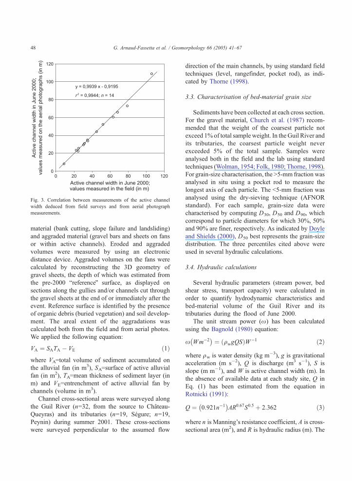
Fig. 3. Correlation between measurements of the active channel
width deduced from field surveys and from aerial photograph
measurements.
G. Arnaud-Fassetta et al. / Geomorphology 66 (2005) 41–6748
material (bank cutting, slope failure and landsliding)
and aggraded material (gravel bars and sheets on fans
or within active channels). Eroded and aggraded
volumes were measured by using an electronic
distance device. Aggraded volumes on the fans were
calculated by reconstructing the 3D geometry of
gravel sheets, the depth of which was estimated from
the pre-2000 breferenceQ surface, as displayed on
sections along the gullies and/or channels cut through
the gravel sheets at the end of or immediately after the
event. Reference surface is identified by the presence
of organic debris (buried vegetation) and soil develop-
ment. The areal extent of the aggradations was
calculated both from the field and from aerial photos.
We applied the following equation:
VA ¼ SATA � VE ð1Þ
where VA=total volume of sediment accumulated on
the alluvial fan (in m3), SA=surface of active alluvial
fan (in m2), TA=mean thickness of sediment layer (in
m) and VE=entrenchment of active alluvial fan by
channels (volume in m3).
Channel cross-sectional areas were surveyed along
the Guil River (n=32, from the source to Chateau-
Queyras) and its tributaries (n=19, Segure; n=19,
Peynin) during summer 2001. These cross-sections
were surveyed perpendicular to the assumed flow
direction of the main channels, by using standard field
techniques (level, rangefinder, pocket rod), as indi-
cated by Thorne (1998).
3.3. Characterisation of bed-material grain size
Sediments have been collected at each cross section.
For the gravel material, Church et al. (1987) recom-
mended that the weight of the coarsest particle not
exceed 1% of total sample weight. In the Guil River and
its tributaries, the coarsest particle weight never
exceeded 5% of the total sample. Samples were
analysed both in the field and the lab using standard
techniques (Wolman, 1954; Folk, 1980; Thorne, 1998).
For grain-size characterisation, the N5-mm fraction was
analysed in situ using a pocket rod to measure the
longest axis of each particle. The b5-mm fraction was
analysed using the dry-sieving technique (AFNOR
standard). For each sample, grain-size data were
characterised by computing D30, D50 and D90, which
correspond to particle diameters for which 30%, 50%
and 90% are finer, respectively. As indicated by Doyle
and Shields (2000), D50 best represents the grain-size
distribution. The three percentiles cited above were
used in several hydraulic calculations.
3.4. Hydraulic calculations
Several hydraulic parameters (stream power, bed
shear stress, transport capacity) were calculated in
order to quantify hydrodynamic characteristics and
bed-material volume of the Guil River and its
tributaries during the flood of June 2000.
The unit stream power (x) has been calculated
using the Bagnold (1980) equation:
x Wm�2� �
¼ qwgQSð ÞW�1 ð2Þ
where qw is water density (kg m�3), g is gravitational
acceleration (m s�2), Q is discharge (m3 s�1), S is
slope (m m�1), and W is active channel width (m). In
the absence of available data at each study site, Q in
Eq. (1) has been estimated from the equation in
Rotnicki (1991):
Q ¼ 0:921n�1� �
AR0:67S0:5 þ 2:362 ð3Þ
where n is Manning’s resistance coefficient, A is cross-
sectional area (m2), and R is hydraulic radius (m). The

G. Arnaud-Fassetta et al. / Geomorphology 66 (2005) 41–67 49
Jarrett (1985) equation was used to determine an initial
value of n in Eq. (3):
n ¼ 0:32S0:38R�0:16 ð4Þ
The critical stream power (xcr) has been defined
by the Costa (1983) equation:
xcr W m�2� �
¼ 0:009D1:68650 ð5Þ
where D50 is median bed-material grain size (mm),
and by the Bagnold (1980) equation, expressed in
Martin and Church (2000) as:
xcr W m�2� �
¼ 5:75 0:04 cs � cwð Þqw½ �3=2 gq�1w
� �1=2D3=2log 12dD�1
� �
ð6Þ
where cs is specific gravity of sediment and cw is
specific gravity of water.
Moreover, mean boundary shear stress (s) exertedby the fluid on the riverbed has been calculated using
the relation of Du Boys (1879):
s ¼ qwgRS
The critical shear stress (scr) needed to initiate
movement depends principally on grain size, accord-
ing to the equation of Lane (1953):
scr N m�2� �
gD ð7Þ
where D is characteristic particle size (cm), and to the
equation of Costa (1983):
scr Nm�2� �
¼ 0:056D1:21350 ð8Þ
Also, in the absence of direct measurements of bed-
material transport, an alternative method of estimating
bed-material transport was required (Gilvear and
Bradley, 1997; Ham and Church, 2000). Bathurst et
al. (1987), followed by Gomez and Church (1989),
concluded that the Schoklitsch (1962) equation per-
forms best when predicting the bed-material transport
capacity in gravel-bed channels. This equation is
defined as:
qub m2s�1� �
¼ 2:5 qsq�1w
� ��1h i
S1:5 QW�1� �
� qcru� �
ð9Þ
where qub is bed-material discharge per unit width
(m2 s�1), qs is sediment density (kg m�3), and qcru is
critical water discharge per unit width for the particle
size D50, defined as:
qcru m2 s�1� �
¼ 0:15g0:5D1:550 S
�1:12 ð10Þ
where D50 is median bed-material grain size (m).
Results from the Schoklitsch (1962) equation were
compared with bed-material transport estimates
obtained with the Lefort (1991) formula. This latter
is interesting because it relies directly the solid
discharge to the liquid discharge without requiring
the calculation of hydraulic conditions, always diffi-
cult to estimate in the case of floods affecting streams
with steep longitudinal gradient. This equation is
defined as:
QsQ�1 ¼ 4:45 D90D
�130
� �0:2qw qs � qwð Þ�1h i
S1:5
� 1� QcQ�1
� �0:375h ið11Þ
where Qs is bed-material discharge (m3 s�1), D90 is
particle diameter for which 90% are finer (m), D30 is
particle diameter for which 30% are finer (m), and Qc
is critical water discharge (m3 s�1), defined by the
equation:
Qc
pgD5
50
� �� ��1 ¼ 0:295S�2:16 1� 1:2Sð Þ2:67 ð12Þ
4. The June 2000 flood, a classic event
4.1. A hydro-meteorological event
This large event was caused by the conjunction of
both triggering and aggravating factors. First, from
June 10 to 14, the catchments of the Upper Guil
River and its left bank tributaries (Maloqueste,
Segure, Peynin, Aigue Agnelle) received some heavy
rain (Abries 276 mm, Saint-Veran 202 mm, Chateau-
Queyras 140 mm) (Fig. 4), which amount was
probably higher on the upper slopes than in these
valley stations. Compared to the 1957 rainfall, that
of June 2000 was not exceptional but, in contrast to
1957, it was strictly localised and concentrated over
the upper ridges of the Upper Guil catchment and
the Mt. Viso massif. Both the chronology of the
event and the maximum hourly intensity (N17.3 mm
h�1) of precipitation recorded explain the immediate

Fig. 4. The June 2000 meteorological event, Abries station (1536 m), where the cumulative maximum rainfall was recorded in the valley. The
event lasted 4 days, with two rainfall peaks; the second one occurred at the same time as the maximum flood wave coming from the Upper Guil
River (source: MeteoFrance and EDF, 2000).
G. Arnaud-Fassetta et al. / Geomorphology 66 (2005) 41–6750
response of the hydrological system and its general
destabilisation. The rainfall started from the south-
ernmost part of the catchment (very Upper Guil
subcatchment and its first-order tributaries such as
the Maloqueste), then moved northwest, propagating
downstream at the same pace as the flood wave
(Beaudouin and Cossart, 2000). The Segure was
affected then the Bouchet, whose flows converged
simultaneously with those coming down from the
Upper Guil River. On the morning of the 13th, the
Guil flood wave reached Aiguilles at about the same
time as the Peynin overflowed its cone. The flood
then moved down to Ville-Vieille and Chateau-
Queyras, and eventually reached the Maison du
Roy dam. The Aigue Agnelle/Aigue Blanche sub-
catchment was less affected, the rain being confined
to the upper slopes.
Aggravating factors reinforced the effects of the
flow event. On the upper slopes of the catchment,
most of the winter snow had only recently melted, so
that the soils were still saturated and so unable to
absorb more water. Moreover, intense runoff along
the mixed torrent/avalanche tracks of the steep,
southeast facing mountain slopes was exacerbated
by the fact that humid air mass was coming straight
from the southeast, and thus directly affected these
mountain slopes.
4.2. Hydro-geomorphic impacts on the Guil
tributaries
The ultimate effect of this sequence of events was
substantial runoff and sediment supply by the head-
waters (Fort et al., 2002). Cut into slaty, schist
bedrock, first-order catchments provided a great
quantity of frost-shattered debris, mobilised as debris
flows or hyperconcentrated torrential flows. The
sediment was composed of a mixture of fine and
coarse material, with maximal grain size exceeding
3.65 m3 (Peyronelle torrent). Parts of this debris
locally accumulated at breaks of slope (12,000 m3
being deposited on the Peyronelle fan), regardless of
whether or not there was a forest cover, while other
parts were transported by the Guil tributaries
(Peynin, Segure), the channels of which were
alternately eroded (destruction and incision of gravel
bed armouring) and aggraded (accumulations of
poorly sorted gravelly/bouldery bars) (Fort et al.,
2002). Adjacent banks or slopes were locally
subjected to failures and landslides: in the Segure,
N25,000 m3 debris were supplied by the lower slopes
to the riverbed (Debail, 2002), whereas in the very
Upper Guil River, the same processes provided about
28,000 m3 of sediment (Bourbon, 2002). We noted
that nearly all active landslide sites were located on

G. Arnaud-Fassetta et al. / Geomorphology 66 (2005) 41–67 51
former landslide scars created during the 1957 flood.
Along the Peynin, a third-order Guil tributary, the
average sedimentary volume mobilised during the
2000 flood was estimated as N82,000 m3, roughly
Fig. 5. Longitudinal distribution of stream power (A) and shear stress (B)
2000). Important fluctuations in the hydraulic parameters are due to variati
are everywhere lower than the values reached during the flood, a fact th
transport capacities.
equally supplied by landsliding and riverbank cutting
(Einhorn, 2002).
The lower slopes all contributed significantly to
the addition of mixed, fine and very coarse sediment
in the Guil Valley, from its source down to Chateau-Queyras (June
ons in longitudinal slopes. Note that values of critical stream power
at explains the large volume of sediments mobilised and the high

G. Arnaud-Fassetta et al. / Geomorphology 66 (2005) 41–6752
load to the channel, thus giving a sediment yield of
2540–3925 m3 km2 (very Upper Guil River), 5310
m3 km2 (Segure Torrent) and 7665–11,000 m3 km2
(Peynin Torrent). This substantial sediment yield
resulted in rapid change in flow mode (i.e., debris
flows, hyperconcentrated flows). Moreover, factors
such as fluctuations in rainfall intensity, breaking up
of log jams, or the presence of nonadjustable, rocky
Fig. 6. Comparison of the active channel width of the Guil River before a
measured on IGN aerial photographs dated from 1956, 1957, 1999 and 20
the section type (constrained or not by the presence of rocky outcrops a
impacts of both events are comparable, and the June 2000 event might eve
about 40% of the 1957 channel width; yet locally (upstream of short gorg
reaches along the longitudinal profiles, explain the
discontinuity and the rapid shift in both space and
time of the different hydro-geomorphic processes
during such events.
In fact, the specific stream power of these streams
was greater than their critical stream power, which
explains the abundant solid discharge effectively
transported during the flood (the discharge amount
nd after the June 1957 and June 2000 events (active channel width
00). The amplitude of variations in active channel width depends on
nd/or tributary fans). Upstream of La Roche Ecroulee (site 9), the
n be larger. Downstream, the active channel width in 2000 was only
e sections), the width was similar during both events.
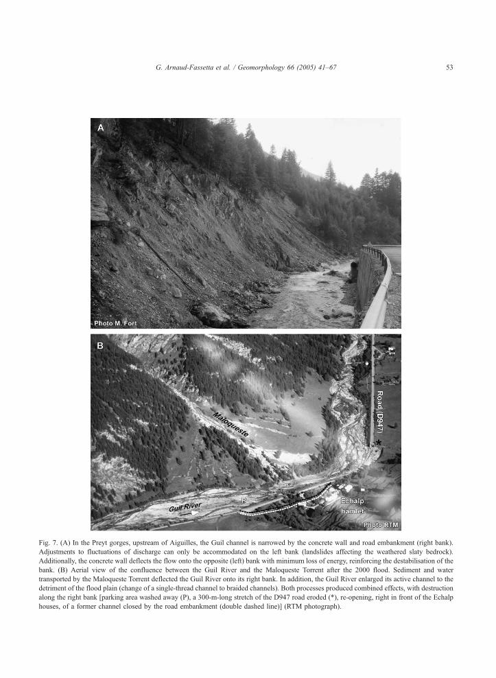
Fig. 7. (A) In the Preyt gorges, upstream of Aiguilles, the Guil channel is narrowed by the concrete wall and road embankment (right bank).
Adjustments to fluctuations of discharge can only be accommodated on the left bank (landslides affecting the weathered slaty bedrock).
Additionally, the concrete wall deflects the flow onto the opposite (left) bank with minimum loss of energy, reinforcing the destabilisation of the
bank. (B) Aerial view of the confluence between the Guil River and the Maloqueste Torrent after the 2000 flood. Sediment and water
transported by the Maloqueste Torrent deflected the Guil River onto its right bank. In addition, the Guil River enlarged its active channel to the
detriment of the flood plain (change of a single-thread channel to braided channels). Both processes produced combined effects, with destruction
along the right bank [parking area washed away (P), a 300-m-long stretch of the D947 road eroded (*), re-opening, right in front of the Echalp
houses, of a former channel closed by the road embankment (double dashed line)] (RTM photograph).
G. Arnaud-Fassetta et al. / Geomorphology 66 (2005) 41–67 53
G. Arnaud-Fassetta et al. / Geomorphology 66 (2005) 41–6754
also being conditioned by the characteristics of the
catchment debris supply). Along the Segure tributary,
specific stream power was estimated to range from 121
to 1350 W m�2, whereas along the Peynin tributary,
estimates ranged from 227 to 1404 W m�2, and along
the debris-flow prone Peyronelle subtributary, it was
estimated to be 5489 W m�2. In contrast, estimates for
the uppermost reaches of the Upper Guil River were
lower (63 to 1128 W m�2: Fort et al., 2002). All these
values are minimum estimates.
4.3. Hydro-geomorphic impacts on the Guil Valley
The maximum discharge of the Guil River was
estimated (Koulinski and Lefort, 2000) to be 180 m3
s�1 at Aiguilles (1957: 315 m3 s�1), for an mean annual
discharge of 6 m3 s�1 and a mean June discharge of 18
m3 s�1 (SOGREAH et al., 1991). From the Roche
Ecroulee to Chateau-Queyras, the specific stream
power, always higher than the critical stream power,
was estimated to vary from 51 to 276 W m�2 (Fig. 5).
This explains the high transport capacity, estimated to
be 105–140 m3 km�2.
The flood impacts on the Guil valley floor were
influenced by variations in the floodplain and/or
channel geometry, in particular by the succession of
long, 250-m-wide stretches alternating with short,
narrow gorge sections (Le Preyt, Chateau-Queyras),
causing water impoundment upstream. The swelling of
the Guil River caused the submersion of, and aggrada-
tion within, a large part of the floodplain (i.e., Echalp,
Gouret, Aiguilles), generalised bank erosion (whatever
the substratum, be it alluvial, colluvial, or schists) and
quite systematic changes in the river pattern. The
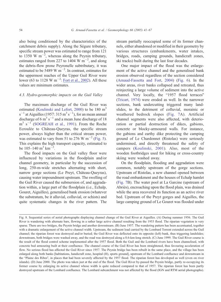
Fig. 8. Sequential series of aerial photographs displaying channel change
River is wandering with alternate bars, flowing in a rather large active ch
sparse. There are two bridges, the Peynin bridge and another downstream. (
with a dramatic enlargement of the active channel width. Upstream, the sed
channel; the riparian forest was destroyed and/or buried; the Guil River w
downstream, both bridges were washed away, and the road was destroyed a
the result of the flood control scheme implemented after the 1957 flood.
concrete bed armouring built at their confluence. The channel course of t
flow. No serious flood has affected the Guil River since 1957. The Peynin
enlarged along both banks [habitations, handicraft zone, hospital (H), spor
the bPlaine des RibesQ, in places that had been severely affected by the 1
islands). (D) June 2000. The photo was taken just at the end of the flood.
former course by enlarging its active channel whose width is quite redu
destroyed upstream of the Lombard confluence. The Lombard subcatchme
stream partially reoccupied some of its former chan-
nels, either abandoned or modified in their geometry by
various structures (embankments, water intakes,
bridges, roads, camping grounds, handicraft zones,
ski tracks) built during the last four decades.
One major impact of the flood was the enlarge-
ment of the active channel and the generalised bank
erosion observed regardless of the section considered
(Arnaud-Fassetta and Fort, 2004) (Fig. 6). In the
wider areas, river banks collapsed and retreated, thus
reinjecting a large volume of sediment into the active
channel. Very locally, the b1957 flood terracesQ(Tricart, 1974) were eroded as well. In the narrower
sections, bank undercutting triggered many land-
slides, to the detriment of colluvial, morainic or
weathered bedrock slopes (Fig. 7A). Artificial
channel segments were also affected, with deterio-
ration or partial destruction of dikes, gabions,
concrete or blocky-armoured walls. For instance,
the gabions and earthy dike protecting the camping
ground of Le Chardonnet (Ristolas) were seriously
undermined, and directly threatened the safety of
campers (Koulinski, 2001). Also, most of the
wooden footbridges used for hiking or cross-country
skiing were washed away.
On the floodplain, flooding and aggradation were
common, notably upstream of the gorge sections.
Upstream of Ristolas, a new channel opened between
the road embankment and the houses of Echalp hamlet
(Fig. 7B). The water pool at La Garcine (upstream of
Abries), encroaching upon the flood plain, was drained
while the area recovered its function as an active river
bed. Upstream of the Preyt gorges and Aiguilles, the
large camping ground of Le Gouret was flooded under
of the Guil River at Aiguilles. (A) During summer 1956. The Guil
annel resulting from the 1953 flood. The riparian vegetation is very
B) June 1957. The wandering pattern has been accentuated, together
iment load carried by the Lombard Torrent extended across the Guil
as deflected onto its opposite (left) bank, thus triggering landslides;
long a 0.6-km-long stretch. (C) June 1999. The Guil River course is
Both the Guil and the Lombard rivers have been channelised, with
he Guil River has been straightened, thus favouring acceleration of
bridge has been rebuilt in the same place, and the village has been
ts ground], upstream of the Lombard confluence and downstream in
957 flood. The riparian forest has developed as well (even on river
The Guil River by-passed the Peynin bridge, partly re-occupying its
ced compared to that of 1957. The riparian forest has been partly
nt was not affected by the flood (IGN and RTM aerial photographs).

G. Arnaud-Fassetta et al. / Geomorphology 66 (2005) 41–67 55
about 2 m of water. The resulting decrease in velocity
caused the abandonment of the transported sandy load
with, in some places, 1.5-m-thick deposits displaying
ripple marks suggesting tractive water flows. Obvi-
ously, the river reoccupied part of its floodplain as an
efficient way to dissipate its excess energy.

G. Arnaud-Fassetta et al. / Geomorphology 66 (2005) 41–6756
At a more general level, numerous changes
affected the river pattern, as becomes evident when
comparing the 1999 situation with that prevailing
after June 2000. In 1999, the Guil River had a
single-thread channel, bordered by vegetated, grav-
elly and sandy banks, artificially channelised in
places. After the flood, many stretches were (and
still are in 2002) braided (Arnaud-Fassetta and Fort,
2004), as a response to the sediment supply into the
riverbed (sections between Echalp hamlet and
Ristolas, between Ristolas and Abries). Other
changes occurred at the confluences between the
Guil River and its tributaries. For instance, the
Maloqueste subcatchment (left bank) delivered a
voluminous debris flow that spread across its
confluence fan, the water and debris encroaching
Fig. 9. The Peynin bridge at Aiguilles, during and after the 2000 June flood.
nearly buried by sediment and the new channel opened by the Guil River on i
the Peynin bridge, blocked by sediment (PNRQ). The cross-sectional area is
and the gravels removed have been piled on both banks as levees to re-establi
The upstream-progressing erosion subsequent to the dredging of the Guil r
armouring has been built in order to protect the right bank and the hospital
upon the Guil floodplain, then deflecting the Guil
onto its right bank, thus causing the destruction of a
300-m-long stretch of the road at the Echalp hamlet
(Fig. 7B).
Other indirect impacts occurred subsequent to the
flood. In fact, the context prevailing before the flood
was predominantly narrowing and incision, as
observed along the upper Guil River prior to the
June 2000 flood (e.g., comparison of long profile
and/or cross sections surveys, undermined structures
such as bridge piles, etc.; Parc Naturel Regional du
Queyras, 2002). This trend, generally interpreted as
an adjustment to land-use change (afforestation) and
torrential control works, is in agreement with the
behaviour of other alpine streams (Bravard et al.,
1997; Liebault and Piegay, 2002). This trend was
(A) June 13th. Oblique aerial view (RTM) showing the Peynin bridge
ts left bank. The cross-sectional area was 82m2. (B) June 14. Detail of
reduced to 8.68m2. (C) July 2000. The Guil channel has been dug out,
sh one single channel flowing under the Peynin bridge. (D)May 2002.
iverbed has undermined the base of the bridge piles. Concrete stone
downstream, whereas the left bank has been left unmanaged.

G. Arnaud-Fassetta et al. / Geomorphology 66 (2005) 41–67 57
temporarily offset by the flood (abundant aggrada-
tion), but was reset with the lowering of the flow,
thus causing more destabilisation (undermining) of
the existing protective structures such as river dikes
or road embankments. This also made the entire
torrential system more sensitive to subsequent
bminorQ events (i.e., avalanches of late winter and
spring 2001, 10- to 15-year R.I. floods of October
2000 and July 2002).
Fig. 10. Comparative maps showing flood impacts and land-use changes tha
and 2000. Obviously, the vulnerability of this village has increased, due t
channel of the Guil River and on the Peynin fan. 1=1957 active channel; 2
5=secondary channels; 6=1957 flood plain extent; 7=flood control structu
structure: concrete bed armouring; 9=village; 10=building away from the
flooded in 2000; 12=damaged building; 13=road; 14=damaged or destroy
bridge; 18=ski pylon; 19=damaged or destroyed ski pylon; 20=ski run.
4.4. Case study: Aiguilles
The worst damage took place at Aiguilles village
where the Guil waters, flowing rapidly through the
bPreyt gorgesQ, spread over the bPlaine des RibesQ,opened new channels on one side of the bridge and
destroyed many commercial buildings. One kilometre
downstream, the Guil waters were impeded again at the
Peynin confluence, where this uncontrolled tributary
t took place in the Plaine des Ribes (Aiguilles village) between 1957
o the many buildings and activities sited in the former 1957 active
=floodplain; 3=zone of aggradation (torrential fan); 4=main channel;
re: concrete embankment and weirs; 8=channel degradation control
1957 flood plain; 11=building sited on the 1957 flood plain, not
ed road; 15=bridge; 16=aggraded bridge; 17=damaged or destroyed

Fig. 11. Sequential series of photographs showing changes that occurred on the Peynin fan before (A), during (B), a few hours after (C) and a
few weeks after (D) the overflowing of the Peynin fan. Before the 2000 flood, the fan was partly occupied by a handicraft zone (left bank) and
by ski runs and installations (right bank). On the morning of June 13, the right bank was breached. The transport capacity of the Peynin,
reinforced by its traverse through steep gorges upstream, explains the amount of debris suddenly deposited on the fan. A few weeks later, a new
straight channel had been artificially dug out, and the right bank has since been re-shaped by bulldozing to restore the ski runs.
G. Arnaud-Fassetta et al. / Geomorphology 66 (2005) 41–6758
overflowed its right bank and injected more water and
debris into the Guil River.
Several processes came together to produce
catastrophic consequences. In the Preyt gorges, the
water level and the power of the Guil River
increased, thus favouring landsliding on the left
bank and the blocking then the destruction of both a
small dam and a water intake on the right bank. The
high discharge of the Guil entering the Aiguilles
Fig. 12. The Peynin fan before and during the June 2000 flood, the Guil R
energy by widening its active channel over the 10-year flood limit, by lat
across forested areas established on the b1957 flood terraceQ. The destabi
another minor flood that occurred in early October 2000. 1=active chann
5=100-year R.I. flood limit on the Guil River; 6=100-year R.I. flood limit
8=June 2000 morphodynamically active area beyond 10-year R.I. flood li
R.I. flood limit; 10=major morphodynamic adjustments between June an
14=camping ground; 15=road; 16=damaged or destroyed road; 17=bridge
basin caused partial destruction of the riparian forest
(Fig. 8C) and overbank flooding (82 m2 cross-
sectional area) near Peynin bridge, in particular
because of gravel aggradation in the channel and
the subsequent reduction in the cross-sectional area
under the bridge (from 31.58 to 8.68 m2) (Fig. 9).
The waters, prevented from flowing on the right
bank by the road embankment and by additional
protection (sandbags) for the hospital (Fig. 8D),
iver naturally expanded across the Plaine d’Aiguilles, dissipating its
eral cutting and eventually by braiding. New channels were opened
lisation of the fluvial system can be appreciated from the effects of
el; 2=zone of aggradation; 3=main channel; 4=secondary channel;
of the Guil tributaries; 7=10-year R.I. flood limit on the Guil River;
mit; 9=June 2000 morphodynamically active area beyond 100-year
d October 2000; 11=forest; 12=field or stripped soil; 13=building;
; 18=destroyed bridge.
G. Arnaud-Fassetta et al. / Geomorphology 66 (2005) 41–67 59
spread over the left bank, in the handicraft zone, thus
reoccupying their former (pre-1957) channel course
(Fig. 10). The two buildings of the carpenter’s
workshop, one civil engineering company building,
and a small house were damaged. Overbank flow
also occurred on the right bank downstream of the

G. Arnaud-Fassetta et al. / Geomorphology 66 (2005) 41–6760
bridge, destroying the swimming pool and threat-
ening a restaurant. Further down the Plaine des
Ribes, light, wooden bridges (used for cross-country
skiing) were swept away.
At the Peynin confluence, the Plaine des Ribes
was inundated, and the Guil River was deflected
against its left bank, blocked by the road embank-
ment, which suffered some damage. The excess
sediment load carried by the Peynin Torrent (debris-
flow pulses), in addition to the sharp slope break at
the confluence with the Guil Valley, caused instanta-
neous aggradation (Fig. 11). The resulting blocking
by debris of the straight, artificial channel, together
with the formation of log jams concentrated around a
narrow bridge downstream, forced the Peynin Tor-
rent to change its course and to overflow its right
bank (resulting in destruction of ski installations, in
particular of a water intake for artificial snow). In
fact, the Peynin Torrent swept across its fan, and
accumulated a volume of debris estimated to be
15,000 m3 (Beaudouin, 2001).
Further downstream, the Guil was deflected by the
road embankment, causing it to swing against its
opposite (left) bank, which was then eroded well above
the decadal flood limit. A section of the dirt road and
pieces of land underlain by the b1957 flood terraceQwere washed away (Fig. 12).
5. Discussion on the role of human impact on flood
effects
Two types of structures require consideration,
namely those related to flood prevention and those
arising from recent changes in the local economy.
5.1. To what extent were the post-1957 flood control
structures aggravating factors?
First, comparative study of the geomorphic con-
sequences of both the 1957 and 2000 floods provides
a basis for assessment of the efficiency of flood
control structures built after the 1957 event. On the
one hand, the flood was partly controlled by the
post-1957 preventive structures (Segure, Lombard,
Aigue Agnelle). At the Segure/Guil confluence, for
instance, the Segure flows have been constrained and
their velocity accelerated by embankments, in order
to protect Ristolas village and to avoid repetition of
the disastrous 1957 flood, during which the Segure
swept over the entire village, causing aggradation
that locally exceeded 6 m in thickness (Fig. 13). In
2000, the artificial channel efficiently constrained the
flood. In contrast, the absence of post-1957 protec-
tion on the Peynin fan (an omission arising from the
fact that the fan at that time was devoid of any
human use) caught out Aiguilles villagers in 2000; it
appears to have been forgotten that, in 1957, about
30,000 m3 of debris (SOGREAH et al., 1991) had
spread over the Peynin fan. We thus think the
contrasting responses of the Segure and Peynin
torrents are directly related to the mitigating effect
of engineering works conducted or not on their
alluvial fans. This assessment is supported by the
fact that other factors, such as geology, relief,
sediment sources, land-use, are very similar in both
catchments and do not create different landscape
sensitivity to rainfall. Another factor that might
explain a contrasting response would be that rainfall
was not uniformly distributed in space; this
assumption cannot be entirely ruled out, however
both reports by local people and observed geo-
morphic effects in these upper catchments suggest
the rainfall intensities and duration were not
significantly different.
Clearly, therefore, the flood-mitigation structures
installed have a certain effectiveness. On the other
hand, some of them (such as those around Ville-
Vieille) were partly damaged in 2000 due to poor
maintenance (Fig. 14). Thus, their effectiveness in the
face of a flood greater than a 30-year recurrence
period may be seriously questioned.
Second, some man-made structures such as under-
designed bridges, or the upstream/downstream dis-
continuities and irregularities in the degree of channel
management, were obviously aggravating factors. At
Aiguilles, the Peynin bridge is quite narrow, and its
cross-sectional area is too small to accommodate flood
discharges greater than the 10-year R.I. flood,
especially if important aggradation takes place as
occurred during the 30-year R.I. 2000 flood (Fig. 9B).
In Ristolas, the presence of a concrete weir built at the
downstream bridge has artificially maintained the
longitudinal profile of the Guil River at a level higher
than would have occurred in natural conditions. The
weir was destroyed during the June 2000 flood, thus
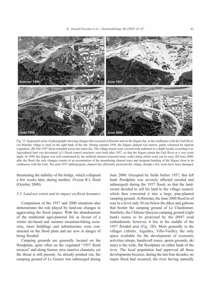
Fig. 13. Sequential series of photographs showing changes that occurred at Ristolas and on the Segure fan, at the confluence with the Guil River.
(A) Ristolas village is sited on the right bank of the fan. During summer 1956, the Segure channel was narrow, partly colonised by riparian
vegetation. (B) The 1957 flood extended across the entire fan. The village streets were covered with sediment to a depth locally exceeding 6 m.
Agricultural land was devastated. (C) Flood control structures were built after 1957, so that the Segure joined the Guil River at a very acute
angle. In 1999, the Segure was well constrained by the artificial channel (concrete-stony walls) along which weirs can be seen. (D) June 2000:
after the flood, the only changes consist of an accentuation of the meandering channel trace and incipient braiding of the Segure close to its
confluence with the Guil. The post-1957 anthropogenic channel has efficiently protected the village, though a few weirs have been damaged.
G. Arnaud-Fassetta et al. / Geomorphology 66 (2005) 41–67 61
threatening the stability of the bridge, which collapsed
a few weeks later, during another, 10-year R.I. flood
(October 2000).
5.2. Land-use extent and its impact on flood dynamics
Comparison of the 1957 and 2000 situations also
demonstrates the role played by land-use changes in
aggravating the flood impact. With the abandonment
of the traditional agro-pastoral life in favour of a
winter ski-based and summer mountain-hiking econ-
omy, more buildings and infrastructure were con-
structed on the flood plain and are now in danger of
being flooded.
Camping grounds are generally located on the
floodplain, quite often on the vegetated b1957 flood
terracesQ and along former, now inactive channels; yet
the threat is still present. As already pointed out, the
camping ground of Le Gouret was submerged during
June 2000. Occupied by fields before 1957, this left
bank floodplain was severely affected (eroded and
submerged) during the 1957 flood, so that the land-
owner decided to sell his land to the village council,
which then converted it into a large, pine-planted
camping ground. At Ristolas, the June 2000 flood level
rose to a level only 30 cm below the dikes and gabions
that border the camping ground of Le Chardonnet.
Similarly, the Chateau-Queyras camping ground (right
bank) seems to be protected by the D947 road
embankment; however, it lies in the middle of the
1957 flooded area (Fig. 2D). More generally in the
villages (Abries, Aiguilles, Ville-Vieille), the only
space available for the development of economic
activities (shops, handicraft zones, sports grounds, ski
runs) is the wide, flat floodplain on either bank of the
river. The local population had approved all these
developments because, during the last four decades, no
major flood had occurred, the river having naturally
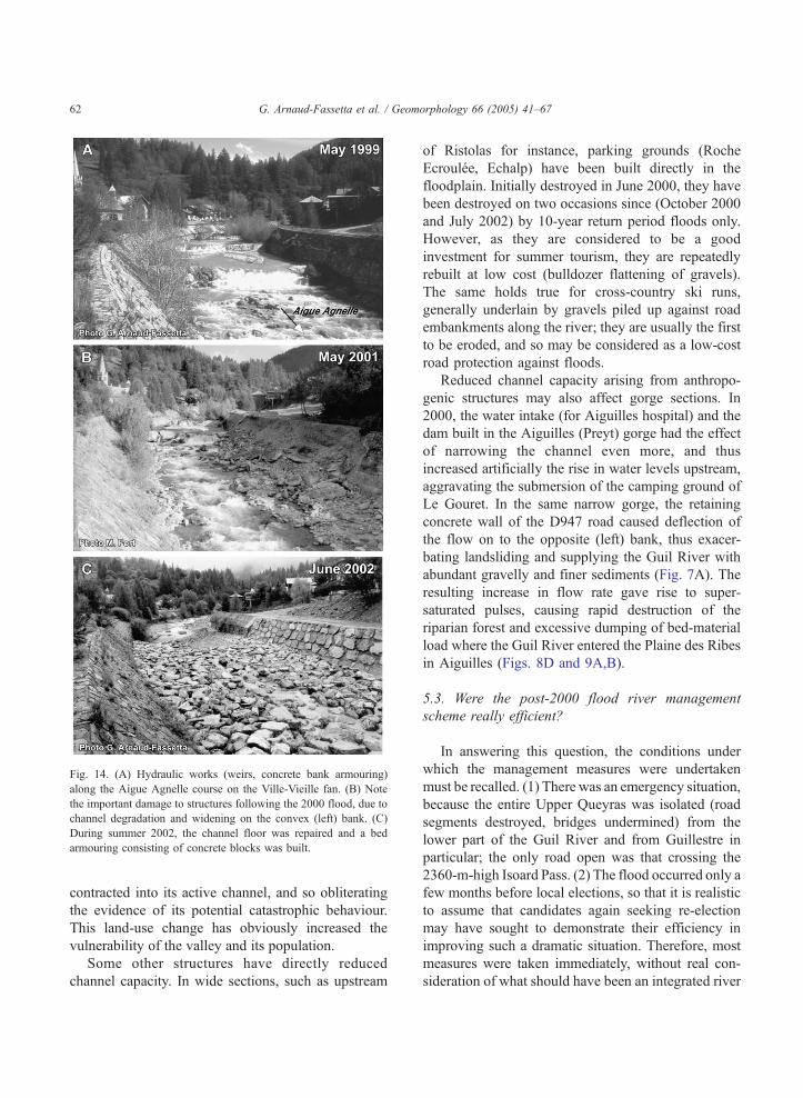
Fig. 14. (A) Hydraulic works (weirs, concrete bank armouring)
along the Aigue Agnelle course on the Ville-Vieille fan. (B) Note
the important damage to structures following the 2000 flood, due to
channel degradation and widening on the convex (left) bank. (C)
During summer 2002, the channel floor was repaired and a bed
armouring consisting of concrete blocks was built.
G. Arnaud-Fassetta et al. / Geomorphology 66 (2005) 41–6762
contracted into its active channel, and so obliterating
the evidence of its potential catastrophic behaviour.
This land-use change has obviously increased the
vulnerability of the valley and its population.
Some other structures have directly reduced
channel capacity. In wide sections, such as upstream
of Ristolas for instance, parking grounds (Roche
Ecroulee, Echalp) have been built directly in the
floodplain. Initially destroyed in June 2000, they have
been destroyed on two occasions since (October 2000
and July 2002) by 10-year return period floods only.
However, as they are considered to be a good
investment for summer tourism, they are repeatedly
rebuilt at low cost (bulldozer flattening of gravels).
The same holds true for cross-country ski runs,
generally underlain by gravels piled up against road
embankments along the river; they are usually the first
to be eroded, and so may be considered as a low-cost
road protection against floods.
Reduced channel capacity arising from anthropo-
genic structures may also affect gorge sections. In
2000, the water intake (for Aiguilles hospital) and the
dam built in the Aiguilles (Preyt) gorge had the effect
of narrowing the channel even more, and thus
increased artificially the rise in water levels upstream,
aggravating the submersion of the camping ground of
Le Gouret. In the same narrow gorge, the retaining
concrete wall of the D947 road caused deflection of
the flow on to the opposite (left) bank, thus exacer-
bating landsliding and supplying the Guil River with
abundant gravelly and finer sediments (Fig. 7A). The
resulting increase in flow rate gave rise to super-
saturated pulses, causing rapid destruction of the
riparian forest and excessive dumping of bed-material
load where the Guil River entered the Plaine des Ribes
in Aiguilles (Figs. 8D and 9A,B).
5.3. Were the post-2000 flood river management
scheme really efficient?
In answering this question, the conditions under
which the management measures were undertaken
must be recalled. (1) There was an emergency situation,
because the entire Upper Queyras was isolated (road
segments destroyed, bridges undermined) from the
lower part of the Guil River and from Guillestre in
particular; the only road open was that crossing the
2360-m-high Isoard Pass. (2) The flood occurred only a
few months before local elections, so that it is realistic
to assume that candidates again seeking re-election
may have sought to demonstrate their efficiency in
improving such a dramatic situation. Therefore, most
measures were taken immediately, without real con-
sideration of what should have been an integrated river

G. Arnaud-Fassetta et al. / Geomorphology 66 (2005) 41–67 63
basin management scheme. Most actions taken were of
relatively low cost and meant to be only temporary.
These measures consisted of narrowing and dredging
the channel cross section, correcting the channel course
and re-establishing as rapidly as possible the conditions
for economic activity (road foundations and embank-
ments, road- and foot-bridges, parking areas, etc.).
One generalised action (along both natural and
urbanised reaches) was the narrowing of channel cross-
sectional area by artificial levees, built with loose
gravels taken up directly from the river channel (Fig.
9C). These stone dikes, stretching parallel to the low
water channel, were meant to restrict the braiding river
course within one channel as had been the case before
the flood, and to force the river to incise its alluvial
floor, thus indirectly reducing the frequency of over-
bank floods. However, we speculate that this approach
is illusory. First, bed armouring prevents channel
incision during annual floods, so that the channel
capacity remains insufficient for a 10- to 30-year flood
event. Strong riverbed degradation (armour removal)
increases the critical height of the levees for planar/slab
failure. Second, during extreme events, these artificial
levees offer little resistance to erosion because the
channel competence during flood is greater than the
resistance offered by the grain-size of the material
constituting the artificial levees. In these conditions, the
channel tends to widen and to be infilled, causing a
higher flood risk in the flood plain (Fig. 15A).
A complementary measure adopted was the exca-
vation of the Guil channel, designed to increase the
cross-sectional area and thus to avoid another cata-
strophic, overbank flood situation. In doing so, how-
ever, the managers introduced the possibility of
upstream-progressing erosion, which may destabilise
existing structures, including those dating from the
older (post-1957) flood control schemes (Fig. 15B).
This holds particularly true at Aiguilles, where both the
dredging of the gravels, accumulated under the Peynin
bridge during the flood (Fig. 9B,C), and additional
artificially dredged 1.5-m-deep channel in the Guil
River have induced regressive linear incision, threat-
ening directly the piles of the Peynin bridge. Two years
on from the 2000 event (summer 2002), regressive
incision has reached, and has begun to attack, the
concrete bed armouring built after the 1957 flood at the
Lombard confluence (some 500 m upstream of the
bridge). As a consequence, this important and formerly
very efficient structure has been undermined and is
rapidly deteriorating (release of stones, collapsing
slabs), with a N3-m-deep plunge pool accelerating the
process. Ultimately, this process constitutes a threat to
the Lombard artificial channel that protects the eastern
part of Aiguilles village (Fig. 10B). A similar, though
less critical situation is also observed at Ristolas.
Another management intervention taken at
Aiguilles only a few weeks after the flood was the
digging of a new, straight, artificial channel for the
Peynin stream, aligned at right-angles to the Guil River
(Fig. 11D). Indeed, the handicraft buildings on the left
bank had to be protected to the detriment of the right
bank (ski runs). However, any further major flood is
likely to see the re-establishment of the Peynin’s
course, which will continue to deflect the flow of the
Guil onto the opposite (right) bank, thus posing a
further threat to the already-damaged road embank-
ment. In fact, a new scheme is under study, designed to
deviate the entire Peynin course onto its left bank, in
such a way that its confluence would join the Guil
channel at a more acute angle (similar to the Segure
confluence), in order to avoid the damming effects of
such tributary convergence (Koulinski, 2000). How-
ever, the decision has not yet been made to modify the
Peynin course because of local interests and conflicts.
Other measures adopted have included rebuilding
bridges, at the same places and sometimes of the same
size as before the flood. Although, following its
destruction, the bridge connecting the road to the
Peynin cone, downstream of Aiguilles, was rebuilt with
a wider roadbed (30 m instead of 16 m), and so able to
absorb the effects of higher river discharges, the same
rather small cross-sectional area was retained in the
case of the intact Peynin bridge. In fact, because of the
cost of such a structure, it was decided to wait until
another major flood destroys the bridge, so that a new,
larger bridge will then be constructed, and the left bank
protected (handicraft zone). So far, the left bank has
been left unmanaged as the lesser evil, for the flooding
of the handicraft zone is considered less of a disaster
than the flooding of the hospital (concrete rock-
armouring rebuilt on the right bank; Fig. 9D).
This last example provides some insight into
acceptable future valley management. In such high
mountainous environments, it is preferable to keep
most of the valley bottom clear of buildings, thus
ensuring that the river has sufficient space to migrate
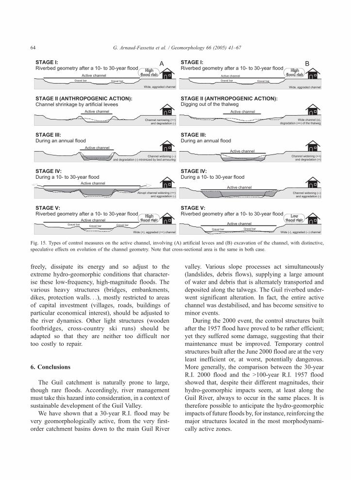
Fig. 15. Types of control measures on the active channel, involving (A) artificial levees and (B) excavation of the channel, with distinctive,
speculative effects on evolution of the channel geometry. Note that cross-sectional area is the same in both case.
G. Arnaud-Fassetta et al. / Geomorphology 66 (2005) 41–6764
freely, dissipate its energy and so adjust to the
extreme hydro-geomorphic conditions that character-
ise these low-frequency, high-magnitude floods. The
various heavy structures (bridges, embankments,
dikes, protection walls. . .), mostly restricted to areas
of capital investment (villages, roads, buildings of
particular economical interest), should be adjusted to
the river dynamics. Other light structures (wooden
footbridges, cross-country ski runs) should be
adapted so that they are neither too difficult nor
too costly to repair.
6. Conclusions
The Guil catchment is naturally prone to large,
though rare floods. Accordingly, river management
must take this hazard into consideration, in a context of
sustainable development of the Guil Valley.
We have shown that a 30-year R.I. flood may be
very geomorphologically active, from the very first-
order catchment basins down to the main Guil River
valley. Various slope processes act simultaneously
(landslides, debris flows), supplying a large amount
of water and debris that is alternately transported and
deposited along the talwegs. The Guil riverbed under-
went significant alteration. In fact, the entire active
channel was destabilised, and has become sensitive to
minor events.
During the 2000 event, the control structures built
after the 1957 flood have proved to be rather efficient;
yet they suffered some damage, suggesting that their
maintenance must be improved. Temporary control
structures built after the June 2000 flood are at the very
least inefficient or, at worst, potentially dangerous.
More generally, the comparison between the 30-year
R.I. 2000 flood and the N100-year R.I. 1957 flood
showed that, despite their different magnitudes, their
hydro-geomorphic impacts seem, at least along the
Guil River, always to occur in the same places. It is
therefore possible to anticipate the hydro-geomorphic
impacts of future floods by, for instance, reinforcing the
major structures located in the most morphodynami-
cally active zones.
G. Arnaud-Fassetta et al. / Geomorphology 66 (2005) 41–67 65
Two different conceptions of river management
are encountered locally. On the one hand, most
villagers press for a rapid rehabilitation of the flood
control structures, similar both in design and location
to the existing (pre-2000) structures. They even
make a case for better protection in order to include
new settlements and activities developed in relation
to the tourism economy. These projects require
considerable amounts of money, in a context of
restricted funding by the State agencies (Restauration
des Terrains en Montagne, Direction Departementale
de l’Equipement, Region). On the other hand, a large
minority of people, most often supported by non-
residents, are increasingly concerned about the
quality of life and the environment, and see the
river (together with the mountain environment) as a
rich ecological system that has to be protected. They
reject environmentally destructive structures (such as
dredging or continuous embankment) and plead for
more conservative, Tlightr structures (involving
more local river training works than sophisticated
civil engineering work), good enough to absorb the
most frequent (10-year magnitude) floods; although
undoubtedly damaged by the larger events, such
structures can also be repaired at a lower cost for the
community.
Like in any other part of the Western Alps, river
management in Queyras should moderate the need for
economic development with reference to hydro-geo-
morphic dynamics. Whatever the final outcome, any
management scheme should allow the river sufficient
space to dissipate its energy during flood events, as well
as taking care to avoid siting buildings or other
structures in dangerous places. This requires coordina-
tion at the river basin scale, between the different
villages of the valley as well as between the various
users of the stream waters, and cannot be implemented
without prevention/warning systems adapted to a
population living only seasonally in such a potentially
hazardous environment.
Acknowledgements
Valuable information was provided by the Parc
Naturel Regional du Queyras (PNRQ, Guillestre), by
the agency Restauration des Terrains en Montagne
(RTM) des Hautes-Alpes (Gap), and by the Archives
Departementales des Hautes-Alpes (Gap). We
acknowledge with thanks S. Pagnol (PNRQ) for many
and very fruitful discussions and for her help in
collecting some data. Thanks are also due to P.
Vauterin, Head, and J. Vuillot (RTM), to M. Blanchet
(PNRQ), Chris de B. (Aiguilles) and Mrs. Tripotin
(Institut Geographique National). Assistance in the
field was provided by C. Bourbon, B. Debail and B.
Einhorn (Universite Paris VII-Denis Diderot). The
authors are deeply indebted to Prof. E. Derbyshire
(Royal Holloway, U.K.) who carefully edited the
English manuscript. The review comments of Mauro
Marchetti (Universita di Modeno e Reggio Emilia,
Italy) and an anonymous reviewer greatly helped in
improving the manuscript.
References
Arnaud-Fassetta, G., Fort, M., 2004. La part respective des facteurs
hydro-climatiques et anthropiques dans l’evolution recente
(1956–2000) de la bande active du Haut Guil, Queyras, Alpes
francaises du Sud. Mediterranee 1–2, 143–156.
Bagnold, R.A., 1980. An empirical correlation of bedload transport
rates in flumes and natural rivers. Proceedings of the Royal
Society of London 372A, 453–473.
Ballandras, S., 1993. Les crues torrentielles de l’ete 1987 dans les
Alpes. Interpretations et enseignements. Revue de Geographie
Alpine 3, 13–32.
Ballandras, S., 2002. L’evolution des formes de relief et des
formations torrentielles alpines depuis 4700 BP. Quaternaire 13
(3–4), 267–277.
Bathurst, J.C., Graf, W.H., Cao, H.H., 1987. Bed load discharge
equations for steep mountain rivers. In: Thorne, C.R., Bathurst,
J.C., Hey, R.D. (Eds.), Sediment Transport in Gravel-bed
Rivers. John Wiley and Sons, Chichester, pp. 453–491.
Beaudouin, B., 2001. La crue du Guil (Hautes-Alpes) du 13 Juin
2000; ses effets morphologiques et les ajustements fluviaux.
Unpublished Report, DEA Universite Paris 7-Denis Diderot.
103 pp.
Beaudouin, B., Cossart, E., 2000. La crue du Guil (Hautes-Alpes)
du 13 Juin 2000: reflexions preliminaires. Unpublished Report,
Parc Naturel Regional du Queyras et Universite Paris 7-Denis
Diderot. 26 pp.
Bourbon, C., 2002. Dynamique torrentielle et amenagement en
region de montagne, le Queyras schisteux; etude geomorpho-
logique de la crue de Juin 2000 sur la partie amont du Guil.
Unpublished Report, Maıtrise Universite Paris 7-Denis Diderot.
145 pp.
Bravard, J.-P., Amoros, C., Pautou, G., Bornette, G., Bournaud, M.,
Creuze des Chatelliers, M., Gibert, J., Peiry, J.L., Perrin, J.F.,
Tachet, H., 1997. River incision in south-east France: morpho-
logical phenomena and ecological effects. Regulated Rivers:
Research and Management 13, 75–90.

G. Arnaud-Fassetta et al. / Geomorphology 66 (2005) 41–6766
Chaillet M., 2002. Les crues du Guil (Queyras, Hautes-Alpes): alea,
risque et gestion. Unpublished Report Maıtrise Universite de
Savoie (Chambery). 146 pp.
Church, M.A., McLean, D.G., Wolcott, J.F., 1987. River bed
gravels: sampling and analysis. In: Thorne, C.R., Bathurst, J.C.,
Hey, R.D. (Eds.), Sediment Transport in Gravel-Bed Rivers.
John Wiley and Sons, Chichester, pp. 43–88.
Costa, J.E., 1983. Palaeohydraulic reconstruction of flash-flood
peaks from boulder deposits in the Colorado Front Range.
Geological Society of America Bulletin 94, 986–1004.
Debail, B., 2002. Impacts et interpretation de la crue du 13 Juin
2000 sur le bassin versant du Segure (affluent de rive gauche du
Guil, Hautes-Alpes): Dynamique torrentielle, ajustements
hydromorphologiques et aleas naturels. Unpublished Report,
Maıtrise Universite Paris 7-Denis Diderot. 186 pp.
Doyle, M.W., Shields Jr., F.D., 2000. Incorporation of bed texture
into a channel evolution model. Geomorphology 34, 291–309.
Du Boys, M.P., 1879. Etudes du regime du Rhone et de l’action
exercee par les eaux sur un lit a fond de graviers indefini-
ment affouillable. Annales des Ponts et Chaussees 5 (18),
141–195.
Einhorn, B., 2002. Etude geomorphologique de la dynamique
hydro-sedimentaire de la crue de Juin 2000 sur le bassin versant
et sur le cone de dejection du torrent de Peynin (Queyras,
Hautes-Alpes) Unpublished Report, Maıtrise Universite Paris 7-
Denis Diderot. 152 pp.
Fanthou T., 1994. Les risques naturels dans le Departement des
Hautes-Alpes. Chroniques et Territoires. Unpublished Thesis
Universite Paris 7-Denis Diderot. 189 pp.
Folk, R.L., 1980. Petrology of Sedimentary Rocks. Hemphills,
Austin. 182 pp.
Fort, M., Arnaud-Fassetta, G., Cossart, E., Beaudouin, B., Bourbon,
C., Debail, B., Einhorn, B., 2002. Impacts et signification
hydromorphologique de la crue du Guil de Juin 2000 (Haut
Queyras). In: Delahaye, D., Levoy, F., Maquaire, O. (Eds.),
Geomorphology: from Expert Opinion to Modelling. A tribute
to Professor Jean-Claude Flageollet. European Centre on Geo-
morphological Hazards, Strasbourg, pp. 159–166.
Gallart, F., Clotet-Perarnau, N., 1988. Some aspects of geomorphic
processes triggered by an extreme rainfall event: the November
1982 flood in the eastern Pyrenees. In: Harvey, A.M., Sala, M.
(Eds.), Geomorphic Processes in Environments with Strong
Seasonal Contrasts. Volume II: Geomorphic Systems, Catena,
pp. 79–85. Suppl. 13.
Gilvear, D., Bradley, S., 1997. Geomorphological adjustment of a
newly engineered upland sinuous gravel-bed river diversion:
Evan Water, Scotland. Regulated Rivers: Research and Manage-
ment 13, 377–389.
Gomez, B., Church, M.A., 1989. An assessment of bed load
sediment transport formulae for gravel bed rivers. Water
Resources Research 25, 1161–1186.
Guttierez, F., Guttierez, M., Sancho, C., 1998. Geomorphological
and sedimentological analysis of a catastrophic flash flood in the
Aras drainage basin (central Pyrenees Spain). Geomorphology
22, 265–283.
Ham, D.G., Church, M.A., 2000. Bed-material transport estimated
from channel morphodynamics: Chilliwack River, British
Columbia. Earth Surface Processes and Landforms 25,
1123–1142.
Harvey, A.M., 1984. Geomorphological response to an extreme
flood: a case from southeast Spain. Earth Surface Processes and
Landforms 9, 267–279.
Howard, A.D., 1967. Drainage analysis in geologic interpretation: a
summary. American Association of Petroleum Geologists 51,
2246–2259.
Jarrett, R.D., 1985. Determination of roughness coefficient for
streams in Colorado, US Geological Survey Water Resources
Investigations, (Report 85-4004).
Jorda, M., 1985. La torrentialite holocene des Alpes francaises du
Sud. Facteurs anthropiques et parametres naturels de son
evolution. Cahiers Ligures de Prehistoire et de Protohistoire 2,
49–70.
Koulinski V., 2000. Etude hydraulique du torrent du Peynin sur son
cone de dejection. Unpublished Report, Commune d’Aiguilles.
78 pp.
Koulinski, V., 2001. Actualisation de l’expertise hydraulique suite a
la crue d’octobre 2000. Unpublished Report, Commune
d’Abries et d’Aiguilles en Queyras. 24 pp.
Koulinski, V., Lefort, P., 2000. Crue du Guil du 13 Juin 2000,
expertise hydraulique. Unpublished Report, Parc Naturel
Regional du Queyras. 35 pp.
Lane, E.W., 1953. Progress report on studies on the design of stable
channels of the Bureau of Reclamation. Proceedings of the
American Society of Civil Engineers (79 pp.).
Lapeyre, N., Lapeyre, J., 1982. A travers le Queyras. Passinge. 95 pp.
Lefort, P., 1991. Transport solide dans le lit des cours d’eau:
dynamique fluviale, ENSHMG-INPG.
Lemoine, M., Tricart, P., 1988. Queyras, un ocean il y a 150
millions d’annees, initiation a la geologie sur les sentiers du
Queyras. Editions du BRGM, Orleans. 112 pp.
Liebault, F., Piegay, H., 2002. Causes of 20th century channel
narrowing in mountain and piedmont rivers of South-
eastern France. Earth Surface Processes and Landforms 27,
425–444.
Maas, G.S., Macklin, M.G., 2002. The impact of recent climate
change on flooding and sediment supply within a Mediterranean
mountain catchment, southwestern Crete, Greece. Earth Surface
Processes and Landforms 27, 1087–1105.
Macklin, M.G., Lewin, J., Woodward, J.C., 1995. Quater-
nary fluvial systems in the Mediterranean basin. In:
Lewin, J., Macklin, M.G., Woodward, J.C. (Eds.), Mediterra-
nean Quaternary River Environments. Balkema, Rotterdam,
pp. 1–25.
Martin, Y., Church, M.A., 2000. Re-examination of Bagnold’s
empirical bedload formulae. Earth Surface Processes and
Landforms 25, 1011–1024.
MeteoFrance, EDF, 2000. Bulletin meteorologique de la crue du 13
juin 2000. Unpublished Report, 2 pp.
Osterkamp, W.R., Hedman, E.R., 1982. Perennial-streamflow
characteristics related to channel geometry and sediment in
Missouri River basin. United States Geological Survey
Professional, 1242.
Parc Naturel Regional du Queyras, 2002. Contrat de riviere du Guil.
Etude du fonctionnement physique et hydraulique, de l’entretien

G. Arnaud-Fassetta et al. / Geomorphology 66 (2005) 41–67 67
et de la mise en valeur du Guil et de ses affluents. Preliminary,
unpublished Report, Mai 2002. 118 pp.
Poesen, J.W.A., Hooke, J.M., 1997. Erosion, flooding and channel
management in Mediterranean environments of southern
Europe. Progress in Physical Geography 21, 157–199.
Rotnicki, A., 1991. Reproduction and palaeodischarges of meander-
ing and sinuous alluvial rivers and its palaeohydroclimatic
implications. In: Starkel, L., Gregory, K.J., Thorne, J.B. (Eds.),
Temperate Palaeohydrology. John Wiley and Sons, Chichester,
pp. 431–471.
Rundle, A., 1985. Braid morphology and the formation of multiple
channels; the RakaRa, New Zealand. Zeitschrift fqr Geomorpho-
logie. Supplementband (55), 15–37.
Schoklitsch, A., 1962. Handbuch des Wasserbaues, 3rd edition.
Springer-Verlag, Vienna.
SOGREAH, VERREP, Cabinet GAY, 1991. Schema d’Amenage-
ment du Guil, A1-Diagnostic de l’etat actuel, A2-Hydrologie.
Unpublished Reports, Departement des Hautes-Alpes, Direction
Departementale de l’Equipement. 18 pp. and 27 pp.
Thorne, C.R., 1998. Stream Reconnaissance Handbook. John Wiley
and Sons, Chichester. 133 pp.
Tivollier J., Isnel P., 1938. Le Queyras (Hautes-Alpes). Editions
Louis Jean, Gap, 2 volumes. 294 pp. and 498 pp.
Tricart, J., 1958. Etude de la crue de la mi-Juin 1957 dans la vallee
du Guil, de l’Ubaye et de la Cerveyrette. Revue de Geographie
Alpine 4, 565–627.
Tricart, J., 1961a. Les modalites de la morphogenese dans le lit du
Guil au cours de la crue de la mi-juin 1957. Publ. 53, A.I.H.S.,
65–73.
Tricart, J., 1961b. Mecanismes normaux et phenomenes catastro-
phiques dans l’evolution des versants du bassin du Guil (Hautes-
Alpes France). Zeitschrift fqr Geomorphologie 5, 277–301.
Tricart, J., 1974. Phenomenes demesures et regime permanent dans
les bassins montagnards. Revue de Geomorphologie Dynami-
que XXIII, 99–114.
White, S., Garcia-Ruiz, J.M., Marti, C., Valero, B., Paz Errea, M.,
Gomez-Villar, A., 1997. The 1996 Biescas campsite disaster in
the central Spanish Pyrenees, and its temporal and spatial
context. Hydrological Processes 11, 1797–1812.
Wolman, M.G., 1954. A method for sampling coarse river bed
material. Transactions-American Geophysical Union 35 (6),
951–956.