Analysis of geomorphic systems’ response to natural and human drivers in northern Spain:...
13
Analysis of geomorphic systems’ response to natural and human drivers in northern Spain: Implications for global geomorphic change V.M. Bruschi a, ⁎, J. Bonachea b , J. Remondo a , J. Gómez-Arozamena c , V. Rivas d , G. Méndez e , J.M. Naredo f , A. Cendrero a a Departamento de Ciencias de la Tierra y Física de la Materia Condensada, Universidad de Cantabria, Santander, Spain b Departamento de Ciencias de la Tierra, Universidad de Zaragoza, Zaragoza, Spain c Departamento de Ciencias Médicas y Quirurgicas, Universidad de Cantabria, Santander, Spain d Departamento de Geografía, Urbanismo y Ordenación del Territorio, Universidad de Cantabria, Santander, Spain e Departamento de Geociencias Marinas y Ordenación del Territorio, Universidad de Vigo, Vigo, Spain f Escuela de Arquitectura, Universidad Politécnica de Madrid, Madrid, Spain abstract article info Article history: Received 16 November 2011 Received in revised form 20 March 2012 Accepted 20 March 2012 Available online 28 March 2012 Keywords: Global geomorphic change Sedimentation rates Anthropocene Northern Spain An analysis of changes experienced during the last century by certain indicators of the intensity of geomorphic processes in northern Spain is presented, in order to test a previously formulated hypothesis. The hypothesis, already tested in the Rio de la Plata Basin, is that there is a global geomorphic change which implies an accelera- tion of geomorphic processes in general, and that such acceleration is mainly due to the transformation of land surface by human activities, not to climate factors. Sedimentation rates obtained in eight estuaries in northern Spain, through Pb-210 and Cs-137 dating of sediment cores, show a general increase since the beginning of last century, and particularly after the 1950s. Similar increases in landslide frequency have been formerly ob- served in some areas of the same region. Trends of change in sedimentation rates have been compared with those of potential natural (rainfall) and human (indicators of the intensity of human activities that can contribute to land-surface transformation) drivers. There seems to be no relationship between rainfall and sedimentation rate trends but the magnitude and trends of several indicators of human activity are similar to those of the latter. Data on landslide frequency obtained in a small study area also show a possible relationship with land-use change and infrastructure development, but not with rainfall. The results described are coherent with the hypothesis and suggest that the process described could have a global character. If this is so, the worldwide observed increase in flood and landslide disasters might be a characteristic of the Anthropocene and due to human-induced geomorphic change, rather than climate change (also human-induced), as often assumed. © 2012 Elsevier B.V. All rights reserved. 1. Introduction Work in certain areas of northern Spain has shown significant increases of landslide frequency in different areas and periods, such as Mid-Holocene and late 18th century (González-Díez et al., 1996, 1999), and second half of last century (Remondo, 2001; Cendrero, 2003; Remondo et al., 2005; Bonachea, 2006). Those increases could not be explained by changes in rainfall or other natural drivers but there was an apparent relationship between landslide frequency and human activities. In particular, there seemed to be a correspondence between GDP (an indicator of the intensity of human activities, in- cluding those that produce terrain alterations) and landslide rates during the last few decades (Remondo et al., 2005; Cendrero et al., 2006). The former authors speculated that as the extent and inten- sity of human activities which affect the land surface is growing throughout the world such relationships could have a global character and represent a significant “global geomorphic change”. Data on flood and landslide frequency, as well as rainfall and GDP data at national (Guzzetti and Tonelli, 2004; Cendrero et al., 2006; Bruschi et al., 2008) and global (Historical Statistics for the World Economy, 2006; Cendrero et al., 2009; Gutiérrez et al., 2010; EM-DAT, 2011) levels sug- gest this might be the case. It is interesting to point out that indicators of both intensity of geomorphic processes (landslides, floods, sedimen- tation rates) and human activities showed a marked increase after World War II (Cendrero et al., 2006, 2009). This phenomenon has also been pointed out by Steffen et al. (2007, 2011), who named it “the Great Acceleration”, referring to different manifestations of human activity and their effects on natural processes. On the basis of the former facts a conceptual model was proposed (Cendrero et al., 2006, 2009) to express the possible relationship between human activity and geomorphic processes. It considers that there could be a cause-effect sequence of relationships such as: drivers (population, technology, wealth) – pressures on geomorphic systems (increased human activity and intervention on the territory) – impacts (land-use changes, Geomorphology 196 (2013) 267–279 ⁎ Corresponding author. E-mail address: [email protected] (V.M. Bruschi). 0169-555X/$ – see front matter © 2012 Elsevier B.V. All rights reserved. doi:10.1016/j.geomorph.2012.03.017 Contents lists available at SciVerse ScienceDirect Geomorphology journal homepage: www.elsevier.com/locate/geomorph
Transcript of Analysis of geomorphic systems’ response to natural and human drivers in northern Spain:...

Geomorphology 196 (2013) 267–279
Contents lists available at SciVerse ScienceDirect
Geomorphology
j ourna l homepage: www.e lsev ie r .com/ locate /geomorph
Analysis of geomorphic systems’ response to natural and human drivers in northernSpain: Implications for global geomorphic change
V.M. Bruschi a,⁎, J. Bonachea b, J. Remondo a, J. Gómez-Arozamena c, V. Rivas d, G. Méndez e,J.M. Naredo f, A. Cendrero a
a Departamento de Ciencias de la Tierra y Física de la Materia Condensada, Universidad de Cantabria, Santander, Spainb Departamento de Ciencias de la Tierra, Universidad de Zaragoza, Zaragoza, Spainc Departamento de Ciencias Médicas y Quirurgicas, Universidad de Cantabria, Santander, Spaind Departamento de Geografía, Urbanismo y Ordenación del Territorio, Universidad de Cantabria, Santander, Spaine Departamento de Geociencias Marinas y Ordenación del Territorio, Universidad de Vigo, Vigo, Spainf Escuela de Arquitectura, Universidad Politécnica de Madrid, Madrid, Spain
⁎ Corresponding author.E-mail address: [email protected] (V.M. Bruschi).
0169-555X/$ – see front matter © 2012 Elsevier B.V. Aldoi:10.1016/j.geomorph.2012.03.017
a b s t r a c t
a r t i c l e i n f oArticle history:Received 16 November 2011Received in revised form 20 March 2012Accepted 20 March 2012Available online 28 March 2012
Keywords:Global geomorphic changeSedimentation ratesAnthropoceneNorthern Spain
An analysis of changes experienced during the last century by certain indicators of the intensity of geomorphicprocesses in northern Spain is presented, in order to test a previously formulated hypothesis. The hypothesis,already tested in the Rio de la Plata Basin, is that there is a global geomorphic changewhich implies an accelera-tion of geomorphic processes in general, and that such acceleration is mainly due to the transformation of landsurface by human activities, not to climate factors. Sedimentation rates obtained in eight estuaries in northernSpain, through Pb-210 and Cs-137 dating of sediment cores, show a general increase since the beginning oflast century, and particularly after the 1950s. Similar increases in landslide frequency have been formerly ob-served in some areas of the same region. Trends of change in sedimentation rates have been compared withthose of potential natural (rainfall) and human (indicators of the intensity of human activities that can contributeto land-surface transformation) drivers. There seems to be no relationship between rainfall and sedimentationrate trends but themagnitude and trends of several indicators of human activity are similar to those of the latter.Data on landslide frequency obtained in a small study area also show a possible relationship with land-usechange and infrastructure development, but not with rainfall. The results described are coherent with thehypothesis and suggest that the process described could have a global character. If this is so, the worldwideobserved increase in flood and landslide disasters might be a characteristic of the Anthropocene and due tohuman-induced geomorphic change, rather than climate change (also human-induced), as often assumed.
© 2012 Elsevier B.V. All rights reserved.
1. Introduction
Work in certain areas of northern Spain has shown significantincreases of landslide frequency in different areas and periods, suchas Mid-Holocene and late 18th century (González-Díez et al., 1996,1999), and second half of last century (Remondo, 2001; Cendrero,2003; Remondo et al., 2005; Bonachea, 2006). Those increases couldnot be explained by changes in rainfall or other natural drivers butthere was an apparent relationship between landslide frequency andhuman activities. In particular, there seemed to be a correspondencebetween GDP (an indicator of the intensity of human activities, in-cluding those that produce terrain alterations) and landslide ratesduring the last few decades (Remondo et al., 2005; Cendrero et al.,2006). The former authors speculated that as the extent and inten-sity of human activities which affect the land surface is growing
l rights reserved.
throughout the world such relationships could have a global characterand represent a significant “global geomorphic change”. Data on floodand landslide frequency, as well as rainfall and GDP data at national(Guzzetti and Tonelli, 2004; Cendrero et al., 2006; Bruschi et al.,2008) and global (Historical Statistics for the World Economy, 2006;Cendrero et al., 2009; Gutiérrez et al., 2010; EM-DAT, 2011) levels sug-gest this might be the case. It is interesting to point out that indicatorsof both intensity of geomorphic processes (landslides, floods, sedimen-tation rates) and human activities showed a marked increase afterWorld War II (Cendrero et al., 2006, 2009). This phenomenon hasalso been pointed out by Steffen et al. (2007, 2011), who namedit “the Great Acceleration”, referring to different manifestationsof human activity and their effects on natural processes.
On the basis of the former facts a conceptual model was proposed(Cendrero et al., 2006, 2009) to express the possible relationship betweenhuman activity and geomorphic processes. It considers that there couldbe a cause-effect sequence of relationships such as: drivers (population,technology, wealth) – pressures on geomorphic systems (increased humanactivity and intervention on the territory) – impacts (land-use changes,
268 V.M. Bruschi et al. / Geomorphology 196 (2013) 267–279
reduced resilience of surface layer, behaviour of processes) – response ofgeomorphic systems (increased rates of geomorphic processes, land-slides, denudation, sedimentation, and related hazards/disasters). Ofcourse, natural drivers, mainly rainfall, also play a role in geomorphicprocesses and their changes ought to be considered. Therefore, totest the model possible contributions of human as well as climate-related drivers ought to be analysed. In this conceptual model drivers(human and natural) can be considered as independent variables, al-though strictly speaking only population and wealth are really inde-pendent (and not completely). Other human drivers and, to a certainextent, present climate variations depend on the former. The finaldependent variable whose changes could be compared to changesin drivers is sedimentation rate (itself dependent on runoff, slopemovements or channel flow, in turn influenced by both human andnatural drivers).
The model was tested through an analysis carried out in the Rio dela Plata basin (Bonachea et al., 2010). The results obtained showedthat variations experienced by indicators of the intensity of geomorphicprocesses (sedimentation rate, river discharge) in that basin during thesecond half of last century could not be explained by theminor changesin rainfall that occurred during the same period, and that there was amuch greater similarity between changes in the former and those of dif-ferent indicators of the intensity of human intervention on the landsurface.
Additional analyses carried out in several small areas in northernSpain (Bruschi et al., 2011) also showed that changes in landslidefrequency or sedimentation rates that occurred in recent times bearonly a limited relationship with rainfall changes, and that land-usechanges as well as road network influence seem to have a much moredetermining role.
As pointed out by Syvitski et al. (2005) and Syvitski and Kettner(2011), human influence on fluvial sediment transport worldwidehas grown considerably, particularly after World War II (Wallingand Fang, 2003). It appears that one of the characteristics of themodernAnthropoceneworld is the growing human role on sediment generation,transport and deposition (Syvitski et al., 2005; Wilkinson and McElroy,2007), through different types of changes produced on the land surface.Human influence on geomorphic characteristics and processes in gener-al is increasing (Slaymaker et al., 2009) and, consequently, also on geo-morphic hazards and risks (Bruschi et al., 2011).
The aim of the present work is to further assess (Bonachea et al.,2010) the hypothesis formulated on the basis of the former model,through the analysis of additional data on sedimentation rates fromseveral estuaries in northern Spain, as well as data on potential natu-ral and human drivers.
Table 1Main characteristics of data used in the analysis.
Data Level Type Period
Rainfall Daily Meteorological stations Bilbao airport:Santander: 192Mirones: 1968Molledo: 1958Pontevedra: 19
River discharge Yearly mean Gauging stations 1970–2003
Population Local-national Census data 1900–2009GDP Provincial and National Current prices Const.
pesetas 19951930–2000
Houses Local Construction permits 1900–2001
Cement use National Total consumption 1940–2010
AEMET: Agencia Estatal de MeteorologíaINE: Instituto Nacional de Estadística.MF/MV: Dirección General de Programación Económica del Ministerio de Fomento.ICANE: Instituto Cántabro de Estadística.OFICEMEN: Agrupación de Fabricantes de Cemento de España.
2. Methodological approach
The methodological approach has been described previously(Bonachea et al., 2010) and was directly derived from the workinghypothesis proposed. Sedimentation rates (indicative of the intensi-ty of geomorphic response) during the last century were obtainedfrom different estuaries along the coast and were compared withchanges in human and natural drivers to determine to what extentprocess behaviour conforms to the expected pattern. Some of thoserates were determined in former studies – with different objectives –by some of the authors and others correspond to new determinationsfor the presentwork (in these cases error bars are represented), as spec-ified in Section 4.
Sediment cores were extracted using hand-driven PVC tubes. Coreswere cut into 1 cm thick slices and dated using the Pb-210 and Cs-137methods (Koide et al., 1973; Appleby and Oldfield, 1978, 1983; Applebyet al., 1988; Shukla and Joshi, 1989; Bolívar et al., 1994; Appleby, 1998;Fuller et al., 1999; Sánchez-Cabeza et al., 2000; San Miguel et al., 2004).The analytical procedures used have been described in detail by someof the authors in former contributions (Gelen et al., 2004; Ródenaset al., 2004; Soto et al., 2006; Cearreta et al., 2008; Irabien et al.,2008a,b).
Drivers considered were rainfall and several indicators of the in-tensity of human activity, such as population, construction of newhouses, GDP, energy or cement consumption (Table 1). The latter re-flect human potential to act upon and transform the land surfacethrough all kinds of activities. In particular, cement consumption ornew house construction, are directly related to activities that implyexcavation or modification of land surface (extraction of constructionmaterials, expansion of urban-industrial areas and related infrastruc-ture, intensive agriculture). Certainly, none of those indicators is univ-ocally and exclusively linked to the alteration of the land surface andrelated intensification of processes such as landslides, surface runoff,denudation, and sediment generation, although generally speakingthe greater GDP value, cement consumption or number of new housesbuilt the more extensive the land modification.
Apart from sedimentation rates possible indicators of the intensi-ty of geomorphic response include, for instance, frequency of slopemovements, occurrence of erosion landforms, erosion rates, riverdischarge, sediment load or frequency of flood events. The modelproposed assumes that alteration of land surface by human activityincreases the sensitivity – or reduces the resilience – of the surfacelayer (Cendrero et al., 2006) and increases runoff. This should pro-duce more slope movements and erosion, as well as greater riverdischarge.
Source Indicators
1948–2007 AEMET, 2010 TotalAnnual rainfall and>P95;(10 years moving average)
4–1996–2006–200121–1949; 1964–2010
Confederación Hidrográficadel Cantábrico, 2010
Average yearly flow
INE, 2010 Nº InhabitantsInchausti, 2003 Total, Pesetas/year
MF/MV, 2010 (Vizcaya andPontevedra)
No. of new houses/decade
ICANE, 2010 (Cantabria)OFICEMEN, 2010 Tons/year
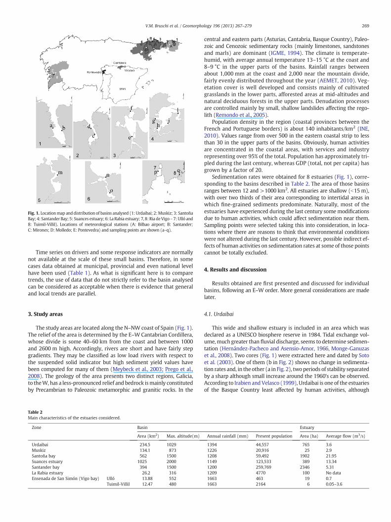
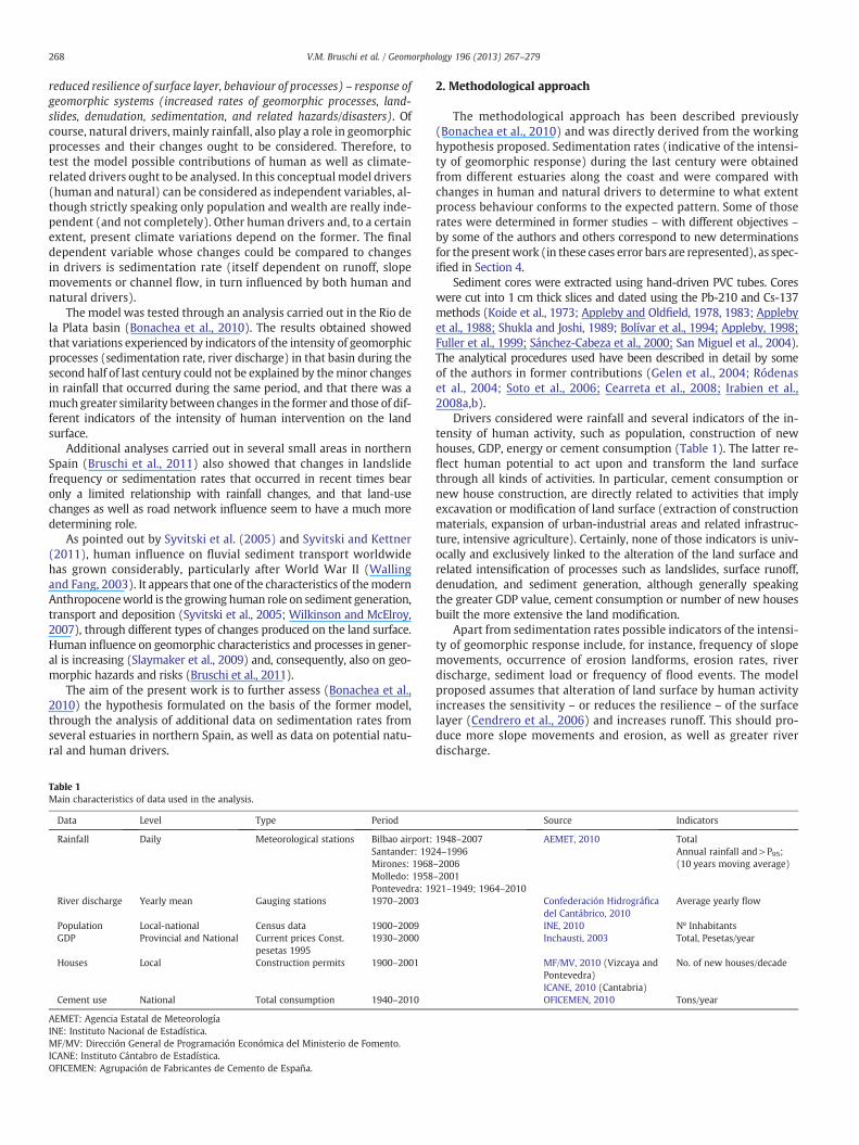
Fig. 1. Locationmap anddistribution of basins analysed (1: Urdaibai; 2:Muskiz; 3: SantoñaBay; 4: Santander Bay; 5: Suances estuary; 6: La Rabia estuary; 7, 8: Ria deVigo– 7: Ulló and8: Tuimil-Villil). Locations of meteorological stations (A: Bilbao airport; B: Santander;C: Mirones; D: Molledo; E: Pontevedra) and sampling points are shown (a–q).
269V.M. Bruschi et al. / Geomorphology 196 (2013) 267–279
Time series on drivers and some response indicators are normallynot available at the scale of these small basins. Therefore, in somecases data obtained at municipal, provincial and even national levelhave been used (Table 1). As what is significant here is to comparetrends, the use of data that do not strictly refer to the basin analysedcan be considered as acceptable when there is evidence that generaland local trends are parallel.
3. Study areas
The study areas are located along the N–NW coast of Spain (Fig. 1).The relief of the area is determined by the E–WCantabrian Cordillera,whose divide is some 40–60 km from the coast and between 1000and 2600 m high. Accordingly, rivers are short and have fairly stepgradients. They may be classified as low load rivers with respect tothe suspended solid indicator but high sediment yield values havebeen computed for many of them (Meybeck et al., 2003; Prego et al.,2008). The geology of the area presents two distinct regions, Galicia,to theW, has a less-pronounced relief andbedrock ismainly constitutedby Precambrian to Paleozoic metamorphic and granitic rocks. In the
Table 2Main characteristics of the estuaries considered.
Zone Basin
Area (km2) Max. altitude(m)
Urdaibai 234.5 1029Muskiz 134.1 873Santoña bay 562 1500Suances estuary 1025 2000Santander bay 394 1500La Rabia estuary 26.2 316Ensenada de San Simón (Vigo bay) Ulló 13.88 552
Tuimil-Villil 12.47 480
central and eastern parts (Asturias, Cantabria, Basque Country), Paleo-zoic and Cenozoic sedimentary rocks (mainly limestones, sandstonesand marls) are dominant (IGME, 1994). The climate is temperate-humid, with average annual temperature 13–15 °C at the coast and8–9 °C in the upper parts of the basins. Rainfall ranges betweenabout 1,000 mm at the coast and 2,000 near the mountain divide,fairly evenly distributed throughout the year (AEMET, 2010). Veg-etation cover is well developed and consists mainly of cultivatedgrasslands in the lower parts, afforested areas at mid-altitudes andnatural deciduous forests in the upper parts. Denudation processesare controlled mainly by small, shallow landslides affecting the rego-lith (Remondo et al., 2005).
Population density in the region (coastal provinces between theFrench and Portuguese borders) is about 140 inhabitants/km2 (INE,2010). Values range from over 500 in the eastern coastal strip to lessthan 30 in the upper parts of the basins. Obviously, human activitiesare concentrated in the coastal areas, with services and industryrepresenting over 95% of the total. Population has approximately tri-pled during the last century, whereas GDP (total, not per capita) hasgrown by a factor of 20.
Sedimentation rates were obtained for 8 estuaries (Fig. 1), corre-sponding to the basins described in Table 2. The area of those basinsranges between 12 and >1000 km2. All estuaries are shallow (b15 m),with over two thirds of their area corresponding to intertidal areas inwhich fine-grained sediments predominate. Naturally, most of theestuaries have experienced during the last century somemodificationsdue to human activities, which could affect sedimentation near them.Sampling points were selected taking this into consideration, in loca-tions where there are reasons to think that environmental conditionswere not altered during the last century. However, possible indirect ef-fects of human activities on sedimentation rates at some of those pointscannot be totally excluded.
4. Results and discussion
Results obtained are first presented and discussed for individualbasins, following an E–W order. More general considerations are madelater.
4.1. Urdaibai
This wide and shallow estuary is included in an area which wasdeclared as a UNESCO biosphere reserve in 1984. Tidal exchange vol-ume,much greater than fluvial discharge, seems to determine sedimen-tation (Hernández-Pacheco and Asensio-Amor, 1966, Monge-Ganuzaset al., 2008). Two cores (Fig. 1) were extracted here and dated by Sotoet al. (2003). One of them (b in Fig. 2) shows no change in sedimenta-tion rates and, in the other (a in Fig. 2), two periods of stability separatedby a sharp although small increase around the 1960's can be observed.According to Irabien and Velasco (1999), Urdaibai is one of the estuariesof the Basque Country least affected by human activities, although
Estuary
Annual rainfall (mm) Present population Area (ha) Average flow (m3/s)
1394 44,557 765 3.61226 20,916 25 2.91208 59,492 1902 21.951149 123,533 389 13.341200 259,769 2346 5.311209 4770 100 No data1663 463 19 0.71663 2164 6 0.05–3.6
Fig. 2. Urdaibai. A) Sedimentation rates (a, b; Soto et al., 2003). B) Rainfall data from the nearest station with long and reliable record (Bilbao airport). C) Population. D) Constructionof new houses. Population and house construction data were obtained for the municipalities of Ajangiz, Arratzu, Busturia, Ereño, Errigiti, Forua, Gautegiz, Guernika-Lumo, Kortezubi,Mendata, Mundaka, Murueta, Muxika, Nabarniz, and Sukarrieta.
270 V.M. Bruschi et al. / Geomorphology 196 (2013) 267–279
geochemical data do show a certain human influence on sedimentation.Work by Monge (2008) and Monge et al. (submitted for publication,2008) indicates that channel construction and dredging in the estuarymay have affected sedimentation in parts of it. Although sampling pointsare not close to areaswhere such activities have taken place, it is difficultto assess to what extent they might have affected sedimentationrates in them.
The nearest rainfall station with a relatively long and reliable recordis the one at Bilbao (to theWest), some 25 km from the centre of the es-tuary. Total rainfall did not change much from late the 1940s to the late1970s (Fig. 2). From this date onwards there has been a steady decrease.Frequency of intense events (days with rainfall greater than the 95%value for daily intensity, or total rainfall/Nº rainy days) shows a regulardecrease since the beginning of the record. Population and house con-struction data for the basin (Fig. 2) show a fairly stable behaviourprior to the late 1950s, followed by a marked increase which continued
until around 1980 and later by a new period of stability (population) orslower increase (house construction).
Altogether, the image we obtain from data in this estuary is one ofquite stable sedimentation rates, with a limited but sharp increaseduring a period that coincides with the most intense constructionactivity in the basin and does not seem to bear any relationship withrainfall patterns.
4.2. Muskiz
This is a narrow estuary (Fig. 1) corresponding to a small basinand has experienced important human modifications, which includedmarsh reclamation, mining activities, particularly intense since the19th century, as well as the construction of an oil refinery in theearly 1970s which occupied over half its original extent (Rivas,1991). The muddy middle estuary area receives waste from the oil

271V.M. Bruschi et al. / Geomorphology 196 (2013) 267–279
refinery and from a wastewater treatment plant which opened in1988, although there has been no persistent historical organic or inor-ganic pollution in this estuary (Cearreta et al., 2008). Two sedimentcores were obtained and dated (Cearreta et al., 2008). One of them(c in Fig. 3) shows a fairly regular increase of sedimentation rates,by a factor of nearly 10 in one century. A second core dated by thesame authors shows stability of sedimentation rates (d in Fig. 3).The first core was extracted in an intertidal area subject to the generaldynamics of the estuary and apparently not modified by human ac-tivities, whereas the second one corresponds to a point by the mainchannel, which might have been affected by dredging operations.This could explain the difference in the variation of sedimentationrates.
The nearest reliable rainfall station is, as in the former case, Bilbao(Fig. 3). Rainfall variations here also show quite a different trend fromsedimentation rates. Data on human drivers show a slight populationdecline, but the number of houses built (a much more relevant indica-tor from the point of view of potential effects on the territory) shows amarked growth, particularly after 1950 (Fig. 3). Infrastructure con-struction, in particular roads and streets, increased accordingly. Thesechanges affected mainly the lower part of the basin, especially afterthe construction of the oil refinery in the early 1970s. The upper parthas a farming-forestry character, is thinly populated and has experi-enced a steady although limited population decline since the early20th century.
Fig. 3. Muskiz. A) Sedimentation rates (c, d; Cearreta et al., 2008). B) Rainfall data from thenearest stationwith longandreliable record (Bilbao airport). C) Population.D) Constructionof new houses. Population and house construction data were obtained for the municipali-ties of Arcentales, Galdames, Muskiz, Sopuerta, and Abanto.
Mining and related ore processing are a possible influence on sed-iment generation. Mining started in the 16th century (Losada et al.,1987), became important in the second part of the 19th century,and had its peak in 1900–1910. A steady decline started afterwards,until around 1950. Then there was a moderate increase, up to the1980s, but at much lower levels than those of the beginning of thecentury (Cueto Alonso, 2006). Open cast mining stopped in 1985and the last mine closed in 1993 (Escudero, 1998; Pérez Goikoetxea,2003).
With the information available it does not seem that mining canexplain the observed sedimentation rate increase, which was particu-larly intense in the second half of last century, the time when thisactivity was in decline. Input of fine sediment from waste processingand effects of construction activities appear as the most likely causesof the sedimentation rate increase observed in one of the cores. As inthe case of Urdaibai, it is difficult to assess the possible effect on sed-imentation of local changes produced in the estuary.
4.3. Santoña Bay
This estuary, corresponding to the Asón River and the Clarín stream(Fig. 1), is one of the largest in Northern Spain and one of the leastmod-ified by human activities. Two sediment cores have been extracted anddated here (Irabien et al., 2008b). Sedimentation rates (Fig. 4) showclear increases by a factor of 7–10 during last century, particularlyafter about 1980. This is significant because the cores have beenextracted in two quite different sedimentary environments. Core ecorresponds to the internal zone, where the Asón River dischargesinto the main channel, with a greater fluvial influence and a high de-gree of naturalness. Core f was taken near the northern edge of theestuary with limited fluvial influence and partly isolated from gener-al estuarine dynamics. The margins of this area experienced signifi-cant alterations during the 1980s for road construction, and thismay explain the higher increase in sedimentation rates observed.That is, although there are differences in sedimentation rate changesand degree of local influence, both cores show a clear increase in theformer, with acceleration after 1980. It must also be pointed out thatthe Asón has several small dams, most of them built after the 1980s,used for water supply. These dams must retain part of the sedimentload thus making the detected increase in sedimentation rates evenmore significant.
No meteorological station with a long and reliable record exists inthe area. The nearest ones are those of Bilbao and Santander (Fig. 4).Both show a slight increase in total rainfall and frequency of intenseevents until about 1980, and a steady decrease afterwards. Althoughwith a shorter time series, river discharge data from the Asón showa similar trend, for both annual discharge and number of days aboveP95 (rainfall greater than 95% of the maximum daily intensity). Asimilar behaviour can be observed in the neighbouring Agüera Riverand by other rivers in the region, as discussed further down. Populationshows a limited and fairly steady growth since 1900, but construction ofnew houses (and accordingly roads and other infrastructure) increasedsignificantly (Fig. 4) in the second part of the century, with a slight dropin the decade of the 1980s.
With the information above, it seems that the intensification oferosion/sedimentation processes in this basin can be better explainedby construction-related activities than by rainfall changes. This agreeswith the interpretation of Irabien et al. (2008b)who point to populationgrowth, related increase in untreated sewage production and land-usechanges as the likely explanation of increasing sedimentation rates.
4.4. Santander Bay
The Santander bay, in which four cores have been extracted anddated (Gelen et al., 2004; Soto-Torres et al., 2007; Viguri et al., 2007),is another large estuary corresponding to the Miera River. This bay,
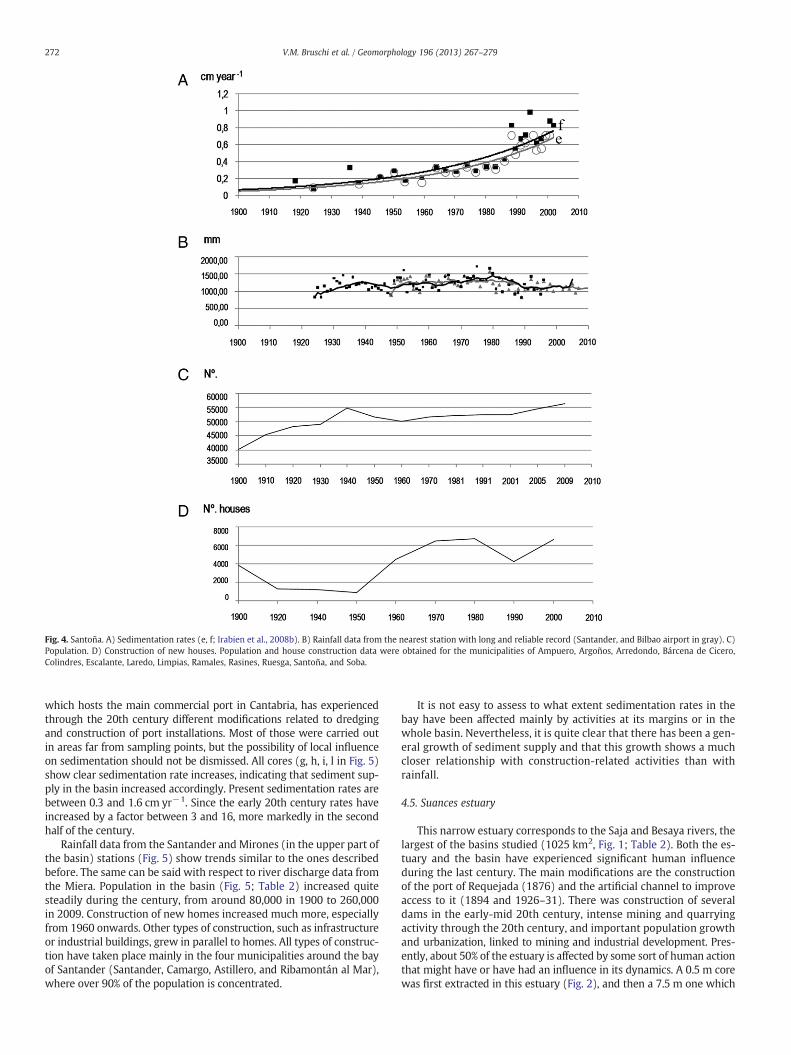
Fig. 4. Santoña. A) Sedimentation rates (e, f; Irabien et al., 2008b). B) Rainfall data from the nearest station with long and reliable record (Santander, and Bilbao airport in gray). C)Population. D) Construction of new houses. Population and house construction data were obtained for the municipalities of Ampuero, Argoños, Arredondo, Bárcena de Cicero,Colindres, Escalante, Laredo, Limpias, Ramales, Rasines, Ruesga, Santoña, and Soba.
272 V.M. Bruschi et al. / Geomorphology 196 (2013) 267–279
which hosts the main commercial port in Cantabria, has experiencedthrough the 20th century different modifications related to dredgingand construction of port installations. Most of those were carried outin areas far from sampling points, but the possibility of local influenceon sedimentation should not be dismissed. All cores (g, h, i, l in Fig. 5)show clear sedimentation rate increases, indicating that sediment sup-ply in the basin increased accordingly. Present sedimentation rates arebetween 0.3 and 1.6 cm yr−1. Since the early 20th century rates haveincreased by a factor between 3 and 16, more markedly in the secondhalf of the century.
Rainfall data from the Santander and Mirones (in the upper part ofthe basin) stations (Fig. 5) show trends similar to the ones describedbefore. The same can be said with respect to river discharge data fromthe Miera. Population in the basin (Fig. 5; Table 2) increased quitesteadily during the century, from around 80,000 in 1900 to 260,000in 2009. Construction of new homes increased much more, especiallyfrom 1960 onwards. Other types of construction, such as infrastructureor industrial buildings, grew in parallel to homes. All types of construc-tion have taken place mainly in the four municipalities around the bayof Santander (Santander, Camargo, Astillero, and Ribamontán al Mar),where over 90% of the population is concentrated.
It is not easy to assess to what extent sedimentation rates in thebay have been affected mainly by activities at its margins or in thewhole basin. Nevertheless, it is quite clear that there has been a gen-eral growth of sediment supply and that this growth shows a muchcloser relationship with construction-related activities than withrainfall.
4.5. Suances estuary
This narrow estuary corresponds to the Saja and Besaya rivers, thelargest of the basins studied (1025 km2, Fig. 1; Table 2). Both the es-tuary and the basin have experienced significant human influenceduring the last century. The main modifications are the constructionof the port of Requejada (1876) and the artificial channel to improveaccess to it (1894 and 1926–31). There was construction of severaldams in the early-mid 20th century, intense mining and quarryingactivity through the 20th century, and important population growthand urbanization, linked to mining and industrial development. Pres-ently, about 50% of the estuary is affected by some sort of human actionthat might have or have had an influence in its dynamics. A 0.5 m corewas first extracted in this estuary (Fig. 2), and then a 7.5 m one which
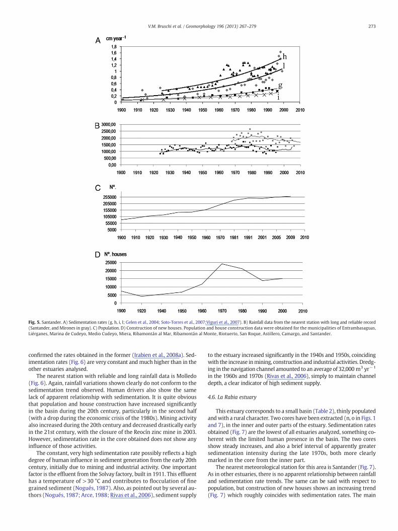
Fig. 5. Santander. A) Sedimentation rates (g, h, i, l; Gelen et al., 2004; Soto-Torres et al., 2007;Viguri et al., 2007). B) Rainfall data from the nearest station with long and reliable record(Santander, and Mirones in gray). C) Population. D) Construction of new houses. Population and house construction data were obtained for the municipalities of Entrambasaguas,Liérganes, Marina de Cudeyo, Medio Cudeyo, Miera, Ribamontán al Mar, Ribamontán al Monte, Riotuerto, San Roque, Astillero, Camargo, and Santander.
273V.M. Bruschi et al. / Geomorphology 196 (2013) 267–279
confirmed the rates obtained in the former (Irabien et al., 2008a). Sed-imentation rates (Fig. 6) are very constant and much higher than in theother estuaries analysed.
The nearest station with reliable and long rainfall data is Molledo(Fig. 6). Again, rainfall variations shown clearly do not conform to thesedimentation trend observed. Human drivers also show the samelack of apparent relationship with sedimentation. It is quite obviousthat population and house construction have increased significantlyin the basin during the 20th century, particularly in the second half(with a drop during the economic crisis of the 1980s). Mining activityalso increased during the 20th century and decreased drastically earlyin the 21st century, with the closure of the Reocín zinc mine in 2003.However, sedimentation rate in the core obtained does not show anyinfluence of those activities.
The constant, very high sedimentation rate possibly reflects a highdegree of human influence in sediment generation from the early 20thcentury, initially due to mining and industrial activity. One importantfactor is the effluent from the Solvay factory, built in 1911. This effluenthas a temperature of >30 °C and contributes to flocculation of finegrained sediment (Nogués, 1987). Also, as pointed out by several au-thors (Nogués, 1987; Arce, 1988; Rivas et al., 2006), sediment supply
to the estuary increased significantly in the 1940s and 1950s, coincidingwith the increase inmining, construction and industrial activities. Dredg-ing in the navigation channel amounted to an average of 32,000 m3 yr−1
in the 1960s and 1970s (Rivas et al., 2006), simply to maintain channeldepth, a clear indicator of high sediment supply.
4.6. La Rabia estuary
This estuary corresponds to a small basin (Table 2), thinly populatedandwith a rural character. Two cores have been extracted (n, o in Figs. 1and 7), in the inner and outer parts of the estuary. Sedimentation ratesobtained (Fig. 7) are the lowest of all estuaries analyzed, something co-herent with the limited human presence in the basin. The two coresshow steady increases, and also a brief interval of apparently greatersedimentation intensity during the late 1970s, both more clearlymarked in the core from the inner part.
The nearest meteorological station for this area is Santander (Fig. 7).As in other estuaries, there is no apparent relationship between rainfalland sedimentation rate trends. The same can be said with respect topopulation, but construction of new houses shows an increasing trend(Fig. 7) which roughly coincides with sedimentation rates. The main
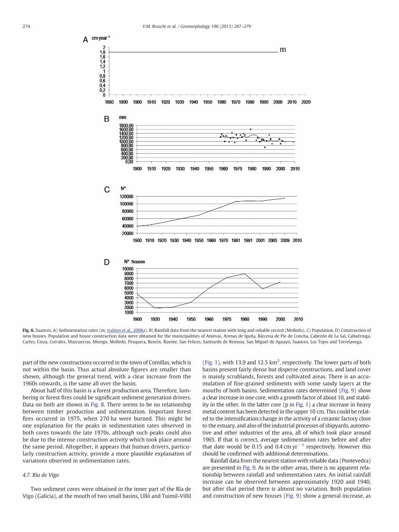
Fig. 6. Suances. A) Sedimentation rates (m; Irabien et al., 2008a). B) Rainfall data from the nearest station with long and reliable record (Molledo). C) Population. D) Construction ofnew houses. Population and house construction data were obtained for the municipalities of Anievas, Arenas de Iguña, Bárcena de Pie de Concha, Cabezón de La Sal, Cabuérniga,Cartes, Cieza, Corrales, Mazcuerras, Miengo, Molledo, Pesquera, Reocín, Ruente, San Felices, Santiurde de Reinosa, San Miguel de Aguayo, Suances, Los Tojos and Torrelavega.
274 V.M. Bruschi et al. / Geomorphology 196 (2013) 267–279
part of the new constructions occurred in the town of Comillas, which isnot within the basin. Thus actual absolute figures are smaller thanshown, although the general trend, with a clear increase from the1960s onwards, is the same all over the basin.
About half of this basin is a forest production area. Therefore, lum-bering or forest fires could be significant sediment generation drivers.Data on both are shown in Fig. 8. There seems to be no relationshipbetween timber production and sedimentation. Important forestfires occurred in 1975, when 270 ha were burned. This might beone explanation for the peaks in sedimentation rates observed inboth cores towards the late 1970s, although such peaks could alsobe due to the intense construction activity which took place aroundthe same period. Altogether, it appears that human drivers, particu-larly construction activity, provide a more plausible explanation ofvariations observed in sedimentation rates.
4.7. Ria de Vigo
Two sediment cores were obtained in the inner part of the Ría deVigo (Galicia), at the mouth of two small basins, Ulló and Tuimil-Villil
(Fig. 1), with 13.9 and 12.5 km2, respectively. The lower parts of bothbasins present fairly dense but disperse constructions, and land coveris mainly scrublands, forests and cultivated areas. There is an accu-mulation of fine-grained sediments with some sandy layers at themouths of both basins. Sedimentation rates determined (Fig. 9) showa clear increase in one core, with a growth factor of about 10, and stabil-ity in the other. In the latter core (p in Fig. 1) a clear increase in heavymetal content has been detected in the upper 10 cm. This could be relat-ed to the intensification/change in the activity of a ceramic factory closeto the estuary, and also of the industrial processes of shipyards, automo-tive and other industries of the area, all of which took place around1965. If that is correct, average sedimentation rates before and afterthat date would be 0.15 and 0.4 cm yr−1 respectively. However thisshould be confirmed with additional determinations.
Rainfall data from thenearest stationwith reliable data (Pontevedra)are presented in Fig. 9. As in the other areas, there is no apparent rela-tionship between rainfall and sedimentation rates. An initial rainfallincrease can be observed between approximately 1920 and 1940,but after that period there is almost no variation. Both populationand construction of new houses (Fig. 9) show a general increase, as
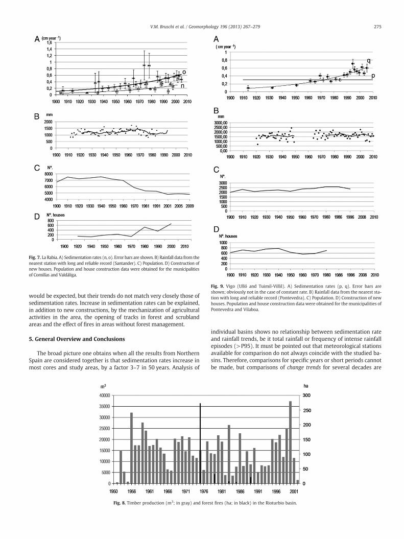
Fig. 7. La Rabia. A) Sedimentation rates (n, o). Error bars are shown. B) Rainfall data from thenearest station with long and reliable record (Santander). C) Population. D) Construction ofnew houses. Population and house construction data were obtained for the municipalitiesof Comillas and Valdáliga.
Fig. 9. Vigo (Ulló and Tuimil-Villil). A) Sedimentation rates (p, q). Error bars areshown; obviously not in the case of constant rate. B) Rainfall data from the nearest sta-tion with long and reliable record (Pontevedra). C) Population. D) Construction of newhouses. Population and house construction data were obtained for the municipalities ofPontevedra and Vilaboa.
275V.M. Bruschi et al. / Geomorphology 196 (2013) 267–279
would be expected, but their trends do not match very closely those ofsedimentation rates. Increase in sedimentation rates can be explained,in addition to new constructions, by the mechanization of agriculturalactivities in the area, the opening of tracks in forest and scrublandareas and the effect of fires in areas without forest management.
5. General Overview and Conclusions
The broad picture one obtains when all the results from NorthernSpain are considered together is that sedimentation rates increase inmost cores and study areas, by a factor 3–7 in 50 years. Analysis of
Fig. 8. Timber production (m3; in gray) and fore
individual basins shows no relationship between sedimentation rateand rainfall trends, be it total rainfall or frequency of intense rainfallepisodes (>P95). It must be pointed out that meteorological stationsavailable for comparison do not always coincide with the studied ba-sins. Therefore, comparisons for specific years or short periods cannotbe made, but comparisons of change trends for several decades are
st fires (ha; in black) in the Rioturbio basin.
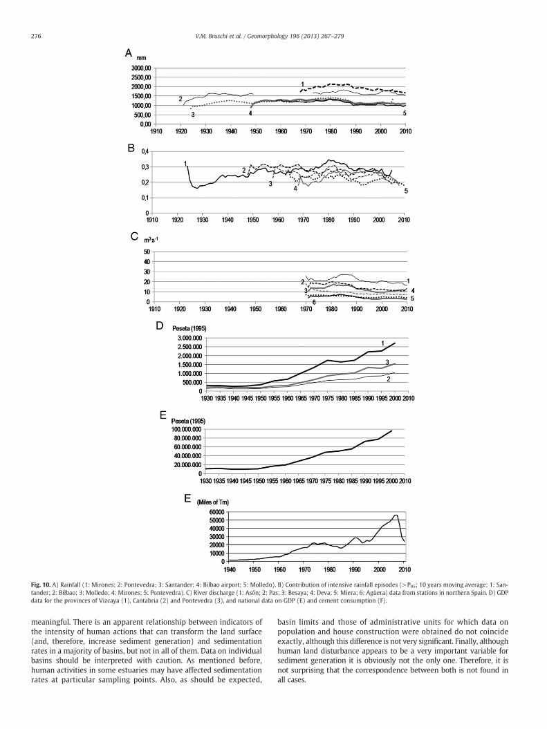
Fig. 10. A) Rainfall (1: Mirones; 2: Pontevedra; 3: Santander; 4: Bilbao airport; 5: Molledo). B) Contribution of intensive rainfall episodes (>P95; 10 years moving average; 1: San-tander; 2: Bilbao; 3: Molledo; 4: Mirones; 5: Pontevedra). C) River discharge (1: Asón; 2: Pas; 3: Besaya; 4: Deva; 5: Miera; 6: Agüera) data from stations in northern Spain. D) GDPdata for the provinces of Vizcaya (1), Cantabria (2) and Pontevedra (3), and national data on GDP (E) and cement consumption (F).
276 V.M. Bruschi et al. / Geomorphology 196 (2013) 267–279
meaningful. There is an apparent relationship between indicators ofthe intensity of human actions that can transform the land surface(and, therefore, increase sediment generation) and sedimentationrates in a majority of basins, but not in all of them. Data on individualbasins should be interpreted with caution. As mentioned before,human activities in some estuaries may have affected sedimentationrates at particular sampling points. Also, as should be expected,
basin limits and those of administrative units for which data onpopulation and house construction were obtained do not coincideexactly, although this difference is not very significant. Finally, althoughhuman land disturbance appears to be a very important variable forsediment generation it is obviously not the only one. Therefore, it isnot surprising that the correspondence between both is not found inall cases.

277V.M. Bruschi et al. / Geomorphology 196 (2013) 267–279
If the whole region is considered, the lack of relationship withrainfall trends and an apparent relationship with those of humandrivers seem to be better defined (Fig. 10). The figure shows GDP datafor the three provinces (Inchausti, 2003) in which the basins studiedare located as well as national data on population, and cement con-sumption. Sufficiently long time series could not be obtained at provin-cial level for the latter; of course, even less at basin level. What is veryapparent from the data presented is that trends are very similar atprovincial and national levels. Obviously absolute values are different.It is therefore reasonable to assume that the same is true for trends inthe case of cement consumption. This indicator is related to activitiesthat alter the land surface and can significantly contribute to sedimentgeneration.
An analysis of landslide frequency through time and its relationshipwith rainfall and human drivers in two small study areas of the region(Bruschi et al., 2011) has shown that the former seems to be deter-mined essentially by land-use changes and infrastructure. As pointedout by Bonachea et al. (2010), rates of geomorphic processes such aslandslides and floods at local, national or global level show trendsquite similar to the ones obtained here for sedimentation rates. They
Fig. 11. Landslide frequency and Nº. of publications (A; Gutiérrez et al., 2010) in the world acompared with GDP (C; Historical Statistics for the World Economy, 2006).
also found that sedimentation rates during the 20th century in a largebasin (Rio de la Plata) show an apparent relationship with humandrivers and no relationship with rainfall trends. If global rates of thoseprocesses are compared with potential natural or human drivers(Cendrero et al., 2009), the lack of relationship with the former andpossible relationship with the latter are even more apparent (Figs.11 and 12).
Thus, the new data presented here agree to a great extent with themodel and hypothesis proposed. That is, the existence of a globalgeomorphic change, driven by human geomorphic pressure (intensityof human action by unit area, more determined by wealth and techno-logical capacities than by simple population numbers) and with limitedor no relationship to climate change. This would imply the accelerationof geomorphic processes in general, and hazards such as floods andmass movements in particular. Indeed, intensification of geomorphicprocesses appears to be one of the characteristics of the Anthropocene(Steffen et al., 2011; Syvitski and Kettner, 2011; Zalasiewicz et al., 2011).One would expect that the starting point of such acceleration couldvary in different regions, because it should be linked to economic/population development, but this difference is probably not very
nd flood frequency (B; EM-DAT, 2011) in different continents or large continental areas

Fig. 12. Rainfall data for different regions of the world, 1901–2005 (IPCC, 2007).
278 V.M. Bruschi et al. / Geomorphology 196 (2013) 267–279
great. Preliminary data on disasters linked to geomorphic processes(Forte, 2011) indicate that most regions of the world experienced amarked increase in disaster frequency around 1950. A higher fre-quency of hydrogeomorphic hazard occurrence could thus very wellbe another characteristic of the Anthropocene. It would be worth tryingto further test the model, ideally by other research groups, in other re-gions or on other geomorphic processes. If the model is confirmed itwould have considerable importance for the assessment and mitigationof geomorphic hazards and risks.
Acknowledgements
Work for this project was carried out within project CAMGEO(CGL2006-11431, Plan Nacional de I+D, Ministerio de Ciencia eInnovación (Spain). Jaime Bonachea had postdoctoral contract fromthe Ministerio de Ciencia e Innovación, Spain (Programa Juan de laCierva).
References
AEMET, 2010. Agencia Estatal de Meteorología, Gobierno de España. http://www.aemet.es/es/portada2010.
Appleby, P.G., 1998. Dating recent sediments by Pb-210. Problems and solutions. Proc.2nd NKS/EKO Seminar, Helsinki, Finland, 2–4 April 1997, pp. 7–24.
Appleby, P.G., Oldfield, F., 1978. The calculation of 210Pb date assuming a constant rateof supply of unsupported 210Pb to the sediment. Catena 5, 1–8.
Appleby, P.G., Oldfield, F., 1983. The assessment of 210Pb date from sites with varyingsediment accumulation rates. Hydrobiologia 103, 29–35.
Appleby, P.G., Nolan, P.J., Oldfield, F., Richardson, N., Higgitt, S.R., 1988. Pb-210 datingof lake sediments and ombrotrophic peats by gamma assay. The Science of theTotal Environment 69, 157–177.
Arce, A.R., 1988. La ría de San Martín de la Arena. Análisis histórico-económico de susdistintos asentamientos portuarios. Proyecto Fin de Carrera de la Escuela Superiorde Marina Civil de Santander. Unpublished report. 188pp.
Bolívar, J.P., García-Tenorio, R., García-León, M., 1994. A generalized transmissionmethod for gamma-efficiency determinations in soil samples. Nuclear Geophysics8, 485–492.
Bonachea, J., 2006. Desarrollo, aplicación y validación de procedimientos y modelospara la evaluación de amenazas, vulnerabilidad y riesgo debidos a procesos geo-morfológicas. Tesis Doctoral en Red, Universidad de Cantabria, 356 pp.
Bonachea, J., Bruschi, V.M., Hurtado, M., Forte, L.M., da Silva, M., Etcheverry, R.,Cavallotto, J.L., Dantas, M., Pejon, O., Zuquette, L., Bezerra, M.A., Remondo, J.,Rivas, V., Gómez-Arozamena, J., Fernández, G., Cendrero, A., 2010. Natural andhuman forcing in recent geomorphic change; case studies in the Rio de la Platabasin. Science of the Total Environment 408, 2674–2695.
Bruschi, V.M., Bonachea, J., Remondo, J., Rivas, V., Gómez, J., Salas, L., Fernández, G.,Soto, J., Cendrero, A., Ménde, G., Naredo, J.M., Hurtado, M., Forte, L.M., da Silva,M., Etcheverry, R., Cavallotto, J.L., Dantas, M., Pejon, O., Zuquette, L., 2008. ¿Existeun cambio geomorfológico global acoplado a la actividad económica? In:Cendrero, A., Gómez, J., Fernández, P.L., Quindós, L., Ródenas, C., Saiz, C. (Eds.),Contribuciones científicas en memoria del Profesor Jesús Soto. Ediciones de laUniversidad de Cantabria, Santander, pp. 31–54.
Bruschi, V.M., Forte, L.M., Bonachea, J., Remondo, J., Rivas, V., Cendrero, A., 2011. Evi-dences of major changes in Earth's surface processes. Should the Anthropocenebe considered as a new period in geologic history? IAG/AIG Regional Conference.Geomorphology for human adaptation to changing tropical environments. AddisAbaba, Ethiopia, p. 37. Abstract volume.
Cearreta, A., Alday, M., Irabien, M.J., Etxebarria, N., Soto, J., 2008. Modern conditions andrecent environmental development of the Muskiz estuary: historical disturbanceby the largest oil refinery of Spain. Journal of Iberian Geology 34, 191–213.
Cendrero, A., 2003. De la comprensión de la historia de la tierra al análisis y predicciónde las interacciones entre seres humanos y medio natural. Real Academia deCiencias Exactas, Físicas y Naturales, Madrid.
279V.M. Bruschi et al. / Geomorphology 196 (2013) 267–279
Cendrero, A., Remondo, J., Bonachea, J., Rivas, V., Soto, J., 2006. Sensitivity of landscapeevolution and geomorphic processes to direct and indirect human influence. Geo-grafia Fisica e Geodinamica Quaternaria 29, 125–137.
Cendrero, A., Bruschi, V.M., Bonachea, J., Remondo, J., 2009. Previsiones sobre cambioclimático y cambio global ¿son sostenibles las tendencias observadas? Rev. RealAcademia de Ciencias Exactas, Físicas y Naturales 103, 55–77.
Confederación Hidrográfica del Cantábrico, 2010. http://www.chcantabrico.es2010.Cueto Alonso, G.J., 2006. La minería del hierro en la Bahía de Santander. Un estudio de
Geografía Histórica. Santander, Consejería de Medio Ambiente de Cantabria, Centrode Investigación del Medio Ambiente.
EM-DAT, 2011. The OFDA/CRED International Disaster Database. www.em-dat.net–Brussels Universite Catholique de Louvain, Belgium.
Escudero, A., 1998. Minería e industrialización de Vizcaya Ed. Critica. Universidad deAlicante, Spain, 360 pp.
Forte, L.M. 2011. Análisis de las tendencias de variación en las tasas de actividad de losprocesos geomorfológicos y de sus implicaciones para los riesgos naturales. MScThesis, Universidad de Cantabria, Santander, Spain, 47 pp.
Fuller, C.C., van Geen, A., Baskaran, M., Anima, R., 1999. Sediment chronology in SanFrancisco Bay, California, defined by 210Pb, 234Th, 137Cs and 239,240Pu. Marine Chemistry64 (1–2), 7–27.
Gelen, A., Soto, J., Gómez, J., Díaz, O., 2004. Sediment dating of Santander Bay, Spain.Journal of Radioanalytical and Nuclear Chemistry 261, 437–441.
González-Díez, A., Salas, L., Díaz de Terán, J.R., Cendrero, A., 1996. Holocene climatechanges and landslide occurrence in the Cantabrian Region, Spain. Geomorphology15, 291–309.
González-Díez, A., Remondo, J., Díaz de Terán, J.R., Cendrero, A., 1999. A methodologicalapproach for the analysis of the temporal occurrence and triggering factors of land-slides. Geomorphology 30, 95–113.
Gutiérrez, F., Soldati, M., Audemard, F., Bălteanu, D., 2010. Recent advances in landslideinvestigation: Issues and perspectives. Geomorphology 124, 95–101.
Guzzetti, F., Tonelli, G., 2004. Information system on hydrological and geomorphologi-cal catastrophes in Italy (SICI): a tool for managing landslide and flood hazards.Natural Hazards and Earth System Sciences 4, 213–232.
Hernández-Pacheco, F., Asensio-Amor, I., 1966. Estudio fisiográfico-sedimentológico dela ría de Guernica. Boletín del Instituto Español de Oceanografía, 125. 30 pp.
Historical Statistics for the World Economy, 2006. Groningen Growth and Develop-ment Centre. University of Groningen, http://www.ggdc.net/.
ICANE, 2010. Series Estadísticas Municipales. Instituto Cántabro de Estadística. http://www.icane.es.
IGME, 1994. Mapa geológico de España a escala 1:1000,000. Instituto Geológico yMinero de España, Madrid.
Inchausti, J.A., 2003. Evolución económica de las regiones y provincias españolas en elsiglo XX. Fundación BBVA (Ed.), Bilbao, 384 pp.
INE, 2010. Instituto Nacional de Estadística – Spain. http://www.ine.es/.IPCC, 2007. Climate change 2007: synthesis report. Cambridge University Press, Cambridge.Irabien, M.J., Velasco, F., 1999. Heavy metals in Oka river sediments (Urdaibai National
Reserve, northern Spain): lithogenic and anthropogenic effects. EnvironmentalGeology 37, 54–63.
Irabien, M.J., Cearreta, A., Leorri, E., Gómez, J., Viguri, J.A., 2008a. A 130-years record ofpollution in the Suances estuary (southern Bay of Biscay); implications for envi-ronmental management. Marine Pollution Bulletin 56, 1719–1727.
Irabien, M.J., Rada, M., Gómez, J., Soto, J., Mañanes, A., Viguri, J.A., 2008b. An assessmentof anthropogenic impact in a Nature Reserve. The Santoña marshes, northernSpain. Journal of Iberian Geology 34, 235–242.
Koide,M., Bruland, K., Goldberg, E.D., 1973. Th-238/Th-232 and Pb-210geochronologies inmarine and lake sediments. Geochimica et Cosmochimica Acta 37, 1171–1187.
Losada, Miguel Ángel., Medina, Raúl., Desiré, J.M., 1987. Interacción puerto-costa. Algu-nos casos del litoral del País Vasco. Seminario Internacional sobre problemas deuso del territorio, Planificación y Manejo de zonas litorales. Bilbao. Unpublishedreport. 85 pp.
Meybeck, M., Laroche, L., Durr, H.H., Syvitski, J.P., 2003. Global variability of daily totalsuspended solids and their fluxes. Global Planet Change 39, 65–93.
MF/MV, 2010. Dirección General de Programación Económica del Ministerio deFomento. www.mfom.es.
Monge, M., 2008. Evolución temporal de la dinámica sedimentaria en el estuario infe-rior del Oka (Reserva de la Biosfera de Urdaibai): una herramienta para la gestiónintegrada de zonas costeras. Ph D Thesis, UPV/EHU, Bilbao, Spain, 424 pp.
Monge,M., Cearreta, A., Evans, G., submitted for publication.Morphodynamic consequencesof dredging and dumping activities along the lower Oka estuary (Urdaibai BiosphereReserve, southeastern Bay of Biscay, Spain). Ocean and Coastal Management.
Monge-Ganuzas, M., Cearreta, A., Iriarte, E., 2008. Consequences of estuarine sanddredging and dumping on the Urdaibai Reserve of the Biosphere (Bay of Biscay):the case of the “Mundaka left wave”. Journal of Iberian Geology 34, 215–234.
Nogués, S., 1987. Torrelavega: un espacio industrializado. Excmo, Ayuntamiento deTorrelavega. 262 pp.
OFICEMEN, 2010. Evolución histórica del consumo de cemento. Memoria anual 2010.http://www.oficemen.com.
Pérez Goikoetxea, E., 2003. Minería del hierro en los montes de Triano y Galdames.Diputación Foral de Bizkaia. Instituto de Estudios Territoriales de Bizkaia. 217 pp.
Prego, R., Boi, P., Cobelo-García, A., 2008. The contribution of total suspended solids tothe Bay of Biscay by Cantabrian Rivers (northern coast of the Iberian Peninsula).Journal of Marine Systems 72, 342–349.
Remondo, J., 2001. Elaboración y validación de mapas de susceptibilidad de deslizamientosmediante técnicas de análisis especial. Ph D Thesis, Universidad de Cantabria,Santander, Spain, 404 pp.
Remondo, J., González-Díez, A., Soto, J., Díaz de Terán, J.R., Cendrero, A., 2005. Humanimpact on geomorphic processes and hazards in mountain areas. Geomorphology66, 69–84.
Rivas, V., 1991. Evolución del litoral cantábrico desde la transgresión flandriense a laactualidad y evaluación de las consecuencias ambientales de la actividad humana.Ph D Thesis, Universidad de Murcia, Murcia, Spain, 537 pp.
Rivas, V., Cendrero, A., Hurtado, M., Cabral, M., Giménez, J., Forte, L.M., del Río, L., Cantú,M., Becker, A., 2006. Geomorphic consequences of urban development and miningactivities; an analysis of study areas in Spain and Argentina. Geomorphology 73,185–206.
Ródenas, C., Gómez, J., Soto, J., 2004. Medida de 210Pb para datación de sedimentos enestuarios. Revista Investigación Pesquera 1E, 1–6.
San Miguel, E.G., Bolívar, J.P., Garcia-Tenorio, R., 2004. Vertical distribution of Th-isotope ratios, 210Pb, 226Ra and 137Cs in sediment cores from an estuary affectedby anthropogenic releases. The Science of the Total Environment 318, 143–157.
Sánchez-Cabeza, J.A., Ani-Ragolta, I., Masqué, P., 2000. Some considerations of the 210Pbconstant rate of supply (CRS) dating model. Limnology and Oceanography 45,990–995.
Shukla, B.S., Joshi, S.R., 1989. An evaluation of CIC model of Pb-210 dating sediments.Environmental Geological Water Science 14, 73–76.
Slaymaker, O., Spencer, T., Embleton-Hamann, C. (Eds.), 2009. Geomorphology andglobal environmental change. Cambridge University Press, London. 434 pp.
Soto, J., Soto, J.A., Corral, D., Francés, E., Cendrero, A., Navas, A., 2003. Tasas de sedimen-tación y contaminación de sedimentos en Urdaibai, Vizcaya, España. 205–211 IICongreso Internacional de Ciencia y Tecnología marina. Libro de Ponencias. ISBN:84-9758-463-5, p. 1. Alicante, 22–26 Abril de 2003.
Soto, J., Gómez, J., Viguri, J., Cendrero, A., Irabien, M.J., Yusta, I., Gelen, A., Díaz, O., 2006.Increase of sedimentation rates in an estuarine system. Contribution to Educationand Environmental Protection 7, 35–40.
Soto-Torres, J., Soto-Velloso, J.A., Ródenas, G., Gelen, A., Díaz, O., Viguri, J., 2007. Estima-ción de las tasas de erosión en torno a la bahía de Santander. España Ciencias TierraEspacio 7, 1031–1036.
Steffen, W., Crutzen, P.J., McNeil, J.R., 2007. The Anthropocene: Are Humans Now Over-whelming the Great Forces of Nature? Ambio 36–8, 614–621.
Steffen, W., Grinevald, J., Crutzen, P., McNeill, J., 2011. The Anthropocene: conceptualand historical perspectives. Philosophical Transactions of the Royal Society A 369,842–867.
Syvitski, J.P.M., Kettner, A., 2011. Sediment flux and the Anthropocene. PhilosophicalTransactions of the Royal Society A: Mathematical, Physical and Engineering Sci-ences 369 (1938), 957–975.
Syvitski, J.P.M., Vörösmarty, C.J., Kettner, A.J., Green, P., 2005. Impacts of humans on theflux of terrestrial sediment to the global coastal ocean. Science 308, 376–380.
Viguri, J.R., Irabien, M.J.I., Yusta, J.S., Gómez, J., Rodriguez, P., Martinez-Madrid, M.,Irabien, J.A., Coz, A., 2007. Physico-chemical and toxicological characterization ofthe historic estuarine sediments: a multidisciplinary approach. Environment Inter-national 33, 436–444.
Walling, D.E., Fang, D., 2003. Recent trends in the suspended sediment loads of theworld's rivers. Global and Planetary Change 39, 111–126.
Wilkinson, B.H., McElroy, B.J., 2007. The impact of humans on continental erosion andsedimentation. Geological Society of American Bulletin 119, 140–156.
Zalasiewicz, J., Williams, M., Haywood, A., Ellis, M., 2011. The Anthropocene: a new epochin geological time? Philosophical Transactions of the Royal Society A 369, 835–841.