WATER AS A GEOMORPHIC AGENT
16
INTRODUCTION Hydrologic units are drainage areas that are delineated so as to nest into a multi-level hierarchical drainage system. Aside from the surface waters that are collected within the boundary of a hydrologic unit, it may also accept water from one or more points outside of the unit’s boundary. Additionally, hydrologic units may include associated surface areas whose drainages do not connect, thus resulting in multiple outlet points. This is usually the case with coastal frontage units such as those containing multiple outlets to the Chesapeake Bay or Atlantic Ocean. In contrast, a true watershed is an area of land and water defined by a boundary such that all surface drainage within the boundary converges to a single point. This point of convergence is usually the exit point, where the collected waters leave the watershed. There are, however, watersheds out of which no water flows. According to the classic definitions, all watersheds are hydrologic units but not all hydrologic units are watersheds. In the development of hydrologic units, watersheds are inherently preferred: They are the perfect hydrologic unit. In hydrology, the water shed or drainage basin is a logical unit of focus for studying the movement of water within the hydrological cycle, because the majority of water that discharges from the basin outlet originated as precipitation falling on the basin. A portion of the water that enters the groundwater system beneath the drainage basin may flow towards the outlet
-
Upload
independent -
Category
Documents
-
view
3 -
download
0
Transcript of WATER AS A GEOMORPHIC AGENT
INTRODUCTION
Hydrologic units are drainage areas that are delineatedso as to nest into a multi-level hierarchical drainagesystem. Aside from the surface waters that arecollected within the boundary of a hydrologic unit, itmay also accept water from one or more points outsideof the unit’s boundary. Additionally, hydrologic unitsmay include associated surface areas whose drainages donot connect, thus resulting in multiple outlet points.This is usually the case with coastal frontage unitssuch as those containing multiple outlets to theChesapeake Bay or Atlantic Ocean.
In contrast, a true watershed is an area of land andwater defined by a boundary such that all surfacedrainage within the boundary converges to a singlepoint. This point of convergence is usually the exitpoint, where the collected waters leave the watershed.There are, however, watersheds out of which no waterflows. According to the classic definitions, allwatersheds are hydrologic units but not all hydrologicunits are watersheds. In the development of hydrologicunits, watersheds are inherently preferred: They arethe perfect hydrologic unit.
In hydrology, the water shed or drainage basin is alogical unit of focus for studying the movement ofwater within the hydrological cycle, because themajority of water that discharges from the basin outletoriginated as precipitation falling on the basin. Aportion of the water that enters the groundwater systembeneath the drainage basin may flow towards the outlet

of another drainage basin because groundwater flowdirections do not always match those of their overlyingdrainage network.
2.00 WATER AS A RESOURCE
Water is the most distinctive substance found on earth;it is a vital ingredient of all life today. Water ismade of molecules containing one atom of oxygen and twoatoms of hydrogen (H20). Pure water has no color, notaste and no smell. it turns to a solid at 320f andboils at sea level at 2120f.The density of liquid wateris 1gram per cubic centimeter, and it is extremely goodsolvent.
The water of the earth is found in three states: as aliquid, as a solid and as a gas. The great majority ofthe world’s moisture, however, is in the form of liquidwater, which can be changed to the gaseous form byevaporation or to the solid form by freezing. Watervapour can be converted to liquid water by condensationor to ice by sublimation. Ice can be converted toliquid water by melting or to water vapour bysublimation. In each of these processes, there iseither a gain or a loss of heat.
Life is impossible without water; every living thingdepends on it. Watery solutions in living organismsdissolve or disperse nutrients for nourishment. Theliquidity of water greatly enhances its versatility asan active agent in the atmosphere, lithosphere, andbiosphere. It forms the oceans, seas, lakes, rivers andthe underground waters found in the top layers of theearth’s crust and soil cover. In a solid state, it
exists as ice and snow cover in polar and alpineregions. A certain amount of water is contained in theair as water vapour, water droplets and ice crystals,as well as in the biosphere. Huge amounts of water arebound up in the composition of the different mineralsof the earth’s crust and core.McKnight T.L Et al(2002).
To assess the total water storage on the earth reliablyis a complicated problem because water is so verydynamic. It is in permanent motion, constantly changingfrom liquid to solid or gaseous phase, and back again.The quantity of water found in the hydrosphere is theusual way of estimating the earth’s water. This is allthe free water existing in liquid, solid or gaseousstate in the atmosphere, on the Earth’s surface and inthe crust down to a depth of 2000 metres. Currentestimates are that the earth’s hydrosphere contains ahuge amount of water - about 1386 million cubickilometres. However, 97.5% of this amount exists assaline waters and only 2.5% as fresh water.
The greatest portion of the fresh water (68.7%) is inthe form of ice and permanent snow cover in theAntarctic, the Arctic and in the mountainous regions.29.9% exists as fresh groundwaters. Only 0.26% of thetotal amount of fresh water on the earth isconcentrated in lakes, reservoirs and river system,where it is most easily accessible for our economicneeds and absolutely vital for water ecosystems.
The values for stored water given above are fornatural, static, water storage in the hydrosphere. Itis the amount of water contained simultaneously, on

average, over a long period of time, – in water bodies,aquifers and the atmosphere. For shorter time intervalssuch as a single year, a couple of seasons or a fewmonths, the volume of water stored in the hydrospherewill vary as water exchanges take place between theoceans, land and the atmosphere.
3.00 THE HYDROLOGICAL CYCLE: NATURAL PROCESSES OFGROUND-WATER AND SURFACE-WATER INTERACTION.
The hydrologic cycle describes the continuous movementof water above, on, and below the surface of the Earth.The water on the Earth's surface--surface water--occursas streams, lakes, and wetlands, as well as bays andoceans. Surface water also includes the solid forms ofwater-- snow and ice. The water below the surface ofthe Earth primarily is ground water, but it alsoincludes soil water.
Water is taken up by the atmosphere from the earth'ssurface in vapor form through evaporation. It may thenbe moved from place to place by the wind until it iscondensed back to its liquid phase to form clouds.Water then returns to the surface of the earth in theform of either liquid (rain) or solid (snow, sleet,etc.) precipitation. Water transport can also takeplace on or below the earth's surface by flowingglaciers, rivers, and ground water flow.
The stages of the cycle are:
Evaporation
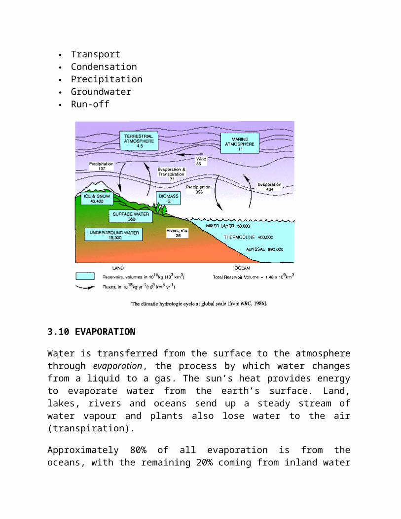
Transport Condensation Precipitation Groundwater Run-off
3.10 EVAPORATION
Water is transferred from the surface to the atmospherethrough evaporation, the process by which water changesfrom a liquid to a gas. The sun’s heat provides energyto evaporate water from the earth’s surface. Land,lakes, rivers and oceans send up a steady stream ofwater vapour and plants also lose water to the air(transpiration).
Approximately 80% of all evaporation is from theoceans, with the remaining 20% coming from inland water
and vegetation. Evapotranspiration is the term for boththe direct return of surface water to the atmosphere byevaporation and its indirect return throughtranspiration from the leaves of plants.
3.11 Transpiration
This process of water movement through a plant and itsevaporation from aerial parts, such as from leaves butalso from stems and flowers. Leaf surfaces are dottedwith pores which are called stomata and in most plantsthey are more numerous on the undersides of thefoliage. The stomata are bordered by guard cells andtheir stomatal accessory cells (together known asstomatal complex) that open and close the pore.Transpiration occurs through the stomatal apertures,and can be thought of as a necessary "cost" associatedwith the opening of the stomata to allow the diffusionof carbodioxide gas from the air for photosynthesis.Transpiration also cools plants, changes osmoticpressure of cells, and enable mass flow of mineralnutrients and water from roots to shoots.
Mass flow of liquid water from the roots to the leavesis driven in part by capillary action, but primarilydriven by water potential differences. In taller plantsand trees, the force of gravity can only be overcome bythe decrease in hydrostatic (water) pressure in theupper parts of the plants due to the diffusion of waterout of stomata into the atmosphere. Water is absorbedat the roots by osmosis, and any dissolved mineral
nutrients travel with it through the xylem.
3.12 Regulation
Plants regulate the rate of transpiration by the degreeof stomatal opening. The rate of transpiration is alsoinfluenced by the evaporative demand of the atmospheresurrounding the leaf such as humidity, temperature,wind and incident sunlight. Soil water supply and soiltemperature can influence stomatal opening, and thustranspiration rate. The amount of water lost by a plantalso depends on its size and the amount of waterabsorbed at the roots. Transpiration accounts for mostof the water loss by a plant, but some directevaporation also takes place through the cuticle of theleaves and young stems. Transpiration serves toevaporatively cool plants as the escaping water vaporcarries away heat energy.
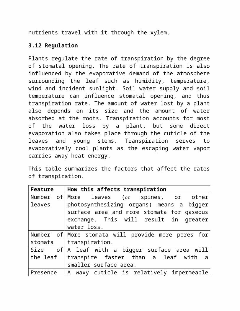
This table summarizes the factors that affect the ratesof transpiration.
Feature How this affects transpirationNumber ofleaves
More leaves (or spines, or otherphotosynthesizing organs) means a biggersurface area and more stomata for gaseousexchange. This will result in greaterwater loss.
Number ofstomata
More stomata will provide more pores fortranspiration.
Size ofthe leaf
A leaf with a bigger surface area willtranspire faster than a leaf with asmaller surface area.
Presence A waxy cuticle is relatively impermeable
of plantcuticle
to water and water vapour and reducesevaporation from the plant surface exceptvia the stomata. A reflective cuticle willreduce solar heating and temperature riseof the leaf helping to reduce the rate ofevaporation. Tiny hair-like structurescalled trichomes on the surface of leavesalso can inhibit water loss by creating ahigh humidity environment at the surfaceof leaves. These are some examples of theadaptations of plants for conservation ofwater that may be found on manyxerophytes.
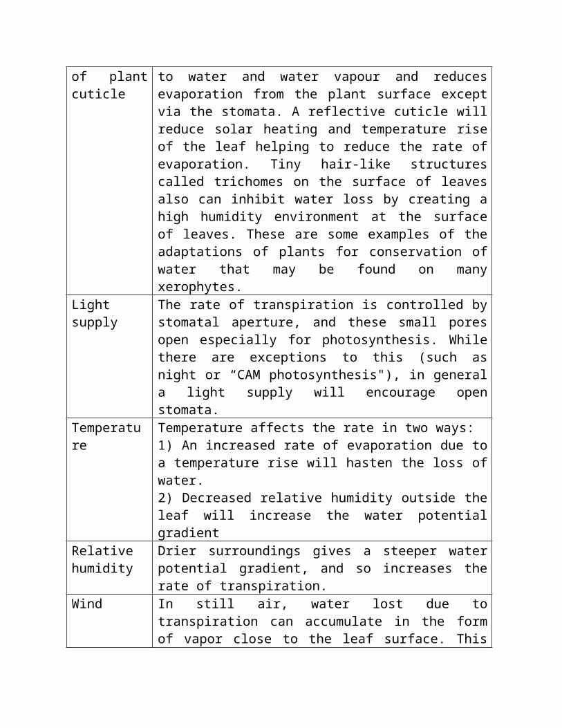
Lightsupply
The rate of transpiration is controlled bystomatal aperture, and these small poresopen especially for photosynthesis. Whilethere are exceptions to this (such asnight or “CAM photosynthesis"), in generala light supply will encourage openstomata.
Temperature
Temperature affects the rate in two ways: 1) An increased rate of evaporation due toa temperature rise will hasten the loss ofwater.2) Decreased relative humidity outside theleaf will increase the water potentialgradient
Relativehumidity
Drier surroundings gives a steeper waterpotential gradient, and so increases therate of transpiration.
Wind In still air, water lost due totranspiration can accumulate in the formof vapor close to the leaf surface. This
will reduce the rate of water loss, as thewater potential gradient from inside tooutside of the leaf is then slightly less.Wind blows away much of this water vapornear the leaf surface, making thepotential gradient steeper and speeding upthe diffusion of water molecules into thesurrounding air. Even in wind, though,there is some accumulation of water vaporin a thin boundary layer of slower movingair next to the leaf surface. The strongerthe wind, the thinner this layer, and thesteeper the water potential gradient.Also, the bigger the leaf, the greater theaverage thickness of the boundary layer,which means a bigger leaf will have aslightly slower transpiration rate perunit area (although a higher transpirationrate overall).
Watersupply
Water stress caused by restricted watersupply from the soil may result instomatal closure and reduce the rates oftranspiration.
There are many reasons for this, such as where themountains are and where the prevailing winds blow. Thisrainfall distribution partly explains the differencesin vegetation and why some areas are deserts and someare rainforests.
3.20 TRANSPORT
The movement of water through the atmosphere,
specifically from over the oceans to over land, iscalled transport. Some of the earth’s moisture transportis visible as clouds, which themselves consist of icecrystals and/or tiny water droplets.
Clouds are propelled from one place to another byeither the jet stream, surface-based circulations likeland and sea breezes or other mechanisms. However, atypical cloud 1 km thick contains only enough water fora millimetre of rainfall, whereas the amount ofmoisture in the atmosphere is usually 10-50 timesgreater than this.
Most water is transported in the form of water vapour,which is actually the third most abundant gas in theatmosphere. Water vapour may be invisible to us, butnot to satellites which are capable of collecting dataabout moisture patterns in the atmosphere.
3.30 CONDENSATION
The transported water vapour eventually condenses,forming tiny droplets in clouds.The primary mechanismfor transporting water from the atmosphere to thesurface of the earth is precipitation.
When the clouds meet cool air over land, precipitation,in the form of rain, sleet or snow, is triggered andwater returns to the land (or sea). Precipitation isthe primary input of the hydrological cycle.
3.31 FORMS OF PRECIPITATION
There are two forms of precipitation: Horizontal andVertical precipitation. Horizontal precipitation
results when water vapour in the atmosphere condencesnear the ground or directly on surfaces on th ground.Dew,Fog and Frost. Vertical precipitation results whendrops of crystals of water join together to form largerdrops and then falls vertically to the ground. Drizzle,Rain, Sleet, Hail and Snow are typical examples.
3.40 GROUNDWATER
Some of the precipitation soaks into the ground andthis is the main source of the formation of the watersfound on land - rivers, lakes, groundwater andglaciers.
Some of the underground water is trapped between rockor clay layers - this is called groundwater. Water thatinfiltrates the soil flows downward until it encountersimpermeable rock and then travels laterally. Thelocations where water moves laterally are called‘aquifers’. Groundwater returns to the surface throughthese aquifers, which empty into lakes, rivers and theoceans.
Under special circumstances, groundwater can even flowupward in artesian wells. The flow of groundwater ismuch slower than run-off with speeds usually measuredin centimetres per day, metres per year or evencentimetres per year. Water seeping down from the landsurface adds to the ground water and is called rechargewater. Ground water is recharged from rain water andsnowmelt or from water that leaks through the bottom ofsome lakes and rivers. Ground water also can berecharged when water-supply systems (pipelines and

canals) leak and when crops are irrigated with morewater than the plants can use.
At least some ground water can be found almosteverywhere. The water table may be deep, such as undera hillside, or shallow such as under a valley. Thewater table may rise or fall depending on severalfactors. Heavy rains or melting snow may increaserecharge and cause the water table to rise. An extendedperiod of dry weather may decrease recharge and causethe water table to fall.
Ground water can be obtained by drilling or diggingwells. A well is usually a pipe in the ground thatfills with ground water. This water can then be broughtto the land surface by a pump. Shallow wells may go dryif the water table falls below the bottom of the well,as illustrated at right.
Water leaving an aquifer is called discharge water.Water that is pumped from a well is discharge water.Ground water might also discharge naturally as springs
or into swamps, lakes, or rivers.
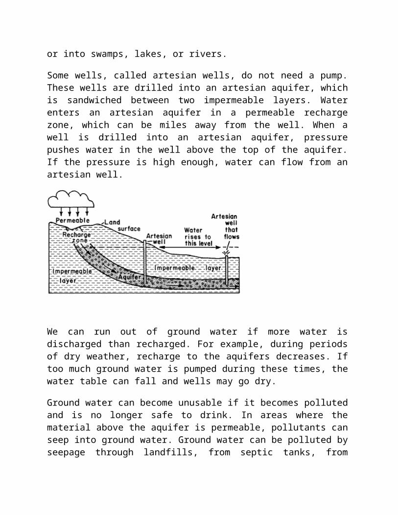
Some wells, called artesian wells, do not need a pump.These wells are drilled into an artesian aquifer, whichis sandwiched between two impermeable layers. Waterenters an artesian aquifer in a permeable rechargezone, which can be miles away from the well. When awell is drilled into an artesian aquifer, pressurepushes water in the well above the top of the aquifer.If the pressure is high enough, water can flow from anartesian well.
We can run out of ground water if more water isdischarged than recharged. For example, during periodsof dry weather, recharge to the aquifers decreases. Iftoo much ground water is pumped during these times, thewater table can fall and wells may go dry.
Ground water can become unusable if it becomes pollutedand is no longer safe to drink. In areas where thematerial above the aquifer is permeable, pollutants canseep into ground water. Ground water can be polluted byseepage through landfills, from septic tanks, from
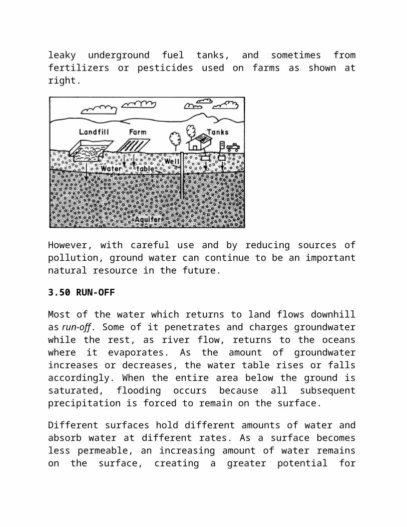
leaky underground fuel tanks, and sometimes fromfertilizers or pesticides used on farms as shown atright.
However, with careful use and by reducing sources ofpollution, ground water can continue to be an importantnatural resource in the future.
3.50 RUN-OFF
Most of the water which returns to land flows downhillas run-off. Some of it penetrates and charges groundwaterwhile the rest, as river flow, returns to the oceanswhere it evaporates. As the amount of groundwaterincreases or decreases, the water table rises or fallsaccordingly. When the entire area below the ground issaturated, flooding occurs because all subsequentprecipitation is forced to remain on the surface.
Different surfaces hold different amounts of water andabsorb water at different rates. As a surface becomesless permeable, an increasing amount of water remainson the surface, creating a greater potential for
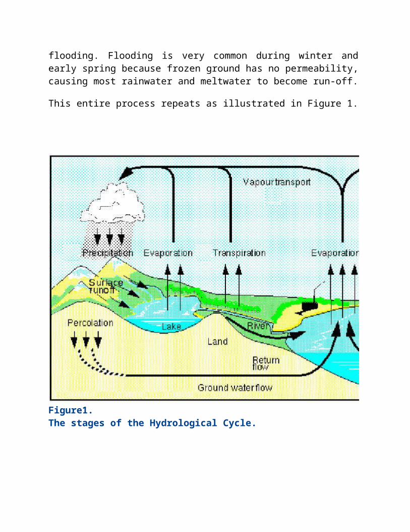
flooding. Flooding is very common during winter andearly spring because frozen ground has no permeability,causing most rainwater and meltwater to become run-off.
This entire process repeats as illustrated in Figure 1.
Figure1.The stages of the Hydrological Cycle.
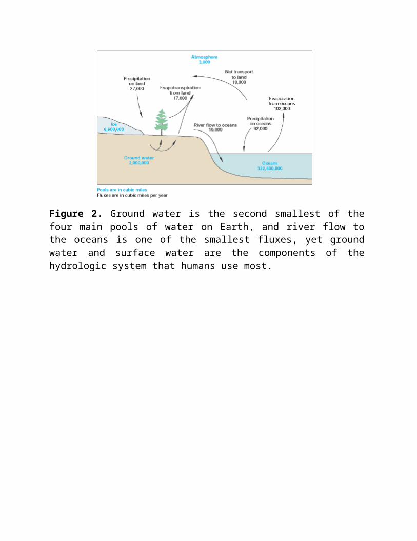
Figure 2. Ground water is the second smallest of thefour main pools of water on Earth, and river flow tothe oceans is one of the smallest fluxes, yet groundwater and surface water are the components of thehydrologic system that humans use most.