Regional Cumulative Effects Assessment - Manitoba Hydro
166
-
Upload
khangminh22 -
Category
Documents
-
view
0 -
download
0
Transcript of Regional Cumulative Effects Assessment - Manitoba Hydro

REGIONAL CUMULATIVE EFFECTS ASSESSMENTFOR HYDROELECTRIC DEVELOPMENTS ON THE CHURCHILL, BURNTWOOD AND NELSON RIVER SYSTEMS: PHASE II REPORT
PART V: WATER

REGIONAL CUMULATIVE EFFECTS ASSESSMENT – PHASE II DECEMBER 2015
WATER
PART V

REGIONAL CUMULATIVE EFFECTS ASSESSMENT – PHASE II WATER – TABLE OF CONTENTS
DECEMBER 2015 5-I
TABLE OF CONTENTS Page
5.0 WATER .......................................................................................................... 5.1-1
5.1 Introduction and Background .......................................................................... 5.1-1
5.1.1 General Description of the Aquatic Ecosystem ............................................................ 5.1-2
5.1.2 Approach ....................................................................................................................... 5.1-3
5.1.2.1 Regional Study Components ......................................................................... 5.1-3
5.1.2.2 Description of Assessment Areas ................................................................. 5.1-5
5.1.2.3 Selection of Indicators and Metrics ............................................................... 5.1-7
5.1.2.4 Selection of Benchmarks and Thresholds ..................................................... 5.1-9
5.1.2.5 Pathways of Effects ..................................................................................... 5.1-10
5.1.3 Organization of Part V ................................................................................................. 5.1-13
5.1.4 Bibliography ................................................................................................................ 5.1-14
5.1.4.1 Literature Cited and Data Sources .............................................................. 5.1-14
5.2 Water Quality .................................................................................................. 5.2-1
5.2.1 Introduction ................................................................................................................... 5.2-1
5.2.1.1 Pathways of Effect ......................................................................................... 5.2-2
5.2.1.2 Indicators and Metrics ................................................................................... 5.2-5
5.2.1.3 Benchmarks ................................................................................................... 5.2-5
5.2.1.4 Approach and Methods ............................................................................... 5.2-13
5.2.1.5 Data Limitations ........................................................................................... 5.2-17
5.2.2 Area 1: Lake Winnipeg Outlet to Jenpeg Generating Station ..................................... 5.2-19
5.2.2.1 Key Published Information .......................................................................... 5.2-23
5.2.2.2 New Information and/or Re-analysis of Existing Information ...................... 5.2-24
5.2.2.3 Changes in Indicators over Time................................................................. 5.2-26
5.2.2.4 Cumulative Effects of Hydroelectric Development on Water Quality .......... 5.2-35
5.2.3 Area 1: Jenpeg Generating Station to Cross Lake Outlet .......................................... 5.2-38
5.2.3.1 Key Published Information .......................................................................... 5.2-38
5.2.3.2 New Information and/or Re-analysis of Existing Information ...................... 5.2-40

REGIONAL CUMULATIVE EFFECTS ASSESSMENT – PHASE II WATER – TABLE OF CONTENTS
DECEMBER 2015 5-II
5.2.3.3 Changes in Indicators over Time................................................................. 5.2-42
5.2.3.4 Cumulative Effects of Hydroelectric Development on Water Quality .......... 5.2-54
5.2.4 Area 1: Downstream of Cross Lake to the Kelsey Generating Station ....................... 5.2-58
5.2.4.1 Key Published Information .......................................................................... 5.2-58
5.2.4.2 New Information and/or Re-analysis of Existing Information ...................... 5.2-59
5.2.4.3 Changes in Indicators over Time................................................................. 5.2-62
5.2.4.4 Cumulative Effects of Hydroelectric Development on Water Quality .......... 5.2-71
5.2.5 Area 2: Split Lake to Stephens Lake ........................................................................... 5.2-74
5.2.5.1 Key Published Information .......................................................................... 5.2-77
5.2.5.2 New Information and/or Re-analysis of Existing Information ...................... 5.2-78
5.2.5.3 Changes in Indicators over Time................................................................. 5.2-81
5.2.5.4 Cumulative Effects of Hydroelectric Development on Water Quality .......... 5.2-92
5.2.6 Area 2: Stephens Lake ............................................................................................... 5.2-95
5.2.6.1 Key Published Information .......................................................................... 5.2-97
5.2.6.2 New Information and/or Re-analysis of Existing Information ...................... 5.2-97
5.2.6.3 Changes in Indicators over Time................................................................. 5.2-99
5.2.6.4 Cumulative Effects of Hydroelectric Development on Water Quality ........ 5.2-108
5.2.7 Area 2: Kettle Generating Station to the Nelson River Estuary ................................ 5.2-111
5.2.7.1 Key Published Information ........................................................................ 5.2-114
5.2.7.2 New Information and/or Re-analysis of Existing Information .................... 5.2-115
5.2.7.3 Changes in Indicators over Time............................................................... 5.2-116
5.2.7.4 Cumulative Effects of Hydroelectric Development on Water Quality ........ 5.2-123
5.2.8 Area 3: Southern Indian Lake ................................................................................... 5.2-125
5.2.8.1 Key Published Information ........................................................................ 5.2-129
5.2.8.2 New Information and/or Re-analysis of Existing Information .................... 5.2-129
5.2.8.3 Changes in Indicators over Time............................................................... 5.2-132
5.2.8.4 Cumulative Effects of Hydroelectric Development on Water Quality ........ 5.2-148
5.2.9 Area 3: South Bay Diversion Channel to Notigi Control Structure ............................ 5.2-152
5.2.9.1 Key Published Information ........................................................................ 5.2-154
5.2.9.2 New Information and/or Re-analysis of Existing Information .................... 5.2-154
5.2.9.3 Changes in Indicators over Time............................................................... 5.2-155
5.2.9.4 Cumulative Effects of Hydroelectric Development on Water Quality ........ 5.2-164

REGIONAL CUMULATIVE EFFECTS ASSESSMENT – PHASE II WATER – TABLE OF CONTENTS
DECEMBER 2015 5-III
5.2.10 Area 3: Notigi Control Structure to Split Lake ........................................................... 5.2-167
5.2.10.1 Key Published Information ........................................................................ 5.2-169
5.2.10.2 New Information and/or Re-Analysis of Existing Information .................... 5.2-170
5.2.10.3 Changes in Indicators over Time............................................................... 5.2-171
5.2.10.4 Cumulative Effects of Hydroelectric Development on Water Quality ........ 5.2-184
5.2.11 Area 4: Missi Falls Control Structure to the Churchill River Estuary ........................ 5.2-187
5.2.11.1 Key Published Information ........................................................................ 5.2-190
5.2.11.2 New Information and/or Re-analysis of Existing Information .................... 5.2-191
5.2.11.3 Changes in Indicators over Time............................................................... 5.2-193
5.2.11.4 Cumulative Effects of Hydroelectric Development on Water Quality ........ 5.2-204
5.2.12 Summary of the Effects of Hydroelectric Development in the Region of Interest on Water Quality ....................................................................................................... 5.2-208
5.2.13 Bibliography .............................................................................................................. 5.2-211
5.2.13.1 Literature Cited and Data Sources ............................................................ 5.2-211
5.3 Fish Community .............................................................................................. 5.3-1
5.3.1 Introduction ................................................................................................................... 5.3-1
5.3.1.1 Pathways of Effect ......................................................................................... 5.3-2
5.3.1.2 The Fish Community and Focal Species ...................................................... 5.3-3
5.3.1.3 Indicators and Metrics ................................................................................... 5.3-7
5.3.1.4 Approach and Methods ................................................................................. 5.3-8
5.3.1.5 Data Limitations ............................................................................................. 5.3-9
5.3.2 Area 1: Lake Winnipeg Outlet to Jenpeg Generating Station ..................................... 5.3-11
5.3.2.1 Key Published Information .......................................................................... 5.3-12
5.3.2.2 New Information and/or Re-analysis of Existing Information ...................... 5.3-14
5.3.2.3 Changes in the Fish Community and Focal Species over Time ................. 5.3-14
5.3.2.4 Cumulative Effects of Hydroelectric Development on the Fish Community from the Outlet of Lake Winnipeg to the Jenpeg Generating Station ......................................................................................................... 5.3-30
5.3.3 Area 1: Jenpeg Generating Station to Kelsey Generating Station ............................. 5.3-33
5.3.3.1 Key Published Information .......................................................................... 5.3-34
5.3.3.2 New Information and/or Re-analysis of Existing Information ...................... 5.3-34
5.3.3.3 Changes in the Fish Community and Focal Species over Time ................. 5.3-35

REGIONAL CUMULATIVE EFFECTS ASSESSMENT – PHASE II WATER – TABLE OF CONTENTS
DECEMBER 2015 5-IV
5.3.3.4 Cumulative Effects of Hydroelectric Development on the Fish Community from the Jenpeg Generating Station to the Kelsey Generating Station ...................................................................................... 5.3-57
5.3.4 Area 2: Kelsey Generating Station to Kettle Generating Station including the Burntwood River downstream of First Rapids Reach ................................................. 5.3-60
5.3.4.1 Key Published Information .......................................................................... 5.3-63
5.3.4.2 New Information and/or Re-analysis of Existing Information ...................... 5.3-63
5.3.4.3 Changes in the Fish Community and Focal Species over Time ................. 5.3-64
5.3.4.4 Cumulative Effects of Hydroelectric Development on the Fish Community from the Kelsey Generating Station to the Kettle Generating Station including the Burntwood River Downstream of First Rapids ......................................................................................................... 5.3-84
5.3.5 Area 2: Kettle Generating Station to the Nelson River Estuary .................................. 5.3-87
5.3.5.1 Key Published Information .......................................................................... 5.3-88
5.3.5.2 New Information and/or Re-analysis of Existing Information ...................... 5.3-89
5.3.5.3 Changes in the Fish Community and Focal Species over Time ................. 5.3-89
5.3.5.4 Cumulative Effects of Hydroelectric Development on the Fish Community from the Kettle Generating Station to the Nelson River Estuary ...................................................................................................... 5.3-107
5.3.6 Area 3: Southern Indian Lake ................................................................................... 5.3-108
5.3.6.1 Key Published Information ........................................................................ 5.3-108
5.3.6.2 New Information and/or Re-analysis of Existing Information .................... 5.3-110
5.3.6.3 Changes in the Fish Community and Focal Species over Time ............... 5.3-111
5.3.6.4 Cumulative Effects of Hydroelectric Development on the Fish Community of Southern Indian Lake ......................................................... 5.3-137
5.3.7 Area 3: South Bay Diversion Channel to First Rapids on the Burntwood River ....... 5.3-141
5.3.7.1 Key Published Information ........................................................................ 5.3-141
5.3.7.2 New Information and/or Re-analysis of Existing Information .................... 5.3-142
5.3.7.3 Changes in the Fish Community and Focal Species over Time ............... 5.3-143
5.3.7.4 Cumulative Effects of Hydroelectric Development on the Fish Community from the South Bay Diversion Channel to First Rapids on the Burntwood River .................................................................................. 5.3-163
5.3.8 Area 4: Missi Falls Control Structure to the Churchill River Estuary ........................ 5.3-166
5.3.8.1 Key Published Information ........................................................................ 5.3-168
5.3.8.2 New Information and/or Re-analysis of Existing Information .................... 5.3-169
5.3.8.3 Changes in the Fish Community and Focal Species over Time ............... 5.3-169

REGIONAL CUMULATIVE EFFECTS ASSESSMENT – PHASE II WATER – TABLE OF CONTENTS
DECEMBER 2015 5-V
5.3.8.4 Cumulative Effects of Hydroelectric Development on the Fish Community from Missi Falls Control Structure to the Churchill River Estuary ...................................................................................................... 5.3-194
5.3.9 Summary of the Effects of Hydroelectric Development in the Region of Interest on Fish Community ................................................................................................... 5.3-198
5.3.10 Bibliography .............................................................................................................. 5.3-202
5.3.10.1 Literature Cited and Data Sources ............................................................ 5.3-202
5.4 Lake Sturgeon ................................................................................................ 5.4-1
5.4.1 Introduction ................................................................................................................... 5.4-1
5.4.1.1 Lake Sturgeon Life History ............................................................................ 5.4-4
5.4.1.2 Pathways of Effect ......................................................................................... 5.4-5
5.4.1.3 Indicators and Metrics ................................................................................... 5.4-5
5.4.1.4 Approach and Methods ................................................................................. 5.4-5
5.4.1.5 Data Limitations ............................................................................................. 5.4-6
5.4.2 Area 1: Lake Winnipeg Outlet to Kelsey Generating Station ........................................ 5.4-8
5.4.2.1 Key Published Information .......................................................................... 5.4-11
5.4.2.2 New Information and/or Re-analysis of Existing Information ...................... 5.4-12
5.4.2.3 Changes in Lake Sturgeon over Time ......................................................... 5.4-12
5.4.2.4 Cumulative Effects of Hydroelectric Development on Lake Sturgeon in Area 1 .......................................................................................................... 5.4-25
5.4.3 Area 2: Kelsey Generating Station to the Nelson River Estuary including the Burntwood River downstream of First Rapids ............................................................ 5.4-27
5.4.3.1 Key Published Information .......................................................................... 5.4-30
5.4.3.2 New Information and/or Re-analysis of Existing Information ...................... 5.4-31
5.4.3.3 Changes in Lake Sturgeon over Time ......................................................... 5.4-32
5.4.3.4 Cumulative Effects of Hydroelectric Development on Lake Sturgeon in Area 2 .......................................................................................................... 5.4-47
5.4.4 Area 3: Southern Indian Lake to First Rapids on the Burntwood River ...................... 5.4-51
5.4.4.1 New Information and/or Re-analysis of Existing Information ...................... 5.4-51
5.4.4.2 Changes in Lake Sturgeon over Time ......................................................... 5.4-53
5.4.4.3 Cumulative Effects of Hydroelectric Development on Lake Sturgeon in Area 3 .......................................................................................................... 5.4-54
5.4.5 Area 4: Missi Falls Control Structure to Churchill River Estuary ................................ 5.4-55
5.4.5.1 Key Published Information .......................................................................... 5.4-57
5.4.5.2 New Information and/or Re-analysis of Existing Information ...................... 5.4-57

REGIONAL CUMULATIVE EFFECTS ASSESSMENT – PHASE II WATER – TABLE OF CONTENTS
DECEMBER 2015 5-VI
5.4.5.3 Changes in Lake Sturgeon over Time ......................................................... 5.4-58
5.4.5.4 Cumulative Effects of Hydroelectric Development on Lake Sturgeon in Area 4 .......................................................................................................... 5.4-60
5.4.6 Summary of the Effects of Hydroelectric Development in the Region of Interest on Lake Sturgeon ........................................................................................................ 5.4-61
5.4.7 Bibliography ................................................................................................................ 5.4-63
5.4.7.1 Literature Cited and Data Sources .............................................................. 5.4-63
5.4.7.2 Personal Communications .......................................................................... 5.4-75
5.5 Mercury in Fish ............................................................................................... 5.5-1
5.5.1 Introduction ................................................................................................................... 5.5-1
5.5.1.1 Pathways of Effects ....................................................................................... 5.5-2
5.5.1.2 History of Mercury Research and Monitoring in Manitoba ............................ 5.5-3
5.5.1.3 Indicators and Metrics ................................................................................... 5.5-6
5.5.1.4 Approach and Methods ................................................................................. 5.5-8
5.5.1.5 Data Limitations ........................................................................................... 5.5-11
5.5.2 Area 1: Lake Winnipeg Outlet to Kelsey Generating Station ...................................... 5.5-13
5.5.2.1 Key Published Information .......................................................................... 5.5-13
5.5.2.2 New Information and/or Re-analysis of Existing Information ...................... 5.5-14
5.5.2.3 Changes in Mercury Concentrations over Time .......................................... 5.5-16
5.5.2.4 Cumulative Effects of Hydroelectric Development on Fish Mercury Concentrations in Area 1 ............................................................................. 5.5-24
5.5.3 Area 2: Kelsey Generating Station to the Nelson River Estuary ................................ 5.5-30
5.5.3.1 Key Published Information .......................................................................... 5.5-31
5.5.3.2 New Information and/or Re-analysis of Existing Information ...................... 5.5-32
5.5.3.3 Changes in Mercury Concentrations over Time .......................................... 5.5-34
5.5.3.4 Cumulative Effects of Hydroelectric Development on Fish Mercury Concentrations in Area 2 ............................................................................. 5.5-46
5.5.4 Area 3: Southern Indian Lake to Split Lake Inlet ........................................................ 5.5-53
5.5.4.1 Key Published Information .......................................................................... 5.5-53
5.5.4.2 New Information and/or Re-analysis of Existing Information ...................... 5.5-56
5.5.4.3 Changes in Mercury Concentrations over Time .......................................... 5.5-56
5.5.4.4 Cumulative Effects of Hydroelectric Development on Fish Mercury Concentrations in Area 3 ............................................................................. 5.5-71
5.5.5 Area 4: Missi Falls Control Structure to the Churchill River Estuary .......................... 5.5-83

REGIONAL CUMULATIVE EFFECTS ASSESSMENT – PHASE II WATER – TABLE OF CONTENTS
DECEMBER 2015 5-VII
5.5.5.1 Key Published Information .......................................................................... 5.5-83
5.5.5.2 New Information and/or Re-analysis of Existing Information ...................... 5.5-84
5.5.5.3 Pre-CRD Baseline Mercury Concentrations ................................................ 5.5-87
5.5.5.4 Changes in Mercury Concentrations over Time .......................................... 5.5-88
5.5.5.5 Cumulative Effects of Hydroelectric Development on Fish Mercury Concentrations in Area 4 ............................................................................. 5.5-94
5.5.6 Effects of Changes in Hydroelectric Development on Fish Mercury Concentrations in the Region of Interest..................................................................... 5.5-98
5.5.7 Bibliography .............................................................................................................. 5.5-100
5.5.7.1 Literature Cited and Data Sources ............................................................ 5.5-100
5.5.7.2 Personal Communications ........................................................................ 5.5-113
5.6 Fish Quality..................................................................................................... 5.6-1
5.6.1 Introduction ................................................................................................................... 5.6-1
5.6.1.1 Pathways of Effect ......................................................................................... 5.6-2
5.6.1.2 Indicators and Metrics ................................................................................... 5.6-3
5.6.1.3 Data Limitations ............................................................................................. 5.6-4
5.6.2 Area 1: Lake Winnipeg Outlet to Kelsey Generating Station ........................................ 5.6-6
5.6.2.1 Approach and Methods ................................................................................. 5.6-6
5.6.2.2 Key Published Information ............................................................................ 5.6-7
5.6.2.3 New Information and/or Re-analysis of Existing Information ........................ 5.6-7
5.6.2.4 Changes in Indicators over Time................................................................... 5.6-9
5.6.2.5 Cumulative Effects of Hydroelectric Development on Fish Quality in Area 1 .......................................................................................................... 5.6-10
5.6.3 Area 2: Split Lake to Nelson River Estuary ................................................................. 5.6-12
5.6.3.1 Approach and Methods ............................................................................... 5.6-12
5.6.3.2 Key Published Information .......................................................................... 5.6-14
5.6.3.3 New Information and/or Re-analysis of Existing Information ...................... 5.6-15
5.6.3.4 Changes in Indicators over Time................................................................. 5.6-15
5.6.3.5 Cumulative Effects of Hydroelectric Development on Fish Quality in Area 2 .......................................................................................................... 5.6-16
5.6.4 Area 3: Southern Indian Lake to Split Lake Inlet ........................................................ 5.6-18
5.6.4.1 Approach and Methods ............................................................................... 5.6-18
5.6.4.2 Key Published Information .......................................................................... 5.6-20

REGIONAL CUMULATIVE EFFECTS ASSESSMENT – PHASE II WATER – TABLE OF CONTENTS
DECEMBER 2015 5-VIII
5.6.4.3 New Information and/or Re-analysis of Existing Information ...................... 5.6-20
5.6.4.4 Changes in Indicators over Time................................................................. 5.6-20
5.6.4.5 Cumulative Effects of Hydroelectric Development on Fish Quality in Area 3 .......................................................................................................... 5.6-26
5.6.5 Area 4: Missi Falls Control Structure to Churchill River Estuary ................................ 5.6-28
5.6.5.1 Approach and Methods ............................................................................... 5.6-28
5.6.5.2 Key Published Information .......................................................................... 5.6-28
5.6.5.3 New Information and/or Re-analysis of Existing Information ...................... 5.6-30
5.6.5.4 Changes in Indicators over Time................................................................. 5.6-30
5.6.5.5 Cumulative Effects of Hydroelectric Development on Fish Quality in Area 4 .......................................................................................................... 5.6-31
5.6.6 Summary of Effects of Hydroelectric Development in the Region of Interest on Fish Quality ................................................................................................................. 5.6-32
5.6.7 Bibliography ................................................................................................................ 5.6-33
5.6.7.1 Literature Cited and Data Sources .............................................................. 5.6-33
5.6.7.2 Personal Communications .......................................................................... 5.6-36
5.7 Seals .............................................................................................................. 5.7-1
5.7.1 Introduction ................................................................................................................... 5.7-1
5.7.1.1 Pathways of Effect ......................................................................................... 5.7-1
5.7.1.2 Indicators and Metrics ................................................................................... 5.7-4
5.7.1.3 Approach and Methods ................................................................................. 5.7-4
5.7.1.4 Data Limitations ............................................................................................. 5.7-4
5.7.2 Area 2: Kelsey Generating Station to the Nelson River Estuary .................................. 5.7-5
5.7.2.1 Key Published Information ............................................................................ 5.7-5
5.7.2.2 New Information and/or Re-analysis of Existing Information ........................ 5.7-5
5.7.2.3 Changes in Seals over Time ......................................................................... 5.7-5
5.7.2.4 Cumulative Effects of Hydroelectric Development on Seals in Area 2 ....... 5.7-10
5.7.3 Area 4: Missi Falls Control Structure to the Churchill River Estuary .......................... 5.7-11
5.7.3.1 Key Published Information .......................................................................... 5.7-11
5.7.3.2 New Information and/or Re-analysis of Existing Information ...................... 5.7-12
5.7.3.3 Changes in Seals over Time ....................................................................... 5.7-12
5.7.3.4 Cumulative Effects of Hydroelectric Development on Seals in Area 4 ....... 5.7-17

REGIONAL CUMULATIVE EFFECTS ASSESSMENT – PHASE II WATER – TABLE OF CONTENTS
DECEMBER 2015 5-IX
5.7.4 Summary of the Effects of Hydroelectric Development in the Region of Interest on Seals ...................................................................................................................... 5.7-18
5.7.5 Bibliography ................................................................................................................ 5.7-19
5.7.5.1 Literature Cited and Data Sources .............................................................. 5.7-19
5.8 Beluga ............................................................................................................ 5.8-1
5.8.1 Introduction ................................................................................................................... 5.8-1
5.8.1.1 Pathways of Effect ......................................................................................... 5.8-4
5.8.1.2 Indicators and Metrics ................................................................................... 5.8-6
5.8.1.3 Approach and Methods ................................................................................. 5.8-6
5.8.1.4 Data Limitations ............................................................................................. 5.8-6
5.8.2 Area 2: Kelsey Generating Station to Nelson River Estuary ........................................ 5.8-8
5.8.2.1 Key Published Information ............................................................................ 5.8-8
5.8.2.2 New Information and/or Re-analysis of Existing Information ........................ 5.8-8
5.8.2.3 Changes in Beluga over Time ....................................................................... 5.8-8
5.8.2.4 Cumulative Effects ...................................................................................... 5.8-15
5.8.3 Area 4: Missi Falls Control Structure to Churchill River Estuary ................................ 5.8-16
5.8.3.1 Key Published Information .......................................................................... 5.8-16
5.8.3.2 New Information and/or Re-analysis of Existing Information ...................... 5.8-17
5.8.3.3 Changes in Beluga over Time ..................................................................... 5.8-17
5.8.3.4 Cumulative Effects ...................................................................................... 5.8-22
5.8.4 Summary of the Effects of Hydroelectric Development in the Region of Interest on Beluga .................................................................................................................... 5.8-24
5.8.5 Bibliography ................................................................................................................ 5.8-25
5.8.5.1 Literature Cited and Data Sources .............................................................. 5.8-25

REGIONAL CUMULATIVE EFFECTS ASSESSMENT – PHASE II WATER – LIST OF TABLES
DECEMBER 2015 5-X
LIST OF TABLES Page Table 5.1.2-1: List of Regional Study Components for Water ....................................................... 5.1-4 Table 5.1.2-2: Indicators and Metrics Used to Assess the Condition of Regional Study
Components ........................................................................................................... 5.1-8 Table 5.2.1-1: Description of Water Quality Indicators and Metrics Applied for the RCEA ........... 5.2-7 Table 5.2.1-2: Benchmarks Applied for the Water Quality RCEA ................................................. 5.2-9 Table 5.2.1-3: Hardness Scale for Aquatic Ecosystems (CCREM 1987) .................................... 5.2-11 Table 5.2.1-4: Trophic Categorization Schemes Applied for Lakes and Reservoirs ................... 5.2-11 Table 5.2.1-5: Trophic Categorization Schemes Applied for Rivers ............................................ 5.2-12 Table 5.2.2-1: Water Quality Data Subject to Detailed Analysis ................................................. 5.2-26 Table 5.2.3-1: Water Quality Data Subject to Detailed Analysis ................................................. 5.2-42 Table 5.2.4-1: Water Quality Data Subject to Detailed Analysis ................................................. 5.2-62 Table 5.2.5-1: Water Quality Data Subject to Detailed Analysis ................................................. 5.2-79 Table 5.2.6-1: Water Quality Data Subject to Detailed Analysis ................................................. 5.2-99 Table 5.2.7-1: Water Quality data Subject to detailed Analysis................................................. 5.2-116 Table 5.2.8-1: Water Quality Data Subject to Detailed Analysis ............................................... 5.2-132 Table 5.2.8-2: Summary of Results of Linear Regression between water quality metrics
measured in SIL Area 4 near the Missi Falls CS and hydrological metrics: open water season post-CRD (1977–2013) ....................................................... 5.2-137
Table 5.2.8-3: Summary of results of linear regression between water quality metrics measured in SIL Area 6 near the community of South Indian Lake and hydrological metrics: open water season post-CRD (1977–2013) ..................... 5.2-138
Table 5.2.9-1: Water Quality Subject to Detailed Analysis ........................................................ 5.2-155 Table 5.2.10-1: Water Quality Data Subject to Detailed Analysis ............................................... 5.2-171 Table 5.2.11-1: Water Quality Data Subject to Detailed Analysis ............................................... 5.2-192 Table 5.2.11-2: Summary of Results of Linear Regression Between Hydrological and Water
Quality Metrics at Red Head Rapids: Pre- (1972–1975) vs. Post-CRD (1977+) ............................................................................................................... 5.2-194
Table 5.2.11-3: Summary of Results of Linear Regression Between Water Quality Metrics in Southern Indian Lake Near the Missi Falls CS (SIL Area 4) and Discharge at Leaf Rapids and the Missi Falls CS: Open Water Season 1977–2013 ............. 5.2-200
Table 5.2.11-4: Overview of statistically significant differences in water quality metrics at Red Head Rapids and near the Town of Churchill between 1972–1975 and 1977–2013 .......................................................................................................... 5.2-206
Table 5.5.1-1: List of Fish Species with Information on Mercury Concentrations in the Region Of Interest for Years 1971–2014 ................................................................ 5.5-9

REGIONAL CUMULATIVE EFFECTS ASSESSMENT – PHASE II WATER – LIST OF TABLES
DECEMBER 2015 5-XI
Table 5.5.2-1: Standard Mean Mercury Concentrations, Parts-per-Million, for Northern Pike and Walleye from Area 1 On-System Lakes with Data that Pre-Date Lake Winnipeg Regulation (1973–1976) ....................................................................... 5.5-25
Table 5.5.2-2: Mean Mercury Concentrations, Parts-per-Million, from Commercial Samples of Northern Pike and Walleye from Selected Area 1 Lakes for Years 1970–1979 ...................................................................................................................... 5.5-26
Table 5.5.3-1: Arithmetic Mean (range) Mercury Concentrations, Parts-per-Million, and Fork Length for Lake Sturgeon from Two Reaches of the Nelson River (downstream of Limestone Generating Station to Gillam Island, and the estuary), the Hayes River, and Split, Gull, and Stephens Lakes ......................... 5.5-49
Table 5.5.4-1: Mean (range) Mercury Concentrations, Parts-per-Million, for Northern Pike, Walleye, and Lake Whitefish from On-System and Off-System Waterbodies in Area 3 for the Years Predating Churchill River Diversion (1969–1974, except Wuskwatim Lake, 1970–1976) ................................................................. 5.5-57
Table 5.5.4-2: Standard Mean Mercury Concentrations, Part-per-Million, for Northern Pike, Walleye, and Lake Whitefish from Five Coordinated Aquatic Monitoring Program Off-System Reference Lakes for Years 2002–2014 .............................. 5.5-73
Table 5.5.4-3: Average mercury concentration prior to flooding (Hg pre-flood), maximum post-Churchill River Diversion mercury concentration (Hg Max), the number of years to reach Hg Max after the end of flooding, minimum mercury concentration post-Churchill River Diversion (Hg Min), the year Hg Min was observed, the increase factor, and the return time for Lake Whitefish, Northern Pike, and Walleye from fifteen Area 3 lakes flooded by Churchill River Diversion and three reservoirs in Area 2..................................................... 5.5-78
Table 5.5.5-1: Mean (range) Mercury Concentrations, Part-per-Million, for Northern Pike, Walleye, and Lake Whitefish from On-System and Off-System Waterbodies in Area 4 for Years Predating Churchill River Diversion (1970–1972) ................. 5.5-88
Table 5.5.5-2: Standard Mean or Arithmetic Mean Mercury Concentrations with 95% Confidence Limits, Parts-per-Million, for Northern Pike, Walleye, and Lake Whitefish from Nine Off-System Lakes in Area 4 for Years 1978–2005 .............. 5.5-95
Table 5.6.2-1: Historical and Current Grades for Lake Whitefish in Area 1 Waterbodies Based on Triaenophorus crassus Cyst Counts .................................................... 5.6-10
Table 5.6.3-1: Historical and Current Grades for Lake Whitefish in Area 2 Waterbodies Based on Triaenophorus crassus Cyst Counts .................................................... 5.6-16
Table 5.6.4-1: Historical and Current Grades for Lake Whitefish in Area 3 Waterbodies Based on Triaenophorus crassus Cyst Counts .................................................... 5.6-25
Table 5.6.5-1: Historical and Current Grades for Lake Whitefish in Area 4 Waterbodies Based on Triaenophorus crassus Cyst Counts .................................................... 5.6-31
Table 5.7.3-1: Comparison of the Annual and Seasonal Mean Number of Seals Observed along the Lower Churchill River, 1996–2005 ....................................................... 5.7-16
Table 5.8.3-1: Number and Distribution of Beluga Observed in the Churchill River Estuary, 1983, 1984, and 2000 ........................................................................................... 5.8-22

REGIONAL CUMULATIVE EFFECTS ASSESSMENT – PHASE II WATER – LIST OF FIGURES
DECEMBER 2015 5-XII
LIST OF FIGURES Page Figure 5.1.2-1: The Primary Pathways of Effects for Hydroelectric Developments and Other
Projects and Activities .......................................................................................... 5.1-12 Figure 5.2.1-1: Linkage Diagram Showing Potential Pathways of Effect of Hydroelectric and
Other Factors on Water Quality .............................................................................. 5.2-4 Figure 5.3.1-1: Linkage Diagram Showing Potential Pathways of Effect of Hydroelectric
Development and Other Factors on the Fish Community ...................................... 5.3-5 Figure 5.4.1-1: Potential Pathways of Effect of Hydroelectric Development and Other Factors
on Lake Sturgeon. .................................................................................................. 5.4-7 Figure 5.5.1-1: Linkage Diagram Showing Potential Pathways of Effect of Hydroelectric
Development and Other Factors on Mercury Concentrations in Fish .................... 5.5-5 Figure 5.5.2-1: Mean Length (95% Confidence Limits)Standardized Muscle Mercury
Concentrations of Northern Pike, Walleye, and Lake Whitefish From Playgreen Lake for 1978–2012 ............................................................................ 5.5-17
Figure 5.5.2-2: Mean (95 % Confidence Limits) Length Standardized Muscle Mercury Concentrations of Northern Pike, Walleye, and Lake Whitefish From Little Playgreen Lake for 1981–2013 ............................................................................ 5.5-18
Figure 5.5.2-3: Mean (95% Confidence Limits) Length Standardized Muscle Mercury Concentrations of Northern Pike, Walleye, and Lake Whitefish From Kiskittogisu Lake for 1978–2012 .......................................................................... 5.5-19
Figure 5.5.2-4: Mean (95% Confidence Limits [CL]) Length Standardized Muscle Mercury Concentrations of Northern Pike, Walleye, and Lake Whitefish From Cross Lake for 1971–2014 .............................................................................................. 5.5-21
Figure 5.5.2-5: Mean (95% Confidence Limits [CL]) Length Standardized Muscle Mercury Concentrations of Northern Pike, Walleye, Lake Whitefish, and Sauger From Sipiwesk Lake for 1970–2014 .............................................................................. 5.5-22
Figure 5.5.2-6: Mean (95% Confidence Limits) Length Standardized Muscle Mercury Concentrations of Northern Pike, Walleye, and Lake Whitefish From Setting Lake for 1978–2013 .............................................................................................. 5.5-23
Figure 5.5.3-1: Mean (95% Confidence Limits [CL]) Length Standardized Muscle Mercury Concentrations of Northern Pike, Walleye, and Lake Whitefish From Split Lake for 1969–2013 .............................................................................................. 5.5-35
Figure 5.5.3-2: Mean (95% Confidence Limits) Length Standardized Muscle Mercury Concentrations of White Sucker, Longnose Sucker, Cisco, and Sauger From Split Lake for 1976–1998...................................................................................... 5.5-36
Figure 5.5.3-3: Mean (95% Confidence Limits [CL]) Length Standardized Muscle Mercury Concentrations of Northern Pike, Walleye, and Lake Whitefish From Stephens Lake for 1981–2013 ............................................................................. 5.5-37

REGIONAL CUMULATIVE EFFECTS ASSESSMENT – PHASE II WATER – LIST OF FIGURES
DECEMBER 2015 5-XIII
Figure 5.5.3-4: Mean (95% Confidence Limits) Length Standardized Muscle Mercury Concentrations of Northern Pike, Walleye, and Lake Whitefish From the Long Spruce Forebay for 1985–2003 ............................................................................ 5.5-38
Figure 5.5.3-5: Mean (95% Confidence Limits) Length Standardized Muscle Mercury Concentrations of Northern Pike, Walleye, and Lake Whitefish From the Limestone Forebay for 1989-2013 ....................................................................... 5.5-40
Figure 5.5.3-6: Mean Arithmetic Standard Error and Standardized (Upper 95% Confidence Limit) Mercury Concentration, and Mean Standard Error Fork Length of Lake Whitefish Collected From Several Reaches of the Nelson River Mainstem in 1992 ...................................................................................................................... 5.5-41
Figure 5.5.3-7: Mean (95% Confidence Limits [CL]) Length Standardized Muscle Mercury Concentrations of Northern Pike, Walleye, and Lake Whitefish From the Lower Nelson River Downstream of the Limestone Generating Station for 1975–2013 ............................................................................................................ 5.5-42
Figure 5.5.3-8: Mean (95% Confidence Limits) Length Standardized Muscle Mercury Concentrations of Northern Pike and Walleye From the Aiken River at York Landing and Ilford for Years 1978–2012 .............................................................. 5.5-44
Figure 5.5.3-9: Mean (95% Confidence Limits [CL]) Length Standardized Muscle Mercury Concentrations of Northern Pike, Walleye, and Lake Whitefish From Assean Lake for 1978–2013 .............................................................................................. 5.5-45
Figure 5.5.3-10: Mean (95% Confidence Limits) Length Standardized Muscle Mercury Concentrations of Northern Pike Walleye, and Lake Whitefish From the Hayes River for 2006–2013 .................................................................................. 5.5-46
Figure 5.5.4-1: Mean (95% Confidence Limits [CL]) Length Standardized Muscle Mercury Concentrations of Northern Pike, Walleye, and Lake Whitefish From Area 6 (South Bay) of Southern Indian Lake for 1969–2013 ........................................... 5.5-59
Figure 5.5.4-2: Mean (95% Confidence limits) Length Standardized Muscle Mercury Concentrations of Northern Pike, Walleye, and Lake Whitefish From Issett Lake for 1975–2008 .............................................................................................. 5.5-62
Figure 5.5.4-3: Mean (95% Confidence Limits) Length Standardized Muscle Mercury Concentrations of Northern Pike, Walleye, and Lake Whitefish From Rat Lake for Years 1978–2005 ................................................................................... 5.5-63
Figure 5.5.4-4: Mean (95% Confidence Limits [CL]) Length Standardized Muscle Mercury Concentrations of Northern Pike, Walleye, and Lake Whitefish From Notigi Lake for 1977–2007 .............................................................................................. 5.5-65
Figure 5.5.4-5: Mean (95% Confidence Limits[CL]) Length Standardized Muscle Mercury Concentrations of Northern Pike, Walleye, and Lake Whitefish From Threepoint Lake for 1980–2014 ........................................................................... 5.5-66
Figure 5.5.4-6: Mean (95% Confidence Limits) Length Standardized Muscle Mercury Concentrations of Sauger, Cisco, White Sucker, and Longnose Sucker From Threepoint Lake for Years 1981-2005 .................................................................. 5.5-67

REGIONAL CUMULATIVE EFFECTS ASSESSMENT – PHASE II WATER – LIST OF FIGURES
DECEMBER 2015 5-XIV
Figure 5.5.4-7: Mean (95% Confidence Limits) Length Standardized Muscle Mercury Concentrations of Northern Pike, Walleye, and Lake Whitefish From Wuskwatim Lake for 1970–2014 .......................................................................... 5.5-69
Figure 5.5.4-8: Mean (95% Confidence Limits [CL]) Length Standardized Muscle Mercury Concentrations of Northern Pike, Walleye, and Lake Whitefish From Leftrook Lake for 1981–2014 .............................................................................................. 5.5-70
Figure 5.5.4-9: Mean (95% Confidence Limits [CL]) Length Standardized Muscle Mercury Concentrations of Northern Pike, Walleye, and Lake Whitefish From Granville Lake Lake for 1970–2014 ..................................................................... 5.5-74
Figure 5.5.4-10: Maximum Observed Mercury Concentration in Northern Pike and Walleye From Lakes and Reservoirs in Areas 2 and 3 ...................................................... 5.5-80
Figure 5.5.4-11: Generalized Timeline (Red Line) of Changes in Fish Mercury Concentrations Based on Results From Reservoirs and Flooded Lakes Due to Hydroelectric Development in the Region Of Interest ................................................................ 5.5-81
Figure 5.5.5-1: Mean (95% Confidence Limits [CL]) Length Standardized Muscle Mercury Concentrations of Northern Pike, Walleye, and Lake Whitefish From Northern Indian Lake for 1971–2013 ................................................................................... 5.5-89
Figure 5.5.5-2: Mean (95% Confidence Limits [CL]) Length Standardized Muscle Mercury Concentrations of Northern Pike and Walleye From the Churchill River Mouth for 1970–1998 ...................................................................................................... 5.5-91
Figure 5.5.5-3: Mean (95% Confidence Limits) Length Standardized Muscle Mercury Concentrations of Northern Pike, Walleye, and Lake Whitefish From the Churchill River Upstream of the Weir for 1994–2013 ........................................... 5.5-93
Figure 5.5.5-4: Relationship Between Mercury Concentration and Fork Length for Lake Sturgeon From the Churchill River at the Little Churchill River for 2010–2014 and the Hayes River for 2009–2013 ..................................................................... 5.5-96
Figure 5.6.1-1: Linkage Diagram Showing Potential Pathways of Effect of Hydroelectric Development and Other Factors on Fish Quality ................................................... 5.6-5
Figure 5.6.4-1: The Rate of Infestation of Triaenophorus crassus Cysts in Lake Whitefish from Commercial Fishery and Experimental (SIL Areas 4 and 5 only) Catches in Southern Indian Lake, 1952–2013 ..................................................... 5.6-24
Figure 5.7.1-1: Linkage Diagram Showing Potential Pathways of Effect of Hydroelectric Development and Other Factors on Seals ............................................................. 5.7-3
Figure 5.7.2-1: Seasonal Differences in the Number of Seals Observed during Systematic Surveys in 2006 and 2007 between the Upstream End of Gillam Island to Port Nelson in Relation to Tide State, Compared with Opportunistic Observations Conducted at Low Tide in 2009 ....................................................... 5.7-8
Figure 5.7.3-1: Distribution of Seals Observed during Aerial Surveys of the Lower Churchill River, 1998 ........................................................................................................... 5.7-15
Figure 5.7.3-2: Average Daily Locations for 17 Juvenile and Adult Harbour Seals Satellite Tagged in the Churchill River Estuary, Western Hudson Bay, during Fall, 2001 and 2002 ...................................................................................................... 5.7-17

REGIONAL CUMULATIVE EFFECTS ASSESSMENT – PHASE II WATER – LIST OF FIGURES
DECEMBER 2015 5-XV
Figure 5.8.1-1: Linkage Diagram Showing Potential Pathways of Effect of Hydroelectric Development and Other Factors on Beluga ........................................................... 5.8-5
Figure 5.8.2-1: Visible Population Estimates (a) and Average Density (b) of Beluga Observed at High and Low Tides in the Nelson River Estuary during 2003 ........ 5.8-12
Figure 5.8.2-2: Visible Population Estimates (a) and Average Density (b) of Beluga Observed at High and Low Tides in the Nelson River Estuary During 2005 ....... 5.8-13
Figure 5.8.3-1: Historic Harvest (Domestic and Commercial) of Beluga from Churchill, MB, 1930–1989 ............................................................................................................ 5.8-18

REGIONAL CUMULATIVE EFFECTS ASSESSMENT – PHASE II WATER – LIST OF MAPS
DECEMBER 2015 5-XVI
LIST OF MAPS Page Map 5.1.2-1: The Region of Interest Showing the Four Primary Aquatic Areas and
Watersheds ............................................................................................................ 5.1-6 Map 5.2.1-1: Water Quality Assessment Areas – Overview........................................................ 5.2-3 Map 5.2.2-1: Water Quality Assessment Area – Lake Winnipeg Outlet to Kelsey
Generating Station – RCEA Area 1 ...................................................................... 5.2-21 Map 5.2.2-2: Water Quality Sampling Sites – Outlet of Lake Winnipeg to Cross Lake ............. 5.2-22 Map 5.2.3-1: Water Quality Sampling Sites – Cross Lake ........................................................ 5.2-39 Map 5.2.4-1: Water Quality Sampling Sites – Downstream of Cross Lake to Kelsey
Generating Station ................................................................................................ 5.2-61 Map 5.2.5-1: Water Quality Assessment Area – Split Lake to Nelson River Estuary –
RCEA Area 2 ........................................................................................................ 5.2-76 Map 5.2.5-2: Water Quality Sampling Sites – Split Lake Area .................................................. 5.2-80 Map 5.2.6-1: Water Quality Sampling Sites – Stephens Lake Area .......................................... 5.2-96 Map 5.2.6-2: In situ Dissolved Oxygen Sampling Sites August 1972 (Crowe 1973) –
Stephens Lake .................................................................................................... 5.2-104 Map 5.2.7-1: Water Quality Sampling Sites – Downstream of Kettle Generating Station ....... 5.2-113 Map 5.2.8-1: Water Quality Assessment Area – Southern Indian Lake to Split Lake –
RCEA Area 3 ...................................................................................................... 5.2-126 Map 5.2.8-2: MCWS Water Quality Sampling Sites – Southern Indian Lake and Upstream
Area .................................................................................................................... 5.2-127 Map 5.2.8-3: DFO and CAMP Water Quality Sampling Sites – Southern Indian Lake ........... 5.2-128 Map 5.2.9-1: Water Quality Sampling Sites – Downstream of Southern Indian Lake to
Notigi Lake .......................................................................................................... 5.2-153 Map 5.2.10-1: Water Quality Sampling Sites – Notigi Lake to Split Lake .................................. 5.2-168 Map 5.2.11-1: Water Quality Assessment Area – Missi Falls Control Structure to Churchill
River Estuary – RCEA Area 4 ............................................................................ 5.2-188 Map 5.2.11-2: Water Quality Sampling Sites – Southern Indian Lake to Churchill River
Estuary................................................................................................................ 5.2-189 Map 5.3.1-1: Fish Community Assessment Areas - Overview .................................................... 5.3-4 Map 5.3.2-1: Fish Community Assessment Area - Lake Winnipeg Outlet to Kelsey GS -
RCEA Area 1 ........................................................................................................ 5.3-13 Map 5.3.4-1: Fish Community Assessment Area - Kelsey GS to Nelson River Estuary -
RCEA Area 2 ........................................................................................................ 5.3-62 Map 5.3.6-1: Fish Community Assessment Area - Southern Indian Lake to First Rapids -
RCEA Area 3 ...................................................................................................... 5.3-109

REGIONAL CUMULATIVE EFFECTS ASSESSMENT – PHASE II WATER – LIST OF MAPS
DECEMBER 2015 5-XVII
Map 5.3.8-1: Fish Community Assessment Area - Missi Falls Control Structure to Churchill River Estuary - RCEA Area 4 ............................................................................. 5.3-167
Map 5.4.1-1: Lake Sturgeon Designatable and Management Units ............................................ 5.4-3 Map 5.4.2-1: Lake Sturgeon Assessment Area – Lake Winnipeg Outlet to Kelsey
Generating Station – RCEA Area 1 ...................................................................... 5.4-10 Map 5.4.2-2: Lake Sturgeon – Upper Nelson River and Kelsey Pre-Hydroelectric
Development Riverine Habitat .............................................................................. 5.4-17 Map 5.4.2-3: Lake Sturgeon – Upper Nelson River Pre-Hydroelectric Development
Riverine Habitat .................................................................................................... 5.4-20 Map 5.4.3-1: Lake Sturgeon Assessment Area – Kelsey Generating Station to Nelson
River Estuary – RCEA Area 2 .............................................................................. 5.4-28 Map 5.4.3-2: Lake Sturgeon – Lower Nelson River Kettle Reservoir Pre-Hydroelectric
Development Riverine Habitat .............................................................................. 5.4-35 Map 5.4.3-3: Lake Sturgeon – Kettle Generating Station to Limestone Generating Station
Pre-Hydroelectric Development Riverine Habitat ................................................. 5.4-38 Map 5.4.4-1: Lake Sturgeon Assessment Area – Southern Indian Lake to First Rapids –
RCEA Area 3 ........................................................................................................ 5.4-52 Map 5.4.5-1: Lake Sturgeon Assessment Area – Missi Falls Control Structure to Churchill
River Estuary – RCEA Area 4 .............................................................................. 5.4-56 Map 5.5.2-1: Map Showing Waterbodies with Available Fish Mercury Data in Area 1 ............. 5.5-15 Map 5.5.3-1: Map Showing Waterbodies with Available Fish Mercury Data in Area 2 ............. 5.5-33 Map 5.5.4-1: Map Showing Waterbodies with Available Fish Mercury Data in Area 3 ............. 5.5-55 Map 5.5.5-1: Map Showing Waterbodies with Available Fish Mercury Data in Area 4 ............. 5.5-86 Map 5.6.2-1: Fish Quality Assessment Area – Lake Winnipeg Outlet to Kelsey Generating
Station – RCEA Area 1 ........................................................................................... 5.6-8 Map 5.6.3-1: Fish Quality Assessment Area – Kelsey Generating Station to Nelson River
Estuary – RCEA Area 2 ........................................................................................ 5.6-13 Map 5.6.4-1: Fish Quality Assessment Area – Southern Indian Lake to First Rapids –
RCEA Area 3 ........................................................................................................ 5.6-19 Map 5.6.4-2: Southern Indian Lake – Historical Geographic Areas .......................................... 5.6-23 Map 5.6.5-1: Fish Quality Assessment Area – Missi Falls Control Structure to Churchill
River Estuary – RCEA Area 4 .............................................................................. 5.6-29 Map 5.7.2-1. Nelson/Hayes Rivers – Freshwater-Saltwater Mixing Zone ................................... 5.7-6 Map 5.7.2-2: Distribution of Seal Haul-out Sites – Nelson and Hayes Rivers 2006 and
2007 ........................................................................................................................ 5.7-9 Map 5.7.3-1: Distribution of Seal Haul-out Sites – Lower Churchill River ................................. 5.7-14 Map 5.8.1-1: Beluga Stock Distributions in Canadian Waters ..................................................... 5.8-3 Map 5.8.2-1: Lower Nelson River and Estuary .......................................................................... 5.8-14

REGIONAL CUMULATIVE EFFECTS ASSESSMENT – PHASE II WATER – APPENDICES
DECEMBER 2015 5-XVIII
APPENDICES Note: Any table, figure or map with a letter in its number is located in an appendix. The numbering of tables, figures and maps within the Water appendices is based on the number of that appendix; for example, the first figure in Appendix 5.2.2A is Figure 5.2.2A-1.
WATER QUALITY APPENDIX 5.2.2A: AREA 1
APPENDIX 5.2.3A: AREA 1
APPENDIX 5.2.4A: AREA 1
APPENDIX 5.2.5A: AREA 2
APPENDIX 5.2.6A: AREA 2
APPENDIX 5.2.7A: AREA 2
APPENDIX 5.2.8A: AREA 3
APPENDIX 5.2.9A: AREA 3
APPENDIX 5.2.10A: AREA 3
APPENDIX 5.2.11A: AREA 4
FISH COMMUNITY APPENDIX 5.3.1A: FISH SPECIES NAMES AND ABBREVIATIONS
APPENDIX 5.3.1B: FISH COMMUNITY METRICS METHODS
APPENDIX 5.3.2A: AREA 1 LAKE WINNIPEG OUTLET TO JENPEG GENERATING STATION
APPENDIX 5.3.3A: AREA 1 JENPEG GENERATING STATION TO KELSEY GENERATING STATION
APPENDIX 5.3.4A: AREA 2 KELSEY GENERATING STATION TO KETTLE GENERATING STATION INCLUDING THE BURNTWOOD RIVER DOWNSTREAM OF FIRST RAPIDS
APPENDIX 5.3.5A: AREA 2 KETTLE GENERATING STATION TO THE NELSON RIVER ESTUARY
APPENDIX 5.3.6A: AREA 3 SOUTHERN INDIAN LAKE
APPENDIX 5.3.7A: AREA 3 SOUTH BAY DIVERSION CHANNEL TO FIRST RAPIDS
APPENDIX 5.3.8A: AREA 4 MISSI FALLS CONTROL STRUCTURE TO THE CHURCHILL RIVER ESTUARY
LAKE STURGEON APPENDIX 5.4.2A: AREA 1 LAKE STURGEON
APPENDIX 5.4.3A: AREA 2 LAKE STURGEON
APPENDIX 5.4.4A: AREA 3 LAKE STURGEON

REGIONAL CUMULATIVE EFFECTS ASSESSMENT – PHASE II WATER – APPENDICES
DECEMBER 2015 5-XIX
MERCURY IN FISH APPENDIX 5.5.1A:
APPENDIX 5.5.4A:
APPENDIX 5.5.4B:
APPENDIX 5.5.4C:
EFFECTS OF MERCURY ON FISH HEALTH MERCURY IN NORTHERN PIKE IN AREA 3 LAKES MERCURY CONCENTRATIONS IN FISH FROM SIL PRE-CRD AND POST CRD FLOODED AREAS

REGIONAL CUMULATIVE EFFECTS ASSESSMENT – PHASE II WATER – ACRONYMS, ABBREVIATIONS AND UNITS
DECEMBER 2015 5-XX
ACRONYMS, ABBREVIATIONS AND UNITS
Acronym/Abbreviation Term/Unit
AEA Adverse Effects Agreement
ANOVA analysis of variance
ATK Aboriginal Traditional Knowledge
BCMOE British Columbia Ministry of the Environment
CaCO3 calcium carbonate
CAMP Coordinated Aquatic Monitoring Program
CCME Canadian Council of Ministers of the Environment
CCREM Canadian Council of Resource and Environment Ministers
CEC Clean Environment Commission
cfs cubic feet per second
CL confidence limit
cm centimetre(s)
cms (m3/s) cubic metre(s) per second
COSEWIC Committee on the Status of Endangered Wildlife in Canada
CPUE catch-per-unit-effort
CRD Churchill River Diversion
CS Control Structure
DFO Department of Fisheries and Oceans Canada
DL detection limit
DO dissolved oxygen
DOC dissolved organic carbon
DU Designatable Unit
e.g. example
EC Environment Canada
EIS Environmental Impact Statement
et al. and others
etc. et cetera
FEMP Federal Ecological Monitoring Program

REGIONAL CUMULATIVE EFFECTS ASSESSMENT – PHASE II WATER – ACRONYMS, ABBREVIATIONS AND UNITS
DECEMBER 2015 5-XXI
Acronym/Abbreviation Term/Unit
FFMC Freshwater Fish Marketing Corporation
fish/100 m/24 h fish per 100 metres per 24 hours
FL fork length
FLCN Fox Lake Cree Nation
ft feet
FWI Freshwater Institute (of the DFO in Winnipeg)
g gram(s)
g/cm2 grams per square centimetre
GIS Geographic Information Systems
GS Generating Station
h hour
ha hectare(s)
HBC Hudson’s Bay Company
HGA Historical Geographic Area
i.e. in other words, that is
IF Increase Factor (in reference to fish mercury concentrations)
IUCN International Union for Conservation of Nature
JTU Jackson turbidity units
k Brody growth coefficient (in the von Bertalanffy growth model)
KF Fulton’s Condition Factor
kg kilogram(s)
kg/standard net/24 h kilogram(s) per standard net per 24 hours
kg/y kilogram(s) per year
KHLP Keeyask Hydropower Limited Partnership
km kilometre(s)
km2 square kilometre(s)
L∞ asymptotic length (in the von Bertalanffy growth model), the maximum mean length at which growth is zero
LAMP Limestone Aquatic Monitoring Program
lb pound(s)
LKST Lake Sturgeon
LSSEP Lake Sturgeon Stewardship and Enhancement Program
LWCNRSB Lake Winnipeg, Churchill and Nelson Rivers Study Board
LWR Lake Winnipeg Regulation

REGIONAL CUMULATIVE EFFECTS ASSESSMENT – PHASE II WATER – ACRONYMS, ABBREVIATIONS AND UNITS
DECEMBER 2015 5-XXII
Acronym/Abbreviation Term/Unit
m metre(s)
m/s metre(s) per second
m/y metre(s) per year
MCWS Manitoba Conservation and Water Stewardship
MDMNR Manitoba Department of Mines and Natural Resources
MDNR Manitoba Department of Natural Resources
MEMP Manitoba Ecological Monitoring Program
MFB Manitoba Fisheries Branch
mg/L milligram(s) per litre
mm millimetre(s)
MMMR Monitoring of Mercury Concentrations in Fish in Northern Manitoba Reservoirs
MS Manuscript (in Manuscript Report)
MU Management Unit
MW megawatt
MWQSOGs Manitoba water quality standards, objectives, and guidelines
MWS Manitoba Water Stewardship
n sample size
NAC Northern Affairs Community
NAD North American Datum
NCN Nisichawayasihk Cree Nation
NFA Northern Flood Agreement
NFC Northern Flood Committee
ng/L nanogram(s) per litre
NIL Northern Indian Lake
No. number
NRG Nelson River Group
NRSB Nelson River Sturgeon Co-Management Board
NSC North/South Consultants Inc.
NTU nephelometric turbidity units
PAL protection of aquatic life
pers. comm. personal communication
PPER Post-Project Environmental Review
ppm parts per million

REGIONAL CUMULATIVE EFFECTS ASSESSMENT – PHASE II WATER – ACRONYMS, ABBREVIATIONS AND UNITS
DECEMBER 2015 5-XXIII
Acronym/Abbreviation Term/Unit
RA relative abundance
RCEA Regional Cumulative Effects Assessment
RI rate of infestation
ROI Region of Interest
RSC Regional Study Component
RTL Registered Trapline
RYCS relative year class strength
SARA Species At Risk Act
SD standard deviation
SIL Southern Indian Lake
SILESC South Indian Lake Environmental Steering Committee
SNP single nucleotide polymorphisms
sq mi square miles
Sr. senior
t₀ age when average length was zero (a modeling artefact in the von Bertalanffy growth model)
TCN Tataskweyak Cree Nation
TCU true colour units
TDI tolerable daily intake
TEMA Tataskweyak Environmental Monitoring Agency
TKN total Kjeldahl nitrogen
TN total nitrogen
TP total phosphorus
TSS total suspended solids
unpubl. unpublished
USA United States of America
UTM Universal Transverse Mercator
WHB Western Hudson Bay
WQ water quality
YFFN York Factory First Nation
YOY young-of-the-year
~ approximately oC degrees Celsius
= equals, equal to

REGIONAL CUMULATIVE EFFECTS ASSESSMENT – PHASE II WATER – ACRONYMS, ABBREVIATIONS AND UNITS
DECEMBER 2015 5-XXIV
Acronym/Abbreviation Term/Unit
> greater than
≥ greater than or equal to
< less than
≤ less than or equal to
µg/L microgram(s) per litre
µS/cm microsiemen(s) per centimetre
/ per, divided by
% percent
+ plus

REGIONAL CUMULATIVE EFFECTS ASSESSMENT – PHASE II WATER – INTRODUCTION AND BACKGROUND
DECEMBER 2015 5.1-1
5.0 WATER
5.1 Introduction and Background This section provides an assessment of the cumulative effects of hydroelectric developments on selected components of the aquatic environment (referred to as Regional Study Components or RSCs). The RSCs include: • water quality;
• fish community; • Lake Sturgeon (Acipenser fulvescens), which are dealt with separately from the fish community);
• mercury; • fish quality (dealt with separately); • seals (including bearded seals [Erignathus barbatus] and harbour seals [Phoca vitulina]); and
• beluga whales (Delphinapterus leucas).
The RSCs and the rationale for their selection are discussed in Section 5.1.2.1. The assessment of the aquatic environment divided the Regional Cumulative Effects Assessment (RCEA) Region of Interest (ROI) into four areas as discussed in Section 5.1.2.2. These areas were used for the Lake Sturgeon, mercury in fish, fish quality, seals, and beluga RSCs. For the water quality (Chapter 5.2) and fish community (Chapter 5.3) RSCs, each area was further subdivided (as shown in Maps 5.2.1-1, and 5.3.1-1, respectively) to facilitate the discussions.
The RCEA focuses on the effects of hydroelectric development; however, the effects of other developments (e.g., mines) and activities (e.g., commercial fishing) are described at a high level to provide context for the assessment. The condition of the RSC is described chronologically, beginning with the earliest available technical information to the most recent information up to December 2013. Where important information from 2014 or 2015 is available, it has been incorporated into the study, if possible, and as appropriate.
The general methods for the RCEA are provided in Section 1.3.3 (RCEA: General Methods). Introductory sections are provided for each of the RSCs, which identify any differences from the general methods either due to information constraints, specific geographic features that need to be addressed, or the specific nature of the RSC. The effects of hydroelectric development on each RSC will be discussed first by area (or subdivision within the area where applicable) and then for the RCEA ROI as a whole (Chapters 5.2 [Water Quality], 5.3 [Fish Community], 5.4 [Lake Sturgeon], 5.5 [Mercury in Fish], 5.6 [Fish Quality], 5.7 [Seals], and 5.8 [Beluga]).

REGIONAL CUMULATIVE EFFECTS ASSESSMENT – PHASE II WATER – INTRODUCTION AND BACKGROUND
DECEMBER 2015 5.1-2
5.1.1 General Description of the Aquatic Ecosystem The aquatic ecosystem in the RCEA ROI is typical of Canada’s northern boreal region. It includes primary producers (aquatic plants and attached and planktonic algae) and consumers (benthic invertebrates, zooplankton, and fish species). Energy enters the system from the sun, and is converted into carbon compounds by the primary producers, which in turn are eaten by the consumers or die and settle to the bottom to become part of the detrital system. In riverine environments, energy also enters and leaves in the flow of the river, in the form of drifting and planktonic plants, animals and detritus (dead organic material). There are also linkages to the land environment: riparian vegetation affects nearshore habitat, run-off from the adjoining land enters the water bringing nutrients and other substances, and birds and mammals may consume fish and aquatic invertebrates. Nutrients, in particular nitrogen and phosphorus, enter the food web primarily via inflowing water, in the form of detritus and as dissolved and particulate inorganic forms that are taken up by plants and algae and then become available to higher level consumers.
The climate in the RCEA ROI is typical of all northern boreal systems (see Climate, Section 4.2.1 for additional information). Winter is characterized by a prolonged period of ice cover, during which low temperatures and the lack of sunlight to support primary production result in minimal biological activity. Rising temperatures and increasing daylight in spring increase productivity throughout the ecosystem; this is also the time of the onset of reproduction and growth in many of the biota. Growth continues through summer, but by fall, most biological components are entering a period of relative inactivity for winter. Interannual variations in weather (i.e., sunlight and timing of spring temperature increase and fall temperature decrease) and stream flow result in marked differences in the ecosystem between years. These interannual variations in weather can either increase or decrease the short-term success of specific biota and these differences are often referred to as “natural variation”.
In areas affected by hydroelectric development, the natural hydrologic regime was altered, to varying degrees. These alterations include areas that were flooded (e.g., Southern Indian Lake), areas that were dewatered (e.g., the Churchill River), areas that were affected by the reversal of flow patterns with higher flows during winter months than in the open water season in some years (e.g., Cross Lake). Transmission lines, linear developments such as access roads, and other infrastructure have also affected many of the areas affected by water regime changes. The alterations to the aquatic environment (see pathways of effects in Section 5.1.2.5) vary between areas, both in terms of the types of effects and the magnitude of effects. In some cases, the magnitude and/or types of effects have changed over time as the biota adapt to the changed environment. In other cases, the effects have changed because of mitigation (e.g., construction of the Cross Lake Weir). While the changes in aquatic biota are strongly linked to changes in the physical environment (see Section 5.1.2.5), they are also linked to socio-economic conditions (e.g., changes in fish prices can result in the targeting of specific species by commercial fishers).

REGIONAL CUMULATIVE EFFECTS ASSESSMENT – PHASE II WATER – INTRODUCTION AND BACKGROUND
DECEMBER 2015 5.1-3
5.1.2 Approach
5.1.2.1 Regional Study Components Regional Study Components have been selected to represent the effects of hydroelectric developments on the aquatic environment in the RCEA ROI.
Selection of RSCs was based on one or more of the following: • overall importance/value to people as identified by residents in the RCEA ROI through various forums
(e.g., Clean Environment Commission Hearings, Aboriginal Traditional Knowledge reports from the First Nations, Northern Flood Agreement Claims etc.);
• umbrella indicator (an indicator that represents changes for a broad group of species and one or more ecological pathways);
• importance/value to overall ecosystem function; and
• known to be susceptible to the direct or indirect effects from hydroelectric developments.
A preliminary list of RSCs for the aquatic component was selected in Phase I to help focus the RCEA. Following review of the Phase I document by Manitoba, the list of RSCs was discussed between Manitoba and Manitoba Hydro and the list remained unchanged. While the linkages between hydroelectric development and some RSCs may be tenuous, they were included and discussed due to their importance to some of the affected communities and to the people of Manitoba as a whole.
The RSCs selected were as follows: • Water quality as it affects the ability of the aquatic environment to support aquatic life and is
important to people as a source for drinking water, recreation, and aesthetics; • Fish communities due to their ecological importance and their importance to the commercial and
domestic fisheries; • Lake Sturgeon as they are culturally important to First Nation members, are a favoured domestic
food item, are a species of conservation concern, and are sensitive to hydroelectric development; • Mercury in fish flesh due to the importance of fish to the commercial and domestic fisheries;
• Fish Quality due to concerns from First Nation members regarding changes in palatability as well as the number of cysts of Triaenophorus crassus in Lake Whitefish (Coregonus clupeaformis), which affects their market price;
• Seals due to their importance to Manitobans and due to regulatory concerns (e.g., harbour seals); and
• Beluga due to their importance to commercial tourism operators and all Manitobans; beluga is also a species of conservation concern.
A list of the RSCs selected, a more detailed rationale for their selection, and the criteria (see above) that each RSC addresses are provided in Table 5.1.2-1.

REGIONAL CUMULATIVE EFFECTS ASSESSMENT – PHASE II WATER – INTRODUCTION AND BACKGROUND
DECEMBER 2015 5.1-4
Table 5.1.2-1: List of Regional Study Components for Water
Major Ecosystem
Regional Study Component Rationale and Criteria for Selection
Water
Water Quality
Water quality affects the ability of the aquatic environment to support aquatic life. It is also important to the people who live in the area as a source for drinking water, recreation, and aesthetics. Criteria: Value to people: yes; Umbrella indicator: yes; Ecosystem Function: yes; Susceptible to hydroelectric effects: yes
Fish Community
Fish communities were selected due to their ecological importance, as an indicator of aquatic habitat changes, and their importance to the commercial and domestic fisheries in northern communities. The fish community as a whole was examined and an additional emphasis was placed on two focal species: Lake Whitefish and Walleye (Sander vitreus) due to their importance to the commercial and domestic fisheries. In some areas where particular species have special importance, such as Brook Trout (Salvelinus fontinalis) in Area 2, they are dealt with in more detail under the fish community. Criteria: Value to people: yes; Umbrella indicator: yes for some species; Ecosystem Function: yes for the fish community as a whole; Susceptible to hydroelectric effects: yes
Lake Sturgeon
Lake Sturgeon was selected as they are culturally important to First Nation members, are a favoured domestic food item in many communities, are a species of conservation concern, and are particularly sensitive to many human activities including hydroelectric development. Criteria: Value to people: yes; Umbrella indicator: no; Ecosystem Function: no; Susceptible to hydroelectric effects: yes
Mercury in Fish and Fish Quality
Mercury in fish flesh was selected due to the importance of fish to the commercial and domestic fisheries in the impacted communities and the effect of mercury on the suitability of fish for consumption (due to the risk to human health). Fish Quality (which will be dealt with separately from mercury) refers primarily to the taste, texture and palatability of fish as well as the number of cysts of Triaenophorus crassus in Lake Whitefish, which affects their market price. Criteria: Value to people: yes; Umbrella indicator: no; Ecosystem Function: no; Susceptible to hydroelectric effects: yes
Seals and Beluga
Seals and beluga were selected due to their importance to a variety of stakeholders, including commercial tourism operators and all Manitobans. Beluga is also a species of conservation concern. These two species are discussed separately as the pathways of effects are different in several areas. Criteria: Value to people: yes; Umbrella indicator: yes; Ecosystem Function: yes; Susceptible to hydroelectric effects: yes

REGIONAL CUMULATIVE EFFECTS ASSESSMENT – PHASE II WATER – INTRODUCTION AND BACKGROUND
DECEMBER 2015 5.1-5
5.1.2.2 Description of Assessment Areas The aquatic RCEA ROI was divided into four main geographic areas (see Map 5.1.2-1): • Area 1: Warren Landing to the inlet of Split Lake; • Area 2: Split Lake to the Nelson River estuary;
• Area 3: Opachuanau Lake to Split Lake Inlet (including Southern Indian Lake); and • Area 4: Missi Falls Control Structure to the Churchill River estuary.
This division is similar to that used in two major study programs: namely, the Lake Winnipeg, Churchill and Nelson Rivers Study Board (1971–1975) and Manitoba and Manitoba Hydro’s Coordinated Aquatic Monitoring Program (2007 to present). The exception is Area 3, which combines Southern Indian Lake and the diversion route, which are dealt with separately in the aforementioned studies. The assessment area includes the Churchill, Nelson, and Burntwood rivers and their tributaries.
As noted in Section 5.1, these areas were used for the Lake Sturgeon, mercury in fish, fish quality, seals, and beluga RSCs. For the water quality and fish community RSCs, each area was further subdivided (as shown in Maps 5.2.1-1, and 5.3.1-1, respectively) to facilitate the discussions. The subdivisions varied for each RSC (e.g., the subdivisions for water quality were different from the subdivisions for fish populations) as some RSCs required a more focused assessment for specific geographical areas.
It should be noted that the aquatic assessment of effects to the Nelson and Churchill River estuaries was limited to beluga and seals, which are the species of greatest concern. Due to the large tides that make it difficult to work in the estuary, there is an almost complete absence of historic, quantitative data for water quality and the fish community, which are subsequently not discussed for the estuaries.

File
Loc
atio
n: J
:\MY
P\M
H_R
CE
A\IN
TRO
\201
5100
4_R
CE
A_P
hase
II_A
E_T
heR
egio
nOfIn
tere
stS
how
ingT
heF
ourP
rimar
yAss
essm
entA
reas
And
Wat
ersh
eds_
cp.m
xdC
reat
ed B
y: c
park
er -
B S
ize
Land
scap
e S
TD -
MA
R 2
015
S
cale
: 1:2
,500
,000
Fox LakeCree Nation
York Factory First Nation
Fox LakeCree Nation
War LakeFirst Nation
O-Pipon-Na-PiwinCree Nation
Pimicikamak First Nation
Norway HouseCree Nation
The Pas
Churchill
GillamTataskweyakCree Nation
NisichawayasihkCree Nation
Thompson
ShamattawaFirst Nation
LAKEWINNIPEG
Nelson Rive
r
Cross Lake
River
Haye
s
SouthernIndianLake
HUDSONBAY
River
StephensLake
Nelso
n Rive
r
Churchill
Split Lake
RCEAArea 2
RCEAArea 3
RCEAArea 4
RCEAArea 1
2.0
20-JUL-15
North/South Consultants
04-DEC-15
Province of Manitoba, Government of Canada, Manitoba Hydro
The Region of Interest Showing the Four Primary
Assessment Areas and Watersheds
LegendRCEA Region of Interest
Major Drainage BasinsChurchill RiverSeal RiverHayes RiverHudson BayLake WinnipegNelson RiverSaskatchewan River
Hudson Bay
Thompson
Winnipeg
Churchill
NAD 1983 UTM Zone 14N
DATA SOURCE:
COORDINATE SYSTEM: DATE CREATED:
CREATED BY:
VERSION NO:
REVISION DATE:
QA/QC:
Regional Cumulative Effects Assessment
0 20 40 Miles
0 30 60 Kilometres
InfrastructureHighway
Map 5.1.2-1

REGIONAL CUMULATIVE EFFECTS ASSESSMENT – PHASE II WATER – INTRODUCTION AND BACKGROUND
DECEMBER 2015 5.1-7
5.1.2.3 Selection of Indicators and Metrics Environmental indicators have been used for several decades to assist in determining the health of the environment. The definition of an environmental indicator has been provided in numerous reports (e.g., the Organization for Economic Cooperation and Development [1994] and the United Nations [1997]). Environment Canada (2011) defines an indicator as “Signs or symptoms of changes in the health of an individual or community.”
In a similar manner, the indicators selected for the RSCs are aimed at describing/characterizing, in a measurable way, the state of that RSC. In most cases, no single indicator is sufficient; rather, a number of indicators are used to provide complementary information that can suggest the overall state of the RSC. In doing so, the report aims to meet its key objectives of assessing the effects of hydroelectric development and of determining the current quality of the environment.
The Phase I report noted that Manitoba and Manitoba Hydro would work together to develop indicators and metrics for the RSCs. Manitoba and Manitoba Hydro held several meetings/workshops to identify the appropriate indicators and metrics for each RSC.
During the selection of indicators, the following were considered: • does the indicator assist in determining the health or condition of the RSC;
• is the indicator measureable; • is there sufficient information available on the indictor to make it useful in determining the condition of
the RSC; and • is the indicator easy to understand and meaningful to the general public.
Metrics were also identified to assist in determining changes to the indicators. Metrics are the tools or methods used to measure changes in the indicators. For example, abundance is an indicator for fish communities and catch-per-unit-effort (presented as the number of fish caught in a standard gang of gillnets over a 24-hour period) is one of the methods/metrics used to measure changes to the indicator over time. The indicators and metrics for each RSC, along with the rationale for their selection, are presented in Table 5.1.2-2.

REGIONAL CUMULATIVE EFFECTS ASSESSMENT – PHASE II WATER – INTRODUCTION AND BACKGROUND
DECEMBER 2015 5.1-8
Table 5.1.2-2: Indicators and Metrics Used to Assess the Condition of Regional Study Components
Regional Study Components Focal Species Indicators Metrics
Water Quality
Water Clarity Total Suspended Solids, turbidity and Secchi disk
Nutrients Total Phosphorus Total Nitrogen Chlorophyll a
Dissolved Oxygen Dissolved oxygen, temperature, and stratification
Major Ions, Metals, Alkalinity, Hardness, Conductivity
For specific waterbodies where levels were high or had changed significantly post-project
Fish Community
All species Abundance Catch-per-unit-effort
Species Diversity Hill's Effective Richness Species Composition
Walleye, Lake Whitefish
Growth Length-at-age Weight-at-age Relative Year Class Strength
Condition Fulton's Condition Factor Relative weight
Mercury and Fish Quality
Walleye, Lake Whitefish, Northern Pike
Mercury Concentration in muscle tissue
Lake Whitefish Triaenophorus crassus
Cyst counts in some affected waterbodies (e.g., Southern Indian Lake)
Walleye, Lake Whitefish Taste and texture Documented community concern
Lake Sturgeon
Abundance Catch-per-unit-effort
Growth Length at age Weight at age
Condition Fulton's Condition Factor
Seals and Beluga Abundance Quantitative and qualitative information on abundance have been used to the extent available

REGIONAL CUMULATIVE EFFECTS ASSESSMENT – PHASE II WATER – INTRODUCTION AND BACKGROUND
DECEMBER 2015 5.1-9
5.1.2.4 Selection of Benchmarks and Thresholds The Terms of Reference for the RCEA (Appendix 1A) state that the current quality of the environment will consider available thresholds and benchmarks. The Canadian Environmental Assessment Agency’s Practitioner’s Guide (Hegmann et al. 1999) describes thresholds as:
… limits beyond which cumulative change becomes a concern, such as extensive disturbance to a habitat resulting in the rapid collapse of a fish population, or when contaminants in soil suddenly appear in potable water supplies. Thresholds may be expressed in terms of goals or targets, standards and guidelines, carrying capacity, or limits of acceptable change, each term representing different combinations of scientific data and societal values.
Hegmann et al. (1999) also state that:
There is not … always an objective technique to determine appropriate thresholds, and professional judgement must usually be relied upon. When an actual capacity level cannot be determined, analysis of trends can assist in determining whether goals are likely to be achieved or patterns of degradation are likely to persist.
Given that there are currently almost no thresholds for the RSCs specific to the RCEA ROI, and that development of such thresholds could not be completed within the timeline of the RCEA, Manitoba and Manitoba Hydro agreed that the assessment would, where applicable, focus on comparison to benchmarks.
Benchmarks form a standard or point of reference against which things may be assessed. In general, benchmarks are set in relation to changes or levels of indicators that could be indicative of negative effects. The selection of the appropriate benchmark depends on the intent of the assessment: in the case of the RCEA, benchmarks were selected to provide an index of the degree of change as a result of hydroelectric development as well as an index of environmental quality (e.g., does the RSC meet the Manitoba Surface Water Standards, Objectives and Guidelines). The selected benchmarks were developed based on the following:
• the degree of change that has occurred between pre-hydroelectric conditions and post-hydroelectric conditions;
• the Manitoba Water Quality Standards, Objectives and Guidelines; • the Canadian Water Quality Guidelines for the Protection of Aquatic Life;
• use of models/scientific literature to determine the relative condition of key parameters; • whether an RSC (e.g., Lake Whitefish) population is increasing, decreasing, or stable;
• changes outside the limits of natural variation;
• how the RSC compares to an RSC in a non-affected waterbody in a similar geographical area; • whether the RSC (e.g., the fish community) is able to continue to support a commercial and/or a
domestic fishery; and • professional judgement.

REGIONAL CUMULATIVE EFFECTS ASSESSMENT – PHASE II WATER – INTRODUCTION AND BACKGROUND
DECEMBER 2015 5.1-10
5.1.2.5 Pathways of Effects The RCEA ROI has been affected by multiple hydroelectric developments (see Part II). The effects of these developments vary widely depending on the type of development, methods of construction and operation, and the affected environment. In many cases, the effects are from more than one project. The cumulative effects of these projects can be additive (e.g., multiple generating stations affecting several areas of spawning habitat for a fish species), synergistic (e.g., the input of two contaminants that combine to make a more toxic substance), or in some cases, subtractive (e.g., the Wuskwatim Generation Project has reduced water level fluctuations on Wuskwatim Lake that were caused by the Churchill River Diversion). The pathways of effects for hydroelectric developments and other projects and activities are illustrated in Figure 5.1.2-1.
The types of effects vary among waterbodies. For example, some of the effects experienced on Northern Indian Lake, where water levels decreased, are different from the effects experienced on Southern Indian Lake, where water levels increased. In some cases, the pathways lead to the effects directly (e.g., the physical presence of the Limestone Generating Station blocked upstream fish movements). In other cases, the pathways lead to the effects indirectly (e.g., daily water level fluctuations decreases habitat quality/availability in the littoral zone; decreased littoral habitat quality reduces benthic invertebrate production; reduced benthic invertebrate production affects fish dependent on this food source; and decreased fish populations lead to reduced harvests by fishers).
In general, the primary pathways of effects in areas with increased water levels may include: • increased water depth and changes to water velocity; • reversal of the timing of flows (e.g., increased winter flows and decreased summer flows);
• changes in the rate and magnitude of water level fluctuations; • changes in ice cover/slush ice and timing of freezing;
• changes in water quality due to decomposition of vegetation and leaching of materials from flooded soils;
• increases in erosion and sediment deposition; loss of aquatic habitat due to the physical presence of the facilities;
• the blockage of upstream fish movements;
• flooding of terrestrial habitat and creation of new aquatic habitat; and • increased debris in the water and along the shorelines.
In general, the primary pathways of effects in areas with decreased water levels may include: • changes in water depth;
• changes in water velocity; • changes in the rate and magnitude of water level fluctuations; • reversal of the timing of flows (e.g., increased winter flows and decreased summer flows);
• changes in sedimentation and/or sediment resuspension; • changes in ice cover/ timing of freezing;
• loss of habitat due to the physical presence of the facilities and dewatering of areas; and • the blockage of upstream fish passage.

REGIONAL CUMULATIVE EFFECTS ASSESSMENT – PHASE II WATER – INTRODUCTION AND BACKGROUND
DECEMBER 2015 5.1-11
As noted previously, in addition to the effects of hydroelectric development, the RCEA ROI is also affected by other projects and activities, as well as changes in the natural environment. For example: • Other projects such as mines can have direct effects on water quality through chemical inputs and
indirect effects on fish populations due to the influx of people into the area. • Linear developments such as roads can provide increased access into areas and may put additional
stress on the resources. In some cases, road access has facilitated commercial fishing by providing a more economical way of shipping fish and in other cases has resulted in increased sport fishing pressure on species such as Brook Trout.
• Other human activities such as commercial fishing can have large effects on RSCs, particularly for species that are not resilient to overharvesting.
• The introduction of invasive species (e.g., Rainbow Smelt: Osmerus mordax) into a waterbody can often create large effects.
• Periodic natural disturbances and climate can affect the ecosystem. In particular, shoreline areas are disrupted by changes in water level seasonally and between years (including extremely low levels associated with droughts), wave and ice action, and periodic floods that scour river channels and littoral areas.
• Climate change has had, and will continue to have, an effect on the natural biota in the RCEA ROI (e.g., warm water fish will move northwards and cold-water fish will become increasingly stressed with increased water temperatures).
In some cases, there are cumulative and/or synergistic effects between hydroelectric and non-hydroelectric developments and activities and natural occurrences. For example, construction of a generating station may reduce the amount of spawning habitat available to Lake Whitefish. Weather conditions during the spawning season may periodically result in very weak year classes. The combination of these effects may result in a reduction in the overall spawning success of Lake Whitefish and lead to a decline in the population, when each in isolation would not have resulted in a population decline.

REGIONAL CUMULATIVE EFFECTS ASSESSMENT – PHASE II WATER – INTRODUCTION AND BACKGROUND
DECEMBER 2015 5.1-12
Specific pathways of effects diagrams for each RSC are provided in Chapters 5.2 to 5.8.
Figure 5.1.2-1: The Primary Pathways of Effects for Hydroelectric Developments and Other Projects and Activities

REGIONAL CUMULATIVE EFFECTS ASSESSMENT – PHASE II WATER – INTRODUCTION AND BACKGROUND
DECEMBER 2015 5.1-13
5.1.3 Organization of Part V The assessment of the cumulative effects of hydroelectric development on each RSC is provided in the following chapters: water quality (Chapter 5.2); fish community (Chapter 5.3); Lake Sturgeon (Chapter 5.4); mercury in fish (Chapter 5.5); fish quality (Chapter 5.6); seals (Chapter 5.7); and beluga (Chapter 5.8). The following is provided for each RSC where available: • dates relevant to the analysis of the data (e.g., which time periods would be considered pre- and
post-hydroelectric development);
• a description of published information including studies conducted or located after the production of the Phase I report;
• a description of any new raw data received and analyzed; • a description of the reanalysis of data from published studies to facilitate their comparison;
• changes over time in the indicators for each RSC;
• a summary of the major changes that have occurred to each RSC and if/how those changes are related to hydroelectric development;
• the identification of data limitations that affect the understanding of the cumulative effects of hydroelectric development on the RSCs; and
• a summary of the effects of hydroelectric development within the RCEA ROI as a whole on the RSC.

REGIONAL CUMULATIVE EFFECTS ASSESSMENT – PHASE II WATER – INTRODUCTION AND BACKGROUND
DECEMBER 2015 5.1-14
5.1.4 Bibliography
5.1.4.1 Literature Cited and Data Sources Environment Canada. 2011. Glossary. Available from
https://www.ec.gc.ca/default.asp?lang=En&n=7EBE5C5A-1 [accessed 2015].
Hegmann, G., Cocklin, C., Creasey, R., Dupuis, S., Kennedy, A., Kingsley, L., Ross, W., Spaling H. and Stalker, D., and AXYS Environmental Consulting Ltd. 1999. Cumulative Effects Assessment Practitioners Guide. 71 pp + Appendices.
Lake Winnipeg, Churchill and Nelson Rivers Study Board. 1975. Lake Winnipeg, Churchill and Nelson Rivers Study Board, 1971–1975.
Organization for Economic Cooperation and Development. 1994. OECD Key Environmental Indicators. OECD Environment Directorate. Paris, France.36 pp.
United Nations Environment Programme. 1997. UNEP Environmental Indicators for North America. 158 pp.

REGIONAL CUMULATIVE EFFECTS ASSESSMENT – PHASE II WATER – WATER QUALITY
DECEMBER 2015 5.2-1
5.2 Water Quality
5.2.1 Introduction Water quality affects the ability of the aquatic environment to support aquatic life and also provides an essential resource for terrestrial organisms as habitat (e.g., waterfowl, aquatic furbearers) and as a water source. It is also important to the people who live in the area for drinking water, transportation, recreation, and aesthetics.
The fundamental question for the water quality Regional Cumulative Effects Assessment (RCEA) was whether water quality changed in a manner that rendered it unsuitable for aquatic biota. There are many aspects of water quality that are relevant to the suitability of an aquatic ecosystem for aquatic life, including: nutrients; dissolved oxygen (DO); water clarity; acidity (pH); conductivity; temperature; and metals. Many elements or substances are essential to aquatic life such as nutrients (phosphorus and nitrogen) and a number of metals (e.g., copper and iron). Other elements, which are commonly found in the environment, are non-essential to aquatic life and can be toxic even in low concentrations (e.g., cadmium, lead, and mercury). Even essential substances can exert adverse effects on aquatic life or ecosystems in high concentrations. For example, although nutrients are essential to aquatic life, when present in high concentrations they can lead to nuisance algal blooms or depletion of DO. In addition, other water quality parameters, like pH or hardness, affect the toxicity of other parameters such as ammonia and some metals (e.g., cadmium). Potential pathways through which hydroelectric development may affect water quality are discussed in Section 5.2.1.1 and key indicators and metrics applied for the water quality regional cumulative effects assessment are discussed in Section 5.2.1.2.
The four areas defined for the RCEA Region of Interest (ROI) were further divided into a total of 10 areas for the description of water quality. The divisions within the areas of the RCEA ROI were based on effects of hydroelectric development and/or locations of hydroelectric development structures and were as follows (Map 5.2.1-1):
Reaches within Area 1:
• Lake Winnipeg Outlet to the Jenpeg Generating Station (GS) – includes the Outlet Lakes, the reservoir of the Jenpeg GS and the east channel of the Nelson River to Cross Lake (Section 5.2.2);
• Cross Lake – includes the upper Nelson River downstream of the Jenpeg GS, including Cross, Walker, and Pipestone lakes (Section 5.2.3); and
• Downstream of Cross Lake to the Kelsey GS – includes the upper Nelson River downstream of Cross Lake and Sipiwesk Lake (Section 5.2.4).
Reaches within Area 2:
• Split Lake to Stephens Lake – includes Split Lake and the lower Nelson River to Stephens Lake. The Keeyask GS is currently being constructed in this reach (Section 5.2.5);
• Stephens Lake – includes the lower Nelson River, and the reservoirs of the Long Spruce and Limestone GSs (constructed in the 1970s and 1980s; Section 5.2.6); and

REGIONAL CUMULATIVE EFFECTS ASSESSMENT – PHASE II WATER – WATER QUALITY
DECEMBER 2015 5.2-2
• Lower Nelson River Downstream of Stephens Lake – includes the lower Nelson River, and the reservoirs of the Long Spruce and Limestone GSs (constructed in the 1970s and 1980s; Section 5.2.7).
Reaches within Area 3: • Southern Indian Lake (SIL) – includes Opachuanau and Southern Indian lakes to the outlet at the
Missi Control Structure (CS) and the diversion channel at South Bay (Section 5.2.8); • South Bay Diversion Channel to the Notigi CS – includes the upper Rat River and Rat River lakes
along the Churchill River Diversion (CRD) route upstream of the Notigi CS, including the Issett, Rat, Notigi, and Mynarski lakes (Section 5.2.9); and
• Notigi CS to Split Lake – includes the lakes and rivers of the CRD route downstream of the Notigi CS, including the Rat and Burntwood rivers and Threepoint, Footprint, and Wuskwatim lakes downstream of the Notigi CS. Wuskwatim Lake is the site of the Wuskwatim GS, completed in 2012 (Section 5.2.10).
Reaches within Area 4:
• Missi Falls CS to the Churchill Estuary – includes the lower Churchill River and lakes, including Northern Indian, Partridge Breast and Fidler lakes. This reach includes the Churchill Weir, constructed in 1998 (Section 5.2.11).
5.2.1.1 Pathways of Effect Hydroelectric development can affect water quality in a number of ways, including creation of reservoirs and associated/flooding of terrestrial habitat, alterations in flows and water levels, and water diversion. These pathways of effects are illustrated in Figure 5.2.1-1. In brief, water quality may be affected by hydroelectric development through a number of pathways, most notably: • Changes in the Water Regime: Changes in water levels, flows, velocities, depths, and residence
times may affect mixing within the water column, reaeration, temperature, accumulation of substances in the water column, cycling of substances such as phosphorus between the water column and sediments, or losses of substances such as suspended solids due to deposition, and thermal stratification.
• Diversions: Diversion of river systems may affect water quality through transfer of water with a different chemistry to another system, as well as associated changes in the water regime (see previous bullet).
• Changes in the Ice Regime: Changes in the spatial extent of open water areas and/or timing of freeze-up and break-up may affect reaeration (and therefore DO concentrations and associated parameters), light availability, and temperature.
• Flooding of Terrestrial Habitat: Decomposition of flooded organic materials may affect DO, pH, nutrients (phosphorus and nitrogen, organic carbon), colour, and/or metals.
• Erosion and Sediment Transport/Deposition: hydroelectric development often increases shoreline erosion, which may increase total suspended solids (TSS) and/or turbidity and decrease water clarity. Conversely, it may also lead to enhanced sedimentation associated with reductions in velocities, which may in turn decrease TSS/turbidity and increase water clarity.

RCEAArea 1
RCEAArea 4
RCEAArea 3
RCEAArea 2
Jenpeg G.S. to Cross Lake Outlet
Stephens Lake
Southern Indian Lake
Split Lake to
Stephens Lake
Kettle G.S. to Nelson River Estuary
Lake Winnipeg Outlet to Jenpeg G.S.
Notigi Control Structure to Split lake
Downstream of Cross Lake to
Kelsey G.S.
South Bay Diversion Channel to
Notigi Control Structure
Missi Falls Control Structure to Churchill River Estuary
Jenpeg G.S.
Kettle G.S.
Kelsey G.S.
Wuskwatim G.S.
Limestone G.S.Long Spruce G.S.
Keeyask G.S.
Conawapa G.S.
Cross Lake
Thompson
Churchill
Snow Lake
Gillam
Bird
York Landing
Norway House
South IndianLake
Split Lake
Ilford
Nelson House
Notigi Control Structure
Missi Falls Control Structure
LAKEWINNIPEG
HUDSONBAY
File
Loc
atio
n: J
:\MY
P\M
H_R
CE
A\W
ater
_Qua
lity\
PH
AS
E_2
\MX
D\R
epor
t_M
aps\
2015
1204
_RC
EA
_Pha
seII_
AE
_WQ
_Wat
erQ
ualit
yAss
essm
entA
reas
Ove
rvie
w_c
p.m
xd
1.0
29-OCT-15
North/South Consultants
Cre
ated
By:
cpa
rker
- B
Siz
e La
ndsc
ape
STD
- M
AR
201
5
Sca
le: 1
:2,4
45,0
00
04-DEC-15
Province of Manitoba, Government of Canada, Manitoba Hydro
Water Quality Assessment Areas
Overview
LegendRCEA Region of Interest
Water Quality Reach Boundary
First Nation Reserve
Hudson Bay
Thompson
Winnipeg
Churchill
NAD 1983 UTM Zone 14N
DATA SOURCE:
COORDINATE SYSTEM: DATE CREATED:
CREATED BY:
VERSION NO:
REVISION DATE:
QA/QC:
Regional Cumulative Effects Assessment
0 20 40 Miles
0 30 60 Kilometres
InfrastructureGenerating Station (Existing)
Generating Station (Under Construction)
Generating Station (Potential)
Control Structure
Highway
Rail
Manito
baOnta
rio
Map 5.2.1-1
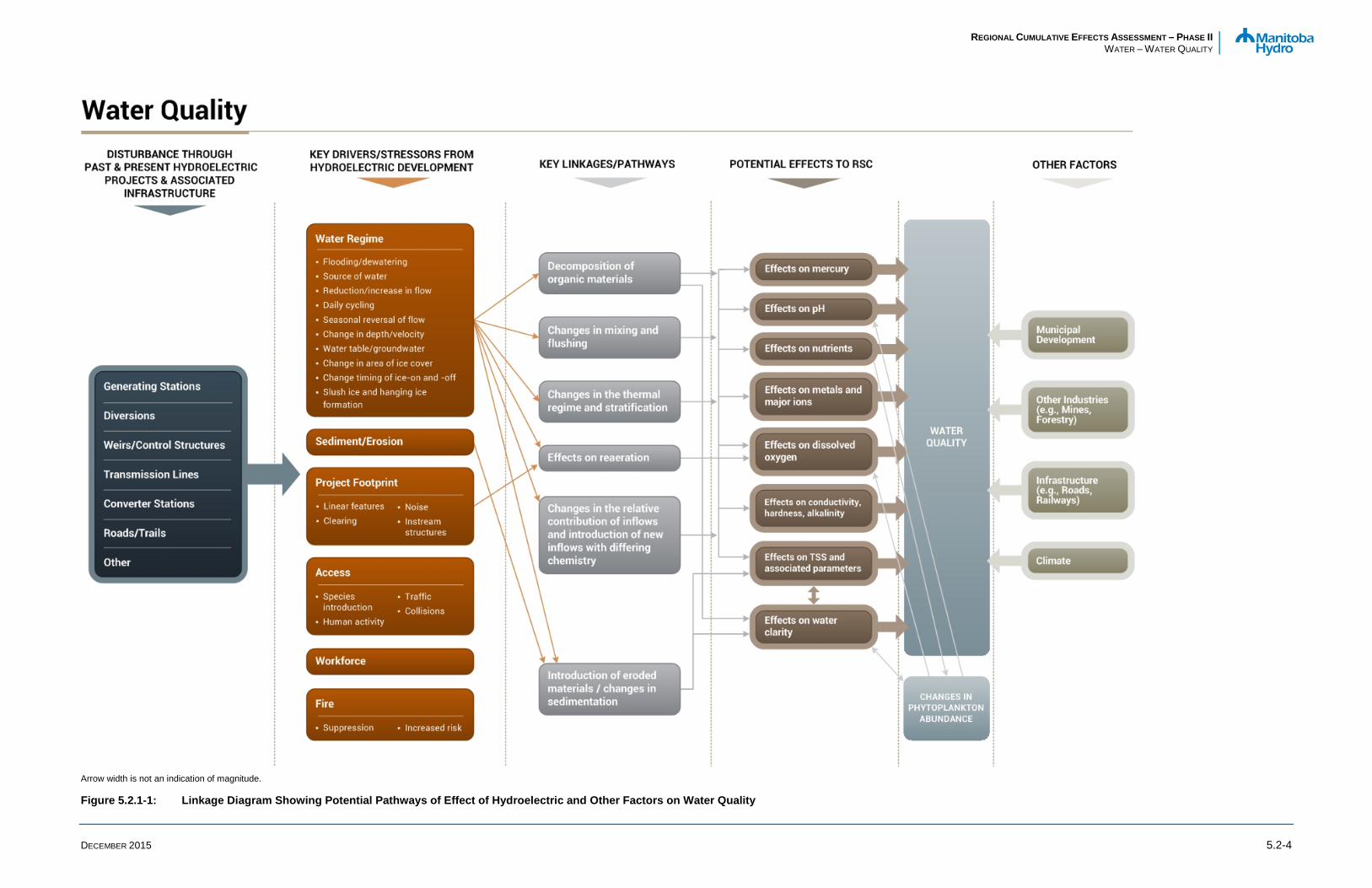
REGIONAL CUMULATIVE EFFECTS ASSESSMENT – PHASE II WATER – WATER QUALITY
DECEMBER 2015 5.2-4
Arrow width is not an indication of magnitude.
Figure 5.2.1-1: Linkage Diagram Showing Potential Pathways of Effect of Hydroelectric and Other Factors on Water Quality

REGIONAL CUMULATIVE EFFECTS ASSESSMENT – PHASE II WATER – WATER QUALITY
DECEMBER 2015 5.2-5
5.2.1.2 Indicators and Metrics Key indicators and associated metrics for water quality were identified based on a number of considerations, including: • critical for aquatic life;
• potential to be affected by hydroelectric development; • commonly used indicator of water quality; and
• established water quality objectives or guidelines for the protection of aquatic life (PAL).
A list of the key indicators and metrics applied for the RCEA, as well as a brief description of their importance, are provided in Table 5.2.1-1. All of the metrics identified for the water quality RCEA are incorporated in Manitoba/Manitoba Hydro’s Coordinated Aquatic Monitoring Program (CAMP 2014).
One of the water quality assessment indicators is water clarity, which includes TSS, turbidity, and Secchi disk depth as key metrics. These metrics are also discussed in the sedimentation chapter (Physical Environment Part IV, Chapter 4.4 Erosion and Sedimentation), although TSS is the main parameter of interest for sedimentation, turbidity and Secchi depth are also considered as general indictors of TSS conditions. While the same metrics are used for both water clarity and sedimentation, data sets and analyses undertaken for the water quality and sedimentation assessments differed. Specifically, the water quality assessment focused upon detailed analysis of raw data (including previously unpublished data) for key sites, notably those with long-term records, to support a statistical assessment of changes in water quality over time. The rationale for the sites and data sets used in the sedimentation analysis is discussed in Part IV. Due to differences in data sets and analyses undertaken for these two components/assessments on the same waterbodies, results reported for the same metrics are at times different. However, these differences reflect the appropriate approach in both Chapters 4.4 (Erosion and Sedimentation) and 5.2 (Water Quality). For example, the water quality assessment is based on sites that are generally representative of water in the main flow of the river while the sedimentation analysis also considered locations more distributed through the waterbodies (e.g., in closer proximity to areas of erosion/deposition).
5.2.1.3 Benchmarks As described in Section 5.1.2.4 (Introduction and Background), water quality benchmarks were selected to provide an index of environmental quality based on published water quality objectives and guidelines for PAL.
Manitoba water quality standards, objectives, and guidelines (MWQSOGs) have been developed for a number of water quality parameters for PAL (Manitoba Water Stewardship [MWS] 2011). With respect to water quality, aquatic ecosystem health was primarily assessed through comparisons of water quality metrics to current MWQSOGs for PAL (MWS 2011; Table 5.2.1-2). In Manitoba, existing provincial water quality objectives and guidelines were revised in 2011 (MWS 2011) and are largely in accordance with national Canadian Council of Ministers of the Environment (CCME) guidelines (CCME 1999;

REGIONAL CUMULATIVE EFFECTS ASSESSMENT – PHASE II WATER – WATER QUALITY
DECEMBER 2015 5.2-6
updated to 2015). Additional benchmarks or classification schemes applied for characterizing and describing water quality included the following: • chloride - the CCME chronic PAL guideline for chloride (CCME 1999; updated to 2015;
Table 5.2.1-2); • sulphate - the British Columbia Ministry of the Environment PAL guidelines for sulphate (Meays and
Nordin 2013; Table 5.2.1-2); • the water hardness classification scheme for surface waters described in the Canadian Council of
Resource and Environment Ministers (CCREM 1987; Table 5.2.1-3); and
• trophic status of lakes and rivers as defined on the basis of total phosphorus (TP), total nitrogen (TN), and chlorophyll a using various trophic categorization schemes (Tables 5.2.1-4 and 5.2.1-5).
For many water quality parameters there is a single water quality objective or guideline for PAL specified in the MWQSOGs, but for some variables there are multiple objectives or guidelines (e.g., water quality objectives for some parameters vary depending on exposure duration), and for still others, objectives and guidelines are calculated based on site-specific conditions.

REGIONAL CUMULATIVE EFFECTS ASSESSMENT – PHASE II WATER – WATER QUALITY
DECEMBER 2015 5.2-7
Table 5.2.1-1: Description of Water Quality Indicators and Metrics Applied for the RCEA
Indicators Metrics Importance of Variables
Nutrients / Trophic Status • Nitrogen (Total or total Kjeldahl nitrogen [TKN]) • Phosphorus (TP) • Chlorophyll a
• Nutrients are essential to aquatic life. Excessive nutrients may increase primary production
• Eutrophication may be associated with larger or more frequent algal blooms, development of noxious algal blooms, DO issues, production of algal toxins, taste and odour issues, and reduced aesthetic quality
• Chlorophyll a is a commonly used indicator of phytoplankton abundance (i.e., primary productivity)
Water clarity • TSS • Turbidity • Secchi disk depth
• TSS may be harmful to aquatic life at high concentrations
• Water clarity affects the availability and quality of light in surface waters, which in turn affect primary producers. Reducing water clarity can lead to lower levels of plant or algal growth
• The transparency or clarity of water also affects behaviour and survival/growth/condition of some biota (e.g., reducing predation success of visual predators; increased survival of fish due to reduced acuity of predators)
pH, Alkalinity, Hardness, Specific conductance
• pH • Total alkalinity • Hardness • Specific conductance
• High or low pH may be harmful to aquatic life • pH may affect the cycling and forms of other
substances in water • Hardness affects the bioavailability and toxicity
of some metals • Specific conductance is used as a general
indicator of changes in water quality and of cumulative effects to water quality

REGIONAL CUMULATIVE EFFECTS ASSESSMENT – PHASE II WATER – WATER QUALITY
DECEMBER 2015 5.2-8
Table 5.2.1-1: Description of Water Quality Indicators and Metrics Applied for the RCEA
Indicators Metrics Importance of Variables
DO • DO • Temperature1
• DO is essential to most forms of aquatic life • DO may affect the cycling of other substances in
water (e.g., precipitation/release of phosphorus from sediments)
• Water temperature is considered as it closely relates to DO saturation, stratification/mixing, and to the presence of early or mature life stages of aquatic life
Major Ions
• Major cations (calcium, magnesium, potassium, and sodium)
• Chloride • Sulphate
• Essential elements for biota and affect water hardness
• May be harmful to aquatic biota at high concentrations
Metals / metalloids • Metals
• Metals/metalloids include some essential elements (e.g., calcium) and non-essential elements (e.g., arsenic). May be harmful to biota at high concentrations
Notes: DO = dissolved oxygen; TSS = total suspended solids; TP = total phosphorus. 1. Water temperature is considered as a supporting variable and is not explicitly discussed as a key metric (i.e., thermal regime is not described).

REGIONAL CUMULATIVE EFFECTS ASSESSMENT – PHASE II WATER – WATER QUALITY
DECEMBER 2015 5.2-9
Table 5.2.1-2: Benchmarks Applied for the Water Quality RCEA
Indicator Metric Unit Objectives and Guidelines Description Comments Source
Nutrients TP (mg/L) Lakes, ponds, reservoirs: 0.025 Streams/rivers: 0.050
Narrative guideline For protection of various water usages MWQSOGs
Water clarity TSS (mg/L)
30-Day Average: increase in TSS of 5 mg/L from background, where background TSS is ≤25 mg/L 1-Day Objective: change of up to 25 mg/L from background, where background TSS concentrations are ≤250 mg/L or a 10% change from background where TSS is >250 mg/L
Objective Requires that background concentrations be defined. Turbidity may be used as a surrogate for TSS
MWQSOGs
pH, Alkalinity, Hardness, Conductivity
pH - 6.5-9.0 Guideline MWQSOGs
DO DO (mg/L)
Open water: 6.0 (cool-water) and 6.5 (cold-water) Ice cover: 5.5 (cool-water) and 9.5 (cold-water)
Objective Most stringent objectives for cool- and cold-water aquatic life MWQSOGs
Major Ions Chloride (mg/L) 120 Guideline Long-term guideline CCME
Sulphate (mg/L) Site-specific Guideline 30-day average. Calculated based on water hardness BCMOE
Metals
Aluminum (mg/L) 0.1 Guideline
MWQSOGs
Arsenic (mg/L) 0.15 Objective
MWQSOGs
Boron (mg/L) 1.5 Guideline
MWQSOGs
Cadmium (mg/L) Site-specific Objective 4-day averaging duration (i.e., chronic objective). Values calculated based on water hardness
MWQSOGs
Metals Chromium (mg/L) Site-specific Objective 4-day averaging duration (i.e., chronic objective). Values calculated based on water hardness
MWQSOGs

REGIONAL CUMULATIVE EFFECTS ASSESSMENT – PHASE II WATER – WATER QUALITY
DECEMBER 2015 5.2-10
Table 5.2.1-2: Benchmarks Applied for the Water Quality RCEA
Indicator Metric Unit Objectives and Guidelines Description Comments Source
Copper (mg/L) Site-specific Objective 4-day averaging duration (i.e., chronic objective). Values calculated based on water hardness
MWQSOGs
Iron (mg/L) 0.3 Guideline
MWQSOGs
Lead (mg/L) Site-specific Objective 4-day averaging duration (i.e., chronic objective). Values calculated based on water hardness
MWQSOGs
Mercury (ng/L) 26 Guideline Guideline for "inorganic mercury" MWQSOGs
Methylmercury (ng/L) 4 Guideline MWQSOGs
Molybdenum (mg/L) 0.073 Guideline
MWQSOGs
Nickel (mg/L) Site-specific Objective 4-day averaging duration (i.e., chronic objective). Values calculated based on water hardness
MWQSOGs
Selenium (mg/L) 0.001 Guideline
MWQSOGs
Silver (mg/L) 0.0001 Guideline
MWQSOGs
Thallium (mg/L) 0.0008 Guideline
MWQSOGs
Uranium (mg/L) 0.015 Guideline
MWQSOGs
Zinc (mg/L) Site-specific Objective 4-day averaging duration (i.e., chronic objective). Values calculated based on water hardness
MWQSOGs
Notes: DO = dissolved oxygen; TSS= total suspended solids; TP = total phosphorus.

REGIONAL CUMULATIVE EFFECTS ASSESSMENT – PHASE II WATER – WATER QUALITY
DECEMBER 2015 5.2-11
Table 5.2.1-3: Hardness Scale for Aquatic Ecosystems (CCREM 1987)
Hardness as calcium carbonate (mg/L) Degree of Hardness
0–30 Very soft
31–60 Soft
61–120 Moderately soft (hard)
121–180 Hard
180+ Very Hard
Table 5.2.1-4: Trophic Categorization Schemes Applied for Lakes and Reservoirs
Metric Units
Trophic categories
Reference Ultra-oligotrophic Oligotrophic Mesotrophic Meso-
eutrophic Eutrophic Hyper-eutrophic
TP (mg/L) <0.004 0.004–0.010 0.010–0.020 0.020–0.035 0.035–0.100 >0.100 CCME (1999; updated to 2015)
Chlorophyll a (µg/L) - <2.5 2.5-8 - 8–25 >25 Organization for Economic
Cooperation and Development (1982)
TN (mg/L) - <0.350 0.350–0.650 - 0.651–1.2 >1.2 Nürnberg (1996)
Notes: TP = total phosphorus; TN = total nitrogen.

REGIONAL CUMULATIVE EFFECTS ASSESSMENT – PHASE II WATER – WATER QUALITY
DECEMBER 2015 5.2-12
Table 5.2.1-5: Trophic Categorization Schemes Applied for Rivers
Metric Units
Trophic categories
Reference Ultra-oligotrophic Oligotrophic Mesotrophic Meso-
eutrophic Eutrophic Hyper-eutrophic
TP (mg/L) <0.004 0.004–0.010 0.010–0.020 0.020–0.035 0.035–0.100 >0.100 CCME (1999; updated to 2015)
Chlorophyll a (µg/L) - <10 10-30 - >30 - Dodds et al. (1998)
TN (mg/L) - <0.7 0.7-1.5 - >1.5 - Dodds et al. (1998)
Notes: TP = total phosphorus; TN = total nitrogen.

REGIONAL CUMULATIVE EFFECTS ASSESSMENT – PHASE II WATER – WATER QUALITY
DECEMBER 2015 5.2-13
A summary of MWQSOGs applied for the RCEA is provided in Table 5.2.1-2; brief explanations for variables for which there are either multiple PAL objectives/guidelines, or for which site-specific objectives or guidelines are derived, are provided below.
PAL objectives for DO vary according to the presence of cool- or cold-water aquatic life, the presence of mature or early life history stages of aquatic life, and exposure duration. As the presence of various life history stages at a particular water quality site and sampling time cannot be readily determined, to be conservative, DO data were compared to the most stringent objectives associated with water temperatures/time of year. In addition, since historical and contemporary water quality sampling frequencies do not allow for determination of seven-day averages, minima, or 30-day averages of DO concentrations, the most stringent objectives in terms of exposure duration were applied.
Site-specific PAL objectives were calculated for cadmium, copper, chromium, lead, nickel, and zinc based on water hardness measured in the same water sample. To be conservative, monitoring results were compared to the long-term (4-day) Manitoba objectives for PAL for these variables.
The Manitoba narrative guideline for nutrients, which includes numerical guidelines for TP, is intended to apply to various uses and was applied as a benchmark for the water quality assessment. Different numerical guidelines are specified for streams than for reservoirs, lakes, and ponds and streams near the point of entry to these waterbodies. These guidelines, in addition to the Manitoba PAL objectives and guidelines, were applied for the water quality assessment.
5.2.1.4 Approach and Methods Overall, the water quality RCEA relied on two general approaches to describe changes over time and effects of hydroelectric development on the various indicators and metrics: • Literature Review: Key published literature, including primary and grey literature in which water
quality was described and/or formal assessments of changes in water quality were presented, were summarized.
• New Analysis and/or Re-Analysis of Existing Information: This task involved either reanalysis of historical data that were presented in the literature previously or a de novo analysis (i.e., new analysis or reanalysis) of data that have not been analysed previously (in whole or in part). As many of the published assessments of water quality were produced a number of years ago, this task included revisiting past assessments with inclusion of more recent data. In addition, water quality data from numerous sources were compiled, collated, and analysed for selected sites and waterbodies to provide a comprehensive analysis of water quality based on available and accessible data. Past assessments typically did not attempt to integrate information collected under various programs in the same waterbody.
Methods used for the water quality RCEA included:
• review and summary of published studies, which included assessments of changes in water quality over time, notably in relation to hydroelectric development;
• temporal analysis of raw water quality data collected at various locations and times by federal and provincial agencies and Manitoba Hydro;

REGIONAL CUMULATIVE EFFECTS ASSESSMENT – PHASE II WATER – WATER QUALITY
DECEMBER 2015 5.2-14
• description of current water quality conditions using recent water quality data, most notably data collected under CAMP;
• spatial comparisons of water quality across waterbodies sampled during similar periods; and
• comparison of historical and recent water quality data to water quality benchmarks, notably water quality objectives or guidelines for PAL.
There are limitations regarding water quality data for some RCEA areas and waterbodies, as well as various limitations associated with historical data and/or comparability of data over time (e.g., methods changes). It is recognized that due to these limitations, small changes in water quality conditions may have occurred as a result of hydroelectric development and/or due to cumulative effects of various activities but may not be discernible. However, the fundamental question was whether water quality changed in a manner that rendered it unsuitable for aquatic biota. This key question was addressed by comparing historical and recent water quality conditions to water quality objectives and guidelines for PAL.
As noted in RCEA Phase I, some water quality parameters that are routinely monitored in contemporary water quality studies were not monitored historically. In addition, analytical methods for various water quality indicators have changed over time which render comparability of data sets over the period of record problematic or, in some cases, preclude comparisons altogether. This applies primarily to metals, which, when measured, were typically analysed using different methodologies in the earlier period of record. In addition, the sensitivity of analytical methods has varied over time. For metrics that were frequently reported as below the limits of analytical detection, the low frequency of detection coupled with the variability in detection limits (DLs), render it difficult or impossible to assess changes over time.
5.2.1.4.1 Key Published Information Literature was reviewed for each area using documents identified in RCEA Phase I, supplemented with additional resources identified since completion of Phase I. Emphasis of this review was placed on the indicators and metrics identified for RCEA and on describing the associated effects of hydroelectric development on water quality.
5.2.1.4.2 New Information and/or Re-Analysis of Existing Information
TEMPORAL COMPARISONS
Detailed temporal analyses were conducted for substantive datasets, notably for sites where the period of record extends back to the early 1970s (or earlier). Sources and periods of record of data used for temporal analyses varied between areas and waterbodies but included the following key sources:

REGIONAL CUMULATIVE EFFECTS ASSESSMENT – PHASE II WATER – WATER QUALITY
DECEMBER 2015 5.2-15
• raw data obtained from the Manitoba Conservation and Water Stewardship (MCWS) electronic database (raw data provided by MCWS 2014);
• data collected by Manitoba Hydro under various historic and current monitoring or sampling programs), including CAMP;
• Environment Canada (EC) data (data were largely obtained from published reports)1;
• raw water quality data collected by the Fisheries and Oceans Canada (DFO; raw data were provided electronically by DFO 2015);
• Lake Winnipeg, Churchill and Nelson Rivers Study Board (LWCNRSB) water quality data (i.e., raw data were obtained from MCWS, the LWCNRSB reports, and/or from DFO 2015); and
• raw data from published historical reports (e.g., Crowe 1973; Green 1990).
Many of these data sets have been described in published reports and in some instances have been the subject of formal assessments of changes in water quality in relation to hydroelectric development. However, as noted previously, the intent of this analysis was to update past assessments with more current data and/or to conduct assessments using combined sources of data not previously investigated collectively or independently.
Emphasis of the de novo analyses was placed on:
• long-term data sets, notably where data are available prior to hydroelectric development;
• data sets where methods are documented and that are amenable to comparisons over time (i.e., data comparability);
• comprehensive data sets (e.g., where multiple indicators were measured);
• data sets where more than one sampling period was completed; and • data sets for selected key waterbodies (i.e., waterbodies identified as representative for a given area).
Where historical data records were small, unverifiable, measured with methods not comparable to more contemporary data sets, and/or for which there are no contemporary data, analyses were not always undertaken. Documentation of data used and sources of data are provided within the water quality discussion presented for each RCEA area.
SPATIAL COMPARISONS
Spatial comparisons of water quality across sites within the RCEA study area were undertaken, where appropriate, to evaluate whether there was evidence of a change in water quality conditions between upstream and downstream sites on the same system. These also allowed for an examination of potential cumulative changes along the length of a river, or reach of a river system, and assisted with identification
1 With the exception of two sites, water quality data requested from Environment Canada could not be provided within the timeline of this project.

REGIONAL CUMULATIVE EFFECTS ASSESSMENT – PHASE II WATER – WATER QUALITY
DECEMBER 2015 5.2-16
of potential causes of observed changes. Data collected at off-system waterbodies (i.e., lake or river sites where water levels and flows are either entirely or largely unaffected by Manitoba Hydro’s hydraulic operating system) have also been included to provide context.
COMPARISON TO BENCHMARKS
As previously noted, the key question addressed in the water quality RCEA is whether hydroelectric development, either alone or in combination with other activities, caused changes to water quality that rendered it unsuitable for aquatic life. To address this question, historical and contemporary water quality data were compared to PAL objectives and guidelines and other classification schemes (i.e., benchmarks), as described in detail in Section 5.2.1.3. This assessment was conducted on both long-term data sets, such as the MCWS long-term water quality monitoring sites, as well as for smaller data sets, notably recent data collected under CAMP. This allowed for assessing aquatic ecosystem health historically and more recently, as well as whether any changes in the suitability of the water to support aquatic life occurred over the available data records. For example, a change in the frequency of exceedance of a PAL objective or guideline temporally and/or a shift in the trophic classification of a waterbody over time could indicate a fundamental shift in water quality in terms of its suitability for aquatic life.
In some instances, the laboratory analytical DLs associated with water quality measurements, notably for historical data, were higher than the contemporary MWQSOGs for PAL and comparisons to MWQSOGs could not be undertaken.
ANALYSIS OF WATER QUALITY DATA
For presentation and analysis of raw water quality data, all values reported as below the analytical DL were assigned a value of one-half the DL. Outliers were generally not removed from any data set, notably where data sets were small and therefore lacked the robustness to reliably identify a “true outlier” from natural variation. However, some data were removed from data sets where it could be established that fundamental changes in methods occurred, analytical sensitivities were inadequate, and/or values were clearly outliers based on a qualitative assessment (e.g., low plausibility of being correct such as a pH in surface water of 2). Due to the large amount of data, the lack of documentation of sampling and/or analytical methods for some data sets, and the number of data sources that were accessed and assessed, a detailed comparison of methods was not undertaken. As noted in Williamson and Ralley (1993), “While it is recognized that combining data sets generated from different agencies would introduce another source of variation, it was thought that this was out-weighted by the additional gain in information.” Inclusion and consideration of data from multiple sources was required in many instances in order to provide information prior to and following hydroelectric development.
Lastly, it is noted that no attempts to review the accuracy of electronic data files or published raw data were undertaken. However, several data sets or portions of data sets were omitted from the analysis, as follows: • Total and dissolved phosphorus data collected by MCWS over the period of April 2001 through March
2009 were excluded from analysis. Issues with these data, associated with a change in the analytical laboratory, were recently identified (McCullough 2015).

REGIONAL CUMULATIVE EFFECTS ASSESSMENT – PHASE II WATER – WATER QUALITY
DECEMBER 2015 5.2-17
• Initial analysis of TN data for the RCEA ROI as a whole indicated potential issues with TN data reported by Morelli (1975) and these data were omitted from the final analysis. Specifically, detailed examination of TN data presented in Morelli (1975) indicated large variability and substantively higher concentrations than other datasets for the same time period at multiple sites across the RCEA ROI. Further, concentrations of TN reported by Morelli (1975) for the pre-hydroelectric development period were generally higher than those measured following hydroelectric development, including areas subjected to substantive flooding. This observation is conceptually the reverse of typical effects associated with flooding (i.e., flooding typically causes increases in nutrients). Higher concentrations were also observed in the Granville Lake Morelli (1975) dataset. Collectively, these observations suggest that the TN data reported by Morelli (1975) may be erroneous.
• “Up until the end of 1993, the analytical method for determining dissolved nitrogen at the EC stations did not fully recover nitrogen associated with urea and ammonium compounds. As a result, much of the TN concentration (sum of dissolved and particulate nitrogen) reported prior to the end of 1993 (when the method was changed) actually underestimated the amount of nitrogen in water (Jones and Armstrong 2001).” Therefore, these data were excluded from analysis.
Many historical, long-term, and contemporary data sets, including MCWS long-term monitoring data, either did not incorporate sampling in winter or winter sampling was not collected consistently over time. Further, most long-term monitoring consisted of point sampling in time. Because many water quality parameters (e.g., dissolved inorganic nutrients, DO, pH, conductivity, TSS) vary seasonally – most notably between the open water and ice cover seasons - detailed temporal analyses of water quality data sets were conducted on data collected in the open water season. The removal of the winter data standardized the data sets to allow for more appropriate comparisons of conditions over the period of record. For analytical purposes, the open water season was defined as the period of June–October. However, water quality changes in winter were also described where data were sufficient and/or where effects have been noted in the literature.
Statistical analyses were undertaken to evaluate temporal differences in water quality metrics for some larger data sets. For metrics exhibiting a normal distribution, analyses were conducted using a t-test or analysis of variance (ANOVA) and a Tukey’s test (α = 0.05). For parameters not meeting the assumptions of a normal distribution, analyses were performed using the non-parametric Kruskal-Wallis test followed by the Dunn’s multiple pairwise comparisons procedure (two-tailed; α = 0.05). Statistical analyses were conducted using XLSTAT (2014).
Exploration of relationships between hydrological metrics, such as water level and discharge, and water quality metrics was undertaken for some sites and datasets using linear regression analysis. Raw and log-transformed data were analysed at a significance level of 0.05.
5.2.1.5 Data Limitations There are a number of limitations associated with water quality data for the RCEA ROI that affect the ability to conduct a more comprehensive, or that have affect the uncertainty associated with, analysis of some of the water quality metrics and/or areas. These data limitations are discussed as part of the assessment in subsequent sections.

REGIONAL CUMULATIVE EFFECTS ASSESSMENT – PHASE II WATER – WATER QUALITY
DECEMBER 2015 5.2-18
Key data limitations include:
• The primary data limitation relates to the absence, or limited amount, of data for pre-hydroelectric development. This precludes direct comparisons of conditions before and after hydroelectric development in some instances.
• For some waterbodies post-hydroelectric development data are lacking or limited.
• Water quality data have been collected by a number of organizations and agencies over the period of record and sampling and/or analysis methods have varied which may affect comparability of data.
• Water quality sampling generally does not provide information for high wind or storm events as these conditions preclude sampling from a boat or fixed wing aircraft. Therefore a comprehensive assessment of effects of hydroelectric development on TSS and related parameters is not possible.
Despite these limitations, sufficient information exists for most of the major lakes in the RCEA ROI to provide a general description of existing conditions and an assessment of general changes in water quality since the early 1970s, including an assessment of effects related to hydroelectric development. In addition, Manitoba/Manitoba Hydro’s ongoing CAMP continues to provide a long-term record water quality based on a standard set of sampling methods, which permits comparisons among on-system waterbodies, comparison to off-system reference waterbodies, and an analysis of change or trends over time.

REGIONAL CUMULATIVE EFFECTS ASSESSMENT – PHASE II WATER – WATER QUALITY
DECEMBER 2015 5.2-19
5.2.2 Area 1: Lake Winnipeg Outlet to Jenpeg Generating Station
This reach of Area 1 extends from Warren Landing and Two-Mile Channel at the outlet of Lake Winnipeg/inlet to Playgreen Lake up to the Jenpeg GS on the West Channel, and up to Cross Lake on the East Channel (Maps 5.2.2-1 and 5.2.2-2). This reach includes the Outlet Lakes (Playgreen, Little Playgreen, Kiskittogisu, and Kiskitto lakes) on the West Channel and Little Playgreen Lake on the East Channel of the Nelson River.
A description of the construction and operation of hydroelectric developments in the Lake Winnipeg Outlet to Jenpeg GS reach of the Nelson River is found in Part II Hydroelectric Development Project Description in the Region of Interest. A detailed description of effects of hydroelectric development to the water regime is provided in Water Regime, Chapter 4.3. Key points of the project description and water regime relevant to water quality are summarized below.
Prior to Lake Winnipeg Regulation (LWR), the only natural outflow from Lake Winnipeg was at Warren Landing, a narrow, rocky constriction at the outlet of Lake Winnipeg which connected directly to the south basin of Playgreen Lake. At Playgreen Lake, the majority of flow continued up the west channel of the Nelson River via the north basin of Playgreen Lake through Whiskey Jack Narrows into the north basin of Kiskittogisu Lake and then to Cross Lake, while approximately 15% of the flow passed via Little Playgreen Lake and the east channel of the Nelson River to Cross Lake (Water Regime, Section 4.3.2.2).
Construction of LWR began in 1971–1972 with access roads, construction camps and forebay clearing. Instream construction at many locations began in 1972–1973, with most locations having one (or more) cofferdams completed by the summer of 1973. The completion of the Kispachewuk and Ominawin cofferdams in 1973 led to some ponding on Lake Winnipeg as flow downstream of these cofferdams was reduced. By fall of 1973, these cofferdams were largely removed and construction of all channels and structures continued between 1974 and 1976. The summer of 1975 marked the completion of the Jenpeg GS main dam, with the GS completed in the summer of 1979, and Two- and Eight-Mile Channels completed in the fall of 1976.
A detailed description of the present day water regime in this reach is provided in Section 4.3.2.2 (Water Regime). In brief, flows and water levels on Playgreen Lake are primarily a function of the water level in the north basin of Lake Winnipeg. The construction of Two-Mile Channel provided a second outlet from Lake Winnipeg and increased the efficiency with which water could be moved out of Lake Winnipeg into Playgreen Lake. Eight-Mile Channel avoids a flow constriction on the west channel of the Nelson River by connecting Playgreen Lake with the southern end of Kiskittogisu Lake, and uses Kiskittogisu Lake as a second flow path for Lake Winnipeg outflows. The Ominawin Bypass Channel and work completed in the Kisipachewuk Channel upstream from the Jenpeg GS provide additional outflow capacity from Kiskittogisu Lake to the West Channel of the Nelson River. Operation of the Jenpeg GS regulates the Nelson River West Channel portion of Lake Winnipeg’s outflow. LWR was completed in 1976 and impounded the west channel of the Nelson River upstream to the outlet of Kiskittogisu Lake.

REGIONAL CUMULATIVE EFFECTS ASSESSMENT – PHASE II WATER – WATER QUALITY
DECEMBER 2015 5.2-20
The Kiskitto Dam and Inlet CS prevent flooding of Kiskitto Lake from backwater effects of the Jenpeg forebay, while providing a continuous regulated inflow. An outflow diversion channel, along with the Black Duck CS, provides outflow from Kiskitto Lake into the Black Duck Creek. The CSs are operated to keep water levels on Kiskitto Lake within the natural range.
Flows along the east channel of the Nelson River (including Little Playgreen Lake) are unregulated and remain a function of water levels in Playgreen Lake (Water Regime, Section 4.3.2.2). Based on available pre- and post-LWR data, flows along the east channel have been slightly higher post-LWR but because Lake Winnipeg outflows have been 4.4% higher for the same period, it is not clear whether higher long-term average east channel flows are because of LWR or wetter conditions.
For the purposes of this discussion, water quality data collected in 1972 and 1973 were considered as pre-hydroelectric development, (i.e., pre-LWR); though it is acknowledged that construction activities may have affected water quality in 1972 and 1973 at some locations. Pre-LWR data were largely restricted to sampling conducted by the LWCNRSB (Morelli 1975). The primary reasons for including 1973 in the pre-LWR water quality dataset, although it has been included in the construction period dataset in other analyses, were as follows:
• Based on information presented in Section 4.3.2.2 (Water Regime), water levels in the open water season of 1973 were still within natural levels as assessed by examination of water levels at Norway House.
• A preliminary review of water quality data (scatterplots) for several metrics indicated no notable changes in data collected between 1972 and 1973 that could be directly or likely associated with hydroelectric development.
Data collected between 1974 and 1976 represent the construction period, with the latter half of 1976 being possibly affected by immediate post-construction effects. Water quality data measured post-1976 represented post-impoundment conditions. Quantity and comparability of data for pre-LWR, construction/impoundment, and post-impoundment periods vary between studies.

Thompson
PimicikamakCross Lake (NAC)
Norway House Cree NationNorway House (NAC)
Thicket Portage(NAC)
Pikwitonei(NAC)
Wabowden(NAC)
Kelsey G.S.
Jenpeg G.S.
WuskwatimG.S.
Cross Lake Weir
LAKEWINNIPEG
PlaygreenLake
SipiweskLake
Minago
CrossLake
River
MolsonLake
SettingLake
WalkerLake
Nelso
n Rive
r
CauchonLake
PipestoneLake
Nelso
n Rive
r
LandingLake
DuckLake
KiskittoLake
Little Playgreen Lake
KiskittogisuLake
Bladder Rapids
Kiskitto InletControl Structure
Warren Landing
391
391391
373
391
6 Lake Winnipeg Outlet to Jenpeg G.S.
Downstream of Cross Lake to Kelsey G.S.
Jenpeg G.S. to Cross Lake Outlet
1.0
29-OCT-15
North/South Consultants
Created By: cparker - B Size Portrait BTB - MAR 2015 Scale: 1:928,000
Province of Manitoba, Government of Canada, North/South Consultants andManitoba Hydro.
04-DEC-15
File Location: J:\MYP\MH_RCEA\Water_Quality\PHASE_2\MXD\Report_Maps\Area1\20151204_RCEA_PhaseII_AE_WQ_EE_WaterQualityAssessmentAreaLakeWinnipegOutletToKelseyGSRCEAArea1_cp.mxd
Hudson Bay
Thompson
Churchill
Water Quality Assessment Area Lake Winnipeg Outlet to Kelsey
Generating StationRCEA Area 1
Regional Cumulative Effects Assessment
NAD 1983 UTM Zone 14N
0 10 20 Kilometres
0 8.5 17 Miles
DATA SOURCE:
DATE CREATED:
CREATED BY:
VERSION NO:
REVISION DATE:
QA/QC:
COORDINATE SYSTEM:
RCEAArea 1
LegendRCEA Region of InterestWater Quality Reach BoundaryFirst Nation Reserve
NOTE: (NAC) Northern Affairs Community
InfrastructureGenerating Station (Existing)Control StructureHighwayRailTransmission Line (Existing)
Map 5.2.2-1

Water Quality Sampling Sites Outlet of Lake Winnipeg to Cross Lake
Province of Manitoba, Government of Canada, North/South Consultants andManitoba Hydro.
North/South Consultants
2.0
24-AUG-15 04-DEC-15
Kiskitto InletControl Structure
6
374
373
Norway House Cree NationNorway House (NAC)
Kiskitto-MinagoDrainage Channel
River
River
LittlePlaygreen
Lake
OminawinBy Pass Channel
Minago
Gunisao
Turnbull
Hargrave PipestoneLake
PlaygreenLake
2-MileChannel
LAKEWINNIPEG
KiskittogisuLake
Nelson Rive
r
8-MileChannel
Kiskitto Lake
PlaygreenLake
UBS019
UBS015
UBS021UBS020
UBS010(CAMP)
MB05UDS003MB05UDS014
MA05UBS0010 (LWCNRSB)
MB05UBS001MB05UBS002 (MCWS)
MB05UBS005
MB05UBS003
Stn.16Warren Landing
Jenpeg G.S.
Cre
ated
By:
cpa
rker
- B
Siz
e La
ndsc
ape
BTB
- M
AR
201
5
Sca
le: 1
:473
,000
Regional Cumulative Effects Assessment
NAD 1983 UTM Zone 14N
0 4.5 9 Miles
0 5 10 Kilometres
File
Loc
atio
n: J
:\MY
P\M
H_R
CE
A\W
ater
_Qua
lity\
PH
AS
E_2
\MX
D\R
epor
t_M
aps\
Are
a1\2
0151
126_
RC
EA
_Pha
seII_
AE
_WQ
_EE
_Wat
erQ
ualit
ySam
plin
gSite
sOut
leto
fLak
eWin
nipe
gToC
ross
Lake
_cp.
mxd
DATA SOURCE:
DATE CREATED:
CREATED BY:
VERSION NO:
REVISION DATE:
QA/QC:
COORDINATE SYSTEM:
Water Quality Sampling Sites
Hudson Bay
Thompson
Churchill
Coordinated Aquatic Monitoring Program (CAMP)
Manitoba Conservation and Water Stewardship (MCWS)
Lake Winnipeg, Churchill and Nelson Rivers Study Board (LWCNRSB)
Generating Station (Existing)
Highway
First Nation Reserve
Legend
NOTE: (NAC) Northern Affairs Community
Map 5.2.2-2

REGIONAL CUMULATIVE EFFECTS ASSESSMENT – PHASE II WATER – WATER QUALITY
DECEMBER 2015 5.2-23
5.2.2.1 Key Published Information The earliest record of water quality data for the Outlet Lakes Area was a brief survey conducted by the Manitoba Mines Branch, with the analysis of single samples collected near Norway House in June 1953 and February 1954 (Thomas 1959). Since that time, water sampling has occurred at numerous locations throughout this reach of Area 1. Key water quality studies or monitoring programs conducted in this area include:
• the LWCNRSB studies conducted by the DFO and Department of the Environment between 1972 and 1974;
• long-term monitoring conducted by MCWS at two locations (Jenpeg GS 1973–1977 and 2001–2014 and the upper Nelson River/Little Playgreen Lake at Norway House 1975–2013);
• biweekly samples collected from the raw water supply intake line at the Jenpeg GS (1986–1989) under the Manitoba Ecological Monitoring Program (MEMP); and
• monitoring conducted under CAMP at Warren Landing (2012–2013), Playgreen Lake near the entrance of the East Channel (2009, 2012), Little Playgreen Lake (2010, 2013), and two sites within Two-Mile Channel – one at the inlet and one at the outlet (2013).
Assessments of water quality and fisheries in the Outlet Lakes Area were conducted in 1965, 1971, and 1972 (Driver and Doan 1972; Schlick 1972; Schlick 1973 in Koshinksy 1973; Stockner 1972; Stockner 1973 in Koshinksy 1973). Water quality data for the pre-LWR period (1972–1973) were presented, and effects for the upper Nelson River region were predicted, as part of the LWCNRSB program (Koshinsky 1973; LWCNRSB 1975).
The Federal Ecological Monitoring Program (FEMP) included monitoring from 1987–1989 in the Nelson River below Sea River Falls and in the Jack River above Norway House, with final results summarized and discussed in Ramsey (1991a) and EC and DFO (1992a, b).
Studies addressing sedimentation and erosion in the Outlet Lakes Area were described in Manitoba Hydro and the Department of Mines (1972), Underwood McLellan Ltd. (1983), MacLaren Plansearch Inc. (1985a, b), and I.D. Systems (1993).
Water quality monitoring data collected by MCWS near the community of Norway House have been subject to formal assessments of water quality changes in the lake (Playle and Williamson 1986; Playle et al. 1988; Duncan and Williamson 1988; Ralley and Williamson 1990; Williamson and Ralley 1993; Jones and Armstrong 2001).
Other authors have also synthesized water quality information from the upper Nelson River and discussed changes that have occurred since LWR, including Bodaly et al. (1984), Baker and Davies (1991), and Bodaly pers. comm. (in Baker and Davies 1991).
Results of the first three years of CAMP were synthesized and presented in CAMP (2014), which included sites in Playgreen and Little Playgreen lakes.
The results of studies on mercury in water in the Outlet Lakes Area have also been published; key reports include Morelli (1975), Rannie and Punter (1987), and CAMP (2014).
REGIONAL CUMULATIVE EFFECTS ASSESSMENT – PHASE II WATER – WATER QUALITY
DECEMBER 2015 5.2-24
5.2.2.2 New Information and/or Re-analysis of Existing Information For this area, data sources subjected to detailed analysis included: • LWCNRSB water quality data (raw data were obtained from LWCNRSB reports [Morelli 1975] or
MCWS 2014); • the MCWS electronic water quality database (raw data were provided by MCWS 2014);
• water quality data collected at the Jenpeg GS under MEMP as presented in Green (1990); and
• Manitoba/Manitoba Hydro’s CAMP (CAMP 2014).
Analysis of the LWCNRSB and MCWS datasets were undertaken to provide a more comprehensive examination of water quality, as publications based on these data did not incorporate the full period of monitoring and/or some of the water quality parameters measured during the studies. Data collected under CAMP were also included in this analysis to provide more contemporary water quality data for the Outlet Lake reach. Sites included for the detailed analyses are indicated on Map 5.2.2-2. Data were plotted and analysed separately for the open water season (defined here as June–October) and the ice cover season (defined here as December–April), separately. Where a replicate sample was collected, the sample with the most comprehensive analytical suite of parameters or the first reported sample was included.
Re-examination of the MCWS data were undertaken to update the previous temporal analyses, which utilized data up to and including 1992 (i.e., Williamson and Ralley 1993), with additional more recent data, and to incorporate assessments of other existing data not previously included in published reports (i.e. data collected at the Jenpeg GS by both MCWS and under the MEMP).
Statistical analysis was based on comparison of conditions in five time intervals, following the approach applied by Williamson and Ralley (1993):
• pre-construction period: 1972–1973; • construction/impoundment period: 1974–1976;
• immediate post-impoundment period: 1977–1986; • post-impoundment period 2: 1987–1992; and
• post-impoundment period 3: 1993–2013.
No formal outlier assessment was undertaken for this analysis. However, in a few instances, extreme outliers were removed from the datasets based on qualitative review of the data.
Inventories of water quality data used for analyses, (including abbreviations used for the locations in the figures) are indicated in Table 5.2.2-1 and in detail in Table 5.2.2A-11.
1 Tables, figures, and maps with a letter in their numbers (e.g., A) can be found in the appendices for this chapter.

REGIONAL CUMULATIVE EFFECTS ASSESSMENT – PHASE II WATER – WATER QUALITY
DECEMBER 2015 5.2-25
Some of the data identified above have been analysed and published in a variety of reports, including, but not limited to: Underwood McLellan Ltd. (UMA 1983); McLaren Plansearch Inc. (1985a, b); Playle and Williamson (1986); Duncan and Williamson (1988); Playle et al. (1988); Ralley and Williamson (1990); Williamson and Ralley (1993); and CAMP (2014).

REGIONAL CUMULATIVE EFFECTS ASSESSMENT – PHASE II WATER – WATER QUALITY
DECEMBER 2015 5.2-26
Table 5.2.2-1: Water Quality Data Subject to Detailed Analysis
Waterbody Location Period of Record
Nelson River Warren Landing (WL) 1972–1973; 2012–2013
Two-Mile Channel Two-Mile Channel Inlet (2M-In) 2013
Two-Mile Channel Outlet (2M-Out) 2013
Playgreen Lake
Near Two-Mile Channel (PGL 1) 1973–1974; 1974–1977
Near Eight-Mile Channel (PGL 2) 1973–1974; 1974–1977
Near East Channel Inlet (PLAYG) 2009–2013
Little Playgreen Lake At Norway House (NH) 1972–1974; 1975–2013
Near Norway House (LPLAY) 2010–2014
Jenpeg GS forebay Jenpeg GS (Jen) 1972–1974; 1973–1977; 1986–1989; 2001–2014
5.2.2.3 Changes in Indicators over Time Potential effects of hydroelectric development on water quality in the Outlet Lakes are as follows: • Diversion and Increased Conveyance: Construction of Two-Mile and Eight-Mile Channels altered
the flows into and through the Outlet Lakes reach and could affect water quality through changes in water residence times, water levels, and flow patterns, and by introducing water with differing water quality characteristics to a new location.
• Flooding: 17.6 square miles (sq mi) (45.6 square kilometres [km2]) of land was flooded, with the greatest amount of flooding in the region closest to the Jenpeg GS main dam and extending upstream to the outlets of Kiskittogisu Lake (Water Regime, Section 4.3.2.2). As noted in Sections 4.4.3.2 (Water Regime) and 4.4.2.1 (Erosion and Sedimentation), flooding associated with the construction of the Jenpeg GS resulted in a transition from a fluvial to a lacustrine environment for a large part of the area above the GS. Flooding potentially causes increases in nutrients, metals, and colour, and decreases in pH, DO, and water clarity.
• Water Level Fluctuations: the Jenpeg GS increased the range of water levels in the Outlet Lakes, which can affect water quality by altering light penetration, temperature, or increasing effects of wind-induced turbidity on shallow lakes.
• Erosion/Sedimentation: Increased shoreline erosion due to increased variability in water levels and flows, or changes in sedimentation patterns due to flooding or channel construction. This pathway could result in increases in TSS, notably in areas of increased erosion, and/or alter rates of sedimentation where water velocities, depths, and/or residence times were affected. Effects would be expected to vary spatially in relation to shoreline characteristics, residence times, depths, and fetch.

REGIONAL CUMULATIVE EFFECTS ASSESSMENT – PHASE II WATER – WATER QUALITY
DECEMBER 2015 5.2-27
5.2.2.3.1 Nutrients and Trophic Status
PRE-HYDROELECTRIC DEVELOPMENT
Prior to LWR, it was suggested that the Outlet Lakes retained nutrients as water flowed downstream (Koshinsky 1973). The estimated high nutrient loading to the Outlet Lakes prior to LWR was felt to be balanced by the rapid water exchange, such that it was likely that only a fraction of even the dissolved component of the loadings would have relevance to the productivity of these lakes (Koshinsky 1973).
The majority of TP concentrations in the Outlet Lakes Area would place these locations in the mesotrophic to meso-eutrophic range on average (Figure 5.2.2A-1). Concentrations fell near the current Manitoba narrative guideline for lakes, reservoirs and ponds (0.025 milligrams per litre [mg/L]) and on occasion exceeded this level at each site (Figure 5.2.2A-2). There are no reliable TN data for this area prior to LWR (see Section 5.2.1.4.2 for details).
No pre-LWR chlorophyll a data are available for the Outlet Lakes Area; however, downstream in Cross and Sipiwesk lakes and upstream of the Kelsey GS, chlorophyll a concentrations were in the mesotrophic range (see Sections 5.2.3.3 and 5.2.4.3).
POST-HYDROELECTRIC DEVELOPMENT
Recent TP data from Warren Landing were highly variable, ranging from 0.027 to 0.364 mg/L (Figures 5.2.2A-1 and 5.2.2A- 2) and averaging 0.095 mg/L (0.041 mg/L with outlier removed), and notably higher than the mean of 0.014 mg/L measured at this location prior to LWR (Figure 5.2.2A-2).
A few water samples were recently collected under CAMP within Two-Mile Channel (i.e., one site at the inlet [2MC-In] near Lake Winnipeg, and the other near the outlet [2MC-Out]) near Playgreen Lake. These samples exhibited a high degree of variability, with TP concentrations ranging from 0.033–0.222 mg/L and 0.032–0.118 mg/L at 2MC-In and 2MC-Out, respectively. The maximum concentrations in Two-Mile Channel were both measured in fall 2013. That concentrations were most elevated at the inlet suggests that Lake Winnipeg was the source. Active erosion is known to occur along the north shore of Lake Winnipeg near Two-Mile Channel (Erosion and Sedimentation, Section 4.4.2.1.2). For comparison, TP concentrations collected from Warren Landing on the same day were not notably elevated. Effects on water quality in Playgreen Lake during this period are not known, as the lake was not sampled in 2013.
TP concentrations measured in 22 samples in the south basin of Playgreen Lake in September 1984 ranged from 0.03-0.17 mg/L and averaged 0.0305 mg/L (MacLaren Plansearch Inc. 1985a). The smaller 1972–1973 dataset for Playgreen Lake near Two-Mile Channel (PGL 1) had TP concentrations ranging from less than detection to 0.04 mg/L (Figure 5.2.2A-2). Pre-LWR data provided in Koshinsky (1973) for Playgreen Lake included TP readings of 0.027 mg/L (December 1972), 0.04 mg/L (August and October 1971) and 0.045 mg/L (August 1971; Table 5.2.2A-2). While this information does not indicate whether TP concentrations changed in Playgreen Lake following LWR, it does indicate that concentrations were high on occasion both prior to and after LWR.
TP data collected by the LWCNRSB and MCWS, and under CAMP on Little Playgreen Lake near Norway House and the Jenpeg GS over the period of 1972–2013 showed that trophic status at Norway House

REGIONAL CUMULATIVE EFFECTS ASSESSMENT – PHASE II WATER – WATER QUALITY
DECEMBER 2015 5.2-28
and the Jenpeg forebay generally ranged from meso-eutrophic to eutrophic both prior to and following LWR (Figure 5.2.2A-3). There were a small number of TP concentrations in the oligotrophic range in the early 1970s, but proportionately fewer after that time. Most TP concentrations were above the Manitoba narrative nutrient guideline (0.025 mg/L) in the majority of samples collected over both open water and ice cover seasons after 1976, while most measurements prior to 1976 were below the guideline (Figure 5.2.2A-4). However, there were no significant differences in any pre- vs. post-LWR comparisons of open water TP concentrations near either the Norway House or the Jenpeg GS (Figure 5.2.2A-4). Conversely, TP was significantly higher in the ice cover season near the Jenpeg GS in both the 1977–1986 and 2009–2013 periods relative to pre-LWR. This contradicts the findings of Playle and Williamson (1986) and Williamson and Ralley (1993) who noted a significant and sustained increase in TP following LWR at Norway House (analyses ended prior 1993). Possible reasons for these differences are examination of different time periods (i.e., the designation of 1974–1976 as the construction period in the present analysis) and/or consideration of ice cover and open water season data separately.
Jones and Armstrong (2001) reported a long-term flow-adjusted decreasing trend in TP concentrations over the period of 1975–1999 at Norway House. While there were no statistically significant differences between the most recent period examined (1993–2013) and the pre-LWR period (i.e., 1972-1973), qualitatively, TP appears to have undergone increases at both the Jenpeg GS and Norway House sites in the most recent years of monitoring. A comparison of Outlet Lakes sample locations to trophic status boundaries prior to LWR suggests TP in the mesotrophic to meso-eutrophic range while that in the most recent data indicates a range of meso-eutrophic to eutrophic (Figure 5.2.2A-1). TP concentrations prior to LWR were near the narrative guideline for lakes (0.025 mg/L), while those from the most recent period nearly all surpass this level and are nearer the narrative guideline for rivers (0.05 mg/L; Figure 5.2.2A-2). Total phosphorus exceeds the Manitoba narrative nutrient guideline of 0.025 mg/L in lakes and reservoirs (and streams near inflows to these waterbodies) in northern areas of the province, including off-system lakes such as Assean, Leftrook, Gauer, and Setting lakes either occasionally or frequently. Furthermore, TP concentrations are above the guideline upstream of the RCEA ROI in the north basin of Lake Winnipeg (EC and MWS 2011) and, on occasion, in Granville Lake (see Section 5.2.8.3).
The potential increases in TP noted above may reflect observations of changes in Lake Winnipeg – the primary inflow to these waterbodies. Recent monitoring and research on Lake Winnipeg has indicated that phosphorus concentrations increased in Lake Winnipeg in recent decades. McCullough et al. (2012) and Bunting et al. (2011) concluded that phosphorus concentrations increased relatively abruptly beginning circa 1990.
As noted above, there are no reliable pre-LWR TN data on which a pre- vs. post-LWR comparison can be made and effects of LWR on this metric cannot be determined. Available post-LWR data indicate that most locations sampled in the Outlet Lakes Area fell within the mesotrophic range based on TN concentrations measured between 2008 and 2013 (Figures 5.2.2A-5). Long-term datasets for TN near Norway House and the Jenpeg GS typically place these waters in the mesotrophic range on average for the post-LWR period (Figure 5.2.2A-6). Jones and Armstrong (2001) reported no significant trends in flow-adjusted TN concentrations over the period of 1978–1999 for the Norway House site. Notwithstanding this issue, the relatively consistent TN concentrations measured in each site after LWR, coupled with the relative similarity of TN concentrations in downstream reaches (i.e., Cross and Sipiwesk

REGIONAL CUMULATIVE EFFECTS ASSESSMENT – PHASE II WATER – WATER QUALITY
DECEMBER 2015 5.2-29
lakes; see Sections 5.2.3.3.1 and 5.2.4.3.1), collectively suggests that changes associated with this project were likely minimal and/or relatively short-term and not captured in the monitoring programs.
Insufficient pre-LWR data for chlorophyll a precludes a pre- vs post-LWR comparison. However, available data indicate conditions have generally been on average, indicative of mesotrophic status (Figures 5.2.2A-7 and 5.2.2A-8). However, chlorophyll a ranged from 2.8–24 micrograms per litre (µg/L), and averaged 8.3 µg/L in 31 samples collected from the south basin of Playgreen Lake in July 1984 and from 4.6–11 µg/L, averaging 8.0 µg/L in 22 samples collected in September of that year (MacLaren Plansearch Inc. 1985a). This would place Playgreen Lake in the eutrophic category for lakes based on average chlorophyll a concentrations. Mean and maximum chlorophyll a concentrations in the 2009–2013 period were roughly similar at Warren Landing, Playgreen Lake and the Jenpeg forebay, and tended to be slightly higher at these locations than in Little Playgreen Lake (NH and LPLAY, Figure 5.2.2A-7). Available chlorophyll a data for the Norway House and Jenpeg GS areas place these waters in the mesotrophic range for lakes, although concentrations near the Jenpeg GS were often somewhat higher, falling in the eutrophic range Figure 5.2.2A-8).
5.2.2.3.2 Water Clarity
PRE-HYDROELECTRIC DEVELOPMENT
Prior to LWR the entire Outlet Lakes region was characterized by high turbidity – with the lakes being notably more turbid than Lake Winnipeg (Driver and Doan 1972, Koshinsky 1973). Most often the turbidity was related to resuspension of bottom sediments that consisted of fine glaciolacustrine clays easily mobilized during windy conditions on the shallow lakes (Koshinsky 1973).
Analysis of raw water quality data indicates that pre-LWR TSS concentrations ranged from roughly 5–30 mg/L at most Outlet Lakes locations, but was most variable near the future inlet of Two-Mile Channel in Playgreen Lake (Figure 5.2.2A-9). Additional information from the scientific literature indicates similar concentrations. A TSS reading of 8 mg/L was recorded in the southern basin of Playgreen Lake in August 1971 (Schlick 1972; Table 5.2.2A-2). MacLaren Plansearch Inc. (1985a) reported pre-LWR TSS values of 14.00 mg/L, 16.40 mg/L, and 19.57 mg/L for Lake Winnipeg and Playgreen Lake near the sites of the future Two- and Eight-Mile Channels, respectively.
Prior to LWR, turbidity was similar at Warren Landing, Playgreen Lake near the future location of Eight-Mile Channel and Norway House (Figure 5.2.2A-10). Similar to TSS, turbidity was more variable and higher near the future inlet of Two-Mile Channel in Playgreen Lake than the other locations sampled prior to LWR. The latter observation was likely a reflection of the actively eroding shoreline of southwestern Playgreen Lake, and indicates that instances of elevated TSS occurred in this area prior to LWR (LWCNRSB 1975).
Secchi disk depths in the summers of 1970 and 1971 averaged 0.5 metres (m) in Playgreen Lake, compared to 1.9 m for northern Lake Winnipeg (MacLaren Plansearch Inc. 1985a).

REGIONAL CUMULATIVE EFFECTS ASSESSMENT – PHASE II WATER – WATER QUALITY
DECEMBER 2015 5.2-30
POST-HYDROELECTRIC DEVELOPMENT
In general, available largely information indicates that water clarity was not notably affected in the Outlet Lakes Area by LWR. While Two-Mile Channel did result in the introduction of suspended sediments from shoreline erosion along the north shore of Lake Winnipeg to Playgreen Lake, significant mineral plumes were reportedly present in the south basin of Playgreen Lake prior to LWR due to shoreline erosion (MacLaren Plansearch Inc. 1985a). The supply of sediment to the south basin of Playgreen Lake was found to be episodic and related to season, weather, hydrology, lakeshore morphology and water level (MacLaren Plansearch Inc. 1985a). Similarly, I.D. Systems (1993) concluded that water clarity in Playgreen Lake was not affected by LWR. It was also noted that sediment plumes entering through Two-Mile Channel or Warren Landing, or sediments generated from erosion of the southern and western shores of Playgreen Lake did not flow towards or affect flows into Little Playgreen Lake (MacLaren Plansearch Inc. 1985a). This is in contrast to comments made by UMA (1983) that Two-Mile Channel appears to cause episodes of high turbidity near the community of Norway House.
While MacLaren Plansearch Inc. (1985a, b) conducted a highly detailed assessment of TSS in Playgreen Lake in 1984, the field program was limited to a single year of study and therefore provides information on spatial variability over a relatively limited period, but no information on inter-annual variability. Results of 36 TSS samples collected in April 1984 ranged from less than five (in 29 samples) to 37 mg/L, 31 TSS samples in July 1984 ranged from 5–42 mg/L and averaged 18.5 mg/L; and 22 samples collected in September ranged from 7–54 mg/L and averaged 21.05 mg/L. The MacLaren Plansearch Inc. (1985a) data were similar to pre-LWR data ranges for reported for the lake as well as the most recent data collected under CAMP in this waterbody, further suggesting that TSS was not notably affected by LWR in Playgreen Lake (Figure 5.2.2A-9).
More recent analyses of erosion in the Outlet Lakes Area (Erosion and Sedimentation, Section 4.4.2.1.2) confirm ongoing erosion along the north shore of Lake Winnipeg and the southwest shore of Playgreen Lake. Substantive erosion has been measured near the entrance to Two-Mile Channel since it was constructed, though it is not known if erosion rates have changed since approximately 1993. However, erosion rates have declined over time within the channel itself (Erosion and Sedimentation, Section 4.4.2.1.2). Water quality sampling conducted in Two-Mile Channel (inlet and outlet) in 2013 indicates that high concentrations of TSS are introduced to Playgreen Lake during some periods; TSS measured in fall 2013 was 228 and 147 mg/L at the Two-Mile Channel inlet and outlet, respectively - approximately six and 10 times the concentration measured concurrently at Warren Landing (23.3 mg/L). Both TSS and turbidity were higher at the inlet than the outlet of Two-Mile Channel indicating that the source of TSS was Lake Winnipeg and/or the erosion near the entrance to the channel. Effects on water quality in Playgreen Lake during this period are not known as the lake was not sampled in 2013.
Statistical analysis of TSS data collected at the Jenpeg GS and a site near Norway House revealed no significant differences pre- vs. post-LWR at either site (Figure 5.2.2A-11). Similarly, there were no significant differences pre-LWR vs. post-LWR for turbidity at Norway House (turbidity was not measured at the Jenpeg GS; Figure 5.2.2A-12). Playle and Williamson (1986) reported a significant increase in turbidity at Norway House after LWR, however, a later assessment of the data by Williamson and Ralley (1993) did not find a significant difference in any of the post-LWR periods.

REGIONAL CUMULATIVE EFFECTS ASSESSMENT – PHASE II WATER – WATER QUALITY
DECEMBER 2015 5.2-31
5.2.2.3.3 Dissolved Oxygen
PRE-HYDROELECTRIC DEVELOPMENT
The Outlet Lakes did not stratify and DO was at or near saturation at all depths in all lakes in the summer prior to LWR (Koshinsky 1973). A detailed ice cover survey of DO conducted by Stockner between March 21 and April 13, 1971 in Playgreen and Kiskittogisu lakes indicated that most stations were at or near saturation (Koshinsky 1973). Only eleven of 106 locations, all of which were in marshy bays or inlets removed from the main channel of the Nelson River, had DO concentrations less than 5 mg/L (Koshinsky 1973), which are below the most stringent PAL objectives for cool- (5.5 mg/L)and cold-water aquatic life (9.5 mg/L). No pre-LWR DO data could be located for other sites, including the long-term Jenpeg GS and Norway House monitoring sites. Pre-LWR open water DO concentrations measured in Playgreen Lake were above the PAL objective for both cool- and cold-water aquatic life (Figure 5.2.2A-13).
POST-HYDROELECTRIC DEVELOPMENT
Due to the near absence of data prior to LWR, information is inadequate to conduct a comprehensive assessment of effects of LWR on DO in this area. However, available data indicate the area has generally been isothermal, well-oxygenated, and DO concentrations have been typically above PAL water quality objectives since LWR (Figures 5.2.2A-13 to 5.2.2A-19). Recent measurements collected in Playgreen Lake were similar to those measured at different locations in the lake prior to LWR (Figure 5.2.2A-13).
5.2.2.3.4 pH, Alkalinity, Hardness, and Specific Conductance
PRE-HYDROELECTRIC DEVELOPMENT
Minimal published data exist prior to LWR that discuss or quantify pH, alkalinity, hardness, or specific conductance. Koshinsky (1973) presented some data for a few locations/sampling times within Playgreen and Kiskittogisu lakes (Table 5.2.2A-2). Thomas (1959) indicated that the Nelson River showed a hardness of about 120 mg/L (on the boundary between “moderately soft/hard” and “hard”) and commented that major variations in quality on the Nelson River system can be anticipated from year to year due to variations in discharge and corresponding wide changes in seasonal quality (Thomas 1959). In 1970 and 1971, an increasing gradient of pH, specific conductance, and total dissolved solids occurred from Warren Landing to Kiskittogisu Lake (MacLaren Plansearch Inc. 1985a). As LWR would not involve a change in source water and discharges down the East Channel were not expected to be notably different following LWR, major alterations in pH, alkalinity, hardness and specific conductance were not anticipated (LWCNRSB 1975).
All pH readings reported in the LWCNRSB/MCWS data for all locations (Figure 5.2.2A-20) were within the Manitoba PAL guideline range (6.5–9). Prior to LWR, hardness in the Outlet Lakes Area was moderately soft/hard to hard (Figure 5.2.2A-21). Specific conductance (Figure 5.2.2A-22) and alkalinity (Figure 5.2.2A-23) were relatively similar across sites prior to LWR.

REGIONAL CUMULATIVE EFFECTS ASSESSMENT – PHASE II WATER – WATER QUALITY
DECEMBER 2015 5.2-32
POST-HYDROELECTRIC DEVELOPMENT
With a couple of exceptions, pH (Figure 5.2.2A-23), hardness (Figure 5.2.2A-24), specific conductance (Figure 5.2.2A-25), and alkalinity (Figure 5.2.2A-23) were not significantly different in any post-LWR period relative to pre-LWR at either Norway House or the Jenpeg GS. The results of this assessment are in agreement with the results of Playle and Williamson (1986) and Williamson and Ralley (1993) who also reported no significant changes in these metrics at Norway House after LWR (Jenpeg GS data were not assessed). Further, the results of the present study
The exceptions included statistically significant differences in pH and specific conductance noted in the 1987–1992 period at the Jenpeg GS site, which consisted solely of data collected between 1987 and 1989 under MEMP, relative to pre-LWR. These observations may reflect differences in sampling sites, sampling and/or analytical methods, and/or drought conditions that occurred at that time (Ramsey 1991a). That all pH measurements were consistently within the PAL guideline indicates that conditions have been suitable for aquatic life at both sites since monitoring was initiated.
Based on the CCREM (1987) hardness scale for aquatic ecosystems, water in the Outlet Lakes has generally been in the moderately soft/hard to hard range over the period of record (Figures 5.2.2A-21 and 5.2.2A-5). There was a slight upward trend for hardness in the most recent years of monitoring at Norway House, although the 1993–2013 period was not significantly different from the pre-LWR conditions. Hardness is not currently measured at the Jenpeg GS.
As noted above, specific conductance was statistically higher in the 1987–1992 open water period at the Jenpeg GS, relative to pre-LWR (Figure 5.2.2A-25). Similar to hardness, an upward trend was noted in this metric after approximately 2008 at both Norway House and the Jenpeg GS (Figures 5.2.2A-24 and 5.2.2A-25).
There is some evidence that temporal variability of these metrics, notably for hardness and specific conductance, is affected by Nelson River discharge. In the 1987-1989 period, pH, hardness, specific conductance and most ions were found to correlate negatively with Nelson River discharge (Ramsey 1991a). Duncan and Williamson (1988) noted that conductivity and hardness were negatively correlated with discharge prior to LWR and that conductivity and alkalinity were negatively correlated with discharge after LWR at Norway House.
5.2.2.3.5 Major Ions
PRE-HYDROELECTRIC DEVELOPMENT
Koshinksy (1973) summarized data for ions in Playgreen and Kiskittogisu lakes (Table 5.2.2A-1).
Pre-LWR data for potassium (Figure 5.2.2A-28), sodium (Figure 5.2.2A-29), calcium (Figure 5.2.2A-30), chloride (Figure 5.2.2A-31) and sulphate (Figure 5.2.2A-32) were generally within similar ranges, by variable, at all sampling locations. Dominant cations were calcium followed by sodium. No magnesium data are available from 1972–1973. Concentrations of all major ions were notably higher in the Outlet Lakes Area than in the Rat/Burntwood River system, which is to be expected as the Nelson River drains a large prairie sedimentary area (Bodaly et al. 1984). Chloride concentrations were relatively low

REGIONAL CUMULATIVE EFFECTS ASSESSMENT – PHASE II WATER – WATER QUALITY
DECEMBER 2015 5.2-33
(ranging from about 10–20 mg/L, Figure 5.2.2A-31) and were well below the CCME PAL guideline (120 mg/L). Similarly, sulphate concentrations, which ranged from about 20–35 (Figure 5.2.2A-32), were well below the BCMOE PAL guideline (309 mg/L; Meays and Nordin 2013).
POST-HYDROELECTRIC DEVELOPMENT
With a few exceptions, major ions appear to have been largely unaffected by LWR in this area (Figures 5.2.2A-28 to 5.2.2A-39).
An assessment of the long-term dataset for Norway House did not identify any statistically significant differences in major ions after LWR. Conversely, potassium (Figure 5.2.2A-33) and chloride (Figure 5.2.2A-38) was temporarily higher during one post-LWR period (1977–1986), and calcium (Figure 5.2.2A-30) was lower in two post-LWR periods (1974–1976 and 1987-1992 ice cover season only, relative to pre-LWR at the Jenpeg GS. Data for the 1977–1986 period at the Jenpeg GS are very limited and restricted to one year of data (1977). Chloride (Figures 5.2.2A-31 and 5.2.2A-38) and sulphate (Figure 5.2.2A-32 and 5.2.2A-39) concentrations were well within the CCME PAL guideline (120 mg/L) and BCMOE PAL guideline (309 mg/L; Meays and Nordin 2013), respectively, at all sampling times.
MacLaren Plansearch Inc. (1985a) also noted that chloride was elevated in the immediate post-LWR period, but Williamson and Ralley (1993) found no significant changes for this metric at Norway House.
Pre-LWR magnesium data at Norway House and the Jenpeg GS are insufficient for an assessment of pre- and post-LWR differences (Figure 5.2.2A-37). Using a larger pre-LWR dataset, Williamson and Ralley (1993) noted an increase in magnesium in the 1987–1992 period relative to pre-LWR (1972–1975) concentrations.
Although major ions exhibited a large degree of inter-annual variability, potassium, sodium, chloride, and sulphate appear to have undergone a recent increase at Norway House (major ions have not been measured at the Jenpeg GS since 1989; Figures 5.2.2A-34 to 5.2.2A-39) and Warren Landing (Figures 5.2.2A-28 to 5.2.2A-32). Similar to hardness and specific conductance, there is some evidence that temporal variability of major ions is affected by Nelson River discharge. Duncan and Williamson (1988) noted that calcium was negatively correlated with discharge prior to LWR and that calcium and magnesium were negatively correlated with discharge after LWR at Norway House. Similarly, in the 1987–1989 period, Ramsey (1991a) found that most ions correlated negatively with Nelson River discharge.
5.2.2.3.6 Metals
PRE-HYDROELECTRIC DEVELOPMENT
Few metals were measured prior to LWR in the Outlet Lakes Area and measurements that were made are of limited utility due to substantive changes in analytical methods. The following provides an overview of available information regarding mercury in water and effects of hydroelectric development, as well as a brief description of recent conditions for other metals measured under CAMP.

REGIONAL CUMULATIVE EFFECTS ASSESSMENT – PHASE II WATER – WATER QUALITY
DECEMBER 2015 5.2-34
Total mercury concentrations in surface water were measured by the LWCNRSB in 1972-1974 as part of the pre-LWR studies conducted in the Nelson River at Warren Landing, Norway House, Kispachewuk Rapids, and the Jenpeg forebay area (Morelli 1975). Most concentrations were at or all near the DL, and mean values reported for each site were similar throughout the Outlet Lakes. However, all samples collected prior to 1974 were later deemed to be contaminated and of insufficient quality to be used for assessing changes over time (Rannie and Punter 1984). No record of pre-LWR mercury data for Playgreen, Kiskittogisu, or Kiskitto lakes was found, and no methylmercury data were found for any location.
POST-HYDROELECTRIC DEVELOPMENT
Flooding of terrestrial organic matter typically results in increased methylation of inorganic mercury (e.g., Hall et al. 2005) and ultimately leads to trophic biomagnification in aquatic food webs. With respect to water quality, the substantive effect of flooding on mercury in water is a change in the form of mercury (i.e., increases in the fraction of methylmercury), rather than changes in total mercury concentrations. It is well established that total mercury concentrations are not greatly increased in surface waters following reservoir creation (e.g., Kelly et al. 1997; EC and DFO 1992c; Hall et al. 2005). Conversely, flooding generally results in a greater relative and absolute concentration of methylmercury in aquatic ecosystems, although the concentrations generally remain low in the water column (e.g., Kelly et al. 1997).
No pre- or post-LWR methylmercury data were located for the Outlet Lakes Area, and due to the lack of pre-LWR data for total mercury, assessment of LWR effects on total or methylmercury concentrations in the Outlet Lakes Area is not possible. Furthermore, no record of data for total mercury in water was found for Kiskittogisu or Kiskitto lakes, nor were data for methylmercury located for any waterbody in this reach.
Despite these limitations, existing information suggests that total mercury in water was only marginally affected by LWR. Specifically, total mercury concentrations measured near Norway House between 1977 and 1983 were consistently at or slightly above the level of analytical detection, which varied from 20–50 nanograms/L (ng/L).
More recent data collected under CAMP indicate that total mercury concentrations in water remained at or near the DL between 2009 and 2013 (Figure 5.2.2A-40). All but one sample analysed at DLs lower than the PAL guideline (26 ng/L; MWS 2011) were below the PAL guideline. The exception was the single sample collected on March 4, 2014 from Little Playgreen Lake (27.2 ng/L) in which mercury was slightly above the PAL guideline.
Recent monitoring (2009–2013) under CAMP indicates that most other metals are also within PAL objectives and guidelines in the Outlet Lakes Area (Table 5.2.2A-3). However, aluminum (Figure 5.2.2A-41) and iron (Figure 5.2.2A-42) frequently or consistently exceeded PAL guidelines in the waterbodies monitored the Outlet Lakes Area, as well as the inflow (i.e., Warren Landing, Two-Mile inlet and outlet, and Playgreen and Little Playgreen lakes). These occurrences are relatively common in Manitoba lakes and rivers and are also observed in lakes and rivers unaffected by hydroelectric development (CAMP 2014, Ramsey 1991a). Both iron and aluminum are relatively abundant elements (iron and aluminum are the third and fourth most abundant elements in the earth’s crust, respectively) and elevated concentrations occur in ‘pristine’ environments, including waterbodies in Manitoba. For example,

REGIONAL CUMULATIVE EFFECTS ASSESSMENT – PHASE II WATER – WATER QUALITY
DECEMBER 2015 5.2-35
Ramsey (1991a) concluded that high concentrations of aluminum, copper, and iron in the Burntwood (above Threepoint Lake), Footprint (above Footprint Lake), and Aiken rivers (all “natural, unregulated rivers”) were “natural”. Aluminum was also, on average, above the PAL guideline in off-system lakes including Assean (Section 5.2.6.3.6), Granville (Section 5.2.8.3.6), and Setting (Section 5.2.3.3.6) lakes and the off-system Hayes River (Section 5.2.5.3.6) over the period of 2008–2013. High concentrations of iron have also been reported across Canada and elevated aluminum concentrations have been reported for the western Canada region (CCREM 1987).
Similar to TSS and turbidity, mean concentrations of metals (especially aluminum and iron) were higher in samples collected from Two-Mile Channel relative to the other Outlet Lakes locations, primarily due to high concentrations measured on September 28, 2013. Also similar to TSS and turbidity, concentrations tended to be higher at in the Two-Mile Channel inlet (near Lake Winnipeg) than the Two-Mile Channel outlet (near Playgreen Lake), indicating Lake Winnipeg or the entrance to Two-Mile Channel to be the source. Concentrations of lead, iron, chromium, and aluminum at 2M-In on September 28, 2013 were 24 to 34 times higher than those measured at that same location in July 2013.
5.2.2.4 Cumulative Effects of Hydroelectric Development on Water Quality
Published literature and de novo data analysis indicated that few changes in water quality have occurred in the Outlet Lakes Area since long-term water quality monitoring began in 1972.
TP concentrations were not significantly different post-LWR than pre-LWR at the Jenpeg GS or near Norway House in the open water season. However, concentrations were significantly higher in the ice cover seasons in two post-LWR time intervals (1977–1986 and 2009–2013) at the Jenpeg GS. No changes were observed at Norway House.
While there were few statistically significant differences between the pre- and post-LWR periods examined, qualitatively, TP appears to have undergone increases at both the Jenpeg GS and Norway House sites in the most recent years of monitoring. A comparison of Outlet Lakes sample locations to trophic status boundaries prior to LWR suggests TP in the mesotrophic to meso-eutrophic range while that in the most recent data indicates a range of meso-eutrophic to eutrophic. In addition, TP concentrations prior to LWR were near the narrative guideline for lakes (0.025 mg/L), while those from the most recent period nearly all surpass this level and are nearer the narrative guideline for rivers (0.05 mg/L). While conceptually the significant increase observed in the Jenpeg GS forebay immediately after LWR could have been related to the project, the more recent increases in TP may be a reflection of increases observed upstream in Lake Winnipeg.
There are no reliable pre-LWR TN data on which a pre- vs. post-LWR comparison can be made and effects of LWR on this metric cannot be determined. Available post-LWR data indicate that most locations sampled in the Outlet Lakes Area fell within the mesotrophic range based on TN concentrations for the post-LWR period. Notwithstanding this issue, the relatively consistent TN concentrations measured in each site after LWR, coupled with the relative similarity of TN concentrations in downstream reaches (i.e., Cross and Sipiwesk lakes), collectively suggests that changes associated with this project were likely minimal and/or relatively short-term and not captured in the monitoring programs.

REGIONAL CUMULATIVE EFFECTS ASSESSMENT – PHASE II WATER – WATER QUALITY
DECEMBER 2015 5.2-36
Insufficient pre-LWR data for chlorophyll a precludes a pre- vs post-LWR comparison. However, available data indicate conditions have generally been on average, indicative of mesotrophic status.
Prior to LWR, the Outlet Lakes were known to have high turbidity, primarily due to localized erosion and the mobilization of bottom sediments under windy conditions. The current assessment did not identify any significant change in turbidity near Norway House, or TSS concentrations near Norway House or in the Jenpeg GS forebay during any period following LWR. However, sampling conducted in the Two-Mile Channel in 2013 indicates higher variability in these metrics in areas close to areas known to experience erosion.
While data are somewhat limited, DO concentrations measured prior to and following LWR were largely within PAL objectives in surface and bottom samples and do not appear to have been altered by LWR at the locations sampled. Both historic and recent data show a lack of thermal stratification in the Outlet Lakes Area.
pH, specific conductance, hardness, and alkalinity in Little Playgreen Lake near Norway House were unchanged between 1972 and 2013. In contrast, pH and specific conductance in the Jenpeg GS forebay were significantly higher during the second post-LWR period (1987–1992) relative to pre-LWR measurements. While this observation could conceptually reflect changes in sampling and/or analytical methods over time, the upper Nelson River experienced drought conditions in the late 1980s, which may have influenced these metrics. pH, consistently remained within the Manitoba PAL guideline range over the period of record at all locations.
Major ions appear to have been largely unaffected by LWR in this area. However, the current analysis and other assessments identified significant increases in potassium and chloride concentrations in the Jenpeg GS forebay during the 1977–1986 period, compared to 1972–1973. No significant changes were found for these or other major ions for samples collected near Norway House. All sulphate and chloride concentrations were well below their respective BCMOE and CCME guidelines.
Available information indicates that temporal variability of hardness, specific conductance, major cations, chloride, and sulphate is affected by Nelson River discharge. However, several metrics, including hardness, specific conductance, potassium, sodium, chloride, and sulphate appear to have undergone relatively recent increases in this reach which may reflect changes in the upstream source water.
Due to the lack of pre-LWR data, it is not possible to assess changes in total or methylmercury in water related to hydroelectric development. However, available information suggests that total mercury was either unchanged or negligibly increased in the Outlet Lakes Area. This observation is supported by the scientific literature that has established little to no effects on total mercury in water following reservoir creation. Information regarding methylmercury concentrations in water was not found for any waterbody in this reach.
In general, water quality in the Outlet Lakes Area is currently suitable for PAL. The lakes are generally well-oxygenated and pH and most metals consistently remain within PAL objectives and guidelines. Key exceptions include aluminum and iron, which occasionally or consistently exceeded PAL guidelines in some or all of the areas monitored from 2008–2013 in the upper Churchill River area. In addition, occasional exceedances of PAL guidelines for lead and selenium have been observed in the area, though

REGIONAL CUMULATIVE EFFECTS ASSESSMENT – PHASE II WATER – WATER QUALITY
DECEMBER 2015 5.2-37
the mean concentrations of both metals are well below the guidelines. These occurrences are relatively common in Manitoba lakes and rivers and are also observed in lakes unaffected by hydroelectric development. Iron is currently notably lower in Area 4 of SIL than Areas 1 or 6 or upstream in Opachuanau or Granville lakes.

REGIONAL CUMULATIVE EFFECTS ASSESSMENT – PHASE II WATER – WATER QUALITY
DECEMBER 2015 5.2-38
5.2.3 Area 1: Jenpeg Generating Station to Cross Lake Outlet
Area 1 comprises the reach of the Nelson River from the outlet of Lake Winnipeg to the Kelsey GS. This reach of Area 1 includes Cross, Pipestone, and Walker lakes, as well as the Nelson River immediately downstream of Cross Lake (Map 5.2.3-1). A description of the construction and operation of hydroelectric developments affecting the Cross Lake reach of the Nelson River is found in Part II Hydroelectric Development Project Description in the Region of Interest. A detailed description of effects of hydroelectric development to the water regime is provided in Chapter 4.3 (Water Regime). Key points of the project description and water regime relevant water quality are summarized below.
The Jenpeg GS has regulated outflow from Lake Winnipeg into Cross Lake and altered the flow regime of Cross Lake and downstream waterbodies since 1976. Prior to LWR, water levels and flows on Cross Lake followed a typical seasonal pattern and were highest mid-summer and lowest during winter. Since LWR and prior to construction of the Cross Lake Weir, the water regime of the Cross Lake area has been altered during lower flow years through changes in the seasonal timing of water levels and increases in the annual water level range, such that average levels in summer were 4 feet (ft; 1.2 m) lower and average levels in winter were over 1 ft (0.3 m) higher. A weir was constructed at the outlet of Cross Lake between May and October 1991 to raise the mean water level on the lake and reduce the range of water levels. Overall water levels are now higher than pre LWR and average levels range is reduced. Changes in the frequency, duration, and timing of high water level events on Cross Lake due to LWR have also affected the water regime on connected lakes. Water levels continue to fluctuate on Pipestone Lake with those on Cross Lake in the post-LWR era. Water levels on Walker Lake are affected by LWR when water levels on Cross Lake are greater than 681 ft (207.6 m).
5.2.3.1 Key Published Information The earliest record of water quality data for Cross Lake was a brief fisheries study conducted in June 1965, in which relatively limited data (in situ pH, DO, and temperature, Secchi disk depth, total dissolved solids, and alkalinity) were measured in several areas of the lake (Driver 1965; Driver and Doan 1972). Since that time, a number of water quality studies have been done and long-term water quality monitoring has been conducted at one location. The key water quality studies or monitoring programs conducted in this area include:
• the LWCNRSB studies conducted by the DFO in 1972–1974; • long-term monitoring conducted by MCWS near the community of Cross Lake;
• Manitoba Fisheries Branch studies conducted in 1980 and 1981; • the MEMP conducted from 1986–1989;
• Manitoba Hydro environmental studies conducted in relation to the Cross Lake outlet weir in 1992–1994; and
• Manitoba/Manitoba Hydro’s CAMP initiated in 2007.

Water Quality Sampling Sites Cross Lake
Province of Manitoba, Government of Canada, North/South Consultants andManitoba Hydro.
North/South Consultants
1.0
24-AUG-15 25-NOV-15
Jenpeg G.S.
ClearwaterBay
OminawinBy Pass Channel
Cross Lake
Mustoe Lake
Walker Lake
Minago River
Drunken Lake
Clarke Creek
Nelson Rive
r
Muhigan River
Thicket Creek
Pipestone Lake
Eves Falls
PimicikamakCross Lake (NAC)
374
373
373
3
MA05UB0010(LWCNRSB)
PL-1
CL-3
CL-1
UDS020
Stn. 12
Stn. 11Stn. 10
Stn. 2
Stn. 4
15 (MEMP)
UDS004Stn.9
Jenpeg GS
Stn. 3 MB05UDS013
4
240
MB05UDS005(LWCNRSB)
11
Cross Lake Weir
MB05UDS014MB05UDS003
MB05UDS011
6CL-2
Stn. 7
MB05UDS012
Cre
ated
By:
cpa
rker
- B
Siz
e La
ndsc
ape
BTB
- M
AR
201
5
Sca
le: 1
:300
,000
Regional Cumulative Effects Assessment
NAD 1983 UTM Zone 14N
0 2.5 5 Miles
0 3.5 7 Kilometres
File
Loc
atio
n: J
:\MY
P\M
H_R
CE
A\W
ater
_Qua
lity\
PH
AS
E_2
\MX
D\R
epor
t_M
aps\
Are
a1\2
0151
125_
RC
EA
_Pha
seII_
AE
_WQ
_EE
_Wat
erQ
ualit
ySam
plin
gSite
sCro
ssLa
ke_c
p.m
xd
DATA SOURCE:
DATE CREATED:
CREATED BY:
VERSION NO:
REVISION DATE:
QA/QC:
COORDINATE SYSTEM:
Water Quality Sampling Sites
Hudson Bay
Thompson
Churchill
CAMP
Cross Lake Weir
MFB
MCWS
MEMP
LWCNRSB
Generating Station (Existing)
Highway
First Nation Reserve
Legend
NOTES:(CAMP) Coordinated Aquatic Monitoring Program(MFB) Manitoba Fisheries Branch(MCWS) Manitoba Conservation and Water Stewardship(MEMP) Manitoba Environmental Monitoring Program(LWCNRSB) Lake Winnipeg,Churchill and Nelson Rivers Study Board(NAC) Northern Affairs Community
Map 5.2.3-1

REGIONAL CUMULATIVE EFFECTS ASSESSMENT – PHASE II WATER – WATER QUALITY
DECEMBER 2015 5.2-40
Water quality data for the pre-LWR period (1972–1973) were presented, and effects for the upper Nelson River region were predicted, as part of the LWCNRSB program (Cleugh 1974a; Koshinsky 1973).
An extensive assessment of water quality and fisheries in Cross, Pipestone, and Walker lakes was conducted in 1980 and 1981 and a qualitative analysis of changes since LWR was undertaken (Gaboury and Patalas 1981, 1982).
Three sites were sampled in Cross Lake under MEMP from 1985–1989 and winter DO monitoring was conducted at a number of sites from 1987–1989. Results were reported in Ramsey et al. (1989) and Green (1990). Ramsey et al. (1989) conducted a qualitative comparison of data from 1986–1987 to pre-LWR data.
Manitoba Hydro conducted fisheries studies in Cross and Pipestone Lakes to monitor the system after construction of the Cross Lake outlet weir. The studies included measurement of select water quality parameters in August 1992–1994 (Kroeker and Bernhardt 1993; Bernhardt and Schneider-Vieira 1994; Bernhardt 1995).
Water quality monitoring data collected by MCWS near the community of Cross Lake have been subject to formal assessments of water quality changes in the lake (Playle and Williamson 1986; Playle et al. 1988; Duncan and Williamson 1988; Ramsey et al. 1989; Ralley and Williamson 1990; Williamson and Ralley 1993). The most recent of the latter studies (Williamson and Ralley 1993) statistically compared water quality for the site over three time frames, defined as: pre- LWR period (1972–1975); immediate post-LWR period (1977–1984); and later post-LWR period (1987–1992).
Other authors have also synthesized water quality information from Cross Lake and discussed changes that have occurred since LWR, including Bodaly et al. (1984), Nelson River Group (1986), MacLaren Plansearch Inc. (1989), Baker and Davies (1991), and Manitoba Hydro (2014).
Results of the first three years of CAMP were synthesized and presented in CAMP (2014), which included a site in Cross Lake near the community.
The results of a number of studies on mercury in water in Cross Lake have also been published; key reports include Koshinsky (1973), Kozody (1979), Williamson (1986), and Rannie and Punter (1987).
5.2.3.2 New Information and/or Re-analysis of Existing Information Raw water quality data were compiled (to the extent data could be located) from various sources, integrated, and analysed to provide a description of changes over time and to provide information on recent or contemporary conditions. For this area, key data sources included:

REGIONAL CUMULATIVE EFFECTS ASSESSMENT – PHASE II WATER – WATER QUALITY
DECEMBER 2015 5.2-41
• data collected during fisheries studies conducted by the Province of Manitoba (Driver 1965; Driver and Doan 1972; Gaboury and Patalas 1981; 1982);
• LWCNRSB water quality data (i.e., raw data were obtained from MCWS and/or the LWCNRSB reports1 [Cleugh 1974a], [Morelli 1975]);
• the MCWS water quality database (raw data were provided by MCWS [2014] and supplemented with raw data from Green [1990]);
• data collected by Manitoba Hydro under the Cross Lake Weir studies; and
• Manitoba/Manitoba Hydro’s CAMP.
After inclusion of the most recent information (i.e., post-1993), the data collected by MCWS near the community of Cross Lake were re-analysed statistically to update the previous temporal analyses (which included data to 1992; i.e., Williamson and Ralley 1993). Data analysed for the MCWS site near the Cross Lake community was provided by MCWS (2014), including data collected since 2008 under CAMP. The approach and data exclusions are discussed in Section 5.2.1.4.2. Sites are presented in Map 5.2.3.1.
Statistical analyses were conducted for the open water season (defined as June to October) and ice cover season (defined as December to April) separately. The statistical analyses were based on comparison of conditions in six time intervals:
• pre-LWR period: 1972–1973; • LWR construction period: 1974–1976;
• post-LWR period 1: 1977–1986;
• post-LWR period 2: 1987–1990; • Cross Lake Weir construction period: May–October, 1991; and
• post-LWR/Cross Lake Weir period: 1992–2013.
Data collected at sites located upstream of the study area, in Little Playgreen Lake near Norway House and in the Jenpeg GS forebay, were also examined (and analysed in detail in Section 5.2.2) to provide additional supporting information regarding conditions of the inflowing waters.
Detailed inventories of water quality data that were used for analysis are indicated in Table 5.2.3A-1 and a summary of the waterbodies and areas subjected to detailed analysis is provided in Table 5.2.3-1.
1 Data were obtained from MCWS (2014) but are also reported in Morelli (1975).

REGIONAL CUMULATIVE EFFECTS ASSESSMENT – PHASE II WATER – WATER QUALITY
DECEMBER 2015 5.2-42
Table 5.2.3-1: Water Quality Data Subject to Detailed Analysis
Waterbody Period of Record
Pipestone Lake 1980–1981; 1993–1994
Cross Lake Near Community 1972–2013
Whiskey Jack/Clearwater Bay 1980–1981; 1985–1989
West Cross Lake 1987–1989
Central Cross Lake 1987–1989
East Cross Lake 1980–1981; 1985–1989; 1992–1994
Walker Lake 1981; 2010–2013
Nelson River below Cross Lake 1972–1974
5.2.3.3 Changes in Indicators over Time Potential effects of LWR on water quality in Cross Lake include: • Reversal of the Water Regime (in Low to Average Flow Years)/Drawdown: Hydrologic reversal
and summer drawdown of Cross Lake potentially causes increases in turbidity, colour, nutrients, and metals, and decreases in pH, DO, and water clarity through increased re-suspension of sediment during wind events.
• Erosion/Sedimentation: Increased shoreline erosion due to increased variability in water levels and flows, or changes in sedimentation patterns due to upstream flooding or channel construction. This pathway could result in increases in TSS and turbidity, notably in areas of increased erosion, and/or alter rates of sedimentation where water velocities, depths, and/or residence times were affected. Effects would be expected to vary spatially in relation to shoreline characteristics, flow velocity, depths, and fetch.
5.2.3.3.1 Nutrients and Trophic Status
PRE-HYDROELECTRIC DEVELOPMENT
Based on a brief survey conducted in 1965, Driver and Doan (1972) concluded that the upper Nelson River had a notable influence on the chemical nature of Cross Lake, particularly the western basin.
Like the upstream sites (Norway House and the Nelson River at the inlet to Cross Lake), Cross Lake was moderately to highly nutrient rich in 1972–1973, with a trophic status (on average) of meso-eutrophic to eutrophic based on TP (Figure 5.2.3A-1). The average TP concentration also exceeded the Manitoba narrative guideline for nutrients for lakes, ponds, and reservoirs (0.025 mg/L; MWS 2011; Figure 5.2.3A-2); however, the average was below the guideline if one outlier (0.28 mg/L from June 1973) was removed from the analysis. The Nelson River at the outlet of Cross Lake (i.e., below Eve Rapids)

REGIONAL CUMULATIVE EFFECTS ASSESSMENT – PHASE II WATER – WATER QUALITY
DECEMBER 2015 5.2-43
was also classified as meso-eutrophic in terms TP, but TN concentrations indicated a lower trophic status (mesotrophic; Figure 5.2.3A-3).
No record of chlorophyll a data was found for the 1972–1973 period for Cross Lake or the Nelson River near Eve Rapids. However, the LWCNRSB (1975) concluded that primary productivity in the Outlet Lakes, and particularly the East Channel of the Nelson River (i.e., the tributary to Pipestone Lake), was inhibited by high turbidity and low light penetration. Bodaly et al. (1984) also suggested that productivity of the Outlet Lakes and upper Nelson River was lower than expected because of the high flushing rates through the system.
No record of pre-LWR water quality data was found for Pipestone or Walker lakes.
POST-HYDROELECTRIC DEVELOPMENT
De novo analysis of the long-term (1972–2013) water quality data collected in Cross Lake near the community indicates that TP concentrations were unchanged over the period of record (during the open water1 and ice cover seasons; Figures 5.2.3A-4 and 5.2.3A-5). Data were not available for an assessment of changes in TN relating to LWR; however, concentrations remained relatively consistent after 1978, and there was no significant change following construction of the Cross Lake Weir (Figure 5.2.3A-6; Table 5.2.3A-2). Like the current analysis, Playle and Williamson (1986) and Playle et al. (1988) also found that TP was unchanged through time. Conversely, Williamson and Ralley (1993) concluded that TP increased permanently (i.e., 1977–1992) following LWR, and that a new equilibrium had been reached at a higher concentration within the latest period evaluated (1987-1992). The separation of open water and ice cover data in the current analysis may relate to the disparity between these analyses.
Like upstream sites, the trophic status of Cross Lake has remained in the meso-eutrophic to eutrophic range, in terms of average TP, and the majority of TP measurements continue to exceed the Manitoba narrative guideline for lakes, ponds, and reservoirs (0.025 mg/L; MWS 2011) since construction and operation of LWR. Total phosphorus also occasionally or frequently exceeds this guideline in northern areas of the province, including off-system lakes such as Assean, Leftrook, and Setting lakes. Furthermore, TP concentrations are above the guideline upstream of the RCEA ROI in the north basin of Lake Winnipeg (EC and MWS 2011). In terms of TN, concentrations have been relatively consistent since 1978, and the trophic status of Cross Lake is defined as mesotrophic.
No chlorophyll a data were collected in Cross Lake near the community prior 1987; therefore, an assessment of the impacts of LWR cannot be completed. However, open water chlorophyll a concentrations measured in 2008–2013 were significantly higher than those measured prior to
1 The analysis was unchanged when one anomalously high value (0.28 mg/L) from June 1973 was removed.

REGIONAL CUMULATIVE EFFECTS ASSESSMENT – PHASE II WATER – WATER QUALITY
DECEMBER 2015 5.2-44
construction of the Cross Lake Weir (i.e., in 1987–1989) and trophic status increased from mesotrophic to eutrophic (Figure 5.2.3A-7; Table 5.2.3A-2). There is insufficient data to determine the reason for the observed difference between these two periods due to the limited data. However, chlorophyll a concentrations observed in Cross Lake over the period of 2008–2013 are similar to those measured upstream in the Jenpeg GS forebay. Furthermore, chlorophyll a concentrations have been relatively similar at sites sampled along the upper Nelson River under CAMP over the open water periods of 2008–2013, with all sites being classified as mesotrophic to eutrophic (Figure 5.2.3A-8; Manitoba Hydro 2014; Keeyask Hydropower Limited Partnership [KHLP 2012]).
Water quality conditions in other areas of Cross Lake were only measured during short-term programs (e.g., MEMP, 1985–1989) and were not assessed prior to LWR. Sampling conducted in 1980–1981 and 1985–1989 indicated that TN and TP concentrations (and plankton biomass) were highest in the east and other backwater areas, and decreased along an east-to-west gradient in the lake (Figures 5.2.3A-9 to 5.2.3A-11; Gaboury and Patalas 1981, 1982; Ramsey et al. 1989). It has been suggested that the drawdown associated with LWR may have increased resuspension of sediments, and subsequently turbidity, in the shallower east basin of the lake (Gaboury and Patalas 1981; Bodaly et al. 1984; Nelson River Group 1986; Erosion and Sedimentation, Chapter 4.4). Increases in suspended materials could increase concentrations of nutrients associated with these materials. The highest concentrations of TN and TP, as well as TSS, in Cross Lake (particularly the middle and east basins) occurred in 1988 (Figures 5.2.3A-9 to 5.2.3A-12), at a time of low water levels (based on information presented in Water Regime, Chapter 4.3). Though this suggests that lake water level may have affected water quality in the middle and east basins of Cross Lake, water level in the lake (measured near the community) in 1980 and 1981 were similar to those measured in 1988, but nutrient concentrations were not elevated during the earlier low water events. In conjunction with the elevated nutrient concentrations in the late 1980s, chlorophyll a concentrations increased dramatically in the middle and east basins (Figure 5.2.3A-13). Similarly, trophic status increased for each basin based on average 1988 results. When 1988 data are excluded, the west basin was classified as mesotrophic in terms of TN and chlorophyll a concentrations, and meso-eutrophic on the basis of average TP; whereas, concentrations in 1988 placed the basin within the eutrophic category for each parameter. In most years, the middle and east basins were classified as mesotrophic to eutrophic in terms of average TN, TP, and chlorophyll a concentrations; however, elevated levels in 1988 (and 1987, in the case of TN and chlorophyll a) increased the categorization to hyper-eutrophic. Additionally, the majority of TP measurements collected from each site during the period of record exceeded the Manitoba narrative guideline for nutrients for lakes, ponds, and reservoirs (0.025 mg/L; MWS 2011).
Qualitative analysis of limited data collected in the west, middle, and east basins before (1980–1981 and 1986–1989) and after (1992–1993) construction of the Cross Lake Weir suggests that post-weir TN and TP concentrations were within the range of values measured prior to the construction period (Figures 5.2.3A-9 to 5.2.3A-11). As such, the trophic status and guideline exceedances were also similar between the pre- and post-weir periods. Conditions in each basin, and particularly the middle and east basins, were highly variable prior to 1990 (relating, at least in part, to the drought in the late 1980s), however, and collection of additional data would be required to determine whether conditions in the basin have become more stable (i.e., less variable) since construction of the weir. Chlorophyll a was not

REGIONAL CUMULATIVE EFFECTS ASSESSMENT – PHASE II WATER – WATER QUALITY
DECEMBER 2015 5.2-45
measured in these basins following construction of the Cross Lake Weir; therefore, and assessment of change cannot be undertaken.
No record of pre-LWR data was located for Pipestone or Walker lakes, and no data are available near Eve Rapids after LWR; therefore, an analysis of change at these sites cannot be undertaken. Post-LWR data collected from the Pipestone Lake in 1980–1981 indicated that the chemistry in Pipestone Lake was similar to that measured in the west basin of Cross Lake (Gaboury and Patalas 1982). As with post-LWR conditions in Cross Lake, Pipestone Lake was considered meso-eutrophic to eutrophic on the basis of mean TP and mesotrophic based on TN measured in 1980–1981 and 1993 (Figures 5.2.3A-14 and 5.2.3A-15); however, the site is classified as mesotrophic in terms of chlorophyll a concentrations (Figure 5.2.3A-16). Additionally, the majority of TP measurements collected from each site in 1980–1981 and 1993 exceeded the Manitoba narrative guideline for nutrients for lakes, ponds, and reservoirs (0.025 mg/L; MWS 2011). No record of recent water quality data for Pipestone Lake was located.
Though data are limited, concentrations of nutrients measured in 1981, when Walker Lake was not affected by LWR (i.e., Cross Lake water level was <681 ft [207.6 m]; based on information presented in Water Regime, Chapter 4.3), and in 2010 and 2013, when Walker Lake was affected by LWR (i.e., Cross Lake water level was >681 ft) were similar. The trophic status (mesotrophic to meso-eutrophic) of Walker Lake was also consistent between these sampling years (Figures 5.2.3A-17 to 5.2.3A-19; Table 5.2.3A-3). These data also illustrate that some samples from Walker Lake have TP in excess of the narrative nutrient guideline, although the overall mean concentration is within the guideline.
5.2.3.3.2 Water Clarity
PRE-HYDROELECTRIC DEVELOPMENT
Limited data collected in Cross Lake in 1965 and 1972–73 indicate that the lake was “very turbid” with reduced water clarity (i.e., lower Secchi disk depth) in the west basin compared to the east basin (Driver and Doan 1972; Koshinsky 1973; Cleugh 1974a). Specifically, the lowest Secchi disk depth in the lake (0.3 m) was measured in the west basin along the main flow of the river, while overall transparency ranged from 0.3 to 1.4 m, with an average of 0.8 m (Driver 1965; Driver and Doan 1972). The spatial difference in the lake was attributed to the inflow of “silt-laden water” from the Nelson River, re-suspension of the sediment during wind events in shallow areas, and the predominance of bedrock controlled shorelines in the eastern basin (Driver and Doan 1972; Koshinsky 1973; LWCNRSB 1975). Cross Lake acted as a sink for TSS, however, as concentrations were lower (Figure 5.2.3A-20), and transparency was higher, than in Norway House or the Nelson River upstream or downstream of Cross Lake (Koshinsky 1973; LWCNRSB 1975).
No record of pre-LWR chemistry data was found for Pipestone or Walker lakes.
POST-HYDROELECTRIC DEVELOPMENT
De novo analysis of long-term monitoring data (1972–2013) collected in Cross Lake near the community during the open water and ice cover seasons indicated that TSS and turbidity were not statistically

REGIONAL CUMULATIVE EFFECTS ASSESSMENT – PHASE II WATER – WATER QUALITY
DECEMBER 2015 5.2-46
different before and after LWR and the Cross Lake Weir (Figures 5.2.3A-21 and 5.2.3A-22; Table 5.2.3A-2). The lack of change in TSS after 1977 was also noted at upstream sites (i.e., Norway House and the Jenpeg GS forebay) and has been reported previously for Cross Lake (Playle and Williamson 1986; Playle et al. 1988; Williamson and Ralley 1993). Williamson and Ralley (1993) also noted that turbidity was similar over the period of record; however, other authors reported significant increases after LWR (Playle and Williamson 1986; Playle et al. 1988). Notably, the latter authors used a different timeframe (1972–1976) to designate the pre-LWR period, although various reports noted that the increase was minor and would not likely have resulted in adverse effects for water users (Playle and Williamson 1986; Baker and Davies 1991; Williamson and Ralley 1993). Several authors stated that the minimal change in TSS and turbidity likely reflects the naturally high turbidity of the system, which in part relates to the shallow nature of all the Outlet Lakes (including Cross Lake) and the propensity for wind-driven re-suspension of sediment and subsequent transport downstream (Driver and Doan 1972; Koshinsky 1973; LWCNRSB 1975; Gaboury and Patalas 1981, 1982; Bodaly et al. 1984; Williamson and Ralley 1993). Additionally, alterations in water levels and flows associated with LWR did not initially result in large scale changes in erosion in the Cross Lake area except in localized areas; however, considerable erosion was documented in Cross Lake after record high water levels occurred in 2005 and 2011 (Erosion and Sedimentation, Chapter 4.4). Secchi disk depth was not measured near the Cross Lake community until 1987; therefore, an assessment of the impacts of LWR cannot be undertaken (Figure 5.2.3A-23).
The absence of significant impacts to turbidity and TSS concentrations in the west basin (i.e., near the community) after LWR would not necessarily imply a lack of change in other areas of the lake, or Walker or Pipestone lakes. The most frequently cited impact of LWR on the Cross Lake area in the lower flow years prior to construction of the Cross Lake Weir was the reversal of the flows and the reduction of water levels (Gaboury and Patalas 1981, 1982; Bodaly et al. 1984; Nelson River Group 1986; Williamson and Ralley 1993). Specifically, these changes resulted in a widespread drawdown and exposure of large mud flats in various areas of the lake, most predominantly in the shallower east basin, and a gradient of decreasing water clarity was observed from the west basin (i.e., closer to the main flow) to east basin after LWR (Figures 5.2.3A-12, 5.2.3A-24, and 5.2.3A-25; Gaboury and Patalas 1981, 1982). As such, Gaboury and Patalas (1981) stated that transparency qualitatively decreased in the east basin (with Secchi disk depths of 0.76 m in 1965 and 0.45 m in 1980) while clarity increased in the west basin (from 0.53 m to 0.67 m; the analysis was conducted using different sites than those used in the current analysis). Various authors attributed the change in the east basin to wind-related sediment re-suspension under lower water depths, and the increased transparency of the deeper west basin to the increased flushing along the mainstem of the upper Nelson River as a result of LWR (Bodaly et al. 1984; Nelson River Group 1986; Erosion and Sedimentation, Chapter 4.4). The lack of turbidity or TSS data from the east basin prior to LWR precludes the application of water quality objectives (which refer to changes from background); however, Gaboury and Patalas (1981) suggested that reduced water clarity would have caused a reduction in the suitability of habitat available for fish.
As discussed previously, the highest TSS and turbidity, and lowest Secchi disk depths, in Cross Lake (particularly the middle and east basins) occurred in 1988 (Figures 5.2.3A-12, 5.2.3A-24 and 5.2.3A-25), at a time of low water levels (based on information presented in Water Regime, Chapters 4.3). Though

REGIONAL CUMULATIVE EFFECTS ASSESSMENT – PHASE II WATER – WATER QUALITY
DECEMBER 2015 5.2-47
this suggests that lake water level may have affected water quality in the middle and east basins of Cross Lake, TSS concentrations in 1980–1981 were lower than in 1988 despite similar water levels in the lake (measured near the community) during each period. Further, the highest Secchi disk depth measurements for the east basin of Cross Lake were observed in a high water year (1986).
Construction of the Cross Lake Weir was intended to increase water levels and reduce the range of water levels on the lake and since installation the seasonality of water levels has more closely resembled natural conditions (Water Regime, Chapter 4.3). Water clarity data were very limited for the post-weir periods; however, a qualitative assessment of Secchi disk depths measured in August 1992–1994 indicated that post-weir water clarity in each basin was similar to that of the pre-weir period (Figure 5.2.3A-25). In contrast, TSS and turbidity data for the west, middle, and east basins were too limited to make assessments regarding changes related to the Cross Lake Weir (Figures 5.2.3A-12, 5.2.3A-24 and 5.2.3A-25). As water clarity was highly variable in the basin prior to construction of the Cross Lake Weir, collection of additional detail would be required to determine whether conditions in the basin have become more stable (i.e., less variable) since construction of the weir.
Recent data collected in Cross (2008–2013) Lake near the community under CAMP indicate that water clarity in Cross Lake is lower than that measured in Walker Lake or the off-system reference site (Setting Lake; Table 5.2.3A-3).
As no TSS, turbidity, or Secchi disk data were collected in Pipestone or Walker lakes prior to LWR, and no data are available near Eve Rapids after LWR, it is not possible to assess the effect of LWR at these sites. However, the chemistry of Pipestone Lake was described as being similar to the Sagatawak Basin in the west in 1980–1981, with Secchi disk depths (0.45–1.20 m) similar to or higher than those measured in Cross Lake (0.20–1.20 m; Gaboury and Patalas 1982). TSS and Secchi disk depths were also measured in 1993 and/or 1994; however, data are too limited to make assessments about changes relating to construction of the Cross Lake Weir (Figures 5.2.3A-26 and 5.2.3A-27). No record of recent water quality data for Pipestone Lake was found.
In contrast to Pipestone Lake, measurements in Walker Lake in 1981 indicated that conditions were similar to those in the east basin of Cross Lake, and the site had the highest Secchi disk depths recorded during the sampling program (2.30–3.60 m; Figure 5.2.3A-28; Gaboury and Patalas 1982). TSS was also below detection in all samples collected that year (Figure 5.2.3A-29). Recent data collected in Walker Lake in 2010 and 2013 under CAMP indicate that the lake continues to have high water clarity (e.g., with Secchi disk depth ranging from 1.55 to 3.27 m) and that Secchi disk depth, turbidity (Figure 5.2.3-30), and TSS levels are similar to those in the off-system reference lake (Setting Lake; Table 5.2.3A-3). Notably, LWR was not affecting Walker Lake during the former study when a smaller, higher range of Secchi disk depths were recorded, but did affect water levels on the lake during the CAMP sampling conducted in the open water seasons of 2010 and 2013.

REGIONAL CUMULATIVE EFFECTS ASSESSMENT – PHASE II WATER – WATER QUALITY
DECEMBER 2015 5.2-48
5.2.3.3.3 Dissolved Oxygen
PRE-HYDROELECTRIC DEVELOPMENT
During a brief survey conducted in June 1965, two sites in the east basin of Cross Lake were near saturation1 with no thermal stratification (Driver 1965; Driver and Doan 1972; Koshinsky 1973). Similar results were generally found in 1973 during the LWCNRSB sampling conducted in the Nelson River near Eve Rapids (Cleugh 1974a). The exception occurred in June 1973, when DO saturation was 42% at the surface. Oxygen depletion was also documented by the LWCNRSB at sites on the Churchill, Rat/Burntwood, and upper and lower Nelson rivers (Cleugh 1974a), suggesting that the DO data may be erroneous. When these saturation values are converted to concentrations, the measurements from July, August, and September 1973 were within the current PAL objectives for cool and cold water aquatic life (6.0 and 6.5 mg/L, respectively; MWS 2011) but DO from June 1973 (4.3 mg/L) fell below both PAL objectives. The LWCNRSB program did not include an assessment of Cross Lake.
No record of pre-LWR DO data was found for Pipestone or Walker lakes, or the east basin of Cross Lake.
POST-HYDROELECTRIC DEVELOPMENT
Although temperature data were insufficient for statistical analysis, Bodaly et al. (1984) noted increases in the surface temperature of Cross Lake between 1965 and 1980/1981, and cited LWR-related drawdown during the open water period (i.e., from an average depth of 2.4 m prior to LWR to 1.5 m afterwards) as the cause. Specifically, the authors noted that surface temperatures were <20°C prior to LWR but temperatures ranging from 21 to 26°C were commonly observed in Cross and Pipestone lakes in the open water seasons of 1980 and 1981; temperatures in Walker Lake remained below 20°C in 1981.
As no comparable DO data were collected in Cross, Pipestone, or Walker lakes prior to LWR, and no data are available near Eve Rapids after LWR; it is not possible to assess changes in DO in the Cross Lake area resulting from the development. However, data collected from two sites in June 1965 suggested that the lake did not stratify and was typically well-oxygenated in spring. In contrast, when DO was measured throughout the open water seasons between 1981 and 2013, stratification and hypoxia (<4.8 mg/L) in the lower water column were occasionally observed (Gaboury and Patalas 1981, 1982; Green 1990; CAMP 2014). Gaboury and Patalas (1981, 1982) measured temperature and oxygen concentrations at ten sites in Cross Lake in 1980 and 1981. Samples were collected every two to four weeks during each open water season and stratification was noted at four sites (i.e., in the middle basin, the narrows between the middle and east basins, downstream of the Jenpeg GS, and in Whiskey Jack/Clearwater Bay). DO concurrently declined with depth at the site in the narrows (both years), and in Whiskey Jack/Clearwater Bay (in 1981; Figure 5.2.3A-31). DO in the lower portion of the water column at
1 Raw values were presented as cc/L and are not comparable to mg/L.

REGIONAL CUMULATIVE EFFECTS ASSESSMENT – PHASE II WATER – WATER QUALITY
DECEMBER 2015 5.2-49
these two sites occasionally fell below the most stringent objective for DO (PAL for cool water species; 6.0 mg/L; MWS 2011) but concentrations measured at the other sites during the open water season remained above the PAL objectives.
Winter DO surveys were also conducted in Cross Lake in 1981 and 1987–1989 (Gaboury and Patalas 1981, 1982; Green 1990) and indicated that hypoxia (concentrations <2.8 mg/L) and oxygen depletion occurred in the surface and deep waters in most areas of the middle and east basins, and Whiskey Jack/Clearwater Bay1 (Figure 5.2.3A-32). As such, surface and/or bottom concentrations measured in these areas fell below the PAL objectives for cold water and/or cool-water species during the ice cover season (9.5 and 5.5 mg/L, respectively; MWS 2011), and a winterkill was reported in the winter of 1981 (Gaboury and Patalas 1981, 1982; Bodaly et al. 1984; MacLaren Plansearch Inc. 1989). In contrast, sites in Sagatawak basin and near the main flow of the Nelson River consistently had winter DO concentrations above the PAL objective.
A number of authors concluded that oxygen depletion in Cross Lake was the result of decomposition of the increased abundance of aquatic vegetation that resulted from LWR-related drawdown of the lake (Gaboury and Patalas 1981, 1982; Bodaly et al. 1984; MacLaren Plansearch Inc. 1989; Williamson and Ralley 1993).
Construction of the Cross Lake Weir was intended to increase water levels on the lake and return the lake to near-historic conditions, and after implementation, the average water level of the lake exceeded pre-LWR levels by 0.5 m (Water Regime, Chapter 4.3). No significant differences in surface DO for either the open water or ice cover seasons were found near the community between the pre- and post-weir periods (Figures 5.2.3A-33 and 5.2.3A-34; Table 5.2.3A-2). Specifically, mid-summer studies conducted by Manitoba Hydro for three years following construction of the Cross Lake Weir found that sites in the Sagatawak, middle, and east basins of Cross Lake were isothermal with DO concentrations at all depths measured above the PAL objectives (6.0 and 6.5 mg/L for cool and cold water species, respectively; Kroeker and Bernhardt 1993; Bernhardt and Schneider-Vieira 1994; Bernhardt 1995). No winter studies have been conducted to examine the extent of oxygen depletion in the lake after construction of the Cross Lake Weir. Additionally, no record of the abundance of aquatic macrophytes in the lake following construction of the Cross Lake Weir was located.
More recent data (2008–2013) collected in Cross Lake near the community under CAMP indicates that thermal stratification and oxygen depletion occasionally occur, although it is more common during the ice cover season than during open water (Figure 5.2.3A-35). Notably, however, data collected from an off-system reference lake (Setting Lake) exhibited more frequent and pronounced declines in temperature and DO with depth over this period (Figure 5.2.3A-36). Additionally, DO concentrations in Cross Lake are
1 A total of six sites were sampled in 1981 and 9–17 sites were assessed each year in 1987–1989.

REGIONAL CUMULATIVE EFFECTS ASSESSMENT – PHASE II WATER – WATER QUALITY
DECEMBER 2015 5.2-50
occasionally below the cold-water PAL objective in winter (9.5 mg/L; MWS 2011), but concentrations in Setting Lake more frequently fall below the cool- and cold-water objectives in both winter and summer.
Unlike sites in Cross Lake, Pipestone Lake was isothermal and well-oxygenated (>8.4 mg/L) across depth during the open water seasons of 1980 and 1981 (Gaboury and Patalas 1981, 1982). Specifically, concentrations at all depths remained above the PAL objectives for cool- and cold-water species (6.0 and 6.5 mg/L, respectively; MWS 2011). Notably, aquatic vegetation proliferated in Pipestone Lake after LWR, similar to records for Cross Lake; however, hypoxic conditions were not measured in the former lake (Gaboury and Patalas 1981), possibly because of flushing from the east channel of the Nelson River. The lake was studied again in August 1993 and 1994, following construction of the Cross Lake Weir; the central area of the lake was isothermal with DO concentrations at all depths measured above the PAL objectives (Bernhardt and Schneider-Vieira 1994; Bernhardt 1995). Winter conditions in Pipestone Lake are unknown, and no recent data were located for the lake.
Limited data for Walker Lake also suggest that the central area was isothermal and well-oxygenated. As previously noted, LWR did not affect water levels on Walker Lake during the open water season of 1981 when a DO survey was conducted, but did affect water level on the lake during the CAMP sampling conducted in the open water seasons of 2010 and 2013. Measurements collected multiple times throughout the open water season of 1981 indicated that DO concentrations at the site consistently remained above the PAL objectives for cool- and cold-water species (6.0 and 6.5 mg/L, respectively; MWS 2011) across all depths. In contrast, sampling under CAMP indicates that the site is occasionally stratified during the open water season, and that oxygen depletion (to levels below the PAL objectives) occurred during the ice cover seasons of both 2010 and 2013 (Figure 5.2.3A-37). As noted above, however, more pronounced and frequent stratification and oxygen depletion occurred over the same time period in the off-system reference lake (Setting Lake; Figure 5.2.3A-36).
5.2.3.3.4 pH, Alkalinity, Hardness, and Specific Conductance
PRE-HYDROELECTRIC DEVELOPMENT
Prior to LWR, Cross Lake and the inflow and outflow of the Nelson River were neutral to slightly alkaline (Figures 5.2.3A-38 and 5.2.3A-39) and moderately hard to hard (Figure 5.2.3A-40), with specific conductance ranging between 249 and 400 µmhos/cm (Figure 5.2.3A-41; Driver 1965; Driver and Doan 1972; Koshinsky 1973). Conditions were also stable across depth for these metrics, and the Nelson River had a notable influence on the chemistry of the west basin of Cross Lake; specific conductance and alkalinity were elevated in areas that experienced a greater influence of the Nelson River. All measurements of pH in the Nelson River and Cross Lake in 1965–1973 were within the current PAL guidelines.
No record of pre-LWR data was found for Pipestone or Walker lakes.

REGIONAL CUMULATIVE EFFECTS ASSESSMENT – PHASE II WATER – WATER QUALITY
DECEMBER 2015 5.2-51
POST-HYDROELECTRIC DEVELOPMENT
As was observed for most metrics in the upstream reach (Section 5.2.2.3.4), there were no significant changes between the pre- and post-LWR periods or pre- and post-weir periods (during either the open water or ice cover seasons) for pH, alkalinity, specific conductance, or hardness observed at the long-term monitoring site in Cross Lake (Figures 5.2.3A-42 to 5.2.3A-45; Table 5.2.3A-2). As with nutrients and water clarity, the lack of change through time has also been reported by other authors (Playle and Williamson 1986; Playle et al. 1988; Ramsey et al. 1989; Williamson and Ralley 1993). However, these metrics qualitatively increased at Norway House and Cross Lake since approximately 2008. pH, alkalinity, specific conductance, and hardness were relatively similar between the sites along the upper Nelson River (i.e., Norway House, Cross Lake, the Sipiwesk Lake Outlet, and the Kelsey GS forebay), and conditions in the system primarily reflect those of the inflowing water (Section 5.2.4.3.4). Inter-annual variability and temporal patterns in these data are likely related to variations in flows through the system as relationships between water quality parameters and discharge of the upper Nelson River have been noted by various authors (Duncan and Williamson 1988; Ramsey 1991a; Williamson and Ralley 1993). Additionally, the Nelson River has a greater influence on the chemistry of the west basin of Cross Lake, with a gradient of decreasing alkalinity, specific conductance, and hardness from west to east (Figures 5.2.3A-46 to 5.2.3A-48; Gaboury and Patalas 1981, 1982). Measurements of pH were within the current PAL guidelines throughout the period of record (Figure 5.2.3A-49) and Cross Lake was characterized by moderately hard to hard water between 1972 and 2013.
Similar to trends observed near the Cross Lake community, limited data for the west (Sagatawak), middle, and east basins appeared to be similar between the 1987–1990 and 1992–1994 periods (Figures 5.2.3A-46 to 5.2.3A-49). In contrast to the other metrics, alkalinity, specific conductance, and hardness measured in 1988 (following a drought) were lower and in a smaller range compared to other sampling events. Regardless, the pre-weir data set represent samples collected across a broader set of natural extremes whereas the data collected after construction of the Cross Lake Weir (i.e., in August of 1992–1994) do not represent the full variability of conditions that may be occurring in the basin during the latter period.
No record of data for pH, alkalinity, specific conductance, or hardness in Pipestone or Walker lakes was located for the pre-LWR period, and no data were found for Eve Rapids after LWR; therefore, it is not possible to assess the effect of LWR at these sites. However, the chemistry of Pipestone Lake in 1980–1981 was described as similar to the Sagatawak Basin in west Cross Lake, with comparatively high specific conductance and alkalinity, and moderately hard to hard water (Figure 5.2.3A-50 to 5.2.3A-53; Gaboury and Patalas 1982). Similar trends were observed during the sampling conducted in 1993 and 1994. No recent data were located for Pipestone Lake.
Walker Lake had similar characteristics to the east basin of Cross Lake in 1981; the site was more dilute (i.e., lower specific conductance) with relatively low alkalinity and moderately soft water (Figure 5.2.3A-54 to 5.2.3A-57; Gaboury and Patalas 1982). These differences also persist currently, with samples collected under CAMP in 2008–2013 from Cross and Walker lakes (Table 5.2.3A-3). However, Walker Lake was unaffected by LWR in the former year (i.e., water levels on Cross Lake were <618 ft [207.6 m]; based on

REGIONAL CUMULATIVE EFFECTS ASSESSMENT – PHASE II WATER – WATER QUALITY
DECEMBER 2015 5.2-52
information presented in Water Regime, Chapter 4.3) but was affected in 2010 and 2013 (i.e., Cross Lake water levels were >207.6 m).
5.2.3.3.5 Major Ions
PRE-HYDROELECTRIC DEVELOPMENT
Concentrations of major ions were very similar between Cross Lake and the inflow and outflow of the Nelson River in 1972–1973, and the dominant cations were calcium and sodium (Figures 5.2.3A-58 to 5.2.3A-60). Chloride and sulphate concentrations in the area were consistently below the CCME (1999, updated to 2015; 120 mg/L) and BCMOE PAL (126–309 mg/L; Meays and Nordin 2013) guidelines, respectively (Figures 5.2.3A-61 and 5.2.3A-62). No record of pre-LWR chemistry data was found for Pipestone or Walker lakes, or the east basin of Cross Lake.
POST-HYDROELECTRIC DEVELOPMENT
As was observed at Norway House and the Jenpeg GS, concentrations of major ions in Cross Lake generally remained the same between the pre- and post-LWR periods (Figures 5.2.3A-63 to 5.2.3A-68), and during the periods prior to and following construction of the Cross Lake Weir (Table 5.2.3A-2). The exceptions were that chloride concentrations at the Jenpeg GS, and potassium at Cross Lake and the Jenpeg GS, increased immediately following LWR (i.e., during the 1977–1986 period). Similar results were reported by Playle and Williamson (1986) and Playle et al. (1988); however, Williamson and Ralley (1993) also cited significant increases in sodium and chloride in Cross Lake in 1977–1986. These significant differences all reflect the limitations of the data available during that period, i.e., that measurements were limited to samples collected solely in 1977 and do not reflect conditions that occurred over the larger 1977–1986 period. Data collected at Norway House and Cross and Sipiwesk lakes showed a qualitative increase in concentrations of the major ions since approximately 2008 (see Section 5.2.4.3.5 for additional information). As with specific conductance and hardness, concentrations of major ions in the upper Nelson River are known to vary with discharge (Duncan and Williamson 1988), and high water levels were noted along the river system in both 2005 and 2011 (Water Regime, Chapter 4.3).
As discussed previously, the water chemistry of Cross Lake, particularly the west basin, is influence by and reflects the conditions of the inflowing water. In terms of the major ions, concentrations were generally highest along the main flow in the west basin, and lowest in the east basin (Figures 5.2.3A-69 to 5.2.3A-74; Gaboury and Patalas 1981, 1982; Ramsey et al. 1989). Limited data suggest that conditions in the west, middle, and east basins were similar during the periods prior to and immediately following construction of the Cross Lake Weir (i.e., 1987–1989 and 1992–1994). As mentioned previously, however, the post-weir data represent one or two samples collected each year and do not illustrate the full variability of conditions that may be occurring in the basin since construction.
No record of major ion data was found for Pipestone or Walker lakes during the pre-LWR period, nor were data located for Eve Rapids after LWR; therefore, it is not possible to assess the effect of LWR at these sites. Spatially, however, the chemistry of Pipestone Lake in 1980–1981 was described as being

REGIONAL CUMULATIVE EFFECTS ASSESSMENT – PHASE II WATER – WATER QUALITY
DECEMBER 2015 5.2-53
similar to the Sagatawak Basin in the west basin of Cross Lake (with high ion concentrations; Gaboury and Patalas 1982). Concentrations measured in 1993 were similar to those reported previously (Figures 5.2.3A-75 to 5.2.3A-80). No recent data were located for Pipestone Lake.
Data regarding concentrations of the major ions in Walker Lake are limited to samples collected in 1981 (Gaboury and Patalas 1982) and in 2010 and 2013 under CAMP (Figures 5.2.3A-81 to 5.2.3A-86). There is very little variability in the data, despite the fact that Walker Lake was unaffected by LWR in the former year (i.e., water levels on Cross Lake were <207.6 m [618 ft]; based on information presented in Water Regime, Chapter 4.3) but was affected in 2010 and 2013 (i.e., Cross Lake water levels were >207.6 m).
As was observed during the pre-LWR period, chloride and sulphate concentrations in the area were consistently low and below the CCME (120 mg/L) and BCMOE PAL (126–309 mg/L; CCME 1999, updated to 2015; Meays and Nordin 2013) guidelines, respectively (Figures 5.2.3A-67, 5.2.3A-68, 5.2.3A-73, 5.2.3A-74).
5.2.3.3.6 Metals
Few metals were measured prior to LWR in the upper Nelson River system and those measurements that were made are of limited utility due to substantive changes in analytical methods. The following provides an overview of available information regarding mercury in water and effects of hydroelectric development, as well as a brief description of recent conditions for other metals measured under CAMP.
PRE-HYDROELECTRIC DEVELOPMENT
Total mercury concentrations were measured in surface water from Cross Lake and the Nelson River at Eve Rapids between July 26 and December 11, 1972 (Koshinsky 1973). The mean values reported for each site were similar to those measured in the upper Nelson River and all values were near the DL (70 ng/L). However, all samples collected prior to 1974 were later deemed to be contaminated and of insufficient quality to be used for assessing changes over time (Rannie and Punter 1987). Additionally, no record of pre-hydroelectric development measurements of mercury in water could be located for Pipestone or Walker lakes, and there are no data documenting methylmercury concentrations in water prior to LWR.
POST-HYDROELECTRIC DEVELOPMENT
There are limited data to characterize total mercury concentrations in the Cross Lake reach in general, and due to the lack of pre-LWR and pre- and post-weir data, there is no direct means for assessing changes over time or effects related to hydroelectric development. Furthermore, no data for total mercury in water were found for Pipestone Lake, nor were data for methylmercury located for any waterbody in this reach.
Despite these limitations, existing information suggests that total mercury in water was only marginally affected by LWR. Some total mercury concentrations measured in Cross Lake in 1977 and 1978 were elevated, similar to concentrations measured in a reference lake (Setting Lake), but all other results collected immediately after LWR (i.e., 1977–1983) were below detection (i.e., <20 or 50 ng/L;

REGIONAL CUMULATIVE EFFECTS ASSESSMENT – PHASE II WATER – WATER QUALITY
DECEMBER 2015 5.2-54
Figure 5.2.3A-87; Kozody 1979; Williamson 1986). Together, these data suggest that the earlier samples may have been contaminated, and/or that any increases in mercury concentrations resulting from construction activities were negligible and temporary.
As stated previously, no mercury data were collected immediately before or immediately following construction of the Cross Lake Weir in 1991. However, recent data collected in Cross and Walker lakes under CAMP indicated that total mercury concentrations in water remained at or near the DL between 2008 and 2013 (Figure 5.2.3A-87). Samples analysed at the lowest DL (i.e., DLs lower than the PAL guideline) also indicated that most samples were below the Manitoba PAL guideline (26 ng/L; MWS 2011). Two samples with higher concentrations of mercury (one from each of Cross and Setting lakes) were collected on March 4, 2014. However, most samples collected during that sampling event (including samples from Walker and Little Playgreen lakes) had elevated concentrations. Considering that no other elevated concentrations (i.e., exceeding five times the DL) have been measured in these regions under CAMP, it is assumed that equipment used to collect samples through ice may have introduced some contamination. Furthermore, the concentrations in these two samples were only marginally above the PAL guideline.
Recent data collected in Cross (2008–2013) and Walker (2010, 2013) lakes under CAMP indicates that most other metals are within PAL objectives and guidelines (Table 5.2.3A-3). All concentrations of metals in Walker Lake were within the objectives and guidelines, but aluminum (Figure 5.2.3A-88) and iron (Figure 5.2.3A-89) frequently exceeded PAL guidelines in Cross Lake. These occurrences are relatively common in Manitoba lakes and rivers and are also observed in lakes and rivers unaffected by hydroelectric development (CAMP 2014, Ramsey 1991a). Both iron and aluminum are relatively abundant elements (iron and aluminum are the third and fourth most abundant elements in the earth’s crust, respectively) and elevated concentrations occur in ‘pristine’ environments, including waterbodies in Manitoba. For example, Ramsey (1991a) concluded that high concentrations of aluminum, copper, and iron in the Burntwood (above Threepoint Lake), Footprint (above Footprint Lake), and Aiken rivers (all “natural, unregulated rivers”) were “natural”. Aluminum was also, on average, above the PAL guideline in off-system lakes including Assean (Section 5.2.5.3.6) and Setting (Section 5.2.3.3.6) lakes and the off-system Hayes River (Section 5.2.5.3.6) over the period of 2008–2013. High concentrations of iron have also been reported across Canada and elevated aluminum concentrations have been reported for the western Canada region (CCREM 1987).
5.2.3.4 Cumulative Effects of Hydroelectric Development on Water Quality
Published literature and de novo data analysis indicated that few changes in water quality have occurred in Cross Lake near the community since water quality sampling first began in the 1965. Furthermore, changes in water quality observed in the west basin of Cross Lake were generally similar to those found upstream at Norway House and in the Jenpeg GS forebay. Additionally, qualitative and quantitative analyses suggest that few changes occurred in the west, middle, and east basins of Cross Lake following construction of the Cross Lake Weir.

REGIONAL CUMULATIVE EFFECTS ASSESSMENT – PHASE II WATER – WATER QUALITY
DECEMBER 2015 5.2-55
Like other sites in northern Manitoba, Cross Lake (near the community) TP concentrations were unchanged over the period of record. Pre-LWR data are not available for TN or chlorophyll a concentrations near the community, but significant increases in chlorophyll a were observed between 1992–2013 and 1987–1990 following construction of the Cross Lake Weir. However, chlorophyll a concentrations measured recently in Cross Lake (near the community) under CAMP (2008–2013) were similar to sites upstream and downstream of the lake. In contrast, nutrient and chlorophyll a concentrations measured between 1980 and 1994 varied spatially through the lake, with higher concentrations in the east basin than the west (Sagatawak) basin. Conditions in each basin qualitatively appear to be similar during the pre- (1980–1989) and post-weir (1992–1993) periods. Nutrient and chlorophyll a concentrations in each basin were highly variable prior to 1990 (relating, at least in part, to the drought in the late 1980s), however, and collection of additional data would be required to determine whether conditions in the basin have become more stable (i.e., less variable) since construction of the weir.
The most frequently cited impact of LWR on the Cross Lake area in the lower flow years prior to installation of the Cross Lake Weir was the seasonal reversal of flows, the reduction of water levels and mean depth, and an increase in water level fluctuations. Specifically, these changes resulted in widespread drawdown and exposure of large mud flats in various areas of the lake, most predominantly in the shallower east basin. Despite these changes, no significant differences in TSS or turbidity were found at the long-term monitoring site near the community either after LWR or after construction of the Cross Lake Weir. The limited amount of pre-LWR data for the middle or eastern basins of Cross Lake precludes a comprehensive and quantitative assessment of effects in these areas. However, qualitative assessments of available data indicated that water clarity (measured as Secchi disk depths) in the east basin declined following LWR. Water clarity data were very limited for the post-weir periods (1992–1994); however, Secchi disk depth in the west (Sagatawak), middle, and east basins were within the range of values measured during the pre-weir period (1980–1989).
Very limited data suggest that Cross Lake and the upper Nelson River were well mixed and well oxygenated during the open water season prior to LWR. Recent data (2008–2013) collected near the community indicate that areas along the main flow of the Nelson River continue to be well mixed during the open water season but that reductions in DO at depth (to levels below the PAL objectives) occasionally occur during the ice cover season. In contrast, data collected between 1980 and 1989 showed that more isolated areas (i.e., the east basin and Whiskey Jack/Clearwater Bay) occasionally exhibit deep water DO concentrations below the objectives during the open water season, but depletion to levels below the long-term PAL objectives is more frequent during the ice cover seasons.
Analysis of long-term data for Cross Lake near the community indicates that alkalinity, hardness, specific conductance, and most of the major ions remained unchanged following both LWR and construction of the Cross Lake Weir. However, all of these parameters exhibited increases since approximately 2008, as was observed at sites located upstream and downstream on the upper Nelson River. Collectively, this indicates that conditions are defined primarily by the inflowing water (i.e., Lake Winnipeg outflow) rather than local influences. Further, the temporal patterns and concentrations observed at Cross Lake for these metrics are similar to those observed upstream along the upper Nelson River near Norway House. Additionally, the Nelson River has a greater influence on the chemistry of the west basin of Cross Lake,

REGIONAL CUMULATIVE EFFECTS ASSESSMENT – PHASE II WATER – WATER QUALITY
DECEMBER 2015 5.2-56
with a gradient of decreasing alkalinity, specific conductance, hardness, and major ions from west to east. Post-weir data (1992–1994) are limited for these metrics but suggest that conditions in the west (Sagatawak), middle, and east basins were similar to those measured prior to construction of the Cross Lake Weir (1980–1989).
Data to characterize changes in metals in the Cross Lake area are lacking. However, currently most metals are within PAL objectives and guidelines in Cross (near the community) and Walker lakes. Exceptions include frequent exceedances for aluminum and iron in Cross Lake, and one exceedance of the PAL guideline was noted for mercury in Cross Lake. Iron and aluminum concentrations are generally high in Manitoba waterbodies, including northern Manitoba lakes unaffected by hydroelectric development. Additionally, the two samples with higher mercury concentrations (from Cross and Setting lakes) were collected on March 4, 2014. However, most samples collected during that sampling event (including samples from Walker and Little Playgreen lakes) had elevated concentrations. Considering that no other elevated concentrations (i.e., exceeding five times the DL) have been measured in these regions under CAMP, it is assumed that equipment used to collect samples through ice may have introduced some contamination.
Due to the lack of pre-LWR and pre- and post-weir data, it is not possible to assess changes in total or methylmercury in water related to hydroelectric development or the amelioration projects. However, available information suggests that total mercury was either unchanged or negligibly increased in Cross Lake area. This observation is supported by the scientific literature that has established little to no effects on total mercury in water following upstream flood events or reservoir creation. Information regarding methylmercury concentrations in water is lacking for Cross, Pipestone, and Walker lakes and the Nelson River outflow.
Information regarding the water quality in Pipestone and Walker lakes is lacking until the 1980s; therefore, it is not possible to assess whether changes occurred in these or other parts of the Cross Lake area as a result of LWR. Specifically, the data for Pipestone Lake are limited to samples collected in 1980–1981 and 1993 and/or 1994. The literature suggests that conditions in Pipestone Lake are similar to those in west Cross Lake. Water chemistry in Pipestone Lake was generally similar over the years of study, with moderate water clarity and high oxygen concentrations (within the PAL objectives) throughout the water column during the open water season; DO was never assessed during the ice cover season. pH, chloride, and sulphate levels were all within the current PALs; however, TP concentrations in the lake exceeded the narrative guideline. No metals data or recent chemistry information were found for Pipestone Lake.
Water quality conditions in Walker Lake were assessed in 1981, 2010, and 2013. The influence of LWR on this lake varies with the water level in Cross Lake, such that Walker Lake was unaffected by LWR in 1981 but was affected during the later years. Previous reports indicated that the chemistry of Walker Lake was similar to those in the east basin of Cross Lake. Examination of the full data set indicates that Walker Lake had higher water clarity than Cross Lake, and was well oxygenated during the open water season but may exhibit low DO concentrations (below PAL objectives) during the ice cover season. Levels of pH, chloride, sulphate, and other metals with PAL were within the guidelines during each sampling event.

REGIONAL CUMULATIVE EFFECTS ASSESSMENT – PHASE II WATER – WATER QUALITY
DECEMBER 2015 5.2-57
Overall, water quality in the Cross Lake area has been suitable for aquatic life prior to and following hydroelectric development. Current conditions and their comparison to available water quality guidelines and objectives for the protection of freshwater aquatic life indicate that water quality in this area is currently suitable to support aquatic life. Furthermore, the data strongly suggest that water quality at all long-term sampling locations monitored in Area 1 predominantly reflect conditions in the source water - Lake Winnipeg.

REGIONAL CUMULATIVE EFFECTS ASSESSMENT – PHASE II WATER – WATER QUALITY
DECEMBER 2015 5.2-58
5.2.4 Area 1: Downstream of Cross Lake to the Kelsey Generating Station
This reach of Area 1 extends from downstream of the Cross Lake Outlet to the Kelsey GS and includes Sipiwesk Lake (Map 5.2.4-1). A description of the construction and operation of hydroelectric developments in this area is found in Part II Hydroelectric Development Project Description in the Region of Interest. A detailed description of effects of hydroelectric development to the water regime is provided in Section 4.3 (Water Regime). Key points of the project description and water regime relevant to water quality are summarized below.
The Kelsey GS was constructed between 1958 and 1961 and raised water levels in the forebay area by 30 ft (9.1 m; Water Regime, Section 4.3.2.4). Impoundment flooded 63.5 sq mi (164.5 km2) of land, increasing the surface area of the rivers and lakes between Sipiwesk Lake and the Kelsey GS from approximately 233 to 297 sq mi (603 km2 to 769 km2; Water Regime, Section 4.3.2.4). The Kelsey GS had no effect on upper Nelson River flows for the first 16 years as it operated as a run of the river plant. Infrequent ponding began at the Kelsey GS in 1977, with water levels typically drawn down during the late winter (Water Regime, Section 4.3.2.4).
There have been a number of estimates as to how much impoundment occurred on Sipiwesk Lake as a result of the Kelsey GS. The results of those estimates vary from an average water level increase of 1.0 to 4.4 m because there is very limited information about water levels on Sipiwesk Lake prior to construction of the Kelsey GS (Water Regime, Section 4.3.2.4).
5.2.4.1 Key Published Information The earliest record of water quality data for this area was a brief survey conducted by the Manitoba Mines Branch, which entailed the analysis of two samples collected on the upper Nelson River four miles (6.4 km) downstream of Sipiwesk Lake in June and September 1953 (Thomas 1959). Since that time, water sampling has occurred at numerous locations throughout this reach of Area 1. Key water quality studies or monitoring programs conducted in this area include: • Crowe (1973) conducted a water chemistry and limnology survey in the upper Nelson River upstream
of the Kelsey GS and Stephens Lake (Kettle reservoir) in August 1972;
• the LWCNRSB conducted studies between 1972 and 1974 (sites included the upper Nelson River downstream of Cross Lake, Bladder Rapids, Sipiwesk Lake outlet, and the Nelson River upstream of and near the Kelsey GS) and their results were presented in Cleugh (1974a) and Morelli (1975);
• water quality was evaluated at three locations in Sipiwesk Lake in 1986 and 1987 under MEMP and results were presented and described in Ramsey et al. (1989). Results were compared to pre-LWR data collected at a similar site by the LWCNRSB. Additional data collected in 1988–1989 under the MEMP were presented in Green (1990);
• water quality was sampled downstream of the Kelsey GS under FEMP conducted from 1987 to 1989 (Ramsey 1991a);

REGIONAL CUMULATIVE EFFECTS ASSESSMENT – PHASE II WATER – WATER QUALITY
DECEMBER 2015 5.2-59
• water quality has been sampled upstream of the Kelsey GS as part of environmental assessment studies for the Keeyask Generation Project over the period of 2004 and 2011 (Badiou et al. 2007; Jansen and Cooley 2012; KHLP 2012);
• long-term monitoring conducted by MCWS at the Sipiwesk Lake outlet (1975–2013); • sampling conducted under Manitoba/Manitoba Hydro’s CAMP, initiated in 2007. Sites have included
Sipiwesk Lake (2011–2012) and the Nelson River upstream of the Kelsey GS (2011-2012); and • the results of studies on mercury in water in Sipiwesk Lake have also been published; key reports
include Ramsey and Ramlal (1986), EC and DFO (1992b), Ramsey (1991b), Jansen and Cooley (2012), and KHLP (2012).
Pre-LWR water quality conditions were studied in Sipiwesk Lake by the province of Manitoba in relation to developing commercial fishing limits (Schlick 1968a) and by the LWCNRSB in relation to LWR (Morelli 1973, 1975; Cleugh 1974a, b). Various authors have statistically or qualitatively assessed the impacts of LWR on water quality in Sipiwesk Lake (Playle 1986; Playle and Williamson 1986; Northwest Hydraulic Consultants Ltd. 1987; Playle et al. 1988; Ramsey et al. 1989; Ralley and Williamson 1990; Williamson and Ralley 1993).
5.2.4.2 New Information and/or Re-analysis of Existing Information Raw water quality data were compiled (to the extent data could be located) from various sources, integrated, and analysed to provide a description of changes over time and to provide information on recent or contemporary conditions. For this area, data sources included:
• LWCNRSB water quality data (raw data were obtained from LWCNRSB reports [Cleugh 1974a; Morelli 1975);
• the MCWS electronic water quality database (raw data were provided by MCWS 2014); • water quality data for three locations in Sipiwesk Lake and from the Kelsey GS forebay raw water
intake were collected under the MEMP as presented in Green (1990); • water quality data from the Kelsey GS forebay collected under the as part of environmental
assessment studies for the Keeyask and Conawapa Generation Projects (Badiou et al. 2007; Jansen and Cooley 2012); and
• Manitoba/Manitoba Hydro’s CAMP first imitated in 2007.
Analysis of the LWCNRSB, MEMP, and MCWS datasets were undertaken to provide a more comprehensive examination of water quality, as publications based on these data did not incorporate the full period of monitoring and/or some of the water quality parameters measured during the studies. Data collected under CAMP and as part of environmental assessment studies for the Keeyask Generation Project were also included in this analysis to provide more contemporary water quality data for this region. In particular, the re-examination of MCWS data was undertaken to update the previous temporal analyses, which utilized data up to and including 1992 (i.e., Williamson and Ralley 1993), with additional more recent data. This current assessment also incorporates other existing data not previously included in previous assessments (i.e., data obtained for sites in Sipiwesk Lake as well as the Kelsey GS under the MEMP).

REGIONAL CUMULATIVE EFFECTS ASSESSMENT – PHASE II WATER – WATER QUALITY
DECEMBER 2015 5.2-60
Sites included for detailed analyses are indicated on Map 5.2.4-1. To standardize datasets, data collected in the open water (defined as June–October) and ice cover (defined as December–April) seasons were treated separately as seasonal differences are known to exist for a number of metrics and because frequency and seasonal representation of water quality sampling varied over time. Statistical comparisons were limited to the open water season as data for the ice cover season were inadequate for analysis. The analysis was based on comparison of conditions in five time intervals, all of which followed construction of the Kelsey GS, following the approach applied by Williamson and Ralley (1993):
• pre-LWR construction period: 1972–1973;
• LWR construction/impoundment period: 1974–1976; • immediate post-LWR period: 1977–1986;
• post-LWR period 2: 1987–1992; and • post-LWR period 3: 1993–2013.
No formal outlier assessment was undertaken for this analysis. However, in a few instances, extreme outliers were removed from the datasets based on a qualitative review of the data.

Water Quality Sampling Sites Downstream of Cross Lake to
Kelsey Generating Station
Province of Manitoba, Government of Canada, North/South Consultants andManitoba Hydro.
North/South Consultants
1.0
24-AUG-15 27-NOV-15
BearIsland
SipiweskLake
CauchonLake
WitchaiLake
LandingLake
SettingLake
Nelso
n Rive
r
WinteringLake
PikwitoneiLake
CrossLake
Wabowden (NAC)
Pikwitonei (NAC)
Thicket Portage (NAC)
11
240
1
UDS021
MB05UES001MA05UE0002
MB05UDS010(SIP-E)
MB05UDS009(SIP-C)
MB05UDS008(SIP-W)
280
373
6
391
Wuskwatim G.S.
Thompson
Cre
ated
By:
cpa
rker
- B
Siz
e La
ndsc
ape
BTB
- M
AR
201
5
Sca
le: 1
:702
,000
Regional Cumulative Effects Assessment
NAD 1983 UTM Zone 14N
0 6.5 13 Miles
0 8 16 Kilometres
File
Loc
atio
n: J
:\MY
P\M
H_R
CE
A\W
ater
_Qua
lity\
PH
AS
E_2
\MX
D\R
epor
t_M
aps\
Are
a1\2
0151
030_
RC
EA
_Pha
seII_
AE
_WQ
_EE
_Wat
erQ
ualit
ySam
plin
gSite
sDS
Cof
Cro
ssLa
keTo
Kel
seyG
S_c
p.m
xd
DATA SOURCE:
DATE CREATED:
CREATED BY:
VERSION NO:
REVISION DATE:
QA/QC:
COORDINATE SYSTEM:
Water Quality Sampling Sites
Hudson Bay
Thompson
Churchill
Keeyask Coordinated Aquatic Monitoring Program (CAMP)Fisheries and Oceans Canada (DFO)Manitoba Conservation and Water Stewardship (MCWS)
Manitoba Ecological Monitoring Program (MEMP)
Lake Winnipeg, Churchill and Nelson Rivers Study Board (LWCNRSB)
Generating Station (Existing)
First Nation ReserveHighway
Legend
NOTE: (NAC) Northern Affairs Community
Kelsey G.S.
UFS017
MB05UFS013Kelsey GS
SPL-9
Mercury (Hg)
0 0.5 1 Kilometres
0 0.25 0.5 Miles
Map 5.2.4-1

REGIONAL CUMULATIVE EFFECTS ASSESSMENT – PHASE II WATER – WATER QUALITY
DECEMBER 2015 5.2-62
Inventories of water quality data used for detailed analyses provided in Table 5.2.4A-1 and summarized in Table 5.2.4-1.
Table 5.2.4-1: Water Quality Data Subject to Detailed Analysis
Waterbody Location Period of Record
Nelson River Upstream of Sipiwesk Lake
Nelson River Downstream of Cross Lake 1973–1974
Sipiwesk Lake
West 1986–1989
Central 1986–1989
East (SIP-E and SIP) 1986–1989; 2001–2012
Outlet (SIP-OUT) 1972–1973; 1972–1974; 1975–2013
Nelson River Downstream of Sipiwesk Lake
Upstream of the Kelsey GS 1972–1974
At or Near the Kelsey GS 1972–1974; 1986–1989; 2007, 2011-2012
Some of the data identified in Table 5.2.4-1 have been analysed and published in a variety of reports, including, but not limited to, Playle and Williamson (1986), Ramsey et al. (1989), Ralley and Williamson (1990), Ramsey (1991a), Williamson and Ralley (1993), Badiou et al. (2007), Jansen and Cooley (2012), KHLP (2012), and CAMP (2014).
5.2.4.3 Changes in Indicators over Time Potential effects of hydroelectric development on water quality downstream of Cross Lake to the Kelsey GS: • Flooding: Flooding potentially causes increases in nutrients, metals, and colour, and decreases in
pH, DO, and water clarity. Effects of flooding typically decrease over time. • Hydrological Changes: Changes in flows, velocities, depths, water residence times, hydrological
patterns, and/or changes in the ice regime could affect water quality through changes in mixing, settling/resuspension of particulates, reaeration, and or cycling of nutrients and organic materials.
• Erosion/Sedimentation: Increased shoreline erosion may result from flooding, increased/altered water level fluctuations, and/or changes in sedimentation due to changes in hydrology/morphology of lakes and river channels. This pathway could result in increases in TSS, notably in areas of increased erosion, and/or alter rates of sedimentation where water velocities, depths, and/or residence times

REGIONAL CUMULATIVE EFFECTS ASSESSMENT – PHASE II WATER – WATER QUALITY
DECEMBER 2015 5.2-63
are affected. Effects would be expected to vary spatially in relation to shoreline characteristics, residence times, depths, and fetch.
To simplify discussion, water samples collected at or near the outlet of Sipiwesk Lake will be referred to as Sipiwesk Lake Outlet, while those collected at or near the Kelsey GS will be referred to as the Kelsey GS forebay.
5.2.4.3.1 Nutrients and Trophic Status
PRE-HYDROELECTRIC DEVELOPMENT
No nutrient or chlorophyll a data for the period prior to construction of the Kelsey GS could be located.
POST-HYDROELECTRIC DEVELOPMENT
Between 1960 and 1975, the median TP concentration was 0.02 mg/L on the Nelson River at the Kelsey GS (Table 5.2.4A-2). Prior to LWR, but more than 10 years following construction of the Kelsey GS, TP concentrations downstream of Cross Lake and up to the Kelsey GS were, on average, in the meso-eutrophic to eutrophic range (Figure 5.2.4A-1). TP concentrations often exceeded the current narrative nutrient guideline of 0.025 mg/L for lakes and reservoirs at all locations (Figure 5.2.4A-2). Prior to LWR, trophic status based on TN (Figure 5.2.4A-3) and chlorophyll a (Figure 5.2.4A-4) was on average in the mesotrophic range.
TP concentrations at the Sipiwesk Lake Outlet site were significantly higher during the LWR construction phase (1974–1976) and in the latest post-LWR period (1993–2013), but not over the period of 1977 to 1992, relative to concentrations prior to LWR (Figure 5.2.4A-5). The increase in the most recent time interval reflects the higher concentrations measured in recent years (2009-2013); a similar recent pattern was also observed upstream near the Jenpeg GS, Norway House, and Cross Lake (Sections 5.2.2.3.1 and 5.2.3.3.1). In addition, most recent measurements (2009–2013) exceeded the narrative nutrient guideline of 0.025 mg/L for lakes and reservoirs (Figure 5.2.4A-6). Frequent exceedances of the narrative nutrient guideline were also observed at the Jenpeg GS, Norway House, and Cross Lake (Sections 5.2.2.3.1 and 5.2.3.3.1). Total phosphorus exceeds the Manitoba narrative nutrient guideline in lakes and reservoirs (and streams near inflows to these waterbodies) in northern areas of the province, including off-system lakes such as Assean, Leftrook, Gauer, and Setting lakes either occasionally or frequently. Furthermore, TP concentrations are above the guideline upstream of the RCEA ROI in the north basin of Lake Winnipeg (EC and MWS 2011) and, on occasion, in Granville Lake (see Section 5.2.8.3). Recently observed increases in TP in the upper Nelson River system likely reflect increases in TP that have occurred upstream in Lake Winnipeg in recent decades (McCullough et al. 2012, Bunting et al. 2011), as recent concentrations in this area have been relatively similar to the north basin of Lake Winnipeg (mean of 0.044 mg/L over the period of 1999–2007; EC and MWS 2011).
Playle and Williamson (1986) and Williamson and Ralley (1993) did not identify a significant increase in TP after LWR, and Williamson and Ralley (1993) actually identified a significant decrease in TP in the 1987–1992 period. Possible reasons for differences between these assessments include examinations of different time-periods (i.e., the designation of 1974–1976 as the construction period in the present

REGIONAL CUMULATIVE EFFECTS ASSESSMENT – PHASE II WATER – WATER QUALITY
DECEMBER 2015 5.2-64
analysis), separate consideration of ice cover and open water season data, and inclusion of more recent data in the current assessment. Ramsey (1991a) also noted a decrease in total dissolved phosphorus in the vicinity of the Kelsey GS when comparing data collected between 1971 and 1974 with data collected between 1987 and 1989, however, it was acknowledged that this difference may have been entirely due to the lower flows in the Nelson River system at the time (1987–1989) of the FEMP study (Ramsey 1991a).
TN concentrations at the Sipiwesk Lake Outlet and the Kelsey GS forebay sites typically place these waters in the mesotrophic category since monitoring began in 1972, though individual measurements have ranged from oligotrophic to hyper-eutrophic at both locations on occasion (Figure 5.2.4A-7). Compared with pre-LWR, there were no significant differences in TN in any period at the Sipiwesk Lake Outlet site (Figure 5.2.2A-7). Ramsey (1991a) noted a decrease in total dissolved nitrogen when comparing data collected between 1971 and 1974 with data collected between 1987 and 1989 in the Kelsey GS forebay. This difference may have been due, all or in part, to the lower flows in the system at the time of the FEMP study (Ramsey 1991a).
Available chlorophyll a data from the Sipiwesk Lake Outlet site indicate that the lake predominantly fell in the mesotrophic range over the period of 1972–2013 (Figure 5.2.4A-12), and no significant differences were identified in chlorophyll a concentrations when comparing data collected between 1972 and 1973 with data collected in the late 1980s or 2000s (Figure 5.2.2A-13). Recent chlorophyll a data collected from the Kelsey GS forebay fell within the similar mesotrophic range as that measured upstream of the Kelsey GS prior to LWR (Figure 5.2.4A-4).
Williamson and Ralley (1993) concluded that water quality changes at Sipiwesk Lake probably had little effect on vegetation and aquatic organisms since all statistically significant changes were below the Manitoba Surface Water Quality Objectives. Ramsey (1991a) concluded that there was no clear relationship between any changes observed in water quality near the Kelsey GS and LWR. It was also noted that the FEMP study was conducted during a period of very low Nelson River flows caused by drought conditions in western Canada, and that this may have contributed to any observed changes in water quality in a comparison of samples collected between 1971–1974 with those collected between 1987-1989 (Ramsey 1991a).
Effects of construction of the Kelsey GS, notably flooding, would conceptually have caused an initial increase in nutrients due to decomposition of flooded organic matter, followed by a decrease as decomposition subsided. While data were insufficient for a direct pre- versus post-Kelsey GS comparison, available data for TP and TN collected from the Sipiwesk Lake Outlet and the Kelsey GS forebay sites over the period of 1972–2013 did not reveal any notable trend that would suggest effects from the Kelsey GS in this area. Effects related to the Kelsey GS may have either been relatively small, subsided by the initiation of sampling in the early 1970s, and/or have been masked by LWR and other changes in the watershed over the period of record.

REGIONAL CUMULATIVE EFFECTS ASSESSMENT – PHASE II WATER – WATER QUALITY
DECEMBER 2015 5.2-65
5.2.4.3.2 Water Clarity
PRE-HYDROELECTRIC DEVELOPMENT
Turbidity (17.5 NTU [nephelometric turbidity units]) and TSS (11.3 mg/L) were measured in two samples collected from the upper Nelson River, 6.4 km downstream of Sipiwesk Lake in 1953, prior to construction of the Kelsey GS and LWR (Table 5.2.4A-2).
POST-HYDROELECTRIC DEVELOPMENT
Post-Kelsey GS, but prior to LWR, the reach downstream of Cross Lake to the Kelsey GS was characterized by high turbidity and TSS (Cleugh 1974a). Secchi disk depths were consistently low (<1 m, with many readings in the 0.5 m range; Schlick 1968a and Cleugh 1974a; Table 5.2.4A-2), TSS concentrations were relatively high, although somewhat lower at the Kelsey GS forebay (Figure 5.2.4A-9), and turbidity was also relatively high (Figure 5.2.4A-10). Similarly, low water clarity was also reported upstream in the upper Nelson River prior to LWR (Sections 5.2.2.3.2 and 5.2.3.3.2).
Analysis of long-term monitoring data (1972–2013) collected from the Sipiwesk Lake Outlet site during the open water season indicated that TSS was significantly lower in the 1977–1986 and 1987–1992 periods relative to concentrations measured prior to LWR, and a decreasing trend was evident in the data from the early 1970s to the late 1980s (Figure 5.2.4A-11). Ramsey et al. (1989) also concluded that TSS was lower at mainstem locations in Sipiwesk Lake in 1986–1987 compared to 1972–1973.
While a similar pattern was noted for turbidity, there were no statistically significant differences identified for any period following LWR relative to pre-LWR at the Sipiwesk Lake Outlet site (Figure 5.24A-12). Conversely, Williamson and Ralley (1993) reported a significant decrease in turbidity at the Sipiwesk Lake Outlet site in the 1987–1992 period compared to pre-LWR and no significant differences for TSS. As previously noted, differences in conclusions between this study and past assessments may be due to differences in the analysis of time intervals and seasons.
Due to a lack of pre-Kelsey GS data and a minimal amount of post-Kelsey GS and LWR data from the Kelsey GS forebay, data are inadequate for an assessment of effects. However, Ramsey (1991a) identified a significant decrease in TSS in the upper Nelson River in the vicinity of the Kelsey GS when comparing data collected between 1971–1974 with data from 1987–1989 under the FEMP. Ramsey (1991a) hypothesized that this difference may have been attributable to the natural evolution of limnological conditions in the Kelsey GS forebay, as severe shoreline erosion was evident in the forebay after flooding, and the reduction in TSS may have been an indication that shorelines had begun to stabilize (Ramsey 1991a). In 1972, shoreline erosion, flooded vegetation, floating peat islands and other floating peat features were observed throughout the Sipiwesk Lake and Kelsey forebay areas (Erosion and Sedimentation, Section 4.4.2.3.2). The final conclusion of the FEMP in relation to the Kelsey GS was that none of the minor changes detected could be directly attributed to LWR. It was further noted that the samples collected between 1987 and 1989 were collected during a period of very low Nelson River flows caused by drought conditions in western Canada (Ramsey 1991a). The reduced flows could have caused or contributed to the lower concentrations of TSS noted at this location in the 1987–1989 period.

REGIONAL CUMULATIVE EFFECTS ASSESSMENT – PHASE II WATER – WATER QUALITY
DECEMBER 2015 5.2-66
Post-LWR, Secchi disk depths measured at three locations in Sipiwesk Lake between 1986 and 1989 averaged between 0.60 and 0.68 m, with a mean of 0.81 m measured over the same period at the Sipiwesk Lake outlet (Table 5.2.4A-3). Recently measured Secchi disk depths at the Sipiwesk Lake Outlet and the Kelsey GS forebay sites were relatively low (0.48 and 0.45 m, respectively), and CAMP Secchi depth data for a site in central Sipiwesk Lake in 2011 was also relatively low (average of 0.40 m, Table 5.2.4A-4). All measurements were within the historic range reported in Cleugh (1974a), but were somewhat lower than those recently measured at Norway House (Section 5.2.2.3.2) or Cross Lake (Section 5.2.3.3.2) and also lower than the (0.82 m) average measured in Sipiwesk Lake in 1966 (Schlick 1968a).
Recent (2008–2013) turbidity readings at the Sipiwesk Outlet and Kelsey GS forebay sites were qualitatively higher than those at these locations historically (Figures 5.2.4A-10 and 5.2.4A-12). This recent reduction in water clarity at and downstream of Sipiwesk Lake may be due to increased rates of erosion caused by recent high-water events (2005, 20011, and 2014), as considerable erosion has been documented in Sipiwesk Lake in recent years (Erosion and Sedimentation, Section 4.4.2.3.2).
5.2.4.3.3 Dissolved Oxygen
PRE-HYDROELECTRIC DEVELOPMENT
No pre-Kelsey GS DO measurements in this reach of Area 1 could be located.
POST-HYDROELECTRIC DEVELOPMENT
Over the period of July 17–28, 1966, Schlick (1968a) noted strong currents throughout Sipiwesk Lake, especially in constricted channels, and no thermocline was present at any of the eight locations sampled. Cleugh (1974a) also noted that the Nelson River (downstream of Cross Lake and upstream of the Kelsey GS) was isothermal and generally saturated in DO.
Available information indicates that DO was not affected by LWR along the mainstem of the upper Nelson River, including the reach from downstream of Cross Lake to the Kelsey GS (Sections 5.2.2.3.3 and 5.2.3.3.3). Monitoring conducted by MCWS, as part of environmental assessment studies for the Keeyask Generation Project, and under CAMP has indicated that Sipiwesk Lake and the Kelsey GS forebay do not stratify, that both are well-oxygenated in the open water and ice cover seasons, and that DO was typically within PAL objectives year-round (Figures 5.2.4A-13 to 5.2.4A-16). However, DO was occasionally below PAL objectives at the outlet of Sipiwesk Lake over the period of record (Figures 5.2.4A-13 and 5.2.4A-14). DO concentrations below PAL objectives have also been observed in the nearby off-system Setting Lake (Section 5.2.3.3.3, Table 5.2.3A-3).
Effects of the Kelsey GS on DO cannot be discerned due to the lack of pre-development data. If effects did occur, however, they were no longer evident by 1975 when sample collection for DO began as there were no trends in the data that would suggest a stabilization of DO concentrations (Figure 5.2.4A-13).

REGIONAL CUMULATIVE EFFECTS ASSESSMENT – PHASE II WATER – WATER QUALITY
DECEMBER 2015 5.2-67
5.2.4.3.4 pH, Alkalinity, Hardness, and Specific Conductance
PRE-HYDROELECTRIC DEVELOPMENT
Two measurements of pH, hardness, and specific conductance were made in 1953 in the upper Nelson River (Thomas 1959; Table 5.2.4A-2). pH was slightly alkaline and within the PAL guideline range (average of 8.25), the river was moderately soft/hard (average of 118 mg/L as calcium carbonate [CaCO3]) and specific conductance was 279 µmhos/cm. No other data for the period prior to construction of the Kelsey GS could be located.
POST-HYDROELECTRIC DEVELOPMENT
pH measured at various locations downstream of Cross Lake to the Kelsey GS prior to LWR but following construction of the Kelsey GS (1972-1973) were similar to the readings obtained in 1953 for the Nelson River downstream of Sipiwesk Lake (Figure 5.2.4A-17) and to measurements made at upstream locations (Jenpeg GS, Norway House, and Cross Lake) over a similar time frame (see Sections 5.2.2.3.4 and 5.2.3.3.4). All measurements were within the PAL guideline range (Figure 5.2.4A-17).
Hardness readings downstream of Cross Lake to the Kelsey GS forebay prior to LWR but following construction of the Kelsey GS were on the border between moderately soft/hard and hard, were similar to those at other upstream locations (Jenpeg GS, Norway House and Cross Lake) and similar to the mean concentration measured in 1953 (Figure 5.2.4A-18 and Table 5.2.4A-2).
DFO and EC (1977) reported that the median specific conductance in samples collected between 1960 and 1975 at the Kelsey GS was 296 µmhos/cm (Table 5.2.4A-2), which is similar to levels reported from other studies conducted in the area in the early 1970s (Figure 5.2.4A-19), as well as the measurements collected in 1953 (Thomas 1959; Table 5.2.4A-2).
Data for alkalinity are more limited but indicate similar conditions at the outlet of Sipiwesk Lake and a site upstream of the Kelsey GS (Figure 5.2.4A-20).
There were no significant pre- vs. post-LWR differences in pH (Figure 5.2.4A-21), hardness (Figure 5.2.4A-22), specific conductance (Figure 5.2.4A-23), or alkalinity (Figure 5.2.4A-24) identified for the long-term data sets at the Sipiwesk Lake Outlet and Kelsey GS forebay sites. The lack of significant changes in each of these metrics at the Sipiwesk Lake Outlet site is in agreement with an earlier assessment conducted by Williamson and Ralley (1993). These results are also in general agreement with results obtained for upstream sites (see Sections 5.2.2.3.4 and 5.2.3.3.4).
Ramsey (1991a) reported a slight, but statistically significant, decrease in pH in the upper Nelson River above Split Lake when comparing data collected between 1971 and 1974 with data collected between 1987 and 1989. However, a similar change in pH also occurred in natural rivers sampled over the same time-period, therefore, the difference was attributed to a change in analytical equipment or procedure (Ramsey 1991a). All pH measurements in this reach of Area 1 were within the PAL guideline range at all sampling times (Figures 5.2.4A-17 and 5.2.4A-21).

REGIONAL CUMULATIVE EFFECTS ASSESSMENT – PHASE II WATER – WATER QUALITY
DECEMBER 2015 5.2-68
pH, hardness and specific conductance are relatively similar along this length of the upper Nelson River between Norway House and the Kelsey GS forebay, and were also similar to samples collected in the north basin of Lake Winnipeg over the period of 1999–2007 (EC and MWS 2011). This suggests that conditions in Area 1 are defined primarily by the inflowing water (i.e., Lake Winnipeg outflow) rather than local influences. Further, the temporal patterns observed at Sipiwesk Lake for these metrics are very similar to those observed upstream at Cross Lake and the upper Nelson River near Norway House (Sections 5.2.2.3.4 and 5.2.3.3.4). These temporal patterns are likely related to natural variation and variations in Nelson River discharge over time. Ramsey (1991a) reported that pH, hardness, specific conductance and most ions were negatively correlated with Nelson River discharge in the 1987–1989 time-period. Similarly, Williamson and Ralley (1993) also noted that as discharge increased, specific conductance decreased. Prior to the Kelsey GS, Thomas (1959) commented that major variations in quality on the Nelson River system could be anticipated from year to year due to variations in discharge and corresponding wide changes in seasonal quality.
5.2.4.3.5 Major Ions
PRE-HYDROELECTRIC DEVELOPMENT
Pre-Kelsey GS major ion concentrations were measured on the Nelson River 6.4 km downstream of Sipiwesk Lake in 1953 (Thomas 1959). These data are summarized in Table 5.2.4A-2.
POST-HYDROELECTRIC DEVELOPMENT
Post-Kelsey GS, pre-LWR ion concentrations measured at sites on the upper Nelson River upstream of the Kelsey GS are summarized in Table 5.2.4A-2. Concentrations of potassium (Figure 5.2.4A-25), sodium (Figure 5.2.4A-26), calcium (Figure 5.2.4A-27), magnesium, (Figure 5.2.4A-28), chloride (Figure 5.2.4A-29) and sulphate (Figure 5.2.4A-30) for locations between Cross Lake and the Kelsey GS were similar. Chloride concentrations were well below the CCME PAL guideline (120 mg/L, Figure 5.2.4A-29) and sulphate concentrations (Figure 5.2.4A-30) were well below the BCMOE PAL guideline (309 mg/L; Meays and Nordin 2013). With the exceptions of sodium (Figure 5.2.4A-26) and chloride (Figure 5.2.4A-29),which were higher on average in the 1972–1973 period relative to the limited pre-Kelsey GS data (Thomas 1959, Table 5.2.4A-2), all other major ions were similar to those measured in 1953.
No significant differences in sodium (Figure 5.2.4A-31), calcium (Figure 5.2.4A-32), magnesium (Figure 5.2.4A-33), chloride (Figure 5.2.4A-34), and sulphate (Figure 5.2.4A-35) concentrations were observed between the pre-LWR and post-LWR periods at the Sipiwesk Lake Outlet site. The only significant difference observed for this site was a temporary increase in potassium in the 1977–1986 period relative to concentrations prior to LWR, although only data from 1977 were available for comparison for the first post-LWR period (Figure 5.2.4A-36). Significant increases were also observed upstream at the Jenpeg GS and Cross Lake over this period (Sections 5.2.2.3.5 and 5.2.3.3.5). Statistical analyses could not be conducted for the 1987–1992 period for potassium at the Sipiwesk Lake Outlet site, as all samples collected at that time were below the analytical DL, which was notably higher than that associated with the other samples.

REGIONAL CUMULATIVE EFFECTS ASSESSMENT – PHASE II WATER – WATER QUALITY
DECEMBER 2015 5.2-69
The results of the present analysis agree with the results of some but not all past assessments of water quality in the area. Similar to the present analysis, Playle and Williamson (1986) identified an increase in potassium, at Sipiwesk Lake Outlet when comparing water quality data collected before and after LWR (mid-1976). Also, similar to the results from this study, Williamson and Ralley (1993) reported no significant differences in calcium, magnesium, and sulphate concentrations between pre-LWR (1972–1975) and post-LWR (1977–1984 and 1987–1992) periods at Sipiwesk Lake Outlet. However, the latter study reported a significant, temporary increase in chloride and sodium in the immediate post-LWR period (1977–1984) relative to pre-LWR. Ramsey et al. (1989) noted a decrease at Sipiwesk Lake mainstem locations in all anions and cations when comparing data collected under the MEMP in 1986-1987 with that collected near the outlet of the lake in 1972–1973. A decrease in dissolved potassium were also noted in the upper Nelson River above Split Lake when comparing data collected between 1971 and 1974 with that collected between 1987 and 1989 under the FEMP (Ramsey 1991a). However, Ramsey (1991a) noted that there was no clear relationship between any observed changes in water quality and LWR.
With the exception of calcium, all major ions appear to have undergone a recent increase at the Sipiwesk Lake Outlet site (Figure 5.2.4A-31 and Figures 5.2.4A-33 to 5.2.4A-36). Similar trends were also observed upstream at Cross Lake (Section 5.2.3.3.5) and the upper Nelson River near Norway House (Section 5.2.2.3.5). Although there was no evidence of recent increases in major ions upstream of the Kelsey GS, recent data are very limited and inadequate to delineate trends (samples were only collected in 2011 under CAMP). In general, the temporal pattern in major ions observed at the Sipiwesk Lake Outlet site reflects the pattern observed upstream and concentrations at all locations were similar to those observed recently in the north basin of Lake Winnipeg (EC and MWS 2011). Collectively, this information indicates that major ion concentrations, like hardness, pH, and specific conductance, are largely defined by conditions in the inflow to the upper Nelson River (i.e., Lake Winnipeg), rather than by local influences. Differences in Nelson River discharge, may, in part, explain the temporal pattern noted in the major ions, specific conductance, pH, and hardness concentrations in the Nelson River between Lake Winnipeg and the Kelsey GS forebay.
Chloride concentrations were well within the CCME PAL guideline (120 mg/L; CCME 1999; updated to 2015) and sulphate was consistently within the BCMOE PAL guideline (309 mg/L; Meays and Nordin 2013) at all sites and sampling times.
5.2.4.3.6 Metals
PRE-HYDROELECTRIC DEVELOPMENT
No pre-hydroelectric development of metals, including mercury, for this reach of Area could be located.
POST-HYDROELECTRIC DEVELOPMENT
Few metals were measured prior to LWR downstream of Cross Lake to the Kelsey GS and measurements that were made are of limited utility due to substantive changes in analytical methods. The following provides an overview of available information regarding mercury in water and effects of

REGIONAL CUMULATIVE EFFECTS ASSESSMENT – PHASE II WATER – WATER QUALITY
DECEMBER 2015 5.2-70
hydroelectric development, as well as a brief description of recent conditions for other metals measured under CAMP.
Total mercury concentrations in surface water were measured by the LWCNRSB in 1972-1974 at the outlet to Sipiwesk Lake, the upper Nelson River near the Kelsey GS, and from Eve Falls (Morelli 1975). Although many readings were at or below the analytical limits of detection, these samples were later deemed to be contaminated and of insufficient quality to be used for assessing changes over time (Rannie and Punter 1984). Pre-LWR methylmercury data could not be located for any location in this area.
The available information indicates that total mercury in water was largely unaffected by hydroelectric development in this area, though data are limited (Ramsey and Ramlal 1986, Ramsey 1991). Though some measurements of total mercury in water post-LWR (1977–1984) were above the PAL guideline (26 ng/L; Figure 5.2.2A-37), several studies have concluded that reservoir creation has little effect on total mercury in water (see Section 5.2.2.3.6 for further discussion). Total mercury concentrations at the Sipiwesk Lake Outlet site between 1977 and 1984 were at or near the DL (20 or 50 ng/L). Of the four samples where mercury was detected, two samples (30 ng/L) were marginally above and one (110 ng/L, collected in February 1982) was notably higher than the current PAL guideline (26 ng/L; Figure 5.2.2A-37). However, Williamson (1986) concluded that total mercury was rarely detectable in Sipiwesk Lake in 1977-1984, and that the few detections of mercury in water collected in the CRD and upper Nelson River regions were representative of either sampling or analytical contamination (due to the “persistent and ubiquitous nature of mercury in uncontrolled field surroundings”) or the upper percentiles of the range of normal conditions for the site. Additionally, mercury concentrations measured in plankton, which has been used as a general indicator of abiotic conditions, showed that concentrations in Sipiwesk Lake in 1984 were similar to those measured in the reference lakes Granville and East Mynarski lakes, as well as uncontaminated lakes in Canada and the United States of America (Ramsey and Ramlal 1986). Data collected in Sipiwesk Lake and the Kelsey forebay under CAMP also indicated that four decades after hydroelectric development was initiated total mercury concentrations in water remained below the DL (<50 ng/L; Figure 5.2.4A-38). These samples were not analysed at a low enough DL to facilitate comparison to Manitoba PAL guideline (26 ng/L; MWS 2011). However, total and dissolved mercury were below detection and below the PAL (26 ng/L) in a surface water sample collected in the Kelsey forebay in October 2011 (Jansen and Cooley 2012).
There is insufficient information to determine if methylmercury was affected by hydroelectric development in this area as data are limited to two sampling events after construction of LWR and the Kelsey GS. Methylmercury concentrations in water have not been measured in Sipiwesk Lake, but a sample collected from the Kelsey forebay in October 2011 indicated that methylmercury was <0.05 ng/L (Jansen and Cooley 2012) and therefore below the PAL guideline (1 ng/L). Additionally, concentrations of methylmercury in plankton (i.e., a surrogate for methylmercury in water) were below detection for samples collected in Sipiwesk Lake in August 1984 (Ramsey and Ramlal 1986).
Recent monitoring conducted under CAMP indicates that most other metals are also within PAL objectives and guidelines between Sipiwesk Lake and the Kelsey GS (Table 5.2.4A-4). However, aluminum was consistently (Figure 5.2.4A-39) and iron was frequently (Figure 5.2.4A-40) above the PAL guidelines in Sipiwesk Lake and in the Nelson River upstream of the Kelsey GS. These occurrences are

REGIONAL CUMULATIVE EFFECTS ASSESSMENT – PHASE II WATER – WATER QUALITY
DECEMBER 2015 5.2-71
relatively common in Manitoba lakes and rivers and are also observed in lakes and rivers unaffected by hydroelectric development (CAMP 2014, Ramsey 1991a). Both iron and aluminum are relatively abundant elements (iron and aluminum are the third and fourth most abundant elements in the earth’s crust, respectively) and elevated concentrations occur in ‘pristine’ environments, including waterbodies in Manitoba. For example, Ramsey (1991a) concluded that high concentrations of aluminum, copper, and iron in the Burntwood (above Threepoint Lake), Footprint (above Footprint Lake), and Aiken rivers (all “natural, unregulated rivers”) were “natural”. Aluminum was also, on average, above the PAL guideline in off-system lakes including Assean (Section 5.2.6.3.6), Granville (Section 5.2.8.3.6), and Setting 5.2.4A-39) lakes and the off-system Hayes River (Section 5.2.5.3.6) over the period of 2008–2013. High concentrations of iron have also been reported across Canada and elevated aluminum concentrations have been reported for the western Canada region (CCREM 1987).
5.2.4.4 Cumulative Effects of Hydroelectric Development on Water Quality
A near lack of pre-Kelsey GS water quality data precluded any direct pre- vs. post-Project assessment of effects on water quality. Sampling at most locations was not initiated until 1972, more than one decade following construction of the Kelsey GS. Notwithstanding this limitation, examination of spatial and temporal trends or differences in water quality data collected since 1972, coupled with knowledge on shoreline erosion, provides some insight into potential effects of the Kelsey GS on water quality in the area. The available data were sufficient to provide a general assessment of potential effects of LWR on water quality in this area.
Overall, there were few changes identified in water quality downstream of Cross Lake to the Kelsey GS, and most changes identified did not show any clear relationship to the Kelsey GS or LWR. The following provides a summary of the key conclusions of the assessment.
TP temporarily increased at the Sipiwesk Lake outlet during the LWR construction period (1974–1976). A secondary increase was also observed at this site over the 1993–2013 period, though this was largely a reflection of very recent (2009–2013) increases. Recent increases were also found at other sites upstream on the Nelson River and may reflect changes in conditions from the major inflow (i.e., Lake Winnipeg). Data for the area upstream of the Kelsey GS are too limited to assess effects related to LWR.
The trophic status of this area has varied widely from oligotrophic to eutrophic, though during most periods, conditions were meso-eutrophic on average. TP concentrations have exceeded the Manitoba narrative nutrient guideline for lakes and reservoirs (0.025 mg/L) over the period of record, though exceedances have been generally more frequent after LWR.
Though limited, available data indicate TN did not significantly change after LWR in this area and trophic status has been relatively consistent over time (typically mesotrophic). Similarly, data for chlorophyll a are limited but do not show evidence of substantive changes. Trophic status based on chlorophyll a has also typically been in the mesotrophic range.

REGIONAL CUMULATIVE EFFECTS ASSESSMENT – PHASE II WATER – WATER QUALITY
DECEMBER 2015 5.2-72
Prior to construction of the Kelsey GS or LWR, sampling locations downstream of Cross Lake to the Kelsey GS forebay had relatively high turbidity and low Secchi disk depths (<1 m). A downward trend was observed in both TSS and turbidity at the outlet of Sipiwesk Lake between the initiation of sample collection in 1972 and the early 1990s and TSS was significantly lower in two post-LWR periods (1977–1986 and 1987–1992) relative to pre-LWR. This temporal trend may be a reflection of changes in shoreline erosion over time, though information is insufficient to assign cause to this observation. Significant and increased rates of erosion in Sipiwesk Lake have been documented after the construction of the Kelsey GS.
Though not statistically significant, turbidity appears to have increased at the outlet of Sipiwesk Lake over the last decade. Similarly, recent Secchi disk depths measured in Sipiwesk Lake (at the outlet as well as at a more central lake location assessed under CAMP) fell at the low end of the historic range.
With few exceptions, DO concentrations were above PAL objectives and pH, chloride, and sulphate were well within their respective guidelines. The data suggest that effects of flooding from construction of the Kelsey GS on DO were either short-term, minimal, or not detected by monitoring programs.
With one exception, no significant differences in pH, hardness, specific conductance, or major ions at the Sipiwesk Lake outlet or the Kelsey GS forebay were observed pre- vs. post-LWR and there were no patterns that would suggest any notable change attributable to the construction of the Kelsey GS. All pH readings fell within the PAL guideline range at all times at all locations. Most major ions appear to have undergone a recent increase.
The exception was a temporary increase in potassium was higher in the open water season at Sipiwesk Lake in the 1977–1986 period relative to the 1972–1973 period. A similar increase was observed at Cross Lake and the Jenpeg forebay, however, only one year of data (1977) was available for the 1977–1986 time-period at all locations.
Few metals were measured prior to LWR in this area and those measurements that were made are of limited utility due to substantive changes in analytical methods. Recent monitoring conducted under CAMP indicates that most other metals are also within PAL objectives and guidelines at Sipiwesk Lake and the Kelsey GS forebay. Exceptions include exceedances for aluminum and iron. These occurrences are relatively common in Manitoba lakes and rivers and are also observed in lakes unaffected by hydroelectric development. Similar results were obtained throughout Area1, (including samples collected from Warren Landing, Cross Lake, Norway House, Playgreen Lake and Warren Landing).
While changes in aqueous total mercury or methylmercury related to hydroelectric development could not be directly assessed in the reach downstream of Cross Lake to the Kelsey GS, the available evidence suggests that any increase in aqueous total mercury or methylmercury would have been marginal. This is similar to the conclusions for the Outlet Lakes and Cross Lake reaches and is supported by the scientific literature that has established little to no effect on total mercury and minor effects on methylmercury concentrations in water following reservoir creation.
Overall, water quality in the area downstream of Cross Lake to the Kelsey GS has been suitable for aquatic life prior to and following hydroelectric development. Current conditions and their comparison to available water quality guidelines and objectives for the protection of freshwater aquatic life indicate that

REGIONAL CUMULATIVE EFFECTS ASSESSMENT – PHASE II WATER – WATER QUALITY
DECEMBER 2015 5.2-73
water quality within this area is currently suitable to support aquatic life. Furthermore, the data strongly suggest that water quality at all long-term sampling locations monitored in Area 1 predominantly reflect conditions in the source water - Lake Winnipeg.

REGIONAL CUMULATIVE EFFECTS ASSESSMENT – PHASE II WATER – WATER QUALITY
DECEMBER 2015 5.2-74
5.2.5 Area 2: Split Lake to Stephens Lake Area 2 comprises the Nelson River from downstream of the Kelsey GS to the estuary at Hudson Bay, as well as tributary waterbodies. The reach of Area 2 considered in this section includes the Nelson River between the Kelsey GS and Stephens Lake, including Split, Clark, and Gull lakes (Map 5.2.5-1). This reach also includes the Burntwood River below First Rapids to Split Lake. Other major tributaries in this reach (which are not directly affected by hydroelectric development) include the Aiken River, which flows into the southern portion of Split Lake, and the Assean River, which flows from Assean Lake to the eastern portion of Split Lake.
A description of the construction and operation of hydroelectric developments affecting the Split Lake reach of the Burntwood/Nelson river system is found in Part II Hydroelectric Development Project Description in the Region of Interest. A detailed description of effects of hydroelectric development to the water regime is provided in Chapter 4.3. Key points of the project description and water regime relevant water quality are summarized below.
The first effects of hydroelectric development in this area occurred as a result of the construction of the Kelsey GS at Kelsey Rapids on the Nelson River (1958–1961). Flooding extended upstream to Sipiwesk Lake. Habitat downstream of Kelsey Rapids was altered because the GS bypassed a section of the existing river channel and changed the direction of flow in comparison to natural conditions. Until 1976, the GS passed all inflow as it was received and did not affect downstream water levels or velocities. Beginning in 1977, the GS began cycling 10–15% of the time, typically when flows were lower. Cycling typically results in about a 1.5 ft (0.5 m) variation in water level immediately downstream of the GS, with the largest variations up to 2.5 ft (0.8 m). Effects are reduced further downstream and by Split Lake effects are typically reduced to about 0.1 ft (0.03 m). During 1994–2014, cycling has occurred less than 5% of the time due to conditions. The Kelsey GS was re-runnered during the period 2006–2013. Re-runnering reduced the required amount of spill at the GS by increasing the capacity of the turbines.
Lake Winnipeg Regulation affected inflows to Split Lake via the Nelson River. Construction activities (e.g., instream work on cofferdams) are not expected to have affected Split Lake due to the number of lakes between the construction work and Split Lake (see Sections 5.2.2 to 5.2.4 for details). The reduction in outflow from Lake Winnipeg due to the construction of cofferdams in the west channel of the Nelson River during summer and fall 1973 would have reduced the inflow to Split Lake during summer and fall 1973.
With the opening of the Two Mile Channel in mid-1976, regulation of flows out of Lake Winnipeg began. The monthly average discharge at the Kelsey GS pre- and post-LWR shows that LWR increased winter flows. Although LWR can also increase flows during the open water season under flood conditions, the available record indicates that on average LWR decreased open water flow. Long-term average flow, which is not affected by hydroelectric development, is approximately 89,000 cubic feet per second (cfs; 2,520 cubic metres per second [cms]) in the pre-LWR period (1951–1976) and 78,000 cfs (2,210 cms) in the post-LWR period (1977–2013).

REGIONAL CUMULATIVE EFFECTS ASSESSMENT – PHASE II WATER – WATER QUALITY
DECEMBER 2015 5.2-75
The CRD affected inflows to Split Lake via the Burntwood River. Changes during construction are not expected to have notably affected Split Lake, though the blocking of the Rat River May 1974 to November 1975 at the Notigi CS reduced inflows and potentially affected habitat in the Burntwood River below First Rapids. Average flows in the Burntwood River downstream of First Rapids would have been temporarily reduced by about 30%. Diversion of the Churchill River began in mid-1976 and increased flows would have reached Split Lake several weeks later.
The CRD has increased flows eight-fold in the Burntwood River from a long-term average of approximately 4,000 cfs to 30,000 cfs (110 cms to 850 cms). The CRD increased the total inflow to Split Lake by about 30% and also changed flow patterns due to the large increase in inflow from the Burntwood River. Operation of the CRD underwent testing and annual adjustments and was not consistent until the Augmented Flow Program was fully established by 1986.
The average Split Lake water level was 547.4 ft (166.8 m) pre-CRD/LWR. Post-CRD/LWR, the average Split Lake water level is 1.2 ft (0.4 m) higher at 548.6 ft (167.2 m). Water levels on average are approximately four feet higher during winter while average levels during summer are similar pre and post regulation. The seasonal pattern was changed post-CRD/LWR as average winter water levels are now typically higher than average summer water levels. However, during flood years peak water levels still occur during the summer, resulting in highly variable conditions during summer.
Construction of the Keeyask GS, just downstream of Gull Lake, began in 2014.
No water quality data were located for the period prior to construction of the Kelsey GS. Therefore, for the purposes of this discussion, water quality data collected prior to January 1976 were considered as pre-CRD and pre-LWR. Pre-CRD/LWR data are largely restricted to sampling conducted by the LWCNRSB in 1972 and 1973 (Cleugh 1974a). Water quality data measured post-1976 represented post-diversion and impoundment conditions. Quantity and comparability of data for pre-CRD/LWR, impoundment, and post-impoundment/diversion periods vary between studies.

Water Quality Assessment Area Split Lake to Nelson River Estuary
RCEA Area 2
Government of Canada, Province of Manitoba, North/South Consultants andManitoba Hydro.
North/South Consultants
1.0
29-OCT-15
LegendRCEA Region of Interest
Water Quality Reach Boundary
Generating Station (Existing)
Generating Station (Under Construction)
Generating Station (Potential)
Transmission Line (Existing)
Highway
Rail
First Nation Reserve04-DEC-15
KelseyG.S.
LongSpruceG.S.
LimestoneG.S.
KettleG.S.Keeyask
G.S.
ConawapaG.S.
290
280 Gillam
Fox Lake Cree NationA Kwis Ki Mahka Reserve
York Factory First NationYork Landing (Kawechiwasik)
Fox Lake Cree NationFox Lake (Bird)
War Lake First NationIlford (Mooseocoot)
Tataskweyak Cree NationTataskweyak (Split Lake)
AsseanLake
LakeThomas
LHolmes
Churchill
River
R
Bieber
Assaikwatamo
Aiken R.
Split Lake
L
Lake
L
Billard
Nelson R.
WarLake
Kettle
RiverButnauLake
GullLake
Limestone
Stephens Lake
AtkinsonLake
KettleLake
River
Weir River
AnglingLake
RiverNelson River
Haye
s
Stephens Lake
Split Lake to Stephens Lake
Kettle G.S. to Nelson River Estuary
Cre
ated
By:
cpa
rker
- B
Siz
e La
ndsc
ape
BTB
- M
AR
201
5
Sca
le: 1
:724
,000
Regional Cumulative Effects Assessment
NAD 1983 UTM Zone 15N
0 7 14 Miles
0 8 16 Kilometres
File
Loc
atio
n: J
:\MY
P\M
H_R
CE
A\W
ater
_Qua
lity\
PH
AS
E_2
\MX
D\R
epor
t_M
aps\
Are
a2\2
0151
204_
RC
EA
_Pha
seII_
AE
_WQ
_EE
_Wat
erQ
ualit
yAss
essm
entA
reaS
plitL
aket
oNel
sonR
iver
Est
uary
RC
EA
Are
a2_c
p.m
xd
DATA SOURCE:
DATE CREATED:
CREATED BY:
VERSION NO:
REVISION DATE:
QA/QC:
COORDINATE SYSTEM:
RCEAArea 2
Hudson Bay
Thompson
Churchill
Map 5.2.5-1

REGIONAL CUMULATIVE EFFECTS ASSESSMENT – PHASE II WATER – WATER QUALITY
DECEMBER 2015 5.2-77
5.2.5.1 Key Published Information The earliest record of water quality data for Split Lake was a brief fisheries study conducted in July 1966, in which relatively limited data (in situ pH and temperature, Secchi disk depth, total dissolved solids, and alkalinity) were measured in several areas of the lake (Schlick 1968b). Since that time, the area has been the subject more extensive and intensive study. The key water quality studies or monitoring programs conducted in this area include:
• the LWCNRSB studies conducted by the DFO in 1972–1974;
• long-term monitoring conducted by MCWS near the community of Split Lake; • the MEMP conducted from 1986–1989;
• the FEMP conducted from 1987–1989; • environmental studies in relation to the Keeyask and Wuskwatim Generation Projects from
2001–2006, and 2009; and • Manitoba/Manitoba Hydro’s CAMP initiated in 2007.
Water quality data for the pre-CRD/LWR period (1972–1973) were presented and effects were predicted as part of the LWCNRSB program (Cleugh 1974a; Hecky and Harper 1974).
Northwest Hydraulic Consultants Ltd. (1987, 1988) reviewed Landsat imagery as part of the investigation of changes in sediment deposition as a result of CRD.
Water quality monitoring data collected by MCWS near the community of Split Lake have been subject to formal assessments of water quality changes in the lake (Playle and Williamson 1986; Duncan and Williamson 1988; Playle et al. 1988; Ramsey et al. 1989; Ralley and Williamson 1990; Williamson and Ralley 1993). The most recent of the latter studies (Williamson and Ralley 1993) statistically compared water quality for the site over three time frames, defined as: pre-CRD/LWR period (1972–1975); immediate post-CRD/LWR period (1977–1984); and later post-CRD/LWR period (1987–1992). These authors specifically excluded data collected in 1976, assuming a short-term disruption in water quality conditions during initial operation.
A formal assessment of changes in water quality resulting from CRD and LWR was also undertaken as part of the FEMP. The analysis was conducted based on sites on the Nelson River upstream and downstream of Split Lake and combined data from multiple sites to obtain additional data for the analysis (Ramsey 1991a). Pre-CRD (1972–1973) data were compared to conditions measured in 1987–1989. FEMP also included a spatial analysis of the chemical differences between the inlet and outlet of Split Lake in the late 1980s to assess the influence of each river on the lake system (EC and DFO 1992b).
Manitoba Hydro conducted numerous studies in the Burntwood River including Split, Clark, Gull, and Assean lakes, and the Nelson River upstream and downstream of Split Lake as part of various environmental baseline studies and monitoring programs regarding the Wuskwatim and Keeyask Generation Projects (Bezte et al. 1999; Badiou and Cooley 2004, 2005; Badiou et al. 2005, 2007; Savard et al. 2009a, b, 2010; Hnatiuk Stewart and Cooley 2010; Savard and Cooley 2011a). Results were summarized in the Keeyask Generation Project Environmental Impact Statement (EIS; KHLP 2012).

REGIONAL CUMULATIVE EFFECTS ASSESSMENT – PHASE II WATER – WATER QUALITY
DECEMBER 2015 5.2-78
Results of the first three years of CAMP were synthesized and presented in CAMP (2014), which included sites in the Burntwood River at the inlet to Split Lake and in Split Lake near the community. A site on the Nelson River upstream of the Kelsey GS was also sampled under in CAMP in 2011/2012 (i.e., but was not included in the aforementioned report).
The results of a number of studies on mercury in water in Split Lake have also been published. Key reports include: Kozody (1979); Williamson (1986); Rannie and Punter (1987); Ramsey (1991b); EC and DFO (1992b); Badiou and Cooley (2004, 2005); Badiou et al. (2005, 2007); Savard et al. (2009a, b, 2010); Hnatiuk Stewart and Cooley (2010); Savard and Cooley (2011a); KHLP (2012).
5.2.5.2 New Information and/or Re-analysis of Existing Information Raw water quality data were compiled (to the extent data could be located) from various sources, integrated, and analysed to provide a description of changes over time and to provide information on recent or contemporary conditions. For this area, data sources included:
• raw data from published historical reports (Schlick 1968b); • LWCNRSB water quality data (i.e., raw data were obtained from the LWCNRSB reports1
[Cleugh 1974a], and/or from DFO [2015]);
• the MCWS water quality database (raw data were provided by MCWS [2014] and supplemented with raw data from Green [1990]);
• data collected by Manitoba Hydro under various monitoring or sampling programs (e.g., environmental studies in relation to the Keeyask Generation Project); and
• Manitoba/Manitoba Hydro’s CAMP.
As previously mentioned, no record of data was located for the period prior to the construction of the Kelsey GS; therefore, the current analysis was inherently restricted to an examination of the effects of CRD and LWR on the Split Lake area. After inclusion of the most recent information (i.e., post-1993), the data collected by MCWS near the community of Split Lake were re-analysed statistically to update the previous temporal analyses (which included data to 1992; i.e., Williamson and Ralley 1993). Data analysed for the MCWS site near the Split Lake community was provided by MCWS (2014), supplemented with data collected since 2008 under CAMP. The approach and data exclusions are discussed in Section 5.2.1.4.2. Sites are presented in Map 5.2.5-2.
Statistical analyses were conducted for the open water season (defined as June to October) and ice cover season (defined as December to April) separately. Additionally, as per Williamson and Ralley (1993), data collected in 1976 were excluded from the analysis due to uncertain effects of upstream activities on water quality and quantity (i.e., and whether to include them in the pre- or post-CRD/LWR
1 Data were obtained from MCWS (2014) but are also reported in Morelli (1975).

REGIONAL CUMULATIVE EFFECTS ASSESSMENT – PHASE II WATER – WATER QUALITY
DECEMBER 2015 5.2-79
period). The statistical analyses were based on comparison of conditions in four time intervals, following the approach applied in Williamson and Ralley (1993): • pre-CRD/LWR period: 1972–1975;
• post-impoundment period 1: 1977–1986; • post-impoundment period 2: 1987–1992; and
• post-impoundment period 3: 1993–2013.
Data collected at sites located upstream of the study area, in the Nelson River system at the inlet to Split Lake, were also examined (and analysed in detail in Sections 5.2.4) to provide additional supporting information regarding conditions of the inflowing waters. To extend the period of record, data from the Burntwood River at First Rapids (approximately 30 km upstream of the mouth) collected in 1972–1973 were combined with the data for the inlet to Split Lake (i.e., at the mouth of the river; 2001–2004, 2007–2013) to qualitatively assess changes in this tributary (Table 5.2.5A-1). The analysis in Section 5.2.10 indicated that the water quality was similar through this reach of the river and that this combination would not impact the results of the analysis. Data for the Nelson River at the inlet to Split Lake (i.e., downstream of the Kelsey GS; 1972–1974, 2001–2004, 2009) were also combined with data collected from the Kelsey forebay under MEMP in 1986–1989. A comparison of data collected from the two sites in the same year indicated few differences between the sites and that combination of these data was also appropriate (Table 5.2.5A-2). When pre-CRD/LWR data for Split Lake (near the community) was not available (i.e., for TN, chlorophyll a, and DO), data from the outlet of Clark Lake was used to complete the analysis. Finally, data collected from the outlet of Clark Lake in 1972–1974 (Cleugh 1974a) was combined with those collected from Clark Lake during the Keeyask Generation Project studies (2001–2004, 2009) to describe water quality at this site.
Inventories of water quality data that were used for analysis are indicated in Table 5.2.5A-1 and a summary of the waterbodies and areas subjected to detailed analysis is provided in Table 5.2.5-1.
Table 5.2.5-1: Water Quality Data Subject to Detailed Analysis
Waterbody Period of Record
Nelson River at the Inlet to Split Lake 1972, 1973, 1974 (one sample), 1985–1989, 2001–2004, 2009
Burntwood River at the Inlet to Split Lake 1973, 2001–2004, 2007–2013
Split Lake near the Community 1972–2013
Nelson River at the Outlet of Clark Lake/Clark Lake 1972, 1973, 2001–2004, 2009
Nelson River between Split and Stephens lakes 2001–2004, 2009

Water Quality Sampling Sites Split Lake Area
Government of Canada, Province of Manitoba, North/South Consultants andManitoba Hydro.
North/South Consultants
1.0
05-OCT-15
CAMP
LWCNRSB
MEMP
MCWS
Wuskwatim
Keeyask
Generating Station (Existing)
Generating Station (Under Construction)
Highway
First Nation Reserve27-NOV-15
280
York Factory First NationYork Landing (Kawechiwasik)
War Lake First NationIlford (Mooseocoot)
Tataskweyak Cree NationTataskweyak (Split Lake)
Nelson River
ClarkLake
MooseNose Lake
Gull Lake
WitchaiLake
River
GooseHunting
Lake
River
SplitLake
Aiken River
Assean Lake
Grass
Nelso
n
First Rapids
Burntwood
River
Kelsey G.S.
KeeyaskG.S.
Kelsey GS
Site 2
Station 5
Station 200
SPL-1TGS015 (CAMP)
UFS012
UFS011
SPL-2
Station 3
CL-1
NR-2
Cre
ated
By:
cpa
rker
- B
Siz
e La
ndsc
ape
BTB
- M
AR
201
5
Sca
le: 1
:284
,000
Regional Cumulative Effects Assessment
NAD 1983 UTM Zone 15N
0 2.5 5 Miles
0 3 6 Kilometres
File
Loc
atio
n: J
:\MY
P\M
H_R
CE
A\W
ater
_Qua
lity\
PH
AS
E_2
\MX
D\R
epor
t_M
aps\
Are
a2\2
0151
005_
RC
EA
_Pha
seII_
AE
_WQ
_Wat
erQ
ualit
ySam
plin
gSite
sSpl
itLak
eAre
a_cp
.mxd
DATA SOURCE:
DATE CREATED:
CREATED BY:
VERSION NO:
REVISION DATE:
QA/QC:
COORDINATE SYSTEM:
Hudson Bay
Thompson
Churchill
NOTES:(CAMP) Coordinated Aquatic Monitoring Program(LWCNRSB) Lake Winnipeg,Churchill and Nelson Rivers Study Board(MEMP) Manitoba Environmental Monitoring Program(MCWS) Manitoba Conservation and Water Stewardship
Water Quality Sampling SitesLegend
Map 5.2.5-2

REGIONAL CUMULATIVE EFFECTS ASSESSMENT – PHASE II WATER – WATER QUALITY
DECEMBER 2015 5.2-81
5.2.5.3 Changes in Indicators over Time Potential effects of CRD and LWR on water quality in Split Lake and its inlets and outflow include: • Diversion: The addition of water from the Churchill River and increase in flows from the
Rat/Burntwood river system. Diversion could alter water quality conditions in relation to inherent differences between the Churchill River and the upper Nelson River, as well as through changes in velocities and water residence times.
• Erosion/Sedimentation: Increased shoreline erosion due to increased upstream flows and water levels and/or changes in sedimentation due to changes in hydrology of the lake. This pathway could result in increases in TSS and turbidity, notably in areas of increased erosion, and/or alter rates of sedimentation where water velocities, depths, and/or residence times were affected. Effects would be expected to vary spatially in relation to shoreline characteristics, residence times, flow velocity, and depths.
• Flooding: CRD/LWR increased water levels on Split Lake by approximately 0.4 m (Water Regime, Chapter 4.3). Flooding potentially causes increases in nutrients, metals, and colour, and decreases in pH, DO, and water clarity.
The conclusions of published assessments of the effects of CRD and LWR on water quality in Split Lake have not always been in agreement, likely due to differences in datasets utilized within the individual studies or publications. Reported effects to water quality in Split Lake also varied spatially. CRD increased the relative influence of the Burntwood River on the Split Lake ecosystem, as compared to the upper Nelson River, but flows also increased along the Nelson River. This, in turn, influenced water quality metrics near each inflow and in the various mixing zones of the lake.
5.2.5.3.1 Nutrients and Trophic Status
PRE-HYDROELECTRIC DEVELOPMENT
No record of water quality data was found for the period prior to construction of the Kelsey GS (i.e., pre-1957).
POST-HYDROELECTRIC DEVELOPMENT
As data were unavailable prior to development of the Kelsey GS, it is not possible to assess changes in water quality in the Split Lake area resulting from this project.
Water quality conditions in Split Lake prior to CRD/LWR but after construction of the Kelsey GS have been described in a number of reports. A brief survey conducted in July 1966 determined that water chemistry in Split Lake varied spatially in the vicinity of each tributary (Schlick 1968b). Specifically, the author stated that “waters from the Burntwood and Odei rivers are … less productive than water from the Nelson River.” Cleugh (1974a) and Hecky and Harper (1974) confirmed this observation with data collected between 1972 and 1973, documenting that chlorophyll a concentrations and algal biomass were lower in the Burntwood River compared to the Nelson River (Figure 5.2.5A-1). In contrast, these data also

REGIONAL CUMULATIVE EFFECTS ASSESSMENT – PHASE II WATER – WATER QUALITY
DECEMBER 2015 5.2-82
indicated that TP concentrations were slightly higher in the Burntwood River than the Nelson River (Figures 5.2.5A-2 and 5.2.5A-3). Regardless, data from the early 1970s show that the Burntwood and Nelson river inflows, Split Lake (near the community), and the lower Nelson River outflow were all moderately to highly nutrient-rich and had similar trophic status. On the basis of average TP concentrations, the upper Nelson River at the inlet to Split Lake was at the border of meso-eutrophic to eutrophic, and the Burntwood River inlet, Split Lake, and lower Nelson River were categorized as eutrophic. All sites were mesotrophic based on chlorophyll a and TN concentrations.
The majority of samples collected in 1972 and 1973 from the Burntwood and upper Nelson rivers at the inlet to Split Lake, Split Lake near the community, and Clark Lake (e.g., the outlet of Clark Lake) exceeded the Manitoba narrative guideline for TP for lakes, reservoirs, and tributaries to such waterbodies (0.025 mg/L; MWS 2011). No record of pre-CRD/LWR data was found for any sites on the lower Nelson River between Clark and Stephens lakes.
De novo analysis of the long-term (1972–2013) water quality data collected in Split Lake near the community indicates that TP and TN concentrations were unchanged over the period of record (Figures 5.2.5A-5, 5.2.5A-6, 5.2.5A-7). When the data were assessed over a shorter period (1972–1992) and with open water and ice cover data pooled, Williamson and Ralley (1993) concluded that TP increased approximately 20% immediately following CRD/LWR (i.e., 1977–1984) but that concentrations returned to pre-CRD/LWR levels during the 1987–1992 period. These authors suggested that the eventual reduction in TP indicated stabilization of the system by the mid-1980s. Overall, the trophic status of Split Lake during the open water season remained eutrophic and mesotrophic in terms of average TP and TN, respectively. The majority of TP measurements also continue to exceed the guideline for TP in lakes, ponds, and reservoirs since construction and operation of CRD/LWR. Total phosphorus also occasionally or frequently exceeds the guideline in other lakes and reservoirs (and streams near inflows to these waterbodies) in northern areas of the province, including off-system lakes such as Assean, Leftrook, Gauer, and Setting lakes. Furthermore, TP concentrations are above the guideline upstream of the RCEA ROI in the north basin of Lake Winnipeg (EC and MWS 2011) and, on occasion, in Granville Lake (see Section 5.2.8.3).
Analysis of long-term monitoring data indicated that open water chlorophyll a concentrations near the community of Split Lake were unchanged after CRD/LWR, and that the trophic status was mesotrophic during all periods (Figure 5.2.5A-9). A lack of significant change was also observed upstream at the outlet of Sipiwesk Lake (Figure 5.2.5A-10).
Although nutrient and chlorophyll a data for other sites in the reach are limited, most of the data suggest that there has been no change in TN or chlorophyll a concentrations through time, but that TP in the Burntwood River at the inlet to Split may have declined slightly in 2001–2013 compared to 1972–1974 (Figures 5.2.5A-5 to 5.2.5A-7, 5.2.5A-9). Jones and Armstrong (2001) reported a significant decreasing flow-weighted mean trend in both TP and TN in the Burntwood River at Thompson over the period of 1975–1999.
Ramsey (1991a) reported reductions in dissolved nutrients in the upper Nelson River near the inlet to Split Lake in 1987–1989 compared to 1972–1973 but found no change in the concentrations of the

REGIONAL CUMULATIVE EFFECTS ASSESSMENT – PHASE II WATER – WATER QUALITY
DECEMBER 2015 5.2-83
suspended fraction between these periods. Similar to the current analysis, the author did not find a change in TP at the outlet of Split Lake (TN was not assessed). Ramsey (1991a) concluded that the changes at the inlet could not be attributed to LWR, as no such changes were observed in the Nelson River at Norway House, or in Cross or Sipiwesk1 lakes. However, the FEMP studies were conducted during a drought period in the upper Nelson River which limited the ability to draw conclusions on long-term effects to water quality.
The trophic status of the inlet and outlet sites during the open water season remained in the mesotrophic and eutrophic ranges for TN/chlorophyll a and TP, respectively, throughout the period of record. Additionally, consistent with the pre-CRD/LWR period, TP concentrations in the outflow as well as the major tributaries into Split Lake frequently exceeded the Manitoba narrative guideline for lakes, reservoirs, and tributaries.
Although the flow and relative contribution of the Burntwood River to the lower Nelson River increased (by approximately eight times and from 3% to 25% [on average], respectively; based on information provided in Water Regime, Chapter 4.3) since CRD, the chemical differences observed in 1966 and 1972–1973 between the Burntwood, upper Nelson, and Aiken rivers continue to persist (Cleugh 1974a; Hecky and Harper 1974; Schlick 1968b; KHLP 2012). Monitoring conducted throughout Split Lake, the inlets, and the lower Nelson River downstream to Stephens Lake in 2001–2004 and 2009 indicated that “water quality in the lake resembles the quality of its tributaries near tributary mouths, the extent of which depends upon tributary discharge as well as variability in tributary and lake water quality conditions. Water quality at the Split outlet is a reflection of the various inflows and in-lake processes” (e.g., Figures 5.2.5A-8, 5.2.5A-10; 5.2.5A-10; KHLP 2012). The studies specifically noted that the upper Nelson River had higher total Kjeldahl nitrogen (TKN; a major component of TN) than the Burntwood River, but that the Aiken River had higher TKN than both other rivers. In contrast, the Aiken River had the lowest concentrations of TP, whereas levels in the upper Nelson and Burntwood rivers were similar.
5.2.5.3.2 Water Clarity
PRE-HYDROELECTRIC DEVELOPMENT
No record of water quality data was found for the period prior to construction of the Kelsey GS (i.e., pre-1957).
1 When recent data were added and the effects for the open water and ice cover seasons were examined separately, the current analysis revealed a significant increase in TP in Sipiwesk Lake during construction (1974–1976) as well as the most recent period (193-2013; Figure 5.2.5A-11; see Section 5.2.4.3.1 for further detail).

REGIONAL CUMULATIVE EFFECTS ASSESSMENT – PHASE II WATER – WATER QUALITY
DECEMBER 2015 5.2-84
POST-HYDROELECTRIC DEVELOPMENT
Spatial differences in water clarity were observed in Split Lake prior to CRD/LWR. A brief survey conducted in July 1966 determined that water clarity in Split Lake varied spatially in the vicinity of each tributary (Schlick 1968b). Specifically, the author stated that “waters from the Burntwood and Odei rivers are … more turbid… than water from the [upper] Nelson River.” Cleugh (1974a) confirmed this observation with data collected between 1972 and 1973, documenting that Secchi disk depths were consistently lower in the Burntwood River (all measurements were 0.3 m) compared to the upper Nelson River (measurements ranged from 0.3 to 0.9 m; Figure 5.2.5A-12). The author also suggested that the difference in transparency of the systems was due to suspended clay transported in the Burntwood River. However, Cleugh (1974a) also stated that concentrations of TSS did not vary noticeably between the river systems prior to CRD/LWR (Figure 5.2.5A-13).
Statistical analysis of long-term monitoring data collected in Split Lake near the community indicated that TSS was unchanged after CRD/LWR during both the open water and ice cover seasons, but that turbidity increased during the most recent open water period (1993–2013; Figures 5.2.5A-14 and 5.2.5A-15). Ramsey et al. (1989) stated that TSS measured in 1987 was half that reported for 1972. However, subsequent statistical analyses concluded that TSS in the lake was unchanged after CRD/LWR (Playle and Williamson 1986; Playle et al. 1988; Williamson and Ralley 1993). Playle and Williamson (1986) concluded that turbidity of Split Lake increased immediately following diversion because of the increased flow of turbid water from the Burntwood River. However, subsequent analyses determined that the former authors erroneously removed high values measured in 1972–1974 (the values were recorded in different, though equivalent, units; Ramsey 1991a; Williamson and Ralley 1993). As in the current analysis, studies that retained the early data indicate that turbidity near the community did not change during the period immediately following CRD/LWR, despite a 10-fold increase in sediment load to the west basin (Northwest Hydraulic Consultants Ltd. 1987, 1988; Ramsey 1991a; Williamson and Ralley 1993).
Analysis of the Split Lake data on a shorter timescale also indicated an increase in TSS and turbidity during the period of 1997–2006 over 1987–1996 (and thus, beyond pre-CRD/LWR levels; KHLP 2012). This increase reflects the recent rise in turbidity of the Burntwood River, as reflected by the significantly higher levels observed at Thompson in 1993–2013 compared to 1967–1973 (Figure 5.2.5A-16), increased erosion since 2005, as well as the slight (though not significant) increase in turbidity along the upper Nelson River. Specifically, the study of erosion along the Burntwood River identified “considerable erosion” along the south shore in areas in the direct path of flow (Erosion and Sedimentation, Chapter 4.4). Extremely high water levels were also reported on Split Lake in 2005 and resulted in “appreciable shoreline erosion”; only minor erosion had been noted in the Split Lake area prior to that point (Erosion and Sedimentation, Chapter 4.4). Although concentrations of TSS and turbidity did not exhibit significant increases at any long-term monitoring sites examined in Split Lake or the upstream reaches, a substantial increase in variability of the TSS and turbidity data from Sipiwesk Lake was also recorded during the 1993–2013 period (Figure 5.2.5A-17; Section 5.2.4.3.2). The latter trend may be associated both with the drought of 2003, as well as the flood of 2011 (Erosion and Sedimentation, Chapter 4.4), as both conditions alter flow and erosion patterns.

REGIONAL CUMULATIVE EFFECTS ASSESSMENT – PHASE II WATER – WATER QUALITY
DECEMBER 2015 5.2-85
Various authors suggest that the absence of impacts of CRD on TSS and turbidity in the east basin of Split Lake is a result of deposition of material from the Burntwood River near the delta in the west basin (Northwest Hydraulic Consultants Ltd. 1987, 1988; Ramsey 1991a; Williamson and Ralley 1993). As stated previously, water quality in the lake varies with proximity to each tributary; therefore, effects of CRD on Split Lake at the community would not adequately evaluate changes near the mouths of the tributaries. The limited data for the Burntwood River and Nelson River inflow and outflow suggest that TSS measured in 2001–2013 was similar to that of 1972–1973 but that Secchi disk depth qualitatively increased (Figures 5.2.5A-14 and 5.2.5A-18). In contrast, Ramsey (1991a) found that TSS at the Nelson River inlet to Split Lake1 declined by 67% in 1987–1989 compared to 1972–1973. The change could not be attributed to LWR, however, as no significant changes in TSS were found upstream in Sipiwesk Lake2. The author noted that “severe shoreline erosion” had occurred in the Kelsey forebay after flooding (the related project was not qualified in the report) and that the reduction in TSS likely reflected low water levels and low rates of erosion during drought conditions in the late 1980s. No significant changes in turbidity or TSS were documented for the outlet of Split Lake3 (Figure 5.2.5A-15). No record of data collection prior to CRD/LWR for the lower Nelson River between Split and Stephens lakes was found; therefore, changes resulting from hydroelectric development in the area could not be assessed.
As was observed prior to CRD and LWR, recent conditions indicate that the Burntwood River continues to be substantially more turbid than the upper Nelson or Aiken rivers (Ramsey et al.1989; Ramsey 1991a). Specifically, during the 1987–1989 period, the Burntwood River was four times more turbid with five times higher TSS concentrations compared with the upper Nelson River (Ramsey 1991a). Landsat imagery from 1985 and 1986 also visually illustrated the difference between the major inflows, with a distinctly clearer plume entering the lake from the upper Nelson River, compared to the turbid inflows of the Burntwood River in the western basin. The low water clarity of the latter river has been attributed to shoreline and bank erosion cause by the diversion (Northwest Hydraulic Consultants Ltd.1988; Ramsey 1991a). However, Ramsey (1991a) also noted that results of studies conducted in the late 1980s reflected the drought conditions throughout the Nelson River drainage basin, which may have contributed to lower turbidity and TSS levels during the analysis. More recently, the environmental studies conducted in support of the Keeyask Generation Project found that TSS was higher in the Burntwood River compared to the upper Nelson and Aiken rivers, but that conditions were generally similar (i.e., overall, low water clarity) for sites located on the mainstem of the lower Nelson system (including sites between Split and Stephens lakes; KHLP 2012).
1 This analysis combined data from three sites on the upper Nelson River, as well as three sites at the outlet, to compile sufficient data for the statistical analysis.
2 When the winter data were excluded, the current analysis revealed a significant reduction in TSS in the lake during the 1977–1992 period compared to 1972–1974; Figure 5.2.5A-17; see Section 5.2.4.3.2 for further detail.
3 As stated previously, this analysis combined data from three sites at the outlet to compile sufficient data for the statistical analysis.

REGIONAL CUMULATIVE EFFECTS ASSESSMENT – PHASE II WATER – WATER QUALITY
DECEMBER 2015 5.2-86
5.2.5.3.3 Dissolved Oxygen
PRE-HYDROELECTRIC DEVELOPMENT
No record of water quality data was found for the period prior to construction of the Kelsey GS (i.e., pre-1957).
POST-HYDROELECTRIC DEVELOPMENT
As data were unavailable prior to development of the Kelsey GS, it is not possible to assess changes in water quality in the Split Lake area resulting from this development.
The earliest study of temperature and oxygen in the Nelson River stated that stratification was not observed at any mainstem site (including the inlet of Split Lake or outlet of Clark Lake) between Playgreen Lake and the Kettle forebay during the open water season of 1972 (Cleugh 1974a). Dissolved oxygen saturation was also generally between 90 and 110% in the Split Lake inlet and outflow, with concentrations above the current Manitoba water quality objectives for PAL in the open water season (Figure 5.2.5A-19). In contrast, DO measured in June 1973 were below the PAL objective; however, the reported DO depletion spanned two river systems, which is an atypical observation for northern Manitoba and suggests that DO data may be erroneous.
Long-term monitoring data indicate that DO concentrations in Split Lake near the community have not changed significantly between 1972 and 2013, though pre-CRD/LWR data are extremely limited (Figure 5.2.5A-19). Notwithstanding this limitation, with few exceptions, DO concentrations have largely been above the Manitoba water quality objectives for PAL during the open water season since 1972, indicating conditions have been suitable for aquatic life.
Data collected during the Keeyask Generation Project environmental studies from over 20 sites in Split Lake and adjacent upstream and downstream areas indicated that the lakes and river reaches in the Split Lake area were well oxygenated and above the PAL objectives during the open water season and most ice cover seasons between 1999 and 2009 (KHLP 2012). Exceptions were that DO fell below the PAL during some winters at sites near York Landing, the inlet of the Aiken River, and an off-system waterbody (Assean Lake); concentrations also decreased with depth at the sites near the Aiken River inlet.
Recent data collected under CAMP (2008–2013), which includes depth profiles, also indicate that the Burntwood River upstream of Split Lake, the upper Nelson River upstream of the Kelsey GS, and Split Lake (near the community) occasionally exhibit reduced DO at depth but generally do not stratify and are well-oxygenated (Figures 5.2.5A-20 to 5.2.5A-22). The one exception occurred during summer 2009 when a surface measurement in Split Lake was below the PAL objective for cool-water aquatic life. This may be a result of sampling error, however, as it was a laboratory measurement rather than an in situ reading, and all other measurements collected in the lake in 2009 (i.e., under the Keeyask Generation Project studies) were above the DO objectives (Savard et al. 2010; CAMP 2014).

REGIONAL CUMULATIVE EFFECTS ASSESSMENT – PHASE II WATER – WATER QUALITY
DECEMBER 2015 5.2-87
5.2.5.3.4 pH, Alkalinity, Hardness, and Specific Conductance
PRE-HYDROELECTRIC DEVELOPMENT
No record of water quality data was found for the period prior to construction of the Kelsey GS (i.e., pre-1957).
POST-HYDROELECTRIC DEVELOPMENT
A brief survey conducted in July 1966 determined that water chemistry in Split Lake varies spatially in the vicinity of each tributary (Schlick 1968b). The author stated that “waters from the Burntwood and Odei rivers are more acid… than water from the [upper] Nelson River.” Despite being slightly more acidic, the LWCNRSB study conducted in 1972–1973 concluded that pH was similar between the two rivers (Figure 5.2.5A-23) but that the Burntwood River was softer and more dilute than the upper Nelson River (Cleugh 1974a; Figures 5.2.5A-23 to 5.2.5A-25). Given the substantial difference in flows from the Burntwood and upper Nelson rivers prior to CRD/LWR (i.e., approximately 110 cms versus 2,520 cms, respectively; Water Regime, Chapter 4.3), the chemistry of Split Lake predominantly reflected that of the upper Nelson River (Playle and Williamson 1986; Ramsey 1991a; Williamson and Ralley 1993), which contributed the majority of inflow to the lake prior to CRD/LWR.
Following diversion and the dramatic increase in relative contribution of the Burntwood River to Split Lake (i.e., from approximately 3% before to 25% post-CRD on average; Water Regime, Chapter 4.3), water chemistry in the lake changed to reflect the greater contribution from the Churchill/Burntwood river system (Ramsey 1991a; Williamson and Ralley 1993). As a result of the input of softer water from the Churchill River (see Sections 5.2.8 to 5.2.10 for additional detail), CRD resulted in temporary reductions of alkalinity, hardness, and specific conductance in Split Lake during both the open water and ice cover seasons (Playle and Williamson 1986; Playle et al. 1988; Ramsey et al. 1989; Baker and Davies 1991; Ramsey 1991a; Split Lake Cree-Manitoba Hydro Joint Study Group 1996; Williamson and Ralley 1993); levels of each metric returned to pre-CRD/LWR values in the most recent time period evaluated (1993-2013; Figures 5.2.5A-26 to 5.2.5A-28). The exception is that hardness in Split Lake remained lower during the recent ice covered season, although concentrations have qualitatively increased since approximately 2009. In contrast, pH remained unchanged throughout the period of record (i.e., 1972-2013), except for a temporary reduction during the ice cover period between 1987 and 1992 (Figure 5.2.5A-29). Reductions in the former parameters and lack of significant change or slight increase in pH were also noted throughout the upper reaches of the CRD route (Figures 5.2.5A-30 to 5.2.5A-33); these patterns have been consistently reported in the literature, despite differences in time frames of study (e.g., 1972–1992; Playle and Williamson 1986; Playle et al. 1988; Williamson and Ralley 1993; Split Lake Cree-Manitoba Hydro Joint Study Group 1996). Playle and Williamson (1986) also reported that the dilution of Split Lake water was exclusively related to CRD, as specific conductance in Sipiwesk Lake

REGIONAL CUMULATIVE EFFECTS ASSESSMENT – PHASE II WATER – WATER QUALITY
DECEMBER 2015 5.2-88
increased (and the other metrics were unchanged) as a result of LWR1 (Figures 5.2.5A-30 to 5.2.5A-33; see also Section 5.2.4.3.4). Ramsey (1991a) also reported reductions of 25, 24, and 19% for specific conductance, hardness, and alkalinity2 near the outflow of Split Lake between 1972–1973 and 1987–1989. In contrast, between 1972–1973 and 1987–1989, Ramsey (1991a) reported 5 and 3% declines in pH of the Nelson River inlet and outlet, respectively. These data were not available and were not included in the current analysis; however, the author noted that the change was also observed in “natural, unregulated rivers”, and suggested the change may have been analytical. Considering a recent period, increases in specific conductance and hardness (e.g., to near-pre-CRD/LWR levels) and slight reductions in pH were observed between the 1987–1996 and 1997–2006 periods (KHLP 2012).
Specific conductance and hardness in Split Lake are a function of the difference between conditions in, coupled with variations in the relative contribution of flows from, the upper Nelson and Burntwood rivers. In the initial years of CRD/LWR operation, the Burntwood River contributed a relatively higher fraction of total inflow to the lake, which was manifest as lower levels of hardness and specific conductance (Figures 5.2.5A-31 and 5.2.5A-32). In more recent years, these metrics increased as a reflection of the greater contribution of flow from the upper Nelson River system.
The increased flows of more dilute water from the Churchill/Burntwood river system may have increased the heterogeneity of water chemistry and/or the size and quality of tributary plumes, in Split Lake, although the relative contribution from each river varies based on the upstream inputs and flows (Ramsey 1991a). During the Keeyask Generation Project environmental studies conducted throughout Split Lake, the inlets, and the lower Nelson River downstream to Stephens Lake in 2001–2004 and 2009, gradients of water chemistry were noted in the plume of each tributary (KHLP 2012). “Water quality in the lake resembles the quality of its tributaries near tributary mouths, the extent of which depends upon tributary discharge as well as variability in tributary and lake water quality conditions. Water quality at the Split Lake outlet is a reflection of the various inflows and in-lake processes.” The Burntwood River was characterized as more dilute (i.e., lower specific conductance), alkaline, and soft than the upper Nelson and Aiken rivers while the Aiken River was more acidic (Figures 5.2.5A-26 to 5.2.5A-29). Conditions in the outflow and the downstream reach of the Nelson River were slightly alkaline and bordering between moderately soft/hard and hard.
No record of water quality data prior to CRD/LWR for the lower Nelson River between Split and Stephens lakes was found; therefore, changes resulting from hydroelectric development in the area could not be
1 In contrast to the analysis conducted by Playle and Williamson (1986), the current analysis separated the open water and ice cover seasons. When the winter data were removed, no significant change was found for specific conductance, alkalinity, hardness, or pH in Sipiwesk Lake during the post-impoundment open water period compared to the 1972–1974 period (Figure 5.2.5A-32; see Section 5.2.4.3.4 for further detail). Data were insufficient for analysis of trends during the ice cover season.
2 Ramsey (1991) pooled multiple sites to have sufficient data for analysis. The alkalinity data were collected near the community and are therefore not presented on the Nelson River-outlet figure in Figure 5.2.5A-23.

REGIONAL CUMULATIVE EFFECTS ASSESSMENT – PHASE II WATER – WATER QUALITY
DECEMBER 2015 5.2-89
assessed. However, pH, alkalinity, specific conductance, and hardness are currently relatively similar along the length of the lower Nelson River and it is likely that any changes observed upstream in Split Lake following CRD/LWR would have also extended into this area.
5.2.5.3.5 Major Ions
PRE-HYDROELECTRIC DEVELOPMENT
No record of water quality data was found for the period prior to construction of the Kelsey GS (i.e., pre-1957).
POST-HYDROELECTRIC DEVELOPMENT
As with specific conductance and hardness, calcium, magnesium, potassium, sodium, chloride, and sulfate measured in 1972–1973 were all lower in the Burntwood River compared to the upper Nelson River (Cleugh 1974a; Figures 5.2.5A-34 to 5.2.5A-39). The concentrations of the major ions in the lake then reflected the relative contribution, and differing chemistries, of each tributary (Playle and Williamson 1986). Chloride and sulphate were consistently below the CCME (1999, updated to 2015; 120 mg/L) and BCMOE PAL (126–309 mg/L; Meays and Nordin 2013) guidelines, respectively. Prior to CRD/LWR, the Burntwood and Nelson river inflows, Split Lake, and the outflow were all dominated by calcium; the Burntwood River was secondarily dominated by magnesium while the upper Nelson River, Split Lake, and outflow had higher concentrations of sodium. The dominance of the Nelson River chemical signal through the lake reflects the high flows and greater relative contribution of this source.
Diversion of the Churchill River into the Rat/Burntwood River system and Split Lake resulted in reductions in many of the major ions. Calcium, sodium, chloride, and sulphate declined significantly during the first (1977–1986) or second (1987–1992) open water period after impoundment; magnesium also qualitatively declined (Figures 5.2.5A-40 to 5.2.5A-44). Concentrations of calcium, sodium, and magnesium measured during the ice cover period also temporarily declined after diversion. Previous authors reported similar trends and specifically attributed the changes to CRD (Playle and Williamson 1986; Playle et al. 1988; Ramsey et al. 1989; Williamson and Ralley 1993; Split Lake Cree-Manitoba Hydro Joint Study Group 1996). The current analysis extended the period of record and illustrated that, with the exception of a recent increase in potassium (Figure 5.2.5A-45), concentrations of major ions in Split Lake returned to pre-CRD/LWR levels during the 1993–2013 period. Analysis of the ion data over a shorter time frame (2001–2003 versus 2004–2006) did not reveal any significant changes in the data (KHLP 2012). In addition to the reductions resulting from CRD, Ramsey (1991a) documented a 15% reduction in potassium at the Nelson River inlet in 1987–1989 over 1972–1973. Together, the changes in the Burntwood and Nelson river inflows resulted in 27–47% reductions in calcium, magnesium, potassium, sodium, chloride, and sulphate at the Split Lake outlet between 1987–1989 over 1972–1973 (Ramsey 1991a). The author reported that another study (Berger and Ramsey 1991 in Ramsey 1991a) did not find significant changes in ions at the outlet and attributed the reductions in the former study to the inclusion of winter data with lower ionic content. Overall, Ramsey (1991a) concluded that the majority of the change in potassium at the Nelson River outlet was attributable to LWR, as changes were also found at the upper Nelson River inlet to Split Lake.

REGIONAL CUMULATIVE EFFECTS ASSESSMENT – PHASE II WATER – WATER QUALITY
DECEMBER 2015 5.2-90
As observed for specific conductance and hardness, changes in major ions in Split Lake are a function of the difference between conditions in, coupled with variations in the relative contribution of flows from, the upper Nelson and Burntwood rivers. In the initial years of CRD/LWR operation, the Burntwood River contributed a relatively higher fraction of total inflow to the lake, and because of the lower concentrations of the major ions in that system compared to the Nelson River, this was manifest as reductions in the concentrations of calcium, sodium, chloride and sulphate in Split Lake (Figures 5.2.5A-46 to 5.2.5A-51). In more recent years, these metrics increased as a reflection of the greater contribution of flow from the upper Nelson River system.
The heterogeneity of water quality conditions in the lake observed prior to CRD/LWR persists through present day. The Keeyask Generation Project environmental studies included sampling in Split Lake, the inlets, and the lower Nelson River downstream to Stephens Lake in 2001–2004 and 2009, and found that “water quality in the lake resembles the quality of its tributaries near tributary mouths, the extent of which depends upon tributary discharge as well as variability in tributary and lake water quality conditions. Water quality at the Split Lake outlet is a reflection of the various inflows and in-lake processes” (KHLP 2012). The Burntwood and Aiken rivers were characterized by lower concentrations of all major ions compared to the upper Nelson River, but all reaches were dominated by calcium and sodium (Figures 5.2.5A-40, 5.2.5A-41, 5.2.5A-44, 5.2.5A-45).
As in the pre-CRD/LWR period, chloride and sulphate concentrations in the area were low and below the CCME (120 mg/L) and BCMOE PAL (126–309 mg/L; CCME 1999, updated to 2015; Meays and Nordin 2013) guidelines, respectively (Figures 5.2.5A-42 and 5.2.5A-43).
Nor record of pre-CRD/LWR data for the lower Nelson River between Split and Stephens lakes could not be found; therefore, changes resulting from hydroelectric development in the area could not be assessed. However, major ions are currently relatively similar along the length of the lower Nelson River and it is likely that any changes observed upstream in Split Lake following CRD/LWR would have also extended into this area.
5.2.5.3.6 Metals
The following provides an overview of available information regarding mercury in water and effects of hydroelectric development, as well as a brief description of recent conditions for other metals measured under CAMP.
PRE-HYDROELECTRIC DEVELOPMENT
No record of water quality data was found for the period prior to construction of the Kelsey GS (i.e., pre-1957). As previously noted, data are inadequate to characterize other metals, in surface water prior to CRD/LWR.

REGIONAL CUMULATIVE EFFECTS ASSESSMENT – PHASE II WATER – WATER QUALITY
DECEMBER 2015 5.2-91
POST-HYDROELECTRIC DEVELOPMENT
There are limited data to characterize total or methylmercury concentrations in the Split Lake area in general, and due to the lack of pre-development data in the area, there is no direct means for assessing changes over time or effects related to any of the hydroelectric developments.
Despite these limitations, existing information indicates that total mercury in water in the Split Lake area was not likely affected by CRD and only marginally affected by the Kelsey GS and LWR. In contrast, methylmercury increased in water following LWR and likely increased following construction of the Kelsey GS. Total mercury concentrations measured between 1977 and 1983 were all at or near the DL (20 or 50 ng/L); results for samples where detectable concentrations were measured were either assumed to be related to sampling or analytical error, or to the upper percentile of natural concentrations (Kozody 1979; Williamson 1986; and Rannie and Punter 1987). Studies conducted in 1989 using new trace clean techniques and lower DLs (typically 1 ng/L) confirmed that the earlier concentrations were substantially inflated due to contamination from sampling equipment and that concentrations were actually 1.07–2.10 ng/L along the Churchill, Rat, Burntwood, and Nelson rivers between Granville and Stephens lakes (Ramsey 1991b).
More recent data indicate that total mercury concentrations in water were generally at or near the DL (10, 20, or 50 ng/L) between 2001 and 2013 in the upper Nelson River downstream of the Kelsey GS; Split, Clark, Gull, and Assean lakes; the lower Nelson River between Split and Stephens lakes; and the Aiken River (Figure 5.2.5A-52). The exceptions occurred in Assean Lake and the Burntwood River, where one sample from each site had a mercury concentration slightly above detection but remained at low levels. Samples analysed at the lowest DL (i.e., DLs lower than the PAL guideline) indicated that all samples were below the Manitoba PAL guideline (26 ng/L; MWS 2011).
Results of trace-level sampling indicated that methylmercury concentrations in Split Lake and the downstream reach likely increased following the construction of the Kelsey GS and LWR. There have been a number of estimates as to how much impoundment occurred on Sipiwesk Lake as a result of the Kelsey GS. The results of those estimates vary from an average water level increase of 1.0 to 4.4 m because there is very limited information about water levels on Sipiwesk Lake prior to construction of the Kelsey GS (Water Regime, Section 4.3.2.4). Flooding and inundation of organic matter is known to increase rates of mercury methylation and the concentration of methylmercury in the water column (e.g., Kelly et al. 1997; see Section 5.2.2.3.6 for additional information). As such, it follows that flooding (and ongoing changes in water levels) from the Kelsey GS and LWR likely caused increases in methylmercury in the forebays and downstream reaches of the Nelson River. Ramsey (1991b) reported that methylmercury concentrations in the Rat/Burntwood river system were elevated as a result of CRD, but that downstream export was limited to the reach upstream of Thompson. As such, it is unlikely that CRD affected methylmercury concentrations in water in the Split Lake area. However, fish in Split Lake had elevated mercury content and Ramsey (1991b) further suggested downstream export of this methylmercury from Sipiwesk Lake and the Kelsey forebay, or release of mercury from fish killed during transit through the Kelsey GS, as the cause.

REGIONAL CUMULATIVE EFFECTS ASSESSMENT – PHASE II WATER – WATER QUALITY
DECEMBER 2015 5.2-92
The only monitoring for methylmercury in this reach was conducted as part of the Keeyask Generation Project environmental studies. Methylmercury was not detected (0.05 ng/L) in any sample collected in fall 2011 from sites upstream and downstream of: Kelsey GS, Gull Rapids, and Limestone GS (KHLP 2012).
Recent monitoring conducted under CAMP (2008–2013) indicates that most other metals are within PAL objectives and guidelines in Split Lake as well as the areas immediately upstream and downstream of the lake (Table 5.2.5A-3). However, aluminum (Figure 5.2.5A-53) and iron (Figure 5.2.5A-54) occasionally or consistently exceeded PAL guidelines in Split Lake and the Burntwood and Nelson river inlets to Split Lake from 2008–2013. These occurrences are relatively common in Manitoba lakes and rivers and are also observed in lakes and rivers unaffected by hydroelectric development (CAMP 2014, Ramsey 1991a). Both iron and aluminum are relatively abundant elements (iron and aluminum are the third and fourth most abundant elements in the earth’s crust, respectively) and elevated concentrations occur in ‘pristine’ environments, including waterbodies in Manitoba. For example, Ramsey (1991a) concluded that high concentrations of aluminum, copper, and iron in the Burntwood (above Threepoint Lake), Footprint (above Footprint Lake), and Aiken rivers (all “natural, unregulated rivers”) were “natural”. Aluminum was also, on average, above the PAL guideline in off-system lakes including Assean (Section 5.2.5.3.6), Granville (Section 5.2.8.3.6), and Setting (Section 5.2.3.3.6) lakes and the off-system Hayes River (Section 5.2.5.3.6) over the period of 2008–2013. High concentrations of iron have also been reported across Canada and elevated aluminum concentrations have been reported for the western Canada region (CCREM 1987). In addition, occasional exceedances of PAL guidelines for copper (Figure 5.2.5A-55) and silver (Figure 5.2.5A-56) were observed in the Burntwood River, though the mean concentrations of both metals are well below the guidelines. Occasional exceedances of Manitoba PAL objectives and guidelines for metals, including copper and silver, are observed at numerous sites in and upstream of the RCEA ROI as well as off-system sites (see Tables 5.2.6A-2 and 5.2.8A-5, CAMP 2014, and Ramsey 1991a). For example, Ramsey (1991a) concluded that high concentrations of copper in the Burntwood (above Threepoint Lake), Footprint (above Footprint Lake), and Aiken rivers (all “natural, unregulated rivers”) were “natural”. Copper and silver were also occasionally above the PAL objective and guideline, respectively, in the Hayes River (Table 5.2.6A-2) and copper occasionally exceeded the PAL objective in Assean Lake (Table 5.2.6A-2) over the period of 2008–2013.
5.2.5.4 Cumulative Effects of Hydroelectric Development on Water Quality
Using published literature and de novo data analysis, a number of changes in water quality have been identified in Split Lake, its inlets, and the lower Nelson River since water quality sampling first began in the early 1970s. As data were not available for the 1950s, the effects of construction of the Kelsey GS cannot be assessed. Observed changes in water quality since the 1970s differed between the upper Nelson and the Burntwood river inflows. Furthermore, the impacts of LWR (i.e., changes via the upper Nelson River) on Split Lake appear to have been negligible but changes in the lake occurred as a result of CRD. Overall, water quality in Split Lake is heterogeneous with conditions near to tributary mouths reflecting the water quality of the inflows; water quality of the Nelson River outflow is a reflection of the various inflows as well as in-lake processes.

REGIONAL CUMULATIVE EFFECTS ASSESSMENT – PHASE II WATER – WATER QUALITY
DECEMBER 2015 5.2-93
De novo analysis indicated that TN and TP concentrations in Split Lake (near the community) were unchanged over the period of record (1972–2013). However, recent qualitative increases in TP in Sipiwesk Lake and Split Lake appear to be related to changes in hydrology of the upper Nelson River. In contrast, the limited data suggest that TP declined in the Burntwood River and in the outlet of Clark Lake during the most recent period, while TN was unchanged.
Water clarity in Split Lake was not significantly affected by CRD or LWR during the initial years of operation, but turbidity in the 1993–2013 open water period was significantly higher than during the 1972–1975 period. Additionally, trends indicate that TSS and turbidity have both increased at the community during the 1997–2006 period, as compared to the previous decade (1987–1996), and relate to “considerable erosion” that has been documented on the Burntwood River since CRD, increased erosion in the Split Lake area since 2005, and increased turbidity and TSS in the upper Nelson River over the same time frame. Extremely high water levels reported on Split Lake in 2005 resulted in “appreciable shoreline erosion” and local increases in turbidity. Turbidity and TSS also increased in the upper Nelson River (at Sipiwesk Lake) in recent years, likely in conjunction with the drought of 2003 and the flood of 2011. Trends for the west basin of Split Lake may also differ from those in the east basin (near the community), as the sediment load delivered to Split Lake increased as a result of CRD.
Lacustrine and riverine sites in the Split Lake area have generally been well mixed and well oxygenated prior to and following CRD/LWR. Recent data indicate that some more isolated areas occasionally exhibited reduced DO at depth to levels below the long-term PAL objectives (i.e., near the inlet of the Aiken River).
Analysis of long-term data for Split Lake near the community indicate that alkalinity, hardness, specific conductance, and most of the major ions temporarily decreased for approximately 15 years post-CRD/LWR but returned to pre-CRD levels during the 1993–2013 period. The temporary decline in alkalinity, hardness, specific conductance, and some major ions in the Split Lake area was directly related to CRD, as these changes were well documented along the CRD route as a result of soft water inputs from the Churchill River; additionally, these changes were not noted for the LWR route over the concurrent time frame. The recent increases in these metrics appear to be related to the relatively greater influence of the upper Nelson River to Split Lake inflows.
Data to characterize changes in metals, notably in association with impoundment and immediate post-impoundment/diversion periods, are lacking. However, currently most metals are within PAL objectives and guidelines in the upper Nelson River downstream of Sipiwesk Lake, the Burntwood River at the inlet to Split Lake, and in Split Lake near the community. Exceptions include frequent exceedances for iron and aluminum at all three sites, as well as occasional exceedances of PAL guidelines for copper and silver in the Burntwood River. Iron and aluminum concentrations are generally high in Manitoba waterbodies, including northern Manitoba lakes unaffected by hydroelectric development, and PAL exceedances for aluminum, copper, iron, and silver are not uncommon.
Information regarding methylmercury concentrations in water in the Split Lake area are lacking until 2011, when concentrations from sites upstream and downstream of: Kelsey GS, Gull Rapids, and Limestone GS were all non-detectable. Methylmercury produced in SIL and the Notigi reservoir was shown to ameliorate along the CRD route upstream of Thompson (on the Burntwood River); therefore, other

REGIONAL CUMULATIVE EFFECTS ASSESSMENT – PHASE II WATER – WATER QUALITY
DECEMBER 2015 5.2-94
authors suggested that methylmercury was transported into Split Lake from the LWR route or from fish kills at the Kelsey GS. Scientific literature has also consistently shown that flooding (e.g., as occurred along the LWR route) leads to increased methylation of mercury.
Overall, water quality in the Split Lake area has been suitable for aquatic life prior to and following hydroelectric development. Current conditions and their comparison to available water quality guidelines and objectives for the protection of freshwater aquatic life indicate that water quality in this area is currently suitable to support aquatic life.

REGIONAL CUMULATIVE EFFECTS ASSESSMENT – PHASE II WATER – WATER QUALITY
DECEMBER 2015 5.2-95
5.2.6 Area 2: Stephens Lake This reach of Area 2 includes Stephens Lake (the reservoir of the Kettle GS) and two major tributaries (the North and South Moswakot rivers) to the lake, which are not directly affected by hydroelectric development. At one time, the Butnau River also flowed into Stephens Lake, but it was diverted as part of the development of the Kettle GS.
A description of the construction and operation of hydroelectric developments in the Stephens Lake reach of the Nelson River is found in Part II Hydroelectric Development Project Description in the Region of Interest. A detailed description of effects of hydroelectric development to the water regime is provided in Chapter 4.3 (Water Regime). Key points of the project description and water regime relevant to water quality are summarized below.
The Kettle GS was the second station on the Nelson River and the first on the lower Nelson River. The Kettle GS increased water levels on the Nelson River immediately upstream by approximately 103.3 ft (31.5 m) (Manitoba Hydro-Split Lake Cree Joint Studies 1996) and flooded approximately 85.3 sq mi (221 km2) of land, creating what is now known as Stephens Lake (Water Regime, Section 4.3.4.3). Construction of the station began in 1966 and was completed in 1974. Impoundment occurred prior to the first unit was in service in December 1970. Operation of the GS causes daily and weekly water level changes on the reservoir (Stephens Lake).
No pre-Kettle GS water quality data were located and all available information is therefore representative of the operation period. For the purposes of this discussion, water quality data collected prior to 1976 were considered pre-CRD/LWR as construction activities are not expected to have extended into the Stephens Lake area and because major alterations in flows did not begin until 1976. Pre-CRD/LWR data are largely restricted to sampling conducted by the LWCNRSB in 1972 and 1973 (Cleugh 1974a). Water quality data measured after mid-1976 represents both post-CRD/LWR and post-Kettle GS. Quantity and comparability of data for pre- and post-CRD/LWR vary between studies.

Water Quality Sampling Sites Stephens Lake Area
Government of Canada, Province of Manitoba, North/South Consultants andManitoba Hydro.
North/South Consultants
1.0
05-OCT-15
CAMP
Conawapa
DFO
Keeyask
LAMP
LWCNRSB
MEMP
Generating Station (Existing)
Generating Station (Under Construction)
Highway
First Nation Reserve25-NOV-15
Keeyask G.S.
Long Spruce
G.S.KettleG.S.
Fox Lake Cree NationA Kwis Ki Mahka Reserve
Gillam
NikikLake
Nelson River
NorthKinosewLake
Gull Lake
CaribouIsland
Stephens Lake
MaskwaLakeLimestoneRiver
LimestoneLake
NorthMinistikLake
NorthMoswakotRiverSouth
MinistikLake
290
280
Cleugh 3
NR-2K-Tu-11
MEMP STL-2
STL-1
K-Tu-12
Cleugh 41
UFS016
MEMP STL-3KEEY STL-2 LWCNRSBMEMP Kettle GS
LAMP-2
Cleugh 4
MEMP STL-1 KEEY STL-3
UFS015
Cleugh 5
LAMP-3LAMP-1
NR-3Li-S-02b
Cre
ated
By:
cpa
rker
- B
Siz
e La
ndsc
ape
BTB
- M
AR
201
5
Sca
le: 1
:238
,578
Regional Cumulative Effects Assessment
NAD 1983 UTM Zone 15N
0 2 4 Miles
0 2.5 5 Kilometres
File
Loc
atio
n: J
:\MY
P\M
H_R
CE
A\W
ater
_Qua
lity\
PH
AS
E_2
\MX
D\R
epor
t_M
aps\
Are
a2\2
0151
005_
RC
EA
_Pha
seII_
AE
_WQ
_Wat
erQ
ualit
ySam
plin
gSite
sSte
phen
sLak
eAre
a_cp
.mxd
DATA SOURCE:
DATE CREATED:
CREATED BY:
VERSION NO:
REVISION DATE:
QA/QC:
COORDINATE SYSTEM:
Hudson Bay
Thompson
Churchill
NOTES:(CAMP) Coordinated Aquatic Monitoring Program(DFO) Fisheries and Oceans Canada(LAMP) Limestone Aquatic Monitoring Program(LWCNRSB) Lake Winnipeg,Churchill and Nelson Rivers Study Board(MEMP) Manitoba Environmental Monitoring Program
Water Quality Sampling SitesLegend
Map 5.2.6-1

REGIONAL CUMULATIVE EFFECTS ASSESSMENT – PHASE II WATER – WATER QUALITY
DECEMBER 2015 5.2-97
5.2.6.1 Key Published Information Although there is no long-term water quality monitoring site in Stephens Lake and no studies were conducted in this area prior to construction of the Kettle GS, a number of water quality sampling programs have been conducted since the early 1970s in this waterbody. Key studies include:
• Crowe (1973) conducted a water chemistry and limnology survey in the Nelson River upstream of the Kelsey GS and Stephens Lake (Kettle reservoir) in August 1972;
• the LWCNRSB sampled water quality in Stephens Lake in 1972–1974 and results were presented in Cleugh (1974a), Hecky and Harper (1974), and Morelli (1975);
• water quality was evaluated at three sites in Stephens Lake in 1986 and 1987 under MEMP and results were presented and described in Ramsey et al. (1989). Results were compared to pre-CRD/LWR data collected at similar sites in Stephens Lake by the LWCNRSB. Additional data collected in 1988–1989 under the MEMP were presented in Green (1990);
• numerous studies have been conducted in Stephens Lake (1990–1994, 2001–2006, and 2009) under the Conawapa and Keeyask Generation Projects environmental studies programs and the Limestone GS aquatic monitoring program (LAMP; MacDonell and Horne 1994; Badiou and Cooley 2004, 2005; Badiou et al. 2005; 2007; Savard and Cooley 2007a; Cooley et al. 2009; Savard et al. 2010; KHLP 2012; North/South Consultants Inc. [NSC] 2012);
• an assessment of changes in water quality in Stephens Lake over time was presented in the Keeyask Generation Project EIS (KHLP 2012);
• the north and south basins of Stephens Lake are monitored every three years (first initiated in 2009) as part of CAMP (CAMP 2014); and
• the results of a number of studies on mercury in water in Stephens Lake have also been published; key reports include Ramsey and Ramlal (1986), EC and DFO (1992b), Ramsey (1991b), Badiou and Cooley (2004, 2005), Badiou et al. (2005, 2007), Savard et al. (2010), and KHLP (2012).
5.2.6.2 New Information and/or Re-analysis of Existing Information Raw water quality data were compiled (to the extent data could be located) from various sources, integrated, and analysed to provide a description of changes over time and to provide information on recent or contemporary conditions in Stephens Lake. For this area, key data sources included: • raw data from published historical reports (Crowe 1973); • LWCNRSB water quality data (i.e., raw data were obtained from the LWCNRSB reports
[Cleugh 1974a; Morelli 1975], and/or from DFO [2015]);
• raw water quality data collected by DFO (2015); • the MCWS water quality database (raw data were provided by MCWS 2014);
• raw data from MEMP as reported in Green (1990);
• Keeyask and Conawapa Generation Projects environmental studies programs; • Manitoba Hydro’s LAMP; and
• Manitoba/Manitoba Hydro’s CAMP.

REGIONAL CUMULATIVE EFFECTS ASSESSMENT – PHASE II WATER – WATER QUALITY
DECEMBER 2015 5.2-98
Unlike many of the areas examined under RCEA, there is no long-term dataset for the Stephens Lake area and no data were collected in the area prior to construction and operation of the Kettle GS and the upstream Kelsey GS. The earliest data that could be located were collected in 1972, prior to CRD and LWR but after construction of the Kettle and Kelsey GSs. Therefore, a before-after comparison of water quality could not be conducted for all of the hydroelectric developments potentially affecting water quality in Stephens Lake. Given these limitations, the approach taken to assessing effects of hydroelectric development in Stephens Lake entailed:
• an evaluation of changes in water quality metrics over time in Stephens Lake in the isolated northern arm (Stephens Lake north) and in the mainstem area of the lake (Stephens Lake south);
• an evaluation of spatial differences (or lack thereof) in water quality metrics along the main flow of the Nelson River from upstream to downstream of the lake; and
• a collective examination of spatio-temporal changes/differences in Stephens Lake water quality and upstream/downstream sites.
While the assessment focused upon an examination of water quality data for sites within Stephens Lake proper, sites located on the lower Nelson River upstream and downstream of Stephens Lake were also included to provide context for evaluating conditions in the lake itself, relative to adjacent areas. This also facilitated evaluating how water quality may have been affected in the southern portion of Stephens Lake by comparing to upstream and downstream conditions measured concurrently (i.e., this analysis was done since a pre/post Kettle GS analysis could not be conducted due to the lack of pre-Kettle GS water quality data).
Stephens Lake can generally be described as consisting of a southern riverine portion through which the main flow of the Nelson River passes (or the “mainstem” area of the lake), and a northern arm which is relatively isolated from the Nelson River flow. An itemization of sites subject to detailed analysis and grouping of water quality data is provided in Table 5.2.6-1. In general, sites were grouped within Stephens Lake as follows: • Stephens Lake north (STLN);
• Stephens Lake southwest (STLSW); • Stephens Lake southeast (STLSE); and • Stephens Lake at/near the Kettle GS (KETTLE; i.e., within approximately 1 km of the GS).
To standardize datasets, data collected in the open water (defined as June to October) and ice cover (defined as December to April) seasons were treated separately as seasonal differences are known to exist for a number of metrics and because frequency and seasonal representation of water quality sampling varied over time. An inventory of water quality data that were used for detailed analysis is indicated in Table 5.2.6A-1 and a summary is provided in Table 5.2.6-1.

REGIONAL CUMULATIVE EFFECTS ASSESSMENT – PHASE II WATER – WATER QUALITY
DECEMBER 2015 5.2-99
Table 5.2.6-1: Water Quality Data Subject to Detailed Analysis
Area Period of Record
Upstream of Stephens Lake
1972–1973, 1985 (September only), 1986–1989, 2001–2004, 2009, 2010–2013
Stephens Lake Southwest 1986–1989, 2001–2004, 2009
Stephens Lake Southeast 1972–1973, 1974 (September only), 1984, 1986–1989, 1993, 2001–2004, 2009, 2012
Kettle GS forebay 1972–1974, 1986–1989, 1990–1994
Stephens Lake North 1972–1973, 1974 (September only), 1986–1989, 2004, 2009, 2012
Downstream of Stephens Lake 1972–1973, 1990–1994, 1996, 1999, 2002–2004, 2006 (March only), 2009
5.2.6.3 Changes in Indicators over Time Potential effects of hydroelectric development on water quality in Stephens Lake include: • Flooding: Flooding potentially causes increases in nutrients, metals, and colour, and decreases in
pH, DO, and water clarity. Effects of flooding typically decrease over time. • Diversion: Diversion of the Churchill River could alter water quality conditions in relation to inherent
differences between the Churchill River and the pre-existing Nelson River, as well as through changes in velocities and water residence times.
• Hydrological Changes: Changes in flows, velocities, depths, water residence times, hydrological patterns, and/or changes in the ice regime could affect water quality through changes in mixing, settling/resuspension of particulates, reaeration, and or cycling of nutrients and organic materials.
• Erosion/Sedimentation: Increased shoreline erosion due to flooding and/or changes in sedimentation due to changes in hydrology/morphology of the lake (or upstream areas). This pathway could result in increases in TSS, notably in areas of increased erosion, and/or alter rates of sedimentation where water velocities, depths, and/or residence times were affected. Effects would be expected to vary spatially in relation to shoreline characteristics, residence times, depths, and fetch.
5.2.6.3.1 Nutrients and Trophic Status
PRE-HYDROELECTRIC DEVELOPMENT
No pre-hydroelectric development water quality data for this area could be located.
POST-HYDROELECTRIC DEVELOPMENT
Nutrient concentrations have varied in time and space within Stephens Lake since water quality studies were first initiated in the early 1970s. The spatial and temporal patterns observed since that time provide an indication of potential effects of construction of the Kettle GS and CRD/LWR.

REGIONAL CUMULATIVE EFFECTS ASSESSMENT – PHASE II WATER – WATER QUALITY
DECEMBER 2015 5.2-100
The most striking spatial differences observed in the early 1970s, prior to CRD/LWR but following construction of the Kettle GS, were the higher concentrations of TP in the north arm of the lake, relative to the mainstem of the Nelson River, including the southern area of the lake (Figure 5.2.6A-1). Although pre-Kettle GS data are not available, it is likely that this spatial difference reflected the effects of flooding and a relatively long residence time (i.e., limited mixing with the mainstem of the lower Nelson River) in the north arm of the lake. Though the difference was smaller, the north arm of the lake was also slightly less productive (based on chlorophyll a) in the 1970s than the southern mainstem area or sites upstream or downstream of the lake. Conversely, TN, TP, and chlorophyll a were relatively similar in the southern area of the lake relative to sites located upstream and downstream along the lower Nelson River (Figures 5.2.6A-1, 5.2.6A-2, 5.2.6A-3, and 5.2.6A-4). In the early 1970s, Stephens Lake and areas upstream and downstream of the lake were mesotrophic to eutrophic based on TP, TN, and chlorophyll a (Figure 5.2.6A-1).
Water quality was not measured in Stephens Lake again until the late 1980s. At this time, phosphorus (Figure 5.2.6A-2) and nitrogen (Figure 5.2.6A-3) concentrations in the north arm of Stephens Lake had decreased and have remained relatively constant since that time. TP, in particular, decreased notably over this period and trophic status shifted from eutrophic in the early 1970s to mesotrophic by the late 1980s. TP in the north arm exceeded the Manitoba narrative nutrient guideline for lakes and reservoirs (0.025 mg/L) in the early 1970s in the majority of samples but was typically within the guideline thereafter when monitoring was conducted (Figure 5.2.6A-5). These, as well as other, temporal changes observed in the north arm of Stephens Lake are consistent with the effects of flooding, coupled with limited mixing with the mainstem of the lower Nelson River. Ramsey et al. (1989) attributed these changes to an evolution of limnological conditions following impoundment of the Kettle GS forebay and not to CRD/LWR.
Unlike the north arm, nitrogen and phosphorus in the southern area of Stephens Lake have remained relatively similar since the 1970s (Figures 5.2.6A-2 and 5.2.6A-3). In an earlier assessment of changes in water quality over time, Ramsey et al. (1989) reported that nutrients were in the same range in 1972–1974 and 1986–1987. The lack of substantive changes in nitrogen and phosphorus in the southern mainstem area of the lake since the 1970s, coupled with the relatively similar concentrations of these nutrients along the main flow path of the lower Nelson River, further supports the conclusion that the temporal changes observed in the north were due to the Kettle GS and not CRD/LWR (Figures 5.2.6A-2 and 5.2.6A-3). Furthermore, no significant changes in nitrogen or phosphorus concentrations were observed upstream in Split Lake pre- versus post-CRD/LWR and concentrations were similar over the period of record (Section 5.2.5.3.1).
These observations collectively suggest that effects of CRD/LWR on the mainstem area of Stephens Lake were likely small and/or were not captured within the monitoring that was conducted in this area. TP was generally above the Manitoba narrative nutrient guideline for lakes and reservoirs in the south of Stephens Lake and at sites upstream and downstream of the lake along the main flow path of the lower Nelson River over the period of record. Total phosphorus exceeds the Manitoba narrative nutrient guideline of 0.025 mg/L in lakes and reservoirs (and streams near inflows to these waterbodies) in northern areas of the province, including off-system lakes such as Assean, Leftrook, Gauer, and Setting lakes either occasionally or frequently. Furthermore, TP concentrations are above the guideline upstream

REGIONAL CUMULATIVE EFFECTS ASSESSMENT – PHASE II WATER – WATER QUALITY
DECEMBER 2015 5.2-101
of the RCEA ROI in the north basin of Lake Winnipeg (EC and MWS 2011) and, on occasion, in Granville Lake (see Section 5.2.8.3). That trophic condition remained meso-eutrophic to eutrophic on the basis of TP indicates a lack of a fundamental shift in trophic status in this area (Figure 5.2.6A-5).
Effects of construction of the Kettle GS on primary production (measured as chlorophyll a) are less clear. Currently chlorophyll a continues to be lower on average in the north arm relative to the south in Stephens Lake (Figure 5.2.6A-1). Although both TP and TN decreased between the early 1970s and late 1980s in this area, decreases in chlorophyll a were not observed until the 2000s (though changes may have occurred earlier between the monitoring programs; Figure 5.2.6A-4). Jackson and Hecky (1980) suggested that primary production was limited by high concentrations of humic substances, and subsequent sequestration of essential trace elements, in the “backwater” area of Stephens Lake in the initial years following impoundment. They further postulated that this “trophic depression phase…probably comes to an end when the “pulse” of foreign humic matter is dissipated by processes such as sedimentation and flushing.” Jackson and Hecky (1980) noted that although Secchi disk depths were higher in Stephens Lake north in the early 1970s, light extinction was greater, suggesting that light might have been limiting to phytoplankton. As noted above, although chlorophyll a concentrations are currently lower than in the early 1970s, dissolved organic carbon (DOC), Secchi disk depths, and nutrients also decreased in this area since the 1970s (KHLP 2012).
Conversely, similar to major nutrients, chlorophyll a concentrations measured in the mainstem area of Stephens Lake (Figures 5.2.6A-1 and 5.2.6A-4), as well as sites upstream and downstream of the lake, have been relatively similar since the 1970s suggesting that CRD/LWR and the Kettle GS had little effect on primary production along the main flow path of the lower Nelson River.
5.2.6.3.2 Water Clarity
PRE-HYDROELECTRIC DEVELOPMENT
No pre-hydroelectric development water quality data for Stephens Lake could be located.
POST-HYDROELECTRIC DEVELOPMENT
A number of parameters have been measured in Stephens Lake that relate to water clarity, including Secchi disk depth, TSS, and turbidity. The earliest studies of water clarity in Stephens Lake were conducted in the early 1970s – prior to CRD/LWR but following construction of the Kettle GS. Cleugh (1974a) indicated that the north arm of Stephens Lake had a higher Secchi disk depth than the mainstem of the Nelson River but that this area was “highly colored and dark brown.” Cleugh (1974a) attributed the spatial differences to flooding associated with the construction of the Kettle GS and indicated that these “water quality changes are probably typical of what may be expected in inundated areas of most northern reservoirs.”
Secchi disk depth was higher and TSS was lower in the north arm of the lake in the early 1970s, relative to the southern mainstem area or at sites upstream and downstream of the lake (Figure 5.2.6A-6). Secchi disk depth decreased in the north arm thereafter, though it still remains higher than the southern area of the lake and the lower Nelson River in general (Figures 5.2.6A-6 and 5.2.6A-7). TSS concentrations,

REGIONAL CUMULATIVE EFFECTS ASSESSMENT – PHASE II WATER – WATER QUALITY
DECEMBER 2015 5.2-102
however, have been relatively similar over the last 40 years in the north arm (Figure 5.2.6A-8). Ramsey et al. (1989) attributed changes in water clarity, as well as changes in other water quality metrics, to an evolution of limnological conditions following impoundment of the Kettle GS reservoir and not to CRD/LWR.
As described in Section 4.4.2.11.2 (Erosion and Sedimentation), impoundment of Stephens Lake resulted in “severe impacts” over 95% of the shoreline, consisting of flooded vegetation, erosion and permafrost thawing. Stephens Lake was, and continues to be, affected by both peatland disintegration and mineral erosion, with the most extensive peatland disintegration occurring in the northern arm of the lake. While this process continues, the rate of peatland disintegration had decreased when studied 32 years post-impoundment. These processes likely caused the decrease in Secchi disk depths observed since the 1970s in the north arm of Stephens Lake.
Secchi disk depths along the mainstem of the lower Nelson River have been typically less than 1 m since the early 1970s and have been relatively similar both over time and across sites (Figures 5.2.6A-6 and 5.2.6A-7). TSS decreases marginally along the main flow path of the lower Nelson River within the southern area of Stephens Lake (Figure 5.2.6A-8); this spatial pattern reflects deposition of suspended materials within the lake itself (KHLP 2012; Erosion and Sedimentation, Section 4.4.2.11.3). Although pre-Kettle GS data are not available, this decrease is likely attributable to construction of the Kettle GS and associated changes in velocities and residence times in the lake. TSS was not significantly affected by CRD/LWR upstream in Split Lake (Section 5.2.5.3.2), which further indicates that CRD/LWR likely had no significant effect on TSS in Stephens Lake. Turbidity data are inadequate to assess temporal changes (Figure 5.2.6A-9) in Stephens Lake, though no significant changes were observed upstream in Split Lake after CRD/LWR until the most recent period evaluated (1993–2013; Section 5.2.5.3.2). Recent increases in turbidity in Split Lake, which appear to have extended into Stephens Lake, reflect recent increases in the Burntwood River and to a lesser extent, the upper Nelson River (Section 5.2.5.3.2).
In the absence of pre-project data it is not known how the Kettle GS may have affected water clarity in the north arm of the lake. Available data suggest that the Kettle GS may have slightly decreased TSS in the southern area of the lake but overall neither the Kettle GS nor CRD/LWR appear to have substantively altered water clarity in the southern area of the lake. However, episodic increases in TSS and reductions in water clarity associated with stochastic events such as high wind/wave energy events may have occurred but not been captured in past monitoring programs.
5.2.6.3.3 Dissolved Oxygen
PRE-HYDROELECTRIC DEVELOPMENT
No pre-hydroelectric development water quality data for this area could be located.
POST-HYDROELECTRIC DEVELOPMENT
Cleugh (1974a) reported temperature depth profiles and surface and bottom DO measurements at the two sampling sites in Stephens Lake (one in the north and one in the southeast), as well as upstream and downstream of the lake, in 1972–1973. The site located in the north arm of Stephens Lake exhibited a

REGIONAL CUMULATIVE EFFECTS ASSESSMENT – PHASE II WATER – WATER QUALITY
DECEMBER 2015 5.2-103
“slight thermocline” throughout the sampling program, while thermal stratification was not observed at sites located along the mainstem of the Nelson River, including the site in the southeastern area of Stephens Lake. As total water depths were not reported (reference is only given as “bottom”), the information presented is insufficient to determine if water temperature changed at a rate ≥1 degree Celsius (oC) per metre of water (i.e., a common means for defining thermal stratification). Comparing conditions in the “newly formed” Kettle reservoir to the older Kelsey forebay, Crowe (1973) reported that the Kettle reservoir was not stratified in August 1972 (area surveyed was the south-southeastern area of the lake).
There are limited historical data delineating DO conditions in Stephens Lake over time. However, two studies conducted in the early 1970s reported that low DO concentrations were observed in some areas of Stephens Lake. Crowe (1973) reported that low DO concentrations were observed at depth at some sites in the southern portion of Stephens Lake in August 1972. Specifically, DO concentrations were below current PAL water quality objectives at depth over some flooded areas, which presumably experienced reduced mixing with the mainstem of the river. DO was lower at depth in Area E and Area B (see Map 5.2.6-2 for areas), which Crowe (1973) described as a “deep embayment connected to the main reservoir by a narrow channel”. In Area E, an increasing gradient of DO was observed extending from the flooded area to offshore. These data indicate that effects to DO were observed at least in the initial years following impoundment of Stephens Lake in some more isolated areas of the southern portion of the reservoir.
Cleugh (1974a) observed lower DO concentrations in the north arm of Stephens Lake relative to sites located along the Nelson River mainstem, including the site located in Stephens Lake southeast, in the early 1970s (Figure 5.2.6A-10 and 5.2.6A-11). DO was occasionally below the PAL objectives in the north and southeast areas of the lake in the open water season (Figure 5.2.6A-11). DO was also lower at depth at some sites and times, notably in July 1973. Hypoxic conditions were also observed in northern arm of the lake in one winter (Figure 5.2.6A-11).
Following the early 1970s studies, DO data were not collected in Stephens Lake until 2001 (Figure 5.2.6A-12 and 5.2.6A-13). These recent data indicate that the mainstem of Stephens Lake is typically well-oxygenated in the open water season, as observed in other areas of the Nelson River system (KHLP 2012; CAMP 2014; Table 5.2.6A-2). However, DO depletion is evident in some areas on the northern portion of the lake in at least some winters and concentrations have been below the Manitoba PAL objectives for the protection of cool- and cold-water species in this area (KHLP 2012). This occurrence is relatively common in north temperate aquatic ecosystems that experience long periods of ice cover. Further, limited mixing of isolated backbays and the northern arm of the lake with the lower Nelson River would increase the likelihood of DO depletion in winter.
Concentrations of DO are also currently somewhat lower in backbays in the north arm of Stephens Lake in summer, relative to ‘offshore’ areas and the mainstem in the south (KHLP 2012). Surveys conducted in August 2005 and 2006 in the vicinity of a backbay (O’Neil Bay) and two sites in the southwestern area of the lake indicate that while DO concentrations at the surface were all above PAL objectives, concentrations increased along a gradient emanating from nearshore out into the lake (KHLP 2012). The offshore site contained similar DO concentrations as the southern sites indicating these conditions are likely restricted to isolated bays, notably in areas of organic substrate.

In situ Dissolved Oxygen Sampling Sites August 1972
(Crowe 1973) Stephens Lake
Government of Canada, Province of Manitoba, North/South Consultants andManitoba Hydro.
North/South Consultants
1.0
05-OCT-15
Dissolved Oxygen (DO) Sampling Site
Sampling Area
Generating Station (Existing)
First Nation Reserve
Highway
27-NOV-15
280
Gillam
Fox Lake Cree NationA Kwis Ki Mahka Reserve
JohnTaylorIslandMary Millar
Island
Butnau Road
KettleG.S.
StratfordIsland
Stephens Lake
102 3
1
8
7
64
9
5
5
4
3
2
1
97
6
8 10
1
2
3
4
56
7
8
9
10
78
9
10
645
32
1
1
2345
67
8
910
Area D
Area B
Area E
Area C
Area A
Cre
ated
By:
cpa
rker
- B
Siz
e La
ndsc
ape
BTB
- M
AR
201
5
Sca
le: 1
:73,
000
Regional Cumulative Effects Assessment
NAD 1983 UTM Zone 15N
0 0.7 1.4 Miles
0 0.8 1.6 Kilometres
File
Loc
atio
n: J
:\MY
P\M
H_R
CE
A\W
ater
_Qua
lity\
PH
AS
E_2
\MX
D\R
epor
t_M
aps\
Are
a2\2
0151
005_
RC
EA
_Pha
seII_
AE
_WQ
_Ins
ituD
isso
lved
Oxy
genS
ampl
ingS
itesA
ugus
t197
2Cro
we1
973S
teph
ensL
ake_
cp.m
xd
DATA SOURCE:
DATE CREATED:
CREATED BY:
VERSION NO:
REVISION DATE:
QA/QC:
COORDINATE SYSTEM:
Hudson Bay
Thompson
Churchill
Legend
Map 5.2.6-2

REGIONAL CUMULATIVE EFFECTS ASSESSMENT – PHASE II WATER – WATER QUALITY
DECEMBER 2015 5.2-105
Data collected with DO loggers in summer 2008 indicated that DO generally remains high and above MWQSOGs for PAL at the surface in bays in the north arm of Stephens Lake. However, marked DO depletion may occur at depth during periods of atypically low wind (KHLP 2012). Under these atypically low wind speeds, temporary thermal stratification may also develop which prevents mixing of the surface and bottom waters. When wind speed increased over the period of measurement, DO concentrations were similar at the surface and bottom of the water column indicating that this depletion (and stratification) is relatively atypical and transient.
5.2.6.3.4 pH, Alkalinity, Hardness, and Specific Conductance
PRE-HYDROELECTRIC DEVELOPMENT
No pre-hydroelectric development water quality data for this area could be located.
POST-HYDROELECTRIC DEVELOPMENT
The north arm of Stephens Lake was slightly more acidic and had lower specific conductance than the southern area of the lake or sites upstream and downstream in 1972 and 1973 (Figure 5.2.6A-14). Conversely, these metrics were relatively similar along the main flow path of the lower Nelson River, including the southern area of Stephens Lake.
Since the early 1970s, pH (Figure 5.2.6A-15) and hardness (Figure 5.2.6A-16) have increased in the north arm of Stephens Lake and both are currently similar to the mainstem of the Nelson River (Figures 5.2.6A-14, 5.2.6A-15, and 5.2.6A-16). Conversely, specific conductance has remained relatively consistent since the 1970s in Stephens Lake north (Figure 5.2.6A-17). Data for alkalinity are inadequate to assess changes over time (Figure 5.2.6A-18).
Alkalinity, specific conductance, and hardness were significantly lower upstream in Split Lake for approximately the first 15 years following CRD/LWR, relative to pre-CRD/LWR conditions; subsequent increases in these metrics (circa 1990) reflect the increased influence of the upper Nelson River (Section 5.2.5.3.4). Since CRD/LWR became operational, levels of these parameters upstream in Split Lake generally mirror the pattern observed on the upper Nelson River, though in low flow years on the upper Nelson River, the chemistry is more influenced by the Burntwood River (Section 5.2.5.3.4). While data for Stephens Lake are more limited, this pattern also appears to have occurred in Stephens Lake south. No significant changes in pH were observed in Split Lake (Section 5.2.5.3.4) and available data for Stephens Lake also indicate relatively consistent conditions over the period of record. The lack of spatial differences along the main flow path of the lower Nelson River suggests that the Kettle GS had minimal effects on these metrics in the southern portion of the lake while the temporal differences observed in the lake and upstream in Split Lake suggest CRD/LWR affected alkalinity, specific conductance, and hardness.
Hardness of Stephens Lake, and the lower Nelson River upstream and downstream of the lake, fluctuated between moderately soft/hard to hard over the last 40 years. pH was consistently within current water quality guidelines for PAL in all studies conducted since the 1970s indicating conditions were
REGIONAL CUMULATIVE EFFECTS ASSESSMENT – PHASE II WATER – WATER QUALITY
DECEMBER 2015 5.2-106
suitable for aquatic life. The increase in pH over time, coupled with a lack of spatial differences across the main flow of the lower Nelson River, suggests that construction of the Kettle GS (i.e., flooding of terrestrial habitat) decreased pH in Stephens Lake north. This effect is a typical response observed following flooding and is generally temporary.
5.2.6.3.5 Major Ions
PRE-HYDROELECTRIC DEVELOPMENT
No pre-hydroelectric development water quality data for this area could be located.
POST-HYDROELECTRIC DEVELOPMENT
Three of the major cations (magnesium, potassium, and sodium), as well as chloride and sulphate, were lower, while calcium was similar, in the north arm relative to the southern mainstem area of Stephens Lake prior to CRD/LWR (Figures 5.2.6A-19, 5.2.6A-20, 5.2.6A-21, 5.2.6A-22, 5.2.6A-23, 5.2.6A-24, 5.2.6A-25, and 5.2.6A-26). These spatial differences continue to persist to the present time and though data are limited, major ions do not appear to have been substantively affected by either the Kettle GS or CRD/LWR in Stephens Lake north because this difference has been maintained, and concentrations have been relatively similar, over time.
Calcium, magnesium, sodium, chloride, and sulphate temporarily decreased upstream of Stephens Lake in Split Lake following CRD/LWR (Section 5.2.5.3.5) and available data indicate a similar effect occurred in Stephens Lake south. Potassium (Figure 5.2.6A-22) also appears to have temporarily decreased in Stephens Lake south following CRD/LWR, though no significant decreases were observed upstream in Split Lake (Section 5.2.3.5). Available data indicate some cations may have recently increased, possibly above pre-CRD/LWR concentrations. As observed for specific conductance and hardness, changes in major ions observed over the last five decades upstream in Split Lake are a function of the difference between conditions in, coupled with variations in the relative contribution of flows from, the upper Nelson and Burntwood rivers. In the initial years of CRD/LWR operation, the Burntwood River contributed a relatively higher fraction of total inflow to the lake, which was manifest as lower concentrations of calcium, sodium, chloride and sulphate (Section 5.2.5.3.5). In more recent years, these metrics increased due to the greater contribution of flow from the upper Nelson River system (Section 5.2.5.3.5). This pattern appears to extend into Stephens Lake. The lack of substantive spatial differences in major cations along the main flow path of the lower Nelson River suggests that the Kettle GS had negligible effects on these metrics.
Chloride was well below the CCME PAL guideline (120 mg/L) and sulphate was well below the BCMOE PAL guideline (218–309 mg/L; Meays and Nordin 2013) in all areas of Stephens Lake over the period of record.

REGIONAL CUMULATIVE EFFECTS ASSESSMENT – PHASE II WATER – WATER QUALITY
DECEMBER 2015 5.2-107
5.2.6.3.6 Metals
PRE-HYDROELECTRIC DEVELOPMENT
No pre-hydroelectric development water quality data for this area could be located.
POST-HYDROELECTRIC DEVELOPMENT
Few metals were measured prior to CRD/LWR in Stephens Lake and those measurements that were made are of limited utility due to substantive changes in analytical methods. The following provides an overview of available information regarding mercury in water and effects of hydroelectric development, as well as a brief description of recent conditions for other metals measured under CAMP.
The first measurements of mercury in Stephens Lake were collected in the early 1970s, though all samples collected prior to 1974 were later deemed to be contaminated and of insufficient quality to be used for assessing changes over time (Rannie and Punter 1984). Furthermore, there are no pre-CRD/LWR and Kettle GS data for methylmercury in water and no pre-Kettle GS total mercury measurements in Stephens Lake. The lack of reliable data for total mercury prior to and immediately following flooding of the Kettle forebay precludes an assessment of effects associated with this project.
Notwithstanding the data limitations, several studies concluded that the effects of CRD on mercury concentrations in the Burntwood/Nelson river system did not extend geographically beyond Thompson (Williamson 1986; Rannie and Punter 1987; Ramsey 1991b). Furthermore, Ramsey (1991b) reported that concentrations of total mercury in waters of SIL, and the Rat, Burntwood, and Nelson rivers “have not been elevated as a result of CRD or LWR.” Samples collected in 1984 under FEMP measured total mercury concentrations in plankton as a surrogate for mercury in water, as analytical methods were insufficient at the time for detecting trace levels of mercury in water (Ramsey and Ramlal 1986; Ramsey 1991b). These results indicated that total mercury concentrations in plankton (and therefore water) in Stephens Lake were low and comparable to those measured in upstream reference lakes (Granville and East Mynarski lakes) and uncontaminated lakes in other parts of Canada. Surface water samples collected in 1989 in Granville, Southern Indian, Notigi, and Stephens lakes for analysis of trace mercury demonstrated that at the time, concentrations were similar to or lower than those measured in the reference lake (Table 5.2.6A-3; Ramsey 1991b; EC and DFO 1992b). Together, these data indicate that any effects of the Kettle GS and/or CRD/LWR on mercury concentrations in water were either small or not captured in the monitoring that was completed in the area.
A later study conducted by Ramsey (1991b), indicated that methylmercury concentrations collected in Stephens Lake in 1989 using trace-clean techniques were higher than either a flooded nearshore and offshore area of SIL monitored concurrently (Table 5.2.6A-3). Ramsey (1991b) attributed the differences to the more extensive flooding in Stephens Lake.
More recent data collected over the period of 2001 to 2013 indicate that total mercury concentrations in water are generally low (Figures 5.2.6A-27 and 5.2.6A-28). Analytical DLs have varied over time and considering the most sensitive measurements, total mercury in water in both Stephens Lake north and south has been below the Manitoba PAL guideline (Figure 5.2.6A-28). Furthermore, concentrations have

REGIONAL CUMULATIVE EFFECTS ASSESSMENT – PHASE II WATER – WATER QUALITY
DECEMBER 2015 5.2-108
on average, been similar in Stephens Lake to areas upstream and downstream along the lower Nelson River as well as off-system sites (Figure 5.2.6A-28).
Recent monitoring (2008–2013) conducted under CAMP indicates that most other metals are also within PAL objectives and guidelines in Stephens Lake (Table 5.2.6A-2). However, aluminum (Figure 5.2.6A-29) consistently and iron sometimes (Figure 5.2.6A-30) exceeded PAL guidelines in Stephens Lake over the period of 2008–2013. These occurrences are relatively common in Manitoba lakes and rivers and are also observed in lakes and rivers unaffected by hydroelectric development (CAMP 2014, Ramsey 1991a). Both iron and aluminum are relatively abundant elements (iron and aluminum are the third and fourth most abundant elements in the earth’s crust, respectively) and elevated concentrations occur in ‘pristine’ environments, including waterbodies in Manitoba. For example, Ramsey (1991a) concluded that high concentrations of aluminum, copper, and iron in the Burntwood (above Threepoint Lake), Footprint (above Footprint Lake), and Aiken rivers (all “natural, unregulated rivers”) were “natural”. Aluminum was also, on average, above the PAL guideline in off-system lakes including Assean (Table 5.2.6 A-2), Granville (Section 5.2.8.3.6), and Setting (Section 5.2.3.3.6) lakes and the off-system Hayes River (Table 5.2.6 A-2) over the period of 2008-2013. High concentrations of iron have also been reported across Canada and elevated aluminum concentrations have been reported for the western Canada region (CCREM 1987).Both iron and aluminum are currently lower in Stephens Lake north than the southern area of the lake or at other sites located along the lower Nelson River.
5.2.6.4 Cumulative Effects of Hydroelectric Development on Water Quality
There are no pre-Kettle GS water quality data to compare to data collected following creation of the Kettle reservoir. However, data collected from the early 1970s shortly after impoundment, from the 1980s approximately 15–20 years post-project, and from the 1990s through 2013 under various programs, collectively provide some insight into temporal changes that may have occurred in Stephens Lake since the reservoir was created. Further, available data are sufficient to provide a general assessment of potential effects of CRD/LWR on water quality in Stephens Lake. Assessment of spatio-temporal changes/differences indicates the following key changes in Stephens Lake water quality.
Key changes that have occurred in the north arm of Stephens Lake since the 1970s include: • TP concentrations were notably higher in the north arm of the lake relative to the southern mainstem
of the Nelson River in 1972 and 1973. Concentrations had declined by the late 1980s and since that time have remained lower than the southern area of the lake. Trophic status changed from eutrophic in the early 1970s to mesotrophic by the 1980s. Further, phosphorus generally exceeded the Manitoba narrative nutrient guideline in the 1970s but has been generally within the guideline since the 1980s.
• TN was higher in the north arm of the lake in 1972 and 1973 but by the 1980’s had become quite similar in the northern and southern areas. Similar to TP, since 2004, concentrations have been somewhat lower in the north arm than the mainstem of the lower Nelson River.
• Chlorophyll a has been lower in the north arm relative to the south of the lake since the 1970s, although concentrations appear to have recently decreased further in this area.

REGIONAL CUMULATIVE EFFECTS ASSESSMENT – PHASE II WATER – WATER QUALITY
DECEMBER 2015 5.2-109
• Secchi disk depths in the north arm of the lake, though consistently higher than the southern mainstem of the lake, declined after the 1970s. This temporal change may reflect changes in peatland disintegration and mineral erosion of shorelines over time.
• TSS has consistently been lower in the north than the south of Stephens Lake since 1972. • Lower DO concentrations were observed in the north arm of the lake in the early 1970s, notably in
winter, relative to areas on the main flow path of the lower Nelson River. Though offshore areas are generally well-oxygenated year-round in this area, targeted monitoring programs conducted over the last decade have demonstrated that isolated nearshore areas of the north arm of the lake have lower DO concentrations than then offshore and well-mixed areas of the lake. Short-term reductions in DO may also occur under atypically low wind events in isolated areas.
• pH and specific conductance were lower in the north arm relative to the southern area of Stephens Lake in 1972 and 1973. By the 1980s, pH in the north arm had become similar to the southern mainstem of the lake.
• Major ions do not appear to have substantively changed over time.
Key changes that have occurred in the southern area of Stephens Lake include:
• In contrast to the north arm where phosphorus and nitrogen decreased over time, there is no indication of a progressive temporal change in either nutrient in the southern area of Stephens Lake since the 1970s.
• Chlorophyll a concentrations, while quite variable, have remained similar since the 1970s in Stephens Lake south and at sites upstream and downstream of the lake.
• Water clarity, measured as Secchi disk depths and TSS, has been relatively similar since the 1970s in the southern area of Stephens Lake. A marginal decrease in TSS occurs along the flow of the lower Nelson River in Stephens Lake south due to sedimentation.
• Though there are limited data for the early period following construction of the Kettle GS and CRD/LWR, there is evidence that turbidity levels increased in recent years in this area. This is likely attributable to increases in the Burntwood River and to a lesser extent the upper Nelson River.
• pH has been relatively similar since the 1970s and consistently within PAL guidelines. • Specific conductance, hardness, alkalinity, and some major ions were decreased, on average, for
approximately 15 years in the southern area of Stephens Lake, as well as sites upstream and downstream of the lake, following CRD/LWR.
Overall, the available water quality data for Stephens Lake indicate that the north arm of the lake was more acidic and nutrient-rich in the early 1970s relative to more recent years. This observation is consistent with the evolution of limnological conditions in the flooded, more isolated area of the lake since the Kettle GS was constructed. Although pre-project data are not available, the temporal changes indicated by the available water quality data, together with general scientific knowledge of the temporal changes in water quality following reservoir creation, suggest that the lake experienced an increase in nutrients and a reduction in pH following flooding.
Since the 1970s the north arm is now considerably more nutrient-poor than the southern mainstem of the lake or the lower Nelson River in general. Collectively, the data indicate that the effects of reservoir creation, particularly flooding, were greatest in the initial years of the project, notably in the north arm of

REGIONAL CUMULATIVE EFFECTS ASSESSMENT – PHASE II WATER – WATER QUALITY
DECEMBER 2015 5.2-110
the lake, with effects declining and stabilizing within approximately 15–20 years post-flood. These changes over time are likely attributable to creation of the Kettle forebay and not to CRD/LWR.
Conversely, available data indicate that effects of the Kettle GS along the main flow of the lower Nelson River in the southern area of Stephens Lake were marginal, short-term, and/or not captured in monitoring programs. This conclusion is based on the spatial similarity of water quality conditions observed from upstream to downstream of the lake, as well as relative differences to water quality in the north arm of the lake. Unlike Stephens Lake north, Stephens Lake south experienced temporary changes in water quality (decreases in specific conductance, hardness, alkalinity, and some major ions) following CRD/LWR. These changes are consistent with those observed upstream in Split Lake and reflect inherent differences in the chemistry of the upper Nelson and Churchill rivers. Changes in these parameters over the last five decades upstream in Split Lake are a function of the difference between conditions in, coupled with variations in the relative contribution of flows from, the upper Nelson and Burntwood rivers. In the initial years of CRD/LWR operation, the Burntwood River contributed a relatively higher fraction of total inflow to the lake, which was manifest as lower concentrations of calcium, sodium, chloride and sulphate and alkalinity, hardness, and specific conductance. In more recent years, these metrics increased in the lower Nelson River region due to the greater contribution of flow from the upper Nelson River system.
Existing information indicates that total mercury in water was likely only marginally affected, if at all, by CRD/LWR, while methylmercury in water increased following CRD/LWR and construction of the Kettle GS.
In general, water quality in Stephens Lake is currently suitable for PAL. The lake is generally well-oxygenated, though isolated backbays may experience lower DO concentrations during some periods, and pH and most metals consistently remain within PAL objectives and guidelines. Exceptions include aluminum and iron, which exceeded PAL guidelines in Stephens Lake over the period of 2008–2013. These occurrences are relatively common in Manitoba lakes and rivers and are also observed in lakes unaffected by hydroelectric development.

REGIONAL CUMULATIVE EFFECTS ASSESSMENT – PHASE II WATER – WATER QUALITY
DECEMBER 2015 5.2-111
5.2.7 Area 2: Kettle Generating Station to the Nelson River Estuary
This reach of Area 2 is bounded on the upstream end by the Kettle GS and extends through the Long Spruce and Limestone forebays1 to the Nelson River estuary (Map 5.2.7-1).
As noted in the preceding sections, the first hydroelectric development in the Nelson River was the construction of the Kelsey GS on the Nelson River just upstream of Split Lake. Effects of the construction of the Kelsey GS are not expected to have extended to the Nelson River below present-day Kettle GS, due to the large size of Split Lake, which would have dampened any variations in flow caused by the Kelsey GS. A description of the construction and operation of hydroelectric developments in the Kettle GS to Nelson River estuary reach of the Nelson River is found in Part II Hydroelectric Development Project Description in the Region of Interest. A detailed description of effects of hydroelectric development to the water regime is provided in Chapter 4.3 (Water Regime). Key points of the project description and water regime relevant water quality are summarized below.
The Kettle GS was the first GS on the lower Nelson River and the first alteration to the water regime of this area. The downstream environment experienced daily, weekly and monthly variations in flow after the GS was constructed and prior to the construction of the Long Spruce and Limestone GSs.
LWR and CRD were the next Manitoba Hydro projects to affect flows on the lower Nelson River. Together these developments increased overall discharge and changed the seasonal pattern of flows, with average flows being greater in winter than summer.
Instream construction for the Long Spruce GS started in 1973 and the first unit was in service in 1977. Impoundment flooded 5.6 sq mi (14.5 km2). The station was fully operational in 1979.
Construction began on the Limestone GS in 1976. The first stage cofferdam was constructed in 1976-1978 extending two-thirds of the way across the river. Construction of the Limestone GS was suspended in 1978. Construction was re-started in 1985 and completed in 1992. The first of 10 units began producing power in September 1990; the reservoir was full impounded during the following winter at which time it flooded 0.8 sq mi (2.2 km2).
For the purposes of this section, 1970 (in-service date for first unit of the Kettle GS) was selected as the beginning of effects to the water regime of the lower Nelson River as a result of hydroelectric development. Construction of the Kettle GS, and subsequently the Long Spruce and Limestone GSs, resulted in daily and weekly cycling of flows in both the impounded areas and in the river downstream
1 Historically the reservoirs of the Long Spruce and Limestone GSs were referred to as forebays due to their small size; both the terms reservoir and forebay are used in this document.

REGIONAL CUMULATIVE EFFECTS ASSESSMENT – PHASE II WATER – WATER QUALITY
DECEMBER 2015 5.2-112
(Water Regime, Chapter 4.3). Depending on local conditions, large areas of the riverbed downstream of the Limestone GS are dewatered and wetted on a daily or weekly basis.
Prior to hydroelectric development, ice cover generally progressed upstream from the Nelson River estuary, as ice accumulated at the leading edge, shoving and thickening with ice generated from the fast flowing upstream open water river sections. The process resulted in a very thick and rough ice cover and typically caused water level increases of about 33 ft (10 m) and ice scouring. This process still occurs downstream of the Limestone GS but within the reservoirs, a stable, relatively thin ice cover is formed.

Water Quality Sampling Sites Downstream of Kettle
Generating Station
Government of Canada, Province of Manitoba, North/South Consultants andManitoba Hydro.
North/South Consultants
2.0
18-SEP-15
CAMP
DFO
Conawapa
Keeyask
LAMP
Nelson River Estuary
LWCNRSB
MCWS
MEMP
Generating Station (Existing)
Generating Station (Potential)
Highway
First Nation Reserve25-NOV-15
ConawapaG.S.
LongSpruce G.S.
LimestoneG.S.
KettleG.S.
280
290
Fox Lake Cree NationFox Lake (Bird)
Haye
s Rive
r
Little Hayes Creek
GodsRiver
River
DeerIsland
WeirRiver
AnglingLake
GillamIsland
Nelson
JackfishIsland
Limestone River
Station 9
Kettle GS
Kettle FB Site 5
LongSpruce FB
NR3
Limestone FB
NR4
UHS004
UHS001
NR6
C-Tu-08
UHS002 (CAMP)
Site 51
Site 2
NR8C
reat
ed B
y: c
park
er -
B S
ize
Land
scap
e B
TB -
MA
R 2
015
S
cale
: 1:3
17,0
00
Regional Cumulative Effects Assessment
NAD 1983 UTM Zone 15N
0 3 6 Miles
0 3.5 7 Kilometres
File
Loc
atio
n: J
:\MY
P\M
H_R
CE
A\W
ater
_Qua
lity\
PH
AS
E_2
\MX
D\R
epor
t_M
aps\
Are
a2\2
0151
015_
RC
EA
_Pha
seII_
AE
_WQ
_Wat
erQ
ualit
ySam
plin
gSite
sDow
nstre
amO
fKet
tleG
ener
atin
gSta
tion_
cp.m
xd
DATA SOURCE:
DATE CREATED:
CREATED BY:
VERSION NO:
REVISION DATE:
QA/QC:
COORDINATE SYSTEM:
Hudson Bay
Thompson
Churchill
NOTES:(CAMP) Coordinated Aquatic Monitoring Program(DFO) Fisheries and Oceans Canada(LAMP) Limestone Aquatic Monitoring Program(LWCNRSB) Lake Winnipeg,Churchill and Nelson Rivers Study Board(MCWS) Manitoba Conservation and Water Stewardship(MEMP) Manitoba Environmental Monitoring Program
Water Quality Sampling SitesLegend
Map 5.2.7-1

REGIONAL CUMULATIVE EFFECTS ASSESSMENT – PHASE II WATER – WATER QUALITY
DECEMBER 2015 5.2-114
Surveys of shorelines showed that pre-development there was minimal erosion but following development extensive erosion occurred at some locations. The average recession rate for both forebays was less than 1 m/year (Erosion and Sedimentation, Chapter 4.4). Analysis of erosion of the river downstream of the Limestone GS suggests that erosion rates at the most highly erodible banks have not changed substantially since the 1970s, despite the construction of the CRD/LWR and the Limestone and Long Spruce GSs. The existing Nelson River is noted as being stable and having not experienced large morphological changes in the past 50 years.
5.2.7.1 Key Published Information The earliest record of water quality data for this area was a brief survey conducted by the Manitoba Mines Branch, with the analysis of single samples collected in the Nelson River near the Limestone River in October 1958 and March 1959 (Thomas 1959). Studies coordinated through the LWCNRSB (1975) included assessments of water quality in the Nelson River near the Long Spruce GS and downstream in 1972. Studies along the lower Nelson River after 1974 were typically related to measuring baseline conditions in relation to potential future developments. The key water quality studies or monitoring programs conducted in this area include:
• the LWCNRSB studies conducted by DFO in 1972;
• additional studies conducted by DFO in 1973; • environmental studies conducted in relation to the Limestone, Conawapa, and Keeyask Generation
Projects from 1990–1994, 1996, 1999, 2001–2006, and 2009; and
• CAMP initiated in 2007.
Water quality data for the pre-CRD/LWR period (1972–1973) were presented as part of the LWCNRSB program (Cleugh 1974a; Hecky and Harper 1974; Morelli 1975; Northwest Hydraulic Consultants Ltd. 1987; Grapentine et al. 1988). MEMP conducted from 1986-1989 sampled the Kettle forebay but did not include sites downstream (Green 1990).
Numerous studies were conducted along the lower Nelson River including the Long Spruce and Limestone forebays and the lower Nelson River below the Limestone GS as part of various investigations in relation to the Limestone, Conawapa, and Keeyask Generation Projects. Key publications include the synthesis of results of the LAMP (NSC 2012) and the Keeyask Generation Project EIS (KHLP 2012). A series of data reports were also published from these studies (MacLaren Plansearch and InterGroup Consultants 1986; Baker 1989, 1990, 1991, 1992, 1996; Horne and Baker 1993; Kroeker and Horne 1993; Schneider and Baker 1993; MacDonell and Horne 1994; Schneider-Vieira 1994, 1996; Horne and MacDonell 1995; Horne 1997; Zrum and Kennedy 2000; Badiou and Cooley 2004, 2005; Badiou et al. 2005, 2007; Burt and Neufeld 2007; Savard and Cooley 2007b, 2011b; Savard et al. 2010; Jansen and Cooley 2012; Juliano et al. 2013; Cooley et al. 2014).

REGIONAL CUMULATIVE EFFECTS ASSESSMENT – PHASE II WATER – WATER QUALITY
DECEMBER 2015 5.2-115
Results of the first three years of CAMP were synthesized and presented in CAMP (2014), which included sites in the Limestone forebay and the lower Nelson River downstream of the Limestone GS, as well as the off-system Hayes River.
The results of a number of studies on mercury in water in the lower Nelson River have also been published; key reports include Ramsey (1991b), Badiou and Cooley (2005), Badiou et al. (2005, 2007), Kirk and St. Louis (2009), Savard et al. (2010), and KHLP (2012).
5.2.7.2 New Information and/or Re-analysis of Existing Information Raw water quality data were compiled (to the extent data could be located) from various sources, integrated, and analysed to provide a description of changes over time and to provide information on recent or contemporary conditions (the most recent published reports generally considered data only to the early 1990s). For this area, data sources included: • LWCNRSB water quality data (i.e., raw data were obtained from the LWCNRSB reports
[Cleugh 1974a], and/or from DFO [2015]);
• the MCWS water quality database (raw data were provided by MCWS 2014);
• data collected under the Keeyask, Conawapa, and Limestone Generation Project sampling programs; and
• Manitoba/Manitoba Hydro’s CAMP.
Qualitative analysis of the compiled dataset was undertaken as part of the RCEA to supplement the existing published information. Since there are virtually no data available for this reach from the pre-hydroelectric development period, and limited data for the period of 1975 to 1990, analyses inherently focused upon the period post-construction of all current hydroelectric developments in the lower Nelson River region.
Due to a lack of pre-development data and overlap in construction and operation periods of the various hydroelectric developments in the area, effects associated with hydroelectric development on water quality were also examined through spatial comparisons of conditions along the length of the lower Nelson River. Reference lines were included in graphics to identify and separate out critical periods of hydroelectric development. Additionally, data collected at sites located upstream of the study area, in the Kettle forebay (Morelli 1975; Green 1990; NSC 2012), were included to provide supporting information regarding conditions of the inflowing waters. To extend the period of record, data collected from sites along the lower Nelson River from above of the Angling River to above the Weir River were combined for the analysis (Table 5.2.7A-1).
Inventories of water quality data that were used for analysis are indicated in Tables 5.2.7A-1 and a summary of the waterbodies and areas subjected to detailed analysis is provided in Table 5.2.7-1.

REGIONAL CUMULATIVE EFFECTS ASSESSMENT – PHASE II WATER – WATER QUALITY
DECEMBER 2015 5.2-116
Table 5.2.7-1: Water Quality data Subject to detailed Analysis
Waterbody Area Period of Record
Kettle forebay - 1972–1974, 1986–1994
Long Spruce forebay - 1972–1973, 1990–1994, 1996, 1999, 2002–2004, 2006, 2009
Limestone forebay - 1989–1994, 1996, 1999, 2002–2004, 2006, 2009–2013
lower Nelson River Downstream of Limestone GS 1979–1983, 2002–2004, 2008–2013
lower Nelson River Near the estuary 1972, 1988, 2002–2004, 2009
5.2.7.3 Changes in Indicators over Time Potential effects of hydroelectric development on water quality in the lower Nelson River downstream of Stephens Lake are as follows: • Upstream Changes: Changes in water quality conditions upstream resulting from CRD/LWR, the
Kelsey GS, and the Kettle GS. • Flooding: Construction of the Long Spruce and Limestone GSs flooded 14.5 km2 and 2.2 km2,
respectively. Flooding potentially causes increases in nutrients, metals, and colour, and decreases in pH, DO, and water clarity.
• Erosion/Sedimentation: Increased shoreline erosion due to flooding and/or changes in sedimentation due to changes in hydrology/morphology of the river. This pathway could result in increases in TSS, notably in areas of increased erosion, and/or alter rates of sedimentation where water velocities, depths, and/or residence times were affected.
• In-stream Construction: In-stream activities would have occurred during construction of both the Long Spruce and Limestone GSs. In-stream work potentially causes short-term increases in TSS and related parameters.
5.2.7.3.1 Nutrients and Trophic Status
PRE-HYDROELECTRIC DEVELOPMENT
No record of water quality data for TN, TP or chlorophyll a for the period prior to construction of the Kettle GS (i.e., pre-1966) was found.
POST-HYDROELECTRIC DEVELOPMENT
A lack of pre-development data and limited data prior to operation of the Limestone GS constrain the ability to detect changes in nutrients and chlorophyll a that may have resulted from hydroelectric development.

REGIONAL CUMULATIVE EFFECTS ASSESSMENT – PHASE II WATER – WATER QUALITY
DECEMBER 2015 5.2-117
The LWCNRSB reported that in general water quality was relatively similar along the lower Nelson River in the early 1970s, prior to CRD/LWR, and construction of the Long Spruce or Limestone GSs but post-Kettle GS construction (Cleugh 1974a; Hecky and Harper 1974).The lower Nelson River was moderately to highly nutrient-rich, with an average trophic status of meso-eutrophic based on TP (Figure 5.2.7A-1), and mesotrophic based on TN (Figure 5.2.7A-2) and chlorophyll a (Figure 5.2.7A-3; applying categories for lakes and reservoirs).
Available data indicate that effects of the Kettle GS or CRD/LWR along the main flow of the lower Nelson River in the southern area of Stephens Lake were marginal, short-term, and/or not captured in monitoring programs (Section 5.2.6.3.1). This was based on both a lack of spatial differences in water quality along the flow path of the river and relatively consistent nutrient concentrations over time in the southern portion of the lake.
Data were not collected in the area again until 1979, approximately two years after construction of the Long Spruce GS was completed and following suspension of construction of the Limestone GS. TP concentrations were measured by EC (data provided by MCWS 2014) at a site downstream of the current Limestone GS. Though there are no earlier data for temporal comparison for this site, TP concentrations were, with the exception of 1980, generally similar to concentrations measured upstream in Split Lake over this period. In 1980, anomalously high TP results that ranged from 0.072-0.21 mg/L (Figure 5.2.7A-4) were measured downstream of the Limestone GS. These unusually high concentrations could be a result of analytical/sampling error or they could be a result of phosphorus inputs upstream. TP data collected in 1980 by EC (2015) at the Hayes River (an off-system reference) were within the normal range for this site indicating that analytical error was unlikely (Figure 5.2.7A-5). The nearest upstream data available from 1980 for comparison are from Split Lake near the community; at this time TP concentrations in Split Lake were within the normal range for this site (Figure 5.2.7A-5). Furthermore, these samples contained high concentrations of TSS (Section 5.2.7.3.2), which suggest introduction of suspended materials. TP and TSS may have been affected by the uncompleted cofferdam (Limestone Generating Station Project Description, Appendix 2H) that was in place upstream (e.g., erosion of the cofferdam or shoreline erosion).
Water quality sampling was next conducted in the area in 1988, with intensive monitoring conducted in the Long Spruce and Limestone forebays and sites downstream as part of LAMP. A synthesis of the results of these studies was reported by NSC (2012). Later sampling was conducted as part of the Keeyask and Conawapa Generation Project environmental studies programs and CAMP. Over this time period, TN and TP were within the same range measured during earlier sampling programs and remained similar in the Long Spruce forebay and downstream in the lower Nelson River (Figures 5.2.7A-1 and 5.2.7A-2). Likewise, TN and TP have shown little change over the period of record in the Limestone forebay (1990-2013).
In the area of the Long Spruce forebay, TN concentrations were within the meso-eutrophic range and TP was within the meso-eutrophic to eutrophic range prior to (1972) and during construction (1973) of the Long Spruce GS (applying categories for lakes and reservoirs). Recent monitoring (NSC 2012; KHLP 2012; CAMP 2014) suggests that the trophic status of the Long Spruce forebay has not changed (Figures 5.2.7A-1 and 5.2.7A-2).

REGIONAL CUMULATIVE EFFECTS ASSESSMENT – PHASE II WATER – WATER QUALITY
DECEMBER 2015 5.2-118
In the Limestone forebay, TN concentrations have been within the oligotrophic to mesotrophic range (Figure 5.2.7A-2) and TP concentrations were generally meso-trophic to eutrophic (Figure 5.2.7A-1; applying categories for lakes and reservoirs) over the period of record. TN concentrations are generally within the oligotrophic range in the lower Nelson River downstream of the Limestone GS and at the estuary, although concentrations within the mesotrophic range have been recorded at both locations (Figure 5.2.7A-2; applying categories for rivers and streams). With the exception of 1980, as previously discussed, TP concentrations the lower Nelson River downstream of Limestone GS and at the estuary are within the meso-eutrophic to eutrophic range (Figure 5.27A-1).
Over the period of record, TP was typically near or above the Manitoba narrative guideline for lakes and reservoirs (0.025 mg/L; MWS 2011) in the Kettle, Long Spruce and Limestone forebays (Figure 5.2.7A-4). TP exceeds the Manitoba narrative nutrient guideline of 0.025 mg/L in lakes and reservoirs (and streams near inflows to these waterbodies) in northern areas of the province, including off-system lakes such as Assean, Leftrook, Gauer, and Setting lakes either occasionally or frequently. Furthermore, TP concentrations are above the guideline upstream of the RCEA ROI in the north basin of Lake Winnipeg (EC and MWS 2011) and, on occasion, in Granville Lake (Section 5.2.8.3). In the Nelson River mainstem, TP was with a few exceptions near or below the Manitoba narrative guideline for streams (0.050 mg/L; MWS 2011). NSC (2012) concluded that although a lack of pre-project data make it difficult to determine possible effects of the Limestone GS on water quality, TN and TP concentrations are relatively similar between the Long Spruce and Limestone forebays suggesting that there was no substantial increase in nutrients as a result of the creation of the Limestone reservoir.
Prior to CRD/LWR and construction of the Long Spruce and Limestone GSs, Hecky and Harper (1974) predicted that primary productivity in mainstem areas of new reservoirs along the Nelson River would be similar to pre-impoundment conditions in upstream lakes and that primary productivity in reservoirs of the Nelson River (e.g., Kettle reservoir) did not seem to be limited by nutrients. Studies for both the Limestone and Keeyask Generation Projects (NSC 2012; KHLP 2012) found that chlorophyll a concentrations were similar along the lower Nelson River, and recent monitoring (2008–2013) conducted under CAMP shows a similar trend (Figure 5.2.7A-6). A qualitative analysis of available data agrees and shows in the Long Spruce forebay and the lower Nelson River at the estuary, where earlier data are available, that there has been no notable change in chlorophyll a concentrations over the period of record (Figure 5.2.7A-3).
5.2.7.3.2 Water Clarity
PRE-HYDROELECTRIC DEVELOPMENT
One water sample collected from the Nelson River near the Limestone River in October 1958 indicated that suspended matter (i.e., TSS) was 14 mg/L (Thomas 1959). No other information on water clarity is available for this reach prior to construction of the Kettle GS (i.e., pre-1966).
POST-HYDROELECTRIC DEVELOPMENT
A virtual lack of pre-development data and limited data prior to the Limestone operation period constrain the ability to detect changes in water clarity that may have resulted from hydroelectric development.

REGIONAL CUMULATIVE EFFECTS ASSESSMENT – PHASE II WATER – WATER QUALITY
DECEMBER 2015 5.2-119
The LWCNRSB reported that in general water clarity was relatively similar along the lower Nelson River prior to CRD/LWR in the early 1970s (Cleugh 1974a; Hecky and Harper 1974) and that transparency was always less than one metre (Cleugh 1974a). Water clarity was relatively similar upstream, within, and downstream of Stephens Lake at this time and over the period of record (Section 5.2.6.3.2). Effects of the Kettle GS and CRD/LWR on water clarity within Stephens Lake south appear to have been marginal, short-term, and/or not captured in monitoring programs.
In 1980, TSS concentrations in the lower Nelson River above the Weir River were anomalously high (Figure 5.2.7A-7). Like TP, this could be a result of analytical/sampling error or a result of sediment inputs upstream. No reasonably close upstream data are available from this time for comparison. However, the concurrently high TP concentrations suggest that this is not likely analytical error and may reflect effects of upstream erosion (i.e., from the Limestone GS cofferdam and/or shoreline erosion).
NSC (2012) stated that due to a lack of pre-Limestone data it was “not possible to determine if the Limestone GS caused a change in TSS concentrations” in the lower Nelson River. Re-analysis of all available data (Figure 5.2.7A-7) confirms this statement; however, over the period of record there were occasional instances of unusually high TSS in the Limestone forebay and in the lower Nelson River downstream of the Limestone GS that may be connected to the Limestone project. Further, there is evidence that TSS concentrations may be higher in areas where natural bank slumping occurs (NSC 2012).
Based on data collected as part of LAMP, in August 1990, at the end of the Limestone construction phase, TSS was unusually high in the Limestone forebay (105 mg/L) and TSS in the Nelson River downstream (19 mg/L) was higher than upstream in the Long Spruce forebay (10 mg/L). Baker (1992) indicated that TSS decreased in the Limestone forebay from 1990 to 1991 and suggested that this may be due to more stabilized shorelines following full impoundment.
Recent data indicate relatively similar concentrations of TSS and turbidity levels along the lower Nelson River. However, KHLP (2012) reported that based on data collected from 2002–2003, TSS decreased downstream of Stephens Lake then began to increase at the lower end of the Nelson River. Re-analysis of these data combined with more recent data (2002–2013) confirms a slight increase in TSS from the Limestone forebay to the estuary (Figure 5.2.7A-8). Data are too limited to determine if this trend occurred prior to the Limestone GS. Recent monitoring (2008–2013) conducted under CAMP indicates that similar to pre-CRD/LWR, transparency remains less than one metre in the Limestone forebay (Figure 5.2.7A-9).
5.2.7.3.3 Dissolved Oxygen
PRE-HYDROELECTRIC DEVELOPMENT
No record of DO data for the period prior to construction of the Kettle GS (i.e., pre-1966) was found.

REGIONAL CUMULATIVE EFFECTS ASSESSMENT – PHASE II WATER – WATER QUALITY
DECEMBER 2015 5.2-120
POST-HYDROELECTRIC DEVELOPMENT
A lack of pre-development data and limited data prior to operation of the Limestone GS constrain the ability to detect changes in DO that may have resulted from hydroelectric development. Despite this, all available studies have indicated that the lower Nelson River downstream of Stephens Lake is well oxygenated in the open water and ice covered seasons (Cleugh 1974a; Swanson 1986; KHLP 2012; NSC 2012; Stantec Consulting Ltd. 2014) as it is upstream along the main flow path of the river. DO concentrations have remained above Manitoba objectives for the protection of cool and cold water aquatic life over the period of record (Figure 5.2.7A-10).
In the early 1970s, the LWNRSB established that the lower Nelson River was isothermal (Cleugh 1974a) and fisheries studies in 1985 determined that the Long Spruce forebay was not stratified during the open water season (Swanson 1986). However, in the 1990s, studies for the Limestone GS observed occasional DO gradients in summer in the Long Spruce and Limestone forebays such that DO decreased with depth but remained above the Manitoba PAL objectives (NSC 2012). Later studies conducted over the period of 2004-2013 indicated that neither the Long Spruce nor the Limestone forebays typically stratify (small differences in water temperature have been observed across depth during some sampling periods) and they remain well oxygenated throughout the water column during both the open water and ice cover season (Badiou et al. 2007; Savard and Cooley 2007b; Savard et al 2010; CAMP 2014; Stantec Consulting Ltd. 2014).
5.2.7.3.4 pH, Alkalinity, Hardness, Conductivity
PRE-HYDROELECTRIC DEVELOPMENT
Thomas (1959) indicated that the Nelson River near the Limestone River had a hardness of 130 mg/L (i.e., hard) and commented that major variations in quality on the Nelson River system can be anticipated from year to year due to variations in discharge and corresponding wide changes in seasonal quality. This same survey indicated that pH was 8.2, which is within the current Manitoba PAL guideline (6.5–9.0, MWS 2011).
POST-HYDROELECTRIC DEVELOPMENT
Limited data prior to operation of the Limestone GS constrains the ability to detect changes in water quality that may have resulted from hydroelectric development. Studies have reported that in general water quality was relatively similar along the lower Nelson River prior to CRD/LWR in the early 1970s (Cleugh 1974a; Hecky and Harper 1974), and following the construction of the Long Spruce and Limestone GSs (KHLP 2012; NSC 2012).
Similar to upstream areas along the main flow path of the lower Nelson River, no spatial or major temporal differences in pH have been observed downstream of Stephens Lake since the 1970s (Figure 5.2.7A-11). Between 1993 and 1994, there was a decrease in pH observed at the Kettle, Long Spruce and Limestone forebays but this does not appear to be related to hydroelectric development as this change was consistently observed along the length of the river and no changes in hydroelectric development occurred at that time.

REGIONAL CUMULATIVE EFFECTS ASSESSMENT – PHASE II WATER – WATER QUALITY
DECEMBER 2015 5.2-121
Temporal differences (i.e., initial decreases and later increases) were observed for hardness, alkalinity and conductivity upstream in Split and Stephens lakes in association with CRD/LWR (Section 5.2.6.3.4). Though similar data for the lower Nelson River area are too limited to assess long-term trends, qualitative analysis of the data suggests that, at a minimum, the recent increases in hardness, alkalinity and conductivity observed upstream also extend into this area (Figures 5.2.7A-12 to 5.2.7A-14).
The lower Nelson River downstream of Stephens Lake has been moderately soft/hard to hard over the period of record with no spatial differences evident (Figure 5.2.7A-12); similarly, no spatial differences were observed for pH. Over the period of record, laboratory measured pH has been consistently within the Manitoba PAL guidelines (6.5-9.0, MWS 2011) indicating conditions were continually suitable for aquatic life in the lower Nelson River (Figure 5.2.7A-11). The lack of spatial differences along the main flow path of the river suggests that the Kettle, Long Spruce and Limestone GSs had minimal effects on these metrics in the lower Nelson River, though some effects may have occurred in the past that were not captured within the available information.
5.2.7.3.5 Major Ions
PRE-HYDROELECTRIC DEVELOPMENT
Thomas (1959) presented water quality data for major ions in the lower Nelson River near the Limestone River from 1958. Analysis of these data indicates that chloride was below the CCME long-term guideline (120 mg/L, CCME 1999 updated to 2015) and sulphate was below the BCMOE PAL guideline (309 mg/L, Meays and Nordin 2013). No other information on major ions is available for this reach prior to construction of the Kettle GS (i.e., pre-1966).
POST-HYDROELECTRIC DEVELOPMENT
Limited data prior to operation of the Limestone GS constrains the ability to detect changes in water quality that may have resulted from hydroelectric development. Studies have reported that in general water quality was relatively similar along the lower Nelson River prior to CRD/LWR in the early 1970s (Cleugh 1974a; Hecky and Harper 1974), and following the construction of the Long Spruce and Limestone GSs (KHLP 2012; NSC 2012).
Calcium, magnesium, sodium, chloride, and sulphate temporarily decreased upstream in Split Lake following CRD/LWR (Section 5.2.5.3.5) and available data indicate a similar effect occurred in Stephens Lake south for these major ions and potentially potassium (Section 5.2.6.3.5). A qualitative analysis of the available data shows that magnesium, chloride and sulphate concentrations were lower in the lower Nelson River at Long Spruce following CRD/LWR and the creation of the Long Spruce GS (1977–1997) when compared to the early 1970s. Data for downstream locations are too limited to determine if similar changes were observed farther along the lower Nelson River than the Long Spruce GS.
Recent data (2002–2013) show that magnesium (Figure 5.2.7A-15), potassium (Figure 5.2.7A-16), sodium (Figure 5.2.7A-17), chloride (Figure 5.2.7A-18) and sulphate (Figure 5.2.7A-19) have been higher in recent years in the Long Spruce and Limestone forebays and in the lower Nelson River downstream of the Limestone GS. Conversely, calcium concentrations downstream of Stephens Lake show no temporal

REGIONAL CUMULATIVE EFFECTS ASSESSMENT – PHASE II WATER – WATER QUALITY
DECEMBER 2015 5.2-122
or spatial changes (Figure 5.2.7A-20). As observed for specific conductance and hardness, changes in major ions observed over the last five decades upstream in Split Lake are a function of the difference between conditions in, coupled with variations in the relative contribution of flows from, the upper Nelson and Burntwood rivers. In the initial years of CRD/LWR operation, the Burntwood River contributed a relatively higher fraction of total inflow to the lake, which was manifest as lower concentrations of calcium, sodium, chloride and sulphate (Section 5.2.5.3.5). In more recent years, these metrics increased due to the greater contribution of flow from the upper Nelson River system (Section 5.2.5.3.5). This pattern appears to extend, at least for some of the major ions, downstream of the Limestone GS. The lack of substantive spatial differences in major ions along the lower Nelson River suggests that the Kettle, Long Spruce and Limestone GSs had negligible effects on these metrics.
Chloride was well below the CCME PAL guideline (120 mg/L; CCME 1999 updated to 2015) and sulphate was well below the BCMOE PAL guideline (218–309 mg/L; Meays and Nordin 2013) in all areas downstream of Stephens Lake over the period of record, though some effects may have occurred in the past that were not captured within the available information.
5.2.7.3.6 Metals
Few metals were measured prior to development of the lower Nelson River system and those measurements that were made are of limited utility due to substantive changes in analytical methods. The following provides an overview of available information regarding mercury in water and effects of hydroelectric development, as well as a brief description of recent conditions for other metals measured under CAMP.
PRE-HYDROELECTRIC DEVELOPMENT
No record of pre-hydroelectric development measurements of mercury in water was found. As previously noted, data are inadequate to characterize other metals, in surface water prior to construction of the Kelsey, Kettle, Long Spruce, and Limestone GSs.
POST-HYDROELECTRIC DEVELOPMENT
With the exception of two samples collected in 1979, information regarding mercury concentrations in water in the Long Spruce and Limestone forebays and the lower Nelson River are limited to the period after 2002. Given these limitations, there is no direct means for assessing changes over time or effects related to hydroelectric development.
Despite these limitations, minor changes in the Split and Stephens lake areas suggest that increases in total mercury concentrations in the lower Nelson River resulting from hydroelectric development would also have been negligible. Samples collected in 1979 in the Nelson River upstream of the Weir River indicated that total mercury was at or near the analytical DL. Data collected from the raw water supply at the Limestone GS in 2003-2007 and analysed at a DL below the guideline (26 ng/L; MWS 2011) indicated that total mercury was occasionally elevated in the Limestone forebay (Kirk and St. Louis 2009). However, more recent samples collected under CAMP (2009–2013) had mercury concentrations at or near the DL, and below the PAL guideline (Figure 5.2.7A-21; Kirk and St. Louis 2009; KHLP 2012).

REGIONAL CUMULATIVE EFFECTS ASSESSMENT – PHASE II WATER – WATER QUALITY
DECEMBER 2015 5.2-123
Elevated concentrations of methylmercury were measured in Stephens Lake in 1989 (Ramsey 1991b) and, considering that methylmercury is known to be transported downstream (e.g., EC and DFO 1992c), it is likely that concentrations in the Long Spruce forebay (and possibly the Limestone forebay and lower river reaches) would also have been elevated several years after formation of the Kettle reservoir. Limited effects on mercury and methylmercury in water would be expected in relation to construction of the Long Spruce and Limestone GSs due to the relatively limited flooding (Physical Environment, Part IV), Samples collected in 2003–2007 and 2011 upstream and downstream of the Limestone GS indicated that methylmercury concentrations were low (i.e., 0.05 ng/L) and consistently below the Manitoba PAL guideline (4 ng/L; MWS 2011; Kirk and St. Louis 2009; KHLP 2012).
Recent monitoring (2008–2013) conducted under CAMP indicates that most other metals are also within PAL objectives and guidelines in the Limestone forebay and the lower Nelson River (Table 5.2.7A-2). However, aluminum (Figure 5.2.7A-22) and iron (Figure 5.2.7A-23) occasionally or consistently exceeded PAL guidelines (0.1 mg/L and 0.3 mg/L, respectively; MWS 2011) in some or all of the areas monitored from 2008–2013 in the lower Nelson River Region. These occurrences are relatively common in Manitoba lakes and rivers and are also observed in lakes and rivers unaffected by hydroelectric development (CAMP 2014; Ramsey 1991a). Both iron and aluminum are relatively abundant elements (iron and aluminum are the third and fourth most abundant elements in the earth’s crust, respectively) and elevated concentrations occur in ‘pristine’ environments, including waterbodies in Manitoba. For example, Ramsey (1991a) concluded that high concentrations of aluminum, copper, and iron in the Burntwood (above Threepoint Lake), Footprint (above Footprint Lake), and Aiken rivers (all “natural, unregulated rivers”) were “natural”. Aluminum was also, on average, above the PAL guideline in off-system lakes including Assean (Section 5.2.5.3.6), Granville (Section 5.2.8.3.6), and Setting (Section 5.2.3.3.6) lakes and the off-system Hayes River (Section 5.2.5.3.6) over the period of 2008–2013. High concentrations of iron have also been reported across Canada and elevated aluminum concentrations have been reported for the western Canada region (CCREM 1987).
In addition, occasional exceedances of PAL guidelines for selenium (Figure 5.2.7A-24) have been observed in the lower Nelson River, though the mean concentrations of are well below the guidelines (0.001 mg/L; MWS 2011). Occasional exceedances of Manitoba PAL objectives and guidelines for metals, including selenium, are observed at numerous sites in the RCEA ROI as well as off-system sites (see Table 5.2.8A-5; CAMP 2014; Ramsey 1991a). Selenium was also occasionally above the PAL guideline, in Granville Lake (Table 5.2.8A-5) over the period of 2008–2013.
5.2.7.4 Cumulative Effects of Hydroelectric Development on Water Quality
A deficiency of pre-development data and limited data prior to operation of the Limestone GS constrain the ability to detect changes in water quality that may have resulted from hydroelectric development in the lower Nelson River downstream of Stephens Lake. Additionally, due to substantive overlap of construction and operation of hydroelectric developments within or upstream of this area, discrimination of effects of various developments on water quality individually or collectively is challenging. However, the lack of notable spatial differences in water quality along the length of the lower Nelson River over the period of record suggests that past effects either were relatively small or were not captured by the studies

REGIONAL CUMULATIVE EFFECTS ASSESSMENT – PHASE II WATER – WATER QUALITY
DECEMBER 2015 5.2-124
conducted in the area. Key observations regarding changes in water quality in this area based on available information include: • Nutrient and chlorophyll a concentrations have remained similar since the 1970s in the Long Spruce
forebay and at the downstream end of the lower Nelson River near the estuary. • Water clarity, measured as Secchi disk depths and TSS, has shown no long-term temporal changes
along the lower Nelson River. • Short-term increases in TSS and TP were observed downstream of the Limestone GS construction
site in 1980 that may be related to the cofferdam that was left uncompleted when construction was suspended in 1978.
• TSS may be higher in areas where natural bank slumping occurs and, based on relatively recent data, experiences a slight increase from the Limestone forebay to the estuary. Data are too limited to determine if this trend occurred prior to 2002.
• pH has been relatively similar since the 1970s and consistently within PAL guidelines. • Some major ions and related parameters (e.g., specific conductance and hardness) temporarily
decreased in the Long Spruce forebay, as well as at sites upstream following CRD/LWR. In more recent years, these metrics increased in upstream areas in association with an increase in the relative contribution of the upper Nelson River at Split Lake. This trend also appears to have extended into this reach of the lower Nelson River as recent data suggest that specific conductance, hardness, and some major ions are increasing in the lower Nelson River downstream of Stephens Lake.
Overall, water quality in the Nelson River downstream of the Kettle GS has been suitable for aquatic life prior to and following hydroelectric development. Current conditions and their comparison to available water quality guidelines and objectives for the protection of freshwater aquatic life indicate that water quality within this area is currently suitable to support aquatic life.

REGIONAL CUMULATIVE EFFECTS ASSESSMENT – PHASE II WATER – WATER QUALITY
DECEMBER 2015 5.2-125
5.2.8 Area 3: Southern Indian Lake This reach of Area 3 includes the Churchill River downstream of Leaf Rapids and Opachuanau and Southern Indian lakes (Map 5.2.8-1). A description of the construction and operation of hydroelectric developments in the SIL reach is found in Part II Hydroelectric Development Project Description in the Region of Interest. A detailed description of effects of hydroelectric development to the water regime is provided in Chapter 4.3 (Water Regime). Key points of the project description and water regime relevant to water quality are summarized below.
Construction activities, including construction of major access roads and development of construction camps for the Missi Falls CS and the South Bay Diversion Channel, were initiated in winter 1972/1973. Construction of the first cofferdam at Missi Falls was completed in August 1973 at which time impoundment of SIL was initiated. Construction of the South Bay Diversion Channel was initiated in 1974. The cofferdam at Missi Falls was removed in November 1975 and the Missi Falls CS essentially became operational at that time although it was not fully completed until December 1976. The South Bay Diversion Channel cofferdam was removed on June 2, 1976 and CRD became operational. Southern Indian Lake was fully staged on October 15, 1976. CRD increased the water surface area along the Churchill River from Leaf Rapids up to and including SIL from 843 to 898 sq mi (2,180 to 2,330 km2) by flooding approximately 55 sq mi (140 km2) of land (Water Regime, Section 4.3.3.2.3).
For the purposes of this discussion, water quality data collected prior to 1974 were considered as pre-CRD; however, it is acknowledged that construction activities may have affected water quality in 1972/1973 in some areas. Pre-CRD data are largely restricted to sampling conducted by the LWCNRSB in 1972 and 1973 (Cleugh 1974b). Water quality data measured post-1976 represented post-diversion and impoundment conditions. Quantity and comparability of data for pre-CRD, impoundment, and post-impoundment/diversion periods vary between studies.
Prior to CRD, water quality conditions in SIL varied spatially in relation to inflows (including small local tributaries) and the influence (i.e., flow path) of the Churchill River. Due to the size and complexity of SIL, past studies have typically divided the lake into seven areas (i.e., Areas 1 to 7) based on basin structure and differences in water chemistry; past studies have also commonly identified Opachuanau Lake as Area 0. Prior to CRD, SIL Areas 0 to 4 were most affected by the inflowing Churchill River while SIL Areas 5, 6, and 7 were more isolated from the Churchill River flow. Though the precise boundaries of these areas vary between studies, there is general agreement on divisions in the literature. Boundaries identified in Maps 5.2.8-2 and 5.2.8-3 were applied for all data analyses presented herein.

SILArea 1
SILArea 7 SIL
Area 3
Leaf Rapids
Thompson
O-Pipon-Na-Piwin Cree NationSouth Indian Lake
Nisichawayasihk Cree NationNelson House (NAC)
KelseyG.S.
Wuskwatim G.S.
493
280
6
391
BigSandLake
WuskwatimL.
Notigi Lake
IssettLake
OpachuanauLake
Lake
Rat River
MynarskiLakes
Southern
Indian
LeftrookLake
PemichigamauLake
First Rapids
BaldockLake
ThreepointLake
WapisuLake
Rat Lake
BirchTreeLake
ApussigamasiL
BarringtonLake
GranvilleLake
Gauer Lake
Burntwood R.
FootprintL.
SILArea 4
SILArea 6
SILArea 5
SILArea 2
Notigi Control Structure
Missi Falls
Control Structure
Southern Indian Lake
Notigi Control Structure to Split lake
South Bay Diversion Channel to Notigi Control Structure
1.0
22-OCT-15
North/South Consultants
Province of Manitoba, Government of Canada, North/South Consultants andManitoba Hydro.
04-DEC-15
Hudson Bay
Thompson
Churchill
Regional Cumulative Effects Assessment
NAD 1983 UTM Zone 14N
0 10 20 Kilometers
0 10 20 Miles
DATA SOURCE:
DATE CREATED:
CREATED BY:
VERSION NO:
REVISION DATE:
QA/QC:
COORDINATE SYSTEM:
RCEAArea 3
Legend
Water Quality Assessment AreaSouthern Indian Lake to Split Lake
RCEA Area 3
NOTE: (NAC) Northern Affairs Community
RCEA Region of InterestWater Quality Reach BoundarySouthern Indian Lake (SIL) Historical Geographic Area
Generating Station (Existing)Control StructureTransmission Line (Existing)
HighwayRailFirst Nation Reserve
Map 5.2.8-1