Oscillatory instabilities of intracellular fiber networks - eDiss
Upload
khangminh22Category
view
0download
0
Agrarian change and hydro-social
transformations
The socio-natural production of water, risk and
inequality in Jambi province, Indonesia
Dissertation
zur Erlangung des mathematisch-naturwissenschaftlichen Doktorgrades
"Doctor rerum naturalium"
der Georg-August-Universität Göttingen
im Promotionsprogramm Geowissenschaften / Geographie
der Georg-August University School of Science (GAUSS)
vorgelegt von
Jennifer Merten (M.Sc.)
aus Essen
Göttingen 2020
Betreuungsausschuss:
Prof. Dr. Heiko Faust, Abteilung Humangeographie, Geographisches Institut, Fakultät für
Geowissenschaften und Geographie, Georg-August-Universität Göttingen
Prof. Dr. Christoph Dittrich, Abteilung Humangeographie, Geographisches Institut, Fakultät für
Geowissenschaften und Geographie, Georg-August-Universität Göttingen
Prof. Dr. Jonas Østergaard Nielsen, Institut für Geographie/ Integrative Research Institute on
Transformations of Human-Environment Systems (IRI THESys), Humboldt Universität zu Berlin
Mitglieder der Prüfungskommission
Referent/in: Prof. Dr. Heiko Faust, Abteilung Humangeographie, Geographisches Institut, Fakultät
für Geowissenschaften und Geographie, Georg-August-Universität Göttingen
Korreferent/in: Prof. Dr. Christoph Dittrich, Abteilung Humangeographie, Geographisches Institut,
Fakultät für Geowissenschaften und Geographie, Georg-August-Universität Göttingen
weitere Mitglieder der Prüfungskommission:
Prof. Dr. Jonas Østergaard Nielsen, Institut für Geographie/ Integrative Research Institute on
Transformations of Human-Environment Systems (IRI THESys), Humboldt Universität zu Berlin
Dr. Miriam Wenner, Abteilung Humangeographie, Geographisches Institut, Fakultät für
Geowissenschaften und Geographie, Georg-August-Universität Göttingen
Dr. Yvonne Kunz, Forschungsprogramm Umwelt-Governance, Deutsches Institut für
Entwicklungspolitik (DIE), Bonn
Prof. Dr. Dirk Hölscher, Abteilung Waldbau und Waldökologie der Tropen, Fakultät für
Forstwissenschaften und Waldökologie, Georg-August-Universität Göttingen
Tag der mündlichen Prüfung: 15. Januar 2021

For Lia

i
Executive summary
The production of global commodities such as soy, coffee or palm oil has caused a large-scale
expansion of agro-industrial plantation systems in many countries of the Global South in recent years.
This plantation development has led to substantial alterations in the biophysical environmental, for
example, through widespread deforestation. It has also come along with the transformation of local
political economies, producing both winners and losers of this agrarian change. Indonesia is a country
exemplifying such agrarian change for global production. There, the production of natural rubber,
palm oil and pulpwood has led to the establishment of large areas of intensively managed, export-
oriented plantation systems. This development is highly contested at local and global levels. It has
sparked conflict over access to land and forests areas and also about the loss of tropical biodiversity or
the emission of greenhouse gases that spur global climate change.
A topic receiving rather little attention in this context is water. To date, only few studies across the
social and natural sciences present insights into the ecohydrological consequences of this agrarian
change and the social impacts and dynamics it entails. This doctoral thesis aims to contribute to this
gap in literature. For this purpose, it provides in-depth insights from a key region of agrarian change in
Indonesia, the Jambi province on Sumatra. It builds on in-depth qualitative case studies and
complements these with extensive analyses of ecohydrological measurements and data.
In studying the ecohydrological and social, or “hydro-social”, transformation processes in Jambi, the
thesis pursues two main aims. First, it aims to investigate how agrarian change has contributed to a
reconfiguration of hydro-social relations in Jambi. Therein, it seeks to disentangle the social and
environmental processes that have contributed to the production of new water related risks and social
inequality. Second, on a conceptual level, this thesis aims to assess different conceptual and
methodological approaches to a more integrated study of environmental risk. For this purpose, it
analyzes how the conceptual frameworks critical realism and relational dialectics may help to study the
interactions and feedback processes between water flows and local societies. Finally, this thesis
explores different modes of combining research data on environmental perceptions and local ecological
knowledge with natural science measurements.
In total, this thesis comprises five articles and manuscripts that explore different aspects and dynamics
of the hydro-social transformations in the context of agrarian change in Indonesia. Together, they
demonstrate that the recent agrarian change has contributed to the production of multiple, interrelated
water relates risks, such as water scarcity, flooding and the risk of peat fires. The thesis finds that
mutual changes in material water flows, people’s cultural attachments to water and their material and
discursive practices of engaging with water provide key explanations for the production of water risks
in Jambi. In particular, an increasing representation of flooding as an obstacle to economic development
and changes in soil hydraulic properties and plant transpiration rates associated with forest conversion
constitute key processes in this development. They help explain a trend towards increasing extremes in
river and groundwater water levels as well as an increasing depiction of water as risk and hazard.
The impacts of these newly produced water risks, as this thesis shows, are distributed highly unevenly
across society. Flooding, for example, is increasingly managed through technical interventions in water

ii
flows and thus redistributed at the local level. In consequence, it often affects those people not able to
invest in costly flood control measures. In particular, food crop farmers and other smallholder farmers
cultivating wetlands are suffering from a decreasing capability to benefit from their land. As flooding,
water scarcity and fires frequently threaten their fields and plantations, their land use options are
gradually decreasing. Together, as this thesis shows, such developments lead to the fact that access to
and protection from water have turned into sources of local contestations and inequality.
Existing risk mitigation strategies tend to exacerbate these dynamics further. As peat drainage causes
large amounts of greenhouse gas emissions, water in Jambi has also turned into contested resource at
the global level. Multiple transnational initiatives have recently been found to promote alternative, low
carbon development pathways in Jambi’s peatlands. These approaches however strongly conflict with
local land use imaginaries and local sources of livelihoods, which mainly rest on incomes from export-
oriented plantations. Climate mitigation initiatives that materialize in new land use policies and
agreements in Jambi thus end up further restricting smallholder peat farmers in the ways they can
cultivate their land.
Finally, on a conceptual level, this thesis shows how both critical realism and relational dialectics
present useful frameworks for more integrated studies of environmental risk. They allow
reconstructing the processes contributing to risk production and are open towards the integration of
both environmental and social processes in risk analysis. While critical realism provides a strong
framework enabling the integration of both social and natural science methods, relational dialectics
provides a particularly dynamic and socially sensitive framework to the study of risk. Yet, both
approaches also have their limitations, something that is discussed in this thesis, too. Finally yet
importantly, this thesis presents and discusses different ways of combining local and scientific
knowledge in the study of environmental risk. It works out how such integration can provide for a
more holistic, practically relevant and socially sensitive understanding of environmental risk and
reflects on the conditions necessary to achieve such knowledge integration.
iii
Acknowledgements
The work on this thesis would not have been as fruitful and enjoyable without the support by of many
people. First, I want to thank Heiko Faust for his continuous and enduring support during my PhD
studies, for trusting in me, letting me explore the topics and question I found most interesting and for
always being so positive about the plans and projects I had. I also want to thank Jonas Østergaard
Nielsen for welcoming me so warmly in his research group at the IRI THESys, for cutting innumerable
words in my manuscripts and for helping me sharpen the points I wanted to make therein.
I further want to express my gratitude to all my colleagues in Berlin and Göttingen with whom I could
constantly discuss my ideas and questions and who made my PhD life so much more pleasant in
Germany, and also in Indonesia. Special thanks goes to Fenna Otten: I could not have imagined this
whole journey without you! To Nina Hennings, for providing Harry a room to stay, for the great time
we spent together in Jambi and the recurrent discussions about natural and social science methods. To
Mirka Erler, for being such a cheerful office mate and for all the enjoyable moments I shared with the
boxing kangaroo. To Beril Ocakli, for making me stick to the pomodoro, to Karen Lebek, for teaching
me basics in hydrology and to Christian Stiegler and Alexander Röll, for pushing our joint paper
projects.
I also want to acknowledge the incredible and tireless support of my research assistants Agustina
Siregar, Yossy Delfitri, Yohana Manurung and Nurfitri Susanti. Thank you for helping me in getting
around in Jambi, translating interviews, discussing findings and making fieldwork so much fun.
My sincere gratitude also goes to all my interview partners who shared their knowledge and
experience with me and who openly welcomed me in their houses, plantations and offices. In
particular, I want to thank the families who hosted me during fieldwork, provided me with a room to
stay and work and prepared so much great food. Thank you for letting me take part in your daily life!
No fieldwork in Jambi and the many workshops and conferences I visited would have been possible
with innumerable people managing the EFForTS project and the graduate programs I was involved in.
Thank you to all the great office staff in Göttingen, Berlin, Bogor and Jambi! I also want thank my
counterparts in Indonesia. Terima kasih, Ibu Rosyani for introducing me to life in Jambi and for helping
me organize my fieldwork and interviews. A big thanks also goes to Pak Bowo and Pak Endriatmo
with whom I discussed my research plans and findings in Bogor.
Finally, I want to thank my friends and family for supporting me during all these years and for always
believing in me and my work. My deepest gratitude goes to my parents who have always encouraged
me to follow my own way of life. Thank you so much for always being there for me! And Alex, thank
you for simply everything. For joining me to Indonesia, for letting me go so many times and most of all,
for being by my side through all of last year.
iv
Table of content
Executive summary ............................................................................................................................................ i
Acknowledgements.......................................................................................................................................... iii
List of figures .................................................................................................................................................. viii
List of tables .................................................................................................................................................... ixx
Acronyms ........................................................................................................................................................... x
Chapter I: Introduction ................................................................................................................... 1
1. Introduction ................................................................................................................................................ 1
2. Conceptual framework .............................................................................................................................. 4
2.1. Developing a political ecology of environmental risk .................................................................. 4
2.1.1. Political ecology as a "capacious umbrella term" ..................................................................... 4
2.1.2. The socio-natural production of environmental risk………………………….....……………..5
2.2. Integrated analyses of risk production – overcoming the analytical divide ............................. 8
2.2.1. Critical realism and local knowledge integration .................................................................... 9
2.2.2. Relational dialectics and the study of hybrid water .............................................................. 11
2.3. Environmental risk and justice ...................................................................................................... 13
2.3.1. The need for an environmental justice perspective ............................................................... 13
2.3.2. The capabilities approach to justice ......................................................................................... 14
3. Empirical setting ....................................................................................................................................... 17
3.1. The rise of the plantation business in Indonesia ......................................................................... 17
3.2. Transformations in the biophysical environment ....................................................................... 18
3.3. Transformations in the political economy .................................................................................... 20
4. Methodology ............................................................................................................................................. 22
4.1. A qualitative case study approach ................................................................................................ 22
4.2. Choosing a research site .................................................................................................................. 22
4.3. Being in the field – access, field stays, purposes.......................................................................... 24
4.4. Research methods ............................................................................................................................ 27
4.5. A word on ethics and positionality ............................................................................................... 29
4.6. Data recording, coding and analysis ............................................................................................. 32
4.7. Interdisciplinary thinking and collaborations ............................................................................. 33
4.8. Limitations and constraints ............................................................................................................ 36
5. Structure of the thesis .............................................................................................................................. 38
v
Chapter II: Water scarcity and oil palm expansion: social views and environmental
processes .......................................................................................................................................... 41
1. Introduction .............................................................................................................................................. 42
2. The hydrosocial cycle and environmental perceptions ...................................................................... 43
3. Methods ..................................................................................................................................................... 44
3.1. Study region ..................................................................................................................................... 44
4. Results ........................................................................................................................................................ 47
5. Discussion ................................................................................................................................................. 53
6. Conclusions ............................................................................................................................................... 57
Chapter III: Flooding and land use change in Jambi Province, Sumatra: integrating
local knowledge and scientific inquiry ..................................................................................... 59
1. Introduction .............................................................................................................................................. 60
2. Conceptual framework ............................................................................................................................ 62
3. Study region and methods ...................................................................................................................... 64
4. Results ........................................................................................................................................................ 69
5. Discussion: integrating insights from local ecological knowledge and scientific measurements 79
6. Conclusion and final reflections ............................................................................................................. 84
Chapter IV: From rising water to floods: disentangling the production of flooding as a
hazard in Sumatra, Indonesia ...................................................................................................... 86
1. Introduction .............................................................................................................................................. 87
2. The socionatural production of flooding as a hazard ......................................................................... 88
3. Research approach and methods ........................................................................................................... 90
4. Results ........................................................................................................................................................ 91
4.1. Living with rising water – hydrosocial relations in Jambi’s lowlands until the mid 1980s .. 91
4.2. The transformation of hydrosocial relations in Jambi province ................................................ 93
4.2.1. The introduction of the agro-industrial plantation business…………………………………93
4.2.2. “Flooding is stress. Stress for the oil palm and also for the people” - Changing
perspectives on land and water ……………………………………………………………………….95
4.2.3. “Maybe nature is changing?” The emergence of abnormal floods……………………….… 96
4.2.4. “At least the water will flow faster” – Contested attempts to control unruly flood waters
……………………………………………………………………………………………………………..98
5. Discussion – Turning “rising water” into “flood” ............................................................................. 100
6. Conclusion ............................................................................................................................................... 103

vi
Chapter V: Indonesia's Fire Crisis 2015: A Twofold Perturbation on the Ground ........ 104
1. Introduction ........................................................................................................................................ 105
2. Maladaptation through Disconnected Scales in Policy Making .................................................. 106
3. Introduction to the Study Site and Applied Methods .................................................................. 107
4. Results: Ground Perspectives on Perturbations ............................................................................ 109
5. Discussion ........................................................................................................................................... 113
6. Conclusion .......................................................................................................................................... 114
Chapter VI: Transnational climate mitigation action in tropical peatlands – implications
for smallholder farmers in Indonesia ...................................................................................... 115
1. Introduction ............................................................................................................................................ 116
2. Background: peatlands in global and Indonesian climate policy .................................................... 117
3. Conceptual framework: justice in the global climate regime ........................................................... 119
4. Methods ................................................................................................................................................... 121
5. Results ...................................................................................................................................................... 121
5.1. Land use history and current challenges .................................................................................... 121
5.2. GHGE and a changing governance regime of peatland management ................................... 124
6. Discussion ............................................................................................................................................... 130
7. Conclusion ............................................................................................................................................... 133
Chapter VII: Synthesis and conclusion……………………………………………………....135
1. Synthesizing empirical findings and contributions .......................................................................... 135
1.1. The socio-natural production of water risks .............................................................................. 135
1.2. The socio-natural production of social inequality ..................................................................... 137
2. Conceptual and methodological contributions and reflections ....................................................... 139
2.1. Conceptual reflections on an integrated analysis of environmental risk ............................... 139
2.2. Methodological reflections on knowledge integration ............................................................. 141
3. Outlook and research needs ................................................................................................................. 143
References ...................................................................................................................................... 145
Appendix ....................................................................................................................................... 181
1. Appendix to chapter I: Introduction .................................................................................................... 181
a. Interview guidelines for the first and second field visit ............................................................... 181
b. Interview guideline for households owning land on riparian sampling plots ......................... 187

vii
2. Appendix to chapter II: Water scarcity and oil palm expansion ..................................................... 189
3. Appendix to chapter III: Flooding and land use change in Jambi Province, Sumatra ................. 195
4. Curriculum vitae .................................................................................................................................... 204

viii
List of figures
Chapter I
Fig. 1: Overview of study region and research sites. ..................................................................................... 24
Fig. 2: Overview of interview activities during the different field visits. ................................................... 29
Fig. 3: Average interview length……. .............................................................................................................. 29
Fig. 4: Overview of expert interviews…………………………………………………………………..…..………….29
Chapter II
Fig. 1: Location of the study sites in Jambi province, Sumatra, Indonesia. ................................................ 45
Fig. 2: Streamflow patterns from oil palm dominated and rubber dominated catchments. .................... 51
Fig. 3: SPEI index (standardized precipitation evapotranspiration index) ................................................. 52
Chapter III
Fig. 1: Study region of the Tembesi watershed in Jambi Province, Sumatra, Indonesia. ......................... 65
Fig. 2: Recently built flood control dam on an agro-industrial oil palm plantation .................................. 73
Fig. 3: Overview of precipitation and river water level at Pauh hydrological and meteorological station.
................................................................................................................................................................................. 75
Fig. 4: Land use change in the Tembesi watershed and its wetland areas between 1990 and 2013. ....... 77
Fig. 5: Topsoil (0–10 cm) bulk densities (BD, g cm-³) at forest, rubber, and oil palm plantations. .......... 77
Fig. 6: Saturated soil hydraulic conductivity (Kfs, cm h-1) in oil palm monoculture control plots and in
plots within the oil palm biodiversity experiment ........................................................................................... 78
Fig. 7: Development of average groundwater table at forest, rubber, and oil palm riparian locations
during the period July 2017 to April 2019. ........................................................................................................ 79
Chapter IV
Fig. 1: Land use maps of the sub-districts Air Hitam and Mendahara Ulu. .............................................. 94
Fig. 2 and Fig. 3: Soil pit where mineral soil is being sold to build housing foundations in the peatlands
. ................................................................................................................................................................................ 96
Fig. 4: Farmer watching his flooded field.. ...................................................................................................... 97
Fig. 5: Stagnant polluted water in the peatlands of Mendahara Ulu........................................................... 98
Fig. 6: Recently built flood control dam in the Air Hitam sub-district. ...................................................... 99
Chapter V
Fig. 1: Haze during the day, September 2015 ............................................................................................... 106
Fig. 2: Localisation of the research village and forest fires 2015 in Jambi province. ............................... 108
Fig. 3: Reduced visibility due to the haze, August 2015 .............................................................................. 111
ix
Chapter VI
Fig. 4: Study area.. ........................................................................................................................................... 123
Fig. 5 and Fig. 6: Tilted areca and coconut palms on strongly subsided peat soils ................................. 123
Fig. 7: Drainage channel in one of the studied villages. ............................................................................ 124
Fig. 8: Experimental tree and crop planting inside the protected forest area ........................................ 126
Fig. 9: Public banner warning people about the risk of prison sentences in case they set fire. ........... 128
Fig. 10: Peat restoration area. .......................................................................................................................... 130
Fig. 12: Dried peat showing a failed attempt to stop drainage with a canal block. ................................. 130
List of tables
Chapter II
Table 1: Representative quotes from the interviews and group discussions of the social case study.
Interviews were conducted in the village of Bungku, Jambi, from May to July 2013. ................................ 49
Table 2: Characteristics of the water cycle and connected variables of oil palm plantations, rubber
plantations, and forest stands. ............................................................................................................................ 52
Chapter III
Table 3: Quotes illustrating villagers’ perceptions of changing flooding regimes .................................... 70
Table 4: Quotes illustrating villagers’ evaluations of possible causes of changing flooding regimes .... 71
x
Acronyms
ANT Actor-Network Theory
ASEAN Association of Southeast Asian Nations
BD Bulk density
BMKG Badan Meteorologi, Klimatologi, dan Geofisika (Indonesian Center for Meteorology,
Climatology and Geophysics)
BPS Badan Pusat Indonesia (Statistics Indonesia)
BRG Badan Restorasi Indonesia (Indonesian Peat Restoration Agency)
COP Conference of the Parties (to the UNFCCC)
CRC Collaborative Research Center
CSR Corporate Social Responsability
DFID Department for International Development (United Kingdom)
EFFoRTS Ecological and Socioeconomic Functions of Tropical Lowland Rainforest Transformation
Systems (Collaborative Research Center 990 at the University of Göttingen)
EFForTS-BEE EFFoRTS Biodiversity Enrichment Experiment
ET Evapotranspiration
FAO Food and Agricultural Organization of the United Nations
FOLU Forest and Land Use Sector
FORCLIME Forest and Climate Change Program (by the GIZ)
GHG Greenhouse Gases
GHGE Greenhouse Gas Emissions
GIZ Deutsche Gesellschaft für International Zusammenarbeit (German Agency for
International Cooperation)
GWT Groundwater table
ICCFT Indonesia Climate Change Trust Fund
INDC Intended Nationally Determined Contributions (to the UNFCC)
IPCC Intergovernmental Panel on Climate Change
IPB Institut Pertanian Bogor (Agricultural University Bogor)
ISPO Indonesian Sustainable Palm Oil (certification system)
KLHK Kementerian Lingkungan Hidup dan Kehutanan (Indonesian Forestry Ministry)
ECCHR European Center for Constitutional and Human Rights
ENSO El Niño-Southern Oscillation
MOEF Indonesian Ministry of Environment and Forestry
NDC Nationally Determined Contributions (to the UNFCC)
xi
NGO Non-governmental organization
PM Particulate matter
PSI Pollutant Standards Index
PTPN Perseroan Terbatas Perkebunan Nusantara (state-owned plantation company)
REDD+ Reducing Emissions from Deforestation and Forest Degradation
RSPO Roundtable for Sustainable Palm Oil
SDII Simple pricipitation intensity index
SE Standard error
SPEI Standardized Precipitation Evapotranspiration Index
SFB Sonderforschungsbereich (Collaborative Research Center)
STS Science and Technology Studies
UNFCCC United Nations Framework Convention on Climate Change
USA United States of America
WWF World Wide Fund for Nature
1
CHAPTER I: INTRODUCTION
1. Introduction
The production of global commodities such as soy, coffee or palm oil has led to the establishment of
large-scale agro-industrial plantation systems across many countries of the Global South in recent years
(Hosonuma et al. 2012, Niewöhner et al. 2016, Tramberend et al. 2019, Qiang et al. 2020). This
development has come along with deep transformations in both, the biophysical environment and the
political economy. Plantations of export crops are often established at the expense of tropical forest
areas and result in the loss of local ecosystem functions (Hosonuma et al. 2012, Margono et al. 2014,
Austin et al. 2019, Dislich et al. 2016). They also come along with an increasing competition over land
and natural resources, producing both winners and losers of such agrarian change (Gerber et al. 2009,
Beckert et al. 2014, Li 2014, Pichler 2014, Niewöhner et al. 2016, Dietz and Engels 2020). Understanding
both, the social and the ecological implications of agrarian change for global production, and the
interactions and feedback processes therein, is hence of local and global importance. It reflects in
innumerable scientific, private and political initiatives aiming to understand and govern the
consequences of such transformation processes (e.g. COUPLED 2017, NABU 2019, BMZ 2020, Georg-
August Universität Göttingen 2020, OPAL 2020, RSPO 2020, UNFCCC 2020).
Indonesia is a particularly interesting case exemplifying such agrarian change for global production.
There, the production of natural rubber, palm oil and pulpwood has led to the establishment of large
areas of intensively managed, export-oriented plantation systems (Margono et al. 2014, Miettinen et al.
2016, Austin et al. 2019). Pushed through both small and large-scale plantation development, the
country has experienced widespread forest and land use conversion (Fearnside 1997, McCarthy 2010,
Abood et al. 2014, Li 2014, Clough et al. 2016, Steinebach 2017, Austin et al. 2019). It has turned
Indonesia into one of the countries with the highest deforestation rates in the world (Margono et al.
2014, Weisse and Goldman 2020). The pace and extent of this agrarian change causes it to be strongly
contested. Inter alia, it has sparked conflicts over access to land and forest areas, the loss of tropical
biodiversity and the emission of greenhouse gases, spurring global climate change (Koh and Ghazoul
2008, Danielsen 2009, Potter 2009, Steinebach 2013, Beckert et al. 2014, Pichler 2014, Harris et al. 2015,
Brot für die Welt 2019, Greenpeace International 2019, 2020, Meijide et al. 2020).
A topic hardly noticed in this context, is water. This is truly surprising as Indonesia, the “land of
thousand islands”, is known as a land of water (Boomgaard 2007). Numerous anthropologists have
richly described how oceans and the large lowland rivers have shaped the islands histories, cultures
and economies (Andaya 1993, 2016, Boomgard 2007, Christie 2007). On the downside, global news
frequently report how river pollution, ocean plastic, land subsidence or flooding threaten local
development across the country (Lamb 2018, Putz 2018, Rasyadi 2019, Carrubba 2020). Water, in the
context of agrarian change, however, has received much less attention, both scientifically as well as
politically.
2
To date, only a few scientific studies have investigated the ecohydrological consequences of agrarian
change in Indonesia and Maritime Southeast Asia in general. A few social science studies have reported
about villagers complaining about increasing challenges of flooding and water scarcity in plantation-
dominated landscapes (Larsen et al. 2012, Merten 2014, Wells et al. 2016). However, the processes
contributing to such changes and the social implications they entail are not well understood. Existing
natural science studies so far only present fragmented and partly contradictory insights into the topic
(e.g. Yusop et al. 2007, Banabas et al. 2008, Comte et al. 2012, Manoli et al. 2018). They have also largely
neglected the role of social processes in shaping local water flows.
There is hence a need for more integrated research endeavors that investigate the role of water in the
context of agrarian change for global production. Such studies are required to gain more complete
insights into the social and ecohydrological consequences of such transformation processes. They may
also help to achieve a better understanding of the interactions and feedback processes between water
flows and local societies (cf. Lele and Kurien 2011, Di Baldassare et al. 2014). The investigation of such
“hydro-social”1 relations and their transformation in the context of agrarian change in Indonesia is
hence what I aim to contribute to with this thesis.
In order to structure and organize my investigation of these hydro-social transformations, I will mainly
build on research developed in political ecology and adjacent research fields. Political ecology has a
long tradition of critically investigating locally specific interactions between societies and their
biophysical environment. It has also richly investigated the production of environmental risk, i.e. the
risk of harmful events associated with environmental change. It provides a particularly interesting lens
to the study of hydro-social transformations in the context of agrarian change. This is because: first, it
allows to capture the interaction of both social and environmental processes. For risk to materialize, it
requires both a threatening environmental process or event as well as a vulnerable population (Pelling
2001, Wisner et al. 2003). Second, it allows to investigate hydro-social transformations in a socially
sensitive way. The production of risk, as has been shown in previous studies, is often closely linked to
the production of social inequality and injustice (e.g. Hewitt 1983, Pelling 2001, Mustafa 2002, Smith
2006).
Guided by the lack of research on water in the context of agrarian change in Indonesia and a political
ecology-inspired approach to risk analysis, I pursue two main research objectives in this thesis:
First, my overarching empirical research objective is to gain a deeper understanding of the
ongoing social and environmental transformations in the context of agrarian change in
Indonesia. In particular, I aim to investigate how agrarian change for global production has
contributed to a reconfiguration of local hydro-social relations. Therein, I strive to understand,
which social and environmental processes have contributed to this change and what water-
related risks have been produced therein. In addition, I aim to pay close attention to the
socially differentiated impacts of these risks and the production of social injustice.
1 The term “hydro-social relations” has been coined by diverse scholars in the research field of political ecology. Briefly,
it has been used to refer to the ways how water and societies interact and influence each other in a process of mutual
adjustment (Swyngedouw 2009, Linton and Budds 2014).

3
Second, in order to better understand the interactions and linkages between social and
ecohydrological processes, I aim to assess different approaches enabling more integrated
analyses of environmental risk: On a conceptual level, I want investigate the potential of two
distinct frameworks to such an endeavor, namely critical realism and relational dialectics.
Methodologically, I seek to explore different ways of combining qualitative social research
data on environmental perceptions and local ecological knowledge with natural science
measurements.
In order to attain these objectives, this thesis builds on 10 months of qualitative field research in a key
region of agrarian change in Indonesia. In Jambi province on Sumatra, I conducted field research in two
distinct physiographic areas. This helped me to gain insights into locally specific but also into more
overarching processes contributing to the transformation of hydro-social relations and the production
of risk therein. In addition, I build my investigation on extensive interdisciplinary collaborations with
colleagues from the natural sciences. Together we discussed multiple environmental measurements
and data to interrogate the ecohydrological consequences of agrarian change, and the large-scale forest
conversion in particular.
My fieldwork in Jambi province was guided by the following research questions:
How has agrarian change transformed local hydro-social relations and what new water-related
risks have been produced therein?
What are the specific multiple biophysical, social, economic and political processes contributing
to the production of water-related risks?
What kind of policies, programs and strategies exist to cope with and/or to mitigate water-
related risks2, and at what levels?
What are the socio-cultural and economic impacts for local communities? And (how) do these
hydro-social transformations contribute to the production of new inequalities and injustices?
The thesis is structured as follows. This first chapter serves as an introduction to the thesis. In the
following, I will elaborate on the conceptual and analytical frameworks guiding this thesis, introduce
the empirical setting and explain the methodological approach adopted for this research. Chapters II to
VI then constitute the main part of this thesis. They comprise five individual articles and manuscripts
that my colleagues and I submitted and partly already published in international peer-reviewed
journals. All of them constitute stand-alone contributions that provide insights into individual parts of
the overarching research objectives and questions posed. Each of the chapters takes up particularly
relevant points that emerged during fieldwork in Jambi province and applies conceptual and analytical
frameworks that I considered to best expound the empirical problems encountered. The final part of the
thesis provides a synthesis of the different articles and manuscripts. It works out key findings,
illustrates their scientific contribution to the literature and lays out future research needs.
2 The different environmental risks described in this thesis are all related to changes in local water flows. Yet, they do not
only refer to explicit water risks such as flooding or water scarcity, but also include secondary risks, such as the risk of
fire in drained peatlands. Hence, using the term “water-related risks” would be more accurate to describe the type of
risks referred to in this thesis. Yet, for reasons of readability, in the following I will abbreviate this terminology and only
refer to “water risks”.
4
2. Conceptual framework
In this chapter, I will provide an overview of the conceptual and theoretical frameworks that guided
my investigation of the recent hydro-social transformation processes in Jambi province. It consists of
two main parts. First, I will briefly introduce the research field political ecology and elaborate how it
has shaped my understanding of environmental risk. In the second part, I will then work out two
research endeavors that help furthering our understanding of environmental risk, not only in political
ecology but also beyond. In the sub-chapters of this second part, I will present the individual
conceptual and analytical frameworks employed in chapter II-IV and VI of this thesis.
2.1. Developing a political ecology of environmental risk
2.1.1. Political ecology as a “capacious umbrella term”
Geography is an interdisciplinary research field encompassing both social and natural science sub-
disciplines. Yet, the question of how exactly both physical and human geography should or should not
be integrated and with what purpose remains a contested endeavor (Goudie 1986, Weichhardt 1993,
Turner 2002, Viles 2005, Castree 2012, Goudie 2017, Zimmerer 2017). Political ecology partly emerged
from such endeavors and has become a well-established research field in human geography (cf. e.g.
Heynen 2013, Turner 2013, Robbins 2012, Loftus 2019, Sultana 2020). It developed from a desire to
develop alternatives to what were labeled apolitical ecologies in the 1960s and 1970s (Robbins 2012,
Bridge et al. 2015). Being a field of “disciplinary transgressions” (Bryant 1999: 148), political ecology has
been influenced and developed by scientists from anthropology, sociology, geography and political
sciences. Together, these scholars sought to situate environmental risk and degradation into the wider
social and historical contexts by working out the societal (power) relations behind environmental
knowledge and policies.
Today, political ecology is a broad field of research that covers a wide array of topics, places,
methodological approaches and theoretical conceptions (Bridge et al. 2015, Bryant 2015, McCarthy
2017). It stretches along different sub-fields of geography and helps connecting fields such as urban and
rural geography, development geography and economic geography (Bryant 1999, Sywngedouw and
Heynen 2003, Robbins 2004). Political ecology thus evades a simple definition and rather serves as a
“capacious umbrella term” (McCarthy 2017: 1). It is an experimental epistemological project that aims
at understanding and critically interrogating specific relationships between societies and their
biophysical environment (Bridge et al. 2015). Political ecology can hence better be defined by common
commitments and assumptions than by theoretical conceptions or topics of research (Bridge et al. 2015,
McCarthy 2017). These commitments include: a theoretical commitment to a post-positivist
understanding of nature and the production of knowledge; a methodological commitment to in-depth,
place based research that aims to understand human-environment interactions in their social
complexity and historical-geographical context; and finally, a normative political commitment to the
promotion of a world that is socially and environmentally more just (Bridge et al. 2015, McCarthy
2017).
5
One of the antecedent research fields that political ecology developed from was hazard research
(Wescoat 2015). Hazard research was criticized for being dominated by technocratic and behavioral
approaches to risk and for overemphasizing the supposedly “natural” dimension of “natural disasters”
(ibid.). Beginning in the 1970s and 1980s, political ecology thus developed alternative approaches to the
study of risk. Since then, political ecology scholars, inter alia, have focused on revealing the social root
causes of vulnerability and critically analyzing the power relations embedded in risk assessments and
policies (e.g. Hewitt 1983, Watts 1983, Blaikie et al. 1994, Mustafa 1998, 2002, Pelling 1999, Collins 2009,
Ribot 2014, Simon 2014, Neale et al. 2016, Oliver-Smith et al. 2017). They have also started to
deconstruct the role of risk discourse and representation in the shaping of unequal conditions of risk
and vulnerability (e.g. Emel and Huber 2008, Rebotier 2012, Jones et al. 2014). Briefly, political ecology
has worked out how risks are produced through historically and geographically specific political, social
and economic processes and structures (Wescoat 2015).
2.1.2. The socio-natural production of environmental risk
Building upon the manifold interconnections and feedbacks between social and environmental
processes in the production of risk, political ecology has shaped an understanding of environmental
risks as “socio-naturally produced”. “Produced” in this context refers to Neil Smith’s (1984: 32ff) thesis
on the “production of nature”. Therein, Smith argued that “nature” is a temporary outcome of a
complex and dynamic historical-geographical process (Swyngedouw 2015: 20). Nature and risk are thus
rather “made” through specific human practices, than naturally a given3 (Loftus 2017).
In the following, I will expand on the socio-natural production of environmental risks in more detail,
drawing on literature in political ecology and related research fields. For this purpose, I will outline five
theoretical arguments and reflections that help explain the different ways in which social and
biophysical processes interact in the production of risk. During the research process, these arguments
and reflections helped me orientate myself during field research. Together with my empirical research
findings, they also guided my choice of specific conceptual and analytical frameworks used for the
different manuscripts and articles across chapters II-VI.
First, decades of risk research have shown that disasters are typically caused by complex intermixtures
of social and geo- or biophysical processes (e.g. Blaikie et al. 1994, Brookfield 1999, French et al. 2020).
Hence, risks today are widely conceptualized as resulting from a combination of environmental
hazards and vulnerability (Wisner et al. 2012: 24). Hazards therein are understood as environmental
events and processes potentially harmful (Wisner et al. 2012: 24). Yet, environmental hazards are often
ambiguous in nature. Flooding or volcanic eruptions, for example, may entail opportunities such as
carrying fertile sediments and ashes as well as posing dangers through being a potentially destructive
force. Whether an environmental event is perceived and represented as a hazard is thus clearly
dependent upon the local context (Pelling 2001). It may also differ across different social groups and
3 While Neil Smith (1984) mainly referred to nature as being “socially” produced, multiple political ecology scholars
have developed his argument further. They started referring to a “socio-natural” production of nature to also
acknowledge the active role of the biophysical environment in the shaping of specific types of nature (e.g. Swyngedouw
2004) (for more details on this argument, see chapter I: 2.2.2).
6
change over time (ibid.). This perception is clearly linked to vulnerability. Vulnerability, in the broadest
sense, is one’s individual “susceptibility to harm”4 (Adger 2006: 268). It is determined by social,
political, economic structures and historical processes that shape the degree and reliability of different
people’s access to different kinds of resources (Wisner et al. 2012: 22ff, Ribot 2014). Such resources may
include agricultural land or water but also political power, wealth or safe housing (Wisner 2012: 27).
Whether or not disasters ‒ small or large-scale events resulting in loss and damage ‒ do materialize is
thus clearly dependent upon specific socio-natural configurations (Wescoat 2015). Without a hazard
there is no disaster and without vulnerability the hazard loses its hazardousness (Pelling 2001).
Second, environmental hazards are likely the product of both social and biophysical processes.
Nowadays, hardly any biophysical process can be claimed to occur independent of human alteration.
Large parts of the earth’s surface are transformed by human settlements, agricultural production
systems or mining activities (Crutzen and Stoermer 2000). Moreover, anthropogenic changes in global
processes such as climate change, biodiversity loss, or the nitrogen cycle impact our biophysical
environment across local and global scales (Rockström et al. 2009). In general, most biophysical
processes are extremely complex and interconnected, making it hard to discern individual causal
processes (van Dijk et al. 2009, Pattison and Lane 2012). Anthropogenic land use conversion or climate
change, for example, will always interact with local physiographic conditions. Bare soils following
deforestation may thus, combined with intensive tropical precipitation and dense clayish soils, result in
sharp increases in surface-runoff and eventually flooding (Bruijnzeel 2004).
Third, environmental risks need to be understood in their historical and geographical embeddedness
(Watts 1983, Bankoff 2003). Much research has shown that the root causes of vulnerability often lie in
unequal histories of colonization, economic development and marginalization (e.g. Hewitt 1983, Watts
1983, Blaikie et al. 1994, Hewitt 1997, Mustafa 1998). Colonial projects, for example, have often
introduced new legal systems redefining land and property (Kunz 2016). They have also established
different systems of agricultural production, thereby creating lasting legacies in local ways of managing
land or water (D’Souza 2006, Ley 2018). Vulnerability thus needs to be understood as constantly “in-
production” (Simon 2014). It is perennially shaped and reshaped by ongoing political, social and
economic developments (ibid.). A the same time, the way how a society perceives and interprets
environmental risk depends on imaginaries and paradigms prevailing during specific historical
episodes (Jasanoff 1999, Oliver-Smith 2004). The idea of human emancipation and self-realization
during the enlightenment, for example, was closely linked to the perception of nature as unruly and
hazardous (Oliver-Smith 2004).
This leads us to the next argument that, fourth, the materiality (biophysical properties or conditions) of
things and their social meaning may interact in the production of environmental risk. On the one hand,
specific framings of nature and risk determine how environmental processes and conditions are
4 The conceptualization of vulnerability in this thesis builds on a context-oriented or processual view of vulnerability (cf.
O’Brien et al. 2007, Ribot 2014, Gibb 2018). Different scholars have highlighted the importance of distinguishing two
opposite approaches to a conceptualization of vulnerability: An outcome-oriented approach to vulnerability that
considers vulnerability as a linear outcome of environmental change and a context-oriented approach to vulnerability. The
latter investigates how specific social, political, economic and structural-historical processes shape vulnerability. Such
conceptualization of vulnerability thus considers people to be vulnerable to undesirable outcomes (Ribot 2014).
7
managed (Oliver-Smith 2004, Rebotier 2012). The enlightenment was, for example, closely linked to the
idea of the control and the use of nature (Oliver-Smith 2004, Linton 2010). In addition, decisions to
frame environmental processes in terms of risk, or to blame specific social groups for causing disaster,
actively shape risk prevention, assessment and response policies (Jasanoff 1999, Collins 2009, Rebotier
2012, Simon and Dooling 2013, Neale et al. 2016). Such risk policies in turn determine the material
conditions of vulnerability across different social groups (Rebotier 2012). On the other hand, the
physical experience of disaster actively shapes societies, too (Bankoff 2003: 179ff). For billions of people,
disasters are an integral feature of daily life (ibid.). Disasters influence local cultures, political structures
and economic systems (ibid.). The specific material properties of environmental processes and events
play an important role therein (Fitzsimmons 1989, Bakker 2003, Bakker and Bridge 2006, Whatmore
2006, Bear and Bull 2011). They may enable or constrain how social relations unfold, present sources of
unpredictability, unruliness or even resistance to human modification (Bakker and Bridge 2006).
Fifth, the production of environmental risk is often linked to the production of inequality. Disasters are
often considered to be revelatory events that expound and reinforce the existing relationships among
environments, cultures, politics and power (Hewitt, 1983, Oliver-Smith 1986, Pelling 2001, Claus et al.
2015, Hallegatte et al. 2020). Such is for example the case if poor people cannot afford safe housing,
dwell in dangerous environments and are then disproportionately affected by hazardous
environmental events (Smith 2006). Moreover, risk mitigation policies are often considered to reinforce
social inequalities (Mustafa 1998, 2002, Collins 2009, Simon and Dooling 2013). This is because
vulnerability often has a relational component (Taylor 2013). It means that ”the relative security of
some social groups is achieved through the production of insecurity among others” (Taylor 2013: 318).
Such linkage is often explained by the close relation between social power relations and knowledge
production (Foucault 1980, Forsyth 2003, Gaillard and Mercer 2013). As a result, scientific or expert
knowledge is often prioritized in risk assessments compared to, for example, local knowledge (Forsyth
1996, 2003, Gaillard and Mercer 2013). In turn, this may lead to the fact that political interpretations of
risk and vulnerability often remain disconnected from the lived experience of vulnerable people (Simon
and Dooling 2013, see chapter V). It may also result in the fact that poor people are blamed for settling
in hazardous environments or contributing to environmental degradation. This even being the case if
there is a lack of solid assessments of why they do so and whether the latter is really the case (e.g.
Fairhead & Leach 1998, Calder and Aylward 2000, Forsyth 2003, Benjaminsen et al. 2006, Hofer and
Messerli, 2006, Kooy and Bakker 2008, Benjaminsen 2015). Such misrecognition and a lack of political
participation may result in marginalization which is “the exclusion of certain individuals and groups
from economic, social or political resources” (Pelling 2001: 179). It is considered the main root cause of
vulnerability (cf. also Hewitt 1983, Pelling 2001, Wisner et al. 2012).
Capturing this socio-natural production of environmental risk requires conceptual frameworks and
analytical lenses. In the following, I will hence introduce the frameworks and lenses chosen to order
and structure the investigation of these complex interactions between societies and their biophysical
environments. Each of the frameworks focuses on different arguments and reflections listed above.
Together, they address two main research endeavors in risk research, in political ecology but also
beyond. These are: first, the integration of social and environmental processes in the analysis of risk
and second, the production of inequality and injustice in the context of agrarian change.
8
2.2. Integrated analyses of risk production – overcoming the
analytical divide
As illustrated above, interrogating environmental risk in the context of agrarian change clearly requires
integrated analyses: studies that take into account the interactions and feedback mechanisms between
biophysical and social processes in risk production and the material and discursive dimensions of risk.
Already in 2004, Oliver-Smith argued that a truly integrated analysis of risk needs to investigate: first,
“the general contributions of the cultural construction of nature to the social production of disaster”,
second, how the “conditions that characterize vulnerability are inscribed in an environment” and third,
the “relationship between the cultural interpretation and the material world of risk” (Oliver-Smith
2004: 11-12).
Yet, studies uncovering such socio-natural entanglements and intermixtures still present minority
work: much risk research today remains divided into those studies that focus their analysis on the
biophysical hazard and those that focus on the causes of vulnerability (Rebotier 2012, Wisner et al 2012,
Di Baldassare et al. 2014, Ribot 2014, Donovan 2017). This is also the case in political ecology, which has
often focused rather strongly on the social processes of risk production. In consequence, the role of the
biophysical environment in shaping socio-natural conditions has often been sidelined (Vayda and
Walker 1999, Walker 2005, Wescoat 2015). Two major challenges continue inhibiting more complete
and integrative approaches to the study of environmental risk.
First, even those studies pursuing integrated forms of risk analysis are often accused for not being
integrative enough. This is for example the case if other disciplines are only integrated as external
forces affecting the subject of study (Di Baldassare et al. 2014). (Qualitative) Social science studies are
often critiqued for paying too little attention to material complexities and ecological dynamics. Natural
science studies or coupled system approaches, in turn, are blamed for trying to integrate humans into
models-thinking, thus ignoring social complexity, human agency and social power relations (Tolia-
Kelly 2011, Di Baldassare et al. 2014, Spiller et al. 2015, Stone-Jovicich 2015, Wescoat 2015, Wesselink et
al. 2017). These problems are closely related to the inherent society-nature dualism present in much risk
research. Artificially separating the world in to a “social” and a “natural” realm, it has been argued,
limits our understanding of the ways in which society and nature interfere and are, in fact, inseparable
(Castree 2005: 221f).
Second, the prevalent divide between positivist and constructivist epistemologies is often deemed
another barrier to collaborations between the natural and the social sciences in risk analysis (Jasanoff
1999, Lele and Kurien 2011, Di Baldassare et al. 2014, Krüger et al. 2016, Wesselink et al. 2017). While
positivist approaches consider risk “as an objective hazard that exists and can be measured
independently of social and cultural processes” (Wisner et al. 2004: 18), constructive approaches take
risk as being “refracted in every society through lenses shaped by history, politics and culture’ (Jasanoff
1999: 139). Based on such fundamentally differing conceptualizations of risk, both are often linked to
divergent objectives in risk analysis. The former typically focus their analysis on the material conditions
of risk. The latter, on the contrary, emphasize the need to uncover differing representations and
framings of risk, including the social power relations behind them (Jasanoff 1999).

9
In the following, I present two conceptual frameworkes that are considered particularly useful to
overcome some of these challenges to an integrated analysis of environmental risks (Stone-Jovicich
2018, van Koppen 2017, Donovan 2017). These are critical realism and relational dialectics. Both of them
aim to integrate the biophysical environment in a political ecology-inspired study of risk. Critical
realism contributes to overcoming the divide between positivist and constructivist epistemologies.
Relational dialectics contributes to overcoming the society-nature dualism. These two approaches build
the basis for the articles and manuscripts presented in the first part of the thesis (chapters II-IV). In this
chapter, I will elaborate the main theoretical foundations, recent developments and wider application
of these two approaches. Chapters II-IV will then apply these frameworks to the study of specific
empirical cases.
2.2.1. Critical realism and local knowledge integration
Critical realism criticizes the divide between positivist and constructivist schools of thought in risk
research. Contrary to prominent claims in literature, critical realism argues that both approaches are in
fact well reconcilable and together can produce a better understanding of risk production. Critical
realism constitutes the framework used for chapter III on “Flooding and land use change in Jambi
Province, Sumatra: integrating local knowledge and scientific inquiry”.
Critical realism is a philosophy of science that was originally developed by Roy Bhaskar in the 1970s
and 80s (Fletcher 2017). His main allegation towards the natural sciences was that they were
committing an “epistemic fallacy” (1998: 27) of reducing ontology to epistemology. They were thus
limiting “reality” to what can be empirically known (Fletcher 2017, Yeung 1997). Bhaskar emphasized
the need to treat ontology and epistemology in separate and presented an alternative version of a realist
philosophy. His critical realist philosophy acknowledges the existence of a reality independent of
human consciousness but argues that human knowledge is always fallible, partial and socially
constructed (Forsyth 2011, Nastar et al. 2018). Hence, it is only able to capture a small part of a deeper
and vaster reality (Yeung 1997, Fletcher 2017). Following the logic of critical realism, there is no need
for a dichotomy between positivist and constructivist approaches to risk (Ribot 2014). This is because
one may distinguish between a constructivist ontology and a constructivist methodology (ibid.). The
latter should then be considered as a way of understanding situated knowledge which, however, does
not conflict with a realist ontology, which assumes that there are “real” conditions and causes of
vulnerability (Leach 2008, Ribot 2014).
To illustrate this, a critical realist ontology differentiates between three levels of reality: the empirical
level of events or objects, which can be observed, experienced and studied; the actual level within which
events occur whether or not we experience them and the real level at which “causal mechanisms” exist
(Fletcher 2017). These mechanisms are properties in an object or structure that act as causal forces to
produce events at the empirical level (ibid.). Importantly, almost all events at the actual level are
considered to occur in open systems (Bhaskar 2010). They must thus be conceived as co-determined by
a multiplicity of causal mechanisms (ibid.). Moreover, critical realism recognizes that the empirical
level, the way we measure and interpret things, can be causal as well (Fletcher 2017). The primary goal
of critical realism then is to explain empirical socio-natural phenomena, such as environmental risks,
10
through reconstructing these mechanisms (Yeung 1997, Fletcher 2017). This process of abduction (cf.
Castree 2006: 116) is aimed at through the integration of different knowledge areas (Bhaskar 2010: 4f).
A particular strength of critical realism is its ability to enable collaborations between qualitative social
sciences and quantitative natural sciences. It can build on positivist research - though recognizing that
science itself is socially constructed - while also acknowledging that framing and discourse shape
human behavior and may have material consequences (Ribot 2014). Due to this ability critical realism
has become adopted as an important philosophy behind much political ecology work during the 1980s
and 1990s and is the main philosophy behind the so-called “critical political ecology” (Forsyth 2001,
2003). A main aim behind the development of a critical political ecology was to integrate an awareness
of the social construction of sciences with a realist understanding of the environment and to thereby
challenge existing beliefs about the separation of environmental science and politics (Forsyth 2001,
2003).
A critical political ecology of environmental risk today pursues two main aims. First, it may use a post-
structuralist lens to work out how environmental science and political processes are mutually
embedded (Forsyth 2003). Much critical political ecology work, for example, seeks to deconstruct
historical, political and social relations behind supposedly apolitical scientific environmental
explanations of environmental degradation and risk (Forsyth 2001). The institutional and power
dynamics elevating scientific knowledge over other types of knowledge are a common concern in this
type of research (Gaillard and Mercer 2013, Stone-Jovicich 2015). Scientific explanations of
environmental degradation and risk production are often critiqued for not representing the interests of
groups not involved in the science process. They are thus criticized for providing only partial and
socially constructed insights into complex socio-natural processes. Such incomplete environmental
explanations may frequently run the risk of exacerbating environmental crisis and strengthening social
injustices (Blaikie and Brookfield 1987, Leach and Mearns 1996, Forsyth 2003, Hofer and Messerli 2006,
Benjaminsen et al. 2015).
Second, a critical political ecology of environmental risk may also aim to construct new, alternative
explanations of environmental degradation and risk production (Forsyth 2001, 2003). Such explanations
according to critical realism can only be achieved through the combination of different knowledge
areas (Nastar et al. 2018). This is because, as stated above, all empirical phenomena are considered to be
co-determined by a multiplicity of causal mechanisms (Bhaskar 2010). critical political ecology in
particular aims to integrate local and scientific knowledge areas (Forsyth 2001, 2003). Local knowledge
is often gained through personal empirical observation and interpretation of the local environment
(Gaillard and Mercer 2013, Berkes et al. 2000). Combining it with scientific knowledge is considered to
have two main benefits in the research process. First, it may help empowering social groups and
environmental perspectives previously not represented in science. It may thus help address the needs
of marginalised or poor communities (Forsyth 1996). Second, local knowledge is considered to usefully
complement scientific knowledge because it: also exists in areas where little scientific knowledge exists,
is often the only information about past land use and is based on long-term, holistic and repeated
observations across a variety of places (Fabricius et al. 2006, Usher 2000, Pierotti and Wildcat 2000,
Aikenhead and Ogawa 2007). The overall aim of critical political ecology then is to construct new
11
explanations of risk production that are biophysically more accurate, socially more just and practically
more relevant in local contexts (Forsyth 2001, 2003).
This is what chapter III of this thesis aims at in the case of flood risk in Jambi province. The linkage
between land use conversion and flood risk is a highly contested research endeavor among both social
and natural science scholars (e.g. Hofer 1993, van Dijk et al. 2009). Hence, multiple scholars have called
to integrate local people’s values and perceptions in the analysis and evaluation such interlinkages (e.g.
Lele and Kurien 2011, Di Baldassare et al. 2014, van Noordwijk et al. 2016). Following this need, chapter
III integrates local ecological knowledge with scientific data and measurements in order to achieve a
more holistic and socially sensitive understanding of the production of flood risk in Jambi province.
2.2.2. Relational dialectics and the study of hybrid water
The second conceptual framework to an integrated study of environmental risk are relational dialectics.
They contribute to overcoming the nature-society dualism present in much risk research. Relational
dialectics constitutes the framework for chapter II: “Water scarcity and oil palm expansion: social views
and environmental processes” and chapter IV: “From rising water to floods: disentangling the
production of flooding as a hazard in Sumatra, Indonesia”.
As laid out above, environmental risks are neither purely natural nor cultural and are both material and
symbolic (Oliver Smith 2004, Donovan 2017). Political ecology has recognized this intertwinement of
society and nature by conceptualizing risk and vulnerability in more relational terms. Rebotier (2012:
392), for example, conceptualizes risk as “a situated production (in time, space and society) in both
material and discursive terms” and Simon (2014: 1199) argues that vulnerability needs to be
conceptualized as a “recursive and relational process that is always in production and inscribed
unevenly over time and space”. Yet, these studies continue to lack a proper engagement with
environmental processes and events in their analysis. Contrary to risk and vulnerability, “nature” is not
conceptualized in relational terms but rather remains an external force or a passive substratum that is
transformed through social processes (cf. Rebotier 2012, Simon 2014). Different relational approaches to
nature, which developed since the early 1990s, could clearly benefit such risk analysis (Castree 2005).
One of these approaches that became popular in political ecology research and in particular in the
political ecologies of water, are the so-called “relational dialectics” (Harvey 1996, Linton 2010).
Relational dialectics5 are rooted in the historical-geographical materialism developed by David Harvey
(1983, 1996). In his work, David Harvey (1996: 176ff) worked out a twofold intertwinement between
social and ecological conditions. First, he argued that all ideas of nature get mobilized for specific
purposes. By illustrating the breadth of different ideas of nature and how to manage it ‒ for example
through “sustainable development” or “nature conservation” ‒ he showed how these ideas are
simultaneously arguments about nature as well as arguments about specific socio-political programs.
Yet, such an intertwinement between ecology and politics on the discursive level, he argued, is not
sufficient for understanding socio-ecological change. He thus, secondly, emphasized the need to
integrate such findings with insights from historical-geographical materialism. Not only arguments
5 partly also referred to as “new dialectics” (Castree 2005: 232ff)
12
about but also any transformation of ecological conditions, he claimed, would always reflect a particular
set of social relations, resulting in the fact that “created ecosystems tend to both instanciate and reflect,
therefore, the social systems that gave rise to them” (Harvey 1996: 185).
Eric Swyngedouw in his work on the production of the Spanish waterscape (1999, 2004, 2014, 2015)
developed this argument further. He criticized that many Marxist scholars would overemphasize the
importance of social relations and render nature only “as the substratum for the unfolding of social
relations” (Swyngedouw 1999: 446). Insisting on the “social production of nature” (Smith 1984: 49ff) , as
Swyngedouw argued, suggests that social relations ultimately determine the production process.
Swyngedouw complemented Harvey’s approach to society-nature relations by building on the
argument of Latour (1994) and Haraway (1991) that nature is a “hybrid” thing. Nature, as well as most
other things, such as water, food, computers or urban areas, they argued, are partly social, partly
natural. They are intermediaries that “embody and express nature and society” (Swyngedouw 1999:
445, original emphasis). This notion opens up for integrating both materiality and meaning in the
analysis of nature. In fact, the very essence of nature is considered to be co-produced by both its
biophysical properties and its cultural and symbolic meaning, which is expressed through
representation, discourse or cultural practices. Water, for example, can become a border, a territorial
object, a resource for regeneration, a means of nation-building or simply the chemical formula H2O
(Hamlin 2010, Linton 2010, Barnes and Alatout 2012, Boelens 2014).
Importantly, Swyngedouw built his notion of hybridity on the principle of internal relations (Ollmann
1993, Harvey 1996). He argued that the properties of things like nature only emerge as a function of
their relations with other things and phenomena (Linton and Budds 2014). Change, from this
perspective “does not happen to things but among things” (Linton 2010: 29). Building on this notion of
internal relations, implies accepting that the very properties of hybrid things can only be approached
through understanding the processes of their becoming (Swyngedouw 1999). A relational dialectical
approach to nature hence builds on Lefebvre’s (1999) ontological priority of process and flux. That is to
say that the approach’s prior aim lies in the investigation of the historical-geographical processes that
contribute to the production of specific forms of nature or socio-ecological conditions, for example risk
(Harvey 1996, Swyngedouw 1999, Castree 2005, Bakker & Bridge 2006).6
In addition, Swyngedouw (2004) follows Harvey (1996) in arguing that environmental transformation
almost never occur in a non-contradictory (i.e. stable) way. They always produce unintended ecological
consequences (Swyngedouw 2004). Socio-ecological change, Swyngedouw posits, is inherently conflict-
ridden. It always creates both enabling and disabling social and environmental conditions (ibid.). In his
work Swyngedouw, for example, showed how the mutual constitution of water politics, engineering
and water culture in Spain contributed to the production of new social inequalities (1999, 2004, 2014,
2015). A relational dialectical examination of water ‒ or other natural resources ‒ thus also requires
6 Another famous approach to this hybridity is the Actor-Network-Theory (ANT), which developed within the field of
science and technology studies (STS). Major differences between relational dialectics and ANT lie in the fact that ANT
considers the relations between society and nature as external. ANT thus considers hybrid things to develop as a product
out of encounters between nature and society. Moreover, ANT focuses rather on the detailed description of socio-natural
hybridity than looking for the processes contributing to the production of that hybridity (Swyngedouw 1999, Castree
2005, Bakker and Bridge 2006) (see Greenhough 2017 for a more detailed description of ANT).
13
examining how water and its circulation internalizes and expresses politics or political economic
change as well as the tensions and contradictions emerging in socio-ecological change (Bakker and
Bridge 2006, Linton and Budds 2014).
This notion of socio-natural7 hybridity of water has encouraged many political ecology scholars to
explore specific configurations of the “hydro-social” cycle (Swyngedouw 2009). They have used the
hydro-social cycle as an analytical framework to explore how society and water shape each other both
materially and discursively in a process of mutual adjustment. Thereby, they have highlighted how
water plays a positive role in social formations, the power relations embedded in local water flows as
well as how water and people are not only related in a material sense but also in experiential, cultural
and metaphorical ways (e.g. Bakker 2003, Baviskar 2003, Budds, 2009, Swyngedouw 2009, Debanné
2013, Barnes 2014, Boelens 2014, Linton and Budds 2014, McDonald 2014, Mollinga 2014, Wilson, 2014,
Acharya 2015, Mills-Novoa 2017).
Such a relational dialectic perspective on socio-nature and hybrid water provides multiple strengths for
an integrated analysis of the production of water risks. In particular, its analytical focus on the
processes of production makes relational dialectics well-suited to explain the emergence of new water
risks. It also helps to discuss specific ideas of nature, for example as hazard. Surprisingly, however,
such relational approaches to nature have rarely been explicitly associated with risk studies (Baldassare
et al. 2014, Jones et al. 2014, Donovan 2017). This, although its usefulness for study of risk, for example
of flood risk dynamics, is well recognized (e.g. Baldassare et al. 2014, Jones et al. 2014, Donovan 2017).
This is what is done in chapter IV of this thesis. It uses relational dialectical thinking about water and
specifically the analytical framework of the hydro-social cycle. It questions how today’s notion of
flooding as a hazard has come to be produced and interrogates the role of agrarian change therein.
Chapter II equally uses the framework of hydro-social cycle but in a slightly different way. It uses the
framework as an explanatory tool to make sense of diverging villager’s perceptions of the hydrological
impacts of oil palm plantations and to emphasize the political dimensions of water in the context of
agrarian change.
2.3. Environmental risk and justice
2.3.1. The need for an environmental justice perspective
As outlined above (chapter I: 2.1.2), environmental risks often reflect and exacerbate social inequality.
Political ecology research has a long tradition in documenting and criticizing the production of such
inequalities (Bridge et al. 2015). Yet, despite its clear normative stance and its strong opposition to the
conditions of uneven development, political ecology has repeatedly been criticized for engaging too
7 The terms “socio-natural” and further below the term “hydro-social” are partly written with or without hyphen in
literature. In particular scholars taking a relational dialectical approach to nature, prefer to omit the hyphen in order to
illustrate the inseparability of society and nature. This thesis, however, in its majority uses the spelling with hyphen in
order to accommodate all chapters under a common use of terminology. Only chapter IV omits the hyphen, as it has
been published as such.
14
little with normative theories (Olson and Sayer 2009, Walker 2009, Svarstad and Benjaminsen 2020).
Frameworks and concepts developed in research on environmental justice may thus fruitfully
complement political ecology research. They may help to understand the specificities of the inequalities
produced and to describe and explain why these are considered unjust (Olson and Sayer 2009, Walker
2009, Svarstad and Benjaminsen 2020).
Justice analyses have become even more important as environmental justice concerns are increasingly
operating at a global scale (Sikor et al. 2014). Agricultural production of global commodities, for
example, has increasingly reconfigured the geographies and dynamics of environmental (in)justice
(ibid.). Inter alia, this is illustrated by innumerous land conflicts between indigenous people and
transnational companies (e.g. Gerber 2011, Steinebach 2013). At the same time, large-scale land use
conversion in the Global South has contributed to a growing adoption of discourses and governance
mechanisms associated with the search for socially just and environmentally sustainable development
pathways (Brown an Getz 2008, Marston 2013, Martinez-Alier 2014, Sikor et al. 2014, Pye 2019). They
include international organization and conventions such as the Climate Justice Alliance or the United
Nations Declaration on the Rights of Indigenous Peoples as well as the development of private sector
fair-trade certification schemes. This twofold intertwinement between agrarian change for global
production and environmental justice concerns creates the need for solid scientific frameworks that
help to evaluate and critique the (in)justices produced therein.
The capabilities approach to justice is a particularly well-suited analytical framework for investigating
the production of injustice in the context of agrarian change. It is hence used as a framework for chapter
VI of this thesis. In the following, its origins, main arguments and strengths are depicted. Chapter VI
then uses the capability approach to evaluate justice in current policies that aim at mitigating climate
risks caused by agricultural production on peatlands.
2.3.2. The capabilities approach to justice
Environmental justice research evolved relatively independent from political ecology. It developed in
reaction to concerns regarding the inequitable distribution of toxic waste in poor African-American
communities in the United States of America in the 1980s (Walker 2012). Back then, distributions of
environmental risk and governmental protection were often considered to express the larger reality of
socio-economic and cultural inequity8 (Schlosberg and Collins 2014). Early justice research hence
mainly focused on distributive approaches to justice (Schlosberg 2007: 12f). These, following John
Rawls’ A Theory of Justice (1971), are concerned with the rules that govern the distribution of natural
and social ‘primary goods’, such as health, income, power, or civil rights (Schlosberg 2007: 12f). Starting
in the 1990s, criticism of such a one-sided conceptualization of justice arose (ibid.). Distributive justice
alone, it was argued, would lack a proper engagement with the underlying causes of maldistribution
(Young 1990, Fraser 1997). Both, Young and Fraser then contributed to the development of two further
dimensions of justice. In particular, they argued that the causes for distributive injustice often lie in the
8 The terms “equity” and “inequity” are typically invoked to refer to justice in distributive terms. The term “justice”, in
contrast, is used in a broader sense. It also includes justice dimensions concerning political participation and social
misrecognition (cf. e.g. Schlosberg 2007: 25, Klinsky et al. 2016).
15
lack of social and political recognition (Schlosberg 2007: 13ff). Besides discussing unjust patterns of
distribution, any examination of justice thus needs to include discussions of the structures, practices,
rules, norms, languages and symbols that lead to institutional subordination and misrecognition of
certain social groups (Young 1990, cit. in Schlosberg 2007: 15). Procedural justice was introduced as
third dimension of justice. It defines justice as fair and equitable institutional processes of a state
(Schlosberg 2007: 25ff). Converting recognition into practices of political participation is clearly a
prerequisite for justice (ibid.). Yet, procedural justice is not only a condition for social justice but also an
element of social justice as inequity and misrecognition may hinder real political participation (Young
1990, cit. in Schlosberg 2007: 26).
The capabilities approach to justice links these three justice dimensions – distributive justice, justice as
recognition and procedural justice – and has therefore become one of the most influential theoretical
approaches to justice (Schlosberg 2007, Olson and Sayer 2009, Walker 2009, Edwards et al. 2016). The
capabilities approach was developed by Amartya Sen (1993, 1999, 2004, 2009) and Martha Nussbaum
(1993, 2000) and was intended as a broad normative framework for the evaluation and assessment of
individual well-being, development and justice (Robeyns 2005). Amartya Sen, in line with Fraser (1997)
and Young (1990), criticized that the traditional distributive approach to justice by John Rawls would
overemphasize the distribution of primary goods in the evaluation of justice (Sen 2009). Yet, Sen’s
critique of Rawls was a different one than that by Fraser and Young. Sen argued that justice should
primarily be judged on the basis of how the distribution of primary goods affects people’s well-being
(Schlosberg 2012). Primary goods therein, should, at best, be seen as means to “valued ends” of human
life (Sen 2009: 234). Evaluations of justice, according to Sen, should then be judged based on the
freedom a person has to choose the life he or she wants to live (ibid.). In other words, he insisted on an
”open valuational scrutiny for making social judgments” (Sen 2004: 333). According to Sen, the freedom
to effectively being able to choose between different beings – e.g. being healthy, being well-educated –
and doings – e.g. working, reading, voting –, are clearly significant for human well-being (Robeyns
2005). These different kinds of freedoms, from which a person may choose a combination, are referred
to as “capabilities” (Sen 2009: 231ff). Whether or not these can benefit one’s personal well-being is
dependent upon personal, social, environmental conversion factors, for example reading skills, public
policies, social norms, or geographical conditions (Robeyns, 2005). By evaluating justice in terms of
capabilities, the capability approach also encompasses justice dimensions of recognition and procedural
justice: both are necessary to convert resources and assets into valued functionings, i.e. realized
capabilities (Robeyns 2005, Sen 2004, Schlosberg 2012). Deprivations and injustice, the capability
approach concludes, arise from a lack of capabilities to avoid those deprivations (Sen 2004: 335).
In the context of agrarian change for global commodity production, the capability approach offers a
number of strengths in order to evaluate and explain the production of injustice. First, the capability
approach to justice is not only well-suited for the evaluation and description of injustice. It may also
help to explain the production of specific vulnerabilities. A reduction of capabilities clearly increases a
person’s overall vulnerability. This is because it might reduce a person’s capacity to cope with or adapt
to disasters, for example, if their capabilities to choose between different sources of livelihood or their
access to goods and resources are reduced. Second, the capability approach takes into account the
environment for human functioning (Schlosberg 2012). It acknowledges that environmental conversion
16
factors may either enable or constrain human functioning (ibid.). Thereby, the capability approach
allows to evaluate reductions in people’s well-being that are caused by environmental risks. Third,
through its outcome-oriented focus the capability approach not only serves to assess individual well-
being, but can also be used as a normative guideline to evaluate justice in specific policies or projects
(Schlosberg 2012). This may include different types of environmental or risk mitigation policies,
irrelevant of the geographical and political scales where these are developed (Claus et al. 2015). Finally,
the capability approach focuses on people’s own evaluations of well-being. Thereby, it offers flexibility
regarding a local variability in the impacts, experiences of and responses to environmental or agrarian
change (Walker 2009, Schlosberg 2012). As some people may choose to live in risky environments such
as fertile floodplains, the capability approach retains flexibility in how people secure their functionings.
It may thus also help to contrast local with global perceptions of justice.
17
3. Empirical setting
Field research for this thesis was conducted in a key region of agrarian change in Indonesia, the
lowlands of Jambi province, Sumatra. In the following chapter, I will briefly introduce this empirical
setting. First, I will outline the general characteristics of the recent agrarian change in Indonesia. I will
then, second, work out the social and environmental transformation processes that have come along
with this change. Site-specific land use history, socio-economic characteristics and physiographic
conditions are described in more detail in chapters II-VI.
3.1. The rise of the plantation business in Indonesia
As many other countries in the Global South, Indonesia has experienced profound changes in its
agrarian economy in recent years. In particular, from the 1980s onwards it has increasingly focused on
the production of global commodities such as rubber, palm oil and pulpwood (Barr 2006).
The first plantation systems for global production were already established during Dutch colonial times
in the 17th century (Locher-Scholten 2003). These included the cultivation of spices, such as nutmeg,
cinnamon and pepper and, since the beginning of the 20th century, also of the exotic rubber species
Hevea brasiliensis (Beckert 2016). Yet, in many parts of the country, such plantation systems were rather
extensively managed and only covered smaller areas. In southern Sumatra, in Jambi province, for
example, forest areas (including agroforestry systems) still covered around 70% of the province’s area
until 1985 (Murdiyarso et al. 1995). It was exactly at that time that in many areas, including Jambi, land
use began to change more rapidly. Back then, President Suharto (1967-1998) and his military regime
pursued a paradigm of economic development that mainly rested on the exploitation of natural
resources in Indonesia’s Outer Islands (Barr 2006). In consequence, large-scale logging and export-
oriented plantation concessions were granted on islands such as Sumatra or Kalimantan (ibid.). In
addition, President Suharto resettled millions of people from densely populated Java and Bali to these
more sparsely populated islands (Fearnside 1997, Barr 2006). Under the so-called transmigration
program (transmigrasi), the resettled families received around 2.25 ha each (Fearnside 1997). With the
support of private or government-owned companies, this land was then to be developed as rubber or
oil palm plantation. It is estimated that to Jambi province alone, almost 300,000 people were resettled
under this program between 1967 to 1995 (Miyamoto 2006).
A rapid expansion of the plantation systems also continued after the fall of Suharto’s military regime.
During this period of legal decentralization, vague formulations regarding newly attributed authority
led to overlapping and competing authority over forest resources (Moeliono and Dermawan 2006). In
consequence, district and provincial authorities started granting innumerous logging and plantation
concessions on their own (Moeliono and Dermawan 2006, Bullinger and Haug 2012). These “emerging
excesses” (Bullinger and Haug 2012: 246) at the local level were partly halted through legal reforms
recentralizing authority over Indonesia’s forest resources. Despite this recentralization, plantation
expansion in Indonesia continued further. Inter alia, it was pushed through the additional granting of
oil palm and pulpwood concessions at national level but also due to regional development programs,
such as district-to-district transmigration projects (Barr et al. 2006, Wakker 2014, Hein et al. 2018).

18
Well established value chains, rising global market demand and profitable income opportunities also
contributed to the engagement of many independent9 smallholders in the plantation business
(McCarthy 2010, Li 2014, Clough et al. 2016, Schaffartzik et al. 2016). Gradually, smallholder farmers
started converting their rubber agroforestry systems or clearing additional forest areas (Feintrenie et al.
2010, Clough et al. 2016). First, mainly into more intensively managed rubber plantations and, from the
mid-1990s onwards, preferably into oil palm plantations (Feintrenie et al. 2010, Schwarze et al. 2015,
Euler et al 2016). Such spontaneous and smaller-scaled plantation development not only included local
farm households. In particular the development of oil palm plantations was also strongly pushed by
newly emerging actor groups. These included spontaneous migrants and absentee investors who, over
time, became important groups engaging in Indonesia’s plantation business (Varkkey 2013, Steinebach
2017, Purnomo et al. 2017).
These developments have turned the plantation business into an important sector contributing to the
Indonesian national economy. In 2019, the export value of the total Indonesian plantation produce
(excluding timber and pulpwood) was estimated at 25 billion USD (Direktorat Jenderal Perkebunan
2019: 13). Palm oil had by far the largest share therein. Its 2018 export value was estimated at 23 billion
USD alone (Purnomo et al. 2020). In total, palm oil thereby contributed to 17% of Indonesia's
agricultural gross domestic product in 2014 (MoA 2015, cit. in Purnomo et al. 2020). According to
government data, oil palm plantations also covered the largest part of the country’s plantation area: in
2019, 14.7 million ha land were planted with oil palms. These were followed by rubber plantations,
which, however, only covered 3,7 million ha (Direktorat Jenderal Perkebunan 2019: 15). In the same
year, the national government estimated that 7.3 million people were directly employed in the oil palm
business, and more than 4.6 million smallholders were managing oil palm plantations themselves
(Direktorat Jenderal Perkebunan 2019: 13). Concrete numbers regarding the importance of timber and
pulpwood plantations are more difficult to obtain. This is due to the complex system of forest
governance in Indonesia (cf. Sahide and Giessen 2015) as well as due to the joint reporting of wood
harvested in logging and timber plantation concessions (e.g. KLHK 2019). Trunk and processed wood
from both concession types was estimated at an export value of more than 12 billion USD in 2019
(KLHK 2019: ix). Regionally, the largest share of the plantation produce was harvested in Sumatra:
around 70% of the national oil palm produce and 62% of the national trunk wood were harvested there
during the past years (Direktorat Jenderal Perkebunan 2016: 9, BPS Indonesia 2019: 13). In Sumatra, the
provinces with the largest plantation extent are North Sumatra, Riau, South Sumatra as well as the
study site of this thesis, Jambi province (Direktorat Jenderal Perkebunan 2019, KLHK 2019: 66).
3.2. Transformations in the biophysical environment
The development of both small- and large-scale plantation systems has led to an extremely rapid land
use conversion on islands such as Sumatra and Kalimantan, in particular in lowland and peatland areas
(Miettinen et al. 2012, Margono et al. 2014, Austin et al. 2019). There, the establishment of rubber, oil
palm and pulpwood plantations mainly occurred at the expense of forest areas and extensively
9 Independent here refers to those smallholder farmers not involved in contract-farming schemes, such as
former transmigrants.
19
managed rubber agro-forestry systems (Feintrenie and Levang 2009, Margono et al. 2014, Miettinen et
al. 2016, Austin et al. 2019). On the island of Sumatra, this plantation expansion contributed to the
conversion of 7,54 million ha of primary forest between 1990 and 2010 (Margono et al. 2012, Austin et
al. 2019). And in Jambi province, the (agro)forest area decreased from 70% to only around 30% of the
province’s area from 1985 to 2013 (Murdiyarso 1995, Melati 2017). Today, primary forests in Jambi
province are only to be found in Jambi’s highlands as well as individual national parks (Margono et al.
2012) (see Fig. 1, p. 24). Government estimates about the extent of the province’s plantation cover vary
hugely. While national reports estimate the share of oil palm plantations to be the largest in Jambi
province, provincial reports estimate rubber and oil palm plantations to cover more similar amounts of
land (BPS Indonesia 2020, BPS Jambi 2020). Public data on timber and pulpwood plantations is not
available (but cf. Tempo.com 2013). While pulpwood is dominantly grown in industrial large-scale
timber concessions, rubber plantations are dominated by smallholder cultivations and oil palm
plantations are planted by both private and state-owned companies, as well as by smallholder farmers.
Such large-scale forest conversion has, together with an agricultural specialization towards intensively
managed monocultures, decreased multiple ecosystem functions in the affected areas (Clough et al.
2016, Dislich et al. 2016, Drescher et al. 2016, Klasen et al. 2016). Among those changes debated most
heatedly at the global level, are the loss of tropical biodiversity and the emission of greenhouse gases
(e.g. van der Werf 2015, Greenpeace International 2019, 2020, Jong 2019b). Forest conversion in
Indonesia was found to contribute to a general loss of species diversity, density and biomass (Barnes et
al. 2014, Clough et al 2016). It has also led to the large-scale habitat destruction of flagships species such
as the Sumatran tiger or the orangutan (Robertson and van Schaik 2001, Wich et al. 2012, Smith et al.
2018, Poor et al. 2019). In addition, substantial amounts of greenhouse gas emissions caused by
deforestation, peatland drainage as well as peat and forest fires were found to contribute substantially
to global climate change (Koh and Ghazoul 2008, Abood et al. 2014, Miettinen et al. 2017, Meijide et al.
2020, Wijedasa et al. 2017). Equally important, yet mainly discussed at the local level are changes in soil
properties and microclimate. Forest conversion to oil palm and rubber plantations was estimated to
have contributed to more than 30 cm of topsoil erosion, thus decreasing soil organic carbon and soil
fertility (Comte et al. 2013, Guillaume et al. 2015). It was further shown that plantation development
contributes to significant increases in local temperatures. Forests were shown to be up to 2.3 °C cooler
than oil palm and rubber monoculture plantations (Meijide et al 2018).
Studies regarding the ecohydrological consequences of the large-scale forest and land use conversion
are rather scarce. Most of them only provide fragmented and at times controversial insights into the
ecohydrological consequences of plantation expansion (cf. also Comte et al. 2012). On the one hand,
Yusop et al. (2007), Banabas et al. (2008) and Adnan and Atkinson (2011), for example, found little
indications that oil palm and rubber plantations alter an ecosystem’s ecohydrological functioning
substantially. On the other hand, studies by Sumarga et al. (2016) and Tan-Soo et al. (2016) provided
evidence for an increasing occurrence of flood events in oil palm dominated areas. Their findings are in
line with two social science studies that found villagers reporting about an increase in flash floods
following the establishment of large-scale oil palm plantations (Obidzinski et al. 2012, Larsen et al.
2014). In both studies, villagers were further complaining about lowering water tables during the dry
season as consequence of plantation development. Such decrease in dry season water tables was
20
equally observed in a village in Jambi province (Merten 2014). The villagers there largely attributed this
change to high water consumption rates by oil palms (ibid.). Natural science studies supporting such
studies, however, are lacking so far.
3.3. Transformations in the political economy
Besides such changing biophysical conditions, the widespread establishment of export-oriented
plantation systems has also come along with significant changes in local political economies. It has
widely been documented that the plantation business has contributed to an increasing household
welfare among smallholder farmers involved in the plantation sector (Krishna et al. 2017, Euler et al.
2017, Kubitza et al. 2018, Bou Dib 2018a). Particularly households cultivating oil palm plantations
themselves, were found to have increased their household incomes. This has allowed them to increase
their household’s consumption of food and non-food items and also to increase the level of education
of their children (Krishna et al. 2017, Euler et al. 2017, Kubitza et al. 2018). On the downside, it is also
well-documented that such increases in income are highly dependent upon the ways how farm
households engage in the plantation business (McCarthy 2010, Krishna et al. 2017). Most studies have
found that better-off households are those able to profit most from engaging in the plantation business.
The rising importance of the production of export crops such as oil palm has thereby also come along
with an increase in social inequality (McCarthy 2010, Li et al. 2014, Euler et al. 2017, Bou Dib et al.
2018b).
A major reason behind the unequal opportunity to profit from the plantation business is access to land
(Krishna et al. 2017). In Indonesia’s Outer Islands such as Sumatra, the agricultural sector still
constitutes the main source of household income in rural areas. Hence, access to land and poverty in
Indonesia are still strongly linked (McCarthy et al. 2012). The recent agrarian change has come along
with a strong increase in competition for land. Thereby, it has enabled an accumulation of land by
some, while it has decreased access to land for others. This can be explained by two main
developments. First, the granting of large-scale plantation concessions has widely challenged local land
rights systems (Steinebach 2008, Pichler 2010, Beckert 2016). Since Dutch colonial times, Indonesia’s
legal system can be characterized as one of legal pluralism (Kunz 2016). This pluralism has caused
overlapping land rights between national legislation and customary rights (ibid.). The granting of
plantation and logging concession at national level thus often leads to contestation about competing
land claims at the local level (McCarthy and Cramb 2008, Pichler 2010, Steinebach 2013, Beckert 2016,
Kunz 2016). In particular under President Suharto, plantation development has been pushed with
military force, displacing thousands of people from their land (Barr et al. 2006, Pichler 2010, Beckert
2016). And even today, forceful evictions of local communities claiming customary land rights continue
across Indonesia (Steinebach 2013, Jong 2019, Jong 2020).
Second, in addition to competing land claims between national authorities and local communities,
competition for land occurs within local communities. The specific characteristics of oil palm
management, such as the need for costly agricultural inputs, i.e. fertilizer ad seedlings, make it harder
for poorer households to engage profitably in the oil palm business (McCarthy 2010). In consequence,
many unsuccessful oil palm adopters end up selling their land due to low plantation productivities and
21
high land prices (ibid.). On the other side of the coin, the low labor requirements of oil palm plantations
enable better-off households to cultivate larger areas of land (Feintrenie et al. 2010, Euler et al. 2017). It
is exactly such land expansion by better-off households that has been shown to present an important
pathway how oil palm adoption contributes to higher living standards among smallholder farmers
(Krishna et al. 2017). Finally, competition for land has been spurred through new actor groups such as
absentee investors, land brokers or migrant farmers. They present further groups profiting
substantially from engaging in the plantation business. Through powerful patronage networks these
groups often manage to acquire contested village land, which is granted by local elites and authorities
(Steinebach 2017, Purnomo et al. 2017).
22
4. Methodology
4.1. A qualitative case study approach
Understanding specific socio-natural interactions in all their dynamics, social complexity and larger
historical-geographical context is crucial for political ecology analysis (Bridge et al. 2015, McCarthy
2017). For this purpose, political ecology requires in-depth, open-ended, place-based qualitative
research that is at least historical in analysis (Bridge et al. 2015, McCarthy 2017). Hence, I choose a
qualitative case study approach for this thesis.
The main idea behind qualitative case study research is that research subjects and objects should not be
dismantled into individual variables but rather studied holistically, considering the full complexity and
integrity of their daily contexts (Flick 2016). It hence focuses on understanding the dynamics present
within single settings in as much depth as feasible (Eisenhardt 1989). The advantage of such a research
strategy is that it can “’close in’ on real-life situations and test views directly in relation to phenomena
as they unfold in practice” (Flyvbjerg 2006: 235). It is characterized by its inductive character and its
openness towards the research object (Flick 2016). This implies that rather than confirming existing
theories it aims to explore social phenomena, uncover new things or develop new theories (Eisenhardt
1989, Herbert 2000, Mayring 2002, Flick 2016). Order, it is often argued, should emerge “from the field
rather than be imposed on the field” (Silverman 1985, cit. in Herbert 2000: 552). A strength and
characteristic of qualitative research is its focus on empirical problems as experienced by the research
subjects (Mayring 2002). Moreover, it regards subjective, experiential knowledge that is gained through
the researcher’s lived experience as an asset rather than a hindrance, which allows an in-depth
understanding of context, processes as well as of causal linkages (Stake 2008, Flyvbjerg 2011).
Subjectivity is not just present on part of the researcher but ingrained in the central method: interviews,
which are – as anything presented by people – always linked to subjective intentions (Mayring 2002).
Hence, it is central to the whole research process. Any observable activity can have different meanings
to different people and thus needs to be made accessible through description and interpretation (ibid.).
As Mishler (1986: 112, cit. in Roulston 2010) pinpoints, the “critical issue is not the determination of one
singular and absolute “truth” but the assessment of the relative plausibility of an interpretation when
compared with other specific and potentially plausible alternative interpretations.” Interpretation,
however, is not possible without an extensive previous knowledge about the research object (Mayring
2002). For this reason, the starting point of any analysis needs to constitute a detailed and extensive
description of the research object that discloses the previous knowledge and understanding of it (ibid.).
This knowledge is then developed further through interpretation, which needs to be triangulated
throughout the study period (Mayring 2002, Stake 2008).
4.2. Choosing a research site
As qualitative research focuses on research in individual settings, a careful selection of these sites is
necessary. Contrary to random samples in quantitative research, their choice generally builds on theory
or information-oriented selection (Eisenhardt 1989, Flyvbjerg 2011). Being embedded in the
23
collaborative research centre “Ecological and Socioeconomic Functions of Tropical Lowland
Transformation Systems (Sumatra, Indonesia)” (EFForTS) much of the research that I conducted for this
thesis took place in the lowlands of Jambi province. This region was chosen as a research site by the
University of Göttingen as it was found to represent one of the regions with “the fastest and most
complete conversion of tropical lowland rainforest worldwide” (Georg-August Universität Göttingen
2011: 1). In addition, I also conducted research in Jambi’s coastal peatlands as tropical peat swamp
forests experience an even faster and more recent conversion than Jambi’s lowland rainforests
(Miettinen et al. 2016). Building on these two research regions, the thesis hence builds on so-called
“multi-sited” fieldwork (Marcus 1995). This does not simply imply conducting geographically different
case studies, but aims at following connections between distinctive discourses across sites as well as its
ability to posit relationships between different social groups and environments (Marcus 1995).
Different techniques of identifying the research sites in multi-sited fieldwork exist. As suggested by
Marcus (1995: 106), I decided to “follow the thing”, namely water. I hence choose two sub-districts for
research where access to water and protection from water-related risks strongly shape land, people,
culture and economy. The sub-district Air Hitam is located in Jambi’s inner lowlands and was selected
based on its importance as main research site within the EFForTS collaborative research centre (Faust et
al. 2013) as well as based on information about the area gained during a scoping field visit in 2015. The
sub-district Mendahara Ulu is located in Jambi’s coastal peatlands and was chose following a
recommendation by a research colleague and a two-day scoping visit to the area in 2017. Both sub-
districts overlap partly with small watersheds of the eponymous Air Hitam and Mendahara River. In
each sub-district, three to four villages were chosen along an upstream-downstream continuum. While
water importantly shapes both regions, both sub-districts differ widely in physiography, land use,
history and social characteristics. Choosing “maximum-variation” or “polar types” of cases may
constitute an adequate choice of cases to obtain information about the significance of various
circumstances for case process and outcome (Eisenhardt 1989: 537, Flyvbjerg 2011: 307).
Early settlements in the inner lowlands centered along the large lowland rivers as these constituted the
main transport ways (Locher-Scholten 2004: 36). Their strong seasonal fluctuations shaped not only
land use, but also housing social activities and culture (see in more depth chapter IV). Agricultural use
mainly built on seasonal food crop cultivation of floodplains and extensively managed rubber
agroforests further inland (Scholz 1988: 163ff). The main ethnic group inhabiting these lands is Malay
people. Despite being located in the wet tropics, access to water is not a given. Between June and
September when evapotranspiration exceeds precipitation, the region is characterized by a biological
dry season (Merten 2014). During this season, drying wells may cause the need to access surface waters
as a source of water supply.
The coastal peatlands are watery lands. The area was only sparsely inhabited until the turn of the 20th
century (Claridge et al. 1994) and today a mix of Bugis (South-Sulawesi), Banjar (South-Kalimantan)
and Javanese ethnic groups inhabit the area. The need to balance between too much and two little
water has been the crucial precondition for building up livelihoods there (see chapter IV). While the
drainage of peat soils poses the risk of fire during dry season, flooding impedes any agricultural
activity during rainy season. Access to drinking water is generally difficult. Well water in peatlands
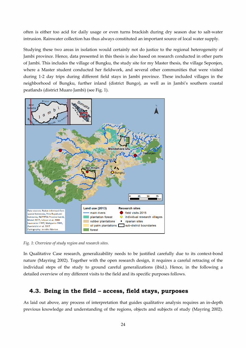
24
often is either too acid for daily usage or even turns brackish during dry season due to salt-water
intrusion. Rainwater collection has thus always constituted an important source of local water supply.
Studying these two areas in isolation would certainly not do justice to the regional heterogeneity of
Jambi province. Hence, data presented in this thesis is also based on research conducted in other parts
of Jambi. This includes the village of Bungku, the study site for my Master thesis, the village Seponjen,
where a Master student conducted her fieldwork, and several other communities that were visited
during 1-2 day trips during different field stays in Jambi province. These included villages in the
neighborhood of Bungku, further inland (district Bungo), as well as in Jambi’s southern coastal
peatlands (district Muaro Jambi) (see Fig. 1).
Fig. 1: Overview of study region and research sites.
In Qualitative Case research, generalizability needs to be justified carefully due to its context-bond
nature (Mayring 2002). Together with the open research design, it requires a careful retracing of the
individual steps of the study to ground careful generalizations (ibid.). Hence, in the following a
detailed overview of my different visits to the field and its specific purposes follows.
4.3. Being in the field – access, field stays, purposes
As laid out above, any process of interpretation that guides qualitative analysis requires an in-depth
previous knowledge and understanding of the regions, objects and subjects of study (Mayring 2002).
25
Following extensive literature research on the study region as well as on water and land use change,
extensive field research thus constituted the focus during the first years of my PhD studies. During this
time, I spent a total 12 months in Indonesia, including almost 10 months in Jambi province.
My first visit to Jambi province already took place in 2012 when I conducted fieldwork for my Master
thesis. Following a two-week one-by-one language course in Yogyakarta, I spent a total of two months
in Jambi province; interrogating problems of water scarcity in the village of Bungku (cf. Merten 2014).
My second visit to Jambi province followed in September 2015, just at the time when widespread forest
and peat fires blanketed Southeast Asia (see chapter V). At that time, a colleague and I visited Jambi
province for a scoping visit. In order to interrogate the wider social relevance and regional
heterogeneity of our planned research topics. For this purpose we visited two to three villages each in
four different regions of the province that varied in land use, land use history, ethnic and cultural
history as much as possible and stayed four to five days in each of the regions. The villages were
chosen based on an extensive analysis of pre-existing data collected during a household survey in the
province (Gatto et al. 2015, unpublished data) (see Fig. 1). Interviews at that time were mainly
conducted with representatives from village governments and farmer groups. They focused on
questions regarding land use and village history, current socio-economic, cultural and land use
characteristics, existing village organizations as well as general challenges and benefits associated with
the recent land use change. Already during this field research, it became apparent that environmental
changes related to water were important topics in each of the regions visited. While the specific
challenges varied across regions, water scarcity, pollution and flooding were mentioned as challenges
for securing local livelihoods and plantation management in all villages visited.
These previous field visits provided me with substantial knowledge about the characteristics of land
and people in Jambi province before starting my main field research in 2016. This field research was
divided into three different stays with each of them lasting around three months. They took place from
May to August 2016, from March to May 2017 and from October to December 2017 and thus enabled
me to visit Jambi during very different times of the year. The first field stay focused on researching the
sub-district Air Hitam, the second focused on the sub-district Mendahara Ulu and during the third
stay, I visited both sub-districts for a second time.
Before entering the field, I took an intensive one-on-one Bahasa Indonesia language course of three and
two weeks in the city of Yogyakarta in April 2016 and February/March 2017. These courses were
essential in acquiring a rigorous knowledge of the Indonesian language, which helped me to gain trust
and intimacy with interview partners, as well as acquiring a better understanding of the meaning and
significance of the interview results. At later stages, it enabled me to conduct the large majority of the
interviews directly in the Indonesian language.
During all phases of field research, I was accompanied by local female research assistants who were
(former) students from Jambi University and were recommended by friends and colleagues in Jambi
city. Being accompanied by a student from a local university was key to gaining access to the different
research villages and also for conducting successful field research in general. All three research
assistants - a different one during each field stay - helped to introduce me to village authorities, get
around by motorbike, translate language as well as local customs and behavior, record information
26
gained during interviews as well as discuss findings, inconsistencies and the many open questions I
had at the end of each day.
The first two field visits served to gain an in-depth overview of the two research regions. Before
commencing field research in the different research villages the assistant and I typically first visited the
head of the village to acquire research permission in the selected village. During field research, we then
either stayed at the house of the village head or with his/her family. The first days were used to
interview village authorities, as well as representatives from village and farmer groups or village elders
to get an in-depth overview of the village history and characteristics as well as current socio-economic
and environmental challenges. After adjusting to village life we then started choosing our interview
partners more independently, relying largely on snowball sampling techniques (Jupp 2006: 281) or
selected interview partners purposively, because they lived close to a river or owned plantations prone
to flooding for example. Over time, this strategy enabled us to delve deeper into specific research
topics, uncover new research themes as well as to broaden our perspectives and data sources with
regard to interview and research questions.
My third field visit aimed at rounding off research findings from the previous field visits. This visit
helped to fill gaps in data by deepening and crosschecking specific research findings and further
allowed me to get some insights into local dynamics and developments of my research topic. The fact
that I was well known to the villagers when I re-entered the field and my choice to focus on mainly re-
visiting former interview partners proved a big advantage. Interviews during this stay were much less
formal and more intimate (Fig. 2, p. 29). As my proficiency in Bahasa Indonesia had largely improved
over time, I was able to conduct the interviews largely myself, did not need to rely on rigid guidelines
and largely refrained from audio-recording interviews. Thereby, interviews often rather resembled
conversations between friends and enabled me to get much better insights into personal opinions and
evaluations of the research topics as well as to discuss previous research findings. In addition to re-
visiting both study regions, during this third phase of field research I also conducted interviews with
households owning oil palm and rubber plantations on riparian sites, which were sampled by natural
scientist of the EFForTS project (Georg August Universität 2015). In addition to research in the village,
all field visits also aimed to include external perspectives through conducting expert interviews (Flick
2016: 214). Several days spent in the city of Jambi, as well as in (sub-)district capital cities of our study
areas were thus used to conduct interviews with representatives from government bodies, academia,
civil society organizations, as well as private companies (Fig. 4, p. 29).
During each stay in Jambi province, we travelled back and forth between the villages and Jambi city.
These breaks in between repeated phases of field research appeared crucial in structuring field visits.
They allowed me to complete and order field memos and interview records, reflect on previous
research findings, develop long lists of open questions, adjust interview guidelines and to plan research
activities for the upcoming trips to the villages. Similar to travelling back and forth between the village
and Jambi city, travelling between Jambi and Germany helped ordering my research activities. Staying
in Germany for four to six months between each field trip enabled me to organize and evaluate
research data by working out open questions, related interview topics or inconsistencies in research
findings as well as to review additional literature in the meantime.

27
4.4. Research methods
This research follows a “transactional approach” to validity (Cho and Trent 2006: 322). It thus builds on
the presupposition that qualitative research can be more credible as long as certain methods and
research strategies are employed by which misunderstandings can be adjusted and fixed throughout
the research process (ibid.). Such strategies include the triangulation of data through the adoption of
different research methods, repeated interview situations as well as “member checking”, a process in
which collected data is ‘played back’ to the interview partners to check for their reactions and
evaluations (Cho and Trent 2006: 322, see also Berger 2015). Only such a combination of different
qualitative research methods can produce such “rich thick descriptions” that are typical for political
ecology (Núñez 2015: 460).
Semi-structured and informal interviews as well as participant observation build the main research
methods applied in the field. Semi-structured interviews are guided by a set of guideline questions,
which can be adapted during interview situations (Bernard 2006: 205). The strength of this type of
interview is that it allows for comparison between different interviews but also enables flexibility to
react to emerging topics during conversations or to deepen interview topics related to an interviewee’s
personal background and/or function (ibid.). They are particularly useful for when one only gets one
chance to interview a person (ibid.) and thus were also the preferred choice for expert interviews, for
example, with government representatives or with the owners of the riparian sampling locations.
Initial interviews during the first and the second field research were guided by a number of pre-defined
questioned. Different interview guidelines were used for farm households, representatives of the
village government and representatives of specific village groups or organizations. As this research
followed an inductive, bottom-up research approach, the interview guidelines comprised a broad range
of topics (Appendix 1.a). They mainly covered questions about: household characteristics, important
village developments, such as current projects and challenges to village development, practices of land
management and challenges therein, perceptions of environmental change, the role and importance of
specific village organizations or actor groups, existing land use regulations and spatial heterogeneity in
and between villages. Interviews at later stages during field research were rather guided by specific
themes and topics than by pre-defined sets of questions. They included topics such as: household and
village level impacts of water risks (flooding, water scarcity, fire, water pollution) strategies of coping
with and adapting to water risks, peatland management, food crop cultivations, water infrastructure,
village society, absentee investors, fire prevention or crop choice. Interviews with the owners of the
riparian sampling locations were coordinated with different natural science colleagues. The guideline
for these households is attached in the appendix of this thesis (Appendix 1.b).
Informal and unstructured interviews on the contrary do not follow a guideline (Bernard 2006: 203ff).
While unstructured interviews may still include formal interview situations, informal interviews
include conversations during the course of a day in the field. Situations that are more casual often allow
to gain more personal insights into specific topics than formal, recorded interviews as well as to
uncover new topics of interest that may have been overlooked previously (ibid.). Yet, due to their
informality, they limit the researcher in his or her way of leading and controlling the conversations,
which, for example, might suddenly be interrupted by someone else entering the situation (ibid.).
28
Moreover, some difficulty lies in the fact that informal interviews require the researcher to remember as
much as possible from a conversation and thus require a constant jotting of field notes (ibid.). Such
informal interviews varied widely in their degree of informality. They included planned visits to
villager’s plantations, when research purposes were obvious, to completely informal conversation
during dinner, social festivities or along the roadside.
Finally, participant observation was used as another research method. Participant observation means,
“going out and staying out”, experiencing the lives of the people that one is studying (Bernard 2006:
324). Ideally, it means immersing into the field, into a different culture and simply taking part in daily
life until people behave as usual when one shows up (Bernard 2006: 324). Such an approach to
participant observation would require a lot of time, especially for a white, European researcher in rural
Indonesian with villages of several thousands of inhabitants. It is also hardly realizable in multi-sited
field research. However, we tried to participate in village life as much as possible and gratefully
accepted any invitation we got. Such activities included joining wedding ceremonies, farmer group
meetings, joint cooking for fast breaking during the fasting month of Ramadan, boat trips along the
Mendahara and the Air Hitam river, visits to interview partners’ plantations or other interesting places
across the villages as well as taking part in gossip and conversations about the developments of the
village. Such kind of participant observation has the advantage that it allows gaining experiential
knowledge, knowledge that allows one to recount how it is or it feels like to live in the site of study
(Bernard 2006: 322). Moreover, it allows to collect many different kind of data such as photographs,
which I collected intensively as they proved to be extremely helpful in memorizing personal
impressions as well as sharing experiences, for example during conference presentations.
A small number of group discussions were also organized in both case study regions and proved useful
in gaining insights into local discussions and arguments around specific research topics. Organizing
such discussions, however, often appeared very time consuming while their success was not always
guaranteed, for example, if participants called off the meeting spontaneously. Moreover, guiding a
conversation between a group of up to eight smallholder farmers in Indonesian language presented a
particular, though enjoyable, challenge in itself.
In total, I conducted 229 interviews during my different field visits. These included 46 expert interviews
and 183 interviews at the village level (Fig. 2 and Fig. 4). The latter comprised 98 formal interviews
(incl. group discussions) and 85 informal interview situations (incl. field trips). While first field visits
were dominated by formal interview situations, during later field visits more informal interview
situations presented the majority of the interviews conducted (Fig. 2) In total 104 of the formal
interviews were audio-recorded (plus group discussions). Most of the recorded interview lasted
between 45 min and 1 h 15 min (n= 58). Only six interviews were shorter than 45 min and 36 interviews
lasted longer than 1 h 15 min (Fig. 3).
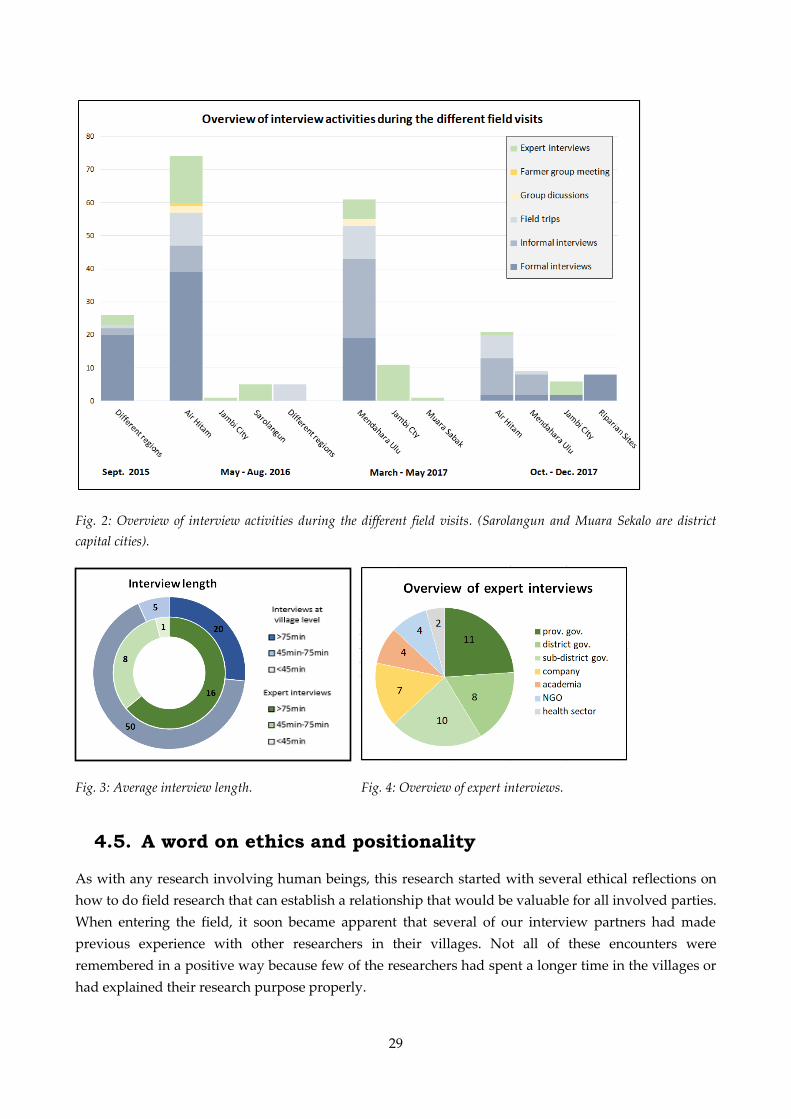
29
Fig. 2: Overview of interview activities during the different field visits. (Sarolangun and Muara Sekalo are district
capital cities).
Fig. 3: Average interview length. Fig. 4: Overview of expert interviews.
4.5. A word on ethics and positionality
As with any research involving human beings, this research started with several ethical reflections on
how to do field research that can establish a relationship that would be valuable for all involved parties.
When entering the field, it soon became apparent that several of our interview partners had made
previous experience with other researchers in their villages. Not all of these encounters were
remembered in a positive way because few of the researchers had spent a longer time in the villages or
had explained their research purpose properly.
30
My assistants and I hence tried to find our own ways and strategies in order to enable more sensitive
encounters with our interview partners. Before every interview, we visited our potential respondents to
obtain their approval to being interviewed. At this occasion, we shortly introduced ourselves and
explained why we were interested in talking to them. The interview partners themselves were then able
to choose if, when and where an interview would take place. Before getting started, their formal
consent for conducting the interview was obtained. We explained the background and purpose of my
research in more detail, assured confidentiality and anonymity of all information provided and made
clear that any contribution was voluntary and the interview partners could stop the interview at any
time they wanted to. Finally, we asked them for permission to audio-record the interview. After
switching off the recorder at the end of each interview, we ensured that there was enough time for
more informal conversations. We then encouraged the interview partner to ask questions him or herself
about anything of interest related to our personal backgrounds, the research, Germany or else.
Moreover, we tried to show our appreciation towards the interview partners by different gestures. We
brought small mementos, including a hand-made card to express our gratitude about their
participation in my research. We also took a joint photograph after each interview, which we handed
out personally when coming back to the village, to enable another informal encounter and gesture of
appreciation. Finally, we tried to meet several of our interview partners on several occasions and asked
for permission to leave the village (an Indonesian habit to say goodbye) at the end of each field stay.
Despite trying to obtain people’s formal consent and being transparent about my research aim, both
aspects also had limitations. Explaining the background and purpose of my research before each
interview, for example, at times constituted an act of balance between being as open and transparent as
possible, yet not revealing too many details, which could influence the research participants’ responses.
In addition, while research participants were asked for their consent in the case of formal interview
situations, informal conversation did not allow for this. Bernard (2006: 211) even acknowledges that
any type of informal interviews often involves some kind of deception to keep people from knowing
that one is studying them. Openly and repeatedly communicating about me being a researcher and my
topics of research as well as being particularly careful regarding confidentiality of information obtained
during such situations was my choice of dealing with such situations. However, it could certainly not
prevent that I gathered information that was not meant to be shared as research data but still helped me
broadening my understanding of issues at stake.
At the beginning of my research, I had committed myself to sharing research findings with villagers
during my last field visit. Unfortunately, this was not possible in a formal way due to political concerns
in our research project. Moreover, many findings and conclusions were only formulated once field
research had finished. Informally discussing some of my initial findings during later field visits was
thus the only way to do so. Further, I tried to share concerns and challenges raised by villagers during
expert interviews with relevant government representatives. Through collaborating closely with the
University of Jambi and the Agricultural University of Bogor, I further had the chance to discuss my
research findings (in particular chapter IV) extensively during colloquia in both cities. Additionally, as I
had already conducted research in Jambi province for my Master thesis I was able to share research
results on water scarcity related to oil palm expansion whenever this topic was brought up by
individual interview partners.

31
Finally yet importantly, qualitative research is a process of interactions (Mayring 2002). Hence, some
words on positionality and power relations need to be added. As Temple and Edwards (2002: 6) note,
in cross-cultural, cross-language research a ‘triple subjectivity’, shaped by researcher, assistant and the
interview partner influences knowledge production in the field. Being a white, European, unmarried,
well-educated woman about 30 years old certainly left its stance on the research findings. In particular,
being obviously white had both advantages and disadvantages. On the hand, many people were
wondering about who I was and what I was doing in their village making them curious to talking to
me. It also proved hugely beneficial to get access to even high-ranking government representatives who
gladly took their time for an interview with me. On the other hand, being white also posed several
challenges for conducting research at the village level. Wherever I came, I was elevated as a special
guest being offered the wedding buffet first or being invited to join lunch with the district governor.
This certainly impeded me from truly submerging into the field and made my research assistants often
feel uncomfortable. On one occasion, I was even asked to give a small speech when a government
representative visited one of the villages and was obviously misusing his visit to promote himself as a
candidate for the upcoming election of governor. Not willing to support his private campaign, I
immediately rejected this offer, which, however, was certainly extremely impolite towards the village
head. Moreover, and in particular when I discussed challenges for village development, interview
partners often hoped that I could help them in this regard, by either bringing money or having personal
connections to public authorities. Explaining the purpose and benefits of my research thus continued a
difficult endeavor throughout the field visits.
Berger (2015) acknowledges that being such an outsider can also be an empowering experience for
respondents who are elevated into expert positions. However, this was no easy task. Frequently, my
level of education seemed to intimidate interview partners, who considered themselves only “stupid”
farmers whose course of study was limited to primary school. It often took a lot of effort convincing
them that I was interested in their personal opinions and practical experience rather than expert
knowledge. Moreover, while my perspective on local developments might have brought a new and
different outsider perspective on the research topic (Berger 2015), it is equally true that understanding
many things in the field took me much longer than it would have taken for a local researcher who
could have collected a similar amount of data in much shorter time.
Equally, my research assistants strongly influenced my research through their individual backgrounds
and personalities. Their different intersectionalities (Whatmore 2002) with interview partners, for
example, being (non-)Muslim, being born in the same area, or going to the same university as the
respondents’ children shaped the level of trust and intimacy with interview partners and their calm or
extrovert personalities the atmosphere of conversation. Finally, the assistants and I had to get used to
each other’s working style, for example, in terms of how much translation was needed and to what
kind of detail, how much the interview partners were allowed and encouraged to go off topic before
returning to the guideline, or how open a question could be posed to get a good and relevant answer,
while not influencing their responses (these and other limitations and constraints of my research are
further elaborated in chapter 4.8).
32
4.6. Data recording, coding and analysis
Data analysis in qualitative research is an ongoing process and frequently overlaps with data collection
(Eisenhardt 1989). Conducting qualitative interviews, contrary to, for example, conducting a larger
household survey usually implies that the researcher him- or herself is present during all interview
situations and is thus constantly exposed to the data collected. Data analysis hence begins with the
writing of field notes and memos, the adjustment of research and interview questions, the selection of
interview partners and a lot of reflection and brainstorming. To make this possible, a thorough,
ongoing documentation of research findings is necessary. Hence, all information obtained during
interviews was recorded in written form at the end of each day and personal impressions and thoughts
were written down in field memos. All audio-recorded (n= 104) interviews were transcribed in
Indonesian language with the help of the research assistants.
Data analysis is often that part of the research process that is described with less detail in qualitative
research studies (Eisenhardt 1989). While it is certainly impossible to follow exactly, how researchers
derive their conclusions from endless months in the field, hundreds of pages of interview notes and
hours of interview recordings, some key features in qualitative analysis were identified by Eisenhardt
(1989). First, there is a need for a “within case analysis”, which aims at becoming intimately familiar
with each case separately before commencing the search for “cross-case patterns” (ibid.: 540). For this
purpose, I summarized my research findings from each village and noted down personal reflections on
the specific research topics following most of the field visits. In addition, travelling back and forth
between the different villages, questioning villagers for regional similarities and differences aided
acquiring knowledge about regional heterogeneity and local specificities, such as differences in
flooding, access to land or societal structures. Based on this in-depth knowledge about the different
villages, overall research themes and relationships between different variables emerged which then
helped me shape of different hypotheses (cf. Eisenhardt 1989). The research diary where I wrote down
impressions, thoughts and reflections after discussions with supervisors, friends and colleagues,
conference presentations, or summer schools visited, supported such hypothesis building during the
whole research process.
Moreover, during this step of analysis, coding of research data proved crucial. In order to structure and
organize research data, in the follow-up of each field research, interview protocols and field memos
were coded with MAXQDA software. As Saldaña (2009: 7f) notes, such coding may serve as a heuristic,
an exploratory technique of analysis. Since coding is more than just labeling and helps linking ideas
and data, it was crucial for hypotheses building (ibid.). Data was mainly coded for content following
Mayring (2000). Code categories were hence formed inductively out of the research material and were
then revised, adjusted and reformulated stepwise and in feedback loops (ibid.). Initial categories aimed
to grasp basic topics arising during the interviews (e.g. “fishing, “customary law” and “flooding”).
These were then subsumed under different general themes (e.g. “land use characteristics”,
“environmental change”, “village level politics”) or also refined further in case categories became too
large to analyze (Saldaña 2009: 10f).
Having coded all data then helped to pursue a more rigorous analysis and interpretation of research
data (Saldaña 2009: 7f). Hypotheses that were built during this phase of analysis, for example,

33
“flooding has increased in frequency and intensity”, or “flooding shapes crop choices”, were then
compared systematically with the evidence from each case (Eisenhardt 1989). In an iterative process
each case was used to confirm or disconfirm the emergent relationships and hypotheses and thus to
establish internal validity (ibid.). This research stage also led to the restructuring of data, such as the
building of new code categories and the consulting of additional data sources. Initially, only interview
protocols and field memos were coded systematically. Particularly interesting confirming or
disconfirming research data was then analyzed in more depth by consulting the original transcripts in
Indonesian language. In some cases, interview data alone could not confirm initial hypotheses. This
was, for example, the case for the hypothesis “transnational climate mitigation action strongly shapes
local land use regulations in Jambi” (chapter VI). Hence, an additional review of grey literature such as
government reports or websites was carried out to confirm this relationship.
4.7. Interdisciplinary thinking and collaborations
As laid out in the conceptual framework to this thesis, studying the socio-natural production of
environmental risks clearly requires research that transgresses traditional disciplinary boundaries.
Hence, this thesis builds on different ways of interdisciplinary thinking and collaborations. In the
following, different logics, modes on procedures guiding my interdisciplinary work will be described.
Reasoning for why interdisciplinary research is considered necessary can be guided by different logics,
for example logics of accountability or logics of ontology (Barry and Born 2013). The research at hand
builds on both. It builds on logic of accountability since the immense public concern, together with the
multi-dimensionality of environmental risks, requires research that is able to analyze both social and
environmental processes in the production of risk. In addition, this research also builds upon two
different logics of ontology that will be described in the following.
First, chapter IV in this thesis (“From rising water to floods: Disentangling the production of flooding
as a hazard in Sumatra, Indonesia”) can be categorized as a type of interdisciplinary research that
according to Barry and Born (2013: 19) aims at the generation of “hybrid or relational objects”. Such
research is typically grounded in a critique of the society-nature dualism (e.g. Castree 2005, Latour
1993). It thus engenders interdisciplinary thinking and practices as it cuts across the boundaries
between the natural and social sciences (Barry and Born 2013). During this PhD project, I have
consistently tried to challenge my former perspective on flooding as an external environmental process.
By engaging extensively with relational approaches to natural resources and water in particular (e.g.
Swyngedouw 2004, Linton 2010, Jones et al. 2014), I have tried to understand both the social qualities
and biophysical dynamics of flooding in Jambi. For this purpose, and common for this kind of
interdisciplinary thinking (Barry and Born 2013), I have further tried to internalize the fact that any
conceptualization of an environmental problem actively shapes and is shaped by the environmental
problem itself (Latour 1993). In chapter IV, I use this insight to contest the predominant and immediate
categorization of flooding as a hazard in much risk research (e.g. Wisner et al. 2003, Smith 2013). I
exemplify how environmental events such as a river overflowing its banks only turn into hazards
through the joint effect of human perception, discourse and modification. Environmental hazards, such
as flooding, I argue, constitute socio-natural hybrids and need to be studied as such. Chapter IV

34
thereby builds on what Barry and Born (2013) consider an “agonistic-antagonistic mode” of
interdisciplinary research. I comprises research that stems from “a commitment or desire to contest or
transcend the given epistemological and/or ontological assumptions of specific historical disciplines”
(ibid.: 12).
Second, chapter III in this thesis (“Flooding and land use change in Jambi Province, Sumatra:
integrating local knowledge and scientific inquiry”) can be categorized as interdisciplinary research
that aims at the integration of different knowledge areas, including non-scientific ones (Barry and Born
2013). Building on a critical realist philosophy of science (see chapter I: 2.2.1), chapter III builds upon
the ontological logic that empirical phenomena are causally non-reducible (Nastar et al. 2018).
Following this logic, any analysis of environmental risk necessitates interdisciplinary knowledge and
methodological pluralism10 in order to make conceptual links about the multiplicity of causal processes
(ibid.). It thus builds on an “integrative-synthesis mode” of interdisciplinarity, which understands
interdisciplinary practices as achieved through a synthesis of different knowledge areas11 (Barry and
Born 2013: 12). Such synthesis can be approached through the process of integration or negotiation
(ibid.) Being embedded in the interdisciplinary collaborative research centre EFForTS enabled me to
discuss my research findings with colleagues across different disciplines on several occasions. These
discussions soon revealed the lack of scientific measurements regarding specific empirical societal
problems, for example villager’s observations of changing water flows. Together with different
colleagues, I hence decided to explore the potential of integrating local ecological knowledge, captured
through qualitative interviews, with natural science measurements in the study of these problems.
Expectations of what such integration between different areas of knowledge should achieve differ
widely. Traditional perspectives often expect such interdisciplinary endeavors to achieve integration by
a “higher-level concept” (Thorén and Persson 2013: 338). Others, however, acknowledge that a
theoretical integration of very distant disciplines ‒ such as qualitative social science and quantitative
natural science ‒ is unlikely due to incompatible epistemologies and ontologies (Olsson and Jerneck
2013, Thorén and Persson 2013). In particular in a single PhD project, a different and more realistic aim
of an interdisciplinary collaboration may hence be to achieve practical integration (Thorén and Persson
2013). Such practical integration is often pursued through “problem-feeding”, in which a problem
encountered in one discipline is moved to another discipline (ibid.). Starting with the villagers’
observations of changing water flows, my colleagues and me thus moved this problem across different
natural science disciplines to find explanations for these changes.
In the way we organized our collaboration we followed Danermark’s (2019) advice on how to structure
an interdisciplinary research process. Danermark identified five important steps in a research process
that builds on critical realism. In an initial planning phase, me and another researcher who shared the
lead over the project, decomposed the observed phenomena, flooding, into the structures and
10 Methodological pluralism argues that there are ontological reasons to use different methods to understand structures
and mechanisms across different knowledge areas (Danermark 2019).
11 Critical realist theory here rather refers to different “levels” than to “areas of knowledge”. In the social realm such
levels could, for example, include the socio-material level, the level of social structure or the level of the person (Bhaskar
2010, Nastar et al. 2018). Following the suggestion by Danermark (2019), however, I prefer to use the term “area of
knowledge”, which is less imprecise than the term “discipline” but easier to understand than the term “level”.
35
mechanisms that could affect, reinforce or weaken this phenomena. For this purpose, we built upon a
literature review of previous research and in-depth knowledge from the research sites. We identified an
alteration of soil properties, climatic change and land use conversion as potential mechanisms
contributing to an increase of flooding in Jambi province. At a later state of the research, we added
different land use practices as another potential mechanism to our research design. We then identified
all research project groups and researchers in the EFForTS research centre that oversaw corresponding
research methods and data and inquired about their willingness to join our project. Together, we then
interrogated existing datasets and measurements, available analytical tools for analysis and the
researchers capable of analyzing the necessary data. The second phase in such an interdisciplinary
research process is the “disciplinary phase” (Danermark 2019). During this phase, all researchers
involved in our collaboration independently analyzed the research data in their specialized knowledge
area in an independent manner. Third, a phase of “cross-disciplinary understanding” follows, which, in
our case, was strongly mixed with the fourth phase of “transfactual theorizing” that aims at knowledge
integration (Danermark 2019).
During numerous group meetings, we started discussing first results of analyses, clarified individual
methodologies and research approaches, identified lacking data as well as further needs of analysis. As
described in much other literature on interdisciplinary research, this phase of the research process was
certainly also a phase of tensions (e.g. Spiller et al. 2015, Anders et al. 2015, Krüger et al. 2016). These
included tensions between positivist and non-positivist scientific world views, about the
representativeness and validity of disciplinary research findings, about the terminology used and also
about the conclusions that could be drawn based on such a diverse set of research data. Finally,
building on this methodological pluralism we triangulated findings, discussed complementarities and
inconsistencies between local knowledge and scientific measurements. As described elsewhere, a
successful collaboration during this research phase requires a number of personal characteristics and
contextual factors (cf. Danermark 2019). Without a true open-mindedness among the researchers
involved, respectful ways of communication and a passionate as well as patient and enduring attitude
towards the research process, our collaboration would have failed for sure. The withdrawal of one
researcher from the group during the research process ‒ resulting from a lacking appreciation of
qualitative social science methods ‒ exemplified the bumpy road towards knowledge integration. The
fifth phase then is the phase of “interdisciplinary understanding”, which should lead to an integrated
knowledge about the object (Danermark 2019). As Danermark (2019: 379) notes, this should be a phase
of a true “melding of disciplines”, resulting in unique research outcomes that could not have been
produced by the individual disciplines in separate. In our case, this led to the drafting of a joint
manuscript for the journal Ecology & Society that aimed to achieve a more detailed and complete
understanding of the complex causal relations between agrarian change and changing water flows in
Jambi province.
Chapter II (“Water scarcity and oil palm expansion: social views and environmental processes”) builds
on a mode of interdisciplinarity in between those two approaches. Similar to chapter III it builds on an
integration of scientific and local knowledge. It thus also presents an “integrative-synthesis mode” of
interdisciplinarity (Barry and Born 2013: 12). The ontological reasoning behind chapter II, however,
differs from chapter III. Chapter III integrates these different knowledge areas in order to achieve a
36
more complete understanding of the potential causal processes contributing to the production of
flooding Jambi. Chapter II, instead, combines these knowledge areas to interrogate both material and
discursive dimensions of water scarcity in Jambi.
4.8. Limitations and constraints
As with any research endeavor, this study has a number of limitations and constrains. First, as already
mentioned above, there are advantages but also a number of disadvantages to researching people and
topics one is an outsider to. Having to learn a new language, getting used to local customs and habits as
well as gaining trust from interview partners: it all takes a lot of time and may limit the depth of data
obtained. Insider researchers who have a more intimate knowledge of place, history and social
developments may often obtain more personal, in-depth, or more specific interview answers or may be
able to achieve a richer interpretation of the research topic at hand. Equally, having interviews at least
partly translated by a local research assistant may filter meaning, modify discourses, or produce
misunderstandings and thereby influence the validity of qualitative research data (Williamson et al.
2011, MacKenzie 2015, Caretta 2015). Although such translation was reduced stepwise during field
research, any translation between languages certainly goes along with a loss of detail and precision.
Second, any choice of methods and interview partners is always also determined by practical
considerations. Hence, this research mainly builds on household interviews but less on group
discussion that could have presented better insights into social interactions or provide more
controversial accounts of certain research topics. Two group discussions with women were conducted
to hear about their specific concerns regarding environmental change, yet women unfortunately
represented the minority of my interview partners. Most local groups, associations and government
bodies in Jambi are primarily led by men and snowball sampling starting with one male farmer often
resulted in a recommendation of another man. Further, not all of those women whom I encouraged to
join the interviews engaged with the same level of confidence and openness as their husbands did.
Another group hardly represented are representatives from the plantation sector. Despite multiple
inquiries and letters sent to producer associations, official ways of inquiring interviews failed as we
received no response or interview appointments were cancelled spontaneously. Regarding this group
of interview partners, only two government representatives from the plantation office accepted my
interview requests and one oil palm company, where one of my assistants had worked formerly,
officially allowed us to interview their staff.
Third, being embedded in a larger research project with well-established local networks between local
universities and authorities was hugely beneficial for gaining access to local authorities and acquiring
research permits in reasonable time. Yet, in research locations where numerous other researchers had
conducted household surveys or had taken soil samples such activities had certainly influenced my
interview partners, raising expectations of benefits or forming presuppositions about my research
purpose and interview questions. Finally, the interdisciplinary collaboration that I engaged in was a big
surplus for my research and my personal experience during this PhD project. However, integrating our
multidisciplinary datasets a posteriori implied lacks of data, mismatches in scale, timing and/or

37
locality. Starting interdisciplinary collaborations already with a joint research proposal would have
certainly enabled a much more robust way of data integration.

38
5. Structure of the thesis
The core of this thesis comprises five articles and manuscripts that have been published in or are
planned for submission to different international peer-reviewed scientific journals. Each of them
provides insights into different parts of the overarching research objectives and questions guiding this
thesis. All articles are concerned with specific empirical problems encountered during the extensive
field research in Jambi province. Conceptual frameworks and analytical lenses were then chosen
individually to best expound and explain the empirical phenomenon or problem encountered in the
field. In the following, I will introduce the purpose of each of the articles and outline their relation to
the overall research objectives and questions.
The thesis consists of two main parts. The first part, chapters II-IV, focuses on investigating the
production of new water risks in Jambi province. These chapters build on different conceptual and
methodological approaches that enable a more integrated analysis of risk production. Each of them
focuses on different aspects of the hydro-social relations in Jambi and analyzes their specific
contribution to the production of risk.
The second part of the thesis, chapters V-VI, draws attention to different risk mitigation policies and
their impacts on local communities. Geographically, this part focuses on Jambi’s coastal peatlands. As
the conversion and protection of tropical peatlands has turned into a topic of great international
interest, risk mitigation action there appeared to be of great social and political relevance.
Chapter II: Water scarcity and oil palm expansion: social views and
environmental processes
The aim of this first chapter is to understand the production of the risk of water scarcity in Jambi
province. It presents a combined analysis of biophysical and political processes that help explain
emerging contestations about water scarcity in the village of Bungku. For this purpose, the chapter uses
data from my Master thesis (Merten 2014) and integrates these with natural science measurements and
data. Specifically, it analyzes villager’s perceptions of decreasing groundwater levels during dry season
and confronts these with micro-meteorological, eco-hydrological and pedological measurements
conducted in oil palm and rubber plantations as well as in forest reference sites. Conceptually, the
article uses the framework of the hydrosocial cycle. It helps explain local divergence in villager’s
environmental perceptions and to explore the wider social and political implications of the ongoing
agrarian transformation processes in Jambi province.
I share the first authorship for this article with Alexander Röll from the department Tropical
Silviculture and Forest Ecology at Göttingen University. We further involved numerous co-authors
from Göttingen University, the Agricultural University Bogor (IPB) and the Center for Climate change
and Air Quality in Jakarta. The article was published in the Journal Ecology & Society in April 2016.

39
Chapter III: Flooding and land-use change in Jambi Province, Sumatra:
integrating local knowledge and scientific inquiry
Similar to chapter II, this chapter builds on an integrated analysis of qualitative social science and
quantitative natural science research data. In contrast to chapter II, it interrogates the production of
flood risk. Conceptually, this chapter adopts a critical realist approach to the study of environmental
risk. Critical realism posits that a combination of different knowledge sources is necessary to achieve a
thorough understanding of environmental phenomena such as risk. The reasons for this is that critical
realism considers all knowledge to be partial, fallible and socially constructed. Building on this
premise, the chapter combines different scientific and non-scientific knowledge sources to interrogate
the causal processes and linkages between land use change and flooding in the Tembesi watershed in
Jambi province. It combines qualitative interview data on local ecological knowledge with river
discharge measurements, precipitation data, land use mapping and pedological measurements of soil
hydraulic properties. In an outlook, it discusses how such an integration of knowledge helps to provide
for a more complete and socially sensitive understanding of the production of flood risk in Jambi
province, and also beyond.
I hold the first authorship of this article. In addition, numerous colleagues from Göttingen University,
the Agricultural University Bogor (IPB) and the Center for Climate change and Air Quality center in
Jakarta were involved as co-authors in the development of this article. It has been published in the
Journal Ecology & Society in August 2020.
Chapter IV: From rising water to floods: disentangling the production of
flooding as a hazard in Sumatra, Indonesia
This chapter adds to chapter III and aims to deepen our understanding of the production of flood risk
in Jambi province. It explains why flooding, once considered a normal seasonal phenomenon, today, is
largely perceived and represented as a threatening hazard. For this purpose, it takes an entirely
different approach to an integrated study of flood risk and conceptualizes flooding as a socio-natural
hybrid. This conceptualization allows us to include the discursive and symbolic dimensions of risk and
hazard in risk analysis and thereby goes beyond the material changes in flooding described in chapter
III. Methodologically, this chapter builds on a historically situated case study approach in two sub-
districts in Jambi province. It uses qualitative research data to reconstruct the multiple material and
discursive changes in hydrosocial relations in Jambi province over the last three decades. The chapter
focuses on interrogating how changes in social relations may explain the production of flood risk in
Jambi. However, it also takes into consideration the biophysical processes behind risk production by
paying close attention to the specific materialities of flooding. Conceptually, the article brings into
conversation literature on relational approaches to water with recent risk literature and works out how
these approaches can further our understanding of the production and meaning of environmental risks.
I am the first author of this article. It has been co-authored by my supervisors Heiko Faust and Jonas
Østergaard Nielsen from Göttingen and Humboldt University as well as my Indonesian counterparts
Rosyani from Jambi University and Endriatmo Soetarto from IPB Bogor. The article was accepted for
publication in Geoforum in November 2020.
40
Chapter V: Indonesia's fire crisis 2015: a twofold perturbation on the
ground
This chapter introduces the second part of this thesis. It looks at a different environmental risks related
to changes in the local water flows, namely the risk of fires in drained peatlands. Building on
qualitative case study research from a village in Jambi’s coastal peatlands, the chapter investigates the
social impacts of the large-scale peat fires during the extremely dry El Niño year 2015. It critically
analyzes policies on the prevention and control of peat and forest fires, which were developed in the
aftermath of the fires, and works out the implications of these for smallholder farmers. Conceptually, it
builds on a context-oriented approach to vulnerability. It differentiates between material and political
dimensions of vulnerability to explain why risk policies have resulted in maladaptive outcomes for the
local communities.
The article was mainly elaborated by a Bachelor student, Flora Hartmann. I assisted her in carrying out
her field research in Jambi province, joined her in discussing research questions and findings and
helped developing this article as the second co-author. The article was published in the Journal Pacific
Geographies in January 2018.
Chapter VI: Transnational climate mitigation action in tropical peatlands – implications for smallholder farmers in Indonesia
This chapter continues the research endeavor of chapter V but delves even deeper into the analysis of
the social impacts of risk mitigation policies in Jambi province. It traces how transnational policy efforts
to mitigate environmental risks from peatlands, i.e. fires and carbon emissions, materialize in new
policies, projects and land use agreements in Jambi’s coastal peatlands. It uses a capability approach to
climate justice to analyze how such transnational climate mitigation action fails to comply with
fundamental criteria of justice and analyzes how this impacts local people’s well-being.
Methodologically, the chapter builds on insights from qualitative case studies in different villages in
Jambi’s coastal peatlands. These are complemented with an extensive review of government reports,
Indonesian legislation and grey literature.
I hold the first authorship of this manuscript. It is co-authored by my supervisors Heiko Faust and
Jonas Østergaard Nielsen from Göttingen and Humboldt University and my Indonesian counterpart
Rosyani from Jambi University. It is planned for submission to Mitigation and Adaptation Strategies for
Global Change.

41
CHAPTER II:
Water scarcity and oil palm expansion: social views and environmental processes12
Jennifer Merten, Alexander Röll, Thomas Guillaume, Ana Meijide, Suria Tarigan, Herdhata
Agusta, Claudia Dislich, Christoph Dittrich, Heiko Faust, Dodo Gunawan, Jonas Hein,
Hendrayanto, Alexander Knohl, Yakov Kuzyakov, Kerstin Wiegand and Dirk Hölscher
Abstract
Conversions of natural ecosystems, e.g., from rain forests to managed plantations, result in significant
changes in the hydrological cycle including periodic water scarcity. In Indonesia, large areas of forest
were lost and extensive oil palm plantations were established over the last decades. We conducted a
combined social and environmental study in a region of recent land-use change, the Jambi Province on
Sumatra. The objective was to derive complementary lines of arguments to provide balanced insights
into environmental perceptions and eco-hydrological processes accompanying land-use change.
Interviews with villagers highlighted concerns regarding decreasing water levels in wells during dry
periods and increasing fluctuations in stream flow between rainy and dry periods. Periodic water
scarcity was found to severely impact livelihoods, which increased social polarization. Sap flux
measurements on forest trees and oil palms indicate that oil palm plantations use as much water as
forests for transpiration. Eddy covariance analyses of evapotranspiration over oil palm point to
substantial additional sources of evaporation in oil palm plantations such as the soil and epiphytes.
Stream base flow from a catchment dominated by oil palms was lower than from a catchment
dominated by rubber plantations; both showed high peaks after rainfall. An estimate of erosion
indicated approximately 30 cm of topsoil loss after forest conversion to both oil palm and rubber
plantations. Analyses of climatic variables over the last 20 years and of a standardized precipitation
evapotranspiration index for the last century suggested that droughts are recurrent in the area, but
have not increased in frequency or intensity. Consequently, we assume that conversions of rain forest
ecosystems to oil palm plantations lead to a redistribution of precipitated water by runoff, which leads
to the reported periodic water scarcity. Our combined social and environmental approach points to
significant and thus far neglected eco-hydrological consequences of oil palm expansion.
Key words: eco-hydrology; environmental perception; erosion; evapotranspiration; forest; land-use change; runoff;
rural water supply; streamflow; transpiration
Published in: Ecology and Society 21(2): 5
http://dx.doi.org/10.5751/ES-08214-210205
12 The social science research data in this chapter builds on field research conducted for my Master thesis (Merten 2014).
42
1. Introduction
When there was still a lot of forest around Bungku even during a drought of two months we still had water
in our wells. But now there is no forest anymore, there is oil palm.
Farmer from Bungku, Jambi, Indonesia, June 2013
Large-scale land-use change such as the current oil palm expansion in Indonesia is characterized by the
interaction of social, economic, and ecological processes. It is increasingly recognized that such
conversions require research that includes both human and environmental dimensions (Bradshaw and
Bekoff 2001, Bodin and Tengö 2012, Moore et al. 2014, Ledford 2015). The integration of local
knowledge and perceptions, e.g., the above statement by a farmer from Jambi (Sumatra, Indonesia)
enables scientific research to directly address local people’s concerns (Ostrom 2009, Pahl-Wostl et al.
2010, Scholz et al. 2011, as cited in Binder et al. 2013). Although the need for such problem-driven
research has been emphasized in numerous studies, applied environmental research often fails to
adequately integrate social analyses (Lele and Kurien 2011, Wandersee et al. 2012, Tàbara and Chabay
2013, Sagie et al. 2013, Reyers et al. 2013, Orenstein and Groner 2014). Thus, we see a need for applied
interdisciplinary studies that give credit to the embeddedness of environmental processes in socio-
cultural processes by confronting local environmental perceptions with natural science measurements.
Indonesia is currently undergoing large-scale land-use change characterized by declining areas of
natural ecosystems and increasing areas of mono-culture plantations, thereby creating substantial
changes in the social-ecological system. Particularly oil palm plantations have rapidly expanded in
Indonesia over the past decades, from a total of less than one million ha in 1990 to over seven million ha
in 2013; today, Indonesia is the global leader in crude palm oil production (FAO 2015). Oil palm often
replaces other cash or subsistence crops, e.g., rubber plantations, but has also been identified as a driver
of large-scale deforestation (Koh and Wilcove 2008, Carlson et al. 2012). Such large-scale forest
conversion toward intensive agricultural systems may cause severe changes in the hydrological cycle
(Bruijnzeel 1989, 2004, Krishnaswamy et al. 2013). In our study region, the Jambi province in Sumatra,
the expansion of oil palm plantations has made water scarcity an issue in the human perception as, for
example, expressed in the introductory quote. Such socio-hydrological consequences and linkages of
forest conversion have not yet been adequately studied (Lele 2009).
Available scientific as well as popular studies linking oil palm plantations to the water cycle mainly
focus on water quality (e.g., Wakker 2005, Friends of the Earth et al. 2008, Babel et al. 2011, Colchester
and Chao 2011, Buschmann et al. 2012, Gharibreza et al. 2013). The few social science studies examining
water quantity do not explain the underlying reasons of the observed declines in water availability
(e.g., Obidzinski et al. 2012, Larsen et al. 2014). From the natural sciences perspective, water-related
studies on oil palm are scarce and often only examine single components of the hydrological cycle (also
see Comte et al. 2012, Dislich et al. 2015).
In this study, we aim at integrating social and natural science approaches to analyze the social and eco-
hydrological consequences of oil palm expansion. The starting point for our interdisciplinary, problem-
oriented research is the environmental perception of changes in the water cycle by residents of Bungku,
a village in Jambi. We investigate if and how these perceptions can be explained by empirically derived
43
environmental variables that were measured in the vicinity of the mentioned village. For this purpose,
we analyzed micrometeorological, eco-hydrological, and pedological measurements in oil palm
plantations, rubber plantations, and forest sites. Unlike oil palm, rubber has been cultivated in Jambi
since the first half of the 20th century (Feintrenie and Levang 2009). Rubber plantations today still
represent the dominant land-use system in the province, extending over 660,000 ha in 2013 (BPS Jambi
2014). Our approach allows for an assessment of the environmental perceptions and eco-hydrological
processes following forest conversion to monoculture plantations. We also analyzed long-term climatic
data to evaluate the influence of potential climatic changes in the Jambi region. Our objectives were (1)
to asses villagers’ perceptions of changes in the local water cycle in an oil palm dominated region, (2) to
identify environmental processes leading to changes in the water cycle, (3) to confront the perceived
changes with empirically derived environmental data, and thus (4) to derive complementary lines of
argument to discuss environmental perceptions in the context of the actual underlying eco-hydrological
processes.
2. The hydrosocial cycle and environmental perceptions
The hydrosocial cycle (after Linton and Budds 2014) serves as a framework to analyze water as a
product of society-nature interrelations. Although the concept of the hydrological cycle focuses only on
the material components of water, the way that water actually flows through landscapes is drastically
shaped by human institutions, practices, and discourses (Linton and Budds 2014). Water can therefore
be considered something inherently political, because the control over water produces certain types of
social power relations and structures (Wittfogel 1957). The hydrosocial cycle builds upon the notion of
water as a “hybrid” object (Latour 1993), i.e., one that simultaneously possesses a social and a natural
dimension that are engaged dialectically as both product and agent of socio-natural change
(Swyngedouw 2004). Water is thus considered to have a material energetic dimension, such as the flow
of water that can change landscapes and established social orders and that provides the basis for
individual or societal claims, as well as a cultural-symbolic dimension formed by symbolic orders,
interpretive contexts, and social constructions (Becker et al. 2011). The hydrosocial cycle can thus be
defined as a socio-natural process by which water and society interact materially and discursively
(Linton and Budds 2014). In order to untangle the social and natural processes coproducing this hybrid
nature of water, we combined qualitative social field research with natural science empiric
measurements in this study.
From the social science perspective, we approach the hybridity of water through environmental
perceptions. Environmental perceptions can be defined as the “reception and processing of information
from the environment” (Ittelson 1973:4). This includes both the assessment and the evaluation of
information, which implies embedding the environmental context into individual experiences,
imaginations, and memories (Schiffman 1982, Bell et al. 2001). As such, the way in which individuals
analyze the environment and environmental changes is influenced in particular by environmental
knowledge and values, place attachment, interests and motivations, but also by the specific prevailing
circumstances such as time or cause of environmental change (Hellbrück and Fischer 2003, Chokor et
al. 2004, Brown et al. 2005, Sampaio Sieber et al. 2011, Boelens 2014). Environmental perceptions thus
have to be understood as context-related, dynamic, and discursively formed knowledge that is open to

44
negotiation and change (Irwin 2001). Accordingly, both conformity and nonconformity of
environmental perceptions vs. measured environmental processes have been reported (e.g., Moser
1984, Poor et al. 2001, Artell et al. 2013, Cottet et al. 2013).
3. Methods
3.1. Study region
Our research is part of EFForTS, an interdisciplinary research project investigating ecological and
socioeconomic functions of tropical lowland rainforest transformation systems (http://www.uni-
goettingen.de/crc990; Faust et al. 2013, Drescher et al. 2016). The study region of EFForTS is Jambi
Province in the eastern lowlands of Sumatra, Indonesia. The field work for this study was carried out in
the South of Jambi Province, in and around Bungku village (Fig. 1). Climate in the region is tropical
humid (26.5 °C, 2235 mm year-1, based on data from the meteorological station at the airport Sulthan
Thaha, Jambi), with a relatively dry season from June to September (monthly precipitation often below
120 mm). Between 1985 and 2007, 1.7 million ha of forest were cleared in the lowland areas (< 150 m
elevation) of Jambi province, which corresponds to 71% of the 1985 forest area (Laumonier et al. 2010).
Today, mono-culture rubber and oil palm plantations dominate the landscape. Rubber has been
cultivated in Jambi since Dutch colonial times (Feintrenie and Levang 2009); oil palm cultivation started
in the mid-1980s and expanded to almost 600,000 ha in 2013 (BPS Jambi 2014).
The Bungku village spreads over an area of 600 km² and comprises five hamlets. The social scientist
case study was conducted in two neighboring hamlets in northern Bungku, Bungku Indah and Johor
Baru 1 (see Fig.1). Until the 1980s, Bungku was still dominantly covered by forest areas, extensive
rubber agroforests, and shifting cultivation land-use systems. Since then, intensive logging, the
expansion of rubber plantations, and the establishment of oil palm plantations, which was promoted
particularly since the mid-1990s (Colchester et al. 2011), led to rapid deforestation. Today, natural
vegetation can only be found in patches in the Harapan Rainforest, a forest rehabilitation project in the
southern area of Bungku (Fig. 1). In 2013, land use in Bungku Indah was characterized by about 60%
rubber and 40% oil palm cultivation, with oil palm strongly increasing in recent years (personal
communication with village head); Johor Baru 1 was predominantly characterized by industrial and
smallholder oil palm plantations. The company PT Asiatic Persada holds an oil palm concession of
20,000 ha directly bordering the Johor Baru 1 (Fig. 1). Indigenous land claims inside the concession area
have been oppressed since the granting of the concession in 1987. The plantation has ever since been
the subject of an ongoing land-use conflict involving numerous national and international actors (for
more details see Colchester et al. 2011, Steinebach 2013, Beckert et al. 2014, Hauser-Schäublin and
Steinebach 2014).
Through constant in-migration from other parts of Jambi and Indonesia the population of Bungku has
grown significantly over the last decades. Although the initial settlement project in the early 1970s only
comprised roughly 60 households, the village population in 2015 had grown to 10,798 people (Hauser-
Schäublin and Steinebach 2014, BPS Kabupaten Batang Hari 2015). About 10% of today’s population are
indigenous people, 55% are migrants from Java, 30% are migrants from other parts of Sumatra/Jambi
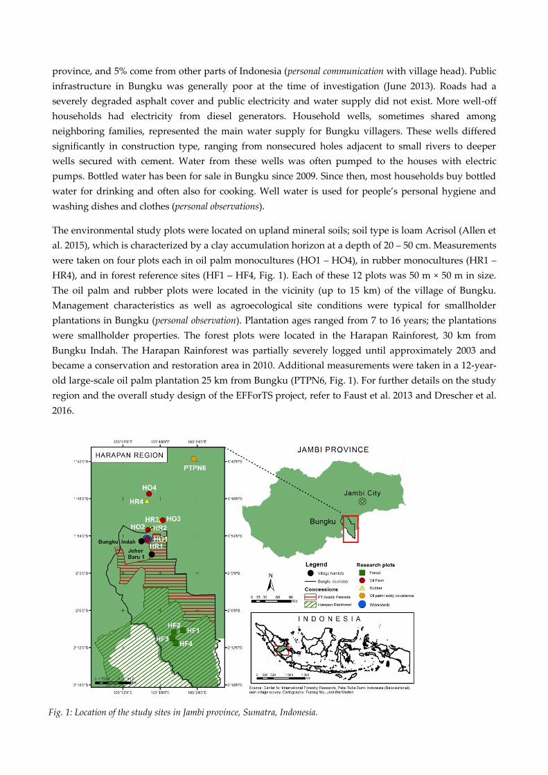
45
province, and 5% come from other parts of Indonesia (personal communication with village head). Public
infrastructure in Bungku was generally poor at the time of investigation (June 2013). Roads had a
severely degraded asphalt cover and public electricity and water supply did not exist. More well-off
households had electricity from diesel generators. Household wells, sometimes shared among
neighboring families, represented the main water supply for Bungku villagers. These wells differed
significantly in construction type, ranging from nonsecured holes adjacent to small rivers to deeper
wells secured with cement. Water from these wells was often pumped to the houses with electric
pumps. Bottled water has been for sale in Bungku since 2009. Since then, most households buy bottled
water for drinking and often also for cooking. Well water is used for people’s personal hygiene and
washing dishes and clothes (personal observations).
The environmental study plots were located on upland mineral soils; soil type is loam Acrisol (Allen et
al. 2015), which is characterized by a clay accumulation horizon at a depth of 20 – 50 cm. Measurements
were taken on four plots each in oil palm monocultures (HO1 – HO4), in rubber monocultures (HR1 –
HR4), and in forest reference sites (HF1 – HF4, Fig. 1). Each of these 12 plots was 50 m × 50 m in size.
The oil palm and rubber plots were located in the vicinity (up to 15 km) of the village of Bungku.
Management characteristics as well as agroecological site conditions were typical for smallholder
plantations in Bungku (personal observation). Plantation ages ranged from 7 to 16 years; the plantations
were smallholder properties. The forest plots were located in the Harapan Rainforest, 30 km from
Bungku Indah. The Harapan Rainforest was partially severely logged until approximately 2003 and
became a conservation and restoration area in 2010. Additional measurements were taken in a 12-year-
old large-scale oil palm plantation 25 km from Bungku (PTPN6, Fig. 1). For further details on the study
region and the overall study design of the EFForTS project, refer to Faust et al. 2013 and Drescher et al.
2016.
Fig. 1: Location of the study sites in Jambi province, Sumatra, Indonesia.
46
3.1.1. Social dimension
Based on initial reports about water scarcity in areas surrounding oil palm plantations in Jambi, interest
by social and natural scientists led to an inductive social case study. Bungku was chosen because of
reports of rapid land-use changes and increasing water scarcity. The case study aimed at investigating
villagers’ perceptions of major environmental changes, challenges in the local water supply, and
processes that potentially cause problems for the water supply.
To investigate these questions we conducted problem-centered, semi-structured household interviews
(after Mayring 2002; n = 30) that were triangulated with participatory observation, informal interviews,
focus group discussions, and participatory rural appraisal tools, i.e., timeline interviews and resource
mapping (after Kumar 2002). Field work in Jambi was conducted during a period of eight weeks from
May to July 2013. Respondents were chosen according to the snowball sampling method (Schnell et al.
2013), trying to reflect the social structure of the hamlets. Supplementary information was obtained
through nine key informant interviews with representatives of the private sector, civil society
organizations, and public authorities at the regional and national level. For further details on interview
procedures and data processing refer to Appendix 1.
During the research process it became clear that changes in the local water cycle could not easily be
separated from the political discourse about them. We thus chose the hydrosocial cycle as a conceptual
framework to cope with these existing ambiguities and to analyze the different dimensions of socio-
natural relations. Applying this framework, the social and natural scientists involved in the study
jointly discussed if and how the villagers’ perceptions from the social case study could be explained by
empirical environmental datasets.
3.1.2. Environmental patterns and processes
Land-use change
In the PTPN6 large-scale oil palm plantation (Fig. 1), the eddy covariance technique (Baldocchi 2003)
was used to measure evapotranspiration, the three components of the wind vector (METEK USA-1,
Elmshorn, Germany), as well as water fluxes (LICOR 7500, Lincoln, USA). We used data from three
sunny days during October and November 2014 to minimize day-to-day variability induced by
weather.
Transpiration rates, soil erosion, air temperature under the canopy, and soil moisture fluctuations were
studied on oil palm, rubber, and forest plots (HO1 – HO4, HR1 – HR4, and HF1 – HF4, Fig. 1). To
estimate stand transpiration rates we measured sap flux densities with thermal dissipation probes
(Granier 1985, 1996) in these 12 plots as well as at the PTPN6 site. For measurements in oil palm leaf
petioles, we used the calibration and sampling scheme as proposed by Niu et al. (2015). The standard
equation (Granier 1985) was used for trees in rubber and forest plots. For trees, radial profiles of
changes in sap flux density with xylem depth were established. To extrapolate from trees and palms to
stand transpiration, inventory data were used (Kotowska et al. 2015). Because measurements were
partly not conducted simultaneously, we also averaged the values of three sunny days for the analysis
47
to minimize variability induced by weather. More details on these and all other applied methods can be
found in Appendix 1.
On the 12 forest and plantation plots, the soil carbon content in the Ah horizon (down to max 10 cm
depth) was measured (Guillaume et al. 2015) and soil erosion was estimated by assessing the soil
carbon isotopic composition (δ13C) with depth. The δ13C profiles in the plantations were compared with
the forest reference plots, where erosion was assumed to be zero. This was necessary to estimate the
thickness of the surface layer lost by erosion after forest conversion. To assess fluctuations in
microclimate (air temperature, air humidity, and soil moisture), weather stations equipped with
thermohygrometers (Galltec Mella, Bondorf, Germany) and soil moisture sensors (IMKO Trime-PICO,
Ettlingen, Germany) were installed on the 12 study plots.
Within two small catchments encompassing some of the oil palm and rubber plots (HO1 – 4, HR1 – 4,
Fig. 1), we recorded streamflow and measured rainfall interception for four months. One catchment
(14.2 ha in size) was dominated by 10 – 14-year-old oil palm plantations (covering 90% of the catchment
area). The other catchment (4.9 ha) consisted of different rubber stands: 8-year-old (19% of the
catchment area) and 30-year-old (56% of the area) mono-culture rubber plantations and jungle rubber
(25% of the area), a mix of rubber trees and naturally established dicot tree species. We selected a two-
week period (7 to 20 Nov 2013) of the recorded hydrographs encompassing both dry and rainy
conditions. Rainfall interception of the oil palm and rubber monocultures in the respective catchments
was assessed by measuring throughfall and stemflow, and subtracting them from incident rainfall.
Climate change
For the period from 1991-2011, we analyzed air temperature and rainfall data from the meteorological
station located at Airport Sultan Thaha, Jambi, property of the Indonesian meteorological service
(BMKG). Our aim was to assess whether there have been climatic changes in Jambi over the last 20
years. Mean, maximum, and minimum temperature as well as rainfall data were separated into their
time components to detect trends in these variables over the last years. For an analysis of climatic
trends on a greater temporal scale, we calculated the Standardized Precipitation Evapotranspiration
Index (SPEI) from the Global SPEI Database (SPEIbase; Vicente-Serrano et al. 2010) for the Bungku
region from 1901–2011. The SPEI is a multiscalar drought index that takes into account precipitation
and potential evapotranspiration to determine drought conditions; a strong drought is reflected by a
large negative value.
4. Results
4.1. Social perspectives on changes in water availability
To structure and analyze the environmental perception of the villagers we first describe people’s
assessments of environmental changes that they observed during their time in Bungku, and secondly
people’s personal evaluations of these changes. Finally, we discuss impacts on local water supply as a
consequence of a decreasing availability of clean water.
48
Villagers’ assessments of changes in local water resources
Over the last 25 years, the villagers of Bungku observed pronounced changes of local water resources.
Among the observations mentioned were a faster depletion of groundwater reservoirs during dry
periods, a higher fluctuation of river levels with particularly low levels during dry seasons, and an
increased pollution of surface waters (see Table 1). The fast depletion of groundwater levels during dry
seasons was of particular importance to the villagers because their water supply was mainly ensured
by household wells. Wells that dried up in past decades have also been reported. However, the
consensus among interviewed villagers in Bungku was that during dry periods the scarcity of well
water has started to occur much faster and more frequently since the early 2000s. They observed that
since then, in times of prolonged dry periods, many wells in the village fall dry.
In addition to the fast groundwater depletion, community members reported that streamflow levels
decrease much faster during dry seasons than had been the case 10 years ago; several smaller rivers
stopped flowing after only a few weeks without rain. Swampy areas are generally numerous along
streams and rivers in the research region. However, over the past years, many of them were observed
to have started to decrease in extent and depth, or to have dried out completely. During the rainy
season, very high river levels with quick declines after rainfall events were observed in recent years.
The interviewed villagers also mentioned alterations in water quality. Water quality was reported to
have decreased significantly over the past decades, described as changes in water color from “clean”
and “pure” in the past to “turbid” and “muddy” at the time of research. Water quality was said to be
particularly bad in times of water scarcity. When a lot of wells in Bungku run dry, many villagers rely
on surface water for personal hygiene. This then generates further pollution particularly of shallow or
stagnant water bodies.
The challenge in accessing clean water was also recognized by an official document on the village
development. “Difficult access to clean water” was ranked among the four most urgent issues for all
five village hamlets. An additional factor possibly interconnected to seasonal water scarcity in Bungku
was the observation of increasing air temperature. Villagers felt it had become significantly hotter since
oil palm plantations started to dominate large parts of the landscape surrounding the village.

49
Local evaluations of increasing seasonal water scarcity
The explanations by the villagers for the observed changes in local water supply were manifold but
were all directly or indirectly related to the ongoing land-use change in the Bungku region. The
explanations given for decreasing groundwater and streamflow levels during dry seasons included
particularly the ongoing deforestation and the expansion of oil palm cultivation (see Table 1). Water
availability was observed to have decreased notably after oil palms became the dominant element in
the landscape. Common stories in the village attributed an allegedly high water use to oil palms, which
was believed to cause adjacent swamp areas, rivers, and wells to run dry. Rubber plantations, on the
other hand, were believed to rather “conserve” or “store” water in the soil. Some villagers reported that
wells they built in oil palm plantations ran dry after only a few weeks without rainfall, while wells
inside rubber plantations provided water even during prolonged dry periods. Further explanations for
the low streamflow of local rivers brought forward by individual villagers included landscape-shaping
activities of oil palm companies, e.g., draining of swamps, channelization of rivers, or inadequate
canalization in road construction.
Key informants reported that increasing pollution of surface waters was likely related to the behavior
of the villagers themselves (see Table 1). The main issues mentioned by the interviewees were the lack
of waste and wastewater management in the village, the use of surface waters for personal hygiene,
and the use of poison for fishing. The rapid population growth in the village added to this by causing a
constantly increasing volume of waste and wastewater. With respect to oil palm cultivation, individual
villagers blamed the lack of environmental management and the absence of buffer zones along rivers
Table 1: Representative quotes from the interviews and group discussions† of the social case study. Interviews
were conducted in the village of Bungku, Jambi, from May to July 2013.
50
for increases in the sediment load of local rivers over the last years. Fertilizer and possibly pesticide
leaching were reported to be further sources of pollution in other studies (e.g., Banabas et al. 2008,
Comte et al. 2012, Obidzinski et al. 2012, Larsen et al. 2014, Allen et al. 2015), but were only mentioned
by few villagers in our study.
The evaluations presented above reflect the general opinion of the respondents in Bungku, including
both rubber and oil palm farmers. Some indigenous farmers and long-time residents, however,
presented different evaluations of local developments. They emphasized that oil palms per se cause
most environmental degradations occurring in the area and are, e.g., also particularly “water-greedy.”
In contrast to this, individual, more prosperous oil palm farmers, company representatives, and local
representatives of policy institutions negated most negative environmental impacts of oil palm
expansion, rather stressing the economic benefits.
Impacts of decreasing water availability on local water supply
As a consequence of local water scarcity during prolonged dry seasons, the majority of the interviewed
households were forced to access different, more abundant water resources. These were often at a
distance of up to 10 kilometers from the village. Only those few households possessing a car could
transport an amount of water lasting for a couple of days. Poorer families had to rely on richer
neighbors to carry additional water for them. Trucks with water tanks could be ordered to the village,
but apart from significant costs this implied possessing major storage facilities, which most households
did not have. Thus, many households tried to reduce their water consumption and used bottled water
for the most essential uses, i.e., drinking, cooking, washing infants. The sale of bottled water at kiosks
in the village was reported to roughly double during dry seasons. Concerning personal hygiene,
laundry, and the cleaning of cooking facilities, many people sought any other available source of water
in and around the village, commonly of poor water quality, e.g., small swamps and rivers. According to
statistics of the community health center, skin diseases and allergies were the second most common
diseases (after upper respiratory tract infections) in Bungku at the time of investigation. People
suffering skin allergies were generally recommended to use bottled water for showering. The
degradation of water quality was also reported to lead to substantial declines in fish stocks, forcing
villagers to go fishing at the rather distant larger streams near the Harapan Rainforest or to rely on
aquaculture.
4.2. Environmental patterns and processes
Land-use change
Evapotranspiration rates derived from the eddy covariance technique in a 12-year-old oil palm
plantation in Jambi (PTPN6) were 4.7 ± 0.1 mm day-1 (three sunny days, mean ± SE; Table 2). On the
same days (and in the same plantation, PTPN6), transpiration by the oil palms as derived from sap flux
measurements was estimated to be 2.5 ± 0.1 mm day-1; the remaining 47% of evapotranspiration are
likely the sum of transpiration by other plants, e.g. ground vegetation or trunk epiphytes, and
evaporation, e.g., from the soil.
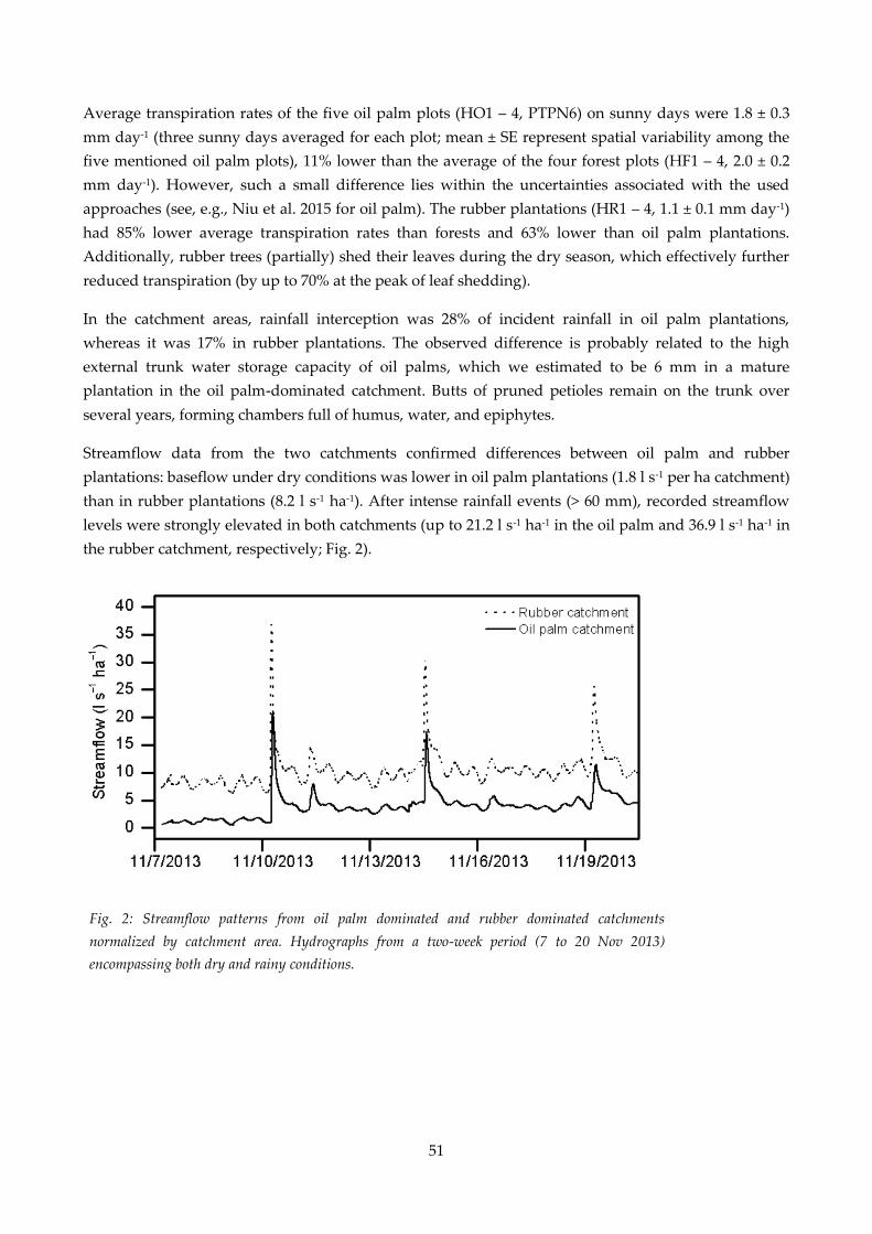
51
Average transpiration rates of the five oil palm plots (HO1 – 4, PTPN6) on sunny days were 1.8 ± 0.3
mm day-1 (three sunny days averaged for each plot; mean ± SE represent spatial variability among the
five mentioned oil palm plots), 11% lower than the average of the four forest plots (HF1 – 4, 2.0 ± 0.2
mm day-1). However, such a small difference lies within the uncertainties associated with the used
approaches (see, e.g., Niu et al. 2015 for oil palm). The rubber plantations (HR1 – 4, 1.1 ± 0.1 mm day-1)
had 85% lower average transpiration rates than forests and 63% lower than oil palm plantations.
Additionally, rubber trees (partially) shed their leaves during the dry season, which effectively further
reduced transpiration (by up to 70% at the peak of leaf shedding).
In the catchment areas, rainfall interception was 28% of incident rainfall in oil palm plantations,
whereas it was 17% in rubber plantations. The observed difference is probably related to the high
external trunk water storage capacity of oil palms, which we estimated to be 6 mm in a mature
plantation in the oil palm-dominated catchment. Butts of pruned petioles remain on the trunk over
several years, forming chambers full of humus, water, and epiphytes.
Streamflow data from the two catchments confirmed differences between oil palm and rubber
plantations: baseflow under dry conditions was lower in oil palm plantations (1.8 l s-1 per ha catchment)
than in rubber plantations (8.2 l s-1 ha-1). After intense rainfall events (> 60 mm), recorded streamflow
levels were strongly elevated in both catchments (up to 21.2 l s-1 ha-1 in the oil palm and 36.9 l s-1 ha-1 in
the rubber catchment, respectively; Fig. 2).
Fig. 2: Streamflow patterns from oil palm dominated and rubber dominated catchments
normalized by catchment area. Hydrographs from a two-week period (7 to 20 Nov 2013)
encompassing both dry and rainy conditions.
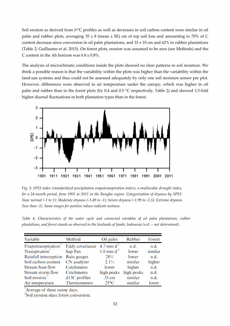
52
Table 4: Characteristics of the water cycle and connected variables of oil palm plantations, rubber
plantations, and forest stands as observed in the lowlands of Jambi, Indonesia (n.d. – not determined).
Fig. 3: SPEI index (standardized precipitation evapotranspiration index), a multiscalar drought index,
for a 24-month period, from 1901 to 2011 in the Bungku region. Categorization of dryness by SPEI:
Near normal (-1 to 1); Moderate dryness (-1.49 to -1); Severe dryness (-1.99 to -1.5); Extreme dryness
(less than -2). Same ranges for positive values indicate wetness.
Soil erosion as derived from δ13C profiles as well as decreases in soil carbon content were similar in oil
palm and rubber plots, averaging 35 ± 8 (mean ± SE) cm of top soil loss and amounting to 70% of C
content decrease since conversion in oil palm plantations, and 33 ± 10 cm and 62% in rubber plantations
(Table 2; Guillaume et al. 2015). On forest plots, erosion was assumed to be zero (see Methods) and the
C content in the Ah horizon was 6.8 ± 0.8%.
The analysis of microclimatic conditions inside the plots showed no clear patterns in soil moisture. We
think a possible reason is that the variability within the plots was higher than the variability within the
land-use systems and thus could not be assessed adequately by only one soil moisture sensor per plot.
However, differences were observed in air temperature under the canopy, which was higher in oil
palm and rubber than in the forest plots (by 0.4 and 0.5 °C respectively, Table 2) and showed 1.5-fold
higher diurnal fluctuations in both plantation types than in the forest.
53
Climate change
The analysis of the SPEI indices over the past 100 years suggests that droughts are recurrent in Bungku
area (Fig. 3), and that their frequency and intensity has not increased over the last century. The most
severe droughts, reflected by a large negative SPEI index value (i.e., -1.5), occurred in 1924, 1983, and
1998; they are associated with strong El Niño Southern Oscillation (ENSO) events.
The evaluation of trends in air temperature and rainfall from 1991 to 2011 shows no significant changes
in mean and maximum temperatures. However, the minimum temperature shows an increase of about
1 °C in the period from 2004–2011 (p < 0.05), indicating a small decrease in the range of annual
temperature variation. Rainfall, for 21 years with complete data series, was 2235 ± 84 mm per year
(mean ± SE). Rainfall in Jambi is characterized by a relatively dry period from June to September, when
average monthly rainfall is often below 120 mm. In some years such as 1993, 1994, or 2011, this dry
season was more pronounced, with at least two consecutive months with monthly precipitation below
40 mm. Other years, e.g., 2005, 2010, were wetter and the dry season was not very pronounced,
indicating high variability in the rainfall patterns between years. Based on the evaluated data, we
conclude that there were no significant climatic changes in Jambi between1991 and 2011, and probably
also not over the last century.
5. Discussion
5.1. Environmental perceptions of changes in the local water
cycle
Our study suggests that water availability during dry periods is an increasing problem for the local
population in the oil palm-dominated landscape of our study region. The interviewed villagers
reported that significant changes in the hydrological cycle have occurred in the study region over the
last 25 years. The main concern of the interviewed villagers was the decline of surface and subsurface
waters that they attributed to the rapid local land-use change from a landscape mosaic of forest and
(agroforest) rubber patches to an increasingly oil palm-dominated land cover. Similar linkages between
forest conversion and changes in local water supply have been observed in several studies, e.g., related
to the development of payment for ecosystem services schemes (Pattanayak and Kramer 2001,
Pattanayak 2004, Asquith et al. 2008, Muños-Piña et al. 2008, Lapeyre et al. 2015). Such schemes are,
e.g., introduced to maintain watershed services from forest areas, including stable dry-season
streamflow.
The villagers’ perception in Bungku was that forest conversion to oil palm plantations impacted local
water availability far more negatively than conversion to rubber monoculture plantations. In the
opinion of the villagers, oil palm plantations use up a lot of the available water during dry seasons.
These statements reflect the evaluation of the great majority of the interviewed villagers, independent
of their social background and including dedicated oil palm farmers. This is in line with findings from
a household survey in 45 villages in the Jambi province (n = 700; Faust et al. 2013), which showed high
awareness of villagers across all social groups of the environmental impacts of oil palm cultivation (M.
54
Euler, V. Krishna, Z. Fathoni, S. Hermanto, S. Schwarze, and M. Qaim 2012, unpublished data). Drying
wells and surface waters in the surroundings of oil palm plantations were also reported in studies by
Obidzinski et al. (2012), Larsen et al. (2014), and an NGO report by Friends of the Earth et al. (2008).
Two small groups of interviewees, however, propagated different evaluations of the local development.
Depending on their social background and their (non)participation in the profitable oil palm business,
they either overemphasized or completely neglected negative hydrological impacts by oil palm
expansion. This demonstrates that the local discourse on water supply is deeply embedded into a wider
discourse on consequences of the regional land-use change. Local water supply is being used as an
argument to substantiate personal claims and viewpoints regarding the drastic expansion of
monoculture oil palm plantations in the region. The actor groups that vigorously advocated the
advantages of oil palm business are among the winners of the ongoing land-use change to agricultural
systems. On the other hand, poorer smallholders and indigenous people are confronted with large
agricultural investors, which make access to land in the region increasingly unaffordable. Considering
the diverse nature of the ongoing land-use conflicts in the area, the described politicization of water
scarcity is not surprising. Steinebach (2013), Hein and Faust (2014), and Hein et al. (2015) have
extensively described how indigenous people and poor farmers in the area form strategic coalitions and
engage in environmental justice discourses to legitimize and strengthen their political claims of access
to land and natural resources.
As a consequence of regularly dried up wells, households were forced to access more abundant but
often quite distant water resources. The transport of water from these sources heavily depended on
access to motorized vehicles. Access to clean water thus was highly dependent on the households’
financial situation, i.e., the available capital for purchasing bottled water or ordering larger tanks of
water. According to our observations, buying water for drinking and cooking could be afforded by
most interviewed households in Bungku, whereas the use of bottled water for showering or other high-
water activities would stress household finances substantially. Access to water thus strongly increased
social polarizations, further disadvantaging those not participating in the profitable oil palm business.
Cooperation among neighbors in times of need, i.e., times of local water scarcity, generally seemed
strong regarding the provision of water. However, recounts of locked wells during the strong El Niño
year in 1997 suggest that social cohesion might decline in times of extreme scarcity, which poses risks of
social unrest.
In times of scarcity, the increasing use of surface waters for personal hygiene, along with the rapid
population growth of past decades, put enormous pressure on local water bodies. Consequently, water
from small and highly frequented local water bodies was commonly observed to be of extremely poor
quality, which might be a significant cause of diseases, e.g., of the skin. Even the water of larger rivers
in Jambi cannot be considered safe because of possible leaching of agrochemicals from surrounding
plantations (Comte et al. 2012, Allen et al. 2015) or upstream gold mining activities. For the Muslim
majority of the village, this does not only impose problems regarding health, but also regarding
religious customs. Clean water is indispensable for the ritual washing before prayers, fast breaking,
funerals, and other religious celebrations.
55
5.2. Environmental processes leading to changes in the water
cycle
Evapotranspiration rates derived from eddy covariance measurements for a 12-year-old oil palm
plantation (PTPN6) under dry, sunny conditions were similar (4.7 mm day-1) to values reported for
lowland rainforests on Borneo (4.2 mm day-1 on annual average; Kumagai et al. 2005) and rainforests in
Peninsular Malaysia (4.2 mm day-1 on annual average; Tani et al. 2003). The transpiration estimate
derived from sap flux measurements for the same oil palm plantation (2.5 mm day-1) was the highest
among the five oil palm plantations assessed in this study, and also among 15 different oil palm
plantations of varying age in the greater study region (Röll et al. 2015). It was also similar to the highest
transpiration rate among the four forest plots (2.4 mm day-1). Our oil palm and forest transpiration
estimates are similar to transpiration rates reported for tropical forest sites in Indonesia and Australia
(1.3 – 2.6 mm day-1; Calder et al. 1986, Becker 1996, McJannet et al. 2007). This suggests that oil palms
can transpire at substantial rates under certain conditions, despite, e.g., their much lower biomass per
hectare compared to forests (Kotowska et al. 2015). Among all studied plots, the sap flux-derived
estimates for average oil palm and forest transpiration rates are similar, but rubber plantations
transpire at more than 60% lower rates under similar conditions. Also, rubber trees partially shed their
leaves in pronounced dry periods, which further reduces transpiration by up to 70% explicitly in times
of water scarcity. In addition to the much lower re-evaporation of water to the atmosphere, rainfall
interception by rubber plantations is 1.7-fold lower than by oil palm plantations (28% of incident
rainfall); our values for interception fall into the range of values reported for tropical forests in South
East Asia (commonly 10-30%, e.g., Dykes 1997, Kumagai et al. 2004, Dietz et al. 2006). The differences in
transpiration and interception can explain the lower baseflow from oil palm dominated catchments as
compared to rubber dominated catchments that we observed.
Soil water infiltration capacities represented by Ks-values derived from ring infiltrometer experiments
for different land-use types in the study region were reported to decrease from forest (47 cm hr-1) via
rubber (7 cm hr-1 on harvesting paths, 7.8 cm hr-1 between rubber trees) to oil palm plantations (3 cm hr-
1 on harvesting paths and weeding circles; S. Tarigan and Sunarti, unpublished data). The much lower
infiltration capacities in plantations as compared to forest are consistent with the observed strong
decline of soil quality after forest conversion, i.e., decrease in C content and erosion (Guillaume et al.
2015, 2016). C content plays a key-role in soil aggregation (Franzluebbers 2002, Bronick and Lal 2005),
while erosion brings deeper and denser soil layers to the soil surface. Thus, both are associated with
lower soil permeability. Such soil degradation after forest conversion was also observed in similar land-
use types in Malaysia (Gharibreza et al. 2013), China (de Blécourt et al. 2013), and Ghana (Chiti et al.
2014). Although the extent of soil degradation was similar between rubber and oil palm plantations,
soil characteristics are more heterogeneous in oil palm plantations, i.e., soil organic carbon content is
lower in inter-rows (Frazão et al. 2013) and frequent and intensive management and harvesting
operations increase soil compaction, e.g., on harvesting paths. The surfaces with the most degraded soil
in oil palm plantations correspond to the locations where rainfall interception is low because of the
incomplete canopy cover between palms (> 20% gap fraction; Kotowska et al. 2015). This may explain
the higher runoff as reflected by two-fold higher relative peak flows, i.e., normalized by baseflow, in oil
palm than in rubber plantations.
56
In conjunction with the observed higher transpiration rates of oil palm as compared to rubber
plantations, the increased runoff in oil palm plantations results in significantly less water being
available for groundwater recharge after precipitation than in rubber plantations, and much less than in
forested areas. Thus, groundwater recharge may be less efficient in oil palm dominated catchments
than in rubber dominated ones, which may add to water scarcity during dry periods. Similar
reductions in dry period baseflows and increases in postprecipitation peak flows after forest conversion
have been reported in a variety of studies (e.g., Bruijnzeel and Bremmer 1989, Fritsch 1990, Sandström
1995, Elkaduwa and Sakthivadivel 1999, Zhou et al. 2002, Bruijnzeel 2004, Bonell et al. 2010,
Zimmermann et al. 2010).
Our findings are consistent with the “sponge and pump” approach to hydrological effects of forest
conversion (Bruijnzeel 2004, Peña Arancibia 2013). Forests may act as sponges by enhancing infiltration
rates and moisture retention because of the effects of organic matter and the root network on soil
physical properties, and act as pumps by transpiring large amounts of water into the atmosphere (see,
e.g., Peña Arancibia 2013). In our study, both land-use types replacing the forest may have reduced the
sponge effect. According to the “infiltration trade-off hypothesis” (Bruijnzeel 1986, 1989, 2004), the net
effects of forest conversion on streamflow largely depend on the type of land cover replacing the forest.
Baseflow (in dry periods) may be as high as in forested areas if losses in infiltration capacity are
outbalanced by much lower (evapo)transpiration rates in the newly established land-use systems,
which is often the case. In our study, the rubber plantations are such an example. The oil palm
plantations, however, are different: we found soil degradation and thus low permeability as well as a
high transfer of water vapor to the atmosphere. Combined, this can induce or enhance periodic water
scarcity in oil palm dominated landscapes.
5.3. Confronting perceived changes with environmental
measurements
Our results suggest that rainfall volume and seasonal patterns did not change significantly since the
beginning of oil palm expansion in the study region. Also, similar volumes of water are re-evaporated
back into the atmosphere from oil palm plantations and forests, but the penetration of water into the
soil is reduced in oil palm plantations. Thus, much precipitated water leaves the landscape as surface
runoff, causing streamflow to be high during rainfall events; less water remains in the soil under oil
palms than in forested areas and groundwater recharge is decreased. In consequence, wells may dry
out (earlier) during dry periods in oil palm dominated regions, as it was reported by the majority of
interviewed Bungku villagers. The perception of extremely high water-use rates of oil palms as the
main cause for increased seasonal water scarcity among some Bungku villagers does not match the
results of our evapotranspiration and transpiration measurements. However, the people’s perception
that the regional oil palm expansion may be responsible for local water scarcity during dry periods is
backed by several results from environmental measurements. We also have indications that there are
significant differences in eco-hydrological characteristics (particularly in transpiration rates) between
oil palm and rubber plantations, as observed by several villagers.
57
Our matching of social perceptions and environmental measurements thus provides manifold
explanations for changes in the physical water cycle. The major force behind these changes is the
rapidly expanding oil palm business, which constitutes the main driver of deforestation and land-use
change in the area (Colchester et al. 2011). Changes in the local water cycle are not only caused by soil
degradation under oil palms but also through the channelization of rivers and the draining of swamp
areas by oil palm companies (personal observations in the field and from satellite images). These shifts in
the physical water flows mirror changing societal power relations that accompany the conversion of an
originally forest-dominated area toward an intensively managed agroindustrial landscape (see Beckert
et al. 2014, Brad et al. 2015, Hein et al. 2015). Water, a formerly abundant common pool resource, today
is becoming a scarce resource during dry seasons. In such times of water scarcity, people have to
reorganize their daily life around the constant “search for water.” Water is consequently increasingly
treated as a commodity rather than a common pool resource. This capitalization increases social
polarizations in the village between winners of land-use change and underprivileged social groups
such as indigenous people or poorer farmers. In the light of decreasing access to land (Colchester et al.
2011, Beckert et al. 2014, Hauser-Schäublin and Steinebach 2014, Hein et al. 2015), the access to clean
water has turned into an additional argument to substantiate political claims in local contestations over
access to land and natural resources. Our social and environmental analysis of different components
and processes of the hydrosocial cycle in Bungku thus clearly depicts the complexity of local water-
society relations. It serves as an example of how local land-use change triggers both material and
discursive changes in the hydrosocial cycle, i.e., the occurrence of local water scarcity as well as its local
interpretation by different social groups.
6. Conclusions
Water shortages were reported to occur more often since oil palm cultivation has become the dominant
land use and large-scale deforestation has taken place. Several villagers strongly emphasized that oil
palm is a major consumer of water and thus largely responsible for decreasing local water tables and
water supplies. Analyses of environmental processes generally supported this perception and also
confirmed differences between rubber and oil palm plantations. However, there is some added eco-
hydrological complexity to the local interpretations. Our evapotranspiration data indicate that oil palm
plantations use about as much water as forests for transpiration. Rather than to high water use of oil
palms per se, local water scarcity seems connected to the redistribution of water after precipitation at
the landscape scale. In natural ecosystems, e.g., forest, the largest part of rainfall water is taken up by
the soil and contributes to the transpiration of plants and groundwater recharge. Under oil palm
plantations, however, precipitated water cannot well penetrate the eroded and compacted soil.
Consequently, a significant amount of water leaves the landscape as runoff and less water is available
for groundwater recharge. Large-scale conversion of natural forests to oil palm plantations thus
induces or enhances periodic water scarcity.

58
Acknowledgments
This study was supported by a grant from the German Research Foundation (DFG) in the framework of
the Collaborative Research Centre 990 (http://www.uni-goettingen.de/crc990). Jennifer Merten received
a grant from the Heinrich-Böll Foundation. We greatly thank all our Indonesian counterparts for their
assistance during field work. Special thanks to all our Indonesian field assistants who made the
extensive field work possible. Terimakasih! Finally, we thank the two anonymous reviewers for their
constructive comments.
Author Contributions
Jennifer Merten and Alexander Röll contributed equally to the study in terms of coordinating,
contributing data and ideas, and the amount of time spent writing and revising the manuscript.
Jennifer Merten coordinated the human dimensions part of the study, Alexander Röll the natural
science part.

59
CHAPTER III:
Flooding and land use change in Jambi Province, Sumatra: integrating local knowledge and scientific inquiry
Jennifer Merten, Christian Stiegler, Nina Hennings, Edwine S. Purnama, Alexander Röll,
Herdhata Agusta, Michaela A. Dippold, Lutz Fehrmann, Dodo Gunawan, Dirk Hölscher,
Alexander Knohl, Johanna Kückes, Fenna Otten, Delphine C. Zemp and Heiko Faust
Abstract
The rapid expansion of rubber and oil palm plantations in Jambi Province, Sumatra, Indonesia, is
associated with largescale deforestation and the impairment of many ecosystem services. According to
villagers’ observations, this land use change has, together with climate change, led to an increase in the
magnitude and frequency of river flood events, which constrain village and plantation development.
Based on this empirical societal problem, we investigate whether we can find measurable indications
for the presumed linkages between land use change, climate change, and changing flooding regimes.
We follow an explorative, bottom-up research approach that builds on a review of multidisciplinary
datasets, integrating local ecological knowledge with scientific measurements from soil science,
climatology, hydrology, and remote sensing. We found that water levels of one of the largest rivers in
Jambi Province, the Tembesi, have increased significantly during the last two decades. Data of local and
regional meteorological stations show that alterations in rainfall patterns may only partly explain these
changes. Rather, increased soil densities and decreased water infiltration rates in monoculture
plantations suggest an increase in surface runoff following forest conversion. Moreover, additional
interview data reveal that an increasing encroachment of wetlands in Jambi Province may contribute to
changes in local flooding regimes, as the construction of drainage and flood control infrastructure
redistributes floodwater at the local scale. We conclude that changing flooding regimes are the result of
multiple interacting social-ecological processes associated with the expansion of rubber and oil palm
plantations in Jambi Province. Although ecohydrological changes are likely to contribute to an increase
of flood occurrence, their social impacts are increasingly mediated through flood control infrastructure
on industrial oil palm plantations.
Key Words: ecohydrology; flooding; global change; Indonesia; interdisciplinary analysis; land use conversion;
local ecological knowledge; oil palm; rubber
Published in: Ecology and Society 25(3): 14
https://doi.org/10.5751/ES-11678-250314

60
1. Introduction
In the past, flooding occurred rarely. ... Back then, most people didn’t plant oil palm, didn’t plant rubber. ...
It started, because the forest is already gone. That’s why nowadays flooding occurs so often. ... For annual
crops, if flooding occurs more often, that’s a problem. ... [Sometimes] when the farmers had just planted the
seedlings, then suddenly flooding occurred.
Rubber farmer, Jambi, Sumatra, Indonesia
In Southeast Asia, large areas of lowland forests have been converted to oil palm, rubber, and pulp
wood plantations over the last decades (Hansen et al. 2013, Margono et al. 2014, Clough et al. 2016). For
example, in 2015, oil palm plantations in Malaysia and Indonesia covered an area of 17 million ha
(Chong et al. 2017). Such intense land use change is often followed by an impairment of
ecohydrological functions (Bruijnzeel 2004, Bradshaw et al. 2007, Ellison et al. 2017). Several studies
have recently started to connect the expansion of rubber and oil palm monoculture plantation systems
with increases in the frequency and intensity of flooding.
The existing studies build on a variety of methodological approaches. Hydrological measurements
showed that oil palm monoculture plantations may have low soil water infiltration rates (Tarigan et al.
2018) as a consequence of severe soil degradation and erosion (Guillaume et al. 2015, 2016). Particularly
in combination with low evapotranspiration rates of young oil palm plantations this may increase
surface run-off and the risk of flooding in oil palm dominated landscapes (Manoli et al. 2018, Tarigan et
al. 2018). These findings also correspond with a time-series analysis of streamflow data that found
evidence for increasing streamflow through upstream land use conversion to rubber and oil palm
plantations (Adnan and Atkinson 2011). Other approaches have built on spatial analyses and
econometric modeling. For example, Tan-Soo et al. (2016) and Wells et al. (2016) found rubber and oil
palm plantations to be spatially associated with reports of increasing flooding occurrence in Malaysia
and Indonesia. Finally, a number of studies conducting qualitative social research present interview
data from villagers across Indonesia who associated land use change, toward monoculture plantations,
with increasing flood occurrence (Obidzinski et al. 2012, Larsen et al. 2014, Kelley and Prabowo 2019).
Such a linkage between the expansion of plantations and flooding was also observed by villagers in our
study area in Jambi Province, Sumatra, as pointed out in the above quote from a smallholder farmer. In
times of rapid land use change for global cash crop production, understanding such processes is of
great relevance for the affected communities. Although the above-mentioned studies provide some
evidence of changing flooding regimes due to plantation expansion, most of them present
compartmentalized insights from single disciplines. A substantial gap in knowledge about the
multiplicity of causal processes between land use change, climate change, and river water levels
remains in our study region and beyond.
Establishing the linkage between land use change and flooding has been a long and contested endeavor
among natural as well as social scientists (Calder and Aylward 2006, Bradshaw et al. 2007, van Dijk et
al. 2009, Lele 2009). In public discourses, deforestation is often linked to an increase in the frequency
and intensity of flooding. In fact, tree and forest removal is well known for raising the likelihood of
floods, as decreasing evapotranspiration rates and decreasing water infiltration increase local surface

61
runoff (Ellison et al. 2017). However, after deforestation, such processes may be reversed. Water
infiltration rates may recover and evapotranspiration rates by planted tree species may then be as high
as those of natural forests (Bruijnzeel 2004). Natural scientists have further cautioned that linkages
between land use change and flooding regimes often depend upon the interaction of multiple, site-
specific ecohydrological processes, including local climate change (Bradshaw et al. 2007, Alila et al.
2009, Locatelli and Vignola 2009, van Dijk et al. 2009, Tran et al. 2010, Pattison and Lane 2012). Social
scientists, for their part, have warned that a generalization of the forest-flood linkage may result in
policies with adverse social consequences, e.g., upstream forest dwellers being restricted in their land
use activities and falsely blamed for causing downstream flooding (Saberwal 1998, Calder and Aylward
2006, Hofer and Messerli 2006). Moreover, they have pointed out that studies within the natural
sciences often ignore the social and technical context that mediates flood impacts as well as response
and feedback processes (Lele 2009, Di Baldassare et al. 2014).
Integrating local ecological knowledge into scientific analysis can address some of the above-mentioned
uncertainties and risks when studying complex social-ecological phenomena (Pierotti and Wildcat 2000,
Fabricius et al. 2006, Stringer and Reed 2007, Tengö et al. 2014, Leimona et al. 2015, Días et al. 2018).
Such an integration of different knowledge sources may also enable research outcomes to be socially
and practically more relevant in the local social context and is considered an important step toward
democratizing explanations of environmental change (Forsyth 2003).
In this paper we aim to provide an integrated analysis of linkages between land use change, climate
change, and flooding regimes by combining qualitative interview data on local ecological knowledge
with scientific measurements. We examined multidisciplinary datasets to identify potential social-
ecological processes that could explain the villagers’ observations of increases in flood frequency and
intensity following forest conversion in the Tembesi watershed in Jambi Province (Sumatra, Indonesia).
Our research objectives are the following: building on qualitative interviews, we (1) review villagers’
observations of changes in patterns and intensity of flood events as well as their evaluations of
changing environmental processes. We then (2) test whether the reported changes in flooding regimes
are mirrored in available stream flow data from the Tembesi River. Building on the villagers’
evaluations of the potential causes for changing flooding regimes, we test whether changes in climate
and/or in land use can provide explanations for the observed changes. Therefore, we (3) analyze local
precipitation patterns for changes over the last decades, and (4) compare hydraulic soil properties in
different land use systems. More specifically, we quantify land use change in the Tembesi River
watershed (1990–2013) and assess whether soil bulk densities (as an indicator of soil compaction), water
infiltration capacities, and groundwater levels of oil palm and rubber plantations differ from forests
and less intensively managed reference systems. Finally, based on villagers’ specific concerns for land
use change in wetland areas, we (5) investigate whether forest conversion in wetland areas has further
contributed to an alteration of flooding regimes. To this aim, we analyze the land use history as well as
land use characteristics of wetland areas, building on land use data (1990–2013) as well as on a
comparison of qualitative case study data within the Tembesi watershed.
Finally, we integrate these multiple knowledge sources by discussing convergences, complementarities,
and divergences among datasets. Although our study design was not a priori designed to answer
62
questions related to flooding specifically, we show that an a posteriori analysis of different knowledge
sources can be an important tool for interdisciplinary research. It can also provide a more complete
analysis of the complex linkages between land use change and flooding.
2. Conceptual framework
Our research approach builds on the tradition of critical realist approaches in political ecology and
sustainability sciences. These studies emphasize the need for problem-driven, bottom-up research
approaches that integrate different knowledge sources to find locally framed explanations of
environmental problems (Forsyth 2003, Walters and Vayda 2009, Lele and Kurien 2011, Thorén and
Persson 2013, Ribot 2014).
Studies on flooding and flood impacts in the context of land use change are often dominated by
accounts from the natural sciences. Changes in flooding regimes are mainly derived from direct
ground-based measurements using water level or discharge data from flood gauges (e.g., MDID 1989,
Yusop et al. 2007, Adnan and Atkinson 2011), or modeling exercises. Model inputs are typically based
on direct field measurements of the different components of the hydrological cycle, such as soil surface
runoff, infiltration rates, throughfall, or evapotranspiration rates (e.g., Manoli et al. 2018, Tarigan et al.
2018). Precipitation quantities are either obtained from satellite-derived precipitation and cloud cover
estimates (Maggioni and Massari 2018), or based on combined field and satellite measurements (Kwak
2017). In recent years, satellite imagery has become a widely used tool for monitoring flood events on a
large scale. However, optical-based satellite imagery has its limitations because of cloud cover,
especially in the tropics (Ahamed and Bolten 2017, Ban et al. 2017, Adam et al. 2018, Notti et al. 2018).
Typical indicators for changing flooding regimes include the number of days with extreme water levels
or peak flows, average water level rise as an indicator for flash floods, average seasonal water levels, or
shifts in seasonal water levels (Dang et al. 2011, Wang et al. 2015).
These approaches, however, have a number of limitations with regard to data availability and the
integration of the human dimension. In the study of flooding regimes, local people’s ecological
knowledge may thus fruitfully complement scientific measurements. Local ecological knowledge
(sometimes also referred to as traditional ecological knowledge) comprises three components of
knowledge: observational knowledge, knowledge acquired through practical experience, and
knowledge in the form of people’s beliefs (Berkes et al. 2000). Such knowledge is acquired through
personal empirical observation and interpretation of local ecosystems, and enriched and validated
through exchange with other farmers and villagers (Berkes et al. 2000, Usher 2000, Houde 2007).
In particular, the integration of observational and practical local ecological knowledge may provide
several benefits for establishing a link between land use change and flooding regimes. First, local
ecological knowledge provides fine-grained information about ecosystems in areas where little
scientific knowledge exists, such as rural Sumatra (Fabricius et al. 2006). A typical problem of scientific
measurements is that field measurements are often only available at plot scale. On the other hand,
modeling exercises conducted at larger scales often provide little information about factual changes in
flooding regimes, e.g., at the village level. Integrating people’s knowledge might also be useful for
detecting environmental changes that are not immediately apparent in short-term scientific

63
measurements as local people get to observe things more often, over longer periods, and in a wider
variety of places (Usher 2000). Thereby it might draw attention to environmental change that otherwise
would possibly not be studied. For example, Wells et al. (2016) integrated interview data with
newspaper reports of flooding and watershed characteristics to show that flooding is far more
widespread than reported in government assessments. Moreover, local ecological knowledge is
considered to be holistic in nature, compared to scientific studies that are often compartmentalized
(Pierotti and Wildcat 2000, Fabricius et al. 2006, Aikenhead and Ogawa 2007). Integrating local
ecological knowledge in the study of land use change and flooding may thus enable more open
research approaches, which could better account for multiple and interacting processes in the
generation of flood events.
Second, both field measurements and modeling exercises often fail to adequately incorporate the
human dimension of the problem, both with regard to defining what constitutes a problematic change
in flooding as well as with regard to potential human influences on water flows (Lele 2009, Di
Baldassare et al. 2014, Langill and Abizaid 2020). Lele and Kurien (2011) thus call for a shift from
theory-driven to problem-driven, bottom-up research, to avoid research questions that are only
determined by what the researcher is trained in. For example, by questioning what actually constitutes
a “bad flood,” Langill and Abizaid (2020) showed that studies of extreme floods within the natural
sciences typically focused on unusually high floods. In their study, they showed that for a floodplain
community in the Peruvian Amazon the timing and duration of flooding were in fact the most salient
features of problematic floods. Existing studies connecting land use change in Indonesia and Malaysia
to changing flooding regimes either investigated streamflow fluctuations independent of human
evaluation (Adnan and Atkinson 2011) or looked at the number of flood events reported by
newspapers and government assessments (Tan-Soo et al. 2016, Wells et al. 2016).
Integrating local ecological knowledge into the study of land use change and flooding may also help to
draw attention to the social and technical context that mediates flood impacts. This integration may
further contribute to an understanding of how changing flooding regimes may trigger people’s
response and feedback processes that shape water flows in turn (Lele 2009, Di Baldassare et al. 2014).
For instance, Kelley and Prabowo (2019) use oral histories to reveal social transformation processes set
in motion by changing flooding regimes. These transformation processes were shown to increase the
people’s systemic vulnerability to flooding as well as producing feedbacks of altering river flows.
Although multiple opportunities for integrating local knowledge and scientific measurements exist, the
pitfalls of integration have also been discussed at length and, at times, in a controversial manner
(Klubnikin et al. 2000, Pierotti and Wildcat 2000, Moller et al. 2004, Bohensky and Maru 2011, Persson et
al. 2018). Similar to the integration of methods from qualitative social science and quantitative natural
science, it has been pointed out that ontological and epistemological differences between knowledge
sources may hinder output-oriented knowledge integration (Nadasdy 1999, Krüger et al. 2016, Thorén
and Stahlhammer 2018). In particular, in-depth confrontations between different ontological
understandings and assumptions, or critical engagements with other approaches for establishing
scientific quality and validity of methods, are often limited by time constraints. Despite such concerns,
we argue that more pragmatic approaches that foster interdisciplinary research are both possible and
valuable. An important condition for overcoming challenges of integration is a common framing of the
64
research problem. Several scholars have therefore recommended taking an empirical societal problem
as a starting point of analysis, i.e., observations of increasing flood occurrence (Walters and Vayda
2009, Lele and Kurien 2011, Thorén and Persson 2013). Explanations from different disciplines and
knowledge sources may then be reconciled by seeing each as partial, context-specific, and potentially
fallible, but acknowledging that the combination of different sources may provide better
understandings of environmental problems (Yeung 1997, Forsyth 2003, Lele and Kurien 2011).
3. Study region and methods
Our study region, Jambi Province, lies in the eastern lowlands of Sumatra, Indonesia. In Jambi
Province, 7942 km² of forest were cleared between 1990 and 2013, which corresponds to 35.2% of the
1990 forest area (Melati 2017). Most land use changes have taken place in the lowlands of Jambi
Province, which today are dominated by monoculture rubber (Hevea brasiliensis) and oil palm (Elaeis
guineensis Jacq.) plantations. Monoculture rubber plantations have been developed in Jambi Province
since the Dutch colonial times (Feintrenie and Levang 2009); oil palm cultivation started in the mid-
1980s and has expanded to almost 9000 km² (18% of the province’s territory) in 2017 (BPS Indonesia
2018).
The lowland rivers of Jambi Province show strong seasonal fluctuations between the dry and the wet
season. Consequently, large areas in the province’s lowlands are inundated during the rainy season. In
the Batanghari watershed (44,595 km²), the largest watershed in Jambi Province, 2282 km² of land
across 222 villages is affected by regular flood events (Minister of Public Works 2012).
Our paper presents findings with a focus on the lowlands of the Tembesi watershed, the largest
subwatershed of the Batanghari (12,819 km²). This focus was chosen because of the dynamic land use
change in this area, the number of people affected by flooding, as well as data availability. The
watershed’s lowlands cover large wetland areas, which include peatland areas of around 440 km² (see
Fig. 1; Wahyunto and Subagjo 2003, Biagioni et al. 2015). Today, land use in the lowland areas of the
Tembesi is dominated by agriculture, mainly oil palm and rubber plantations that account for 52% of
the watershed’s area (see Fig. 1; Melati 2017). The climate in the watershed’s lowlands is tropical humid
(annual average air temperature of 26.5 °C, annual precipitation of 2235 mm year-1) with a wet season
from October to May (Sulthan Thaha meteorological station, as cited in Drescher et al. 2016). According
to data published in local newspapers, the typical seasonal fluctuations of the Tembesi water levels in
the watershed’s lowlands vary between 5 and 11 m (Anton 2017, Saputra 2017). All data analyzed for
this study was obtained within the EFForTS collaborative research center (https://www.uni-
goettingen.de/en/310995.html)

65
Fig. 1: Study region of the Tembesi watershed in Jambi Province, Sumatra, Indonesia.
3.1. Qualitative interview data
Our analysis builds on two different sets of qualitative interview data obtained from semistructured
and informal interviews (total number of interviews = 91; Bernard 2011). All interviews were conducted
during long-term (2–6 months) field stays in Jambi Province between 2012 and 2017. Interviews were
conducted in English and Indonesian with the help of local assistants. Detailed notes and memos were
written down during or shortly after the interviews. In addition, audio-recorded interviews were
transcribed in Indonesian. All interview notes as well as excerpts from transcripts were coded for
content (Mayring 2000) using MAXQDA (V. 11) software.
Local ecological knowledge on changing flooding regimes
Interviews of the first dataset were mainly conducted in the subdistrict Air Hitam (Fig. 1). In this
subdistrict, three villages were chosen along an upstream-downstream continuum of the eponymous
Air Hitam River. In this subdistrict, interview partners from 33 different households were interviewed.
Interview partners were chosen according to snowball and purposive sampling methods (Flick 2016).
Purposively selected interview partners included village government representatives, heads of farmer
groups, village elders, and villagers who were directly affected by flood events, either on their housing
plot or on their plantations. In addition to the households in the Air Hitam subdistrict, eight
households, who own plantations in riparian areas that were also sampled for soil property analyses
within the frame of this study, were purposively selected for interviews. Several of the interview
partners were interviewed repeatedly during consecutive field visits, combining both formal and
66
informal interview situations, and often involving family members or friends present during the
interview situation (total number of interview situations n = 69). The interviews focused on
interrogating people’s observations of changes in local flooding regimes, their individual evaluations of
possible causal relations and the implications for the individual households.
Local knowledge on land use history and management of wetlands
Because of the interview partners’ specific concern about land use change in wetland areas, an analysis
of the second dataset aimed to explore the specific land use characteristics of wetland areas in the
Tembesi watershed. Therefore, we compared land use history and management of wetland areas across
six villages, the territories of which include vast wetland areas. In addition to the three villages in the
Air Hitam subdistrict, our case study comparison comprised three further villages within the lowlands
of the Tembesi watershed. Interviews conducted in these villages included data from former
investigations within the EFForTS research project (Kunz 2016, Rödel 2018) that were made available
for this study (additional number of interviews n = 22). We define wetland areas as areas where water
covers the soil or is near the surface of the soil either permanently or temporarily (Ramsar Convention
Secretariat 2016). This includes riparian floodplains, swamps, as well as peatlands.
The presence of a foreign researcher most certainly influences the way interview partners recount a
certain topic, e.g., by providing an answer they expect will please the researcher (Berger 2015). We
aimed to reduce such response biases through conducting long-term qualitative research with repeated
visits to the studied villages. Qualitative interview techniques were chosen as a method because they
allow for bottom-up and in-depth analyses of people’s evaluation of local environmental change.
Contrary to predefined questionnaires, the use of open-ended questions and a more natural and
spontaneous course of conversation allows researchers to create trusting and less formal interview
situations. These are helpful for avoiding response biases because they allow the researcher to
encourage interview partners to recount environmental changes on their own initiative. They further
provide room for more detailed descriptions of environmental changes and reveal insights into the
importance of flooding for people’s daily life. Information obtained during interviews was then cross-
checked in subsequent interviews with interview partners from different social groups. Finally,
interview data was triangulated with participative observation, including several visits to villagers’
plantations and different river sections.
3.2. Quantitative scientific measurements
River water level
The water level of the Tembesi River was measured at Pauh hydrological station (02°08′55″ S,
102°48′22″ E), which is located at the mouth of the Air Hitam River to the Tembesi River (Fig. 1). The
data for this analysis was provided by the Public Works Agency for Water Resources (Dinas Pekerjaan
Umum Bidang Sumberdaya Air) and covers the period 1997–2016. The river catchment area at Pauh
hydrological station covers an area of 10,760 km² (84% of the Tembesi watershed). Water levels were
67
recorded once per day between 8 and 9 am, local time, with an automatic water level recorder that uses
a floating ball as a mechanical trigger (Roni 2005). River discharge was derived from a site-specific
rating curve.
Based on villagers’ observations of changing flooding regimes and building on the approach of Wang
et al. (2006) and Zhang et al. (2009), we analyzed a potential increase in flood frequency and intensity as
well as potential shifts in seasonal patterns of flood events. For this purpose we investigated (a) the
number of days with extreme water levels of the Tembesi River, (b) the average water level rise as well
as the frequency and intensity of flash floods, and (c) the average seasonal water level and possible
changes. For (a) we defined extreme water levels as water levels when the Tembesi River overflows its
natural dams (11 m). This threshold is based on the reported typical water level of 5–11 m (Anton 2017,
Saputra 2017) and double checked with river water level data for days when flood events were
reported in the local online newspaper or by the National Board for Disaster Management (BNPB 2019).
For (b) we compared the change in water levels between two subsequent days over the period 1997–
2016 and defined a flash flood as an event with water level rise > 1 m over two consecutive days. For (c)
we calculated the mean water level for each month.
Precipitation
The only lowland meteorological stations in the vicinity of our study region that offer long-term
meteorological measurements are at Jambi Sultan Thaha Airport (01°38′17″ S, 103°38′40″ E, 25 m a.s.l.),
which has been taking measurements since 1978, and in the village Pauh (02°11′09.6″ S, 102°49′01.1″ E,
43 m a.s.l.), where measurements have been available since 2007 (Fig. 1). Both meteorological stations
are owned and run by the Indonesian Meteorological Service (BMKG). The areal distance between the
two meteorological stations is approximately 110 km and the areal distance between the Pauh
meteorological and hydrological stations is approximately 4 km. Both meteorological stations are
located inland, within similar land use structures and relatively flat terrain. Precipitation pattern in the
lowlands are mostly dominated by very local and temporary convective rain showers. Precipitation
patterns and intensities may thus differ substantially even within small distances. We analyzed
monthly accumulated precipitation, precipitation intensity, and seasonal distribution. Precipitation
intensity for both meteorological stations was calculated following the SDII climate index (Zhang et al.
2011), where the total sum of precipitation during consecutive wet days (precipitation > 0.1 mm d-1) is
divided by the total number of consecutive wet days.
Land use change
Our land use change analysis builds on a comparison of existing land use maps for Jambi Province
from 1990 and 2013 (Melati 2017). For the purpose of this study, the land use classes were reclassified to
fit our research questions and land use maps were reanalyzed for the section of the Tembesi watershed.
The maps elaborated by Melati (2017) were based on mixed land use/land cover maps originally
developed by the Indonesian Ministry of Environment and Forestry (MoEF; Margono et al. 2016). The
classification of these land use/land cover maps was based upon a visual interpretation of 30 m spatial
68
resolution Landsat imagery with a minimum mapping unit of 6.25 ha. The original 23 classes defined
by Margono et al. (2016) were enhanced further in a subsequent visual interpretation by Melati (2017)
who regrouped some of the former land use/land cover classes to fit land use in Jambi Province. During
this enhancement, formerly categorized estate crops were further differentiated into rubber and oil
palm land use systems. For this study, we grouped the resulting land use classes by Melati (2017) into
the seven most relevant land use classes, namely forest, mixed agriculture, bush/bare land, rubber
plantations, oil palm plantations, settlement, and water.
To map wetland areas, we combined available wetland maps for Jambi Province, elaborated by
Gumbricht et al. (2017; https://www2.cifor.org/global-wetlands/), Wahyunto and Subagjo (2003), and
Laumonier (1997). An additional land use change analysis was performed on these areas using the land
use data provided by Melati (2017).
Soil bulk density and water infiltration capacity
Published bulk density data (g cm-³) from well-drained sites (Allen et al. 2016) as well as unpublished
data from riparian sites were used to evaluate soil compaction after the conversion of forests to
monocultures. Bulk density samples were weighed and dried at 105 °C until constant weight. The data
consisted of five replicates per site and soil depth. Sampling depth intervals were 0–10 cm, 10–30 cm,
and 30–50 cm soil depth. Sampling sites represented six sites from reference forests, six from rubber,
and six from oil palm plantations on well-drained mineral soils as well as four sites of each land use
system on riparian soils. Three well-drained mineral soil sampling sites were located within the
Tembesi watershed whereas three well-drained mineral sampling sites, as well as the riparian soil
sampling sites, were located just outside the watershed, but within the same lowland of Jambi province
(Fig. 1). Acrisols with a clayish to sandy loam texture were the dominant soil type in well-drained
mineral soils (Guillaume et al. 2015), whereas riparian soils were classified as stagnic Acrisol and
Stagnosols with a loamy texture (Waite et al. 2019).
To assess the water infiltration capacity of soils, we measured saturated soil hydraulic conductivity (Kfs,
cm h-1), which describes the movement of water through soil under water-saturated conditions. The
main measurements were performed with a dual-head infiltrometer (Saturo, Meter, USA) in a
commercial oil palm plantation where a biodiversity enrichment experiment was established in 2013
(EFForTS-BEE; Teuscher et al. 2016). In this experiment, multiple native tree species were planted and
natural regeneration of the vegetation was allowed. The experimental plots have varying tree diversity
levels (from 0 to 6 native tree species) and plot sizes (from 25 m² to 1600 m²) following a random
partition design (Teuscher et al. 2016). We carried out one measurement per plot in March 2018 in the
subplot in four control plots (management-as-usual oil palm monoculture plantation) and 33
experimental plots where different tree species have been planted and vegetation regenerates naturally
(see Table A1.1). We carried out additional, confirmatory measurements of Kfs with a conventional
manual double-ring infiltrometer in a commercial, intensively managed monoculture oil palm
plantation in the same region (PTPN VI, at approx. 40 km distance from the biodiversity enrichment
experiment). Six study plots were measured between June and September 2018.

69
Groundwater level
To investigate the effect of the land use system on groundwater level, we measured groundwater levels
in oil palm and rubber riparian monocultures as well as in forest riparian locations with an OTT
Orpheus Mini water level logger (OTT HydroMet GmbH, Kempten, Germany). Measurements were
conducted at the same 12 riparian locations that were also sampled for soil bulk density. The logger
was installed at a depth of between 2.5 and 4.5 m in a metal borehole equipped with a fine sieve on its
lower end. Data was available from July 2017 to March 2019 at four different locations for each of the
three land use systems (forest, rubber plantation, oil palm plantation).
Statistics and data analyses
We applied the Mann Kendall Trend Test (M-K test; Gilbert 1987) to investigate possible changes in the
seasonal and monthly pattern of river water level and accumulated precipitation. The M-K test τ ranges
from -1 to 1 where values above 0 indicate a positive trend whereas values below 0 indicate a negative
trend and trends are significant for p < 0.05. To test for statistical differences in soil bulk density and Kfs
between different land use systems, we performed a nonparametric Kruskal-Wallis Test (differences
are significant for p < 0.05; Townend 2004). All statistical analyses and graphing were performed using
R-studio (version 1.1.463), except for the land use change analyses, which were performed in ArcMap
(version 10.6.1) and Excel and visualized with the help of the online tool sankeyMATIC
(http://sankeymatic.com/).
4. Results
4.1. Qualitative interview data
Local ecological knowledge on changing flooding regimes
Of 33 interview partners in the Air Hitam subdistrict, 29 mentioned having perceived changes in the
intensity, frequency, or predictability of flooding over the last 10–15 years. A common observation
among villagers was that flooding nowadays would occur faster, and even after short rainfall events. In
their memory, flooding in the past had only occurred after prolonged rainfall (Table 1: Q1). Heavy
flood events, in the past common at a return period of about five years, nowadays were said to occur
almost every year (Table 1: Q2). Moreover, villagers complained that contrary to former seasonal
patterns of flooding, today, the timing of flood events was no longer predictable (Table 1: Q3). Only
five farmers residing in wetland areas had noticed decreases in flood height and length, which in most
cases can be explained by drainage activities on these lands.

70
Table 1: Quotes illustrating villagers’ perceptions of changing flooding regimes. (Translations by J. Merten)
Perceptions of changing flooding regimes
Q1: “[The flooding in the past] was different, very different. In the past when
it only rained for one day, the river did not directly overflow. But now, after
one hour of heavy rain, it already overflows. […] It started to be like that ever
since many people opened the land for oil palm. […] Now, there is constant
flooding.”
rubber farmer
(riparian
plantation, 14
Nov. 2017)
Q2: “Flooding happened since the past. But as far as I remember, in the past
flooding occurred rarely, and it was rarely very high. Sometimes, once in five
years there was a big flooding, but now it happens almost every year.”
village gov.
representative
(Air Hitam, 13
July 2016)
Q3: “Now it is difficult to predict [the flooding]. Normally, […] starting from
October, November, December, there would be flooding. But last year, in
May, and in April, there was flooding as well. We cannot predict it anymore.
In the past, when the forest was still wide, we could still predict the
flooding.”
village gov.
representative
(Air Hitam, 7
June 2016)
Explanations given for these observed changes in flooding regimes were multiple. In total, 25 of the
interview partners associated changes in intensity and frequency of flood events directly with land use
change and plantation management. They agreed that flooding regimes started to change after vast
forest areas had been converted to rubber and oil palm plantations. Because of this conversion,
according to them, the capacity of the landscape to “retain” or “save” water had decreased. Among the
villagers, forests were known to “hold back” rainwater and release it only slowly to the rivers (Table 2:
Q4). Individual interview partners referred to forests as acting as a “protective shield” that would
prevent the occurrence of natural disasters (Table 2: Q5).
The capacity to store water in the landscape was attributed to forest areas, but not to plantations. Some
farmers had observed that rainfall in their plantations could not be absorbed and retained by the soil
(Table 2: Q6). Others further observed that rainfall in their plantations had flushed away large
quantities of soil. This soil was then observed to flow into the rivers where it would result in shallower
riverbeds (Table 2: Q7). In addition to the protective function of upstream forest areas against flood
occurrence, individual interview partners also highlighted this function in regard to swamp and peat
areas. As a village head recounted, before these peatlands were converted to oil palm plantations, they
had absorbed and stored large amounts of water (Table 2: Q8).
Perceived causes for changes in the temporal predictability of flood events were not as consistent as for
changes in flood frequency and intensity. Some interview partners associated seasonal changes in flood
events with land use change (Table 1: Q3, Table 2: Q8). Others, however, also perceived that rainfall
would no longer follow seasonal patterns and had become difficult to predict (Table 2: Q10).
Villagers owning land close to rivers had further noted a very recent (3–5 years) change in flooding
regimes. This change was attributed to the construction of flood control infrastructure by oil palm
companies managing wetland areas. Newly constructed dams and drainage gates were reported to lead
to a redistribution of floodwaters. These were blamed for increasing the length and depth of flood
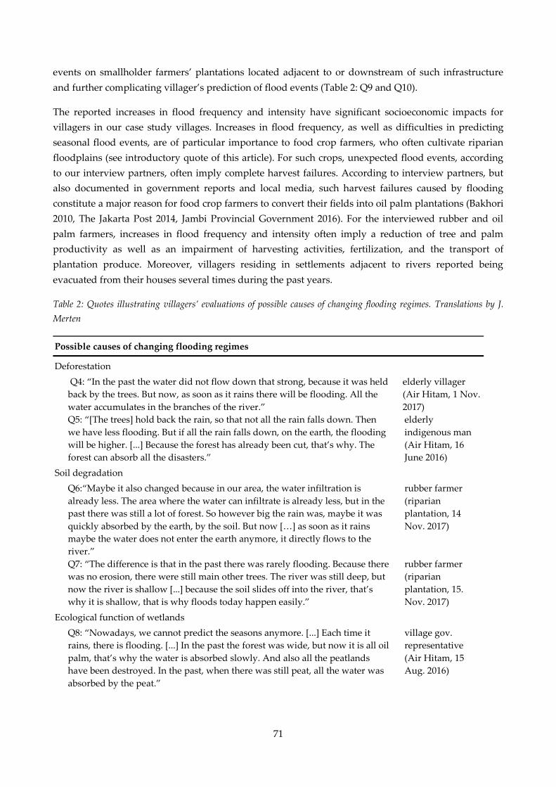
71
events on smallholder farmers’ plantations located adjacent to or downstream of such infrastructure
and further complicating villager’s prediction of flood events (Table 2: Q9 and Q10).
The reported increases in flood frequency and intensity have significant socioeconomic impacts for
villagers in our case study villages. Increases in flood frequency, as well as difficulties in predicting
seasonal flood events, are of particular importance to food crop farmers, who often cultivate riparian
floodplains (see introductory quote of this article). For such crops, unexpected flood events, according
to our interview partners, often imply complete harvest failures. According to interview partners, but
also documented in government reports and local media, such harvest failures caused by flooding
constitute a major reason for food crop farmers to convert their fields into oil palm plantations (Bakhori
2010, The Jakarta Post 2014, Jambi Provincial Government 2016). For the interviewed rubber and oil
palm farmers, increases in flood frequency and intensity often imply a reduction of tree and palm
productivity as well as an impairment of harvesting activities, fertilization, and the transport of
plantation produce. Moreover, villagers residing in settlements adjacent to rivers reported being
evacuated from their houses several times during the past years.
Table 2: Quotes illustrating villagers’ evaluations of possible causes of changing flooding regimes. Translations by J.
Merten
Possible causes of changing flooding regimes
Deforestation
Q4: “In the past the water did not flow down that strong, because it was held
back by the trees. But now, as soon as it rains there will be flooding. All the
water accumulates in the branches of the river.”
elderly villager
(Air Hitam, 1 Nov.
2017)
Q5: “[The trees] hold back the rain, so that not all the rain falls down. Then
we have less flooding. But if all the rain falls down, on the earth, the flooding
will be higher. [...] Because the forest has already been cut, that’s why. The
forest can absorb all the disasters.”
elderly
indigenous man
(Air Hitam, 16
June 2016)
Soil degradation
Q6:“Maybe it also changed because in our area, the water infiltration is
already less. The area where the water can infiltrate is already less, but in the
past there was still a lot of forest. So however big the rain was, maybe it was
quickly absorbed by the earth, by the soil. But now […] as soon as it rains
maybe the water does not enter the earth anymore, it directly flows to the
river.”
rubber farmer
(riparian
plantation, 14
Nov. 2017)
Q7: “The difference is that in the past there was rarely flooding. Because there
was no erosion, there were still main other trees. The river was still deep, but
now the river is shallow [...] because the soil slides off into the river, that’s
why it is shallow, that is why floods today happen easily.”
rubber farmer
(riparian
plantation, 15.
Nov. 2017)
Ecological function of wetlands
Q8: “Nowadays, we cannot predict the seasons anymore. [...] Each time it
rains, there is flooding. [...] In the past the forest was wide, but now it is all oil
palm, that’s why the water is absorbed slowly. And also all the peatlands
have been destroyed. In the past, when there was still peat, all the water was
absorbed by the peat.”
village gov.
representative
(Air Hitam, 15
Aug. 2016)

72
Water infrastructure
Q9: “My oil palm in the past never got flooded, but now the water is deep
and the oil palms cannot be harvested. Because the water cannot spread
anymore. In the past it could flow over there [direction of peatlands], but now
it is blocked by the company’s dam, and then the water flows over here. In
the past the water flowed to [village name]. The water split [into several
arms], but now, because there is the dam, the water flows to the village.”
oil palm farmer
(Air Hitam, 21
July 2016)
Q10: “In the past, before there was a dam built around inti [the company’s
plantation], the flooding would drop fast. Now because of the dam, it takes
longer for the water level to drop. The water comes fast, but drops slowly.
[…] [Before the dam was built] the flooding lasted two days, and then it
would drop for two days. After five days the water was already gone. […] But
now, it lasts at least half a month, if it is a big flooding.”
oil palm farmer
(Air Hitam,
22.06.2016)
Climate change
Q10: “The seasons are not certain anymore today […] Normally, the flooding
seasons starts in November, […] [It] lasts 4 months. But because there is a
change in the weather, we cannot predict it anymore. […] The amount of rain
nowadays is not certain anymore. […] In the past it was comfortable. […] Our
ancestors, when they wanted to plant rice, they would count the day, would
count the month. […] But now it is difficult because of the change, the change
in the weather.”
rubber farmer
(riparian
plantation, 14
Nov. 2017)
Land use history and management in wetland areas
To analyze land use history and management in wetlands areas in the Tembesi watershed we
compared interview data across six case study villages with vast wetland areas. Interviews revealed
that wetland areas in our case study villages were only extensively used before the mid-1980s. In
autochthonous villages, riparian floodplains were traditionally cultivated only during the dry season
and mainly planted with staple crops such as dry rice, corn, or soybean. Shallow swamp areas were
partly used for wet-rice cultivation. Deeper swamp and peatland areas, on the contrary, mainly
remained forested.
Starting in the mid-1980s, forested wetlands in our case study villages were progressively converted
into plantation systems. At that time a national resettlement program (transmigrasi) aimed, inter alia, at
the economic development of supposedly undeveloped areas across Jambi Province, including
expansive peatland areas (for more details see Fearnside 1997). Three of our case study villages were
established under this program. Following the establishment of these villages, peat swamp forests
adjacent to them were converted into industrial oil palm and rubber plantations. These plantations
were jointly managed by settlers and industrial companies. In the other three autochthonous villages,
plantations expanded into wetland areas more recently, starting around the early 2000s. A profitable
plantation development on these soils requires substantial financial and technical capital for water
management. Therefore, villagers interviewed argued that the conversion of wetland forests was
mainly initiated by independent private and commercial investments that progressively expanded into
areas that were formerly considered marginal. Smallholder farmers who independently tried to
develop these areas often sold their land or left it only sporadically managed.

73
Nowadays, wetland areas in all studied villages are almost exclusively planted with monoculture oil
palm plantations. According to the interview partners, the oil palm is the only crop known that can be
profitably managed in inland wetlands. A rubber plantation developed on peat soils in one of the
transmigration villages had been abandoned after a few years because of extremely low productivity.
Annual crops planted in wetland areas have decreased in extent over the past decades because of
economic disincentives as well as the above-mentioned challenges associated with changing flooding
regimes.
Changes in local flooding regimes appear to also concern companies and private investors who own oil
palm plantations in the wetlands of our case study villages. Prior to plantation development, these had
typically established large-scale drainage systems on their lands. In several cases, however, these
drainage systems have recently been complemented with flood protection infrastructure such as flood
control dams. Along the Air Hitam River, at least three larger oil palm companies have built new flood
control dams during or shortly before our field visits (2012–2017; Fig. 2). According to a representative
of one of these companies, the need for additional water infrastructure arose because of an observed
increase in flood frequency. In accordance with the villagers’ observations, he associated this increase
with upstream deforestation activities. Consequently, the company constructed additional drainage
channels and flood control dams, and made use of water pumps to mitigate flood impacts on their
plantations. According to the villagers, such infrastructure redistributes floodwaters locally, increasing
the frequency and intensity of flood events on their own plantations (see Table 2: Q9 and Q10). In two
villages, village authorities complained that they had not been informed about nor involved in the
planning of the flood control dams. In consequence, villagers tried to protest against the building of
such dams by writing letters to local authorities or organizing roadblocks. Yet, they were not successful
in stopping such constructions at the time of research.
Fig. 2: Recently built flood control dam on an agro-industrial oil palm plantation.:
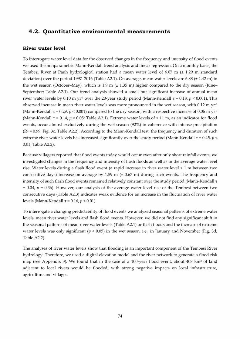
74
4.2. Quantitative environmental measurements
River water level
To interrogate water level data for the observed changes in the frequency and intensity of flood events
we used the nonparametric Mann-Kendall trend analysis and linear regression. On a monthly basis, the
Tembesi River at Pauh hydrological station had a mean water level of 6.07 m (± 1.29 m standard
deviation) over the period 1997–2016 (Table A2.1). On average, mean water levels are 6.88 (± 1.42 m) in
the wet season (October–May), which is 1.9 m (± 1.35 m) higher compared to the dry season (June–
September; Table A2.1). Our trend analysis showed a small but significant increase of annual mean
river water levels by 0.10 m yr-1 over the 20-year study period (Mann-Kendall τ = 0.18, p < 0.001). This
observed increase in mean river water levels was more pronounced in the wet season, with 0.12 m yr-1
(Mann-Kendall τ = 0.29, p < 0.001) compared to the dry season, with a respective increase of 0.06 m yr-1
(Mann-Kendall τ = 0.14, p < 0.05; Table A2.1). Extreme water levels of > 11 m, as an indicator for flood
events, occur almost exclusively during the wet season (92%) in coherence with intense precipitation
(R² = 0.99; Fig. 3c, Table A2.2). According to the Mann-Kendall test, the frequency and duration of such
extreme river water levels has increased significantly over the study period (Mann-Kendall τ = 0.45, p <
0.01; Table A2.2).
Because villagers reported that flood events today would occur even after only short rainfall events, we
investigated changes in the frequency and intensity of flash floods as well as in the average water level
rise. Water levels during a flash flood event (a rapid increase in river water level > 1 m between two
consecutive days) increase on average by 1.59 m (± 0.67 m) during such events. The frequency and
intensity of such flash flood events remained relatively constant over the study period (Mann-Kendall τ
= 0.04, p = 0.36). However, our analysis of the average water level rise of the Tembesi between two
consecutive days (Table A2.3) indicates weak evidence for an increase in the fluctuation of river water
levels (Mann-Kendall τ = 0.16, p < 0.01).
To interrogate a changing predictability of flood events we analyzed seasonal patterns of extreme water
levels, mean river water levels and flash flood events. However, we did not find any significant shift in
the seasonal patterns of mean river water levels (Table A2.1) or flash floods and the increase of extreme
water levels was only significant (p < 0.05) in the wet season, i.e., in January and November (Fig. 3d,
Table A2.2).
The analyses of river water levels show that flooding is an important component of the Tembesi River
hydrology. Therefore, we used a digital elevation model and the river network to generate a flood risk
map (see Appendix 3). We found that in the case of a 100-year flood event, about 408 km² of land
adjacent to local rivers would be flooded, with strong negative impacts on local infrastructure,
agriculture and villages.
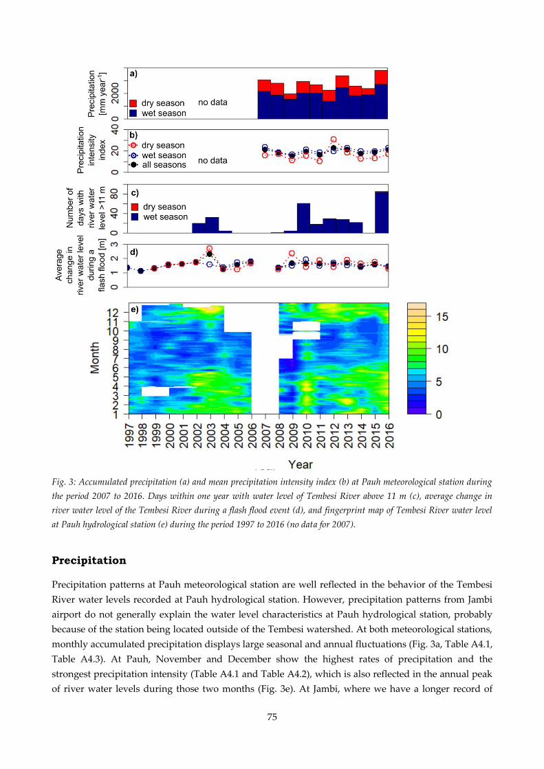
75
Fig. 3: Accumulated precipitation (a) and mean precipitation intensity index (b) at Pauh meteorological station during
the period 2007 to 2016. Days within one year with water level of Tembesi River above 11 m (c), average change in
river water level of the Tembesi River during a flash flood event (d), and fingerprint map of Tembesi River water level
at Pauh hydrological station (e) during the period 1997 to 2016 (no data for 2007).
Precipitation
Precipitation patterns at Pauh meteorological station are well reflected in the behavior of the Tembesi
River water levels recorded at Pauh hydrological station. However, precipitation patterns from Jambi
airport do not generally explain the water level characteristics at Pauh hydrological station, probably
because of the station being located outside of the Tembesi watershed. At both meteorological stations,
monthly accumulated precipitation displays large seasonal and annual fluctuations (Fig. 3a, Table A4.1,
Table A4.3). At Pauh, November and December show the highest rates of precipitation and the
strongest precipitation intensity (Table A4.1 and Table A4.2), which is also reflected in the annual peak
of river water levels during those two months (Fig. 3e). At Jambi, where we have a longer record of

76
precipitation measurements, April shows the highest accumulated precipitation and precipitation
intensity is strongest in March (Table A4.3 and Table A4.4).
At both meteorological stations, we found no clear trend in total accumulated precipitation and no shift
in the distribution of precipitation between the wet and the dry season (Table A4.1–A4.4). At Pauh
however, we found a clear trend toward higher precipitation at the end of the wet season in May
(Mann-Kendall τ = 0.60, p < 0.05) and at the beginning of the wet season in November (Mann-Kendall τ
= 0.56, p < 0.05; Table A4.1), which, for the latter, is in agreement with our findings of increased river
water levels at the beginning of the wet season (Table A2.2).
Land use change
In 1990, about half of the Tembesi watershed was covered with forest areas. Between 1990 and 2013,
this forest area decreased by 25%, from 6835 km² to 5108 km². Today, most of the remaining forest area
is located in the upstream, mountainous area of the watershed (Fig. 1; for an accuracy assessment of the
land use classes see Table A5.1). The forest loss in the watershed can mainly be explained by an
increase in plantation area as well as in bush/bare land (Fig. 4). From 1990 to 2013 the area cultivated
with oil palm plantations expanded by 54%, from 939 km² to 1451 km². Rubber plantations increased by
25%, from 2714 km² to 3404 km². The area of bush or bare land increased by 59%, from 597 km² to 947
km². In consequence, in 2013, oil palm plantations covered 11%, and rubber plantations 25% of the
Tembesi watershed. The area of mixed agricultural land has remained almost the same over the same
period, covering 15% of the watershed’s area in 1990 and 16% in 2013.
According to the wetland map we created, wetland areas constitute 8.35% of the Tembesi watershed
(1116 km²). In 1990, about one-third of these wetlands were covered with forests, while 54% of the
wetlands were used for different types of agriculture (Fig. 4). The proportionate loss of forest cover in
wetlands was even greater than in the whole watershed. From 1990 to 2013, forest areas in the
watershed’s wetlands decreased by 73%, from 347 km² to 93 km². This implies that 15% of the total
forest loss between 1990 and 2013 in the Tembesi watershed occurred in wetland areas although these
comprise only 8.35% of the whole watershed. The converted forest area was almost exclusively planted
with oil palm plantations, which almost doubled in area from 1990 to 2013, from 244 km² to 479 km²,
respectively. In fact, 33% of all newly developed oil palm plantations in the Tembesi watershed have
been established in wetland areas.

77
Fig. 4: Land use change in the Tembesi watershed and its wetland areas between 1990 and 2013 (based on land use data
by Melati 2017). Total area: Tembesi watershed 13,370 km², wetlands 1167 km².
Soil bulk density and water infiltration capacity
Bulk densities of rubber and oil palm plantations in the topsoil (0–10 cm) were 1.3-fold higher (1.14 ±
0.05 and 1.13 ± 0.05 g cm-³, mean ± standard error) than at the reference rainforest sites (Fig. 5). In
contrast to the topsoil, bulk densities in deeper soil layers (30–50 cm) showed similar values across all
land use systems (1.37 ± 0.03 g cm-3).
Saturated soil hydraulic conductivity (Kfs) in an oil palm monoculture plantation (6.5 ± 1.7 cm h-1, n = 4)
was three times lower than in the oil palm biodiversity experiment (22.6 ± 2.6 cm h-1, n = 33; Fig. 6),
suggesting higher surface runoff in the former. Additional measurements with a conventional double-
ring infiltrometer in another oil palm plantation gave lower Kfs (0.7 ± 0.2 cm h-1, n = 6).
Fig. 5: Topsoil (0–10 cm) bulk densities (BD, g cm-³) at 10 sites each in forest, rubber, and oil palm plantations (sites
described in Drescher et al. 2016). The dots represent means and the error bars the according standard errors. Different
letters represent significant differences among groups (Kruskal-Wallis test, p < 0.05).
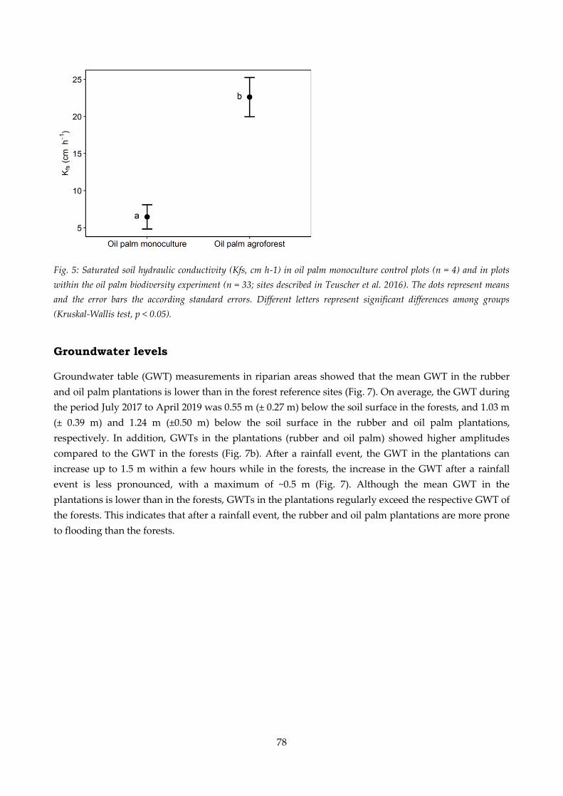
78
Fig. 5: Saturated soil hydraulic conductivity (Kfs, cm h-1) in oil palm monoculture control plots (n = 4) and in plots
within the oil palm biodiversity experiment (n = 33; sites described in Teuscher et al. 2016). The dots represent means
and the error bars the according standard errors. Different letters represent significant differences among groups
(Kruskal-Wallis test, p < 0.05).
Groundwater levels
Groundwater table (GWT) measurements in riparian areas showed that the mean GWT in the rubber
and oil palm plantations is lower than in the forest reference sites (Fig. 7). On average, the GWT during
the period July 2017 to April 2019 was 0.55 m (± 0.27 m) below the soil surface in the forests, and 1.03 m
(± 0.39 m) and 1.24 m (±0.50 m) below the soil surface in the rubber and oil palm plantations,
respectively. In addition, GWTs in the plantations (rubber and oil palm) showed higher amplitudes
compared to the GWT in the forests (Fig. 7b). After a rainfall event, the GWT in the plantations can
increase up to 1.5 m within a few hours while in the forests, the increase in the GWT after a rainfall
event is less pronounced, with a maximum of ~0.5 m (Fig. 7). Although the mean GWT in the
plantations is lower than in the forests, GWTs in the plantations regularly exceed the respective GWT of
the forests. This indicates that after a rainfall event, the rubber and oil palm plantations are more prone
to flooding than the forests.
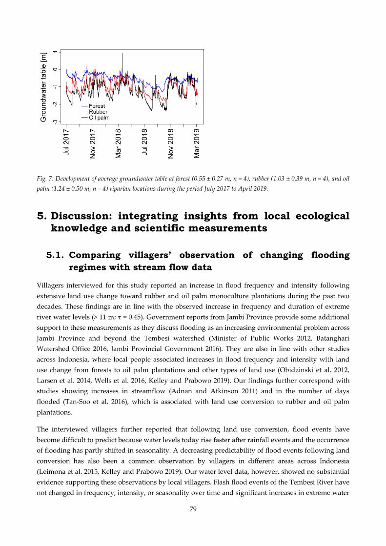
79
Fig. 7: Development of average groundwater table at forest (0.55 ± 0.27 m, n = 4), rubber (1.03 ± 0.39 m, n = 4), and oil
palm (1.24 ± 0.50 m, n = 4) riparian locations during the period July 2017 to April 2019.
5. Discussion: integrating insights from local ecological knowledge and scientific measurements
5.1. Comparing villagers’ observation of changing flooding
regimes with stream flow data
Villagers interviewed for this study reported an increase in flood frequency and intensity following
extensive land use change toward rubber and oil palm monoculture plantations during the past two
decades. These findings are in line with the observed increase in frequency and duration of extreme
river water levels (> 11 m; τ = 0.45). Government reports from Jambi Province provide some additional
support to these measurements as they discuss flooding as an increasing environmental problem across
Jambi Province and beyond the Tembesi watershed (Minister of Public Works 2012, Batanghari
Watershed Office 2016, Jambi Provincial Government 2016). They are also in line with other studies
across Indonesia, where local people associated increases in flood frequency and intensity with land
use change from forests to oil palm plantations and other types of land use (Obidzinski et al. 2012,
Larsen et al. 2014, Wells et al. 2016, Kelley and Prabowo 2019). Our findings further correspond with
studies showing increases in streamflow (Adnan and Atkinson 2011) and in the number of days
flooded (Tan-Soo et al. 2016), which is associated with land use conversion to rubber and oil palm
plantations.
The interviewed villagers further reported that following land use conversion, flood events have
become difficult to predict because water levels today rise faster after rainfall events and the occurrence
of flooding has partly shifted in seasonality. A decreasing predictability of flood events following land
conversion has also been a common observation by villagers in different areas across Indonesia
(Leimona et al. 2015, Kelley and Prabowo 2019). Our water level data, however, showed no substantial
evidence supporting these observations by local villagers. Flash flood events of the Tembesi River have
not changed in frequency, intensity, or seasonality over time and significant increases in extreme water

80
levels were only found during the wet season. Only the slight increase in average water level rise (τ =
0.16) provides a small indication supporting villagers’ observation of larger fluctuations in water levels.
Because discharge data is only available from one hydrological station in the Tembesi watershed, our
data, therefore, provide very selective insights into hydrological processes at the watershed scale. As
the catchment area upstream of our hydrological station covers over 10,000 km², flash flood events in
smaller subcatchments may not result in significantly higher water levels of the Tembesi River. In
general, it has been found that the impacts of land use change on river water levels may be larger in
smaller watersheds (Bruijnzeel 1990, van Dijk et al. 2009). Farmers who own plantations adjacent to
smaller streams, e.g., the Air Hitam River, may thus observe larger changes in water levels than are
reflected in the water levels of the Tembesi River. Indications supporting this hypothesis can be found
in our measurements of groundwater tables, which show rapidly increasing water levels in rubber and
oil palm plantations after rainfall events.
5.2. Potential contributions of local climate change to
changing flooding regimes
Several interview partners reported seasonal shifts in local rainfall patterns, which could thus
potentially provide an explanation for the villagers’ reports that flood events have become difficult to
predict. Our analysis of precipitation data may partly explain the villagers’ complaints as it indicates a
clear shift in the seasonal distribution of precipitation toward higher precipitation rates at the end of
the wet season in May. Similar accounts about increasingly unpredictable rainfall patterns were
reported from farmers across different regions in Jambi Province (Merten et al. 2016, Martens 2017,
Rödel 2018). Considering this widespread observation, the measured changes in the seasonal
distribution of precipitation appear relatively small. Further data from different meteorological stations
across Jambi Province would thus be needed to discuss the villagers’ observation of changing seasonal
rainfall patterns in more detail.
Changes in rainfall patterns could further provide an explanation for the measured increase in the
average water levels of the Tembesi River. However, our analysis of precipitation data at Pauh and
Jambi airport meteorological station showed that the total amount of precipitation as well as the overall
precipitation intensity has remained relatively constant over the past decades. Our precipitation data
available for the Tembesi watershed, however, only covers the lowland areas. Hence, we cannot rule
out changes in precipitation patterns in the highland regions of the Tembesi River watershed, which
may have contributed to the observed increase in water levels.
Deforestation can modify rainfall patterns because of vegetation-atmosphere interactions at various
spatial scales (Lawrence and Vandecar 2015, Spracklen et al. 2018). Large-scale forest conversion, as in
the Tembesi watershed, typically leads to a reduction of rainfall and therefore river discharge
(Lawrence and Vandecar 2015). However, this might be different in the case of forest conversion to oil
palm plantations in which evapotranspiration remains relatively high (Röll et al. 2019). On the other
hand, deforestation in heterogeneous landscapes such as the Tembesi watershed may increase rainfall
over deforested areas and thereby increase both river discharge and river water levels (Lawrence and
Vandecar 2015). Moreover, global climate change is expected to increase both total annual precipitation
81
and extreme precipitation in Southeast Asia (Ge et al. 2019). Although such trends are not yet
identifiable in our precipitation data, such developments could further increase both river discharge
and river water levels in the future. Long-term climate records and a dense network of meteorological
stations are therefore indispensable for studying the current and future linkages between precipitation
and river discharge.
5.3. Potential contributions of land use change to changing
flooding regimes
Evidence for altered hydraulic soil properties after forest conversion
The villagers interviewed in this study reported that flooding regimes started to change after vast forest
areas had been converted to rubber and oil palm plantations. Our land use change analysis, together
with our measurements of soil properties and groundwater levels in different land use systems,
provide indications that the large-scale land use change might have contributed to changes in the
ecohydrological functioning of the Tembesi watershed. High soil compaction in monoculture rubber
and oil palm land use systems is in line with results of other studies in the tropics, showing that forest
conversion and associated soil compaction leads to 1.2- to 1.3-fold increases in topsoil bulk density
(Don et al. 2011, Li et al. 2012). Higher bulk densities in monoculture plantations than in forests are
likely the result of severe soil erosion and changes in soil properties (Guillaume et al. 2015, 2016), e.g.,
compaction caused by heavy machinery during deforestation or subsequent harvesting operations.
Such increases in soil compaction may go along with significantly lower saturated hydraulic
conductivities (Kfs; Pachepsky and Park 2015). Our measurements indicate that subsoil bulk densities
(30–50 cm) remain unchanged across the different land use systems, which corresponds with a previous
study from the region (de Blécourt et al. 2013). However, it has been suggested that increases in topsoil
bulk density alone are sufficient to strongly reduce Kfs in soils of the humid tropics (Hassler et al. 2011).
In a meta-analysis, Pachepsky and Park (2015) suggested that topsoil bulk densities of around 1.36 g
cm-³ form a critical threshold, beyond which they have altered hydraulic properties such as hydraulic
conductivity, permeability, and porosity due to soil compaction. In our study, more than 30% of the
assessed oil palm and rubber plantations cross this threshold. Such changes in hydraulic soil properties
are further supported by our measurements of saturated hydraulic conductivity (Kfs). Our very low Kfs
values coincide with a previous study in the region, where soil water infiltration in oil palm
monocultures (3 cm h-1) was reported to be 60% lower than in rubber plantations (7.8 cm h-1) and more
than 15-times lower than in reference rainforests (47 cm h-1; Tarigan et al. 2018). These results, as well as
ours, thus point to very low Kfs in conventionally managed oil palm monocultures, which is most likely
related to the described soil compaction. These observations are in agreement with the villager’s
observation that soils in plantations do not effectively absorb or retain rainwater.
The type of vegetation in riparian areas is critical for infiltration capacity, overland flow, and
groundwater recharge (Alvarenga et al. 2017). Our groundwater table (GWT) analysis in riparian areas
showed that rubber and oil palm plantations have lower GWTs compared to forests. This might be
related to the relatively high soil compaction and the low water infiltration capacities in monoculture

82
plantations, as mentioned above. Higher amplitudes of GWT in oil palm and rubber plantations
compared to forests indicate a loss of buffer functions such as flood moderation, groundwater recharge,
and soil water storage in the plantations. Hence, our measurements of bulk density, water infiltration,
and groundwater tables point to substantial increases in surface runoff after precipitation, which could
potentially increase flood frequency and intensity (Bruijnzeel 2004). This line of argument is supported
by a previous study in the region, which modeled large increases in surface runoff with an increasing
share of rubber and oil palm plantations in a given watershed (Tarigan et al. 2018). Although our water
level data from the Tembesi River did not reflect villagers’ observation that rainfall nowadays
accumulates faster in local rivers than they remember from the past, our measurements of hydraulic
soil properties and groundwater levels provide substantial indications that support this observation.
Our analysis of soil water infiltration in oil palm plantations where biodiversity enrichment has been
carried out, however, suggests that tree planting and regeneration of natural vegetation could partially
restore the very low infiltration capacity. Five years after the establishment of the experiment, average
Kfs in the enriched oil palm plantation was at least three-times higher than in oil palm monocultures.
These findings are consistent with a meta-analysis across the tropics that reports on average three-fold
increases of water infiltration capacity after afforestation or tree planting in agricultural fields (Ilstedt et
al. 2007).
Our measurements thus provide several indications that forest conversion and subsequent alteration of
soil properties may explain the measured increase in the Tembesi’s water levels. However, especially in
larger catchments, the interaction of land use and ecosystem processes increases in its complexity and
causes with increasing catchment area (Bruijnzeel 1990, van Dijk et al. 2009). Studies from several river
catchments in the tropics have shown that other processes related to land use change and subsequent
changes in soil properties, e.g., sedimentation, road construction, missing buffer zones, or illegal gold
mining have the potential to further increase river water levels (Allan 2004, Ziegler et al. 2006, Wantzen
and Mol 2013, Carlson et al. 2014, Luke et al. 2017). These above-mentioned processes are also found in
the Tembesi catchment area and, with the relatively large extent of the river, this myriad of complex
land use changes and related interactions may therefore further contribute to the observed increases in
river water level.
Increases in the Tembesi river water levels in both the dry and rainy seasons might be explained by the
complexity of interacting ecosystem processes. In the case of reduced water infiltration capacity of soils
coupled with high (evapo)transpiration rates in oil palm monoculture plantations (Manoli et al. 2018), a
reduction of water levels in rivers during the dry season might be expected (Bruijnzeel 1990).
Indications for such changes were suggested for oil-palm-dominated landscapes by Merten et al. (2016).
Rubber plantations, on the other hand, exhibit lower (evapo)transpiration rates in smallholder-
dominated cultivation systems in Jambi (Röll et al. 2019). Therefore, the impact of land conversion on
the river water level in larger watersheds with mixed land use systems may be less discernible.

83
Potential contributions of wetland conversion and water infrastructure to
changing flooding regimes
Despite their important ecological role (Bhowmik 2020), wetlands have often been described and
treated as wastelands and hence converted into other land use types (Barbier et al. 1997). Our land use
change analysis indicates a much higher rate of forest conversion in wetland areas compared to well-
drained sites. According to interview data, this land use change can be explained by both
governmentally planned plantation establishment as well as market-driven expansion of oil palm
plantation into marginal areas. This trend of oil palm plantations expanding into wetlands areas has
also been reported in other regions across Indonesia and Malaysia (Abram et al. 2014, Guillaume et al.
2016, Schoneveld et al. 2019).
Because of plantation expansion into wetland areas, but also because of the reported increases in flood
frequency and intensity, flood control infrastructure such as dams and drainage channels have recently
been installed across all our case study villages. Although we cannot quantify to what extent such
infrastructure has contributed to an alteration of flooding regimes at the landscape level, our interview
partners reported that the construction of flood control dams, water pumps, and drainage gates
contribute to a redistribution of floodwaters at the local scale. Such developments are considered
particularly sensitive because government representatives during interviews confirmed that the
construction of water infrastructure often happens without legal notice. Accordingly, the first author
observed the emergence of social conflicts.
Our interview data as well as observations in the field show that most of the studied wetland areas
were managed by or with the support of private companies, external investors, or more well-off
farmers. Likewise, Schoneveld et al. (2019) and Kelley and Prabowo (2019) show that plantation
development on peat soils and flood prone riverbanks in Indonesia was mainly realized by more well-
off farmers, political elites, and private companies that adopted more industrialized land use
operations. This concentration of companies and local elites in wetland areas, together with the already
mentioned conflicts over water infrastructure, creates a risk of an increasingly unequal distribution of
flood damage. Surprisingly, to our knowledge, no study linking oil palm expansion to increasing flood
frequency and intensity has yet paid attention to the role of infrastructure in changing flooding regimes
or to the associated social impacts.
The large-scale expansion of plantations into wetland areas may also have contributed to changing
flooding regimes by reducing the ecohydrological functioning of these ecosystems. Review studies
suggest that lowland wetlands may substantially reduce or delay flood events (Bullock and Acreman
2003, Acreman and Holden 2013, Mitsch and Gosselink 2015). Anthropogenic activity in wetlands
strongly affects local river systems because of frequent lateral water exchange between rivers and
wetlands (Junk et al. 1989, Junk and Wantzen 2004). Although no data on wetland hydrology were
available for the Tembesi watershed, the drainage and burning of large areas of peatlands in the
watershed (Uryu et al. 2010, NASA FIRMS 2019) is particularly indicative of a degradation of local
ecohydrological functions. Drainage and burning of peat soils is known to alter their physical
properties, resulting in peat subsidence and compaction, thus reducing the water absorption of peat
swamps (Andriesse 1988, Page et al. 2006, Wösten et al. 2008, Evers et al. 2017). Moreover, the
84
subsidence of peat soils is considered to progressively lengthen periods of inundation (Wösten et al.
2006, Hooijer et al. 2015, Sumarga et al. 2016).
6. Conclusion and final reflections
Our analysis showed that the observed and measured increase in flood frequency and intensity within
the Tembesi River catchment area is most likely driven by land use change from forests to monoculture
plantations. This development appears to be related to soil compaction, decreasing water infiltration
rates, and, therefore, higher surface runoff. It might further be aggravated by the expansion of oil palm
plantations into wetland areas and the subsequent construction of drainage and flood control
infrastructure.
Our study illustrates how interrogating local ecological knowledge and integrating it with
multidisciplinary scientific measurements can drive forward problem-centered research on the linkage
between land use change and flooding. This study benefited from data integration in three important
ways. First, local people’s reports of changes in flooding regimes following land conversion, draw our
attention to a problem of environmental change previously not accounted for by our research project.
We thus build upon local people’s ecological knowledge to then interrogate datasets from different
disciplines, whether they provide indications confirming villagers’ observations and evaluations or not.
None of the data analyzed were initially collected for the purposes of studying flooding, and
hydrological data provided by the provincial government in Jambi remain scarce and often incomplete.
Despite this, the analyzed data provided substantial indications that support people’s claims that land
use change alters local flooding regimes. The villagers’ observations and evaluations matched well with
our measurements of extreme river water levels and altered hydraulic soil properties in monoculture
plantations. In data-poor regions, such an integration of multidisciplinary datasets may thus help us to
gain insights into socially relevant research topics that are otherwise neglected.
Second, villagers’ observations of changing flooding regimes, such as increases in the frequency of
flood events or more rapidly rising water levels after rainfall, also helped us to define what indicators
to look for in local water level data. As a result, our problem-based research approach pointed out
significant gaps in our data, which, by analyzing water level data alone, might not have appeared as a
gap at all. Although the predictability of flood events appears to be a major concern for local farmers in
Jambi, our analyzed data does not mirror seasonal shifts in flood events and only small shifts in
seasonal rainfall. Reports of shifting seasonal rainfall patterns, however, have been common across
different areas in Jambi Province, and a decreasing predictability of floods has also been reported in
other areas with rapid land use change (Leimona et al. 2015, Kelley and Prabowo 2019). This mismatch
points to a need for more fine-scaled spatial and temporal monitoring of water levels and precipitation
in the area to improve our understanding of the complex linkages between river discharge, land use
change, and climate change.
Finally, the integration of local ecological knowledge draws our attention to the multiplicity of
processes that influence the occurrence of flooding. Our study reveals that the construction of drainage
or flood control infrastructure has aggravated changes in local flooding regimes, thus generating new
social conflicts. Newly installed infrastructure was observed to redistribute floodwaters at the local
85
level and thus to play a crucial role in the mediation of the social impacts of flooding. Surprisingly, the
role of technical infrastructure in mediating water flows has received little scientific attention in studies
connecting land use change with changing flooding regimes. More studies are needed to assess and
monitor the hydrological impacts of such water management practices, as well as the social and
economic relations that shape these practices.
Acknowledgments
This publication was funded by the Deutsche Forschungsgemeinschaft (DFG, German Research
Foundation), project number 192626868, in the framework of the collaborative German-Indonesian
research project CRC 990 (SFB): “EFForTS, Ecological and Socioeconomic Functions of Tropical
Lowland Rainforest Transformation Systems (Sumatra, Indonesia)“ (http://www.uni-
goettingen.de/crc990). We thank the EFForTS subproject A05 for contributing additional data to
complete the bulk density dataset, as well as Imke Schulze Kalthoff (née Rödel) and Yvonne Kunz for
contributing interview data on land use history and management of wetlands areas. We further thank
Jasper Knieling for conducting the land use change analysis using ArcMap. We thank Edgar Tunsch,
Marek Peksa, Malte Puhan, Frank Tiedemann, and Dietmar Fellert for their technical support. We
would also like to acknowledge PT Humusindo, PTPN6, and the smallholder plot owners for allowing
us to perform measurements on the plantations as well as all interview partners for sharing their
knowledge and perspectives on the research topic. We greatly thank all our Indonesian field assistants
who made the extensive field work possible: Agustina Siregar, Yossy Delfitri, Yohana Manurung,
Winda Januarista, Basri, Bayu, Darwis, Ardian, and Amrina. Terimakasih banyak! We would also like
to thank our Indonesian counterparts for their assistance during field work. Finally, we thank two
anonymous reviewers for helping to improve the quality of this article.
Author Contributions
JM, CS, MD, HF, LF, DH, NH, AK, EP designed the study. JM, CS, NH, FO, AH, JK, DCZ contributed
data to the manuscript. JM, CS, NH, AR, EP performed data analysis and interpretation. JM and CS
prepared the manuscript. NH, AR, EP contributed to writing the manuscript. JM, CS critically revised
the manuscript. All authors discussed the results and commented on the manuscript.

86
CHAPTER IV:
From rising water to floods: disentangling the production of flooding as a hazard in Sumatra, Indonesia
Merten, Jennifer, Nielsen, Jonas Østergaard, Rosyani, Soetarto, Endriatmo, Faust, H.
Highlights:
Risk research must increase our understanding of what is considered a hazard
Hazards (incl. floods) are the product of past and present socionatural relations
Relational approaches to risk and natural resources help to study hazards
In Jambi, Sumatra, land use change alters the materiality and meaning of flooding
The prioritization of dry land for plantation development is a main driver of this
Abstract
In Jambi province, Sumatra, Indonesia, flooding is a recurrent rainy season phenomenon. Historically
considered manageable, recent political economic developments have changed this. Today, flooding is
an environmental hazard and a threat to people’s livelihoods and health. Based on qualitative research
and literature that has developed relational approaches to risk and water, we investigate past and
present hydrosocial relations in Jambi province and reconstruct the changing meaning of flooding. We
suggest that flooding as a hazard in Jambi was produced through the introduction of the plantation
business to the area and its prioritization of dry land for agro-industrial development. This
development altered the materiality of water flows, reconfigured power relations and changed the
socio-cultural dimensions of flooding. Together, these changes have led to a separation of flooding
from its original social and geographic realm, producing new risks and vulnerabilities. The paper adds
insights into the material and symbolic dimensions that influence how environmental processes come
to be imagined, controlled and contested. It shows how tracing the socionatural production of hazards
may help explain the increasingly systemic nature of risks and provide insights into the wider social
meaning of environmental risks.
Keywords: hydrosocial relations; hazards; risk; vulnerability; land use change; political ecology; Indonesia
Accepted manuscript in: Geoforum
(November 7, 2020)
87
1. Introduction
In Jambi province, Sumatra, Indonesia, rivers overflow their banks during the rainy season. People
living along the rivers had adapted to this, building daily practices and cultural identity in a close
relationship with rivers and floods. Extensive cultivation of riparian floodplains, agroforestry and
fishing constituted a mainstay of the local economy. In the local dialect, people referred to floods as
“rising water” (air naik) or “deep water” (air dalam). Neither term entailed an immediate threat to their
lives and livelihoods. In the 1980s, Jambi province went through a national economic development
program. Plantations were established transforming land cover and use on a large scale subsequently
attracting migrants and private investments to the Province. This changed the relationship between
people, rivers and floods. Today, flooding is more frequently discussed as a threat to people’s
livelihoods and people use the official Indonesian word for flooding, “banjir”, more often. This term
carries the added connotation of the risk of disaster. As this paper will show, flooding in Jambi has
transformed from an expected seasonal phenomenon into a hazardous event.
Hazards are environmental processes and events potentially harmful13 and, in combination with
human vulnerability, they produce the risk of disaster (Wisner et al., 2012). Yet, the study of
interactions and feedback mechanisms between environmental and social processes in the constitution
of risk remains a key challenge in risk research as this remains divided into hazard-centered
approaches and vulnerability studies (Lele, 2009, Wisner et al., 2012, Di Baldassare et al., 2014, Ribot,
2014). While the former locate risk in the environmental hazard and focus their study on biophysical
changes therein, the latter locate risk in social structures and inequalities and focus their analysis on
socio-economic and political causes of human vulnerability to hazards (Rebotier, 2012, Ribot, 2014).
Relational approaches to risk have contributed to overcoming this analytical divide. They have
conceptualized environmental risk as a socionatural production, or as a situated production arising
from specific society-nature relations that are deeply embedded in local geography, environmental
changes, history and culture (Rebotier, 2012). Such an understanding has contributed to three major
theoretical advancements. First, it has enabled a more dynamic understanding of risk and vulnerability,
rejecting static risk assessments and recognizing risk as being constantly in production (Collins, 2009,
Simon, 2014). Second, it has led to the recognition of risk and vulnerability existing both as a material
condition and as a discursive construct (Jasanoff 1999, Simon & Dooling, 2013). Risk studies have
thereby expounded how different representations of risk and vulnerability – e.g. discourses about who
is at risk and why – are socially contested. Third, it has shown how hegemonic risk discourses
contribute to the production of highly uneven landscapes of risk and vulnerability through shaping risk
prevention, assessment and response policies (Collins, 2009, Rebotier, 2012, Simon & Dooling, 2013,
Neale et al., 2016).
Few studies have used these insights to interrogate the socionatural production of environmental
hazards, questioning how normal environmental processes or natural resources turn into threatening
hazards (Walker et al., 2011, Ribot, 2014, Jones et al., 2014, Langill & Abizaid, 2019). In this paper, we
13 The term hazard is inconsistently conceptualized in the literature and sometimes interchangeably used with the term
disaster, as an event resulting in loss and damage (Smith 2013, Wescoat 2015).
88
explore how a physical event, rising waters, becomes a hazardous flood. We show that hazards are not
purely biophysical phenomena that simply exist, but also, like risks and vulnerability, they are the
outcome of socionatural relations. Attached with meaning and values, these, in combination with
biophysical and material aspects, constitute, we argue, something as a hazard.
To illustrate this, we draw on literature on relational approaches to natural resources and water from
political ecology and anthropology. These bodies of literature have provided rich accounts of how
flooding is best conceptualized as a socionatural production that is shaped through the dialectic
relationship between water and society (Swyngedouw, 1999, Linton & Budds, 2014). This allows us to
explore the ontological multiplicity of water (Linton, 2010, Hamlin, 2010, Boelens, 2014), the specific
materialities of water that shape social relations in Jambi (Bakker, 2003, Barnes, 2014), the socio-cultural
meaning of rivers and flooding (Baviskar, 2003, Acharya, 2015), and the power relations embedded in
local water flows (Swyngedouw, 2004, Budds, 2009, Swyngedouw 2015, Boelens, 2014). The historical
socionatural production of water-related hazards such as floods or water scarcity is prominent in such
research (e.g. Mehta, 2007, Budds, 2009, Fernandez, 2014, King et al., 2019).
This paper begins by reviewing recent theoretical advancements in hydrosocial research. We focus on
how this literature helps explain the production of flooding as a hazard. We then present our methods
before turning to our results. The results analyze the socionatural production of flooding as a hazard
over time using the case study of Jambi province. Following Ribot (2014: 680), we ask what makes a
hazard a hazard, or what turned “deep water” into “flood” in Jambi? We investigate past material and
discursive hydrosocial relations that shaped an understanding of flooding as a normal seasonal
phenomenon. We then trace how this was reshaped through political-economic transformations in
Jambi over the last three decades. Particular attention is paid to how agro-industrial plantation systems
transformed Jambi’s landscape and seasonal water flows as well as how different actors engage
discursively and materially with flooding. In the discussion, we use our empirical insights to discuss
what conditions and processes have enabled the recent production of flooding as a hazard. We further
illustrate how studying the historical production of a hazard can further our understanding of the
production and meaning of hazards and risks. We round off the paper with a conclusion.
2. The socionatural production of flooding as a hazard
During the past two decades, there has been an increasing recognition of how water and society shape
each other in a dialectical process of mutual adjustment (Linton & Budds 2014). In his seminal work on
the production of the Spanish waterscape, Swyngedouw (1999, 2004, 2015) showed how water flows in
Spain are deeply embedded in and infused by social power relations. He thus conceptualized water as
a socionatural hybrid produced in a ‘hydrosocial cycle’ of material processes, cultural practices,
discursive representations and social power relations (Swyngedouw, 2004, see also Linton & Budds,
2014).
Using the hydrosocial cycle as an analytical framework has helped researchers to identify the
assemblage of historical, hydrological, political and technological circumstances that produce specific
instances of water, and to question how these configure social relations (Linton & Budds, 2014).
Thereby, this body of literature has convincingly revealed how, for example, social inequalities and

89
injustices become produced and sustained through water and the role of water’s particular materiality
in shaping social relations (Budds, 2008, Debanné, 2013, Wilson, 2014, Barnes, 2014). It has further shed
light on the varied socio-cultural dimensions and meanings of water (Baviskar, 2003, Boelens, 2014,
Acharya, 2015).
Water’s particular physical nature connects places and people across political, legislative and socio-
cultural spheres, interacting with different actors and power relations (Krause, 2016). It has an
inherently relational character. Water is also both beneficial and harmful. It is essential for human
survival, an economic resource, a source of personal hygiene, a disruptive force, or a carrier of
pathogens - to mention just a few attributes (Boomgard, 2007). Through this multiple and variable
character, water actively shaped histories and geographies (Bear and Bull, 2011). The temporality of
water through its’ seasonal and tidal rhythms have for example been shown to shape and change social
life over time (Harris, 1998, Jones, 2011, Camargo, 2017). Indeed, the consonance or dissonance of
temporal relations between social and natural rhythms may be a deciding factor in determining
whether a water flow is productive or disruptive (Jones, 2011). Whitt (2018) showed, for example, how
water risks in Bolivia were produced as existing hydrosocial relations fell apart, producing a “cyclic
dissonance” between the cycles of water and people’s management of it.
Water is thus to some extent “what we make of it” (Linton, 2010: 3). Definitions of flooding, for
example, are embedded in people’s daily experience, practices and ideas and expectations of where
water belongs (Walker et al., 2011). Walker et al. (2011: 2306) show how in Hull, England, water only
becomes floodwater when it crosses a boundary of “spatially constituted normality” when it moves
“out of place”. They thus assert a necessary “abnormal” quality to flooding. But the definition of
abnormality is geographically determined, fluid, open, multiple, value laden and contested in terms of
when water is considered to be “out of place” and who gets to determine this (Walker et al., 2011).
Defining what water is and where it belongs constitutes an important part of Linton’s (2010) work on
the ‘modern’ understanding of water. Linton shows how water and modern ideas about it were shaped
during the enlightenment where water, abstracted as H2O, was ontologically separated from its social
realm. Being able to control “natural” water flows became a manifestation and goal of modernization
with flooding constituting a hazardous disorder that interrupts social and economic life (Oliver-Smith,
2002, Linton, 2010, Bernhardt, 2016). In the same vein, Lahiri-Dutt (2014) showed how land and water
in Western thought were split into disparate categories, with land defined “as the part of the earth’s
surface that is not covered by water” (Oxford Dictionary, cit. in Lahiri-Dutt, 2014). Today flooding is
generally defined as an overflow of water onto “normally” dry land (Arnell, 2002).
The protection of dry land from flooding is often related to the protection of economic activities since
“watery land” is generally considered non-productive (Lahiri-Dutt 2014). The British colonial
government in Bengal, India, for example, aimed to control the rivers in order to stabilize the land as a
source of revenue (D’Souza, 2009, cit. in Lahiri-Dutt, 2014). In another account, Mehta (2007) showed
how hegemonic narratives of water scarcity in India legitimized large-scale technical interventions in
water flows. Water conceptualization itself is thus an intrinsically social and political activity (Boelens,
2014) and water circulation and control in this way often internalizes and expresses power relations.
Indeed, research on the production of irrigation and drainage systems (Barnes, 2014, Swyngedouw,
2015), water supply systems (Kooy & Bakker, 2008, Bakker, 2003) or river flows (Bouleau, 2014), all

90
highlight how political, economic and cultural ideas about water and flooding become physically
inscribed into the landscape. Understanding the material and symbolic dimensions of how natural
resources come to be imagined, controlled and contested as hazards therefore opens up the socio-
cultural as well as political dimensions of risk production for analysis (Jones et al., 2014).
3. Research approach and methods
The research conducted for this paper was part of the interdisciplinary research project (EFForTS). The
project explored socio-ecological impacts of the expanding plantation business in Indonesia. Jambi
province constituted the site of research due to the ongoing rapid land use transformations in the
province’s lowlands. Interest in the production of flooding as a hazard emerged during initial field
visits to Jambi province in 2015 and 2016. These visits aimed at creating a broader understanding of the
kind of challenges people in Jambi were facing with regard to the governance of natural resources. It
quickly became apparent that flooding was considered a threat to local development across the
province. What intrigued us, however, was how this contradicted the fact that flooding had always
been a seasonal phenomenon in this part of the wet tropics. To explore this contradiction, the first
author conducted empirical qualitative field research. The focus was put on two sub-districts in Jambi’s
lowlands that differed in their physiographic as well as socio-cultural characteristics. The sub-district
Air Hitam (Sarolangun regency) is located in the inner lowlands of Jambi province, while the sub-
district Mendahara Ulu (Tanjung Jabung Tibung regency) is located in the coastal peatlands. Both sub-
districts overlap with small watersheds, the Air Hitam and the Mendahara rivers. Along each of these
two rivers, three to four villages were selected for study. The time spent in each village varied between
one and four weeks. In total, the first author lived in Jambi province for ten months, in the period
September, 2015 to December, 2017.
Semi-structured interviews, informal interviews, participative observation and group discussions were
the main methods applied. 99 semi-structured and 64 informal interviews with villagers were
conducted. The interview partners were chosen according to snowball and purposive sampling
methods (Flick, 2016). At the village level, these included research participants representing local
institutions such as government bodies, farmer groups or civil society groups, and people directly
affected by flooding at home or on their plantations. These included interview partners across different
social groups, such as people born in the area, spontaneous and state-settled migrants, food crop and
plantation farmers, as well as poorer households and village elites. Initially the interviews were
translated into English by a local student assistant; later the first author conducted the majority of
interviews directly in Indonesian. This language proficiency facilitated numerous insightful informal
conversations and helped to build trust and recognition between the researcher, the assistant and the
interview partners. This level of intimacy was further enhanced as several households were
interviewed repeatedly during consecutive field visits, combining both formal and informal interview
situations and involving different members of the households. Repeated field visits and interview
situations enabled us to re- and cross-check findings and interpretations with our interview partners as
well as to gain insights into local dynamics. Visits to villagers’ and companies’ plantations, different
river sections and protected forest areas further helped to interrogate the meaning of flooding at the
affected places. External perspectives on local developments and insights into local and regional policy

91
making were gained through an additional 32 interviews in (sub-)district and provincial capital cities
with representatives from academia, civil society organizations, government offices and the private
plantation sector.
Formal interviews were recorded and transcribed in Indonesian. All interview notes and field memos
were coded for content using MAXQDA software. Finally, empirical research data was complemented
by a review of literature on historical land use patterns and the importance of rivers and floods for
culture and economy in Jambi province.
4. Results
4.1. Living with rising water – hydrosocial relations in Jambi’s
lowlands until the mid 1980s
First villages in Jambi’s inner lowlands were established by Malay people who explored new territories
in Southeast Asia by moving upstream on the large rivers. Until the mid-1980s sedentary agriculture
centered on the larger riverbanks and was well adapted to seasonally changing water levels (Scholz,
1988, Locher-Scholten, 2004). The Air Hitam sub-district exemplifies this. During the dry season
villagers collectively cultivated dryland agriculture such as corn, rice or soybean on natural river dams.
Some alluvial floodplains were cultivated with wet rice. Adjacent to the agricultural fields, rubber
agroforests were developed. These turned into the mainstay of the local economy around the mid 1970s
but did not extend beyond a stretch of a few kilometers from the riverside. The forests further inland
were scarcely inhabited by semi-nomadic indigenous groups practicing slash and burn agriculture
(Steinebach, 2008). Peat and swamp areas, located south of the Air Hitam River (Fig. 1), were used only
for hunting and fishing and remained forested. The floodplains of the Air Hitam River were protected
under customary law as local spawning grounds.
The coastal swamp and peatlands of Jambi province, including our case study site Mendahara Ulu,
remained scarcely inhabited until the turn of the 20th century. During the following decades, migrants
from South-Sulawesi, South-Kalimantan and partly also from Java settled along the coast and started
moving inland (see also Scholz, 1988, Claridge, 1994, Galudra et al., 2013). In our case study area first
settlements were established in the 1970s. After the strenuous clearing and draining of the swamp
forests, settlers established land use systems based on their agricultural knowledge developed at the
coast. Riverbanks were dominated by tidal rice cultivations and the adjacent shallow peat soils were
planted with coconuts. As population numbers increased, newly settled migrants gradually started
converting deeper peat areas, further away from the Mendahara River, as well as areas further
upstream of the river. Cultivation systems generally did not yet extend further than 5–8 km from the
riverbanks and the particularly flood-prone areas in the southern peatlands of Mendahara Ulu
remained largely uninhabited. In the 1980s, a private company obtained a logging concession of almost
18,000 ha in the peat swamp forests adjacent to the villages. Logging, in the following years, turned into
one of the most important sources of income for many farmers and resulted in a gradual abandonment
of their rice fields.
92
The rivers in both regions served as the main mode of transportation and enabled barter trade with and
between upstream and downstream villages (Locher-Scholten, 2004). As an older woman born in the
Air Hitam sub-district expressed in an interview, the river was considered the “place of living” (tempat
hidup). It was the place for the market, transportation and housing. It also provided water for drinking,
bathing, and washing. Boomgaard (2007) tellingly referred to the Malay people as a “water people”.
Fishing was a common source of income in both sub-districts and constituted an important social
activity. Whenever people recounted about fishing, they often started reminiscing about the abundance
of fish and the particularity of local fish species. Villagers living in stilt houses in the peatlands also
remembered that during flooding they could fish directly out of their windows and doors and that
shrimps would swarm around their feet whenever they went bathing in the rivers. In the peatlands,
this condition remained until recently. The head of a village hamlet who had moved to the area in 2001
remembered the ease of fishing:
In the past there were still many fish, so many. Some of the villagers went fishing […] they could
even earn their living with fishing. […] We only sold it [the fish] here in the village. Because the
people from Jambi [city] came here to pick up the fish. We only put it in front of our houses. In
the past the water was still deep. That’s why there were many fish. (Mendahara Ulu, March 24,
2017)
Despite this close connection to the rivers, flooding did present problems. It was a source of waterborne
diseases and impeded agricultural land use. But to the villagers, flooding was considered a natural
phenomenon and the slowly rising water levels in the rainy season did not pose any immediate threat.
Floods were referred to as “rising water” (air naik) or “deep water” (air dalam) and traditional
knowledge helped prevent flood damage:
In the past, we would read the condition [of the weather]. So if there is flooding, we won’t plant
the rice. But if it is dry, we will go to the fields. […] And until the rice was ready to harvest there
was no flooding. Only after we harvested the fields, the floods came. (Head of a local farmer
group, Air Hitam, July 17, 2016)
In fact, older villagers recounted that in the past they preferred the rainy season – also called “flooding
season” – over the dry season. The latter posed several challenges to the villagers. Before roads were
established, transport by boat was often hampered by low water levels during the dry season and
water supply in the peatlands was difficult when riverine water turned brackish due to salt water
intrusion:
In dry season life was hard. It was hard to get out of the village. […] And to bring the products
into the village. Because the water level decreased. To transport the rubber produce we had to
pull the boat. We walked through the river, pulling the rubber. It took weeks until we arrived.
(Older Malay woman born in the Air Hitam sub-district, July 13, 2016)
The local rivers also served as central site for identity building (see also Andaya, 1993, Locher-Scholten,
2003, Andaya, 2016). For example, the founding myth of Jambi city - a story which the researcher came
to hear in different versions several times during field research - builds on the narrative of a couple
traveling downstream the Batanghari river with two goose. These were supposed to indicate to the

93
couple where they should build a new settlement. Until today, the central market in Jambi’s capital city
is named after these two goose (angso duo). Advertized cultural artefacts from Jambi include the
wooden stilt houses (rumah panggung) or traditional batik cloth decorated with symbols of goose, rivers,
and ships. Indications of upstream (hulu) or downstream (ilir) were used to describe different economic
and political systems but also referred to different peoples, cultures, spirits and gods.
4.2. The transformation of hydrosocial relations in Jambi
province
4.2.1. The introduction of the agro-industrial plantation business
Large-scale deforestation and land use change in our case study areas was initiated with the rise of the
agro-industrial plantation business under the military regime of President Suharto (1967-1998). His
national economic development program focused on supposedly “undeveloped” and scarcely
populated areas, which included large peat and swamp areas (Scholz, 1988, Galudra et al., 2013). For
this purpose, Suharto initiated a resettlement program (transmigrasi), that aimed at resettling people
from densely populated Java and Bali to Indonesia’s outer islands (see also Fearnside, 1997). Large
parts of the forested peatlands and adjacent areas in the sub-district Air Hitam, our first case study
area, were chosen for such a transmigration project in the mid-1980s (Fig. 1). As part of this program,
each transmigrant household received a two-hectare parcel of land, which was developed into an oil
palm plantation in cooperation with private companies in the early 1990s. In addition, the companies
were granted large-scale concessions for oil palm plantation development adjacent to the transmigrant
villages. Subsequently, peat and swamp areas were cleared and plantations and village hamlets were
established in the middle of regularly flooded land. Large-scale drainage and road systems were
constructed to make this possible. Once oil palm companies had settled, the land use in neighboring
Malay villages also changed (Fig. 1). As people born in the area observed the economic success of the
transmigrant oil palm farmers, many hoped to benefit from the business as well and started cultivating
oil palms on their own. Food crop cultivations that had already decreased with the economic success of
rubber plantations, decreased even further.
Rapid land use change continued in the sub-district Air Hitam during the decentralization phase that
followed the fall of Suharto’s military regime in 1998 when local and regional actors started competing
over authority and access to land (Moeliono & Dermawan, 2006). Irregular land sales represented a
widespread challenge and concession granting extended into the remaining unprotected forest areas
(Barr et al., 2006). In addition, investment and job opportunities in the plantation sector attracted
numerous migrants and land investments, spurring the further establishment of plantations, in
particular in the remaining forested floodplains and peatlands adjacent to the Air Hitam River. Around
the year 2010 they had been cleared entirely.
In Mendahara Ulu, the second case study area, agro-industrial plantation development started several
years later than in Air Hitam. In the 1990s, smallholder farmers who had formerly cultivated coconut
plantations, started intercropping these with areca nut palms and later also with oil palms. Yet, large-
scale land use change only began at the turn of the 21st century after a 70,000 ha forest production

94
concession had been granted to a transnational pulpwood company on the peatlands in the vicinity of
our case study villages (Fig. 1). When the company started clearing land to develop acacia plantations,
numerous land conflicts also spurred land clearance and plantation development by smallholders who
aimed to demarcate their land claims. At the same time the resurfacing of district road in the southern
peatlands of Mendahara Ulu resulted in spontaneous in-migration from all over Indonesia as it
strongly improved access to the area. Around the year 2012, almost all forests outside protected areas
had been gradually cleared in the sub-district.
In both case study areas, the large-scale encroachment of wetland areas was thus initiated by private
companies that were granted concessions for plantation development. Once these had started clearing
land and through road establishment improved access to such lands, smallholders tried to develop
plantations on their own as well. Many of them, however, did not have the financial or technical
capacities to profitably manage plantations on these flood-prone lands. They thus opted to sell such
lands to wealthier farmers from neighboring villages, migrants or private investors from urban areas.
For such actors, wetlands presented attractive investment opportunities as they were sold at a relatively
cheap price. Moreover, this land constituted the last continuous areas for sale in the area and thereby
also attracted larger investors.
Fig. 1: Land use maps of the sub-districts Air Hitam (left) and Mendahara Ulu (right). The land use displayed is based
on a land use classification in Jambi province in 2013 (Melati 2017). The category “other villages” includes different
types of non-state planned villages (i.e. Malay villages).
95
4.2.2. “Flooding is stress. Stress for the oil palm and also for the
people” - Changing perspectives on land and water
The introduction of the plantation business in our case study areas not only led to large-scale land use
change but also changed many people’s attitudes towards land and water. In particular, actors in the
plantation business perceive flooding as an obstacle needing to be controlled to enable economic
development. A woman from South Sumatra who had bought land in the peatlands of Mendahara Ulu
in 2011 explained:
[When we settled here] there was a lot of empty land. And the price was affordable for people
from the middle class. […] When we bought the land, it looked like we were buying a piece of
sea. The water had the same height as the road. […] But what was important was that it could
become productive in the future. (December 7, 2017)
As a precondition for successful plantation management they needed to get rid of the excess water. The
approaches taken varied hugely according to people’s individual financial and technical capabilities.
Rich investors bought excavators, dug sophisticated systems of drainage channels and heightened the
soil under young palm seedlings. Less affluent people also tried to win the battle against the water
masses. A local smallholder farmer, interviewed in his plantation in the floodplains of the Air Hitam
River, explained that out of 100 oil palm seedlings that he had planted the year before, only 12 had
survived the flooding season. Despite this loss, he calculated that if only some seedlings would survive
each year, his plantation could provide an income for his children at some point in the future.
For those who could not successfully control the water, flooding resulted in economic and psychic
stress. While oil palm plantations are relatively flood resistant, flooding causes young seedlings and
fertilizer to be washed away and substantially reduces the palm’s productivity. Moreover, these
perennial palm trees should be harvested throughout the year, but seasonal flooding disrupts this. A
transmigrant farmers, who was designated land in the floodplains of the Air Hitam River, explained
the difficulties of managing his plantation there:
Each time I apply fertilizer, the water comes. Then it [the fertilizer] is lost. […] [The impact of
flooding] is stress. Stress for the oil palm and also for the people. […] When the flooding is over,
the leaves will turn yellow. The process takes at least three months, only after that the oil palm
will be normal again. (June 21, 2016)
With the introduction of the plantation business, in fact, Jambi’s entire economy and infrastructure
became dependent upon dry land and thus heavily dependent upon flood control. As transport was
shifted on to the roads and villages and plantations expanded into wetlands areas, we observed the rise
of new businesses selling mineral soil used to build streets and housing foundations on flood-prone
land (Fig. 2-3). In particular, transmigrant households adapted to flooding by raising the foundations of
their houses. These “modern” houses, however, are much lower than traditional stilt houses and thus
continue to be prone to exceptional flooding. In general, the appearance of new actor groups such as
(trans)migrants or private investors not used to regular flooding reshaped the local understanding of
flooding. As an officer at the provincial watershed agency depicted it, these people were simply not
“friends with the water”.
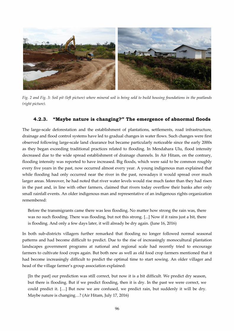
96
Fig. 2 and Fig. 3: Soil pit (left picture) where mineral soil is being sold to build housing foundations in the peatlands
(right picture).
4.2.3. “Maybe nature is changing?” The emergence of abnormal floods
The large-scale deforestation and the establishment of plantations, settlements, road infrastructure,
drainage and flood control systems have led to gradual changes in water flows. Such changes were first
observed following large-scale land clearance but became particularly noticeable since the early 2000s
as they began exceeding traditional practices related to flooding. In Mendahara Ulu, flood intensity
decreased due to the wide spread establishment of drainage channels. In Air Hitam, on the contrary,
flooding intensity was reported to have increased. Big floods, which were said to be common roughly
every five years in the past, now occurred almost every year. A young indigenous man explained that
while flooding had only occurred near the river in the past, nowadays it would spread over much
larger areas. Moreover, he had noted that river water levels would rise much faster than they had risen
in the past and, in line with other farmers, claimed that rivers today overflow their banks after only
small rainfall events. An older indigenous man and representative of an indigenous rights organization
remembered:
Before the transmigrants came there was less flooding. No matter how strong the rain was, there
was no such flooding. There was flooding, but not this strong. [...] Now if it rains just a bit, there
is flooding. And only a few days later, it will already be dry again. (June 16, 2016)
In both sub-districts villagers further remarked that flooding no longer followed normal seasonal
patterns and had become difficult to predict. Due to the rise of increasingly monocultural plantation
landscapes government programs at national and regional scale had recently tried to encourage
farmers to cultivate food crops again. But both new as well as old food crop farmers mentioned that it
had become increasingly difficult to predict the optimal time to start sowing. An older villager and
head of the village farmer’s group association explained:
[In the past] our prediction was still correct, but now it is a bit difficult. We predict dry season,
but there is flooding. But if we predict flooding, then it is dry. In the past we were correct, we
could predict it. […] But now we are confused, we predict rain, but suddenly it will be dry.
Maybe nature is changing…? (Air Hitam, July 17, 2016)

97
As food crop farmers’ fields were often located close to the rivers, sudden floods caused frequent
harvest failures. Uncertain flood patterns, together with economic reasons, made several of them
convert their food crop cultivations into oil palm plantations, supposedly more flood resistant (Fig. 4).
However, the flooding also constrained these.
Fig. 4: Farmer watching his flooded field. This former corn field has recently been planted with young oil palms.
In addition to changes in flood timing and intensity, villagers in both sub-districts complained
about a decrease in river water quality. This decrease was attributed to high water turbidity,
garbage floating in the water, and a decrease in fish stocks and species. The causes for these
changes are multiple and probably a cumulative result of the loss of riparian buffer zones, the
frequent use of fish poison, the leaching of agricultural inputs, and the drainage of peat soils. The
decrease in water quality presents a serious health challenge, which is particularly problematic in
the peatlands. Villagers but also medical professionals considered the large areas of polluted,
stagnant water in rainy season a cause of a variety of diseases (Fig. 5):
Maybe if the water would flow, the garbage would flow away. But here it doesn’t, it stays under
the houses. [...] The result is that there are many mosquitoes. [...] And then we have outbreaks of
dengue and other diseases.” (discussion with a village women’s group, Mendahara Ulu, April 13,
2017)
The observed degradation of river water changed people’s traditional practices of using the river for
fishing or personal hygiene. Eating river fish was sometimes even considered a danger to people’s
health, a claim that was particularly dominant among urban residents. A representative from the
provincial government sarcastically depicted:
In the past when we ate fish it was considered healthy. But now if we eat fish from the bottom of
the river, we are afraid that it is polluted with mercury. And fish from the surface of the river is
polluted with soap and all types of household waste. So all of them are polluted. (Jambi City,
June 12, 2017)
The decrease in water quality has further led to an increasing commodification of formerly public
goods, such as fish and water in both our study regions. Governments as well as company funded CSR
programs nowadays promote the establishment of fish ponds. Yet, the need for successfully writing

98
funding proposals, makes only well-organized farmer groups benefit from such programs. To prevent
the spread of diseases, local authorities and public sanitation campaigns tried hard to convince people
to use wells or packaged water for their personal hygiene. However, such campaigns strongly conflict
with many people’s daily reality and with the role that rivers originally played for cultural identity and
social activities. Public campaigns thus contributed to a stigmatization of those still using the rivers and
often remained without success. A general practitioner desperately recalled:
[I tell them] don’t use the river! It’s so difficult, the mindset of the people here. Since we were
children, we always used the river. Even if people have wells, they still use the river. If we use
the river, we can swim. But if we use the well, […] I mean, we do not really get wet. (Air Hitam,
June 21, 2016)
Fig. 5: Stagnant polluted water in the peatlands of Mendahara Ulu.
4.2.4. “At least the water will flow faster” – Contested attempts to
control unruly flood waters
The joint effect of changing flood patterns and the ever increasing expansion of oil palm plantations
into wetland areas led to a continuously increasing professionalization of water management among all
types of land owners. Smallholder farmers began renting machines from wealthier villagers or regional
authorities to dig drainage channels on their plantations. Oil palm companies and private investors
equally professionalized their water management systems (Fig. 6):
Now what we are concerned about is flooding […] When I came back to this area in 2013, I
realized that there is flooding because the trees in the national park are already less. So upstream
of the plasma [transmigrant] farmers’ land we try to divide the water flow into two. We made
channels like in Jakarta, one flood channel in the west, and one in the east […] So our hope is,
while we cannot prevent the flooding, at least the water will flow faster to the mouth of the river.
(oil palm company representative, Air Hitam, June 18, 2016)
Yet, controlling the fluid water remained difficult. In particular in the peatlands, the amount of drained
water often by far exceeded the river capacity to carry water flow. Many villagers thus requested

99
governments and companies to “normalize” their rivers, including dredging and widening them to
improve water flow. In Mendahara Ulu, where this had been done twice, the effect, however, was not
sufficient and villagers requested further initiatives. Respondents further observed that even small
differences in the type of the drainage systems could influence whether plantations were inundated or
not. A transmigrant farmer owning a plantation adjacent to company land explained:
The companies cleaned the channels, they use a machine […] But the companies are not the same.
For example if there are two companies: in one area they clean the channel, but the company
downstream has not yet cleaned it. Or even if the difference [in cleaning] between both is only
small: […] if here the water flows fast, then downstream it will clog again. And then the water
will rise again. (Air Hitam, June 21, 2016)
Fig. 6: Recently built flood control dam in the Air Hitam sub-district.
Through the construction of large-scale flood control and drainage infrastructures water flows became
increasingly embedded in power relations. As they contributed to a spatial and temporal redistribution
of flooding, they often aggravated flood damage for the most vulnerable. A smallholder farmer
residing downstream of a major drainage channel explained:
The biggest challenge for the farmers here is flooding. Because PT WKS (the acacia plantation
company) has a lot of channels and trenches. If it is very dry, they keep the water in the
plantation, but if there is too much rain, they open the channels and all the water flows to the
village. […] That is why it is impossible to grow staple crops and vegetables in the village. […]
Because suddenly there will be flooding and all the crops die. (Mendahara Ulu, March 25, 2017)
Flooding thus started being discussed as an expression of injustice. It also turned into a source of
conflict. Standing on a recently built dam a young Javanese migrant complained that in the past, the
company and himself were affected by flooding. After the company had built the dam, however, the
company was able to harvest in rainy season, while flooding on his plantation had become even worse.
In another case, a newly built dam prevented a smallholder farmer from accessing his land. Enclosed
by the Air Hitam River and the companies dam, he destroyed parts of the dam to make his motorbike
pass. Villagers tried to oppose the building of corporate dams and drainage channels by filing official
100
complaints. In one case, they even organized a road blockade to impede the company’s transport of
fresh oil palm fruits. Yet, until the time of research, such initiatives remained without success.
5. Discussion – Turning “rising water” into “flood”
Recent research in political ecology and anthropology offers useful insights into the dialectic
relationship between meaning, practices, and materiality in the constitution of water flows. Building
upon this literature, our study offers four important insights into how engaging more deeply with
hazards and the processes of their production can further our understanding of the production and
meaning of risk.
First, examining the production of flooding in Jambi reveals that hazards are not just ‘out there’, but
are, as in the case of risk and vulnerability, the products of socionatural relations. Contrary to dominant
framings in public discourse, risk policies and also much risk research, our case study illustrates that
flooding does not necessarily constitute a hazard. Definitions of water, and thus also flooding, are
rather emergent products of the local economic, socio-cultural and historical context (Hamlin, 2000,
Baviskar, 2003, Linton, 2010, Boelens, 2014, Wilson, 2014). Our historically situated analysis of
hydrosocial relations in Jambi exemplifies this. Before the introduction of the agro-industrial plantation
business to Jambi province, flooding was considered a normal seasonal phenomenon of gradually and
predictably rising water levels. Through economic and cultural practices such as fishing or floodplain
cultivation, people had built their material culture around this temporal dynamic considered intrinsic
to social life (Harris, 1988, Jones, 2011). As in other parts of Southeast Asia, the large tropical rivers had
constituted a source of social interaction and livelihood (Boomgard, 2007, Ley, 2018). Moreover, local
notions of “deep” or “rising” water reflected that Jambi’s people did not draw strict boundaries
between land and water. It was less the spatial boundaries between land and water that shaped
people’s life, but rather what Krause (2017) describes as “the rhythms of wetting and drying”.
Conceptions of flooding in Jambi were hence shaped less by ideas of “where water belongs” (Walker et
al., 2011) and more by expectations of when and how water would rise. Flooding, in consequence, was
simply a dynamic gradient of rising water depth and, as also described by others (e.g. Harris, 1988,
Baviskar, 2003, Jones, 2011), a source of social life and cultural identity.
However, such definitions of flooding are open and contested and may change over time if social,
political and economic or ecological relations are reconfigured (Hamlin, 2000, Linton, 2010, Walker et
al., 2011, Jones et al., 2014, Linton & Budds, 2014). In Jambi, flooding as a hazard has been produced by
recent political economic change. This change, facilitated by the emerging plantation sector, introduced
new frames and imaginations of flooding. Plantation owners, for example, saw water on land as
something “out of place” that impeded a profitable plantation management. Similar to what other
studies have argued happened during industrialization in the Global North (Linton, 2010, Bernhard,
2016), or during colonization across Southeast Asia (D’Souza, 2006, Lahiri-Dutt, 2014, Ley, 2018),
wetlands were framed as useless unless they were drained and flooding as a hazard that threatens
economic development. As the plantation business prioritized dry land for economic development,
efforts to control water through infrastructural developments have thus resulted in a sharper definition
and allocation of where water belongs. These developments further consolidated, in turn, an
101
understanding of flooding and the relationship between land and water that is inherently different to
the understanding that had historically developed within the local area. The emergence of the
plantation business in Jambi thus started reframing nature itself and also initiated new discourses of
risk.
However, what constitutes flooding as a hazard it is also a product of water’s specific material traits
that put people and objects at risk. In Jambi, infrastructural developments and changes in local
ecohydrological processes have altered the materiality of water flows, causing rivers to overflow their
banks more often and, according to the farmers, in less predictable patterns (Merten et al., 2020). These
changes contributed to changing the local understanding of flooding, too. For water to qualify as a
flood, according to Walker et al. (2011) it needs to be provided with an “abnormal quality”. In Jambi,
actors that have only recently bought land in the area, perceive the mere presence of water on land as
something inherently “abnormal”. Yet, for people local to the area, only the recent material changes
qualify rising water as a hazardous flood. In line with other studies on flooding and land use change,
the predictability of flooding is of greatest concern (van Noordwijk et al., 2017, Langill & Abizaid,
2019). It made food crop farmers reconsider their crop choices but also troubled harvesting and
fertilizer application of those people managing plantations. Yet others, considered the decreased
quality of flood waters as particularly hazardous as it constrains their daily use of the river. Finally, the
fluid nature of water adds to its perception as a hazard. As water flows move across the landscape from
one plantation to another, strategies of coping with flooding appear insufficient. Gradually, an ever
increasing need of managing flooding arose, causing water flows to appear even more abnormal.
Second, reconstructing the changing nature of flooding in Jambi enables us to look beyond the material-
economic dimensions of risk. It reveals insights into the social life of natural resources and thus also
into the socio-cultural meaning of newly produced material risks, something that is urgently needed in
political ecology (Baviskar, 2003, Boelens, 2014, Acharya, 2015). In Jambi, the changing hydrosocial
relations have marginalized the role that flooding historically performed for social life in Jambi. The so-
called “water people”, are increasingly kept away from drinking, bathing or fishing in the rivers, which
are now deemed polluted and dangerous. The river, or the historical “place of living”, has also lost its
former functions such as transportation and providing a location for markets and joint communal
activities such as crop rotation or fishing. These changing hydrosocial relations thus gradually
contributed to a loss of material practices related to flooding and, subsequently, a loss of its importance
for cultural identity. On the contrary, they even contributed to a stigmatization of such practices.
Discourses labelling traditional practices of using the river as unhealthy and culturally backward have
been prevalent in many parts of Indonesia since colonial times. They helped colonists and subsequent
governments to establish their moral superiority and also contributed to the development of socially
segregated urban water supply systems (Kooy & Bakker, 2008, Engel & Susilo, 2014, Ley, 2018). In rural
Jambi, such discourses have clearly been strengthened through a visibly deteriorating water quality.
Finally, while flooding in the past was a source of communal activities, today it is a source of conflict.
In fact, many smallholder farmers had embraced the fact that cultivation practices were constrained
through seasonal flooding. It only changed after technical interventions in water flows made flood
damage spread unevenly between spaces and people. Rising water flows today are also considered
“abnormal” as they have become expressions of social injustice, reflecting the growing social
102
inequalities across rural communities in Indonesia (McCarthy, 2010, McCarthy, 2012, Beckert, 2016,
Obidzinski et al., 2016, Merten et al., 2016).
Third, reconstructing the historical production of flooding as a hazard can facilitate the study of the
interactions between social and biophysical processes and reveal contradictions in the socio-ecological
configurations that are constitutive to the production of risk (Harvey, 1996, Oliver-Smith, 2002). Due to
the dialectic relationship between meaning, practice and materiality such shifting ontologies of
environmental processes lead to different ways of dealing with the environment (Jones et al., 2014,
Oliver-Smith, 2002, Linton & Budds, 2014). Framing flooding as an obstacle for economic development
and a threat to people’s health, in Jambi has legitimized technical interventions to control its flows and
public recommendations to refrain from using river water. But this separation material and discursive
separation of water from its context strongly contradicts the biophysical environment. It creates what
Whitt (2018) calls a “cyclic dissonance” between cycles of water and people’s uses of land, producing
new spatial patterns and temporalities of flood risk. Moreover, it contributes to the emergence of path
dependencies towards ever more financially and technically demanding needs of managing the
“uncooperative” (Bakker, 2003) water flows. These technical interventions reflect existing power
relations and thereby exacerbate unequal landscapes of risk and vulnerability. In many Indonesian
coastal cities, such techno-managerial risk approaches contributed to implementing specific ideas of
development in urban space. As “illegal” residents along the rivers and their “unmodern” practices of
using the river, for example, were blamed for flooding and other river-related problems, their eviction
was often justified through flood protection policies (Kooy & Bakker, 2008, Van Voorst & Hellmann,
2015, Octavianti & Charles, 2018, Ley, 2018, Dovey et al., 2019). Engaging with the production of the
hazard thus allows us to map out the produced nature of environmental risks, unmasking the social
processes behind physical events, something ever more important in the Anthropocene and in this era
of global climate change (Mehta, 2007, Ribot, 2014, Oliver-Smith et al., 2017).
Ultimately, and hence fourth, tracing such changes in a society’s understanding of environmental
processes may also provide valuable explanations for future developments. A variety of risk studies
have shown, how risk representations may become hegemonic, as they manifest in policies or risk
assessments, thus naturalizing scarcity or risk (e.g. Mehta, 2007, Fernandez, 2014). While we did not
explicitly analyze how the changing frames of flooding are taken up in water policies in Jambi, we have
come across several recently developed watershed management plans and flood risk assessments
during our field research. Understanding changes in the ontologies of environmental processes may
thus provide useful explanations for how such new risk policies are produced and legitimized. As
shown by Ley (2018), representations of coastal marshlands as dark, uninhabitable and criminal spaces
have established river “normalization” (dredging and embanking rivers) as a cure for flood risk
management in the Northern city of Semarang, Indonesia. It has further worked to spread norms of
urban conduct and “right” development. While technical interventions in water flows in rural Jambi
are seemingly not (yet) associated with normative development programs, calls for “normalization” as
a solution to flooding have become widespread.
103
6. Conclusion
In this article, we showed how the meaning of flooding in Jambi province has changed from seasonally
rising water to hazardous flooding. We did so by approaching flooding as a socionatural production
and investigating past and present symbolic as well as material dimensions of flooding. We showed
how the expansion of the agro-industrial plantation business altered physical water flows and changed
people’s ways of engaging with floods, materially as well as discursively. In our study, it becomes clear
that today’s economic relations strongly contradict Jambi’s wet physiography, thereby leading towards
a path dependency on water redistribution that reflects and reinforces uneven power relations under
Jambi’s new political economy and marginalizes the traditional role of flooding in social life.
In conclusion, we argue that engaging more thoroughly with the socionatural production of the
hazardous event itself may benefit much risk research. Engaging with relational perspectives on water
and natural resources, developed in political ecology and anthropology, provide important lessons for
that. They enable us to focus not only on biophysical changes but also the cultural and symbolic
dimension regarding when water turns into a flood and how this is shaped through local history,
geography and culture. Moreover, engaging with relational perspectives on water and natural
resources serves to reflect on contradictions and tensions present in current socio-ecological
configuration, thereby allowing us to explain the increasingly systemic nature of environmental risks.
Acknowledgements
This work was funded by the Deutsche Forschungsgemeinschaft (DFG, German Research Foundation),
project number 192626868, in the framework of the collaborative German-Indonesian research project
CRC 990 (SFB): “EFForTS, Ecological and Socioeconomic Functions of Tropical Lowland Rainforest
Transformation Systems (Sumatra, Indonesia)” (http://www.uni-goettingen.de/crc990). We deeply
thank our Indonesian field assistants who made the extensive field work possible: Agustina Siregar,
Yossy Delfitri, Yohana Manurung. We would further like to acknowledge all interview partners for
sharing their knowledge and perspectives on the research topic.
Author contributions
Jennifer Merten: Conceptualization, Methodology, Investigation, Validation, Formal analysis, Project
administration, Funding acquisition, Visualization, Writing - original draft, Writing - review & editing.
Jonas Østergaard Nielsen: Supervision, Writing - Review & Editing. Rosyani: Project administration,
Writing - Review & Editing. Endriatmo Soetarto: Project administration, Writing - Review & Editing.
Heiko Faust: Supervision, Conceptualization, Project administration, Funding acquisition, Writing -
Review & Editing.
104
CHAPTER V:
Indonesia's Fire Crisis 2015: A Twofold Perturbation on the Ground
Flora Hartmann, Jennifer Merten, Michael Fink & Heiko Faust
Abstract
Wildfires in tropical rainforests and especially peat fires have abundant and wide-ranging negative
effects on the economy, ecology and human health. Indonesia has large areas of peat swamp forests
that recurrently burn. The use of fire is the most common method for land clearing in Indonesia. As a
reaction to the devastating fire events of 2015, the provincial government of Jambi reimposed a more
stringent version of the prohibition of burning land, delegalizing this land clearing method for
smallholders. From a local perspective through qualitative research at the village level it becomes clear
that this regulation is maladaptive as the underlying cause making land prone to fires, the sinking
ground water table, remains unchanged by the ban. Further, the impacts of the new regulation vary for
different groups of the local population, with severe land management restrictions for food crop
farmers. The application of a framework on the political and material dimension of vulnerability
reveals that the national policy unintentionally causes economic hardship and landscape changes at the
local level. Hence, smallholders have experienced a two-fold perturbation caused by the fires’ impacts
and the reinforced ban on burning land.
Keywords: Indonesia, peat fires, vulnerability, maladaptation, governance
Published in: Pacific Geographies # 49. January/February 2018: 4-11.
https://doi.org/10.23791/490411
105
1. Introduction
Frequently, uncontrolled large-scale peat and forest fires in the tropics pose a threat to the affected
regions’ integrity regarding ecology, economy and human health (Alencar et al. 2006, Cochrane 2009,
Gross 2015). As the resulting toxic haze contains an enormous amount of fine particulate matter
(Koplitz et al. 2016) and does not stop at national borders, tensions between nations are likely. With the
1997 fire events which “blanketed” (Frankenberg et al. 2005: 109) large areas in South East Asia, the
issue attracted attention from public, scientific and political actors for the first time (Carmenta et al.
2017, Davies & Unam 1999, Fanin & van der Werf 2017, Lin et al. 2017). Supranational institutions such
as the Association of South East Asian Nations (ASEAN) reacted to the risks of fire and associated
pollution and haze and have urged their member states to prevent fire events as with the 2002
Agreement on Transboundary Haze Pollution (Lin et. al. 2017). Nevertheless, large scale peat and forest
fire events still occur, especially in Indonesia. Most recently, the fire events of 2015 caused the burning
of 2.6 million ha of Indonesian land (World Bank 2016). Each day, the emissions caused by the fires in
2015 surpassed the daily emissions from the whole USA (Carmenta et al. 2017). Ecosystems suffered
(Lee et al. 2017) and the economic loss is estimated at USD 16.1 billion to Indonesia alone (World Bank
2016). The 2015 fire event coincided, like the one in 1997, with a strong El Niño Southern Oscillation,
ENSO (also referred to as El Niño), that causes a prolongation of the dry season and a reduction in
annual rainfall (Fanin & van der Werf 2017, Koplitz et al. 2016). Monsoonal winds carried the pollution
haze to Malaysia and Singapore. Consequently, around 69 million people were exposed to an extremely
high particulate pollution (Crippa et al. 2016) which led to the premature death of approximately
100,300 people (Koplitz et al. 2016). National and international pressure forced the Indonesian
government to adopt adequate measures to prevent the burning of land. In Jambi province, one of the
hotspots of the fires, a new regulation was issued that banned the burning of any land and imposed a
penalty of up to ten years imprisonment.
Against this backdrop we claim that the prohibition on burning land is an insufficient attempt in the
long-term prevention of large-scale fires in Indonesia. This article builds on an in-depth qualitative case
study. Its conceptual approach follows the basic idea of political vulnerability, which describes the
translation of materialised harm into measurements undertaken by politicians. The ban on fire as an
agricultural tool demonstrates how susceptibility to harm caused by change in the biophysical sphere is
linked to political change. This change, in turn, is an example for a mismatch between its intention to
reduce the local population’s, and biophysical spheres’ susceptibility to harm, and its outcome as it
does not address root causes thus fostering unintended land use change. As a starting point, we analyse
the effects the exceptional 2015 fire events had on income and health, referred to as material
vulnerability, followed by the impact of the fire ban, and people’s adaptation to it.
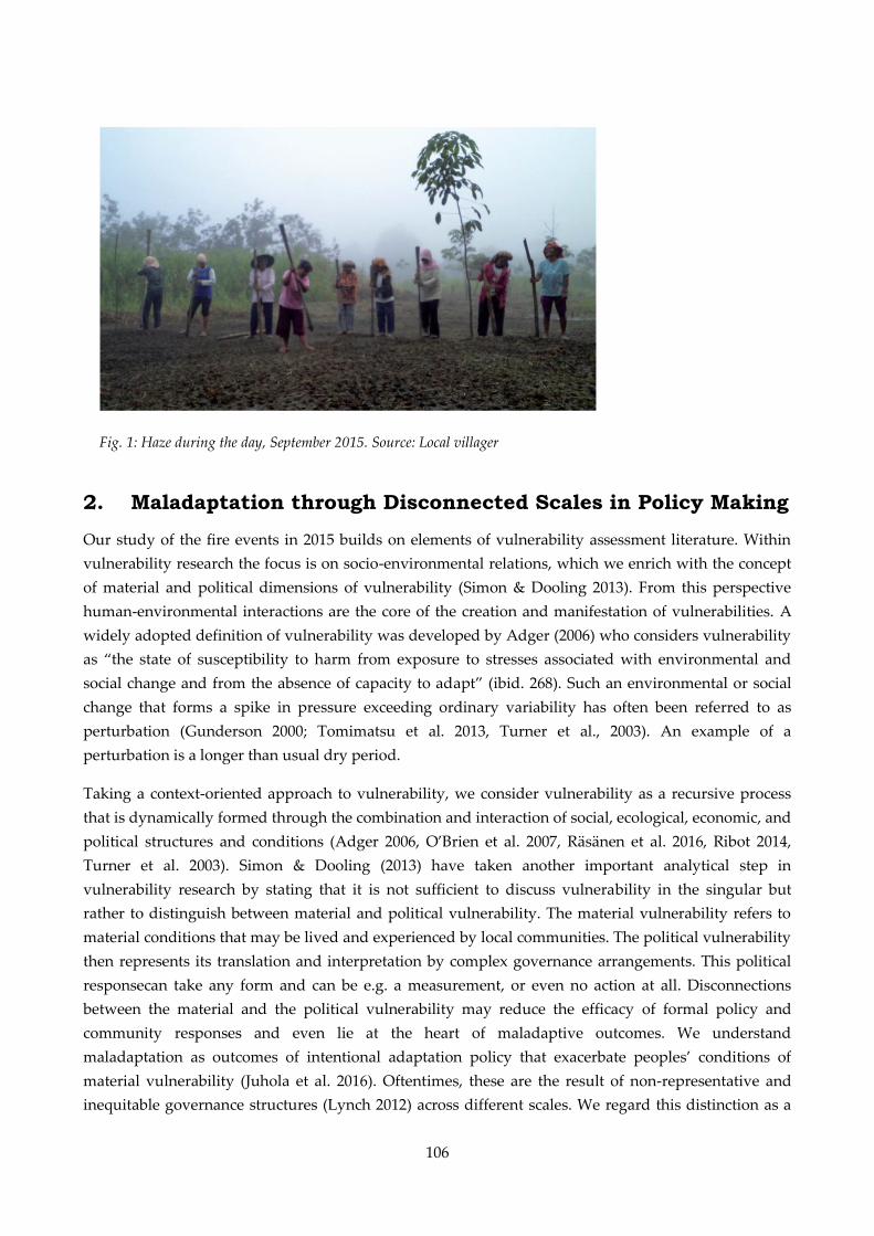
106
2. Maladaptation through Disconnected Scales in Policy Making
Our study of the fire events in 2015 builds on elements of vulnerability assessment literature. Within
vulnerability research the focus is on socio-environmental relations, which we enrich with the concept
of material and political dimensions of vulnerability (Simon & Dooling 2013). From this perspective
human-environmental interactions are the core of the creation and manifestation of vulnerabilities. A
widely adopted definition of vulnerability was developed by Adger (2006) who considers vulnerability
as “the state of susceptibility to harm from exposure to stresses associated with environmental and
social change and from the absence of capacity to adapt” (ibid. 268). Such an environmental or social
change that forms a spike in pressure exceeding ordinary variability has often been referred to as
perturbation (Gunderson 2000; Tomimatsu et al. 2013, Turner et al., 2003). An example of a
perturbation is a longer than usual dry period.
Taking a context-oriented approach to vulnerability, we consider vulnerability as a recursive process
that is dynamically formed through the combination and interaction of social, ecological, economic, and
political structures and conditions (Adger 2006, O’Brien et al. 2007, Räsänen et al. 2016, Ribot 2014,
Turner et al. 2003). Simon & Dooling (2013) have taken another important analytical step in
vulnerability research by stating that it is not sufficient to discuss vulnerability in the singular but
rather to distinguish between material and political vulnerability. The material vulnerability refers to
material conditions that may be lived and experienced by local communities. The political vulnerability
then represents its translation and interpretation by complex governance arrangements. This political
responsecan take any form and can be e.g. a measurement, or even no action at all. Disconnections
between the material and the political vulnerability may reduce the efficacy of formal policy and
community responses and even lie at the heart of maladaptive outcomes. We understand
maladaptation as outcomes of intentional adaptation policy that exacerbate peoples’ conditions of
material vulnerability (Juhola et al. 2016). Oftentimes, these are the result of non-representative and
inequitable governance structures (Lynch 2012) across different scales. We regard this distinction as a
Fig. 1: Haze during the day, September 2015. Source: Local villager
107
means for pointing out the disconnection between the material and political vulnerability as it enables
the identification of the underlying causes for vulnerability. In this paper, scales are not regarded as
fixed levels or natural entities but as socially constructed (Anssi 2004, Hein et al. 2015). In our case
study we consider the individual, household, provincial, national and global level as relevant.
Perturbations and the impacts of adaptation measurements may arise from one scale and may manifest
themselves in another one.
3. Introduction to the Study Site and Applied Methods
Field research was conducted in the village Seponjen in Jambi province, situated in the south-central
part of the island of Sumatra, Indonesia. An overview of the village’s location is displayed in Figure 1.
Jambi Province was chosen as a research region due to its comparatively rapid agricultural
transformation processes. For the past 30 years, vast forest areas of agroforestry systems have been
converted into oil palm plantations (Clough et al. 2015). In 2016, oil palm plantations extended over
474,000 ha (BPS Provinsi Jambi 2017), and rubber plantations over 664,000 ha (BPS 2017). Staple crop
cultivations (rice, corn, soybean) in 2015 were only grown on 136,000 ha (BPS 2015)
and are increasingly being replaced by more profitable plantation land use systems. The coastal areas in
Jambi province are characterized by vast peat areas (Miettinen et al. 2016). The transformation of peat
swamp forests into land suitable for agricultural purposes accords with the trend in Sumatra, Borneo
and Papua Island. Formerly regarded as marginal agricultural land, peat land has experienced an
increase in exploitation for plantation systems which is accompanied by drainage and degradation
(Carmenta et al. 2017). The scarcity of land in Jambi Province has driven state promoted resettlements
(Kunz et al. 2016), large-scale issuing of concession areas (Kunz et al. 2017) and spontaneous migration
of independent smallholders seeking a better future in the plantation sector (Hein 2016; Kunz 2017).
During the fire events burning from June until October 2015, 123.000 ha of land burned in Jambi
province (World Bank, 2016), which lead to persistently hazardous levels of smoke (Koplitz et al., 2016),
causing an economic damage of 866 million USD. Hereof, 210 million USD account to losses in
agriculture (ibid.). An impression of the fire events in Jambi can be gained from Figure 2, 3 and 4.
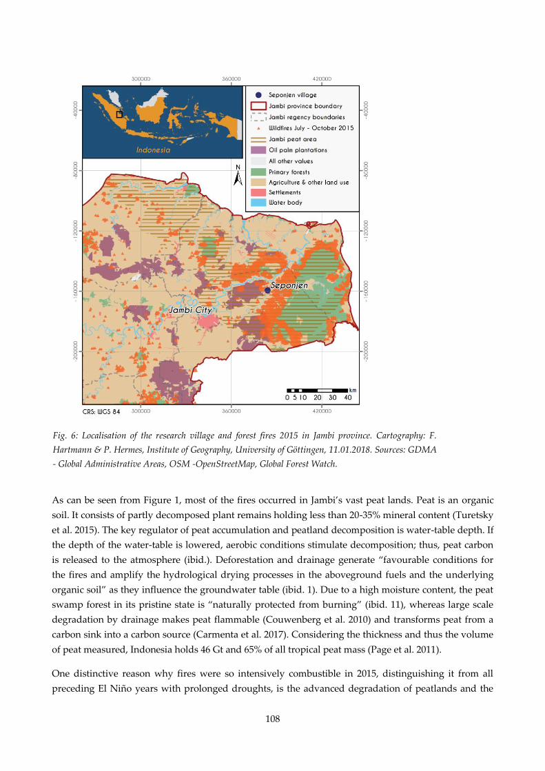
108
As can be seen from Figure 1, most of the fires occurred in Jambi’s vast peat lands. Peat is an organic
soil. It consists of partly decomposed plant remains holding less than 20-35% mineral content (Turetsky
et al. 2015). The key regulator of peat accumulation and peatland decomposition is water-table depth. If
the depth of the water-table is lowered, aerobic conditions stimulate decomposition; thus, peat carbon
is released to the atmosphere (ibid.). Deforestation and drainage generate “favourable conditions for
the fires and amplify the hydrological drying processes in the aboveground fuels and the underlying
organic soil” as they influence the groundwater table (ibid. 1). Due to a high moisture content, the peat
swamp forest in its pristine state is “naturally protected from burning” (ibid. 11), whereas large scale
degradation by drainage makes peat flammable (Couwenberg et al. 2010) and transforms peat from a
carbon sink into a carbon source (Carmenta et al. 2017). Considering the thickness and thus the volume
of peat measured, Indonesia holds 46 Gt and 65% of all tropical peat mass (Page et al. 2011).
One distinctive reason why fires were so intensively combustible in 2015, distinguishing it from all
preceding El Niño years with prolonged droughts, is the advanced degradation of peatlands and the
Fig. 6: Localisation of the research village and forest fires 2015 in Jambi province. Cartography: F.
Hartmann & P. Hermes, Institute of Geography, University of Göttingen, 11.01.2018. Sources: GDMA
- Global Administrative Areas, OSM -OpenStreetMap, Global Forest Watch.
109
ongoing change in land-use. Taufik et al. (2017) link the hydrological drought to the fire-proneness of
the humid tropics in Jambi.
The village Seponjen was selected for our case study due to its proximity to several hotspots of the 2015
fire events. The dominant soil type in the village are peat soils with a depth of up to four metres,
however there are scattered fields on mineral soil or thin peat layers that are already degraded. The
village is populated by different ethnic groups, the native Malay people, immigrated Bugis from
Southern Sulawesi and other migrant groups from Java. The main income for local households is
derived from agriculture. While most farmers focus on oil palm business, some also cultivate maize
which became popular in the village with the arrival of the Bugis people in the late 90s and is still
dominantly grown by them. Illegal logging of nearby peat swamp forest was a major source of income
until the early 2000s. An industrial oil palm plantation concession borders the village; here villagers
offer their labour power (interviews with villagers during February and March 2017).
During a two-month field stay in Jambi province we conducted thirty semi-structured and
unstructured interviews in February and March 2017 with villagers in Seponjen. Interviews were
conducted in Bahasa Indonesia and translated with the help of a field assistant. To acknowledge the
heterogeneity of the village population we interviewed a variety of villagers, from village leader to the
head of customs to common farmers of different ethnicities and landless families. The main topic
discussed during the interviews was the prevailing impacts of the firesto local livelihoods and people’s
adaptation strategies to prevent future fire outbreaks. During the field visit it became apparent that
apart from immediate impacts of the fires, the new provincial regulation on the prevention of forest
and land fires had major impacts on local land management strategies. Hence, these dynamics became
a second and unforeseen topic of research. All interviews were recorded, partly transcribed and
documented in detail. Interview data was further supported by participative observation, photographs
taken by our respondents, as well as a review of government regulations.
4. Results: Ground Perspectives on Perturbations
4.1. The first Perturbation: Immediate Impacts of the Fire
As the agricultural sector is the main income for villagers of Seponjen, economic losses caused by the
fires largely manifested there. This situation was intensified by low crop yield of the forgone months
brought about by the outstandingly long drought. Without exception, all oil palm smallholders
reported their fruits had become trek, an expression that describes the phenomenon when fruits of the
fresh fruit bunches become lighter and smaller. However, the impacts on plantation productivity
differed depending on farmers’ management practices as well as whether plantations were only
impacted by drought and pollution haze or also suffered tree loss due to fire. A lower production was
reported to have had lasted up to three months after the fire incidents. Such losses in income put
smallholders under financial pressure. These circumstances were intensified by extra expenses
mitigating adverse effects of the drought and fires. Additional costs included spending on medical
treatments and clean water for washing, bathing and drinking. Natural water resources, usually
serving these purposes, were polluted by dust and particles, and wells ran dry. The severity with which
110
the income losses affected the households varied widely from simply a shortfall in savings to a need for
actions such as gaining additional income from other sources and cutting expenses. The most popular
method to compensate for the income losses was to gain income as a day labourer on either another
farmers’ or companies oil palm plantations. Along with the endeavour to counterbalance the losses,
cutting on expenses stands to reason. Most popular was cutting down on food costs by a change in
nutrition habits, a reduction in quantity of food and a forego of non-vegetarian sustenance. Further, a
common strategy among parents was to consume less, thereby leaving enough food for their children.
Chemical fertilisers generally required for the management of oil palm plantations were often
intermitted during the 2015 fire events due to their high cost, causing further decreases in productivity
of the palm trees in the following months.
Health issues proceeded from people’s exposure to the pollution haze and smouldering peat which
contained high concentrations of Particulate Matter (PM) with diameters of less than 10 and 2.5 μm,
also referred to as PM10 and PM2.5 (Koplitz et. al 2016). From the beginning of September 2015 until
the end of December the same year, air quality in Jambi’s peatlands regularly reached very unhealthy
or even hazardous levels according to measurements of the Pollutant Standard Index (PSI) (see Crippa
et al. 2016 for more details). Every respondent experienced breathing problems; all experienced sore
eyes, some suffered from psychological trauma. Additionally, a decline in water quality lead to several
cases of diarrhoea. Exposure of and sensitivity to the pollution haze and smouldering peat and access
to coping were largely determined by three factors: (1) age (2) time spent exposed to the pollution haze
and (3) economic background. Young and elderly people, as well as those with pre-existing lung or
heart diseases, are a high-risk group as they are particularly susceptible to harm (WHO 2013). The
duration people spent exposed to pollution haze varied, so did awareness and knowledge of associated
health risks. Further, profession and economic background mattered as different occupations involve
outdoor activities, such as being a farmer. As most people of Seponjen are farmers they were under
economic necessity to work on their fields and plantations or to guard them, thus enduring exposure to
pollution haze. Given the fact that economic resources determine the amount of money available for
quality construction materials, people with less financial capital tend to live in houses made of wood
compared to wealthier people living in houses made of concrete. These types of houses differ strongly
in their efficiency to exclude outdoor air as the houses made of wood have a high number of interstices
between the wooden boards forming the walls and the floor. Less tangible is the phenomenon of
psychic trauma, which were relived in cases where people had experienced losses caused by burnings
of their fields and plantations in previous times. Hence, the individual’s exposure and sensitivity
towards perturbations varied.
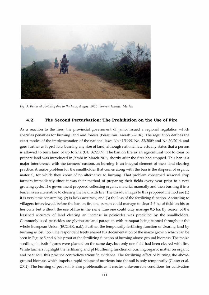
111
Fig. 3: Reduced visibility due to the haze, August 2015. Source: Jennifer Merten
4.2. The Second Perturbation: The Prohibition on the Use of Fire
As a reaction to the fires, the provincial government of Jambi issued a regional regulation which
specifies penalties for burning land and forests (Peraturan Daerah 2-2016). The regulation defines the
exact modes of the implementation of the national laws No 41/1999, No. 32/2009 and No 30/2014, and
goes further as it prohibits burning any size of land, although national law actually states that a person
is allowed to burn land of up to 2ha (UU 32/2009). The ban on fire as an agricultural tool to clear or
prepare land was introduced in Jambi in March 2016, shortly after the fires had stopped. This ban is a
major interference with the farmers’ custom, as burning is an integral element of their land-clearing
practice. A major problem for the smallholder that comes along with the ban is the disposal of organic
material, for which they know of no alternative to burning. That problem concerned seasonal crop
farmers immediately since it was their method of preparing their fields every year prior to a new
growing cycle. The government proposed collecting organic material manually and then burning it in a
barrel as an alternative to clearing the land with fire. The disadvantages to this proposed method are (1)
it is very time consuming, (2) is lacks accuracy, and (3) the loss of the fertilizing function. According to
villagers interviewed, before the ban on fire one person could manage to clear 2-3 ha of field on his or
her own, but without the use of fire in the same time one could only manage 0.5 ha. By reason of the
lessened accuracy of land clearing an increase in pesticides was predicted by the smallholders.
Commonly used pesticides are glyphosate and paraquat, with paraquat being banned throughout the
whole European Union (ECCHR, n.d.). Further, the temporarily fertilising function of clearing land by
burning is lost, too. One respondent freely shared his documentation of the maize growth which can be
seen in Figure 5 and 6, his proof of the fertilizing function of burning above-ground biomass. The maize
seedlings in both figures were planted on the same day, but only one field had been cleared with fire.
While farmers highlight the fertilizing and pH-buffering function of burning organic matter on organic
and peat soil, this practice contradicts scientific evidence. The fertilizing effect of burning the above-
ground biomass which impels a rapid release of nutrients into the soil is only temporarily (Glaser et al.
2002). The burning of peat soil is also problematic as it creates unfavourable conditions for cultivation
112
on the already nutrientpoor soil in the long term and causes peat oxidation (Dikici & Yilmaz 2006;
Hirano et al. 2014).
In the villagers’ opinion, the law is a heavy burden for smallholders and highly impracticable. Out of
fear, the majority of the respondents stated they will, nevertheless, obey. Well known is the case when a
farmer of a neighbouring village used fire to clear his land, whereupon he was sought by the police but
ran off. His land became state property. In spite of this story, some villagers admitted planning to burn
secretly due to a lack of alternatives. In general, opinions on the law among the villagers interviewed
were deeply divided.
In 2014, Seponjen was the largest maize production site in the district Muaro Jambi (interviews with
villagers during February and March 2017). Where the land for maize cultivation, carried out primarily
by Bugis farmers, must be absolutely clear and follow a strict schedule as it can only be planted once a
year in Seponjen, oil palm smallholders are more flexible in their proceeding and the oil palm’s
requirements concerning the clearness of the land are lower. An advantage of burning land is the
rapidity and thoroughness which cannot be achieved via manual weeding. The timeslot when maize
seedlings have to be planted is very short. Usually, cultivation starts in May when the annual flooding
is over. If weeds are cut manually and planting is then postponed, the harvest may fail as monsoon
starts and the fields are frequently inundated. Hence, it is not just the accuracy in land clearing that is a
major problem for maize cultivation but the timing which is gravely hampered by the ban on fire. As
explained by some farmers, this is a reason why the ban might have an influence on crop choice and
even trigger land-use change from maize to oil palm. Another concern about a side effect of the law
were raised by some interviewees. Attempts in cultivating maize despite the given circumstances or the
transformation of maize fields to fallow land might lead to an increase in available organic fuel which
plays an essential role in the uncontrolled spread of fires.
After the reinforcement of the ban in 2016, around 20 people cultivated 60 ha of maize. Prior to the ban,
about 80 people cultivated 200 ha maize. These numbers only refer to maize farmers organised in
farmer groups who may apply for free seedlings from the local government. At the time of our research
in March 2017 one farmer group of Seponjen had already withdrawn their proposal for maize
seedlings, as it was likewise considered by another farmer group. Individuals had already resigned
from maize farmer groups. Other farmers wanted to wait and see whether the prohibition of burning
land would be altered again in the coming season and, if the prohibition was unchanged, stop
cultivating maize. It is expected that the land formerly used for maize cultivation is either transformed
to fallow land or changed to another crop like the oil palm. A change to another seasonal crop like
watermelon or pineapple with less organic waste production is not an option as knowledge on how to
cultivate other crops and profitable land use options is not a given. Other crops are rarely cultivated as
there is a long history of private and state-owned oil palm companies in Jambi where farmers often
received training. Also, farmers would incur high investment costs for other seedlings as maize
seedlings are governmentally funded for members of farmer groups, although these costs vary
depending on seedling and fertilizer quality chosen.
Similarly to the impact of the first perturbation, villagers are affected differently. The degree to which
the law disadvantages smallholders is explained in the village’s specific cropping pattern. Especially
113
affected are maize farmers, more precisely the ethnicity of the Bugis as they are the main maize
cultivators in Seponjen. Hence, the law causes unintended dynamics leaving foremost maize farmers,
and thus most Bugis the worst off.
5. Discussion
So far, analysis of the ecological, economic and health impacts of the fires 2015 remained on a national
or regional scale (World Bank 2016, Lee et al. 2017, Crippa et al. 2016), leaving a blind spot on how the
impacts manifested themselves on the ground. The drying of peat soil has been associated with the
creation of conditions that favour the spread of fires (Turetsky et al. 2015, Couwenberg et al. 2010), but
has not yet been considered with regard to fire policy. Only with the knowledge of both an
understanding of the changes the law brings about in the village and an awareness of characteristics of
peat soil can the significance of the ban become clear and demonstrates how it fails to address the
underlying causes for the outbreak of fires. To reiterate, a combination of influences out- and inside the
village area, namely the expansion of oil palm monocultures on peat land caused the degradation of
peat swamp through drainage, fostered by, among others, the Indonesian national government due to
land scarcity and a growing global demand in palm oil. Private plantations in Seponjen and an oil palm
concession bordering the village on peat soil are an outcome of these influences. These conditions
created on the local scale an environment that favoured the outbreak of fires, as dry peat is easy
flammable. The dryness of the peat is intensified by the phenomenon El Niño which manifested itself
as a prolonged drought. These changed environmental conditions are the Material Vulnerability in
Figure 7. How the twofold perturbation of the fire crises in 2015 is fostered by and connected to
influences out- and inside the village is depicted in Figure 7. This figure is a timeline connecting a
simplification of the events on the household/individual scale to the local and provincial/national and
global scale. The arrows connect the different events, the arrow’s line informs about the quality of the
scales’ connectedness. Whereas an unbroken line illustrates a high level of connectedness, a broken line
indicates inconsistencies. If an ideal connectedness is a given, the political translation of the material
vulnerability meets the aim to reduce vulnerabilities, hence the material vulnerability is mitigated.
In consideration to the given evidence, it is apparent that the major cause making land prone to fires –
the sinking ground water table through drainage – is not corrected by the regulation on not burning
organic matter on land. Thus, the fires arethe driver of the first perturbation the local population went
through. This first perturbation is the direct cause for the Material Vulnerability at the household and
individual scale which manifested themselves as the explained adverse effects.
The reaction on the regional scale the ban on the use of fires as a political translation of the material
vulnerability is highly disconnected from the local reality. The ban does not tackle the changes that
made the land so prone to fires – the sinking ground water table in peat lands through drainage. It is
clear that without any kind of compensation or further assistance the ban is highly impractical, hence it
is titled as a second perturbation to the villagers as it brings about adverse impacts on their income and
makes them more susceptible to economic shocks. A further consequence of the ban is its potential to
drive the change from seasonal crops to oil palm. However, this change does not provide a solution to
all the villagers’ problems as it is not financially viable for everyone and the pressing issue of the
114
disposal of organic matter is not eliminated but adjourned. Maize farmers in particular are hindered by
the regulation as their organic disposal comes in high quantities. If the ban on fire is to be successful,
the needs of the people on the local scale must be addressed as there is currently no known alternative
in land clearing methods. The potential magnitude of future fires is also affected by the varying
acceptance of the ban among the villagers. While some plan to obey, others state they will ignore the
law as they recognise no danger in burning their land beyond the disadvantages associated with the
regulation. Exactly here lies a danger. If the ban is obeyed only by a few people, more dried organic
matter remains on the fields or fallow land which is, in case of an uncontrolled fire, easily flammable
fuel.
Hence, vulnerability has increased in terms of (1) susceptibility to economic shocks for the local people
and (2) susceptibility to fire due to an increase of available fuel. As the ban also fails in tackling root
causes that make the land so prone to fire, the ban on fire-clearing as an agricultural tool is a
maladaptation.
6. Conclusion
The reality at the local level, and policy making on the national level, are highly disconnected in terms
of the Indonesian fires of 2015. Further, the roots of components of the complex set of factors that make
Indonesia so prone to fires are inscribed in its recent past. Identification of the dynamics on different
scales that have created and will create the current and future situation offers an answer to some whys
and hows of Indonesia’s fire problem.
The next El Niño phenomenon will certainly happen, and the frequency of the occurrence of extreme El
Niño events is predicted to increase due to global warming (Cai et al. 2015). Thus, the Indonesian fire
issue is even more pressing. An avoidance of a repetition of the Indonesian fires 2015 is of global
significance, as the impact’s scope reaches everyone, may it be through positive radiative forcing,
economic losses or adverse health effects. However, a ban on fire as an agricultural tool is not the
ultimate solution. The given example of a two-fold perturbation shows that the discourse in
vulnerability is in need of political approaches that recognize how vulnerabilities arise due to a
disconnection of local realities and political measurements, as well as how vulnerabilities are created
that constitute the initial situations prone to perturbations.
Acknowledgements
This study is part of the Collaborative Research Center 990 'Ecological and Socioeconomic Functions of
Tropical Rainforest Transformation Systems in Sumatra, Indonesia' (EFForTS) funded by the German
Research Foundation (DFG). We are grateful to the many people who have contributed in a variety of
ways to this study. We particularly extend our sincere thanks to our diligent field assistant Winda
Januarista and to all interviewees who generously contributed valuable time and information.

115
CHAPTER VI:
Transnational climate mitigation action in tropical peatlands – implications for smallholder farmers in Indonesia
Merten, J., Nielsen, J. Ø., Rosyani, Faust, H.
Abstract
Peatlands constitute a major terrestrial carbon sink while peat drainage and fires constitute a major
source of global greenhouse gas emissions. Formerly considered non-productive lands that need to be
drained for the purpose of agricultural production, the protection and restoration of peatlands have
recently turned into a major topic in global climate mitigation policies. In particular, tropical peatlands
have been targeted by transnational climate action. Little research, however, has investigated how
efforts to mitigate greenhouse gas emission from peatlands materialize at the local level and which
consequences this entails for the local population. We present insights on this from the coastal
peatlands in Jambi province (Sumatra, Indonesia) and use a climate justice lens to evaluate local
impacts. We show how in Jambi an increasingly transnational network of state and non-state actors has
initiated multiple policies and projects targeting more “sustainable” and “climate-friendly” land use
practices on peatlands. However, as these ambitions materialize in new laws, policy programs and land
use agreements, local land use rights are reconfigured, gradually limiting local people’s livelihood
strategies and reducing their capabilities to benefit from their natural resources. Despite the
propagation of “win-win” solutions for more sustainable land use, we show how local communities in
our case study area lack the opportunity to contribute their perspectives on desirable future
developments and are not able to benefit from the proposed low carbon development paths. Instead,
local communities increasingly are expected to carry the burden of global climate change mitigation.
This occurs through the threefold assignment to protect forests, prevent fires and help restoring
degraded peatlands.
Key words: peatlands; climate justice; climate change mitigation; peat restoration; community based forestry;
peat fires; Indonesia;
Planned for submission in: Mitigation and Adaptation Strategies for Global Change
116
1. Introduction
Peatlands cover only about 3-5% of the Earth’s surface, yet store about 30% of global terrestrial carbon
stocks (Murdiyarso et al. 2019). The degradation of peatlands through fire and drainage is expected to
contribute at least 2 gigatons CO2-eq./yr. or around 6% of global annual greenhouse gas emissions
(GHGE) (Joosten 2010, Wichtmann et al. 2016, IEA 2020). This may comprise 12–41% of the GHG
emission budget for keeping global warming below +1.5 to +2 °C (Leifeld et al. 2019). Unsurprisingly,
the protection and restoration of peatlands has become a central topic in transnational climate
mitigation policies. This development presents a major paradigmatic shift for peatland management.
Used for agricultural production for centuries, today around 60% of peatlands in Europe are drained
(Joosten et al. 2017). In the tropics, large-scale agricultural development of peatlands is a more recent
phenomenon closely connected to the expansion of agro-industrial plantations for the production of
global commodities (Miettinen et al. 2016, Schoneveld et al. 2019, Olsson et al. 2019, Hein 2019).
Estimates suggest that without political intervention, tropical peatland conversion could increase by
another 11.6 million hectares and thus dominate global GHGE from peatlands (Leifeld et al. 2019).
Multiple studies thus propose to halt this trend (Page et al. 2011, Hooijer et al. 2012, Miettinen et al.
2012, Miettinen et al. 2017b, Leifeld and Menichetti 2018).
While estimates vary across studies, Page et al. (2011) calculated Indonesia to host almost 50% of
tropical peatlands. In particular, the expansion of oil palm and pulpwood plantations on peatlands has
contributed to Indonesia being the largest global GHG emitter from peatlands (Joosten 2010, Olsson et
al. 2019). The first national policies for GHGE reduction from peatlands were introduced under
president Yudhoyono (2004-2014) but it was the extremely dry El Niño year of 2015 that brought the
peatlands of Indonesia widespread international attention. Just before global climate negotiations in
Paris in 2015, large-scale peat and forest fires caused severe environmental pollution, health problems
and more daily GHGE than the entire US economy (van der Werf 2015, Harris et al. 2015, Hartmann et
al. 2018, Meijaard 2018). Peat protection and restoration became therefore a major target within
Indonesia’s national climate strategy and has been strongly supported by transnational networks such
as the Global Peatlands Initiative and the Climate and Land Use Alliance. It has received climate
funding from the US, the UK, and Germany, and civil society organisation like Wetlands International
(UK DFID 2016, UN Environment 2016, Wetlands International 2017, GIZ 2020a, Climate and Land Use
Alliance 2020).
Yet little research has investigated the consequences of such efforts of peat protection and restoration
for local communities living in and around peatlands. Building on qualitative fieldwork and a review
of policy documents, we investigate how such national and transnational climate mitigation policies
influence the regulatory framework for peatland governance in Indonesia and illustrate their social
impacts on the ground. For this purpose, we provide insights from a hotspot of Indonesian peatland
restoration programs, the coastal peatlands of Jambi province, Sumatra. Using climate justice as an
analytical lens we explore how there the burden of global climate change mitigation is redistributed,
involves trade-offs and impacts local people’s livelihoods (Klinsky et al. 2016). Particular attention will
be paid to perspectives of the most vulnerable groups in the study site as these, like vulnerably people
in general, are poorly represented in global climate negotiations (Venn 2019, Walliman-Helmer 2019).
Such analysis is particularly relevant in the Global South where peatlands often constitute so-called
117
resource frontiers. These are characterized by highly dynamic land use systems, complex actor
landscapes and unstable property regimes making them prone to the production of new social
injustices (Peluso and Lund 2011, Sikor et al. 2014, Hein 2019).
The article is structured as follows. First, we reconstruct the emerging role of peatlands in global and
Indonesian climate policy. Second, we provide an overview of the recent climate justice literature and
its critique of the global climate governance framework. We further introduce the capability approach
as an analytical framework for climate justice. Third, we present our methods and then, fourth, turn to
our results. We start with an overview of land use history and challenges in Jambi’s coastal peatlands
and then analyze three recent policies and projects aiming at reducing greenhouse gas emissions from
peatlands. We show how these have been pushed trough transnational actor networks aiming at
supposedly climate-friendly land use systems and present local people’s perspectives as well as
evaluations of these interventions. We discuss our insights using the capability approach to evaluate
justice implications of these different climate mitigation projects and policies. We round off with a
conclusion.
2. Background: peatlands in global and Indonesian climate policy
Peatlands have long been regarded as unproductive land (Maltby 2009). This perspective on peatlands
slowly started to change in the 1970s. In 1971, the Ramsar Convention on Wetlands of International
Importance recognized, for example, the important role of wetlands for biodiversity. In the mid-1980s,
peatlands were then also recognized to provide important ecosystem services such as water regulation
and flood retention (Maltby 2009). Initial efforts of protecting peatlands, however, mainly focused on
natural, un-drained peatlands. The recognition of peatlands as an important global carbon stock in the
past two decades changed this, expanding political ambitions towards peat protection and restoration
of drained peatlands under agricultural usage (Joosten, pers. com. November 24, 2019).
The integration of peatlands into global and national climate mitigation policies is a very recent and
ongoing process. In 2011, Susan Page famously published a paper emphasizing the importance of
including the tropical carbon pool in national and regional GHG assessments. Tropical peat, she
estimated, would cover around 11% of global peatland area but 18–25% of the global peat volume, with
Indonesia hosting 65% of this alone. As tropical peatlands are estimated to have carbon contents
between 50-60% (Neuzil 1997, cit. in Page 2011), drainage which leads to peat oxidation, and peat fires
are considered major sources of GHGE (Page et al. 2011, Hooijer et al. 2012, Carlson et al. 2015).
Common IPCC guidelines for the reporting and monitoring of GHGE from peatlands were first
released in 2013 (Moomaw et al. 2018).
2015 presented a major turning point in climate mitigation policies concerning peatlands, in particular
tropical peatlands. Under extremely dry condition caused by El Nino and spurred through the
extensive degradation of peatlands, the 2015 fires resulted in the burning of about 26,000 km² of
peatlands across Indonesia causing large amounts of GHGE (Medrilzam et al. 2017). The fires
heightened media, political and scientific attention to GHGE from peatlands and turned peatlands into
118
an important topic at the 2015 Paris Conference of the Parties (COP) to the United Nations Framework
Convention on Climate Change (UNFCCC). In the following, multiple state and non-state actors
engaged in the development of climate mitigation action through peatland protection and restoration.
The Global Peatlands Initiative founded at COP 22 in Marrakech in 2016 is an example of this
(www.globalpeatlands.org). Simultaneously numerous scientific studies as well as NGO reports called
attention to the role of peatland degradation for global greenhouse gas emissions emphasizing the need
to stop draining peatlands, in particular in the tropics (Greenpeace 2015, Kolka et al. 2016, Osaki and
Tsuji 2016, Wijedasa et al. 2016, Wetlands International and Tropenbos International 2016, Evers et al.
2017, Miettinen et al. 2017a, Miettinen et al. 2017b).
Indonesia was among the first countries to commit to reducing GHGE from peatlands. Peatlands were
included in the first Indonesian declaration on emission reduction targets published in 2011 (President
of the Republic of Indonesia 2010). A moratorium on the granting of new concessions on peatlands was
decided the same year and peatland restoration as well as fire prevention were listed as important
strategies for emission reduction under provincial REDD+ strategies (PerPres 61-2011, InPres 10-2011,
Perbatakusuma et al. 2013). Yet, these initiatives often showed limited effects on the local level. The
large-scale peat and forest fires in 2015 largely changed this. Submitted during the height of the fires
(September 24, 2015), the Indonesian Intended Nationally Determined Contributions (INDC) to the
UNFCCC announced the prioritization of the forest and land use (FOLU) sector in the national
emission reduction targets (Republic of Indonesia 2015). At his speech in Paris, the Indonesian
president, moreover, announced the plan to establish a peat restoration agency for the first time (BRG –
Badan Restorasi Gambut) (President of the Republic of Indonesia 2015), which was then founded
following a presidential regulation issued on January 6, 2016 (PerPres 1-2016). In the following year, the
Indonesian government revised its regulation on the protection and management of peatlands (PP 57-
2016) and developed a national plan to restore 2 million ha of peatlands in November 201614
(BRG
2016). At the same time national and regional governments in Indonesia further revised and
strengthened their policies on the prevention and control of fires (InPres 11-2015, PerMen LHK 32-2016,
PerDa Provinsi Jambi 2-2016) and elaborated a development plan for a national strategy for fire
prevention (Medrilzam et al. 2017). In total, the Indonesian government pledged that the FOLU sector
should account for 87% of the national emission reduction target of the 2020 target and 60% of the 2030
target (Masripatin 2017). As peat decomposition and peat fires alone were estimated to cause 47% of the
positive GHGE emission of the FOLU sector in 2016, peatland restoration together with forest fire
control therein are to achieve an emission reduction of 230,000 Gg CO2e (Masripatin 2017, Sugardiman
2018). In addition to fire prevention and peatland restoration these emission reduction targets are to be
achieved through halting deforestation, afforestation or reforestation, and ensuring a more sustainable
forest management, for example through the development of social forestry programs (Perbatakusuma
et al. 2013, Direktorat Jenderal Pengendalian Perubahan Iklim 2018). Implementation of all of these
policies focuses on specific key provinces with particular rapid peatland conversion, including Riau,
South Sumatra, Kalimantan, and our case study region Jambi province.
14 Later this target was increased to 2,49 million ha which should be restored until 2020 (BRG 2019).

119
These and other measures are expected to be strongly supported through international climate finance.
In its nationally determined contribution to the Paris Agreement (NDC), Indonesia pledged to reduce
its national GHGE by an additional 12% by 2030 conditional upon international support, for example
through REDD+ (Reducing Emissions from Deforestation and Forest Degradation) - a mechanism
aiming to incentivize developing countries to reduce deforestation or maintaining carbon sinks through
payments by developed countries (Republic of Indonesia 2016, Masripatin 2017). REDD+ alone is
considered to have the potential to reduce land-based emissions by up to 70% (Masripatin 2017). While
the Indonesian government to date has only received few payments for results-based emission
reductions (Jong 2020) it receives much international financial support in form of policy or project
development and capacity building (Masripatin 2017). These are funded through bilateral agreements
with countries such as Norway, Japan, Korea, and Germany as well as with international conservation
organizations and the private sector (ibid.). Moreover, individual countries, such as the US, England,
the UK, Japan, Germany, and the Netherlands have pledged to support specific Indonesian climate
mitigation policies such as peatland restoration and fire prevention through their national climate
funds (UK DFID 2016, Hansson and Dargusch 2018, GIZ 2020a). Multiple other REDD+ projects, such
as social forestry schemes, are funded by the private sector and civil society organisations (Fisher et al.
2018, Enrici and Hubacek 2018, Hein 2019, Shahab 2019).
3. Conceptual framework: justice in the global climate regime
Justice has been a key concern of global climate negotiations since the very beginning in the early 1990s.
The UNFCCC guiding principle of “common but differentiated responsibilities and respective
capabilities” reflects this (Art. 3, UNFCCC 1992). The implementation of the UNFCCC framework has,
however, repeatedly been criticized for not operationalizing justice sufficiently and for making very
limited attempts to address global inequality (Okereke and Conventry 2016, Venn 2019). Climate justice
scholars have repeatedly taken issue with the strong link between climate change, vulnerability,
poverty and marginalization (Schroeder 2010, Raleigh 2010, Shue 2014, Smith and Rhiney 2016,).
Despite hardly contributing to global climate change (Hickel 2020), vulnerable people and countries are
often particularly strongly impacted by climate change, while at the same time being excluded from
decision-making processes in global climate politics (Venn 2019, Walliman-Helmer 2019).
The shift towards a voluntary climate governance framework with the Paris Agreement has raised
additional justice concerns. Such concerns are particular raised with regard to distributive justice,
which is concerned with the rules that govern a just distribution of social, political, economic, and
environmental goods and bads (Schlosberg 2007). By moving away from legally binding emission
reduction targets global climate mitigation policies have been criticized for weakening former rules
regarding a just distribution of the climate burden (Okereke and Coventry 2016, Falkner 2019).
Contrary to the Kyoto Protocol, national voluntary commitments to the Paris Agreement are not
negotiated internationally and no framework to assess these in terms of equity exist (Okereke and
Coventry 2016, Falkner 2019). On the one hand, this voluntary regime, it has been argued, has resulted
in increasing bargaining and pressure on developing countries to reduce their emissions (Hurrel and
Sengupta 2012, Ciplet 2015, Okereke and Coventry 2016). Developing countries have indeed been

120
found to commit to ambitious climate action but without subsequently receiving sufficient
technological and financial assistance to realize this (Hurrel and Sengupta 2012, Ciplet 2015, Okereke
and Coventry 2016, Falkner 2019). Such a climate regime might therefore result in negative impacts on
vulnerable communities in particular in case their perspectives are not sufficiently recognized and
represented in the development of national climate strategies (Venn 2019, Walliman-Helmer 2019). A
lack of recognition and the resulting inequitable participation in political processes are considered key
underlying conditions for injustices in the distribution of the global climate burden (Schlosberg 2007).
On the other hand, justice scholars have raised concerns about the legally non-binding nature of the
NDCs and a lack of common emission reporting requirements. Together, this may result in a mere
“’ambition’ rhetoric” (Okereke and Coventry 2016: 9) resulting in continuously increasing emissions
and thereby further impacting climate vulnerable communities (Falkner 2016, Schoeneveld et al. 2016,
Schneider et al. 2019, Rowan 2019).
There is hence a need to analyze the justice implications of post Paris climate mitigation action. In order
to evaluate justice in specific climate policies, the capabilities approach developed by Sen and
Nussbaum has been proposed (Schlosberg 2012, Forsyth and Sikor 2013, Ribot 2014, Klinsky et al. 2016).
The capability approach argues that just arrangements should be judged not only in distributive terms,
but also in how those distributions affect people’s well-being (Schlosberg 2012). Well-being therein is
conceptualized in terms of people’s capabilities, which constitute the actions or opportunities (=
functionings) that a person can benefit from for their livelihoods (Klinsky et al. 2016). A particular
strength lies in its focus on the question whether people are able to the live the life they value and on
the actual realisability of people’s functionings (Robeyns 2005). A capability thus does not only require
a person to posses certain resources, it also requires that a person has access to the personal, social,
environmental conversion factors necessary to actually benefit from the resources (Robeyns 2005,
Forsyth and Sikor 2013). Therein the capability approach represents a pluralistic and open conception
of justice. It is clearly concerned with distributive justice, yet also encompasses recognition and
procedural justice, as both are necessary to turn functionings into capabilities (Schlosberg 2012, Ribot
2014, Klinsky et al. 2016). It is this outcome-oriented focus of justice that is considered particularly
useful in the assessment of the effectiveness of specific climate policies (Walker 2009, Schlosberg 2012,
Ribot 2014, Klinsky et al. 2016,). In conclusion, the capability approach thus asks “what it is that either
enables or interrupts a living system in its ability to transform primary goods […] into functionings”
(Schlosberg 2007: 30-31).
Applying the capability approach to analyze justice implications of climate mitigation policies requires
interrogating the following aspects. First, it needs to question whether people have the political
opportunity to contribute their perspectives on the development of low-carbon development pathways
(Robeyns 2005, Schlosberg 2012, Forsyth 2015, Klinsky et al. 2016). It then needs to assess if and how
climate mitigation action reduces or enhances the people’s capabilities (Klinsky et al. 2016). Truly just
climate policies, as Klinsky et al. (2016) argue, should not only achieve to prevent the reduction of
capabilities but also a just distribution of the benefits and actions aiming at a low carbon development
(see also Pottier et al. 2017). Finally, a capability approach to justice demands also that climate politics
pursue strong mitigation action in order to prevent the reduction of capabilities due to climate change
(Klinsky et al. 2016).
121
4. Methods
A first short field visit to Jambi’s peatlands took place in September 2015. In depth, qualitative field
research was then conducted by the first author in 2017 (March-May and December) focusing on the
sub-district of Mendahara Ulu. During the three months stay, qualitative research methods were
applied in three villages located along the Mendahara River. Semi-structured interviews, informal
interviews, participative observation and group discussions were the main methods used. 23 semi-
structured and 40 informal interviews as well as two group discussions with villagers were conducted.
The interview partners were chosen according to snowball and purposive sampling methods (Flick
2016). At the village level, these included government representatives, heads of farmer groups and
other village organizations, farmers of different crops, village elders as well as people that were directly
affected by changes in the local governance regime. Several households were interviewed during
consecutive visits, combining both formal and informal interview situations. Interviews were
triangulated with participative observation, including several visits to villagers’ and companies’
plantations as well as the neighboring protected forest areas. In addition, the first author participated in
a one-day workshop on participative conservation planning in one of the villages.
External perspectives on local developments as well as local and regional policy making were gained
through 11 expert interviews in (sub-)district and provincial capital cities (June 2016 – December 2017).
These interviews involved representatives from academia, civil society organizations, and different
government offices. Finally, the first author participated in two conferences on peat management and
restoration: the RSPO Annual Roundtable meeting in Bali (December 2017) which included a workshop
on peat management, and a conference on climate protection through peat protection organized by
German Ministry for Environment and Nuclear Safety and the Greifswald Mire Centre (October 2018).
Interviews in Indonesia were largely conducted in Indonesian language by the first author and partly
translated into English by a local student assistant. Formal interviews were recorded and transcribed in
Indonesian and together with field notes coded for content using MAXQDA software (Mayring 2000).
An extensive literature review supplemented field work data. To trace and understand regulatory
changes in the peat governance framework at national and regional level in Indonesia, the first author
reviewed a wide array of grey literature including government reports, environmental legislation,
climate policies and other reports as well as websites on the management of peatlands published by the
transnational actors involved in governing Jambi’s peatlands.
5. Results
5.1. Land use history and current challenges
The sub-district Mendahara Ulu is named after the Mendahara River that drains the Sungai Buluh peat
dome (Fig. 1). With a history of roughly 13,400 years of peat development and peat depths of more than
9 m, the Sungai Buluh peat dome is considered a global tropical carbon sink and has been designated a
pilot area for peat restoration (Hapsari et al. 2017).
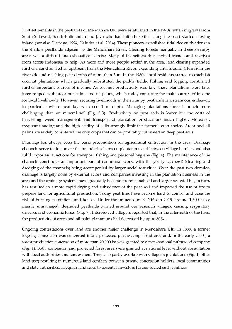
122
First settlements in the peatlands of Mendahara Ulu were established in the 1970s, when migrants from
South-Sulawesi, South-Kalimantan and Java who had initially settled along the coast started moving
inland (see also Claridge, 1994, Galudra et al. 2014). These pioneers established tidal rice cultivations in
the shallow peatlands adjacent to the Mendahara River. Clearing forests manually in these swampy
areas was a difficult and exhaustive exercise. Many of the settlers thus invited friends and relatives
from across Indonesia to help. As more and more people settled in the area, land clearing expanded
further inland as well as upstream from the Mendahara River, expanding until around 4 km from the
riverside and reaching peat depths of more than 3 m. In the 1980s, local residents started to establish
coconut plantations which gradually substituted the paddy fields. Fishing and logging constituted
further important sources of income. As coconut productivity was low, these plantations were later
intercropped with areca nut palms and oil palms, which today constitute the main sources of income
for local livelihoods. However, securing livelihoods in the swampy peatlands is a strenuous endeavor,
in particular where peat layers exceed 1 m depth. Managing plantations there is much more
challenging than on mineral soil (Fig. 2-3). Productivity on peat soils is lower but the costs of
harvesting, weed management, and transport of plantation produce are much higher. Moreover,
frequent flooding and the high acidity of soils strongly limit the farmer’s crop choice. Areca and oil
palms are widely considered the only crops that can be profitably cultivated on deep peat soils.
Drainage has always been the basic precondition for agricultural cultivation in the area. Drainage
channels serve to demarcate the boundaries between plantations and between village hamlets and also
fulfil important functions for transport, fishing and personal hygiene (Fig. 4). The maintenance of the
channels constitutes an important part of communal work, with the yearly cuci parit (cleaning and
dredging of the channels) being accompanied by larger social festivities. Over the past two decades,
drainage is largely done by external actors and companies investing in the plantation business in the
area and the drainage systems have gradually become professionalized and larger scaled. This, in turn,
has resulted in a more rapid drying and subsidence of the peat soil and impacted the use of fire to
prepare land for agricultural production. Today peat fires have become hard to control and pose the
risk of burning plantations and houses. Under the influence of El Niño in 2015, around 1,500 ha of
mainly unmanaged, degraded peatlands burned around our research villages, causing respiratory
diseases and economic losses (Fig. 7). Interviewed villagers reported that, in the aftermath of the fires,
the productivity of areca and oil palm plantations had decreased by up to 80%.
Ongoing contestations over land are another major challenge in Mendahara Ulu. In 1999, a former
logging concession was converted into a protected peat swamp forest area and, in the early 2000s, a
forest production concession of more than 70,000 ha was granted to a transnational pulpwood company
(Fig. 1). Both, concession and protected forest area were granted at national level without consultation
with local authorities and landowners. They also partly overlap with villager’s plantations (Fig. 1, other
land use) resulting in numerous land conflicts between private concession holders, local communities
and state authorities. Irregular land sales to absentee investors further fueled such conflicts.
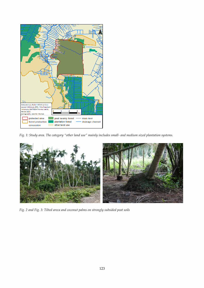
123
Fig. 1: Study area. The category “other land use” mainly includes small- and medium sized plantation systems.
Fig. 2 and Fig. 3: Tilted areca and coconut palms on strongly subsided peat soils
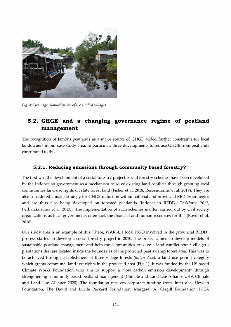
124
Fig. 4: Drainage channel in one of the studied villages.
5.2. GHGE and a changing governance regime of peatland
management
The recognition of Jambi’s peatlands as a major source of GHGE added further constraints for local
landowners in our case study area. In particular, three developments to reduce GHGE from peatlands
contributed to this.
5.2.1. Reducing emissions through community based forestry?
The first was the development of a social forestry project. Social forestry schemes have been developed
by the Indonesian government as a mechanism to solve existing land conflicts through granting local
communities land use rights on state forest land (Fisher et al. 2018, Resosudarmo et al. 2019). They are
also considered a major strategy for GHGE reduction within national and provincial REDD+ strategies
and are thus also being developed on forested peatlands (Indonesian REDD+ Taskforce 2012,
Perbatakusuma et al. 2013,). The implementation of such schemes is often carried out by civil society
organizations as local governments often lack the financial and human resources for this (Royer et al.
2018).
Our study area is an example of this. There, WARSI, a local NGO involved in the provincial REDD+
process started to develop a social forestry project in 2010. The project aimed to develop models of
sustainable peatland management and help the communities to solve a land conflict about villager’s
plantations that are located inside the boundaries of the protected peat swamp forest area. This was to
be achieved through establishment of three village forests (hutan desa), a land use permit category
which grants communal land use rights in the protected area (Fig. 1). It was funded by the US based
Climate Works Foundation who aim to support a “low carbon emission development” through
strengthening community based peatland management (Climate and Land Use Alliance 2019, Climate
and Land Use Alliance 2020). The foundation receives corporate funding from, inter alia, Hewlett
Foundation, The David and Lucile Packard Foundation, Margaret A. Cargill Foundation, IKEA
125
foundation, Ford Foundation as well as public funding from Norway’s International Climate and
Forest Initiative (Climate Works Foundation 2020).
In 2018 the last of these three village forest was legally established. While members of WARSI were
proud about this achievement and argued that the village forest permit had improved the
communities’ land rights, the villager’s perspectives were a different one. The new land use permit
only included the right to use ecosystem services, for example through the development of tourism or
the harvesting of non-timber forest products such as honey. Previous activities such as logging or the
cultivation of plantation crops was forbidden. Already existing plantations were tolerated for the
current plantation cycle, however, maintaining drainage channel was, as elsewhere in the forest,
forbidden immediately. Most villagers thus did not see much benefit in these new land permits and
complained about heavy land use restrictions. A villager expressed his surprise as follows:
We can plant whatever we want, but we cannot cut the wood. How then should the plants grow?
If they are planted under the dense cover. [...] And especially if we are not allowed to dig
drainage channels, to make the water flow out, how should they live?” (former village head, May
3, 2017)
Others got angry about the land use restrictions on their existing plantations:
Please, have a protection forest; [...] there is nothing wrong about it. But what is already there [the
plantations] don’t disturb it. [...] The land that my father opened in 1980, the land that I opened, if
they touch it, I am ready to fight. (smallholder farmer owning land inside the protected area, May
24, 2017)
The social forestry project also led to conflicts within the village between those supporting and those
rejecting the project. A farmer who owned land inside the protected forest area explained that he would
not join WARSI’s meetings, as he feared doing so would upset his friends who feared losing their land
due to the village forest project.
These diverging views can partly be explained with a partial and incomplete participation of the
villagers in the project development. Participation in project workshops was often limited to the
elaboration of specific activities inside the forest area with no room to change the land use regulation of
the protected forest area. The suggested benefits of the village forest for many villagers remained
largely opaque. While WARSI praised the use of ecosystem services and non-timber forest products,
the villagers did not really understand the concepts and listed oil and areca palms as ecosystem
services during a workshop visited. Cultivation of these, however, was not allowed under the land use
permit. The lack of knowledge regarding marketable tree products from allowed peatland tree species
and missing market structures for these products resulted in the villagers not taking these land use
options serious. An experimental planting of jelutung trees (a natural rubber variety), for example, by
some was referred to as a mere reforestation strategy (penghijauan) due to the missing market for this
kind of rubber produce. Even villagers proactively engaging in the project remained sceptical about
future income opportunities. Clearly proud to protect a forest of so-called global importance, as they
put it, they invested a lot of work in the establishment of forest boundaries, drainage blocks and
experimental tree plantings (Fig. 5). They benefited from working with the NGO and public authorities
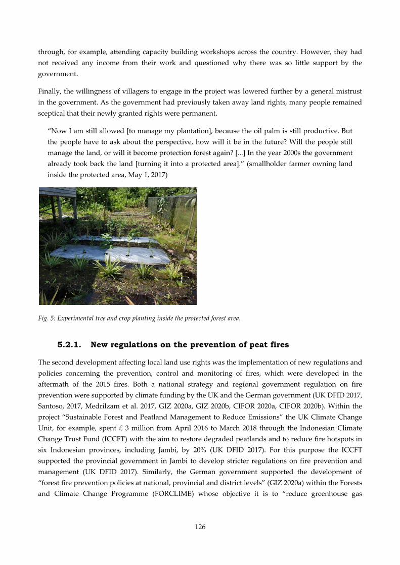
126
through, for example, attending capacity building workshops across the country. However, they had
not received any income from their work and questioned why there was so little support by the
government.
Finally, the willingness of villagers to engage in the project was lowered further by a general mistrust
in the government. As the government had previously taken away land rights, many people remained
sceptical that their newly granted rights were permanent.
“Now I am still allowed [to manage my plantation], because the oil palm is still productive. But
the people have to ask about the perspective, how will it be in the future? Will the people still
manage the land, or will it become protection forest again? [...] In the year 2000s the government
already took back the land [turning it into a protected area].” (smallholder farmer owning land
inside the protected area, May 1, 2017)
Fig. 5: Experimental tree and crop planting inside the protected forest area.
5.2.1. New regulations on the prevention of peat fires
The second development affecting local land use rights was the implementation of new regulations and
policies concerning the prevention, control and monitoring of fires, which were developed in the
aftermath of the 2015 fires. Both a national strategy and regional government regulation on fire
prevention were supported by climate funding by the UK and the German government (UK DFID 2017,
Santoso, 2017, Medrilzam et al. 2017, GIZ 2020a, GIZ 2020b, CIFOR 2020a, CIFOR 2020b). Within the
project “Sustainable Forest and Peatland Management to Reduce Emissions” the UK Climate Change
Unit, for example, spent £ 3 million from April 2016 to March 2018 through the Indonesian Climate
Change Trust Fund (ICCFT) with the aim to restore degraded peatlands and to reduce fire hotspots in
six Indonesian provinces, including Jambi, by 20% (UK DFID 2017). For this purpose the ICCFT
supported the provincial government in Jambi to develop stricter regulations on fire prevention and
management (UK DFID 2017). Similarly, the German government supported the development of
“forest fire prevention policies at national, provincial and district levels” (GIZ 2020a) within the Forests
and Climate Change Programme (FORCLIME) whose objective it is to “reduce greenhouse gas

127
emissions from the forest sector while improving the livelihoods of Indonesia's poor rural
communities” (GIZ 2020b).
Two regulatory changes were of particular relevance for communities in our study area. First, a
complete ban on fire for land clearing and land preparation activities concerned the villagers. In the
past smallholders were allowed to clear land smaller than 2 ha by using fire (UU 32-2009; art. 69-2), but
this was changed by a government regulation prohibiting the use of fire on peatlands (PP 71-2014) and
strengthened further by a new provincial regulation on fire prevention banning fire on any kind of land
(PerDa Provinsi Jambi 2-2016). This complete ban conflicted with traditional practices of land
management. In particular, food crop farmers lamented that fire was necessary to maintain soil fertility:
Here, if you want to plant paddy, because the soil is not fertile, you have to burn it first, the grass.
[…] to decrease the acidity. […] But now, [...] there is the regulation that we are not allowed to
burn the land anymore. (village head, March 28, 2017)
Providing alternative land clearing methods to fire was part of the national and regional regulations,
yet training and infrastructure were hardly provided in the villages visited. A small excavator provided
by the sub-district government promised little relief for the farmers. It could only be rented to each
village every couple of years, was too small to remove larger pieces of wood and could only be used on
areas with overlapping land claims (see Fig. 1). Several interview partners complained about the ban
and recommended that the government should distinguish between fires:
If we gather everything [the wood], we can burn the land. [...] If you want to clear two hectare
land […] then you should clean it [the borders] [...] or make a small channel, so that the fire
cannot pass it. [...] The government only says we cannot use fire [...] But they don't provide us
with the technology. How shall the people make a plantation, if they are not allowed to burn the
land? They should give instructions to the people: this is the way you can burn your land.
(village government representative, May 23, 2017)
Second, they were concerned about the increasing involvement of military and police in the prevention,
monitoring and control of fires (PerMen LHK 32-2016, PerGub Provinsi Jambi 31-2016). The villagers
were generally supportive of a stricter control and prevention of peat fires as the large-scale peat fires
in 2015 had clearly traumatized them. However, the villagers and also key informants interviewed in
Jambi city considered the regulation too repressive. Across the province, public banners announced
that disregarding the ban on fire could result in imprisonments of up to 10 years (Fig. 6). In addition to
law enforcement, the national strategy on fire prevention in fact recommended a strengthening of social
institutions and community participation in fire prevention. Yet, the only form of participation realized
at the village level was the establishment of so-called village fire brigades, whose tasks included
awareness raising, patrolling and reporting fire to the police. Together, the strengthened involvement
of police and military, the heavy punishments and the village brigades resulted in a situation where
people were clearly frightened to start fire:
When the police was not yet involved [...] the people were still brave to burn the land, but since
the police [is involved], they will directly be detained. [...] In the past the police did not have the
authority for that [...] But since 2015, after the big fires here, the police was involved. Now they
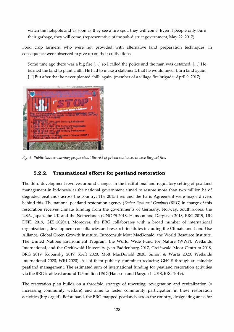
128
watch the hotspots and as soon as they see a fire spot, they will come. Even if people only burn
their garbage, they will come. (representative of the sub-district government, May 22, 2017)
Food crop farmers, who were not provided with alternative land preparation techniques, in
consequence were observed to give up on their cultivations:
Some time ago there was a big fire […] so I called the police and the man was detained. […] He
burned the land to plant chilli. He had to make a statement, that he would never burn land again.
[...] But after that he never planted chilli again. (member of a village fire brigade, April 9, 2017)
Fig. 6: Public banner warning people about the risk of prison sentences in case they set fire.
5.2.2. Transnational efforts for peatland restoration
The third development revolves around changes in the institutional and regulatory setting of peatland
management in Indonesia as the national government aimed to restore more than two million ha of
degraded peatlands across the country. The 2015 fires and the Paris Agreement were major drivers
behind this. The national peatland restoration agency (Badan Restorasi Gambut) (BRG) in charge of this
restoration receives climate funding from the governments of Germany, Norway, South Korea, the
USA, Japan, the UK and the Netherlands (UNOPS 2018, Hansson and Dargusch 2018, BRG 2019, UK
DFID 2019, GIZ 2020a,). Moreover, the BRG collaborates with a broad number of international
organizations, development consultancies and research institutes including the Climate and Land Use
Alliance, Global Green Growth Institute, Euroconsult Mott MacDonald, the World Resource Institute,
The United Nations Environment Program, the World Wide Fund for Nature (WWF), Wetlands
International, and the Greifswald University (van Paddenburg 2017, Greifswald Moor Centrum 2018,
BRG 2019, Kopansky 2019, Kieft 2020, Mott MacDonald 2020, Simon & Warta 2020, Wetlands
International 2020, WRI 2020). All of them publicly commit to reducing GHGE through sustainable
peatland management. The estimated sum of international funding for peatland restoration activities
via the BRG is at least around 125 million USD (Hansson and Dargusch 2018, BRG 2019).
The restoration plan builds on a threefold strategy of rewetting, revegetation and revitalization (=
increasing community welfare) and aims to foster community participation in these restoration
activities (brg.org.id). Beforehand, the BRG mapped peatlands across the country, designating areas for
129
protection (defined as peat deeper than 3m15
) or for cultivation, and identified peatlands with a need of
restoration activities. In Jambi province, peatland needing restoration covered 409,000 ha, or 66% of the
province’s peatland area (BRG 2016). In Mendahara Ulu almost all peatlands were defined as in need of
restoration (Fig. 7).
At the time of research, the restoration work focused on the protected peat swamp forest area, where
canal blocks were installed and paludiculture demonstration plots were established. Paludiculture is an
agricultural system that aims at cultivating traditional peat plants not requiring drainage (Wichtmann
and Joosten 2007, Wichtmann et al. 2016). It is considered the main strategy to increase community
welfare in peatland restoration areas (BRG 2016). A few farmers volunteered to participate investing
many uncompensated working hours but most villagers considered it strange that the restoration
agency wanted people to stop drainage. According to the villagers, drainage increases land
productivity, yet the restoration agency tried to convince them otherwise:
Since I was small I managed plantations, my father, my grandfather and I managed plantations.
There is no story about a crop that would grow without drainage channel. They will not grow in
the water. What should grow there? (village government representative, May 23, 2017)
Some people were open to such trials but admitted that if production would be lower than with
drainage, other villagers would probably not follow their example. A scientist interviewed shared this
concern noting that it was highly uncertain whether paludiculture was a viable income alternative to
existing plantations.
The plan to conduct peatland restoration activities on villager’s land outside the protected forest area
was another source of concern for many villagers. Most of the villagers’ land in the study area is
defined as cultivation zone but should not be drained lower than 40 cm below soil surface. This would
require the closing of large drainage channels used for transportation:
Here, everybody uses small boats; there is nobody who uses a four-wheel drive. So
automatically, if we cannot clean the drainage channels, how shall we get out our plantation
produce? (smallholder farmer, May 24, 2017)
In general, activities by the restoration agency remained ad hoc and not well coordinated. A key
informant involved in the activities argued that state money for the restoration agency had only been
released in the second half of 2017. In consequence, the installation of drainage blocks remained poorly
planned and resulted rather in a redirection of water flows than in their interruption (Fig. 8).
15 In fact, peat soils deeper than 3 m were already classified as protected areas since 1990 (Keputusan Presiden 32-1990).
Despite this and due to a lack of public data on peatlands, deep peat areas were often targeted for economic
development programs by national and regional authorities in the past.
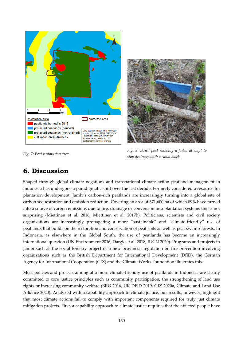
130
Fig. 7: Peat restoration area.
6. Discussion
Shaped through global climate negations and transnational climate action peatland management in
Indonesia has undergone a paradigmatic shift over the last decade. Formerly considered a resource for
plantation development, Jambi’s carbon-rich peatlands are increasingly turning into a global site of
carbon sequestration and emission reduction. Covering an area of 671,600 ha of which 89% have turned
into a source of carbon emissions due to fire, drainage or conversion into plantation systems this is not
surprising (Miettinen et al. 2016, Miettinen et al. 2017b). Politicians, scientists and civil society
organizations are increasingly propagating a more “sustainable” and “climate-friendly” use of
peatlands that builds on the restoration and conservation of peat soils as well as peat swamp forests. In
Indonesia, as elsewhere in the Global South, the use of peatlands has become an increasingly
international question (UN Environment 2016, Dargie et al. 2018, IUCN 2020). Programs and projects in
Jambi such as the social forestry project or a new provincial regulation on fire prevention involving
organizations such as the British Department for International Development (DfID), the German
Agency for International Cooperation (GIZ) and the Climate Works Foundation illustrates this.
Most policies and projects aiming at a more climate-friendly use of peatlands in Indonesia are clearly
committed to core justice principles such as community participation, the strengthening of land use
rights or increasing community welfare (BRG 2016, UK DFID 2019, GIZ 2020a, Climate and Land Use
Alliance 2020). Analyzed with a capability approach to climate justice, our results, however, highlight
that most climate actions fail to comply with important components required for truly just climate
mitigation projects. First, a capability approach to climate justice requires that the affected people have
Fig. 8: Dried peat showing a failed attempt to
stop drainage with a canal block.

131
a political opportunity to contribute their perspectives on the development of low-carbon development
pathways (Schlosberg 2012, Forsyth 2015, Klinsky et al. 2016). Meeting such principles of procedural
justice is not only necessary in terms of guaranteeing a just development, but is also considered crucial
to successfully achieve climate-friendly land use scenarios (UNFCCC 2010, cit. in Enrici and Hubaeck
2018, Minang et al. 2015). Despite this, numerous studies show that projects aiming to reduce land-
based emissions often lack good plans for involving local communities, following instead top-down
project impositions (Bottazzi et al. 2014, Leach and Scones 2015, Fisher et al. 2018, Hein 2019). The case
of peatland conservation and restoration in Jambi mirrors this. Despite opposite visions of development
between communities, who consider drainage and fire a precondition for agricultural activity, and
international donors, who propagate the rewetting of peatlands, few attempts have been made to
reconcile these positions. Although villagers’ needs, for example, were assessed during NGO-led
conservation planning workshops, neither the NGO nor the communities had the power to change the
restrictive land use regulations that strongly limit local land use options. In addition, while villagers
argued for a differentiation of fire types, the promised participation in fire prevention policies mainly
concentrated on policy implementation, such as fire monitoring and extinction. This lacking recognition
of the villager’s perspectives and an inequitable participation in the design of climate mitigation
policies has caused supposedly inclusive policies such as fire prevention or community based forestry
to be misaligned with local needs and aspirations, something other land-based mitigation projects also
suffer from (Bottazzi et al. 2014, Afroz et al. 2016, Corbera and Schroeder 2017, Fisher et al. 2018, Hein
2019,). Instead of empowering local communities, such projects have elsewhere in Indonesia been
analyzed as a means for the state to share the burden of forest protection (Royer et al. 2018), a point also
relevant in our case.
Second, the capability approach demands climate policies to avoid the reduction of capabilities of those
most vulnerable. The explored case of climate mitigation from peatlands, however, suggests that the
exact opposite has happened. The combination of different projects and policies aiming at reducing
GHGE from peatlands in Jambi have resulted in the reconfiguration of local people’s land use rights to
make these correspond with climate mitigation targets and have greatly reduced their capabilities of
benefiting from their land. Securing livelihoods has ever since been a difficult endeavor in the swampy
peatlands of Mendahara Ulu. Limited crop choices, costly plantation management and low
productivities constitute only some of the daily challenges of smallholder peatland farmers there.
Instead of enhancing the capabilities of these people, new climate mitigation projects and policies
further constrain these. A capability, for example securing one’s livelihood, as Sen (1992) emphasized,
requires a person to have access to the personal, social, environmental conversion factors necessary to
benefit from their land. The combined effect of the ban on fire, the prohibition of maintaining drainage
channels inside the protected forest area and also the general mistrust in the national government have
eroded these. Today, many villagers in our study area are concerned about what they should do with
their land as they lack knowledge and the financial as well as technical capacities to adopt alternative
land use practices, not to mention state support to do so. This insecurity is even threatening local food
security. In Mendahara Ulu, as in other parts of Indonesia, a ban on fire together with economic and
environmental risks makes farmers convert their food crop cultivations into perennial tree plantations
(Vel et al. 2016, Hartmann et al. 2018, Merten et al. 2020). Equally, farmers may not be willing to invest
in the management of their plantations, if future land use regulations remain unclear. Instead of being

132
involved in the development of alternative land use scenarios, vulnerable communities are thus
increasingly subjected to state-imposed land use restrictions with their rights being conditional upon
particular forms of livelihood as well as conservation outcomes (Li 2002, Afroz et al. 2016, de Royer et
al. 2018). Land use rights in our case study region are gradually limited. On top of that, the allowed
forms of livelihoods are expected to contribute to the development of low carbon development
pathways. In sum, it appears that villagers in our study region are increasingly expected to carry the
burden of global climate change mitigation. This supports climate justice scholars’ concerns that the
voluntary climate governance of the Paris Agreements could contribute to production of new injustices
in the burden-sharing of the global mitigation burden (Hurrel and Senupta 2012, Ciplet 2015, Okereke
and Coventry 2016, Falkner 2019). In Jambi, this materializes through the communities’ threefold
assignment to protect forests, prevent fires and help restoring degraded peatlands.
Third, the capability approach demands climate politics to achieve a just distribution of the benefits
related to a low carbon development (Klinsky et al. 2016, Pottier et al. 2017). As international climate
discourse is increasingly framed in terms of green development and win-win solutions, climate justice
advocates urge the use of such opportunities to enhance the capabilities of the most vulnerable in
society (Klinsky et al. 2016, Pottier et al. 2017). Indeed, the policies and projects for climate-friendly use
of peatlands in Jambi were all legitimized accordingly. None of the promised benefits have, however,
materialized in our study area. Land clearing and preparation without fire has not become an accepted
method due to the lack of knowledge and technical as well as financial capacities among smallholders.
Experimenting with different tree crops and land use systems is certainly a reasonable way of exploring
more climate-friendly land use options. However, experimental plantings alone are unlikely to
contribute to widespread shifts in established land use systems. As in other REDD+ project areas,
establishing economically viable land use alternatives to lucrative export-oriented plantation crops is
difficult and appears even more difficult on rewetted peat soils (Sills et al. 2014). Smallholder farmers in
our study region have never built their livelihoods on the collection of forest products or agroforestry
systems, complicating their acceptance of these proposed land use alternatives. Paludiculture
propagated as a solution for a sustainable agricultural use of peatlands equally remains contested. Most
paludiculture projects are still in the experimenting phase. Yet already, low product prices, value chain
barriers and long return-on investment periods were shown to be challenges for achieving economic
viability, also beyond our study area (Tata 2019, Ward 2020, Budiman et al. 2020). Even in Europe,
where pilot projects have been developed since the 1990s, paludiculture remains difficult to upscale
due to a continued lack of substantial carbon offsets (Schaller et al. 2011, Wichtmann et al. 2016,
Wichmann 2017, Hermanns et al. 2017, Ferré et al. 2019, Ziegler 2020).
Fourth, a capability approach requires climate politics to pursue strong mitigation action in order to
prevent the reduction of capabilities (Klinsky et al. 2016). Following the Paris Agreement, the
Indonesian government has, conditional upon international support, adopted highly ambitious targets
regarding reducing GHGE from the land use sector and peatlands. Yet, such achievement remains
highly questionable in our study region. Although the villagers had reported to be afraid of setting
fires, due to strict law enforcements, renewed peat fires in the studied villages in 2019 show the limited
success of fire prevention policies (NASA FIRMS n.d.). Across Indonesia the 2019 fires burned nearly
10,000 km² and reached GHGE similar to those in 2015 on individual days (Jong 2019a, Jong 2019b,

133
Haniy et al. 2019). This is not surprising. Multiple studies have warned that a simple ban on fire will
largely remain ineffective. In particular, knowledge gaps on causal relations between ignition sources
and fires and the lack of attention towards powerful economic and political interests behind the fires
are considered main reasons for this (Tacconi and Vayda 2006, Vayda 2010, Purnomo et al. 2017).
Equally doubtful remains the success of carbon emission reduction in peatland restoration. The results
of this paper, obtained in a priority area of peatland restoration, suggests hardly any restoration success
by the end of 2017 when, according to the peat restoration plan, in fact 50% of the restoration target
should have been achieved already (BRG 2016)16
. Our findings showing only small-scale restoration
trials with limited rewetting success are similar to other studies across Indonesia. These have show that
such trials together with little previous experience with tropical peatland restoration, a complex
hydrology, and conflicting land use demands hinder successful peatland restoration and large-scale
emission reduction (Ritzema et al. 2014, Dommain et al. 2016, Dohong et al. 2018, Uda et al. 2018,
Olsson et al. 2019, Budiman et al. 2020). Water level monitoring by the peat restoration agency
exemplifies the limited success of ongoing rewetting experiments, with online data showing
widespread water tables more than 1m below the peat surface during dry season in 2020
(https://sipalaga.brg.go.id/, August 10, 2020). Finally, it remains doubtful that villagers owning land
inside the village forests will contribute to a reforestation of the area. The lack of social legitimacy of
proposed alternative land use scenarios in Jambi goes along with high expectations regarding
government support in finding alternative, economically viable land use options. If this does not come,
alternative land use systems such as paludiculture are unlikely to succeed. Again, similar concerns
have been raised in other social forestry projects, where contestations over state enclosure of
community land or the failure to incorporate local land management practices in forest management
were considered substantial risks to conservation outcomes (Fisher et al. 2018). As climate mitigation
success across all three policies and projects thus remains doubtful, our results contribute to concerns
that voluntary national climate commitments may rather consist of a rhetoric of ambitions than of
actual emission reduction (Okereke and Coventry 2016, Rowan 2019).
7. Conclusion
Climate change mitigation remains a pressing issue and reducing greenhouse gas emissions from
peatlands is key to achieving this. Smallholder farmers in Indonesia’s coastal peatlands are facing
multiple challenges to secure their livelihoods. Risks of fire and floods as well as low plantation
productivity on degraded peatlands constrain their daily life, while the ongoing drainage of peatlands
constitutes a significant source of GHGE. Transnational climate efforts for a more sustainable use of
peatlands, however, have not managed to solve this dilemma. On the contrary, top down policy
development has further reduced smallholder farmers’ capabilities to benefit from their land. While
16 In fact the Nationally Determined Contributions submitted by Indonesia only pledge a restoration of 2 million ha until
2030 and set much lower restoration targets for 2016 and 2017. However, the recent issuance of regulation by the
Minister of Environment and Forestry (P.10/2019) raises serious doubts whether the set target for peatland restoration
will be seriously continued by the Indonesian government. The new regulation has strongly watered down many
previously set land use restrictions in peatlands and only requires the protection and restoration of “Peat Dome Peak” in
a legally-binding manner (Eyes on the Forest 2019).
134
supposedly alternative land use scenarios such as the use of ecosystem services or paludiculture do not
yet provide alternative sources of income, law enforcement to control fires, logging and drainage
pushes their current land use practices to the brink of illegality. Despite these and an unclear success in
terms of greenhouse gas reduction, Indonesia’s program for peatland protection and restoration
receives much technical and financial support from transnational state and non-state actors. As long as
such policies do not strive for true community empowerment and lack solid research documenting and
monitoring emission reduction success, they risk not going beyond a rhetoric of ambition while
marginalizing already vulnerable communities even further.
Author contributions
Jennifer Merten: Conceptualization, Methodology, Investigation, Validation, Formal analysis, Writing -
original draft, Writing - review & editing. Jonas Østergaard Nielsen: Writing - Review & Editing.
Rosyani: Writing - Review & Editing. Heiko Faust: Writing - Review & Editing.
135
CHAPTER VII: SYNTHESIS AND CONCLUSION
This thesis has explored the ongoing social and environmental transformation processes in the context
of agrarian change for global commodity production in the Global South. Its focus lies on the
transformation of hydro-social relations and the production of risk and inequality therein.
Building on a historically-situated case study approach, this thesis provides in-depth insights from one
of the fastest changing landscapes in the Global South, the lowlands of Jambi province, Sumatra,
Indonesia. There, I conducted 10 months of fieldwork in two distinct physiographic settings. I have
further complemented insights gained from this fieldwork by building on interdisciplinary
collaborations with colleagues from the natural sciences. Together, we discussed a wide array of
ecohydrological measurements and data. Building on both social and natural science data, this thesis
sheds light on both locally specific as well as overarching transformation processes contributing to the
production of new water risks in Jamb province.
Thereby, this thesis provides substantial insights into a rather neglected research topic in the context of
agrarian change, namely water. Conceptually, it adds to ongoing debates on how to integrate social and
natural science perspectives in a geographical and political ecology-inspired study of environmental
risks. In the following, I will work out some conclusions drawn across the different articles and
manuscripts presented in chapters II-VI of this thesis. They comprise key findings relating to the thesis’
objectives and the research questions guiding fieldwork. In addition, I will outline major scientific
contributions to different bodies of literature, first on an empirical and then on a conceptual level.
1. Synthesizing empirical findings and contributions
1.1. The socio-natural production of water risks
In order to understand the transformation of hydro-social relations in Jambi, in a first step, I questioned
if and how water flows in Jambi province have changed during the past decades. For this purpose, I
have explored rural villagers’ perceptions and evaluations of environmental change. I have then
complemented these assessments with ecohydrological measurements and data. Together with my
natural science colleagues, I have thereby added to current investigations of the ecohydrological
consequences of large-scale forest and land use conversion into plantation systems.
In Jambi province, as we have shown, agrarian change has come along with significant alterations in
local water flows. These alterations present multiple and interrelated water risks that are of social and
political relevance at both local and global levels. In particular, a development towards more extreme
situations was of great social concern across the different research sites. Villagers had noted that river
and groundwater levels, today, are increasing much faster during the rainy season and are decreasing
much faster during the dry season than this had been the case about 20 years ago. For the interviewed
villagers this change has resulted in risks of flooding and water scarcity. Analyses of streamflow data
and groundwater measurements (chapters II and III) largely support the villagers observations. They
show high fluctuations in streamflow and groundwater levels in plantation systems and point to lower
136
dry season water levels in oil palm plantations, compared to rubber plantations and forest reference
sites. Increases in flood events of a large lowland river provide further support for an increase of flood
risk in Jambi’s lowlands (chapter III). In the province’s coastal peatlands, higher fluctuations in water
levels were not only of concern due to the risk of flooding and water scarcity, they also entailed the risk
of fires (chapters V-VI). There, the large-scale drainage of peat soils causes water levels to decrease
rapidly during the dry season, resulting in large areas of highly flammable dried peat. Peat fires are not
only of local, but also of global importance. Releasing large amounts of greenhouse gas emissions, the
fires also contribute to global climate risks (chapters V-VI, cf. Hooijer et al. 2012, Wijedasa et al. 2016,
Miettinen et al. 2017). Finally, across chapters II-IV, I have shown that the a deteriorating water quality
of surface waters was discussed as another important development associated with the recent agrarian
change across all study sites.
My colleagues and me then interrogated the specific biophysical and social processes behind the
production of these water risks (chapters II-IV). By explicating the interaction between social and
ecohydrological processes in the alteration of water flows, chapters II and III provide practically
relevant and socially sensitive recommendations regarding land use and flood management in
Indonesia. As outlined in chapter III, the linkages between land use conversion and water flows are
highly contested among both social and natural scientists. This thesis adds to this literature by
providing a locally specific and empirical evidence for such linkages. Increasing extremes in river and
groundwater levels in Jambi province emerge from multiple interacting ecohydrological changes and
social developments: in chapters II and III my colleagues and me have analyzed the role of different
biophysical processes behind the changing water flows. Our results show that the combined effect of
alterations in transpiration rates and soil hydraulic properties following forest conversion are likely
explanations behind increasing extremes in water levels. In chapters III and IV, we have further
analyzed the role of social developments in altering water flows: We found that a continuous expansion
of plantations and villages into wetland areas result in increasing technical interventions in water
flows, which increase and redistribute floodwater at the local level.
Finally, I also investigated how framing and discourse about water have contributed the risk-laden
nature of hydro-social relations in Jambi province today. The thesis thereby adds to literature
investigating the interactions and feedback processes between social and natural processes in the
production of environmental risk. It shows how mutual changes in material water flows, people’s
cultural attachments to water and their material and discursive practices of engaging with water
provide key explanations for the production of water risks in Jambi. Chapter IV has illustrated how
agrarian change in Jambi has engendered a representation of flooding as an environmental hazard. It
finds that actors involved in the plantation business emphasize water as an obstacle to economic
development. Local notions of river flows as dynamic, seasonal rhythms, on the contrary, are
increasingly marginalized. This development is further strengthened through alterations in the material
properties of water flows. Water pollution and rapid increases in river water levels undermine
traditional practices of using water and coping with its risks. The discursive shift in the framing and
representation of water helps explain an ongoing alteration of water flows as well as an augmenting
and unequal vulnerability to flooding among Jambi’s people. Local representations of flooding as a

137
hazard influence the ways how flooding is managed. They hence contribute further to ever increasing
technical interventions in water flows and thus to an unequal distribution of flood damage.
1.2. The socio-natural production of social inequality
In addition to disentangling the multiple processes contributing to the production of water risks in
Jambi province, this thesis also discusses the social impacts and dynamics these risks evoke. Thereby, it
adds insights into important social dynamics in the context of agrarian change towards global
commodity production, so far hardly touched upon in literature. As I have shown across chapters II-VI,
the social impacts of the newly produced water risks are varied across social groups and touch upon
different livelihood dimensions, such as the economy, personal health and social security, to mention
only a few. Yet, a number of overarching themes and findings are worth highlighting more specifically.
They illustrate path dependencies as well as feedback processes and reveal developments contributing
to the production of social inequality and injustice.
First, the newly produced water risks are greatly diminishing smallholder access to land. As described
in the introduction to this thesis, access to land remains crucial for people in Jambi to secure their
livelihoods (McCarthy et al 2012, chapter I: 3.3). Previous studies on this matter emphasize the
importance of people’s ability to acquire formal land titles, their access to authorities or their ability to
engage in resistance movements in order to secure their access to land (e.g. Kunz 2016, Beckert 2016,
Hein 2019). This thesis, exemplifies how access to land, i.e. the capability to benefit from it, also
depends on the environmental condition of that land.
The villagers interviewed for this thesis reported that environmental conditions, such as flooding but
also climate, have become hard to predict. This change complicates their planning and management of
agricultural fields and plantations. The difficulty in predicting environmental conditions adds to the
observed extremes in both a scarcity and an excess of water. Together, they often result in a decrease of
crop productivity or even lead to complete harvest failures. In degraded peatlands, the impacts of these
developments are even more severe: there, flooding may last for several months and water scarcity
may result in fire that burns entire fields and plantations. As a result, the capability to cultivate food
crops has decreased in all study regions. Food crops, as I have shown, are those crops particularly
vulnerable to water scarcity or flooding. In addition, longer periods of flooding also affect rubber
plantations grown near rivers. Crop choice is thus increasingly limited to a crop known to resist even
the harshest environmental conditions: the oil palm. Throughout chapters III, IV and VI, I have shown
that most interviewed villagers describe the oil palm as a particularly robust crop. It is known to defy
flooding, water scarcity, wind and may partly even recover after fire. By working out this widespread
understanding of oil palm as a particularly robust tree crop, this thesis also contributes to a better
understanding of smallholder crop choices. Beyond profitability (Clough et al. 2016, Grass et al. 2020)
and agro-economic management characteristics (Feintrenie et al. 2010, McCarthy et al. 2012, Schwarze
et al. 2015), it presents environmental change and crop specific characteristics as additional reasons
behind the widespread adoption of oil palm cultivation among smallholder farmers in Indonesia.
Second, this thesis suggests that water has turned into a much contested resource in Jambi province.
Water both reflects and deepens social inequalities at local and global level. In addition to contestations
138
over access to land and forest (e.g. Steinebach 2008, Li 2014, Beckert et al. 2014), it demonstrates how
struggles about access to and protection from water have turned into additional sources of social
contestation and inequality in the context of agrarian change in Indonesia. Existing risk mitigation
strategies and policies, tend to exacerbate these dynamics further.
Alterations in local water flows in Jambi are largely related to forest conversion towards intensively
managed plantations (chapters II-IV). Forest conversion has altered local ecohydrological functions and
has required large-scale draining and flood protection of land. Responsibility for flooding, water
scarcity and fire, accordingly, is often attributed to companies and investors converting forest areas at a
large scale. In addition, risks of flood damage or health impacts due to polluted water sources are
distributed highly unevenly across society. The case of flooding in chapters III and IV shows how
financial and technical means enable certain actor groups to redirect water flows from their land,
thereby often aggravating flood damage on adjacent plantations. In addition, social inequality is
exacerbated further through more indirect pathways. The decreasing quality of surface waters together
with problems of water scarcity is threatening local water supply (chapters II and IV). Village programs
to improve water supply are under way in many villages visited. Yet, at the time of research, the
financial means to purchase bottled water or drill deep wells were largely decisive for a household’s
access to safe water. Consequently, poorer households are often highly vulnerable to health threats
from the use of polluted water sources.
Chapter VI has added to this by showing how water has also become a contested resource at the
international level. In this chapter, I have shown how numerous international state and non-state actors
aim at the mitigation of climate risks through the promotion of more “climate friendly” land use
systems in Jambi’s peatlands. As this vision of development clashes with local approaches to land use
and water management, contestations about opposing land use imaginaries emerge. While powerful
transnational actor networks manage to shape land use policies and agreements in Jambi’s peatlands,
smallholder farmers lack the social recognition and the means of political participation to do so. Such
newly issued land use restrictions often lead to a further marginalization of vulnerable peat farmers
and food crop farmers in particular (chapters V and VI). This thesis thereby adds to a growing body of
research that illustrates the transnationalization of environmental conflicts and resource governance. It
shows how contestations of water management in Jambi’s peatlands are not only conflicts at local level;
they are equally conflicts about questions of burden sharing with regard to the mitigation of global
environmental change.
Third, in this thesis I argue that wetlands constitute those sites where such contestations and social
dynamics materialize most strongly. I thereby contribute to emerging research that depicts wetlands as
a highly contested development frontier in Indonesia (Hein et al. 2018). This thesis adds to the existing
literature by working out the variety of channels and initiatives through which transnational climate
action contributes to local land use contestations in this frontier region. In addition, this thesis works
out how wetlands are also sites of social differentiation, which adds further to such contestations.
As shown in chapters III, IV and VI, profitably managing wetlands is much more challenging than
securing one’s livelihood on mineral soils. It requires costly investments in the construction of roads
and drainage channels. Many farmers, who do not depend on these lands financially, thus tend to sell

139
them to more well-off actors. In areas where both mineral and wetlands exist ‒ and farmers may hence
chose which land type to buy ‒ this leads to a social differentiation between landowners: poor
landowners, who cannot afford more suitable land, farm in direct neighborhood to landowners who
see wetlands as an attractive investment opportunity. Together, the transnationalization of peatland
governance and a social differentiation at the local level thus exacerbate the production of social
inequality in Jambi’s peatlands. Farmers who are already vulnerable to floodwater redirected by
neighboring agro-industrial plantation complexes suffer from new land use restrictions imposed with
the goal of “sustainable” land use development.
2. Conceptual and methodological contributions and reflections
In addition to the empirical findings, I have demonstrated how critical realism and relational dialectics
provide well-suited conceptual frameworks enabling a more integrated study of environmental risk.
On a methodological level, I have examined different ways of integrating local ecological knowledge,
obtained through qualitative interviews, with scientific measurements. Thereby this thesis also
contributes to the field of geography more generally. It provides valuable findings regarding an
integration of human and physical geography, both conceptually and methodologically. In the
following, I will present critical reflections on these approaches and work out key contributions to the
literature.
2.1. Conceptual reflections on an integrated analysis of
environmental risk
A strength of both, critical realism and relational dialectics, is that they seek to openly explore and
reconstruct the multiple processes that have contributed to empirically manifesting risk conditions. Yet,
they do so in very different ways. A critical realist approach to risk production aims at studying the
interaction of social and environmental processes by integrating different knowledge areas (Bhaskar
2010: 4f). A relational dialectical approach conceptualizes nature as a socio-natural hybrid and focuses
on analyzing the mutual constitution of meaning, materiality, discourse and practice (Swyngedouw
2004: 18f).
In a retrospective, I argue, that critical realism is a particularly well-suited philosophy to integrate the
complexity of biophysical processes within a political ecology-inspired analysis of risk production. This
is due to the fact that critical realism, compared to relational dialectics, offers a philosophy of science
more easily acceptable on part of the natural sciences. Moreover, critical realism allows collaborations
between the social and the natural sciences to take place on eye-level because it treats all knowledge
areas as equally valid. Another strength of critical realism is that it enables pragmatic ways of
knowledge integration, where conceptual or theoretical integration is not achievable or not aimed at.
A relational dialectical approach to risk analysis has the advantage that it allows for a better and deeper
understanding of what actually constitutes a “hazard”. In chapter IV of this thesis, I have used this
approach to work out the materially and discursively produced and thus hybrid nature of flood
140
hazards. Such kind of analyses, I argue, present important add-ons to political ecology and other social
science studies that tend to treat hazards as external forces only (e.g. Rebotier 2012, Simon 2014).
Moreover, a relational dialectical perspective allowed me to elaborate on the cultural-symbolic
dimensions of flooding, something that is equally less developed in literature, both in political ecology
and risk research more generally (cf. Baviskar 2003, Acharya 2015, Donovan 2017).
Yet, the main advantage of a relational dialectical approach to risk analysis, I contend, lies in its
dialectical thinking. Through its focus on the tensions, contradictions and reciprocal adjustments
between humans and nature, it provides for a much more dynamic perspective on risk than critical
realism does. It thus presents a particularly strong approach to the study of feedbacks, interactions and
path dependencies in the production of environmental risk. Thereby, such dialectical thinking also
helps explain how environmental risks may turn into systemic qualities of socio-natural relations, not
only in Jambi but also beyond (cf. chapter IV).
Within this process of mutual adjustment, a relational dialectical perspective on risk also provides
space to elucidate the role of the biophysical environment in shaping social relations. Yet, the
engagement with the biophysical materiality within studies employing a relational dialectic approach
to nature, is often a rather superficial one. Due to the emphasis on the non-neutrality of socio-ecological
change, these studies typically strive to explain the production of unequal and/or contested socio-
ecological conditions in their analysis (cf. Harvey 1996, Swyngedouw 2004). Hence, their ultimate
interest lies on the question how social relations are interwoven in transformations of the biophysical
environment (cf. also chapter IV). This focus also reflects in the fact that key scholars, propagating a
relational dialectical approach to the study of nature, and water in particular, remain curiously silent
about how to integrate the biophysical environment methodologically.
Qualitative research may well help to identify physical forces as drivers behind social relations.
However, it may not interrogate causal processes behind physical events and processes, such as
flooding. This clearly requires the integration of natural science methods in analysis. The
understanding of nature and water as a socionatural hybrid, however, seems irreconcilable with the
natural sciences. This is because these rely on a positivist epistemology taking things as objectively
measurable. In consequence, this contradiction leaves important methodological questions unanswered
regarding the study of hybrid socio-nature. In chapter II of this thesis, I have challenged this apparent
incompatibility. Together with my colleagues, I have illustrated how a relational dialectical study of
water may achieve a deeper integration of the biophysical environment in practice. By building upon
natural science methods, we have unveiled how soil degradation and oil palm transpiration rates are
key forces shaping conditions of water scarcity in Jambi. On top, we use the lens of hybridity to work
out the political dimensions of water scarcity. One way of reconciling positivist research methods and
socionatural hybridity theoretically may be through an integration of an awareness of the social
construction of science into risk analysis. Critical realism, which acknowledges that all knowledge is
socially constructed and partial (cf. Forsyth 2003), presents a way of doing so (cf. chapter I: p. 10) . Yet,
more explicit elaborations on these theoretical reflections are needed in order to provide thorough
guidance on how biophysical processes can be integrated better in a relational dialectical approach to
risk.

141
2.2. Methodological reflections on knowledge integration
Chapters II and III of this thesis build on an integration of local and scientific knowledge in order to
interrogate potential causal processes behind empirically observed changes in local water flows.
Practically integrating these knowledge areas, however, was often a challenging endeavor. A main
challenge therein was to integrate qualitative social science and quantitative natural science methods.
In what follows, I hence want to discuss and reflect on a number of common arguments, challenges and
preconditions for knowledge integration across the social and natural sciences.
Researchers mainly relying on quantitative research methods often have reservations against the use of
qualitative research methods (cf. e.g. Strang 2009, Spiller et al. 2015, Wesselink et al. 2017). Relying on
local people’s perceptions and evaluations is often depreciated for only providing “subjective
interpretations” and qualitative research methods for lacking “hard data and numbers”. Integrating
local people’s perception and knowledge with scientific measurements at a first glance thus appears
more straightforward if building on quantitative research data from household surveys. I want to
counter this assumption by presenting a number of benefits of integrating qualitative social methods
with natural science measurements. First, qualitative social research provides a perfect starting point
for problem-oriented, interdisciplinary research endeavors. It allows to openly explore, which
processes of environmental change are of greatest relevance for local communities and for what
reasons. Second, it may provide valuable insights into the social dynamics of environmental change.
Certainly, any claim about environmental change will be influenced by the interview partner’s personal
background, context and experience. Yet, if staying in the field for longer periods, a researcher may
learn to interpret both interview statements and the social context of the interview partner. Such
contextual and experiential knowledge may then provide insights into the socially differentiated
impacts of environmental change or the social and political contestations about it. Such insights are
highly relevant for providing socially sensitive policy recommendations (cf. e.g. Forsyth 2003). Finally,
local ecological knowledge obtained through qualitative interviews may also push natural science
analyses. Many interview partners in Jambi showed to have a good general awareness of
environmental processes and interconnections, for example between soil compaction and flooding.
Surely, they will not be able to evaluate the exact contribution of specific ecological processes to
environmental change. Yet, as they build their knowledge rather at landscape than at plot level (Usher
2000), their knowledge may draw attention to additional processes influencing water flows, such as
climate change or gold mining.
It has also been questioned whether short-term interdisciplinary research endeavors may achieve
research findings that go beyond the sum of individual knowledge areas (e.g. Conelly and Anderson
2013, Krueger et al. 2016). I argue yes, and this even in the case of a paper-focused, a posteriori
integration of fundamentally opposing datasets. An integrated research design right from the start
would be the ideal. Yet, this is not always possible, was not always thought upon initially or is
hindered by the need to submit research proposals before getting to know the research site in-depth.
Even an imperfect knowledge integration may push scientific analysis in different ways. Knowledge
integration may, for example, contribute to different types of analysis. In the development of chapters II
and III, new data was obtained and analyzed (e.g. river discharge), different analyses were conducted
(e.g. seasonal patterns) and data was analyzed from different viewpoints (e.g. water scarcity). An a
142
posteriori integration of different disciplinary knowledge areas most probably cannot establish definite
causal relations between the different processes. This may be the result, for example, of lacking data or
a mismatch of scales. However, it may provide indications supporting or rejecting initial hypotheses.
These may help identify research needs for previously neglected environmental dimensions of agrarian
change. Finally, as I show in this thesis, such knowledge integration may also provide for practically
relevant research findings, such as the need for soil protection or a better monitoring of flood control
infrastructure.
Such knowledge integration, however, requires a number of preconditions regarding researchers and
research environments. Most importantly, working across the social and natural sciences requires
mutual respect, a true open-mindedness towards different epistemological cultures among the
researchers and a good degree of perseverance (cf. also Danermark 2019, chapter I: 4.7). It is time-
consuming, challenging, at times frustrating and requires constant self-reflection of the own modes of
doing research. A minimum understanding of the different research traditions is thus indispensable.
Looking back, it certainly helped a lot in this regard that several of the co-authors involved in chapters
II and III were trained in geography. Despite this, clearing out all doubts and concerns about the other
research approaches was certainly not possible. The need to pursue individual PhD or PostDoc-projects
hardly allowed for an in-depth engagement with the different epistemologies and research traditions
alongside our paper-projects. Such engagement, however, could have certainly pushed knowledge
integration much further. Hence, I strongly recommend graduate programs and interdisciplinary
research projects to push interdisciplinary training of young scientists. In addition, if interdisciplinary
collaborations are aimed at, more time is needed to complete a PhD study. The work on chapter III of
this thesis took one and a half years from the decision to write a joint paper until its submission to the
journal Ecology & Society. In particular, bottom-up research approaches may end up highly time-
consuming. The more open a research approach begins, the more processes potentially influencing the
research topic will appear, thus complicating the choice of subsequent data analyses. The work on
chapters II and III of this thesis thus resulted in long discussions about what datasets and analyses to
include and which people to involve in our work. We spent innumerable hours trying to acquire
additional datasets (e.g. on river sedimentation) or to find new ways of analyzing data (e.g. a remote
sensing analysis of riparian vegetation). Many of these ideas yet ended up being discarded.
Nevertheless, the researchers involved in the end agreed that the achieved output was certainly worth
these efforts. In the end, both chapters presented more complete and socially sensitive insights into the
production of water risks in the context of agrarian change for global production, a fact that was also
valued by the reviewers assessing the manuscripts.
Ultimately, treating both natural science and social sciences on eye-level is another challenge in a paper
project. The risk of leaving one side as a subordinate, service-providing knowledge area (cf. also Spiller
et al. 2015), was something I was confronted with constantly. Decisions about which journal to choose,
which statement to highlight or how many words to allow for each dataset, were always difficult acts of
balance. In addition, finding scientific journals that are well equipped to handle the review process of
interdisciplinary papers is difficult. A team of only two reviewers may not be able to review a paper
adequately, if different disciplinary methods are combined. In our case, this resulted in the fact that
some of the data presented in chapters II and III were hardly addressed in the reviewers comments.

143
After the publication of chapter II, we hence discussed whether or not two separate articles, one natural
science and one social science article, would have better done justice to the methods and efforts of the
different scientists involved. Yet, we concurred in our conclusion that without the aim of publishing a
joint paper, the other involved PhD students and me might then not have continued working together.
The reason for this assessment again rested on the limited time frame of a PhD project.
3. Outlook and research needs
In this thesis, I have extensively explored the dynamic, contested and risk-laden nature of hydro-social
transformations in the context of agrarian change in Indonesia. Yet, there remain several research topics
on which I could touch upon only briefly in this thesis. Hence, I want to provide some final insights
into research topics that emerged during my field research and that I consider to deserve more in-depth
attention in future research.
Across the different chapters of this thesis, I have repeatedly illustrated that the expansion of plantation
systems often competes with existing food crop cultivations. Flooding and water scarcity often pose the
risk of harvest failure of food crops. In addition, a number of further developments make farmers give
up on their food crop cultivations. These are, inter alia, economic disincentives, a high labor demand of
food crops and an increasing amount of pests in monoculture plantation landscapes (cf. also Merten
2014, Otten et al. 2020, Vel et al. 2016, Lakitan et al. 2018). Together, such conditions have contributed to
a continued decrease of local food production in Jambi province (Jambi Provincial Government 2016).
In response to this decrease, the Indonesian government has introduced numerous policies on food
sovereignty and security in recent years (cf. Vel et al. 2016). During field work, I found that those
policies aiming at an expansion of plantation systems and those aiming at ensuring food security were
competing at the local level. Food crop cultivation in Jambi in fact has turned into a highly contested
topic. During my field research, I have, for example, come across newly issued district-level regulations
that prohibit the conversion of food crop fields into plantations. Not surprisingly, these were strongly
contested among food crop farmers. However, I also observed villagers using their plan to cultivate
food crops as an argument to justify land claims towards plantation companies. Finally, on another
occasion, I heard government officials argue that the cultivation of wet rice could present a
“sustainable” version of using peatlands, although this would require partly draining the peatlands.
How different actors invoke different imaginaries of land use, and the local dynamics these evoke,
would provide for much more interesting research. Among others, it could add insights into existing
research on competing state projects (cf. Hein et al. 2018) as well as research on land use competition
and changing food regimes (Niewöhner et al. 2016).
Oil palms, as I have shown across chapters II-VI, appear to be a truly robust crop, relatively easy to
cultivate and hardly influenced by harsh environmental conditions such as flooding or pests. It hence
remained the primary crop choice among smallholder farmers at the time of field research. However, a
number of interview partners also mentioned that they were considering replacing oil palms in the near
future. In coastal areas, some people deemed areca nuts more promising than oil palms. Others
reported about a project that aimed to convert former oil palm cultivations into food crop fields.
Whether the specific characteristics of oil palms contribute to their long-term cultivation or whether

144
volatile world market prices and increasing sustainability requirements make farmers and companies
reconsider their crop choice, remains unclear. Research from other areas in Southeast Asia has shown
that crop choices may change within short times frames (e.g. Hall 2011, Friis et al. 2019). At the present
time, oil palm plantations need to be replanted in many places across Jambi province as productivities
of older palms are decreasing. It presents a perfect timing to investigate whether oil palms will remain
the favorite crop choice in Indonesia and what we can learn from the farmers’ decisions with regard to
boom-and-bust cycles of export-oriented cash crops.
A research topic that I pursued initially during my field research was the investigation of village- or
district-level initiatives for a more sustainable land use development. Though not reflecting in their
crop choice (cf. Clough et al. 2016), many villagers are well aware and concerned about an
environmental degradation in monoculture plantation landscapes. During field research, I was told
about multiple village-level plans to replant trees along the river side, protect forest areas around
natural springs or about other small-scale nature conservation measures. Yet, at the time of research,
few of them had been realized, requiring a follow up on such projects. Such research could contribute
to understanding under which conditions local initiatives for more sustainable land use are realized
and which actors play a key role therein.
Field research also revealed that village authorities differ strongly in their ability and their power to
influence local (land use) development. In particular, villages with good road access have become
attractive for land investments by absentee investors and have experienced rapid in-migration during
past years. Such processes seemed to limit village authorities in their ability to shape local
development. One village head, for example, claimed that he hardly knew who lived where and who
owned which land. Such dynamics also appeared to decrease social cohesion and community work.
“Less developed”, more distant villages in contrast showed much lower social inequalities and less
social conflicts. A higher social cohesion in these villages also resulted in a socially more just and
environmentally more sustainable way of managing land use. This manifested, for example, in a much
lower occurrence of peat fires compared to neighboring villages. More in-depth studies on the regional
heterogeneity in land use and social developments could thus provide valuable insights into the limits
to and conditions for more sustainable land use development.
Last but not least, there remains a need to follow up on the recent policies and projects aiming to push
alternative, low carbon developments on peatlands. Initial government plans for mitigating greenhouse
gas emissions from peatlands targeted at a large-scale peatland restoration and severe land use
restrictions. A recently issued regulation by the Minister of Environment and Forestry (P.10/2019) yet
appears to partly revoke these ambitious plans. It aims at implementing peatland restoration rather on
individual peat domes than on a landscape level (Eyes on the Forest 2019). It thus remains to be seen,
whether climate mitigation action on Indonesian peatlands will go beyond individual restoration
projects. This will not only be relevant in terms of smallholder’s land use options but also with regard
to the success of global climate negotiations.

145
REFERENCES
Abood, S. A., Lee, J. S. H., Burivalova, Z., Garcia-Ulloa, J., and L. P. Koh. 2015. Relative Contributions of the
Logging, Fiber, Oil Palm, and Mining Industries to Forest Loss in Indonesia. Conservation Letters 8(1):
58–67. DOI: 10.1111/conl.12103.
Abram, N. K., Meijaard, E., Ancrenaz, M., Runting, R. K., Wells, J. A., D. Gaveau et al. 2014. Spatially explicit
perceptions of ecosystem services and land cover change in forested regions of Borneo. Ecosystem
Services 7: 116–127.
Acharya, A. 2015. The cultural politics of waterscapes. In: Bryant, R. L. (ed.): The International Handbook of
Political Ecology. Edward Elgar Publishing, Cheltenham: 373–386.
Acreman, M., Arthington, A. H., Colloff, M. J., Couch, C., Crossman, N. D., F. Dyer et al. 2014.
Environmental flows for natural, hybrid, and novel riverine ecosystems in a changing world. Frontiers
in Ecology and the Environment 12(8): 466–473. DOI: 10.1890/130134.
Adam, F., Mönks, M., Esch, T., and M. Datcu. 2018. Cloud Removal in High Resolution Multispectral
Satellite Imagery: Comparing Three Approaches. Proceedings 2(7): 353. DOI: 10.3390/ecrs-2-05166.
Adger, W. N. 2006. Vulnerability. Global Environmental Change 16(3): 268–281. DOI:
10.1016/j.gloenvcha.2006.02.006.
Adnan, N. A., and P. M. Atkinson. 2011. Exploring the impact of climate and land use changes on
streamflow trends in a monsoon catchment. International Journal of Climatology 31(6): 815–831. DOI:
10.1002/joc.2112.
Afroz, S., Cramb, R., and C. Grünbühel. 2016. Ideals and institutions. Systemic reasons for the failure of a
social forestry program in south-west Bangladesh. Geoforum 77: 161–173. DOI:
10.1016/j.geoforum.2016.11.001.
Ahamed, A., and J. D. Bolten. 2017. A MODIS-based automated flood monitoring system for southeast asia.
International Journal of Applied Earth Observation and Geoinformation 61: 104–117. DOI:
10.1016/j.jag.2017.05.006.
Aikenhead, G. S., and M. Ogawa. 2007. Indigenous knowledge and science revisited. Cultural Studies of
Science Education 2(3): 539–620. DOI: 10.1007/s11422-007-9067-8.
Alencar, A., Nepstad, D., and M. C. V. Diaz. 2006. Forest Understory Fire in the Brazilian Amazon in ENSO
and Non-ENSO Years: Area Burned and Committed Carbon Emissions. Earth Interactions 10(6): 1–17.
DOI: 10.1175/EI150.1.
Alila, Y., Kuraś, P. K., Schnorbus, M., and R. Hudson. 2009. Forests and floods. A new paradigm sheds light
on age-old controversies. Water Resources Research 45(8): 249. DOI: 10.1029/2008WR007207.
Allan, J. D. 2004. Landscapes and Riverscapes. The Influence of Land Use on Stream Ecosystems. Annual
Review of Ecology, Evolution, and Systematics 35(1): 257–284. DOI:
10.1146/annurev.ecolsys.35.120202.110122.
Allen, K., Corre, M. D., Kurniawan, S., Utami, S. R., and E. Veldkamp. 2016. Spatial variability surpasses
land-use change effects on soil biochemical properties of converted lowland landscapes in Sumatra,
Indonesia. Geoderma 284: 42–50. DOI: 10.1016/j.geoderma.2016.08.010.
Allen, K., Corre, M. D., Tjoa, A., and E. Veldkamp. 2015. Soil Nitrogen-Cycling Responses to Conversion of
Lowland Forests to Oil Palm and Rubber Plantations in Sumatra, Indonesia. PloS one 10(7): e0133325.
DOI: 10.1371/journal.pone.0133325.
Alvarenga, L. A., Mello, C. R. d., Colombo, A., and L. A. Cuartas. 2017. Hydrologic Impacts due to the
Changes in Riparian Buffer in a Headwater Watershed. CERNE 23(1): 95–102. DOI:
10.1590/01047760201723012205.
146
Andaya, B. W. 1993. Cash cropping and upstream-downstream tensions. The case of Jambi in the
seventeenth and eighteenth century. In: Reid, A. (ed.): Southeast Asia in the Early Modern Era: Trade,
Power, and Belief. Asia East by South. Cornell University Press, Ithaca, New York, United States of
America: 91–122.
Andaya, B. W. 2016. Rivers, Oceans, and Spirits: Water Cosmologies, Gender, and Religious Change in
Southeast Asia. TRaNS: Trans -Regional and -National Studies of Southeast Asia 4(2): 239–263. DOI:
10.1017/trn.2016.2.
Andriesse, J. P. 1988. Nature and management of tropical peat soils. FAO Soils Bulletin 59.
Anton. 2017. Debit air sungai Batanghari mulai surut. Metro Jambi, 17 March. [online]
https://metrojambi.com/read/2017/03/17/19543/debit-air-sungai-batanghari-mulai-susut [last
accessed June 17, 2019].
Arnell, N. 2016. Hydrology and global environmental change. Understanding global environmental change.
Routledge, New York.
Artell, J., Ahtiainen, H., and E. Pouta. 2013. Subjective vs. objective measures in the valuation of water
quality. Journal of environmental management 130: 288–296. DOI: 10.1016/j.jenvman.2013.09.007.
Asquith, N. M., Vargas, M. T., and S. Wunder. 2008. Selling two environmental services: In-kind payments
for bird habitat and watershed protection in Los Negros, Bolivia. Ecological Economics 65(4): 675–684.
DOI: 10.1016/j.ecolecon.2007.12.014.
Babel, M. S., Shrestha, B., and S. R. Perret. 2011. Hydrological impact of biofuel production: A case study of
the Khlong Phlo Watershed in Thailand. Agricultural Water Management 101(1): 8–26. DOI:
10.1016/j.agwat.2011.08.019.
Badan Nasional Penanggulangan Bencana (BNPB). 2019. Data Kejadian Bencana Banjir. BNPB, Jakarta,
Indonesia. [online] http://geospasial.bnpb.go.id/pantauanbencana/data/databanjirall.Php [last
accessed June 17, 2019]
Badan Pusat Statistik (BPS) Indonesia. 2020. Luas Tanaman Perkebunan Menurut Provinsi (Ribu Hektar),
2017-2019. [online] https://www.bps.go.id/indicator/54/131/1/luas-tanaman-perkebunan-menurut-
provinsi.html [last accessed November 28, 2020].
Badan Pusat Statistik Indonesia (BPS Indonesia). 2019. Statistik Produksi Hutan 2018. [online]
https://www.bps.go.id/publication/download.html?nrbvfeve=ZGM4YzU4YTdjMWM0NjcxMjZj
Mjg1ZDJl&xzmn=aHR0cHM6Ly93d3cuYnBzLmdvLmlkL3B1YmxpY2F0aW9uLzIwMTkvMTEv
MjkvZGM4YzU4YTdjMWM0NjcxMjZjMjg1ZDJlL3N0YXRpc3Rpay1wcm9kdWtzaS1rZWh1dGF
uYW4tMjAxOC5odG1s&twoadfnoarfeauf=MjAyMC0xMS0yNSAyMDowMzoyNQ%3D%3D [last
accessed November 23, 2020].
Badan Pusat Statistik (BPS). 2015. Pertanian dan Pertambangan. Tanaman Pangan 2015. [online] https://
www.bps.go.id/site/pilihdata.html [last accessed January 4, 2018].
Badan Pusat Statistik (BPS) Indonesia (Statistics Indonesia). 2018. Luas tanaman perkebunan menurut
provinsi. Badan Pusat Statistik, Jakarta, Indonesia. [online]
https://www.bps.go.id/subject/54/perkebunan.html#subjekViewTab6 [last accessed June 17, 2019].
Badan Pusat Statistik (BPS) Jambi. Luas Tanaman Perkebunan Menurut Jenis Tanaman (Hektar), 2016-2018.
[online] https://jambi.bps.go.id/indicator/54/514/1/luas-tanaman-perkebunan-menurut-jenis-
tanaman-.html [last accessed November 28, 2020].
Badan Pusat Statistik (BPS) Kabupaten Batang Hari. 2015. Kecamatan Bajubang dalam angka 2015. BPS
Kabupaten Batang Hari, Indonesia. [online]
http://batangharikab.bps.go.id/backend1/pdf_publikasi/Kecamatan-Bajubang-Dalam-Angka-
Tahun-2015--.pdf [last accessed November 23, 2015].
147
Badan Pusat Statistik (BPS) Provinsi Jambi. 2017. Provinsi Jambi dalam angka 2017. [online] https://
jambi.bps.go.id/publication/2017/08/11/64e2c cc9c541365b48699aa4/provinsi-jambi-dalamangka-
2017.html [last accessed January 4, 2018].
Badan Pusat Statistik (BPS) Provinsi Jambi. 2014. Jambi dalam angka 2014. BPS Jambi, Indonesia. [online]
http://jambi.bps.go.id/website/pdf_publikasi/Jambi-Dalam-Angka-2014.pdf [last accessed
November 23, 2015].
Badan Restorasi Gambut Republik Indonesia (BRG). 2019. Three Years of Peatland Restoration in Indonesia.
Report. [online] https://brg.go.id/wp-content/uploads/2019/06/3-years-peatland-restoration-
inindonesia_eng-pmk_without-track-changes_edit-layout.pdf [last accessed October 7, 2020].
Badan Restorasi Gambut (BRG), Republik Indonesia (Hg.). 2016. Rencana Strategis Restorasi Gambut 2016-
2021. P.5/KB BRG-SB/11/2016 [last accessed October 23, 2020].
Badan Restorasi Gambut Republik Indonesia (BRG). 2016. Rencana Strategis Badan Restorasi Gambut 2016-
2020.[online] https://brg.go.id/rencana-strategis-badan-restorasi-gambut-2016-2020/ [last accessed
October 7, 2020].
Bakhori, S. 2010. Alih Fungsi Sawah Ancam Ketahanan Pangan Jambi. Tempo.co, 23 July. [online] URL:
https://nasional.tempo.co/read/265784/alih-fungsi-sawah-ancam-ketahanan-pangan-jambi [last
accessed June 17, 2019].
Bakker, K., and G. Bridge. 2006. Material worlds? Resource geographies and the `matter of nature'. Progress
in Human Geography 30(1): 5–27. DOI: 10.1191/0309132506ph588oa.
Bakker, K. J. 2003. An uncooperative commodity. Privatizing water in England and Wales. Oxford
geographical and environmental studies. Oxford University Press, Oxford, New York.
Baldocci, D. D. 2003. Assessing the eddy covariance technique for evaluating carbon dioxide exchange rates
of ecosystems: past, present and future. Global Change Biology 9(4): 479–492. DOI: 10.1046/j.1365-
2486.2003.00629.x.
Ban, H.-J., Kwon, Y.-J., Shin, H., Ryu, H.-S., and S. Hong. 2017. Flood Monitoring Using Satellite-Based RGB
Composite Imagery and Refractive Index Retrieval in Visible and Near-Infrared Bands. Remote Sensing
9(4): 313. DOI: 10.3390/rs9040313.
Banabas, M., Turner, M. A., Scotter, D. R., and P. N. Nelson. 2008. Losses of nitrogen fertiliser under oil palm
in Papua New Guinea: 1. Water balance, and nitrogen in soil solution and runoff. Soil Research 46(4):
332. DOI: 10.1071/SR07171.
Bankoff, G. 2003. Cultures of disaster. Society and natural hazards in the Philippines. RoutledgeCurzon,
London, New York.
Barnes, J., and S. Alatout. 2012. Water worlds: Introduction to the special issue of Social Studies of Science.
Social Studies of Science 42(4): 483–488. DOI: 10.1177/0306312712448524.
Barbier, E. B., Acreman, M., and D. Knowler. 1997. Economic valuation of wetlands. A guide for policy
makers and planners. Ramsar Convention Bureau, Glad, Switzerland.
Barnes, J. 2014. Mixing waters: The reuse of agricultural drainage water in Egypt. Geoforum 57: 181–191. DOI:
10.1016/j.geoforum.2012.11.019.
Barr, C. M., McCarthy, J., Moeliono, M., and I. A. P. Resosudarmo. 2006. Decentralization and
Recentralization in Indonesia’s Forestry Sector: Summary and Recommendations. In: Barr, C. M. (ed.):
Decentralization of forest administration in Indonesia. Implications for forest sustainability, economic
development, and community livelihoods. Center for International Forestry Research, Sindang
Barang, Bogor, Indonesia: 121–144.
148
Barry, A., and G. Born. 2013. Interdisciplinarity: Reconfigurations of the social and natural sciences. In:
Barry, A. und G. Born (eds.): Interdisciplinarity. Reconfigurations of the social and natural sciences.
Culture, economy and the social. Routledge, London, New York NY: 1–56.
Batanghari Watershed Office (BWS Sumatera VI). 2016. Laporan akuntabilitas kinerja instansi pemerintah.
Balai Wilayah Sungai Sumatera VI, Jambi, Indonesia. [online]
http://sda.pu.go.id/bwssumatera6/lakip-2016/ [last accessed June 17, 2019].
Baviskar, A. 2003. For a Cultural Politics of Natural Resources. Economic and Political Weekly 38(48): 5051–
5055. DOI: 10.2307/4414342.
Bear, C., and J. Bull. 2011. Water matters: agency, flows, and frictions. Environment and Planning A 43(10):
2261–2266. DOI: 10.1068/a44498.
Becker, E., Hummel, D., and T. Jahn. 2011. Gesellschaftliche Naturverhältnisse als Rahmenkonzept. In: Groß,
M. (ed.): Handbuch Umweltsoziologie, vol. 8. VS Verlag für Sozialwissenschaften, Wiesbaden: 75–96.
Becker, P. 1996. Sap flow in Bornean heath and dipterocarp forest trees during wet and dry periods. Tree
physiology 16(1_2): 295–299. DOI: 10.1093/treephys/16.1-2.295.
Beckert, B. 2016. A post-frontier in transformation: land relations between access, exclusion and resistance in
Jambi province, Indonesia. Doctoral thesis, Georg-August Universität-Göttingen. [online]
https://ediss.uni-goettingen.de/handle/11858/00-1735-0000-0023-3DBD-F [last accessed 24th November
2019].
Beckert, B., C. Dittrich, and S. Adiwibowo. 2014. Contested land: an analysis of multi-layered conflicts in
Jambi Province, Sumatra, Indonesia. Austrian Journal of South-East Asian Studies 7 (1):75-92.
Benjaminsen, T. A. 2015. Political ecologies of environmental degradation and marginalization. In: Perreault,
T., Bridge, G. und J. McCarthy (eds.): The Routledge handbook of political ecology. Routledge
International Handbooks. Routledge, London: 354–365.
Berger, R. 2015. Now I see it, now I don't. Researcher's position and reflexivity in qualitative research.
Qualitative Research 15(2): 219–234. DOI: 10.1177/1468794112468475.
Berkes, F., Colding, J., and C. Folke. 2000. Rediscovery of traditional ecological knowledge as adaptive
management. Ecological Applications 10(5): 1251–1262. DOI: 10.1890/1051-
0761(2000)010[1251:roteka]2.0.co;2.
Bernard, H. R. 2011. Research methods in anthropology: qualitative and quantitative approaches. 4th ed.
AltaMira Press, Lanham, Maryland, USA.
Bernard, H. R. 2006. Research Methods in Anthropology. Qualitative and quantitative approaches. 4. ed.
AltaMira Press, Lanham, MD.
Bernhard, C. 2016. Im Spiegel des Wassers. Eine transnationale Umweltgeschichte des Oberrheins (1800-
2000) Umwelthistorische Forschungen 5. Böhlau. Köln, Germany.
Bhaskar, R. 2010. Contexts of interdisciplinarity. Interdisciplinarity and climate change. In: Bhaskar, R. (ed.):
Interdisciplinarity and climate change. Transforming knowledge and practice for our global future.
Ontological explorations. Routledge, Taylor Francis Group, London, New York: 1–24.
Bhowmik, S. 2020. Ecological and Economic Importance of Wetlands and Their Vulnerability. In: Wang, Y.,
Rathoure, A. K. und P. B. Chauhan (eds.): Current State and Future Impacts of Climate Change on
Biodiversity, vol. 8. Advances in Environmental Engineering and Green Technologies. IGI Global: 95–112.
Biagioni, S., Krashevska, V., Achnopha, Y., Saad, A., Sabiham, S., and H. Behling. 2015. 8000years of
vegetation dynamics and environmental changes of a unique inland peat ecosystem of the Jambi
Province in Central Sumatra, Indonesia. Palaeogeography, Palaeoclimatology, Palaeoecology 440: 813–829.
DOI: 10.1016/j.palaeo.2015.09.048.
149
Binder, C. R., Hinkel, J., Bots, P. W. G., and C. Pahl-Wostl. 2013. Comparison of Frameworks for Analyzing
Social-ecological Systems. Ecology and Society 18(4). DOI: 10.5751/es-05551-180426.
Blaikie, P., and H. C. Brookfield. 1987. Land degradation and society. University paperbacks, vol. 940.
Methuen, London.
Blaikie, P.,Cannon, T.,Ian, D., and B. Wisner. 1994. At risk. Natural hazards, people's vulnerability, and
disasters. Routledge, London.
Blécourt, M. de, Brumme, R., Xu, J., Corre, M. D., and E. Veldkamp. 2013. Soil carbon stocks decrease
following conversion of secondary forests to rubber (Hevea brasiliensis) plantations. PloS one 8(7):
e69357. DOI: 10.1371/journal.pone.0069357.
Bodin, Ö., and M. Tengö. 2012. Disentangling intangible social–ecological systems. Global Environmental
Change 22(2): 430–439. DOI: 10.1016/j.gloenvcha.2012.01.005.
Boelens, R. 2014. Cultural politics and the hydrosocial cycle: Water, power and identity in the Andean
highlands. Geoforum 57: 234–247. DOI: 10.1016/j.geoforum.2013.02.008.
Bohensky, E. L., and Y. Maru. 2011. Indigenous Knowledge, Science, and Resilience. What Have We Learned
from a Decade of International Literature on "Integration"? Ecology and Society 16(4). DOI: 10.5751/ES-
04342-160406.
Bonell, M., Purandara, B. K., Venkatesh, B., Krishnaswamy, J., Acharya, H.A.K., U. V. Singh et al. 2010. The
impact of forest use and reforestation on soil hydraulic conductivity in the Western Ghats of India:
Implications for surface and sub-surface hydrology. Journal of Hydrology 391(1-2): 47–62. DOI:
10.1016/j.jhydrol.2010.07.004.
Boomgaard, P. (ed.). 2007. A world of water. Rain, rivers and seas in Southeast Asian histories.
Verhandelingen van het Koninklijk Instituut voor Taal-, Land- en Volkenkunde, 240. KITLV Press, Leiden.
Bottazzi, P., Crespo, D., Soria, H., Dao, H., Serrudo, M., J. P. Benavides et al. 2014. Carbon Sequestration in
Community Forests. Trade-offs, Multiple Outcomes and Institutional Diversity in the Bolivian
Amazon. Development and Change 45(1): 105–131. DOI: 10.1111/dech.12076.
Bou Dib, J., Alamsyah, Z., and M. Qaim. 2018b. Land-use change and income inequality in rural Indonesia.
Forest Policy and Economics 94: 55–66. DOI: 10.1016/j.forpol.2018.06.010.
Bou Dib, J., Krishna, V. V., Alamsyah, Z., and M. Qaim. 2018a. Land-use change and livelihoods of non-farm
households: The role of income from employment in oil palm and rubber in rural Indonesia. Land Use
Policy 76: 828–838. DOI: 10.1016/j.landusepol.2018.03.020.
Bouleau, G. 2014. The co-production of science and waterscapes: The case of the Seine and the Rhône Rivers,
France. Geoforum 57: 248–257. DOI: 10.1016/j.geoforum.2013.01.009.
Brad, A., Schaffartzik, A., Pichler, M., and C. Plank. 2015. Contested territorialization and biophysical
expansion of oil palm plantations in Indonesia. Geoforum 64: 100–111. DOI:
10.1016/j.geoforum.2015.06.007.
Bradshaw, C. J. A., Sodhi, N. S., PEH, K. S.-H., and B. W. BROOK. 2007. Global evidence that deforestation
amplifies flood risk and severity in the developing world. Global Change Biology 13(11): 2379–2395.
DOI: 10.1111/j.1365-2486.2007.01446.x.
Bradshaw, G. A., and M. Bekoff. 2001. Ecology and social responsibility: the re-embodiment of science.
Trends in Ecology & Evolution 16(8): 460–465. DOI: 10.1016/s0169-5347(01)02204-2.
Bridge, G., McCarthy, J., and T. Perreault. 2015. Editor's introduction. In: Perreault, T., Bridge, G. und J.
McCarthy (eds.): The Routledge handbook of political ecology. Routledge International Handbooks.
Routledge, London: 3–18.
Bronick, C. J., and R. Lal. 2005. Soil structure and management: a review. Geoderma 124(1-2): 3–22. DOI:
10.1016/j.geoderma.2004.03.005.
150
Brookfield, H. 1999. Environmental damage. Distinguishing human from geophysical causes. Environmental
Hazards 1(1): 3–11. DOI: 10.3763/ehaz.1999.0102.
Brot für die Welt. 2019. OECD-Klage gegen die Finanzierung von Menschenrechtsverletzungen im
Zusammenhang mit Palmöl. [online] https://brotfueralle.ch/oecd-klage-gegen-die-finanzierung-von-
menschenrechtsverletzungen-im-zusammenhang-mit-palmoel/ [last accessed November 6, 2020].
Brown, S., and C. Getz. 2008. Privatizing farm worker justice: Regulating labor through voluntary
certification and labeling. Geoforum 39(3): 1184–1196. DOI: 10.1016/j.geoforum.2007.01.002.
Brown, T. C., Peterson, G. L., Marc Brodersen, R., Ford, V., and P. A. Bell. 2005. The judged seriousness of an
environmental loss is a matter of what caused it. Journal of Environmental Psychology 25(1): 13–21. DOI:
10.1016/j.jenvp.2004.12.005.
Bruijnzeel, L. A. 2004. Hydrological functions of tropical forests. Not seeing the soil for the trees? Agriculture,
Ecosystems & Environment 104(1): 185–228. DOI: 10.1016/j.agee.2004.01.015.
Bruijnzeel, L. A. 1990. Hydrology of moist forests and the effects of conversion: a state of knowledge review.
Free University, Amsterdam, The Netherlands.
Bruijnzeel, L. A. 1989. (De)forestation and dry season flow in the tropics: a closer look. Journal of Tropical
Forest Science 1 (3): 229-243.
Bruijnzeel, L. A. 1986. Environmental impacts of (de)forestation in the humid tropics: a watershed
perspective. Wallaceana 46: 3-13.
Bruijnzeel, L. A., and C. N. Bremmer. 1989. Highland-lowland interactions in the Ganges-Brahmaputra River
Basin: a review of published literature. ICIMOD Occasional Paper no. 11. International Centre for
Integrated Mountain Development, Kathmandu, Nepal.
Bryant, L. R. 1999. A Political Ecology for Developing Countries? Progress and Paradox in the Evolution of a
Research Field. Zeitschrift für Wirtschaftsgeographie 43(3-4): 148–157.
Budds, J. 2009. Contested H2O: Science, policy and politics in water resources management in Chile.
Geoforum 40(3): 418–430. DOI: 10.1016/j.geoforum.2008.12.008.
Budiman, I., Bastoni, Sari, E. N. N., Hadi, E. E., Asmaliyah, H. Siahaan et al. 2020. Progress of paludiculture
projects in supporting peatland ecosystem restoration in Indonesia. Global Ecology and Conservation 23:
e01084. DOI: 10.1016/j.gecco.2020.e01084.
Bullinger, C., and M. Haug. 2012. In and Out of the Forest: Decentralisation and Recentralisation of Forest
Governance in East Kalimantan, Indonesia. Hg. v. SEAS - Society for South-East Asian Studies.
Bullock, A., and M. Acreman. 2003. The role of wetlands in the hydrological cycle. Hydrology and Earth
System Sciences 7(3): 358–389. DOI: 10.5194/hess-7-358-2003.
Bundesministerium für wirtschaftliche Zusammenarbeit und Entwicklung (BMZ). 2020. Faire globale Liefer-
und Wertschöpfungsketten. [online] https://www.bmz.de/de/themen/lieferketten/index.html [last
accessed October 19, 2020].
Buschman, F. A., Hoitink, A. J. F., Jong, S. M. de, Hoekstra, P., Hidayat, H., and M. G. Sassi. 2012. Suspended
sediment load in the tidal zone of an Indonesian river. Hydrology and Earth System Sciences 16(11):
4191–4204. DOI: 10.5194/hess-16-4191-2012.
Cai, W., Santoso, A., Wang, G., Yeh, S.-W., An, S.-I., K. M. Cobb et al. 2015. ENSO and greenhouse warming.
Nature Climate Change 5(9): 849–859. DOI: 10.1038/nclimate2743.
Calder, I. R., and B. Aylward. 2006. Forest and Floods. Water International 31(1): 87–99. DOI:
10.1080/02508060608691918.
Camargo, A. 2017. Land born of water: Property, stasis, and motion in the floodplains of northern Colombia.
Geoforum. DOI: 10.1016/j.geoforum.2017.11.006.
151
Caretta, M. A. 2015. Situated knowledge in cross-cultural, cross-language research. A collaborative reflexive
analysis of researcher, assistant and participant subjectivities. Qualitative Research 15(4): 489–505. DOI:
10.1177/1468794114543404.
Carlson, K. M., Curran, L. M., Ponette-González, A. G., Ratnasari, D., Ruspita, N. Lisnawati et al. 2014.
Influence of watershed-climate interactions on stream temperature, sediment yield, and metabolism
along a land use intensity gradient in Indonesian Borneo. Journal of Geophysical Research: Biogeosciences
119(6): 1110–1128. DOI: 10.1002/2013JG002516.
Carlson, K. M., Curran, L. M., Ratnasari, D., Pittman, A. M., Soares-Filho, B. S., G. P. Asner et al. 2012.
Committed carbon emissions, deforestation, and community land conversion from oil palm plantation
expansion in West Kalimantan, Indonesia. Proceedings of the National Academy of Sciences of the United
States of America 109(19): 7559–7564. DOI: 10.1073/pnas.1200452109.
Carlson, K. M., Goodman, L. K., and C. C. May-Tobin. 2015. Modeling relationships between water table
depth and peat soil carbon loss in Southeast Asian plantations. Environmental Research Letters 10(7):
74006. DOI: 10.1088/1748-9326/10/7/074006.
Carmenta, R., Zabala, A., Daeli, W., and J. Phelps. 2017. Perceptions across scales of governance and the
Indonesian peatland fires. Global Environmental Change 46: 50–59. DOI: 10.1016/j.gloenvcha.2017.08.001.
Carrubba, A. 2020. Rotten river: life on one of the world’s most polluted waterways – photo essay. The
Guardian, November 2, 2020. [online] https://www.theguardian.com/global-
development/2020/nov/02/rotten-river-life-on-one-of-the-worlds-most-polluted-waterways-
photo-essay [last accessed November 7, 2020].
Castree, N. 2012. Progressing physical geography. Progress in Physical Geography 36(3): 298–304. DOI:
10.1177/0309133312436456.
Castree, N. 2005. Nature. Key ideas in geography. Routledge, London, New York.
Castree, N., Rogers, A., and D. J. Sherman (eds.). 2005. Questioning geography. Fundamental debates.
Blackwell Pub, Malden, MA.
Center for International Forestry Research (CIFOR). 2020a. KNOWFOR Program.
https://www.cifor.org/knowfor-program/ [last accessed 13 October 2020].
Center for International Forestry Research (CIFOR). 2020b. KNOWFOR Program. Fire and Haze summary.
https://www2.cifor.org/wp-
content/uploads/dfid/Case%20study%20summaries/Fire%20and%20Haze%20summary_final.doc
x [last accessed October 13, 2020].
Chiti, T., Grieco, E., Perugini, L., Rey, A., and R. Valentini. 2014. Effect of the replacement of tropical forests
with tree plantations on soil organic carbon levels in the Jomoro district, Ghana. Plant and Soil 375(1-2):
47–59. DOI: 10.1007/s11104-013-1928-1.
Cho, J., and A. Trent. 2006. Validity in qualitative research revisited. Qualitative Research 6(3): 319–340. DOI:
10.1177/1468794106065006.
Chokor, B. A. 2004. Perception and response to the challenge of poverty and environmental resource
degradation in rural Nigeria: Case study from the Niger Delta. Journal of Environmental Psychology
24(3): 305–318. DOI: 10.1016/j.jenvp.2004.08.001.
Chong, K. L., Kanniah, K. D., Pohl, C., and K. P. Tan. 2017. A review of remote sensing applications for oil
palm studies. Geo-spatial Information Science 20(2): 184–200. DOI: 10.1080/10095020.2017.1337317.
Ciplet, D. 2015. Rethinking Cooperation: Inequality and Consent in International Climate Change Politics.
Global Governance: A Review of Multilateralism and International Organizations 21(2): 247–274. DOI:
10.1163/19426720-02102005.
152
Claridge, G. 1994. Management of coastal ecosystems in eastern Sumatra: the case of Berbak Wildlife
Reserve, Jambi Province. In: Sasekumar, A., Marshall, N. und D. J. Macintosh (eds.): Ecology and
Conservation of Southeast Asian Marine and Freshwater Environments including Wetlands, Vol 8.
Springer Netherlands, Dordrecht: 287–302.
Claridge, G., 1994. Management of coastal ecosystems in eastern Sumatra: the case of Berbak Wildlife
Reserve, Jambi Province. Hydrobiologia 285: 287-302.
Claus, C. A., Osterhoudt, S., Baker, L., Cortesi, L., Hebdon, C., Zhan, A., and M. R. Dove. 2015. Disaster,
degradation, dystopia. In: Bryant, R. L. (ed.): The International Handbook of Political Ecology.
Edward Elgar Publishing, Cheltenham: 291–304.
Climate and Land use Alliance. 2020. Indonesia Initiative. [online]
https://www.climateandlandusealliance.org/wp-content/uploads/2018/09/CLUA-Indonesia-
2018_2022.pdf [last accessed 7 October 2020].
Climate and Land use Alliance. 2019. Grant search. [online]
https://www.climateandlandusealliance.org/grant-search/ [last accessed October 7, 2020].
Climate Works Foundation. 2019. History. [online] www.climateworks.org/about-us/our-history/ [last
accessed November 28, 2019]
Clough, Y., Krishna, V. V., Corre, M. D., Darras, K., Denmead, L. H., A. Meijide et al. 2016. Land-use choices
follow profitability at the expense of ecological functions in Indonesian smallholder landscapes.
Nature communications 7: 13137. DOI: 10.1038/ncomms13137.
Cochrane, M. A. 2009. Tropical Fire Ecology. Climate Change, Land Use, and Ecosystem Dynamics. Springer
Praxis Books. Springer-Verlag Berlin Heidelberg, Berlin, Heidelberg.
Cohen, A., and J. McCarthy. 2014. Reviewing rescaling. Progress in Human Geography 39(1): 3–25. DOI:
10.1177/0309132514521483.
Colchester, M., P. Anderson, A. Yunan Firdaus, F. Hasibuan, and S. Chao. 2011. Human rights abuses and
land conflicts in the PT Asiatic Persada Concession in Jambi. Report of an independent investigation
into land disputes and forced evictions in a palm oil estate. Independent Investigation of PT AP.
HuMa, Sawit Watch. and Forest People Programme, Moreton-in-Marsh, UK. [online]
http://www.forestpeoples.org/sites/fpp/files/publication/2011/11/final-report-pt-ap-nov-2011-low-
res-1.pdf [last accessed November 23, 2015].
Colchester, M., and S. Chao, editors. 2011. Oil palm expansion in South East Asia: trends and implications
for local communities and indigenous peoples. Sawit Watch and Forest People Programme, Moreton-
in-Marsh, UK. [online] http://www.forestpeoples.org/topics/palm-oil-rspo/publication/2011/oil-
palm-expansion-southeast-asia-trends-and-implications-loc [last accessed November 23, 2015].
Collins, T. W. 2009. The production of unequal risk in hazardscapes. An explanatory frame applied to
disaster at the US–Mexico border. Geoforum 40(4): 589–601. DOI: 10.1016/j.geoforum.2009.04.009.
Comte, I., Colin, F., Whalen, J. K., Grünberger, O., and J.-P. Caliman. 2012. Agricultural Practices in Oil Palm
Plantations and Their Impact on Hydrological Changes, Nutrient Fluxes and Water Quality in
Indonesia. In: Sparks, D. L. (ed.): Advances in Agronomy, Vol 116. Advances in Agronomy, 116. Elsevier
Science, Burlington: 71–124.
Connelly, S., and C. Anderson. 2007. Studying water: reflections on the problems and possibilities of
interdisciplinary working. Interdisciplinary Science Reviews 32(3): 213–220. DOI:
10.1179/030801807X183669.
Corbera, E., and H. Schroeder. 2017. REDD+ Crossroads Post Paris: Politics, Lessons and Interplays. Forests
8(12): 508. DOI: 10.3390/f8120508.
153
Cottet, M., Piégay, H., and G. Bornette. 2013. Does human perception of wetland aesthetics and healthiness
relate to ecological functioning? Journal of environmental management 128: 1012–1022. DOI:
10.1016/j.jenvman.2013.06.056.
COUPLED Project. 2017. Operationalising Telecouplings for Solving Sustainability Challenges for Land Use.
[online] http://coupled-itn.eu/ [last accessed November 23, 2020].
Couwenberg, J., Dommain, R., and H. Joosten. 2010. Greenhouse gas fluxes from tropical peatlands in south-
east Asia. Global Change Biology 16(6): 1715–1732. DOI: 10.1111/j.1365-2486.2009.02016.x.
Crippa, P., Castruccio, S., Archer-Nicholls, S., Lebron, G. B., Kuwata, M., A. Thota et al. 2016. Population
exposure to hazardous air quality due to the 2015 fires in Equatorial Asia. Scientific reports 6: 37074.
DOI: 10.1038/srep37074.
Crutzen, P. J., and E. F. Stoermer. 2000. The Anthropocene. International Geosphere–Biosphere Programme
Newsletter (41): 17–18.
Dang, N. M., Babel, M. S., and H. T. Luong. 2011. Evaluation of food risk parameters in the Day River Flood
Diversion Area, Red River Delta, Vietnam. Natural Hazards 56(1): 169–194. DOI: 10.1007/s11069-010-
9558-x.
Dargie, G. C., Lawson, I. T., Rayden, T. J., Miles, L., Mitchard, E. T. A., S. E. Page et al. 2019. Congo Basin
peatlands: threats and conservation priorities. Mitigation and Adaptation Strategies for Global Change
24(4): 669–686. DOI: 10.1007/s11027-017-9774-8.
Davies, S. J., and L. Unam. 1999. Smoke-haze from the 1997 Indonesian forest fires: effects on pollution
levels, local climate, atmospheric CO2 concentrations, and tree photosynthesis. Forest Ecology and
Management 124(2-3): 137–144. DOI: 10.1016/S0378-1127(99)00060-2.
Deutsche Gesellschaft für Internationale Zusammenarbeit GmbH (GIZ). 2020a. Forests and climate change
programme (FORCLIME). Programme description. [online]
https://www.giz.de/en/worldwide/16728.html [last accessed November 25, 2019].
Deutsche Gesellschaft für Internationale Zusammenarbeit GmbH (GIZ). 2020b. FORCLIME. Forest and
Climate Change Programme. About Forclime. https://www.forclime.org/index.php/en/homeen/about-
forclime [last accessed September 19, 2020].
Di Baldassarre, G., Kemerink, J. S., Kooy, M., and L. Brandimarte. 2014. Floods and societies. The spatial
distribution of water-related disaster risk and its dynamics. Wiley Interdisciplinary Reviews: Water 1(2):
133–139. DOI: 10.1002/wat2.1015.
Díaz, S., Pascual, U., Stenseke, M., Martín-López, B., Watson, R. T., Z. Molnár et al. 2018. Assessing nature's
contributions to people. Science 359(6373): 270–272. DOI: 10.1126/science.aap8826.
Dietz, J., Hölscher, D., Leuschner, C., and Hendrayanto. 2006. Rainfall partitioning in relation to forest
structure in differently managed montane forest stands in Central Sulawesi, Indonesia. Forest Ecology
and Management 237(1-3): 170–178. DOI: 10.1016/j.foreco.2006.09.044.
Dietz, K., and B. Engels. 2020. Analysing land conflicts in times of global crises. Geoforum 111: 208–217. DOI:
10.1016/j.geoforum.2020.02.019.
Dikici, H., and C. H. Yilmaz. 2006. Peat fire effects on some properties of an artificially drained peatland.
Journal of environmental quality 35(3): 866–870. DOI: 10.2134/jeq2005.0170.
Direktorat Jenderal Perkebunan. 2016. Statistik Perkebunan Indonesia 2015-2017. [online]
https://drive.google.com/file/d/1IvOb3Y2IhU5WS06jBl5A1NJrsDH6Ny27/view [last accessed November 23,
2020].
Direktorat Jenderal Perkebunan. 2019. Pembangunan Perkebunan 2019. Direktorat Jenderal Perkebunan,
Kementerian Pertanian, Republik Indonesia. [online]
154
http://ditjenbun.ppid.pertanian.go.id/doc/16/FA_Lap.Tahunan%20PERKEBUNAN%202019_fix_(
03-04-2020)_LOW.pdf [last accessed November 23, 2020].
Dislich, D., A. C. Keyel, J. Salecker, Y. Kisel, K. M. Meyer, M. D. Corre, H. Faust, B. Hess, A. Knohl, H. Kreft,
A. Meijide, F. Nurdiansyah, F. Otten, G. Pe'er, S. Steinebach, S. Tarigan, T. Tscharntke, M. T.lle, and K.
Wiegand. 2015. Ecosystem functions of oil palm plantations: a review. EFForTS discussion paper, no. 16.
GOEDOC - Dokumenten - und Publikationsserver der Georg-August-Universität Göttingen,
Germany. [online] http://webdoc.sub.gwdg.de/pub/mon/sfb990/dp-16.pdf [last accessed November
23, 2015].
Dohong, A., Abdul Aziz, A., and P. Dargusch. 2018. A Review of Techniques for Effective Tropical Peatland
Restoration. Wetlands 38(2): 275–292. DOI: 10.1007/s13157-018-1017-6.
Dommain, R. Dittrich, I. Giesen, W., Joosten, H., Rais, D. S., Silvius, M., and I. T. C. Wibisono. 2016.
Ecosystem services, degradation and restoration of peat swamps in the South East Asian tropics. In:
Bonn, A., Allott, T., Evans, M., Joosten, H., and R. Stoneman (eds.). Peatland restoration and
ecosystem services. Science, policy, and practice. Ecological Reviews. Cambridge University Press,
Cambridge, United Kingdom. 253-288.
Don, A., Schumacher, J., and A. Freibauer. 2011. Impact of tropical land-use change on soil organic carbon
stocks - a meta-analysis. Global Change Biology 17(4): 1658–1670. DOI: 10.1111/j.1365-2486.2010.02336.x.
Donovan, A. 2017. Geopower. Progress in Human Geography 41(1): 44–67. DOI: 10.1177/0309132515627020.
Dovey, K., Cook, B., and A. Achmadi. 2019. Contested riverscapes in Jakarta: flooding, forced eviction and
urban image. Space and Polity 23(3): 265–282. DOI: 10.1080/13562576.2019.1667764.
Drescher, J., Rembold, K., Allen, K., Beckschafer, P., Buchori, D., Y. Clough et al. 2016. Ecological and socio-
economic functions across tropical land use systems after rainforest conversion. Philosophical
transactions of the Royal Society of London. Series B, Biological sciences 371(1694). DOI:
10.1098/rstb.2015.0275.
D’Souza, R. 2006. Drowned and Dammed. Oxford University Press, New Delhi, India.
Dykes, A. P. 1997. Rainfall interception from a lowland tropical rainforest in Brunei. Journal of Hydrology
200(1-4): 260–279. DOI: 10.1016/s0022-1694(97)00023-1.
Edwards, G. A. S., Reid, L., and C. Hunter. 2016. Environmental justice, capabilities, and the theorization of
well-being. Progress in Human Geography 40(6): 754–769. DOI: 10.1177/0309132515620850.
Eisenhardt, K. M. 1989. Building Theories from Case Study Research. The Academy of Management Review
14(4): 532–550.
Ellison, D., Morris, C. E., Locatelli, B., Sheil, D., Cohen, J., D. Murdiyarso et al. 2017. Trees, forests and water.
Cool insights for a hot world. Global Environmental Change 43: 51–61. DOI:
10.1016/j.gloenvcha.2017.01.002.
Elkaduwa, W. K. B., and R. Sakthivadivel. 1999. Use of historical data as a decision support tool in watershed
management: a case study of the Upper Nilwala basin in Sri Lanka. International Water Management
Institute 26.
Emel, J., and M. T. Huber. 2008. A risky business: Mining, rent and the neoliberalization of “risk”. Geoforum
39(3): 1393–1407. DOI: 10.1016/j.geoforum.2008.01.010.
Engel, S., and A. Susilo. 2014. Shaming and Sanitation in Indonesia: A Return to Colonial Public Health
Practices? Development and Change 45(1): 157–178. DOI: 10.1111/dech.12075.
Enrici, A. M., and K. Hubacek. 2018. Challenges for REDD+ in Indonesia: a case study of three project sites.
Ecology and Society 23(2). DOI: 10.5751/ES-09805-230207.
155
Euler, M., Krishna, V., Schwarze, S., Siregar, H., and M. Qaim. 2017. Oil Palm Adoption, Household Welfare,
and Nutrition Among Smallholder Farmers in Indonesia. World Development 93: 219–235. DOI:
10.1016/j.worlddev.2016.12.019.
European Center for Constitutional and Human Rights (ECCHR). n.d. Syngenta - ECCHR - EUROPEAN
CENTER FOR CONSTITUTIONAL AND HUMAN RIGHTS (de). [online] https://www.ecchr.
eu/de/wirtschaft-und-menschenrechte/agrarindustrie/ syngenta.html [last accessed July 3, 2017].
Evers, S., Yule, C. M., Padfield, R., O'Reilly, P., and H. Varkkey. 2017. Keep wetlands wet: the myth of
sustainable development of tropical peatlands - implications for policies and management. Global
Change Biology 23(2): 534–549. DOI: 10.1111/gcb.13422.
Fabricius et al. 2006. Mobilizing Knowledge for Integrated Ecosystem Assessments. In: Reid, W. V. (ed.):
Bridging scales and knowledge systems. Concepts and applications in ecosystem assessment. A
contribution to the Millennium Ecosystem Assessment. Island Press, Washington, D.C.: 165ff.
Falkner, R. 2016. The Paris Agreement and the new logic of international climate politics. International Affairs
92(5): 1107–1125. DOI: 10.1111/1468-2346.12708.
Fanin, T., and G. R. van der Werf. 2017. Precipitation–fire linkages in Indonesia (1997–2015). Biogeosciences
14(18): 3995–4008. DOI: 10.5194/bg-14-3995-2017.
Faust, H., Schwarze, S., Beckert, B., Brümmer, B., Dittrich, C., Euler, M., Gatto, M., Hauser-Schäublin, B.,
Hein, J., Holtkamp, A. M., Ibanez, M., Klasen, S., Kopp, T., Krishna, V., Kunz, Y., Lay, J., Mußhoff, O.,
Qaim, M., Steinebach, S., Vorlaufer, M., and M. Wollni. 2013. Assessment of socio-economic functions
of tropical lowland transformation systems in Indonesia. Sampling framework and methodological
approach. EFForTS Discussion Paper Series 1. Dokumenten- und Publikationsserver der Universität
Göttingen. [online] http://webdoc.sub.gwdg.de/pub/mon/sfb990/2013-1.pdf [last accessed November
21, 2020].
Fearnside, P. M. 1997. Transmigration in Indonesia. Lessons from its Environmental and Social Impacts.
Environmental management 21(4): 553–570.
Feintrenie, L., Chong, W. K., and P. Levang. 2010. Why do Farmers Prefer Oil Palm? Lessons Learnt from
Bungo District, Indonesia. Small-scale Forestry 9(3): 379–396. DOI: 10.1007/s11842-010-9122-2.
Feintrenie, L., and P. Levang. 2009. Sumatra’s Rubber Agroforests: Advent, Rise and Fall of a Sustainable
Cropping System. Small-scale Forestry 8(3): 323–335. DOI: 10.1007/s11842-009-9086-2.
Fernandez, S. 2014. Much Ado About Minimum Flows…Unpacking indicators to reveal water politics.
Geoforum 57: 258–271. DOI: 10.1016/j.geoforum.2013.04.017.
Ferré, M., Muller, A., Leifeld, J., Bader, C., Müller, M., Engel, S., and S. Wichmann. 2019. Sustainable
management of cultivated peatlands in Switzerland: Insights, challenges, and opportunities. Land Use
Policy 87: 104019. DOI: 10.1016/j.landusepol.2019.05.038.
Fisher, M. R., Moeliono, M., Mulyana, A., Yuliani, E. L., Adriadi, A., Kamaluddin et al. 2018. Assessing the
new social forestry project in Indonesia. Recognition, livelihood and conservation? International
Forestry Review 20(3): 346–361. DOI: 10.1505/146554818824063014.
Fitzsimmons, M. 1989. The Matter of Nature. Antipode 21(2): 106–120.
Fletcher, A. J. 2017. Applying critical realism in qualitative research: methodology meets method.
International Journal of Social Research Methodology 20(2): 181–194. DOI: 10.1080/13645579.2016.1144401.
Flick, U. 2016. Qualitative Sozialforschung. Eine Einführung. Originalausgabe, 8th ed. Rowohlt Taschenbuch
Verlag, Hamburg.
Flyvbjerg, B. 2006. Five Misunderstandings About Case-Study Research. Qualitative Inquiry 12(2): 219–245.
DOI: 10.1177/1077800405284363.
156
Food and Agriculture Organization of the United Nations (FAO). 2015. FAOSTAT online statistical service.
FAO, Rome, Italy. [online] http://faostat.fao.org/site/567/DesktopDefault.aspx?PageID=567#ancor
[last accessed November 23, 2015]
Forsyth, T. 1996. Science, Myth and Knowledge. Testing the Himalayan Environmental Degradation
in Thailand. Geoforum 27(3): 375-392.
Forsyth, T. 2005. Critical realism and political ecology. In: López, J. und G. Potter (eds.): After
postmodernism. An introduction to critical realism. Continuum Collection. Continuum, London, New
York: 146–154.
Forsyth, T. 2011. Politicizing Environmental Explanations. What can Political Ecology learn from Sociology
and Philosophy of Science? In: Goldman, M., Nadasdy, P. und M. Turner (eds.): Knowing Nature.
Conversations at the Intersection of political ecology and science studies. University of Chicago Press,
Chicago, London: 31–46.
Forsyth, T. 2003. Critical political ecology. Environmental knowledge, policy and risk. Routledge, New York,
London.
Forsyth, T. 2014. Climate justice is not just ice. Geoforum 54: 230–232. DOI: 10.1016/j.geoforum.2012.12.008.
Forsyth, T., and T. Sikor. 2013. Forests, development and the globalisation of justice. The Geographical Journal
179(2): 114–121. DOI: 10.1111/geoj.12006.
Foucault, M. 1980. Two Lectures. In: Gordon, C. und M. Foucault (eds.): Power/knowledge. Selected
interviews and other writings 1972 - 1977. Vintage Books, New York, United States of America.: 78–
102.
Frankenberg, E., McKee, D., and D. Thomas. 2005. Health consequences of forest fires in Indonesia.
Demography 42(1): 109–129. DOI: 10.1353/dem.2005.0004.
Franzluebbers, A.J. 2002. Water infiltration and soil structure related to organic matter and its stratification
with depth. Soil and Tillage Research 66(2): 197–205. DOI: 10.1016/S0167-1987(02)00027-2.
Fraser, Nancy (1997). Justice Interruptus: Critical Reflections on the ‘Postsocialist’ Condition. Routledge,
New York.
Frazão, L. A., Paustian, K., Pellegrino Cerri, C. E., and C. C. Cerri. 2013. Soil carbon stocks and changes after
oil palm introduction in the Brazilian Amazon. GCB Bioenergy 5(4): 384–390. DOI: 10.1111/j.1757-
1707.2012.01196.x.
French, A., Mechler, R., Arestegui, M., MacClune, K., and A. Cisneros. 2020. Root causes of recurrent
catastrophe: The political ecology of El Niño-related disasters in Peru. International Journal of Disaster
Risk Reduction 47: 101539. DOI: 10.1016/j.ijdrr.2020.101539.
Friends of the Earth, Sawit Watch, and LifeMosaic, editors. 2008. Losing ground: the human rights impacts
of oil palm plantation expansion in Indonesia. Friends of the Earth, Sawit Watch, and LifeMosaic,
London, UK. [online] http://www.foe.co.uk/sites/default/files/downloads/losingground.pdf [last
accessed November 23, 2015].
Friis, C., Lu, J., Castella, J.-C., Cole, R., Kenney-Lazar, M., Mahanty, S., Pravalprukskul, P., and I. Vagneron.
2019. Crop booms: What we know about smallholder involvement… and why it matters. New Mandala
, November 1, 2019. [online] https://www.newmandala.org/smallholder-crop-booms/ [last accessed
November 19, 2020].
Gaillard, J. C., and J. Mercer. 2013. From knowledge to action. Progress in Human Geography 37(1): 93–114.
DOI: 10.1177/0309132512446717.
Fritsch, J. M., 1990. Les effets du défrichement de la forêt amazonienne et de la mise en culture sur
l’hydrologie des petits bassins-versants en Guyane française. Doctoral Dissertation, Université des
Sciences et Techniques du Languedoc, Montpellier, France.
157
Galudra, G., van Noordwijk, M., Agung, P., Suyanto, S., and U. Pradhan. 2014. Migrants, land markets and
carbon emissions in Jambi, Indonesia: Land tenure change and the prospect of emission reduction.
Mitigation and Adaptation Strategies for Global Change 19(6): 715-731. DOI: 10.1007/s11027-013-9512-9.
Ge, F., Zhu, S., Peng, T., Zhao, Y., Sielmann, F., K. Fraedrich et al. 2019. Risks of precipitation extremes over
Southeast Asia: does 1.5 °C or 2 °C global warming make a difference? Environmental Research Letters
14(4): 44015. DOI: 10.1088/1748-9326/aaff7e.
Georg-August Universität Göttingen. 2020. Ecological and Socioeconomic Functions of Tropical Lowland
Rainforest Transformation Systems (Sumatra, Indonesia). [online] https://www.uni-
goettingen.de/en/310995.html [last accessed November 29, 2020].
Georg-August Universität Göttingen. 2011. Ecological and Socioeconomic Functions of Tropical Lowland
Rainforest Transformation Systems (Sumatra, Indonesia). Funding proposal 2012-2015.
Gerber, J.-F. 2011. Conflicts over Industrial Tree Plantations in the South: Who, How and Why? Global
Environmental Change 21(1): 165–176. DOI: 10.1016/j.gloenvcha.2010.09.005.
Gharibreza, M., Raj, J. K., Yusoff, I., Othman, Z., Tahir, W. Z. W. M., and M. A. Ashraf. 2013. Land use
changes and soil redistribution estimation using 137Cs in the tropical Bera Lake catchment, Malaysia.
Soil and Tillage Research 131: 1–10. DOI: 10.1016/j.still.2013.02.010.
Gilbert, R. O. 1987. Statistical methods for environmental pollution monitoring. Wiley, New York, New
York, USA.
Glaser, B., Lehmann, J., and W. Zech. 2002. Ameliorating physical and chemical properties of highly
weathered soils in the tropics with charcoal - a review. Biology and Fertility of Soils 35(4): 219–230. DOI:
10.1007/s00374-002-0466-4.
Goudie, A. S. 1986. The Integration of Human and Physical Geography. Transactions of the Institute of British
Geographers 11(4): 454. DOI: 10.2307/621938.
Granier, A. 1996. Sap flow measurements using the radial flowmeter technique. INRA-Unité
d’Ecophysiologie Forestiére, Champenoux, France.
Granier, A. 1985. Une nouvelle méthode pour la mesure du flux de sève brute dans le tronc des arbres.
Annales des Sciences Forestières 42(2): 193–200. DOI: 10.1051/forest:19850204.
Gross, M. 2015. Learning to live with landscape fires. Current Biology : CB 25(16): R693-6. DOI:
10.1016/j.cub.2015.07.069.
Greenhough, B. J. 2017. Actor-Network Theory. In: Richardson, D., Castree, N., Goodchild, M. F., Kobayashi,
A., Liu, W. und R. A. Marston (eds.): International Encyclopedia of Geography: People, the Earth,
Environment and Technology, Vol 27. John Wiley & Sons, Ltd, Oxford: 1-7. DOI:
10.1002/9781118786352.wbieg0532.
Greenpeace. 2015. 4 ways to STOP Indonesia’s forest fires. [online]
https://www.greenpeace.org.au/blog/indonesias-forest-fires/ [last accessed October 13, 2020].
Greenpeace International. 2020. Global pulp and paper company linked to endangered Sumatran tiger’s
death. Press release, May 27, 2020. [online] https://www.greenpeace.org/international/press-
release/43462/global-pulp-and-paper-company-linked-to-endangered-sumatran-tigers-death/ [last
accessed November 6, 2020].
Greenpeace International. 2019. Major consumer brands linked to massive CO2 emissions from Indonesia
forest fires. Press release, December 05, 2019. [online] https://www.greenpeace.org/international/press-
release/27643/major-consumer-brands-linked-to-massive-co2-emissions-from-indonesia-forest-fires/
[last accessed November 6, 2020].
Greifswald Moor Centrum. 2018. Konsortium um Greifswalder Moorforscher gewinnt Indonesischen
Moorpreisdotiert mit 1 Mio US$. Pressemitteilung des Greifswald Moor Centrum, February 2, 2018.
158
[online]
https://greifswaldmoor.de/files/dokumente/Presse/180202_PM%20Greifswalder%20Moorforscher
%20gewinnt%20Indonesian%20Peat%20Prize.pdf [last accessed October 24, 2020].
Guillaume, T., Damris, M., and Y. Kuzyakov. 2015. Losses of soil carbon by converting tropical forest to
plantations: erosion and decomposition estimated by δ(13) C. Global Change Biology 21(9): 3548–3560.
DOI: 10.1111/gcb.12907.
Guillaume, T., Holtkamp, A. M., Damris, M., Brümmer, B., and Y. Kuzyakov. 2016. Soil degradation in oil
palm and rubber plantations under land resource scarcity. Agriculture, Ecosystems & Environment 232:
110–118. DOI: 10.1016/j.agee.2016.07.002.
Guillaume, T., Maranguit, D., Murtilaksono, K., and Y. Kuzyakov. 2016. Sensitivity and resistance of soil
fertility indicators to land-use changes: New concept and examples from conversion of Indonesian
rainforest to plantations. Ecological Indicators 67: 49–57. DOI: 10.1016/j.ecolind.2016.02.039.
Gumbricht, T., Roman-Cuesta, R. M., Verchot, L., Herold, M., Wittmann, F., E. Householder et al. 2017. An
expert system model for mapping tropical wetlands and peatlands reveals South America as the
largest contributor. Global Change Biology 23(9): 3581–3599. DOI: 10.1111/gcb.13689.
Gunderson, L. H. 2000. Ecological Resilience—In Theory and Application. Annual Review of Ecology and
Systematics 31(1): 425–439. DOI: 10.1146/annurev.ecolsys.31.1.425.
Hall, D. 2011. Land grabs, land control, and Southeast Asian crop booms. Journal of Peasant Studies 38(4): 837–
857. DOI: 10.1080/03066150.2011.607706.
Hallegatte, S., Vogt-Schilb, A., Rozenberg, J., Bangalore, M., and C. Beaudet. 2020. From Poverty to Disaster
and Back: a Review of the Literature. Economics of Disasters and Climate Change 4(1): 223–247. DOI:
10.1007/s41885-020-00060-5.
Hamlin, C. 2000. 'Waters' or 'Water'? — master narratives in water history and their implications for
contemporary water policy. Water Policy 2(4-5): 313–325. DOI: 10.1016/S1366-7017(00)00012-X.
Haniy, S. U., Hamzah, H., and M. Hanifah. 2019. Intense Forest Fires Threaten to Derail Indonesia’s Progress
in Reducing Deforestation. World Resource Institute Blog, October 7, 2019. [online]
https://www.wri.org/blog/2019/10/intense-forest-fires-threaten-derail-indonesia-s-progress-
reducing-deforestation [last accessed October 13, 2020].
Hansen, M. C., Potapov, P. V., Moore, R., Hancher, M., Turubanova, S. A., A. Tyukavina et al. 2013. High-
resolution global maps of 21st-century forest cover change. Science 342(6160): 850–853. DOI:
10.1126/science.1244693.
Hansson, A., and P. Dargusch. 2018. An Estimate of the Financial Cost of Peatland Restoration in Indonesia.
Case Studies in the Environment 2(1): 1–8. DOI: 10.1525/cse.2017.000695.
Hapsari, K. A., Biagioni, S., Jennerjahn, T. C., Reimer, P. M., Saad, A., Y. Achnopha et al. 2017.
Environmental dynamics and carbon accumulation rate of a tropical peatland in Central Sumatra,
Indonesia. Quaternary Science Reviews 169: 173–187. DOI: 10.1016/j.quascirev.2017.05.026.
Harris, M. The Rhythm of Life on the Amazon Floodplain: Seasonality and Sociality in a Riverine Village.
The Journal of the Royal Anthropological Institute 4(1): 65–82.
Hartmann, F., Merten, J., Fink., M., and H. Faust. 2018. Indonesia's Fire Crisis 2015. A Twofold Perturbation
on the Ground. Pacific Geographies 49: 4-11. [online] http://pacific-geographies.org/wp-
content/uploads/2018/02/PG49_FHartmann_et_al.pdf [last accessed October 13, 2020].
Haraway, D. 1991. Simians, Cyborgs and Women: The Reinvention of Nature. Free Association Books,
London.
Harris, N., Minnemeyer, S., Stolle, F., and O. Payne. 2015: Indonesia’s Fire Outbreaks Producing More Daily
Emissions than Entire US Economy. World Resource Institute Blog, October 16, 2015. [online]

159
https://www.wri.org/blog/2015/10/indonesia-s-fire-outbreaks-producing-more-daily-emissions-entire-
us-economy [last accessed August 4, 2020].
Harvey, D. 1996. Justice, nature and the geography of difference. Wiley-Blackwell, Cambridge, United
Kingdom.
Hassler, S. K., Zimmermann, B., van Breugel, M., Hall, J. S., and H. Elsenbeer. 2011. Recovery of saturated
hydraulic conductivity under secondary succession on former pasture in the humid tropics. Forest
Ecology and Management 261(10): 1634–1642. DOI: 10.1016/j.foreco.2010.06.031.
Hauser-Schäublin, B., and S. Steinebach. 2014. Harapan: a “no man’s land” turned into a contested agro-
industrial zone. EFForTS discussion paper, no. 4. GOEDOC - Dokumenten – und Publikationsserver der
Georg-August-Universität Göttingen, Germany. [online]
http://webdoc.sub.gwdg.de/pub/mon/sfb990/dp-4.pdf [last accessed November 23, 2015].
Hein, J. 2019. Political Ecology of REDD+ in Indonesia. Agrarian Conflicts and Forest Carbon. Routledge,
Oxon, United Kingdom and New York, USA.
Hein, J., and H. Faust. 2014. Conservation, REDD+ and the struggle for land in Jambi, Indonesia. Pacific
Geographies 41: 20-25.
Hein, J., Adiwibowo, S., Dittrich, C., Soetarto, E., and H. Faust. 2016. Rescaling of Access and Property
Relations in a Frontier Landscape: Insights from Jambi, Indonesia. The Professional Geographer 68(3):
380–389. DOI: 10.1080/00330124.2015.1089105.
Hein, J., Faust, H., Kunz, Y., and R. Mardiana. 2018. The Transnationalisation of Competing State Projects.
Carbon Offsetting and Development in Sumatra's Coastal Peat Swamps. Antipode 50(4): 953–975. DOI:
10.1111/anti.12381.
Hellbrück, J., and M. Fischer. 2003. Umweltpsychologie: Ein Lehrbuch. Hogrefe Verlag, Göttingen, Germany.
Herbert, S. 2000. For ethnography. Progress in Human Geography 24(4): 550–568. DOI:
10.1191/030913200100189102.
Hermanns, T., Helming, K., König, H. J., Schmidt, K., Li, Q., and H. Faust. 2017. Sustainability impact
assessment of peatland-use scenarios. Confronting land use supply with demand. Ecosystem Services
26: 365–376. DOI: 10.1016/j.ecoser.2017.02.002.
Hewitt, K. 1983. The idea of calamity in technocratic age. In: Hewitt, K. (ed.): Interpretations of Calamity.
from the viewpoint of Human Ecology. Allen & Unwin Inc., Boston, London, Sydney: 3–32.
Hickel, J. 2020. Quantifying national responsibility for climate breakdown: an equality-based attribution
approach for carbon dioxide emissions in excess of the planetary boundary. The Lancet Planetary Health
4(9): e399-e404. DOI: 10.1016/S2542-5196(20)30196-0.
Hirano, T., Kusin, K., Limin, S., and M. Osaki. 2014. Carbon dioxide emissions through oxidative peat
decomposition on a burnt tropical peatland. Global Change Biology 20(2): 555–565. DOI:
10.1111/gcb.12296.
Hofer, T., and B. Messerli. 2006. Floods in Bangladesh: history, dynamics and rethinking the role of the
Himalayas. United Nations University Press, Tokyo, Japan.
Hofer, T. 1993. Himalayan deforestation, changing river discharge, and increasing floods: myth or reality?
Mountain Research and Development 13: 213-233.
Hooijer, A., Vernimmen, R., Visser, M., and N. Mawdsley. 2015. Flooding projections from elevation and
subsidence models for oil palm plantations in the Rajang Delta peatlands, Sarawak, Malaysia. Report
1207384. Deltares, Delft, The Netherlands. [online] URL:
https://www.deltares.nl/app/uploads/2015/06/Rajang-Delta-Peatland-Subsidence-Flooding-
Deltares-2015.pdf [last accessed June 17, 2019].

160
Hooijer, A., Page, S., Jauhiainen, J., Lee, W. A., Lu, X. X., Idris, A., and G. Anshari. 2012. Subsidence and
carbon loss in drained tropical peatlands. Biogeosciences 9(3): 1053–1071. DOI: 10.5194/bg-9-1053-2012.
Houde, N. 2007. The Six Faces of Traditional Ecological Knowledge: Challenges and Opportunities for
Canadian Co-Management Arrangements. Ecology and Society 12(2). DOI: 10.5751/ES-02270-120234.
Ilstedt, U., Malmer, A., Verbeeten, E., and D. Murdiyarso. 2007. The effect of afforestation on water
infiltration in the tropics: A systematic review and meta-analysis. Forest Ecology and Management 251(1-
2): 45–51. DOI: 10.1016/j.foreco.2007.06.014.
Indonesian REDD+ Task Force. 2012. REDD+ national strategy. [online]
https://www.unredd.net/documents/un-redd-partner-countries-181/national-redd-strategies-
1025/15862-indonesia-national-redd-strategy.html?path=un-redd-partner-countries-181/national-redd-
strategies-1025 [last accessed 27 November 2019].
International Energy Agency (IEA). 2020. Global CO2 emissions in 2019. Article, February 11, 2020. [online]
https://www.iea.org/articles/global-co2-emissions-in-2019 [last accessed November 23, 2020].
Irwin, A. 2001. Sociology and the environment: a critical introduction to society, nature and knowledge.
Polity, Cambridge, UK.
Ittelson, W. H., editor. 1973. Environment and cognition. Seminar Press, New York, New York, USA.
IUCN 2020: How Rwanda became a restoration leader. IUCN News, March 31, 2020. [online]
https://www.iucn.org/news/forests/202003/how-rwanda-became-a-restoration-leader [last
accessed October 13, 2020].
Jambi Provincial Government (Pemertina Provinsi Jambi). 2016. Rencana Pembangunan Jangka Menengah
Daerah (RPJMD) Provinsi Jambi 2016-2021. Provincial Government Jambi, Indonesia. [online]
http://jdih.jambiprov.go.id/fileperaturan/6081Perda_NO.7RPJMD_2016-2021.pdf [last accessed
June 17, 2019].
Jasanoff, S. 1999. The Songlines of Risk. Environmental Values 8(2): 135–152. DOI:
10.3197/096327199129341761.
Jones, O. 2011. Lunar–Solar Rhythmpatterns: Towards the Material Cultures of Tides. Environment and
Planning A: Economy and Space 43(10): 2285–2303. DOI: 10.1068/a4468.
Jones, R. M., Instone, L., and K. J. Mee. 2014. Making risk real. Urban trees and the ontological politics of
risk. Geoforum 56: 211–225. DOI: 10.1016/j.geoforum.2014.07.009.
Jong, H. N. 2019. In Indonesia, a paper giant shuffles a litany of land conflicts. Mongabay Series: Indonesian
Forests, April 24, 2019. [online] https://news.mongabay.com/2019/04/in-indonesia-a-paper-giant-
shuffles-a-litany-of-land-conflicts/ [last accessed November 23, 2020].
Jong, H. N. 2019a. Indonesia fires cost nation $5 billion this year: World Bank. Mongabay, December 20,
2019. [online] https://news.mongabay.com/2019/12/indonesia-fires-cost-nation-5-billion-this-year-
world-bank/ [last accessed October 13, 2020].
Jong, H. N. 2019b. Indonesia fires emitted double the carbon of Amazon fires, research shows. Mongabay,
November 25, 2019. [online] https://news.mongabay.com/2019/11/indonesia-fires-amazon-carbon-
emissions-peatland/ [last accessed October 13, 2020].
Jong, H. N. 2020. Indonesia to receive $56m payment from Norway for reducing deforestation. Mongabay,
May 29, 2020. [online] https://news.mongabay.com/2020/05/indonesia-norway-redd-payment-
deforestation-carbon-emission-climate-change/ [last accessed October 13, 2020].
Jong, H. N. 2020. Land conflicts escalate with spread of COVID-19 in Indonesia. Mongabay Series: Global
Forests, Indonesian Forests, Indonesian Palm Oil, April 15, 2020. [online]
https://news.mongabay.com/2020/04/land-conflicts-escalate-with-spread-of-covid-19-in-
indonesia/ [last accessed November 23, 2020].
161
Joosten, H. 2010. The Global C02 Picture. Peatland status and drainage related emissions in all countries of
the world. Wetlands International. [online]
https://unfccc.int/sites/default/files/draftpeatlandco2report.pdf [last accessed August 4, 2020].
Joosten, H. Tanneberger, F., and A. Moen (eds.). 2017. Mires and peatlands in Europe. Status, distribution
and conservation. Schweizerbart'sche, E., Stuttgart, Germany.
Juhola, S., Glaas, E., Linnér, B.-O., and T.-S. Neset. 2016. Redefining maladaptation. Environmental Science &
Policy 55: 135–140. DOI: 10.1016/j.envsci.2015.09.014.
Junk, W., Bayley, P. B., and R. E. Sparks. 1989. The flood pulse concept in river-floodplain systems. Pages
110-127 in D. P. Dodge, editor. Proceedings of the International Large River Symposium (LARS). Canadian
Special Publication of Fisheries and Aquatic Sciences 106:110-127.
Junk, W. J., and K. M. Wantzen. 2004. The flood pulse concept: new aspects, approaches and applications-an
update. Pages 117-140 in R. L. Welcomme and T. Petr, editors. Proceedings of the Second International
Symposium on the Management of Large Rivers for Fisheries. Volume 2. RAP Publication 2004/17. Food
and Agriculture Organization of the United Nations (FAO) and the Mekong River Commission
(MRC), FAO Regional Office for Asia and the Pacific, Bangkok, Thailand.
Kelley, L. C., and A. Prabowo. 2019. Flooding and Land Use Change in Southeast Sulawesi, Indonesia. Land
8(9): 139. DOI: 10.3390/land8090139.
Kementerian Lingkungan Hidup dan Kehutanan (KLHK). 2019. Laporan Kinerja 2019. [online]
https://www.menlhk.go.id//site/download_file?file=1595484093.pdf [last accessed November 23,
2020].
Kieft, J. 2020. UNEP supports project to restore peatlands in Indonesia. UNEP News and Stories, August 10,
2020. https://www.unenvironment.org/news-and-stories/story/unep-supports-project-restore-
peatlands-indonesia [last accessed October 13, 2020].
King, B., Shinn, J. E., Yurco, K., Young, K. R., and K. A. Crews Meyer. 2019. Political Ecologies of Dynamic
Wetlands: Hydrosocial Waterscapes in the Okavango Delta. The Professional Geographer 71(1): 29–38.
DOI: 10.1080/00330124.2018.1455524.
Klinsky, S., Waskow, D., Northrop, E., and W. Bevins. 2016. Operationalizing equity and supporting
ambition. Identifying a more robust approach to ‘respective capabilities’. Climate and Development 9(4):
287–297. DOI: 10.1080/17565529.2016.1146121.
Klubnikin, K., Annett, C., Cherkasova, M., Shishin, M., and I. Fotieva. 2000. The Sacred and the Scientific:
Traditional Ecological Knowledge in Siberian River Conservation. Ecological Applications 10(5): 1296–
1306. DOI: 10.1890/1051-0761(2000)010[1296:TSATST]2.0.CO;2.
Koh, L. P., and J. Ghazoul. 2008. Biofuels, biodiversity, and people. Understanding the conflicts and finding
opportunities. Biological Conservation 141(10): 2450–2460. DOI: 10.1016/j.biocon.2008.08.005.
Koh, L. P., and D. S. Wilcove. 2008. Is oil palm agriculture really destroying tropical biodiversity?
Conservation Letters 1(2): 60–64. DOI: 10.1111/j.1755-263X.2008.00011.x.
Kolka, R. K., Murdiyarso, D., Kauffman, J. B., and R. A. Birdsey. 2016. Tropical wetlands, climate, and land-
use change. Adaptation and mitigation opportunities. Wetlands Ecology and Management 24(2): 107–112.
DOI: 10.1007/s11273-016-9487-x.
Kooy, M., and K. Bakker. 2008. Technologies of Government: Constituting Subjectivities, Spaces, and
Infrastructures in Colonial and Contemporary Jakarta. International Journal of Urban and Regional
Research 32(2): 375–391. DOI: 10.1111/j.1468-2427.2008.00791.x.
Kopansky, D. 2019. Working as one: how Indonesia came together for its peatlands and forests. Story,
Ecosystems and Biodiversity, June 4, 2019. [online] https://www.unenvironment.org/news-and-
stories/story/working-one-how-indonesia-came-together-its-peatlands-and-forests [last accessed
October 24, 2020].
162
Koplitz, S. N., Mickley, L. J., Marlier, M. E., Buonocore, J. J., Kim, P. S., T. Liu et al. 2016. Public health
impacts of the severe haze in Equatorial Asia in September–October 2015: demonstration of a new
framework for informing fire management strategies to reduce downwind smoke exposure.
Environmental Research Letters 11(9): 94023. DOI: 10.1088/1748-9326/11/9/094023.
Kotowska, M. M., Leuschner, C., Triadiati, T., Meriem, S., and D. Hertel. 2015. Quantifying above- and
belowground biomass carbon loss with forest conversion in tropical lowlands of Sumatra (Indonesia).
Global Change Biology 21(10): 3620–3634. DOI: 10.1111/gcb.12979.
Krause, F. 2016. “One Man’s Flood Defense Is Another Man’s Flood”: Relating Through Water Flows in
Gloucestershire, England. Society & Natural Resources 29(6): 681–695. DOI:
10.1080/08941920.2015.1107787.
Krause, F. 2017. Rhythms of wet and dry: Temporalising the land-water nexus. Geoforum. DOI:
10.1016/j.geoforum.2017.12.001.
Krishna, V., Euler, M., Siregar, H., and M. Qaim. 2017. Differential livelihood impacts of oil palm expansion
in Indonesia. Agricultural Economics 48(5): 639–653. DOI: 10.1111/agec.12363.
Krishnaswamy, J., Bonell, M., Venkatesh, B., Purandara, B. K., Rakesh, K. N., S. Lele et al. 2013. The
groundwater recharge response and hydrologic services of tropical humid forest ecosystems to use
and reforestation: Support for the “infiltration-evapotranspiration trade-off hypothesis”. Journal of
Hydrology 498: 191–209. DOI: 10.1016/j.jhydrol.2013.06.034.
Krüger, T., Maynard, C., Carr, G., Bruns, A., Mueller, E. N., and S. Lane. 2016. A transdisciplinary account of
water research. Wiley Interdisciplinary Reviews: Water 3(3): 369–389. DOI: 10.1002/wat2.1132.
Kubitza, C., Krishna, V. V., Alamsyah, Z., and M. Qaim. 2018. The Economics Behind an Ecological Crisis.
Livelihood Effects of Oil Palm Expansion in Sumatra, Indonesia. Human Ecology 46(1): 107–116. DOI:
10.1007/s10745-017-9965-7.
Kumagai, T., Katul, G. G., Saitoh, T. M., Sato, Y., Manfroi, O. J., T. Morooka et al. 2004. Water cycling in a
Bornean tropical rain forest under current and projected precipitation scenarios. Water Resources
Research 40(1): 425. DOI: 10.1029/2003wr002226.
Kumagai, T.’o., Saitoh, T. M., Sato, Y., Takahashi, H., Manfroi, O. J., T. Morooka et al. 2005. Annual water
balance and seasonality of evapotranspiration in a Bornean tropical rainforest. Agricultural and Forest
Meteorology 128(1-2): 81–92. DOI: 10.1016/j.agrformet.2004.08.006.
Kumar, S. 2002. Methods for community participation. A complete guide for practitioners. Practical Action
Publishing, Warwickshire, UK.
Kunz, Y. 2016. Landscape transformation in Jambi province, Sumatra. An analysis of land tenure regulations
under translational dynamics. Dissertation. Georg-August University of Goettingen, Goettingen,
Germany. [online] https://ediss.uni-goettingen.de/handle/11858/00-1735-0000-0028-875A-A [last
accessed November 17, 2020].
Kunz, Y., Hein, J., Mardiana, R., and H. Faust. 2016. Mimicry of the Legal: Translating de jure Land
Formalization Processes Into de facto Local Action in Jambi province, Sumatra. Austrian Journal of
South-East Asian Studies 9(1): 127–146. DOI: 10.14764/10.ASEAS-2016.1-8.
Kunz, Y., Steinebach, S., Dittrich, C., Hauser-Schäublin, B., Rosyani, I., Soetarto, E., and H. Faust. 2017. ‘The
fridge in the forest’: Historical trajectories of land tenure regulations fostering landscape
transformation in Jambi Province, Sumatra, Indonesia. Forest Policy and Economics 81: 1–9. DOI:
10.1016/j.forpol.2017.04.005.
Kwak, Y.-J. 2017. Nationwide Flood Monitoring for Disaster Risk Reduction Using Multiple Satellite Data.
ISPRS International Journal of Geo-Information 6(7): 203. DOI: 10.3390/ijgi6070203.
Lahiri-Dutt, K. 2014. Beyond the water-land binary in geography: Water/lands of Bengal re-visioning
hybridity. ACME: An International E-Journal for Critical Geographies 13(3): 505–529.
163
Lamb, K. 2018. 'Plastic, plastic, plastic': British diver films sea of rubbish off Bali. The Guardian, March 6,
2018. [online] https://www.theguardian.com/world/2018/mar/06/plastic-british-diver-films-sea-
rubbish-bali-indonesia [last accessed November 7, 2020].
Langill, J. C., and C. Abizaid. 2020. What is a bad flood? Local perspectives of extreme floods in the Peruvian
Amazon. Ambio 49(8): 1423–1436. DOI: 10.1007/s13280-019-01278-8.
Lapeyre, R., Pirard, R., and B. Leimona. 2015. Payments for environmental services in Indonesia: What if
economic signals were lost in translation? Land Use Policy 46: 283–291. DOI:
10.1016/j.landusepol.2015.03.004.
Larsen, R. K., Jiwan, N., Rompas, A., Jenito, J., Osbeck, M., and A. Tarigan. 2014. Towards ‘hybrid
accountability’ in EU biofuels policy? Community grievances and competing water claims in the
Central Kalimantan oil palm sector. Geoforum 54: 295–305. DOI: 10.1016/j.geoforum.2013.09.010.
Latour, B. 1994. We have never been modern. 3. ed. Harvard Univ. Press, Cambridge, Mass.
Laumonier, Y. 1997. The Vegetation and Physiography of Sumatra. Springer Netherlands, Dordrecht.
Laumonier, Y., Uryu, Y., Stüwe, M., Budiman, A., Setiabudi, B., and O. Hadian. 2010. Eco-floristic sectors
and deforestation threats in Sumatra: identifying new conservation area network priorities for
ecosystem-based land use planning. Biodiversity and Conservation 19(4): 1153–1174. DOI:
10.1007/s10531-010-9784-2.
Lawrence, D., and K. Vandecar. 2015. Effects of tropical deforestation on climate and agriculture. Nature
Climate Change 5(1): 27–36. DOI: 10.1038/nclimate2430.
Leach, M. 2008. Pathways to Sustainability in the Forest? Misunderstood Dynamics and the Negotiation of
Knowledge, Power, and Policy. Environment and Planning A 40(8): 1783–1795. DOI: 10.1068/a40215.
Leach, M., and R. Mearns (eds.). 2003. The lie of the land. Challenging received wisdom on the African
environment. International African Institute; Conference. . African issues. Heinemann; Currey,
Portsmouth, N.H, Oxford.
Ledford, H. 2015. How to solve the world's biggest problems. Nature 525(7569): 308–311. DOI:
10.1038/525308a.
Lee, B. P. Y.-H., Davies, Z. G., and M. J. Struebig. 2017. Smoke pollution disrupted biodiversity during the
2015 El Niño fires in Southeast Asia. Environmental Research Letters 12(9): 94022. DOI: 10.1088/1748-
9326/aa87ed.
Lefebvre, H. 1999. The Production of Space. Blackwell, Oxford.
Leifeld, J., and L. Menichetti. 2018. The underappreciated potential of peatlands in global climate change
mitigation strategies. Nature communications 9(1): 1071. DOI: 10.1038/s41467-018-03406-6.
Leifeld, J., Wüst-Galley, C., and S. Page. 2019. Intact and managed peatland soils as a source and sink of
GHGs from 1850 to 2100. Nature Climate Change 9(12): 945–947. DOI: 10.1038/s41558-019-0615-5.
Leimona, B., Lusiana, B., van Noordwijk, M., Mulyoutami, E., Ekadinata, A., and S. Amaruzaman. 2015.
Boundary work: Knowledge co-production for negotiating payment for watershed services in
Indonesia. Ecosystem Services 15: 45–62. DOI: 10.1016/j.ecoser.2015.07.002.
Lele, S., and A. Kurien. 2011. Interdisciplinary analysis of the environment: insights from tropical forest
research. Environmental Conservation 38(02): 211–233. DOI: 10.1017/S037689291100018X.
Lele, S. 2009. Watershed services of tropical forests: from hydrology to economic valuation to integrated
analysis. Current Opinion in Environmental Sustainability 1(2): 148–155. DOI:
10.1016/j.cosust.2009.10.007.
Ley, L. 2018. Discipline and Drain: River Normalization and Semarang’s Fight against Tidal Flooding.
Indonesia 105(1): 53–75. DOI: 10.1353/ind.2018.0002.
164
Li, H., Ma, Y., Liu, W., and W. Liu. 2012. Soil changes induced by rubber and tea plantation establishment:
comparison with tropical rain forest soil in Xishuangbanna, SW China. Environmental management
50(5): 837–848. DOI: 10.1007/s00267-012-9942-2.
Li, T. 2002. Engaging Simplifications: Community-Based Resource Management, Market Processes and State
Agendas in Upland Southeast Asia. World Development 2002(2): 265–283.
Li, T. 2014. Land's end. Capitalist relations on an indigenous frontier. Duke Univ. Press, Durham, NC.
Lin, Y., Wijedasa, L. S., and R. A. Chisholm. 2017. Singapore’s willingness to pay for mitigation of
transboundary forest-fire haze from Indonesia. Environmental Research Letters 12(2): 24017. DOI:
10.1088/1748-9326/aa5cf6.
Linton, J. 2010. What is water? The history of a modern abstraction. Nature, history, society. University of
British Columbia Press, Vancouver, Toronto.
Linton, J., and J. Budds. 2014. The hydrosocial cycle: Defining and mobilizing a relational-dialectical
approach to water. Geoforum 57: 170–180. DOI: 10.1016/j.geoforum.2013.10.008.
Locatelli, B., and R. Vignola. 2009. Managing watershed services of tropical forests and plantations: Can
meta-analyses help? Forest Ecology and Management 258(9): 1864–1870. DOI:
10.1016/j.foreco.2009.01.015.
Locher-Scholten, E. 2004. Sumatran Sultanate and Colonial State. Jambi and the Rise of Dutch Imperialism,
1830–1907. Cornell University Press, Ithaca, NY.
Luke, S. H., Barclay, H., Bidin, K., Chey, V. K., Ewers, R. M., W. A. Foster et al. 2017. The effects of catchment
and riparian forest quality on stream environmental conditions across a tropical rainforest and oil
palm landscape in Malaysian Borneo. Ecohydrology : ecosystems, land and water process interactions,
ecohydrogeomorphology 10(4): e1827. DOI: 10.1002/eco.1827.
Lynch, B. D. 2012. Vulnerabilities, competition and rights in a context of climate change toward equitable
water governance in Peru's Rio Santa Valley. Global Environmental Change 22(2): 364–373. DOI:
10.1016/j.gloenvcha.2012.02.002.
MacKenzie, C. A. 2015. Filtered meaning. Appreciating linguistic skill, social position and subjectivity of
interpreters in cross-language research. Qualitative Research. DOI: 10.1177/1468794115569564.
Maggioni, V., and C. Massari. 2018. On the performance of satellite precipitation products in riverine flood
modeling: A review. Journal of Hydrology 558: 214–224. DOI: 10.1016/j.jhydrol.2018.01.039.
Malaysian Department of Irrigation and Drainage (MDID) (ed.) (1989): Variation of Rainfall with Area in
Peninsular Malaysia. Sungai Tekam Experimental Basin Final Report, July 1977 to June 1986. Water
Resources Publication, 20. [online]
https://www.water.gov.my/jps/resources/auto%20download%20images/58746b0be2b8a.pdf [last
accessed November 7, 2020].
Maltby, E. 2009. The Changing Wetland Paradigm. In: Maltby, E. and T. Barker (eds.). The Wetlands
Handbook. Blackwell Publishing, Oxford, United Kingdom: 3-42.
Manoli, G., Meijide, A., Huth, N., Knohl, A., Kosugi, Y., P. Burlando et al. 2018. Ecohydrological changes
after tropical forest conversion to oil palm. Environmental Research Letters 13(6): 64035. DOI:
10.1088/1748-9326/aac54e.
Marcus, G. E. 1995. Ethnography in/of the World System. The Emergence of Multi-Sited Ethnography.
Annual Review of Anthropology 24(1): 95–117. DOI: 10.1146/annurev.an.24.100195.000523.
Margono, B. A., Potapov, P. V., Turubanova, S., Stolle, F., and M. C. Hansen. 2014. Primary forest cover loss
in Indonesia over 2000–2012. Nature Climate Change 4(8): 730–735. DOI: 10.1038/nclimate2277.
Margono, B. A., Usman, A. B., [Nachname nicht vorhanden], B., and R. A. Sugardiman. 2016. Indonesia’s
Forest Resource Monitoring. Indonesian Journal of Geography 48(1): 7. DOI: 10.22146/ijg.12496.
165
Marston, A. 2013. Justice for all? Material and semiotic impacts of Fair Trade craft certification. Geoforum 44:
162–169. DOI: 10.1016/j.geoforum.2012.09.013.
Martens, K. 2017. Adaption strategies of oil palm smallholders towards certification schemes. A micro scale
approach from Jambi, Sumatra. Thesis. Georg-August University of Goettingen, Goettingen,
Germany. [online] https://www.uni-
goettingen.de/de/master+studies+g%c3%b6ttingen+%282017%29/564021.html [last accessed June
17, 2019].
Martinez-Alier, J. 2014. The environmentalism of the poor. Geoforum 54: 239–241. DOI:
10.1016/j.geoforum.2013.04.019.
Masripatin (ed.). 2017. Third National Communication Under the United Nations Framework Convention on
Climate Change. Republic of Indonesia.
Mayring, P. 2000. Qualitative Content Analysis. Forum Qualitative Sozialforschung 1(2). DOI: 10.17169/fqs-
1.2.1089.
Mayring, P. 2002. Einführung in die qualitative Sozialforschung. Eine Anleitung zu qualitativem Denken. 5.
ed. Beltz Studium. Beltz, Weinheim, Germany.
McCarthy, J. 2017. Political Ecology. In: Richardson, D., Castree, N., Goodchild, M. F., Kobayashi, A., Liu, W.
und R. A. Marston (eds.): International Encyclopedia of Geography: People, the Earth, Environment
and Technology, Vol 27. John Wiley & Sons, Ltd, Oxford, UK: 1–20.
McCarthy, J. F. 2012: ‘Where is justice?’ - resource entitlements, agrarian transformation and regional
autonomy in Jambi, Sumatra. In: Warren, C. and J. F. McCarthy (ed.). 2012: Community, environment
and local governance in Indonesia: locating the commonweal. Routledge contemporary Southeast Asia
Series. Routledge, Taylor & Francis Group. London, United Kingdom and New York, United States of
America. 167-196.
McCarthy, J. 2010. Processes of inclusion and adverse incorporation: oil palm and agrarian change in
Sumatra, Indonesia. Journal of Peasant Studies 37(4): 821–850. DOI: 10.1080/03066150.2010.512460.
McCarthy, J. F., and R. A. Cramb. 2009. Policy narratives, landholder engagement, and oil palm expansion
on the Malaysian and Indonesian frontiers. The Geographical Journal 175(2): 112–123.
McJannet, D., Fitch, P., Disher, M., and J. Wallace. 2007. Measurements of transpiration in four tropical
rainforest types of north Queensland, Australia. Hydrological Processes 21(26): 3549–3564. DOI:
10.1002/hyp.6576.
Medrilzam, Rahayu, N. H., Widiaryanto, P., Rosylin, L., Firdaus, R., Suprapto, U., Sumantri, Purnomo, H.,
Wulan, Y. C., Tarigan, M. L. P., and M. Nugraha. 2017. Grand Design. Pencegahan kebakaran hutan,
kebun dan lahan 2017 – 2019. Republic of Indonesia, Kementerian Koordinator Bidang
Perekonomian, Kementerian Perencanaan Pembangunan Nasional/BAPPENAS, Kementerian
Lingkungan Hidup dan Kehutanan (KLHK). [online]
http://www.cifor.org/publications/pdf_files/Books/GrandDesign2017-2019.pdf [last accessed October
13, 2020].
Mehta, L. 2007. Whose scarcity? Whose property? The case of water in western India. Land Use Policy 24(4):
654–663. DOI: 10.1016/j.landusepol.2006.05.009.
Meijaard, E. 2018. Indonesia’s Fires in the 21st Century: Causes, Culprits, Impacts, Perceptions, and
Solutions. In: Quah, E. and & T. Slong (eds.). Pollution Across Borders: Transboundary Fire, Smoke
and Haze in Southeast Asia. World Scientific Publishing Co. Pte. Ltd., New Jersey, United States of
America: 103-118.
Meijide, A., La Rua, C. de, Guillaume, T., Röll, A., Hassler, E., C. Stiegler et al. 2020. Measured greenhouse
gas budgets challenge emission savings from palm-oil biodiesel. Nature communications 11(1): 1089.
DOI: 10.1038/s41467-020-14852-6.
166
Melati, D. N. 2017. The use of remote sensing data to monitor land use systems and forest variables of the
tropical rainforest landscape under transformation in Jambi Province, Sumatra, Indonesia. Doctoral
Dissertation. Georg-August-University of Goettingen, Goettingen, Germany. [online] URL:
http://hdl.handle.net/11858/00-1735-0000-002E-E323-E [accessed 30th July 2019].
Merten, J., Stiegler, C., Hennings, N., Purnama, E. S., Röll, A., H. Agusta et al. 2020. Flooding and land use
change in Jambi Province, Sumatra: integrating local knowledge and scientific inquiry. Ecology and
Society 25(3). DOI: 10.5751/ES-11678-250314.
Merten, J., Röll, A., Guillaume, T., Meijide, A., Tarigan, S., H. Agusta et al. 2016. Water scarcity and oil palm
expansion: social views and environmental processes. Ecology and Society 21(2). DOI: 10.5751/ES-08214-
210205.
Merten, J. 2014. Land use change and rural water supply in the tropics. Perceptions and impacts of oil palm
expansion in Sumatra, Indonesia. Master thesis, Georg-August Universität Göttingen.
Miettinen, J., Hooijer, A., Vernimmen, R., Liew, S. C., and S. E. Page. 2017. From carbon sink to carbon
source: extensive peat oxidation in insular Southeast Asia since 1990. Environmental Research Letters
12(2): 24014. DOI: 10.1088/1748-9326/aa5b6f.
Miettinen, J., Shi, C., and S. C. Liew. 2017. Fire Distribution in Peninsular Malaysia, Sumatra and Borneo in
2015 with Special Emphasis on Peatland Fires. Environmental management 60(4): 747–757. DOI:
10.1007/s00267-017-0911-7.
Miettinen, J., Shi, C., and S. C. Liew. 2016. Land cover distribution in the peatlands of Peninsular Malaysia,
Sumatra and Borneo in 2015 with changes since 1990. Global Ecology and Conservation 6: 67–78. DOI:
10.1016/j.gecco.2016.02.004.
Miettinen, J., Shi, C., and S. C. Liew. 2012. Two decades of destruction in Southeast Asia's peat swamp
forests. Frontiers in Ecology and the Environment 10(3): 124–128.
Mills-Novoa, M., Borgias, S. L., Crootof, A., Thapa, B., Grenade, R. de, and C. A. Scott. 2017. Bringing the
Hydrosocial Cycle into Climate Change Adaptation Planning. Lessons from Two Andean Mountain
Water Towers. Annals of the American Association of Geographers 107(2): 393–402. DOI:
10.1080/24694452.2016.1232618.
Minang, P. A., van Noordwijk, M., Freeman, O. E., Mbow, C., de Leeuw,J., and D. Catacutan (eds). 2015.
Climate-Smart Landscapes: Multifunctionality in Practice. World Agroforestry Centre (ICRAF),
Nairobi, Kenya. [online] https://www.worldagroforestry.org/output/climate-smart-landscapes-
multifunctionality-practice [last accesses October 24, 2020].
Minister of Public Works (Menteri Pekerjaan Umum), Republic of Indonesia. 2012. Keputusan Menteri PU
Nomor 51/KPTS/M/2012 tentang Pola Pengelolaan Sumber Daya Air Wilayah Sungai Batanghari.
Minister of Public Works, Jakarta, Indonesia. [online]
http://sda.pu.go.id/produk/mfhandler.php?file=2012_Pola%20PSDA%20Batanghari.pdf&table=ne
wsmain&field=Attachment&pageType=list&key1=140 [last accessed June 17, 2019].
Mitsch, W. J., and J. G. Gosselink. 2015. Wetlands. 5th ed. Wiley, Hobokoen, The Netherlands.
Moeliono, M., and A. Dermawan. 2006. The Impacts of Decentralization on Tenure and Livelihoods. In: Barr,
C. M. (ed.): Decentralization of forest administration in Indonesia. Implications for forest
sustainability, economic development, and community livelihoods. Center for International Forestry
Research, Sindang Barang, Bogor, Indonesia: 108–120.
Moller, H., Berkes, F., Lyver, P. O.'B., and M. Kislalioglu. 2004. Combining Science and Traditional Ecological
Knowledge: Monitoring Populations for Co-Management. Ecology and Society 9(3). DOI: 10.5751/ES-
00675-090302.
Mollinga, P. P. 2014. Canal irrigation and the hydrosocial cycle. Geoforum 57: 192–204. DOI:
10.1016/j.geoforum.2013.05.011.

167
Moomaw, W. R., Chmura, G. L., Davies, G. T., Finlayson, C. M., Middleton, B. A., S. M. Natali et al. 2018.
Wetlands In a Changing Climate. Science, Policy and Management. Wetlands 38(2): 183–205. DOI:
10.1007/s13157-018-1023-8.
Moore, M.-L., Tjornbo, O., Enfors, E., Knapp, C., Hodbod, J., J. A. Baggio et al. 2014. Studying the complexity
of change: toward an analytical framework for understanding deliberate social-ecological
transformations. Ecology and Society 19(4). DOI: 10.5751/es-06966-190454.
Moser, G. 1984. Water quality perception, a dynamic evaluation. Journal of Environmental Psychology 4(3):
201–210. DOI: 10.1016/s0272-4944(84)80041-9.
Mott MacDonald. 2020. Restoring vulnerable peatlands. [online]
https://www.mottmac.com/article/62430/berbak-green-prosperity-partnership-
sumatra?appliedFilters=%22CultureId%20eq%20127%20and%20SubsiteIds/any(t%20:%20t%20eq%20
%271%27)%22&searchTerm=%22Restoring%20vulnerable%20peatlands,%20Indonesia%22&highlighte
dFilters=[]&filterOption=exact&searchType=general [last accessed October 24, 2020].
Muñoz-Piña, C., Guevara, A., Torres, J. M., and J. Braña. 2008. Paying for the hydrological services of
Mexico's forests: Analysis, negotiations and results. Ecological Economics 65(4): 725–736. DOI:
10.1016/j.ecolecon.2007.07.031.
Murdiyarso, D., Saragi-Sasmito, M. F., and A. Rustini. 2019. Greenhouse gas emissions in restored secondary
tropical peat swamp forests. Mitigation and Adaptation Strategies for Global Change 24(4): 507–520. DOI:
10.1007/s11027-017-9776-6.
Murdiyarso, D., and U. R. Wasrin. 1995. Estimating Land Use Change and Carbon Release from Tropical
Forests Conversion Using Remote Sensing Technique. Journal of Biogeography 22(4/5): 715–721.
Mustafa, D. 1998. Structural Causes of Vulnerability to Flood Hazard in Pakistan. Economic Geography 74(3):
289–305.
Mustafa, D. 2002. To Each According to his Power? Participation, Access, and Vulnerability in Irrigation and
Flood Management in Pakistan. Environment and Planning D: Society and Space 20(6): 737–752. DOI:
10.1068/d338.
NABU. 2019. Hutan Harapan Regenwald erhalten. Neues Projekt schützt das Klima und Lebensgrundlagen
indigener Bevölkerung in Indonesien. [online] https://www.nabu.de/umwelt-und-
ressourcen/klima-und-luft/klimaschutz-weltweit/nabu-aktivitaeten/26553.html [last accessed
November 7, 2020].
Nadasdy, P. 1999. The politics of TEK: power and the “integration” of knowledge. Arctic Anthropology 36:1-
18.
NASA Fire Information for Resource Management System (FIRMS). N.d. FIRMS Map Viewer. [online]
https://firms.modaps.eosdis.nasa.gov/map/#t:adv;d:2015-09-29;l:viirs,modis_a,modis_t;@103.6,-1.3,10z
[last accesses October 13, 2020].
NASA FIRMS. 2019. VIIRS active fires. [online] www.globalforestwatch.org/map [last accessed June 17,
2019].
Nastar, M., Boda, C. S., and L. Olsson. 2018. A critical realist inquiry in conducting interdisciplinary research:
an analysis of LUCID examples. Ecology and Society 23(3). DOI: 10.5751/ES-10218-230341.
Neale, T., Weir, J. K., and T. K. McGee. 2016. Knowing wildfire risk: Scientific interactions with risk
mitigation policy and practice in Victoria, Australia. Geoforum 72: 16–25. DOI:
10.1016/j.geoforum.2016.03.008.
Niewöhner, J., Bruns, A., Hostert, P., Krueger, T., Nielsen, J. Ø., H. Haberl et al. (eds.). 2016. Land use
competition. Ecological, economic and social perspectives. Human-environment interactions, volume 6.
Springer, Switzerland.

168
Niu, F., Röll, A., Hardanto, A., Meijide, A., Köhler, M., Hendrayanto, and D. Hölscher. 2015. Oil palm water
use: calibration of a sap flux method and a field measurement scheme. Tree physiology 35(5): 563–573.
DOI: 10.1093/treephys/tpv013.
Notti, D., Giordan, D., Caló, F., Pepe, A., Zucca, F., and J. Galve. 2018. Potential and Limitations of Open
Satellite Data for Flood Mapping. Remote Sensing 10(11): 1673. DOI: 10.3390/rs10111673.
Nunez, G. G. 2015. The political ecology of colonias on the USA–Mexico border: ethnography for hidden and
hard-to-reach communities. In: Bryant, R. L. (ed.): The International Handbook of Political Ecology.
Edward Elgar Publishing, Cheltenham: 460–474.
Nussbaum, M. C., and A. Sen (eds.). 1993. The quality of life. Clarendon Press, Oxford.
Nussbaum, M. A. 2000. Women and human development. The Seeley lectures 3. Cambridge University Press,
Cambridge.
Obidzinski, K., Andriani, R., Komarudin, H., and A. Andrianto. 2012. Environmental and Social Impacts of
Oil Palm Plantations and their Implications for Biofuel Production in Indonesia. Ecology and Society
17(1). DOI: 10.5751/ES-04775-170125.
O'Brien, K., Eriksen, S., Nygaard, L. P., and A. N. E. Schjolden. 2007. Why different interpretations of
vulnerability matter in climate change discourses. Climate Policy 7(1): 73–88. DOI:
10.1080/14693062.2007.9685639.
Octavianti, T., and K. Charles. 2019. The evolution of Jakarta’s flood policy over the past 400 years: The lock-
in of infrastructural solutions. Environment and Planning C: Politics and Space 37(6): 1102–1125. DOI:
10.1177/2399654418813578.
Okereke, C., and P. Coventry. 2016. Climate justice and the international regime. Before, during, and after
Paris. Wiley Interdisciplinary Reviews: Climate Change 7(6): 834–851. DOI: 10.1002/wcc.419.
Okuda, T., Manokaran, N., Matsumoto, Y., Niiyama, K., Thomas, S. C., and P. S. Ashton (eds.). 2003. Pasoh.
Springer Japan, Tokyo.
Oliver-Smith, A., Alcántara-Ayala, I., Burton, I., and A. Lavell. 2017. The social construction of disaster risk:
Seeking root causes. International Journal of Disaster Risk Reduction 22: 469–474. DOI:
10.1016/j.ijdrr.2016.10.006.
Oliver-Smith, A. 2004. Theorizing Vulnerability in a Globalized World: A Political Ecological Perspective. In:
Bankoff, G., Frerks, G. und T. Hilhorst (eds.): Mapping vulnerability. Disasters, development, and
people. Earthscan Publications, London, Sterling VA: 10–24.
Oliver-Smith, A., 2002. Theorizing Disaster. In: Hoffmann, S. M. and A. Oliver-Smith. (eds.): Catastrophe and
disaster: The anthropology of disaster. School of American Research Press, New Mexico, United States
of America: 23-47.
Ollmann, B. 1993. Dialectical Investigations. Routledge, New York
Olsson, L., and A. Jerneck. 2018. Social fields and natural systems: integrating knowledge about society and
nature. Ecology and Society 23(3). DOI: 10.5751/ES-10333-230326.
Olsson, L., H. Barbosa, S. Bhadwal, A. Cowie, K. Delusca, D. Flores-Renteria, K. Hermans, E. Jobbagy, W.
Kurz, D. Li, D.J. Sonwa, and L. Stringer. 2019. Land Degradation. In: Shukla, P. R., Skea, J., Calvo
Buendia, E., Masson-Delmotte, V., Pörtner, H.-O., Roberts, D. C., Zhai, P., Slade, R., Connors, S., van
Diemen, R., Ferrat, M., Haughey, E., Luz, S., Neogi, S., Pathak, M., Petzold, J., Portugal Pereira, J.,
Vyas, P., Huntley, E., Kissick, K., Belkacemi, M. and J. Malley (eds.). Climate Change and Land: an
IPCC special report on climate change, desertification, land degradation, sustainable land
management, food security, and greenhouse gas fluxes in terrestrial ecosystems: 345-436. [online]
https://www.ipcc.ch/site/assets/uploads/sites/4/2019/11/07_Chapter-4.pdf [last accessed October 13,
2020].
169
OPAL Project. 2020. Oil Palm Adaptive Landscapes. [online] https://www.opal-project.org/ [last accessed
October 13, 2020].
Orenstein, D. E., and E. Groner. 2014. In the eye of the stakeholder: Changes in perceptions of ecosystem
services across an international border. Ecosystem Services 8: 185–196. DOI: 10.1016/j.ecoser.2014.04.004.
Osaki, M., and T. Nobuyuki. 2016. Tropical peatland ecosystems. Springer, New York, United States of
America and Tokyo, Japan.
Ostrom, E. 2009. A general framework for analyzing sustainability of social-ecological systems. Science
325(5939): 419–422. DOI: 10.1126/science.1172133.
Pachepsky, Y., and Y. Park. 2015. Saturated Hydraulic Conductivity of US Soils Grouped According to
Textural Class and Bulk Density. Soil Science Society of America Journal 79(4): 1094–1100. DOI:
10.2136/sssaj2015.02.0067.
Page, S. E., Rieley, J. O., and R. Wüst. 2007. Lowland tropical peatlands of Southeast Asia. In: Chesworth, W.,
Martini, I. P. und A. M. Cortizas (eds.): Peatlands. Evolution and Records of Environmental and
Climate Changes, vol. 9. 1. ed. Developments in Earth Surface Processes, Elsevier professional,Amerstam,
Netherlands: 145–172.
Page, S. E., Rieley, J. O., and C. J. Banks. 2011. Global and regional importance of the tropical peatland
carbon pool. Global Change Biology 17(2): 798–818. DOI: 10.1111/j.1365-2486.2010.02279.x.
Pahl-Wostl, C., Holtz, G., Kastens, B., and C. Knieper. 2010. Analyzing complex water governance regimes:
the Management and Transition Framework. Environmental Science & Policy 13(7): 571–581. DOI:
10.1016/j.envsci.2010.08.006.
Pattanayak, S. K. 2004. Valuing watershed services: concepts and empirics from southeast Asia. Agriculture,
Ecosystems & Environment 104(1): 171–184. DOI: 10.1016/j.agee.2004.01.016.
Pattanayak, S. K., and R. A. Kramer. 2001. Pricing ecological services: Willingness to pay for drought
mitigation from watershed protection in eastern Indonesia. Water Resources Research 37(3): 771–778.
DOI: 10.1029/2000wr900320.
Pattison, I., and S. N. Lane. 2012. The link between land-use management and fluvial flood risk. Progress in
Physical Geography: Earth and Environment 36(1): 72–92. DOI: 10.1177/0309133311425398.
Pelling, M. 2001. Natural Disasters? In: Castree, N. und B. Braun (eds.): Social nature. Theory, practice, and
politics. Blackwell Publishers, Malden, Mass.: 170–188.
Peluso, N. L., and C. Lund. 2011. New frontiers of land control. Introduction. Journal of Peasant Studies 38(4):
667–681. DOI: 10.1080/03066150.2011.607692.
Peña Arancibia, J. L. 2013. Impacts of land use change on dry season flows across the tropics: forests as
‘sponges’ and ‘pumps.’ Dissertation, King’s College, London, UK.
Pierotti, R., and D. Wildcat. 2000. Traditional ecological knowledge: the third alternative (commentary).
Ecological Applications 10(5): 1333–1340. DOI: 10.1890/1051-0761(2000)010[1333:TEKTTA]2.0.CO;2.
Perbatakusuma, E. A., Ridwansyah, M., Irfan, A., Akiefnawati, R., Widodo, W., Kurniawan, D., Primadona,
E., Shakti, M., Andrian, I., Erwin, D., Lindawati, and Alfiansyah (eds.) 2013. Strategi dan Rencana Aksi
Provinsi (SRAP) REDD+ Provinsi Jambi 2012 -2032. Dokumen Utama. Komisi Daerah REDD+ Provinsi
Jambi. Jambi.
Pichler, M. 2010. Agrofuels in Indonesia: Structures, Conflicts, Consequences, and the Role of the EU. ASEAS
- Austrian Journal of South-East Asian Studies 3(2): 175–193.
Poor, E. E., Shao, Y., and M. J. Kelly. 2019. Mapping and predicting forest loss in a Sumatran tiger landscape
from 2002 to 2050. Journal of environmental management 231: 397–404. DOI:
10.1016/j.jenvman.2018.10.065.
170
Poor, P. J., Boyle, K. J., Taylor, L. O., and R. Bouchard. 2001. Objective versus Subjective Measures of Water
Clarity in Hedonic Property Value Models. Land Economics 77(4): 482–493. DOI: 10.2307/3146935.
Pottier, A., Méjean, A., and O. Godard. 2017. A Survey of Global Climate Justice: From Negotiation Stances
to Moral Stakes and Back. International Review of Environmental and Resource Economics 11(1): 1–53. DOI:
10.1561/101.00000090.
President of the Republic of Indonesia. 2015. Statement of the President of the Republic of Indonesia H.E.
Joko Widodo at the Leaders’ Event at the 21th Conference of the Parties to the UNFCCC, Paris, France,
30 November 2015. [online]
https://unfccc.int/files/meetings/paris_nov_2015/application/pdf/cop21cmp11_leaders_event_indonesi
a.pdf [last accessed October 24, 2020].
President of the Republic of Indonesia. 2010. Peraturan Presiden Republik Indonesia Nomor 5 Tahun 2010
tentang Rencana Pembangungan Jangka Menengah Nasional Tahun 2010-2014. [online]
https://www.kemenkeu.go.id/sites/default/files/perpres2010_5.pdf [last accessed August 4, 2020].
Purnomo, H., Okarda, B., Dermawan, A., Ilham, Q. P., Pacheco, P., Nurfatriani, F., and E. Suhendang. 2020.
Reconciling oil palm economic development and environmental conservation in Indonesia: A value
chain dynamic approach. Forest Policy and Economics 111: 102089. DOI: 10.1016/j.forpol.2020.102089.
Purnomo, H., Shantiko, B., Sitorus, S., Gunawan, H., Achdiawan, R., Kartodihardjo, H., and A. A. Dewayani.
2017. Fire economy and actor network of forest and land fires in Indonesia. Forest Policy and Economics
78: 21–31. DOI: 10.1016/j.forpol.2017.01.001.
Putz, U. 2018. Indonesiens Hauptstadt Jakarta Eine Metropole versinkt im Meer. Spiegel Online, October 20,
2018. [online] https://www.spiegel.de/wissenschaft/natur/jakarta-in-indonesien-eine-millionen-
metropole-versinkt-im-meer-a-1232208.html [last accessed November 7, 2020].
Rachmawaty, E. (ed.). 2018. Pedoman Penentuan Aksi Mitigasi Perubahan Iklim. Direktorat Jenderal
Pengendalian Perubahan Iklim. Kementerian Lingkungan Hidup dan Kehutanan. [online]
http://ditjenppi.menlhk.go.id/reddplus/images/adminppi/dokumen/Pedoman_penentuan_aksi_
mitigasi_perubahan_iklim_FINAL.pdf [last accessed October 7, 2020].
Raleigh, C. 2010. Political Marginalization, Climate Change, and Conflict in African Sahel States. International
Studies Review 12(1): 69–86. DOI: 10.1111/j.1468-2486.2009.00913.x.
Ramsar Convention Secretariat. 2016. An introduction to the Convention on Wetlands. Ramsar Convention
Secretariat, Gland, Switzerland. [online]
https://www.ramsar.org/sites/default/files/documents/library/handbook1_5ed_introductiontocon
vention_e.pdf [last accessed June 17, 2019].
Rasyadi, M. A. 2019. Indonesia’s Battle Against Plastic Pollution. Heinrich Böll Stiftung. October 28, 2019.
[online] https://th.boell.org/en/2019/10/28/indonesias-battle-against-plastic-pollution [last accessed
November 7, 2020].
Räsänen, A., Juhola, S., Nygren, A., Käkönen, M., Kallio, M., Monge Monge, A., and M. Kanninen. 2016.
Climate change, multiple stressors and human vulnerability: a systematic review. Regional
Environmental Change 16(8): 2291–2302. DOI: 10.1007/s10113-016-0974-7.
Rebotier, J. 2012. Vulnerability conditions and risk representations in Latin-America: Framing the
territorializing urban risk. Global Environmental Change 22(2): 391–398. DOI:
10.1016/j.gloenvcha.2011.12.002.
Republic of Indonesia. 2016. First nationally determined contribution. [online]
https://www4.unfccc.int/sites/ndcstaging/PublishedDocuments/Indonesia%20First/First%20NDC%20I
ndonesia_submitted%20to%20UNFCCC%20Set_November%20%202016.pdf [last accessed November
27, 2019]

171
Republic of Indonesia 2015. Intended nationally determined contribution. [online]
https://www4.unfccc.int/sites/submissions/INDC/Published%20Documents/Indonesia/1/INDC_REPU
BLIC%20OF%20INDONESIA.pdf [last accessed October 24, 2020].
Resosudarmo, I. A. P., Tacconi, L., Sloan, S., Hamdani, F. A. U., Subarudi, Alviya, I., and M. Z. Muttaqin.
2019. Indonesia's land reform. Implications for local livelihoods and climate change. Forest Policy and
Economics 108: 101903. DOI: 10.1016/j.forpol.2019.04.007.
Reyers, B., Biggs, R., Cumming, G. S., Elmqvist, T., Hejnowicz, A. P., and S. Polasky. 2013. Getting the
measure of ecosystem services: a social–ecological approach. Frontiers in Ecology and the Environment
11(5): 268–273. DOI: 10.1890/120144.
Ribot, J. 2014. Cause and response. Vulnerability and climate in the Anthropocene. The Journal of Peasant
Studies 41(5): 667–705. DOI: 10.1080/03066150.2014.894911.
Ritzema, H., Limin, S., Kusin, K., Jauhiainen, J., and H. Wösten. 2014. Canal blocking strategies for
hydrological restoration of degraded tropical peatlands in Central Kalimantan, Indonesia. CATENA,
114, 11-20. DOI: 10.1016/j.catena.2013.10.009.
Robbins, P. 2012. Political ecology. A critical introduction. 2nd ed. Critical Introductions to Geography. J. Wiley-
Blackwell, Malden, Mass.
Robertson, J. M. Y., and C. P. van Schaik. 2001. Casual factors underlying the dramatic decline of the
Sumatran orang-utan. Oryx 35(1): 26–38. DOI: 10.1046/j.1365-3008.2001.00149.x.
Robeyns, I. 2005. The Capability Approach. A theoretical survey. Journal of Human Development 6(1): 93–117.
DOI: 10.1080/146498805200034266.
Rockström, J., Steffen, W., Noone, K., Persson, A., Chapin, F. S., E. F. Lambin et al. 2009. A safe operating
space for humanity. Nature 461(7263): 472–475. DOI: 10.1038/461472a.
Roni, P., editor. 2005. Monitoring stream and water restoration. American Fisheries Society, Bethesda,
Maryland, USA.
Routledge International HandbooksRoutledge International HandbooksRoutledge International HandbooksRoutledge
International HandbooksPersson, J., Johansson, E. L., and L. Olsson. 2018. Harnessing local knowledge
for scientific knowledge production. Challenges and pitfalls within evidence-based sustainability
studies. Ecology and Society 23(4). DOI: 10.5751/ES-10608-230438.
Rödel, I. 2018. Smallholders’ sustainability perceptions vs. performance in the context of Indonesian palm
oil. How do international sustainability criteria influence local discourses and practices in rural
Sumatra? Master thesis. Georg-August University of Goettingen, Goettingen, Germany. [online]
https://www.uni-goettingen.de/de/master+studies+g%c3%b6ttingen+%282018%29/583178.html
[last accessed June 17, 2019].
Röll, A., Niu, F., Meijide, A., Ahongshangbam, J., Ehbrecht, M., T. Guillaume et al. 2019. Transpiration on the
rebound in lowland Sumatra. Agricultural and Forest Meteorology 274: 160–171. DOI:
10.1016/j.agrformet.2019.04.017.
Röll, A., Niu, F., Meijide, A., Hardanto, A., Knohl, A., and D. Hölscher. 2015. Transpiration in an oil palm
landscape: effects of palm age. Biogeosciences 12(19): 5619–5633. DOI: 10.5194/bg-12-5619-2015.
Roulston, K. 2010. Considering quality in qualitative interviewing. Qualitative Research 10(2): 199–228. DOI:
10.1177/1468794109356739.
Roundtable for Sustainable Palm Oil (RSPO). 2020. About. [online] https://rspo.org/about [last accessed
November 7, 2020].
Rowan, S. S. 2019. Pitfalls in comparing Paris pledges. Climatic Change 155(4): 455–467. DOI: 10.1007/s10584-
019-02494-7.

172
Royer, S. de, van Noordwijk, M., and J. M. Roshetko. 2018. Does community-based forest management in
Indonesia devolve social justice or social costs? International Forestry Review 20(2): 167–180. DOI:
10.1505/146554818823767609.
Saberwal, V. K. 1998. Science and the Desiccationist Discourse of the 20th Century. Environment and History
4(3): 309–343. DOI: 10.3197/096734098779555547.
Sagie, H., Morris, A., Rofè, Y., Orenstein, D. E., and E. Groner. 2013. Cross-cultural perceptions of ecosystem
services: A social inquiry on both sides of the Israeli–Jordanian border of the Southern Arava Valley
Desert. Journal of Arid Environments 97: 38–48. DOI: 10.1016/j.jaridenv.2013.05.007.
Sahide, M. A. K., and L. Giessen. 2015. The fragmented land use administration in Indonesia – Analysing
bureaucratic responsibilities influencing tropical rainforest transformation systems. Land Use Policy 43:
96–110. DOI: 10.1016/j.landusepol.2014.11.005.
Saldaña, J. 2009. The Coding manual for qualitative researchers. First published 2009 Sage, Los Angeles,
London, New Delhi.
Sandström, K. 1995. Forests and water - friends or foes? Hydrological implications of deforestation and land
degradation in semi-arid Tanzania. Linköping University Electronic Press, Linköping, Sweden.
Santoso, B. 2017. Zumi Zola Terima Bantuan Inggris Cegah Kebakaran. Liputan 6, 14 March 2017. [online]
https://www.liputan6.com/regional/read/2885610/zumi-zola-terima-bantuan-inggris-cegah-kebakaran
[last accessed November 27, 2019].
Saputra, D. 2017. Jambi berstatus siaga III banjir. Antara Jambi, 12 March. [online] online:
https://jambi.antaranews.com/berita/318040/jambi-berstatus-siaga-iii-banjir [last accessed June 17,
2019].
Schaffartzik, A. 2016. At a Distance from the Territory: Distal Drivers in the (Re)territorialization of Oil Palm
Plantations in Indonesia. In: Niewöhner, J., Bruns, A., Hostert, P., Krueger, T., Nielsen, J. Ø., H. Haberl
et al. (eds.): Land use competition. Ecological, economic and social perspectives. Human-environment
interactions, volume 6. Springer, Switzerland: 41–58.
Schaller, L., Kantelhardt, J., and M. Drösler. 2011. Cultivating the climate: socio-economic prospects and
consequences of climate-friendly peat land management in Germany. Hydrobiologia 674(1): 91–104.
DOI: 10.1007/s10750-011-0736-y.
Schiffman, H. R. 1982. Sensation and perception. An integrated approach. Second edition. Wiley, New York,
New York, USA.
Schnell, R., P. B. Hill, and E. Esser. 2013. Methoden der empirischen Sozialforschung. Oldenbourg
Wissenschaftsverlag, München, Germany.
Schlosberg, D. 2007. Defining environmental justice. Theories, movements, and nature. Oxford University
Press, Oxford.
Schlosberg, D. 2012. Climate Justice and Capabilities. A Framework for Adaptation Policy. Ethics &
International Affairs 26(04): 445–461. DOI: 10.1017/S0892679412000615.
Schneider, L., Maosheng, D., Stavins, R., Kizzier, K., Broekhoff, D., F. Jotzo et al. 2019. Double counting and
the Paris Agreement rulebook. Poor emissions accounting could undermine carbon markets. Science
Magazine 366(6462):
Scholz, U. 1988. Agrargeographie von Sumatra. Eine Analyse der räumlichen Differenzierung der
landwirtschaftlichen Produktion. Giessener Geographische Schriften 63. Universität Gießen. Gießen,
Germany.
Schoneveld, G. C., Ekowati, D., Andrianto, A., and S. van der Haar. 2019. Modeling peat- and forestland
conversion by oil palm smallholders in Indonesian Borneo. Environmental Research Letters 14(1): 14006.
DOI: 10.1088/1748-9326/aaf044.
173
Schroeder, H. 2010. Agency in international climate negotiations: the case of indigenous peoples and
avoided deforestation. International Environmental Agreements: Politics, Law and Economics 10(4): 317–
332. DOI: 10.1007/s10784-010-9138-2.
Schwarze, S., Euler, M., Gatto, M., Hein, J., Hettig, E., Holtkamp, A. M., Izhar, L., Kunz, Y., Lay, J., Merten, J.,
Moser, S., Mußhoff, O., Otten, F., Qaim, M., Soetarto, E., Steinebach, S., Trapp, K., Vorlaufer, M., and
H. Faust (2015) Rubber vs. oil palm: An analysis of factors influencing smallholders´ crop choice in
Jambi, Indonesia. EFForTS Discussion Paper Series 11, University of Göttingen.
Sen, A. 1992. Inequality Re-examined. Clarendon Press, Oxford, United Kingdom.
Sen, A. 1993. Capability and Well‐Being. In: Nussbaum, M. C. und A. Sen (eds.): The quality of life.
Clarendon Press, Oxford: 30–53.
Sen, A. 1999. Development as freedom. Oxford University Press, Oxford.
Sen, A. 2004. Elements of a Theory of Human Rights. Philosophy and Public Affairs 32(4): 315-356.
Sen, A. 2009. The idea of justice. Belknap Press of Harvard Univ. Press, Cambridge, Massachusetts.
Shahab, N. 2019. Innovative peatland restoration efforts key to mitigating climate change. How new
initiatives benefit local communities in Indonesia. CIFOR Forest News, December 20, 2019. [online]
https://forestsnews.cifor.org/63392/peatland-restoration-efforts-key-to-mitigating-climate-change?fnl
[last accessed November 28, 2019].
Shue, H. 2014. Climate justice. Vulnerability and protection. Oxford University Press, Oxford.
Sieber, S. S., Medeiros, P. M., and U. P. Albuquerque. 2011. Local Perception of Environmental Change in a
Semi-Arid Area of Northeast Brazil: A New Approach for the Use of Participatory Methods at the
Level of Family Units. Journal of Agricultural and Environmental Ethics 24(5): 511–531. DOI:
10.1007/s10806-010-9277-z.
Sikor, T., and P. Newell. 2014. Globalizing environmental justice? Geoforum 54: 151–157. DOI:
10.1016/j.geoforum.2014.04.009.
Sills, E.O. (ed.). 2014. REDD+ on the ground. A case book of subnational initiatives across the globe. Centre
for International Forest Research (CIFOR), Bogor Barat, Indonesia.
Simon, G. L. 2014. Vulnerability-in-Production: A Spatial History of Nature, Affluence, and Fire in Oakland,
California. Annals of the Association of American Geographers 104(6): 1199–1221. DOI:
10.1080/00045608.2014.941736.
Simon, G. L., and S. Dooling. 2013. Flame and fortune in California: The material and political dimensions of
vulnerability. Global Environmental Change 23(6): 1410–1423. DOI: 10.1016/j.gloenvcha.2013.08.008.
Simon, O. and Z. Warta. 2019. Case study. Peatland restoration in Indonesia. WWF, July 8, 2019. [online]
http://forestsolutions.panda.org/case-studies/peatland-restoration-in-indonesia [last accessed
October 24, 2020].
Smith, K. 2013. Environmental Hazards. Assessing risk and reducing disasters. Routledge, London, United
Kingdom and New York, United States of America. Sixth edition.
Smith, N. 2006. There’s No Such Thing as a Natural Disaster. Social Science Research Council, Insights from
the Social Sciences. [online] https://items.ssrc.org/understanding-katrina/theres-no-such-thing-as-
a-natural-disaster/ [last accessed November 19, 2020].
Smith, N. 1984. Uneven development. Nature, capital, and the production of space. Verso, London.
Smith, O., Wang, J., and C. Carbone. 2018. Evaluating the effect of forest loss and agricultural expansion on
Sumatran tigers from scat surveys. Biological Conservation 221: 270–278. DOI:
10.1016/j.biocon.2018.03.014.
174
Smith, R.-A. J., and K. Rhiney. 2016. Climate (in)justice, vulnerability and livelihoods in the Caribbean: The
case of the indigenous Caribs in northeastern St. Vincent. Geoforum 73: 22–31. DOI:
10.1016/j.geoforum.2015.11.008.
Spiller, K., Ball, K., Daniel, E., Dibb, S., Meadows, M., and A. Canhoto. 2015. Carnivalesque collaborations.
Reflections on 'doing' multi-disciplinary research. Qualitative Research 15(5): 551–567. DOI:
10.1177/1468794114548946.
Spracklen, D. V., Baker, J.C.A., Garcia-Carreras, L., and J. H. Marsham. 2018. The Effects of Tropical
Vegetation on Rainfall. Annual Review of Environment and Resources 43(1): 193–218. DOI:
10.1146/annurev-environ-102017-030136.
Stake, R. E. (2008). Qualitative case studies. In: Denzin, N. K., and Y. S. Lincoln (eds.). Strategies of qualitative
inquiry. Sage Publications, Los Angeles: 119–149.
Steinebach, S. 2017. Farmers and Pawns. The Role of Migrants in Agrarian Conflicts and Rural Resistance in
Sumatra, Indonesia. The Asia Pacific Journal of Anthropology 18(3): 228–245. DOI:
10.1080/14442213.2017.1304443.
Steinebach, S. 2013. “Today we Occupy the Plantation – Tomorrow Jakarta”: Indigeneity, Land and Oil Palm
Plantations in Jambi. In: Hauser-Schäublin, B. (ed.): Adat and indigeneity in Indonesia. Culture and
entitlements between heteronomy and self-ascription. Göttinger Studien zu Cultural Property Göttingen
studies in cultural property, v. 7. Universitätsverlag Göttingen, Göttingen: 63–79.
Steinebach, S., 2008. „Der Regenwald ist unser Haus“. Die Orang Rimba auf Sumatra zwischen Autonomie
und Fremdbestimmung. Doctoral Dissertation, Georg-August Universität Göttingen.
Stone-Jovicich, S. 2015. Probing the interfaces between the social sciences and social-ecological resilience:
insights from integrative and hybrid perspectives in the social sciences. Ecology and Society 20(2). DOI:
10.5751/ES-07347-200225.
Strang, V. 2009. Integrating the social and natural sciences in environmental research: a discussion paper.
Environment, Development and Sustainability 11(1): 1–18. DOI: 10.1007/s10668-007-9095-2.
Stringer, L. C., and M. S. Reed. 2007. Land degradation assessment in Southern Africa: integrating local and
scientific knowledge bases. Land Degradation & Development 18(1): 99–116. DOI: 10.1002/ldr.760.
Sugardiman (ed.). 2018. Second Biennal Update Report under the United Nations Framework Convention on
Climate Change. Republic of Indonesia. [online]
https://unfccc.int/sites/default/files/resource/Indonesia-2nd_BUR.pdf [last accessed August 4, 2020].
Sumarga, E., Hein, L., Hooijer, A., and R. Vernimmen. 2016. Hydrological and economic effects of oil palm
cultivation in Indonesian peatlands. Ecology and Society 21(2). DOI: 10.5751/ES-08490-210252.
Svarstad, H., and T. A. Benjaminsen. 2020. Reading radical environmental justice through a political ecology
lens. Geoforum 108: 1–11. DOI: 10.1016/j.geoforum.2019.11.007.
Swyngedouw, E. 2015. Liquid power. Water and contested modernities in Spain, 1898-2010. Urban and
industrial environments. MIT Press. Cambridge, United Kingdom.
Swyngedouw, E. 2014. "Not a Drop of Water…": State, Modernity and the Production of Nature in Spain,
1989-2010. Environment and History 20: 67–92.
Swyngedouw, E. 2004. Social Power and the urbanization of water. Flows of power. Oxford Geographical and
Environmental Studies. Oxford University Press Inc., New York, United States of America.
Swyngedouw, E. 1999. Modernity and Hybridity: Nature, Regeneracismo, and the Production of the Spanish
Waterscape, 1890-1930. Annals of the Association of American Geographers 89(3): 443-465.
Tàbara, J. D., and I. Chabay. 2013. Coupling Human Information and Knowledge Systems with social–
ecological systems change: Reframing research, education, and policy for sustainability. Environmental
Science & Policy 28: 71–81. DOI: 10.1016/j.envsci.2012.11.005.
175
Tacconi, L., and A. P. Vayda. 2006. Slash and burn and fires in Indonesia. A comment. Ecological Economics
56(1): 1–4. DOI: 10.1016/j.ecolecon.2005.03.034.
Tani, M., Nik, A. R., Ohtani, Y., Yasuda, Y., Sahat, M. M., B. Kasran et al. 2003. Characteristics of Energy
Exchange and Surface Conductance of a Tropical Rain Forest in Peninsular Malaysia. In: Okuda, T.,
Manokaran, N., Matsumoto, Y., Niiyama, K., Thomas, S. C. und P. S. Ashton (eds.): Pasoh, Vol 31.
Springer Japan, Tokyo: 73–88.
Tan-Soo, J.-S., Adnan, N., Ahmad, I., Pattanayak, S. K., and J. R. Vincent. 2016. Econometric Evidence on
Forest Ecosystem Services: Deforestation and Flooding in Malaysia. Environmental and Resource
Economics 63(1): 25–44. DOI: 10.1007/s10640-014-9834-4.
Tarigan, S., Wiegand, K., and B. Slamet. 2018. Minimum forest cover required for sustainable water flow
regulation of a watershed: a case study in Jambi Province, Indonesia. Hydrology and Earth System
Sciences 22(1): 581–594. DOI: 10.5194/hess-22-581-2018.
Tata, H. L. 2019. Paludiculture: can it be a trade-off between ecology and economic benefit on peatland
restoration? IOP Conference Series: Earth and Environmental Science 394: 12061. DOI: 10.1088/1755-
1315/394/1/012061.
Taufik, M., Torfs, P. J. J. F., Uijlenhoet, R., Jones, P. D., Murdiyarso, D., and H. A. J. van Lanen. 2017.
Amplification of wildfire area burnt by hydrological drought in the humid tropics. Nature Climate
Change 7(6): 428–431. DOI: 10.1038/nclimate3280.
Taylor, M. 2013. Climate change, relational vulnerability and human security. Rethinking sustainable
adaptation in agrarian environments. Climate and Development 5(4): 318–327. DOI:
10.1080/17565529.2013.830954.
Temple, B., and R. Edwards. 2002. Interpreters/translators and cross-language research: reflexivity and
border crossings. International Journal of Qualitative Methods 1(2): 1–11.
Tempo.co. 2013. 853.430 Hektare Hutan di Jambi Dikuasai HTI. Tempo.co, August 16, 2013. [online]
https://nasional.tempo.co/read/504870/853-430-hektare-hutan-di-jambi-dikuasai-hti/full&view=ok
[last accessed November 23, 2020].
Tengö, M., Brondizio, E. S., Elmqvist, T., Malmer, P., and M. Spierenburg. 2014. Connecting diverse
knowledge systems for enhanced ecosystem governance: the multiple evidence base approach. Ambio
43(5): 579–591. DOI: 10.1007/s13280-014-0501-3.
Teuscher, M., Gérard, A., Brose, U., Buchori, D., Clough, Y., M. Ehbrecht et al. 2016. Experimental
Biodiversity Enrichment in Oil-Palm-Dominated Landscapes in Indonesia. Frontiers in plant science 7:
1538. DOI: 10.3389/fpls.2016.01538.
The Jakarta Post. 2014. Floods ruin thousands of hectares of crops. The Jakarta Post, 31 December. [online]
online: https://www.thejakartapost.com/news/2014/12/31/floods-ruin-thousands-
hectarescrops.Html [last accessed June 17, 2019].
The United Nations Office for Project Services (UNOPS). 2018. Agreement between Norwegian Ministry of
Foreign Affairs and The United Nations Office for Project Services (UNOPS) regarding support to
INS-2134-17/0016 BRG Results Enabling Facility (BRG REF). Executed in Jakarta, April 4, 2018
Thorén, H., and J. Persson. 2013. The Philosophy of Interdisciplinarity: Sustainability Science and Problem-
Feeding. Journal for General Philosophy of Science 44(2): 337–355. DOI: 10.1007/s10838-013-9233-5.
Thorén, H., and S. Stålhammar. 2018. Ecosystem services between integration and economics imperialism.
Ecology and Society 23(4). DOI: 10.5751/ES-10520-230444.
Tolia-Kelly, D. P. 2012. The geographies of cultural geography III. Material geographies… Progress in Human
Geography 37(1): 153–160. DOI: 10.1177/0309132512439154.
176
Tomimatsu, H., Sasaki, T., Kurokawa, H., Bridle, J. R., Fontaine, C., J. Kitano et al. 2013. FORUM: Sustaining
ecosystem functions in a changing world: a call for an integrated approach. Journal of Applied Ecology
50(5): 1124–1130. DOI: 10.1111/1365-2664.12116.
Townend, J. 2004. Practical statistics for environmental and biological scientists. 3rd ed. John Wiley & Sons,
Chichester, UK.
Tran, P., Marincioni, F., and R. Shaw. 2010. Catastrophic flood and forest cover change in the Huong river
basin, central Viet Nam: a gap between common perceptions and facts. Journal of environmental
management 91(11): 2186–2200. DOI: 10.1016/j.jenvman.2010.05.020.
Turetsky, M. R., Benscoter, B., Page, S., Rein, G., van der Werf, G. R., and A. Watts. 2015. Global vulnerability
of peatlands to fire and carbon loss. Nature Geoscience 8(1): 11–14. DOI: 10.1038/ngeo2325.
Turner, B. L. 2002. Contested Identities. Human-Environment Geography and Disciplinary Implications in a
Restructuring Academy. Annals of the Association of American Geographers 92(1): 52–74. DOI:
10.1111/1467-8306.00279.
Turner, B. L., Kasperson, R. E., Matson, P. A., McCarthy, J. J., Corell, R. W., L. Christensen et al. 2003. A
framework for vulnerability analysis in sustainability science. Proceedings of the National Academy of
Sciences of the United States of America 100(14): 8074–8079. DOI: 10.1073/pnas.1231335100.
Uda, S. K., Schouten, G., and L. Hein. 2020. The institutional fit of peatland governance in Indonesia. Land
Use Policy 99: 103300. DOI: 10.1016/j.landusepol.2018.03.031.
UK DFID (Department for International Development). 2019. Development Tracker. Forestry, Land-use and
Governance in Indonesia. [online] https://devtracker.dfid.gov.uk/projects/GB-1-204623 [last accessed
November 28, 2019].
UK DFID (Department for International Development). 2017. Forestry, Land-use and Governance in
Indonesia. Annual Review - Summary Sheet. [online]
http://iati.dfid.gov.uk/iati_documents/5716033.odt [last accessed November 28, 2019].
UK DFID (Department for International Development). 2016. Forestry, Land-use and Governance in
Indonesia. Annual Review - Summary Sheet. [online]
http://iati.dfid.gov.uk/iati_documents/5358327.odt [last accessed November 28, 2019].
UN Environment 2016. Global Peatlands Initiative. [online] https://www.globalpeatlands.org/ [last accessed
October 24, 2020].
United Nations Framework Convention on Climate Change (UNFCCC). 2020. REDD+. Reducing Emissions
from Deforestation and Forest Degradation in Developing Countries. Web Plattform. [online]
https://redd.unfccc.int/ [last accessed October 19, 2020].
Uryu, Y., Purastuti, E., Laumonier, Y., Sunarto, Setiabudi, Budiman, A., Yulianto, K., Sudibyo, A., Hadian,
O., Kosasih, D. A., and A. Stüwe. 2010. Sumatra’s forests, their wildlife and the climate windows in
time: 1985, 1990, 2000 and 2009. Technical Report. WWF Indonesia, Jakarta, Indonesia.
Usher, P. J. 2000. Traditional Ecological Knowledge in Environmental Assessment and Management.
ARCTIC 53(2). DOI: 10.14430/arctic849.
van der Werf, G. 2015. Indonesian fire season progression. Global Fire Data Emissions Database. [online]
http://www.globalfiredata.org/regional.html#indonesia [last accessed August 4, 2020].
van Dijk, A. I. J. M., van Noordwijk, M., Calder, I. R.A.N., Bruijnzeel, S. L. A., Schellekens, J., and N. A.
Chappell. 2009. Forest-flood relation still tenuous - comment on ‘Global evidence that deforestation
amplifies flood risk and severity in the developing world’ by C. J. A. Bradshaw, N.S. Sodi, K. S.-H. Peh
and B.W. Brook. Global Change Biology 15(1): 110–115. DOI: 10.1111/j.1365-2486.2008.01708.x.
van Koppen, C. S. A. 2017. Incorporating nature in environmental sociology: a critique of Bhaskar and
Latour, and a proposal. Environmental Sociology 3(3): 173–185. DOI: 10.1080/23251042.2016.1272180.
177
van Noordwijk, M., Kim, Y.-S., Leimona, B., Hairiah, K., and L. A. Fisher. 2016. Metrics of water security,
adaptive capacity, and agroforestry in Indonesia. Current Opinion in Environmental Sustainability 21: 1–
8. DOI: 10.1016/j.cosust.2016.10.004.
van Paddenburg, A. 2017. Restoring peatlands at scale builds inclusive green growth. Global Green Growth
Insitute (GGGI) News, November 5, 2017. [online] https://gggi.org/restoring-peatlands-at-scale-
builds-inclusive-green-growth/ [last accessed October 24, 2020].
van Voorst, R., and J. Hellman. 2015. One Risk Replaces Another. Asian Journal of Social Science 43(6): 786–810.
DOI: 10.1163/15685314-04306007.
Varkkey, H. 2013. Malaysian investors in the Indonesian oil palm plantation sector: home state facilitation
and transboundary haze. Asia Pacific Business Review 19(3): 381–401. DOI:
10.1080/13602381.2012.748262.
Vayda, A. P. 1983. Progressive contextualization: Methods for research in human ecology. Human Ecology
11(3).
Vayda, A. P. 2010. Explaining Indonesian Forest Fires: Both Ends of the Firestick. In: Bates, D. G. und J.
Tucker (eds.): Human Ecology. Contemporary Research and Practice. Springer Science+Business
Media, LLC, Boston, MA: 17–35.
Vayda, A. P., and B. B. Walters. 1999. Against Political Ecology. Human Ecology 27(1): 167–179. DOI:
10.1023/A:1018713502547.
Venn, A. 2018. Social justice and climate change. In: Letcher, T. M. (ed.): Managing Global Warming. An
Interface of Technology and Human Issues. Academic Press, Place of publication not identified: 711–
728.
Vicente-Serrano, S. M., Beguería, S., and J. I. López-Moreno. 2010. A Multiscalar Drought Index Sensitive to
Global Warming: The Standardized Precipitation Evapotranspiration Index. Journal of Climate 23(7):
1696–1718. DOI: 10.1175/2009jcli2909.1.
Viles, H. 2005. A Divided Discipline? In: Castree, N., Rogers, A. und D. J. Sherman (eds.): Questioning
geography. Fundamental debates. Blackwell Pub, Malden, MA: 26–38.
Wahyunto, R. S., and H. Subagjo. 2003. Peta Luas Sebaran Lahan Gambut dan Kandungan Karbon di Pulau
Sumatera / Maps of peatland distribution and carbon content in Sumatera, 1990-2002. Wetlands
International Indonesia Programme and Wildlife Habitat Canada (WHC), Bogor, Indonesia.
Waite, P.-A., Schuldt, B., Mathias Link, R., Breidenbach, N., Triadiati, T., N. Hennings et al. 2019. Soil
moisture regime and palm height influence embolism resistance in oil palm. Tree physiology 39(10):
1696–1712. DOI: 10.1093/treephys/tpz061.
Wakker, E. 2014. Indonesia: Illegalities in Forest Clearance for Large-Scale Commercial Plantations.
Aidenvironment Asia. [online] https://www.forest-trends.org/wp-
content/uploads/imported/indonesia-case_6-19-14-pdf.pdf [last accessed November 23, 2020].
Wakker, E. 2005. Greasy palms. The social and ecological impacts of large-scale oil palm plantation
development in Southeast Asia. Friends of the Earth, London, UK. [online]
http://www.foe.co.uk/sites/default/files/downloads/greasy_palms_impacts.pdf [last accessed
November 23, 2015]
Walker, G. 2009. Environmental Justice and Normative Thinking. Antipode 41(1): 203–205. DOI:
10.1111/j.1467-8330.2008.00663.x.
Walker, G., Whittle, R., Medd, W., and M. Walker. 2011. Assembling the Flood: Producing Spaces of Bad
Water in the City of Hull. Environment and Planning A: Economy and Space 43(10): 2304–2320. DOI:
10.1068/a43253.
178
Walker, P. A. 2005. Political ecology. Where is the ecology? Progress in Human Geography 29(1): 73–82. DOI:
10.1191/0309132505ph530pr.
Wallimann-Helmer, I. 2018. Justice in managing global climate change. In: Letcher, T. M. (ed.): Managing
Global Warming. An Interface of Technology and Human Issues. Academic Press, Place of publication
not identified: 751–768.
Walters, B. B., and A. P. Vayda. 2009. Event Ecology, Causal Historical Analysis, and Human–Environment
Research. Annals of the Association of American Geographers 99(3): 534–553. DOI:
10.1080/00045600902931827.
Wandersee, S. M., An, L., López-Carr, D., and Y. Yang. 2012. Perception and decisions in modeling coupled
human and natural systems: A case study from Fanjingshan National Nature Reserve, China.
Ecological Modelling 229: 37–49. DOI: 10.1016/j.ecolmodel.2011.08.004.
Wang, H., Yang, Z., Saito, Y., Liu, J. P., and X. Sun. 2006. Interannual and seasonal variation of the Huanghe
(Yellow River) water discharge over the past 50 years: Connections to impacts from ENSO events and
dams. Global and Planetary Change 50(3-4): 212–225. DOI: 10.1016/j.gloplacha.2006.01.005.
Wang, L.-N., Chen, X.-H., Shao, Q.-X., and Y. Li. 2015. Flood indicators and their clustering features in
Wujiang River, South China. Ecological Engineering 76: 66–74. DOI: 10.1016/j.ecoleng.2014.03.018.
Wang, Y., Rathoure, A. K., and P. B. Chauhan (eds.). 2020. Current State and Future Impacts of Climate
Change on Biodiversity. Advances in Environmental Engineering and Green Technologies. IGI Global,
Wantzen, K., and J. Mol. 2013. Soil Erosion from Agriculture and Mining: A Threat to Tropical Stream
Ecosystems. Agriculture 3(4): 660–683. DOI: 10.3390/agriculture3040660.
Ward, C., Stringer, L. C., Warren‐Thomas, E., Agus, F., Hamer, K., N. Pettorelli et al. 2020. Wading through
the swamp: what does tropical peatland restoration mean to national‐level stakeholders in Indonesia?
Restoration Ecology 28(4): 817–827. DOI: 10.1111/rec.13133.
Watts, M. 1983. On the poverty of theory: natural hazards research in context. In: Hewitt, K. (ed.):
Interpretations of Calamity. from the viewpoint of Human Ecology. Allen & Unwin Inc., Boston,
London, Sydney: 231–262.
Weichhart, P. 1993. Geographie als Humanökologie? Pessimistische Überlegungen zum Uralt-Problem der
„Integration“ von Physio- und Humangeographie. In: Kern, W., Stocker, E. Und H. Weingartner
(eds.): Festschrift Helmut Riedl. Salzburger Geographische Arbeiten 25: 207–218.
Weisse, M., and E. D. Goldman. We Lost a Football Pitch of Primary Rainforest Every 6 Seconds in 2019.
World Resource Institute, Blog, June 2, 2020. [online] https://www.wri.org/blog/2020/06/global-tree-
cover-loss-data-2019 [last accessed November 6, 2020]
Wells, J. A., Wilson, K. A., Abram, N. K., Nunn, M., Gaveau, D. L. A., R. K. Runting et al. 2016. Rising
floodwaters: mapping impacts and perceptions of flooding in Indonesian Borneo. Environmental
Research Letters 11(6): 64016. DOI: 10.1088/1748-9326/11/6/064016.
Wescoat, J. L., JR. 2015. Political Ecology of Risk, Hazards, Vulnerability, and Capacities. In: Perreault, T.,
Bridge, G. und J. McCarthy (eds.): The Routledge handbook of political ecology. Routledge International
Handbooks. Routledge, London: 293–302.
Wesselink, A., Kooy, M., and J. Warner. 2017. Socio-hydrology and hydrosocial analysis. Toward dialogues
across disciplines. Wiley Interdisciplinary Reviews: Water 4(2): e1196. DOI: 10.1002/wat2.1196.
Wetlands International. 2020. Indonesian Peatland Partnership Fund. [online]
https://indonesia.wetlands.org/publications/indonesian-peatland-partnership-fund/ [last accessed
October 24, 2020].
Wetlands International. 2017. Wetlands International Indonesia Launches A New Initiative: The Indonesian
Peatland Partnership Fund. A Small Grants Programme to Support Community-Based Peatland
179
Conservation, Restoration and Sustainable Development. Press release, May 2, 2017. [online]
https://indonesia.wetlands.org/news/press-release-wetlands-international-indonesia-launches-a-new-
initiative-the-indonesian-peatlands-partnership-fund-a-small-grants-programme-to-support-
community-based-peatland-conservation-restora/ [last accessed October 24, 2020].
Wetlands International, Tropenbos International. 2016. Can Peatland Landscapes in Indonesia be Drained
Sustainably? An Assessment of the ‘Eko-Hidro’ Water Management Approach. Wetlands
International Report. [online] https://www.wetlands.org/publications/peatland-brief-an-
assessment-of-the-eko-hidro-water-management-approach/ [last accessed October 24, 2020].
Whatmore, S. 2002. Hybrid geographies. Natures, cultures, spaces. SAGE Publications, London, Thousand
Oaks, California.
Whatmore, S. 2006. Materialist returns. Practising cultural geography in and for a more-than-human world.
Cultural Geographies 13(4): 600–609. DOI: 10.1191/1474474006cgj377oa.
Whitt, C. 2018. From flooded fields to a vanished lake: The politics of broken water cycles in the Bolivian
Altiplano. Geoforum. DOI: 10.1016/j.geoforum.2018.03.009.
Wich, S. A., Gaveau, D., Abram, N., Ancrenaz, M., Baccini, A., S. Brend et al. 2012. Understanding the
impacts of land-use policies on a threatened species: is there a future for the Bornean orang-utan? PloS
one 7(11): e49142. DOI: 10.1371/journal.pone.0049142.
Wichtmann, W. and H. Joosten. 2007. Paludiculture:peat formation and renewable resources from rewetted
peatlands. IMCG-Newsletter 2007(3): 24-28.
Wichmann, S. 2017. Commercial viability of paludiculture: A comparison of harvesting reeds for biogas
production, direct combustion, and thatching. Ecological Engineering 103: 497–505. DOI:
10.1016/j.ecoleng.2016.03.018.
Wichtmann, W., Schröder, C., and H. Joosten (eds.). 2016. Paludiculture - productive use of wet peatlands.
Climate protection - biodiversity - regional economic benefits. Schweizerbart Science Publishers,
Stuttgart, Germany.
Wijedasa, L. S., Jauhiainen, J., Könönen, M., Lampela, M., Vasander, H., M.-C. LeBlanc et al. 2017. Denial of
long-term issues with agriculture on tropical peatlands will have devastating consequences. Global
Change Biology 23(3): 977–982. DOI: 10.1111/gcb.13516.
Williamson, D. L., Choi, J., Charchuk, M., Rempel, G. R., Pitre, N., Breitkreuz, R., and K. E. Kushner. 2011.
Interpreter-facilitated cross-language interviews. A research note. Qualitative Research 11(4): 381–394.
DOI: 10.1177/1468794111404319.
Wilson, N. J. 2014. Indigenous water governance: Insights from the hydrosocial relations of the Koyukon
Athabascan village of Ruby, Alaska. Geoforum 57: 1–11. DOI: 10.1016/j.geoforum.2014.08.005.
Wisner, B., Gaillard, J. C., and I. Kelman. 2012. Framing Disaster. In: Wisner, B., Gaillard, J. C. und I. Kelman
(eds.): Handbook of Hazards and Disaster Risk Reduction and Management. Taylor & Francis,
Hoboken: 18–33.
Wisner, B., Gaillard, J. C., and I. Kelman. 2012. Conclusion: Challenging risk—has the left foot stepped
forward? In: Wisner, B., Gaillard, J. C. und I. Kelman (eds.): Handbook of Hazards and Disaster Risk
Reduction and Management. Taylor & Francis, Hoboken: 742–746.
Wittfogel, K. A., 1957. Oriental despotism: a comparative study of total power. Yale University Press, New
Haven, Connecticut, USA.
World Bank. 2016. The cost of fire : an economic analysis of Indonesia’s 2015 fire crisis. Indonesia Sustainable
Landscapes Knowledge Note: 1. The World Bank. [online]
http://documents.worldbank.org/curated/en/776101467990969768/The-cost-of-fire-aneconomic-
analysis-of-Indonesia-s-2015-fire-crisis [last accessed July 17, 2017].
180
World Health Organization. 2013. Health effects of particulate matter. Policy implications for countries in
eastern Europe, Caucasus and central Asia. [online] http://www.euro.who.int/en/health-
topics/environment-and-health/air-quality/publications/2013/health-effects-ofparticulate-matter.-
policy-implications-for-countriesin-eastern-europe,-caucasus-and-central-asia-2013 [last accessed
July 17, 2017].
World Resource Institute (WRI). 2020: Fadhli Zakiy. PRIMS Platform Lead, WRI Indonesia. [online]
https://www.wri.org/profile/fadhli-zakiy [last accessed October 24, 2020].
Wösten, J. H. M., van den Berg, J., van Eijk, P., Gevers, G. J. M., Giesen, W. B. J. T., A. Hooijer et al. 2006.
Interrelationships between Hydrology and Ecology in Fire Degraded Tropical Peat Swamp Forests.
International Journal of Water Resources Development 22(1): 157–174. DOI: 10.1080/07900620500405973.
Wösten, J. H. M., Clymans, E., Page, S. E., Rieley, J. O., and S. H. Limin. 2008. Peat–water interrelationships
in a tropical peatland ecosystem in Southeast Asia. CATENA 73(2): 212–224. DOI:
10.1016/j.catena.2007.07.010.
Yeung, H. W.-c. 1997. Critical realism and realist research in human geography: a method or a philosophy in
search of a method? Progress in Human Geography 21(1): 51–74. DOI: 10.1191/030913297668207944.
Young, Iris (1990). Justice and the Politics of Difference. Princeton University Press, Princeton, NJ.
Yusop, Z., Chan, C. H., and A. Katimon. 2007. Runoff characteristics and application of HEC-HMS for
modelling stormflow hydrograph in an oil palm catchment. Water science and technology : a journal of the
International Association on Water Pollution Research 56(8): 41–48. DOI: 10.2166/wst.2007.690.
Zhang, Q., Xu, C.-Y., Becker, S., Zhang, Z. X., Chen, Y. D., and M. Coulibaly. 2009. Trends and abrupt
changes of precipitation maxima in the Pearl River basin, China. Atmospheric Science Letters 10(2): 132–
144. DOI: 10.1002/asl.221.
Zhang, X., Alexander, L., Hegerl, G. C., Jones, P., Tank, A. K., T. C. Peterson et al. 2011. Indices for
monitoring changes in extremes based on daily temperature and precipitation data. Wiley
Interdisciplinary Reviews: Climate Change 2(6): 851–870. DOI: 10.1002/wcc.147.
Zhou, J., Xia, B., Treves, D. S., Wu, L.-Y., Marsh, T. L., R. V. O'Neill et al. 2002. Spatial and resource factors
influencing high microbial diversity in soil. Applied and environmental microbiology 68(1): 326–334. DOI:
10.1128/aem.68.1.326-334.2002.
Ziegler, A. D., Negishi, J., Sidle, R. C., Preechapanya, P., Sutherland, R. A., Giambelluca, T. W., and S. Jaiaree.
2006. Reduction of stream sediment concentration by a riparian buffer: filtering of road runoff in
disturbed headwater basins of montane mainland southeast Asia. Journal of environmental quality 35(1):
151–162. DOI: 10.2134/jeq2005.0103.
Ziegler, R. 2020. Paludiculture as a critical sustainability innovation mission. Research Policy 49(5): 103979.
DOI: 10.1016/j.respol.2020.103979.
Zimmerer, K. S. 2017. Geography and the Study of Human-Environment Relations. In: Richardson, D.,
Castree, N., Goodchild, M. F., Kobayashi, A., Liu, W. und R. A. Marston (eds.): International
Encyclopedia of Geography: People, the Earth, Environment and Technology, Vol 48. John Wiley &
Sons, Ltd, Oxford, UK: 1–23.
Zimmermann, B., Papritz, A., and H. Elsenbeer. 2010. Asymmetric response to disturbance and recovery:
Changes of soil permeability under forest–pasture–forest transitions. Geoderma 159(1-2): 209–215. DOI:
10.1016/j.geoderma.2010.07.013.
181
APPENDIX
1. Appendix to chapter I: Introduction
a. Interview guidelines for the first and second field visit
Interview guideline for farm households
Household characteristics
1. Where were you born? What ethnic group do you belong to? 2. When did you move to this village? 3. Why did you move to this village? 4. When you first moved to this village what crops did you cultivate? 5. When you first moved here, how much land did you own? From whom did you buy it? 6. Did you change the crops you cultivate since you first moved here?
a. If yes, when did you change the crop? Why did you change it? b. Who in the family decides what crop to cultivate? c. Did anybody outside of your family influence you to cultivate that crop? d. Did you buy or sell land since you moved here?
i. If yes, from whom did you buy it?/To whom did you sell it? 7. Today how many hectares do you own of which crop? 8. What kind of land certificate do you have? Does that apply to all of your land? 9. Do you have any other sources of income? (Animals, business...) 10. Are you part of any group, institution, association in the village?
11. Are you involved in the village government?
Village development
1. What do you think have been important positive developments in the village?
2. What do you think have been important negative developments in the village?
3. How do you think will the village change in the future?
4. What do you think are most important things that need to be improved at village level?
5. What group or institution do you consider most important for village development?
6. Is there any specific person you consider especially important for village development?
7. Is there any person or group working specifically on the environment?
8. Is there any person or group that tells people where they can plant which crop?
9. Do you think this village is different to other villages in the surrounding? Please explain
10. Do you think the society in this village is different to other villages in the surrounding? Please explain
11. Did you perceive any environmental changes in the village level?
12. Did you perceive any changes in the quality of the land in the village?
13. Do you think the village has any problems related to the environment?
a. How do you think they could be solved them? Who do you think is responsible to solve them?
182
Plot management
Ask specifically for each agricultural crop grown (e.g. rubber, oil palm, paddy)
1. Do you own land at one location only or do you have different plots?
2. What management activities do you perform on your plantations?
3. How did you learn how to manage your plot? If not understood: e.g. friends, training….
4. Did you receive any training?
5. Do you wish to get more training on a certain topic?
6. What are most important challenges for you in your plantation management?
a. What would you need to overcome these?
7. Do you manage the whole plantation in the same way or are there any differences?
a. If yes, why?
b. If yes, is that important to you?
8. If there is more than one location:
a. Do you manage all plots the same way?
b. Are there any differences in the plots regarding the site conditions? (e.g. soil, water,
topography)
i. If yes, is that important to you? If no specific answer: Do you manage these sites
differently? Does that impact the productivity of your plants?
9. If the crop was changed in the past: Did you perceive any changes in the quality of your land after you
changed crops?
10. If no crop change: Did you perceive any change in the quality of your land during the last years?
a. If yes, what do you think has caused that?
b. What impact does that have for you? (positive/negative)
c. If negative impact: Do you think there is anything that you could do to improve that problem?
11. Is there any law/regulation that influences what crop you cultivate? If yes, which one?
12. Is there any law/regulation that influences how you manage your land? If yes, which one?
13. Is there any person/group that influences how you manage your land? If yes, who?
14. Are there any local values/adat rules that influence how you manage your land?
15. Did you experience any changes in the productivity during the last years? If yes, do you have an
explanation for it?
16. Do you know about certification systems of oil palm? If no answer, ask specifically for ISPO or RSPO
17. Do you know farmers that manage their plantations differently? If yes, what do they do differently? Do
you know, why they do this?
18. If you need to replant your crop, do you think you will change the crop?
a. If yes, why?
b. If no, would you change anything in the management of the crop?
Riparian sites
1. Is there any river or swamp area on your land? If yes:
a. Is that area somehow important to you? If no answer:
i. Do you do fishing there? If yes, did you observe a change in the fish population? If yes,
why?
ii. Do you use the water for anything?
iii. Do you think this area is important for your plantation? (e.g. for the productivity of the
crop, for the environment (e.g. biodiversity)?)
b. Do you manage the area next to river or swamp differently from the rest of your land? If yes,
why?

183
c. Did you observe any changes in this area during the last years?
i. If yes, do you have an explanation for this change?
ii. Do you think this change is reversible? If yes, how?
2. Is flooding an issue in your plantation? If yes,
a. Did the flooding have an influence on your crop choice?
b. How does the flooding that impact your productivity?
c. Does the flooding influence your management of your plantation?
3. Do you think, rivers, swamps or flooded area should be differently managed?
a. If yes, why?
4. Do you think there is any impact from you plantation to the water resources? If yes, please explain
Water supply & sanitation
1. Where do you get your water from?
2. What do you do with your waste water?
3.
ADDITIONAL QUESTIONS (if time allows)
Plot management:
1. Do you work on your plot by yourself or does anybody help you?
a. If somebody else works on the plot: Who is that? (family, labour)
2. Do you apply fertilizer in your plot?
a. If yes: How often? Which type of fertilizer?
3. Do you apply pesticides in your plot?
a. If yes: How often? Which type?
4. Do you weed your plantation manually?
5. Do you keep animals in your plantation?
a. If yes, which? How many? Why?
6. Do you perform any other management activity on the plot?
Households characteristics
12. How many years did you go to school? 13. How many people live in this household? When were they born? 14. What is the occupation of the other household members? 15. Do you think people will still be growing oil palm in the future?

184
Interview guideline for representatives of village organizations
Background/structure of the group/organization
1. When was the organization found?
2. Do you know, why the organization was found at that specific time?
3. How many people work in this organization?
a. Did the number of members increase or decrease during the last years?
b. If yes, do you have an idea why the number of members changed?
4. How is the structure of your organization?
a. How are leaders selected?
b. How are decision made?
Work scope of the institution
1. Can you please explain me about the work of your organization?
2. What focuses do you have?
3. How do you work?
4. With whom do you work?
5. What are current important projects?
6. With which other institutions do you cooperate at village level?
a. How? How often?
b. Which cooperation are especially important to you?
c. How do you work together with the village government?
7. With which other organization do you cooperate outside of the village? (also incl. district government
etc.)
a. How? How often?
b. Which cooperation are especially important to you?
Work experience
1. What were very successful projects?
2. Did you ever have projects that could not be completed?
a. If yes, do you know what difficulties were at that time?
3. What do you think are most important topics for the people in the village (regarding your work)?
4. What are most important challenges for you?
5. Does the village government somehow control, support, regulate your work?
6. What laws do you consider important for your work?
7. Are there any laws that make you work more difficult?
8. Are there any issues that would need a new law?
9. Is there anything from the village government that could be done to make your work easier?
Village development
14. What do you think have been important developments in the village?
15. What do you think have been important positive developments in the village?
16. What do you think have been important negative developments in the village?
17. How do you think will the village change in the future?
18. What do you think are most important things that need to be improved at village level?
19. What group or institution do you consider most important for village development?
20. Is there any specific person you consider especially important for village development?
21. Was that different 10, 20 years ago?
185
22. Is there any person or group working specifically on the environment?
23. Is there any person or group that tells people where they can plant which crop?
24. Do you think this village is different to other villages in the surrounding? Please explain
25. Do you think the society in this village is different to other villages in the surrounding? Please explain
Interview Guideline for representatives of the village government
Village Characteristics
Can partly be obtained elsewhere (e.g. village statistics)
1. When was the village founded? Why? By whom?
2. How was land use characterized at that time? How did that change (develop) over time?
3. How many people lived in the village when it was found? How many people live in the village today?
a. Did the village grow gradually or was there any special event/year when many people came?
4. How is the current proportion of ethnic groups here? (Javanese, Sunda, Batak, Orang Rimba…)
a. If there are Orang Rimba: How many of them live in the forest and how many in the village?
5. How many hectares does the village land comprise?
a. Is there any private company on the village land?
i. If yes, what kind of company? What is the name of the company
ii. If yes, how many hectares belong to the company?
b. Is there any protected forest in the village?
i. If yes, how many hectares belong to the protected forest areas?
6. What is the current proportion of different crops in the village? (e.g. oil palm/rubber/forest/fallow
land/jungle rubber/paddy/horticulture/ other crops)
7. What is the current proportion of people planting oil palm/rubber/forest/jungle rubber/paddy…? (or
mixed)
8. Are there many people that plant fruit trees in the village?
9. Are there any plans for new companies to buy village land?
10. Is there any land that belongs to the village (community)?
a. If yes: What are the plans for this land for future? (e.g. convert, protect, rehabilitate forest….)
11. Is there any land that belongs to the state?
Spatial planning
1. Did you observe any important changes in the environment in your village during the last years?
a. If yes, what do you think has caused this?
b. What could be done to improve that?
2. Is there a spatial plan for the village?
1. If yes:
i. How was it elaborated?
ii. Who was involved in the elaboration?
iii. From which year is it?
iv. What were priorities during the elaboration?
v. What does it regulate? (crop? protection? River? Forest? Agricultural inputs?)
2. If not:
i. How do you decide who can grow which agricultural crop in what area?
ii. Is there any local regulation regarding this topic?
iii. Is there any other regulation regarding the use of natural resources in the village? If not
mentioned yes, ask specifically for water, soil, forest, peat land, swamp areas

186
3. Is there any management of the groundwater at village level?
1. How many depot air are there in your village?
2. Is there any regulation about how much water they can sell?
Village development
1. What have been most important developments in the village during the last years?
2. What are most important current developments/projects at village level? (positive and negative)
3. Is there any topic which, according to your opinion, might create problems for the village or the villagers
in the near future? (that is not a problem yet)
a. If yes, how do you think these can be prevented?
Village groups and organizations
1. Can you please list up village organizations and groups important in this village? And give a very short
description of their work.
a. If not mentioned yet, ask specifically for:
i. Groups associated to Mosque/Church
ii. Farmer groups (oil palm/rubber/padi)
iii. Farmer cooperatives
iv. Women/family groups
v. Youth groups
vi. NGOs
vii. Universities/research institutes
viii. Customary institutions
ix. Political parties
x. Extension workers (alone or in group?)
xi. Any group or person working on certification?
2. Can you please list up any organizations /groups/companies working in the village (but based outside
the village)?
3. With which organizations/groups does the village government work together?
4. With which organizations/groups do you personally work together?
5. On which topics do you work together with the District or provincial offices/ministries?
6. Are there any organizations/groups that you consider very important regarding social-economic topics?
7. Are there any organizations/groups that you consider very important regarding environmental topics?
Mapping of the village
1. Can you please draw a map of your village?
2. Can you please tell me a bit about the local physical conditions of the village? – If possible, draw a map
a. Do you know the soil type in the village? Is it everywhere the same?
b. Is there peat soil in the village? If yes, where?
c. How is the topography of the village?
d. Are there any river in the village?
e. Are there any large swamp areas in the village?
f. Are there any natural springs in the village?
Specific questions for Kepala Adat
1. Can you please explain me:
a. How do you work?
b. On what?
c. What are main differences to Kepala Desa?

187
2. What role does customary law still play in this village?
a. On what topics?
b. Who uses it?
3. What customary institutions/groups do exist at village level?
a. What do they work on?
b. Since when?
c. How many people are working on it? Who?
d. Do they work together with other institutions at village level?
e. Do they work together with institutions outside of the village?
b. Interview guideline for households owning land on riparian
sampling plots
Household characteristics
16. Where were you born? What ethnic group do you belong to? 17. When did you move to this village? 18. Why did you move to this village? 19. When you first moved here, how much land did you own?
a. From whom did you buy it? b. What did you grow there?
20. How many hectares of land do you own today? a. What kind of crops do you grow on your land? b. How many plots do you own?
21. Do you have any other sources of income? (Animals, business...) 22. Are you part of any group, institution, association in the village?
Riparian sites
Plot description
1. How large is your kebun where our research project has its installation?
2. Since when do you own this land?
3. From whom did you buy/get that land?
4. Why did you choose this special location?
a. If they bought it because it was cheap: how much is the price difference between land in
flooding areas in land in non-flooded areas
5. How was the land was used before you bought it?
6. Do you know why the other person sold that land?
Our research project is interested into your plot because there is some influence of water in your plot. Can you
please describe how the water influence/flow changes over the year?
1. What is the impact of that to your plantation? Positive/negative
a. What is the impact for your harvest?
i. Can you still harvest the plantation?
1. Do you have any other sources of income if you cannot harvest the plantation?
ii. How much does harvest decrease if flooded?
b. What is the harvest that you can get from these plots (per hectare, dry/rainy season)?
i. If flooding changed, how much does the harvest differ from the past?
188
c. What is the impact for your management? Do you treat this plot differently than your other
plots?
2. Did you know about the water (problem) when you bought the land?
3. Did you observe any changes in the water body/flow since you bought the land?
a. If yes, how would you describe the change?
b. Dulu when did flooding occur (which month), today when?
c. So what was different dulu? How did you use your land? How did you arrange your life with
flooding? Did you have any other activity/income during flooding time?
d. Since when did it flooding change?
e. Why do you think it changed?
i. Do you think it is because perubahan iklim (hujan) or land use change/parit?
ii. I ever heard that floods are “god given”, what do you think about it?
Adaptation to flooding
1. How do you try to live with the flooding. Is there anything that you can do to sustain your income?
2. What do you think should be done to improve your problem?
3. Did you ever think about selling the land?
4. What plant is suited best to (flooded) land like yours?
Generalization
1. Are there many plantation with water characteristics like yours?
2. Why is that?
3. Do they face the same problems as you?
4. What do they do to adapt to it?
a. Who are they?
a) Where are they from?
b) Since when do they live here?
c) What do they grow on that land?
d) Do they own land somewhere else?
e) Do they have further sources of income?
f) Did they ever try to sell the land?
Plantation Management:
1. How old are the trees/palms grown on your plot?
2. Do you use fertilizer of pesticides on your plots?
a. Which one? How often? How much? Is that every year the same?
3. How much and how often do you harvest? Dry season/rainy season?
4. What animals have you observed on your plot? (birds, mammals)
a. Do you think this is different to other plantations? (also insects)
189
2. Appendix to chapter II: Water scarcity and oil palm expansion
Appendix 1. Detailed method description.
Methodology of Social Study
The research stay in Indonesia comprised a period of three months in total. An initial two week one-to-
one course of Bahasa Indonesia added up on prior autodidactic learning and provided the researcher
with a good basic knowledge of the Indonesian language. This knowledge as well as several meetings
with our Indonesian counterparts at the Agricultural University of Bogor and the University of Jambi
helped to prepare the field research and to get important insights into the Indonesian culture. Except
for two expert interviews in Bogor, all interview activities were conducted in Jambi province during a
period of eight weeks from May to July 2013. All interviews were conducted in Bahasa Indonesia with
the help of an Indonesian research assistant who had extensive prior research experience and a very
good knowledge of the English language. Initial participants for household interviews in the village
were chosen based on their relevance for the research topic, e.g. length of time lived in Bungku.
Subsequent interview partners were chosen by the snowball sampling method (Schnell et al. 2013),
aiming to represent the social structure of the village hamlets. Focus group discussions were conducted
with groups of six independent oil palm farmers to gain insights into local attitudes and concerns
regarding oil palm cultivation. All interview activities were audio-recorded and written down in form
of detailed chronological protocols in English language. Data processing and analysis followed the
principles of a qualitative analysis of content (after Mayring 2002). Additional personal profiles of the
interview partners allowed for an empirical typification (Kluge 2000) of the participants.
Methodology of Climate Change Analysis
We used the Standardized Precipitation Evapotranspiration Index (SPEI), which takes into account
precipitation and potential evapotranspiration, to determine drought conditions. Using the Global SPEI
database (SPEIbase, Vicente-Serrano et al. 2010), which offers information about SPEI at the global scale
with a 0.5 degrees resolution and monthly time resolution, we evaluated drought changes from 1900
until 2011 in Bungku area (E 103.25, S 1.25). The SPEIbase is based on monthly precipitation and
potential evapotranspiration from the Climatic Research Unit of the University of East Anglia (CRUE
TS 3.2 dataset). Additionally, we analyzed air temperature and rainfall data from 1991 to 2011 from the
meteorological station, property of the Indonesian meteorological service (BMKG), located at the
Airport Sultan Thaha in Jambi. Rainfall was recorded daily, while temperature was manually recorded
three times a day (7, 13 and 18 h). Daily average temperature was calculated by double counting the
measurement at 7 am (to consider the lower temperatures during the night) and averaging it with the
temperatures measured during the rest of the day. Daily minimum and maximum temperatures were
also recorded. Data series were separated into its time components in order to detect possible changes
in their trend over the period of study.
190
Methodology of Environmental Measurements
Evapotranspiration
The eddy covariance technique (Baldocchi et al. 2003) was used to measure evapotranspiration (ET) in a
12-year old oil palm plantation in Indonesia. In the oil palm plantation (S1.693 E 103.391, at
approximately 25 km from Bungku, Fig. 1), a 22 m high tower, equipped with a sonic anemometer
(Metek uSonic-3 Scientific, Elmshorn, Germany) to measure the three components of the wind vector
and an open path carbon dioxide and water analyzer (Li-7500A, Licor_Inc, Lincoln, USA), was running
from March 2014 until December 2014. Evapotranspiration fluxes were calculated using the software
EddyPro, planar-fit coordinate rotated, corrected for air density fluctuation and quality controlled
(Meijide et al., in preparation). For this analysis, ET was estimated using data from three sunny days
during the period of July-August 2014, using daytime (6 am-7 pm) data, in order to avoid possible
measurement errors as a consequence of low turbulent conditions during nighttime hours.
Transpiration
To derive transpiration rates, we used the thermal dissipation probe (TPD, Granier, 1985, 1996) method
to measure sap flux density (SFD) in leaf petioles of oil palms and in the trunks of dicottrees. For oil
palm, 16 TDP sensors (1.25 cm length) were installed on the underside of oil palm leaf petioles on four
palms of varying height per plot (see Niu et al. 2015 for details). For forest and rubber plots, two
sensors were installed at breast height in the North and South, respectively, of six (rubber) or eight
(forest) tree trunks per plot (2.5 cm sensor length). In the forest, we chose dominant and co-dominant
individuals only, as they are expected to account for the major part of stand water use; within the
dominant and co-dominant sociological classes, we evenly selected individuals of relatively larger,
medium and smaller diameters (min. diameter at breast height: 10 cm).
After sensor installation, insulative materials and aluminum foil were added to minimize temperature
gradients and reflect radiation. Durable plastic foil was added for protection from rain. The sensors
were connected to AM16/32 multiplexers connected to a CR1000 data logger (both Campbell Scientific
Inc., Logan, USA). The signals from the sensors were recorded every 30 sec and averaged and stored
every 10 min. In each plot, SFD was measured for a minimum period of three weeks. For oil palm, the
mV-data from the logger were converted to SFD (g cm 2 h 1) with the equation by Granier (1985), but
with an adjusted set of equation parameters a and b that was specifically derived for TDP
measurements on oil palm leaf petioles (Niu et al. 2015).
As for oil palm by Niu et al. (2015), the TDP method was tested against gravimetric measurements in
the laboratory for rubber and forest trees. The gravimetric readings and the estimates using the original
Granier equation were within the 95 % confidence interval of a linear regression with a slope of 1. Thus,
the original equation parameters (Granier 1985) were used for the analysis of rubber and forest trees.
To upscale from sap-flux point-measurements to water use rates per plant (kg day-1) and ultimately to
stand transpiration (mm day-1), water conductive areas (cm²) had to be established for each of the
studied individuals and stands. For oil palm leaf petioles at the location of sensor installation, we used
a linear regression between leaf baseline length and leaf conductive area, which was derived by Niu et
191
al. (2015) for oil palms in the same study region based on laboratory staining experiments. To derive
water conductive areas for dicot trees in forest and rubber plots, we measured the radial patterns of
SFD with increasing depth (d, cm) into the xylem (0-8 cm, 1 cm resolution) with heat field deformation
sensors (HFD, Nadezhdina, 2012, sensors from ICT International, Armidale, Australia) in 10
individuals per land use type. The measurements were conducted in parallel to TDP measurements (0-
2.5 cm depth) on these individuals; HFD sensors were installed in between TDP sensors (North and
South), i.e. in the West, at a similar height on the tree. The radial SFD patterns obtained by the HFD
measurements were normalized to a depth of 1.25 cm (center of TDP sensors) to allow for an
extrapolation of the single-point TDP measurements in the outer xylem (0-2.5 cm) to whole-tree water
use rates (following Oishi et al. 2008). To subsequently upscale to stand-scale transpiration rates
inventory data were used.
The sap flux measurements were conducted between March 2013 and April 2014. As most
measurements could not be conducted in parallel for logistical reasons, we used the respective averages
of the three most sunny and dry days within each measurement period (min. 3 weeks) for the analysis
of the spatial variability in transpiration rates between plots, as to minimize dayto-day variability
induced by weather.
Soil characteristics and erosion
Soil samples were collected per horizon in one soil pit on each plot. The subsoil under plantations was
not affected by enhanced decomposition processes after forest conversion (Guillaume et al. 2015).
Carbon content and C/N ratio below the Ah horizons were similar under forest and plantations.
Therefore, we assessed δ13C values) in the plantation subsoil was similar to the values in the forest
subsoil prior to conversion. Consequently, when an identical subsoil dept δ13C in the plantation than
the forest, we suggest that this layer experienced a vertical shift towards the soil surface after erosional
loss of the upper layer.
A power function describing the increase in δ13C with depth under forest was fitted in Statistica 10
using Equation A1.1.
δ13Cd= δ13CAhd-1 (A.1.1)
where C(d), δ13C(d), C(Ah) and δ13C (Ah)are the C content and the δ13C value estimated for the depth d
and measured in the Ah horizon, respectively, d the depth in cm and l the fitted parameters of the
function. Regressions were fitted using all samples below the Ah horizons in the four forest replicate
plots.
Erosion was calculated using the power function describing the distribution of δ13C with soil depth in
the forest plots δ13C in the plantation subsoil resulted from shift in the depth due to the erosion after
conversion, we calculated the original depth before erosion for all samples under plantations by
modifying Equation A1.2:
(A1.2)

192
where db is the estimated depth before the conversion to plantation, δ13Cd is the δ13C values of the
samples under plantation at depth d, 1 δ13CAh is the mean δ13C values of the Ah horizons under forest,
and l is the parameters estimated for the soils under forest. The difference between the estimated depth
before conversion (db) and depth at which the sample was collected (d) corresponds to erosion. The
erosion for one plantation plot was calculated by averaging the erosion estimated for each sample
collected in the plot. We excluded Ah horizons and samples deeper than 77 cm, which corresponds to
the deepest sample under forest.
Microclimatic effects of land use change
A 2.5 m aluminum mast was placed in the center of the plots. A thermo-hygrometer (Galltec Mella,
Bondorf, Germany) was installed at 2 m height in the mast and a soil temperature and moisture sensor
(Trime-Pico 32, IMKO, Ettlingen, Germany) was placed 0.3 m under the soil surface. Both sensors were
connected to a data logger (LogTrans16-GPRS, UIT, Dresden, Germany). Data were recorded every
hour, for 16 months from June 2013 on.
Micro-catchment related measurements
General catchment characteristics
Within two small catchments partly encompassing the oil palm and rubber plantations (plots HO1-4,
HR1-4, Fig. 1), we recorded streamflow and measured rainfall interception for four months. One
catchment (extension of 14.2 ha) was dominated by 10-14 year-old oil palm plantations (90 % of the
area). The other catchment (4.9 ha) consisted of different rubber stands: eight year-old (19 % of the area)
and 30 year-old (56 % of the area) mono-culture rubber plantations and jungle rubber (25 % of the area),
a mix of rubber trees and naturally established dicot tree species. We selected a two week period (7 to
20 Nov 2013) of the recorded hydrographs encompassing both dry and rainy conditions. Rainfall
interception of the oil palm and rubber monocultures in the respective catchments was assessed by
measuring throughfall and stemflow, and subtracting them from incident rainfall.
Precipitation
We measured incident rainfall with three ombrometers (154 cm² collection area each) in open areas no
more than 100 m from the respective catchments. Data were recorded manually at 6 am every day. We
observed 30 rainfall events during our measurement period from November 2012 to February 2013,
ranging from light to heavy rain (see Fig. A1.1).
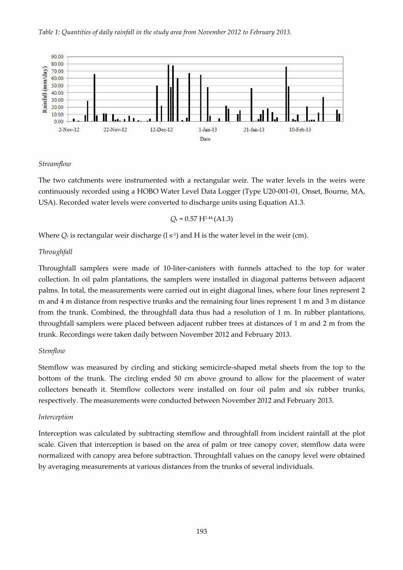
193
Streamflow
The two catchments were instrumented with a rectangular weir. The water levels in the weirs were
continuously recorded using a HOBO Water Level Data Logger (Type U20-001-01, Onset, Bourne, MA,
USA). Recorded water levels were converted to discharge units using Equation A1.3.
Qr = 0.57 H1.44 (A1.3)
Where Qr is rectangular weir discharge (l s-1) and H is the water level in the weir (cm).
Throughfall
Throughfall samplers were made of 10-liter-canisters with funnels attached to the top for water
collection. In oil palm plantations, the samplers were installed in diagonal patterns between adjacent
palms. In total, the measurements were carried out in eight diagonal lines, where four lines represent 2
m and 4 m distance from respective trunks and the remaining four lines represent 1 m and 3 m distance
from the trunk. Combined, the throughfall data thus had a resolution of 1 m. In rubber plantations,
throughfall samplers were placed between adjacent rubber trees at distances of 1 m and 2 m from the
trunk. Recordings were taken daily between November 2012 and February 2013.
Stemflow
Stemflow was measured by circling and sticking semicircle-shaped metal sheets from the top to the
bottom of the trunk. The circling ended 50 cm above ground to allow for the placement of water
collectors beneath it. Stemflow collectors were installed on four oil palm and six rubber trunks,
respectively. The measurements were conducted between November 2012 and February 2013.
Interception
Interception was calculated by subtracting stemflow and throughfall from incident rainfall at the plot
scale. Given that interception is based on the area of palm or tree canopy cover, stemflow data were
normalized with canopy area before subtraction. Throughfall values on the canopy level were obtained
by averaging measurements at various distances from the trunks of several individuals.
Table 1: Quantities of daily rainfall in the study area from November 2012 to February 2013.

194
Literature cited in Appendix
Baldocchi, D. 2003. Assessing the eddy covariance technique for evaluating carbon dioxide exchange
rates of ecosystems: past, present and future. Global Change Biology 9:479-492.
Bush, S. E., K. R. Hultine, J. S. Sperry, J. R. Ehleringer. 2010. Calibration of thermal dissipation sap flow
probes for ring- and diffuse-porous trees. Tree Physiology 30:1545 1554.
Granier, A. 1985. Une nouvelle méthode pour la mesure du flux de sève brute dans le tronc des arbres.
Annals of Forest Science 42:193 200.
Granier, A. 1996. Sap flow measurements using the radial flowmeter technique. INRA-Unité 9.
Guillaume, T., M. Damris, Y. Kuzyakov. 2015. Losses of soil carbon by converting tropical Global Change
Biology, in press: DOI: 10.1111/gcb.12907.
Kluge, S. 2000. Empirisch begründete Typenbildung in der qualitativen Sozialforschung. Forum
Qualitative Sozialforschung 1 (1). [online] URL: http://www.qualitativeresearch.
net/index.php/fqs/article/viewFile/1124/2498 (last accessed 02/12/2014).
Kumar, S. 2002. Methods for community participation. A complete guide for practitioners. London.
Practical Action Publishing. Warwickshire, UK: pp. 71-78, 118-127.
Lu, P., L. Urban, and P. Zhao. 2004. Granier's thermal dissipation probe (TDP) method for measuring
sap flow in trees: theory and practice. Acta Botanica Sinica 46, no. 6:631-646.
Mayring, P. 2002. Einführung in die qualitative Sozialforschung. Eine Anleitung zu qualitativem
Denken. Beltz, Weinheim, Germany, 5th edition: pp. 66-84, 144-120.
Meinzer, F. C., B. J. Bond, J. M. Warren, and D. R. Woodruff. 2005. Does water transport scale
universally with tree size? Functional Ecology 19:558 565.
Nadezhdina, N., M. W. Vandegehuchte, and K. Steppe. 2012. Sap flux density measurements based on
the heat field deformation method. Trees 26 (5):1439-1448.
Niu F., A. Röll, A. Hardanto, A. Meijide, M. Köhler, Hendrayanto, and D. Hölscher. 2015. Oil palm
water use: calibration of a sap flux method and a field measurement scheme. Tree Physiology, in press:
DOI: 10.1093/treephys/tpv013.
Oishi, A. C., R. Oren, and P. C. Stoy. 2008. Estimating components of forest evapotranspiration: a
footprint approach for scaling sap flux measurements. Agricultural and Forest Meteorology 148:1719 1732.
Renninger, H. J., N. Phillips, and G. D. Salvucci. 2010. Wet- vs. dry-season transpiration in an
Amazonian rain forest palm Iriartea deltoidea. Biotropica 42:470 478.
Schnell, R., P. B. Hill, and E. Esser. 2013. Methoden der empirischen Sozialforschung. Oldenbourg
Wissenschaftsverlag, München, Germany: p. 292.
Sperling, O., O. Shapira, S. Cohen, E. Tripler, A. Schwartz, and N. Lazarovitch. 2012. Estimating sap
flux densities in date palm trees using the heat dissipation method and weighing lysimeters. Tree
Physiology: tps070.

195
Sun, H., D. P. Aubrey, and R. O. Teskey. 2012. A simple calibration improved the accuracy of the
thermal dissipation technique for sap flow measurements in juvenile trees of six species. Trees 26, no.
2:631-640.
Vicente-Serrano, S.M., S. Beguería, and J. I. López-Moreno. 2010. A multiscalar drought index sensitive
to global warming: the Standardized Precipitation Evapotranspiration Index. Journal of Climate 23
(7):1696 1718.
3. Appendix to chapter III: Flooding and land use change
in Jambi Province, Sumatra
Appendix 1: Biodiversity enrichment experiment
Table A1.1: Information regarding the plots of the biodiversity enrichment experiment (EFForTS-BEE)
where water infiltration has been measured. Details on the species composition, plot size and tree
diversity are described in Teuscher et al. (2016). A: Parkia speciosa (Fabaceae); B: Archidendron
pauciflorum (Fabaceae); C: Durio zibethinus (Malvaceae); D: Dyera polyphylla (Apocynaceae); E: Peronema
canescens (Lamiaceae); F: Shorea leprosula (Dipterocarpaceae)
Plot ID Lat Long Plot size
Diversity
Level
Composition
of the
planted tree
species
Number
of planted
trees
1 -1.94162 103.2519 40 1 A 400
2 -1.94174 103.253 20 3 ACF 99
3 -1.9433 103.2518 20 2 CD 100
4 -1.94321 103.2532 10 1 F 25
5 -1.94478 103.2518 40 1 B 400
6 -1.94462 103.2532 5 1 E 6
7 -1.94469 103.2552 40 3 AEF 399
8 -1.94587 103.2491 5 1 F 6
12 -1.94589 103.2543 20 1 C 100
13 -1.94591 103.2559 10 1 E 25
17 -1.94734 103.2531 20 1 F 100
22 -1.94873 103.2491 5 2 BF 6
24 -1.94838 103.2543 40 2 CE 400
26 -1.94849 103.2572 40 2 DF 400
27 -1.94992 103.2464 10 2 AE 24
28 -1.95002 103.2478 5 1 B 6
29 -1.94996 103.249 40 3 BCD 399
30 -1.94981 103.253 20 1 E 100
31 -1.94997 103.2545 5 1 C 6

196
34 -1.95143 103.2451 10 2 BD 24
35 -1.95182 103.2466 40 0 Z 0
36 -1.95106 103.2477 20 2 AF 100
37 -1.95118 103.2488 10 0 Z 0
38 -1.95172 103.2504 20 1 D 100
39 -1.95138 103.2518 5 2 AC 6
41 -1.95267 103.2438 10 1 A 25
42 -1.95276 103.245 5 1 D 6
44 -1.95271 103.2478 5 3 BEF 6
45 -1.95307 103.2487 40 1 E 400
46 -1.95442 103.2424 40 2 AB 400
47 -1.95395 103.2437 20 2 BE 100
48 -1.9541 103.2452 10 3 CEF 24
49 -1.954 103.2466 40 1 F 400
50 -1.95406 103.2478 5 6 ABCDEF 6
51 -1.95425 103.2491 20 1 A 100
53 -1.94325 103.2547 10 control
0
54 -1.9512 103.2558 10 control
0
55 -1.9513 103.2534 10 control
0
56 -1.95505 103.2461 10 control
0

197
Appendix 2: River discharge
Table A3.1: Mean water level (± standard deviation) at Pauh hydrological station and results of Mann-Kendall test (Mann-Kendall τ and p-value).
Year
Month Wet
season
(Oct.-
May)
Dry
season
(Jun.-
Sept.)
Annual
Jan. Feb. Mar. Apr. May Jun. Jul. Aug. Sept. Oct. Nov. Dec.
Average
(1997-
2016)
7.07
(±2.05)
6.90
(±2.24)
6.80
(±2.46)
7.25
(±2.17)
6.47
(±1.94)
4.92
(±1.50)
4.74
(±1.58)
4.48
(±1.29)
4.43
(±1.32)
5.08
(±1.43)
7.05
(±1.73)
8.13
(±2.67)
6.88
(±1.47)
4.98
(±1.22)
6.07
(±1.29)
Mann-
Kendall
τ
0.13
(p<0.001)
0.23
(p<0.001)
0.22
(p<0.001)
0.33
(p<0.001)
0.28
(p<0.001)
0.25
(p<0.001)
0.21
(p<0.001)
0.05
(p =0.07)
0.05
(p =0.07)
-0.14
(p<0.001)
0.26
(p<0.001)
0.25
(p<0.001)
0.29
(p<0.001)
0.14
(p<0.05)
0.18
(p<0.001)
Table A3.2: Sum of days with water level >11 m at Pauh hydrological station and results of Mann-Kendall test (Mann-Kendall τ and p-value).
Year
Month Wet
season
(Oct.-
May)
Dry
season
(Jun.-
Sept.)
Annual Jan. Feb. Mar. Apr. May Jun. Jul. Aug. Sept. Oct. Nov. Dec.
Average
(1997-
2016)
1.8
(±1.6)
2.5
(±3.1) 2 (±2.7)
2.2
(±2.4)
1.8
(±1.0) 0 0 0 0 0.1
1.4
(±0.7)
3.6
(±4.3)
15.4
(±1.0) 0
15.4
(±1.0)
Mann-
Kendall
τ
0.49
(p=0.01)
0.28
(p=0.15)
0.24
(p=0.21)
0.23
(p <0.24)
0.23
(p <0.23) - - - -
0.32
(p=0.12)
0.59
(p<0.01)
0.25
(p=0.17)
0.45
(p<0.01)
0.32
(p=0.12)
0.45
(p<0.01)
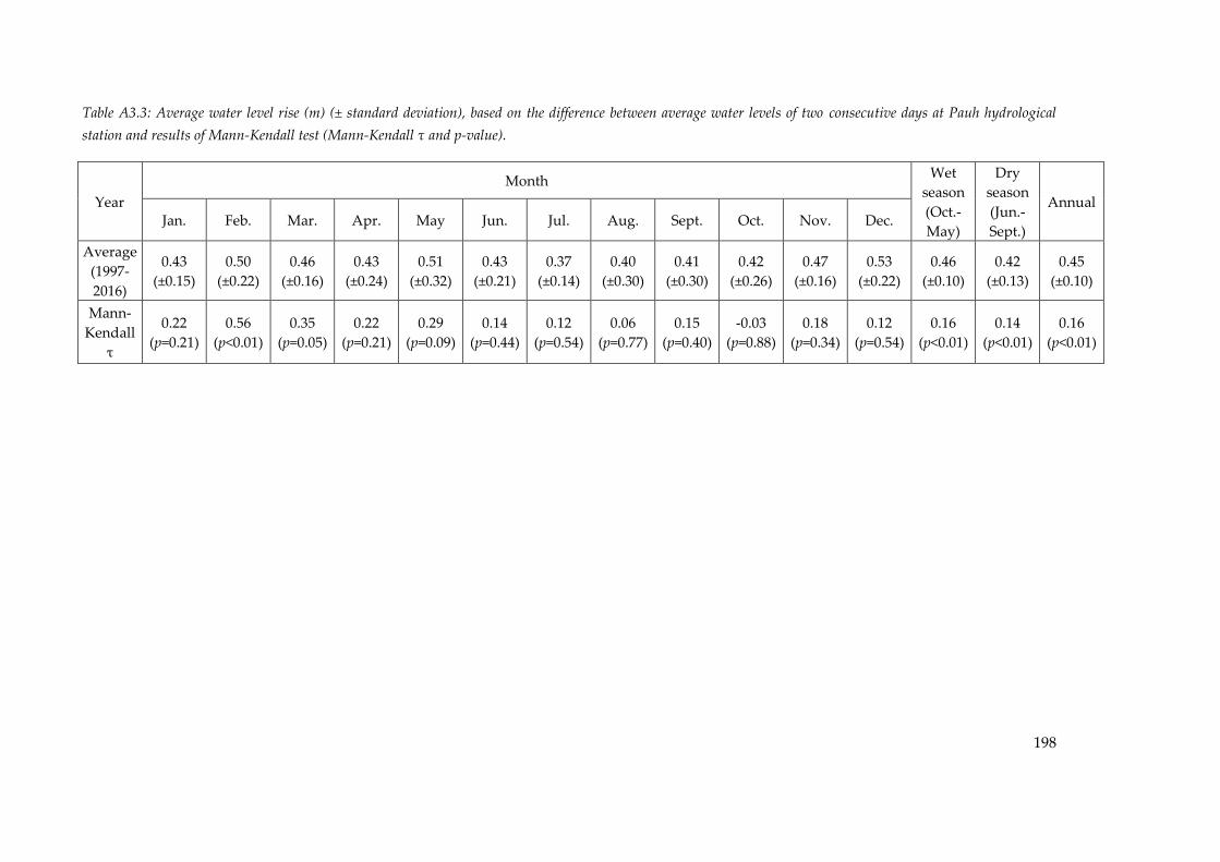
198
Table A3.3: Average water level rise (m) (± standard deviation), based on the difference between average water levels of two consecutive days at Pauh hydrological
station and results of Mann-Kendall test (Mann-Kendall τ and p-value).
Year
Month Wet
season
(Oct.-
May)
Dry
season
(Jun.-
Sept.)
Annual Jan. Feb. Mar. Apr. May Jun. Jul. Aug. Sept. Oct. Nov. Dec.
Average
(1997-
2016)
0.43
(±0.15)
0.50
(±0.22)
0.46
(±0.16)
0.43
(±0.24)
0.51
(±0.32)
0.43
(±0.21)
0.37
(±0.14)
0.40
(±0.30)
0.41
(±0.30)
0.42
(±0.26)
0.47
(±0.16)
0.53
(±0.22)
0.46
(±0.10)
0.42
(±0.13)
0.45
(±0.10)
Mann-
Kendall
τ
0.22
(p=0.21)
0.56
(p<0.01)
0.35
(p=0.05)
0.22
(p=0.21)
0.29
(p=0.09)
0.14
(p=0.44)
0.12
(p=0.54)
0.06
(p=0.77)
0.15
(p=0.40)
-0.03
(p=0.88)
0.18
(p=0.34)
0.12
(p=0.54)
0.16
(p<0.01)
0.14
(p<0.01)
0.16
(p<0.01)

199
Appendix 3: Determination of flood-risk areas
In order to map areas that are prone to flooding, we followed the guidelines of the Indonesian
National Agency for Disaster Management (Badan Nasional Penanggulangan Bencana / BNPB),
which requires two main input datasets, namely (1) a digital elevation model (DEM) and (2) the
river flow network. We used the 3 arc-second (≈ 90 m) void-filled, open-access DEM
“Hydrological Data and Maps Based on Shuttle Elevation Derivatives at Multiple Scales”
(HydroSHEDS) developed by the Conservation Science Program of the World Wildlife Fund For
Nature (Lehner et al. 2008). This DEM presents a combination of the Shuttle Radar Topography
Mission (SRTM-3) and the void-filled digital terrain elevation data (DTED®-1) (Lehner 2013). The
river network is based on the corresponding vector layer from the Indonesian Geospatial
Information Agency (Badan Informasi Geospasial / BIG 2017) digitally available for Jambi
Province at the scales of 1:250,000 and 1:50,000. Building on these two datasets, we determined a
flooding probability by combining the slope gradient, distance from the rivers and the modified
topographic index (TIm) :
where ad is the local upslope contributing area per unit contour length; tan(β) is the local slope
gradient; n is an exponent (0.016x0.46) and x is the spatial resolution of the DEM (Manfreda et al.
2011; Manfreda et al. 2014). The TIm was developed to delineate the exposure to flooding events
on the basis of the basin topography (Manfreda et al. 2011). Eventually, an area was defined as
flood-prone when (1) the distance to the river was < 300 m, (2) the slope gradient < 15% and (3)
TIm exceeded a threshold τ, which was set to τ = 10.89n + 2.282 (based on BNPB 2016), and
constitutes an area that equals or exceeds 0.2 % annual chance to be flooded (Holmes Jr. and
Dinicola, 2010).
Literature cited
[BIG] Badan Informasi Geospasial / Indonesian Geospatial Information Agency. 2017. Peta
Rupabumi. Retrieved from http://www.big.go.id/peta-rupabumi/.
[BNPB] Badan Nasional Penanggulangan Bencana / Indonesian National Agency for Disaster
Management. 2016. Risiko Bencana Indonesia. Direktorat Pengurangan Risiko Bencana. Jakarta.
Holmes Jr., R.R., Dinicola, K. 2010. 100-year flood-it’s all about chance. [online] URL:
https://pubs.usgs.gov/gip/106/pdf/100-year-flood-handout-042610.pdf
Lehner, B., Verdin, K., and A. Jarvis. 2008. New global hydrography derived from spaceborne
elevation data. Eos, Transactions, American Geophysical Union 89(10):93-94.
https://doi.org/10.1029/2008EO100001
200
Lehner, B. 2013. HydroSHEDS technical documentation version 1.2. Conservation Science
Program World Wildlife Fund US.
Manfreda, S., Di Leo, M., and A. Sole. 2011. Detection of flood-prone areas using digital elevation
models. Journal of Hydrologic Engineering 16(10):781-790. https://doi.org/10.1061/(ASCE)HE.1943-
5584.0000367
Manfreda, S., Nardi, F., Samela, C., Grimaldi, S., Taramasso, A.C., Roth, G., and A. Sole. 2014.
Investigation on the Use of Geomorphic Approaches for the Delineation of Flood Prone Areas,
Journal of Hydrology. Journal of Hydrology 517: 863-876.
https://doi.org/10.1016/j.jhydrol.2014.06.009

201
Appendix 4: Precipitation
Table A4.1: Accumulated precipitation (mm) at Pauh meteorological station and results of Mann-Kendall test (Mann-Kendall τ and p-
value).
Year
Month Wet
season
(Oct.-
May)
Dry
season
(Jun.-
Sept.)
Annual Jan. Feb. Mar. Apr. May Jun. Jul. Aug. Sept. Oct. Nov. Dec.
Average
(2007-
2016)
290.3
(±115.9)
216.7
(±74.1)
268.5
(±149.3)
280.3
(±94.6)
244.1
(±83.9)
109.6
(±53.0)
170.6
(±94.0)
126.6
(±85.2)
141.2
(±112.1)
256.1
(±110.3)
352.7
(±119.4)
365.0 A)
(±162.8)
1993.1
(±392.7)
792.1
(±220.2)
2785.2
(±547.0)
Mann-
Kendall
τ
0.16
(p=0.59)
0.38
(p=0.15)
0.33
(p=0.21)
0.20
(p=0.47)
0.60
(p <0.05)
-0.04
(P =0.93)
-0.07
(p =0.86)
-0.20
(p =0.47)
-0.24
(p =0.37)
-0.33
(p =0.21)
0.56
(p <0.05)
0.06
(p =0.92)
0.02
(p =0.13)
-0.02
(p =0.33)
0.03
(p =0.65)
A) No data for December 2012 available
Table A4.2: Average precipitation intensity index (± standard deviation) at Pauh meteorological station and results of Mann-Kendall
test (Mann-Kendall τ and p-value).
Year
Month Wet
season
(Oct.-
May)
Dry
season
(Jun.-
Sept.)
Annual Jan. Feb. Mar. Apr. May Jun. Jul. Aug. Sept. Oct. Nov. Dec.
2007-
2016
15.9
(±13.3)
17.6
(±13.5)
17.2
(±16.1)
22.0
(±19.0)
21.6
(±21.2)
13.7
(±13.5)
18.5
(±22.5)
15.4
(±16.5)
17.3
(±16.9)
17.1
(±14.0)
24.4
(±22.4)
23.3
(±23.1)
20.2
(±18.8)
16.0
(±17.6)
19.0
(±18.6)
Mann-
Kendall
τ
-0.14
(P =0.13)
0.11
(P =0.26)
0.16
(P =0.04)
-0.09
(P =0.29)
0.07
(P =0.40)
-0.08
(P =0.40)
0.14
(P =0.10)
-0.09
(P =0.32)
-0.05
(P =0.66)
-0.14
(P =0.13)
0.02
(P =0.81)
0.06
(P =0.47)
0.02
(P =0.59)
-0.02
(P =0.71)
0.01
(P =0.81)

202
Table A4.3: Mean precipitation (mm) at Jambi airport meteorological station and results of Mann-Kendall test (Mann-Kendall τ and p-
value) during the period 1978-2016.
Year
Month Wet
season
(Oct.-
May)
Dry
season
(Jun.-
Sept.)
Annual Jan. Feb. Mar. Apr. May Jun. Jul. Aug. Sept. Oct. Nov. Dec.
1978-
2016
199.3
(±85.7)
180.2
(±79.9)
233.9
(±82.7)
256.0
(±90.0)
170.5
(±64.8)
112.4
(±64.6)
112.5
(±81.4)
124.6
(±92.9)
129.6
(±86.1)
223.0
(±105.8)
241.1
(±98.9)
248.2
(±86.6)
1798.2
(±91.6)
491.7
(±81.4)
2289.9
(±99.9)
Mann-
Kendall
τ
-0.28
(P =0.01)
-0.08
(P =0.51)
-0.02
(P =0.85)
-0.22
(P =0.05)
-0.12
(P =0.31)
-0.08
(P =0.51)
0.16
(P =0.16)
0.10
(P =0.38)
-0.16
(P =0.16)
-0.13
(P =0.24)
-0.06
(P =0.63)
0.02
(P =0.85)
0.09
(P =0.02)
0.03
(P =0.54)
-0.05
(P =0.10)
Table A4.4: Average precipitation intensity index (± standard deviation) at Jambi Airport meteorological station and results of Mann-
Kendall test (Mann-Kendall τ and p-value).
Year Month
Wet
season
(Oct.-
May)
Dry
season
(Jun.-
Sept.)
Annual
Jan. Feb. Mar. Apr. May Jun. Jul. Aug. Sept. Oct. Nov. Dec.
1991-
2016
11.3
(±11.9)
13.1
(±13.4)
16.1
(±16.6)
14.2
(±14.2)
12.8
(±12.8)
11.9
(±14.6)
15.3
(±18.2)
13.7
(±15.5)
11.1
(±12.0)
14.7
(±12.4)
14.4
(±13.0)
15.7
(±15.0)
14.0
(±13.8)
13.0
(±15.2)
13.8
(±14.2)
Mann-
Kendall
τ
-0.01
(P =0.79)
0.05
(P =0.34)
-0.13
(P <0.01)
0.02
(P =0.74)
-0.03
(P =0.54)
-0.08
(P =0.18)
-0.04
(P =0.54)
0.01
(P =0.92)
-0.05
(P =0.44)
-0.03
(P =0.57)
-0.05
(P =0.36)
-0.03
(P =0.56)
0.05
(P
=0.01)
0.0
(P
=0.96)
-0.03
(P =0.06)

203
Appendix 5: Accuracy statistics of land use/cover classes
Table A5.1: Accuracy statistics and area proportion of each land use/cover class in the
Tembesi watershed for the year 2013 (recalculated from Melati 2017).
Land use/ cover
class Accuracy
Area proportion
(%)
User's Producer's Overall Map Estimated
Agriculture 72.4 ± 16.6 95.6 ± 5.4
85.8 ±
4.4
16.3 12.4 ± 2.8
Bush/bareland 79.4 ± 10.1 60.3 ± 17.4 7.1 9.4 ± 2.8
Forest 93.9 ± 6.8 95.4 ± 3.2 38.1 37.5 ± 2.9
Oil palm 83.3 ± 10 68.5 ± 13.8 10.8 13.1 ± 2.8
Rubber 86.4 ± 7.5 90.9 ± 6.7 25.6 24.4 ± 2.6
Settlement 81.3 ± 19.8 35.2 ± 22.3 1.3 2.9 ± 1.8
Water body 50 ± 43.8 100 ± 0 0.8 0.4 ± 0.3
Copyright © 2022 FDOKUMEN