Hydraulic assessment for flood risk assessment in Soufrière ...
80
Government of Saint Lucia Ministry of Infrastructure, Port Services and Transport Hurricane Tomas Emergency Recovery Project Hydraulic assessment for flood risk assessment in Soufrière, Fond St Jacques and Dennery Report # 3: River and Drainage options report Version 1 July 2014 Partner:
-
Upload
khangminh22 -
Category
Documents
-
view
1 -
download
0
Transcript of Hydraulic assessment for flood risk assessment in Soufrière ...

Government of Saint
Lucia
Ministry of Infrastructure, Port Services and Transport
Hurricane Tomas Emergency Recovery Project
Hydraulic assessment for flood risk assessment in Soufrière, Fond St Jacques and Dennery
Report # 3: River and Drainage options report
Version 1
July 2014
Partner:
Egis Eau Quality
Hydraulic assessment for flood risk assessment in Soufrière, Fond St Jacques and Dennery
Page 2 Version 1
Quality
Project title Hydraulic assessment for flood risk assessment in Soufrière, Fond St Jacques and Dennery
Report title Report # 3: River and Drainage options report
Date July 2014
Author(s) M. Raymond / V. Fabrègue
N° RIV 22852E
Control
Version Date written by Visa:
1 31/07/14 V. Fabregue / M. Raymond C. LESCOULIER
Recipients
Sent to:
Name Organism sent :
Myrtle Drysdale Octave Ministry of Infrastructure, Port Service and Transportation
copy:
Name Organism sent :
Egis Eau Table of Contents
Hydraulic assessment for flood risk assessment in Soufrière, Fond St Jacques and Dennery
Page 3 Version 1
Table of Contents
Chapter 1. Introduction .............................................................. 8
1.1 Context and objectives of this report .................................................. 8
1.2 Principles of flash flood risk management ........................................10
Chapter 2. Structural measures ............................................... 11
2.1 Dimensioning data ..............................................................................11
2.2 In Dennery ............................................................................................15 2.2.1 Existing critical infrastructures in Dennery .............................................. 15 2.2.2 Proposed structural measures in Dennery .............................................. 16
2.2.2.1 Rehabilitation of the left dike along the Mole river .................................... 16 2.2.2.2 Re-calibration of the central drain combined (or not) with retention area
(storm management pond) upstream to the East Coast Road, and creation
of a new direct outlet to the sea, .................................................................... 20 2.2.2.3 Ravine Trou à Eau structural measures.................................................... 29
2.3 In Soufriere ..........................................................................................35 2.3.1 Existing critical infrastructures in Soufriere ............................................. 35 2.3.2 Proposed structural measures in Soufriere ............................................. 36
2.3.2.1 Damming the Soufriere river ..................................................................... 36 2.3.2.2 Bends embankements protections ............................................................ 40 2.3.2.3 Re-calibration of the « Ruby » stream and creation of a new direct
outlet into the Soufriere river ......................................................................... 41
2.4 In Fond Saint Jacques ........................................................................44 2.4.1 Existing critical infrastructures in Fond Saint Jacques ............................ 44 2.4.2 Note about the debris flow modeling ....................................................... 44 2.4.3 Proposed structural measures in Fond Saint Jacques ........................... 45
2.4.3.1 Streams embankements protections ........................................................ 47 2.4.3.2 Recalibration of 2 bridges ......................................................................... 47 2.4.3.3 Jam traps .................................................................................................. 48
Chapter 3. Non-structural measures ....................................... 49
3.1 Prevention strategies ..........................................................................50 3.1.1 Watershed management ......................................................................... 50
3.1.1.1 Agricultural measures: .............................................................................. 50 3.1.1.2 Rivers maintenance plans: ........................................................................ 51 3.1.1.3 Watershed management In Dennery: ....................................................... 52 3.1.1.4 In Soufriere Watershed: ............................................................................ 54 3.1.1.5 Focus in fond saint Jacques watershed: ................................................... 56
3.1.2 Floodplain management and flood area regulation ................................. 61 3.1.2.1 Generalities ............................................................................................... 61 3.1.2.2 Flood hazard mapping in the three studied communities .......................... 62
3.2 Mitigation strategies ............................................................................64 3.2.1 Reducing discharge through natural retention ........................................ 64 3.2.2 Monitoring, warning, and response system (MWRS) .............................. 66
3.2.2.1 General overview ...................................................................................... 66
Egis Eau Table of Contents
Hydraulic assessment for flood risk assessment in Soufrière, Fond St Jacques and Dennery
Page 4 Version 1
3.2.2.2 Proposed MWRS in the three communities .............................................. 68 3.2.3 Public information and education ............................................................ 73
Chapter 4. Costs and prioritization ......................................... 74
4.1 Return period definition ......................................................................74
4.2 In DENNERY .........................................................................................74
4.3 In SOUFRIERE .....................................................................................76
4.4 In FOND SAINT JACQUES ..................................................................77
Chapter 5. Conclusion .............................................................. 78
Egis Eau List of Figures
Hydraulic assessment for flood risk assessment in Soufrière, Fond St Jacques and Dennery
Page 5 Version 1
List of Figures
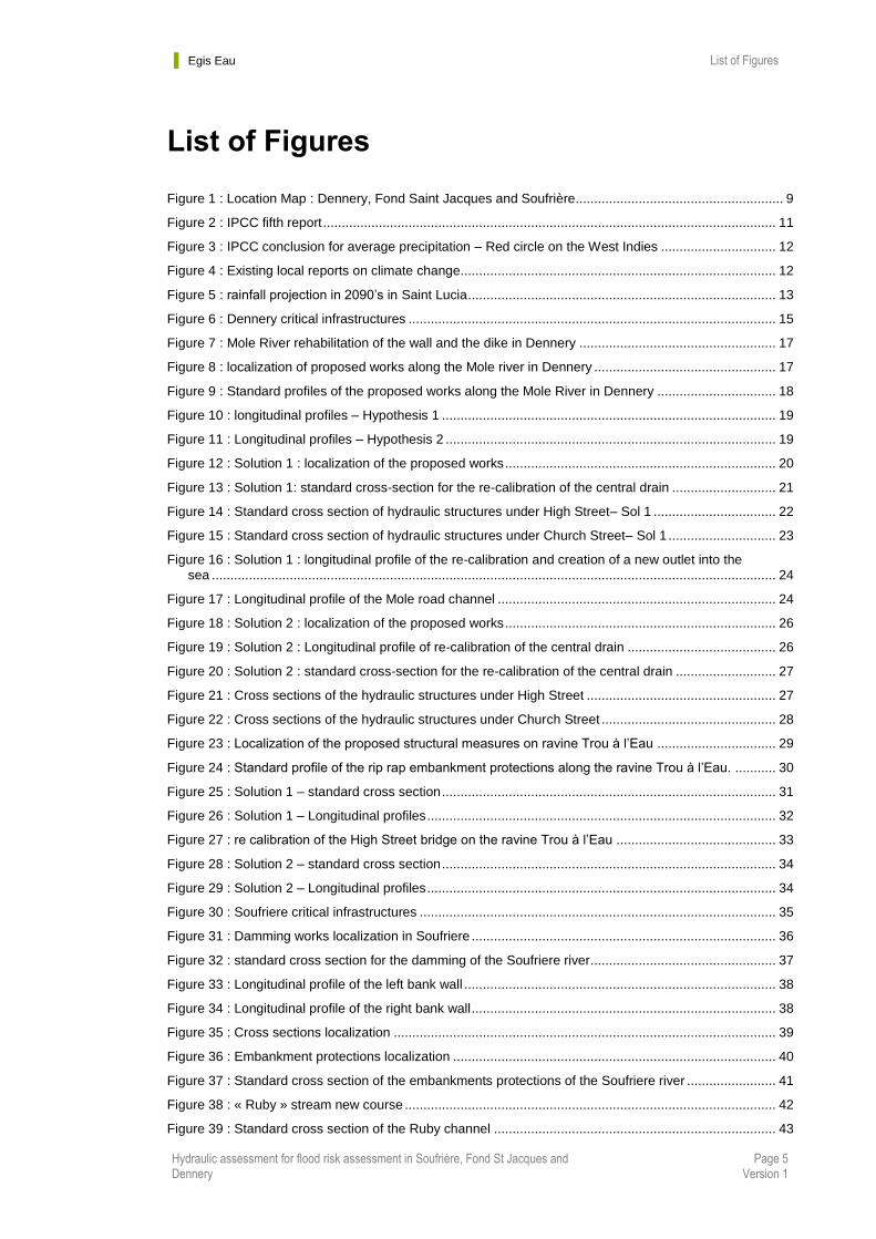
Figure 1 : Location Map : Dennery, Fond Saint Jacques and Soufrière ........................................................ 9
Figure 2 : IPCC fifth report .......................................................................................................................... 11
Figure 3 : IPCC conclusion for average precipitation – Red circle on the West Indies ............................... 12
Figure 4 : Existing local reports on climate change..................................................................................... 12
Figure 5 : rainfall projection in 2090’s in Saint Lucia ................................................................................... 13
Figure 6 : Dennery critical infrastructures ................................................................................................... 15
Figure 7 : Mole River rehabilitation of the wall and the dike in Dennery ..................................................... 17
Figure 8 : localization of proposed works along the Mole river in Dennery ................................................. 17
Figure 9 : Standard profiles of the proposed works along the Mole River in Dennery ................................ 18
Figure 10 : longitudinal profiles – Hypothesis 1 .......................................................................................... 19
Figure 11 : Longitudinal profiles – Hypothesis 2 ......................................................................................... 19
Figure 12 : Solution 1 : localization of the proposed works ......................................................................... 20
Figure 13 : Solution 1: standard cross-section for the re-calibration of the central drain ............................ 21
Figure 14 : Standard cross section of hydraulic structures under High Street– Sol 1 ................................. 22
Figure 15 : Standard cross section of hydraulic structures under Church Street– Sol 1 ............................. 23
Figure 16 : Solution 1 : longitudinal profile of the re-calibration and creation of a new outlet into the sea ........................................................................................................................................................ 24
Figure 17 : Longitudinal profile of the Mole road channel ........................................................................... 24
Figure 18 : Solution 2 : localization of the proposed works ......................................................................... 26
Figure 19 : Solution 2 : Longitudinal profile of re-calibration of the central drain ........................................ 26
Figure 20 : Solution 2 : standard cross-section for the re-calibration of the central drain ........................... 27
Figure 21 : Cross sections of the hydraulic structures under High Street ................................................... 27
Figure 22 : Cross sections of the hydraulic structures under Church Street ............................................... 28
Figure 23 : Localization of the proposed structural measures on ravine Trou à l’Eau ................................ 29
Figure 24 : Standard profile of the rip rap embankment protections along the ravine Trou à l’Eau. ........... 30
Figure 25 : Solution 1 – standard cross section .......................................................................................... 31
Figure 26 : Solution 1 – Longitudinal profiles .............................................................................................. 32
Figure 27 : re calibration of the High Street bridge on the ravine Trou à l’Eau ........................................... 33
Figure 28 : Solution 2 – standard cross section .......................................................................................... 34
Figure 29 : Solution 2 – Longitudinal profiles .............................................................................................. 34
Figure 30 : Soufriere critical infrastructures ................................................................................................ 35
Figure 31 : Damming works localization in Soufriere .................................................................................. 36
Figure 32 : standard cross section for the damming of the Soufriere river .................................................. 37
Figure 33 : Longitudinal profile of the left bank wall .................................................................................... 38
Figure 34 : Longitudinal profile of the right bank wall .................................................................................. 38
Figure 35 : Cross sections localization ....................................................................................................... 39
Figure 36 : Embankment protections localization ....................................................................................... 40
Figure 37 : Standard cross section of the embankments protections of the Soufriere river ........................ 41
Figure 38 : « Ruby » stream new course .................................................................................................... 42
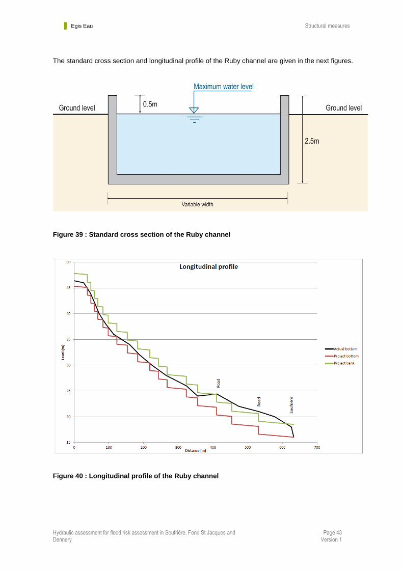
Figure 39 : Standard cross section of the Ruby channel ............................................................................ 43
Egis Eau List of Tables
Hydraulic assessment for flood risk assessment in Soufrière, Fond St Jacques and Dennery
Page 6 Version 1
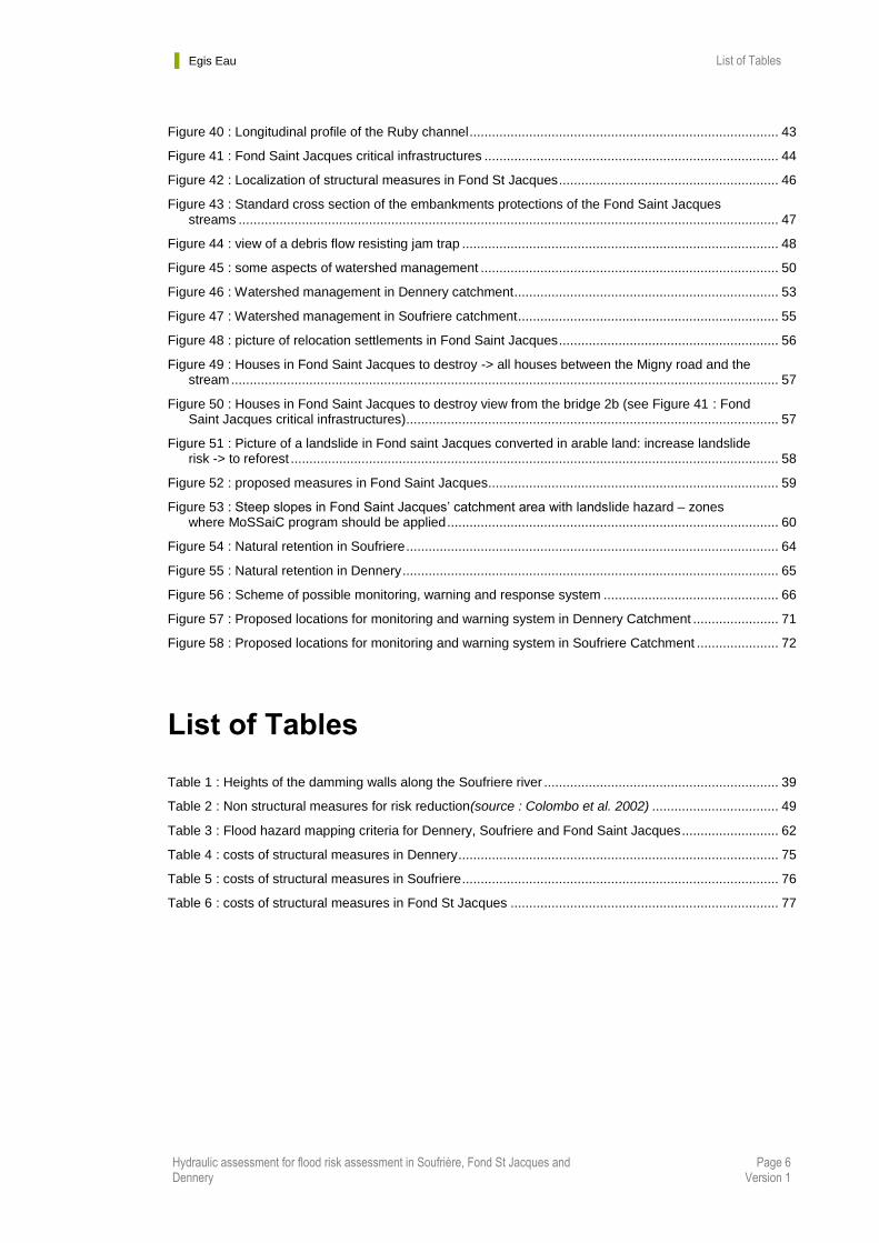
Figure 40 : Longitudinal profile of the Ruby channel ................................................................................... 43
Figure 41 : Fond Saint Jacques critical infrastructures ............................................................................... 44
Figure 42 : Localization of structural measures in Fond St Jacques ........................................................... 46
Figure 43 : Standard cross section of the embankments protections of the Fond Saint Jacques streams ................................................................................................................................................. 47
Figure 44 : view of a debris flow resisting jam trap ..................................................................................... 48
Figure 45 : some aspects of watershed management ................................................................................ 50
Figure 46 : Watershed management in Dennery catchment ....................................................................... 53
Figure 47 : Watershed management in Soufriere catchment ...................................................................... 55
Figure 48 : picture of relocation settlements in Fond Saint Jacques ........................................................... 56
Figure 49 : Houses in Fond Saint Jacques to destroy -> all houses between the Migny road and the stream ................................................................................................................................................... 57
Figure 50 : Houses in Fond Saint Jacques to destroy view from the bridge 2b (see Figure 41 : Fond Saint Jacques critical infrastructures) .................................................................................................... 57
Figure 51 : Picture of a landslide in Fond saint Jacques converted in arable land: increase landslide risk -> to reforest ................................................................................................................................... 58
Figure 52 : proposed measures in Fond Saint Jacques.............................................................................. 59
Figure 53 : Steep slopes in Fond Saint Jacques’ catchment area with landslide hazard – zones where MoSSaiC program should be applied ......................................................................................... 60
Figure 54 : Natural retention in Soufriere .................................................................................................... 64
Figure 55 : Natural retention in Dennery ..................................................................................................... 65
Figure 56 : Scheme of possible monitoring, warning and response system ............................................... 66
Figure 57 : Proposed locations for monitoring and warning system in Dennery Catchment ....................... 71
Figure 58 : Proposed locations for monitoring and warning system in Soufriere Catchment ...................... 72
List of Tables
Table 1 : Heights of the damming walls along the Soufriere river ............................................................... 39
Table 2 : Non structural measures for risk reduction(source : Colombo et al. 2002) .................................. 49
Table 3 : Flood hazard mapping criteria for Dennery, Soufriere and Fond Saint Jacques .......................... 62
Table 4 : costs of structural measures in Dennery ...................................................................................... 75
Table 5 : costs of structural measures in Soufriere ..................................................................................... 76
Table 6 : costs of structural measures in Fond St Jacques ........................................................................ 77
Egis Eau Acronyms and abbreviations
Hydraulic assessment for flood risk assessment in Soufrière, Fond St Jacques and Dennery
Page 7 Version 1
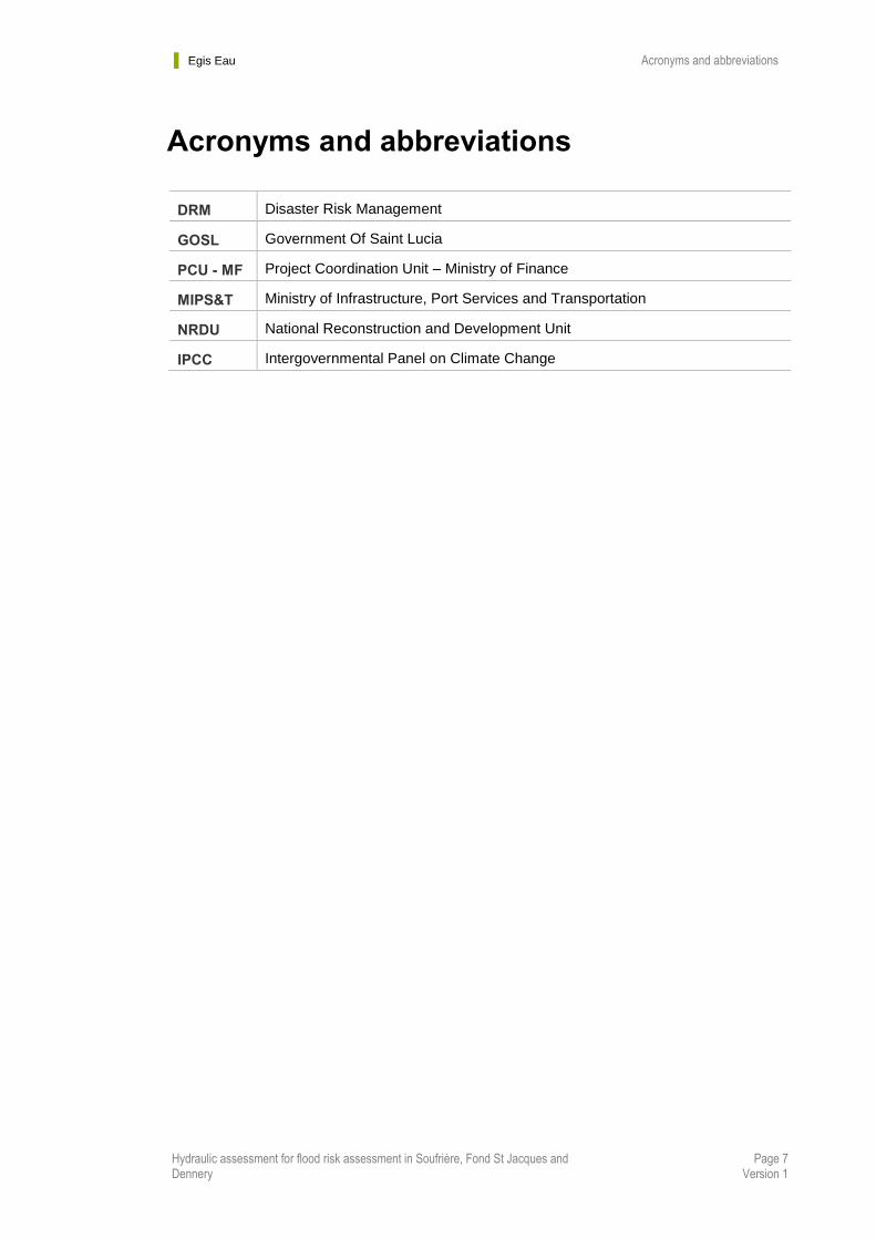
Acronyms and abbreviations
DRM Disaster Risk Management
GOSL Government Of Saint Lucia
PCU - MF Project Coordination Unit – Ministry of Finance
MIPS&T Ministry of Infrastructure, Port Services and Transportation
NRDU National Reconstruction and Development Unit
IPCC Intergovernmental Panel on Climate Change
Egis Eau Introduction
Hydraulic assessment for flood risk assessment in Soufrière, Fond St Jacques and Dennery
Page 8 Version 1
Chapter 1. Introduction
1.1 Context and objectives of this report
The vulnerability of Saint Lucia’s population and economy, to natural disasters related to water
phenomena has become an important national issue.
In October 2010, the Hurricane Tomas impacted Saint Lucia. An important rainfall, in quantity (533 mm)
and duration (24 hours), accompanied this hurricane. Due to Saint Lucia’s topography and land
occupation, numerous flooding and landslide were deplored. To support the Saint Lucia’s recovery and
reconstruction effort the government of the island received a Credit from the World Bank.
The extreme rainfall associated to the Hurricane Tomas also altered the river-courses and accumulated
sediment in the channels due to significant number of landslides and important run-off. Theses
sediments now increase the flooding risk, in particular on specific risk areas: the watershed
communities of Dennery, Soufriere and Fond St-Jacques.
The objectives of the assignments are to provide the implementation of flood management measures in
3 watershed areas (of the Dennery, Soufriere and Fond St-Jacques communities):
Carry out flood risk assessment
Identify and quantify appropriate cost effective remedial measures to reduce flood hazard.
The project is divided in 6 phases:
Phase 1 : Site characterization, flood hazard and vulnerability analysis
Phase 2 : Drainage designs standards and flood risk mapping
Phase 3 : River and drainage and mitigation measures
Phase 4 : Preliminary designs
Phase 5 : flood mitigation measures
Phase 6 : Flood risk design and flood management training
This report describes the phase 3 analysis. It contains for each community:
The identification and comparison of feasible options for river and drainage rehabilitation works.
The map and identification of existing critical infrastructure necessary to be rehabilitated or
reconstructed, and vulnerable infrastructures that should be protected and strengthened.
Costing and prioritizing of various types of mitigation measures (works and non structural
measures).

Egis Eau Introduction
Hydraulic assessment for flood risk assessment in Soufrière, Fond St Jacques and Dennery
Page 9 Version 1
Figure 1 : Location Map : Dennery, Fond Saint Jacques and Soufrière
Egis Eau Introduction
Hydraulic assessment for flood risk assessment in Soufrière, Fond St Jacques and Dennery
Page 10 Version 1
1.2 Principles of flash flood risk management
Saint Lucia and especially the three communities studied in this assessment are vulnerable for
flash floods, caused by heavy rainfalls and/or landslides.
Flash flood risk management can include structural and non-structural measures. A common strategy to
cope with floods has been to construct civil works such as floodwalls, transversal protection works,
embankments, conduits, and reservoirs to protect the environment up to an acceptable risk threshold.
Structural measures tend to consider mainly the hydrological and hydraulic implications of flooding,
which are generally solved by choosing the alternative that maximises the expected net benefit. In
addition, such measures can have a substantial impact on the riverine environment and ecology.
Furthermore, while structural solutions contribute to flood reduction and protection, they also have
hidden ‘piggy-back’ liabilities associated with them, such as the issue of their long-term value, the false
sense of security they may provide, their possible environmental impact, and costs related to their
operation and maintenance.
In contrast, non-structural measures offer a variety of possibilities, ranging from land use planning and
construction and structure management codes, through soil management and acquisition policies,
insurance, and perception and awareness, to public information actions, emergency systems, and post
catastrophe recovery, all of which contribute towards the mitigation of flood-related problems. The
advantage of non-structural measures is that, generally, they are sustainable and less expensive. Non-
structural measures are often the most effective in managing flash floods. However, they can only be
efficient with the participation of a responsive population and an organized institutional network.
A combination of structural and non-structural measures can be the best. This report is giving
both types of measures for each of the three studied communities.
Egis Eau Structural measures
Hydraulic assessment for flood risk assessment in Soufrière, Fond St Jacques and Dennery
Page 11 Version 1
Chapter 2. Structural measures
2.1 Dimensioning data
In this chapter, all data are taken from report #1 and #2, especially:
- Topographical survey
- Hydrological analysis and flow calculations for 1 in 10, 50, 100 years flood event and Tomas
event
- Hydraulic actual conditions (velocity and heights of water for 1 in 10, 50, 100 years flood event
and Tomas event
FOCUS ON CLIMATE CHANGE RAIN CONDITIONS:
Climate change scenarios have been studied by IPCC (Intergovernmental Panel on Climate Change).
The Fifth Assessment Report provides a clear and up to date view of the current state of scientific
knowledge relevant to climate change.
Figure 2 : IPCC fifth report

Egis Eau Structural measures
Hydraulic assessment for flood risk assessment in Soufrière, Fond St Jacques and Dennery
Page 12 Version 1
This report is a large scale study (world scale). It concludes to the raise of temperature, the raise of sea
levels, the raise of number of extreme rainfall events.
The next figure shows that for all the scenarios studies by IPCC, average precipitation is going to
decrease in the West Indies. But there is no projection for rain intensity or duration.
Projected precipitation and temperature changes imply possible changes in floods, although overall
there is low confidence in projections of changes in fluvial floods. Confidence is low due to limited
evidence and because the causes of regional changes are complex.
There is medium confidence (based on physical reasoning) that projected increases in heavy rainfall
would contribute to increases in local flooding in some catchments or regions.
There is no data focuses in Saint Lucia or the West Indies.
Figure 3 : IPCC conclusion for average precipitation – Red circle on the West Indies
Figure 4 : Existing local reports on climate change

Egis Eau Structural measures
Hydraulic assessment for flood risk assessment in Soufrière, Fond St Jacques and Dennery
Page 13 Version 1
According to Saint Lucia Hires Report GCM Projections of Future Climate suggest:
1. Temperature
• • The mean annual temperature is projected to increase by 0.5 to 2.1°C by the 2060s, and 1.0
to 3.6 degrees by the 2090s. The range of projections by the 2090s under any one emissions
scenario is around 1‐ 2°C. The projected rate of warming is similar throughout the year, but a
little more rapid in the colder seasons DJF and SON.
• All projections indicate substantial increases in the frequency of days and nights that are
considered ‘hot’ in current climate.
• Annually, projections indicate that ‘hot’ days will occur on 28‐ 67% of days by the 2060s, and
37‐ 100% of days by the 2090s.
• Nights that are considered ‘hot’ for the annual climate of 1970‐ 99 are projected to occur on
28‐ 68% of nights by the 2060s and 37‐ 99% of nights by the 2090s. Nights that are hot for
each season are projected to increase most rapidly in SON, occurring on 79‐ 100% of nights in
every season by the 2090s.
• All projections indicate decreases in the frequency of days and nights that are considered ‘cold’
in current climate. These events do not occur at all by the 2060s in projections from most of the
models.
2. Precipitation
• Projections of mean annual rainfall from different models in the ensemble are broadly consistent
in indicating decreases in rainfall for Saint Lucia. Ensemble median values for all seasons are
negative. Annual projections vary between -56% and +15% by the 2090s with ensemble median
values of -10 to -22%.
• The proportion of total rainfall that falls in heavy events decreases in most model projections,
changing by -26% to +6% by the 2090s.
• Maximum 1- and 5-day rainfalls tend to decrease in model projections, with 5-day maxima
changing by -31 to +13mm by the 2090s.
Figure 5 : rainfall projection in 2090’s in Saint Lucia
Egis Eau Structural measures
Hydraulic assessment for flood risk assessment in Soufrière, Fond St Jacques and Dennery
Page 14 Version 1
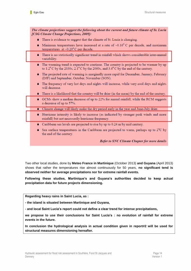
Two other local studies, done by Meteo France in Martinique (October 2013) and Guyana (April 2013)
shows that rather the temperatures rise almost continuously for 50 years, no significant tend is
observed neither for average precipitations nor for extreme rainfall events.
Following these studies, Martinique’s and Guyana’s authorities decided to keep actual
precipitation data for future projects dimensioning.
Regarding heavy rains in Saint Lucia, as :
- the island is situated between Martinique and Guyana,
- and local Saint Lucia’s report could not define a clear trend for intense precipitations,
we propose to use their conclusions for Saint Lucia’s : no evolution of rainfall for extreme
events in the future.
In conclusion the hydrological analysis in actual condition given in report#2 will be used for
structural measures dimensioning hereafter.
Egis Eau Structural measures
Hydraulic assessment for flood risk assessment in Soufrière, Fond St Jacques and Dennery
Page 15 Version 1
2.2 In Dennery
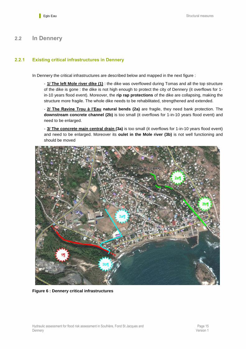
2.2.1 Existing critical infrastructures in Dennery
In Dennery the critical infrastructures are described below and mapped in the next figure :
- 1/ The left Mole river dike (1) : the dike was overflowed during Tomas and all the top structure
of the dike is gone : the dike is not high enough to protect the city of Dennery (it overflows for 1-
in-10 years flood event). Moreover, the rip rap protections of the dike are collapsing, making the
structure more fragile. The whole dike needs to be rehabilitated, strengthened and extended.
- 2/ The Ravine Trou à l’Eau natural bends (2a) are fragile, they need bank protection. The
downstream concrete channel (2b) is too small (it overflows for 1-in-10 years flood event) and
need to be enlarged.
- 3/ The concrete main central drain (3a) is too small (it overflows for 1-in-10 years flood event)
and need to be enlarged. Moreover its oulet in the Mole river (3b) is not well functioning and
should be moved
Figure 6 : Dennery critical infrastructures
Egis Eau Structural measures
Hydraulic assessment for flood risk assessment in Soufrière, Fond St Jacques and Dennery
Page 16 Version 1
2.2.2 Proposed structural measures in Dennery
To protect to town of Dennery against floods, we propose de following structural measures :
1/ Rehabilitation of the left dike along the Mole river, taking account of 2 different hypothesis of
development on the right bank:
Hypothesis 1 : enlarge the outlet is possible by the removal of the existing spur at the mouth of
the river in order to enable flood expansion and drainage,
Hypothesis 2 : take account of a project of hotel on the right bank wich will require to fill a part of
the right bank and keep the spur. (We were asked to examine this hypothesis by Elizabeth
Charles-Soomer- Unit Chief of the National Reconstruction and Development Unit).
2/ Re-calibration of the central drain combined (or not) with retention area (storm management
pond) upstream to the East Coast Road, and creation of a new direct outlet to the sea,
3/ Bank protections in the bends of the ravine Trou à l’Eau,
4/ Re-calibration of the Ravine Trou à l’Eau between first overflow point and the outlet in the sea.
2.2.2.1 Rehabilitation of the left dike along the Mole river
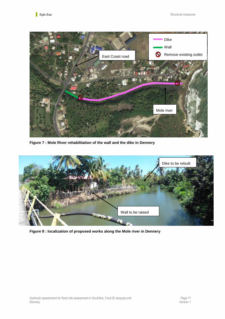
The crest of the actual dike is irregular and has been lowered by last devastating floods. The actual
riprap embankment protection are also collapsing into the river, fragilizing more and more the stability of
the dike.
The proposed solution consists in rebuilding the left river dike between the East Coast Road bridge and
the outlet into the sea.
In order to limit the hold on the ground in a private property, we propose the construction of a wall for a
total length of 60 m downstream of the bridge (actual gabion baskets).
After the wall, we propose to rebuild an earth dike for the rest of the distance to the sea (410m), to
replace the existing one which is collapsing.
The left embankment of the river will be protected with riprap along the whole works length.
The 2 existing outlets trough the dike will be removed.
The proposed works are localized in the next figure :
Egis Eau Structural measures
Hydraulic assessment for flood risk assessment in Soufrière, Fond St Jacques and Dennery
Page 17 Version 1
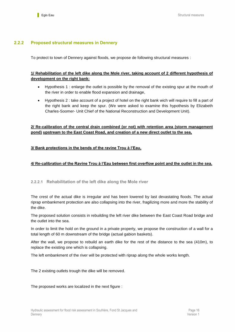
Figure 7 : Mole River rehabilitation of the wall and the dike in Dennery
Figure 8 : localization of proposed works along the Mole river in Dennery
Wall to be raised
Dike to be rebuilt
East Coast road
Dike
Wall
Remove existing outlet
Mole river

Egis Eau Structural measures
Hydraulic assessment for flood risk assessment in Soufrière, Fond St Jacques and Dennery
Page 18 Version 1
The corresponding standard profiles are the followings :
Figure 9 : Standard profiles of the proposed works along the Mole River in Dennery
The crest elevation of the dike and wall are set to the maximum water levels corresponding to various
return periods (in order to provide a large scale of proposed solutions to be chosen by the client),
increased by 0.50m of safety margin.
Three level of protection are proposed :
- 1-in-50-year flood event,
- 1-in-100-year flood event
- Tomas flood event

Egis Eau Structural measures
Hydraulic assessment for flood risk assessment in Soufrière, Fond St Jacques and Dennery
Page 19 Version 1
For each proposed hypothesis, the longitudinal profiles are given in the next figures :
Hypothesis 1 : enlarge the outlet -> removal of the spur,
Hypothesis 2 : taking account of the project of hotel on the right bank -> fill the right bank.
Figure 10 : longitudinal profiles – Hypothesis 1
Figure 11 : Longitudinal profiles – Hypothesis 2
Egis Eau Structural measures
Hydraulic assessment for flood risk assessment in Soufrière, Fond St Jacques and Dennery
Page 20 Version 1
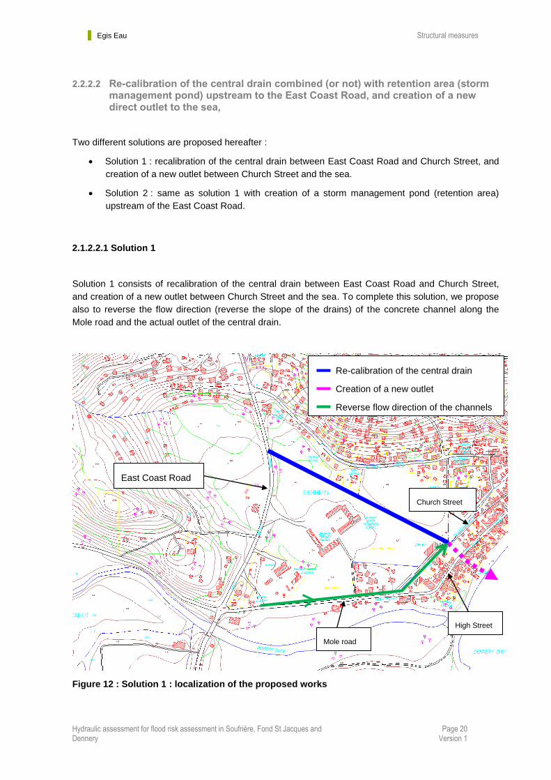
2.2.2.2 Re-calibration of the central drain combined (or not) with retention area (storm management pond) upstream to the East Coast Road, and creation of a new direct outlet to the sea,
Two different solutions are proposed hereafter :
Solution 1 : recalibration of the central drain between East Coast Road and Church Street, and
creation of a new outlet between Church Street and the sea.
Solution 2 : same as solution 1 with creation of a storm management pond (retention area)
upstream of the East Coast Road.
2.1.2.2.1 Solution 1
Solution 1 consists of recalibration of the central drain between East Coast Road and Church Street,
and creation of a new outlet between Church Street and the sea. To complete this solution, we propose
also to reverse the flow direction (reverse the slope of the drains) of the concrete channel along the
Mole road and the actual outlet of the central drain.
Figure 12 : Solution 1 : localization of the proposed works
Re-calibration of the central drain
Creation of a new outlet
Reverse flow direction of the channels
Chan
Mole road
High Street
Church Street
East Coast Road

Egis Eau Structural measures
Hydraulic assessment for flood risk assessment in Soufrière, Fond St Jacques and Dennery
Page 21 Version 1
The solution consists of creating a new reinforced concrete channel.
The crest elevation of the channel are set to the maximum water levels corresponding to various flood
return periods (in order to provide a large scale of proposed solutions to be chosen by the client),
increased by 0.50m of safety margin.
For all tested flood, the width of the channel is set at 3 meters.
All the existing drainage channels which have their outlet in the central drain will be equipped with non-
return valves.
The corresponding standard cross-section is given hereunder:
Figure 13 : Solution 1: standard cross-section for the re-calibration of the central drain
Egis Eau Structural measures
Hydraulic assessment for flood risk assessment in Soufrière, Fond St Jacques and Dennery
Page 22 Version 1
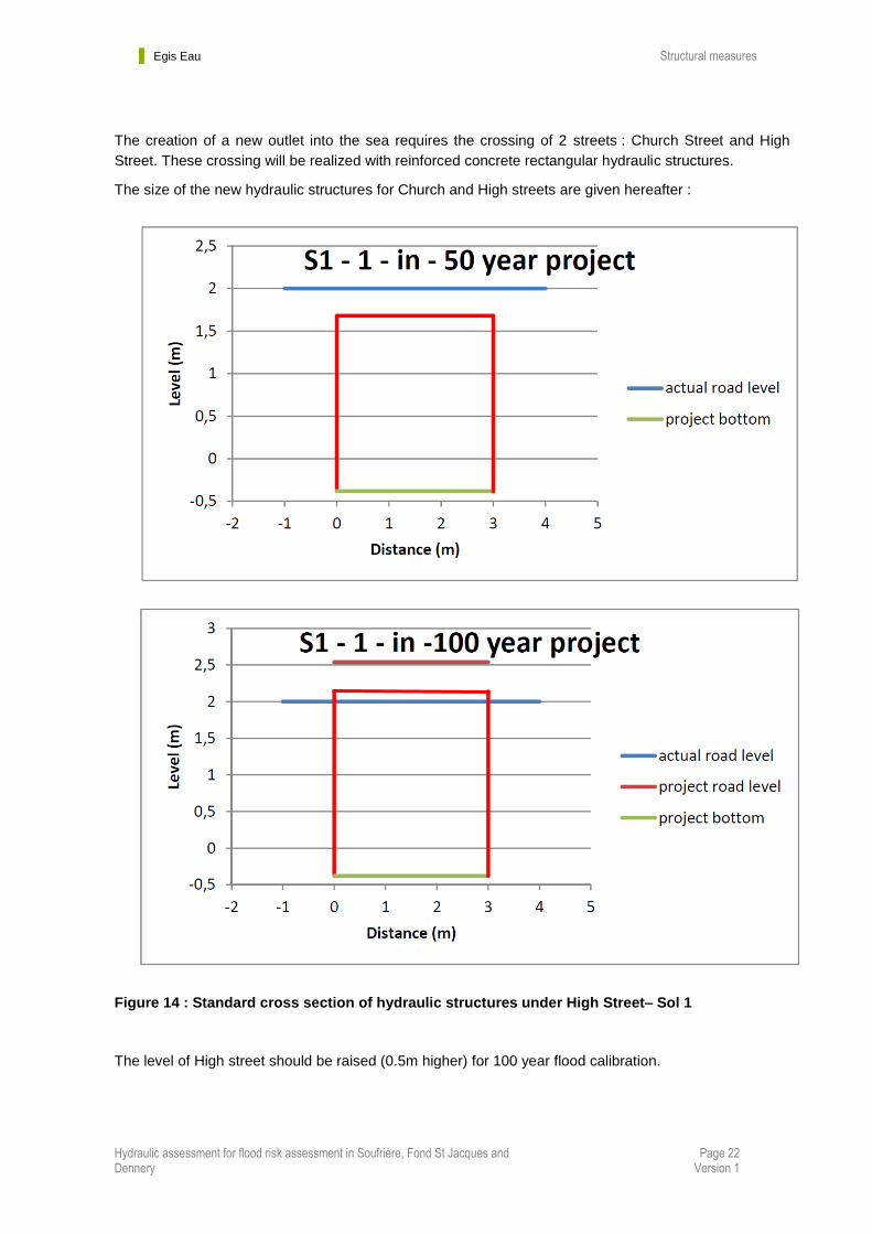
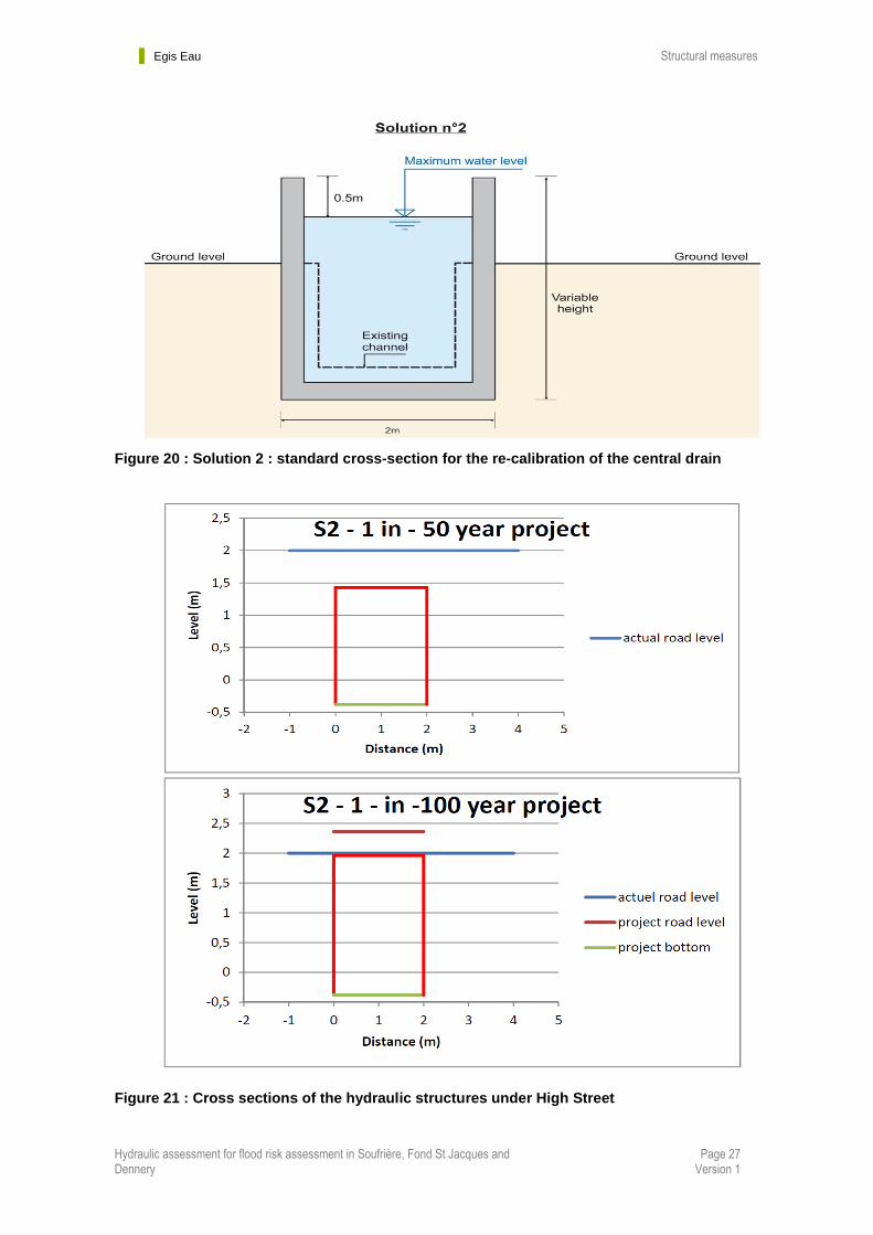
The creation of a new outlet into the sea requires the crossing of 2 streets : Church Street and High
Street. These crossing will be realized with reinforced concrete rectangular hydraulic structures.
The size of the new hydraulic structures for Church and High streets are given hereafter :
Figure 14 : Standard cross section of hydraulic structures under High Street– Sol 1
The level of High street should be raised (0.5m higher) for 100 year flood calibration.

Egis Eau Structural measures
Hydraulic assessment for flood risk assessment in Soufrière, Fond St Jacques and Dennery
Page 23 Version 1
Figure 15 : Standard cross section of hydraulic structures under Church Street– Sol 1
The level of Church street should be raised :
- 0.6m higher for 50 year flood calibration.
- 1.1m higher for 100 year flood calibration.
Egis Eau Structural measures
Hydraulic assessment for flood risk assessment in Soufrière, Fond St Jacques and Dennery
Page 24 Version 1
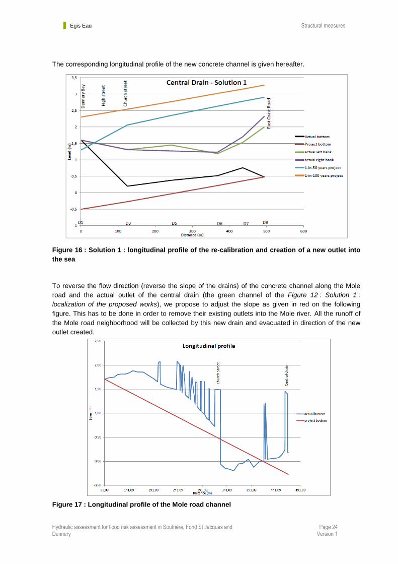
The corresponding longitudinal profile of the new concrete channel is given hereafter.
Figure 16 : Solution 1 : longitudinal profile of the re-calibration and creation of a new outlet into
the sea
To reverse the flow direction (reverse the slope of the drains) of the concrete channel along the Mole
road and the actual outlet of the central drain (the green channel of the Figure 12 : Solution 1 :
localization of the proposed works), we propose to adjust the slope as given in red on the following
figure. This has to be done in order to remove their existing outlets into the Mole river. All the runoff of
the Mole road neighborhood will be collected by this new drain and evacuated in direction of the new
outlet created.
Figure 17 : Longitudinal profile of the Mole road channel

Egis Eau Structural measures
Hydraulic assessment for flood risk assessment in Soufrière, Fond St Jacques and Dennery
Page 25 Version 1
2.1.2.2.2 Solution 2
The solution 2 consists in creation of a storm management pond upstream of the East Coast Road (dig
the ground where a former wetland had been filled), in order to control the release of water downstream
and then reduce the size of the concrete channel through the city.
In the light of the calculated volume, which is quite small comparing to the available room, it is possible
to store the whole runoff volume upstream of the East Coast Road.
The corresponding volume (V), for each return period, to store is (without outlet) :
V50 = 6 300 m3
V100 = 7 300 m3
Vtomas 73 000 m3
Tomas runoff volume is very important because of the long duration of the rain phenomenon.
The available area for the storm management pond is approximately 10 000 m²
The corresponding depth (H), for each return period is :
H50 = 0.63 m
H100 = 0.73 m
Htomas = 7.3 m (!!!)
This shows that it is impossible to store the entire volume of a long raining event like Tomas. We
propose to add an outlet under the East Coast Road to release downstream through the city (into the
central drain) a controlled flow.
With a maximum flow release of 1 m3/s, the storm management pond would have the following
characteristics:
V50 = 4 200 m3
V100 = 5 100 m3
Vtomas 7 800 m3
The corresponding depth (H), for each return period is :
H50 = 0.42 m
H100 = 0.51 m
Htomas = 0.78 m
For all these solutions, the East Coast Road has to be reinforced and create a spillway to pass
high floods (if the outlet fails for example).
The downstream flow through the city will be evacuated by a reinforced concrete channel of 2 meters
wide. All the other works are the same as the solution 1 ones.
Egis Eau Structural measures
Hydraulic assessment for flood risk assessment in Soufrière, Fond St Jacques and Dennery
Page 26 Version 1
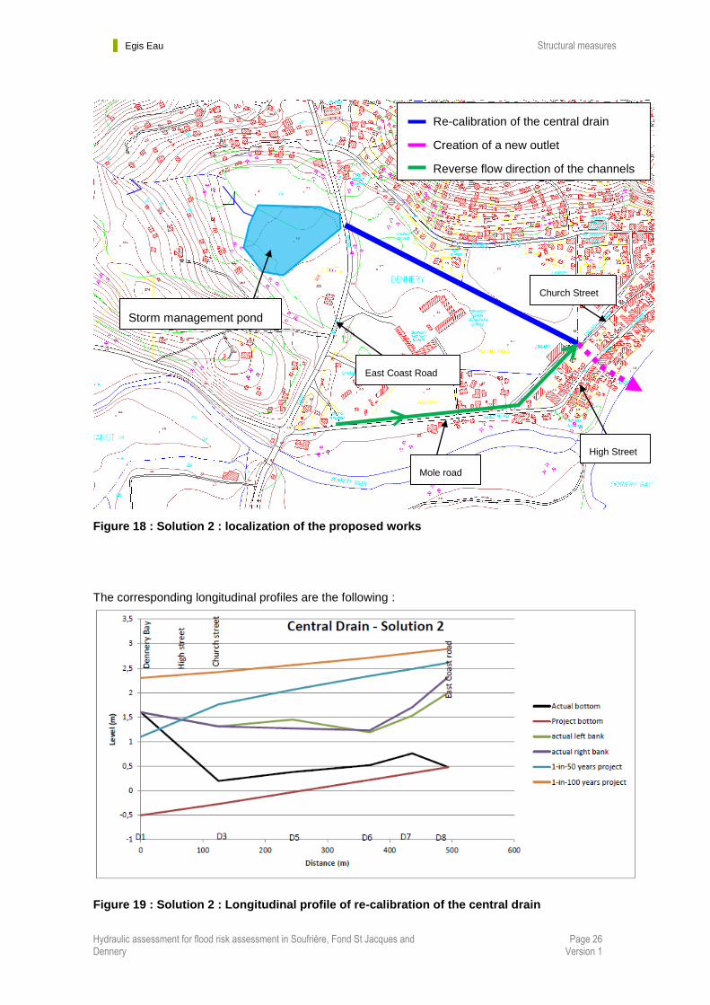
Figure 18 : Solution 2 : localization of the proposed works
The corresponding longitudinal profiles are the following :
Figure 19 : Solution 2 : Longitudinal profile of re-calibration of the central drain
Storm management pond
Mole road
High Street
Church Street
East Coast Road
Re-calibration of the central drain
Creation of a new outlet
Reverse flow direction of the channels
Chan
Egis Eau Structural measures
Hydraulic assessment for flood risk assessment in Soufrière, Fond St Jacques and Dennery
Page 27 Version 1
Figure 20 : Solution 2 : standard cross-section for the re-calibration of the central drain
Figure 21 : Cross sections of the hydraulic structures under High Street

Egis Eau Structural measures
Hydraulic assessment for flood risk assessment in Soufrière, Fond St Jacques and Dennery
Page 28 Version 1
Figure 22 : Cross sections of the hydraulic structures under Church Street
The level of Church street should be raised :
- 0.3m higher for 50 year flood calibration.
- 0.8m higher for 100 year flood calibration
Egis Eau Structural measures
Hydraulic assessment for flood risk assessment in Soufrière, Fond St Jacques and Dennery
Page 29 Version 1
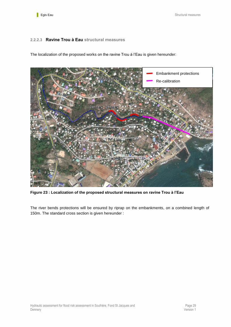
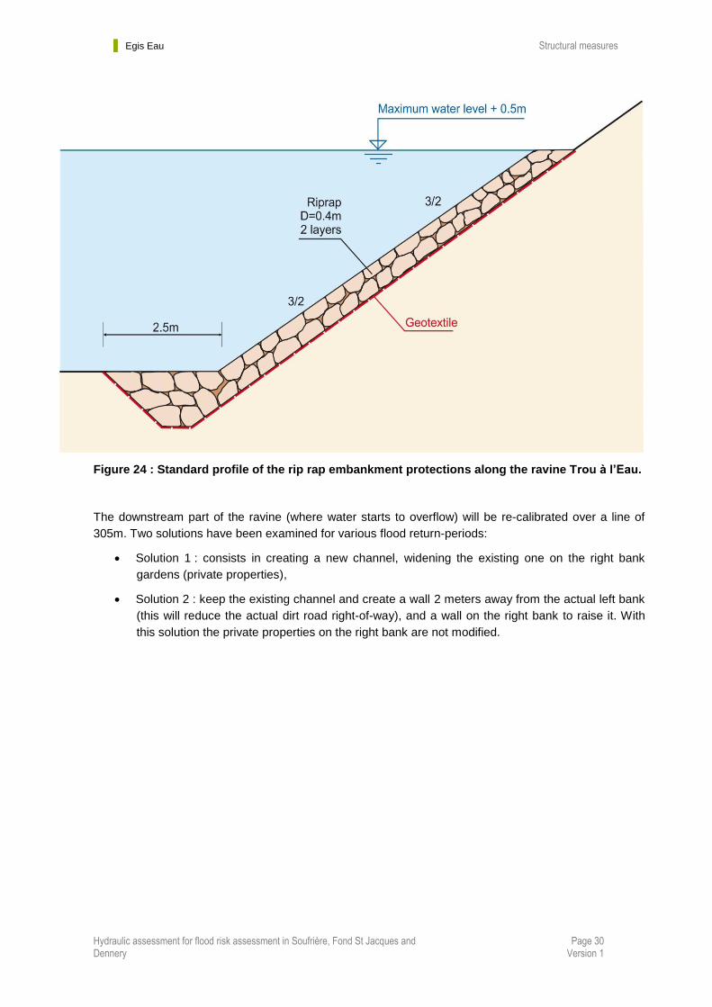
2.2.2.3 Ravine Trou à Eau structural measures
The localization of the proposed works on the ravine Trou à l’Eau is given hereunder:
Figure 23 : Localization of the proposed structural measures on ravine Trou à l’Eau
The river bends protections will be ensured by riprap on the embankments, on a combined length of
150m. The standard cross section is given hereunder :
Embankment protections
Re-calibration
Egis Eau Structural measures
Hydraulic assessment for flood risk assessment in Soufrière, Fond St Jacques and Dennery
Page 30 Version 1
Figure 24 : Standard profile of the rip rap embankment protections along the ravine Trou à l’Eau.
The downstream part of the ravine (where water starts to overflow) will be re-calibrated over a line of
305m. Two solutions have been examined for various flood return-periods:
Solution 1 : consists in creating a new channel, widening the existing one on the right bank
gardens (private properties),
Solution 2 : keep the existing channel and create a wall 2 meters away from the actual left bank
(this will reduce the actual dirt road right-of-way), and a wall on the right bank to raise it. With
this solution the private properties on the right bank are not modified.
Egis Eau Structural measures
Hydraulic assessment for flood risk assessment in Soufrière, Fond St Jacques and Dennery
Page 31 Version 1
2.2.2.3.1 Solution 1
The corresponding standard cross section is:
Figure 25 : Solution 1 – standard cross section
The channel width is:
4 m for 1-in-50-year flood period,
5 m for 1-in-100-year flood period,
6 m for Tomas flood
The crest elevation of the walls are set to the maximum water levels corresponding to various flood
return periods (in order to provide a large scale of proposed solutions to be chosen by the client),
increased by 0.50m of safety margin.
All the existing drainage channels which have their outlet in the re-calibrated part of the ravine Trou à
l’Eau will be equipped with non-return valves.
The corresponding longitudinal profiles are given on the following figure.

Egis Eau Structural measures
Hydraulic assessment for flood risk assessment in Soufrière, Fond St Jacques and Dennery
Page 32 Version 1
Figure 26 : Solution 1 – Longitudinal profiles
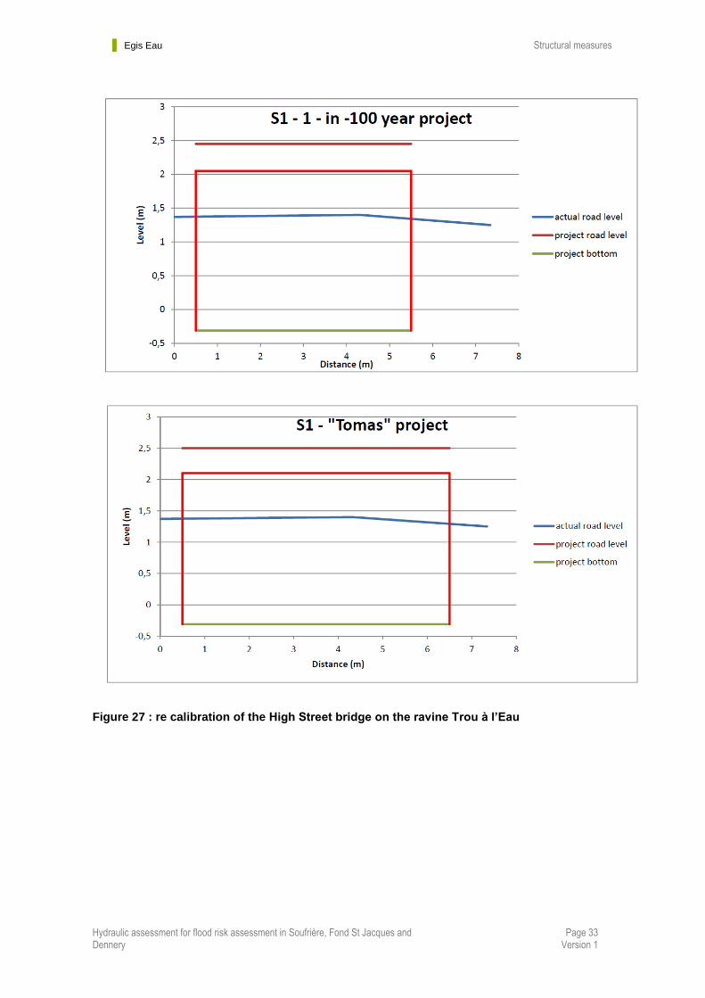
Moreover, the hydraulic structure of High Street on the ravine should also be re calibrated.
The new size of the bridge opening are given hereunder, for various return periods
Egis Eau Structural measures
Hydraulic assessment for flood risk assessment in Soufrière, Fond St Jacques and Dennery
Page 33 Version 1
Figure 27 : re calibration of the High Street bridge on the ravine Trou à l’Eau

Egis Eau Structural measures
Hydraulic assessment for flood risk assessment in Soufrière, Fond St Jacques and Dennery
Page 34 Version 1
2.2.2.3.2 Solution 2
The corresponding standard cross section is:
Figure 28 : Solution 2 – standard cross section
The crest elevation of the walls are set to the maximum water levels corresponding to various flood
return periods (in order to provide a large scale of proposed solutions to be chosen by the client),
increased by 0.50m of safety margin.
All the existing drainage channels which have their outlet in the re-calibrated part of the ravine Trou à
l’Eau will be equipped with non-return valves
The corresponding longitudinal profiles are given on the following figure.
Figure 29 : Solution 2 – Longitudinal profiles
Egis Eau Structural measures
Hydraulic assessment for flood risk assessment in Soufrière, Fond St Jacques and Dennery
Page 35 Version 1
2.3 In Soufriere
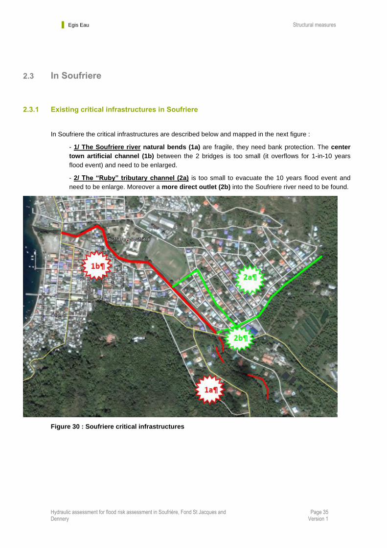
2.3.1 Existing critical infrastructures in Soufriere
In Soufriere the critical infrastructures are described below and mapped in the next figure :
- 1/ The Soufriere river natural bends (1a) are fragile, they need bank protection. The center
town artificial channel (1b) between the 2 bridges is too small (it overflows for 1-in-10 years
flood event) and need to be enlarged.
- 2/ The “Ruby” tributary channel (2a) is too small to evacuate the 10 years flood event and
need to be enlarge. Moreover a more direct outlet (2b) into the Soufriere river need to be found.
Figure 30 : Soufriere critical infrastructures
Egis Eau Structural measures
Hydraulic assessment for flood risk assessment in Soufrière, Fond St Jacques and Dennery
Page 36 Version 1
2.3.2 Proposed structural measures in Soufriere
To protect to town of Soufriere against floods, we propose de following structural measures :
1/ damming the Soufriere river between the 2 bridges, on left and right banks,
2/ Embankents protections of the river bends upstream,
3/ Re-calibration of the « Ruby » stream and creation of a new direct outlet into the Soufriere
river
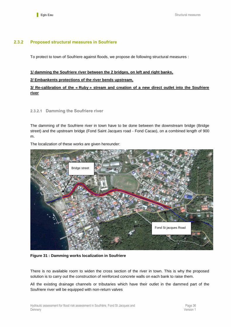
2.3.2.1 Damming the Soufriere river
The damming of the Soufriere river in town have to be done between the downstream bridge (Bridge
street) and the upstream bridge (Fond Saint Jacques road - Fond Cacao), on a combined length of 900
m.
The localization of these works are given hereunder:
Figure 31 : Damming works localization in Soufriere
There is no available room to widen the cross section of the river in town. This is why the proposed
solution is to carry out the construction of reinforced concrete walls on each bank to raise them.
All the existing drainage channels or tributaries which have their outlet in the dammed part of the
Soufriere river will be equipped with non-return valves
Fond St jacques Road
Bridge street
Egis Eau Structural measures
Hydraulic assessment for flood risk assessment in Soufrière, Fond St Jacques and Dennery
Page 37 Version 1
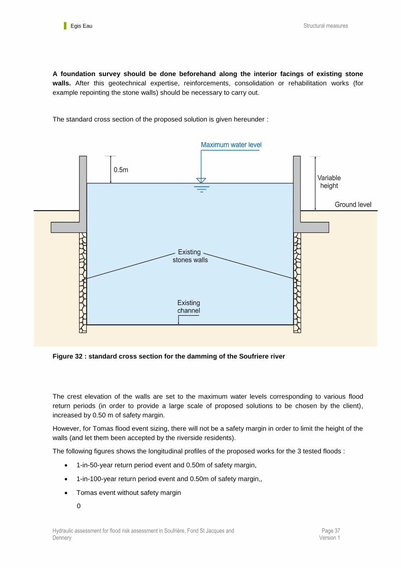
A foundation survey should be done beforehand along the interior facings of existing stone
walls. After this geotechnical expertise, reinforcements, consolidation or rehabilitation works (for
example repointing the stone walls) should be necessary to carry out.
The standard cross section of the proposed solution is given hereunder :
Figure 32 : standard cross section for the damming of the Soufriere river
The crest elevation of the walls are set to the maximum water levels corresponding to various flood
return periods (in order to provide a large scale of proposed solutions to be chosen by the client),
increased by 0.50 m of safety margin.
However, for Tomas flood event sizing, there will not be a safety margin in order to limit the height of the
walls (and let them been accepted by the riverside residents).
The following figures shows the longitudinal profiles of the proposed works for the 3 tested floods :
1-in-50-year return period event and 0.50m of safety margin,
1-in-100-year return period event and 0.50m of safety margin,,
Tomas event without safety margin
0
Egis Eau Structural measures
Hydraulic assessment for flood risk assessment in Soufrière, Fond St Jacques and Dennery
Page 38 Version 1
Figure 33 : Longitudinal profile of the left bank wall
Figure 34 : Longitudinal profile of the right bank wall
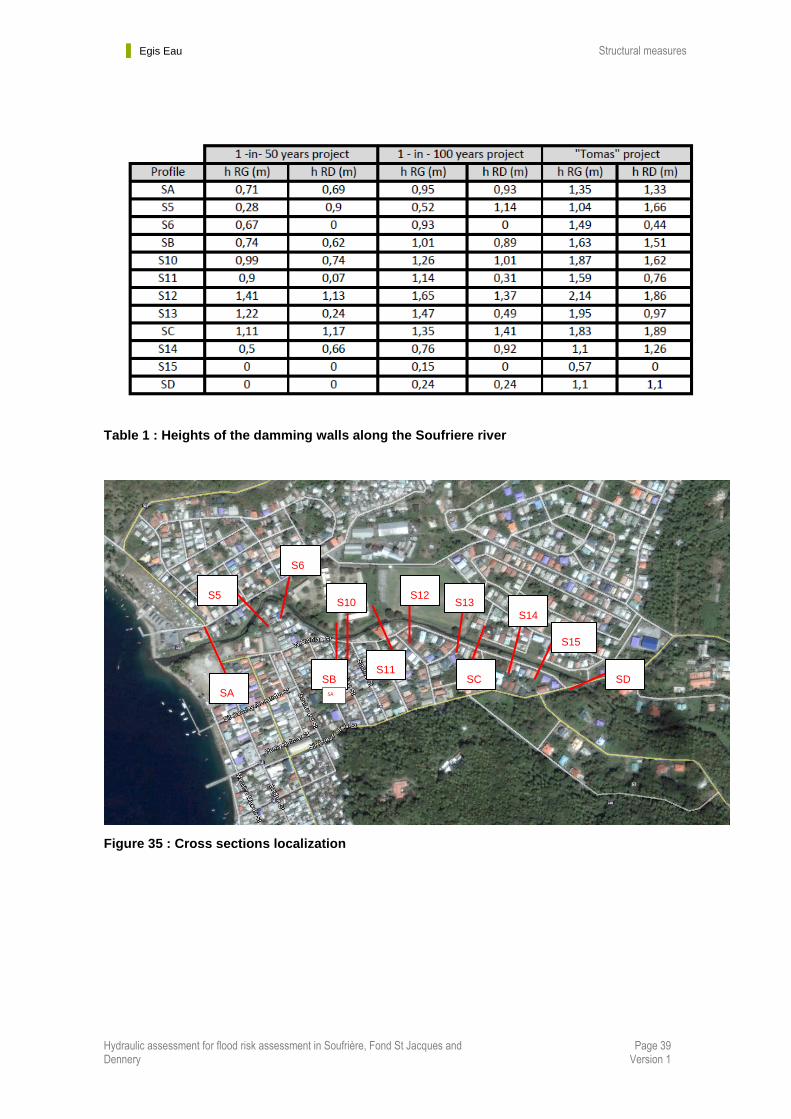
The following table shows the height of the walls (from the ground level) in different cross section of the
river, for the 3 tested floods. The corresponding localization of the cross section is given in the newt
figure.
Egis Eau Structural measures
Hydraulic assessment for flood risk assessment in Soufrière, Fond St Jacques and Dennery
Page 39 Version 1
Table 1 : Heights of the damming walls along the Soufriere river
Figure 35 : Cross sections localization
SA
SB SA
SC SD
S5
S6
S10
S11
S12 S13
S14
S15

Egis Eau Structural measures
Hydraulic assessment for flood risk assessment in Soufrière, Fond St Jacques and Dennery
Page 40 Version 1
2.3.2.2 Bends embankements protections
The bends which need to to be protected are given on the newt figure
Figure 36 : Embankment protections localization
The banks protections are ensured by rip rap placed on the embankments. The corresponding standard
cross section is given on the following figure.

Egis Eau Structural measures
Hydraulic assessment for flood risk assessment in Soufrière, Fond St Jacques and Dennery
Page 41 Version 1
Figure 37 : Standard cross section of the embankments protections of the Soufriere river
2.3.2.3 Re-calibration of the « Ruby » stream and creation of a new direct outlet into the Soufriere river
Arriving in the urban area of Soufriere, the « Ruby » stream will have to be resized in order to reduce
flood risk. The proposed channel will be a reinforced concrete open channel. A new outlet would be
constructed directly into the Soufriere river ; its last part would be covered.
Covered section and road crossing culvert :
Ground Level
W H = 2,5 m
1 – in – 10 year project : W = 4,5 m
1 – in – 50 year project : W = 6,5 m
1 – in – 100 year project : W = 7,1 m
Tomas” project : W = 7,3 m

Egis Eau Structural measures
Hydraulic assessment for flood risk assessment in Soufrière, Fond St Jacques and Dennery
Page 42 Version 1
Figure 38 : « Ruby » stream new course
In order to limit the water velocity to 5 m/s in the channel, the natural of the stream has to be reduced
with 1.5m high falls.
With this modified slope (reduced to 0,006 mpm) and the maximum flows to evacuate, for a 2.5m high
channel (taking account of a safety margin of 0.5m above maximum water levels) the width would be :
:
4,5 m for 1-in-10-year return period event
6,5 m for 1-in-50-year return period event
7,1 m for Tomas event,
7,3 m for 1-in-100-year return period event.
Channel re-calibration (open)
Culvert (covered section)
Road crossing culvert
Existing outlet
Proposed outlet
Soufriere river
Fond St Jacques Rd
Egis Eau Structural measures
Hydraulic assessment for flood risk assessment in Soufrière, Fond St Jacques and Dennery
Page 43 Version 1
The standard cross section and longitudinal profile of the Ruby channel are given in the next figures.
Figure 39 : Standard cross section of the Ruby channel
Figure 40 : Longitudinal profile of the Ruby channel
Egis Eau Structural measures
Hydraulic assessment for flood risk assessment in Soufrière, Fond St Jacques and Dennery
Page 44 Version 1
2.4 In Fond Saint Jacques
2.4.1 Existing critical infrastructures in Fond Saint Jacques
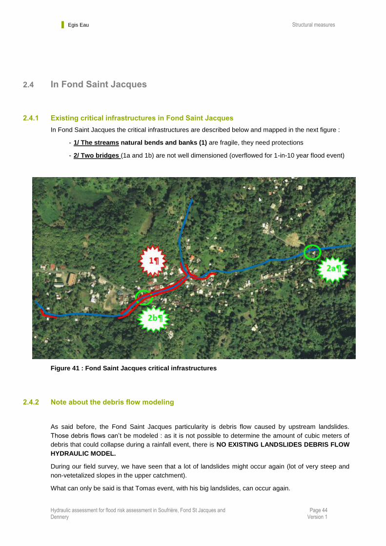
In Fond Saint Jacques the critical infrastructures are described below and mapped in the next figure :
- 1/ The streams natural bends and banks (1) are fragile, they need protections
- 2/ Two bridges (1a and 1b) are not well dimensioned (overflowed for 1-in-10 year flood event)
Figure 41 : Fond Saint Jacques critical infrastructures
2.4.2 Note about the debris flow modeling
As said before, the Fond Saint Jacques particularity is debris flow caused by upstream landslides.
Those debris flows can’t be modeled : as it is not possible to determine the amount of cubic meters of
debris that could collapse during a rainfall event, there is NO EXISTING LANDSLIDES DEBRIS FLOW
HYDRAULIC MODEL.
During our field survey, we have seen that a lot of landslides might occur again (lot of very steep and
non-vetetalized slopes in the upper catchment).
What can only be said is that Tomas event, with his big landslides, can occur again.
Egis Eau Structural measures
Hydraulic assessment for flood risk assessment in Soufrière, Fond St Jacques and Dennery
Page 45 Version 1
The model done for report #2 was calibrated with the Tomas water/debris levels survey: we have
artificially increased the peak discharges until the levels calculated by the model reaches the
water/debris levels surveyed.
This is the only way to produce a good flood/debris exposure map in this community, based on
Tomas event.
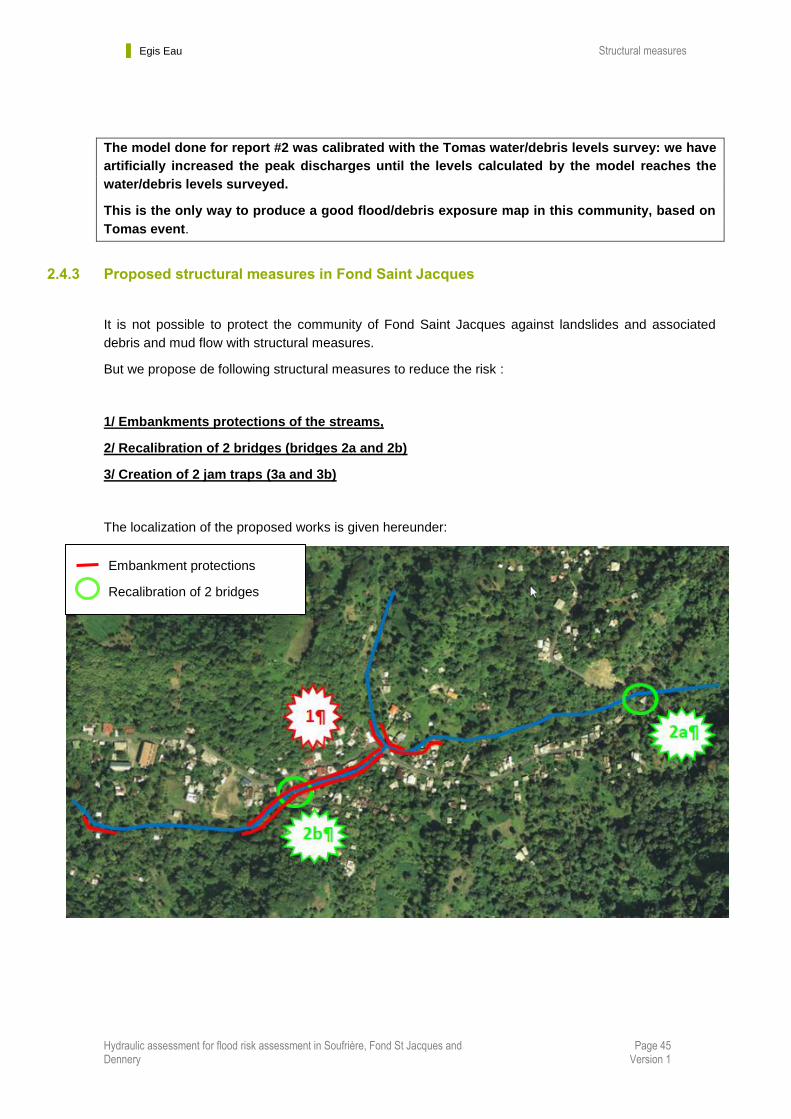
2.4.3 Proposed structural measures in Fond Saint Jacques
It is not possible to protect the community of Fond Saint Jacques against landslides and associated
debris and mud flow with structural measures.
But we propose de following structural measures to reduce the risk :
1/ Embankments protections of the streams,
2/ Recalibration of 2 bridges (bridges 2a and 2b)
3/ Creation of 2 jam traps (3a and 3b)
The localization of the proposed works is given hereunder:
Embankment protections
Recalibration of 2 bridges

Egis Eau Structural measures
Hydraulic assessment for flood risk assessment in Soufrière, Fond St Jacques and Dennery
Page 46 Version 1
Figure 42 : Localization of structural measures in Fond St Jacques
3b
3a
Egis Eau Structural measures
Hydraulic assessment for flood risk assessment in Soufrière, Fond St Jacques and Dennery
Page 47 Version 1
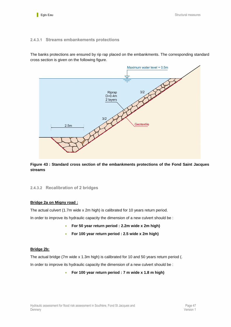
2.4.3.1 Streams embankements protections
The banks protections are ensured by rip rap placed on the embankments. The corresponding standard
cross section is given on the following figure.
Figure 43 : Standard cross section of the embankments protections of the Fond Saint Jacques
streams
2.4.3.2 Recalibration of 2 bridges
Bridge 2a on Migny road :
The actual culvert (1.7m wide x 2m high) is calibrated for 10 years return period.
In order to improve its hydraulic capacity the dimension of a new culvert should be :
For 50 year return period : 2.2m wide x 2m high)
For 100 year return period : 2.5 wide x 2m high)
Bridge 2b:
The actual bridge (7m wide x 1.3m high) is calibrated for 10 and 50 years return period (.
In order to improve its hydraulic capacity the dimension of a new culvert should be :
For 100 year return period : 7 m wide x 1.8 m high)

Egis Eau Structural measures
Hydraulic assessment for flood risk assessment in Soufrière, Fond St Jacques and Dennery
Page 48 Version 1
2.4.3.3 Jam traps
The construction of a jam trap upstream of the streams of the community of Fond St Jacques is feasible
and will be effective to protect the downstream inhabitants of the area.
It appears necessary to build a very massive structure in order to resist to a debris and mud flow caused
by an upstream landslide.
An example of this kind of structure is given hereafter.
Figure 44 : view of a debris flow resisting jam trap

Egis Eau Non-structural measures
Hydraulic assessment for flood risk assessment in Soufrière, Fond St Jacques and Dennery
Page 49 Version 1
Chapter 3. Non-structural measures
Non-structural measures are particularly important for the island of Saint Lucia for several reasons:
the high cost and short lifetime of structural measures
lack of capacity to build and operate structural measures
low involvement of local community, lack of feeling of ownership
other environmental impacts of structural measures
Non-structural measures tend to be more sustainable because they include the active involvement of
the community. National and regional policy should favour non-structural alternatives due to their low
cost and reduced number environmental side effects, and implement structural measures only as a last
resort.
Success in managing flood areas depends on selecting suitable measures based on flood
characteristics, physical and morphological characteristics of flood areas, economic and social
conditions, political and environmental conditioning, or flood-control works planning. Structural
measures cannot reach these objectives if they are used alone; non-structural measures such as land
use control and planning can be tools not only to reduce flood risk, but also to develop a sustainable
approach to flood management. Risk reduction is one of the main goals in flash flood management.
It can be dealt with in two ways: prevention strategies and mitigation strategies.
Table 2 : Non structural measures for risk reduction(source : Colombo et al. 2002)
Egis Eau Non-structural measures
Hydraulic assessment for flood risk assessment in Soufrière, Fond St Jacques and Dennery
Page 50 Version 1
3.1 Prevention strategies
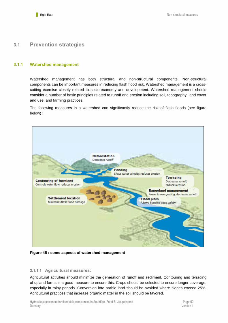
3.1.1 Watershed management
Watershed management has both structural and non-structural components. Non-structural
components can be important measures in reducing flash flood risk. Watershed management is a cross-
cutting exercise closely related to socio-economy and development. Watershed management should
consider a number of basic principles related to runoff and erosion including soil, topography, land cover
and use, and farming practices.
The following measures in a watershed can significantly reduce the risk of flash floods (see figure
below) :
Figure 45 : some aspects of watershed management
3.1.1.1 Agricultural measures:
Agricultural activities should minimize the generation of runoff and sediment. Contouring and terracing
of upland farms is a good measure to ensure this. Crops should be selected to ensure longer coverage,
especially in rainy periods. Conversion into arable land should be avoided where slopes exceed 25%.
Agricultural practices that increase organic matter in the soil should be favored.
Egis Eau Non-structural measures
Hydraulic assessment for flood risk assessment in Soufrière, Fond St Jacques and Dennery
Page 51 Version 1
Forestry:
Reforestation can be a good measure to decrease runoff. Tree species that do not prohibit undergrowth
should be selected. Logging should be carried out during non-rainy seasons. Favor mixed, uneven
aged, and autochthonous woods.
Rangeland management: Pasture renewal through fire must be avoided as this reduces soil organic
matter.
For the three studied communities, we propose the following watershed management principles:
Steep slopes (>25%) : avoid the destruction of existing forest – reforestation if needed
(especially on landslides)
Promote agricultural practices in floodplains (bottom of the valleys)
Control water on cultivated slopes in order to reduce soil erosion and landslide risk
Avoid agricultural practice on landslides but reforestation
3.1.1.2 Rivers maintenance plans:
In the three studied communities, lack of maintenance have been pointed out (see report#1 and #2) to
be one of the causes of malfunctioning drainage et flood evacuation.
This is why it is important to adopt and follow a maintenance plan of the studied rivers :
- Field inspections of river beds and banks at least twice a year (before and
after hurricanes and heavy rains period) : overview of infrastructures
stability (rip rap protections, bridges foundations …), state of the
vegetation, state of cleanliness of the river channels …
- Mechanical or hand clearing of river banks in inhabited areas every often
as needed
- Remove debris and rubbish every often as needed
- Mechanical clearing of the bottom of river beds (especially remove the
sand from the mouth of the rivers: Mole River and Soufriere River) every
often as needed
The regularity of these maintenance activities is important and not easy to define. We propose to
do it on a quarterly basis the first year and adapt the rhythm of the next years with this first year
feedback.
Egis Eau Non-structural measures
Hydraulic assessment for flood risk assessment in Soufrière, Fond St Jacques and Dennery
Page 52 Version 1
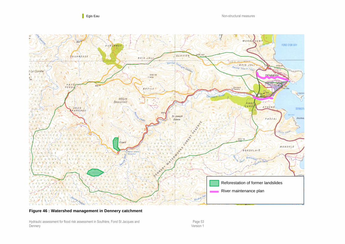
3.1.1.3 Watershed management In Dennery:
See next figure
Most part of the watershed is composed of steep slopes and the forest has to be preserved in these
areas.
We propose to reforest 2 zones where landslides have occurred during Tomas in the upper part of the
Mole river catchment (delineated with the aerial photograph taken after Tomas).
A rivers maintenance plan should be done in Dennery :
- Along the Mole river, from the mouth to the bridge of the main road
- Along the ravine Trou à l’Eau, from the mouth to the bridge of the main road
More generally a maintenance plan should be set along all de concrete drainage culverts of the center
of Dennery, to keep them clean and clear of obstruction.
Egis Eau Non-structural measures
Hydraulic assessment for flood risk assessment in Soufrière, Fond St Jacques and Dennery
Page 53 Version 1
Figure 46 : Watershed management in Dennery catchment
Reforestation of former landslides
River maintenance plan

Egis Eau Non-structural measures
Hydraulic assessment for flood risk assessment in Soufrière, Fond St Jacques and Dennery
Page 54 Version 1
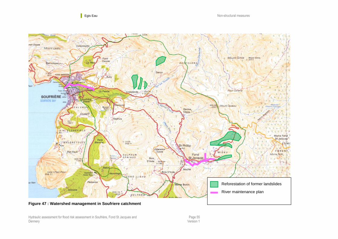
3.1.1.4 In Soufriere Watershed:
Most part of the watershed is composed of steep slopes and the forest has to be preserved in these
areas. We propose to reforest all zones where landslides have occurred during Tomas (delineated with
the aerial photograph taken after Tomas), and avoid agricultural practice on them (even it is a common
practice in Saint Lucia). The arable lands should be developed in the flat bottom of the streams valleys.
Egis Eau Non-structural measures
Hydraulic assessment for flood risk assessment in Soufrière, Fond St Jacques and Dennery
Page 55 Version 1
Figure 47 : Watershed management in Soufriere catchment
Reforestation of former landslides
River maintenance plan

Egis Eau Non-structural measures
Hydraulic assessment for flood risk assessment in Soufrière, Fond St Jacques and Dennery
Page 56 Version 1
3.1.1.5 Focus in fond saint Jacques watershed:
Most part of the watershed is composed of steep slopes and the forest has to be preserved in these
areas. We propose to reforest all zones where landslides have occurred during Tomas, and avoid
agricultural practice on them (even it is a common practice in Saint Lucia). The arable lands should be
developed in the flat bottom of the streams valleys.
In Fond Saint Jacques, the main problem is landslides, which cause devastating debris and mud flow in
the community. As Fond Saint Jacques is situated in the upper part of the watershed, the distance
between landslides areas and the first settlement is very short (less than 1km), meaning that the time
between a landslide and the first damage in Fond Saint Jacques is extremely short (less than 10 min).
This time is not enough to secure population: they will not have enough time to evacuate if there was an
alert.
Another difficulty of landslides is that it is not possible to predict when and where it could happen.
This leads us to propose the following measures in Fond Saint Jacques.
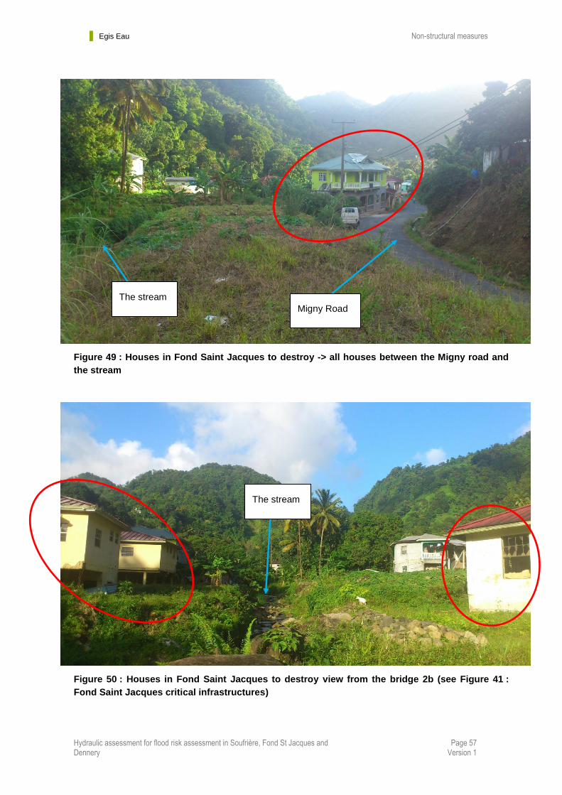
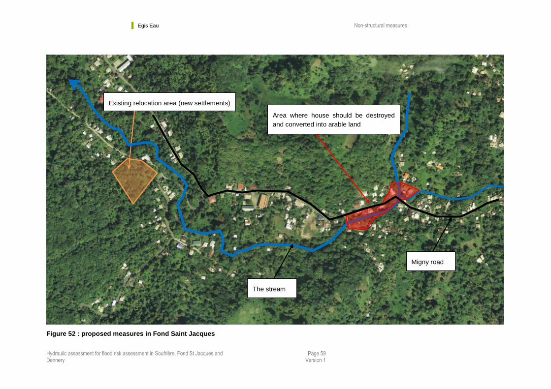
1/ To avoid the return of inhabitant along the streams : a program of new settlements has been
done after Tomas. The population most at risk (whose houses were damage during Tomas) is now
living in a safe area. But the damaged houses are still in place. To avoid the possible return of
inhabitant in the dangerous zone in the future, we propose to destroy those houses. (in the violet zone
of the hazard map – see Annex).
Figure 48 : picture of relocation settlements in Fond Saint Jacques
Egis Eau Non-structural measures
Hydraulic assessment for flood risk assessment in Soufrière, Fond St Jacques and Dennery
Page 57 Version 1
Figure 49 : Houses in Fond Saint Jacques to destroy -> all houses between the Migny road and
the stream
Figure 50 : Houses in Fond Saint Jacques to destroy view from the bridge 2b (see Figure 41 :
Fond Saint Jacques critical infrastructures)
The stream
Migny Road
The stream
Egis Eau Non-structural measures
Hydraulic assessment for flood risk assessment in Soufrière, Fond St Jacques and Dennery
Page 58 Version 1
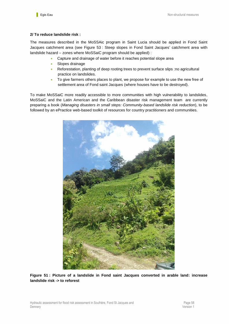
2/ To reduce landslide risk :
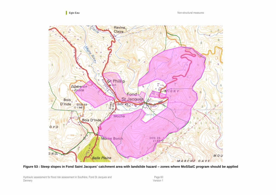
The measures described in the MoSSAic program in Saint Lucia should be applied in Fond Saint
Jacques catchment area (see Figure 53 : Steep slopes in Fond Saint Jacques’ catchment area with
landslide hazard – zones where MoSSaiC program should be applied) :
Capture and drainage of water before it reaches potential slope area
Slopes drainage
Reforestation, planting of deep rooting trees to prevent surface slips :no agricultural
practice on landslides.
To give farmers others places to plant, we propose for example to use the new free of
settlement area of Fond saint Jacques (where houses have to be destroyed).
To make MoSSaiC more readily accessible to more communities with high vulnerability to landslides,
MoSSaiC and the Latin American and the Caribbean disaster risk management team are currently
preparing a book (Managing disasters in small steps: Community-based landslide risk reduction), to be
followed by an ePractice web-based toolkit of resources for country practitioners and communities.
Figure 51 : Picture of a landslide in Fond saint Jacques converted in arable land: increase
landslide risk -> to reforest
Egis Eau Non-structural measures
Hydraulic assessment for flood risk assessment in Soufrière, Fond St Jacques and Dennery
Page 59 Version 1
Figure 52 : proposed measures in Fond Saint Jacques
Existing relocation area (new settlements)
Area where house should be destroyed
and converted into arable land
Migny road
The stream
Egis Eau Non-structural measures
Hydraulic assessment for flood risk assessment in Soufrière, Fond St Jacques and Dennery
Page 60 Version 1
Figure 53 : Steep slopes in Fond Saint Jacques’ catchment area with landslide hazard – zones where MoSSaiC program should be applied
Egis Eau Non-structural measures
Hydraulic assessment for flood risk assessment in Soufrière, Fond St Jacques and Dennery
Page 61 Version 1
3.1.2 Floodplain management and flood area regulation
3.1.2.1 Generalities
Floodplain management includes flash flood hazard mapping, which shows the areas that will
be impacted by a flood of a particular return period and enables delimitation of flood areas.
Flood hazard mapping can be conducted to different degrees of detail. A very simple flood
hazard map shows the area of inundation. In addition, the depth of inundation, the velocity of
flood water at a given location, elements at risk, and others can be provided.
– One important activity is the delimitation of flood areas and securing of flood plains.
Based on the technical study on flash flood hazard mapping, streams should have adequate
buffer areas to safely cater for flood waves. The floodplain can for example be divided into
different zones were constructions/activities should be prohibited, limited or authorized with
prescriptions, or fully authorized.
– Land use regulation : it is designed to reduce danger to life, property, and development
when flash floods occur. The following elements should be addressed while implementing land
use control in a watershed. Many of the elements mentioned here are directly related to
planning and policy makers, although flash flood managers should also have a good
understanding of these issues.
Prohibiting development in areas of high risk: No major development should
be permitted in these areas. Areas of high risk can be used for functions with a
lower risk potential such as nature reserves, sports facilities, and parks.
Functions with high damage potential such as hospitals should be permitted in
safe areas only.
Relocation of elements that block the flood passage: In addition to the
obvious danger of being damaged or washed away, buildings and other
structures blocking the floodway may cause damage by trapping floodwaters
which then overflow into formerly flood-free zones.
Implementation of a building code: The design of buildings and choice of
building materials should consider the probability and severity of flash floods.
Provision of escape routes: Land use plans should have clear escape routes
and provide refuge areas on higher ground.
Natural ponds in the watershed retain the runoff and dampen the peak
discharges in the stream. The ponds should be maintained properly and filling
the depressions for development purposes should be avoided.
Egis Eau Non-structural measures
Hydraulic assessment for flood risk assessment in Soufrière, Fond St Jacques and Dennery
Page 62 Version 1
3.1.2.2 Flood hazard mapping in the three studied communities
The INTERREG IV "Caribbean" program was approved by the European Commission on 27
March 2008, for the benefit of the Caribbean regions.
As part of this program, Egis has participate with the redaction of “Guide for disaster risk
prevention and reduction plan (PPR) in the Caribbean”
In this guide, the recommendation for risk mapping it a crossing between the flood levels
map and velocity map. The maps have to be done for the 1-in-100 years return period or
the highest flood known. In the three studied communities, Tomas event is higher than
the 1-in-100 flood event.
This is why for Dennery, Soufriere and Fond Saint Jacques, the flood hazard maps are
done with Tomas event.
FLOOD HAZARD
Based on Tomas Event
Velocity
Height
Low and interm.
between 0 et 1 m/s
High
over 1 m/s
H < 1 m Medium risk High risk
1 < H < 3 m High risk High risk
H > 3 m Major risk Major risk
Table 3 : Flood hazard mapping criteria for Dennery, Soufriere and Fond Saint Jacques
The corresponding Flood Hazard maps in Dennery, Soufriere and Fond Saint Jacques are given at the end of the report (see Annexes).
Major Flood Risk (purple) : exceptional hazard – riks and damages are extremely
severe - human lives are threatened.
High Flood Risk (red) : risks and damages are important. Protection measures are difficult and expensive to implement. Human lives are threatened.
Medium Flood risk (orange) : lot of damages but bearable and protection measures are possible.
Low Flood Risk (no color) : flood risk are very low.
Constructions rules must been associated to every zone of this map. Those rules, written with international engineering best practice, are given hereunder.

Egis Eau Non-structural measures
Hydraulic assessment for flood risk assessment in Soufrière, Fond St Jacques and Dennery
Page 63 Version 1
Flood Major Risk zones (Purple zones)
In purple zones, rules must be made to remove exposed population and properties.
The principle are :
- NO CONSTRUCTIBILITY (This means no new construction, no reconstruction of
destroyed buildings.)
- DESTRUCTION OF EXISTING BUILDINGS AND RELOCATION OF PEOPLE ALREADY
LIVING IN THE ZONE.
High Risk zones (Red zones)
In red zones, rules must be made to enhance risk management, improve the security of
people already living in the zone and not increase exposed population and properties.
The principle is NO CONSTRUCTIBILITY.
This means no new construction and no reconstruction of destroyed buildings.
But some projects, activities or works could be authorized in order to let people go on
with their lives, if they are compatible with the described objectives.
For existing constructions with floor lower than Tomas water level, push for:
- a shelter level (second floor or operable roof window)
- and cofferdams at all the outside doors.
Medium Risk zones (Orange zones)
In orange zones, rules must be made to enhance risk management, improve the security
of people already living in the zone and new inhabitants.
The principle is CONSTRUCTIBILITY WITH PRESCIPTIONS.
Prescriptions are :
- For new constructions : first floor level 0.50m above Tomas water level
- For new constructions : construction on silts (to let the water pass under the building)
- For existing constructions with floor lower than Tomas water level : add a shelter level
(second floor or operable roof window) and put cofferdams at all the outside doors.
Egis Eau Non-structural measures
Hydraulic assessment for flood risk assessment in Soufrière, Fond St Jacques and Dennery
Page 64 Version 1
3.2 Mitigation strategies
The following sections provide some examples of non-structural measures that can be used to
reduce the intensity, frequency, and impacts of flash floods.
3.2.1 Reducing discharge through natural retention
Studies on water flow have identified the early securing of areas for flood control purposes, so
as to have them available in emergency situations, as a crucial aspect. To this end, natural
retention areas must be identified and improved, although this is in contrast with the desire to
use them for industrial, economic, settlement, and transport purposes. Specific regulations
should be made to avoid exploitation conflicts that may arise. Agricultural practices or sports
fields for example can be allowed in those areas.
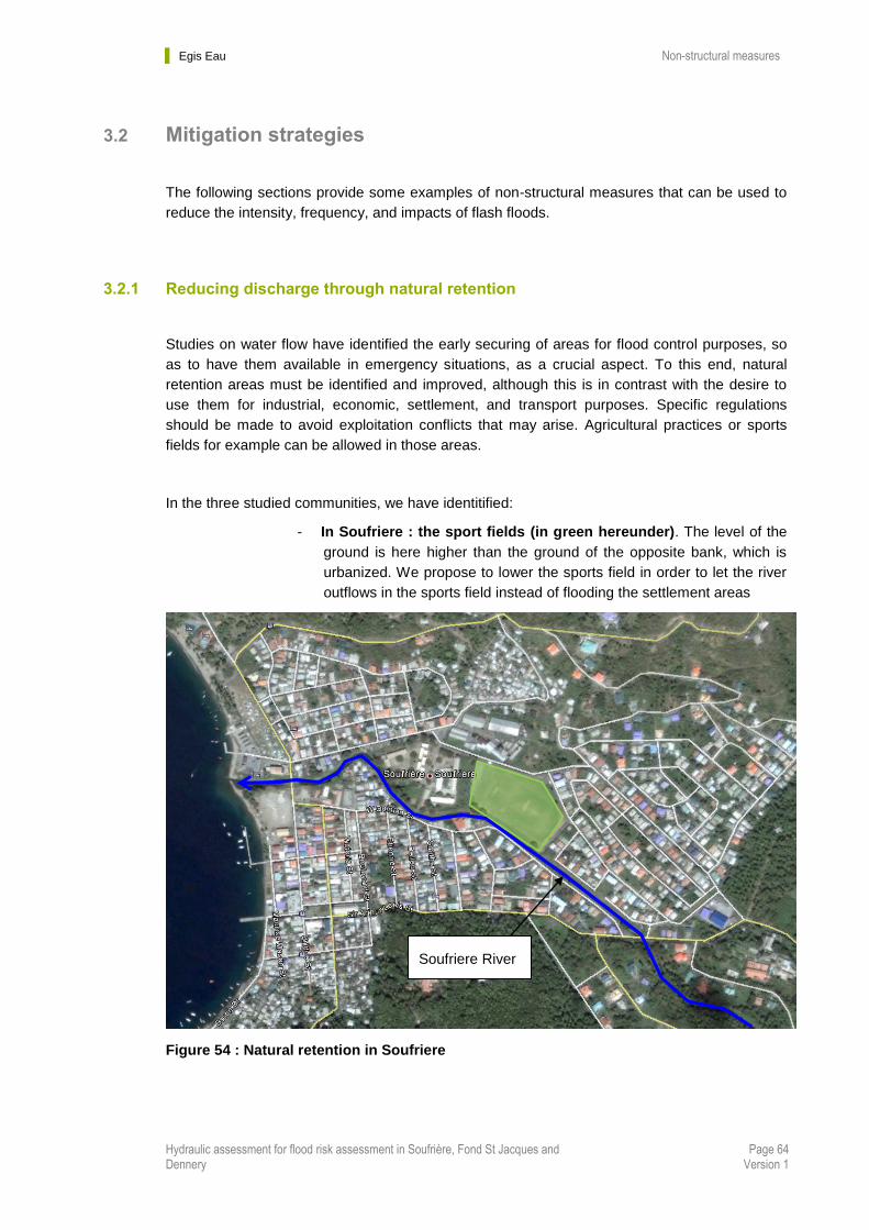
In the three studied communities, we have identitified:
- In Soufriere : the sport fields (in green hereunder). The level of the
ground is here higher than the ground of the opposite bank, which is
urbanized. We propose to lower the sports field in order to let the river
outflows in the sports field instead of flooding the settlement areas
Figure 54 : Natural retention in Soufriere
Soufriere River
Egis Eau Non-structural measures
Hydraulic assessment for flood risk assessment in Soufrière, Fond St Jacques and Dennery
Page 65 Version 1
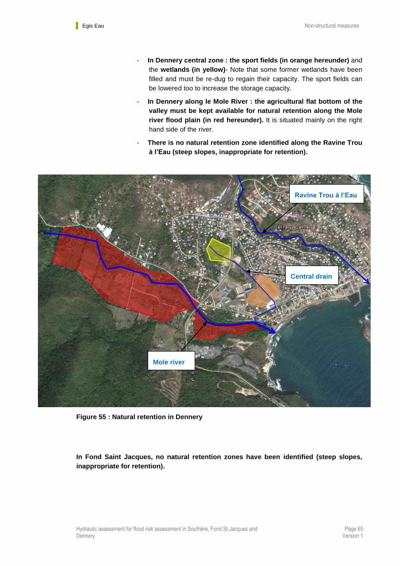
- In Dennery central zone : the sport fields (in orange hereunder) and
the wetlands (in yellow)- Note that some former wetlands have been
filled and must be re-dug to regain their capacity. The sport fields can
be lowered too to increase the storage capacity.
- In Dennery along le Mole River : the agricultural flat bottom of the
valley must be kept available for natural retention along the Mole
river flood plain (in red hereunder). It is situated mainly on the right
hand side of the river.
- There is no natural retention zone identified along the Ravine Trou
à l’Eau (steep slopes, inappropriate for retention).
Figure 55 : Natural retention in Dennery
In Fond Saint Jacques, no natural retention zones have been identified (steep slopes,
inappropriate for retention).
Mole river
Central drain
Ravine Trou à l’Eau

Egis Eau Non-structural measures
Hydraulic assessment for flood risk assessment in Soufrière, Fond St Jacques and Dennery
Page 66 Version 1
3.2.2 Monitoring, warning, and response system (MWRS)
3.2.2.1 General overview
Actions based on monitoring, warning, and response systems (MWRSs) can be a very effective
form of nonstructural flash flood management. MWRSs include many components, all of which
contribute towards the mitigation of flash floods. MWRS is often referred to as an end-to-end
flash flood mitigation system. Each component in the system is explained below. Failure of any
of these components to function can hamper the effectiveness of the whole system (See Figure
56 : Scheme of possible monitoring, warning and response system.)
Figure 56 : Scheme of possible monitoring, warning and response system
Data collection and monitoring system
Monitoring extreme hydrometeorological events is the first step towards understanding what
could happen in the future and choosing from possible alternatives. Collection of
hydrometeorological data, such as rainfall, temperature, and streamflow, is essential for
simulating the natural phenomena. Ground observation networks are commonly used to collect
rainfall and other meteorological data. However, radar-based precipitation estimation may be
Egis Eau Non-structural measures
Hydraulic assessment for flood risk assessment in Soufrière, Fond St Jacques and Dennery
Page 67 Version 1
the only source of rainfall data due to scarcity of hydrometeorological networks, long delays in
data transmission. A ground-based network seldom has the density sufficient to reflect the
natural spatial variability of precipitation, particularly in mountainous terrain. Radar estimation
can be a valuable complement in such cases. On the other hand, radar estimates are
sometimes biased due to different limitations such as orographic effects and warm cloud
processes. Thus, it is not possible to rely on radar rainfall estimates alone. A combined radar
and surface-based rainfall estimate provides the best input for flash flood forecasting and early
warning systems.
Data transmission system
An efficient data transmission system is necessary for timely data transfer from the monitoring
site to the centre where the data are analysed. After analysis, the forecasts and warning
messages should be relayed to end users in a timely manner. A wide range of data
transmission systems are available. Automatic transmission of data from the gauge to the
centre through different digital media such as terrestrial telephone, GSM, or satellite
connections is the most reliable, although the high cost of such systems can be a limitation.
Forecasting system
Forecasting systems can also vary in complexity. Normally, a forecasting system consists of
models (hydrological, hydraulic, and so on) that predict scenarios of potential flash flood events
and closely follow the evolution of key parameters that could trigger them. The model may be
complicated and can result in very accurate forecasting, but may be of no use if the computation
takes so long that it does not provide sufficient lead time before the flood event. Flash floods are
rapid processes and often lead time is very small. Further, lack of sufficient data regarding land
characteristics hinders the application of sophisticated models. Flash flood managers should
consider all these aspects while selecting models for flash flood forecasting. More simplistic
models, such as flash flood guidance tables, may be preferable.
Warning system
The general public may not be able to interpret quantitative flash flood forecasts, in which case
qualitative warnings have to be issued. Floods are classified into different categories of
warnings, which communities and stakeholders should be able to interpret in terms of impact on
them. Flash flood guidance can be the volume of rainfall in a given duration over a given small
catchment that is just enough to cause minor flooding at the outlet of the draining stream. Any
rainfall in excess of the flash flood guidance is considered a flash flood threat.
Dissemination system
After a flood forecast and warning are prepared, they must be disseminated effectively. In the
majority of cases, good forecasts fail to prevent damage and loss of life due to poor
dissemination systems. The forecasts and warnings should reach agencies related to the
disaster management system in a timely and understandable manner. These agencies should
issue forecasts and warnings by appropriate media such as radio and television and to different
levels of disaster management units down to the lowest level. The warning should be clear and
concise to be understandable by communities and should use language that will not cause

Egis Eau Non-structural measures
Hydraulic assessment for flood risk assessment in Soufrière, Fond St Jacques and Dennery
Page 68 Version 1
unnecessary panic. The warning may be in text or use diagrams and maps. It is necessary to
conduct community awareness raising programmes to help people understand the warnings. In
some communities, small inexpensive radios can be distributed in risk areas so that they have
access to warnings.
Disaster Management System
Even where there is accurate and timely issue of forecasts and warnings, flash flood damage
can happen. A disaster management system should be well-prepared for such events. The
disaster management system should have an overall vision of the crisis situation. It is the task of
the system to alert key action groups, which is part of the response system.
Response System
A response system consists of actions by groups such as
● police and fire brigade (e.g., assisting vulnerable groups such as the elderly and the
handicapped in flood-proofing their houses, evacuation procedures, and so on)
● civil protection authorities (e.g., dissemination of targeted information)
● voluntary groups (e.g., assisting the injured, allocating resources)
● military (e.g., preparing sandbags, constructing temporary structures)
● media (dissemination of information).
3.2.2.2 Proposed MWRS in the three communities
In the three studied communities, the main problem is the very short time between rainfall and
correlated floods :
- In Dennery : less than 2h30min
- In Soufriere : less than 1h
- In Fond saint Jacques : less than 10 min
This means that in the 3 communities, flash floods are rapid processes and lead time is very
small.
In the light of the previous paragraphs and We propose several actions :
- Use the real-time data of the radar of Martinique
- Add rain gauges in the studied watersheds (automatic rain gauges,
maximum time-steps of 30 min – and 10 min for Fond Saint Jacques) ,
- Add discharge gauges on the Mole river and on the Soufriere river
- Connect all the gauges (existing and proposed ones) to NEMO center
which should be responsible of all the real-time data collection,
transmission, warning, dissemination and response system.

Egis Eau Non-structural measures
Hydraulic assessment for flood risk assessment in Soufrière, Fond St Jacques and Dennery
Page 69 Version 1
In Saint Lucia, rain gauges and water level stations are now operated by WRMA and the
automatic weather stations are operated by Met Office.
A combined radar and surface-based rainfall estimate provides the best input for flash
flood forecasting and early warning systems.
The principle is to have a minimum of 2 rain gauges in the catchments of Dennery and
Soufriere (Fond saint Jacques is situated in the Soufriere catchment).
Two rain gauges will secure the rainfall measures, even if one of them is not operational.
A minimum of 2 discharges gauges is necessary too, on the Mole river and on the
Soufriere river, one upstream were the flood are often , and one downstream, near the
towns.
The rain gauges and the upstream discharge gauges are necessary to warn people as
soon as possible that there is a flood risk.
The downstream discharge gauges are necessary to alert people of flooding threat.
These gauges should be linked to a siren placed in the center of Dennery and Soufriere
(for example on the roof of the fire station in Soufriere and on the roof of Dennery school
or church). The siren should sound if the level in the river is increasing and reach a
specific threshold level.
All data should be collected during several years. The aim is to set an accurate
hydrological model in the studied communities, based on the collected data. This will
lead to a reliable forecasting system for the communities, improved every year with local
events and measurements.
Rain gauges should be placed near a road (for an easy access), in an open area where there
are no obstacles, such as buildings or trees, to block the rain. This is also to prevent the water
collected on the roofs of buildings or the leaves of trees from dripping into the rain gauge after a
rain, resulting in inaccurate readings.
In Dennery :
There is an existing rain station, Errard Estate, in the middle of the catchment. We propose to
use this station and equip it with automatic rain gauges if not.
We also propose to add two more automatic rain gauges in the catchment :
- One in the upper part of the catchment, near the “Deux Branche” road.
Egis Eau Non-structural measures
Hydraulic assessment for flood risk assessment in Soufrière, Fond St Jacques and Dennery
Page 70 Version 1
- One in the downstream part of the Catchement, in the Ravine Trou à
l’Eau watershed
Moreover, 2 discharge stations should be placed on the Mole river : one near Errard road , and
one on the bridge of the main road in Dennery. If the water reach a threshold level, population
should be worn with a siren.
Their location is shown in the “Figure 57 : Proposed locations for monitoring and warning
system in Dennery Catchment” and is indicative.
In Soufriere / Fond Saint Jacques :
There are two existing rain stations, Desraches and Soufriere, in the middle of the catchment.
We propose to use these stations and equip them with automatic rain gauges if not.
We also propose to add one more automatic rain gauge in the Fond Saint Jacques catchment.
Moreover, 2 discharge stations should be placed on the river :
- one on the new Fond Saint Jacques bridge (Mocha road) ,
- and one on the bridge in Soufriere (Fond Saint Jacques road). If the
water reaches a threshold level, population should be worn with a siren.
Their location is shown in the “Figure 58 : Proposed locations for monitoring and warning
system in Soufriere Catchment” and is indicative.
In Fond Saint Jacques, time is too short for an early warming. The best way to increase the
delay is to follow the real-time radar data (Martinique radar), linked it with local rain gauges to
calculate a correcting parameter if needed (in order to correlate radar images and local rain
gauges measurements).
But the delay between a potential alert and the flash and debris flood arrival will be very short
(few minutes).
This is why we propose to relocate people living along the streams in Fond Saint Jacques as
much as possible.

Egis Eau Non-structural measures
Hydraulic assessment for flood risk assessment in Soufrière, Fond St Jacques and Dennery
Page 71 Version 1
Figure 57 : Proposed locations for monitoring and warning system in Dennery Catchment
Catchment area
Existing rain station : Errard Estate
Proposed rain stations
Proposed discharge stations

Egis Eau Non-structural measures
Hydraulic assessment for flood risk assessment in Soufrière, Fond St Jacques and Dennery
Page 72 Version 1
Figure 58 : Proposed locations for monitoring and warning system in Soufriere Catchment
Existing rain stations : Desraches and
Soufriere
Proposed rain stations
Proposed discharge stations

Egis Eau Non-structural measures
Hydraulic assessment for flood risk assessment in Soufrière, Fond St Jacques and Dennery
Page 73 Version 1
3.2.3 Public information and education
Maximum community involvement is essential for effective preparedness towards mitigating
flash flood risk. Awareness must be created about the hazard and existing resources. Various
awareness campaigns can be done to inform and unite the community. Methods to influence
people can include:
● posters
● brochures
● school arts and essay competitions
● Memory museum/flood marks to keep in mind past events
● audio-visual methods
● training and demonstrations
● regular drills
This section will be detailed in report #5 and #6.
Egis Eau Costs and prioritization
Hydraulic assessment for flood risk assessment in Soufrière, Fond St Jacques and Dennery
Page 74 Version 1
Chapter 4. Costs and prioritization
4.1 Return period definition
A return period, also known as a recurrence interval is an estimate of the likelihood of an
event, such as flood to occur.
The theoretical return period is the inverse of the probability that the event will be exceeded in any one year (or more accurately the inverse of the expected number of occurrences in a year). For example, a 10 year flood has a 1/10 = 0.1 (or 10%) chance of being exceeded in any one year and a 50 year flood has a 0.02 or 2% chance of being exceeded in any one year.
This does not mean that a 100 year flood (also called 1-in-100 year flood) will happen regularly every 100 years, or only once in 100 years. Despite the connotations of the name "return period". In any given 100 year period, a 100 year event may occur once, twice, more, or not at all.
A 10 year flood as 10% chance of being seen in a year
A 50 year flood as 2% chance of being seen in a year
A 100 year flood as 1% chance of being seen in a year
4.2 In DENNERY
The prioritization of structural and non structural measures proposed in Dennery is given
hereunder.
1/ The first thing to do is to apply a flood area regulation (see chapter 3.1.2) in the community
of Dennery, based on the flood hazard map provided in this report. This regulation will have to
be explained to the population, and therefore associated with public awareness raising
campaigns and education.
2/ Organize a river and drainage maintenance plan in Dennery
3/ Then structural measures have to be done. There is no prioritization of them, as they are all
necessary to protect the community of Dennery against floods:
Mole river structural measures
Central drain structural measures
Ravine trou à l’eau structural measures
The client should only choose the return period for each structural measure, and the type of
solution/hypothesis.

Egis Eau Costs and prioritization
Hydraulic assessment for flood risk assessment in Soufrière, Fond St Jacques and Dennery
Page 75 Version 1
The structural measures for a “x” return period had been calibrated to have NO OVERFLOW for
rainfall events lower than the “x” return period event. For more intense rainfall events, there will
be overflow in the community (and associated flood damages).
Type of work Flood return period Cost in USD ($)
Mole river Dike and wall on
the left bank
Hypothesis 1 : large outlet
T = 50 years 2 850 000
T = 100 years 2 900 000
Tomas event 2 970 000
Mole river Dike and wall on
the left bank
Hypothesis 2 : hotel on the
right bank
T = 50 years 2 860 000
T = 100 years 2 950 000
Tomas event 3 100 000
Recalibration of the Central
drain
Solution 1 : no storage pond
T = 50 years 4 600 000
T = 100 years 5 200 000
Tomas event 5 200 000
Recalibration of the Central
drain
Solution 2 : storage pond
T = 50 years 4 000 000
T = 100 years 4 500 000
Tomas event 4 500 000
Ravine trou à l’eau
embankment protections All return periods 485 000
Ravine trou à l’eau
recalibration
Solution 1 : widening on the
right bank
T = 50 years 3 300 000
T = 100 years 3 600 000
Tomas event 3 900 000
Ravine trou à l’eau
recalibration
Solution 2 : widening on the
left bank
T = 50 years 2 700 000
T = 100 years 2 800 000
Tomas event 2 900 000
Table 4 : costs of structural measures in Dennery
4/ Reforestation plan
5/ Monitoring program
6/ Warning system
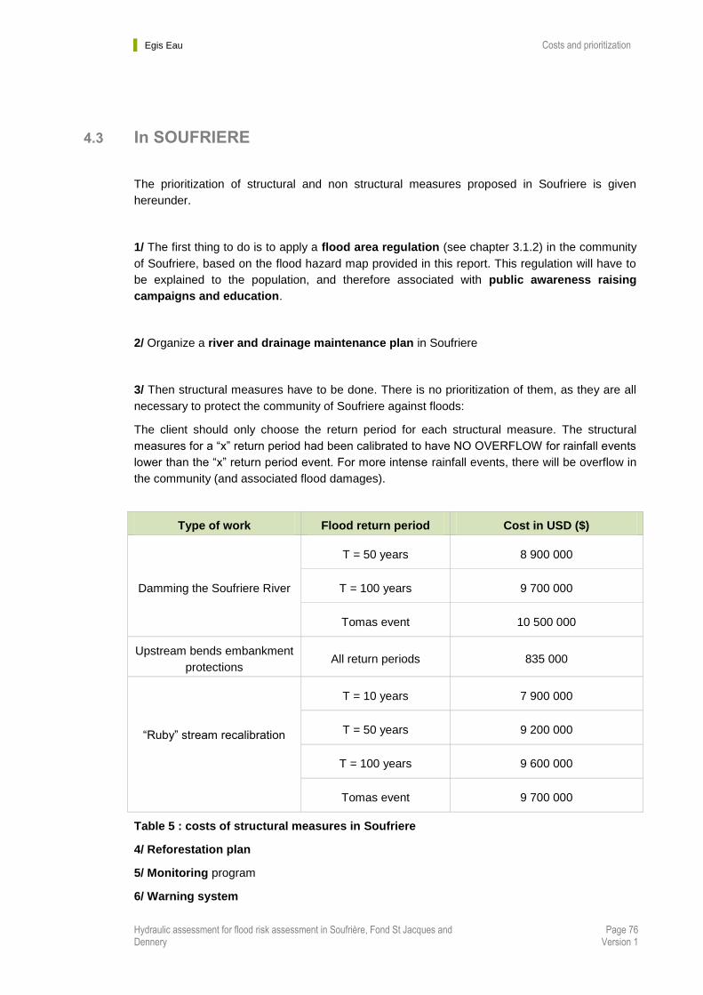
Egis Eau Costs and prioritization
Hydraulic assessment for flood risk assessment in Soufrière, Fond St Jacques and Dennery
Page 76 Version 1
4.3 In SOUFRIERE
The prioritization of structural and non structural measures proposed in Soufriere is given
hereunder.
1/ The first thing to do is to apply a flood area regulation (see chapter 3.1.2) in the community
of Soufriere, based on the flood hazard map provided in this report. This regulation will have to
be explained to the population, and therefore associated with public awareness raising
campaigns and education.
2/ Organize a river and drainage maintenance plan in Soufriere
3/ Then structural measures have to be done. There is no prioritization of them, as they are all
necessary to protect the community of Soufriere against floods:
The client should only choose the return period for each structural measure. The structural
measures for a “x” return period had been calibrated to have NO OVERFLOW for rainfall events
lower than the “x” return period event. For more intense rainfall events, there will be overflow in
the community (and associated flood damages).
Type of work Flood return period Cost in USD ($)
Damming the Soufriere River
T = 50 years 8 900 000
T = 100 years 9 700 000
Tomas event 10 500 000
Upstream bends embankment
protections All return periods 835 000
“Ruby” stream recalibration
T = 10 years 7 900 000
T = 50 years 9 200 000
T = 100 years 9 600 000
Tomas event 9 700 000
Table 5 : costs of structural measures in Soufriere
4/ Reforestation plan
5/ Monitoring program
6/ Warning system
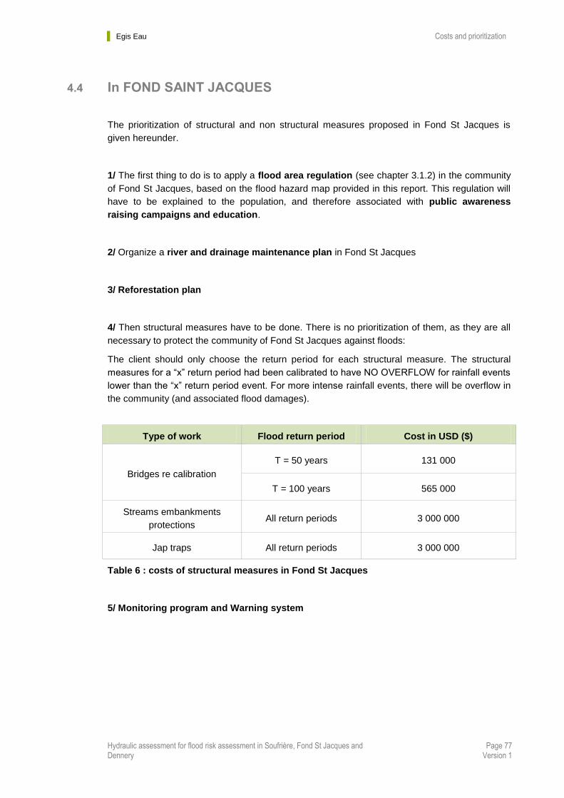
Egis Eau Costs and prioritization
Hydraulic assessment for flood risk assessment in Soufrière, Fond St Jacques and Dennery
Page 77 Version 1
4.4 In FOND SAINT JACQUES
The prioritization of structural and non structural measures proposed in Fond St Jacques is
given hereunder.
1/ The first thing to do is to apply a flood area regulation (see chapter 3.1.2) in the community
of Fond St Jacques, based on the flood hazard map provided in this report. This regulation will
have to be explained to the population, and therefore associated with public awareness
raising campaigns and education.
2/ Organize a river and drainage maintenance plan in Fond St Jacques
3/ Reforestation plan
4/ Then structural measures have to be done. There is no prioritization of them, as they are all
necessary to protect the community of Fond St Jacques against floods:
The client should only choose the return period for each structural measure. The structural
measures for a “x” return period had been calibrated to have NO OVERFLOW for rainfall events
lower than the “x” return period event. For more intense rainfall events, there will be overflow in
the community (and associated flood damages).
Type of work Flood return period Cost in USD ($)
Bridges re calibration
T = 50 years 131 000
T = 100 years 565 000
Streams embankments
protections All return periods 3 000 000
Jap traps All return periods 3 000 000
Table 6 : costs of structural measures in Fond St Jacques
5/ Monitoring program and Warning system
Egis Eau Conclusion
Hydraulic assessment for flood risk assessment in Soufrière, Fond St Jacques and Dennery
Page 78 Version 1
Chapter 5. Conclusion
Success in managing flood areas depends on selecting suitable measures based on
flood characteristics, physical and morphological characteristics of flood areas,
economic and social conditions, political and environmental conditioning, or flood-
control works planning. Structural measures cannot reach these objectives if they are
used alone; non-structural measures such as land use control and planning can be tools
not only to reduce flood risk, but also to develop a sustainable approach to flood
management
In this report, various type of structural measures have been proposed. A large scale of
structural measures has therefore been proposed, calibrated and cost estimated in a first
approach for various return periods.
Once the client will have chosen the type of structural measures and their associated
return periods, we will perform the corresponding Preliminary Design, as per the terms of
references, and produce the final flood exposure maps for the 3 studied communities.
But as said in the report, first priority should be to adopt and enforce a building code for
the 3 communities associated with hazard zoning maps should be adopted and enforced.
At various times in Saint Lucia's history building codes have been proposed, written, and
edited. Such a document can be a major advance for disaster mitigation and would offer
considerable increase in long-term cost savings from future disasters at modest current
increases in construction costs.

Études générales
Assistance au Maître d’Ouvrage
Maîtrise d’œuvre conception
Maîtrise d’œuvre travaux
Formation
Egis Eau Siège social
78, allée John Napier
CS 89017
34965 - Montpellier Cedex 2
Tél. : 04 67 99 22 00
Fax : 04 67 65 03 18
http://www.egis-eau.