Symmagmatic folding of the base of the Bergell pluton, Central Alps

Tectonophysics 476 (2009) 436–449
Contents lists available at ScienceDirect
Tectonophysics
j ourna l homepage: www.e lsev ie r.com/ locate / tecto
Geophysical modeling and structure of Ushuaia Pluton, Fuegian Andes, Argentina
Javier Ignacio Peroni a,⁎, Alejandro Alberto Tassone a, Marco Menichetti b, María Elena Cerredo c
a CONICET-INGEODAV, Dpto. de Ciencias Geológicas, Facultad de Ciencias Exactas y Naturales, Universidad de Buenos Aires, Ciudad Universitaria, Pabellón 2,CP-C1428EHA, Buenos Aires, Argentinab Istituto di Scienze della Terra, Università di Urbino, Campus Scientifico Universitario, 61029, Urbino, Italyc CONICET, Dept. Cs. Geológicas, FCEyN, Universidad de Buenos Aires, Argentina
⁎ Corresponding author.E-mail addresses: [email protected] (J.I. Peroni),
(A.A. Tassone), [email protected] (M. Menichetti), c(M.E. Cerredo).
0040-1951/$ – see front matter © 2009 Elsevier B.V. Adoi:10.1016/j.tecto.2009.07.016
a b s t r a c t
a r t i c l e i n f oArticle history:Received 6 November 2008Received in revised form 17 July 2009Accepted 20 July 2009Available online 28 July 2009
Keywords:Magnetic modelingPluton emplacementStrike-slip activityTierra del Fuego
Within the area of Ushuaia Bay (Tierra del Fuego, southernmost South America) the deformed LowerCretaceous sedimentary rocks of Yahgán Formation host the Ushuaia Pluton. The intrusive body is oval inmap view; it is compositionally varied with rocks ranging from the ultrabasic to the mesosiliceous realm.The emplacement time is constrained within the Albian–Cenomanian span by new amphibole K/Ar data.Meso- and microstructures of Ushuaia Pluton and its host indicate a synkinematic emplacement with adominant extensional component. A set of transcurrent and normal faults related to the sinistral strike-slipBeagle Channel Fault System affects the pluton and its host. On the basis of aeromagnetic data combinedwith field information, a new model is presented for the Ushuaia Pluton. Modeling results fit well with alaccolithic body with an estimated volume of around 111 km3. The model pluton cross-section displays acentral zone with an average thickness of 2000 m which progressively thins toward the margins (∼500 m)and a southern root which reaches 5000 m deep. The combined structural and geophysical model supports atranstensive scenario for the Ushuaia Pluton emplacement at Early–Late Cretaceous boundary.
© 2009 Elsevier B.V. All rights reserved.
1. Introduction
The tectonic evolution of Tierra del Fuego has been subjected tomany studies, especially the area between the Fuegian orogen and thefold and thrust belt in the southernmost region of the Andes(Cunningham, 1993; Klepeis, 1994; Mukasa and Dalziel, 1996;Diraison et al., 2000; Lodolo et al., 2002a,b, 2003; Kraemer, 2003;Gighlione and Ramos, 2005; Menichetti et al., 2008 and referencescited therein). Other aspects, such as stratigraphy, related to theevolution of Tierra del Fuego, have been studied in the Argentineanpart of the island, setting an appropriate framework for othergeological studies in the area (Martinioni et al., 1999; Olivero et al.,1999; Olivero and Malumián, 1999; Olivero and Martinioni, 2001;Olivero and Malumián, 2008; and references cited therein), and itscorrelation with the off shore (Tassone et al., 2008). Also, petrologicstudies of small intrusive bodies have been made in the Argentineanpart (Cerredo et al., 2000; Acevedo et al., 2002; Cerredo et al., 2005).However, amultidisciplinary systematic study of these igneous bodieshas not been carried out so far. That is why, in the last five years,scientist from INGEODAV and collaborators have performed severalgeophysical and structural studies about the nature of many intrusive
[email protected]@gl.fcen.uba.ar
ll rights reserved.
bodies and the environment in which they are emplaced in theArgentinean part of Tierra del Fuego, including magnetic and 2Dgravimetric modeling (Tassone et al., 2002, 2005a, 2006; Peroni,2006; Menichetti et al., 2007; Peroni et al., 2007, 2008a) in addition tothe systematic survey of magnetic fabric data (anisotropy of magneticsusceptibility) and paleomagnetic studies (Baraldo et al., 2002;Rapalini et al., 2005; Esteban et al., 2007; Rapalini, 2007; Esteban,2008).
The Ushuaia Pluton is one of the few outcrops of the FuegianBatholith in the Argentinean part of Isla Grande de Tierra del Fuego.This batholith mainly outcrops south of the Beagle Channel, in theChilean sector, making a long belt of exposures, in Hoste and NavarinoIslands (Fig. 1A) and south-western Chilean territory, and belongs tothe southernmost part of the Patagonian Batholith (Fig. 1B). It iscomposed of multiple intrusion, where three groups were distin-guished: the Gabbro Complex of lower Cretaceous age (141–103 Ma)and two granitoid assemblages, the Beagle Channel Plutonic Group ofCretaceous age (113–81 Ma) and the Seno Año Nuevo Plutonic Groupin Paleocene times (60–34 Ma) (Hervé et al., 1984). On the northernmargin of Beagle Channel, in Isla Grande de Tierra del Fuego (Fig. 1A),the exposures currently known are scarce and small, usually less than20 km2 such as the Kranck pluton, located on the northern margin ofFagnano Lake (Tassone et al., 2007; Peroni et al., 2008b), the Moatdioritic pluton (González Guillot et al., 2005), a few dioritic stocks inthe area of Rancho de la Lata, on the Paso Spion-Kop, studied byPetersen (1949), the Jeu-Jepén intrusive (Tassone et al., 1998, 1999;

Fig. 1. A) Geological units within the study area and surroundings: 1 – Undifferentiated Fuegian Batholith, 2 – Tortuga complex, 3 – Lemaire Fm., 4 – Yahgán Fm. SCB: Beagle ChannelFault System, CF: Cadic Fault, AF: Andorra Fault, EBF: East Beagle Fault, MFS: Magallanes–Fagnano Fault System (modified from Menichetti et al., 2007). Box indicates the area ofFig. 2. B) Location of the area of Fig. 1A within the southern tip of South America. Arrowed lines indicate the extension of different segments of the Patagonian Batholith (after Hervéet al., 2007). BPN: North Patagonian Batholith. BPA: South Patagonian Batholith. BF: Fuegian Batholith.
437J.I. Peroni et al. / Tectonophysics 476 (2009) 436–449
Acevedo et al., 2000; Cerredo et al., 2000, 2005; Tassone et al., 2005a,b) and the Ushuaia Pluton (Acevedo et al., 1989, 2002; Acevedo, 1996;Tassone et al., 2005b, 2006; Peroni, 2006; Cerredo et al., 2007;Menichetti et al., 2007).
Since most parts of Isla Grande de Tierra del Fuego is covered byforest and peat which restrict the exposed surface of the intrusivebodies, the information provided by geophysics becomes a funda-mental tool for the study of these poorly exposed plutons.
The goal of this study was to obtain the model of the UshuaiaPluton in order to extrapolate in depth the surface observations.This model was obtained using geological information (lithologyintegrated to structures), geophysical data (aeromagnetic anomalies,magnetic susceptibilities and values of remanent magnetic fields).
2. Regional tectonic frame
The Isla Grande de Tierra del Fuego is located in the southernmostportion of the Andes where a steep flexion of almost 90° eastwarddeviates it from the N to S axis along the western edge of SouthAmerica. It has been proposed that this sharp orogenic curvature isdue to major strike-slip offsets (Cunningham, 1993).
The current tectonic arrangement of Tierra del Fuego is the result ofa long and complex evolutionwhich involved the southernmost part ofSouth America, South Africa and Antarctica, beginning in the Paleozoicwhen these three plates were part of Gondwana. Towards thebeginning of the Mesozoic, a subduction zone along the active westernmargin of the super continent was developed (Dalziel and Elliott,1973; Dalziel, 1982). Due to the regional extension associated with thebreak-up of Gondwana, during lower toMiddle Jurassic (Bruhn, 1979),there was an extensive emission of silicic–volcanic material all overPatagonia, including Fuegian Andes, the Tobífera Formation, which isknown as the Lemaire Formation in Argentina. This extensional periodwas associatedwith the formation of oceanic crust (represented by theTortuga complex in the Southern Archipelago, and the Sarmiento
Ophiolite emplacements in Southern Patagonia) due to the develop-ment of Rocas Verdes marginal basin (Dalziel and Elliott, 1973) withthe consequent deposition of marine sequences (Dalziel, 1981) knownin the Argentinean part as Yahgán Formation.
Approximately, towards 100 Ma (Dalziel et al., 1974), a compres-sional stage began in the southernAndes, probably as a result of a shift inthe convergence velocity of the plates, related to the opening of theSouth Atlantic Ocean. This generalized compressional stage led to theclosure of the Rocas Verdes marginal basin with a contemporarydevelopment of the Magallanes basin as foreland basin (Natland et al.,1974). Since the Late Mesozoic to the Tertiary, the area of Tierra delFuego experimented the continent-ward development of the fold andthrust belt with a thick-skin versus thin-skinned structural style(Winslow, 1982; Biddle et al., 1986; Alvarez-Marrón et al., 1993;Gighlione and Ramos, 2005; Menichetti et al., 2008; among others).During this period several plutonic emplacements occurred in the studyarea spreading from the southern archipelago to the Tierra del Fuegoinland.
From the Paleogene to the present, EW sinistral strike-slip tec-tonics with the development of several extensional and compressivestructures along the different fault strands, affected the region. From30 Ma ago the relative motion between South America and theAntarctic Peninsula led the Drake Passage opening and the develop-ment of Scotia Plate (Cunningham et al., 1995).
The boundary between South America and Scotia Plates, repre-sented in Tierra del Fuego by strike-slip faulting, is known as theMagallanes–Fagnano Fault which runs from North Scotia ridge to theChile trench at 50°S (Fuenzalinda, 1972; Dalziel, 1989). The strike-slipactivity is well documented from the Carbajal valley to the Canal deBeagle region south of the Magallanes–Fagnano transform faultsystem (Fig. 1A). The deformation is partitioned in several E–Wstructures with a sinistral strike-slip kinematics with an importantextensional component where several pull-apart basins are devel-oped (Lodolo et al., 2001).

Fig. 2. A) Geological map of the Ushuaia Pluton, Northmargin of Beagle Channel (modified fromMenichetti et al., 2007). B) Geological sketch showing the facies of the Ushuaia Plutonand the extensión of contact metamorphic aureole with indication of characteristic mineral assemblage. Numbers indicate the location of sampling sites for MRN measurements.
Table 1New amphibole K/Ar ages for Ushuaia Pluton.
Sample %K 40Arrad, nl/g % 40Arair Age, Ma
GMP27 1.19 4.757 18.86 101.9±2.8GM36 0.92 3.763 21.26 104.2±3.1
Age determination was carried out at Actlabs (Canada) on amphibole separated fromwhole rock. (GMP 27 hornblendite of the ultrabasic heterogeneous domain and GM36andesite of the roof area); the potassium concentration was performed by ICP and theargon analysis was performed using the isotope dilution procedure on noble gas massspectrometer.
438 J.I. Peroni et al. / Tectonophysics 476 (2009) 436–449
3. Ushuaia Pluton
3.1. Local geologic framework
The Ushuaia Pluton (UP) mainly outcrops on the eastern shore ofUshuaia Bay where the exposed area of around 11 km2 displays anelliptical shape with a major axis trending WNW–ESE; minorexposures of the UP are found in Ushuaia Peninsula (Fig. 2A). Thepluton intrudes with clear-cut contacts the turbidite sequence of theEarly Cretaceous Yahgán Formation. UP is an epizonal intrusive bodywith typical subvolcanic textures of mainly andesitic composition

Fig. 3. A) Outcrops of the ultrabasic facies on Beagle Channel coast with hornblendite rock cut across by syenite veins, where, on the left, there is a sharp contact between the twolithologies and, on the right, there is a suite of veins of syenitic composition. The stereogram shows the normal faults affecting the complex (lower hemisphere equal area plot). Rosediagram shows prevalent N-NE orientation of syenite veins. Black dots indicate the drilling sites where the oriented drilling-cores were obtained. B) Dome structure generated by anintrusive apophysis in the Ushuaia Peninsula. Lower hemisphere equal area plot withmain fault planes associatedwith regional lineaments. Kamb contours of fault planes with striaeare located 2 sigma-apart. Orientation of maximum stress axis (Sigma 1: triangle, Sigma 2: diamond, Sigma 3: star) was calculated using the Angelier inversion method. Sample size(n) is indicated for each structural population.
439J.I. Peroni et al. / Tectonophysics 476 (2009) 436–449
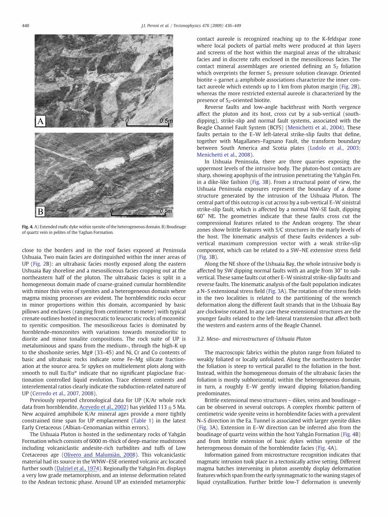
Fig. 4. A) Extendedmafic dykewithin syenite of the heterogeneous domain. B) Boudinageof quartz vein in pelites of the Yaghan Formation.
440 J.I. Peroni et al. / Tectonophysics 476 (2009) 436–449
close to the borders and in the roof facies exposed at PeninsulaUshuaia. Two main facies are distinguished within the inner areas ofUP (Fig. 2B): an ultrabasic facies mostly exposed along the easternUshuaia Bay shoreline and a mesosiliceous facies cropping out at thenortheastern half of the pluton. The ultrabasic facies is split in ahomogeneous domain made of coarse-grained cumular hornblenditewith minor thin veins of syenites and a heterogeneous domain wheremagma mixing processes are evident. The hornblenditic rocks occurin minor proportions within this domain, accompanied by basicpillows and enclaves (ranging from centimeter to meter) with typicalcrenate outlines hosted inmesocratic to leucocratic rocks of mozoniticto syenitic composition. The mesosiliceous facies is dominated byhornblende-monzonites with variations towards monzodioritic todiorite and minor tonalite compositions. The rock suite of UP ismetaluminous and spans from the medium-, through the high-K upto the shoshonite series. Mg# (33–45) and Ni, Cr and Co contents ofbasic and ultrabasic rocks indicate some Fe–Mg silicate fraction-ation at the source area. Sr spykes on multielement plots along withsmooth to null Eu/Eu⁎ indicate that no significant plagioclase frac-tionation controlled liquid evolution. Trace element contents andinterelemental ratios clearly indicate the subduction-related nature ofUP (Cerredo et al., 2007, 2008).
Previously reported chronological data for UP (K/Ar whole rockdata from hornblendite, Acevedo et al., 2002) has yielded 113±5 Ma.New acquired amphibole K/Ar mineral ages provide a more tightlyconstrained time span for UP emplacement (Table 1) in the latestEarly Cretaceous (Albian–Cenomanian within errors).
The Ushuaia Pluton is hosted in the sedimentary rocks of YahgánFormation which consists of 6000 m-thick of deep-marine mudstonesincluding volcaniclastic andesite-rich turbidites and tuffs of LowCretaceous age (Olivero and Malumián, 2008). This volcaniclasticmaterial had its source in theWNW–ESE oriented volcanic arc locatedfurther south (Dalziel et al., 1974). Regionally the Yahgán Fm. displaysa very low grade metamorphism, and an intense deformation relatedto the Andean tectonic phase. Around UP an extended metamorphic
contact aureole is recognized reaching up to the K-feldspar zonewhere local pockets of partial melts were produced at thin layersand screens of the host within the marginal areas of the ultrabasicfacies and in discrete rafts enclosed in the mesosiliceous facies. Thecontact mineral assemblages are oriented defining an S2 foliationwhich overprints the former S1 pressure solution cleavage. Orientedbiotite+garnet±amphibole associations characterize the inner con-tact aureole which extends up to 1 km from pluton margin (Fig. 2B),whereas the more restricted external aureole is characterized by thepresence of S2-oriented biotite.
Reverse faults and low-angle backthrust with North vergenceaffect the pluton and its host, cross cut by a sub-vertical (south-dipping), strike-slip and normal fault systems, associated with theBeagle Channel Fault System (BCFS) (Menichetti et al., 2004). Thesefaults pertain to the E–W left-lateral strike-slip faults that define,together with Magallanes–Fagnano Fault, the transform boundarybetween South America and Scotia plates (Lodolo et al., 2003;Menichetti et al., 2008).
In Ushuaia Peninsula, there are three quarries exposing theuppermost levels of the intrusive body. The pluton-host contacts aresharp, showing apophysis of the intrusion penetrating the Yahgán Fm.in a dike-like fashion (Fig. 3B). From a structural point of view, theUshuaia Peninsula exposures represent the boundary of a domestructure generated by the intrusion of the Ushuaia Pluton. Thecentral part of this outcrop is cut across by a sub-vertical E–Wsinistralstrike-slip fault, which is affected by a normal NW-SE fault, dipping60° NE. The geometries indicate that these faults cross cut thecompressional features related to the Andean orogeny. The shearzones show brittle features with S/C structures in the marly levels ofthe host. The kinematic analysis of these faults evidences a sub-vertical maximum compression vector with a weak strike-slipcomponent, which can be related to a SW–NE extensive stress field(Fig. 3B).
Along the NE shore of the Ushuaia Bay, the whole intrusive body isaffected by SW dipping normal faults with an angle from 30° to sub-vertical. These same faults cut other E–Wsinistral strike-slip faults andreverse faults. The kinematic analysis of the fault population indicatesa N–S extensional stress field (Fig. 3A). The rotation of the stress fieldsin the two localities is related to the partitioning of the wrenchdeformation along the different fault strands that in the Ushuaia Bayare clockwise rotated. In any case these extensional structures are theyounger faults related to the left-lateral transtension that affect boththe western and eastern arms of the Beagle Channel.
3.2. Meso- and microstructures of Ushuaia Pluton
The macroscopic fabrics within the pluton range from foliated toweakly foliated or locally unfoliated. Along the northeastern borderthe foliation is steep to vertical parallel to the foliation in the host.Instead, within the homogeneous domain of the ultrabasic facies thefoliation is mostly subhorizontal; within the heterogeneous domain,in turn, a roughly E–W gently inward dipping foliation/bandingpredominates.
Brittle extensional meso structures – dikes, veins and boudinage –
can be observed in several outcrops. A complex rhombic pattern ofcentimetric wide syenite veins in hornblendite facies with a prevalentN–S direction in the Ea. Tunnel is associated with larger syenite dikes(Fig. 3A). Extension in E–W direction can be inferred also from theboudinage of quartz veins within the host Yahgán Formation (Fig. 4B)and from brittle extension of basic dykes within syenite of theheterogeneous domain of the hornblendite facies (Fig. 4A).
Information gained from microstructure recognition indicates thatmagmatic intrusion took place in a tectonically active setting. Differentmagma batches intervening in pluton assembly display deformationfeatureswhich span from the early synmagmatic to thewaning stages ofliquid crystallization. Further brittle low-T deformation is unevenly

Fig. 5. Photomicrographs of the microstructures in Ushuaia Pluton. A) Magmatic microstructure in the ultrabasic facies characterized by amphibole SPO. XPL light, base of the photo3.6 mm B) Submagmatic microstructure in subvolcanic marginal facies. Microboudinage in amphibole phenocryst in andesite; note the prominent magmatic amphibole orientation.PL light, base of the photo 3.6 mm C) Magmatic plagioclase tiling and subparallel biotite orientation, with interstitial fine-grained quartz pockets in tonalite of the mesosiliceousfacies. XPL light, base of the photo 3.6 mm D) Healed microfracture in hornblendite of the ultrabasic facies. Fine-grained amphibole welds the microfracture. PL light, base of thephoto 1.5 mmE) Brittle microshear zonewith lozenge plagioclase pophyroclast set in a fine-grained comminuted quartz–feldspar matrix. XPL light, base of the photo 3.6 mm F) Dragmicrofold in amphibole associated with a brittle microfault in hornblendite of the heterogeneous domain. XPL light, base of the photo 1.5 mm.
Table 2Me: Median magnetic susceptibility values employed in the magnetic modeling for thedifferent lithologies in Ushuaia Bay area measured in the laboratory.
Geological unit Age Me magneticsusceptibility [CGS]
σ N
UP Ultrabasic facies Albian–Cenomanian 4.9×10⁻³ 2.9×10⁻³ 38Mesoliceous facies 5×10⁻⁵ 5×10⁻⁴ 35
Yahgán Fm. Early Cretaceous 7×10⁻⁵ 7×10⁻⁵ 12Lemaire Fm. Late Jurassic 2×10⁻⁵(⁎) – –
Metamorphicbasement
Paleozoic 1×10⁻⁶(⁎) – –
UP: Ushuaia Pluton. σ: standard deviation. N: number of measurements (⁎).Susceptibilities after Peroni (2006) and Tassone et al. (2005a).
441J.I. Peroni et al. / Tectonophysics 476 (2009) 436–449
developed. Except for localized zones of high deformation, the pre-servation of euhedral crystal shapes in the feldspars as well as in themafic minerals (mainly amphibole, rarely biotite and clinopyroxene),indicates that UP did not undergo extensive sub-solidus deformation.
Macroscopic shape-preferred orientation (SPO) is common inK-feldspar megacrystals of syenitic rocks within the heterogeneousdomain of ultrabasic facies, SPO is also observed in amphibolecrystals of hornblendites (Fig. 5A). Magmatic plagioclase tilingaccompanied by subparallel alignment of hornblende (±biotite, ±clinopyroxene) is common in rocks of the mesosiliceous facies(Fig. 5C).
Microstructures at high solid fraction, i.e. at the submagmatic stageare unevenly developed and represented by microfractures infeldspars and microboudinage in amphibole of the subvolcanicmarginal andesitic facies (Fig. 5B), often submagmatic cracks are

Table 3Mean remanent magnetization intensity (Jr), declination (Decl.) and inclination (Incl.)for each site and its confidence intervals (α95).
Site Jr (mA/m) Dec. Incl. α95 n Q
1 1.8 22.7 −19.5 92.4° 6 9.8×10⁻⁴
2 10.9 50.8 −0.3 87.9° 6 5.5×10⁻³
3 210 351.3 −6 71.4° 8 0.14 307 27.3 −29.8 45.4° 8 0.155 115.6 253.9 −48.9 180° 8 0.056 152.7 69 −0.6 85.7° 6 0.097 2420 90 3.8 14.1° 7 1.23
The great difference in sampling site no. 7, where hornblendite prevails, is outstandingcompared with the rest of the sites.
Fig. 6. Stereograms showing the directions of remanent magnetization in the seven sampling sites located in Fig. 2B. Black symbols: lower hemisphere, white symbols: upperhemisphere.
442 J.I. Peroni et al. / Tectonophysics 476 (2009) 436–449
normal/subnormal to primary magmatic crystal alignment. Fine-grained quartz-plagioclase-K-feldspar±myrmekite often occur in themesosiliceous facies as “pockets” filling interstitial spaces. Althoughthese fine-grained pods do not show a particular shape, they tend todisplay a subtle shape-preferred orientation parallel to the magmaticfoliation (Fig. 5C).
Limited high to moderate-T sub-solidus overprint is representedby flame perthites in K-f, fine myrmekite lobes, chess-board twinningin plagioclase, either diffuse or elongated subgrains in feldspars,healed cracks in amphibole welded by fine-grained (neo?) amphibole(Fig. 5D).
Brittle microstructures are very restricted, associated with discretemicroshear zones where locally a porphyroclast/matrix texturedevelops (Fig. 5E) with lozenge shaped plagioclase set in a mass ofcomminuted quartz–feldspar. In hornblendites, when brittle shear cutacross large amphibole crystals often drag microfolds are developed(Fig. 5F). Straight brittle fractures with epidote infillings (likely aposthumous magmatic product) are widespread in all lithologies andin turn are affected by brittle shearing.
4. Geophysical study
With the aim of achieving an estimation of the unexposed portionsof the Ushuaia Pluton a geophysical modelling was performed. Itcombined the information of aeromagnetic anomalies with newmagnetic data acquired in the field. In addition, the obtainedmodelledpluton was inserted in a schematic N-S section integrating structural,lithological and regional magnetic data.
4.1. Sampling and processing for magnetic properties determination
In the field, hand samples and drill cores of the main lithologieswere obtained with a portable drilling machine and oriented with sunand magnetic compasses. Eighty-five oriented samples were collectedat seven sites indicated in Fig. 2B.
The values of magnetic susceptibility and remanence data nec-essary for the modeling were obtained in the laboratory. Magneticsusceptibility determination was made using a Bartington MS2 sus-ceptibility meter in selected drill cores. The magnetic susceptibilityvalues employed for the modeling were obtained by averaging 38samples of the ultrabasic facies, 35 samples of themesosiliceous facies
Fig. 7. Comparison between not reduced to pole (A) and reduced to pole (B) 5569-II aeroprojection). Contour lines 5 nT-apart. W–E cross-section showing the relationship among tline) andmagnetic susceptibility recorded in the field (solid line). The difference between theThe location of the geological section of Fig. 10 is shown in Fig. 7A.
and the 12 samples of host rock (Yahgán Fm.) from the sevensampling sites in the Beagle Channel area (Table 2).
Natural remanentmagnetizationwas determined using a DC-squidcryogenic magnetometer (2G-750R). Stereograms in Fig. 6 show thedirection of the remanentmagnetization for each sample site (Fig. 2B).Formost of the sites, magnetizationwasweak and dispersed (Table 3),except for site no. 7, in the ultrabasic facies, which shows the highestmean intensity (2420 mA/m) and a mean declination of 90° andinclination of 3.8°.
For all other sites, Q is less than one, thus remanent magnetizationis not very important in the outcrops, where the induced magnetiza-tion prevails due to its high susceptibility.
4.2. Processing of aeromagnetic information
The 1:250,000 5569-II (total magnetic field; SEGEMAR, 1998)aeromagnetic chart of anomalies not reduced to pole (Fig. 7A) andreduced to pole (Fig. 7B) was used. These charts were obtained from aregional aeromagnetic survey, with N–S flight lines, 500 m-apart, E–Wcontrol flights, 5000 m-apart and a 120 mconstant height above ground.
Digitalization of the available hard copy of aeromagnetic charts wasperformed; themagnetometric contour lines were digitalized bymeansof more than 10,000 points (referred to geographic coordinates) in eachchart. Therefore, the software required parallel profiles could beobtained. The modeling of Ushuaia Pluton was carried out with atotal of 20, 18 km-long, NS-oriented profiles with 500 mof equidistancebetween sections. Values of latitude, longitude, value of the magnetic
magnetic chart and its position with respect to the modeled intrusive (Gauss Krügeropography (grey area), lithology, reduced-to-pole aeromagnetic anomaly (segmentedpluton susceptibility values and those of the host rock is remarkable. USH: Ushuaia city.

443J.I. Peroni et al. / Tectonophysics 476 (2009) 436–449

Fig. 8. A: Bathymetric isolines of modeled intrusive body. Contour lines every 1000 m. Note the southern deep “tail” and the northern shallowing of themodeled pluton. B: Isolines ofpercentage differences between measured and modeled grids. See text for explanation of the calculation of %Error.
444 J.I. Peroni et al. / Tectonophysics 476 (2009) 436–449
field and topographic data (obtained from DEM) characterize the 1025points that were used to define each one of the 20 parallel sections.
The digital version of the 5569-II reduced to pole chart (Fig. 7B)allowed a better appreciation of the intrusive location as well as itsapproximate shape and size. The chart displays an elliptical positiveanomaly in the Ushuaia Bay area of 70 km2, with a WNW–ESE majoraxis of 9.6 km-long and a 8.6 km-long minor axis. The contour lines,ranging from 1200 to −60 nT, show an asymmetric distribution withthe steepest gradient in the eastern half of the anomaly.
The unreduced anomaly, in turn (Fig. 7A), shows a maximumlocated N with an asymmetrical bell shape and an intensity of 350 nTand an associated minimum of −320 nT with an elliptical shapelocated further S.
It is worth emphasizing the presence of anothermagnetic anomalyof minor intensity, located E of the above described one, on the NEmargin of Encajonado River, near Cerro Trapecio (Fig. 7B), with amaximum of 20 nT surrounded by values around −40 nT. Unlike theanomaly produced by the Ushuaia Pluton, this other one does notshow an important variation in its shape in the reduced to pole chart(Peroni et al., 2009).
4.3. Modeling
The modeling was performed with the Encom Model Vision Pro 7.0software (Encom Technology, 2002), using the information from theInternational Geomagnetic Reference Field (IGRF, revision 2004) of thestudy area, magnetic susceptibility and remanent magnetization of themodeled intrusive body. This software is based on the Won and Bevis(1987) algorithm which calculates the magnetic anomaly by means ofan n-side polygon within a bi-dimensional space. The softwareperforms the magnetic modeling from simple bodies (cubes, spheres,
cylinders, etc.) as well as from a series of polygons in order to achieve abetter correlation between the collected data and the obtained model.
In order to differentiate local from regional anomalies, a regional fieldwas calculated from a grade one polynomial following the equation:
R = a + bX + cY
where: a=33,050; b=7×10⁻⁴ and c=−0.004.In order to obtain the better fit of the modeled curve, the total
volume of the body was divided into 500 m-thick, N–S orientedparallel vertical sheets. The geometry of these sheets was modifiedthroughout the modeling process to attain a better fit between themeasured curve and the calculated one, using a trial and errormethod. The modeled intrusive body is represented by 20 parallelsections composed of two lithologies (ultrabasic and mesosiliceousfacies) and displays a laccolithic shape with an average thickness of2000 m in its central area coincident with the pluton exposures in theUshuaia Bay and a southern root reaching 5000 m deep. The bodythickness decreases towards the edges, reaching 500 m (Fig. 8A). Themodeled intrusive body is composed of 1130 facets.
The Q factor was not employed because during modeling, anextreme scenario was tested by setting a magnetic remanence for thewhole pluton equal to the one recorded in site no. 7 (Fig. 6), whichwould mean Q factor=1.23. Such a vector, with that orientation andintensity, did not give a noticeable change in the modeled curve.Therefore, for this model, the magnetic anomaly would dependmostly on the magnetic susceptibility (therefore, on the inducedmagnetization).
Primary and preliminary evidence of the similarity between thecalculated and measured anomalies is provided by the comparableshape and size of the reduced-to-pole anomaly and the modeled one(Fig. 7B). In order to properly test the fitness between original and

Fig. 9. Perspective view from SE of the modeled intrusive and the local topography (topographic isolines each 100 m ). The 20 vertical sections in which the body was divided can bedistinguished. Each vertical sheet is composed of a mesosiliceous and an ultrabasic facies (lower left corner sketch).
445J.I. Peroni et al. / Tectonophysics 476 (2009) 436–449
modeled grids, the percentage differences between the measured andcalculated data were computed:
ðXo−XcÞ⁎100Xo
where Xo represents the value of a specific point in the original grid andXc is the value of the corresponding point in the modeled grid. In thisway, negative values indicate that the modeled grid shows highermagnetic anomaly than the original grid. The calculated differenceswererepresented by isolines in the map of Fig. 8B displaying the excellent fitbetween modeled and measured grids. The percentage differences aregenerally lower than ±0.1%. Higher differences are found towards thebody margins, especially southwestwards. Furthermore, there is a goodfit between the 0 m isoline and the boundary of Ushuaia Pluton outcropsat Ushuaia Bay (Fig. 9), which is an additional proof of model accuracy.
On plant view, the proposed model has a surface of 111 km2, ofwhich the outcrops in Ushuaia Bay area (0 m isoline) would onlyaccount for 11%. It has an oval shape with N–S major axis around12 km-long and 10 km-long E–W minor axis. The modeled volume is150 km3 of which 86.2 km3 would correspond to the ultrabasic faciesand the remainder 63.8 km3 to the mesosiliceous facies.
4.4. Geological section elaboration
The aeromagnetic survey (SEGEMAR, 1998) provides importantinformation which after processing was a powerful tool to decipherthe distribution and geometry in depth of intrusive bodies. Thesecharts combined with the data obtained in laboratory of magneticsusceptibility and remanence, were used to generate a mathematicalmodel which was combined with the main structures giving amodeled geological N–S section of 30 km length and 10 km depth(Fig. 10). In the emplacement environment, the Beagle Channel wasrepresented as a 4 km-wide and 7 km-deep basin filled by the LemaireFm. overlain by the Yahgán Fm. Tierra Mayor valley and the associated
positive flower structures (making a piece of basement raised up to1500mdepth)were also represented (modified fromMenichetti et al.,2004). The main structures were defined through a regionalgeological section merging geological data and seismic reflectionanalysis (Menichetti et al., 2004, 2008); the Digital Elevation Model(DEM) was used and for the topographic profile. The location of thefaults on surface matches what was seen and measured in the field.
A series of thrusts with north vergence can be distinguished in thesection of Fig. 10, located in the uppermost portion of the sedimentarysuccession. These structures are cut by themodeled intrusive, which itselfis affectedby theE–WandWNW–ESE strike-slip andnormal fault system,with north vergence, associated with the Beagle Channel fault system.
The thrust complex includes two south-dipping duplexes, with solethrusts rooted in the pre-Jurassic basement. The sole thrusts mergenorthwards onto the Jurassic volcanoclastic sediments of the Lemaire Fm.Northward, a deeper slice of basement forms the leading edge of theAndes range in the Magallanes fold and thrust belt. The displacement ofthe major décollement thrust sheets is distributed with slip formingramp anticlines. Cumulative shortening of these structures could beestimated in tens of kilometers across the region (Menichetti et al., 2008).
The extensional features in the Ushuaia area are splays of theBeagle Channel strike-slip fault that shows a structure with doublevergence in both sides. The cumulative extensional fault offset is fewkilometers while the strike-slip displacement reach many tens ofkilometers. In the northern part of the section, it is noticeably thepositive structure of the Carbajal valley where reverse faults prevail.
5. Discussion and conclusions
Ushuaia Pluton displays several meso- and microstructures relatedto an E–W extensional stress field during its emplacement in Albian–Cenomanian times. The presence of centimetric to metric syenitic dikesand veins of dominant NS orientation and E–W extended veins anddikes both in the intrusive as in the host, support this interpretation.

Fig. 10. A) N–S Magnetic profile (for location see Fig. 7A). Solid line: aeromagnetic anomaly. Dotted line: magnetic anomaly value calculated through the modeling. Segmented line:regional magnetic field. B) 2D numeric model profile obtained with the Modelvision 7.0 software and magnetic susceptibility values of the different units used in the modelingprocess. C) Geological section, based on the numeric model, where the main Fuegian Andes structures can be observed (structural section modified from Menichetti et al., 2004).
446 J.I. Peroni et al. / Tectonophysics 476 (2009) 436–449
The primary magmatic crystal alignment is a common microstruc-ture in rocks of all facies within the Ushuaia Pluton. Moreover, thecoexistence of parallel magmatic, submagmatic and high-temperaturesolid state microstructures implies a continuous deformation historysynchronous with pluton emplacement and cooling. Additionally, theS2-oriented contact metamorphic assemblages support also the synky-nematic nature of Ushuaia Pluton. In this connection, it is important torecall the general normal to subnormal relation found between themagmatic/high-T sub-solidus alignments and the submagmatic cracksand the very low-temperature microfractures and microshear zones,which points to a protracted and persistent stress field that would havecontrolled magma ascent, emplacement and cooling.
This extensional scenario is consistent with a strike-slip partitioningin an oblique convergent setting where the deformation is accommo-dated simultaneously by strike-slip fault systems and contractionalstructures (Teyssier and Tikoff, 1998) (Fig. 11). The relationshipbetween plate motion and deformation is quite complex especially ina zone of oblique convergence because the collisional vector can bedecomposed in a normal and tangential component. Many collisionalsettings display partitioning of the deformation in the contractionalorogen wedges and along important strike-slip faults strands (Mann,2007).
The collisional margin from which the Andean Cordillera inTierra del Fuego emerged after Lower Cretaceous times underwent a

Fig. 11. Block diagram for the Fuegian Cordillera region showing possible geometries related to the transpressional deformation regime during Cretaceous. The inset in the lowerright shows the angular divergence between the plate motion vector and the fastest horizontal shortening direction (Hmin) responsible of the rotation, toward a margin parallelorientation, of the finite strain long axis (Hmax) to the fastest horizontal stretching direction (after Fossen and Tikoff, 1998 ). The northern strike-slip structure sketches MagallanesFagnano Fault System and the southern one the Beagle Channel Fault System.
447J.I. Peroni et al. / Tectonophysics 476 (2009) 436–449
combination of oblique horizontal shortening and crustal thickeningof the basement rocks which produced the emplacement of severalthrust sheets involving the sedimentary cover. In this scenario ofoblique convergence, the infinitesimal strain axes and the finite strainaxes are not parallel (Fossen and Tikoff, 1998). The angular divergencebetween the plate motion and the fastest horizontal shorteningdirection is responsible for the rotation, toward a margin parallelorientation, of the finite strain long axis to the fastest horizontalstretching direction (Fig. 11 inset).
Late Cretaceous transtensive structures, with brittle–ductile left-lateral strike-slip faults have been already reported in other areas ofthe Tierra del Fuego, especially in the western arm of the BeagleChannel where the plutons of the Yamana suite were interpreted torepresent left-lateral transtensional zones (Cunningham, 1995). Low-angle extensional shear zones were also described in the north andwest of the Cordillera Darwin (Dalziel and Brown, 1989; Klepeis andAustin, 1997) and can be related to the exhumation of themetamorphic core complex (Menichetti et al., 2008).
The obtained model for the Ushuaia Pluton displays a laccolithicshape around 2 km maximum thick in the central area thinningoutwards to 0.5 km (Fig. 9). The size and shape of the modeled plutonwould match analogical models of intrusive bodies in zones of strike-slip faults (Corti et al., 2005).
The prominent aeromagnetic anomaly in the Ushuaia area mightbe mainly caused by the high magnetic susceptibility of the ultrabasicfacies (hornblendite dominated) and, to a lesser extent, of themesosiliceous facies of Ushuaia Pluton. This is evident in the W–Eprofile of Fig. 5, where the magnetic anomaly reduced to pole iscompared to the susceptibility values recorded in the field. This fact isalso supported by the low value of Koenigsberger coefficient in themeasured samples.
There is a striking contrast in the size of intrusive bodies out-cropping to the north and to the south of Beagle Channel. While inHoste, Navarino and surrounding Islands there are several largeoutcrops of plutonic rocks, on the northern side of the channel, thereare only minor outcrops (Fig. 1A). The modeling of aeromagnetic
anomaly associated with the Ushuaia Pluton allowed to infer a mostlyburied intrusive body of similar size as the plutonic units of thesouthern archipelago.
Acknowledgements
This study was supported by grants from CONICET – PIP 5782 andAgencia Nacional Científica y Tecnológica – PICT 7-15185. The authorsthank CADIC-CONICET for the logistical support in Ushuaia city andEstación Astronómica Río Grande (EARG) for the logistical andtechnical support in the field. The authors would like to thank HoracioLippai for his constant help in the field and laboratory work. We aregrateful for the thorough and constructive reviews of the anonymousreferees.
References
Acevedo, R.D., 1996. Los mecanismos sustitutivos y los factores de evolución en losanfíboles de la Hornblendita Ushuaia, Tierra del Fuego. Revista de la AsociaciónGeológica Argentina 51 (1), 69–77.
Acevedo, R.D., Quartino, G.P., Coto, C.D., 1989. La intrusión ultramáfica de Estancia elTunel y el significado de presencia biotita y granate en la Isla Grande de Tierra delFuego. Fundación Miguel Lillo, San Miguel de Tucumán, Argentina. Acta GeológicaLilloana 42 (1), 21–36.
Acevedo, R.D., Roig, C.E., Linares, E., Ostera, H.A., Valín-Alberdi, M.L., Queiroga-Mafra, J.M.,2000. La intrusión plutónica del Cerro Jeu-Jepén. Isla Grande de Tierra del Fuego,República Argentina. Cuadernos do Laboratorio Xeolóxico de Laxe, A Coruña España25, 357–359.
Acevedo, R.D., Linares, E., Ostera, H., Valín-Alberdi, M.L., 2002. Hornblendita Ushuaia(Tierra del Fuego): Petrografía, geoquímica y geocronología. Revista de laAsociación Geológica Argentina 57 (2), 133–142.
Alvarez-Marrón, J., McClay, K.R., Harambour, S., Rojas, L., Skarmeta, J., 1993. Geometryand evolution of the frontal part of the Magallanes Foreland Thrust and Fold Belt(Vicuna area), Tierra del Fuego. southern Chile. American Association of PetroleumGeologists Bulletin 77, 1904–1921.
Baraldo, A., Rapalini, A., Tassone, A., Lippai, H., Menichetti, M., Lodolo, E., 2002. Estudiopaleomagnético del intrusivo del cerro Hewhoepen, Tierra del Fuego, y susimplicancias tectónicas. 15° Congreso Geológico Argentino: El Calafate, Actas, vol. 1,pp. 285–290.
Biddle, K.T., Uliana, M.A., Mitchum, R.M., Fitzgerald, M.G., Wright, R.C., 1986. Thestratigraphic and structural evolution of the central and eastern Magallanes basin,

448 J.I. Peroni et al. / Tectonophysics 476 (2009) 436–449
southern South America. In: Allen, P.A., Homewood, P. (Eds.), Foreland Basins: Int.Assoc. Sediment. Spec. Publ., vol. 8, pp. 41–61.
Bruhn, R.L., 1979. Rock structure formed during back-arc basin deformation in theAndes of Tierra del Fuego. Geological Society of America Bulletin 90, 998–1012.
Cerredo, M.E., Tassone, A., Coren, F., Lodolo, E., Lippai, H., 2000. Postorogenic, alkalinemagmatism in the Fuegian Andes: the Jeujepen intrusive (Tierra del Fuego Islan). IXCongreso Geológico Chileno, Puerto Varas: Acta, vol. 2, pp. 192–196.
Cerredo, M.E., Remesal, M.B., Tassone, A., Lippai, H., 2005. The shoshonitic suite ofHewhoepen pluton, Tierra del Fuego, Argentina. XVI Congreso Geológico Argentino,La Plata., Actas (I), pp. 539–544.
Cerredo, M.E., Remesal, M.B., Tassone, A., Menichetti, M., Peroni, J.I., 2007. Ushuaiapluton: petrographic facies and geochemical signature. Tierra del Fuego Andes.International Geological Congress on the Southern Hemisfere (Geosur 2). Santiago.Chile. Libro de Resúmenes, p. 31.
Cerredo, M.E., Remesal, M.B., Menichetti, M., Peroni, J.I., Tassone, A., 2008. Magmatismand strike-slip tectonics in the Southernmost Andes: Ushuaia Pluton. Tierra DelFuego. XVII Congreso Geológico Argentino, Actas, I, p. 81.
Corti, G., Moratti, G., Santi, F., 2005. Relation between surface faulting and graniteintrusions in analogue models of strike-slip deformation. Journal of StructuralGeology 27, 1547–1562.
Cunningham, W.D., 1993. Strike-slip faults in the southernmost Andes and thedevelopment the Patagonian orocline. Tectonics 12 (1), 169–186.
Cunningham, W.D., 1995. Orogenesis at the southern tip of the Americas: the structuralevolution of the Cordillera Darwin metamorphic complex, southernmost Chile.Tectonophysics 244, 197–229.
Cunningham, W.D., Dalziel, I.W.D., Lee, T.-Y., Lawver, L.A., 1995. Southernmost SouthAmerica-Antarctic Peninsula relative plate motions since 84 Ma: implications forthe tectonic evolution of the Scotia arc region. Journal of Geophysical Research 100(B5), 8257–8266.
Dalziel, I.W.D., 1981. Back-arc extension in the southern Andes: a review and criticalreappraisal. Philosophical Transactions – Royal Society of London 300, 319–335.
Dalziel, I.W.D., 1982. In: Craddock, C. (Ed.), The early (pre-Middle Jurassic) history ofthe Scotia Arc region: a review and progress report. InAntarctic Geoscience,University of Wisconsin Press, Madison, pp. 111–126.
Dalziel, I.W.D., 1989. Tectonics of the Scotia Arc, field trip guide, Vol. T180. AGU,Washington, DC. 206 pp.
Dalziel, I.W.D., Brown, R.L., 1989. Tectonic denudation of the Darwin metamorphic corecomplex in the Andes of Tierra del Fuego, southernmost Chile: implications forcordilleran orogenesis. Geology 17, 699–703.
Dalziel, I.W.D., Elliott, D.H., 1973. The Scotia Arc and Antarctic margin. In: Nairn, A.E.M.,Stehli, F.G. (Eds.), The Ocean Basins and Margins vol. I: The South Atlantic. PlenumPress, New York, pp. 171–245.
Dalziel, I.W.D., de Wit, M.J., Palmer, F.K., 1974. Fossil marginal basin in the southernAndes. Nature 250, 291–294.
Diraison, M., Cobbold, P.R., Gapais, D., Rossello, E.A., Le Corre, C., 2000. Cenozoic crustalthickening, wrenching and rifting in the foothills of the southernmost Andes.Tectonophysics 316, 91–119.
Encom Technology, 2002. ModelVision Pro v.7.0. Encom Technology, Sydney, Australia.Esteban, F., 2008. Transecta geofísica a través de los Andes australes. Sector central de la
Isla Grande de Tierra del Fuego. Argentina. Trabajo final de Licenciatura. Dpto. deGeología. Facultad de Ciencias Exactas y Naturales, Universidad de Buenos Aires.
Esteban, F., Rapalini, A., Tassone, A., Cerredo, M.E., Vilas, J.F., Lippai, H., 2007. Magneticfabric and microstructures across the Andes of Tierra del Fuego Geosur 2007.Simposio. InActas, Santiago de Chile.
Fossen, H., Tikoff, B., 1998. Extended models of transpression and transtension, andapplication to tectonic settings. In: Holdsworth, R.E., Strachan, R.A., Dewey, J.E.(Eds.), Continental Transpressional and Transtensional Tectonics: GeologicalSociety, London, Special Publications, vol. 135, pp. 15–33.
Fuenzalinda, R.H., (1972). Geológical correlation between the Patagonian Andes andthe Antarctic Peninsula and some tectonic implications. Master Thesis, 75 pp.,Stanford Univ., Ca.
Gighlione, M., Ramos, V.A., 2005. Progression of deformation and sedimentation in thesouthernmost Andes. Tectonophysics 405, 25–46.
González Guillot, M., Seraphim, G., Acevedo, D., Escayola, M., Schalamuk, I., Pimentel, M.,2005. El Plutón Diorítico Moat: Una Nueva Manifestación Del Batolito PatagónicoAustral En La Provincia De Tierra Del Fuego, Argentina. XVI Congreso GeológicoArgentino. 20–23 setiembre. La Plata, Buenos Aires. Argentina.
Hervé, M., Suarez, M., Puig, A., 1984. The Patagonian Batholith S of Tierra del Fuego,Chile: timing and tectonic implications. Journal of The Geological Society of London141, 909–917.
Hervé, F., Pankhurst, R.J., Fanning, C.M., Calderón, M., Yaxley, G.M., 2007. The SouthPatagonian Batholith: 150 My of granite magmatism on a plate margin. Lithos 97,373–394.
IGRF, 10th Generation, revised 2004. Synthesis Form. British Geological Survey. http://www.geomag.bgs.ac.uk/gifs/igrf_form.shtml.
Klepeis, K.A., 1994. Relationship between uplift of the metamorphic core of thesouthernmost Andes and shortening in the Magallanes foreland fold and thrustbelt, Tierra del Fuego, Chile. Tectonics 13, 882–904.
Klepeis, K.A., Austin, J.A., 1997. Contrasting styles of superposed deformation in thesouthernmost Andes. Tectonics 16, 755–776.
Kraemer, P.E., 2003. Orogenic shortening and the origin of the Patagonian orocline(56 S.Lat). Journal of South American Sciences 15, 731–748.
Lodolo, E., Tassone, A., Menichetti, M., Lippai, H., Hormaechea, J.L., Ferrer, C., Connon, G.,2001. The Magallanes–Fagnano Fault System in the LAGO FAGNANO, Tierra delFuego Island: morphology and structure. European Geophysical Society (EGS).XXVI General Assembly. March. Nice. France. Symposium Se. 5.02, pp. 25–30.
Lodolo, E., Menichetti, M., Tassone, A., Sterzai, P., 2002a. Morphostructure of thecentral-eastern Tierra del Fuego Island from geological data and remote-sensingimages. EDS Stephan Mueller Special Publication Series, EGS 2 (1), 1–16.
Lodolo, E., Menichetti, M., Tassone, A., Geletti, R., Sterzai, P., Lippai, H., Hormaechea, J.L.,2002b. Researchers target a continental transform fault in Tierra del Fuego. EOS.Transactions of the American Geophysical Union 83 (1), 1–4.
Lodolo, E., Menichetti, M., Bartole, R., Ben Avram, Z., Tassone, A., Lippai, H., 2003.Magallanes–Fagnano continental transform fault (Tierra del Fuego, SouthernmostSouth America). Tectonics 22 (6), 1076. doi:10.1029/2003TC0901500.
Mann, P., 2007. Global catalogue, classification and tectonic origin of active restraining-and releasing bends, on strike-slip fault systems. In: Cunningham, W.D., Mann, P.(Eds.), Tectonics of Strike-Slip Restraining and Releasing Bends: Geological Society,London, Special Publications, vol. 290, pp. 13–142.
Martinioni, D.R., Linares, E., Acevedo, R.D., 1999. Significado de la edad isotópica dediques básicos intruidos en la Formación Beauvoir (Cretácico Temprano), Tierra delFuego. Revista Asociación Geológica Argentina 54 (1), 88–91.
Menichetti, M., Acevedo, R.D., Bujalesky, G.G., Cenni, M., Cerredo, M.E., Coronato, A.,Hormachea, J.L., Lippai, H., Lodoso, E., Olivero, E.B., Rabassa, J., Tassone, A., 2004.Field trip guide of the Tierra del Fuego. Geosur Meeting Buenos Aires 2004. 39 pp.
Menichetti, M., Tassone, A., Peroni, J.I., Gonzàlez Guillot, M., Cerredo, M.E., 2007. Assettostrutturale, petrografia e geofisica della Bahía Ushuaia – Argentina. Rendiconti dellaSocietaÁ Geologica Italiana Nuova Serie 4, 259–262.
Menichetti, M., Lodolo, E., Tassone, A., 2008. Structural geology of the Fuegian Andesand Magallanes fold and thrust belt: a reappraisal. GeoSur Special Issue. GeologicaActa (ISSN: 1695-6133) 6 (1), 19–42.
Mukasa, S.B., Dalziel, I.W.D., 1996. Southernmost Andes and South Georgia Island, NorthScotia Ridge: zircon U–Pb and muscovite TMAr/39Ar age constraints on tectonicevolution of southwestern Gondwanaland. Journal of South American Earth Sciences9, 349–365.
Natland, M.L., Gonzalez, E., Cañon, A.P., Ernst, M., 1974. A system of stages for thecorrelation of the Magallanes Basin sediments Geological Society of AmericaMemoir, vol. 139. 126 pp.
Olivero, E.B., Malumián, N., 1999. Eocene stratigraphy of southeastern Tierra del FuegoIsland, Argentina. American Association of Petroleum Geologists 83 (2), 295–313.
Olivero, E.B., Malumián, N., 2008. Mesozoic–Cenozoic stratigraphy of the FuegianAndes, Argentina. Geologica Acta (ISSN: 1695-6133) 6 (1), 5–18.
Olivero, E.B., Martinioni, D.R., 2001. A review of the geology of the Argentinian FuegianAndes. Journal of South American Earth Sciences 14, 175–188.
Olivero, E.B., Martinioni, D.R., Malumián, N., Palamarczuk, S., 1999. Bosquejo geológicode la Isla Grande de Tierra del Fuego, Argentina. 14º Congreso Geológico Argentino.Salta. Actas I, pp. 291–294.
Peroni, J.I., 2006. Anomalía magnética en Bahía Ushuaia (Tierra del Fuego). EstudioGeofísico de la continuidad de las unidades geológicas en subsuelo. Trabajo final deLicenciatura. Dpto. de Geología. Facultad de Ciencias Exactas y Naturales.Universidad de Buenos Aires, p. 90.
Peroni, J.I., Tassone, A., Lippai, H., Menichetti, M., Lodolo, E., Vilas, J.F., 2007. Geophysicalmodeling of theKranckPluton, TierraDel Fuego,Argentina.Geosur2007. InternationalGeological Congress on The Southern Hemisphere Santiago De Chile – 19/20November 2007. Libro de Resúmenes, p. 122.
Peroni, J.I., Tassone, A., Cerredo, M., Lippai, H., Menichetti, M., Lodolo, E., Esteban, F.,Vilas, J.F., 2008a. 3D geophysic model of Ushuaia Pluton Tierra del Fuego.Argentina. Bollettino di Geofísica teorica ed applicata. GeoMod 2008 ExtendedAbstract, pp. 263–267.
Peroni, J.I., Tassone, A., Menichetti, M., Lippai, H., Lodolo, E., Vilas, J.F., 2008b. Geologia egeofisica del plutone Kranck (Lago Fagnano, Tierra del Fuego, Argentina):Rendiconti online della Societá Geologica Italiana, vol. 1, pp. 132–136. 00871234.
Peroni, J.I., Tassone, A., Menichetti, M., Lippai, H., Vilas, J.F., 2009. Geologia e geofisica delplutone del Cerro Trapecio – Tierra del Fuego – Argentina: Rendiconti online Soc.Geol. It., vol. 5, pp. 160–163.
Petersen, C.S., 1949. Informe sobre los trabajos de relevamiento geológico efectuados enTierra del Fuego entre 1945 y 1948. Dirección General de Industria yMinería, Bs. As.Inédito.
Rapalini, A.E., 2007. A paleomagnetic analysis of the Patagonian Orocline. GeologicaActa 5 (4), 287–294.
Rapalini, A.E., Lippai, H., Tassone, A., Cerredo, M.E., 2005. An AMS and paleomagneticstudy across the Andes in Tierra del Fuego. 6th International Symposium onAndean Geodynamics (ISAG 2005, Barcelona), Extended Abstracts, pp. 596–599.
Servicio Geológico Minero Argentino (SEGEMAR). (1998). Levantamiento geofísicoaéreo magnetometría aérea de Tierra del Fuego. Proyecto PASMA. Hoja Ushuaia5569 II Escala 1:250.000.
Tassone, A., Lodolo, E., Zanolla, C., Lippai, H., Grupo TESAC, 1998. Relevamientogravimétrico y magnetométrico a través de la Zona de Fractura Magallanes Fagnano(Tierra del Fuego. X Congreso Latinoamericano deGeología. Buenos Aires, vol. II, p. 45.
Tassone, A., Lodolo, E., Grupo TESAC, 1999. Indicadores geofísicos sobre la localizacióndel límite entre las placas Sud América–Scotia en Tierra del Fuego (Argentina). XIVCongreso Geológico Argentino. Salta. Actas I, pp. 326–329.
Tassone, A., Lippai, H., Lodolo, E., Menichetti, M., Hormaechea, J., Rapalini, A., 2002.Estudio gravimétrico y magnetométrico aplicado a la evolución tectónica de laparte central de la Isla Grande de Tierra del Fuego Argentina. XV CongresoGeológico Argentino. Calafate, Argentina, vol. Il, pp. 280–284.
Tassone, A., Lippai, H., Lodolo, E., Menichetti, M., Comba, A., Hormaechea, J.L., Vilas, J.F.,2005a. A geological and geophysical crustal section across the Magallanes–Fagnanofault in Tierra del Fuego and associated asymmetric basins formation. Journal ofSouth American Earth Sciences 19, 99–109.
Tassone, A., Peroni, J.I., Lippai, H., Lodolo, E., Vilas, J.F., Rapalini, A., 2005b. Anomalíasmagnéticas de las áreas del cerro Hewhoepen y bahía Ushuaia. Tierra del Fuego.

449J.I. Peroni et al. / Tectonophysics 476 (2009) 436–449
Argentina. XVI Congreso Geológico Argentino. 20–23 septiembre. La Plata, BuenosAires. Argentina.
Tassone, A., Peroni, J.I., Cerredo, M.E., Lippai, H., Vilas, J.F., 2006. Estudio geofísico delcuerpo intrusivo Ushuaia. Margen norte del Canal de Beagle, Argentina. XI CongresoGeológico Chileno. 7–11 de agosto, Antofagasta, Chile. Actas.
Tassone, A., Peroni, J.I., Lippai, H., Menichetti, M., Lodolo, E., Vilas, J.F, 2007. Geophysicalsurvey of the Fagnano pluton. Tierra del Fuego. Argentina. International Union ofGeodesy and Geophysics (IUGG). 2–13 July. Perugia. Italia.
Tassone, A., Lodolo, E., Menichetti, M., Yagupsky, D., Caffau, M., Vilas, J.F., 2008.Seismostratigraphy and geodynamic of the Tierra del Fuego Atlantic off-shore.Geologica Acta (ISSN: 1695-6133) 6 (1), 55–67.
Teyssier, C., Tikoff, B., 1998. Strike-slip partitioned transpression of the San AndreasFault system: a lithospheric scale approach. In: Holdsworth, R.E, Strachan, R.A.,Dewey, J.F. (Eds.), Continental Transpression and Transtension Tectonics: Geolo-gical Society of London Special Publication, vol. 135, pp. 143–158.
Winslow, M.A., 1982. The structural evolution of the Magallanes Basin and neotectonicsin the southernmost Andes. In: Craddock, C. (Ed.), Antarctic Geoscience. Universityof Wisconsin, Madison, pp. 143–154.
Won, I.J., Bevis, M.G., 1987. Computing the gravitational and magnetic anomalies due toa polygon: algorithms and Fortran subroutines. Geophysics 52 (2), 232–238.
Copyright © 2022 FDOKUMEN