Geophysical Field Pattern in The West Bohemian Geodynamic Active Area
20
GEOPHYSICAL FIELD PATTERN IN THE WEST BOHEMIAN GEODYNAMIC ACTIVE AREA JAN SVANCARA Institute of Physics of the Earth, Masaryk University, Brno, Czech Republic 1 IVAN GNOJEK 2 FRANTISEK HUBATKA AND KAREL DEDACEK Geofyzika a.s., Brno Czech Republic 3 Summary: Regional geophysical data from detailed gravity survey, airborne magnetometry and gamma-ray spectrometry were analysed in order to determine the subsurface extent of contrasting geological bodies and to highlight subtle anomalies which can be related to the occurrence of earthquake swarms. Potential field data were compiled into contour and colour- shaded relief maps suitable for detecting structural tectonic elements. A shaded relief map of the horizontal gradient of gravity was used to detect considerable structural and tectonic features. The results of airborne gamma-ray spectrometry, showing the regional total gamma-ray activity, abundance of uranium, thorium and potassium, were included in this study. Only the two most instructive maps - the total gamma-ray activity and the abundance of potassium are shown. The main line of epicentres Novy Kostel - Pocdtky coincides well with the N-S configuration of abundances of these natural radioactive elements. The epicentres of micro-earthquakes detected by the local seismological network KRASLICE for the 1991 to 1998 period were plotted in the geophysical maps. The hypocentres of earthquakes in the main epicentral zone at Novy Kostel were projected onto the crustal density model based on the interpretation of seismic reflection profile 9HR and gravity data. The average distance between the Novy Kostel epicentral zone and the seismic profile was 4-5 km. Based on the interpretation of gravity data the hypocentres of the main epicentral zone seem to be associated with the western margin of the Eibenstock - Nejdek (Karlovy Vary) Pluton and, beside that, they follow the depth level where the allochthonnous part of the Saxothuringian Zone is thrust over the " European parautochton". A drawing of the geodynamic model of the area is also shown. Key words: Earthquake swarm, Bohemian Massif, Saxothuringian Zone, Eibenstock - Nejdek (Karlovy Vary) Pluton, Cheb Basin, gravity, airborne magnetometry, airborne gamma-ray spectrometry, seismic profile 9HR, density model, stress field, geomorphology 1 Address: Tvrdeho 12, 602 00 Brno, Czech Republic ([email protected]) 2 Address: M.Hubnerove 42, 621 00 Brno 3 Address: Jecna 29a, 621 00 Brno, Czech Republic 307 Studia geoph. et geod. 44 (2000), 307-326 ©2000 StudiaGeo s.r.o., Prague
Transcript of Geophysical Field Pattern in The West Bohemian Geodynamic Active Area

GEOPHYSICAL FIELD PATTERN IN THE WEST BOHEMIANGEODYNAMIC ACTIVE AREA
JAN SVANCARA
Institute of Physics of the Earth, Masaryk University, Brno, Czech Republic1
IVAN GNOJEK2
FRANTISEK HUBATKA AND KAREL DEDACEK
Geofyzika a.s., Brno Czech Republic3
S u m m a r y : Regional geophysical data from detailed gravity survey, airborne magnetometryand gamma-ray spectrometry were analysed in order to determine the subsurface extent ofcontrasting geological bodies and to highlight subtle anomalies which can be related to theoccurrence of earthquake swarms. Potential field data were compiled into contour and colour-shaded relief maps suitable for detecting structural tectonic elements. A shaded relief map of thehorizontal gradient of gravity was used to detect considerable structural and tectonic features. Theresults of airborne gamma-ray spectrometry, showing the regional total gamma-ray activity,abundance of uranium, thorium and potassium, were included in this study. Only the two mostinstructive maps - the total gamma-ray activity and the abundance of potassium are shown. Themain line of epicentres Novy Kostel - Pocdtky coincides well with the N-S configuration ofabundances of these natural radioactive elements. The epicentres of micro-earthquakes detected bythe local seismological network KRASLICE for the 1991 to 1998 period were plotted in thegeophysical maps.
The hypocentres of earthquakes in the main epicentral zone at Novy Kostel were projected ontothe crustal density model based on the interpretation of seismic reflection profile 9HR and gravitydata. The average distance between the Novy Kostel epicentral zone and the seismic profile was 4-5km. Based on the interpretation of gravity data the hypocentres of the main epicentral zone seem tobe associated with the western margin of the Eibenstock - Nejdek (Karlovy Vary) Pluton and, besidethat, they follow the depth level where the allochthonnous part of the Saxothuringian Zone is thrustover the " European parautochton". A drawing of the geodynamic model of the area is also shown.
Key words : Earthquake swarm, Bohemian Massif, Saxothuringian Zone, Eibenstock - Nejdek(Karlovy Vary) Pluton, Cheb Basin, gravity, airborne magnetometry, airborne gamma-rayspectrometry, seismic profile 9HR, density model, stress field, geomorphology
1 Address: Tvrdeho 12, 602 00 Brno, Czech Republic ([email protected])2 Address: M.Hubnerove 42, 621 00 Brno3 Address: Jecna 29a, 621 00 Brno, Czech Republic
307Studia geoph. et geod. 44 (2000), 307-326©2000 StudiaGeo s.r.o., Prague

1. INTRODUCTION
The analysis of regional geophysical data is very important for the geological interpretation offrequent earthquake swarms in the western part of the Bohemian Massif. Most hypocentres of thisseismoactive area are in the depth interval of 5 to 18 km but the micro-earthquakes of the main zoneat Novy Kostel originate in the depth interval of 5 to 9 km. Because of the absence of deepboreholes in the area, the hypocentres can be attributed to a specific seismoactive geologicalstructure using geophysical data only. Regional geophysical data play an important role in the studyof gas flux distribution in mineral springs and of the tectonic structure as well (Weinlich et al.]998).
Understanding the gravity field is of principal importance for interpreting the deep geologicalstructure. The Bouguer anomaly map, compiled for a reduction density of 2670 kg/m3 has enabledthe location of density-contrasting geological bodies, or even an estimation of the depth range ofgranite bodies. The shaded relief of the total horizontal gradient of gravity has provided informationon fault trends and other tectonic lines which could not be identified in usual contour maps.
The results of airborne magnetometry completely differ from those of gravimetry. Thisdifference is attributed to the fact that the granite plutons, which are dominant in the upper part ofthe Earth's crust in the study area, are not magnetic. On the other hand, magnetic anomalies cancharacterize the composition of deep-seated rocks and direct the attention to various volcanic bodieswithin the Earth crust. The phenomenon of volcanism is considered by several authors to bea common denominator of the European earthquake swarm occurrences (Spicdk et al. 1999).
The very shallow depth of penetration is typical for the airborne gamma-ray spectrometricsurvey. This method measuring potassium, equivalent uranium and equivalent thorium contents inthe near-surface rocks is able to supply valuable petrological and geochemical informationespecially in the areas built by magmatic rocks. Moreover, the distribution pattern of the naturalradioactive elements can provide an indirect indication of some tectonic features.
Deep reflection seismic profile 9HR and seismological records were further geophysical datasources utilized in this study. A crustal-scale 2.5 D balanced density model (Svancara andChlupdfovd, 1997) has been computed along seismic profile 9HR. Since the northwestern part ofthe 9HR profile runs only 4 - 5 km from the main Novy Kostel epicentral zone, the authors tried toproject the hypocentres of earthquakes onto the density cross-section.
All the hypocentres from the records of the KRASLICE network in the period 1991 - 1998(Skdcelovd et al.,1998) were used for these analyses. These hypocentres have a high degree ofcoherence because they were recorded within a fixed network geometry. The algorithm for locatingevents and the 3D block velocity model remained unchanged during the whole 1991 - 1998 periodof recording.
The maps shown rely on the geophysical data acquired, processed and stored by Geofyzika Brnoprevailingly in projects for the Czech Geological Survey, Prague.
2. GEOLOGY
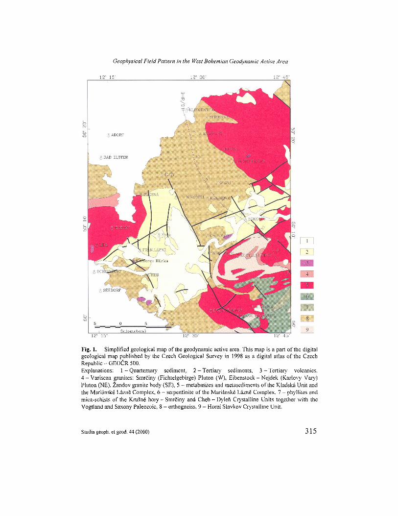
Almost the whole area under study belongs to the Saxothuringian Zone (Fig. 1). Onlythe SE corner of the geological scheme presented in this figure pertains to the MarianskeLazne" high-grade ophiolitic complex, which separates the Saxothuringian Zone from theTepla - Barrandian Zone in the SE.
The geological structure of this area has recently been explained in the monographedited by Vrdna, Stedrd (1997). The segment of the Saxothuringian Zone representing thegeodynamic active area is predominantly built by the Krusne hory - SmrCiny CrystallineUnit, Horni Slavkov Crystalline Unit and the Cheb - Dylen Crystalline Unit, which areunderstood to be complexes consolidated both during the Cadomian and the Variscan
J. Svancara et al.
308 Studia geoph. et geod. 44 (2000)

orogeny. The Krusne hory - SmrCiny Crystalline Unit is covered (in the NW) by theLower Paleozoic of Vogtland and Saxony consisting of weakly metamorphosedsedimentary rocks with a low proportion of metavolcanites.
Three granite plutons intruded into the area during the Variscan orogeny. The largestis the Eibenstock - Nejdek (Karlovy Vary) Pluton (NE), rather smaller is the SmrCiny(Fichtelgebirge) Pluton (W) and the smallest body to the SE is the Zandov Pluton. TheKladska Unit cropping out NW of the Marianskd LaznS Complex is a denudation remnantof metasediments with concordant bodies of mostly basic metavolcanites tectonicallyoverlying the Horni Slavkov and the Cheb - Dylefi Crystalline Units. (See Fig. 1)
Along the young OhFe rift zone, two basins, filled by Tertiary and Quarternarysediments, are developed in the area under interest. In the SW part of the area there is theCheb Basin, in the E there is the rather narrower Sokolov Basin. Not only the sediments ofthe basins, but also the granite plutons and complexes of metamorphites are locallypenetrated by Cainozoic volcanites.
3. GEOMORPHOLOGY
The area under study belongs to four mountain systems among which two youngbasins are developed. In the NW, there are the SmrCiny (Fichtelgebirge) Mts., the NE partpertains to the large Krusne hory (Erzgebirge) Mts. System. The SE corner of the area isoccupied by the Slavkovsky les Mts. and the small SW part belongs to the Cesky les Mts.The Cheb Basin (W) and the Sokolov Basin (E) are situated between the pairs of thementioned mountain systems in the North and those in the South. The Smrdiny Mts. areseparated from the Krusne hory Mts. by a flat depression spread in the surroundings of thesmall town of Luby. The KruSne hory Mts. System begins (at its SW margin) with theKrajkova Highland continuing to the NE with the Nejdek Highlands which gradually riseto the highest partial area - the Klfnovec Mts.. Also the second largest mountain part ofthe area studied, i.e. the Slavkovsky les Mts., is composed of the Kynlvart Highland (inits SW part) and of the Hornf Slavkov Highlands (in the NE).
The Cheb Basin, as the broader, is sharply tectonically limited in the E and NE(towards the Krusne hory Mts. System) by a fault slope with the relative offset reaching150 m. The remaining N, W and S margins of the Basin pass almost gradually to thesurrounding uplands. The S part of the Cheb Basin is separated from the TachovDepression, developed further to the S, by a ridge cropping out between the villages ofDolnf 2andov and LaznS Kynzvart. The Sokolov Basin, the narrower, is almostsystematically limited by a set of faults from both the NW (the Krusne hory Mts.) and theSE (the Slavkovsky les) sides. These two basins are separated from one another by a smallridge of crystalline rocks linking up the KruSne hory Mts. and the Slavkovsky les Mts.Systems.
The area of interest is drained by the Ohfe river and its tributaries. The Ohre riverflows from the flat western part of the Cheb Basin (elevation about 460 m) to the SokolovBasin with a considerably more variable relief through a narrow ridge near the village ofChlum nad Ohfl
Studia geoph. et geod. 44 (2000) 309
Geophysical Field Pattern in the West Bohemian Geodynamic Active Area

The elevation map (Fig. 2) was compiled on the basis of a digital elevation model. Themap is supplemented by a schematic network of hydrography (without contouring waterreservoirs) compiled and provided to the authors by Man (1997).
4. GRAVITY FIELD
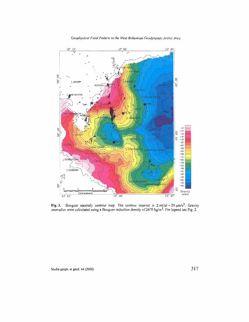
The map of Bouguer anomalies computed for the reduction density of 2670 kg/m3 wasused to interpret the geological structure of the area of interest. This map is based ona detailed gravity survey with 4-6 gravity points per km2. Topographic corrections werecalculated for Hayford zones A-C>2 , i.e. up to a distance of 166.7 km. The gravity mapshown in Fig. 3 was computed in the Potsdam gravity system using the Helmert formulafor normal gravity. The Bouguer anomalies computed in this way are approximately17 mGal = 170 um/s2 higher than the anomalies calculated in the IGSN71 gravity systemand using International gravity formula 1967.
The extensive gravity minimum caused the by the light granites of the Eibenstock -Nejdek (Karlovy Vary) Pluton is a dominant feature of the gravity field (Fig. 3). ThisPluton is the largest granite body in the whole Saxothuringian Zone (Conrad, 1994;Svancara, Chlupacova 1997). The gravity effect of the light sediments of the SokolovBasin is superimposed on this regional negative gravity anomaly. The light granites of theZandov intrusion of the Eibenstock - Nejdek (Karlovy Vary) Pluton account for thenegative anomaly at the southern margin of the area under study.
The gravity minimum bounded by the FrantiSkovy Lazn6 - Kynsperk - Novy Kostel -Plesna - Hazlov polygon is attributed to the light granites of the SmrCiny (Fichtelgebirge)Pluton (Hecht et al. 1997; Srdmek, Mrlina 1997) as well as to the sediments of the ChebBasin.
The sources of the positive anomaly in the area of Luby - Novy Kostel - Krajkova -Stribrna include dense phyllites of the Vogtland - Saxony Paleozoic and mica schist ofthe Krusne hory Mts. crystalline complex. The positive anomaly to the west of Cheb iscaused by various kinds of phyllites and mica schist of the Cheb - Dyleft Crystalline Unit.
The horizontal gravity gradient is presented in the form of a gray-shaded relief map(Fig. 4). This derived gravity field shows the high frequency component of the gravityfield that may not be visible in the Bouguer anomaly map. Fig. 4 shows all thepronounced density contacts, especially those of the upper part of the Earth's crust.Tectonic lines are depicted in a similar way because they are usually accompanied byzones of reduced density. Some indications from Fig. 4 have a known geologicalexplanation, but many of them provide new information and enable the correlation ofspatially distant phenomena.
A pronounced indication of the density contact is associated with the eastern marginalfault of the Cheb Basin in the Luby - Kynsperk nad OhFi interval. Many E-W trends arepronounced in Fig. 4 (N of Nejdek, SE of Kostelni BFi'za and between Soos and Liba,etc.). Indications of density contacts between Kostelnf Bfiza and Lazy correlate withearthquake occurrences near Lazy. The line connecting the main epicentral zone of NovyKostel with the epicentres N of Franti§kovy Lazn6 within the Cheb Basin is also shown inthe horizontal gravity gradient map.
310 Studia geoph. et geod. 44 (2000)
J. Svancara et al.

5. MAGNETOMETRY
The airborne magnetic survey was performed using a G-801/3B proton magnetometer(accuracy 1 nT). The distance between the flight profiles was 250 m with tie lines every2500m. The prevailing ground clearance was 80- 100 m, the sampling rate was 1 s(approx. 35 m along the flight profiles). The finally processed data - AT anomalies - arestored in a 125-m square grid. Fig. 5 shows the magnetic map generated from this grid.
The magnetic field of the Bohemian Massif is characterized by the zonal character ofmajor long-wavelength anomalies (Pokorny, Benes 1997). Two large magnetic elevationscan be distinguished within the predominantly positive field of the area under study. Thefirst situated in the southern half of the Cheb Basin is attributed to the magnetized rockswhich build the basement of the basin. Local linear anomalies trending WSW-ENE areinterpreted as a system of tufaceous horizons consisting of magnetite-bearing phyllites(Mazdc, Pokorny 1962) which may appertain to the Ordovician Phycode complex. Localmagnetic anomalies are often caused by strongly magnetized young volcanics of Mioceneto Pleistocene age; e.g. basalts near the village of Stary Hrozftatov (S of Cheb) and/ornephelinites of the Komornf Hurka Hill.
The second magnetic elevation Sokolov - Olovf is assumed to be caused by a buriedbasic body of unknown type (Pokorny 1969). The ground survey performed by Pokorny etal. (1966) disclosed that many local anomalies of the Vogtland Saxony Paleozoic werecaused by phyllites with magnetite and pyrrhotite.
The most intensive anomaly of the area is produced by a strongly magnetizedserpentinite body near the village of Prameny pertaining to the Marianske LaznS Complexof mostly basic rocks. The pronounced anomaly north of the village of Lazy is generatedby metasediments and metebasites of the recently defined tectonic unit of Kladska(Kachlik 1994).
The granites of the Eibenstock - Nejdek (Karlovy Vary) Pluton are non-magnetic andalso the Smrc'iny (Fichtelgebirge) Pluton has a low magnetization. The fault systemfollowing the boundary between the phyllite and mica-schists complexes (SW) andEibenstock - Nejdek Pluton (NE) along the Kraslice - Rotava - Jindfichovice - Chodovline can be recognized in the magnetic field pattern. On the contrary, the structure of theCheb Basin is not reflected in the magnetic field. No evident correspondence of the mainNovy Kostel - PoCatky epicentral zone and the magnetic field pattern has hitherto beenfound. A detail study of some small-sized magnetic anomalies, which might be connectedwith buried volcanic bodies, could bring new interpretation results in future.
6. GAMMA-RAY SPECTROMETRY
Airborne gamma-ray spectrometry was applied simultaneously with airbornemagnetometry. The 256-channel airborne gamma-ray spectrometer GR-256 with a volumeof 33 litres of Nal(Tl) crystal detectors was used. The resolution was 1 ppm of uranium,1.5 ppm of thorium, 0.25% of potassium and 2 ppm Uequiv. in the total count channel.The processed gamma-ray spectrometric data - abundance of U, Th, K and total gamma-ray activity of the Earth's surface - are also stored in 125-m square grids. Fig. 6 displays
Studia geoph. et geod. 44 (2000) 311
Geophysical Field Pattern in the West Bohemian Geodynamic Active Area
the pattern of the total gamma-ray activity and Fig. 7 shows the abundance of potassium.(The reader is asked to take into account the fact that most of the extensive localminima - with the exception of the SE corner - are water reservoirs and peateries).
The western part of the Bohemian Massif is proved to be a region with high uraniumpotential. A remarkable abundance of the radioactive elements was found in the plutonicrocks. The Eibenstock - Nejdek (Karlovy Vary) Pluton is relatively rich in uranium on theCzech side. The content of this element commonly varies between 4 to 10 ppm U withmany local anomalies reaching tens ppm U. Similar results were presented in the study byForster et al.1999 from the German part of the pluton.
As a thorium is concerned, the autometamorphosed types of granites have a reducedcontent of thorium (6- lOppmTh) while the other-mostly biotite - granites contain14-30 ppm Th.
The SmrCiny (Fichtelgebirge) Pluton also pertains to notable granite bodies from theradiometric point of view. Especially the uranium contents were found to be ratherhigh - mostly from 5 tolO, but locally up to 25 ppm U. Chlupacova et al. 1998 ascertainthat the regional distribution of uranium is distinctly independent of granite petrology.The content of thorium, generally varying at medium values, rapidly decreases to4-2 ppm Th in the easternmost outcropping part of the pluton near the Cheb Basin.Detailed information about the geochemistry of the German side of this pluton waspublished by Hecht et al. 1997.
Remarkable contents of radioactive elements were also observed in the Zandov granitebody to the SSE of the Cheb Basin. The most striking values relate to the content ofuranium (10 - 20 ppm U); thorium as well as potassium contents (15-20 ppm Th and3.5 - 4% K) are less pronounced.
A notable abundance of uranium was even found in several localities within the Cheband Sokolov Basins where ceramic raw materials and brown coal are exploited in openpits. Radioactive anomalies, found in these excavated parts of the basins, provided theproof that the supply of uranium to the basins was not negligible.
The N-S trending minima in the map of the total gamma-ray activity and the maps ofdistribution of natural radioactive elements (K, U and Th), which correlate with epicentresnear Novy Kostel, may indicate - through the presence of local streams - faults of lowerorder with which the location of epicentres could be linked.
7. INTERPRETATION OF SEISMIC, SEISMOLOGICAL, AND GRAVITY DATA
The completion of the 9HR deep seismic profile initiated a new period in theinterpretation of geophysical data in western Bohemia. The 9HR profile providedinformation about the acoustic impedance changes for the whole Earth's crust and evenseveral upper mantle reflections.
Fig. 8 shows the northwestern part of the crustal density model of the geologicalstructure along the straightened 9HR profile (Svancara, Chlupacova 1997). The initialgeometry of the density model was derived from the line-drawing of the essentialreflections along the profile (Tomek et al., 1997) and also from the correlation of areaswith equal echogenity. Particular attention was paid to the natural rock densities used for
312 Studia geoph. et geod. 44 (2000)
J. Svancara et al.
the gravity modelling. The resultant density model of the Earth's crust is in full agreementwith the measured gravity data. The gravity low of the light granites of theEibenstock - Nejdek (Karlovy Vary) Pluton (density 2600 kg/m3) is a dominant feature ofthe gravity profile. The thickness of the Eibenstock - Nejdek (Karlovy Vary) Pluton is11-12 km. (In a similar study performed by Conrad (1994) along the MVE 90 profile,the thickness of the Eibenstock granite was estimated to be 10 km.) The increase ingravity values towards the northwest is attributed to a dense Ordovician phyllites (density2800 kg/m3) and mica schists (density 2706 kg/m3). The abrupt increase in gravity alongthe south-eastern margin of the Eibenstock - Nejdek (Karlovy Vary) Pluton coincideswith the contact of this granite massif with the dense rocks of the Marianske LaznfiComplex.
As an attempt to display possible correlation between the density model of thegeological structure and the located hypocentres we prepared montage shown in Fig. 8.The hypocentres of earthquakes located by the Kraslice network in the period1991 - 1998 closer than 10 km to the 9HR profile were projected on the density model.The hypocentres of the main epicentral zone of Novy Kostel (4 - 5 km of the seismicprofile) occur along the western margin of the granites of the Eibenstock - Nejdek Pluton.Here the authors assume a body with a density of 2720 kg/m3 that forms the bedrock ofthe Krusne hory Mts. crystalline unit. The montage shown in Fig. 8 is twofold ambiguous.The first is the principal ambiguity of the inverse gravity problem, and the other is theunproven assumption of the two-dimensionality of the geological structure between the9HR profile and the hypocentres. Under similar assumptions we compiled Fig. 9, whichdisplays envelopes of hypocentres in the NW part of the migrated time section of seismicprofile 9HR. Here the authors observed groups of pronounced dipping reflections that canbe regarded as manifestations of tectonic displacements. The high intensity of thesereflections that disturbs the relatively isotropic reflection image may indicate recurrenttectonic displacement. The crossing of these reflections at 4 km and the two-way time of2500 ms may suggest the presence of two tectonic systems.
The majority of hypocentres registered in the broader vicinity of Novy Kostel issituated in the depth interval from 5 to 9 km. It is the very place of the geological section,in which the allochthonous complex of the Saxothuringian Zone is thrust over the'European parautochthon' as depicted in the ray tracing section of the 9HR seismic lineand subsequently interpreted by Tomek et al. 1997
The analysis of the structural and tectonic features recorded in geophysical fields andthe study of regional stress fields published by Skdcelovd et al. (1998) and Havif (2000)enabled a simplified dynamic scheme to be designed and a possible movement mechanismwhich could explain the occurrence of earthquake events to be outlined (Fig. 10). Theauthors attribute great importance to the existence of two subparallel NW-SE trendingfault systems, i.e. the Marianske LaznS regional fault and the Kraslice - Rotava - Chodovfault system (near the SW margin of the Eibenstock - Nejdek Pluton) both well reflectedin the geophysical data. Between these two faults exposed to the NW-SE (NNW-SSE)regional stress field, an 'en-echelon' fault structure was created. The nearly N-S orientedline of epicentres Novy Kostel - PoCatky could be a manifestation of the young 'en-echelon' fault (Nehybka, Skdcelovd, 1995) which seems to be a hosting structure of micro-earthquake events. The continuation of this N-S line to the south is clearly seen in all the
Studia geoph. et geod. 44 (2000) 313
Geophysical Field Pattern in the West Bohemian Geodynamic Active Area

airborne gamma-ray spectrometric maps as N-S trending minima in the gamma-rayresponse. (The minima in these maps are caused by water-saturated alluvial deposits,which fill the valleys of local streams. The N-S orientation of the streams may correspondwith the mentioned 'en-echelon' faults.) From the geomechanical point of view, thesinistral displacement along the above-mentioned young fault following the line ofepicentres Novy Kostel - PoCatky should be accompanied by a dextral displacement alongthe Marianske' LaznS fault coinciding there with the eastern marginal fault of the ChebBasin. The Novy Kostel - Pocatky line and the Marianskd LaznS fault in the vicinity ofNovy Kostel form a conjugate system. The partial blocks delimited by the above-mentioned faults and controlled by the regional stress field are compressed and pushedagainst one an other. The regional extension in the NE-SW to ENE-WSW directionenables the release of accumulated elastic-strain energy.
8. CONCLUSIONS
Based on the gravity data interpretation we conclude that the hypocentres of the NovyKostel epicentral zone are associated with the western margin of the Eibenstock - Nejdek(Karlovy Vary) Pluton.
The line of epicentres Vackovec - Novy Kostel - PoCatky correlates with the N - Strending abundances (both minima and maxima) of the all natural radioactive elementsdetected by airborne gamma-ray spectrometry. This trend correlates slightly withgeomorphology but does not correlate with the potential field data - Bouguer anomalymap and derived gravity maps and aeromagnetic total intensity map.
The Novy Kostel - PoCatky line and the Marianske LaznS fault create a conjugatesystem. The sinistral shear sense along the Novy Kostel - PoCatky line should beaccompanied by dextral displacement along the Marianske Lazn6 fault. The partial blocksdelimited by the above-mentioned regional faults are controlled by a regional NW-SE(NNW-SSE) stress field and compressed and consequently pushed against one an other.The regional extension in the NE-SW to ENE-WSW direction enables the accumulatedelastic-strain energy to be released.
Acknowledgement: Authors would like to thank Dr. Vladimir Nehybka for providing thedatabase of hypocentres of microearthquakes recorded by the Kraslice network in the period1991 - 1998, and Dr. Josef Havif for valuable consultations on the regional stress field. We wouldalso like to thank Prof. Tomek, Dr. Jahr, and Dr. Kampf for the careful review of the article thatgreatly helped to eliminate inaccuracies in the text and provided many stimulating suggestions forextending this paper. The review by Prof. Tomek led to a major revision of the manuscript whichwas very valuable especially because of his different opinion in some interpretation questions.
314 Studia geoph. et geod. 44 (2000)
J, Svancara et al.
Geophysical Field Pattern in the West Bohemian Geodynamic Active Area
Fig. 1. Simplified geological map of the geodynamic active area. This map is a part of the digitalgeological map published by the Czech Geological Survey in 1998 as a digital atlas of the CzechRepublic - GEOCR 500.Explanations: 1 - Quarternary sediment, 2 - Tertiary sediments, 3 - Tertiary volcanics,4 - Variscan granites: SmrCiny (Fichtelgebirge) Pluton (W), Eibenstock - Nejdek (Karlovy Vary)Pluton (NE), Zandov granite body (SE), 5 - metabasites and metasediments of the Kladska Unit andthe Mariansk6 LaznS Complex, 6 - serpentinite of the Marianske LaznS Complex, 7 - phyllites andmica-schists of the KruSne hory - SmrCiny and Cheb - Dyleft Crystalline Units together with theVogtland and Saxony Paleozoic, 8 - orthogneiss, 9 - Horni Slavkov Crystalline Unit.
Studia geoph. et geod. 44 (2000) 315

J. Svancara et al.
Fig. 2. Elevation color contour map, contour interval 100 m. The black dots indicate epicentres ofmicro-earthquakes for the period 1991 - 1998.Legend: the black box symbols mark positions of the seismological stations of the KRASLICEnetwork. The deep reflection profile 9HR is marked by a black line with 1 km ticks.
Studia geoph. et geod. 44 (2000)316
Geophysical Field Pattern in the West Bohemian Geodynamic Active Area
Fig. 3. Bouguer anomaly contour map. The contour interval is 2 mGal = 20 pim/s2. Gravityanomalies were calculated using a Bouguer reduction density of 2670 kg/m3. For legend see Fig. 2.
Studia geoph. et geod. 44 (2000) 317

J. Svancara et al.
Fig. 4. Gray-shaded relief map of the gravity horizontal gradient il luminated from the north. Thered dots indicate epicentres of micro-earthquakes for the period 1991 - 1998. The thick yellow linesmark selected fault systems. For legend see Fig. 2.
Studia geoph. et geod. 44 (2000)318

Geophysical Field Pattern in the West Bohemian Geodynamic Active Area
Fig. 5. Colour-shaded relief map of total magnetic field illuminated from the north. The map wasgenerated from airborne data obtained along flight profiles 250 m appart. The sensor height was80 - 100 m. The red dots indicate epicentres of micro-earthquakes for the period 1991 - 1998. Forlegend see Fig. 2.
Studia geoph. et geod. 44 (2000) 319

J. Svancara et al.
Fig. 6. Total radioactivity map based on the total count channel of the airborne gamma-rayspectrometry. For legend see Fig. 2.
Studia geoph. et geod. 44 (2000)320

Geophysical Field Pattern in the West Bohemian Geodynamic Active Area
Fig. 7. Potassium content colour map obtained by airborne gamma-ray spectrometry. For legendsee Fig. 2.
Studia geoph. et geod. 44 (2000) 321

J. Svancara et al.
Fig. 8. North-western part of the crustal-scale density balanced cross-section along deep seismicreflection profile 9HR (Klingenthal - Sokolov - Tepla). Black circles indicate the projection ofhypocentres. Integer numbers show the density of the individual bodies in kgm .
Studia geoph. et geod. 44 (2000)322

Geophysical Field Pattern in the West Bohemian Geodynamic Active Area
Fig. 9. Migrated time section of the northwestern most part of the deep seismic reflection profile9HR (Klingenthal - Sokolov basin margin). Red ovals show the envelopes of hypocentres projectedonto the seismic time section. Yellow colour is used to mark important groups of reflections. Thehorizontal axis shows the distance in kilometres and the vertical axis displays the two-way reflectiontime in milliseconds.
Studia geoph. et geod. 44 (2000) 323

J. Svancara et al.
Fig. 10. Sketch of geodynamic model of the area. The green lines delineate the main fault systems,i.e. the Marianske Lazn£ regional fault (MLF) and the Kraslice- Rotava - Chodov fault (KChF)system, both well expressed in geophysical data. The brown arrows show the direction of regionalcompression, and the blue arrows the direction of regional extension. The sinistral displacementalong the young 'en-echelon' fault coinciding with the main Novy Kostel - PoCatky epicentral lineshould be accompanied by a dextral displacement along the Marianskd Lazne fault.
Studia geoph. et geod. 44 (2000)324

References
ChlupaCovd M, Stemprok M. and Gnojek I., 1998: Distribution of Th, U, and K. and petrophysicalproperties of granites in the Czech part of the Smrdiny (Fichtelgebirge) pluton. Vest. Ces. geol.list., 73, 287-300.
Conrad W., 1994: Interpretation of the Bouguer gravity low of the Erzgebirge and North Bohemia inrelation to the new seismic data. In DECORP Research Group: The deep reflection profilesDECORP 3/MVE-90. Zeitsch. Geol. Wis., 22, 720-734.
Havif J., 2000: Stress analysis in the epicentral area of Novy Kostel (Western Bohemia). Studiageoph. et geod., Studia geoph. el. geod., 44, submitted (Volume U of Special Issue).
Hecht L., Vigneresse J.L., and Morteani G., 1997: Constraints on the origin of zonation of thegranite complexes in the Fichtelgebirge (Germany and Czech Republic): evidence fromgravity and geochemical study. Ceol. Rundschau, 86, Suppl, 93-109.
Forster H.J., Tischendorf G., Trumbull R.B. and Gottesmann B., 1999: Late-Collisional Granites inthe Variscan Erzgebirge, Germany. Journal of Petrology, 40,1613-1645.
Kachlik V., 1994: The Kladskd Unit - petrological and structural evidence for Variscan thrusting ofthe Mariansk6 Lazng Complex over the Saxothuringian terrane (West Bohemia). KTB Report,94-3, 19-3 I.Hannover.
Man O., 1997: Digital hydrography network in the Czech Republic - Technical report. Unpublishedinternal report (in Czech).
MazaC O. and Pokorny L., 1962: Geophysical investigation in the Cheb Basin. Uzitd Geojyz.,Praha,1961,81-126.
Nehybka V. and Skacelova Z., 1995: Seismotectonic analysis of the seismological measurements inthe Kraslice network. Vest. Ces. geol. ust., 70, 97-100
Pokorny L., Bednaf J. and SfoviCkova N., ChlupaCova M. and Cejchanova B., 1966: Thegeophysical survey in the Krusne hory Mts. and the Slavkovsky les. Part I.: Western Krusn6hory Mts. and SmrCiny Mts. (in Czech) -MS Geofond Praha.
Pokorny L., 1969: Einige Ergebnise der geophysikalischen Untersuchungen des Erzgebirges.Geophys. und Ceol., Leipzig, 14, 71-74.
Pokorny L. and Benes L., 1997: Magnetic Field. In Geological model of western Bohemia related tothe KTB borehole in Germany, eds. S.Vrana and V.Stgdra, J.Geol.ScL, Prague, 47, 38-42.
Skacelova Z., Nehybka V. and Havff J., 1998: Seismicity in the Area of Western Bohemia.Exploration Geoph., Remote Sensing and Env., 2,7-15.
Spifiak A., Horalek J., BouSkova A., Tomek C. and VanSk J., 1999: Magma intrusions andearthquake swarm occurrence in the western part of the Bohemian Massif. Studia geoph. etgeod., 43, 87-106.
Srdmek J. and Mrlina J., 1997: Gravity fields - its features and geological interpretation. In Vrana S.and StSdra V. eds., 1997: Geological model of western Bohemia related to the KTB boreholein Germany, J.Geol.Sci., Prague, 47, 24-32.
Manuscript received: 2 December 1999 Revisions accepted: 28 March 2000
Geophysical Field Pattern in the West Bohemian Geodynamic Active Area
Studia geoph. et geod. 44 (2000) 325

Svancara J. and ChlupaCova M., 1997: Density model of geological structure along the profile 9HR.In Geological model of western Bohemia related to the KTB borehole in Germany, eds.S.Vrana and V.Stedra, J.Geol.Sci., Prague, 47, 32-36.
Tomek C., Dvofakova V. and Vrana S., 1997: Geological interpretation of the 9HR and 503Mseismic profiles in Western Bohemia. In Geological model of western Bohemia related to theKTB borehole in Germany, eds. S.Vrana and V.Stedra, J.Geol.Sci., Prague, 47, 43-50.
Vrana S. and StSdra V. eds., 1997: Geological model of western Bohemia related to the KTBborehole in Germany, J.Geol.Sci., Prague, 47, 5-240.
Weinlich F., Tesaf J., Weise S.M., Brauer K. and Kampf H., 1998: Gas flux distribution in mineralsprings and tectonic structure in the western Eger Rift. J. Czech Geol. Soc., 43, 1-2, 91-110.
326 Studia geoph. et geod. 44 (2000)
J. Svancara et al: Geophysical Field Pattern in the West Bohemian Geodynamic Active Area