Geophysical Abstracts 145 April-June 1951
68
Geophysical Abstracts 145 April-June 1951 (Numbers 12701-12890) GEOLOGICAL SURVEY BULLETIN 981-B
-
Upload
khangminh22 -
Category
Documents
-
view
3 -
download
0
Transcript of Geophysical Abstracts 145 April-June 1951
Geophysical Abstracts 145 April-June 1951(Numbers 12701-12890)
GEOLOGICAL SURVEY BULLETIN 981-B

Geophysical Abstracts 145 April-June 1951(Numbers 12701-12890)By MARY C. RABBITT and S. T. VESSELOWSKY
GEOLOGICAL SURVEY BULLETIN 981-B
UNITED STATES GOVERNMENT PRINTING OFFICE, WASHINGTON : 1951
UNITED STATES DEPARTMENT OF THE INTERIOR
Oscar L. Chapman, Secretary
GEOLOGICAL SURVEY
W. E. Wrather, Director
For sale by the Superintendent of Documents, U. S. Government Printing Office, Washing ton 25, D. C. Price 25 cents (paper cover). The printing of this publication has been approved by the Director of the Bureau of the Budget, May 11, 1951.
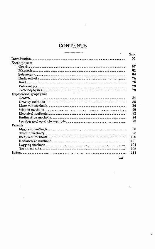
CONTENTS
PageIntroduction___________ __________________________ __________,.___--_ 55Earth physics
Gravity __-_______-__--------------_-----_--_-----------_----_ 57Magnetism______ ________________ _____ ____ _61Seismology _______ -___ _____________________________ 64Radioactivity ________ ___________________________________ T.«. 74Heat______________________________________ 76 Volcanology.____-_-_--_----_--__-__--_-__----__--_-----_-_,__ 78Tectonophysics_ _____________________________________________ 79
Exploration geophysicsGeneral. __________-_____-_--------_--_--_---------_----_-____ 84Gravity methods______________________________________________ 85Magnetic methods.________-_--_-_----______-_______-_-_____-_- 86Seismic methods___-____-_____--_____-___________-____--____'___ 90Electrical methods___________________________________________ 92Radioactive methods_________________________________________ 94Logging and borehole methods________________________________ 95
PatentsMagnetic methods.____________________________________________ 96Seismic methods_____________________________________________ 96Electrical methods___________________________________________ 100
Radioactive methods_________________________________________ 101Logging methods______________________________________________ 104Technical aids______________________________________________ 108
Index__._____________________________________________________ 111m

GEOPHYSICAL ABSTRACTS 145, APRIL-JUNE 1951
By MARY C. BABBITT and S. T. VESSELOWSKT
INTRODUCTION
Geophysical Abstracts are prepared by the Geophysics Branch of the Geological Survey, United States Department of the Interior, as an aid to those engaged in geophysical research and exploration. Periodicals, books, and patents are regularly searched for material dealing with geophysical exploration and with the physics of the solid earth.
Abstracts are grouped in three sections dealing with earth physics, exploration geophysics, and patents. The first section has been further divided into sections on gravity, magnetism, seismology, radioactivity, heat, and tectonophysics. The section on exploration geophysics covers gravimetric, magnetic, seismic, electric, and radio active methods, well logging, and technical aids. Patent abstracts are taken from the Official Gazette of the U. S. Patent Office. Within each group the order of the abstracts is as follows: general papers, bibliographies, and reviews; theory; instruments; methods and techniques; observations.
As many readers may not have ready access to the source material, an effort is made to include all significant new material in these abstracts. Where geographic names quoted differ from the decisions of the United States Board on Geographic Names, the latter are added in brackets.
Geophysical Abstracts 1-86 and 112-127 were issued as Informa tion Circulars by the Bureau of Mines, and 87-111 were issued as Bulletins of the Geological Survey. Geophysical Abstracts 128 and following numbers have been published as Bulletins of the Geological Survey.
All Geophysical Abstracts published as Information Circulars are now out of print. Geophysical Abstracts issued as Bulletins of the Geological Survey (except Nos. 87 and 88 which are out of print) may be purchased as single copies or by subscription from the Superin tendent of Documents, Government Printing Office, Washington 25,
55

56 GEOPHYSICAL ABSTRACTS 145, APRIL-JUNE 1951
D. C. For subscription, the Superintendent will accept a deposit of $5 in payment of subsequent issues. When this fund is near depletion, the subscriber will be notified. The deposit may also be used to pur chase any other publication from the Superintendent of Documents.
Acknowledgments. Special thanks are due James K. Balsley, Jr., Roland G. Henderson, Nancy Ann Smead, and Isidore Zietz who have prepared the abstracts signed with their initials.
EARTH PHYSICS
GEAVITY
12701. Cunietti, Mariano. Sulla smagnetizzazione di gravimetri astatici [On the demagnetization of astatic gravimeters]: Riv. Geofis. Appl., v. 11, no. 2, pp. 103-107, 1950.
Some types of astatic gravimeters are influenced by the geomagnetic field because of the stray magnetization of inner steel parts. Remanent magnetiza tion is removed by exposing the gravimeter to a strong alternating magnetic field which is monotonically decreasing to zero. For very precise instruments the earth's field must also be removed. This is done by means of a Helmholtz coil. 8. T. V.
12702. Boulanger, fD. D. The influence of the geomagnetic field on pendulums made of invar [in Russian]: Akad. Nauk SSSR, Geofiz. Inst. Trudy, no. 2 (129), 32 pp., 1948:
Since the introduction of pendulums made of invar, the possible magnetic effect of the geomagnetic field on these instruments has been considered. Sys tematic discrepancies between the determinations made with invar pendulums and those made with bronze pendulums have been noted. A theoretical analysis is presented to show that the disturbance produced by the geomagnetic field must be taken into account in precise gravitational measurements. This can T>e done by introducing corresponding corrections, computed analytically. How ever, it was found that the magnetic properties of invar sometimes vary errati cally because of shocks during transport or because of strong local magnetic anomalies.
It was found, experimentally, that the effect of the geomagnetic field was eliminated by an arrangement of Helmholtz coils around the pendulum. The results of these experiments show that the error caused by the magnetic effect may be as much as 4 mgal, or more in localities of strong magnetic anomalies; magnetostriction can cause an error up to 2X10⁻⁸ sec and thus can be neglected; the disturbing effect of the geomagnetic field can best be eliminated by the use of Helmholtz coils. 8. T. 7.
12703. Boaga, Glovanni. Sulla equazione differenziale di Schweydar relativa alle marie terrestri [On Schweydar's differential equation referring to earth tides]: Geofis. Pura e Appl., v. 18, pp. 38-44, 1950.
The method of Schweydar and Somigliana is followed in studying the def ormation of the earth by the tidal effect of the sun and moon. The theoretical analysis of forces and reactions leads to a differential equation of the sixth order with polynomial coefficients, which contain a number of unknown func tions representing such relations as the variation of the density and of the elastic properties of masses through the depth of the earth. By making certain assumptions as to the form of these functions and using the formula of Roche ior the variation of density and Herglotz' formula for rigidity, it is possible to integrate the equation approximately and to obtain expressions for the changes of the shape and of the potential energy of the earth resulting from the
57
58 GEOPHYSICAL ABSTRACTS 145, APRIL-JUNE 1951
tidal effect. Precise gravity observations are needed to provide numerical values of several parameters entering into the computation. S. T. V.
12704. Reford, M. S. Tidal variations of gravity: Am. Geophys. Union Trans., v. 32, no. 2, pp. 151-156, 1951.
Changes in the value of gravity with respect to time were observed at Toronto over a period of 29 days, using a North American gravimeter with readings taken every quarter hour. The drift curve of the instrument was calculated, and the residual fluctuations were analyzed harmonically to determine the amplitudes and phases of the gravity changes corresponding to the tidal constituents M2 , Sn, N2, -fiTi and Oi. By comparing observed amplitudes with the tide-generating potentials of the sun and moon, a function of Love's numbers, m=l+7fc 3fc/2, is obtained. Mean values of m for semidiurnal and diurnal constituents were determined as 1.0(9) and 1.0(0) for the 29 days, or 1.2(2) and 1.0(2) if only the first 15 days are considered. Love's numbers may be used to give a value for the rigidity of the earth as a whole, and may also prove useful in gravity surveys in which the true drift of the instrument and tidal variations are combined in a single drift curve. If tidal variations are known, frequent returns to base may be unnecessary, unless the higher and per haps discontinuous rate of drift induced'by^ clamping and jolting the instrument makes such a method of operation impracticable. M. C. R.
12705. Hoskinson, A. J. Harmonic analysis of gravity observations: Am. Geophys. Union Trans., v. 32, no. 2, pp. 163-165,1951
A description is given of the U. S. Coast and Geodetic Survey's part in the project initiated by A. Van Wielder of the Shell Oil Co. to measure tidal varia tions of gravity at several stations scattered throughout the world. Harmonic analyses have been made of the data from 17 stations in Mexico, Texas, Cali fornia, New Mexico, Oklahoma, District of Columbia, Colorado, Utah, and Canada, and are given in a table. M. C. R.
12706. George, W. O., and Romberg, F. E. Tide-producing forces and artesian pressures: Am. Geophys. Union Trans., v. 32, no. 3, pp. 369-371, 1951.
Simultaneous observations of gravity, atmospheric pressure, and artesian pressure were made during a 48-hour period November 30 to December 2, 1949, at the M. R. Gonzales artesian water well about 1 mile south of Fort Stockton, Pecos County, Tex. The well is about 700 km from the Gulf Coast and more than 1,300 km from the Pacific Coast at the nearest points. The curve of observed gravity conforms to that of the computed tide-producing force (except at the beginning, which may be the result of instrumental error) in time and relative amplitude of maxima and minima. Variations in the observed force are approxi mately 25 percent greater than in the computed curve for which a rigid earth is assumed. The curve of artesian pressure also corresponds to the curve of the computed tide-producing force. The curve of atmospheric pressure conforms less closely, suggesting fluctuation in atmospheric pressure may be less important than the earth tide in causing diurnal fluctuation of water level. M. C. R.
12707. Woollard, G. P. A gravity reconnaissance of the island of Oahu: Am. Geophys. Union Trans., v. 32, no. 3, pp. 358-368, 1951.
The 26 gravimeter stations established on Oahu in 1948 in addition to older stations established by the U. S. Coast and Geodetic Survey provide a network
GRAVITY 59
of stations at about 4-mile intervals along the main roads circling and crossing the island. In analyzing the gravity anomalies, both the regional field and local anomalies are considered. By the method of density profiles used in geo physical exploration to establish density of surface and near surface formations, the density of the island mass as a whole above the sea floor is found to be 2.3 g per cu cm. This implies either considerable subsidence of the mass or the existence of vesicular structure under high confining pressures. The Bouguer- anomaly curve based on a density of 2.3 g per cu cm shows a regional gravity minimum about 500 mi wide with a maximum amplitude .about 75 mgals beneath the island block. The center of the minimum is displaced about 100 km from the center of the island block, suggesting that two geologic features contribute to the anomaly. Part may be related to a thinning of the crystalline crustal layer because of the withdrawal of magmatic material at depth to furnish lavas and a possible magma chamber at depth, and the balance is presumably related to surface subsidence whereby material of 2.3 specific gravity is brought into juxtaposition with oceanic crustal material of 2.95 specific gravity. Regional subsidence on this basis has been between 8,000 and 10,600 feet. An additional subsidence of approximately 7,000 feet is required to achieve isostatic equilibrium. lrf)cal anomolies of +110 mgals occur over the sites of the ancient caldera of Koolau and Waianae, and are apparently the result of a contrast in the densi ties of the solid throat material of the volcanic vents and surrounding vesicular basalts. Computations of the depth to which a maximum density contrast of 0.6 g per cu cm exists to satisfy the anomaly indicate subsidence to 9,000 fe?t below the ocean floor, essentially the same subsidence as determined from the regional anomaly. M. C. R.
12708. Cook, A. H. and Thirlaway, H. I. S. Recent observations of gravity in Wales and the Borders: Internat. Geol. Gong., Great Britain, 18th sess., 1948, Rept, pt. V, Proc. sec. D, pp. 33-44, 1950.
This is the full text of the paper, the abstract of which was published as Geophys. Abstract 11692. In central Wales, there is a general positive Bouguer anomaly of 5-10 mgals. These figures indicate there is no isostatic compensa tion of the mass of the Welsh mountains and that the strength of the crust supports not only the visible irregularities but also an excess mass corresponding to about 7 mgals. The positive area coincides with the area of post-Cretaceous uplift. The anomaly falls from +5 to about 25 mgals at the boundary between Triassic and Paleozoic rocks on the line of the Malvern Hills, and reaches a minimum of 30 mgals in the Worcester basin. The gravity field is interpreted as the result of a step fault complex with a total downthrow of 3,000 in. The age of the faulting is believed to be late Carboniferous. A sharp local increase of 7 mgals near Church Stretton is attributed to the outcrop of denser pre- Cambrian rocks in the core of the anticlines. M. C. R.
12709. Magnee, Ivan de. Commentaire geologique sur la nouvelle carte gravi- metrique de la Belgique [Geological comments on the new gravimetric map of Belgium] : Soc. beige geologic Bull., v. 57, no. 3, pp. 576-588, 1949.
With the exception of those in the northeast part of Limbourg and the region around Mons, all the Bouguer anomalies shown on the map have a deep or very deep origin. The anomalies are divided into those which are interpretable by geologic knowledge, as the negative anomaly in Ardennes attributed to the
963521 51 2
60 GEOPHYSICAL ABSTRACTS 145, APRIL-JUNE 1951
mountain root of the Hercynian range, and the negative anomaly due to- Tertiary sediments in the Roermond graben (especially well shown on the combined Dutch, German, and Belgian maps), and those which cannot be in terpreted from present geologic knowledge, such as the negative anomalies in. Ardennes and Flanders, and the positive anomaly in the northeastern part of the country. Comparison with the magnetic map shows that the gravity anomalies correspond to magnetic anomalies of the opposite sign. A map of the Bouguer anomalies is included. S. T. V.
12710. Norin, E. and Ambolt, N. P. The relation of the Tarim Basin to it& border ranges as elucidated by gravity data: Internat. Geol. Cong., Great Britain, 18th sess., 1948, Kept., pt. V, Proc. sec. D, pp. 104-109,. 1950.
The tectonic character of the Tarim Basin is studied on the basis of gravity data, 48 pendulum stations grouped along two sections one across the eastern Tien Shan at approximately 89° E. longitude and the other across the western part of the Tarim Basin along the Khotan Darya and Kunlun Mountains to the- Plateau of Tibet. The Bouguer anomaly is negative at all stations. Measure ments along the western section indicate a median zone of 111 to 161 mgals from which the anomaly increases laterally. In the Kunlun Mountains, the- anomaly is about 400 mgals along the crest. In the Karakoram Range and on the Plateau of Tibet the anomalty is more than 500 mgals with a maximum of 566 mgals. In the section across the eastern Tien Shan there are com paratively small variations in gravity and no apparent relation between the anomaly and the mean elevation. In the first section the anomaly is probably- due to a deep-seated source such as changes in thickness and depth of the sialic and simatic layers, while changes in the second section are related to changes- in the geologic superstructure. M. G. R,
12711. Gassmann, Fritz, liber die Isostasie und Mechanik der Erdskruste [Isotasy and the mechanics of the crust of the earth]: Geog. GeselL Bern Jahresber., v. 40, pp. 37-39, 1951.
A review of our present knowledge of the structure Of the earth. S. T. V.
12712. Heiskanen, W. On the isostatic structure of the earth's crust.Isostatic Inst. Internat. Assoc. Geodesy Pub. 24, 60 pp., 1950 (Reprinted from the Acad. Sci. Fenn. Ann., Ser A, III. Geol.-Geog., 22).
The publication contains the principal part of the "Report on Isostasy" written for the Oslo General Assembly of the International Union of Geodesy and Geophysics in 1948. The methods of reduction of gravity values, gravity formu las, geoid studies, the gravimetric method for computing deflections of the vertical and isostatic reductions and studies of particular regions during recent years are reviewed. An extensive bibliography is included M. G. R.
12713. Dario Rozo, M. El achatamiento terrestre [The flattening of the earth] : Acad. Colombiana cien. exactas, fis. y nat. Rev., v. 8, no. 29, pp. 16-18,. 1950.
From geodetic measurements the flattening of the earth has been found to be- very nearly 1/297. Deriving the same value from the equations of mechanics, applied to the condition of equilibrium of a rotating homogeneous deformable body, P. Appel in his treatise on analytical mechanics obtained 1/578. If the
MAGNETISM 61
method of Appel is followed and the molecular attraction of water particles and that of the terrestrial atmosphere are considered, the value of 1/297.0 ± 0.5, in agreement with geodetic measurements, is found. 8. T. V.
12714. Judice, Anttoio. Calcul pratique de 1 'aplatissement de la terre et de la pesanteur gquatoriale [Practical computation of the flattening of the earth and of the gravity at the equator]: Geofis. Pura e Appl., v. 18, pp. 107-112,1950.
The earth's flattening and the value of gravity at the equator have been com puted, using numerical values of the mean isostatic anomalies as given by L. Tanni, as 1/296.3 and 978.055 gals respectively. S. T. V.
12715. Morelli, Carlo. Collegamento gravimetrico Padova-Trieste e rilievo gravimetrico regionale del Veneto centro-orientale [The Padova-Trieste gravimetric tie and regional gravimetric survey of east-central Veneto] : Biv. Geofls. Appl., v. 11, no. 2, pp. 85-102,1950.
During the spring of 1950 relative-gravity determinations were made between the Observatorio Astronomico at Padova and the Observatorio Geoflsico of Trieste using a Western G4A gravimeter. The measurements were made with extreme care, the high precision of the gravimeter making possible such refine ments as correction for lunisolar effect on gravity. Twenty-seven intermediate stations were occupied during this survey, forming a regional gravitational network. The results of the survey are presented as a Bouguer map of the region. The anomalies are negative and increase in absolute value toward the Alps. Final values of gravity were determined as 980.6575 gals at Padova and 980.6647 gals at Trieste. 8. T. V.
MAGNETISM
12716. Haalck, Hans. Neue Ansichten uber die Ursachen des magnetischen Feldes des festen Erdkorpers [New views on the origin of the magnetic field of the solid earth]: Geofis. Pura e Appl., v. 18, pp. 132-142, 1950.
A theoretical proof is presented of the fact that a cosmic mass of high temper ature and of high degree of ionization must inevitably become magnetized owing to Brownian movement of its free electrons. The alinement of the resulting magnetic field corresponds to the magnetic field of the earth and of the sun. This may explain the origin of the magnetism of the earth's core. The magnetism of the crust of the earth is attributed primarily to telluric currents circulating in the crust and also to remanent magnetism of the rocks. The pattern of the observed magnetic field in the crust indicates the rotation of the American vortex system of telluric currents is clockwise and of the Afro-Australian, counter-clock wise. From the fact that when the patterns of these systems are traced onto a map they coincide with the great geosynclines of the earth, it can be concluded that the original telluric currents were evidently generated by certain tectonic processes. Secular variation of the geomagnetic field is to be attributed to pro gressive change of telluric currents. S. T. V.
12717. Chapman, Sydney. Corpuscular influences upon the upper atmosphere: Jour. Geophys. Research, v. 55, no. 4, pp. 361-572,1950.
Evidence for the corpuscular theory of .magnetic storms is reviewed. Efforts to detect solar corpuscles during emission from the sun or passage to the earth
62 GEOPHYSICAL ABSTRACTS 145, APRIL-JUNE 1951
have not been successful. The strongest direct evidence for the theory seems to be provided by the hydrogen lines in the auroral spectrum, which are broadened and displaced by the Doppler effect, with the spread of the H/3 and Hy lines corresponding to a range of speed of 800 km per sec. M. C. R.
12718. Agostinelli, Cataldo. Influenza del magnetismo solare sul moto di rotazione della terra [Influence of solar magnetism on the rotational motion of the earth] : Geofis. Pura e Appl., v. 18, pp. 18-37, 1950.
The existence of the magnetic field of the sun being demonstrated, the ques tion has been repeatedly raised whether this field with its violent variations of intensity can influence the rotational motion of the earth, as these variations certainly produce intense perturbations of the geomagnetic field. A detailed analysis of this question is made. The potential of the solar magnetic field is determined and at sufficiently distant points found to be equivalent to that pro duced by an elemental dipole placed in the center of the sun. After extended mathematical computations and detailed analysis of the steady conditions as well as periods of magnetic disturbances, it is concluded that in normal condi tions the magnetism of the sun does not produce any effect on the rotation of the earth. Possibly during exceptionally violent magnetic disturbances and the periods of intense solar spots this effect can become noticeable. S. T. V.
12719. Sivaramakrishnan, M. V. Some geomagnetic disturbances at Alibag Observatory (India) and allied radio and solar effects (1937-46) : Indian Jour. Meteorology and Geophysics, v. 1, no. 3, pp. 207-219, 1950.
From a study of magnetic disturbances associated with solar flare and radio fade-out during 1937-46 it is concluded that while individual storms differ con siderably in their detailed morphology, there are common features. Many storms start suddenly from quiet conditions and are simultaneous within a minute of time all over the earth. Storms may occur at any hour. A great storm may be predicted by considering the proximity in time to one of the peaks of annual frequency near the equinoxes and the occurrence of a great spot group near the central meridian. Magnetic changes occurring simultaneously at a large number of stations indicate that the magnetic effect is an augmentation of the normal diurnal variation, presumably because of increased atmospheric ionization by ultraviolet rays from the eruption. Magnetic storm disturbances, on the other hand, are due to solar corpuscles travelling at a speed of 1,000 to 2,000 mps. The ionizing radiation from the sun is to be classed as wave radia tion and particles. The wave radiation ionizes the day side of the ionosphere, and produces solar and lunar daily variation. The corpuscular radiation reaches the earth's night side and causes auroral and magnetic disturbances. M. C. R.
12720. Bartels, Julius. Results of geomagnetic K-indices for the international Polar Year 1932-33: Jour. Geophys. Research, v. 55, no. 4, pp. 427-435, 1950.
*
Planetary indices for the 13 months of the polar year have been tabulated. Geomagnetic activity was typical for the year before a sun-spot minimum. Diurnal variation of geomagnetic activity is shown to have significance as indicating the terrestrial target sectors of solar-particle radiation. There is apparently a difference between European and North American variations of activity near the auroral zone. M. C. R.
MAGNETISM 63
12721. Beagley, J. W. and Bullen, J. M. Trends in magnetic declination at Apia and Christchurch: New Zealand Jour. Sci. Technology, v. 31, sec. B., no. 1, pp. 16-26, 1949 [1950].
Declination at Christchurch from 1902 to 1947 may be represented by the curve defined by Dc= 16.2941° +0.0302° (f-1902.5) +0.0007085° (t-1902.5) 2+ 0.0000002477° (t 1902.5) 3 where 1902.5 is the initial epoch, * any year after this epoch, and easterly declination is taken as positive. Residuals of observed minus calculated values show a marked tendency toward a 22-year periodicity, suggesting a possible relationship with sunspots. Mean annual values for Apia from 1905 to 1947 are best represented by the straight line JDc=9.5315°+0.0392° (t 1905.5), with a similar tendency toward a 22-year periodicity of the resid uals indicated. To determine the low which governs the effects superimposed on the main trend a longer series of data is needed, but this work supports the idea that secular variations show small-order dependence in their progress on the sunspot cycle- M. C. R.
12722. Zietz, Isidore and Henderson, R. G. Magnetic anomalies at high alti tudes: Am. Geophys. Union Trans., v. 32, no. 3, pp. 397-404, 1951.
To investigate the effect of anomalies in the earth's magnetic field at high alti tudes, aeromagnetic maps of two representative areas showing isoanomalic curves for total intensity are projected to levels of 10 and 20 miles above the surface of a plane Earth. The projects are accomplished by numerical computa tions and by use of a magnetic-field projecting machine at the Naval Ordnance Laboratory. It is found that anomalies of 500 gammas near the surface of the Earth, in merging into neighboring anomalies, may produce effects of 100 gammas or more at an altitude of 20 miles. Author's abstract.
12723. Digiesi, Domenico. La nuova carta magnetica dell'Istituto Geografico Militare con le isogone al 1948 [The new magnetic map of the Military Geographical Institute with isogonics reduced to the epoch 1.1.1948] : Boll. Geodetico, no. 4, pp. 193-194, 1949.
The Italian Military Geographical Institute has published a new map, as supple ment to its older magnetic map of Italy, with declinations reduced to 1.1.1948, using the results of magnetic surveys made in 1947-48, and taking into account the recently determined values of the secular and diurnal variations of magnetic elements. The isogonics show good agreement with the magnetic networks of Switzerland and France in contiguous areas. [From a review by A. Paroli in Rivista del Catasto e dei Servizi Tecnici Brariali, no. 4, p. 305, 1950.] S. T. V.
12724. Hoge, Edmond. Considerations sur la distribution du magnetisme ter- restre en Belgique [Reflections on the distribution of terrestrial mag netism in Belgium]: Soc. Sci. Bruxelles Annales, v. 65, fasc. .1-2, pp. 71-78, 1951.
Geomagnetic surveys of Belgium since 1900 are reviewed and the main features of established magnetic anomalies are compared with geologic evidence and results of gravitational and seismological investigations. The greatest positive anoma lies are located in the anticlinal zones of Ardennes and Brabant and negative anomalies in the basin of Campine [Kempenland]. This confirms the theory that the changes in magnetic anomalies reflect the variation of the upper boundary of crystalline basement. Where this approaches the surface, as over anticlines, thy observed anomalies are positive. Anomalies are negative over grabens or syn-

64 GEOPHYSICAL ABSTRACTS 145, APRIL-JUNE 1951
clines. Comparison of the magnetic map of Belgium with the seismic map shows that the regions of greatest seismic intensity correspond to the regions of positive magnetic anomalies. Gravity anomalies in Belgium in general correspond to magnetic anomalies of opposite sign. S. T. V.
12725. Baird, H. F. and Cullington, A. L. A new magnetic survey of New Zea land : Jour. Geophys. Research, v. 55, no. 4, pp. 379-384,1950.
New magnetic charts of New Zealand for the epoch 1945.5 have been prepared, based on observations of declination, horizontal force, and inclination at 219 stations between May 1941 and December 1948. Distribution of stations and D, H, and I are shown by maps. M. G. R.
12726. Kumagai, N., Kawai, N., and Nagata, Takeshi. Recent progress in palaeomagnetism in Japan: Jour. Geomagnetism Geoelectricity, v. 2, no. 3, pp. 61-65, 1950.
The remanent magnetization of lava flows and horizontal sedimentary rocks in various parts of Japan has been measured using magnetometers and induc tion-type equipment as required. With three exceptions, the Azuki tuff and lava from the volcano Sigi [Shigi-san] and dike rock at Kasuga, all material of late Neogene through early Holocene age is magnetized nearly in the direction of the present field. The Azuki tuff and Sigi lava are inversely magnetized. It is noted that from Japanese data only Tertiary ejecta and deposits show this inverse magnetization. M. C. R.
SEISMOLOGY
12727. Bela, Simon. A foldrenge'skutatas tortenete [The history of seismology] : Pazmfiny P6ter Tudomanyegyetem Az Orsz&gos F61drengesvizsgal6 Intezet Kiadvdnyai [Hungarian Govt. Inst. Seismology], ser. C: 7, 43 pp., 1948.
This is a brief review of the development of seismology and a discussion of its use for studying the structure of the earth, instruments and methods of investigation of earthquakes, earthquake damage and its possible prevention, and locations of seismic stations. S. T. V.
12728. Fu, C. Y. Free vibrations of an inner stratum: Science record [Aca- demia Sinica], v. 3, no. 1, pp. 81-85, 1950.
In prospecting by the seismic method one possible source of energy loss is a thin layer imbedded in a thick formation.- This layer, if thin enough, has an inappreciable effect on the direction and time of the reflected and refracted seismic waves, but it can be excited into free vibration thus consuming energy. Conditions under which such vibrations can be generated are studied by investi gating the propagation of dilatational and distortional waves as a two-dimen sional phenomenon. Knott's function is used in establishing the two differential equations of waves'; their solutions are derived. It is concluded that when the frequency equation contains imaginary parameters, body type waves are gen erated, leading to energy losses. When the parameters are real, only Stoneley waves along the boundary planes of the stratum will be produced. S. T. V.

SEISMOLOGY 65
12729. Fu, C. Y. On the irrelevant roots of the Rayleigh wave equation: Science record [Academia Sinica], v. 2, no. 4, pp. 388-392, 1950.
Of the three roots of the Rayleigh-waves equation, only one gives rise to a surface wave. The other two roots, which may be both real or both complex, were discarded by Rayleigh as not corresponding to the surface type of waves he was investigating. Fu analyzes,the physical significance of the two roots in question. He introduces in the fundamental wave equation two Knott's functions, <p and <f>, with v= v (z)e i<-^~a(> and *=*(z)ei(**~" d . Here the ratio w/£ equals the apparent velocity along the free surface characterized by the absence of the stress in its points. The solution of the so transformed wave equation gives one wave motion with apparent velocity w/l equal to 0.9194y, where 1? is the velocity of the distortional wave. Two other roots are pure imaginary quantities. Fu concludes that they have physical meaning only in the case of inhomogeneous waves. S. T. V.
12730. Homma, S. On the propagation of dispersive seismic waves: Geophys. Mag., v. 23, no. 3, pp. 209-236, 1951.
The maximum amplitude of dispersive waves and their velocity of propagation are investigated with reference to seismic surface waves. The general theory for dispersive waves in a nonabsorptive medium is developed assuming that the initial distributions of displacement and velocity are given. For wave trains composed of component waves with, finite frequencies it is concluded that the maximum amplitude propagates with the maximum or minimum group velocity. However, when the component waves have frequencies that are infinitely large the theory is at variance with seismological observations. By taking the initial conditions into consideration, the discrepancy can be interpreted.
The conditions of generation of a wave are believed to influence more seriously the greatest amplitude of a wave train than does the group velocity. Examples are given of initial values of displacement or velocity which illustrate the author's view.
The analysis of dispersive waves in an absorptive medium shows that the maximum amplitude will progress with a constant velocity different from and a magnitude less than that in a nonabsorptive medium. R. G. H.
12731. Officer, C. B. Normal tftode propagation in three-layered liquid half space by ray theory: Geophysics, v. 16, no. 2, pp. 207-212, 1951.
The fundamental integral for normal mode propagation in a three-layered liquid half space is derived by multiple reflections. The resulting integral agrees with that obtained formally by Pekeris (1948).
The physical significance of normal mode propagation for the three layer case is discussed in terms of the characteristic equation. Normal modes occur when the primary ray is in phase with the sum of secondary rays suffering one re flection from the free surface. The higher modes occur at increasing values of the wave number corresponding to multiples of 2ir in the phase. The cut-off frequency occurs when there is partial refraction into the lowest medium. There is a critical frequency beyond which the propagation takes place solely in the first medium. R. G. H.
12732. Benioff, Hugo. Global strain accumulation and release as revealed by great earthquakes : Geol. Soc. America Bull., v. 62, no. 4, pp. 331-338,1951.
The elastic strain-rebound characteristics of three world sequences of great earthquakes between 1904 and 1950, those of magnitude 8 or greater at depths
66 GEOPHYSICAL ABSTRACTS 145, APRIL-JUNE 1951
of 70 km or less, those of magnitude 7 or greater at depths of 70 to 300 km, and those of magnitude 7 or greater at depths of 300 ,km or more, hav,e been determined. The characteristic of the shallow sequence approximates a saw tooth curve with nearly linear segments, and amplitudes and periods which decrease with time. From this it is concluded that these earthquakes are not independent events but are related in some form of world-wide stress system; that between 1908 and 1950 the rate of total secular strain generation in the crustal layer in which these earthquakes originate has been remarkably constant; that the strain was released in five periods of decreasing lengths separated by intervals of little or no activity during which crustal strain accumulated at a constant rate; and that during active periods strain release took place at ap proximately twice the rate of secular strain generation. At the present time the oscillatory amplitude of the characteristic is so small that there is no effective secular accumulation and strain is being released substantially as fast as it is- being generated.
The epicenters of the shocks terminating active intervals lie very nearly on, a great circle with center at approximately 55° N. lat, 127° W. long. This may be mere chance, but if not, the plane defined by this circle may represent some fundamental shearing surface which divides the earth into hemispheres. The great earthquake of August 15, 1950, apparently marked not only the end of the minor active interval but also the end of the whole secular period which began prior to 1904.
Two hypotheses are suggested to explain the characteristic, one that postulates some variation in the dimension of the earth's radius in the form of radial relax ation oscillation, and the other by analogy to the motion of a bowed string, but neither explains why the magnitudes are apparently independent of the total accumulated crustal strains.
The characteristic of the intermediate earthquakes sequence suggests a long- term periodicity, but less than two cycles are represented. The characteristic of the deep earthquakes sequence may be represented by a straight line which indicates that great deep earthquakes are related in a single stress system in which compressional elastic creep strain has been accumulating or releasing since 1888.
The different behavior of the three sequences is considered evidence of the existence of three layers, 0-70 km, 70-300 km, and 300-680 km, with different secular mechanical properties. M. C. R.
12733. Press, Frank, Crary, A. P., Oliver, Jack, and Katz, Samuel. Air-coupled1 fiexural waves in floating ice: Am. Geophys. Union Trans., v. 32, no. 2,. pp. 166-172, 1951.
In the course of experimental studies of the propagation of elastic waves on floating ice sheets made on the ice of Lake Superior and Lake Cayuga, an air- coupled flexural wave was identified. Elastic waves were generated by small explosive charges detonated at various depths in the water, within the ice, and in the air and recorded by a spread of geophones, a microphone, and hydro phone at distances up to 7414 feet. Shots in the water produced the normal sequence of dispersive flexural waves. With shots fired on or above the ice surface, the dispersive flexural waves were absent and a train of constant frequency waves was observed, beginning at time t r/2va and culminating with the arrival of the air wave at time t=r/Va (r being the range and Va the speed of sound in air). These have been interpreted as air-coupled flexural waves. The frequency depends on the ice thickness and the speed of sound in air. The
SEISMOLOGY 67
waves precede the air wave because the group velocity of flexural waves is greater than the phase velocity. The interpretation was supported by later experiments in which the air-coupled flexural vibrations were recorded by microphones. M. C. R.
12734. Stoneley, Robert. Polarization of the $-phase of seismograms: Annali Geofls., v. 4, no. 1, pp. 3-8, 1951.
In earthquakes recorded at moderate distances, the tf-phase has been observed to appear first as an SH wave, followed after 10 to 14 seconds by an 8V wave*. The possibility that this results from double refraction, caused by anisotropy of the upper layer of the earth's mantle, is investigated. The upper layer is assumed to be "transversely isotropic" and symmetrical about the vertical, the formulae for the velocities of SH and SV waves are analyzed, which de pend on the angle the ray .makes with the normal. The mineral beryl, which is transversely isotropic, is taken as a limiting case as it is unlikely that the earth could be more markedly anisotropic. The velocities of SH and SV for different angles of incidence are "scaled down" so as to match the velocity of distortional waves in granite (3.40 kmps for SV at angles of incidence 0° and 90°). The velocity, in the underlying material, is assumed to be 4.38 kmps, so the model corresponds to granite on ultrabasic material. The difference in the time taken by either wave from one point of the surface of the earth to another point on the surface can be calculated. A layer of ,anisotropic rock 30 km thick was found to account for a time difference of only 1% sec. To produce a dif ference of 14 sec in the times of arrival of SH and SV waves, a layer 300 km thick would be required. Thus no great credence can be attached to an explana tion based on double refraction. S. T. V.
12735. Garrick, R. A. Observations of ScS near an earthquake epicenter: New Zealand Jour. Sci. Technology, sec. B., v. 31, no. 2, pp. 15-23, 1949 [1950].
ScS has been identified on the Wellington, Tuai, and Auckland records of the earthquake of January 15, 1948, at 40°35' S. lat., 175°00' E. long. The epi- central distances were 0.92°, 2.25°, and 3.45° respectively. Periods of the waves were 2.0,1.7, and 2.5 seconds. M. C. R.
12736. Gutenberg, Beno. PKKP, P'P', and the earth's core: Am. Geophys. Union Trans., v. 32, no. 3, pp. 373-390, 1951.
Observed times and amplitudes of PKKP and P'P' are discussed. At distances between 100° and 120° PPP with angular distances over 180° preceded P'P' by less than 1 minute and has occasionally been confused with P'P'. The travel time curve for longitudinal waves between points on the surface of the core is revised. Observed amplitudes of short-period waves in P' and PKKP are roughly four times greater than the amplitudes calculated on the assumption that the distribution of energy as a function of period is the same for waves through the core as for those through the mantle only (P, PP, and S). PKKP waves with periods of more than three seconds are very rare. PKKP through the inner core is usually not observed, in agreement with theoretical expectation. The fact that PKKP through the outer part of the core is well observed indicates a ratio of probably at least 1.7 for the densities inside and outside the outer core unless the ratio is near 1.0. At the boundary of the inner core (radius about 1,300 km) the velocity increases from 10± to ll±kmps within 100±km and
963521 51 3

68 GEOPHYSICAL ABSTRACTS 145, APRIL-JUNE 1951
is 11.2±kmps in most of the inner core. P" at distances between its beginning near 105° and a distance of 125° is probably mainly due to waves reflected at the inner core. Author's Abstract.
12737. Leet, L. D., Linehan, Daniel, and Berger, P. R. Investigation of the T phase: Seismol. Soc. America Bull., v. 41, no. 2, pp. 123-141, 1951. .
From detailed studies of more than 250 earthquakes it has been found that the T phase is generated by earthquakes originating mostly at depths of 40 to 100 km under the ocean floor. It consists primarily of shear waves with a velocity of between 1.6 and 2.7 kmps over oceanic paths and 2.1 kmps over land. The period ranges from 0.5 to 1.0 second. These results are in fundamental disagreement with those of Ewing, Press, and Tolstoy [see Geophys. Abstract 11953]. It is suggested that the T phase may be short-period shear waves travel ing in ocean bottom sediments and the top continental layer. M. C. R.
1273&. Leet, L. D. Discussion of "Proposed use of the T phase in tsunami warning systems": Seismol. Soc. America Bull., v. 41, no. 2, pp. 165-167, 1951.
Ewing, Tolstoy, and Press report of a striking correlation between the occur rence of the T phase and the occurrence of tsunami [see Geophys. Abstract 11953] is shown to have several exceptions. The value of T as a tsunami warning is not conclusive. M. C. R.
12739. Due Rojo, Antonio and Gimeno Riutort, Antonio. Rutas sismicas super- ficiales [Paths of seismic surface waves]: Ofoservatorio de Cartuja (Granada) Trabajos geofis., ser. B, no. 29, 6 pp., 1950.
Investigation of surface waves and interpretation of their seismograms is extremely difficult because of the influence of upper layers of the crust across which these waves propagate. At some distance from same epicenter surface waves spreading in different directions have very different periods and character. They may be very useful as indicators of differences in geologic structure in their path. At the Cartuja Observatory, seismic disturbances have been divided into 36 groups according to the azimuth of arrival. Different seismograms show striking differences in the whole pattern of incoming waves in accordance with the angle of arrival. Four main groups of seismograms are distinguished: one contains the waves coming from antipodes from the region of New Zealand; the second includes the Philippines, Formosa, and Japan; the third group of seismic disturbances is generated in the Atlantic Ocean; and the last on the portion of the circum-Paciflc belt from the Andes to California. £. T. V.
12740. Caloi, Pietro, and Peronaci, Francesco. Sulla superficie di discon- tinuita alia profondita di 950 km circa [On the discontinuity at the depth of about 950 km]: Annali Geofis., v. 4, no. 1, pp. 107-110, 1951.
Reflections from the discontinuity at about 1,000 km were recognized on the records of the earthquake of March 16, 1941 in lower Tirano at 15 European stations at distances between 780 and 1,916 km. Calculated depths ranged from 915 to 990 km with an average of 950 km. 8. T. V.
12741. Gutenberg, Beno. Revised travel times in southern California : Seismol. Soc. America Bull., v. 41, no. 2, pp. 143-163, 1951.
A reinterpretation of seismograms of earthquakes is necessitated because of the discrepancies of up to 20 percent between velocities calculated from blast
SEISMOLOGY 69
records and those of earthquakes. Assuming P and S start simultaneously wave velocities have been found which fit the observed travel time and amplitudes of both earthquakes and blast records. The latter indicate Fp in the upper 5 km is about 5.8 kmps, increasing suddenly or rapidly to about 6.5 kmps at 5 km and to 6.8 or 6.9 kmps at about 11 km. From earthquake data the average velocity between source at about 16 km depth and surface is about 6.35 kmps for longi tudinal waves and 3.67 for transverse waves. The amplitudes of p (the direct phase) indicate that at the depth of focus the velocity decreases with depth. The amount cannot be calculated but it seems unlikely that the minimum at about 20 km is much less than 6 kmps for P and 3% kmps for 8. A sudden increase in velocity at about 28 km produced strong reflected waves but less clear refracted waves. The velocities below this depth are about 7.1 kmps and 4.1 kmps. Strong reflected and refracted waves are associated with the Mohorovic'ic discontinuity which is at a depth of about 35 km in coastal areas. Velocities below the Mohoro vicic' discontinuity are 8.1 to 8.2 kmps and 4.5 kmps. No discontinuity between the Mohorovicic and 80 km is indicated. M. C. R.
12742. Logie, H. J. The velocity of seismic waves on the Witwatersrand: Seismol. Soe. America Bull., v. 41, no. 2, pp. 109-121, 1951.
Velocities of P and 8 were determined from the data of 50 tremors by the method of least squares as 5.65 kmps and 3.37 kmps respectively. These are considered as representing good values in the sedimentary beds of the upper and lower Witwatersrand system for epicentral distances ranging from 5 to 25 km. Tremors were found to originate at depths of 1 to 3.5 km, which is about the depth of mining on the Witwatersrand, thus confirming the close relation between mining activity and local seismic activity. M. C. R.
12743. Engel, A. E. J. The earth's crust: Engineering and Science, v. 14, pp. 5-9, 1951.
A review of present ideas on seismicity and the crust of the earth. N. A. S.
12744. Gutenberg, Beno. Crustal layers of the continents and oceans: Geol. Soc. America Bull., v. 62, no. 5, pp. 427-440,1951.
Recent findings from blasts suggest a new interpretation of near earthquake records. It now seems more likely that the velocity of longitudinal waves below the sediments is about 6 kmps, increasing to 6% kmps or more at a depth of about 10 km and decreasing below a depth of between 10 and 15 km to about 5.6 kmps. Such a decrease might be expected in rocks with an appreciable quartz content as laboratory experiments have shown the elastic contents of quartz decrease with increasing temperature near the temperature at which the change from alphia- to beta-quartz takes place. Velocities between the depth at which most earthquakes originate (about 18 km) and the Mohorovic'ic discontinuity are hard to calculate because of the low velocity layer but seem to be about 7-7% kmps. The Mohorovic'ic' discontinuity is usually at a depth of between 30 and 40 km, although deeper under some mountain chains and forms the boundary between the simatic crustal layers and the ultra-basic material below which has a velocity of 8.2 kmps.
The thickness of the uppermost sialic layer decreases under the shelves of the Atlantic and Indian Oceans and is not continuous under their deep basins. The depth of the Mohorovicic discontinuity is noticeably smaller. A similar structure may be expected under parts of the Pacific outside the actual Pacific basin. Under the Pacific basin the Mohorovicic" discontinuity is at a depth of
70, GEOPHYSICAL ABSTRACTS 145, APRIL-JUNE 1951
only a few kilometers. The boundary of the Pacific basin seems to be the most important crustal boundary and to be in many places, if not everywhere, the surface trace of a sharp, deep-reaching discontinuity. M. C. R.
12745. Rothe", J. P. La strncture de 1'Atlantique [The structure of the At lantic] : Annali Geofis., v. 4, no. 1, pp. 27-41,1951.
The mid-Atlantic ridge divides the Atlantic Ocean geologically into an eastern part, of continental structure related to the African block, and a western part, probably consisting exclusively of sima and thus having typical Pacific features. The parallelism of the outlines of Africa and South America suggests not only Wegener's hypothesis of continental drift but also Rothe's idea of the separation of the American continent from the Euro-African block along the central Atlantic ridge. The distribution of earthquake foci, the continuation of African morpho logic features deep into the ocean, and the pronounced difference of seismic velocities through the eastern and western portions of the ocean reported by Caloi and others, are cited as evidence. Additional evidence is presented by the results of deep sea dragging. Sf. T. V.
12746. Rothe, J. P. The structure of the bed of the Atlantic Ocean: Am. Geophys. Union Trans., v. 32, no. 3, pp. 457-461,1951.
This is essentially the same as the previous article. M. C. R.
12747. Tolstoy, Ivan. Submarine topography of the North Atlantic: Geol. Soc. America Bull., v. 62, no. 5, pp. 441-450, 1951.
Several types of topography may be distinguished in the North Atlantic. In many places the continental slopes show a step-like succession of horizontal or imperceptibly sloping shelves, dissected by systems of submarine canyons. Broad basins characterized by smooth floors from which rise large sea mounts, either isolated or in graphs, cover areas of more than 200,000 sq mi. Plains at a depth of 2,900 fathoms are the floors of the northern part of the North American and North Canary basins. The southern end of both these plains is broken into a series of tongue-like, flat-bottomed valleys. The floor of the northwestern part of the North American basin north of Bermuda is a plain between 2,600 and 2,700 fathoms deep. From this plain conspicuous group of sea mounts rise to approxi mately 800 fathoms and string out toward the southeast, roughly from the direc tion of Cape Cod. A gently undulating plain between 2,800 and 2,880 fathoms occupies the North American basin southwest of Bermuda.
The mid-Atlantic ridge, extending from Iceland to a point southwest of the Cape of Good Hope, occupies the central part of the Atlantic Ocean. It may be divided into three areas of different topography. A high central zone, the main range, consists of parallel ridges following the general trend of the ridge and rising to less than 800 fathoms. An intermediate zone flanking the main ridge to the east and west between 1,600 and 2,500 fathoms is characterized by a succes sion of flats which have been called terraces. Seismic studies by Bwing and Press and others have shown that these terraces are or have been areas of greater deposition. Between the terraced zone and the 2,900-fathom plain is a mountainous area, with some peaks more than 3,000 feet high, called the foothills of the mid-Atlantic ridge.
The trend of the ridge south of the Azores is northeast-southwest and north of the Azores it is northwest-southeast. Transverse trends are superposed on this main trend, the Azores being the local manifestation of a major trans-

T SEISMOLOGY 71
Atlantic one. Two major periods of activity are evident in the history of the Azores and Iceland, one early or mid-Tertiary, the other late Tertiary to Recent. The origin of the ridge may be associated with Alpine orogeny, a thesis which is supported by the relatively high seismicity. M. C. R.
12748. Oulianoff, Nicolas. Seismologie et structure du soubassement des Alpes [Seismology and the structure of the basement of the Alps]: Internat. Geol. Cong., Great Britain, 18th Sess,, 1948, Rept, pt. V, Proc. sec. D, pp. 110-118, 1950.
On the basis of the records of the earthquake of January 25, 1946, as recorded at four Swiss observatories, certain facts about the structure of the crust are deduced. See also Geophys. Abstracts 9581, 11083, and 11535. M. C. R.
12749. Levitskaia, A. G. Earthquakes in the region around the Gora Kazbek tin Russian]: Akad. Nauk SSSR Geofiz. Inst. Trudy, no. 5(132), pp. 32-37, 1949.
Between 1932 and 1947, 33 local earthquakes occurred in the region between 42° and 46° N. latitude and 43° to 46° E. longitude around Gora Kazbek in the central Caucasus. The epicenters were determined from the seismograms of the five nearest seismic stations at a maximum distance of 60 km and chiefly between 20 to 33 km. By the method of least squares, the travel time equa tions for a focal depth of 30 km were found to be: tp= 0.118+^/5.6; ts= 1.121+d/3A, where d is the distance of the point of observation from the epicenter. From the analysis of data it is concluded that there are two discon tinuities in the earth's crust beneath the Caucasus Mountains, one at a depth of 60 km and the other at 40 km. 8. T. V.
12750. Montandon, Frederic. Fractures et zones de choc dans les Alpes nord- occidentales [Faults and seismic zones in the northwestern Alps] : Internat. Geol. Cong., Great Britain, 18th sess., 1948, Rept., pt. V, Proc. sec. D, pp. 96-103, 1950.
The seismicity of an area must be based not only on the frequency and intensity of earthquake shocks but also on the presence of faults. The northwestern Alps are divided into eight regions in which, with a few minor exceptions, there is a striking correlation between the faulted state of the area and the frequency and occurrence of earthquakes. 8. T. V.
12751. Hayes, R. G. Earthquakes in New Zealand during the year 1948: New Zealand Jour. Sci. Technology, v. 31, sec. B, no. 1, pp. 37-40, 1949 [1950].
Epicenters, origin times, and maximum felt intensity according to the modi fied Mercalli scale are tabulated for all earthquakes in the New Zealand region during 1948. Epicenters of the principal shocks are shown on a map. Strongest shocks were those of May 22 at 42.5° S. lat, 172.9° E. long and June 19 at 43.2° S. lat, 169.2° E, long. if. C. R.
12752. Due Rojo, Antonio. Movimientos sismicos en Espana durante el afio 1948 [Earthquakes in Spain during 1948] : Soc. espanola historia nat. Bol., tomo 48, no. 1, pp. 83-90, 1950.
Data on time of origin and location are given for 23 earthquakes felt in Spain as well as 217 earthquakes which were recorded only. M. C. R.
72 GEOPHYSICAL ABSTRACTS 145, APRIL-JUNE 1951
12753. Medvedev, S. V. Tentative zoning of the Moldavian S. S. R. according to seismic activity [in Russian]: Akad. Nauk SSSR Geofiz. Inst. Trudy, no. 5 (132), pp. 38-48, 1949.
During the past 150 years nine important earthquakes were felt in the region which is now the Moldavian S. S. R. The strongest was that of October 26, 1802, which was of intensity 9. Most of the epicenters of these earthquakes are in the eastern Carpathian Mountains beyond the boundaries of the republic. The seismic danger in different parts of the Moldavian S. S. R. was determined by considering the frequency with which shocks of different intensities were observed, characterizing it as high, medium, and low. The article contains ten maps and a table indicating for more important populated points the expected frequencies of earthquakes of different intensities. #. T. V.
12754. de Castellvl, P. M. G. Apuntes geo!6gicos y practices hacia una 1" estacion sismografica en la vertiente E. de los Andes en Colombia [Geological and practical considerations for the erection of the first seismograph station on the eastern slope of Andes in Colombia] : In- ternat. Geol. Cong., Great Britain, 18th Sess., 1948, Rept, pt. 5, Proc. sec. D, pp. 45-51, 1950.
The importance of seismologic studies around Sibundoy, Colombia suggests the establishment of a seismological station there The region is characterized by a high degree of seismicity, several active volcanoes and numerous hot springs, and interesting geologic structure. 8. T. V.
12755. Ramirez, J. E. El gran terremoto ecuatoriano de Pelileo Agosto 5, 1949 [The violent earthquake of August 5, 1949 in Pelileo, Ecuador] : Acad. Colombiana cien. exactas fis. y nat. Rev., v. 8, no. 29, pp. 129-139, 1950.
On August 5, 1949, an unusually violent earthquake occurred in Ecuador. The center was near the city of Pelileo [Pilileo], where the intensity of the shock was 12 on the modified Mercalli scale. More than 56 percent of the houses in the city were completely ruined and only 25 percent remained habi table. The estimated death toll was 2,000.
The earthquake was of tectonic origin. The focus was along an ancient fault at a depth of 20 to 30 km. The epicenter was located at 1°20'-1°29' S. lat, 78°30' W. long. The origin time was 19h 8m 47s .
The study contains a geologic description of the region, an isoseismal map, travel time graphs and numerous photographs of the effect of the quakes. Recommendations for building codes for regions of strong earthquakes are also included. S. T. V.
12756. Malurkar, S. L. The great earthquake on Assam border of August 15, 1950: Jour. Sci. Ind. Research, v. 10, no. 1, pp. 21-25,1951.
An exceedingly violent earthquake occurred on the northeast border of the Chinese province of Sikang on August 15, 1950. The shock, felt at the Colaba Observatory near Bombay, was one of the five greatest shocks ever recorded. The first shock was so intense that the recording instruments of the observatory were damaged. The magnitude of the earthquake was estimated as 8.5. Rumbling sounds were heard at places 456 km from epicenter. The epicenter of the earthquake was computed from the records of Milne-Shaw and Omori- Ewing seismographs and from data of other observatories, as 1,675 miles from Bombay, approximately at 29° N. lat, 97° E. long. This epicenter lies in the
SEISMOLOGY 73
region of frequent seismic activity and very unstable geologic structure. Up to September 30, 1950, some 45 aftershocks were recorded by the Colaba seis mographs, many of them of great intensity. S. T. "F.
12757. Silgado F., Enrique. The Ancash, Peru, earthquake of November 10, 1946: Seismol. Soc. America Bull., v. 41, no. 2, pp. 83-100, 1951.
The Ancash earthquake was outstanding among South American earthquakes as the first for which all visible phenomena, including faulting, were well docu mented. It was produced by a vertical displacement at Quiches heights along an apparently old geological fault. Fault scarps have been observed in two areas 10 km apart, striking northwest and in general dipping southwest. Analy sis of instrumental data gave the epicenter as 8°19.9' S. lat, 77°50.3' W. long and depth of focus 30 to 40 km. if. (7. R.
12758. Caloi, Pietro, and Giorgi, Maurizio. Studio del terremoto delle isole Lipari del 13 aprile 1938 [The study of the earthquake of April 13, 1938 on the Lipari Islands]: Annali Geofls., v. 4, no. 1, pp. 9-26,1951.
Using the method suggested by B. Galitzin, and seismograms from twelve seis- mological observatories distributed all over the European continent, the epicenter of this shock was located at 39°21.6'±2.6' N. lat, 15°10.3'±1.6' E. long. The depth of focus was 290.9±7.8 km. The epicenter is in an active volcanic zone which is characterized by a large positive isostatic anomoly. 8. T. V,
12759. Rozova, E. A., and Cherniavkina, M. K. The earthquake of Nov. 2,1946, and the epice^itral zone of its aftershocks [in Russian]: Akad. Nauk SSSR Geoflz. Inst. Trudy, no. 5 (132), pp. 3-31, 1949.
The destructive earthquake of November 2, 1946, in the region of ChatkaFsky Khrebet, was followed by an unusually large number of aftershocks, with 422 seismic shocks registered up to the end of 1947. The epicenter of the principal shock was determined from the seismograms of the six nearest stations, by the method of intersecting azimuths and that of hyperbolas, 42°00'±3' N. lat, 71°38'± 1' E. long. The depth of the focus was about 100 km. The epicenters of the aftershocks were found by mathematical statistics to be at very nearly the same latitude as that of the principal earthquake, but at a longitude more than 0.5° further to the east. S. T. V.
12760. Due Rojo, Antonio, and Gimen© Riutort, Antonio. El factor termico en la genesis de los microsismos [The thermal factor in the generation of microseisms] : Rev. Geofis., v. 9, no. 36, pp. 321-333, 1950.
Results of the study of microseismic disturbances recorded during 1940-49 by several different seismographs chiefly at Cartuja are presented. The correlation of microseisms with meteorological factors, especially with the variation of tem perature, is analyzed. A pronounced correlation of microseisms of intermediate and long periods with local temperature changes is established as both phenomena have a periodicity of 24 hours. Occasional certain exceptions are explained by additional meteorological complications. Analysis of short period microseisms is difficult because of the unsuitability of most seismographs for measuring such waves and the complexity of these disturbances. Confirming the studies of Leet and Lynch, a correlation between these microseisms and cold fronts associated with formation of cyclones is found. A decrease of the period of these micro- seisms indicates an approaching cold front. S. T. V.
74 GEOPHYSICAL ABSTRACTS 145, APRIL-JUNE 1951
12761. Hardtwig, Erwin. Untersuchungen liber Mikroseismik in Deutschland wahrend des zweiten Weltkrieges [Investigations of microseisms in Germany during the second World War] : Annali Qeofis., v. 4, no. 1, pp. 95-106, 1951.
In 1942 the German Weather Bureau began the study of a possible relationship between microseismic phenomena and meteorological factors to determine the possibility of weather prediction on the basis of microseismic disturbances. All three components of microseismic displacement were registered and from these the direction of incoming seismic waves, similar to Rayleigh waves, was deter mined. It was concluded that surf on the coast was the cause of the microseisms. Correlations between meteorological conditions and the frequency spectra of microseismic disturbances were established. No indication that the microseisms come from the center of the cyclone was found. Several observations were made of microseismic maxima with centers of lows over land. An increase in the intensity of microseisms as a cold front passes from the ocean to land was also observed. 8. T. V.
12762. Dulanto Pinillos, Jose. Estado actual del Calculo Antislsmico [The present state of earthquake-resistant design] : Peru Soc. Ing. Inf. y Mem., v. 51, no. 11, pp. 646-653, 1950.
Theoretical methods and practical rules in the design of engineering structures to resist damage by earthquakes are reviewed with recommendations based on studies and experiments, mostly on models, in the United States, Europe and South America. Extensive investigations at the Institute Experimental de Chile of vibration-produced stresses in structures are emphasized. In earth quake-resistant designs, it is stated that primarily horizontal forces are to be considered and introduced into calculations as additional "dynamic loads." S. T. V.
RADIOACTIVITY
12763. Labeyrie, J. Perfectionnement aux compteurs de Geiger-Miiller conte- nant de CO2 [Improvement of Geiger-Miiller counters filled with CO2]: Jour, physique et le radium, tome 12, no. 2, pp. 146-148, 1951.
A detailed description of a Geiger-Miiller counter developed at the French Commissariat of Atomic Energy is given. The counter is filled with a mixture of CO2 , under partial pressure of 10 cm Hg, and alcohol, under partial pressure of 1 cm Hg. The mixture is self-quenching, assuring a long plateau only slightly inclined. The operation is stable up to a counting rate of 5,000 pulses per minute, the threshold being low and stable. 8. T. V.
12764. Stefanizzi, A. On the radioactivity of atmospheric precipitates: Jour. Geophys. Research, v. 55, no. 4, pp. 373-378,1950.
Determination of the radioactivity of 33 samples of atmospheric precipitates (snow and rain) showed that snow usually has a greater activity than rain, that rain in thundershowers is more active than ordinary rain, and that at least a certain amount of activity is acquired during fall from clouds to ground level. Decay products of thoron were also found in precipitates. M. C. R.
RADIOACTIVITY 75
12765. Voitkevich, G. V. The age of the earth [in Russian]: Akad. Nauk SSSR Doklady, torn 77, no. 3, pp. 461-464,1951.
The most reliable conclusions on the age of the earth can be derived from the ratios of the isotopes U285 : U238 and Pb207 : Pb206 in minerals.
A distinction between the astrophysical age of the earth, since the beginning of the condensation of a cosmic mass into what finally became the earth, and the geological age, the time interval since the formation of crust, is given. Using recent data on the nuclear disintegration of active uranium as well as on the ratios of the isotopes of uranium and lead in different minerals and meteorites, it is concluded that the geological and astrophysical ages of the earth are between the limits 3.3 XlO9 and 5X10⁹ years. 8. T. V.
12766. Schneider, Otto. La edad de la tierra [The age of the earth]: Soc. cient. argentina Anales, v. 151, no. 2, pp. 77-97,1951.
A review of the. problem and methods of determining the age of the earth S. T. V.
12767. Rostagni, Antonio. Radioattivita del potassio ed et& della terra [Radio activity of potassium and the age of the earth]: Geofis. Pura e Appl., v. 18, pp. 123-131, 1950.
The conclusion that the earth must have remained in a fluid state for at least 10* years is derived, based on the assumptions that the argon in the atmosphere is produced exclusively by the decay of K40, that the total amount of potassium contained in the earth is all in the crust about 10 miles thick, and that the age of the solid crust does not exceed 3XlO9 years 8. T. V.
12768. Chackett, K. F. KM and the age of the atmosphere: Phys. Rev., v. 81, no. 6, p. 1057, 1951.
The abundance of ordinary K in the upper layers of the crust is assumed to be 2.60 percent, the K40 abundance to be 0.0119 percent, the density of the crust as 2.8, and the depth of the K-bearing crust to be 40 km. The upper and lower limits of the time elapsed since the crust became so well solidified that further additions to the atmosphere have been inappreciable are taken as 2XlO9 and IX10" yearg ago. A relationship is derived by equating the mass of K* per sq cm of the earth's surface which has decayed to the actual amount of argon observed, from which the limits of 3.5XlO9 and 3.1 XlO9 years for the age of the atmosphere are obtained. M. C. R.
12769. Gerling, B. K., and Pavlova, T. G. Determination of the geological age of two meteorites by the argon method [in Russian]: Akad. Nauk, SSSR Doklady, torn 77, no. 1, pp. 85-86, 1951.
The ages of several meteorites found in different parts of the earth, were de termined from their helium, uranium and thorium content to be as much as 8x10" years. The reliability of the method has been questioned because of the possible formation of additional helium in meteorites by the action of cosmic rays, which would give a higher figure for the age. The ages of two sample meteorites were determined by measuring the amount of argon formed through the disintegration of KM as 3.0X10⁹ and 3.03XlO9 years. S. T. V. *
963521 51-
76 GEOPHYSICAL ABSTRACTS 145, APRIL-JUNE 1951
12770. Troflmov, A. V. The ratio of carbon isotopes contained in meteorites [in Russian]: Akad Nauk SSSR Doklady, torn 72, no. 4, pp. 663-666, 1950.
Thirty-nine meteorites from Russian mineralogical collections were analyzed and their C12 : CM ratio was found to range from 89.6 to 91.8, almost the same as that found in minerals, in shells, and in different oils. This shows with a great degree of probability that the substance of the earth and of the analyzed meteorites belongs to the same system. 8. T. V.
12771. Boato, G., Careri, G., Nencini, G., and Santangelo, M. Sulla composizione isotopica dell'argon nei gas natural! [Isotopic composition of argon in natural gases]: Annali Geofis., v. 4, no. 1, pp. 111-112, 1951.
, The ratio of AM to A86 in samples of gas from fumaroles at Larderello is about 30 percent greater than in the atmosphere. The additional A40 is attributed to nuclear disintegration of KM. 8. T. V.
HEAT
12772. Koebcke, F. On a method of integration of the one-dimensional equation of thermal conductivity, when the surface temperature is a given func tion of time: Poznan Soc. Amis des Sci. et Lettres Bull., ser B : Sci math, et nat, no. 10, pp. 213-221, 1949.
A semianalytical method is presented for finding the temperature at a given depth when the surface temperature is a given empirical function of time. The empirical function appearing in the integral solution of the thermal conductivity equation is smoothed by using a number of straight lines. The solution is then expressed as a finite sum of products involving the line slopes, time, and a tabulated function related to the probability integral. To illustrate the method, surface temperature data of the Moon during the eclipse of October 28, 1939, Were used to compute the temperature at a given depth and time. The resulting value was in agreement with that obtained by Wesselink using a different process. The semianalytical method is believed to be more efficient than the numerical integration method usually used. R. G. H.
12773. Quiring, Heinrich. Die Warmebilanz der Erde als Grundlage einef absoluten Zeitrechnung [The heat balance of the earth as the basis of an absolute measurement of time] : Gerlands Beitr. Geophysik, Band; 61, Heft, 3, pp. 125-143, 1950.
Changes in the temperature of the earth during different periods of geologic history make it possible to determine the duration of these periods and thus to calculate the age of the earth. Heat loss and heat reception of the earth are the result of the initial heat content carried by the earth at the moment of its separation from the sun; heat received from the sun by radiation; heat generated in earth's interior as the result of chemical reactions; heat generated by the changes in physical state of different component substances; heat result ing from the atomic fission of radioactive minerals. In connection with the detailed calculation of thermal processes indicated numerous assumptions are made, and approximations introduced, as for instance, about the temperature of the sun at the epoch of the separation from it of the planets and about the total loss of heat by the earth due to radiation into interstellar space since the time when the density of the earth was only 1 g per cm3 until the present. In calculating the heat produced by chemical reactions between hydrogen, oxygen,
HEAT 77
chlorine, nitrogen, oxides of different metals, the total amounts of different parts of the earth's mass were by necessity approximated.
A table is given of the computed heat of the earth during different periods, such as photicum, when the earth was a shining celestial body; anhydricum, before the formation of waters; abiooceanicum, when the water on the earth's surface was still sterile; and biooceanicum. The duration of the different periods is computed, resulting in an estimate of the age of the earth as 5.2 billion years. 8. T. V.
12774. Van der Merme, J. H. The influence of convection on measured borehole temperature: South African Jour. Sci., v. 47, no. 8, pp. 235-237, 1951.
Ordinarily rock temperature at various depths is measured by lowering thermometers down boreholes and assuming that the temperature of the water filling the hole is the same as that of the rock at that depth. The influence of possible convection currents in the water on its temperature is thus important but investigation shows that the nature of these convection currents makes the temperature variation very small. To obtain a true temperature of the rock at certain depth, it is necessary to determine the average temperature of water at this cross section. The correctness of this conclusion is also proven by measurements on a borehole. 8. T. V.
12775 Beli&kov, M. F. The anomalous shape of geoisotherms in the Dnieper- Donets syncline [in Russian] : Akad. Nauk SSSB Doklady, torn 77, no. 2, pp. 325-327, 1951.
The following temperatures were measured in a borehole near the city of Lubny, Ukrainian S. S. R.: 21.8 C at 445 m, 30.0 C at 800 m, 32.7 G at 1,000 m, 40.0 C at 1,300 m, 43.5 C at 1,425 m, 44.1 C at 1,445 m. Temperature gradients of 1 C per 60.0, 37.8, 52.8, 35.2 and 44.8 m were found in the depth ranges 100-200, 220-606, 606-1,240, 1,240-14,444 and 100-1,444 m respectively. The increase in temperature per 100 m for the same depth ranges was 1.7 C, 2.6 C, 1.9 C, 2.8 C and 2.2 C respectively. The variation of the temperature gradient with depth is attributed to structure. In the Donets Basin [Donbass] the smaller tempera ture increases with depth are probably due to better thermal conductivity of the Carboniferous strata. 8. T. V.
12776. Beliakov, M. F. Geothermal anomalies observed on the salt domes of Emba [in Russian] : Akad. Nauk SSSR Doklady, torn 68, no. 6, pp.1079- 1080, 1949.
Geothermal anomalies similar to those observed on many anticlinal structures (see Geophys. Abstract 11125) were discovered on salt domes in the Emba region, where detailed geothermal measurements were made using electrical ther mocouples and mercury maximum thermometers. As a general rule, absolute temperatures in the drill holes decrease following the dip of the upper boundary of the salt formation. The measurements also show that the thermal anomalies in the Emba region are greater than those in the Bashkirskaya ASSR, and oa the Apsheron Peninsula [Apsheronskiy Poluostrov]. S. T. V.
12777. . Epstein, Samuel, Buchsbaum, Ralph, Lowenstam, H. A., and Urey, H. C. Carbonate-water isotopic temperature scale: Geol. Soc. America Bull., v. 62, no. 4, pp. 417-426, 1951.
A relationship between temperature and relative O18 abundance in calcium carbonate in marine shells has been determined. If the relative O18 abundance

78 GEOPHYSICAL ABSTRACTS 145, APRIL-JUNE 1951
of the wafer in which the shell greM? is known, the temperature can be determined to an accuracy of ±1.0 C. The relative O18 contents of marine waters increase with salinity and, in the case of surface marine waters, with salinity. and tem perature. Author's Abstract.
12778. Urey, H. C., Lowenstam, H. A., Epstein, Samuel, and McKinney, C. R. Measurement of paleotemperatures and temperatures of the Upper Cre taceous of England, Denmark, and the southeastern United States: Geol. Soc. America Bull., v. 62, no. 4, pp. 399-416, 1951.
Since the abundance of the O18 isotope in calcium carbonate varies with the temperature at which it is deposited from water, the variation in abundance can be used as a thermometer. This paper discussed the following problems: the magnitude of the effect expected, the mass spectometer of high sensitivity, the preservation of the record during geological time, the constancy of the isotopic composition of the ocean, the impossibility of using skeletons of air breathing animals, and the temperature of marine animals relajtive to their surroundings.
A Jurassic belemnite is used to show that the record has been retained since Jurassic times, and belemnites of the Upper Cretaceous of the United States, England, and Denmark are used to determine the temperature of this time at these localities. The temperatures are about 15-16 C and indicate nearly uniform temperature over this latitudinal belt. Becau.se of the possible variation in OM content of the oceans and the limited numbe]*of samples, these temperatures are regarded as preliminary. Author's abstract.
VOLCANOLOGY
12779. Pough, F. H. The birth and growth of a volcano. Endeavor, v. 10, no. 37, pp. 50-55, 1951.
An illustrated account of the Mexican volcano, Paricutin. N. A. 8.
12780. Fries, Carl, Jr., and Gutierrez, Celedonio. Activity of Paricutin volcano from January 1 to June 30, 1950: Am. Geophys. Union Trans., v. 32, no. 2,
pp. 212-221, 1951.
Eruptions from the crater continued to be erratic. During January and Feb ruary there were frequent, tremendously strong explosions that hurled out great quantities of rock fragments and pasty lava. There was moderately strong activity in March and April with frequent, though somewhat less intense and more heavily charged, eruptions. During May and June strong explosions were infrequent and the eruptions were largely gas. The outer form of the cone remained about the same. The maximum height of the cone above its original base was about 397 m on February 21, 37 m higher than on the same day in 1947. The maximum (northwest-southeast) diameter of the base of the cone in February was 940 m, the minimum 700 m, in contrast to the 1946 figures of 1,100 and 950 m respectively. The maximum diameter of the rim was 280 m. Lava issued only from the northeast Nuevo Juatita vent. The area covered by advanc ing lava from the north cascade amounted to about 1,656,000 sq m during the 6-month period, and that covered by the northeast cascade about 604,000 sq m. Assuming the average thickness to be about 10 meters, the total volume extruded In the first half of 1950 was about 23 million cubic meters. The total area covered by Paricutin lava at the end of June was about 24.2 sq km. M. C. R.
TECTONOPHYSICS 79
12781. Arrigo, Agatino D. La recente eruzione dell'Etna e 1'opera del Genio Civile [The recent eruption of Etna and the work of the government civil engineers]: Giov. Genio Civile, v. 89, fasc. 2, pp. 91-102,1951.
A detailed description of the eruption of Etna on November 25, 1950, and a brief historical review of previous activity are given. The latest eruption was one of great violence and of long duration, being accompanied by the liberation of great amounts of gases and over 120 million cubic meters of lava. During this eruption intense microseismic disturbances were observed. As the probable cause of the volcanic activity of Etna, the author suggests "endogenous processes of thermonuclear subatomic nature" taking place in deep strata. S. T. V,
12782. Minakami, Takeshi. Report on the volcanic activities in Japan during 1939-47: Bull, volcanologique, ser. 2, tome 10, pp. 45-49,1950.
Investigations of 11 volcanic eruptions which occurred in Japan from 1939 to 1947 were conducted by the staffs of the Japanese Earthquake Research Institute, Meteorological Observatory and several universities. This report includes photographs, data on topographical deformations, volume of ejecta, chemical analyses, and seismic observations. S. T. V.
12783. Beck, A. C. Volcanic activity at Mt. Ruapehu from August to December, 1945: New Zealand Jour. Sci. Technology, v. 31, sec. B, no. 5, pp. 1-13, 1950 [1951].
Volcanic activity began with the forcing upward of the plug in the crater lake. Gas escaping blasted vents in the plug dome. During July one vent became dominant and the rise of the plug ceased. In September part of the crater floor collapsed and a ring fault scarp was formed. Activity reached a maximum about November 6. Maps, photographs, and sections illustrate the various stages of eruption. M. C. R.
12784. Cloud, P. E. The 1949 eruption of Ngauruhoe: Sci. Monthly, v. 72, no. 4, pp. 241-251, 1951.
The eruption occurred during the meetings of the Seventh Pacific Science Congress in February 1949, and produced the only active lava flow so far seen by persons of European extraction in New Zealand. The volcano is one of a
-group about 10 mi south of Lake Taupo and 80 mi south-southwest of Rotorua. Ngauruhoe is located on one of the earth's major zones of rifting, seismic and volcanic activity, and has been the n?ost persistently active volcanic center along this line in recorded history. The 1949 eruption was violent but relatively short lived. It began with the blasting out of a plug from the vent on the west side of the crater followed by a series of hot avalanches. The crater then filled up with lava which subsequently flowed over the lowest part of the rim on the northwest side of the cone. N. A. S.
TECTONOPHYSICS
12785. Gignoux, Maurice. Meditations sur la tectonique d'6coulement par gravit^ [Reflections on the tectonics of flow by gravity] : Grenoble Univ., Lab. geologie, Travaux, tome 27, pp. 1-34, 1950.
A new factor in the study of tectonic phenomena is the process of the flow of solids, which forms the basis of rheology. Discussions are presented of the physical conditions under which the flow of material can take place, and of the

80 GEOPHYSICAL ABSTRACTS 145, APRIL-JUNE 1951
simultaneous slipping of parallel strata undergoing the flowing which is termed differential flowing. The basis of the new theory is the physical possibility that solid substances can undergo great deformation without breaking, even under the action of such very small forces as their own weight. Reference is made to numerous experiments in engineering mechanics revealing slow flowing of such substances as sealing wax, ice, etc. The increase of the plasticity of ma terial if it is exposed to hydrostatic pressure or if its temperature is raised is cited. The influence of the time factor, slowness of the process under lab oratory conditions, and the integration of its effect in the course of geologic time are considered. The new theory is illustrated with examples from tectonic studies of the Alps. 8. T. V.
12786. Hubbert, M. K. Mechanical basis for certain familiar geologic struc tures : Geol. Soc. America Bull., v. 62, no. 4, pp. 355-372, 1951.
A simple experiment with loose sand shows that this material exhibits fault ing under deformational stresses in a manner remarkably similar to rocks. Moreover, the sand experiment is amendable to theoretical analysis with good agreement between predicted and observed behavior. The same theoretical treatment, with slight modification, is also applicable to the behavior of rocks, and appears to afford a basis of understanding for a variety of empirically well-known geologic structures. Author's abstract.
12787. Hafner, W. Stress distributions and faulting: Geol. Soc. America Bull., v. 62, no. 3, pp. 373-398, 1951.
Tectonic deformations result from a condition of internal stress caused, in turn, by primary and secondary forces. In the geological literature, a great deal of discussion is based on a direct connection between forces and deforma tion, completely bypassing the concept of stress. This paper is a. contribution in the intermediate field of stress relations. It presents the complete solutions of certain stress systems caused by various forms of boundary forces. Further more, the location and attitude of the fault surfaces likely to be associated with them is determined.
The basic concept of stress is briefly reviewed and some of the fundamental differences between the force vector and the stress tensor are pointed out. The pallacy of applying the familiar methods of vector addition of forces to problems in stress is demonstrated.
For certain systems of external boundary forces acting on a portion of the earth's crust, the internal stress distribution can be calculated by means of the familiar equations of elasticity. Appropriate calculation methods for two- dimensional cases are shown and the basic equations applicable to a series of important boundary conditions are derived. The examples here presented in clude : Superposed horizontal compression with constant lateral and vertical gradients, horizontal compression with exponential attenuation, and sinusoidal vertical and shearing forces acting on the bottom of a block. The latter equa tions provide solutions for differential vertical uplift and for the important case of drag exerted on the bottom of the crust by convection currents in the sub stratum. Diagrams show configuration of the stress trajectories and distribu tion of the maximum shearing stress for the resulting stress systems.
A parallel series of diagrams shows the disposition between the relatively stable and unstable segments of the blocks and the probable attitude of the fault surfaces likely to be associated with the individual stress systems. The construction of the fault surfaces is based on the original stress distributions
TECTONOPHYSICS 81
alone, the influence of local stress alterations due to the occurrence of fracture being disregarded. The full effect of this interaction is not known, owing to the extreme complexity of the problem. The fault patterns shown are strictly applicable only to the initial stages of fracture, but may also represent fair approximations during the more advanced stages, since the original stress remains the dominating influence and stress alternations due to faulting diminish rapidly with distance. Author's abstract.
12788. Sorskii, A. A. The mechanism of breaking of geologic strata with simultaneous formation of lenses [in Russian] : Akad. Nauk SSSR Doklady, torn 72, no. 5, pp. 937-939,1950.
The transformation of a continuous layer into a lenticular thread, or "tectonic lens," may often be observed in areas of violent diastrophism, among deformed metamorphic Archean rocks. This consists of replacement of layers of amphibolites or pegmatitic veins by threads of disconnected lenses of the same substance. It is suggested that if a heterogeneous stratified mass is exposed to high pressures acting perpendicularly to parallel separating planes, the com pressed strata are flattened and begin to flow in the direction perpendicular to the compression. Less plastic substances break, but those of great plasticity become more and more flattened, and finally the initially continuously layer is separated into a series of disconnected lenses. S. T. V.
12789. Danilovich, V. N. Kinematic relations during an overthrust folding [in Russian] : Akad. Nauk SSSR Doklady, torn 75, no. 2, pp. 259-262, 1950.
In studying the mechanism of overthrust folding it is necessary to start with the analysis of kinematic relations during the process, using as the basis observed tectonic forms such as the appearance of crevasses, and deformations of strata involved. The Angara overthrust near Lake Baikal is used as an example in developing the method. As can be readily observed in the formation of an anticline, displacements take place parallel to the stratification not only on the flanks of the" fold, but also in the ridge. Variations of these displacements along the axis of folding are important, and the term of "differential gradient of displacement" is introduced. These variations of displacements are caused by the changes in frictional resistance, in the plasticity of individual layers and other factors. Rotational movements can be found in many points. These rotations take place around the axes perpendicular to the general displacements and parallel to the plane of thrust. This shows that rotation is caused by the flow of disintegrated substances along the plane of contact. In general a much greater dislocational metamorphism is observed in the flanks than in the ridge. Several graphs, giving the total displacement at a point as function of its distance from the top, illustrate the suggested theory. S. T. V.
12790. Sorskii, A. A. The effect of laminar differential movements on the for mations of folded structures [in Russian] : Akad. Nauk SSSR Doklady, torn 72, no. 3, pp. 565-568, 1950.
The structure of many regions along the western shore of White Sea are ex ceedingly intricate. This has been interpreted as the result of several forces acting at different times. A new unifying theory of the formation of these tectonic and petrographic forms is suggested and explained, using as an example geologic features observed in the region of Terbeostrov. The important char acteristics of this profile are a much greater thickness of strata in the top of the
82 GEOPHYSICAL ABSTRACTS 145, APRIL-JUNE 1951
anticlines than in the flanks, the presence of numerous schists and amphibolites stretched out and broken into disconnected lenses, the location of automorphic porphyroblasts in the central part of folds, inclusion of numerous granules of quartz in crystals of garnet, and the occurrence in these strata of feathered cracks filled with quartz and pegmatite which form an angle of 20°-40° with the general direction of strata. All these features can be explained by the hypo thesis of differential flowing of stratified substances. The variations of their plasticity cause the relative displacement of substances in the direction of the initial stratification. Petrographic study of some gneisses and garnets show that the strata underwent differential flow, resulting in the displacement of harder grains which were surrounded by more plastic substances. 8. T. V.
12791. Bridgman, P. W. Some implications for geophysics of high-pressure phenomena: Geol. Soc. America Bull., v. 62, no. 5, pp. 533-536, 1951.
Laboratory measurements of a number of methyl siloxanes indicate that their viscosity increases 107 times at pressures of 10,000 kg/cm2 and verified the assumption that there is no critical point between solid and liquid under pressure and that the melting curve rises to indefinitely high temperatures under indefi nitely increasing pressure. Several examples have been found in which the great viscosity at high pressure prevents formation of nuclei of the solid phase. Experiments have shown that there is a definite change in the shearing strength of olivine at 85,000 kg/cm2 which is probably the result of a polymorphic transi tion at that pressure. At levels of polymorphic transition such as this, it is expected that inequalities of stress would be equalized. This might provide the mechanism for isostatic readjustment. High pressure tremendously increases^ the ductility of ordinary materials. Although "ideal" plastic flow is experienced at normal pressure only for small deformation, at high pressure it prevails over an indefinitely wide range of deformation. This information has not been gen erally considered in the mathematical treatment of earth models nor has con sideration been given to the possibility that the elastic constants for rocks undergoing plastic flow may be markedly different than those of rocks in the elastic range. Both two- and three-dimensional flow have been studied and it has been found that strain hardening proceeds more slowly and instabilities and mathematical singularities are more abundant in two- than in three- dimensional flow. Large plastic flow may be accomplished by jerks or surges and may be accompanied by great strain hardening and increase in strength. J. R. B.
12792. Livingston, C. W. Research at the Colorado School of Mines in subjects related to the mechanics: of rock failure: Am. Geophys. Union Trans., v. 32, no. 2, pp. 268-278, 1951.
The paper presents the results of experiments at Colorado School of Mines in subjects related to the mechanics of rock -failure. A brief review of Fenner's hypothesis of the distribution of stress around circular and elliptical openings is presented and field evidence cited whiich supports1 the hypothesis.
An impact loading device useful in studies of rock failure is described, and the attitudes of strain lines in a brittle, lacquer-coated tunnel model as obtained with the impact loading device are compared with the directions and magnitudes of the principal stresses obtained using an interferometer. The distribution of the strain lines is compared with the stress distribution around the opening, and a strain pattern produced by impact loading is compared with one produced by static loading. Results indicate that the apparatus and techniques can be

TECTONOPHYSICS 83
used to determine the direction of principal stress and to compare static and impact loads producing similar strain patterns. Author's abstract.
12793. Danilov, V. V. Methods of treating the data of repeat geodetic surveys to detect horizontal deformations of the crust [in Russian] : Akad. Nauk SSSB Geoflz. Inst. Trudy, no. 5 (132), pp. 115-133, 1949.
Horizontal deformations of the earth's crust, either secular or abruptly caused by earthquakes, have been measured in several countries by precise triangulation of sufficiently wide areas around the presumed center of displacements. Jap anese geophysicists have assumed one immovable point and one unaltered direc tion, selected arbitrarily on the periphery of the investigated area. The method of transformation first suggested by F. R. Helmert and substantially improved for the case of plane coordinates by J. Rysany is suggested. In this method the new positions of individual stations are obtained by minimizing the sum of the squares of the corresponding relative displacements. The assumption of an unchanged direction is rejected and the new configuration of the network is obtained by plotting the computed displacements on the old map, beginning with points on the periphery not affected by the deformation sought. This method is applied to the determination of horizontal displacements resulting from the earthquake of 1923 in the Kanto region, Japan. The results obtained are in the opinion of the authors in good agreement with seismological and tectonic evidence. S. T. V.
12794. Bonchkovskii, V. F. The method of measuring the inclination of the surface of the earth at a point [in Russian] : Akad. Nauk SSSR Geofiz. Inst. Trudy, no. 5 (132), pp. 49-60, 1949.
The theory of the horizontal pendulum is developed and its optimum dimen sions and arrangement are determined. Special analysis is made of the influence of temperature variations on the indications of the instrument. The theoretical conclusions were checked by experimental measurements in the laboratory and their agreement was good. The sensitivity of the instrument in visual observa tions may be as high as 0.02", corresponding to a displacement of the illuminated point of 0.1 mm. With such an instrument the existence of daily period of the angle of inclination of the ground probably resulting from Variations in tempera ture, can easily be proved. A brief description is given of a similar instrument provided with bifilar suspension. 8. T. V.
12795. Godovkina, N. V. Measurements of the inclination of the surface of the ground in 1946-1947 in Stalinabad and Obi-Garm [in Russian] : Akad. Nauk SSSR Geofiz. Inst. Trudy, no. 5 (132), pp. 61-66, 1949.
The results of the first year of systematic observations of the inclination of the ground surface around Stalinabad and Obi-Garm in central Asia are reported. Four Bonchkovskii clinometers were used, two each in Stalinabad and Obi-Garm, alined at right angles to each other. The average daily curve of the variation was computed from the readings of the instruments during each month by the method of least squares. Analysis of the curves shows that the variation is greater during the summer months and that the amplitude of the variation is determined by the surrounding topography and is different in various directions. In Stalinabad, which is located on a plain, the north-south amplitude is 0.07", ' the east-west 0.06". In Obi-Garm, in a fnountainous area, the east-west ampli-. ttide is 0.15", and in the north-south direction, which coincides with the slope

84 GEOPHYSICAL ABSTRACTS 145, APRIL-JUNE 1951
of the ridge, it is 0.7". Measurements repeated with the instruments installed in a cave and carefully isolated against the sun gave the same results. The curve of the variation of the inclination is only slightly shifted in phase from the curve of variation of temperature of the air. 8. T. V.
12796. Nicolini, Tito. Sulle variazioni delle latitudini medie annual! [Varia tions of the average annual latitudes] : Acad. Naz. Lincei, Cl. Sci. fis., mat. e nat, Rend., ser. 8, v. 8, f asc. 3, pp. 218-223, 1950.
Precise determinations of latitude by the observatories of Mizusawa (Japan), Chardzhou (U. S. S. R.), Carloforte (Italy), Ukiah (California), Gaithersburg (Maryland), Cincinnati (Ohio), Washington (B.C.), Greenwich (Great Britain), and Berlin (Germany) have been analyzed. It is concluded that the variations of latitude positively established by the different observatories, vary from point to point, and thus indicate local deformations of the crust. This may be a contributing factor in determining variations in the seismicity of different regions of the earth. /g. T. V,
EXPLORATION GEOPHYSICS
GENERAL
12797. Cantos Figuerola, Jose. iQue" es geoflsica? [What is geophysics?]: Inst. geol. min. Espafia, notas y communicaciones, no. 21, pp. 53-90,1950.
Applied geophysics is denned and the different methods and their application are reviewed, emphasizing the economic importance and advantages. 8. T. V.
12798. Coates, J. Geophysics and the geologist: Presidency College, Calcutta, Geol. Inst Jour., v. 12, no. 1, pp. 12-17,1950.
This is the summary of a lecture to graduate students of geology on the necessary working relations between geophysicists and geologists during geo physical prospecting to achieve the best results. 8. T. V.
12799. Landes, K. K. Petroleum geology, 660 pp., New York, John Wiley and Sons, 1951.
The book is devoted primarily to the occurrence of petroleum and the exploita tion of oil fields, but contains a section on geophysical methods of exploration and the interpretation of results discussed. 8. T. V.
12800. Niggli, Paul. Gesteine und Minerallagerstatten [Rocks and mineral de posits] : 540 pp., Basel, Birkhauser, 1948.
A concise discussion of modern geophysical methods used in the search for ores and oil, and in connection with engineering problems is included. /g. T. V.
12801. Banerjee, S. L. Application of geophysical methods to engineering problems: Central Board of Irrigation Jour., v. 7, no. 4, pp. 412-413,1950.
A review of the use of the seismic and resistivity methods in such engineering problems as determining depth of alluvium or other overburden to be removed, presence of major faults or structural defects in rock, height of the water table, and perviousness and strength of foundation rocks. 8. T. V.
GRAVITY METHODS 85
12802. Gear, D. J., and Gerrard, J. A. F. Geophysical work during the year 1949: Uganda Protectorate, Geol. Survey Dept, Ann. Kept., pp. 13-16, 1950.
Way's technique of electrical-resistivity method was used quite successfully in exploration for sources of water in the Busoga District. In 45 of 49 explora tory holes drilled the conclusions of geophysical work were confirmed. This method, however, proved to be completely unsatisfactory in investigating the geologic features of the Mpanga dam-site. The self-potential method was used to delineate buried sulfide deposits. The magnetic method was used in exploring copper deposits at Kilembe mine and other points where pyrrhotite is associated with copper ore bodies. The results were in most places fully satisfactory. S. T. V.
12803. Hollingsworth, W. E. Geophysical history of the Delhi Field, Richland, Franklin, and Madison Parishes, La.: Geophysics, v. 16, no. 2, pp. 185- 191, 1951.
Earliest geophysical work in the Delhi field was a reconnaissance gravity survey by Gulf in 1938, which indicated a definite gravity minimum. Results of drilling in 1940 indicated absence of the Tuscaloosa beds and a possible pinch out. Seismograph surveys established a small closure -which was drilled, the discovery well being brought in December 9, 1944, with good production from the Paluxy. The field has siece spread in an east-west direction and is approxi mately 12 miles long and 2 miles wide with more than 350 producing wells. M. C. R.
12804. Goguel, Jean M. Constitution geologique des depressions perialpines de la Sa6ne et du Rh6ne, d'apres la prospection geophysique [Geologic structure of the pre-Alpine depressions of the Saone and Rh6ne rivers according to geophysical exploration]: Internat. Geol. Gong. Great Brit ain, 18th Sess., 1948, Kept., pt. 5, Proc. sec. D, pp. 59-67, 1950.
This is the full text of the paper of which an abstract was published as Geophys. Abstract 11355. Geophysical surveys consisting of gravimetric inves tigations, measurements of telluric currents, and numerous electric soundings were made on the plains drained by the Sa6ne and Rh6ne rivers, between Vesoul and Dr6me. Outcrops in these regions are of Miocene and Pliocene age. Geo physical evidence made possible the detection of a trough fault, and the location of several grabens in which there are thick Oligocene deposits and the tracing of the variations of faeies of these formations, such as saline intrusions in the south and lacustrine limestones in the north. Gravimetric anomalies permit determining the shape of the coal basin of Bas Dauphin^ and suggest that Permo- Carboniferous synclines continue as far to the north as Bresse and the borders of the Jura. Electric soundings gives the indication of such a syncline near Lons-le-Saunier. Other anomalies indicate very deep intrusions of dense rocks. Included are geologic maps, based on the geophysical data and gravity and telluric maps. 8. T. V.
GRAVITY METHODS
12805. Klaus, H. and Hughes, J. C. Gravity exploration for reefs and other porosity maxima : World Oil, v. 132, no. 7, pp. 78-84,1951.
A porosity maximum is defined as a porous rock mass surrounded by less porous or nonporous material. It thus includes reefs, sand lenses, and shoe
86 GEOPHYSICAL ABSTRACTS 145, APRIL-JUNE 1951
string sands among others. Variations in porosity bear a definite relationship- to the bulk density. If the changes are large enough and take place quickly enough, and if the total anomalous mass is great enough, gravity surveys can be an important exploration tool. Effects to be expected under assumed condi tions of different porosity and density contrasts and size of mass involved are computed as examples. M. C. R.
12806. Barnes, V. E., Mathis, R. W., and Romberg, F. E. Gravity prospecting: for lead and zinc, New Mexico: Internat. Geol. Gong., Great Britain,. 18th Sess., 1948, Rept, pt. 5, Proc. sec. D, pp. 5-15, 1950.
This is the full text of the paper the abstract of which was published as Geophys. Abstract 10479. Gravity surveys were made on the Houston-Thomas claims in the PinoS Altos Mountains north of Silver City, N. Mex. Lead-zinc ore occurs here as replacement deposits in limestone, and has an average density of 3.85. Station spacing was about 100 feet because of the shallow depth of the ore. Three positive anomalies were discovered. Drilling on one anomaly, which was 0.3 mgal high, penetrated an ore body in which mining was later started. Two holes on another anomaly missed ore, and the third anomaly did not warrant drilling. M. C. R.
12807. Grant, C. K. Geophysical observations at Moorlands: South Australia Dept. Mines, Mining Rev., no. 90, pp. 170-176, 1950.
The northern and northwestern basins of the Moorlands brown coal field and adjacent regions have been investigated by magnetic, gravimetric, and elec trical methods since 1938. A gravity map based on the gravimetric survey of 1949 is given with gravity contours corrected for free air and Bouguer factor. Terrain corrections have not been made as the surveyed area is very flat. Basinlike structures likely to contain deposits of brown coal were determined from gravity observations, but no drilling has yet been done. 8. T. V.
12808. Zelman, C. H. Geophysical Survey to the north of Leigh Creek coal field: South Australia Dept. Mines, Mining Rev., no. 87, pp. 78-81, 1949,
Gravity surveys using a Heiland GSC 2 gravimeter, were made of the area north of the Leigh Creek coal field. The outstanding features of the resulting gravity map were a 9 mgal negative anomaly over the deep Telford basin, a 2 mgal anomaly over the shallow Northern basin, a 5 mgal anomaly centering 2 mi west-southwest of the Lyndhurst railway station, and a weak negative anomaly in the vicinity of the Mundy Creek-Mount Fitton road crossing. Anom alies over the Telford and Northern basins were used as guides in interpreta tion. Drilling was recommended on the anomaly southwest of Lyndhurst. B. T. V.
MAGNETIC METHODS
12809. Morelli, Carlo. ; Sull' utilizzabilita a scopo geofisico delle relazioni fra anomalie eotvossiane e magnetiche [The use in geophysical studies of the relations between magnetic and Eotvos anomalies]: Geofis. Pura e Appl., v. 18, pp. 143-147, 1950.
The property of the magnetic field established by Eotvos that the magnetic force exercised by a mass is proportional to the gradients of its gravitational attraction creates the theoretical possibility of computing magnetic anomalies from torsion balance measurements of gravity. Starting from the Poisson's theorem which determines the magnetic potential V by the formula
MAGNETIC METHODS 87
~V=I/KpSU/SI, and forming derivatives of this equation with respect to coordi- nates,.-the axial components of the magnetic force can be found. In this «fuation I is the intensity of magnetization, U the gravitational potential, K the universal gravitational constant, and p the density. Expressions can then be obtained which give the magnetic properties of the formation in terms of the gravity values obtained with the torsion balance. The formulas are valid .only when there is no residual magnetization of the formation. S. T. V.
12810. Specchia, O., and Addario, M. Microbalancia per la misure del coem- ciente di suscettivita magnetica dei corpi [Microbalance for measuring the coefficient of magnetic susceptibility of solid bodies]: 1st. Lombards Rend., v. 77, no. 2, pp. 620-626, 1944.
Two permanent magnets of cylindrical form are suspended on quartz strings on the ends of the beam of a torsion balance. By placing two samples of the substance to be investigated symmetrically with respect to the axis of the bal ance, opposite the magnets, twisting of the balance will be produced through an angle determined by the susceptibility of the substance. The instrument can alsojpe used for measuring the susceptibility of liquids. S. T. V.
12811. Lucas Ortueta, Rani6n de, and Yuste Garride, Enrique. Materiales magn6ticos [Magnetic materials] : Rev. cien. aplicada, no. 15, pp. 289- 300; no. 16, pp. 428-439; no. 17, pp. 495-506, 1950.
A brief review is presented of different theories of magnetization, especially of recent hypotheses based on the quantum theory, the molecular structure of magnetic materials is described, and the applications of these theories in the designing of different magnetic apparatus are discussed. Descriptions of ex perimental investigations of magnetic materials, both artificial and natural, and of the determination of their magnetic properties are given. 8. T. V.
12812. Schumann, Wolfgang. "Cber die Einfuhrung und Bedeutung einer Eisen- Charakterzahl fur Minerale [On the introduction and importance of an iron-index for minerals] : Gerlands Beitr. Geophysik, Band 61, Heft 2, pp. 70-78, 1949.
The importance of an iron index characterizing the magnetic behavior of frequently occurring minerals is discussed. Magnetic properties of a mineral are determined not only by the total content of iron but also by the chemical molecule containing iron and by its form. Therefore the iron index must be so selected as to give an indication of the chemical structure of a mineral and of the phase in which iron is present. /S. T. F.
32813. Geyer, R. A. Geomagnetic survey of a portion of southeastern New York State: Geophysics, v. 16, no. 2, pp. 228-259, 1951.
A magnetic survey of an area of 130 sq, mi in northern Westchester, Putnam, and Dutchess Counties was made for the three-fold purpose of investigating the possibility of a correlation between variations in the vertical component of the earth's magnetic field and major geological characteristics of an area in which basement rocks crop out, of determining the possibility of obtaining such a cor relation with a minimum of magnetic observations, such as four to a square mile, and of determining whether statistical methods can be successfully applied on computing regional corrections and evaluating these data for purposes of geologic correlation. An Askania magnetometer was used to measure the ver-
88 GEOPHYSICAL ABSTRACTS 145, APRIL-JUNE 1951
tical component at 453 regional stations and 86 additional stations used in the construction of detailed profiles.
A well-defined correlation was found between changes in the vertical com ponent and the distribution of major lithologic units. A tripartite classification of the gneiss into granitoid, plagioclase, and perthite types is in agreement with the division made on the basis of variations in AZ. The magnetic char acteristics are primarily a reflection of their respective susceptibilties. Use of average magnetic values by themselves for differentiating geologic zones may be meaningless, but if the standard deviation is computed to determine upper and lower limits, a correlation between variations in magnetic values and geologic characteristics of a given area may be made. On the basis of the magnetic data obtained, additional unexposed amphibolite lenses and associated igneous in- trusives are indicated in the eastern schist zone. M. C. R.
12814. Sappenfield, L. W. A magnetic survey of Adams County, Ohio, crypto- volcanic structure: The Compass, v. 28, no 2, pp. 115-123, 1951.
A magnetic survey of an area of about 150 square miles in Adams, Highland, and Pike Counties, Ohio, shows two anomalies of 800 and 900 gammas separated by a 300- to 400-gamma saddle. The lower anomaly crosses a cryptbvolcanlc structure mapped by Bucher. Analysis of the magnetic data gives a depth to the surface of the basement of 6,000-6,500 ft. It is postulated that the anomaly is produced by an intrusion of basic magma into the siliceous basement rocks and that the cryptovolcanic structure has been formed by the accumulation of gas or water vapor escaping from the intrusive. J. R. B.
12815. Brifckshaw, J. M. The delineation of a dyke by the magnetic method: Internat. Geol. Cong., Great Britain, 18th Sess., 1948. Rept., pt. V, Proc. sec. D, pp. 26-31, 1950
Details of the course of the great Armathwaite Dyke for a distance of 16 mi were obtained by magnetic surveys Large anomalies, 100 to 2,000 gammas, were produced in the surveyed area. The dike was found to be a discontinuous series of sections, roughly parallel to each other, but with gradually changing general strike. Negative anomalies, rather than the anticipated positive anomalies, were found. M. C. R.
12816. Grant, C. K. Magnetic surveys in the Middleback Range: South Aus tralia Dept. Mines, Mining Rev., no. 90, pp. 163-169, 1950.
In 1948 magnetic observations were made in the Middleback Range and over Iron Prince Hill to assist in the interpretation of the geologic structure and to explore for additional deposits of iron ore. Several traverses were made on the surface across the ridge and inside a tunnel through the ridge. Maximum variations of more than 1,000 gammas were observed over the ore body. Phenomenally large anomalies, more than 50,000 gammas, were observed over hematite-quartz layers. It is concluded that magnetic surveys over proved hematite ore bodies can be used to delineate the approximate limits of the ore, but that is not possible to use magnetic observations to locate ore bodies in areas containing large masses of hematite-quartzite formations. S. T. V.
12817. Hoylman, H. W. A two-level aeromagnetic profile across western Texas: World Oil, v. 132, no. 2, pp. 62-64,1951.
Fairchild Surveys made a two-level reconnaissance flight southeast from El Paso to Sanderson, Tex., a distance of 300 miles. The flight levels were 8,000
MAGNETIC METHODS 89
and 12,000 feet above sea level. A figure shows the two aeromagnetic curves with regional gradient removed, topography and surface geology. Fifteen spe cific anomalies along the profile are discussed to demonstrate the greater detail in interpretation possible with two-level surveys. M. G. R.
12818. Abraham, E. M. Preliminary report on the geology in the vicinity of aeromagnetic anomalies on the Bancroft and Coe Hill sheets, 19 pp., Ontario Dept. Mines Kept., 1951.
During January 1949, an aeromagnetic survey was made of an area approxi mately 1,450 sq mi in southeastern Ontario between latitudes 44°15' N. and 45°15' N. and longitudes 77°30' W. and 78°00' W. The area was known to have many magnetite deposits. Following the aeromagnetic survey, pace-and-compass traverses were run over the anomalies. Dip-needle readings were taken over most of the anomalies and surveys were made over those thought to have possible economic significance. A tabular summary is given of the geology in the Bancroft and Coe Hill regions and an evaluation of the character of the terrain, the maximum intensity and the magnetic relief in gammas.
It was found that broad, elongated anomalies generally were caused by paragneiss containing disseminated magnetite. A linear anomalous belt of several high intensities was due to an alkali syenite lying between granite and metasedi- ,ments. The large gabbrd masses usually showed up as an irregular area of high magnetic intensity within which lie a number of very high closures. Other facts determined by the investigation were that the trend of magnetic contours in general corresponds to the trend of topographic contours and the direction of foliation and bedding, that the rock causing the anomaly generally lies son?ewhat north of the plotted position, that structural features such as regional strike and sometimes direction of dip can be determined from the contours, and that large concentrations of magnetite show up as circular or elongate anomalies of high intensity rimmed by small anomalies of low intensity. M. G. R.
12819. U. S. Geological Survey. Total intensity aeromagnetic maps of Minne- cota. Geophysical Investigations Maps GP 46 to 51. Scale 1 inch=l
mile, contour interval=50 gammas, 1951.
A continuation of the series first listed in Geophys. Abstract 11817. Maps of parts of Clearwater, Polk and Red Lake Counties, parts of Clearwater and Mahnomen, part of Becker, the northern part of Otter Tail, the southern part of Otter Tail, and Douglas and part of Grant Counties have been issued. The maps are accompanied by profiles. M. C. R.
12820. U. S. Geological Survey. Total intensity aeromagnetic maps of Indiana. Geophysical Investigations Map GP 52 to 76. Scale 1 inch=l mile, contour interval=10 gammas, 1951.
A continuation of the series listed in Geophys. Abstracts 11816, 12253, and 12634. Maps of Blackford, Brown, Clark, Crawford, Decatur, Delaware, Floyd, Grant, Hamilton, Hancock, Harrison, Henry, Jefferson, Jennings, Lawrence, Madison, Morgan, Orange, Owen, Parke, Ripley, Scott, Shelby, Tipton, and Washington Counties, by John R. Henderson have been issued. M. G. R.
90 GEOPHYSICAL ABSTRACTS 145, APRIL-JUNE 1951
SEISMIC METHODS
12821. Mota Lindonor. Determic.ao de mergulhos e profundidaHes <ie camadas geologicas [The determination of the dip and depth of geological strata] : Univ. Brasil Escola de minas Rev., v. 15, no. 5, pp. 5-10, 31-32, 1950.
Assuming that the boundary surfaces separating different geologic formations are plane and that the velocities of seismic waves are different in every f onnatiou though unchanging with depth within one formation, the fundamental relations of the seismic refraction method for determining the dip and depth of refracting horizons are derived and applied to numerical examples from practical pros pecting. S. T. V.
12822. Slater, R. L. La prospezione sismica sottomarina per la ricerca d'idro- carburi [Marine seismic prospecting in search of petroleum]: Riv. Geofis. Appl., v. 11, no. 2, pp. 81-84, 1950.
The development of marine prospe£tjng for oil in the Gulf of Mexico along the coasts of Texas and Louisiana is reviewed. /S. T. V.
12823. Weiss, Oscar. Problems of seismic work on Canadian coral reefs: Oil in Canada, v. 3, no. 26, pp. 16-27, 1951.
Problems of oil prospecting in Canada differ from those in other parts of the world not only in geological problems involved but also in the conditions of rights for exploration and exploitation. Important oil production away from the foot hills area has been obtained only from coral reefs. The reflection method based on instrumentation and interpretation methods generally used in United States oil fields are not well suited to the problem. Varying thickness of glacial drift is another complicating factor. Development of a special high frequency and high recording velocity seismic method for rapid measurement of the thickness of the glacial drift is reported. The gravimetric method may ultimately be used, if a way can be found of correcting for irregular variations in thickness of drift which may mask anomalies caused by deeper structures. M. G. R.
12824. Solaini, Luigi. Sulla interpretazione delle riflessioni composte [On the interpretation of composite reflections] : Riv. Geofis. Appl., v. 11, no. 2, pp. 69-80, 1950.
The new method of seismic prospecting based on the use of the PS phase sug gested by Norman Ricker and R. D. Lynn (See Geophys. Abstract no. 12033) is discussed. Analysis of the method is supplemented by mathematical derivations and its application is extended to new cases, such as that of a constant variation of seismic velocity. The interpretation of the results obtained by this procedure is illustrated by several numerical examples. S. T. V.
12825. Faust, L. Y. Seismic velocity as a function of depth and geologic time: Geophysics, v. 16, no. 2, pp. 192-206, 1951.
Velocity data, chiefly with reference to shale and sandstone, have been compiled from measurements of nearly one million feet of section in 500 well surveys in the United States and Canada. Relfults indicate that mean values of the velocity increase with depth and with geologic time. Little evidence of systematic devia tion from one area to another was found with the exceptions that the Devonian of the Appalachian basin and the Eocene and Cretaceous of southwest Texas both had velocities of the order of those usually observed at depths 3,000 feet greater.
SEISMIC METHODS 91
Variations of velocity with depth and time were studied independently, the latter using the Holmes 1946 figures. It is concluded that the velocity for an average sand and shale section is given by 7=125.3 (Z21 ) 1/6 , where V is the velocity in feet per second, Z the depth in feet, and T age in years. Less definite evidence of increase of velocity with age and depth is shown by limestone sections. M. G. R.
12826. Hughes, D. S. and Jones, H. J. Elastic wave velocities in sedimentary rocks: Am. Geophys. Union Trans., v. 32, no. 2, pp. 173-178, 1951.
A group of 11 sedimentary rock samples has been studied using the method previously described (See Geophys. Abstract 12231) of impressing a series of pulses on the specimen. Measurements were made in the range of 0-1,100 kg/cm2 and 25-175 C. One limestone and one dolomite sample have also been measured up to 200 kg/cm2. Results are shown on small diagrams, and variations of veloci ties and elastic moduli with depth are computed assuming a temperature gradient of 9.5 C per 1,000 feet of depth. Vertical-well velocity surveys from the wells, from which the samples were taken, give values which are consistently somewhat higher than the laboratory values. M. G. R.
12827. Brock'amp, B. Die barometrische Hohenberechnung auf der Deutschen Gronlandespedition A. Wegener; Oberflachenform des Inlandeises und des Felsuntergrundes [The barometric computations of elevations on the Greenland expedition of Wegener; Surface of the glacier and of the basement rock] : Neues Jahrb. Geologic u. Palaontologie, Abt. B Heft 2, pp. 53-55,1951.
This is the summary of an address on certain aspects of the expedition. The temperature of the ice of the glaciers was repeatedly measured and found to be as low as 28.5 C in the center of the glacier. The thickness of the ice of one glacier was determined by the seismic reflection method to range from 50 to 350 meters. The frequency of the seismic waves was 80 cycles per sec at 0 C and 120 cycles per sec at 6 C. The velocity of seismic waves through ice also varied with temperature from 3.60 kmps at 0 C to 4.00 kmps at 18 C. 8. T. V.
12828. Bruce, V. G. A graphical method for solving vibration problems of a Single degree of freedom. Seismol. Soc. America Bull., v. 41, no. 2, pp. 101-108, 1951.
A graphical method, based on that described by Lamoen, is presented for investigating linear and non-linear vibration systems of one degree of free dom. The method employs a phase plane whose coordinate axes are the dis placement y (a solution of the differential equation of the vibration) and y/pf the ratio of the velocity to the natural frequency of the system. For a linear re storing force the phase-plane diagram is a circle or hyperbola depending upon whether the spring constant is positive or negative. A non-linear restoring force can be approximated by a number of linear segments, resulting in a phase-plane diagram composed of circular and/or hyperbolic arcs. As a numerical example, the period of a simple pendulum of large initial amplitude is determined. R. G. H.
12829. Leet, L, D. Blasting vibrations' effects, Pt. Ill: Explosives Engineer, v. 29, no. 2, pp. 42-44, 1951.
A continuation of the discussion of the effects of vibrations from blasting. Bureau of Mines' tests, Crandell's "Energy Ratio," and the cause of normal plaster
92 GEOPHYSICAL ABSTRACTS 145, APRIL-JUNE 1951
cracking and distinguishing characteristics of vibration cracks are summarized. M. C. R.
ELECTRICAL METHODS
12830. Sunde, E. D. Earth conduction effects in transmission systems, 373 pp. New York, D. Van Nostrand Co., Inc., 1949.
The book is primarily concerned with methods of analysis of earth conduction effects and basic principles underlying protective measures against resultant circuit disturbances. The nine chapter headings are: Basic electromagnetic concepts and equations, earth resistivity testing and analysis, resistance of grounding arrangements, mutual impedance of insulated earth-return conduc tors, propagation characteristics of earth-return conductors, D-C earth con duction and corrosion protection, power system earth conduction and inductive interference, surge characteristics of earth-return conductors, lightning pro tection of cable and transmission lines. M. C. R.
12831. Wait, J. R. Transient electromagnetic propagation in a conducting medium: Geophysics, v. 16, no. 2, pp. 213-221, 1951.
The transient electric and magnetic fields for several types of source elements embedded in a homogeneous, isotropic and conducting medium are computed for a step function current source. The elements considered are the electrical dipole, magnetic dipole and grounded current lines of finite and infinite length. The equations for the field intensities are derived by means of the Laplace Transformation. The functions A (t), B (t), and C (t), which are contained in the expressions for the dipoles, are presented graphically and discussed. These functions indicate how the fields build up with time to their static value. I. Z.
12832. Keller, G. V. The role of clays in the electrical conductivity of the Bradford sand: Producers Monthly, v. 15, no. 4, pp. 23-28, 1951.
The nature of electrical conductivity on the Bradford third sand has been investigated by measuring the resistance of brine-saturated cores. The clay content of the sand apparently affects the conductivity appreciably by increasing the conductivity of the connate water through ion exchanges and by surface conduction over the clay. This effect is greatest at low effective porosities, but depends also on the salinity of the water in the rock, and the salt in solution in the water. If. G. R.
12833. Klinkenberg, L. J. Analogy between diffusion and electrical conductivity in porous rocks: Geol. Soc. America Bull., v. 62, no. 6, pp. 559-564, 1951.
Recent studies have shown experimentally that the rate of transport by dif fusion in sediments is independent of permeability, but dependent on an "effective directional porosity." This result could have been predicted from the analogy which exists between diffusion and flux of electricity. The "effective directional porosity" may be evaluated from measurements of the electrical conductivity of a rock saturated with a liquid of known conductivity. In an open liquid-filled space the equations for diffusion and electrical conduction are similar. In a rock composed of iron-conductive minerals, diffusion and electrical conduction occur only in pore space and along sinuous paths. The effective diffusion constant and electrical conductivity are thus smaller by a factor f/L where / is the porosity and L a lithologic factor depending on the sinuosity of the path. This f/L is the same as the "effective directional porosity". These deductions have been experimentally confirmed. M. C. R.
ELECTRICAL METHODS 93
12834. Metzger, A. A. T. On potential-drop-ratio measurements in structural investigations: Internat. Geol. Cong., Great Britain, 18th Sess., 1948, Kept., pt. V, Proc. sec. D, pp. 81-84, 1950.
The potential-drop-ratio method of prospecting, when applied to problems of more or less vertical structures, is often hampered by the occurrence of an overburden of varying thickness and non-homogeneous character. Kihlstedt proposed a field technique to eliminate the effect of the overburden by taking readings in both directions along the same profile with the exciting electrodes alternately at opposite ends of the profile, the mean curve showing anomalies in connection with variations in the deeper subsurface. A new electrode con figuration is proposed in which the current electrode is moved together with the potential electrodes. The distance to the first potential electrode was a, to the second 2a, and to the third 3a, distances which were kept constant as the system was moved. The resulting mean of the curves has position and shape depending on the thickness of the overburden, the relation between the resistivity of the overburden and that of the subsurface, and the variation of resistivity both in the overburden and in the subsurface. Deviation from the mean has a diagnostic value in the study >of vertical or nearly vertical contacts. The method is illustrated by an example. M. C. R.
12835. Edwards, G. J. A preliminary report on the electrical resistivity survey at Medicine Lake, Montana : U. S. Geol. Survey Circular 97,16 pp., 1951.
Resistivity measurements, using the depth profiling method, were made in the vicinity of Medicine Lake, northeastern Montana, to determine depths to the Fort Union formation and the existence of a buried channel. Electrical char acteristics of the Fort Union were found to range from 800 ohm-cm in a lignite seam to 5,430 ohm-cm in a sandy clay and gravel below the lignite. Altitudes of the Fort Union, based on interpretations of the apparent resistivity curves, are shown on a contour map and profiles. The map shows a channel extending eastward under Medicine Lake and then turning and continuing to the north east. M. C. R.
12836. Breusse, J. J. La prospection electrique appliquee recherches hydrolo- gique dans la presqu'ile de Dakar, A. O. F. [Electrical prospecting applied to hydrological investigations on the Dakar peninsula, French West Africa] : Internat. Geol. Gong., Great Britain, 18th Sess., 1948, Kept, pt. V, Proc. sec. D, pp. 16-25, 1950.
This is the full text of the paper, the abstract of which was published as Geophys. Abstract 10589. An important reservoir of sweet water exists in the upper layers of the sand dunes along the shore of the Dakar peninsula. An electrical survey was made to determine the boundary between the sweet and the salty water which has infiltrated the lower layers and thus to evaluate the total available quantity of drinking water. The resistivity method was used because of the great resistivity contrast between the sand containing sweet water (50-150 ohm-meters) and that containing ocean water (0.4-1.3 ohm- meters). A four electrode Schlumberger arrangement was used and 274 measure ments were made, with the distance between the current electrodes ranging from 400 to 2,000 meters. Satisfactory data on the thickness of the layer containing sweet water were obtained and confirmed by subsequent drilling. S. T. V.
94 GEOPHYSICAL ABSTRACTS 145, APRIL-JUNE 1951
12837. Weiss, Oscar, and Frost, A. Geological results of geophysical prospecting for water on the new goldfields of the Orange Free State of the Union of South Africa: Internat. Geol. Cong., Great Britain, 18th Sess., 1948, Kept., pt. V, Proc. sec. D, pp. 133-137, 1950.
This is the full text of the paper, the abstract of which was published as Geophys. Abstract 10600. Sources of water were £ound in fractured Karroo shales in the immediate vicinity of the post-Karroo dolerate dikes. The pro cedure was to outline the dike system by magnetic measurements and then use resistivity measurements to find the water-filled fracture zones. The walls of the dikes were located by resistivity ratio curves and the fissured zones by variations in the ratio curves. Detailed surveying with shifts of 5 feet in electrode position was necessary. A total supply of 79,900 gals per hr in 89 boreholes was found. M. C. R.
12838. Migaux, Leon. Quelques exemples d'application de la methode tellurique [Some examples of the application of the telluric method] : Internat. Geol. Cong., Great Britain, 18th Sess., 1948, Kept., pt. V, Proc. sec. D, pp. 85-95, 1950.
The telluric method is briefly reviewed and its advantages of greater contrast in readings than the gravimetric method and smaller cost than the seismic method are cited. Gravimetric and telluric maps of areas in French Morocco and Aquitaine are shown to demonstrate the greater detail possible with telluric surveys. <S. T. V.
12839. Magnee, Ivan de. Delimitation geo-electrique du premier pipe de kim- berlite decouvert dans les champs diamantiferes du Kasai (Congo beige) [The delineation by geoelectrical method of the first pipe of kimberlite in the diamond fields of Kasai (Belgian Congo)] : Internat. Geol. Cong., Great Britain, 18th Sess., 1948, Kept., pt. 5, Proc. sec. D, pp. 52-58, 1950.
This is the full text of the paper, the abstract of which was published as Geophys. Abstract 11310.' In 1946, a crew of geophysicists was sent to eastern Kasai, Belgian Congo, to try geophysical methods in prospecting for industrial diamonds. About 75 percent of the world's output of industrial diamonds come from this region from a source rock of diamantiferous dikes of kimberlite. The magnetic method of exploration was first tried but was not successful. In the surveyed area the upper layer of ground was pure sand with an electrical re sistivity of from 800 to 1,500 ohm-meters. Below the sand were found strata of limestone layers, which also had a relatively high electrical resistivity of about 400 ohm-meters, but the deposits of "yellow ground," the kimberlite, had a resistivity of only 20 ohm-meters. This contrast made the use of electrical resistivity methods advisable. With the use of a megger, numerous resistivity profiles were determined. The average distance between stations was 20 meters. This made possible a delineation of the pipe, which was later confirmed by drilling. 8. T. V.
RADIOACTIVE METHODS
12840. Tiratsoo, E. N. Radioactivity measurements as an aid to geological mapping: Internat. Geol. Cong., Great Britain, 18th Sess., 1948, Kept., pt V, Proc. sec. D, pp. 122-130.
The history of the use of radioactivity measurements in geologic mapping is briefly reviewed. A portable -Geiger-Muller counter designed and manufactured

LOGGING AND BOREHOLE METHODS 95
by Messrs. Alltools, Ltd. is described. The influence of cosmic rays on readings is considered and it is concluded that only the barometric effect is significant in causing a variation of the background count. Only a limited thickness of rock at the surface will affect the instrument, and if there is a thick soil cover which has not been derived from the underlying rock, the readings would be related to it rather than the solid rock. Radioactivity surveying may be an aid to geologic mapping .in suitable circumstances, being most useful in sedimentary areas where there is good lithologic contrast between the surface rocks. M. {J. R.
LOGGING AND BOREHOLE METHODS
12841. Faul, Henry, and Tittle, C. W. Logging of drill holes by the neutron, gamma method, and gamma ray scattering: Geophysics, v. '16, no. 2, pp. 260-276, 1951.
The intensity distribution of secondary gamma radiation resulting from neu tron capture has been measured in simulated drill holes of various types. Results show that intensity of neturon-capture gamma rays depends on the hydrogen content of the rock. The absolute gamma intensity is greatly reduced when non-hydrogenous gamma-ray or neutron absorbers, such as lead or boron, are introduced between logging probe and formation, but the slope of the curve of logarithmic gamma-ray intensity versus distance remains virtually constant. The slope changes with the hydrogen content of the formation, and thus can be measured automatically in the well by two gamma detectors placed in a probe at fixed distances from a neutron source, thus offering a means of quantitatively estimating porosity behind casing. Drilling mud and other hydrogenous well fluids impair the usefulness of the log.
Of the common types of portable neutron sources, the Po-Be is preferable because of its negligible gamma background. Po-Be sources are less expensive but should be used only with properly shielded detectors. The scattered intensity decreases with increasing bulk density of the formation. Under favorable con ditions, continuous logs of formation density as a function of depth can be obtained from measurements of radiation scattered from a strong source of fairly hard and monochromatic gamma rays, as cobalt 60. M. C. R.
12842. McGaha, S. W., and Terry, J. M. Greater Seminole area of Oklahoma: Tomorrow's Tools Today, v. 16, no. 4, pp. 28-31, 1950.
The lithology of different parts of this area are described, together with the corresponding radioactivity logs, gamma-ray and neutron curves. A composite radioactivity log illustrates the descriptions. 8. T. V.
12843. McGaha, S. W. Radioactivity dictionary: Tomorrow's Tools Today, v. 16, no. 4, pp. 4-11 and 34,1950.
This is a brief description of radioactivity logging and of the different forma tions and borehole conditions found during logging operations. Geologic defi nitions of some 60 formations are given, and their effect on the gamma-ray and neutron logs are described. Typical graphs obtained in the field work illustrate the text. 8. T. V.
12844. Bush, R. E. Interpretation of radioactivity logs in reef limestone: Tomorrow's Tools Today, v. 17, no. 1, pp. 4-10,1951.
Neutron-derived porosity curves have been derived for many combinations of bore sizes and casing conditions. Available data indicate the composition of

96 GEOPHYSICAL ABSTRACTS 145, APRIL-JUNE 1951
reef limestone is sufficiently uniform that the curves determined in one field may be applied to other fields in reef limestone. M. C. R.
PATENTS
MAGNETIC METHODS
12845. Temperature compensation means for magnetic field balances. Rudolph Raspet, Baltimore, Md.: U. S. patent 2,550,719, issued May 1, 1951.
A statically balanced magnetic system comprising a rotatably suspended hub member, a bar magnet extending diametrically through said hub member, a pair of radially extending temperature variation members projecting from said hub member at spaced positions along the length of said hub member in radial planes at substantially 90° to the plane of said bar magnet, each of said tempera ture variation members being compositely formed by coextensive portions of different temperature coefficients, said temperature variation members having their coextensive portions screw-threaded, and adjustable weights carried by said members and engaging the screw threads on the coextensive portions thereof. Claims allowed, 7.
12846. Method and apparatus for measuring the values of magnetic fields. Victor V. Vacquier, Garden City, N. Y., and Gary Muffly, Penn Township, Allegheny County, Pa., assignors to Gulf Research and Development Co., Pittsburgh, Pa., a corporation of Delaware: U. S. patent 2,555,209, issued May 29, 1951.
Apparatus for measuring values of magnetic field comprising a magnetically sensitive detector, a gravity-controlled gyroscope seeking to align its spin axis along the vertical and having a frame attached thereto for mounting said de tector, a gimbal ring mounting for said gyroscope and detector, and a second magnetically sensitive detector mounted on said frame in a plane perpendicular to the axis of said gyroscope, a servomotor energized by said second detector upon deviation thereof from a normal to the magnetic field to restore position in horizontal plane and orient the apparatus in azimuth, and adjusting means associated with said first detector for inclining the same to the axis of the gyro scope by the complement of the angle of magnetic dip in the locality where observations are made.
The method of measuring intensity values of a magnetic field which com prises orienting the magnetic measuring means in a predetermined direction, maintaining said orientation by stabilizing the magnetic measuring means in one plane and simultaneously stabilizing the magnetic measuring means in a second plane and controlling both of said stabilizations by means sensitive to orientation in the magnetic field, and substantially continuously observing the indication of the magnetic intensity measuring means. Claims allowed, 13.
SEISMIC METHODS
12847. Seismic exploration system. Alfred J. Hermont, Houston, and Jerome C. Toups, Bellaire, Tex., assignors to Shell Development Co., San Francisco, Calif., a corporation of Delaware: U. S. patent 2,547,703, issued April 3, 1951.
In a seismograph recording system comprising a detector and a recorder, automatic volume control means for said system comprising a transmission
SEISMIC METHODS 97
channel connected between said detector and said recorder, a controller channel connected in parallel with said transmission channel, means coupling said trans mission and controller channels to form a high, medium and low level control unit, each of said control units comprising a rectifier having its input connected to the controller channel, attenuator means comprising a balanced bridge formed of non-linear resistor elements connected across the transmission channel, a filter circuit connecting the output of said rectifier to said bridge to pass there through a control current proportional to the intensity of the signals supplied to said rectifier, whereby the intensity of the signals passing through the trans mission channel is attenuated as a function of said control current by the vari able shunting action of said bridge, and amplifier and current limiter means connected in said transmission and said controller channels between said high and medium level control units and said medium and low level control units, - whereby the attenuation provided by each of said control units is maintained between predetermined minimum and maximum levels. Claims allowed, 3.
12848. Pressure measuring device. Dayton H. Clewell, Dallas, Tex., assignor, by mesne assignments, to Socony-Vacuum Oil Co., Inc., New York, N. Y., a corporation of New York: U. S. patent 2,548,947, issued April 17, 1951.
A device for use in measurement of pressure changes due to the detonation of an explosive charge comprising a steel spherical sheath substantially entirely of uniform thickness over its entire surface and deformable by pressures in cident to detonation of said charge, resistance means within said sheath and variable by said deformation, and means including a conductor insulated from said steel sheath for completing an electrical circuit through said resistance means to said sheath. Claims allowed, 5.
12849. Invertible geophone. Kenneth W. McLoad, Dallas, Tex., assignor, by mesne assignments, to Socony-Vacuum Oil Co., Inc., New York, N. Y., a corporation of New York: U. ,S. patent 2,548,990, issued April 17, 1951.
A vibration sensitive device which comprises two vibrating systems, means coupling said vibrating systems for generation of a voltage upon variations in the relative positions of said vibrating systems with respect to each other, and means for selectively immobilizing one of said vibrating systems when said device is in one of two operating positions and for immobilizing the other of said vibrating systems when said device is in the other of its operating positions. Claims allowed, 19.
12850. Device for comparing traces on seismic records. John E. Gaede, Trochu, Alberta, Canada, assignor to Geophysical Service, Inc., Dallas, Tex., a corporation of Delaware: U. S. patent 2,550,238, issued April 24,1951.
A device for comparing traces on a seismic record that comprises a transparent, flat plate adapted to be positioned upon a seismic record, guide means on the under surface of said plate for positioning said plate with respect to an edge of the seismic record, an elongated transparent member pivotally mounted on said plate so as to extend across said seismic record, said member being in scribed with a straight line extending lengthwise thereof, a link pivotally con nected to said elongated member at a point removed from the point at which said member is connected to the plate, indicating means mounted on said plate and connected to said link so as to be moved thereby and a scale on said plate

98 GEOPHYSICAL ABSTEACTS 145, APRIL-JUNE 1951
cooperating with said indicating means to indicate the position of said indicating means relative to said plate. Claims allowed, 6.
12851. Apparatus for seismic exploration. Charles H. Carlisle, Houston, Tex., assignor, by mesne assignments, to Standard Oil Development Co., Elizabeth, N. J., a corporation of Delaware: U. S. patent 2,551,417, issued May 1, 1951.
A drag seismometer means comprising an elongated casing adaptable for drag movement in the direction of its longitudinal axis along an earthern surface, a seismometer, and cradle means rotatably mounting the seismometer within the casing for free movement on an axis substantially parallel to the longi tudinal axis of the casing and in a manner such that the seismometer will be maintained in a fixed, substantially vertical position relative to the longitudinal axis of the casing irrespective of the number of rotations of the casing about its longitudinal axis in either direction. Claims allowed, 4.
12852. Seismic signal amplifier. James E. Hawkins and Jesse R. Cornett, Tulsa, Okla., assignors, by mesne assignments, to Seismograph Service Corp., Tulsa, Okla.: U. S. patent 2,554,905, issued May 29, 1951.
In a signal channel for transmitting low frequency signals and including at least one amplifier stage provided with an input circuit, a pair of variable im pedance gain control networks each including a pair of oppositely poled rectifiers having impedances variable as a function of the bias voltages thereacross, a pair of biasing circuits separately included in said networks and separately bridging said pairs of rectifiers across said input circuit, said biasing circuits respectively including voltage sources normally biasing said rectifiers to have predetermined impedances, means decoupling said networks one from the other, whereby each network is rendered substantially independently operative to vary the signal input level to said amplifier stage, signal responsive means coupled to said channel and responsive to signal traversal of said channel for varying the bias voltages across all of said rectifiers to vary the impedances of said rectifiers as an inverse function of the magnitude of signals in said channel, and means independent of said signal responsive means and separately included in said biasing circuits for differently controlling the rate of change of the bias voltages across the rectifiers respectively included in said networks. Claims allowed, 4.
12853. Seismic prospecting method, including generation of a cylindrical wave front. George D. Mitchell, Jr., Houston, Tex., assignor to Texaco De velopment Corp., New York, N. Y., a corporation of Delaware: U. S. patent 2,555,806, issued June 5, 1951.
In seismic prospecting involving the detection of a reflected seismic wave at a series of pickup points spaced along a line and the recording of traces of the wave forms picked up simultaneously and side by side on a single record, the improvement which comprises causing the wave as it approaches the line of pickup points to have a wave front of approximately cylindrical shape with the axis of the cylinder extending in the same general direction as the line of pickup points by initiating the wave with a plurality of approximately simul taneous but separate seismic disturbances at separate shot points spaced from each other along a line running in the direction of the axis of the cylinder, the several shot points being sufficiently close together that the fronts of the waves
SEISMIC METHODS 99
originating at the several points combine to produce the cylindrical wave front. Claims allowed, 11.
12854. Method of generating directional seismic waves. Clarence B. Scott, Tulsa, Okla., assignor to Standard Oil Development Co., a corporation of Delaware: U. S. patent 2,556,299, issued June 12, 1951.
In seismic prospecting, a method of generating directional seismic energy in a shot hole which comprises arranging a plurality of vertically spaced seismic detectors in said shot hole, detonating a trial charge adjacent the top of said shot hole, recording impulses received by each of said detectors whereby the velocity of travel of seismic waves downwardly along said hole may be deter mined, replacing said seismic detectors by a substantially vertical train of explosives and detonating said train, at a velocity substantially equal to tbe velocity of seismic waves traveling through the earth as determined by the detonation of said trial charge. Claims allowed, 3.
12855. Shot pulse recording in reflection seismography. Philip S. Williams, Tulsa, Okla., assignor to Standard Oil Development Co., a corporation of Delaware: U. S. patent 2,557,714, issued June 19^ 1951.
An improved method of prospecting by reflection seismography comprising the steps of initiating seismic waves at a selected source point in the earth, whereby seismic waves will be directed downwardly toward a reflecting substratum, receiving reflected seismic waves at each of a plurality of reception points horizontally displaced from said source point adjacent the surface of the earth, separately receiving downwardly traveling waves at an additional reception point positioned below the source point and in the direct path of seismic waves traveling from said source point to said reflecting substratum, converting the received waves at each of said reception points into electrical oscillations, separately amplifying the electrical oscillations from each reception point, the amplification for the oscillations from said additional reception point differing from the amplification for the oscillations from all of the other reception points by a factor proportional to the normal attenuation of seismic energy in travel ing through the earth, and recording the amplified oscillations from each of the reception points simultaneously as separate traces on a single record, said factor being of the form
e \f<>/
wherein e is the base of natural logarithms, / is the frequency of any given wave, and /0 is a reference frequency depending on the depth of reflecting substrata and the nature of the subsurface. Claims allowed, 2.
12856. Geoacoustic apparatus for underground exploration. Caperton B. Horsley, Westwood, and Gordon C. Seavey, Arlington, Mass., assignors to Sonic Research Corp., Boston, Mass., a corporation of Massachusetts: U. S. patent, 2,558,089, issued June 26, 1951.
Apparatus for generating sound waves and transmitting the same into the ground while minimizing loads on the bearings of the driving mechanism which comprises, in combination, a relatively light sound radiating member having an extensive surface adapted to engage the ground, a relatively heavy massive member vertically above said radiating member, a lever system sup porting said massive member on said radiating member for vertical oscillatory
100 GEOPHYSICAL ABSTRACTS 145, APRIL-JUNE 1951
movement, said lever system comprising a series of radially symmetrically ar ranged levers fulcrumed near their outer ends upon portions of said radiating member and sustaining said massive member on their outer ends and having their inner ends connected together, a vertically reciproc'able drive shaft in driving connection with said inner ends for operating said levers in unison, and a driving mechanism for reciprocating said shaft for causing vertical oscillatory motion of said massive member at sonic frequencies. Claims allowed, 4.
ELECTRICAL METHODS
12857. Grounding device for electrical conductors. Ora C. Mudd, Houston, Tex., assignor to Shell Development Co., San Francisco, Calif., a corporation of Delaware: U. S. patent 2,552,208, issued May 8, 1951.
A ground connection comprising an electrode adapted to have a wire connected thereto, an apertured ceramic container surrounding said electrode, uncompacted carbonaceous material filling the space between said electrode and the apertures of said container, and downwardly and outwardly inclined louvers extending above the apertures of said container, whereby the carbonaceous material can flow out of the apertures and the inward encroachment of surrounding earth is prevented. Claims allowed, 10.
12858. Lowering the electrical resistance of soils and of electrode-to-soil contacts. Ivar Harry Sanick, Stockholm, Sweden: U. S. patent 2,558,159, issued June 26, 1951.
A method o£ increasing the electrical conductivity of soils and lowering the resistance of electrode-to-soil contacts, which comprises the step of injecting into the soil surrounding such a contact at least one aqueous solution of two chemicals capable of reacting and forming in situ in the soil to be treated a mass of a stable semipermeable gel of a metal compound which gel is substantially insoluble in water but having a high electrical conductivity. Claims allowed, 20.
12859. Metal detection apparatus. Ben R. Gossick, Oak Ridge, Tenn., assignor to Radio Corp. of America, a corporation of Delaware: U. S. patent 2,550,688, issued May 1,1951.
In a metal detector having an alternating electro-magnetic inspection field, secondary coil means oriented for detecting metal in said field and comprising an elongated inductance coil having substantially parallel conductors transposed alternately from side to side of said coil across the longitudinal axis thereof at points substantially at equal intervals along the length thereof, said conductors at said transposition points lying at angles other than a right angle to said longitudinal coil axis, whereby a series of cascade-bridge coil sections are pro vided in said inductance coil and effectively connected in series opposed balanced relation. Claims allowed, 13.
12860. Metal detection apparatus. Donald J. Tricebock, Philadelphia, Pa., assignor to Radio Corp. of America, a corporation of Delaware: U. S. patent 2,550,736, issued May 1, 1951.
In a metal detection apparatus, the combination with primary coil means pro viding an alternating current electromagnetic inspection field, of secondary coil means inductively coupled therewith and oriented with respect thereto for the detection of metal in said field, said secondary coil means comprising an elon gated inductance coil having substantially parallel conductors transposed alter-
RADIOACTIVE METHODS 101
nately from side to side of said coil across the longitudinal axis thereof at pre determined intervals and at angles other than a right angle with respect to said axis, and said coil having end conductors extending across said longitudinal axis substantially at a right angle thereto, whereby square ends are provided for said coil means with a series of cascade-bridge coil sections therebetween in end-to-end relation along said axis and the number of sections being an odd number, for effecting improved balance and sensitivity in said apparatus. Claims allowed, 16.
RADIOACTIVE METHODS
12861. Integrating counter circuit. Eugene E. Shenk and Arthur E. Canfora, Brooklyn, N. Y., assignors to Radio Corp. of America, a corporation of Delaware: U. S. patent 2,549,022, issued April 17, 1951.
An impulse-counting system comprising a first electron discharge tube having an input circuit for receiving the impulses to be counted and an output circuit connected between its anode and cathode, said output circuit including an anode circuit resistor and a direct current source; a first capacitor and a second capacitor; a first unilateral circuit extending from ground through the first tube, through the first capacitor, thence through two resistive elements and through the second capacitor to ground; a second unilateral circuit extending from ground through a third resistive element, through the first capacitor, through said anode circuit resistor and said source to ground; diode rectifier means for rendering said unilateral circuits mutually opposed and conductive only as per mitted by the polarity of potential differences along said circuits; and electronic means for dissipating the charge on said second capacitor after it has reached a critical potential, which potential results from the storage of incremental charges on said second capacitor corresponding in number to the impulses to be counted, and said resistors in combination with said capacitors constituting time constant means for introducing a time delay for the charge to build up on said second capacitor, whereby the effects of spurious impulses of shorter duration than the impulses to be counted are minimized. Claims allowed, 9.
12862. Portable radiation detector. James M. Constable, Ozone Park, N. T.: U. S. patent 2,549,058, issued April 17, 1951.
A device for detecting penetrating radiation comprising means to convert the radiation into electrical impulses, a gaseous discharge device having input and output means, energizing means connected to said gaseous discharge device, coupling means connecting said radiation converting means to said input means, means to energize said radiation converting means through said gaseous dis charge device, and means connected to said output means and operable to indi cate the radiation upon the occurrence of an electrical impulse in said radia tion converting means which is automatically impressed on said gaseous dis charge device by said coupling means and said input means. Claims allowed, 8.
12863. Detection of scattered neutrons. Kenneth C. Crumrine, Tulsa, Okla., assignor to The Texas Co., New York, N. Y., a corporation of Delaware: U. S. patent 2,549,176, issued April 17, 1951.
A method for determining the characteristics of a substance evidenced by the magnitude of the back scattering of neutrons which comprises bombarding said substance for a given period with a continuous flux of neutrons to bring about a back scattering of slow neutrons, causing the scattered slow neutrons to contact a fissionable isotope, causing the fission products resulting from said contact
102 GEOPHYSICAL ABSTRACTS 145, APRIL-JUNE 1951
to impinge upon a fluorescent material to cause photon emission, converting the photons emanating from said fluorescent material to an electric current, amplifying said current and determining the magnitude thereof. Claims allowed, 9.
12864. Radiation detector. John W. Coltman, Pittsburgh, Pa., assignor to Westinghouse Electric Corp., East Pittsburgh, Pa., a corporation of Pennsylvania: U. S. patent 2,550,107, issued April 24, 1951.
Apparatus for detecting elementary particles with a fluorescent body to be disposed to be activated by said particles and when so activated to emit radia tion during a decay interval following said activation; comprising in combi nation a radiation-responsive device to respond to the radiation emitted by said body when activated by producing an electrical potential, an amplifier having an input circuit having a time constant which in magnitude is between a small integral portion of and a small multiple of said decay interval and an output circuit having an upper cut-off frequency which in magnitude is between a small integral portion of and a small multiple of the reciprocal of said decay interval multiplied by 2ir, connections for impressing said potential in said input circuit and a discriminator for distinguishing outputs of said amplifier respectively under and over, a predetermined level. Claims allowed, 26.
12865. Radiation counter. Charles II. Marsh, State College, Pa., assignor to the United States of America as represented by the U. S. Atomic Energy Comm.: U. S. patent 2,550,488, issued April 24,1951.
A pulse circuit of the character described comprising a normally inoperative gas electric discharge device, an output circuit for said discharge device including a resistor and a capacitor for intermittently discharging through the discharge device and recharging through said resistor, means for coupling said output circuit to a sound reproducing device, means for periodically rendering said discharge device operative, and means providing a low impedance surge path about said resistor when said capacitor charges for producing pulses across said sound reproducing device. Claims allowed, 10.
12866. Nuclear radiation detector. Perry C. Smith, Moorestown, and John H. Reisner, Haddonfleld, N. J., assignors to Radio Corp. of America, a corporation of Delaware: U. S. patent 2,550,610, issued April 24, 1951.
A radiation detector comprising in combination, a substance responsive to said radiation, detection means for said response, a filter which conducts said radiation interposed between said radiation and said responsive substance, and directive vanes substantially parallel to said radiation having said substance as a surface coating exposed to said radiation and being located between said radiation and said detector. Claims allowed, 5.
12867. Method for locating deposits. John R. Menke, New York, N. Y., assignor to Nuclear Development Associates, Inc., New York, N. Y.: U. S. patent 2,551,449, issued May 1, 1951.
The method of geochemical and geophysical prospecting for subterranean deposits including the steps of procuring samples from the earth at different points in a predetermined region, detecting in each sample the presence of at least one selected element indicative of the hidden deposit, measuring in each
RADIOACTIVE METHODS " 103
sample the relative abundance of the isotopes of said selected element, and re cording said measurements of relative abundances in correlation with the spatial relation of the points of sampling to determine significant anomalies Indicative of the hidden deposits. Claims allowed, 5.
12868. Radiation counter. Melvin S. Freedman, Chicago, 111., assignor to the United States of America as represented by the U. S. Atomic Energy Comm.: U. S. patent 2,551,531, issued May 1, 1951.
In a radiation counter, in combination: an electrode-containing .counter body; a sample-holding assembly having a cavity adjoining the counter body and adapted to receive a radioactive sample; a closeable gas-sealing connection be tween the cavity and the interior of the counter body; and means for flowing gas through the cavity; whereby air entering said cavity during the insertion of a radioactive sample therein is flushed out of said cavity and prevented from « ntering the counter body. Claims allowed, 21.
12869. Gamma-ray directional receiver. Robert S. Bailey, New York, N. Y., assignor to International Standard Electric Corp., New York, N. Y., a corporation of Delaware: U. S. patent 2,551,576, issued May 8, 1951.
A directionally-sensitive detector for gamma rays and the like comprising an evacuated envelope, means within the envelope for producing a quantity of free electrons having a first path, at least one electron-collector electrode adapted to collect recoil electrons resulting from the impingement of the gamma rays on said free electrons, said electron-collector electrode being located in the path of said recoil electrons, which latter path is at an angle to said first path. Claims allowed, 6.
12870. Radiation-detecting device. Marcel J. E. Golay, West End, N. J.: U. S. patent 2,557,096, issued June 19, 1951.
A method of measuring changes in radiant energy which includes the steps of converting said radiant energy changes into corresponding increments in kinetic energy of gas, converting said corresponding increments of kinetic energy into changes of light-transmission-characteristic of an optic:il path to obtain modulations of light, and converting said modulations of light into substantially proportional modulations of electrical energy. Claims allowed, 32.
12871. Radioactive exploration. Charles F. Teichmann, Mount Vernon, N. Y., assignor to Texaco Development Corp., New York, N. Y., a corporation of Delaware: U. S. patent 2,557,158, issued June 19, 1951.
A method of determining the radiation over an appreciable period of time from a predetermined section of an area being explored by a radiation detector mounted on a support moving relative to said section comprising the steps of directing said radiation detector on said section, maintaining said radiation detector directed on said section by movement of the principal axis of sensitivity of said radiation detector relative to said moving support, rendering said de tector inoperative after a predetermined time of observation, returning said detector to its original position on said support for observation of a second sec tion of the area, and rendering said detector operative for observation of said second section. Claims allowed, 10.
104 " GEOPHYSICAL ABSTRACTS 145, APRIL-JUNE 1951
12872. Amplifying-and pulse selecting circuit for radiation detectors. Kenneth C. Crumrine, Tulsa, Okla., assignor to The Texas Co., New York, N. Y., a corporation of Delaware: U. S. patent 2,557,636, issued June 19, 1951.
In an amplifying and selecting circuit for use with a radiation detector deliver ing pulses of smaller size and pulses of larger size resulting from different types of radiation, an amplifying channel for receiving and amplifying all said pulses and delivering amplified, positive pulses, an electron discharge tube having its grid coupled to receive said amplified, positive pulses and biased to select therefrom substantially only pulses of larger size, a second amplifying channel for receiving and amplifying the selected pulses of larger size, and means for controlling the action of said selecting tube comprising means for taking amplified, negative pulses from a point in the amplifying channel preceding said selecting tube, amplifying means for further amplifying the pulses thus taken and for producing amplified, negative pulses therefrom, means for deriving from said amplified, negative pulses a unidirectional integrated negative voltage which is a function of the number and size of said pulses and varies therewith, means for taking amplified pulses from the said second amplifying channel and deriving from said amplified larger pulses a unidirectional integrated positive voltage which is a function of the number and amplitude of said larger pulses and varies therewith, means for combining the said integrated negative and positive derived voltages, and means for impressing the resulting combined unidirectional voltage upon the grid of said selector tube to control and stabilize the action thereof. Claims allowed, 2.
LOGGING METHODS
12873. Multiple element radioactive ray recording. Shelley Krasnow, Ar lington County, Va., and Leon F. Curtiss, Montgomery County, Md., assignors to Schlumberger Well Surveying Corp., Houston, Tex., a corporation of Delaware: U. S. patent 2,547,218, issued April 3, 1951.
In a method of investigating radioactivity in a bore hole drilled into the earth, the steps of simultaneously lowering into the bore hole a plurality of radiation responsive devices having different radiation response characteristics, exposing said devices to radioactivity in the bore hole so as to cause at least one of said devices to respond significantly thereto, and obtaining indications of the responses of said devices whereby information about radioactive conditions in the bore hole may be obtained by comparing the indications of the responses of said devices. Claims allowed, 5.
12874. Apparatus for taking physical measurements in boreholes. Shelley Krasnow, New York, N. Y., assignor to Schlumberger Well Surveying Corp., Houston, Tex., a corporation of Delaware: U. S. patent 2,547,875, issued April 3, 1951.
In apparatus for surveying a well drilled into the earth, the combination of electrical exploring means adapted to be lowered into a well for providing a continuous current signal the amplitude of which varies as a function of a subject to be investigated in a well, electrical oscillator means movable with said ex ploring means and incorporating a tuned circuit including fixed inductance means having a magnetically saturable core, winding means for said core con nected to receive said continuous current signal so as to vary the flux density
LOGGING METHODS 105
in the core and thereby modulate the frequency of the signal output of said oscillator means in accordance with the amplitude of said continuous current signal, and means for transmitting a signal having the frequency of the modula tion in said oscillator output signal to the surface of the earth. Claims allowed, 2.
12875. Apparatus for investigating a plurality of physical values in boreholes. Shelley KrasnjB^, Arlington County, Va., assignor to Schlumberger Well Surveying <k>rp., Houston, Tex., a corporation of Delaware: U. S. patent; 2,547,876, issued April #,^51.
In apparatus f#r surveying a we$ 4$N$& i#to the earth, the combination of first eleetrjjeal eXjplorji^g i^&vs %$£jjfa& £o toe lowered into a well for providing a continuous <prrej*t signal n ^fSjfediff^" °f which varies as a function of a subject to be igreestj|j»t6d jyi.^JliP> ^P«n4 electrical exploring means movable with said first ex-plaJt^Jg |B^a*»* tof providing a second signal representative of another subject of iateiaest in a bore hole, first electrical oscillator means mov able with said exploring means and having a tuned circuit including inductance means provided with a magnetically saturable core, winding means .for said core connected to receive said continuous current signal so as to vary the flux density in the core and thereby modulate the frequency of the output signal from said first oscillator means in accordance with variations in said characteristic of the continuous current signal, second electrical oscillator means, means for modulating the frequency of the signal output of said second oscillator means as a function of said second signal, and means for transmitting a signal having frequency components that are functions of the modulation components in the outputs of said first and second oscillator means to the surface. Claims al lowed, 2.
12876. Radioactive locating means. James W. McPhee, Los Angeles, Calif., assignor to Lane-Wells Co., Los Angels, Calif., a corporation of Dela ware : .U. S. patent 2, 549,109, issued April 17, 1951.
The method which comprises positioning in a well borehole with respect to a stratum penetrated by said borehole, a solid pipe coupling carried by a casing string positioned in said borehole, said coupling having homogeneously incor porated therein a radioactive material and maintaining said radioactive ma terial permanently disposed in the same position in said borehole with respect to said stratum. Claims allowed, 1.
12877. Method of establishing markers in boreholes. Henri-Georges Doll, Houston, Tex., assignor to Schlumberger Well Surveying Corp., Hous ton, Tex., a corporation of Delaware: U. S. patent 2,550,004, issued April 24, 1951.
A method of establishing a detectable depth marker in a casing in a bore hole in known relationship to radioactive material outside the casing, comprising lowering into the bore hole a detector for said radioactive material outside said casing and an electrode in known spatial relationship to said detector, stopping said electrode in a predetermined relation to said radioactive material outside the casing, and passing a direct current between the casing and said electrode while said electrode is stopped in said predetermined relation to the radioactive material outside said casing. Claims allowed, 7.
106 GEOPHYSICAL ABSTRACTS 145, APRIL-JUNE 1951
12878. Well logging method and apparatus utilizing periodically variable spon taneous potentials. Henri-Georges Doll, Houston, Tex., assignor to Schlumberger Well Surveying Corp., Houston, Tex., a corporation of Delaware: U. S. patent 2,550,005, issued April 24, 1951.
In a method of logging the uncased portion of a well containing a column of conducting liquid and having an upper portion lined with a casing extending to the surface of the earth, the steps of lowering an electrode on a supporting cable into the well, affixing at the top of the well a cap having a stuffing box to facilitate the movement of the cable through the well, pumping a substantially incompressible liquid into the well to increase the hydrostatic pressure in the well, permitting controlled leakage of liquid from the top of the well to permit the increased hydrostatic pressure of the well liquid to decrease substantially to a reference level, repeating said liquid pumping step while permitting con trolled leakage from the well to produce periodic pressure pulses in the well liquid, the pulse-repetition rate and the relative rates of pumping and leakage being suitably chosen to produce periodically variable electroflltration potentials in the well at the levels of relatively permeable formations, moving the electrode through the well during the production of said pressure pulses, and obtaining indications only of periodically variable potentials picked up by said electrode. Claims allowed, 6.
12879. Drilling rate logger. Eugene M. McNatt, Tulsa, Okla., assignor to Stand ard Oil Development Co., a corporation of Delaware: U. S. patent 2,550,420, issued April 24, 1951.
Apparatus for continuously logging the rate of penetration of a drill in oil- drilling operations utilizing a derrick supporting a crown block, a traveling block, and a rotary table, comprising a record paper, driving means for said record paper, a recording pen adapted to contact said record paper, a shaft supporting said pen and adapted on rotation to move said pen across said paper, a second shaft, clutch means disengageably joining said first and second shafts, means adapted to rotate said second shaft, spring means normally urging said pen in one direction, a pulley attached to said crown block, wire line tension means, a wire line attached at one end to said travelling block, passing over said pulley, attached at its other end to said wire line tension means, and adapted to actuate said paper driving means and said rotating means for said second shaft in proportion to linear motion of said wire line, clutch disengaging means for said clutch means, and means adapted to actuate said clutch disengag ing means periodically in relation to a predetermined number of rotations of said rotary table. Claims allowed, 3.
12880. Sleeve supported electrode for well logging. Alexander B. Hildebrandt, Tulsa, Okla., assignor to Standard Oil Development Co., a corporation of Delaware: U. S. patent 2,552,428, issued May 8,1951.
An electrode assembly for the electric logging of bore holes comprising an elongated flexible insulating sleeve adapted to contact substantially the entire periphery of the bore hole, at least one electrode carried by said sleeve in a section intermediate its ends, said electrode being insulated from the interior of said sleeve but electrically accessible from the exterior of said sleeve, and means for supporting said sleeve in said bore hole and for pressing its upper periphery into contact with the periphery of the bore hole. Claims allowed, 8.
LOGGING METHODS 107
12881. Well-logging method and apparatus. Henri-Georges Doll, Houston, Tex., assignor to Schlumberger Well Surveying Corp., Houston, Tex., a corpo ration of Delaware: U. S. patent 2,554,174, issued May 22, 1951.
A method of investigating earth formations traversed by a bore hole containing a column of liquid, comprising lowering into the bore hole a body having fluid outlet means therein, periodically directing a jet of fluid from said outlet means into the bore hole liquid at different depths in the bore hole, thereby creating periodically varying electroflltration potentials in the vicinity of permeable for mations, and obtaining indications of said varying potentials between a point in the vicinity of said jet of fluid and1 a point at a reference potential. Claims allowed, 8.
12882. Casing collar locator. Lawrence M. Swift, Tulsa, Okla., assignor to Well Surveys, Inc., Tulsa, Okla., a corporation of Delaware: U. S. patent 2,554,844, issued May 29, 1951.
Apparatus for logging cased wells that comprises means for detecting at a plurality of depths in a well bore phenomena characteristics of the surrounding strata by producing signals proportionally related to said phenomena, means for concomitantly establishing a magnetic field extending into the surrounding casing, means for detecting variations in said magnetic field due to junctions of the casing sections by producing an additional signal, means for combining said first signals and the additional signal, a recorder located at the surface of th'e earth, means for transmitting the resultant signals to the recorder for actuation of the same. Claims allowed, 6.
12883. Continuous electric logging while drilling. Jan. J. Arps, Tulsa, Okla., and Orbie W. Ward, Los Angeles, Calif.: U. S. patent 2,557,168, issued June 19, 1951.
Apparatus for determining a characteristic of a formation traversed by a drill hole, which extends from the earth's surface into the earth, comprising in com bination with a drill stem and a drill bit in said drill hole a tubular insulated container dividing said drill stem into an upper and a lower portion electrically insulated one from the other, a detector in the lower part of said drill stem adapted to produce a signal representing said formation characteristic, means for electrically connecting said two insulated portions and for varying said con nection in response to said signal, an electrical generator at the earth's surface, said generator having one terminal grounded and the other connected to the upper portion of the drill stem thus forming an electrical circuit, the resistance of which varies in accordance with variation of said connection, whereby the electric current supplied by said generator correspondingly varies and a meas uring means positioned at the earth's surface for measuring said current, thereby producing an index representing said formation characteristic. Claims al lowed, 6.
12884. Apparatus for and method of determining permeability of earth forma tions penetrated by well bores. Charley Leamond White, Eureka, Kans., assignor to Phillips Petroleum Co., a corporation of Delaware: U. S. patent 2,557,488, issued June 19, 1951.
Apparatus for determining an interface between two immiscible liquids of different densities comprising in combination a float of a density intermediate the density of the two liquids and adapted to assume a position generally corre-
108 GEOPHYSICAL ABSTRACTS 145, APRIL-JUNE 1951
spending to the interface, a reel, a measuring line wound on said reel and se cured to said float, and a scale for weighing the unreeled portion of said float and attached measuring line. Claims allowed, 9.
12885. Casing-collar locator. Herbert C. Fagan, Houston, Tex., assignor to Schlumberger Well Surveying Corp., Houston, Tex., a corporation of Delaware: U. S. patent 2,558,427, issued June 26, 1951.
Detecting apparatus for use in a bore hole comprising magnet means pro viding a magnetomotive force of substantially constant magnitude and polarity and adapted to be moved through a bore hole, a pair of longitudinally spaced apart pole means on said magnet means for emitting and receiving magnetic flux at longitudinally spaced apart locations in the bore hole, third pole means longitudinally spaced apart from said pair of pole means, means forming a mag netic flux path between said third pole means and said magnet means, winding means operatively associated with said magnetic flux path forming means for providing a voltage related to changes in magnetic flux in said flux path, and means for recording said voltage as a function of the depth of said magnet means in the bore hole. Claims allowed, 8.
TECHNICAL AIDS
12886. Magnetic amplifier. Robert W. Olson, Dallas, Tex., assignor to Geophysi cal Service, Inc., Dallas, Tex., a corporation of Delaware: U. S. patent 2,548,049, issued April 10, 1951.
A device of the type described that comprises a source of alternating current, a saturable core inductance and a thermionic tube, the heating element of the thermionic tube, the inductance and the source of alternating current being connected in series; a conductor coil positioned so as to induce magnetic flux in said saturable core, a source of direct current potential and a current indicator connected in series therewith between the plate of said thermionic tube and the cathode of said tube; a second conductor coil also positioned so as to produce flux in said saturable core, and means to supply a constant current to this coil; and a third conductor coil also positioned so as to induce flux in said saturable core and connections for passing a current to be amplified through this third coil. Claims allowed, 7.
12887. Suspension galvanometer and magnet assembly. Arthur D. Richardson, Pasadena, Calif., assignor to Consolidated Engineering Corp., Pasadena, Calif., a corporation of California: U. S. patent 2,550,720, issued May 1, 1951.
An ungrounded galvanometer comprising an elongated casing, a pair of magnet pole pieces set through the opposite sides of the casing with an air gap there between, a coil of wire in the form of an elongated loop located within the air gap, a pair of supporting wires of larger diameter than the coil wire attached at each end of the loop and connected with a respective end of the coil, a mirror attached to one of the supporting wires, a support affixed to and insulated from one end of the galvanometer, one of the supporting wires being fastened to said support at the longitudinal axis of the galvanometer, a coiled spring coaxial with said longitudinal axis near the other end of the galvanometer, and the other supporting wire being hooked to said spring to maintain the wires in tension, means for making electrical connection to the two supporting wires, said supporting wires being insulated from the case and from each other so that

TECHNICAL AIDS 109
the galvanometer is ungrounded, and a sliding sleeve located within the casing near the wire holding support and provided with a longitudinal slot with a protuberance over which the wire extending from the support to the coil rests, said protuberance being positioned to maintain the wire along the longitudinal axis, said sleeve acting as an adjustable slider to vary the total effective length of the wires. Claims allowed, 5.
12888. Direct current amplifier. Roswell W. Gilbert, Montclair, N. J., assignor to Weston Electrical Instrument Corp., Newark, N. J., a corporation of New Jersey: U. S. patent 2,550,990, issued May 1,1951.
An amplifier comprising a pair of vacuum tubes which each have a primary and a secondary control electrode cooperating with a cathode and an anode, con ductive circuit elements connecting the secondary control electrode of each tube to the anode of the other tube to provide regeneration, said circuit elements in cluding means for establishing a desired degree of regeneration, means con- ductively coupling the anode of each tube to its own primary control electrode to provide degeneration, means for impressing an input signal upon the primary control electrodes, and an output circuit conductively coupled to said anodes. Claims allowed, 2.
12889. Electromagnetic accelerometer. John G. King, Arlington, Mass., as signor, by mesne assignments, to The Pennsylvania Research Corp., a corporation of Pennsylvania: U. S. patent 2,552,722, issued May 15, 1951.
An electromagnetic accelerometer comprising an E-shaped magnetic core struc ture having vertically extending legs, an electromagnetic winding carried by each of said legs, an energizing source connected with one of said windings, measuring apparatus connected with the others of said windings, and a magnetic mass suspended vertically over said legs and displaceable in accordance with the acceleration of a mobile body with which said mass is associated in a transverse path across said legs for varying the magnetic path between the legs of said core structure and correspondingly controlling the measuring apparatus. Claims allowed, 7.
12890. Accelerometer. John G. Burmist, Philadelphia, Pa.: U. S. patent 2,- 557,173, issued June 191, 1951.
An accelerometer comprising a support, an acceleration responsive member movable with respect to such support, and mounting means for said responsive member for damping the movement thereof including a corrugate* flexible metallic member of predetermined frequency characteristics carried by said support and having a movable portion connected to said responsive member in supporting relation, a second corrugated flexible metallic member of different predetermined frequency characteristics from said first flexible member con nected to said acceleration responsive member, and a third corrugated flexible metallic member of still different predetermined frequency characteristics con nected to said support at one end and connected to said second flexible member at the other end thereof, the combined frequency effects of the flexible metallic members effecting damping of movement of the acceleration responsive member. Claims allowed, 5.

INDEX
AbstractAbraham_._..____.____......_ 12818Addario, M...__._.._____.__...... 12810Agostinelli, Cataldo..-.--..--....... .-.... 12718Ambolt, N. P................................ 12710Arps, J. J_ .-- -__ .___.___.._._.....___ 12883Arrigo, A. D'................................. 12781
Bailey, R. S.................................. 12869Baird, H. F.................................. 12725Banerjee, S. L................................ 12801Barnes, V. E................................. 12806Bartels, Julius .________..____._ 12720Beagley, J. W................................ 12721Beck, A. C................................... 12783Bela, Simon......_....__.....__.__ 12727Bellakov, M. F......................... 12775,12776Beniofl, Hugo................................ 12732Berger, P. R_ .............................. 12737Boaga, Giovanni......._..........._.__ 12703Boato, Q..................................... 12771Bonchkovskii, V. F...__.__.....____. 12794Boulaager, fD. D.........--. --.-.-.--.. 12702Breusse, J. J.................................. 12836Bridgman, P. W......_____________ 12791Brockamp, B................................. 12827Bruce, V. Q.................................. 12828Bruckshaw, J. M_. .____...______.____.____ 12815Buchsbaum, Ralph .--.-.-.___.---_.-- 12777Bullen, J. M................................. 12721Burmist, J. G................................ 12890Bush, R. E................................... 12844
Caloi, Pietro. _.___-.. 12740,12758Canfora, A. E_.___ .......................... 12861Cantos Figuerola, Jos§__....__....__-... 12797Careri, Q.-.. .-.............-........ 12771Carlisle, C. H................................ 12851Chackett, K. F............................... 12768Chapman, Sydney........___._.___ 12717Chernfavkina, M. K......................... 12759Clewell, D. H................................ 12848Cloud, P. E.........__........___.... 12784Coates, J.-..----.._........................ 1-2798Coltman, J. W............................... 12864Constable, J. M.............................. 12862Cook, A. H-. .............................. 12708Cornett, J. R .............................. 12852Crary,A. P.................................. 12733Crumrine, K. C........................ 12863,12872Cullington, A. L...____________ __ 12725Cunietti, Mariano_..._.__...____... 12701Curtiss, L. F.._......................_..... 12873
Abstract Danilov, V. V................................ 12793Danilovich, V. N_............................ 12789Dario Rozo, M__________________ 12713 de Castellvi, P. M. C__.............:........ 12754Digiesi, Domenico_.______ _________---. 12723,Doll,H. G....................... 12877,12878,12881Due Rojo, Antonio.......--.----. 12739,12752,12760Dulanto Pinillos, Jose___-__...____'. 12762
Edwards, G. J................................ 12835Engel, A. E. J................................ 12743Epstein, Samuel-.____________ 12777,12778
Fagan, H. C.................................. 12885Faul, Henry .- ------- --- 12841Faust, L. Y------ ....................... 12825Freedman, M. S. ...-...................... 12868Fries, Carl, Jr.------.-------------------.---- 12780Frost, A.. 12837Fu, C. Y..:..... ................. 12728,12729
Gaede, J. E.......................... .-.. 12850Garrick, R. A............... .. .. 12735Gassmann, Fritz............................. 12711 ,Gear, D. J . .............. 12802George, W. O. ....... . ........... 12706Gerling, E. K................................ 12769Gerrard, J. A. F..... .................. . 12802Geyer, R. A . . . . 12813 Gignoux, M----- - ----- ------ 12785Gilbert, R. W............. ................ 12888Gimeno Riutort, Antonio..- ----------- 12739,12760Giorgi, Maurizio... __________._-__ 12758 Godovkina, N. V ....................... 12795Goguel, J. M ......... ... ... 12804Golay, M. J. E ............................ 12870Gossick, B. R--- .......................... 12859Grant, C. K -. .. . 12807,12816 Gutenberg, Beno. ... ... - 12736,12741,12744 Gutierrez, Celedonio..----------------------- 12780
Haalck, Hans..---------------------------- 12716Hafner, W.. ...... ........... 12787Hardtwig, Erwin.... .......I.. .._-.- 12761Hawkins, J. E................................ 12852Hayes, R. C ........... ....... ... 12751Heiskanen, W . .. .... 12712Henderson, R. a.. .-.-. . -- 12722Hermont, A. J ...... . ...... . 12847Hildebrandt, A. B ........................ 12880Hoge, Edmond --- --- 12724Hollingsworth, W. E-.-_.................... 12803Homma, 8...... . . . . - 12730
111

112 GEOPHYSICAL ABSTRACTS 145, APRIL-JUNE 1951
Abstract Horsley, C. B......... .................... 12856Hoskinson, A. J_____ _...-.-.---.. 12705 Hoylman, H. W ....... 12817Hubbert, M. K_ ................. 12786Hughes, D. S .......................... 12826Hughes, J. C................................. 12805
Jones, H. J ......_ 12826Judice, Antonio.__..-.---------------.----- 12714
Katz, Samuel.- .. _.-.-.._........_ 12733Kawai, N.................................... 12726Keller, G. V ... 12832 King, J. G ... 12889 Klaus, H...___ _._ ._ 12805 Klinkenberg, L. J. 12833Koebcke, F................................... '12772Krasnow, Shelley. ... 12873,12874,12875 Kumagai, N.................................. 12726
Labeyrie, J..___....__....________ 12763Landes, K. K................................ 12799Leet, L. D......... ........ . 12737,12738,12829LevitskaiS, A. ft- 12749Linehan, Daniel.. ........_._ 12737Livingston, C. W_ 12792Logie, H. J . .. 12742 Lowenstam, H. A__._ ... 12777,12778 Lucas Ortueta, Ranion de...____.____ 12811
McGaha, 8. W. ....... 12842,12843McKinney, C. R.......... .............. 12778McLoad, K. W _ ............... 12849McNatt, E. M_ .. 12879McPhee, J. W................................ 12876Magnfie, Ivan de. _______. ____ 12709,12839 Malurkar, S. lj............................... 12756Marsh, C. R................................. 12865Mathis, R. W . 12806Medvedev, S. V.._ ___ 12753 Menke, J. R ............ 12867Metzger, A. A. T.. ....................... 12834Migaux, Leon.___________.____ 12838 Minakami, Takeshi.._ . - 12782 Mitchell, G. D., Jr.--.-.-............._... 12853Montandon, Frederic _____________ 12750 Morelli, Carlo.--..-_ 12715,12809 Mota, Ltodonor . ... ......... 12821Mudd, O, C..... ........................ 12857Muflly, Gary..... 12846
Nagata, Takeshi_____....._............ 12726Nencini, G... ......_......_.......... 12771Nicolini, Tito.... . ... ...... 12796Niggli, Paul __- .... 12800Norin, E..................................... 12710
Officer, C. B.._........... ............. 12731Oliver, Jack... .-------.----...--.-......... 12733Olson, R. W... ............ 12886Oulianoff, Nlcolas..- 12748
Pavlova, T. G .. ................ 12769Peronaci, Francesco.-__._.----_____ 12740
AbstractPough, F. H. ....._ - 12779- Press, Frank.. ..._...........---.------ 12733
Quiring, Heinrich._____........ ___ 12773
Ramirez, J. E..--_ ____ _.. 12755Raspet, Rudolph ..... ........... .... 12845Reford, M. S................................. 12704Reisner, J. H...- 1286&Richardson, A. D.... ....... ... 12887Romberg, F. E .......__.. 12706,12806Rostagni, Antonio . . . ......... 12767Rothe, J. P 12745,12746Rozova, E. A.___-__ - -------..--. 12759
flanick, I. H 12858Santangelo, M-.--------- . .. ... 12771Sappenfield, L. W . ... 12814 Schneider, Otto. 12766Schumann, Wolfgang- I 12812 Scott, C. B -.... 12854Se&vey, G. C ............... 12856Shenik, E. R ... 12861SilgadoF., Enrique-.-----------__..---..- 12767Sivaramakrishnan, M. V ..... __- 12719Slater, R. L 12822Smith, P. C-._ 12866Solaini, Luigi 12824SorskiI,A. A. 12788,12790Specchia, O--- 12810Stefanizzi, A_-_ 12764Stoneley, Robert........ ... ----- 12734Sunde, E. D-_-__.._..___ _- 12830 Swift, L. M- ,- 12882
Teichmann, C. F _---------_.. ------ 12871Terry, J. M-. 12842Thirlaway, H. I. S_ 12708Tiratsoo, E. N. - 12840Tittle, C. W.. 12841Tolstoy, Ivan------------------------------ 12747Toups, J. C- .- 12847Tricebock, D. J. - 12860Trofimov, A. V. ................. ... 12770
U.S. Geological Survey. - 12819,12820 Urey.H. C 12777,12778
Vacquier, V. V . - .-- 12846 Van der Merme, J. H- - 12774 Voitkevich, G. V .. 12765
Wait, J. R.- 12831Ward, O. W... 12883Weiss, Oscar 12823,12837White, C. L 12884Williams, P. S-- 12865Woollard, G. P. 12707
Yuste Garride, Enrique.- UStl
Zelman, C. H. 12808Zietz, Isadore ------- ... 12722