Arbor Low Environs Project - geophysical survey report for English Heritage
24
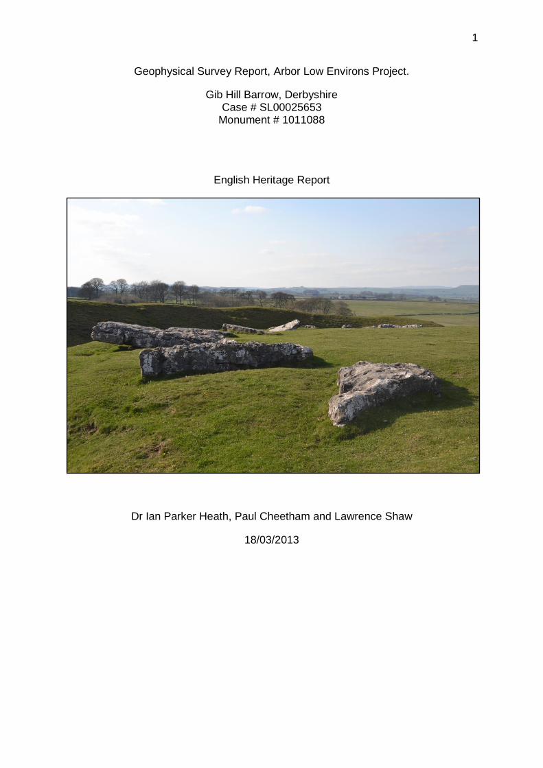
1 Geophysical Survey Report, Arbor Low Environs Project. Gib Hill Barrow, Derbyshire Case # SL00025653 Monument # 1011088 English Heritage Report Dr Ian Parker Heath, Paul Cheetham and Lawrence Shaw 18/03/2013
-
Upload
independent -
Category
Documents
-
view
2 -
download
0
Transcript of Arbor Low Environs Project - geophysical survey report for English Heritage
1
Geophysical Survey Report, Arbor Low Environs Project.
Gib Hill Barrow, Derbyshire Case # SL00025653
Monument # 1011088
English Heritage Report
Dr Ian Parker Heath, Paul Cheetham and Lawrence Shaw
18/03/2013

2
Abstract
In March 2012 a geophysical survey was undertaken as part of the Arbor Low
Environs Project. This saw the undertaking of a gradiometer and resistivity survey
within a field south of the Arbor Low henge complex, focusing on the scheduled area
associated with the prehistoric avenue linked to the complex. The survey was
undertaken by Lawrence Shaw and Paul Cheetham of Bournemouth University, with
help from Dr Ian Parker Heath, project director. The results of this survey revealed a
continuation of the avenue ditch and bank, which was previously unknown. This
report details the results seen through the magnetometer and resistivity surveys
undertaken.
Acknowledgements
The project team would like to thank Graham Kirkham and Bernard Woolley for their
permission to undertake the surveys on their land, Nicky Dick for access and
hospitality, and Kay Gregory for her assistance in the field.
3
Contents
1 Introduction ........................................................................................................ 5
2 Location, topography and geology ...................................................................... 5
3 A history of archaeological research: Arbor Low & Gib Hill ................................. 6
4 Rationale for the study ........................................................................................ 8
5 Aims and Objectives ......................................................................................... 10
6 Methodology ..................................................................................................... 11
6.1 Survey ....................................................................................................... 11
6.2 Post Processing ......................................................................................... 12
6.3 Conditions .................................................................................................. 12
7 Results ............................................................................................................. 13
7.1 Raw Data ................................................................................................... 13
7.2 Processed Data ......................................................................................... 14
8 Interpretation .................................................................................................... 15
8.1 Resistivity................................................................................................... 15
8.2 Magnetometry ............................................................................................ 16
9 Description ....................................................................................................... 17
9.1 Resistivity................................................................................................... 17
9.2 Magnetometry ............................................................................................ 18
10 Conclusion ....................................................................................................... 19
11 Bibliography ..................................................................................................... 20
Appendix i ............................................................................................................... 22
Appendix ii .............................................................................................................. 23
Appendix iii ............................................................................................................. 24

4
Table of Figures
Figure 1: Hypothesised location of processual routeway linking Arbor Low and the
River Lathkill, via Cales Dale. ................................................................................... 9
Figure 2: Map showing the 20x20 meter grid used for the survey. .......................... 11
Figure 3: Raw resistivity data. ................................................................................. 13
Figure 4: Raw magnetometry data. ......................................................................... 13
Figure 5. Processed resistivity data. ....................................................................... 14
Figure 6. Map showing the scheduling found across the Arbor Low avenue as seen
in the resistivity survey. ........................................................................................... 14
Figure 7: Resistivity interpretation. .......................................................................... 15
Figure 8: Labelled resistivity anomalies................................................................... 15
Figure 9: Magnetometry interpretations................................................................... 16
Figure 10: Labelled magnetometry anomalies. ........................................................ 16

5
1 Introduction
In the light of recent research at a number of henges, which has highlighted further
complexity of these prehistoric monuments e.g. Stonehenge Riverside Project
(Parker Pearson et al, 2006), this survey was undertaken as part of the Arbor Low
Environs Project (ALEP) which re-considers the Neolithic henge of Arbor Low (SK
1603 6355) and associated features, within the landscape that surrounds it.
The project is informed by, and seeks to support, a number of English Heritage and
Peak District National Park initiatives (e.g. English Heritage, 2003; Maguire, 2008).
Among the programmes detailed by English Heritage, we are seeking to add to the
overall understanding of a scheduled monument and the landscape within in which it
is located, involve members of the public and thereby provide access to the
archaeological process. In meeting its aims the Arbor Low Environs Project has the
potential to make a significant contribution to knowledge at both a local and regional
level and in terms of broader national debates about the creation, siting and use of
henge monuments in the Neolithic.
This report details a survey in the immediate vicinity of the barrow of Gib Hill, and is
the first step in a longer term programme of work being undertaken with a view to
test the hypothesis that the natural topography of Cales Dale was used as a
processual route in the Neolithic, from the River Lathkill to the henge of Arbor Low.
Examining this hypothesis will enable us to suggest a rationale for the siting and use
of the henge.
2 Location, topography and geology
2.1 The area discussed takes as its focus the monument complex of Arbor Low
and Gib Hill. This is located in the White Peak zone of the Peak District in Derbyshire
(SK 1603 6355 and SK1583 6332 respectively) and lies within the Peak District
National Park. The White Peak is a Carboniferous Limestone plateau lying between
approximately 200-400m OD. The area of the White Peak is well known for
extensive archaeological evidence and extant sites.
2.2 The topography of the region is typical of a karst landscape, with the presence
of caves, swallow/sink-holes, pavements etc. The immediate vicinity of the complex

6
has been discussed previously (e.g. Barnatt & Collis, 1996: 65). The henge itself sits
on a false crest of a ridge, and approximately 100m from the highest point of the
ridge to the south-east. To the north and north-west, the land drops away, and there
is a dry valley – Cales Dale - which eventually reaches Lathkill Dale to the east. Gib
Hill lies some 320m south-west of the henge. Beyond the edge of the scheduled
area the land drops away to the south-west/west towards the modern road (A515)
and there is a suggestion of a paleochannel crossing between the monument and
the modern road. The land then rises to form the eastern edge of the Dove Valley.
2.3 The underlying geology of the White Peak is, as was stated above,
Carboniferous Limestone. Within the area under discussion, there are subtle
changes which should be recognised. In the recent conservation plan for the
complex the author noted that Arbor Low itself sits upon a bed of Monsal Dale
Limestone and Gib Hill on a narrow band of Dolomitised Limestone (Maguire, 2008:
21), whilst the soil at both sites is said to be of Malham 2 association (Martin, 2001).
3 A history of archaeological research: Arbor Low & Gib Hill
3.1 The monument complex that includes Arbor Low and Gib Hill is located in a
landscape rich with ritual resources and close by are a number of natural features
such as caves, rock shelters and fissures. In prehistory they were frequently used as
repositories for human bones (e.g. Barnatt, 2005; Barnatt & Edmonds, 2002,
Jackson, 1951; Piggott, 1953). Arbor Low and Gib Hill have long been the focal point
of both antiquarian and archaeological interest and the story of antiquarian and
archaeological work undertaken has been reviewed elsewhere (e.g. Barnatt, 1996;
Maguire, 2008) with only particular points needing to be raised here. Firstly, the
excavation of the henge has been piecemeal and largely carried out prior to the
development of contemporary methodologies and standards; the last excavation for
example, was carried out by Gray in 1902 (see Gray, 1903). Secondly, a key facet of
antiquarian and archaeological literature concerning the site is that the focus has
been the monuments themselves whilst the landscape has, until relatively recently,
been largely neglected; hence, the overall aim of this project is to re-consider the
henge monument within a landscape that surrounds it.

7
3.2 There have been several recent attempts at interpreting the henge
monuments in general and Arbor Low in particular. Interpretations of this type of
monument include territorial marker, astronomical centre, an interface with the
supernatural and ritual site (e.g. Edmonds, 1999; Green, 2000; Harding, 2003;
Thomas, 1991; Warner, 2000; Watson, 2000). With increasing emphasis placed on
the ‘personal’ experience of landscapes, monuments and ritual the
phenomenological musings in the literature has generated to a number of
explorations of the rationales underpinning the siting of monuments, including
henges, in the past. The inter-visibility of monuments and the importance this might
have played in Neolithic society has become an accepted method of analysis (e.g.
Cummings & Whittle, 2003, 2004; Llobera, 2007), though not one without its critics
(e.g. Brück, 2005, Flemming, 2006).
3.3 One feature which remains something of an enigma is the earthwork
sometimes referred to as either the Avenue or Serpentine. It is this feature which is
the focus of this survey. Since the 19th century, this relatively slight bank and
associated ditch has been documented as being in two sections and while there is
no firm evidence from excavation to link the two sections it is possible that later land
use has destroyed such a link. The feature itself is still visible both on the ground as
a faint linear feature (S. Newsome, pers. comm.) and from the air. The proximal
terminus, and hence the ‘avenue’, was stated by Gray (1903) to be broadly
contemporary with the henge bank, whilst the distal terminus has yet to be
examined. Gray excavated in two sections of this feature, both close to the proximal
terminus. It was found that the ditch was approximately 0.9m deep and 2.4m wide
and sloped gradually to meet the Limestone surface beneath the henge bank. He
also recorded a small number of finds which he interpreted as contemporary with the
construction of the monument. Although it only has a single bank it is possible to
interpret this feature as an ‘avenue’, similar to those found at Stonehenge,
Durrington Walls and Avebury. Its dimensions are similar to both the Avenue and the
Greater Cursus at Stonehenge. However, John Barnatt has offered several
suggestions as to the function of this earthwork (e.g. 1978: 75, 80). These include
the idea that it is not to be connected with the henge, rather that it is associated with
Gib Hill, acting as a guide, directing people from the henge to Gib Hill long cairn.
Barnatt has also postulated that the bank is perhaps a boundary, possibly dating to

8
late prehistory or early Roman period (cited by McGuire, 2008: 27). The uncertainty
surrounding this earthwork is summed up by McGuire who states that “the feature is
not thought to be a formal structure related to the henge” (2008: 24).
3.4 The landscape in the vicinity of the monuments has been the subject of some
interest recently, with English Heritage carrying out both geophysical and
topographic surveys of the henge and its immediate surroundings (Martin, 2001; S
Newsome, pers. comm.) which have recorded a range of possible features. The
geophysical survey reported by Martin (2001) produced some disappointing results
with little of note. In addition to this, a number of topographic surveys have been
carried out in and around the henge and barrows (e.g. Barnatt, 1991, 1993;
Newsome, pers.comm & forthcoming). The results from Barnatt’s work appear in the
recently published conservation plan (e.g. McGuire, 2008: 119). Here it can be seen
that the earthwork extends for only a short distance beyond the field boundary wall of
Gib Hill Plantation. The more recent survey by Newsome also shows the earthwork
extending beyond the same wall, but for a considerably greater distance (Newsome,
pers. comm.).
4 Rationale for the study
4.1 As a number of authors have argued and have highlighted, (e.g. Tilley, 1994;
Bradley, 2000; Scarre, 2011) there is much potential for archaeologists to explore
‘natural places’ and the landscape more broadly in our attempts to further
understand monuments. Indeed Bradley argues that monuments as a class of
archaeological site will remain abstract concepts while analyses fail to integrate them
with a wider, local landscape and he has called for both elements to become part of
future research programmes (Bradley, 2000: 33-35). This approach, which demands
that we collapse the modern dichotomy between nature and culture and instead
explore how features of the landscape held significance for people in the past, is one
that this project finds particularly compelling in relation to Arbor Low. Here, prior work
has provided information about the interior of the henge itself (discussed in more
detail in Section 3), but this work has not enabled the development of wider
interpretations that extend beyond this interior view. Consequently we argue that
exploring the wider landscape setting of Arbor Low (and specifically its relationship to
9
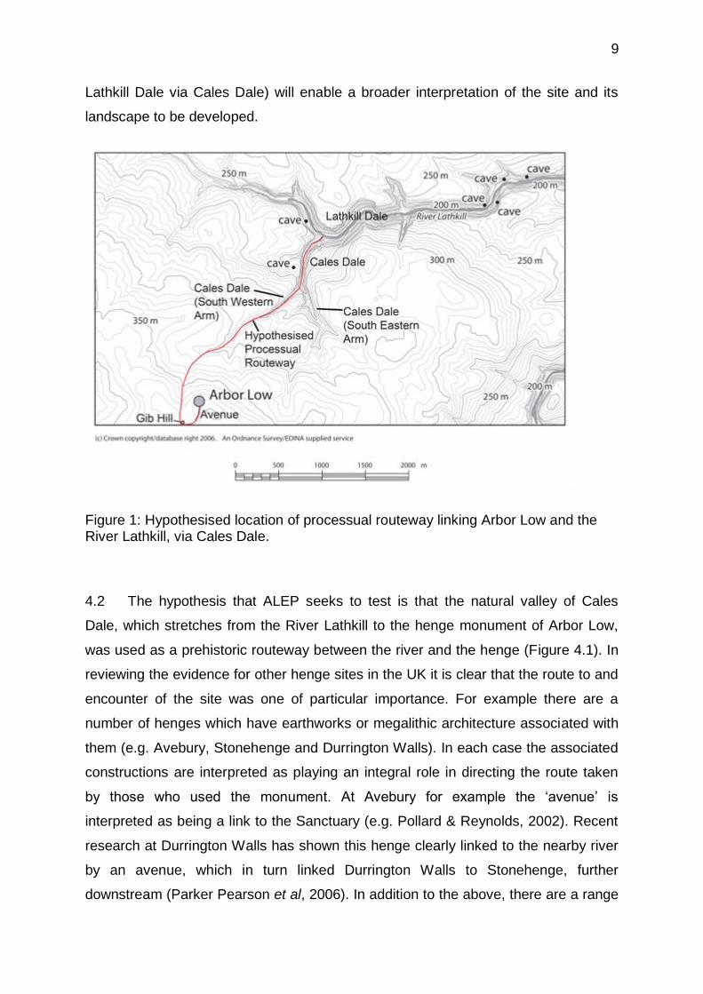
Lathkill Dale via Cales Dale) will enable a broader interpretation of the site and its
landscape to be developed.
Figure 1: Hypothesised location of processual routeway linking Arbor Low and the River Lathkill, via Cales Dale.
4.2 The hypothesis that ALEP seeks to test is that the natural valley of Cales
Dale, which stretches from the River Lathkill to the henge monument of Arbor Low,
was used as a prehistoric routeway between the river and the henge (Figure 4.1). In
reviewing the evidence for other henge sites in the UK it is clear that the route to and
encounter of the site was one of particular importance. For example there are a
number of henges which have earthworks or megalithic architecture associated with
them (e.g. Avebury, Stonehenge and Durrington Walls). In each case the associated
constructions are interpreted as playing an integral role in directing the route taken
by those who used the monument. At Avebury for example the ‘avenue’ is
interpreted as being a link to the Sanctuary (e.g. Pollard & Reynolds, 2002). Recent
research at Durrington Walls has shown this henge clearly linked to the nearby river
by an avenue, which in turn linked Durrington Walls to Stonehenge, further
downstream (Parker Pearson et al, 2006). In addition to the above, there are a range
10
of further arguments that support our hypothesis regarding the important symbolic or
cosmological connections that may have been drawn between Arbor Low and the
River Lathkill. Of particular relevance here is the work of Richards (1993, 1996a & b).
Richards (1996a & b) highlighted the significance of water to the siting of henge
monuments, with many being located close to rivers and low-lying areas. These
include the Orcadian henges of the Ring of Brodgar and Stones of Stenness,
Marden and Durrington Walls in Wiltshire and the Thornborough henges in North
Yorkshire (e.g. Harding, 2003).
4.3 In view of this and the range of recent works on the location of monuments
dating to the Neolithic (e.g. Cleal & Pollard, 2004; Edmonds,1999; Loveday, 2006;
Oswald et al, 2001) it is now more pertinent than ever to re-consider Arbor Low in a
wider context. The presence of these patterns elsewhere therefore lead us to
postulate that a similar importance may have been ascribed to the routeway
provided by the natural topography of Cales Dale, between the River Lathkill and
Arbor Low.
5 Aims and Objectives
The Arbor Low Environs Project has the following overall aims:
To increase understanding of the role and experience of Neolithic ceremonial
monuments in the Peak District.
To explore the relationship between the Neolithic henge site of Arbor Low and
its surrounding topography.
To meet these aims an initial survey season (2012) of geophysical survey
work in the upper part of the dale, in the immediate vicinity of Arbor Low, was
undertaken.

11
6 Methodology
6.1 Survey
Differential Global Positioning System (DGPS)
The use of a Leica VIVA GNSS Smart Net Differential GPS was employed to create
the grids used for the survey. A 20 x 20 meter grid was created in ArcGIS 10 prior to
the survey and uploaded onto the GPS (Figure 2). The stakeout function was then
used on the GPS system to intern the pre-produced grid, which was located within
2cm accuracy. This grid was used for both the resistance and magnetics surveys.
Figure 2: Map showing the 20x20 meter grid used for the survey. © Crown Copyright/database right 2013. An Ordnance Survey/EDINA supplied service.
Resistivity
This survey saw the use of a GeoScan Research RM15 to undertake a resistivity
survey. The machine was calibrated at 1 metre spacing to take 1 metre samples
along 1 metre traverses within 20 x 20 metre grids. The traverse recording method
was zig-zag and the grids were walked from south to north. Resistivity is an active
survey technique which uses an electric current that passed through the ground,
measuring the strength at which it passes from one probe to another. The

12
measurement of Ohms identifies features beneath the ground affecting the strength
that the current can pass through them. In particular, resistivity is very useful when
looking to identify any ditches and bank such as those already associated with the
Arbor Low Avenue.
Magnetometry
The Bartington Grad 601-2 Fluxgate Gradiometer was also used to survey the site.
This twin probe setup was calibrated to take 0.125 metre sampling along 1 metre
traverses in a parallel method within 20 x 20 metre grids. Traverses were walked in
the same directions as the resistivity surveys (South to North). This passive form of
survey measures how the strength of a magnetic field varies across an area. By
measuring the nanoteslas (nT) between two points, the fluxgate gradiometer can
create an image of any magnetic disturbances found throughout a study area.
Features such as ditches, pits and hearths should be represented as positive
readings due to their altered magnetic levels.
6.2 Post Processing
Geoplot and ArcGIS were the two software programs used to process the three
datasets gathered during the survey
6.3 Conditions
Weather conditions varied from sun to heavy rain during the different surveys.
However this does not seem to have had an effect on the results seen.
13
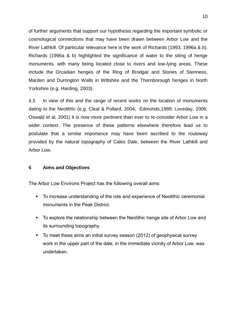
7 Results
7.1 Raw Data
Figure 3: Raw resistivity data. © Crown Copyright/database right 2013. An Ordnance Survey/EDINA supplied service.
Figure 4: Raw magnetometry data. © Crown Copyright/database right 2013. An Ordnance Survey/EDINA supplied service.
14
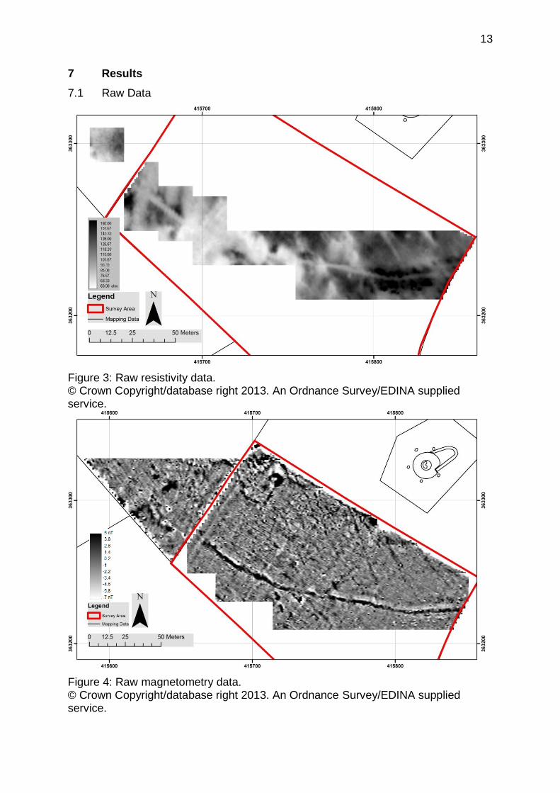
7.2 Processed Data
Figure 5. Processed resistivity data. © Crown Copyright/database right 2013. An Ordnance Survey/EDINA supplied service.
Figure 6. Map showing the scheduling found across the Arbor Low avenue as seen in the resistivity survey. © Crown Copyright/database right 2013. An Ordnance Survey/EDINA supplied service.

15
8 Interpretation
8.1 Resistivity
Figure 7: Resistivity interpretation. © Crown Copyright/database right 2013. An Ordnance Survey/EDINA supplied service.
Figure 8: Labelled resistivity anomalies. © Crown Copyright/database right 2013. An Ordnance Survey/EDINA supplied service.

16
8.2 Magnetometry
Figure 9: Magnetometry interpretations. © Crown Copyright/database right 2013. An Ordnance Survey/EDINA supplied service.
Figure 10: Labelled magnetometry anomalies. © Crown Copyright/database right 2013. An Ordnance Survey/EDINA supplied service.

17
9 Description
9.1 Resistivity
Within the results seen in the resistivity survey there are 8 anomalies identified as
being of interest in Fig 8. The first of these is the identification of the previously
known avenue bank and ditch found within the scheduled area, A1 and A2. Here the
bank of the avenue is visible as a high reading running east west and to the north of
the avenue ditch which bands the south side of the bank. Both features measure
around 3.5 meters in width and were visible on the ground whilst surveying. From
Figure 6 it is also visible that the scheduling of this area misses a small section of the
ditch. The high low anomaly seen to the north of anomaly A2 is a result of a
shadowing effect created by the bank. To the south of the avenue ditch, there I also
a number of small, high resistivity anomalies that run parallel with the ditch,
anomalies E1, E2, E3 and E4. Whilst undertaking the survey, it was noted that these
areas were very stony under the resistivity probes and it is possible that this could be
up cast associated with initial cutting of the avenue ditch. Alternatively, it would
appear that previous use of the field saw ploughing run from north east to south
west, and these anomalies could be stones dragged across for the avenue bank.
Heading north-westwards, outside of the scheduled area, is the continuation of the
avenue ditch, anomalies B and B1. However, these are segmented by an area
where the ditch appears to be lost, F. Although there may be some faint sign of the
ditch continuing between these two sections, there is nothing substantial. Similarly,
there is no obvious evidence of the bank continuing past the area of scheduling other
than in one or two discrete locations.
Upon identifying that the avenue ditch continues to run up to the north western wall
of the field, it was decided to undertake a single survey grid to other side of the wall
to confirm if the ditch continued through to the other side. Unfortunately no clear
features were visible other than a number of high resistivity readings, anomalies G1
and G2. These are also seen in the magnetometry survey as anomaly K. Whilst
undertaking the survey in this area, it was identified that the ground had been heavily
disturbed by possible quarry pits and this may be the reason the feature does not
appear to continue through into the next field.
18
Also visible in the survey are the three linear anomalies seen running from the north
west to south east of the eastern end of the survey, anomalies D1, D2 and D3.
Although only partially visible, these negative anomalies measuring around one
meter in diameter, were also recorded in the magnetometry survey running from the
fence line in the north, toward the avenue ditch (magnetometry anomalies D1 to D5).
It is unclear whether these anomalies continue past the avenue ditch; however their
dimensions and readings suggest they are geological rather than archaeological.
The anomaly marked C in the interpretation shows a low resistance areas seen in
the survey that appears to run from north the south along the north west wall of the
field. This is also picked up in the magnetometry survey (magnetometry anomaly C)
and was noted on the ground whilst survey was undertaken as being associated with
previous farming that had taken place in the field. Anomaly H is a large low
resistance feature measuring around five meters in diameter. Unfortunately the
whole of this feature was not surveyed but the reading suggests this may be an area
of interest.
9.2 Magnetometry
As seen in both the resistivity survey and illustrated in Fig 10, the magnetometry
survey identified the previously known avenue bank and ditch seen within the
scheduled area, anomalies A1 and A2. Similarly, the magnetometry survey also
revealed the continuation of the avenue ditch through the middle of the field,
anomalies B1. However, unlike the resistivity, the magnetometry shows the
continuation of the avenue ditch through to the field wall on the western side,
anomalies B3 and B5. As well as this there would appear to be possible evidence of
part of the avenue bank along a section of the ditch, recorded as anomaly B4.
However, as seen in the resistivity, no evidence of the bank and ditch continuing into
the neighbouring field can be seen, even after surveying a larger area. The
anomalies marked as J do show a high and low magnetic linear feature running in a
similar direction to that of the avenue. However, it is unclear whether they are
related.

19
Anomalies E and H, identify an area of high reading anomalies of varying shapes
and sizes. It would appear that the area has seen some activity taking place across it
and this may be evidence pits. Similarly, the anomalies seen at I show varying shape
size and levels of magnetic response, which are different to those seen elsewhere in
the survey. This could also therefore, indicate an area of archaeological activity
within the survey area.
To the Northwest corner of the field, anomalies F1 and F2 identify a high reading
anomaly that runs from the North to the Southwest before turning at a right angle
towards the North West. This feature also appears to continue into the neighbouring
field, anomaly F3. Judging from the size and shape of this anomaly, it may be
possible that this is a ditch. In the top Northwest corner of the field there is a large
irregular shaped, high magnetic anomaly, anomaly G. This was visible on the ground
as a large, sub circular mound with a depression in the centre and appeared to be
filled with rubble. It is likely that this is associated with quarrying work that was
undertaken in the area.
10 Conclusion
Through the use of two different survey methods, this survey has shown that the
avenue bank and ditch associated with Arbor Low henge, does continue for at least
another 100 meters to the west of the point it was previously thought to have
finishing. Although it is not seen to be continuing in the neighbouring field, it would
seem strange that the ditch and bank respect the boundaries of a later field wall, so it
would therefore be appropriate to assume that the avenue does continue on past this
field. Due to more modern quarrying activity interfering with the monument in this
area, it is unclear as to where the avenue runs past this point and further work will be
required to identify where the avenue runs from this point on and where it terminates.
As well as identifying the continuation of the avenue, the surveys have also identified
a number of anomalies and features that may be associated with the pre-historic
activity taking place in this area, of which further investigation may be required
through excavation.

20
11 Bibliography
Barnatt, J. (1978). Stone circles of the Peak. A Search for Natural Harmony. Wellingborough: Turnstone Press,.
Barnatt, J. (1991). Upper Oldhams Farm, Middleton by Youlgreave, Derbyshire, Archaeological Survey 1991. Archaeological Interpretation and Recommendations on Presentation. Unpublished report for Peak Park Joint Planning Board.
Barnatt, J. (1993). Upper Oldhams Farm – Stanton Estate Land, Middleton by Youlgreave, Derbyshire. Archaeological Survey 1993. Unpublished report for Peak Park Joint Planning Board.
Barnatt, J. (2005) Lathkill Dale Nature Reserve: Over Haddon, Monyash and Youlgreave Parishes, Derbyshire. Archaeological Survey. Unpublished report, Peak District National Park Authority, Bakewell.
Barnatt, J. & Collis, J. (1996). Barrows in the Peak District. Recent Research. Sheffield: J.R. Collis Publications,
Barnatt, J. & Edmonds, M. (2002). Places Apart? Caves and Monuments in Neolithic and Early Bronze Age Britain. Cambridge Archaeological Journal, 12(1), 113-129.
Bradley, R. (2000). An Archaeology of Natural Places. London: Routledge.
Brück, J. 2005: Experiencing the past? The development of a phenomenological archaeology in British Prehistory. Archaeological Dialogues, 12 (1), 45-72.
Cummings, V. and Whitle, A. (2003). Tombs with a view: landscape, monuments and trees. Antiquity, 77, 255-66.
Cummings, V. and Whitle, A. (2004). Places of Special Virtue. Megaliths in the Neolithic Landscapes of Wales. Oxford: Oxbow Books.
Edmonds, M. (1999). Ancestral Geographies of the Neolithic. Landscape, monuments and memories. London: Routledge.
English Heritage, (2003). Implementation Plan for Exploring Our Past, (accessed online www.english-eritage.org.uk/upload/pdf/plan_eop_98.pdf?1239629339).
Flemming, A, (2006). Post-processual landscape archaeology: a critique. Cambridge Archaeological Journal 16, 267-80.
Green, M. (2000). A Landscape Revealed. 10,000 Years on a Chalkland Farm. Stroud: Tempus,.
Jackson, W.F. (1951). Peterborough (Neolithic B) Pottery from High Wheeldon Cave, Earl Sterndale, near Buxton. Derbyshire Archaeological Journal, 71, 72-77.
Gray, H. St George. (1903). On the excavation at Arbor Low 1901-2. Archaelogia, 38.
Harding, J. (2003). Henge monuments of the British Isles. Stroud: Tempus,.
21
Llobera, M. (2007). Reconstructing visual landscapes. World Archaeology, 39 (1), 51-69.
Parker Pearson, M., Pollard, J., Richards, C., Thomas, J., Tilley, C., Welham, K. and Albarella, U. (2006) Materializing Stonehenge: The Stonehenge Riverside Project and new discoveries. Journal of Material Culture 11, 227-61.
Maguire, S. (2008). Arbor Low and Gib Hill Conservation Plan 2008. London: English Heritage.
Martin, L. (2001). Arbor Low, Derbyshire. Report on geophysical survey, August 1998. http://sdb2.eng-h.gov.uk/reports/arborlow.
Piggott, S. (1953). Secondary Neolithic burials at Church Dale near Monyash, Derbyshire. Proceedings of the Prehistoric Society, 19, 228-230.
Pollard, J. & Reynolds, A. (2002). Avebury: the biography of a landscape. Stroud: Tempus.
Richards, C. (1993). Monumental Choreography: Architectural and Spatial Representation in Late Neolithic Orkney. In C Tilley (Ed) Interpretive Archaeology. Oxford: Berg, pp143-178.
Richards, C. (1996a). Henges and water: towards an elemental understanding of monumentality and landscape in Late Neolithic Britain. Journal of Material Culture, 1, 313-336.
Richards, C. (1996b). Monuments as landscape: creating the centre of the world in Late Neolithic Orkney. World Archaeology, 28, 190-208.
Scarre, C. (2011). Landscapes of Neolithic Brittany. Oxford: Oxford University Press.
Tilley, C. (1994), A Phenomenology of Landscape. Oxford: Berg.
Warner, R.B. (2000). Keeping out the Otherworld: The Internal Ditch at Navan and other Iron Age hengiform enclosures. Emania, 18, 39-44.
Watson, A. (2000). Encircled Space: the experience of stone circles and henges in the British Neolithic. Unpublished PhD thesis, University of Reading.

22
Appendix i
Processing methods Magnatometry: De striped using a zeo median travers (+ and – 5nt) Clipped Scale intervals for xy 25nt Magnification x4 Resistivity: High pass filter in a window of 7 x 7 to remove background geology

23
Appendix ii
3D image of the raw resistivity data showing the continuation of the avenue ditch.

24
Appendix iii
Trace model of the magnetometry in Field 1
Trace model of the magnetometry in Field 2