


Geography of India - Forgotten Books
348
-
Upload
khangminh22 -
Category
Documents
-
view
0 -
download
0
Transcript of Geography of India - Forgotten Books


Ind ian R eaders
This Series of School R eaders was compiled in 1906-
7
by the Rev . Henry Cull i ford,and i s designed to teach
the language , as far as possible , withou t the use of forbidding grammars . It i s printed in clear new type on
excel lent paper,and verv abund antly il lustrated . I t
consists of seven books .
Indian Primer I . 3 2 pp .,Globe 8vo . Limp As . 3 .
Ind ian Reader II . 3 2 pp . ,Globe 8vo . L imp , As . 3 .
The aim of these Primers is ( 1 ) to teach the letters ofthe Engl ish alphabet gradually (2 ) to accustom the childto the more common sound s of English word s , so that hispronunciation may b e correct ; (3 ) to supply him with a
small b ut useful vocabu lary and so (4) to enable him at
an ear ly stage to use what he has learnt in conversation .
NO objec t is mentioned that is not more or less fam iliar toevery child .
Indian Reader I . 64 pp . Globe Rvo . L imp,As . 4 .
Ind ian Reader II . 80 pp . Globe Svo . L imp,As . 6 .
Indian Reader III . 1 04 pp . G l obe 8vo . L imp , As . 8 .
Indian Reader IV. 1 60 pp . G lobe 8yo . Cloth boards ,As . I O .
Ind ian Reader V. 208 pp . Globe 8vo . Cloth boards .As . 1 2 .
These books are d esigned to meet the requ irementsof modern ed ucationalCodes . All contain a fair amount ofpoetry ,
and great attention has been given to make the
lessons not only instructive,b ut also interesting. The
id iom of the language 15 careful ly explained ,and the
lessons are made the basis of instruction in grammar.derivation . and word —build ing . Reader V . consists of
ex tracts from wel l-known English writers .
CHRISTIAN LITERATURE SOCIETY FOR INDIA .
9 ,DUKE STR EET
,ADELPH I
,LONDON
MEMOR IAL HALL,MADR As , and DAM S r . , COLOM BO .

G rammatical S er ies
Primer of Engl ish Grammar. Globe 8vo 80 pp ., As . 3 .
‘ A complete introduction to the study of EnglishGrammar and id iom , and the structure and analysis ofthe sentence. With abundant graduated exercises .
Manual of Engl ish Grammar. Globe 8v0 . , 2 2 4 pp .
cloth limp,As . 8 .
A complete handbook of English Grammar and id iom ,
with full chapters on word -build ing , the structure andanalysis of the sentence,
figures of speech , and punctua
tion . With lxxviii. exercises.
These two books , which have long enj oyed greatpopularity in India
,have recently been completely
re-written and made more suitable than ever for all
Secondary Schools .
Advanced English Grammar , for High School andUniversi ty Students . Escap . 8vo 2 80 pp ,
cl oth,As .
1 4 .
This book d ifiers from the Manual chiefly in its moreabundant exercises (with questions for self-examination)and in the fact that fu ller treatment is given to thestructure of the Sentence. Errors in id iom pecu l iar toInd ia are pointed out and there is a chapter on Prosody.
A Gu ide to Engl ish Spel l ing and Pronunciation. I 8mo
72 pp . , As . 2 .
The sounds of the vowels and consonants are illustratedby examples with general ru les for spell ing and lists ofanomalous word s.
CHRISTIAN LITER ATURE SOCIETY FOR INDIA,
9 , DUKE STR EET , ADELPH I , LONDON ,
MEMOR IAL HALL , MAD R AS ; and DAM ST . , COLOM BO .


Geography of India
Physical, Political
Commercial
GEOR GE PATTER SON
Late Prof . of H istory and Political Economy in the Mad ras ChristianCollege, and Fel l ow and Examiner of the University of Madras
LONDON
( the christian fi tteralure S ociety for Shela
35, JOHN ST BEDFORD R ow, W.C.
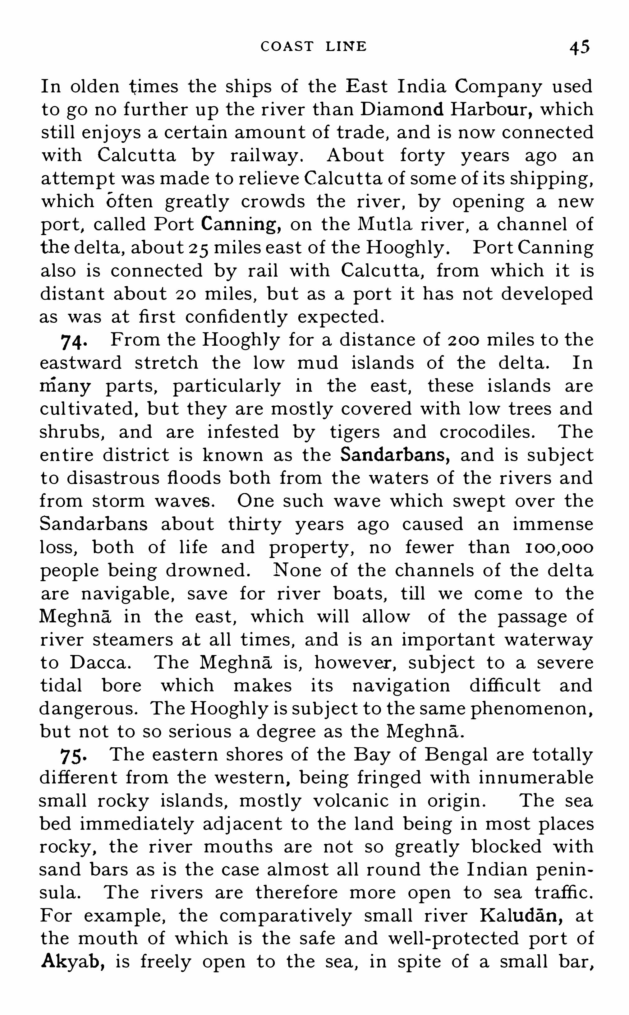
1909
[A ll R zgk ls resew ed

Preface
N its main substance and style of treatment this
book is an en l argement of the Chapter on India
in my Handbook of Geography for Indian S chools and
Colleges, b ut many subjects which it was impossible
even to touch upon there are introduced here. I t
may b e thought that I have given a somewhat wide
interpretat ion to the term Geography,and perhaps that
is so. I have not confined myself to mere topographical
or physical details. Many subjects are b riefly treated
of which the youths who graduate from our Indian
Universities are often sad ly ignorant , b ut which it
greatly concerns them to know.
In the Spelling of Indian proper n ames I have in
most instances followed the revised edition of the
Imperial Gazetteer of India. All political, commercial
and statistical informat ion is b rought down to the end
of the year 1 907, and much of it to a still later date.
G . P.
LONDON ,
30th S eptember , 1 909.

The two Parts o f PA R T IND IA
As A WHOLE and PA R T I I IND IA IN PR O
V INCES AND STATES,may be had separately
limp cloth, price annas each .

Contents
PART I .— IND IA AS A WHOLE
CHAPTER I . GEN E R AL Vi Ew
CHAPTER I I . THE CL IMATE O F IND IA
CHAPTER I I I . THE PEOPLE OF IND IA
CHAPTER IV . THE NATUR AL PR ODUCTIONS O F
IND IA 82— 1 1 0
CHAPTER V . MANUFACTUR ES,COMMUN ICATIONS
,
AND COMMER CE
CHAPTER V I . THE GOVER NMENT O F IND IA
PART I I .— IND IA IN PROV INCES AND STATES
General Survey
BENGAL
EASTER N BENGAL and ASSAM
NEPAL,BHUTAN
,and S I KK IM
UN ITED PR OVINCEs of AGR A and OUDH
THE PUN JAB
NOR TH-WESTE R N FR ONTIER PR OV INCE
KASHM I R
BALUCHISTAN
R A JPU’
I‘
ANA
CENTR AL IND IA
CENTR AL PR OV INCES
HYDER ABAD
BOMBAY
MADR As
TR AVANCOR E
MYSOR E
BUR MA
Foreign PossessionsAPPEND IX L ist of ch ief NAT IVE STATES
Index

List of Maps and Diagrams
Ind ian Empire , physical (coloured )Ind ian Empire, pol itical (co loured )I .
Ot
ui
-A
UJ
N
P
PO
P
I O .
1 2 .
I 3 .
1 4 .
1 5.
1 6 .
I 7 .
1 8 .
1 9 .
2 1 .
2 2 .
2 3 .
2 4 .
25.
26 .
2 7 .
2 8
29 .
30 .
O cean-Depths south of A siaMountains branching from the PamirsThe HimalayasThe Tibetan P lateauThe North-West Frontier MountainsMountains of the North-East Frontier andBurma
The Great Plain and Peninsu lar Ind iaThe Indus and its TributariesThe sources of the Great Northern RiversBasins of the Ganges and BrahmaputraThe chief Rivers of the PeninsulaThe River Systems of Burma.
Karachi HarbourBombay I sland s and HarbourPoint de Galle and Gal le Bay .
The Ganges-Brahmaputra Del taThe Andaman I slands .
The Mean Annual Temperature O f Ind iaThe Mean and Extreme Ranges of Temperature
Mean Temperature for March , May,August,
and Decemberlsobars for MayIsobars for J ulyIsobars for O ctoberI sobars for DecemberDirection of the Monsoon \VindsAverage Rainfal l for January , April , J uly.
and O ctoberMean Annual RainfallRace-d istribution in Ind iaDensity of population .
Languages O f Ind iaGeological O utline of Ind iaForest areas of Ind iaAreas of Rice cultivation

L IST OF MAPS AND D IAGR AMS vii .
Areas of Wheat cu l tivation page 93Areas of Tea
,Sugar
,Coffee
,and Tobacco
cultivationAreas of Cotton cultivationThe principal Rai lways O f Ind iaThe chief lines of Foreign CommunicationThe East Ind iaHouse in the 1 7th centuryThe Growth of the British Empire of Ind ia .
The Province of BengalThe Province of Bengal in reliefDistricts and States O f BengalThe River HooghlyGovernment House
,Calcutta
Temp le at BhubaneswarEastern Bengal and AssamDitto
,in relief .
Districts and States of dittoA Buddhist MonasteryA Window in BenaresThe United ProvincesDitto
,in relief
Districts and States of d ittoThe City of BenaresThe Taj Mahal , AgraMausoleum of Akbar
,Secundra
The Punjab,the North-Western Frontier
Province and KashmirDitto
,in relief
Districts and States of the PunjabThe Palace
,Lahore
The Jumma Musj id,Delhi
Districts of the North-Western FrontierProvince
The Bridge,Srinagar
Baluchistan and Sind .
Tribesmen of the North West FrontierRajpu tana AgencyThe chief States of RajputanaRajputana and Central Ind ia in reliefCentral Ind iaAgencyThe chief States O f Central Ind iaGwal ior from the Sou th-East

viii . L IST O F MAPS AND D IAG R AMS
A R aj put TrooperThe Central Provinces and BerarDitto
,in relief
Districts and States of the Central ProvincesDistricts of HyderabadThe Presidency of BombayBombay and Sind in rel iefDistricts and States of Bombay and SindThe Victoria Rai lway Station
,Bombay
Monolithic Carv ings in the I sland of Ele
phanta
Madras,Hyderabad and Mysore
Ditto,in relief
Districts of Madras and MysoreTemp le at Mahab alip i
'
i ram
Temple at MaduraThe Pagoda, Conjeevaram
Trichinopoly RockA Ryot ’s House in CochinA Vi l lage Street in MysoreThe h’Iaharaja
’
s Palace, BangaloreThe Province of BurmaDitto
,in rel ief
A Group O f KachinsA Burmese Paddy BoatDistricts and States of BurmaThe Incomparable Pagoda, Mandalav

GEOGRAPHY OF INDIA
PAR T I . INDIA AS A WHOLE
CHAPTER I
GENERAL VIEW
( 1 ) Geographical Position
1 . The great continent of Asia divides in the south intothree vast peninsulas Arab ia on the west , Indo-China onthe east , and the southern hal f of Ind ia in the centre .
India proper includes the whole of the central peninsula,
and stretches northwards to the mountain ranges whichseparate it from Central Asia . The northern hal f i s oftencalled Continental India, to disti ngu ish it from Peninsu larIndia , the southern hal f . The Tropic of Cancer is , speakingroughly , the dividing li ne between these two . From thisl ine Peninsular I ndia stretches southwards for more than
or over miles while Continental I ndia extendsalmost as far to the north .
2 . The natural boundaries of I ndia are exceedingly wel ldefined . The peninsula i s separated from Arabia by theArab ian Sea, and from IndO -China by the Bay of Bengal .These two arms of the I ndian O cean give the peninsula a
B

GEOG R A PH Y OF IND IA
coas t l ine of nearly miles . I n the north the Himalayas form an almost impassab l e barrier for miles .
On the north -west for 800 miles , and on the north -east for
400 miles are regions of more broken mountainous countrystretching i n ever d iminish ing al t i tudes from the extremit iesof the Himalayan wal l to the sea . These give north-westand north-east frontiers , both of which are fairlv welldefined . As frontiers they are imperfec t only i n comparison wi th the mighty mountainous ramparts whichprotec t the north . NO other country , of equal extent , notbeing an island , i s so completely i solated as I nd ia ,
or formsso true a geographical uni ty . This fac t
,more than any
other S i ngle cause , has moulded i ts destiny and guided thedevelopment of i ts people .
3 . I n stric t geographical usage the name INDIA Shouldbe appl ied only to th is wel l-defined geographical whole . I ncommon use , however , a wider sense i s often given to i t ,making it synonymous wi th The Indian Empire . TheEmpire of I ndi a extends beyond the natural boundari esof India proper
,both on the east and the west . O n the
east it takes in Burma and on the west Baluchistan , bothof wh ich are frequently spoken of as provinces of I nd ia .
This is convenient when poli t ical matters are u nder consideration . But i t should not be forgotten that i t i s onIypol itically that e i ther of these provinces belongs to I nd ia .
In almost al l the aspects wi th which non-pol i t ical geographyis concerned
,both the IndO -Chinese peni nsula and
Baluchistan are widely d ifferen t from I nd ia proper .
4. On the other hand the island of Ceylon , though
politically separated from Ind ia , geographically belongs toi t
,being a part of the great land -mass which forms the
Indian peninsula . Ceyl on i s a continental island ,
”
stand ing on the continen tal shel f. At one time theshal low strai t which now separates Ceylon from themainl and did not exist and a very sligh t elevation of thebed of the strait would make i t a part of south I nd ia again .
I n all their physical conditions Ceylon and the southernpart of the peninsula are one
,though the name I nd ia. i s
never used to include the I sland Colony .

4 G EOG R A PH Y OF IND IA
6. I f the level of the surround ing seas were reducedby abou t 1 00 fathoms the general contour of I ndia would
not be greatly changed . Ceylon would,as we have seen
,
be uni ted wi th the mainland,and the whole of the peninsul a
would be considerably increased i n wid th,part icu larly i n
the north . The Gul fs of Cambay and Cutch would d isappear .Bombay would be 250 miles from the sea
,and Karach i 80
miles ; while O ri ssa and Chi ttagong would be u nited byland
,except for one cu rious arm of greater depth
,stretching
i n a north-easterly d irection towards the mouth of theGanges
,which would stil l be claimed by the sea . Bu t on
the whole the general shape of peninsular I nd ia would bebut l ittle changed .
7. Far greater would be the changes wrought i n theeastern and western peninsulas of southern Asia . I n thewest
,the shal low Persian Gul f would be drained
,and
Arabia would no longer be a peninsula . I n the eas t , Indo
China would stretch miles south of Annam,and
would take in the great i slands of S umatra, j ava, Borneo ,
and the Celebes, which are al l cont inen tal isl ands . TheAndaman and N icobar groups of i slands would then eachform one long and narrow isl and , and the two togetherwould enclose between themselves and the mainl and a
deep and almost l and - l ocked sea .
8 . I f the level of the sea were reduced by insteadof 1 00 fathoms , the further changes in the contour of thel and would be trifl ing
,for from 1 00 to fathoms
the depth increases everywhere with great rapidity . Thehundred -fathom l ine
,or the edge of the continental shel f ,
i s thus the true continental boundary . I t i ndicates , farmore accurately than the coas t l i ne
,t he actual contour
of the great l and-mass that forms the con ti nent .
(3 ) The Natural Divisions of India
9. Sir Wi l l iam Hunter remarks that i f we could viewthe whole of I nd ia from a bal loon
,we Should see that i t i s
d ivided into three separate and wel l -defined trac ts .
” I n
the north and north-west i s the region of moun tain s , the

NATUR AL D IV I S ION S 5
vast Himal ayan range with their al l ied systems . Immediately to the south is the almost equal ly vast region ofplains , the soi l of wh ich has been deposited by the greatrivers that drain the mountains . To the south again i sthe region of plateaux,
which includes almost the whole ofpeninsular I ndia . The plateaux are bounded by rangesof hil l s, broken along the north and east but more continuous on the west ; and between the hi l l s and the seathere is everywhere a narrow strip of al luvial land formed ,l ike the great pl ains of the north
,by the rivers that drain
the higher land . To these three well-defined regions ofI ndia proper
,we must now
,i f we speak of the Empire of
India,add a fourth
,viz .
,Burma— a region O f alternate
mountain ranges and val l eys,with the great delta of the
I rrawaddy towards the south .
(4) The Himalayan R egion
I O. India,we are often told
,i s bounded on the north
by the Himal ayas .” But this great mountain chain ismuch more than a mere boundary . The vast system ofhighlands of which the Himal ayas form the southern wall ,i s of such immense importance to India that it cl aims themost carefu l attention
,and forms the natural starting
point for any study of I ndian Geography .
I I . From the Pamir Plateau which l ies to the northwest of Kashmir , and from its great height i s appropriatelycal led in the native language
,the roof of the world ,
” theHindu Kush range runs in a south-westerly direction intoAfghanistan . From the same centre
,but running in an
east- south-easterly direction,are the Muz tagh or Karako
rum Mountains , a range of great and sustained height . Tothe south of this range
,and running at first almost paral lel
with i t,i s the western portion of the Himalayas proper .
The river Indns, r ising in Tibet , flows in a north-westerlydirect ion between the Karakorum and Himalaya ranges
,
breaking through the Ladakh R ange on its course , and then ,bending sharply to the south-west
,divides the western
extremity of the Himal ayas from the spurs of the HinduKush . From this point the Himalayas
,there called the

6 G EOG R A PHY O F iNniA
l askar range , run fi rst i n a south-easterly direction,and
then gradually bend round to the east . The B rahma/ mire:
( i n the upper part of i ts course cal l ed the Tsan-pu) ri ses
F ig. 2 . Showing the mountain-chains of high elevation branching from the
Pami r Piateau.
near the I ndus,north of the main range
,and after flowi ng
i n an easterly direct ion for over 800 miles,rounds the
eastern extremity of the Himalayas j ust as the Indusrounds the western . The ent ire range is thus held withinthe gigant ic arms of these two mighty rivers . Thel ength of the range is abou t miles
,and i ts width from
1 50 to 200 miles . I n parts i t i s flanked on i ts sou thernside by low and detached paral lel ranges of h ill s
,whol ly
d i fferent i n geologi cal struc ture and history . But in mostplaces the main range ri ses from the plain s with considerableabruptness . Throughout i ts entire l ength one conti nuousrange can be traced which contai ns most of the l oft ies tpeaks
,more than twenty of which exceed feet i n
heigh t .1 2 . The most westerly peak in the Himalayas proper i s
Nanga Parbat,which l ies j u st with in the angl e of the
I ndus and rises to a heigh t of feet . Abou t 1 50
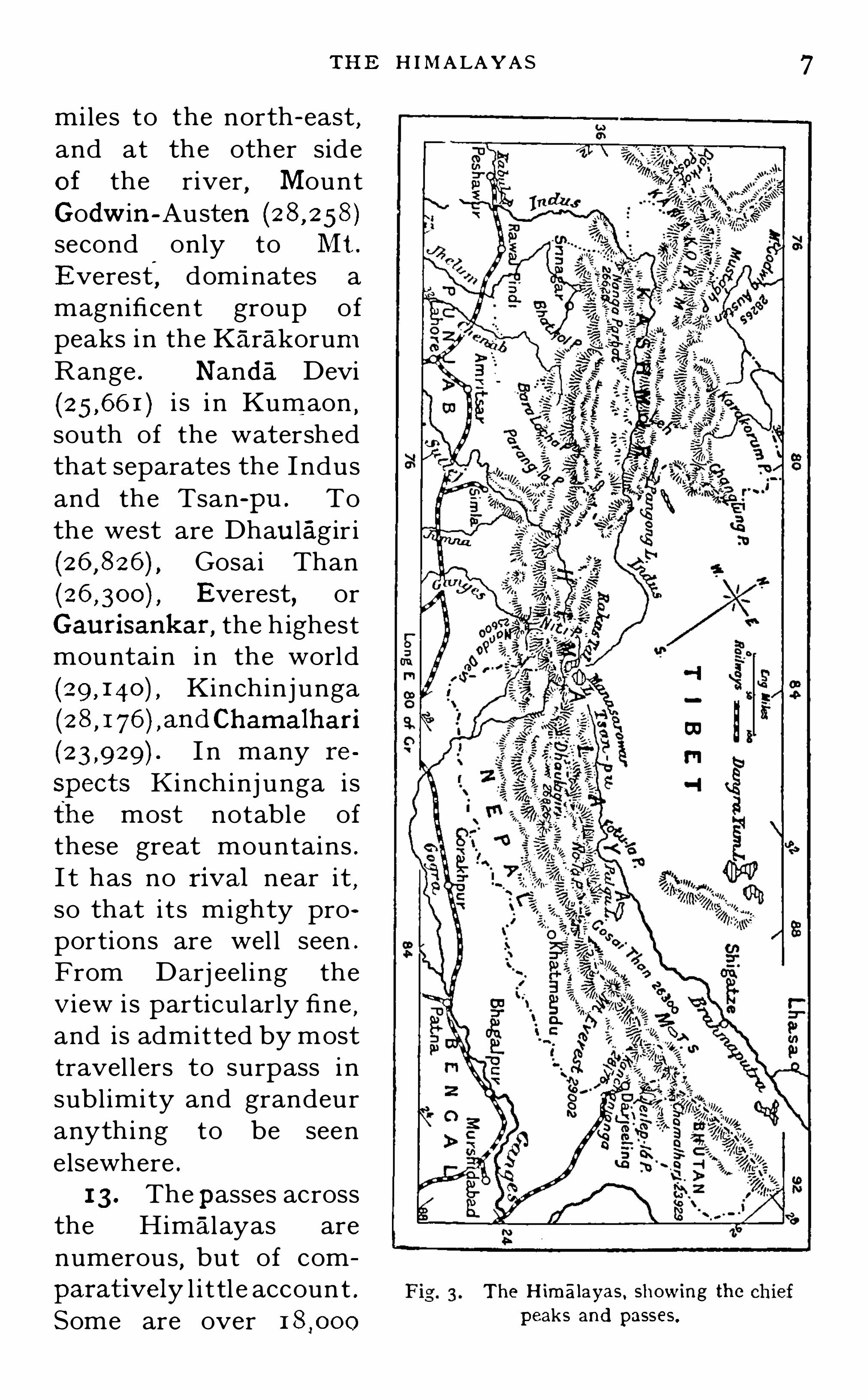
THE H I MALAYAS
miles to the north- east,
and at the other sideof the river , MountGodwin-Austensecond only to Mt .
Everest, dominates amagnificent group ofpeaks in the Karakorum
Range . Nanda Devii s i n Kumaon
,
south of the watershedthat separates the Indusand the Tsan-pu . Tothe west are Dhau lagir i
Gosai ThanEverest
,or
Gaurisankar , the h ighestmountain in the world
Kinchinj unga
I n many re
spects K i nchinj unga isthe most notable ofthese great mountains .I t has no rival near it ,so that i t s mighty proportions are wel l seen .
From Darj eel ing theV iew i s particularly fine
,
and is admitted by mosttravel lers to surpass i nsubl imity and grandeuranything to be seenelsewhere .
1 3 . The passes acrossthe Himal ayas arenumerous
,but of com
parativelyl i t tl e account .Some are over
The H imalayas , showing thepeaks and passes.

8 GEOG R A PH Y O F 1ND1A
feet i n heigh t . TheBaraLacha and Parang- la passes cross i ntoKashmir from the north -west corner of the Punj ab . FromKashmir one of the best roads to Lhasa i s via the PangongLake . Most of the trade between Northern India and Tibethas for centuries been by these routes . I n the north ofKashmir the Karakorum and Muz tagh passes , which crossthe Karakorums respec t ively east and west of Moun tGodwin-Austen
,have been the ch ief routes of the trade
wi t h Central Asia . The Niti pass i s north of Nanda Devi ,near the source of the Ganges
,and leads from Garhwal into
Tibet . The No-la pass crosses the mountains in the northof Nepal
,and the Jailep- la pass i s south of Chamalhari, and
east of Sikkim .
1 4. The Himal ayas are,however
,only the sou thern
wall of a great mountain system which should be studiedas a whole . Branching from the northern side of theKarakorum Range are the Kwen Lun Mountains which runat first cl ue east , then bend sl ightly to the north , andfurther east to the south again . These form the northernboundary of the Plateau of Tibet. Between them and theHimalayas the elevation nowhere fal ls bel ow feet ,and the average is probably over The length ofthe Plateau from east to west i s miles , and its wid thfrom north to south Varies from 200 to 600 miles . I ts areai s nearly half a mil l ion square miles . There is no othermountain -mass in the whole world at al l to compare withi t. I t is d iff i cu l t to give any adequate idea of i ts s ize .
The Alps of Central Europe do not cover one -th ir tieth ofi ts area
,
! and are greatly in ferior i n average height . I tsimportance to I ndia can hardly be over-estimated . I tforms a northern rampart which no enemy has ever sealed ,
and with its great sou thern buttress,the H imal ayas , exerts
an i nfluence upon the cl imate and rainfall o f Ind ia whichhas done much to determine the char acter of the countryand the development of i ts people .
1 5. The main chain of the Himalayas , though of muchgreater average heigh t than any ot her continuous chaintraversing the plateau
,does not consti tu te the water
See a s tr iking map on page 1 2 3 of Hold ich's
“ Ind ia.

THE T I BETAN PLATEAU 9
Fig. 4. Showing the extent of the Tibetan P lateau .
parting between India and Tibet , which is from 1 00 to 200
miles to the north of it . A second wal l of the Himal ayashas often therefore been assumed to run north of the troughof the Indus and Tsan -
pu . Dr . Sven Hedin , the Swed ishtravell er
,claims to have traced
,during his travels in Tibet
in 1 907 8 ,a conti nuous chain running east and west at a
d istance varying from 1 30 to 300 miles north of the Himalayas and forming the true watershed . This range henames the Trans Himalaya. I t is not
,however
,a part of
the Himal ayan system,but a more ancient range , and
though i t forms the watershed it does not r ival the Hima'

I O G EOG R APH Y OF I ND IA
l ayas i n heigh t . G eological evidence shows that thegeneral l ines of drainage as they exis t to-day were established l ong before the upheaval of the mai n H imalayanrange
,and that the process of upheaval was slow enough
for the rivers to main tai n their ancien t channels by thei rown erosive power . This i s seen mos t cl early i n Nepal ,where the drainage i s not to the Tsan -
pu i n the north ,b u t
sou thward through deep gorges i n the vast Himalayanchain
,gorges which the streams themselves have cu t .
1 6. Geological evidence al so Shows that the easternHimal ayas are far more ancient than the western
,but the
ent ire range is young i n comparison with the A ravallis orthe Eastern Ghats , both of which are of grea t geologicalantiqu ity. There was, doubtl ess , a t ime in very remotegeological ages when what now forms the Indian peninsulawas j oined to South Africa by a broad stretch of land , ofwhich we sti l l h ave remnants i n the Mald ives
,the
Laccad ives,the Seychel les , and Madagascar . I n those
early day s the Eastern Ghats constituted the easternboundary of the land ,
while the Aravallis bounded i t onthe west . Long ages of erosion have worn these two rangesdown til l they are now
,probably
,but a shadow of what
they once were . At that t ime the Aravalli peaks looked ou tover a vast north-western sea
,which appears to have been
entirely cu t off from the southern ocean . The rocks whichnow compose the mountain sy stems west and north of theI ndus
,as wel l as most of the great Tibetan Plateau ,
werethen being sl owly formed at the bed of the sea . Therei s al so abundant evidence that i n subsequent ages theywere repeatedly thrust upwards and again submerged
,
existing al ternately as d ry land and sea bed , unt il t hefinal upheaval began which slowly raised them to their
present altitudes .1 7. The Eastern Ghats were apparently al so a t one
period connected by an unbroken chai n o f hi ll s wi ththe eastern Himal ayas
,a connect ion which continued t i l l
a comparat ively recen t geological age . The whol e southerndrainage of the Himalayas cousequentlv , being cu t off
from the eastern seas , found its way across the continen t

I 2 GEOG R A PHY OF IND IA
fold s of the S ulaimans Open out , and ,i n stead ily decreasing
al titudes,bend round to the west . Further to the south
again,and further west , are a number of sti l l l ower ranges ,
runn ing i n almost paral le l ridges at first i n a southerlyd irect ion
,and then
,l ike the S ulaimans,
bend ing gradual lyround to the west . The most easterly of these
,the
Khirthar range,maintains its southern direction almost to
the sea .
20. These variou s mountain ranges form the naturalnorth-west frontier of I ndia proper . The frontier l ine
,as
in the old Sikh days , i s the ex treme l imi t of cu l t ivation on
the eastern sl opes . Theoret ical ly thi s i s st il l the boundaryof Briti sh I nd ia . Bu t partly for the sake of frontierdefence
,and partly to bring under effective control the
turbulent mountain tribes that were a constant menaceto the front ier provinces and trans- fronti er trade
,Briti sh
influence has been steadi ly pu shed beyond the fronti er .The North Western Frontier Province l ies ch iefly , andBaluchis tan wholly beyond it . But even the latt er i snow practical ly within the boundaries of the Empire .
2 1 . Across this frontier,which extends for nearly 850
mil es,numerou s passes over the mountains provide gate
ways between I nd ia on the east and Afghan i stan andBaluchistan on the west . The passes across the Himal ayasinto Tibet are of comparatively l ittl e moment
,be ing only
the laborious routes of a small and uncertain trade . Verydifferent i s it with the passes across the North West Fronti er .Every invading host that has ever penetrated into India byl and has forced its way through one or other of these northwestern passes . Through one or other of them al so eachof the successive swarms of immigrants who have helpedto people I ndia have found their way into the northernplains . A S trade rou tes the north-western passes aregreatly more valuabl e than those of the H imalayas ; butthei r ch ief importance l ies i n the fac t that most . of themare possible mil itary roads (or might easily be made such )through which an i nvading foe might agai n force h is way .
The safety of India on the north -west i s only secu redby the strength wi th which the passes are held .

Fig. 5.
NOR TH -WEST FR ONT IE R
TheNorth Western Frontier Mountains from the sea to the Pamirs.
I 3

I 4 GEOG R A PHY OF IND IA
22 .3,‘Unti l comparat ively recent years almost al l thepasses that were regarded as of primary importance weresituated to the sou th of the Kabul r iver . Bu t now thosewhich give communication between Ind ia and Cen tralAsia via Chitral are receiving almost greater attention thanany others . These are the Malakand Pass in the east o fChi tral
,and the Barogil and Dorah passes over the Hind u
Kush . The presen t importance of these passes i s d ue tothe fact that they are wi thin 1 00 miles of the nearestRussian ou tpost . To the south of the Kabul R iver themost important of the passes are the Khyber
,the Kuram
,
the Tochi,the Gomal
,and the Bolan .
23 . The Khyber Pass is over the easter n spurs of theS afed Koh, twenty-five miles west of Peshawar , on theroad which leads from Peshawar to Kabul . This i s byfar the most important l ine of communication betweenI ndia and Afghan istan . I t is an important trade route anda sti l l more important mil itary highway . A portion of theKhyber route west of the pass i s al ong the val ley of theKab ul , but the pass i tsel f i s considerably south of the river ,as i n the eastern part of i ts course the Kabul river fl owsthrough impassable gorges . The Kuram Pass i s on anotherroute to Kabul by the val ley of the Kuram river . Thepass itsel f crosses the western spurs of the Safed Koh at aheight of nearly feet . The Tochi Pass i s on the roadfrom Bannu to Ghazni
,once the capital of Afghanistan .
The road fol lows the valley of the Tochi,a tributary of the
Kuram,and then crosses the mountains south-east of
Ghazni at a height of feet . The Gomal Pass i s 30
miles north of Takht -i-S ulamian on the road passing upthe val ley of the Gomal to the plateau of Afghanistan .
The Gomal marks the boundary between Afghanistan andBaluchistan . The Gomal Pass i s the oldes t of all thepasses
,and has for many centuries been the route by which
the caravan trade from Pers ia through t he valley of theHelmand has reached I nd ia . The Bolan Pass , which l iesto the west of the sou thern S ulaimans,
i s now traversedby a rai lway which connects Quetta with India, and runsbeyond Quetta to the frontier of Afghanistan .

N O R TH -EASTE R N F R ONT IE R I 5
(6) The North-Eastern Frontier and the Mountains of
Burma
24. The eastern extremity of the great Himal ayan wallis
,l ike the western , flanked by a series of lower chains
running f or the most part i n a southerly or south-westerlydirecti on . To the north-east of the bend of the Emmaputra these r idges are arranged in almost concentric arcscurving round to the south , and the inner one to the southwest . Geological ly they are of much later formation thanthe Himalayas , and their upheaval d iverted the Brahmaputra from its original course to the east and turned itsenrich ing flood into Assam and Bengal. These rangesform an effective boundary to Eastern Bengal and Assam
,
and const itute the natural north-e astern frontier of I ndiaproper . This frontier is
,however
,of l ittl e importance
compared to the north-western . I n the past there hasbeen considerable Mongol ian immigrat ion into India acrossthe mountain barriers
,but India has been peopled almost
exclusively from the west . And though the Burmese haveoccasionally raided parts of Assam
,no great conquering
host has ever penetrated into India on this side . Now thatBurma is a Province of the Empire , the geographicalfronti er is no longer of imperial
,but only of provincial ,
moment . But it nevertheless separates two parts of theEmpire that are widely and essent ially d ifferen t .25. Three main chains can be traced
,which start from
the bend of the Brahmaputra and conti nue their coursefar to the south . The Chain nearest to the ri ver bendssharply to the south-west and under the name Patkai Hi l lsshuts in the Brahmaputra val ley on the south . The Nagaand Lushai Hi lls continue the chain ,
bending gradually tothe south again . From the Nagas , but separated fromthem by a narrow valley
,the Khas i Hi l l s stretch in a
westerly direct ion into Bengal . South of the Lushais themain range takes a south-south - easterly course , and isthen known as the Arakan Yoma . I t becomes narrowerand lower as i t passes sou th and bends sl ightly to the westagain . At Cape Negrais i t d ips into the sea , and continues
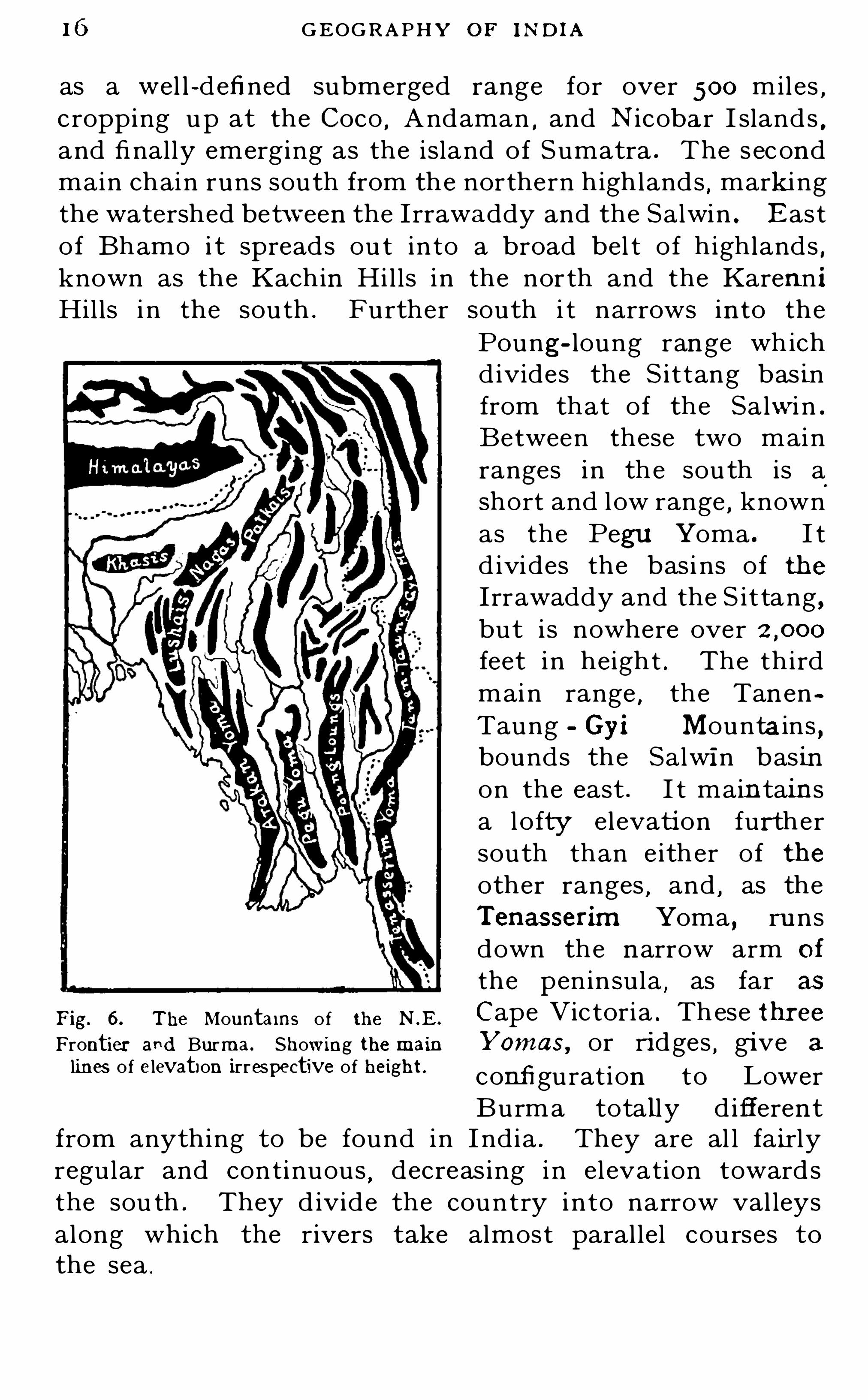
1 6 GEOG R APHY O F 1ND1A
as a wel l -defi ned submerged range for over 500 miles ,cropping up at the Coco
,Andaman
,and N icobar I slands ,
and finally emerging as the island of Sumatra . The secondmain chain runs south from the northern highlands
,mark i ng
the watershed bet ween the Irrawaddy and the Salwin . Eastof Bhamo i t spreads ou t into a broad bel t of highlandsknown as the Kachin Hil ls in the nor th and the Karenn iHil ls i n the south . Further south i t narrows into the
Poung- loung range wh ichd ivides the S ittang basinfrom that of the Salwi n .
Between these two mainranges in the sou th is ashort and low range
,known
as the Pegu Yoma . I td ivides the basi ns of theIrrawaddy and the S it tang ,but i s nowhere overfeet i n height . The thirdmain range
,the Tanen
Taung Gyi Mountains ,bounds the Salwin basinon the east . I t maintainsa lofty elevation furthersouth than either of theother ranges
,and , as the
Tenasserirn Yoma , ru nsdown the narrow arm of
the peninsula,as far as
Fig. 6. The Mountains o f the NE .
Cape Victoria' These threeFrontier and Burma. Showing themain Yomas, or ridges , give 3 ,
lines of elevation irrespective of height. configuration to LowerBurma totally d ifferent
from anything to be found in I ndia . They are al l fairlyregular and continuous
,decreas ing in elevation towards
the sou th . They d ivide the country into narrow val leysalong which the rivers take almost paral lel courses tothe sea .

THE G R EAT PLA IN I 7
(7) The Indo -Gangetic Plain
26. Immediately south of the great mountain wal l,the
general curves of which it closely follows,l ies the great
plain of the Indu s and the Ganges . The drop from thehigh ranges to the plain i s made with comparative abruptness
,and then the plain extends southwards
,with a width
varying from 1 00 to 300 miles , till it meets the brokenhighlands that form the northern boundary of the Deccan .
The plain i s ent irely al luvial , being formed of the si ltbrought down by the great rivers which traverse it . Thethickness of the al luvial deposit does not appear to beanywhere less than 600 feet , and in the delta of the Gangesthere is reason to bel ieve that it i s three t imes this thickness . Geologically the plain i s older than the Himalayas .There are also many indications that the plain has beensubj ected to steady depression
,acting slowly through long
ages . Geologists bel ieve that the great forces that up
heaved the Himal ayas also reduced the level of the plain,
and that the two processes went on together,both being
parts of the same great earth -movement . The easternpart of the plai n was in later ages subj ected to a furtherdepression . O riginally the enti re plain sloped towardsthe west
,and the whole drainage was , as we have seen ,
into the Arabian Sea . The later subsidence of the easternpart of the plain changed the course of the rivers
,and for
ages the enti re drainage from the J umna eastwards hasbeen to the Bay of Bengal .27. The area of the plain is about square miles .I t i n
'
cludes almost the whole of the basins of the I ndus andGanges
,and thus stretches without a break from the
Arabian Sea to the Bay of Bengal . The watershed betweenthese two basins i s slightly to the west of the city of Delhi
,
where the plain reaches its greatest height, 924 feet above
sea-l evel . From that point to the mouth of the Indus i s850 miles , and to the mouth of the Ganges miles .The slope towards the sea is thus extremely gentl e on bothsides , and the rivers consequently flow slowly
,depositing
their sil t as they go . The northern and eastern portion
c

1 8 GEOG R A PH Y O F IND IA
of th is great plai n i s the mos t ferti le and populous part ofI nd ia . The rainfal l
,especial ly toward s the east
,i s ample
,
and the river deposits greatly enrich the soil . In the eas tof the plain the Brahmapu tra mingl es its waters with those
Fig. 7. TheGreat Plain and Peninsular India.
of the Ganges,and it has been estimated that the two
rivers bring down annual ly more than mill ion cubic
feet of sol id matter to enl arge and enr ich their common

20 GEOG R A PH Y OF IN D IA
30. South of th is bel t l ies the great Plateau of theDeccan
,which consti tu tes the cen tral core of the peninsula .
Except where b roken in the east by the great rivers wh ichflow into the Bay of Bengal , th is plateau main tai n s anel evat ion o f from to over feet . I t i s h ighes ti n the south and west
,and slopes very gradual ly to the
north and east .
3 1 . The Plateau i s bounded on the west by the WesternGhats , or Sahyadri Mountains . The northern extremi tyof th is range i s separated from the Satpuras by the valleVof the Tapti . From this point the Western Ghats ru nsouthwards nearly paral le l to the coast , and at no greatd istance from i t
,almost to the southern point of the
peninsula . The range i s fairly conti nuous,bu t there are
four important breaks . Two of these are near Bombay ,
another near Goa,and the fou rth is the Palghat Gap , 200
miles further south,where the elevat ion drops swi ftly from
over ft . to l ittl e more than ft . Through al lthese openings i n the hil l s railways now pass
,connect ing
the west coast with other parts of I nd ia .
32 . I n the south the Western Ghats attai n to muchgreater altitudes than i n the north . I ndeed , the highestpeaks to be found south of the Himal ayas he immediatelynorth and south of the Palghat Gap
,where
,i n sharp con
trast to the Gap i tsel f,elevations of over ft . are
reached . The Ni lg ir i Hi l ls l ie to the nor th of the Gap ,
the Anamalais to the south . Eastward of the Anamalaisare the Palnis
,and to the south stretch the Cardamom Hil ls ,
maintain ing an al ti tude of over ft . to wi th in 25 milesof Cape Comorin . On their western side
,throughou t their
entire l ength, the slope of the Western Ghats i s fairly steep ,
and between the foot of the h il l s and the sea i s a wel lwatered and fertil e strip of al luvial plain varying in wid thfrom three or four miles in i ts narrowest part to th irtymiles in the south
,where the mountains recede somewhat
from the sea . On their eastern side the slope is less rapid ,
and the elevation drops gradual ly to that of the plateau .
33 . The eastern boundary of the plateau is a brokenrange of highlands stretching sou thwards from the hil l s o f

THE GR EAT R IVER S 2 1
O rissa ti l l their southernmost spurs , the Shevaroy Hills ,almost meet the eastern spurs of the Nilgiris. The easternhighlands
,though commonly cal led the Eastern Ghats
,
have l ittl e in common with their western namesakes . Theyare comparatively low
,seldom exceeding ft .
, as wel las irregular and broken
,and are separated from the sea by
a much broader al luvial plain . L ike the Aravallis, theEastern Ghats are the remnants of a very ancient range ,worn down by long ages of weathering .
” The WesternGhats on the other hand
,are of comparatively recent
elevation . This,together with the fact that almost the
whole drainage of the plateau is to the east , account s forthe greater breadth of the al luvial plain
,which varies from
50 to 1 50 mil es in W idth ,and stretches far inland where the
great r ivers force their way to the sea .
34. The plateau itsel f is h ighest in the southern angleformed by the converging eastern and western ranges . I nthat angle l ies the State of Mysore, a large part of whichmaintains an altitude of over ft. I n the west theplateau is almost everywhere wel l over ft . Fromthese higher level s i t slopes gradual ly
,and almost imper
ceptib ly, in an easterly and northerly d irection t i l l it meetsthe Western Ghats , the low crests of which seldom rise tomore than ft . above it .
(8 ) The Great Rivers and their Basins .
35. Most rivers begin their course as mountain torrents,
and this is particularly the case in'
north India,where
almost al l the Chief rivers rise at exceptional ly high altitudes , and before they emerge from their mountain bedhave become streams of considerable volume . Most of theHimal ayan rivers take their r ise at elevations varyingfrom to ft . , and fal l swiftly almost to the levelof the plains through rocky channels which they have cutout for themselves . Their fal l being rapid their flow isswift
,and their erosive power proportionately great .
Many of them flow at the bottom of steep ravines of theirown making many thousand s of fee t deep . Mountain
2 2 G EOG R A PH Y OF I ND IA
torrents cannot, t herefore , change their course , but retain
i t from age to age,confined by the rocks through which
they have cu t the ir way . Such mountain torrents bri ngdown a vast amount of sol id matter to the level of theplains . The steep sides of thei r ravines are continual lycrumbl ing , and the d isintegrated matter i s washed in tothe bed of the torrent by which i t i s con tinual ly bei ngcarr ied down to lower and lower level s . I f the rapid ityof flow is checked at any point i n the descent
,so that a lake
is formed,th is sol id matter i s deposi ted
,and in course of
time a ferti l e val ley i s the resul t , through which the streamflows placid ly to recommence its swi fter descent fu rtheron . Many such val leys have thus been formed i n theHimalayas
,the beaut i fu l Vale of Kashmir being one .
36. When such a river reaches the plains , i t en ters uponwhat we may cal l the second stage of i ts l i fe . I ts flowbecomes Sl ower in proportion to the flatness of the plain
,
and the silt which i t has brought down i s rapidly depositedon its banks and bed . In seasons of flood these deposi tsare again d isturbed and carr ied further down. Sometimes
such a river wi ll bu i ld up its bed to a level above that ofthe surround ing plain . O r sometimes , having hal f fi l ledup its channel
,it wil l
,i n a season of great flood , overflow
i ts banks and as these banks are soft and easily destroyed,
they are soon washed away,and the river cu ts ou t a new
,
or auxi l iary,channel for i tsel f . As it approaches its mou th
the flow becomes sti l l s lower . t i l l i n i ts estuaries i t mee tsand mingles wi th the t idal waters of the sea . Here thefinal deposit of its sol id matter takes place
,and the land
stead ily encroaches on the sea . The old channel s , ord istributaries
,of the r iver are continual ly bei ng partial ly
blocked up wi th S i lt,and i n periods of flood i ts waters over
flow and cu t ou t new channel s for themselves by means ofwh ich they reach the sea . Much of the sil t brought downby such a river when i n flood is washed ou t to sea . Therei t gradual ly set tles
,and the bed of t he sea i s rai sed around
the river ’s mouth,or the numerous mouths o f i ts d istrib u
taries . Mud i slands presently appear , which in course oft ime are j oined to the mainland ,
and o thers further ou t

THE GR EAT R IVER S 23
are formed . So the delta is always being slowlyenlarged , and the land pushed further and further out .
37. Such is the character of almost al l the rivers ofIndia . I n one point
,however
,the rivers of the north
contrast sharply with those of the peninsula . The formerare snow-fed , the l atter are not . The great mountains ofthe north are a vast storehouse of water in the form ofsnow . The l ine of perpetual snow is at a height of about
ft . on the south side of the Himalayas,and at about
to ft . on the north side and on the mountainso f the north-west . I n the winter the snow does not mel t ,and the northern rivers are
,therefore
,lowest i n the early
months of the year,when the effect of the monsoon rains
i s past , and the mel t ing of the snow has not yet begun .
But as soon as the warmer weather sets in the snows beginto melt
,and then for several months there is a steady supply
of water to al l the rivers of the north . This is greatlyincreased when the rains set i n
,and in Ju ly the Himalayan
rivers are in ful l flood . But the flow from the snows conti nnes long after the monsoon rains have ceased . Therivers of the peninsula have no such supply , for thereare no mountains south of latitude 27
°N . high enough to
reach the snow l ine . The sou thern rivers,therefore ,
being dependent upon the rains alone,are subj ect to much
greater variat ion i n volume than those which -come downfrom the north and water the great plain .
38 . The great rivers of the north,the Indus , the Brahma
putra , and the -Ganges , drain the main slopes of the Himal ayas both north and south and the Indus and Brahmaputra bring the drainage of the north round the westernand eastern extremities of the mountain chain . Some ofthe greater tributaries of these r ivers rise north of themain chain , and make their way across the chain throughdeep gorges between the mountains . The Indus , its maintributary ,
the Sutlej , the Brahmaputra , and the Gogra ,one of the chief tributaries of the Ganges
,take their r ise
wi thin 1 00 miles of each other,near Lake Manasarowar
i n Tibet,at an el evation of over ft . The Ganges
and another of its tributaries,the Jumna, rise in the
24 G EOG R A PHY OF IND IA
mountains to the west of this lake . Manasarowar i s thusthe great hydrographic cen tre of North Ind i a .
39. The Indus . Rising in Tibet , the Indus flows fi rs tinanorth-westerly direction for 800 miles , passing throughKashmir between the Himalayas and the Karakorums,
andrece iving the drainage of both these chains . Round ing
F ig. 8 . The Basin of the Indus .
the great peak of Nanga Parbat , the most westerly peakof the Himalayas proper
,i t tu rns sharply to the sou th -west
,
breaking through a magnificen t gorge with cl i ffs at bothsides over ft . i n heigh t . From this point i t continnes i ts flow in a south -westerly d irection til l i t reaches

THE INDUs 5
the sea . J ust at i ts bend it receives the waters of theGilgit river from the west . Two hundred miles further on ,near Attock , it i s j oined by the Kabu l r iver , which ,
with itstributaries the Swat
,the Panjkora
,and the Chitral , drains
the eastern slopes of the Hindu Kush and the Chitral Hill s .O ther important affluents from the west are the Ku ram ,
with its tributary the Tochi,and the Gomal .
40. But the great affluents of the Indus are from theeast . They are five i n number
,and
,watering the Punj ab ,
give that Province its name— Panj -ab , five rivers . TheJhelum is the most westerly of these , and pours its watersi nto the Chenab, which ,
further down,also receives the
Fig. 9. Showing LakeManasar owar and the rise o f the great northern rivers.
waters of the Ravi . All these take their rise i n the Himal ayas
,and
,l ike the Indus , flow at first i n a north -westerly
di rection . The Sutlej,the most easterly of the five rivers
of the Punj ab , flows from Rakas Tal, a lake to the west ofManasarowar , and , breaking through a gorge in the Himal ayas north of Simla
,en ters the Punj ab from the east .

26 GEOG R A PHY O F 1ND 1A
W hen hal f way on i ts course to the I ndus i t i s j oined bythe Beas , which rises on the sou thern sl opes of the hill snot far from the source of the Chenab . At this poin t theSu tlej changes i ts course
,which has h itherto been almost
westerly,and after flowing for 300 miles i n a south -westerly
d irection,j oins the Chenab . One channel
,cal led the
Panjnad, thus carries the water of al l five rivers to theI ndus .
4 1 . All these rivers being fed by the mel ting snows,as
wel l as by the monsoon rains,are in flood in the late summer .
After their emergence from the h i l ls their course lies’
acrossan almost l evel al luvial plain composed for the most partof a soft loam . They therefore carve for themselvesnumerous wide and shal low channels , which they constantlytend to change . This is true al so of the I ndus in many partsof its course
,as wel l as of most of the tributaries of the
Ganges . I n the broad plain there are no hill s to confinethem
,and the soft earth of which their banks are composed
is unable to withstand the erosive action of their floodwaters .
42 . From its confluence with the Panjnad the Indusflows midway between the fronti er h ills of Baluchi stan andthe region of the scantiest rainfall in I ndia
,the Thar or
Indian Desert. I t has,therefore
,no further afliuents of
importance and in the lower part of its course gives morewater than it receives. I t does for Sind precisely what theN i l e does for Egypt , wateri ng and ferti l i z ing the land formany mil es on both S ides . By the vast amount of si l twhich for ages it has brough t down from the mountains i thas bui l t up for i tsel f a bed h igher than the surround ingcountry . Streams therefore flow from i t instead of intoit . This makes i rr igation from the I ndus for the most partexceed ingly simple and easy
,but at the same time i t
increases the danger of d isastrous floods . The same forcewhich has buil t the broad soft banks can also d es troy them .
When the river i s i n flood the swirl ing waters often makevast b reaches i n them ,
and widespread inundati ons withgreat l oss of l i fe and property are the resu l t . O ccasional ly ,
al so,the river will i n consequence change i ts course , or

28 G EOG R A PHY OF IND IA

THE GANGES 29
46. The Ganges proper is formed in Garhwal by theunion of two rivers (see F ig . 9 , page the Bhagirathi,which rises among the gl aciers of Gangotri and is oftencalled the Ganges , and the Alaknanda, which rises to thenorth-west of the great peak Nanda Devi and breaksthrough the Garhwal Himalayas . The Alaknanda i s muchthe larger of these confluents. The river thus formed flowsfor 50 miles i n a south-westerly d irection , and thengradually bends round to the south and sou th-east
,
maintain ing the latter d irect ion t i l l it has passedAl lahabad . On its eastern and northern side it receivesmany tributaries
,the chief of which is the R am
ganga, which al so rises i n Garhwal . From the west andsouth it receives no tributary of importance ti l l it reachesAllahabad ,
where it is j oined by the Jumna.
47. The Jumna al so takes its rise north of Garhwal andwest of the Bhagirathi. I n its course it describes a curvesimilar to that of the Ganges , and for the greater part of
its way to Allahabad maintains a d istance of from 50 to80 miles west of that river . Unlike the Ganges
,however
,
its main affluents are from the west and south . The mostimportant of these is the Chamb al which drains the northeastern Sl opes of the Aravallis and Vindhyas.
48 . From Allahabad the Ganges flows eastwards,
passing Benares , and a few mil es further on is j oined bythe Gumti , which descends from the front iers of Nepal .A hundred miles l ower down it receives the waters of theGogra, which r ises near Lake Rakas Ta] and breaksthrough a gorge in the mountains . On i ts way the Gograreceives the waters of the sardaand the Rapti , and by thet ime it reaches the Ganges it rival s it i n volume . Withinthe next 30 miles the Ganges i s j oined by the Sim from thesouth and the Gandak from the north , and when north ofthe Rajmahal Hil l s it receives the Kiwi from the north .
Both the Gandak and the Ki wi ri se north of the Himal ayasand break through the mountain Chain
,while the numerous
feeders of the SOn drain the rocky highl ands of the CentralProvinces and Chota Nagpur . After passing the R ajmahal Hi lls the Ganges bends toward the south -east
,and

30 GEOG R A PHY o r m om
soon begins to th row off its d istribu taries to the south .
The firs t of these is the Bhagirathi, which lower downbecomes the Hooghly , and the poin t at which the Bhagirathi
branches o ff i s the beginning of the del ta. The mainstream stil l conti nues i n a south -easterly direction , t il lsouth of Pabna i t d ivides i nto two almost equal streams ,one of which
,the Madhumati
,or Haringata,
takes a moresoutherly course to the sea
,and the other , the Pudda (or
Padma) fol lows a more easterly course to Goalanda ,where
i t unites wi th the Brahmaputra .
49. The northern and sou thern tributari es of theGanges d iffer greatly in character . The former are fed
,as
we have seen , not only by the heavy rains which fal l onthe Himal ayan 510pes , but al so by the mel ting snows .
They are therefore much more constant than they wouldbe i f dependent on the rains alone . Though in flood inJ uly and August they cont inue to bring down a fair quantityof water through the greater part of the year . The southerntributari es have no snow reservoirs to draw upon . Theirbasins have also a much smal ler rainfall than theHimalayas
,
particul arly i n the west . The ground they drain is al sofor the most part rocky
,off which the water flows with
great rapid ity . The rivers,therefore
,ri se rapid lv as soon
as the summer monsoon brings i ts store of rain,and fal l
almost as rapidly when the rain ceases . When in floodthey rival the northern rivers in volume
,but for the greater
part of the year they are l ittl e more than rivulets . Forthis reason they are of much less value for irrigati on purposes than the Himal ayan rivers . While (as we shallpresently see) there are vast irrigation systems that drawtheir suppl ies from the l atter
,the systems dependent on
the southern tributaries are few and smal l . The Gangesi s also of immense value as the ch ie f waterway of northInd ia . I ts volume is always sufficient to bear upon i tsbosom a vast host of boats o f every description . At thevarious registering towns along its course overriver boats of various kinds are l icensed to ply upon i tswaters . The river thus brings down a l arge part of theimmense produce of the rich provinces which i t traverses .

THE G R EAT R IVER S 3 1
( 1 0) The Rivers of the Pen insu la
50. Most of the great rivers of the peninsu la pour theirwaters i nto the Bay of Bengal . I n the map on page 2 8 thewater-parting between east and west is shown by a li neof heavier dots extending from north of the Himal ayas toCape Comorin . I t wil l be noticed that from the southernpoint this l ine fol lows the Western Ghats
,t i l l
,from the
northern extremity of this range , it strikes sharply westwards Where the narrow basins of the Tapti and Narbadastretch far across the peninsu la
,the latter nearly two
thirds of the way to the Bay of Bengal. With these twoexceptions the r ivers which flow westwards are small andof l ittle moment . The great r ivers of the peninsula ,though rising as a rule within a few miles of the westcoast
,make their way eastwards
,gathering volume as
they go .
51 . TheNarb ada, ris ing near Mount Amarkantak , i n thenorth of the Central Provinces , and a l i ttl e to the east ofChota Nagpur , takes an almost straight course to theGul f of Cambay . I t receives few tributaries , and no largeones . L ike the Ganges it i s a sacred river of the Hindus
,
and from its source to its mouth it i s by very far the mostbeaut i fu l r iver i n I ndia . O f al l the rivers in I nd ia ,
” saysSir Lepel Griffin
,there is none which is surrounded by
more romance and mystic interest whilst for strange andfantast ic beauty it takes high rank among the celebratedrivers of the world .
52 . The Tapti ri ses south of the Mahadeo range of hil ls ,and flow westward along the northern val ley . Debouchingthrough a gorge at their western extremity
,it i s j oined by
the Pfirna which drains the southern slopes of the samehil l s . L ike the Narbada, from which it i s separated by thesatpura range , the Tapti flows westwards and emptiesitsel f into the Gulf of Cambay ,
a l ittl e to the north of theancient port of Surat .
53 . The four great rivers of peninsular India whichd ischarge into the Bay of Bengal are the Mahanadi , theGodavari, the Kistna, and the Cauvery.
3 2 G EOG R A PHY OF iND IA
54. The Mahanadi . The basin of the Malianad i meetsthat of the Narbada, and one o f i ts tributaries takes itsrise , l ike that river , on the sl opes of Mt. Amarkantak .
The Malianad i i tsel f r ises on the northern sl opes of the hi l l sthat form the northern boundary of the State o f Bastar inthe Central Provinces . I t flows at first i n a northerlyd irection ti l l , having received its chie f tributary
,the
Seonath,from the west , i t turns to the east and flows east
and sou th , past Sambalpur . I ts numerous affluents drai na large tract of hil ly country ,
and in the rainy season theriver i s of unusual volume for i ts length . When i n floodit almost equals the Ganges . But
,l ike al l the Vindhyan
rivers,it rises qu ickly and quickly fal l s again . The
Mahanadi breaks through the hil l s by a gorge 40 mileslong and of great beau ty
,and
,after passing Cu ttack ,
divides i nto the numerous channels of i ts del ta . The riverbrings down a very large quanti ty of si l t
,and the del ta i s
extensive and rapid ly increas ing .
55. The Godavari rises i n the Western Ghats a l i ttlenorth of Bombay . I t flows through the N i zam ’s Dominions ,and for more than 350 miles i ts various t ributaries formthe northern boundary of that State . The general courseof the Godavari i s west- sou th-west for the first two- th irdsof its length
,then i t turns to the sou th-west and main tai ns
that d irect ion t ill it reaches the sea . I ts mai n tributaryon the south is the Manj ira, which rises i n the Bhir coun tryon the borders of Bombay . From the north , j us t at thepoint where it bends more to the sou th , i t receives thewaters of the Pranhita, a river almost as large as i tsel f .The Pranhita i s formed by the union of three rivers
,the
Paingangafrom the west , the Wardhafrom the north-west ,and the Waingangafrom the north . Further on i t receivesfrom the north -east the Indravati, which rises on thewestern slopes of the Eastern Ghats and drains the un
heal thy j ungles of Bastar . I n their passage through theGhats the waters of the Godavari are confined for 20 mileswith in a deep and narrow channel , and the scenery on bothsid es i s wi ld and grand . Shortly after i ts emergence fromthe Ghats i t broad ens into a vast and noble river , and at
R IVER S O F THE PEN IN SU LA 3 3
Raj ahmundry it i s crossed by a railway bridge 1g miles
long . At Dowlaishweram ,the apex of its delta , the river
d ivides into three main distributaries and many smallerones , and so reaches the sea .
Fig. I I . Basins o f the chief rivers of the Peninsula.
56. The Kistna and its tributaries receive the easterndrainage of considerably more than one-hal f of the wholel ength of the Western Ghats . The Kistna basin , unl ikethat of the Godavari , i s broadest towards the west , andgradually narrows as i t approaches the Bay of Bengal .
D

34 GEOG R A PHY OF IND IA
The Kistna rises near Mahabaleshwar and flows fi rst i n asoutherly d irection . I t has two great t ribu tar ies
,the
Bhima from the north and the Tungabhadra from the sou th .
The Bhima rises to the north of Poona,and after flowing
south -east through Bombay and the N i zam ’s Dominions,
j oins the Kistna a l it tl e to the north of R aicht'
ir . The
Tungab had ra i s formed by the un ion of two rivers , theTunga and the Bhadra , both of which rise i n the west ofthe Mysore State . They unite wi th in the boundaries ofthat State
,and , flowing i n a north -easterly d i recti on
,
separate the Presidency of Madras fi rst from Bombay andthen from Hyderabad . After receiving the waters of the
Tungab had ra the K i stna turns to the north -east and con
tinues i ts flow in that d irection ti l l i t has passed the
Nallamalai Hill s , which cu t i t off from the plai n of theeastern seab oard . Then it tu rns sharp ly to the southeast and so reaches the sea .
57. The Cauvery and i ts tributaries drain the whol e ofsouthern Mysore , the eastern slopes of the N i lg iris and
Anamalais,and the northern and eastern slopes of the
Palnis. I t flows through some of the most produc tive andpopulous d istricts of South I nd ia , notably Tanj ore , whichi t waters by means of extensive and ancien t irrigati onworks . After passing Trichinopoly i ts del ta begins . Theriver d ivides into two arms , the smaller of which ,
sti l lcal l ed the Cauvery , flows almost due east , and d ivides againinto several channel s before i t reaches the sea . Thelarger
,cal led the Coleroon, flows in a nor th -easterly d irec
tion,and empties i tsel f i n to the sea hal f way between
Pondicherry and Negapatam .
A few miles from t he ci ty of Mysore the Cauvery d ivides,
and the two arms , uniting again lower down , enclose theriver i sland of Seringapatam ,
the famous stronghold atwhich Tipi
’
i Sultan made his last stand . Further down,
two similar i sl ands are formed , both held to be of greatsancti ty by Hindus . These are the island of Sivasamun
dram,at the southern frontier of Mysore , and t he i sland o f
Srirangam,near Trich inopoly , the si te of one of the
l argest and mos t famous Hindu temples .

36 GEOG R APHY or IND IA
60. The Irrawaddy drai ns the greater part of Bu rma.I t is a noble river , navigab le by l igh t draugh t steamers asfar as Bhamo
, 700 miles from the sea , and by smaller crafts ti l l further . Being snow fed i t ri ses and fal l s , but i s neververy low . Til l rai lways were constructed i t was almostthe only h ighway of commerce between Upper Bu rma
Fig. 1 2 . R ivers o f Burma.
and the coast,and i t i s st i l l the chie f . The I rrawaddy
rises in the rugged mountains east of the bend of theBrahmaputra ,
and wi th the exception of abou t 60 milesafter passing Bhamo
,and agai n for a similar distance after
passing Mandalay ,when it turns in each case to the west
,
i ts general course i s almost due sou th . At a d istance of
THE I R R AWADDY 37
800 miles from the sea it i s more than hal f a mile wide , andi t mai ntains a width of from hal f a mile to a mile and a halfal l the way to i ts del ta
,except i n four places where it
breaks through defiles i n the mountains,and
,amid scenery
of surpassing beauty,
'narrows into deep rocky channels .
In one of‘
these the river is only 600 ft . wide , but overft . deep . A l ittle below Mandalay the Irrawaddy is
j oined by the Myit-nge which drains the Shan Hill s to thenorth- east . Thirty miles further down it rece ives the
waters of its main tributary,the Chindwin. R i s ing , l ike the
I rrawaddy itsel f,east
fl
of the bend of the Brahmaputra , theChindwin drains the eastern 510pes of the Patkai and NagaHil ls
,and the Arakan Yoma . I n its lower course before its
j unction with the Irrawaddy,it waters a broad and fertil e
val ley . A littl e below the point of confluence the Irrawaddybends gradual ly to the south agai n . More than 1 00 mile sfrom the sea the delta begins
,and the river finds its way
to the Gul f of Martaban through fourteen channels . On
the most easterly of these distributaries stands the port ofRangoon
,the ch ief port of Burma
,and on the most
westerly , the smaller port of Bassein .
61 . The basin of the Sittang i s separated from that ofthe Irrawaddy on the west by thePegu Yoma , and from thatof the Salwin on the east by the Poung- loung Hil ls , bothof them fairly Continuous
,though low
,ranges
,which run
north and sou th,and enclose a r ich and ferti l e val ley from
50 to 90 miles in width . A glance at the map wi l l showthat the basin of the Irrawaddy meets that of the Salwin ,about 1 00 miles south of Mandalay. The Sittang is ,therefore , a comparatively short river , and being shallowat i ts mouth it i s useless for navigation . I t i s subj ect alsoto a severe tidal bore . The tidal wave
,concentrating i n
the apex of the gul f,rushes up the broad estuary as a wal l
of water,often from fi fteen to twenty feet i n height . The
Sittang val ley is flat,and provides an excel lent rou te for
the rai lway to Mandalay .
62 . The Salwin , l ike so many of the rivers of NorthI nd ia, rises amid the snows of Tibet . Bending to thesouth , 200 mil es east of the Brahmaputra , i t makes its long

3 8 GEOGR A PHY OF IND IA
j ourney to the Gul f o f Martaban between ranges of hi ll swhich in the north narrow its basin to a few m il es . Throughout i ts whol e course i t has a rocky bed . At seasons of flood
,
when the Tibetan snows are mel ting . the Salwin bringsdown more water than the I rrawaddy . But numerous rockyrapids on i ts course make navigation impossible for morethan 1 00 miles from its mouth .
( 1 2 ) Coast Line and Harbours
63 . The total coast l ine of I ndia and Bu rma,from Cape
Monze on the western poin t of Sind to Victoria Point inthe south of Tenasserim
,i s sl igh tly over miles in
length . Seeing,however
,that the peninsula o f Ind ia
stretches southwards from Lat i tude 25°
N . for nearlymiles forming almost an equi lateral triangle wi th
that paral lel as its base,and that Burma stretches about
the same d istance to the south on the other side of theBay of Bengal
,th is long coast l ine i s relatively short . I t
i s comparatively u ni form and regular,and i s broken by
few indentations of any magni tude . For the greater partof its l ength a sandy and almost level coast strip i s washedby shal low seas . The waves
,roll ing i n unbroken from the
Open ocean,break in the shal low water i n long l ines of surf
,
which even i n fine weather are a d ifliculty and danger tosmal l boats
,and i n stormy weather lash the shore wi th
almost irresi stible fury and make i t impossib l e of approach .
This i s part icularly the case on the sou th—east coast , but i smore or less true al l round the peninsula . I n naturalharbours I nd ia i s unusual ly poor . Vast stretches of coastpresen t no conven ience or shel ter whatever for shipping
,
neither land -locked bays nor navigab l e estuaries . I nd iacould therefore never become a great marit ime countr y
,
and all her foreign sea-borne trade i s carried in the shipso f other nat ions .64. Both the east and the west coasts of I nd ia are
greatly affected by the surface currents , or dri fts , i n the
surround ing seas,which are. i nduced by the steady seasonal
winds . During the south -west monsoon the cu rren ts run

COAST L INE 39
along the west coast of the peninsula from north to south ,
and along the east coast from south to north . Duringthe north-east monsoon these d irections are reversed .
These currents exerci se considerable erosive power , and atthe same time they wash up
,and move along the coast ,
vast quantit ies of sand,which is deposited wherever the
force of the current i s checked by its entry into a bay , orby its confl ict with the river currents prolonged into thesea . The influence of these dri fts i s thus twofold . Wherethey beat upon an exposed promontory they gradual lyeat i nto the land . When they flow into a confined baythey wash more sand i n than they can wash out , andslowly tend to fi l l the bay up . Striking examples of thesetwo effects are to be found on the west coast
,where the
currents exert on the whole a more powerful i nfluence thanon the east . The extreme north-western point of
Kathiawar , which is exposed to the ful l effect of the southwest monsoon dri ft as it bends round the north of theArabian Sea , i s being rapidly worn away ,
and the sea issteadily encroaching on the land . On the other hand .
the Gulfs of Cutch andCambay are rapid ly si l ti ng up . One curiousresult of these dri fts
,
seen almost equal lyalong both coasts
,i s
the formation of l ongbanks of sand and mud
,
or b ars , as they arecal led , a l i t tle d istancefrom the mouths of al lrivers . These bars arej ust beyond the scouring power of the flood water ofthe river
,and they consti tute an effectual barrier to
navigati on .
65. Beginning at the extreme west of India we havethe excel lent harbour of Karachi , a natural bay formedby a proj ect ing ridge of rock and greatly improved by anextensive breakwater . Karachi is about 1 2 miles west
Fig. 1 3 . Karachi Harbour .

40 G EOG R A PHY OF IND IA
of the most westerly outle t of the Indus . Being theneares t I ndian port to Europe , and having d irect rai lwaycommunication wi th north Ind ia (by a bridge across theI ndus at Sukkur) , i t attracts to i tsel f the greater part ofthe sea-borne trade of Raj putana and the Punjab , and i sa rapid ly-growing port . Owing to the steady silt ing upof the en trance
,however
,the channel has to be incessantly
dredged .
66. For 1 20 miles south -east of Karach i extends thedel ta of the river I ndus , the shi ft ing channels of which arenavigable only by smal l craft . At one t ime the chie fchannel of the Indus discharged i ts waters into the GreatRann of Cutch , which separates the island of Cutch fromSind . Between Sind and the promontory of Kath iawaron the sou th are the Little Rann of Cutch and the Gu lf ofCutch . The Ranns are shown as arms of the sea on al l
maps,but they are no more than vast sal t morasses ,
overed with shal low water only in the wet season , and in
the dry months for the most part baked dry and hard .
They are the haunt of wild asses,which wander about i n
herds of 50 or 60 ,and are so timid and fleet that they can
seldom be approached . The Ranns are sea-swamps in
process of natural reclamation . The Gul f of Cutch is al soexceed ingly shal low
,and when the tide is low much of i t
i s bare sand . South-east of Kath iawar i s the Gu lf ofCambay
,which
,as we have seen ,
i s gradually si l t ing up.The port of Cambay at the north of the Gul f has los talmost al l i ts sea trade
,and the more famous ports of
Breach,on the Narbada
,and Surat
,on the Tapti , are yearly
being rendered more di fficul t of access from the samecause . Surat was at one time the weal th iest and mostfamous port in I ndia.
67. Abou t 1 50 miles sou th of the Gul f of Cambay i s th eexcel lent natural harbour of Bombay . I t is protected bythe isl ands of Bombay and Sal sette ,
and offers abundantand safe anchorage . But owing to the constant deposi t ofsi l t at i t s entrance great care has to be taken to keep i tOpen
, and the largest vesselshave to enter wi t h cau tion .
Bombay is admirably si tuated as the princ ipal por t for

COAST L INE 4 1
communication with the west,and is the chie f mail route .
I t i s almost equ idistant from the north,south
,and east of
I ndia,and is accessible by rai l from all parts .
68 . From Bombay south to Cape Comorin , thoughthere are many smal l seaports
,there are only two harbours
that offer a safe anchorage in bad weather for vessels oflarge size . These areGoaand Karwar. The formeris now served by theSouthern Maratha Railway
,and is growing in
importance . The rest are“ fai r weather ports ”
only,and manv of them
are qui te unapproachab l ewhen the south-west monsoon is blowing ih force .
Near the south of the peninsul a there i s an extensive system of b ackwatersor 1agoons,separated fromthe sea by broad banksof sand through whichoccasional openings givean outl et for flood wateri n the rains
,and an inlet
for the sea . I n ancientdays it i s prob able thatthese channels
,as wel l
as the lagoons themselves ,were of much greaterdepth
,and admitted ships
of fair si ze . Now, how
ever,though O f inestim Fig. 1 4 . Bombay Islands and Harbour .
able value as i nland waterways , these lagoons are uselessfor seafaring purposes .
69.Rounding Cape Comorin we enter the Gulf of Manar ,
on the western shore of which stands the small portof Tuticorin. The water is exceedingly shal low, and

42 G EOG R A PH Y O F I ND IA
steamers have to anchor some miles out , but in spi te o f
this Tu ticori n has come to be of some importance as thechie f peninsular port for communication wi th Ceylon .
Northward are the Palk Straits , almost b locked by theislands of Rameswaram on the west and Manar on theeast
,and a long sand bank which almost uni tes the two .
On the landward side of the two i slands are shal l ow passages
known as the Manar Passage and the Pamban Passage .Til l a few years ago neither of them was more than six fee tdeep
,and although they have recently been deepened and
widened,they offer no rou te for large ocean steamers ,
which have to pass round the south of Ceylon .
70. The west coast of Ceylon , like that of the pen insulaitsel f
,i s l ow and sandy
,and is sub j ec t to the same sil ti ng .
There are extensive backwaters , i n many respects similarto those on the west coast of I nd ia, and , l ike them , of greatvalue for boat traffi c . The port of Colombo , nearly 1 00
miles from the most southerly point of the isl and,i s rapid ly
becoming one of themost important portsof cal l i n Asia . I thas a fair naturalharbour
,which has
been very great lyimproved by the construc tion of a longbreakwater . As aport of cal l
,and the
poin t where almostal l the great steamship l ines travers ingthe I nd ian O ceanconverge , Colombo
has superseded Galle in the south of the i sland,though
Galle Bay forms an excel len t and fairly safe harbour .
7 1 . The east coast of Ceylon contrasts sharply w iththe west
,as well as w i th the entire coast o f the pen insula
,
being everywhere rocky and descend ing quickly to the sea .
The depth of water increases with unusual rapidi ty ,a dep th
Fig. 1 5. Point de Gal le and Bay.

44 G EOG R A PH Y OF IND IA
Mutla. Abou t 80 miles up the Hooghly stands Calcutta , themetropol is and premier port of India . The river i s , how
ever,exceed ingly difficul t to navigate
,and i n one part
perilous . At the bend i n i ts course,where i t receives the
waters of the R upnarayan, the J ames and Mary Sands havebeen formed . This i s the most dangerous bank of quick
Fig. 1 6. TheGanges-Brahmaputra Delta.
sand s i n the world . Vessels that strike i t are swal lowedup wi th appal l ing rapid ity . Calcu tta , therefore , hold s i tsposition as the ch ie f port of I nd ia more because i t taps therichest and most productive of all the I nd ian Provincesthan by reason of its excell ence as a seaport , i n whichrespec t it i s far surpassed both by Bombay and Karachi .
COAST L INE 45
I n olden times the ships of the East I ndia Company usedto go no further up the r iver than Diamond Harbou r , whichsti l l enj oys a certain amount of trade
,and is now connected
with Calcutta by rai lway . About forty years ago anattempt was made to rel ieve Calcu tta of some of its sh ipping
,
which Often greatly crowds the river,by opening a new
port,called Port Cann ing, on the Mutla river , a channel of
thedelta,about 25miles east of the Hooghly . Port Canning
also i s connected by rail with Calcu tta,from wh ich it i s
distant about 20 miles,bu t as a port it has not developed
as was at first confidently expected .
74. From the Hooghly for a distance of 200 miles to theeastward stretch the low mud islands of the del ta . I nrriany parts , particularly in the east
,these i slands are
cul tivated,bu t they are mostly covered with low trees and
shrubs,and are infested by tigers and crocodiles . The
en tire district i s known as the Sandarbans, and is subj ectto disastrous floods both from the waters of the rivers andfrom storm waves. O ne such wave which swept over theSandarb ans about thirty years ago caused an immenseloss
,both of l i fe and property
,no fewer than
people being drowned . None of the channels of the del taare navigable
,save for river boats
,t ill we come to the
Meghna i n the east,which wil l al low of the passage of
r iver steamers at al l t imes,and i s an important waterway
to Dacca . The Meghna i s,however ,
subj ect to a severetidal bore wh ich makes i ts navigation difficult anddangerous . The Hooghly is sub j ect to the same phenomenon
,
but not to so serious a degree as the Meghna.
75. The eastern shores of the Bay of Bengal are total lydifferen t from the western
,being fringed with innumerable
small rocky islands,mostly volcanic i n origin . The sea
bed immediately adj acent to the land being in most placesrocky
,the river mouths are not so greatly blocked with
sand bars as i s the case almost al l round the I ndian peninsu la . The r ivers are therefore more open to sea traffic .
For example,the comparatively smal l r iver Kaludan
,at
the mouth of which is the safe and well -protected por t ofAkyab , i s freely open to the sea , i n spi te of a smal l bar ,

46 G EOG R APH Y O F IND IA
and can be navigated for over 50 miles by vessel s of 400 or
500 tons bu rden . Akyab is the only port of any couse
quence north of Cape Negrais . Basse in and Rangoon areon channels of the I rrawaddy del ta , and Mou lmein i s at themouth of the Salwin . All these are eas i ly accessible
,and
give safe anchorages to the largest vessel s . This i s alsotrue of the smal l er ports on the Tenasserim coast , AmherstTavoy
,and Mergu i .
( 1 3 ) Islands
76. With the exception of Ceylon , which does not belongto the I ndian Empire and wil l be treated separately
, the
I slands of I ndia are of comparat ively l i t tle moment . Theyare
,however
,exceedi ngly numerous
,especial ly off the
coast of Burma,and though small
,the ir united coas t-l ine
exceeds miles in length . The total coast - l ine of theI ndian Empire i s m iles .
77. Salsette and Bombay are now connected wi th themainland by a causeway
,and can hard ly be considered
isl ands . Elephanta and Trombay are wi th in the harbourof Bombay . O ther smaller i sl ands
,mostly composed of
volcan ic rock , belong to the same group . The Laccadiveand Maldive Islands are, as we have seen , remnants of thebroad bel t of l and which
,i n far back geological ages
,uni ted
I nd ia and Sou th Africa . O r, more accurately ,
they are coralstructures raised slowly by the coral polyp (which can onlyl ive comparatively near the surface of the water) upon thegradually submerging land . The Laccadives are abou t200 miles west of the Malabar coast , and belong to I nd ia.
The Maldives are 300 miles south-wes t of Cape Comorin ,
and are under a Su l tan tributary to Ceylon . N ine of theLaccad ive I slands are inhabited
,and seventeen o f the
Mald ives,the population being respectively abou t
and Rameswaram and Manar are two island slying be tween Ceylon and Ind ia
,the former belonging to
I nd ia , the lat ter to Ceylon . Rameswaram is a noted plac eof Hindu pilgrimage . O f the many low island s at themou ths of the Ganges
,Brahmapu tra and Meghna
,the only
ones of any moment are Saugor island in the west,and
Shahbazpur and Sandip i sl ands in the eas t .
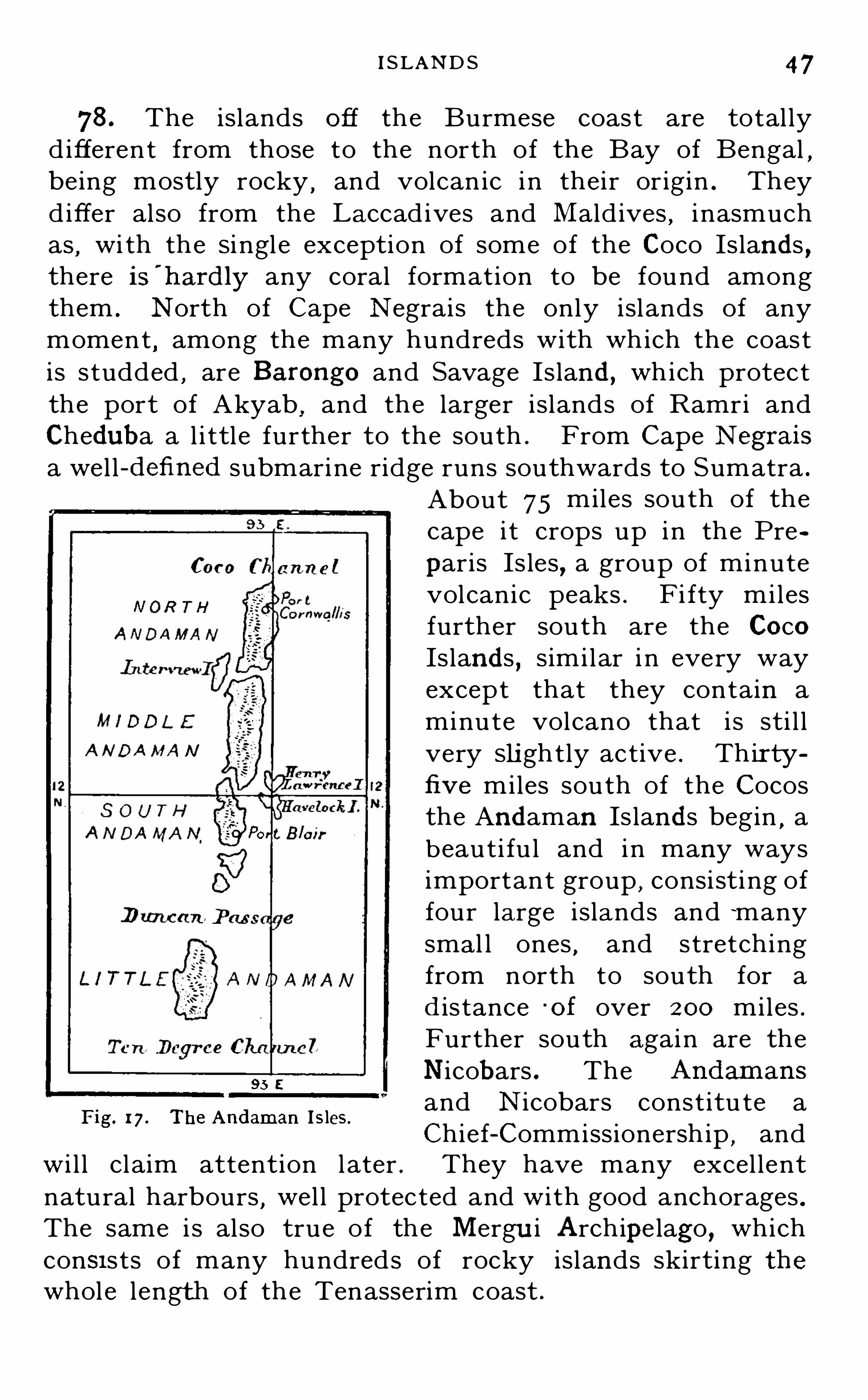
I SLAND S 47
78 . The islands off the Burmese coast are total lyd ifferent from those to the north of the Bay of Bengal ,being mostly rocky
,and volcan ic in their or igin . They
differ also from the Laccad ives and Mald ives , i nasmuchas
,wi th the Si ngle exception of some of the Coco Islands ,
there is'
hardly any coral formation to be found amongthem . North of Cape Negrais the only islands of anymoment
,among the many hundreds with which the coast
is studded,are Barongo and Savage Island , which protect
the port of Akyab,and the larger islands of Ramri and
Chedub a a l i ttl e further to the south . From Cape Negrais
a well -defined submarine ridge runs southwards to Sumatra .
About 75 miles south of thecape i t crops up in the Pre
paris Is les , a group of minutevolcanic peaks . F i fty milesfurther south are the CocoIslands , similar i n every wayexcept that they contain aminute volcano that i s sti l lvery Slightly active . Thir tyfive miles south of the Cocosthe Andaman Is lands begin ,
abeauti fu l and in many waysimportant group
,consi st i ng of
four large islands and !manysmal l ones
,and stretching
from north to south for ad is tance '
of over 200 miles .Further south again are theNicob ars . The Andamans
and N icobars constitu te aChief-Commissionersh ip
,and
wil l claim attent ion later . They have many excel lentnatural harbours , well protected and with good anchorages .The same i s also true of the Mergu i Archipe lago , whichcon3 1sts of many hundreds of rocky islands skirting thewhole length of the Tenasserim coast .
95 5
Fig. 1 7 . The Andaman I s les .

CHAPTER II
CLIMATE O F INDIA
79. BLAN FO R D remarks that we may Speak of theclimates but not of the climate of I nd ia
,for the world
itsel f affords no greater contrast than is to be met with atone and the same time within i ts limits . I t would be avain task to describe the cl imate of every part of I nd ia
,
and any attempt to do so is unnecessary . Cl imate i severywhere the result of certai n conditions whose influenceis wel l unders tood . The presence or absence of thesecond itions enables u s read ily to explain and understand al lcl imatic d ifferences .
( I ) Temperature
80. The Tropic of Cancer crosses I ndia almost midwaybetween its northern and sou thern points . Passing through
Cutch on the west and the Gangetic Del ta on the eas t , i tvery nearly marks the division between peninsular andcontinental I ndia . The whole of the peninsula is wi thinthe tropics
,and Cape Comorin is j us t over 8 ° north of th e
equator . The I ndo-Gangetic plain,on the other hand ,
l ies outside the tropics,but near enough to be wi th i n the
region of greatest solar radiati on in the summer months .
I n the absence of al l other mod i fying causes , therefore , weshould expect the sou th of the peninsu la to have the highes tmean annual temperature
,and the lowest annual range.
Passing north we should expect the mean annual temperature steadi ly to d imin ish
,and the mean annual range to
increase ; while from 2° south of the Tropic to 6 ° or 8 °
north of i t we should expect to find t he summer maximahigher than i n any other part of I nd ia . I n the main thi si s the case
,but in I nd ia
,as i n all other coun tries , the
presence or absence of water,the prevai l ing winds , the
proximi ty of mountain chai ns . e levation and aspect oftenmake the ord inary temperatu re of places i n the same
lati tude total ly d i fferen t .
TEM PER ATUR E 49
81 . I t is easy to see how very greatly the climate of Ind ia ismoderated by these various causes. Water in all its forms isthe great moderator of heat and cold . Happ ily the greater partof the country is
, as a rule,sufficiently wel l supplied with water
to render extreme day and night temperatures impossible, andin many
’
-
parts the climate is remarkably equable. The in
fluence of the sea is also felt far inland all round the peninsula.
In Rajputana,Sind and Baluchistan ,
however,the daily range
is often so great as to be extremely trying to all but the mostrobust . In the highlands of Baluchistan during the late summeror early autumn a day temperature of 80
° F. is often followedby a night minimum of 10° F. The air is exceed ingly d ry,
the
ground amixture of rock and sand ,and rad iation proceeds with
amazing rap id ity.
82. I t is in this connection that the nature of the soil, and
the presence or absence of vegetation ,exerc ise a powerful
influence on climate. Some soils are shal low and porous andrest upon a b ed of impenetrable rock , so that the rainfall qu icklyflows away and they are soon dry. Such is the character of the
greater part of the east and south of peninsu lar Ind ia.
! O thersoils have a remarkable power of absorbing and retaining therain that falls upon them . The b lack cotton soil that prevai ls over the greater part of the north-west of the peninsula
‘
and
Kathiawar , and the mixture of clay and loam which forms theeastern part of the Gangetic p lain , areboth of this nature. Fromsuch soils there is always a large amount of evaporation , evenwhen their surface seems qu ite d ry,
and they neither heat norcool rapid ly. The sands of Sind and Rajputana on the otherhand retain no moisture . What little rain they receive soondries up ,
and in the hot weather they are perfectly d ryfor severalfeet below the surface. Under the summer sun , therefore,
theyheat with great rapid ity and to a very high degree so much sothat it is said often
'to b e possible to cook an egg by simply
laying it on the sand in the sunshine at noonday.
83 . Winds almost always b low from colder to warmerregions, and are one of nature
’s chief ways of equal ising tem
perature. How much Ind ia owes to seasonal changes of windwe shall see presently . Wemay notice here , however, a commondiurnal change which greatly mitigates the summer heat along
See Geological Outline Map on page 83 .

50 GEOG R APHY OF IND IA
the coasts o f the peninsula. Dur ing the early part o f the daythe air over the land is warmed by the sun ’s rays far more thanthat over the sea. In the course o f the afternoon
,therefore
,a
cool and refreshing breeze sets in from the sea which attains its
greatest strength a l ittle before sunset and is fel t for many mi lesinland . The hotter the day and the d rier the air
,the sooner
does the sea-breeze begin and the stronger does it blow. A few
hours after sunset i t d ies down ,and then
,i f the n ight b e clear
the air over the land cools more rap id ly than that over thesea, so
that towards morning a land -wind is established b lowi ng out tosea. The sea breezes which blow dai ly in the hottest weather
greatly moderate the heat along the Coromandel coast .
84. That elevation reduces temperature is a very famil iarexperience in Ind ia,
where coo l refuges from the heat o f the
plains are found at a multitude of hill stat ions . The extentof this reduction is abou t I
° F . for every 2-0 feet of vert ical
ascent . The plateau o f Mysore,being over feet in height ,
is always from 1 0° to 1 2
° F . cooler than the ad jacent p lains .The same cause greatly moderates the b eat all over the Deccan .
85. Hil ls or mountain chains exercise in other ways alsoa powerfu l influence on climate. The slope of the hills turnedtowards the sun is always much warmer than the slope thatlooks away from it . Mountain chains al so often interceptwinds
,increasing
,or sometimes
,though more seldom ,
reducing,
the temperature of the protected plains as a resu l t . The
Himalayas protect the Gangetic plain from the keen and icynorth wind s that blow in winter across Tibet . On the otherhand ,
during the south-west Monsoon ,the Ghats keep
both wind and rain from the plains immed iately to their east,
where both would be more than welcome.
86. I n the l igh t of the foregoing paragraphs we maynow il lustrate the prevail ing temperatures of I nd ia by aseries of isothermal claarls. I n the following chart s therecorded temperatures are reduced to sea—level, i.e they
are i ncreased by I° F . for every 2 70 feet o f el evat ion . The
approximate tem p erature of any place can therefore easilybe found by divid ing its elevation in feet by 2 70 and
deducti ng that number of degrees from the temperature
shown on the chart .

52 GEOG R A PH Y OF IND IA
the coasts o f the I nd ian peni nsula . Fig . 19 shows : ( 1 ) theMean Annual Range , or the d i fference between the meantemperatures of the hottes t and the coldest months . I twil l be seen that the d i fference is bu t sl ight i n the south
,
but i ncreases rapid ly as we pass north : (2 ) the AnnualExtreme Range , or the average d ifference be tween thehighest and lowest temperatures recorded in the year . I tshou ld be not iced that the extreme range is greater on theeast coast than on the west , owing to the fac t that the westcoast receives its chief rains in the hottest mon ths . InJ une and J uly the south -east coast i s nearly 1 0
° hotterthan the south-west .
Fig. 20. Showing the temperature of India for four months.

THE MON SOON S 53
88 . Fig . 20 , which gives the mean temperatu res for fourmonths of the year , i s worthy of special study .
I t will be observed that in December , the coolest month of theyear , the hottest part of Ind ia is a small tract inland from Goa,
almost hal f way between Cutch and Cape Comorin , where themean temperature is over 80° F. Next come the sou thern andwestern parts of the peninsula,
then the eastern as far north asa l ine stretching from north of Bombay to V izagapatam. Fromthis point the isotherms stretch irregu larly from east to westacross Ind ia,
colder temperatures prevai l ing as we pass furtherand further north .
By March the sun has come north to the equator and thetemperature has increased all over Ind ia
,but the peninsula is
still the hottest part . Along the coast the temperature is from80
° to 85°E , but a large interior tract is over 85
° F and withinthat is a smal ler tract over 90
° F.
Taking Ind iaas a whole, May is the hottest month of the year,the sun being well on his way to the TrOpic of Cancer and the
s0uth-west monsoon as yet hard ly felt. The region of greatestheat , over 95
° F is in Central Ind ia,with a large tongue stretch
ing into Rajputana. The surround ing area,from 90
° to 95°F .
,
keeps clear of the coast except in the north-west , and stretchesinto Baluchistan . The coolest parts of Ind ia are a strip alongthewest coast and thewhole region north and east of the Bay ofBengal.By August the full cool ing effects of the monsoon have beenfelt
,and it will b e seen that the area of high temperature has
moved away to the north-west , to a region untouched by themonsoon currents .
(2 ) The Monsoons and R ainfall
89. The Monsoons are the seasonal winds that prevaili n I ndia and blow al ternately from the south -west andnorth-east
,bringing the abundant rains upon which the
fertility and weal th of the country depend . The southwest monsoon , which in ordinary years reaches the southwest coast in May and blows in ful l force in the northernProvinces by the end of J une
,i s by far the most important.
I t is emphatical ly the monsoon . I t brings to flve—sixths

54 G EOG R APH Y O F IND IA
of peninsular and continen tal Ind ia and the southern sl opesof their great moun tain wall their main supply o f water .The north -east monsoon
,though of less momen t to the
country as a whole,i s o f great importance to the south -eas t
o f the peninsula and the north of Ceyl on . These partsrece ive bu t l i ttl e rain from the south -west
,and the north
east monsoon makes up the deficiency .
90. The causes of the monsoons are not d i fficul t to understand . \Ve have seen that wind s always blow from regions ofhigher to regions of lower pressure, and that regions of hightemperature are also regions of low pressure. “f inds thereforeblow on the Surface of the earth from colder to warmer regions .I f the surface of the earth were all water , wind s would blow inboth hem ispheres towards the equatorial belt , which wouldconstitute a permanent zone of low pressure. By the rotationof the earth S uch wind s would b e d iverted towards the west
, and
therefore north-east winds would prevai l in the northern hemisphere and south-east winds in the sou thern hem isphere,
and ineach case these winds would b e strongest when the sun was at
the other sid e of the equator . As the southern hemisphere ismainly water
,sou th-east wind s do actual ly prevai l over the
greater part of its surface. But the northern hemisphere has
more land than water,and therefore,
owing to the d i fferentdegrees in which land and water are heated by the sun’s rays ,the areas of lowest pressure are sometimes far removed from the
equator , and the d irection of the prevai l ing winds are changed .
The winds in the northern hemisphere are therefore not characterised by the comparative uniformity that prevai ls in the south ,
and sometimes— as in the case of the south-west monsoon inInd ia— the primal cond itions are completely reversed .
91 . By March 22nd the sun has passed the equator on hisway north ,
and the whole of Ind ia,then every where fairly d ry,
is rapid ly increasing in temperature. During that month the
average pressure falls over the entire country. By the end ofApri l an area of deeper depression has been formed over theUnited Prov inces and Central Ind ia
,and already over a con
S iderab le part of the peninsula light south-west wind s havebegun . These do not come from the sea, however , and so bringno water with them . By the midd le of May the depression haslargely increased in extent and i ts centre has become deeper .I ts infl uence is consequently felt over a wider area,
and as far

THE SOUTH -WEST MON SOON 55
Figs. 2 1 22. I llustrating the formation of the low pressure system which causesthe S W. Monsoon.
56 GEOG R APHY O F iND iA
south as the equator the wind s are now mainly South-west .They strike the west coasts of Ind ia after travel ling over warmoceans for many hund red s of miles , and come ladenwithmoistu re.
By the end of j une the depression has increased enormously inextent
,and has still further d eepened over northern Ind ia. The
monsoon is now ful ly developed ,and south-wes t winds prevai l
for 30° north of the equator and from the coast of A frica to the
Philippines . In j u ly the d epression is stil l larger and its centreof greatest depth is over Baluchistan . During August andSeptember the depression gradual ly d iminishes and moves tothe south-east.The charts on page 55 i llustrate the formation of the low
pressure system and ind icate the prevai ling winds .92. By September 2 2nd the sun has passed south of the
equator , and the vast d ry highland s of A sia are cooling withextraord inary rapid ity. The cond itions of Central Asia as topressure are therefore soon totally reversed . By the midd le ofO ctober a large system of moderately high pressure has beenformed
,ex tend ing from the Caspian Sea to China. “h at
remains of the old depression , greatly reduced ,is now over the
Bay of Bengal . North-east winds have begun to blow in the
north of the Bay,though south-west winds still prevai l in the
sou th and east. Now winds blowing from the north-east comefrom cold er and comparatively d ry latitudes . They bring l ittlemoisture with them
,and though they wou ld take up a con
siderab le quantity from the Bay of Bengal , they cou ld give littlerain to the east coast of Ind ia
,upon which they blow. For they
are travel l ing from colder to warmer latitud es,and
,growing
warmer as they go , are ever increasmg their water-bearing power .But sou th-west wind s are stil l b lowmg in the south and east ofthe Bay of fiBengal, and these coming from the warmer southernoceans are laden with moisture. Meeting the north-east wind sthis sou therly current is bent round in the north of the Bay,
and,
chi l led by the colder current which turns it back ,it shed s its
moisture in a ferti lising flood on the east coast of the peninsulaand far inland . I t is for this cause that the north-east monsoonis sometimes called the retreating monsoon ,
for i ts rain
giv ing power depends upon the south-west wind s which it meetsand overcomes . The rains of the north-east monsoon are
,
however,soon over
,for by the end of November , the high
pressure area hav ing increased in intens ity,north-east winds
prevail over the whole Bay and the warm water-bearing

Figs . 23 and 24.
THE NOR TH -EAST MON SOON 57
I l lustrating the formation of the high pressure system whichcauses the NE . Monsoon.

58 G EOG R A PH Y O F iNniA
currents are turned back long before they reach the latitude ofInd ia.
The charts on the preced ing page show the formation of thehigh pressu re system over Central Asia,
and the prevai ling wind sfor O ctober and December .
93 . Though we speak of the South -\Vest Monsoonand the “
North -East Monsoon,thereby ind icating the
general d irect ion of the wind,i t must not be supposed that
the winds actually maintain these d irect ions i n every partof I ndia . They do not . They are diverted from theiroriginal di rect ion to some exten t by l ocal variations ofpressu re
,and to a much greater exten t by the configuration
of the country . The decl ine i n barometric pressure from
F ig. 25. Showmg the d irection of thewinds when the and
Monsoons are fullv es tab l ished .
west to east during the south -west monsoon (see Figs . 2 1
and 2 2 ) bends the south -west wind s round toward s theeast
,and they strike the coasts of Bombay as westerly
winds . The opposi te i s the case in the north of Burmawhere the rapidly decreasing pressure to the north -wes tbends the wi nd s round towards the north and then to thenorth -west . This influence is greatly i ntensified b y the
northern mountai n wall,across which they cannot pass .
The sou th-west monsoon curren t in t he Ganget ic pla inblows
,therefore . from t he sou th-east , travell ing from
60 GEOG R APHY or I ND IA
i sland almost untouched . Sweeping up the Bav i t strikesthe coasts of Burma . Tenasserim rece ives a very copiouswatering
,as also does the Arakan coast west of the Yoma .
Fairly heavy rains , indeed ,prevai l for a couple of mon ths
over almost the whole of Burma,except a central area a
couple of hundred mi les north and sou th of Mandalay,
which is comparatively dry . I t i s a warm and shel teredregion consisting of plai ns and low hill s
,and the monsoon
current,having deposi ted much of i ts water in the sou th
and west , passes over i t withou t shedding much more of itsmoisture til l it meets the colder mountains of the north .
97. North of the Bay of Bengal , and i n the val ley o fAssam
,the rain fal l i s very heavy . Cherrapunj i , on the
sou thern edge of the Khasi Hil l s,has a fal l far i n excess
of that of any other place in the world,receiving as a rule
over 600 i nches of rain i n the year . This phenomenal fall,
which extends only over a very smal l area,i s due to a
combination of causes . The clouds have swept up overmany hundreds of miles of the warm bay and the Gangesdelta
,and the air i s completely saturated wi th moistu re .
The slopes of the hi l ls are sharp , and the curren t i s swiftlydiverted upwards . But this alone would not account forsuch a fal l . J us t at that point the cu rren t that is d ivertedtoward the west by the frontier hil l s of Burma , meets thatcoming up direct from the bay , and i t i s probab l e that anupward swirl i s cau sed that carries vas t vol umes ofsaturated air to cooler heigh ts
,ridd ing i t thus of almost all
i ts moisture . From the Khasis one branch of the sou thwestern current i s d iverted in a north-westerly directi onalong the southern slopes of the Himalayas and the gr eatplain
,and the other , turning to the eas t , passes up the
valley of the Brahmaputra . Both these branches yieldabundant rai n
,and the Provinces which t hey traverse are
among the best watered trac ts i n I nd ia .
98 . During the north -east monsoon the rain fal l isch iefly on the eas t coas t , extend ing inland in the sou thright across the peninsu la to the Western Ghats . Theseare the d is tricts to which the san th-west monsoon givesbu t l i t tle rain blowing over them for the most part as a

R A INFALL 6 1
comparat ively dry and warm wind . The north-eastmonsoon makes up for this deficiency
,and in the place of
the summer rains which prevail e lsewhere gives them afull supply in the autumn .
99. The following d iagrams give the rainfal l and theisobars the l ines of equal barometric pressure) for fourtypical months.
Fig. 26. Showing the isobars and average rainfal l in four typical months.
January is a drymonth. O ver a large part of Ind ia cool , dry,
north-easterly breezes are b lowing ,but the influence of the re
treating monsoon has passed away. In the north,however
,
along the slopes of the m<fintains and in the northern plains ,and especially in the north-west , there is a small amount of rain

62 GEOG R APH Y OF IND IA
d ue to the influence of cold north-westerly winds that blow at
this season from the highland s of Afghanistan .
In Apri l the south-west monsoon currents are slowly forming,
and by the end of the month Ceylon and Travancore havereceived the beginn ing of their rains . In the d iagram for thismonth
,as wel l as in those for J uly and O ctober
,notice shou ld
b e taken of the comparatively d ryarea in central Burma.
In J uly the south-west monsoon is in ful l force, and i t wil l b eseen how greatly the \Vestern Ghats keep the rain from the
d istricts to the east of them .
In October the north-east (or retreating monsoon isbeginning . From the d irect south-west currents rain is stil lfall ing on the south-west coasts of Ind ia and Burma
,and the
retreating current has begun to shed i ts store along the coast ofMadras .
1 00. Taking the rain fal l of Ind ia as a whole,we find
that i n most parts i t is fairly abundant . The northeastern port ion of the great Indo—Gangetic plain
,the whole
of Bengal and Assam , the greater part of Burma ,and the
West Coast D istricts from the Gul f of Cambay to CapeComorin
,have a very copious supply . Next to them come
the eastern Districts of the Deccan Plateau: These haveas a rule a heavier fal l than the western Districts
,where
the rains are much more uncertain and variab l e . I n thenorth-west of I nd ia the fal l i s always scanty and insufficien t ,and much of the land i s consequently l i ttle be tter thandesert . East of the I ndus a long narrow strip is almostrainless .101 . Though the cl imate and rainfal l of Ind ia are thussubject to wel l ascertained laws , and are on the whole exceed inglyregular
,they are nevertheless l iable, particu larly at the change
of monsoons,to local d isturbances of pecu l iar v iolence. Thunder
storms are very common in many parts ,and
,though qu ickly
over,they often deluge large tracts of country over which they
pass . They are as a rule very welcome. They bring relief fromthe oppress ive heat , and their rains refresh the whole face ofnature. In the Bay of Bengal Cyclones o f great severity are
also frequently generated ,especially at the change of monsoons .
They seem,as a rule,
to take their rise in the neighbourhood ofthe Andaman Islands
,and travel at first in a westerly d irection
grad ually changing their course to north and then north-east .

R A INFALL 63
Cyclone storms are approx imately circular or elliptical , and
their centre is an area of deep depression . The wind blowsround the centre
,but bends ever inwards and upwards . Cyclones
commonly strike the coast to the north of Mad ras , and , passingnorthwards , the fury of their wind s often does great damagealong the coast . They are usual ly accompanied by exceed inglyheavy rains. Owing in part to the rap id decrease in barometric
pressure toward s the centre (which alone wou ld account for a
Fig. 27. Mean annual rainfal l.
rise of 3 feet in the level of the water ) , and in part to the inwardand upward motion of the wind ,
vast storm waves are sometimesformed , and when these strike a confined b ay they sweep overthe land for many mi les
,causing great destruction of life and
property. About thirty years ago the town of Masu lipatam was
almost destroyed by such awave,and a few years later a similar
one swept over the Sandarb ans and up the estuaries of theGanges , doing immense damage and destroying overlives.

CHAPTER I I I
THE PEOPLE O F INDIA
( 1 ) Ethnology
1 02 . The ethnology of I ndia i s sti l l i n its infancy ,and
only its bare outl ines can be regarded as i n any degreesettled . In some respects i t i s less sett l ed now than i tappeared to be a few years ago . By modern ethnologistsmore rel iance is placed on the study of physical types thanon that of language
,and many conclusions that were
believed , on l inguistic evidence , to be firmly establ ished arenow widely rej ected . Twenty years ago language wasregarded as yield ing by far the most valuable testimony asto the origi ns of races and tribes and their pre-histori cmovements . At the present t ime a minu te study o fphysical type is more rel ied on , and i n this d irection a largeamount of most val uabl e material has been gathered bythe Ethnograph ic Su rvey of India , commenced in Bengaltwenty years ago and now proceed ing i n most O f the
Provinces . The resul ts of this survey up to 1 90 1 werecareful ly worked out i n the G eneral Report on the Censusof that year
, Chapter ! I . Bu t before summarising theseresu l ts
,i t wil l be wel l to glance briefly at the theorie s
commonly accepted ti l l withi n the las t ten years . I n themain these are supported by recen t i nvestigations
,bu t in
some important points they must now be greatly mod ified .
1 03 . The vast maj ori ty o f the people o f India have longbeen known to belong to two great stocks , the Aryan and
the Dravidian . To what extent these two stocks havemingled
,where the purest b l ood of each is now to be found ,
and over what extent o f the country each now predominatesthese are quest ions on which a variety of Opinions have
been held,and to wh ich a study of type alone can give
a decisive answer .

ETHNOLOGY 65
1 04. I n add ition to these great stocks , three others ofsubordinate importance to India have been distingu ished .
The Tib eto -Burman,which has influenced the country on
the east ; the Scythian, of Mongolo-Tartar origin on thewest ; and the Kolarian , of doubtfu l origin , but closelyrelated to the Dravidian and represented in modern daysby scattered tribes east and west of Central India
1 05. That the Aryans entered Ind ia from the northwest
,pressing on i n success ive swarms probably through
many centuries,has long been un iversal ly agreed . Lan
guage,custom , and tradit ion al ike bear tes timony to this .
Whether the Dravid ians and Kolarians had similarly anexternal origin
,and entered India i n invading swarms long
anterior to the inroads of the Aryans , or whether theyshould rather be regarded as the true aborigines of thecountry
,has been a disputed point . As regards the
Dravidians,the former concl usion has been the one most
favoured . There exists in Baluchistan a “ l i nguist ici sl and of Dravidian speech , the Brahi
'
i i l anguage , cut offfrom the main body of Dravid ian tongues by
-nearlymiles . This has been taken as strong proof that theDravidians
,l ike the Aryans after them
,came from the
north-west . Sir W . W. Hunter accepted this , and furtherheld that the Kolari ans came into India from the east, and ,
stretching across the north of the peninsula , peopled thehighlands from O rissa to the mouth of the Narbadabeforethe influx of the Dravid ians ; and that the l atter , whenpressed by the Aryans in the north
,broke through the
Kolarian l ine and forced their way into the south of thepen insula . The Dravidians had thus driven an ethnicwedge down the centre of the peninsula
,divid ing the
Kolarians into two sections . He thus accounted for theseparation of the Bhi ls
,Kolas
,etc .
, of the west from theSanthals, Kols , etc .
,of the east— al l of which tribes he
bel ieved to be Kolarian .
1 06. To these four stopks a fi fth was added almost i nhistoric times . The Scythians appear to have come fromCentral Asia , and to have forced their way across the northwest frontier . Their influence is to be traced throughou t
F
66 G EOG R A PH Y O F IND I A
the whole of west I nd ia , but Hunter bel ieved that this racehad permanently occupied the plains of the I ndus , and thatthe noble race of Rajputs , and the Jats , the most importan tagricul tu ral tribe of western Punj ab
,are their modern
representatives .
1 07 . Such were the conclusions d rawn mai nly from a
study of l anguage,with whatever add itional l igh t was to be
had from a comparison of social systems,from tradi tion
,
and from a general agreemen t of type Modern ethnolo
gists,however
,hold that phy sical type is far more persisten t
and unchanging than language,and that , when we can
d ecipher i t , we shal l find the ethn ic h istory of every peoplemore truly recorded in their physical characteristicsshape of head
,style of features
,stature
,hair
,eyes
,etc .
than in thei r speech . They fur ther hold that a minutestudy of physical type is l ikely to prove of pecul iar val uein I nd ia
,where for centuries tribes and castes have l ived
apart , with bu t l i ttl e i ntermixture of blood ; for i n such acase types may be expected to persis t wi th unusual definiteness .
1 08 . I t i s exceedi ngly probable that th is l ine of i nvest i
gation may yield most valuable resul ts i n I nd ia wi thin thenext few _years. I n the Census Report Mr . H . H . R I SLEY
,
summarises the resul ts of the Survey as far as i thad then proceeded , and on the basi s of the data col lectedd ivides the people of India into the fol lowing seven d istinc ttypesI . The Turko-Iranian type,
in Baluchistan and the Northwest Frontier Prov ince . S tature above mean complexion fair
eyes mostly dark , b ut occasionally grey hair on face plentiful ;head broad nose moderately narrow, prominent, and very long.
I I . The Indo-Al’yan type,in Punjab
,Raj putana and Kash
mir. S tature mostly tall ; complexion fair eyes dark hair on
face plentiful ; head long ; nose narrow and prominent, b ut not
specmlly long.
I I I . The S cytho-Dr'avid ian type of W'estern Ind ia. Head
b road ; complexion fair hai r on face rather scanty stature
medium nose moderatelyfine and not conspicuously long.
IV . The APyo-Dl’avidian ty pe in the United Prov inces, parts
of Raj putana, in Bi liar , and Ceylon . Head long or medium ;

68 G EOG R A PH Y 0 1? m um
communi ty are also very various . Among the ScythoDravid ians the Scythic element predominates i n theMaratha Brahmans
,and the Aryan element predominates
among the Brahmans of the Aryo -Dravid ians . There isalso a certain admixture of the Aryan element almost
RACE OISYI IBUTIOI
MONGOLOIO
INOO -ARYAN
ORAVIDIAN
MONOOLO'DRAVIDIAN
ARVO'ORAVIOIAN
BCYTHO DRAVIDIAN
TURKO-IRANIAN
Fig. 28 . Showmg R ace Distribution.
everywhere among the h igher castes,and traces of
Scythic and Mongolian blood are found among theDravidians of the south .
(2 ) Distribution of the Population
1 1 1 . I nd ia is essen tial ly an agr icul tural country .
Accord ing to the last Census nearly 200 mil l ions of the
people were engaged d irec tly in agricu ltural or pas toraloccupati ons . These people are necessarily scattered over

D I S TR IBUTIO N O F POPULATION 69
the land and not congregated together i n towns . Manymore are indirectly emploved on the land ,
being engagedin ministering to the needs of the agricu l turists proper .These also are scattered over the country . I ndia has nogreat mineral resources
,and even what she has are as yet
bu t l ittle worked . Nor are there any great manufacturesto draw the people together i n towns . Small manufacturesthere are in plenty
,and some have their centres in particu lar
local ities . Bu t i n no sense can I ndia,or any Province of
I ndia,be called a manufacturing country. The resul t of
this is that the vast maj ority of the people l ive in hamletsor vi l lages
,and the towns and ci ties are comparatively few
,
and for the most part small . This is best seen by comparing India wi th a great manufacturing country l ikeEngl and . Wh i l e i n India
,ou t of a population of 294
mill ions,only 2 7i mill ions— or considerably l ess than
I O per cent — l ive in towns of inhabitants and over,i n England 77 per cent . of the total population l ive in suchtowns . I n the one case over 90 per cent . of the people arescattered over the land , but i n the other only 2 3 per cent .I ndia i s thus emphati cal ly a land of vi l lages .
1 12. In ancient days these v i l lages were general ly selfcontained and self-organised communities. They had butlittle communication with the ou tside world and needed l ittle.
L iving upon the 5011, the maj ority of their people were cu ltivators,
b ut the simp le hand icrafts , etc .,necessary for the in
dependent l ife of an agricu ltural community were representedin every v il lage, and all occupations passed from father to son .
In ord inary years , when naturewas prop itious , suchvillagers hadfew inducements to look beyond their own narrow borders .Roads were few travelling d ifficu l t and dangerous and ,
exceptwhen some rel igious festival d rew them to some famous shrine ,they Spent their qu iet and laborious days among their own
people. In many parts of Ind ia this is stil l to a large extent thecase , but in others i t is rap id ly passing away. Better roads , andother means of communication ,
the spread— even among thei lliterate— oi some knowledge of the world beyond
,the increase
of their means , and the opening of ou tside markets for their
produce,are all enlarging the Outlook of the people, breaking
down their v i l lage exclusiveness, and bringing them into touch
7O c noonamiv O F m om
with a wider world . But these influences d o not tend to substitute town life for v illage li fe, nor will they ever do so . S O longas Ind ia remains , as she must remain
, an agricultural country ,
the vast majority of her people must l ive upon the landthey till .
1 1 3 . I n modern days the growth of towns on particulars ites is almost always due to one or more of three reasons .A site may present ( I ) special natural advantages for someparticular manufacture
,as when the presence O f rich i ron
ore and coal leads to the developmen t O f a great i ronindustry
,giving employment to thousands O f people . O r
it may Offer (2 ) pecul iar facil i ties for commerce , where theproduce O f different l ands
,or d istricts
,may be most easi ly
brought together for exchange . Such si tes are naturalharbours
,the mouths of navigable rivers
,the j unctions of
i nland trade routes,etc .
,where commercial towns tend to
spring up . O r i t may be (3 ) that a si te presents suchnatural attractiveness
,combined with a heal thy and
i nvigorating cl imate,that i ts su itab i l i ty as a sanatorium
and hol iday resort i s recognised,and a considerable set tl e
ment springs up . This last is an essentially modern cau seof towns
,and is due to the i ncrease in the fac il i t ies O f
travel,and of the wealth and l e isure of the people . I t i s
natural ly,therefore , most operative in Europe and America ,
where a mul ti tude of towns trace thei r growth and pros
perity to no other cause . Bu t it has also been operativein I nd ia
,and such hi l l stat ions as Simla
,Darj eel ing ,
Ootacamund , e tc .,owe their existence to i t alone . Such
towns are,however
,of less importance than those whose
origin i s to be ascribed to the other causes named . Thoughthey may grow to considerable s i ze and weal th
,and may
be,as i n I ndia
,summer seats O f Governmentf they exercise
no great i nfluence on the developmen t and destiny of apeople .
1 14. But while in these modern days most towns areindebted to commerce or manu fac ture for their prosperi ty
,
very d iff eren t reasons may have led original ly to theirfoundation . In anc ient times ( 1 ) pol i tical and ( 2) religiousconsiderations had more to do wi th the found ing o f towns

G R O \VTH OF TOWN S 7 1
i n India than had commerce . At various periods thecountry has been overrun by foreign invaders
,and at
others has been broken up into a mul titude of States almostceaselessly at war wi th one another . I n such times ,wherever a powerful chief settled
,people flocked to him ,
partly for defence and partly for trade and a town soongrew up , which became his capital and the seat of hisgovernment . The site of such a town was chosen not somuch for commercial as for mil i tary reasons . I t had ,
i ndeed,to be s ituated
,i f possible
,i n some place to which
the suppl ies needed by his retainers and army could beeasi ly brought but i t was st il l more need ful that it shouldbe in a good strategic posi t ion
,wel l adapted both for
defence and as a base for attack . A large number O f I ndiantowns had this origin . Many others owed their origin torel igion . The presence of a famous shrine , or the proximityO f a sacred river
,attracted annual ly multitudes of pi lgrims ,
whose requ irements in the way of accommodation andprovisions afforded lucrative employment for a largeresident populat ion .
1 15. When once a town has been founded , no matterwhat i ts origin may have been
,it tends to build up for itself
a“
trade and thus to maintain i tsel f i n prosperity , eventhough the circumstances in which i t had its rise shouldqu ite pass away . Rel igious change in I ndia is so exceedingly slow ,
that towns which grew up at first for the convenience of pilgrim s are Often preserved in prosperity formany centuries by the condit ions wh ich gave them birth .
We have il lustrations of this i n Benares and Puri . Puriexists solely for the sake O f pilgrims
,and though Benares
has now an additional importance,due to other and modern
causes,yet i ts shrines and pilgrims are sti l l the chief sources
of i ts fame and weal th .
1 1 6. Pol it ical changes in I nd ia have,however
,been as
rapid as reli gious changes have been slow,but British rule
has now given peace to the whole country . Many towns,
therefore , that had a strategical origin are now flourishingtrade centres. I n most cases they possessed from the firs t
,
as we have seen,a certai n sui tab i l i ty of posi t ion for trading

72 G EOG R A PH Y OF I ND IA
purposes . \Vlien they became centres o f G o vernment,and
seats O f a large population , roads were pushed ou t i n everydirection
,and other means O f communication Opened up
,
t il l i n course of t ime they became the recognised emporiafor l arge di stri cts . When their pol i t ical importancedecl ined
,their trade st i ll maintained them and became a
more enduring cause of prosperi ty and weal th . UnderBriti sh rul e such towns have frequently become centres ofc ivil or mil itary administrat ion , and have regained muchO f thei r Old greatness . Delhi , Lucknow , Allahabad , Poona ,and a host of others are examp l es . When
,however
,such
ancien t mil itary towns were not wel l si tuated for trade , andd id not become the natural and accepted commercialcentres of considerable d istricts
,any change in the pol i tical
circumstances which gave them birth general ly led to theirdecl ine and sometimes to thei r complete extinct ion .
Kanau3, Aj odhya , and Seringapatam are il lu strat ions ofthis .
1 1 7. O f the ancient towns i n I nd ia which owe thei rorigin to commerce
,comparat ively few are of any si ze or
great importance . India has always had a considerab l eforeign trade
,and though even in ancien t t imes the bulk
of i t was,no doubt , carr ied by sea , it gave ri se to no sea-port
of any magn i tude that has survived to modern days .This was mainly due to the fact that the trade was carriedi n foreign ships , and the people of I nd ia themselves nevertook largely to navigat ion . Further , the trade beingchiefly on the West Coast , where the accumulation of sandwashed up by the sea i s greatest , such ancien t por ts asthere were have ei ther been obl i terated or have becomei nland towns . Even the l ater ports O f Surat
, Cambay, andGoa
,which enj oyed the earl ier trade round t he Cape of
Good Hope,have greatly su ffered from this cause
,and the
bulk O f thei r trade has now passed to Bombay . O verlandcommerce has , however , left more permanent marks on
many of the towns of the north and north -west . Shikarpurhas for ages control led the trade across the Bolan Pass ;Dera Ismai l Khan , and , further i nland , Shahpur andMu ltan
,that by the Gomal ; Peshawar
,tha t by the

D EN S ITY OF POPULAT ION 73
Khyber and Ju l lundur and Amritsar,that through
Kashmir to Tibe t . All these towns owe much to the factthat for centuries they have been the natural and recognisedcentres for the trade carried on across these ancient mountain routes . I nland trading towns grew up in early t imes
,
chieflyalong the great water-ways of the Gauges and Indus ,or where trade routes crossed one another .
(3 ) The Density of Population
1 1 8 . I n an agricul tural country l ike Indi a,which does
not import its food but grows i t,the population of every
considerable area tends to increase t i ll i t approaches themaximum that the produce of the land can feed . But theabundance of the harvests depends upon the nature O f thesoil and the sufficiency and regulari ty of the water supply .
And,since in most places the water supply is almost
enti rely due to the rainfal l,it fol lows that
,as a general ru le
and within certain l imi ts,the densi ty of the population
varies with the average rainfall . O f course,there are many
exceptions to this . The rainfal l may be so irregular that,
though the country may have a large annual average, i tmay
,nevertheless , be burnt up for the greater part O f the
Vear and flooded for a few weeks . Such an irregular rainfal l as th is would not greatly promote agriculture . O r ,
though the rainfal l i s large and regular,the land itsel f may
consist of rocky and barren hills . Both the produce andthe population will then be low. On the other hand
,a
country which has a scanty rainfal l may be wel l wateredby irrigation
,and therefore ferti l e . B ut i f sufficiently
large areas be taken,it wil l be found that regions of
ampler rai nfal l are also regions of denser popul ation .
1 1 9. I t should be noted , however , that this connectiononly holds good in agricultural countries. Wherever otheri ndustries are largely developed , whether mining or manufacture
,a population is often found far larger than any
that the land itsel f could support . The wealth made bythese industries enab l es such countries to import much oftheir food from other lands .

74 GEOG R A PHY OF I ND IA
1 20. The fol lowing map ,which shows the densi ty o f the
population in the several S tates and Provinces O f theEmpire
,i l l ustrates i n part this rel ation be tween rain fal l
and populati on . I f i t be compared with the rain fal lmap on p . 63 it wil l be seen that the densest population
F ig. 29. Shownig the Dens ity of the Population.
is found in the wel l -watered Provinces O f the Gangeticval ley and the sou th -west coast . Nex t come theLeastand west coast d ist ricts
,where al so the rai n fal l i s fai rly
rel iable and abundant .
(4) Language
1 2 1 . The two great fami lies of languages that d ividebetween them almost the whole o f I nd ia proper are theAryan and the Dravidian . I ndo -Chinese languages prevaili n Burma and al ong the Himalayas .

76 G EOG R A PHY OF IND IA
Santal i and K0] , the languages O f the Santhals and Kols ,who numbe r nearly three mi ll i ons and are found i n Bihar ,ChotaNagpur and O rissa . are the chief l anguages Of theMunda Sub-Family. There are several o ther members ofthis group , but less known , and spoken by smaller numbers .
These l anguages used to be cal led Kolarian,and the
Kolarians were bel ieved by some to have entered I ndiafrom the north -east . The group is
,however
,essentially
Dravid ian,and is probably identical in origin with the
Dravidian l anguages O f the South .
1 23 . The Aryan languages spoken in I nd ia fal l i nto twoclasses
,the Itano-Aryan , or Iran ian , wh ich prevai l west O f
the I ndus , and of which Baloch , Pashto , and Persian are thechief examples
,and the Indo-Aryan wh ich prevail from the
Indus to the confines of Burma,and sou thwards t il l they
meet the Dravidian languages O f the peninsula
1 24. All the ch ie f Indo-Aryan languages are Sanscri ticin their character , Sanscri t , the great classical language ofIndia
,having in all probabil ity been developed into the
form in which i t i s found i n the Vedas long after the finalAryan immigrants had settled in the Midd le Land . Acomparison O f these l anguages suggests that they werei ntroduced into I ndia at two di fferent periods
,probably
separated by several centuries ; that the earlies t wave ofimmigrants
,coming , most l ikely , from the west . spread
over the greater par t O f western and northern Ind ia beforethe arrival of the second wave ; and that these l atter
,
coming most probably across the northern fron tier,forced
their way into the midd le of the previous settl ers,and
,as
they grew in numbers,d rove them gradual ly to the east
,
sou th and west , and to some extent also to the north .
DR . GR IE R SON ,the head O f the Linguistic S urvey of I ndia.
cal l s the languages whose origin i s to be traced to theselater settlers , the Inner Indo-Aryan languages , and thosethat appear to have sprung from the language of th eearl ier settlers , the Outer Indo-Aryan languages . To theeast of the I nner group t here is al so a smaller Intermediatec lass formed probably by a fusion of the two . The chie f

LANGUAGE 77
l anguages belonging to each group,with the approximate
number of people speaking them,are as follows
INNER INDO -AR YAN .
Western HindiRajasthaniGujaratiPunjabiPahari
INTER MED IATE INDo-AR YAN .
Eastern HindiO UTER IND O-AR YAN .
Kashmiri 1 ,00
Lahnda 3 , 3
S indhi
MarathiOriya
Bihari
BengaliAssamese 1 , 3
1 25. The l ocali ties in which these various languages arespoken are shown on the map on the fol lowing page . I tshould be remembered
,however
,that neighbouring
languages shade off i nto one another by almost imperceptib le gradations , and though the boundaries are ofnecessi ty sharply defined on a map
,they are not so in
real ity .
1 26. Most of these languages have numerous dialects,
somet imes exhibiting a very wide degree O f divergence .
The only one of these that we need not ice is Hindustani ,the chief d ialect of Western Hindi . Hindustani is spokenmore or less al l over I ndia
,and particularly by the Muham
madams , and is often spoken of as the lingua francaO f I ndia .
Urdfi i s literaryHindustani , written in the Persian character ,and often greatly modified by the introduction O f Persianwords . The prevalence of Hindustani throughout I ndiais due to the widespread i nfluence of the Mughal Empire ,and to the fact that Muhammadans are numerous in everyProvince .
1 27. I n the extreme north of India are tribes speakingNon-Sanscritic Indo-Aryan languages . They are few in

78 G EOG R A PHY O F IND IA
number,however
,and none O f their d ialects have native
characters .
1 28 . The Indo-Chinese languages spoken i n I nd ia , Ofwhich b v far the mos t importan t group is the Tibeto
F ig. 30. Showing the Distribution of Languages .
Burman,are very numerous
,i ncluding no fewer than 92
of the 1 47 l anguages enumerated in the Census Report .
They are spoken,however
,b y a comparatively small
fraction of the people,l ess than twelve m il l ions in all
,

R EL IG ION 79
including the people O f Burma and the border mountains,
the Khas i and Garo Hill s,and the slopes of the Himal ayas .
Burmese , the most cul tivated of these languages , i s spokenby about 7% mill ions . Karen and Shan
,spoken by tribes
b earing'the same names , are closely related to Chinese , andare each S poken by about a mil l ion people . The res t O fthe languages of this group are Spoken by mere handful s ofpeople . Comparatively l ittl e i s known as yet about manyof the I ndo-Chinese languages .
R el igion
1 29. O f the 294 mill ions of people in I ndia in 1 90 1 , 207
mill ions were classed as Hindus . But the term Hindu ism,
as now used,includes such a wide variety O f bel iefs and
customs that definition becomes impossible . The earlyDravidians were Animists
,i .e.
,bel ievers in spirits
,mostly
malign,that had constantly to be propitiated by sacrifice
and Offering . The non—Caste population O f south Ind iaare l ittl e more than thi s to-day . The Aryans
,on the other
hand,early developed a philO SOphic cu l t , chiefly pantheist ic
i n character,which was overgrown in later ages by a vast
mass of Brahmanical ceremonial and custom . The Aryansin India greatly influenced the earl ier races with whichthey came in contact
,imposing their authority and im
parting their religious rites,but at the same time adopting
and sanctioning many elements of their primitive animisticbel iefs . Every type of rel igion in which a Hindu elementis d iscoverab l e i n any degree is now classed as Hinduism ,
and that term therefore covers every varie ty O f bel ief andceremonial custom
,from almost the crudest animism to
philOSOphic pantheism . Between the various sects ofHinduism
,or between the multitudinous castes, there are
to-day hardly any common bonds save reverence forBrahmans
,the Observance of caste rules . and bel ief in the
sacredness of the cow . O nly a few primit ive tribesinhabit ing hilly tracts in the peninsula are now classed asAnimists . Their number , which is decreasi ng , i s about8% mill ions .

S O GEOG R A PHY O F I ND IA
1 30. Muhammadanism has more than 62 mill ions ofadherents i n I nd ia . They form the maj ori ty of the pOpul ation in the Punj ab
,the North-West Frontier Province ,
Bengal,and Assam
,as wel l as in the State of Kashmi r
,
and are numerous al l over I nd ia . Muhammadanism was
i ntroduced in to I nd ia in comparatively recent times by theincursions of the Afghans
,the Mughal s , and others , and i ts
prevalence throughou t I nd ia is to be traced mainly to thei nfluence of the Mughal supremacy . Its doctri nes , basedon the Quran, make Muhammadanism an essential lyaggressive fai th . O ver I ndia , as over many other l ands ,i t was spread ch iefly through the influence of civil andmil i tary power . I t i s st i l l aggr essive i n many parts ofI ndia , though its growth now is mainly due to soc iali nfluences .
1 3 1 . Buddhism was in i ts origin a revol t against Brahmanism
,and was founded by GAUTAMA , who was born about
five and a hal f centuries before the Chri stian era . Thoughi t flourished greatly in Indi a for several centuri es , Benaresitsel f being for long a Buddhist city
,it has not taken
permanent root i n the land of i ts birth . I t has spread ,
however,over the greater par t of eastern Asia , and now
numbers over 1 00 mill ion votaries . At the date of the lastCensus there were nearly 97} mil l ion Buddhists in the I nd ianEmpire
,but they were almost ent irely confined to Burma .
1 32 . Jain ism arose about the same time as Buddhism , or
perhaps a l i t tl e earl ier,and has much in common wi th i t .
I t does not,however
,make nirvana the great goal of
aspirat ion,but bel ieves that the sou l
,when del ivered from
the bondage of matter,wil l enj oy a separate and conscious
spiri tual l i fe . The modern J ains number abou tand are found chiefly in Raj pu tana , Bombay and Cen tralIndia . They observe caste
,have an inordinate number of
temples , and are remarkable for their reverence for everyform of animal l ife .
1 33 . Sikhism is of much more modern origin . I ts
found er,BA BA NANAK
,was a vigorous preacher born near
Lahore a l i ttle more than 400 years ago . His fol lowersformed a rel ig ious socie ty
,which his successors in power

R EL IG I ON 8 1
b ound together by strict pol itical organisation and mil i taryd iscipl ine . I n the h istory of I nd i a the Sikhs have beenrather a mil itary than a religious force . As a rel igionS ikhism acknowledges one God
,i nculcates reverence for
its sacred writ ings,or Granth
,and rej ects all caste d istinc
t ions and ceremonies . The Sikhs number now about 2kmill ions
,and have their headquarters at Amritsar in the
Panj ab .
1 34. Christian ity, i n one form or another , has existed inI ndia for many centuries
,chiefly on the south-west coast ,
where the Syrian Christians have long been settl ed . BothRoman and Protestant Christianity have increased rapidlyin India of recent years
,and the number of Christi ans
returned at the last Census was nearly 3 mill ions .1 35. Among the minor rel igious bodies found in I ndia
are the Parsis and the J ews. The Parsis are fire-worshippers
,whose ancestors came from Persia . Their sacred
book is the Z end -avesta O f ZOR OASTER . They are settl edchiefly in Bombay
,where they constitute a thr iving com
mercial communi ty numbering abou t There areover J ews in I ndia , two- thirds O f whom are inBombay and along the west coast . How or when theycame is a disputed point
,but i n some places they enj oy
!
very ancient righ ts . As in all other countries the J ews inI ndia keep themselves rigidly separate from the peopleamong whom they dwell .

CHAPTER IV
NATURAL PRODUCTIONS
1 36. As a necessary prel iminary to any useful study of
the natural products of Ind ia,and especially of the cu l ti
y ated vegetabl e products , we must first consider thenature of the soi l and the supply of water for agriculturalpurposes . We have glanced at both these subj ects inother connections
,but they claim now a more detailed
and careful examination i f we would understand thenatural distribution of vegetab l e products , and the reasonswhy diff erent crops , or d ifferen t methods of cul tivation ,prevail in d iff eren t districts .
( I The Soi l
1 37. The soil i s the weathered product O f the rocks ofwh ich the earth ’s crust is composed . Whenever rocks
,
however hard , are exposed to the influence of air andwater
,heat and cold
,they slowly crumb l e . This process
,
which i s partly chemical and partly mechani cal , i s termedweathering . I t i s accelerated by the presence ofvegetation
,for not only do plants promote chemical
action , but their roots,penetrat ing into the minu test
crevices , soon spl it the hardest rocks . The soil i s theproduct of long ages O f such weatheri ng , i ncreased andenriched by the decay of plants and animals .
1 38 . \Vhatever other substances may have mingledwi th i t and modified it
,it i s pl ai n that the character of the
soil must everywhere depend primari ly upon the characterO f the rock from which i t i s derived . I n a great alluvialplain l ike that O f the Ganges the soi l i s a mixture of thecrumbl ings O f many kinds of rock which the rivers havebrought from great distances
,and which have been ground
down by attri tion to a fine impalpab l e mud . Bu t in other

84 GEOG R A PHY O F IND IA
northern spurs o f the Aravallis to the gulls of Cii tch and
Cambay,hard crvstalline arclizean rocks prevai l . Such
rocks weather very sl owly, and al though the process of
d isin tegration has been going on for countless ages,the
soi l i s o f no great depth except where it has been washeddown from the hi l l sides in to the vall eys . The soi l fromsuch rock i s porous and l igh t
,and the rain si nks in to i t
readily . But as the rock i tsel f i s comparatively near thesurface and i s impervious to water
,the moistu re that the
soil receives drains away with rapid ity,or i s col lected in
deep hol lows of the rock .
1 40. Between the Archman regi on O f the Aravallis andthat of the south-west there i s a vast area O f basal tic rock
,
known as Deccan Trap , which is volcanic i n its origin .
Through long geological ages that part of India was t he
scene of vast and recurrent volcanic d isturbances,the
outflow O f which ul timately covered an area O f upwardsof square miles . I t forms the ent ire north-westernpart of the Deccan and two- thi rds of Kath iawar
,and in
successive layers extends to a very great depth,i n some
pl aces exceed ing feet . Deccan Trap weat hers com
paratively qu ickly ,and the resu lt ing soil i s dark in colour
and very fert il e,and i s known as the black cotton soil.
Unl ike the soil from the crystal l i ne rocks O f the east itretains its water
,so much so that it i s Often described as
water-hold ing soil . ” And since,owing to the rapid
dis integration of the trap,the soi l i s generally fairly deep
,
there is u sual ly a good supply of water a l it tle way belowthe surface which can eas ily be tapped by well s .
1 41 . The water-hold ing power of any soil i s of thegreatest possible value to the agriculturist . Wh ere the soi lhas bu t l i ttl e such power the effects of drought are veryspeed ily felt
,the fields are burnt up and the well s run d ry.
A water -hold ing soil,however
,may be caked on the surface
,
but sti l l vegetation flou rishes,for as the surface dries the
water rises from below . \Vit h such a soil i t i s only aftermany rai nless months that the eff ects O f drought begin tobe seen . The cotton soil possesses this power to a remarkab le degree . TO a less degree i t is al so characteristic of

I R R IGAT ION 85
most of the al l uvial soi l of Ind ia . This i s particu larly thecase in the val ley and delta O f the Ganges
,where the soil
i s a mixture O f clay and mud,and to a less extent also i n
the northern part O f the great plain between the Jumnaand the Indus , where the soi l i s a l ight , bu t not sandy ,
loam . Passing south -west,however
,down the Indus
val ley,the soil becomes more and more mixed with sand ,
t i l l i n Sind i t i s l ittleelse . The scanty rains which thatregion receives are qu ickly absorbed by the light andporous earth but they evaporate almost as quickly
,and
the ground is soon perfectly dry for many feet below thesurface .
(2 ) Irrigation
1 42 . By irrigation we commonly mean the watering ofthe land for the purposes of agricul ture by water broughtfrom a distance by means O f canal s from rivers
,or from
storage tanks . I n many parts of I ndia a sufficient supplyO f water can be obtained in ordinary years from wellsalone . This is the case wherever water-hold ing soi l prevails . Where wel ls can be depended on there is less needfOr other sources O f supply ,
though even there a perennialsupply of river water mav be both cheaper and better forthe land . Well - irr igation exists al l over Ind ia
,sometimes
alone,and sometimes side by side wi th other Systems
,
and,taking India as a whole , probably a greater area is
watered by wel l s than by al l other systems of irrigat ionpu t together . But well-irrigation is ehiefly a private work ,
and land so watered is seldom,i n the techn ical sense
,
irr igated land . I t i s probab l e that irrigation from wellsmay in some places be taken up by Government
, experi
ments with power-pumps having been made in severaltalfiks i n the south . But so far l ittle has been cl one .
1 43 . The rivers and plains of North India are pecul iarlysui tab l e for the development O f great systems of canalirrigation . The rivers being snow- fed afford even in theirupper courses and i n the driest seasons a fairly abundantsupply of water . This can be drawn off into canal s at the

86 GEOG R A PHY O F IND IA
highest part of the almost l evel plain , and the gentl e slopeof the plain then gives the fal l necessary for s teady flow .
144. As an i l lustration of this system , and as showing the
magnitude of the works that have sometimes to b e undertaken .
we may take the Upper Ganges Canal which has been in operation for upward s of hal f a century. The Canal head is nearHardwar , a few mi les below the j unction of the Bhagirathi andAlaknanda. At this point the Ganges is a fair-si zed river , hav inga flow of about cubic feet per second in the d riest season ,
and much more in the rains , or when the snow has begun tomelt . The vast head—works of the Canal are of solid masonryand are so arranged as to draw O ff about cubic feet ofwater per second . This great volume of water is taken in a
south-westerly d irection across the course of other mountainstreams which it does not d isturb . I t passes under one bymeans of a tunnel , and is carried over another by an aqueducttwo mi les in length . Then it bend s to the sou th , and by meansof main channels over 450 mi les in length , and smal ler distrib utaries wi th a total length of almost miles , waters anarea of square mi les of land between the Gauges and the
Jumna. A little lower down ,when the Ganges has again become
a river of considerable volume, another canal takes off an
almost equal quantity of water .
145. Similar canals are taken from almost all the maintributaries of the Gauges and Indus
, and some are of evengreater magnitude . The Sirhind Canal from the Sutlej watersmore than sq. mi les of the Panjab . as wel l as large tractsin the Native States of Patiala,
Nabha and J ind . I ts mainchannel exceeds 500 mi les in length , and has over ten timesthat length of d istributaries . The Lower Chenab Canal has a
main channel of 427 miles , and waters the large area ofsquaremi les . The Jumna, theRav i , the Jhelum and the Gandak ,
prov ide water for other canal systems which give a perennialsupply to many mil lions of acres . In the Punjab alonesquare m i les of land are thus watered .
146. In the canals already mentioned the Supp ly of wateris constant , the head -works being so constructed as to d raw O ff
a su fficient volume even when the river is at i ts lowest . In the
lower course of the Ind us a d i fferent system is ado pted , thecanals being fi l led only d uring the time that the river is in flood .
Such canals are d ist ingu ished as Inundation Canals . The Indus ,

8 8 GEOG R A PHY O F mom
that floods the land during the rainy season from runningto waste . This i s solved by stori ng i t in tanks wherei t is available for fu ture use . These tanks are O f al l si zes ,from mere ponds to lakes five or six miles i n length . They
are usually constructed by throwing a dam or bund ofmasonry or earthwork across a narrow val ley throughwhich a stream passes
,thus confining the natural d rainage .
O r sometimes these tanks , or lakes , are constructed at somedistance from a river whose waters are artificially tu rnedinto them . The water is then d istributed over the surrounding country by a network of channels .
149. In the Madras Pres idency alone there are suchtanks O f all sizes . Many of them are ancient works , b u t mostof the greatest have been constructed in recent years . One
notable illustration may be mentioned— the Periyar Project, asi t is cal led . The Periyar is a river on the western side of the\Vestern Ghats , whose waters used to be lost in the ArabianSea. They are now d iverted and carried through a tunnel underthe Ghats to the eastern side of the hills wherewater was greatlvneeded . They Supply a vast artificial lake capable of wateringmore than 300 square miles of land .
150. Ind ian irrigation works surpass in extent and util ityanything else of the kind in the whole world . The total capitaloutlay upon them up to the end of 1906 exceededThe payment received from the cu l tivators for thewater suppliedmeets all the working expenses and returns a fair interest onthis large sum. The extent to which such works increase the
wealth of the country ,and especial ly of the ryots
,is bes t seen
from the fact that in seasons O f only sl ight scarci ty the value ofthe crops raised on irrigated land , and which, b ut for irrigation,
could not have been raised at all, exceeds the whole capital ou tlavon the works themselves.
3 ) Forests
1 51 . The forests of I ndi a const itu te a valuable part O fthe natural resources of the country
,because of the t imber
they provide,and they are of further importance because
of their in fluence on cl imate and rain fal l . Forests protec tthe hil l -Sid es , the roots of the trees bind ing the soi l and

FOR ESTS 89
hindering i t being washed away . They al so check evaporation , and so preserve the moisture of the soil . And
,what
i s of st i l l greater moment,wherever a large extent of forest
occurs its comparatively cool area is frequently sufficientto attract the clouds and determine a downpour of rain ,which , when once started ,
spreads far beyond the actual
F ig. 32 . Showmg the forest areas and the areas under irrigation.
forest area . Forests are of importance for another reason .
They encourage and protect the undergrowth of grass andsmall shrubs
,which consti tu te an inval uable graz ing ground
when vegetation on the more exposed land i s burnt up .
152. I f trad ition is to b e bel ieved the forests of Ind ia coveredat one time the face of the who le land . Bu t for centuries they
90 GEOG R APH Y OF I ND IA
have been exposed to No stepswere taken for their preservation til l 1 846 when conservancyoperations were begun in Bombay. Ten years later this examplewas followed in Mad ras . In 1 86 1 the Forest Department of theGovernment was created , and the work thus begun was com
pleted by the F orest A ct of 1 878 ,which gave to Ind ia a com
plete, scientific , and efficient system of fores t administration .
In all the Prov inces there are now large areas of reservedforests , which are entirely under the control of the Department ,as wel l as other , and in some prov inces considerably larger ,areas which are demarcated and efficiently protected . The
Objects which the Department has in v iew are ( I ) the protectionof such forests as now ex is t from damage through unscientificfelling of timber , or from fires ; ( 2 ) the extension of the fores tsby planting suitable and usefu l trees over areas reserved forthe purpose ; ( 3 ) the production of as much good timber andfirewood as the forest can yield without in jury ; and (4 ) the
provision of grazing areas n hich can be rel ied on in times ofd rought . The total demarcated forest in British India is overa quarter of a m il lion square mi les , or about twice the areaof the British I sles .
153 . Numerous valuable timber trees are native to theforests of India . O f these by far the most importan t i steak . The tree is found chiefly in the forests of Burmaand the Western Ghats
,i n both of which regi ons much
attention has been given to i ts cultivat ion . Abouttons of teak
,are exported from Burma yearly . I t i s
floated in vast rafts down the rivers , particu lar ly theSalwin . Teak is a hard and durable wood ,
and until i t i svery old is not attacked by wh ite ants . I t is , therefore ,special ly useful for bui ld ing purposes and for furni ture .
The Sal i s found in great abundance in the forests of theHimal ayas and the Central Provinces . I ts wood is hardand heavy
,and i s u sed for build ing purposes and railway
sleepers . The sissoo is al so characteri st ic O f the Himalayanforests . I ts wood is O f a rich dark brown colour , hard andcapabl e of a fine pol i sh
,and is used for furn i ture . The
blackwood is found ch iefly on the “estern Ghats . I tsheart-wood i s a d eep redd ish -b l ack
,hard and fi rm , and i s
greatly used for carved furn iture and decorative work .
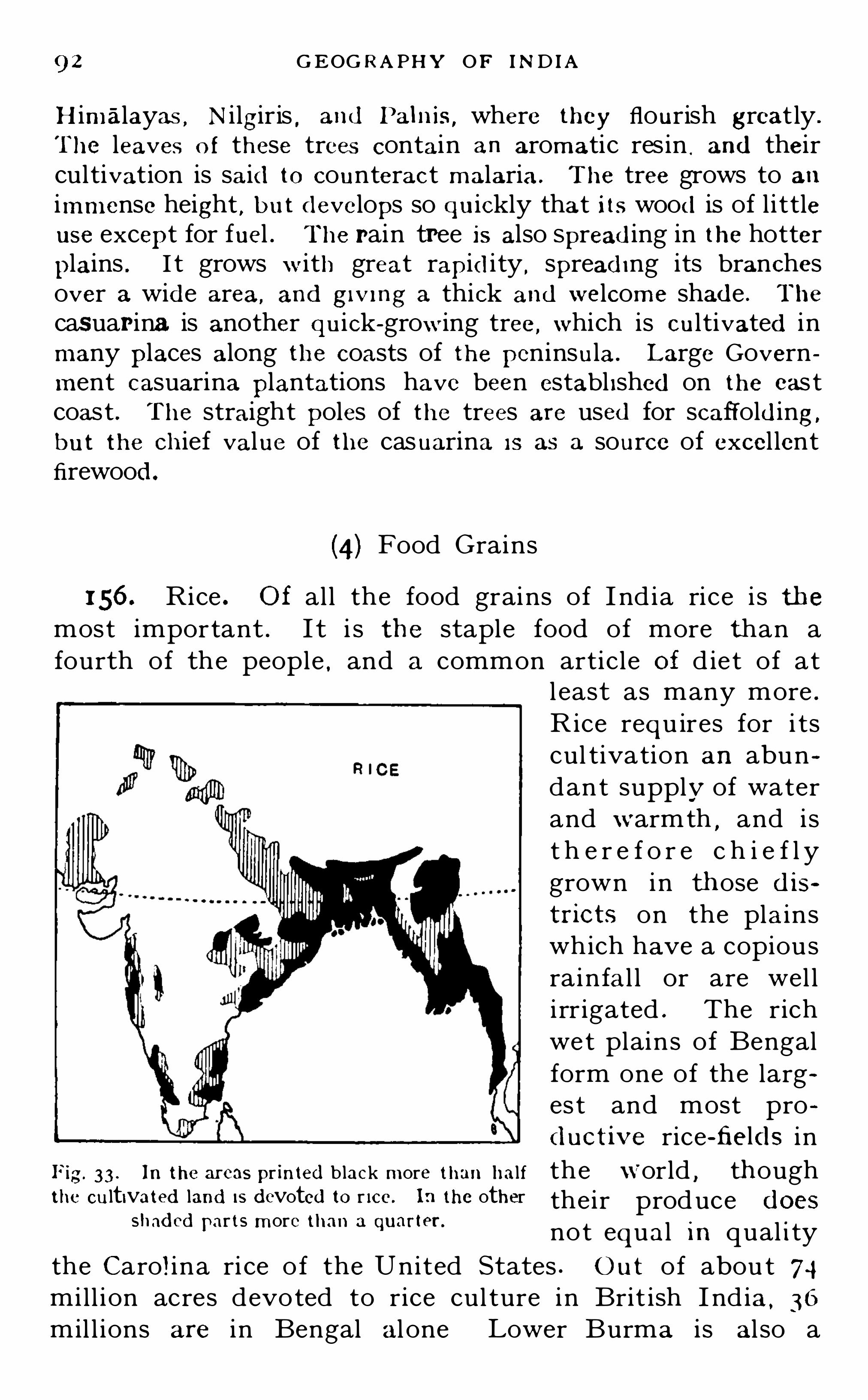
92 G EOG R A PHY OF IND IA
Himalayas , Nilgiris , and Palnis,where they flourish greatly .
The leaves o f these trees contain an aromatic res in , and theircultivation is said to counteract malaria. The tree grows to animmense height , b u t develops so qu ickly that its wood is of l i ttleuse except for fuel . The pain tree is also Spread ing in the hotter
plains . I t grows with great rapid ity , spread ing its branchesover a wide area, and givmg a thick and welcome shade . The
casuar ina is another qu ick-growing tree,which is cultivated in
many places along the coasts of the peninsula. Large Government casuarina plantations have been establ ished on the eas tcoast . The straight poles of the trees are used for scaffold ing,
b u t the chief value of the casuarina IS as a source of excel lentfirewood .
(4) Food Grains
156. Rice . O f al l the food grains of I nd ia rice i s themost important . I t i s the staple food of more than afourth of the people . and a common article of d iet of at
l east as many more .
Rice requ ires for i tscul tivation an abundant supply of waterand warmth
,and is
t h e r e f o r e c h i e f l ygrown in those d istricts on the plainswhich have a copiousrainfal l or are wel li rr igated . The richwet plains of Bengalform one of the larges t and most prod uctive rice-fields in
Fig. 33 . In the areas pr inted b lack more than hal f the world , thoughthe cultivated land [5 devoted to r ice. In the other their produce ( 1065
shaded ar ts more than a uarter.P q not equal in qual ity
the Carol ina ri ce o f the United States . O ut of abou t 74mill ion acres devoted to rice cul ture in Brit ish I nd ia, 36
mil l ions are in Bengal al one Lower Burma i s al so a

FOOD GR A IN S 93
great rice-producing province,but i ts total output i s less
than one- fourth that of Bengal . I n both these provincesrice is the mai n food of the peopl e
,bu t while the vast
population of Bengal consumes almost the whol e of therice grown in the province
,three-fifths of the crop of
Lower'
Burma is avai lab l e for export . Rice is also extensively grown in the deltas of the peninsular rivers , andwherever the conditions of the country are favourable .
1 57. Wheat i s cul tivated largely in North and CentralInd ia , and i s a cereal of increasing importance , both as astaple food of the people and as an article of export . I trequi res for its cul tivation much l ess waterthan rice . Wh en youngit can stand keen frosts
,
but after the ear i sformed it needs a dryair and bright sunshineto bring it to perfection . The plains ofNorthern and CentralI ndia
,especi al ly to
wards the west,are
thus wel l adapted forits growth . I nd ianwheat i s hard and ofexcel lent qual ity,
and F ig. 34 . The b lack areas are the centres o fi s growing in favour wheat cu ltivation. I t is less abundantly grown
i n Europe . I ts cupin the districts shaded with lines , and stil l less
in those shaded With dots.tivation is
,therefore ,
spreading,and its export rapidly increasing.
In the year 1 907 the extent of land devoted to wheatculture in British India was 25 mill ion acres , against 735mill ion acres devoted to rice . The total rice crop wasabou t 2 1 mill ion tons , and the wheat cr0p exceeded 8
mil l ion tons .
158 . Mi l lets . The chief mil lets grown in Ind ia arecholum (or j owar) , cumbu (or bajm l and ragi. They

94 G EOG R A PHY OF IND I A
requi re much less water than rice and take the place ofthat grai n i n mos t of the d rier provinces of Ind ia . In
al l bu t the great rice -producing d istricts of the peninsulamillets form the stapl e food of the poorer people
,rice
being a luxury of the wealthy . I n Bombay,Si nd
,and
Berar more than hal f of the total area devoted to food grainsi s given up to mil lets
,and more than one - th ird in Madras
and in at l east hal f the Distric ts of the Punj ab , Agra ,and
Upper Burma . Taking Briti sh I ndia alone the millets arenot so importan t a food crop as rice
,bu t i f the Native
States be added,the maj ority of which are less abundantly
watered than the Bri ti sh Provinces , they are moreimportan t
,and form the staff of l i fe to a larger numb er
of people .
159. Pulses . Various pu lses,the chie f of which are
gram and dal. are widely grown i n the United Provi ncesand the Punj ab
,and less extensively in other provinces .
They are valuabl e as foods,being more nu tri tious than
either rice or mill ets,because of the larger proporti on of
nitrogenou s matter they contain . They are eaten i n combination with less nu tri tious grains almost al l over I nd ia .
1 60. Barley is grown in the United Provinces , and to al ess extent i n the Punj ab and Bengal . I t i s less nu tri tiousthan the mil l e ts
,but i s cheaper
,and i s , therefore , largely
used by the poorer c lasses . Barley i s al so ex tensivelyu sed for brewi ng .
1 61 . Maize,or Indian corn
,i s also cul tivated in these
provinces , and to a l ess exten t i n many other parts ofI nd ia . I t i s nowhere
,however
,a cr0p of firs t importance .
(5) Other Vegetable Products
1 62 . Palms . Various spec ies of Palms are commonthroughout the plains of India
,and on the hil l s ides
,
though being an essenti al ly tropical order they do notflouri sh at any great height . By far the most usefu l ofthese is the cocoanut. I t loves a wel l-watered , sandy so il ,and flourishes all round the coasts of the peninsula
,and

96 G EOG R A PHY O F IND IA
and the brin j al . or egg plant . But a tropical country ,
especial ly where the rain fal l i s precari ous and confined toparticu lar seasons
,i s no t well adapted to the cul tivation
of succulen t fru i ts or vegetables . The temperate regionsare richer both in the vari ety and qual ity of these products .
1 64. Oil Seeds . Abou t 1 4 mill i on acres i n Bri ti sh Ind iaare devoted to the cul tivation of various seeds which arevaluabl e chiefly for the oil which they contain . Thel argest areas of cultivat ion are i n Bengal
,the Cen tral
Provinces , Bombay , and Madras . The greater part of thecrop is annual ly exported ,
the sh ipmen ts i n 1 904-
5 repre
senting a value of nearly 1 0 mil l ions sterl i ng . Lin seed i sthe most important of these seeds , and accounts for nearlyhal f the ir total value . L inseed oil i s a drying oil , and i su sed for mixing paints . Rapeseed yields rape , or col za oil ,which i s used for l amps and for lubricating . Sesamum
( ti l or j in j i l i) seed yield s an oi l much used in Ind ia forbathing purposes . Cotton seed , mustard seed , and groundnuts yield oil s which are u sed in the manufacture of soaps .The las t two are al so used in the manufacture of sweetmeats
,chiefly in France . There i s a considerable export
of ground nuts from Pondicherry to French ports for thispurpose . Castor seed yields an oi l valuable as a medic ine .
The dry residue of these seeds , after the oil has beenexpressed
,forms o il cake
,a useful food for cat tl e . L i nseed
cake,rape cake
,and cotton cake are especial ly valuable .
1 65. Sugar. The sugar cane i s l argely grown i n theUnited Provinces . Bengal , the Punj ab , and the NorthWestern Frontier Province
,and to a less exten t in other
parts of I ndia . I n the whole of British Ind ia , nearly2 % mil l ion acres are devoted to i ts cul tivation . I t needsabundant water
,and is therefore grown on irr igated land .
The total crop in an ordinary year yield s abouttons of sugar
,or abou t four-fifths of the enti re amount
consumed in the country .
1 66. Tea is the fermented and dried leaves of a shrubnative to the forests of Assam . The product ion of tea inInd ia has increased enormously of recent y ears . I tscu l tivation on any large scale is
,i ndeed , ent i re ly a develop

TEA,ETC. 97
ment of the last hal f-century . I n 1 830 the Governmentestabl i shed a smal l plantation of the China shrub on theslopes of the Garhwal Himalayas
,and China tea i s sti l l
grown there , chiefly for export by land to Tibet and CentralAsia . About the samet ime the shrub wasdiscovered in the forestsof Assam . During thenextquarter of.a centuryexperimental cul tivation
,gradually increas
i ng in extent,was
carried on in manyplaces , but i t was notunti l abou t forty yearsago that the I ndian Teaindustry real ly began ;
and i n Ceylon i t wasten years l ater . I n1 865 only 2 per cent .
of the tea used in G reatBri tain camefrom lndia,
F ig. 35. Showing the d istricts where tea,
and none from Ceylon ; coffee, sugar and tobacco are grown. The
darker shad ing shows more extensive cultiin 1907 I nd ia supplied vation.
54 per cent ,and Cey
lon 36 per cent . I n the last twenty years the outpu tof Indian tea has i ncreased threefold . The area devotedto tea in Bri tish India i s over hal f a mill ion acres
,more than
nine-tenths of which are in Bengal and Assam . The restis on the hil l s of the Punj ab and the United Provi nces
,and
the N ilgiris and Palnis i n Madras . There are also abou tacres of tea i n the State of Travancore . The value
of the tea annually exported is from five to six mil l ions
sterl ing .
1 67. Coffee i s the dried berry of a shrub said to havebeen introduced into Indi a from Arabia , where i t growsin great perfecti on . For some years coffee culture hasbeen decl in ing in I ndia . Bad seasons and the ravages ofinsects have done much to d iscourage planters
,and the
H

98 G EOG R APHY or mom
decl ine in prices has mad e the cul tivation unremunerative .
I nd ian coffee at the best can hard ly compete wi th Braz ili an .
The area devoted to co ffee at p resen t i s u nderacres
,of which more than three -quarters are i nMysore and
Coorg,and the res t on the N i lgiri H ills and the Western
Ghats . Comparatively l i t tle coffee is used in India , and thebulk of that grown i s exported to Great Britain . Thetotal export for 1907 was abou t lbs .
,and its
value
1 68 . Spices and Condiments . O f these I nd ia has no
great variety. Chi ll ies and turmeric are grown i n most
parts and are universal ly used . Coriander , an i seed , ginger ,and cum in are also cu lt ivated .
S everal species of pepperare grown along the Malabar coast strip ,
and i n Travancorecardamoms are a valuab l e Government monopoly .
1 69. Opium is a powerful narcotic drug obtained froma species of poppy . Shor tly after the plant has floweredincisions are made i n the green capsule . The j uice whi chexudes sol id ifies on the outside of the capsule , from whichi t is daily collected . Cl eaned and further dried thisexudation consti tu tes the crude opium of commerce .
O pium is an exceedingly valuabl e med icine . I t i s al sowidely used as an article of vicious i ndu lgence . For th ispurpose i t i s commonly smoked
,or smal l quanti ties of i t
are swallowed,or an in fusion i s made and drunk . I n what
ever form i t i s used i t acts firs t as a st imul ant and then as apowerful narcotic and soporific . I t has long been widelyused as a luxury by many classes i n India, notably theSikhs and Raj pu ts ; and ,
i n parts of Bengal,Assam , and
Burma, it i s rel ied on as an antidote to malaria .
170. Following the examp le of the Mughal Emperors theBritish R u lers o f Ind ia early made op ium a Government mono
poly . In British Ind ia i t is produced ch iefly in Bihar and theUn ited Provinces
,where the cultivators grow
‘
it under oflicnal
l II SpCCI lO l] , the Government making ad vances on t he crop , the
whole produce of which 13 handed over to their agents . The
central Government Opium DepOts are at Patna and Ghazipur .
There the Opium is packed in chests and for warded to Calcutta,
where it is so ld by auction for export . Opium is al so grown in

I O O GEOG R A PH Y OF IND IA
of that amount . Ind igo is ch iefly grown in Bengal,Madras
,
the Uni ted Provinces and the Punj ab,fou r-nin ths of the
entire amoun t produced being grown in Bengal, and hal f
the remainder in Madras .
1 74. Cotton is the soft fibre which enfolds the seed so f a small annual plan t which has been cul tivated inI nd ia for many centuries . I t grows wi th great luxuri anceon the rich b lack soi l o f the Deccan Trap , which has thus
earned the name of cotton soi l . Cotton is one of the mostimportant agricul tu ralproducts of I nd ia
,for
i t i s not only one of themain articl es o f export
,
but , what i s o f st i l lgreater moment
,i s the
raw material o f a considerab le and growingl o c a l m a n u f a c t u r e .
Great efforts have been,
and are sti l l being mad eto improve the qual ityof I nd ian cotton . Atpresent i t i s not equal tothe American variety
,
which has a longer fibre
F ig. 36. In the d istr icts marked b lack cotton and i s there fore more18 most extensively grown ; next the d istr icts easily worked , and o fshaded with l ines
,and then those shaded with greater strength . Cared
ful cul t ivat ion , and the
introduction of the American species,wi l l probably over
come this d ifficu l ty and make Ind ian cotton equal to any inthe world . Cotton cul tivat ion i s steadily increasing i n I nd ia .
At present,abou t 1 9 mill ion acres are d evoted to i t , 1 4
mill ions of which are i n Brit ish I ndia and s mill ions i nthe Native States . The val ue of raw cotton exported in
1 907 was over The greatest cotton -growingProvinces are Bombay ( i ncl ud ing the Native S tates) , Berar ,and the N i zam ’s Domin ions
,bu t i t i s extensively grown
al so i n Madras,t he Un ited Provinces , the Punj ab , and the
Cen tral Provinces .

M INER AL PR ODU CTS 1 0 1
1 75. Jute is the fibre of a quick-growing herbaceousmal low
,which usually attains a height of eight to ten feet
within four months of sowing,and often reaches twelve
feet . I t i s then cut and the stalks are left for some weeksto soak i n water when the fibre i s easily extracted andcleaned . Ju te i s grown almost exclusively in the Gangeticdelta , where over 3 mill ion acres are devoted to it . Althoughi t exhausts th e soil upon which i t grows to such an extentthat it i s u su al ly al lowed to lie fal low one year in four , iti s nevertheless a most valuable crop . Not only does thefibre real ise r emunerative prices
,bu t the plant can be
grown on land exposed to such severe floods that any otherform of cultivation would be extremely precarious . Thevalue of the export of raw and manufactured j ute in 1 907
was over
(6) Mineral Produce and Resources
1 76. Coal. There are several valuable coal fields inI ndia , some of which are being successful ly worked . Themost important of these is in Bengal
,sou th of the Rajmahal
Hil l s , from wh ich point it extends westwards to the vall eyof the S én
,and from thence south -eastwards through
Chota Nagpur to O ri ssa . Another large field is in theval ley of the Godavari s tretching north -west from theGhats to beyond Warora
,and extending westwards into
the Ni zam’s Domin ions . A smaller field is i n the basinof the Narbada
,sou th of J ubbulpore . I n Assam there are
several coal fields in the val ley of the Brahmapu tra , wherecoal of a better qual ity is found . In the Native State ofRewah is another field whi ch is being successful ly worked .
I n Burma there are some promising fields,bu t l ittl e
mining has as yet been attempted .
177. At present by far the largest output of coal 18 from the
Bengal m ines . The chief col lieries are near R anigan j , and
at J hePPia and Giridhi. In the Central Provinces thereare mines at Warora (worked by Government) in theGodavari coal field
,and at Mohpani in the Narbada field . In
Hyderabad the S ingareni mines are very successful - and pro

1 02 GEOG R A PHY OF IND IA
d uctive. So,al so
,though on a smaller scale
,are the Umar'ia
m ine in R ewah (which ,like the \Varora mine is worked by
Government) and the Makum mine in Assam .
178 . The total outpu t of coal from Ind ian m ines in 1 907
was over 1 1 m i l lion tons,of which nearly 1 0 mi l lion tons came
from Bengal alone. This was su fficient to supply the chiefneeds of the country , and to leave a mi ll ion tons for export toCeylon and the Straits Settlements . The import of coal fromEngland has fal len d uring the last twelve years from three
quarters o f a mil lion to a quarter of ami l lion tons .
1 79. Iron . There is an abundance of i ron ore i n Ind ia,
and much of it i s of excel lent qual i ty . Espec ial ly richores are found round Salem in the Madras Presidency
,i n
the Raipur District of the Central Provinces , and in O ri ssa.
At one time large quant ities of iron were produced in I nd ia .
But the nat ive sy stem of smel ting needed an abundan tsupply of charcoal
,and the decay of the industry was due
i n part to the decline i n the fuel supply,owing to the whole
sale destruct ion of forests . Native smel ting is sti l l carri edon b y i sol ated groups of metal workers
,bu t the quantity of
iron produced i s very small , and there i s now no possibil i tyof a revival of the industry
,as impor ted iron i s much
cheaper .1 80. Iron can only be profitably worked in I nd ia
where,along with the ore
,coal and some form of l ime
stone are found,the latter being needed as a flux . I f
either of these has to be brough t from a distance the costof carr iage makes the work unremunerative . At Raniganji n Bengal
,these cond itions exi st
,and i ron -works have been
establ ished there which smel t abou t tons of orea year . But the great bulk of the i ron u sed i n I ndia i s
imported from Great Britain and Belgium .
1 8 1 . Gold . This precious metal has for ages beenfound in I nd ia . Gold commonly occurs embedded i n
quartz , a hard crystal l ine rock of the most ancien t geologicalformation . Rivers which cut the ir way through suchrock almost always bring down more or less gold , which isdeposi ted along wi th the other detritus which forms theirall uvium . O ften ,
through the greater weight of the

[ 0 1 G EOG R A PH Y OF IND IA
Central Provnices. The coast factories of Bombay supply thechief need s o f Bombay and Sind ,
and a part o f the Deccan . O n
the Rann o f Cutch the Government own the Pritchard BrineWorks wh ich y ield a large quantity o f excellent salt
,most of
which goes to the United Prov inces, Central Ind ia,
and theCentral Provmces.
185. The Sambhar Lake— a lake about 20 miles long ,lying
a little to the north-east of Ajmere— has water so salt that indry seasons the crystals gather on the surface to a thicknessof S ix or eight inches . Vast quantities (about one-seventh ofthewhole produce of Ind ia) are taken from it without appreciablyd im inishing the sal inity of its water . What the source of itssal t may b e is a matter o f conj ecture. The Sambhar Lake,together with br ine Springs at Pachbhadra in the J odhpur State,1 80 miles to the south-west , supply R ajputana,
and a great
part of the United Prov inces,Central Ind ia
,and the Central
Provmces.
186. In the north-west corner of Ind ia ranges of hills con
tain ing vast quant ities of rock sal t stretch east and west onboth S ides of the Indus . The name Sal t R ange is
,however
,
con fined to those on the east side of the river . There are numerousm ines both in the Salt Range proper and in the hills of Kohatwest of the river
,and in the latter d istrict
,where the salt crops
out. it i s quarr ied l ike stone . From these mines and quarries acheap and plentiful supp ly is obtained for the Punjab ,
theNorthVVestern Front ier Provmce and Kashmir .
1 87. Petroleum . There are three valuable petroleumfields i n Burma
,the produce of which i s rapidly increasing .
These are,in the order o f their y ield ,
the Yenangyaung ,the
Singu , and the Yenangyat field s . The crude oil i s obtainedi n well s and has then to be purified . The yield o f petroleumin 1 907 was over 1 50 mill ion gal lons , which is more thanthree-fifths of the enti re quanti ty consumed i n I nd ia . Theimports of petroleum in the same year fel l to 60 mill iongal lons . Not many years ago three -quarters o f the petroleum used i n I nd ia was imported . now l ittle more than aquarter . The Burma fields thus promise at no verydistant date to supply the entire needs o f I nd ia. A considerab le quantity of pe troleum is al so obtai ned at Makh in ,
i n Assam.

W ILD AN IM ALS 1 05
188. Manganese ore 18 found in Madras,near V izagapatam ,
and,in unusual richness and purity, in the Central Provinces
and Central Ind ia. The amount raised has increased twelve-foldduring the last eight years, and in 1 906 nearly half ami ll ion tonswere exported . Manganese is used chiefly in the manufactureof steel .
189. Mica of excellent qual ity is found in Bengal , and insmal ler quantity in Madras . About tons are Shipped toEurope yearly . S altpetre is found in Bengal, as well as in some
of the other northern Provinces,and about worth is
exported yearly . Copper also ex ists in Bengal , b ut is not as yetworked . Plumbago is found in Travancore. Tin ex ists abundautly in the southern parts o f Tenasserim ,
b ut is not worked toany large degree.
190. Precious S tones. Burma has valuable ruby m ines .Indeed
,of the best stones i t has a monopoly, and supp lies the
world . Along with the rubies a few sapphires are also found .
The Mines are worked by a Company who hold them on leasefrom the Government . The Company also grants m iningl icenses to private ind iv iduals who make no return of theirfinds . The total output is, therefore, d ifficult to d iscover . J ade,a green stone great ly valued by the Chinese , is also found inBurma. Valuable diamonds have been found in the past in theGodavari basin
,and are occasional ly found now . But there is
no svstematic mining for them .
(7) Wild Animals
191 . The lion is now found only in Kathiawar, and thoughfor many years i t has been rigid ly preserved ,
it is almost extincteven there. The tiger is found in most parts of Ind ia whereverextensive forests or j ungles ex ist . Tigers abound in the Terai ,the j ungles of the Sandarb ans, and the forests of Central Ind iaand the Western Ghats . The panther , or leopard , is still morecommon . The cheetah , or hunting le0pard , is a d ifferent Spec ies ,and is native only to the Deccan . I t is trained for hunting theantelope, b ut though swift and sure in attack has no stayingpower . Wolves abound sti ll in the open country b ut shun theforests . The common b lack bear is met with in the forests ofrocky hills
,and the Tibetan sun bear is found throughout the
whole length of the Himalayas, b ut only at heights of over

1 06 GEOG R A PHY or IND I A
feet. Hywnas are numerous,b ut only where the wolf is
not . J ackals are common everywhere and are useful scavengers .The wild dog, wh ich hunts in packs , is found in the forests ofBurma and Assam .
192. The wild elephant ex ists chiefly in the forests of EasternBengal and Assam ; less commonly in those of Burma and theInd ian peninsu la. Under a spec ial Act of the Ind ian Legislaturethe elephant is strictly preserved ,
and can only b e captured b vl icense. Considerable numbers are caught and trained for theGovernment service and for sale. The elephant is not found at
all in the north-west of Ind ia,where the cl imate is too d ry and
the temperature too variable for him . Several spec ies of rhinoceros haunt the swamps of the Brahmaputra val ley, the Sandarb ans
,and Chittagong and their horns are valued by certain
classes of the natives . The wild hog is common in most Prov inces m the v icinity of cu lt ivat ion
,and hunt ing him is a danger
ous and exciting sport . The wild ass roams in herds of 20 to 50in the deserts of S ind and Cutch , and several species of wildsheep and goats have their home on the H imalayas , the mountains of the north-west
,and the S iilaiman range . The ibex, a
species of goat , is found on the mountains of the peninsula andKashmir . Antelope are fairly common in Central Ind ia and inthe coast flats of Gujarat and Orissa. Bison are met W ith in thehill j ungles of South Ind ia and Burma
,and the wild buffalo in
Burma and Assam . O f deer there are many species , the chiefbeing the sambur. Monkeys of many kind s are exceed inglynumerous almost everywhere. Rats and mice abound throughout the land
,and the bandicoot, the most gigantic member of
the tribe,is exceed ingly destructive.
193. O f reptiles , snakes and scorpions o f many kind s areeverywhere found . The largest Ind ian snake is the python ,which somet imes attains a length of 30 feet . Most of the snakesfound in Ind ia are harmless
,but there are three or four whose
bi te i s dead ly,and for whose pO ison no effect ive antidote is
known . O ne of the worst of these,and at the same time one of
the commonest,is the cobra di capello. Numerous poisonous
water snakes are. also found . The blunt-nosed crocodi le infestsswampy rivers and backwaters , and the sharp-nosed species .the ghavail, which preys only on fish
,is numerous in some of
the greater rivers, especial ly the Ganges, Brahmaputra, and
Mahanadi .

108 GEOG R A PHY or IND IA
stantly guarded against , is the white ant, or termite. The
mosquito is, perhaps , the greatest o f insect p lagues , and where
it abound s renders life almost unendurable. Fierce war is wagedagainst the mosqu ito now ,
as one species has been proved tob e the chief d istributer o f malarial p0 ison . O f useful insects thebee, the silk-worm ,
and the lac insect are cu l t ivated .
8 ) Domestic An imals
1 99. Horses and ponies are common in every Provinceof India, but i n relation to the population are most numerousin the Punjab , the Uni ted Provinces , and the CentralProvinces . I nd ian bred horses are not; however , so goodas those imported from Arabia
,Persia
,and Austral ia .
Pegu ponies have long been famous . Asses and mules aremost numerous in the Punj ab . The Ind ian Governmentbreeds mules for use in arinv transport . They are strongand hardy
, and especial ly usefu l i n h il ly d istric ts and
rough roads,being more sure -footed than the horse .
200. Cattle , i .e bull s,bullocks
,and cows , are every
where reared and greatly valued . They are almost equal lycommon i n every Provi nce
,and their number i s everywhere
found to be roughly proportionate to the p0piilation.
The Government has of late years paid great at tention tothe improvement of the breeds o f catt le , and their protection from disease
,as wel l as to the provis ion o f fodder .
Sheep and goats also are pretty general ly d istributed ,
except i n Burma,where they are rare . Sheep are most
numerous in Madras,and next i n the Punj ab . G oats are
most numerous i n the United Provi nces,next i n the
Punj ab and Madras .
201 . The elephant i s u sed for state d isplay by theNative Princes
,and for heavy transport by the Govern
ment . I n Burma elephants are trained to work i n thetimber yard s and may be seen haul ing and stacking theheavy logs . For Sagaci ty the elephant is hard ly equal ledeven by the dog . The camel
,the most useful o f al l beast s
o f burden in a hot and dry cl imate , i s commoner than t hehorse in S ind , and almost as common i n the Punjab and the

AN IMAL PR ODU CTS 1 09
North-Western Frontier Province . Camels are u sed alsoto some extent i n the United Provinces
,but in other parts
of I ndia they are hardly known . The b uffalo is commonthroughou t I nd ia , and ,
l ike the bul lock,i s used for draught
purposes both on the road and in the fields . As in everyother country , dogs of various breeds are universal . Themost notable are the mastiff of the Himal ayas
,and the
polegar hound of South India .
(9) Economic Animal Products
202. The ord inary animal products which are everywhereused as food
,and
,as such
,are common objects of local pro
duction , trade and consumption , need only b e mentioned . Sucharem ilk
,butter
,ghee
,eggs
,fish
, pou ltry, game, flesh,etc . Flesh ,
either of beasts or birds is a less common article of d iet in tropicalregions than in colder latitudes
,and in Ind ia a vegetable d iet
has the added sanction of religion . O f the natives of Ind ia fewbeyond the Muhammadans and the lowest castes of H indus arehabitual flesh eaters . Mi lk
,butter
,and ghee, and all forms of
dairy produce, are,however
,universal ly used . So also are
eggs . Fish,wherever it can b e had ,
is a welcome food to fu l lytwo-third s of the peop le, and in the deltas of the rivers and alongthe coasts it forms a staple article of d iet .
203 . Fish curing i s being developed in Ind ia as an econom icindustry
,and it is possible that at no very d istant date sal t fi sh
may become an article of export . A lready there is a smal l
quantity exported from Sind . Fish in Ind ia is commonly eatenfresh
,and until very recently the process of fish curing was
hard ly known,or was rendered imposmb le by the prohibitive
price of salt . For some years now the curing industry has beenfostered by Government on the coasts of Madras and Bombay .
Fish curing yards have been opened ,and sal t for the purpose
has been supplied at a nominal figure.
204. There is a considerable production of wool inI ndia
,though of an inferior qual ity . Much of i t i s used
locally in the manufacture of carpe ts,etc .
,and almost all
the rest i s exported to Great Britain . The value of the rawwool exported in 1907 was For the best classof woollen manufacture in India raw wool is imported .

I I O GEOGR A PHY OF IND I A
205. Hides of various kind s are a valuable art icle ofcommerce . They are coll ected i n every Province both for
the local leather industry and for shipment to Germany ,
I taly,and Austria . The value of the hides exported i n
1907 was over There are al so small exports
of horn , bone manure . and bristles .
206. Si lk i s the produce of the si lk -worm,wh ich is
cul tivated largely in Bengal and Assam,and to a less exten t
in several other provinces . I t l ives only on the leaves o fthe mulberry tree . O f l ate years great attenti on has beengiven to the cul ture both of the silk-worm and of themulberry , and the silk industry i s increas ing . A wild sil kis obtained i n large quantit ies i n Assam
,which is known
as tusser si lk . I t is local ly manufactured ,and silk fabrics
are much used b y the Assamese . A good deal of thecultivated S i lk is also manufactured local ly . The val ueof s ilk exports in 1 907 was over
207. Lac i s deposi ted by the lac insect,and is collected
by the hil l tribes in the Central Provinces and Cho taNagpur . I t is the source of shellac
,a material u sed in the
manu facture of varnishes and seal ing-wax,and of lac-dye .
The lac insect l ives on many kinds of forest trees , and itsartificial culture has been attempted by the Forest O fficersi n the Central Provinces . The lac industry is a remunerative and a growing one
,and the exports of lac and l ac-dye
in 1 907 were over in value .

I I Z GEOG R A PHY OF IND IA
But when,less than a couple of centu ries ago ,
G reat Bri tainbegan to manu fac tu re cottons for hersel f
,the Engl ish
market for the Ind ian article was closed,since in order to
protec t the growing home ind ustry the importation offoreign—made fabrics was proh ibited . This greatly reducedthe production of the best cottons in I nd ia
,and especially
of the del icate musl ins . I n 1 8 1 3 the trad ing monopoly ofthe East I nd ia Company was aboli shed
,and the I nd ian
trade thrown open to private enterprise . O ne of theresul ts of this change was that Engl i sh -made cottons beganto compete in I ndia wi th the local manu facture . By thattime power- looms had taken the place of hand - l ooms inEngland
,but were completely unknown in I nd ia . New
hand -woven good s,though usual ly better in qual ity ,
cannotcompete in price wi th the fabrics so swi ftly produced bypower- l ooms
,and accord ingly Indian -made goods gradual ly
gave way before the piece goods of Manchester , i n whicha vast I ndian trade grew up . The quanti ty of Engl i shmade cottons sold in I nd ia to-day is more than twentv
times as great as the enti re produce of the Engl i sh mill s100 years ago . L i ttl e wonder tha t the Manchester manufacturers fough t hard ,
and sti ll figh t,for so important a
market .2 1 0. But though greatly reduced
,the I nd ian hand -loom
industry has by no means been destroyed . I t st il l givesemployment to over 25 mill ions of weavers , and supportsa total populat ion of over 51, mill ions . The fabrics prod uced are chiefly of the commoner and cheaper order , orof kinds especial ly adapted to I nd ian tastes , and which
Manchester does not copy ,or cannot equal . Such are t he
beau ti fu l saris and tu rban s of Guj arat , which are sometimes mixed wi th S i lk
,or bordered wi th si lk and gold
,and
the exquisite musl ins of Dacca,Murshidabad and Arn i .
Dacca musl in was once famed throughou t the world , bu tnow its manu facture is on a very l imited scale . Vizagapa
tam,Nel lore
,Surat
,Ahmadabad
,Poona , Dharwar , and
many other places are considerable centres of hand - l oomweaving stil l , and to some degree the manu facture is foundin every town and almost i n every vil lage .

MANUFA CTUR ES 1 1 3
2 1 1 . Cotton Mi l ls . During the last hal f-century Ind iahas been regaining a part of her lost cotton manufacture bythe adoption of Western machinery and the use of steampower . The first steam cotton mill was opened in Bombayin 1 854. Thirty years later there were 74 such mill s atwork in I ndia
,and twenty years later stil l
,i n 1 904 ,
their number had i ncreased to 206 . These mil l s representa total capital of abou t g1 2 , and give employmentto over people . I n the l ast ten years thei rout-turn has ri sen from lbs . of yarns and wovengoods to Bombay is the great centre ofthe steam cotton industry in I ndia j ust as Manchester is i nEngland
,but there are mills in many other parts of the
country . The importation of Manchester piece-goods hasnot been greatly affected by the establ ishment of mill s inI ndia
,for the Engl i sh fabrics are cheap and good
,and meet
the needs of the poorer cl asses . But the growth of thesteam industry has given India a val uable export trade incotton yarns and piece goods , most of the former going toChina and the l atter to Ceylon and the Straits Settlements .
2 1 2 . Jute Manufactures . The valuable j ute i ndustry ofBengal is qu ite a recent growth . The plant was hardlyknown in I nd ia fi fty years ago . There are now 44 j utemil l s
,almost al l i n Bengal
,which give employment to over
people . The chief manufactures are gunny b agsand gunny cloth . Gunny bags are used in commerce forthe transport of grain and other articl es . In 1907 over 250mill ion bags _
were shipp ed from Calcu tta to various partsof the world
,the largest customers being Austral ia , Great
Britain,Chi le , the Straits Settl ements , and Egypt . Gunny
cloth is a strong and coarse material , also used chiefly forpacking . The manufacture of gunny cloth has i ncreasedgreatly of late years . I n 1 897 the export was 1 69 mill ionyards
,i n 1 907 i t was 696 mill ion yards . The total val ue
of manufactured j u te articles exported in the latter yearwas nearly 1 3 mill ions sterl ing .
2 1 3 . Wool len Manufactures . There are six wool lenmil ls at work in North Ind ia which give employment toabout people . They make serge and b lankets,

1 1 4 GEOG R A PH Y OF IND IA
chiefly for the Army and Pol ice services . For this purposethey employ a mixture of Austral ian and I nd ian wool
,
the latter al one not being of sufficiently good qual i ty . Farmore importan t are the hand woollen manu factures i nwhich about peopl e are engaged . L ike al l handmanu factures wool weaving is found in almost everydistric t , being represented sometimes by Single famil ies ofweavers , sometimes by small communities . Carpets , rugsand rough blankets are the principal art icl es made . Thebest carpets are produced in Kashmir and Sind
,and at
Mirzapur and Agra , and cheaper kinds at Masulipatam andBangalore . Blankets are made in every Province , andrugs have become a very common j ai l manu facture . TheKashmir shawl , which used to be so famous , i s woven ofthe soft wool of a Himalayan goat , but its product ion hasgreatly decl ined .
2 1 4. Si lk Manufactures . The indigenous silk i ndustryof I nd ia provides employment for over people .
Si lk fabrics are woven chiefly in Bengal and Assam ,where
the silk-worm is extensively reared . I t i s also found wildin the forests of Assam , where the cocoons are coll ected ,
and the raw si lk woven into the material known as tussersi lk . Si lk mill s have been establ i shed in Bombay whichemploy nearly people . They produce excell en tfabrics
,chiefly for the Burma market S ilk being a favouri te
articl e of costume among the Burmese . Abou tworth of manu factured si lk i s exported annual ly . Si lkcarpets are made at Tanj ore and Salem .
2 15. Metal-work . Gold , Silver , Brass , Copper and I ronworkers are found everywhere . The gold and si lver-smi th sof I ndia number over hal f a mill ion . These metals areemployed mainly for ornament , and special types of manufacture prevai l at different centre
’
s . Trichinopoly i s famousfor what i s known as swami j ewel l ery ; Cu ttack forsi lver fi l igree work Kashmir for carving on gilded silver
Cutch ,Lucknow , and Dacca for hammered S i lver . Brass
and copper workers number over and chieflymanu facture cul inary and other household utensi l s . O rnamental carved brass work i s produced at many places
,

1 1 6 G EOG R APHY or IND IA
do not employ qu ite people . O ther industri es ,which are sometimes classed as manu factures
,are merely
the preparation of raw products for export . Such arecotton cleaning , gi nning , and pressing , j u te pressi ng ,
andrice cl eaning , which together find employment for over
workers i n about mill s .
2 1 9. Taken as a whol e the manufactures of I nd ia areexceedingly few and smal l compared wi th the size andpopulation of the country . The use of modern mach ineryand steam power i s very restricted , and i s not l ikely toextend with any great rapid ity. Two things are againsti t : ( I ) the cheapness of l abour , and (2 ) the great cost ofsetting up steam mill s . I t i s said to cost three times asmuch to set up a cotton mill i n I nd ia as in England
,owing
to the fact that al l the machinery has to be imported .
O ther mill s are almost equally costly . So long as this i sthe case , and hand labour continues to be available andcheap
,everything that can be done by hand wil l con ti nue
to be so done . The course of i ndustrial development wi l ldoubtless change these cond i tions i n India as elsewhere .
But the process wil l be comparatively sl ow .
(2 ) Roads
220. Ti l l within the last 75 years there were few goodroads in I ndia except i n the immediate vicin ity of thel arger stations . Away from these the only semblance ofroads were broad tracks, marked sometimes by avenues oftrees which the piety of native rulers had planted . Suchtracks were seldom even level led , and , though they servedfor palanqu in bearers or pack animals
,they were practical ly
useless for wheeled traffic . The Eas t I nd ia Company d idnot real i se the importance
,ei ther for mil i tary or commercial
purposes,of easy means of communicat ion , and were un
wil l ing to face the heavy outlay that the construc tion ofroads mus t en tail . Even so late as 1 830 S ir CharlesMetcal f declared that Ind ia did not wan! roads. But wisercounsel s were already prevail ing . The grand trunk road

R OAD S 1 1 7
from Calcutta to Delh i,which had for some time been
under construct ion , was completed in 1 835,and was
carried beyond Delhi to the North-West Frontier atPeshawar . O ther trunk roads soon followed . Bombaywas connected with Agra on the one hand ,
and Madras onthe other
,by roads which crossed the Western Ghats at
the Thal and Bor passes respect ively . A few years laterCalcutta and Bombay were united by a road crossing thepeninsula by way of Nagpur
,and j oining the Bombay
Madras road at Poona . Calcutta was also connected wi thMadras by a road that skirted the east coast and wascontinued southwards into Tinnevelly . All these roadswere metal led and bridged throughou t
,and the way in
which they were carried over mountain barriers was oftenj ustly regarded as a triumph of engineering skil l .22 1 . Road-making in I ndia received a great impetus
during the Governor-Generalsh ip of Lord Dalhousie , whodid more than any other ru ler before or since to improveInd ian internal communications of every kind . I t wasduring his rule that the Pub l ic Work s Department wasorgan ized ,
and was made responsible for the constructionand maintenance of roads su i ted to heavy—wheeled traffic .From that t ime the improvement of road communicat ionshas been steady and unceasing . Trunk roads have beenmultipl ied
,from which branch roads
,often of a l ighter and
less costly make,l ead to every considerable town . The
principal ob j ect kept i n view in planning some of thegreater roads was undoubtedly the mil i tary needs of theGovernment
,provision being thus made for the easy trans
port oi troops and heavy arti l lery . But the roads becamealso great arter ies of commerce
,and so served a far greater
and more b eneficent end . In course of t ime the extensionof railways in I nd ia robbed the roads of their mil itaryvalue
,but at the same t ime greatly increased their com
mercial importance . They have become the auxil i ariesand feeders upon which the rai lways depend . For thelast thi rty years the economic
,and not the military ,
needsof the country have determined the construction of roadsi n all save the Fronti er Provinces.

1 1 8 GEOG R APHY or IND IA
2 22 . For some t ime after the establ ishmen t of thePubl ic Works Department most o f the roads were under i tscare . The extension of local government has changed this
,
and now the Local Boards or other local au thori ties areresponsible for them
,and mee t the cost o f construc tion
and maintenance from local funds . O nly a few of themore important roads are maintained by the Provincialau thorities
,and these are s ti l l under the care of the Publ ic
Works Department.2 23 . The total l ength of roads i n Bri tish I nd ia i s now
over miles . Abou t a quarter of this length ismetal led
,composed of hard stone
,broken evenly
,and
wel l compacted . The metal l ing o f road s i n any Provincenatural ly depend s upon the ease wi th which a supply ofsu i table stone can be had . I f th is i s not available local ly
,
only the more importan t roads can be metal led,as the cost
of bringing stone from any d istance is proh ib i tive . I n thegreat plain of the north there is no supply of stone excepti n the vicinity of the hil l s
,and therefore ou t of
miles of road less than m i les are metal l ed . I n thePresidency of Madras
,on the other hand , ou t of
miles of road more than miles are metalled .
3 ) Rai lways
224. The firs t rai lway constructed in I ndia was a shortl ine from the ci ty of Bombay to Thana ,
which was openedin 1 853 . I n that year Lord Dalhousie penned a Minu te .which has become historic
,on the need of railway con
s truction throughou t the land and the duty of Governmen tt o encourage and facil i tate i t . He planned a number ofgreat trunk l ines to connec t the chie f c it ies and provi ncesof I nd ia
,and wh ich he thought migh t be constructed by
private Companies under the safeguard of a Governmen tguarantee o f five per cen t . i nterest on the capi tal expended .
As a return for this guarantee the Government would retainthe final control of the rai lways
,and so would be ab l e t o
secure th ei r adaptat ion not only to the commercial andsocial needs of the count ry ,
bu t also to possible m il i tary

1 20 GEOGR APHY OF IND IA
centres of production . This work,he held
,could best be
done by Government i tsel f . Accord ingly ,during the next
fi fteen years a large number of Indian State Railways wereconstructed the cost of which was met by the I nd ianGovernmen t from funds raised ch iefly by loans . Severalof the more advanced Native States fol lowed th is example ,and other short l ines were constructed at the cost of theNative Governments . Later a third system was adoptedi n what are now call ed Assisted Railways . These wereconstructed by private companies
,to which the Govern
ment guaranteed only a low rate o f i nterest,and as a rule
only for a short term of years,bu t helped them by making
them free grants of l and as wel l as o ther concessions .
228 . I n the arrangements original ly made wi th bothguaranteed and assisted Companies the Governmentreserved to themselves the right to take the li ne over aftera certain time and under certai n cond i t ions . I n this waymost of the early guaranteed rai lways have now becomeState l ines
,and are worked by the Companies on behalf
of the Government . At the close of 1 907 there weremiles of rai lway Open for traffic i n India . O f th is
total m il es were I nd ian State l i nes . and milesNative State l ines
,and the remai nder belonged to Guar
anteed , Assisted ,or Unassi sted Companies .
229. The growth of the rai lway system in Ind ia since1 8 7 1 has been remarkably rapid . During the three d ecadesbetween 1 8 7 1 and 1 90 1 the length of new l ines opened fortraffic was and mil es respectively . S O
steady and conti nuous an increase would be remarkab le i nany country . Equal ly noteworthy
,as showing the in
creasing u ti li ty of the railways and the growing productivepower of the country
,i s the proportionate i ncrease in the
traffic over the l ines . I f we compare the y ears 1 8 7 1 and1 907 we find that the traflic per mile of l i ne has increasedby 70 per cent . In the former of these years the numberof passengers carried for each mile of l ine Open wasand the quantity of merchandise tons while i n 1 90 7
these numbers were respec tively and 069 .

R A I LWAYS
Fig. 37. Showing the chief railways of India.
2 1

1 2 2 GEOG R APHY OF IN D IA
2 30. The extent to which railways have benefited I ndiai s beyond computation . Not only have they strengthenedenormously the admin istrat ive and mil i tary power o f theGovernment
,but
,what i s of far greater moment
,they have
developed the resources o f the country and so enriched thepeopl e . A few l ines have been constructed mainly wi th aview to mil i tary requirements . Such are those which pu tstrategic points on the North -Wes t Fron tier into d irectcommunicat ion wi th the centres of Governmen t and withthe western ports
,Karach i and Bombay . The great
maj ori ty of l ines have,however
,been designed solely for
economic ends— to unite the great centres of population ,
and to give the main areas of production easy and cheapaccess to the sea . Railways are consequently mostnumerous i n such d istric ts as the densely peop l ed andproductive vall ey o f the Ganges . But whichever of theseobj ects may have led original ly to the constru ction ofany l ine
,when once opened i t serves both ends . The
rai lways of the North-West have greatly i ncreased the
prosperity of the Frontier Provinces , and the numerou sl i nes i n the more densely -peopled Distri cts of the plainshave given the Government an administrat ive grip thatit cou ld not o therwise have secured .
23 1 . F i nancially the railway system of India has beena complete success and has j ustified Lord Dalhousie
's
sangu ine forecast . The maj ori ty of the l ines have morethan paid their way almost from the first
,and for some
years rai lways have not only been no cost whatever to theState
,bu t have made a considerable and growing contrib u
tion to the revenue . The total capital expend iture onInd ian Rai lways up to the end of 1 907 amounted to
and after interes t on this vast sum had beenpaid the ne t profi t accru ing to the Government was over
5mil l ions sterl ing .
23 2 . Nothing is of greater importance to I nd ia than arapi d extension of i ts rai lway system . I t i s the only wayi n which some parts of the country can be e ffectuallyprotected agains t famine . A few l ines have been constructed especial ly wi th th is view . Though fam i ne may
1 2 4 GEOGR APHY OF IND IA
l arger canal s are al so navigabl e,and a few have been con
structed especially for that purpose . Such are theBal iaghata Canal from Calcu tta to the Sandarb ans,
andthe Tidal Canal from the mou th of the Hooghly to Bal asore .
B ut the traffi c that used to be carried on along some of thei rrigation canal s has now passed almost en tirely to therailways . The Agra Canal has been closed to traffic and i thas been proposed to close both the Upper and LowerGanges Canals , on both of which the traf fic has becomeunremunerative . On the Western Jumna Canal , on theother hand
,traffic is growing
,and is a source of considerab l e
revenue .
234. Peninsular India has few waterways of any greatmomen t . The rivers
,being raging torrents at one season
of the year and shallow ,sluggish streams at another , are
not wel l adapted for the devel opment o f boat traffic .
Large sums have been spent with a view to establish asteam service on the Godavari , but wi th l i t tl e resul t . Trafficin small sai l i ng boats i s
,however
,common on most of the
larger rivers . On the Sou th -West Coas t a series of Backwaters , which have been uni ted by canal s , give an almostunbroken stretch of water communication from Coch in toTrivandrum
,and form the ch ie f commercial highway of
Travancore . Along the eas t coast the Buckingham Canalgives communication between Madras and the K i stnaDel ta .
235. In Burma,in Spite of the construct ion o f rai lways
(which now run northwards from Rangoon for over 800miles) , the I rrawaddy sti l l remains the great highway ofthe coun try . Being snow- fed i t has an abundant supplyof water all through the y ear , and possesses one o f thefinest flotillas of river steamers i n the world . They plyat all seasons from Rangoon to Bhamo
,a d istance o f
Goo miles . There is al so a very large amount o f othertraffic on the river . Ne i ther the Sittang nor the Salwini s adapted for through traffic
,on account of the rocky
rapids that , here and there , bar the way bu t i n d ifierentparts of both rivers local boat traffic is common . Rafts ofteak are floated down the Salwin .

FOR E IGN COM MUN I CAT I ON S . 1 25
(5) Foreign Communications
236. With the exception of the Passes which lead acrossthe mountains to the neighbouring States of the north
,
I ndia’s foreign communications are entirely by sea. Beforethe Opening of the Suez Canal the principal commercialroute between India and Europe was round the Cape ofGood Hope . The weekly mails
,a considerable par t of the
passenger traffic , and a small quantity of the more preciousmerchandise , went by the Red Sea and the Mediterranean ,crossing Egypt by rai l . But that route was too costly forordinary trade . Since the opening of the canal the oldroute via? the Cape has been gradually superseded . Atpresent more than three- fourths of the foreign trade ofIndia , both exports and imports , passes through the canal ,or practical ly the whole of the trade with Europe andAmerica . This has led to the rapid development of the twogreat western ports of I nd ia , Bombay and Karachi . Bythe Cape route Calcutta was but l i ttle further from Europethan Bombay
,but by the Canal route Bombay has the
advantage by nearly miles , and Karachi bymiles . Almost the whole of the foreign trade of the Punj aband Sind is carried on via? Karachi ; and as Bombay hasd irect , railway communication with al l parts of India , muchof the trade that used previously to go by Calcutta orMadras now goes by Bombay . Owing to the rapid growthof foreign commerce the Bay of Bengal ports havebeen able to do more than hold their own , and Calcu ttastil l remains - the premier port of I nd ia ; but for overthirty years Bombay and Karachi have enj oyed anadvantage of position from which they have reaped arich harvest .
237. The opening of the Suez Canal has had anothereffect on the trade of Ind ia which is worthy of note . I thas caused it to be carried almost enti rely in steamships .Sai l ing ships cannot pass the Canal
,and even the Red Sea
i s not safely navigable by large vessels except under steam .
No country in the world has so large a proport ion o f itssea trade carried in steamers as I ndia . I n 1 906
—7 the ships
that entered or left Indian ports laden with cargo had a

1 26 GEOG R APHY O F IND IA
Fig. 38. Showmg the chief tins of foreign Communication.

1 28 GEOG R A PHY or mom
in land postage are exceed ingly low . Nowhere el se can aclosed l etter be sent for Id ” or a post card for id . TheValue Payable Parcel system (now extended to Ceylon ) is aconvenience provided in few European States
,and is of
great assistance i n the minor transactions of trade . Theother services rendered by the Ind ian Pos t O ffice— theremittance of money
,the conveyance of small parcel s
,the
custody at i nteres t of smal l savings,the purchase of Govern
ment securi ties for deposi tors , and the provision of a cheapand simple system of l i fe insurance and annuities— aresuch as are now general ly provided by European postoffi ces . I n the firs t of these services , however , the IndianPost O ffice gives greater fac il it ies to both sender andreceiver than are given in any other country .
241 . The following figures show the rapid increaseduring the las t 1 0 years in the various branches of theI nd ian Postal Service .
1 907 .
Post O ffices and Letter BoxesTotal Staff of the DepartmentLetters
,Post Cards
,Newspapers
and Parcels del iveredMoney O rders issuedDepositors in P0 . Sav ings BankBalance ofDepositsat closeofyear Rs . R s.
242 . The inland telegraphic system of I nd ia i s nowfairly complete
,and is worked in connection wi th the post
offices and the rai lways . There are about TelegraphO ffices Open to the pub l ic . Almost every town of over
inhabi tan ts i s served,and the work of connect ing
up the smal ler towns is rapidly proceed ing .
243 . There are four tel egraphic rou tes to Europe , thetwo chie f being ( 1 ) a private company
's l ine in}? Suez , and
( 2 ) the I ndo-European hne vii? Teheran . The lat ter isunder the control of the I nd ian Government as far asTeheran
,and proceeds by cable from Karachi to Bushi re
and thence by a land l ine nort h to Teheran , where i t j oinsthe European system . There is now also a d irec t land

INTER NA L TR AD E 1 29
connection between Quetta and Teheran by the new CentralPersian l ine constructed under an agreement between theEngl ish and Persian Governments . Three submarinecables run from Bombay to Aden
,giving direct connect ion
not only with Egypt and Europe , bu t also , by cables alongthe east coast of Africa
,with the Seychel les
,Maurit ius and
South Africa . Two cables run from Madras to Penang ,giving connection with the Straits Settl ements
,as wel l as
with Austral ia in the south and China and J apan in thenorth . There are also land routes to China vz
'
c’
z'Bhamo
,
and to Siam m’
é Moulmein . Two cables unite Ceylon toIndia , whence direct cable communication with Austral iai s under construction .
(7) Internal Trade
244. A detail ed account of the internal trade of Ind iacannot be given
,as no publ ic record of it i s
,or could be
,
kept . The foreign trade,both by land and sea
,i s
recorded at the various Custom Houses where import orexport duties are levied upon it . But there are no generalinland duties
,and therefore no complete inland returns .
At one time smal l duties were levied on certain classes ofgoods as they passed from place to place , but these havenow been abol ished . Municipal it ies occasionally levyoctroi dut ies at the boundaries of their j urisdiction , andthen there is a local record of the trade thus taxed . Thecommerce in a few other articles upon the manu facture andsale of which restr ictions are placed
,such as intoxicating
drinks,sal t and opium
,i s also known . But wi th these
except ions the internal trade of India goes on unrecorded .
245. But there can be no doubt that in both volume andvalue it far exceeds the foreign trade . The weight of thesea-borne commerce of I ndia is about I I mill ion tons a year .But the rai lways of I ndia alone transport nearly 60 mill iontons of merchandise a year . From this it i s plain that ,over and above the col lection and distribution of exportsand imports
,the exclusively internal trade carried on by
means of the railways must be at least four times thevolume of the entire sea-borne trade . Yet the railway s
K

1 30 G EOG R A PH Y o r IND IA
deal wi th only a smal l part of the internal trade,the great
bulk of which i s carried by road,canal
,or river . I t i s thus
of vast proportions,and i s of the greatest possible value
to the country . The comfort and wel fare of the peopledepend upon i t
,and the pol icy of the Governmen t has
l ong been to promote i t by every means in its power .
Owing to the increasing productiveness of the country as awhole
,and the improved means of communication , by
which parts once isolated are enabled to bring their surplusproducts to market , the internal trade of India is becominggreater year by year .
(8 ) Foreign Sea-borne Trade
246. The foreign commerce of I ndia has been stead i lygrowing for many years . Measured in rupees i t has morethan trebled in the last 30 years , having ri sen from a totalvalue of m i l l ion rupees in 1 877 to mill ions i n
1 907 . The foll owing are the ch ie f articles of export andimport . The figures after each article indicate
,i n mil l ion s
of pounds sterl ing , the value of the quanti ties imported orexported in the year 1 906
-
7
Exports . Raw Cotton , Twi s t , Yarn , and
Manu factured Cottons , Raw J ute , Manu
factured J u te , Rice , O il Seeds,
Wheat , Hides and Skins,raw and dressed
,
Opium ,Tea , Lac , Raw Wool
,
Treasure ,
Imports, Cotton Goods , Metals, and
Manufactures of Metals , ch iefly I ron and Steel ,Sugar
,S ilk Goods , Woollen Goods
,
Mineral O i l s , Various articles of food and drinkTreasure ,
247. Most of the articles of export have been noticedalready - in the chapter on Natural P roductions,
and l i t tleneed be said of them here . The exports o f cotton
,j u te
,
wheat,and tea have been steadi ly increas ing for some
years . Bu t the export of wheat varies greatly from year

1 3 2 GEOG R A PH Y OF IND IA
250. The fol lowing are the chief countries with whichthe foreign trade of I nd ia is carried on . The imports andexports are given separately
,and the various article s of
commerce are i n each case named in the order of importance . W here any article consti tu tes hal f the total (ofimports or exports , as the case may be) i t i s pri n ted inheavy type ; i f it consti tu tes l ess than a quarter i t ispri nted in ital ics . The figure s i nd icate values i n m il lionssterl ing
,and are for the year 1 906- 7.
UN ITED K INGDOM .
IMPOR TS from , Cotton manufactures , iron, steel,
machinery and cutlery, and almost every other article oftrade.
EXPOR TS to , Jute , raw and manu factured,tea
,wheat,
hides, raw wool, oil seeds, rice, raw cotton.
CH INA AND HONG KONG .
IMPOR TS from, S ilk, raw and manufactured, sugar ,
drugs, and tea.
EXPOR TS to , Cotton goods, especial ly twist and
yarn , Opium , j ute manufactures.
GER M ANY .
IMPOR TS from , Sugar,woollen goods, metals, cotton
goods, hardware.
EXPOR TS to , R aw j ute , raw cotton,rice, hides, oil
seeds.
UN ITED STATE S .
IMPOR TS from, ( I M ineral oi ls, cotton goods.
EXPOR TS to. J ute, rawand manufactur ed , hid es , lac.
FR AN CE .
IM POR TS from, Wines and spirits, gold thread , silks.
EXPOR TS to , O il seeds , raw j ute, raw cotton, wheat,
hides, and cofiee.
JAPAN .
I MPOR TS from , Silk goods , cottons, matches.
EXPOR TS to , Raw cotton, rice.
BELG IUM .
IM PO R TS from. Steel,dyes, iron, cotton goods.
EXPOR TS to , R aw cotton,O il seed s , wheat.

FR ONT IE R TR A DE 1 33
STR A ITS SETTLEMENTS.IMPOR TS from , Spices , fish, mineral oils, tin.
EXPOR TS to, Rice,Opium , j ute, cotton manufactures.
AUSTR IA-HUNGA R YIMPOR TS from
,Sugar
,metals, glass ware, cotton goods.
EXPOR TS to,
R aw cotton , fate, rice, hides.
CEYLON .
IMPOR TS from, Betelnuts, coconut oil, tea.
EXPOR TS to, R ice, cotton manufactures, coal.
ITALY .
IMPOR TS from , Cottons, silks, dyes, coral.
EXPOR TS to, R aw cotton, hides, j ute, oil seeds.
Large quantities of gunny bags and other j ute manufactures are also exported to the Sou th American Republ ics
,
especial ly Argentina and Chi le , from whence there i s nocorresponding import trade . Austral ia also takes almosta mil l ion pounds worth of j ute manufactures a year
,and
sell s to India horses,wheat
,and copper . There is a large
import of sugar from the Mauritius and Java , and rice i sexported to both these countries.
(9) Land Frontier Trade
251 . The total trade across the l and fronti ers of I nd iaamounted in 1 902 to abou t oi millions sterl ing , and by1 907 had risen to nearly 1 2 mill ions . The trade wi thNepal amounts to 33 milli ons , that with Kashmir to 2
mill ions , and with Afghanistan to I } mill ions . Across theBurmese frontier a considerabl e trade i s done with WestChina, Siam ,
and the Shan States,which amounted in 1 905
to abou t 2gmill ions . The chief art icles of import acrossthe land frontiers are rice
,ghee
,teak
,raw wool
,sil k
,and
borax ; and the exports are mainly cotton goods , salt ,
metal s,and sugar.

F ig. 39.
G EOG R A PHY OF IND IA
East Ind ia House, London,in the seventeenth century .
headquarters of the East Ind ia Company .
The first

1 36 GEOG R A PHY or iND IA
numerous fierce encounters . I n I ndia i tsel f, however,their policy was one o f peace . \Vith the single except ionof one brief period (which ,
though marked by d isaster atthe t ime
,l ed to the foundation of the present metropol i s
o f India) the Board of Directors at home seem never tohave d reamed of empire
,or of winning for themselves i n
I ndia the posi tion of an independent pol it ical power .Their officers exercised sovereign j u ri sd iction within theboundaries of their factories
,bu t the Board continually
impressed upon them the peril s that would attend anyopen display of power
,and exhorted them to remember
that they were the servants and representatives of a bodyof merchants whose sol e aim was profi table trade .
254. But during the last hal f of the eighteenth centuryan i rresi stibl e comb i nation o f circumstances completelychanged this attitude . For some time theMughal Empirehad been rapid ly breaking up . After the death of Aurangzebe in 1 707 there was no strong central power i n India ,and by the middle of the centu ry the great provincialgovernors
,though sti l l owning a nominal allegiance to
Delhi,had become practical ly independent ru l ers . The
Nawab of Bengal held h is court at Murshidabad the
Nawab-Wazi r of Oudh ruled over the terri tories nowincl uded in the United Provinces ; and the Nizam-ul
Mu lk held the heart of the Deccan and a long stretch ofthe east coast . I n the west the Maratha Confederationhad al l power in its hands and oppressed the Raj pu tpri nces . The Peshwa, the nominal head of the Con
federacy,was supreme along the coast of Bombay ; the
Raja of Nagpur had pushed h is dominion across thepeninsu la to the coasts of O rissa ; while Sindhia waspressing h is conquests i n the north and was soon to wrestfrom the A fghans the possession o f the imperial c i ty andthe person of the fal len Emperor . Such was t he cond i tionof I ndia at the middle of the eighteenth century . Amida mul ti tude of chie ftains these were themost powerful andaggressive , and as each was set on the extension of h i sdominions or the plunder of h is neighbour
,the su ffering
country was torn by incessan t war .

G R OWTH OF B R IT I SH IND IA 1 37
255. Amid such surroundings it would have beenimpossible in any case for the officers of the East IndiaCompany to have held long aloof from Indian pol itics .The Directors themselves were beginning to feel that thesecurity of their I ndian trade would soon depend upontheir abil ity to seize and wield independent pol iti calpower
,and were accord ingly busy strengthening their
armed forces . But events moved more quickly than theyforesaw . Another set of circumstances
,of western origin ,
suddenly threatened their very existence,and quickly
plunged them into the vortex of I ndian stri fe .256. L ike the other sea- faring nations of Europe the
French had endeavoured to secure for themselves a Shareof the Indian trade
,and a French East India Company,
establ ished in 1 664 ,possessed fortified settlements at
both Pondicherry and Chandernagore . Commercial ly theFrench Company had never been a success , and had beenmaintained at a heavy cost by the home Government ,bu t i n India the French were at l east the equal s of theEngl ish in military power and political influence . When ,i n 1 744,
war broke out between England and France inEurope
,it precipitated a confl ict (that in any case could
not have been long delayed ) between the two powers inI nd ia which
,with the except ion of a brief i nterval of
peace,l asted for nearly twenty years . I n the hosti l ities
that ensued most of the Nat ive Princes of South I nd iaand the Deccan were at different periods involved as theall ies first of o ne of the chief combatants and then of theother . The aim of the French commanders was nothingshort of the expulsion of the Engli sh from Ind ia . Theyhesi tated at no intrigue which might assi st them to aecom
plish their purpose,and as the same may be said with
equal truth of the Engl ish , both parties were soon plungedin the muddy and turbulent sea of I nd ian politics . Atthe beginning of the war the fortunes of the Bri tish fel lexceedingly low . Madras was taken
,and the Governor
and chief c itizens led capt ive to Pondicherry . But thegenius of Clive and S ir Eyre Coote, coupled with the decl ineof the French naval power
,turned the tide . Lal ly
,the

1 38 GEOG R A PH Y o r IND IA
French G eneral,was finally de feated at Wandiwash i n
1 760 ,and the fol lowing year Pond icherry surrendered to
the Engl ish . The town was restored by the Treaty of Pari si n 1 763 ,
but the power of the French in I ndia was u tterlyand permanently broken
,and the pol itical ascendancy of
the Briti sh establ i shed on the firmest of al l bases,mil itary
prestige .257. While the French and Engl ish were contend ing
in the Carnatic the foundations of the Briti sh Empire i nI ndia were being fi rmly laid in Bengal . The Governor ofFort Will i am
,having been ordered by the Directors to see
to hi s defences l est he shou ld be attacked by the Frenchfrom Chandernagore , proceeded to strengthen his fortifications . The Nawab of Mursh idabad commanded him todesist
,and upon h is re fusal sei zed and sacked the city
,
and the terrible tragedy of the Black Hole was enacted .
Cl ive was despatched from Madras to retri eve th is d isas ter,
and,after retaking Calcu tta , routed the Nawab at Plassey
in 1 757. From that time the rich provinces of Bengal,
Bihar , and part of Orissa were under the military controlof the Company and greatly strengthened them in theirfinal struggl e with the French , from whom they nowwrested
,wi thou t diffi cul ty , the coast Distr ic ts known as
the Northern Ci rcars , which had been ceded to the Frenchby the N i zam .
258 . Cl ive left India in 1 760,and returned to resume
the Governmen t of Bengal i n 1 765. During his absenceone Nawab had been deposed and another se t up ; thed istricts of Burdwan , Midnapore , and Chittagong had beenadded to the Company
’s terri tori es ; and the NawabWarir of O udh ,
who had attacked Bengal i n the nominali nterests of the Emperor , had been de feated at the battl eof Buxar. Cl i ve now se t h imsel f to re form and consol idatethe Company
’s rule . He received from the Emperor thed iwani , or fiscal government , of Bengal , as well as a formalgran t O f the Northern Ci rcars ; and , to the great d isappointment oi many of the Engl ish officers , restored the
Nawab-Waz i r to his throne under a treaty which madehim dependen t on Bri tish protection .

1 40 GEOG R A PH Y OF IND I A
troops that the paramount power would main tain forthei r defence . These subsid iary treaties have d one moreto g ive peace and stab i l ity to the Nat ive S tates of I nd iaand to determine the map of the country than any othercause . Speaking roughly ,
the present Feudatory States arethose that accepted Bri tish protection
,and , as a resul t ,
exist to-day,whi l e the Brit ish Provinces embrace the
terr itories of al l such as refused it,together wi th d istricts
ceded by some of the protected States i n l ieu of the subsidies they had agreed to pay .
261 . The pol icy thus init iated by Lord Wel lesley wasstead ily fol lowed by hi s successors ti l l the whole countrywas brough t under control . Every native war , everyuprising of the turbulen t nat ive soldi ery agains t theirch iefs
,every fai lure of a native prince to carry out hi s
treaty obligations or to rule h is terr i tory j ustly , and everyact of treachery or hosti l i ty again st the paramount power ,l ed inevitably and qu ickly to the assump tion of contr olby the Bri ti sh and the extension and consol idation oftheir empire . We cannot fol low the process i n minutedetail
,but the fol lowing paragraphs ind icate in bri e f
outl ine the ch ie f stages i n the bu ild ing up of the Britishdominion both before and after the time of Wel lesl ey .
262. For nearly half a century after the conquest of Bengalthe chief add itions to British territory were in the south of the
peninsu la. In 1 76 1 , the year after the French power had beenbroken at Wand iwash ,
the Nawab of the Carnaticsought Bri tish
protection . The same year Haidar Ali , a mercenary sold ier inthe service of the Mysore Raja,
expelled the H ind u dynasty ,
and seized Mysore for himself. He soon became themost aggressive and d readed ruler in South Ind ia. His forces continual lythreatened Travancore , and the Maharaja sought and obtainedBritish protection . Before the close of the century the Britishhad fought three wars wi th Haidar Ali or his son Tipi
’
i Sultan .
A t the close of the second o f these the District of Malabar onthe west coast was added to the British dominions . The thirdwar resulted in the death of Tipi
‘
i , who was slain at the siege ofSeringapatam ,
the restoration of the Hindu dynasty underBritish protection ,
the transference of the d istricts of Cuddapah.

GR OWTH OF B R IT I SH IND IA I 4 I
Bellary, and part of Kurnfil to the Nizam , and the acquisi tionof S outh Kanara and Coimbatore by the British. At the sametime the small MarathaKingdom of Tan jore was handed overto the British . The following year the N i zam entered into a
subsid iary alliance , and in l ieu of a subsidy ceded the d istrictshe had at the partition of Mysore. In 1 801 the wholeof the territories of the Nawah of the Carnatic ,
which had longbeen under British administration , were formally annexed .
These various and extensive terri tories, acquired within the
space of three years , together with the Northern Ci rcars (takenfrom the French in 1 759 ) were consol idated into the Province(or Presidency) of Madras, the boundar ies of which a hundredyears ago were very nearlv what they are to-day.
263 . The first twenty years of the nineteenth century wit~nessed the consolidation of British au thority over almost thewhole of north Ind ia south of the Sutlej and east of the Thar ,or Ind ian Desert . The Kingdom of Oudh had , as we have seen ,
been practical ly under British protection since Clive’s days .
The Nawab-Wazir was, however , threatened by the Marathasall along his frontier , his army was mutinous , and his financeswere d isorganised . He was therefore very ready to fal l in withLord Wellesley
’
s policy, with whom he entered into a subsid iaryalliance, ced ing to the British thewhole of his frontier provincesin the south and west . His kingdom was thus greatly reducedin mm , but being flanked by British prov inces on three sides itwas secured from attack and continued to exist as a ProtectedState till 1 856,
when it was forfei ted to the British throughmisgovernment.
264. Theannexation of the frontier prov inces of Oudh broughtthe British into close touch with the most turbulent of the
Maratha princes , and to Lord Wellesley the time seemed ripefor such an assertion of British supremacy as would curb theirlawlessness . The MarathaConfederacy was torn by civ il war,and the Peshwa,
its nominal head , had fled before his more
powerful chiefs. He appealed to the British for help , signed a
subsid iary treaty and was restored to his throne at Poona to b ehenceforth under British protection and control . Such a treatySindhia and the R aja of Nagpur, the most powerfu l Marathachiefs
,scornfully refused to recognise, and British forces were
sent against them . The war which ensued led to a great increaseof British power in central and northern Ind ia, aswell as to large

1 42 GEOG R A PHY or iNDI A
accessions of territory. The R ajaof Nagpur was compel led tocede the coast district of Cuttack to the Bri tish, and to restoreBerar to the Ni zam ; whi le from Sindhia Lord Wel lesley tookthe coast d istricts north of Bombay , and an extensive and ferti letract along the J umna,
most of which is now included in theProv ince of Agra. Delhi , and wi th i t the person of the MughalEmperor , thus passed into Bri tish hand s.
aimsu viovmcts PROTECTED sm rs ELLE
Fig. 40. Showing the growth of the Br itish Empire of Ind ia.
265. The British now held the whole of the east coast o f the
peninsula from Chittagong to Cape Comorin , and the greater
part of the west coast also . In the whole of south Ind ia and i nthe greater part of the Deccan their supremacy was acknowledged , and the co untry was rapid ly settling down to reap the

1 44 G EOG R A PHY O F‘
iND IA
267. Whi le,through the force of irresistible circumstances ,
British rule has thus Spread throughout Ind ia,from the southern
seas to the Himalayas , in the east i t has passed the naturalboundaries o f Ind ia proper . No barrier State protected Bengalfrom foreign attack , and the depredations of the Burmese onthe north-east frontier led to the First Burmese War in 1 8 25.
which resulted in the annexation of Assam,Arakan and Tenas
serim. The entire eastern shores of the Bav of Bengal thus came
under British control . The Second BurmeseWar in 1 852 led tothe annexation of Pegu . In 1 886 King Theb aw,
whose crueltyand misru le had long
'called for chastisement
, was deposed and
banished , and the whole of his dominions annexed . Thus wascompleted the Province of Burma, the latest , the largest , andi n some ways the most progressive, of all the Prov inces of theEmpire of Ind ia.
(2 ) Government and Admin istration
268 . As its territories increased the East I ndia Company gradual ly ceased to be a trad ing association andbecame an administrat ive and pol i t ical corporati on underthe au thority of the Briti sh Parl iament . Up to 1 773Parl iament claimed no d irec t authority over the Com
pany’
s affai rs . The Governors of Fort Wil l iam ,Fort S t .
George,and Bombay were responsible only to the Board
of Directors , and each of them was independent of theothers . But when the acqu isit ion of the great Provinceof Bengal made the Company responsible for the government of a vast population , Parl iament asserted i ts righ tof control
,and i n 1 773 the Regu lating Act was passed .
This Act gave to the Governor of Fort Will iam (who bythat time had come to be called Governor of Bengal) thetitl e of Governor-General , and empowered him to exercisea measu re of control over the other two Governors i n allmatters relating to peace or war
,or pol itical al l iances with
the Nat ive S tates . The same Act establ ished a SupremeCourt at Calcu tta . By Pitt ’s India Act i n 1 784 a Boardof Contro l was consti tu ted ,
which was made superior to
the Board of D irec tors in al l matters of I nd ian administra

ADM IN I STR AT I ON 1 45
tion . At the renewal of the Company ’s Charter i n 1 8 1 3
its trading monopoly was restricted to commerce withChina and the trade in tea
,and twenty years later it
ceased to be a trading corporation altogether . After theSepoy Mutiny in 1 857 the East I ndia Company wasdissolved and the Government of India passed to theCrown , the supreme authority being vested i n a Secretaryof State assi sted by a Council . I n 1 86 1 the India Counci lsAct was passed , and this Act , with certain additions andmodifications made in subsequent years
,especial ly in 1 892 ,
sti l l prescribes and regulates the various Governments i nIndia .
269. By these and other less important Acts the entiregovernment of the Ind ian Empire i s vested in the Crownand Parl iament of the United Kingdom
,the King being
,
by the R oyal Titles Act of 1 876,EM PER OR OF IND IA . The
authority of al l the high O fficers of State in I ndia is deriveddirectly from the Crown
,and they carry on the government
i n the Emperor’s name and subj ect to the control of Parl iament . The revenues of the Empire are al so coll ected inhis name
,but they are spent exclusively for the purposes
of the I ndian Government .
270. The Secretary of State for Ind ia is a member of theGovernment of the United Kingdom for the time being
,
and l ike al l the other principal Secretaries of State he has,
by unbroken custom a seat i n the Cabinet . He possessesal l the powers
_
exerC1sed by the Board of Control , as wel las those exercised by the Company after 1 83 3 ,
and isassisted by a Council of at l east ten members , nine ofwhom must have spent not less than ten years i n Ind ia .
The Members of the India Council do not,however
,l ike
the Secretary for Ind ia himsel f,go out of office with the
Government . They are each appointed for a period often years
,and may afterwards be appointed for a further
period of five years , and once appointed they can only beremoved upon an address from both Houses of Parl iament .
Vacancies in the India Council are fi l led up by the Secretaryof State for I ndia for the time being . The Council exercisesa general supervision over every branch of Indian adminis

1 46 GEOG R A PHY O F IND IA
fration ,and has absolute control of the expend iture of the
Ind ian revenue,on which the vote of a maj ori ty of the
members i s final . Bu t i n all purely poli tical matters theSecretary of State for I ndia acts al one .
27 1 . The supreme government i n Ind ia i s vested in theGovernor -General (commonly cal l ed the Viceroy) , who i sappointed by the Crown , and ord inari ly holds the officefor five years . He is assisted by a Counci l of seven membersappointed by the Crown , wi th the Commander-in-Chie fwho si ts as an extraordinary member . Three of themembers must have been in the service of the I ndianGovernment for at l east ten years , another i s always ad istinguished lawyer , and one i s now a native of Ind ia .
This Counci l i s execu tive on ly .
“ The Governor-General-inCouncil ” i s responsible for the entire adminis tration of the
Empire , and exercises a large measure of con trol over allthe Provincial Governments . For legislat ive purposes theExecutive Counci l is enl arged by the appointment of Sixteenadd it ional members , and is then cal led the Legislative Counci lof the Government of India . O f these add i tional membersten are non-official. Al l the members are appointed by theViceroy
,but fou r are nominated b y the non -official members
of the Provincial Legi slat ive Councils , one by the CalcuttaChamber of Commerce , and the remaining five are selectedso as to secure the due representation of the d iflerentclasses of the community .
”
272 . The functions of the Council when thus enlargedare purely legislative . Although the Budget Statemen t i smade publ icly in the enlarged counci l
,and the financial
policy of the Government may then be freely d iscussedand critic ised , the Legislat ive Council has no authori tyover any matter pertaining to administration . I nlegislative matters i t cannot repeal or modify any Act ofthe Imperial Parl iament which prescribes t he consti tu tionof the I ndian Empire or its rel ation to the Crown
,and a
few other subj ects are al so reserved . But wi th t heseexceptions the Counci l exerci ses ful l legislative power overthe whole of I ndia . I ts Acts requi re the assent o f theViceroy
,and may be d isal lowed by the Crown .

1 48 GEOG R A PHY or IND IA
276. All the large provinces of India , whether rul ed bya Governor
,a L ieu tenant-Governor
,or a Chie f Com
missioner,are d ivided i nto Districts . The Distric t i s
throughout I nd ia the uni t of administrative organisation .
With the exception of Madras,the larger Provinces are
broken up into Divisions containing four or five Distric tsover which 3. Commissioner presides . I n the olderProvinces
,Bengal , Madras , Bombay (exclusive of Sind ) ,
and Agra,
— which are known as Regulation Provincesfrom the fact that the early enactments o f the PresidencyCouncils according to which the ir government was conducted were cal led Regul ations , — the chie f D is tri c tOfficer i s call ed the Col lector , while in the Non-regulati onProvinces he is styled the Deputy Comm iss ioner. Bu twhatever may be their official titl e
,their duties are similar ,
and include both revenue and magisterial functions . Thepowers and responsibil it ies of a District officer are verygreat . Pol ice
,j ails , educati on , municipal i ties , roads ,
sanitation ,d ispensaries , the local taxati on
,and the
imperi al revenues of h is d istrict , are to him matters of dailyI f the District officer is weak and incapable
,
authority and law in the d istrict are weak al so ; i fhe i s strong and competent , they are respected . T The
Col lector has under h im a large body of Governmentofficers belonging to various branches of the service , notonly Assistan t and Deputy Col lectors and minor revenueofficial s who take charge of revenue subd ivisions , but al sooffi cers of the Public Works , Pol ice , Forest , and otherDepartments of Government
,al l o f whom are more or
less completely under h is authori ty and look to him forgu idance .
277. During the last quarter of a cen tury an immensedevelopment has taken place in Loca l Government of apartial ly elec tive character both in towns and rural tracts .Prior to 1 88 1 many attempts had been made i n d ifi‘erentparts of I nd ia to promote municipal sel f-government , andnumerous Acts had been passed by the various Provincial
Human 1 S ll'j ohn Strachey.

LOCA L GOVER N MEN T 1 49
l egislatures with this end in view . But no great progresswas made till the Governor-Generalship of Lord Ripon
,
who took a deep interest in the subj ect . His Government,
actively seconded by the Provincial Governments,took
steps to promote the formation both of Municipal ities andLocal Boards , whi ch have had ,
on the whol e,the happiest
results . There are now nearly 800 Municipal ities in I ndi a,
and the rural d istricts are almost ent irely mapped outunder Local Boards . The Municipal Councils
,or Com
mittees, and the Boards for the larger rural areas , arealmost everywhere main ly elective
,and though subj ect
to a certain amount of official control,they nevertheless
secure to the people a large share in the management oftheir local affairs . In Madras , where the rural system ismore fully developed than in any other Province
,there
are three orders of Local Boards,
— ( I ) Village Un ions , orPanchayats ; (2) Taluk Boards ; and (3 ) District Boards.
The District Boards have a general control throughoutthe D istrict , and are mainly composed of members electedby and from the Tal uk Boards .
278 . The duties that devolve upon these local bod iesare very varied . The Municipal Committees (or Council s)have control of the streets
,drainage and sanitation
,water
supply,l ighting
,precautions against fire
,hospitals and
vaccination,elementary education
,and many other matters
that bear upon the corporate l i fe of the ci tizens and the convenience and beauty of their town . The rural Boardsare concerned
'
mainly with roads and other communica
t ions,minor public works
,dispensaries
,vaccination
,rest
houses,etc . The total expenditure control led by local
bodies i n 1 904—5 was over Municipal revenues
are derived mainly from taxes levied on houses} lands ,vehicles
,trades and professions
,and in some Provinces
,
particularly Bombay,from octroi duties . The revenues
of Local Boards consist ch iefly of the land cess— a fixedpercentage of the land revenue— together with the produceof toll s and ferries and other minor sources of i ncome .
To these i s now frequently added a contribution fromImperial revenues .

I SO GEOG R A PHY OF IND IA
279. The J udicial Administration of Bri t ish I nd ia d i ff ersconsiderably in d i fferen t Provinces . Each of the older
,
or “ Regulation Provinces,Bengal
,Madras
,Bombay
,
and Agra , has a High Court (establ ished b y the Crown invirtue of the I ndian High Courts Act of 1 86 1 ) which supervises and control s the whole admin istration of j ust ice i nthe Province . Next i n rank are the District and SessionsCourts , which are establ i shed in almost every Distric t andare presided over by a Civi l and Session s J udge who i s amember of the I nd ian Civi l Service . All these courtshave both civi l and criminal j u ri sd iction . O f the i n feriorcourts the Magistrates
’Courts
,of various classes
,have
criminal j urisd iction only,al l c ivil su i ts being tri ed in the
Subordinate Judges ’ Cou rts and the Munsiff’
s Courts , bothof wh ich are civi l courts only . In the more recentlyorgan ised Provinces other systems prevail which d ifferfrom this chiefly in the constitution of the superior courts .
The Punj ab and Lower Burma have each a Ch ief Cou rt ,establ i shed by the authority of the Ind ian Government ,which exerci ses al l the powers of the High Courts in theolder provinces . I n the Central Provi nces
, O udh ,Sind ,
and Upper Burma,the supreme j udic ial funct ions are
exercised by one or more J udicial Commissioners .280. The foregoing paragraphs refer only to Brit i sh
I nd ia . The Native States are administered by their own
Governments,subj ec t to a certain measure of Imperial
control . There are al together nearly 700 Native Statesin I ndia
,bu t many of them are very small . Most of the
l arger States are d irectly under the Viceroy,who is repre
sented by a Resident at the Native Court , or by an Agentto the Governor-General
,
” who is made responsible for agroup of States . The chie f “ Agencies ” are Raj pu tanaand Central I nd ia . The Chief Commissioners of Bri tishBaluchistan and the North -Western Frontier Province arerespec tively Agents to the Governor-G eneral for the
Baluchistan States and the tribal territories o f the northwest . The smal ler Native S tates which are within , orcontiguous to
,a Bri ti sh Province are commonly under the
control of i ts Governor or Chief Commi ssioner . This i s

152 G EOG R A PHY OF IND IA
maund ( 80 lbs . ) first to Rs . 2 , and then ( in 1905) to Rs . 15. In
1904—5, when the rate was Rs . 2 ,
the tax yielded over q mi ll ion
pounds sterling . The incidence per head of the population isnow a little under 5d . per annum .
284. Excise Duties are levied chiefly on alcoholic l iquors .Ind ian hemp (bhang) and Op ium . The tax is col lected in two
ways as a duty paid b v the manufacturer accord ing to the
quantitv made, and ( 2 ) as a fee charged for licenses to sell.
The amount received under the head of excise has largely increased O f recent years , owing partly to increased vigi lance inadministration by which ill ici t manufacture and sale have beengreatly reduced , and partly to increased consumption .
285. Customs. An import duty at the rate O f 5 per cent . ontheir value is now levied on almost all articles of commerceentering Ind ia from abroad . On a few articles , such as alcohol ,Opium , etc . , a much higher rate i s charged . Cotton p iece good sand i ron are taxed at a lower rate than 5 per cent ; and cottonyarns , machinery ,
food grains , and printed books , are admittedfree . For twelve years , from 1 882 to 1 894 Ind ia had no generaltari ff , import d uties being levied only on those articles whichare now taxed at the higher rates . The financial d i fficultiescaused by the steady decline in the value O f the rupee,
led tothe reimposition Of a general tariff in the latter O f those years .That this has not material ly interfered wi th the growth O f
foreign trade i s sufficiently shown b v the fact that the value O fimports into Ind ia increased four times as rapidly in the
decade following 1 894 as in that preced ing it.
286. Till about forty years ago export duties were numerous ,but they have been grad ual ly abo l ished , and now the onlyarticle O f importance taxed on leaving the shores of Ind ia i srice, the export of which is checked b y a d uty of 3 As . a maund .
287. The other taxes contributing to the revenue are ofsmaller moment . S tamps and R egi stration are chieflv Courtfees and duties on legal documents
, and may therefore properlyb e regarded as payments for serv ices rendered by the State.
The chief item under Assessed taxes is the Income Tax whichis levied on non-agricul tural incomes of not less than Rs.a year . Stamps and Registration yield over 4 mi ll ions a year ,and Assessed taxes abou t 1 } millions.288. The Land R evenue. The land is by far the most im
portant source o f revenue in Ind ia. The Land Tax , as it is

LAN D TENUR E 1 53
commonly called ,is no t a tax at all in any proper sense of that
word , but (as J . S . Mill and others pointed out long ago ) is inreali ty a rent paid for the possession and use O f the land . TheS tate in Ind ia takes the place O f the Landlord in Europe . Fromtime immemorial the land has been regarded as belonging to theRuler for the time being . All subord inate rights in it have beenderived from him and have been held in v irtue of an annual
payment of a definite proportion of the produce. The Britishinherited this S ystem from their predecessors , but thev take a
far smaller share O f the produce . Accord ing to all competentauthorities the land revenue O f Aurangz eb ewas about twice theamount of the land revenue O f the Ind ian Government to-day,
al though the cultivated area has greatly increased . The revenu e ,moreover
,is col lected tod ay with a moderation unknown in
earlier times . As the share of the Government is theoreticallya share of the produce,
the tax is partial ly or wholly remi ttedwhenever any untoward circumstances , such as drought or flood ,
damage or destroy the crops.289. Two systems of land assessment are in force in Ind ia,
known respective as the Zamindari and the R yotwar. systems.In the former the revenue is assessed on an ind iv idual (or some
times a community ) hold ing an extensive area which is brokenup into smal l al lotments and let ou t on a rental to the actualcul tivators . The Zamindars are in most respects similar to theland lords of the west , and they pay the assessed land tax fromthe rents which they receive . The tenants are of two orders ,occupancy tenants, who have an inali enable right to the landso long as they pay their rents and tenants at wi ll, who mayb e evicted at any time. Under the R yotwari System ,
on the
other hand ,the R yot , or small cu ltivator , holds his land d irect
from Government. The tax i s assessed upon him , and so longas he pays it he holds his land by a fixed and settled tenure.
He can sell or mortgage i t without the consent of the Government , and at his death i t passes to his heirs. He is thus to allintents and purposes a tenant proprietor . The Zamindarisystem was at first favoured by the British Government , and a
deliberate effort was made in some of the northern Prov inces tocreate a class O f “ landed gentry in Ind ia. Zamindari tenures
prevai l in Bengal , the Central Provinces, the Northern Ci rcars ,the United Provinces
,and the Punjab ; whi le the R yotwari
system is the rule in the greater part of Mad ras, Bombay, A ssamand Burma.

GEOG R A PH Y OF IND IA
290. The share of the produce payable to the Governmenti s not determ ined annual ly ,
nor is i t,except in Bengal , settled
in perpetuity . The former was the system of theNative Governments that preceded the British , and was for some time followedby the officers of the East Ind ia Company. I t was found to b ebeset by so many d i fficulties , however , that in 1793 the assessment was declared to be fixed for all time in all the provincesthen held by the British , v i z Bengal , and parts of A ssam ,
Madras , and the United Prov inces. This is known'
as'
thePermanent S ettlement. In most of the territories acquired since 1 793 theassessment is settled once in thi rty years . At each settlementeverything affecting the value O f the land i s taken into account
,
and the amount payable annually for the next thirty years isfixed . The FamineCommission O f 1 88 1 found that the incidenceO f the land revenue varied in d i fferent d istricts from 4 to 8 percent . O f the gross produce O f the land , a proportion which is lessthan one-third of that taken by the Mughal Emperors , and verymuch less than that paid in the West as rent .
291 . Most of the other branches of revenue have been deal twith in another connection and need only be mentioned here.
The revenue from opium comes in part from the profi ts made onthe Op i um grown for the Government , and in part from the tax
lev ied on MalwaOp ium on its transi t through Bri tish territory .
The large revenues accruing from Rai lways, Irrigation , and other
paying public works , the Post and Telegraph services and the
Forests, are more than sufficient to pay the cost of these departments. Not one of them is any burden to the State. Theycontribute enormously to thewell-being of the people , and at the
same time earn anet revenuewhich helps to keep taxation down .
(4) Public Expenditure
292 . The total expenditure of the Government of I nd iafor 1 906
—7 was a l ittle over 7 1 % mill ions sterling . I f we
subtract from this total the expendi ture on railways ,i rrigation works
,and other “ paying departments , the
remai nder i s abou t 49 mill ions . This i n round figures i sthe present cost O f the government and d e fence O f theEmpi re . O f this sum 7 mill ions are absorbed by thecos t O f col lecting the revenue , 2 mill ions by interest on

1 56 G EOG R A PHY O F m om
I nd ian civi l government,both in I ndia and i n England .
The largest i tems are the administration O f j us tice andpolice
,which together absorb more than 6 mill ions . Educa
t ion and general adminis tration cost I % mill ions each ,
and the med ical,pol i t ical
,marine
,and other minor depart
ments abou t 3 mill ions . Pensions (ch iefly paid in I ndia)take over 3 mill ions .
296. The Army is the heavies t charge upon the revenuesof the country . The total cost includes the whole expend i
ture both in I nd ia and i n England for the main tenance o fthe army in an efficien t cond i ti on
,i ncluding transport ,
de fence works,and pensions . Though a part O f a greater
Empire , I nd ia i s now practical ly one of the Great Powersof the world
,and l ike all the rest she feels the burden of
growing armaments . But with the vast terri tories of Ind iato defend , no Government could greatly reduce the
amount now spent on defence . The cost of her armyis the price I nd ia pays for the unspeakable blessings ofpeace and securi ty
,and considering her great exten t and
immense populat ion it i s,i n comparison wi th the mil i tary
expendi ture O f other countries,not an excessive price .
297. The size of the army in Indi a is not , as armies nowgo
,by any means a large one . But for the facts that the
natural defences by l and are unusual ly s tr ong ,and that
Great Britain has command of the seas,i t would have to
be very much larger i n order effectually to secure thecountry i n peace . At present i t consists
,all told
,O f abou t
men . O f these Briti sh,and Native
troops consti tute the regular standing army . Theremainder i s composed O f Reserves
,Volunteers , and
Imperial Service troops . the last being a force O f
men main tained by the Nat ive Princes for purposes ofImperial defence . Til l recently the I nd ian army wasd ivided into th ree commands
, the Madras and BombayCommanders-in-Chief having a large amoun t o f independent control . These ch ie f command s have now beenabol ished , and the Madras and Bombay armies madesubordinate commands under the Commander - ih -Chie fO f I nd ia .

THE CUR R EN CY 1 57
5) The Currency
2 98 . Til l 1 835 the coins i n common use in I nd ia werevery various . Not only had many of the Nat ive States aspecial
_ currency of their own (as , i ndeed ,some of them
have sti l l ) , but the rupees coined by the British Government in the di ffere nt Provinces of I ndia were not identicalin value . In that year a standard rupee was introducedfor the whole of Brit ish India . I t was original ly equ ivalen ti n value to the tenth part of an Engl ish sovereign
,a value
which i t retained with bu t l ittle variation for nearly fortyyears . Till 1 898 this rupee was the only legal tender inBritish India it was the only coin which could betendered in any quantity in payment of a debt
,and which
no one cou ld refuse to accept) and being current throughout India it l argely took the place of the local coinage inmany of the Native States .
99. But about 1 873 , owing to changes in Europe,
si lver,and with it the rupee , began to decl ine in value i n
comparison with gold . This went on for over 20 yearst i l l i n 1 894 the rupee was worth only the eighteenth partof a sovereign instead of the tenth . This decl ine wasprej udicial to India in many ways
,but chiefly because it
handicapped foreign trade and at the same time was asource of heavy loss to the Government . How it producedthe former of these effects i s not difficult to understand .
No I ndian merchant ordering a cargo of goods from Europe,
or shipping acargo to Europe,at p rices fixed in gold
,
could tel l with any certainty how many rupees he mighthave to pay or to receive
,for the gold—value of the rupee
might change considerably between the acceptance of theorder and the settl ement of the account . I f , on the otherhand ,
the price was fixed in rupees , a similar uncertaintywould beset the merchant i n Europe with whom he wasdeali ng . Thus trade was made more or less speculativeand uncertain .
300. The loss to the Government of India was simplerand more direct . I ndia has been greatly benefi ted by theforeign capital that has been invested in her railways and

1 58 GEOG R A PHY O F IND IA
other productive publ ic works . Bu t the interest on th iscapital has to be paid i n gold . Part of the cost of thearmy in Ind ia
,and of the civi l service
,has al so to be paid
i n gold i n England . As the rupee fel l i n value a pro
portionately larger number of rupees was required to mee tthese l iabil iti es , and as the revenues of I ndia were col lectedi n rupees thi s steady increase in expend iture was met byno corresponding increase i n revenue
,and soon became a
most serious drain upon the exchequer . The loss byexchange ” i n 1 894
—5 amounted to the enormous total of
58 mil l ions of rupees .
301 . I n 1 893 and 1 898 Acts were passed to remedy thisevil . I n the former of these years the I ndian mints wereclosed to the publ ic for the coinage of si lver . So long asthe Government undertook to coin i nto rupees as muchsilver as the publ ic chose to send to the mint
,i t i s plai n
that the exchange value of the rupee could never verygreatly exceed the intrinsic value of the si lver that i tcontained . To close the mints to the publ ic was thus thefirst step in the reform . F ive years later the Engli shsoverei gn was made legal tender i n India at the rate offi fteen rupees to the sovereign . The effect of this changewas to give I ndia a gold standard of value instead of asi lver one
,and thus to bri ng her into line wi th al l the gr eat
countri es of Europe . The rupee st i l l remains legal tenderto any amount
,but i t i s now a token coin ,
i ts valuedepend ing not upon the intri nsic worth of the si lver i tcontains but upon i ts rel ati on to the sovereign
,of which
it now represents the fi fteenth part . The resul ts of thischange have been in every way beneficial . The Government have been rel i eved of a heavy annual loss
,and trade
of every kind has been stimulated by the removal o f aserious source of insecuritv .

1 60 GEOG R A PHY O F I ND IA
Brough t forward. Under Chie f Commissionersappointed by the V iceroy
CENT R A L PR OV IN CES AND
BE R A RNO R TH -WESTE R N FR ONT I E RPR OV IN CE
BR IT I S H BA LU CH I STANA J M E R -MERWAR A
COOR GANDAM AN AND N I COBA R Is
LANDS
Total s
Each of these Provinces wil l be deal t wi th i n i ts turn,bu t
not in the order in which they are named above .
303 . I n add ition to the Briti sh Provinces there are inIndia a large number O f Native States . These all ocOupytowards the Government of I ndia the posi tion of subj ectstates under a su zerain power . The precise rel ati ons subsisting between their rulers and the paramoun t power areprescribed by numerous treat i es , and vary in many parti enl ars . The following cond i tions are common to all
( 1 ) The Suzerain Power guarantees the securi ty of each State,
undertaking to protect it against attack from without andrebellion within .
( 2 ) No Native R uler , therefore , need s an army for his ownd efence . He is permi tted to maintain troops for police pu rposesor for personal d isplay, b u t not for defence or attack . Any
other troops maintained must be for co-operation “i th the
Suzerain Power as Imperial Serv ice Troops .
( 3 ) No Native State is al lowed to enter into any d irect relations with other States or with foreig n powers , the SuzerainPower retaining all d ip lomatic negociations in i ts own hand s .
(4 ) As a consequence of this no Native Ruler can exerciseany protective power over his subjects when they are outside hisown dominions . They become then , to all intents and purposes ,British subjects , and are accorded all the protection which theywould have had had they been born in a British Province. In


1 62 GEOG R APH Y O F IND IA
Bri ti sh Government who has spec ial charge o f the State,
and is commonly invested wi th considerab l e authori ty aswel l as large advi sory powers .
306. The fol l owing tab l e gives the area and populationof the Native States . The seven single States first namedare i n d irec t pol i tical relation wi th the Governmen t ofI ndia,
the first five having Bri tish Resid en t s,and Bhutan
and S ikkim be ing under one Pol i t ical O fficer . Each ofthe three groups that fol low i s under the charge of anofficer appointed by the Viceroy and styled “ Agent tothe Governor-General . The res t o f the Native States areu nder the supervision of the various Provincial Governments
,and are grouped accordingly .
N umber rea in
S tates or Groups. 0/ S tates . sq. miles. Population.
NEPAL 1
HYDE R A BAD 1
MYSOR E I
KASH M I R AND j AMMU 1
_BA R OD A 1
B HUTAN and S I K K IM 2
CENTR AL IND I A AGEN CYRAJ PUTANA AGEN CY . .
BALU CH I STAN AGEN CYMAD R AS STATE SBOM BAY STATESBENGA L STATES 1 3
EASTE R N BENGAL AND ASSAMSTATES
UN ITED P R OV IN CES STATES .
PUNJ A B STATEs
BUR MA STATESCENTR A L PR OV IN CES STATE S
Total s 646

BENGAL
History
3 07 . Un t i l Cl ive broke the power of the Nawab ofBengal at Plassey ( 1 757) the Bri tish territories In that partof I ndia were confined to about 40 vi llages round Hooghlyand Fort Wi l l iam which had been purchased from thenative Ruler and were held by the East India Companysubj ec t to the payment of an annual revenue . The Bat tl eof Plassey is properly regarded as the foundation of theBri tish Empire in India
,for from that date Bengal was
enti rely at the mercy of the Company ’s officers,who set up
first one puppet Nawab and then another,bu t did not
assume the responS Ib ilities of government . The richd istricts of Midnapore and Burdwan and the coast trac tof Chittagong alone were taken . These were formallyced ed by the nominal Nawab
,and formed the nucleus of a
Province d estined to increase with amaz ing rapidi ty .
308 . The Battle of Buxar in 1 764 ( i n which Maj orMunro defeated the Nawab Wazir of O udh
,to whose camp
the Nawab of Bengal had fl ed ) placed the whole of O udhand Al lahabad at the disposal of the British . Cl ive re
turned to I nd ia the following year,and , as he was averse
to the increase of the Company ’s terri tory,he reinstated
the Nawab Waz ir under Bri ti sh protection and res toredAl lahabad to the Emperor
,rece iving in exchange a formal
grant of the Diwan i of Bengal , Bihar and Orissa . TheDiwani
,or fiscal government
,i ncluded the civil bu t not
the criminal administration . The l atter was , however,soon assumed
,and from the passing of the R egu lating A ct i n
1 773 the Brit ish exercised complete rights of sovereigntyover the enti re Province .

1 64 G EOG R A PHY OF IND IA
Engl i sh M i l c s
0 so 000 050
W
Fig. 4 1 . The Province of Bengal.

1 66 G EOG R A PHY o r
Government under the t i tl e of the North -West Provinces .
The remaining d i s tric ts — the Provinces of Bengal , Biharand O r issa, and ,
after 1 83 8 ,Assam— were thence forth known
as the Lower Provinces of Bengal . The Province thusreduced remai ned und er the d irec t rul e of the GovernorG eneral t i l l 1 853 ,
when i t was consti tuted a Lieu tenantGovernorshi p .
3 1 2 . I n 1 8 74 Assam was separated from the LowerProvinces and made a separate Government under a Chie fCommissi oner . In 1 905 the Prov ince of Bengal properwas d ivided , all the eastern d is tr icts being united wi thAssam to form a new province under the titl e O f EasternBengal and Assam . At the same time fi ve Hind i speakingStates were transferred from ChotaNagpur to the CentralProv i nces
,and the same number of O r iya speaking S tates
from the Central Prov i nces to O ri ssa .
General Physical Features
3 1 2 . The Province of Bengal as at presen t const itutedi ncludes the Old Provi nces o f Bihar , Chota Nagpur , andOr issa
,toge ther with the \Vestern hal f o f Bengal proper .
Bihar is the northern part of the Provi nce , and i s almostb i sec ted by the Ganges as i t flows eastwards from its confluence wi th the Gogra to the poin t where i t bend s to thesouth after passi ng the R ajmahal H il ls . Though lyingimmed iately south of the Himalayas B ihar only touchesthe lowest slopes of the mountains at i t s north -westerncorner where the bend of the Gandak forms i ts boundary .
Eastward s the boundary recedes st i l l further from themountains . bu t at the north -eas t corner a tongue o f territory abou t 1 00 miles long ,
i nclud ing the D istr ic t of Dar
j eeli ng and the smal l State o f Sikkim , stretches d ue northInto the main chai n and separates Nepal from Bhutan .
3 1 4. South of Bihar l ies Chota Nagpur . and furthersouth
,O rissa. The greater part of ChotaNagpur consi sts
of low,b roken
,hil ly country , forming the eastern Spurs
O f the chai n of highland s which stre tches righ t acrossIndia and separates the great plain from the Deccan .

BENGAL 1 67
For the most part these hil l s vary from 2000 to 3000 feeti n heigh t
,bu t Mt . Parasnath attains an elevat ion of 4500
feet . O ri ssa includes the fertile del ta and valley of theMahanad i . I nland from the del ta the elevation increasesvery Slowly
,but immediately to the north and al so to the
south -west,are low hil ls . The former reach a height of
over ft . ,and may be regarded as the northern
spurs of the Eastern Ghats through which the Malianad icuts i ts way . Western Bengal i ncludes the greater part o fthe Del ta of the Ganges
,and is almost perfectly flat except
at its north-west corner .
3 1 5. The Province has a coast-l ine of about 400 miles ,or reckoning the many indentations of the Ganges d el ta ofover 600 miles . I t extends from the south of Lake Chilka
(the southernmost point of O rissa) to the mouth'
of the riverMadhumati, which d ivides Bengal from the new Provinceof Eastern Bengal and Assam . On the land Side the Provmce adj oins Madras on the sou th
,the Central Provinces
and the United Provinces on the west,Nepal on the north ,
and Eastern Bengal and Assam on the east .
3 1 6. Cl imate and Rainfal l . The Tropic of Cancerpasses through the del ta a few miles south of Goalanda ,where the Ganges and Brahmaputra unite . The greaterpart of the province thus l ies j ust outside the tropics , i nthose lati tudes which have the greatest summer heat . I tis
,however
,abundantly watered both by copious rains
which fal l ch iefly in the summer months and by the un
fail ing snow—fed rivers which traverse i t . This greatlymoderates the heat i n summer and the cold in winter ,and reduces the annual , as wel l as the dai ly ,
range of tem
perature. While similar lat i tudes inWestern India su fferfrom extremes of heat and cold Bengal enioys a com
paratively equab l e cl imate . A mois t heat prevai l s for thegreater part of the year . April and May are the driestand hottest months , while from November the air i s cooland pleasant . The province is pecul iarly sub j ect toexceedingly severe cyclones
,the effects of which are occa
sionally disastrous . Sometimes they l ead to an ab normallvheavy fal l of rain
,giving rise to widespread and most

1 68 GEOG R A PHY O F IND IA
Fig. 42 . Bengal in relief.

1 70 G EOG R A PHY OF IND IA
i ncludes in i ts bas in the eas tern hal f of the Cen tral Provinces . Owing to the exceedingly heavy rains that oftenfal l there the river
,when in flood , rival s the G anges . All
the other rivers are comparat ively small . The Damodar ,the Kasai
,and the Subanrekha, al l d rai n Chota Nagpur ,
and flow in a sou th -easterly d irect ion . The two fi rs t j oi nthe Hooghly between Cal cu tta and the sea
,and the l as t
reaches the sea hal f-way between the two del tas . TheBaitarani and the Brahman i d rai n northern O rissa andChotaNagpur
,and j oin the Mahanad i at the delta .
3 1 9. Irrigation . The only i rrigat ion works of anv
magni tude are ( I ) the son Canals , which water nearlysq . miles i n South Bihar ; (2 ) the O rissa Canal s ,
which carry the waters of the Malianad i to a large part of itsdel ta and (3 ) the Midnapore Canal , which runs westwardsfrom the Hooghly . I t was estimated that in the Biharfamine of 1 896—7 ,
the 86m Canal s added more t han 1 }mill i on tons of grain to the food of the people .
People
320. Recent investigations show that the people ofBengal are mainly Dravidian i n race . From the east
,
however,there i s a strong i nfusion of Mongol b lood , and
from the north -west an equal ly strong infusion of Aryan .
In the inland distric ts of O rissa and in most of ChotaNagpur
,the maj ori ty of the people are almost pure Dra
vid ians . Along the coas t and in the Ganges del ta they areMongolo-Dravidians , the Mongol ian characteris tics in
creasing toward s the east . In Bihar they are ch iefly
Aryo-Dravid ians
,the Aryan s tra in becoming more pro
nounced towards the west . The Brahman sect ion o f thepopulation is
,however
,al l through the province
,more
Aryan in charac ter than Dravid ian or Mongol ian .
3 2 1 . Dwell i ng for centuries i n the great Delta and the
rich val ley o f the Ganges,where nature i s generous and
the cl imate soft and relaxing , the Bengal is and Biharishave no t attained great physical vigour or s trength o f

BENGAL 1 7 1
character . Such qual ities are se ldom‘ developed savewhere man has to maintain a constant struggle wi thnature . But they are acute and intel l igent
,proud and
amb i t ious , and not slow to adapt themselves to new circumstances. I n some respects the Bengal is are the mostprogressive race in I nd ia , but taking the province as awhole education is not so widespread as in Burma
,Madras
,
or Bombay , nor so advanced as in the two last—namedProvinces . In rel igion abou t five- sixths of the people areHindus
,the rest chiefly Muhammadans .
322 . The total population of the Province,including
the Native S tates,i s nearly 51 mil l ions , of whom less than
4 mill ions are dwel lers in towns . Although i t contains themetropol is of I ndia and has great i ndustri al and miningcentres Bengal is essential ly a province of vil lages
,and
agricul ture is the occupation of over 90 per cent . of i tspeople . I n no other Province of the Empire
,save Eastern
Bengal and Assam ,is so smal l a proportion of the people
found in the towns . Excluding the Native S tates thedensi ty of population is nearly 440 to the sq . mile . ButBengal and Bihar are much more thickly peopled thanChotaNagpur or O r issa , having in each case about 650 tothe square mile .
Products and Industries
323 . More than half the whole area of Bengal is composed of the rich al luvium brought'down by the rivers .This i s the case wi th almost the whol e of Bihar and Bengalproper
,as well as wi th a large part of O rissa . And the
r ivers which have made the soil annual ly enrich i t,for the
si l t which they bring down when in flood and deposi t overenormous areas i s the best of al l possib le natural manures .The abundant rainfal l and warm , damp atmosphere areal so favourab l e to vegetation . All causes thus combine tomake the Province one of unusual natural weal th . The
crops are heavy,and in many parts the land is
‘
croppedtwice a year . The food -producing power of the country

I 7” GEOG R APH Y OF IND I A
i s,there fore
,enormous
,and enables i t to support its
dense population .
3 24. The chie f food grain is rice . The rich lands of theDel ta produce more ri ce than all the res t of I nd ia and
Burma pu t together . Wheat , barley , maize , pu lses , andmi l lets are al so extensively grown i n the d rier parts ofBihar , Chota Nagpur , and O ri ssa . Oil seeds are morelargely cul tivated than in any other province
,especial ly
rape,mustard , and l inseed which occupy as much land as
maize and barley pu t together . Sugar cane,opium
,tobacco ,
and indigo are important crops , though the cu l tivation ofthe las t is rapidly decl i ning . O pium is almost confined tothe western d istricts of Bihar . The poppy is grown underGovernment l icense and inspect ion and the Opium producedis handed over to the Government and sold by auction in
Calcu tta . But next to rice,j ute i s the most valuab l e
vegetab l e product . O f thi s most useful fibre Bengalhas almost the world ’s monopoly . Cotton is grown to asmall extent i n Bihar and tea is extensively cul tivated i nthe Darj eel ing d istrict , and to a l ess exten t on the hi l l sof ChotaNagpur .
3 25. Mineral products . Coal of fai r qual i ty i s found ,
and i s success ful ly worked at Ran iganj,G iridhi
,and a few
other places . The Damodar val ley coalfield i s by far theriches t in I ndia. At Raniganj al so iron ore i s found , and
considerab l e quanti t ies of the metal are produced . Biharyield s saltpetre
,and mica is ob tai ned at Hazaribagh .
3 26. Industries . I n add i t ion to the hand icrafts commonthroughou t India (pottery ,
weaving,
Bengal hasimportant steam industries . Since coal has been workedi n the province the use of steam power has been stimulated ,
and Cal cu tta i s rapidly becoming a grea t manu facturingcentre . The j u te mill s are the most important . J utefibre i s woven into j u te cloth and gunny bags , which areused for packing
,and are exported i n large quan ti tie s .
Cottons , si lks , ropes , paper , sugar , and soap ,are al so
manu factured ,and there are large engineering works where
mach inery of all sorts i s made .

1 74 G EOG R A PH Y OF IND IA
very great . O ver cargo boats are continual lyplying on the Ganges . As a means of transi t the river isslower than the railway but much cheaper
,and
,as speed
i s seldom a mat ter of first importance i n Ind ia,the boats
ge t thei r ful l share of the increasi ng traffic of the coun try .
I n a great part of the del ta the innumerable channels ofthe river almost take the place of roads and form theprincipal means of communicat ion
,every cul tivator who
can afford it possessing hi s own boat .
Admin istrative Divisions
33 1 . Bengal contains six D ivisions,each of which forms
a Commissionership . These are further divided into 34
Disiricls.
Amo in Population
Divisions and Dzsti'ic/s. sq. miles.
Presidency Division
1 . Twenty- four Parganas2 . Calcutta
3 . Nad ia
4 . Murshidabad
5. Jessore6 . Khu lna
Burdwan Divis ion
7. Burdwan8 . Birb hfim
9 . Bankura1 0 . Midnapore1 1 . Hooghly1 2 . Howrah
Bhagalpur Division1 3 . Bhagalpur1 4 . Monghyr1 5. Purnea1 6 . Darj eeling1 7 . Santal Parganas

BENGAL 1 75
F ig. 43 . Districts and States of Bengal.The numbers correspond with those on the list.
Patna Division1 8 . Patna1 9. Gaya20 . Shahabad2 1 . Saran2 2 . Champaran
Muzaffarpur24 . Darbhanga

1 76 GEOG R APHY O F IND IA
ChotaNagpur Division25. Hazaribagh26 . Ranchi2 7 . Palaman2 8 . Manb hfim
29. S inghb hi'
im .
Or issa Division30 . Cuttack
3 1 . Balasore
3 2 . Angul
3 3 . Puri
34 . Sambalpur
Chief Towns
332 . CALCUTTA i s no t only the chief town of the Province of Bengal , bu t , as the headquarters of the SupremeGovernment , the Capi tal o f the I nd ian Empire . I t wasfounded in 1 686
, when the E . I . Co .
’
s servan ts at Hooghlywere threatened by the Mughal authori ties
,and for thei r
greater security moved 26 miles down the river and se ttl edat a small vil lage cal led Sfitanuti
,s ituated on i ts eas tern
bank,and about 85 miles from the sea . There they found
good anchorage for their ships , and i n 1 700 they purchased
Satanuti with the neighbouring vil lages of Calcu tta andGobindpur from Prince Az im the son of Aurungzeb e. Thefactory ” thus founded developed rapid ly ti l l i n themidd le of the century i t was the most prosperous . and wasconsidered the safes t
,centre of the Company ’s trade . A
fort— the first Fort Wil l iam— had been buil t,and a moat
enc ircl ing the factory on the l andward side was nearlycompleted . B ut i n 1 756 the town was sacked by Siraj
ud -daula,and of 1 46 prisoners taken 1 2 3 perished in t he
Black Hole . Swi ft retribution fol lowed . An exped ition from Madras under Admiral Watson and Cl ive speed ilyre- took the town
,and almost exactly a year after i ts sack
Cl ive broke for ever the Mughal power in Bengal at theBattl e o f Plassey
,and laid the foundation of the Bri t ish
Province .

1 78 GEOG R APHY O F IND IA
th is d ifficul ty . The great waterways O f the Ganges andi ts tr ibutaries pu t Cal cu tta i nto d irect connection wi thtwo-thirds of north I nd ia
,and make i t the natural outl e t
for the produce of the riches t and most ferti le provincesof the Empire . Bombay has no such river-ways , being cu t
F ig. 44 . The Hooghly, showing the approach to Calcutta.
off from the Deccan and Cen tral I ndia by the \VesternGhats , and was there fore in the pre - railway days very farbehind Calcu tta in weal th and greatness . The opening ofrai lways and the cutti ng of the Suez Canal have greatlychanged this however . Bombay is now connec ted by

BENGA L 1 79’
rail with every part of I ndia,and
,with the exception of
Karachi , i s the nearest Indian port to Europe . Muchtrade that was previously carried on through Cal cuttanow goes via Bombay ,
and consequently the western cityhas
,during the l ast forty years
,grown more rapidly than
its eastern sister . But though Bombay i s now the firstmanufacturing city in India
, Calcutta sti l l remains thepremier port .
3 35. Calcu tta used to be cal led the City of Palacesbut its publ ic bu ild ings are now surpassed by those ofBombay . As it i s the seat of the Provincial as wel l as theSupreme Government
,i t has two disti nct sets of publ ic
offices . The Viceregal Palace , buil t by Lord Wel lesley ,i s
almost i n the heart of the ci ty,and is separated from the
Fort by the broad Maidcm. Calcutta i s the seat of auniversity
,and has numerous colleges for general
.
education
,as wel l as for education in arts
,law,
medicine,and
engineeri ng . The two last are large and exceedingly wel lequipped . The city has an extensive and excellent museum
,
and zool ogical and botan ic gardens .
336. The principal docks are at K idderpore , but thereis good anchorage for vessels of average size extending forover 1 0 miles . The bed of the river from Calcutta almostto the sea is under continual inspect ion
,and the condit ion
of the banks is reported almost hourly both to Calcu ttaand to Diamond Harb our at the mouth of the river . Thechannel i s kept clear by numerous giant steam -dredgers
,
and no vessel i s al lowed to pass e i ther up or down except i ncharge of a cert ificated pi lot .
337. The European quar ter of Cal cu tta i s r‘hiefly i n thesouthern portion of the city and the extensive suburbs .At Alipore , 4 miles south of Fort Will iam ,
i s the residenceof the L ieut .
-Governor of Bengal . Dum-Dum and Barrack
pore to the north are both military stations . The formercontains an arms factory , and at the latter is the countryhouse of the Governor-General . Both Port Canning onthe Mutla and Diamond Harb our on the Hooghly areconnected with Calcutta by rail . At the Opposi te side ofthe river is the great suburb of Howrah , now a separate

1 80 GEOG R A PHY or iNniA

1 82 GEOG R A PHY O F iND iA
took its name . Monghyr , further east , is an ancient town ,
once noted for its fort . A t Lakhisarai , south-west of Monghyr .the chord or straight line of the East Ind ian Rai lway joinsthe loop
” or semi-circu lar line . A t Bhagalpur ,stil l further
east , the Ganges is 7 mi les wide. Muzaffarpur and Darbhangalie to the north of the river , and are the ch ief towns in Tirhut .
The Tirhu t Rai lway connects them W ith the Ganges . Theyhave both suffered through the decline of the Ind igo ind ustrv.
F ig. 46 . Temp le at Bhub anesm i r in O rissa.
APPah, on the East Ind ian R ai lway , is the chief town in Shahabad ; westward on the Ganges , is Buxar , where the Englishd efeated the Nawab \Vazir of O udh in 1 764 . Chupra is at thej unction of the Gogra and the Ganges .
3 40. I n O rissa and ChotaNagpur there are few townsof any moment
,the hil ly parts of both these d ivisions
being largely overrun with j ungles and i nhab i ted only byprimitive tribes . Cuttack ,
the l argest town in O rissa,is

B ENGAL 1 83
on the Mahanad i . Steamers now touch at False Pointnear the mouth O f the river . Puri
,on the coast
,i s noted
for its temple of J agannath ,and is a great place of p ilgrim
age . Bhub aneswar i s a temple town in the Puri Districtwith great trad it ions . I t has a large number of templesencircl ing a sacred lake , and is said to have been originallyintended as a rival to Benares . Samb alpur (recently transferred from the Central Provinces) was once famous for i tsd iamonds . Ranch i and Hazaribagh are the chief towns inChotaNagpur . Nei ther of them is as yet touched by anyrai lway . At Hazaribagh mica is found .
(8 ) Native States of Bengal
341 . COOCH BEHAR i s a wel l -governed and flourishingl ittl e State which
,though surround ed by districts belonging
to the Province of Eastern Bengal and Assam ,i s pol i tically
connected wi th Bengal . I t l ies very low,and being inter
sected by several Himalayan rivers the soil i s always wetin the rainy season
,indeed
,i t is almost a swamp . The
cl imate is consequently humid and trying,but famine is
unknown . Large quanti ties of rice,tobacco
,and j ute are
grown . The chief town is Cooch Behar. A branch of theE . Bengal Rai lway runs through the south of the State
,and
the Cooch Behar State Rai lway runs northwards . to thefoot of the Bhutan Hill s
342 . The other Native States sub j ect to Bengal are verynumerous
, but of l i ttle moment . They are situated chieflyin O rissa . The eastern Hill States that belonged to Bengalbefore the d ivision have now been transferred to the newlyformed Province of Eastern Bengal and Assam . There wasat the same time an exchange of Native S tates betweenBengal and the Central Provinces , most O f the O riya
speaking States being transferred to the latter .

EASTERN BENGAL AND ASSANI
343 . EASTE R N BENGA L AND AS SAM is bounded on thewest by the now red uced Province of Bengal . From thepoint where the Ganges bends after pas sing the RajmahalHil ls the river forms the d ivid ing l ine as far sou th asPabna . I t is then continued to the sea by the Madhumati ,one of the main channels of the del ta
,thus giving the
eastern hal f O f the delta to the new province . Northward,
from the bend of the Ganges,the boundary runs almost
in a s traigh t l ine to the sou th -west corner of Bhutan , and
then east and north -eas t, al ong the slopes of the Himalayas ,
til l i t crosses the Brahmaputra a l i ttle to the north of its
bend . On the east the Province has no very clear naturalboundary . I t runs al ong the r idge of the Khamt i Hill seas tward of the r iver bend ,
and then al ong the sou theastern Sl opes of the Patkai and NagaHills in the north ,
and the Lushais and Chi ttagong Hil ls in the sou th wh ilein the centre i t coinc ides with the eas tern boundary O f
the native s tate of Manipur .
344 . History . O f the various terri tories which are nowincluded in the province the fi rst to pass i nto British handswas the coast d is tric t o f Chittagong , which was ceded bythe Nawab of Bengal in 1 760 . The valley of Sylhet andthe western d is tric t o f the Brahmaputra val ley were included in Bengal when the Diwfmi of that province wasgranted to Cl ive in 1 764 . Assam and the cachar Valleywere annexed in 1 8 3 6 ,
after the First Burmese \Var . Assamwas at first placed under the ru le o f a nat ive Raja,
who wasd eposed for corrupt and oppressive government in 1 838 ,
when h is terri tories were formal ly i ncorporated wi thBengal . The Bhutan war in 1 865 led to the annexat ion

1 86 GEOG R A PHY O F IND IA
to (bu t not includ ing) the State of Cooch Behar , toge therwi th Sylhet
, Cachar , and the hi l l tracts , were separatedfrom Bengal and made i n to a separate province under aChie f Commissioner
,whose head -quarters were at Sh il l ong
on the Khasis. I n 1 905 all the districts of Bengal eas t ofthe boundary already ind icated
,including Chit tagong and
Hill Tippera,were un ited wi th Assam to form the present
prov ince,which was placed under a Li eutenant-Governor ,
with a Legislat ive Counc il . The seat of Governmen t wasat the same time removed from Shi llong to the ancien tc ity of Dacca
,which thus became the capi tal o f the province .
345. Area and Surface . The province thu s constituted has an area of abou t sq . miles . Along theeast there is a tract of hi l ly coun try stretch ing from the
Ch ittagong Hil l Tracts and Hil l Tippera to the Khamtisin the north -east . This be l t of h il l s is abou t 1 50 milesbroad in the sou th -west
,where i t is composed of a series
of ridges running roughly north and south,and narrows
toward s the north -eas t . From i ts cen tral portion , butseparated from it by a belt of l ower elevation along wh icha railway now passes
,i s a tongue o f hil ly country about
200 miles long and 50 broad ,stretching out to the west ,
and including the Khasi , J aintia, and Garo Hi lls . Fromthe same point the Mik ir Hills s tre tch northward s almostto the Brahmapu tra
,reducing the wid th of the val ley
from 60 to 20 miles , and d ivid ing Assam into an upperand a lower portion . The res t of the province is almostall l ow- lying plain
,al l uvial in character and exceed ingly
fertile,and fringed by wel l -watered mountain Slopes . The
long,narrow val ley of the Brahmaputra stretches from
the north -eas tern extremity of the province for a d istanceof 450 miles to the poin t where the river rounds the GaroHil ls
,and 50 miles further down the del ta prOper begins .
South O f the Khas i Hil ls another al luvial plain stretchesto the east includ ing Sylhet
,the val ley o f the Surma,
and cachar , the somewhat more elevated valley of theBarak , Nearly hal f the province is thus composed ofrich and wel l watered plains
,and some parts of the del ta
are among the richest and most ferti le d istricts in Ind ia .
EASTE R N BENGAL AND A SSA M
Fig. 48 . Eastern Bengal and Assam in relief.
1 87

1 88 GEOG R A PHY or 1x0 1».
346. Rivers . J ust as the weal th and ferti l i ty of Bengalare gi fts of the Ganges
,so the weal th and fert i l i ty
o f . E . Bengal and Assam are gi fts o f the Brahmaputra .
Both these provinces are in a true sense created by themigh ty rivers that traverse them . For the final 800miles o f i ts course the Brahmaputra fl ows through th is
provmce. I t i s i n flood after the summer rain s,which are
exceed ingly heavy al l along its course and on theslopes of the hi l ls wh ich it d rains ; but
,owing to the
mel ting of the snows in Tibe t,it continues to flow in
great volume far into the winter month s . I t bringsdown enormous quant ities of rich mud from which i t hasbuil t up hundreds of r iver island s
,thus spl it ting i tsel f up in
many places in to numerous channels,and often spread ing
ou t over a width of six or eight miles . Throughouti ts en tire length
,from north -east Assam to the sea
,the
Brahmaputra is navigab le,and river s teamers
,as wel l as
a vas t mul t itude of sai ling boats,ply upon it .
347 . The only other r ivers of any importance are the
Barak and Surma. The Barak drains the Lushai Hill sand the west o f Manipur
,and the Surma the southern
slopes of the Khasis. These rivers u ltimately unite wi thone of the d istributar ies of the Brahmaputra and so formthe Meghna. They d rain hil l s which have an exceptionallyheavy rain fal l , Cherrapunj i on the Khasis having an
average of nearly 500 inches a year . Hence,though their
basins are comparatively smal l,the Meghna i n seasons
of flood brings down an immense volume of water . Abou t80 miles from the sea the Meghna and the Brahmaputraun ite and thei r j oint waters
,toge ther with those of the
main branch of the Ganges which j oins the Brahmaputra80 miles higher up ,
find the ir way to the sea through themany channels of their common del ta. The Meghna i snavigab l e at all seasons , and when in flood the Barak
and Surina are each navigable for nearly 1 00 miles . Theriver bed s have been rai sed above the surround ing plainsby the deposi t of si l t . Streams therefore flow from theminstead of to them and , carry. ng great quanti ties of sil t ,enrich the surrounding l and .

190 GEOG R A PH Y OF IND IA
known as the Duars . I n many parts the forest growth isso thick as to be impenetrab l e
,save where roads have
been construc ted along which the h il l produce is broughtdown to the river . These forests , and the swamps whichin Upper Assam stretch i n many places to the r iver andare covered with deep j ungle
,are the home of e lephants
,
rh inoceroses,tigers , and a special species o f bu ffalo .
Much val uable timber , ch iefly sal , s issoo , and ironwood .
i s obtained from the forests,and the h i l l t ribes coll ec t
india-rubber from the rubber tree . The Government hasgiven much attent ion to the sc ientific cul ture of th is tree
,
and i t promises to become a considerable source of weal thto the province . A wild si lk is also col lected b y thenatives from which the fabric known as Tussur Si lk i swoven .
351 . Along the terraced land on both s ides of the rive r,
bu t particularly on the l pes of the Naga and Patka iHill s to the sou th of the val ley
,and in Cachar and Sylhet
,
tea,the staple cul ture o f Assam , i s l argely grown . O n the
al luvial plains , especial ly those of Eastern Bengal,rice
,
oil- seeds,j ute
,sugar-cane , and tobacco are the principal
crops,while further north millets and pulses are largely
grown . The valley of Assam does not produce as muchrice as i s requ ired by its people ,
and large quanti t ies arecarried up the r iver from Eastern Bengal
,where rice fields
form nearly 75 per cen t . of the total cropped area . Assamhas several smal l coalfields
,some of which yield coal of
excel lent qual ity . The only mines of any importance,
however . are at Ledo ,near Makum
,at the base of the
Patkai Hil ls , the yield of which is abou t tons perannum . At Makum there are al so petroleum wel ls , workedby the Assam O il Co .
,which yield abou t three mil l ion
gal lons of O il a year . Large quanti t ies of excellen t l imestone are quarried in the Khasi and JaintiaHil ls .
352 . Commun ications . The Brahmaputra i s st ill thegreat artery of commerce in the province , and in the del tathe numerous r iver channels are, as a means of communicat ion
,of greater importance than the. roads . Many
excellent trunk-roads have been construc ted giving easy

EASTER N BENGAL AND ASSAM 1 9 1
communicat ion with the h i lly d istr icts . Rai lways arebeing rapidly extended . The Eastern Bengal Railwayruns northward from Sara Ghat to Sil iguri
,at the north
western corner of the Province,where it j oin s a mountain
railway to Darj eel ing . Another l ine belonging to the samesystem 'crosses this at Parbat ipur and
,running east and
west , un ites the Ganges with the Brahmaputra . This l ineis now cont inued on the northern s ide of the Brahmaputrato a station opposite the town of Gauhat i . The AssamBengal Railway runs from Chittagong through Sylhet andCachar to the south of the M ikir Hills , where i t d ivides ,one line runn ing westward to Gauhat i
,and the other
nor th-eastward to near Sad iya at the head of the Brahmaputra valley . Branches of this l ine run east and westfrom Makum J unct ion the one to Ledo where the Makumcoal mines are
,and the other to D ibrugarh on the r iver ,
the centre of the tea industry . At its southern end theAssam-Bengal Railway communicates on the west withChandpur and i n the south with Noakhal i and Saheb ghat ,a l ittl e port on the del ta .
353 . Administrative Divisions . The Province i s madeup of 26 Districts
,which are grouped together into 5
DivisionsArea in Popu lation
Divisions and Districts sq. mi les ( 1 90 1 )Dacca Division
1 . Dacca2 . Mymensingh
3 . Faridpu r
4 . Bakarganj
Chittagong Division5. Tippera6. Noakhali
7 . Chittagong8 Chittagong Hil l Tracts
R aJshahi Division9. R aj shahi
'
1 0. Dinaj pur1 1 Jalpaiguri1 2 . Malda

1 92 GEOG R A PH Y OF IND IA
R aj shahi Division (conmmed )1 3 . R angpur1 4 . Bogra1 5. Pabna
Assam Valley Division16 . GoalparaI 7. Kamri
’
i p
1 8 . Darrang19 . Nowgong20 . Sibsagar2 1 . Lakhimpur . .
20 ,
'24
Fig. 49. Districts and States of Eastern Bengal and Assam.
The numbers agree With those of the list.
EASTERN BENGAL
A N0 AS SAM
Boun dar ies o f S taf f s
Bowcdur ias o f Div is ions
Bowulw 'u's of lh s fr m ts
Eng/is]! Afilrs

194 G EOG R A PH Y O F iNmA
bend are both great cen tres of tea manufac ture . All thesetowns are now served by the Bengal -Assam Railway .
Makum is the cen tre of the m ining industry . Sylhet, thechief town in the val ley of that name , is on the Su rma, andi s noted for i ts oranges
,l arge quan tit ies o f which are sen t
down the river . Silchar on the Barak i s the chie f town o f
Cachar,and a centre of tea production .
357. Native States . The Native S tates of Assam areMan ipur and Hil l Tippera
,with twenty-five smal ler S tates
s ituated in the central hi l ly tract and known j ointly asthe Khas i States.
MAN I PU R has an area of abou t sq . miles , bu t apopulat ion of only I t is under a Hindu Rajaof Naga family . The people are wild and semi- civilizedh il l races
,and the State makes l i t tle progress . Imphal , or
Man ipur,i s the capital
,a large town with a population of
H I LL T I PPE R A i s s imilar in many respects to Manipur .The people are indolent and semi-barbarous h il l tr ibes .
The area i s over square miles,and the population
about The Raja is a Hindu,bu t the people are
chiefly Animists .
NEPAL AND BHUTAN
358 . These two Native S ta tes stretch along t he whole
of the Eastern Himalayas , from Kumaun to wi thin 150
miles of the bend of the Brahmaputra,with the single
exception of a strip of abou t 50 miles where the l ittl es tate of S ikkim is wedged in between them . Geographi
cally they both belong to I nd ia,and though they are
general ly spoken of as Independent States they may wi thalmost equal tru th be regarded as belonging to t he Em
p ire of Ind ia . The degree of i nternal independence enj oyed

NEPA L 195
by the Nat ive States of I nd ia varies from the merest vestigein some of the smaller ones to complete internal au tonomyin Nepal . But al l al ike
,Nepal not l ess than the rest
,are
completely control led by the Government of India in al ltheir foreign relations . Nepal , moreover , i s not permittedto take Europeans into its service without the consen t ofthe Governor-General
,and is bound to rece ive a British
Resident appointed by him . Bhutan is l ess i ndependentthan Nepal
,and i s sometimes classed among the States
belonging to the Province of Eastern Bengal and Assam,as
one of the civil officers of that Province,the Commissioner
of Raj shahi,used to be ex-o/ficio Poli tical O fficer for
Bhutan . But the State i s now in direct pol i t ical relationwith the Supreme Government
,the Poli tical O fficer in
charge being an Agent to the Governor-General .
NEPAL
359. Nepal takes in the whole of the Himal ayas fromKumaun in the west to Sikkim in the east
,and is bounded
on the north by Tibet,and on the south by the United
Provinces and Bengal . I ts length from east to west isabou t 540 miles , and its breadth varies from 80 to 1 40
miles . I ts area is about square miles,and its p Opu
l at ion is estimated at 4 mill ions .
360. History. A Rajput race who had settled in thedistrict of Gurkha in Nepal establ ished themselves asrulers of the whole country in the latter half of the 1 8 th
Century . They were first brought in to relat ion with theGovernment of I nd ia in 1 792 ,
when a commercial treatywas s igned . I n 1 8 1 4 a fron tier outrage compel led theBriti sh to declare war
,and when peace was restored the
fol lowing year,the d istr icts of Garhwal and Kumaun were
annexed to the Province of Bengal,and Nepal was com
pelled to receive a British Resident . S ince that t ime ,friendly relations have been maintained
,and in 1 857 the
Maharaja sent a detachment of troops to help to quel lthe Mu tiny .

1 96 G EOG R A PH Y o r 1N 1 ! 1A
361 . Physica l Features . Throughou t i ts whole lengthNepal embraces the main chain of the Himal ayas
,and
except in i ts eas tern portion the entire wid th of the range .
I t includes the highest peak in the world, Mt . Everest ,
fee t,and numerous others we ll over feet .
There are many ferti le val leys runn ing from east to westand watered by tribu taries of the great r ivers . But thech ie f l ines of drainage cross the main axis of the moun tainrange
,the great rivers flowing southwards through deep
gorges which they have cu t for themselves during the sl owupheaval of the mountain fold s . The chie f r ivers are theKusi in the east , which drains the l peS of Mt . Everest ,and flows due sou th to the Ganges ; the Gandak whichtakes a wind ing sou thern course from the slopes of Dhaulagiri and j oins the Ganges near Patna ; and the Gogra ,which rises in Tibet and flows through the western part of
Nepal in to O udh . All these r ivers rece ive numerous affluents from the valleys running east and wes t .
362 . Cl imate and Natural Products . O ver the greate rpart of Nepal the rain fal l i s heavy . The temperaturevaries with the alt itude
,being fairly h igh at the sou thern
base of the h il l s , where the long strip of pes ti lential tem ii s tropical in character . O n the lower l pes of the mountains dense fores ts prevail
,but the temperature i s too
low for most of the more valuable trees of Ind ia ,such as
ebony and teak,their place being taken by sal and sissoo .
I n the valleys among the hil l s , r ice , wheat, barley , thevarious mil lets and o il-seeds
,especial ly rape
,are largely
grown . The Val ley o f Kliatmandu i s similar to the Valeof Kashmir , be ing the bed of an ancien t lake nearlyft . above sea level .
363 . People . The govern ing race , the Gurkhas, are ofAryan origin , the Raj puts be i ng the purest Aryans inI nd ia . Two - thirds of the total populat ion belong tovar ious tr ibes of the Tibeto -Burman race of the greatMongo l ian family . There has been considerable in termixture o f races . The language o f the G urkhas cal l edParb liatiya is Aryan in character . Among the res t TibetoBurman d ialec ts prevai l . The Gurkhas are short in

1 98 GEOGR APHY or men
S I KK I M 199
peace and securi ty of the Assam val ley has,however
,
been more effectively secured by the annexat ion of theDuars . Though nominal ly independent
,Bhutan is now
practical ly a part of the I ndian Empire . The same Pol it icalO fficer has charge of both Bhutan and Sikkim as Agentto the Governor General .
367. Natural Features . Bhutan is a maze of loftymountains separated by wel l watered val leys . The highest peak is Chamalhari, in the north-west corner
,nearly
feet . There are many other lofty peaks,especial ly
near Panakha the capital , which is surrounded by some ofthe finest mountain scenery in the world . The drainagei s south to the Brahmaputra by a multitude of '
small
rivers . In cl imate Bhutan resembles Nepal , being wet andcold on the mountains
,wet and warm in the val leys .
Rice , maize , mil lets , pu lses , and many kinds of fru it arethe chief vegetab l e products .
368 . There is a smal l trade between India and Bhutanamounting to less than a lakh of rupees a year . Horses .cattl e , fru its , ghee , wax ,
and a cloth of native manu facture , are the chief exports. Rice
,sugar , spices , and tobacco
are the ch ief imports . The Bhut ias produce a very highlytempered steel
,of which they manufacture weapons of
great excel lence .
SIKK IM
369. S I K K~IM is a smal l mountainous country betweenNepal and Bhutan which has been under Briti sh protectionsi nce 1 890 . Its area i s about square miles , and itspopulat ion nearly L ike Bhutan i t was ti l l recentlyi n pol i t ical relat ion with the Province of Bengal , the Commissioner of Raj shahi being Pol itical Agent ; i t i s now ,
however,l ike al l the northern Frontier S tates , directly
under the Viceroy . The trade between India and Tibet i salmost al l carried on through Sikkim
,and since the recent
Bri t ish Expedition - i nto that country the roads have beengreatly improved . The chie f towns are Tumlong and
Gantak .

200 GEOG R APHY OF IND IA
F ig. 51 . A Window 111 the Man Munder , Benares .

20 2 GEOG R A PHY OF I ND IA
north,and Bri tish terri tory on the east
,south
,and west .
The G overnmen t of O udh was,however
,extremely
corrupt,and i n 1 856 after manv warnings
,the Bri t i sh
Governmen t decided on the deposi tion of the Kingand the annexation of hi s domin ions . From 1 856 to1 877 ,
O udh was under a Ch ief Comm iss ioner , bu t in thel atter year i t was un ited with the North \Ves t Province sto form a L ieutenant-Governorship . I n 1 90 1 ,
when theNorth Western Front ier Province was formed ,
the nameNorth West Provinces and Oudh was changed to the moreappropriate one which the province now bears .
37 1 . Though the Provinces of Agra and O udh are closelysimilar i n al l physical characteristics , and are united underone Government , they nevertheless d iffer widely in manyimportan t branches of admin istration . This i s mainly to
be traced to the d iff erent pol it ical h istory of the two
provinces . There are fundamental d i ff erences i n connection with the assessment of the land tax ,
and al so in theadmini strat ion of j u stice . Many other minor d iflerencesnecessarily follow from these
,so that the United Provi nces
may be properly regarded as two administrations underone head .
372 . Boundaries and Extent. The Un ited Provincesare bounded on the east by Bengal on the sou th by theNative S tates of the Central Ind ia Agency and Raj pu tana ;on the west by the Punj ab ; and on the north by Tibe tto the west and Nepal to the eas t . Their total length fromnorth -west to south-east i s 595 miles , and the ir bread t hvaries from 1 90 to 350 miles . Their total area issquare miles
,of which sq . miles is Briti sh territory .
Their total populat ion is abou t 485~ mill ions .
373 . I n the north-west corner t he boundary stretchesi nto the Himalayas , includ ing the mountain d istr ic ts o fGarhwal and Kumaun ,
which are bounded on the westby the upper reaches of the J umna , and separated from
Nepal on the eas t by the river Kal i , the ch ie f affluent o fthe Sarda. The Jumna forms the boundary l ine be tweenthe Province of Agra and the Punjab t i l l abou t 70 milessouth of Delhi . The b oundarv then st r ikes a l it tle westward

UN ITED PR OV IN CES 203
and cont inues southwards and then eastwards in an irregular and broken curve (determined not by any conti nuousnatural feature
,but by the territories of contiguous Nat ive
States) , unti l it touches the Ganges at Buxar , 55 mileswest of its j uncti on wi th the Gogra . The angl e enclosed
En gl i sh Mi l es R a l f-W ays
Na 7 ! 0 w G a u ge
F ig. 52 . The United Provinces of Agraand Oudh.
204 GEOG R A PH Y OF IND IA
by these two rivers i s the most westerly point o f the province
,from which the boundary bends back along the
Gogra for a d istance of 40 miles , and then str ikes northward til l i t mee ts the Gandak .
374. Physical Features . Wi thin these l imits the UnitedProvinces contain almost every varie ty of surface . Thenor thern boundary of the Himalayan portion l ies beyondthe h ighest snowy range
,and includes several mighty
peaks over feet i n heigh t . Among these are Trisfi l,NandaKot, Badrinath , and NandaDevi . The last of these i sthe highest , feet
,and is i n every way the most
notabl e . I t l ooks down into Tibet,and is wi th in 80 miles
of Lake Manasarowar,the centre from which the chief South
Asian watersheds rad iate . Near the southern base of themountains i s the low range of the Sewaliks, wh ich stretchfrom near Hardwar into the Punj ab enclosing the ri che levated val ley of Dehra Di
‘
i n . The Sewaliks are total lyd ifferent from the Himalayas , both in structure and age .
They are composed of fresh water deposits,the washings
of the loftier hi ll s,and are remarkable for the great number
of fossils they contain . North of the Dehra Dan the h il l sr ise rapid ly to a he ight of from six to eight thousand feet
,
and at th is level the beau ti fu l and salubrious sanatoriaof the province are si tuated ; Mussouri, Nain i Tal, andLandour.
375. At the foot of the mountain s i s a broad be l t o fswampy and pesti lent ial j ungle known as the Terai
,which
is the haunt of wild beas ts,especial ly the t iger . The
swampy nature of the Terai is not due to the overflow o f
mountain streams,bu t to the rain which si nks i nto t he
moun tains and wel ls up at the ir base . The wid th of theTerai varies from S ix to fi fteen miles . Beyond i t the plainbegins which extend s southward unti l i t meets the lowerspurs of the rocky highlands that form the northern buttresses of the Deccan plateaux . This plain occupies threefourths of the province
,and consists of rich al luvial soi l
laid down by the great r ivers which intersec t i t . Thewestern part of the province is very near the watershedbetween the basins of the Gauges and the Indus , and all
200 GEOG R A PH Y OF IND IA
from west to east i s abou t 1 8 i nches per mile . The surface
is no t qui te flat,however . Along the course of each O f
the great r ivers there is a s tretch of l and of varying wid thwhich l ies below the h ighest level of the flood -waters of theriver . Beyond th is
,on both sides
,a more extensive area
i s above this level , though only by a few fee t . The landi s thus d ivided into two disti nct kinds
,that which i s
watered d irectly by the river and is annual ly enriched bythe river deposi ts
,and that which depends for i ts water
upon rainfal l or artificial irrigat ion from well s or rivers .The former is cal led Khadar land ,
the latter Bhangar.South of the great rivers the all uvial deposi ts becomerapid ly shal lower and the southern Distric ts touch thenorthern slopes of the rocky Vindhvan highlands wherethe soil i s l ight and poor .
376. Rivers . The province is en ti rely included wi thinthe basin of the Ganges . This r iver rises in Garhwal , andfor the firs t 600 miles o f its course i s wi thin the UnitedProvinces . I ts great western tributary
,the J umna
,rises
near it,and j oins i t at All ahabad . Between these two
rivers s tretches a tract known as the Doab (do-ao,two
waters) . There are other doabs in I nd ia ,espec ial ly in the
Punj ab,bu t this is the Great Doab . About 1 50 miles be fore
i t reaches Al lahabad,the Ganges receives the waters of the
R amganga, which also comes down from the Himalayas .Further on , the Gumti j oins it , a smaller river whose sourceis near the western poin t of Nepal . The sarda, cal led theKal i i n i ts upper reaches , and the Gogra , both rise beyondthe snowy range
,and un ite i n O udh . Lower d own t hey are
j oined by the Rapti , which rises i n Nepal , and 70 mil essouth -eas t of the j unct ion their j oint s treams unite wi th theGanges . None of these rivers save the Gumti are ever d ry ,
as they are fed by the snows of Tibe t . The streams thatj oin the Ganges and the J umna from the south are deepand rapid rivers in the rainy season
,bu t in the d ry weather
are shal low and sluggish . The Chambal d rains t he northernslopes of the Vi ndhyas and the eastern slopes of the Ara
val l is,and unites wi th the J umna abou t 200 miles above
Allahabad . Further down,but be fore i t reaches Allahabad ,

UN ITED PR OV IN CES 207
the J umna is j o ined by the Betwaand the Ken. BelowAllahabad the Ganges receives the Tons . The 8611 uniteswith the Ganges in Bihar
,but on i ts way traverses the
M i rzapur d istrict of the United Provinces . All thesesouthern rivers are of the same character they are dependent upOn the rains , and drain a country where the rainfall ,though fairly abundant
,is almost confined to two or three
months of the year .
377. Cl imate . The Un ited Provinces l ie outside thetropics , their most sou therly point being in Lat . 23
°
50’
N .
But being removed from the moderat ing influences of thesea their plains have a considerably greater range of temperature than the more southerly plains of Bengal . DuringMay and the early par t of J une , before the summer rain sbegin , very high temperatures are reached . The averageannual maximum for almost the ent ire province (save , ofcourse
,the hi lls) , is 1 1 3
°F . ,and the averageannualminimum
4 1° F . Keen frosts are not unknown in the winter even on
the plains . In February,
1 905,three frosty n ights in
success ion in the distr ict of Allahabad ,when a temperature
of 1 8 ° F . was registered,did damage to crops estimated at
over 5 mill ion rupees . I n rainfal l the d istricts of the northeast contrast strongly with those of the sou th-west . Therainfal l i s natural ly heavies t near the hi l ls , along which ,
however,it dec reases rap idly from eas t to west owing
to the gradual exhaustion of the water-bearing monsooncurrent
,which travels up the valley. I t decreases st il l
more rapidly from north to sou th,and al l the south
western d istricts of Agra are within the region of precarious rainfal l
,where drought and famine are only too wel l
known .
378 . Natu ral Productions . Al l cond it ions combine tomake the distric ts north of the Ganges and the J umnaexceedingly fertile . The all uvial soi l i s wel l adapted foralmost all kinds of cu lture
,and is annual ly enriched along
the flood - land bordering the r ivers by the sil t which thestreams bring down . The snow- fed r ivers from the northprovide at al l seasons an abundance of water for irrigat ion purposes . The gentle slope of the land , too , i s favour

208 G EOG R A PHY O F IND IA
able to canal irrigation on a large scal e . In some of thedrier parts of the great plain
,however . the land i s rendered
i nfertil e by a sal ine efllorescencc cal led reh. The sal ts arebrough t up by the water as the land dries and are l eft uponthe surface . The province possesses immense and mostproductive irrigation works , the canal s and channel s ofwhich carry a supply of water to those parts of the pla inwhich are remote from the rivers or above the flood level s .The Upper and Lower Ganges Canals water almost thewhole of the Great Doab .
379. Almost exactly one hal f of the whole area of theprovince i s annual ly cropped
,and of this large proport ion
nearly a quarter yields two crops a year . Food grain s ofvarious k inds are produced in vast quant ities
,and the pro
v ince supports a dense and prosperous populat ion . Inbarley
,maize
,pulses , and other secondary crops , the
United Provinces stand first among the provinces of Ind ia .
I n the various mil lets they are exceeded only by Bombayand Mad ras . Wheat and rice are the most importantgrains grown . I n wheat production the United Provincesstand second only to the Punj ab ; and though in theamount of rice grown they are far beh ind Bengal
,they do
not come far shor t of e i ther Burma or Madras . TheUnited Provinces produce more sugar than al l the res t ofI nd ia pu t together , and more cotton than any province ou ts ide the Deccan
,where the special cotton soi l i s mos t
abundant. Opium is al so a very impor tant crop in the eastern d istricts
,al though the area d evoted to i t is small .
O nly a hundredth par t of the total cropped area is givenup to opium
,ye t this i s more than twice the area given to
it in Bengal . I n the product ion O f Opium ,as wel l as of
sugar,the United Provinces take the lead .
3 80. People . The people of the U n ited Provinces areo f a mixed Aryan and Dravidian race . About six—seventhsare Hindus and the res t chiefly Muhammadans . I n theeastern Districts Bihar i i s spoken by about I O mill ions ofthe people . Abou t 1 5 mil l ions i n the central DistrictsSpeak Eastern Hindi , and abou t 2 1 % mill ions i n the westernDistricts Western Hindi . Urdu or Hindustani , a d ial ec t

2 1 0 G EOG R A PH Y OF lND lA
Divisions and D IS /rials
Allahabad Divis ionCawnporeFatehpurBandaHami rpurA l lahabad
j hansiJalaun
DivisionMuttraAgra
I O . Farrukhabad1 1 . Mainpu riI 2 . Etawah1 3 . Etah
Meerut D ivision1 4 . Dehra Dun .
1 5. Saharanpu r1 6 . Muz afi‘arnagar
e
wa
v
mfl
e
ww
~
1 7 . Meerut1 8 . Buland shahr1 9. Aligarh
Bareilly Division20 . Barei lly2 1 . Bij nor2 2 . Budaun2 3 . Moradabad2 4 . Shajahanpu r
25. Pilibhit
Benares Division2 6 . Benares2 7 . Mi rzapur2 8 . Jaunpur29 . Ghazipur
30 . Bal lia
Gorakhpur Division
3 1 . Gorakhpur
3 2 . Basti
3 3 . A zamgarh

UN ITED PR OV IN C ES
Kumaun Division
3 4. Naini Ta
35. A lmora
36. Garhwal
THE UNITED PROVINCESBoum lu rms of S l a tes
Bou zu /fl rws o f [ luv / n uns
flowtdar r'
cs of Dmtr zcts
Eng/ ( sit Mag sS o 100
T R A L
F ig. 54. Districts of the United Provinces .
The numbers coincide With those in the list.
Lucknow Division
3 7
3 8 .
39.
4o .
4 1 .
42 .
LucknowUnaoR ae BareliSitapu rHardoiKheri
G EOG R A PHY OF IND IA
Fyzabad Division
43 . Fyzabad
44 . Gondfi
45 Bahraich
46 Sultanpur
47 . Partabgarh
48 . BaraBanki
383 . Chief Towns . Allahabad the presen tcapital of the prov ince , i s si tuated at the j unction of theGanges and the J umna . I ts ancien t Hindu name wasPrayag (confluence) , and i ts early importance was duemainly to the fact that i t i s s itu ated where the great easternand western waterways meet . I ts present name was givenby Akbar
,who built the for t . Al lahabad i s a great cen tre
of trade and an important rai lway j unction,but i t h as no
large manufactures . The Government of the North Wes tProvinces was transferred from Agra to Al lahabad afterthe Mut iny . Allahabad i s 565 mil es from Calcu tta byrail
,and 845 from Bombay , and is now the seat of a
Un iversi ty .
3 84. Lucknow on the Gumti , the capi ta l ofO udh
,i s a large c ity with many historical bu i ldings of
note . I t was the capital of the K ingdom of O udh for morethan a centu ry
,and the c ity grew up round the cou rt .
There was a town on the same si te reputed to have beenfounded by Lakshman
,the brother of Rama
,but the
presen t ci ty dates only from las t century . I n the historyof Brit ish Ind ia Lucknow is famous for the long defence
,
and u lt imate relief,of the Res idency dur ing the Mu tiny
of 1 857 .
3 85. Benares , or Kas i the larges t ci ty in theProvince of Agra , i s s ituated on the Ganges , nearly 100
mi les below Allahabad . I t i s a city noted for stone -buil thouses
,narrow streets , and innumerable temples and
ghats . Benares was once a Buddhis t c ity . I t is now the
most famous of the holy places of Hinduism , and is v is i tedby vast crowds of pilgrims . Au rungz eb e pull ed down themost sacred temple of the H indus and bui l t a mosque on

2 14 G EOG R A PHY OF IND IA
its s ite . The European residents l ive at Secrole, abou t
three miles from the c i ty . Benares i s 476 mil es fromCalcu tta
,with which i t has d irec t railway communication
by a fine bridge across the Ganges . I t is the centre of afertil e and populous d i stric t , and a large trade centre . I thas also a few ancient and sti l l thriving industrie s , especial lycarving and inlaying in brass . Ghaz ipur on the Gangeseast of Benares is noted for i ts rose -water . and i s al so theheadquarters of the Government O pium Agency . Lord
Fig. 56. TheTaj Mahal , Agra.
Cornwal lis d ied here in 1 805. Mirzapur , on the Ganges wes tof Benares
,i s a place of some trade
,and has important
carpe t and cotton manu factures .
3 86. Agra on the J umna,was the capital of
the Mughal Empire before the Government was removedto Delh i . I t was founded by Akbar in 1 566 ,
and containsmany very beautiful bui ld ings which date from the timewhen the Mughal Empire was at i ts zen ith . Near Agra
i s the Taj Mal ia] , the mausoleum buil t b y Shah Johan for

UN ITED PR OV IN CES 2 1 5
his favouri te consort,and where he himsel f also res ts .
The Taj i s the most exquisi te bu i ld ing in Ind ia . Secundra,
abou t six miles from Agra , contains the tomb of Akbar .
Fatehpur Sikri , to the sou th-west , was Akb ar’
s favouriteresidence .
3 87. Cawnpore on the Ganges i s a prosperousand growing manufacturing town and an important railway j unction . F ive different rai lway l ines converge at
F ig. 57. Mausoleum of Akbar at Secundra.
Cawnpore ; from Allahabad ,Jhansi , Agra , Farrukhabad ,
and Lucknow . The ch ief manufactures are leather andleather goods (especial ly saddlery) , and cotton and woollenfabrics
. Cawnpore is notorious as the scene of NanaSahib ’s massacre . Bare il ly is the ch ief town in
R ohilkhand ,and is a large mil i tary station occupying an
important strategic position .

2 10 GEOG R A PH Y OF I ND I A
388 . Meerut s ituated midway be tween theGauges and the J umna , 1 40 miles north O f Agra
,is a large
civil and mil i tary station . Here the Mu ti ny broke ou t in1 857 . Though an ancien t town it owes its present importance to the fact that a large garrison is s ta tionedthere . Aligarh
, 45 miles north o f Agra , i s a noted cen treof Muhammadan learning . Saharanpur , north of Meeru t ,i s noted for i ts botanical garden . Here the O udh and
R ohilkhand rai lway j oins the North Weste rn . Hardwar ,on the Ganges , where it l eaves the moun tains , is muchfrequented by pilgrims , and i s the si te of the great headworks of the Upper Ganges Canal . At R firki, a modernmanufacturing town near Hardwar
,are the canal engineer
i ng works,and a famous Engineering Coll ege . Fyzabad , on
the Gogra , was once the Capital of O udh . J hans i is arai lway j unction of growing importance in the south-west .
3 89. Towns that were once o f great importance bu thave now decl ined are numerous both in Agra and O udh .
Kanau j,near Cawnpore
,was for several cen turies the mos t
renowned and splend id ci ty in North Ind ia . Muttra , on theJ umna,
north-wes t of Agra,i s a very anc ien t H indu ci ty
,
and is the reputed birthplace of Krishna. O udh i tsel f is themodern representat ive of the ancient K i ngdom of Kosala,
once the premier state in north I nd ia . Benares repre
sents the K ingdom of Kasi . Both were importan t statesi n early Buddhis t days . The ru ins of Ayodhya , the anc ientcapital of O udh are near Fyzabad on the Gogra .
NAT IVE STATES IN THE UN ITED PR OV IN CE S .
390. RAM PU R,noted for i ts chaddars , i s a small State
in R ohilkhand . I t is the last remnant of the once powerfu lconfederacy of Rohi l la Afghans . The area of Rampur is
900 sq . miles,and the population hal f a mill ion . Rampur i s
the residence of the Nawab . TEH R I (GA R HWAL) i s a largerS tate with an area o f over sq . miles . But i t i s al l
mountainous,and the populat ion i s only a quarter o f a
mil l ion . The R aja i s a Hind u .
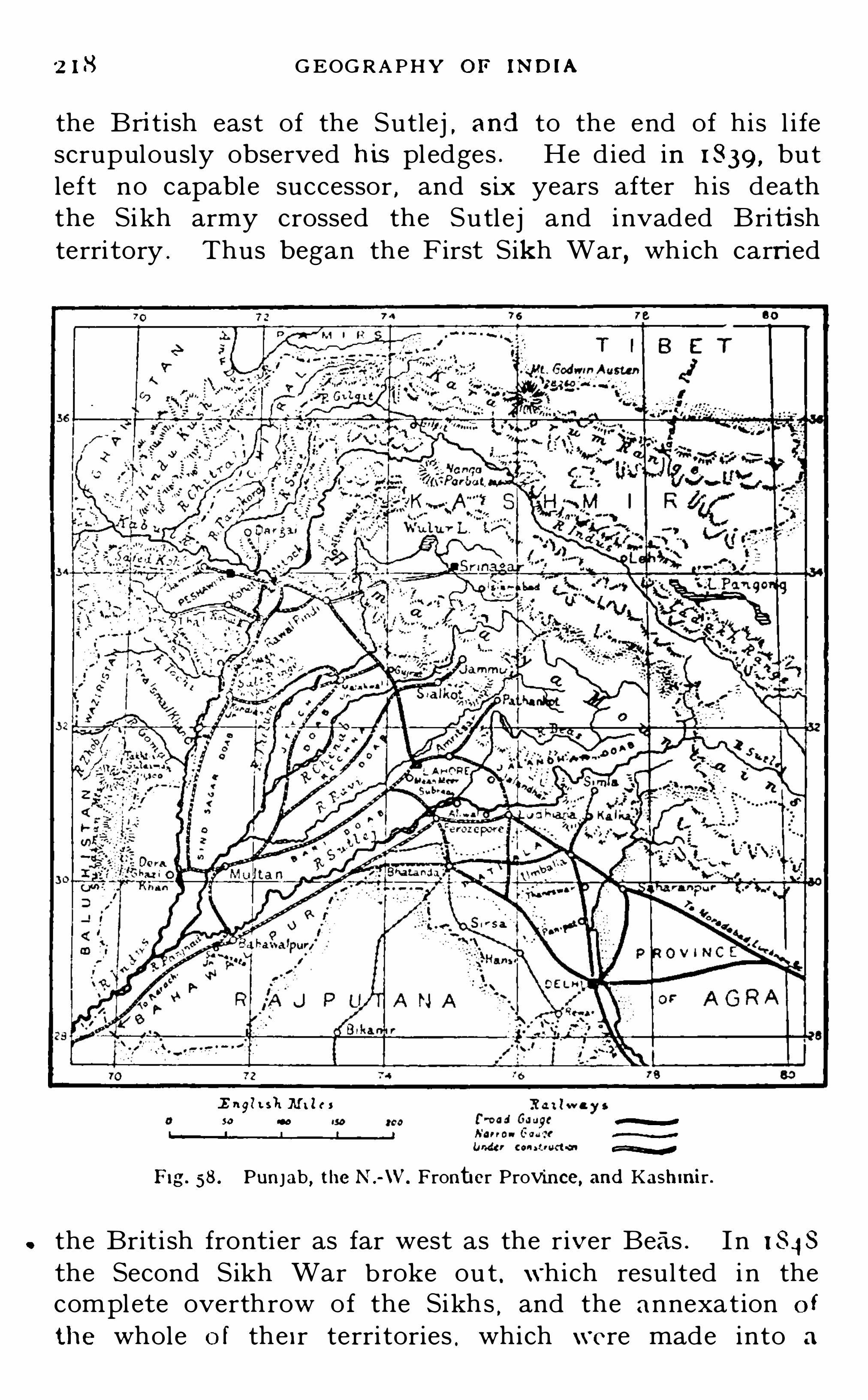
2 1 8 G EOG R A PHY or mom
the British east of the Sutlej , and to the end of his l i fescrupulously observed his pl edges . He died in 1 839, butleft no capable successor
,and six years after h is death
the Sikh army crossed the Sutl ej and invaded Britishterritory . Thus began the F irst Sikh War , which carried
E ngl t sh M i les
30 Co
M
M
Fig. 58 . Punjab , theN .-W. Frontier Province, and Kashmir .
the Brit i sh fronti er as far west as the river Beas . I n 1 848
the Second Sikh War b roke ou t . which resul ted i n thecomplete overthrow of the Sikhs
,and the annexation o f
the whole o f the ir terri tories , which were made into a

THE PUN J A B 2 1 9
Ch ief-Commissionersh ip under Sir J ohn Lawrence . Duringthe Mutiny
,the Sikhs di stingu ished themselves by their
l oyalty to the British . I n 1 858 the city of Delhi , wi th allthe Trans-Jumna districts north of that city , were transferred from the North -West Provi nces
,and in the foll owing
year the Punj ab was made a Li eutenant -Gov ernorship . A
Legisl at ive Council was granted in 1 897 . I n 1 90 1 five ofthe Trans- Indus districts of the Punj ab were separated
,to
form,along wi th the neighbouring Hil l Agencies
,the North
Western Frontier Province .
393 . Surface . The north -eastern part of the Punj ab ismountainous
,being composed of lofty ranges intersected
by ferti le and beauti fu l valleys . The north-westerncorner is cut off from the southern plains by the Salt Range
,
which runs almost i n a semi-circl e south -eastwards fromKohat
,across the Indus near Kalabagh
,then east and
north-east to the Jhelum . North of the Salt Range is aplateau averaging abou t feet in elevation . The restof the province is a vast plain sloping slowly to the southwest , except ih the sou th -east corner , where a long ridgeof sl ight elevation runs northward to Delhi . This ridgei s the northern extension of the Aravallis, and formed thehistoric Bri tish camping ground in the Mutiny .
394. Rivers . The Punj ab includes the greater part ofthe Indus basin . The name is derived from two Persianwords
, {Dani-ab (five waters) , and originally denoted thecountry watered by five rivers
,Jhelum , Chenab , Ravi , Beas ,
and Sutlej , the five great tributaries of the Indus . All theser ivers
,l ike the Indus i tsel f
,take their rise in the Himalayan
region . The Indus and the Sutlej , respect ively the mostwestern and the most eastern of the six
,r ise near each
other beyond the chief snowy range ; the others on thesou thern l pes. All these r ivers flow at first in a northwesterly d irection
,and then bend round to the south
,
gradual ly drawing together t il l they unite about 60 milesfrom the south-western corner of the province . TheJhelum first pours i ts waters i nto the Chenab
,and the
Ravi does th e same on the other side . The Beas flowsin to the Su tl ej
,and l ower down the Su tlej and Chenab

220 G EOG R APHY OF IND I A
Mg. 50. The Pu njab , &e. ,in relief .
un ite to form the Panjnad which carries the waters of allfive rivers to the Indus . These rivers form five doabs .The Sind sagar Doab, the larges t , is eas t of t he Indus ;the Jetch Doab is between the j helum and t he Chenabthe R echna Doab be tween the Chenab and the Ravi the

G EOG R A PH Y OF IND IA
3 98 . Natural products . Wheat is the principal foodgram grown
,as much land being ord inari ly devoted to its
cul ture as to al l other food -grains pu t together . The
cl imate and soi l are both su i table,and Punj ab wheat i s
equal to any i n the world . Large quant i ties of i t are exported to Europe . Next in importance among food -grain s
are millets and barley. Rice is less ext ensively grown as i trequ ires much water . Gram and oth er pu lses are ver
'
V
largely cu l tivated , as al so are o il-seeds , espec ially rapeand mustard . Cotton and sugar are widely grown on theirrigated land
,and to a less exten t tobacco and indigo .
Tea is cu lt ivated in the Kangra Valley . The silk-wormis successfu lly reared in the Mul tan d istr ict . Bees are keptin the north and east
,and much honey and bees-wax are
produced . The chief mineral product i s salt. Rock sal t ismined at various places in the Sal t Range . Ant imony andalum are al so obtained from the same hil ls . Large quanti ties of saltpetre are produced i n the plains . Coal i s foundnear the J helum .
399. Commun icat ions . The most important railway inthe Punj ab runs up the Indu s Vall ey
,giving the province
direc t connection with Karach i its ch ief seaport . At onetime goods had to be taken across the r iver at Hyderabadby means of a ferry , bu t now that the river i s spanned bythe Lansdowne Br idge at Sukkur
,there i s through ra ilway
connecti on between Karachi and the north of the Punj abvia Multan . From Mul tan branches of the same systemradiate up most of the Doabs . The North Western Rai lway unites Delh i wi th Umballa
,Ludhiana and Lahore ,
and i s conti nued beyond Peshawar in the North-\VesternFrontier Province . From Umballa a li ne now runs up thehil l s to Simla
,the summer seat of both the Provincial and
the Supreme Gove rnments . A vas t number o f flat
bottomed boats ply on the r ivers and canals .
400. People . The people of the Punj ab are of thepurest Aryan b lood in Ind ia . They represent the latestwave of Aryan immigrants , who found t he country al readyl argely peopled wi th mixed Aryan races . The chie f languages are Punjabi , which i s spoken by about 1 8 mill ions ,

THE PUN J A B 2 2 3
Urdu (or Western Hind i ) , spoken b v abou t. 4 mill ions , andRaj asthani
,Spoken by about half a mill ion in the south .
Numerous Sanscri tic dialects (classed together as Pahari )are spoken in the hi l l tracts . I n religion the Muhammadansslightly outnumber the Hindus
,except in the Native States .
There are over two mill ion Sikhs , who are most numerous i nthe districts around Amritsar .
Fig. 60. Districts and Chief States of the Punjab . The numbers coincide Withthose of the list.
401 . Administrative Divis ions . The Provi nce of Punj abcontai ns 29 Districts grouped into 5 Divisions , as follows
Division and D istrict. A rea in Population,
Delhi Division sq. mi les 1 90 1
1 . H issar2 . Rohtak3 . Gurgaon4 . Delhi5. Kamal6. Umbal la7 . Simla 1 0 1

2 24 GEOG R A PHY OF IND IA
Lahore Division8 . Lahore( 1 . Montgomery10 Amri tsar1 1 . Gurdaspur1 2 . Sialkot1 3 . Guj ranwala
J ullundur Divis ion1 4 . Kangra1 5. Hoshiarpur16 . JnUundur1 7 . Ludhiana1 8 . Ferozepore
R awalpindi Divis ion1 9 . Guj rat20 . Shahpur2 1 . Jhelum2 2 . R awalpind i .2 3 . Attock
Multan Division24. Mianwal i25. Jhang26 . Mul tan2 7. Muzaffargarh2 8 . Dera Ghazi Khan29. Lyal lpur
402 . Ch ief Towns . Lahore near the Ravi ,the seat of Government
,was for some time Akb ar’s capital ,
and later the capital o f the S ikh Kingdom . The city contains the tomb of Ranj i t S ingh . and numerous other finebuild ings . I t i s now the seat of the Punj ab Universi ty.
Mean-Meet , the mil i tary station ,i s a few miles d istan t .
403 . Delhi on the J umna,the larges t city in
the Punj ab,was the capital of the Mughal Empire
,and i s
the most famous of the many historical cit ies of Ind ia .
The ruins of old Delh i are a few miles di stan t . The presen tci ty was founded by the Emperor Shah J ehan ,
who bui l tboth the palace and the for t as we l l as the magnificen tmosque
,the J umma Musj id . Delhi has always been a

2 26 GEOG R A PHY O F IND IA
great commercial centre , and since the construct ion of railways it has i ncreased in importance . S ix rai lway l inesrad iate from the ci ty
,and make i t the most important
railway centre in north Ind ia . I t has no manu factures ofany great moment , but its musl ins , as well as i ts gold andsilver work
,used to be famous .
404. Amritsar midway between the Ravi andthe Beas , is the sacred c ity of the Sikhs . One of the Sikh
gurus formed a tank here , which he cal led Amritsar (Poolof Immortal ity ) . Amritsar is noted for i ts manufacture o fshawls
,s ilks , and cottons . I t has long been the chief
emporium for the trade wi th Kashmir and Tibe t . Govind
garh , a strong fortress , bu ilt by Ranj it S ingh ,commands
the ci ty . From Amritsar a railway proceeds north eastward to Pathankot, the nearest rai lway s tat ion to Dalhousie , a sanatorium . South-eas t of Amri tsar i s Jullundur a mil itary station . Northward l ies Kangra ,with a famous hill fort
,which was plundered by Mahmfid
of Ghazni . Sialkot i s an important mil i tary stat ion on thenorthern front ier . I t i s situated on the North WesternR ailwav,
and i s the j unction for a branch l ine to J ammu .
405. Umbal la between the Su tlej and theJ umna
,i s a l arge mil itary stati on . Northward on the lower
H imal ayas is Simla , the summer residence of the Viceroy .
Sou th of Umbal la , Thaneswar , plundered by Mahmi‘
id ofGhazni . Near this i s said to be the Kurukshetra field
,
where the great battl e of the Mahabharata was fought .About midway between Umball a and Delh i i s Pan ipat
,the
scene of several great battles . Ludhiana near theSutl ej
,i s in Cis—Sutlej Terri tory
,and was the British
frontier before the Fi rst Sikh War . \Vestward l ie Aliwal,
Sobraon , Firoz shah, and Miidki, where bloody battles tookplace between the Sikhs and Brit ish .
406. Multan sou th -west , near the Chenab ,i s
a mil i tary station and a large manufacturing town . I t hasfor cen turies been the great centr e o f caravan trade withBal uch istan and Persia across the Bolan Pass , and t he construction of a railway through the pass has no t robbed i tof its trade . I t is now the most important station on the
THE PUN J A B 227
Indus Valley Railway . Attock on the Indus at i ts j unctionwith the Kabul river guards the principal route acrossthe I ndus . Here a railway bridge now spans the river .Rawal Pindi between the Jhelum and the Indus ,i s a large mil i tary station . Near the Chenab is Guj rat,where the Sikhs were finally defeated by the Engl ish .
Chi lianwala,where a bloody battle was fought with the
Sikhs,is in the neighbourhood . Not far from this Alex
ander the Great defeated Porus, 327 BC .
NAT IVE STATES IN THE PUN J A B .
407. There are 34 of these states , bu t most of them arevery smal l . They have an area of square miles ,and a populat ion of 45mil l ions .
408 . BAHAWALPU R stretches sou th of the Sutlej and theI ndus . I t has an area of square miles
,and a popu
l ation of about 5;of a mil l ion . The ch ief town i s Bahawal
pur, the residence of the Muhammadan Nawab . With theexcep tion of a smal l port ion of the State watered by a canalfrom the r iver Sutlej
,the country is an arid plain .
409. PAT IALA , a fertil e d istrict i n Sirhind ,south of
Ludhiana , is a Sikh State . I t has an area of sq .
miles,and a population of 1 5mill ions . The chief town i s
Patiala towards the east . The Maharaja i s an enl ightenedand progressive ruler
,and the State is making rapid
progress .
4 1 0. J IND , divided into two parts by the British Districtsof Rohtak and Hissar ; NA BHA
,south of Ludhiana ;
KAPUR THALA,which stretches along the Sutlej between
Amritsar and J ul lundur ; MAND I , on both S ides of theBeas
,between the Simla Hil l S tates and Chamba ; and
FAR ID KOT,which almost d ivides the District of Ferozepore
into two parts,are other Sikh states . CHAM BA , east of
J ammu,and BUS SAHI R
,north -east of the Simla Hil l States
and intersected by the Sutlej,are two of the ch ief Hill States .

2 28 GEOG R APHY O F IND IA

2 30 G EOG R A PHY O F IND IA
l ofty Safed Koh range , which branches eastwards from theHindu Kush
,separating the basins of the Kab ul and the
Kuram,and forms a part o f the western boundary . Both
at this poin t,and at the extreme north . an elevation of
nearly feet i s reached . East of the hil l s the landslopes gradually to the south -east to the val ley o f theI ndus .
41 3 . Admin istrative Divis ions . The following figuresgive the area and popul at ion of the S ix Distric ts i nto whichthe British portion of the Provi nce i s d ivided . I t i simpossible to give accurate figures for the Hill Agencies .
A rea in PopulationDistr ict. sq. miles ( 190 1 )
HazaraPeshawarKohatKu ramBannuDera Ismai l Khan
4 14. Rivers . The entire province l ies wit hin the bas inof the Indus . The Kabu l River en ters the province from'
the west after receiving the waters of the Kunar or ChitralRiver which drains the Chi tral mountains in the north .
Further on it i s j o ined by the Swat, with i ts tributary thePanjkora
,which also comes down from the northern h ills
and th irty miles further on it j oins the Indus near Attock .
The Kuram rises in the Safed Koh range,and flows sou th
eastwards . J ust with in the western boundary of theprovince it receives its ch ie f tr ibu tary , t he Tochi , andempties i tsel f i nto the Indus a few miles to t he sou th of theSal t Hil l s of Kohat . North of these h il ls a smal ler river
,
the Kohat,
flows west to the Indus , and'
along itsvall ey a railway now runs , unit ing Thal , on the Ku ram ,
with Kohat and the Indus Vall ey Rai lway . The Gomalr ises i n the Afghanistan highlands , and for about 40
miles forms the boundary between the North-\VesternFrontier Province and Baluch istan . Afte r rece iv ing the
waters of the Zhob from the south i t curves round the
northern spurs of the S ulaimans and j oins the Indus sou th

N .- \V . FR ONT IER P R OV IN CE 2 3 1
of Dera I smail Khan . Along the val leys of all theserivers roads wind into the highlands
,lead ing in every case
to one of the passes which form the gateways of communication between Ind ia and Afghanistan .
4 15. Cl imate and Products . Throughout the provincethe rainfal l i s scanty , particularly in the south . The heatin summer and the cold in winter are both extreme
,so
A FGHANI STAN
Fig. 63 . Districts and Tribal Areas of the Province.
The numbers coincxde with those on the list.
also is the variation between day and night . In all thesepoints the cond itions prevai l ing in the Punj ab are inten
sified . With the exception of its north-eastern point theprovince l ies outs ide the monsoon area . In winter keenand biting north-west winds prevail which often bringheavy snow storms .
41 6. The cul tivated areas are ch iefly along the riverval leys
,some of which are very fertil e . Wheat i s the ch ief
23 2 GEOG R A PHY OF IND IA
grain,b u t barley
,maize
, and pu lses are al so extensivelygrown . The cul tivation of cotton is Spreading . A largequant ity of fru i t i s al so grown and pomegranates
,quinces ,
pears,grapes
,and peaches are sent to various parts of I ndia .
Nearly square miles o f the best land i s protected byirrigation
,the principal canal s being from the Swat and
the Kabul . There are also numerou s smal ler canal s fromthe Toch i
,Kuram and I ndus
,many o
f which are privateproperty . A new canal i s under construction by which thewaters of the Swat will be brought by tunnel under theMalakand Pass i nto the Peshawar Distric t where water i smuch needed .
4 17. People and languages . The population of the d istricts separated from the Punj ab was in 1 90 1 .
The hil l tribes have never been accurately numbered,bu t
the total populat ion of the province is between two and threemil l ion s . Chief among the h il l tribes are the Waz iris in
the sou th,and the Kohistan is in the north . The principal
languages are Punjabi and UrdI'
I on the plains,and Pashtfi
in the mountainou s country along the west .
4 1 8 . Towns. The ch ie f town and the seat of Government
i s Peshawar,wh ich l ies almost at the foot of the Khyber
Pass,the most importan t route from Ind ia to Kabul .
Peshawar is an ancient city and attained considerableimportance i n the Buddhi st period . The modern city owesmuch to the Sikhs . I t is surrounded by a wal l wi th 1 6
gates,and has a fortress of considerab l e strength outside
the wal ls . I t i s now a large mil i tary station,and i s
connected with Rawal Pind i and Lahore by the North
Western Railway . Twenty -five miles east of Peshawara branch of this l ine runs north to Dargai . Small ertowns are Kohat , the head of the d istric t of the samename ; Edwardesabad , on the Kuram River ; Dera IsmailKhan commanding the val ley of theGomal and Abbottabad ,i n the Hazara Distric t north of Rawal Pind i . Al l theseare important t rade centres . Through the Kuram vallevl ies another route from I nd ia to Kabul , and i n the sou th ,
west of Dera I smai l Khan , i s the G omal Pass , the chie froute to Ghazn i i n Afghanistan .

2 3 } G EOG R A PHY O I! I ND IA
a mere fract ion of the ancien t one,and yet the largest
sheet o f fresh water in I nd ia . The Vale of Kashmir hasan el evation of 5250 fee t above sea level . The rest of theS tate i s almost entirely composed of rugged moun tainsintersected by narrow val leys . The Muz tagh ,
or Karakorum Mountains
,are in the nor th
,and look down into
Chi nese Turkistan . They contain many l ofty peaks ,among which are Mt. Godwin Austen Gasherbrum and Dipsang with others o f almostequal height
,which form toge ther one of the most magni
ficent groups of peaks in the world . East of this groupthe Karakorum Pass crosses the range at a heigh t offeet . The Ladakh Range runs from north-west to sou theast
,th rough the centre of Kashmir . The Himalayas in
the south run in the same direct ion , from the great peakof Nanga Parbat
,but open ou t in doub l e folds wh ich
enclose the Vale of Kashmir .
422 . Rivers . The Indus enters Kashmir from Tibet ,i n the sou th -east corner
,flows in a north -westerly direction
for abou t 350 miles , and then makes i ts great bend to thesou th-wes t
,round ing Nanga Parbat . J ust at i ts bend i t
rece ives the waters of the Gilg it River , which drains themountains of Chitral in the north-west . The j oin t val l eysof the Indus and G ilgit
'
b isect the state d iagonally . TheJhelum rises in the h il ls west of the Vale of Kashmir
,and
l ike the I ndus,takes a north -westerly course , and then
bend ing sharply to the south forms for 1 00 miles the boundary l ine between Kashmir on the east and the Punj ab onthe west . The Chenab enters Kashmir from the h il l s o fnorth-eastern Punj ab
,and after a wind ing westerly course
for 1 20 miles,turns to the south forming the boundary of
J ammu , and re-en ters the Punj ab north o f S ialkot .
423 . People . The Kashmiris are chiefly of Aryanb l ood
,and are vigorous and hardy , as wel l as fai r and
handsome . In the north - east and throughou t Ladakhand the Himalayan h il l s in the sou th-east
,a Mongol ian
element predominates . The languages spoken are variousAryan d ial ec ts in the west , and Tibeto-Burman dialec tsin the east .

KASHMI R 235

2 36 GEOG R A PHY O F IND IA
424. Cl imate and Productions . The Vale o f Kashmirenj oys one o f the pleasantest cl imates i n the world
,being
never very hot,and in the win ter months cold and bracing .
J ammu,in the sou th
,i s much warmer
,and is the winter
resort of t he Maharaja and his court . Higher up themoun tains
,and especial ly i n the north -west
,the cold i s
i ntense . The rainfal l i s scan ty everywhere . On thesouthern h il ls there are extensive forests from whichtimber is obtained
,especial ly deodar , and in the val leys
wheat, b arley, and m il lets are grown . The Vale of Kashmiri s famous for i ts fru its and flowers .
425. Towns . The capi tal,Srinagar on the
Jhelum , i s a flourish ing town , beau ti fu l ly si tuated in thehil l-enclosed Vale . I t is much visited by tourists . Thefamous Kashmir Shawls ,
” made of the inner hair of theKashmir goat , are s ti l l made here , but the manu facturehas decl ined . There is a growing manu facture of si lk .
Carpets are also made . Srinagar i s an important j unct ionof trade routes
,and a railway is in process of construct ion
which wil l un i te i t wi th the North \Vestern Railway atRawal Pi nd i . Leh
,the ch ief town in Ladakh
,i s near the
I ndus . I t i s a poin t where several trade -rou tes meet,and
is one of the highest towns in the world,being more than
feet above the sea level . Is lamabad is south—eastof Sr inagar , on the Jhelum . Iskardo (or Skardo) on theIndus
,i s the capital of Bal t istan , Gilgit i s a town in the
north -west,and an important front ier s tat ion . J ammu
lies to the south of the Himalayas,and i s connected by rai l
with S ialkot .
BALUCHISTAN .
426. Though ou tside t he boundaries o f Ind ia proper ,BALU CH ISTAN i s now a province o f t he I nd ian Empire .
I t i s bounded by S ind and the Punj ab on the east,Persia
on the west , Afghanistan on the north ,and the Arabian
Sea on the sou th . I ts total area i s sq . miles , ofwhich nearly is now Bri t ish terri tory . The native

2 3 8 G EOG R A PHY O I? iND iA
coast-l ine f ill i n Persia they bend to the north again . Thissemi -circl e of h ill s
,the southern portion of which forms
the tract known as the Makran ,bound s the arid plateau
of Iran , which averages fee t i n el evation . The Makranhighlands form the sou thern boundary of a region of inlanddrainage which extends northwards i n a series o f basinsfor more than miles til l i t meets the arctic basin ofthe O b - I rti sh . In the north-west of Baluch is tan is thesmallest of these basins
,a depression in the plateau 250
miles from east to wes t,and 1 00 from north to south , in
which the drainage is to the Mashkel Hamim ,a sal t swamp
near the Persian front ier and feet above sea-l evel .The ent ire depression is a rocky and sandy desert , d ry andparched . I t was not always so
,however . There are many
proofs that i t was once wel l watered and fertil e . Themountainous di stric t of Makran i s not quite so barren .
The hill s are bare and rocky ridges,but in the narrow
valleys there are strips of green which here and there arecul tivated .
428 . The most easterly of the r idges running sou th fromthe Quetta h ighlands , the Khirthar range , con tinues sou thwards to Cape Monze
,and forms t he boundary between
Baluchistan and Sind . Between the Khirthars and theMakran ridges bend ing round to the west
,i s a tr iangle of
al luvial land,the del ta of the Purali river , which forms the
State of Las Bela . O n the eastern frontier of Baluch istan ,
hal f-way between i ts northern and sou thern points,there
is a trac t of low- lying desert stre tch ing north-westward tothe foot of the Quetta hil l s , and separating the sou thernS ulaimans from the h il ls of Kalat . This i s known as theKachhi , and is traversed by the railway from Jacobabadto Quetta .
429. Cl imate and Productions . Baluchistan experiencesgreat extremes of temperature . On t he l ow plains i t isunendurably hot by day in summer
,and intensely cold by
nigh t in win ter . On the plateau the heat i s moderated ,
bu t the cold is more intense . The d iurnal varia tion al lthe year round is extreme . The rain fall i s exceed inglyscanty everywhere . From the southern S ulaimans to Las

BALU CH I STAN 239
Bela and along the coast—strip the average is under 5 inchesa year , and it is nowhere over 1 0 inches save in the neighb ourhood of Quetta . The produce i s , therefore , small ,cu ltivation being in most parts impossib le ; and the popul ation is very Sparse
,averaging less than six to the square
mi le . In the val leys around Quetta the heavier rain fal li s assi sted by irrigation
,and good crops of wheat and
millets are secured . Fru it i s also largely grown ,and the
melons produced are the finest in the world . E l sewherethere i s l ittl e cul tivation of any kind . The dates of Makranare famous
,and form the staple food of the people . Along
the coast large quantities of excellen t fish are caught .
430. People . The total populat ion i s only about threequarters of a mill ion . Nearly half are Brahu is , who speaka Dravidian tongue
,and are apparently a Dravidian race .
The remainder are mostly Turko-Iran ian s . They aredivided into many tribes
,cl assed together as Balochs
,
and are chiefly a pastoral people , and very largely nomadic.
In rel igion they are Muhammadans of the Sunni sect .
43 1 . B R IT I SH BALU CH I STAN includes Quetta and theBolan
,which have been held since 1 883 by a perpetual
lease from the Khan of Kalat,together with Sibi
,Pishin
,
and other districts . Quetta is united wi th Ind ia by theS ind -Pishin Railway . This l ine branches off from theIndus Val ley l ine near Sukkur
,and runs up the Kachh i
desert tract to S ibi where i t d ivides . The northern branchpasses up the val ley of a smal l stream called the Harnai
,
through the Nari pass to Pishin ,and so to Quetta . The
sou thern branch takes a more direct route . At first thel ine was constructed through the old Bolan Pass . Later
,
as the Bolan l ine was found to be exposed to damagefrom floods , which a very l ittle rain wil l cause , another l inewas constructed through the safer val ley of the Mashkai,a few miles to the north . From Quetta the l ine runsnorth-west to Chaman
,and south-west to Nushki
,both
on the front ier of Afghanistan . These l ines are of immenses trategic importance
,as they command both the Gomal
and Bolan routes to Afghanistan and Persia . Quetta hasalways been a trad ing town of some importance as it i s

2 40 G EOG R A PH Y OF IND IA
on the d irect route to Kandahar . I t i s now also a stronglyfortified mi l i tary station . For the greater part of theyear i t has a pleasan t cl imate , being ft . above thesea level
,and almost su rrounded by lofty mountains .
432 . KA LAT i s an ancien t Khanate , which has successively been und er the protection of the Mughal Empire ,Afghanistan
,and the Brit i sh . The Khan belongs to a
Brahu i family ,and exercises a loose au thori ty over nearly
tribesmen . His ch ie f revenue is from the subsidyetc . ,
paid h im by the Ind ian Governmen t,amounting to
abou t per annum . Kalat, his capi tal , i s an ins ignifican t town
,s ituated on the h il ls wes t of the Kachhi
,
and sou th of Quetta,at a heigh t of feet . LA S BELA
has a populat ion of only The Jam i s o f Arabdescen t .
Fig. 66. Tribesmen of theNorth-West.

242 GEOG R A PHY OF IND IA
where they founded numerous principal i ties which,through
many v ici ssi tudes,have survived ti l l to-day . The
Maharanas of Udaipur (also cal led Mewar) claim descentfrom Rama
,K ing of Aj odhya, the hero of the Ramayana ,
and hold the first place among the Raj put Princes . Allthrough the centuries they have maintained the purity oftheir blood with uncompromising pride . During the
Muhammadan age they steadfastly re fused to give thei r
S am bha r L
O daISaImcr
d odhpur
Pachbhadra
ft !“ 1 w a vs
“I !( I ( I ( I My
? W
Aa r r nu h a u qe M
F ig. 67 . R ajputana.
daughters to Musalman princes,and even refused to inter
marry with Raj pu t famil ies which countenanced suchal l iances . All through the period of Mughal supremacythe 1 7 Raj pu t States maintained their independence , andth ough they suffered much during the turbulent yearswhen the Marathas were supreme in the wes t
,the

R A J PUTANA 243
barren and uninvit ing character of their territoriesprotected them against the cupid ity which seizedeverything worth seiz ing . At the close of the ThirdMaratha \Var
, most of the Raj put Princes enteredinto subs id iary treaties with the Marqu is of Hastings
,
then Governor-General of I nd ia,whereby they came under
Bri t ish protect ion . The in ternal government of the R aj putStates is largely feudal in character . Their territories are
R Ad PUTANA
Fig. 68 . R ajputana, showing the chief States.
generally d ivided among Thakurs , or chiefs , who paycertain dues
,but over whom the Prince often exercises
bu t l ittl e influence .
435. Physical Features . The Aravalli Hills, a low rangeseldom exceeding feet i n height except at theirsouthern extremity
,where Mt. Abu rises to stretch

244 GEOG R A PHY OF I ND IA
across Raj putana in a north - easterly d irection d ivid ing theprovince into two strongly con trasting parts . The westernport ion is nearly twice the s ize of the eas tern
,and cons is ts
ch iefly of sandy desert where the rain fal l i s exceedinglysmall and the watered and productive areas few . Beyondthe 11 1113 the conditions improve . The rainfal l i s more abundant and i ncreases steadily toward the east
,and the countrv
being of higher level , i s r icher and more d iversified . Thesouth-eastern portion of the province forms part of thePlateau of Malwa, composed largely of Deccan Trap , thevolcan ic rock which forms the rich black cotton-soi l o f theDeccan . This plateau slopes gently to the north
,with
many rocky ridges , and the drainage i s to the J umna ,through its great southern affluent the Chambal . Thenumerous tributaries of the Chambal whi ch drain thenorthern slopes of the plateau and the eas tern slopes of
the Aravallis, are the ch ie f r ivers of the province . The
Min i drain s the western S lopes of the Aravallis into theGreat Rann of Cutch , but its waters are salt , and for hal fthe year its bed i s dry.
436. Cl imate and Products . The heat is great throughout the whole of Raj putana , and especial ly so in the west ,where the rain fall is very small
,and the sandy soil dry and
parched for the greater par t of the year . West ward fromthe Aravallis there is comparatively l ittl e vege tation ofany kind ,
and the variousmillets are the only crops that canbe grown . Eas t of the Aravallis the summer heat i s not soextr eme , and much of the land is r ich and well watered .
Agriculture i s therefore more flouri shi ng . Mi l lets,pu lses
and oil-seeds are largely grown,al so wheat and barley. The
area devoted to wheat has greatly increased during recen tyears . Cotton and sugar cane are also cultivated .
437. Min erals . The only mineral product of any
moment i s salt,which is obtained in enormous quanti t ies
from sambhar Lake a l i ttle to the north o f Ajmere. Thewaters of this lake are so exceed ingly sal t that the crystalsgather on the surface , and about tons o f sal t aretaken from it every year
,wi thou t sensibly d iminish ing i ts
sal in i ty . The lake has been leased to the Governme nt of

246 GEOG R A PHY OF IND IA
F ig. 69. R ajputana and Central India in r elief.

CENTRAL INDIA .
441 . CENTR AL IND IA is composed of a group of NativeS tates which l ike those of RAJ PUTANA are united under onePol itical O fficer styled Agent to the Governor-General . ”
I n al l there are 1 48 Princes and Chiefs included in theAgency , bu t as 1 2 of these have no terri tories , Cen tral Ind iamay be said to consist of 1 36 States . Most of these are ofno great si ze , and many of the smaller ones are in a sensesubord inate to one or other of the larger States , to whichthey pay an annual tribu te . The fol lowing tab le Shows thearea and populat ion of the principal States of the Agency .
A ream Population
sq. miles ( 1 901 )
The total area of the Agency is square miles and thepopulat ion 85mill ions .
442 . The numerous S tates thus united do not i n anysense form a natural division
,and are constituted a pol itical
uni t under the Supreme Government mainly because theyal l came under Bri tish protection and control about thesame t ime
,after the final overthrow of the Marathapower
in 1 8 1 8 . The Agency is d ivided into two parts by thesou thern tongue of the Province of Agra,
which stretchessouthwards ti l l i t meets the northern boundary of theCentral Provinces . The western part i s the larger . I tl ies between the Central Provinces and Raj putana , and
i ncludes the more important S tates of Gwalior,Indore , and
Bhopal , each of which consists of numerous separate territories . The eastern part i ncludes the larger S tates of

248 GEOG R APH Y O F iNDiA
Rewah, Orchha, and Panna, and the numerous small S tates
of Bundelkhand.
443 . People . I n race the people of Central India arevery mixed . There are numerous Rajputs who are of
tolerably pure Aryan blood,and sti l l more Marathas who
are Scythe-Dravid ians,the Scythic element predominating .
There are al so abou t a mill ion and a hal f Bhi ls and Gonds ,primi tive Dravid ian races who Speak Dravid ian d ialec ts of
CE N T R A L P R O V !
E ngl i sh ”f i les R a i l w ays
o 50 'OO f i r oa cl Gaugc !N
Nar r ow 60 age M
F ig. 70. Central Ind ia.
their own,and to whose ancestors in pre -historic times the
whole of Eas t Central I nd ia probab ly belonged . TheBhilalas are of mixed Raj pu t and Bhil descen t . The res tof the people are al so mainly of Dravid ian extrac tion . O f
the total populat ion , abou t 7 mil l ions are Hindus , and therest chiefly Animists
,Muhammadans
,and J a in s . Dialects
of Western Hindi are spoken by abou t 42mill ions , EasternHindi and Raj asthani by abou t 1 5 mil l ions each , and
various Bhi l d ialec ts by over a quarter of a m il l ion .

250 GEOG R A PH Y OF IND IA
Son i n the south,and more gently to the valley of the
Ganges in the north . I n the extreme south of the eastern
section the greatest el evation is reached , Mount Amarkantak
,feet i n heigh t
,being j u st on the boundary
line between the Cen tra l Provinces and Central Ind ia .
445. Cl imate and rainfal l . The rainfal l i s ample , bothin the eastern and western secti ons
,especial ly in the
former , and i t occurs ch iefly in the summer months . Themonsoon current passes up the val ley of the Narbada,
shedding its moisture as i t goes,but giving a heavier
watering to Bundelkhand than i t does to Malwa. Thenorthern parts of the Agency around the ci ty of Gwal iorare much drier than the sou thern
,and are wi thin the
region of precarious rain fal l . The temperature overthe whole of Central I nd ia i s high in the summer , partienlarly to the north , bu t in the winter it i s cool and pl easant .
446. Rivers . For more than 1 00 miles the Narbadaflows through the south -western porti on of the Agency ,
and for 1 50 m i les fu rther up i t forms the boundary bet weenCentral I ndia and the Central Provinces
,but i t drains only
a narrow strip sou th of the Vindhyas. Wi th this exceptionthe whole drainage of the Agency is northward to the
Chambal and the J umna al ong the gent le slopes of theplateau . The chief tribu taries of the Chambal are theKal i Sindh in the west
,and the Parbati a l i t tl e fu rther eas t .
The Chambal i tsel f rises i n the Vindhvas,as al so does the
Mahi further west . The Mah i flows at fi rs t northward ,
then bending round finds its way to the Gul f of Camb av .
I n the eastern part of the Agency the river son,ris ing on
the sl opes of Mt . Amarkantak,
flows northward to the
Kaimur Range,which i t skirts al ong the sou th and so
passes into the Uni ted Provinces . North of the Kaimurs
the drainage i s to the j umna and Ganges , the Batwawi thi ts tributary the Bhasan , the Sunar or Ken , and t he Tons ,all flowing in a north -westerly di rection from t he southernhi ll s .
447. So il and Natural Products . The soi l o f the Malwa
plateau consis ts ch iefly of the rich black cotton -so i l characteristic of the north -west Deccan
,and the hi l l s are composed

CENTR AL IND I A 251
of abrupt masses of basal tic rock . In the north and eastarchaean rocks and sandstones prevail
,which yield a
l ighter and more porous soil through which the water
quickly drains . The western portion of the Agency i s ,therefore , much more ferti l e than the eastern . On theMalwa
'
plateau much opium i s grown,also tobacco,
cotton, millets and sugar-cane. Wheat is grown in
the drier d istricts both east and west , and is chiefly a coldweather cr0p . In the south of Rewah ,
i n the easternportion of the Agency
,coal is found and is successful ly
worked at Umaria. The largest coal-fields of India stretchsouth-east from Umariatowards the val ley of the Mahanadi ,and eastwards along the valley of the Damodar .
448 . Commun ications . A branch of the Bengal-Nagpurl ine from Bilaspur to Katni runs through the south-easternpart of the Agency tapping the Umaria coal-fields, and iscontinued westwards to Kotah on the Chambal . TheEast Indian Railway from J ubbulpore runs north throughBundelkhand to All ahabad ,
crossing the l ine from Bilaspurat Katni . The Indian Midland Railway runs southwardfrom Agra to Jhansi , passing the town of Gwalior , whencethree smal l branches radiate . The same line runs throughthe south-west of the Agency
,giving Gwal ior direct con
nection with Bhopal,Uj j ain
,and R utlam . From Uj j ain
a narrow-gauge l i ne,a branch of the Rajputana-Malwa
Railway,runs to I ndore and Mhow
,and is continued north
ward b y R utlam and Neemuch to A jmere. The rivers areof l i ttle use as means of communication , being roaringtorrents in the rainy season and at other t imes almost dry .
The roads are specially good,more than four-fifths of their
total length being wel l metal led . . The great trunk roadfrom Bombay to Agra runs through the western part ofthe Agency
,passing the ci t ies of I ndore and Gwal ior .
449. GWAL IOR ,a Maratha State under Sindhia, i s the
largest of the Central I ndia States . I t includes numerousdetached districts between the Chambal and the Narbada,
peopled mainly by Marathas,Raj puts , and Jats . The
founder of the Sindhia family was R anoj i Sindhia , thesl ipper-bearer of the Peshwa, who died about 1 750 . This

252 GEOG R A PHY OF IND I A

254 G EOG R A PH Y O I! IND IA
h igher lands are fert i l e and produce large crops of whea t ,pulses and barley
,with a l i t tl e cotton . Rewah is rich both
in forest s and coal . The Umariacoal -field i s i n the south ,
and the mines are worked wi th consid erable success .Rewah
,the capital , i s a town of li ttl e momen t , and is not
situated on any rai lway or any great t runk road .
453 . BUND ELKHAND,the country o f the Bundela
Rajputs , l ies to the west of Rewah , and is d ivided amonga l arge number of Native States and Jagirs of which themost extensive are PANNA and O R CH H A . The B undelas
,
of whom the Raja of O rchha i s now the head ,took the
cou ntry abou t 500 years ago . The only towns of anymoment are Panna,
in the east , once noted for i ts d iamonds ,Chhatarpur, i n the north , a flourish ing trading town withmanufactures of coarse paper
,and Aj aigarh
,i n the north
east, a h i l l fortress .
Fig. 73 . A R amui Trooper.

THE CENTRAL PROVINCES
454. The CENTR AL PR OV IN CES are bounded by Bengaland the northern d istricts of Madras on the east
,on the
north and north -west by Central India,and on the south
and south-west by Hyderabad . They touch the Provinceof Agra at two points in the north , and the Province ofBombay in the west . The Narbada forms the chiefboundary in the north-west , and the Painganga,
thePranhita,
and the Godavari divide both Berar and theCentral Provinces from Hyderabad in the south . IncludingBerar and the Native States the total area of the provincei s over square miles , and it has a population ofabout I m ill ions .
455. History. The greater part of the territories nowcompri sed i n the Central Provinces were at the beginn ingof last century included in the dominions of the BonslaRaja of Nagpur and formed the most eastern Marathaprincipality. At the close of the Thir d MarathaWar in1 8 1 8 the Narbada and Saugor D istricts (the latter j uttingout
'
to the north between the eastern and western secti onsof Central Indi a) and Berar , the richest part of hisdominions
,were taken from him . The former were
annexed to the British province of Bengal,and Berar was
given to the N i zam . At the same t ime the Bonsla Rajabecame a feudatory Prince , and his reduced territories aBriti sh Protectorate . I n 1 853 the RajaR agoj i died without heirs
,and his enti re dominions passed to the Brit i sh .
During the Indian Mutiny several petty States were forfeited owi ng to the disl oyal intrigues of their rulers . I n
1 861 the whol e of these territories were u nited into oneGovernment and placed under a Chief Commissioner . In
1 853 the N izam handed over Berar to Briti sh administration in order to meet the cost of the Contingent Force

256 0 17.00 12».a or iNm A
maintained by the Briti sh G overnmen t for his protec tion,
and for many years th is province was administered by theBriti sh Residen t at Hyderabad as Chie f Commissioner . I n1002 i t was leased in perpetu ity to the Bri tish i n consideration of an annual subsidy of 25 l akhs of rupees , and wasadded to the Central Provinces .
E n a v t s h M i l e s
0 ( 90
Fig. 74. The Central P rovinces .
456. Surface and drainage . I n the north the Vindhyasand satpuras stretch from west to east under many names .The low Bhanrer Range continue the Vindhyas eastward sto the Kaimurs, and form the southern boundary of theSaugor terri tories . The Mahadeo and Pachmarh i Hills ,of much greater elevat ion
,attai ning at one point a height

258 c aoa pnv or iND iA
Department to cul t ivate the lac insec t . Coal i s found inthe Godavari Val ley ,
and is mined at \Varora, north of thej unction of the \Vard lia and the Painganga. I ron ores
of excel len t quali ty are found i n several Distric t s,par
ticularly J ubbulpore and Narsiiighpur ,and are worked by
native processes . In 1 904 abou t tons of i ron wereob tained . il langancse i s al so found in many places , thepures t ore being from Ramtek in the Nagpur Distric t
,
where large quanti ties are mined .
458 . Commun ications . The Bengal-Nagpur Railway ,provid ing the shortest route from Calcu tta to Bombay ,
runs righ t through the province from east to west,meeting
the central arm of the Great Indian Pen insu la Railway atNagpur . There are numerous branches north and south .
One of the southern branches serves the coal -fields ,
and another the ferti le plateau of Chhattisgarh . Anotherbranch of the G reat Indian Peninsula system runs northwest to meet the East Indian l ine at J ubbulpore , whence abranch runs south to meet the Bengal -Nagpur l ine . FromBilaspur
,on the Bengal -Nagpur l ine
,a branch runs north
west , uniting the East Indian l ine at Katn i , whence anotherbranch runs through the Saugor Distric t to meet the IndianMidland L ine at Bina ,
1 00 miles south of Jhansi . Watercommunicati ons are of l i t tl e value
,and there are few canal s .
The rivers are not adapted to navigation,and the chief
towns are not found on their banks . Great sums havebeen spent i n efforts to improve the navigation of the
Godavari,bu t wi th l i ttle resul t . The roads are good ,
bu t only abou t a quarter of their l ength is metal led .
459. People . The people are main ly of the Dravid ianstock . About I i mill ions are Hindus
,and hal f a mil li on
Muhammadans . The remainder , who are chiefly semi -b arbarous tribes of Gonds inhabi ting the upl ands , are Animists .The Gonds are probably of Dravid ian origin , but they haveflat noses and th ick l ips . Their name means lu
'
glilandcrs.
Und er numerous chiefs they held the greater par t of t he
hil ly d ist r icts of the Central Provinces prior to the Maratha
conquest . Their worship included t he offering of humansacrifices ti l l such ri tes were suppressed by the British

CENTR AL P R OV IN CES 259
Government . The chief language of the Province i s Hindi ,which is spoken by about 60 per cen t . of the people . Marathiis the language of about 30 per cent . and is most prevalenti n the west . Oriyai s spoken by abou t half a mil l ion in theeast , and various Dravidian and Munda dialects are usedby the hil l tribes .
Fig. 75. Central Provinces and Hyderabad in relief.

260 GEOG R A PHY or IND IA
460. Admin istrative Divis ions . Brit ish terri tory in theCentral Provinces ( i nclud ing Berar) i s d ivided in to 2 2
Distric ts which are grouped in to 5 DivisionsA rea in
Division and District. sq. miles.
J ub bulpore DivisionSaugor
2 . Damoh
3 . Jubbulpore .
4. Mand la
5. Seoni
NarbadaDivision6. Narsinghpur
7. Hoshangabad8 . Nimar
9 . Beti‘
i l
1 0 . Chhindwara
Nagpur D ivisionI I . Wardha1 2 . Nagpu r1 3 . Chanda1 4. BhandaraI 5. Balaghat
Chhattisgarh Division1 6 . DH] g1 7 . Raipur1 8 . Bilaspur
Berar Division1 9. Amraoti20. Bu ldana2 1 . Akola2 2 . Yeotmal
461 . Towns . Nagpur the chie f town in th eCentral Provinces
,was the capital o f a MarathaRaja. I t
i s a considerable cen tre of trad e and has rapidly developedsince the railway gave i t d irec t communication wi th Calcutta and Bombay . The fort is on the S itabald i R idge .
The cantonment is at Kampti , abou t 9 mil es d istan t .

262 GEOG R A PHY o r iNniA
Khamgaon,west o f Akola
,i s another great cotton mart .
Gawilgarh ,a famous h il l fort
,i s west of El l ichpur .
NAT IVE STATES iN THE CENT R A L PR OV IN CES
463 . The Feudatory States i nclud ed in the CentralProvinces are 1 8 i n number . They include an area of
square miles and have a total population of over1 12, mil l ions . They occupy ch iefly the north - east and southeast corners of th e Province
,regions of rugged hillv country
largely covered with fores t and j ungl e,and are i nhabi ted
chiefly by hil l tribes . The five Northern States (ChangBhakar, Korea, Surgu ja, Udaipur and Jashpurlwere recentlytransferred to the Cen tral Provinces from O rissa . Thelarges t States are Bastar and Surgu ja.
464. BASTA R has an area of over square m iles,
and a popul ation of I t is s i tuated i n the southeast of the Province . and i s traversed by the Indravati andi ts tribu taries . Abou t a th i rd of i ts area i s dense forest
,in
which teak and sal abound . A sti l l larger area is coveredwi th low j ungle . Two- thirds of the people are Gonds .Jagdalpur , the capi tal , was til l recently l i ttl e more than acol lecti on of mud huts
,but considerab le advance has o f
l ate been made,schools and public offices , & c .
,having been
buil t . The Rajabel ongs to an ancient Raj pu t family .
465. SU R GUJ A has an area of square mi les and apopulation of L ike Bastar , SU R GUJ A has a pri nceof ancien t Raj pu t lineage . KAN K E R
,to the north of
Bastar,with a populat ion of UDA I PU R
,south of
Surguja,with KO R EA , to the west , with
and KHA I R AGA R H,west of the Brit ish D istrict of Drug .
wi th are al l Raj put States . J A SH PU R , one of thefive northern States
,wi th a populat ion of has a
Maratha Raja,and the Raja of NANDGAON (sou th of
Kliairagarli , wi th a populat ion of is a Bai ragi .Both Khairagarli and Nandgaon have benefi ted greatlyfrom the construc tion of the Bengal -Nagpur Rai lway whichpasse s through bot h of them . RA IGA R H is a prosperousl i ttl e G ond State wi th an area of square miles and apopulat ion of

HYDERABAD
(F or .M ap see page 2 82 )
466. HYD ER ABAD,or THE NIZAM
’
s DomiN I ONs,i s
bounded on the east and north-east by the CentralProvinces
,on the west by the Bombay Presidency
,and on
the south and south -east by the Madras Presidency . I nthe north- east the rivers Paingangaand Godavari form theboundary
,i n the south the Tungab had ra and Kistna, and
a part of the western boundary is formed by the S ina atributary of the K i stna . The State of Hyderabad hasd irect pol it ical rel ations with the Government of India,
the Governor—General being represented by a Resident atthe Court of the N i zam . Hyderabad is the largest andmost important of the Protected States in Ind ia .
467. History. At the break-up of the Moghul Empirethe Subahdar of the Deccan
,styled N i zam-ul-Mulk (Regu
lator of the State) , declared hi s i ndependence and established a new dynasty i n which the t i tle of N izam hasbecome hereditary . In 1 766 the Br i tish entered in to anal l iance wi th the N i zam
,and to secure his consent to their
occupation of the Northern Circars , which British forceshad recently wrested from the French
,agreed to give h im
their support agai nst the Marathas on the north and HaiderAli on the south . The N i zam stri ctly observed his treatyengagements and sided with the British in both warsagainst Tipi
’
I Sul tan receiving large sl ices of terri tory ashi s share of the spoil . At the close of the Third MarathaWar in 1 8 1 8 the N i zam received the rich province of Berar .In 1 853 he assigned th is province to the Brit ish inpayment of a large debt which he had incurred and tomeet i n perpetu i ty the cost of a mil i tary force maintainedfor his defence and known as ” The N i zam’s Conti ngent .
”
For nearly hal f a century the expenses of the Contingent

264 GEOG R APHY OF IND IA
were paid ou t of the Berar revenue and the bal ance washanded over to the Ni zam . I n 1 902 Berar was leased inperpetu i ty to the Ind ian Governmen t for an annualsubs idy of 25 l akhs of rupees .
468 . Surface . The whole country forms part of theDeccan plateau
,and has an average heigh t of abou t
feet above sea l evel . Stre tches of greater elevation extend
sou thward from the Ajanta Range,and the Balaghat Hills
run east and west between the Maniira and Godavari.
The general slope i s from north-west to sou th-east,and the
rivers have on the whole an eas terly course . The southwest corner of the State l ies between the Tungab had ra andthe Kistna
,and forms what i s known as the Raichur Doab.
The area of the State i s square miles , and the popul ation is over 1 1 mill ions .
469. Rivers . The Godavari enters the State in thenorth-west and traverses the en tire northern part of i t i n asouth-easterly direction , rece iving from its left s ide theDudna and the Purna , and from the right the Manj ira,
which from its source in the west takes a wind ing course
through the heart of the State . Close to Sironcha on theeastern boundary the Godavari i s j oi ned by the Pranhita,
which is formed by the united waters of the Painganga theWardhaand the Wainganga. From that poin t the Godavari forms the boundary line of the State to i ts easterncorner 30 miles north-west of R ajamund ry. BelowSironcha there i s a rocky barrier which prevents navigationbetween the upper and lower reaches of the river , bu tabove and below this poin t i t i s a use ful waterway . TheKistna enters the State on the south -west from the BombayPresidency , and flows at fi rst north -east and then south -east .I t i s j oined on i ts left bank by the Bhima , which enters theState from Bombay a l i ttle further north , and on its rightby the Tungabhadra,
which forms the sou thern b oundarvof the State for more than 1 00 miles . The Mfisi j oins theKistna from the left abou t 30 miles from the poin t where .having rounded the Nallamalai Hill s . i t makes a sharp turnto the sou th -west i nto the Madras Presidency . There areno great irrigation works in Hyderabad
,though numerous

GEOG R A PH Y OF IND IA
A rea in Popu lation
Divisions and Districts. sq. miles ( i go i )1 . Atraf- i-Balda
Medak Division2 . N izamabad
3 . Medak
4 . Mali b i'
i b iiagar
5. Nalgonda
Warangal Divis ion6 . \Varangal
7 . Karimnagar8 . Ad ilabad
Gulburga Divis ion9 . Gulburga1 0 . O smanabad1 1 . Raichur1 2 . Bidar
Aurungabad Division1 3 . AurungabadI 4. Parb haii i
1 5. Nander1 6. Bhir
474. Chief Towns . HYDE R ABAD , the capi tal , i s s i tuatedon the river Hiis i , a tributary of the Kistna . I t i s a largeC ity with inhabitants
,among whom are many
Arabs and Pathans . The c ity contains a number of finebuildings
,the most remarkable of which date from the
sixteenth century,before Hyderabad fel l under the dominion
o f the Mughal s . The Char Minar , or four minarets , occupies
a command ing posit ion i n the hear t o f the C ity and i s oneof the most beauti ful structures of i ts k ind . The ci ty i swel l suppl ied with water from two fine tanks
,the Husain
Sagar and the Mir Alam . The lat ter i s the more modern,
having been const ruc ted near the close o f the eighteenthcentu ry
, the cost be ing met by the N i zam's share o f the
spoil s after the fal l of Seringapatam . The tank is eigh tmiles i n ci rcumference , and the water i s confined by a sol idmasonrv dam bui l t i n a series o f semi -Ci rc les
,W ith their
convex face to the water .

HYD ER A BAD 267
475. At Secunderab ad , the northern suburb of thecapi tal
,i s the Briti sh cantonment . Bolaram
,a few mil es
south,i s the headquarters of the N i zam ’s army . Aurunga
bad, ia the north -west,i s the second town in size . I t has a
population of about Aurungz eb e was parti cu larlyattached to this ci ty
,and here i s the tomb of hi s favourite
wife . North of Aurungabad are El lora and Aj anta,famous
for their sculptured cave- temples . Jalna,east of Aurunga
bad ,i s amil i tary station .
HYDER ABADBound ar ies of Dw isionsBozuwtar ws of Di str icts
Fig. 77. Distri cts of Hyderabad . The numbers coincide With those of the list.
476. Bidar , north-west of Hyderabad , and Gu lb urga (orKulb urga) , on the G .I .P . Rai lway , were capital s of theBahmini kingdom . Kalyan
,west of Bidar , was the
Chal ukya capital . Warangal,north -east of Hyderabad ,
was the capital of the Hindu kingdom of Telingana, orAndra . Golconda
,near Hyderabad , has a strong fortress ,
it was once noted for its trade in diamonds.

268 GEOG R A PHY or IND IA
Engl i sh N i les R a i l w ays50 Broad Gauge
Nar row Gauge
Fig. 78 . Bombay. For Sind see map on page 237.

2 70 G EOG R A PHY OF IND I A
479. Surface . From the river Tapti the Western Ghatsor Sahyadri Mountains run sou thward . Near the riverthey are 70 miles from the sea
,but toward s the south the
d istance grows less t il l i n the most southerly d istric t of theprovi nce they approach the coast . Between the mountainsummits and the sea are the d istric ts known as the Konkan
,
i nclud ing the steep slopes of the h il ls and a narrow coas talplain . I nland from the mountains i s the western part ofthe Deccan plateau
,to which the h il l s slope gently
,and
which seld om fal l s to a lower level than feet abovethe sea. The whole of this part of the province i s wel lwatered and ferti le . O n the western sl opes of the hi l ls therain fall is very heavy
,bu t it d ecreases rapid ly to the east
,
and more slowly to the north . North of the Tapti theprovince incl udes the southern Sl opes of the Satpuras, whichd ivide the Tapti and Narbada basins , and north of theNarbada the gentle western slopes of the Vindhyas.
Running from th is point to the north -west are the lowMalwaGhats , which form the boundary between Bombayand Central Ind ia.
480 . From these hi l ls the province s tretches away tothe north -west and the amount of rain fal l rapid ly d ecl ines .
O ver the great peninsula of Kath iawar and north -westwardsto Malwa i t i s sti l l fai rly sufficient
,being usual ly between
20 and 40 i nches a year . But Cutch and t he whole of S indreceive much less . The greater p art of S ind has less than1 0 i nches
,and a considerable area less t han 5 i nches . The
resul t of thi s is that,though much of the soil o f Sind is
naturally good,the province i s thinly peopled and com
paratively barren . I t depends upon the Indus for i tswater . All along the course of the river there are inundation canals which carry the flood waters for many miles .
\V herever the l and can be thus watered i t i s found exceedingly productive and yields heavy crops . But the greaterpar t of Sind is too far from the river to be reached by inundation canals
,and i s therefore barren . The Distric t of
That and Parkar , lying north of the great salt swamp called
the Rann of Cutch forms the southern portion of theI ndian Desert .

BOM BAY 27 1
Fig. 79. Bombay and Sind in relief.

2 72 GEOG R A PHY OF IND IA
48 1 . Rivers . The Indus flows from north to south ofSind
,but receives no tributaries in this part o f i ts course .
I ts bed is higher than the su rround ing plain, and destruct ive
floods sometimes resul t from the bursting of its banks .
The high level of the rive r,however
,makes irrigation by
inundation canal s all the easi er (Pt . I . Canal s of thisk ind
,which have been constructed at an exceed ingly l ow
cost , give fai rly efficient protec tion to about 350 sq . mil eson both sides of the river . Such canal s do not provide aperennial supply of water , but they nevertheless suffi ce toconvert wide tracts of barren d esert into smili ng cornfield s.
482 . The sabarmati and the Mah i flow southward fromthe Malwa Ghats to the Gul f o f Cambay . The Narbadaruns but a short part of i ts course through Bombay . I thas a broad sandy estuary . The Tapti flows through theprovince for the las t 200 mi les of i ts course
,watering the
broad , low plateau of Khandesh . I n the sou thern portionof the province the rivers flowing to the west are short andswi ft . On the east the basins of the Godavari and Kistnaextend from the Tapti basin to the extreme south of t heprovince . The Sina and the Bhima , both of which ri se inthe Western Ghats , are the ch ie f tribu taries of the Kistna .
483 . Cl imate and rainfal l . The abundant ra in fal l inthe south of the province keeps the temperature fairly even .
I n the Konkan it i s warm and moist al l th e year , Oppress ivei n the hotter month s but pl easant i n winter . At the otherside of the hi lls the d ifference between winter and summertemperature is greater , and in the Deccan distri cts t hewinter is exceed ingly bracing and heal thy . As the rain fal ldecreases towards the north-west the variation of temperature be tween summer and winter and betwee n day andn ight i ncreases til l
,i n the north of the Province
,i t i s very
great . In Sind the summer days are unendurably hot ,the thermometer i n the shade often risi ng to 1 25
°F .
, and
the winter nights are i ntensely cold . There is sometimes a
drop of 50° between day and n igh t .
484. Soi l and Products . I n Sind the soi l i s all uvial , andin most parts sandy . From the Rann of Cutch and northKathiawar north-westward to the Aravallis i s a broad

2 74 G EOG R A PHY O F iND i A
bad ,then on the righ t bank alone to Karachi . From near
the Sukkur Bridge the Sind-Pishin Railway branches off to
Quetta and the A fghan frontier . The province is wel lsuppl ied with roads , bu t of inland waterways i t h as nonesave the I ndus .
486. People . The i nhabitants o f the province arechiefly of Scytho-Dravidian race . Hindus greatly predominate in Bombay proper , and Muhammadan s in Sind .
There are nearly a quarter o f a mil l ion Jains i n the province ,also abou t Pars is , who were driven from Persia bythe Muhammadan i nvasions i n the 7th centu ry . TheParsis form the most ac tive and energetic business men inthe city of Bombay . Sindhi i n the north -west
, Guj aratiround theGul f of Cambay , Marathi southwards to Sholapur ,and Kanarese s ti ll further south are the principal languagesspoken . As i n al l other provin ces of Ind ia , agriculture i sthe main occupation of the people . But the city andneighbourhood of Bombay has become a great manu facturi ng centre .
487. Admin istrative Divis ions . The Bri ti sh terri toryi n the Province of Bombay is d ivided i nto 25 Distric ts ( or26 i f the City of Bombay be consider ed a District i n itsel f)which are grouped into 4 Divisions
Divisions and D istricts.
S ind D ivisionKarachiHyderabadLarkanaSukkurThar and ParkarUpper Sind Frontier .
Northern DivisionAhmadabadBroachKai raPanch MahalsSuratThana

BOM BAY 275
BOMBAY
BOMBAYBoundar ies of .
S'
Ud es
Boundar i es of II LV LA UH IS
Boundar ie s of Distr ic t.
8 Parts of the S tate of Bar oda
S The S tate of Sanafl vcwfc
Fig. 80. The Districts and States of Bombay. Thenumbers coincide With thoseof the list.

2 76 G EOG R A PH Y O F iND iA
Central Divis ionAhmadnagarEast Khandesh\Vcst KhandeshNasikPoonaSataraSholapur
S outhern DivisionBelgaumB iiépnr
DharwarKanaraKolabaRatnagiri
Bombay Cit-y ( 1906 ) 2 .
488 . Chief Towns . BOM BAY is the second ci ty i nBriti sh Ind ia in population
, and i s stead ily and rapidlygrowing . At the census of 1 90 1 i ts populat ion was returnedat but accord ing to a special Census taken i n 1 906
i t was I t s tands upon a small i sland which i snow connected with the larger i sl and of Sal se tte to thenorth
,which i n i ts turn i s connec ted with the mai nland .
The city may thus be said to stand upon an artificial promontory wh ich encloses what i s by very far the finest andmost commodious natural harbour i n I nd ia. I ts safe andexcel lent accommodation for shipping of any size , and thefac t that , wi th the single exception o f Karachi , i t i s theneares t Ind ian por t to Europe
,gives Bombay an advantage
over every other I nd ian seaport,especial ly now that the
Ghats,which in olden ( l ays out i t o ff from the i n terior
,have
been surmounted by rai lways . Being the neares t seaportof any si ze to the Chief cotton-growing Distric ts , Bombayis the great cotton -port of Ind ia. During the las t hal fcentury a vast s team cot ton industry has al so Sprung upin the City and neighbourhood
,which now gives empl oy
ment to people . During the same period theforeign trade of the port has i ncreased nearly seven foldfrom 85mil l ions sterl ing to 57 mill ions .

2 78 GEOG R A PH Y or m om
with shipping . At Surat,on the Tapti, the fi rst Engl i sh
factory i n Ind ia was establ ished i n 1 6 1 2 . For many yearsSurat was the great cen tre of trade on the western coastand the chie f port of Ind ia . I ts trade has now almostdeparted . All the ports on the Gul f of Camb av are beinggradually cu t o ff from the sea by the si lt ing up of the Gulf ,which i s d ue not only to the sol id matter brought down bythe rivers bu t sti l l more to the sand washed i nto the gul fby the monsoon cu rren ts . Cambay, at the head of theGul f
,was once a flourishing port
,but i s now an inland
Fig. 8 2 . Cave of E lephanta. Monoli thic carvings .
town . Elephanta a smal l i sland i n Bombay harbour,
and Salsette to the north,con tain sculptured cave - temples
of great beauty.
491 . Nasik,a place of pi lgrimage about 100 miles north
west of Bombay,i s si tuated near the source of the G odavari .
There are some cave temples of Buddhi st origin i n the
neighbourhood . Ahmadnagar,on the Sina
,i s a wal led c ity
which was once the capi tal of a Muhammadan kingdom .
Poona is a large militarv stati on and was the l as t capital o fthe Peshwa. To the north -west i s Mahabaleshwar , asanatori um fee t above sea-l evel . Mahabaleshwar i s

BOM BAY 279
the chief summer residence of the Governor of Bombayexcept during the rains
,when he moves to Poona . Dharwar ,
i n the south,i s noted for its cotton
,and is connected by
rai l wi th Bel l ary . Hubli,a railway j unction near Dharwar ,
has a l arge cotton trade .
492 . Karach i,a seaport west of the Indus with a good
harbour (Pt . I . 64) and a rapidly growing trade , i s thelargest town in Sind . I t has rai lway connection withnorth India and is the ch ief seaport for the Puniab trade .
Almost al l the Indian export of wheat i s from this port .The trade of Karachi has increased three - fold during thel ast 1 0 years , and now amounts to abou t 1 8 mill ions sterlinga year . Hyderabad , near the Indus , was formerly thecapital of the Amirs .
NAT IVE STATES IN BOM BAY .
493 . The Bombay Presidency has a larger number ofNative States than any other Province
,but many of them
are very small . Exclusive of BAR ODA,which i s under the
Supreme Government,their total area is over
square miles , or more than hal f the size of the Bri tishterritory , and their population i s about 7 mil l ions .
494. KHA I R PU R,i n the north—east of S ind , i s the largest
of these S tates and has an area of square mil es and apopul ation of Khairpur is ruled by descendantsof the Amir s of S ind . I t is a hot and almost rainless region ,
but the soil i s ferti l e wherever it is wel l watered . O f lateyears numerous canal s have been cut from the Indus andthe prosperity of the State has greatly increased . Thechief town , Khairpur , i s not far from the Indus .
495. CUTCH i s a l ong semicircular peninsula to thenorth of the Gul f of Cutch ,
and separated from Sind by thebroad sal t swamp cal led the Great Rann . The inhabitantsof Cutch are Musalmans and Hindus in abou t equalproport ions . The head of the Government i s cal led theRao , under whom there are about 200 Chiefs . The principaltown i s Bhfij , near the centre on the coast i s Mandavi , asmall seaport . I n 1 8 1 9,
Bhi'
i j was nearly destroyed by anearthquake .

2 80 GEOG R APHY or iND iA
496. BA R ODA ,under the Gaikwar , i s the most important
of the Gujarat States . I t consists of four separate terr itorie s wi th a total area o f more than square miles anda populat ion of 2 mil l ion s . The State is under a wise andenl ightened ruler
,and great progress has been made of
recen t years,especially i n the extension of rai lways and
the promotion of ed ucation . Among the States and Provi nces of Ind ia i t i s the only one in wh ich the experimen tof free education has been made . Baroda is only geographi
cal ly i n Bombay . Pol i tical ly it i s in d i rec t rel ation withthe Supreme Government and has a Brit ish Residen taccred ited to i ts court . Baroda
,the capi tal
,east of th e
Gul f of Cambay,has a population o f over I t i s
not a great commercial cen tre,bu t has a State Library ,
awell-equipped Coll ege , and numerous handsome pub l i cbuild ings . Deesa, a. mil itary station , i s north of Baroda .
CAM BAY ,now much decayed
,n ear the mou th of the Mah i
,
i s u nder a Nawab .
497. There are many smal l S tates in the peninsul a ofKath iawar some of which are trib utarv to the Gaikwaro f Baroda and some to the Bri tish . Among the KathiawarPri nces are some of the mos t enl igh tened Native Rulers inI ndia . They have done much for the devel opmen t of theirterri tories by a wise imi tat ion of Bri tish method s and thepromoti on of rai lways and education . The Peninsul a i straversed by the Bhaunagar-Gondal-J unagarh -PorbandarRai lway
,cons tructed at the expense o f the Native Govern
ments . The ch ief towns in Kathiawar are Raj kot, nearthe centre ; Bhaunagar , i n the east ; with Porbandar , aseaport
,and Dwarka
,a place of pilgrimage
,in the west .
498 . There are also several Native S tates and Jagi rsin the Maratha country . Two of the most importan t areKOLHA PU R
,sou th -eas t of Ratnagiri and SAYANTvAD i
,
north of Goa . J AN J I R A i s a smal l S tate sou th of Bombay ,
under a Nawab who i s a Sid i , or Abyssinian , by descen t .A large number of other smal l States are grouped togetheri n the Palanpur , Mahi Kantha and Rewa Kantha Pol iticalAgencies .

282 GEOGR A PHY or IND IA
Engl i sh l f r l t sso i .) n o t oo 3 '5 c d. 00 “ i f ( “ M
Na» row O auq c m ,
Fig. 83. Madras , Hyderabad , and Mysore.
MAD R As 2 83
to the British in return for a pension . The fol lowing yearthe N izam entered into a subsidiary al l iance with theBriti sh , ceding to them in return for protection the wholeof his recent acquisitions . Thus the greater part of thepresent Districts of Bel lary
,Anantapur , Kurni
'
I l andCuddapah, (which to this day are known as
“the Ceded
Districts were added to the Presidency .
502 . For some years previous to this the Nawab of theCarnat ic had resided in the ci ty of Madras under Bri t ishprotection , l eaving the admini stration of his territories i ntheir hands . I n 1 799 i t was discovered that he had beenin correspondence with Tipu. He was therefore compel ledto resign all claim to his terri tories and accept a pension.
I n 1 80 1 the whole of the Carnatic was formally annexed tothe Presidency of Madras
,which thus became very much
what it i s to day . The terri tories of the Nawab of Kurmalwere annexed to the Presidency i n 1 839. Tranqueb ar waspurchased from the Danes i n 1 845,
and in 1 862 the WestCoast District of North Kanara was transferred to Bombay .
503 . Surface . Madras takes in almost the whole of theEastern Ghats and a considerabl e portion of the DeccanPlateau . In the south i t includes the Ni lgir is , where theEastern and Western Ghats draw together
,and the Palghat
Gap, which separates them from the Anamalais and giveseasy communication between the eastern and western partsof the province . North of the Gap the highest peak ofthe N i lgiris
, Dodabetta,attains an elevation of feet ,
and is exceeded only by Anaimudi i n the Anamalais, southof the Gap
,which reaches feet
,and i s the h ighest
point south of the S ulaimans. The Palnis are a long easternspu r of the Anamalais. The ShevaroyHills are a de tachedgroup south-west o f Madras
,which may be regarded as the
sou thern spurs of the Eastern Ghats . They are separatedfrom the eastern spurs of the Nilgiri s by the valley of theCauvery . South of the Anamalais and Palnis th e Car
damom Hil ls run south almost to Cape Comorin , formingthe boundary between the Native State o f Travancore onthe west and the British districts on the east . The EasternGhats are known by di fferent names in d iff erent parts , the

2 84 GEOG R A PHY or iND i A
chie f being the Nallamalai Hil ls , sou th of the bend o f theKistna . None of them are over feet i n heigh t t il lnorth of the Godavari
,when they approach considerab lv
nearer the sea and in several places rise to nearlyfeet . From the Godavari sou thward to Cape Comorinthe coastal plai n i s broad
,el sewhere i t i s narrower
,but al l
al ong the east coast i t i s much broader than on the west .
504. Rivers . The -6) flowthrough Madras for only the las t few mi les of their course
,
bu t they bring down an immense volume o f water and areof great importance . The Cauvery runs the greater partof its course in Madras . I t ri ses on the plateau and by i tsnumerous tribu taries drains the sou thern half o f the MysoreState . After descending to the plains i t rece ives theBhavan i and the Noyil from the Nilgiris and the Amaravatifrom the Palnis. At Trichinopoly i t d ivides i nto two mainarms which carry its waters to the Bay of Bengal . Thenorthern and larger of these i s known as the Coleroon.
Smaller rivers are the Northern Penner,which d rai ns by it s
numerous tributaries the northern part of the Mysoreplateau and enters the Bay o f Bengal at Nel l ore the Palarand the Southern Penner
,which also come down from the
plateau and discharge in to the Bay near Sad i as and
Cuddalore respec tively the Vellar , a l i t tle further southand the Vaigai, the Vaipar and the Tamb raparni, which risei n the southern mountai ns and flow i nto the Palk S tra i tsand the Gul f of Manar . Most of these rivers are l iab l e toserious floods . The heavy monsoon rainfal l d rain s awaywith great rapidi ty from the rocky plateau and the riversrise with great suddenness , and often overflow thei r banksand submerge the coun try formany miles . The rivers d onot tend to Change their channels
,however , bu t when the
flood subsides fal l back into thei r old beds .
505. Cl imate and Rainfal l . The temperature is fairlyhigh all the year round . The day temperature along thecoast varies from 75
° to 95°F .
,and the d iff erence between
day and night is very sligh t . I n the interior both dailyand seasonal ranges are greater . The wes t coast i s not sohot in summer as the east on account o f the heavy rai ns

286 G EOG R A PH Y O F iND iA
which then prevai l . The south-west wind s,which bring
refreshmen t to the west of the peninsula , reach the easternd istric ts as hot and d ry l and winds . The eas t coast rec e ivesits chief water ing i n O ctober and November when the northeast monsoon blows ih force . Along both coasts the rainfal l i s u sually plenti fu l . The western d istric ts
,however
,
owi ng to the influence of the Ghats , receive a much heavierfal l than the eastern
,the annual average being 1 30 inches
against 50 i nches on the east . Inland the fal l i s much lessas wel l as more precarious , and in the northern d istricts ofthe pl ateau i t i s very scanty
,varying from 1 7 i nches in
Anantapur to 30 i nches i n Cuddapah .
506. So il and irrigation . The rich , black , water-hold ingsoil , known as the cotton soil , i s not largely met with inMadras
,save in the north-western Distric ts . The greater
part of the province,as wel l as the State of Mysore
,the
sou th -eastern Districts of Hyderabad , and a large part ofthe Central Provinces is a region of crystal l ine archaanrock
,the softer volcanic rock which yield s the black
soi l o f the north-wes t Deccan be ing almost unknown .
Most of th e soi l i s,therefore
,sandy and porous
,and except
along the al l uvial coast strip the water qu ickly drainsaway
,and the land is soon dry even after the heaviest
rain . There i s almost everywhere . therefore , a constantneed for irrigati on . Vast systems of canals d istribute thewaters of the Godavari , K i s tna, Cauvery and North Pennerover their deltas . More than miles of canal s
,large
and small,water square miles of land , convert ing
tracts once d ry and barren into rich and fertil e rice fields .
507. Still more important ,however ,i s the irrigation carried
on from tanks i n which the rain,which would otherwi se run
to waste,i s stored for use in the dry season . There are
over artific ial tanks in the province , varying in sizefrom mere ponds to vast lakes . I n some cases the smallerrivers hardly find the ir way to the sea at all, their floodwaters being run off in to tanks along their whol e cou rse .
Almost all the smaller tanks are anc ient , having been constructed long before the British occupation . I rrigationfrom wel ls is al so of great importance , and is common

MAD R AS 2 87
through the province . Abou t acres of agricultural land in the Province is enti rely dependent upon irrigat ion from wel ls . Such well s are private works , but theGovernment encourages their construction by advancingthe requisite funds whenever necessary . O ver newwells have thus been dug in the last I O years .
508 . Natural Products . R ice i s grown in the riverdel tas
,along the coastal strip
,and wherever water is
plenti fu l . O utside Bengal , Tanj ore i s the greatest riceproducing d istrict i n I ndia . I n the drier districts millets,especial ly cholum and cumbu are very largely grown ,
asalso are pulses. I n the whole province mil lets and pulsesusually cover twice as much land as rice . Oil-seeds and
sugar-cane are also extensively grown . Cotton i s a crop
of increasing value,only Berar and Bombay exceeding
Madras i n the amount of cotton produced . The Indigopl ant was at one time a crop of great importance , bu towi ng to the competition of art ificial indigo i t now coversa comparat ively smal l area . Tobacco i s largely grown inMadura and the Godavari Del ta , the produce of the latterbeing known as Lanka tobacco. Cofice and tea, and ,
to a decreasing extent,Cinchona are grown on the N i lgi ris
and the Western Ghats . The coconut i s common everywhere along the coast .
509. The province of Madras has no great mineralweal th . I ron of remarkable purity is abundant nearSalem and elsewhere
,but owing to the scarcity of fuel
and l ime i t cannot be worked successful ly on any largescale . Along the coast salt i s obtained from sea-waterby solar evaporation . M anganese ore i s found in greatquant ities in the Vizagapatam District and is mined atViz ianagram . About tons a year are shipped toEurope , where it i s used in the manufacture of steel . M ica
i s found in many parts,and is extensively mined in Nel lore
where the mines give employment to over peopl eCrude saltpetre i s obtained in Coimbatore and Trichinopoly.
51 0. People . The population of the provi nce i s almostentirely Dravidian . Telugu i s spoken in the north-east
,

288 G EOG R A PHY or IN D IA
Tamil in the sou th-east , Kanarese i n the north-west , and
Malayalam in the south-west . There are a few prim itivetribes on the hil l s who al so Speak Dravid ian dialects . Tu luis a cultivated language of the same family spoken in SouthKanara. The great maj ori ty of the people are Hindus,bu t about 2 5} millions are Jll uhammadans, and 2 mill i onsChristians. Education i s more widespread i n Mad rasthan i n any other province of the Empire save Burma .
51 1 . Industries . Madras d i ffers from Bengal andBombay in having no conspicuous manu facturing industries . More than two-thi rd s of the people are d irectlyengaged i n agriculture . The ordinary hand-manufacturesof I nd ia
,pottery ,
weaving,b rass work , etc .
,are common
in many parts,but most of them are decl ining . The
Northern Circars used to be famed for their fine musl ins,
and though these are sti ll produced,the output i s trifl ing
compared to what it once was . Tanj ore and Trichinopolyare s ti l l noted for their ornamental gold and s ilver work .
Trichinopoly and Dindigul are al so famed for cheroots andcigars .
51 2 . Communications . The province is wel l suppl iedwi th roads
,and owing to the ease wi th which stone is
obtained , more than three- fourths of the entire lengt h aremetal led . Madras contains almost as great a l ength ofmetal led roads as all the other Bri tish provi nces pu ttogether . I ts river waterwavs are of l i ttl e importanceowing to the variable vol ume of the streams . I n the dryweather most of them shrink to mere rivulets meanderingover a wid e bed of sand
,while i n the rainy season they are
rushing torrents which carry all before them . \Vherever
the waters are held up by anicuts there i s a certai n amountof boat traffic
,and smal l steamers have been tried , though
withou t much success,on a par t of the G odavari . The
Buck ingham Canal runs al ong the eas t coast , uni ting theGodavari and the Palar , and brings large quanti ties ofproduce from both north and south to Madras .
51 3 . Three l ines of rai lway b ranch from Madras . TheEast Coast Railway runs north to Calcu tta , meeting atBezwada the Southern Maratha l ine which crosses the

290 GEOG R APH Y OF IND IA
the ratio of increase i s not much behind that of the morefavoured provinces . I n 1 896
—7 the total forei gn trade of
I ndia was nearly 1 30 mill ions sterli ng , of which the Provinceof Madras had 1 2 mil l ions . I n 1 906
-7 the to tal for I ndia
was nearly 190 mill ions , and Madras had 1 75 mill ions .The exports of the Province consist chiefly of hides, cotton,
indigo, rice, oil-seeds and sugar . The imports are chieflycotton fabrics, metals and machinery, spices and liquors.
M A'CR AS
MADRAS MYSOREof S ta tes
”ou rulu r tm'
'i q l i s /o .Vcl c s
0
Fig. 85. The Districts o f Mad ra and Mysore. The numbers coind dc with thoseof the li st.

MAD R AS 29 1
51 6. Administrative Divis ions. The Presidency ofMadras i s divided into 2 3 Districts . The D ivi sion
,
” as agroup of D istricts under a Commissioner , i s not a part ofthe administrat ive machinery of Madras . The Districtsare i ndependent one of another and each is directly subordinate to the Provincial Government . The classificationof the Districts below is therefore not based on any administrative relat ionship
,bu t simply on geographical j uxta
posit ion .
A rea in Population
Name of District. sq. mi les ( 1 901 )East Coast Districts
1 . Ganjam2 Vizagapatam
3 . Godavari
4. Kistna5. Guntar6. Nellore
Deccan Districts
7 . Cuddapah8 . Kurnfil
9. Bellary1 0. Anantapu r
S outhern Districts1 1 . Madras Ci ty1 2 . Chingleput1 3 . North Arc
‘
ot1 4. Salem1 5. Coimbatore1 6. South A rcot1 7 . Tanjore1 8 . Trichinopoly
Madura20 . Tinnevel ly
West Coast Districts2 1 . Nilgiris2 2 . Malabar2 3 . South Kanara

292 GEOG R A PH Y or IND I A
51 7. Chief Towns . MAD R As (5 10 ,000l , the capital of the
Presidency and the l arges t c i ty i n south Ind ia,i s si tuated
on a low sandy coast . I t has no natural beauty whatever,
nor does its posi tion give i t any command of trade . Never
theless it i s a fairly prosperous ci ty ,and possesses many
beaut i fu l publ ic build ings . I t covers an unusual ly l argearea (nearly 30 square miles) and the pub l ic build ings andEuropean residences are not crowded together as i n Cal
Fig. 86. Monolith Temp le at Mahab ahpuram.
cutta and Bombay . I t has an excel len t water supply , and ,
i n spite of its high temperature,i s one of the heal thiest
c it ies i n I ndia . Madras i s defended by Port St . George ,from which the Presidency derives i ts official name . Aharbour has been constructed at great cost , bu t i t givesno shel ter i n b ad weat her . The ci ty i s 770 mi les from
Calcu t ta by sea and nearly 800 miles from Bombay by rail .
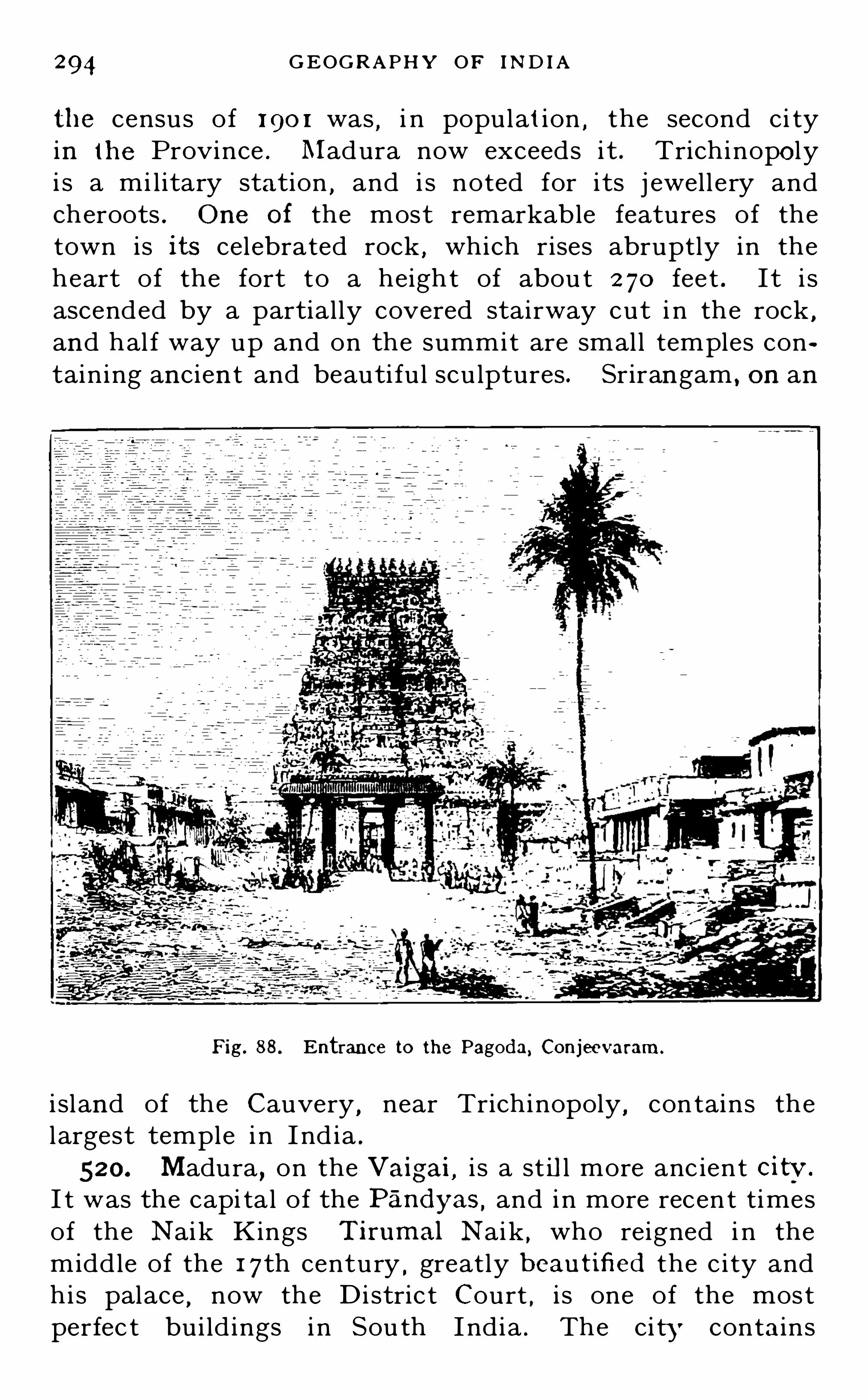
294 GEOG R APHY OF IND IA
the census of 1 90 1 was , i n population , the second ci tyin the Province . Madura now exceeds it . Trichinopolyi s a mi l itary station ,
and i s noted for its j ewell ery andcheroots . One of the most remarkable features of thetown is its celebrated rock ,
which rises abruptly in theheart of the fort to a height of abou t 2 70 feet . I t i sascended by a partial ly covered stairway cut i n the rock
,
and hal f way up and on the summit are small temples containing ancien t and beauti fu l scu lptures . Srirangam , on an
Fig. 88 . Entrance to the Pagoda, Conjeevaram.
i sland of the Cauvery,near Trichinopoly
,contains the
largest temple in I nd ia .
520. Madura,on the Vaigai, i s a st il l more anc ient citv.
I t was the capi tal of the Pandyas,and in more recen t times
of the Naik Kings Tirumal Naik , who reigned i n themiddle of the 1 7th century ,
greatly b eautified the c i ty andhi s palace , now the Distric t Court , i s one of the mostperfec t bui ld ings i n Sou th India . The ci ty contains

MAD R AS 295
several beaut i fu l temples , and the Hal l of a ThousandPillars i s unequall ed in I ndia .
52 1 . Tanj ore , on a branch of the Cauvery ,a flourish ing
town at the head of a rich agri cultural district , was thecapital of a smal l Maratha ki ngdom . The town containsthe Raja’s palace and some large temples . Raj ahmundryi s an important town on the Godavari
,near the point where
its waters divide . The East Coast Railway here crossesthe river by a bridge almost two miles in length . At
Fig. 89. Trichinopolv R ock .
Dowlaishweram , a l i t tl e lower down ,a very fine anicat
crosses the river . Ootacamund and Coonoor , on theN i lgiris , Yercaud on the Shevaroys, and Kodaikanal on thePalnis are al l favourite hil l stat ions . O otacamund i s thesummer seat of the Government
,and has a large population .
522 . After Madras the chief seaports are Vizagapatam,
Cocanada and Masu lipatam ,north of Madras
, Negapatam ..
sou th of Madras , Tuticorin on the Gul f of Manar , and

296 GEOG R APHY or mom
Cal icut on the west coast . There are many other smal l erports
,bu t they are al l al ike in offering no shel ter whatever
to shipping . Cocanada,near the northern mouth of the
G odavari,i s connected with the East Coast Railway
by a short branch l ine . I ts populat ion and trade are
rapid ly growing . Masu l ipatam was the first Engl i shsettl ement on the east coas t . and date s from 1 620 . FromNegapatam large quanti t ies o f rice are shipped to Ceylon .
From Tuticorin the cot ton grown in the southern d i strictsi s shipped . Bu t the chie f trade of the port i s with Colomboby a steamer wh ich runs daily in connect ion with the SouthInd ian Rai lway service . Cal icut was the first place i nIndia visited by the Portuguese under Vasco da Gama
,who
anchored there in 1 498 . The products of the coconut areits chie f exports.
NAT IVE STATES IN MAD R AS .
523 . TRAVANCORE ,the chief Native State in pol it ical
relat ion with Madras,i s bound ed on the north by Cochin
and on the west and sou th by the sea,whil e on the north
east and east the Western Ghats separate i t from theProvince of Madras . I t has thus wel l-defined naturalboundaries
,and the mountain s form a strong rampar t on
the land side . As at presen t consti tu ted the State may besaid to date from the early years of the 1 8 th cen tury .
During the struggl e wi th Haidar Al i i t s ruler was a fai th fu lal ly of the British . Travancore has been under Britishprotec tion since 1 788 ,
and i t is now one of the best ru l edand most progressive Native S tates of the Empi re .
524. Physi cal Featu res . Travancore has been call edThe Garden of I nd ia
,
” both for the rich varie ty of i tsscenery and its great fertil i ty . Magnificen t forests c lothethe mountain sides
,and as the rai n fal l i s very abundan t
and occurs ch iefly in the early summer months , a d ry heati s unknown
,and a mult i tude of shor t mountain s treams
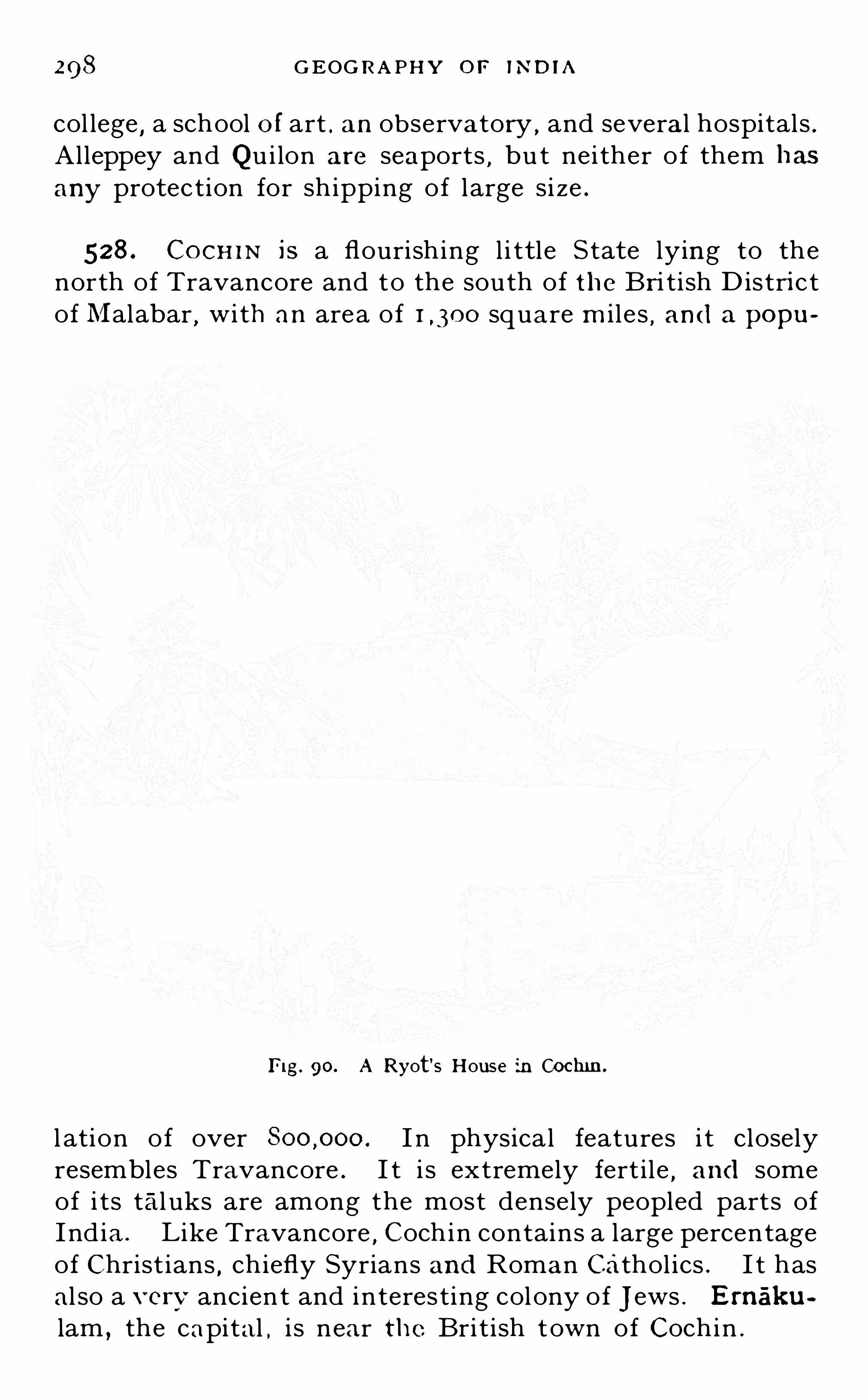
298 GEOG R A PHY o r mom
col lege,a school o f art . an observatory ,
and several hospitals .Alleppey and Qu i lon are seaports , bu t nei ther o f them has
any protection for shipping of large si ze .
528 . CocH iN is a flourish ing l i ttl e State lying to thenorth of Travancore and to the south of the Bri ti sh D istrictof Malabar
,with an area of square m i l e s , and a popu
Fig. 90. A R yot‘s House in Cochin.
l ation of over I n physical features i t closelyresembles Travancore . I t i s extremely fert ile
,and some
of i ts tal uks are among the most densely peopled parts ofInd ia. L ike Travancore
, Coch in contains a large percentageof Christ ians , chiefly Syrians and Roman Cathol ics . I t hasal so a verv ancien t and interes ting colony of j ews . Ernaku
lam,the capital , i s near the British town of Cochin .

MYSO R E 299
529. PUDU KKOTTA I i s a smal l State surrounded by theMadras Districts of Trichinopoly , Tanj ore , and Madura .
I t has an area of about square miles and a populationof I ts ruler is known as the Tond iman Raja.
The capital,Pudukkottai , is a town of inhabi tants .
MYSORE .
530. MYSOR E l ies west of Madras , in the southern angleof the plateau of the Deccan . I t has an area ofsquare miles . Next to Hyderabad i t is the most populousNative State in I nd ia , having a total population of abou t
512 mil l ions . The people are for the most part of Dravidianrace except in the north -west
,where they are Scytho
Dravid ians . More than five mil l ions are Hindus, over aquarter of a mil l ion M uharnrnadans, and the rest ChristiansAnimists, or j ains. The principal language is Kanarese
,
though Marathi i s spoken in the north -west .
53 1 . History . Mysore is an ancient Hindu kingdom .
I n 1 759 Haidar Ali, a Muhammadan adventurer , who hadbeen made Commander-in-Chie f of the Army of the Maharaja,
usurped the authority , dispossessed his master , andcarved ou t for himsel f a dominion in the south of theDeccan much larger than the present Mysore State . In
1 769 he had become powerful enough to threaten theEngl ish atMadras . I n 1 782 Haidar died and was succeededby hi s son Tipi
’
t,who was slain at the capture of Seringa
patam in 1 799. The Engl ish then restored the ancien t
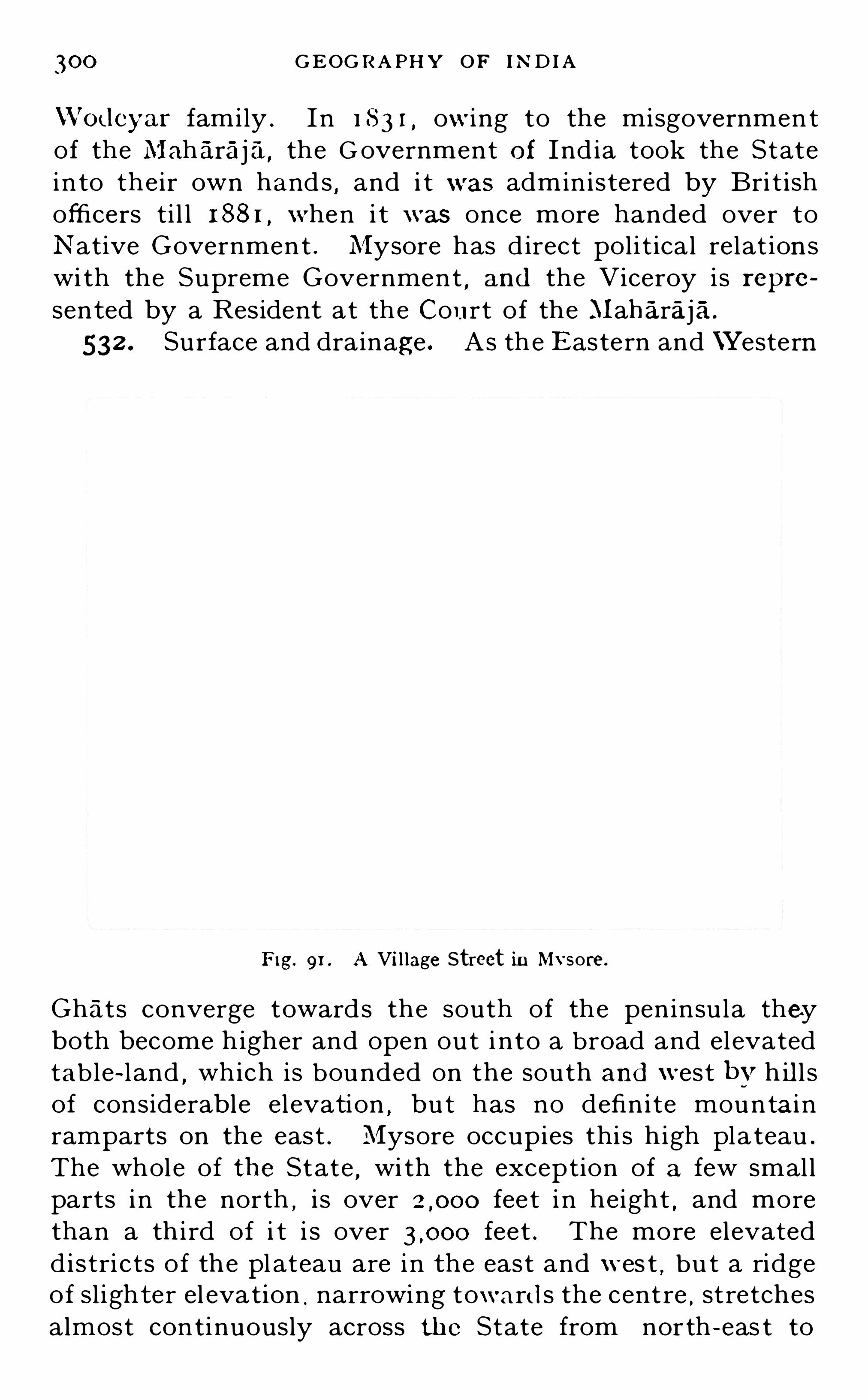
300 GEOG R A PH Y OF IND IA
\Vodeyar family . In 1 8 3 1 ,owing to the misgovernmen t
of the Maharaja,the G overnment of Ind ia took the State
in to their own hand s , and i t was administered by Bri tishofficers ti l l 1 88 1 ,
when i t was once more handed over toNative Government . Mysore has d irect pol i t ical relat ionswi th the Supreme Government
,and the Viceroy is repre
sented by a Resident at the Court of the Maharaja.
532 . Surface and drainage . As the Eastern and \Yestern
F ig. 91 . A Vil lage Street in Mysore.
Ghats converge towards the south of the peninsula theyboth become higher and open out i nto a broad and elevatedtab l e-l and , which is bounded on the south and west b v h ill sof considerable el evation
,but has no definite mountai n
ramparts on the east . Mysore occupies thi s h igh pla teau .
The whole of the State,wi th the exception of a few small
parts in the north,i s over feet i n height
,and more
than a third of i t i s over feet . The more elevateddistri cts of the pl ateau are in the east and wes t
,bu t a ridge
of sl ighter el evation . narrowing toward s the centre ,stretches
almost continuously across the State from north -eas t to

30 2 GEOG R A PH Y OF IND IA
For administrative purposes Mysore is d ivided into eightDistricts
,as shown i n Figu re 45
District.
Fig. 92 . TheMaharaja's Palace, Bangalore.
535. Chief Towns . BANG ALO R E. towards theeast is the chief town of the State . I t i s more thanfeet high and enj oys a sal ubrious and excel lent climate . I ti s the headquarters of the Government
,and contains some
fine publ ic off i ces and a handsome palace . I t i s also aBri ti sh Mi l itary s tat ion ,
and the Cantonment i s Briti shterri tory . To the east l ies Kolar , the bi rthplace of HaidarAli
, now noted for its gold .
Mysore,in the south
,i s the ch ie f residence of the
Maharaja. Seringapatam,northward on an i sland i n the

BUR M A 303
Cauvery , was the capital of the Haidar family . Tipi‘
i waskill ed at the storming of Seringapatam by the British in1 799. The town is now almost deserted on account of itsunhealthiness .
536. COOR G i s a smal l Bri tish territory to the west , withan area of square mi les , and a population ofI t i s very moun tainous . Cofiee and cardanioni s are themost important products . The chief town is Merkara . TheResident of Mysore i s al so Commission er of Coorg .
BURMA .
537. BUR M A ,the largest of the Provinces of the Indian
Empire , l ies outside of I ndia proper . I t occupies thewestern part of the Indo-Chinese Peninsula ,
taking in thewhole of the coast-l ine from the southern point of EasternBengal to Point Victori a on the I sthmus of Kra . On thenorth-west i t adj oi ns the h i l ly districts of Eastern Bengaland Assam and the Nat ive State of Manipur , and on theeast it i s bounded mainly by China in the north , and Siami n the south .
- The total area of the province issquare miles
,and the population is abou t 1 0% millions .
538 . History. The dominions of the native government of Burma were originally much more extensive thanthe present British Province . The K i ng was very despot ic ,being absolute master of the l ives and property of hissubj ects . In 1 824 the reigning monarch declared war
against the British,and prepared golden chains to bind
the Governor-General of India . The Engl ish troopsadvanced to Yandabo , within 45 miles of the capital , andthe Burmese were compelled to make peace b v the sacrificeof Assam ,
Arakan and the Tenasserim Provinces . I n 1 852

304 GEOG R A PHY OF IND I A
hosti l i ties again broke ou t,and Pegu was annexed . To
secure the peace of India,Theeb aw , King of Upper Burma,
was deposed i n 1 885,and the country became a Province
of the I ndian Empire . A Legislative Council was
granted i n 1 897.
539. Surface . Burma consists of ranges of hi l ls runni ngroughly north and south and separated by long and usuallynarrow val leys . At the east of the Pl ateau of Tibet themountain chains , which up to that point run ch iefly east
and west , bend round to the sou th almost in a series of concen tric arcs
,turning the Brahmaputra into the val ley of
Assam . From that poi n t they run mainly in a southerlydirection . Three mai n chains can be traced . Thatnearest the river bends round a littl e to the west
,and under
vari ou s names forms the eastern fronti er of I ndia properas far as Chi ttagong . I t then conti nues as the ArakanYoma at a short d istance from the coast and in ever
d im in i sh ing alti tudes as far south as Cape Negrais , wherei t d ips under th e water to reappear i n the Andaman I sles .This range forms the western boundary of the basin of theI rrawaddy . The eastern boundary of the basi n i s formedby a similar range , which widens out in the cen tre into theShan and Karenn i plateaux , and then , narrowing to thesouth
,fall s to the l evel of the plains near the angle of the
Gul f of Martaban . Between these two ranges there i s aminor range of lower elevat ion and broken i n the centre .
The northern hal f d ivides the basin of the I rrawaddyproper from that of i ts great tributary the Chindwin ,
and
the southern hal f , cal led the Pegu Yoma , forms the westernboundary of the smal l basin of the Sittang . The th ird andmost easterly of the main chains attain s to greater elevationthan ei ther of the others and runs southward for nearlytwice the distance . I t forms the eastern boundary of thenarrow basin of the Salwin
,and runs withou t a break to the
I sthmus of Kra .
540. Coast Line . The coast of Burma contrasts stronglywith that of peninsular I nd ia , being everywhere rockyexcept where the rivers have buil t up their del tas . Likeal l rocky coasts i t i s fringed with innumerab l e i sl and s ,

306 G EOG R A PHY or m om
most of which are very smal l . O ff the Arakan coast i nthe north are the l arger i sl ands o f Ramri and Cheduba . On
the Tenasserim coas t i n the south is the Mergu i Archipelago .
Further out to sea, and stre tching in a li ne from CapeNegrais to Sumatra are the Preparis, the Cocos , the Andamans and the Nicobars , the tops o f a submarine ridgeenclosing a deep sea .
541 . Rivers . The Irrawaddy is the great river of Burma .
I t rises i n the mountains east of the bend of the Brahmaputra and flows south to the Gul f of Martaban . Beingsnow-fed i t i s always a river of great volume
,and being
free from rapids except i n its upper course i t i s navigablefor 800 miles from its mouth . The chie f towns of Burmaare upon i ts banks and i t s t i l l forms the great highway ofcommerce from the interior to the coast . One of the
finest fleets of river steamers in the world ply upon it,going
as far north as Bhamo near the Chinese frontier . The chieftributary of the I rrawaddy i s the Chindwin , which d rainsthe eastern slopes o f the fronti er hi ll s of Eastern Bengaland Assam , and after flowing through a b road and richval ley un ites wi th the I rrawaddy below Mandalay . Fromthe east the Irrawaddy receives numerous minor tributariesthe larges t of which are the Shwel i which drai ns the h ill seast of Bhamo , and the Myit-nge which comes down fromthe Shan Plateau and j oi n s the I rrawaddy near Mandalay .
At its mouth the I rrawaddy forms a vas t del ta,and on i ts
two chief channels stand the ports of Rangoon and Bassein .
542 . The Salwin i s a l onger river than the Irrawaddyand brings down more water
,but i t is hemmed i n b v
mountains and has numerous rocky rapids , so that i t i snavigable only i n short reaches . I t ri ses i n Tibet andflows southward to the Gul f of Martaban . The Sittang isa small er river whose basi n is enclosed by the basins of t heI rrawaddy and the Salwin . I t flows southward to the
Gul f through a broad and level plain,which forms a vast
rice field . L ike the Salwin the Sittang is useless f ornavigati on
,though from d iflerent causes . I t i s shal low in
many parts , i ts mou th is blocked by a huge sand bar , andi t is subject to a severe tidal bore .

Fig. 94.
BUR MA
Burma in relief.
07

308 GEOG R APH Y O F IND IA
543 . People . The people of Burma belong mainly tothe Mongol ian family . There are many al lied tribes andraces who are classed together as Tibeto-Burmans. Theyare not pure Mongols , l ike the Chinese , but in physicalcharacteristics seem hal f way between the Chinese and theMalays . I n the h il l s are numerous wild tribes , the chiefof whom are the Kach ins in the north , the Shans i n the
Fig. 95 A group o f Kachins . (Photo. by P. Kit” ,R angoo
n-l
broad plateau sou th-east of Mandalay,and the Karens
further south . In some respects , and especial ly in education ,
the Burmese are ahead of all the natives of India , but theyhave l itt l e enterpri se or initiative . They are a hospitable
,
easy ,and pleasu re- loving people . Buddhism is the prevai l
ing religion . The ch ief languages are Burmese and Karen.

3 10 GEOG R A PHY OF IND IA
of the Ind ian demand . The chie f petroleum field s are alongthe Irrawaddy Valley and on the Arakan coast . Tin i sobtained in Tenasserim . A fine white marble i s found nearMandalay from which images are cu t . There are famousruby and fade mines i n the north .
546. Communications . Rai lways now run from Rangoon and Bassei n to Prome
, 300 miles up the I rrawaddy ,
and round the head of the Gul f of Pegu and Moulmein .
But the pri ncipal l i ne runs northward al ong the ri ch val leyof the Si ttang to Mandalay
,and onward at the other side
of the river to Myitkyinaalmost on the northern frontier .From Mandalay a branch runs through the Shan States onthe east , and on the other side of the river a shorter branchto Monywa on the Chindwin . I n al l nearly milesof railway are now open . The heavier through traffici s , however , sti l l l argely by river . There are few goodmetal led roads in Burma . One has been constru cted fromBhamo to the Chinese frontier and (by request of theChinese Government) 50 miles beyond i t , along whichan increasing traffic i s carried on with Yun-nan .
547. Administrative Divisions . The Di v isi ons and Districts of Burma are as follows
Divisions and Distr icts
Arakan D ivision1 . Akyab2 . Northern Arakan
3 . Kyankpyu r
4 . SandowayPegu Division
5. Rangoon Town6. Hanthawaddy
7 . Tharrawaddy8 . Pegu
9 . Promo
Irrawaddy Division1 0 . Bassein1 1 . Myaungmya1 2 . Ma-ubin1 3 . Henzada1 4 . Pyapon
A 1ea in Popu lationsq. miles ( 1 90 1 )

B U R MA 3 1 1
BUR MABoundar ies of S ta/115
( i f llw csw ros
Bonn/ {ar ias of ll u tr mt s
Enc sh Miles0 6 0
E A S T E R N
B E N G A L .
A S S A M
S O U T
F ig. 97. Districts and Chief States o f Burma.

3 1 2 G EOG R -APHY OF IN D IA
Tennasserim Division
15.
1 6.
1 7 .
1 8 .
19 .
20 .
ToungooSalwinThatonAmherstTavoyMergui
Minbu Division2 1 .
2 2 .
2 3
24
Man
25.
2 6 .
2 7 .
2 8 .
29.
Thayetmyo . .
PakokkuMinbuMagwe
dalay DivisionMandalayBhamoMyitkyinaKathaRuby Mines
S againg Division
30 .
3 1 .
3 2 .
33
S hue b o
SagaingLower ChindwinUpper Chindwin
Meiktila Division
34
3 5.
KyaukseMeiktila
36 . Yamethin
37 Myingyan
548 . Native States . O f the numerous native States inBurma al l are now practical ly incl uded in Bri ti sh terri torysave Karenni . They are as fol lows
Northern Shan StatesSouthern Shan StatesChin Hi ll sPakokku Chin Hi l lsKarenni States

3 I 4 GEOG R A PHY OF IND IA
550. The Andaman and Nicobar Islands , though geographical ly belonging to Burma , form a separate administration under a Chief Commissioner The Andamans
consist of three l arge i slands and nearly 200 smal l dnes ,
with a total area of about square m iles . They areh il ly , and have numerous excel lent harbours . The rain fallis heavy and the hil l s are covered wi th val uable forests .A large convic t settlement is maintained on the i sl ands .The native inhabitant s are of a low Negr i to race . The
Nicobars have an area of about 630 square miles . Theyare similar in most respects to the Andamans,
bu t arepeopled by a Malay race . Port Blair , on South Andaman ,
i s the seat of the Government . The meteorological observat ions taken on the Andamans are o f great importance asthey give the earliest and most rel iabl e storm warnings .
On thi s account Port Blair has recently been connected bywirel ess telegraphy with Burma .
FOREIGN PO SSESSIONS IN INDIA
551 . The FR EN CH TER R ITOR IES i n India are Pond i cherryand Karikal
,on the coast of the Carnatic Mahé, on the
Mal abar coast ; Yanaon on the Godavari Del ta , and
Chandernagore , on the river Hooghly . They contain lessthan 200 square mil es , and abou t inhabi tants .
Pondicherry i s the residence of the Governor. I t is a smallplace
,with but l itt l e trade .
552 . The POR TUGUESE POS SESS ION S consist of the smal ld istri ct of Goa
,Daman north of Bombay , and t he i s land
of Diu on the coast of the Kathiawar Peninsula . Goa wasonce the Spl endid capital of the Portuguese dominions inthe east
,bu t i s now in ruins . Pan j im
,or New Goa , has
been bui l t nearer the sea . Marmagao , the port of Goa,has
the best harbour on the west coas t sou th of Bombay . I ti s now served by a branch of the Southern MarathaRai lway, and i ts t rad e i s growing .

APPENDI !
LIST OF THE PRINCIPAL NATIVE STATES OF INDIA
With the Titl e and Caste or Race of their Rulers , their Area andPopulation , and the Province or Agency to which they belong .
[N .B . N o S tate is included in this list unless it has either
an area of over sq. miles or a population of atleast There are nearly 600 smaller S tates ]
State A rea in Popu lation,Title and Caste In p o l itical
s q .miles . 1901 . of R u ler . relation with
ALWA R Raj putana
BAHAWALPUR Punj ab
BAR ODA Brit .R esident ,Govt . India
BAN SWAR A 1 R aj putana
BHOPA L
BHOR Bombay
BHUTAN
B I KANER
CHAM BA Punj ab
Maharaj a.Raj pu t
Nawab ,DaudputraMaharaja,
MarathaMaharawal ,
Raj putRana, Raj pu tRaja, Raj putRaja, Raj pu tMaharaja, JatThakur Sahib,
Raj putNawab Begam ,
PathanPant Saehiv,
BrahmanDeb Raja
BhotiaMaharaja,
Raj putRaja
,Bhuiya
Maharao Raja,Raj pu t
Raj a, Raj pu t
Central I ndiaCentral Provs.
O rissaR aj putanaBombay
Central India

3 1 6
Area inState.
sq .miles .
CHHATA R PUR
COCH IN
CO O CHBEHA R
CUTCH . .
DAT IA
DHA R
DHEN KANAL
DHOLPUR
GANGPU R
GONDAL
GWAL IO R
HILLTI PPER A
Hsi p Aw
HYDE R ABAD
IDA R
INDO R E
A I PU R
Popu lation ,
I190 1 .
2
I 73 , 3 25
73 3 70
GEOG R A PHY OF IND IA
Title and Casteo f R u ler .
In po l iticalrelation with
Centr al India
Madras
Cen tral India
O rissa
Raj putana
O rissa
Bombay
Bri t . ResidentCen tral Ind iaEas tern Bengal and AssamBurma
Bri t .Resident ,Govt . Ind ia
Brit .R esident ,Raj putanaRaj putana
Central Provs.
Raj a , BundelaPonwar
Raja,Kshattriya
Maharaja,Kshattriya
Maharao ,R aj put
Maharaja,Raj pu t
Raj a, PonwarMaratha
Raj a ,Kshattriya
MaharajaR ena, Jat
Ra] Sahib,Raj pu t
Maharawal ,Raj put
Raj a ,Kshattriya
Thakur sah ib,Raj pu t
Maharaja,Maratha
Raj a ,Kshattriya
Sawbwa , Shan ,
Buddhis tNizam ,
Turk ,
Sunni Muhammadan
Maharaja,Raj pu t
Maharaja,Maratha
Maharaja.Raj pu t
Maharawal ,Raj pu t

3 1 8 GEOG R A PHY O F IN D I A
S’
t tA rea in Popu lation . T itle and Caste In po l iticala e.
sq m iles. 190 1 . o f R u ler relation with
PA LAN PU R Diwan , Pathan BombayPANNA Maharaja, Central lndi
Raj pu tPAT IALA Maharaja, Jat , Punj ab
SikhRaja, Kal lar Madras
REWAH
SANGL I
RAM PU RSAVANTVAD I
S I K K I M
1 54-54 4
SU R GUJ A Cen tral ProxTE H R I(GA R HWAL)
TON KTR AVAN CO R E
Nawab,Pathan
Raja, GondMaharana
,
Raj pu tMaharaja,
Raj putThakur ,
MarathaNawab, PathanSar Desai ,
MarathaMaharaja,
TibetanRaj a
,Raj pu t
Maharao ,Raj pu t
Raj a,Raj pu t
Raja,Kshattriya
Nawab,Pathan
Maharaja,Kshattriya
Raja, Raj pu tMaharana
,
Raj pu t

IndexThe names of Provinces and States are. pr inted in smal l capital s , e.g. AG R A ,
ALWAR .
town ; ml. , mountain ;The fol lowing abbreviations are used — App ,
Appendix ; r. ,river ; t. ,
is land .
The numbers refer to Paragraphs
Abbottabad , t. , 4 1 8 .
Ab u , ml. , 29 t. , 440.
Ad i labad D ist., 470.
Afghani stan ,Trade with,
251 .
Agra D i st. , 382 ; t., 386,Carpets o f, 2 1 3 .
Agra Canal c losed to
traffic, 2 3 3 .
AGR A and OUD H , Difi‘erch ees in the admmis
tration of, 37 1 .
Ahmadabad D ist., 487 ;t. , 490 ; Cotton manufactures o f, 2 1 0.
Ahmadnagar Di st., 487 ;t. , 491 .
A jaigarh, t. , 453 .
A janta, t. , 475.
A janta R ange, 468 .
Ajmere, t. , 440.
AJMER -MERWA R A , 43 3 ,
440 ; Administrationof , 2 75.
A jodhya (or Ayodhya) ,t. , 1 1 6 ; R uins of, 3 89.
AkolaDist. , 460 t. , 462 .
Akyab Di st., 547 t., 549 ;Port of, 75.
A lai Mts. , 1 1 .
A laknanda, r . , 46.
Aligarh D i st., 382 ; t. ,
388 .
Alipore, t. , 3 37.
Aliwal , t. , 405.
Al lahabad Dist.,t., 1 1 6, 383 .
Al leppey, t. , 527 .
Almora Dist. , 382 .
Altyn Tagh Mts. , 1 1 .
A LWAR , 433 ; APPAmarkantak , Mts. , 444 ;Plateau, 456.
Amarapura, t., 549.
Amaravati, r., 504 .
Amherst Dist., 547 ; t. ,
382
75.
Amraoti Dist., 460 ; t. ,
462 .
Amritsar Dist. , 401 ; t.,1 1 7, 404 ; Ivory workof, 2 1 7 .
Anaimudi , ml., 503 .
Anamallai Mts., 3 2 , 503 .
Anantapur D ist. , 506.
Angu l Di st., 3 3 1 .
AND AMAN I SLAND S , 25,
78 , 540, 550 Admini s
tration of, 2 75.
A R AKAN annexed , 267.
Arakan Yoma, 25, 539.
A ravalli H i l ls , 29, 435 ;Antiquity of, 1 6.
A R GENT INA , Trade Wi th,
250 .
Army of Ind ia, S i ze andcost, 296 Commandoh 297.
Ami Muslims, 2 1 0.
Arrah, t. , 339.
Arialkhan , r . , 43 .
Aryans , The, 1 03—1 09.
Aryan languages , 1 23more prevalent than
Aryan b lood , 1 2 1 .
A ryo Dravidian Type,The, 1 08 .
Ass, TheWild , 1 92 .
A SSAM,Conquest of, 267 ,
3 1 0, 344 Peop le, 1 08Language. 1 24 , 349R ainfal l , 97 M inerals ,351 Coalfields in,
1 76 Cu ltivation ofrubber in, 1 54 o f tea,1 68 S i lk manufactures
,2 1 4 .
Assam-Bengal R ailway,
352
Attock D ist. , 40 1 t., 406.
Aurungabad Dist., 473 ;L, 475.
AUSTR AL IA , Trade With,
250.
A U S T R I A H U N G A R Y ,Trade With,
250.
Ava, t ., 549.
A zamgarh D ist. , 382 .
BABA NANAK, the foundero f Sikhism, 1 3 3 .
Backwaters of the S .-W .
Coast, 68 , 2 34.
Bad rinath, mt., 374.
BAHAWALPUR , 408, App .;t. , 408 .
Baitarani , r. , 3 1 8 .
Bakarganj Di st., 353 .
BalaghatDist.,46o ;Hills,468 .
Balasore D i st. , 3 3 1 .
Bal lia D ist. , 382 .
Baloch language, The,1 23 .
Baliaghata ShippingCanal , 23 3 .
BALUCH ISTAN , 426—432 ;
Natural features , 427 ;Temperature, 8 1 Not
a part of Ind ia proper ,3 Administration, 275;Peop le, 1 08 , 430.
Bamboo The, 1 54 .
Banda D i st. , 382 Cededto British, 370.
Bangalore D i st. , 534 t. ,
535 ; Carpet, Manufacture of , 2 1 3 .
Bank ipore, t. , 3 39.
BankuraDist. , 33 1 .
Bannu D i st. , 4 1 3 .
BAN SWA R A , 433 App.
Bara Lacha Pass , 1 3 .
Barak . r . , 345. 347 .
Barei l ly Dist. , 382 ; t. ,
387 .
Bari Doab , 394 .
Barisal , t. , 355.
Barley, Cu lture of, 1 60 .
BA R O DA. 493 , 496, APPt. , 496.
Barogi l Pass , 2 2 .
Baronga, 78 .
Barrackpore, t., 3 37.
BAR WAN I , App .
Bassein D ist. , 547 ; t.,
549 ; Port of, 75BASTAR
, 463 , 464, App .
Basti Di st. , 382 .
BAUD,App .
Beas , r . , 40, 394 Treatyof , 309.
Belgaum Dist. , 487.
BELG IUM,Trade
250.
BellaryD i st. , 51 6 ; Cededb y the Ni zam, 262 .
Benares Dist. ,382 Ceded ,309. 370 ; t., 1 1 5. 385
'
Brass work of,
2 1 5Ivory work , 2 1 7.
BENGAL , 307—342 ; Conquest of, 257, 308 Ad
ministrative Divisions ,33 1 Physical features ,3 1 3 , 3 1 6 ; People, 1 08 ,320
—32 2 ; Communica
tions , 328—330 ; Natu
Wl th,

3 20 INDEX
The numbers re fe r to Paragraphsral Produc ts , 323 ; Coal111 11105 , 1 76 , 3 25 ; Ironmines , 1 80, 325 ;Manufactures of
jute
,2 1 2
S i lk , 2 1 4 ; ton, 1 80 ;Exports and Imports,327Bengal-Nagpur R ly. , 328 ,
448
Bengal and4
.N5-W. R ly.,
3 28 , 38 1 .
Bengal i language, The,1 24 .
BER AR , taken from R ajaof Nagpur and given totheNizam, 455 Leasedto Brit. Govt., 467 .
Bhanrer R ange, mts., 456.
Bhavani, r. , 504 .
Bhils , The, 1 05.
Bhilsa, t. , 449.
Bhima, r . , 56, 469, 482 .
Bhir Di st., 473 .
BHOPAL. 44 1 . 451 . APPt. , 451 .
BHOR , App .
Bhui. t. , 495.
BHUTAN , 366, 368 , App .
Bhutan War, 344 .
Bidar Dist. , 473 t. , 476.
B I HAR acquired b y the
British. 257 : t . 339 ;Peop le of , 108 OpiumCultivation in, 1 70 .
B ihari language, The, 1 : 4 .
B i japur D i st. , 487 .
B i jnor D ist. , 382 .
B I KANER , 433 , App . ; t. ,
440
B i laspur Dist. , 460.
Betul Dist. , 460.
Betwa, r ., 376. 446.
Bezwada, t. , 372 .
Bhad ra, r . , 56, 532 .
Bhagalpur Dist., 33 1 t. ,
339Bhagirathi , r . , (Garhwal ) ,
64Bhagirathi,
48 , 3 1 8 .
Bhamo D ist. , 547 , 549.
BH AR ATPU R , 43 3 , App .
Bhandara Dist. , 460.
Bhatgaon, t. , 365.
BnAUNAGAR . 497 , App .
Bhaunagar-Gondal-Ju nagarh-Porbandar R ailway, 497
Bhirb hum Dist., 33 1 .
Bhubaneswar , t. , 340.
Birds o f India, 1 95, 1 96.
Black cotton soil , character of , 1 40.
r. , ( Bengal ) ,
lllack l lole, Tragedy ofIhc. 257 1 3 32 ’
llogra Dist. , 353 .
Bolan Pass , 23 , 1 1 7 , 43 1 .
Bolaram, t. , 475.
BOMBAY , 477—498 ; Ad
ministrative Divisions ,48 7 ; H istory of , 478C l imate and R ainfal l ,483 ; $011 and Pro
ducts, 484 , Communications , 485 Peop leand languages , 486 ;Government of. 273 ;The greatest cottongrowing Province, 1 74Salt factor ies o f , 1 84S i lk-mi l ls o f, 2 14 Ex
ports oi, 249 ; NativeStates in, 493 .
Bombay, i sland of, 77,
478 .
Bombay, t. , 488 ; Com
parison with Calcutta,
334 The great centreof Cotton Manu facture,
2 1 1 Harbour , 67- 68po rt, 2 36.
Bombay, Baroda and
Central Indian R ai lway,
2 26, 38 1 , 485.
BONA I , App .
Bor Pass , R oad across ,2 20.
Brahmani, r . , 3 1 8 .
Brahmaputra, r . , 38 , 43 ,
3463Brahu i1 22 .
Brahuis , The, 105.
B R ITiSH BALUCH I STAN ,
43 1 Govt. of , 275.
British Empire in Ind ia,Growth of, 264 .
Broach D ist., 487 t., 66,
language, The,
490
Buck ingham Canal , 234 ,
51 2 .
Budaun Dist., 382 .
Buddhism , 1 3 1 .
Bu landshahr Dist. , 3 82 .
Buldana Di st. , 460.
Bundela R ajputs , 453 .
Bundelkhand , 453 .
BUND I , 433 . App .
Burdwan Dist. , 33 1 Ao
quired b y the British,258. 307 L. 338
Burhanpur. t. , 461 .
BU R MA , 53 7—551 Coastline oi, 540 ;R ivers . 5962 ;Notjapart o f Ind iaproper.,3 i; Annexation
of,267 H istory, 538
Government, 274 Ad
ministrative Divisions,547 C limateand R ainfal l
, 96, 544 ; NaturalProducts , 544 ; Nextto Bengal as 3 R ice
producing Provmce,
1 56 ; Minerals , 1 76,1 8 7, 1 90 ; Peop le, 108 ,537 ; Languages. 543
8
;R ailwa) 5 o f, 546 ;tive States , 548 .
BurmeseWar, First, 3 10.
BUS S AH IR , 4 1 0.
Buxar , t. , 339 Battle of,258. 308 . 3 70.
Cachar Dist. , 353 .
Cachar Val ley, 344 .
Calcutta, t. , 3 32-337
Compari son with Bomb ay, 3 34 the PremierPort of India, 73 , 236sacked b y the Nawabof Murshidabad , 257 ;Exports o f, 249.
Cal icut. t., 522 .
Cambay, 496 ; t. , 420
Trade of, 1 1 7 ° Gui o f,silting up , 64-66 .
Cardamom H i l ls , 32 , 503 .
Carnatic , The, annexed262 , 502 .
Cauvery, r . , 57. 504 , 542 .
Cawnpore Dist. , 382 t. ,
387 .
0Ceded Distri cts , The,
501 .
CENTR AL INniA , 44 1-453 ;
Area and Population,
44 1 Climateand rain
fal l , 445 Communications , 446 ; Peop le of108 . 443 R ivers , 446Soil and natural products , 1 57. 447.
CENTR AL PR ov1NCE5 ,454
465 H istory. 455 1Government of, 275 ;Administrative Divisions
, 460 Sur face anddrainage, 456 ; Areaand population, 454C limate and products ,457 ; Peop le. 108 .469 :Communications, 457.
CEYLON. geographicallyaPart of India, 4 Coastof , 70—1 Trade with ,
250.
Chamalhari, ml 1 2 , 367.
l Chaman, t., 43 1 .

3 2 2 INDEX
The numbers re fer to Paragraphstory. 344 Government of , 274 Admin
istrativeD ivis ions , 353 ,
C limate and p roducts ,348
—3 50 Peop le, 349
Communications. 352 .
Eastern Bengal R ai lway ,
226, 3 28 . 352 .
Easter n Ghats , 33 , 503 :
Antiquity of, 1 6 ; onceconnected With the
H imalayas , 1 7 .
Easter n H ind i language,
The, 1 24 .
Edwardesab ad ,t. , 4 1 8 .
E lephanta. 77 , 490.
Ellichpiir, t. , 462 .
E l lora, t 475.
Ernaku lam. t. , 528 .
Etawah Dist. , 382 .
E tah Di st. , 38
Ethnographic1 02 .
Ethnology of India, S iRW . W . HuNTER
’
s
V iews , 1 05—7.
Everest. Mt. , 1Exchange, Governmentloss on, 300.
E ! CI SE Duties , 284 .
Export dutyon rice, 286.
Survey,
False Point, 340.
Famine Administration,
294 .
FAR ID KOT, 4 1 0.
Faridpur D ist. , 353 .
Farrukhabad Dist. , 382 .
Fatehpur D ist. , 38 2 .
Fatehpur S ik ri , t. , 386.
Ferozepur D ist. , 401 .
Feudatory S tates , Origino f, 260 .
F irozshah , t. , 405.
First Burmese War, 267,3 1 0. 34
First Sikh4War, 392 .
Fish Curing , 203Foreign Commerce, 246.
Foreign Communications ,236
-9 .
Foreign Possessions in
India, 551—2 .
Forests, lnfluenceon rainfal l
,1 51
—5.
Forest Department, Creation and work of , 1 52 .
Fort S t. George. 500.
Fort Wi l liam, 3 33 .
FR ANCE , Tradewith, 250 .
French East 256.
French Territories in
Ind ia, 551 .
I’rontirr Trade of Ind ia,
I°'vzab ad ,
t. , 388 .
Gandak , r . , 48 , 3 1 8 . 36 1
Ganuvs 7 4 46-49. 3 1 8.
3 76.
Ganges Canals ,Traffic on, 2 33 .
G ANGPL'R , App .
Ganjam D ist . , 516.
Gantak. t. , 369 .
Dist . , 309, 38 1 .
Garo H il l s , 345.
Gasherb rum, mt , 42 1 .
Gauhati. t. , 3 52 , 3 56.
Gaur. rums of , 355Gaurisankar, pk 1 2 .
GAUTAMA BUDDHA , 1 3 1 .
Gawi lgarh, t. , 462 .
Gaya D ist. , 33 1 t. , 339.
GER MANY , Trade with,
25o .
Ghasz ipur Dist. , 38 2
ceded , 309, 3 70 i . .385.
Gilgit, t. , 425 r. , 39. 1 20 .
G iridhi, Coal mines o f ,I 77. 3 25
Goa, 552 ; t 8 ; Tradeof , 1 1 7 .
Goalanda, t. , 355.
Goalpara D ist. , 353 .
Gobindpur , t. , 332 .
Godavari Dist. , 51 6 ; f55. 469. 482 . 504 ;Steam service on, 2 34 .
Godwm Austen, .\ It . 1
Gogra, r . , 36 1 . 375.
Golconda, t. , 472 , 476Gold in India, 1 8 1—1 8 3
Gomal Pass , 23 , 1 1 7.
Gomal , r . , 39, 4 1 4 .
Gond language, The, 1 22 .
GONDAL , App .
Gonds , The, 459, 464Gorakhpur D is t.
, 382
Gosai Than, pk , 1 2
Governor-General , Firs tappointment of , 268 ;
powers o f , 2 71 .
Govindgarh , L. 404 .
Grand Trunk R oad , 2 20.
G t. Indian Peninsu laR ai lway , 2 25, 38 1 , 458 ,
472 . 485. 51 3Great R ann of Cutch , 66.
Guj rat Dist. , 406 t. , 40 1 .
Gujarati language, The,1 24 .
Gu jranwala Dist. , 401
Gu lburga Dist. , 473 ; t
476
Gumti , r., 1 8 , 3 76.
( Luntur Dist. , 51 6.
Gurdaspur Dist. , 401 .
Gurgaon Dist. , 401 .
Gurkhas , The, 363 warWith, 309.
GwALiO R , 44 1 , 449, App.
Hamirpur Dist. , 370, 382 .
Hanthaivaddy Dist. , 547.
HA I DA R Au , Wars with,262 .
Hardo i Dist. , 382 .
Hardwar, t. , 1 44 , 388 .
Han iai , r. , 43 1 .
Hassan Dist., 534 .
Hazara Dist. , 4 1 3 .
Hazari bagh Dist. , 33 1
t , 340 ; M ica found3 25.
Helmand , basin of, 1 8 .
Henzada Dist., 547 .
H ILL T I PPER A , 345, 357,,
AppH imalayas , The, mls . , 1 0
1 91 , 192 not awatershed , 1 5 Drainage of ,1 7 ; Peop le of. 1 08 .
H imalayan Pas ses , 1 3 .
H indi language, The, 459H indu Kush, mist , 1 1 , 19.
H industani language,The, 1 26.
Hinduism, its elasticity,1 2
H inganghat, t. , 461 .
H issar Dist. , 401 .
HONG KONG , Tradewith,
250 .
Hooghly D ist. , 33 1 ; t. ,
252. 3 38 ; r 48. 73 .
Hoshangabad Dist. , 460.
Hoshiarpur Dist , 401 .
Howrah Dist , 33 1 ; I
33 7s Aw, App .
Hub li, t. , 491 .
Hugri, r. , 53 2 .
Husain Sagar tank , 474 .
HYDER ABAD , 466, 476 ,
Appendix Histor)467 ; AdministrativeDii
'isions, 473 ; Cu
mate and products ,470 : Communications,472 ; Peop le of 1 08 ;C ity. 4 74 . 49
“
Hyderabad and GodavariR ai lway, 472 .
I DA R , AppImperial Sen'
ice Troops,

INDEX 3 23
The numb ers refer to ParagraphsImphal ,357~
Income Tax, 2 87 .
India Council , Constitution of, 270 Ind iaCou nci ls Act, 1 861 , 268 .
Ind ian Desert, 1 00.
Ind ian M id land R ai lway,448. 458
Ind igo, dec lining cultivation of , 1 73 .
Indo Aryan languages ,1 23
—4 .
Indo Chinese languages ,1 28 .
Indo Gangetic Plain, 26,27 .
INDO R B . 44 1 . 450. APP- it. , 450.
Indravati , r. , 55, 464 .
InduS . r ., 38-
42. 394.422 .
or Manipu r, t.,
48 1 .
Indus Val ley R ai lway,485.
Inner Indo-Aryan lan
guages , 1 24 .
Intermed iate Indo-A ryanlanguages , 1 24 .
Internal Trade of Ind ia,
Internalwaterways,233-5.
Inundation Canals , 1 46.
I ran, Plateau of, 1 8 , 427 .
Irano-Aryan languages ,1 23 .
I rrawaddy, r. , 59, 60,
54 1 Steam servi ceon,
2 35.
I rrigation, 1 42—1 50 Cost
of,and income from,
1 50 .
Iskardo (or Skardo) , t
425.
Is lamabad ,t. ,
I s lands o f India, 76—8 .
ITALY , Tradewith ,250.
Jagannath, Temp le of,340
J agdalpur , t., 464.
Jai lep-la Pass , 1 3 .
Jats , The, 1 06, 1 09.
J aintia H i l ls , 345.
J ainism, 1 32 .
J A IPUR , 43 3. App . ; t .
440
JA iS ALMER , 433 , App .
Jalangi, r . , 3 1 8 .
J alaun D ist. , 382 .
Jalpaigu ri D ist. , 353 .
Jalna. t 475J ames and Mary Sands ,73 ; 334
Jammu , t. , 425.
J ANJ I R A , 498 .
J APAN , Trade With, 250.
J ASHPUR . 463 . 465. App .
Jaunpur D i st. , 382 .
J AVA , Tradewith, 250.
J essore D ist. , 33 1 .
Jetch Doab , 394 .
J ews in Ind ia, 1 35.
J HABUA , App .
J hang D ist. , 401 .
J hansiD ist. , 382
Jhelum Di s t. , 401 r ., 40,1 45. 394 , 42 2
J IND , 4 1 0,App .
J O DH PUR (MARWAR ) , 433 ,App . ; t 449 .
J ubbu lpore Di st. , 460 ;t. , 458 , 461 .
JudiCial Administrationof India, 279.
J u l lundur Di st., 401
t. , 1 1 7 , 404 .
J u l lundur Doab , 394 .
J umna. r. , 38. 47. 1 44.
376.
J UNAGAR H , App .
J ute, 1 75 ; Export of ,246 Manufactures ,
Kabu l , r . , 39, 4 1 4 .
Kachhi, 428 .
Kachin H i l ls , 25.
Kadur D i st. , 534 .
Kaimur R ange, 344, 456.
Kaira Dist., 387.
KALAT, 432 , App . ; t. ,
432 .
Kal i , r . , 376.
Kali S indh, r ., 446.
Kaludan, r . , 75.
Kalyan, t. , 476.
Kampti , t. , 461 .
Kamrup Di st. , 354.
Kanauj , t. , 1 1 6, 389.
Kanara annexed , 501 .
Kanarese language, The,1 22 .
Kangra Dist. , 401 t.,
404 .
KAN KER , 465, App .
KAPUR THALA , 4 10, App .
Karachi , t. , 1 90, 487harbour , 64—5, 236.
Karakorum Mts. , 1 1
Karakorum Pass , 1 3 , 42 1 .
KAR AUL I , 43 3 , App .
Karen language, The,1 28 .
Karenni H i l ls , 25, 539,
548
Karikal , t. , 551 .
t , 388 .
Karimnagar Dist., 473 .
Karnal D ist., 401 .
Kamaphuli, r. , 355.
Kasai , r . , 3 1 8 .
KASHM I R AND J AMMU ,4 19
-
425. App His
tory, 420 ; PhysmalCharacter istics , 42 1 ;Peop le, Cli
mate and Productions ,424 Manufactures ,2 1 3 .
Kashmiri language, The,1 24 .
Kasimbazar ,KathaDi st. , 547.
Kathiawar , 1 40, 480, 497.Katni, t. , 458 .
Ken, r . , 376.
KENGTUNG , App .
KEONJHAR , App .
Khyber Pass , 2 3 , 1 1 7.
KHA I R AGAR H , 465.
KHA IR PUR , 494 , App .
Khamgaon,t. , 462 .
Khamti H i l l s , 345.
Khasi H i l l s , 25, 345.
Khasi and Jaintia Hil l sDi st.
, 353 .
KHAS I STATES , 357 .
Khatmandu ,Val ley of,
362 t. , 365.
Kheri D ist. , 382 .
Khirthar Mts. ,1 9, 428 .
Khu lna D ist. , 3 3 1 .
K idderpore, t. , 336.
KinchinJungaMt. , 1 2
Ki stnaDi st . , 51 6.
Kistna. n. 56. 469. 482.
504 .
Kodaikanal , t. , 52 1 .
Kohat D ist. , 4 1 3 t. ,
4 1 8 ; r ., 4 1 4 ; Salthi l l s of , 1 86, 4 14 .
KolabaD ist. , 487 .
Kolar D ist., 535 t. ,
535 Goldfields of,
Kolarian languages , 1 22 .
Kolas , The, 1 05.
KO LHAPUR , 498 , App .
Kols,The, 1 05.
Konkan, The, 479.
KO R EA , 4 63 , 465, App .
KOTAH . 4 33 . AppKunar (or Chitral ) , r . , 39,
4 1 4 .
Kuram D i st. 4 1
1
3 ; Pass ,23 ;Kurnu l D ist. , 51
1
64
;cededb y theNi zam ,
262 .
Kurukh language, The,1 22 .

3 24 INDEX
The numbers re fer to ParagraphsKUSI , r 36 1 .
Kwen Lun Mts. , 1 1 , 1 4 .
Kyankpyur D ist. , 547.
Kyankse D ist., 547 .
Laccad ives , isls . , 16, 77.
Ladakh R ange, 1 1 , 42 1 .
Lahore D ist. , 40 1 ,t. ,
402 .
Lahnda languages , The,1 24 .
Lakli imp iir Dist. , 353 .
Lakhisarai , t. , 339.
Land R evenue, The, 288Assessment of, 289 ;Settlements , 290
under the Mughals ,
Landour, t. , 3 74 .
Larkana D ist . , 487 .
LAs BELA , 4 26 , App .
Ledo , t. , 352 .
Leh, t. , 425.
LinguisticInd ia, 1 24 .
Local Board s , 222 , 277 .
Local Government in
Ind ia, 277—278 .
Lower Burma. R ice Cul
tivation in, 1 56.
Lower Chenab Canal ,
Survey of
145.
Lower Cli indwm Dist.,470
LoswerGanges Canal 378 .
Lucknow Di st. , 382 ° t. ,
1 1 6, 384 .
Ludhiana D ist , 401 t. ,
404 .
Luni , r . , 4 35.
Lushai H i l ls , 25. 353 .
Lyal lpur Dist . , 401 .
Madhumati , r . , 48 , 3 1 8 .
Madura D ist , 51 6 . t. ,
520.
M AD R AS , 499-
528 ; His
tory, 500 ; Adminis
trative Divisions , 51 6C l imate, 505 People,
Communi
cations . 51 2 ; NaturalProducts , 508 ;ForeignCommerce, 249, 51 5 ;Native States in, 523 .
Madras City and Dist. ,51 6 ; Port of , 72 , 236 ;Factory founded , 252
taken b y the French,256.
Madras R ai lway,
534 .
Magwe Dis t . , 547.
Mahabaleshwar , t. , 49 1 .
Mahab alipurain (or SevenPagodasL 51 8 .
Mahadeo H i l ls , 29, 456.
Mahanadi, r. , 54 , 3 1 8 ,
456
Mahbubnagar Dist. , 473 .
Mahe, t. , 551 .
Mahi , r . , 446, 48 2 .
MAi i i KANTHA AGENCY ,498
Maikal R ange, The, 29,
456.
Mainpur i Dist. , 382 .
Makum, t. , 356 ; CoalM ines , 1 78 Petro leumWells. 1 8 7 .
Malabar D ist. , 516 ;taken b y the Br itish,
262 .
Malakand Pass. 22 .
Malayalam language,The,1 22 .
MaldaD ist. , 353 ; t. , 355.
Maldives , 15154 1 6 , 77.
MalwaGhats , 479.
Malwa Op ium , 1 70.
Malwa, Plateau of , 435.
Manar , Gu l f of , 69 ;77
Manasarowar, Lake, 38 ,
Manb lium D ist. , 33 1 .
Mandalay D ist . , 547 ; t
540.
Mandavi, t. , 495.
MANDi , 4 1 0, App .
Mand la Dist. , 460 .
MAN iPUR , 357 , App .
Manj ira, r . ,
Manufactures ° Cotton ,
2 1 1, ;J ute, 2 1 2 Woo l
len, 2 1 3 : Si lk , 2 1 4 ;
Steam flour mills, 2 1 8
Metal work , 2 1 5 Pot
tory, 2 1 6 Ivory, etc
2 1 7 ; Paper , 2 1 8 ;Sugar , 2 1 8 .
Marathi language, The,
1 24 459Marmagao , t. , 552
Martaban, Gu l f o f. 539.
Mashkaf, r. , 43 1 .
Mashkel Hanina. 427 .
Masulipatam. t. , 2 1 3 . 252
22 swept b y a s tor mwave, 1 0 1 .
Mao ub in Dis t . 547.
MAUR iTiUS , Trade with.
250 .
MAvU R EHAN ) , App .
Mean-Meer , t. , 402 .
Medak Dis t. , 473 .
Mee rut Dist . 382 ; t. , 388 .
Meghna. r . , 43 , 74 , 347.
Meiktila Dist ., 547 .
Mergui Archipelago , 78 ,
5403Mergu i D ist. , 547 L. 75,
549Merkara, t. , 536.
Mhow, t. , 450.
M ianwali Dist . , 40 1 .
MidnaporeCanal,The, 3 19.
M idnapore Dis t . , 258 ,
M ikir Hills. 345.
M inbu Dist. , 547.
Mir A lam tank , 474 .
M irzapur D ist. , 38 2 ; t. ,
385, carpet manufactures o f, 2 1 3 .
Mohpani coal nunes . 1 77 .
Monghyr D ist. , 33 1 ; t.,
3 39NoNGNA i , App .
Monsoons , The, 89—93 .
Montgomery Dist . , 401 .
Moradabad Dist. , 382 .
Moulmein, t. , 75. 549.
Mudk i , t. , 405.
Mu tla, r . , 73 .
Mu ltan Dis t . , 401 t. ,1 1 7 , 406 .
Munda S ub -Family o flanguages. 1 22 .
MuniCipalities,277 R eve
nue and Expenditureof. 278 .
Murshidabad Dist. , 33 1t. , 254 , 338 .
MuS i , r . . 469.
Mussouri , t. , 374 .
Mutla. r . , 33 7 .
MuttraDist . , 38 2 t. .389 .
Muzaffargarh Dist . , 40 1 .
Muzaffarpur Dist . , 33 1 ;l . . 3 39
MuzafiamaggarDi st . , 382 .
Muz tagh or KarakorumMts. , 1 1 , 4 2 1 .
Muz tagh Pass , 1 3 .
Myaungrm aD ist 547.
My ingyan Dist . 54 7.
.\ Ivi t-nge, r. , 60, 54 1 .
\lyitkvina Dist . , 547.
Mymensingh Dist. , 353 .
MvS O R E , 530-5. App .
H istory, 53 1 C limate,
533 ; Peo p le and lan
guage. 530 ; Prod ucts ,533 Cotice cultivationin, 167 Gold mines in,
1 82 : R ailway s . 534 ;Mvsore State R ailways ,

3 26 IND EX
The numbers re fer to ParagraphsCu ltivation, 1 57 ; SaltH i l l s O f , 1 83 People ,
1 08 , 400 ; Communications , 399 ; NativeStates in, 407.
Punjabi language, The.
1 24 .
Purali , 7 , Del ta of , 428 .
Fun D ist. 33 1 ; t , 1 1 5,
340
Puma, r . , 52 , 469 .
Pumen D ist . , 33 1 .
Pyapon Dist. , 547 .
Quetta, t. , 43 1 .
Qui lon, t. , 527
R ADHANPU R , App .
R ae Barel i Dist. , 382 .
R aichur Di st. , 473 .
R aichur Doab , The, 468 .
R A ioA R H, 465, App .
R ailways in India, 2252 3 1 Income from,
291 .
R ainfal l of India, 94100 ; its influence on
population, 1 1 9.
R aipur Dist. , 460 ;
461 .
R aj amundry,t. , 52 1 .
R ajasthani language,The, 1 24 , 400
R ajkot t. , 497.
R A IR IPLA , App .
R AJPL‘
TANA , 43 3-440
H istory, 434 C l imateand Products , 436
Peop le, 1 08 , 438 ; Saltlakes o f , 1 8 3 Lan
guages , 438 .
R ajputana-Malwa R ailway , 448 , 485.
R ajputs , The,1 06, 1 09.
R akas Tal, I. , 40.
R ameswaram, 69, 77 .
R amganga, r . , 46, 476 .
R AMPU R , 490, App .
R amri . 78 , 540 .
R anchi Di st. , 33 1 t.,
340
549.
R angpur Di st. , 353 .
R aniganj , t. , 1 77 , 1 80,
R ANJ iT S iNGH. 302 .
R ann of Ciitch, 66. 480 .
R atnagiri Dist. , 487.
R apti , r . , 48 , 3 76.
R avi, r . , 40.
R awalpind i Dist. , 401 ;t. , 406.
R ecli iia l loali . 394 .
R egu lating Act, The
268 .
R elig ions of Ind ia,1 29
I 3SKAvTiiA Agency,
The, 498 .
R EivA ii , 44 1 , 452 . App .
R ice, Cultivation and
consumption of , 1 56 ;Export of. 246, 249.
R oads , Construction o f,2 20—2 2
R ohtak Dist . , 40 1 .
R oyal Titles Ac t269.
R uby M ines in Burma,1 90.
R uby M ines D ist. , 547 .
R upee, Decl ine in valueof, 299.
R upnarayan, r , 73 .
R urk i , t. , 388 .
R yotwari Land Tenure289.
Sab amiati , r. , 482
Sad iya, t. , 354 , 356.
Sad ras , t. , 51 8 .
Safed Koh Mts , 19, 4 1 2 .
Sagaing Dist 547 .
Saharanpur Dist. , 38 2
i , 388 .
Saheb ghat. t. , 352 .
Sahyadri Mountains , 3 1 .
Salem Dist. , 51 6.
Sal sette, 67, 77, 478 ,
490
Salt R ange,The, 1 86. 393 .
Salt, Sources o f , 1 831 86 ; Imports of , 1 83 .
Salt Tax. The, 283 .
Salwm Dist. , 547 r . , 59,
62 , 235, 542 .
Sambalpur Dist. , 3 3 1 I
34 1
Sambhar Lake, 1 83 , 1 85,
4 337Sandaltt ood , a Government monopo ly in Mvsore, 533 .
Sandarb ans, The. 73 , 74Swept b y a stor mwave, 10 1 .
Sand ip , 77.
Sandoway D ist. , 547 .
SANGL I , App .
Santal Parganas Dist. ,
Santhals, The, 105.
Saran Dis t 3 3 1 .
Sarda, r. , 48 . 3 76 .
Satara Di st . , 48 7.
Satpura Mts. , 29, 444 ,
Saugor Dist. , 455, 460 ;t. , 46 1 .
Saugor I sland . 77 .
Savage I sland , 78 .
SAVANTVAD I , 498 . ApSecond Burmese at ,The, 267 .
Second S ikh War, 392 .
Secretary of State forInd ia, Powers of , 270.
Scotole, t. . 385.
Secunderabad , t. , 475.
Secundra, t. , 386 .
Seonath. r . , 54 , 456.
Seoni Dist. , 460.
Serampore, t. , 338 .
Seringapatam, t. , 57, 1 16,
535Shab az pur, 77 .
Shahabad Dist. , 33 1 .
Shahpur Dist. , 401 ; t. ,1 1 7 .
Shajahanpur Dis t . , 382 .
Shan language, The, 1 28 .
Shevaroy Hills, The, 33 ,503 .
ShimogaD ist. , 534 .
Shikarpur , t 1 1 7 .
Sholapur Di st. , 487.
Shwebo D ist . , 547 .
Shweli, r .. 54 1 .
Sialkot Dist. , 401 .
S IAM, Trade with. 251 .
S ibiDis t . , 43 1 .
Sibsagar Dist. , 353 ; t. ,
356.
S igauli. Treaty of , 370.
Sikh Wars , The, 266.
S I K K IM , 369, App.
Silchar , t. , 356.
SimlaDist. , 401 t. , 1 1 3 ,
405.
Sina. r . , 482 .
S IND . 480 ; Conquest of,66
Smd Pishin
Sind , Punjab and DelhiR ailway , 226 .
Sind Sagar Doab , 394 .
Singareni, t. , 469 ; Coalmines o f, 1 77.
Sindhi language, The,
R ai lway,
1 24 .
Singhbhum Dist. , 33 1 .
S lR \! t R ,
-\ ppS I R O H I , 43 3 . AppS i tab ald i R idge, 461 .
Sitapur Dis t , 382 .
Sittang . r . , 59, 6 1 , 235,

INDEX 32 7
The numb ers refer to ParagraphsS ivasamundram , 57 .
S iwal ik H i l l s , 374 Geo
logi cal character of, 1 7 .
Sobraon,t., 405.
South Arcot Di st. , 51 6.
South Ind ian R ai lway,
South Kanara D ist. , 51 6.
Southern Maratha R ai lway. 472 . 485. 5ny534Southern Penner, r . , 504,
53 2
SOUTHER N S H AN STATES ,548 .
Srinagar , t 425.
Srirangam, 57 ; t.,
51 9.
STR A ITS SETTLEMENTS ,Trade With, 250.
S ub anrekha, r . , 3 1 8 .
Suez Canal , Eflect O f on
Ind ian Trade, 236, 3 34 .
Sugar, Growth O f, 1 65Manufacture O f
,2 1 8 .
Sukkur D ist. , 487 t. , 42 .
Sulaiman Mountains , 1 9,
Sunar (or Keri) , r. , 446.
Surat D ist. , 487 ; t. , 66,1 88 ; First BritishFactory founded at,252 .
SU R GUJA , 463 , 465, App .
Sunna. r 4Sutlei. n. 38. 40. 393 .
Swat, Agency O f, 4 1 1
7 4
Sylhet Di st . 345. 353t. , 356.
Syrian Christians , 1 34 .
Taj Mahal , 386.
Takht-i-Sulaiman, pk. ,
1 9.
Taluk Boards , 277 .
Tamb rapami , r., 504 .
Tanen-Taung-Gyi Mts. ,
25.
Tanjore D ist . , 501 , 51 6 ;t. , 52 1 .
Tapti , r . ,
Tapt i Val ley R ai lway,48 5Tavoy D ist . , 547 ; t., 75.
Thal Pass , 2 20.
Thana Dist 487 .
Thaneswar , t. , 405.
Thar, or Ind ian Desert,396.
Thar and Parkar D ist.,487 .
Tharrawaddy D ist. , 547 .
Thaton D i st. , 547.
Thayetmyo D i s t. , 547 ;t 549Tian Shan Mts. , 1 1 .
Tibetan Plateau,1 4 , I 6,
85.
Tibeto-Burman races ,1 04 .
T idal Canal , Balasore,-2 33 .
Tinnevel ly D ist , 51 9.
Tmnevelly-l on R ailway , 526
Tippera D ist. , 353 .
Tirhut R ai lway , 3 39.
Tea, Cu ltivation O f, 1 66,
351 ; Expor t of , 246.
TEH R I (GA R HWAL ) , 390 ;App .
Telegraph Service, In
land , 242 ; Foreign,
243 .
Telugu language, The
1 2 2 .
TENASSER IM
Tenasserim Yoma, 25Terai , The, 362 , 3 75.
Tobacco, Growth of, 1 7 1 .
Tochi . a . 39. 4 1 4 ;Agency, 4 1 1 .
Tochi Pass , 2 3 .
TO N K. 43 3 . APPTons , r .
, 376, 446.
Toungoo Di st., 547 ,
t.,
540.
Trade Wi th foreign countries , 250.
Tranquebar , Purchase of,502 .
Trans-Alai Mts. , 1 1 .
Trans-H imalayaMts. , 1 5.
TR AVANCO R E , 52 3—7 ,
App . Physical fea
tures , 524 ; COHIHIUHI:cations and Commerce,526 ; Cardamonis, a
Government Monopoly, 1 68 .
Trichinopo ly Di st., 51 6 ;
t. , 51 9.
Tr isu l , mt , 374 .
Trivandrum, t. , 527.
Trombay,
'I S / 77
Tu lu language, The, 1 22 .
Tumkur D ist. , 534 .
Tumlong, t. , 369.
Tunga, r . , 56, 532 .
Tungab hadra, r . , 56, 469,
532
Tuticorin, port, 69, 52 2 .
Twenty-four ParganasDist., 33 1 .
UD A I PU R , 463 , 465. APP°
UD A IPU R (MEWA R ) . 433 .App . t. , 440.
Uj jain, t. , 449.
Umaria Coal mine 1 02 ,
Umballa D ist., 401 ; t. ,
405.
Unao Dist., 382 .
UN ITED K INGDOM , TradeWith, 250.
UN ITED PR OV INCES , 370383 ; AdministratiyeDivi s ions , 382 ; His
tory, 370 ; C l imate,3 77 ; Natu ral Productions, 378 ; Peop le,1 08 , 380 ; Communi
cations , 38 1 ; NativeS tates in, 390.
UN ITED STATES ,wi th, 250.
UPPER BU R MA annexed ,267 .
Upper Chindwin Dist.,547
Trade
Upper Ganges Canal ,I 44. 378 .
Upper S ind FrontierD ist . , 487 .
Urdu (or Western H indi)language, The, 1 26,
400.
Vaigai, r . , 504.
Vellar, r . , 504 .
Vi l lage Unions , 277.
Vindhya H i l ls, 29, 444,
,
456
Vizagapatam Dist., 51 6t. , 52 2 .
Wad i , t. , 472 .
Wainganga. r . , 55. 456.
469.
Wana, Agency of, 4 1 1 .
Wandiwash,Battle O f,
256.
Warangal D ist. , 473 1
Wardha Di st. , 460 ; r . ,
Warora Coalfields , 1 77 ,
458. 461
West Khandesh Dist. ,
487 .
Vl’
eavmg Industry ofIndia
,2 1 0.
Western Ghats , 3 1 , 479.
Western H indi language,The, 1 24 .
\Yestern J umna Canal ,Traffic on, 23 3 .

328 iNDEx
The numbers refer toWheat, area under cu lti Wu lur Lake,
vation, 1 57 ; Export Wynaad , Gold mines in,
of, 246, 249. 1 82 .
Wind , Diurnal Change o f,83 . Yamethin Dist.. 547.
Woo l len Manufactures , Yanaon, t. , 551 .
204, 2 1 3 . Yeo tmal D ist. , 460.
Yercaud , t. , 52 1 .
Zamindari Land Tenur e,
289.
Zaskar R ange, 1 1 .
Zhob, r., 4 1 4 .

G eographical S er ies
A Manual of Geography , Physical and Political . Globe8yo . , 400 pp . Wi th 8 fold ing col oured maps
,and
26 others,Rs . 1 .
This has long been a popular book thr oughou t Ind iaand was recently completely t e written and greatlyimproved . Each ed ition is rev ised and brought up todate.
Outl ines of Geography. Fcap . 8vo 208 pp . \Vitli 1 8
maps , mostly coloured . Cloth,As . 1 0 ; or stifi
paper covers,As . 8 .
Pr imer of Geography. Fcap . 8yo ., 64 pp . ,
with 1 1
coloured maps,AS . 5.
The Primer , the Outlines and the A'Iamtal form a
graduated series , and being special ly intended for use
in Ind ian Schools , Ind ia receives much fuller treatmentthan any other country. They are all well printed and
abundantly illustrated .
Geography of Asia . Fcap . 8yo 80 pp . ,wi th fold ing
coloured map , paper covers , As . 5.
Geography of Europe and Africa . Fcap . 8v0 . ,80 pp . , with
fold ing coloured map , paper covers , As . 5.
Excel lently got up Replete with good maps
and attractive illiiS trations. The matter is wel l arrangedand the information abundant. — I nd ian Iournal ofEducation.
CHRISTIAN LITERATURE SOCIETY FOR INDIA ,
9 ,DUK E STR EET , ADELPH I , LONDON ,
MEMO R I AL HALL , MAD R AS ; and DAM ST COLO M BO .

UCSOUTHERNREGIONAL LIBRARY FACILITY
A 000 165 418 5
ITY O F CAL IFO R N IA LIBR AR Y
LosAngelesDUE on the last date stamped b elow.