


II. - Forgotten Books
470
-
Upload
khangminh22 -
Category
Documents
-
view
3 -
download
0
Transcript of II. - Forgotten Books


CON TENTS .
PART II.
CHAPTERXIX.
EXTRA-PENIN-
SULARAREA.
su m— (w. r. B.)
PAGE PAGE
Sub division of Ei tra-Peninsular
area .
1. SIM) z—Physical geography ofWest
Palmontology
Ranikot groupPab ontology
Cretaceous and lower tertiary rocks of
Baluchistan 453 Greatpost-pliocene disturbanceKhirthar group Alternation of marine and freshwater
Pala ontology beds
7
CHAPTERXX .
EXTRA-PENINSULARAREA.
THE PUNJAB HILLS WEST or THE JHELUM.-(W. r. B.)
Physical geographyGeological data.General geological featuresRook-groups of SaltRangeBo ck-groups of Hazéra and the North
483
Abnormal boundary of upper tertiaries 483
Az oic and Palwoioic rocks of Salt
Range,&c.
Purple sandstone
Nari groupPalmontologyGfij groupPalaeontologyManchhar groupRelations toMakran group .
Pab ontol'
ogy ofManchhar groupJest-tertiary bedsAdditional notes on Sind tertiary series
Absence of general breaks below
Silurian ( i’)
Magnesian sandstone
Speckled sandstone
Carboniferous
Mesoaoic rocks of Salt Range,Ceratite beds
Pseudomorphic salt-crystal zone
Jurassic or variegated groupCretaceous (neocom ian)Olive group

CONTENTS.iv
CHAPTERXXI.
EXTRA-PENINSULARAREA.
THE PUNJAB HILLS WEST or THE JHELUM—cmMued.—(W. T . B.)
m an m an
Pale oz oic and m esoz oic rocks of North Kohat districtern Punjab Salt and gypsum
Crystalline and m etam orphic Clays, lim estones, and sandstones above
Schistose series the salt
A-ttock slates Northern Potw'
er andMurree HillsCarboniferous and infra triassic Hill nummulitic lim estone of Northern
T1 ias ( includingRhaetic)Jurassic : Spiti shalesGieum al sandstone
Cretaceous
Tertiary beds of Punjab generallyThi ckness of tertiary series
Distribution of eocene beds
Mari and Bhl’igti hillsSuleman range near Dera Ghaz i KhanChichali Hills and SaltRange
CHAPTERXXII.
EXTRA-PENINSULARAREA.
SUB-HIMALAYAS.- (H. B. M.)
m es
Scanty materials
Provisional lim its of Himalayan region
General featuresThree main div isions
Tun SUB-HIMALAYAS.—Prov i s i o na1~
conclusions
General featuresEarly views on Sub-Himalayas
General range of these depositsClassification
PetrologyChiefly of freshwater originStructural conditions
FaultsFlexures
Middle and term inal Sub-Himalayanregions
The Sim la region
Order of description
Tm : SmMuB AREA
Upper tertiaries, Siwaliks, &c.
Distribution
PalaeontologyPost-pliocene deposits of Northern
PunjabErratics
Indus floodsFossil shells
Unity of the formation
Subathu, Dagshai, and Kasauli groupsRelation to the older rocks
Secti on at Subathu
Lim its of the Sirmfir area
Easternmost outlier of the numm ulitic
group
eSIWALm SERIES : NABAN ABBA
The Nahan-fi walik boundaryTheNéhan-Sirmfir boundary
THE JUMNA-GANGBS ABBA
Composition in relation to the great
r1vers
Identification of beds 111 the two z ones .
Suggested connection of the two z ones
in this area
TBB GABBWAL AND KumauN ABBA
NBBAL ABBA
Sm xm AND BBuTA'
N ABBAs
UrrBB ASSAMABBA

CONTENTS.
CHAPTERXXIII,
EXTRA-PENINSULARAREA.
SUB-HimALAYAs—continued.
TBBMINAL SUB-HIMALAYAS KANGBA
General structure
The Gham bar Basauli fault
The Kosari and Badsar-Nurpur faultsExtinction of the Nahan S1wel1k
boundary
The Sutlej at BubhorExtinction of theNahan-Sirmfir bound
ary
Difficulties of classification in the
Kangra area
Bubhor and Belaspur sections compared
Doubtful beds in the Sirm 1’
1r z one
Want of fossils
The base of the Dhauladhar range
TheMandi rock ‘salt
North-western termination of the
Kangra areaSpecial featureSirmfir z one at theRaviWestern expansion of Sirmfir z one
Inliers
Characters of the Subathu group
Relation of tertiary to palaeoz oic rocks
PAGE
CHAPTER
EXTRA-PENINSULARAREA.
(n. B. M.)
SIWALIK FAUNA.— (W. T B.)
The later tertiary vertebrate faunaSiwalik m ollusca
Hom otaxis of mamm alia
Reptilian oevidence
Siwalik fauna probably pliocene
Stratigraphical evidence of age of Siwa
Surv ival of miocene form s in Siwalik
beds
Pliocene fauna of Pikermi in Attica
PAGE
Comparison with sections of Sim la
region
Doubtful newer rocks of the Sirmfirz one
Other general features of Sirmfir z one
The Siwalik-Sirm fir boundaryThe Basauli-Naushera fault
Riassi conglomeratesThe outer Siwalik z one
SUMMARY1 . Special Him alayan disturbance
altogether post eocene
2. Eocene Himalayan land
3. Doubtful extension over the Lower
Himalayan area
Actual Him alayan border defined
in m iddle tertiary times
5 . Its partial extension to the north
west
6. Himalayan river-gorges in Siwaliktim es same as now
7. Extrem e slowness of disturbing
action
8. Elevation preceded compression
MigrationEffects of change of climate
Comparative poverty of recent mam
m alian faunas
Relations of Siwalik to Perim Islandfauna
Comparison with Irawadi fauna
Comparison of Siwalik and recent
faunas

v i'
CONTENTS._
CHAPTERXXV .
EXTRA-PENINSULARAREA.
LOWERHIMALAYAS .—(H . B . M
Lim its Trappean rocks
General features The Chor m ountain
The term inal area South-east of Sim la
Classification of rocks Kumaun and GarhwalCorrelation of groups
The gneissic series
The slate series
The Infra-Blaini rocks (Simla slates) .
The Blaini group
Infra-E rd'
l groupThe Krél group
Therelations of the slate and gneissic
series
Specialmetm orphism and disturbance
CHAPTERXXV-I.
EXTRA-PENINSULARAREA.
CENTRAL (TIBETAN) BIMALArAsl— (E . B
Data available
Classification of rocks central
General structureand distributionThe m ain gneissic axis
The Hundes and Zanskar Synclinal
The Karakoram synclinal and Kuenlun
The Kashmir synclinalPosition of the tertiary form ations 626
Gneiss of two ages
The central gneiss
Mineral cha r
acter
Stratigraphical relation 628
Relations defined only'
in the m iddle
The Sikkim area
The Darjili-ng gneissThe Daling series
The Dam l’
i da series
Relations of the three Series in Sikkim
The Bhutan borderThe Dikrang section
Summary
The granitic axis
Term inal extensions of
gnfeiss
The Zénskér gneissic range
The PirPanjal gneissic chain
The Dhauladhar gneissic range
The newer gneiss
The chief sedimentary basins
The form ations of the Zénskar area
Palaeoz ow series
South-west boundarySouth-east boundaryThe
.
Rupshu m etam orphics
North boundary with tertiary rocks
The secondary s eries
The tertiary series

CONTENTS. Vii
CHAPTERXXVII.
EXTRA-PENINSULARAREA.
CENTRAL (TIBETAN) HIMALAYAs—cbntinaed.—(H. B . M
The Hundes or Ngari -Khorsum area
Stratigraphical series of Niti in Hun
des
The tertiary eruptive rocks of Hundes
The sedim entary tertiary rocks of
Hundes
The Karakdram area
The Ladak gneiss
The eastern section of the
bas in
The Karakoram sectionThe Kuenlun range
The Suket pass section
The Yang-i pass section
The Pam ir section
The Kashm ir-Pangi areaTriassic rocks of Kashm ir
CHAPTER. XXVIII.
EXTRA-PENIN SULARAREA.
THE AsszuuRANGE—(H. B. M.)
Area to be described
Formations presentGeneral structure
The cretaceous series : Khasi areaCretaceous series : Géro area
Cretaceous series :Mikir areaNummulitic series Khasi area .
biIAPTERXXIX .
EXTRA-PENINSULARAREA.
BURMA.-i- (W. T B.)
Area and .physical geography
Geological data
Carboniferous rocks of Kashm irSilurian rocks of KashmirT he Pangi basin
The Pir Panjal chainOne-s idedness of m ountain structure
Post-tertiary and recent formations
Sub-Him alayan high-level gravels
Glacial evidence in TibetThe Hundes lake-basin
Lingzhithang and Kuenlun lake-basinsTsoMoriri and other basinsAlluv ial deposits of Ti bet
The Kashmir basinThe Nepal valley ;
Other lakes
Drainage lines
Summary
Nummulitic serieS : Géroarea
Eastern extension of the nummulitica
The upper tertiaries
The Assam coal-fields
General structureThe Disang group
The coal m easures
Tipam and Dehing groups

CONTENTS.
Maulmain group
Mai -i ( cretaceous) groupSupposed cretaceous
scrim
Negrais rocks
Coal-bearing rocks of Tenasserim
Pegu groupNewer tertiary beds in Araka-n
Pliocene fossil-wood group‘
Tertiaries of Upper Burma
Extinct volcano of Puppa
Trachyte in South-Western PeguPost-tertiary deposits laterite
Older alluvial sands and grav'
els
Delta of lrawadi
Littoral concrete of Arakan coast
Mud volcanoes ofRam ri, &0.Islands in the Bay of Bengal
AndamanIslands
Nicobar Islands
Barren Island and Narcondsm

Extra-Peninsular, ] SUB-DIVISION OF THE E‘XTRA-PENINSULARAREA.
CHAPTERXIX .
EXTRA-PENINSULARAREA.
SIND.
Sub-div ision of the extra-peninsular area I, SIND—Physical geography of Western SindRock form ations Cretaceous beds Deccan trap Ranikot group Palaeonto
logy—Cretaceous and lower tertiary beds of Baluchistanfi Khirthar group Palae
ontology Nari group Palaeontology s group Palaeontology Manchhargroup Relations toMakran group of Baluchistan Palaeontology ofManchhar groupPost-tertiary beds Additional notes on Sind tert iary series Absence of general
breaks below pliocene Great post-pliocene disturbance Alternation of marine and
fresh-water beds .
Sub -div ision o f the extra-
peninsular area—The distinctionsin geological characters between the peninsular and extra-
peninsularareas of India have already been explained, and the reasons for treatingthe two regions separately have been sufficiently stated in the intro
ductory chapter ; whilst the descriptions of the tertiary, and still m ore
of the post-tertiary, form ations of the Peninsula furnish a natural passage
to the extra-
peninsular area . This . is geologically an intrinsic portionof the Asiatic continent
,whilst peninsular India is not.
Im perfect as is our knowledge of the geology of the Indian Penin
sula, our acquaintancewith the geological structure of the m ountain ranges
west of the Indus, of the Him alayas, and of the countries east and north
east of the Bay of Bengal, is even m ore fragm entary. Occasionally wide
areas intervene, such as Nepal and the outer hills of the Afghan high
lands, from which Europeans are rigidly excluded, and, even when no
political difficulties exist, the physical im pedim ents to surveying are of
the m ost serious description . Many parts of the m ountainous barrier
which alm ost surrounds India are, from their great elevation and rigor
ous clim ate, only habitable for a short period of the year, and even
then their exploration is a m atter of diffi culty population is Sparse, and
roads either difficult or wanting throughout the whole tract. To the
eastward, in the dam per regions of Assam , Sylhet, and Burm a, the dense
ness o f the forest throughout nearly the whole of the country, and the
impenetrable undergrowth of creepers, canes, bam boos, and shrubs, render
the exam ination of the rocks toilsom e, tedious, and unsatisfactory. To
crown the whole, throughout extra-peninsular India, wi th the exception
of Sind and the Panjah, the geology is greatly obscured by the disturbance
and, in m any parts, them etam orphism which the rocks have undergone.

GEOLOGY or inDiA- sm n. [ Chap. XIX.
Owing to these various drawbacks, it is not practicable to treat the
geology of extra-peninsular India as has been done in the case of the
peninsular area, and to describe each form ation throughout the wholeregion by itself. Having to deal with fragm entary and isolated observations, varying greatly in their am ount of detail,.
it appears best to takeeach geological tract separately ; and this arrangem ent is facilitated bythe fact that there is a wide distinction between different parts of the
region, both in the form ations represented, and in the physical features ofthe geology, such as the directions of the m ountain chains . The planthat will be adopted in describing the extra
-peninsular tracts will be to
comm ence at the west with Sind, as the rocks of that province are not
only closely connected with the tertiary form ations of Cutch and Kettywar, described in the fourteenth chapter, but are also of importance as
afi ording a better series of the tertiary beds, so widely developed inextra-peninsular India, than is known elsewhere in Southern or SouthEastern As ia.
The following regions will therefore be separately described
I. Sind. IV. Assam , Sylhet, Chittagong, &c.
II. Panjéb hills westof theJhelum . V. Burm a.
III. Himalayas.
I. SIND—Physica1geography of Western S ind—The greaterpart of the province of Sind is included in the Indo-Gangetic plain,already described in Chapter XVII; Eastern Sind, beyond the lim its ofthe Indus alluvium , consists chiefly of sand-hills, and the rock area of
the province is alm ost lim ited to the ranges of hills on the western or
Baluchistan frontier, and a few isolated ridges in the alluvium the m ost
important exposures am ongst the latterbeing those near Sukkur (Sakhar)and Rohri (Boree)
The province is comm only di vided into Upper and Lower S ind, theform er lying north, the latter south of Sehwan . Upper Sind consists ofa broad alluv ial plain on both sides of the river
,interrupted near Suk
kur andRohri by the ridges of lim estone already m entioned, and boundedto the westward by a. north and south m ountain chain
, known as theKhirthar,
l form ing the boundary between Sind and Baluchistan, and
rising in places to and even in one spot to feet above thesea. Lower Sind, west of the Indus, consists of a series of para
llel
north and south ridges of no great height, seldom exceeding feetabove the sea, but much loftier to the north than to the south
, wherethey almost di sappear in an undulating plain near the coast. Many of
1 This range in all the older maps is united with other bills on thewesternborder of Sind,and the whole is called the Hails. range. No suchrange is recognised in the country Thereis aHalopass,not in the Khirthar range, but in another much smaller ridge south of Sehwan.
Extra-Peninsular. J ROCK FORMATION9.
these ridges are simple anticlinals, the axes being form ed of the m assivenumm ulitic lim estone of which the highest portion of the Khirthar also
consists . The Khirthar range term inates in Lower Sind som e distancesouth of Sehwan ; other ridges, however, both east and west of this m ain
range, extend farther to the south. East of the Indus there is an
isolated low range of lim estone hills, on the northern extrem ity of which
stands the town of Hyderabad, and there is another sim ilar rise at Tatta.
The hills of Baluchistan, west of Sind, are very im perfectly known
for som e distance from the Sind frontier they form ranges running north
and south parallel to the Khirthar, but farther west they assum e an
east and west d irection . They are principally com posed of tertiary rocks,
like the hills of Sind, but at Kelat itself, and in a few other localities,older form ations have been discovered,l and som e apparently extensiveigneous rocks also occu
r
.
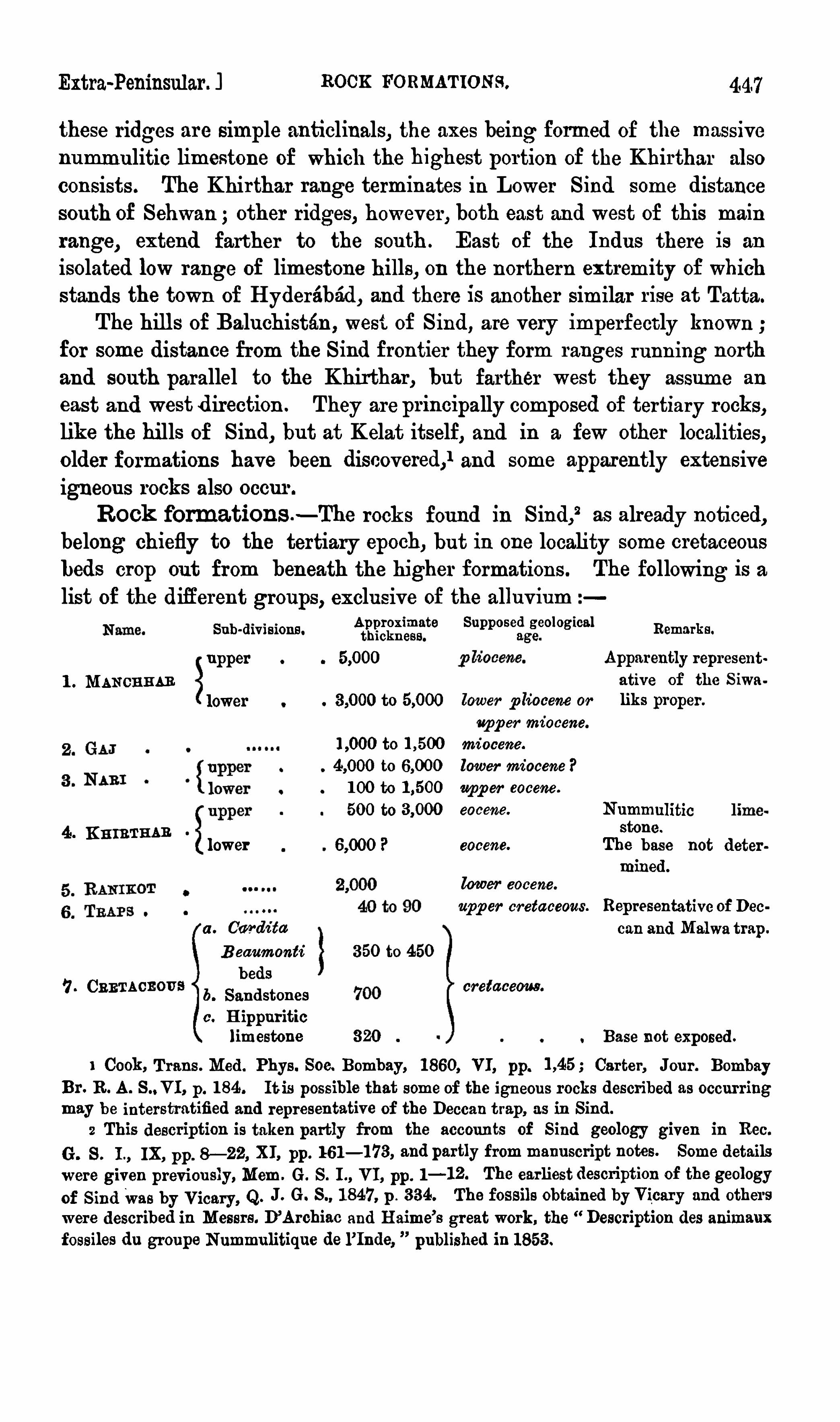
Rock form ations —The rocks found in Sind,2 as already noticed,
belong chiefly to the tertiary epoch, but in one locality som e cretaceous
beds crop out from beneath the higher form ations . The following is alist of the different groups, exclusive of the alluvium
Sub-div isions . fig‘i’
gfigg‘gf
e Remarks.
upper
1 . Mancnumlower
Nummulitics n
4 . KHm THAB
lower eocene. Thdo
biise not deter
m ined .
lower eocene.
upper cretaceous. Representative of Deca . Ca/rdz
'
ta can andMalwa trap.
Beaum onts 350 to 450
beds7. CRETACEOUS cretaceous .
b. Sandstones
c . Hippuritic
lim estone 320 Base not exposed .
1 Cook, Trans . Med . Phys . Soc. Bombay, 1860, VI, pp. Carter, Jour. Bombay
Br. R. A. S.,VI, p. 184. It is possible that som e of the igneous rocks described as occurring
m ay be interstratified and representative of the Deccan trap, as in Sind.
2 This description is taken partly from the accounts of Sind geology given in Rec.
G . S. I., IX, pp. 8—22, XI, pp. 161—173, and partly from m anuscript notes. Som e details
were given previ ously,Mem . G . S. I., VI, pp. 1—12. The earliest description of the geology
of SindWas by Vicary, Q. J. G. S., 1847, p. 384. The fossils obtained byVicary and others
were described in Messrs . D’Archiac and Haim e’s great work, the Description des animaux
fossiles da groupe Nummulitique de l’Inde, published in 1853.
to
to
to
100 to
500 to
Apparently represent
ative of the Siwa
lower p liocene or liks proper.
upper m i ocene.
m i ocene.
lower m i ocene ?
upper eocene .
eocene.
GEOLOGY or INDIA—SIND. [ Chap XIX.
Of these rocks, the lower Khirthars and the Ranikot beds m ay be, to
som e extent, representative of each other. On the river Gaj, which
traverses the Khirthar range in Upper Sind, a thickness of at least
feet of strata is exposed, none of the fossiliferous beds being of
older date than eocene but som e of the rocks towards the base of the
section beyond the“Sind frontier correspond so well with the description
given by Dr. Cook of strata in which he found m eso z oic foss ils
(Ammonites, 8m.) in Kelat, that these bottom beds on the upper Gaj,which are only seen west of the British frontier, m ay very probably be
of cretaceous age .There is, however, no resem blance between any of
the lower beds on the Gaj and the cretaceous rocks of the Laki range .
Cretaceous b eds .- The only locality in Sind, in which beds of
o lder date than eocene have been identified, is in a range of b ills running
due south from the neighbourhood of Sehwan , and generally known to
E uropeans as the Laki range,1 from the sm all town of Laki near the
northern extrem ity. South-west of Am ri on the Indus, a number of
very dark-coloured hills are seen in this range ; they contrast stronglywith the cliffs of grey and whitish num mulitic lim estones behind them .
These dark hills consist of cretaceous beds, but the lowest m em ber of the
series is only exposed in a single spot, at the b ase of a hill known as
Barrah, lying about 10 m iles south-west of Am ri . The Whole range here
consists of three parallel ridges, the outer and inner com posed of tertiary
rocks ; while the interm ediate one consists of cretaceous beds, faulted tothe eastward against the lower eocene strata and dipping under them to
the westward . Close to the fault som e whitish lim estone is found,
c om pact and hard the lower portion pure the upper portion, often con
tain ing ferruginous concretions, is sandy, gritty, and form s a passage intothe overlying sandstones . The base of this lim estone is not seen thewhole
thickness exposed is a little over 300 feet, and the length of the outcropdoes not exceed half a mi le. The lim estone is fossiliferous
,and contains
echinoderm s and m ollusca, but it is so hard and hom ogeneous that nothingthat has been obtained from it can be easily recognised, except one fragm ent of a hippurite. This fossil is, however, of great importance, becauseit shews that the white lim estone may very probably be an eastern
representative of the hippuritic lim estone, so extensively developed in
Persia, and found in num erous localities 2 from Tehran to east of
1 This range has no general nam e, differentportions being known by a number of local
term s. It is one o f the ranges which combines to form the Hala range ofVicary and otherwriters, and the nam e is less inappropriate in this case, for there is an unimportant passthrough the chain known as the Hala Lak. Different portions of the range are known as
Tiy fin, Kara, Eri, Surjana, &c . The range is very incorrectly represented on the m aps2 Eastern Persia, II, pp. 457, 485.

Extra-Peninsular. ) CRETACEOUS BEDS.
Karman in longitude just ten degrees west of the Laki range inS ind . Of course the sam e form ation m ay be found in the interveningcountry, the geology of which is unknown . The precise position of the
Persian hippuritic lim estone in the cretaceous series has not been deter.m ined, but the European form ation, which is very . sim ilar and probablyidentical, is of the age of the lower chalk (turonian).
The sandstones resting on the hippuritic lim estone occupy a consider
able tract around Barrah hill, and extend for about 3 m iles from north
to south. They are also seen at Jakhm ari to the northward, and in one
o r two other places in the neighbourhood . They are gritty and conglo
m eratic, frequently calcareous, and contain a few bands of shale, usuallyo f a red colour. The prevailing colour on the weathered surfaces is dark
brown or purple, m any of the beds beinghighly ferruginous . On the topof the sandstones is a thi ck bed of dark-coloured im pure lim estone, containing oyster shells, and occas ionally large bones, apparently of reptiles none,
however, have been found sufficiently well preserved for identification.
In one place a bed of basalt,about40feet thick, has been found inter
stratified in the sandstones,and it is possible that the band m ay exist
elsewhere, but it has hitherto rem ained undetected . The position of this
bed of basalt on the face of a hill called Bor, about 13 m iles north of
Ranikot, is at an elevation of 300 or 400 feet above the base of the
sandstones, and about twice as m uch beneath the m ain band of inter
bedded trap, to be described presently .
The highest sub-division of the cretaceous form ation consists of soft
o live shales and sandstones, usually of fine texture. The sandstone beds
are thin, and frequently have the appearance of containing grains of de
com posed basalt or som e s im ilar volcan ic rock, or else fine volcanic ash. A
few hard bands occur, and occasionally, but rarely, thin layers of dark oliveor drabMpure lim estone . Gypsum is of comm on occurrence in the shales.
Palaeonto logy—The olive shales are highly fossiliferous, the com
m onest fossil being Car-d im beaumonti,‘ a peculiar, very globose species,
truncated posteriorly, and m ost nearly allied to form s found in the lower
and m iddle cretaceous beds of Europe (neocom ian and gault) . This
shell is extremely abundant in one bed, about 200 to 250 feet below the
top of the cretaceous series, but is not confined to this horiz on. Nautile'
also occur, the comm onestzspecies closely resem bling N. Zaéec
’
lzez'
z of
Messrs . D’Archiac and Haim e, but diifering in the position of the
siphuncle. This form appears undistinguishable from N. toacéardianus,
found in the upper cretaceous Arialur beds of Pondicherry, and at a lower
1 D’Archiac and Haim e, An . fess . Groupe Num ., p. 253, pl. xxi, fig. 14.
2 T. c. p. 338, pl. xxxiv, fig. 12.

450 GEOLOGY OF INDIA—SIND. [ Chap XIX,
cretaceous horiz on in Europe. A second Nautilus resembles N . suéflew i
ausiam w, another eocene Sind Species, in form , and is also allied to som e
cretaceous types . Several Gasteropoda occur, especially form s of Rostellam a, Gypm a, Nation» and Turritella, but none are very characteristic .
Two form s of 082m are com m on—one of them allied to the tertiary
0. flamingz’
and to the cretac eous 0. z ittelz'
mza, but distinct from both.
The only m ollusk which certainly passes into the Ranikot beds is CorbulaIla/ma . Two echinoderm s have been found—one is an Epias ter, an almost
exclusively cretaceous genus, only one or two tertiary species havingbeen found the other is an aberrant form of Eckiaommjoas . Two or three
corals com plete the list of invertebrate fossils found in the olive shales.
In the lower part of the beds with Oar/Jim beam onti, however, som e
am phiccelian vertebrae were found, which Mr. Lydekker has ascertainedto be crocodi lian . All amphicoelian crocodiles arem esoz oic, and thepresentform m ust be one of the latest known. So far as it is possible toform an opin ion from very fragm entary m aterials, the vertebrae inquestion appears m ore nearly allied to the Wealden Suckosawrm than to
any other form hitherto described . It has, however, been already shewn,
when writing of the Gondwana flora, that the distribution ofReptilz'
a
in past ages was not the sam e in India as in Europe.
The fossils of the Cand ida teaumonti z one require m uch fuller exam ination and comparison than they have hitherto received, but sufli cient hasbeen ascertained to shew that they have a distinctly cretaceous character,
and that the lim it of tertiary form ations must be drawn above them .
As wi ll be seen in the description of the Panjab SaltRange in the next
chapter, it is probable that this peculiar band of o live-coloured shales is
represented by s im ilar beds in that locality also . It has, however, not
hitherto been recognised in Baluchistan or in the Western Panjab, southof the SaltRange .
Deccan trap .—'
Mention has already been m ade of one bed of basaltintercalated in the sandstones above the hippuritic lim estone a much
m ore im portant band of the sam e igneous rock has been traced, restingupon the Cardin beaumonte
'
beds, throughout a distance of 22 m iles fromRanikot to Jakhma ri
, about 17 m iles south of Sehwan,
‘
wherever thebas e of the Ranikot group, the lowest tertiary form ation, is exposed.
The thickness of this band of trap is trifling, and varies from about 40 toabout 90feet. Apparently in som e places the whole band consists oftwo lava flows sim ilar in m ineral character, except that the upper issom ewhat ashy, and contains scoriaceous fragm ents the higher portion ofeach flow is amygdaloidal, and contains nodules of quartz , calcedony andcalcite, and in places the nodules are surrounded by green earth
, as is

Extra-Peninsular ] RANIKOT snout} .
so frequently the case in the Deccan traps . Another characteri sticaccessory m ineral, comm on also in the traps of the Deccan andMalwa, isquartz with trihedral term inations . The basaltic trapof the Laki hills isapparently of subaerial origin, although it rests conform ably on the
m arine (or estuarine ?) Cardita beaumonti beds . There is nothing in the
igneous bed to indicate its having consolidated otherwise than in the air,and the structure differs altogether from that of subaqueous volcanic tuffs .
The evidence that this band of basaltic rock is interstratified and not
intrusive is ample; throughout the whole distance the trap is found in
precisely the sam e position between the lowest beds of the Ranikot groupand the—highest cretaceous strata, and apparently perfectly conform able toboth. The close resem blance in m ineral character and the sim ilarityof geological position at the base of the tertiary beds shew that
this band m ust be in all probability a thin representative of the
great'
Deccan andMalwa. trap formation, and the occurrence of a second
bed at a lower horiz on, interstratified with rocks of cretaceous age, tends
strongly to confirm the inference drawn from the relations of the traps
to cretaceous and tertiary rocks in the Narbada valley, that the greatvolcanic form ation of Western India m ust be classed as upper cretaceous .
Ran ikot group—The nam e of the lowest tertiary sub-division is
derived from a hill fortress of the Sind Am irs, situated in the Laki range
of bi lls, and known as Rani-jo-kot, or Ranikot, and also as Mohan-kot,’
from theMohan stream , which traverses the fortification . The Ranikot
group is m uch m ore extensively developed in Sind than the underlying:
cretaceous beds , for although it is confined to Lower Sind, and although
its base is only seen in the Laki range, north of Ranikot, its upper
strata occupy a cons iderable tract of country, about 26 m iles long
from north to south by about 12 in breadth, north-west of Kotri,
and another even larger exposure, about 36 m iles long, occurs, extending
from north of Jhirak (Jbirk, Jhirruk, Jerruck or Jurruk) to Tatta. In
the Laki range, the Ranikot beds are seen for about 35 m iles, but“
the
outcrop is never m ore than 2 or 3 m iles broad, and one sm all inker 1s“
exposed tothe west of
‘Ranikot.
All the lower portion of the Ranikot group, includ ing by far the
greater portion of the beds, consists of soft sandstones, sh
ales and clays,
often richly coloured and variegated Wi th brown and red tants . Gypsum
is of frequent occurrence ; som e of the shales are highly carbonaceous ;
and in one instance a bed of coal (or lignite) nearly 6 feet thi ck was
found, and a considerable quantity of the m ineral extracted } The.
quality was, ho
wever,poor, and from the quantity of iron-
pyrltes present,
the coal decomposed rapidly, and was hable to spontaneous com busti on
l Mem .G. S. I., VL, p 13.

452 GEOLOGY or INDIA—BIND. LChap. IXX.
when exposed, whilst the deposit was found to be a small patch, not
extending m ore than about 100 yards in any direction .
- Som e of the
m ore pyritous shale is used in the m anufacture of alum . The only fossils
found in the lower portion of the Ranikot group, with the exception of
a few fragments of bone, have been plants, some dicotyledonous leaves,hitherto not identified, being the m ost important. All theRanikot beds,except towards the top of the group, have the appearance of being of
fresh-water origin, and are probably fluv iatile.
A variable portion of the group, however, towards the top, consi stsof highly fossiliferous lim estones, often light or
_
dark brown in colour,interstratified with sandstones, shales, clays, and ferruginous bands. Theseare the lowest beds in S ind containing a distinctly tertiary m arine
fauna . The brown lim estones are well developed around Lynyan, east
of BandVero and north-west of Kotri, and throughout the area ofRanikotbeds near Jhirak and Tatta. In this part of the country there appears to
be a complete passage upwards into the overlying numm ulitic lim estone
(Khirthar); but in the Laki range, the upper m arine beds of theRanikot
group are poorly represented or wanting, and it is ev ident that they were
rem oved by denudation before the deposition of the Khirthar lim estone,
for the latter is seen at Hothian Pass resting upon their denuded edges.
The greatest thickness of the Ranikot group in the Laki range,
where alone, as has already been explained, the base of the group is
visible, is about feet, but generally the am ount is rather less,about It m ust, however, be recollected that in this locality som e
of the upper m arine beds are wanting, and as these m arine lim estones
and their intercalated shales, sandstones, &c ., are 700or 800 feet thick,in places northwest of Kotri, it is evident that the original development,
of the group exceeded the feet seen in the Laki range .
Palwontology .—The following are som e of the comm onest or m ost
important fossils of the Ranikot group. The large collections.
m ade bythe Geological Survey have as yet only been partially exam ined, and
the lists of fossils given can be considered only prelim inary, m any ofthe comm onest species being undescribed form s
CEPHALOPODA.
Nautilus subj leuriaus ianus. N'
. j b rbes i .IV. delaci .
1 As in other lists in this chapter, most of the names are taken from D’
Archiac andHaim e
’s
“ Animaux fossiles du groupe numm ulitique de l’Inde. In this work, however,species from upper cretaceous, eocene and m iocene beds are described until the rocks ofSind were surveyed, the distribution of the fossils was not known, although indications of a
probable sub-division had been pointed out by D’Archiac and Kaim e, (t. e. p. and it
had been shewn by Jenkins (Q. J . G. S ., 1864, p. and by Martin Duncan (ih., p. 66,and Ann. Mag. Nat. HM? Seh 3, VOL XIII, P that some of the fossils describedindicated the presence of m iocene beds.

GEOLOGY or INDIA—SIND. [ Chap, xxx,
Baluchistan, west of the frontier of Upper Sind, lower beds crop out
from beneath the massive nummulitic (Khirthar) lim estone, forming the
crest of the intervening range of bills, and on the banks of the Gaj river
which traverses the range south-west of Mehar, a series of m ore than
feet of strata is exposed below the Khirthar group. The follow
ing is a rough section of the rocks thus exposed, the thickness being
m erely an approximation
1 .Massive nummulitic lim estone, forming the crest of the
Khirthar range2. Shales, m arls and clays, m ostly dark-olive in colour.
KHIRTHAR abounding in a m ulites
3. Hard grey lim estone, with Nummuh'
tes
4. Argillaceous lim estone, shales and clays, olive and bluish
grey in colour, abounding in Nam ubites
Unfossiliferous olive and bluish‘grey clays and nodular
shales, no limestone bands
6. Pale-brown sandstones in thick beds with vegetable
markings
7. Fine greenish-white sandstone and shale, som e of which
is carbonaceous
8. Dark-brown lim estone and dark-green argillaceous beds,
with Nmmnulites
9. Pale-grey argillaceous lim estone, with but few fossils; one
band towards the base contains Nm m ulfites and
Alveoh'
me
10. Fine dark-coloured shales, unfossiliferous
11. Very fine grained hom ogeneous thin-bedded lim estones,
white, red, grey, or ochrey in colour, unfossiliferous .
CRETACEOUS form ing a conspicuous range
12. Hard grey shales with calcareous bands from an inch or
two to a foot in thicknes s
The base not exposed.
Lowsn Knm'rmm
About this section the first point to be Observed is that none of the
beds resem ble those seen in Lower Sind sufficiently to enable any of the
strata of the two localities to be identified with certainty. The sandstone
No . 6 m ay correspond to the sands and clays of the Ran ikot group, butthere is no great sim ilarity, and nothing in the above section appears to
represent the fossiliferous brown lim estones of the Ranikot group, theDeccan trap, the olive shales with Carda
’
ta beaumonts’
, or any other of the
cretaceous beds in the Laki hills . SO far, indeed, as the section on the
Upper Gaj river is concerned, all the rocks exposed m ight be referred to
the tertiary epoch and classed as lower eocene ; no marked break inter“
venes anywhere, nor are there any fossils below the argillaceous lim estone
withnummulites, NO. 9, to shew the age of the beds . But, as has

Extra-Peninsular. ) CRETACEOUS ROCKS OF BALUCHISTAN.
already been noticed, farther to the westward, nearKho'
z dar, in BaluchiSa
tan, Dr. Cook discovered Ammonites in som e argillaceous beds,
passing upwards into red and white limestone, and it appears probable
from the description that the latter is identical with the fine-grained
thin-bedded lim estone, No . 11, of the preceding section, whilst the
argillaceous beds m ay be the sam e as No . 12.
The following section, abri dged from that given by Dr. Cook,2
shews the nature of the rocks between Kelat and Khoz dar, the latter
place lying about 70m iles north-northw est of the section on the upper
Gaj river
I. Compact white or reddi sh-white lim estone containing
Nummuli tes, Orbi tobites, Orbi toides, Alveobina, &c .
(This is doubtless the Khirthar limestone.) Thick
ness unknown probably m ore than
EQCENE 2. Lim estone s trata, diifering in character, compact, Sub
crystalline, saccharoid, at times cretaceous, containing
Nmmmd i tes (Assi bina) , Alveoh‘
aa, and m inute
indistinct Foram ingfera and passing downwards into
coloured argillaceous strata200—500
3 ' More or less compart, fine grained red and whi te lime
gmne interleaved with slabs of flint or chart, the upper
part containing one or two m
as sive strata of an excess
ively hard limestone, abounding in Orbi toi des, Orbi ta
s oz om Mac , and Opercalina, the lower strata becom ing argil
laceous and shaly and containing ( rarely) Amm onites
4. Dark-blue fossiliferous limestone containing strata
yieldinglead ore (galena and carbonate of lead)
5. Clay slate
It is true that the precise relations of m any of these beds are far
from clear
Thus, in the valley of Kelat, the red and whi te lim estone
appears to underlie stratacontaining Ortfioce mtztes. Thi s may,
however, be
due to faulting or inversion . It is probable that several d1fi erent groups
of beds occur near Kelat, for am ongst the fossils, besides Ofl lzocem tzles,
Ammom'
tes of jurassic types, Ce mtitea,Criocem s, Soap/lites and Belem
m’
taa occur, and whilst som e of the form s are typically cretaceous, others
can scarce] be newer than triassic .
It is nost impossible that the
lim estone bands in No . 3, containing
Orbitoides and otherForammg'
fl’ m, m aybelong to the tertiary series and
R. A. s . ,VI, p. 186, 188.
2gzfiaso
ggy
pi; Soc Trans, £860, VI, p. 100. The bed numbered 2 in the section is
rdanceDr. Cook, butWith ama
rk of doubt. Th ewasperhaps in acco
5311
13
1
51135222320
1200
;1
ill‘
ila’yclassification of the beds b
eneath the nummuliti c limestone form erly
held by Dr. Carter, but subsequently modified by him . See Jo
ur.
,
BombayBr.R.A. S IV,
pp 93 95 V p 635 and Geological papers on Western India, pp. 623, 626, 699, 700,a u, a y

GEOLOGY OF INDIA—SIND. [ Chap XIX,
not to the group with which they are associated. The banded fine
grained white or red and white lim estone is a conspi cuous and im portant
bed, and is probably widely developed in Baluchi stan . It was found by
Dr. Cook at several places south and south-west of Kelat ; it occurs, as
already shown, on the upperGaj riverwest of theKhirthar range,form ing
a range of hills known as Parh, and a rock of precisely the sam e m ineral
character appears 130 m iles further south on the coast at a sm all hill
called Gadani, about 25 m iles north-west of Karachi. If, as appears
probable, this peculiarly fine lim estone or calcareous shale (for the rock
in places appears argillaceous) belong to the upper portion of the
c retaceous series, it will serv e to m ark that horiz on in Baluchistan and
facilitate the recognition of the indistinct lim it between m esoz oic
and tertiary. There is, however, a great appearance of passage betweenall these formations .
Returning to the beds of the Ga section, thegradual pas sage upwardsfrom the shales, m arls, and clays with Nummulites, Nos . 2
,3, and 4 of
the section, into the massive num mulitic limestone is worthy of notice.
A sim ilar passage takes place locally in Lower Sind, and it appearsbest to consider the shales andmarls as the lowerportion of the samegroup.
as the lim estone. The six thousand feet of rocks rem aining between
the numm ulitic shales and the banded lim estones of supposed cretaceous
age m ay be classed as lower Khirthar ; they very possibly represent the
Ran ikot group, but, as already noticed, there is no distinct m ineralogicalor palssontological connexion. The numm ulites found in No . 8 in
the m iddle of this lower K hirthar groupc omprise N. obtusa, N. grana
losa, N. leymeriei, N . spin», and other species comm on in the Khirtharlim estone itself.
It is probable that the beds below the Khirthar lim estone extend
throughout a large tract in Baluchistan, on the west side of the Khirthar range, for sim i lar beds are seen, from the crest of thehills, croppingout to the westward as far north as Dhéryaro and Kutto-jo-Kabar (thedog
’s tom b), the culm inating point of the range due west of Lairkt
'
ma.
Again, west of the Habb river, form ing the boundary of Sind near the
s ea, the whole Khirthar form ation appears composed of shales, m arlsand sandstones, c losely resembling in character those of the lower Khirthar group west of Upper Sind, and an enorm ous thickness of sim ilarbeds is found extensively developed inMakran .
1
Khirthar group -Although this group, nam ed from the greatfrontier range of bills already noticed
,is, when the underlying shales
and sandstones are excluded, inferior in. total thickness to several1Eastern Persia, v ol. pp. 460, 473.

Extra-Peninsular. ) KHIRTHARGROUP. 457
other sub-divisions of the tertiary series in Sind, it comprises by farthe m ost conspicuous rock, the m assive num m ulitic lim estone. Of
this form ation all the higher ranges in Sind consist. It form s the
crest of the Khirthar throughout, and all the higher portions of the
Laki range, of theBhitrange south-west ofManchhar lake, and of severalsm aller ridges, and consists of a m ass of lim estone, varying in thicknessfrom a few hundred feet in Lower Sind to about or I,200 at the
Ga) river, and probably or even farther north. The colour
is usually pale, either white or grey, som etim es, but less frequently, dark
grey ; the texture varies from hard, close, and hom ogeneous, breakingwith a conchoidal fracture, to soft, coarse and open . Ordinarily, thenum m ulitic lim estone is tolerably compact, but not crystalline, and chieflycom posed of Foram z
’
ntfem ,especially Nummulites , whole or fragm entary ;
corals, sea-urchins and m ollusks also abound, but the two latter veryfrequently only weather out as casts.
ThroughoutNorthern Sind, except nearRohri, no beds are seen beneaththe Khirthar lim estone, and the rocks which crop out west of the Sindfrontier from beneath the m ain lim estone band have already been de
scribed. The rem arkable range of low hills, surrounded by Indus alluvium ,
and extending for m ore than 40 m iles south from Rohri , consists ofnumm ulitic lim estone having a low dip to the
"
Westward, and beneath
the lim estone form ing the eastern scarp of the hills, on the edge of the
alluvial plain, a considerable thickness of pale-green gypseous clays is
exposed, with a few bands of im pure dark lim estone and c alcareous
shale. No Foram z'
ng'
f'
em have been found in these beds, although
Nummulites abound in the lim estone imm ediately overlying ; several
species of m ollusca occur, but none are characteristic,and it is far
from clear whether the green clays and their associates are m erely
thick bands intercalated in the lim estone, or whether they belong to a
lower group. Probably these argi llaceous beds of the Rohri hills
represent som e of the m arls, shales and clays form ing the lower portion
of the upper Khirthar group on the Gaj river.
In som e places west of Kotri, a band of argillaceous and ferruginous
rock is found close to the base of the Khirthar group. This rock
weathers into laterite ; it is m ainly composed of brown haem atite, and
appears to be found over a considerable area near Kotri and Jhirak. It
i s im possible to avoid suggesting its identity with the ferruginous
lateritic bed found in a simi lar position in Guz erat, Cutch, the Salt
range, and the Sub-Him alayan region .
It has already~ been m entioned that in the Laki range the numm a litic lim estone rests unconform ably on the Ranikot group. The Khir
thar group here cannot be m uchfl
more than 500 or 600 feet thick, and

GEOLOGY OF INDIA—SIND. [Chap XIX.
consists entirely of limestone. To the south-east, towards Kotri and
Tatta, there is no unconform ity between the Ranikot and\
Khirthar groups,but on the contrary there is an alm ost com plete passage between the
two, and the lim estone of the latter becom es m uch split up and inter».
calated with shales and sandy beds . This is even m ore the case further
to the south-east in Cutch,‘where, as was noticed on a previous page,
the whole group consists of comparatively thin beds of lim estone, in
ters’
tratified with shales . To the south-west, near the Habb river, the
m assive lim estone dies out altogether, and although it is well developedin the southernm ost extrem ity of the Khirthar range near Karchat,about 50 m iles south of Sehwan, it di sappears entirely within a dis
tance of 12 or 14, m iles, and in the ranges on the Habb river isentirely replaced by shaly lim estones, - shales, and thick beds of sandstone.
Som e rather m assive beds of numm ulitiferous dark-
grey lim estone,very different in character from the pale-coloured Khirthar lim estone,are found west of the Habb, but their precise position in the series is
not known, and the rocks appearing from beneath the Nari group, in
the place of the Khirthar lim estone,consist of shales and sandstones,
with som e calcareous bands abounding in num m ulites, and closelyresem bling, both in character and in the species of Foramz
'
m’
fem theycontain, the num m ulitic shales beneath the m assi ve lim estone on the
Gaj ri ver. It is not known to what typical Khirtharlim estone is developed in Baluchistan ; around li elat, to the northward,this band appears to be extensively exposed, but to the westward, near
Gwadar, the rocks supposed to represent the older tertiary beds consistof an imm ense thickness of shales, shaly sandstones
,and unfossiliferous
calcareous bands, resembling the lower Khirthars of the Gaj, and the beds’
of the Habb valley, and lim estones with nummulites are of unfrequentand local occurrence. It is thus evident that the Khirthar lim estone,although it is so conspicuous in m ost parts of Sind, and although it attainsa considerable thickness, is not by any m eans universally distributed .
Pa laeonto logy—The m ost characteristic fossils 2 of the Khirthargroup are Nummulites and Ahealz
‘
na ; neither the genera, nor, as a rule,1 See ante, p. 345 .
2 The following fossils from the eocene formations ofWestern India are figured on plate
1 . Voluta jugosa.
2. Ner'ita sclmzedelz’
a/na, 2a. cast
of the same, halfnatural siz e.
3 . Pecten labadgei .
4 . Vulsella. legumen’
.
5 . E cke‘
m olwmpas oh'
scoideus, 5 siz e.
6. Ewrhodz'
a morrisi.
7. Orbitm’
des papym cea .
F ig . 8 . Orbitoides dispense .
9 . Alveohlmz spheroidea,10. Ntmzm ulz
'
tes gam nsensis .
11 . N . suble vigata.
12. N. ra/mond/i .
13 . N . obtuse .
14. N. granulosa ,15 . N . Ieymefl ei .

Extra-Peninsular. J NARI GROUP.
459
the species are peculiar, but the extraordinary abundance of individualsrenders it usually easy to recognise even sm all fragm ents of the rockby the organism s preserved in it. The following is a list of thecomm onest or m ost important fossils
Gasrs norom .
Ovulum m urckisom’
, and other species. Nerz'
ta schmedeliana, Pl. XV fig, 2, 2a.
Ceritkium cf. giganteum .
LAMELLIBBANCHIATA .
Pkoladomya halaensis . As tarte kyderabadens is .
Corbula subemarata . Crassatella s i ndens is .
Cardita mutabili s. C . kalaens is .
C . subcomp lanata. Vulsella legumen, Pl. XV , fig. 4.
Lavina gigantea . Ostrea vesicularis, v ar. (O. globosa,Sow.)
ECHINODERMATA.
Brissop sz'
s scutg’
form z’
s . Am blypygus, sp.
B . sowerbyi ? Co '
noclyp eus pulvinatus .
Sckiz aster, sp. E urlwdia caldari .
Eupatagus avellana . E chinolampas discoideas , PI.XV, fig, 5 .
Fibularia, sp. E . s indens is .
Fo s i m m rs na .
Orbitoli tes comp lcmata . Nummuli tes ramondi , Pl. XV, fig. 12
Orbitoz'
des disp ansa, Pl. XV, fig. 8 . N . biaritz ensis .
Patelli/na cook-i . N. beaumontz .
Alveolina avoided . N . vicaryz .
A . spkeroidea, Pl. XV, fig. 9. .N . granulosa, Pl. XV, fig. 14.
Nu/mmulites obtusa, Pl. XV,fig. 13. N . leymerwz , Pl XV, fig 15
Many of the species nam ed, and the foram inifera especially, are
characteristically eocene, and there can be no question that the numm ulitic lim estone of India is a continuation of the sam e form ation in
Europe . Several species pass from the Ranikot beds into the Khirthar
group indeed, the principal palaeontological differences between the two
m ay be due to a change in conditions, the Khi rthar bemg apparently a
deeper water deposit than theRanikot group.
Nari group—The series of tertiary rocks above the Kh
irthar
numm ulitic lim estone is superbly developed and very well seen in the
hi lls on the frontier of Upper S ind, the culm inating ridge of which
is known as the Khirthar. The nam es of the tertiary groups over.

460 GEOLOGY or INDIA—SIND. ( Chap; XIX.
lying the nummulitic form ation have consequently been derived from
places in this range, and the Nari group takes its title from a stream
which traverses the lower portions of the range, composed alm ost
entirely of Nari beds, for a considerable distance, and issues from the
hills nearly west of Johi, and west by north of Sehwan. The present
sub-divi sion comprises at the base the upperm ost bands ofm estone con
tainingNummulites ; the species,however (N. yamm em ie,Pl. XV, fig . 10,
and N . sublcem'
gata, being distinct from those so com m onlyfound in the Khirthar sub-division, and the lim estone itself beingusually distinguished from that of the Khirthar group by its yellowishbrown colour, and by being in comparatively thin' bands interstratifiedwith shales and sandstones . Several other fossils, too, besides the
nummulites, diifer from those in the Khirtharbeds. Not unfrequently,however, there is an apparent pas sage from the white '
or greyish-whiteKhi rthar lim estone into the yellow or brown Nari reek, and the two
groups appear always to be perfectly conform able, but no‘interm ixture
of the characteristic species,
of numm ulites has been detected, and thedivision between the Khirthar and Nari beds can always be recognisedby the fossil evidence.
In som e places the lowerNari beds consist alm ost entirely of brown
and yellow lim estones, but m ore frequently the lim estone bands are
subordinate ; dark shales, and brown rather thinly-bedded sandstone
form ing the m ass of the rocks . The lim estone bands are often confined
to the base of the group, and always dim inish in abundance and thicknessabove, although they are occasionally found as m uch as feet
above the tOp of the Khirthar. The shales and fine sandstones, wi th
occas ional bands of lim estone, constitute the lower Naris, and pass gra.
dually into the coarser, m assive, thick-bedded sandstones form ing the
greater portion of the group, and attaining a thickness of or
feet on the flanks of the Khirthar range. With the sandstones
a few bands of clay, shale, or ironstone, are interstratified, and bands of
conglom erate occasionally occur. The Nari beds in their typical formextend throughout the eastern flank of the Khirthar range, and occupya belt of varying width, from one or two to as much as 10 m iles inbread th, betw
'
reen the underlyingKhirthar and the overlying Gaj beds .
On the western side of the Bhagotoro hills, 4 or 5 m iles south of
Sehwan, there is a break in the Nazi beds, and som e variegated shales,clays and sandstones, ri chly tinted in parts with brown and red, andrepresenting the m assive sandstones of the upper Nari . group, restunconform ably on the denuded edges of the lower Nari brown lim e.
’
stones and shales . The break is evidently local. To the east of the

462 GEOLOGY or INDIA—SIND. [Chap, x1x,
impressions, probably due to fucoids, have b een found in the sandstones
them selves .There appears a probability tha
t these sandstones m ay be of
fluv iatile and not of m arine origin .
In the lim estones towards the base of the Nari group, m any m arine
fossils have been obtained, the following being som e of the m ore
important
Gasrnnorom .
Terebellum obtusum .Natica patula.
Cypraea nasuta .N . sigaretina .
Voluta j ugosa, Pl. XV, fig . 1. Si liquaria granti .
V. dentata . Solarium afi ne.
Tri ton dafv idsoni . Trachus cumulans .
Pkasianella oweni .
LAMELLIBRANCHIATA.
Corbula barpa . Pecten labadyei, Pl.‘
Venus grm zosa, Pl. XVI, fig. 7. Ostreaflabellula.
Cardium triforme.
ECHINODERMATA .
Scfiiz aster beloutckistanensis . Clypeaster profundus .
E upatagus rostratus . Ocelopleurusforbesi .E chinolampas, sp. Cidaris oernem
’
lli .
ANTHOZOA .
Trookocyatkus burncsi . Montlivaltia v ignai .
FORAMINIFERA.
Numm ulz’
tesgaransensis,Pl.XV, fig 10. Orbitoz'
des papyracea, Pl. XV, fig. 7.
N . sublaev igata, Pl;XV, fig. 11.
Although som e species pass from the Khirthar, and even from the
Ranikot group into the Nari beds, the fauna is chiefly distinct and
m arks a higher horiz on . The m ost m arked change is perhaps in the
Foram inglfem , because they are so abundant and characteri stic ; wholebeds of lim estone towards the base of the Nari group being entirelym ade up of Nummulites gam ns
'
ensis, N . s uélcevigata and Orbitoz'
des papy
m cea, the last nam ed frequently of large siz e, som e specim ens beingtwo to three inches in diam eter yet every species is di stinct from those
occurring in the Khirthar group. One of these species of Nummulites,
N . yam nsensis, is of im portance, because it occurs in Europe, as in Sind,in the highest strata characterised by the abundance Of the genus, those
beds being at the base of them iocene. Nummulites sublaevigata is peculiar,so far as is known, to India .
Several of theMollusca and Ecleinodermata of the Nari beds also,such as Siliquaria granti, S olarium afi ne, Venus grandee, and Chpeaster

Extra-Peninsular ] GAJGROUP. 463
fi rqfundm , shew distinctly m iocene affinities, and som e of these pass upinto the Gaj group. But at the sam e tim e there are so m any eocene
form s present, such as Natica patula, N . siyaretz'
na, Ostrea flaéelhd a,
Voluta jugosa, &c ., that it is som ewhat difficult to decide to which subdivision the Nari beds should be assigned. They m ay, perhaps, occupyan interm ediate position, sim ilar to that of the oligocene of continental
Gaj group—Upon the Nari group, almost throughout S ind, thereis found resting a m ass of highly fossiliferous lim estones and calcareousbeds, usually m ore or less shaly, always distinctly stratified, and easilydistinguished from the lim estones of the older tertiary form ations by theabsence of nummulites . A superb section of the strata forming this
group is exposed on the banks of the Gaj river, the only stream which
cuts its way through the Khirthar range, and in the neighbourhood of
which, west of the range, the fine section of lower tertiary and cretaceousbedsalready noticed is exposed . From this river the present groupderives its nam e.
On the eastern flanks of the Khirthar range in Upper Sind, the Gajgroup forms a conspicuous ridge, the hard dark-brown lim estone bandsnear the base of the form ation resisting the action of denudation farm ore than the soft sandstones of the Nari beds,and rising everyhere and
there into peaks of and feet, or even m ore, escarped to the
westward, and sloping to the east ; Am ru, thehighest summ itof the Gajridge,being feet above the sea. Still, the lim estone bands, althoughso conspicuous , are subordinate, the greater part of the group consisting
of sandy shales, clays with gypsum ,and, towards the base, sandstones.
Many of the bands of lim estone appear very constant in position, andm ay be traced for a long distance as a rule, they are dark-brown in colour,but one bed is White and abounds in corals and sm all Foram z
'
uéfem
(Orbitoz'
dee) whilst som e of the darker bands contain Ecli inodermata in
The upperm ost portion of the group is usually argillaceous, beingchiefly com posed of red and olive clays with white gypsum , and these
beds pass gradually into precisely sim ilar strata belonging to the overlyingManchhar group. The passage beds contain, am ongst other fossils
such as s wam; angulata, Pl. XVI, fig. 2, and form s of Ostrea and
Placuna, the following
Corbula trigonalis , Pl. XVI, fig. 8. Tellina subdoaaci alis .
Lucina (D igolodonta ) incerta. Area larloanensz’
s, Pl. XVI, fig. 6 .
All of these have allies living in estuaries at the present day ; Area
gamma, a recent representative of A. larka/nem is, being one of the

464 GEOLOGY OF INDIA—SIND. [Chap XIX,
comm onest and m ost typical of Indian estuarine mollusca. To these
estuarine passage beds further reference will be made presently when
the relations of theManchhar to the Gaj beds are discussed.
The Gaj beds at the Gaj river are very nearly feet thick, but
they appear to be less developed to the northward in the Khirthar range,
and net to be m uch m ore than half the thickness nam ed west of
Larkana, where, however, they are nearly vertical, and have probablysuffered from pressure. In Lower Sind, the Gaj group, like the Nari,
disappears to the eastward of the Laki range,Where it is either entirelywanting, or else represented by a thin band containing one of the charac
teristic fossils, Ostrea multicostata (PI. XVI, fig . at. the base of the
Man chhar group. There is, however, a very large area Of Gaj beds northand north-east of Karachi
, and the appearance of the form ation here is
som ewhat different from what it is in the Khirthar range, for the
greater portion of the group consists Of pale-coloured lim estones, alm ost
horiz ontal, or dipping at very low angles . and to the east of the Habb
valley form ing plateaus 400 or 500 feet high bounded by steep scarps,
which rise from the low ground of the soft Nari sandstones . A low
range of hills, form ed of Gaj beds, extends to the south-west, past the hot
Spring atMagar orMangah Pir, to the end of the prom ontory known as
Cape Monz e, west of Karachi, and the sam e beds form the low hills east
and north-east of the town, and furnish the m aterials of which the
houses in Karachi are m ostly built. A sm all island called Ghurna,in
the sea, west of CapeMonz e, also consist of Gaj rocks . To thenorth;
Ward the Gaj area of lower Sind extends with very irregular outline tothe neighbourhood of Tong and Karchat, alm ost due west of Héla, andthere are several outliers farther north, connnecting the southern portion
Of the group with the typical outcrop in the Khirthar range. East of
Karachi, also, Gaj beds extend in the direction of Tatta, until they dis-t
appear with the other tertiary rocks beneath the alluvium of the Indus.
As was shewn in a previous chapter, the Gaj group of Sind appears to
be represented in Cutch by a highly fossiliferous belt, containing m ost
of the typical m ollusca, echinoderm s,850. It is quite possible that the
present group, as well as the Nari,never was deposited in the neighbour:
hood of Kotri and Jhirak.
It has been already stated that the Gaj beds, throughout the greater
portion of the Khirthar range, rest conform ably upon the Nari group,although there is a change in m ineral character, and that, in lower Sind,the passage from one group into the other is gradual, calcareous bandswith s fossils, such as Osh ea multieostata and Pecten suécom eus,
beingfound interstratified with the uppermost Nari sandstones. At one place

Extra-Peninsular. GAJGROUP. 465
however, near Tandra Rahim Khan, west by north of Sehwan, theoutcrop of the Gaj beds, here dipping at a high angle to the westward,runs nearly in a straight line across the m outh of a valley, com posed of
a deep synclinal of the Nari group between two anticlinal ridges of
Khirthar lim estone . As the Gaj beds do not share the synclinal curveof the Naris, it is difficult to see how the two can be conform able but
an exam ination of the boundary between the two groups failed to shew
any clear evidence of unconform ity. There are, however, som e placessouth of Sehwan where the Gaj group overlaps the Nari beds and rests
upon the Khirthar lim estone, but it m ust be recollected that the
Gaj group is itself overlapped by Manchhar beds in the imm ediate
neighbourhood .
Palwontology .
—The following 1 is of course a very imperfect list of
the anim al rem ains found in this richly fossiliferous group, only the
m ore im portant or com m on form s being noticed .
Cnnsm cm .
Palwocarp z'
lius rugglfer.
’ Balanus subleevie.
Typilobua, sp.
GAsrnnoronx .
Buccinum eautleyi .
B . v iearg/i .
Viearya verneuilli, Pl. XVI, fig . 1 .
Turrz'
tella angulata, Pl. XVI, fig . 2.
LAMELLIBBANCHIATA.
Kupkus reetus (Serpula reeta ,
Corbula trigonalz'
s, Pl. XVI, figs . 8, 8a .
Venus granosa, Pl. XVI, fig. 7.
V. cancellata .
Tap es subvz’
rgata .
Cardium anomale.
Astarte lag/derabadensis .
D osinia pseudoargus .
Area kurrackeens is ,Pl. XVI, figs . 5 , 5a .
Area peetkens is .
A . larlelzanensis , Pl. XVI, fig. 6.
Peetuneuluspecten.
Pecten subcorneus.
P . bouei .
P .faurei , Pl. XVI, fig. 4.
Sp oncfiylus tellavignes i .
Ostrea m ultieostata, Desh.
, Pl. XVI,
figs . 3, 3a .
ECHINODERMATA.
Sehizaster, sp.
Maretia cf. planulata .
Meoma, sp.
Breym'
a carinata, Pl. XVI, fig . 9.
E ekinolampas j aequem onti .
E ekiznolampas spheroidalis .
E chinodiseus, sp., Pl. XVI, fig . 10.
b peasterprofundus .
0. dep ressus , Pl. XVI, fig . 11.
Coelop leurus forbes i .
1 The following fossils from the m iocene beds of Sind are figuredon Plate XVI
Fig . 1 . Vi carya verneui llz’
.
2. I’wrr'i tella angulata .
3 . Ostrea multi eostata, Desh.
4 . Pecten f avrei .
5 . Area (ParaleZZOp ipedum) kurra
ekeensz'
s .
Fig. 6. Area (Anom aloeardia) larkkanem is .
7. Venus granosa, Q.
8 . Corbula trigonalis .
9. Breynia carinata.
10. E chinodz’
seus, sp.
11 . Clypeaster depressus, i .
2 Stolicz lm: Pal. Inch, Ser. VII, p. 8, Pls . IV, V.

466 GEOLOGY OF INDIA—SIND. [Chap XIX.
ANTHOZOA.
Paekyseris marehisoni . Cladoeora kaimei .
Hydmpbora p iana and other species . Myeedium costatum.
Fonxm m rsm .
Operculina canaiiflara. I Orbitoideapajayram .
The comm onest and m ost characteristic fossils of this grOup are Oetrea
multieostata 1 andBreynia earinata . There cannot be any question that
the Gaj fauna is newer than eocene som e of the species are recent
(for instance, Dom ia paeudoargus i s identical with the recent 1) . exae .
perata, Chem n . and it is probable that many others, when they are
com pared with recent form s m ore carefully than has hitherto been done,will prove to bethe sam e as living species . Several genera, too, asMorena,Breynz
'
a,Meoma, Eekimodz'
eeus,M oore , and Myeedi'
fm , are rare or un
known in the oldertertiaries, and there is alm osta completedisappearance ofeocene form s, very few species being comm on to theNari beds even . The
chief doubt is whether the Gaj should not be considered as upper m iocene .
The only mammal yet obtained from the Gaj beds is s’
noceroe
siealensz’
e—a species found also in the Siwaliks .
Manchhar group.—The highest sub division of the Sind tertiary
series has been named from a large lake, theManchhar, a few m iles westof Sehwan . The group doubtless represents generally the far better
known Siwaliks of Northern India, and it is probable that the upper and
lower lim its of the two m ay be the sam e, but the fossiliferous bands areat different horiz ons .
The Manchhar group of Sind cons ists“
of clays, sandstones, and
conglom erates, and attains in places a thickness of but little, if at all, lessthan feet on the flanks of the Khirthar range. Although it is
difficult to draw an absolute line between the sub-divisions, the whole
group m ay be divided, wherever it is well '
exposed, into two portions ; thelower consisting mainly of a characteristic grey sandstone, rather soft,
m oderately fine grained, and com posed of quartz , with som e felspar
and hornblende, together with red sandstones, conglom eratic beds, and,towards the base, red, brown, and grey clays ; the latter, however, beingm uch less largely developed than in the upper sub-division. The conglo
m eratic beds chiefly contain nodules of clay and of soft sandstone,
apparently deri ved from beds precisely sim ilar to those of theManchharsthem selves ; so far as has been observed, these conglom erates do not
contain fragm ents derived from the older tertiary rocks, no pebbles either
1 It is not quite certain whether this species is identical with the European form , but
it is certainly the shell figured byMessrs. D’Arehiac and Haime. There is another species
known by the same name and found in trias sic beds in Europe.

Extra-Peninsular. ] MANCHHARGROUP. 467
of the characteristic Ga) limestones or of the still m ore easily recognisednumm ulitic lim estone of the Khirthars having been noticed in the bedsof the lower Manchhars
, although both abound in the upper strata of
the group. These conglom eratic beds of the lower Manchhars are
frequently ossiferous, the bones and teeth contained in them being ,
however, usually isolated and fragmentary.
The upperManchhar sub-division, where it is best seen, on the flanksof the Khirthar range, west of Larkana, is thicker than the lower, andconsists principally, towards the base, of a great thickness of orange or
brown clays, with subordinate bands of sandstone and conglom erate.
The sandstones are usually light-brown, but occasionally grey, like thecharacteristic beds of the lower sub-division . The higher portion of this
upper sub-
group contains m ore sandstone and conglom erate, and the
whole is capped by a thi ck band of m assive coarse conglom erate, which
throughout Upper S ind form s a conspicuous ridge along the edge of the
Indus alluv ium . This conglom erate contains num erous large pebblesof num m ulitic and s lim estone, together with fragments of quartz iteand other rocks of unknown origin . Throughout the conglom eraticbeds of the upper Manchhars , pebbles of num mulitic lim estone and of
the brown Gaj lim estone occur, shewing that these older tertiary bedsm ust have been upheaved an
’
d denuded in the laterManchhar period,although there is a complete passage between the s beds and the lower
There appears, however, good reason for supposing that some disturbance of the older rocks took place before the deposition of the lower
portion of theManchhar group. To the east of the Laki range the
Manchhar beds, them selves disturbed, rest unconform ably on the Khirthar
group, the beds of which are vertical in m any places, so that it is manifestthat the Khirthars had in this locality been upheaved before the depositionof theManchhars . The presence in this locality of the lower portion of
the latter group appears to be proved by the occurrence of teeth and
bones of the sam e mammals . as are found in the lower Manchhars
elsewhere.
It is evidently far from im probable that theManchhar group of Sind
should be sub -divided into two distinct groups, the upper being perhaps
the equivalent of the typical Siwaliks . Only a few fragm ents of bones,
too im perfect fordeterm ination, have, however, hitherto been found in the
upperManchhars, so that no clue to the age of the sub-division is afforded
by fossil rem ains . There/is also a possibility that the coarse conglom erate
capping the whole tertiary series should be classed apart from the under
lying beds, although it appears to pass into them . The only reason for
468 GEOLOGY or m um—SIND. Chap. XIX.
distinguishing the upper conglom erate, apart from its great coarseness
and thickness, is that it, and it alone, exhibits som e slight connection in
its developm entw ith the existing features o f the country ; at least the
c onglom eratic band appears to be much thicker at the spot where it is
traversedby the Gaj river than it is to the n orthward or to the south
ward, and this increase in thickness m ay be due to an accum ulation of
pebbles brought down by a stream which o ccupied in upper Manchhar
tim es the sam e position as the Géj now does . A sim ilar increase in the
developm ent of conglom erate near the course o f the present rivers will
be noticed in a subsequent chapter in the case of the Sub-Him alayan
Siwaliks . It is, however, m anifest that a great part of the disturbance
whi ch has caused the elevation of the Khirthar range is of later date
than the Manchhar conglom erate, because that conglom erate has been
tilted up at high angles, and appears to dip conform ably with the oldertertiary rocks . Nevertheless it is true that, as has been shewn in the
lastparagraph, there m ust have been som e change of level before theManchhars were deposited, and it is also true that the1e 1s in places an
apparent passage from the uppei Manchhar c onglom erate into the
gravels of the mpe, on the e dge of the alluvium , but the latter m ay
simply be -due to the reconsolidation of pebbles derived from the con
glom erate itself and if the am ount of .disturbance in the interval between
the upper and lowerManchhar periodsw as considerable, the . ev idence of
such a break should be m ore conspicuous than it is . On the whole, i t
appears evident that the great period of di sturbance which term inated
the tertiary epoch in Sind com m enced during the deposition o f the
Manchhar beds, or probably even earlier, but that far greater changes
took place after the highest Manchhar strata had been deposited than
during the period Of their deposition .
In one case a few estuarine fossils were found, near the Nari stream ,
in '
aManchhar bed 300 or feet above the base of the group. The
Only form recognised was Corbula trigonalis, already m entioned as
characteristic of the estuarine passage beds between G5,“
andManchhar.
W ith this exception, and that of som e rolled Oyster-shells possibly derivedfrom a lower form ation, no m arine -or estuarine fossils have been observedin theManchhar beds of
“Upper Sind, above the passage beds at the baseof the group, and there appears every reason to believe that the groupi s of fluv iatile origin . The form .of t he pebbles in the conglom erate
Of the upper Manchhars is that of stream -worn, and not t hat o f sea
worn fragm ents , they appi oach an oblate rather than 9. prOlate spheroid .
Still the am ount of rounding 1s such as could only have been pi oducedby a 1apid str .eam

GEOLOGY OF INDIA—SIND. [ Chap XIX,
the Laki range, and they occupy a considerable tract of country east
and north-east of Karachi . But throughout these areas in Lower
Sind the rocks are not nearly so well seen as to the northward, the soft
sandstones and clays of theManchhar group having been denuded into
undulating plains, covered and concealed in general by the pebbles and
sands derived from the neighbouring hills, form ed of the comparativelyhard older tertiary rocks, and it is far m ore difficult than it is in Upper
Sind to distinguish the different p ortions of the group, or to form a
correct idea of the thickness of strata exposed .
Relations to Makran group.
—TheManchhar beds extend alongthe edge of the sea, west of Karachi, alm ost to the end of CapeMonz e,
but no representative of this formation is seen for a considerable distance
to the westward of the Cape. The few exposures of rocks seen near
the shores of Sonm iani Bay are older tertiary, or perhaps cretaceous, and
the greater part of the country consists of alluvium ;‘
a low cliff near the
coast, north of Gadani, being composed apparently of sub-recentdeposits.
But west of Sonm iani Bay, in the neigt urhood of Hinglaj, a wellknown place of Hindu pilgrim age, there are high hills of hard greyish
white m arls or clays, usually sandy, often highly calcareous, and occasiona lly intersected by veins of gypsum . With this clay or m arl, bands of
shaly lim estone, dark calcareous grit and sandstone are interstratificd, but
they usually form but a small portion of the mass, although theirgreaterhardness renders them conspicuous . This marl form ation extends for
m any hundreds of m iles along the coast, and is well seen at RasMalan,Ormara, Pasni, Gwadar, near Jashk at the entrance of the PersianGulf, and on the Persian shores of the gulf itself. The headlands of
Ras Malén, Orméra, and Gwadar consist of great horiz ontal plateaus,surrounded by clifi s of whitish m arl or clay, and capped by dark
coloured calcareous grit, RasMalan especially being a table-land risingabruptly to a height of feet from the sea. These rem arkable rocks
have been called theMakran group1 from the nam e usually applied to
the littoral tracts of Baluchistan .
TheMakran group is of purely m arine Origi n, and abounds in m ol
lusca,“
echinoderm s, &c ., m ost of the species apparently being the sam e as
those found in the neighbouring seas at present. The collections madeat Gwadar, Jashk, and other places have not been sufficiently compared
to ascertain whether any are com m on to the Gaj beds of Sind, but byfar the greater portion are distinct ; none of the characteristicGaj fossils,such as Osirea multicostam, Bregm
'
a carénata, Ech'
nelampaa j acguea
m onti, &c., have been noticed in the Makran group, and the latterRec. G . S. I , V, ‘p. 43 Eastern Persia, II, p. 462.

Extra-Peninsular. ] MANCHHARGROUP. 47]
appears to be of later age than the m iocene Gaj beds . Althoughthere is no resem blance between the typicalManchhar beds and the cha
racteristic rocks of the Makran group, nor, from thewidely difierent conditions under which the two form ations must have been deposited, wouldany sim ilarity in m ineral character he probable, som e of the soft argillaceous shaly sands in the Manchhar beds nearKarachi closely resemblesom e sim ilar beds in theMakran group nearGwadar. As the coast of
Baluchistén has never been exam ined geologically, all that is knownof its structure having been ascertained by brief visits to a few pointsseparated from each other by intervals of from 50 to 100 m iles, it isuncertain to what extent the rocks of Sind extend to the westward,and whether any representatives of the Gaj group, especially, existin that direction, but there appears a considerable am ount of probability that the m arineMakran group in Baluchistan m ay represent the
fresh-waterManchhars and Siwaliks on the edge of the Indo-Gangetic
Pala ontology of Manchhar group—The only fossil remains of
any importance hitherto detected in the Manchhar group are bones ofm ammalia, and all that have been recognised belong to the lowerMan
chhars, the upper sub-division of the group, as has already been m ention
ed, having hitherto furni shed only a few bones, in too poor and fragment
ary a state of preservati
on for the species, or even the genera, to be
determ ined. The few estuarine shells which have been found in thelowestManchhar beds in Upper Sind, andaportion at least of the m arine
fossils procured from a sim ilar hori z on near Karachi, appear to be Gajform s, and to indi cate a close connection between the lowerManchhars andthe underlying group. In places, and especially in the neighbourhood of
the Laki range, silicified fossilwood is found in abundance in theManchharbeds, stems of large trees being of common occurrence. The majorityare dicotyledonous , but som e fragm ents of monocotyledons are also
The following is a. list of the species of Vertebrate‘hitherto identified
from the lower Manchhar group : it should perhaps be repeated that therem ains are extrem ely fragmentary, and chiefly consist of single teeth
and broken portions of bones. No rem ains of Quam m e, Chrq mm ,
Insectieam ,Rodentz‘
a, or Cetacea have hitherto been found, and the fauna
is chiefly rem arkable for the prevalence of arfi odactyle ungulates, allied
to pigs, or intermediate between pigs and rum inants .
1 These have been nam ed by Mr. Lydekker, Rec. 6 . s. 1 1x, pp. 91, 93, 106; x,pp.
76, 83, 225 ; XI, pp. 64, 71, 77. 79, &c. 3Pal. Ind, set . X, pt. 2.

472“ GEOLOGY or lNDIA—SIND . ( Chap; x11 ,
MAMMALIA.
Ca'
RNIv onA.
Amphicyon palazindz'
cus, Pl. XIX, fig. 4 .
Pronosc'
m n .
Mastodonperimensis,Pl. XVII, fig. 3. Mastodon (Tri loplwdon)falconera.
M. latidens , Pl. XVII, fig. 4.D inotherium pentepotam iaz .
UNGULA’I‘A.
PERISSODACTYLA.
Rhinoceros palcez'
ndieus .Acerotherium perimense.
R. sp. nearR. deccanensis .
ARTIODAOTYLA.
Sus kysudrz‘
cws .
’ 3“ Hyopotamuspalwindz'
cuc.
"
Hemmeryx , sp. Hyotlz erium sindz’
ense.
S ieam eryw, 2 sp. Darcatkerium maj us .
Ckalicotherium s ivalense. D . m inus .
Ant/aracutkerium si listrense.
EDENTATA.
“Manis sindiensis .
REPTILIA.
Crocodilus , sp. Opkz‘
dia, sp. indet.
dbelom'
a, sp. indet.
Species m arked with an asterisk have not been found elsewhere.
m ajority of the genera are extinct ; R/i inoceros, Sue, andMam ie being theonly living types, and the last nam ed has only been recognised from a
single digital phalange, so that the generic identification is far from
sufficient . Both Rfiinoceros and Sue existed in m iocene tim es,whilstAmp/ticyon,Antlmncotfierium, Hyop otamus, and Dinotizerium are not known
to occur in Europe in beds of laterdate than m iocene . The genera
Hemmeryx and Sivameryw are peculiar both are allied‘
to the Siwalik
Merycopotamus .
The species found also in the pliocene Siwaliks areRizinocerospalemdim s, Acerot/iérium perimense, Claalicotfierium rivalense, Sue laym dricus, the
two species of Dorcotkerium,Mastodon Zadz'
dens,andMastodon
pfalconeribut as thepresence of these form s in theManchhars is inferred for them ost
part from fragm ents, the identifications are by no m eans quite certain,
whilst the general facies of the fauna, the absence of characteristic livingform s like Eguus, Boa, Anfllofie, Germ s
,and Elep/ias, and the presence
of several extinct genera not hitherto detected in the Siwaliks, shew thatthem amm aliferous bedsOf Sind are of older age than the
-
typical Siwalikstrata. It should be recollected , m oreover, that the
"
precisehoriz on at
which the Siwalik form s are found is but rarely known with accuracythat som e of the Siwalik strata are as old as the lowerManchhars, if notolder, and that a portion at least of the older types of m amm als are from

Extra-Peninsular.] NOTES ON TERTIARY SERIES. 3
beds low in the Siwalik series . None of the remarkable series of types
allied to the giraifes and Sivatfierz’
um,nor of the peculiar bovine and
antilopine form s so characteristic of the Siwalik fauna, have as yetbeenfound in S ind the only rum inant detected in theManchhar beds is them iocene Dorcatkerz
'
um,and the place of the m ore specialised Pecam
appears to have been occupied by the less specialised even-toed ungulatesallied to the pig . While therefore it is probable that som e extinct types ,such as Antkm cotlzerz
’
um and Hyopotamus, which are not known in
Europe above the lower m iocene, existed in India at a som ewhat later
period, together with species which survived till pliocene tim es, it isevident that the lower portion of theManchhar group can scarcely be considered of later date than upper m iocene . The palseontological evidenceis in accordance with the geological, and both shew the close“ connexionbetween the lowerManchhar beds and the s group.
Post-tertiary bedS.—The post-tertiary form ations in the Sind hills
are not of sufficient importance to deserve alengthened description gravel,sand and clays, brought down by torrents, occupy a large area in the
valleys, and frequently form a slope som e m iles broad, extending fromthe base of each range of hills, and covering a very large portion of the
intervening valleys . The sam e phenom enon is seen throughout a great
part of Western and Central Asia, being m ore conspicuous on account of
the dryness of the clim ate and the resulting deficiency of forest or
dense vegetation independently, however, of the greater facilities for
studying such form ations which are aiforded by the absence of trees and
shrubs, the formation of extensive gravel slopes appears to be character
istic of clim ates like that of Sind, with a low rainfall, because in suchtracts
rock detritus accumulates along the bases of hi lls m ore quickly than it
can be carried away by the stream s the rainfall is suffi cient to wash
down the disintegrated fragm ents from the steeper slopes, but not to
carry them forward where the fall is m ore gradual .’
The great plain north-east of Karachi is covered by extensive alluvial deposits, chiefly of gravel and sand ; the gravels here, and in m any
of the valleys in Western Sind, being often consolidated into a hard
conglom erate by carbonate of lim e derived from the pebbles of limestone,
which form the bulk of the detritus . Som e oysters of recent species
are found in the conglom erates near Karachi .
Additional notes on Sind tertiary series - Before quitting the
subject of the S ind tertiaries, there are two or three points to which
attention m ay be directed. These points are chiefly of interest with
for further details as to these gravel slopes, see Q. J . G. S., 1873,p. 496 Eastern
Persia, II, p. 465 5 and also Drew, Q. J . G . S 1873, pp. 445, &c;

GEOLOGY OF INDIA—SIND. [Chap XIX,
regard to the geology of m ore extensive areas, but the knowledge, gained
in the last few years, of the sequence in Sind, and of the peculiarities
of the upper m esoz oic and tertiary series there exposed, togetherwith the
great imperfection of our acquaintance with all the neighbouring
regions, renders it desirable that these geological features, although
they m ay not be peculiar to the Sind area, should not be overlooked
when the characters of the region are compared with those of other
parts of India.
Ab sence of general breaks b elow pliocene—The first of these
points is the general conform ity of the whole series from cretaceous
(probably upper cretaceous) to pliocene . The lowest bed, the hip
puritic lim estone, passes into the cretaceous sandstones, and these again
into the oli ve shales with Cardz'
ta deaumonti . The Deccan trap and
the Ranikot beds at the base of the eocene period follow ln regular and
conform able succession, and the break, shewn by the Khirthar lim e
stones resting on the denuded edges of the upperRanikot beds in the Lakirange, is m erely local, for a few m iles to the south-eas t the two form a
tions pass completely into each other. At the top of the“
.
_Khirtharlim estones also, although there is a sudden and abrupt change in the
fauna, no unconform ity has been detected at the base of the Nari
group, whilstNari beds in many places, and especially in South-Western
Sind, pass uninterruptedly into the m iocene Gaj beds, and there is again a
complete pas sage from the latter into the Manchhar group. In the
m iddle of theManchhar form ation there may be a break proved by som e
slight indications of unconform ity and by the appearance of detritus
derived from m iddle and lower tertiary beds in the upper sub -division, butthe unconform ity, if any exist, is probably local .
Great po st-pliocene di sturbance.-Here, however, the sequence
ends , and, in the evidence of great disturbance having taken place inWestern Sind since the upper Manchhar beds were deposited, there is
an abrupt and startling change f1om the phenom ena exhibited on the
other side of the Indus valley. We are in fact brought into the pre
sence of one of the g1eat facts which divide with so trenchant a linethe geology of the Indian Peninsula from that of neighbouring countries .
The eocene numm ulitic lim estone, even in the m iddle of the Indus valleyaround Sukkur and Rohri, never dips at m ore than and rarely .at m ore
than or the tertiaries of Cutoh, Kattywar and Surat pas s upwardsalm ost without a break into the coast alluv ium the
‘laterite of Western
India, probably of tertiary age at leas t, lies undisturbed upon the flat
cretaceous basalts 3 and the difficulty in drawing a line between older and
newer form s of laterite—a difficulty so frequently po inted out in the

Extra-Peninsular-l ALTERNATION OF BEDS. 475
fi fteenth chapter of the present work—alone suffices to shew how destituteof v iolent di sturbance the geological history of peninsular India has beenin caenoz oic tim es . It is unnecessary here to do m ore than refer to the
older m esoz oic and palaeoz oic rocks of the Indian Peninsula, but it is afact that the pliocene beds of Sind and the Him alayas are m ore disturbed
than the ancient az oic Vindhyans of Bundelkhand . The upperm ost
Manchhar rocks on the edge of the alluvial Indus plain are frequentlyvertical, and rarely dip at lower angles than 30
°
or and it is m anifest
that the great anticlinal ridges of the Sind m ountains have been m ainlyform ed in post-pliocene tim es .
In the few notes on the physical geography of Sind at the comm ence
m ent of the present chapter, it was shewn that the ranges of hills in the
province are simple anticlinals with paralled axes, all running nearlynorth and south. This probably proves that the action of disturbance
has been unusually sim ple, and has consisted of a distinct lateralthrust from one direction . The change of direction to the westward
in Baluchi stan, and to the northward in the Punjab, has been noticed
elsewhere.
Alternation of m arine and fresh-water b eds—The cretaceous
rocks appear to have been m arine,with the possible exception of the
unfossiliferous sandstones above the hippuritic lim estone, but at the
base of the Sind tertiary rocks, in the Ranikot beds, proofs of the im
m ediate neighbourhood of land are afi orded by the presence of terrestrial
plants . It is probable that the thin band of Deccan trap at the base
of the Ranikot group was of subaerial origin in Sind as elsewhere, and
that the lowerRanikot beds them selves are fluv iatile. The upper portion
of the Ranikot group, the whole of the Khirthar and the lower Nari beds
are m arine, and the num mulitic lim estone m ay‘have been deposited far
from land, whilst it is certain that a considerable portion of this lim e
stone form ation is too pure to have accum ulated in a sea into whi ch
sedim ent in any quantity was poured by rivers or washed from a coast
line . But, as has been shewn above, the Khirthar lim estone in Lower Sind
contains/intercalated sandstones and shales, shewing the adm ixture of
detritus,
derived from land, and the great lim estone band itself disappears
in the south-western part of the province near the Habb river. The
thi ck um andstones, and the still thickerManchhars have, again,the character of fluv iatile deposits, but the intervening Gaj group is
m arine and in part perhaps estuarine.
Thus throughout the tertiary series of S ind there is evidence of frequent
alternations of m arine and terrestrial conditions, the last m arine beds
known being of m iocene date. Itwill be shewn in subsequent chapters

GEOLOGY OF iNDIA—SIND. [ Chap XIX,
that to the northward, on the flanks of the Himalayas, the tertiary
m arine beds tend to disappear or dim inish, even the numm ulitic lim estone,
the only m arine form ation which appears to be persistent throughout
the greater part of the extra-peninsular area, being m uch less developedin the Sub-Him alayan ranges than it is in the neighbourhood of the
lower Indus valley

GEOLOGY OF INDIA—THE PUNJAB HILLS. [0.11a XX,
known as Margalla, Chitapahar, Cherat, &c ., which have a general east
and west (or east by north to west by south) direction, and connect the
Murree and Haz ara with the Afridi m ountains . These hill ranges
traverse the Northern Punjab south of Attock, and repeat, though on
a dim inished scale, the rem arkable curves of the Salt Range and Chichali
or Shiugarh hills . North of the Cherat and Afridi hills is the alluvial
plain of Peshawar, and this again is bounded on the north by the
hills of Swat and Yusafz ai, the geology of which is unknown .
A third plain, m ore to the westward, of sm aller extent than either ofthe form er, exists in the neighbourhood of Bannu (Bu
'
nnoo) It is closeto the northern continuation of the Suleman Range, and is bounded tothe northward by ranges of hills having a
‘
general east andwest direction
in the Bahédur Khel and Waz iri country in Kohat, and to the east
and south by the trans-Indus continuation of the SaltRange, knownunder a variety of nam es, such as Chichali or Shiugarh, Kafirkot,Shekh Budin, &c. , none of which, however, appear to have m ore than a
local value.
1 The Bannu plain comprises about square m iles 5 it isabout feet above the sea, and is drained by the Kurram (Koorum )river and its tributaries .
For the purposes of the present work, the boundary between the
Punjab and Him alayan areas will be understood as coinciding with
the course of the Jbelum below the junction with the Kishenganga at
Muz afirabad , thewhole of Hazara, and of the hills aroundMurree (Mari)being included in the Punjab hill ranges . The circum stance that the
valley of the Jbelum , which is also the boundary of Kashm ir in this
direction, closely corresponds with the important change in the m ain
direction of the ranges from the east-north-east strikeprevalent in Hazara
1 No nam es are applied to these ranges on the map, and almost every writer employs
different term s forthem . The ranges in the Punjab are notnam ed by the inhabitants of the
country, and such distinctive term s as are comm only used appear to be derived either from
the tribes inhabiting the hills, as Wa z iri, Afridi, &c ., from the passes through them , from
the country around, or from som e local peculiarity, as in the case of the Salt Range.
The following are the nam es used by various writers for the hills form ing the western
extension of the SaltRange beyond the Indus. The portion near the river, much curved,
but having on thewhole an east and west strike for som e distance, and then turning
southwards and running north and south, is known as the Chichali, Shiugarh or Lowagarh
and Surgarh. By one writer these hills are called Khattak . South of the break made by
the Kurram river, there is a double range, the northern or north-western, running north-east
and south-west, known as the Batani or Shekh Budin ridge, whilst the parallel ridge to the
south-east near the bank of the Indus is variously known as Khasor, Betot, Kafirkot, or
Rotta Roh. From west of the peak of Shekh Budin another ridge runs to the north-west
and joins the Shekh Budin range to the Suleman . This m inor ridge is known as the Pyz u
(Peyz oo) from a pass through it. Most of the ridges nam ed consist of tertiary rocks, but
older formations occur in the Chichali or Shiugarh and Kafirkot ranges, and under Shekh
Bud in peak .

Extra-PeninsularJ GEOLOGICAL DATA. 479
to the north-western direction of the Fir Panjal, justifies the selection of
this line for the eastern lim it of the Him alayan region .
The plains of the Punjab, so far as they require geological notice, or
perhaps, it should rather be said, so far as their geology is known, havealready been described in the seventeenth chapter with the rest of the
post-tertiary Indo-Gangetic plain . The orographical features of the hillsto the north and west of the province are peculiar, but our knowledge ofthe geology requires m any additions to be m ade to it before these featurescan be understood . The change in the direction of the ranges, caused bya sim i lar alteration in the strike of the rocks at the Jbelum valley, hasjust been noticed, but this is only one of several sim ilar abrupt changes
in the Punjab hills . Com m encing again on the frontier of Sind, the
Mari and Bhfigti hills, north of Jacobabad, run nearly east and west,
whilst the Suleman Range, from the Sind frontier to Dera Ism ail Khan,runs nearly north and south, like the Khirthar and other m ountain chains
in Sind . The various ranges of the Northern Punjab are so m uch
curved and twisted, that no general direction can be detected ; there is,
however, in m any parts of them , as in the Eastern SaltRange, and inthe Shekh Budin hills, a tendency to parellelism with the east-north-east
direction of the Hazara hills . The extraordinary curve of the Salt
Range at the Indus m ay be considered a rem arkable instance of foldingdue to compression,
but the cause of so singular a change of direction
requires further explanation . In the Punjab hills three distinct lines of
strike m ay be traced that of the Suleman Range, running nearly north
and south ; that of the lower Hazara hills, running east-north-east to
west—south-west ; and that of the Fir Panjal, runn ing nearly north-west
and south-east ; but all these chains are,_in great part at least, of post
pliocene date, for all com prise pliocene beds, and it is difficult to see
any reason for doubting that all are of contemporaneous origin .
Geological data.. Our present knowledge of the various hill rangesvaries greatly in accuracy and detail . The SaltRange and the elevated
tract to the northward in theRawalpindi district, known as the Potwar,
together with som e of the hills west of the Indus form ing the trans
Indus salt region, and extending to the neighbourhood of Kohat and
Bannu, have been exam ined and m apped by the Geological Survey
1
portions of Hazara and the Murree hills have also been surveyed, but
of the rem ainder of the region very little is known . Of the hills of
the Derajat from Bannu southward scarcely any inform ation exists .
Som e notes on the ranges near the Indus, from Kalabagh to Shekh
1 Chiefly byMr. Wynne portions of the Salt Range, of theMurree hills, and Hazara
having also been exam ined by Dr. Waagen. The Salt Range is described at length by
Mr. Wynne : Mem .G
. S. 1 , vol. XIV ;- an account of Mount Tilla having previously

GEOLOGY or INDIA—THE PUNJAB HILLS. ( Chap, xx,
Budin, have been published by Dr. Flem ing .
l A few observations on
the geology of the Shekh Budin hills and neighbouring ranges have also
been published by Dr. Coste llo 2and Dr. Verchere,
3 but the details in all
these cases are extrem ely m eagre and im perfect. The Suleman Range
beyond the British frontier has been traversed west of Dera Ghaz i
Khan byMr. Ball,‘ and som e notes on the Mari and Bhfigti hills to
the southward were published m any years since by Captain Vicary
whilst the only inform ation on the northern part of the range is
com prised in som e brief notes by Dr. Flem ing6and Dr. Stewart.
7
General geo logical features . So far as is at present known, the
Mari and Bhiigti hills and the Suleman Range are principally, like theKhirthar and other b ills of Sind, composed of tertiary beds, am ongst
which num m ulitic lim estone and the conglom erates, sandstones and
clays of the upper tertiaries (Manchhar or Siwalik) are the m ost
conspicuous rocks . In the northern part of the Suleman hills, however,older form ations appear, som e of them m etam orphic . The ShekhBudin and Chichali or Shiugarh hills, west of the Indus, are a continu
ation of the Salt Range, and contain to a g reat extent the sam e rocks,
but, as already rem arked, they are very im perfectly known . In the SaltRange there is a rem arkable series of form ations, from older palaeoz oicto later tertiary, m any of them fossiliferous, the oldest rocks being found
along the southern bas e of the range; and all the beds, despite m uch
irregular disturbance, having a general northerly dip. Here the contrast
been published : Rec. G. S. I III, p. 81. The various descriptions by prev ious observers
are noted in Mr. Wynne’s m em oir : of these the m ost important were the reports by
Dr. Flem ing : J. A. S. B., XVII, 1848, Pt. 2, p. 500, and XXII, 1853, pp. 229, 333, 444.
The trans-Indus salt region was described : Mem . G . S. I., XI, pp. ( 105) the
Kharian hills, south of the Jhelum , Rec. G . S. I., VIII, p. 46 the neighbourhood of Mari(Murree) hill station, Rec. G. S. I., VII, p. 64 and the tertiary rocks of the upper Punjab,Rec. G. S . I., X, p. lo7,—all byMr. Wynne. Som e details were also given Q. J. G. S.,
1874, p. 61 1878, p. 347 and Rec . G. S. I., III, p. 73 ; VI, p. 59. The geology of MountSirhan, close to Abbottabad in Hazara, was described by Dr. Waagen and Mr. WynneMem . G . S . I., IX, pp. (331) whilst Dr.Waagen separately gave an account of a
section nearMurr ee : Rec. G . S. I., V, p. 15 and of form s of Ammonz'
tes, Cerati tes, and
Goniatites fi-ompcarboniferous rocks : Mem . G. S. I., p. The fossil collections m ade
by Dr. Flem ing and Mr. Purdon in the Salt Range were described byMr. Dav idson
Q . J. G. S., 1862, p. 25 ; and Prof. de Koninck : Q . J. G . S ., 1863, p. 1. The only other
important contribution to the geology of the Punjab is by Dr. Verchere : J. A. S. B.,
XXXV,Pt. 2, pp. 89, 159 ; XXXVI, Pt. 2, pp. 9, &c .
The present and the following chapter are chiefly compiled from data furnished byMr.Wynne
’
s papers, except where the contrary is stated .
1 J. A. S. B XXII, 1853, pp. 259, 261,4Rec. G . S . I., VII, p. 145 .
268, &c.
5 Q J . G S ., 1846, p. 260 Geol. Papers On2 J . A. S . B., XXXIII, p 378. Western India, p. 521 ,
a J . A. s . B ., xxxi v , Pt. 2, p. 42 and 6 Q. J . G . s ., 1853, p. 346.
m ap, J. A. s. B., xxxvi , Pt 7 J. A. s . B., max, 314.

Extra-Peninsular, ROCK -GROUPS OF SALT RANGE. 48l
so”frequently noticed between the peninsular and extra-
peninsular areas
of India is Very strongly marked although the Korana hills,1 apparentlycom posed of the Arvali transition beds, are but 40m iles distant to thesouth-east, not a single form ation
,out of the tenpre-tertiary groups
distinguished byMr.Wynne am ongst the rocks of the range, has hitherto
been clearly identified with any form ation in the,peninsular area, and the
SaltRange tertiary beds are only represented, as already noticed, in
Western India.
'
At the sam e tim e the peninsular form ations contrast
m uch m ore strongly with the m arine palaeoz oic and m esoz oic strata of the
Western SaltRange than with the unfossiliferous sandstones in the easternpart
'
of the hills, and there is not only a gradual passage in the range itselffrom west to east, from a distinctly m arine facies to one m ore nearlyresembling that of the Vindhyan and Gondwana series Of the peninsula,
but there is still a possibilitythat som e of the peninsular form ations m ay
be identified with those of the Eastern Salt Range. All that can be said
is that no such identification has hi therto been m ade; Dr. Waagen'
suggests2 that the Salt Range m arks the pas sage from the extra
peninsular to the peninsular type of rocks, and these hills may couse
quently be on the.
m argin of the ancient land area, of which the Indian
Peninsula form ed a portion in palaeoz oic and m esoz oic tim es .
Rock -
groups o f SaltRange—The following is a general list of
the rock-
groups found in the SaltRange in descending order 3
European equiva lents . Charac ter of rocks.
PLIOCENE 14 Upper Siwalik
13 Lower Siwalik4
12 Nathan i"
Em m a: 11. Nummulitic400 t° 600
Ante, p. 52.
2 Denkschr.K . Akad . Wiss. Wien., 1878, p. 8.
3 Wynne,Mem .G
. S . I., p. The SaltRangewas m apped geologically byMr.Wynne,
but Dr. Waagen spent part of a season in exam ining the rocks and added tothe accurate
determ ination of the fossiliferous formations, besides distinguishing the triassic group,
which had previously only been separated on lithological characters Unfortunately,
his health hav ing failed, Dr. Waagen was obliged to leave Indiawithout working out the .
palaeontology. He is now occupied in determ ining the fossils .
4 As will be shewn subsequently, it is possible Nos. 12 and 13 of the'
list, the lower
Siwalik and Nahan of Mr. Wynne’s classification, should rather be classed as m iddle
Siwalik (pliocene). See foot-note, p. 512.
Conglomerates, drab and
pink clays
Grey sandstones and red
clays, w1with mammalian
bones . 1,200to 7,500. Greenish-grey sandstones 600 to 1,000Pale lim estones, with
nummulites and other
fossils
White sandstones, shales,and red and grey clays,
with lignite and gypsum 150 to 300

482 GEOLOGY OF INDIA—THE PUNJAB HILLS. LChap, XX,
European equivalents . Name. Character of rocks .
Cnnracnous Oli ve group
150 to 350
JURASSIC 9. Variegated g'
roup
200to 500
Tan sere5°t° 500
120 to 250
Cansom rnnons
300 to 500
250 to 450
150 to 250
SIL‘URIAN 3. beds
30 to 150
250 to 450
800tobase not seen.
Scarcely any of these groups, except the salt m arl at the base, andthe later tertiary beds at the top of the series, are found throughout therange, althoughthe nummulitic lim estone is only absent in a few localitiesat each end. No . 2 of the preceding section, the purple sandstone ;No . 3, the black Silurian shales ; No. 4, the m agnesian sandstone ;
No . 8, the red sandstones and shales, with pseudom orphs of salt crystals ;and No . 10, the olive group, are all wanting in thewestern part of therange whilst No . 5, the speckled sandstone ; No . 6, the carbonifer
ous lim estone ; No . 7, the triassic lim estone ; and No . Q, the jurassic
group, are absent to the eastward. Sim ilar differences m ay exist betweenthe Western Salt Range and the continuation west of the Indus ; one
form ation, the necom ian, is certainly found to the.westward, but not east
of the river. The important distinction,~however, is the prevalence of
m arine fossiliferous rocks in the western, and of unfossiliferous beds in
Olive, reddish and white
sandstones, slightly cal
careous beds and black
clays with boulders,slightly fossiliferous
Red, white and vari egatedsandstones, yellow and
grey lim estones andm arls, fossiliferous.
Red and pale-coloured
fiaggy sandstones with
blood-red clays or shales,
Grey lim estones, ~ calca
roons. sandstones, andgrey marls, weathering
greenish, fossiliferous
6. Carboniferous lim e Grey and magnes ian lim e
stone. stone, calcareous sand
stone, and argillaceous
beds,highlyfossiliferousSpeckled sandstones Speckled, reddish and
white sandstone, red and
lavender clay, unfossili
ferous
4. Magnesxan sandstoneLight-coloured magnes ian
sandstone and shales,unfossiliferous
Black shales with glau
conitic calcareous layers
and sandy bands, fossili
ferous
2. Purple sandstones Deep purple sandstones,unfossiliferous
1. Salt marl Red gypseous marls withthick beds of rock salt
and thin dolomitic
layers

Extra peninsma u ROCK-GROUPS or HAZARA, ETC. 483
the eastern part of the range, all the principal fossiliferous form ations
below the olive series, the carboniferous, triassic and jurassic beds, beingrestricted to the western po1tion of the area.
Rock -
groups of Haz ara, and the Northern Punjab —Therocks to the northward in Hazara and nearMurree, and in the hills of theNorthernPunjab near Attock and Peshawar, difi er to a very great extentfrom the Salt Range beds . Although the form ations are, in m any cases,of sim ilar age, m arine eocene, cretaceous, juras sic and triassic rocks
being found in both areas, there is a m arked distinction, both in m ineralcharacter and in fossils, between the m esoz oic rocks in Hazara and
those in the Salt Range, and no connexion has been traced between anyof the palaeoz oic groups . The ‘
num m ulitic lim estone also exhibits differences in the two regions . The m esoz oic 1ocks of the Northeln Punjab arem ore closelyconnected both by m ineral character and fossils, with the
comparatively di stant trans-Him alayan beds of Zanska1, Rupshfi and
Spiti, than with the strata of the Salt Range.
The following are the form ations found ln the extrem e north of the
Punjab
European equiva lents . Name. Ckaracter of rocks .
Lim estone, chiefly da1kcoloured, and shales ;Numm uhticsom e carbonaceous shaleslocally near the base toThin-bedded limestones, 60 and upunfossiliferous wards 300Sandy and rusty limestones, fossiliferous
Sandstones, &c ., poorlyfossiliferous
Gieum al beds, Limestones, fossiliferousSpiti shales, &c . Black shales, sandy beds,
&c ., fossiliferous
Lim estones, m agnesian in
pa1t, shales and sand
stones, fossiliferous or less
Siliceous and dolom itic
breccia, shales, sand
stones, unfossiliferous
TANOL (TANAWAL) Gaour Quartz ites, conglom erates,
Cann on-ous
Q 8 slates, schists and m agZ8 nesian lim estones, un
Oo fossiliferous .
5 S SILURIAN Attock slates Black and grey slates,
511 lim estones , &c.
a. Schistose beds, quartz ites and dolom ites.Metam orphic and crystalline roc
ks.
Abnorm al b oundary of upper tertiaries—The boundary between
the palaeoz oic and m esoz oic beds, with the hill nummuhtlc lim estone

GEOLOGY or INDIA- THE PUNJAB HILLS. ( Chap. xx,
on the one hand, and the upper tertiaries, including the beds clas sed
as upper num mulitic, on the other, i s very m arked, and has the appear
ance of a great crushed fault l ; it is not clea1 , however, whether the
break is entirely due to faulting, or whether it m ay not in pa1t be
the result o f unconformable deposition subsequently to the consolida
tion of the hill area . One of the chief peculiarities of this boundaryis the apparent inversion of the rocks, the newer beds to the south
of the junction having comm only a dip towards the north, as if
they were inferior in position to the older form ations to the northward.
The line of fracture is not always simple ; occasion-ally it bifurcates or
consists of two or m ore parallel lines, nor is it an absolute boundarybetween the two types of tertiary rocks, for the hill variety of the
num m ulitic lim estone is o ccasionally brought up by faults or exposedin crushed anticlinals to the south of the m ain line of division, and thenewer tertiary beds are sim ilarly m et with in places faulted or let in
by synclinals to the north of the boundary . The m ost rem arkableoccurrence of the hill numm ulitic lim estone south of the dividing line1s in the ridge of Khair1 Murat
, south-west of Rawalpindi, and 10
m iles south of the m ain lim it of the form ation,whilst the newertertiary
beds a1e found represented 1n theMirKfilan pass,wwest of Attock, nearlyas far to the north of the junction line, and at Dungagalli, north of
Murree hill station . It should, however, be m entioned that the outliersof newer tertiary. beds within the area of the hill rocks are not quite so
clearly identified as the outlier of numm ulitic lim estone exposed south of
the dividing line.
This discordant junction between the Him alayan rocks and the tertiary
form ations 1s not confined to the North Western Punjab, but 1s tracedthroughout the ranges to the east of the Jhelum in Kashmir territory,and thence far to the south-east along the southern slope of the
Himalayas . There is, however, this distinction between the boundary
in the Northern Punjab and that farther to the south-east, that the
eocene form ations are -found superbly developed as the hill type of num
m ulitic lim estone north of the junction line in the Northern Punjab ;whereas to the eastward the rocks on the northern side of the boundaryappear, except in the Sirm tir area of the Sim la region, to be m uch
older than tertiary. In the Punjab, too, at no great distance to thesouth of the line, fossiliferous beds of sim ilar age to those found ln
the Him alayan area are exposed, although the fossil fauna is in some
cases different, whilst no sim ilar connection has been t1aced between the
Him alayan rocks and those of the Peninsula generally, except in the
Wynne, Q. Q. GUS” 1874, p. 69.

GEOLOGY or INDIA—THE PUNJAB HILLS. [Chap XX.
In the ranges west of.
the Indus, the greater part of the area is occupied
by tertiary rocks, palaeoz oic beds occurring, however, in the Chichali range,and form ing a considerable portion of the Kafirkothills . In the southern
part of the Suleman ranges no preftertiary formations have hithertobeen noticed, but the occurrence of carboniferous lim estone west of Dera
Ghaz i Khan has been inferred from the existence of fragm ents in the
beds of stream s running from the range . Farther. north,in the Mahsud
Waz iri country, south-west of Bannu, the higher ranges consist of
m etam orphic and schistoserocks .
1
Salt m arl .—At the base of all the SaltRange sections, throughoutthe range from east to west, there is found a great thickness of red m arl
,
varying in colour frbm bright scarlet to dull purple, and containing thickbands of rock salt and gypsum and a fewlayers of dolom ite. The baseof this group is nowhere seen, so that the thickness is unknown, all that
can be ascertained is that it is not less than feet.
The m arl itself, which consists of clay, having . carbonate of lim e and
magnesia and a smallproportion of sulphate of lim e (gypsum ) combined,is soft and hom ogeneous, and the only evidence of stratification, as a rule
,
is to be found in the intercalated beds of salt, gypsum , and dolom ite.
In these the strata are frequently seen to be m uch broken and contorted,
although no evidence of disturbance can be seen . in the m arl itself . Be
sides the m ore regular beds, m asses of gypsum are frequently irregularlydispersed throughout the marl. Many crystals of quartz and a few of
iron pyrites have been found locally in the gypsum . In one locality in theKhewra gorge near Pind Dadun Khan a small quantity of bitum inousshale was discovered.
The beds of rock salt to which the group owes its nam e are veryrich, som e separate bands being as m uch as 100 feet in thickness, and
there being frequently several thick beds at one locality. Thus at the
MayoMines of Khewra there are altogether no less than 550 feet of
pure and impure salt in the upper feet of the salt m arl of this thi ck
ness, 275 feet, or one-half, consists of nearly pure salt the other half,
known as lcalar, being too earthy and impure to be of m arketable valuewithout refining. The saltof thePunjab, it should be noted, is transported and sold in the m arket as it is dug from the m ine, without beingrefined . The beds of salt, so far as they are known, are m ost abundantin the upper portion of the group, and the principal bands of gypsum
overlie the salt beds . The'
salt bands do not appear to be continuous
1 Stewart, J. A. s. B XXIX, 1860, p. 316} Verchere, J. A. s. B., xxxvr, 1867,Pt. 2, p. 18.

Extra-Peninsular ] SALT MARL. 487
over a large area, bUt owing to the m anner in which the outcrops are
usually dissolved by m in, and then covered up by the m arl, it 1s im possibleto trace the beds . The salt itself 1s white, grey or reddish, and i s frequentlycomposed of alternatm g whi te and reddi sh layers, differing 1n translucencyas well as in colou r
. Som e bands are alm ost pure, others contain sm all
quantities of Sulphate of lim e and chlorides of calcium and m agnesium .
At theMayo Mines one band has been found, 6 feet thick, composed of
a m ixture of sylvine (chloride of potassium ) and kieserite (sulphate of
m agnesia, with only one equivalent of water), and the latter salt prevailsthroughout about 7 feet beneaththe sylvine band. Epsom salts (sulphateof m agnesia, with seven equivalents of water) are produced when waterfrom the atm osphere is absorbed by the kieserite, and they frequentlyweather out on the surface, shewing that the m agnesian salt is of comm on
occurrence in the rock. G lauberite (anhydrous sulphate of soda andlim e) has also been found by Dr. Warth, to whom the discovery of
m ost of the salts m entioned is due.
Owing to the softness of the m arl, and to the tendency‘
of harder
rocks to slip upon . it whenever it is sufficiently saturated with water
to destroy its coherence, and also to the salt beds being dissolvedby water, the rocks of the Salt Range are broken and m ixed up in
the ‘
m ost comphcated m anner,m asses of the m arl having been squeez ed
by pressure inplaces into a position in which they appear to o verlie
m ore recent rocks, whilst all the newer form ations are cracked and
faulted . The detailed geology of the range is consequently very intri
cate, and it is not al'
ways easy to tell whether dislocations of the strata
are due to true faults traversing all the beds, inclusive of the salt m arl,or whether the displacem ent is merely due to complicated lands lips .
Besides being found from end to end of the Salt Range along the
baseof the southern scarps, the salt m arl is exposed for a short distance
beyond (west of) the Indus in thehills behind Kalabagh. The sam e rock is
said by Dr. Verchere (and shewn upon his m ap) to be found at the northern
and southern extrem ities of the Kafirkot hills (Rotta Roh of Verchere),west of the Indus, and south of Isa Khel, and round the southern base of
the ShekhBudin peak, a few m iles farther west. Dr.Flem ing also 1 m en
tions the occurrence of red and grey saliferous sandstones under carboni
ferous limestone at the northern extrem ity of the Kéfirkot range.
The salt of the Kohat district is derived from beds of apparently m uch
later date than those of the SaltRange.
In a few places, a volcanic rock, having the appearance of diorite,
but m uch decomposed, is found in the upper portion of the salt m arl
1 J. A. s. B., XXII, 1853, -p. 260.

488 GEOLOGY or INDIA—THE PUNJAB HILLS. [Chap xx,
just below the purple sandstone. It occurs in horiz ontal lenticular
layers from a few inches to 6 feet or m 01e in thickness, and contains,
in abundance, acicularstellate crystals, m uch decom posed, but apparently
of hornblend (trem olite or actinolite), together with talc, quartz , and
calcite the latterin sm all cavities .
‘
It is not at all certain whether this
igneous rock is intrusive or contemporaneous, but its occurrence in
lenticular beds is in favour of the latter view.
There can be no reasonable doubt that the salt m arl is a s edi
m entary rock, although its very peculiar appearance has induced
som e observers to suspect an igneous origin . The red colour, however,due to the occurrence of iron sesquioxide, is a normal character of beds
containing salt. The absence of organic rem ains is also a comm on
peculiarity of saliferous rocks . Whether such form ations with their.
beds of rock salt and gypsum have been deposited in salt lakes under
process of desiccation, does not appear to be equally gene1ally adm itted.
1
The am ount of salt in the beds of the SaltRange is so great, that successive
“
supplies of salt water and repeated evaporation alone could pro
duce the thickness of the m ineral found in places .
The“
geological age of the salt m arl and of the next form ation in
ascending"order, owing to the absence of fossils, is som ewhat doubtful,
but the presence of a bed, probably of Silurian age, at a higher horiz on,shews that both m ust be of veryancient palaeo
‘
z oic date.
2 . Purple sandstone. The group nextabove the salt m arl consistsalm ost entirely of . sandstone of a dull purple colour, containing car
bonates of both lim e and m agnesia . The lower fifty to a hundred feetare
m ore argillaceous, and perhaps indicate transition from the m arl below ; inthe higher portion of the
'
group bands Of clay are rare or absent.Near the top the colour becom es paler.
This purple band is found throughout the eastern part of the range,but it dies out .to the westward, or is replaced by an argillaceous conglom erate . No fossils have been found in the present group, which has
not hitherto been traced beyond the Salt Range .
3 . Si lurian —Throughout the eastern portion of the range som eblackish sandy shales, of a dull purple colour When di y, overlie thepurple sandstones, and although comparatively of sm all thickness, are
well seen in various cliff sections . Sandy or conglom eratic and calcareousbands occur in the g1oup, but the shaly character is predom inant. Inthese shales a speci es of Brachiopod belonging to the genus Obolus, orsom e allied form , has been found . Obolus i s a charactel istically
lower
1 For a discussion of this question, and 1eferences, see Wynne,Mem .G
. S. I XI,p. and XIV, p. 82.

Extra-Peninsular. ) CARBONIFEROUS OF SALT RANGE. 4489
Silurian type, but the determ inatiom is not sufliciently certain to fix theage of the shale defin itely .
4 . Magnesian sandstone—The next group in ascending order isalso confined to the eastern portion of the SaltRange, and consists, in itstypical form, of a calcareous sandstone, containing m agnesia, or of a sandydolom ite, (the latter being perhaps the m ore correct term ,) a hard, m assivecream -co loured rock, conspicuous on the scarps from its m assive character.
Associated with theharder beds are light-coloured sands tones, occasionallywith oolitic layers or flaggy bands, intercalated with greenish and dark
coloured shales .
To the westward this group becom es chiefly Composed of sandstones
and shales, and is no longer characteristic . No fossils have been foundin these beds .
5 . Speckled sandstone—In theEastern SaltRange the'
dolom itic
beds just noticed are succeeded in as cending order by a bright red
argillaceous band, No . 8, and . then by the olive beds, NO. 10 but to
the westward other z ones are found to intervene, by far the m ost im
portant of which is the carboniferous lim estone. Beneath this,however,
and overlying the m agnesian sandstone, thereis a group of beds consisting chiefly of light-coloured sandstones
,with reddish . or purplish specks
and patches . With the sandstones, red clays and shales, and som e verydi stinctly m arked lavender and purplish or greyish argillaceous and
gypseous bands, are intercalated, especially in the higher part and at
the top of the group. Som e traces of copper in the form'
of sm allnodules of copper glance have been discovered in these s hales, b ut these‘concretions are of rare occurrence. The sandstones are comm only dis
tinguished by the occurrence of sm all concretionary.nodules which pro
ject in the form of sm all knobs from the weathered surface. These beds
are in parts conglom eratic, containing pebbles Of crystalline rocks, and
this conglom eratic character increases to the westward. The speckled
sandstone group, a lthough well developed throughout the western part
of the Salt Range, is lost near the Indus .
Carb oni ferous—With the exception of the few Brackiopoda from
the supposed Silurian shales, the Oldest fossils hitherto found in the Salt
Range occur in t he carboniferous rocks, from which a v ery rich and
characteristic f aun a has been obtained . The m ost prom inent beds are
grey and yellowish lim estones, frequently m agnesian, and closely resem
bling the m ountain lim estone of the British Isles and other parts of
Western Europe in texture, co lour, and composition, as well as in organic
rem ains. At the base of the group, shales often predom inate, succeeded
by reddish and yellowish sandstones with Sp irgffer, rem ains of fish, &c .,
the sandstones som etim es containing thick beds of black coaly and sandy

4-90 GEOLOGY OF INDIA- THE PUNJAB HILLS. [ Chap XX,
shale. The upper part of these sandstones is fossiliferous,I and they
are succeeded by'
lim estones with num erous Cepfialqpoda, Brae/impede,Bryozoa, Crinoz
'
dea, &c . The upper strata-are again sandy, and som etim es
consist of light-coloured sandstones With coaly shales and argillaceousbeds intercalated, one thick sandstone bed being crowded with a species of
Belleropkon. The sections vary in difi erent places beds of sandstone
m ay occu1 anywhere, and very frequently the m assive grey lim estone
is found at the base of the group resting upon the upperm ost lavender
clays of the s peckled sandstone group.
The carboniferous formation is wanting in the eastern part of the
SaltRange,2and appears first in the Nilawzi n ravine nearKallarKahér, in
the form of coarse, light-coloured yellowish-grey and greenish sandstones
with coaly lam inae and a band of sandy calcareous shales . The sand
stones contain Productus qoz'
nosus, and the Whole group is but \ 60 to
70 feet thick, resting on the lavender clays of the underlying sub
divi sion. To the Westward the carboniferous beds gradually expand to
a thickness of 450 or 500 feet, form ing in m any places a steep scarp, and
m ainta ining this thickness to the neighbourhood of the Indus . Here,
like m ost of the other rocks, . they disappear for a: space, but they
reappear, according to Flem ing, in the Chichali hills, about 7 m iles north
of Kalabagh, and m ay thence be traced along the range to nearMulakhel,a distance of about 25 m iles. At this spot they are covered up by newer
1 The following carboniferous fossils, chiefly BrockiOpoda, are figured on Plate 1 ;the greater portion are from the Salt Range, several being found also in Kashm ir and
other Himalayan tracts, and a few being peculiar to the latter
Figure 1 . Spirifer kei lkam z. Figw e 8 . Productus semiretz'
culatus.
2. S . m oosakkafi lem is i . 9. P. costatas e.
3 . Spifl ferim oetOp li cata . 10. P. pw doni .
4. Athyris subti hita. 11 . Stropkalosi a mowi si and .
5 . Retz ia radialie. 12. Chouetes horde-em , var.
6. Cm eroPkoria pardomi. thibetwnus.
7. Streptorhynchua wen/5am . 13 AvicuZOpectea kit/m alfe
9 According to Dr. Waa'
gen, the carboniferous rocks of the Western SaltRange are re
presentedby unfossiliferous sandstones associated with themagnesian lim estone to the eastward . He says (Denkschrift Math. Naturwiss. Class. Kais . Aéad. Wiss. Wien, 1878XXXVIII, p. Writing of the palaeozoic rocks of the Salt Range generally It i s verydifli cult to trace the separate bands through the various phases of their transformation from
west to east, but I have endeavoured to do this at least for the lowest strata of the ao-called
carboniferous limestone, and have found that this formation, proceeding from west to east,
passes, first, into a coarse-grained white sandstone which still contains a very few fossils
consisting of rolled fragm ents of coral ; next, into a very coarse conglom erate, with boulders
the siz e of a man’s head or larger; and lastly, into a homogeneous greyish-green sandstone
without any organic remains, which again appears to be closely connected with Wynne’s
m agnesian sandstone.

Extra-Peninsularj osnnom raaous or SALT RANGE. 491
rocks, but they are again found well developed in the Kéfirkot range,south of Isa Khel (Esakhel) . Carboniferous rocks do not appear to
have been recognised under Shekh Budin, but they occur to the north
west in the country beyond the British frontier} as fragm ents of blackhm estone with Productus are found in the river Kurram , draining the
southern slopes of the Sufed Koh ; and Dr. Flem ing found . bouldersof Productus lim estone in the stream s running from the Sulem an Rangefar south as the neighbourhood of DeraGhaz i Khan .
2
The following is a list of the fossils hitherto discovered in the car
boniferous lim estoneof the Salt Range and the neighbouring bills, as
determ ined by Messrs . Davidson“ and de Koninck,4 som e specie s con
sidered by those authors as probably'
from higher horiz ons having beenom itted, as it -has been shewn that fossils from triassic,
"
and even fromhigher beds, had been mi xed with carboniferous . Three éepfialopodadescribed by Dr. Waagen
‘have also been added . Species m arked e are
also found in Europe or Am erica.
Prsors.
Saum'
chthys indicus . Acrodusflem ingianus.Acrodus, sp. nov .
CEPHALorona .
Orthoceras decrescens . Goniatz’
tes pm'
mas .
0 . rachid ium .Cerat
‘
i tes carbonarius .
O . vés icu losum . 0. sp. indet.
N autilusfl em ingianus . Ammonites (Pkg/lloceras) oldlcami .
GASTEaorom .
Macrockei lws axvellanoides . Belleropbon orientalis .
M. dep i lis . B . decipiem .
Belleraplwn j onesianus . D entalz'
um herculeum.
LAMELLIBBANCHIATA.
Solenops is imbricata . Pecten as iaticus
Pecten crebris t'ria .P . fl emingiaazus .
Anom ia Zawrenciana .
l Verchere, J . A. S. B XXVI, Pt. 2, p. 21.
2 Q. J.
G. S., 1853, p. 348 . The boulders of palaeoz oic limestone found by Vicary
J.
G. S ., 1850, p. 45, in the stream s near Peshawar are also said byVerchere to have con
tained carboniferous fossils ..See foot-note, p. 500.
3 Q.J . G . S., 1862, p. 25.
4 1 6 1863, p. 1 .
5Mem . G . S. I IX, p.

492 GEOLOGY or INDIA—THE PUNJAB HILLS. [ Chap xx,
Bnacm orom .
Terebratuld himalagensis . e Strep torlzynclzus do . var. robustus .
T . subvesicula/ris . S . pectim’
formz’
s .
At yrz'
s aoyssi . e Ortlzz'
s resupinam.
A . subtilita, var. grandzs, Pl. I, fig. e'
Productus striatus .
e Retz ia radialz’
s , var.grdndicosta , fig . 5 e P. longisp inus .
e Spirifem atrium. e P. cora .
S . m oosakkailensz’
s, Pl. I, fig. 2. e P . s'
em ireticulatus, Pl. I, fig . 8.
e S . lineata . e P . costatas ,Pl. I, fig. 9.
Sp irq'
ferinw octoplicata, Pl. I, fig. 3. e P . purdoni, Pl. I, fig. 10.
Rkynconella pleurodon . P. fiumboldtii .
Cameropborz'
a purdoni , Pl. I, fig . 6 . e Stropkalosia.m orm’
siana, fig. 11.
e Strep torkyhchus crem'
stria,P]. I, fig 6 . Aulosteges dallzousz z .
Urem ic , sp.
Baroz oa.
Phyllopora cribellum . Fenestella sykesi.
P haimeana . F. megastoma .
Retepora lep ida . Polyporafastuosa .
ECHINODERMATA.
Pkilocrinus comefa . Poteriocrinus sp.
ANTHOZOA.
e Aloeolz'
tes septosa e L i tkosérotion irregulare.
e Mickelinia fawsa . e L . basaltéf‘
orme.
Olisiopkyllum'
indicum .
It has been shewn by Dr. Waagen that Dentalium fierculeum and
Bellamy/con j onesz'
anus occur at a higher horiz on than the other fossils
and im m ediately beneath triassic beds with Cem tz'
tes, &c.
'
Stroplzalosia
morrisz'
ana is a Perm ian form in Europe, and the Auloéteges has Perm ian
affinities rather than carboniferous, but m ost . of the Bracbiopodw and
m any of the other fossils are characteristically carboniferous . The occur
rence, therefore, of a true amm onite and a ceratite, two form s of Ammoni
tidw not previously found in palaeoz oic beds, is very rem arkable. It was
certainly believed by Dr. Flem ing that he had found Cem tz'
tee together
with the carboniferous Brae/Liopoda, but the species of' the form er genus
described from his collections are found in a higher bed, which is reallyof triassic age. The am m onite and the two ceratites discovered byDr. Waagen, however, were procured byhim self, together with Goniatites
primers, in the uppe1 portion of the group, from ab ed containing severaltypically carboniferous Baac/z iop oda, including At/iyn
‘
s woyss i, A. subtilita,Spa? if eriam octoplicata, Streptoréync/me crenistvia, Productus cosiatus,&c.
The triassic beds appear not only to be perfectly conformable to the
carboniferous of the SaltRange, but to pass into them , and Dr. Waagen

494 GEOLOGY or INDIA—THE PUNJAB HILLS. [Chap xx,
Cardari z'
a, Gereillz'
a,Rlynconella, &c .,Occur in large num bers ; the bivalves
being especially characteristic of the upper beds . The m ost rem arkable
fossil, however, i s a species of Belleropfion, a genus not known to occur
in Europe 1n rocks of later age than palaeoz oic .
The ceratite beds are probably about the age of the Bunter (lower
t1ias), whilst aMy/op lwria ln the overlying lim estone closely resem bles a
Muschelkalk species . Above this no distinct fossil z one can be recog
nised until the m iddle Jurassic is reached .
Pseudom orphi c salt-crystal z one—A group of thin-bedded and
flaggy sandstones, with intensely red shales and clays, is conspicuous in
the eastern part of the SaltRange, resting upon the m agnesian lim e
stone, and overlaid by the cretaceous olive shales . Where well developed,the upper portion of the present group is argillaceous, the lower portion,which 1s of less thickness than theupper,being chiefly composed of flags andsandstone, but there 1s som e variation 1n the section in places the lower
portion of the group consists of red and variegated clays and shales,
and where the band is less developed, it consists m ainly of flaggy sand
stones . On the surface of the sandstones cubical pseudom orphs of saltcrystals abound, and are so characteristic that they serve to distinguishthe beds. The band is also rem arkable for the bright red colour of som e
of the clays .
The present group is unfossiliferous or nearly so, only som e obscureorganic traces of doubtful origin having hitherto been detected in it
Its position in the series is far from certain, for it is nowhere in contact
with fossiliferous . jurassic, trias sic, or carboniferous beds ; it rests upon
the m agnesian lim estone, and is overlaid by the cretaceous olive group.
Each of the three groups, although they appear to form part of a
continuous and conform able series,is well
,distinguished by m ineral
character and by relations to the other beds ; both the overlying and
underlying groups being in fact unconform able on the large scale to the
interm ediate salt-crystal form ation, for the speckled sandstone in the
western part of its extent intervenes b etween the place of the saltcrystal beds and the m agnesian sandstone, whilst the olive group com
pletely overlaps the salt crystal formation, and rests upon older form a
tions to the westward. The reference of the present group to the trias
is consequently but little m ore than a suggestion, and must be considered
as liable to alteration, should further evidence be obtained.
The pseudom orph salt-crystal form ation is found from Mount Tilla,
near the eastern extrem ity of the Salt Range, toMakrach, north-west of
Find Dadun Khan, but is wanting at Cham bal m ountain near Jalalpur.
West of Makrach no such band is found, nor are sim ilar rocks knownwest of the Indus .

Extra-Peninsular,J JURASSIC GROUP or SALT RANGE.
Jurass1e or variegated group.—The nextgroup in ascending order
is again a weste1n formation,it consistsof soft white and red sandstones,
With gley and yellowish lim estones and yellow m arls, and is unknown
in the eastern part of the SaltRange. The lower beds of this jurassic
group rest upon the triassic rocks, and consist of sandstones of'
varyingcolour, succeeded in ascending order by lim estones
,clays, and soft white
sandstones ; then com e bands of haem atite,several feet in thickness, andthinner layers of golden oolite, precisely sim ilar to the rock of Cutch,and the upper portion of the group consists of coarse brown sandstones,
yellow m arls, white sandstone and hard grey lim estone bands . The
sandstones are often conglom eratic, and the lim estones are m ost largelydeveloped to the westward. Sm all layers and patches of bright jettycoal occur in places towards the base of the group, and west of the
Indus near Kalabagh these m asses are sufficiently abundant to havebeen worth extraction for the purpose
'
of supplying fuel to the riversteam ers, but the supply is sm all ; there is nothing like a seam of coal,and no prospect of regular m ining Operations being successful . The
patches of coal appear to be m erely carboniz ed fragm ents of drift wood‘.
The“Salt Range jurassic beds are not found east of the neighbour
hood of Naoshera they begin to appear a little farther west than the
triassic ceratite strata, and increasing m uch in thickness continue into
the Indus . West of that river the sam e rocks reappear in the Chichali
hills, where they are well developed and m ore fossiliferous than in the
Salt Range they are well seen in the Chichali pass, and extend further
to the southward round the curve of the range than the carboniferous
lim estone does, but they disappear beneath the t ertiary rocks about
6 m iles south of Mulakhel.1 They are wanting i n the northern portion
of the Kéfirkot range, but are said by Verchere2 to be well developed
at Shekh Budin . On Verchere’sm ap, too, jurassic rocks are represented
as occurring in the southern part of the Kafirkot range and also near
Bahadur Khel, north-east of Bannu, but Mr. Wynne was unable to
find any in thelatter locality, although he searched for them 1n the place
indicated . Flem i ng m entions that Belemnz'
tes are brought by natives of
the country from the Suleman Range near Dera Ghaz i Khan, and Vei
chere found coral lim estone, which he considered probably jurassic, in
the Waz iri country, west cf Shekh Budin .
3
Until'
the fossils of the Salt Range jurassic beds are exam ined in
detail, it is not possible to say exactly what m em bers of the jurassic
l Flem ing, J. A. S. B., 1853, p. 278,
B 1. c ., P 19‘
2 J . B., 1867, p. 15,
496 GEOLOGY or INDIA—THE PUNJAB HILLS. [ Chap mg,
series are represented. Dr. Waagen has shewn that there i s a close
connexion between the SaltRange oolitic beds and those of Cutch,1 but
that the Him alayan Spiti shales contain a very"
different fauna. The
Kelloway portion of the Chari beds is di stinctly represented in the
Punjab, and som e of the higher jurassic groups also . Cepfialopoda are
scarce, except west of the Indus, where Ammonites and Belem ites occur
rathermore abundantly, especially in the fine section of jurassic beds
exposed in the Chichali pass .
Cretaceous (neocom ian) .—In the Chichali pass, north-west of
Kalabagh on the Indus, the upperJuras si c beds, consisting of dark ol1ve
clays and sandstones, with patches of oolitic lim estone, pass upward into
sim ilar beds of a dark blackish-
green colour, containing lower neoco
m ian (lap/1141201106541,
2and these, again, are capped by 60 feet of m as sive
sandstone,light coloured above, black below . This is the only instance
in which beds with a lower neocom ian fauna have yet been clearlyascertained to occur in India ; upper neocom ian Ceplzalop oda have, as
already stated, been found in Cutch, and som e of the Ammonites from
Sriperm atii r were also thought by Dr. Waagen3 to resemble neocom ian
species.
Oliv e group—So far, there is no well-m arked break in the series of
m esoz oic form ations,although several groups: m ay be unrepresented,
but the next form ation in ascending order is m uch m ore abruptly limitedbelow. It is found
“
to the eastward,and consists of sandstones of various
shades of dark green, grey,olive, and whitish, olive being the prevailingtint. In the upper part som e shaly and carbonaceous bands occur, andin the lower part dark shales, filled with large boulders of crystallinerock.
4
This boulder conglom erate is an extrem ely interesting form ation, forit affords a second instance in India (the Talehir group being the firstexample noted) of the characteristic m arks of glacial action being foundin ancient deposits . Other conglom erates, som etim es containing frag;
m ents of rock of large siz e, are found at a lower horiz on in the SaltRange, but the only instance in which evidence has been detected of
1 P111. Ind., Ser. IX, p. 236.
2 Waagen, Pal. Ind., Ser. IX, p. 245.
3 Denkschr.-K . Akad . Wiss. Wien., 1. c. p. 12.
4 In m ineral character, in the occurr‘
ence of boulders, and in the evidence of glacial
conditions at the period of deposit, there is a curious resemblance between this conglom erateof the Salt Range and the Talchir group of the Gondwana system (see ante, p. 109) andMr. Theobald, the only geologist with any experience of the Talchir beds who has examinedthe Salt Range, noticed the sim ilarity (Ree, G.S. I X, p.

Extra-Peninsular.
‘
OLIVE GROUP or SALT RANGE. 497
the boulders having been transported by ice is in the olive group. Mr.
Theobald found'
a rounded fragm ent of red granite, rather less than a
foot in diam eter, on the surface of this conglom erate, and apparentlyderived from it ; the block is polished and striated on three faces in so
characteristic a m anner, that very little doubt can exist as to itshaving been transported by ice. The parent rock of this and m anysim ilar fragm ents found in the sam e conglom erate is unknown
,no
crystalline form ation is exposed in the neighbourhood of the Salt Range,and no red granite, like that of which the boulders are com posed, is
known in the Him alayan region to the northward . SOm e of the trans
ported fragm ents are m uch larger than the specim en already m entioned,and at Narwari, a m ile east of the Co llector
’
s house at the Mayo SaltMines of Khewra, one block of red granite occurs 7 feet high and 19 in
circum ference another large m ass lies in the upperpart'
of the Baghanwalaravine in the eastern part of the Salt Range. The derivation of these
two blocks from the conglom erate of the olive group is not, however,certain .
The boulder shales at the base of the olive group are found through
out a considerable area in the eastern SaltRange, but they are not co
extensive with the overlying sandy beds . In the latter, fossils are
occasionally found, having for the m ost part a tertiary facies, but one
species of Ammonites has been found .
2 Large Nautili,‘
Ec/linodermata,
corals, and Tereém tulaflemi/ngz’
are the principal form s occurring . Cardita
beaumonti occurs, but it is rare.
The olive group is very closely connected with the tertiary beds it
appears to pass up into them ,and to be perfectly conform able to them
whilst the very irregular m anner in which it overlaps various o lder
groups shews it to be unconform able to all of them . Although this
form ation is only fully developed to the eas tward, a thin band is found,extending to beyond the N ilawan ravine, and even fartherwest, at the base
of the num m ulitic group, beds occur probably belonging to the sam e
horiz on ; indeed,’
Dr.Waagen considers“ that this group m ay be traced
throughout the range and across the Indus, where it rests unconform ably
on the neocom ian .
It is alm ost certain that this olive group of the Punjab Salt Range
is the sam e as the olive Cardita beaumonti beds of Sind , the sim ilarity
in position and m ineral character is striking, and som e of the fossils are
identical .
1 Bee .G S. I X, p. 224. The block in question is in the GeologicalMuseum , Calcutta.
2 Waagen . MS . notes .
3MS. notes.

493 GEOLOGY or m orn—rut PUNJAB 1111.1.s . [Chap xx1,
CHAPTERXXI.
EXTRA-PENINSULARAREA.
THE PUNJAB HILLS wnsr or THE Jasmin
Palmozoic and mesozoic rocks of Northern Punjab Crystalline and m etam orphic Schis
tose series Attock slates Carboniferous and infratriassic (Tanolgroup) Trias (in
cludingRhsetic) Jurassic Spiti shales Gi eumal sandstone Cretaceous Tertiary
beds of Punjab generally L—Thickness of tertiary series Distribution of eocene beds
Mari and Bhi’i gti hills SulemanRange near Dera Ghaz i Khan—Chich5.li hills and SaltRange Kohét district Salt and gypsum Clays, limestones, and sandstones above
the salt Northern Potwar and Murree hills Nummulitic lim estone of Northern
Punjab or billlim estone Upper tertiaries, Siwaliks, &c. Distribution—PalacntologyPost-pliocene deposits of the Northem Pun-jab Erratics - Iridns floods Fossil
shells.
Palaeozo ic and m esoz o ic rocks of'
Northern Punjab i—Beforeproceeding to the tertiary rocks of the
'
Salt Range'
and of tbe'
Western
and South-WesternPunjab, it will be well to notice the few detailshitherto recorded concerning the older form ations of the Alpine and Northern
Punjab, comprising Hazara with part of theMurree hi lls, the Gandgarh,Margala, and other ranges to thesouth-west of Haz ara, the Chita Pahar,Attock and Cherat hills near the Indus, and the Afridi ranges to thewestward. Of the hills of Yusafz ai arid Swat, north of thePeshawar
plain, scarcely anything is known . All the ranges m entioned are north
of the peculiar line of dislocation and inversion, already noticed as
the northern lim it of the upper tertiaries and all are composed of
rocks, which are closely allied to those of the Him alayas, andare for
the m ost'
part distinct in m ineral structure and in organ ic rem ains from
the strata of corresponding age in the Salt Range . The rocks of
Mount Sirban, near Abbottabad in Hazara, present in many respectsan
epitom e of the geology of the Northern Punjab, and several of thedetails in the following descriptions are taken from a study of the rocks
at that locality byMr.Wynne and Dr. Waagen .
1
Crystalline and m etam orphic—The lowest rocks in Hazara arethe syenite, porphyritic granitoid gneiss and greenstone
’
s of the Pakli
l Mem . G. S . I IX, p. For add itional details of the geology of the Northern
Punjab, see Wynne, Ree. G. S. I VI, p. 59 VII, p. 64 X, p. 126 and Q. J. G. S., 1874,
p. 61 also Waagen,Rec . G. S. I V, p. 15 and Denkschr. Keir. Aired . Wiss. Wien Math.
Naturhist. Kl. 1878, p. 10. A sketch is also given in thePunjab Gaz etteer, the details for
which were furnished byMr. Wynne.

Extra-Peninsular. J A'
l‘TOCK SLATES .
v alley, Sfisfilgali, Agror, &c . TO what extent these rocks are m etam or
phosed sedim entary beds, and whether any or all of them are intrusive, isuncertain. The porphyritic granitoid rock w ith large twin crystals offelspar bears som e resem blance to the central gneiss of the Him alayas .
Very little m ore is known of these form ations than that they occupylarge areas inNorthern andNorth-Eastern Hazara, and that they probablyextend thence to the westward . They are a continuation of som e ofthe crystalline rocks form ing the axis of the Pir Panjal.Schi sto se series —Between the crystalline rocks and the Attock
slates“
in Hazara there is found an imm ense thickness of quartz ites,dolom ites, and schistose beds passing down into gneiss . T hese rocks
apparently rest upon the Attock slates, but the dip seen m ay be
an inversion . They occupy the greater portion of North-Western
Haz ara and extend down the Indus valley below Turbela . Neither. the
crystalline nor schistose form ations of Hazara extend into the other
hills of the Northern Punjab within the British boundary, but both
are doubtless continued in the m ountains of Yusafz ai .
Attock S lates .—The next form ation has a m uch wider range. It
consists of dark-coloured slates with lim estones, som e sandstones, and a
few intrusions and perhaps contemporaneous beds of basic trap intercalated .
These rocks are particularly well seen in the hills on the Indus south of
Attock, and have consequently received the nam e of Attock slates .
They are generally rem arkable for their dark colour they are irre
gularly cleaved, and seldom , if ever, afford good slates for roofing or
sim ilar purposes, although their thinly lam inated layers are som etim es
employed. The lim estones vary in texture, being som etim es compact,
and occasionally brecciated they are often altered, and m any are
dolom itic . They are not often crystalline, although a conspicuous
band of sub -crystalline white m arble belonging to the present form a
tion extends for som e distance along the southern face of the Attock or
Mirkulan hills and reappears in the Gandgarh. range. The only fossils
yet obtained are too obscure for identification, and even such traces of
organism s as have been noticed are excessively rare, the slate beds
them selves being. unfossiliferous .
In parts of Haz ara the slates becom e altered and slightly schistose, as
in the neighbourhood of Gandgarh and Haripur. In these hills the
typical dark Attock slates are absent or so m uch altered that they cannot
be recognised, the com m on rock being talcose, s ilky and schistose from
partial m etam orphism . Many greenstone dykes and intrusive m asses of
syenite are found in the schists . In Upper Hazara and Mianjain,
lim estones are rare or Wanting in the slate series, but they abound in the
Gandgarh hills and also hear Attock, a few bands of trap being also
500 GEOLOGY OF INDIA—THE PUNJAB HILLS. [ Chap XXI,
found in the Gandgarh range . At Mount Sirbén and around Abbott
abad the group consists of slates of a dark colour, som etim es black or
purple, with bands of greenish grey sandstone.
Nothing certain is known as to the age of these slates,1 except that
they must be pala oz oic, for they are inferi or in position and quite 11nconform able to the infra-triassic groupnearAbbottabad in Hazara. Theyare very probably identicalwith the slates of the Fir Panjal classed as
silurian by Lydekker.s
TheAttock slates occupy a considerable area in Haz éra, and form
a broad belt between the tract of c rystalline and schistose rocks to the
north-west and the newer form ations to the south-east ; one bas in of
stratified rocks, including lim estone, resting upon the gneissose , and
schistose series of Northern Haz ara, am ongst the high m ountains near
the frontier, m ay also contain representatives of the present form ation.
The belt of Attock slates continues to the south-west in the
Gandgarh hills and in the east and west ranges form ing the Cherat and
other hills south of Attock and Nowshera, and extending to the west
ward until the beds are lost near Jaloz ai, beneath the gravels of thePeshawar plain. To the west of Peshawar the rocks are unknown, but
the sam e beds m ay very probably reappear in the Khyber Pass . North
of the cantonm ent of Nowshera, in the plain of Peshawar, the slates aresaid to be found near Hoti and Mardan at the base of the Yusafz ai
m ountains.1 The suggestion has been repeatedly m ade by Dr. Waagen, Mr. Wynne and others
that the Attock slates are probably represented by beds containing lower silurian fossils in
the Khyber Pass. It is not, however, quite certain that the fossils found by Falconer and
Vicary in that locality were silurian . The statem ent that “ lower silnrian fossils from
the Khyber b ills were found by Dr. Falconer in the gravel of the Cabal river was made
by Colonel ( then Captain) H.H. GodwinLAusten in 1866 (Q. J. G. S. , XXII, p. The
paper in which this statement was made appears to have been drawn up from field notes
without m eans of access to published inform ation, and no reference is supplied to any
original authority. No notice of the discovery of such fossils can he found in Falconer’spublished writings, and the only original statem ent in printWe have been able to defect is
in a foot-note to a paper byCaptain Vicary (Q. J. G. S., 1850, p. Vicary him self oh
tained a small Spimf er, Ortiz/1'
s in abundance, 11 Tereb mtula and some Polypan‘
a from
limestone boulders in the water-courses near Peshawar. In a foot-note he adds : Dr. Fal
coner obtained specimens of Sp irifer, Orthis, and other palaeoz oic form s from these moun
tains several years ago.
” Also in a note by SirR.Murchison,'
prefixed toVicary’s paper, the
discovery of palteoz oic foss ils is mentioned . Now it is quite possible that thefossils collectedby Falconer and Vicary have been exam ined and their age determ ined, but as this is not
stated, som e doubt remains whether the fossils may nothave been carboniferous,as theywere
said to be by Verchere (J. A. S. B 1867, Pt. 2, p. the Orthe'
s being perhaps Ortki sz'
na or
S treptorligachas crenistr'ia, form erly included in the genus Oribis . The chief reason
for suggesting the possibility of these fossils having been carboniferous, and not silurian, is
that carboniferous rocks are known to occur in the SulemanRange, whilstno fossiliferoussilurian beds have hitherto been discovered in that direction.
2 Rec.G.S. L, XI, pp. 39, 63, &c.

502 GEOLOGY OF INDIA—THE PUNJAB HILLS. [ Chap XXI,
containing different organ i sm s from those in theunderlyingportion of the
group. The lower sub-division contains two characteristic form s,Mega
Zodon and Dicerocsrdéam, together with Gerrillie, &c., the
upper beds contain num erous Nerz’
nm ,together with form s of Nem
'
topsis,
Astm‘te, 01m, N ucula, Leda, Oshw , &c . T he lbwer beds are apparentlyrepresentative of the Para lim estone or upper triassic of Spiti, and
the higher sub-division of the lower Tagling limestone,’or rhaetic of
the sam e area.
The triassic rocks are'
well developed in Hazara betweenMurree andAbbottabad, and extend from ' the Mochpura m ountains to beyond 'the
trunk road, reappearing in the Chi ta Pahér, but the outcrops are greatlycom plicated by
'
disturbance and faulting, especially in the neighbourhood
of Murree itself and to the northward . Very little is known with
certainty as to the extension of triassic rocks to the south-westward,as it is difficult and often immssible to d istinguish the difi erent formations in a m as s of unfossiliferous contorted lim estones and other rocks
,
comprising representatives of triassic , jurassic and num m ulitic beds . The
triassic strata are well developed in the spurs from the Hazara m oun
tains east of Hasan Abdel and Haripur. Here the rocks contain but few
fossils , although sufficient to enable their age to be determ ined The
triassic group is also probably represented by m assive contorted limestonesin the Chita Pahar range and detached ridges to the north along thesouthern side of the ranges south of Attock andNowshera,and extendingwestward into the Afridi hills .
Jurassic, —Spiti shades —Above the triassic beds there appears tobe a break in the series, and in Haz ara the next formation in ascending
orderconsists of j et-black shales with m ore or less ferruginous concretions .
These beds have been identified both by m ineral characterand fossils withthe upper jurassic Spiti shales,
”of the Him alayan region, but do not
appear to be very thick. Amongst the fossils, Animonites, Belemmites,and various Zamelliém nckz
'
am have been found, som e of the m ost
characteristic Spiti species found in thePunjab being Ammanites (Oppelz'
a)acucinctm , A (Perim/tind er) fi eguem , and Belemnitee gem rde
'
. The
second and last named are also found in Cutch, though in differentz ones, the f ormer being known from the Um ia group, the latter fromthe Cheri sub-division .
The Spiti shales in Hazara are conspicuous from the contrast theyafi ord to the thi ck m ass of lim estones ranging from palaeoz oic to nummu
1 See chapterXXVI,on theHimalayan rocks. T he lower Tagling limestone was classedby Stoliczka,Mem . G. s. I., v , p. 66, prov isionally as lower lies, but hepointed outthat itwas the equivalent of the Kom n beds, comm only classed as rhaetic. The Para lim estone,at first classed as rhwtic, was subsequently united to the trias .

Extra-Peninsular ,] CRETACEOUS OF HAZARA, ETC. 503
litic, and form ing the bulk of the rocks . Like the underlying trias,the juras sic beds are greatly broken up by faults and dislocations .
The Spiti group is well seen on Chamba hill, north of Murree, and hashitherto been found in no di strict of the Punjab, except the higher
parts of the South Hazara m ountains .
Gieumal sand stone—Above the -
shales in m any places, butnot invariably, there is found a thick-bedded sandstone, yellowish-brown andferruginous externally, but bluish-
grey when freshly fractured. Occa
sionally the Spiti shales are wanting, and the rusty sandstones alonerepresent the jurassic form ation. The sandstone closely corresponds in
m ineral character to the Gieum al sandstone of Spiti, and has beenidentified with it by Dr. Stolicz ka.
l As a rule, in Haz ara, the present
form ation is not fossiliferous, but som e lim estones and earthy beds with
a few bands of calcareous sandstone can be traced for a long distanceon the spur running west by south from theMurree hills to the north of
Rawalpindi, and traversed by the Grand Trunk Road at theMargallapass, and appear to be a continuation of the G ieum al sandstone, or theym ay represent both this band and the Spiti shales . At theMargallapass and in som e other places, the rock abounds in Trigonia centricosa,
2
the fossil already noticed as characteristic of the Um ia beds in Cutchand of the upperm ost jurassic z one near Ellore.
The Gieum al sandstone has not been clearly recognised in the MountS irhan section , but m ay be represented by calcareous sandy beds in the
upper . portion . of the Spiti shales . The sandstone is well exposed
north of Murree, in places,—always being, however, m uch crushed and
disturbed.
The Jurassic beds have been traced to the south-west along the
Margalla spur, and again south of the Chita Paharrange, south of Cam pbellpu
-r, to the Indus, and farther west beyond the Indus near Nilabgash
into the Afridi country, where the sam e beds are seen north of Koha’ t,but very-little is known of the exposures. The Spiti shales m ay perhaps
be chiefly represented by liniestones, and the G ieum al sandstone by the
beds with Trigam'
a centricom , but the characteristic appearance of the
H im alayan beds is no longer to be traced in this direction.
Cretaceous - Ih Mount Sirban, resting upon the sandy and calcare
ous strata at the top of the Jurassic group, there is found a bed, 10 to 20
feet thick, of a difi erent kind of calcareous sandstone, ferruginous and
weathering of an orange colour. This bed abounds in fossils, m ostlycoated with iron ox ide, and comprising
“
Ammonit'
es of cretaceous form s,
1 Scientific results of the second YarkandMission, Geology, p. 11.
2 See woodcut, ante, p. 261.

504, GEOLOGY or INDIA—THE PUNJAB HILLS. [Chap XXI.
all belonging to the cristati and inflatz'
groups, besides species of
Ancylocem s, Anisocem s, Baculz'
tes and large Belemnites . The species
have not been determ ined, but the fauna has a gault facies .
Above the fossiliferous z one there is a group of thin -bedded lim estones
of grey colour, apparently destitute of organic rem ains . This m ay be
either cretaceous or num m ulitic . It is succeeded by the num muliticlimestone. Cretaceous rocks . have hitherto been clearly recognised in
only one other locality in the Northern Punjab, north of the SaltRange
and Chichali pass beds this is close to Kohat, where a band of ferru
ginous sandy lim estone contains som e fossils, recognised as of cretaceous
age by Dr. Waagen .
Tertiary b eds of Punjab generally .—Hitherto, in dealing
with the different palaeoz oic and m esoz oic rocks of the Punjab, it hasbeen sufficient to describe isolated outcrops of comparatively sm alltent ; but in treating of the num m ulitic lim estone and the associated
rocks, and to a still greater extent when describing the upper tertiary
form ations, m uch larger areas will com e under notice, and it willtherefore be better to describe each of the two great sub-divisions of the
tertiary series,the older tertiary, or eocene, and the newer tertiary,
including the representatives of m iocene and pliocene form ations, through
out the whole Punjab area, com m encing at the south. It has alreadybeen stated that the m iocene m arine, or s group of Sind, hasnot yet been recognised farther north, and although there is verylittle doubt that the upper eocene Nari group is represented in the
Punjab, for som e of the characteristic species of num m ulites have beenbrought from Punjab localities, no attempt has yet been m ade to
di scrim inate the different z ones of num m ulitic lim estone in the northern
region by m eans of fossils . The Ranikot beds, as already noticed, are
only known to exist in Lower Sind , but they m ay be represented byrocks of sim ilar character at the base of the num m ulitic lim estone in the
Salt Range and elsewhere . The only‘
Sind groups which have hithertobeen clearly traced to the northwards are the Khirthar or numm uliticlim estone proper, and the Manchhar or Siwalik.
Thickness of tertiary series—The total thickness of the upper
tertiary, or Siwalik form ation of the Punjab cannot be m uch less than
feet, and theMurree beds, into which the upper tertiaries pass,represent about half as m uch m ore, so . that the whole tertiary series,including the num m ulitic lim estone and its associated bed s,where fullydeveloped, com prises little, if at all, less than feet of strata. Of
this enorm ous thickness,all
, except-
the lower or feet, is
destitute of m arine rem ains .

Extra-Peninsular, ] TERTIARY BEDS OF PUNJAB. 505
Distribution of eocene beds .—The nummulitic lim estone and
its associated beds form the higher ranges of the Mari and Bhugti hillsnorth of the Sind frontier, and extend throughout the Suleman range,apparently without interruption, from the Sind frontier to Peshawar. Eocene rocks are said not to occur in the Shekh Budin and other
ranges south and south-west of the Bannu plain,1 but they occupy a
very large tract to the northward of the sam e plain in the Kohatdistrict. They are well developed in the Chichali and Shingarh range,
and they possibly form a great portion of the Afridi hills south of
Peshawar. East of the Indus , the num mulitic group is extensively dev eloped in the SaltRange, and form s the small range of KhairiMuratsouth-west of Rawalpindi . The rocks underlying theMurree beds alongthe west side of the Jhelum valley belong to the sam e group, but are
poorer in lim estone than usual, whilst north of the line of abnorm alboundary already m entioned as traversing the Punjab north of Rawal
pindi and Kohat, and form ing the northern limit of the upper tertiaries,the numm ulitic lim estone is again largely developed in theMurree andHaz ara hills and Chita Pahar, and form s a great band across the
province from the neighbourhood of Abbottabad and Murree to theAfridi range south of Peshawar. In this area the lim estone diifers from
its representative further south, as will be explained presently. A few
details of the sections in each area will shew the character of the
form ation .
Mari hills .- In theMari and Bhiigti hills north of Jaeobabad, the
numm ulitic lim estone form s a num ber of east and west anticlinal ridges .$3
No lower beds were noticed, and although sandstones rest upon the
lim estones, it is probable, from the description, that none of them belongto the Nari group, but that they are all Siwalik.
Sulem an range near Dera Ghaz i Khan—Not far n orth of
“
the
Mari hills is the section of the Suleman '
range n earDera Ghaz i Khan de
scribed byMr. Ball .3 Here, again, there is no trace of anything which
can be identified with theNari sandsto nes, the beds resting upon the num
m ulitic lim estone being described as dark-brownish sandstones in beds of
no great thickness,alternating with bright red, greenish and grey clays,
probablySiwalik . The lowest beds seen in the whole section of the range
consist of a great thickness of sandstones and shales with very few
fossils, succeeded by from to feet of m assive lim estone with
l Verchere, J. A. S. B 1867, XXXVI, Pt. 2, pp. 13—16, and map.
3 Vicary, Q. J. G. S II, p. 260.
3 Bee . G. S. L,VII,p. 145.

506 GEOLOGY or INDIA—THE PUNJAB HILLS. [ Chap XXI.
numm ulites, 8m . On the eastern slope of the hills the numm uliticlim estones are m uch m ixed with sandy and shaly beds, but a few
m iles further to the westward the whole band consists of lim estone.
The m ain range of the Suleman consists of the sandstones and shalesunderlying the lim estones. With the shales som e very thin layersofcoal are occasionally as sociated, but none are known to exceed about sixinches in thickness, and consequently none hi therto discovered are of anycomm ercial value.
The fossils found in the sandstones are all tertiary species,1and one,
Oatreaflamingz'
, is in Sind a characteristic Ranikot form . There appears
good reason for assigning all the beds noticed -to the eocene group, the
lower sandstones and shales probably representing the lower Khirthars ofthe UpperGaj section described in the last chapter. The num m uliticlim estone is evidently a continuation of that form ing the Khirthar range
in Sind .
Chi chali Hills and SaltRange—No full description of the eocenerocks in the northern portion of the Suleman range has been published,
and it will be as well therefore to proceed at once to the SaltRange andits continuation in the curved ridges of Chi chali and Shingarh west of
the Indus . A section of the latter range, taken near Sultan Khel, andabout 15 mi les north-west of Isa Khel, has been given by Dr, Verchere,”
whilst the SaltRange rocks have been fully described by Mr. Wynne.
The section appears m uch the sam e throughout, and has a considerableresem blance to that already described in the Sulem an range. There isa bed of lim estone several hundreds of feet thick and usually of a. lightcolour, resting upon sandstones, shales and clays, with lign
ite. The latter
pass downwards into the cretaceous olive group, but imm ediately upon
the lim estone com es the upper tertiary group, which contains no m arinefossils . The Gaj andNari beds of Sind appear to be unrepresented , there
is evidently a break above the numm ulitic limestone, and the overlyingform ation is unconform able, and rests in places upon a denuded surface of
numm ulitic rocks. The unconform ity is also shewn by overlap in several
places at the eastern extrem ity of the Salt Range, and, as alreadynoticed, in the ranges near Shekh Budin, and by the circum stance that
the lowest bed of the upper tertiary sandstones som etim es contains
pebbles of nummulitic limestone, as for instance near Fadial, west ofMount Tilla.
l The species quoted in Mr. Ball’s paper were for the most part only approximatelydeterm ined.
2 J. A. s. B 1865, xxxi v, Pt. 42.

Extra-Peninsular ] KOHAT DISTRICT 507
The inferior shaly portion of the numm ulitic group consists of soft,variegated shales or clays, m ore or less sandy, with occas ionally a pisoliticferruginous band, resem bling laterite, at the base . A sim ilar band is foundin a corresponding position in the Sub-Him alayan sections, as will beshewn in the next chapter. Many of the shales and clays are pyritous
and decompose readily on exposure, the decomposed shales being burntand em ployed in the m anufacture of alum . The so -called coal of the SaltRange occurs in the upper part of this lower sub -division, associated
with gypseous shales, and is really a lignite of variable purity, foundchiefly in thin strings and beds of no great horiz ontal extent, but
occasionally in rather thicker seam s, som e being as m uch as three to
three and a half feet in thickness . The principal localities are Bhaganwala, Pid and Sam undri . Like m ost of the tertiary lignites, that ofthe SaltRange is pyritous, and frequently falls to pieces or takes fire
spontaneously when exposed to the air. S im ilar lignite is found in theChichali and Shiugarh hills west of the Indus . Beneaththe coaly shales
are white, red and olive sandstones and clays, occasionally with m arls or
lim estone full of forarninifera, and, in the western Salt Range, a thickband of num m ulitic lim estones occurs im m ediately below the beds with
lignite .
The m ain band of numm ulitic lim estone is usually compact, grey or
white, occas ionally chalky, the upper portion being generally purer and
less m ixed with shaly or m arly bands than the lower. The whole group
is fossiliferou s, the num m ulitic lim estone containing the usual fossils,whilst bands containing num m ulites and other foram inifera occur
am ongst the lower shales and sandstones, but m ore com m only rem ains
of plants, chiefly dicotyledonous, are found in the latter.
The sim ilarity of the section in the SaltRange with that of the Laki
range inSind is very great the actual beds are thicker in Sind, but in
both localities there are olive shales believed to be of upper cretaceous
age at the base, then variegated sandstones , alum shales and clays with
plant-rem ains, lignite and gypsum ,
followed in ascending order by
num m ulitic lim estone . Further com parison of the fossils will, however,
be necessary, before the group beneath the numm ulitic lim estone in the
Punjab can be safely correlated with theRanikot beds of Sind .
Kohat district .—
.There is another region in the Upper Punjab
where the eocene rocks are well developed, and where they have been
fully exam ined and described ; this is in the Trans-Indus salt region of
the Kohat district,1and the section here exposed, although only a few
m iles distant from parts of the Salt Range, difi ers in som e important
Wynne,Mem . G . S. L, XI, pp. (101)

GEOLOGY or INDIA—THE PUNJAB HILLS . [Chap XXI.“
po ints fromthat just described . The fo llowing is abridged from
Mr. Wynne’s sum m ary of the rocks exposed
Thickness in feet.
Upper sa/ndstones.—Soft, grey sandstones, clays and
conglom erates 500 to
L ower sa/ndstones .—Harder grey and purple sandstones,
bright red and purple clays, slightly calcareous and
pseudo-conglom eratic bands 3,000to
Upp er nuam /uli ti c .—Num mulitic lim estone and some
shaly bands
Red clay z one, or lower nummuhti c .—Red clay, lavender
EOCENE coloured near the top, occasionally with Num mulites .
The lower portion of the red clays in places is partly
or wholly replaced by fossiliferous sandstones, thick
greenish clays and bands of lim estone all containing
Nmmwulc'
tes 150 to 400
Gypsum—White, grey or black gypsum with bands of
Eoonu clay or shale 50 to. 300
Rock salt.—Thick beds of salt, alm ost pure. The base
not seen 300to 700
The region exam ined is the hilly tract north of the Bannu plain aridof the Chichali hills , and extending from the Indus, on the east
,to the
British frontier. The ground is traversed by a series of east and west
ranges, chiefly form ed of crushed and broken anticlinals of the nummuliticlim estone and the associated rocks .
Salt and gypsum .—The rock salt and gypsum at the base of the
tertiary series in the Kohat region are very im portant and rem arkable.
The salt consists of a m ore or less crystalline m ass, usually grey in
colour, with transparent patches, and never reddish, like the salt of the
Salt Range . A few earthy bands occur, but the portion of the whole m ass
too im pure to be worked for comm ercial purposes is but sm all,although
there is no attempt at refining the salt, which is exported forsale in the
form in which it is m ined. In som e places the upperm ost layer is dark
coloured, alm ost black, and bitum inous . The quantity of salt is som e
thing m arvellous in the anticlinal near Bahadur Khel alone rock saltis seen for a distance of about eight m iles, and the thickness exposed
exceeds feet, the wi dth of the outcrop being som etim es m ore
than a quarter of a m ile. Hills, 200 feet high, are som etim es formed of
pure rock salt. As a rule, the salt contains sulphate of lim e (gypsum ),but none of the potassium and m agnesium salts of the Salt Range beds .
Above the salt com e gypsum and clays, as in the SaltRange, butthe colours
,white and grey, are very different, and the whole appearance
of both salt and gypsum so distinct from those of the ancient salt m arl,that although there is no indication of salt beds at a higher level inthe Salt Range itself, and although the outcrop of. the salt m arl close
PLIOCENE AND
MIOCENE
60 to 100

510 GEOLOGY or INDIA—THE PUNJAB HILLS. [Chap XXI.
understand how two totally difi erent form ations could have been depo
sited contemporaneously on the opposite sides of a line along which there
is no evidence of any ridge of older rocks to separate the two areas of
deposition . Besides, as has already been stated, the hill form of num
m ulitic lim estone occasionally appears a little to the south of the dividingline
,being brought to the surface either by faults or anticlinals, and the
newer tertiaries are sim ilarly let in by synclinals, whether faulted Or
not, to the north of the sam e lim it. Such outcrops are at no great
distance from the m ain boundary, and the“
rocks are so greatly disturbed
and contorted that their relations are obscure. In this case, as e lsewhere,the additional knowledge of the distribution of fossils in the older
tertiary form ations aiforded by the study of the Sind rocks has not yet
been applied to the Punjab region, whilst the complicated di sturbance of
the rocks and the com parative paucity or bad preservation of organic
rem ains in the latter country render the correlation of the various strata‘
a“
work of great difficulty .
Perhaps the m ost interesting section hitherto noticed is that a lreadyreferred to, occurring in the anticlinal ridge of Khairi Murat about12.m iles South-west ofRawalpindi . Here clays and sandstones with
"
bands
of lim estone are seen resting conform ably upon a m assive clearer limestone the form er rocks being evidently
(
identical with the upper
numm ulitic beds found south of the m ain boundary, whilst the latter
represents the hill num m ulitic lim estone .
The eocene beds of the UpperPunjab, south of the line of disturbance,
consist of sandstones and shales, very frequently of a red colour,and
com prising, towards their base, occasional bands of lim estone or m arl,with num m ulites . Associated with the sandstones, som e gypseous shales
and bands of gypsum are found, but no trace of the Kohat'
salt.
‘
As
already stated, these lower tertiary sandstones are cut oif abruptly to thenorth, and it is not always clear whether they rest upon the
‘
hill lim estone
or are faulted against it ; doubtless the junction, whether conform ableor unconform able originally, has b ecom e com plicated by faulting andcrushing, but the whole line of boundary has the appearance of a gigantic
fault. There is a gradual and complete passage, to the south of this lineof fracture, from the beds containing num m ulites into the upper tertiarySiwalik rocks, with m am m alian bones . As Will be noticed in the chapter
on the Sub-Him alayan area, very sim ilar beds occur at the base of the
tertiary series along the southern foot of the Him alayas in the Eastern
Punjab, but in this area representatives of the lower nummuliticlim estone are shewn to exist by the fossils occurring.
The rocks at the hill station of Murree have been repeatedly de
scribed . The station itself is built oh grey and purple sandstones and

Extra-Peninsular.] HILL NUMMULITIC LIMESTONE. 511
deep purplish clays,with occasional concretionary bands . These are the
Murree beds of Mr. Wynne, and whilst their lower strata m ay corre
spond to the Dagshai sub-division of the Sirm ur or eocene series in the
Sim la hills , it is probable that they represent higher groups also, and theym ay even comprise strata corresponding to all the Sub-Him alayan beds
of the Dagshai, Kasauli and Nahan groups between the Subathu and
the Siwaliks proper. It is evident that no definite line can be drawn,
either in the neighbourhood of .Murree or to the west of Rawalpindi,between the eocene beds and the newer tertiaries . Im m ediately north
west Of the ridge on whichMurree stands, sim ilar grey and red sand
stones and shales, underlying theMurree beds, contain bands of numm ul
itic lim estone. Theserocks are supposed to represent in part the Subathubeds at the base of the Sirm ur group,
1 but it is probable that the lower
portion of the Subathu group m ust be older and representative of part of
the hill lim estone of the Pun jab . The bands with num m ulites at the base
of theMurree beds are traced at intervals from the country west of the
Jbelum to the Potwar, and thence to the westward to beyond the Indus
Hil l num m ulitic lim estone o f Northern Punjab .- The hill
numm ulitic lim estone,”as i t is frequently called, consists of a great thick
ness of dark -bluish grey or blacki sh lim estones,with brownish olive shales .
The rock is generally foetid and m assive, with nodular bands, but thick
z ones of pale-grey splintery lim estone also occur. Stratification is som e
tim es distinct, som etim es obscure. N ear Dungagali, betweenMurree and
Abbottabad ,som e red clays are associated with the hill lim estone and
appear to be interstratified .
2 These Him alayan and North Punjab beds
difi er from the numm ulitic lim estone of the Salt Range and Suleman
m ountains, and from the Khi rthar limestone of Sind, in colour and
structure but it is far from clear how far the distinction is due to the
am ount of disturbance and pressure experienced by the'
northern rocks .
The intercalation of shales with ‘the limestone takes place also in Lower
Sind and Baluchistan . Sim ilar dark-coloured numm ulitic lim estones are
found in Baluchistan, also in a disturbed region, and all the differences
hitherto noticed between the hill numm ulitic rocks and their represent
atives in the SaltRange and elsewhere, except colour, m ight be attributed
to the different am ount of disturbance that has affected the two reg ions .
No distinctions have been shewn to exist between the organic rem ains
1 See next chapter. The tertiary rocks of the Sub-Himalayan ranges are thus classed
in descending order
1 Newer ; Siwalik
2 Older ; Sirm ur
2 W nrn n n Mg n o te s .

5 12 GEOLOGY OF INDIA—THE PUNJAB HILLS. [Chap XXI,
found in the two .form s of lim estone, except that the hill num m ulitic
beds contain m uch fewer and'
sm aller organism s .
The bill type of nummulitic lim estones form s a broad belt throughoutHaz ara and theMurree Hills, from the neighbourhood of Abbottabad,
pastMurree, and along the spurs traversed by the grand trunk road
north-west of Rawalpindi . The sam e rock form s the greater part of
the Chita Pahér Range, and is continued west of the Indus in the
N ilabgash and Afridi hills, which are chiefly composed of this form ation.
This great belt and the parallel band of the Attock slates to the
northward are indeed the leading stratigraphical features of the Northern
Punjab, the intervening form ations being less prom inent, although
largely developed locally.
Upper tertiaries, Siwaliks, & c .—It will beunnecessary to devote
m uch space to the description of the upper tertiary rocks, since, despite
the enorm ous area covered by them , and their“
great thickness, they
present a nearly uniform character, and difi er but little from the rocks
of the sam e age to the southward in Sind, already described in the lastchapter, and from the typical Siwalik series Of the Sub -Him alayan region,
to which the next two chapters will be devoted .
The passage from the lower into the upper tertiaries throughout the
Northern Punjab, so far as the ground has been sufficient]y exam ined,
is transitional, with the exception of the boundary to the north of the
Salt Range, where, as has already been shewn, the upper tertiary rocks
rest unconform ably on the num m ulitic lim estones . But even in this areathere is an apparent conform ity in dip and strike, the bedding planes of the
upper tertiary strata being parallel to those of the num m ulitic lim estone,
and it is not quite certain how m any sub -divisions of the tertiary series
are wanting.
1 Apparently the lower portion, if not the whole of the
Murree beds, including the num m ulitic bands at their base,—that is, all
those rocks classed as older tertiary that are exposed im m ediately to the
south of the line of di scordant junction traversing theNorthern Punjab,are unrepresented to the south of theRawalpindi plain . It is probable
that a sim ilar deficiency of the m iddle tertiary beds exists on the flanks
l The lowest beds resting upon the nummulitic lim estone of the SaltRange are cons idered byMr.Wynne to represent theMurree beds, butMr. Theobald, who has identified the
sam e strata with the m iddle Siwalik group of the Sub-Him alayan region, considers that
ev en the Nahan group is wanting on the northern slopes of the Salt Range. The
fact, determ ined by Mr. Theobald, that an ossiferous hand may be traced not 100feet
above the numm ulitic lim estone, and that am ongst the bones discovered in this band are
those of Mastodon latidens and Rhinoceros palceindi cus, renders it probable that the bedsresting upon the lim estone must be either upper m iocene or pliocene, and consequentlym ust belong to a higher horiz on than that of the Murree beds generally. Still as the
lim its of theMurree beds are vague and undefined, it is quite possible that strata, elsewhere
classed wi h theMurree beds, may be represented north of the SaltRanger

Extra-Peninsular. l UPPERTERTIARIES 513
of the Sulem an Range, and it'
is highly probable that the sandstonesand clays resting upon the num m ulitic beds in Kohat are also, as alreadysuggested, separated by a considerable break in time from the typica
leocenes .
Throughout thePunjab, as in Sind,. the upper tertiary rocks consist ofa great sequence of sandstones and clays, surmounted in places by a m ass ofcoarse conglom erate of variable thickness . No satisfactory subndiv isionshave been established in this series, although it is certain that a largeperiod of geological tim e is represented for the m am m alian fossils fromthe lower portion in the Punjab, as in Sind, include m uch older form s of
life, and resem ble thosepeculiar to them iocene of Europe, whilst in theupper beds living genera are com m on
,although the species are extinct.
The transition from the Murree beds to the upper tertiaries or
S iwalik series is m arked by a dim inution in the prevalence of red
clays and sandstones, and by the appearance of bright grey sandstones
in great abundance. The sandstones becom e softer, concretionarybands m ore num erous, and a few pebbles derived from the numm uliticlim estone andMurree beds , together with rounded fragm ents of quartz iteand crystalline rocks, m ake their appearance. Higher in the section
the red clays disappear, and are replaced by orange and grey clays, and
there i s a gradual passage upwards into the m assive conglom erates,
which form in m any places the upper portion of the whole series .
The pebbles of these conglom erates appear to have been derived fromthe sam e Him alayan rocks as those now furnishing the m aterials for the
gravel and boulder beds of thePunjab rivers, and it is consequently evident'
that the rivers in the Siwalik period ran from the north, as they do now .
Distribution—Comm encing, like the eocene rocks, at the southern
extrem ity of the area, the upper tertiary beds form several ranges of
bi lls north of the Upper Sind frontier, between the desert plain of
Jacobabad and the ridges of num m ulitic limestone ; and, to judge byVicary
’s section,
1 the higher beds reappear in the valleys between the
parallel anticlinal ranges of older tertiary lim estone, precisely as in LowerSind . Passing northward along the boundary of the Derajat, the
Siwaliks, although form ing only a narrow belt on the flanks of the
Sulem an Range in the Siri Pass, west of Dera Ghaz i Khan, comprise
two well-m arked sub-divisions of these the upper, consisting of conglo
m erates and coarse sandstones, 500 to 600 feet thick, rests unconform
ably upon the lower, com posed of sandstones with bright red, greenish,and grey clays, and attaining a thickness of at least feet, and
probably m ore.
2 The only sections recorded have been too hurriedly
traversed for m ore details to be determ ined, and it m ust rem ain for the
1 Q . J. G. S II, 1846, p. 261.
2 Ball,Rec. G. S. I., VII, p. 150.

5 14 GEOLOGY or INDIA—T HE PUNJABHILLS . [Chap XXII
present uncertain whether any of the interm ediate groups of Sind are
represented on the flanks of the Sulem an Range .
Passing northward along the Suleman, the belt of upper tertiarybeds appears perfectly continuous . The whole of the Pyzu and Shekh
Budin ranges are believed to consist of newer tertiary strata, with
the exception of the peak of Shekh Budin itself, and all the north
western slope of the Kafirkot range near the Indus is of the sam e
Siwalik formation . A broad tract to the west of the Banmi plain, the
Waz iri country north of Bannti , and the western l pes of the Shingarh
Range are sim ilarly com posed, so that'the newer tertiary beds entirelysurround, and probably underlie, the Bannfi plain.
l Northand north-east
of this the upper tertiary form ations cover a large portion of the Kohat
district west of the Indus, and nearly the whole of the greatRawalpindi
plateau to the east of the river, being thrown throughout into a series of
great wave-like undulations, the anticlinal and synclinal axes of which
have a general east and west direction . Older rocks appear to a large
extent in the anticlinal ridges west of the Indus, m ore sparingly to the
eastward, and to the north the upper tertiary area is bounded by the
Murree and upper num m ulitic beds south'
of the great line of dislocation .
Palaeonto logy .—It is unnecessary to enter into any detailed
account of the organic rem ains, alm ost entirely vertebrate, found in the
newer tertiaries of the Punjab, because a large num ber of the sam e
species have also been discovered east of the Jb elum , and it will be betterto deal with the Siwalik fauna as a whole. Owing to the sim ilarity of
the beds com posing the upper tertiary series throughout, and the compli
cated disturbance which the rocks have undergone in m any places, it is
very often im practicable to determ ine the precise horiz on at which any
particular fossiliferous beds occur, and with a large proportion of the
bones hitherto collected, the original locality has been imperfectlyrecorded. It is therefore impossible to draw up anything like a trust
worthy list of the species found in any sub-division of the newer tertiary
series ; all that is known with certainty is that the m ajority of the
bones found in the Punjab are from the higher portion of the strata.
In one cas e only has the peculiar m iocene fauna of the Sind LowerManchhar beds as yet been detected in the Punjab, and in this case
the exact locality is unknown, but it was in the neighbourhood of
Kushalghar, 40 m iles south of Attock .
2 Rem ains of Mastodon, Din oMariam pentepotamiae, Listriodonp entepotamiw, Binoceros,Merycopotamns,
L‘orcatfieriwn, Sanitizerinm scfilagintweitz z and Amphicyon palceindicns
1 These details are from Verchere’s m ap, J. A. S. B., 1867, XXXVI, Pt. 2, and from
the Atlas sheets of the GreatrIrigonom etrical Survey.
2 Lydekker,Rec. G. S. I., IX, p. 92. The fossils were first noticed by Falconer, Pal.Mem .. I. n. 415 .

Extra-Peninsular. J ERRATICS. 515
were found . There can be no question that the beds yielding the abovefossils m ust be at a lower horiz on than those from which the bulk of
the Siwalik fauna has been procured . It is,however,farfrom improbable
that som e of the supposed Siwalik form s com e from the sam e lowerhoriz on, as certain species belong to older form s of life than the m ajority of the Siwalik vertebrates .
Po st-pliocene depo sits o f Northern Punjab—Ou the great
plains of Rawalpindi (the Potwar), Bannli , and Peshawar, extensivedeposits of gravel, sand and silt exist. Little is known about laterdepositsin the Peshawar and Bann ii plains, but those of the Potwar present som e
features of interest. The surface consists of an alluv ial, rather light-brownclay, often containing kunkur, and passing in places into fine silt.
‘
Beneath this alluvial deposit there is a m ass of gravels and sand, som e
tim es enclosing boulders of large siz e . The boulders are not,however,
c onfin ed to the pebble beds ; m any hav e been observed im bedded in
fine silt, and this circum stance, together with the great siz e of m any
of the blocks found, and the distance to whi ch they have been trans
ported, has induced several observers to attribute the transport of the
larger m asses to ice, whether floating down a river or in a lake . It has
been suggested that the Potwar m ay have been converted into a
lacustrine basin in post-tertiary tim es by the elevation of the SaltRange
and the ridges west of the Indus . There is but little evidence in favour
of this View, but still it is not im possible, for, although the pebble beds
underlying the finer silt of the Soén valley appear too coarse for
lacustrine1 deposits the silt m ay be, in part at least, a later deposit.
The post-tertiary deposits are of course quite unconform able to the
S iwalik rocks, which had been greatly disturbed and denuded before the
later beds were form ed . These later beds them selves, however, are
occasionally found dipping at a considerable angle, due, it is said, to
original deposition . The pebble beds are found around Rawalpindi
and‘ in the neigh
bourhood of the Indus they overlie the Rhotas
gorgenear Jhelum ,
occur on som e of the Salt Range plateaus, and
cap them ountain above Kalabagh on the Indus . They are found at a
considerable elevation above the present ri ver beds, som e fragm ents of
crystalline rocks in the neighbourhood of the Indus, apparently brought
down by the stream ,having been observed feet above the river.
Erratics .—The large blocks attributed to i ce flotation appear to
have been derived from the H im alayas . They are abundant along the
Indus as far up as Am b, on the left bank of the river, in the gorge.
of
the Sirun and for som e m iles below Attock, around Jhand about 20m lles
farther south, and farther still to the southward near the Vi llage of Trap
o amtinm l details concerning these alluv ial deposits of the Potwér, Bee Wynne,

516 GEOLOGY or INDIA—THE PUNJAB HILLS. [Chap XXI.
on the lower course of the Soan . Som e of the blocks have beenm ea
sured nearly 50 feet in girth and others are even larger. In places such
blocks have been found 20m iles away from the banks of the Indus .
Indus floodS .—The “
Indus, as is well known, is subject to extra
ordinary floods, due to a portion of the upper valley being blocked bylandslips or, according to some, by glaciers, and to the sudden destruction
of the barriers thus form ed . Such floods occurred in 1841 and 1858,
and have doubtless taken place in past ages .
1 In the flood of 1841, the
waters of the Cabulriver were checked and forced backwards for 20m iles
by the rise of the Indus and Drew hasshewn that the lake in Gilgit
form ed by the landslip in 1840-41 m ust have been 35 m iles long,and upwards of 300 feet deep. Enorm ous quantities of detritus must be
carried down by the violent floods produced by the bursting of such
barriers, and if, as appears probable,2 the low temperature of the glacial
epoch was felt in India, such lakes at an elevation of or feet
above the sea would have been deeply froz en in winter, and large blocks
from the river bed and dam m ight easily havebeen em bedded in the ice ;
glac iers also in the North-Western Him alayas m ust have b een m ore ex
tensive than they now are, and the form ation of lakes damm ed up by
glac ierswas probably of comm on occurrence. Shaw 3 has called attention to
the occurrence of heaps of stone and gravel of all siz es brought 80m ilesdown the Shayok, one of the tributaries of the Upper Indus in Ladak,byblocks of ice and a sim ilar action on a larger scale on the Indus m ay
eas ily have supplied the erratics of the Upper Punjab. If the Potwar
was a lake, the dispersion of the erratic blocks is easily understood ; if
not, the area over which the m asses of rock are found m ay be due to
variation in the course of the Indus, and to,
the reversed flow of its
tributari es in great floods .
Fossi l shells —In one locality near Fatehganj a number"
of landand ‘ fresh-water shells were found in silt, apparently the same as
that in which boulders are elsewhere im bedded . The species found,
including Lymnea rnfescens, Plan orbz'
s ewnstns, Paladin c bcngalcnsz'
s,
Byt/n’
nia pnlcfiella,Melanin tuberculam, Bulimns insularz'
s, Opecs ym cz'
lz'
s,
&c.,are the sam e as are now found comm on in the country, and it
appears doubtful if they would have survived any very great dim inution of temperature . At the sam e tim e it is possible that the bedscontaining shells m ay be of later date than those with boulders .
lFor accounts of these floods, see Cunningham’s Ladak Montgomerie, J. A. S B
1860, p. 128 ; Shaw,
“ High Tartary, Yarkand and Kashghar, p. 433, &c., and Appendix,p. 481 ; and especially Drew,
“ Jumm oo and Kashm ir Territories,” p. 414. Numerousreferences to other accounts are given by the last-named writer.
2 See ante, p. 372.
3 l. p. 486.

518 GEOLOGY OF INDIA- SUB-HIMALAYAS. [ Chap XXII,
whole . We can only attempt to indicate such m ain features as“
have
been determined, and to m ake som e conjectures on their possible eon
nexion . This very prelim inary condition of our inform ation m ust be
our excuse for a som ewhat irregular m ethod of presentation .
Prov iSional lim its of region .—The area to be included under the
word Him alaya needs to be specified . As originally applied and accepted
by excellent authorities, it would m ean only the southern face of the
Tibetan plateau ,whereas of late by geological W1 i ters the nam e has fre
quently been used as equivalent to extratpeninsular India, with undefined
outer lim its . Both senses are about equally inconvenient, in oppositeways .
Although the nam e m ay be retained in its narrowest sense to distinguish
the Him alayan range preper from other ranges of the sam e apparent
system ,it is also, as that of the principal, or at least the m ost fam ous
m em ber of the group, com m only understood to indicate the whole of this
m ore or less parallel system of ranges . In these senses we shall hereSpeak of the m ain line of snowy peaks between the Brahm apiitra and
the Indus as the Him alayan range, and of the Him alayan region as
extending from the plains of India to the n orthern scarp of the Tibetan
plateau . It is very possible, or even likely, that this geological regionor m ountain system , m ay hereafter be very largely extended but untilthis is done upon a basis of observation, and to eXpress a m eaningm ore defined and substantiated than any as yet proposed, it would be
m ore confusing than instructive to adopt a wider definition than that
given above. For example, the tertiary rocks of the Potwar and of
Haz ara (between the Jhelum and Indus) are shewn to be continuous
with those of the Sub-Him alayas, and to have been affected by the
same disturbing causes ; yet it is quite necessary to distinguish bynam e the two regions, as affected by total and abrupt contrast in the
direction of disturbance, and of the resulting surface-features . It is
certainly m ost convenient to restrict the word “ Him alaya” in this definite
intelligible sense, m ore or less in agreem ent with the m eaning spon
taneously attached to it, rather than adopt a new nam e for the fam iliar
ground, and extend the old one to a m eaning without assignable lim its.
The geological contrast between peninsular and non-
peninsular Indiais a very striking one : in the form er the sedimentary rocks are alm ostexclusively of fresh-water form ation, while the corresponding deposits inadjoining areas are m arine ; again, the stratified rocks of the penin
sula, from the Upper Vindhyan tim e, have undergone comparativelylittle com pression or alteration, while very late form ations in the
adjoining area are universally m ore or less contorted . We can, however,keep in m ind the peculiar characters of the peninsular rocks without

Extra-Peninsular. ] THREE DIVISIONS OF HIMALAYAN REGION. 519
extending the term“ Him alaya on the grounds of such general features
as m arine origin, and disturbance, regardless of special distribution andstructure .
Map—In the m ap attached to this work, the Him alayan area iscorrespondingly m ore incomplete than the peninsula . The blanks are
larger, and such indications as are given are less exact, the lines having
been m ore or less conjecturally extended between the observations m ade
ou separate routes . Som e important observations byMr. Lydekker in.
the Kashm ir region that are noticed in the text cam e too late for insertion on the m ap.
General features —So far as known, the Himalayas exhibit m ore;
regularity of structure than the Alps . There are,no doubt
, exceedinglyknotty points to be unravelled, but the continuity and sim ilarity of
'
structure which prevai l over large areas greatly facilitate description, and
give a prom ise of an ultim ate understanding . On a good physical m ap,
the regularity of the boundary between the m ountain region and the plainsof Northern Indi a is a very m arked feature ; a steady gentle curve,convex to the west- south-west, without any interruption from spurs or
sem i-detached m asses . Throughout great distances the m ain features of
the m ountains, both of structure and configuration, conform to this outer
boundary, and thus we m ay conveniently take up the description in.
successive z ones .
Three m ain div isions —Three such z ones or natural div isions, of
perm anent significance, can be indicated. There is on the south a con
tinuous fringing belt of lower ridges, appropriately known as the Sub
Him alayas, and com posed of tertiary rocks . Between this m arginal z oneand the great snowy range there lies, throughout the whole length of
the Him alayas to as far west as the Sutlej, a broad area, som e fifty
m iles wide, consisting of irregular ridges of m oderate average elevation ,
from to feet—som e ranging up to—all largely m ade
up of crystalline m etam orphi c rocks, in very obscure relation with som e
unaltered form ations, the latter being for the m ost part of veryuncertain age . This great area, so well defined by position, and
characterised throughout by extrem e com plex ity of structure, m ay
appropriately be distinguished as the Lower Him alayan region .
Although of course the m ost accessible and the m ost frequented
part of the m ountains, it is the least understood. The great snowy
range of the Him alayas proper belongs to what m ay be convenientlydistinguished as the Central, orTibetan, division of the m ountains, which
is characterised on the large scale by several parallel axes of gneissic
rocks and intervening synclinal basins of little-altered, fossiliferous
form ations . To the west of the Sutlej, and actually on the strike of the

520 GEQLOGY OF lNDIA—SUB-HIMALAYAS. [ Chap XXII.
great Him alayan range, the .hills next to the tertiary z one have this
latter type of structure, and m ust be classed in the central division .
This feature and the corresponding disappearance of the whole LowerHimalayan region at the Sutlej point to a fact which m ust be constantlykept in m ind—that our observations and descriptions
'
refer chiefly tothe (partially) term inal portions of the great Him alayan region , m ost
of the middle Him alayas, in N ipal and to the north of it, beingunknown to us ; so that the divi sions and characters ad opted in the
north-western portion m ay be inapplicable to the m ountain region as a
whole . It is, however, to be observed that the fundam ental structuralcharacters, from which the history of the m ountains is to be m ade out,
m ay be better exhibited’
where dying out than in the m ore elevatedm iddle . regions, where a deeper and intensified phase of disturbingconditions would be exhibited.
THE SUB-H1MALAYAS .
1—Prov isiona.l conclusions .—The Himalayas
being generally supposed to have been upraised in late tertiary tim es,
the study of the tertiary rocks ought to be of special im portance, asem bracing the m ost active period in the history of the m ountains . Sinceour sketch of this history cannot be very form al or conclusive, it m ayassist comprehension to indicate at the outset the provisional views sug
gested by the observations that have been m ade, up to the present, in
the Sub-Him alayan region . If these points do not specifically agree
with current anticipations, they quite bear-out the important part taken
by the tertiary form ations, and the m ention of them here will give a
meaning and an imm ediate interest to the descriptive details . Som e of
these provisional conclusions depend m ore or less upon single sections,
on the report of a single observer, and the verification of them should bean object with every competent explorer, either to confirm or confute.
To provoke this desirable service we will give dogm atic prom inence to
the crucial points . It will be shewn
(l) that im m ediately preceding the lower tertiary (numm ulitic)period, the area defined as the Lower Him alayas m ust havebeen exposed to denudation as part of a land of doubtfulconfiguration
(2) that the very ancient, slaty rocks of that land upon which, after
depression, the m arine numm ulitic deposits were laid down,
had then undergone little or no contortion, where they are
now most contorted ;
that during the depos ition of an im m ense thickness of the
upper tertiary deposits, the Him alayan region was already
X
For published descriptions of the Geology, seeMem . G . S. I., III, Pt. 2 5Rec. G . S. I
I p. 49.

Extra-Peninsular.EARLY VIEWS ON sunm mamm s. 521
defined as an area of denudation in which the great riverswere the sam e as are now found there ;
that the topm ost beds (Upper Siwalik) of the Sub-Himalayantertiary series have undergone extrem e disturbance ;
that the Operation of the forces by which this total of resultswas accom plished m ust have been m ost gradual .
General features —By abrupt difference of elevation and by contour,the Sub-Him alayan hills are everywhere easily distinguishable from the
m uch higher m ountains to the north of them . They very comm only
present a steep fac e to the south, with a m ore gentle inner slope and
as a general rule they consist of two ranges, separated by a broad flatv alley, forwhich the native nam e
“ dun” (doon) has been adopted in India .
When the outer of these ranges is wanting, as is the case below Naini
T61 and Dérjfling, the whole geographical feature m ight escape notice ,
the inner range being confounded with the spurs of the m ountains .
From a point of view whence all the surface features of this innerrange can be seen, it will, however, generally be observed, that the hillsare not branching extrem ities of the spurs from the m ain range,
but true longitudinal flanking ridges, separated from the higherrange by a line of gaps and gorges or at least there will always benoticed a rapid increase of elevation imm ediately inside the tertiaryboundary.
Two places are known, on the Bhutan frontier, where even the inner
Sub -Himalayan range is wanting , and the marginal slopes of the plains
reach to the base of the Lower Him alayan region but with these
exceptions the fringe of tertiary rocks is, so far as we know, continuous
for m iles, from the Brahmaputra to the Jbelum , which are the
lim its of the H im alayan region proper, as here restricted. West of the
Su tlej, where the Lower Him alayan area ends, there is an equivalent
increase in the width of the Sub Him alayan z one, m ade up by a repeti
tion of low ridges and intervening dfins .
Early v iew s on Sub -Him alayas .—Soft, m assive sandstone is the
prevailing rock of the Sub-Him alayan ranges, but as sociated in veryvariable proportions, according to position, with conglom erates and clays .
Owing apparently to som e suspected connexion with the rock-salt deposits
of North-Western India, these sandstones were considered by the early
observers to belong to the New Red Sandstone of the European scale of
form ations . The Vindhyan rocks on the south of the plains were
regarded at the sam e tim e as Old Red Sandstone and on the strength of
these identifications borings were recomm ended, if not actually under
taken, along the margin of the plains, to find the carboniferous formation

522 GEOLOGY OF lNDIA—SUB-HIMALAYAS. [ Chap XXII,
with its coal .l It was the discovery of the famous Siwalik fossils in
the outer range of the hills that established the true age of these rocks .
Sir Proby Cantley (then Lieutenant Cantley, an .) seem s to havebeenthe original discoverer of those fossils, priorto 1882
9 and the great
collections were subsequently m ade by him and Dr. Falconer, and
described by the latter, chiefly in the FaunaAntiqua Sivalensis and
Palaeontological Mem oirs . Long after the publication of the tert iaryage of the Siwalik rocks, until the exam ination of the ground by the
Survey, the sandstones of the inner range flanking the m ountains were
still regarded as secondary.
General range of these deposits—The whole of the Sub-Himalayan z one is form ed of these tertiary rocks, with the exception of som e
inliers of palaaoz oic lim estone in the north-west,where the area is broadest.At this western extrem ity of the range, on the Jhelum the wholesedimentary series undergoes an abrupt change of strike, and the tertiaryform ations, without break of continui ty, thus sweep into the Potwar
(the upland north of the SaltRange) and across the Indus, passing downinto Sind .
In the other direction, the breach of continuity m entioned in theSub-Himalayan hills on the Bhutan frontier applies also superficially tothe rocks, no outcrop of the sandstones having been detected in this
position . It is thought that they are only concealed, having beendenuded, and then covered up by the diluvial gravels but it m ay be
that they are altogether wanting, for in this neighbourhood, in LowerAssam , detached hill m asses, form ed of gn eissic rocks of the peninsulartype, approach nearer than anywhere else to the Him alayan border. At
one spot, indeed, on the east bank of the Baidak (E . long . 89°
Mr. Mallet observed a sm all boss of this southern gneiss far within thetertiary z one, and only a few hundred yards from its inner boundary.
3
The sandstone intervened between this boss and the very diiferentm etam orphic rocks of the m ountains ; its ‘
contact with the gneissformi ng the boss was not seen, but we m ay presum e that the relation isone of simple superposition, and that we have here the local extra
1 In Notes on the Econom icMineralogy of the Hill Districts of the North-WesternProv inces of India, by E. T . Atkinson, B.A.
, Bengal Civ il Service, 1877, thefollowing remark occurs But it has never yet been settled whether coal does or does notexist in Kumaun, and until this question has received the attention due to it, the eventualabsolute success of the Kumaun m ines m ust rem ain problem atical (p. There is no
further allusion to coal, to indicate upon what facts this hope of its occurrence is based.It may be only a survival of the prim itive idea m entioned in the text.
9 Jour. As . Soc., Bengal, Vol. I, p. 249, 1832.
3 Mem . G . S. I., XI, 44:

Extra-Peninsular. J CLASSIF ICATION 523
H im alayan base of the tertiary series, the natural junction of suchextrem e types of rock indicating an equivalent geological break, eventhe num m ulitic beds being absent.
rl‘hese gaps in the tertiary z one do
not, however, quite correspond with the nearest approach of the southern
gneissic rocks, but lie som ewhat to the west ; and it m ay be m ore to the
point to notice that they occur exactly in front of the great gapb etweenthe Assam range and the Rajm ahal hills through which all the Him a
layan drainage pas ses to the Bay of Bengal . It seem s at least probablethat the sandstones once were continuous across these gaps, though no
rem nant of these tertiary beds m ay now be left beneath the superficial
deposits and at all events it is certain that the Sub-Him alayan hills and
rocks occur again in full force and characteristic form throughUpperAssamto the Brahm apiitra, where, as on the Jhelum at the western extrem ity
of the range, they bend round across the head of the Assam valley, andthere conform to a system of disturbance having a totally different
direction from that of the Him alayas proper. All this takes place' in a
very rem ote wild country, inhabited by savage tribes, outside the lim its
of British occupation, so no details of the feature are known beyond the
facts given .
Besides the case described in Lower Assam ,the only other
'
position
Within or close to the Sub -Him alayan region where we find an extra
Him alayan bas e for the Sub -H im alayan series is in the Punjab, on the
south side of the Rawalpindi plateau, orPotwér, where lower or m iddleS iwalik sandstones rest with quasi-conform ity on the numm ulitic lim e
stone capping the older fossiliferous series of the Salt Range, as alreadydescribed in the preceding chapter. Over all the interm ediate country,
from east to west, the southern lim it of the tertiary rocks is altogether a
m atter of conjecture, for no trace of them is found along the southernedge of the plains , where from beneath the alluvial deposits the m ost
ancient form ations of peninsular India crop out unless, indeed, we are
to recognise them ,as has been suggested, in the deepest beds of these
plains deposits them selves .
Classifi cation—From the fam iliar term s numm ulitic and Siwa
lik”used parenthetically in preceding pa
ragraphs, it m ay be observed that
the Sub-Him alayan system contains a pretty full representation of the ter
tiary series as generally understood, the form er deposits being eocene and
the latter in part pliocene. The deposits do ample justice to this extended
period, their aggregate thickness being computed as between
and feet, or very m uch m ore if we take the m aximum thickness
of different portions in different positions .
Within this region the vertical lim its of the seri es are very well
defined, the nummulitic beds at the base are everywhere inM t

OLOGY or lNDIA—SUB-HIMALAYAS. ( Chap. XXII,
contact with imm ens ely older rocks, presumably palaeoz oic ; while the
topm ost S iwalik beds are as often as not vertical at the edge of the plains,
and are thus in the sharpest possible s tratigraphical contras t with the
post-pliocene and recent deposits . For use within this special region
the following classification may be adopted for the Sub-Himalayan form
ations
Upper.a” ?
Siwalik series Middle. 5 5
SUB-HIMALAYANLower (Nahan).
SYSTEM.
(Kasauli)Sirmfir series (Dagshai).
(Subéthu : nummulitic). (f
The enunciation of a classified list of formations ought at once to
facilitate the progress of description . We should be able to take up each
so-called group and point out its exact range. For the bottom and top
divisions of our list—the Subathu and the Upper Siwalik—this m ight
be roughly done ; but we should utterly break down in attempting a con
tinuous delineation of the m iddle z ones . Thi s failure is highlysuggest
ive of error ; but recognised confusion m ay be a safer state of
progress thanimposed order; and the comprom ise to be suggested is that
no single group-list will ever suit the difi erent sections of the Sub
Him alayan z one e. g.,the break between. the Siwalik and Sirmur divi
sions, whi ch is the m ost m arked feature in the Sim la region (accord
ing to the interpretation given), certainly disappears before reachingthe Jhelum . Such discrepancies will not surprise any one who can per
ceiv e that the Him alayashave been in great part form ed synchronouslyw iththe deposition of the tertiary series between the Subathu and Upper
Siwalik groups .
Under these difiicult circum stances we m ust crave the reader’s
indulgence for a less regular form of treatm ent than has been followed
in the preceding chapters, and for the introduction of discussion upon
elem entary questions not hitherto m entioned, because these are of crucial
importance in them ountain-sections . A brief abstract account of each
division will be given, and for further details reference must be made to
the descriptions of the separate areas .
Petro logy —Sandstone imm ensely preponderates in the Sub-Himalayan deposits, and is of a very persistent type from end to end of the
region and from top to bottom of the series . Its comm onest form
is undistinguishable from the rock of corresponding age known asMollasse in theAlps, of a clear pepper and salt grey, sharp and fine in grain,
generally soft, and in very mas sive beds . The wholeMiddle and LowerSiwaliks are formed of this rock, with occasional thick beds of red clay

526 GEOLOGY or lNDlA—SUB-HIMALAYAS. [ Chap XXII.
the Sub-Himalayan deposits, above the Subathu group, are fresh-water
and fluv iatile, and form ed on the surface of the land. They are in fact
subae'
rial form ations, like the river alluvium and bhabar deposits of the
present day .
The striking agreement in character between theSub-Him alayan rocks
and the actual deposits now in progress of . form ation from'
Him alayan
debris, at once suggests that'
the m ountain border musthave been to som e
extent defined, and the Him alayan area undergoing denudation, from
early tertiary tim es and it will be seen from the distribution of the
Siwalik conglom erates, that during the later tertiary tim es the configura
tion of the m ountains m ust have been very sim ilar to what it is now.
Structural condi tions —The validity and m eaning of the classificafl
tion of the Sub-Him alayan tertiary form ations depend so m uch upon the
interpretation of certain leading and constant features of the sections,
that it is absolutely necessary to preface the descriptions of these features
by a brief discussion of certain elem entary stratigraphical characters of
som ewhat exceptional application . A lthough, of course, not required forthe experienced geologist, these explanationswill surely be of use to som e
who m ay attempt to extend our observations .
The distinction between the original relations of rocks, those resultingfrom the conditions at the tim e of form ation, and the relations inducedby subsequent disturbance is perfectly clear in thought and in fact. In
practice, however, it is often m ost difli cult to discrim inate between these
relations, and the confusion is at the root of m any a disputed position .
The reader of the foregoing chapters m ay already have perceived this inconnexion with the question of the nature of the basins of Gondwana
rocks (pages 103 In the Him alayan sections it is of specialdifficulty and interest, as bearing upon the question of m ountain form a
tion and som e prelim inary indications are necessary to a comprehension
of the case.
The m ost rem arkable structural features in the Sub -Him alayan z one
consist of long lines of abrupt contact of highly contrasting rocks, in
which, as a rule the newer strata dip towards, and so apparentl under,
the olderT fi dT m m mm r—Mfi imare
in norm al order, i . e .,not inverted. As exposed in the sides of steep
valleys, the V-shaped outcrop of the plane of contact, pointing up the
valley, towards the older rocks, shews indisputably that these latter areto that extent superposed on the newer. It is quite certain that thiscould not have been an original relation of these contiguous form ations .
Fau lts .- In every region which has undergone disturbance to any
extent there occur what geologists call faults—fissures along which the

Extra-Peninsular. ] STRUCTURAL CONDITIONS. 527
rocks on either side have m oved up or down, or up on one side and down
on the other, resulting in a separation of the once continuous strata.Side
m ovem ent along the fissure m ay also occur, but this effect is not here
considered. When the fissure is vertical, the displacem ent is altogether
vertical but when the fissure has a slope, there is a horiz ontal effect alsoif the m ass on the upper side m ove downwards, the ends of the brokenbeds retreat from each other, leaving a gap between the broken ends of
the several strata ; but when the opposite m ovem ent occurs, the ends of
the several beds overlap, so that the newer underlies the older,and a
vertical line would pass twice through the sam e beds on opposite sides
of the fault. This latter kind is the least comm on, and so has com e
to be called a reversed fault. It is clear that horiz ontal pressure
on opposite sides of a sloping plane of fracture tends to produce reversedfaults, the m ovem ent on the inclined plane being always in the direction
of the force producing it.
The feature m entioned as so comm on on the Him alayan border has
p rimd'
facz'
e the appearance of a reversed fault. Off-hand judgm ents are,
however, very dangerous in com plicated cases : a fault that was Origin
ally vertical and norm al m ight easily assum e the condition of a reversed
fault by a suitable tilt in the whole m ass, and it is easy to see that the
original relations of rocks m ight be sim ilarly deform ed beyond primi
f acie recognition . The word “ deposit”
suggests chiefly a floor of de
position ,and other lim iting conditions are liable to be lost sight of. We
hear, indeed, of geological shores, but chiefly in the sense of shallow
bottom s yet all of us are fam iliar with clifi s and slopes of every degree .
Although due to erosion and always, as cliffs, subject to denudation,
these m ay also form surfaces on and against which deposition m ay
take place, and the resulting rock-feature m ust always bear m ore
or less resem blance to a fault—discontinuous rocks in steep juxta
position . It is, m oreover, certain that subsequent com pression m ight in
this cas e also produce the resem blance of a reversed fault—the overhang
ing of older upon newer strata .
These evident chances of deception call for careful exam ination of
the ground in certain cases, and we are not without tests, m ore or less
trustworthy, according to circum stances . A fault, as such, unless It
.
occurs
in the bedding or along som e other plane of original contact, impli es the
sam e series of rocks on each side—that any bed on the downthrow
side can be found on the upthrow side, unless rem oved by denudati on ;
and that any bed on the upthrow side can be found on the down
throw side, unless buried out of sight. Straightness of di rection
.
18
another special original character of faults, any departure from which

528 GEOLOGY OF INDIA—SUB-HIMALAYAS. [ Chap XXII,
would generally be due to inequalities in the resisting m edium when the
fracture was m ade and in proportion to the m agnitude of the fault this
interference would probably be inefi ectual. Another im portant criterion
between a faulted and an original contact should be found at the verycontact itself, and in proportion to the m agnitude of the fault. It is
certain that slips do occur in the interior of rock m asses with scarcelyany perceptible efi ect of crushing or of friction ; and it is intelligiblehow this m ay take place but there m ust be a general tendency to such
effects, and often they are“
m ost m arked. In the cas e of these reversedfaults—the result of lateral compression
—the friction m ust be prodi
gious, and its effects conspicuous. On the otherhand, a steep surface of
original contact, by deposition, would have a quite different appearancealthough this, too, would be greatly disguised by subsequent compression,such as would convert a norm al into a reversed slope of the junction . The
leading structural lines so m arked in the Sub-Him alayas exhibit m ixed
characters in som e the evidence is very strongly in favour of faultingin others there is very decided evidence that the feature is principallyaboriginal .1
Flexures .—These special lines, the right comprehension of whichis so
essential to an understanding of the m ountains’history, are in som e cases
traceable into connectionwith the known direct elfects of disturbance,
which in this region observe a decided prevailing type, that of norm al
flexures with the axis-plane inclined towards the m ountains .
2 The
fam iliar form of the Sub-Him alyan hills is a direct result of this
structural character. The detached Siwalik ranges are m ostly form ed
of a single flexure, the steep.southern or outer face corresponding with
the high dip of the beds or else, the strata on this, the southern, side
of the axis have been rem oved “
by denudation , exposing the scarped edges
of the gently sloping strata on the north side . This low dip becom es
m ore or less horiz ontal, and so form s the area of the typical dun, orlongitudinal v alley, of the Sub-Him alayan z one.
Middle and term inal Sub -Him alayan regi ons—As there are
gaps of som e 50 to 200m iles between several of the known sections of the
1 In geological language, this word must m ean—from the commencement of the
relation, 13. e., from the date of form ation of the newer rock.
‘2 Professor H . D. Rogers’classification (Geology of Pennsylvania, 1858) of the un
dulations of strata will be found m ost useful the sym etr ica lflexure, When the inclinations is
the sam e on both sides of the axis the normal flexure (so-called, perhaps, because, them ost comm on in mountain regions), when the dip is greater on one side than on the other
and thef olded flexure, when the steeper dip has been pushed beyond the vertical, the beds
on that side being then inverted . The arts-plane is the plane bisecting the angle between
the opposite dips. To the above we may add the monocl'iaal flexure, when the beds on
one side are horiz ontal.

Extra-Peninsular. l THE SIMLA REGION. 529
Sub-Him alayan z one, the description must be sim ilarly broken, and thism ethod will
'
also best suit the imperfect state of our knowledge evenwhere observations have been continuous . The conditions of the groundlend them selves to this m ethod. One very m arked natural division ofthe Sub-Him alayan rock-features corresponds to the term ination of the
Lower Him alayan region, about the seventy-seventh parallel of east
longitude. Eas t of thii llflfic fiffll the upperm yform ing a m ere inge to the and consisting often of asingle range of low hills imm ediately flanking the m ountains
“
whereas,to the west, there are always several ranges of Sub-Him alayan hills,and the z one is som etim es 60 m iles wide. As the word central has
been already applied to a di vision of the m ountains in the sense ofaxial, and as distinguished from lateral, so the word middle will be usedin a transverse sense, as distinguished from term inal and thus the
contras t here indicated is between the term inal, north-western, portion
of the z one and the m iddle portion . We do not know enough of the
far eastern region to say whether there are any corresponding term inalfeatures in that direction .
1
The Sim la. region—The discrepancies that have been m entioned inthe classification of the tertiary series on different sections are chieflyconnected with this general change of the m ountain features, and so
the position is one of special importance . For the older rocks, also, the
term inal area of the Lower Him alayas will be shewn to be of peculiarinterest, so it wi ll be convenient to give this tract a distingui shing nam e
as the Sim la region the nam e being, of course, derived from the favourite
hi ll station which stands in the m iddle of the area,on the watershed
between the Sutlej and the Jum na. It is here we find the original
type area of the Sirmur series, where a remnant of these lower tertiaryform ations has been elevated on the m argin of the Lower Him alayas.
To the east the series di sappears altogether, and to the west it pas ses
down into the Sub-Him alayan z one. Corresponding to this elevation
of the lower tertiaries, we find here a total separation of them from the
upper series and there is evidence to suggest that the relation between
1 The words inner and outer are of frequent use in the description of mountain
structure. With some writers they have reference to a point external to the range, to an
imaginary centre of dispersion of the disturbing action . In the text these words will be
used with reference to central (axial) ; and as our description chiefly refers to the southern
face of the mountain region, this use will not conflict with that other sense of the words, for
from that point of view the wave of Himalayan disturbanceis supposed to have com e from
the north.
Longi tudinal and transverse or latera l are also term s of frequent use in descriptions of
mountain structure they refer to directions with, or across, the axis of the range.
1 1

5310 GEOLOGY or INDIA—SUB-HIMALAYAS. [Chap XXII.
the two is of the nature of an unconform ity. Here, too, we findevidence for at least a local unconform ity in the uppertertiary, or Siwalikseries. It seem s possible that these two important features m ay be
generally characteristic of the whole m iddle Him alayan area whileit is certain that to the north-west neither supposed unconform ity is
m aintained, and other structural features are introduced different fromany observed in .the m iddle area.
Order of description—Following these indications, we will firstexam ine these apparently m ore decisive sections of the Sim la region,and then the other areas of the m iddle Him alayan ground to the east.
We will then return and describe the expanded tertiary z one to the north
west, in the Kangra district and the Jam u (Jumm oo) hills.
THE SIRMUR AREA.-The typical area of the Sirmur series is not
in the Sub-Him alayan z one, but on the m argin of the Lower Him alayas,at their extrem ity, where the boundary sweeps round to the north up to
the base of theDhauladhar. At this edge of the m ountains, convex tothe south-west, a rem nant of the lower tertiary form ations has been preserved, upraised on a basis of the old rocks . The occurrence form s
thus an exception to the complete correspondence between the expressionsSub-Him alayan rocks and Sub-Him alayan area and we have to put upwith the anom aly of taking our type section of the lower series of theSub -Him alayan system from the Lower Him alayan area. Although
spoken of as a rem nant, the form ation here occupies a considerable extentof ground, stretching from the Sutlej for 70 m iles to the eastward to
W ithin 15 m iles of the Jum na, and locally as m uch as 10 m iles wide.
All the east end of the area is in the Sirmur State, so this nam e has beentaken for the form ation .
Unity o f the form ation—In a m ore important sense than relativesiz e, the tertiaries of the Sirmur area are not properly a rem nant. Although the latest beds of the series are only found in a few places, theyform , with the lower deposits, a series of very complete facies and unity,presenting a gradual passage, by interstratification, from exclusively calcario -earthy m arine beds at the base , 1hrough clays and sandstones, to an
exclusively sandy band at top, in which fossil leaves of plants are locallyabundant
, suggesting the natural local consumm ation of a continuousprocess of deposition. This character is of m uch importance in discussing the relation to the Siwalik series im m ediately to the south.
Subathu, Dagshai , and Kasauli groups—The numm ulitic
rocks of Subathu were first described by Major Vicary in 1853 and
1 d. J. G. S., xx, 1853, p. id.

Extra-Peninsular.) sum rnu, DAGSHAI AND KASAULI GROUPS. 531
the fossils collected by him were included in the Ileacrz'
ption dee animana
f acades da Groupe Nammalz’
tz’
gae ale l’lnde (1853) by D
’Archiac and
Baim e, from which work the following list is taken . The authors
remark upon the great contrast between these fossils and those from the
nummulitic beds of the Salt Range and of Sind a contrast especiallyshewn by the total want of corals, bryoz oa, echinoderm s, and crustaceans
in the collections from Subathu . This discrepancy may perhaps to som e
extent be accounted for by the prevailing m uddy character of the Sub
Himalayan nummulitic deposits as compared with those to the south-west.1
Gi e norom .
Pkg/3a nummulitica . C'. hookeri .
e i“Na tica glaucinoides . Fasus m lcolmsom'
.
e if N mutabi lis . F. macclellandi .
e N . Roualti . F . obscum s .
8 IV ep iglottina . Rostellaria rimosa .
N . cgprwform z‘
s . Bucc inum , sp. indet.
Turbo oldkeim i . Voluta multidenta ta
Turritella subathooens ie . a Terebellum fm g'
forme.
T . subfasciata . e Ancellaria olivula .
Ceri tlaium j elam ense .Com es, 2 sp. indet.
C: s tracheyi .
LAMELLIBBANCHIATA.
Panoptea subelongata.V. subcyrenoides.
Corbula subexarata . V. nucleus .
Danae: crassa .V. sem icircularis .
Cypri na s nbatkooeneix. Cao'dita subcomplanata, var.
C . transversa .C. depm ea .
C'. sem ilunaris .C. mutabilis .
Venus gumberensis . Cue-diam jacquemonti .
V. subgamberens is . Cypricardia view-yo“
.
V. pseudonitidula.C.faba.
V. everesti . Area, sp.
V. m beveresti . Av icala ratimeyri .
Fou nrm rns s .
e Namnmlites laeasana , var . e lv. sp ira .
ei “N . beaamonti .
Those m arked 8 occur in Europe.
Sind .
Complete reliance cannot be placed in the recorded distribution of these fossils . In
the brief stratigraphical sketch given on pages 175 and 176 of the wor
k, there are several
important errors, none of which occur in Major Vicary’s own account (I. c.) published in
the sam e year 3 suchas the occurrence of large mamm alian fossils in beds immediately
overlying the nummulitics near Subathu. Reference was m ade to Major Vicary on these
points : he declared the sta tements to be erroneous, but could not explain the confusion
that appeared in the account of MM. D
’Archiac and Haime. (Mem . G . S. I., III, pt. 2,
p. 93, note) .
532 GEOLOGY OF INDIA- SUB-HIMALAYAS. IChap. XXII.
In the Sirmur area, the prevailing rock of the Subathu group is a
fi ne, pale yellowish-brown, crum bling c lay with occasional calcareousbands, or locally som e thin beds of purer lim estone ; dark-
greenish shalesand som etim es harder sandy beds occur. Even within this sm all area thethickness of the group varies from 200 to feet, as well as can be
estim ated in these very disturbed sections. At the top of the group, bedsof red clay or shale alternate with the
“
typical Subathu rocks, and
m ore or less rapidly increase to the exclusion of the o thers, with the
introduction of thick beds of hard purplish sandstone. Thus a gradualtransition takes place into deposits of strikingly diiferent aspect. The
Dagshai ridge is entirely m ade up of these red clays and hard purplishsandstones Of the m iddle Sirmur group, which must have a thicknessof 800 to feet. The sandstone has quite the composition and
texture of the Siwalik rock, and when from any local cause it is lessindurated and has lost its colour, the two are undistinguishable. The
red clays gradually d isappear, and on the Kasauli ridge, and elsewhere,
we find som e -600 to 800 feet of sandstone, with only occas ional
partings of grey sandy shale, in which the leaves of plants are locallyabundant.1
The separation of the Kasauli and Dagshai horiz ons is, of course,
less m arked and less significant than that of the Subathu group ; and
the two would go well together as upper Sirm firs, as di stinguished fromthe m arine nummulitic deposits form ing the lowerpart Of the series. But,as suggested already, the further di stinction is important for purposes
of local comparison . A thickness of feet is the least assignable forthe s eries in the Sirmur area, the whole m ountain m ass being form ed ofit, from the water level in the Sursulla, at an elevation of about 2
,000feet,
to the summ it of Kasauli within a horiz ontal distance of lessthan two m iles ; but the disturbance is everywhere excessive.
Relation to the O lder rocks—The first thing to notice is, thatthe Sirmur rocks in the Sim la region do not rest upon the top group ofthe older form ations. All the strata are so trem endously crushed
together, and the“
junctions for the m ost part so steep, that the true
relation is not apparent at once , The newest group Of the old, pre
tertiary, rocks is unquestionably the m assive lim estone, underlaid by a
great thickness of fiaggy slates, forming the conspicuous hills of1 Two of these localities m ay be ind
icated : one is on the lowerMall, at Kasauli. at a
projecting angle about a quarter of a m ile south of the water tunnel ; the other is some
m iles north of Kasauli, on the Budi road, near the stream in the chief re-entering angleon the east side Of the m ain ridge. The leaves were roughly identified as belonging to the
natural fam ilies Of Sapindacea , E ri caceee, Laura cece, Moraceae, Cycadeacew, Conifera ,Palmaceee, Cyperacece. and Gramineae.—Mem . G. S. I 111 pt.

534 GEOLOGY OF lNDlA—SUB-HIMALAYAS. [ Chap XXII,
som e approach to a m argin of the numm ulitic sea, the features of which
(whether shore or sea bottom ) m ust have consisted of steeply scarped
flat m asses of horiz ontal palaeoz oic strata. A reasonable objection to the
introduction of any actual shore here m ay be found in the total absence
of anything like a shore deposit along so steep a coast-line. Even sm all
pebbles are very rare in the Sirm tir series at any p oint, and the
Subathu group is almost exclusively m ade up of very fine m ud, the
calcareous elem ent being quite subordinate in it throughout the Sub
Him alayan region .
Lim its of the Sirm ur area .—The lower tertiaries of the Sirmur
area do not quite form an outlier, as they are not completely out elf
from the Sub-Him alayan z one . A narrow band of Subathu beds, less
than a quarter of a m ile wide, crossing the Sutlej at Dihar, connects the
S irmur area on the north-west with the innerm ost Sub-Him alayan z one
of the Kangra area, where the numm ulitic grqup soon disappears
altogether, and is covered by higher beds . To the south-east the
S irmur rocks have undergone the very opposite eifect owing to"
a generalelevation in that direction, the counterpart of the depression to the
north-west, they have been altogether rem oved by denudation ; the
bottom beds are the last left, high on the ridge, about 10m iles east
by north from Nahan . The south boundary of this area is an exceed
ingly regular and well-marked feature, an abrupt junction with the
younger tertiary form ations . The nature of this boundary will form
an important subject of discussion in connexion with these latter rocks.
The inner boundary of the Sirm xirs in the Sim la region is different from
any other connected with the Sub-Him alayan rocks : at a few places,as along the south-easterly spur from the B6j m ountain, the sandstones
and clays of the m iddle hori z on occur abutting steeply against the
slates ; but for the m ost part the junction is found in low ground,withthe Subathu clays at the contact, alm ost always steep and m uch crushed
and straggling extensions frOm the m ain area of the Subathu group can
be followed am ongst the old rocks, as, for instance, the band pas sing north
of Subathu nearly up to Solan, between the Béj and the Krél. Severalsm all outliers of bottom Subathu beds have also been observed, foldedup in the slates, as m ay be seen on the old Sim la road, above theHaripur rest-house
,close to an outcrop of the Blaini lim estone. Over
the whole of this area, the m assive Krél lim estone, and a great thicknessof the underlying slates, must have been denuded before the depositionof the Subathu group.
Easternm ost outlier‘
of the num m ulitic group.—This is the
fittest place to mention the one small outlier of the Subathu group that

Extra-PeninsularJ SIWALIK SERIES : NAHAN AREA. 535
has been observed east of the Sirmur area. A small patch of brownnum m ulitic clay occurs near the village of Ben, in a depression of theridge of slates at the east end of
.
the Dehra dun over Rikikés . Theoutlier is quite isolated, and Som e m iles north of the Lower Him alayanboundary. As this ground, east of the Ganges, has been little exam ined,it is not unlikely that other such remnants m ay yet be found there
, butany large area of these rocks, west of Nepal, would probably have beenbrought to notice .
It is thus still an open question, whether the numm ulitic form ation
ever extended continuously along the southern face of the Him alayas ,for no vestige of it has been found in the Sub-Him alayan z one of the
m iddle region . The fact that the nearest known rocks of eocene age,at the west end of the Assam range, in the Garo hi lls, are m ade upexclusively of fine clays, precisely like those of Subathu, need onlysuggest sim i larity of origin . In both positions there is a m arked absence
of purely marine deposits ; while in both cases these are introduced
extensively away from the m iddle region, to the north-west beyond the
Jbelum , and to the eas t in the Khasi hills . TheAssam range is, indeed,
outside the Him alayan border, but thi s border, as we know it, has beenin great m easure defined in post-num mulitic tim es . It was
,however
,
approxim ately fixed, as now, in earliest Siwalik (Néhan) tim es . Sucha change of feature implies a great break between the deposits preceding and succeeding it and this is a suggested m easure of the possible
separation of the Sirm ur and Siwalik series in the S im la region and
throughout the m iddle Him alayas .
SIWALIK seam s : NAHAN AREA.—It was in this Nahan area that
by far the greater part of the original collections of Siwalik fos
sils were m ade, on whi ch account alone this ground m ust be considered
c las sical. It was here, too, that the study of these form ations was first
taken up by the Survey and it so happens that the sections are peculiarlyfavourable for observation , or at least, features are here exposed that
have not as yet been observed elsewhere, and that certainly are generally
concealed . This exceptional character m ight indeed be reasonablytaken as an objection to considering thi s ground as a standard of inter
pretation for any larger region 3 however this m ay be, it is certain that
the facts here exposed give us the m eans of stating, in the clearest
m anner, one im portant condition of this question of interpretation, upon
whi ch the truth of our history of this m ountain region m ust depend.
The area thus peculiarly circum stanced, in the neighbourhood of
Nahan, does not at all correspond in length with the adjoining Sirmur

536 GEOLOGY or lNDIAL SUB-HIMALAYAS. ( Chap. XXII.
area. The latter extends to the Sutlej whereas, in the Sub-Him alayan
z one, the features of the western region begin where the boundary of theLowerHim alayas first trends northwards, near Kalka. Just east of this
point the width of the Sub-Him alayan z one is at its lowest. The lowerHim alayas them selves are here som ewhat protuberant southwards ; but
there is no exceptional compression of the upper tertiary rocks ; the
corresponding reduction in width of the fringing tertiary z one is effected
by the absence of any trace of a dun . From the west end of the
Kaiarda dun, whi ch is the trans-Jum na continuation of the Dehra dun,to the east end of the Pinjor dun, which is the cis-Sutlej continuationof the Una dun, the outer Siwalik hills are confluent, for a lengthof nearly 30 m iles, with those on the north of the Pinjor and Kaiardadlins ; so that the junction of the rocks form ing these distinct ranges
can be closely followed for that distance. Itwas from the exam ination
of this junction that a clear separation was proposed between a Siwalikand a Nahan group. It is not yet proven that such a separation is not
m aintained eastwards, throughout the m iddle Him alayan region ; but itcertainly is not distinguishable on the extension to the north-west : and
so, a comprom ise has been adopted—to speak of the inner or Nahan
z one, and its representative rocks elsewhere,as Lower Siwaliks .
TheNahan, orLower Siwalik rocks, form ing the inner Sub-Him alayanz one at Nahan
,consist m ainly of m assive grey sandstone, often spoken
of as the lignite sandstone, from its frequently containing sm all nestsand strings of fossil wood, which from early tim es till now have givenrise to m any sanguine reports of the discovery of coal. In deeper
sections red or purple clays occur, associated with thinner, harder,darker sandstones, very like the rock of the Dagshai group. Owing to
the contorted and faulted condition of these rocks, and the rugged,
covered nature of the ground, accurate estim ates of thickness are not
easily m ade from to feet m ay be taken as limits.
The rocks form ing the outer tertiary z one, the true Siwalik hills,south of Nahan, consist at top of; conglom erates and brown claysassociated in very variable proportion, overlying a series of alternatingthick, soft grey sandstones, and red and yellow clays . The total thickness m ay vary from to feet. In other ground the conglo
m eratic beds by them selves are at least feet thick, with a sim ilarthickness of grey sandstone between them and the Nah
'
an horiz onThese beds of the Siwalik hills proper will be distinguished - the conglo
m erates as Upper, and the sandstones and clays asMiddle Siwaliks ; evenif the separation should not be m aintained by fossil evidence, thestratigraphical distinction will be always necessary.

538 GEOLOGY OF INDIA—SUB-HIMALAYAS. [Chap XXII.
S iwalik conglom erates. This hint is worthy of notice, but it scarcelyaifects the question at issue, for the beds indicated, whetherwe choose
to call them Siwalik or not, must be closely related to that series, as
being at least apparently conform able to it, and hav ing undergone the
sam e disturbances, and m ust be totally distinct from any deposits formed
subsequently to the elevation of the outer range.l Thus we m ay say
that, for this portion of the ground, all the evidence, with one exception,suggests that this boundary is not due to faulting . The exception is
the reversed lie of the plane of contact ; and it is evident that thiscondition m ight be produced by lateral pressure upon an originallynormal face of deposition .
Another important point in the discussion of this boundary is, that no’
satisfactory identification has been m ade between beds on oppositesides ofit in this section at Nathan . If this should be correct, that in the great
thickness of rocks outside this boundary none of the inner rocks are re
presented, the consequences that follow upon either interpretation of the
junction are rather startling : if it be a fault, the throw must amount to
several thousand feet ; and, if it be an original boundary, disturbance of
Sub-Him alayan (Siwalik) ,
rocks, with denudation to a prodigious ex
tent, m ust have taken place within the Sub-Himalayan (Siwalik) period,involving great unconform ity here between the upper and lower groups .
A comprom ise m ay be yet m ade out ; but any possible identification of
the beds of the inner z one, in the rock-series of the outer z one, must below down in this latter series, and so would still leave a large break to beaccounted for by the fault or the unconform ity, as m ay be ultimatelydecided. It should be rem embered that in such rapidly forming diluvial
deposits as those of the Siwalik form ation, very great discrepanciesmightoccur between synchronous beds within short distances, so that great judgment and a full consideration of many circum stances are needed in
deciding this question . An explanation of this peculiar unconform itywill be suggested in describing its disappearance westward, in the
Kangra region .
The m ost westerly point at which the peculiar Nahan-Siwalik junction has been observed is in the Sursulla, below Kalka, where the
1 Because of doubts expressed regarding this section, although no one, that I know
of, has exam ined the spot indicated, I have wished much for an opportim ity to re
v isit it. Such an occasion, after a lapse of 18 years, has occurred within the last three
m onths, since the above remarks were written. The position lies on the path to Khairwalafrom the Bajah
’s garden on theMarkanda, near the village of Tib. I was disappointed to
find that no section of the contact is now exposed, but on thi s point I never had any doubts
of the accuracy of my original observation . I have, however, satisfied myself again that
the outer rocks at the contact are the regular Upper Siwalik strata—H. B.M.

Extra-Peninsular, ] THE NAHAN-SIRMURBOUNDARY . 539
m as sive hori z ontal Upper Siwalik conglom erate, form ing the surfaceof the Finjor ddn , takes a strong dip towards its junction with thehighly inclined sandstones of the inner z one. Beyond this no contactsection of the Upper Siwaliks has been observed on the north side ofthe dun for m ore than 50m iles
, to near the Sutlej, where everything is
changed, and the conglom erates are nearly vertical, having a slight
south-westerly underlie, and are thus in apparent continuous sequencewith hard Lower Siwalik rocks form ing the ridge of the inner z one.
This Sutlej section belongs to the Kangra area .
The continuation to the east is m ore doubtful at this end of the ex
posed contact in the Nahan hills, the tilted conglom erates at the boundarypass on to form the crest of the range on the south side of the Kaiarda
dun, and flatten out to form its floor but no near sections of the junc
tion with the rocks of the Nahan z one are vi sible.
The Nahan-S irm ur b oundary—Within theNahan area the junction of the Siwalik and Sirmur series corresponds withWhat we shall constantly refer to as the main boundary for we m ay fairly give this nam e
to the m ost persistent and striking structural feature of the wholem ountain region
—the abrupt junction of the slaty or schistose rocks of
the m ountains with the rocks of the Sub-Him alayan z one . The correct
interpretation of thi s line of junction is a first step towards understandingthe history of the m ountains . The scarcely disputed adm ission
,that the
Sub -H im alayan deposits are in great part m ade up of Him alayan debris,is at least suggestive that the present boundary m ay have had som e
thing to do with the original one but the closer inspection of the
feature seem s always to deter from any further encouragem ent of this
View the appearance is nearly always that of a reversed fault, the outcropof the plane of junction in the bottom of the valley being generallyinside a line connecting the outcrops of the sam e plane on the adjacent
spurs ; and consequently this plane of junction between tertiary and
H im alayan beds is inclined towards the m ountains . It is only through the
Sirmur rocks in the Sim la region that we can bring any direct argum ent
to bear upon this question . Elsewhere there are no term s of com parison
between the rocks on Opposite sides of this sharp line whereas here the
beds on either side unquestionably belong to the sam e great tertiary
series . We have seen that the upper Sirmur beds them selves exhibit
strongly the type of the Sub-Him alayan deposits, and a
re also presum
ably derived from the sam e source—denudati on of the Him alayan area:
The question again turns upon the part taken by faulting. If thls
m ain boundary is a post-Siwalik fault, we m ight expect to be able
to identify som e of the beds on opposite sides. The conditions are

GEOLOGY OF INDIA—SUB-HIMALAYAS. [Chap XXII,
altogether favourable for such a recognition : the highest beds on the
upthrow side are sufficiently distinctive, and the beds on the down
throw side are thoroughly turned up and eroded yet there is no
approach to a resem blance “
on the contrary, clays becom e. m ore and m ore
frequent as we get deep in the Lower Siwalik (Nahan) group, and
have seen that the top beds of the Sirmurs are exclusively sandstone. No
trace of. the very distinctive num mulitic clays has ever been seen south
of the junction, or as fault-rock in the supposed faulted boundary . .
These argum ents m ay, of course, be m et by'
m agnifying the throw
of the supposed fault, so that the Sirmur rocks should be completelyburied out of sight to the south or a m ore plausibleobjection m ight be
“
raised, that as the outcrops we bring into comparison are for the m ost
part at a considerable distance from the fault, and at a still greater
distance from each other, the correspondence cannot be expected ; for
theoretically; the agreem ent dem anded only holds exactly for the bedsoriginally continuous across the dislocation . It m ight thus be sug
gested that the plant-bearing sandstones of Kasauli belong to the sam e
horiz on as the Lower Siwalik clays, or the lignite sandstone . Thosewho have exam ined the rocks are least disposed to adopt this supposi-
f
tion and unless one or other of'
these views is adopted, the argum ent is
binding in favour of this . m ain boundary being an original line of junc-r '
tion, however m odified by the subsequent com pression to which eventhe Upper Siwaliks have been subjected.
This conclusion would establish for the m iddle Him alayan region
a very great unconform able break between the upper and lower tertiaries—the Siwalik and the Sirmur series . It would shew that a great
"
elevation took . place, with deep erosion, along the m argin of the LowerHim alayan region, in the interval between these form ations.
In the case of the Nahan-Siwalik boundary in the Sim la region
another argum ent, besides that founded on the contrast of the strata
on opposite sides of the junction, was used to shew that the present
boundary coincided with the original m argin of deposition, and was not
a line of fault. This argum ent was, the very broken direction of the
boundary-line; Sim ilar observations apply to the m ain boundary : the
Dehra dun occupies a great bay in the Lower Him alayan area, so that a linejoiningthe term ination of the Sirmur beds in Sirmur to the sm all outlierof the sam e beds east of the Ganges, would touch the Siwalik range southof Dehra ; and within this bay the m ain boundary exhibits several sharpbcnds, not traceable to cross -faults . Such twists would be scarcely com
patible with a great dislocation having several thousand feet of throw, as
this boundary must have, if it is to be regarded as a post Siwalik fault.

542 GEOLOGY or INDIA—SUB-HIMALAYAS. ( Chap. xxn,
range with som e beds of the inner z one at Nahan is well worth
attention . Taking the Nahan beds , by reason of their apparent position,
as the highest in that section, he accounted for the non-appearance east
of the Jumna of the m ore fossiliferous strata of the west, by the sm aller
upheaval in the form er position. As already explained, the reverse is the
case ; and the beds in question, in which fossils were found, at the entrance
to the Kalawala pass (cis-Jum na), the sam e as in the Nahan beds, are
probably older than any in the outer range trans-Jum na. A closer
search m ight detect the suspected unconform ity between these beds -at
the south end of Kalawala pass and the overlying Siwalik sandstones.
The greater abundance of fossils in the range trans-Jum na than cis-Jumna
m ay easily be due to the contrasting nature of the deposits .
Suggested connection of the two z ones in thi s area—Thecomplete confirm
ation of the identification m entioned in the last paragraph,need not disturb the view given of the equivalence of the outer ranges
on opposite sides of the Jum na but this equivalence has been questioned.
Throughout the diin east of Dehra there is no representative of the
Nahan range, any rem nant of these rocks being covered by a great
bank of detritus ; but in the western dun this inner ridge of the Sub
H im alayas is well defined, and in the Ndu, under Mansuri (Mus
sooree), there is a peculiarly puz z ling section . The stream , as usual,has cut a steep narrow gorge through the flanking ridge of the m assivelignite sandstone, here nearly vertical, butw ith a slight inward underlie ;and just below the gorge there is in the low banks a nearly continuous
section of seem ingly conform able beds, in which the sandstone becom es
pebbly, and gradually alternates with strong beds of conglom erate, the
northerly underlie being steady throughout. According to the universal
order in all normal sections, conglom erates always increase in the upper
beds, so this section in the Nun must be an inverted series, and it
m ost resem bles that in the range south of the dun .
If this link should be confirm ed, we should have to recast the viewsketched above regarding the relations of the cis and trans-Jum naSiwaliks ; for there is every reason to suppose that the m assive sandstone
of the Nun is the sam e as that of Nahan,with which it m ay be said to
be continuous . There would then be m uch plausibility in the view once
advocated by Mr. Theobald (in an unpublished report), that the originalSiwalik hills are chiefly composed of Nahan rocks, and that the m ore
fossiliferous and newer trans -Jumna Siwaliks are not represented to
the east of the river, having been denuded away, or else never upheaved .
The alternative interpretations, to reconcile the Nlin section withthe current Opinion of the equivalence of the outer Siwaliks on both

Extra-Pen‘
insulan ] NEPAL AREA. 543
s ides of the Jum na, Would be—to suppose that theNun conglom erates aretrue top beds of the Néhan group, and quite different from those of the
outer range ; or else, to suppose a break, by a concealed fault, in theapparently regular sequence between them and the lignite sandstone .
The question m ust be worked out on the ground : though it is needf ulto point it out, it would be out of place to discuss it further in these
pages .
1
THE GAHRWAL AND KUMAUN AREA.—These hill districts correspond
with the Rohilkand di vision of the plains, between the Ganges and the
Nepal frontier. This ground has sdarcely been looked at. Within tenm iles east of the Ganges the Siwali k rocks proper are well represented,
and a narrow belt of Nahan beds separates them from the slaty rocks of
the Lower Him alayan m ountain s . Further east, the outer range, and the
rocks formi ng it, seem to be generally absent and the inner hills, form ed
of the m assive sandstones supposed to belong to the lower Siwalik or
Nahan group, becom e very prom inent. The steady north-easterly dip prevails, wherever observations have been m ade . In General Strachey
’
s
paper on this part of the Him alayas2 a very important observa
tion is recorded, that the trap-rock of the Lower Him alayas enters the
sandstone of the Sub-H im alayan z one. The position is in the Gola
river south of Bhim tal. No fact of the kind has been noticed elsewhere.
Operations have been undertaken to sm elt iron on a large scale from
an ore concentrated in the red clays at the base of these bills under
Naini Tal. Sim ilar ferriferous clay is known to occur near Nahan, and
again in the sam e rocks far to the east in Sikkim .
NEPAL AREA3.—For a length of 500 mi les the kingdom of Nepal
com pletely arrests all study of Him alayan geology, with the exception
of the single track to Kathm andu (Katm andoo) and a sm all area around
the valley . On this track very complete representatives are found of the
two Sub-Him alayan ranges and their intervening d i’
ln or mdrz'
, as.
the
valley is called here . The Churiaghati range is structurally a facs zm zle
of the original Siwalik s . At the outer base
,at Bichi ako , there are som e
earthy rustybeds, all greatly crushed . The dlp soon settles down to 30
°
to
north-north-west, m aintaining the sam e angle stead ily to the top of the
pass .
1 Salt-pans were once set up on a sm all scale in the gorge of the man : it is not
known whether this enterprise was started on the strength of the nam e mi n (salt), or on
account of the efliorescence that is often'
locally abundant on exposed surfaces of the lignite
sandstone, or on the trustof som e tradition of the occurrence of rock-salt.
2 Q.J
.G
. S.,L,1851, Vol. VII, p. 296.
3 Bee. G. S. I., 1875, VIII, p. 93.

544. G‘
EOLOGY or INDIA—SUBB IMALAYAS. [Chap mm,
This is the typical structure Of these detached Sub-Him alayan ranges,
the flat inner half of a norm al anticlinal flexure . The range is about four
m ileswide, which would give an aggregate thickness of about feet
of rock . The pass, as is universal in these ranges, follows the broad bed of.
a torrent to near the summ it, where the road turns up a steep gully,
partly artificial.
The lower half of the section is sand, and the upper half conglo
m erate. In the Siwaliks Of the North-West the passage between these
two rocks is gradual and alternating ; in the Chiiriaghati section it
was noticed that the change is rapid and com plete, from an alm ost
unbroken m ass Of fine grey sand to an equally uniform m ass of pale
yellowish-brown conglom erate . This m ay not be a point of any import
ance ; but special notice was m ade Of the exceedingly fresh aspect of
these deposits as compared with the rocks of the ori ginal Siwalik
range,—a point that m ay have som e m eaning in connexion withMr.
Theobald’s suggestion, already m entioned, that the latter rocks m ay
belong to the Nahan horiz on . In this respect the rocks Of the Chliria
ghati range m ore resem ble those Of the outerm ost hills of the trans
Jum na region.
This sam e newness of aspect m ay be noticed in comparing the
Chiiriaghati rocks with those of the inner Sub-Him alayan range on
the north side of the diin at Etaunda (the rest-house on the road to
Kathmandu) in order to represent the apparent impossibility Of the
two ranges being a repetition of the sam e rock-series and hence the
presumption that their junction is not a fault. In theRapti, imm ediatelyunder Etounda, there are outcrops Of the rusty sandy clays and
greenish-
grey hard sandstone at the base of the section to the north.
They dip at 60°
to north by east. Wherever Observed along the
road, this dip (with slight variation in am ount) was found constant, andthere is but little change in the character of the rock. Clays occur,
but very subordinately ; the sandstone becom es som ewhat softer in the
higher beds, and there are here several layers : of thin conglom erates .
It is clearly a norm al ascending section, and in no particular is thereany near resem blance to the series Of the outer range. The section
here is about two m iles wide, which would give a thickness Of about
feet, there being nothing to suggest repetition by faulting or
flexure. As usual, the contact with the rocks of the m ountain is
concealed,Regarding the interpretation Of this section : we m ight explain the
actual difference of composition by the presum able difference in successivez ones of one great belt of torrential deposits, and the actual differences of

546 GEOLOGY or INDIA—SUB-HIMALAYAS.
Colonel G'rodwin-Aust‘
eni in.
the Daphla hills of the Dikrang basin, ad
jo ining the Darrang and Lakhimpur districts of Upper Assam . Here
again there are two well-m arked ranges of Sub-Him alayan hills,withan intervening dun . Each range is form ed of a norm al anticlinalflexure, directed from the m ountains,
53 just as at the-base of the North
VVestern Him alayas ; and the inner range is, at least in great part, form ed
of Older beds than the outer’
one . Here, too, nests'
of lignite are of
frequent occurrence in the sandstone.
The sam e lignite sandstones have been Observed m ore to the east,
north of Dibrugarh, with the usual high northerly dip.
3
1 J. A. S. B, 1875, XLIV, p. 35.
2 i . c., hav ing the axis-
planemping towards the mountam s (see note, p.
3Mem . G. S. I IV, p. 393.

Extra-Peninsular, ] TERMINAL SUB-HIMALAYAS. 547
CHAPTERXXIII.
EXTRA-PENINSULAR AREA.
SUB-HIMALAYAs
TERMINAL SUB-HIMALAYAS : THE KANGRA AREA General structure The Ghambar
Basauli fault The Kosari and Badsar Nurpi'
i r faults Extinction of theNahan Siwalik
boundary The Sutlej at Bubh6r Local extinction Of the Nthan Sirmur boundaryDifficulties of classification in the Kangra area Bubhér and Belaspur sections
compared Doubtful beds m the Sirm ur z one Want of fossils The. base of the
Dhauladhér North-western term ination of the Kangra area TheMandi rock-salt.
THE JAMU AREA Boundaries Special feature Sirmur z one at the RaviWestern expansion of the Sirm t
’
i r z one Inliers Characters of the Subathu groupTertiary
-palaeoz oic relation Com parisonwith sections of the Sim la region Doubtful
newer rocks of the Sirm l'
ir z one Other general features of the Sirmur z one
Sirmur-Siwalik boundary The Hasanli -Naushera fault Rizi ssi conglom erates The
outer Siwalik z one“ SUMMARY .
TERMINAL SUB-HIMALAYAS : Kangra. area..—I'
n the last chapter
the Sub-Him alayan rocks were traced from the typical Sim la area
to their eastern extension in Assam ; we have now to return to the
North-West Him alayas and exam ine the sections to the west of the Sim la
region .
1 The great and rapid expansion of the tertiary z one to the
north-west corresponds with the extinction of the Lower Him alayan
region . From about half-way between Nahan and Kalka the m ain
boundary bends steadi ly inwards, and continues this northerly course
for nearly 80mi les, to the base of the Dhauladhar ridge, which is
directly on the prolongation of the m ain snowy range of the m iddleHim alayas . The Sub Him alayan ranges are for the m ost part unaifected
by this bend of the m ain bound-ar -
y and thus the ground on the
prolongation of the Lower Him alayas is occupied by tertiaryrocks, 60
m iles wide inside Hoshiarpur. The greater part of this area, up to
the Ravi, 1s in the Kangra district , but this geological field, designated
as the Kangra area, m ust be understood to begin east of the Sutlej,
1 It would be impossible to give any idea of the structure of this ground without
m entioning features and localities that are not indicated on the small map accom panying
this work : it will therefore be difficult tofollow these descriptions without reference to a
larger map (see note, p.
548 GEOLOGY OF INDIA—SUB-HIMALAYAS. [Chap XXII,
about the east end of the Finjor (or Kalk‘
a) dli n. The Sutlej and the
Bias flow westwards, across the term inal boundary of the Lower Him a
layas, and traverse the duns and ridges o f the Kangra area in veryz ig-z ag courses.
General structure—The outer Siwalik range of the Kangraarea is continuous with that of the Nahan area ; so it will appear that
the great spread of tertiary rocks to the north-west takes place for the
m ost part on the prolongation of the Nahan, or inner Sub-Him alayan,
z one of the mi ddle Him alayan region . Both boundaries of this z one,as lines of contact of dissim ilar rocks, change in character and disappear ;
and in the m iddle of the expanded z one new features supervene, flexuresand great faults, unlike anything as yet observed in the ground to
the east.
A m ore peculiar feature of the term inal Sub-Him alayas is the introduction of an inner z one of oldest tertiaries, not represented at all in
themiddle Himalayas, but on the prolongation of, and actually con
tinuous with, the Sirmur series, on the m argin of the Lower Him alayasin“
the Sim la region . The Sutlej m ay be given as the point where
the Si rmur rocks take their place as”belonging to the Sub-Him alayas
and a great change rapidly supervenes in the aspect of all the rock
features . In all the z ones the introduction of apparently higher beds
to the north-west is the rule.
It has been already observed that our representation of the Sub
Him alayan series depends m ainly upon the interpretation put upon
certain leading structural features peculiar to such m ountain regions,and which are m arkedly hom ologous in all the form ations ; our atten t
tion m ust therefore be principally turned upon those features ; and as
their characters are perhaps best exhibited in their lees extrem e form ,
am ong the newer rocks, the rule observed in this work, to proceed
from the oldest to the newest, cannot be followed ,
The Gham bar-Basauli fault—At the east end . of the Finjordun
,in the section of the Mangrad, south-south-east of Kalka, the
Nahan z one is scarcely a quarter of a m ile wide the strata are vertical,
and all of the lower type noticed in the Nahan section, hard purplishsandstones and red clays . North-north-west of Kalka, rocks of thi s
stamp, in a very contorted condition, form a confused congeries of . hillsin theMailOg and Nalagarh States . About Khadi, close to the m ainboundary, on the Subathu and Budi road, higher beds occur, pa
ler,softer, coarser sandstones ; and there , is the beginning of a distinctfeature, a
’
faulted synclinal flexure, diverging stead ily from the . m ainboundary to the north-west. In this direction the character of the

550 GEOLOGY or INDIA—SUB-HIMALAYAS. [ Chap 11a
Himalayas . With the introduction of these new features , characteristicof the north-Western region,
5the two chief s tructural features of theSub-Him alayas
‘
in the m iddle region—the Nahan-Siwalik and Nathan
Sirm lir boundariesL-becom e extinct. These boundaries have alreadybeen interpreted as prim arily unconform ities,marking decided divisionsin the tertiary series ; and thus we already find established, in the m iddleof the Kangra area, the difficulty to be
'
confronted throughout the tertiarySeries of the North-West, the absence of any well-m arked stratigraphi
cal horiz ons .
Extinction of the Naham Siwalik boundary—This boundary, as
described to the east (p. 537) with t0p Siwaliks abutting at various anglesagainst crushed Nahan beds
-
1
long a very z ig-Zag line of junction, continues all along the Pinjor dnn to beyond Nalagarh, 16 m iles north-east
of"Rupar (Roopur) where lofty terraces of
"
brow'
n Siwal ik clays lie flatlyclose up to the ridge of crushed red Nahan rocks .
‘
Seen in such juxta
position as this, the possibility of. a conform able transition between thetwo would appear out of the question yet s uch is apparently the casewithin 15 m iles to the north-West. N rth of Anandpur, low flankinghi lls, formed of these sam e upper Siwal
'
strata, turned up and vertical,rise in front of the 1 idge of the red ro ks . A section is recorded justn01th of Nanowal (close to An andpur), where the very strata form ingthe dii n turn up, within a s
'
padepf 100yards, from being horiz ontal toa dip of 80
°
to south-west ; in the section to the north they pass down
into the grey rocks of the m iddle Siwaliks . On this section, under
Naina Devi peak,‘there is still an abrupt, probably faulted, c
'
ontact of
the grey and the red'
rocks , all being parallel and vertical but on the
continuation of the sam e strike, Where the Sutlej cuts a deep gorge
through the l idge, and the section is fully exposed, it is impossible-to
draw a line between the two types of rock. Within 10 m iles fartherto the north-westany sem blance of a continuation of the original NahanSiwalik “
boundary 1s lost ; the dip flattens, and the Naina Devi ridge, as
defined by a core of the harder rocks, disappears, all the strata rollingover round the end of the ridge.
In the“
annexed figures an attempt is m ade to . illustrate the inter
pretationput upbn the observed facts . Throughout the western region
superficial features of the sam e character as those on section B, between
a and c,are interpreted as great faults , where beds several thousand feet
apart in geological position are found in abrupt contact. The reasons
for taking such a totally difi erent view of like features 1n the eastern
sections are : 1st, that the horiz ontal features (the outlines ln plan)of the junction are strikingly different in the west they obse1v e a


552 GEOLOGY or INDIA—SUB-HIMALAYAS. [Chap xxm .
This is not a conjectural inference, as in the case of the boundary,but one that scarcely adm its of an alternative ; as it would be m ore
wonderful still to suppose that the river kept its position throughout all
that disturbance, without any initial obligatory point in the neighbour
hood above Bubhor. Besides, the deposits in question are such as are
only found near the m outh of a torrential gorge. After that gorge was
first m arked out in the rising flexure of the Nahan strata, the river m ust
have scattered its boulders and gravel over a wide space on either side
while at the sam e tim e the flexurewas steadily encroaching, and so slowlyas not to break the continuous parallelism of the series, the lowest bed
of which m ay have been vertical before the highest was deposited . The
required result can easily be im agined With the aid of the figured section,
page 550: a greater concentration of the flexure would change the local
overlap-unconform ity in figure B into the { apparent conform ity of
figure A.
1
This conclusron as to the age of theNainaDevi ridge, the second (fromthe outside) of the Siwalik ranges on the Sutlej, m ust hear som e weight
in the discussion of the equivalence or otherwi se of certain analogousor hom ologous deposits, external or internal to that range. But it m ust
not be forgotten in this connexion, that this case of the Nahan-Siwalikboundary has suggested a longitudinal as well as a transverse progressionin the di sturbing action, so that analogous deposits on the sam e continu
ous z one need not be, or cannot be, strictly equivalent in tim e, any m ore
than exactly sim ilar deposits in the several successive hom ologousz ones.
Extinction of the Nahan-Sirm ur boundary—TheNathan-Sirmur
boundary of the Sim la region and of the Nahan area is one and the sam e
as the m ain boundary of the m iddleHim alayas (p. 528)—the junction of thetertiary Sub-Himalayan form ations with the old rocks of the higherm oun
tains . The presence of the Sirmur outlier on the Low\
er Himalayas of the
Sim la region does not alter this condition, which continues in force forsom e distance into the Kangra area. For a length of 20 m iles near
the Sutlej a ridge of old lim estone, along this junction, separates the
Sirmur outlier from the Sub Him alayan z one. Near Belaspur this ridgetrends to east of north, and Sirmur rocks take its place at the boundary”while the ridge crosses the Sutlej at Dihar ;it dies out in the midst of numm ulitic clays .
The p1esence of the Sirmur rocks, com posed ln their upper m easures
of distinctly Sub-Him alayan deposits, enabled us to discuss the nature of
but just beyond the river
1 The necessary distortion of these sections, to make the lines visible, greatly reduces the
verisim ilitude of the features .
Extra-Peninsular. 1 THE KANGRA AREA. 553
this m ain boundary, with the result that it is probably of pre-Nahano rigin . Evidence to the sam e effect is found on the continuation of the
boundary up to the Sutlej . Although the lower Siwalik (Nahan) rocks
of theMailog and Nalagarh hi lls are greatly disturbed and deeply eroded,no trace of the distinctive rocks of the contiguous Sirmurs has beendetected on the contrary, we find here Strong addi tional evidence of theasserted unconform ity in the eastern region . Although clearly on the
prolongation of the N 'éham z one, the rocks of the Mailog hills do not
c losely resem ble the corresponding rocks of the Nahan area ; the m assivelignite sandstone is not developed, red clays and hard sandstones pre
vail, like those at the base of the section at Nahan, and where higher bedsoccur
, they are different from any seen to the east. They com e in gradu
ally along the,m ain boundary, and are in force in the valley of. the
Gam rola and at the Sutlej . They consist principally of thick conglo
m eratic sandstones, and the debris 1s largely com posed of Sirmur rocks,
including the Subathu numm ulitics . Thus it i s clear that the olde1
tertiaries were indurated and undergoing denudation at the tim e when
these Gam rola conglom erates were deposited . Whether these latter are
really of lower Siwalik age is a point upon which som e rem arks will be
presently m ade .
The boundary continues in a very direct line nearly due north, for som e
20 m iles beyond the Sutlej, into the basin of the Bias . The contrasting
characters are well di splayed nearly to the end, soft grey conglom eratic
sandstones dipping flatly eastwards, close up to dark red clays and hard
purple sandstones of the Sirmur z one, with a high dip in the sam e
di rection . At one spot, nearDubrog, a contact i s obscurely seen : coai se
conglom erates, here containing well-rounded boulders of quartz ite and
gneiss, 2 feet in diam eter, shivered to splinters an situ by the crushing
they had undergone, are found jum bled together with the red rocks, and
not confined to a definite vertical band ; the conglom erate occurs in situ
at 100 yards east of an outcrop of the red rocks, indicating a steepover
lap or a broken fault. Higher beds com e in rapidly to the north, on the
upthrow side, indicating the dying out of the dis location ; and at last the
strata are continuous across the prolongation of the m ain boundary”of
the eastern region, so that here one can pass Without any break from the
Nahan z one into the Sirmur z one and the fresh-looking conglom eratic
topbeds of the form er appear to be in regular sequence with the Sirmur
series .
The invasion of the Sirmur z one by the rocks of the Nahan z one is
not, however, complete . Another independent dislocation som e 4 m iles
to the east' takes the place of the extinct boundary,,overlapping its end

GEOLOGY OF INDIA~ SUBJH1MALAYAS. [Chap XXIII.
and running to the north-west in a broad curve, parallel to the shore of
the great bay of the tertiary formations, near the head of which the
Bias issues from the m ountains . After a run of about 40 m iles thissubstitute dislocation ceases, and is again replaced near Barwarna (5
m iles south of Palampur) by an exterior line of boundary, on about the
prolongation of the old m ain boundary. The recurrence of a sim ilar
feature on the sam e strike looks as if an early line ofupheaval had beenworn down and ove1lapped by later deposits , but this suggestion of the
underground direct continuity of these equivalentbounda1 ies on opposite
sides of the Bias m ay be only 1m aginary. It i s perhaps m 01e likely thatthe peculiarly symm etrical ar1angem ent of these structural lines near the
Bias should be a necessary adaptation of the planes of fracture in the
tertiary basin to the fo1m of the com pressing surface. From Barwarna the
restoredNahan-Sirm lir boundary becom es again a very perm anent feature,traceable continuously throughthe Jam u hills 'to nearthe Jhelum . To the
north-West of the Sutlej, however,where the Sirmur series takes its placein the Sub-Him alayan z one, this line of junction can no longer be styledthe m ain boundary ; this title m ust be reserved “
for the contact of -the
tertiary{rockswith the old rocks of the m ountains (p. 539) and although
thehills of the Sirmur z one have a very m arkedly greater elevation thanthose of the newer tertiary area, there is always a greater orographicalcontrast accom panying the change from the tertiaries to :the old rocks .
Difficulties of classification in theKangra area—We have nowlost sight of the features which enabled us to trace exact divisions inthe tertiary series i n the Nahan area. Even the great boundary which inthe north-west, as in the Sim la region, separates an inner z one of lowertertiary rocks, is partially obliterated in the neighbourhood of the Bias,Where one can pass from conglom erates of Siwalik-type tdown to numm u
litic beds without apparent stratigraphical break. UnconnectedWith theseboundaries we found in the Kangra area great persistent lines of separa
tion, having m ore distinctly the stamp of dislocations . If one couldfrankly accept these lines as faults, pure and simple, m a completed series
of deposits, such as can be represented in a diagram ,=the correlation-of
the strata would be an easy‘matter ; for! in each area so cut off
, we find
a sequence of deposits having a very decided general likeness, marked byharder, redder beds at the base, and by conglomeratic beds at top. Two
considerations are, however, always present to sap' 0ne
’s confidence in
such ready identifications . There is the condi tion of the alm ost incred
ibly slow creeping m anner in which the features of disturbance wereproduced ; so that, although we m ust accept these lines of dislocation as
primarily fractures, there can be-no certainty that the fault is of later

556 GEOLOGY or INDIA—SUB-HIMALAYAS. [ Chap mm ,
the sim ilar boulder gravel capping the low hills of the Siwalik'beds at
Bubhér.
The easiest solution of the case is to accept these Gam rola conglo
m erates as upperNahanbeds the fact, that Siwalik conglom erates hold a
like relation of apparent conform ity to lower Nahan beds in‘
the Bubhér
section, being disposed of through the peculiar conditions of deposition and
disturbance shewn to have obtained in the Sub-Him alayan region . The
case m ay be either complicated or sim plified by the fact that farther
north, along the sam e boundary atDubrog, as already m entioned, conglo
m erates of the coarse shingle type are in force. As these descriptions are
taken from a very cursory examination of the ground, it is likely that .
a proper survey will m ake all clear. Meantim e such suggestions as are
given m ay be of service to passing observers .
Doubtful beds in the Sirm ur z one—Our next exam ple is taken
from the Sirm dr z one . The structure of this rock-series in its typical
ground, the outlier on the Lower Him alayan border, is som ewhat differentfrom what it is when form ing an inner z one of the Sub-Him alayanarea, from imm ediately north of the Sutlej . In the form erposition the
lowest beds, the Subathu nummulitics, are always freely exposed in the
low ground at the edge of the area, and detached patches occur outside
the principal area whereas the numm ulitic beds ,north of the Sutlej arelast found on rather high ground in the m iddle of the band, in theaxis of an anticlinal flexure, and the highest beds of the series appear
along the inner junction, dipping at a high angle towards the old rocks
of the high mountains . It is so at least till we approach the flanks of
the Dhauladhar range . As already explained, this inner Sirm dr line isnow the m ain boundaryof'
the whole section, and its general regularityof direction, com bined with the features noticed, is suggestive of faulting. According to the arrangem ent described, the top beds of all are
found at the apex of the curved inner boundary, a little north of the
Bias . Between Drang and Haurbagh soft light grey sandstones, undis
tinguishable from Siwalik rock, are succeeded by clays and conglom erates . The highest beds are exposed in the hill at Sih, and consist of
m assive bands of coarse breccia, rather than conglomerate, being com
posed of large and sm all angular debris of the cherty lim estone and of
the pink sandstone occurring in the ridge close by, towards which the
conglom erates dip at
The peculiarly local character of these top deposits is very puz zling.
It suggests som e almost necessary m odi fication of the simply faultednature of the boundary, for the proxim ity to the old rocks at the tim e
of formation must have been somewhat like What it is now. But the

Extra-Peninsular. 1 THE KANGRA AREA. 557
strangest fact is, that although m ade up entirely of the Him alayan rocks
recognisable in the ridge close by to the east, the m ost abundant rock of
that ridge is not represented in the breccia, although in the actual talusof the ridge it asserts its necessarypredom inance. That rock is eruptive.
The suggestion is very strong, that the intrusion of the igneous rock is
of later date than these tertiary deposits and this is the only observation by the Survey confirm atory of that m ade by General Strachey inKum aun (see page that the trap
-rock of the LowerHim alayas is oftertiary age. NO case of intrusion am ongst tertiary beds has been noticedin the Bias area,Where
.
trap is in great force in the higher hills ofMandi .
It is worth m entioning that no debris of tertiary rockswas found in theseconglom erates of Sih.
Thus again here, within the inner z one of tertiary rocks,at the m ain
boundary with the old rocks of the Lower Him alayas, and 50m iles fromthe outer z one of the Siwaliks, there are
‘
rocks which confront us as being
possibly of S iwalik age 5 but thepresumption is that they are older.
W ant of fossils—That so m uch disquisition should have been
pended upon this difficulty, is already an adm ission thatfossil evidence hashitherto failed us . But even thisnegative fact m ust at present havesom e weight in the argum ent. There is no recorded case of a fossil beingfound in these innerm ost beds of upper tertiary aspect, nor indeed in any
upper beds inside the Gham bar fault, although that area includes a large
portion of the Kangra district, and the whole of the ground known as
the Kangra valley, where for m any years Europeans have been accus
tom ed to reside. The greater part of that area, m oreover, between thelower tertiary z one and the Gham bar fault, is occupied by rocks
whi ch, but for the stratigraphical difficulties m entioned, would be taken
at once as equivalents of the accepted Siwaliks of the Bubhér section .
Whatever horiz on those beds belong to, it m ay be confidently expected
that fossils are to be found in them ; but it is well to emphasiz e the
significance that m ay belong to any organic rem ains obtained from
the Kangra valley.
The base of the Dhauladhar range—The features of the
tertiary contact-z one, on the north of the Kangra district, along the base
of theDhauladhar, present peculiar features of interest. Nowhere else are
these late deposits brought so near to the oldest Him alayan rocks .
,Above
the sanitarium of Dharm sala, which stands on the Sirmur z one, the space
is not m ore than one m ile between the tertiaries and the central
gneiss,
” which rises precipitously in the rugged crest of the Dhauladhar
to above feet in elevation. As m ight be expected, the general
stratigraphical features are different in such a position from those of the
558 GEOLOGY OF INDIA~ SUB~HIMALAYAS. [ Chap XXIII,
Lower Himalayan region . The general View suggested at first sight
is,that the gneiss occupies the axis . of a huge folded flexure, in which
even the Siwaliks partook. This view Would agree with the opinion
sometimes expressed, that the whole Him alayan m ountains have been
upraised since a late tertiary date ; and indeed the prodigious. disturb
ance the tertiary rocks have undergone is sudicient testim ony of the
great changes that have been eifected ~ within that tinde, It would,
however, be m ost difficult to m aintain that the tertiary rocks had ever
extended m uch beyond their present lim its . This can at least beasserted for the beds im m ediately outside the Sirmur z one the enorm ous
accum ulation of tertiary river-shingle conglom erates along the base
of the range west of Bhagsu to beyond the Ravi implies the proxim ityof an area of erosion to the north.
The case is different for the Sirm l'
i r series ; and increasingly so to
the west. At Dharm sala these rocks affect a synclinal structure nextto the m ain boundary, but the junction is well defined . At som e spots
to thewest, as along the Chaki, the Sirmdr beds are scarcely, if at all,
represented ; and at the Western extrem ity of[
the range, over the Ravi,they are so crushed togetherwiththe olderrocks as to be inseparable fromthem ,
or else soaltered as to be unrecognisable. The particular section
referred to is at the head of a great fan on the left bank of the Ravibelow Sim liu, where the Sirmur beds pass transitionally into a green
pseudo-amygdaloidal trappoid rock, very sim ilar to a rock of the Fir
Panjal that i s currently accepted as t1appean . The section 13 so distinct
as to have suggested that thePanjal rock would turn out to be alteredSirm urs . This conjectui e has not been confirm ed
,but it illustrates
the degree to which the lower tertiary rocks are im plicated in the
structural features of the Dhauladhar. It is worth mentioning that onan outer outcrop in this position, a bed with obscure leaf marks was
found, exactly like that of Kasauli, and so far suggesting the integrityof the Sirmur group,
The Mand i rock-salt.1—As it is still a disputed point whether the
rock-saltofMandi belongs to the Sub-Him alayan ortheLowerHimalayanrocks, it will be m ost appropriate to notice it in this section treatingof the Kangra district. The rock is known 1n the count1yas blacke
salt,” in contrhdistinction to thepure m ineral of the Salt Range. It has
.
a dark, purplish hue, is quite opaque, and contains about 25 per cent .
of earthy matter,the salt itself being nearly pure sodium chloride It,
is only used by the poorer classes, after being subjected to a purifying
xMem . G. s. 111, Pt. 2, p. to

560 GEOLOGY OF INDIA—SUB-HIMALAYAS. [ Chap XXIIL
THE JAMU AREA : b oundaries—Jam u (Jum m oo) is the capital of
the Sub-Him alayan territories, and the winter residence, of theMaharajaof Kashm i r
,and the nam e m ay appropriately be taken for this section of
the Sub Him alayan z one, the lim its of. the area being also very wellm arked by physical characters .
1 The Jbelum is the western bounda1y,
where its course lies in the axis along which all the strata bend at an
acute angle from their Him alayan strike into that of the m ountains of
Haz ara and of the Salt Range, on account of which fact it has been
chosen as the lim it between the Him alayas proper and the Punjab hillregions, described in the preceding chapter. The west boundary of
Jamu is the Ravi
, which also coincides with a very m arked stratigraphi
cal node.
Special feature—As the peculiar expansion of the Nahan z one
of the Sub-Him alayas in the Kangra area corresponded p
with the ex
tinction of the Lower Himalayan region, so the m ost peculiar character
of the Sub-Himalayanregion of Jamn is the expansion of the Sirm 1'
1r
z one, taking its rise from the abrupt extinction of the Dhauladhar axis
at theRavi . This inward step of the lower tertiary z one corresponds
with that of the outer z one : the two outer Siwalik ranges of the Kangraarea having died out, the outerm ost range of the Jamu area occurs on
the prolongation of the Badsar-Nurpiir dislocation.
Sirm ur z one at the Rav i—The change of features from the
Kangra to the Jam u area is otherwise so decided, that it is rem arkable that
the two m aster-dislocations of the Kangra area—the Ghambar-Basauli andthe Bad sar-Nurpdr faulted flexures
—continue without a check or turn
across the Ravi . The contrast they present in this way with the
boundaries of the inner tertiary z one is very . striking the,Sirm dr , band
m akes two abrupt, nearly rectangular, bends at the Ravi and the riverruns for about 7 m iles in a south-south-west direction along, not across,
the local strike, where the whole series of form ations bends round across
the term ination of the gneissic axis of theDhauladhar. The condition of
the Sirm ur rocks at their inner contact suggests, as already described,complete participation in the intense contortion of the older rocks whi le
on the outside, the Sirm drs are insharp contrastwithcomparatively freshlooking conglom erates . These are enorm ously thick,but notvery coarse,as the upper Siwalik conglom erates always are near the great rivers .
Debris of the Sirmur sandstone occurs in these old 'conglom erates ; but
1 The m aps published with the following papers are on the same scale, and, when joinedtogether, give a fair view of the features noticed in the text —Sub-Himalayan Countrybetween the Ganges and theRavi,Mem . G . S, I., III Jamu andPirPanjal,Rec .
G. S. I [X
North-West Punjab, Rec. G. S. L; X.

Extra-Peninsular. ] THE JAMU AREA. 561
hei e again it was observed that the pseudo arnygdaloidal trappoid 1001:
is not represented, althoughit constitutes at present the m ost abundantdetritus at the surface. These outer rocks, too, are greatly disturbed,being for the m ost part vertical along the south-south-west strike, sothat we cannot say that they have not been subjected to the wholedisturbing action ; and. the abrupt contact of beds of very different horiz ons would suggest faulting . Taking eve1ything into consideration,
however, it seem s probable that this line of junction is not prim arily a
fracture, or at least that its form has been determ ined by local features ofthe Surface, in the sam e position as those now so conspicuouslydeveloped .
It 15 an illustration 1n this ground of the slow process of growth of the
m ountain structure,already illustrated from other sections .
W estern expans ion of Sirm ur z one.—The suppressed and dis
guised condi tion of the Sirm ur z one is one of the peculiarities of theSub-Him alayas of Kangra, where the Subathu (num m ulitic) group hasnot been detected throughout a distance of m ore than 100 m iles southeast of the Ravi . The expansion of this z one and the free exposure of
the bottom group, and even of the supporting rocks, are, on the con
trary, the m ost m arked features of the Sub-Him alayan area of Jamu .
In this las t respect the Jamu tract resem bles the original Sirm iir area
in the Lower Him alayas of the Sim la region, except that in the
latter instance the tertiary strata lie as outliers on the old rocks of the
m ountains, whereas in Jam u the,
old rocks appear as inliers in the
Sirmdr z one. This comparison m ight only imply a relation of degree
in the am ount of denudation the two areas had undergone ; but the
case is far otherwise : there is a great difference in the stratigraphical
relations of the two rock-series in the eas t and in the west, confirm
ing in a very m arked way the opinions arrived at, from the study of
the upper tertiary groups, regarding the growth of the m ountain
system . It,is also to be particularly rem arked that in Jamu as in
Kangra, but not in the Sirmur area, the num m ulitic rocks never occur
at the inner boundary of the z one.
At the Ravi the Sirmur band is less than a quarter of a m ile wide.
It expands gradually to nearly 20 m iles at the road from Jam u to
Kashm ir ; at Rajauri it i s reduced to 12 m iles and farther on, at the
Pfinch, it is nearly 30 m iles wide. As in the case of the upper
tertiaries of the Kangra area, this expansion and irregularity is due to
the unsteadiness of the inner (m ain) boundai y— a character which
appears to shew that that boundary 1s m ore pi obably due to original 1
features of the ground, than to subsequent faulting ; while the outer
See note, 528.

562 GEOLOGY OF INDIA—SUB-HIMALAYAS. LChap, XXIII,
boundary is very steady in direction, and is clearly connected with‘
faulted
flexures . This latterfeature dies out in an anticlinal axis to the north-west
of Kotli “
on thePli nch, before reaching the Jbelum ; and to the south-east,
except for its concealm ent at the Bias, it is m ore or less continuous with
the Nahan-Sirm lir boundary of the Sim la region, the m ain boundary”
of the tertiary z one in the m iddle Him alayan region . This resem blance
or even correspondence with the main boundary of the Lower Him alayas
east of the Sutlej is further increased by the appearance of the
great lim estone inliers along this line in Jam u ; yet the discussion of
the feature in the Sim la region seem ed to be against its being primarilya fault there.
Within '
15 m iles of the Ravi, above the village of Marlin, over the
Pain (Pine) river, a thin calcareous layer with num m ulites was observed,high in a thick section of red shaly clays at the outer edgeof the Sirmurz one. The occurrence of even these upper Subéthu beds along thisboundary is not, however, constant. On the contrary, som ething like
a regular succession of high and low beds, occupying alternating intervals across the Sirmur z one, as of waves along the strike, is very observ
able in the Jam u area. It is well exhibited in connexion with the
great inliers .
Inliers .—These protruding m asses of old rocks within the Sirmur
z one occur in two pai1s : the Lapri and Sangar-Marg ridges on the
Chinab,and the Ranjoti and Debi
'
garh ridges near the Plinch. Theyare f01m ed of hard limestone, conjectured to be of palaeoz oic age, withsubordinate daggy sandstones, and they stand out high above the
su1rounding tertiary strata,—a result due proxim ately to denudation .
Lap1i has an elevation of 9,914 feet, and seem s to be protruded abruptlythrough the red beds of the Sirm drs, no distinctively Subéthu beds havingbeen observed near it. Sangar-Marg, feet high, is the largest of
these inliers, being m ore than 30 m iles long, and 5 to 8 m iles wide the
China-b passes by a deep gorge exactly through its centre, just aboveRiassi .Characters of the Subathu group
— The m arked character of the
bottom Subathu l beds m akes it easy to di stinguish the bas e of‘
the ter
tiary series . The composition of this group’
in the Jamu area differs
from that exhibited where the form ation was originally described in theSim la region. In the latter ground the calcareous elem ent is very sub
ordinate and scattered, whereas throughout the Jam u hills all the lim e
stone is concentrated in a steady and purely calcareous band near the base
of the group. It is constantly underlaid by a band of carbonaceous shalesnot found in the Simla region, and often including a coaly layer.
Thus it

564 GEOLOGY OF INDIA—SUB-HIMALAYAS. [ Chap XXIII,
often very obscure, but with such characteristic junction beds the relations
of the two form ations are very well seen how the old lim estone, as yet
uncontorted, m ust have form ed the floor of the nummulitic deposits,and was brought up and exposed o n the axes of great complex anti
clinal fiexures, the covering bedshaving been m ore or less rem oved duringthe process of upheaval.At the north-west angle of Sangar-Marg the axis of one of these
flexures is very well seen, the old lim estone disappearing undera saddle of
the numm ulitics, which continue exposed for many m iles in the valleys to
thewest, a m iddle rib of the old lim estone appearing again at two points of
the outcrop. Copious hot sulphurous Springs occur at Barm andal in the
numm ulitic coaly beds close to this axis, and again hotter springs at the
point of the Ranjoti ridge, on the banks of the Plinch, where a corre
sponding anticlinal feature is well seen . Along the valley of the Choti
Tawi, eas t of the Chinéb inliers, and to thewest, in the valley of the
Bari Tawi,between the two groups of inliers, much higher beds of the
Sirm dr se1ies are found, on the very strike of the older rocks, thus shew
ing longitudinal undulation of the disturbance, as already m entioned.
Com pared with sections of Sim la region .—Thecontrastbetween
the relations of the Subathu group to the older l ocks of the Jam u inliers
and of the Sim la region is a very noteworthy point in the history of
the Him alayan region . The full effect of the evidence depends a good
deal upon the identity of the old lim estones of the two regions , and
upon this, as will be explained, different conjectures have been offered
but even supposing the Jam u rock to be carboniferous, and the Ki d]
lim estone to be triassic, the difference would still be important. In‘
both
areas the parallel superposition shews that the contortion of the old rocks
occurred after the depositionof theeocene strata in the Sim la region,however, the numm ulitics were deposited close to . the lim estone,but on
beds a thousand feet below its horiz on, z'
. e., on an area where the lim e
stone had been deeply denuded whereas in Jam u the sam e nummuli
tics were laid down evenly over the lim estone itself. Supposing the
limestones the sam e, the facts would imply that the eastern area had
been for long exposed to denudation as a land surface, while the western
had been by“
som em eans protected from erosion . Analogous conclusions,as to an earlier elevation of the LowerHim alayan area, have been alreadystrongly suggested frbm a comparison of the Nahan-Sirmdr and SiwalikNahan relations to east andwest of the Sutlej .Doubtful newer rocks of the Sirm ur z one—In the Sirmur z one of
the Jam u hills wehave again to encounter a puz z le noticed in the Kangraarea. Passing west from theRavi along them ner (main) boundary, higherbeds in the te1t1a1y series are found, not accounted foi by difference of

Extra-Peninsular. rns JAMU AREA. 565
elevation, apparent conformable sequence being observed throughout.At several places in the upper Tawi valley, below the Bindi gap, coarsemassive conglomerates are nearly vertical, close along
.
the boundary.
The peculiarity of these beds as compared with those noticed in a likeposition at Sill (page 556) is, that the partially rounded shingle of the
Tawi conglom erates, containing som e blocks 2 feet in diameter, is madeup almost exclusively of bottom tertiary sandstone.
The question whence was derived this ancient .tertiary debris, at thepresent inner edge of the tertiary area, is of much interest. The con
glomerates occur just where the river, within 10m iles of its rise on theKlind-Kaplas m ountain, feet high, crosses the main boundaryfrom the north-east. This m ountain ridge has not been exam ined, butall the detritus in the river at present is of m etam orphic rocks, and thereis no known occurrence of tertiary sandstones to the north of the Sub
Hir'
nalayan boundary nearer than the basin of the upper Indus in’b
'
het.
Their sub-angular condition and siz e give a strong preem ption that the
blocks of comparatively soft sandstone form ing. these conglomerateshave not travelled far ; and these fragments may possibly have beenderived from som e tertiary rocks exposed by a line of early disturbancein the area to the south. The probability seem s
, however, in favour of
the blocks having com e from the northwards, beyond the present m ain
boundary ; and what we know of the processes of disturbance in thesem ountain sections, would admit of a very .
lim ited range to this form erextension of the tertiary deposits. The rocks at the edge of the supposed
tertiary basin m ay have been slowly, but abruptly, turned up along a
m onoclinal flexure ; as thus indurated and exposed to ‘denudation, their
debris m ay have been laid down in conform able sequence upon their
undisturbed m ain area, until the fracture supervened, which resulted in
the present steep contact with the ancient supporting rocks . Or it
m ight be possible to derive these blocks from the exposed top of
an anticlinal flexure in a form er great spread of these lower ter
tiaries to the north, possibly continuous‘
with the very sim i lar‘
deposits
of the Indus valley in Ladak. Independently of geological considera
tions, the law of pars imony (to favourthe least laborious process) inclines
to the form er supposition; and in any case it is highly probable that the
area of denudation was close by when these conglomerates of coarse
sub-angular debris were form ed.
The question of the age of these conglomerates of the Si rmur z one
is rendered m ore difficult in this position from the fact of their containing
Sirm iir debris. Independently of this, the great thickness of the seriesimp
lies a great difference of age (in years) between the top and bottom

566 GEOLOGY or INDIA—SUB-HIMALAYAS. [Chap. xxm,
beds and it is evidentthatunderthe synchronouspari passe operations ofdisturbance and deposition, as urged for the whole Sub-Him alayan z one,
the presence or absence of even great local unconform ity is of com para
tiv ely little import, and thus som e ordinary stratigraphical criterions of
relative age fail us here. There'
are other beds in this z one that wouldeven m ore directly suggesta m uch later age than any Sirm iir beds of the
standard area ; as on the band of depression of the Choti Tawi,there is a
considerable . thickness of soft pale clays north of Chineni, m ore likeupper Siwaliks than anything else. They are topmostbeds, but in apparent
sequence with all the other strata of the Sirm rir z one. It would be veryrash at present to say that any of these rocks are Siwalik yet it is seem
ingly awkward to include, as Sirm tir,beds made up of m iddle Sirmur
debris, Fossils only can decide these questions, and as yet none havebeen found in these beds .
1
Other general features of Sirm ur z one.—Suchvery fresh looking "
rocks as those on the Chota Tawi have not been observed elsewhere in the
Sirm tir z one of this area, but large portions of the ground have notevenbeen traversed. On the Chinab section only low red beds are exposed,higher beds
’
prevailing again on the Rajauri section. The course of theJbelu
'
m in the Sirm li r z one below Uri is with the strike of the rocks,along a broken anticlinal, having the usual upthrow to the north. Acontinuation of this feature is traceable southward towards Rajauri ; andeast of the dis location, in the ridge of the Haji Pir, there is an outcropof Subathu limmtone. The principal deform ity of the direction of themain boundary is north of Rajauri, Where there i s a broad angularprojection of the rocks of the Pir Panjal ; it is in such positions that testsections of the true nature of the contact are m ost likely to be found.
No study has yet been made of j
that remarkable feature atMusafarabad, close to the confluence of the Kishenganga and theJhelum , wherethe m ain boundary, with the strike of all the rocks and the course ofthe Jhelum bend at an acute angle from the direction of theHim alayan ranges. The position seem s approximately coincident withthe introduction or expansion of the nummulitic limestone to thewestward ; and for som e little distance on the Himalayan side of thebend this rock occurs at the boundary“ Such coincidences of originalwith induced stratigraphical characters are often very suggestive of cor
rect interpretations. To the south-west of this point, in the Hazarahills,the whole character of the bottom tertiary z one is changed insteadof a continuous m ain boundary, separating all the tertiary depositsfrom the rocks of the higher range, as in the Him alayan region, wefind the nummulitic beds folded up prom iscuously with the underly
ing

568 GEOLOGY or INDIA—SUB-HIMALAYAS. [Chap XXIII.
and form s the Naushera faulted anticlinal, with the Kotli synclinal dun
between it and the Sirmur z one, representing the Udampur dun to the
east. The Naushera dislocation is as important as its eastern representa
tive ; it curves round across the Jbelum ,north ofMount Narh, passing
south-westwards towards Rawalpindi.Riassi conglom erates—The actual continuity of this Bas auli
Naushera di slocation ,round the edge of the Riassi bay, m ay possibly
be m aintained. There are no observations to settle the point, or to
shew the relation of this dislocation with the outer Sirm tirboundary,
where the two are confluent at the base of Sangar-Marg. Thus
it would seem that the conglom erates on the Chinab, in the' Riassi
bay, belong as m uch to the m iddle as to the inner Siwalik z one
and there is strong presumption that they correspond in age to the conglo
m erates of the inner z one on the Ravi, north of Basauli . In both cases
the conglom erates occur in force only near the great rivers .
The outer Siwalik z one—TheRiassi bay is m ost m arked in the
outer Siwalik z one . The Badsar-N iirpur anticlinal, which is a conspicu
ous feature throughout the lower hills of Jam u to beyond the Jhelum ,
where it bends south-westwards to Kahuta, m akes a deep swerve north
wards at the Chinab, so that the outerm ost Siwalik range north of
Jam u runs due north and southfor som e distance . This corroborates the
suggestion that the Basauli-Naushera dislocation does actually run up
to the inner boundary under Sangar-Marg. The elucidation of this
very-
exceptional feature, in connexion with the great,
inlier, would forman interesting s tudy.
Outside the Badsar-Nurpiir flexure there is no great continuous dis
location passing across the Jbelum from one direction of strike into theother, as in the deeper sections to the north : a num ber of local independent flexures pass off m ore or less obliquely from the Him alayan strike, to
term inate in a reciprocating m anner with the flexures of the SaltRange system .
1 This arrangem ent exhibits, in even a m ore convincingm anner, a synchronous action in both directions of disturbance. In this
struggle for room the SaltRange system seem s to have had the best of
it flexures belonging to it are m ore persistent in overlapping the
Him alayan series. The last example of this is the Pabbi or Khariananticlinal ridge, consisting of Siwalik rocks, striking due north-east closeup towards, and at right angles to, the Sub-Him alayan ranges at
Bhimbar ; its prolongation for 18 m iles would thus strike the great Siwalikdislocations on the Bari Tawi , m ore than 50m iles from their diversionon the Jhelum . This outlying Kharian flexure is altogether east of the
1 See maps quoted in note, p. 560.

Extra-Peninsular. ] SUMMARY. 569
Jbelum , and form s the only exception to this river form ing an exact
boundary of the Sub Himalayan system .
SUMMARY .—AS other considerations m ade it necessary or desirable
to break up the description of the Sub-Himalayan z one into sections ofareasmore or less natural or arbitrary, we must now endeavour to indicate connectedly the chief points of evidence upon which inferenceshave been based regarding the hi story of the mountains .
1. Special Him alayan di sturbance altogether post-eocene.
Where the original relations of the lowest tertiary deposits, the Subathunummulitic group, to the very ancient (palmoz oic) rocks of the moun
tains are exposed in the Sim la region (p. 582) and in Jamu (p. we
learn that these old rocks had then undergone no . contortion,.
where
now contortion is extreme. We m ight thus infer that the Himalayas,as a region of sp ecial disturbance, had then made no beginning, and forthis southern z one of the m ountains
'
thi s inference is conclusive ; but thereare other facts to qualify it as regards an earlier stage of Himalayanelevation .
2. Eo cene Him alayan land—The remnant of lowest tertiaryrocks preserved on the m argin of the Lower Him alayas in the Sim laregion, reveals otheroriginal relations not elsewhere discoverable—(a) theold rocks had here been deeply denuded (p. as by subaerial denudation (6) the Subathu beds
'
here are v ery
'
v ariable in thickness (p.
suggesting proxim ity to a limi t of deposition to the north-east ; (c) the'
m arked deficiency in these Sub-Him alayan numm ulitics of Open sea
deposits or organisms (p. 531) suggests at least estuarine conditions ; (d)the regular succession here of deposits of true SubAHimalayan type
(pp. 525, 530) carries on this suggestion, implying that before any Special
contortin'
g action had set in, the general conditions of Sub-Him alayan
deposition had been established by a general (continental) elevation of
the Himalayan area. The presence of terrestrial plants in the Kasauli
beds also proves the proximity of land.
3 . Doubtful extension ov er the Lower Him alayan area.
Even in the Simla region, the border‘
of‘
that eocene Himalayanland is only approxim ately and conjecturally indicated. The innerboundary of thi s Sirmur outlier is quite different from any line of junc
tion in the Sub-Himalayan z one (p. 534) these latterare universally, to
som e extent or other, special features of Him alayan"disturbance, form ing
single continuouslines of boundary ; whereas the form er is the outcrop
of an irregular surface of deposition that had subsequently undergone
simple corrugation and denudation . As regards the country to thenorth
west, the absence in the old rocks of Jamu (p. 564) of the denudation
which is so m arked in the Sim la region, suggests that the long pre

570 GEOLOGY or lNDIA—SUB-HIMALAYAS. ( Chap. xxm ,
tertiary elevation of the Lower Him alayan regionl
had not extended to
the north-west. The features of the boundary in this direction alsoleave it an open question how far the tertiaries m ay have extended we
find these either am algam ated with the older rocks in their m ost extrem e
condition of disturbance (p. or in abrupt faulted contact (p.
both states im plying som e form er extension so
]
there rem ain s only thefact of composition to suggest that there, too, there was a neighbouringeocene land .
4 . ActualHim alayan b orderdefined in m i dd le tertiary tim es .
—To the east of the Sim la region the case is the reverse Of that de
scribed to the west : no trace of lowest tertiary rocks has been foundin the Sub-Him alayan z one in this direction (p. 534) the Sirmur rocks
seem to have been uplifted, andm ore/
or less completelyrem oved by’
denuda
tion, in early tertiary tim es (pp. 534,
when the present Him alayanborderwas defined. The only connection suggested for the Subéthu groupin the east is the strikingly sim ilar numm ulitic beds in the Géro hills
, at
the west end of the Assam range (p.
5 . Its partial extensionto the north-west.
—This firstgreat actof Him alayan disturbance in tertiary times, as just recorded, again resultedin the elevation of the Lower Himalayan as compared with the north
western area, producing the Nahan Sirmur unconform ity, and the m ain
boundary of the whole m iddle Him alayas .“In the north-west the
Nahan Sirmur boundary is the m ost important structural feature withinthe Sub-Him alayanz one ; and
'
there, too, it is doubtfully a feature ofsimple dislocation (pp. 560 The elevation in the east
"
seem s to havetaken place earlier : seem ingly newer rocks occur in the Sirmur z one
north of the Sutlej than in the Sim la region (p.
6 . Him alayan riv er-gorges in Siwalik tim es sam e as now .
The great accum ulation of conglom erates, and their m arked variationin quantity and quality in relation to the great Him alayan torrents,are m ost m arked in the outer Siwalik z one (pp. 541 551) andthe fact adm its of no other explanation than that the gorges of thesetorrents in the adjoining m ountains were then in the sam e positions
'
as
now, and have not been sensibly changed by the prodigious disturbance
to which these latest Siwalik deposits havebeen subjected (pp. 541,
In the north-west sim ilar accumulation and distribution of conglom erates are found in the inner Siwalik z ones (p. Whether ornot these prove to be of the sam e age as those on the outer z one on
the sam e section, the fact is again suggestive of the earlier elevation andseparation of the z ones in the m iddle Him alayas .
7. Extrem e s lowness of disturb ing action—The extrem e slowness with which such great operations of disturbance were accomplished

572 GEOLOGY or lNDIA—SIWALIK FAUNA. [Chap XXIV.
CHAPTERXXIV.
EXTRA-PENINSULARAREA.
SIWALIK FAUNA.
The later vertebrate fauna —Siwalik m ollusca Homotaxis of mammalia
Reptilian evidence Siwalik fauna probably pliocene Stratigraphical evidence of
age of Siwaliks Survival of m iocene fortns in Siwalik beds Pliocene fauna of
Biker-mi in Attica Migration Elfects of change of climate Comparative pow/artyof recentmammalian faunas Relations of Siwalik to Perim Island fauna Comparison
with Irawadi fauna Comparison of Siwalik and recent faunas.
The later tertiary v ertebrate fauna—In several of the pre
ceding chapters reference has been m ade to the m ammalian fauna
found in the upper tertiary beds of Northern and Central India, and in
five instances,—the post-pliocene faunas of the Gangetic plain1and of
the Narbada valley,3 the older pliocene m amm alia of Perim Island,3 andthe m iocene faunas of Sind4 and ofKushalghar"in thePunjah,—lists of thespecies identified have been given. By far the m ost important collection of m ammalian remains found in any Indian form ation is, however,that of the Siwalik beds ; and as many of the species found elsewhererecur in the Siwalik area of the North-West Prov inces and the Punjab,it will be useful in the present chapter to give a general account of thelater tertiary vertebrata of India and Burma .
“ The following is a
complete list of all species7 hitherto identified in the m iocene, pliocene,
1 Ante, p. 402.
3 P. 385.
3 P. 343.
5 Crania and teeth of several species, and in two instances, As tmyali, are figured in
Plates XVII, XVIII, XIX, and XX. References are appended'
in the list of species.7 The m ajority of the tertiary vertebrata of India, discovered by Falconer, Cantley,
Baker and Durand, were described by Falconer, m ost of whose writings, published andu published, are collected in his posthumous Palaeontological Memoirs."The greater
portion ,of the following notes are taken from Mr. ,Lydekker
’s papers on theSiwalik fauna ;
Bec G~ S~ 1» IX. pp. 42. 86. 144. 154 : X, pp. 30. 76. 225 ; xi , p. 64. and Pal. Ind., Ser. x,
Pts. 2 and 8 ; and from someMS. papers byMr. Theobald, who has collected a largenumberof the fossils described byMr. Lydekker.

Extra-Peninsular,] THE LATERTERTIARY VERTEBRATA. 573
and post-
pliocene deposits of British India and its dependencies, thedistinctly miocene form s of Sind and thePunjab being distinguished by theletterM, and the post-tertiary m amm als by PIbeing affi xed . To all
form s that have been found in the Siwalik area, irrespectiveof horiz on, the
letter S is added ; the species from Perim Island are distinguished byaP, and those from the Irawadi valley by I.
S . Macacus s ivalensis .
S .M. , sp.Pl. XIX, fig. 11.
Pl. S ., sp.
CARNIVORA.
FELIDE Unswee
S . M. Amphicyon palazindz'
cus, Pl.
XIX’
, fig. 4.
I. U.,sp.
S. Pseudcelurue si ca lensis .
Pl U namadz’
cus , PI. XX fi
VIVERBIDES. Hymnarctus s ivhlens is, Pl.
S . Ictitkeriwm s is alense.
HYE NIDE3 IT. palwindicus .
MUSTELIDE
CANIDES . Males, Sp.
S . Lutra pala indica .
PROBOSCIDEA.
ELEPHANTIDE
Pl. XVII, fig. 5 .Pl. XVII, fig. 6 .
Pl. E . (Eueleplzas) namadicus, Pl. S. I. P. M. Mas todon (Tetralo .
XX figs 5 8 pkodon) latidens, Pl. XVII, fig. 4.
m;
XVII, figs . 1, 7.Pl.PM (Wilopkodon)pandionis .
Pl. 8 . E . (Stegodon) ganesa, Pl. S. M.MXVII, fig. 2.
Dm ornnnm m
P. D inotkerium indicum .
M. D . pentepotamias .

574 GEOLOGY OF lNDIA—SIWALIK FAUNA. { Chap XXIV,
UNGULATA.
a ocsnorm zs TAPIRIDE
S. Rhinoceros p latyrkinus . I. T(12757 268. Sp
S .M.R. s icalensis,Pl.XIX,figs. 1, 3.MLish'i odonpentepotam iw,PI.XIX,
S.M. R. palceindicus .
S . R.p lanidens .S. L . theobaldi .
I. R. iravadicus,Pl. XIX, fig. 2.
PI. R. namadicus , Pl. XX, fig. 9. S. Equus sivalen
Pl. R. deccanensis .
S. R. 2 sp.
Pl. E . namadz'
cus, Pl. XX, fig. 4.
I R SP s . H ipparion antelop inum , Pl. XIX,
M. R. 2 sp.
S. P. I. Acerotlzerium perimense. S.M. H . tkeobaldi .
B ARTIODAC'TYLA.
HIPPOPOTAMIDJE
Pl.'
Hipp opotamus (Tetraprotodon)palcez
'
ndicus, Pl. XX, fig. 7.
S. H'
. (Hexaprotodon) sis alensis,
Pl. XVIII, figs . 1, 6, 8 .
I. H. (Hexaprotodon) i ra‘vadicus .
Pl. .H . (Hewaprotodon) namadicus,
Pl. XX, fig. 2.
S. Hipp op otamoa’on s im lens is .
TETBACONODONTIDE
S. Tetraconodon m agnus .
Sum m
S . Sue giganteus, Pl. XVII, fig. 9.
S . S. punj abiensis:S. P.M. S . kysudric
Pl. S . sp.
M. Sand /cerium scklagintweiti .
S. B igopokyus sizzalensis , Pl. XVII,fig . 8.
S . E . sp.
M. Hyopotamus palceindicus .
P. Brahma /cerium perimense, Pl.A TNOPLO BERIDEXVIII, fig. 5 .
S . Chalwotlzemum swalense, Pl.S. Hydasp itherium m egacep/zalam .XVIII, fig. 4:S. H. grands .
ANTHRACOTHERIDE S. E . leptognatkus .
M. Hyot/wrium s indz'
ense. I. Vishnutkerium iravadicum.
S. I. Marg/copotamus diss im ilz'
s, Pl.
XVII, fig.
M. Anthracotlz erium s ilistrense.
Cha romeryx s ilistrensis .
M. Hem imeryw, sp.
M. Sivam eryz , 2 sp.
CEBVIDJE
S . Cervus latidens .
S. 0. simp licidem .
Pl. 0. namadicas .
I. 0. sp.
S.M. Dorcatkerium m aj zts ,Pl.XVIII,fig. 3 .
S. M. D . m inus .
CAMELOPARDALIDJE
S. Camelopdrdalis siealensis .
S. 0. sp.
P. 0. sp.
S. Si t-atherium giganteum, Pl. XVIII,

576 GEOLOGY OF INDIA—SIWALIK FAUNA. [Chap XXIV.
Siwalik m o llusca—The few m ollusca which have been found be
long solely to fresh-water or terrestrial forms, and the only compari son
hitherto m ade 1 was carried out under circum stances so unfavourable,with so poor a collection of recent species from India, and at a tim e
when the latter were so imperfectly known, that but little weight can beattached to the conclusions form ed . No good m aterials for comparison
have been procured of late years, and the few specim ens obtained are in
poor preservation, but all the form s collected since the recent fresh-water
shells have been better known have proved to be either identical withliving species, or closely. allied to them . Am ongst those hitherto identi
fied, the only land-shell is Bulilmas l'
nsularls,9a species which ranges
at the present day f rom Africa to Burma, whilst am ongst fresh-water
m ollusks, the two common Indian river-snails, Paladins lengalensis and
P. dissimills, have been recognised, and form s of Melania, Ampullaria,and Unio also occur.
So far as the evidence extends, therefore, the few m ollusca of the
Siwaliks tend to shew that the {beds m ust be of late tertiary date for it
is difficult to conceive that no important change in the species of fresh
water m ollusca would have taken place had the strata been of m iocene
age . But the evidence afi orded by the m ollusca . is imperfect, and both
closer comparison and a larger series of fossil specim ens are desirablebefore any Very positive as sertions can be m ade as to the antiquity ofthe form ations on the data afforded by the Invertelm ta . In investi
gating the question of age, we are consequently forced to depend, first,upon the Vertebrala, and especially theMammalla
‘
; and seconally, upon such
geological evidence of connection with other form ations of known age
as the rocks afford.
Hom otaxis of m am m alia .
—The first question, then, is the hom otaxial relation of the Siwalik m amm alian fauna . The pi eceding lists,it should be repeated, em brace the whole of the collections of Vertebrate
from the later te1tiary beds of India ; in dealing with the Siwaliks
alone,we \ have
“
therefore to om it all form s found solely 1n the
lowerManchhar beds of Sind, and their probable representatives in the
1 Prof E. Forbes, in Falconer’s PalaeontologicalMem oirs, I, p. 389.
2 Theobald,MS. As 1n this and the following paragraph Mr. Theobald’s v iew of the
affinities of the Siwalik m ollusca has been accepted 1n preference to the high authority of
Prof. E . Forbes, it i s only just to say thatMl . Theobald has a far m ore extensive knowledgeof living Indian fresh water shells than it was possible for any naturalist in Europe to
/
acquire at the period when Prof. E . Forbes’ note was w1 itten . Indeed it is evident from
PIof. Forbes’ remarks that the collections of recent Indian shells exam ined by him were
too imperfect to enable him to form a competent opinion . Mr. Benson, a far better author
ity on this particular subject than Prof . E. Forbes, considered the m ost, if not the whole, of
the Siwalik mollusca identical with existing species : Falconer, Pal. Mem . , I, pp. 26, 181.

Extra-Peninsular.J Homoru rs orMAMMALIA. 577
Western Punjab in the localities of Perim Island, the
‘
Irawadi
valley, and certain beds of Sylhet - and (3) in the post-tertiary clays andgravels of the Jum na, Narbada, Godavari, and other Indian rivers, sofar as all such form s are unrepresented in the Siwalik area.
Thisleaves a fauna com posed of the following 45 genera,each
'
representedby the num ber of species noted, the total num ber of specific form s
being 84 : extinct genera are m arked with an asterisk
PRIMA'
rs-s
Macacus , 2 ; Semnopz'
tlaecus , 2.
CARNIVORA
Felis , 2 ; Maclzce1~odus* (Drepanodon), 1 Pseudcelurus,
* 1 ; Ictilkerium ,* 1
.Hyaena, 1 Canis (Vulpes), 1 Amphicponfi 1 , Ursus, 1 , Hymna'rctusfi 2
Melli 'vora , 1 Males , 1 ; Lutra , 1 , E nhydriodon ,* 1.
PBonoscm m
E leplzas , 7 ; (E uelephas , 1 ; L oxodoh, 1 ; S tegodon,* 5 Mastodonfi 4.
(Pentalopkodon,* 1 Tetra lophoalon,
* 2 Tri lOplwdonfi“
UNGULATA Pnnrssonac'rrm
Rhinoceros, 6'
Acerotkerium ,* 1 1 Equus, 2 H ipparion,
* 2 .
UNGULATA ARTIODACTYLA
H ippopotamus (Hewaprolodon*) 1 Hippopotamodonfi 1 , Tetraconodon,
* 1
Sue, 3 Happ ohyus,* 2 Chalwotkeriumfi 1 Merycop otamus,*1 Cervus , 3
D orcatkerium ,* 2 Camelopardalis, 2 ; Sivatlzerlum ,
* 1 , Er
ydasp it/zeriumfi
3 ; Box, 6'
(B08 restricted, 3 Bison ,
'
1 ; Bubalus, Pewt er,“g 1 ,
Amphibos,* 1 Hemlbosfi“ 1 Anti lope, 4 ; Capra,
2 Gets, 1 Camelus, 1.
RODENTIA
Mus , 1 Rhiz omys, 1 , Hystrix, 1.
Of a large proportion of the species only very im perfect inform ation
exists as to the exact horiz on in the Siwalik series at which the bones
have been found, but the great m ajority are from the upper and m iddle
Siwaliks, none in the typical area being[
known to occur in the lower
orNahan sub-division . It is, however, by no m eans certain that som e cf
the specim ens from the North-Western Punjab are not derived from beds
of the sam e age as the Nahan group. The m am m als of Kushalgharhave
already
been excluded from the list, because they, like the lower Man
chhar species of Sind, evidently belong to an older form ation than
the fossiliferous portion of the Siwalik beds 5 and Nii
rpiir in the Punjab,
the only other locality, besides Kushalghar and the Laki hills of
1S i
nd,
M

573 GEOLOGY or INDIA—SIWALIK FAUNA. [Chap XXIV.
whence Am klcyon has been obtained, m ay also be upon older strata. It
is highly probable that som e other form s with m iddle tertiary affinities
would be found to be confined to lower Siwalik beds, if the precise
horiz on of all the bones collected were known 1
On the otherhand, one post-tertiary form , B08 (Bulalus) palaelncllcua,
has been found in the highest Siwalik strata, associated with Camelus
stealensz'
e,Colossocllelys, &c . ; and two species of elephant
,
belonging to
the sub-
genus Slegoclon, v iz . E’. ins ignis and E . ganged , range throughout
the upper Siwaliks, and recur in the post-tertiary deposits . The species
of proboscidians generally appear to have had a m ore extensive range,
both in space and tim e, than m ost of the form s belonging to other
m am m alian orders 5 butB08 palwlmllcus is an anim al of exceptionallyrecent aspect, even in the post
-tertiary m am m alian -fauna, since it is
only distinguishable from the living Bos lulalus (Bulalus lufi elus v .
B. am t, auct.) by comparativelytrifling and unim portant osteologicaldetails it m ust evidently have been a very near ally, and, in all pro
bability, the not very di stant progenitor of the buffaloes whi ch now
inhabit the Ganges valley, Assam , and parts of the Central Provinces
of India .
The Siwalik form s, however, which m ight be excluded on account of
belonging to an older or a newer fauna, and of being supposed, on
m ore or less strong evidence,to be confined to either the lowest or
the upperm ost portions of the series, are too few in number to afi ect the
general facies, and there are unquestionably several m iocene types and
som e post-tertiary species found in the highly fossiliferous upper Siwalik
beds . It is best therefore, for the present, to include all the forms
enum erated .
Proceeding, then , to clas sify the genera above given, it will be found
that 245, comprising 53 species, still ‘exist (the living species being how
ever all,
so far as is known, different), whilst 21, with 30 species, are
extinct. If,instead of reckoning the larger genera, Eleplas, Masloclon,
Hippopotamus, and Bar, their sub-
genera are counted, the result will beslightly to dim inish the proportion of recent genera, the recent generic
types becom ing 26, with 47 species, the extinct 25, with 36 Species .
The form er plan of classification is however, on the whole, preferable,
because such distinctions as those between Eueleplms, Laxoclon, and Sloga
don, for instance, are scarcely of generi c value, the m ajority of the generanam ed
,e . g. Fells
,Rl inoceros, Cereals, Antilope, have not been sub-divided
1 A very large proportion of the Siwalik rem ains have been obtained by native collectors
employed in the search, and of course the precise locality pf the bones is in most cases
doubtful.

580 GEOLOGY OF lNDIA—SIWALIK FAUNA. ( Chap. XXIV
ossiferous beds of Sansan in“
France“
.
1 The presence of four extinct
genera not known to range above the m iocene period elsewhere rs con
trasted with the occurrence of sixteen genera not found elsewhere at a
lower horiz on than pliocene or post tertiary . There is perhaps rather
m ore probability that early ,form s like Clalieoll erium and Ampl ieyon
should have survived longer in India than they did in Europe, just as
rhinoceroses, tapirs, and elephants still exist in the tropics, associated with
a fauna am ongst which they appear antiquated and out of place,“
than
that such em inently specialised types asMaeaous, Bos, Capra, or Equal s
should have lived in m iocene tim es but the argum ent is of sm all value,for the m iocene Cerous and Antilope were in all probability as highly
specialised, or nearly so as the Siwalik genera . The fact,however
,that
the recent genera contain m ore species than the extinct form s is of som e
im portance, since it is probable that types which were dying out
would be represented by fewer species than those which were supplantingthem
,and which might fairly be credited with the vitally im portant
power of producing distinct specific stocks by variation . A stronger
argum ent for the newer age of the Siwalik beds is to be found in the
close approx im ation between som e of the m ammals and the livingspecies of the sam e genera, the m ost rem arkable of all being the con
nection, already noticed, between the fossil buffalo of the upperm ost
Siwalik strata, thatA
of the post-
pliocene Jum na and Narbada beds, and
the com m on Indian species now existing .
Reptilian ev idence — The evidence afforded by the few Species of
reptiles suffi ciently known to be of importance is decidedly in favourof
’
attributing to the Siwalik beds a later age than m iocene . Onlysix species are sufficiently Well known to be
!
fairly com parable, andthree of these, Crocodile s p alasti i s, Glaria lis gangelicus, and Emys leclum,
are com m on living form s now inhabiting the sam e area ; whilst Emys
(Bellia) sioalensis 2 rs very closely allied to a liv ing Burm ese species,E . crass icollis . Crocodiles erassidens and Colossoel elys atlas differ consi
derably from all living form s,and Crocodilus lep lodus is very imperfectly
known .
Siwalik fauna probab ly plio cene .
— Putting together the wholedata derived from Mammalia, Rep tilia, andMollusca
,it is im possible
‘
to
deny that the balance of evidence is in favour of a pliocene age.This is
opposed to the general consensus of European geologists hitherto,3and it
1 Gervais, Zobl. Pal. Franc ., p. 338.
9 Theobald,Rec . G. S. I.,X, p. 43.
3 It appears at first sight, also, to be in direct oppositi on to Dr.Falconer’s conclusions,
but a study of his writings leaves it doubtful whether he ever expressed any decided conv iction on the subject. He repeatedly noticed the close connexion between some Siwalik
Extra-Peninsular. ] STRATIGRAPHICAL EVIDENCE OF AGE. 581
would therefore be put forward with very little confidence if it were notsupported by som e stratigraphical data. As the approx imate age of the
Siwalik reeks is a necessary elem ent in any argum ent . founded upon
their fauna,it will be best to shew how the stratigraphical evidence
supports the view that these beds are of pliocene and not of m iocene
age, before proceeding to notice som e other interesting points of con
nexion between the S iwalik and other faunas,recent and extinct.
Stratigraphi cal ev idence of age of Siwalik s —The stratigra
phical data as distinguished from the purely hom otaxial relations justdiscussed depend entirely upon the connexion between the typicalSiwaliks and theManchhar beds of Sind . The position of the latter
has been already described in Chapter XIX,1 where it was shewn that
the whole of theManchhar group,com prising, where thickest, but little
less/than feet of strata rests upon the m iocene Gaj group, the
age of which is determ ined by the far m ore satisfactory data afforded
by m arine organ ism s, and is shewn to be m ore probably upper than
lower m iocene . The lower Manchhar beds pass down into the Gajrocks, so that it is reasonable to believe that no difference of age of any
importance exi sts between the two . It has also been shewn that the
m am m alian fauna of the lowerManchhars, although contain ing several
species in com m on with the Siwaliks, is altogether older in aspect ;
and that the m ajority of the form s hitherto recognised belong to the
peculiar types of even-toed ungulates allied to Meryoop olamus and
Ant/i raoot/zerium,interm ediate in character between pigs and rum inants,
and peculiarly characteristic of the m iocene epoch. In these lowerMan
chhar beds also there is found a form of Dinolnerinm'
, another m iocene
type unknown in the Siwaliks proper, though found‘
(the species being
distinct) in the beds of Perim Island . Now,there can be no reasonable
doubt that the'Manchhar beds of Sind, as a whole, correspond with the
Siwalik form ation of Northern India ; for the two are portions of one con
tinuous band of upper tertiary rocks, and, viewed in this light, the
relations of the faunas are very striking, the fossiliferous lower beds
of the Manchhar group corresponding to the unfossiliferous Nahans and
s and those now foundin India, and appeared for a long tim e (Pal.Mem .,
1, p. 28 )
rather disposed to consider that the tert iary m amm alia of Ind ia “ lasted through a. period
corresponding to m ore than onefof the tertiary perrods of Europe than to class the Siwalik
fauna with the m ioceneof Europe. In his later writings he certainly spoke of the Siwalik
fauna as m iocene, but only incidentally ;whilst in som e of
'his latest papers he argued in
favour of m an hav ing been a probable contemporary of Calossochelys and the Siwalik mam
m alia—nu‘
idea which it is diflicult to reconcile wrtlr the m iocene age of the fauna.
form
1 Sec ante, p. 466.

582 GEOLOGY or INDIA‘—SIWALIK FAUNA. ( Chap, xxrv .
the alm ost unfossiliferous upperManchhar beds to the ossiferous strata
Of the Siwaliks . It has already been shewn how extrem ely diffi cult
it is to trace particular z ones am ongst the confused and contorted
m ass of the newer tertiary deposits in the Sub-Him alayan ranges and
thePunjab 5 but, so far as the evidence extends, it is certainly in favour
of a close correspondence between the Manchhars and the Siwaliks,
the upper Siwaliks being represented in Sind by the conglom erate,
less fully developed‘
there than to the northward, at the top of the
series, whi lst a'
large proportion of the lower Manchhars is m ade up of
the grey sandstone, so well developed in the Nahan group. If, there
fore, the lowerManchhars of Sind are upper m iocene,so is the . Nahan
group Of the Punjab and it is impossible, either on stratigraphical or
palaeontological grounds, to class the fossiliferous middle Siwaliks lowerthan pliocene, the upper Siwaliks, which contain Bee (Bubalns) pala in
dicns, being probably upper pliocene. Briefly stated, the evidence isthat the Siwalik fauna is newer than theManchhar
'
fauna, and found in
higher beds, and theManchhar fauna is not Older than upper m i ocene.
Surv ival Of. m iocene form s in Siwa lik b eds —If the views .
expressed in the preceding paragraphs be adm itted, it will be seen
that we have represented in the Siwalik beds a pliocene fauna,containing an abnorm ally large m iocene elem ent 5 and although the
presence of this older elem ent m ay be partially due to an undetected
adm ixture,by the collectors, Of fossils from lower beds, it is certain that
this explanation will not suffice to account for all the Older types of
Siwalik m amm als 5 for the locality and horiz on of several typicallym iddle tertiary form s, such as Dorcalnerinm
, are well known to be m iddle,or even upper Siwalik. An adm ixture Of European m iocene form s
,
though to a m uch sm aller extent, is found in the Older pliocene of North
Am erica . There is, however, a good reason for believing that Europeanm iocene form s survived to a later period in India than in CentralEurope,because several genera not known in beds of later age than the m iocene
Of Europe are found living, or are represented by nearly allied form s,
in the tropics of Asia and Africa . It has even been suggested that
of the two m ost im portant faunas rn the tropics Of the Old World, theIndo Malayan (exclusive Of that inhabiting the Indian peninsula) and
the Ethiopian, the form er is allied . to the lower or m iddle m i ocene,
the latter to the upper m iocene of Europe. Thus in the m iocene
beds Of Central Europe, besides a m onkey very like Semnopit/ieens, thereI Frans , Wiirttem berg
’sche naturw. Jahreshefte, XXVI, 1870, p. 297 0
5 v . Pelz elnAfrica-Indien, Verb . Zool. Bot. Ges. Wien ., 1875, p. 61 5 and Ueber die Malayische Sangethier- ;fauna Festschrift, 25 Jahr. Zool. Bot. Gesellschq 1876, p. 19 , Wallace, GeographicalDistribution of Anim als, I, pp. 114 to 124.

584. GEOLOGY OF INDIA—SIWALIK FAUN’
A. [Chap XXIV_
guishable from the fem ale of Sivat/wrinm,
'
are found in the Siwaliks of
India besides this, the faunabears in m any respects the sam e s im ilarity to
that of Africa at the present day as the Siwalik m am m als bear to their
living Indian representatives . Now, this Pikerm i fauna is constantly
quoted as upperm iocene, and its connexion with the m iocene beds in other
parts of Europe is unm istakable, no less than 15 species being undistin
guishable from those found in various m iocene deposits . Several of these
species are doubtfully identified, but am ongst the num ber are such
characteristic form s as Macfiwrodus cultridens, Mastodon turicensis, and
Hijoparion ym cile.
'
But, asi
M. Gaudry points out in the clearest m anner,1
the ossiferous beds of Pikerm i contain at their base, and below the
horiz on whence the bones have been obtained, a layer with pliocene
m arine fossils, and all the beds containing the bones, together with the
pliocene m arine beds, rest unconform ably on lacustrine m iocene rocks .
There can be"
therefore no reasonable 'doubt that the Pikerm i fossils ,
like the Siwaliks, are of pliocene age, and'
that the quotation of them
as m iocene is an error.
2
Migration —The points of sim ilarity between the European m iocene
faunas and the anim als now inhabiting either tropical Asia or.Africa south
of the Sahara m ay be due'
either to m igration and survival 3 in .a m ore
favourable clim ate,or to the fauna having been form erly
'
m ore uniform
over large areas, and to the m odified descendants continuing to live in one
region, whereas they have died out and been replaced by distinct types
in other parts of their old province . On the latter hypothesis we m ay
suppose that the fauna'
of Central Europe and Malayasia was m ore or
less uniform in the lower m iocene period, and that Greece and Africa
form ed a single z oological provm ce'
m pliocene,days but that the gibbon
like apes, Tupaz’
adce and otherMalay types, died out in Central Europe,and the giraifes, antelopes, &c .
,in Greece, whilst the descehdants of their
relatives survived in the Malay countries and Africa respectively . The
theory of m igration presents, on the whole, fewer diffi culties, and is rather
1 Tom . cit., pp. 426-435:
2 For the theory adopted byM. Gaudry to account for the surv ival of these m iocene
anim als in pliocen‘
e times, see“ Anim aux fossiles et geologie de l
’Attique,
”
p. 431. It appears
s im pler to believe that the m iocene fauna of Europe m igrated to the southward, and that
m any species surv ived in Greece after they had died out north of the Alps. Hence the
adm ixture of pliocene and m iocene types.
a It is assum ed in the present and in other arguments employed in this work
that sim ilarity of organisation implies relationship of descent, z’
. c ., that animals hav ing
sim ilar structure are descended from the sam e ancestors m ore or less remotely. Thetheories of evolution and of brigin of species by descent with m odifi cation are now
so widely accepted am ongst naturalists that it is unnecessary to explain or defend
them .

Extra-Peninsular, ] EFFECTS OF CHANGE OF CLIMATE. 585
in accordance with the little we already know of the Indian m iocene
(Manchhar) fauna, in which living tropical form s appear to be less represented than they are in the deposits of that agein Europe. It is not
unreasonable to suppose that som e of the form s“
named, and especiallythe rum inants, m igrated into Southern Asia at the close of the m iocene
period .
E ffects of change of c lim ate—It is true that am ongst the
m arine invertebrates there is a well-m arked resem blance between the
m iocene genera of Europe and living tropical form s . The Indian and
African land faunas of the early and m iddle tertiaries are as yet too
imperfectly known for any com parison to be m ade between them and those
of the sam e epoch in extra- tropical regions . It is not improbable thatthere m ay prove to have been a greater sim ilarity than exists am ongst
the terrestrial form s living ' at present, and it is also probable that if
such sim ilarity existed, it will be found to have consisted m ainly in the
greater richness of the extra-tropical fauna in m iddle tertiary tim es, and
in a num ber of types now extinct or confined to the tropics having been
represented in both tropical and extra-tropical z ones of clim ate. Thislast probability is founded on the fact that the tem perature of Europe
in the m iocene epochwas in all probability nearer to that of the present
tropics than to the tem perate clim ate of recent tim es, and that conse
quently whole fam ilies of anim als, and of plants intolerant of
,cold,
then ranged to much higher latitudes than they now do . That
this was the case with plants is shewn by the well-known m iocene
(or eocene flora of Greenland, Spitz bergen, and Alaska} and by
the species found in such m arvellous abundance in the m iocene beds
in Central Europe .
It is by no m eans an im probable inference that the representation of
so m any European m iocene genera in the Indian Siwaliks is due to
changes caused by the gradual refrigeration of the earth in later tertiary
tim es , and to the m igration of the fauna towards the tropics . There is
good reason for believing that Europe and South-Eastern Asia were con
nected byland after the eocene period and as it is certain that a great
portion of the disturbances aifecting the Him alayan strata are of pliocene
or pest-pliocene date, it is reasonable to conclude that at the close of the
m iocene epoch no suchm ountain barrieras exi sts at present separated the
Indian peninsula from Central Asia. There is independent evidence in
favour of the view that the elevation of the Tibetan plateau is of post
S iwalik date for rem ains ofRfiz'
noceros and'
other large m amm als occur
Heer : Flora fossilis Arctica, Vol. III, Pt. 4, &c.

586 GEOLOGY or INDIA—SIWALIK FAUNA. [Chap XXIV.
at an elevation of 15,000« feet in Tibet,1 and it is not probable that these
anim als lived in so elevated a region .
2
Com parativ e pov erty of recent m amm alian faunas—Butthe imm ig1ation of the European m iocene forms m ay not be the onlyWay in which the Siwalik fauna was aifected by the secular refrigeration of the earth
’s surface, culm inating in the glac ial epoch. It i s true
that there is a considerable am ount of sim ilarity between the Siwalikfauna and that of India at the present day but, nevertheless, there is avery striking distinction—a distinction due less to change and re
placem ent than to disappeai ance . Even after m aking allowance for
the fact that the whole assem blage m ay not have existed contem
poraneously, there i s nothing so striking in the fauna of the S iwalikepoch as the wonderful wealth and variety of foi m s It must be
recollected that we know little or nothing of the smaller m amm als,and that anim als of siz e inferior to a pig or a sheep are scarcelyrepresented. It would be premature to
'
infer that, as at the present
day, the m ore m inute form s exceeded the larger types in abnud
ance for the conditions of interm ediate ages m ay have aifected the m ore
bulky anim als farm ore thanthe m inute Rodentia,~ 1nsectivom ,Cfi z
’
ropter‘
a,
&c . Still it is only reasonable to suppose that the ancestors of the presentMicro-mammal'ia lived in the sam e profusion as they
‘
do now and it is
incredible that the living rodents and insectivores can play the parts onthe m odern stage and fulfil the functions of the great ungulates and
carnivores of past times . Comparing like with like, and especially passing in reviewthe Carnivore, Proboscidea, and Ungulata, all represented,and all, except the Proéoscz
‘
dea, well represented in the living fauna ofIndia, indeed better than in m ost other parts of the world at the
present day, it is impossible not to be struck with the comparative povertyin variety of the existing m amm alian types . We have of course but an
1 There'
i s, on the other hand, a probability that the elevation of the great plateau of
Central Asia dates from a period prior to the glacial epoch, or at least antecedent to the
close of the cold period, because,’
in the firstplace, there are num erous signs of i ce havingform erly occupied a much greater area than it does atpresent , and secondly, there is a veryremarkable change in several species of m igratory birds between the forms found in
Western India (many of whi'
ch are comm on to Europe) and those found in Eas tern Indiaand Burma, m any of which are peculiar to Eastern Asia. The two groups m eet in India ;and although stragglers are found to the east and west of the lim it, they are not conimon.
The contrast'
i s easily explained if the breeding places of the representative races have been
separated for ages through the elevated regions of Genit al Asia being so covered by snow
and i ce as to be unfitted forbirds,and especially for insectivorousbirds, to breed'
in. Am ongst
examples of therepresentative races,Motaci lla a lba (v . dukhunensz’
s) and Erythrosternaparva
ofWestern India, replaced byM'
. luz oniensis and E . albiciua to the eastward, m ay bequoted.
9 Falconer, Pal.Mem ., I., p.
'
173.
588 GEOLOGY OF INDIA—SIWALIK FAUNA. [ Chap XXlV,
India,m ay perhaps have been partly due to the agency of m an, who , if
the evidence of the chipped quartz ite im plem ent already m entioned 1can
be trusted, m ust have been a contem porary of the Narbada fauna.
Relations of Siwalik to Perim Is land fauna .—Before quitting
the subject of the relations between the Siwalik and other fossil faunas,
two otherIndian deposits containing m am m alian rem ains requi1e notice,besides the m iocene beds of Sind and the Punjab, and the post pliocene
form ations of the Ganges valley and the Indian peninsula . These twodeposits are those of Perim Island in the Gulf of Cam bay, the known
species from which locality have already been quoted 2and are m arked
P in the preceding list of tertiary fossil vertebrates,and those of the
Irawad i valley in Upper'Burm a m arked I.
The known m am m als from Perim Island comprise ten species, of
which four, v iz . Mastodon Zatzdens, M. perimens z'
s, Acerotderz'
um p eri
mense, and Sns nysudneus, are common to the Siwalik beds . All these
form s are, however, found in other fossil faunas Mastodon p erimens is and
Bus [lysndricns being m et with also in the lower Manchhar beds of Sind,
Acea'ot/zerz'
um p erimense in the Irawadi deposits, and Mastodon Zatidensin both
,so that all the form s com m on to Perim Island and the Siwaliks
are clearly species of wide range. The absence of Elep/zos and its
sub -
genera, and of bovines, and the presence of Dinotnes inm, tend
strongly to m ake the Perim Island fauna appear of greater'
age than
the Siwalik generally ; but, on the other hand,the presence of so
highly specialised a genus as Cap ra, if the generic determ ination be
accepted,3the occurrence of Camelopardnlz
'
s and Antilope, and, aboveall, the absence, so far as is known, of any of the Ant/zroeotneridw and
other older ungulate types so abundant in the m iocene beds of Sindand the Punjab, are Opposed to the idea that the Perim Island rocks
can be of higher antiquity than pliocene. They possibly occupy an
interm ediate position between the Siwaliks proper and theManchhars
of Sind, but they are m ore nearly allied to'
the form er.
Com parison with Irawadi fauna .-It will be necessa1y to revert
to the m am m alian rem ains found i n the Irawadi valley when describingthe rocks of Burm a . All that it 1s now necessary to point out is that
,
although the prop01tion of species identified with Siwalik form s is
rather less than in the case of Pei im Island, only four species, v iz ., Stego
don olefi n,Mastodon Zdtidens, Acerot/terz'
nm 1087zmense, and Merycopotamns
1 Ante, p. 386.
2 Ante, p. 343 .
3 It should not be forgotten that Capra perimensis is founded solely
'
on a frontlet
with the horn -cases, and that nothing is known of the greater part of the cranium , the
teeth, or the limb bones . See Lydekker, Pal. Ind . , Ser. X, 3, p. 88-170, P1. xxv iii, fig/
4.

Extra-Peninsular. ] COMPARISON WITH RECENT FAUNA. 589
diss im ilis, out of thirteen,being known to be comm on to the Siwaliks
and the Irawadi beds, the general facies of the two, faunas is very sim ilar.
Both contain a considerable proportion of living genera unknown in
the m iddle tertiaries of Europe, together with som e older form s , 511011
as Acerot/zefrz'
nm and Meryeopotamns . The Irawadi fauna perhaps m aybe equivalent to upper Siwalik.
The Tibetan m am m alian fauna already noticed is too imperfect forcompari son .
Com parison of Siwalik and recent faunas —Lastly, a few wordsm ay be added as to the points of connexion between the Siwalik fauna
and that now found in India,Malayasia, and Africa. Them ost rem arkable
distinction between the m am m alian life of tertiary .tim es and that of the
present day, the com parative wealth of the form er and poverty Of thelatter
,has already been noticed but it is m atter Of som e interest to trace
how far the Siwalik types are represented by anim als now inhabiting India,
and how m any of the tertiary genera, though still living on the earth’s
surface, are no' longer found in the regions form erly inhabited by their
Siwalik a llies . As the fauna of India varies in different parts, it will bebest to take for com parison with the Siwalik m amm als
'
all form s now
ex isting in the Indo-Gangetic plain, from the Indus to the parallel of
Calcutta, together with those inhabiting the lower slopes of the Him alayas
up to or feet. This area comprises portions of three distinct
z oological sub -
provinces, the anim als inhabiting the Indo-Gangetic plain
to the westward exhibiting som e distinctions of importance from those
occurring to the eastward,and the lower slopes of the H im alayas havinga very different fauna, distinguished by the presence of num erous
Malaytypes . In this comparison, again, them inorgeneric or sub-
generic
groups of many m odern naturalists are not enum erated Rucervus
,Rnsa,
and Axis, for instance, being considered m erely form s of Germ s, and_
Bioos,
Bnbalas, &c ., of 3 0‘
s . The following is a list of the Siwalik genera
represented byspecies living in Northern India,
2the num ber of such
species being added
PRIMA’
I‘ES
Sem nopitkecus,2 ;Macacus, 1 (or
Canm v ona
Felis , 83; E gana,
-1 Canis, (including a pes), 4 ; Ursns, 1 ;Mellwora, 1 ;
La tra, 2 (or
1 Falconer, Pal. Ind ., I, p. 173 Strachey, Q. J . G. S., 1851, p. 292.
2 The living genera are taken chiefly from Jerdon’sMamm als of India, a. fewalterations
and additions being m ade.
3 Five of these are of small siz e.

590 GEOLOGY or INDIA—SIWALIK FAUNA. [ Chap xx1v,
.PROBOSCIDEA
E lephas, 1.
UNGULATA rnm ssom crrm
Rhinoceros, 2 (both only found to the eastward, and the"
second species barely within
the area) E quns, 1 (also barely within the area, but to the westward).
UNGULATA anriom c'rrm
Sns (including Porcnlia), 2 (or 3) Corvus, 4 ; Antilope (includi ng Gaz ella), 2 ;
3 03 , 2 ; Oo is, 1 (in the Punjab only). Capra is not found liv ing in the area
nam ed, but 3 species exist on the higher Himalayas, and two on the hill
ranges to the west of the Punjab.
RODENTIAMus, m any species ;Rlziz omys, 1 (only found to eastward) Hystrix, 2 (or
The genera of Ungulata now found in Northern India and not re
presented, so far as is known, in the Siwalik fauna are only four Cerenlns,
Portaa , Tetracerus, and Nemor/zedus . Som e twelve genera of living Indianand Him alayan Carnivora have not been found in the Siwalik rocks, but allare of com paratively sm all siz e ; Vioerm ,Arotz
’
ctis, Cnon, and Paradoxnrns
being the largest.
The Siwalik genera not now living in Northern India, but still
existing elsewhere, areMeles and Camelns, now confined in the wild state
to the palaearctic region, and Hippopotamus and'
Camelopardalzf
s,both
‘
surv iving in Africa . All the other living form s already enum erated
are com m on to India and Africa south of the Sahara, except Semna
p itneens, filaeaens, Ursns, Cervas, Ovz’
s,
and Rinz omg/s, whilst Hywna,Canis,Mellivora, Egnns, Antilop e, and Ovis are unknown in theMalayregions . The genera comm on to the Siwalik faunaand Malayasia, but
not found in Africa, are Semnop itfiecns, Maeaens, Ursns, Owens, and
Rlz iz omys . The first two and the last of these are,however, represented
by allied form s in Africa, whilst no such near Malayan representa
tives of any of the Siwalik-African form s, except (Janis (replacedby a n), can be m entioned .
'
It m ay be added that of the twelve generaof living Indian Carnavora,
unrepresented in the S iwaliks, the m ajorityare Malayan form s inhabiting the Him alayas . It is clear that the
Siwalik fauna resem bles that now inhabiting Southern Africa m ore than
it does the assem blage Of livingMammalia now found in Malayasia,and it is probable that this resem blance is due to both the pliocene
Siwaliks and the recent;Ethiopian faunas, together with a very large
proportion of the anim als now inhabiting the plains of India, being
descended partly or wholly from the sam e ancestors, and perhaps from
their ancestors having originally m igrated southward from the m iocene
lands of Central Europe and Asia. We know nothing of the m iocene
m amm als of Southern Africa, but such inform ation as we possess of the

GEOLOGY OF INDIA—LOWERHIMALAYAS. [ Chap XXV.
CHAPTERXXV.
EXTRA-PENINSULARAREA.
LOWER HIMALAYAS .
Lim its General features The terminal area Classification of rocks Correlation
of groups The gneissic series The slate series The Sim la slates The Blaini
group The Infra-Krél The Krol group The relation of the slate and gneissic
series. Special m etam orphism and disturbance Trappean rocks The Chorm ountain
South—east of Sim la. Kum aun and Gharwal. Nepal. The Sikkim area Dar
j iling gneiss4 The Déling series The Bermuda series Relations of the three
series The Bhutan border : Baxa series The Dikrang section. SUMMARY .
Limi ts—The nam e“ LowerHim alaya
” does not spontaneously suggest
the area to which it is here restricted. This i s not a m ountain-z one of
medium elevation, continuous between the Sub-Him alayas and the Centralor Tibetan region ; for, as already stated (p. we find the tertiary
rocks in the Kangra district within a m ile of a lofty ridge ofI
central
gneiss,”on the prolongation of the m ain Him alayan axis, and structurally
belonging to the Tibetan region . Still, to any one who knows the ground,
the character Lower ” would suggest the area in question for the
ridges of the Dhauladhar and Pir Panjal, belonging to the CentralHim alayas, and overhanging the Sub-Him alayan z one in the north-west
,
are m uch m ore lofty, rugged, arid persistent than the m ountains of the
Lower Him alayas, occupying the broad area, som e 50 m iles wide,
between the great snowy range and the plains .
To the east this feature continues beyond the range of exploration, in
the m ountains north of Assam on the west it ends, or begins, abruptlyvery nearly on m eridian 77
°
E, a short distance west of Sim la; Both
the Bias and the Sutlej flow from east to west across this term inal bound
ary of the Lower Him alayan region, while the Tons and the Jum na are
the first rivers having a southerly course in this ground . The m ention
of these rivers shews that the m eridional watershed of India occurs here
but this is a fact Of no significance for it is possible that alm ostwithin historical tim es the Jum na m ay haveflowed westward, instead of
to the Ganges .
1 Simla stands on the Sutlej-Jum na watershed, and, as
1 See page 417.

Extra-Peninsular. ] GENERAL FEATURES. 593
a well-known place, its name has been given (p. 529) to this term inalregion of the Lower Him alayas . If a politico-geographical nam e wererequired for the Lower Him alayan region, the kingdom of Nepal wouldfurnish the m ost suitable, as it occupies the whole m iddle area for a
length of 500 m iles ; and the Gurkhas of Nepal form erly held sway to
beyond the Sutlej .General features—The characterchosen to designate this region of
the m ountains is a superficial one ; y et it is an index of importantstructural peculiarities : the low general average of elevation is due tothe
.
irregularity of the disturbance that has afi ected the rocks, without
producing any dom inant lines of dislocation or of upheaval ; being thus
in m arked contrast with two other divisions of the m ountains, where
steady outcrops are determ i ned by continuous parallel axes of flexure and
of dislocation . There is, no doubt, a very decided prevalence of a Strike
parallel to the general m ountain-axis, and the dom inant dip of the
strata is towards that axis ; but local interruptions are SO frequent, thatthe general result, as brought out by the drainage courses, is m ore likethat from the denudation of a hom ogeneous m ass . It has been suggested
1
that the present rivers cross this area on lines of fracture ; but Observationlends no support to the opinion : the drainage channels, great and
sm all,are as devious as they could be worn through a prom iscuous
m as s of broken m aterials . A possible cause for this condition will be
suggested .
The boundaries of the Lower Him alayas are, however, well defined.
On the north, so far as known from the west'
end, there is the great ‘
gneissic axis, with constant granitic intrusion, form ing the m ain snowy
range. On the Sub-H im alayan border, along the “m ain boundary
”of
the tertiary z one, there is also, from the west up to Nepal, som e approach
to constancy in the older rocks . They are intensely contorted, but with
m ore steadiness of direction than in the interior of the area ; although
still there are num erous breaches of regularity, as at the sharp bends
of the m ain boundary east of Dehra, and again just east of the Ganges,
both of which coincide with twists in the strike of the slates . This
c ircum stance (the local strike of the strata at these points) is perhaps an
additional argum ent in favour of this boundary being prim arily a
feature of denudation, or at leastagainst its being a greatm aster-disloca
tion (p.
Regarding the distribution and structure of the rocks in the Lower
H im alayas, our inform ation is still m ore scanty than in the case of the
Sub-Himalayas, and our description must be correspondingly bare. Fora
l o. J. G. S., vn, p. 309.

594. GEOLOGY OF INDIA—LOWERHlMALAYAS. [ Chap XXV.
length of 500 m iles in Nepal, we have only notes upon one short section
in the m iddle and to the east of this, throughout the whole range, onlyone narrow area has been examined, in Sikkim . It is in the north-western
portion that m ost observations have been m ade, and it is there that the
rocks are in the m ost favourable condition for study, as exhibiting least
m etam orphism . This is apparently due to the position being a sub
term inal one in the m ountain area. However this m ay be, we find here
a continuous broad belt of unaltered lim estones and shaly slates at the
edge of the m ountains ; and at m any points they extend far into the
intei ior. This border contracts gradually to the eastwards, being com
paratively narrow,though stillwell m arked
,atNaini Tal ; but on theKath
m andu section it has disappeared, and in Sikkim gneissic rocks com e
very close to the southern or m ain boundary . The relation of these
unaltered rocks to the gneissic series is the chief puz z le of the LowerHim alayas. The boundary of the two is as irregular as it can be, and
quite unlike any feature described in other Him alayan regions .
As i n the cas e of the Sub Him alayas , and for analogous reasons, we
m ust describe the Lower Him alayas in sections of areas, comm encing
at the west end, with the term inal area already denoted as the Sim la
region .
1
The term inal area —It is important to note’
at starting that the
term ination of the Lower Himalayas, in about 77°
of east longitude, is
strictly a feature of the general m ountain -structure, the boundary there
being m ore or less hom ologous with that elsewhere. The several rock-series
of the area do not continuewith their general north-westerly strike up
to the term inal boundary, nor end there along a transversely denudedoutcrop, against the tertiary form ations . Here, as elsewhere, the strike of
the old rocks conform s to the m ain boundary, even when alm ost at right
angles to the ax is of the range and the sam e external band of unaltered
palaeoz oic rocks intervenes continuously between the gneiss of the interior
and the fringing tertiary form ations . This condition holds good for thewholeWestern Him alayas, the strata form ing throughout an independent
system of disturbance : at no point along the m ountain border on this
side do the gneissic rocks touch the Sub-Him alayan z one, so they can
never (in ,or since, Silurian tim es) have been continuous with the crystalline
rocks of peninsular India. This fact would be alm ost a corollaryfrom the Statem ent already given (p. 569) that the contortion Of the
slates is of post-numm ulitic date it m ay now be quoted as a confirm a
tion of that statem ent.
For som e particulars of this ground, seeMem . G. S . I., III, Pt. 2, 1864 ; and Rec.
(1. S. I., X, p. 202, 1877.

596 GEOLOGY o r m om - 4 .0m m HIMALAYAS. [Chap XXV.
On the sam e page (l. a.) Dr. Stolicz ka m entions a prior recognition
of the infra-Kr61 beds as lower trias, from theirbeing m ineralogically so
very sim ilar to the Bunter Sandstein of Europe ; and no rem ark is so fre
quently repeated in Stoliczka’s later Him alayan notes as the resem blance
of the sem i-oolitic triassic lim estone to the Krol rock. An apparent
confirm ation of the‘age as signed by Dr. Stolicz ka to the Krol group was
published about the sam e tim e1 in Professor G iimbel
’
s description of a
Specim en,from the Schlagintweit collection, said to have been obtained
at Dharampur near Solan in the Sim la district, containing three fossils,Lima Zinea
'
m and Natica gaillardoti, found also in the Muschelkalk in
Europe, and a new species, Nat. simlaeneis (Giim b) . In view of all the
circum stances,2 however
,it seem s safest to doubt the authenticity of this
specim en . The well-known locality Dharampur, in the neighbourhood
indicated,is certainly on numm ulitic rocks, and there can be but little
doubt that the specim en in question cam e from som e totally different
ground, possibly from Tibet.
The m ethod of connected observations has suggested a difl’erent
correlation of the upper m em bers of the Sim la series . These rocks , as
has been said, are continuous, although locally m uch contracted and oh
scured,along the Himalayan border up to the Fir Panjal, and the lim e
stone there occurring, like that of the Sim la region, at the top of the
slate series, has been satisfactorily identified byMr. Lydekker3 with the
carboniferous lim estone of Kashm ir (the Kuling lim estone of Tibet),and quite distinct from the triassic lim estone, which also occurs in the
valley . He also thinks that the infra-Krél is carboniferous, leaving the'
Blaini group and the Sim la slates to represent the Muth and Bhabeh
rocks of Tibet, as silurian . In the Pir Panjal and Kashm ir, as in the
Lower Him alayas, these lower rocks have as yet proved unfossiliferousbut there can scarcely be a doubt of their representing the infra-carboniferous slates of Tibet in which S ilurian fossils have been found.
The gneissic series .-The gneissic and schistose rocks, even in the
Sim la region, occupy the largest portion of the Lower Him alayan area
south of the great snowy range. That range, westwards from Nepal, hasbeen described by difi erent observers as form ed of, or supported by, gneiss, _
with extensive intrusion of granite. In describing this gneiss betweenthe Sutlej at Wangtu and the Bhabeh pass, north-east of Sim la,
"
Dr.
Sitzungsber. bair. Akad.
'
d. Wiss ., 1865, -II, p. 354.2 So m any serious errors have been found to exist in the localities assigned by the
Messrs. Schlagintweit to their reptilian and other collections, that no dependence can be
placed upon any specim en collected by them .
Rec. G. S. I., XI, p.

THE oumssrc SERIES. 597
Stoliczka distinguished it as the central gneiss, asse1ting that, geologically speaking, it had nothing to do with the gneiss of the Lower Him alayas to the south of it .
1 It i s presum able that there was som e better
ground for this opinion than the presence of an eruptive rock in the gneissalong this m ountain axis but however this m ay be, it has been shewn
beyond reasonable doubt by ColonelMcMahon2 that the crystalline seriesform ing the peaks south of Wangtu, of which the Sim la watershed is an
offshoot,is the sam e a s that of the m ain range.
3 The m assive granitoid
gneiss which, although subordinate, is the m ost conspicuous m ember of
the series, and thus was unfortunately m ade its representative m ember,
passes into the north base of these southern peaks above Sangla on the
Baspa (whi ch joins the Sutlej south of Chini), at an elevation of aboutfeet ; and it em erges on the south base at Lorot (20
.
mi les duesouth-west from Sangla) at the head of the Pabar valley, at an elevationof about In the intervening m ountains of Bisahi r, crossed by the
Borendo andRupin passes, the stratification lies flatly, and there m ust,be
som e feet of the gneissose schists overlying the m ore granitoidrock . Although no granitehas been observed here, these are no doubt
the sam e as the schistose gneiss, having a highnortherly dip, described byDr. Stoli czka in the Bhabeh section (1. c ., p. 14) and distinctly included byhim in his central gneiss .
” The opinion that this gneiss was restricted
to the m ain m ountain ax is was, no doubt, a principal reason for the
nam e given to it, which is certainly not altogether appropriate to the real
state of the case . Lower gneiss would have been a better designation
for it, as it is probably the oldest rock in the whole Him alayas . In'
the
Tibetan region we shall find gneiss that is probably an altered Silurian
rock whereas the junction of the Lower Him alayan gneiss with the
Silurian slates on the north side of the m ain range is represented as
abrupt, if not unconform able although the granite 1s said to penetrate
even up to the overlying secondary rocks .
4
This determ ination of the Lower Him alayan gneiss in the Sim la
region to be the sam e as that of the m ain range, i s a point of gi eat
importance ; as it at once disposes of the conjectures that had been
haz arded, as to its being possibly of later age than the Krél rocks ; and
it is only fair to suggest that those conjectures m ay have influenced
l Mem . G . S I “ P 15
2 3 430 G . S . I.,X, pp. 216—221 .
3 It should be recollected that Dr. Stoliczka did not him self su1 vey the Sim la region,
and that his exam ination of the gneiss in this part of the Himalaj as can only have been of
the m ost cursory description.
4 L c ., p. 12.

598 GEOLOGY OF INDIA—LOWER. HIMALAYAS. [Chap XXV.
Dr. Stoliczka’s decision upon thedistinctness of the two gneisses. Suppos
ing the m assive band of granitoid gneiss to have an approxim ately fixed
position in the series, as is implied for this area by the foregoing observ
ations, i t will be of great service in tracing the position of the gneissic
series and its relation to the slate series. On the secondary.
ridge, and
principal watershed, running West-south-west from the Bisahir peaks to
Simla, this gneiss form s the crest at Hatu and it is“very pro
minent below the crest in the southern branch, form ing“
the Shankan
ridge, from which it passes eastwards into the valley of the Pabar. A
low east-north-easterly dip is the general lie of the gneiss in this position .
Hatu would seem to be on the crest of an anticlinal, and 8 m iles to the
north, in the Sutlej the sam e gneiss, or what we are supposing to
be the sam e, form s the banks of the river from Kamarsen bridge, nearlytoRampur, the capital of the Bisahir State. North of the Sutlej, in theJalori ridge, running from the snowy pealm of Kulu west-south-westwards to the Cheru summ it within 12 mi les of the tertiary z one,
a massive granitoid gneiss again occurs, with a prevailing low easterlydiPAll these gneissic rocks of the interior are continuous with the crys
talline m ass of the m ain chain ; and the principal feature to notice aboutthem is their sm all disturbance as compared with their state in thatchain, or with the condition of the newer rocks form ing the outer z one
of the Lower Him alayas . But there is one mass of granitoid gneissdifferently circum stanced in the Sim la. area, form ing the Chor m ountain
(I1 982 feet high), 25 m iles south-east of Sim la, and 20m iles from them ain boundary at Nahan. Lithologically, the rock forming the Choris the sam e as the massive gneiss of Hatu and elsewhere, but in the firstnam ed m ountain it is quite surrounded by the rocks of the upper series .
It will be described further on .
The s late series .—Although true slaty cleavage, distinct from
lamination and jointing, is of rare occurrence in the Lower Him alayas,‘
the prevailing type of rock in the newer series, indicated on p. 595, is that
best described as slaty and it will be convenient to speak of these rocks
collectively as the slate series, as distinguished from the lower m etamor
phic series . Locally, the texture is below this standard of induration,and the rock is rather shaly than slaty, as in the Infra-Kr61 shales at thebase of the Krol m ountain . Locally also, and m ore frequently, crystallinefoliation is well developed, where the rock is rather schistose than
\slaty,
as in those same Infra-Krél‘
shales on Jako at Sim la.
‘Mem . e . s. 1 111, Pt. 2, p. 72.

600 GEOLOGY or INDIA—LOWERHIMA'
LAYAS. ( Chap, xxv.
m agnesian limestone,1of pale-grey and pink tints, thin bedded, but often
am algam ated into a single m ass . It . rests upon a quartz ite Sandstone,often a clear quartz ose rock, but som etim es rusty and m ore or less earthy.
In whole or in part this lower band is very Often highly conglom eratic,
with well-rounded pebbles and sm all boulders of white quartz and vari
ously-tinted quartz ites, and som etim es partially-rounded debri s of slate
rocks . Pebbles of crystalline rocks have not been Observed in it in this
region. Although Often crushed together, m ixed and inverted, these two
rocks seem neverto have been interstratified originally ; and it is possible,notwithstanding their so constant association, that they were considerablyseparated in age. The persi stent occurrence of two thin bands of such
different types of rocks over so large an area is a rem arkable circum stance,
but a m ost fortunate one for the geologist who undertakes the study of
this difficult ground.
Infra-Kro l group—This is a provisional form of nom enclature, andit is not improbable that
“ lowerKr61” groupwould be m ore appropriate ;but until the connexion can be based upon palmontologieal facts or m ore
extended observation of the strata, it is safer to adhere to the m ore vagueexpression of the relation . At the base of the Kr61, north of Solan, thesoft black infra-Krél shales are very well exposed. The carbonaceous
elem ent is the m ost Striking character of the group, but it cannot be
adopted as an essential one, or even perhaps general . Som etim es thischaracter extends down to the beds overlying the Blaini lim estone, as in
the Outcrops on the Gham bar between Kiari Ghat and Sairi but often
it is wanting in beds that seem to belong to this horiz on, as along the
Solan watershed, on the crushed anticlinal between the Krél and the Boj.In the absence of faulting, or of an outcrop of the Blaini lim estone here,all the beds should belong to the infra-Krél group, but they are not ear
bonaceous . It m ay perhaps be questioned whether this can be attributedto a subsequent rem oval of the carbonaceous ingredient, or to an originalinequality of distribution . This carbonaceous 1Dgredrent of the shales i s,however, very widely spread, being well seen atMans1'1ri (Mussooree), andother places at a distance from the Sim la region . The shiny
blackcrushed rock, so comm on in faulted ground m this region, is presumablyderived from the carbonaceous beds of the infra-Krél group.
2
1McMahon : Rec. G. S. I X, p. 210.
z Subathu Coal. —The coaly aspect of this carbonaceous shale, especially where m ade
glossy in crushed ground, has often raised expectations of finding coal. In 1862, Colonel
Fyers, in spite of warnings, m ad e an attempt at m ining upon an outcrop of this crushed
rock near Subathu, expecting to find coal to the deep. The stuff contains som etim es as
m u
ph as 25 per cent. of fixed carbon, besides 11 per
“
cent. of volatile matter, partly hydro
car. 0115 .

Extra-Peninsular, ] RELATIONS OF THE SLATES AND GNEISS. 601
In the neighbourhood of the Kr61 orat Sim la, a thickness of aboutfeet would include the beds between the Blaini lim estone and the
base of the Kr61 group elsewhere there is a m uch greater apparentthickness, as from the base of the TaraDevi quartz ite atMan Ghat summ it, to the uutcrop of the Blaini group in the Ussan,where the thicknesswould seem to be feet. But in all these sections the strata are
greatly affected by small slips and these interfere with any attempt to
estimate the dim ensions of the groups, and tend either to exaggerate, or todim ini sh the true thickness .
1
The Kro l group—On the Kr61m ountain, from which it takes itsnam e, the top group consists alm ost entirely of limestone, a pale-grey
.compact or crypto
-crystalline rock,“
som etim es dark and locally oolitic ;but even here there are subordinate shaly beds, som etim es pale pink, and
at the base there is a variable band of clear'
coarsish quartz sandstones.
The calcareous elem ent is decidedly the prevailing character of the group,
as compared with the underlying slate series,which is remarkably deficient
in this ingredient. The sandy elem ent, however, is often very pro
m inent. As an expansion of the bottom hand, this fact is well exempli
fied at Sim la, in the m assive quartz ites of Boileauganj, and of Tara Devi
ridge to the south, overlaid by a rem nant of the KrOl lim estone at Jutog.
E lsewhere, as south of Gum a peak in Sirmur, the lim estone itself is
rather a calcareous sandstone, or occurs as subordinate bands in a m ass of
sandstone. When the ground comes to be worked out, these variations
will be useful, as suggesting local conditions of deposition; and the estab
lishm ent of thi s character in the standard area will fac ilitate conjecturalidentification of the group elsewhere, as in Nepal.
The relations of the s late and gneiss ic series .—No special ac
counthas been given of the distribution of each group, nor of the strue
tural features of the ground, because the little that is known of eitherwill
be fully exhibited in discussing the difficult question of the relation of the
two rock-series . The structural peculiarities of the Lower Himalayas
are best shewn by contras t with those of the other regions of the m oun
tains . .All the boundaries hitherto noticed were determ ined
.
along what
are clearlyHim alayan lines of disturbance . Biven .
i h the m iddle region,
whereboth the bottom tertiary and m iddle terti ary juncti ons were shewn
with som e probability to be aboriginal, i . e. pri
mari ly juncti ons)
lines of deposition, these had previously beendeterm ined as lines of erosion
by the early resu
lts of Him alayan disturbance . In the North-West, again,
where the Sub-Himalayan and Central Him alayan features come
.
toge
thar, there is complete correspondence between the structural features in the
1Mem . G. S. I., 111, Pt. 2, p. 37.

602 GEOLOGY OF INDIA—LOWERHIMALAYAS. [ Chap~
XXV,
gneissic axes of theDhauladha
’
r (the range justnorth of theKangra valley)and the PirPanjal (the range south of Kashm ir), which are constructed on
the sam e pattern as the latest ridge of the Siwaliks . The change is im ;
m ediate where, at the east end of the Dhauladhar, the Lower Him alayan
region begins the boundary of the slate and the gneissic series here does
not run even approxim ately parallel to the m ain boundary it bends east
and then north, round the point of a ridge of gneiss, up the valley of
the Bias towards Sultanpur, and thus all round the basin of the river
and its tributaries to the south, where it runs to south of west along the
Jalori ridge of gneiss, separating the B ias from the Sutlej, and then
round the point of this ridge and along its south flank to far up the
valley of the Sutlej .
Other changes are comm ensurate with this rem arkable one in the outline of the boundary from being a single narrow outcrop along the base
of the Dhauladhar, the slate and lim estone series spreads into a wide area
(som e 20m iles by 30) in the Bias basin, and sim ilarly on the Sutlej.The structural features in the two positions are equally di screpant along
the Dhauladhar the strata are vertical, or underlie towards the gneissic
axis in inverted order whereas in the great river basins of this termi
nal area of the Lower Him alayas, the confused contortion of the rocks
within the basin is beyond description ; but at the boundary the dip on all
sides is towards the overhanging ridge of gneiss, and in normal order,
the great or Krél lim estone being upperm ost.
1
The appearance is as if the slate and lim estone series really passed
beneath thegneiss, and were olderthan it ; but if this gneiss is the sam e
as that of the m ain range, such a view would be untenable. The sup
position which would best represent the facts to the im agination is, thatthese deep and precipitous valleys in the gneiss had existed inpre-silurian
'
,
or at least pre-carboniferous tim es, and had becom e filled w ith deposits
of those periods . Under subsequent compression the disturbance would
principally take effect upon the softer later deposits, and in' a m an
ner corresponding with the features described. It is doubtful indeedwhether any other supposition will fit the case the structural featuresm ay alm ost be said to be incompatible with the v iew of their form ation
by faulting or inversion, produced by lateral thrust upon any parallelsequence of strata, the very difi erent results of which processes are sowell illustrated in neighbouring areas .
An apparently complete refutation of the objection just stated, againstthe explanation by faulting, is found in the Sutlej basin . The Shalim ountain which form s such a picturesque object in the land
Mem . G . S. I., III, Pt. 2, p. 50.

604 GEOLOGY or INDIA—LOWERHIMALAYAS. [ Chap. xxv,
corresponding discordance of original“
relations in the m asses subjected tothe disturbing action. For the case in hand no supposition seem s so
plausible as that already m ade, that these upper rocks in the actualvalley basins were originally laid down in sim ilar deep hollows formedby subaerial erosion in the gne1ss1c serles ; and that the dislocated up
heaved m ass of Sim la slates, form ing the ridge on the south of the Sutlej,was determ ined in form by an underlying original ridge of the support
ing gneissic rocks . The presence of this m assive gneiss in the Chor, on
the axis of this curved dislocation, is perhaps som e support for the ex
planation oifered of the latter feature. This m ode of action is also supported by observations m ade elsewhere, from which it was inferred that
compression has a tendency to increase original inequalities of surface.
1
The junction of the slate and gneiss series in this region is not,
however, all of the sharply defined form described in the Sutlej valley,where the m assive unaltered lim estone dips abruptly towards the m assive
gneiss . The observation already m entioned, of the Blaini group on a
high point north-east of the Shali, and having a low north-easterly dip,gives us cause to expect that the Krol rocks occur in the ascending section
in the direction of the high m ountains, lofty spurs from which are at no
great distance . The sam e Blaini outcrop has been traced by ColonelMcMahon to the south-east across the Thiog ridge into the valley of the
Giri, east of which it passes under the Paternala ridge, form ed of Krél
quartz ites, to em erge again in the valley under Chepel, whence it is traceable to
'
the Tons at thebridge on the Sim la-Mansuri (Mussooree) road.
The expectation to find the supra-Blaini rocks inside this line is natural ;
but the difficulty of recognising them is indefinitely increased by the
greater or less m etam orphism that all the rocks have undergone in thisdirection .
A very im portant first attempt to accomplish this task has been m ade
by Colonel McMahon . He considers that the calcareous schists form ingthe summit north of Mat1ani, on the Sim la watershed ridge, east of
Shali, represent the Krol lim estone ; and they pass on to Narkanda, closeunder the Hatu sum m it, form ed of the m assive gneiss . Simi lar calcareous and carbonaceous rocks occur in the Sutlej valley, north of Hatu,above and below Kotgarh, and close above the m assive gneiss in the
gorge of the river. Other identifications have been m ade in like posi
tions elsewhere, as at the base o f the Shankan ridge about Kotkhai and
Tirhosh (Taroche), and far up the tortuous valley of the Rupin . The
degree of m etam orphism these supposed Krol beds have undergone is
always m arkedly less than that of the gneissic rocks of the enclosing1 Rec. G. S. I VII, p. 62.

Extra-Peninsular.] SPECIAL METAMORPHISMAND DISTURBAN’CE. 6 05
ridges ; but the action has been sufficient to am algamate the two m ake at
their junction, so that the detection of their original contact 1s m ost
difficult. Such crucial sections must, however, be sought for and found,to complete the direct evidence for the proposed relations of the rocks.
Such observations as those now recorded—where top beds of the slateseries rest close upon the m assive gneiss—imply, not only the rem oval of
the feet of schistose gneiss, norm ally overlying the m assive rock
in closely adjoining positions, but also the entire overlap of the Sim las lates by the Krél deposits in the inner area of the m ountains thus
com pleting the picture of the primitive condition of the Sim la area- as a
great m ass of gneissic rocks, deeply eroded by atm ospheric denudation,and gradually subm erged beneath the palaeoz oic waters . The idea of the
upper gneiss being the Sim la slates converted, is hardly to be thought of ;a m uch m ore probable equivalent for the infra-Blaini beds being found
in the silurian slates resting upon that gneiss in Tibet.
Spec ial m etm orphism and disturbance—The extent to whichthe top beds of the slate series have been locallymetam orphosed under
different circum stances isWell exhibited at Sim la itself the garnetiferousand hornblendic m ica schists, with abundance of vein quartz , form ingJako, being undoubtedly converted infra-Krél beds, overlying the Blaini
group, whi ch is well seen round three sides of the m ountain . This featureis in itself m ost interesting, as shewing that advanced results of
m etam orphism are brought about independently of any plutonic heatthe Sim la slates underlying these highly foliated schists of Jako shew
no sign of crystalline m etam orphism ,although of course they m ust
have had the full benefit of any heat from below that can have beeninstrum ental in producing those effects on the upper rocks . This re
m arkable case of special m etam orphism at Sim la was a strong point
in the suggestion that even the gneiss of Hatu and elsewhere m ightreally be a later form ation than the Krél beds
,which at so m any points
seem to pass under it. That suggestion did not necessarily im ply that the
Krél beds m aintained their unaltered condition beneath the gneiss but
the proof (p. 597) that this latter rock is the sam e as the infra-silurian
gneiss of the m ain range, renders the suggestion altogether untenable.
In this c onnexion notice m ay be taken of a comm on structural fea»
ture of the hills in this region how, alm ost invariably, vertical or
highly contorted beds are found in the bottom s of the valleys, whether
transverse or longitudinal while in ascending the slopes the dips becom elower, and at top the beds are often quite flat. ~ The usual explanation
of this would be that, as the valleys are the result of denudation,
erosion had taken place where the strata were m ost crushed. A quite

606 GEOLOGY OF INDIA—LOWERHIMALAYAS. [Chap XXV.
opposite interpretation of the facts has been suggested by Colonel
McMahon, to shew that m ore or less of the contortion of these rocks
has occurred since the hills and valleys assum ed som ewhat of their
present form-that, lateralpressure, set up beneath a deeply eroded
surface, would take effect in the m anner described, crushing the strata
in the positions of least resistance, the action being distributed in a
dim inishing degree up the sides of the hills. Som e confirm ation of
this view m ay be derived from the fact that great contortion, the result
of lateral pressure, has been proved to have taken place in the '
outer
hills since the m ain features of the Lower Him alayas were carved out
(p. 570) and it is by no m eans un likely that at the sam e tim e som e
action of the kind supposed occurred in that area .
There is always a risk in applying characters that are obscure,to
m odify the interpretation of characters that seem plainer but in
com plex questions no suggestion should be om itted . Thus the factthat on a comm anding summ it, som e of the highest beds of the wholestratified series are found in a high state of m etamorphism , overlyingunaltered rocks, and well rem oved from the area of general m etam or
phism , seem s decidedly at variance with certain views put forward, on
page 569, regarding pre
-tertiary Him alayan land and the late disturbance of the slate series . The risk here lies in the imperfection of
our knowledge regarding the processes ,of the m etam orphi sm of rocks
but on any supposition, short of som e innate form of m etam orphic action
at this spot, we m ust connect the fact with the principal disturbanceand crushing to which these rocks have been subjected ; and it m ust
have been a form of disturbance very difi erent from that suggested in
the last paragraph. The sam e considerations would suggest that, at the
tim e of their m etam orphism ,these rocks on Jako, and the valleys on
both sides, m ust have been covered by a thickness of deposits of which
no -account has yet been taken . Or m ay we reverse the reasoning, and
take the fact of the rocks being altered on this peak as a proof of how
v e1y superficial a m atter thorough m etam o1phism m ay be
Trappean rocks .—The distribution of eruptive rocks in the Sim la
region is not without its bearing upon the foregoing considerations .
On the best known section, that along the road through Sim la to Nar
kanda, only one thin dyke has been observed near the latter place ;whereas in the sam e rocks of the adjoining area in the Sutlej valley,and again in the basin of the Bias, we find profuse trappean intrusion,evidently connected with the extrem e crushing and disturbance the slatesand limestone have undergone in those positions and the sam e intrusion
occurs again freely to the south-east, under like conditions .Trap is rare

608 GEOLOGY OF INDIA—LOWERHIMALAYA'
S. [Chap XXV.
The gneiss of the Chor is highly granitoid and massive. It is
certainly generally free from foreign rock, but vein granite has been
observed in it.
1 The beddi ng and foliation can, however, be traced,indicating a low dip to north-north-east and other features shew this
to be the lie of the gneissic m ass on the north, the overlying schists
reach farthest up the spurs , and the gneiss farthest down the stream
beds while on the south the highest outcrops of the gneiss area are on
the spurs and the schists extend up the valleys . This latter disposition
requires that the gneiss to som e extent overlies schists ; but it has not
beenm ade out whetherthis is by norm al superposition, or by inversion of
newer beds , or by deform ation of an original junction, or by faulting.
On the supposition of this gneiss being protruded from below
am ong the slates, whether in a partially plas tic state or by faulting, its
neighbourhood should be a position of special disturbance . The contrary
is certainly the rule. In ascending from the Giri to the Chor, the
Simla slates‘
m aintain a m oderate dip towards the m ountain ; they
becom e gradually m etam orphosed, and about Bana’
lah and Sohana, close
to the gneiss, soft hornblendic garnetiferous m ica schists, like those of
Jako, are nearly horiz ontal . Sim ilar beds on the north side form the
spur betweenMandera and Suran, where they rest upon the porphyritic
gneiss . If these beds are indeed of the infra-Krél group, the‘
case of
overlap and complete unconformity would be established. On the south
east s ide of the Chor the lim estone is in great force, and the disturbance
is m ore m arked .
South-east of Simi lar—Although the fullest and clearest sections
of the upper groups of the slate and lim estone series are found in the
Sim la region, the m ost complete case of rem oval of these beds occurs inthe sam e ground ; west of the Krol, up to Arki, the great Krél lim estoneis wanting, unless it is represented by the narrow band at Kakarhati
on the old road to Sim la,the pseudo -organic m arkings in which rock
have often led to a vain search for fossils . The absence of the lim estonehere is apparently connected with the faulted elevation to the west
,
described on page 603. South-eastwards from the Krél the lim estone
range is very conspicuous, being sharply defined on the north by a great
faulted anticlinal that passes from Kandah Ghat, at the north base of
the Krol, down the deep valley of the lower Giri . From the confluenceof the Palar with the Giri the lim estone crosses to the north
,-and
spreads over a large area east of the Chor, to theDeoban m ountain (9in Jannsar. The boundary with the gneissic series has . not been traced
1 McMahon l. c., p. 221.

Extra-Peninsular.] KUMAUN AND GARHWAL. 609
in that direction. Along the ridge at Mansfiri (Mussooree) the Kréllimestone occurs frequently, as on the Abbey and Cam el’s-back summ its.
On the top of‘
Landour it is m ixed with sandstones, and appears againby itself on the Tapuban
'
point. The Blaini lim estone and conglom erateare well seen on the flanks of the Sirkanda summ it, and again in theGanges at its confluence with the Hinnalgar. Intrusive trap is notuncomm on in the slates atMussooree.
Kum aun and Garhwal.—As the earliest British possession in theHimalayas, the province of Garhwal and Kumaunwas the first open to
system atic observation . Indeed, the first attempt at official geologicalsurvey work in India was the mineralogical survey of this ground, undertaken by Captain Herbert by order of the Governor General (Lord Hastings). The work was finished in 1825, but was not published tilln ine years after the death of Captain Herbert. As the work of an
accomplished m an,fairly versed in the science of his day, Captain Herbert’ 8
report is of perm anent interest for students of geology in India, as the
best local illustration of the state of geo logy at that tim e.
A quarter of a century later it was again on this ground that a
connected geological survey on a large scale was undertaken by CaptainRichard Strachey, of the Bengal Engineers, now General Strachey. His
m ap includes the sam e area of the LowerHimalayas as Captain Herbert’s,
between the Sutlej and Nepal, with the important addition of a broadband in the
'Ih'
betan region . A comparison of the two works gives aninstructive illustration of the advance made by geological science in the
interval. With som e few exceptions , our rem arks on this portion of the
Lower Him alayas are taken from General Strachey’s observations .
it
The section throughNaini Tal and Almora presents som e analogies
with'
the Sim la section. The ridge at Naini T61 is a great synclinal'
range, with m any local fractures and contortions, like its type the Krél
range. The great lim estone that form s m any of the sum m its to the
south of the lake is very like theKrél lim estone ; and the pink, greenish
and dark-
grey shaly slates associated with it shew the sam e affinities.
A conglom erate like the Blaini rock has been observed in the dark slates
form ing the ridge north of the Kota dun. One observation, indeed, hasbeen recorded throwing doubt upon this correlation the Messrs .
Schlagintweit announced3 the di scovery in the. clay-slates in the neigh
bourhood of Naini T51 of num erous Foremingfem , evidently identical
1 As an extra number of Vol. XI of the Journal “
of the Asiatic Society of Bengal.
The map to illustrate thereport was issued with Vol. XIII, 1844.
3 Q.J
.G
. S., Vols. VII and X, 1851 and 18541.
3 J. A. S . B.
,XXV, p. 118.

610 GEOLOGY or INDIA—LOWERnimanaras. [ Chap xxv.
with those which accompany the eocene numm ulitic form ation.
” It is
possible that these explorers m ay have hit upon a rem nant of the
Subathu beds, folded up in the slates, like thosementioned in the Sirmur
area (p. 534) and the one case east of the Ganges (p. 535) but it is also
possible that the oolitic or other concretionary form s, com m on in the
limestone at Naini Tal as at the Krél, m ay have been m istaken for fossils.
Num erous careful observers have searched the rocks'
in vain to verify the
Messrs . Schlagintweit’s discovery.
1
North of the lim estone range there is a great dislocation with up
heaval to‘the north, as‘
at the Krél. But in Kum aun,at least on this
section, the line of fracture is filled with a basic eruptive rock, num erous
dykes of which occur in the range about Naini Tal. It is apparently on
the south-eastern continuation of this m ain intrusion that the igneous
rock which penetrates the sandstones of the'
Sub-Him alayan z one (p. 543)is described as taking the form of a granite.
2 It is stated that the
lim estone occurs again to the east of this great line of intrusive rock.
North of the dislocation the contrast with"
the Sim la section is m ost
m arked we com e at once upon thorough m etam orphic strata, genuine
schists, like the older series of the Sim la region, rather than like any
known m etam orphic condition of . the slate series . The strata m aintain
a steady, m oderate north-easterly dip, thus presenting a very m arked
decreas e of disturbance as com pared with the newer rocks . This was
also a point of contrast between the two series in the Sim la region . In
Kum aun,too, trap rock is com paratively rare in the gneissic series .
South of Alm ora (the capital of Kum aun) a broad band of granitic rock
occurs in the schists, and has a considerable range to south-east and
north-west. It seem s to be in the m ain a m assive granitoid gneiss but
som e true vein granite occurs with it. Mica schists occur again north of
the granitoid rock, containing strings and nests of impure graphite, thenorth-easterly dip being continued ; after a space the sam e beds turnup, with a south-westerly dip. North of the synclinal there is a m arked
line of disruption, with cepious intrusion -of trappean rock and the intro
duction of new strata—slates, conglom erates, and quartz ites, with lim estone in force. Disturbance is, again, m ore varied and m ore m arked in
these form ations, and it is not unlikely that they m ay ultim ately beidentified with the slate and lim estone series of the Sim la region, though
no specific attempt can now be m ade at affiliation . Beyond these, again,
1 There is also a possibility, as in the case of the triassic limestone, said to have been
found by one of the sam e collectors near Solan, and in num erous examples amongst their
z oological collections, that there was a m istake about the locality of the specim en.
2 Q. J. G. S., 1851, VII, p. 298.

612 GEOLOGY OF INDIA—LOWERHIMALAYAS. [Chap XXV.
along a broken anticlinal. With slight variations,'
there is a steadyascending section of the flaggy schists up to the Chendragiri ridge, overlooking the valley of Nepal; and here again we come upon calcareousrocks, which occupy the whole width of the Nepal valley. It is a broad
synclinal, with repeated m inor compressed fiexures of these upper rocks .
Pure limestone occurs chiefly towards the top of the series, as the whitecrystalline rock at the sum m it of Phulchék and elsewhere ; butthere is a great thickness of strata, in which the calcareous element is
subordinate, the prevailing vari ety being a m assive, very fine, schistose .
quartz ite, with only a small percentage of carbonate -of lime.
It is not a very forced supposition to conjecture that these Nepalrocks are the sam e as those south of the Chessagarhi ridge, and representthe Krél series . The change of composition is even analogous to that
observed between the Krél and the ground at and north of Sim la.
The flaggy schi sts of Chitlong would fittingly represent the Sim laslates.Crystalline schists rise again, more or less vertically, on the north
north-east side of the valley, apparently in descending,sequencewith thecalcareous form ation, and at first alternating withthe coarse, felspathic
gneiss form ing the lofty Sheopuri ridge . To the north-west, slatyschists com e m again at
“
the inner base of the Sheopuri ridge, and
have a decided southerly underlie towards the gneiss . In the valleys
of the Tadi and ,Trisulganga the strike of these schists changes to east
north-east, and calcareous rocks occur with them . The Sheopuri gneiss
probably does not cross the Trisulganga.
It is doubtful whether the gneiss of the Chessagarhi or Sheopuri
ridges represents the old gneiss of the western sections . Its structuralrelation to the schist and lim estone series is quite difi erent. No graniticvein-rock was observed in connection with it. It is also noteworthy thatno trappean eruptive rock occurs in these sections, except in the doubtful
case already m entioned near the m ain boundary, although the rocks are
so universally contorted. The fact is apparently adverse to the conjecturehaz arded ( p. 607) upon the quasi- innate nature of trap in the western
regi on.
The Sikkim area s—Passing over another reach of forbidden ground,250 m iles long, in Eastern Nepal, the Lower Him alayas are again acces
sible in Sikkim , and we find an imm ense change in the aspect of the
rocks .
‘
There is no calcareous group, and all the rocks are m ore or lessm etamorphic but their arrangem ent is very different from that seen in
the Kathmandu section, and superficially m ore like that of the Simla

Extra-Peninsular. ) THE SIKKIMAREA. 613
The first observation of importance in this ground was the discoveryby Dr. Hooker, in 1849, of rocks containing fossil plants of the Dam é
'
da
form ation at the base of the Sikkim hills .
1 This still rem ains the onlycase of identification between the pre-tertiary rocks of peninsular Indiaand of the Lower Him alayas , and while we are shut out from observation in Nepal, nothing can be done to follow up this clue towards a
fuller correlation of the formations in the two areas.
In 18744,Mr. F . R. Mallet was deputed to exam ine the ground witha view to the possible discovery of useful coal-seam s in theDamuda rocks .
Several seam s of workable dim ensions were found, but the strata havebeen subjected to such compression and contortion, that the coal is everywhere reduced to a flaky crum bling state, so that it could only be usedafter artificial consolidation . The broken condition of the rocks would
also m ake m ining very difficult. Mr. Mallet has, however, given a de
scription of the rocks that deserves careful attention .
2 His observations
extended along the fringe of the hills through theWestern BhutanDuars
to the Sankos river, near longitude but as there is a stri king contrast
in the rocks to east and west of the Jaldoka, form ing the boundary of
S ikkim on the east, the descriptions had better be given separately.
The Sikkim area is m ore than 90m iles long, from the Mechi on the
west, at the Nepal frontier, to the Jaldoka on the east. The Tista
(Teesta) river, flowing from the great snowy range,divides this area about
equally into the
Darjiling division on the west and the Daling on the east .
N orth of Darjiling lies the broad and deep valley of the Rangit ; while
the Ti sta and the Rangchu form a sim ilar deep depression north of
the Daling‘
area, the com bined eife'
ct being that of two broad lofty
spurs confronting each other on opposite sides of the lower gorge of the
There are three series of rocks within the area specified a gneissic
series, form ing the whole of the m ountain m asses above to feet
in elevation, and called the Darjiling gneiss a great thickness of schist
and slate, called the Déling series, extending not only along the outer
border of the m ountains, but up the gorge of the Tista and round into the
valleys of the Ra'
ngit and Rangchu ; and the.
Damudazs, form ing the
third series of the Lower Him alayan rocks m S ikkim . The last
nam ed are only found at the outer edge of the m ountam s, thei r greatest inward extension being a shortway up the valley of the Ti sta, where
of course the deepest section of the rocks occurs . The Dam lida out
crop dies out within the lim its of the Sikkim border on the west it
1 Himalayan Journals, Vol. I, p. 402,
2Mem . G. S. I.,XI, Pt. 1.

611i GEOLOGY OE INDIA—LOWERHIMALAYAS. [Chap xxv
cannot be traced beyond the Balasan river, 4 m iles short of the Nepal
frontier. To the east it has not been wi th certainty traced beyond the
Chel, south of Daling, one of the positions already noticed where the
tertiary rocks have been totally rem oved or concealed. The Daling slates
at this point form a prom ontory, reaching quite up to the usual line of
the outer edge of the tertiary z one.
The Darjiling gneissg—True gneiss is the preponderating rock of
the gneissic series, but it Often pas ses into gneissose . schist and mica
schist bands of quartz ite occur rarely, and hornblendic rocks are ex
trem ely uncomm on ; lim estone or dolomite is unknown, and the gneiss isquartz ose and never granitoid. Alm ost the only accessory minerals are
kyanite, schorl, and garnet. Several of these characters distingui sh this
gneiss very decidedly from the gneiss of the peninsula, which is well
represented close to the Himalayan border in the hills of LowerAssam .
Except for the absence in Sikkim of the m assivegranitoid band, theDarjiling gneiss would fairly represent the gneiss of the Simla region.
No observer in Sikkim has suggested the presence of two gneissic series .In the snowy range near Kanchinjinga Dr. Hooker has described thisrock as penetrated by granite veins but this, as we have rem arked
(p. gives no grounds for its separation. The age of the gneissin the great range of the EasternHimalayashas not been proved but
there is no presumption that it is difi erent from the infra-silurian gneissin a corresponding position to the north-west and thus there is a decided
presumption against the Darjiling gneiss being formed of strata of the
secondary period, as it must be if its apparent relation to the other formations is the true one. At the sam e tim e
, the rocks of the two areas
have never been examined by the sei ne observer.
On the m ain northern road through Darjiling the gneissic area is 16
m iles across, and the strata have the form of a broad flat synclinal, withnumerousminor internal foldings . On the eastern slope also, over theTista, the dip i s inwards (westerly) . A like arrangem ent
'
i s observed in
the gneiss of the Daling spur.
The Daling seri es.—Pale-green smooth slates or clay-slates are the
prevailing rocks of the Daling series:in its lower outcrops, next the
Dam iidas but sometim es, in this position, they are quite schi stose.
Darker bands occur, also som e flaggyquartz ites,: and rare beds of hornblendio schist,which is som etim es calcareous or dolom itic ; but the almostcomplete absence of lime is a character of the series . Beds of carbonaccous or graphitic schi st are occasionally found in the Daling series, ason the road above Pankabari, and a little south of the cart-road at Kur
seong. West of theMahanadi the beds next the Dam iidas are more

616 GEOLOGY OF INDIA—LOWERHIMALAYAS. [ Chap XXV.
thenewestand theDam iidas the Oldest. This is undoubtedly the apparent
reading of the recorded observations ; and considered by itself, without
reference to other Him alayan sections, the Objection to it was m ore or
less a theoretical one—the occurrence of a completely m etam orphorsed
form ation above absolutely unaltered deposits. Mr. Mallet did not, of
course, suppose that the Dam li das passed beneath the m ountain area with
no greater change of texture than they exhibit at the outcrop on the
edge of that area ; even the'Daling slates are m ore schistose in the
interior valleys than along the outer scarp of the m ountains still, if the
apparent sequence of the'
rocks were true, the anom aly, on a very large
scale, had to be accounted for, and the explanation of it offered by
Mr. Mallet (l. c., p. 42) is certainly a cam cause, within unknown
lim its, in adopting .which he was m uch encouraged by known pre
cedents—the thoroughly crystalline schists (supra-Blaini) form ing: Jako
m ountain at Sim la, overlying slates that are not even sub-schistose and,
the then Open question whether the Krél series did not really pass
under the gneiss of Jalori and Of Hatu (p. The subsequent
dem onstration by Colonel MacMahon, that the gneiss of the Sim laregion is infi
'
a -silurian,m ade this latter supposition untenable ; and
other explanations, seem ingly m ore far-fetched, had to be adopted for
that ground,regarding the relation of the two great rock-series .
This experience in the Sim la region com pels us to scrutinise m ore
closely the observations in Sikkim,and to indicate what possible alter
natives there are to the view at present set forth. We have three seriesto deal with here, which m ay rather help the discussion ; but we havenot the advantage of knowing the norm al (original) order of sequencein any of them , as was the case with the slate and lim estone series in
the north-west ; so that in Sikkim we have no direct criterion as to
inversion, or otherwise, in any particular position .
Out Of all the observations recorded bearing upon this question, onlyone gives certain evidence upon the original relations of these form ations.
The Opinion that the Balings norm ally underlie the Darjiling gneiss isaltogether inferential, from the lie of the rocks of both series in adjoining positions, no actual section of the junction having been seen. It
m ay, indeed, be granted that if the gneiss does overlie the Daling series,it does so in norm al sequence, inversion in this form and of such m agnitude being out of the question ; and this is a crucial point in the
argum ent, for it can be said (from the evidence of our one sure section)that if the gneiss does overlie the Dalings, the Damudas must norm allyunderlie them
,as otherwise the gneiss m ust be converted Dam iidas,
which is an untenable View.

Extra-Penin ular. J THE SIKKIMAREA. 6 17
The crucial section referred to is“
that in the Lehti stream (1. c., pp.
28 and just west of the prom ontory of slates south of Daling.
Here we have a continuous section showing the original relation of the
Demuda and Daling series to be com plete conform ity and associationby interstratification, several hundred feet of each series being exposed .
Nothing can shake the fact derived from this section (assum ing it to becorrectly described), that the two formations are conform ably associatedand this disposes of one of the possible conjectures regarding the boundary—that theDam i
’
i das were deposited against a steep bank of the slates,
as is thought to be the case with the boundary of the tertiary series .
The junction Observed in the Lehti section m ay, m oreover, be one of
extrem e chronological importance ; for if the Daling slates should beultim ately proved to be the sam e as the m iddle palaeoz oic slates of the
Sim la region, the Dam iida beds so closely associated with them can
scarcely be newer than upper palaeoz oic . The other important features
of the . Lehti section are, that the dip is steady and low that its
inclination is to the south ; and that the Dam i'
i das overlie the Dalings.As the balance Of evidence from all the other sections
,and the decision
regarding the slate and gneiss boundary, indicated or required that theDam iidas should underlie the Balings, this section in the Lehti had to
be considered as inverted, in spite of its unbroken low dip, and southerly
inclination, which would require, or at least suggest, that the invertingthrust had been directed from the south It is true that the Dam iidas
here are in their m ost altered condition, comprising quartz ose and car
bonac eous schists, with thin seam s Of the flaky anthractic coal but the
action of m etam orphi sm is too capricious and untraceable to carry much
weight in an argum ent against clear m echanical conditions .
We have already seen an instance (p. 537) in which one clear. section
was held valid against any am ount of’
confiicting appearances . ThisLehti section is not of the sam e decisive nature as the case referred
to, but it certainly suggests the necessity of a close revision of the inter
pretation set forth for these intricate stratigraphical features . If it
should be upheld as the standard section, as shewing that the Dam ii-das
norm ally overlie the Délings, all the other sections Of this junction m ust
be regarded as inversions and the slate and gneiss boundary m ust be one
of great unconformity or of great faulting ; for, as already m entioned, it
is scarcely possible that the gneiss should be converted Dam iidas . This
slate and gneiss boundary (p. 615) is, perhaps, the less difficult of the two,
for its features are exactly sim ilar to those in the Bias and Sutlej valleys
of the Sim la region (p. where the fault or unconform ity explan
ation had to be adopted. The greater difficulty is to shew how, on the

618 GEOLOGY OF INDIA—LOWERHIMALAYAS. [Chap XXV.
supposition of inversion, theDamuda outcrop could assum e the form it
has such as, its greatest . inward extension in the Tista valley, on what
is taken to be an anticlinal axis of ' the slates . This extension on the
denuded anticlinal . axis is exactly what would occur if the Dalings overlaid the Dam t
'
i das norm ally, without inversion
Another supposition is evidently possible : The unconform ity"
v iew
m aybe adopted, as in the North-West, for the Daling and gneiss relation ;and still the Dam iidas m ay norm ally underlie the Dalings, and be
altogether overlapped by these, low down (underground) on the flanks
of: the gneissic m asses . But inthis case also the section in the Lehti
m ust be an inversion .
The reader will probably adm it that the interpretation of the Sikkim
sections is still an Open question and he will also . recognise how
very precarious any attem pt m ust, be to correlate these rocks with
those of the Lower Him alayas of, the North-West the only conjectures
possible are, that the Darjiling gneiss probably represents the central
gneiss, and that the Dalings“
possibly represent the Sim la slates, inwhich case the Dam lidas m ust overlie them .
The Bhutan border—Buxa series—Colonel Godwin-Austen was
the first observer in this ground (1865-68) when he brought to notice 1
its peculiar features—the local concealmm t or absence of the tertiaryrocks, and: the presence in force Of dolom ites that are not represented
in the Sikkim sections. Mr. Mallet’ s connected observations of thetwo areas were necessarily too rapid to adm it Of m ore than a suggested
correlation of these ad joining and contrasting sections. The superficialvi ew of the case (from the m aps) would be, that these new rocks in the
Bhutan Duars take the place of the Dam iidas in the Sikkim ground.
Mr. Mallet gave the nam e of Baxa series to this new form ation,
from the well-known Bhutanese fort which is built upon it. The fullestsection given is that in the Titi stream (20 m iles west of Baxa) as
follows (in apparent natural order)
(f ).—Dark-grey slates ; pyritous and rusty .
(e)—Dolom ite, with layers of dark-
grey slate
(d).—Green, black and red slates, with flaggy quartz ite, chloritic schist,and flaggy calcareous beds at top .
(c) .—White quartz ite, locally flaggy and schistose
(b).—Slates with flaggy silicious and calcareous layers
(a).—Green and red slates
The thicknesses are only eye-estim ates, the dip being pretty steady
at to north-north-east. In the Jangti (3 m iles east of Baxa) the
.
1 J.A. S. B XXXIV, Pt. 2, p. 106, and XXXVII, Pt. 2, p. 117.

620 GEOLOGY or iNDIAP LOWERHIMALAYAS. [ Chap xxv.
The Dikrang section .—After so complete a change as that from
the Dam fida coal-m easures of Sikkim , to a great m ixed series of deposits
like that of Buxa, it m ight certainly be expected that the alteration
would be perm anent, and that the Buxa type of deposits l
would continue
to the eastward yet in the next observationwe obtain o f the LowerHima
layan rocks, the section is m ore like that in Sikkim than any other.
The locality is m ore than 250 m iles to the east of Buxa, in the Dikrangvalley, inhabited by the Daphla tribes, where Colonel Godwin-Austen
has described,1 im m ediately inside the tertiary z one, a belt, about
feet in thickness, of dark, hard sandstones with carbonaceous shales and
seam s of crushed flaky coal . No fossils were secured, but the probability
is strong that the group represents the Dam li da form ation . The beds
are m ore or less vertical, with a north-east strike and they are bounded
on the north-west by a parallel series of white quartz itic beds withm icaceous and hornblendic schists, passing by degrees into gneiss, which
in turn becom es highly granitoid . Had there been anywhere near
this ground any developm ent of so conspicuous a rock as the dolom ites,they would surely have been noticed by so practised an observer so the
presumption is fair that the schists next the Damuda band represent
the Daling rocks . Thus, again, the disappearance of the Baxa series
and the reappearance of the Damudas in its place, is som e slight confirm ation of the conjecture haz arded, that these two form ations are in
som e m anner equivalent.
Sum mary—All the conclusions suggested by our study of the Sub
Him alayan rocks, and sum m arised at the end of Chapter XXIII, havem ore or less bearing upon the contiguous Lower Himalayan area, and
indeed upon the whole m ountain region z'
any additional remarks derivable from this latter area only, m ust refer to the earliest periods of our
history, or, indeed, to pre-Him alayan tim e, for all the form ations ' con
cerned are probably not newer than palaeoz oic .
From end to end of the range (very im perfectly known on the east)we have found two great rock-series, a slaty and a gneissic . For 500
m iles in the m iddle of the range we have but one section, reachingonly to 30m iles from the south border ; and it is, perhaps, doubtfulwhether the gneiss described in that section belongs to the older series
(p. a
In the Sim la region, at the north-west term ination of the LowerHim alayas, a strong case has been m ade out for very great uncon
formity between the two series, shewing the palaeoz oic rocks to have been1 J. A. s. B Vol. xmv, Pt. 2, p. 35.

Extra-Peninsular. ] SUMMARY. 621
deposited upon and against a very deeply and irregularly eroded surfaceof the old gneissic series (p. to which circum stance m ay beattributed the very partial m ariner in which the contortion of the rocks
of the Lower Him alayan area has conform ed to the norm al lines of
Him alayan disturbance.
Structural features hom ologous to those of the S im la ground havebeen provisionally indicated in the east, in Sikkim (p. Shouldthis relation of the two series be established throughout the range,a connexion will have been m ade out between this peculiar LowerH imalayan region and ‘
a prim itive gneissic m ass, form ing a fundam entalnucleus for the whole series of Him alayan form ations . The presence of
this barrier m ay help in the explanation of the strange contrast pre
sented by the fossiliferous deposits on the north,and the az oic charac
ters of what are probably the equivalent strata on the south, even thoughwe find that these deposits were continuously connected to the north
west.
What m ay have been the original southern extension of the great
slate and limestone series of the Lower Him alayan area is at present a
m atter of pure'
conjecture. Considering, on the one hand, the close con
nexi on of the Damudas wi th the Lower Him alayan slates, and,on
the other, the prodigi ous break in tim e between the Gondwanas and the
Vindhyans of the peninsular area, it does not seem likely that the latter
form ation can have any representative in the newer series of the Lower
Him alayan area.
622 GEOLOGY or INDIA—CENTRAL HIMALAYAS. [Ghap XXVI.
CHAPTERxxvI.
EXTRA-PENINSULARAREA.
CENTRAL (TIBETAN) HIMALAYAS.
Data available Classification of rocks General structure and distribution The
main gneissic axis—The Ladak axis—“
The Hundes and ZAnskar synclinal The
Kérékoram synclinal and Kuenlun axis— The Kashm ir synclinal Position of the
tertiary rocksGneiss of two ages The centralgneiss
—Mineral character Strati
graphical relationRelations defined only
'
1n the middle Himalayas The granitic
axis—Terminal extensions of the central gneiss—The Zénskar gneiss The Pir
Panjal gneissic chain The Dhauladhar gneissic range The newer gneiss—The
chief sedim entary basins. The formations of the Zanskér area Palm’
oz oic series
South-west boundary—South-east boundary The Rupshu m etam orphics North
boundarywith tertiaryrocks—The secondary series The tertiary series.
Data availab le.,
-As the title of this section'of ourwork would be
understood to include all of the Himalayan region not described in the
preceding chapters, we must at once call attention to the sm all portion of
that enorm ous area of which any trustworthy observations have been
m ade, and of which onlyanL notice will be taken. Of the two south
ern divisions of the region, the SM N and the Lower Hima
layan, comparable sections were given, extending nearly to the eastern
end of the Him alayan ranges, though with very long blank intervals .
Of the entire eastern half of the central area, we have only to record
Dr. Hooker’s observation1 within the frontier of Tibet, north of Sikkim
and of the gneissic axis, that conglom erates, slates, and red clays were
found overlying the gneiss ; and further on, a dark lim estone “ full of
encrinitic fossils and probably numm ulites, but all were too much
altered for determination .
” All the great peaks are said to be form ed
of granite or of m assive gneiss.
On the west of the unknown area of Nepal, General R. Stracheyhas described the country
2 from the watershed at Lake Manasaraur(Manasarowar), elevation feet, in about longitude 81
°and
has given an account of part of Hundes or Ngari-Khorsum ,in the upper
valley of the Sutlej, as faras the place where this river enters the transverse gorge, about Shipki.
HimalayanJournals, Vol. II, pp. 156 and 177.QQ.J. G. S VII, 1851, p. 292 s and X, 1854, p. 249.

6241 GEOLOGY OF INBIA—CENTRAL HIMALAYAS. [Chap XXVI,
key to the geology of this region lost his life in those researches . Dr.
Ferdinand Stolicz ka was buried at Leh, in the very centre of the field of
his achievem ents .
In one respect, that of the unaccountable absence or rarity of fossilrem ains, the slate and lim estone series of the Lower Him alayas exhibitan obscure relationship to the old formations of the Peninsula ; although,as regards petrological characters, the rocks of the two areas are en
tirely dissim ilar. T his az oic condition holds good for those sam e form a .
tions along the whole south face of the Him alayas, in their extension
to the north-west of the Lower Him alayan area, along the flanks of the
Dhauladhar and the Fir Panjal. It is true these rocks in that posi
tion are greatly compressed and m ore or less altered, but certainlynot so as to obliterate all trace of fossils , had any been p resent in them .
Already on crossing the Fir Pan jal into Kashm ir, fossils are found in
the carboniferous lim estone, sandstone and shales, which arewith m uch
probability taken to represent the upper portion of the series to thesouth. Still here the underlying silurian slates have as yet yielded no
fossils . It i s only on crossing the higher range into Tibet that the series
of m arine fossiliferous deposits can be fully recognised. Through this
ground the geology of India can be brought into relation with the rest
of the world : all the principalform ations of the established stratigraphicalscale, except the cam brian ,
devonian, perm ian, and neocom ian,have
been identified . The detailed sequence of form ations will be g1ven 1n
connexion with the separate areas in which they were observed .
General structure and d istribution —Considering the im m ense
range of form ations—m etam orphic, palaeozoic, and m esoz oic—represented
in the sections of the North-West Him alayas, the general uniformityof distribution and symm etry of arrangem ent, so far observed, give muchprom ise that, ultim ately, a very complete history of the region can be
m ade out. From end to end of the partially known ground, about500
“
m iles,two gneissic axes are m ore or less continuous .
The m ain gneissic ax is—The southern of these is the Him alayan
range proper, of whi ch, in Sikkim and again west of Nepa’ l for 300m iles
,
gneiss is the predom inant rock, m any of the highest and m ost m assivepeaks being fo i m ed of it , while the slates on the north som etim es run
up to an equal altitude, and the passes, through the continuous line of
greatest elevation (thewatershed), are generally to the north even of theseslates . North of the Sim la region, corresponding with the term ination
of the Lower Him alayan area, this m ain gneissic range divides intothree, two of which com e to an endwell within
‘
the Him alayan lim its ;the third probably does so too, but it has not -been traced so far.

Extra-Peni nsular. J THE HUNDES-ZANSKARSYNCLINAL. 625
The Ladak axis .
—The second gneissic axis runs parallel to
the first, at a distance of 50 to 80 miles . It has only been observedwith auv accuracy in Ladak, where it form s a steady range of m oderate
elevation , separating the Indus from its tributary, the Shaiok (Shyok),and thePangkongllake . The continuation of this gneiss to the north
-west
would run high up on the south flank,if not to the crest, of the great
Mustagh range in Baltistan, or Little Tibet. To the south-east the
Ladak gneiss pas ses, on both sides of the Indus, throughRupshu intoChinese 'fi bet. This delineation includes the Rupshu m etam orphics
with those of the Ladak range, as they are only separated by the
numm ulitic trough and the tertiary axis of eruption of the Indus valley.
Their possible, or even probable, distinction will be indicated further on .
The few nam es that have been current for the lead ing features
of these m ountains are often very inappropriate even for geographical
purposes ; and for geological description, they are altogether inadequate.
Indeed the fam iliar remark, denoting the close connexion between surface
features and the rocks, has a. partial lithological application, rather than a
geological one ; for in the latter sen se the idea would often be rad icallydeceptive, as in the case before u s : thi s gneiss of Ladak is geologicallyan ax is of elevation ; but although. m ore steady in its course, it is less
elevated than the m ountains form ed of m uch newer rocks on either side
of it ; it coincides in part with the actual valley of the Upper Indus .
We will avoid confusion with geographical names by calling it the
Ladék gneissic axis .
The Hundes and Zanskar synclinal—Between these two
gneissic axes there is a long synclinal basin in which the fossiliferous
rocks are found in m ore or less com plete sequence, according to original
variations of deposition and the subsequent action of denudation . This
feature is not, however, unbroken from end to end of the known
ground ; at long intervals the basin is m ore or less completely con.
stricted or interrupted by transverse upheaval and m etam orphism of the
rocks .A principal break of this kind occurs where the Sutlej bends
southwards at the Purgial m ountain, which separates -the Hundes area
from that to the north-west, the secondary form ations at leas t being com
pletely interrupted . It was in this north-western area thatDr. Stoliczka
studied the rocks , principally in the Spiti valley, atthe south-east extrem
ity of the basin, for which an appropriate nam e may be taken from the
larger and m ore central district of Zénskér. The length of the basin
is about 200m iles, ending abruptly east of the Drés river in a trans
verse m ass of syenitic m etam orphic rocks . The valleys of Astor and
G ilgit, between which places the Indus has a north and south course
, are
r 1
626 GEOLOGY or INDIA—CENTRAL HIMALAYAS. [ Chap XXVI.
on the prolongation of this synclinal axis of Zénskar, beyond the crystal
line rocks form ing the m ountains round the Deosa—i plateau . Nothing
definite is known regarding the extension of the sedim entary series to the
east of Hundes but it is presum able, as Dr. Hooker conjectured, that the
unaltered rocks observed by him north of the great gneissic range in
Sikkim are m ore or less a continuation of those in a sim ilar position
in the North-Western Him alayas .
The Karakoram synclinal and Kuen lun axis .—North of the
Ladék gneissic axis the sam e sedim entary series com es in again in force,
but in this direction som e of the upper groups of the series have not yetbeen identified. This area also is a broad synclinal basin, the newest
rocks being found in the centre of it, in the Karakoram ridge, and the
older form ations rise again to the north against a thi rd gneissic axis,
form ing the core of the Kuenlun range. The direction of this range
seem s to be m ore east and west than that of the Him alayan ranges
proper ; so that, if the gneissic axes continued to the west, the
sedim entary basin of the Karakoram would soon be cut oif in that
direction ; while to the east it expands rapidly.
The Kashm ir synclinal.—South of the Zanskar basin, and be
tween the diverging prolongations of the gneiss of the m ain Him alayanrange, there is a m inor synclinal basin of unaltered rocks
, that of
Kashm ir and Pangi, divided by a transverse m ass of m etam orphic strata .
Po sition of the tertiary form ations —The one great exception
to the general structural svm m etry of the Him alayan form ations is the
distribution of the tertiary rocks . The num m ulitic deposits are not foundin the m iddle of the synclinal basins, in sequence with the upper
secondary deposits they seem , on the contrary, to be as far as possibleout of connexion With the general sedim entary series, occupying, as theydo, a long trough in the Indus valley, in or adjoining the m etam orphicrocks of the Ladak gneissic ax is . This feature is so very m arked
, aslaid
down for 200 m iles,between Hanle and Kargil, by Dr. Stoliczka (whoidentified numm ulitic rocks in no other position) , and the significance ofthe tertiary rocks in the history of the m ountains is so great, that specia
linterest attaches to observations on this form ation .
G‘rneiss of two ages —It wasfully shewn by Dr. Stolicz ka that the
m etam orphic rocks of the Himalayas are. extensively form ed of convertedpalaeoz oic form ations
, in continuous relation withunaltered rocks of thesam e period . The whole of the gneissic axi s in
'
Ladak is considered to beso constituted . Elsewhere, unaltered lower palaeoz oic strata of greatthickness are found in abrupt contact, at their base, with gneissicrocks . Two sections of this kind are recorded both are in the m ain

62'
s GEOLOGY OF INDIA—CENTRAL HIMALAYAS. [Chap XXVI.
Stratigraphical relation —The stratigraphical relation is also of
m ost uncertain application . It is evident that if a later m etam orphismhad converted the slates of the Niti or the Bhébeh sections, where the
two series are in parallel succession,into gneissic schists, the great
distinction betrayed by the actual relations (perhaps the greatest in the
whole sequence of formations) would have been altogether obscured, and
the whole would appear as one continuous m etam orphic series . This is
precisely the difiiculty encountered in attempting to follow out the central
gneiss to the north-west, in im m ediate continuation of the main
Him alayan axis ; and the sam e im pedim ent would of course render it
still m ore difficult to detect the older gneiss in a detached area, sur
rounded by a later gneiss, as in the Ladak axis, or elsewhere . Eben alongthe south boundary of the central gneiss, in the Lower Him alayan area,
where there is great unconform ity between the gneiss and the slate
series (as that unconform ity does not involve oblique discordance of stra
tification) it has been a m atter of greatdifficulty to detect the distribution
of the two series, and alm ost imposs ible to delineate theirseparation with
any accuracy } the originally highly contrasting conditions of the rocks
having been so disguised by the subsequent m etam orphism of the newer
series, especially near the contact of the two.
Relations defined only in the m idd le Him alayas —The verystriking contrast of the relations between the central gneiss and
the slate series, on the north and on the south, would be a rem arkablefact, if it should be confirm ed by m ore extended observations that,as is believed, the two slate series are identical. On the north
there is quas i-conform ity of superposition, while on the south, as we
have seen (p. the newer series overlaps and abuts against denuded
masses of the older.
l From this latter relation it was shewn that
the central gneiss m ust have form ed a prim itive ridge, to som e extent
corresponding in position with the Lower Him alayan area. In spiteof the "contrasting stratigraphy, the northern sections confirm thisimpression, in that they shew, what was not dem onstrable on the south,however apparently probable, that the gneiss underwent its meta
m orphism in pre-silurian tim es ; and further, it can so far be stated
that the evidence for this condition is lim ited to the confines of the
Lower H im alayan area, or a m iddle Himalayan position with reference
to the whole m ountain range ; everywhere else, in Zénskar, Pangi, and
thePirPanjal, the slates becom e schistose, and arem ore or less transitionalwith the underlying gneiss or
,in other words, the slates along the
1 It should be recollected that the nearest outcrops exhibiting this contrast are 30
m iles apart.
Extra-Peninsular. THE GRANITIC AXIS. 629
northern border of the Lower Him alayan area have not been subjectedto the m etam orphic action which they have undergone m ore or lessgenerally in other parts of the m ountains a fact that would bem ost naturally explained by these slates never having been so depressed,or subjected to so great crushing, whereby the silurian rocks of the
Ladak axis and elsewhere were converted into gneiss . Thus, from the
s ide of the Central Him alayas, in the north, we find confirm ation ofthe ev idence brought forward from the tertiary rocks on the south, andfrom the rock-structure of the Lower Him alayas them selves, that this
latter area holds a peculiar, and m ore or less neutral or independent, position in the Him alayan system .
Although not fully identified out of the Lower Him alayan area, no
thing is m ore likely than that the central gneiss should occur elsewhere ;and it has been recognised with m uch probability in several positionsin the divided north-wes tern ranges on the continuation of the m ainrange . Dr. Stolicz ka thought he recognised the sam e rock well tothe north of the m ain range near Changriz ing, east of the Para river, atthe base of the great Purgial m ountain, which separates the basin of
Zénskar from that of Hundes .
The granitic axiS .—There is no m ore unique or debatable feature
in the Him alayas than the granitic axis, so persistent along the m ain
range . To the east in Sikkim , and in the north-west, from the frontier
of N epal to Kulu, wherever exam ined, coarse white granite has been
found in profusion along the line of peaks, near the present edge of the
sedim entary basin of Tibet. It occurs in veins and dykes of everysi z e, som etim es form ing the m as sive core, up to the sum m it, of the
highest m ountains .
The width of the band of intrusion seldom exceeds 25 m iles, and
is generally m uch less . The rock dies out completely to the west, beingonly very feebly represented at the Baralacha pass , the m ost distant
point at which it has been observed in the ranges bevond the LowerH im alayan area, with which again this peculiar feature is nearly coter
m inous .
This granite is pre-em inently the axial rock of the m ain Him alayan
range, a s a geographical feature ; and this fact, perhaps, was partly the
reason why the nam e central ” was given to the gneiss in which it occurs,wi th the im pl ied suggestion that this gneiss had been upraised with the
granite ; for the contiguous gneiss to the south was regarded by Dr.
Stolicz ka as distinct. This view has, however, been shewn to be untenable
(p.and it is very open to question whether, in any proper
geological sense, thisline of eruptive rock can be considered an axis

630 GEOLOGY OI"INDIA—CENTRAL HIMALAYAS. [Chap XXVI,
(locus) of elevation . The supposition would be incompatible with the
inferences already drawn from the circum stances of the sedim entary
rocks on both sides of the central gneiss of the Lower H im alayas,
shewing abso lutely (if correct) that the slate series had never been
continuous across that area. It is m ore likely that the granite m arks a
m arginal line of irruption, with reference to the m ain area of deposition
from which the Central Asian plateau was to aris e. From general con
siderations on the drainage system it will be suggested that the crest of
the Him alayan elevation lay far to the north of the present m ain 1ange.
General Strachey describes the granite as penetrating the slates, and the
sam e authority'
i s quoted by Dr. Stoliczka 1 for its reaching the secondaryform ations . It can scarcely be of later date .
Term ina l extensions o f the central gneiss .—The distinction of
m iddle and terminal characters is nowhere m ore m arked than in the m ain
Him alayan range, which m ay, in fact, as a geological feature, be said
to end with the Lower H imalayan area . Beyond this, to the north-west,
there are three independent ranges with gneissic axes, all connected with
the central gneiss, and each having som e pretension to be considered the
continuation of the m ain range of the m iddle Him alayas .
The Zanskar gneissic range .-Imm ediately north of the Sutlej,
andwest of theBhabeh section describedby Dr. Stoliczka, there is a great
nucleus, or stratigraphical node, of high m ountains, ranging to 72
feet in elevation, inWaz iriRupi, a district of Kulu. Them ass lies for them ost part to the north of the prolongation of the m ain chain. In fact,
from the Sutlej, at abouttheBhabehpass, there is a rather abrupt change
of about 25°
in the strike of the Central Him alayan axes, on opposite sides
of the Purgial transverse ridge. The strike of the Hundes basin, and of
the m ain gneissic range south of it, is about west-35
°-north ; while
that of the z anskar basin, and of the gneissic range outside it, is west-60°
north. The Zoji-La from Kashm ir, and the Béralécha from Lahul, are
the best known passes in this latter range ; and the nam e of the latter
pass has been som etim es applied to the range itself; but it is better\
to use
a term of greater original extension, such as that of the central districtof Zénskar. Several of the peaks range above feet in elevation .
For m any reasons, geological as well as geographical, the Za’
mskar
range has a right to be considered the principal continuation of the
Him alayan chain . In its centre, south-west of Z5nskar, for a width of
nearly 50 m iles, it is form ed entirely of gneiss ; but this rock rapidlycontracts to the north-west, and dies out altogether before reaching the
Zoji-La, where the sedimentary form ations roll over from Tibet into1Mam . c . v, p. 12.

632 GEOLOGY or INDIA—CENTRAL HIMALAYAS. [Chap XXVI.
In this chain also, according to the few observations on record, the
relation of the gneiss to the slates is not of so decided a character as
in the Lower Him alayan region . There is generally m ore or less of
transition, and it is diffi cult to m ake sure whether we have to deal withthe older or the newer gneiss . The abruptm anner in whi ch the sem i-de
tached gneissic m asses are intercepted by schists and slates is especiallyhard to reconcile with other structural features of the sections, as wi ll beindicated in connection with the slate series but the arrangem ent of
these quasi-continuous m asses, independent)
of an approxim ately axial
position—and there are som e, such as the Kund Kaplas m ountain in
Badrawah, which cannot pretend to belong to the Fir Panjal chain
is suggestive that the relations of the slates to the gneiss here m ay be
the 1esult, in a m inor degl ee, of an original relation like that describedon the south side of the Lower Him alayas in the Sim la region, where
the slate series was shewn to have been deposited am ongst steeply ci oded
m asses of the central gneiss (p.
There is, however, one rem arkable observation by Mr. Lydekker1 in
the slates of the Pangi basin, in the upper Chinab valley, separatingthe Zénskar range from the alm ost equally high m ountains of the Fir
Panjal in Cham ba, shewing that at the tim e of the depos ition of these
slates the central gneiss was undergoing extensive erosion at no great
distance . In the m idst of the black slates, throughout a thickness of som e
feet, large blocks of granitoid gneiss, either angular or water-worn,
are scattered in great num bers . They are well seen about the village of
Salgraun (25 m iles above Kilar) . Som e were m easured as m uch as three
and a half feet in diam eter ; and being embedded in fine slate, it seem s
necessary to suppose that they were in som e m anner erratics,i . c .
,trans
ported by som e form of flotation or suspension, distinct from the ordinarydenuding agencies of water and gravitation only.
The Dhauladhar gneiss ic range—There is one othergneissic ridgethat m ight be considered the legitim ate representative of the Him alayan
axis proper, as being m ost.
nearly on its prolongation, in its norm al
direction . TheDhauladhar is rem arkablywell defined as a geological ax is,although at the very edge of the m ountain area
, overhanging the tertiaryz one in the Kangra valley, and separating thi s z one from the bas in
of slates in the upperRavi valley, which, again, divides the Dhauladharfrom the Fir Panjal range in Barm aur, The Kulu valley, which isthe upper valley of the Bias, running due south from the Rotang pass,completely cuts off the Dhauladhar from direct continuity with the m oun
tains ofRupi but the connexion is m aintained at a very high level, from
Rec. G . S. 1 XI, p. 54.
Extra-Peninsulan ] THE CHIEF SEDIMENTARY BASINS. 633
the Rotang pass through the m ountains Of Bara Baghal, separatingthe head waters of the Bias and the Ravi . There seem s little doubt thatthe gneiss Of the Dhauladhar is to som e extent, if not altogether,the central gneiss but it ends com pletely and abruptly at Dalhousie,where the Ravi turns round it, at right angles to its course within the
m ountains . This is a conspicuous instance of the feature already m en
tioned as so difficult of explanation, and upon which som e detailed
observations are very m uch needed .
The new er gneiss .— ln preceding paragraphs frequent m ention has
been m ade Of the newer gneiss of its special (syenitic) m ineral characterswhere the lower palaeoz oic form ations have been m etam orphosed on a
large scale, as in the Ladak ax is , and of its m ore ordinary condition where
m ineralised in connexion with the Old gneiss in its extensions to the north
west. Any further m ention of the newer gneiss will be m ade in tracingthe general distribution of the palaeoz oic rocks them selves .
The chi ef sedim entary bas ins—The skeleton Of the m ountain
structure delineated in the foregoing paragraphs, shewing the position
and nature of the gneissic axes, will help to elucidate the distributionof the fossiliferous form ations, and will suggest at once the conveni
ence of div iding the description according to the great areas, m ore or less
separated, in which these rocks are now found the two central basins of
Zénskar and Hundes or Ngari—Khorsum ; the northern basin of the
Karakoram and the southern area of Kashm ir and Pangi .
In speaking of these areas as basins of sedim entary rocks, we do not,
of course, m ean basins Of deposition, but simply stratigraphical basins .
They are certainly now basins of disturbance, great synclinal troughs
but it is a leading point of inquiry,—to what extent in any of the
successive form ations, if at all, the areas of deposition corresponded with
these areas of present relative depression Of the rocks ? The available
observations are m uch too cursory and scattered to support a definite
Opinion upon this point but if we m ight extend to this ground the in
ference arrived at in the other Him alayan regions, that the palaeoz oic rocks
had undergone no contortion prior to the eocene period, we could not look
for m uch agreem ent in detail between the actual results of disturbance and
the original distribution of the pre-tertiary sedim entary series . Whatever
m ay have been the circum stances which resulted in the striking disere
pancy between the rock-series of the Central and the Southern Him alayan
areas, whereby all the secondary form ations, or at least all the m iddle
and upper groups of that period, were excluded or rem oved from the
southern area, it m ight seem fair to suppose that the great contortions
and dislocations afi eeting the southern region were m ore or less of syn

634 GEOLOGY or INDIA—CENTRAL HIMALAYAS . [Chap XXVI.
chronons origin with the sim ilar and connected features in the adjoiningarea ; and, therefore, that the great axes of flexure which now define the
rock-basins Of Tibet are Of post-eocene origin . The very m arked approx
im ate conform ity exhibited throughout the whole sedim entary series up
to the cretac eous deposits, as represented in the sections of the Zanskar
basin figured by Stolicz ka, and the certainty that at the close of thecretaceous period som e of the highest sum m its of Tibet were at the sea
level, would seem to support the view, that in this region also the begin
ning Of special Him alayan disturbance was posterior to the eocene period.
We m ust, however, beware of inferential assumptions, however plaus
ible. Enough has been seen in the Sub-Him alayan ground to warn us
against placing m uch reliance upon conform ity or unconform ity, within
very close proxim ity, in these m ountain sections and the m ost m arked
stratigraphical feature of Tibet- the com plete severance Of continuity
between theeocene and the cretaceous deposits—implies great changes in
the intervening tim e, and has a direct bearing upon the point at issue only
we have no observations as to the full or special m eaning Of this feature.
Eocene deposits Of great thickness occupy a long trough in the silurian
gneiss of the Ladak axis . No one has suggested that they-
were let down
intO\
this position by faulting ; so there m u st have been im m ense pretertiary denudation, with a correspofi ingq i se
‘m rrfi layan~—a1'ea. It
is justpossible that the original relation in Tibet m ay have been the sam eas that already shewn for the numm ulitic beds in the Sim la region, where
they were laid down on deeply eroded, but as yet uncontorted, palaeoz oic
rocks . The fac t that the palaeoz oics Of Tibet had been previously convertedinto gneiss would not absolutely preclude this condition (for the central
gneiss is the least disturbed of all the Him alayan form ations), althoughcertainly rendering it far from probable .
The settlem ent of this question—the original relation Of the num m uliticform ation in Tibet—is a point of extrem e interest in Him alayan geology.
If it should be proved that that relation was the sam e as in the LowerHim alayan area—that the im m ense pre
-tertiary denudation of the CentralH im alayan region had taken place previous to any great contortion Of
the strata there—we should have som ething like a dem onstration of the
DeBeaum ont theory Of m ountain form ation : that the first stage in the
process is of the nature Of a great warp or deform ation Of the earth’s
crust, the collapse (e’
cm sement) of which state Of tension results in theflexures and dislocations which characterise every region Of truem ountains .
l
1 DeBeaum ont’s theory of m ountain form ation is so com m only identified with his
final speculations upon the question of direction, that it is necessary to point out that his
prelim inary discussion of the conditions is independent of that elaborate development.

636
(k) SPITI SHALES (Upper j urassic).
GEOLOGY OF INDIA—CENTRAL HIMALAYAS. [Chap XXVI'
Black, crumbling shale, full of calcareous
concretions , each generally containing a fossil. Thickness, 300 to 500feet
in Spiti they rest conform ably on g, the lower Tagling lim estone.
Belemnites cana liculatus .
B . clavatus .
Anisoccras gerardianum
Ammoni tes acucinctus .
A . striyz'
lz’
s .
A . m acroceplwla-s'
.
l
A . octagonus .
A. fiypkas is .
parkinsoni .
theodorit.
sabineanus .
sp iti ensis .
curv icosta.
bra ikenridgu .
nivalis .
liparus .
trip licatas .
bip lem.
a latus .
Pleurotomaria, 2 Sp.
E omomya tibetica .
s
s
s
s
s
s
s
s
s
s
s
SHALY SLATES (Jurassic).—Brown or black full of broken shells .
Astarte unilateralis .
A. m aj or.
A . sp itiens z’
s .
A . hiemalis .
Trigonia costata .
Cyprina trigonalz’
s .
Nucula. cuneif’
orm is .
Thickness,
50 feet ; v ery local ; probably belong to k.
Belemnites, sp. I Posidonomya, ornata .
UPPER TAGLING (L ias) .—Dark, earthy, bitum inous ; only described north of
Spiti . Thickness, nearly feet ; difficult to distinguish from g. ,
Belemnites, sp.
Amm onites (conf. macroec
phalus) .
Ncrinea (conf. lv. goodkaln ).
Acteonina (conf. A . cincta) .
E ucyclus (Am bcrleya), sp.
Trookus latilabrus .
g) TAGLING LIMESTONE (Lower Lie s
Troclms epulus .
T . attenuatus .
Ckcmni tz ia undula'ta .
N cri topsis (conf. IV. elegantissima) .
Modiola , sp. (resem bling Mytilus
Terebratula s inemuriens is .
or l etic). -Dark grey, brown or black,
sandy or earthy, often oolitic and bitum inous, som etim es a shell-lim estone ;
weathers light brown, rusty. Thickness, m ore than feet ; locally nu
conformable On e.
B elemnites budkaiczos .
B . bisulcutus .
B . tibeticus .
Amm onites (conf. A .germanii).
A ., sp. (conf. A . macroec
phalus).
Narinca , sp. (near N . goodlzali i).
Ckemnitz ia (conf. C. coa frctata).
C., sp. (near 0. pkidias) .
Natica (conf‘. N . pelops).
Nerita , sp., nov .
D entalium , sp. (near giganteum).
1 According to Dr. Waagen, Palaeontologic Indica, Ser. IX, 3, p. 237, foot-note, this a nd
several other species are not identical with the European fossil form s to which they were
referred by Dr. Stoliczka.
Area (Macrodon) egertonianum ,
Pl. XII, fig. 14.
Inoceram us hookeri .
L im a , sp., near L . rigida .
Aucella blanfordiana .
A . legum inosa , Pl. XII, fig. 15 .
Am us ium (conf. Beaten s tolidus).Pecten lens .
Os trea, sp.
Rkynconclla various .
Terebra tula sp.
Salenia sp.


638 GEOLOGY OF INDIA—CENTRAL HIMALAYAS. [Chap XXVI,
PALZEOZOIC
(d) KULING SERIES (Carboniferous). —Pale quartz ites (fossiliferous) generally at
base, but alternating with brown shales ; the latter are oftencarbonaceous
and calcareous, passing into dark lim estone. Thickness, 100 to 400feet
junction with (e) conform able, Obscure.
Orthoceras, sp. P . sem iret'
iculatus, PI. I, fig. 8 .
Ao iculopecten, sp. P . longispinus .
Cardiomorpka , sp. Sp irglfer m oosakkailens z’
s ,Pl. I, fig. 2.
Avi cula , sp. S . kez’
lham z , Pl. I, fig. 1.
Productus p urdOni , Pl. I, S . tibeticus .
fig. 10. S . altivagus .
(e) MUTE SERIES (Upper Silurian)White quartz ite, often speckled ; no fossils . Thickness , 200 to 300 feet.
2. Pale sandy and silicious lim estone, purer beds dark ; weathering brown ; fossiliferous . Thickness, 300 to 400 feet.
1 . Purple sandstone, slaty partings ; conglomeratic ; no fossils . Thickness, 500
to 600 feet ; conform able to b, slightly alternating.
Tentaculites, SP Orthis, sp. (near 0. tibetica).S trophom ena , sp. sp. (conf. 0 . resupz
'
nata).Ortlz is , Sp. (near 0 . tkakil, v ar. Crinoid stem s.
'
stri atocostata, and var. con Cpatkoplzyllum , 2 Sp.
room). S min 0 am , 5
Ortkis, sp. (near 0. compta).y g p p
(b) BHABEE SERIES (Lower Si lurian)
3. Greenish and bluish sandstones som etim es m icaceous, Often lam inated also
thickly bedded, occasional slaty and calcareous beds, fossiliferous . Thick
ness not stated, but represented in the section as equal to 2 or 1 .
2. Grey, white and pinkish, speckled sandstone or quartz ite, with occasional
calcareous beds, dolom itic and cav ernous (Rauchwake), fossiliferous . Thick
ness not stated figured as m uch as No . 1 .
1. Bluish and greenish grey slates (som e m icaceous) and sandstones ; no fossils .
Thickness, feet.
Ortkis, sp. f Cfiwtetes yak.
Palaeoz oic series—A large part of Stolicz ka’ s Mem oir is given
to the description and discussion of the fossils,a complete list of which has
been given above ; besides this there is not m uch m atter for discussion,
and itwould be too tedious without a full-scale m ap to trace the form ations
severally wherever they have been Observed. It will be m ore suitable
here to take them up in series, and to indicate the conditions they exhibit
at difi erent points of the area. This sketch possesses the advantage,so rarely experienced in Indian form ations, that the stratigraphicalidentifications were m ade upon the basis of palaeontological evidence.
The palaeoz oic series, as given in the above list, is, of course, only illustrative, not in any sense a standard ; even here
, in several of the groups,

640 GEOLOGY or INDIA—CENTRAL IIIMALAYAS. [ Chap XXVI.
The disturbance is not excessive ; it is locally described as if the schistshad been upheaved in the form Of a dom e.
TheRupshu m etam orphics—The next section is 40 m iles to thenorth, in the upper valley of the Para river, where the conditions of thenorth-east boundary are fully established . The first effects of m etam or
phism are noticed in the triassic rocks ; but the greenish quartz ites andSlates beneath them are still recogni sable as of the Kuling series, andhave yielded carboniferous fossils . Beneath the quartz ites and slatescom e chloritic and m ica-schists, doubtless representative, if the observations be correct, Of the silurian rocks
,but differing entirely from them
in facies . The south-westerly dip continues rem arkably constant for 24
m iles across a vast thickness of these m etam orphic strata, a third of
which would am ply represent the known thickness of the lower palaeoz oicseries so that, unless there are undetected repetitions, there m ust be eithergreat expansion of these form ations, or we have here also an unknown
thickness of the Old gneiss . This would seem by no m eans im probable ; forbelow som e feet of the m ica-schists, at about the m iddle of theMoriri lake, there is a strong band of granitoid rock
, not unlike the
central gneiss .-It is underlaid by a great series Of thin quartz ose schists,
locally gneissose, below which, at . the Kiagar lake, is another m ass of
gneiss, characterised by large imperfect crystals of felspar and m uch tourm aline. This gneiss is thin-bedded, and pass es down again into quartzose schists . At last, within six m iles Of the Indus, there is a reverse
(north-east) dip in'
these beds, and so they abut against (are traversedby) a great m ass of basic igneous rock, form ing a line of irruption alongthe Indus .
A passing reflection m ay be recorded on the absence, in the infra-carboniferous rocks of Rupshu, of bedded greenstone, so abundant throughout the silurians Of the Spiti valley. The fact would be enough to awaken
doubt whether any of thesem etam orphics can be converted silurians savethat the total absence of those sam e rocks in the Bhabeh section rather
suggests that they are not truly contem poraneous in the Spiti ground.
The Rupshu metam orphics continue to the north-west, with a con.
stantly dim inishing width, the m as sive gneiss being still in force at
Gya (36 m iles south-south-east of Leh) where it is described as having
a large proportion of white quartz , but the m ica is occasionally replacedby diallage . This is close to the axis of eruptive rock.
North b oundary with tertiary rocks —Not far to the west theRupshu m etam orphics m ust die out altogether ; for atthe Zalung Karpopass, 15 m iles west of Gya, carbonaceous slates and lim estones underliethe Lilang (triassic) limestone, and are the only rocks seen from this

Extra-Peninsular. ) TIIE ZANSKAR AREA. 641
all down theMarcha valley to Skin, neartheZénskarriver, where carbonaceous lim estone, full Of crinoid stem s
, and presum ably carboniferous, is inclose proxim ity to the nummulitics . Silurian rocks were not distingui shedin
“
this section, but Stolicz ka considers that they are probably present.
The eruptive rock is not noticed inthe section at Skin . The next section
is 30 m iles west of the Zénskar river,on the road from Dras to Leh.
Here the slates, green and red shales and sandstones,between the serpen
tine Of'
theIndus and Lamayuru, are recognised as of the Bhabeh'
series .
They are contorted, with a prevailing south-west high dip, and are over
laid by a few hundred feet of carbonaceous shales, which are spoken of
as Of theMuth series, and also as carboniferous .
1 The rocks are spoken
of as highly m etam orphic-looking, and at the sam e tim e as not
easily di stinguished locally from the adjoining tertiary rocks . Farther
on, west of Kharbu, the tertiary rocks, both sedim entary or igneous,
encroach'
still m ore ; and about Shargol they are in Obscure contact withthe triassic lim estone. The next m ention of
.
the palaeoz oic series is at
16 m iles to the west, where we have already seen them, m uch altered, incontact with the
'
syenite of Kargil.
Thus it appears that for about half its length, on the north, the
Zénskar basin of palaeoz oic and secondary rocks is now bounded by ter
tiary formations . On the north-west these contiguous, but distinct,basins end t ogether against the syenitic m ass of Kargil ; but to the
south-eas t the tertiary rocks pass continuously into the broad central area
of m etam orphic rocks, those of Rupshu on the south-west, and those of the
Ladak range on the north-east. The latter will be noticed in connexion
with the Karakoram area, where they are described in sequence with the
fossiliferous rocks Of that basin .
The secondary series—The series of secondary form ations in the
Zénskar area, recorded in the list at p. 635 am ounts altogether to a
thickness of to feet. From the structural condition Of the
area, shewing that it is proxim ately at least a basin of disturbance, the
general distribution of the form ations m ay be surm ised ; and we have
already traced a continuous outcrop Of the palmoz oic rocks round the
edge of the basin, e xcept on the north, where the structural sym m etry is
broken by the contact of an independent and m uch later basin Of
tertiary rocks . As there is general conform ity throughout the entire
sequence of form ations, each is“
principally exposed along the external
outcrop of its ‘
area, and then along the sides Of the deeply eroded river
gorges traversing the basin, where all the strata are variously affected
1 These observations are taken from Stoliczka’s notes, in the Scientific Results of the
Second YarkandMission : Geology, pp. 13, 14 : Calcutta, 1878.

642 GEOLOGY or INDIA—CENTRAL HIMALAY'AS. [Chap XXVI. .
by m inor undulations and contortions . The great lim estones of the
Lilang and Tagling groups are the m ost prom inent rocks of the area ;
while the later form ations—upperJurassm and'
cretaceous—are reduced to
comparatively sm all patches in the centre of the basin, in the hollows of
local synclinals or as rem nants on the tops of ridges .
On the m uch m ore obscure question of the original distribution of
these form ations, there is very little to be said. It is important to record
the few rem arks on this point m ade by the observer him self, from whom
thesedescriptions are taken . In his reflections on hi s second year’s work
Dr. Stolicz ka rem arks (Z. c., p. 352) Referring to‘
the section near
Muth,as far as I can see now,
Ibelieve thatthe carboniferous deposits hereseem to close a grand geological epoch, and that in the m ain their
deposits filled only the interior of a large basin, which gradually and
partially becam e dry land. The carboniferous rocks now appear Spar
ingly dispersed in consequence of undulating contortions of the entire
ground, Towards the west, especially in Kashm ir and Little Tibet, the
carboniferous rocks are, however, much m ore developed.
” On the sam e
page it is written, that after the close of the triassic group in the
North-West Him alayas, great disturbances m ust have taken place large
tracts of the country were raised, and never m ore covered by the sea,
until partially in com paratively recent periods (eocene), while in other
places the regular succession of deposits took place. One of thesewas
evidently the large northern jurassic basin of the Him alayas .
” Again,
a little further (1. c., p. 353) The j urassic basin,which is so well
developed in Spiti, and extends to North Kum aun, continues to retain
the sam e north-western direction, with all. the characteristic rock-form a
tions, until it becom es interrupted by the great granitic and syenitic
m ass of Little Tibet. A partial interruption seem s to have taken place
after the close of the rhaetic deposits ; but whether the jurassic basin
has been actually and totally interrupted here (that is, south of .the
Indus), Or whether it has been only compelled to continue with its
course towards the northornorth-west in Gilgit and beyond theMustaghrange, subsequent i nqui ries m ust prove .
”
The particular observations upon which these impressions were based
are not indicated and it must be said that from an independent studyof the recorded observations, such inferences could not be m ade, or eventhat a difi erent interpretation is suggested. No facts are quoted shew
ing the great disturbance of the Lilang series independently of the laterformations, preparatory to the form ation of the jurassic basin. The
lower jurassic group, the Tagling lim estone, appearsin full force, formingthe highest summ its close to the edge of the basin, both on the north and

644 GEOLOGY or INDIA—CENTRAL HIMALAYAS. [Chap
sedim entary rocks,as at the west end about Péskim . Varieties of the
eruptive form ation are described as epidotic rock, consisting of crystallised
or granular m asses of epidote, quartz , and albite also as diallage rock,
serpentine, and gabbro . When Dr. Stoliczka first exam ined these tertiaryrocks in Northern Rupshu, the num mulitics are there so indurated, consisting of green and red sandstones and slates, with a thickness of 3,000 to
4,000 feet, that they were taken to be probably a palaeoz oic series ,
the
eruptive rock also i s in great force, being 15 m iles wide at the Hanle
river, and upon it Stolicz ka rem ai ked From their dark colours, these
rockshave som etim es been referred to the basalts, but they have certainlynothing to do with these m ore recent volcanic rocks ” 1 (Z. c .
, p.
On the north-east side this long compressed basin of tertiary .rocks
is bounded throughout by the syenitic m etam orphic series of the Ladak
axis ; on the south-west for half its length it is in contac t with the
Rupshu m etam orphics, which thin out gradually, and are replaced tothe north-west by the palaeoz oic slates of the Za
’
mskar basin ; and far
ther on, the nummulitics reach to the triassic Outcrop within that basin .
Although Dr. Stolicz ka found no trace of numm ulitic rocks to the South
of this very peculiar and well-defined area,he seem s to have ac cepted
without hesitation (Z. c., p. as of the sam e deposits, Dr. Thom son’s
discovery of numm ulitics on the Singhi pass feet) , on the route
between Padam and Leh, in the centre of the Zénskar basin . Without
presum ing to question the possibility of this occurrence, upon so slight
a knowledge of the geology of the region, the obvious importance ofthis observation suggests an exam ination of its authenticity.
2
1 This, of course. refers to the idea, prevalent am ongst German geologists until recently,and still held by a large num ber, that different igneous rocks are characteristic of parti
cular geological epochs . See foot-note, p. 302.
2 Dr. Thom son’s record of the rocks on the Singhi La is as follows
, (“ Western
Him alayas and Tibet 1852, p.
“ Quartz rock, slate, and lim estone alternated during'
the ascent ; and near the sum m it of the pass the lim estone ev idently contained organic
rem ains, perhaps coralline though their traces were not sufficiently distinct to enable m e
to decide the point.” Thi s observation does not at all suggest an outlying high
-level
remnant of newer rocks, like those of the Indus valley, but of well-indurated strata,
form ing the m ass of the adjoining m ountains. The identification of the fossils is re.
corded at page 176 of the Description des Anim aux Fossiles du Groupe Nummulitique
de l’Inde,
" by MM. D’Archiac and Heim e, as follows “ Un calcaire gris bleuz
’
i tre,com pacte, pétri d
’Aleeolina
’m elo, associée aune nummulite qui parait etre la N . ra/mande,
a été observé en place par lo docteur Thom son, dans la chaine m em e de l’Him alaya, au
passage et en col de Singhi La, lorsqu’il se rendait de Zanskar ala vallée de l
’Indus.
”
There is nothing to suggest doubt or discrepancy in these records but so great errors oflocality am ongst the fossils described in this work have been found out (see note, p. 531)that there
'
i s room for doubt, where there i s anything to suggest it ; and it appears desirablethat the occurrence of numm ulitic rocks on the Singhi La should be verified .

Extra-Peninsular. ] THE ZANSKARAREA. 645
There are no detailed observations to shew the relation of the Indus
num m ulitics to the contiguous rocks . The facies of the deposits is thatof a local bas in ; and this seem s to be the view taken of them by Dr.
Stolicz ka, at leas t at the western end he says I rather presum e that
these beds have been form ed in a kind of narrow bay of the tertiarysea, which covered Northern and Eastern Tibet” (p. In his routenotes on his journey to Yarkand, in the sam e western area
,between
Shargol and Kharbu,he describes lumps and patches of the triassic
lim estone sticking out of the tertiary shales .
1
It seem s at least certain from the condition and positiofi of the
eocene rocks of the Indus,that vast denudation, and therefore dis ~
turbance (quoad elevation) , of the Him alayan area had occurred in
pre-tertiary tim es . It remains for future observation to shew how far
the special disturbance of the older form ations corresponds with that
which the eocene rocks them selves have undergone .
Scientific Results of the Second Yarkand Mission : Geology, p. 13 : Calcutta, 1878 .

646 GEOLOGY OF INDIA—CENTRAL HIMALAYAS. [Chap XXVII.
CHAPTERXXVII.
EXTRA—PENINSULAR AREA.
CENTRAL (TIBETAN) HimALAYAs—continaed.
Hundes or Ngari -Khorsum area Stratigraphical series of Niti in Hundes The
tertiary eruptive rocks of Hundes The sedim entary tertiary rocks of Hundes The
Karakoram area The Ladak gneiss The eastern section of the Karakoram basinThe Karakoram section The Kuenlun range The Suket pass section T he
Yangi pass section The.
Pam ir section The Kashm ir-Pangi area Triassic rocks of
Kashm ir Carboniferous rocks of Kashm ir Silurian rocks of Kashm ir The
Pangi basin—
,
The Pir Panjal Chain One-sidedness of m ountain structure Post
te1tiary and recent formations Sub Him alayan high level gravels Glacial evidence
in Tibet TheHundes lake-basin Lingzhithang and Kuenlun lake-basins TsoMo11r1and other basins Alluvial deposits of Tibet The Kashm ir basin The Nepal valley
Other lakes D1 s inago lines . SUMMARY .
The Hundes or Ngari-Khorsum area
l—Although we cannot
referto actual record of the observations,it is probable thatthe palaeoz oic
series is continuous from the Zénskar basin into that of theHundes it is
coloured so on General Strachey’s m ap of the Hundes region, no doubt
on good authority. It rem ains for future observation to shew whether
the m esoz oic form ations of the two areas were originally continuous or
not at present they are separated by the gneissic m ass
.
of Purgial,against which the Sutlej turns southwards, and which is now the north
western barrier of the present basin of secondary rocks of the Hundes
province. At 180 m iles to the south-east of Purgial the great Gurlam ountain feet high), south of Manasaraur lake, stands right inthe axis of the Hundes basin, and m ay be taken as its lim it on this side ;althoughhere, too, there is a band of palaeoz oic and m esoz oic rocks passing
partially to the southof it, upto the edge of the area explored . Whethercontinuously or not, it i s fairly established that jui assic rocks occur far to
the east on this strike, n01th of Nepal, chai acteristic amm onites havingbeen brought by traders from that region. On General Strachey
’s m ap
the gneissic form ations of both Purgial and Gurla are shewn to be in
trusiv ely penetrated by granite so we m ay accept them provisionallyas form ed of the central gneiss .
1 CaptainRichard Strachey, on the Geology of part of the Himalaya Mountains and
Tibet, Q. J. G. S., 1851, Vol. VII,p. 292.

GEOLOGY or INDIA—CENTRAL HIMALAYAS. [Chap XXVII.
Aaicula eckz’
nata .
A. incequivalv v'
s .
Pecten wquivalvis .
P . comutas .
P . lens.
P . sabal.
Ostreaflabelloi‘des .
TRIASSIC (Upper) Dark-coloured limestone, associated with shales and dark
grits.
Ammonites floridus, Pl. II, Natica, subglobulosa .
A. aan. Halobia lommeli , Pl. II, fig.
A . winterbottom i . Pecten scutella .
A . planod z'
scus . Lim a. strackeyi .
A. difiissus, Pl. II, fig. 3.
A . musseea/nus .
Rkynckonella retracita .
Ceratitesj acquemonti .
Ortfioceras pulckellum .
O. salinarz’
um .
CARBONIFEROUS The rock not identified in
Productuspurdom'
,PI. I, fig. 10. Athyris roissyi .
Aviculopecten kyemalis, Pl. I,
Cbonetes v ie/mu.
SILURIAN ' White quartz ite no fossils .
Pale flesh-coloured quartz ite ; no fossils.
Dark-red grits, som etim es m arly ; with Crinoid stem s.
Earthy slates and concretionary lim estones, Cyrtoceras, Ortho
ceras, Chaetetes .
c. Flaggy lim estones and grits a m ost of the Trilobites, Stro
pkomena , 1 Lep tcena, L ituites, Pti lodicz‘
yon, Cystidea , and
Fucoids .
b. Lim estones and slates : the strong-ribbed Orthis (0. thabil),Terebra tula , Lingula , Bellerophon, fragm ents of E ncr z
'
m'
tes
a . Dark,thick-bedded, coralline lim estone.
1 No plate of the,
Him alayan silurian fossils has been given in the present work for
want of specim ens to illustrate. But few have been procured by the Geological Survey, and
the figures in Mr. Salter’
s work are not well a dapted for reproduction by lithography.
Owing to the rarity of silurian fossiliferous rock'
s inIndia and the neighbouring countries,
illustrations of the fossils are not of m uch importance.
0 . acum z’
nata .
Terebratula numzsmalz'
s.
T . carinata .
T . globata.
Rkynconella variabilis .
R. concinna .
Acr‘osalenia P
Pentacrinites, sp.

Extra-Peninsular. HUNDES AREA. 649
The total thickness of these groups is estim ated at feet.
Asaplms em odi .
Illcenus braofigoniscus .
I. punctulosus .
Okei'rwrus mate'
s .
Prosopi scus mamas .
Lichas tibe'
tanas .
Tentaculites, sp.
Nauti lus invol'vens .
m .
Orthoce'ra‘
s st/riatissimum .
O . kem as .
Bellerophon gamesa .
Pleurotomaria turbinata.
Raplz istom a emodi .
Cyclonema ram a .
H . pum ila.
Ctenodonta. sinuosa .
Cyrtodonta .3 imbricatula .
L . ancyloides .
Lép twna kimalens is .
L . crater“ .
L . m m.
Strophomena trackealis .
S . bisecta .
0 . uncata .
Pti lodiceya ferrea.
P . plumala .
S . inosculans .
SLATE SERIES NO. fossils found'
coarse slates, grits, and limestones, withcoarsenglom erate of rounded quartz ose rocks, atbase feet.
METAMORPHICS Many varieties of m ica-schi stsand gneiss, with beds of highlycrystalline lim estone and calcareous schists.
From a sm all collection m ade by Mr. Hughes, of the Geological
Survey, on a trip over theMilam pass, Dr. Waagen has som ewhat ex
tended the list of formations in the Hundes bas in . The following notes
are taken from his paper'
CRETACEOUS Fo ssm s —Corbu la, cf. cancellifera ; Astafrte ; Pectem culus ; Cu
cullaza . The facies of these fossils is considered to be decidedly creta
ecoas .
JURASSIC FOSSILS
Belem nites cf. kun tkotensis .
Amm onites (Oppelia) acucincAmm onites (Perispkinctes), sp. (tripli
catus , Stol. , non Sow.)A . (P.) sabineanus .
1 Rec. G . S. I., XI, p. 1844
,

650 GEOLOGY OF INDIA CENTRAL HIMALAYAS. tchap, XXVH.
Am nom'
tes sp. AucelZa bldnfordidna.
A . (Stephanoceras? ) walliclzii . Au ., sp., nov .
A . (Cosmoceras) theodom’
. Pecten, sp.
A . (C.) octagonue. Rfiynckonella, sp. (vaxriam , Blanf , non
Aucella leguminosa . Schloth.)
TRIASSIC FOSSILS if- “ AManatis , two Pecten, and Rkynckonella austriaca, are
recognised as of an upper triassic horiz on. They occurred in a hard, fiaggy ’"
dark-
grey lim estone. Two fragm ents of Ammoniteé of the Am . semap ur
titus group, in a sm ooth, dark-
grey, hard shale, are considered as probablybelonging to theMuschelkalk, and the Bunter is indicated by a red crypto
crystalline lim estone containing a Ceratite like one of the Salt Rangespec1es .
PERMIAN AND CABBONIFEBOUS FOSSILS —A white limestone fullof crinoid-stem s
yielded
Terebratula himalagensis . Cameropkoria, sp. nov . P
T . subvescicularis. Productus semireticulatus .
T. , sp. nov . P. , sp.
Atkyrz'
s roissyi . Bactrg/m'
um , sp.
Sp irif'
er cf. glaber . Cyatkopkyllum , sp.
This fauna is noticed as much resem bling that of the lower carboniferous limestone
in the Salt Range. A black shale gave a Rkynckonella, allied to Rh.
acum inata and a dark liver-coloured lim estone containedSp er cf. s triatus
Stringocepkalus sp. ;Rbyneonella, sp
SILURIAN FOSSILS —Awhite sandstone yielded Strophomena aranea .
The crystalline schists (central gneiss) at the edge of the Hundes basin
areprofusely penetrated by a coarse, white granite, with m uch schorl andkyanite . All the great peaks of the snowy range occur in this z on
‘
e . The
summits of the highest passes, which average about feet in elevation
,are in the z one of palaeoz oic rocks, which rise into peaks som e 2 000
feet higher than the pas ses . A northerly dip is constant throughout thewhole stratified series and no unconform ities were detected. GeneralStrachey considers that the south edge of this basin has probably been a
sea m argin from the remotest ages of the earth’s hi story (I. c., p.
The,tertiary eruptive rocks of HundeS.
- There can scarcelybe a doubt that the igneous rock so conspicuous at various points of
'
the
Hundes area is the sam e as,and probably continuous with, the m iddle
tertiary (or at leas t post-num mulitic) eruption of the Indus valley inLadak and Rupshu (p. General Strachey describes a great outburst of this rock, 35 m iles wide, “ in whi ch are found hypersthene and
bronz ite, besides syenitic and ordinarygreenstones, and various varieties of
porphyry,”form ing the western shores of
"
the Rakas Tail, which is the
western companion of theManasaraur jManasarowar) lake ; and from here

652 GEOLOGY or INDIA—CENTRAL HIMALAYAS. [Chap XXVII.
by the fact that on m any of the specim ens there are attached rem
nants of a fine calcareous conglom erate, exactly identical wi th beds
observed intercalated with the boulder and gravel-beds that constitute
the m ass of the deposits . This point cannot be much insisted on ,for
the complete sim ilarity of such rocks in difi ei ent groups is well known
(p. Any shadow Of doubt upon the correctness of this inference
com es p rincipally from the asserted horiz ontality of these deposits,whereas the latest S iwalik beds in the Sub-Him alayan z one are locallyvertical ; and even som e doubtfully tertiary deposits in theKashmi r and
Nepal valleys (to be m entioned in our brief notice of the Him alayan
post-tertiaries) have suffered som e disturbance. It should be n oticed
that the occurrence Of a displacem ent of the Hundes deposits seem s
to have been contemplated by Genei al Strachey ; for he speaks Of som e
sim ilar deposits, to the south of the Niti pass, as having been separated
from the gene1al m ass by the dislocations . that have upheaved the wholecountry (5. c.
, p. These discrepancies are noticed with a view to
verification by future explorers : it m ay be that beneath the general m ass
of undisturbed diluvium formm g the Hundes plains, there m ay occur
Obscure outcrops Of sim ilar deposits, Of m uch older date, that have unde1gone considerable disturbance The com parative antiquity of even the
m ost recent beds of the Hundes plain seem s to be attested by the
existence Of ancient m oraines upon that plain (l. c . p. Thesedeposits will be referred to again with others of a like nature.
The Karakoram“
;area-Dr. Stolicz ka’ s Observations on this ground
were taken under ve1y trying circum stances,while m aking forced m arches
at a m ost unseasonable tim e of year. His outward route lay by the
Pangkong, Changchenm o, Lingzhithang, and the Upper Karakash v al
ley. His return journey lay m ore to the west, his las t m arch but one
was across the Karakoram pass .
1
The Ladak gneiss —The entire ridge north of the Indus consists
of syenitic gneiss of extrem ely variable com position . The typical
rock is ,a m oderately fine
-
grained syenite, with veins richer in horn
blende ; som e portions contain m uch schorl . In finer varieties the felsparalm ost disappears, and the quartz is very scarce, form ing a hornblendeschist. Inplaces the hornblende disappears, the crystals of felspar increasein siz e, and with m ica (biotite) and quartz form an ordinary gneiss, butins eparable from the syenite, to which it is subordinate . To the north
the syenitic gneiss passes into hornblende and chlorite schists, alternatingwith quartz ose schists of great thickness . These rocks extend to the
1 Rec. G. S. I., VII, pp,12 and also, Scientific Results of the Second Y arkand Mis
sion : Geology : Calcutta, 1878, pp. 15 -20, and 46.

Extra-Peninsulan ] KARAKORAMAREA. 65 3
Lunkar~ la or Masimik pass . They are intim ately connected with a
greenish chloritic rock, both thin-bedded and m ore m assive, the lattersom etim es distinctly crystalline, containing bronz ite, and passing intodiallage . These beds are compared to those found about Srinagar, inKashm ir (Mr. Lydekker
’s silurian trappean group) , they occupy the
south-west side of the Changchen-m o valley . On the Western route simi
lar rocks were traced, byDr. Bellew,uptheNubra valley to near the foot
of the Sas er pass . Dr. Stolicz ka says I think we have to look upon
this whole series of schistose and chloritic rocks as the representatives ofthe silurian form ation .
” The rem ark seem s to include all the rocks of
the Ladak range ; but this is not certain, for a little further On in the sam e
short paper the Karakoram area is spoken of as bounded on the north
and south by syenitic rocks, including between them the silurian , car
boniferous , and triassic form ations . The Ladak gneiss is so unlike the
description given (by the sam e Observer) Of the gneiss of Rupshu (agate,p . where also the s ilurian form ations are unrepresented, unless bythe crystalline schists, that we m ay expect som e radi caldiiference between
them ,it m ay be that the central gnei ss is largely represented ln Rup
shu . The two areas are separated by the trough of tertiary rocks,
sedim entary and eruptive . A northerly dip seem s to be as general in
the Ladak gneiss as is the southerly one in Rupshu so that the tertiary
basin would seem to lie on the axis of a great anticlinal, in contact with
the very lowest rocks of the Central Him alayas .
The eastern section o ftheKarakoram bas in—The observ ations
m ade on the eastern traverse Of the‘Karakoram basin differ in so m any
points from those of the western route, that they are better given sepa
rately. The di rect length of the form er section on a line northby west,from the top of the s ilurian rocks at the Changchenm o river to the
Kuenlun gneiss near Shahidula, ,is about 120m iles . The length of the
western section in a north-north-east di rection, from a corresponding point
near the Nubra river,below the Saser pass, to Shahidula, is about 90
mi les, which is also nearly the distance between the two starting-
points .
The passage from the trappoid silurian rocks south of Chang
chenm o was‘
not observed ; but on the north side of the valley there are
dark, often black,'
shales with sandstones . Traces of fucoids were found
in these rocks, but no other fossils ; from their relation to the triassiclimestone, and their resemblance to the carboniferous rocks of Spiti,
.
the
beds are supposed to be carboniferous . Obscurely connected with thesebeds, nearKium ,
1n the Changchenm o valley, som e recent looking conglo
m eratic sandstones are noted as possibly related to the eocene deposits of the
Indus valley.

654 GEOLOGY OF INDIA—CENTRAL HiMALAYAS. [ Chap XXVII.
The carboniferous series m ust be of considerable thickness, for it form sthe Chang ridge, north of the Changchenm o valley, and the whole of the
western portion of the Lingzhithang occurring again at the head of the
Karakash river as far'
as Shinglung. Sim ilar rocks were observed byDr.
’
Bellow on both sides of the Sas erpas s, and to the north of it. There isno m ention of a calcareous rock in any of these sections.
A pale-
grey triassic lim estone, containing Dicerocardz'
um fiimalaya
ease andMegalodon trigueter, occurs within the Changchenm o valley, andis the m ost frequent rock, form ing the ridges to the north. It is som e
tim es dolom itic and sem i-oolitic, and is locally underlaid by a red brecciated calcareous conglom erate. On the border of the Lingzhithang it issaid to rest unconform ably on the carboniferous shales . The last placewhere this triassic rock was observed was also at Shinglung, near the
head-waters of the Karakash.
On this route Dr. Stolicz ka observed no newer rock than the triasbut, as before m entioned, the ground was covered with snow at the tim e,and the difiiculties of the journey were extrem e. A little to the east, how
ever, in the Lokzhung range, separating the Lingzhithang plains fromthe larger. area on the north, described by
.Mr. Drew as the Kuenlun
plains, the last-nam ed observer found a limestone containing hippurites,underlaid by ferruginous sandstone, lying unconfOrm ably on an olderencrinitic lim estone
,dark grey in colour.
1
At Shinglung, in the Upperi
Karakash valley, the carboniferous shalesare followed imm ediately by the sam e chloritic rock noticed on the
Lunker-la, alternating with quartz ose schists, and there regarded as
silurian . At Kisiljilga ordinary slates alternate with red conglom eraticsandstones, and are succeeded by dark slates, which rock is described as
occupying the ground to Aktagh, and thence across the Suget-la to near
Shahidula, on the Karakash, where the syenite of the Kuenlun begins .
These silurian slates are expressly noticed as not. m etam orphic, and as
corresponding with the m etam orphic schists on the side of the Ladakax1s .
The Karakoram section—By the eastern route Dr. Stoliczka ap
proached Aktagh nearly from the eas t, and left it in a north-east directionand the observations recorded are strikingly diiferent from those m ade
on the route from the north-west, and proceeding south-south-west to the
Karakoram pass . On the form er route no m ention is m ade of lim estone
anywhere near Aktagh while on the latter lim estone is by far the
m ost conspicuous rock. Som e miles below Aktégh, towards the Yarkand
xJumm oo and Kashm ir, p. 343 .
656 GEOLOGY OF INDIA—CENTRAL HIMALAYAS. [Chap XXVH,
The $11t pass section—The relation of the slates form ing the
Suket pass, supposed to be silurian, to the syenitic gneiss, alternating withquartz ose m etam orphic schists to the north of it, in the Karakash valleyabout Shahidula, is not stated. It is in these gneissic rocks that the
old jade m ines are placed, at about 20m ilesup the Kai-akash, east-south
east from Shahidula and the gorge of the river, for 25 m iles below
Shahidula, to the north, traverses the sam eform ation . On the Sanju pass
the rock is chiefly a true m ica-schist, With garnetiferous, chloritic, andquartz ose varieties, in which jade was observed. In the Sanju valley,at Tani, som e 20 m iles north of the pass, the m etam orphic schists are
overlaid unconform ably by dark, alm ost black, sm ooth slates, succeeded
by grey conglom eratic sandstone belonging to som e palaeoz oic form ation.
These dip at 40°
to the north-west, but are again abruptly replaced bym etam orphic schists, in which occur several m assive beds of coarse
porphyritic gneis'
s these continue for 18 m iles, to Kiwaz . At Kiwaz
both sides of the valley are form ed of conglom erates and red clays, said tostrikingly resemble the supra-nummulitic rocks of the Sub-Him alayas
and . supposed to be,tertiary. Thesehaveundergone contortion ; and below
Kiwaz they rest upon thick grey carboniferous lim estone, containing
Crinoid stem s, Spirifers, and Fenestellce. The dip in this rock is to the
south-west, rising to the vertical, when it is succeeded by chloritic schist,which, after am ile ortwo, is in contact wi th red sandstone and thi s again ,
at Sénju, is overlaid by calcareous sandstones and chloritic m arls,som e
beds of which are nearly m ade up of Grypkcea vesicularz'
s eesiculosa) .This cretaceous group of Sénju is represented in the figured section
with a low northerly dip, running up against the schists to the
south, which som ewhat reduces the difficulties of this rather anom aloussequence .
The Yangi pass section—The second section of the Kuenlun cor
responds only in a general way with that to the east. Som e distance northof the pass there is a broad core of whitegranitoid gneiss, which is spokenof as the axis of the whole m etam orphic m ass . It is overlaid on b
oths ides by schistose gneiss and on the south this is overlain by blackshale, grey sandstone and conglom erate, the whole series being Spoken ofas upper palaeoz oic . The coarse conglom erates are in great force at theYangi pass feet), and have a comparatively recent aspect, evidentlyform ing the top of the series . They are identified with the beds atTam
, on the Sanju section. The lower, greenish and blacki sh, subm etamorphic slaty or schistose 'beds turn up
-again south of . the pass and itis upon these that the newer rocks rest, as already described, near
Aktagh. It m ust be rem embered that all these details are derived

Extra-Peninsula“ THE PAMIRSECTION. 657
from uncorrected field-notes and it is quite possiblethathad Dr. Stoliczka
lived to publish his observations, he would have corrected them in manycases .
North of the gneissic axis there is a broader belt of m etam orphicrocks, chiefly of a syenitic (hornblendic) character ; and for a width of
16 m iles the section is occupied by m assive greenstone, which on the
north is described as if,in part, a transform ed condition of a bedded
chloritic '
rock . This latter rock, with alternating white quartz ose and
calcareous schist, form s the Obiklik pass at the north base of
which it is succeeded by a thin-bedded lim estone, also affected by m eta
m orphism . This limestone increases to a great thickness, form ing a beltsom e m iles wide between the Obiklik pass and a point about 12 m ilessouth of Kugiar. There is a reddish sandy band in the m iddle of it.
The liniestone itself is spoken of as grey dolom ite. The dips are high
and disturbed, but the prevailing direction is to the north. No fossils
were found, and no suggestion is given as to the age of this lim estone
it is presum ably either carboniferous or triassic . No cretaceous beds
were observed on thi s section .
The Pam ir section—A brief note'
of the section of the Pam ir
will be of interest, for com parison with those of the Him alayas proper.
The direct "
distance in a west-south-west direction is about 220 m iles
from Ighiz -yar, at the edge of the Yarkand plains, at an elevation of
feet, to Kila Panjah, the capital ofWakhan, elevation on the Oxus,
at the confluence of the two western stream s, from the Great Pam ir
on the north (elevation and from the Little Pam ir on the south
(elevation The drainage of the eastern side of the Pam ir alsoflows to the Oxus, by the Aksu river (probably the original of Oxus)
passing by Aktash, elevation feet. The m ain watershed lies close
to the east of Aktash, at the Nez atash pass, elevation feet,
at about the centre of a synclinal basin, between the gneissic axes
of Sarikol and the Pam ir. The Pam ir is placed at the apex, where the
Mustagh and Hinduk-l'
i sh ranges would m eet, at an angle of about
if prolonged on their general directions ; but on the m aps these ranges
are represented as swerv ing southwards from the Pam ir, and as being
confluent in the range from which the Gilgit river flows south-eastwards
and the Chitral flows south-westwards, the pass to the latter , valleyfrom the Oxus having only feet of elevation .
The m ass of the‘
Pam ir is m ainly form ed of gneiss a pale, fine
grained, m ica-gneiss,which Dr. Stolicz ka considered to be the sam e as the
central gneiss of theHim alayas . It exhibits comparatively little disturb
ance, and is locally traversed by veins of albite granite, with m us
R 1

658 GEOLOGY or INDIA—CENTRAL HIMALAYAS. [ Chap xxvn,
covite. It is not distinctly stated whether this granite is intrusive. The
correlation of this gneiss with the central gneiss is supported by the factthat the form er is at m any points imm ediately overlaid by black slatesand shales, probably silurian, shewing very little alteration at the contact.
The slates pass up into reddish sandy and conglom eratic beds . On the
north-east, towards Aktash, these rocks are overlaid by som e feet of
lim estone, both dark and pale varieties, considered as probably carboni
ferous and these are succeeded by dark shales and lim estone, in which,
on the Nez atash pass, Halobz'
a Zommeli, Rfiynconellw, andMegalodonwerefound, proving the triassic age of the rock. East of this the black silurianslates turn up, with a very steep underlie, and are -thus in abrupt contact
with the gneiss of Sarikol . The width of the Aktash basin, betweenthe two gneisses, is less than 50 m iles . Intrusive greenstone is of
frequent occurrence in thehighest beds, as we have seen in the Karakoram section, south of Aktagh. The Aktash basin is
,in fact, con
sidered by Dr. Stolicz ka to be the stratigraphical continuation of the
Karakoram .
The abruptboundary of the Sarikol gneiss with the rocks of the Aktash
basin is probably faulted for the relation of the sam e gneiss to corre
sponding beds on its north-east side is described as transitional, the palaeo
z oic strata having undergone considerable m etam orphism and the gneiss
itself is largely hornblendic and m uch disturbed . The Sarikol gneiss isabout 25 m iles broad, and is held to correspond withthe crystalline rocksof the Kuenlun axis . Along the whole section to the north-e ast
,50m iles
long, only lower palaaoz oic rocks were observed in aim slates and
sandstones, occasionally conglom eratic and earthy lim estone, all without
fossils but debris of carboniferous lim estone,withBellerop/zon, was found
in the lateral stream courses . Between Aktala and the gneiss there is
extensive irruption of greenstone, like that south of Chiklik, on the
Yangi section . The degree of disturbance dim inishes in a very m arked
m anner towards the plains .
The Kashm ir-Pangi area .—This ground includes, a s already ind
icated (p. a pair of sem i-detached synclinal basins, on the sam e
strike, south of the Zénskar ridge, which is in elevation the principalcontinuation of the m ain Him alayan range . The Kashm ir area coin
cides nearly with the upper basin of the Jbelum, and the Pangi area
m ay be taken to indicate the upper valley of the Chinab,from the head
waters in Léhul'
to below Kilar. The irregular chain of ridges described(p. 631) as the Pir Panjal form s the south side of these basins ; and
the m inor basin on the upper Ravi, in Chamba, between the eastern
Pir Panjal and the Dhauladhér, belongs to the sam e group of term inal

660 GEOLOGY OF INDIA—CENTRAL HIMALAYAS. [Chap XXVII,
their apparently underlying triassic strata . Mr. Lydekker found the
sam e rocks to the south-east near Am rnéth and Panjtarni to be dis
tinctly folded in a trough of the dolom itic lim estone. The age of these
lim estones is well fixed north of the ZOJI-la. Dr. Stolicz ka observed a
great thickness of light-blue lim estone form ing the banks[
of the Dras
river, and containing num erous sm all bivalves, likeMegalodon colwnéella,Hom es, from the upper trias of the Alps . It is overlaid to the south
by a darker dolom itic lim estone,apparently identical with the Para lim e
stone of'
Northern Zénskar. South of the Zoji-la, Dr. Stolicz ka found
Ammoni ies gem rdi in the lim estones and carbonaceous slates near the
cam p Thajwaz in the Sind valley, proving them to belong to theLilang group of Zénskar.
1 There would seem , however, to be greatvariability in the composition of these groups . Mr. Lydekker (Z. c.,p. 45)identifies the white dolom ite of Am rnath with the Para lim estone
north of the Zoji-la and in the Chandanwari section (Z. c. , p.
at the head of the Lidar valley, a set of slates and sandstones separates
these white dolom ites from the dark-blue carboniferous lim estone, and
is interstratified with both of them . This apparent transition betweencarboniferous and upperm ost triassic strata calls particularly for furtherexam ination . Triassic rock has as yet only been observed in one other
locality in the area under notice ; it is in the Kashm ir valley, inthe prom ontory south of theManasbal lake, where the white dolom iteoverlies the com pact blue carboniferous lim estone.
Carboniferous rocks of Kashm ir.-With the exception of the
very local occurrence of the triassic lim estone on the north side of Kashm ir, as already m entioned, only palaeoz oic and gneissic rocks are found
throughout the rest of the area under notice,in which condition this
ground exhibits apartial affinitywith the Lower Him alayan area . Of the
palaeoz oics, again, only the upper m em bers have been fully recognised byfossil evidence; and in this way they have scarcely been traced beyond
the lim its of Kashm ir, where they are alm ost confined to the north side
of the valley. We m ust notice these rocks first, as it is through com
parison with them that the position of other groups has been provisionally determ ined.
The identification of carboniferous rocks in Kashm ir is of old stand
ing. Fossils are locally abundant, but no large collection of them
has been m ade. The following species of carboniferous Bm c/z iopoda
were described by Mr. Davidson2 from specimens collected by Captain
lMem . G. s. I. v , p. 349.
2 Q. J. G . s XXII, 1866, p. 39.

Extra-Peninsular.] KASHMIR AREA. 661
Godwin Austen near the villages of Khunmu, BaIus, and Zewan, In theVihi valley, im m ediately to the east of Srinagar .
Terebratula sacculus . Strep torkynckus crenistria, Pl. I fig. 7.
Atlzyris subti lita, Pi 1, fig. 4. Productus sem ireticulatus, Pl. I, fig 8 .
Sp irifera leei lfiavii , Pl. I, fig. 1. Pr . scabriculus .
Sp . vikiana . Pr . fiumboldti i .
Sp . hashm iriensis . Pr . spinulosus .Sp . m oosaklzai lens is , Pl. I, fig. 2. Pr . laavis .
Sp . barusiens is . Chonetes lwv is .
Rliynconella barwnensis . Ck. am teniana .
Rb . kaslim iriensis . Discina kaskm iriefnsis.
Two m easured sections from this neighbourhood by Captain GodwinAusten 1 will shew the local composition of the series . The fossils were
principally found near the very base of the form ation ; and it wouldseem from his figured sections that the bottom quartz ite is unconform
able to the underlying hornblende slates ; but as no statem ent is
m ade to that effect, the point is doubtful . The appearance is probablydue to the locally unstratified condition of the trappean upper silurianrocks .
ah
Section a long a spur from Wasterwdn, between E dras and Resfipur
Hard compact lim estone, weathering light ochre
Hard compact lim estone, no fossils
Grey lim estone, weathering light-brownMicaceous sandy lim estone , Sp infera raj ak, and Productus semiretica
latus
Slaty shale
Shaly lim estone, weathering green, full of fossils
Hard fossiliferous lim estone
White quartz rockHom blende slate
Section at the foot of a ridge from Zekanwa’
n.
7. Hard compact crystalline lim estone, of a dark blue-grey, interstratified
with grey shales, which weather to a green tint, very fossiliferous
Calcareous shales, very fossiliferous
Alternations of shaly slate and sand .
Sandstone containing water-worn pebbles
A bed of Waterworn pebbles and shingle, of quartz and h
m
ornblendic r ,ock
imbedded In a sandy crumbling matrix
Altered sandstone and shaly beds, v ery hard and spl1nt01y
White flinty quart z iteHornblendic slaty rock
1 Q. J. G. S .,XXII, 1866, p. 29.

662 GEOLOGY or lNDIA—CENTRAL HIMALAYAS. [Chap XXVI
Owing to the excessive disturbance all these strata have undergone
and the deep erosion of the ground, the upper m em bers of the stratifie<
series are only found in isolated m asses along the inner edge of thc
valley, and in the hills to the north. No carboniferous rocks have bee]
observed on the south-west side of the valley, on the flanks of the Pi‘
Panjal ; but at the south-eas t end of the valley, south of Shahabad, thi
rocks of the Fir are in faulted contact with the m ass of carboniferou
lim estone, which here closes the valley, and stretches for a few m ile
beyond the watershed at theMarbal pass . The general structure is tha
of a broad complex synclinal fold, the axis rising to the south-east. A'
the north-west end of the valley also, at Trigamm a, the carboniferou
lim estone is in force, occupying a synclinal fold in the slates. Nea
ShahabadMr. Lydekker describes the sequence as consisting of dark
brown sandy shales, gradually becom ing calcareous, and so passing 11]
into the characteristic dark-blue carboniferous lim estone, which is overlaid by yellowish and whitish sandstones . These highest beds are oft61
replaced by banded lim estone, and m ay represent the trias .
From the exam ination of m any sections,Mr. Slaydekker conclude<that the carboniferous rocks are norm ally in conform able sequence witlthe underlying slate series . This relation is seen in the section neai
Eishmakam ,in the Lidar valley, north of Islamabad, where the followingbeds are in regular success ion, No . 1 being silurian and Nos . 2, 3, and
l
carboniferous
4. Slates and sandstones with Fenestella, Productus, and Spirifem .
3 . Sandstones and dark-blue lim estones, with corals and crinoids .
2. White and blue sandstones.
1 . Blue or green slates and amygdaloids.
The proportion of lim estone in the carboniferous series is very variabll
in different sections .
Silurian rocks of Kashm ir.
—It is upon the strength of thiclose connection with the carboniferous strata that the underlying serieis taken to be silurian for not a single fossil has been found in thenrocks throughout the whole of this region. They are, however, continuous with rocks in corresponding relations to the carboniferous groulin Zainskar, where silurian fossils do occur (p. though far les:abundantly than farther east in the Hundes basin (p. The absencl
of organic rem ains is only very partially accounted for by the greateim etam orphism of the strata in the north western area .
Another cause of doubt regarding the correlation of.
the differen
form ations in Kashm ir has been the extensive occurrence of trappeairocks
,and the uncertainty as to their relation to the sedimentary series
664. GEOLOGY OF INDIA—C ENTRAL HIMALAYAS. [ Chap XXVII.
seen in passing from the south-east end of Kashm ir, by theMargan pass, to
theWardwan, and down the latter valley to Kishtwar. It is not m erelya case of gradual transition of m etam orphism , but also complete associa
tion by interstratification of slaty. and gneissic rocks, and their equal
participation in the results of disturbance. Som e of the bands of gneiss
thus intercalated with the slates are quite m assive and granitoid, both
fine-grained and porphyritic . The contrast is altogether m ost strikingbetween this m ode of relation and that of the slates to the central gneiss
of the Lower Him alayan region ; and the inference is, that the gneiss of
Zénskér is to a great, but unknown,extent m ade up of converted pale o
z oic strata. Abrupt contact is here also found between the two types
of rock ; but they are m ore or less distinctly due to dislocations, as at
Krur in the lowerWardwan valley.
The Pang'
i basin—Below Kilar, the gneissic rocks of the Zinskér
ridge pass well to the south of the Chinab ; and it is not known whether
they are not there confluent with the gneiss of the Pir Pan]al chain,
thus separating the slates of Pangi from those of Kashm ir. Therecan scarcely be a doubt that these two belong to the sam e lower palaeoz oicseries ; but there are som e noteworthy diiferences of composition . The
trappoid rocks have not been observed in Pangi it m ay be because the
eruptive action did not extend so far, that z one being represented by
ordinary slates or, only the lower m em bers of the series m ay be repre
sented in Pang-i . Bands of lim estone are not very rare in the Pangi
slates, although entirely wanting in the Kashm ir area. The quasierratic boulders in the black slates of Pangi, as alreadym entioned (p. 632)are very peculiar although these slates are probably the local representatives of the z one No . 2 of the Fir Panjal section in the list alreadygiven . The relation of the slates to the gneiss in Pangi is not exclusively like that described in theWardwan valley in introducing the Pangi
slates,Mr. Lydekker (l. c. , p. 54) describes a very thick band Of granit
oid gneiss as conform ably overlaid'
by a newer series of bluish slatesand sandstones, which contain no truly m etamorphic rock. At the east
end of the basin, the junction of the slates with the gneiss Of the
Rotti ng pass would seem to be of the sam e abrupt kind . Yet on a
parallel section to that at Kilar, about Tingrat, in the valleynorth of
Triloknath, there is an alternating passage from the slates to the gneiss .
It is by the close comparison and connected survey of such contrastingsections, that we m ay ultim ately expect to separate the two very distinct
gneissic form ations, which we are alm ost forced to think m ust be present
in thi s ground (p. the central gneiss, of long pre-silurian m eta
m orphism ; and a lower .silurian or cambrian gneiss, made out of,and

Extra-Peninsular,J THE PIRPANJAL CHAIN. 665
associated with, deposits that have undergone little or no change in
adjoining areas .
The Pir Panjal chain—The extension alreadygiven (p. 631) to thisnam e of the range outside (south-west of) Kashm ir
,to include the ridges
in approxim ate continuation of it to the south-east, although separated
by the gorge of the Chinab below Kishtwar, m ay be upheld geographically but geologically (as based upon structural equivalence) it is still
provisional, for we have no observation of these hills south of the upper
Chinab valley. SO far as we know, the slates of Pangi m ay be con
tinuous with those of the upper Ravi valley, without any dividinggneissic axis . In this south-eastern ground, too, the range in questionis not the outerm ost range of the older form ations, for the Dhauladharlies to the south of it ; and it m ay be to this condition, of an outside
position in the m ountain system ,that is due the peculiar structural
character noticed in the Fir Panjal and Dhauladhar ranges—that of a
great folded flexure, with inversion on,
the outer side. This peculiarityis, perhaps, opposed to the connexion of this ridge with the central
regi on, of which it is thus here a specially m arked m arginal feature. Its
affinities are, however, m uch closer with the area of norm al Him alayan
disturbance, than with the Lower Him alayas,where the stru cture is quite
different (p.
Mr.,Lydekker has clearly shewn this structural character at the
Banihal pass,1and at the Pir Panjal pass
z; and the sam e feature had
previously been noticed in the Dhauladhar.
3 In proceeding from Kash
m ir across the Fir Panjal pass, the sequence of rocks given above (p. 663)
is observed in descending order, the beds dipping towards the valley.
The dipincreases steadily, and becom es vertical in thegneiss ; then the
black slates (No . with pebbles of gneiss, com e in again, but with a
steep underlie towards the gneiss ; and they are succeeded at the crest of
the pass by the white quartz ites, having the same inward dip ; under
these again com e the greenish trappean beds of z one NO. 4 the whole
series, m any thousand feet in thickness, being clearly inverted on the
south side of the axis .
On the outer m argin Of the range, in the inverted series, higher
(apparentlylower) beds are preserved than on the side next the valley.
They consist principally of lim estone, with a vari able proportion of
associated black and greenish shales and pale sandstones . From their
conform able and transitional relation to the trappean upper silurian z one,
1Rec. G. S. I IX, p. 161, 1876.
2Rec. G. S. I XI, p. 39, 1878.
3Mem . G. S. I., III, Pt. 2, p. 63, 1864.

666 GEOLOGY or INDIA—CENTRAL HIMALAYAS. [Chap xxvn.
Mr. Lydekker concludes that they represent the sim ilar, but fossili
ferous, rocks in a like position in Kashm ir, and are therefore car
boniferous . This band of lim estone is m ore or less continuous at the
edge Of the higher m ountains, from the Pir Panjal to the Lower Him a
layan area ; and it is upon this rem ote and slender connexion that the
KrOl lim estone, capping
,
the slate series in the Sim la region, is taken to
be carboniferous . The identification of the great lim estone, form ing the
large inliers of the Sub -Him alayan z one (p. from 4 to 12 m iles
distant from the base of the Pir Panjal, as carboniferous,is perhaps
equally open to verification . If all the lim estone of those inliers is
carboniferous, the deposits of that age increased enorm ously in thick
ness within a very short distance ; but this inequality of depositionhas been very generally observed in the carboniferous rocks of the
Himalayas .
The fact that the gneiss partakes so regularly in the disturbance Ofthe slates, would seem necessarily to imply original complete c onform ityof stratification between them and therefore the probability is , that allthe m etam orphics of the Pir Panjél belong to the newer gneiss . It
m ay also be suggested that this form Of disturbance, a great regularfolded flexure, could ha rdly have occurred here had there been a prim itiveridge of old gneiss occupying the position of the present axis from
whi ch we m ay suppose, that if the central gneiss is represented here, itselevation is altogether due to post-silurian disturbance.
There are, however, certain irregularities in the feature as a whole,
that necessitate som e modification of the view of it as a single and
simple anticlinal fiexure. The outcrop of the core of gneiss is not
continuous nor does it Observe a strictly uniform direction throughout.These irregularities, m oreover, are not superficial ; thus, in the deep
gorge cut by the Jbelum through the range, between Baramula and
Uri, the gneiss does not appear at all ; and the slates, in some m anner
not yet worked out, wrap round the term ination of the gneissic mass Of
the ridge on either side. The abruptness of these breaks has suggested
the possibility of,
their connexion with prim itive ridges of old gneiss
but this supposition is so diffi cult to reconcile with the general symm etryof contortion, that we m ust seek for som e other explanation . Since them ain feature is not a simple flexure, but includes also som e m inor foldings of the strata, as is observed in both the Banihal and Pir Panjalsections , it is natural to suppose that at difi erent points of this rangethe m axim um efi ect took place along diiferent m inor axes of initialcontortion, resulting, of course, in ultim ate discontinuity, and partialdiscordance between these elements of the great flexure.

668 GEOLOGY OF INDIA—CENTRAL HIMALAYAS. [ Chap XXVI].
can be little or no correspondence between the great breaks in the
sequence of geological form ations in distantparts of the earth’s surface
and the chief interest of the , case under imm ediate notice is, that the
traces of such a half world-wide event have been observed in the Him a
layas . On the page above referred to it was stated that the lim it between tertiary and post
-tertiary form ations in Europe is m ost con
v eniently m arked by the glacial epoch and on the following page it
was shewn that India had been affected by the glacial period, and that
Him alayan glaciers were form erly
'
m ore extensive than they now are.
That evidence need not be quoted again here ; we would only drawattention to the fixing of the date and the cause of that form er exten
sion, as necessary features of the im portant question at issue—the validityand force of the words epoch
”and period, as applied (without local
affix) to glacial action for, as so used now, they imply a half world-wide,if not a world-wide, coincidence of the phenom ena and the importanceof verifying this application is very great. Even if one such eventcould be established, it would be of imm ense service, in giving a rough
general datum line in past tim e from which to correlate the progress of
geological changes for at present there is no greater obstacle to exact
speculation in geology than the utter uncertainty between local and truetim e
,as indicated by the palaeontological clock .
l It will require a great
accum ulation of connected observations to establish the cotemporane
ous glaciation of even a hem isphere of the earth—to shew,for instance,
that the facts appealed to are not successive, and due to a progressive
change, m ore or less irregular, such as would be caused by a shiftingofthe earth
’s axis, although the possibility of this particular occurrence has
latelybeen denied by com petent physicists . In such a case the expres
sion glacial epoch”would have little m ore exact significance than have
now the various pale ontological periods .
Sub -Him alayan high-lev el gravels—The evidence for a strati
graphical break in the form ations of India,equivalent to the pliocene
pleistocene change in Europe, is not found m ost distinct in the same
localities as the best evidence for an extension of glacial action . The
latternaturally occurs in thehigherground, towards the region of existingglaciers ; the best instances on record being those in Sikkim (supra,p. 373)and Kashm ir.
2 The form er, as naturally, is found in connexion with
the known tertiary deposits in the Sub-Him alayan z one. Nothing
could be m ore sharply defined than the separation of the high-level
l e. 9 . Dr. John Evans’ objections to Professor Haughton’s considerations on Changes
of Clim ate in past tim es . Presidential Address (Geological Section), British Association,1878, “ Nature,
” Vol. XVIII, p. 418 .
2 Drew : Jummoo and Kashm ir Territories, p. 219.

Extra-Peninsular. ) GLACIAL EVIDENCE IN TIBET. 669
gravels along the base of the North Western Him alayas, from all recent
deposits on the one hand, and on the other from the latest rocks of the
tertiary series—the topm ost Siwaliks . In the section already so much
quoted of the Sutlej gorge above the Bubhor (p. 551) those gravelsare found capping the low hills, at an elevation of 500 to 600 feet overthe river, and resting undisturbed on the edges of vertical Siwalikconglom erates. The sam e m ay be seen in m any other places, as in theriver section of the Rotas ridge, west of Jhelum 3 and it will scarcelybe disputed that, from stratigraphical analogy, they m ay takeprovisionalrank as early pleistocene. In the places indicated they are m ade up of
thoroughly water-worn torrential debris, but in certain positions, as in
Kangra, theyhave a character that seem s to dem and the aid of glacial conditions and this only occurs when there is an obvious source of such an
influence The whole Kangra valley and m any other duns were once m ore
or less filled with these deposits . The boulder gravel caps ridges? aboveKangra fort, on the southern side of the valley ; and all about, especiallyon the inner side of the valley, huge blocks of gneiss are scattered. Theseblocks are not traceable to distinct m oraines but they often occur in
sheltered positions, to the side of the actual gorges,where they m usthave
arrived by flotation, or else have fallen over the present flanking ridges
when these were sm othered in a great fan-talus of diluvium from the
m ain ridge of the Dhauladhar close by. No scratching,
or polishing hasbeen found either on the blocks, or on the rocks in situ but all the
facts very strongly suggest that glacial conditions m ust have aided in
producing such results . The elevation of this sub-
glacial deposit in
Kangra is between and 3,000feet 3 the crest of the Dhauladhér,
from 6 to 8 m iles distant, rising to and feet.
G lacial evidence in Tibet—The effects, real or imputed, of glacialaction in the Alps and elsewhere are so prodigious, that, after accepting
som e clear cas es, such as those quoted in Sikkim and Kashm ir, of old
m oraines at elevations of only to feet, one is surprised to
find that traces of glaciation are not m ore conspicuous elsewhere in the
Him d ayas at vastly greater elevations, in Tibet. At least, but slight
m ention is m ade of those traces by very competent observers . Dr. Sto
licz ka m ay be said to have ignored the subject Colonel Godwin-Austen,
who surveyed the highest regions of Western Tibet, and who from the
first paid attention to geological features, only m akes casual m ention of
glacial extension, generally in its least certain form—that of presum ed
erratics and Mr. Drew,who enjoyed such exceptional opportunities of
studying the ground, and who paid particular attention to this subject,
as is proved byhis adm irable account of the superficial deposits ofWestern
670 GEOLOGY OF INDIA—CENTRAL HIMALAYAS. [Chap XXVII.
Tibet,1 m akes less di stinct m ention of glacier extension here than at
m uch lower elevations to the south. He does,indeed, describe deposits
of the glacial period, but as being scarcely different from the actual
torrential deposits : and to the other m arks of glacier-action there is verylittle allusion . The spurs atthe edge of the Deosai plain are said to shew
signs of ice-m oulding,2and a few instances -
of contorted alluvium are
attributed to the presence of glaciers at lower elevations than at present
butMr. Drew’s chief argum ent, so far as his work has proceeded, for the
influence of the glacial period in Tibet is the indirect one—to account for
the excess of di sintegrating action,whereby the river valleys becam e choked
withdi luvialmatter. It is even rem arked (Z. c .,p. 470) Whether in that
period there was any variation in the transporting power of the,
stream s,
I do not at present see my way to determ ine 3 the m aterial is, as awhole, of
the siz e that is even now brought down by the stream s, taking the spring
and occasional floods into account.
” What these occasional flobds m ay
do has been already stated (p. On the whole, the published descriptions of Tibetan regions are not what m ight be expected, had the
ground been deeply covered by ice, as would surely have been the case at a
tim e when on the southern side glaciers reached so low as 7,000feet. But
these doubts are only conjectural, and intended to elicit further research.
The Hundes lake-basin .—The im m ense extent of what we m ay
conveni ently (until we know m ore about them ) call post-Him alayan
deposits in Tibet has already been indicated in our rem arks on the plainof Hundes (pp. 646- 51) where som e doubt was haz arded as to whether
the rem ains of the extinct m amm alia were really derived from the undis
turbed deposits of that high- level basin . If the “
glacial epoch”test
m ight be applied here, it would confirm the supposed Siwalik age of
these beds for General Richard Strachey m entions the existence of old
m oraines upon them .
3 From an observation recorded by Captain HenryStrachey
4 it would seem that they are truly lacustrine he speaks of the
ground by the nam e . Gage, and says that the deposits“appear to
consist of m ore finely comm inuted m aterial in their central part, wherefurthest distant from the m ountains, the great ravines there beingflanked by clifl s half a mi le high, which exhibit throughout their thick
Drew :“ Alluvial and Lacustrine Deposits and GlacialRecords of the Upper Indus
Basin,” Q. J. G. S. , 1873, XXIX, p,
441 ; and Jumm oo and Kashm ir Territories,” 1875 .
The paper in the Quarterly Journal is headed Part I, and only treats in detail of the
alluvial deposits ; it is understood that the GlacialRecords were to have been described inthe second portion of the paper, which has not yet been published.
2 Q . J. G. S., XXIX, p. 466.
3 Q. J . G. S., VII, p. 310.
4 “ Physical Geography ofWestern Tibet, Jour. Roy. Geogr. Soc., 1853, XXIII, p. 19.

672 GEOLOGY or INDIA—CENTRAL HIMALAYAS. ( Chap, xxvn,
Rupshu, and the saline lakes Of Pangkong andMoriri—all attributed tothe sam e m ode of form ation . The Tso Moriri gives the m ost distinct
illustration of this process thePhirsa stream brings down to the m ain
valley m ore debris than it can carry on, and thus has raised a dam
across the valley. The greatest depth Of the lake is 248 feet ; but thefan of the Phirsa apparently has that depth, besides being now, at its
lowest point, about 100 feet higher than the lake.
Around all these lakes and lake-plains there is clear evidence thatthe waters have form erly stood at a m uch higher level . This fact
points to a continuance of the cause whi ch originally gave rise to
these lakes—a progressive decrease Of precipitation and increase of eva
poration, whereby the carrying power of the stream s has becom e m ore
and m ore out of proportion to the rate Of disintegration of the rocks .
Alluvia l deposits of Tibet—This clear evidence Of a change that
is still in Operation is the m ore noteworthy, as it is apparently the
reverse Of a process which is appealed to in explanation Of a m ore wide
spread developm ent of other deposits in the valleys of Tibet. Mr. Drew
m akes a very important di stinction between lake-deposits and riverdeposits, or alluvium ; the principal criterion being the horiz ontality of
the form er, their lam ination, and the absence of larger, current-bornem aterials : and he considers that the great accumulations of debris
found in alm ost every valley, high above the present stream level,
are river-deposits, not lacustrine ; also, that they were deposited since
the valleys were eroded to about theirpresent depth; and that, therefore,
a double change took place in the relative carrying power of the stream s,
before and after the form ation of those deposits . In this case the
changes of balance are accounted for by the abnorm ally increased disintegrating action from the cold of the glacial period ; to which time
these beds are thus relegated. This is, in fact, the principal evidencereferred to for the glacial epoch in Tibet. The general description of the
nature Of these deposits is quoted above (p. and it_is hardly
what one would have expected from the supposed conditions . May not
these old valley deposits be in part the result of tem porary lakes, suchas m ay at som e tim e or other have been form ed by obstructions at
different points of the deep valleys ; and in part, deposits of the .time
when the valleys first stood at those levels ? The Indus is now layingout alluv ial plains at several points of its valley in Ladak.
The Kashm i r basin—None of the Tibetan lake-basins, actual orextinct, are known
, or supposed, to be rock-basins . Indeed, they are
plateaus as m uch as basins, on account of their elevation, and because
the height and width of the lip separating them from ground at a much

Extra-Peninsular. ] THE KASHMIRBASIN. 673
lower level are inconsiderable. This is rem arkably the casewith the Lingzhithang basin . The Kashm ir valley is m uch m ore basin-shaped. Its
length is about 84 m iles, and in width it varies from 20to 25 m iles the
lowest elevation is feet, the m ean for the whole valley being aboutfeet, or feet above the plains Of the Punjab, from which it is
separated by the Pir Panjal range, the lowest pass in which is 3,000feet over the valley. Kashm ir is still in part a lake-basin, and a much
larger part is occupied by very low alluvial land, form ed by the overflow
of the actual rivers the rest is occupied by flat terraces and plateaus,from 100 to 300 feet above the alluvial surface, and known by the v er
nacular nam e karewas . Both surfaces rise as they“
com e within the
influence of torrents and rainwash from the surrounding hills ; in this
way the karewa surface rises to an elevation of feet.
Colonel Godwin-Austen1 observed that at the outer edge Of the valley,specially on the south-east, the karewa deposits have an inward dip of
m ore than 20°
and he estim ated their thickness at feet. Through
out this thickness the rem ains of recent, land and fresh-water,shells were
repeatedly found, also plants and fish scales peaty layers also occur at
several horiz ons, indicating a succession Of land surfaces, alternating with
the lacustrine deposits . Mr. Drew2 confirm s the Opinion, that the karewa
deposits arelacustrine and not alluvial but he seem s (Z. c ., p. 212) to
suggest a distinction between these disturbed beds and the m aterial of
the karewas proper. Mr. Lydekker,3 however, describes a perfectly
gradual transition from the di sturbed blue clays and conglom erates on
the outer side of the valley, up into the horiz ontal pale fine sands and
loam y clays form ing the plateaus in the centre and on the inner (north
east) side but he suggests the convenient distinction of upper and
lower karewa deposits, and considers that the form er m ay be of uppe1
S iwalik age .
It seem s m ost likely that these deposits now lie in a rock-basin, the
tilting Of the lower strata probably corresponding with a late relative
rise on the side of the Pir Panjal. Colonel Godwin-Austen and Mr
Drew,however, only refer to possible Obstructions in the Jhelum valley
in connexion with the old lake although the latter observer (Z. c., p. 211]
contemplates its having risen to a level of feet above the sea, than
of the highest karewa slopes, or to feet above the present lowes1
levelof the valley. The possible source of doubt in this estim ate lies iI
the uncertain distinction between true deposits in water and the results 01'
1'
Q.J . G. S., xx, p. 383.
2 Jummoo and Kashm ir Territories, pp. 161to 212.
3 Bee. G. S . I., XI, p. 32.

674. GEOLOGY or INDIA—CENTRAL HIMALAYAS. [Chap. XXVII.
rainwash. Mr. Drew decides that the ancient buildings in Kashm ir are
subsequent to any but the recent deposits of the valley 5 and no relics Of
m an have been found in any beds Older than recent. NO undoubted
m arks of glacial action have been Observed in Kashm ir lower‘
than 500
feet above the valley the evidence of such action at a lower level is so
far cOnfined to quasi-erratics in or about the gorge of the Jbelum .
The Nepal valley .—The only other valley at all com parable with
that of Kashm ir is Nepal,Iin the Lower Him alayan area. The superfi
cial differences correspond with those that m ark the structural charac ters
of the two regions ; both are longitudinal valleys, lying in the general.
strike of the strata but the clear Open oval area of Kashm ir approx
im ately coincides with the elliptical synclinal depression of the calcareous
upper palaeoz oic strata, a form that is so generally m arked wherever the
Him alayan disturbance has been unobstructed. Nepal, on the contrary,
is rather a group of confluent valleys, with high dividing spurs in both
directions, on the prolongation of the‘
strike Of the rocks, there is a con
tinuation of the special excavation Of the m ountain z one ; and the rocks
Of this z one being prevailingly calcareous,has suggested the conjecture
(Z. c.
, p. 92) that the featureis prim arily due to erosion by solution,as
m ay also be the case with Kashm ir. Another cause, however, and the
proxim ate one (Z. c., p. of the form ation Of a lake-basin in Nepal,
was probably, in part, a relative rise of the hills on the south for here,
too, the bottom beds of the valley .deposits have undergone local disturbance on this side.
These deposits correspond very closely with those of Kashm ir. Thereis no rem nant of a, lake but the other features are alike . An extensiveupland area, known as trim land, corresponds to the karewa of Kashm ir, and to the bhangar of the Gangetic plains . It is the surface of theOld lake-deposits, no doubt considerably m odified by waste in the central
parts, and by rainwash accum ulations near the hi lls . The stream s flow
at a depth Of from 50to 500 feet below this surface,according to posi
tion but here too, as in Kashm ir, they are now,
forthe m ost part,subjectto overflow,
and thus form the alluvial valleys, known as Molar, thekhadir land Of the plains (p. Beds of serviceable peat, m uch
used for brick and lim e burning, occur at various levels In the valleydeposits and there Is also a blue clay, extensively used for top dressingthe fields, and the fertilising virtue Of which seem s to be due to the
phosphate of iron (vivianite) freely scattered through it in blue specks .
NO fossil rem ains have, as yet, been found in any Of these deposits . Any
1 Rec . G S. I VIII, p. 93.

676 GEOLOGY OF INDIA—CENTRAL HIMALAYAS. ( Chap, XXVI]
to shew in countless instances that the rocks in the deep gorges of thi
river-beds are not, and nev er'
have been, so fractured and once the doc:
is closed against this vein of sem i-occult hypothesis, a rational inter
pretation of the form s of denudation, based upon known and m easurablt
m odes of action, becom es possible, and a new record is opened to til l
geologist.
The conditions of this m ode of action have never been very system atic
ally form ulated, although few natural “
processes have to work with S(
sim ple and axiom atic a rule—that water will not rest unsupported
upon a slope, and m ust flow by the lowest channel of escape. The
certainties of the problem arise from unknown,partial interf erences
by ground m ovem ents, with the original levels ; but of these influences
also, evidence should be forthcom ing, as is that of the changes which
occur norm ally in any large drainage system ,whereby an originally
transverse1 drainage m ay become by itself m ore or less converted intcm ainlongitudinal channels .
Thi s norm al process of form ation of river-system s is too wellunderstood to need explana
-ti on here 2 3 and it is evident that abnorm al
changes of the drainage lines, by local disturbances of the ground-levels,should also be traceable; though it m ight not always be easy to assign the
exact cause : for example, a sm all additional tilt of the outer range wouldhave sent the drainage of the old Nepal lake down thelongitudinal valleyto the south-east ; but the gorge of the Baghm ati would have rem ained
as a perm anent testim ony of a form er state of things .
We m ay now indicate the application of these considerations to som e
features of the Himalayas . The case of the Chinab has been alreadynoticed (p. where it passes by a deep narrow gorge atRiassi througha lofty ridge of palaeoz oic lim estone, surrounded by much softer tertiaryrocks, the ground to the north being several thousand feet lower thanthe crest of the ridge. That gorge not being a fissure—it is tortuous, andthe rocks are perfectly continuous and unbroken across the river-bed at
bothends—itm usthave been slowly excavated by the river 5 and throughout that process the ground to the north m ust have been higher than
the river in the gorge, and so originally higher than the present crest of
the ridge. It cannot be asserted that the surface to the north of the
ridge was everhigher than it 1s now , for the disintegration of the tertiai yrocks and the erosion of the gorge m ay have kept pace with the gradual
1 See note, p. 529.
2 For an adm irable illustration of the process referred to in the text, see a paper byMr.
Jukes, 011 the m ode of Form ation of some of theRiverValleys in the south of Ireland,”
Q. J, G. S., XVIII, p. 378, 1862.

fExtra-Peninsular. J DRAINAGE LINES . 671
elevation of the whole ground ; while the resistance of the older rocks
preserved them to be elevated to their present position. Or, the ridgebeing distinctly a case of locally greater upheaval, the erosion of the
gorge, on theprim itive course of the river,musthave kept pacewith thatspecial elevation for otherwise the stream would have made a new channel
through the softer rocks . But the fact rem ains absolute, that .within the
lifetim e of this river, the reeks form ing the crest of this’
ridge musthavebeen lower than the ground to the north.
More important, though less striking, are the cases -to be found"
in
the higher m ountains . That all the great Him alayan rivers have theirsources well to the north of the line of greatest elevation in the m ainsnowy range, has for long been a fam iliar fact and also that the threelargestof them—the Indus, the Sutlej, and the Sangpo or Brahm aputra-run for great distances in longitudinal courseswithin them ountains , so
as alm ost to draw their head-waters from a comm on source in a middle
position . We have no direct observations upon the gorges of these riversin the highm ountains, as to whether they can be regarded as lines of fissure ; but all the collateral evidence is decidedly against that assumption .
We m ay at least glance at the question as if these river-courses had beenselected under the simple conditions that govern formation l
by erosion.
We cannot here assert positively, as in the case of the Riassi gorge,that the river valleys through the snowy range were originally filled by a
m ass of rock, continuous with the m ountain crest on either side although
the probability is that they were very approxim ately so and it is quite
certain that prodigious erosion has taken place in those positions through
the agency
l
of the rivers . It can then be abso lutely asserted (if doe ignore
tfie supposition of originalflew/res) thatthroughout that process of erosion,and at its origin, the whole ground to the north was higher than these
transverse drainage lines, through what is now the m ain m ountain range
and, therefore, that this range (as such), at present the m ost conspicuous
feature of the m ountains, is of later date than these river channels .
The facts further point to the probability that the present longitudi
nal character of the Him alayan drainage may have been m ore or less
brought about from an original transverse type, by the norm al process of
change alluded
'
to in a previous paragraph. The gorges of the greater
torrents, the Sutlej and the Indus, are much deeper than those of the
other rivers draining through the m ain range , and they may thus in
process of time have intercepted and drawn off the original head -waters
of the latter stream s, which m ay have originally drained from beyond
the basin of the sedim entary rocks . No doubt the story may have
been otherwise, and these longitudinal rivers m ay have been m ore or less

678 GEOLOGY OF INDIA—CENTRAL HIMALAYAS . EChap, XXVI] ,
aboriginal, through circum stances that are easily im agined ; but the
question is not beyond the range of evidence and the fact that the
m inor rivers have been able to open, or keep open, a passage throughwhat is now a great m ountain barrier, is suggestive that for a consider
able period they had a larger source of power than now.
These considerations upon the drainage system lend som e support to
views upon the m ountain structure derivable from the rocks . It has been
suggested, with som e probability, that the great sedim entary series of the
Central Him alayas was originally laid down in a continuous basin of depo
sitiou, though now broken up into great synclinal basins of disturbance,represented on the north-west by the Zénskar and the Karakoram areas
also, that the“central gneiss of. the m ain range and the Lower
Him alayas has always been an elevated m ass relatively to that basin of
deposition . Upon these seem ingly probable inferences (or assum ptions)the gneissic axis of Ladak now divid
i
ng these basins of dis turbance, and
form ed ln whole or in great part of m etam orphic palaeoz oic rocks, m ust be
considered as the chief and central feature of Him alayan disturbance, andthe line upon which the greatest am ount of upheaval occurred, whateverelevation it m ay at any tim e have attained . The drainage system , at
least m the m iddle regi on of the m ountains (Hundes), strongly suggests
that it originated from that central -ax is of disturbance as a line of
relatively greatest elevation the fact that the drainage took its originfrom a watershed som ewhere to the north of the present m ain chain
being a certainty.
Two views are compatible withthe facts : either the elevation of the
whole area was equable, and the original spill from that central crest of
upheaval, acro ss What is now the position of . greatest elevation, has beenm aintained sim ply by erosion, the present less elevation o f the centralrange (Ladak axis) being also, a result of denudation, as m ay well be the
case or,there has been a subsequent special elevation along this line of the
present m ain Him alayan range. In this case, this special upheaval m ust
have been so grad ual that the erosion of the passes could keep pace withit ; or else these had been for the m ost part cut down before it set in.
The latoer supposition, of a part ial later elevation of the Him alayan range
proper, would help to account for the great lake of Hundes althoughthe basin itself, as form ed by the drainage of the Sutlej, is probablyof older date . In the case of the
‘ limestone ridge at Riassi,we could
shew that such a special margi nal upheaval had taken place ; for thatlim estone at no very distant period had form ed part of the level bedof the nummulitic sea, and so, at the com m encem ent of the disturbance,m ust have stood at a lower level than the upper tertiary rocks to the

680 GEOLOGY OF INDIA—CENTRAL HIMALAYAS. [Chap XXVI].
(d) . In the, central, as in the outer Him alayas, the relations of the
tertiary rocks are of chief importance in the history of the m ountains
and already som e interesting points have been made out. From the
Sub-Him alayan sections it was shewn (p. 569) that an eocene land had
existed in the Himalayan area. The distribution of the num m ulitic
deposits in Tibet, so far as accurately known, would independently sug
gest the sam e fact : they are totally out cif from connexion with all
preceding deposits, and now lie in a.compressed trough, chiefly in contact
with the m etam orphic palaeo z oic strata, in the very centre of Himalayan
disturbance, where presumably the m ax im um of total upheaval took
place (p. z'
. c., including pre-tertiary with post-tertiary elevations .
After the cretaceous epoch, a prolonged elevation set in, involving the
corresponding denudation . of the whole sedim entary series down to the
altered palaeoz oics, and the rise, on adjoiningareas, of m ountain s havinga height at least equalling the thickness of the m esoz oic series
this position of m aximum upheaval, on the Ladak axis, correspondingwith that of greatestdenudati on, where subsequently the eocene depositswere accum ulated. It is, of course, clear that at the beginning of
the tertiaries, these depressions of the Him alayan area were still, oragain, at the sea—level. This prelim inary, pre-tertiary stage of Himalayan elevation, of the whole area we now speak of as Him alayan, wouldvery closely correspond with the period of the Deccan trap of the
Peninsula.
It is a point of very great interest to ascertain how far, if at all,that pre
-tertiary elevation of the Him alayan axis was accom panied by thedisturbance of contortion which is the special character of the Him alayan
m ountain s (p. No fact is better established in the Sub-H im alayan
z one, at two distinct points (p. than that the special disturbance ofthe silurian slates there is altogether p ost-eocene, subsequent to theelevation of the central area, as just described . Can it have been so
also in the central region ? If so, the hi story of the m ountains would
bebroughtwithin a narrow compass a broad, unbroken, pre-tertiary elevation of the area (clause followed in m iddle tertiary tim es by a.break-upand com pression into flexures . If not, if the plicat
'
ion also of the centralregion preceded the deposition of the Indus tertiaries, a pretertiaryact of special Himalayan disturbance would be m arked cif, distinctfrom that which produced such great efi ects on the southern border ofthe m ountains. It is certain that extensive crushing and folding of
the central region, with irruption, took place after the Indus tertiariesbut there is no observation as to whether in degree, or by dis
cordance,it can be distinguished from an earlier contortion and thus it

Extra-Peninsular. SUMMARY . 681
is still an open question whether the special Him alayan di sturbance isaltogether post-eocene .
(f). There rem ains the im portant question, how far the rising of the
m ountains to their present elevation coincided with the act, or acts, of
pli cation (e’
cm sement,“m ashing ; see note, p. 667) It is quite clear
that the special Him alayancontortion had been practically completed,and the m ountains had very approxim ately assum ed their present
sculpture, when the undisturbed strata of the Hundes basin were deposited (pp. 651 If those deposits are Siwalik, it would be plainthat the very considerable contortion of the latest Siwaliks of the
Sub-Him alayan z one took place, as has been suggested from other facts
(p. 57O) long after the principal contortion of the m ountains, as a
whole, and after they had approxim ately assum ed their present contours .
There rem ains, however, the very im portant question of elevation, as
distinguished from form and structure : it is strongly objected, thatthe rhinoceros could not have lived at the present elevation of the
Hundes deposits . When the possibilities of this condition are fixed,
we m ay be able to record another, and perhaps the latest, event in the
physical history of the m ountains—a great continental elevation of the
area, without sensible contortion of the rocks, and after the sculpturingof the m ountains to very nearly their present shape had been aecom
plished . Any clear evidence of simple and extensive upheaval, distinct
from , and long subsequent to, the chief special plication so characteristic
of the,m ountain region, would be an interesting contribution to the
theory of m ountain-form ation .
682 GEOLOGY OF INDIA—THE ASSAMRANGE. [Chap XXVIH.
CHAPTERXXVIII.
EXTRA-PENINSULAR AREA.
THE ASSAMRANGE .
Area to be described Form ations present General structure The Sylhet trap The
cretaceous series Khasi area Gare area Mikir area—The num m ulitic series
Khasi area Garo area Eastern extension of the nummulitics The upper
tertiaries The Saga coal-fields .
Area. to be describ ed —The ground to be descri bed in this
chapter is a kind of residual area,for which even a nam e has to be in
vented. Assam ,as known in geography and in the Anglo-Indian verna
onlar, is the valley of the Brahm aputra, from the Brahm akhund to
Dhubri, a direct distance of 420 m iles and this has been already de
scribed in the chapter on post tertiary deposits (p. The northern
border of the valley has also been described 111 the Him alayan chapters
(pp. 545,
There rem ain the hills bounding the valley continuously
on the south, and now included in the provi nce of Assam , recentlyform ed into a local governm ent, under a Chief Comm issioner. The closeconnection between the hill tracts and the Assam valley justifies us inspeaking of these hills collectively as the Assam Range, in order to
use one general term instead of the fiv e or six nam es now applied todiiferent portions of the hill country, as was explained on page 27.
This confusion of nam es is, however, to a great extent founded on the
undecided or contrasting features of the ground, as m ay be appre
hended from the statem ent that m ore than half of this range has
alreadybeen described as structurally belonging to the peninsular ar .ea1
The hills form ed of these m ost ancient i ocks, and occupied by theGaro, Khasi, Ja1nt1a, and Mikir tribes, are for the m ost part low and
very irregular on the north side, with num erous outliers in the LowerAssam valley, even close up to the Him alayan border (p. On
1For the little we know regarding the gneiss form ing the great m ass of the hills, ex.
tending for 250m iles, between the Dhansiri and the Lower Brahmaputra, we m ust refer
the read er to page 26 ; and the transition rocks associated with the metamorphics are
noticed at page 40.

684. GEOLOGY OF INDIA—THE ASSAMRANGE . [ Chap XXVIII.
Form ations present.—The rocks to be described have only been
studied with any care in two positions, fa1 apart : one, on the Khasi hill
section,'
at Cherra Poonjee, and one in the coal fields of the Na’
ga hi lls, ln
Upper Assam ; and although the form ations in both are, presum ably, on
the sam e general horiz on, the petrological diiferences are so great, that
no exact correlation of groups can be attem pted . In the former ground
the rocks are seen resting upon, and im m ediately contiguous with, the
gneiss, and som e very noteworthy variations of composition in the seve
ral groups have been observed in this position . The
"
gneiss does not
appear near theNaga hill coal fields, although it m ay underlie the upper
Assam valley at no great distance . The descriptions of these two areas
will be given separately and it 1s only possible to give the m ost general
designation of the form ations as applicable to the whole area,in the
following form
TERTIARY SERIES .—An imm ense thickness of soft sandstones and clays,
based upon a numm ulitic group, in which lim estone is locally in force ;
coal also occurs .
CRETACEOUS SERIEs .—Sandstones and shales, with local coal basins.
JURASSIC —The Sylhet trap, stratified.
General structure.—The leading characters to be exhibited 1n these
form ations are—the original term ination, either abrupt or gradual, of each
against, or upon, the old rocks of the Shillong plateau, cleai ly m arking.
this as the m ai gin of a great basin of deposition ,and, the subsequent
distu1bance of the whole sedim entary series up to theedge of the crys
talline m ass,shewing that the latter has been compa1atively unaifected by
the forces that produced so m uch contortion in the adjoining ground . It
is further of interest to observe that there is a great decrease in the
thickness of the sedim entary series from east to west—a fact supporting
the conjecture of the original continuity of the gneissic area with
that of the Peninsula. It is also of special interest to find a corre
sponding steady increase of disturbance from west'
to east,confirm ing the
well-founded opin ion of a direct causal relation between the original and
induced structural conditions—between the am ount of deposition and the
degree of disturbance . o
In one respect there is'
a noteworthy discrepancybetween the relation
of the gneissic m as s and the newer stratified series, in the Assam Rangeand in the Penin sula. In the latter the fringing m arine deposits everywhere flatly overlap a very irregular surface of thegneiss a sim ilar relationis found where the strata rest upon the m etamorphics of the Shillongplateau ; but in this Shillong ground there is a m arked outer line of
southern lim itation of the older rocks, at m anypoints of which line the

Extra GENERAL STRUCTURE. 685
newer strata abutagainstthe older, as m entionedabove. It can be seen or
the general map, and better still on the smallhill-ranges m ap in the-Intro
duction, that this feature would seem to belong to the Him alayan system ,
being rem arkably parallel to the Eastern Him alayan borderin Assam 01
even as if it m ight once have form ed a continuation of the m iddlr
Himalayan b oundary. Such a temporary connexion cannot, of course
annul them ore fundam ental connexion of the crystalline rocks'
with those
of the Peninsula but, whatever this ,seem ing Himalayan c onnexion may
m ean, it will be shewn .that the feature in question is not due to thrm iddle tertiary disturbance, by which the Southern Him alayan borde1was defined .(p. or to the post
-tertiary disturbance, of which fihfBarail-Patkai range is an effect : although the exposure of the feature is
of course, owing to the disturbance and removal of the covering rocks, i1
will be shewn that this steep face of old rocks is older than the Sylhe‘
trap, and that it gave its form to the feature of disturbance, instead 0:
the reverse .
This distinctly local cause for a feature of direction having sucl
magnitude as the Barail-Patkai range, m ore than 400miles long (m ea
sured to the Brahm aputra) rem oves, or at'least greatly reduces, anj
diffi culty thatm ighthave been preconceived regarding this rangebelongingto the Indo -Burm ese, ratherthan to the Him alayan, system of m ountains
althoughfor a considerable distance the two run directly at right angles t1
each other. The Barai l, with its structural continuation westward to thc
Brahm aputra, m ay not be strictly a m onogenetic component of thc
m eridional ranges of the adjoining area to the south but all the‘
accessoriet
of disturbance are comm on to both, as form ed of imm ediately continuoun
form ations in the sam e basin of deposition . The m onoclinal fiexure alongthe edge of the Shillong plateau m ay have been due to the initial act 0:
depress ion which culm inated in the great waves of compression of'
thc
Burmese m ountains . These explanations are needed to rem ove theprimc
facie impression of the necessary distinctness of the Assam,or at lees
the Barail-Patkai range, from those to the south, and its equally apparen'
relation to the Himalayas ( though, indeed, this distinction does not impljmuchdifference ; both system s of disturbance are so closely related in age
the Burmese being, perhaps, som ewhat the m ore recent. The Shillong
plateau portion of the Assam chain stands equally aloof from hot}
areas of disturbance.
With reference to theparallelism of the Barail-Patkai and the Hima
layan ranges, we m ay also note the contrasting structural features in th4
Sub-Him alayan z one of Assam , as elsewhere, the dom inant dip of thr
rocks is inwards, towards the older rocks of the m ountains ; whereas thi

686 o‘rEOLOGY OF INDIA—THE ASSAMRANGE . [ Chap XXVIII,
corresponding tertiary form ations of the Barail-Patkai range, where fullydeveloped,
'
dip as constantly southwards, away from the gneissic m ass of
the Shillong plateau, and towards the southern basin of disturbance.
The Sylhet trap—The nam e of the adjoining d istrict in the plains
to the southward has been given to this form ation, because of its con
nexion with the area south of the metam orphic m ass of the Shillong
plateau . All the other form ations to som e extent overlap the edge of the
crystalline area”
; but the trap ends abruptly against a steep face of the
gneiss . These features are beautifully exposed on the paths and in the deep
gorges south of Cherra Poonjee. The inner boundary of the trap 1s so
straight and steep, as seen crossing the separate gorges, that the pro
bability of a faulted junction is at once suggested. It is, however, im
m ediately apparent that any such dislocation m ust be of very ancient
standing ; for the cretaceous sandstone passes over the trap in an unbroken
sem i-arch, being horiz ontal on the plateau and nearly vertical at the base
of the hills . The m ode of exposure of the eruptive form ation, is thus in
m ore or less detached areas in the several river gorges, form ing together
an inner z one, close under the scarp of the plateau . The width of this
band in the Tharia river below Cherra is less than two m iles ; and the
height above the sea at which the trap occurs along the inner boundary
with the gneiss varies between and 00 feet, which m ay be
taken as the m inim um local thickness of the form ation ; for the rivers
here are very little above the'
Sylhet plain, which is nearly at the
sea-level .This trappean form ation belongs altogether to the basaltic family,and
has a strong likeness to the corresponding rocks of the Rajm ahal hills
and of the Deccan, already described. Close study m ight reveal distinct~
iv e characters ; but there has been neither tim e nor opportunity for this
work of detail . The stratified condition is very well seen and earthy,
as’
hy beds prevail ; but there are m any flows of hard basaltic rock, both
com pact and granular, som etim es with m uch'
olivine . No dykes wereobserved in the trap, except at the junction with the gneiss, a boundary
which would thus seem to have been to som e extent a line of eruption ,
At the head of the Llan glen (south-south-east of Cherra) som e dykes and
veins, with transverse prismatic structure, traverse the bedded trap, and
penetrate the crystallines fora short distance. The sam e m ay be seen in
the Bogapaui. It is, however, plain that the junction with the gneiss isone of original contact : this is well seen belowMam lu, south by west of
Cherra, where som e 200 feet of the topm ost earthy trap beds rest on the
m etam orphic quartz ite form ing a short spur at Tarna, close to the generalboundary.

688 GEOLOGY OF INDIA-JI‘HE ASSAMRANGE. [Chap XXVIII.
In ascending to the plateau, a very m arked change is observed in the
character of the rocks ; the sandy elem ent prevailing here as m arkedly as
the earthy one did inthe lower section to the south. AboutMahadeo,
on the first ledge above Tharia, a glauconitic sandstone is prominent ;
probably an expansion of the bottom sandstone already noticed . It is
traceable at the same horiz on at m any points in the cliffs south of Cherra.
Marine fossils are locally abundant in it. Above this a fine pale sand
stone, frequently with broken fragments of plants and also m arine fossils ,is a characteristic rock ; it 1s often locally calcareous in a very capricious
manner. This band i s well seen in the Langpar spur, above theMahadeoledge. Above this is the Che1ra sandstone
, a coarsish hard rock, about
200feet thick, which form s the edge of themain scarp, and the broad
ledges of“bare rocks at the edge of the plateau, under the num m ulitic
lim estone. No fossils have been found in it, but it passes down locally
into the lower beds, though often sharply separated from them .
In a sm all collection of fossils from these rocks, Dr. Stolicz ka recog
nised the following'
species . The highest fossiliferous band, about 200feet below the edge of the
-
cliff at Mausm ai,a coarse sandy lim estone,
contains sm all Lamellibm ncfiiam, a 0611610074 , and echinoderm s a finer
rock i s principally made up of an Ash ocwuia, allied to A. decapfiyfla.
From about the m iddle of the series, above Mahadeo, m a stream
underLaisophlang, in a soft, ochreous, glauconitic sandstone these fossilswere found
Nautilus N . elegans).
Nautilus , with a. central siphon ;
fragments.
Amm o'
nites p lauulatus. ] Denta la'
um .
Am . dispar . Ja‘
niwa, nearJ.fl euriausiaua .
Am . orbiguyanus. E xogyra matkm niana.
Am . pacifi cus . Spondylus striatus .
An isocem s indicum . Modiola typica .
Anis . sub-compressum . Cardita orbicularis .
Baculitea, near B . vagina . Cardium .
Alariup apilionacea . Terebratuld, near T . carnea .
Ros tellaria palliata. Hem iaater.
G osavia indica. Halaster.
Ceri thium inauguratum . Brissus .
fl itomfdea reguieniana . Tm ‘binclia .
Hemifiksus cinema.
The facies of this group rather resem bles that of the Utattir beds ofSouthern India.
From the well~known fossil locality about 2 m iles from Tharia,on the fourth cross-cut taken by the foot-path between the z igz ags

Extra-Peninsular. ] THE CRETACEOUS SERIES : KHASI AREA. 689
of the road, or the first below the Devil’s Bridge, the following'
werenam ed
Nauti lus la vigatus . Gyrodes pam us.
Baculites vagina. Gi bbula gra/nulosa.
Nerita divaricata.
0. pi lulosa . E uptycha larvata.
Rostellam’
a palliata. Actaeon cwrculio.
Alaria tegulata. Pecten ceptemplicatus.Alaria glam lina . Jauima guadai costata.
Lyria crassc'
costata. Grypkwa vesicularis.Voluti li tlzes septemcostata . Spomlylus striatus .
Tritom'
clea requieniana . Pecteu, nearP. rugosus .
Latirus reassianus. Inward/mus .
Pseudolz'
va subcostata . Rhyuconella compressa .
Turrz'
tella p oudz'
cherrieusis . Tercbratula, sp., probably T . biplicata
T. m ultis tria te . and T. cam ea .
Mi treola citharina . Amm chytea }seyera1 species, butdistinct
E uspira lirata . Brissas from any descri bed.
Nearly all the fossils of this list occur also in the Arialur group of
Southern India, but there are a num ber of species in the Tharia bedswhich appear to be peculiar, and m ost of them new. It m ay be worth
recording that the observerwho collected these fossils considered the latterlocality to be lower in the series than the form er, which would berem arkable, if true, seeing that the Arialur group is newer than the
Utatur.1
On the plateau at CherraPoonjee, which is only 6 mi les from Tharia,the thickness of the cretaceous series is reduced to 600feet, and ten m ilesfarther north, about Surarim , there is only about 100 feet, and thus it
gradually di sappears altogether. Its last remnants do not occur on the
highest ground but in depressions, and along the edges of the gorges,
which had also been valleys in the cretaceous tim e,where the softer m eta
m orphi c rocks had been eroded, the adjoining higher ground being gener
ally form ed of the Shi llong quartz ite (p. In this way outliers
occur for som e distance to the north, to nearMoflong, 13 miles due northof Cherra.
It is in .these little prim itive basins on the plateau that the cretaceous
coal is found. The station of Shillong was for years supplied from a
tiny coal-basin atMaubilarkar, between Surarim andMoflong. The
mineral itself has a persistenL character throughout the whole cre
taceous area : it is remarkable as being less of a true coal than is
that of the overlying nummuliticgroup; the texture is compact and
' See Chapterm

GEOLOGY OF INDIA—THE ASSAMRANGE. [Chap XXVIII.
splintery, with smooth conchoidal fracture, and the coal gives a dullwoody sound when struck it has the additional peculiarity of containingnumerous specks and sm all nests of fossil resin . The abundance of
pyrites is a serious defect in it as fuel.The topm em ber of the series, the Cherra sandstone
,seem s to becontin
uous throughout it was recognised at the foot of the hills on the Boga
pani, and it covers the coal atMaubilarkar. There is m ore doubt as to
the continuous identity of the bottom group. In the lower ground it is
separated from the Cherra band by feet of earthy strata, while to
the north it seem s to coalesce with the Cherra band. This statem ent
implies that there is an apparently continuous bottom band throughout
in the low ground, next the Sylhet trap, the coarse bottom sand
stone is free from pebbles ; but as it rises on to the plateau, and overlies the m etam orphics, it becom es coarsely conglom eratic, m ade up prin
cipally of half-worn.debris of the Shillong quartz ite and this bottom
conglom erate is continuous from the scarp to the m ost northern outcrop.
It has, however, been observed thatthematrix at diiferent levels partakesof the character of the corresponding horiz on
‘
below Cherra it is som e
tim es glauconitic, like the Mahadeo‘
sandstone, and farther north it 1s
locally calcareous, like the Langpar rocks . The carbonaceous elem ent 1s
the m ost pe1sistent ; traces of it occur at the base of the cliff south of
Cherra ; and we have already m entioned the resin found m ixed with
m arine fossils at the base of the series on the Jadukata.
Cretaceous s eries : Garo area—Imm ediately west of the Jadu
kata, orUmblai, in the Habiang Garo hills, Colonel Godwin -Austen has
described 1 the cretaceous form ation as m ade up entirely of sandstone,in
which he could find no fossil rem ains, save indistinct vegetable impressions . Coal of serviceable quality and thickness was observed in m any
places ; and attention is called (I. c ., p. 23) to this ground as the m ost
favourable for an attempt to work the seam s ; as the form ation here occurs
at the very edge of the plains, within easy reach of wate1 carriage.
From the figured sections in the paper referred to, it would appear
that the overlap of the m etam orphic rocks by the cretaceous sandstones
is m ore gradual 1n this position than to the east or to the west.
From about the Jadukata there is a slightly m ore northerly trend in
the strike of the form ations through the Gare country, and this introducesa considerable expans1on of the low fringing hills of upper tertiarystrata so that the line of the gue1ss1
b oundary em erges at Singm ari,
near the m iddle of the Assam range, here it term inates close to the
1 Pt. 2, p. 1

692 GEOLOGY OF INDIA—THE ASSAMRANGE. [ Chap XXVIII.
channels . There is little or no distu1bance in this locality and it is
plain that the ridge m ust have stood as itdoes now when these sandstones
were laid down . Thus it would seem that, at this west end of the
Assam 1ange, land and fresh-water accum ulations of the cretaceQus
period had m ore or less enveloped the gneiss of the Shillong plateau, just
as the Gondwana form ations had covered up the corresponding rocks at
the nea1est point of the peninsular ai ea, in the Rajm ahal hills .
The earliest notice of coal in this ground (byMr. Jam es Bedford,
Revenue Surveyor, in 1842) was in very shallow basins near the villages
of Sélkura, Champagiri, and Mirampura, on the low gneissic plateau
south-east of Singmari . The seam s are altogether valueless, being onlycarbonaceous shale, with sm all strings of resinous coal. It is certain
that, so far as the form ation is exposed on the western side of the field,there is a very m arked decrease of the coaly elem ent, compared with what
is seen on theSum esari, and between that and the Um blai, as described
by Colonel Godwin-Austen ; yet the rocks are the sam e throughout . a
pale sandstone, in which only traces of plants have been found. A white
shale, or pipe-clay, 1s of m ore frequent occurrence in the west. Themosthopeful point in the enquiry is, perhaps, that the rocks are m uch m ore
disturbed and exposed in the east than near the Brahm aputra ; so that
here the coal m ay lie concealed below the existing outcrops. In this
connexion it is important to notice that, while in the Khasi section all
the beds in the low ground are m arine deposits, the coal being confined
to high ground at the north margin of the form ation, in the HabiéngGaro hills
,and on the Sum esari
,at and below Seju, the coal is equally
found to the south of the general gneissic boundary, in what m ay be
called the m ain basin of the form ation . Thus there seem s a fair chanceof finding it in a like position in the lower valley of the Kalu river.
Cretaceous series : Mikir area—It is certain that the cretaceousrocks occupy a large Space in the Jaintiahills, where the features of theKhasi area are continued for som e distance butwe have no observationson that ground. To the east of it the distinctive characters of the form a
tion becom e m uchdisguised, probably throughthe substitution of earthym a1ine deposits for the coal-m easure sandstone. The thin bands of hardsandstone, resting on the gne1ss, at the falls of the Kopili, south of
Nowgong, are supposed to be cretaceous and the sandy lim estone,sim ilarly resting flatly on the gneiss, attheNam bar, nearGolaghat, is alsobelieved to be of the sam e fo rm ation . In this river, a few m iles Westof Bor Patar, there is a bed of the typical cretaceous coal ; and from
the sam e neighbourhood in the Mikir hills, som e white pipe-clay, justlike that of Tura, has been sent in for inspection . Thus at its eastern

Extra-Peninsular. ] NUMMULITIC SERIES : KHASI AREA. 693
extrem ity, on the south-east border, the characters of the Shillonggneissic area, as a very ancient land surface that has undergone little orno disturbance, appear to be m aintained.
Num m ulitic series i Khasi area—The northern thinning out of
the num m ulitic series upon the gneissic plateau is not so clearly seen, at
least in the Cherra section, as in the case of the cretaceous rocks, becauseonly rem nants of the bottom bands are preserved there ; but, on the whole,the evidence is convincing as to the southern expansion
'
of the m arinedeposits . The numm ulitics have not been observed anywhere to rest uponthe gneiss, so there is no proof of their having overlapped the cretaceousdeposits ; but it is presum able that they did so , for the sequence is conform able, or at least parallel and undisturbed, on a rising surface of the
m etam orphics ; and the numm ulitics extend close up to the northernboundary, where the cretaceous beds are very thi n, near the outcropof the
gneissic rocks .
Imm ediately to the south-west of the station of Cherra Poonjee thereis a small plateau of num m ulitic strata. The bottom 80 feet are of:
lim estone, covered by about an equal thickness of sandstone, not m arkedly
difierent from the underlying cretaceous rock . At about 10 feet above
the lim estone there is a thick seam of bright coal, the well-known
Cherra coal.1 The lim estone rests directly upon the rough surface of the
Cherra sandstone, without any sign of intervening denudation ; and the
bedding is parallel, having a southerly slope of The fossils from this
lim estone were determined by Dr. Stolicz ka : portions of the rock consist
almost entirely of small specim ens of Operculim ca/nalgfem , Nummulites
lucasana, and N. m mondi, both the last species very sm all ; also species
of echinoderm s,fragments of oysters, Pecten, Cardiwm salt
'
, and frag
m entsof Native, Cewltfiium, TW téZZa,
1 Oldham Mem . G. S. I., I., pp. 140 and 185.
s This little plateau at Cherra oifers a rem arkable instance of a form of denudation
that is not, perhaps, taken sufficient account of in geological explanations. The scarp‘
is
very regular and well defined at many points ; but the upper surface of the area, aboutla.
square m ile inextent, is a chaos of ti lted m asses of the upper sandstone. This is c learly
due to the m ore or less complete removal by solution of the supporting lim estone, A small
stream passes under the hill from north to south. The annual rainfall at Cherra exceeds
500 inches . Co lonel Godwin-Austen ( l. c ., p. 21) has described a much larger instance of
this form of denudation in the Gare hills, where a considerable enclosed catchment
ained under round.has}
:Thgr
fossils descri ed from Eastern Bengal by MM. D’Archiac and Haime in their
GroupeNumm ulitique de l
’Inde were all from the Khasi hills ; but their specimens were
so mixed, probably even including fossils from the cretaceous beds, that the value of their
identifications is doubtful. As the authors them selves remark
'
On voit qu’ il y a un
certain vague dans les rapports de plusieurs des assises que nous venous d
’
indjquer 3”l. c.,
p. 177.

694, GEOLOGY or INDIAé THE ASSAMRANGE. [Chap XXVIII.
Close to the north of the coal hill, the nummulitic beds occur again in
equal thickness, underthenativetown of CherraPo'
onjee. The lim estone}
is not seen here ; but this m ay be partly due to concealm ent. The num
mulitic sandstone form s the highest ground of the plateau from Cherra
Poonjee to beyond Stirarim. Carbonaceous markings are frequent init ; and at Lairangau, 4! m iles north of Cherra village, there IS aworkableseam of coal. It
'
is at about the sam eheight over the cretaceous sandstoneas the seam at Cherra but at Lairangau theunderlying beds are all sandstone and shale, except one bdttom bed of limestone,resting on the Cherra
sandstone. In this limestone b'
éd Operculz'
na cm alg'
fera and Nummuh'
teé
lamarcki are very common , with these occur a Troo/tocyatfius, Stylocamz’
a.
vicmy z'
, Eckinolampas a small Cardita,Pecten, Natica roualtz
'
Keilostoma marginatum, a Ziz z'
pfiinus, the small Can'
t/hum Molten} casts
of a large Nation, Ceritfi'
z'
um,and Terebellum .
1
Under Surarim , only 1 m ile from Lairangau, this bottom bed of limestone i s wanting and the carbonaceous sands tones themselves com e to an
end in a low bluff, 2 m iles farther north, near where the road bifurcates .
These observations clearly shew the entire replacem ent of a thick bottomband of m arine lim estone by a coal bearing sandstone , or the lattermay, perhaps, be m ore correctly described as overlapping theform er.
The sam e character of the deposits is shewn by a comparison withthe sectionat the foot of the hills . In the Tharia river the nummuli ticseries is as follows, allwith a high southerly dip
7. Limestone, coarse, massive, blue6. Sandstone, clear, yellowish, coarsish5 . Lim estone, fine, compact, blue or pink4. Sandstone, earthy, greenish, ochrey
3 . Lim estone
2. Sandstone, yellowish1 . Lim estone
Torah
In theparallel section on the Bogap'
ani, below Chela, in the sandstone
just over the bottom limestone, there is a c‘
oaly layer, whichmay suffici
ently establish the identity of these two bottom bands with those on the
plateau abov e, the marine bed hav ing increased in thickness ,and this
m arine character i s here strongly stamped upon the whole series .
These numm ulitic lim estones form the m ost . prominent features ofthe low hills at the foot of the scarp along the Khasi area, where they
These fossils were nam ed by Dr. Stoliczka.

696 GEOLOGY OF INDIA—THE ASSAMRANGE. [Chap Xxvlll .
at the base being about 4 m iles . That there was an original ridge of
sm aller dim ensions in this position is certain ; and it seem s equally so
that the ridge underwent a subsequent special upheaval and the m anner
of this upheaval seem s to require an actual yielding and protrusion of
the gneissic rocks . The disturbance which took efi ect as a general rise
of the Khasi area m ay have been concentrated here in this special crush
ing upwards of the east end of the Tur‘
a range. There is no trace of
such an action at the west end, about Tura. Considering the v iew taken
of the original relations of the rocks here, it is l ather rem arkable thatthe
nummulitics hav e not been found anywhere ln contact with the gneiss
but nothing like a survey of the ground has as yet been attempted:
Eastern extension of the num m ulitics .—Hav ing seen the steady
increase of purely marine deposits from west to east for 120m iles ln the
Ga‘
ro and Khasi areas, it m ight be expected that the more pelagic form a
tion would be steady for som e distance in the sam e direction, ln whatis represented as a still expanding series of deposits . There is no doubtthat the total sedim entary series in the Naaga hills 1s m uch thicker than
in the w estern areas but it is alm ost exclusiv ely m ade up of detrital
(elastic) rocks, and it is certain that the increase takes place largely in theupper tertiary form ations the part taken by the lower tertiary (numm u
litic) form ation in the Naga hills is not known, and its extension in thatdirection on the m ap, to include the Upper Assam coal-m easures, is stillconjectural. The numm ulitics - of the Khasi area no doubt continue forsom e distance into the Jaintiacountry ; but their m ode of change or of
extinction eastwards has not been traced out. Already on the trackbetween Nowgong and Cachar they are so concealed or altered fromtheir fam iliar aspect in the Khasi section, as to have escaped the passingnotice of an observer of som e experience and the m ore detailed exam in
ation of the ground in the Assam coal-m easures at the north base of
the Patkai, has not revealed any recognisable outcrop of num m uliticstrata. The explanation that has been ofi ered of the change to the westm ay cover this case also : that a special elevation of, the Khasi area hasthere brought to the surface a deeper z one of deposits 1n thi s great continuous basin of deposition .
The upper tertiaries j—It was said above that at the west of the
Gram hills the earthy nummulitics pass up, without marked change, intothe soft upper tertiary strata. There is at first a m oderate southerly dipbut the strata becom e nearly horiz ontal as they recede from the gneissicm ass so that this section on the Brahm aputra is the m ost obscure of
any in the whole range ; the hills are m uch lower than elsewhere, and
the tertiary series must have here a m inim um thickness, even if the

mxu'
a-rem nsmar, _j 1 11 m urrn‘
u O‘d'
l
whole of it is exposed . Yet the only distinct information we possess as tothe horiz on of these newer rocks is from this ground. In 1821Mr.
Colebrooke read to the Geological Society of London1som e observations
on these rocks byMr. David Scott,then Comm issioner of
'
Cooch Behar.
In those days the Brahm aputra flowed at the foot of the hills, and at one
spot on the left bankMr. Scott found som e fossils . The exact'
localityis not given, but it was som ewhere between the Kalu andMahendraganj ’
(or Karihari) probably nearer the latter place ; so the position in the
series is not known ; but it seem s certain that the bed belonged to therocks of the hills, not to the old alluv ium for it is described as at thefoot of a sm all hill, rising about 20 feet over the general elevation . The
fossils were a strange mixture of m arine with land and fresh-water form s
and am ongst them Mr. Pentland described 2 the teeth of Antlzm cot/zerz'
um
(C/lwromeryzv) silistrem e, a species that has been recently found in the
Manchar (upper m iocene) beds of Sind.
“
The change of character that is so m arked in the cretaceous and
num m ulitic deposits from west to east has not been observed in the
upper tertiaries there certainly can be no striking feature of this kind .
A m as siv e soft greenish sandstone is\the m ost prom inent rock it is
som ewhat like the comm on Siwalik rock, but m ore earthy and of darker
hue, and the associated beds are m ostly grey shales, unlike the brown
and ochrey clays of the Sub-Himalayan series and the fossils above
m entioned shew that ev en at this western end of the range the deposits
are, in part at leas t, m arine. InMr. Scott’ s notes of the section on the
Brahm aputra, local contortions are noticed, and this condition increases
eastwards. On the Sum esari, where the tertiary z one is 14 m iles wide,nearly 60m iles from the great river, the state of disturbance is still
,
only
partial": at the southern edge of the hills the dip is 40
°
to the south, invery new-looking strata ; there is then a broad band, in which the beds
are flatly undulating they then rise again with a steady and increasing
southerly dip. The form of these outer, partial lines of disturbance isthat of norm al flexures, with the axis-plane sloping northwards, towards
the gneissic m ass at the edge of the basin (note, p. In the innerhalf
of the section there are two lines of compressed contortion,with interven
ing bands of nearly horiz ontal beds . In this m ore advanced state of com
pression the features suggest .that the flexures had not been thrust o ver
from the north, but from the south, as the reversed fault seem s to have
1 Trans. G. S Ser. 2, vol. I, p. 132.
2 Trans . G. S ., Ser. 2, II,'
p. 393.
3 Bee. G. S. I., X, p. 77.
Mem . G. S. I., VII

698 GEOLOGY or INDIA—'JI‘HE ASSAMRANGE. [Chap XXVIII.
a southerly underlie, and the upthrow is on the south. Nothing like a
general unconform ity in the tertiary series was noticed in the‘ section of
the Sum esari .
Only 20m iles to the east lies the ground described by Colonel God
win -Austen on the confines of the Garo and Khasi areas,where the uppertertiary rocks hav e beenalm ost denuded away from the 'baSe of the range,
the li ttle that is left of them being nearly v ertical. Sev eral peculiarities have already been noticed in this position : the depression, or the
gradual rise, of the m etam orphic m ass, unlike its abrupt southern endingto east and west : here, too, is the transition ground of the prevailingm arine type of deposits in both the cretaceous and num m ulitic strata,and here a partial unconform ity was noticed between these form ations .
Sim ilar conditions affect the upper tertiaries : this 1s'
the only, positionin the western part of the range where they have been found on the
plateau, inside the line of disturbance; The summit of Nongkulanghill feet) is formed of rusty sandstones and shales, resting horiz ontally upon the undisturbed numm ulitic lim estone. In a collection of
fossils from these beds, sent by Colonel Godwin-Austen, Dr. Stolicz ka
found the genera Com m,Doi ium, Dentalium , Card ita, Cardium, Tellina,
Nz'
wula, Leda, Cucullxa, and sev eral others and he rem arked that noneof the species, so far as recognisable, appeared to be identicalwith thoseknown from the nummulitic beds of the sam e district. This fact suggeststhat these detached beds on the heights m ay, perhaps, be an overlap of
,
som e beds of the series higher than those that seem to be in transitionalsequence with the numm ulitics in the sections to the west. This v iewis strengthened by the fact, that Colonel Godwin-Austen observ edsom e cases of Ideal denudation-unconformity between these fossiliferoussandstones and the nummulitic limestone, the strata being still quite
parallel.
Along the foot of the plateau in the Khasi and Jaintiaareas the disturbed upper tertiary 1ocks have been almost entirely rem oved by denuda
tion. East of Ja111t1apu1 they appear again in foi ce, and expand rapidlyinto the Barail range, which is, so far as known
, enti1ely m ade up of
them ,rising steeply f1om the alluv i
‘
al valley of Cachar, drained by the
Su’
rma, or Barak . On the south this v alley i s v ely undefined, long latei alvalleys running up from it to the south, between the low meridionalridges of the Tipperah and Lushai hills, form ed of the sam e soft upper
tertiary rocks, som e of which ridges strike up to within ten m iles of theeast and west Barail range. The Cachar valley seem s to be excavatedout of what m ust be the very broken ground where these two conflictingstrikes meet . As the Barail curves to the north-east into the strike of

700 GEOLOGY OF INDIA—THE ASSAMRANGE. [Chap XXVIII.
ev idence also being entirely wanting in the Naga ground. This eastern
area m ust therefore stand by itself for the present. Mr. F. R.Mallet hasdescribed the coal-m easures in som e detail, with the rocks imm ediatelyadjoining, for a length of about 100 m iles from south of Jorhat He
gives the following classificationof the fOrm ations :
11 .—TheBebing group (from the river of that nam e) conglom erates and blue clays
with fossil wood ; m inim um thickness, 400 feet ; transitionalwith No .
3.—Tipam group (from the low range traversed by the Dehing above Jaipur)
m assiv e, false-bedded, soft, grey sandstones, with subordinate v ariegated
clays and fossil wood ; thickness ,7,000 to feet ;'
transitionalwith No . 2.
2.-The coal-m easures : alternating shales, sandstones and coal,with a. few thin cal
earcons layers thickness m ore than feet.
1 .—The Disang group (from the river o f that nam e) grey, fine, hard sandstones
overlying splintery grey shales, several thousand feet thick.
General structure .-Although m a general sense the section of the
Patkai m ay be, as suggested, a continuation of that to the south-west,w ith a prolongation of the crystalline rocks beneath the Upper Assamvalley, v ery great changes are introduced to the north-eas t . Instead of
finding the lowest rocks at the base of the hills,adjoining the alluv ial
area, as would be the case on the sim ple supposition referred to, there is, ,ou
the contrary, a nearlyI
,
continuous 'belt of upper tertiary rocks outside
(north-west of.)2 the m ain outcrop of the coal-m easures and of the Disang
group. This feature is due to a great fault that has b een traced fromend to end of the area
,with a steady strike to east-35°-nor
'
th, and having a great upthrow to the south-east . On both sides of the fault the
prevailing dip is towards the crest of the Patkai .This fault is the leading structural feature of the field, and it m ust
hav e a throw of from to,
feet ; for the outer tertiary rocksdip towards it, and high Tipam , ;and ev en Dehing, beds are generallyfound at the dislocation in contact with the Disang group. The principalcoal-fields occur isolated inside the great fault, where, at intervals, thethrow is less, or where a loop
-fault encloses a section of the m easures .
Here, too, south of the m ain fault, the Tipam group is found in forceoverlying the coal group, and prov ing the m agnitude of the dislocation .
Thus the several coal-fields inside the fault are strictly isolated as basinsof dislocation . The only position where the coal-m easures appear at the
base of the Tipam group outside the fault is in theJaipur field, on the
Dehing and the Disang ; but they presum ably occur allalong the m argin
'Mem . G. s. 1111, p.
2 See note, p. 529 : the axis of disturbance here 13 not Himalayan, but that of theBurmese system .
Extra-Peninsular. ] THE COAL-MEASURES. 701
of the alluvium , at an unknown depth the great thickness of the Tipam
group would m ake the search for the coal very precarious, unless near a
known outcrop.
The Disang group—The three upper groups form a continuous
sequence, and the top one is a'
very late tertiary form ation, so the Di
sang beds m ust take their place below the continuous series, as at leastolder than the coal-m easures . The Disang boundary is everywhere described as faulted, and the original base of the coal-m easures has not anywhere been observed it is, however, quite probable that the Disang bedsalso form part of the continuous sequence, for both shales and sandstoneare v ery m uch like those of the coal-m easures only in the latter theserocks are freely interbedded throughout, and include coal-seam s at all
levels whereas in the Disang group the shales,as a whole, underlie the
sandstone, and both are without carbonaceous layers . As these contrasting conditions obtain in contiguous areas , it is impossible the groups canbe the sam e and the Disang is certainly the older.
The type section of the group is taken from the Disang, .south of
the Tipam range, no coal-m easures being exposed along the great faultfor m any m iles on either side but sim ilar rocks occur to the south of the
coal-m easures, in theMakum field, to the east, and in the Naz ira field,to the west .
The coal-m easures .—Three principalfields have been described. In
the Jaipur field the m easures crop up with a high dip along a narrow
band at the north bas e of the Tipam range for about 20m iles, whenthey are cov ered ov er in both directions by the alluv ium . East of the
gorge of the Dehing, at Jaipur, the Tipam range com es to an end, and
the alluv ium pas ses behind it, up to the edge of theMakum field, along
the m ain fault . This is the m ost extensive of the Assam coal-fields to
the south-west its exact lim it is not known, but it is certainly cut out
before reaching the Disang ; to the north-east it extends beyond the lim its
of exploration, into the Singpho country. The Naz ira field occurs along
the great fault, on the Dikhu and Sazlfrai rivers,for a length of about
m iles . In the form er position the o uter hills of the Tipam rocksintervene between the plain and the coal rocks but onthe Saffrai the
ground is m ore open, and the coal-field m oreaccessible. Farther to the
south-westthere are sm all outcrops -of the coal-m easures south of the
fault, on the Janp and Bisai rivers but here the outer range of Tipam
rocks is v ery broad, and the coal proportionately difficult of access .
For detailed inform ation regarding these fields and'the coal, we must
refer toMr. Mallet’s mem oir.
1The m easures are very m uch alike in all
Mem . G. S. I XII, Pt. 2.

702 GEOLOGY or INDIA—THE ASSAMRANGE. [01111131 11a
seam s of less than ayard in thickness are v ery numerous insom e sections,and not unfrequently the coalbeds attainm uch greater dim ensions. In
theNam dang, south of Bongreng in theMakum field, there is a seam100feet thick, containing at least 75 feet ofsolid coal; and some very .
large
seam s have been traced for m ore than a m ile without dim inution . The
sandstones and shales often contain nodules and layers of clay-ironstone.
Earthy and ferruginous limestone occurs sparingly in thin concretionary
bands, also som e layers of hard tough m agnesian lim estone. The coalm easure shales decompose into a very tenaceous blue clay, differing in this
respect from the Disang shales, which are m ore clunchy.
On the interesting question of the age of these v ery important and
extensive coal-m easures, there is little ev idencefor op1n1on and that
little suggests a m iddle tertiary horiz on . The coal itself 15 a true coal
of superiorquality, not ligni te, as is attested by its composition .
Fixed
Average composition of 27Assam coals
Ditto of 17Ram gan] coals
It is not unlike the numm ulitic coal of the Khasi hills, and quite unlike
the cretaceous coal, which maintains its peculiar characteristics into close
proxim ity to the Assam fields . The only fossils found in the seams
are bad impressions of dicotyledonous leaves and no trace of animal life
has been seen in any of the associated rocks. The strongest poin t in the
argum ent 1s the closely transitional relation between the m easures and the
Tipam sandstone, which 15 a very typi cal representative of the Siwalik
rock, and alm ost undoubtedly belongs to that upper tertiary period. In
the Khasi hills, and again in the Pun jab, the numm ulitic coal occurs ,
near the very base of the formation : in the Tharia section (p. 694) there
am about feet of m arine numm ulitics above the coal bed . If the
Upper Assam coal measures are nummulitic at all, they would seem to
belong to the upper lim its of the formation .
Tipam and Bebing groups —We m ight without much risk speak
of these as Lower and Upper Siwaliks for in very m any respects they
correspond with those Snb Himalayan form ations as seen on the north
side of the alluv ial valley , and it is by no m eans improbable that the
two m ayyet be traced into actual continuity through the wild unexploredcountry at the head of the valley. The greenish grey (pepper-and-salt)sandstone of the Tipam range undoubtedly alternates with the
.
top beds
of the coal-m easures ; but the shaly beds rapidly cease, and the sand
stone becom es very mas sive. Som e coaly partings were also observed
well up in the Tipam group; and fossilwood,whether silicified or sem i

704 GEOLOGY or INDIA—BURMA. [ Chap xxix.
CHAPTER XXIX.
EXTRA-PENINSULAR AREA.
BURMA.
Area and geography Geological data—Rock-groups Metamorphic rocks
Mergui group Maulmain group Axial (triassic) group Mai-i (Cretaceous) groupSupposed cretaceous coal in Tenas serim Negrais rocks Serpentine Numm o
litic groupx Arakan Coal-bearing rocks of Tenasserim Pegu group Newer
tertiary beds in Arakan Pliocene fossi l-wood group Tertiaries of Upper Burma
Extinct vo lcano of Puppa Trachyte in South-Western Pegu Post-tertiary deposits
laterite Older alluvial sands and gravels—‘
Delta of Irawadi Littoral concrete of
Arakan coast Mud volcanoes of Ram ri, &c. Islands in the Bay of Bengal
Andamans Nicobars Barren Island and Narcondam .
Area and physical geography—BritishBurm a
, consisting of the
countries on the eastern side of the Bay of Bengal, north of the tenth
parallel of north latitude, comprises three div is ions—Arakan, Pegu, andTenasserim . The first and las t of these are m ainly com posed of narrow
strips of territory extending along the coast ; the form er north, the lattersouth, of the Irawadi delta . .Pegu consists of the lower Irawadi valley,south of the parallel of 19
°
30'
north latitude, together with the countrybetween the Irawadi and Sittoung (or Sitang) rivers . Martaban, partof the Tenasserim divisi on, includes a large tract between the Sittoungand Salwin.
The whole region is traversed by hill ranges, hav ing a general northand south direction, parallel to the coast. All the principal stream s have
the'
same general course, which is the strike of the rocks . To the
northward, in Arakan, the strike curves to west of north.
The m ain hill ranges of British Burma are three in number. Com
m encing to the westward, the ridge running parallel with the coast,and form ing the watershed between the Bay of Bengal to the westward,and the I
'
rawadi valley to the east, is known as the Ara/cam Yoma .
l Thisrange is the southern continuation of the som ewhat complicated rangesto the east of Chittagong it becom es a well-defined ridge of great
Yo-ma is a Burmese word signifying backbone.

Extra-Peninsular. 1 AREA AND PHYSICAL GEOGRAPHY. 705
breadth, but of comparatively m oderate height, east of Akyab, and continues steadily to Cape Negrais . To the northward the general heightof the watershed is about to feet, som e peaks rising to as
much as 5,000; but to the southward the elevation is m uch less. Thisrange is the boundary between Pegu and Arakan.
Eas t of the Irawad i valley, and forming the water-parting betweenthat river and the Sittoung, is another range, known as the Pegu Yoma,term inating to the southward, close to Rangoon, and extending northward for som e distance beyond the British frontier. The maximumelevation of thi s Yoma is about feet, and is attained near the
southern extrem ity,in latitude 17° thence northward to the frontier
the height of the watershed varies from 800 to feet.
The whole of the m ountains east of the Sittoung m ust be classed
with those of the Tenas serim provinces as parts of"
one great range,greatly exceeding the Arakan and Pegu Yom as in elevation, and distin
guished from both by being m ainly composed of m etam orphic rocks.
To the northward this range, which appears to have no general and dis
tinctive nam e, is connected wi th the gneissic ridges and plateaus of Upper
Burm a ; it form s the watershed between the Sittoung and Salwin, the
latter river cutting through it near Maulmain (Moulm ein), where thestrike of the
'
rocks is north-north-west instead of north, and it continues as
a num ber of parallel north and south ranges in the Tenasserim provinces .
Towards the southern extrem ity of British Burm a the various parallel
ridges coalesce into one general range, which forms the backbone Of the
Malay Peninsula . The m etam orphic hi lls frequently attain an elevation
of to feet, and som e peaks are said to be as much as
above the sea.
It m ay be useful to notice that the great rivers of British Burm a are
the Irawadi and Salwin, both of which rise far to the northward, in
Chinese territory. The Sittoung is a m uch smaller stream , com ing f r
om
but a short distance north of the British frontier. The Irawadi form s
a large delta, but the Salwin flows in a rocky channel alm ost to its
m outh. In Northern Arakan are several rivers of considerable siz e, the
principalbeing the Koladyne, all running from the northward ; and in
the Tenasserim provinces, the river Tenasserim has a course of about
150m iles from north to south, before turning westward to run into the
sea near Mergui . The general parallelism of all the stream s and hill
ranges gives an appearance of simplicity to the physical geology of the
country but, owing in a great m easure to the prevalence of forest, it has
been found extrem ely diflicult to determ ine the stratigraphy, and verylittle can be said to be accurately known about the formations occurring.
U 1

706 GEOLOGY OF INDIA—BURMA. [Chap XXIX.
Geological data..—The province of Pegu has been geologically
mappedl,
~ but, for the reason m entioned, the classification of the rocks in
the hill ranges is by no m eans satisfactorily settled. The formations
along the course of the Irawadi north of the British frontier to beyond
Ava have been cursorily exam ined? as also a tract on the upper Salwin8
and the extinct volcano of Puppa, south-west of Pagan, has been
visited.
4 Occasional notes, too, have been collected,by various travellers
in other parts of Upper Burma . A few visits have been m ade to parts
of Southern Arakan in the neighbourhood of Pegu, and to the islands
of Ramri and Cheduba,5 the southernm ost part of Arakan being in
cluded in Mr. Theobald’s map of Pegu, but the northern portion of the
division is geologically,unknown . All that can be said is, that the
form ations are probably sim ilar to those of .the Arakan Yom a, as the
sam e beds appear to extend northward into the Assam hills . Tenasserimis sim ilarly most imperfectly known, the neighbourhood of Maulmain,and a few localities to the southward, being the only parts of which any
account exists .
6
Rock -groups - The following are the groups in whi ch the rocksfound in Burm a have been arranged, wi th their approxim ate geological
position. It shouldbe repeated that, owing to the very great difficultiesin the way of a geological exploration of the country, the sub-div isionsare by no m eans so well defined as in thePeninsula of India . The fossilsfound have not been compared and described and until this has beendone, it is im possible to feel sure that portions of difi e
‘
rent groups havenot, in som e cases, been included in one sub-division.
Name. Supposed geological ago.
Blown sand, littoral concrete,
1. Nrwnn A mmvnm , &o. regur, and recent alluvial Recent.
Sand and gravels of the olderriver alluvium , laterite, due.
Sand, gravels , 8m, with silicifledPliocene.
wood and bones ofMm malis .
II. OLDERALLUVIUM }Post-tertis 7y .
III. Fosen -woon s s onr
Theobald Mem . G.
‘
S. I., X, pp. (189) Som e earlier notices appeared in theRecords of the Geological Survey of India, but all detd ls were incorporated in the Memoir
3 Oldham Ynle’sMission to the Court of Ava, Appendix, pp. 309—351.3 ByMr. Fedden.
4 J. A. s. B , 1862, xxxr, p. 215.
Mallet . Rec. G . S. I., XI, pp. 188—223.
5 Oldham : Selections from theRecords of theGovernmentof India,Home Department,No. X, pp. 31—67.

708 GEOLOGY or INDIA—BURMA. [Chap xxx}
India(Hyderabad ,Mysore, &c .) and parts of Western Bengal.
1 Hornblendio gneiss seem s less abundant than in the m ain gneissic. area 0
India, whilst crystalline lim estone is of not uncomm on occurrence.
So little attention has hitherto been -
paid to . the m etam orphic rock.
of Burma, that very little is known of the m inerals occurring am ongs
them . That the gneissic form ations are m etalliferous in places ha
long been known ; gold is obtained, in sm all quantities, in many 0.
the stream s, and tin stone is found in som e abundance in parts of tinTenasserim “
prov inces and in Martaban . Lead and silver m ines, on
of them at least—the fam ous Bau~ dwen-gyse—of very large dim ensions and highly productive, exist in the Shan States, north-eas t of AvaThe m ost valuable and productiv e ruby m ines known are in the sam‘
direction, but nearer to the capital. Chondrodite associated with spinein crystalline limestone has been found close toMandalay, the combination of m inerals being sim ilar to that occurring in certain localities newNew York.
As already m entioned, m etam orphic rocks occupy a large, but unexplored, area in Upper Burm a they form all the higher ranges in th'
neighbourhood of Ava, and extend throughout a great portion of th4
country, extending thence to the Salwin . Farther to the northward. the1
extend from Bhamd to the neighbourhood of Mom ein in Yunnan .
2 Th
Irawadi below Ava turns m ore to the west, and flows through newe
rocks, Whilst the crystallines continue to the southward, form ing thRed Karen (Karen-ui) country and the hills between the Sittoung an
Salwin, and extend,
into Tenasserim . None occur in Pegu or Arakar
west of the range between the Sittoung and Salwin .
'
It is impossible to do m uch m ore than . guess at the relations of thBurmese m etam orphic rocks to those of the Indian Peninsula ; but thgneissic rocks of Burma hav e m ore resem blance to those of Peninsula
India than to the crystalline form ations of theHim alayas .
Mergui group—Resting upon the m etam orphic rocks in th
southern portion of the Tenasserim prov inces, there is a great accum ula
tion of pseudo-porphyritic sedim entary beds, the principal feature c
which is derived from imbedded crystalline fragm ents of felspar. Th
rock in its norm al form is earthy, but highly indurated ; it passes, on thone hand, into slaty masses without the conspicuous felspar fragm entand on the other into grits and conglom erates . With these grits, an
resting upon them , are dark-coloured earthy beds, finely lam inated, withard quartz ose grits . These rocks cannot be less than feet i
1 A form of dom e gneiss see ante. n. 20.

nu ra, MAULMAIN uuuur . 1 UV
thickness, and in places they m ust be or Theyhaveonly been noticed hitherto nearMergui and nothing is known of theirrelations .
I
Maulm ain group—The beds of the last group in the Tenasserimvalley are succeeded
, in ascending order, by hard sandstones, often in thinand m assive layers, with thin earthy partings, sometim es in fine
lam inae the prevailing colour is a reddish tint, and som e of the layersare calcareous . Som e of the m ore soft and earthy beds contain marinefossils . Over these sandstones occur grey shaly beds, also sometimescalcareous and fossiliferous, with occasional beds of dark sandstone ;then com e 150 to 200 feet of fine soft sandstone, thinly bedded withgrey and pinkish shaly layers intercalated and upon these, again, hardthick lim estone. The fossils found are unm istakably of carboniferous age,Sp irg
'
fer and Productus being the com m onest form s ; but the species havenot been determ ined, and it is rare to obtain specim ens in a state suitable
for identification .
The thickness of theMaulmain group, exclusive of the lim estone, isestimated at about feet
,and the lim estone itself near Maulm ain
is feet thick .
NearMaulmainthe limestone is extrem ely conspicuous, and form s
large hills and ranges, extending far to the south-south-east up the
valley of the Ataran and Zam i . The sam e rock occurs east of the
Salwin, but it does not extend far into Martaban, and it is wantingin the Sittoung valley. Farther up the Salwin, however, in Karen-ni,
and elsewhere beyond the British frontier, large tracts of limestone
occur, probably belonging to the carboniferous series . Lim estone is
said to abound in theMergui Archipelago, andm ay veryprobably be, in
parts at least, identicalwith that found nearMaulmain. Carboniferous
limestone is also extensively developed in Sum atra.l
Until the fossils are better known, it is impossible to say whether the
Maulm ain group exactly corresponds to the carboniferous beds of the
Him alayas and the Punjab there can ,however, beno question that both
are of the sam e approxim ate age. The occurrence of m arine fossiliferous
rocks of the carboniferous period at the two extrem ities of‘the extra
peninsular area of British India, and the complete absence of any
m arine palaeoz oic fossils within the peninsular region, afford perhaps one
of the m ost striking illus trations of the great divergence . between thegeological history of Peninsular India and that of the surrounding
countries .
1 Geol.Mag , Dec. II, Vol. II, p. 478.

710 GEOLOGY or INDIA—BURMA. [ Chap XXIX
Axial (triassic) group—There is m anifestly a great break between the rocks already noticed and the m esoz oic formations of Burm a
the Older beds are found in a distinct area to the eastward, and are asso
c iated with m etam orphic reeks, whilst the triassicbeds are only known toccur west of the Irawadi, and are connected by stratigraphy and positior
with the newer rocks Of the ‘Arakan Yom a range . This range, althoug]of no great height, form s an excessively broad belt Of uninhabitedforest
clad hills, only traversed by a single road and by a few difficult pathat wide interv als, and it is, in general, absolutely inaccessible
,excep
along the tortuous beds of stream s: Anything like satisfactory geolo
gical surveying becom es alm ost impossible in such a region, unless som t
well-m arked and prom inent beds occur to aiford a clue to the stratigra
phy, or fossiliferous belts are num erous . In the Arakan.
range neithe"
is the case the rocks of the m ain range consist Of rather hard sand
stones and shales, greatly squeez ed, contorted and broken, trav ersed bynum erous sm all veins of quartz , often slaty, and som etim es schistosebut there is a m arked deficiency of any conspicuous strata. The few
bands of lim estone which occur are thin, isolated, and as a rule un fossili
ferous . The rocks on the western, or Arakan, side of the range appear
on the whole, less altered than those onthe eastern, or Pegu, slope and
on the outer spurs, on both sides, unaltered num mulitic rocks appeal
throughout a great part of the area, although'not continuously.
The crushed, hardened, and som ewhat altered rocks of the ArakarYom a were originally separated byMr. Theobald from the newer-look.
ing nummulitics under the nam e of axials,
”and considered as com .
prising the oldest tertiary beds and their imm ediate predecessors in th1
series . Although there is a well-m arked difference between the num
m ulitic beds and the axial-s,” there is no distinct break between them
the two present an appearance Of conform ity where they are no1
faulted against each other, and it is far from clear that som e of ~ th(
axials are not m erely num m ulitic strata, greatly crushed and contorted
But subsequently to the prelim inary exam ination of the area, a creta
ceous amm onite was found in Arakan and am ongst som e rather Obscurf
fossils discov ered near the frontier of British and Native Burm a, wes1
of Thayetmyo, were a few specim ens referred by Dr. Stoliczka to the
typically upper triassic Bolotic lommelt'
(Pl. II, fig . It becametherefore, necessary to distinguish both triassic and cretaceous beds
am ongst the axial rocks of the Arakan range.
To the form er has been referred a series Of hard sandstones and shales .
with grits and conglom erates, and a few bands of impure lim estone, whichc n m m +11 1) f ra n c-4“
A c +lxn Ar n lr a n r a n ts-a o f". th o cv n h f ia v a n t] n v f'flo n l] +n 4k :

712 GEOLOGY or INDIA—BURMA. [Chap xx1x.
resembling indurated chalk,som etim es speckled from containing sublenti
cular crystalline particles, belongs to the cretaceous form ation and this
lim estone has been traced at intervals from near Mai -i; about 30 m iles
north of Tongup (Toungoop), to the neighbourhood of Sandoway, whilstsom ewhat sim ilarlim estone
,thoughnot so characteristic, m ay be traced to
Keantali, som e 30m iles farther south. The sam e lim estone is found inthewestern part ofRam ri Island. Another peculiar form ation is a greyish,rather earthy sandstone, wi th, in places, a pisolitic structure, due to the
presence of sm all globular concretions of carbonate of lim e and iron .
The concretions decom pose, and leave sm all holes, which impart to theearthy sandstone the aspect of an amygdaloidal trap. Like the lim estone,this peculiar sandstone is traced from Mai-i to near Keantali, a distanceof 94 m iles ; and if, as appears probable, these
'
beds are really cretaceous,for both are closely associated with the shale from which the amm onitehad apparently
’
been derived, the rocks of this form ation m ay be con
sidered as extending '
at least the distance m entioned. To the northwardtheir range is unknown ; to the south, they seem to be replaced by the
next group, which m ay, however, in part at leas t, be simply the sam e
beds, but m ore altered. The strata ascribed to the cretaceous group are
less hardened and m etam orphosed than the other rocks of the ArakanYom a ; they are of great thickness, and m ay include all the beds to the
west of the triassic,group, and of the m ain range of the Yom a as far
south.
as Keantali . No rocks which can be referred to the Mai-i grouphavebeen detected east of‘ the m ain Arakan range in Pegu .
Supposed cretaceous coal in Tenasserim .—There is, however,
som e probability that cretaceous rocks m ay exist in Tenasserim . On the
Lenya river,l in the extrem e south of the province, a bed of coal occurs,of very lam inar structure, and containing num erous sm all nodules of a
resinous m ineral like am ber. This peculiar association of m ineral resinis characteristic of the cretaceous coals in the Assam hills , and it ishighly probable that the Tenasserim m ineral is of the same age. At
the sam e tim e no palaaontological evidence has been discovered ; the rocksassociated with the coal are soft clays and sands
,hav ing a m ore recent
appearance than those accompanying the other coal-Seam s of the Tenasse
rim prov inces ; and these other seam s are, it is believed, not older thaneocene. The coal occurs as an irregularly dev eloped bed, varying fromone to five feet or rather m ore in thickness
, with thin layers of fine jettycoal between bands of hard black shale, and rests upon clay with vege
table rem ains, also containing patches of jet-coal thin coal lam inae are
also found in the associated strata.
1 Oldham : Sel. Rec. Govt. India, Home Dept., No . X, p. 48.

Extra-Peninsular. ] NEGRAIS ROCKS. 713
Belowthe rocks, imm ediately associated with the coal, are fine,whitish,earthy sandstones and indurated clay, passing into m arl, with som e
conglom erates . Above the coal is a series of soft m uddy sandstones,clays, m arls, conglom erates, and a few seam s of carbonaceous m atter.
The whole m ay be 600 feet thick . The dip is considerable, aboutand the rocks have undergone disturbance and faulting. Nothing has
been ascertained as to the relations of the coal bearing beds to other
form ations indeed, allthat i s known of the Lenya river coal 13 the resultof a hurried visit to a locality very difficult of access .
Negrais rockS .—The rem ainder of the rocks form ing the Arakan
Yom a are either unfossiliferous, or the few organism s which hav e been
detected, m ostly indistinct rem ains of plants and m ollusca, are insuffi
cient to afford any trustworthy indication of age. Som e of these rocks
appear to be a continuation of the Mai-i group ; whilst, on the otherhand,
[
it is im possible to draw any definite line of boundary between thehill rocks and the num m ulitics of Pegu . In Pegu, away from the baseof the hills, comparatively soft, unaltered fossiliferous beds are found,belonging to the older tertiary period ; these strata appear to rest upon
the hill beds ; for, away from the axis of the range, bothhav e, in general,an eastwardly dip. The two rocks contrast strongly, the numm ulitics
being soft and unchanged, the hill beds hardened, crushed, and in places
alm ost schi stose ; but it is impossible to find a precise lim it to either ;the two are nev er seen in contact ; there is no evidence that they are
faulted against each other, and there appears to be a belt, often two or
three m iles wide, -of rock in an interm ediate condition . On the whole, it
appears probable that the rocks of the Arakan Yom a in general comprise
representatives, slightly altered, of both cretaceous and numm ulitic rocks ;but as it has hitherto proved impossible to draw a line between the two,whilst, on the other hand, there is no clear proof that these Arakan
Yom a beds are identical with the Pegu numm ulitics,it appears best
to distingui sh the hill rocks by a separate nam e, and to class them , as
Mr.Theobald has proposed, as Negrais rocks . The nam e is derived
from Cape Negrais, the south-western point of Pegu, and the extrem e
southern term ination of the Arakan Yom a.
The Negrais rocks difi er 1n no important particulars from the triassic
and cretaceous beds, already noticed, except that they are m ore alteredthan the latter. They consist principally of hardened and contorted sand
stones and shales, intersected throughout by .
num erous sm all veins of
quartz and carbonate of lim e. Lim estone is not of comm on occurrence ;
where it is seen, it does not appear generally 1n regular strata,but m
huge detached blocks, im bedded 1n the shales and sandstones, as if the

714 GEOLOGY or INDIA—BURMA. [Chap XXIX
latter had yielded without fracture to the pressure which dislocated thelim estone. Conglom erates also occur, som etim es pas sing into breccia.
The alteration of these beds -is m ost capricious and irregular ;frequently for a long distance they are apparently unchanged, except inbeing som ewhat hardened ; then they becom e cherty, slaty,
’
or sub
schistose, and cut upby quartz veins . One not uncomm on form of alter
ation is exhibited by the rocks aEecting a greenish hue, due to the
presence of chlorite, such ,rocks being generally m uch out up. by quartz
veins . In a few instances, apart from the serpentine intrusions to bem entioned presently, irregular dyke-like m asses of either serpentine or a
decomposed steatitic rock are found but this is far from being of ftc
quent occurrence. A m ore comm on form of alteration seen along the
coast north of Cape Negrais is apparently due to the infiltration of silica,
in large quantities, and is shewn by the intense,and often abrupt,
alteration of beds of sandstone into cherty m asses .
No satisfactory classification of these, the m ain rocks of the ArakanYom a, has been practicable , they m ust be of gi eat thickness, but the
stratification is too confused, in the absence of any well defined horiz on,for a clear idea as to the succession of different strata to be form ed . Som e
m assiv e sandstones on the Arakan coast north of Cape Negrais m ay
perhaps be high in the series ; they are little, if at all, altered, and dip
westward at a low angle. They are of a peculiar greenish hue, and
com prise subordinate bands of conglomerate, contain ing fragm ents f of
indurated shale and som e quartz . It is possible that these sandstones
m ay be numm ulitic ; but as it is alm ost certain that som e of the Negrais
rocks are older tertiary, the separation . of the upper beds is useless
without further ev idence“
Serpentine—The occurrence of. m asses of serpentine has already
been noticed ; the intrusive rock generally occurs as irregularly-shaped
bosses of varying dim ensions ,1 but, especially north-west of PrOm e, dykes
also occur. The rock is a characteristic dark- coloured serpentine ; itfrequently becom es a gabbro, and contains bronz ite, and it is intersectedby veins of gold
-coloured chrysotile, or som etim es of carbonate of
m agnesia. Occasionally it appears to be replaced by a form of greenstone ; or possibly the greenstone outbursts m ay be distinct, althoughthe two rocks occur in the sam e neighbourhood. The hills form ed of
serpentine m ay be distinguished at a distance by their barrenness ; theyappear to support little except grass and a few bushes the greenstonehills, on the other hand, are covered with luxuriant forest. In all
probability, the serpentine and greenstone outbursts were originally the
None are sufficiently largeto be marked on the m ap issued herewith.

716 GEOLOGY or INDIA—BURMA. [Chap. XXIX .
absolute ; the tendency to a passage at the.
foot of the hills has already
been noticed, and there are, in“
places within the numm ulitic area, hills
form ed of hardened m asses, perhaps older than the rocks around, but
which hav e much the appearance of being the same beds, slightly altered.
The'
m ain outcrop of the numm ulitic rocks extends from north to
south throughout the prov ince Of Pegu, east of the Arakan hills, and
west of the Irawadi river. The beds have a general dip to the eastward
but to the southward it is difficult, if not impossible, to define the base
of the form ation, on account of the apparent passage, just noticed, from
the num m ulitic into the Negrais rocks . To the northward, west of
Thayetmyo, near the boundary of British territory, the section is better
defined, the lowest eocene'
strata, howev er, being, to all appearance, faulted against the triassic rocks ; so that here, again, it is uncertain whether
the bottom beds of the tertiary series are exposed . In the Lhowa stream,
16 m iles west by south of Thayetmyo, upwards of feet of hard
sandstones, m ostly grey, and of blue, grey, or yellow shales, are ex
posed but throughout all this thickness of beds, no fossil rem ains hav ebeen detected, except a few carbonaceous m arkings . Apparently at a
som ewhat higher horiz on on theMahton stream , which joins the Lhowa
from the north, there is a great thickness of m assiv e blue shales, of rathera dark indigo -blue in general, but som etim es of lighter colour. Theseshales cannot be m uch less than feet in thickness but they are
alm ost as unfossiliferous as the sandstones and shales on the Lhowa,
the only organic rem ains found being \ som e cycloid fish-scales . Abovethese shales, again, there is a great thickness of sandstones and shales,
m ostly unfossiliferous, but containing a few layers with Numm ulites ;and at the top of the whole .group is a band of numm ulitic lim estone,from 10 to 100 feet thick . This lim estone, howev er, is by no m eans
continuous : where it occurs, it seem s to be the upperm ost bandOfthe group, but frequently it appears to thin out, and in fact to consistof irregular lenticular bands in shale
,rather than of an unbroken bed“
.
Denudation m ay, perhaps, also hav e rem oved the lim estone in places
before the deposition of the next group. Other bands of lim estone occur
at\a lower horiz on, but they arem ore irregular
’
thanthat at the top of the
group.
Thewhole thickness of the form ation m ust be considerable—probablynot less than feet ; but no estim ate of any v alue can be m ade,on account of the imperfect m anner in which the rocks are seen . In
Northern Pegu, west of Thayetmyo, the breadth of the eocene outcropfrom east to west is 17 m iles ; but a few m iles to the south thewidth dim ini shes, till, west of Prome, it is not m ore than 6 m iles . The

Extra-Peninsular. J ARAKAN. 717
belt again expands in breadth near Thombo and Akouktoung, on the
Irawadi, aboveMyanoung but the beds in general are very poorly ex
posed, being covered with gravel and other late deposits . Farther to thesouthward, west ofMyanoung and Henz ada, the num m ulitic rocks are
m uch concealed by post-tertiary gravels and from Henz ada to Basseinthe only rocks seen to the westward of the Irawadi plain are the alteredNegrais beds . The numm ulitic strata reappear west of Bassein, and
continue thence to Cape Negrais ; but still the rocks are much concealed
by grav el. Throughout the area, however, lim estone with nummulitesoccasionally appears am ongst the higher beds of the group and a peou
liar, v ery fine,white orgreenish, argillaceous sandstone,withForam z
'
nifem ,
seen at Purian point, east of the Bassein river, and in Long Island on
that river,is also probably one of the upperm ost eocene beds . This rock,
known as Andaya-kyou/c, or im age stone, is employed by the Burm ese
for carv ing into im ages of Buddha, and is quarried to som e extent for that
purpose.
It is possible that nummulitic beds m ay crop out in places am ongst
the m iocene rocks Of the Prom e district but the only known exposure of
the form er in Pegu, apart from the belt just noticed as extending along
the eastern side of'
the Arakan -Yom a, is in a sm all ridge, known as Thon
doung, or lim e hill, about 5 m iles south of Thayetmyo . Thi s ridge
consists in great part of num m ulitic lim estone, resting upon shales and
sandstones and in the latter a prom ising bed of coal, 4 feet thick, was
discovered in 1855, but proved so irregular as to be of no value ; the
coal thinning out, and passing into a clay with m ere lam inae and patches
of coaly m atter, in the course of a few feet.
1
Petroleum has been found in a few localities in Pegu within the
Older tertiary area ; and it . is probable that when m ineral Oil occurs in
later tertiary beds, it has been derived from the underlying eocene strata.
Such, at leas t, isMr. Theobald’s Opinion after surveying the country,and it is in accordance with the geological distribution of petroleum in
Assam .
Arakan .—To thewest of the Arakan range, lim estone with numm u
lites has been noticed near Keantali, a v illage on the coast, alm ost on the
18th parallel of north latitude and there can be but little doubt that
eocene beds extend along the coast for a considerable distance.,The
islands of Ramri and Cheduba consist of sandstones and shales closely
resem bling those of Arakan, and doubtless belonging to the sam e series .
2
These beds are also v ery sim ilar to the num m ulitic rocks of Pegu. A
1 Oldham : Sel.‘Rec. Govt . India, Home Dept., NO . X, p 99.
2Mallet : Rec. G. S. L, XI, p. 191.

718 GEOLOGY OF INDIA—BURMA. [Chap xxxx,
few seam s of coal have been found, resem bling in character the num
mulitic coal of Assam ; and petroleum is obtained in several places . The
limestone on‘
the eastern side . ofRam ri Island, as already m entioned, resembles that of the Arakan coast near Mai-i and Tongtip, and may,
therefore, be cretaceous but there is no m arked character by which the
rocks of the island can be divided into two series .
Farther north the eocene beds probably continue, until they join those
of Assam ; but the intervening country is geologically unknown .
Coal-bearing rocks of Tenasserim .-Although nothing definite is
known as to the age of the beds associated with coal in Tenasserim , ex
cept that they are in all probability tertiary, there is m ore likelihoodthat they belong to the older tertiaries than to the newer, because sim i
lar coal-bearing deposits in Assam on the one side, and Sumatra,l Java,and Borneo on the other, are known to be of eocene age. It will consequently be best to notice the Tenas serim beds in this place.
2 They have
received m ore attention than the other rocks of Southern Burma, but
still they are but imperfectly known.
The tertiary formations of Tenasserim consist of conglom erates,sandstones, soft shales, and beds of coal. The conglom erates are nevercoarse, the pebbles seldom exceeding a few inches in diam eter ; the .sand
stones are fine, gritty, and pebbly clean white quartz ose sands, or earthy
and of a yellowish tint ; the shale beds are of a bluish-green or blackishtint, and very regularly disposed in thin lam inae. The coal is also in
thin lam ina , with earthy bands .
These coal-bearing deposits, the total thickness of which nowhere
exceeds 900 to feet, are never traceable continuously over anyextended area. They are found occupying isolated and detached basinsin the great north and south valley of the Tenasserim river, between them ain div iding range to the eas tward separatingBritishBurma from Siam ,
and the outer ridges to the westward near the sea-coast. The small
tracts of tertiary rocks are in all probability of fresh-water origin, andhave m uch the appearance of having been deposited in the small bas insthey now occupy. The only organic remains found are dicotyledonousleaves and scales and bones of fish.
The m ost important coal localities known are Thatay-khyoung and
Heinlap on the great Tenasseri m river, about 6 m iles apart . At theform er locality there is a workable coal-seam , 7 feet in thickness,including small partings of shale and clay ; at the latter the seam is
Geol.Mag , Dec. II, Vole-II, 1875, pp..481, &c.
9 This account is taken from Dr. Oldham ’
s report : Sel. Rec. Govt. India, Home DeptNO. x 1856; pp. 34 " 560

720 GEOLOGY Or INDIA—BURMA.
the neighbourhood of Prom e. The Sitsyahn shales consist of blue clunchyclay, with indistinct bedding, and, except that they are som ewhatpaler
in colour, .greatly resem ble som e of the nummulitic shales. The thickness
of the sub-div ision is about 800 feet, and the beds have been traced for
a considerable distance along the upper lim it of the nummulitic rocks in
the Prom e district.The Prom e beds succeed the Sitsyahn shales conform ably, and are
composed of grey sandstones, occasionally hard, but frequently argilla
ceous or shaly, hard yellow sandstones , and shales or clays of . various
colours . A'
section of about feet of these beds is seen oppositeProme on the right bank of the Irawadi, and probably a m uch greaterthickness exists east of the river. One of the m ost fossiliferous beds isa band of blue clay exposed at Kam a on the Irawadi, 18 m iles aboveProm e. The position of this band is high, and, above it, a bed, aboundinginMn
’
tellw, and a hard sandstone containing corals belong ing to thegenus Cladocem ,
are the highest rocks of the group, and m ark the passageinto the fossil-wood beds ;
In one locality,Minet-toung (Myay-net-toung), 24 m iles east-southeast of Thayetmyo, a bedded v olcanic rock occurs
, consisting of greyishtrap, interstratified With the rocks of the Pegu group, and, to all appear
ance,contemporaneous . Nothing has been ascertained as to the source
of this igneous formation.
It is alm ost useless to give any palaeontological details. Fom m inifemand Ecfiinodermata are rare, and the m ollusca are not, as a rule
, verycharacteristic form s . A sessile cirriped, very comm on in som e beds,closely resem bles Balsam sublwais of the m iocene in Sind. A few small
crabs occur ; sm all corals and sharks’ teeth are common .
The Pegu group form s nearly the whole of the great range of bills,known as thePegu Yom a, between the Irawadi and Sittoung, no olderrocksbeing known with any certainty to occur in the country between thetwo rivers . The area occupied by the m iddle tertiary beds is v ery broadto the northward,where it extends from considerably west of the Irawadito the base of the m etam orphic hills east of the Sittoung, and contractsgradually between the alluvial plains of the two rivers to the southward
,
till it term inates in a long narrow spur at Rangoon. West of the
Irawadi, the Pegu group extends to a little below Prome, and som e hillson the opposite side of the river below Prom e are form ed of the same
beds. It is, however, not quite certain that no older rocks appear
between the Irawadi and Sittoung for in som e beds in Eastern Prom ea Species of Pseudodiadema, a genus of echinoderm s . with cretaceousaffinities
,has been found, and a Tereb mtula with a very cretaceous aspect

Extra-Peninsular. ] PLIOCENE FOSSIL-WOOD GROUP. 721
was obtained near the town of Pegu. In the former case the bedsappear to be high in the Pegu group but owing to the great extent towhich the surface of the country is concealed, both by gravel and otheralluvial deposits, and by forest, it is m ost diflicult to m ake out the
geology satisfactorily,and lower beds m ay be brought up to the surface
by faults or otherwise. In the case nearPegu the position of the bedsis uncertain .
Newer tertiary beds in Arakan .
—Ou theArakancoast, inlatitude16
°
30'
is a small island known as Kaurangyi (Koranji), composedof c alcareous sands tone or earthy lim estone, of a very p ale brown or
cream c olour,and containing echinoderm s, mollusks, sharks’ teeth, and
other fossils . The same rock‘
occurs also at Nga-tha-mu on the m ain
land opposite Kaur'
angyi Island, but has not been detected elsewhere.
Am ongst the fossils the m ost abundant are a species of Loboplo m
(Ecli inodiscas) and an lit-Mad am “ , apparently E j acqwmontii, one of thecomm onest fossils Of theGaj group in Sind : the Ectinodz
’
scus also closely
resem bles a Gaj species . The bed is som ewhat sim ilar to the m iliolite
of Kattywar, and may represent a portion of thePegu group but it is
perhaps m ore probablyof later date. One of the sharks’ teeth, however,closely resem bles one found in the Pegu group south of Thayetm yo .
Pliocene fo ssil-wood group—The highest m ember of the tertiaryseries in Pegu is distinguished by the abundance of silicified dicotyle
donous wood, and is the source whence all the fragm ents of that
substance, so abundant i n the older and newer alluvial gravels of the
Irawadi, are derived. The fossil-wood group is m uch coarser than the
underlying form ations, and consists of sands, gravels, and a few beds of
clay or shale, all, as a rule, being soft and incoherent ; although occasion
ally hard sandstone or conglomerate ' bands occur. The group is thus
sub-div ided
a . Foss il-wood acacia—Sand, in part gravelly and conglomeratic, characterised
by a profusion of concretions of iron peroxide.
6. Fine s ilty clay, with a few small pebbles .
c. Sands, shales, and a few conglom erate beds, with a little concretionary iron
peroxide.
The lowest bed 0 passes downwards into the marine bands of the
Pegu group, and contains , sparingly, rolled fragments of silicified wood,and a few m ammalian bones. Som e sharks’ teeth also occur. The
thickness of none of these sub divisions has been clearly ascertained but
the lowersands must'
comprise beds som e hundreds of feet thick. The
fine silty clay does not exceed about 40 feet 1n thickness . This bed i s
qui te unfossiliferous, neither fossil-wood nor bones having been found
v 1

722 GEOLOGY OF INDIA—BURMA. [ Chap XXIX .
in it, and pebbles are rare, though a few occur. It thus form s a m arkedband in the group, and contrasts with the beds above and below it .
The upper fossil-wood sands and grav els are by far the m ost import
ant m embers of the form ation, and it is from them that the greater
portion of the silicified wood is derived. This wood occurs in the,
form
of large and sm all m asses, som e being trunks of trees 40 or 50 feet
long ; usually, however, such m asses display m arks of attrition, as if the
tree stem s before being silicified had been transported to a distance
and rolled. The wood is always, or nearly always, exogenous a few
rolled fragments of endogenous wood found in newer form ations being
nev ertheless, in all probability, originally derived from the present, group.
Thewood is not coniferous but owing to the v ery considerable am ount 'Of
decomposition it had undergone previous to silicification, its nature isdiffi cult to determ ine. Besides the fossil-wood, another characteristicof this portion of the group is the abundance of concretionary nodules
of hydrated iron peroxide ; these are in places so num erous as to hav e
furnished a supply of iron-ore for the native f urnaces . Mamm alian
bones are of only local occurrence.
The following is a list of the Vertebrate, exclusive of sharks’ teeth,
hitherto obtained in the Irawadi valley from the beds of the fossil-wood
group z
MAMMALIAUrsus, sp.
E lepkas (Stegodon) clzftu .
Mastodon latiolens .
M sioalensz’
s .
Rhinoceros z'
rcwadicus .
R. , sp.
Acerotkerium perimense.
REPTILIA.
‘
Crocodilus, Sp.
Gkarialis, sp.
Testudo, sp.
Colossockelys atlas .
it Thosemarked with an asterisk are also found in the Siwaliks of the Sub-Himalayas.
It has been shewn2 in the chapter onl
the Siwalik fauna that the m am
m aliferous beds of the Irawadi valley are of approximately the sam e age
1 These genera are recorded am ongst the Ava specimens in the collection of the AsiaticSociety, Falconer, Cat. Fos. Rem . Vert.Mu .As . Soc., 1859, p. 30; but as all the specimens
‘
were unlabelled, there is some doubt about the locality.See ante, p. 588.
A.
Tupi/rag, sp.
E guas , sp. [vadicaaHippopotamus (Hexaprotodo
'n) ira4“Merycopotamas diss im i lis .
Cervas , sp.
Vtslmutkeriam iravadicam .
Bos, sp.

724 GEOLOGY OF INDIA—BURMA. [Chap XXIX ,
existence of the beds being shewn by the occurrence in abundance of
fragm ents of silicified wood far beyond the present lim its of the group.
At present the only country within British"
territory where the beds stilloccupy a considerable area is in NorthernProm e. These pliocene strata are
rather extensiv ely distributed east of the Irawadi, betweenProm e and thefrontier ; and som e large patches still exist, although much denuded, onthe west of the river
,in the neighbourhood of Thayetm yo . Judgi ng,
howev er,from the occurrence of the larger blocks of fossil-wood alone,
and neglecting the sm all fragm ents in the alluv ial gravels, the beds of
the present group form erly extended far to the southward, probablyalong the whole eastern side of the Arakan Yoma, and alm ost certainlyas far as Rangoon along the Pegu range. A considerable area in theSittoung valley, northof Tonghoo, is also occupied bythe fossil-wood bedsbut no traces of the form er exi stence of this group is found south of the
Kaboung stream , which joins the Sittoung , from the westward a littlebelow Tonghoo . There is rather m ore clay associated with the pliocenebeds in the Sittoung than in the Irawadi valley whi lst in two sm all
outlying patches, east and north of Tonghoo, the group is representedby a form of laterite containing num erous pebbles .
Tertiaries of Upper Emm a.—The Irawadi valley, from the
British frontier to the neighbourhood of Ava, where the m etam orphic
area is entered, consists of the sam e tertiary rocks as are trav ersed bythe river in Pegu but the newer beds with m amm alian bones and fossilwood occupy, comparatively, a m uch larger area than in Pegu . It is
uncertain whether any true numm ulitic rocks occur in the neighbourhoodof the riv er, or whether all the fossiliferous clays, shales, &c ., should be
referred to the ‘Pegu m iocene group but the latter is certainly wellrepresented. From the pliocene gravels the m ajority of the mamm alianrem ains hi therto collected in Burm a hav e been obtained.
About 50 m iles above Ava, the riv er again runs through tertiaryrocks, in which, near Thingadau, som e coal has been found . The qualityis not very good, but som e of the seam s are from 3 to 5 feet thick .
Nothing is known as to the extent of the coal-seam s,nor have anyfossils been found to shew the age of the beds ; but they are pro
bablyeocene.
The m ost important petroleum wells in Burma are atYem an-khyoung,60 m iles north of the British frontier. The age of the rocks hasnot been ascertained they contain m arine fossils, and probably belongto the Pegu group. The wells are situated o n an anticlinal all therocks are very soft—toomuch so for any fissures to rem ain open in themand the
'
m ineral oil is apparently derived from a porous stratum .

Extra-Peninsular. ] VOLCANIC aocxs. 725
Extinct volcano of Puppa .-About 50 m iles north-north-east of
Ye-nan-khyoung, and 25 to 30 m iles east-south-east of Pagan, both large
towns on the Irawadi, the extinct volcano of Puppa1 rises to a height of
about feet above the undulating country, composed of pliocenesands and gravels. The m ountain has preserved its original form to som eextent but the crater has been greatly broken down by denudation, andthe rim completely cut away at one point, where the drainage from the
interior has made itself a m eans of exit. The peak consists of ash
breccia ; but lava-flows, m ostly trachytic, form the lower slopes and the
surface around the base of the volcano . Amongst these flows, someconsist of a v ery beautiful porphyry, with crystals of pyroxene.
The horiz ontal beds of gravels and sands around the base of the
volcano contain fossil-wood and ferruginous concretions, and belongapparently to the pliocene fossil-wood group. They are capped by thelava-flows, and contain pum ice and volcanic fragm ents and in oneplace
a bed of ash breccia was found interstratified with them . It appears
highly probable, therefore, that the volcano was active in pliocene timesbut it m ay have continued to em it lava and scoriae at a later period.
Far to the northward, in Yunnan in latitude another extinct
volcano has been observed nearMom ein .
Trachyte inSouth-western Pegu.—About 4 m iles east by north
of the v illage of Byangyee on the Bassein river, 14 miles south of
Nga-pu-tau‘
, and 80m iles south of Bassein, a m ass of trachyte occurs,
about 6 feet in diameter, and known in the neighbourhood as kyouk
ta-lon . The relations of this m as s are obscure, but it m ay be part of anintrusive pipe vein : there is no reason to suppose that the block can
hav e been trailsported from a distance. It is rem arkable that the spot is
only 15 m iles east of a straight line from Barren Island, an activevolcano in the Bay of Bengal, to Ruppa. It is by no m eans improbablethat theMomein volcanic outburst is connected with the same line of
vents, and that it is on the prolongation of the great chain of volcanoestraversing theMalay Archipelago, or theMoluccan band of som e writers ;the idea, so comm only put forward in text-books, that the northern
extrem ity of this volcanic line is to be found in Ramri and Cheduba,being due to a m istaken notion as to the nature of the mud volcanoes inthose islands : the real character of the latter outbursts will be explained
presently, after a brief notice of the post-tertiary and recent formations
of Burma.
1 J. A. s. B xxxr, 1862, p. 215.
Anderson : Report on the Expedition to Western Yunnan, pp. 90, 312.

726 GEOLOGY or INDIA—BURMA. [ Chap. XXIX .
Post-tertiary deposits : laterite—Here and there, on the edge
of the alluvial tracts of the Irawadi and Sittoung riv ers in Pegu and
Martaban, laterite of the detrital low-level type is found, form ing, as
usual, a cap to other rocks, and having a very low dip towards the riverfrom the sides of the valleys . The laterite appears to form the base
m ent bed of the post-tertiary gravels and sands ; and laterite grav els,apparently derived from the denudation of .the m assive laterite, are largelydispersed through the older alluv ial deposits .
A few patches only of laterite occur in theMyanoung district, westof the Irawadi ; but the rock is m ore comm on along the western foot of
the Pegu Yom a. To the east of that range laterite is generally wanting ; but to the east of the Sittoung river there is a well-m arked belt . of .
this form ation along the base of the m etam orphic hills . The lateriticrock here form s a plateau, rising 50 or 60 feet above the alluv ium of the
Sittoung valley . Som e laterite is also found in Tenasserim , whence itextends into theMalay Peninsula.
Older alluv ial sands and grav els .—Along the margin of the
Irawadi and Sittoung alluvium , the1e 1s a broad, but interrupted, belt of
undulating ground, clearly distinguished from the flat alluvial plains nearthe river, both by the greater inequality of its surface and by its m ore
sandy character. This tract is locally known as Eng-dain,
”or the
country of the Eng tree (Dtpterocarpas grandtflora) but the'
sam e nam e is
naturally applied to the very sim ilar sandy tracts occupied by the pliocenefossil-wood group, so that the popular distinction does
'
not preciselycoincide with the geological lim its of the form ation .
The Eng-dain tract is composed chiefly of grav el; deriv ed in a largem easure from the neighbouring hills, but partly from a distance. A
portion of the deposits, as on'
the edge of the Ganges v alley,1m ay simply
be bhabar,”the detritus washed from the surface of the bills by rain
and sm all stream s,and form ing a slope at the base of the range but in
Pegu, as , in other countries with a heavy rainfall, thi s slope is inconsiderable, and a great portion of the alluvial gravels a1e sim ply stream and
river deposits . Sim ilar beds of sand and gravel are found in m any
places underlying the argillaceous delta deposits of the Irawadi, and are
ev idently of m ore ancient o1 igin .
Besides the fringe, of v ariable width,form ed by the grav els along the
edge of the older rocks, large tracts of the sam e older alluv ial deposits arefound in places isolated 1n the delta, form ing occasionally ground rai sedto a considerable height above the flat country around. One such tract
,
about 20 m iles long from north-east to south-west, by 10m iles broad,See ante, p. 403 .

728 GEOLOGY or INDIA—BURMA. [Chap XXIX .
of the great Indian rivers andMr. Theobald considers that at least
square m iles must be below the level of high spring-tides. Large
m arshes or jhils eng,” inBurm ese) are found occupying the depressions
between the raised banks of the principal stream s ; and the whole region,
especially in the neighbourhood of the sea
,consists of a network of
tidal creeks . Little appears to be known as to the progress of the delta
seaward : judging by the contour of the coast, it would appear that
the Irawadi, owing to its far greater siz e, and perhaps to the larger pro
portion of silt transported by i ts waters, had pushed its delta seaward far
beyond the Sittoung. The Salwin trav erses for the m ost part an area
of hard m etam orphic rocks, and probably brings down but little detritus ;so that the conversion of the Gulf of Martaban into land, if it . is ever
to be efi ected, ,
must depend largely upon the deposits from the Irawadi .
The alluv ial plain and delta of the Lower Irawadi consist m ainly of
a clay1 v ery similar to that found in the Gangetic plain, but containing
much less lim e, and, in consequence, poor in kankar. The colour is
generally yellowish-brown, som etim es reddish, owing to the presence of
peroxide of iron. The proportion of sand varies, and is, on the whole,greater than in the, Gangetic alluvium . A few thin layers of sand occur,
interstratified with the clay ; and a band of dark-blue or carbonaceous
clay, a few inches in thickness, has been noticed in several localities.
The clay, in m any places towards the head of the delta, is seen to
rest upon pebbly sand, and the latter is frequently found beneath the
clay in the delta itself ;wells being sunk through the argillaceous surfaceform ation to the porous stratum beneath. In the absence of any bor
ings, however, it is impossible to say what the nature of the beds at adepth below the surface m ay be and it is not clear whether the sand is
the underlying formation throughout, or whether it is m erely intercalatedbetween beds of clay.
On the surface of the clay, in the immediate neighbourhood of . the
river, deposits of silt and sand are found in som e places, and resem blethe khadar deposits of the Ganges valley. No extensive area, however,
is covered by these sandy beds ; they form'
a narrow belt along the‘
riverchannel above the influence of the tide, and occupy a rather larger areaaround Pantenan. The deposits of the Sittoung alluvial plain closelyresemble those of the Irawadi .
1 Mr. Theobald considers this clay marine or estuarine, but no fossils have been foundin it and his main arguments, founded on the similarity between the clays of the Irawadi
and Gangetic deltas, are of course favourable to the fluviatile origin of the Irawadi clay, ifthat of the Ganges be also, as has already been contended (ante, p. of fresh-water
origin.

Extra-Peninsular. ] MUD VOLCANOES OF RAMRI, ETC. 729
Littoral concrete of Arakan coast—In m any places on the
Arakan coast, and especially along the course of several of the less
sheltered tidal creeks, a m ore or less compact calcareous sandstone, con
taining shells and corals of recent species, is found at som e elevationabove the level of the highest tides . The
,rock is porous, ev idently
form ed by the cem entation of shells, sand, &c.,
'
by carbonate of lim e ;
and precisely sim ilar to the littoral concrete of Bom bay, Kattywar,850. As in Western India also, the presence of this calcareous rock on the
Arakan coast alfords. evidence of a rise of land within a geologicallyrecent period .
On the shores of Ram ri and Cheduba, theev idence of elevation isvery m arked, and som e details of the am ount and date of the latest m ove
m ents have been recorded .
1 By these accounts it 13 shewn that the lastrise of the land took place about 1760, and varied in amount from 9 to
22 feet, being greatest . in the north of Cheduba, and less to the south
east and north-west .A few sand dunes are found on the Arakan coast, but they are small
and unimportant.Mud v olcanoes of Ram ri, &c . .
-The peculiar geological phenom ena presented by the se-called mud v olcanoes of Arakan and Burm a
deserve a pas sing notice. The best known vents are those of Mem bu 2
(Menbo orMem boo) on the Il awadi , 452 m iles north of the British frontier, and those of the islands of Ram ri and Cheduba on the Arakan
coast a few others are reported, but they are sm all and isolated, and
consist only of temporary outbursts.3
The Ram ri m ud volcanoes are m ore interesting than the others, sincethey alone, so far as is known, are subject to paroxysm al eruptions of
great v iolence, and from them alone‘
stones have been ejected and flam es
em itted. Som e of the principal phenom ena m ay be briefly described
here . There are about a doz en or rather m ore vents in Ram '
ri Islanditself, m ore than half that num ber in Cheduba, and a few in the other
1 Halsted : J. A. S. B X, 1841, p. 434 ; see alsoMallet : Rec. G. S. I., XI, p. 190 and
Map of Arakan Is lands .
2 For a description of the mud volcanoes of Membu by Dr. Oldham , see Yule’sc‘Narrative of theMission to the Court of Ava in p. 339. TheRamri and Cheduba
m ud volcanoes are
"
described, with full references to earlier accounts, byMr'
. Mallet . Rec.
G. S I., XI, p. 188. Figures of the cones are given in both cases. Mr. Mallet’s paperwas pub
lished after page 379 of the present work was printed , hence the om ission of a
reference.
3 No mud volcanoes are found in the IndianPeninsula or in theHimalayas ; butthereis one in Assam , and there are som e on the Baluchi stan coast, west of the British frontier.
See for descriptions, Trans . Bom . Geog. Soc., IX. p. cv iii X,p. 154 Stiffe Q. J. G. S., 18741,
p. 50. Thedetails difi er in no respect from those of theRamri vents.

730 GEOLOGY or INDIA—BURMA. ( Chap, XXIX .
neighbouring islands. Near Kyouk-phyu (Kyauk or Kyouk-
phyoo) in
Ramri, six occur in a line, within a distance of about a mile and a half,along the summ it of a low broad ridge.
Many of the vents‘
consist of truncated cones, built up of‘
the dried
mud ejected by outbursts of gas. The crater, filled with m ud, m ore
or less liquid or viscid, through which the gas escapes, occupies the topof the conical hillock. The majority, however, of theRamri m ud
volcanoes consist of m ounds composed, on the surface, of angular fragm ents of rock, and having scattered over them a few sm all m ud cones
of trifling height (from a few inches to 8 or 10 feet), with craters at thetop. When gas ceases to be em itted from a vent, the mud is rapidlywashed away by rain, and a low m ound remains, composed of angular
fragm ents of rock, ejected togetherwith the mud ; and a sim ilar processaccounts for the formation
-
of them ounds . The m ounds inRamri are from50to 100 yards in diameter, with a height of from 15 to 30 feet ; two of
exceptional siz e, in Cheduba, nearPagoda hill, .being 200 and 250 yards
across . The cones in which the mud is viscid are very steep, being builtup
“
partly of sm all quantities of m ud spurted out by the evolution -
of
gas, so as to form a hard rim round the m ud crater, partly of m ud
poured out from the crater down the slopes through broken portions oftherim .
Besides the gas and mud, a sm all quantity of petroleum is usuallydischarged from the vents. The gas consists m ainly of marsh gas (light
carburetted hydrogen), mixed probably with som e of the m ore volatilehydrocarbons usually associated with petroleum . The mud is sim ply
the grey shale or clay of the tertiary rocks, m ixed with water, containing som e salt m solution. There 1s not the slightest connexion with any
“
real volcanic action , no igneous rocks are found, and if som e few stonesappear to havebeen subjected to heat, this 1s due to the occasional ignitionof the inflammable gases em itted. The only distinction between m ud
v olcanoes”and ordinary em issions of m arshgas is, that m the former case
the gas traverses a bed capable of being easily m ixed with water, so as
to form m ud , and this, like the water and petroleum , 15 carried to thesurface by tlie gas. The term volcano applied to such phenom ena
conveys a false idea of the nature of the action.
The as sociation of petroleum with large quantifi es of marsh gas,and the frequent em ission of water, usually saline, and of gas in abnudance, from borings for m ineral oil, are too well known to require therecapitulation of details. Both the petroleum and the gas are produced
during the slow change of woody fibre into lignite and coal, and both
products are known to be found m many localities amongst the te1tiary

GEOLOGY OF INDIA—BURMA. [ Chap XXIX.
Islands in the Bay Of Bengal. -Of the islands in the Bay of Ben.
gal, exclusive of (those form ing the Mergui Archipelago, whi ch consist
of detached fragments of the Tenasserim rocks, and of the geology
of which but little is known, the only groups requiring notice are theAndam ans and Nicobars, Narcondam and Barren Island.
The Andam ans, and probably the Nicobars, are a continuation of the
Arakan Yom a, the islands of Preparis and the Coco'
s being parts of the
sam e line of elevation, and serving to connect the northernm ost of theAndam an groupwith Cape Negrais . The idea expressed in som e geologi
cal works, that the continuation of the line of summ its form ed by the
Nicobars and Andam ans is to ‘be traced in the islands of Cheduba and
Rama,is not quite accurate, as m ay be seen by exam ining a good m ap.
To the southward, the sam e line of elevation m ay, perhaps, be continuedin Sum atra and Java, as the rocks of all these islands present som e pointsof sim ilari ty ; but no trace of the v olcanic band, so conspicuously dev eloped in Java and Sumatra, is known to exist in the Nicobars or
Andam ans ; and the northern extrem ity of the great series of igneousvents which traverses theMalay Peninsula m ay probably be found, as
already noted, in Barren Island and Narcondam , and perhaps still farthernorth
,in the extinct v olcanoes of Upper Burma and Yunnan.
Andam an Islands—Although there has been a large conv ict settlem ent on the Andam ans fornearly twenty years, and although the islandshave repeatedly been visited by geologists, very little is known of the
rocks, except in the neighbourhood of Port Blair, the British station.
The islands are for the m ost part cov ered withdense, almost impenetrable,forest, and the coasts, owing to cqral reefs and rocks, are diffi cult ofaccess . The only geological inform ation of any importance hitherto
published is contained inMr. S . Kura’ s Report on theVegetation of the
Andam an Islands,” 1 a nd in a few details given by Mr. Ball 53 of the
neighbourhood of Port Blair.
The Archipelago consists of GreatAndam an, comprising North,
Middle, and SouthAndaman, andRutland Island,all separated from each
other by narrow straits or inlets ; Little Andaman, about 35 m iles
south of Rutland Island, and num erous small islets . The larger islandsare hilly, and consist of ranges hav ing a general direction from north byeast to south by west, parallel to the longer diam eter of the group andto the line running from the North Andam an, throughthe Cocos andPreparis, to CapeNegrais. The highest elevation, SaddleMountain, in North
1 Published in 1870. A Geological m ap is given, showing the nature of the roclis inall places visited byMr. Kurz .
9 J. A. S. B., 1870, XXXIX, Pt. 2. p. 231.

Extra-Peninsular. ] ANDAMAN ISLANDS. 738
Andaman, rises to rather more than 3,000 feet above the sea , Ford Peakon Rutland Island m ay exceed 2,000; but m ost of the ridges are lower.
Nothing is known of the geology of North Andaman, nor of LittleAndam an
, but they 1n all probability consist of the sam e rocks as the
other islands .
The form ations of Middle and SouthAndaman are extrem ely sim ilar in appearance to the Negrais rocks of the Arakan Yom a, and in all
probability belong to the sam e group. The prevailing rock is sandstone,fine-grained, grey or greenish in colour, and often containing shales
intercalated. Traces of coal occur, chiefly in nests, no true seam havingbeen detected.
An indurated chloritic rock of a dark-green colour, rather felspathic, intersected by small veins of quartz and calcite, and containingcrystals of quartz and other m inerals in small cavities, extends for aconsiderable distance northwards from Port Blair, and probably the sam eband reappears in theMiddle Andam an. This bed has the appearance
of being a greatly altered form of sandstone, and i s precisely sim ilar to
one of the rocks occurring in the Arakan Yom a. Serpentine and
gabbro.
are found largely developed south of Port Blair and on RutlandIsland, and are doubtless intrusive . A m icro-crystalline syenite
”was
noticed in one locality byMr.K urz ; it is doubtless a form of the dioritic
rock found locally associated with the serpentine in Pegu .
Unlike the Arakan coast and the Nicobar Islands, the Andamans
appear recently to have undergone depression .
1 Stumps of dead treesare found in sev eral places 1n the sea ,
and although som e of these treesgrow in the m angrove swamps, others belong to species which grow
above the limi t of high tides. There are also som e records of encroach
m ent by the sea on the coast, since the period of attempts at settlem ent
in the islands towards the end of the last century ; but these changes
m ight be due to m arine denudation . The evidence aflorded by the tree
sturrips appears , however, indisputable, and it shews that the m ovem ent
of sinking must be very recent. No raised coral reefs have been
detected, although som e bands of conglom erate on the western side of
the islands m ay indicate localelevation , but, on the other hand, the exist
ence in abundance of kitchen-middens,’z just where they m ight be
expected to occur, close to the coast, appears to indicate that the sinking
has been local, or else that the late m ovement of depression is excepI
1 Kurz :2 Stoliczka : Proc. A. S. B., 1870, p. 13.
-734« GEOLOGY or INDIA—BURMA. [ Chap XXIX .
Nicobar Islands —The geology.'
of the Nicobars has been described
by Danish and Austrian observers, m em bers of the Galathea and Nov ara
Expeditions .
1 The interior of the larger islands has never been examined 3but, from observations m ade on the coast, a fair idea [if the general
geology has been obtained. There is'
a vague report of the existence
of an active v olcano in Great Nicobar, but no traces of recent igneousrocks have been discovered on
,
the island ; and although Hochstetterrem arks
-
thatthehighest peak of Great Nicobar has the form of a volcano,
he is.
disinclined to believ e that the m ountain is really of volcanic
origin .
The rocks of the Nicobar Islands, so far as they are known, comprisethe following form ations
1 . Recent coral reef formations.2. Marine deposits, consisting of sandstone, shales and clay.
2
3. Serpentine and gabbro ( intrusive).
Rink considers that there are sedimentary deposits of two ages, exclusiveof the raised coral reefs andhe calls the newer “
older alluv ium ,
”and the
older brown coal form ation . The form er comprises som e arg illaceousform ations in the northern islands 5 the latter the sandstones and shales
of which the southern islands are chiefly composed. Hochstette'
r classes
all together, and is inclined to refer the whole to the newer tertiaries, and
probably to upper m iocene.
This v iew cannot, howev er, be accepted as conclusive inthe case of the
sandstones and shales . Ball 3 has pointed out the sim ilarity of these bedsto those of the Andam ans, where the rocks are in all probability older
,
tertiary or cretaceous and the association of serpentine and gabbro is
a character comm on to the rocks of the N icobars, the Andam ans, and
Arakan . The principal tertiary form ations of Sum atra also are known
to be of eocene age 5 and it is highly probable that sim ilar rocks to those
of the Sum atran m ountains occur in the N icobar Islands,as the latter
appear to be m erely a prolongation of the form er.
'
With the excep
tion of a few obscure v egetable organism s, no.fossils hav e been found
in the N icobar sands tones and shale‘
s.
1Rink, Die Nicobarischen Inseln Kopenhagen 1847 Hochstetter,Reise derNovara ;Geologischer Theil, II, pp. 83-112 Vienna, 1866. A translation of the latter by Dr.
Stoliczka was printed in theRecords of the Geologi cal Survey of India, II, p. 59. The
geology of the neighbourhood of . Nancowry harbour has also been described by Mr. BallJ. A. S . B., 1870, XXXIX, Pt. 2, p. 25 .
2 In Rec. G. S . I., II,pp. 64, 65, &c ., theGerman term“ m ergel is translated clay-marls.
This is incorrect, as the beds in question are free from lime : see Ball, J. A. S. B.,
1870, Pt. 2, p. 27.
3 l. c., p. 27.

736 GEOLOGY OF INDIA—BURMA. Chap, XXIX ,
dam has never been properly exam ined, and no'
one appears to haverecorded an ascent to the peak .
Barren Island is about lfi m iles in diam eter, and nearly 6 m iles incircumference, the highest peak being about 00 feet abov e the sea
,
The island rises from deep water. A high encircling ridge, brokendown nearly to the sea-level on the north-west-by-west side, surroundsa central hollow, in the m iddle of which a cone rises to a height of 950
feet, with a sm all crater at the t0p. The whole consists of basaltic lav aand ashes, the encircling rim being doubtless the remains of the original
cone, after a large portion had been blown off by a violent eruption.
The statem ent in m any geological works, that the sea enters the i nner
bas in, Within the encircling rim,appears to be due to ami sunderstanding
of the original description.
This v olcano was very active at the close of the las t and beginning of
the]
present century ; of late years it is not certain that any eruptions
have been recorded.
Narcondam ,like Barren Island, rises abruptly from the deep sea to a
height of about feet. In cons ists of a tolerably regular cone,
som ewhat truncated at the top, where it form s three sm all peaks” The
rocks on the beach consist of a conglom erate containing boulders of
trachytic porphyry. The island is encircled by dense forest, which itwasfound impracticable to penetrate in the only recorded visit m ade bygeologists . There can be no reasonable doubt that the island is a volcano ;but no erupti ons have been recorded, and the igneous action to which
the peak is due may be extinct.

G L O S SARY .
ACICULAR (acicular, a little needle) . Needle-like, long and fine ; a term
applied to crystals .
ACROGEN ( c'i
xpos,sum m it ; yl
'
yvo’tac, I am form ed) . A subdiv ision of
cryptogam ic plants, com prisingn isetaccae, ferns, m osses, &c .
ACTINOLITE a ray ; M605, a stone) . A v ariety of hornblende or
am phibole, usually of a green colour, and frequently translucent ;it occurs in lpng acicular crystals , and is often found in m etam or
phi e rocks .
ACTINOZOA a ray ; ( Gov, anim al) . A class of C’celentem ta, called
also Anthoz oa .
AGATE (deriv ation said to be from the riverAchates in S icily) Avariegatedform of silica, banded with different colours, or with opaque and
translucent layers alternating. It is com m only found lining
cavi ties in basalt and other v olcanic rocks .
ALBITE (albus, white) “ A kind of felspar, usually of a white or grey
colour, and differing from orthoclase or comm on felspar in contain
ing soda instead of potash, and in crystalli z ing in the triclinic or
anorthi c system .
ALGE ( alga, seaweed) . A class of cryptogam i‘
c plants, comprising variousaquatic form s , such as seaweeds , and also very m any low typsuch as Conferme and Diatom acew.
ALLUVIUM (albuo , I .wash against) . Clay, silt, sand, and grav el deposited
from water. The term is usually restri cted todeposits from riv ers,
lakes, and seas , still existing, or which existed in v ery late geolo:
gical tim es and it i s especially applied to the deposits form ed byrivers when ov erflowing their banks .
ALUM A hydrous double sulphate of alum ina and of an alkali .Com m on alum contains potash.
ALUMINA : An earth : the sesquiox ide of the m etal alum inium , containingtwo equivalents of the rrietal and three of oxygen . Alum ina
com bined with silica is the bas is of all clays.
AMETHYST (dyéfluaros) . Quartz or rock crystal, of a pink or purple colour,
the colour being due to the presence o f m anganese or iron.
w 1

738 GEOLOGY OF INDIA.
AMMONITE . An extinct genus of tetrabranchiate cephalopod m ollusca, cham
bered within,and coiled i n a plane Spiral. The shell 1s distinguish
ed from that of the still-Survi ving genus Nauti lus by the sutures
being m uch curv ed and crenu lated, and by the siphuncle beingdorsal or external. By m any m odern palmbntologi sts the genus
has been div ided . into sev eral . Am m onites range from car
boniferous to cretaceous, and are especial ly characteristic of
m eso z oic strata .
AMORPHOUS : (a , privativ e, and popcr’
y, form ) . A term applied to such
mineral substances as present no appearance of crystalli z ation .
AMPHIBIA : ( rip-w, both, and Blog, life) . A class of vertebrate an im als, com ~
prising the liv ing frogs, newts, and salam anders,and the extinct
Labyrintkodonta. By som e naturalists these form s are c lassed w ithreptiles, but the two di ifer greatly in em bryon ic characters, and
in the fact that all am phibia breathe with gills dur ingpart of their
life, whereas reptiles breathe with lungs throughout.
AMPHIBOLE: ( ow/smokes, am biguous ; the m ineral hav ing been confounded
with tourm aline) . See Hom blcnde.
AMYGDALOID alm ond ; £ 2305, form ) . A vo lcanic rock containingsm al l nodules of quartz , felspar, z eolite, .or som e other m ineral .These m inerals hav e been deposited in cavities which were origin
ally, , in m ost cases , air-bubb les in the m olten rock .
ANALCIME (dvéhrcg,weak in allusion to its weak electri cpowerwhen rubbed) .
A z eolite, com posed chiefly of si lica, alum ina, and soda, and crys
talliz ing in the c ubical or m onom etric system . The ordinary form
is a trapez ohedron .
ANAMESITE ( o’
woipw og, interm ediate) A fine-grained v ariety of dolerite or
basalt,in whi ch the constituent m inerals are so m inutely crys
talli z ed, that the rock appears hom ogeneous, except under the
m icroscope”
ANASTOMOZE (avaaf opwtn s, inosculation) . T o open into each other. A term
applied to the veins of leav es when they unite to form a network .
ANGIOSPERMS : (61n 101 5 a v essel ; enrépna, seed) . The great subdiv ision of
di cotyledonous phanerogam ic or flowering plants, with their seeds
encased . All ordinary dicotyledonous plants, except cycads, coni fers,and. Gnetaeew are angiosperm ous .
ANNELIDA : (annellus, a little ring) . Anneli ds, a class of Am ulosa. or
Articulam, comprising worm s, Saris/a loe, &c .
ANNULOSA : (annulus, a ring) . A prim ary di vi sion or subkingdom of
anim als, comprising worm s, cru staceans, insects, &c ., and corre
sponding. to the Cuvi erian Articu lata .
ANORTHIC : ( av, negative ; 6p669,‘
straight) . A system of crystals distin
gui shed by hav ing the three axes
'
unequal'
and all oblique lyinclined to each other.
“

740 GEOLOGY OF INDIA.
ATOL : (aMalay word) . A coral island consisting of a m ore or less perfect
ring of coral rock surroundi ng a lagoon . The Maldi ve and
Laccadive islands consist of atolS .
AUGITE : (dw t, lustre) “ A m ineral known also as pyroxene ; one of the
principal constituents of lav as, . and e specially of d'
olerite. It is
composed of silica com bined with lim e, magnesia, iron, and other
bases in varying proportions . Augite differs but little in com
position from hornb lende, and both crystalliz e in the sam e system ,
the oblique or m onoclini c, but the angles diifer.
AVES : (Latin for birds ) . Birds : one of the clas ses of the animal sub
kingdom of Vertebrate .
Az om : (a, privati ve ; Z life) . A term applied to the oldest rocks, inwhi ch no organ ic rem ains have hitherto been di scovered. Seep. 37.
BACKWATER. A nam e applied to expanses of 'salt water close to the coast,
and separated from the sea by sand-Spits .
BASALT : (basaltes, Gr. and Lat.) An igneous rock,
'
composed of augite
and labradorite, often with Oliv ine in di ssem inated grains. The
term is chiefly applied to the hard, black, crystalline form of
dolerite, and especially to that vari ety of the rock ‘
which. exhibits
prism atic structure.
BASIN. A defined area com posed of strata, dipping in a concav e form from
the circum ference towards the interior.
BASSET or BASSET EDGE. A m iner’
s term for the outcrop of a bed .
BATHYMETRIOAL : (BdOovE, depth ; pe’
rpov, measure) . Distribution accordingto depth in the sea.
BATRACHIA : a frog) . The Anum or tail-less Amphibia, including frogs and toads .
BED. A single definitelayer of a sedim entary rock, irrespective of thi ckness .
‘BELEMNITE : (Béhspyov, a dart) . An extinct genus of di branchi ate Cephu
loyada, having a straight, subcylindrical internal shell of great
strength, solid and pointed at one end, and expanded so as to form
a conical cham bered area,known as the phragm ocone,_
at the other.
Belemnites abound ln m esoz oic rocks, especially 1n m iddle second
ary or jurassic strata.
BERYL : (fifiv os A m ineral composed of silicate of alum ina and
glucina, crystalliz ing in the hexagonal system , and usually occur
ring in hexagonal pyram ids . Em erald is a finely coloured and
transparent v ari ety of this m ineral.
Bni BER: (Hindi ) . See p. 403.
BEANGAR: (Hindi) . See p. 404.
BHIL (Bengali) jhil : a m arsh. See p. 406.
BIOTI’I‘E (nam ed afterM. Biot) . Uniaxial or m agnesian m ica ; a Silicateof alum ina, iron, and m agnesia, crystalliz ing in the hexagonal
system , and usually dark-
green or black in colour.
GLOSSARY. 741
BOTRYOIDAL : (661-pug, a bunch of grapes ; £ 7609, form ) . Minerals and rocksare thus termed when, owing to concretionary structure, the surfaceis raised into num erous convex projections, resem bling grapes
BOULDER. A m ass of transported rock, too large to be classed as a pebble .
BRACHIOPODA : (bpaxtwv, the arm ; wove, foot) . A class of bivalve shells ,
placed by som e naturalists with true m ollusca, but by m ost m odern
system atists in the Molluscoida, with Bryoz oa and Taumata or
Ascid/t'
oida . The Brachiopoda may be distinguished from true
biv alv e m ollusca or Lam ellz’
bm nchiata by their bilateral symm etry,by the structure of the hinge and texture of the shell, and, in
m any cases, by hav ing one valve larger than the'
other.
BRECCLA: (Itali an ) . A rock composed of angular fragm ents cem ented
BRONZITE . A m ineral alli ed to pyroxene, consisting of silicate of m agnesia,
with a variable proporti on of iron, having frequently'
a bronz e
colour and lustre, and often associated with serpentine. Called
BROWN-CQAL. Lignite of a brown colour, found in tertiary rocks, and so
abun dant in certain m iocene beds in Germ any, as to have been
furnished a nam e used by m any geologists for a p articularepoch.
BRYOZOA : (fipvo v, m oss ; ( Gov, an anim al) . A class of compound aquaticanim als, called also Pobyz oa, form ing a coating of cells on sea
weed, shells, rocks, &c ., or else branched aggregates (corallines) .
One of the best known forms is the seamat or Flastfra . The
Bryoz oa were form erly classed with theRadiata, and subsequentlywithMollusca but by m ost m odern systematis ts they are placed in
theMolluscoida with Brc opOda, to whi ch they are nearly allied
in structure.
BUNTER: (German ; variegated) . The nam e applied to a subdivision of
the Trias form ation in Germ any, on account of the prevalence of
vari egated sandstones . The term is now used for a group of the
new red sandstone, in England and elsewhere, equivalent to theGerm an Bunter.
CE NOZOIC -or CENOZOIO : (w ards, recent ; Zwfi, life) . The latest great subdiv ision of geological tim e . The nam e has been applied by som e
geologists, in preference to tertiary, in order to preserve un iform
ity of nom enclature, and to introduce a term corresponding to
m esoz oic and palaeoz oic .
CALCAIRE GROSSIER: (FL , coarse lim estone) . The nam e of an importantsubdi vision of the French eocene tertiary beds .
CALCAEEQUS : (calm, lim e) . Composed of lim e, or containing a consider.
able quantity of it.
CALcr'rE : ( cala, lim e) . Mineral carbonate of lim e, crystalliz ing i n the hexa
gonal system .

742 GEOLOGY OF INDIA.
CAMBRIAN. A subdiv ision of palaeoz oic rocks , inferior to. the silurian . The
nam e is derived from Cambria orWales.
CARBONIEEROUS : (cafrbo, coal ; few , I bear) . A subdiv ision of upperpalaeo
z oic rocks, resting upon the dev onian, and. beneath the perm ianThe name is derived from the circum stance that all the m ost
important coal beds of Western Europe belong to the formation.
CARNIVOEA : (car-o, flesh 5. ’UO’I‘OKI dev our) . An order of mammalia,
‘com
prising cats, dogs, weasels, civets, bears, seals, dzc.
CATAOLYSM inundation) . A. violent flood or deluge.
CENOMANIAN : (from . Cenomanam , .
the Latin nam e for the town ofMans) . Agroup of the cretaceous system , nearly corresponding to the upper
greens of English geologists,
CEPHALOPODA : head ; r oils, foot) . A,class of m ollusks ,
comprisingcuttle fish. argonauts, Naati ld, Amm mltes, Belem/rates”&c.
CnrAcEA (5 1705, a whale) . An . order of mamm alia comprisingwhales and
porpoises.
CERATITES : (xe’
pag, a horn) . A genus of Cephalopoda, nearlyrallied to Am
momltes, but di stinguished by a m ore simple form of suture . The
distinction, howev er, is now known to be less important than was
form erly supposed . The genus is alm ost peculiar to tri assic strata,though. species
-,hav eb een found in carboniferous beds in India.
CERUSI’I‘E (sewssa, white lead) . Mineral carbonate of lead .
CHABASITE : (xafia’
zmg, a.kind Of stone) . A z eolitic m ineral, a hydrated
silicate of alum ina, lim e and soda with a little potash, crystalli zing in the rhombohedral system , and g enerally occurring in ba~
salt.
CHALOEDONY or CALCEDONY : (d erived. from; the town of Chalcedon) . A‘
variety of uncrystalli z ed silica, with a waxy lustre, and either
transparent or tran slucent.
CHALCOPYRITE : (xahmis, brass ; wagin g, Copper pyri tes, sulphideof copper and iron, crystalli z ing in the pyramidal system .
CHALK . A soft , white lim estone . A rock. of this, kind, belonging to theupper cretaceous peri od, is largely dev eloped in England and
France, and has furnished the -nam e used for the period.
CHAR ( Hindi
; frequently written A sandbank in a river. The term
is applied to the banks of. sand and s ilt left dry on . the subsidence
of rivers after. the flood . season, and frequently cultivated duringthe dryweather.
CHERT. Impure silica, or flinty portions of rocks
CHIROPTERA : (xsip, hand , m-epoy, wi ng) . An order of mamm alia compris.
ing the bats.
CHLORITE : (w 965, green). A hydrated silicate of alum ina, 1ron and m agnesia, resem bling m ica, but
“
of a green colour and very soft, occurring chiefly in scales and sm all crystals in m etamorphic rocks

744 uEULUG r or inum .
CONGLOMERATE (can, together, and glom e'ro, I collect) . Rocks composed of
rounded pebbles cem ented together, or im bedded in a sandy argil
laceous or calcareous m atrix .
CONIFERE ( corms , a cone ; few ,I bear) . An order of gym nosperm ous exo
gens, including pine and fir trees and their allies, and largely de
v e10ped in past epochs .
COPPER GLANCE . Nativ e su lphide of copper, crystalli z ing in the prism atic
or orthorhom bic system , and known also as chalcocite, redruthite,‘
and v itreous copper.
COPPER PYRITES . Sulphi de of copper and iron, containing, when pure,
per cent. of copper, crystalli z ing in the”
pyram idal or'tetra
gonal system .
COPROLITE (Ram s, dung) . Petri fied excrem ent.CORAL ( xopaiv ) . A general term for the calcareous structures secreted
by Anthozoa. and Hyd/roz oa.
CORAL REEF. A shoal or low island form ed by the growth of corals, and by
the accumulation and consolidation of their debris . In m any tropi
cal seas, archipelagoes of great extent'
are entirely form ed of coral
reefs. These hav e been shewn to have been built upon sub
merged land, the reef-building coral anim als, which can only
liv e at certain m oderate depths, hav ing gradually bui lt up the
island as the base sank .
Oomm mm : (led/rand, Hindi ) . Pure alum ina, crystalli zing in the hexa
gonal system . Sapphire and ruby are form s of corundum , and
em ery is a granular variety, m ixed wi th m agnetite or haem atite .
COSMOGONY : world yovfi, origin) . An hypothesis of the origin of
the univ erse.
CRAG. The local nam e for the pliocene beds of Eastern England .
CRATER (xparfip, a cup) . The orifice of a v olcano .
CRINOIDEA (Kptvov , a li ly ; 6 305, form ) . An order of E chinoderm ata consist
ing of a cup-like body, giv ing ofi a v ariable num ber of arm s
(usually five) , and either supported on a jointed peduncle or sessile .
CROP: CROP OUT . To appear at the surface. See Outs/rap .
”
CRUSTACEA (crusta, a shell) . A class of arthropodous Awrm losa, or articu
lated anim als,including crabs, lobsters, cyprides, c irri peds, Squi lla’,
wood-lice,king-crabs, Copepods, tri lobites, &c .
CRYPTOGAMIA : (xpmrrds, concealed ; yapéw, I m arry) . One of the prim arydiv isions of plants, in which flowers and cotyledonous seeds are
CRYSTAL : ( xptcraMos, ice) . A m ineral or salt hav ing regular polyhedral
structure . All crystalline form s known aredi v ided into six system s
the cubical or isom etric the pyram idal, dim etric, or tetragonal
the pri sm atic, trim etric, or orthorhom bic ; the hexagonal orrhom
bohedral the m onoclinic or Oblique ; and the triclinic or anorthic .

GLOSSARY.
CTENOID : (m ac'
s, a com b ; £ 7809, form ) . An order of fisheS ' in Agassm’
ar
rangem ent, di stingu ished by their scales being pectinated on the
posterior m argin .
CUBICAL. A system in crystallography in which all the three axes are equaland at right angles to each other .
CYCADEACEzE. A great subdiv ision or natural order of gym nosperm ous
exogens, com prising a few liv ing genera, as Cycas and Zam ia, and
num erous extinct .form s .
CYCLOID : (m'
ucAos, a ring ; glFo s, form ) . An order of fishes . in Agassi z’
ar
rangem ent, distingui shed byhav ing round sm ooth scales, with a
sim ple m argin .
CYCLOPTERIS ( g um s, a ring elepfs, a fern) . A genus of fossil ferns,
distinguished by hav ing m ore or less rounded leaflets, without a
m idrib, but with dichotom ous veins, radiating from the base to
the m argin .
CYPRIS. A genus of bivalv e entom ostracous freshwater crustac eans
,hav ing
two flattish v alv es,with elliptical outlines .
DEBRIS : (débrfi s, fragm ents or wreck) . An accumulation of loose m aterial
deriv ed from the waste of rocks .
DEGRADATION. The wasting and wearing away of rocks by atm ospheric or
aqueous action .
DEINOSAURIA. See Dinosau m’
a .
DEINOTHERIUM. See Dinothew‘
m n .
DELTA. The alluv ial land near the m outh of a river. The nam e was
originally given tothe triangular tract near the m outh of the Nile,
and was deriv ed from the resem blance of this area in form to the
Greek letter A
DENUDATION : (den/ado, I lay bare) . The rem ov al of the superficial crust of
the earth by the agency of theatm osphere and water.
DEPOSIT : (depono, I lay down) . Any substance originally suspended or
dissolv ed ln water and precipitated therefrom .
DETRITUS'
: (detero, I rub oif) . Material rem ov ed by disintegration and other
agencies from the surface of rocks .
DEVONIAN. A subdiv ision of palaeo z oic form ations, resting upon the silurian ,
and ov erlain by carboniferous . The nam e is deriv ed from the
county of Dev on in England .
DIABASE : (3zafiam 5, a passage) . A com pound of plagioclase felspar (oli
goclase, labradorite, albite or anorthite) , with pyroxene and som e
chlorite . The rock in its fresh state is dark- ;green it 1S usuallyfine gram ed or m icro-crystalline, and 1s distinguished from dolerite
by the presenceof chlorite .
DIALLAGE : difference) . A foliated form ofpyroxene, usually of a
green or greenish grey colour. The nam e is also applied to form s
of the allied minerals, bronz ite and hypersthene.

GEOLOGY OF INDIA.
DIASPORE : (Ewanefpw, I scatter) . A hydrate of alumina, crystalli z ing 1n the
prism atic system , and found 1n sm all scattered cry stals associated
W ith corundum .
DICOTYLEDONOUS : (Bis, twice ; xorvandéw, seed lobe) . Exogenous : the great
subdiv ision of ,phanerogam ous or flowering plants, distinguishedby hav ing seeds with two or m ore lobes or cotyledons, leaves with
div ided v eins, and wood; if any, arranged in concentric layers .
DICYNODON (Sis, twice m'
zwv, a dog ; 65065, tooth) . An extinct reptilewi th
two canine-like teeth, found hitherto in South Africa and India
on ly.
DIEE . See “ Dyke.
DILUVIUM: (Lat , a deluge) . Thi s term is used’
, as opposed to alluvium, to
indicate deposits produced by extraordinary water action . It was
thus applied to the drift grav els, boulder c lays, and erratics attri
buted originally to a deluge ; and although the nam e is now but
little used by English geologists, it i s still com m on ly applied byFrench and Germ an writers in the sense of post-tertiary or
pleistocene .
DIME ’I‘RIC (Big, twice ; ps
’
rpou, a m easure) . A nam e form erly used by Dana
for the pyramidal system in crystallography, now called by him
tetragonal .
DINOSAURIA : (Ben/65, terrible aatpa, li z ard) . An extinct order of’
reptil'
es
having m arked affinities w ith birds . The order included, am ongst
other genera, Igna/nodon'
andMegalos’
aum s .
DINOTHERIUM: terri ble Onpiov,a‘
beast) . A genu s of proboscidian
m amm als, having a very difi erent dentition from E lephas and
Mastodon .
DIORITE : ( 3copti w, I distinguish) . A rock, usually fine-
grained, of a dark
green colour, and consisting of felspar ( not . orthoclase) and
hornblende .
DIP. The angle at which a stratum sl‘
opes from the hori z ontal plane of
the earth’s surface.
DIPTERA (Bis, twice m '
epov , a wing) . An order of insects, including fli esand gnats, and distinguished by
: hav ing only two wings .
DOAB : (do, two db, water Persian ) . The area between mo confluentriv ers, and the confluence itself .
DOLERITE (Sexes, a trick-or deceit) ; A rock of v olcanic ori gin , composed of
labradorite and pyroxene; and d istinguished from trachyte and its
allies by the m uch larger proportion of bases to silica;
DOLOMITE (nam ed after Dolom ieu) . Magnesian lim estone -z a carbonate of
lim e and m agnesia in equal proportions when pure.
DUNE (Fr ) A sand-hill .
DYKE . Vo lcanic or plutonic rock,fi lling a crack in a pre-existing form a
tion .

748 GEOLOGY OF INDIA.
ESTHERIA. A genus of bivalve crustacea.
E UPHYLLITE : ( 60, beautiful , an ” , a leaf) A m ica-like mineral belongingto the m argarophyllite section, and com posed of hydrated silicates
of alum ina, lim e, potash, and soda .
EXOGEN outside ; yi‘
yvopat, I am form ed) . The sam e as“Moots/Zedon
ous
EXUVIE (Lat , cast clothes) . Rem ains of anim als, especially the Shel lycoverings of invertebrates .
FAcfEs : (Lat , the face) . A term used to im ply the general aspect or rela
tions of a fauna or flora.
FALSE BEDDING. .Oblique lam ination ; the arrangem ent of sand and other
materials of which a bed is com posed in lam inae not parallel with
the planes of bedding. False bedding is especially comm on in
beds of sandstone deposited by runn ing water, as by a‘
river, or by
tidal currents in the sea .
FAMILY . In z oology and .botany, a group of allied genera.
FAULT . A m iner’
s term for any break in the continu ity of a coal seam or
m ineral vein, however caused . In geology, the nam e is only ap
plied wh’
ere fracture of any rocks has taken place, accom pan ied by
the shifting, either vertical or hori z ontal, of the opposite faces ofthe crack.
FAUNA (Faun/i, rural deities) . The whole collection of anim als inhabitinga giv en area, or preserv ed
'
m a particular bed Or formation .
FELSPARor FELD :SPAR (the latter spelling 18 correct, the word being de
rived from the Germ an feldspath) . A v ery important group of
minerals, one or the other species'being a principal constituent of
alm ost all igneous rocks . Orthoclas e, albite, oligoclase, and labra
dorite are felspars all cons ist of double silicates of alum ina. and
one or m ore alkalies or alkaline earths, and crystalli z e in the obliqueor anorthic system .
FELsrTE or FELSTONE . A rock of compact texture, usually pale coloured,
but som etim es black or brown, weatheringwhite, composed‘
chi efly
of felspar with som e quartz . Felsite is the m atrix of m ost por
phyr ies .
FENESTELLA : (Lat , a little window). A genus of Bryqzoa. found in the
palaeoz oic rocks .
FERRUGINOUS : (ferrugo, i ron rust) . Impregnated with'
i ron oxide .
FIREGLAY. Clay capable of resisting great heat without fusing.
FLAG or FLAGSTONE. Hard lami nated or fis sile stone, especially hard sand
stone in thin slabs .
FLINT . Silicious concretions , usually translucentand tolerablyhom ogeneous,
occurring in chalk or lim esto ne.
FLORA . ( the goddess of flowers) . Thewhole collection of plants inhabitinga given area, or preserved In a particular bed, formation, group, or
seri es .

GLOSSARY. 749
FOLIATION. The arrangem ent in alternating lam inae of different m inerals,
as com m only occurs in gneiss and other m etam orphic rocks .
FORAMINIFERA (fo'ram en, a sm all open ing ; few ,
I bear) . A group ofRhi z opoda, liv ing in hollow perforated shel ls, frequently cham bered .
Globigem'
xna, Alveolites, andNumzmulites are examples .
FORMATION. An assem blage of rocks of sim ilar origin, connected by m ineral
characters , by organic rem ains , or by being of the sam e geOlo
gical age .
FOSSIL ( fossi lis, dug out of the earth) . Originally, this term applied to
all mi neral substances ; now,it is restri cted to organ ic rem ains,
an im al or v egetable, im bedded in rocks .
FREESTONE . A sto'
ne usually a sandstone, easily cut and dressed .
FUCOID fucus , sea-weed) . A sea weed, or a Similar plant.
GABBRo : (Ital .) A rock com posed of labradorite and diallage pr hyper
sthene (bronz ite) . It is frequently associated with serpentine .
GALENA (Lat) Native sulphide'
of lead, crystalliz ing in the cubical sys
tem .
GANOID (ydvog, brightness; £ 1305, form ) . An order of fishes, distinguishedfor the m ost part by hard polished rhom boidal scales . Ganoids are
far m ore com m on in the upper palaeo z oic and lower m esoz oic
form ations than at present.
GARNET (granatus, like a grain) . A m ineral, crystalli z ing in the iso
m etric or cubical system , and com posed of Silicate of a lum ina and
lim e or iron ; the alum ina often replaced by sesquioxide . of iron ,
and the lim e by m agnesia or som e other o xide .
GASTEROPODA (yaarfip, belly ; m tg, foot) . A class of m ollusks, comprisingordinary univalves, whelks, cowries, cones, periwinkles, lim pets,
&c .
GAULT . An argillaceous bed in the crétaceous form ation between the upper
and lower greensand .
GENUS : (Lat , a race) . A group of allied species .
GHAT (Hindi) . A landing-
place, ford, or pass . This term ghats, origin
ally applied to the passes through the m ountain ranges that run
parallel, or nearly so , to the coasts of the peninsula, has now been
transferred to the ranges them selves .
GLAGIAL EPOCH. A peri od of low temperature interv ening between ter
tiary and recent.
tim es .
GLACIER (French) . A m ass of ice m ov ing slowly down the v alleys and
other depressions of snow-clad m ountains, and form ed by the
accum ulati on and consolidation of snow .
GLAUBERITE .
' Nativ e anhydrous sulphate of lim e and soda, crystalliz ing inthe
‘
oblique system .
‘GLOSSOPTERIS (yhaaaa , the tongue ; wrzpt'
g, a fern) . A genus of simple
leaved ferns, with reticulate venation and a distinct m idrib, com

750 GEOLOGY OF m om .
m -on in the Indian coal—bearing rocks of the Dam fida period, and
in Australian coal-m easures, but rare elsewhere .
GNEIss : (a Germ an,m iner
’
s term) . A highly foliated rock, com posed of
quartz , felspar, and m ica in crystals . The m ica is som etim es re
placed by hornb lende, and garnets or other m inerals are im bedded .
Gneiss passes by insensible gradations into grani te .
GONI'
ATITE : (ywvta, an angle) . A genu s -of Cepha loywdaallied to Amm onites,
but di stinguished by hav ing the sutures in angulate z igz ag
lines .
GRANITE . A plutonic rock, rich in s ilica, and composed of felspar, quartz ,
and m ica . The felspar i s alm ost always(orthoclase a second
felspar, usually Oligoc lase, being frequently present also . In som e
form s of granite themica is absent (aplite or pegmatite)GRAPHITE ( q m’, I write) . A fo
'
rm Of carbon , occurring pure or m ix ed
with more or less iron ox ide in crystal line rocks .
GRAPTOLITES : (widow, I write ; Mflo g, a stone); A group of fossils, charac
teri stic of the cam brian and silurian periods, com posed Of straight
or curved rods, with'
denticulation corresponding to cells on one
or both Sides, and supposed to have been Hyda'oz oa, allied to the
recent sertni larian z oophytes .
GRAUWACKI’
J. A Germ an m iner’
s term for the older argillo -arenaceous beds ,
and often em ployed at one tim e as a nam e for the trans ition series .
The term is now Obsolete .
GRAVEL. Loose pebbles, with or without sand .
GREEN-EARTH. A hydrous sili
cate of iron and potash, found chi efly inbasalt and other eruptive rocks .
GREENSAND . The nam e Of two im portant subdiv isions of the cretaceous
system in England—the upper and lower greensands .
GREENSTONE . A general nam e for‘igneous rocks
, com po sed principally of
felspar and hornb lende . By‘
som e writers certain plutonic rocks
containing augite are also c alled greenstones .
GREYWACKE. See Gram vaoké.
”
GRIT . A coarse s andstone, or, according to som e writers, a sandstone in
which the grains of quartz are angular. The term is applied
som ewhat loosely.
GROUP. An association of beds agreeing in m ineral character, or v aryingam ongst them se lves in m ineral character
, but containing the sam e
fossils . The term s group and “series are frequently used by
geologists as equi valent term s . In
“
the present work, series is
always understo'
od as im plying a m ore extended range of form a
tions, and usually as compri sing several groups .
”
GYMNOSPERMS ( 'yvpvésy naked ; W t'
bpa, seed) . Dicotyledonous floweringplants, W ith naked seeds composed o f two or
.
mo re cotyledons .
Conifers and cycads are included .
752 GEOLOGY OF INDIA.
of Cetacea . The genus giv es its nam e to the order Ichth/yosauria,
which abounded in the m esoz o ic epoch, and especially in'
jurassic
tim es .
IGNEOUS ( ignis, fire) . Al
term applied to all geological phenom ena supposed
to be due to the action of heat. Igneous rocks are such as are
believed to hav e undergone fusion . Particular igneous rocks were
form erly supposed to be characteristic of di fferent geological
epochs, and som e geologists sti ll believe in the distinction , which
has,"
however, been entirely abandoned by all the best English
writers .
ILMENITE (nam ed after Ilmen) . Titaniferous iron ore haem atite, in which
part of the iron lis replaced by titanium .
INFRA : (Lat , below) . Applied to strata, infra. im plies a lower position
thus Infra-Krél (p. 600) is the nam e Of a group inferiorto the
Krol ; Infra-Vindhyan im plies beds underlying the Vindhyans .
INFUSORIA : ( in, and fundo, I pour) . A class of m icroscopic anim als, nam ed
from their occurrence in v egetable infusions ,
INNATE ( in, and natus, born) . A term applied to certain igneous rocks,which hav e undergone transform ation , without intrusion or other
change Of position . Such rocks are believ ed to hav e been found
by Sim ple fus ion in situ .
INSEOTA : (tass’
oo, I cut in pieces) . A class of the arthropodous subdiv ision
of Annulosa, characteriz ed in all perfect form s by the possession of
three pairs of legs attached to the thorax, and inmOst cases by two
pairs Of w ings .
INSECTIVORA ( insectwm , an insect ; I dev our) . An order Of m amm alia,
com prising m o les, shrew s, hedghogs, Twaiw, 850.
IN SITU : (Lat , in place) . A term applied to a rock or fossil when still in
the exact position in relation to the m atrix or surrounding rocksin which it was form ed or deposited .
INVERTEBRA’I‘A ( in, privativ e ; vertebra, a joint) . All anim d s except the
Vertebrate .
IRONSTONE . Any ore of iron ; but generally the nam e is em ployed for
carbonates, especially the argillaceou s carbonate of iron so comm on
in the coal-m easures, and generally known as clay ironstone .
”
ISOMETRIc : equal ; ps’
rgo v, a m easure) . Dana’
s nam e for the cubical
system in crystallography.
ISOTHERMAL ( lo os, equal ; 06pm) , heat) . Equal in tem perature a. nam e
applied to lines and z ones of equal tem perature, for any given
period, on the earth’
s surface .
JADE . A nam e applied to sev eral hard compact m inerals, resem bling each
other in being tough, translucent, and v eryhom ogeneous in texture .
One form (nephrite) is a v ariety of amphibole, another (jadeito)is a Silicate of alum ina and soda .
GLOSSARY. 753
JASPER. Im pure opaque coloured quartz , often Of a bright red colour, or
striped red and black or white .
JET : (gagates, from Gagas, a place in Lycia) . A vari ety of coal hav ing a
very low specific grav ity, hom ogeneous texture, and resinous lustre .
JHIL (Hind i) . A m arsh or shallow lake.
JOINTS. Parallel fissures or planes dividing rocks into m ore or less regular
m asses .
JURASSIC (from the Jura m ountains .) A system of rocks belonging to them eso z oic period, comprising the lias and oolite, and intervening
between the trias below and the cretaceous above . By som e geo
logists, the lias i s separated from the jurassic system , and the
latter then corresponds with the oolitic series of Englishgeologists .
KANKAR. S ee p. 381.
KAOLIN : (Chinese) . Fine porcelain clay, deriv ed from the decompositionof felspar.
KEUPER: (Germ an) . The upper subdiv ision of the triassic system .
KHADAR. See p. 403 .
KHAL (Bengali ) . A tidal creek.
KIE SERITE (from Kieser, a proper nam e) . Hydrous sulphate of m agnesia,crystalli z ing in the prism atic system .
KNORRIA : (from Knorr, a proper nam e) . A carboniferous genus of“
Lg/co
podiaeew, founded on stem s with projecting leaf-sears arranged
in a spiral.
KUNKUR. See p. 381 .
KUPFERSCHIEFER: (kupfer, copper ; sokz'
efer, slate) . A subdiv ision of the
perm ian system in Germ any.
LABRADORITE : (from Labrador, the original locality) . A kind Of felspar
composed of silica, alum ina, lim e, and soda, crystalli z ing in the
anorthic or triclinic system , and form ing a constituent of m anyigneous rocks, such as basalt and diabas e . Labradorite, when in
large crystals , is often distinguished by a peculiar play of colours
on the surface.
LABYRINTHODON : (Aafiépwflog, a labyrinth ; 63065, a to oth) . An extinctgenusof Am hibz
‘
a, nam ed from the com pli cated foldings on the trans
v erse sections Of the teeth. From this genus the order Labyrtntho donta was nam ed : it comprised salam andriform anim als with
a long tail, and existed in upper palaeoz oic and lower m esoz oic
tim es .
LACUSTRINE ( lar/us, a lake) . Of or belonging to a lake .
LAGOON : ( lagana, Ital. ) A shallow salt-water lake or inlet, nearly or
entirely cut off from the sea.
LAMELLIBRANGHIATA : ( la/mena, a thin plate ; fipoiyxca, gills) . A class of
Mollusca,’
com prising ordinary bivalve shells, such as oysters,
m ussels, cockles, &c .

754 GEOLOGY OF INDIA.
LAMINATION : ( lam ina, a thin plate) . The divi sion of rocks into thin paral~
lel layers .
LAPILLI : ( logarithm, a little The finer form s of volcanic ash.
LATERITE . See p. 349.
LAUMONITE or LAUMONTITE (from Laum ont, the nam e of the discoverer) .A hydrous silicate of alum ina and lim e, crystalliz ing in the obliquesystem , and usually found in the cavities .oi basalt and simi lar
rocks associated with z eolites .
LAURENTIAN. Som e of the oldest rocks in Canada, of age anterior to theCam brian, and nam ed thus from the river St. Lawrence. From
these rocks the fossil E oz oon, supposed to be the oldest form of
life known, was first obtained . The nature of this fossil 1s, how
ever, di sputed, and by som e naturalists its organic origin is doubted .
LAVA : (Ital.) The m olten rock that flows from a volcano in erupti on .
Lavas have the sam e com position as intrusive v olcani c rocks, and
are divided into two great sections : ( 1) Doleritic or bas ic, con
sisting largely of pyroxene, and not containing m ore than 45 to
55 per cent. of sili ca ; and (2) trachytic or acidic rocks, with 60 to
80per cent. of silica, and com posed mainly of felspar.
LEPIDOLITE (As-mtg, scale) . A kind of m ica containing lithi a.
LEUClTE : (Asvnég, white) . A si licate of alum ina and potash, crystalli z ingin the cubical or isom etric system ,
and found in volcani cl
rocks .
LEUCOPYRITE : (hevkéc, White ; v img, pyrites) . Arsenide of iron, crystalliz ing in the prism atic system .
LIAS. The rocks at the base of the juras sic or oolitic system , classed by
som e with that system , by others as a di stinct form ation, inter
m ediate between the oolites and the trias .
LIGNITE : (h‘
gmwn, wood) . Fossil wood, carbonised and altered, but still
containing a m uch larger proportion of volatile ingredi ents thantrue coal.
LIMESTONE . Indurated carbonate of lim e.
LITTORAL : ( littas, the shore) . A term appli ed to deposits form ed in
shallow water close to the coast.LOAM. A soil com posed of clay and fine sand .
LoEss. A term applied to a v ery fine unstratified or imperfectly stratifi edform ation, composed Of clay, v ery fine sand, and som e carbonate of
lim e, occurring in the Rhine v alley . Sim ilar. beds of great thick
ness have been found in China and otherparts of CentralAsia,and shewn to have been probably form ed of fine dust transportedby the wind.
LYCOPODIACEE . A class of acrogenous cryptogam ic plants comprising theliving club-m osses and num erous fossil forms .
LYDIAN STONE . A black siliceous rock, either a kind of jasper, or an altered
sili ceous shale.

756 GEOLOGY OE INDIA.
MONOCLINAL : (pdvos, single ; Mime, I incline) . A bend, curve, or angle in
strata, where one portion of the stratification plane is horiz ontaland the other inclined .
MONOGLINIO : (page, single ; v w, I incline) . Dana
’s name for the oblique
system in crystallOgraphy.
MONOCOTYLEDONOUS : (pew s, single ; xorvmt v, seed lobe) . Endogenous
the great subdiv ision Of phanerogam ous or flowering plants, distinguished by having seeds with one lobe or cotyledon, leaves with
subparallel and generally sim ple veins, and the wood not in con
centric layers .MONOMETRIO : (pews, single ; pé'rpo z ', a m easure) . A nam e form erly used by
Dana for the cubical system in crystallography.
MoNSOONs (a corruption of m dusim , a seas on, Hindi) . Seasons of the year
di stinguished by the prevalence of winds whi ch blow in opposite
directions at different periods .
MORAINE : (French, of Switz erland) . The accumulation of angular fragm ents of rock at the term ination and along the sides of glaciers .
The rocks are brought down b orn the m ountains traversed by the
glacier, and deposited where the Ice m elts.
MOORUM: (Dakhani Hindustani) . Decom posed rock of any kind. The
term is comm only used for partially disintegrated basalt near thesurface.
MUSCHELKALK : (Germ an, muschel, a shell ; kalk, lim estone) . The m iddle
group of the triassic form ation .
MUSCOVITE : (from muscovy-glass, an old nam e) . Comm on mi ca or potash
m ica ; one of the constituents of granite, gneiss, and m ica schi st,
chiefly a silicate of alum ina and potash, with som e iron, m agnesia,soda, &c., and crystalli z ing
'
1n the prismatic system .
NALA : (Hindi) . A rivulet or brook, di tch, canal,'
rav ine or valley. The
term is especially applied to a watercourse or ravine.
NA'I'ROLITE (nam e, soda) . A z eolitic m ineral, crystalli z ing in the pris
matic system , usually as sum ing acicular form s, and consistingof hydrous silicate of alum ina and soda.
NAUTILUS ( vavrlMs, a sailor) . A genus of tetrabranchiate cephalopodous
Momma.withcoiled cham bered shells, allied to Amm an/lites, butdis
tinguished byhaving simple sutures . Som e species are still liv ing.
NEOGOMIEN : (Neoconwm, Neufchatel) . The lower subdivision of the creta
ceous system .
NEOGENE : (ve'
os, new ; yiyvofiac, I am form ed) . A term used by German
geologists for all tertiary beds of later age than eocene .
NEOZOIG : ( yéog, new ; (My, life) . All form ati ons from the trias upwards,including both m esoz oic and caeno z oic or tertiary. The .term is
used in contradisfi nction to palaeoz o ic.

GLOSSARY. 757
Nm um n : (Nept'wrms, god of the sea) The stratified or aqueous
”
depositsare thus term ed m conh-adistinction to plutonic or igneous .
NEW RED SANDSTONE. The sandstones, perm ian and trias, above the coal
m easures in the British Islands.NODULE . An aggregation of a m ineral
, such as carbonate ,of lim e or silica
around a nucleus, or central point.
NOEGGERATHIA (nam ed after Noggerath, a botanist) . A genus of plantsof som ewhat doubtful aflinity, found in palaaoz oic rocks. The
ori ginal types are now referred to Oyoadoacew, but it is uncertain
how far the various form s referred to the genus are really con
NULLAH . See “ Nala.
NUMMULITE (wwmxmus, a coin) . A genus of Fora/minifem , cons isting of
lenticular shells com posed of chambers arranged in a spiral.
Numm uhtes are so abundant in eocene beds as to be characteris
OBLIQUE . A system in crystallography in which the three axes areunequal,and whilst two of the ax ial intersections are rectangular,one is
OBSIDIAN. A lava that has cooled rapidly and is consequently v itreous, like
glass or slag. The term is especially applied to vitreous acidic ortrachytic lavas , composed m ainly of felspar.
OCHRE . Clay, strongly coloured by ox ide of iron .
OLD RED SANDSTONE . The sands tones, now referred to the Devonian period,underlying the coal m easures of the British Islands.
OLIGOCENE : ( oMyog, little xaw og, recent) . A term employed by m anyGerm an geologists for a subdiv ision of the te1t iary epoch corre
sponding to the lower m iocene and upperm ost eocene beds of
Engli sh geologists.
OLIGOOLASE : ( chiyog, little ; « l aw, I cleav e) . A spec1es of felspar, chieflya silicate of alum ii1a and soda with som e lim e and potash, crystalliz ing in the anorthic or triclinic system , and comm only found in
granite and other plutonic rocks .
OLIVINE. A tribas ic silicate of m agnesia and iron, usually of a greenish
colour and translucent, crystalliz ing in the prism atic system . The
transparent form s are known as chrysolite. Olivin e is comm on in
basalt, and usually occurs in im bedded grains of a dark yellowish
green colour.
OOLITE : ( (bév, egg ;M605, stone) . Lim estone composed of sm all rounded
concretionary particles . From the prevalence of such lim estonesin the m iddle secondary rocks, the term oolite has been applied
to the system of beds underlying the cretaceous .
OPAL. An am orphous form of silica, having a resinous lustre. Precious
opal has a peculiar play of colours.

758 GEOLOGY OF INDIA.
OPERCULUM: (Lat , a little cov er) . A Shelly or horny appendage to the foot
in m any gasteropodous Mollusca, serving to close the m outh of
the shell.
OPHIDIA : (ape , a snake) . An order of reptiles com pn sm g the snakes .
ORDER. In anim als and plants , a group of inferior rank to a class : thus
in the classMamm aZia. the orders arePrim ates , Carnivore ,Chiroptera,
Ungulata, die.
ORGANIC REMAINS. Any recogni sable parts or im pressions of anim als or
v egetables in a fossil state .
ORIENTAL. A nam e:applied by Mr. Wallace to one of the great z oological
regions into which the surface of the earth is div ided . The
Oriental region , by m any g oologists known as the Indian region,
inc ludes India, the Burm ese andMalay countries, Southern China,
Jav a, Sum atra, and Borneo, with the western half of the Malayarchipelago .
ORTHOCERAS straight ; xépag, a born) . A genus of cephalopodous
Mollusca. with a cham bered shell allied to that of Nauti lus, but
straight, not spiral.
ORTHOCLASE (6p665, straight ; Mai
a», I cleave) . Comm on felspar, essentially
a si licate of alum ina and potash, crystalliz ing in the oblique or
m onoclin ic system ,and form ing an im portant ingredient of gran ite,
gue1ss, and m any other rocks .
ORTHORHOMBIC (o’
peég, straight ; a rhom b) . Dana’
s nam e for the
prism atic system in crystallography.
OSSIFEROUS (as, a bone ; few , I bear) . Bone-bearing : applied to beds
yielding bones of Vertebrata.
OUTCROP. The edge of a bed, where it appears on the surface of the
ground .
OUTLIER. A portion of a bed detached from the m ain area by denudation .
PACHYDERMATA : (waxtg, thick ; Ee'
ppa , skin) . A m am m alian order of Cuv ier’
s,
com prising elephants,hyraces, and certain ungulates .
PALE ARCTIC : (fl a mes, ancient ; I'
ipxrog, a bear,'wrsa, m ajor) . The great z oo
logical’region com prising Europe, Africa north of the Sahara
, and
all Northern and Central Asia .
PALE ONTOLOGY : (uaha tds, ancient, «by, being,Myog, discourse) . The science
of ancient form s of life .
PALE OZOIC ; (walkazég, ancient Zan'
y, life) . The lowest great div ision of
stratified rocks, com prising the perm ian, carboni ferous , devonian,silurian , cam brian , and laurentian system s .
PEAT . A brown or black carbonaceous substance form ed in m arshes from
v egetable tissue by a process of chem ical change. In Western
Europe peat is m ainly derived from the growth and decay of a
kind of m oss .

760 GEOLOGY OF INDIA.
PITCHSTONE . A vitreous, dark-coloured rock of igneous origin allied to
Obsidian, but less glassy, of resinous lustre, and frequently containing sm all crystals and grains of quartz , felspar, duo .
PLACOID : (a l oft, a flat plate ; £ 7305, form ) . An order of fi shes with flat
sm ooth integum ent. This order com pri ses the sharks and rays .
PLAGIOCLASE (whtiytos, oblique ; Ki ds», I cleav e) . A nam e proposed by
Breithaupt for the group of triclini c felspars, albite, O ligoclase,labradorite, and anorthite.
PLEISTOCENE 1 m ost ; xawég, recent) . Post-tertiary or post
pliocene.
PLESIOSAURUS (ulna iog, near ; aaz’
zpa, liz ard) . An extinct genus of m arine
reptiles som ewhat allied to Ichthyosum us, hav ing, in a sim ilar
m anner, lim bs conv erted into padd les, and occurring in m esoz oic
strata. The neck is usually produced and the head sm all.
PLIOCENE (ukeutv, m ore ; Kawés, recent). The upperm ost great subdiv i
sion of tertiary strata.
PLUTONIC (PWto, god of Hades) . Igneous rocks form ed beneath the surface
of the earth and not erupted.
POIKILITIC 9 (nam in g, m any coloured) . A term proposed originally as an
equ iv alent for the New Red Sandstone, com prising both permianand trias sic beds . Subsequently the nam e was used in a m ore
restricted sense, but it has recently been rev iv ed by Huxley with
its original m eaning. At present, when em ployed, it is generally
understood to include both perm ian and trias .
POLYCYSTINA (m itts, m any xtfm g, a bladder) . The m inute siliceous
shells of Radiolaria.
POLYPE (welts, m any r ots, foot) . The anim al of a hydroz oan or antho
z oan (actinoz oan) that is, Of a hydroid z oophyte, sea-anem one,
or coral.
m any ; ( Gov , anim al) . A synonym of Bryoz oa, q. v .
purple) . An igneous rock, com posed of a com
pact finely crystalline m as s , in which large crystals of fe lspar areim bedded . Occasionally other m inerals, besides felspar, 000
large crystals, and the term is applied by som e geologists to rocks
in which any m ineral i s dev eloped in conspicuous crystalline
m as ses . A pomh/yfrt
’
tic granite, syenite, greenstone, &c ., is a rock inwhi ch the felspar is in large distinct crystals . The term porphyri te
has been introduced by Germ an geologists for quartz less porphyriesconsisting of a fels itic base with crystals of fe lspar, hornblende, Orm ica ; porphy
'ry being considered essentially quartz porphyry or
1 This should be written plistocene,’ like pliocene.
2 Correctly ‘paec ilitic.
’

GLOSSAar. 761
eloanite, a compact felsitic mass, with crystals of felspar and
PREHNI’I‘E (nam ed after the discoverer) . A hydrous silicate of alum ina
and lim e, crystalli z ing in the prism atic system , but usually occur
ring in reniform crystalline m asses associated with z eolite s .
PRIMARY : (primus, first) . A term applied by the earlier geologists to the
az oic rocks, and especially to the crystalline form ations, granite,gneiss, &c . The nam e is still occas ionallyused
'
as synonym ous with
palaeo z oic, q. v . Pmbm'
tz'
oe has been used in the sam e signifi cation
as prim ary.
PRIMATES . The highest order of Mam/mafi a, including m en and m onkeys .
By Linnaeus a m ore extended m eaning was given to the term .
PRISMATIC . A system in crystallography in which the three axes are nuequal and all are at right angles to each other.
Pnoroemn (s pam s first ; yiyvopat, I am form ed). A granite containing
talc or chlorite instead of m ica.
PROTOZOA : ( s pan-cg, first ; ,Zaov, an anim al) . The lowest subkingdom of
an im als , compri sing Grega/rim'
da,Rhi z opoda, andRad iolari a . Bym ost naturalists the sponges are also included .
PTEROPODA : (m zptiv, wing ; crabs, foot) . A clas s of Mollusca in which partof the foot is developed into w ing-like processes, with which the
anim al swim s. ThePteropoda. are pelagic anim als, living near the
surfac e of the ocean.
PULMONATA, or PULMO (pabmo, lung) . A class of Mo'
lldsca,di stingui shed from true Gastempoda by intestinal and reproductivecharacters . It comprises snails , slugs, pond snails (141m m ),&c., but not the opercu late
'
land shells, Cyclostoina, E dwina, &c .,
whi ch are ordinary Gasteropoda .
Pum as . A kind of volcanic froth, the m ass of air bubbles from the surface
of lava consolidated, and form ing a spongy rock, allied to obsidian
in composition, but so light as to float upon water.
PYRITE . Iron pyrites ; bisulphide of iron, crystalliz ing in the cubical
system .
PYRITES : (m ph-n; from nap, fire) . Sev eral sulphides of m etals are thus
term ed ; iron pyrite s (pyrite) , copper pyrites (chalcopyrite) , &c.
The term used alone generally signifies pyrite.
PYROXENE ( crap, fire ; fi ves, a stranger. The nam e was given by Hauyunder the impression that the m ineral was not igneous , whereas it
is, except felspar, the comm onest volcanic m ineral). Augite, g. o,
PYRAMIDAL . A system in crystallography in whichall three axes are at rightangles to each other, and two of the three are equal to each other
,
but not to the third.
QUADRUMANA (quatuor, four ;m amas, hand) . A suborderofPrim ates, com
prising monkeys .

762 GEOLOGY or INDIA.
QUAQUAVERSAL : (guagaa, wheresoever ; c erto, I.
turn) . Dipping on,every
s ide : applied to the strata whi ch dip in all directions towards or
from a comm on centre .
QUARTZ . Pure silica, crystalliz ing in the hexagonal system . The word is
a Germ an m ining term .
QUARTZITE . A m etam orphic rock composed entirely, or alm ost entirely, ofsilica.
QUARTZ-REEF. A v ein of silica trav ersing other form ations .
QUATERNARY. A term used by som e geologists for post-tertiary and recent
form ation s .
RACE . A subdi vi sion of a species com prising indivi duals related by descent.
RADIATA : (radius, a spoke) . Cuvier’
s nam e for one of the prim ary sub
div isions of the an im al kingdom . Thi s subkingdom in cluded
the m odern Protoz oa and C'aelenterata, the E chinoderm ata, and the
Bryoz oa .
RADIOLARIA (radial/as, dim . of m alt/us) . A class of Protoz oa, the skeleton of
which, when any is present, usually consists of sili ca. Shells of
Radiolaria are comm only known as Polycystina.
RECENT . In geology, the present epoch ; the period during whi ch no i
portant change has taken place in theplants and anim als inhabitingthe earth.
REE . See p. 413.
REPTILIA ( repo, I crawl) . A class of Vertebrata, compri sing, besides cro
codiles, liz ards, snakes and tortoises, the extinct orders of Ichthyo
sauria and Plesiosa/aria, (which are united by som e naturalists
into a single order Enalr’
oswuria) Dicynodontia, Pterosa/arta, and
Dinosaur'ia .
RHE TIC. A group of beds form erly classed in England as lower lias, and in
Southern Germ any as upper trias, but now separated by m any
geologists as an interm ediate form ati on , and nam ed from the
Rhaeti , the ancient inhabitants of the Tyrol. Thi s group i s alsoknown as the Aricula contorta z one
, and in Southern Austria as
Kassener-schi chten .
RHIZOPODA : (fitla , a root ; 7 065, a foot) . A class of Protoz oa, com prisingthe Fora/m imfera and m any form s without shells, such as Am oeba,all of v ery simple organiz ation, and hav ing the power of thrustingout portions of their body as processes of variable form called
pseudopodia .
’
RHOMBOHEDRAL : (fiépfios, a rhom b ; 33m , a side) . A nam e often used in
stead of hexagonal for the system in crystallography with four axes .
RHYOLITE : (étaya i , I protect) . A rock allied to trachyte and fels ite in com
position . A com pact or v itreous m atri x enclosing grains or
crystals of felspar, m ica or quartz . The proportion of silica is
larger than in trachyte .

764 GEOLOGY OF INDIA.
SECTION (seco, I cut) . A face of rocks exposed by nature or art, or
represented in a drawing.
SEDIMEN‘I‘. Earthy deposit from m echanical suspens ion in water.
SEDIMENTARY ROCKS. Rocks form ed of sedim ent.
SENONIAN : (from Senones, the Latin nam e of a people whose chi ef town
was Agendi cum ,now Sens) . A subdiv is ion of the cretaceous
system in France, corresponding to the upper chalk of English
geologists.
SERIES . A collection of beds comprising sev eral groups, connected by
stratigraphical relations or by sim i larity of organic remains .
See Group .
”
SERPENTINE . A m ineral, usually of a greenish colour, consisting of
hydrous silicate of m agnesia ; a rock com posed of the m ineral in a
m ore or less pure state.
SHALE . A consolidated and well-lam inated argillaceous rock.
SHINGLE Loose pebbles, especially those on the sea-shore.
SILICA (sites , a flint) . Silicic acid, a com pound of the elem ent silicon
and oxygen . Quartz is the sam e as sili ca.
SILICEOUS. Composed partly or wholly of silica or quartz .
S ILT . Fine sedim ent from water, especially from riv ers .
SILURIAN : (Si lures, the ancient inhabitants of a part of Western England
andWales) . A system or series of lower palzeoz oic rocks, above
the Cambrian and below the Devonian .1
SIRENIA (aupr'
pv, a siren or m erm aid) . An order of m arine m amm als,including the dugong, m anatee, andRh/ytina.
SLATE. A fissile non-crystalline argillaceous rock, the planes of separationin which are not due to bedding, but to cleavage. This is thetrue geological definition ; but the term is often applied to hardenedshales, whi ch are bedded, not cleaved, and to schis ts
, which are
crystalline .
SLICKENSIDES. A mining term applied to the sm oothed a'
nd striated sur.
faces of a fissure alongwhi ch m ovem ent or faultinghas taken place.
SOAPSTONE. See Steatite.
SPAR. A comm on term for m ineral crystals.
SPECIES. All plants or anim als which resemble each other so closely in all
characters, that it is convenient to call them by one nam e, form a
Species . They are supposed to be in géneral m ore 6108e con
nected by descent than different species are ; but this rule is not
quite accurate or certain ; The term was originally applied to all
indi viduals supposed to be descended from one pair, or one parentstock ; but the definition is no longer considered suffi cient, as it is
believ ed that different species are connected by descent, and thatspecific distinction is frequently a matter of convenience inclassification .

GLOSSARY . 765
SPINEL. A m ineral composed essentially of alum ina and m agnesia, the m ag
nesia being som etim es replaced by lim e or iron protoxide . Spinel
crystalliz es in the cubical system , and generally occurs in 00.
SPONGIDA, or SPONGIOZOA : (wroyyui, a spongo) . Sponges : a class of anim als
referred by m ost writers to Protoz oa, but lately by som e naturalists
to Owlenterata, and considered by others a distinct subkingdom .
SPORE ( cnropa’
, seed) . The reproductive germ of a cryptogam ic plant.
STALACTITE (arche d-cm , I drop) . Earthy m atter form ing icicle-like projections, and separated from solution In water, throughthe evaporationof the latter, whilst trickling down cliffs, or dropping from the
roofs of caves . The m aterial is comm only carbonate of lim e, less
frequently chalcedony or som e other m ineral.
STALAGMITE : (ardMypa, a drop) . Projections from the floor Of a cav e,pro
duced, in the sam e m anner as stalacti tes from the roof, by the
evaporation of water droppingfrom above, and depositing carbonate
of lim e or any other m ineral from solution .
STEATITE, or SOAPSTONE (aréap, fat) . A form of talc ; a m assive softm ineral,having a waxy lustre and a greasy or soapy feel.
STILBITE (arthfin, lustre) . A z eolitic m ineral : a hydrous silicate of alum inaand lim e, crystalli z ing in the pri sm atic system , and occurring
comm only in basaltic rocks .
STRATUM: pl. STRATA (stratus, spread) . A bed or layer of a sedim entary
rock.
STRIKE . A line drawn along a bed at right angles to the dip, being the
intersection between the plane form ed by the bed and the earth’
s
surface, if horiz ontal. The line of outcrop of any stratum on level
und .
SUBCRYSTALLINE . Imperfectly crystalline. The prefix sub, under, indicatesthat the word to which it is added 18 to be understood as em ployed
in a.m inor or inferior degree.
SUB-HIMALAYAS. The low ranges, along the southern base of theHimalayas,composed of tertiary rocks . The term is also applied to the rocks
form ing the low ranges in question.
SUBMETAMORPHIC. Partially or imperfectly m etam orphic . The term is
applied to the transition rocks of India, which are som etim es
hi ghly crystalline, but m ore frequently unaltered.
S YENITE : (from Syene, in Egypt) . A platonic rock, composed of felspar,quartz , and hornblende, and only differing from granite by the
substitution of hornblende for mica. This is the signification of
the term as employed by English geologists ; but by Germanwriters the nam e is used for a rock composed of orthoclase felsparand hornblende, without quartz , and the quartz iferous rock 18 calledsyenitic granite.

766 GEOLOGY OF INDIA.
SYLVINE (from Stratus, aproper nam e) . Native chloride of potassium .
SYMPHYSIS : (atycpvm g, a growing together) . The union of two bones .
SYNCLINAL (aw , together ; «Mm ,I incline) . The curvature of strata in a
trough or v alley like form , the conv exity or salient angle being
downward.
SYNCLINAL AXIS . A line drawn along the lowest portion of a synclinal
curve .
SYSTEM. A term applied in geology to the whole series o f beds representing
a subdivi sion of geological tim e, as the cretaceous system or
tertiary system .
TALC (derivation uncertain ; said to be from an Arabic word) . A hydrous
s ili cate of m agnesia, rarely crystalli z ing in the pri sm atic system ,
m ore com m only occurring in foliated m asses or granular, v ery soft,
and with a pearly lustre. The m assiv e form is known as steatite
or soapstone.
TALUS . The loose detritus accum ulated by falling from the face of a cli ff,
precipice or s lope, and not rearranged by water.
TERAI. See p. 404.
TERTIARY. The third or upper great div i sion of geological tim e, includingall form ations above the cretaceous and below the deposits of the
glacial epoch. The nam e is syn onym ous with Ce noz oic.
TETRAGONAL (Terpdywvog, four-angled) . Dana’
s nam e for the pyram idal or
dim etric system in crystallography .
THOMSONITE (nam ed after Prof. Thom son) . A z eolite, cry stalli z ing in the
prism atic system , and consisting of hydrous silicate of alum ina,
lim e and soda. It usually occurs in radiated m asses .
T IN-STONE . Oxide of tin , crystalli z ing in the pyram idal system .
TOURMALINE : (turam ali , Cingalese) . A m ineral, crystalliz ing in the hexa
gonal system , and comm only occurring in six -sided pri sm s . It is
of . variab le com position, containing silicic and boracic acid, with
alum ina and m agnesia, iron , soda, potash, or other bases, as wellas a sm all percentage Of fluorine . It is com m on in m etam orphi c
rocks, occurring m ost frequently in the form of schorl.
TRACHYTE ( rpaxtg, rough) . A v olcanic rock, usually of a pale colour, and
m ain ly com posed of felspar a rough m ass, frequently wi th
im bedded crystals Of sanidine (glassy felspar, a variety of ortho
clase) . Som e hornblende or augite and dark-coloured m i ca are
also present in m ost trachytes .
TRANSITION : (tre‘
m seo, I go ov er) . The rocks form ing a passage from the
crystal line gneiss and schists to the foss'
fl iferous sedim entary rocks .
TRAP: (traypa, a stair, Swedish ; treppe, Germ an) . A nam e ori gi nallyapplied to tabular greenstone and basaltic rocks, from their fre
quently occurring in hills with step-like terraces on the sides .
The term subsequently was used in a som ewhat v ague m anner for

\768 GEOLOGY OF INDIA.
dermata andRmm‘
fnarztia of Cuvier, with the exclusion of E lephas
and Hyraw.
UNICLxNAL : (w as; one ; c um ,I incline) . See “Monoclunal. The term
um clm al’
being of im proper construction, has been generally
abandoned for the synonym .
UNSTRATIFIED. Rocks which do not occur in layers or strata.
VARIETY. A subdiv ision of an anim al or v egetable species founded on
m inor characters .
VEIN. In geology, a fissure filled with som e m ineral substance differi ngfrom that of the rock around.
VERMES : (Lat ,worm s) . ALinn aean nam e for severalclasses of Invertebrata,including insects, m ollusks, Zoophyta, 6150. It is now som etim es
used as a synonym of Am elida som etim es of Anrm loula. At
p. 286, it is employed in the form er signifi cation .
VERTEBRATA : (vertebra, a joint, from uerto, I turn) . A prim ary di vision or
subkingdom of anim als com prising all provided with a. spine or
backbone com posed of joints called vertebrae. Mamm als, birds ,reptiles, amphibians, and fishes constitute the subkingdom .
VOLCANIO : (Vulcan/as, god Of fire) . Igneous action at the surface of the
earth, in contradistinction to put/tom'
s action, which takes placebeneath the surface .
VOLCANIC ASH. See “ Ash.
”
WACKE. A Gem an m ining term for a somewhat decomposed state of
doleritic and greenstone rocks .
WHIN : WHINSTONE . A Scotch term for basalt or greenstone.
WOLLASTONITE (nam ed after Dr.Wollaston) . S ilicate of lim e, crystalliz ingin the oblique system .
ZAMITES. A genus of fossil cycadeaceons plan ts allied to the existing
ZECHSTEIN : (Germ an, m ine-stone) . A Germ an term for the upper sub.
di vision of the perm ian series, corresponding to the magnesian
lim estone of England .
ZEOLITE (Zs'
w, I boil) . A group of m inerals, hydrous silicates of alum ina
and various earths and alkali es, all characteriz ed by in tum escence
before the blowpipe . Sev eral of the species are comm on in
amygdaloidal volcanic rocks, fillingthe cavities .
Z IRCON : (from jargon, an Old term for the gem ) . Silicate of z irconi a,
crystalliz ing in the pyram idal system . Z ircons are found in som e
crystalline rocks .
ZOOPBYTA : (May , an anim al ; (pvro'
v, a plant) . A term applied to the
animals of Hydrom a, sea-anem ones and corals, or to all typical
sessile Cwlenterata, and som etim es to Bryoz oa .
INDE X .
pas s
0 A
Abbottabad, 498, 500, 501, 502, 505,
511,Absence of fossils in older. rocks
Abu,MountAbu,Mount, Himalayan plants onAccessory m inerals in Bundelkhandgneiss
Adam’
s bridge
Adjai river I78,
Adjai river, Talchir outliers onAifinities of recent land
'
shellsAfrica and India, land connexion be
.
tween o xxxv, xxxix,lii, lxviii,Africa, recent
‘
mammalia of
Africa, South, cretaceous beds of
Africa, South, jurassicbeds ofAfrica, South formations allied to
Gondwanas‘
xxxiii,
Afridi mountains, 478, 485, 498, 502,505,
Agarii valleyAgate fiake,‘Godavari alluv iumAgates in Deccan traps
Agates in tertiary gravels stone implementAgate knives and ,
cores
Agori
Agra.
Agra, height abovesea
Agror
Ahmedabad
Ahoni
Aikona
Ajabgarh groupAjigarh
AjwirAkbarpur
Aknapali
AkolaAkouktoung
Akrt’
m i
Aktégh
Aktash
Akyab
AlampurAlandanapuram
AlapaliAlbertia speciou s
Albite granite, Pam irAlbite in‘
central gneiss of Him alayasAktkopferis whitbyensis 157, 159,
Alikur
Allahabad, height above seaAlliAlluvial deposits of Tibet
Alluv ial deposits, olderAlluv ial plains of Narbada, Tapti, &.c a.
Alluv ial plains of Tapti valley ,
elevationsalt in
Alluv ial sands and gravels, older, BurmaAlluv ium, Indo-gangetic, see Indo
gangetic alluvium .
Alluvium , old of Narbad a
thickness of
in a rock basin
In
of fluviatile ori
gin.
of'
Godavari
of Indo-gangetic plain,raised area of in Ganges deltao lder, west of Ganges deltan st coast
west coast
Bombay,
Guz erat
Kattywar and Cutcli
Alm od beds .
Alpine triassic fauna In Him alayasAlmoraAlwarAlwar gneiss and schists ,
Alwar groupAmédi stream

770
Am arkantak
Amarkantak plateauAm b
Ambala, see Umballa.
Am ernmbode
Amm onite bed of KachriAnimonitesRagavspnram shales 148,
of\Sripermatur beds 149,
1250,
in carboniferous rocks
Am nonites athlete
Am oai tesfi ssus . 258,
Amman/lites m acrocephabus
Amm onites perurmatusAmm onites (Pkylloceras) oldhami
Amnioni tes p lanulam t 266, 278,Am oniteapottingeri 259,
Ammonites sm ig er 253,
Amphibia, rem ains of, in Gondwana
rocks 117, 128, 131,Arm ies/on 57s,Amraoti
Am ri
Am rnath
AmruhillAnalcime, Rajmahal trapsAnalysis of porcellanic rock from Gwalior beds
Analysis of ,trappoid rock from Lower
Vindhyans
Analysis of porcellanic rock from LowerVindhyans
Analysis of lateriteof kankar
of cotton soil distribution
of Raniganj cOal relations to lower groupsof Assam coal
palwontology'
Anamalé
Anamesite,Rajm ahal .
Deccan tIaps
Anundpur, Guz erat
Anundpu'
r, Sub-HimalayasAnaram J
Ancient zoological and botanical regions
Andagou kyouk
Andam an IslandsAndaman islanders, stone implem entsof 441,
Andaman Islands, depression of land In
Arjuna, Gondwana outlier near
xvii i, 5,
Andbéri
Anim al kingdomh classification of
Anjar riverAntargéonAnthi
Anthoz oa, see Corals.Antri
Apatite in gneiss'
Apophyllite inDeccan trapsAptian beds, Cutcb
Arabia, Southern, cretaceous fossils ofArabian coast, depression of land on
Arakan 794, 717,
Arakan coast, littoral concrete ofrise of land onsanddunes on
Arakan, nummulitic beds of
newer tertiary beds in'
Arakan Yoma xi, 704, 707, 710,
Arakeri 3
Araucwrites outchem ic
Ararelly, see Arvali.Aravulli, seeArvali.Area larkcm em is
Archegoswurus
Arconum junctionArcot, gneissof
Area of Gondw’
anas
Area of Rfijmabal volcanic actionAreas of .gneissic rocks
Arenaceous group, Catch
Argillziceous group, Cutch
Arialur
ArialI'
Ir group
Arur
Arvali area, gneissic rocksboundary of Vindhyans
Ar'
vali range iv, v, vi , 48 ,
regionseries of transition rocks
AsansolAserali
AsirgarhAsh, volcanic, in Deccan trapsAshraopettah

772
Baldchistan, cretaceous and lewer tertiary rocks of
Makran.group of
Baldmfitb
Bam lmi'
Bénaganpili group
bone cave near .
dia'
m ond m ines
Banélah
Bancoora, see Bankfira.
Bémda
Bender coal-fieldBandugarh fort
Banganga river
Banihal passBanks
.of rivers raised by blown sand
flood deposits
Origin of
Barail-Patkai range xi, 683,
relations to Himalayas '
Barélk n ver
Barékar group 115,
river 174, 176,
Barékarl , relations to Télchirsthickness
coal of
Réjmahél hillsTangsnli basin
Sabéjori fieldJainti or Karaun fieldKarharbari fiel'dRfiuiganj fieldJharla coal-field
Bokéro fieldRémgarh fi eldSouth
.Kéranpnra field
Ki ranpura‘
fi eld .
Chopé-field
Itkuri fieldDaltonganj fieldnear Latiahar
INDEX.
PAGE
Barékars,
222, 304, 308,
84, 99, 221, 294, 296,
SouthBewah fieldTélchir pebb les inbasalts interstratified withJhilxnilli fi eldBisrampur fieldLakhanpur fieldKorb ’
a fi eld
Raigarh-Hingir fieldTélchir fieldSétpura basin
Bandar fieldWardha fieldGodi vari valley 235,
Km ;éram fieldSingareni fieldAthgar basin
Béralécha; . ix, 631,
Baraletse, see Béraléicha.
Bardhi
.Bareta
Bargandi
Barbatpur
Barb i
Bairi Doab sand hillsBari hillBari Téwi river
Barm andal LBarinaur
Barod hillBaroda
Berrah hillBarren IslandBri rus
.Barwai
Barwar
Barwérn'
a'
Basalt, in coal, Réniganj fi eld'
intrusions,Ranigdnj fielddykes, SouthRev
‘
vah
dyke, Athgar basin
columnsinterstratified t zh cretaceous
beds of Sind
Basauli 549,
Baéauli-Naushera ?ault, Sub-Hiin aleyasBas ins of upper transition rocks
Gondwyana
sedim entary, of Central Himalayas
Baspa river
PAG1!
202
203
.204.
205
206
206
208
209
212
217226
229
239
241
243
639
449
568
567
56
161

iNDEx.
pas s
Bassein
Bastar
Bath Oolite, or Bath'
onian of Cutch
Bau-dwen-
gyaa
islands .in, geology of
beds
Beas, see Bias .
Beaufort beds, S. Africa
Beawar 50
Beddadanol coal-fi eldBeerbhoom see Birb
’
hum .
Behar'
gneiss
lower VindhyansSouthern, Gondwana basm s in
stone implem ents inBeharinéth hi llBela. 58, 251, 254,
Belaspur, Kangrasection, Sub Him alayas
Belémm’
tes yrantz’
anus
katroletzsia
Belemnopterz’
s
Belgaum
BellaryBelleropkon i n triassic rbcks
Benares, height above sea
Bengal,gneissic area
south western, transition rocks
upper, plains ofsouth eastern, stone 1mplem ents
Benodakatta
Bergir
Beryl in gneissBesram stream
BetulBetwa river, fossi l bones found . in
Bezwada
Bhabar
Bhabar slope at foot ofHimalay
355
233, 238, 239,
Bhégsn
Bhagwfiho, trap dyke at
Bbam o
Bhaudak
Bhandari
Bhéngar
Bhflgti hillsBhu i landBhurtpore, see Barbatpur and Bhart
pur.
Bhtitim
Duars
frontier, absence of Sub-Hindslayan rocks
Sub-Him alayas oflovyer Himalayas of
vn, 479, 480,
former course of
773
PAGE
638
240
19
Bhabar slope, SindBhabeh pass . 596, 627, 628, 630, 639,
series
Bhadrachelliim
Bhédwa‘
hill
BhagalpurBhaganwéla
Bhagirathi, Oscillations ofBhagotoro copper implem ent
hills
of Gangetic plainBhanrer beds
lim estoneBhartpur
Bheng river
Bhiaura hillsBhim
'
a'
basin, transition rocks
series, subdivisions and'
thicks .
ness
Bhimbar
Bhimgarh near Goa
Bhim tél
Bhit range
Bhita
Bhodan
Bliokzi ra near Nagpur
Bhooj, see Bhfij.BhopalBhorla
Bhoséwal, elevationof
774
pas s
Bias river, Sub-Himalayas on, 548. 553valley, lowerHimalayas of 602,
upper
28
28
31
of m iddle Narbada area 32
of Son-Narbada area 33
of Son area
Of Behar-
of Bagh and Jobat
shalesBijiragugarhBijori groupBikanir
Bikrampur
Bilaspti r
BilheriBilla Sli t-gri mBimphedi
Bindrabun, Raymahzi lhillsBiotite iu gneiss
Birbhum 103, 139, 165
Birbhum, Deogarh and KarharbariGondwana region
Biséhir
Bisramganj ghat
Bisrampur coal-fieldBlack band, Raniganj fieldBlack Pagoda near Pooree, form erly on
sea-shore
Black soildistribution of 431
origin of
Blaini group
river 599
Blown sand 435
of Indian desert
Bogapéni river 41. 686, 690,
Begin river
BoileauganjBoj mountain
Bokaro coal-fieldriver
INDEX.
Bole in Deccan trapsBompoka
Bone-cave, Billa SfirgémB08 Bubalus pal
'
ceindicus 386,402, 578,
namadi'
cus
Boulder bed, Télchir, xxi v, 109, 173,180, 186, 188, 190, 194, 205, 206, 211,
Boulder bed in transition rocks
South Africa xxxvi,Boulders in post plio cene rocks of
Bombay
Brackiopoda Utatfir group
Trichinopoly group, 278,Ai ialfir group 283,
Brackiops laticepa-1
Brahmani river, Réjmahal bills 165,
166,
coal-fieldGondwana region
river. Crissa
Brahmaputra river
deltachanges in course of
582
striated in olive group, SaltRange xxxv i,
in Pangi slates xxxvi, 632,
Kangra. valley299, 304, 319,
evidence of depression at
intertrappean‘
beds of
fossilsraised shell beds atalluv iumlittoral concrete
Borghat
Bor hillBor Patér
Borobhfim“
Bore-hole, FortWilliam, Calcutta, 378,Um ballasabz al-ka-hgtSukakheri, Narbada valley
Borendo pass
Boring,MadrasBotanical regions, ancientBotkriceps austm lis
Boundary, abnormal, ofuppertertiaries,
776
Cashm ere, see Kashm ir.Cauvery ri ver
Cave deposits
Cawnpore.-height above sea
CeltsCentral and lower Himalayan gneiss
identicalCentral gneiss of Himalayas xxv i,
stratigraphical relations,age of, &c.
terminal extensions ofCentral Him alayas, definition of 519,
(Tibetan) HimalayasCentral Himalayas, see Himalayas.Central Provinces, gneiss of
stone implem entsCephalopoda Pachhani group
Obz'
iri group
Kantkot sandstone
269, 383,
t,
Katrol group
Um ia group
distribution of, in‘
Cutoh
Jurass icsofUtatti r group 272,
of Trichinopoly groupof Arialur group . 283,
Ceratite beds, Punjab salt rangeCeratites m carboniferous rocks
Ceratodus xxxiv, 101,
Cerusite in gneiss
Germ s nam adicus
Ceylonese subregionChagos islands, depression of
Chaibassa
Chainpur
Chakai'
Chaki riverCkalicothewlwn
Chamba
Chamba hillChémpagiri
Cham panir‘
beds
Chanch
Chanda 75, 110, 124, 227, 231,Chanda coal-fieldChandanvrari
Chandnai stream
Chang range
Changchenm o
Changes of level, subrecent
INDEX.
PAGE
252, 257) 258,
nummulitics of
234, 236,
fossilsCharwar range
Chatar hillChattarkot
Chaura
Chebu
C heduba“
Islandm ud volcanoes of
Ckeirolepfis
Chel ri verChelaUkeflmi tz z
'
a madam .
Chenébl
river
see Chinab.
Chendragiri ridge
Cherakhan
Cherat hills 477, 498,Cherra Poonjee 684, 686, 693,
cretaceous beds at
coal ofCherra sandstone
Chessagarhi ridge
Chetrai, quartz reef at
Cheyairgroup 61,
Chhatawur 11,
Chhatisgarh . 75, 128,
Chichali hills, 480, 485, 490, 493,495, 505,
Godavari valley“
Chikkim lim estoneshales
Chiklik pass
Chilka lake, estuarine shell-beds nearChimur
Chinab riVer v in, 562, 566, 567,
upper valley of
origin of gorge, atRiassi 562,Chinakfi ri
Chineni
Chinese plant fossilsChiniot
Chinna TripettyChinfir

INDEX.
PAGE
011iC hitapahar,478, 485, 498, 502, 503, 505,ChitlongChittagong .
Chittorghar
Ohhtkrolepis
Chlorite'
in gnei'
ss
Chondrodite,MandalayChOpé .
Chopé coal fieldChopra
Chor mountain
gneiss ofChorar
Chorkheri
Chota Nan re, see ChutiaNagpur.
Chota Udepur
Choti Tav'
vi river
Chotan
Chrysotile ingneissChum alari
Cbunar
Chupaxbhita pass
coal field .
Churiaghati range, NepalChurna IslandChutia Nagpur 142,
plateau, iv , vi, 106,
gnei ss
Gondwana outliers “
111
stone implem entsChutro
Classification o f animal kingdomof az oic rocks
Climate, change of, efi‘ects on fauna
Climate of Gondwana epoch
Coal, in Talchir be’
ds
Kurharbari groupBarakar group
RaniganjJabalpur groupRajm ahal hillsTangsuli basin
Kandit Karayah fieldJainti or Karaun fields :Karha'
rbari coal-fieldRaniganj fieldJharia fieldBokai'o field
777
Coal Ramgarh fieldSouth Karanpli ra fieldKaranpura fieldChopé fieldItkuri field . 4
Daltonganj fieldnear Latiahar
reported n'
ear Kurea, Jashpur,Chutia Nagpur
SouthRewah fieldJhilmilli fieldBisrampur field
Lakhanpur fieldUdepiir (Chutia Nagpur)Korba, Bi laspurRaigarh-Hingir fieldTalchir fieldLam etaghatSatpura basin
Pench valleyMopaniBandar fieldWardha (Chanda) fieldGodavari valleyMadavaram fieldBeddadanol fieldKamaram field‘
Singareni fieldfrom Calcutta bore-holeRanikot group, Sindjurassic, Punjab salt rangeSuleman range
nummulitic, SaltRange
supposed, of Sabathu
cretaceous, Khasi"
hillsGi ro hills 690,
basins ofRongreng and Darangof UpperAssamnummulitic, Khasi hillsTenasserim , cretaceous
near ThayetMyo, Burmain Tenasserim
Upper, Burma
Coal-fields of Damuda valleyof Assam
Coal-m easures, Raniganj, possibleextension to eastward
Coal-m easures, upper AssamCoast line of Peninsula inUpper Goadwana times

778 INDEX.
Coast in cretaceous period xxxvi ii,
in Deccan trap period xlivof Peninsula in tertiaryperiod, xlvi, ,
lxi
in jurassic period xxxii xl'
ix
COCt of
Coconada
Cocos islandsCoimbatur iron implements
limestoneColeroon river
Coloasocheh/e atlasColgongColumnar basalt, Deccan trapConglomerates, SiwalikConjeveramCoorg, see Kurg.
Copper glance, Punjab SaltRangeimplements
Coral islands in Indian seas
reef limestone, Utatfir groupreefs, raised, Nicobar islands
‘
Coralline limestone, BaghCorals,Utatfir group
TrichinopolygroupArialfir group
Corbula'
harpa.
trigonalia
Cores, flint,Coromandel coastCorteliar river
Corundum in gneiss
Coseys or Cossyah, seeKhasi .Cotton soil
distribution of
origin of
Oremaocoaclm s
Cretaceous coal,Assam range
MikirhillsTenasserim
Cretaceous fauna, relations ofSouthArabia,
forms in Ranikot bedsfossils, zanskar area
MilampassKhasi hills
land, distribution ofmarine beds of Peninsula
xxxv iii,
rocks of Trichinopoly and
Pondicherry xxxvi ii,
fissaux
PAGE
Cretaceous rocks of Trichinopoly and
Pondicherry, age of x; xviii,,
Cretaceous rocks of Narbada valleyxxxix,
range
xxxix,
extra-peninsularof Trichinopoly, rela
tions to other form ations
Cretaceous rocks of Trichinopoly. sub
div ision of
Cretaceous rocks of Trichinopoly, tableof groups
Cretaceous rocks of Trichinopoly, coralreef lim estone '
m
Cretaceous rocks of Trichinopoly, tableshowing distribution of invertebrate
fossils '
1n
Cretaceous rocks of Trichinopoly, con.nection with other Indian beds
Cretaceous rocks of Trichinopoly, re
lations to South Africa
Cretaceous rocks of Sind
of BaluchistanPunjab salt rangeofHazara
nearKohét
Zénskér 635,
Lo'
kshnngrange,'
l‘ibet
sanjuKhasi area
of 6 5 m area
Mikir area
Burma
Crocodilus palustris
Cro'
m lechsCrystalline rocks, HazaraCuddaloi'e
Cuddalore sandsto nesCuddapah, seeKadapah.
CullygoodyCumbum
‘
slatesCundacoor, see Kandakur.
Curruckpore, see Karakpur.
Cutch Gondwanas 1 97,
flora, 1elations toRédmahals, 147,jurassic rocks of . xxxvi i
jurassics, relations to higher
formations,
physical geology of

780 INDEX.
D'
eccan trap of subaerial ori
ginxliii, 322, Dhaba
relations '
to underlying Dham ini'
rocks xlii, 111111 111111
not poured out in a great Dhénk ua hill, Kyanite oflake Dhansiri river
horiz ontality difficult.
to . Dhéowéra
explain iron.
ore at
volcanic foci of Dhfir forest, Bijawars of
dykes of Vindhyans o f
geological age ofpro bable conditions of
form ation
of Sind
Bebing group
river
Dehra Dun x, 535, 540, 542,Dehri, quartz reef at
Delhiheight above sea
Delta of Gauges and Brahmaputra . 256,Mr. Fergusson
’s theory
depression in, 400, 4109,
of Indus
depression in
of I1awadi
Deltas of Indus and Ganges, depression
Denwa group, Satpura basin
river
Deobun mountain
Deog'
arh
Gondwana region
Deokalli, quartz reef at
DeoliDeopur
Deorat ghat
Deosai plainDeothan
Deposition of az oic rocks
Dera Ghaz i Khan, carboniferous limestone near 486, 491,
Dera Ghaz i Khan, nummulitics near'
Siwaliks nearDera Ismai l Khan
height above sea9)
of transitionseries
jurass1c beds in of Himalayas "lv i, 569,Deva river
667Devonian rocks of Eastern Tibet
ofUpper Vindliyans671
Dharampur
Dharm salaDharwar
Dharyaro
Dhasén river, Bundelkhand 13,
Dhanladhar ix, 530, 547, 556, 557,559, 602. 658, 665,
gneissic range
Sub-Himalayas at base of
Dha'
ulagi riDhosa ooliteDhyandaDiam ond gravels
washings, Sar'
nbalpur
Diam onds in Banaganpili sandstone
in Vindhyans
Diaspore in gnelSB
Dibrugarh
height above sea
D icerocards'
mie
D ictyoz amites
D icynodon orientalis
Dihar
Dikhu river
Dikrang section
Diorite dykes in gneissDipsang plainDisai river
Disang group
river
Distribution of extra-peninsular for
m ations
of Gondwana basins
of recent fauna
Disturbance of peninsular rocks 111
of extra-peninsular area
v ii, xviii,

INDEX .
PAGE
Di sturbance post pliocene, Sindof Assam range
Div ision o f Gondwana system
Dohad
Dolerites ofRajm ahal groupDo lom ite in gneiss
in SouthMahratta countryof a s
Dolphins, ri ver, of Indus and Ganges 392
Dom algiri
Dom e gneiss
Bongabo
Dongargaon
Doom agoodiam , see d agfidem .
Doon, see Dun .
Drainage lines, Him alayas.Drang o
Dras
Dub1ajpur g1oupDubrogDndhi river
Dudukur
Dfimagfi'
dem
Dfingagalli
Duns of Sub Him alayasDykes, Rajm ahal hills
Karharbani fi eldRaniganj fi eldJharia fieldBokzi ro fi eldRi mghar fi eldSouth Rewah
Deccan trap
E
Earthquakes in Him alayas, &c.
Indus valley .
Eastcoast region of Gondwanas
tertiary beds of
rise of land on
alluv iumEastern area gneissic ropks
Eastern Ghats
Ebe river.
Ecca beds, S;Africa
E chinodermata, Utat1'
1r group
(
Arialfir group
Echinostrobus expam us
Eedatum
.
Ehalapur
EllichpurGondwana inliei 5 near99, 140, 147, 223, 238,
81
PAGE
107
170
Eishm akam
ElaoE lepkas namadz
’
cus 386, 389,
ins ij nis 386 578
Elevation of Tibetan plateau post Siwalv i
, 585 586
Elevation of Him alayas, lv i, 1x11, 569,
ElloreEmamganj,Emys tectwm
Endain
Enkatpur
Eocene basin of Ladak
land, distribution of
in Him alayasrocks, extra-peninsular
of Surat
Sind
BaluchistanPunjabKhasi HillsBurmah
Epidote in Bundelkhandg neiss
gneiss of Singrauli
Erratics of Punjab 373,Dipsang plain, Karakoram
Eruptions of Ram ri m ud volcanoesE ryon in Ongole plant beds,Eshwaracupum
E stheria kbtakensis
mangaliem is
Estuarine fossils, Gaj groupRajam ahendri
trappeansTibetan nummulltics
shells in alluviumMadrasin North-EasternKat
'
tywar .
Ethiopian m amm al ian fam ilies m Oriental region
Ethiopian region
Ethiopian affinities of Oriental mammals
Ethiopian affinities of Indian mammalsEthiopian fauna
Etounda

782 INDEX.
PAGE
Europe and India, land connexion be.
tween‘
xxxiv,
European form ations, list ofEuphyllite in gneissEverest,MountExtinct genera in Siwalik fauna
Extra-peninsular areamountain ranges
of v ii,
Extra-peninsular area, disturbance of
sub-div isions
form ations, list ofdistributionof xvn
palwoz oic rocks, xxiv
m esozoic
tertiary
FadialFalse Island nearRamri
Fam ilies of m amm alia, OrientalFatehganjFatehpur
Fauna and flora, Gondwana, relations ofFauna m am m alian, recent, poverty of .
m iocene, migration of
of cretaceous groups, relations
of l l,
of India, Ethiopian and,Malay
form s in
of Indian m ountains
recent distribution of
recent, of Northern India, com
pared with SiwalikSiwalikterrestrial, diversity of
Fault boundary, Talchii fieldsup
'
posed,Si tpurabasin
of SouthRewah fieldJhilm illi field
in Assam coal-fieldsFaulting,west of Sétpnra fieldFaults in Gondwanas
Raniganj coal-fieldBokaro coal-fieldKaranpura coal-fieldsBisrampur fieldin Gondwanabeds nearEllichpurdiscussion of
xxxn,
Faults in Sub-Himalayan rocks
Felsite inMaléni bedsFelspar
'
in Bundelkhand gneiss
in Deccan traps
Fergusson,Mn, theory of Ganges deltaFeroz epore, height above
'
sea
Feroz abad iron implementsFlakesFlexible sandstone
Flexnres, classification of
normal, in Sub-Him alayaseast of Jhelum transitionalwith those to west
Flood deposits, Ganges deltaFloods
, Indus
Flora, Gondwanaof Indianmountainsdiversity of
Foliation of gneiss
Foram inifera, asserted discovery of,
near Naini Ta]
Form ations, Indian geological, 1n generalpeninsular, list ofextra-peninsular, list of
distribu
tion of
European, list ofcontiguous to Bundelkhand gneiss
in Burm a
FortWilliam bore-holeFossil mammals, TibetFossil-wood group, Burm a
Trichinopoly groupManchbar group
Fossiliferous series of Zénskar areaFossils, marine, rarity of, in
i
Peninsula
wanting in older rocks
supposed, in Gwalior bedsVindhyans
Gondwana.
Talcb ir group
Karharbari groupDamuda series
Australian coal-m easures
Karoo series, SouthAfrica
Mangli bedsPanchet groupMahadeva series
Rajmahal group

784
Ganges Delta,Mr. Fergusson’s theory
of form ation
discussion of changes in
peat of
osci llations ofplain of, seehide-Gangetic plain.
’
river 165,
effect on Siwalik bedsvalley, form er condition of, lx,
Gangetic alluvium , possible extension"
of coal-m easures beneathGangpur coal-fieldGanjal riverGanjamGangta
Ganurgarh shalesGarangi hillGarhjét States
Garhwal Lower Him alayas ofGarnets m gneiss of Singrauli
in Darjiling gneissGaro area, cretaceous s eries :
numm ilitic ro cks
Garo hills;character
,
of
upper tertiaries
Garudam anga‘
lam
Gas issuing from mud v olcanoesGastefropoda of Utatfir group 273,
Trichinopoly group 278,
Arialur group 283,
Gatparba, see Ghatprabha.
Gauhati, height above sea
Gauli plateauGawelgarh, see Gawilgurh.
Gawilgurh hillsGeelhoutboom , S. Africa
Genera of Siwalik m ammaliaextinct, Siwalikrecent, Siwalik
Geography , Physical, of IndiaGeological age o f Deccan traps
Geology of India, summary of
Gerar
GermhillG
l
hagar river 85,
Ghambar-Hasanli fault, Sub-Him alayas
548,
549,
INDEX.
PAGE
66, 68,
of Hazara
area, Central Him alayas,26,
areas
xv iii,
Gkam'
a lz’
s yangeti cus
Ghatprabh'
a river
Ghidaur hillsGhfigti s
G iants’
cauldronsGidalur
Gieumal sandstone
Gir
Girai
Giri river 604, 607,Glacial action in olive group, Punjab
epoch, ev idence of, in India, lxx,
372, 586,
effect Of, on Siwalikfauna
ev idence in Tibet
origin of'
I‘alchir , boulder bed,
xxxvi, 110, 112,
Glaciers, former extension of, in Hima
layasGlauconite, Deccan traps _
302, 305,
G lei ckenia'
bind'r‘abundensis 145, 151,
G lobos'i amm onites in cretaceous beds,
lxx,
Glossapteh'
s 111, 118, 119, 121,
browniana 115, 120; 121,
.
G lossoz ams'
tes stolicz lcanus
Gnari-khorsum
Gneiss Assam
Bundelkhandcomposition
‘
o f
accessory m inerals inm ain area, relations to newer
rocks
sub-d ivisions of"Bengal areaof Bundelkhand and main
contrasted
SingbboomareaOrissa area
Central Prov incesSouthMahratta area
Southern KonkanNilgiris
Trichinopoly and Arcot
Peninsular, Assam valley

Gneiss, of Himalayas xix, xxvi, 596,
of Cb'
or mountain
apparently overlying Damudasin Sikkim
Himalayan of two ag'
es
Central of Himalayas xxvi,
term inal extensions ofnewer, of Central HimalayasofRupsbuCentral, Hundesof Ladak
of KuenlunofPam ir
ZfiaskarofPangi
of Pir Panjalof Burma
Gnei ssic axis ofHimalayarange, Zénskar
Pir PanjflDhauladbér
Gneissic regions, three
rocks, main area
Bundelkhand area
INDEX.
m en
626
608
615
626
627
630
633
640
650
652
656
657
664
664
665
707
624
630
631
632
3
4, 17
5
Arvali area 5, 27, 44
section of 6
classification of 9
series ofPeninsula xviii, 1, 3
lower Himalayas 596
Gnei ssoid beds in Bijfiwars 38
358
Goalpara, height above sea 392.
Goats, wild, of Indian m ountains 374
Godévsri valley 104, 124, 151, 200. 223
lower, Vindhyans of 74
region of Gondwanas 223
barrier, third 233
district
alluvial flats ofolder alluv ial deposits ofalluvium ,
m amm alian fossilsagate flake
Godavari district
xxviii,
geological positionand characters
785
Gold, absent in Bundelkhand quartz -reefsin SouthMahrattagneissin Burma
Golden oolite of Cheri group, CutchSalt range, Punjab
Goad countries
Gondwana, derivation of name»
area on upper Tapti
areas on lower Narbadaareas, surface of
Gondwanabasins, origin of, and relationsto existing valleys,xxix, xxx, 103,
distribution
groups oi _origin of difl
’
erent
groups
basins of North-EasternHa
z éribagh, including Karharbari
Gondwanabeds, relations to gneiss
former existence of, on
Chqtia Nagpur plateauchanges in, to west
ward, inDamnda val
ley 193,
trap dykes in
Gondwana coast li 'neepoch, clim ate of
fauna and flora, relations of,Gondwana groups, lower
upper
table ofinliers near Ellichpur
west and north-west
of Nagpur
Gondwana period, physical geographyof
region, RéjmahélBirbhum, Deogarh
and KarharbariDam uda valleySon, Mahanadi and
Brahmani
Satpura
Godavari
East Coast
Gondwana system

U<DU
Gendwe’
ma system, area occupied by,
xxviii,
fiuviatile origin of,
xx'
viii,
geological"
relationsof, xaviii, 99,
fossils, xxviii, xxxii,
probable range ofsupposed age of,
'
xxviii,
disturbance of, xxix,
div ision into groups
table of representa
tive groups
Gondwanas preserved by covering of
Deccan trap xxx,
possible outliers inNarbadavalley
upper, in Eastern Sirguja
Godavari valleyof Sikkim
Goniatit‘es premas
Goniogkyptus longirostrisGooua
Gooty, see Gfiti .
Gupalpraséd
Gropat river
G’opikandar
Gowan
Graphic granite
Granite, Shillong series, Khasi hills,40,
35, 80,
in Arvali seriesofHim alayasHundes
veins, Bundelkhand gneiss
Bengal gneissTrichinopoly and Arcotnear
‘JabalpurBehar transition rocks,
a
37,Granitic axis of HimalayasGravels, high level, of Sub-Himalayas
older, PeguGogoGreat limestone of JamuGreen-earth, Deccan traps 302,
Greenough’s geological map ofIndia
Greenstone, Shillong seriesHundes
PAGE
lxxiv
m an
GreenstOne, Yangi passSarikolKashm irBurma
Groups, Gondwana
allied to Rajmahél, correlation
Gwadar
8, 51, 55,
(Ladak)Gypseous shales of Cutch
Gypsum'
salt range
Kohét
Habb river
v alleyHabiangHe m atite in Bijziwars
in gneiss
in Gwaliors
Harda railway station, elevationHardwar b

788 INDEX.
Himalayas, central, newer gneiss
chief sedimentary
basins
Zénskar area
Hundes'
or Ngari
Khorsum area
Karakoram area
Kuenlun range
Kashm ir-Pangiarea
Pir Panjél chain
post-tertiary and re
cent formations
Summary Hoshiarpur
Himalayas, lower, lim its of Hot-springs, Jamu
general features Hothian Pass
boundaries of Hoti-Murdéudistribution a n d Hottapati sandstone
structure of rocks Hundes
term inal or Sim laarea
classification ofrockscorrelation of groups
absence of fossilsgneissic series
the slate s eriesrelations of slate andgneissic series
special m etam orphism
and disturbance
trappean rocks, 606,
Chor m ountain
South-east of Sim laKumaun and Garb
Hindie
Hindon
Hindu Kush,Hindustan, geological sub-regionHinganghat
Hingir
coal-fieldHinglajHingoli, fossil bones found near
Hinnalgar river
Hiypopatamus m madicus
palm’
ndz‘
cus
Hippurites,Lokzhung range
Hippuritic lim estone, SindHiran river
Hirapur
HislopiteHissar
Hohéru river
Hornblende in gneissHoshangabad 69, 91,
199. 215,
73,
622, 627, 630,
or Ngari-Khorsum area
fossiliferous series oftertiary eruptive rocks of
lake-basinHundes-zanskar
'
synclinal
Hura coal-fieldHyderabad (Deccan) gneiss I
Hyperodapedon xxxiv, lxx, 100,
Hyper'
sthene, Hundes
I
Igneous rocks in transition series
Ikona
Ilm enite in Bundelkhand gneissin Singrauli gneiss
Implements, stoneprehistoric, stone
copper. silver and bronz e
iron
hum an, Narbada alluvium , 386,
Godfivari alluv ium , 389,
Krishna alluviumin laterite of Madras,
358, 369, 370,Inchapilly, see Yenchapali .
Indargarh
Indbyédri billsIndia and Africa, land connexion be
tween, xxxv , xxxix, lii, lxviii,and Malay countries, land con
nexion between

India, north-western, palaaarctic forms
1n
Indian area, survival of older types inIndian desert
sand hills ofderivation of sand
Indian geology, prev ious summaries of
land shells, recentmammals, Ethiopian affinities
peninsula, connexion of, with
Oriental regionIndo-gangetic alluvium , area and elem
tion
notmarine, 1x,
character of
subdivisions
denudation of
bore-holes infossils in
Indo-gangetic plainorigin of
connexion of with
Himalayan ,
ele
vation
a land area in ter
tiary times
surface features of .
Indo-Malayan subregion
fauna allied to m ioceneof Europe
Indrawati (Indrévati) river 76, 233,
Indus river a
course of, through limestonehills between Rohri and
Sakket
form er changes in
floodsin Tibet 625, 640,
Indus valley, subrecent marine condi
tions in
lowersand hillsupper, tertiary rocks of
Indus deltadepression in
Infra-Blaini group
Infra Krol group xxv1,
Infra-trappean, or Lameta beds,
of Rajamahendri
INDEX . 789
PAGE
Infra-triassic rocks, Hazara
IukolaInliers, palmoz oic,
’
i n sub HimalayasInnapai az Kotapilly
Innaparazpolliam
Intertrappean beds
J
Jabalpur 199, 200, 214. 307,district, Bryawars of
Irai
Irawadi valleyriver
deltaIrawadi and Siwalik faunas compared
Irlaconda quartz ites 61,
Iron implem ents, prehistoricIron in lateriteIron-clayIron-ore, Bhaowara, Bundelkhand
SalemBijawarGwalior bedsRaniganjKaranpura fieldSub -Himalayas, Kumaun, &eSub-Himalayas,SangarMarg.
Burm a
Ironstone in Raniganj groupIronstone shales, Damuda
Raniganj fieldJharia fieldBokaro fieldRamgarh fieldSouth KaranpurafieldKaranpura field
Ironstone, clay, Assam coal-fieldsIsakhel 487,Islam abad
Islands in Bay of BengalItial
Itkuri coalofield

790 INDEX.
I'AGI
Jabalpur flora, relations to Bfi mabal Jashpurand Catch fioras 147, 157,
Jabalpur groupSouthRewahnear JabalpurStépura.basin
Goddvari valleyJabalpur, Lameta fossils near
rai lway station, elevation 54, 263, 3417, 4437,
agate flakes found near
bronz e implement
JacobabadJade ingneiss
near Shahidula,KuenlunJfidukdta river 0 0
JaggampetJainti Nadi a
Jainti or Karaun fieldJaintia Hills x, 682, 692, v iii
uppertertiaries
JaipurnearViz agepatam valleyhighlands, gneiss of upper v alley of
Jaipur,Assam Jhem e, see Jharia.
coal-fi eld Jhilm illiJaldoka coal-field
Jhils of Ganges delta461, 457, 461,
63, 54, 93,
hi lls, Sirmurboundary in
area of Sub-Himalayasinliers of palaaoaoio rockscharacters of Subathu groupSub-Himalayas compared with
Simla sectionJamulmadgu groupJamuniJamuni riverJangéon 155, 284, 236, Jare hill 2544,«I51185! river Juras ie coast lines, xxix, xxxn, xu vii,
Janji river m arinebeds,EastCoast, au v-ii,
Jarra 148, 149,
Jéshk age ofUpper Gondw‘nas
541
256
xlix
250
103
Jasper in transition rocks, 28. 33, 85,
in Gwalior,beds
inDeccan traps
JaunsarJatinga riverJarrack, seeJhirakJesalm ir
lim estonesJesalm ir, nummulitic limestone ofJet-coaJ, Jabalpur.group, 156, 204, 215,JewargiJbabanJhalra PatanJhandJhansi, gulena fromJbaria. coal-fieldJhe‘
lum river, vi ii, 478, 485, 554, 560,
tertiary boundaries near
566,
Jhiri shalesJilladypadJobat, Bijéwars ofJodbpurJeb ila n'
ver
Jorb i tJnalamuki, inflammable gas atJnbbulpore, see Jshalpur.JuggiapetJuloz aiJum era Pat
Jumm oo, see Jamu.
Jumna river,mammalianbones found incourse of
effect on Siwaliks
Jumna.Ganges area, SuboHimalayan
beds

792
Kankar, analyses ofKanojKantkot sandstoneKappatgudd hi lls, gold mKarachi
,464, 470, 471,
Karakash river . 654, 656,
Karakoramsynclinalarea
basin, eastern section
section
stones
Karakpur (Khargpur) hillsKaranpfira
coal-fieldsSouth, coal-field
KarauliKaraun coal-fieldKarchatKarharbari, Gondwana region
36, 38,
Karharbari group, 217,
relation to Talchirs
palmontology
coal-fi eldKaren-uiKarewa deposits, Kashm irKargil 626, 635, 639, 641,
Karianaflexible sandstone of
60, 62, 69,
area of Lower Vindhyans
Karnul formation 8,
subdivisions and thickness
Karo riverKaroo series of SouthAfricaKértse
KasaraKastaKasauli ridge
beds
plant fossils inKashmir
oldest rocks of
synclinaltriassic rocks of
rock groups of
carboniferous rocks of
INDEX.
370,
316,
543, 611,
section, lower Him alayas
141, 159,
0
300, 304,
712,447, 448, 456,
section of rocks’ near
Kelloway beds of Cutch
KelodKen river 81, 83, 86,
251, 254, 256, 343,
x, 40, 682,
Kashm ir. trappean rocks of
silurian rocks of
glacial evidence inlake-basin
Kashm ir-Pangi area,CentralHimalayasKashmor, height above sea
Karam bar ringsKaternKathméndu
fossils ofKattywar, jurassic beds in
traps of
tertiary beds of
raised bed of oysters in
alluvium of
coast deposits of
littoral concreteblown sand of
Kéveri, alluv ial flatsKeveri, see Cauvery.
Kaum apying
Kaurangyi
KaurayKautairoo, see KaternKawérsa
Keantali
Kelat‘
Kerauli
Keryli
Kha’
dar
KhadiKhair, Gondwana. outliers nearKhairiM1’1rat 484, 505,Khamam et
Khamapur
Khéndesh
KharagdihaKharbuKharian ridge
KharirKhasi hills

INDEX .
PAGE
Khasi hills, cretaceous beds, relations toSouthern Indian rocks
cretaceous series
fossils fromnumm ulitic seriesupper tertiaries
Khérgpur hillsKhettapani
Khewra salt m inesKhirthar range
Khunmu
Khurreer, see KharirKhyrasol
Khyrpur
Kiégar lakeKi larKilian ridge
Kim river
Kimamli
Kimm eridge beds of Cutch
Kincb injunga
Kinerswém i stream
Kira hillKirlumpudi
Kirwi
Kishenganga river
KisiljilgKistwar 631,
Kitchen-m iddens, Andam an IslandsKiumKiwaaKoari BetKoda DongriKoel riverKohét 478, 503, 504, 513,
district, eocene ro cks of
section of beds
K01l river
Koilkuntla lim estones
Koladyne river
Kolamalé hillsKolumnullah slatesKonkan
705
100, 102,
contradictory evi
dence of, 100
Krur
KachriKudia streamKndnnwara, steatite quarried at
Kuenlun
793
Konkan, gneiss of Southernlaterite ofdenudation of
Kon khas
Konj iri hillKoonap beds of South Africa
K0pili river
K0pilas hillKoréna hillsKorba
coal-fieldKoreaKorhédi
Kori creekKosari fault, Sub-HimalayasKosi riverKota (Singrauli)
(Sironcha)lim estones
Kota-Maleri bedsWardha fieldGodavari valley
Kota-Maleri fossils
562,
300, 451, 452, 457,
height above sea
Krishna river 238,
alluvium of 383, 389,
mammalian fossils instone implements in
61, 65,
533, 599,
. xxvi,
assigned to trias
to carboniferousfossils doubtful
Krol limestone near Sim laMussooree
Kum aunrepresentative of, in Nepal
0

794, 12! um .
m es
Kuenlun axis
range, sections of
lake basinKnlmrkhadi stream
Kulam , seeQuilon.
Kuling seriesKnlu
Kumaun, lowerHimalayas ofSub Himalayas of
‘
iron ores of
Kummnmm eet, see Khamamet.
Kund-Rapids mountainKungirpnra
Kunlmr, see Kankar.
Kunzum pass
Kupputgode hillsKurali hillKarat
Kdrg stone implementsiron implements
KuriKurkut riverKurram river
Kurreer, see Kharir.
Kurrukpoor, see Karakpur and Khfirg
pur. Lameta Ghat
KurseongKushalgarh, mammalian fossils from
514,Kusukunuhal
Kutkheri
Kutto-jo-KabarKutunji
Kyanite'
111 Bundelkhand gneissin Darj iling gneiss .
in Hundes gneiss
Kymore, see Kaimur.Kyouk-phya
L
Labyrinthodont fromMéagli 129
Laccadive islands, depression of 376
Ladék range ix
as gneissie axis, 625, 625, 627, 638
eocene basin of 634,
gneiss
Lahore, height above sea,
Lahul
Lairangau
Laisophlang
Lake basin, Kuenlun and Lingaithang .
Hundes
Tso moriri
of Kashm irof Nepal
Lake deposits
Lakes, Himalayan and Alpine com
pared
Lakes of Naini Tail and SikkimLakhanpur coal-doldLakhimpur
Lakhpat
Laki hills, 451, 452, 4 57 461, 464,
cretaceous beds of
Lakiserai
Lalatpur
LalsotLimayfiru
Lamellibranchiata Utatdrgroup 273,Trichinopoly group
278,Arialur group 283,
215,
Lameta groupresemblance to Bégh
beds
relations to older formations
distribution
fossils of
Land, eo'
cene. distribution of,
shells, recent aflinities ofLandour
Lingpar
Lépri ridge
Laterite
composition
analysis oftubes in
varieties, high level and lowlevelpassage into lithomargere-conso lidation of
infertility of
high level, distribution, &osRajmahél hills

796
MaderapauoumMadras 149, 247, 336,
s tone implements in lateritenear 358, 369, 370,
raised shell,bed near a 377,
boring at
Madapur jungleMagar PirMagnesian sandstone group, SaltRangeMagnesite, SalemMagnetite in gneiss
Salemin Deccan trap
Mabfibar billsMahableshwarMahfidayi ravineMahadeo, Assam hillsMahadeva beds, thickness
fossilshillsseries
Mahadevas,Raniganj fieldBokaro fieldSouth Karanpura fieldKaranpura fieldnear Latiahar
SouthRewahJhilmilli fieldBisrampur fieldChutiu Nagpur
Korba. fieldTalchir fieldSfitpura basin
near Barwai
Deva river,Rajpiplanear Elli chpur
Mahammad baz arMahanadi Gondwana region
river. Orissa.
valley, Orissa
gneiss of
lowerVindhyans ofTalchir outliers in
Mahanadi river, SikkimSiwaliks in
INDEX.
PAGE
Mahratta Country, Southern, traps of312, 313,
laterite of354, 355,
lake de
posits
i'
C
i i
Makran
m es
324
864
Mahratta, South, gneiss areatransition area
Mahsud Waz iri country, metamorphics
m 486
Mahtin 164
Mahton stream 716
Mahuagiri bill 167, 169, 356
Mai-i 711, 712, 718
Mai -1 group 711
Mailan Pat 163
Mailag 548, 553
Main area, gneissic rocks xvi ii, 4, 17
Main boundary between Siwalik and
Sirmurseries, 539, 547. 552
representation of, in
Hazara 567
Main gneissic area, sub-divisions 18
Main Pat 318, 355, 363
Mainpuri, c opper implements found
near
Maisur, iron implementsg neiss
plateaugneiss of
coast, submarine clifi‘
alongMakrén groupMakrachMékum coal-field
Malabar coast, gneiss ofsand dunes of
iron implements
sub-region, z oologicalMalabar hill, BombayMalagarh hillMalani
beds
Malay Archipelago, volcanic band of
725, 732
Malay countries, connexion of, with
India
Malayan fauna allied to European
m iocene
Maldive islands, depression of

Maledi, seeMalcri.Maleri
beds
Mallrapur, elevation of
Mi lwa
151, 236,
MalwanMam luMamm alia, Siwalik, hom otaxis of
genera of
Mamm als,fossil, Tibet .
Indian,Ethiopian affinities of
Oriental, Ethiopian afiinities
of
Palaaarctic afiinities
of
Mammalian faunas, recent,poverty offossils, Narbada
In d o -G an g e t i c
alluviumPerim Island
tertiary fauna
liv,
Mai n GhétManair riverMti nasaraur (Manasarowar) Lake, 622,
646,
Manasbal lake 660,
Mai nttransition rocks
Manchhar beds, connexion
Siwaliks
Manchar groupsub -divisions
estuarine beds in
relations to Makrangroup
Palaeontology, lv,age of Iv, 473,
Manchhar lake 417, 457, 466,
Maud river 208,
Mandan groupMandar hill, BhagalpurManderaMandi
rock saltMandla plateau 18, 202,
Mandlaisur, seeMandlesir.
MandlesirManda.Mandogarh andMandoc, see
INDEX.
PAGE
558
363
267
542, 595, 600,
11, 12,
V11, 4179, 480,505,
Marine beds, absence of, in Indo-Gan-i
getic plain lxi,
Marine beds of peni nsula
group
MauphlongManamniMayo salt m inesMazagaonMechi riverMedulea stream
797
609
16
273
662
513
MandaMandviMangali, l eeMangli.Manganese in lateriteMangli bedsMaugred river
ManhiériMankipurMansfiriMarauraMaravattii rMarbal passMarb le rocks near JabalpurMarcha valleyMarge lle hills
pass
Margan passMari and Bhfigti hills .
equivalents offossils, rarity of, in peninsulajurassic rocks, distribution
of
origin of Sahyédri scarps
Markanda riverMarl, salt, of SaltRange,PunjabMarpamaudi rangeMartabanMarunMascarene islands, birds ofMésim ik passMastodonpandionis
Matabangab, oscillations ofMatepenai hillMatheran hillMatiéniMau, quartz reef atMaubilarkarMaudih hillMaulmain

0 0a n u n A .
n on
Meerut, height above sea 892
Meyelosaurm in cretaceous beds, lxx, 280, 284,Megna river 407
Mekalgandi ghat, sectionof traps and
sedim entary beds 0 a
Mamba, mud volcanoes of
archipelagoso groupMesoz oic rocks, extra-peninsular
of Punjab Salt-Range
Northern Punjabseries of Zénskér
Metamorphic series
areas
rock , classification of
of Bundel k h an dxviii,
main area
Arvali area 27,
Mahsud Waz iri
country
Hazara
ofRupshu 0
Niti Monz e, Cape, rise o f land at
Metamorphism special, in LowerHima Mooltan, height above sealayas MopaniMhar coal at
Mianjani Moraines, ancient, HundesMica in gneiss in Sikkim and Nepal
Micaceous iron in gneiss in Nags hillsMicrophone stowiiMiddle Himalayas a 137,Middle Sub-Himalayan regionMidnapur 184, 385,
Migration of tertiary mammaliaMikir area, cretaceous seriesMil nrhillsMiliolite ofKattywar
Millstones of gneissMinerals in Bundelkhand gneiss 10,
11, 12, 13,in Hazaribagh gneiss
in Singrauli gneiss 115,in Deccan trap
Minet toungMiocene beds of Sind . 447, 463,
Central EuropePegu
flora of Greenland, 810.
Mioceneforms,survivalof, inSewalikbedsin . Indo-Malayan and
Ethiopean faunas, 582,
fossils, ArakanMirampumMirkfilan hills
Pm ‘
MirwaniaMirz apur district, Biyawars of
gneiss
Mochpura m ountainsMochu river
MohaniMohankotMohfirMoira hillMolasse, resemblance to w alik sand
stone
Molim graniteMollusca, fossil, Narbada alluvium
S iwalik 0
7 0
beds, latpura basin
as group 0 o
Mo‘
ulmein, seeMaulmain.
Mountain formation, De Beaumont’s
theory 684,Mountain ranges of Peninsula
of extra peninsulararea 0 0 0 vii,

800
Narbada, alluv ial plain of
old alluvium of
fossils ofstone implem ent inof finviatile origin
fauna compared to Sewalik
beds
Nari group, represented in Punjab
136,
district
railway station, elevationNarukot
Narwar
Naspur
Natrolite, Rajmahal trapsNaushera faultNautibu/s dani cus 281, 283,
neocom iem is
Naz ira coal -fi eldNearctic région
Neemnch, see Nimach.
Negrais, Cape 705, 713,
rocks
inAndaman islandsNeocomian beds of Cutch
relations to
jurassicsChichali pass, Punjab
Neocom ians, supposed, of Pondicherry
Neolithic stone implem entsNeotropical region
Nepal area of Sub-Himalayasre
'
gion, lower Himalayaslower Himalayas ofvalley, lake basin
Nerbudda, see Narbada.
Norrie; sckmedelifm a
Neuropteris vah'
da
Newbold’ s summary of the Geology ofSouthern India
Newcastle beds, AustraliaNez atzish pass
INDEX.
gneiss of
iron implem ents
e 282, 283,
upperm ost Arialur (cretaceous)beds of
N1thah6r
11, 13,
Nummulitics
459 Nummulitic Sea, coasts of114 Nummulitics of Cutch 345
Jesalm ir 347
lxx11 Nummulitic limestone, Sind 457, 460
120 Mari and Bhugti658 bills
Ngéri-KhorsumNga-pu-tan
Nga-tha-mu
Nibhora
Nicobar IslandsNilabgash 503,
Nilawén rav ine 490,
Nilgiri hills, .Southern India, 356, 374,
427,
18, 24,
Niti pass
in Hundes, stratigraphical series ofNoeggem tln
’
a his lopi 111, 115,
Nokrek
Nongkulang
Norm al flexures in Sub-HimalayasNorthern India, plain ofNorth-West ProvincesNowagarh
-Karial plateau. sandstone
Ncwanagar
Nowgong (Bundelkhand)(ASsam) .
No'
wr0j 1 hi ll, BombayNowshera
Nubra river.
Nullaymullay, see Nalam alé.
Nwmmmlz‘
tes gam m ensis
stable s/59am
Nummulites in Surat tertiariesin Subathu group 525,
in Ladak tertiary beds
doubtful, of Singhi passasserted occurrence of,
near Naini .Tal

INDEX .
PAGE
Nummulitic limestone, Sulem zi n range 505 Orissa
SaltRange L. 506
Kohat 509
NorthernPot i r
andMurree b ills 509
hills ofNorthernPunjab
Nummulitica (Subathu group) eastern
m ost outlier ih Himalayas
form er extension of, alongbase of Himalayas
in Jam u
Gare area
Khasi hillsEastern extension
Assam range
0
Burma‘
Nun river, Sub-Him alayasNundialumpet
Nundrukki
Nfirpur 251, 254, 256, 343,
Obolus, SaltRangeOdium Pachmari
Ohun river
Olapaudy
Oligoclase in gneissOlive group, Punjab SaltRangeOlivine, Rajm ahal traps
Deccan traps
Om an, Gulf of, depression inOm ar river
Ong river
OngoleGondwana beds near
Oodeypoor, see Udepur.
Oolitic rocks of Cutch
ofN iti
Oom ia, see Um ia
Ootatoor, see Utatur.
Opalpad plateau 63
Orbi toides d/ispam a 340, 459
O . papym cea 462
Orchha 13, 15, 16
Oriental region lxivsubregions lxv
mammals, fam ilies of lxv iEthiopian affinities Of lxv i Palwoniscus
Origin of Gondwana basins 103 Palaeontology, Gondwanas
801
PAGE
Ormara
Orthoclase in gneissOssiferous beds of Perim islandOstrea m lts
‘
costata 464,
Otoz a/mi tes ym ci lis
Oudh
Ouli RiverOutliers of Upper VindhyansOwk, see Auk.
Oxford beds of Cuteh
Oxus river
group
hills vi, 135,
Pachumba copper implementsPachwara coal-field
pass
PachypkglI/um divaricatum
Packggoniw incarnate
Padam
Padwéni
Pagan
Pagoda hill, ChedubaPahari
Pain river, JamuPaisuni river
Pakhaltank,
Pakli valley, HazaraPalae arctic mamm alian families in Ori
ental regionregion
Palaeo botanical evidencePalaeolithic implements
390,

802 INDEX.
Palm ntology, Talchirs Panchbhad-ta, salt atKarharbéri group Pauchet hillDamuda series group
Panchet groupRéjmahél groupKota-Maleri groupJabalpur groupUm ia group
Utatfir group
Narbada alluviumSind cretaceous beds
Ranikot groupKhirthar groupNari groupGéj groupManchhar groupPunjab Siwaliks
Palwoeitta/rz'
a
Palaeoz a/mia aj ’ n'
cana
Pale oz oic inliers in Sub-Him alayasrelations of tertiary,
to palaeoz oic rocks inPalwoz oic rocks, SaltRange xxiv,
Northern Punjab
converted into gneiss
in Himalayas
Zfinskér series
altered, of RupshuKashm ir
Palamauu (Palam ow) 196, 197,unsurveyed coal fields in
Palar river 247.river near Sim la
Pfilghét gapPaliPo lissya
P. conform
.P. j abaham'ensis
Paljor riverPalkoa
P3111“ o
limestonePalni hillsFahd/ma decaa/nensis
Palampet slatesPaluncha
Pam ir section
Panér river
Penchbhadra
Panchets, upper
Panduah hillPaneum group 70,Pangadi 316,
Pangi 628, 632,
Pangi basin, boulders in slates of, xxxvi ,632,
Pangkong Lake 625,
Paniar
shalesPantenan
Panwari hillPanwat
Par sandstone
scarp
Para river
limestoneParari
Parasnéth, Him alayan plants onxxxiv, 100, 137,
Patarnala. ridge
Pathankot
Patharghata
Patkai range
Patna (Sambalpur)Patrapada
Patro Nadi, Talchir fielPaupugni group
Payen ghat

804
Pollconda range
Pokycistz’
na from Nicobar islandsPondicherry 267, 337, 423,
cretaceous rocks of 267
272, 281,
3041.
stone
Porcellanic beds in GwaliorsKadapahs
in LowerVindhyans, 79,
Porpoises of Indus and Ganges
Porsa
Port BlairPortland beds of CutchPorto-novo, shell beds nearPost-pliocene deposits, Punjab
and Siwalik fauna com
pared
Post-tertiary and recent formations
beds, distinction fr'
om
tertiary
relations to tertiaries of
Himalaya,Punjab, and
Sind
classification of
Sind
Him alayasPost tertiary changes of levelPot-holes '
in river-beds
Potwar 407,
PowagarhhillPranhita river 157. 223,
Prehistoric hum an implementsPreparis IslandProm e
Prom e beds
Protection of coast by alluvial depositsPseudomorphic salt-crystal z one, SaltRange
Pterophylhm 145, 158
Pti lophgllum, 136, l38, 139, 144, 147,
151, 155, 219,
144, 151, 246,
151,
INDEX.
561, 562,
625, 629, 639,
RRachna Doab sandhillsRagavapuram shales 140,
3) Godavari district
PAon
Pulney, seePaine.Punasa
Punch river
Punier, see Panar.
Punjab o
erratics
rivers, ancient changes in
alluvial plain of the
hill ranges of viii, 478,SaltRange, rocks of 481,
Northern, rock groups of xxv,
tertiary reeks of
upper tertiaries of
post-pliocene deposits
upper tertiaries, abnormal boundary of
Punon
Pt’
m fi
Puppa, extinct volcano of
Put-an river
Purgial mountain
Puri
Pfi rna river
alluvial plain of
alluvium , salt inPurian point
Purple sandstone group, SaltRangePatcham , see Pachham.
Pyanfir
Pyrite in gneiss
Pytnn
Pyz fi range
Quartz in Deccan traps
in gneiss o o a 10,
Quartz -reefs in Bundelkhand gneiss 10,direction of
in Bengal gneissSouthMahratta
Quartz veins traversing quartz -reefs
and gneiss
Quartz ite implem entsQuern stones of talcose quartz schist
ofBijawar quartz ite

Ragavapuram shales near OngoleRaialo bedsRaichurRaichur DoabRaidah (Rydak) riverRaiga rh and Hingir coal-fieldsRainfall, Indian desertRairakolRajah’s choultryRajamahendri, 238, 242, 244, 245, 315,
336,
Gendwi naoutcropsnear
traps of xliv, 300,
intertrappean beds of .
marine beds associated
with trap near, 315,
Cuddalore beds near
561,Ralapur, serpentine atRajgir hills 36, 37,Rajm ahal 139, 165, 167,
height above sea
Rajm ahal flora, relations to Jabalpurand Cutch fioras, 147, 157,
flora : relations to Uitenhagefossils compared with Euro
pean
Rajmahal group 107, 108,traps of
in Southern Indiain Khasi hills .xxxi,relations to LowerGond
wanas
table of allied groupsthickness
volcanic area
pale ontologysection of
East coast region
association of marine
fossilsAthgar basin
near Ellorenear Ongolenear Sripermatur
near TrichinopolyRajmahél Gondwfina region
section
Rajmahalhills . iv, xxx, 17,
description of
INDEX. 805
na,-
mans hills, volcanic coresnear,170,laterite of, 356, 359,
black soil inRajmahal traps, eruption of
not connectedwithDec
can traps
RajpurRajputana ; Vindhyans ofRajfirRakes Tél
Rana:pus-incRangoon 705, 720,Rangchu riverRanges, extra peninsularRangichangRangit river
Little124. 126, 178.
Ranikot
group
Ranj river, BundelkhandRanjoti ridge
hill, Sirgujahills (Birbhum)coal-field
Ram nad : raised sandstones near
Rampur : Bisahir(Chattisgarh)
Rampura (Bundelkhand)Ramri Island
mud volcanoesRan of Cutch, 251, 343, 395, 420, 436,
description of the
formerly a gulf of the Sea395,
coal-fieldcoal : analysis of
Raniganj group 115, 126, 169,
Raniganj fieldJhnria fieldBokaro fieldRamgarhfieldSouthKaranpura fieldKai-appura fieldSouthRewnh

806
Mpti river, Siwaliks onvalley
Rés Fartak‘MalanSharwen
Ratanpur
laterite 358,
plant beds
RavercherlaRavi river v iii, 558, 560, 561, 567,
valley, upper 632, 658,Rawalpindi 484, 511,
plateau 477, 509, 514,
Recent formations, Him alayasRecent genera in SiwaliksRecent and Siwalik faunas compared
586,
Recent and poet-tertiary formationsRed colour of Vindhyans and transi
tion rocks
Red hills of PondicherryMadras
soilRegions, Zoological, of Wallace
ancient z oological and botanical
gneissic
Reh : nature and origin of
Rehand valleyRehr orRehand Ri ver 35, 80,
Reguranalyses ofabsorbent power of
di stribution of
origin of
derivation from basaltRe lations between Bundelkhand gneiss
and contiguous form ations
Relations of different az oic series
ofupperVindhyans to lowerReptilian remains in Gondwana rocks
132, 137, 153,Panchet group, locality of
Narbada alluviumSind cretaceous beds
Siwalik c o
Resin, fossil, in cretaceous coal 690,Reversed faults
IN DEX.
PAGE
544
611
297
470
297
341
23
368
338
246
568
665
568
515
667
579
589
371
154
183
385
580
712
526
549, 562, 567,
Rewa KéntaRewah gneiss
group
diamonds in
Rewah, South 104, 199,
and Sohagpur coal-fieldRewah, laterite of 355,
Rhaetic afi nities of Rajmahal groupbeds, extra peninsular
ofHaz éra
fossils, Zénskar area
Rhinoceros deccam sis
R. si va lensa'
s
Rhinosawrus y'
asikoou
Rhododendron arboreum
RynchocephalaRiassi
conglomeratesRilly-la-Montaigne, Eocene fossils ofRing money
stones ;
RikikesRise of land in post-tertiary tim es
probablygreater in westernthan in eastern India, 377,
River lost, of the Indian desertgravels and clays, older
Rivers ofPeninsulaBurm a
Northern India, action of,
on surface
River-systems of HimalayasRivers of Himalayas flowing from
beyond snowy range
Rivers of Punjab, ancient changes inRock-salt of Punjab 486,
ofMandiRohilkandRohri 436, 442, 446, 457,Rongreng, coal basin of, Gi ro bills, 691,
Nags hillsRotang passRotas gorge near JhelumRotas groupRotésgarhRottahRobRuby m ines, AvaRuksbu, seeRupshu.
Bunn of Catch, see Ran.

808 INDEX.
PAGE
Sankos river
Sansan, m iocene fauna of
Sti nktoria
Santhal ParghuahsSéoner
Sarasvati river
Sarikol height above sea
Szi ruth Deogarh
Saser pass
Si sseram
Sasti
Szi thbanwa
Séthpahari hillsatpura range iv ,
hills,
region of Gondwanas
bas in of coal measuresSattavada
group
Sanger
sawantwéri
Scenery and vegetation of Deccan traparea
Schists, Bundelkhandlower Himalayas
Schistose series, Hazara-stones transported by ice
S . gondwanens is
S . mm ami Shekh Budin
Schorl, Singrauli gneissBundelkhand gneissDarjiling gneissHundes gneiss
Scolecite in Deccan trapsScoriae, Deccan traps
Scypkia
Sea-face of Indus delta.
of Ganges deltaSecondary series, Zénskér
Section, az oic rocks
Gondwana, Réjmahal hillsRanigauj coal-fieldJharia coal-fieldRamgarhcoal-fieldKéranpfira fi eld 478, 480, 505, 507,Bisrampur fieldSétpura basin
Wardha field iv, 378,
Section, Sub-Himalayas, Sim la and
Kangra areas contrasted
Sedim entary beds intercalated with
Deccan traps
Sibsagar, height above seaSehwén 417, 418, 448,
Seju, 691, 692,
Sem ri beds 7, 81;
Series, Vindhyan
Serpentine, Bundelkhand gnei ssSingrauli gneiss
Arakan range, Burma
Andaman IslandsNicobar Islands
Seychelle Islands, birds ofShahabad, Kashm ir
(SouthMahratta)Shagarh 11, 12,
Shahidula 653,
Shaikhawati
Shaikhpura hillsShaly slates of SpitiShali mountainShalkarShankan ridge 598,
Shargol 641,
Shayok river
408, 479, 480, 487,
491, 495, 506,
Shekawuttee, see Shaikhawati .
Shells, land, affinities of recentSheopuri ridge
Sher river
Shergotty
Shevroy, see Shivarai .
Shib-wala hillsShikarpur, height above sea
Shillongplateau
gneiss of
transition series
coal nearShim akeri
Shiugarh hillsShinglnng
Shipki
Shivarai b ills
307
392
460
392
695
83
69
14
19
714
733
735
lxv iii662
73
14
656
49
38
636
602
639
604
645
625

Sichel hills .
Sidh Nadi Gondwana basin
Sih
S ikana, steatite near
Sikkim,Gond Nana (Damuda) beds ofxv,97,
m oraines in 373,
iron ores
area, Lower Himalayasrelations of rocks inlakes of
Sikkim Bhutan area of Sub HimalayasS ilewara (Silewada)Silicifi ed wood, Burma
Silt i n Brahm aputra
Silurian fossils, supposed, from Khyberpass
Zénskar area
Milam pass
Silurian rocks ofKashm ir, Spiti,&c.
of salt-range .
and fossils,Niti, Hundesm etam orphosed Ladak .
Karakoram area
Kashm irSilver implements
m ines, Burma
S im aldhap
Sim la 529, 592, 594, 598,
599, 603,
region, of Sub-Him alayas 529,
Lower Himalayas
372, 391, 417, 436,
m ountain ranges of
flints, flakes and cores incopper im plem ent in
tertiary' rocks of l, 339,
physical geography ofwestern
rock form ations of f
cretaceous beds of l,Deccan trap of xliv, 300, 308, 331Ranikot group ofKhirthar group or nummuliticlim estones
Nari group
INDEX.
Singhi pass
Singhpho country
Singmari
Singrauli gneiss, m inerals inpegm atite veins
GondwanasSinhgarh
Sipri
Sirban, m ount
Sirbu shalesSirguja,
'104, 109, 163 , 202,
204, 205, 207, 300, 308, 328,
Siri pass
Sirkanda
Sirmur area, Sim la region,
Sironcha
sandstones
498, 500. 501,
809
Sind Gaj groupManchhar grouppost tertiary beds
tertiary series, additional notes on
absence of breaks below pliocenegreat post pliocene disturbancealternation of freshwater and
m arine beds
Sind Si gar Doab, sand h illsSind valley, Kashm irSindh river, BundelkhandSi-ndri fort
Sindwéna
Singareni coal-fieldSinghbhum gneissic area
transition rocks
thickness of
relations to older rocks
easternm ost outlierrelation to Siwaliks 539,
western expansion
west of Sutlej 548,
doubtful beds of, in KangraatRavi riverdoubtful“ beds of, inJamu
223,
155,
Sirpur 234,
Sirsi
Sirun river
Sitang, see S ittoung.
Sitarampur
Sitariva river
Sitsyahn shales

810
Sind
WesternPunjabdisturbance of
riverdeposits
Nahan area
lower,m iddle and upperrelations to Nebane, cru
ciel sectionrelations to Sirmfirscomposition in relationto the great rivers 541,
correlation of .cis-Jumnaand trans-Jumna beds
section inNdn nearMussooree
section near Kathmandu
general structure near
KangraSim la and Kangra area
contrasted
Sim la and Jamu area
compared
Siwalik age, stratigraphical evidence of
beds,m iocene form s in
representatives of in Tibet
KashmirUpper
Assam
Siwalik faunaprobably pliocenemigration of
effects of change of cli
mate on
comparedwithrecent586,
compared with post
plioceneNarbada faunacompared with Perim
Island faunacompared with Irawad
i
fauna
Siwalik fossils, discovery ofm amm alia, homotaxis of
3,
range of
mammalian genera extinct and
recent
INDEX.
Siwalik molluscareptilia.
Siwalik-Nahan boundarySiwalik-Sirmur boundary, Jamu
Scan river 477, 515,Soda sesquicarbonate in Lonar Lake
Sohzi gpur (S. Rewah) 199, 201, 203,
coal-field 104,
(Hoshangabad)railway station, elevation
of Ganges valley
Sonér hi llsSonmiani
Sorapur'
iron implementsSotra 1iver
Sfikakheri bore holeSkin
Slate series of Lower HimalayasKashm ir
Slates of PangiSlate series, Niti
Slates of PamirSlope of depositing riversSpeckled sandstone group, SaltRangeSpine],MandalaySphenopteris arguta
S. hisbpi
S. mem brm m
Spiti valleyo ldest rocks of
Spiti shales
SOjflt o
Sokéri
SolanSooty
Son river
valleyseries
area, Buéwars of
lower Vindhyans ofGondwana region
valley, trap dykes inSon-Mahanadi riverSon-Narbada.area. of BiJéwars
boundary of Vindhyans

812
m en
SultanpurSum atra, carboniferous lim estono in
tertiary rocks of
Snm esari river 691, 692, 695,
Summary of GeologySumm aries of Indian Geology,Sundays river, South Africa
Sundri tree, fossilSunkerry Droog
.
Sirpur
SurajpurSuran
Surarim
Surat
eocene beds of
higher tertiaries of
regur of
Surface of Gondwana areas
Surma river
Sursulla river
Suru
Survival of older types in Indian
former course of
term ination of Lower
Him alayan region at
Sub -Him alayas on, 548,
550, 551,
at Bubhor
Lower Himalayas on, 598,602, 604,
Tibet, 622, 625, 630, 635,
647, 651,
Sutlej valley, high-level gravels of
Swat
Swatch of no ground
Syhedrite
Sylhettrap
jhils
Sylv ineSynclinal fold in Bundelkhand gneissSynclinal of Hundes and Zénskar
Syringospkwridw
xli, 41, 140,
Table of Gondwana groups
INDEX.
pres
Table of upperGondwana groups
Tadi river
T .'v 'lfttata
Tagling beds, upper
Tagling lim estoneTam
Takvor
Tai l river, SironchaDehra Dun
210
22
xxxv, 107, 108, 109
98origin of
boulder bed, xxxv, 109,
173, 180, 186, 188, 190,194, 205. 206, 211,
229,
resemblance to volcanicrock
resistance to weathering
extent and thickness
Palaeontology xxxu,
conditions of deposition
in Rajmahal hi llsS idhNadi
Kandit Karayah fieldSahajori fieldOutliers onAdjai river
Jainti or Karaun fi eldPatro Nadi
sm al l basins, north-east
Hazaribagh
Karharbari coal-fieldsmall basins on Barakar
river
sm allbasins near Kharagdiha
sm all basins on Sakri
river

INDEX.
Talchirgroup,small areas,HaééribéghDaltonganj fieldat Szi thharwa
at Latiahar
Morhar riverSonth
_
Rewaharound Jhilmilli coalfi eld
coal in
Bisrampur fieldLakhanpur fieldEastern Sirguja, Udepur,&c.
Korba fieldRaigarh-Hingir fieldTalchir fieldoutliers,Mahanadi valleySatpura basin
Kamthi areaBander fieldnear ArjunaWardha fi eldGodavari valley 234,
outliers near Di’
imagi’
i
dem
Ramaram fieldSingareni field
Talchir pebbles in ‘
Barakar beds .
Taldanga
Talewari ghat
Talikot
Talukwara
TandraRtihim KhanTangsuli Gondwfma basin
Barakars of
TanjoreTanna
Tanol or Tanawal group, Hazara
Tapti river 220, 224, 340, 841,
upper, area of Gondwana rocks
alluvial plains of 383,
elevationTénr land, NepalTara Devi
Tarai
Tarcherla sandstonesTarkesar
Tarna
Tasing bill
451, 458,
127, 137, 138, 215,217,
11, 12,
eruptive, ofHundes
sedimentary, Hundes
Assam range
upper, Assam range
Burma
813
Tatta
Tawa river
valleyTawi river
Tehri
Teliagarhi fort
Telorna
T elwasa
Tenasserim
river
cretaceous coal of
coal-bearing beds ofcarboniferous limestone of
Terminal Himalayasarea, lower HimalayasSub-Himalayan region 528,
Ter'
ebm mla biplicata 256,
T. calla
Teressa
Tertiary coasts ofpeninsula
extra-
peninsularTertiary rocks, extra
-peninsular
laterof peninsulaeast coast
Guz erat
higher, of Surat and
Breach
Cutch
class ification of
upper, of Catch
of Jesalm irof Sind l, 447, 451,
thickness of
additional notes
on
lower, of Baluchistanupper, ofPunjab,abnormalboundary of
lower, of Punjabthi ckness of
upper, ofPunjabofHimalayas, 517, 626, 650,of upper Indus valley, 626,

6 14 m um .
Tertiary rocks, newer, Arakan
ofupper Burma
Tertiary vertebrate fauna
n
Tetragonolepz'
e
Tezpur, granite of
ThéjwazThalapfidi
Thar
sand ridges of
Tharia
cretaceous fossils fromThatay
-KhyoungThayetMyo
coal nearThingadau
Thiog ridge
Thondouug
Thul GhatTibet, fossil mammals
Siwalik faunaalluv ial depositsglacial evidence
Tibetan plateaujurassic rocks
Himalayasfossiliferous rockssedimentary basins
Hundes area
Tilla, MountTillanchang
Tillar river, South KonkanTin in Burma
Tin stone in gneiss
Tingrat
Tinnevelly, iron implementsTipam range
9: SN “ ?
T ipapéui
Tipperah hillsTirhosh
Tirhowan
breccia
limestoneTiruvakari, see Trivicary.
Tista river
section, Damudas
fl ta/Jwewurus indicate
Tithonian beds of Cutch
t
Titi riverTodapurti
'
beds
Todihal
Tondakheri
Tong
Tonghoo
Tongup 7l2,
Tons river 541, 604,
Tourmaline in gneissTrachyte intrusion, Rajmahal area
south-western Pegu
Trans-Indus salt regionTransition series xix,
relations to older and
newer beds
igneous rocks in
disturbance of
section of
classification of
lovver
of Bijawar basinof Behar
of Shi llongof S. W. Bengalof Arvali
'
region
of Champanir’ofMaléniupper
of Gwaliorof Kadapah
of KaladgiRajmahal and Deccan, not con
nected
Shillong series, Khasi hillssouth-west Bengal, transition
series
s mahal 139,
Rajmahal, m inerals inoverflowing, Si r
guia 204, 207,onMain PatonRamgarh hillseries of Deccan, see alsoDeccantrap xii,
Deccam reasons for employingname
area, scenery and vegetation
subaqueous, and subaerial, distinctions between
Sind
lowerHimalayas
m en
618
62
3 l l226
464
724
718
607
19
170
725
507
3, 28
170
170
208
208
299

816 INDEX.
PAGE
Udepur coa l field 207
Chota 221, 312
Uitenhage formation of South Africa,
flora compared with Rajm ahal
Ukra hillUlwur, se
'
e Alwar.Umarkot 394,
Umballa'height above sea
boreholeUmblai river
Um ia
Um 1a-
group, xxxvu, 99, 100,
florafossils of xxxv iii, 259, 260,
comparison of Cephalopodcz
with European form s
Umurkuntuk, see Am arkantak.
Una dun
Undfitla
Upalpad
Upper Damada group .
Upper Jarass1es of CutchUrs in
Uri
Usar tracts of North-West Provinces .
Ussan river
Utatur 99, 249,
plant bedsGondwana beds near
Utatl’
ir-group
coral lim estone at base of
distribution of
palaeontology of
list of m ost important
fossilsV
Vaimpulli slatesValadayur
group
Valleys, river, existing, relations to
Gondwana basins xxv iii, 103, 161
Vam evaram 46
Varkalay 337
Vents volcanic, of Rajmahal age, 170,171,
Vertebrate, later tertiary .
Vemts grcm osa,
Vellaur river 268, 282
Verdachellam 268, 269, 281,
area, cretaceous rocks 269,
Vindhyans, upper
boundaries of
thickness of
petrologyrelations to lower
xxii,
disturbance of i ii,
outliers of xxiii, 51,
Arvali region 51,
Vindhyan boulders, transported, in
Télchirboulder bed 205,
Vingorla
core,Rajm ahalareaeruptions in Bay o f Bengal
off Pondicherryfoci, Deccan traps
distribution of, in Deccan
trap period
rl eu
572
465
424
282
xxu
xxiii
Vigor
Vihi valleyVindhyan range
Vindhyan-series in, xxi, 2, 3, 6,
absence of fossils in xii,Origin of
red colour ofclassifi cation of
.unconform abletoGwaliOrsVindhyans, lower xxi, 7,
Karnul areaPalnzi d area
Bhim a basin
Mahanadi and GodziVari areas
Son area
Bundelkhand area
inliers, Wardha coalfi eld
VinjoraiVi z agapatam
Volcanic action at Loner
area, Rajm ahzi l
ash, Deccan traps
band in Malay Archipelago725,

Volcanic intrusions,Raniganj fieldrock in m iocene of Pegu
rocks associated with saltmarl of Punjab
tufi‘
s in transition rocks
Volcano, extinct, of Puppaof Yunnan
reported, in Great Nicobar
Volcanoes, mud;of Ramri, &cof Barren Island and Nar
condam
Poli z ia heteropkylla
Vriddachellam , see Vérdachellam .
Vulsella legumen 340,
waged
WégalkhorWagur aud Wagir, seeWagad .
Wahind river
Wainad (Wynaad) gneiss
gold of
Wainganga river 151, 215, 223,
Wajhiri hill, South KonkanWakhan
Walar lake, Kashm irWamayavaram , see Vam evaram .
Wangtu
Wai rangal
Wardha river
coal-fieldsvalley, alluvium of
district, iron implem entsWardha-Prénhita-Godavari basin of
Gondwanas
Wardwan valleyWarora
251, 256, 258, 260,
coal nearWasterwan section, Kashm ir
“Watershed between Indus and Ganges .
of HimalayasWaz iri country
RupiWeir beds
West coast alluviumWestern ghats, iv 304, 378, see alsoSahyadri.
478, 495,
INDEX.
459
343
340
817
Zalung-Karpo passZam i river
227 zanskar
389
444
677 Zewan
0
514 Zircon in gneissZoological distribution, recent
regions ofWallaceancient
White shales, Ra]mahal g roupWind, action of, in forming river banks
-Wollastonite in gneiss
Wood, fossil silicified, BurmaWii n 228, 229, 230,
Wurroda, see Warora.
Wyanam atta beds, AustraliaWynaad, see Wainzi d.
Yfingi pass section
Yarkand, mountains south of
river
Yeddakul MaléYeddihalli
Yedurba river
Yelaur, see Ellore.
Yellaconda ridge
Ye-nan-khyoung
Yenchapali
Yendloor
Yenktapur
Yinkolu, see Inkolu.
YomaYunnan, extinct volcano inYusafz ai
range
gneissic range
area, formations of
palaeoz oic seriesm esoz oic rocks
Zehanwan section, Kashm ir
Zeolites,Rajmahal trapsDeccan traps


PL AT E I .
Sh aman KEILHAVII,Buch. (S. r
i
aj ak, Salter.)
S. MOOSAKHAILENSIS, Davidson. Half natural si z e.
Amnrm s SUBTILI'I‘A, Hall, var. grandis, Dav .
RETZIA RADIALIS, Phillips, var. grandicosta,
CAm norHom A runnom,Dav .
Srmcrronm mcnus onl
sm srnm , Phil.
Pnonucrus ssm ns 'rrcnm 'rus, Sow.
P. COSTATUS, Sow. Half natural site.
11. Srnornu osm MORRISIANA, .King.
Cnonnrrns HABDRENSIB, var. tIz/ibetensi s,
13. Avm trno-Ps c'
rss E YEMALIS, Salter.
N. B.,—All are of natural siz e, unless the proportions are mentioned,


PLAT E I I .
Ammomrss FLORIDUS, Wulfen. Half natural siz e.
A. ni rrrsos, Hauer.
Stoliczka.
Hum an LOMMELI, Wissm .
Moron s sanrm m , Bronn. Half natural siz e.
Drcsnocm nfm m m rss sn, Stol. One-third natural
MEGALODON m munrnn, Wulfen.
'
Half natural siz e.
Srrm nn srnacman ,Salter.


G e o l o gy of In d i a .
Pl at e Ill .
J. S chaum burgfe etS . S egfi eld im p :
T AL C H IR GRO U P AND DAMUDA S ERIES .


0)
“
9
9‘
s
.
PLAT E V III .
Prrnornn w u acurrronn m,Morris .
Prsnornynnnm BAJMAHALENSE,Morris .
P. PBINOEPS, Oldham andMorris.
Crcanrrs s'
conrnn'rus,Morris.
O'roz am 'rns BENGALENSIS, Oldham,sp.
Dxcrroz a'
m 'ras rancxrvs, Morris, sp.
Pu lsars com m its , Oldham, sp.


PLAT E
JABALPUR
Ann'rnor'rsn-Is unnxrco'r'rn xs , Oldham.
Ponoz am 'rss nanos om rus, Lindley and Hutton,
8. PAMSSYA JABAL‘
BURENSIS, Fstm.
P. m oron, Oldham , sp.
10 11. A mucanrrns ourcnnnsrs, Fstm .


PLATE X II .
JURASSIC 1703 .9s (Marine).
1. BELEMNITES GERARDI, Oppel. Half natural siz e.
2. B. GRANTIANUS, D’Orbigny
'
; (B. kuntkotm is, Waagen) . Half natural siz e.
3 . AM ONITES (Phyllocerar) nmru'ranmrs, Zittel. Halfnatural siz e.
A. (Aepidoceras) PEBARMATus, Sow. One-third natural siz e.
A. (Stepkanoceras) m cm cnrnaw s, Schlotheim . One-fourth natural siz e.
A. (Perisphiactes) POTTINGEBI, Sow. One-third natural siz e.
Gom om u v-som r'm , Agassiz . Half natural siz e.
Pnou nom ra snanosa, Sow. Half natural siz e.
P. m om m a, Sow. Han"natural size.
Tnmom a OLAVELLATA, Lind. Half natural siz e.
T. smu t, Sow. One-third natural siz e.
T . 005mm , Parkinson. Half natural siz e.
Asm ara mason, Sow. One-third natural siz e.
Anoa (Macrodon) s esnrom am , Stol.
Aucsnn Lsem m osa, Sto l.
N'
. B. Goaiomya v-scripta and Trigonia clavellata are not known to occur in India.


AMMONITES nonouaennsrs, Defia nce. One-third natural siz e.
TUERi LITES costrarus, Lam arck. Half natural siz e.
Bacum ras VAGINA, Forbes . Half natural siz e.
Aronnnars ss cunm sna, Forbes, sp.
AVELLANA scaonmunara, Stol.
a édm a s cu m ,Lain .
Inocsnamus slurnsx, Stol. Half natural Siz e.
H. com m VACCINUM. Bronn. Transverse section ; one-third natural siz e.


P LAT E X III .
1. M ourn s noz onu ennsrs, Defiance. One-third natural siz e.
2. A. PLANULATUS, Sow. Half natural siz e.
3 . Tum unm cs cosra'm s, Lam arck. Halfnatural siz e.
4. Bacumm s m am , Forbes. Half natural size.
APORRHAIS BECUBIFERA, Forbes, sp.
Avsnm m scnom oum 'm , Stol.
CARDIUM(Protocardium) HILLANUM, Sow. Half natural siz e .
Tm eom a scu m , Lam .
INOOEBAMUS sxfirnux, Stol. Half natural siz e.
Pncm m ( Vole) qq Uncoscl-ATUS, Sow.
Hmrum 'm s onem xsm s,Mont. One-fourthnatural siz e.
7
H. com mVACCINUM, Bronn. Transverse section ; one-third natural
N . B .—The two species of Hippurites are not known to occur in India.


PLA T E X IV
2. P. PRINéEPII, Sow., var. elangata, Hislop.
P. acxcvm m s, Hisl.
P SANKEYI, Hisl:
P. Dz ooani msxs, Sow.
VALVATA Hisl .
Ln nma snnum 'ra, Sow.
L. TELANKKEDIENSIS, Hisl.. var. peracwm inata.
L. 52 1m , Hisl.
UNIO DECOANBNSIS, Sow. Half natural si z e
Um o HUNTEBI, His]. Three-fourths natural s iz e.
NAmxoa s'ronm xm,
"H isl.
TURRITELLA PBE IONGA, His].
CARDITA VARIABILIS, His].


natural si z e. 9 6 transverse section.
sections o f“
sam e enlarged.
'
14. N. Gnanunosa, D’Ar
‘
cb .


11.
PLAT E XVI .
MIOCENE' GA'
JFossz z s ( ckiqflyMarine).
o ann vm mz urnm , D’Arch.
Tunnn'z m m enu “ , Sow.
Osz nz a mum rcosm m , Deshayes.
Pnoz zn m vnm , D’Arch.
ARCA (Parallelepipedum ) KUREAOEEENSIB, D’Arch.
A. (Anomalocardia) LABKEANENSIS, D’Arch. (estuarine) .
VENUS GRANOSA, Sow. Half natural siz e.
Connum mnxeonam s, Sow. (estuarine )
Ban nu CABINATA, D’
Arch. and H. Half natural siz e.
Eonm om scus, 9p.
Cm rm sm n m mnnssv s, Sow. Half natural size.


PLAT E XV I I .
ELEPHAS INSIGNIS, Falconer ,and Cantley. Restored cranium
one-twentieth natural siz e.
E . (Stegodon) GANESA, F. and C. Restored cranium ; one-twentieth naturalsiz e.
Mascronorr PERIMENSIS, F. and C. Restored cranium one-stwentieth na
tural si z e.
Mas'ronon narrow s, F. and 0. Upper m olar ; one-third natural siz e.
ELEPHAS (Euelephas) HYSUDRICUS, F. and C. Lower m olar ; one-third
natural siz e.
Masrop on swam msrs, F. and 0. Last upper m olar ; one-third natural siz e.
Erasmu s (Stegodon) m sm m s, F. and C. Upper m ilk m olar ; one-third na
tural siz e.
l romm s srvanmrsxs, F. and 0: Second upper m olar.
SUB GIGANTEUS, F. and 0. Upperm olars.
Mray coro'ramvs m ssm rnxs, F. and 0. Upper m olar.


PLAT E XVIII.
LATERTERTIARY FOS SIL MAMMALS (3mm Siwalik pliocene).
l . Bnm nos TBIQUETBICEBUS. F. and C. Cranium one ~ sixth natural siz e.
Aurnm os ACUTIOORNIS, F. and C. Cranium one-sixth natural si z e.
Doncarnsnm m man s, Lydekker. Upper m olar.
Cnsmoo 'rm mwm SIVALENSE, F. and 0. Upper molar ; half natural siz e.
BEAHMATEERIUM PEBIMENSE, Fale. Upper molars two-thirds natural si z e.
HIPPOPOTAMUS (Hem protodon) SIVALENSIs, F. and C. Last upper m olar ,
halfnatural siz e.
Si va'rnsnmm: Grean‘gnum, F. and C . Restored cranium ; one-eighteenth
natural siz e.
e oro'rm us (E ez aprotodoa) swam msrs, F. and C. Cranium ; one
eighth natural siz e.


PLATE X IX .
RHINOCEBOS SN ALE-HSIS, F. and C. Mandible ; one-fourth natural siz e.
R. m AVADIOUB, Lyd. Left upper m olar ; half natural si z e.
R. swa’
nimsxs, F. and C. Upper jaw, right side ; one-fourth natural siz e.
AMPHIOYON PALE INDJOUS, Lyd. Upper m olar (m iocene) .
ENHYDBIQDON SWALENSIS, F. and C. Palate ; four-ninths natural siz e.
HIPPARION ANTELOPINUM, F. and C. Upper m olar.
Lrs'rnronon furrz ro'ram za, Falc.. sp. Upper molar.
Hymns BIVALENBIS, F. and C. Upper car-nassial tooth.
HYE NARO'L‘US EN ABENSIS, F. and C. Right upper darnassial molars ;three-quarters natural si z e.
Hymns sxvannnsxs, F. and 0. Upper premolar.
Snurxorrrnz cus PSUBHIMALAYANUS,Meyer. Right upper molars.
a oonnos, sp. astragalus. One-fourth natural si z e.


Fig. l .
PLAT E X X.
POS T-TERTIARY FOSSIL MAMMALS (Narbada).
Bos (Bubalus) PALE INDICUS, F. and C. Cranium one-fifth natural siz e.
l rororm s (Hw aqorotodoa) s u mm ons, F. and C. Symphysis of m andi
ble ; one-eighth natural siz e.
Bos Humm ers, F. and C. Frontlet and part of right horn-core ; one-tenthnatural siz e.
EQUUS NAMADIOUB, F. and C. Upper molars, right side ; half natural siz e .
ELEPHAS NAMADICUS, F. and C. Lower m ilk-molar one-third natural siz e.
Unsvs NAM ICUB, F.
‘and C. Part of upper jaw ; Inflf natural siz e.
l roro'ru m s ( Tetraprotodon) m mnmm cus, F. and C. Last upper molar,left side ; half natural siz e.
ELEPHAS NAMADICUS, F. and C . Restored cranium ; half natural siz e.
Rum ocanos NAMADICUB, F.and C ., astragalus. One-fourth natural siz e.


PLAT E XX I.
Cm rrsn qoaa'rz rrn IMPLEMENT, ‘
spear-head’ form , from Narbada
valley ; two-thirds natural si z e. This specimen was found in the gravelswhich contain bones of extinct post-tertiary mamm alia. See p. 386.
A'GATE FLARE, or knife, from Godi vari valley, natural si z e ; also found in
gravels containing bones of extinct post-tertiary m ammalia. See p. 389.
CHER]! CORE, found in the bed of the Indus at'
Sukker, natural si z e. See p. 442.
Snoo'm nn CELT of greenstone from Bauda, N. W. P natural si z e. See
p.
“442.
SMOOTH AND POLISHED CELT of limestone, adopted for a handle, from Burma ;
natural siz e. See p. 442.