Heide Hornig / Florian Janoscha Kreppner: “A Neo-Assyrian Chamber Tomb in Dūr-Katlimmu“.

Sustainable Documentation in Archaeology
Technological Perspectives in Excavation
and Processing
Shaanxi Provincial Institute of Archaeology, Xi’an PR China (AI)
i3mainz, Institute of Spatial Information and Surveying Technology, Mainz, Germany

Florian Ströbele · Guido Heinz · Lu Zhiyong (eds)
SUSTAINABLE DOCUMENTATION IN ARCHAEOLOGYTECHNOLOGICAL PERSPECTIVES IN EXCAVATION AND PROCESSING
2013, May 6th-8th, Xi’an / PR China
Römisch-Germanisches Zentralmuseum
Forschungsinstitut für Archäologie
Shaanxi Provincial Institute of Archaeology Xi’an / PR China (AI)
Key Scientific Research Base of On-Site ConservationState Administration of Cultural Heritage
i3mainzInstitute of Spatial Information and Surveying Technology
Mainz 2014

Editorial work, composition and coverdesign: Florian Ströbele (RGZM)Cover image: Tang Duanling (Province Shaanxi, PR China, northern tower of the main gate (Florian Ströbele)
Bibliografische Information der Deutschen Nationalbibliothek
Die Deutsche Nationalbibliothek verzeichnet diese Publikation in der Deutschen Nationalbibliografie; detaillierte bibliografische Daten sind im Internet über http://dnb.d-nb.de abrufbar.
© 2014 Verlag des Römisch-Germanischen Zentralmuseums
Das Werk ist urheberrechtlich geschützt. Die dadurch begründeten Rechte, insbesondere die der Übersetzung, des Nachdrucks, der Entnahme von Abbildungen, der Funk- und Fernsehsendung, der Wiedergabe auf fotomechanischem (Fotokopie, Mikrokopie) oder ähnlichem Wege und der Speicherung in Datenverarbeitungs-anlagen, Ton- und Bildträgern bleiben, auch bei nur auszugsweiser Verwertung, vorbehalten. Die Vergütungsansprüche des § 54, Abs. 2, UrhG. werden durch die Verwertungsgesellschaft Wort wahrgenommen.
Funded by the German Federal ministry of Education and Science (BMBF) and the Shaanxi Provincial Bureau of Cultural Relics

III
CONTENTS
Florian StröbelePreface . . . . . . . . . . . . . . . . . . . . . . . . . . . . . . . . . . . . . . . . . . . . . . . . . . . . . . . . . . . . . . . . . . . . . . . . . . V
Wang NingyuanApplication of Multidisciplinary Methods to an Archaeological Study of the Liangzhu Ancient City Ruins 1
Guido HeinzModern Documentation Methods in Archaeological Field Projects. Experiences and Perspectives . . . . . . 11
Julian D. RichardsDigital Data in Archaeology: Long Term Preservation and Access. The work of the Archaeology Data Service . . . . . . . . . . . . . . . . . . . . . . . . . . . . . . . . . . . . . . . . . . . . . . . . . . . . . . 17
Diao ChangyuSpatial Information Recording Techniques used by the Mobile Laboratory for Preserving Excavated Artefacts . . . . . . . . . . . . . . . . . . . . . . . . . . . . . . . . . . . . . . . . . . . . . . . . . . . . . . . 27
Hartmut Müller · Kai-Christian Bruhn · Guido Heinz · Tobias Kohr Matthias Uhler · Falk WürriehausenProvisioning of Place-based Archaeological Information on the Internet . . . . . . . . . . . . . . . . . . . . . . . . 35
Wang Shaohua · Hu QingwuResearch on Digitisation and Visualisation Techniques for Archaeological Site Excavation based on Multiple Tempo-spatial Data . . . . . . . . . . . . . . . . . . . . . . . . . . . . . . . . . . . . . . . . . . . . . . . . . . 43

V
FLORIAN STRÖBELE
PREFACE
Besides the restoration of archaeological objects, the documentation of their excavation and the recording of all accessible information is a crucial aspect of every-day life in archaeology. This documentation work in-cludes descriptions, written text, drawings, photography, and since some years also digital photography, GIS data, on-site laser scanning of structures and many ore. These data are the starting point of data processing, modelling, and virtual reconstruction work. Digital data acquisition has evolved rapidly within the last years and large amounts of data have been collected. As nearly every archaeological institute has its own way of collecting and storing data, due to the different equipment and workflows they use, it is extremely difficult to exchange raw data between different institutions for further processing. The rapid evolution of data and file standards and their non-uniformity also complicates the situation.In May 2013 a conference was organized by the Römisch-Germanisches Zentralmuseum, the Shaanxi Pro-vincial Institute of Archaeology and the i3mainz, Institute for Spatial Information and Surveying technology in Xi’an to address this topic. Aim of the conference was to offer a possibility to present and discuss different ways of documentation, introduce new documentation techniques and offer a platform for methodological exchange. This contribution contains extended abstracts of about a third of all referees and gives a good overview on the wide range of talks that were held.


1Sustainable Documentation in Archaeology
WANG NINGYUAN
APPLICATION OF MULTIDISCIPLINARY METHODS TO AN
ARCHAE OLOGICAL STUDY OF THE LIANGZHU ANCIENT CITY
RUINS
Archaeological materials contain much more information than that which can be gathered through purely archaeological methods and techniques. Archaeological evidence consists of spatial and temporal aspects, in addition to physical objects, which can be investigated by various other research disciplines. Such a multidisciplinary approach can maximize the output of data and the extraction of information, enhancing archaeological research and the reconstruction of ancient societies. Multidisciplinary cooperation can, in particular, be extremely important for the study of larger archaeological sites.The Liangzhu ancient city ruins excavations are a key element of the Origin of Chinese Civilization Project, Phase 3. Many research questions remain to be addressed regarding Liangzhu ancient city itself as well as related long-time archaeological research and conservation programs. By combining traditional archaeological methods with those from other disciplines a number of significant results have been achieved.
ESTABLISHMENT AND IMPROVEMENT OF AN ARCHAEOLOGICAL SURVEY CONTROL
NETWORK
Liangzhu ancient city ruin is the core element of the wider Liangzhu site group and understanding of the site has evolved from the study of discrete ruins, to the study of larger site groupings, through to the confirmation of these groupings as an ancient city. Accordingly, the basic focus of archaeological work has developed from the consideration of the 135 ruins as separate scattered sites through to the study of the whole ruin group as interrelated components of a larger city. Therefore a large scale archaeological survey and control system has had to be established within the ruins. In cooperation with the Institute of Archaeology and Museology at Peking University, the largest archaeological survey and control system in China has been established, one which is capable of covering hundreds of square kilometres.This survey control system, taking the ancient city as its centre, covers a surrounding area of about 313 square kilometres. The control network is categorised in to three levels: zone, block and square. Each zone is a 2500 m by 2500 m square composed of 25 500 m by 500 m blocks. Each block is in turn divided into 2500 10 m by 10 m squares. Zones are numbered according to a coordinate-based method which can, if necessary, be extended. Each excavation site in the control network has its own corresponding numbers.Along with the development of survey methods, the control methods used within the system have been improved. In the original design each zone was required to have a high number of fixed monitoring points for survey and control. This method required a lot of work and material resources. Later Real Time Kinematic (RTK, dynamic GPS) was used, applying the latest CORS measurement, along with reference points set by

2 Wang Ningyuan · Application of Multidisciplinary Methods to an Archaeological Study
surveying and mapping authorities so that encrypted control point were no longer required. The time and effort involved was therefore reduced and efficiency was improved under the premise of ensuring accuracy.At present all archaeological excavation in the Liangzhu sites group are recorded based on this referencing system. In traditional archaeological excavation projects, numbering methods have generally taken the form of »year + initials of county name + initials of ruins + code of excavation square or site«. For example »2012 Yuhang District Putaofan ruin 1010th excavation square« is recorded as »12YuPuT1010«. During on-site usage this approach is directly linked to elements such as excavation site and pit number. But on the large Liangzhu ruins - which contain hundreds of individual sites - an integrated numbering system cannot be used in this way. Although in the »block-square« numbering system, the entire region is considered as a whole, in a specific field, numbers and code can’t include important information such as specific excavation locations. Therefore, in practice, the advantages of these two numbering systems are combined. First, the location of an excavation block is determined by the »block-square« system approach but, by recording specific site information, the previously mentioned traditional numbering method is also used. The information about zone and block is therefore added to the excavation square record, e. g. 12YuPuT1010 (C0C0 Zone K Block 1010 Square).
TOPOGRAPHIC MAPPING AND OBTAINING GROUND IMAGES
A vector map of the region of interest is the basic requirement to establish a GIS system. A substantial investment of funds has been made in the mapping and aerial photography of the region and in vector processing of original analogue map data. Currently we have obtained various kinds of map data, including a complete map of the Yuhang District (scale 1:10000), mapping of the two towns of Pingyao and Liangzhu covering 380 square kilometres (scale 1:2000), and mapping for a key area of the old town centre covering more than 20 square kilometres (scale 1:500 vector map). At the same time map data for historical periods has also been collected, including the river map of Yuhang area during the Qing dynasty, maps of Hangzhou region in the 1930s, and Japanese military maps and other data for the 1940s. These datasets are a good complement to modern maps and provide information on the change and destruction of structures through anthropogenic influence.Digital orthophotos are another important source of basic geographic information. In addition to the 60 cm resolution ground images published by Google Inc. in the area of the ruins, UAV surveys were carried out above the old town and the surrounding 120 square kilometres to obtain a high resolution (8 cm) digital orthophoto map. Among various large national sites, the Liangzhu ruin may have the most complete map data.
ESTABLISHING A FIELD ARCHAEOLOGICAL DATABASE SYSTEM
Establishing a field database is an important task to improve the archaeological database system. Since 2003 we began using ACCESS as the basis of our own archaeological recording system. Through 10 years of improvement and practice, this recording system now fills the requirements of individual archaeological excavations for the gathering of data. Since this system is entirely based on field excavation and actual research needs, both of which have been defined by archaeologists, the system is easy to use and matches

3Sustainable Documentation in Archaeology
with actual work processes. Various forms and reports can be created by one-key-operations which greatly improves work efficiency. Experience on a number of excavations and the recording of large ruins has confirmed that this system is superior to other professional software, particularly in maintenance and openness. It is easy to use and an effective tool for archaeologists. Currently, there is no national standard system for the documentation of archaeological field work, so most of the existing systems have been developed through the cooperation of local archaeological institutes and software companies. Since software designers often fail to understand the core requirements of archae ological work, the processes involved, and their variety, most of these systems don’t work well as archaeological database systems.Successful software should be attractive to use for archaeologists, reduce the effort required in creating records, have advantages in terms of ease of operation and openness, and also match to general archaeological work processes.Through the increased discovery and enhanced holistic understanding of the Liangzhu ancient city ruins it is necessary to establish an integrated information system to reflect the entire site group, resulting in the integration of data from each site. The integrated nature of the ACCESS data means that, for a single site, the database does not need to support a massive amount of data. We are now working together with the Department of Computer Science at Zhejiang University to design a comprehensive data integration system which will form the basis of a complete information system on the Liangzhu ruins. Currently a beta version has been released which is subject to further testing and development.
DIGITAL ELEVATION MODEL (DEM) FOR THE EXPLORATION OF THE ANCIENT CITY AND
CONFIGURATION OF THE PERIPHERY
The discovery of the ancient city resulted in the development of a new phase of archaeological planning and objectives. The first task was to determine the existence of an outer city. After the confirmation of the ancient city walls, 135 separate site points were identified according to modern field markers. Many site points belong to the same structure (such as a wall) or different functional areas of the city. Therefore previous observations based on single separate sites may be unable to be adapted to the new concept of the ancient city. The identification of the walls does however allow the project aims and ideas to focus archaeological work on the peripheral area of the walls. Taking the basic form of the wall as a point of reference, special attention is given to remains which belong to the Liangzhu period, are elongated or ridge like, or have a positional relationship which could form a block type structure. However, due to intermittent damage to the archaeological sites, some of the points were not longer usable and needed to be replaced in order to keep the DEM in functional condition. At the same time an extensive core drilling program in the eastern region was carried out. Information on the ancient river system within the region and cultural deposits were obtained by investigation of the drilled cores. However, we found that the archaeological plan, which was based on a traditional approach, did not provide adequate information for the study of the peripheral configuration of the ancient city. Subsequently, it was seen as urgent to find another approach for further investigation.As a test, a digital elevation model (DEM) was produced using a 1:5000 digital line graph (DLG) of the ancient city area. Figure 2 shows a detailed picture of the DEM. The typical rectangular profile of the Mojiao

4 Wang Ningyuan · Application of Multidisciplinary Methods to an Archaeological Study
Hill, the great- and small-Mojiao Hills above it, and the Turtle Hill are clearly displayed in this figure. More importantly is that in this small range there is a rectangular structure outside of the southeast ancient city. The north, east and south walls of the ancient city are formed by three towns, Meirendi, Lishangyizheng and Bianjiashan, The two towns forming the south and east walls are also connected.The DEM represents different elevations through the use of different colours. Even if the city walls have been destroyed, the remaining rubble has a consistent elevation and is easily recognised in the DEM. These remains can subsequently be easily observed and reconnected. In comparison to the DEM, the water system map and cultural deposits distribution map created from the core drilling investigation mentioned previously are not capable of representing elevation information, and instead represent the depth of cultural or natural deposits in the ground. Therefore finding wall-like structures on a DEM is an intuitive process. In addition to these types of map, there is also digital orthophoto data of the Liangzhu ruins group (8 cm resolution) together with high definition images (60 cm resolution) in this area obtained from Google Earth. But because of interference from buildings and vegetation, such data is not sensitive to the change of elevation, and ruins are displayed unclearly. In contrast, DEM data represents simply the changing of surface elevation, so pure elevation information can be distinguished easily from the complex visual noise of vegetation. The DEM was found to be the most effective method for finding wall structures in this area in comparison to DLG and high-definition satellite images.
Fig. 1 DEM figure of core area of the Liangzhe ancient city.

5Sustainable Documentation in Archaeology
A DLG of the Liangzhu ancient city has been created at three scales: 1:10,000, 1:2000, and 1:500. A DEM based on the 1:500 map has been found to work best for the accumulation and preservation states of the Liangzhu ruin as a result of their different contour densities. In the 1:10,000 scale, contour spacing is 5 m; in the 1:2000 scale contour spacing is 2 m; and in the 1:500 scale it is 0.5 m. In the Liangzhu area, wall remains and the surrounding farmland are usually elevated to between 3-4 m in height, although some relative elevations can be only 1-2 m. As a result, if the 1:10,000 scale map only is used, larger ruins like Mojiao Hill with 8-9 m elevation can be identified, whereas other smaller sites are almost impossible to identify from the surrounding farmland. So using the 1:10,000 scale map to find wall structures is clearly inappropriate. Also, because the relative elevation of many sites is below 2 m, this information also lost on the 1:2000 scale map. So, according to contour density, the 1:500 map is undoubtedly the best base from which to produce the DEM. In fact the most important factor for DEM production is the elevation resolution instead of surface accuracy. Even if the scale is 1:10,000, as long as its contour density is sufficient, between 0.5-1 m, it should fulfil our requirements.According to the DEM and the information from the core drilling investigation in the area, we believe the frame-like structure should be closely related to the Liangzhe ancient city. This structure may be related to different periods of the ancient city wall or a peripheral subsidiary structure outside the city of the same period. Based on this understanding, excavation work during the last two years has been focussed on the northern part of the wall, mainly at two locations, Meirendi town and eastern Lishanyizheng town. In the south of Bianjiashan town, a large excavation has already been carried out before the excavation of the Liangzhe ancient city. The excavation proved that the ridge-like ruins were formed as a result of several phases of settlements during the late Liangzhu period, which caused a gradual increase in height of the terrain. There is a great possibility that it belonged to civilian residences, which were part of the periphery of the ancient Liangzhe city.DEMs play a major role in archaeological work in this region. Their use however should be closely related to settlement distribution e. g. at Liangzhu and the whole Taihu Lake region, where a water rich plain with lush plants and dense population presents many confounding factors for observation from perspective sites or satellite images. Mostly prehistoric sites are found at elevated ground in the Taihu plain, while water areas and rice fields are usually lower and surround these sites. This type of agricultural change of the environment began in the Liangzhu period and didn’t change much until the present. Therefore early artificial high ground was often used by later generations, causing continued deposition and heightening so that the settlement ground of early ruins were buried and preserved. After removing vegetation and architecture dating later than the Liangzhu period, the original pattern of sites can often be clearly seen.
Fig. 2 DEM of the Liangzhu ancient city and surroundings.

6 Wang Ningyuan · Application of Multidisciplinary Methods to an Archaeological Study
Since the DEM played great role in the archaeological work of the Liangzhu ancient city, surveying on a 1:500 scale map was extended to the north and west of the ancient city in recent years. The surveying works are already complete and we hope more information will be discovered.
APPLICATION OF REMOTE SENSING (RS) AND GIS IN THE EXPLORATION OF A FLOOD
CONTROL SYSTEM ON THE NORTHWEST SIDE OF THE LIANGZHU ANCIENT CITY
In the summer of 2009 a large artificial earthwork at Penggonggang ridge, about 8 km northwest of the Liangzhu ancient city, was discovered during the construction of a factory. According to the archaeological investigation this large artificial earthen structure acted as a dam in the valley between two mountains. The size of the dam is enormous, the now destroyed upper section was between 7-8 m high while the depth of the bottom of the feature could not be detected with a hand auger. It is estimated that the entire earthwork could be 20 m high and over a hundred metres wide. Its core was constructed by stacked blocks wrapped with a mixture of grass and soil. The structure was then covered with loess. This building method is similar to other earthworks from the Liangzhu period such as Fan-Hill. Several ceramics of the Liangzhu culture were found on the site. A Han dynasty tomb was also found on the top of the earthwork, therefore we speculate that the ruin belong to the Liangzhu period. Following this clue, several similar dam buildings were found in the valley of the Qiuwu- and Tiger-ridge. Based on these observations, the dam buildings presumably belonged to a river conservancy system that was used to alter the course of flood water coming from the valley to Deqingxiazhu Lake at the north side of the mountain. This would have prevented flooding that
Fig. 3 The Liangzhu ancient city and its peripheral structure shown on a satellite image.

7Sustainable Documentation in Archaeology
may have threatened the city. In the summer of 2010, 14C dating of three grass samples was carried out by the archaeological laboratory at Peking University. The results date the samples back to approximately 4800-4900 years BP, which confirms the original dating of this site and provides the impetus for more intensive investigation of the surrounding area.In early 2011, by observing Google Earth’s high-resolution satellite images of this area, a large earthwork with an obvious artificial form was discovered. Core drilling investigations were undertaken in this area and confirmed that this 300 m long earthwork was an artificial structure which, together with Shizi Hill east to the Liyu Hill, had been truncated by a road. The result of this investigation has not only been an increase in the number of dam sites but also the finding of the small dam building between Liyu Hill and Shizi Hill which has a connection to the large water conservancy facilities named »Tangshan« at western side of the Liangzhu ruin group. Tangshan ruin, which has a total length of 6.5 km, was discovered in the 1990s and excavated during several campaigns. It was generally considered as a protective dam outside the Liangzhu sites group but it was thought to be a single ruin with no further connection to the Liangzhu site. At Maoyuan ridge, at a kink where the structure changes its main orientation from E-W to S-N, several smaller excavations were undertaken but did not generate any more findings. The discovery of a dam between Liyu Hill and Shizi Hill proved that, after turning southwards, the Tangshan ruin was connected to a natural mountain and then extended in a south-westerly direction. Such dam buildings of different sizes, like Tangshan, didn’t work alone but constituted an extremely large complex flood control and water conservancy system in which Tangshan is the longest. Based on this understanding we cooperated with the Archaeometric Centre of the Archaeological Institute of the Academy of Social Sciences for further study of this series of ruins. Satellite pictures, dating back to the 1970s and taken by US satellites of the »Corona« series, have been analysed by Mr. J. Liu (Academy of Social Science) together with GIS terrain data and further knowledge of the entire water system has been gained. The analysis shows that the dams in the northwest hills may play the role of blocking storm floods. About 960 mm of rainfall could be contained according to the catchment area within the current height of the dam, while the highest rainfall in the region is around 1000 mm, allowing this dam system to resist the worst flood attacks in a century to protect the ruins group. Latest analysis shows that beside dams there might be signs of channels in the Tangshan area. These dams constituted a huge flood water conservancy system outside the ancient city, preventing flooding of the city from the mountainous northwest. At the same time they may have had other integrated functions like transportation which form an integral part of the city.
IDENTIFICATION AND PROVENANCE ANALYSIS OF THE FOUNDATION ROCK UNDER
THE CITY WALLS OF THE LIANGZHU ANCIENT CITY THROUGH PETROLOGICAL
METHODS
In the Liangzhu ancient city a specific kind of rock was laid as foundation for the city walls. Study of the origin, mining, and paving methods can help us to understand the levels of productivity and workload present during the construction of the city, together with associated social and organisational relationships, during the Liangzhu period. A special study project on this subject was carried out at the Archaeological Institute of Zhejiang Province and Department of Geology at Zhejiang University.

8 Wang Ningyuan · Application of Multidisciplinary Methods to an Archaeological Study
In this project petrologic identification and classification of rock, as well as regional geological investigation, were carried out. During petrologic comparison of the rock material in the ancient city with rocks from surrounding hills, the origin of the rock was identified. It was discovered that the construction activity of Liangzhu ancient city involved the transport of stone over a distance of 2-3 km. At the same time, in cooperation with Nanjing University, the rock materials were characterised by microscopic investigation to distinguish whether these rock were mined from a primary deposit or collected from secondary deposits.Prior to this work, 10,526 stones had been analysed and characterised concerning size, shape, colour, and petrology. The focus was on the shape of the rocks to see whether they were mined from a quarry or collected from some kind of secondary deposit. Geological mapping of the surrounding region (400 km²) around the Liangzhu ancient city was also undertaken and included 238 outcrops and 350 rock samples. Using this reference data, the aim of subsequent work was to determine the origin of rocks that were used for building. The results show that the majority of the stones were taken from the mountains north of the city, while a small part came from the south around Daguan Hill and Daxiong Hill. According to the size of the rocks, the possible weight of a single transport of such rock was calculated. Since there were two kinds of possible means of conveyance at that time, a type of canoe and a raft, the raft seems to have been the main means of transport based on their average payload. Using a field simulation total, the total workload of mining, transport, and building could be calculated.
THREE-DIMENSIONAL DATA ACQUISITION OF ARCHAEOLOGICAL RELICS BASED ON
MULTI-IMAGE TECHNOLOGY
Three-dimensional data can provide more spatial information than two-dimensional data. In archaeological work, spatial information for excavations and structures was, in the past, recorded in line graphs, photos, video, and other types of two-dimensional recording methods. Methods of three-dimensional documentation have, however, been gradually applied to archaeological excavations. Most of this work has been done using laser scanners, but this method has limitations for archaeological fieldwork, including equipment and staff costs, and the lack of colour and texture in the resulting point cloud data. The amount of work that must be put into data processing work also exceeds that deemed acceptable for most field excavations. In response to these problems a new technique, close-range photogrammetry, is often used for three-dimensional data extraction and modelling. Currently this technique is relatively mature and is characterised by the use of an ordinary digital camera to capture multiple continuous overlapping photos of an object - covering all angles - which are then processed using specialised software. Point clouds of these objects are then created automatically by comparison of common points present in multiple photos. On the basis of these point clouds, other data such as section images, orthophotos, and 3D models can be created. The advantage of this technique is the low technical prerequisites. Only a digital camera is needed, shooting angles are relatively free, shooting can be completed by one person, and computer processing is done automatically by the software. As the image data also contains colour information, texture mapping work is also unnecessary for orthophotos and 3D models. It is therefore better suited to archaeological work than laser scanners.

9Sustainable Documentation in Archaeology
According to the calculation processes used, 3D-software can be divided into two categories. The first category completes all calculations and modelling on the same computer. Most of the available software packages belong to this kind. Two types of this software were actually used: the »Spatial information software for large ruins scenes« developed by Zhejiang University and Photoscan Pro by Agisoft. As the density of the generated point cloud is often high, high specification computer hardware is often required to calculate a precise 3D model. The other type of software used consists of web-based services used to perform the necessary calculations. The user can generate the model by uploading photos and downloading the finished model. An example for this software type is the free Autodesk 123D catch software created by Autodesk. In this way the system requirements of computer equipment are minimal and processing is free of charge as long as a suitable internet connection is available. As long as access to the site is not restricted, 3D-models can be easily created in this way. Another advantage is the possibility of easily retrieving video output for 3D models, providing a convenient alternative for simple reporting. We completed the dataset with high accuracy and reliability in these two ways, usually using the 123D software. Concerning the development of technology and equipment, acquisition of 3D data will become easier in the future. 3D information for ruins, artefacts, and excavations will eventually become an essential criterion of the recorded content as well as line graphs and photos.


11Sustainable Documentation in Archaeology
GUIDO HEINZ
MODERN DOCUMENTATION METHODS IN ARCHAEOLOGICAL
FIELD PROJECTS
EXPERIENCES AND PERSPECTIVES
Documentation in archaeological field projects needs to fulfil different demands. In excavations it is essential due to the destructive character of the process and forms a description of the site with all archaeological finds and features in their context. From this perspective, it forms the basis for subsequent analysis and interpretation of the archaeological site.This paper focuses on the metric, spatial, and survey aspects of archaeological documentation. The term »modern« here refers to methods producing and dealing with digital data. The usage of digital techniques in the documentation of archaeological projects has increased massively during the last 25 years. One reason is the growing availability and simplified usage of digital sensors suitable for field application. Furthermore, digital documentation can be more efficient in many application scenarios compared to analogue techniques. In many projects a growing interdisciplinary cooperation results in more digital data being created from a variety of methods. Most of the findings and many of the data sets have spatial aspects; they are recorded at or belong to one spatial position. Using digital representations of these data allows an easy spatial combination of the data sets for visualisation and analysis e. g. in a GIS-environment. For this combination to be possible, a common geometric reference system is essential.
When the number of objects in a study grows to a very large number, digital tools for managing and analysing the data offer significant advantages.
Criteria for the selection of appropriate devices and techniques for documentation can include spatial accuracy and resolution, cost of equipment, human resources with appropriate background and training, simplicity of usage, efficiency and others. One important factor is the effectiveness and overall expenditure of the survey.
Fig. 1 Suitability of commonly used techniques depen-dant on the complexity of the object (illustrated by the number of points to record) and the object size. – (By W. Böhler).

12 Guido Heinz · Modern Documentation Methods in Archaeological Field Projects
A number of projects at RGZM over the last 20 years have used total stations, 3D-scanners, image-based techniques for 2D and 3D-documentation and photogrammetry with varying scales and platforms, remote sensing data from satellites and aeroplanes, and GPS and GNSS systems amongst other techniques (Böhler et al. 1998; 2001). The size of the sites documented has ranged from square metres to hundreds of square kilometres. Simple metadata handling has been applied to these datasets.
SOME CASE STUDIES HIGHLIGHTING THE APPLICATION OF SELECTED TECHNIQUES AND TOOLS
In the documentation of the Tang Emperors Mausoleums in Pucheng County, Shaanxi Province, the main tool for documentation was a total station. Additional techniques included remote sensing and close range photogrammetry. Site size varied but the size of one mausoleum in particular exceeded 10 km². The survey results included maps for monographs and data sets for visualisation (Böhler et al. 1996; 2004). For the documentation of hill fortifications in Crimea, Ukraine, a reference system for all subprojects was set up using geodetic GPS and total stations (Aufschnaiter et al. 2007). The recording of caves (600+) on one mountain was undertaken using handheld GPS devices to record positions and additional 3D-scanning and total station survey for the detailed recording of selected caves. The results of these cave recordings include more than 250 CAD and GIS derived plans, produced for a monograph, together with a single GIS dataset containing all the spatial data produced by the various sub-projects and working groups (Cramer et al. 2010).
Fig. 2 Total station measurements of a tower mound at Qiaoling mausoluem.

13Sustainable Documentation in Archaeology
The documentation of a Byzantine workshop in Ephesos, Turkey was performed using 3D-laser scanning. Approximately 100 scans were recorded and resulted in a point cloud with 100,000,000 points. This point cloud formed the basis for all subsequent plans, reconstructions, visualisations and analysis (Cramer et al. 2009).The documentation of an excavation planum in the Eifel region in Germany was undertaken using images captured by a small unmanned aerial vehicle (UAV). Some 50 images were processed using Structure from Motion (SfM) techniques resulting in a 3D-model, an ortho image, and a digital elevation model. The scaled and referenced data were subsequently combined within a GIS.In order to document specific conservation processes, multiple states during the uncovering of a block were also recorded and documented in 3D. A SfM-based approach was used for this purpose. Reference points for orientation and scaling were marked on the block itself and measured using photogrammetry. The image capture for the documentation (50-80 images per recording) was undertaken by the photo-grapher / conservator when needed. The 3D point cloud was then processed automatically, while the referencing and scaling process was interactive. The resulting data was used for visualisation, comparative analysis and as the basis for drawings.
Fig. 3 Documentation data in a GIS environment (1997).

14 Guido Heinz · Modern Documentation Methods in Archaeological Field Projects
Fig. 4 Hill Fortifications in Crimea, Ukraine: Point clouds from 3D-Laser-scanner and plans from total station measurements.
Fig. 5 Byzantine workshop in Ephesos: Point cloud in browser-based viewer.

15Sustainable Documentation in Archaeology
A SUMMARY OF EXPERIENCES AND RESULTS FROM THE PROJECTS
3D recording provides a good basis for deriving 3D, 2.5D and 2D data and visualisation. Professional tools like 3D-laser scanners are still expensive and need specially trained staff.2.5D data processing is sufficient for many applications and projects; real 3D-data is more difficult to handle in terms of hardware and software requirements. It is very important to define the project requirements and expected results before undertaking the documentation survey. Important parameters for this are the spatial accuracy and resolution required, together with the costs and availability of equipment and human resources. Interest in (geometric or spatial) data itself and the possibilities for analysis and processing this data is growing in the archaeological
Fig. 6 Excavation planum: images, recording platform and resulting point cloud.
Fig. 7 Point clouds of a block containing ceramics in four states of excavation.
16 Guido Heinz · Modern Documentation Methods in Archaeological Field Projects
community. Data processing is not always transparent, particularly when using proprietary closed systems. It is important to record metadata relating to data collection, processing steps, and the algorithms used in order to be able to judge the subsequent data quality and possible applications.A wide range of techniques and tools are available and in use in archaeological projects in the meantime. Using these tools is getting easier but basic knowledge unfortunately is still not always present.
OUTLOOK
The utilisation of image-based documentation techniques will increase due to the simplicity of taking digital photos alongside improved algorithms and packages for data processing. Almost all documentation will be recorded and processed digitally. The long-term availability is and will continue to be a problem in the next few years. Several national initiatives like the ADS in the UK, Digital Humanities in the USA or EDNA in the Netherlands address this topic.Fundamental training in digital documentation and data management for archaeological projects is essential for successfully using these tools and should be integrated in first degree courses. Activities like the compilation of the Guides to Good Practice by the Archaeology Data Service support this (Guides to Good Practice, 2013).
REFERENCES
Aufschnaiter et al. 2007: M. Aufschnaiter / A. Cramer / G. Heinz / H. Müller, Documentation of Medieval Caves in Southern Crimea (Ukraine) Using Hybrid Data Sources. CAA 2007, Computer Applications and Quantitative Methods in Archaeology, April 2-6, Berlin (2007).
Böhler / Heinz 1996: W. Böhler / G. Heinz, Methods of Surveying in Archaeology Demonstrated at the Tang Emperors Mausoleums. International Archives of Photogrammetry and Remote Sensing, Volume XXXI, Part B5, Commission V. Published by the Committee of the XVIII International Congress for Photogrammetry and Remote Sensing (1996), 48-54.
1998: W. Böhler / G. Heinz, Vermessungstechnische Methoden in der archäologischen Dokumentation. Arbeitsblätter für Re-stau ratoren 1, 1998, 51-58.
Böhler / Heinz / Marbs 2001: W. Böhler / G. Heinz / A. Marbs, The potential of non-contact close range laser scanners for cultural heritage recording. CIPA International Symposium, Proceedings. Potsdam, Germany (2001).
Böhler et al. 2004: W. Böhler / G. Heinz / Gong Qiming / Yin Shenping, The Progress in Satellite Imaging and Its Application to Archaeological Documentation during the Last Decade. Proceedings of the International Conference on Remote Sensing Archaeology, Beijing, China. October 18-21. Published by the Joint Laboratory of Remote Sensing 2004).
Cramer / Heinz / Müller 2009: A. Cramer / G. Heinz / H. Müller, Die byzantinische Steinsäge in Ephesos / Türkei – Dokumentation von der Aufnahme bis zur Publikation. In: H.-J. Przybilla / A. Grünkemeier (eds), Denkmäler3.de – Industriearchäologie.Tagungs band des interdisziplinären Kolloquiums vom 5. bis 7. Novem ber 2008 (Essen 2009).
2010: A. Cramer / G. Heinz / H. Müller, Spatial data for large size archaeological projects – an example. CAA Conference 2010, Fusion of the Cultures XXXVIII Annual Conference on Computer Application and Quantative Methods in Archaeology (Granada 2010).
Guides to Good Practice by the Archaeology Data Service (2013): http://guides.archaeologydataservice.ac.uk/
17Sustainable Documentation in Archaeology
JULIAN D RICHARDS
DIGITAL DATA IN ARCHAEOLOGY: LONG TERM PRESERVATION
AND ACCESS
THE WORK OF THE ARCHAEOLOGY DATA SERVICE
The use of computers in archaeological fieldwork recording and research has become routine and archaeologists now generate digital data in unprecedented volumes and varieties of formats. Archaeological research data are also increasingly born digital, in laboratories, remote sensing, GIS, and 3D modelling software, with no paper equivalent. At the same time there is increasing world-wide emphasis on the importance of Open Data, and requirements from governments and research councils that researchers should make the data sets which underlie their interpretations, and the publications themselves, freely available to the wider public (Swan 2010; Finch 2012). However, these data are fragile; they need active curation and full documentation if they are to survive. Archaeology is also unusual in that the creation of knowledge results from the physical destruction of primary evidence, making access to data all the more critical in order to test, assess, and subsequently reanalyse and reinterpret both data and the hypotheses arising from them. In particular, the tremendous growth in the use of 3D data in archaeology over the last ten years can be seen not only in the increasing availability of services and technologies that allow the collection of such data but also in the way in which such datasets often play a key or uniting role in larger, more diverse projects. The generation of 3D data occurs at numerous different scales, from landscape or seabed survey, through the laser scanning or photogrammetric survey of buildings and monuments, all the way down to the digitisation of small objects. With such a pervasive and important role the issue of preserving such data for future re-use and re-interpretation comes to the forefront. This is particularly relevant where the data are expensive to acquire or where they are used to monitor or »digitally preserve« sites or objects that are either inaccessible or subject to deterioration.In the United Kingdom, the Archaeology Data Service (ADS) has been working for over 15 years to ensure long term preservation and access to archaeological data. It now disseminates over 1.1 million metadata records to the archaeology of the British Isles, over 19,000 unpublished fieldwork reports, as well as over 500 rich research archives (Richards 2002; 2008). All of these are freely available online, and may be referenced via a permanent Digital Object Identifier (DOI), minted in collaboration with DataCite and the British Library. The ADS is working with European and Australian partners to promote international research infrastructures for archaeology (Jeffrey et al. 2012; Richards / Niccolucci forthcoming), and with North American partners on online Guides to Good Practice for preservation and re-use (Mitcham et al. 2010). It has pioneered the application of text mining to archaeological reports (Jeffrey et al. 2009), and is now researching the potential of mobile applications and Linked Data. It has won two British Archaeological Awards for the Best Archaeological Innovation, in 2008 for a project linking electronic archives with publications, and in 2012 for its grey literature library. In 2010 it was awarded the Data Seal of Approval, and in 2012 the Digital Preservation Coalition’s Decennial Award for the most outstanding contribution to digital preservation over the last decade.

18 Julian D. Richards · Digital Data in Archaeology
The mission statement of the ADS is to support research, learning and teaching with high quality and dependable digital resources. This entails three major areas of activity:1. Preserving data into the long term2. Providing free access via the Internet3. Providing guidance and support for data creators
DIGITAL PRESERVATION
Within Archaeology, although awareness of the need to actively manage digital data is growing, practical developments towards doing so in a secure and standardised fashion are still some way behind other disciplines. As in the wider digital preservation sphere, the issues that are pertinent to the preservation of archaeological digital data revolve around the definition of standards and best practice i.e. what should be preserved and how this should best be done. A significant element of digital archiving focuses on the use and suitability of data file formats for the preservation and dissemination of data and involves such considerations as binary versus ASCII data types, proprietary versus open file formats, and the management of data compression. In addition, all data requires some form of documentation in order to be understood,
Fig. 1 The Archaeology Data Service homepage http://archaeologydataservice.ac.uk

19Sustainable Documentation in Archaeology
not only in terms of how it came into being, but also what it represents and how it can be used. The specification of documentation and metadata standards, and their applicability to archaeological data, remains a significant digital preservation issue.One of the most widely acknowledged approaches to the practical matter of preserving digital data for the long term is the Open Archival Information System (OAIS) reference model. OAIS comprises hundreds of pages of guidance and good practice and makes clear the importance of open file formats, data migration, robust and distributed hardware infrastructure and the necessity of discovery, access and delivery systems (CCSDS 2012). It does not, however, define the practical implementations of the recommended processes. Actual digital preservation based on OAIS can be enormously complex. In archaeology preservation processes may have to deal with hundreds of file types, from hundreds of types of devices, using a plethora of software packages and the whole broad range of archaeological techniques. In addition, for a digital archive to be considered credible, and thereby attain »trusted digital repository« status, it must be able to demonstrate well documented preservation policies and processes as well as having a robust long-term sustainability plan. The accreditation of digital repositories is still in its early stages although the Data Seal of Approval (DSA) provides an internationally recognised kitemark for repositories and a new ISO standard was recently published (ISO 2012). In 2010 a number of European organisations signed a Memorandum of Understanding that links these into a wider European framework for certification (TDR 2010).
DIGITAL ACCESS
Despite some notable exceptions in one or two countries most archaeological data are still not accessible because the traditional approach to research also protects the intellectual property rights of researchers – sometimes beyond any reasonable term, as in the case of excavations unpublished for decades and still »under study« by the archaeologist. It does not favour, or even consider, the publication of primary data. By contrast, access to data and data sharing is generally perceived as important. In a survey undertaken by the ADS in 2007 70 % of respondents had somehow re-used old data and 80 % would allow access to their data; one commented that »having such data available will assist any longer-term monitoring projects or even cast new light on a previously recorded subject« (Austin / Mitcham 2007, 36).The ADS has always taken the view that there is no point in preserving data unless it is also made available for re-use. From an early stage we worked on a number of projects to enable users to find ADS resources and to facilitate re-use. We undertook outreach activities to promote our collections and were successful in building up a very active and supportive stakeholder community which has helped secure our long term future. The ADS now provides access to over 19,000 unpublished fieldwork reports, or grey literature, and over 500 rich digital data archives, ranging from one-off university-led research projects such as the excavations of the burials of the earliest Anglo-Saxon kings of England, to major infrastructure programmes, such as the archaeology of the Channel Tunnel rail link, or of Heathrow Terminal 5. The archives range in time from the earliest hominid tools to Second World War and even Cold War defensive systems and represent some of the most important sites in British Archaeology. They have become the basis of other research projects, most recently a Leverhulme Trust grant awarded to Professor Mike Fulford to study rural settlement in Roman Britain, and a European Research Council grant to Professor Chris Gosden, who is looking at Regional Identities in Britain. The significance of the digital heritage preserved is immeasurable.

20 Julian D. Richards · Digital Data in Archaeology
We have won two British Archaeological Awards for Best Archaeological Innovation:(i) in 2008 for the LEAP project, which allowed users to seamlessly explore the links between ADS archives
and papers published in the e-journal Internet Archaeology (Richards et al. 2011).(ii) in 2012 for the Grey Literature Library. The implementation of DOIs and the geo-spatial mapping have
radically enhanced the usability of what was already a unique resource.The value of the benefits delivered is demonstrated by the large number of users, from all sectors who have made use of ADS resources. The ADS website currently receives around 250,000 visits per year, comprising 13 million page requests and 150,000 unique downloads. Downloads from the grey literature library have escalated dramatically following the introduction of the map search and DOIs.A 2011 RIN/JISC survey »Data centres: their use, value and impact« clearly demonstrated that the ADS has a hugely significant impact on the sector and has received a near universal favourable reaction from archaeologists (RIN 2011). This is true to such an extent that a common theme in responses was that swathes of current archaeological research practice would simply not be possible without the ADS. The survey of the nature of re-use shows around 40 % of users are undertaking academic research, 11 % heritage management and 8 % commercial research, and that there are also high levels of usage for private research and general interest.
Fig. 2 The Sutton Hoo digital archive. http://dx.doi.org/10.5284/1000266
21Sustainable Documentation in Archaeology
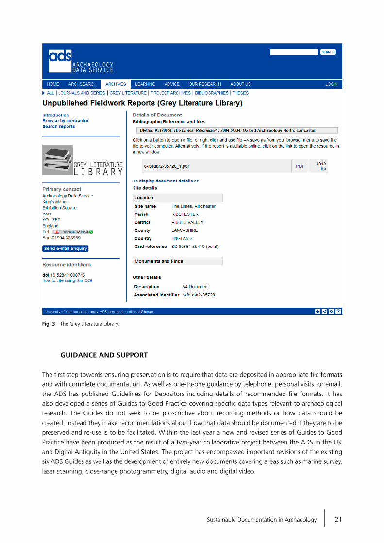
GUIDANCE AND SUPPORT
The first step towards ensuring preservation is to require that data are deposited in appropriate file formats and with complete documentation. As well as one-to-one guidance by telephone, personal visits, or email, the ADS has published Guidelines for Depositors including details of recommended file formats. It has also developed a series of Guides to Good Practice covering specific data types relevant to archaeological research. The Guides do not seek to be proscriptive about recording methods or how data should be created. Instead they make recommendations about how that data should be documented if they are to be preserved and re-use is to be facilitated. Within the last year a new and revised series of Guides to Good Practice have been produced as the result of a two-year collaborative project between the ADS in the UK and Digital Antiquity in the United States. The project has encompassed important revisions of the existing six ADS Guides as well as the development of entirely new documents covering areas such as marine survey, laser scanning, close-range photogrammetry, digital audio and digital video.
Fig. 3 The Grey Literature Library.


23Sustainable Documentation in Archaeology
CONCLUSION
Archaeological data requires active management throughout the project lifecycle to ensure that it will be »fit for purpose« for future preservation and access. A number of factors are encouraging researchers to think about providing open access to their data and to plan for its long term preservation. These include policy recommendations from research councils and governments, as well as an increasing desire from researchers themselves to share data. 3D data faces the same preservation issues as other archaeological datasets although, in some cases, certain problems are somewhat heightened, including issues of data storage, ensuring adequate metadata, documenting processing techniques, and dealing with proprietary software. This increasing volume of data produced by 3D projects has another aspect in that, when the larger workflow is viewed and multiple incarnations of the »same« data are viewed as holding value, storing and providing access to these multiple sets of files becomes problematic. While storage capabilities continue to increase alongside decreasing hardware costs, indicating a possible solution to such data storage issues, it is worth noting that many technologies which capture 3D data continue to generate larger and larger volumes of data countering the perceived savings implied by lower hardware costs. It should also be noted that the most significant cost component of any digital repository is actually the labour required to ingest, migrate and subsequently manage the data. This cost is contingent on many factors, the least of which may be data volume. The continuing growth and use of 3D data and the varied technical systems used to generate it will also hopefully continue to see a parallel development of both data format and metadata standards. Ongoing collaborative research at both a national and international level will be an important factor in developing systems that ensure that the data produced remains secure and usable for future generations.
REFERENCES
Austin / Mitcham 2007: T. Austin / J. Mitcham, Preservation and Management Strategies for Exceptionally Large Data For-mats: »Big Data«. Archaeology Data Service 2007. http://archae ologydataservice.ac.uk/attach/bigData/bigdata_final_report_1.3.pdf
Beagrie 2008: N. Beagrie, http://blog.beagrie.com/2008/01/27/archae ology-data-service-charging-policy/ (2008).
Beagrie / Houghton 2013: N. Beagrie / J. Houghton, The Value of ADS (2013). http://archaeologydataservice.ac.uk/research/impact
CCSDS 2012: Consultative Committee for Space Data Systems (CCSDS) Reference Model for an Open Archival Information System (OAIS). CCSDS 650.0-M-2, Magenta Book, Issue 2, June 2012. http://public.ccsds.org/publications/archive/650x0b1.pdf
Finch 2012: J. Finch, Accessibility, sustainability, excellence: how to expand access to research publications. Report of the Working Group on Expanding Access to Published Research Findings (London 2012)
ISO 2012: ISO 16363:2012. Space data and information transfer systems. Audit and certification of trust worthy digital repositories. International Standards Organisation. (2012) http://www.iso.org/iso/iso_catalogue/catalogue_tc/catalogue_detail.htm?csnumber=56510.
Jeffrey et al. 2009: S. Jeffrey / J. D. Richards / F. Ciravegna / S. Wal-ler / S. Chapman / Z. Zhang, The Archaeotools project: fa ceted
classification and natural language processing in an archae-ological context. In: P. Coveney (ed.), Crossing Boundaries: Com putational Science, E-Science and Global E-Infrastructures. Special Themed Issue of the Philosophical Transactions of the Royal Society A, 367, 2009, 2507-2519.
2012: S. Jeffrey / L. Xia / J. D. Richards / J. Bateman / K. Kintigh / F. Pierce-McManamon / A. Brin, The Transatlantic Archaeology Gateway: Bridging the Digital Ocean. Proceedings CAA 2011, 183-193.
Mitcham et al. 2010: J. Mitcham / K. Niven / J. D. Richards, Archiving Archaeology: Introducing the Guides to Good Practice. In: A. Rauber / M. Kaiser / R. Guenthier / P. Constantopoulos (eds), Pro-ceedings of the 7th International Conference on Preservation of Digital Objects. iPRES 2010, 183-187, [email protected] Band 262.
Richards 2002: J. D. Richards, Digital Preservation and Access. European Journal of Archaeology 5(3), 2002, 343-367.
2008: J. D. Richards, Managing digital preservation and access: The Archaeology Data Service. In: F. P. McManamon / A. Stout / J. A. Barnes (eds), Managing Archaeological Resources: Glo bal context, national programs, local actions. One World Archae-ology 58, 2008, 173-94, 2008.
Richards / Niccolucci forthcoming: J. D. Richards / F. Niccolucci, ARIAD NE: Advanced Research Infrastructures for Archaeological Data set Networking in Europe. International Journal of Humani-ties and Arts Computing (forthcoming).

24 Julian D. Richards · Digital Data in Archaeology
Richards et al. 2010: J. D. Richards / A. F. Austin / C. Hardman, Covering the costs of Digital Curation. Heritage Management 3(2), 2010, 255-263.
2011: J. D. Richards / J. Winters / M. Charno, Making the LEAP: Linking Electronic Archives and Publications. In: E. Jerem / F. Redö / V. Szeverényi (eds), On the Road to Reconstructing the Past. Proceedings of the 36th International Conference on Computer Applications and Quantitative Methods in Archaeology (CAA), Budapest, Hungary, 2008 (2011), 141-146.
RIN 2011: RIN 2011, Data Centres: their use, value and impact, Re search Information Network / Joint Information Systems Com mittee. Available from http://www.jisc.ac.uk/publications/generalpublications/2011/09/data centres.aspx
TDR 2010: TDR 2010, Memorandum of understanding to create a European framework for audit and certification of digital repositories. Trusted Digital Repository.eu. http://trusteddigital repository.eu/Site/Trusted%20Digital%20Repository.html.
Swan 2010: A. Swan, Sharing knowledge: Open access and preservation in Europe. Conclusions of a strategic workshop, European Commission (Brussels 2010).

27Sustainable Documentation in Archaeology
DIAO CHANGYU
SPATIAL INFORMATION RECORDING TECHNIQUES USED BY
THE MOBILE LABORATORY FOR PRESERVING EXCAVATED
ARTEFACTS
The Chinese mobile laboratory for preserving excavated artefacts 1 (MoLab) consists of a specially modified van created in 2009. Working under the concept of an on-site-laboratory, the MoLab provides systematic technical support for archaeological excavation while also providing emergency treatment and conservation to excavated materials. The MoLab is an integrated platform consisting of many technologies including spatial information recording, pre-detection, environment monitoring, analysis, and emergency treatment. By successfully applying these techniques to several different types of archaeological site in Shanxi, Shaanxi, Shandong, Hubei and Zhejiang, the MoLab has proven to be a very important support system for excavation and conservation work.An important part of MoLab’s functions is the recording of spatial information required in documenting the many phases of archaeological excavation and conservation work. Such spatial information can be recorded at a number of different scales. The requirements of excavation site spatial information recording include large scale aerial photography, 3D reconstruction, and quick surface mapping. Large scale aerial photography can be used within GIS systems or for the study of site layout. 3D reconstructions can be used to record locational and geometric measurements. Quick surface mapping can be used to quickly derive measurements over large areas.
SYSTEMS
Three specialized systems were developed and integrated into MoLab to meet these requirements. An auto-pilot helicopter system, fitted with a DSLR camera, is used to capture images at specified points along a computer programmed flight path. This system can easily capture aerial photography data and generate aerial orthophoto maps through automatic orthophoto stitching software with the assistance of RTK and total station devices. A multi-image based 3D reconstruction system is used to automatically reconstruct complete coloured 3D models of heritage sites or excavated artefacts simply from photos taken using ordinary cameras. This system is suitable for large-scale 3D recording of excavation sites and has the advantages of low equipment cost, easy operation, fast capture speed and full automation. A dual camera based close-range stereophotogrammetry system is also used to quickly record surface mapping data over a range of 10 m². This system can support partial surface mapping of excavation sites at high speed.
1于宗仁,苏伯民,陈港泉,崔强,张文元.文物出土现场保护移动实验室在考古发掘现场应用支撑研究中分析体系的构建.敦煌研
究, 2013年01期.

28 Diao Changyu · Spatial Information Recording Techniques
Auto-pilot helicopter system
The auto-pilot helicopter system consists of a series of small remote controlled helicopters, camera mount platforms, DSLR cameras, and image processing software. The diameter of the helicopter’s main rotor blade is about 160 to 180 cm. The maximum payload is about 3 to 5 kg and, fully loaded, the helicopter can fly for over 10 minutes. The camera mount platforms keep the camera still while the helicopter tilts and vibrates. The helicopter system status can be monitored and controlled remotely manually or by computer and a live image from the camera can be monitored from the ground in real time.This system has many advantages for archaeological applications. Firstly, either petrol-powered or electric-powered motors can be applied respectively for long duration or plateau flights. Different types and size of helicopter provide flexibility to easily change and adapt to different conditions and circumstances. Secondly, the auto-pilot system used allows the helicopters to remain stable even in bad weather conditions. Lastly, an automatic orthographic stitching software program has been developed to combine all the photos seamlessly into one large image without laborious manual work. The stitched image contains a low level of error and can be used to derive precise measurements.
Multi-image based 3D reconstruction system
The multi-image based 3D reconstruction system is a software program which can generate a coloured 3D model from several photos of an artefact or heritage site. The photos can be taken by a professional DSLR camera or by a basic point-and-shoot type camera. Even a mobile phone camera can give acceptable 3D reconstruction results. The software program can automatically detect and match features in the photos from which the position, direction, focal length, and lens distortion parameters of each photo can be calculated. At the same time, sparse 3D points for the object are generated. Finally, dense 3D point clouds are generated based on the sparse points and image features.The multi-image based 3D reconstruction system is fully automated. After taking photos and transferring them to a computer, the only thing left to do is to tell the software where the images are stored and to press the »automatic calculation« button. By eliminating the requirement for professional 3D modelling skills, archaeologists can record 3D information for artefacts they are interested in all by themselves. Unlike traditional photogrammetry technologies, no expensive photogrammetric cameras are needed, significantly reducing the cost of photographic equipment.
Fig. 1 The mobile laboratory for preserving excavated artefacts (MoLab).

29Sustainable Documentation in Archaeology
Dual camera based close-range stereophotogrammetry system
The dual camera based close-range stereophotogrammetry system consists of two DSLR cameras, a dual head platform, wireless synchronised shutter controller and specially-developed software. This system can be used to quickly record part of a site for subsequent planning. Over a thousand sample points can be measured from a single image pair, with the process taking around 1 minute for image capture and 5 minutes to process.Archaeologists can benefit from this system’s simplicity and speed. This system can be easily set up using a tripod and is suitable for most kinds of heritage site conditions. With the speed of thousands of measurements within a 6 minute process, it is much faster than using manual methods or a total station.
PRACTICES
The MoLab spatial information recording systems have been tested and applied to many archaeological excavation sites. In this paper, two examples have been selected to represent the practical applications of these systems.In July 2012, the systems were applied to the Laosicheng site in Hunan province. The spatial information recording tasks included large scale aerial photography, specific smaller area aerial photography and large scale 3D reconstruction. Using a petrol-powered helicopter, not only were orthographic images generated
Fig. 2 Auto-pilot helicopter system.
Fig. 3 Multi-image based 3D reconstruction system.

30 Diao Changyu · Spatial Information Recording Techniques
but a panoramic image of the whole site was also created. With the help of the accurate auto-pilot system, several single shot aerial photographs were taken at specified locations. At the same time, over five hundred square meters of site were 3D recorded through the capture of one thousand images. All the results are shown in figures 5-8.In November 2012, the systems were applied to the Dongpingling site in Shandong province. Over 4 million square meters of archaeology were aerial photographed and seamlessly stitched into a single image. Several archaeological excavation sites were 3D reconstructed to capture their current state. The results are shown in figures 9-12.
CONCLUSIONS
Three spatial information recording systems were presented in this paper. Each of them has its own application, advantages, and is suitable for different kinds of requirements. In order to fit the mobility criteria of the MoLab, the volume and weight of each system are optimised as far as possible. However, application has proved that these simplified systems can fit archaeological requirements very well.Future work will focus primarily on automation and customisation. In addition, standardised products of the MoLab spatial information recording system will be available in the near future, giving archaeologists a series of handy tools to conveniently undertake spatial information recording work.
Fig. 4 Dual camera based close-range stereophotogrammetry system.
Fig. 5 Aerial panorama of the Laosicheng site.

31Sustainable Documentation in Archaeology
Fig. 6 Large scale orthographic image.
Fig. 7 Small area aerial photography of an ancient government building.

32 Diao Changyu · Spatial Information Recording Techniques
Fig. 8 3D reconstruction of an ancient government building.
Fig. 9 The orthographic aerial image of the Dongpingling site.

33Sustainable Documentation in Archaeology
Fig. 10 Aerial photograph of archaeological excavations.
Fig. 11 3D reconstruction of an excavation.

34 Diao Changyu · Spatial Information Recording Techniques
Fig. 12 The MoLab at Donpingling.

35Sustainable Documentation in Archaeology
HARTMUT MÜLLER · KAI-CHRISTIAN BRUHN · GUIDO HEINZ · TOBIAS KOHR MATTHIAS UHLER · FALK WÜRRIEHAUSEN
PROVISIONING OF PLACE-BASED ARCHAEOLOGICAL
INFORMATION ON THE INTERNET
Everything happens somewhere. Therefore, place matters in all contexts of life. If we can understand more about the nature of the »place« where things happen, and the impact on people and local conditions on that location, we can then better analyse, better generate synoptic views, and draw better conclusions. Archaeology as a science is highly connected with place-based information. What is the value of a find if you know nothing of its original location? In extended research projects nowadays typically involve scientists from different disciplines together with other stakeholders from different areas and fields. Considering the spatial context in which archaeology takes place, developments in the fields of acquisition, management, analysis and presentation of geospatial data can offer a range of benefits. Formal standards addressing the specific geospatial components of data are available, and are embedded into general internet standards. In the following sections, the framework of geospatial data processing – a Spatial Data Infrastructure (SDI) – will be explained. Some projects will be outlined in order to illustrate the potential benefits to archaeology that emerge from the development of geospatial standards.
SPATIAL DATA INFRASTRUCTURES (SDI)
A Spatial Data Infrastructure (SDI) can serve as the enabling platform that links people to information. It supports the integration of natural and built environment data as a prerequisite for integrated analysis. An SDI encompasses the policies, standards, and institutional arrangements involved in delivering place based information from all available sources to all potential users. An SDI provides the basis for spatial data discovery, evaluation, download, and application for users and providers within all levels of government, the commercial sector, the non-profit sector, academia, and the general public (Global Spatial Data Infrastructure Association 2004).INSPIRE (Infrastructure for Spatial Information in Europe) is a very ambitious initiative of the European Union (European Union 2007). The initiative addresses the technical standards and protocols, organisational and co-ordination issues, data policy and access issues, and the creation and maintenance of place based information in the context of a European Spatial Data Infrastructure (ESDI). Figure 1 gives a general overview of the INSPIRE technical architecture (Drafting Teams »Data Specifications«, »Network Services«, »Metadata« 2007).Archaeology comprises a vast amount of heterogeneous datasets containing relevant spatial attributes. Dissemination of these data is essential, in order to link knowledge between different research groups and to provide information to all stakeholders. Standards and technologies that are being developed within an SDI appear suitable to achieve this objective. By co-ordinating 34 data themes for 28 sovereign member states with more than 500 million inhabitants, multiple languages, and different legal systems, the European INSPIRE initiative addresses a highly complex area. On the one hand, place-based archaeological information

36 Hartmut Müller et al. · Provisioning of Place-based Archaeological Information on the Internet
can serve as a direct input into the INSPIRE framework. On the other hand, the extensive work done in INSPIRE can be used as a comprehensive check list for SDI development in general and, therefore, can be used for the implementation of discipline specific SDI’s, for example in archaeology (Fernández et al. 2012).
HIGEOMES, A STANDARD-BASED WEB SOLUTION FOR ACCESS TO AND ANALYSIS OF HIGHLY HETEROGENEOUS GEOSPATIAL DATA
The research project »HiGeoMes – Die historische Geographie Obermesopotamiens im 2. Jahr tausend v. Chr.« aims at the integrated analysis and transparent access of highly heterogeneous data from a specific geographic area (Bruhn / Kohr 2012). Conducted by a bi-national group from France and Germany, the HiGeoMes project integrates textual and archaeological data within a spatio-temporal context. The project focuses on the collection of archaeological sites at different scales and is based on existing data sets of the ancient Near East. The project is enriched and improved through the investigation of additional spatial and bibliographic sources. The distributed environment, featuring contributors from several places and different scientific disciplines, creates a special challenge but the solution is provided by a Web GIS interface, supporting scientists to better understand interdependencies and contribute to a superior comprehension of past societies. The HiGeoMes portal uses an infrastructure based on Open Geospatial Consortium (OGC)
Fig. 1 INSPIRE technical architecture overview. – (After Drafting Teams »Data Specifications«, »Network Services«, »Metadata« 2007).
37Sustainable Documentation in Archaeology
Web services to facilitate the exchange of archaeological information among project partners and to ensure interoperable access to it for external researchers. IT client development, data quality control, spatial and temporal data accuracy are specific considerations within such a project.
KULIS, A WEB-BASED PLATFORM FOR DATA ACQUISITION BY VOLUNTEERS AND ANALYSIS OF CULTURAL HERITAGE INFORMATION
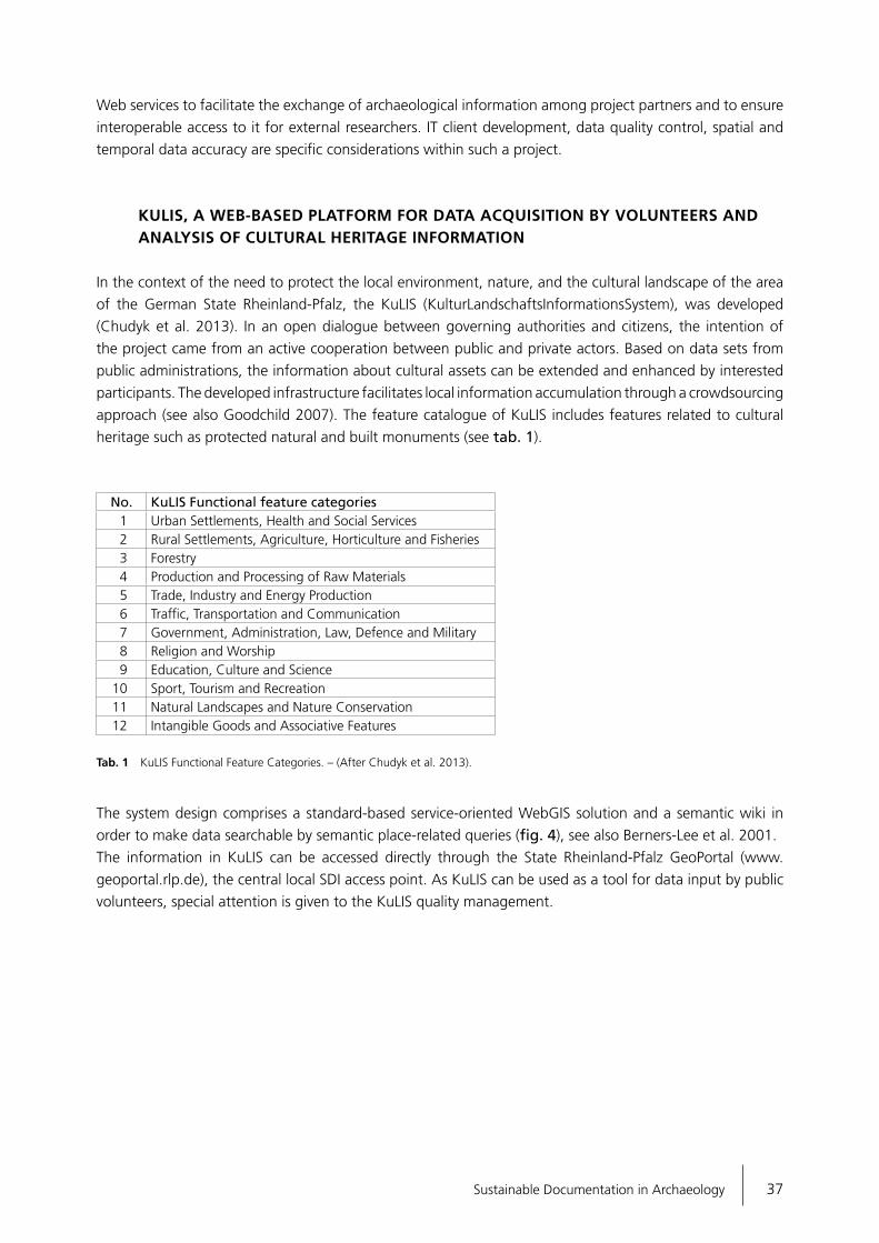
In the context of the need to protect the local environment, nature, and the cultural landscape of the area of the German State Rheinland-Pfalz, the KuLIS (KulturLandschaftsInformationsSystem), was developed (Chudyk et al. 2013). In an open dialogue between governing authorities and citizens, the intention of the project came from an active cooperation between public and private actors. Based on data sets from public administrations, the information about cultural assets can be extended and enhanced by interested participants. The developed infrastructure facilitates local information accumulation through a crowdsourcing approach (see also Goodchild 2007). The feature catalogue of KuLIS includes features related to cultural heritage such as protected natural and built monuments (see tab. 1).
No. KuLIS Functional feature categories1 Urban Settlements, Health and Social Services2 Rural Settlements, Agriculture, Horticulture and Fisheries3 Forestry4 Production and Processing of Raw Materials5 Trade, Industry and Energy Production6 Traffic, Transportation and Communication7 Government, Administration, Law, Defence and Military8 Religion and Worship9 Education, Culture and Science
10 Sport, Tourism and Recreation11 Natural Landscapes and Nature Conservation12 Intangible Goods and Associative Features
Tab. 1 KuLIS Functional Feature Categories. – (After Chudyk et al. 2013).
The system design comprises a standard-based service-oriented WebGIS solution and a semantic wiki in order to make data searchable by semantic place-related queries (fig. 4), see also Berners-Lee et al. 2001. The information in KuLIS can be accessed directly through the State Rheinland-Pfalz GeoPortal (www.geoportal.rlp.de), the central local SDI access point. As KuLIS can be used as a tool for data input by public volunteers, special attention is given to the KuLIS quality management.

38 Hartmut Müller et al. · Provisioning of Place-based Archaeological Information on the Internet
Fig. 2 HiGeoMes Technical Infrastructure. – (After Bruhn / Kohr 2012).
Fig. 3 HiGeoMes Integrated Analysis of Textual and Geospatial Information. – (After Bruhn / Kohr 2012).

39Sustainable Documentation in Archaeology
Fig. 4 KuLIS System Design. – (After Chudyk et al. 2013).
Fig. 5 Administrative quality management in KuLIS. – (After Chudyk et al. 2013).

40 Hartmut Müller et al. · Provisioning of Place-based Archaeological Information on the Internet
Figure 5 shows the KuLIS quality management design. State institutions and the broad public alike offer their data to the system. State institutions can validate and qualify the combined information from public crowdsourcing and government data. The public sector is able to access the validated information.Figure 6 shows the information for Ehrenbreitstein fortress, one of the geospatial objects to be retrieved from KuLIS.
TRANSPORTATION COSTS IN THE ROMAN PERIOD BASED UPON ANCIENT TRANSPORTATION NETWORKS AND THE DISTRIBUTION OF ROMAN SAMIAN WARE
This project, based on a large database of Roman Samian ware, uses a GIS-based digital network to model and reconstruct the transport routes of antique trade goods (Mees o. J.). A web-based interactive application with routing functionality allows the calibration of the system.Pre-modern transportation technologies were very much influenced by environmental constraints like wind and current. Consequently, the correlation between transportation distance and transportation cost tended to be rather low. Duration and financial cost of travel in the Roman period can be estimated by simulating movement along the principal routes of the Roman road network, the main navigable rivers, and defined sea routes in the Mediterranean, Black Sea, and coastal Atlantic. The distribution of remains of transported goods, like amphora, for instance, can be used to control and to improve the algorithms being used for cost
Fig. 6 KuLIS Profile of Ehrenbreitstein Fortress, Rheinland-Pfalz, Germany. – (After Chudyk et al. 2013).

41Sustainable Documentation in Archaeology
simulation. Figure 7 shows the location of find spots of Baetian amphora (green dots) and the simulated cost path between the site of amphora manufacture in Southern Spain and the city of Mainz. As can be seen, the longer path of transport via sea routes is superior to the shorter but more expensive land routes.
CONCLUSIONS
Proven international standards and IT technology for the processing of place-based information are available both within the internet and Spatial Data Infrastructures. Those technologies are ready to be used by archaeologists just as by scientists of any other disciplines related to place-based information. Pilot studies are available to support the implementation of such domain specific solutions and their seamless integration into broader networks, thus supporting easy access via single access points to a large knowledgebase of information prepared for particular uses. As a further prerequisite for successful design and implementation of feasible IT solutions in archaeology, semantic standards will have to be developed and agreed upon within the archaeological community.
Fig. 7 GIS-based simulation of antique transport routes. – (After A. Mees: www.rgzm.de/transportroutes/).

42 Hartmut Müller et al. · Provisioning of Place-based Archaeological Information on the Internet
REFERENCES
Berners-Lee / Hendler / Lassila 2001: T. Berners-Lee / J. Hendler / O. Lassila, The Semantic Web: a new form of Web content that is meaningful to computers will unleash a revolution of new possibilities. Scientific American 284 (5), 2001, 34-43.
Bruhn / Kohr 2012: K.-Chr. Bruhn / T. Kohr, Distributed Geodatabases in Archaeological Joint Research Projects. New Developments in Archaeological Data Management, CAA Netherlands. Germany Joint Chapter Meeting 30th November and 1st December 2012, Institute of Archaeology, University of Groningen (Netherlands). http://www.caanlfl.nl/sites/default/files/Khor_Distributed_GDB_in_Archaeological_JRP.pdf
Chudyk et al. 2013: C. Chudyk / H. Müller / M. Uhler / F. Würrie-hausen, A Cultural Landscape Information System Developed with Open Source Tools. XXIV International CIPA Symposium, Strasbourg, 2-6 September, 2013.
Drafting Teams »Data Specifications«, »Network Services«, »Meta data« 2007: INSPIRE Technical Architecture – Overview, Infrastructure for Spatial Information in Europe, 05-11-2007. http://inspire.jrc.ec.europa.eu/reports/ImplementingRules/network/~INSPIRETechnicalArchitectureOverview_v1.2.pdf
European Union 2007: Directive 2007/2/EC of the European Parlia ment and of the Council of 14 March 2007 establishing an Infrastructure for Spatial Information in the European Com munity (INSPIRE) http://inspire.jrc.ec.europa.eu/directive/l_10820070425en00010014.pdf
Fernández et al. 2012: F. C. Fernández / E. Pérez Asensio / I. del Bosque González / A. U. González / J. M. V. García / A. Fraguas Bravo / C. Parcero-Oubiña / P. Fábrega-Álvarez, Proposal for a Cultural Heritage Application Schema within the INSPIRE directive. Proceedings of the AGILE’2012 International Con–ference on Geographic Information Science, Avignon, April, 24-27, 2012.
Global Spatial Data Infrastructure Association (2004): Developing Spatial Data Infrastructures: The SDI Cookbook, Version 2.0.
Goodchild 2007: M. F. Goodchild, Citizens as sensors: the world of volunteered geography. GeoJournal 69 (4), 2007, 211-221.
Mees o. J.: A. Mees, http://www.rgzm.de/transportroutes

43Sustainable Documentation in Archaeology
WANG SHAOHUA · HU QINGWU
RESEARCH ON DIGITISATION AND VISUALISATION
TECHNIQUES FOR ARCHAEOLOGICAL SITE EXCAVATION
BASED ON MULTIPLE TEMPO-SPATIAL DATA
The traditional process of site excavation can create an artificial record. The majority of recording focuses on image and text data collected through the means of survey, mapping, photography, and video, as well as that generated from interpretation. Excavated material can subsequently not be seen in a detailed, unified way across both time and space and the resulting record is not conducive to subsequent archaeological research, management of the archaeology, or archaeological visualisation. As part of the Pompeii excavation project, carried out by the University of Cincinnati, researchers used an iPad to record the archaeology so that information could immediately enter the site database while existing research results could also feed back in to the excavation process itself. Researchers from Hamburg University of Applied Sciences used digital photogrammetry to create three-dimensional reconstructions of an ancient castle in northern Germany (Kersten et al. 2004). A project at the University of California, Berkeley also used images to create a three-dimensional reconstruction of a large-scale building (Paul et al. 1996). However, issues such as image distortion and blind angles exist in such photogrammetric methods. The »Mellon International Dunhuang Archives project« managed by the Mellon Foundation adopted a combination of »virtual cavern photography« (Luo Dongming et al. 2002), »total station« cave measurement, and digitally synthesised image and cavern measurement data to obtain three-dimensional data for the caves. However, these methods are still faced with the problem of how to quickly extract features that match with the total station measured objects from such photographic images. In the Longmen Grottoes digitisation project, Peking University used a laser scanner to obtain three-dimensional data, create a three-dimensional model, and then project it onto a two-dimensional image space. Line diagrams were then derived from the data and other digital techniques used to reconstruct the archaeology. These examples highlight that the effective integration of low-altitude unmanned remote sensing techniques such as terrestrial 3D laser scanning, GPS-RTK, and other digital capture methods can often address the inadequacies of a single data acquisition technique.In this paper, a digitisation and visualisation approach for excavated archaeological sites based on multiple tempo-spatial modes is proposed. Firstly, a digital method for excavating entire archaeological sites based on the integration of multiple measurements is proposed. This includes the creation of a unified catalogue of excavated data within a unified temporal and spatial reference system. Secondly, a design processing strategy and data model for multi-source spatial and temporal data from archaeological sites is described, along with a visualisation solution for multi-source, multi-resolution, multi-temporal and spatial data based on a three-dimensional geographic information platform. Finally, as an example of digital recording and visualisation for an entire excavation process, the Yejiashan archaeological sites in SuiZhou are described and cover more than 10 types, and more than 1TB, of multiple tempo-spatial data processing, management and visualisation. The results show that the method described here can better realise the digital recording and visual expression of the excavation process on whole archaeological sites while remaining practical to apply.
44 Wang Shaohua · Hu Qingwu · Research on Digitization and Visualisation Techniques
METHODOLOGY
Material acquired during the excavation process has spatial attributes and the location and extent of an archaeological site can be represented using spatial data. Archaeological remains and features, even utensils or pottery within archaeological sites, can be spatially represented using accurate three-dimensional coordinates. In this paper, the complete process of digital excavation for an archaeological site based on multi-source spatial and temporal data starts with the spatial attributes of archaeological remains or features. These attributes are used to establish a multiple spatial and attribute information database and graphics library, which can easily record, display, query, and simulate various types of data and recreate archaeological sites, allowing the visualisation and sharing of information resources created through the excavation process.
Archaeological site digital excavation technology based on multi-source spatial and temporal data
The digital excavation process based on multi-source spatial and temporal data applies surveying, mapping and remote sensing technology, spatial and temporal data management technology, and information display technology to the investigation, excavation, and arrangement of an archaeological site. The process allows the efficient, convenient, and standardised recording and storage of information. The technology creates a space-time database of the site excavation process and allows data to be catalogued and shared within a unified time and space reference system. This benefits the investigation, excavation, research, management, and display – amongst other aspects – of the archaeology. The system is shown in figure 1.
A multi-source spatial and temporal data acquisition method for archaeological sites
Data collected from the archaeological excavation process includes both spatial and attribute data together with information regarding the relationships between these sets of data. Spatial data refers to the spatial position of various archaeological remains whereas attribute data refers to their content and descriptions. The complexity of the excavation process combined with the microrelief features of archaeological sites make the acquisition of spatial information through traditional cartographic recording methods difficult. This paper proposes the use of GPS-RTK, 3D laser scanning, and unmanned remote sensing as an integrated approach to acquiring spatial-temporal data from the excavation process within the defined spatial coordinates of the archaeological site. This approach allows multi-source spatial and temporal data to both directly and indirectly enter the excavation spatio-temporal database which can then provide data resources for site data management and visualisation. The first stage of the process is to use GPS-RTK to set up a reference control network of points as the basis for space-time data acquisition from the site. Once the GPS-RTK platform is established, basic cameras and temperature and humidity sensors are used to expand the scope of information recorded and to perform process acquisition and the recording of drawing, photography, heritage registration, excavation logging and other archaeological excavation activities on the site. In this way, large numbers of fragmented records, drawings and images can be acquired, digitised, and integrated. Meanwhile, mobile spatial data and attribute data of archaeological finds can be recorded and integrated. This process is shown in figure 2.

45Sustainable Documentation in Archaeology
The second stage involves obtaining remote sensing images of the site at different phases with low-altitude unmanned remote sensing aircraft. The low-altitude unmanned remote sensing platform consists of a UAV (Unmanned Aerial Vehicle), flight control system, and digital aerial photo and data processing systems. According to the type of flight required, UAV options include a fixed wing UAV or a small four-rotor unmanned helicopter with flight controlled by either GPS or Wi-Fi. The UAVs are equipped with high-definition cameras and acquire image data along schedule routes within the area to be surveyed. After
Fig. 1 Archaeological site digital excavation technology.

46 Wang Shaohua · Hu Qingwu · Research on Digitization and Visualisation Techniques
software processing, large-scale and full-view mosaic images, orthophoto maps, three-dimensional dense point clouds, and topographic maps in series scale can be obtained from the captured images, as shown in figure 3.Finally, to acquire data for smaller artefacts from archaeological sites, a portable scanner and ground-based three-dimensional laser scanner with resolutions up to 2 mm are used to obtain high-resolution point cloud data, from which vertical, sectional, and cutaway view digital maps and plans can be quickly generated.
Management Model for Archaeological Sites Based on Multiple Tempo-spatial Data
Although archaeological site excavation data possesses a range of different elements such as multi-source, multi-temporal, and multi-scale, they do however have three common features. Firstly, all multi-source data from an archaeological site has spatial characteristics. Point clouds, DOM, DEM, and family tomb models all have their own spatial reference. Secondly, multi-source data has broad types when related to GIS layers, and data can be classified as vector data, grid data, elevation data, and 3D model data within the GIS data model. Thirdly, multi-source data are acquired at set times and can therefore be managed according to both temporal and spatial aspects of the data. In this paper, multiple tempo-spatial data are managed hierarchically within the uniform spatial reference system according to their temporal dimension, with different types of data using different data models and corresponding visualisation methods. The data organisation and management model is shown in figure 5.As shown in figure 5, all the multiple tempo-spatial data obtained during the excavation process, e. g. point cloud data, DOM data, DEM data, 3D model data, documents and videos, are divided into different layers and stored according to the time dimension. Each layer is then divided into six layers including 3D grid, TIN, raster layer, vector layer, 3D model data, documents and videos, by GIS in term of the spatial dimension. The data model is then set up according to the different data layers used and is then finally used to visualise the different data models using various techniques.
Fig. 2 Archaeological recording using GPS-RTK.

47Sustainable Documentation in Archaeology
Fig. 3 Digital acquisition of archaeological sites with low-altitude unmanned remote sensing.
Fig. 4 Digital acquisition of archaeological sites using three-dimensional laser scanning.

48 Wang Shaohua · Hu Qingwu · Research on Digitization and Visualisation Techniques
Visualisation of Archaeological Sites Excavation based on Multiple Tempo-spatial Data
The visualisation of different types of spatial data from excavated sites is based on the ESRI ArcEngine 2D GIS platform and Skyline 3D platform. 3D terrain can be structured based on UAV remote sensing images and 3D laser scan point cloud elevation data, and can be used for the creation of a geographic information platform. In addition, different kinds of vertical and cutaway view maps, along with excavation and site records, are integrated into the interface via a 2D engine. Two- and three-dimensional data visualisation and spatial analysis can also be undertaken within the interface through various linking mechanisms.
EXPERIMENT AND DISCUSSION
Yejiashan family tomb lies in Hubei province, Suizhou economic development zone, Xihe town, Jiangzhai village, eighth group. The tomb lies 1.5 km south of Xi garden and the temple stage (a new stone to Shang and Zhou Dynasties) site and contains ten large tombs (4 m long, 3 m wide), five medium-sized tombs (3 m long, 2.5 m wide) and 50 small tombs. A visualisation management system was established within a 2D and 3D GIS platform containing 10 types and more than 1TB of data obtained by GPS-RTK, three-dimensional laser scanning, and low-altitude unmanned remote sensing. The system is shown in figure 6.
Fig. 5 Multiple tempo-spatial data management during archaeological site excavation.

49Sustainable Documentation in Archaeology
CONCLUSION
As an important part of cultural heritage, archaeological sites are key to the study of Chinese ancient history and the development of culture, art, science and technology. During the process of archaeological site excavation, the recording of data is the foundation of archaeological research work and also the foundation of digital site management, digital display and digital communication.This paper proposes a digital visualisation method for archaeological site excavation based on multiple types of tempo-spatial data, creating an omni-directional digital record for the site through low-altitude unmanned remote sensing, ground-based 3D laser scanning, and GPS-RTK. The system allows the organisation and management of site excavation based on multiple tempo-spatial data such as high-definition remote sensing images, digital terrain models, 3D laser scan point cloud data, excavation drawings, video, and textual information. The processing, management and visualisation capabilities have been practically demonstrated at the excavation of the Yejia Mountain burial site using multiple tempo-spatial datasets.
Fig. 6 The prototype for visualising family tomb sites and tempo-spatial data management.

50 Wang Shaohua · Hu Qingwu · Research on Digitization and Visualisation Techniques
REFERENCES
Kersten et al. 2006: T. Kersten / C. A. Pardo / M. Lindstaedt, 3D acquisition modelling and visualization of north German castles by digital architectural Photogrammetry. 20th ISPRS Congress, Istanbul, July 2004 [C]//The International Archives of Photogrammetry, Remote Sensing and Spatial Information Sciences, Vol. 35, Commission V, Part B2, 2004, 126-132.
Paul et al. 1996: E. Paul / J. Camillo / Jitendra, Modelling and render ing architecture from photographs: A hybrid geometry-
and image-based approach [C]//Computer Graphics Proc, SIGGRAPH, 1996, 11-20.
Luo Dongming et al. 2002: LUO Dongming / PAN Yunhe / CHEN Ren, Dunhuang Cave Virtual Rebuilding and Mural Restoration Simulating[J]. Acta Geodaetica et Cartographica Sinica 31(1), 2002, 39-45.
Cite this article as : Wang (2009) Journal of Remote Sensing 遥感学报 2009, 13(3)
Copyright © 2022 FDOKUMEN