Final Report - PGCB
269
Power Grid Company of Bangladesh Power Cell, Power Division Ministry of Power, Energy and Mineral Resources Government of the People's Republic of Bangladesh Updated Initial Environmental Examination (IEE) for the Enhancement and Strengthening of Power Networking Eastern Region (ESPNER) Project of Bangladesh Final Report Prepared by: Power Grid Company of India Limited (PGCIL) In association with IMEX, BANGLADESH December, 2019
-
Upload
khangminh22 -
Category
Documents
-
view
1 -
download
0
Transcript of Final Report - PGCB
Power Grid Company of Bangladesh
Power Cell, Power Division
Ministry of Power, Energy and Mineral Resources Government of the People's Republic of Bangladesh
Updated Initial Environmental Examination (IEE) for the
Enhancement and Strengthening of Power Networking Eastern
Region (ESPNER) Project of Bangladesh
Final Report
Prepared by:
Power Grid Company of India Limited (PGCIL) In association with
IMEX, BANGLADESH
December, 2019
IEE of Enhancement and Strengthening of Power Network in Eastern Region of PGCB Project
Page | i
Table of Contents ABBREVIATIONS .................................................................................................................................... vii
EXECUTIVE SUMMARY ........................................................................................................................... ix
1.1 Background ............................................................................................................................. 5
1.2 Expected Benefits of the Project ............................................................................................. 7
1.3 Legislative Requirements ........................................................................................................ 7
1.4 Main Objectives of the IEE ...................................................................................................... 8
1.5 Extent of the Study ................................................................................................................. 8
1.6 Scope of Work ......................................................................................................................... 9
1.7 IEE Content .............................................................................................................................. 9
1.8 Methodology ......................................................................................................................... 11
1.8.1 Approach ......................................................................................................................... 11
1.8.2 Methodology ................................................................................................................... 12
2 ENVIRONMENTAL POLICIES, LAWS, REGULATIONS AND STANDARDS ......................................... 17
2.1 General .................................................................................................................................. 17
2.2 Applicable Policies in Bangladesh ......................................................................................... 18
2.2.1 Relevant National Legislations ........................................................................................ 18
2.3 Categories of Projects ........................................................................................................... 27
2.4 International Treaties ........................................................................................................... 27
2.5 World Bank Environmental and Social Safeguard Policies ................................................... 27
2.5.1 IFC Environmental, Health and Safety Guidelines .......................................................... 30
2.5.2 World Bank Policy on Access to Information .................................................................. 31
2.6 GOB Environmental Clearance Procedure ............................................................................ 31
2.7 Applicable Environmental Quality Standards ....................................................................... 33
2.7.1 National Environment Quality Standards ....................................................................... 33
2.7.2 Noise ................................................................................................................................ 36
2.7.3 International Standards .................................................................................................. 36
3 PROJECT DESCRIPTION .................................................................................................................. 37
3.1 Project Location .................................................................................................................... 37
3.2 Project Components/Subprojects ......................................................................................... 39
4 DESCRIPTION OF ENVIRONMENTAL BASELINE ............................................................................. 42
4.1 General .................................................................................................................................. 42
4.2 Chittagong Division ............................................................................................................... 51
4.3 Physical Environment ............................................................................................................ 52
4.3.1 Climate ............................................................................................................................ 52
IEE of Enhancement and Strengthening of Power Network in Eastern Region of PGCB Project
Page | ii
4.3.2 Physiographic Features ................................................................................................... 58
4.3.3 Topography ..................................................................................................................... 61
4.3.4 Geology ........................................................................................................................... 63
4.3.5 Soil ................................................................................................................................... 63
4.3.6 Agro-ecological Zones ..................................................................................................... 66
4.3.7 Hydrology/Drainage ........................................................................................................ 68
4.3.8 Surface Water Quality ..................................................................................................... 74
4.3.9 Ground/DrinkingWaterQuality........................................................................................ 78
4.3.10 Ambient Air Quality .................................................................................................... 82
4.3.11 Noise Level .................................................................................................................. 84
4.4 Biological/Ecological Environment ........................................................................................ 87
4.4.1 Bio-ecological Zones ........................................................................................................ 87
4.4.2 Diversity of Floral and Faunal Species ............................................................................. 89
4.4.3 Biodiversity/Environmentally Sensitive and Protected Areas ........................................ 94
4.5 Socio-Economic Environment ............................................................................................... 96
4.5.1 Demography .................................................................................................................... 96
4.5.2 Age Composition ............................................................................................................. 96
4.5.3 Marital Status .................................................................................................................. 97
4.5.4 Household by Religion ..................................................................................................... 97
4.5.5 Education......................................................................................................................... 98
4.5.6 Income and Expenditure of HHs ..................................................................................... 98
4.5.7 Occupation Pattern ......................................................................................................... 99
4.5.8 Economic Activities of HHs .............................................................................................. 99
4.5.9 Poverty and Gender ...................................................................................................... 100
4.5.10 Land Acquisition and Requisition .............................................................................. 101
5 ANALYSES OF ALTERNATIVES ...................................................................................................... 102
5.1 Analyses of Alternatives forTL &LILO Route Selection - (Assessment & Management
Process) ........................................................................................................................................... 102
5.2 Study of Alternatives ........................................................................................................... 102
5.2.1 Environmental Criteria for TL and LILO Route Selection ............................................... 102
5.2.2 Analyses of Alternativefor Selection of Substations ..................................................... 118
6 ENVIRONMENTAL SCREENING/ASSESSMENT OF THE SUBPROJECTS ......................................... 122
6.1 General ................................................................................................................................ 122
6.2 Screening of Environmental Impacts for Substations (SS) .................................................. 122
6.3 Screening of Environmental Impacts for Transmission Lines(TL) ....................................... 123
6.4 Screening of Environmental Impacts for the LiloLines ....................................................... 125
IEE of Enhancement and Strengthening of Power Network in Eastern Region of PGCB Project
Page | iii
6.5 Impact Assessment ............................................................................................................. 126
6.5.1 General/Common Impacts due to Substation Subprojects .......................................... 126
6.5.2 Substation Subproject Specific Impacts ........................................................................ 129
6.5.3 General/Common Impacts due to TL and Lilo Lines Subprojects ................................. 129
6.5.4 TL/Lilo Line Subproject Specific Impacts ....................................................................... 132
6.6 Category of Subproject ....................................................................................................... 133
7 PUBLIC CONSULTATION .............................................................................................................. 135
7.1 Objectives ............................................................................................................................ 135
7.2 Categories of Stakeholders ................................................................................................. 135
7.3 Consultation Process ........................................................................................................... 136
7.4 Details of the Consultations ................................................................................................ 138
7.5 Findings of the Consultations .............................................................................................. 139
7.5.1 Positive Issues ............................................................................................................... 139
7.5.2 Negative Issues .............................................................................................................. 140
7.5.3 Information Disclosure .................................................................................................. 141
8 ENVIRONMENTAL MANAGEMENT PLAN .................................................................................... 142
8.1 General ................................................................................................................................ 142
8.2 Environmental Mitigation Plan ........................................................................................... 142
8.3 Environmental Monitoring Plan .......................................................................................... 160
8.3.1 Environmental Monitoring System ............................................................................... 160
8.4 Environmental Code of Practice ......................................................................................... 167
8.5 Approximate EMP Budget ................................................................................................... 168
9 INSTITUTIONAL ARRANGEMENT AND CAPACITY BUILDING ....................................................... 170
9.1 General ................................................................................................................................ 170
9.2 Institutional Arrangement and Responsibilities ................................................................. 170
9.2.1 Power Grid Company of Bangladesh (PGCB) ................................................................ 170
9.2.2 Department of Environment (DOE) ............................................................................... 172
9.2.3 Forest Department (FD) ................................................................................................ 173
9.2.4 Design and Supervision Consultants (DSC) ................................................................... 173
9.2.5 Contractors .................................................................................................................... 173
9.3 Capacity Building and Training Requirements .................................................................... 176
9.4 Grievance Redress Mechanism ........................................................................................... 177
10 CONCLUSIONS AND RECOMMENDATIONS ............................................................................. 180
10.1 Conclusions ......................................................................................................................... 180
10.2 Recommendations .............................................................................................................. 182
IEE of Enhancement and Strengthening of Power Network in Eastern Region of PGCB Project
Page | iv
11. REFERENCES ............................................................................................................................ 183
List of Appendices
Appendix-A: Environmental Code of Practice (ECOP)
Appendix -B: Environmental Monitoring Activities during Construction
Appendix-C: NOC from Local Authorities
List of Tables
Table1: Environmental Baseline Data of the Subprojects of t5he Substations (SS) and Transmission
Line (TL)and Lilo Lines ........................................................................................................................... 14
Table 2.1: Relevant Key Policies ............................................................................................................ 24
Table 2.2: Other Relevant National Act, Rules, Laws and Ordinances ................................................. 25
Table 2.3: Relevant International Treaties, Conventions and Protocols Signed by Bangladesh .......... 27
Table 2.4: Bangladesh Standards for Ambient Air Quality Schedule-2, Rule 12, Environment
Conservation Rules of 1997 .................................................................................................................. 33
Table 2.5: National Standard for Inland Surface Water ........................................................................ 34
Table 2.6: National Standard for Drinking Water ................................................................................. 34
Table 2.7: Bangladesh Standards for Noise .......................................................................................... 36
Table 2.8: USA EPA, 2000 Standard Value of Heavy Metals of River Bed Materials (Sand) ................. 36
Table 3.1: Summary of Proposed Scope of Works ................................................................................ 39
Table 3.2: Details of the Proposed Project Components/Subprojects ................................................. 40
Table 4.1: Environmental Baseline Data/Information of the Subprojects of SS and TL ....................... 43
Table 4.2: Test Results of River Bed & Sea Bed Materials .................................................................... 74
Table 4.3: Test Results of Surface Water Quality Analysis .................................................................... 77
Table 4.4: Test Results of Groundwater Quality Analysis ..................................................................... 81
Table 4.5: Measurement Results of Ambient Air Quality ..................................................................... 83
Table 4.6: Noise Level Measurement Results at Different Subproject Sites ........................................ 85
Table 4.7: Lose of trees by category ..................................................................................................... 89
Table 4.8: List of Terrestrial Flora available in the SPIA ........................................................................ 90
Table 4.9: List of Funal Species Available in the SPIA of the Subprojects ............................................. 91
Table 4.10: Common Fish Species in the SPIA of the Subprojects ........................................................ 93
Table 4.11: Affected Households and Population within the ROW of the sub-project areas ............. 96
Table 4.12: PAPs Age Composition by Sex ............................................................................................ 97
Table 4.13: Education level of the PAPs ................................................................................................ 98
Table 4.14: Income and expenditure ration of HHs .............................................................................. 98
Table 4.15: Principal occupation of the affected population in the Project area ................................. 99
Table 4.16: Type of Vulnerability ........................................................................................................ 100
Table 4.17: Land by GIS Locations; permanently acquired (in Acre) .................................................. 101
Table 6.1: Environmental Impacts of the Selected Substation (SS) Subprojects ............................... 122
Table 6.2: Environmental Impacts of the Selected TL Subprojects .................................................... 124
Table 6.3: Environmental Impacts of the Selected LILOLine Subproject ............................................ 125
Table 6.4: Category of the Substation Subprojects ............................................................................ 133
Table 6.5: Category of the Transmission Line Subprojects ................................................................. 133
Table 6.6: Category of the LILO Line Subprojects ............................................................................... 134
IEE of Enhancement and Strengthening of Power Network in Eastern Region of PGCB Project
Page | v
Table 8.1: Mitigation Measures for the General/Common Impacts of the Substation Subprojects .. 143
Table 8.2: Mitigation Measures for the Specific Impacts of the Substation Subprojects ................... 149
Table 8.3: Mitigation Measures for the General/Common Impacts of TL&LILO Line Subprojects .... 150
Table 8.4: Mitigation Measures for the Specific Impacts of the TL&LILO line Subprojects ................ 156
Table 8.5: Environmental Monitoring Plan for Substation Subprojects ............................................. 163
Table 8.6: Environmental Monitoring Plan for TL/Lilo lines Subprojects ........................................... 164
Table 8.7: Approximate EMP Budget for the Project during Preconstruction/Construction stage .... 168
Table 9.1: Training Plan for the Proposed Project .............................................................................. 177
List of Figures
Figure 1: Route Map of Environmental Impact Assessment (IEE) ........................................................ 12
Figure 2-1: Flow Chart for Category Orange B as well as for Category Green, Orange A and Red. ...... 32
Figure 4-1: Map of Chittagong Division and the Subprojects Location ................................................ 51
Figure 4-2: Climatic Zones of Bangladesh ............................................................................................. 53
Figure 4-3: Mean Monthly Maximum & Minimum Temperature and Total Rainfall in Comilla Station
(1961-2015) ........................................................................................................................................... 54
Figure 4-4: Mean Monthly Maximum & Minimum Temperature and Total Rainfall in Feni Station
(1973-1915) ........................................................................................................................................... 55
Figure 4-5: Mean Monthly Maximum & Minimum Temperature and Total Rainfall in Sitakunda
Station (1961-2015) .............................................................................................................................. 55
Figure 4-6: Mean Monthly Relative Humidityover the Study Area (1961-2016) .................................. 56
Figure 4-7: Comilla Meteorological Substation .................................................................................... 57
Figure 4-8: Feni Meteorological Substation .......................................................................................... 57
Figure 4-9: Sitakunda Meteorological Substation ................................................................................. 58
Figure 4-10: Physiographic Units of Bangladesh and the Subprojects Locations ................................. 60
Figure 4-11: Topography of Bangladesh and the Project Area ............................................................. 62
Figure 4-12: Geology of Bangladesh and the Project Area ................................................................... 64
Figure 4-13: Soil Types of Bangladesh and the Project Area ................................................................ 65
Figure 4-14: Agro-ecological Zones of Bangladesh and the Project Area ............................................. 67
Figure 4-15: Floods of Bangladesh Map, also showing the floods severity in the subproject areas .... 69
Figure 4-16: Rivers Of Bangladesh Map, Also Showing the Major Rivers in the Subproject Areas ...... 70
Figure 4-17: Hydrograph of Feni River at Ramgarh Gauge Station ....................................................... 71
Figure 4-18: Hydrograph of Upper Meghna River at Bhairabbazar Gauge Station .............................. 72
Figure 4-19: Hydrograph of Gumti River at Comilla Gauge Station ...................................................... 73
Figure 4-20: Sample Collection Location Map ...................................................................................... 76
Figure 4-21: Arsenic Contamination in Bangladesh and the Project Area ............................................ 79
Figure 4-22: Earthquake Zones of Bangladesh also showing in which zone, subproject is located ..... 86
Figure 4-23: Bio-ecological Zones of Bangladesh and the Project Area ............................................... 88
Figure 4-24: Environmental Protected Areas of Bangladesh and the Project Area .............................. 95
Figure 4-25: Sex-wise distribution of household heads ........................................................................ 96
Figure 4-26: Marital status of population (HH members) 18 years old & above ................................. 97
Figure 4-27: Affected households and population by religion ............................................................. 98
Figure 4-28: Economic Activities of Eligible PAPs ............................................................................... 100
Figure 7-1: Stakeholder Consultations Location Map ......................................................................... 137
IEE of Enhancement and Strengthening of Power Network in Eastern Region of PGCB Project
Page | vi
Figure 7-2: Photographs of Stakeholder Consultations at Different Subproject Sites (such as at
Anandabazar SS, CTG, Basurhat SS, Noakhali, Chandina SS and Gajaria-Kachua TL at Meghna-Gumti
River Crossing Site. .............................................................................................................................. 138
Figure 8-1: Environmental monitoring system ................................................................................... 161
Figure 8-2: Requirement for the Implementation and Operation of the Environmental Monitoring
System ................................................................................................................................................. 162
Figure 9-1: - Organogram of ESU, PGCB.............................................................................................. 171
Figure 9-2: Institutional set up, including major activities and assignment of responsibility for their
execution, for implementation of proposed project by the PGCB ..................................................... 172
Figure 9-3: Organogram for the EMP Implementation of the Project ................................................ 176
Figure 9-4: Proposed GRM for the Project.......................................................................................... 178
List of Maps
Map 3:1: Project Location Map ............................................................................................................ 38
Map 3:2: Diagrammatic Representation of the proposed Transmission System ................................. 41
Map 5:1: Three alternative route alignments for 230 kV D/C Korerhat – Chowmuhoni TL ............... 104
Map 5:2: Three alternative route alignments for 230 kV D/C Chowmuhoni - Kachua TL .................. 106
Map 5:3: Three alternative route alignments for 230 kV D/C Gajaria - Kachua TL ............................ 108
Map 5:4: Three alternative route alignments for 230 kV D/C Chowmuhoni - Maijdee TL ................. 109
Map 5:5: Three alternative route alignments for 132 kV D/C Kachua - Laksham TL .......................... 111
Map 5:6: Three alternative route alignments for 132 kV D/C Comilla North - Chandina TL .............. 112
Map 5:7: Three alternative route alignments for 132 kV D/C Muradnagar - Kosba TL ...................... 114
Map 5:8: Three alternative route alignments for 132 kV D/C Chowmuhoni - Laxmipur TL ............... 115
Map 5:9: Location Map of LILO Line Subprojects ............................................................................... 117
Map 5:10: Route of LILO of 400 kV D/C Mirsharai – BSRM Transmission Line to Korerhat ............... 118
Map 5:11: Location Map of the Substation Subprojects .................................................................... 121
IEE of Enhancement and Strengthening of Power Network in Eastern Region of PGCB Project
Page | vii
ABBREVIATIONS
AIS Air Insulated Switchgear BMD Bangladesh Meteorological Department BWDB Bangladesh Water Development Board BNBC Bangladesh National Building Code BRTA Bangladesh Road Transport Authority BIWTA Bangladesh Inland Water Transport Authority CHT CCORRP
Chittagong Hill Tracts Chitagong City Outer Ring Road Project
DC Double Circuits DOE Department of Environment DPHE Department of Public Health Engineering DOF Department of Fisheries ECC Environmental Clearance Certificate ECR Environmental Conservation Rules ECOP Environmental Code of Practice EHS Environmental Health & Safety IEE Environmental Impact Assessment EMP Environmental Management Plan ESMF Environmental and Social Management Framework ESPNER Enhancement and Strengthening of Power Network in Eastern Region EQS Environmental Quality Standards EPA Environmental Protected Area ESU Environmental & Social Unit FD Forest Department FGD Focus Group Discussions GOB Government of Bangladesh IDA International Development Association IEE Initial Environmental Examination IEF JICA
Important Environmental Features Japan International Cooperation Agency
kV KMG
Kilo Volt Kanchpur Meghna Gumti Project
LGED Local Government of Engineering Department LL LiLo Line LILO Loop-In- Loop-Out MOEF Ministry of Environment and Forest MOPEMR Ministry of Power, Energy and Mineral Resources OP Operational Policy OHS Occupational Health & Safety PAPs Project Affected Persons PDB Power Development Board PC Power Cell PCB Polychlorinated Biphenyl PBS Palli Bidduyt Shamiti PGCB Power Grid Company of Bangladesh PIU Project Implementation Unit PWD Public Works Datum REB Rural Electrification Board RHD Roads and Highways Department RAP Resettlement Action Plan SMP Social Management Plan

IEE of Enhancement and Strengthening of Power Network in Eastern Region of PGCB Project
Page | viii
SPIA Subproject Influence Area SS Substation TL Transmission Line TOR Terms of Reference WB
World Bank
IEE of Enhancement and Strengthening of Power Network in Eastern Region of PGCB Project
Page | ix
EXECUTIVE SUMMARY
This IEE Report has been updated which was prepared and approved by the World Bank in May
2018. The IEE report is updated due to change of three substation location namely Chandina &
Laksam at Cumilla district and Kosba at Brahmanbaria district. Census, IOL, market survey and
consultation were conducted during updating of this IEE. The reasons of changed locations are:
To avoid impacts on private land and due to availability of Government land, PGCB has
changed the location of Chandina at Cumilla District.
Land owners requested PGCB to change the project locations as initially proposed for the
Laksham at Cumilla District and Koshba at Brahmanbaria district for sub-station location.
PGCB has conducted several consultations with the APs and they did not agree to provide
the land. So PGCB with the suggestions of DC office proposed new land adjacent to the
previous location. New land owners are also consulted and agreed to provide land for the
sub-station. Proposed new lands are adjacent to the previously selected land and so
transmission line route is almost same for Laksham and Kosba and for Chandina
transmission line route increased about 3.17 km (previously it was 9.83km and now 13.0
km).
1. INTRODUCTION
The Government of Bangladesh (GOB) has set long term goals for the power sector in the country.
Providing access to affordable, reliable and quality supply of electricity to the majority of the people
of Bangladesh by 2020 are the goals of the GOB to users the next millennium. In line with the above
stated goals, the GOB is expected to obtain financial support from the International Development
Association (IDA) for the proposed Enhancement and Strengthening of Power Network in Eastern
Region (ESPNER) project to ensure reliable and quality supply of electricity to the rural and urban
consumers in Bangladesh through improvements in technical efficiency of the distribution system.
The proposed project is expected to construct sub-stations (SS), transmission lines (TL) and LILO lines
of the PGCB under the Power Cell, Power Division, Ministry of Power, Energy and Mineral Resources
(MOPEMR) of the GOB. Main components of the project include:
Construction of new 230/132 kV two substations and new 132/33 kV 10 substations;
Construction of new 288.642 kmlong 132 kV, 230kV and 400kV transmission lines (TL); and
Construction of new LILO lines (LL);
The present power network in Greater Comilla, Noakhali and Chittagong areas of Bangladesh is aged
and suffering numerous problems as system demand is growing rapidly. The greater Comilla and
Noakhali areas are the second largest demand areas after the capital city of Dhaka. The greater
Chittagong area is on the verge of massive industrialization as the government is taking initiatives to
set up multiple economic zones, upgrade port facility and transportation network. Hence, the
project was conceptualized with a rationale to expand the 230 kV transmission systems and to
strengthen the 132 kV transmission systems in the project area, in order to, eliminate the
operational bottlenecks caused due to inadequacy of the existing system. The project will also
provide an adequate infrastructure for the future power sector development of the area.
The TOR has prepared to carryout IEE for the project in accordance with the relevant laws and
regulations of the GOB and the WB. The specific environmental guideline for the power sector is not
available in Bangladesh. However, the DOE environmental guidelines for the industries provide a
general framework for conducting environmental study for the entire sector. Therefore, the
IEE of Enhancement and Strengthening of Power Network in Eastern Region of PGCB Project
Page | x
proposed IEE will be conducted following the DOE environmental guidelines. In addition, it is
suggested to follow the Environmental & Social Management Framework (ESMF) of Rural Electricity
Transmission and Distribution Project of PGCB and BREB as well as WB environmental guidelines for
the power sector.
The scope of work of the IEE includes: (a) Review of relevant all documents/information/data from
secondary sources, and identify gaps to be filled, relevant to the environmental screening needs
from primary surveys. (b) Provide a description of the environment (such as baseline data on
physical, biological and socio-economic characteristics of the subproject sites along with sub-project
influence area (SPIA). (c) Represent the primary surveys where include baseline (air, water, noise,
and riverbed) environmental quality monitoring at representative and sensitive locations, and
identification of all macro-level environmental issues within the SPIA. (d)Survey the environmentally
sensitive locations on and along the sub-projects and withinthe SPIA. (e)Arrange stakeholder
consultation with the local people from all profession to find out their opinion within the subproject.
(f) Analysis of alternatives to the proposed subprojects. (g) Identify and assessment of potential
environmental impacts due to implementation of the subproject. (h) Formulation of Environmental
Management Plan (EMP)
2. ENVIRONMENTAL POLICIES, RULES, REGULATIONS AND STANDARDS
Both the GOB and WB have formulated environmental regulatory framework and made provisions
to implement them towards the protection and conservation of the environmental components
from negative impacts of the project activities. Major GOB and WB environmental policies, rules,
regulations and standards are as follows:
Relevant GOB Policies, Acts, Rules, Strategies and Guidelines: (1)Environmental Conservation Act
(ECA), 1995 and Amendments; (2)Environment Conservation Rules (ECR), 1997 and Amendments;
(3)Environmental Policy, 1992; (4)Environmental Action Plan, 1992 ; (5)National Environmental
Management Plan (NEMAP), 1995; (6)Bangladesh Wildlife (Preservation) Order, 1973 (Amended in
1994) ;(7)National Water Policy, 1999; (8)National Water Management Plan, 2001 (Approved in
2004); (9)The National Fisheries Policy, 1999; (10)The Protection and Conservation of Fish Rules,
1985 (11)National Agricultural Policy, 1999; (12)The Embankment and Drainage Act, 1952;
(13)Bangladesh Climate Change Strategy and Action Plan; (14)DOE’s IEE/IEE including EMP
Guidelines for Industry, 1997; (15) Environmental Code of Practices,; and (16) Electricity Act 1910
and Amendments.
World Bank’s Relevant Environmental Safeguard Policy: (1) OP/BP 4.01 Environmental Assessment;
(2) OP/BP 4.04 Natural Habitats; (3) OP/BP 4.11 Physical Cultural Resources; (4) OP/BP 4.36 Forestry;
(5) OP/BP 4.12 Involuntary Resettlement; & (5) WB Group Environmental Health and Safety (EHS)
Guidelines.
Applicable National/International Standards: There are environmental standards in operation in
Bangladesh also promulgated under ECR of 1997 and these are for: water; ambient air; noise; odor;
industrial effluent and emission discharges; and vehicular emissions, etc. The standards, commonly
known as Environmental Quality Standards (EQS), are legally binding. The international standard for
heavy metals of soil of USA, EPA, 2000 has also been used.
Categories of Projects: Under the ECR, 1997, a classification system was established for development
projects and industries on the basis of location, size and severity of potential environmental
IEE of Enhancement and Strengthening of Power Network in Eastern Region of PGCB Project
Page | xi
pollutions. There are four categories of projects: green, orange A, orange B and Red with
respectively no, minor, medium and severe environmental impacts. According to the guidelines,
illustrated in ECR, 1997 of DOE, this project falls under the red category of projects. Therefore, for
this project, it needs to prepare an Environmental Impact Assessment (IEE) in due course following
prescribed format and be submitted to the DOE for getting the Environmental Clearance Certificate
(ECC) of the project. According to WB and impact assessment as mentioned in ESMF, this project
falls under category B and therefore needs to carry out the Initial Environmental Examination (IEE).
3. PROJECT DESCRIPTION
The project components such as 12 substations, 8 transmission and 8 LILO lines are located in the
seven districts (such as Chittagong, Feni, Noakhali, Laxmipur, Comilla, Chandpur districts of
Chittagong division and Munshiganj district (small part which is in Dhaka division) of the eastern
region of PBCB’s jurisdiction .
Main components of the project include:
Construction of new 230/132 kV two substations and new 132/33 kV .10 substations;
Construction of new 132 kV, 230kV and 400kV transmission lines (TL);and
Construction of new Total 25.731 km LILO lines (LL);
Initially three sites have been selected for the proposed each substation and 3 routes for the
proposed each transmission line which are located at different seven districts in Bangladesh. From
these three sites, environmentally friendly one site for each substation and one route for each TL
have been finally selected (Chapter 4) which is given in the following tabular form:
SI.
No. Name of the NewSubstation(SS) Name of the New Transmission Line (TL)
1 230/132 kV GIS Substation at
Chowmuhoni Chowmuhoni – Kachua 230 kV M/C Line- 49.05 km
2 230/132 kV GIS Substation at
Kachua Gazaria – Kachua 230 kV M/C Line - 45.09 km
3 132/33 kV GIS Substation at
Muradnagar
LILO of Comilla (N) – Daukandi 132 kV D/C Line at
Muradnagar – 0.5 km
4 132/33 kV GIS Substation at
Laksham Kachua- Laksham 132 kV D/C Line - 30.93 km
5 132/33 kV GIS Substation at
Maijdee Chowmuhoni – Maijdee 230 kV D/C Line- 20.55 km
6 132/33 kV GIS Substation at Patiya LILO of Dohazari – Sikalbaha 132 kV D/C Line at Patiya –
1.16 Km
7 132/33 kV GIS Substation at
Chandina Comilla (N) – Chandina 132 kV D/C Line - km 13km
8 132/33 kV GIS Substation at New
Mooring (Anand Bazaar)
LILO of Halishahar- Khulsi 132 kV S/C (ckt-1, 2&3) Line at
New Mooring-0.630 km
9 132/33 kV GIS Substation at
Basurhat
Two Ckt LILO from Feni – Chowmuhoni 132 kV D/C
line at Basurhat – 2.74 km
10 132/33 kV GIS Substation at
Laxmipur Chowmuhoni – Laxmipur 132 kV D/C Line - 27.38 km
11 132/33 kV GIS Substation at Kosba Muradnagar – Kosba 132 kV D/C Line- 22.79 km
12 400/230 kV GIS Substation at
Korerhat
Korerhat- Chowmuhoni 230 kV M/C Line- 52.73 km
LILO of Modunghat – Meghnaghat 400 kV D/C Line
IEE of Enhancement and Strengthening of Power Network in Eastern Region of PGCB Project
Page | xii
SI.
No. Name of the NewSubstation(SS) Name of the New Transmission Line (TL)
at Korerhat – 0.4 Km
LILO of Comilla (N)/ Feni – BSRM/ Hathazari 230 kV D/C
Line – 5.728 Km
LILO of Feni/ Baroihat – Hathazari 132 kV D/C Line – 2.8
Km
Extension of Mirsharai – BSRM 400 kV D/C Line to
Korerhat – 11.314 Km
4. Analyses of Alternative for TL/Lilo Route and Substation Site Selection
For the selection of optimum route, the following points are taken into considerations: (i) The route
of the proposed TL/Lilo does not involve any human rehabilitation. (ii) Any monument of cultural or
historical importance is not affected by the route of the TL/Lilo. (iii) The proposed route of TL/Lilo
does not create any threat to the survival of any community with special reference to Tribal
Community. (iv)The proposed route of TL/Lilo does not affect any public utility services like
playgrounds, schools, other establishments etc. (v)The line route does not pass through any
sanctuaries, national park etc. (vi) The line route does not infringe with area of natural resources.
In order to achieve this, different alternatives were studied for all the major transmission lines with
understanding that minor alterations often added to avoid environmentally sensitive areas and
settlements at execution stage.
As a rule, alignments are generally cited 10-15 km away from major towns, whenever possible, to
account for future urban expansion.Similarly, forests are avoided to the extent possible, and when it
is not possible, a route is selected in consultation with the local Divisional Forest Officer, that causes
minimum damage to existing forest resources. Alignments are selected to avoid wetlands and
unstable areas for both financial and environmental reasons.
In addition, care is also taken to avoid Environmental Protective Areas (EPA), critical areas, forest
area, homesteads, cultural sites etc. Keeping above in mind the routes of proposed lines under the
project has been so aligned that it takes care of above factors. As such different alternatives were
studied with the help of Google Earth and Survey of Bangladesh (SOB) topographical survey sheets
etc. to arrive at most optimum route which can be taken up for detailed survey and assessment of
environmental & social impacts for their proper management.
Three different route alignments were studied for the selection of TL/Lilowith the help of published
data/Google maps and walkover survey to arrive at most optimum route for detailed survey.
For substation site selection also analysis ofthree alternatives sites has been carried out based on
environment and social aspects and technical requirements. Such analysis considers various site
specific parameters that include availability of infrastructure facilities such as access roads, water
routes, distance from railway lines, type of land (Government/private land/landuse); social impacts
such as number of families getting affected; Common Property Resources (CPR) including feasibility
of acquisition etc.. The finalization of substation land is done based on above analyses and site
visit/verification. The social aspects are provided due weightage after technical requirement in
decision making for selection/finalization of land for substation.
5. DESCRIPTION OF ENVIRONMENTAL BASELINE

IEE of Enhancement and Strengthening of Power Network in Eastern Region of PGCB Project
Page | xiii
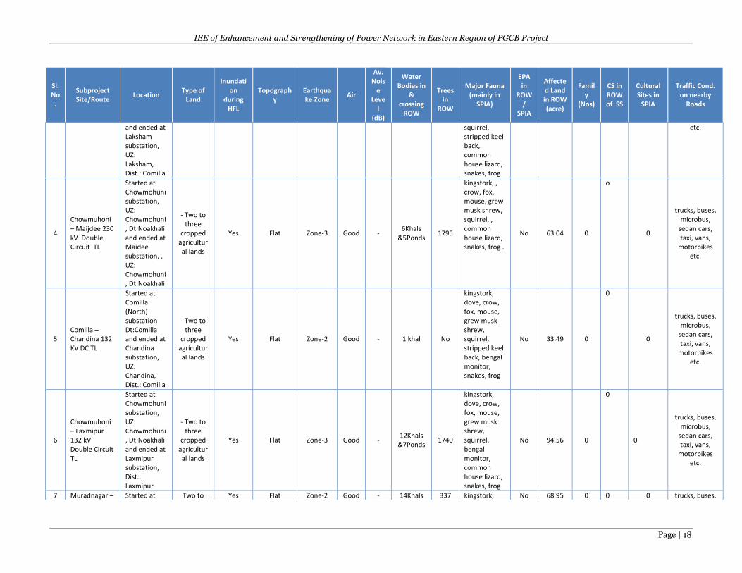
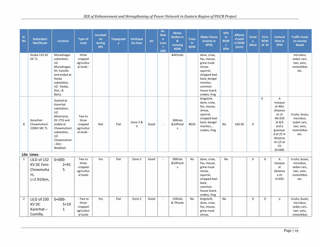
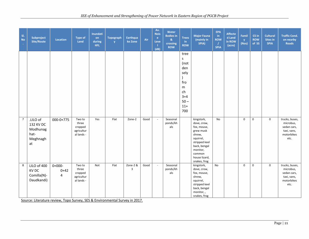
The subproject areas of the substation and TL/Lilo lines of the project are located in a typical
monsoon climate with three main seasons, summer (February to May), monsoon (June to
September) and winter (October to January). The environmental baseline conditions and Important
Environmental Features (IEFs) of each substation (SS) subproject, Transmission Line (TL) subproject
and Lilo Lines are summarized in the following Table 1.
IEE of Enhancement and Strengthening of Power Network in Eastern Region of PGCB Project
Page | 14
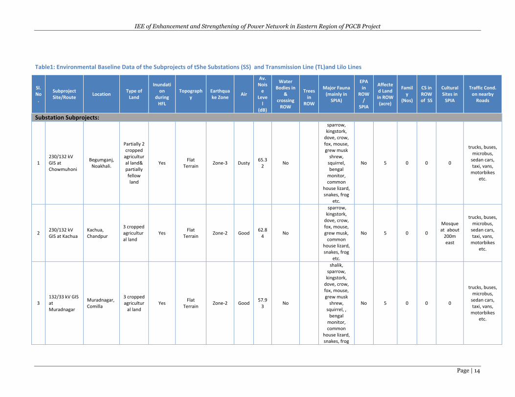
Table1: Environmental Baseline Data of the Subprojects of t5he Substations (SS) and Transmission Line (TL)and Lilo Lines
Sl. No
.
Subproject Site/Route
Location Type of
Land
Inundation
during HFL
Topography
Earthquake Zone
Air
Av. Nois
e Leve
l (dB)
Water Bodies in
& crossing
ROW
Trees
in ROW
Major Fauna (mainly in
SPIA)
EPA in
ROW/
SPIA
Affected Land in ROW (acre)
Family
(Nos)
CS in ROW of SS
Cultural Sites in
SPIA
Traffic Cond. on nearby
Roads
Substation Subprojects:
1 230/132 kV GIS at Chowmuhoni
Begumganj, Noakhali.
Partially 2 cropped
agricultural land& partially fellow land
Yes Flat
Terrain Zone-3 Dusty
65.32
No
sparrow, kingstork,
dove, crow, fox, mouse, grew musk
shrew, squirrel, bengal
monitor, common
house lizard, snakes, frog
etc.
No 5 0 0 0
trucks, buses, microbus,
sedan cars, taxi, vans,
motorbikes etc.
2 230/132 kV GIS at Kachua
Kachua, Chandpur
3 cropped agricultural land
Yes Flat
Terrain Zone-2 Good
62.84
No
sparrow, kingstork,
dove, crow, fox, mouse, grew musk,
common house lizard, snakes, frog
etc.
No 5 0 0
Mosque at about
200m east
trucks, buses, microbus,
sedan cars, taxi, vans,
motorbikes etc.
3 132/33 kV GIS at Muradnagar
Muradnagar, Comilla
3 cropped agricultur
al land Yes
Flat Terrain
Zone-2 Good 57.9
3 No
shalik, sparrow, kingstork,
dove, crow, fox, mouse, grew musk
shrew, squirrel, ,
bengal monitor, common
house lizard, snakes, frog
No 5 0 0 0
trucks, buses, microbus,
sedan cars, taxi, vans,
motorbikes etc.
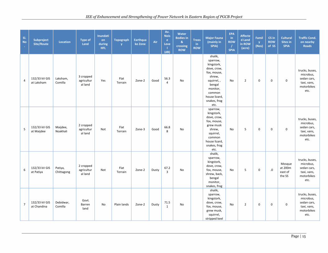
IEE of Enhancement and Strengthening of Power Network in Eastern Region of PGCB Project
Page | 15
Sl. No
.
Subproject Site/Route
Location Type of
Land
Inundation
during HFL
Topography
Earthquake Zone
Air
Av. Nois
e Leve
l (dB)
Water Bodies in
& crossing
ROW
Trees
in ROW
Major Fauna (mainly in
SPIA)
EPA in
ROW/
SPIA
Affected Land in ROW (acre)
Family
(Nos)
CS in ROW of SS
Cultural Sites in
SPIA
Traffic Cond. on nearby
Roads
4 132/33 kV GIS at Laksham
Laksham, Comilla
3 cropped agricultur
al land Yes
Flat Terrain
Zone-2 Good 56.3
4 No
shalik, sparrow, kingstork,
dove, crow, fox, mouse,
shrew, squirrel, ,
bengal monitor, common
house lizard, snakes, frog
etc.
No 2 0 0 0
trucks, buses, microbus,
sedan cars, taxi, vans,
motorbikes etc.
5 132/33 kV GIS at Maijdee
Maijdee, Noakhali
2 cropped agricultur
al land Not
Flat Terrain
Zone-3 Good 66.8
8 No
sparrow, kingstork,
dove, crow, fox, mouse, grew musk
shrew, squirrel, common
house lizard, snakes, frog
etc.
No 5 0 0 0
trucks, buses, microbus,
sedan cars, taxi, vans,
motorbikes etc.
6 132/33 kV GIS at Patiya
Patiya, Chittagong
2 cropped agricultur
al land Not
Flat Terrain
Zone-2 Dusty 67.2
3 No
shalik, sparrow, kingstork,
dove, crow, fox, mouse, shrew, back,
bengal monitor,
snakes, frog
No 5 0 .0
Mosque at 200m east of the SS
trucks, buses, microbus,
sedan cars, taxi, vans,
motorbikes etc.
7 132/33 kV GIS at Chandina
Debidwar, Comilla
Govt. Barren
land No Plain lands Zone-2 Dusty
71.51
No
shalik, sparrow, kingstork,
dove, crow, fox, mouse, grew musk,
squirrel, stripped keel
No 2 0 0 0
trucks, buses, microbus,
sedan cars, taxi, vans,
motorbikes etc.
IEE of Enhancement and Strengthening of Power Network in Eastern Region of PGCB Project
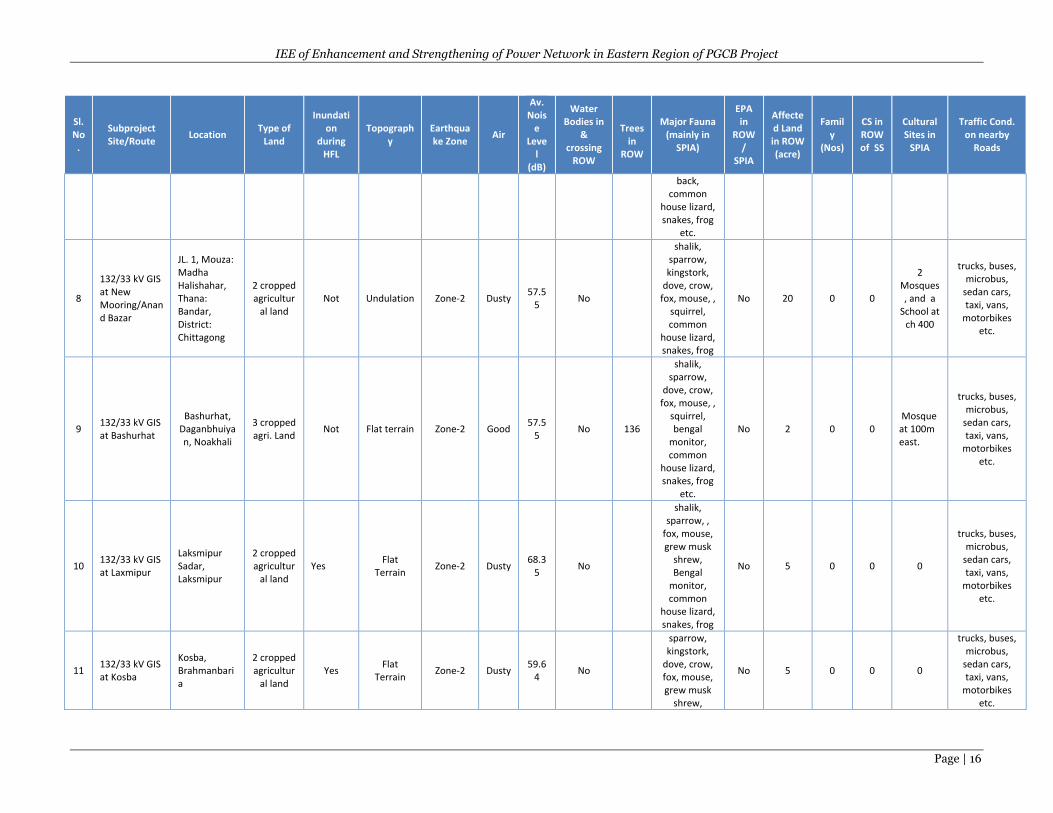
Page | 16
Sl. No
.
Subproject Site/Route
Location Type of
Land
Inundation
during HFL
Topography
Earthquake Zone
Air
Av. Nois
e Leve
l (dB)
Water Bodies in
& crossing
ROW
Trees
in ROW
Major Fauna (mainly in
SPIA)
EPA in
ROW/
SPIA
Affected Land in ROW (acre)
Family
(Nos)
CS in ROW of SS
Cultural Sites in
SPIA
Traffic Cond. on nearby
Roads
back, common
house lizard, snakes, frog
etc.
8
132/33 kV GIS at New Mooring/Anand Bazar
JL. 1, Mouza: Madha Halishahar, Thana: Bandar, District: Chittagong
2 cropped agricultur
al land Not Undulation Zone-2 Dusty
57.55
No
shalik, sparrow, kingstork,
dove, crow, fox, mouse, ,
squirrel, common
house lizard, snakes, frog
No 20 0 0
2 Mosques, and a
School at ch 400
trucks, buses, microbus,
sedan cars, taxi, vans,
motorbikes etc.
9 132/33 kV GIS at Bashurhat
Bashurhat, Daganbhuiyan, Noakhali
3 cropped agri. Land
Not Flat terrain Zone-2 Good 57.5
5 No 136
shalik, sparrow,
dove, crow, fox, mouse, ,
squirrel, bengal
monitor, common
house lizard, snakes, frog
etc.
No 2 0 0 Mosque at 100m east.
trucks, buses, microbus,
sedan cars, taxi, vans,
motorbikes etc.
10 132/33 kV GIS at Laxmipur
Laksmipur Sadar, Laksmipur
2 cropped agricultur
al land Yes
Flat Terrain
Zone-2 Dusty 68.3
5 No
shalik, sparrow, ,
fox, mouse, grew musk
shrew, Bengal
monitor, common
house lizard, snakes, frog
No 5 0 0 0
trucks, buses, microbus,
sedan cars, taxi, vans,
motorbikes etc.
11 132/33 kV GIS at Kosba
Kosba, Brahmanbaria
2 cropped agricultur
al land Yes
Flat Terrain
Zone-2 Dusty 59.6
4 No
sparrow, kingstork,
dove, crow, fox, mouse, grew musk
shrew,
No 5 0 0 0
trucks, buses, microbus,
sedan cars, taxi, vans,
motorbikes etc.
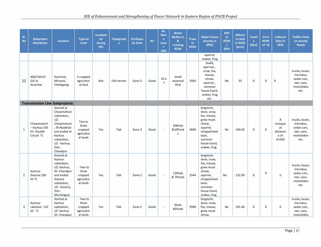
IEE of Enhancement and Strengthening of Power Network in Eastern Region of PGCB Project
Page | 17
Sl. No
.
Subproject Site/Route
Location Type of
Land
Inundation
during HFL
Topography
Earthquake Zone
Air
Av. Nois
e Leve
l (dB)
Water Bodies in
& crossing
ROW
Trees
in ROW
Major Fauna (mainly in
SPIA)
EPA in
ROW/
SPIA
Affected Land in ROW (acre)
Family
(Nos)
CS in ROW of SS
Cultural Sites in
SPIA
Traffic Cond. on nearby
Roads
squirrel, snakes, frog
12 400/230 kV GIS at Korerhat
Korerhat, Mirsarai, Chittagong
2 cropped agricultur
al land Not Flat terrain Zone-2 Good
70.57
Small seasonal
Khal 2945
shalik, sparrow, , crow, fox,
mouse, shrew,
squirrel, , common
house lizard, snakes, frog
etc.
No 25 0 0 0
trucks, buses, microbus,
sedan cars, taxi, vans,
motorbikes etc.
Transmission Line Subprojects:
1
Chowmuhoni – Kachua 230 kV Double Circuit TL
Started at Chowmohuni substation, UZ: Chowmohuni, Dt:Noakhali and ended at Kachua substation, UZ: Kachua, Dist.: Chandpur
Two to three
cropped agricultural lands
Yes Flat Zone-3 Good - 30Khals
&10Ponds
2836
kingstork, dove, crow, fox, mouse, grew musk shrew, squirrel, stripped keel back, common house lizard, snakes, frog
No 149.42 0 0
A mosque
at distance
a ch 0+030
trucks, buses, microbus,
sedan cars, taxi, vans,
motorbikes etc.
2 Kachua-Gazaria 230 kV TL
Started at Kachua substation, UZ: Kachua, Dt: Chandpur and ended Gazaria substation, UZ: Gazaria, Dist.: Munshiganj
- Two to three
cropped agricultural lands
Yes Flat Zone-2 Good - 12Khals
& 7Ponds 2544
kingstork, dove, crow, fox, mouse, grew musk shrew, squirrel, stripped keel back, common house lizard, snakes, frog
No 132.00 0 0
o
trucks, buses, microbus,
sedan cars, taxi, vans,
motorbikes etc.
3 Kachua-Laksham 132 kV TL
Started at Kachua substation, UZ: Kachua Dt: Chandpur
- Two to three
cropped agricultural lands
Yes Flat Zone-2 Good - Khals
&Ponds 2990
kingstork, dove, crow, fox, mouse, grew musk shrew,
No 101.46 0 0 0
trucks, buses, microbus,
sedan cars, taxi, vans,
motorbikes
IEE of Enhancement and Strengthening of Power Network in Eastern Region of PGCB Project
Page | 18
Sl. No
.
Subproject Site/Route
Location Type of
Land
Inundation
during HFL
Topography
Earthquake Zone
Air
Av. Nois
e Leve
l (dB)
Water Bodies in
& crossing
ROW
Trees
in ROW
Major Fauna (mainly in
SPIA)
EPA in
ROW/
SPIA
Affected Land in ROW (acre)
Family
(Nos)
CS in ROW of SS
Cultural Sites in
SPIA
Traffic Cond. on nearby
Roads
and ended at Laksham substation, UZ: Laksham, Dist.: Comilla
squirrel, stripped keel back, common house lizard, snakes, frog
etc.
4
Chowmuhoni – Maijdee 230 kV Double Circuit TL
Started at Chowmohuni substation, UZ: Chowmohuni, Dt:Noakhali and ended at Maidee substation, , UZ: Chowmohuni, Dt:Noakhali
- Two to three
cropped agricultural lands
Yes Flat Zone-3 Good - 6Khals
&5Ponds 1795
kingstork, , crow, fox, mouse, grew musk shrew, squirrel, , common house lizard, snakes, frog .
No 63.04 0
o
0
trucks, buses, microbus,
sedan cars, taxi, vans,
motorbikes etc.
5 Comilla –Chandina 132 KV DC TL
Started at Comilla (North) substation Dt:Comilla and ended at Chandina substation, UZ: Chandina, Dist.: Comilla
- Two to three
cropped agricultural lands
Yes Flat Zone-2 Good - 1 khal No
kingstork, dove, crow, fox, mouse, grew musk shrew, squirrel, stripped keel back, bengal monitor, snakes, frog
No 33.49 0
0
0
trucks, buses, microbus,
sedan cars, taxi, vans,
motorbikes etc.
6
Chowmuhoni – Laxmipur 132 kV Double Circuit TL
Started at Chowmohuni substation, UZ: Chowmohuni, Dt:Noakhali and ended at Laxmipur substation, Dist.: Laxmipur
- Two to three
cropped agricultural lands
Yes Flat Zone-3 Good - 12Khals
&7Ponds 1740
kingstork, dove, crow, fox, mouse, grew musk shrew, squirrel, bengal monitor, common house lizard, snakes, frog
No 94.56 0
0
0
trucks, buses, microbus,
sedan cars, taxi, vans,
motorbikes etc.
7 Muradnagar – Started at Two to Yes Flat Zone-2 Good - 14Khals 337 kingstork, No 68.95 0 0 0 trucks, buses,
IEE of Enhancement and Strengthening of Power Network in Eastern Region of PGCB Project
Page | 19
Sl. No
.
Subproject Site/Route
Location Type of
Land
Inundation
during HFL
Topography
Earthquake Zone
Air
Av. Nois
e Leve
l (dB)
Water Bodies in
& crossing
ROW
Trees
in ROW
Major Fauna (mainly in
SPIA)
EPA in
ROW/
SPIA
Affected Land in ROW (acre)
Family
(Nos)
CS in ROW of SS
Cultural Sites in
SPIA
Traffic Cond. on nearby
Roads
Kosba 132 KV DC TL
Muradnagar substation, UZ: Muradnagar, Dt: Comilla and ended at Kosba substation, UZ: Kosba, Dist.: B. Baria.
three cropped
agricultural lands -
&4Ponds dove, crow, fox, mouse, grew musk shrew, squirrel, stripped keel back, bengal monitor, common house lizard, snakes, frog
microbus, sedan cars, taxi, vans,
motorbikes etc.
8 Korerhat- Chowmuhoni 230KV MC TL
Started at Korerhat substation, UZ: Mirersorai, Dt: CTG and ended at Chowmuhoni substation, UZ: Chowmuhoni , Dist.: Noakhali.
Two to three
cropped agricultural lands -
Not Flat Zone-2 &
3 Good -
30Khals &10Pond
s 8010
kingstork, dove, crow, fox, mouse, shrew, squirrel, stripped keel back, bengal monitor, , snakes, frog
No 160.56 0
0 A mosque at 40m
distance at ch
49+250 at R/S and a
graveyard at 25 m distance at L/S at
Ch 10+000.
trucks, buses, microbus,
sedan cars, taxi, vans,
motorbikes etc.
Lilo Lines:
1 LILO of 132 KV DC Feni-Chowmuhani, L=2.915km,
0+000-2+915
Two to three
cropped agricultural lands
Yes Flat Zone-2 Good - 30Khals &10Pond
s
No dove, crow, fox, mouse, grew musk shrew, squirrel, stripped keel back, common house lizard, snakes, frog
No 0 0 A mosque
at distance
a ch 0+030
trucks, buses, microbus,
sedan cars, taxi, vans,
motorbikes etc.
2 LILO of 230 KV DC Karerhat –Comilla,
0+000-5+191
- Two to three
cropped agricultural lands
Yes Flat Zone-2 Good - 12Khals & 7Ponds
No kingstork, dove, crow, fox, mouse, grew musk shrew,
No 0 0
o trucks, buses, microbus,
sedan cars, taxi, vans,
motorbikes

IEE of Enhancement and Strengthening of Power Network in Eastern Region of PGCB Project
Page | 20
Sl. No
.
Subproject Site/Route
Location Type of
Land
Inundation
during HFL
Topography
Earthquake Zone
Air
Av. Nois
e Leve
l (dB)
Water Bodies in
& crossing
ROW
Trees
in ROW
Major Fauna (mainly in
SPIA)
EPA in
ROW/
SPIA
Affected Land in ROW (acre)
Family
(Nos)
CS in ROW of SS
Cultural Sites in
SPIA
Traffic Cond. on nearby
Roads
L=5.735
squirrel, common house lizard, snakes, frog
etc.
3 LILO of 132 KV DC Karerhat-Hathaz4ari-F5eni 6
0+000-3+327
- Two to three
cropped agricultural lands
Yes Flat Zone-1 Good - Khals &Ponds
No dove, crow, fox, mouse, grew musk shrew, squirrel, stripped keel back, common house lizard, snakes, frog
No 0 0 0 trucks, buses, microbus,
sedan cars, taxi, vans,
motorbikes etc.
4 .LILO of 8132 KV DC Dohazari- Shikalbaha
0+000-0+750
- Two to three
cropped agricultural lands
Yes Flat Zone-1 Good - Seasonal ponds/kh
als
No crow, fox, mouse, grew musk shrew, squirrel, , common house lizard, snakes, frog .
No 0 o 0 trucks, buses, microbus,
sedan cars, taxi, vans,
motorbikes etc.
5 LILO of 132 KV DC Halishahar-Kulshi
0+000-1+105
- Two to three
cropped agricultural lands
Yes Flat Zone-1 Good - Seasonal ponds/kh
als
No kingstork, dove, crow, fox, mouse, grew musk shrew, squirrel, stripped keel back, bengal monitor, snakes, frog
No 0 0 0 trucks, buses, microbus,
sedan cars, taxi, vans,
motorbikes etc.
6 LILO of 400 KV DC Korerhat-BSRM
0+000-11+850
- Two to three
cropped agricultural lands
Yes Undulated Zone-2 Good - Seasonal ponds/khals
, small to medium size forest
kingstork, dove, crow, fox, mouse, grew musk shrew, squirrel, common house lizard, snakes, frog
No 0 0 0 trucks, buses, microbus,
sedan cars, taxi, vans,
motorbikes etc.
IEE of Enhancement and Strengthening of Power Network in Eastern Region of PGCB Project
Page | 21
Sl. No
.
Subproject Site/Route
Location Type of
Land
Inundation
during HFL
Topography
Earthquake Zone
Air
Av. Nois
e Leve
l (dB)
Water Bodies in
& crossing
ROW
Trees
in ROW
Major Fauna (mainly in
SPIA)
EPA in
ROW/
SPIA
Affected Land in ROW (acre)
Family
(Nos)
CS in ROW of SS
Cultural Sites in
SPIA
Traffic Cond. on nearby
Roads
trees (not densely) from ch 3+450 – 11+700
7 .LILO of 132 KV DC Modhunaghat-Meghnaghat
000-0+775 Two to three
cropped agricultural lands -
Yes Flat Zone-2 Good - Seasonal ponds/kh
als
kingstork, dove, crow, fox, mouse, grew musk shrew, squirrel, stripped keel back, bengal monitor, common house lizard, snakes, frog
No 0 0 0 trucks, buses, microbus,
sedan cars, taxi, vans,
motorbikes etc.
8 LILO of 400 KV DC Comilla(N)-Daudkandi)
0+000-0+424
Two to three
cropped agricultural lands -
Not Flat Zone-2 & 3
Good - Seasonal ponds/kh
als
kingstork, dove, crow, fox, mouse, shrew, squirrel, stripped keel back, bengal monitor, , snakes, frog
No 0 0 0 trucks, buses, microbus,
sedan cars, taxi, vans,
motorbikes etc.
Source: Literature review, Topo Survey, SES & Environmental Survey in 2017.
IEE of Enhancement and Strengthening of Power Network in Eastern Region of PGCB Project
Page | xxii
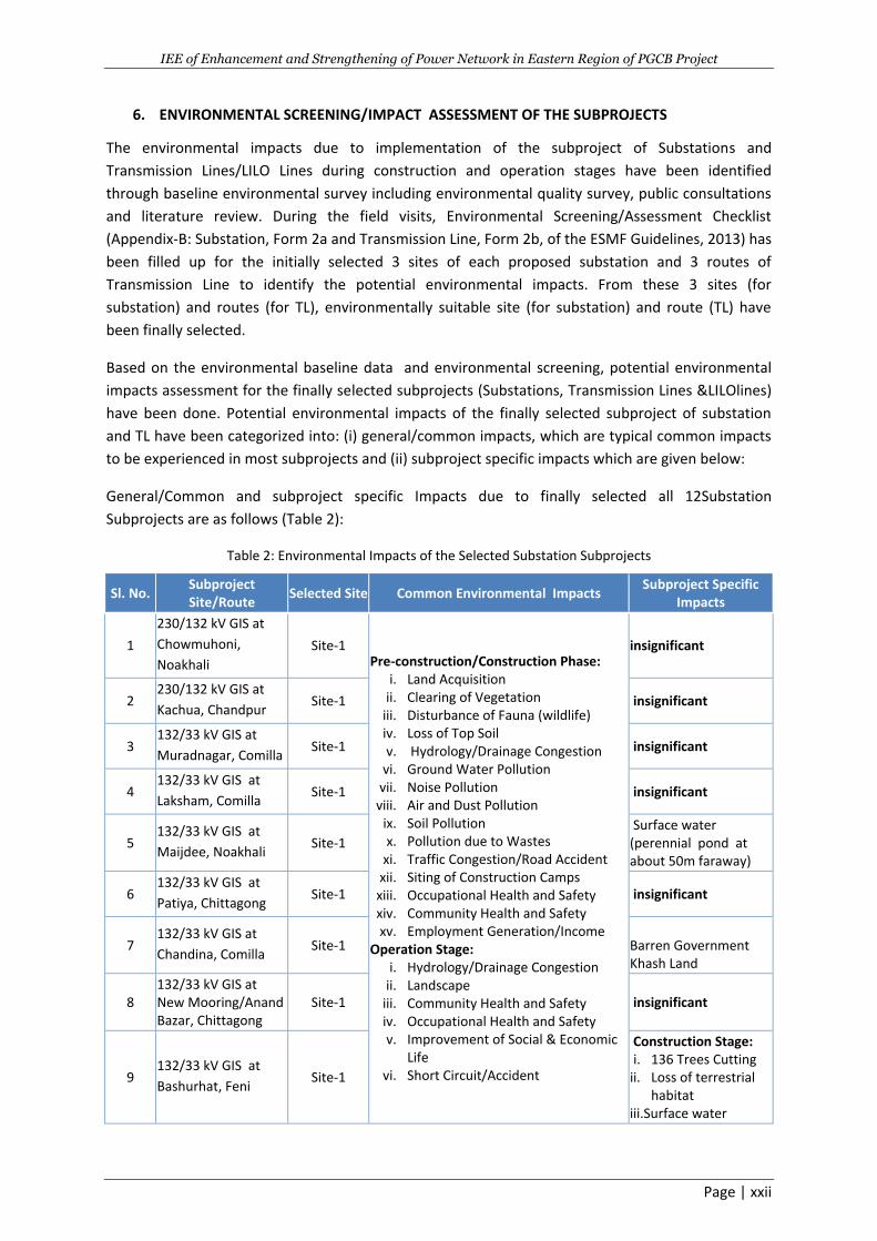
6. ENVIRONMENTAL SCREENING/IMPACT ASSESSMENT OF THE SUBPROJECTS
The environmental impacts due to implementation of the subproject of Substations and
Transmission Lines/LILO Lines during construction and operation stages have been identified
through baseline environmental survey including environmental quality survey, public consultations
and literature review. During the field visits, Environmental Screening/Assessment Checklist
(Appendix-B: Substation, Form 2a and Transmission Line, Form 2b, of the ESMF Guidelines, 2013) has
been filled up for the initially selected 3 sites of each proposed substation and 3 routes of
Transmission Line to identify the potential environmental impacts. From these 3 sites (for
substation) and routes (for TL), environmentally suitable site (for substation) and route (TL) have
been finally selected.
Based on the environmental baseline data and environmental screening, potential environmental
impacts assessment for the finally selected subprojects (Substations, Transmission Lines &LILOlines)
have been done. Potential environmental impacts of the finally selected subproject of substation
and TL have been categorized into: (i) general/common impacts, which are typical common impacts
to be experienced in most subprojects and (ii) subproject specific impacts which are given below:
General/Common and subproject specific Impacts due to finally selected all 12Substation
Subprojects are as follows (Table 2):
Table 2: Environmental Impacts of the Selected Substation Subprojects
Sl. No. Subproject Site/Route
Selected Site Common Environmental Impacts Subproject Specific
Impacts
1
230/132 kV GIS at
Chowmuhoni,
Noakhali
Site-1 Pre-construction/Construction Phase:
i. Land Acquisition ii. Clearing of Vegetation
iii. Disturbance of Fauna (wildlife) iv. Loss of Top Soil v. Hydrology/Drainage Congestion
vi. Ground Water Pollution vii. Noise Pollution
viii. Air and Dust Pollution ix. Soil Pollution x. Pollution due to Wastes
xi. Traffic Congestion/Road Accident xii. Siting of Construction Camps
xiii. Occupational Health and Safety xiv. Community Health and Safety xv. Employment Generation/Income
Operation Stage: i. Hydrology/Drainage Congestion
ii. Landscape iii. Community Health and Safety iv. Occupational Health and Safety v. Improvement of Social & Economic
Life vi. Short Circuit/Accident
insignificant
2 230/132 kV GIS at
Kachua, Chandpur Site-1 insignificant
3 132/33 kV GIS at
Muradnagar, Comilla Site-1 insignificant
4 132/33 kV GIS at
Laksham, Comilla Site-1 insignificant
5 132/33 kV GIS at
Maijdee, Noakhali Site-1
Surface water (perennial pond at about 50m faraway)
6 132/33 kV GIS at
Patiya, Chittagong Site-1 insignificant
7 132/33 kV GIS at
Chandina, Comilla Site-1
Barren Government Khash Land
8 132/33 kV GIS at New Mooring/Anand Bazar, Chittagong
Site-1 insignificant
9 132/33 kV GIS at
Bashurhat, Feni Site-1
Construction Stage: i. 136 Trees Cutting
ii. Loss of terrestrial habitat
iii.Surface water
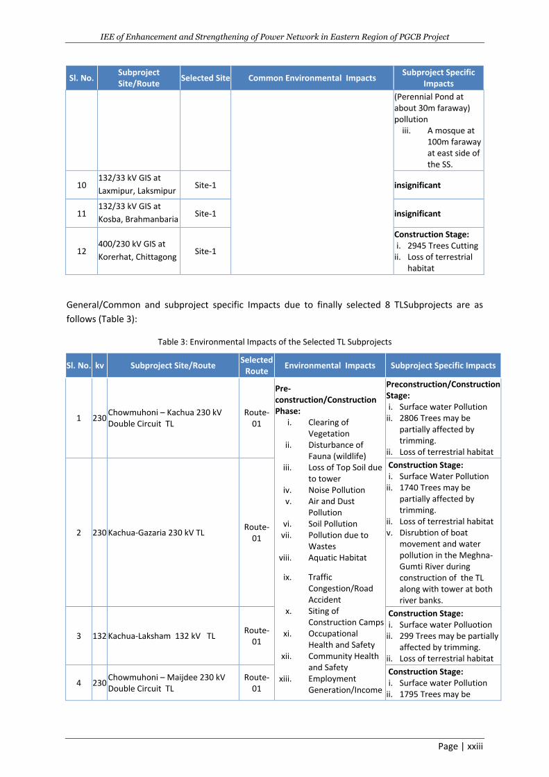
IEE of Enhancement and Strengthening of Power Network in Eastern Region of PGCB Project
Page | xxiii
Sl. No. Subproject Site/Route
Selected Site Common Environmental Impacts Subproject Specific
Impacts
(Perennial Pond at about 30m faraway) pollution
iii. A mosque at 100m faraway at east side of the SS.
10 132/33 kV GIS at
Laxmipur, Laksmipur Site-1 insignificant
11 132/33 kV GIS at
Kosba, Brahmanbaria Site-1 insignificant
12 400/230 kV GIS at
Korerhat, Chittagong Site-1
Construction Stage: i. 2945 Trees Cutting
ii. Loss of terrestrial habitat
General/Common and subproject specific Impacts due to finally selected 8 TLSubprojects are as
follows (Table 3):
Table 3: Environmental Impacts of the Selected TL Subprojects
Sl. No. kv Subproject Site/Route Selected
Route Environmental Impacts Subproject Specific Impacts
1 230 Chowmuhoni – Kachua 230 kV Double Circuit TL
Route-01
Pre-construction/Construction Phase:
i. Clearing of Vegetation
ii. Disturbance of Fauna (wildlife)
iii. Loss of Top Soil due to tower
iv. Noise Pollution v. Air and Dust
Pollution vi. Soil Pollution
vii. Pollution due to Wastes
viii. Aquatic Habitat
ix. Traffic Congestion/Road Accident
x. Siting of Construction Camps
xi. Occupational Health and Safety
xii. Community Health and Safety
xiii. Employment Generation/Income
Preconstruction/Construction Stage: i. Surface water Pollution
ii. 2806 Trees may be partially affected by trimming.
iii. Loss of terrestrial habitat
2 230 Kachua-Gazaria 230 kV TL Route-
01
Construction Stage: i. Surface Water Pollution
ii. 1740 Trees may be partially affected by trimming.
iii. Loss of terrestrial habitat iv. Disrubtion of boat
movement and water pollution in the Meghna- Gumti River during construction of the TL along with tower at both river banks.
3 132 Kachua-Laksham 132 kV TL Route-
01
Construction Stage: i. Surface water Polluotion
ii. 299 Trees may be partially affected by trimming.
iii. Loss of terrestrial habitat
4 230 Chowmuhoni – Maijdee 230 kV Double Circuit TL
Route-01
Construction Stage: i. Surface water Pollution
ii. 1795 Trees may be
IEE of Enhancement and Strengthening of Power Network in Eastern Region of PGCB Project
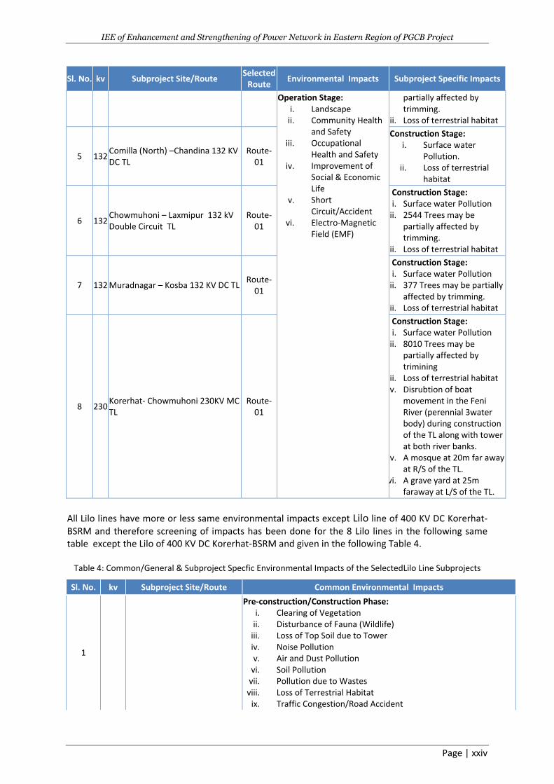
Page | xxiv
Sl. No. kv Subproject Site/Route Selected
Route Environmental Impacts Subproject Specific Impacts
Operation Stage: i. Landscape
ii. Community Health and Safety
iii. Occupational Health and Safety
iv. Improvement of Social & Economic Life
v. Short Circuit/Accident
vi. Electro-Magnetic Field (EMF)
partially affected by trimming.
iii. Loss of terrestrial habitat
5 132 Comilla (North) –Chandina 132 KV DC TL
Route-01
Construction Stage: i. Surface water
Pollution. ii. Loss of terrestrial
habitat
6 132 Chowmuhoni – Laxmipur 132 kV Double Circuit TL
Route-01
Construction Stage: i. Surface water Pollution
ii. 2544 Trees may be partially affected by trimming.
iii. Loss of terrestrial habitat
7 132 Muradnagar – Kosba 132 KV DC TL Route-
01
Construction Stage: i. Surface water Pollution
ii. 377 Trees may be partially affected by trimming.
iii. Loss of terrestrial habitat
8 230 Korerhat- Chowmuhoni 230KV MC TL
Route-01
Construction Stage: i. Surface water Pollution
ii. 8010 Trees may be partially affected by trimining
iii. Loss of terrestrial habitat iv. Disrubtion of boat
movement in the Feni River (perennial 3water body) during construction of the TL along with tower at both river banks.
v. A mosque at 20m far away at R/S of the TL.
vi. A grave yard at 25m faraway at L/S of the TL.
All Lilo lines have more or less same environmental impacts except Lilo line of 400 KV DC Korerhat-BSRM and therefore screening of impacts has been done for the 8 Lilo lines in the following same table except the Lilo of 400 KV DC Korerhat-BSRM and given in the following Table 4.
Table 4: Common/General & Subproject Specfic Environmental Impacts of the SelectedLilo Line Subprojects
Sl. No. kv Subproject Site/Route Common Environmental Impacts
1
Pre-construction/Construction Phase: i. Clearing of Vegetation
ii. Disturbance of Fauna (Wildlife) iii. Loss of Top Soil due to Tower iv. Noise Pollution v. Air and Dust Pollution
vi. Soil Pollution vii. Pollution due to Wastes
viii. Loss of Terrestrial Habitat ix. Traffic Congestion/Road Accident
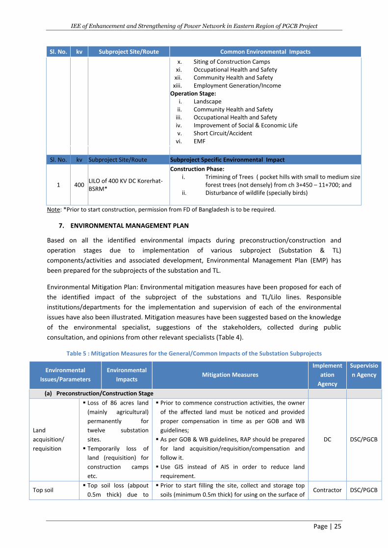
IEE of Enhancement and Strengthening of Power Network in Eastern Region of PGCB Project
Page | 25
Sl. No. kv Subproject Site/Route Common Environmental Impacts
x. Siting of Construction Camps xi. Occupational Health and Safety
xii. Community Health and Safety xiii. Employment Generation/Income
Operation Stage: i. Landscape
ii. Community Health and Safety iii. Occupational Health and Safety iv. Improvement of Social & Economic Life v. Short Circuit/Accident
vi. EMF
Sl. No. kv Subproject Site/Route Subproject Specific Environmental Impact
1 400 LILO of 400 KV DC Korerhat-BSRM*
Construction Phase: i. Trimining of Trees ( pocket hills with small to medium size
forest trees (not densely) from ch 3+450 – 11+700; and ii. Disturbance of wildlife (specially birds)
Note: *Prior to start construction, permission from FD of Bangladesh is to be required.
7. ENVIRONMENTAL MANAGEMENT PLAN
Based on all the identified environmental impacts during preconstruction/construction and
operation stages due to implementation of various subproject (Substation & TL)
components/activities and associated development, Environmental Management Plan (EMP) has
been prepared for the subprojects of the substation and TL.
Environmental Mitigation Plan: Environmental mitigation measures have been proposed for each of
the identified impact of the subproject of the substations and TL/Lilo lines. Responsible
institutions/departments for the implementation and supervision of each of the environmental
issues have also been illustrated. Mitigation measures have been suggested based on the knowledge
of the environmental specialist, suggestions of the stakeholders, collected during public
consultation, and opinions from other relevant specialists (Table 4).
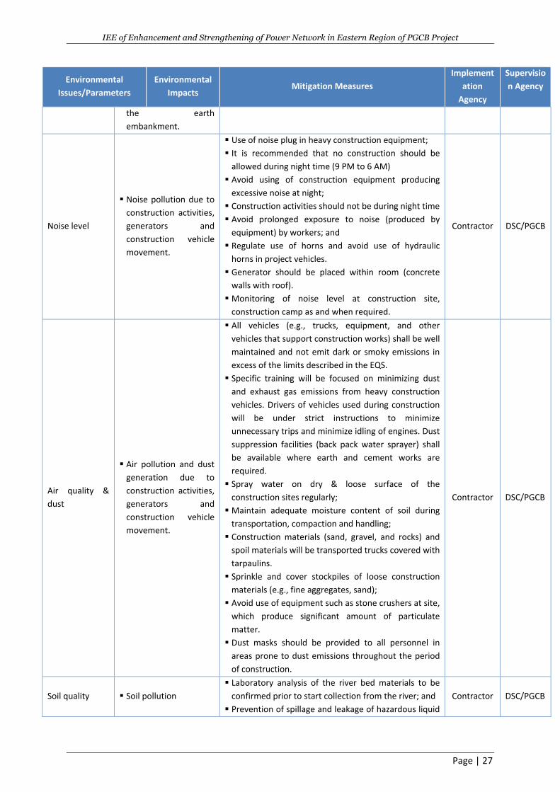
Table 5 : Mitigation Measures for the General/Common Impacts of the Substation Subprojects
Environmental
Issues/Parameters
Environmental
Impacts Mitigation Measures
Implement
ation
Agency
Supervisio
n Agency
(a) Preconstruction/Construction Stage
Land
acquisition/
requisition
Loss of 86 acres land
(mainly agricultural)
permanently for
twelve substation
sites.
Temporarily loss of
land (requisition) for
construction camps
etc.
Prior to commence construction activities, the owner
of the affected land must be noticed and provided
proper compensation in time as per GOB and WB
guidelines;
As per GOB & WB guidelines, RAP should be prepared
for land acquisition/requisition/compensation and
follow it.
Use GIS instead of AIS in order to reduce land
requirement.
DC DSC/PGCB
Top soil Top soil loss (abpout
0.5m thick) due to
Prior to start filling the site, collect and storage top
soils (minimum 0.5m thick) for using on the surface of Contractor DSC/PGCB
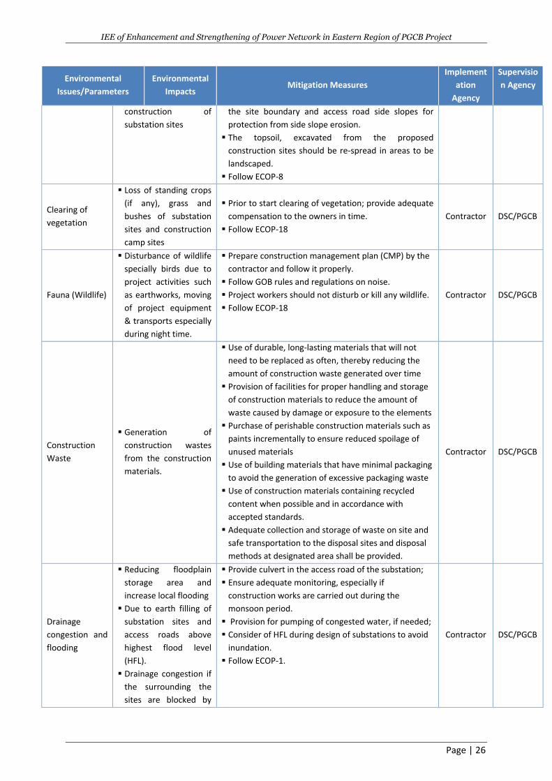
IEE of Enhancement and Strengthening of Power Network in Eastern Region of PGCB Project
Page | 26
Environmental
Issues/Parameters
Environmental
Impacts Mitigation Measures
Implement
ation
Agency
Supervisio
n Agency
construction of
substation sites
the site boundary and access road side slopes for
protection from side slope erosion.
The topsoil, excavated from the proposed
construction sites should be re-spread in areas to be
landscaped.
Follow ECOP-8
Clearing of
vegetation
Loss of standing crops
(if any), grass and
bushes of substation
sites and construction
camp sites
Prior to start clearing of vegetation; provide adequate
compensation to the owners in time.
Follow ECOP-18
Contractor DSC/PGCB
Fauna (Wildlife)
Disturbance of wildlife
specially birds due to
project activities such
as earthworks, moving
of project equipment
& transports especially
during night time.
Prepare construction management plan (CMP) by the
contractor and follow it properly.
Follow GOB rules and regulations on noise.
Project workers should not disturb or kill any wildlife.
Follow ECOP-18
Contractor DSC/PGCB
Construction
Waste
Generation of
construction wastes
from the construction
materials.
Use of durable, long-lasting materials that will not
need to be replaced as often, thereby reducing the
amount of construction waste generated over time
Provision of facilities for proper handling and storage
of construction materials to reduce the amount of
waste caused by damage or exposure to the elements
Purchase of perishable construction materials such as
paints incrementally to ensure reduced spoilage of
unused materials
Use of building materials that have minimal packaging
to avoid the generation of excessive packaging waste
Use of construction materials containing recycled
content when possible and in accordance with
accepted standards.
Adequate collection and storage of waste on site and
safe transportation to the disposal sites and disposal
methods at designated area shall be provided.
Contractor DSC/PGCB
Drainage
congestion and
flooding
Reducing floodplain
storage area and
increase local flooding
Due to earth filling of
substation sites and
access roads above
highest flood level
(HFL).
Drainage congestion if
the surrounding the
sites are blocked by
Provide culvert in the access road of the substation;
Ensure adequate monitoring, especially if
construction works are carried out during the
monsoon period.
Provision for pumping of congested water, if needed;
Consider of HFL during design of substations to avoid
inundation.
Follow ECOP-1.
Contractor DSC/PGCB
IEE of Enhancement and Strengthening of Power Network in Eastern Region of PGCB Project
Page | 27
Environmental
Issues/Parameters
Environmental
Impacts Mitigation Measures
Implement
ation
Agency
Supervisio
n Agency
the earth
embankment.
Noise level
Noise pollution due to
construction activities,
generators and
construction vehicle
movement.
Use of noise plug in heavy construction equipment;
It is recommended that no construction should be
allowed during night time (9 PM to 6 AM)
Avoid using of construction equipment producing
excessive noise at night;
Construction activities should not be during night time
Avoid prolonged exposure to noise (produced by
equipment) by workers; and
Regulate use of horns and avoid use of hydraulic
horns in project vehicles.
Generator should be placed within room (concrete
walls with roof).
Monitoring of noise level at construction site,
construction camp as and when required.
Contractor DSC/PGCB
Air quality &
dust
Air pollution and dust
generation due to
construction activities,
generators and
construction vehicle
movement.
All vehicles (e.g., trucks, equipment, and other
vehicles that support construction works) shall be well
maintained and not emit dark or smoky emissions in
excess of the limits described in the EQS.
Specific training will be focused on minimizing dust
and exhaust gas emissions from heavy construction
vehicles. Drivers of vehicles used during construction
will be under strict instructions to minimize
unnecessary trips and minimize idling of engines. Dust
suppression facilities (back pack water sprayer) shall
be available where earth and cement works are
required.
Spray water on dry & loose surface of the
construction sites regularly;
Maintain adequate moisture content of soil during
transportation, compaction and handling;
Construction materials (sand, gravel, and rocks) and
spoil materials will be transported trucks covered with
tarpaulins.
Sprinkle and cover stockpiles of loose construction
materials (e.g., fine aggregates, sand);
Avoid use of equipment such as stone crushers at site,
which produce significant amount of particulate
matter.
Dust masks should be provided to all personnel in
areas prone to dust emissions throughout the period
of construction.
Contractor DSC/PGCB
Soil quality Soil pollution
Laboratory analysis of the river bed materials to be
confirmed prior to start collection from the river; and
Prevention of spillage and leakage of hazardous liquid
Contractor DSC/PGCB
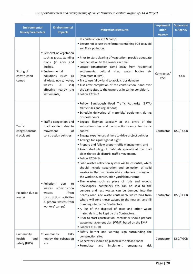
IEE of Enhancement and Strengthening of Power Network in Eastern Region of PGCB Project
Page | 28
Environmental
Issues/Parameters
Environmental
Impacts Mitigation Measures
Implement
ation
Agency
Supervisio
n Agency
at construction site & camp.
Ensure not to use transformer containing PCB to avoid
soil & air pollution.
Sitting of
construction
camps
Removal of vegetation
such as grass, standing
crops (if any) and
bushes.
Environmental
pollutions (such as
air/dust, noise, water,
wastes & soil)
affecting nearby the
settlements,
Prior to start clearing of vegetation; provide adequate
compensation to the owners in time.
Locate construction camp away from residential
settlements, cultural sites, water bodies etc
(minimum 0.5km).
Try to use fallow land to avoid crops damage
Just after completion of the construction, hand over
the camp sites to the owners as in earlier condition .
Follow ECOP-7
Contractor/
DSC PGCB
Traffic
congestion/roa
d accident
Traffic congestion and
road accident due to
movement of
construction vehicles.
Follow Bangladesh Road Traffic Authority (BRTA)
traffic rules and regulations;
Schedule deliveries of materials/ equipment during
off-peak hours
Engage flagman specially at the entry of the
substation sites and construction camps for traffic
control
Engage experienced drivers to drive project vehicles
Arrange for signal light at night
Prepare and follow proper traffic management; and
Avoid stockpiling of materials specially at the road
sides that could disturb traffic movement.
Follow ECOP-14
Contractor DSC/PGCB
Pollution due to
wastes
Pollution due to
wastes (construction
wastes from
construction activities
& general wastes from
workers’ camps)
Solid wastes collection system will be essential, which
should include separation and collection of solid
wastes in the dustbins/waste containers throughout
the work site, construction yard/labour camp.
The wastes such as piece of rods and woods,
newspapers, containers etc. can be sold to the
venders and rest wastes can be dumped into the
nearby road side waste containers/ waste bins from
where will send these wastes to the nearest land fill
dumping site by the Contractors.
A log of the disposal of toxic and other waste
materials is to be kept by the Contractors.
Prior to start cpnstruction, contractor should prepare
waste management plan (WMP) based on the EMP
Follow ECOP-10
Contractor DSC/PGCB
Community
health and
safety (H&S)
Community H&S
nearby the substation
site
Safety barrier and warning sign surrounding the
construction site;
Generators should be placed in the closed room
Formulate and implement emergency risk
Contractor DSC/PGCB
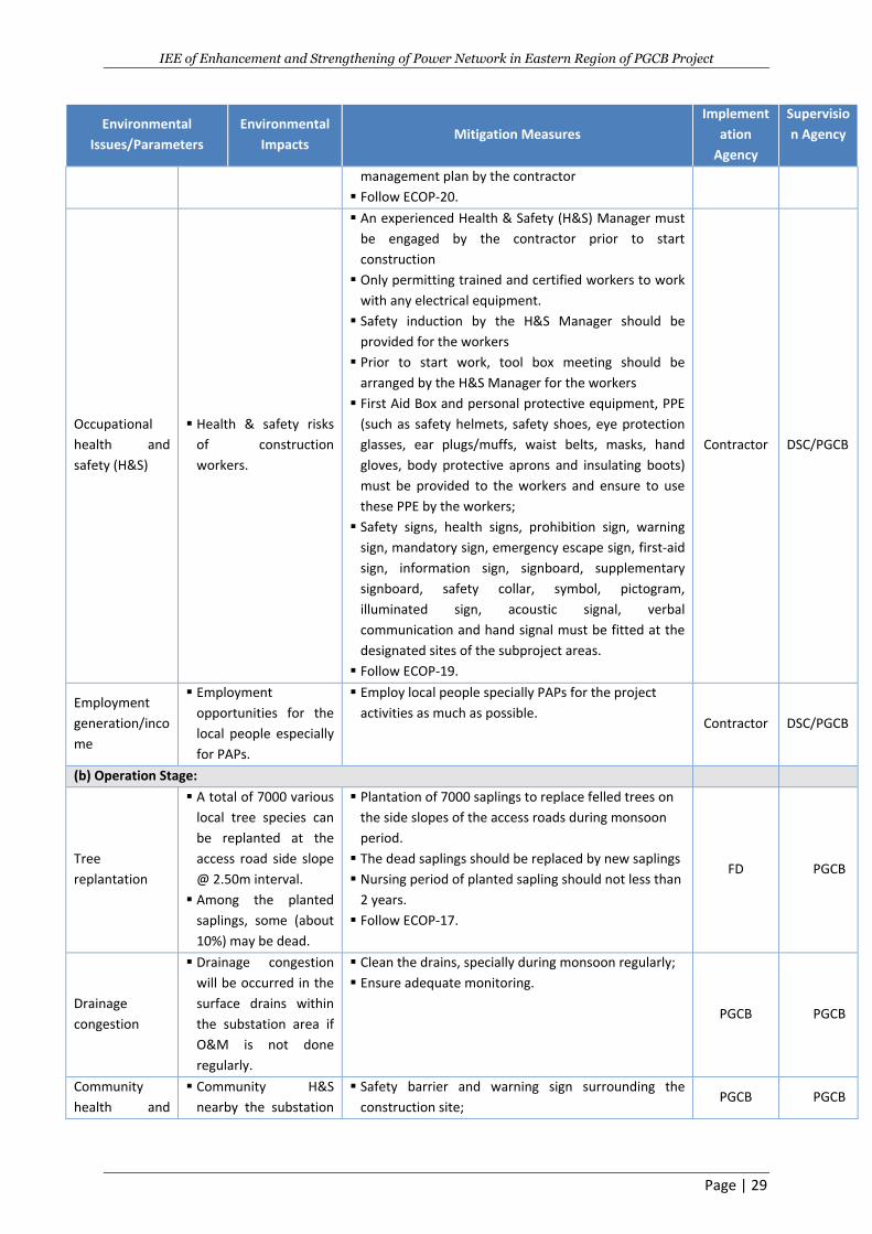
IEE of Enhancement and Strengthening of Power Network in Eastern Region of PGCB Project
Page | 29
Environmental
Issues/Parameters
Environmental
Impacts Mitigation Measures
Implement
ation
Agency
Supervisio
n Agency
management plan by the contractor
Follow ECOP-20.
Occupational
health and
safety (H&S)
Health & safety risks
of construction
workers.
An experienced Health & Safety (H&S) Manager must
be engaged by the contractor prior to start
construction
Only permitting trained and certified workers to work
with any electrical equipment.
Safety induction by the H&S Manager should be
provided for the workers
Prior to start work, tool box meeting should be
arranged by the H&S Manager for the workers
First Aid Box and personal protective equipment, PPE
(such as safety helmets, safety shoes, eye protection
glasses, ear plugs/muffs, waist belts, masks, hand
gloves, body protective aprons and insulating boots)
must be provided to the workers and ensure to use
these PPE by the workers;
Safety signs, health signs, prohibition sign, warning
sign, mandatory sign, emergency escape sign, first-aid
sign, information sign, signboard, supplementary
signboard, safety collar, symbol, pictogram,
illuminated sign, acoustic signal, verbal
communication and hand signal must be fitted at the
designated sites of the subproject areas.
Follow ECOP-19.
Contractor DSC/PGCB
Employment
generation/inco
me
Employment
opportunities for the
local people especially
for PAPs.
Employ local people specially PAPs for the project
activities as much as possible. Contractor DSC/PGCB
(b) Operation Stage:
Tree
replantation
A total of 7000 various
local tree species can
be replanted at the
access road side slope
@ 2.50m interval.
Among the planted
saplings, some (about
10%) may be dead.
Plantation of 7000 saplings to replace felled trees on
the side slopes of the access roads during monsoon
period.
The dead saplings should be replaced by new saplings
Nursing period of planted sapling should not less than
2 years.
Follow ECOP-17.
FD PGCB
Drainage
congestion
Drainage congestion
will be occurred in the
surface drains within
the substation area if
O&M is not done
regularly.
Clean the drains, specially during monsoon regularly;
Ensure adequate monitoring.
PGCB PGCB
Community
health and
Community H&S
nearby the substation
Safety barrier and warning sign surrounding the
construction site; PGCB PGCB
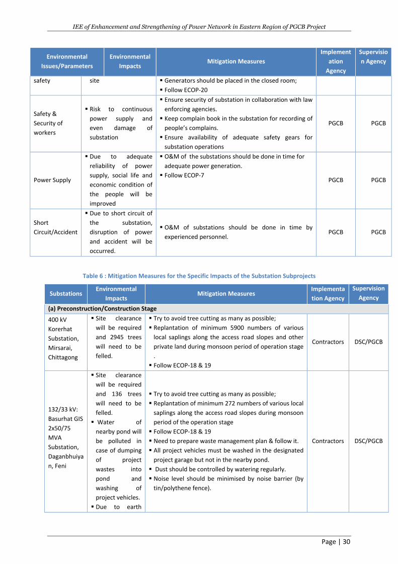
IEE of Enhancement and Strengthening of Power Network in Eastern Region of PGCB Project
Page | 30
Environmental
Issues/Parameters
Environmental
Impacts Mitigation Measures
Implement
ation
Agency
Supervisio
n Agency
safety site Generators should be placed in the closed room;
Follow ECOP-20
Safety &
Security of
workers
Risk to continuous
power supply and
even damage of
substation
Ensure security of substation in collaboration with law
enforcing agencies.
Keep complain book in the substation for recording of
people’s complains.
Ensure availability of adequate safety gears for
substation operations
PGCB PGCB
Power Supply
Due to adequate
reliability of power
supply, social life and
economic condition of
the people will be
improved
O&M of the substations should be done in time for
adequate power generation.
Follow ECOP-7 PGCB PGCB
Short
Circuit/Accident
Due to short circuit of
the substation,
disruption of power
and accident will be
occurred.
O&M of substations should be done in time by
experienced personnel. PGCB PGCB
Table 6 : Mitigation Measures for the Specific Impacts of the Substation Subprojects
Substations Environmental
Impacts Mitigation Measures
Implementa
tion Agency
Supervision
Agency
(a) Preconstruction/Construction Stage
400 kV
Korerhat
Substation,
Mirsarai,
Chittagong
Site clearance
will be required
and 2945 trees
will need to be
felled.
Try to avoid tree cutting as many as possible;
Replantation of minimum 5900 numbers of various
local saplings along the access road slopes and other
private land during monsoon period of operation stage
.
Follow ECOP-18 & 19
Contractors DSC/PGCB
132/33 kV:
Basurhat GIS
2x50/75
MVA
Substation,
Daganbhuiya
n, Feni
Site clearance
will be required
and 136 trees
will need to be
felled.
Water of
nearby pond will
be polluted in
case of dumping
of project
wastes into
pond and
washing of
project vehicles.
Due to earth
Try to avoid tree cutting as many as possible;
Replantation of minimum 272 numbers of various local
saplings along the access road slopes during monsoon
period of the operation stage
Follow ECOP-18 & 19
Need to prepare waste management plan & follow it.
All project vehicles must be washed in the designated
project garage but not in the nearby pond.
Dust should be controlled by watering regularly.
Noise level should be minimised by noise barrier (by
tin/polythene fence).
Contractors DSC/PGCB
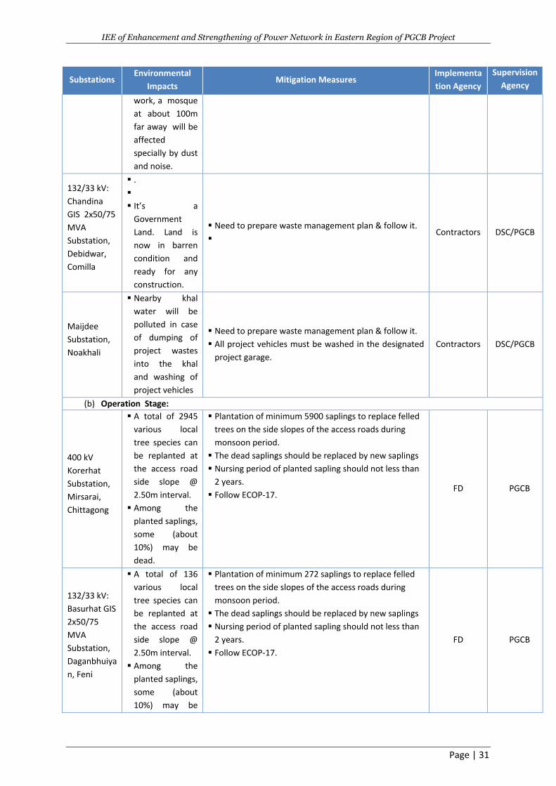
IEE of Enhancement and Strengthening of Power Network in Eastern Region of PGCB Project
Page | 31
Substations Environmental
Impacts Mitigation Measures
Implementa
tion Agency
Supervision
Agency
work, a mosque
at about 100m
far away will be
affected
specially by dust
and noise.
132/33 kV:
Chandina
GIS 2x50/75
MVA
Substation,
Debidwar,
Comilla
.
It’s a
Government
Land. Land is
now in barren
condition and
ready for any
construction.
Need to prepare waste management plan & follow it.
Contractors DSC/PGCB
Maijdee
Substation,
Noakhali
Nearby khal
water will be
polluted in case
of dumping of
project wastes
into the khal
and washing of
project vehicles
Need to prepare waste management plan & follow it.
All project vehicles must be washed in the designated
project garage.
Contractors DSC/PGCB
(b) Operation Stage:
400 kV
Korerhat
Substation,
Mirsarai,
Chittagong
A total of 2945
various local
tree species can
be replanted at
the access road
side slope @
2.50m interval.
Among the
planted saplings,
some (about
10%) may be
dead.
Plantation of minimum 5900 saplings to replace felled
trees on the side slopes of the access roads during
monsoon period.
The dead saplings should be replaced by new saplings
Nursing period of planted sapling should not less than
2 years.
Follow ECOP-17. FD PGCB
132/33 kV:
Basurhat GIS
2x50/75
MVA
Substation,
Daganbhuiya
n, Feni
A total of 136
various local
tree species can
be replanted at
the access road
side slope @
2.50m interval.
Among the
planted saplings,
some (about
10%) may be
Plantation of minimum 272 saplings to replace felled
trees on the side slopes of the access roads during
monsoon period.
The dead saplings should be replaced by new saplings
Nursing period of planted sapling should not less than
2 years.
Follow ECOP-17.
FD PGCB
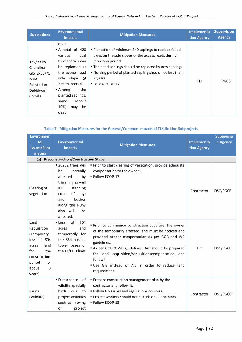
IEE of Enhancement and Strengthening of Power Network in Eastern Region of PGCB Project
Page | 32
Substations Environmental
Impacts Mitigation Measures
Implementa
tion Agency
Supervision
Agency
dead.
132/33 kV:
Chandina
GIS 2x50/75
MVA
Substation,
Debidwar,
Comilla
A total of 420
various local
tree species can
be replanted at
the access road
side slope @
2.50m interval.
Among the
planted saplings,
some (about
10%) may be
dead.
Plantation of minimum 840 saplings to replace felled
trees on the side slopes of the access roads during
monsoon period.
The dead saplings should be replaced by new saplings
Nursing period of planted sapling should not less than
2 years.
Follow ECOP-17. FD PGCB
Table 7 : Mitigation Measures for the General/Common Impacts of TL/Lilo Line Subprojects
Environmen
tal
Issues/Para
meters
Environmental
Impacts Mitigation Measures
Implementa
tion Agency
Supervisio
n Agency
(a) Preconstruction/Construction Stage
Clearing of
vegetation
20252 trees will
be partially
affected by
trimming as well
as standing
crops (if any)
and bushes
along the ROW
also will be
affected.
Prior to start clearing of vegetation; provide adequate
compensation to the owners.
Follow ECOP-17
Contractor DSC/PGCB
Land
Requisition
(Temporary
loss of 804
acres land
for the
construction
period of
about 3
years)
Loss of 804
acres land
temporarily for
the 884 nos. of
tower bases of
the TL/LILO lines
Prior to commence construction activities, the owner
of the temporarily affected land must be noticed and
provided proper compensation as per GOB and WB
guidelines;
As per GOB & WB guidelines, RAP should be prepared
for land acquisition/requisition/compensation and
follow it.
Use GIS instead of AIS in order to reduce land
requirement.
DC DSC/PGCB
Fauna
(Wildlife)
Disturbance of
wildlife specially
birds due to
project activities
such as moving
of project
Prepare construction management plan by the
contractor and follow it.
Follow GoB rules and regulations on noise.
Project workers should not disturb or kill the birds.
Follow ECOP-18
Contractor DSC/PGCB
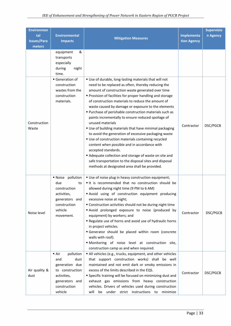
IEE of Enhancement and Strengthening of Power Network in Eastern Region of PGCB Project
Page | 33
Environmen
tal
Issues/Para
meters
Environmental
Impacts Mitigation Measures
Implementa
tion Agency
Supervisio
n Agency
equipment &
transports
especially
during night
time.
Construction
Waste
Generation of
construction
wastes from the
construction
materials.
Use of durable, long-lasting materials that will not
need to be replaced as often, thereby reducing the
amount of construction waste generated over time
Provision of facilities for proper handling and storage
of construction materials to reduce the amount of
waste caused by damage or exposure to the elements
Purchase of perishable construction materials such as
paints incrementally to ensure reduced spoilage of
unused materials
Use of building materials that have minimal packaging
to avoid the generation of excessive packaging waste
Use of construction materials containing recycled
content when possible and in accordance with
accepted standards.
Adequate collection and storage of waste on site and
safe transportation to the disposal sites and disposal
methods at designated area shall be provided.
Contractor DSC/PGCB
Noise level
Noise pollution
due to
construction
activities,
generators and
construction
vehicle
movement.
Use of noise plug in heavy construction equipment;
It is recommended that no construction should be
allowed during night time (9 PM to 6 AM)
Avoid using of construction equipment producing
excessive noise at night;
Construction activities should not be during night time
Avoid prolonged exposure to noise (produced by
equipment) by workers; and
Regulate use of horns and avoid use of hydraulic horns
in project vehicles.
Generator should be placed within room (concrete
walls with roof).
Monitoring of noise level at construction site,
construction camp as and when required.
Contractor DSC/PGCB
Air quality &
dust
Air pollution
and dust
generation due
to construction
activities,
generators and
construction
vehicle
All vehicles (e.g., trucks, equipment, and other vehicles
that support construction works) shall be well
maintained and not emit dark or smoky emissions in
excess of the limits described in the EQS.
Specific training will be focused on minimizing dust and
exhaust gas emissions from heavy construction
vehicles. Drivers of vehicles used during construction
will be under strict instructions to minimize
Contractor DSC/PGCB
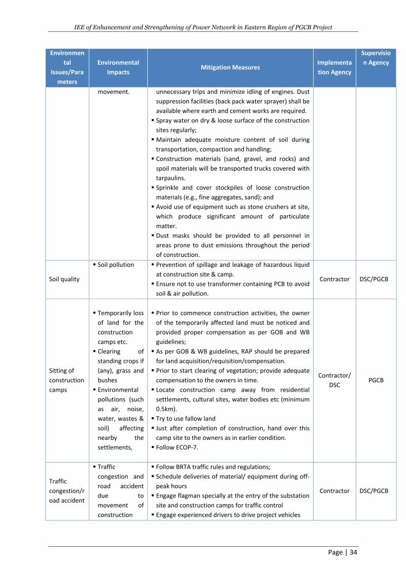
IEE of Enhancement and Strengthening of Power Network in Eastern Region of PGCB Project
Page | 34
Environmen
tal
Issues/Para
meters
Environmental
Impacts Mitigation Measures
Implementa
tion Agency
Supervisio
n Agency
movement. unnecessary trips and minimize idling of engines. Dust
suppression facilities (back pack water sprayer) shall be
available where earth and cement works are required.
Spray water on dry & loose surface of the construction
sites regularly;
Maintain adequate moisture content of soil during
transportation, compaction and handling;
Construction materials (sand, gravel, and rocks) and
spoil materials will be transported trucks covered with
tarpaulins.
Sprinkle and cover stockpiles of loose construction
materials (e.g., fine aggregates, sand); and
Avoid use of equipment such as stone crushers at site,
which produce significant amount of particulate
matter.
Dust masks should be provided to all personnel in
areas prone to dust emissions throughout the period
of construction.
Soil quality
Soil pollution Prevention of spillage and leakage of hazardous liquid
at construction site & camp.
Ensure not to use transformer containing PCB to avoid
soil & air pollution.
Contractor DSC/PGCB
Sitting of
construction
camps
Temporarily loss
of land for the
construction
camps etc.
Clearing of
standing crops if
(any), grass and
bushes
Environmental
pollutions (such
as air, noise,
water, wastes &
soil) affecting
nearby the
settlements,
Prior to commence construction activities, the owner
of the temporarily affected land must be noticed and
provided proper compensation as per GOB and WB
guidelines;
As per GOB & WB guidelines, RAP should be prepared
for land acquisition/requisition/compensation.
Prior to start clearing of vegetation; provide adequate
compensation to the owners in time.
Locate construction camp away from residential
settlements, cultural sites, water bodies etc (minimum
0.5km).
Try to use fallow land
Just after completion of construction, hand over this
camp site to the owners as in earlier condition.
Follow ECOP-7.
Contractor/
DSC PGCB
Traffic
congestion/r
oad accident
Traffic
congestion and
road accident
due to
movement of
construction
Follow BRTA traffic rules and regulations;
Schedule deliveries of material/ equipment during off-
peak hours
Engage flagman specially at the entry of the substation
site and construction camps for traffic control
Engage experienced drivers to drive project vehicles
Contractor DSC/PGCB
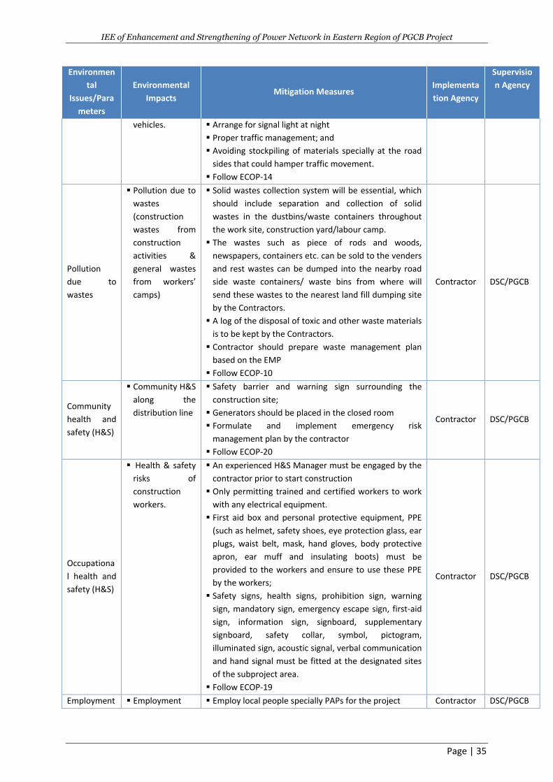
IEE of Enhancement and Strengthening of Power Network in Eastern Region of PGCB Project
Page | 35
Environmen
tal
Issues/Para
meters
Environmental
Impacts Mitigation Measures
Implementa
tion Agency
Supervisio
n Agency
vehicles.
Arrange for signal light at night
Proper traffic management; and
Avoiding stockpiling of materials specially at the road
sides that could hamper traffic movement.
Follow ECOP-14
Pollution
due to
wastes
Pollution due to
wastes
(construction
wastes from
construction
activities &
general wastes
from workers’
camps)
Solid wastes collection system will be essential, which
should include separation and collection of solid
wastes in the dustbins/waste containers throughout
the work site, construction yard/labour camp.
The wastes such as piece of rods and woods,
newspapers, containers etc. can be sold to the venders
and rest wastes can be dumped into the nearby road
side waste containers/ waste bins from where will
send these wastes to the nearest land fill dumping site
by the Contractors.
A log of the disposal of toxic and other waste materials
is to be kept by the Contractors.
Contractor should prepare waste management plan
based on the EMP
Follow ECOP-10
Contractor DSC/PGCB
Community
health and
safety (H&S)
Community H&S
along the
distribution line
Safety barrier and warning sign surrounding the
construction site;
Generators should be placed in the closed room
Formulate and implement emergency risk
management plan by the contractor
Follow ECOP-20
Contractor DSC/PGCB
Occupationa
l health and
safety (H&S)
Health & safety
risks of
construction
workers.
An experienced H&S Manager must be engaged by the
contractor prior to start construction
Only permitting trained and certified workers to work
with any electrical equipment.
First aid box and personal protective equipment, PPE
(such as helmet, safety shoes, eye protection glass, ear
plugs, waist belt, mask, hand gloves, body protective
apron, ear muff and insulating boots) must be
provided to the workers and ensure to use these PPE
by the workers;
Safety signs, health signs, prohibition sign, warning
sign, mandatory sign, emergency escape sign, first-aid
sign, information sign, signboard, supplementary
signboard, safety collar, symbol, pictogram,
illuminated sign, acoustic signal, verbal communication
and hand signal must be fitted at the designated sites
of the subproject area.
Follow ECOP-19
Contractor DSC/PGCB
Employment Employment Employ local people specially PAPs for the project Contractor DSC/PGCB
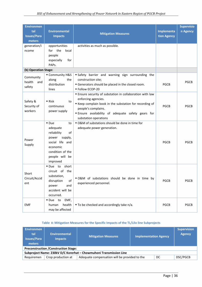
IEE of Enhancement and Strengthening of Power Network in Eastern Region of PGCB Project
Page | 36
Environmen
tal
Issues/Para
meters
Environmental
Impacts Mitigation Measures
Implementa
tion Agency
Supervisio
n Agency
generation/i
ncome
opportunities
for the local
people
especially for
PAPs.
activities as much as possible.
(b) Operation Stage:
Community
health and
safety
Community H&S
along the
distribution
lines
Safety barrier and warning sign surrounding the
construction site;
Generators should be placed in the closed room.
Follow ECOP-20
PGCB PGCB
Safety &
Security of
workers
Risk to
continuous
power supply
Ensure security of substation in collaboration with law
enforcing agencies.
Keep complain book in the substation for recording of
people’s complains.
Ensure availability of adequate safety gears for
substation operations
PGCB PGCB
Power
Supply
Due to
adequate
reliability of
power supply,
social life and
economic
condition of the
people will be
improved
O&M of substations should be done in time for
adequate power generation.
PGCB PGCB
Short
Circuit/Accid
ent
Due to short
circuit of the
substation,
disruption of
power and
accident will be
occurred.
O&M of substations should be done in time by
experienced personnel. PGCB PGCB
EMF
Due to EMF,
human health
may be affected
To be checked and accordingly take n/a. PGCB PGCB
Table 8: Mitigation Measures for the Specific Impacts of the TL/Lilo line Subprojects
Environmen
tal
Issues/Para
meters
Environmental
Impacts Mitigation Measures Implementation Agency
Supervision
Agency
Preconstruction /Construction Stage:
Subproject Name: 230kV D/C Korerhat – Chowmuhoni Transmission Line
Requiremen Crop production at Adequate compensation will be provided to the DC DSC/PGCB
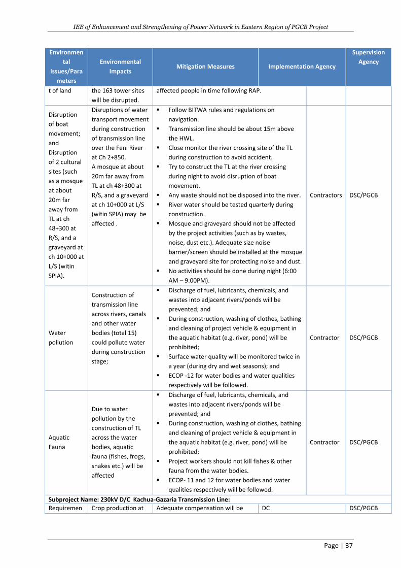
IEE of Enhancement and Strengthening of Power Network in Eastern Region of PGCB Project
Page | 37
Environmen
tal
Issues/Para
meters
Environmental
Impacts Mitigation Measures Implementation Agency
Supervision
Agency
t of land the 163 tower sites
will be disrupted.
affected people in time following RAP.
Disruption
of boat
movement;
and
Disruption
of 2 cultural
sites (such
as a mosque
at about
20m far
away from
TL at ch
48+300 at
R/S, and a
graveyard at
ch 10+000 at
L/S (witin
SPIA).
Disruptions of water
transport movement
during construction
of transmission line
over the Feni River
at Ch 2+850.
A mosque at about
20m far away from
TL at ch 48+300 at
R/S, and a graveyard
at ch 10+000 at L/S
(witin SPIA) may be
affected .
Follow BITWA rules and regulations on
navigation.
Transmission line should be about 15m above
the HWL.
Close monitor the river crossing site of the TL
during construction to avoid accident.
Try to construct the TL at the river crossing
during night to avoid disruption of boat
movement.
Any waste should not be disposed into the river.
River water should be tested quarterly during
construction.
Mosque and graveyard should not be affected
by the project activities (such as by wastes,
noise, dust etc.). Adequate size noise
barrier/screen should be installed at the mosque
and graveyard site for protecting noise and dust.
No activities should be done during night (6:00
AM – 9:00PM).
Contractors DSC/PGCB
Water
pollution
Construction of
transmission line
across rivers, canals
and other water
bodies (total 15)
could pollute water
during construction
stage;
Discharge of fuel, lubricants, chemicals, and
wastes into adjacent rivers/ponds will be
prevented; and
During construction, washing of clothes, bathing
and cleaning of project vehicle & equipment in
the aquatic habitat (e.g. river, pond) will be
prohibited;
Surface water quality will be monitored twice in
a year (during dry and wet seasons); and
ECOP -12 for water bodies and water qualities
respectively will be followed.
Contractor DSC/PGCB
Aquatic
Fauna
Due to water
pollution by the
construction of TL
across the water
bodies, aquatic
fauna (fishes, frogs,
snakes etc.) will be
affected
Discharge of fuel, lubricants, chemicals, and
wastes into adjacent rivers/ponds will be
prevented; and
During construction, washing of clothes, bathing
and cleaning of project vehicle & equipment in
the aquatic habitat (e.g. river, pond) will be
prohibited;
Project workers should not kill fishes & other
fauna from the water bodies.
ECOP- 11 and 12 for water bodies and water
qualities respectively will be followed.
Contractor DSC/PGCB
Subproject Name: 230kV D/C Kachua-Gazaria Transmission Line:
Requiremen Crop production at Adequate compensation will be DC DSC/PGCB
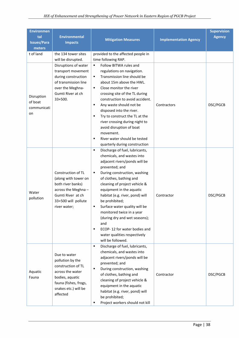
IEE of Enhancement and Strengthening of Power Network in Eastern Region of PGCB Project
Page | 38
Environmen
tal
Issues/Para
meters
Environmental
Impacts Mitigation Measures Implementation Agency
Supervision
Agency
t of land the 134 tower sites
will be disrupted.
provided to the affected people in
time following RAP.
Disruption
of boat
communicati
on
Disruptions of water
transport movement
during construction
of transmission line
over the Meghna-
Gumti River at ch
33+500.
Follow BITWA rules and
regulations on navigation.
Transmission line should be
about 15m above the HWL.
Close monitor the river
crossing site of the TL during
construction to avoid accident.
Any waste should not be
disposed into the river.
Try to construct the TL at the
river crossing during night to
avoid disruption of boat
movement.
River water should be tested
quarterly during construction
Contractors DSC/PGCB
Water
pollution
Construction of TL
(along with tower on
both river banks)
across the Meghna –
Gumti River at ch
33+500 will pollute
river water;
Discharge of fuel, lubricants,
chemicals, and wastes into
adjacent rivers/ponds will be
prevented; and
During construction, washing
of clothes, bathing and
cleaning of project vehicle &
equipment in the aquatic
habitat (e.g. river, pond) will
be prohibited;
Surface water quality will be
monitored twice in a year
(during dry and wet seasons);
and
ECOP- 12 for water bodies and
water qualities respectively
will be followed.
Contractor DSC/PGCB
Aquatic
Fauna
Due to water
pollution by the
construction of TL
across the water
bodies, aquatic
fauna (fishes, frogs,
snakes etc.) will be
affected
Discharge of fuel, lubricants,
chemicals, and wastes into
adjacent rivers/ponds will be
prevented; and
During construction, washing
of clothes, bathing and
cleaning of project vehicle &
equipment in the aquatic
habitat (e.g. river, pond) will
be prohibited;
Project workers should not kill
Contractor DSC/PGCB
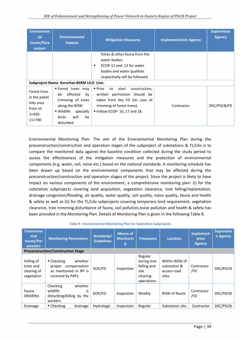
IEE of Enhancement and Strengthening of Power Network in Eastern Region of PGCB Project
Page | 39
Environmen
tal
Issues/Para
meters
Environmental
Impacts Mitigation Measures Implementation Agency
Supervision
Agency
fishes & other fauna from the
water bodies.
ECOP-11 and 12 for water
bodies and water qualities
respectively will be followed.
Subproject Name: Korerhat-BSRM LILO Line:
Forest tress
in the poket
hilly area
from ch
3+450-
11+700
Forest trees may
be affected by
trimming of trees
along the ROW
Wildlife specially
birds will be
disturbed
Prior to start construction,
written permission should be
taken from the FD i(In case of
trimming of forest trees),
Follow ECOP- 16, 17 and 18.
Contractor DSC/PGCB/FD
Environmental Monitoring Plan: The aim of the Environmental Monitoring Plan during the
preconstruction/construction and operation stages of the subproject of substations & TL/Lilo is to
compare the monitored data against the baseline condition collected during the study period to
assess the effectiveness of the mitigation measures and the protection of environmental
components (e.g. water, soil, noise etc.) based on the national standards. A monitoring schedule has
been drawn up based on the environmental components that may be affected during the
preconstruction/construction and operation stages of the project. Since the project is likely to have
impact on various components of the environment, a comprehensive monitoring plan: (i) for the
substation subprojects covering land acquisition, vegetation clearance, tree felling/replantation,
drainage congestion/flooding, air quality, water quality, soil quality, noise quality, fauna and health
& safety as well as (ii) for the TL/Lilo subprojects covering temporary land requirement, vegetation
clearance, tree trimming,disturbance of fauna, soil pollution,noise pollution and health & safety has
been provided in the Monitoring Plan. Details of Monitoring Plan is given in the following Table 8.
Table 9 : Environmental Monitoring Plan for Substation Subprojects
Environmental
Issues/Parameters
Monitoring Parameters Standards/ Guidelines
Means of Monitorin
g Frequency Location
Implementation
Agency
Supervision Agency
Preconstruction/Construction Stage
Felling of trees and clearing of vegetation
Checking whether proper compensation as mentioned in RP is received by PAPs.
DOE/FD Inspection
Regular during tree felling and site clearing operations
Within ROW of substation & access road sites
Contractor/FD
DSC/PGCB
Fauna (Wildlife)
Checking whether wildlife is disturbing/killing by the workers
DOE/FD Inspection Weekly ROW of Route Contractor/FD
DSC/PGCB
Drainage Checking drainage Hydrologic Inspection Regular Substation site Contractor DSC/PGCB
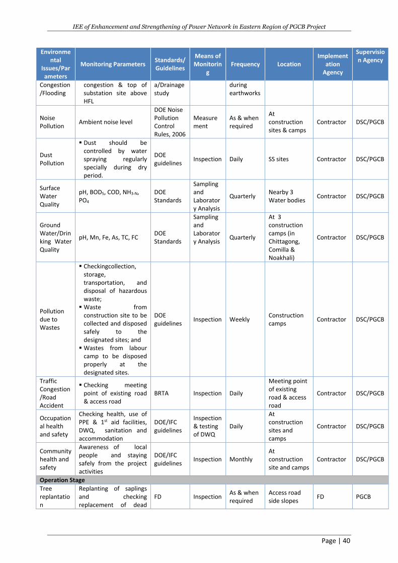
IEE of Enhancement and Strengthening of Power Network in Eastern Region of PGCB Project
Page | 40
Environmental
Issues/Parameters
Monitoring Parameters Standards/ Guidelines
Means of Monitorin
g Frequency Location
Implementation
Agency
Supervision Agency
Congestion/Flooding
congestion & top of substation site above HFL
a/Drainage study
during earthworks
Noise Pollution
Ambient noise level
DOE Noise Pollution Control Rules, 2006
Measurement
As & when required
At construction sites & camps
Contractor DSC/PGCB
Dust Pollution
Dust should be controlled by water spraying regularly specially during dry period.
DOE guidelines
Inspection Daily SS sites Contractor DSC/PGCB
Surface Water Quality
pH, BOD5, COD, NH3-N, PO4
DOE Standards
Sampling and Laboratory Analysis
Quarterly Nearby 3 Water bodies
Contractor DSC/PGCB
Ground Water/Drinking Water Quality
pH, Mn, Fe, As, TC, FC DOE Standards
Sampling and Laboratory Analysis
Quarterly
At 3 construction camps (in Chittagong, Comilla & Noakhali)
Contractor DSC/PGCB
Pollution due to Wastes
Checkingcollection, storage, transportation, and disposal of hazardous waste;
Waste from construction site to be collected and disposed safely to the designated sites; and
Wastes from labour camp to be disposed properly at the designated sites.
DOE guidelines
Inspection Weekly Construction camps
Contractor DSC/PGCB
Traffic Congestion/Road Accident
Checking meeting point of existing road & access road
BRTA Inspection Daily
Meeting point of existing road & access road
Contractor DSC/PGCB
Occupational health and safety
Checking health, use of PPE & 1st aid facilities, DWQ, sanitation and accommodation
DOE/IFC guidelines
Inspection & testing of DWQ
Daily
At construction sites and camps
Contractor DSC/PGCB
Community health and safety
Awareness of local people and staying safely from the project activities
DOE/IFC guidelines
Inspection Monthly At construction site and camps
Contractor DSC/PGCB
Operation Stage
Tree replantation
Replanting of saplings and checking replacement of dead
FD Inspection As & when required
Access road side slopes
FD PGCB
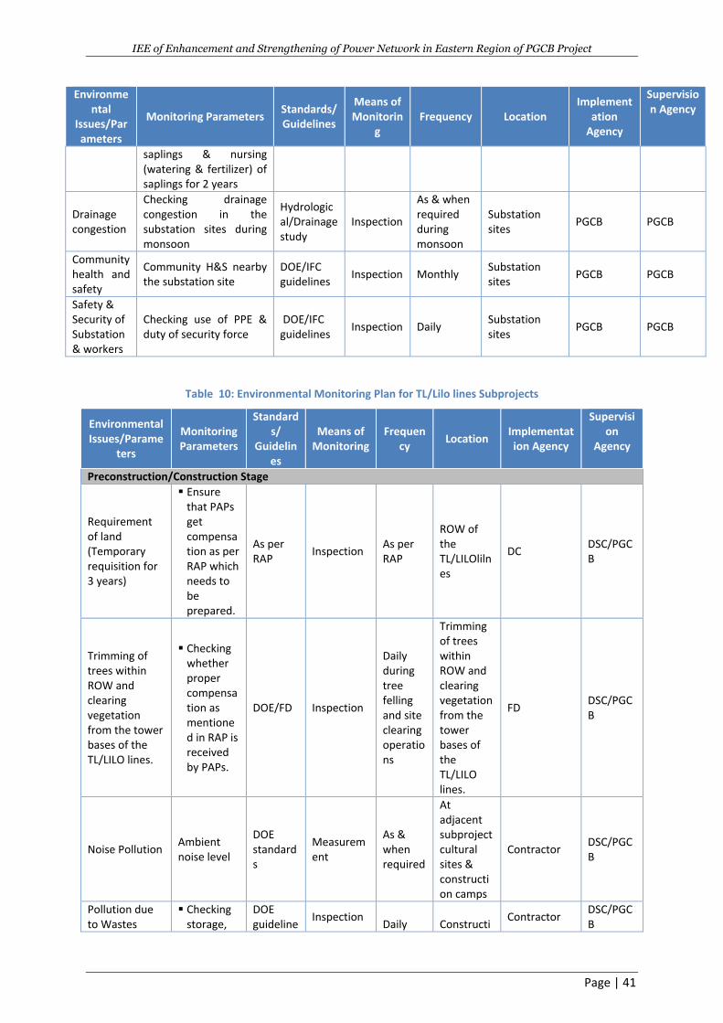
IEE of Enhancement and Strengthening of Power Network in Eastern Region of PGCB Project
Page | 41
Environmental
Issues/Parameters
Monitoring Parameters Standards/ Guidelines
Means of Monitorin
g Frequency Location
Implementation
Agency
Supervision Agency
saplings & nursing (watering & fertilizer) of saplings for 2 years
Drainage congestion
Checking drainage congestion in the substation sites during monsoon
Hydrological/Drainage study
Inspection
As & when required during monsoon
Substation sites
PGCB PGCB
Community health and safety
Community H&S nearby the substation site
DOE/IFC guidelines
Inspection Monthly Substation sites
PGCB PGCB
Safety & Security of Substation & workers
Checking use of PPE & duty of security force
DOE/IFC guidelines
Inspection Daily Substation sites
PGCB PGCB
Table 10: Environmental Monitoring Plan for TL/Lilo lines Subprojects
Environmental Issues/Parame
ters
Monitoring Parameters
Standards/
Guidelines
Means of Monitoring
Frequency
Location Implementation Agency
Supervision
Agency
Preconstruction/Construction Stage
Requirement of land (Temporary requisition for 3 years)
Ensure that PAPs get compensation as per RAP which needs to be prepared.
As per RAP
Inspection As per RAP
ROW of the TL/LILOlilnes
DC DSC/PGCB
Trimming of trees within ROW and clearing vegetation from the tower bases of the TL/LILO lines.
Checking whether proper compensation as mentioned in RAP is received by PAPs.
DOE/FD Inspection
Daily during tree felling and site clearing operations
Trimming of trees within ROW and clearing vegetation from the tower bases of the TL/LILO lines.
FD DSC/PGCB
Noise Pollution Ambient noise level
DOE standards
Measurement
As & when required
At adjacent subproject cultural sites & construction camps
Contractor DSC/PGCB
Pollution due to Wastes
Checking storage,
DOE guideline
Inspection Daily
Constructi
Contractor DSC/PGCB
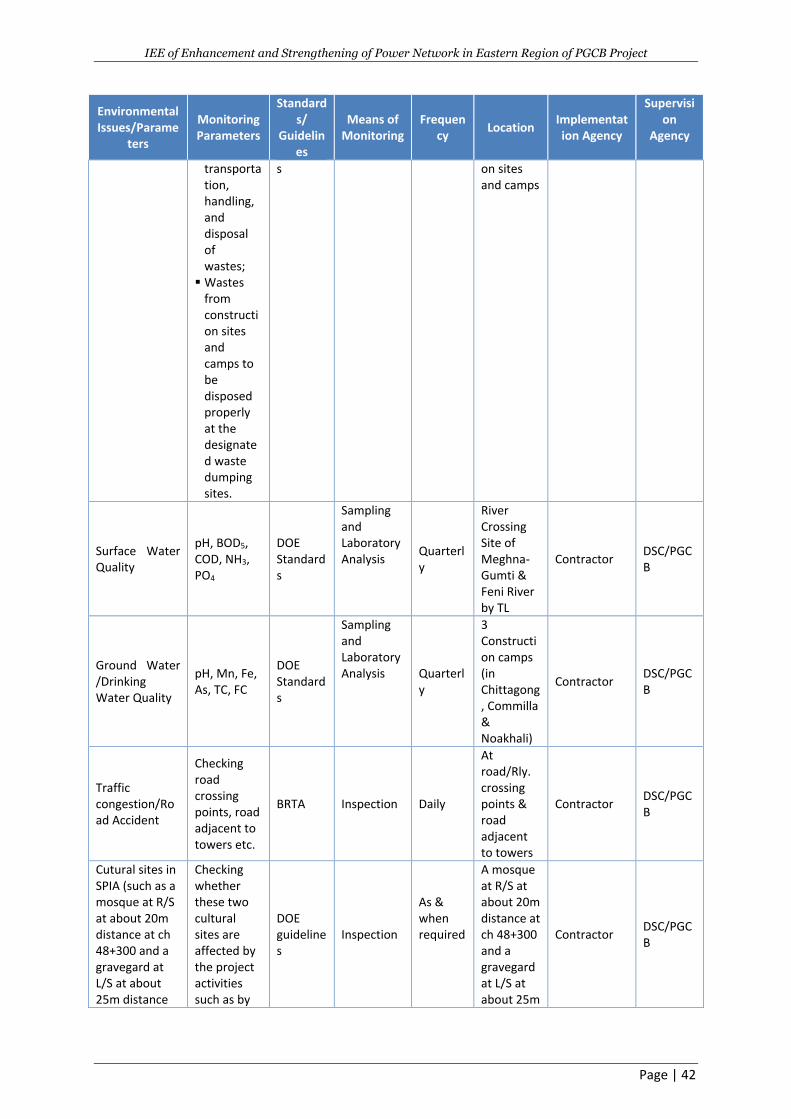
IEE of Enhancement and Strengthening of Power Network in Eastern Region of PGCB Project
Page | 42
Environmental Issues/Parame
ters
Monitoring Parameters
Standards/
Guidelines
Means of Monitoring
Frequency
Location Implementation Agency
Supervision
Agency
transportation, handling, and disposal of wastes;
Wastes from construction sites and camps to be disposed properly at the designated waste dumping sites.
s
on sites and camps
Surface Water Quality
pH, BOD5, COD, NH3, PO4
DOE Standards
Sampling and Laboratory Analysis
Quarterly
River Crossing Site of Meghna-Gumti & Feni River by TL
Contractor DSC/PGCB
Ground Water /Drinking Water Quality
pH, Mn, Fe, As, TC, FC
DOE Standards
Sampling and Laboratory Analysis Quarterl
y
3 Construction camps (in Chittagong, Commilla & Noakhali)
Contractor DSC/PGCB
Traffic congestion/Road Accident
Checking road crossing points, road adjacent to towers etc.
BRTA Inspection Daily
At road/Rly. crossing points & road adjacent to towers
Contractor DSC/PGCB
Cutural sites in SPIA (such as a mosque at R/S at about 20m distance at ch 48+300 and a gravegard at L/S at about 25m distance
Checking whether these two cultural sites are affected by the project activities such as by
DOE guidelines
Inspection
As & when required
A mosque at R/S at about 20m distance at ch 48+300 and a gravegard at L/S at about 25m
Contractor DSC/PGCB
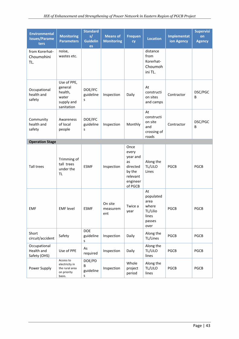
IEE of Enhancement and Strengthening of Power Network in Eastern Region of PGCB Project
Page | 43
Environmental Issues/Parame
ters
Monitoring Parameters
Standards/
Guidelines
Means of Monitoring
Frequency
Location Implementation Agency
Supervision
Agency
from Korerhat- Choumohini TL.
noise, wastes etc.
distance from
Korerhat- Choumohini TL.
Occupational health and safety
Use of PPE, general health, water supply and sanitation
DOE/IFC guidelines
Inspection Daily
At construction sites and camps
Contractor DSC/PGCB
Community health and safety
Awareness of local people
DOE/IFC guidelines
Inspection Monthly
At construction site and crossing of roads
Contractor DSC/PGCB
Operation Stage
Tall trees
Trimming of tall trees under the TL
ESMF Inspection
Once every year and as directed by the relevant engineer of PGCB
Along the TL/LILO Lines
PGCB PGCB
EMF EMF level ESMF On site measurement
Twice a year
At populated area where TL/Lilio lines passes over
PGCB PGCB
Short circuit/accident
Safety DOE guidelines
Inspection Daily Along the TL/Lines
PGCB PGCB
Occupational Health and Safety (OHS)
Use of PPE As required
Inspection Daily Along the TL/LILO lines
PGCB PGCB
Power Supply
Access to electricity in the rural area on priority basis.
DOE/PDB guidelines
Inspection Whole project period
Along the TL/LILO lines
PGCB PGCB
IEE of Enhancement and Strengthening of Power Network in Eastern Region of PGCB Project
Page | 1
The EMP Implementation Schedule and Implementation Cost: The schedule of implementing the
EMP has been prepared based on the environmental issues/parameters illustrated in the EMP which
will be followed at the certain period of the project. However, this implementation schedule is
subject to change depending on the existing situation. The estimated duration of the construction
work is approximately 3 years. Approximate cost for the implementation of the EMP is about BDT
7.020 millions (approx. 83,000 USD). PGCB will use revenue budget for operational phase EMP at
actual cost basis.
Environmental Code of Practises (ECOP): The ECOP is prepared as a guideline for environment
management of different components of the substation and TL subprojects. The ECOP has designed
to address all potential impacts during the construction of the substations, rehabilitation of the
transmission lines, and construction of the new transmission lines. The ECOP will provide guidelines
for best operating practices and environmental management guidelines to be followed by the
contractors for sustainable management of all environmental issues. The list of ECOP, prepared for
the subprojects of ESPNER is given below: Project Planning and Design, Route Selection,Tower/Pole
Erection, Overhead Power Cable Installation, Installation of Transformer on H-Pole, Substation Site
Preparation,Construction Camps,Topsoil Salvage, Storage and Replacement, Borrow Areas, Land
Reclamation, Waste Management, Water Bodies, Water Quality,Public Health and Safety, Material
Storage, Transport & Handling, Cutting/triming of Trees, Vegetation Natural Habitats,Occupational
Health and safety, Community Health and Safety.
8. INSTITUTIONAL ARRANGEMENT AND CAPACITY BUILDING
Institutional arrangements are essential to implement the suggested mitigation measures properly
and to execute Monitoring Plan at different project stages. The implementation of the EMP also
requires capacity building of the EMP implementation agency through training needs and plan. The
structured institutional settings facilitate proper implementation of the environment safeguard
requirements for the development of the project. The PGCB is the key authority to follow up all the
relevant environmental safeguard requirements following institutional arrangement. In addition, the
relevant organizations such as consultant, contractor, DOE and FD are also included. Enhancement
of the capacity of the PGCB’s ESU is required for the effective implementation of proposed
mitigation measures and monitoring the resultant effect, some training programs and awareness
workshop are also essential before and after starting of construction such as General environmental
awareness, regulatory requirements, environmental impacts and mitigation, analysis of alternatives,
environmental management (EMP and ECOP), Environmental assessment, monitoring activities and
H&S.Grievance Redress Mechanism: The concern/grievances may come from the local/affected people
related to inappropriate implementation of various components of EMP or the overall road upgrading
itself. These issues will be addressed through acknowledgement, evaluation and corrective action and
response approach. A grievance redress mechanism will be established to receive, evaluate, and facilitate
the resolution of affected people’s concerns, complaints, and grievances about the social and
environmental performance of the project. The GRM aims to provide a trusted way to voice and resolve
concerns linked to the project, and to be an effective way to address affected people’s concerns.
9. PUBLIC CONSULTATION AND INFORMATION DISCLOSURE
The aim of public consultation is to ensure that the people and the stakeholders living in the SPIA
become aware about the project activities and the aim is also to ensure the acceptance of the
IEE of Enhancement and Strengthening of Power Network in Eastern Region of PGCB Project
Page | 2
subprojects of Substation & TL/Lilo activities. Public consultation is important to collect baseline
information and to identify potential impacts and mitigation measures. After conducting public
consultation, it is also important to disclose information to the public in their own language
regarding the decision and measures planned to be taken against different project activities. As a
part of the environmental study, the environmental team conducted several stakeholders meeting
with local administrative authority, businessmen, fermers, service holders, workers, drivers,
shopkeepers, women as well as PAPs. A total of five stakeholders have been carried out during the
preparation of the IEE of the project. The findings of the consultations are as follows: (i) main
positive issues are: employmentopportunities; improvement of local and national economy;
improvement of security and improvement of power generation etc. and main negative issues are:
permanent (due to construction of SS) and temporay land loss (due to construction of TL/Lilo lines);
losses/trimming of vegetation, air/dust pollution mainly due to construction of SS, noise pollution
due to movement of project vehicles/equipment and accidents/injuries may be occurred during
construction and operation stages of the project etc. The participants of the consultations also have
suggested to enhance the positive issues/impacts and possible mitigation measures to minimize the
negative impacts. The participants of the consultations are infavour of the project implementation.
The implementation of the EMP for the proper management of mitigation/enhancement measures
of the project as document or report, should be publicly available in readable format to the local
people. The project proponent (e.g. PGCB) should ensure information disclosure to the local people.
and to the respective stakeholders of the respective subproject under the proposed project.
10. CONCLUSIONS AND RECOMMENDATIONS
Conclusions
The Government of Bangladesh (GOB) has set long term goals for the power sector in the country.
Providing access to affordable, reliable and quality supply of electricity to the majority of the people
of Bangladesh by 2020 are the goals of the GOB to users the next millennium. In line with the above
stated goals, the GOB is expected to obtain financial support from the International Development
Association (IDA) for the proposed Enhancement and Strengthening of Power Network in Eastern
Region (ESPNER) project to ensure reliable and quality supply of electricity to the rural and urban
consumers in Bangladesh through improvements in technical efficiency of the distribution system.
The proposed project is expected to provide support for augmentation and rehabilitation of the
transmission network of the Power Grid Company of Bangladesh (PGCB) under the Power Cell,
Power Division, Ministry of Power, Energy and Mineral Resources (MOPEMR) of the GOB. Main
components of the project include:
Construction of new 230/132 kV two substations and new 132/33 kV 10 substations;
Construction of new 288.642 long 132 kV, 230kVand 400kV transmission lines (TL); and
Construction of new 8 LILO lines;
The present power network in Greater Comilla, Noakhali and Chittagong areas of Bangladesh is aged
and suffering numerous problems as system demand is growing rapidly. The greater Comilla and
Noakhali areas are the second largest demand areas after the capital city of Dhaka. The greater
Chittagong area is on the verge of massive industrialization as the government is taking initiatives to
set up multiple economic zones, upgrade port facility and transportation network. Hence, the
project was conceptualized with a rationale to expand the 230 kV transmission systems and to
IEE of Enhancement and Strengthening of Power Network in Eastern Region of PGCB Project
Page | 3
strengthen the 132 kV transmission systems in the project area, in order to, eliminate the
operational bottlenecks caused due to inadequacy of the existing system. The project will also
provide an adequate infrastructure for the future power sector development of the area.
The TOR has prepared to carryout IEE for the project in accordance with the relevant laws and
regulations of the GOB and the WB. The specific environmental guideline for the power sector is not
available in Bangladesh. However, the DOE environmental guidelines for the industries provide a
general framework for conducting environmental study for the entire sector. Therefore, the
proposed IEE will be conducted following the DOE environmental guidelines. In addition, it is
suggested to follow the Environmental & Social Management Framework (ESMF) of Rural Electricity
Transmission and Distribution Project of PGCB and BREB as well as WB environmental guidelines for
the power sector.
The scope of work of the IEE includes: (a) Review of existing information (relevant all documents)
from secondary sources, and identify gaps to be filled, relevant to the environmental screening
needs from primary surveys. (b) Provide a description of the environment (such as baseline data on
physical, biological and socioeconomic characteristics of the subproject site along with area of
influence). (c) Represent the primary surveys where include baseline (air, water, noise, and riverbed)
environmental quality monitoring at representative and sensitive locations, and identification of all
macro-level environmental issues within the Sub-project’s influence area. (d)Survey the
environmentally sensitive locations on and along the Sub-projects as well as within the Sub-project’s
influence area. (e)Arrange stakeholders’ consultations within the local people from all professions to
find out their opinion within the subproject. (f) Analysis of alternatives to the proposed subproject.
(g) Identify and assessment of potential environmental impacts due to implementation of the
subproject. (h) Formulation of Environmental Management Plan (EMP)
Initially, 3 sites for each proposed substation and 3 routes for each proposed TL have been selected
and environmental screening and assessment for these 3 substation sites and TL routes have been
done for identifying the potential impacts based on the collected baseline information/data by the
environmental specialist and survey team. From these 3 sites/routes, environmentally suitable
substation site and TL have been finally selected. The potential impacts for the selected subprojects
of the substation and TL/LILO Lines during pre-construction/ construction and operation stages of
the subprojects are:
(a) For Substation Subprojects:
(i)General/Common Potential Impacts:
During Preconstruction/Construction: A total of 85.99 acres land acquisition, clearing of vegetation including 3501 trees , hydrology/ drainage congestion, top soils, and dust pollution, noise pollution, waste pollution , soil pollution, traffic congestion, occupational HS, community HS, and employment generation; and During Operation: Drainage congestion, tree replantation (a total 7000 various trees), landscape,
occupational HS, community HS, and improvement of social and economical life of the people.
(ii) Specific Impacts ofSubstations
IEE of Enhancement and Strengthening of Power Network in Eastern Region of PGCB Project
Page | 4
During Preconstruction/Construction: 2,945 trees, 136trees & 420 trees need to be cut due to
construction of Korerhat, Basurhat & Chandina substation respectfully. SW pollution of pond will be
occurred due to construction of Maijdee, Basurhat& Chandina substation respectfully.
(b) For TL &LILO Lines Subprojects
(i) General/Common Impacts: Pre-construction/Construction Phase: Trimming of 20,252 trees, Disturbance of Fauna (wildlife), Loss of Top Soil due to tower, Noise Pollution, Air and Dust Pollution, Soil Pollution, Pollution due to Wastes, Aquatic Habitat, Traffic Congestion/Road Accident, Siting of Construction Camps, Occupational Health and Safety Community Health and Safety, Employment Generation/Income Operation Stage: Landscape, Community Health and Safety, Occupational Health and Safety Improvement of Social & Economic Life, Short Circuit/Accident, EMF (Electro-Magnetic Fields (EMF).
(ii) Specific Impacts Preconstruction/Construction Phase: Disrubtion of boat movement in the Meghna- Gumti River
during construction of the Kachua-Laksham TL and Disrubtion of boat movement in the Feni River;
amosque due at 20m far away at R/S of the TL at ch 48+300 and a graveyard at 25m faraway at L/S
of the TL dueto constructionof the Korerhat Choumohini TL.Pocket hilly areas with forest small to
medium trees will be affected (trimming) due construction of Korerhat-BSRM LILO line.
The potential impacts during construction phase are short-term that can be avoided or eliminate to
ed or reduced by adopting the mitigation measures properly. Therefore, the anticipated negative
construction related impacts could be mostly controlled/minimized or eliminated by taking
suggested mitigation measures and manage the implementation of the mitigation measures through
the EMP including effective monitoring plan during pre-construction/construction and operation
phases of the project.
The potential impacts during operation are long term and PGCB should ensure to mitigate these
impacts through implementation of the EMP including monitoring plan properely. Approx.total
budget for EMP is about BDT 7,124,000.
.
Recommendations
Based on the findings of the IEE study, the following can be recommended:
Based on the EMP of the IEE, Construction Environmental Management Plan (CEMP) should
be prepared by the contractor prior to start construction of the project and act accordingly
during construction;
The EMP will be included in the bid document of the civil works along with the EMP budget
and eventually become part of the civil works contract (s);
The mitigation measures for the negative impacts and enhancement measures for the
positive impacts of the project as mentioned in the EMP must be implemented by the
contractor (s) properly in schedule time; and
The main tool for the successful implementation of the EMP is the environmental monitoring
during various stages of the project, which must be carried out properly in time by the
client/DSC/other relevant organisations.
IEE of Enhancement and Strengthening of Power Network in Eastern Region of PGCB Project
Page | 5
1.INTRODUCTION
1.1 Background
The economy of Bangladesh has performed well over the past decade. Its Gross Domestic Product
(GDP) has grown at an average of 6% per annum since 2010. In Fiscal Year 2014 (FY 14), the country
moved up to a lower-middle income country (LMIC) status as per capita Gross National Income (GNI)
of US$ 1,080 crossed the LMIC threshold of US$ 1,046. The country’s per capita income soared to
US$1,430 at the end of FY 2016. This sustained growth was achieved despite the negative impacts of
the global recession, oil price rise, unrest in the Middle East and local natural disasters as well as
political disturbance and has largely been dependent on a reliable and affordable supply of
electricity. Bangladesh’s economy could have performed better if the energy infrastructure had
developed in line with the economic demands.
The supply of power in Bangladesh has not been able to keep pace with the rapid growth in demand
and consumers experience frequent power outages. Current installed generation capacity in
Bangladesh is 13,000 mega-Watts (MW), while available capacity is only 9,000 MW. The highest
demand served in the country until November 2016 was 9,036 MW. On average, over 1,000 MW of
load shedding occurs in the summer. Electricity demand is projected to grow by more than 10
percent per annum over the medium term. The Power Sector Master Plan 2016 has projected that
demand will rise to more than 50,000 MW by 2041.
The shortage of electricity and poor quality of supply (aged and low capacity grid network) not only
affect households, but also industry and services, which account for a major share of growth in the
economy. According to the 2013 World Bank (WB) Enterprise Survey, Bangladeshi businesses on
average suffered power outages for 840 hours per year, resulting in an output loss of approximately
3 % of GDP. The availability and reliability of power is hence a key constraint to job creation and
poverty reduction.
The Government of Bangladesh (GOB) has set long term goals for the power sector in the country.
Providing access to affordable, reliable and quality supply of electricity to the majority of the people
of Bangladesh by 2020 are the goals of the GOB to users the next millennium. In line with the above
stated goals, the GOB is expected to obtain financial support from the International Development
Association (IDA) for the proposed Enhancement and Strengthening of Power Network in Eastern
Region (ESPNER) project to ensure reliable and quality supply of electricity to the rural and urban
consumers in Bangladesh through improvements in technical efficiency of the distribution system.
The proposed project is expected to provide support for augmentation and rehabilitation of the
transmission network of the Power Grid Company of Bangladesh (PGCB) under the Power Cell,
Power Division, Ministry of Power, Energy and Mineral Resources (MOPEMR) of the GOB.
Main components of the project include:
Construction of new 132 kV substations;
Construction of new 132 kV transmission lines;
Construction of new 230 kV transmission lines; and
Construction of new LILO Lines.
IEE of Enhancement and Strengthening of Power Network in Eastern Region of PGCB Project
Page | 6
The present power network in Greater Comilla, Noakhali and Chittagong areas of Bangladesh is aged
and suffering numerous problems as system demand is growing rapidly. The greater Comilla and
Noakhali areas are the second largest demand areas after the capital city of Dhaka. The greater
Chittagong area is on the verge of massive industrialization as the government is taking initiatives to
set up multiple economic zones, upgrade port facility and transportation network. Hence, the
project was conceptualized with a rationale to expand the 230 kV transmission systems and to
strengthen the 132 kV transmission systems in the project area, in order to, eliminate the
operational bottlenecks caused due to inadequacy of the existing system.
In order to strengthen Dhaka-Chittagong Transmission Backbone System, establishment of
400/230kV & 400/132kV substation at Korerhat through LILO of Modunaghat-Meghnaghat 400kV
D/C line has been planned which will improve system stability and reduce losses. For dispersal of
power from Korewrhat to nearby load centers, LILO of Comilla (N) /Feni-BSRM/Hathazari230kV D/C
line & LILO of Feni /Bariorhat -Hathazari 132kV D/C line have been planned. In future few more 230
kV substations in & around this economic zone are also expected to be fed directly from 230 kV bus
of Mirsharai 400/230kV substation.Further, establishment of 132/33kV substations at New Mooring
(Anadabazar) along with reconditioning of Sikalbaha -Patya-Dohazari-Cox’sbazar 132kV D/C line
section with high capacity conductor has been planned. In addition, renovation of Halishahar
substation along with augmentation of transformation cqapacity and upgradation from AIS to GIS
substation has been planned to improve reliability of power supply in the vicinity of Halishahar. For
strengthening of transmission system in Noakhali and Comilla area, korerhat -Chowmuhini -Kachua -
Gazaria 230 kV high capacity corridor along with establishment of 230 /130kV substations at
Chowmuhini and Kachua has been planned.
The TOR has prepared to carryout detailed IEE for the project in accordance with the relevant laws
and regulations of the GOB and the WB. The specific environmental guideline for the power sector is
not available in Bangladesh. Howeverthe Department of Environment’s (DOE) environmental
guidelines for the industries/projects provide a general framework for conducting environmental
study for the entire sector. Thereforethe proposed IEE will be conducted following the DOE
environmental guidelines. In addition, it is suggested to follow the Environmental & Social
Management Framework (ESMF) of Rural Electricity Transmission and Distribution Project of PGCB
and BREB as well as WB environmental guidelines for the power sector.
The IEE report is updated due to change of three substation location namely Chandina & Laksam at
Cumilla district and Kosba at Brahmanbaria district. Census, IOL, market survey and consultation
were conducted during updating of this IEE. The reasons of changed locations are:
To avoid impacts on private land and due to availability of Government land, PGCB has
changed the location of Chandina at Cumilla District.
Land owners requested PGCB to change the project locations as initially proposed for the
Laksham at Cumilla District and Koshba at Brahmanbaria district for sub-station location.
PGCB has conducted several consultations with the APs and they did not agree to provide
the land. So PGCB with the suggestions of DC office proposed new land adjacent to the
previous location. New land owners are also consulted and agreed to provide land for the
sub-station. Proposed new lands are adjacent to the previously selected land and so
transmission line route is almost same for Laksham and Kosba and for Chandina
transmission line route increased about 3.17 km (previously it was 9.83km and now 13.0 km)
IEE of Enhancement and Strengthening of Power Network in Eastern Region of PGCB Project
Page | 7
1.2 Expected Benefits of the Project
The project is expected to positively influence the environmental, social and economic profile of the
project area. The expected benefits are described below:
I. Environmental Benefits: Replacing the electricity from Diesel Generator (DG) sets with Grid
power will result in saving of millions of liters of fossil fuel and reduction in pollution level of
the Project area. Expected environmental benefits include reduction in the level of
Particulate Matters, SOx, NOx and Green House Gases (GHG).
II. Social Benefits: It is expected that about 194,000 new residential consumers and about
11,500 new agricultural consumers would be supplied power through the systems proposed
under the project. Additionally, about 4,200 small scale industries and 2 large scale
industries could be supplied power through the schemes proposed under the project, which
in turn, is expected to generate direct employment for about 85,000 people and a significant
number of indirect employments. Further, the new agricultural connections will boost the
agricultural output of the area.
III. Economic Benefits: Considering the fact that the difference between charges of electricity
from off-Grid sources and that from grid is around 15 Taka (Tk), there will be significant cost
saving to end users. It is expected that the initial value of savings will be 4760 Million Taka,
which will gradually increase to 7070 Million Taka.
Power being an enabler sector often results in the overall growth and development of the area.
Income level of the general population tends to generally increase in the areas where electricity
makes an inroad or where the existing power infrastructure is improved.
1.3 Legislative Requirements
The main components of the Environment Conservation Act(ECA), 1995 are (GOB, 1995, pages 613–
621):
a) “Declaration of ecologically critical areas, and restriction on the operation and process,
which can be carried or cannot be initiated in the ecologically critical area.
b) Regulation in respect of vehicle emitting smoke harmful for the environment.
c) Environmental clearance for all industrial units and projects.
d) Regulation on the industries and other development activities — discharge permit.
e) Promulgation of standards for quality of air, water, noise and soil for different purposes.
f) Promulgation of standard limit for discharging and emitting waste.
g) Formulation and declaration of environmental guidelines.
h) Penal measures for non-compliance.”
The major requirements of the Environment Conservation Rules (ECR),1997 are (GOB, 1997, pages
1303–2346):
a. “National Environmental Quality Standards for ambient air, various types of water,
industrial effluent, emission, noise, vehicular exhaust etc.
b. Requirements and procedures to obtain environmental clearance.
c. Requirement for Initial Environmental Examination (IEE)according to categories of
industrial and other development interventions.”
For preparation of the IEE report, therefore, the following legislative procedure will be followed:
IEE of Enhancement and Strengthening of Power Network in Eastern Region of PGCB Project
Page | 8
- Collection and review of relevant information regarding environmental legislation, statutory
orders, by-laws, etc. connected to preparation and approval of the IEE report by the
Department of Environment (DOE), and draft the memo. The memo will also consider the
requirements of WB Guidelines.
- Conduction of meetings with the DOE, the Ministry of Environment and Forest (MOEF), and
the Local Government Engineering Department (LGED). During these meetings appropriate
legal and administrative procedures will be discussed. Review of other relevant
environmental laws, regulations, Norms, and Standards on Air, Noise, Water, Waste,
Wildlife, and etc.
- Conduction of discussion meeting with the DOE particularly for “Environmental Clearance
Certificate” in accordance with the ECA, 1995 and ECR, 1997 of Bangladesh.
Besides this, WB has its own environmental and social safeguard policies. According to the
policies set by WB “an IEE level study” is a study that includes the analysis of alternative plans,
the prediction and assessment of environmental impacts, and the preparation of mitigation
measures and monitoring plans based on detailed field surveys.” Also basic principles of
considering environmental and social impacts, the following WB guidelines will be followed:
1. “A wide range of impacts must be addressed. The types of impacts addressed by WB cover a
wide range of environmental and social issues.
2. Measures for environmental and social considerations must be implemented from an early
stage to a monitoring stage.
3. WB asks stakeholders for their participation. WB incorporates stakeholder opinions into
decision-making processes regarding environmental and social considerations by ensuring
the meaningful participation of stakeholders in order to have consideration for
environmental and social factors and to reach a consensus accordingly. WB replies to
stakeholders’ questions. Stakeholders who participate in meetings are responsible for what
they say.
4. WB discloses information. WB itself discloses information on environmental and social
considerations in collaboration with project proponents etc., in order to ensure
accountability and to promote the participation of various stakeholders.”
1.4 Main Objectives of the IEE
The implementation of the subprojects’ activities has both negative and positive impacts on the
surrounding environment. These impacts will be on the physic-chemical, biological/ecological and
socio-economic environment. Hence, to prevent and/or to reduce the negative environmental
impacts at an acceptable level and to enhance the positive environmental impacts linked with the
implementation of the subproject activities of the project; an IEE is to be required.
Based on the above requirement, the environmental consultant employed for this project will carry
out the IEE and contribute to bidding document for incorporation of EMP cost.
1.5 Extent of the Study
This IEE is carried out based on the approved terms of reference (TOR) (Annex A) against the IEE
Study TOR (Annex B) submitted to the Department of Environment for approval. The influence of
impact has been defined as 1 Km on each side from the substation subprojects location and along
the rights of way (ROW) for transmission lines. However, the study area has been extended beyond
IEE of Enhancement and Strengthening of Power Network in Eastern Region of PGCB Project
Page | 9
5 Km area if any major environmental significant area is found and might have impact due to the
project. Geographical Information System (GIS) techniques have also been used based on recent
satellite imageries of the project area for above purposes. Assessment is carried out on the following
environment components: terrestrial and aquatic ecology, soil, water, air, noise, and socio economic
aspects. The impacts on ecologically sensitive areas (e.g. wildlife sanctuaries, biosphere reserve, and
protected places) within 5 Km of the project areas have been assessed.
1.6 Scope of Work
The scope of work of the IEE includes:
a) Review of relevant all documents and data/information from secondary sources, and
identify gaps to be filled, relevant to the environmental screening needs from field surveys.
b) Provide a description of the environmental baseline (such as baseline data on physical,
biological/ecological and socio-economic characteristics of the subproject site along with
area of influence).
c) Represent the field surveys where include baseline (air, noise, surface water and
ground/drinking water) environmental quality monitoring at representative and sensitive
locations, and identification of macro-level environmental issues within the Sub-project’s
influence area.
d) Collect information on environmentally sensitive locations on and along the sub-projects as
well as within the sub-project’s influence area.
e) Arrange consultation with the local people specially project affected persons (PAPs)to find
out their opinions about the sub-projects.
f) Analysis of alternatives to the proposed sub-projects.
g) Identify and assessment of potential environmental impacts due to implementation of the
sub-projects.
h) Conduct preliminary analysis of impacts and management measures of the nature, scale and
magnitude of the impacts that the sub-project is likely to cause on the environment and
classify the same using established methods.
i) Develop Environmental Management Plan (EMP) including Monitoring Plan for successfully
implementing the mitigation/enhangement measures.
j) Assess PGCB’s institutional capacity to execute and monitor the EMP and recommend
necessary institutional capacity building including additional professionals for environmental
management.
k) Prepare an IEE report in accordance with theDOE and WB safeguard policies and guidelines.
1.7 IEE Content
The report fulfils the requirements of IEE under ECR, 1997 and has been prepared in accordance
with the TOR. This IEE report is also consistent with the GOB guidelines and other relevant
international laws and treaties to the project. The report contains ten chapters and the chapter
details are discussed below:
Chapter 1: Introduction
IEE of Enhancement and Strengthening of Power Network in Eastern Region of PGCB Project
Page | 10
This chapter consists of the background of the project along with the objectives, scope of work and
the methodology of preparing the IEE report. This chapter also includes the organization of the total
IEE report.
Chapter 2: Environmental policies, laws, regulations and standard
In this chapter the national and international laws and policies are described which are relevant to
the environmental and social aspects of the project. The relevant guidelines of the DOE, WB and
other national and international laws are described.
Chapter 3: Project description
This chapter includes the proposed project and project area description. The location of the project
and proposed projectinterventions are described here. In total, this chapter gives a detailed idea
about the project.
Chapter 4: Route selection approach
In this chapter the alternative options of the proposed project are analyzed. It starts from no project
alternative and ends at analyzing all the possible alternatives. This chapter concludes with declaring
the proposed project as the best solution after analyzing all the other alternatives.
Chapter 5: Description of the environmental baseline
This chapter gives idea about the environmental baseline condition of the subproject areas with its
surroundings. It describes the physical, biological/ecological and socio-economic environment.
Chapter 6: Environmental screening/assessment of the subprojects
In this chapter, the impacts likely to be occurred during pre-construction, construction and
operational phases are discussed.
Chapter 7: Public Consultation
In this chapter, the consultation process, consultation meetings details and the outcomes are
described.
Chapter 8: Environmental management plan
This chapter includes the Environmental Management Plan (EMP) which includes the mitigation
measures for the negative impacts/enhancement for the positive impacts and Environmental
Monitoring Plan (MP) to implement the mitigation/enhancement measures during pre-construction
stage, construction stage and operational stages.
Chapter 9: Institutional arrangement and capacity building
This chapter depicts the institutional arrangements of the executing company for successful
implementation of the EMP.
Chapter 10: Conclusions and recommendations
IEE of Enhancement and Strengthening of Power Network in Eastern Region of PGCB Project
Page | 11
The conclusions and recommendations are suggested here about the proposed project.
1.8 Methodology
1.8.1 Approach
The study has been conducted in accordance with ECR, 1997, GOBIEE Guidelines, 1997, and other
relevant international laws and treaties to the proposed project. The route map of this IEE
preparation is given in the following Figure 1.1. The IEEstudy has been prepared based on the
secondaryand primary data/information. The secondary data includes collection and review of the
all relevant documents and data/information of the various relevant government and non
government organizations, websites etc..The primary data/information includes
data/informationcollected from the field surveys, inspections, observations and discussions with
stakeholders including community representatives and PAPs at important locations of the project
and Project Influence Area (PIA). The main purpose of this approach was to obtain a fair impression
on the people’s perceptions of the project and its environmental impacts and possible mitigation.
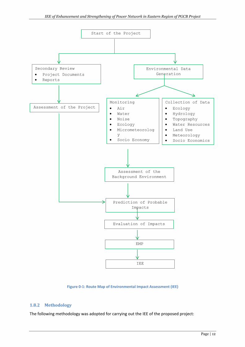
IEE of Enhancement and Strengthening of Power Network in Eastern Region of PGCB Project
Page | 12
Figure 0-1: Route Map of Environmental Impact Assessment (IEE)
1.8.2 Methodology
The following methodology was adopted for carrying out the IEE of the proposed project:
Start of the Project
Environmental Data
Generation
Secondary Review
Project Documents
Reports
Monitoring
Air
Water
Noise
Ecology
Micrometeorolog
y
Socio Economy
Collection of Data
Ecology
Hydrology
Topography
Water Resources
Land Use
Meteorology
Socio Economics
Assessment of the
Background Environment
Prediction of Probable
Impacts
Assessment of the Project
Evaluation of Impacts
EMP
IEE
IEE of Enhancement and Strengthening of Power Network in Eastern Region of PGCB Project
Page | 13
(i) Orientation
Meetings and discussions were held among the members of the IEE Team. This activity was aimed at
achieving a common ground of understanding of various issues of the study.
(ii) Data/Information Collection Plan
Subsequent to the concept clarification and understanding obtained in the preceding step, a detailed
data/information collection plan was developed for the internal use of the IEE Team. The plan
included identification of specific data requirements and their sources; determined time schedules
and responsibilities for their collections and indicated the logistics and other supporting need for the
execution of the data/information collection plan.
(iii) Data/Information Collection
In this step, secondary and primary data/information were collected from relevant organizations and
published materials, field surveys, inspections and observations to establish environmental baseline
profile for physical, ecological/biological and socio-economic environmental conditions. Following
activities were performed for data/information collection:
Site Reconnaissance;
Analysis of Maps and Plans;
Literature Review;
Desk Research;
Field Surveys, Inspection, Observations and Studies;
Laboratory Analysis; and
Public Consultations.
(iv) Secondary Data Collection
Collection and literature review of all available relevant documents, data/information were
conducted for the IEE studyof the Project. The review of secondary sources and informal initial field
investigations were undertaken in order to prepare a preliminary assessment of the physical and
social environment, biodiversity, and conservation significance of the identified study area. This
preliminary literature review also assisted in identifying data gaps which would require collection of
additional primary information through physical field survey. The following secondary data collection
activities were carried out for the Project:
Relevant data/information were collected from the various relevant government/non
governmentorganozations specially related to site aspects, climate (weather), topography,
earthquake, soils, waterbodies, surface/ground water quality, ecology/biology, socio-
economic etc. and assessed;
Previous environmental site studies, where available, were reviewed as well as relevant
scientific journal articles and web sites; and
Thereafter, an information gap analysis was undertaken to identify the areas where further
primary/field data collection would be required to complete the IEE.
Further detail regarding the titles of the relevant literature, policies, acts and other regulations and
guidelines reviewed and applied during the course of this process can be found in legal section of
this report.
IEE of Enhancement and Strengthening of Power Network in Eastern Region of PGCB Project
Page | 14
(v) Primary Data Collection
The primary data/information of the following physical, biological/ecological and socio-cultural
environment were collected during January- August 2017 by Topo Survey, SES & Environmental
Survey Teams to comprehensively evaluate the existing project area environmental baseline
conditions.
(a) Physical Environment
Information/data were collected on the existing physical environment, particularly as related to
topography/geology/soils, hydrology/drainage, water (surface and ground/drinking) quality, air
quality and noise.
Geology, Topography, and Soils
Data related to geology, topography and soil was collected to establish theenvironmental baseline
of the project area and further to find out the impacts of the project mainly during the construction
and operational phases.
Hydrology and Drainage
Data related to hydrology and drainage was collected to identify the elements of the flooding and
water logging that are likely to have impacts on the project and the possible impacts that the project
could have on the regime. Field assessments mainly oninundation and drainage issues of the
subproject areas were carried out by interviews with the stakeholders including PAPs.
Environmental Quality Survey (EQS)
The EQS (such measurement of air quality & noise level, sampling of surface water and
groundwater/drinking water at the fields) has been carried out at the various locations of the
subproject areas during 25-29 August 2017 by EQMS (EQS Organization, Bangladesh).
Air Quality Monitoring
Ambient air quality measurements are essential to provide a description of the existing conditions,
to provide a baseline against which changes can be measured and to assist in the determination of
potential impacts of the proposed construction on air quality conditions. To monitor ambient air
quality; SPM, carbon monoxide (CO), Carbon dioxide (CO2) Sulphur-di-oxide (SO2), Oxides of Nitrogen
(NOx) and Particulate Matter (PM10 and PM2.5) have been included for ambient air quality monitoring
for two hours. LATA Envirotech APM 250 with Combined PM10/PM2.5 Sampler was used for the
measurement and monitoring of particulate matters and for gaseous pollutants.
Noise Level Measurement
The noise monitoring was performed by a trained specialist, using a calibrated Sound Level Meter
(SLM) set to A-weighting, fast response and statistical analysis settings. The SLM was mounted facing
in the direction of the apparent predominant noise source. The SLM was programmed to record
statistical noise levels for 15 minutes at each location and was calibrated before and after the
survey; no significant drift was detected. Noise quality measurements were observed various
locations of the Project site during day time.
Ground /Drinking Water Quality
IEE of Enhancement and Strengthening of Power Network in Eastern Region of PGCB Project
Page | 15
Sampling and analysis of ground/drinking water has been carried for the following parameters: pH,
Chloride (Cl¯), Iron (Fe), Manganese (Mn), Arsenic (As), Total Coliforms (TC), and Fecal Coliforms (FC).
Surface Water Quality
Sampling and analysis of surface water quality has been carried out for the following parameters:
pH, Dissolved Oxygen (DO), Chemical Oxygen Demand (COD) and Biochemical Oxygen Demand
(BOD5), Phosphate (PO4), and Ammonia Nitrogen (NH3-N).
Biological/Ecological Environment
The status of the flora and fauna of the project area were determined by the reviewing of the
literatures relevant to the area, observations and survey at the subproject areas.
Flora
The tree counting at the subproject sites within the Right of Way (ROW) was carried out by the social
survey team. Identification of the dominant tree species, assessment of stage of growth (mature or
sapling) and assessment of canopy cover was carried out.
Fauna
Information on fauna was gathered from existing literature on reported species as well as
observations in the field.
Socio-Cultural Environment
The Consultants have been utilized a combination of desk researches, field investigations, census
data, structured interviews, maps, reports to generate the data required for description of the
existing social environment and assessment of the potential impacts due to the construction of the
subprojects. Data/information was collected during June-July 2017 by the SES team on the following
aspects given below: Demographics; Livelihoods; Education, Health, Community Facilities, Cultural
Sites etc.
(vi) GIS Mapping
The Geographical Information Systems (GIS) was used as a specialized analysis and presentation
tool. Before commencing field investigations, spatial analysis of satellite imagery was used to
identify present administrative areas and other boundaries/constraints to be considered for both
the environmental and social assessments. For example, the administrative boundaries of Local
Government areas were defined, and transport routes, settlement areas and drainage networks
were identified. It also supports more detailed on-ground survey, particularly spatial features (for
example vegetation and ephemeral waterways) that may be directly or indirectly influenced by sub-
project activities.
Detailed on-ground validation of spatial information – particularly land use was undertaken using a
hand-held, non-differential GPS as well as an internet and GPS enabled tablet phone. The spatial
data acquisition team undertook detailed transect walks through the Project area in order to identify
various land use types and confirm the findings of the satellite imagery analysis. The extensive
ground-truthing exercise both validated the land use mapping and identified additional sensitive
areas to include within the environmental fieldwork for sampling.
IEE of Enhancement and Strengthening of Power Network in Eastern Region of PGCB Project
Page | 16
The collected data/information has been demonstrated by means of the numerous GIS mapping
figures found throughout this report.
(vii) Public Consultation
The Public consultation is an important component of the IEE preparation activities. The Local
knowledge about the ecosystem and problems associated with the project activities were carefully
recorded and used in impact assessment and develop mitigation plan. Formal public consultation, in
randem with opportunistic informal ones involving local villagers, and people whose livelihood
depends on these project areas, were executed during 25 August to 30 August 2017.
IEE of Enhancement and Strengthening of Power Network in Eastern Region of PGCB Project
Page | 17
2 ENVIRONMENTAL POLICIES, LAWS, REGULATIONS AND
STANDARDS
2.1 General
Transmission project activities by their inherent nature and flexibility have negligible impacts on
environmental and social attributes. The Bangladesh laws relating to environmental and social issues
have strengthened in the last decade both due to local needs and international commitments. All
activities under the project shall be within the purview of these laws keeping in mind appropriate
international obligations and directives and guidelines with respect to environmental and social
considerations of Funding Agencies.
The proposed project will be implemented in compliance with the applicable environmental laws
and regulations, Bangladesh and WB. Bangladesh has an environmental legal framework that is
conducive to both environmental protection and natural resources conservation. This environmental
legal framework applies to the proposed project. In addition, there are several laws and regulations
related to environmental issues in Bangladesh. Many of these are cross-sectoral and partially related
to environmental issues. This section presents an overview of the major national environmental laws
and regulations that are relevant and may apply to activities supported by the project, institutional
arrangement and national and sub-national level, and WB safeguard policies.
According to the national environmental legislation of Bangladesh all development projects are
governed by some legal and institutional requirements. As such, assessment of relevant legal
provisions, policies, strategies and institutional issues are very important for any project proponent
or developer before execution of a program or plan. The proponent has to be well aware of these
requirements and comply with the provisions as applicable and necessary.
Before initiating any development project, it is hence required to obtain environmental clearance
from Department of Environment (DOE), under the Ministry of Environment and Forests (MOEF) is
the regulatory body responsible for enforcing the environmental laws and regulations like ECA’95
(amended in 2010) and ECR’97 (amended in December 2017) .
The need to comply with the requirements of the IEE Regulations ensures that decision makers are
provided the opportunity to consider the potential environmental impacts of a project early in the
project development process, and assess if environmental impacts can be avoided, minimized or
mitigated to acceptable levels. Comprehensive, independent environmental studies are required to
be undertaken in accordance with the IEE Regulations to provide the competent authority with
sufficient information in order for an informed decision to be made. The following activities have
been carried out under the IEE study:
Identification of national legal obligations in relation to the interventions which will be
required to review under the IEE study of the proposed project;
Exploration of the national legislative provisions and policy guidelines on environmental
sectors;
Identification of the international legal obligations and relevant provisions of multilateral
environmental agreements related to the renewable energy project;
Exploration of national and international legal provisions on energy sector; and
IEE of Enhancement and Strengthening of Power Network in Eastern Region of PGCB Project
Page | 18
Identification of the standard guidelines at regional and international level related to the
project.
2.2 Applicable Policies in Bangladesh
2.2.1 Relevant National Legislations
2.2.1.1 Environmental Policy, 1992
The concept of environmental protection through national efforts was first recognized and declared
with the adoption of the Environmental Policy, 1992 and the Environmental Action Plan, 1992. The
importance of policies in beefing up the environmental regime is recognized in a number of
international instruments including the World Conservation Strategy in 1980 and the Brundtland
Commission Report, 1987. Paragraph 14 of Chapter 8 of Agenda 21 underscored the necessity of
formulation of national policies as well as laws for environmental protection and sustainable
development. The major objectives of Environmental Policy are to:
(i) Maintain ecological balance and overall development through protection and improvement
of the environment;
(ii) Protect country against natural disaster;
(iii) Identify and regulate activities, which pollute and degrade the environment;
(iv) Ensure environmentally sound development in all sectors; and
(v) Ensure sustainable, long term and environmentally sound base of natural resources; and
(vi) Actively remain associate with all international environmental initiatives to the maximum
possible extent.
According to this policy the proposed project needs full environmental assessment. The proposed
interventions are required to comply with all the policy directives emphasizing particularly on
reducing adverse environmental impacts. The IEE studies are required to address the potential
impacts and propose mitigation measures. In compliance to the policy detail IEE is prepared.
2.2.1.2 Environmental Action Plan, 1992
The National Environmental Action Plan,1992 recommended sector specific action plan to achieve
the objectives and implement the policy recommendations of the National Environment Policy. The
followings are water resources key recommended actions:
Environmental audit on an emergency basis will be conducted for water resources
development, flood control and irrigation projects. Steps to mitigate the adverse impact on
the environment identified in the audit will be taken through appropriate modification of
these projects.
Environmental Impact Assessment will be incorporated in all new projects. Adverse impacts
will be prevented through proper steps and adequate investments.
Operation and maintenance will be ensured subsequent to execution of projects related to
water resources development and management. Regular monitoring will be conducted to
evaluate the impact of all projects.
IEE of Enhancement and Strengthening of Power Network in Eastern Region of PGCB Project
Page | 19
2.2.1.3 National Environment Policy (NEP), 1992
The National Environment Policy (NEP) is one of the key policy documents of the Government. The
policy addresses 15 sectors in all, in addition to providing directives on the legal framework and
institutional arrangements.The NEP sets out the basic framework for environmental action together
with a set of broad sectoral guidelines for action. Major elements of the policy are as follows:
a. Maintaining of the ecological balance for ensuring sustainable development;
b. Protection of the country against natural disasters;
c. Identifying and controlling activities which are polluting and destroying the
environment;
d. Ensuring environment-friendly development in all sectors;
e. Promoting sustainable and sound management of natural resources; and
f. Active collaboration with international initiatives related to the environment.
With regard to the project, the environmental policy aims at prevention of pollution and degradation
of resources caused by electricity transmission project. The policy mentions that the IEE should be
conducted before projects are undertaken.
2.2.1.4 National Environmental Management Action Plan (NEMAP), 1995
The National Environmental Management Action Plan (NEMAP) builds on the NEP and was
developed to address specific issues and management requirements during the period 1995-2005.
The plan includes a framework within which the recommendations of a National Conservation
Strategy (NCS) are to be implemented. The NEMAP was developed with the following objectives:
To identify key environmental issues affecting Bangladesh;
To identify actions to halt or reduce the rate of environmental degradation;
To improve management of the natural environment;
To conserve and protect habitats and bio-diversity;
To promote sustainable development; and
To improve the quality of life.
2.2.1.5 Environmental Conservation Act (ECA), 1995
The ECA is currently the main legislation relating to environment protection in Bangladesh. This Act
is promulgated for environment conservation, environmental standards development and
environment pollution control and abatement.
The main objectives of ECA are:
Conservation and improvement of the environment; and
Control and mitigation of pollution of the environment.
The main focuses of the Act can be summarized as:
Declaration of ecologically critical areas and restriction on the operations and processes,
which can or cannot be carried out/ initiated in the ecologically critical areas (ECA);
Regulations in respect of vehicles emitting smoke harmful for the environment;
Environmental clearance;
Regulation of industries and other development activities’ discharge permits;
IEE of Enhancement and Strengthening of Power Network in Eastern Region of PGCB Project
Page | 20
Promulgation of standards for quality of air, water, noise and soil for different areas for
different purposes;
Promulgation of a standard limit for discharging and emitting waste; and
Formulation and declaration of environmental guidelines.
Before any new project can go ahead, as stipulated under the ECA, the project promoter must obtain
Environmental Clearance from the Director General (DG), DOE. An appeal procedure does exist for
those promoters who fail to obtain clearance. Failure to comply with any part of this Act may result
in punishment to a maximum of 5 years imprisonment or a maximum fine of Tk.100, 000 or both.
The DOE executes the Act under the leadership of the DG.
The IEE study is prepared following guidelines of this Act. In accordance with the Act, the dredging
project will need DoE’s clearance prior to the commencement of the project. Also, the Ecologically
Critical Areas, defined by DoE under this act, will be considered while planning and designing of the
project interventions.
Environmental Conservation Act (Amendment 2000)
The Bangladesh Environment Conservation Act Amendment 2000 focuses on ascertaining
responsibility for compensation in cases of damage to ecosystems, increased provision of punitive
measures both for fines and imprisonment and the authority to take cognizance of offences.
Environmental Conservation Act (Amendment 2002)
The 2002 Amendment of the ECA elaborates on the following parts of the Act:
Restrictions on polluting automobiles;
Restrictions on the sale, production of environmentally harmful items like polythene bags;
Assistance from law enforcement agencies for environmental actions;
Break up of punitive measures; and
Authority to try environmental cases.
Environmental Conservation Act (Amendment 2010)
This amendment of the act introduces new rules & restriction on:
No individual or institution (Gov. or Semi Gov, / Non-Gov. / Self Governing) cannot cut any
Hill and Hillock. In case of national interest; it can be done after getting clearance from
respective the department
Owner of the ship breaking yard will be bound to ensure proper management of their
hazardous wastes to prevent environmental pollution and Health Risk
No remarked water body cannot be filled up/changed; in case of national interest; it can be
done after getting clearance from the respective department; and
Emitter of any activities/incident will be bound to control emission of environmental
pollutants that exceeds the existing emission standards.
2.2.1.6 Environmental Conservation Rules (ECR), 1997 and Amendments
Environment Conservation Rules (ECR) 1997 has provided categorization of industries and projects
and identified types of Environment assessments needed against respective category of industries or
projects. Among other things, these rules set (i) the National Environmental Quality Standards for
IEE of Enhancement and Strengthening of Power Network in Eastern Region of PGCB Project
Page | 21
ambient air, various types of water, industrial effluent, emission, noise, vehicular exhaust etc., (ii)
requirement for and procedures to obtain environment clearance (iii) requirement for IEE/IEE
according to categories of industrial and other development interventions. In the ECR 1997, there is
a section on ecologically critical area. This is Section 3, 'Declaration of ecologically critical area' and
reads, “(1) The Government will take the following into consideration in order to declare any area as
Ecologically Critical area vide Section 5(1) of the Act (ECA 1995):
Human settlement
Ancient monument
Archaeological site
Forest sanctuary
National Park
Game reserve
Wildlife habitat
Wetland
Mangrove
Forest area
Biodiversity area
Similar other areas.
The activities or processes which cannot be continued or initiated in Ecologically Critical area shall be
specified by the Government as per standards described in following Rules 12 and 13 of the ECR ’97.
According to the rules, any project/development intervention of the Red Category is to obtain
environmental clearance in two steps - first to obtain site/location clearance (based on the
application along with necessary papers, including the Initial Environmental Examination (IEE) which
will contain the scope of work of the proposed IEE, if required, and then to obtain Environmental
Clearance (by submitting the application along with necessary papers including the IEE).
Environmental Conservation Rules 1997 (Amendment in December 2017)
This amendment of the act introduces new rules. Among them, the project related amended is as
follows:
The transmission lines (TL) above 50km in length falls under Category Orange-B. Noted that
earlier it was under Red Category.
2.2.1.7 National Agriculture Policy, 1999
This policy aims to make the nation self-sufficient in food through increasing production of all crops
including cereals and ensure a dependable and secure food system for all. One of the objectives of
this Act is to preserve and develop land productivity. The policy particularly stresses on research and
development of improved varieties and technologies for cultivation in water-logged and salinity
affected areas. The policy also recognizes that adequate measures should be taken to reduce water-
logging and salinity and provide irrigation facilities for crop production.
Adequate measures should be taken to reduce water-logging and hamper of irrigation system due to
construction of the transmission lines and substations.
IEE of Enhancement and Strengthening of Power Network in Eastern Region of PGCB Project
Page | 22
2.2.1.8 National Land Use Policy, 2001
The National Land Use Policy was adopted by Bangladesh government in 2001, setting out guidelines
for improved land-use and zoning regulations. The main objectives of this policy is to ensure criteria
based uses of land and to provide guidelines for usage of land for the purpose of agriculture,
housing, afforestation, commercial and industrial establishments, rail and highway and for tea and
rubber gardens. Overall, this policy promotes a sustainable and planned utilization of land.
The main contents of this policy are:
Stopping the high conversion rate of agricultural land to non-agricultural purposes;
Utilizing agro-ecological zones to determine maximum land use efficiency;
Adopting measures to discourage the conversion of agricultural land for urban or
development purposes;
Improving the environmental sustainability of land-use practices.
The proposed project must adhere to this policy so that environmental sustainability of land-use
practices is assured.
2.2.1.9 The Electricity Act, 1910
The primary objective of this act is to amend the laws relating to the supply and use of electrical
energy in Bangladesh. This act comprises of guidelines related to licenses, works, and supply for the
supply of energy. It also includes guidelines related to supply, transmission and use of energy by
non-licensees. A licensee is a person authorized by the Government to supply energy in any specified
area and permitted to lie down or place electric supply lines for the conveyance and transmission of
energy. In Part II of this act, guidelines are provided for carrying out works for the supply of energy.
This act includes guidelines related to the execution of any works involved in placing of any
infrastructure in, under, over, along or across any street, part of a street, railway, tramway, canal or
waterway. Also, information on lying of electric supply lines, aerial lines, or other works near sewers,
pipes or other electric supply-lines or works is provided in Part II of the act. According to this act a
licensee shall, in exercise of any of the powers conferred by or under this act, cause as little damage,
detriment and inconvenience as may be, and shall make full compensation of any damage,
detriment and inconvenience caused by him or by any one employed by him. In Part IV of this act,
Protective Clauses are provided for protection of railways and canals/waterways, docks, wharves
and piers, telegraphic, telephonic and electric signaling lines. Part IV also includes guidelines for
occurrences of any criminal offences such as dishonest abstraction of energy, installation of artificial
means, malicious wasting of energy or injuring works, theft of line materials, tower members,
equipment etc. and subsequent procedures to follow up that criminal offence.
2.2.1.10 Electricity (Amendment) Act, 2012 (Draft)
This act is an amendment to The Electricity Act, 1910. In addition to the guidelines provided in the
original act (The Electricity Act, 1910), this act includes more specific instruction relating to
obligation on licensee to supply energy. According to section 22A (Sub section 1) of this act: a person
authorized by a license, or exempted from the requirement to obtain a license, to generate,
transmit, distribute or supply electricity – (a) shall, in generating, transmitting, distributing or
supplying electricity, have regard to the desirability of preserving natural beauty, of conserving flora,
fauna and geological or physiographical features of special interest and of protecting sites, buildings
IEE of Enhancement and Strengthening of Power Network in Eastern Region of PGCB Project
Page | 23
and objects of architectural, historic or archaeological interest; and (b) shall do what the person
reasonably can to mitigate any effect which such generation, transmission, distribution or supply
would have on the natural beauty of the countryside or on any such flora, fauna, features, sites,
buildings or objects. In section 22A (Sub- section 2) it is mentioned that, without prejudice to the
provisions of Sub- section (1), a person authorized by a license, or exempted from the requirement
to obtain a license, to generate, transmit, distribute or supply electricity and the Commission shall, in
generating, transmitting, distributing or supplying electricity, or as the case may be, in the discharge
of the Commission’s functions, avoid, so far as reasonably practicable, causing injury to fisheries or
to the stock of fish in any waters. section 22A (Sub- section 3 and 4) of this act also mentions that a
generation licensee shall, in circumstances specified by the Commission, be entitled to construct,
subject to conditions specified by the commission in consultation with the relevant water authority,
water ways and pipelines, and to use water for its licensed activities and the relevant water
authority shall not unreasonably deny such right. For this purpose, the ‘relevant water authority’
means such authority, as the Commission shall determine.
2.2.1.11 Bangladesh National Building Code (BNBC)
The main purpose of the BNBC is to establish minimum standards for design, construction, quality of
materials, use and occupancy, location and maintenance of all buildings within Bangladesh in order
to safeguard, within achievable limits, life, limb, health, property and public welfare. The installation
and use of certain equipment, services and appurtenances related, connected or attached to such
buildings are also regulated herein to achieve the same purpose.
Chapter-3, part -7 of the BNBC has clarified the issue of safety of workmen during construction and
with relation to this, set out the details about the different safety tools of specified standard. In
relation with the health hazards of the workers during construction, this chapter describes the
nature of the different health hazards that normally occur in the site during construction and at the
same time specifies the specific measures to be taken to prevent such health hazards. According to
this chapter, exhaust ventilation, use of protective devices, medical checkups etc. are the measures
to be taken by the particular employer to ensure a healthy workplace for the workers.
Chapter-1, part-7 of the BNBC, states the general duties of the employer to the public as well as
workers - “All equipment and safeguards required for the construction work such as temporary stair,
ladder, ramp, scaffold, hoist, run way, barricade, chute, lift etc. shall be substantially constructed
and erected so as not to create any unsafe situation for the workmen using them or the workmen
and general public passing under, on or near them”.
Chapter -1, Part-7 of the BNBC clearly sets out the constructional responsibilities according to which
the relevant authority of a particular construction site shall adopt some precautionary measures to
ensure the safety of the workmen. According to section 1.2.1 of chapter 1 of part 7; “in a
construction or demolition work, the terms of contract between the owner and the contractor and
between a consultant and the owner shall be clearly defined and put in writing. These however will
not absolve the owner from any of his responsibilities under the various provisions of this BNBC and
other applicable regulations and bye-laws. The terms of contract between the owner and the
contractor will determine the responsibilities and liabilities of either party in the concerned matters,
within the provisions of the relevant Acts and Codes (e.g.) the Employers' Liability Act, 1938, the
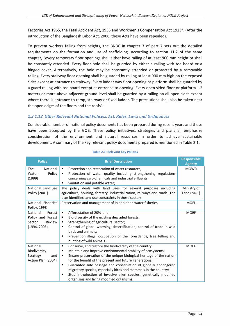
IEE of Enhancement and Strengthening of Power Network in Eastern Region of PGCB Project
Page | 24
Factories Act 1965, the Fatal Accident Act, 1955 and Workmen's Compensation Act 1923”. (After the
introduction of the Bangladesh Labor Act, 2006, these Acts have been repealed).
To prevent workers falling from heights, the BNBC in chapter 3 of part 7 sets out the detailed
requirements on the formation and use of scaffolding. According to section 11.2 of the same
chapter, “every temporary floor openings shall either have railing of at least 900 mm height or shall
be constantly attended. Every floor hole shall be guarded by either a railing with toe board or a
hinged cover. Alternatively, the hole may be constantly attended or protected by a removable
railing. Every stairway floor opening shall be guarded by railing at least 900 mm high on the exposed
sides except at entrance to stairway. Every ladder way floor opening or platform shall be guarded by
a guard railing with toe board except at entrance to opening. Every open sided floor or platform 1.2
meters or more above adjacent ground level shall be guarded by a railing on all open sides except
where there is entrance to ramp, stairway or fixed ladder. The precautions shall also be taken near
the open edges of the floors and the roofs”.
2.2.1.12 Other Relevant National Policies, Act, Rules, Laws and Ordinances
Considerable number of national policy documents has been prepared during recent years and these
have been accepted by the GOB. These policy initiatives, strategies and plans all emphasize
consideration of the environment and natural resources in order to achieve sustainable
development. A summary of the key relevant policy documents prepared is mentioned in Table 2.1.
Table 2.1: Relevant Key Policies
Policy Brief Description Responsible
Agency
The National Water Policy (1999)
Protection and restoration of water resources; Protection of water quality including strengthening regulations
concerning agro-chemicals and industrial effluents; Sanitation and potable water;
MOWR
National Land use Policy (2001)
The policy deals with land uses for several purposes including agriculture, housing, forestry, industrialization, railways and roads. The plan identifies land use constraints in these sectors.
Ministry of Land (MOL)
National Fisheries Policy, 1998
Preservation and management of inland open water fisheries MOFL
National Forest Policy and Forest Sector Review (1994, 2005)
Afforestation of 20% land; Bio-diversity of the existing degraded forests; Strengthening of agricultural sector; Control of global warming, desertification, control of trade in wild
birds and animals; Prevention illegal occupation of the forestlands, tree felling and
hunting of wild animals.
MOEF
National Biodiversity Strategy and Action Plan (2004)
Conserve, and restore the biodiversity of the country; Maintain and improve environmental stability of ecosystems; Ensure preservation of the unique biological heritage of the nation
for the benefit of the present and future generations; Guarantee safe passage and conservation of globally endangered
migratory species, especially birds and mammals in the country; Stop introduction of invasive alien species, genetically modified
organisms and living modified organisms.
MOEF
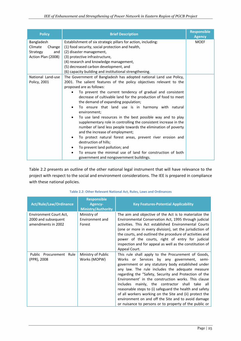
IEE of Enhancement and Strengthening of Power Network in Eastern Region of PGCB Project
Page | 25
Policy Brief Description Responsible
Agency
Bangladesh Climate Change Strategy and Action Plan (2008)
Establishment of six strategic pillars for action, including: (1) food security, social protection and health, (2) disaster management, (3) protective infrastructure, (4) research and knowledge management, (5) decreased carbon development, and (6) capacity building and institutional strengthening.
MOEF
National Land-use Policy, 2001
The Government of Bangladesh has adopted national Land use Policy, 2001. The salient features of the policy objectives relevant to the proposed are as follows:
To prevent the current tendency of gradual and consistent decrease of cultivable land for the production of food to meet the demand of expanding population;
To ensure that land use is in harmony with natural environment;
To use land resources in the best possible way and to play supplementary role in controlling the consistent increase in the number of land less people towards the elimination of poverty and the increase of employment;
To protect natural forest areas, prevent river erosion and destruction of hills;
To prevent land pollution; and
To ensure the minimal use of land for construction of both government and nongovernment buildings.
Table 2.2 presents an outline of the other national legal instrument that will have relevance to the
project with respect to the social and environment considerations. The IEE is prepared in compliance
with these national policies.
Table 2.2: Other Relevant National Act, Rules, Laws and Ordinances
Act/Rule/Law/Ordinance Responsible
Agency-Ministry/Authority
Key Features-Potential Applicability
Environment Court Act, 2000 and subsequent amendments in 2002
Ministry of Environment and Forest
The aim and objective of the Act is to materialize the Environmental Conservation Act, 1995 through judicial activities. This Act established Environmental Courts (one or more in every division), set the jurisdiction of the courts, and outlined the procedure of activities and power of the courts, right of entry for judicial inspection and for appeal as well as the constitution of Appeal Court.
Public Procurement Rule (PPR), 2008
Ministry of Public Works (MOPW)
This rule shall apply to the Procurement of Goods, Works or Services by any government, semi-government or any statutory body established under any law. The rule includes the adequate measure regarding the “Safety, Security and Protection of the Environment’ in the construction works. This clause includes mainly, the contractor shall take all reasonable steps to (i) safeguard the health and safety of all workers working on the Site and (ii) protect the environment on and off the Site and to avoid damage or nuisance to persons or to property of the public or
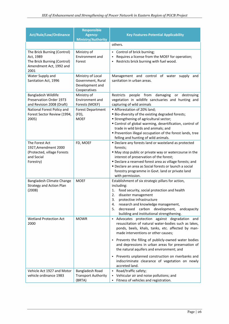
IEE of Enhancement and Strengthening of Power Network in Eastern Region of PGCB Project
Page | 26
Act/Rule/Law/Ordinance Responsible
Agency-Ministry/Authority
Key Features-Potential Applicability
others.
The Brick Burning (Control) Act, 1989 The Brick Burning (Control) Amendment Act, 1992 and 2001
Ministry of Environment and Forest
Control of brick burning; Requires a license from the MOEF for operation; Restricts brick burning with fuel wood.
Water Supply and Sanitation Act, 1996
Ministry of Local Government, Rural Development and Cooperatives
Management and control of water supply and sanitation in urban areas.
Bangladesh Wildlife Preservation Order 1973 and Revision 2008 (Draft)
Ministry of Environment and Forests (MOEF)
Restricts people from damaging or destroying vegetation in wildlife sanctuaries and hunting and capturing of wild animals
National Forest Policy and Forest Sector Review (1994, 2005)
Forest Department (FD), MOEF
Afforestation of 20% land; Bio-diversity of the existing degraded forests; Strengthening of agricultural sector; Control of global warming, desertification, control of
trade in wild birds and animals; and Prevention illegal occupation of the forest lands, tree
felling and hunting of wild animals.
The Forest Act 1927,Amendment 2000 (Protected, village Forests and Social Forestry)
FD, MOEF Declare any forests land or wasteland as protected forests;
May stop public or private way or watercourse in the interest of preservation of the forest;
Declare a reserved forest area as village forests; and Declare an area as Social forests or launch a social
forestry programme in Govt. land or private land with permission.
Bangladesh Climate Change Strategy and Action Plan (2008)
MOEF
Establishment of six strategic pillars for action, including: 1. food security, social protection and health 2. disaster management 3. protective infrastructure 4. research and knowledge management, 5. decreased carbon development, andcapacity
building and institutional strengthening.
Wetland Protection Act 2000
MOWR
Advocates protection against degradation and resuscitation of natural water-bodies such as lakes, ponds, beels, khals, tanks, etc. affected by man-made interventions or other causes;
Prevents the filling of publicly-owned water bodies and depressions in urban areas for preservation of the natural aquifers and environment; and
Prevents unplanned construction on riverbanks and indiscriminate clearance of vegetation on newly accreted land.
Vehicle Act 1927 and Motor vehicle ordinance 1983
Bangladesh Road Transport Authority (BRTA)
Road/traffic safety; Vehicular air and noise pollutions; and Fitness of vehicles and registration.
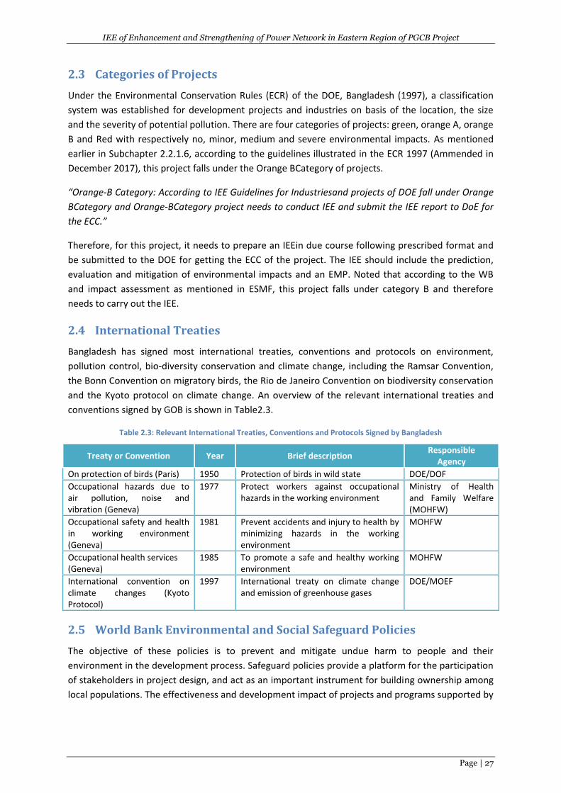
IEE of Enhancement and Strengthening of Power Network in Eastern Region of PGCB Project
Page | 27
2.3 Categories of Projects
Under the Environmental Conservation Rules (ECR) of the DOE, Bangladesh (1997), a classification
system was established for development projects and industries on basis of the location, the size
and the severity of potential pollution. There are four categories of projects: green, orange A, orange
B and Red with respectively no, minor, medium and severe environmental impacts. As mentioned
earlier in Subchapter 2.2.1.6, according to the guidelines illustrated in the ECR 1997 (Ammended in
December 2017), this project falls under the Orange BCategory of projects.
“Orange-B Category: According to IEE Guidelines for Industriesand projects of DOE fall under Orange
BCategory and Orange-BCategory project needs to conduct IEE and submit the IEE report to DoE for
the ECC.”
Therefore, for this project, it needs to prepare an IEEin due course following prescribed format and
be submitted to the DOE for getting the ECC of the project. The IEE should include the prediction,
evaluation and mitigation of environmental impacts and an EMP. Noted that according to the WB
and impact assessment as mentioned in ESMF, this project falls under category B and therefore
needs to carry out the IEE.
2.4 International Treaties
Bangladesh has signed most international treaties, conventions and protocols on environment,
pollution control, bio-diversity conservation and climate change, including the Ramsar Convention,
the Bonn Convention on migratory birds, the Rio de Janeiro Convention on biodiversity conservation
and the Kyoto protocol on climate change. An overview of the relevant international treaties and
conventions signed by GOB is shown in Table2.3.
Table 2.3: Relevant International Treaties, Conventions and Protocols Signed by Bangladesh
Treaty or Convention Year Brief description Responsible
Agency
On protection of birds (Paris) 1950 Protection of birds in wild state DOE/DOF
Occupational hazards due to air pollution, noise and vibration (Geneva)
1977 Protect workers against occupational hazards in the working environment
Ministry of Health and Family Welfare (MOHFW)
Occupational safety and health in working environment (Geneva)
1981 Prevent accidents and injury to health by minimizing hazards in the working environment
MOHFW
Occupational health services (Geneva)
1985 To promote a safe and healthy working environment
MOHFW
International convention on climate changes (Kyoto Protocol)
1997 International treaty on climate change and emission of greenhouse gases
DOE/MOEF
2.5 World Bank Environmental and Social Safeguard Policies
The objective of these policies is to prevent and mitigate undue harm to people and their
environment in the development process. Safeguard policies provide a platform for the participation
of stakeholders in project design, and act as an important instrument for building ownership among
local populations. The effectiveness and development impact of projects and programs supported by
IEE of Enhancement and Strengthening of Power Network in Eastern Region of PGCB Project
Page | 28
the Bank has substantially increased as a result of attention to these policies. The WB’s relevant
environmental, social, and legal safeguard policies are given below:
Environmental Policies:
OP/BP 4.01 Environmental Assessment
OP/BP 4.04 Natural Habitats
OP/BP 4.11 Physical Cultural Resources
OP/BP 4.36 Forests
Social Policies:
OP/BP 4.10 Indigenous Peoples
OP/BP 4.12 Involuntary Resettlement
Legal Policies:
OP/BP 7.50 International Waterways
OP/BP 7.60 Disputed Areas
Operational Policies (OP) are the statement of policy objectives and operational principles including
the roles and obligations of the Borrower and the Bank, whereas Bank Procedures (BP) is the
mandatory procedures to be followed by the Borrower and the Bank. Apart from these, the IFC
guidelines for Environmental Health and safety have been adopted by the World Bank Group which
is also relevant for environmental protection and monitoring. In addition to that the Policy on Access
to Information of World Bank also relates to environmental safeguard. The environmental safeguard
and access to information policy as well as the IFC guidelines are discussed below:
I. OP/BP 4.01 Environmental Assessment
This policy is considered to be the umbrella safeguard policy to identify, avoid, and mitigate the
potential negative environmental and social impacts associated with Bank lending operations. In
World Bank operations, the purpose of Environmental Assessment (EA) is to improve decision
making, to ensure that project options under consideration are sound and sustainable, and that
potentially affected people have been properly consulted. The borrower is responsible for carrying
out the EA and the Bank advises the borrower on the Bank’s EA requirements. The Bank classifies
the proposed project into three major categories, depending on the type, location, sensitivity, and
scale of the project and the nature and magnitude of its potential environmental impacts:
Category A: The proposed project is likely to have significant adverse environmental impacts
that are sensitive, diverse, or unprecedented. These impacts may affect an area broader
than the sites or facilities subject to physical works.
Category B: The proposed project’s potential adverse environmental impacts on human
population or environmentally important areas-including wetlands, forests, grasslands, or
other natural habitats- are less adverse than those of Category A projects. These impacts are
site specific; few if any of them are irreversible; and in most cases mitigation measures can
be designed more readily than Category A projects.
IEE of Enhancement and Strengthening of Power Network in Eastern Region of PGCB Project
Page | 29
Category C: The proposed project is likely to have minimal or no adverse environmental
impacts.
II. OP/BP 4.04 Natural Habitats
The conservation of natural habitats is essential for long-term sustainable development. The Bank
therefore supports the protection, maintenance, and rehabilitation of natural habitats and their
functions in its economic and sector work, project financing, and policy dialogue. The Bank supports,
and expects borrowers to apply, a precautionary approach to natural resource management to
ensure opportunities for environmentally sustainable development. The Bank does not support
projects that involve the significant conversion or degradation of critical natural habitats.
III. OP/BP 4.11 Physical Cultural Resources
Physical cultural resources are defined as movable or immovable objects, sites, structures, groups of
structures, and natural features and landscapes that have archaeological, paleontological, historical,
architectural, religious, aesthetic, or other cultural significance. Their cultural interest may be at the
local, provincial or national level, or within the international community. Physical cultural resources
are important as sources of valuable scientific and historical information, as assets for economic and
social development, and as integral parts of a people's cultural identity and practices. The Bank
assists countries to avoid or mitigate adverse impacts on physical cultural resources from
development projects that it finances. The impacts on physical cultural resources resulting from
project activities, including mitigating measures, may not contravene either the borrower's national
legislation, or its obligations under relevant international environmental treaties and agreements.
The borrower addresses impacts on physical cultural resources in projects proposed for Bank
financing, as an integral part of the environmental assessment process.
IV. OP/BP 4.36 Forests
Forest is defined as an area of land of not less than 1.0 hectare with tree crown cover (or equivalent
stocking level) of more than 10 percent that have trees with the potential to reach a minimum
height of 2 meters at maturity in situ. A forest may consist of either closed forest formations, where
trees of various stories and undergrowth cover a high proportion of the ground, or open forest. The
definition includes forests dedicated to forest production, protection, multiple uses, or conservation,
whether formally recognized or not. The definition excludes areas where other land uses not
dependent on tree cover predominate, such as agriculture, grazing or settlements. In countries with
low forest cover, the definition may be expanded to include areas covered by trees that fall below
the 10 percent threshold for canopy density, but are considered forest under local conditions. The
Bank's forests policy recognizes the importance of forests to reduce poverty in a sustainable manner
integrates forests effectively in economic development, aims to reduce deforestation, promote
afforestation and enhance the environmental contribution of forested areas. The Bank assists
borrowers with the establishment and sustainable management of environmentally appropriate,
socially beneficial, and economically viable forest plantations to help meet growing demands for
forest goods and services.
V. OP/BP 4.12 Involuntary Resettlement
This policy is triggered in situations involving involuntary taking of land and involuntary restrictions
of access to legally designated parks and protected areas. The policy aims to avoid involuntary
IEE of Enhancement and Strengthening of Power Network in Eastern Region of PGCB Project
Page | 30
resettlement to the extent feasible, or to minimize and mitigate its adverse social and economic
impacts. It promotes participation of displaced people in resettlement planning and implementation,
and its key economic objective is to assist displaced persons in their efforts to improve or at least
restore their incomes and standards of living after displacement.The policy prescribes compensation
and other resettlement measures to achieve its objectives and requires that borrowers prepare
adequate resettlement planning instruments prior to Bank appraisal of proposed projects.
VI. OP 4.10 Indigenous People
The term “Indigenous Peoples” is used in a generic sense to refer to a distinct, vulnerable, social and
cultural group possessing the following characteristics in varying degrees:
self-identification as members of a distinct indigenous cultural group and recognition of this
identity by others;
collective attachment to geographically distinct habitats or ancestral territories in the
project area and to the natural resources in these habitats and territories;
customary cultural, economic, social, or political institutions that are separate from those of
the dominant society and culture; and
an indigenous language, often different from official language of the country/ region.
The Bank provides project financing only where free, prior, and informed consultation results in
broad community support to the project by the affected Indigenous Peoples. Such Bank-financed
projects include measures to (a) avoid potentially adverse effects on the Indigenous Peoples’
communities; or (b) when avoidance is not feasible, minimize, mitigate, or compensate for such
effects. Bank-financed projects are also designed to ensure that the Indigenous Peoples receive
social and economic benefits that are culturally appropriate and gender and inter-generationally
inclusive.
VII. OP/BP 7.50 Projects on International Waterways
The WB recognizes the issues involving projects in international waterways and attaches importance
to the riparian’s making appropriate agreements or arrangements for the entire waterway, or parts
thereof.In the absence of such agreements or arrangements, the Bank requires, as a general rule,
that the prospective borrower notifies the other riparian’s of the project. The Policy lays down
detailed procedures for the notification requirement, including the role of the Bank in affecting the
notification, period of reply and the procedures in case there is an objection by one of the riparian’s
to the project.
VIII. OP/BP 7.60 Projects in Disputed Areas
The World Bank finances projects in disputed areas when either there is no objection from the other
claimant to the disputed area, or when special circumstances of case support Bank financing,
notwithstanding the objection. The policy details those special circumstances.
2.5.1 IFC Environmental, Health and Safety Guidelines
The Environmental, Health and Safety (EHS) Guidelines of the World Bank Group
(WBG)/International Finance Corporation (IFC), 2008 is the safeguard guidelines for environment,
health and safety for the development of the industrial and other projects. They contain
performance levels and measures that are considered to be achievable in new facilities at
IEE of Enhancement and Strengthening of Power Network in Eastern Region of PGCB Project
Page | 31
reasonable costs using existing technologies. When host country regulations differ from the levels
and measures presented in the EHS Guidelines, projects are expected to achieve whichever is more
stringent. If less stringent levels or measures than those provided in these EHS Guidelines are
appropriate, in view of specific project circumstances, a full and detailed justification for any
proposed alternatives is needed as part of the site-specific environmental assessment. This
justification should demonstrate that the choice for any alternate performance levels is protective of
human health and the environment.
2.5.2 World Bank Policy on Access to Information
In addition to the safeguard policies, the Access to Information Policy also relates to safeguards. To
promote transparency and facilitate accountability, Bank Access to Information Policy supports
decision making by the Borrower and Bank by allowing the public access to information on
environmental and social aspects of projects in an accessible place and understandable form and
language to key stakeholders. The Bank ensures that relevant project-related environmental and
social safeguard documents, including the procedures prepared for projects involving subprojects,
are disclosed in a timely manner before project appraisal formally begins. The policy requires
disclosure in both English and Local language and must meet the WB standards.
2.6 GOB Environmental Clearance Procedure
Formal IEE guidelines in Bangladesh are set out in “Rules and Regulations under the 1995
Environmental Protection Acts” as published in the official Gazette on August 27, 1997. Any
proponent planning an industrial project is currently required under Paragraph 12 of the
Environmental Protection Acts, 1995 to obtain “environmental clearance letter:” from the
Department of Environment.
As mentioned earlier in Subchapter 2.2.1.6, steps to be followed for obtaining the ECC for this
electricity transmission project are shown in Figure 2.1 as the project is under ‘Category Orange-B ’
and to prepare and submit to DOE an IEE report prior to implementation of such project for
approval.
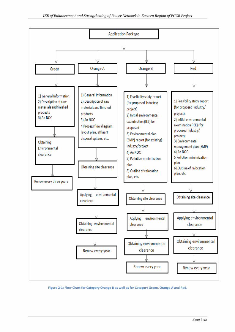
IEE of Enhancement and Strengthening of Power Network in Eastern Region of PGCB Project
Page | 32
Figure 2-1: Flow Chart for Category Orange B as well as for Category Green, Orange A and Red.
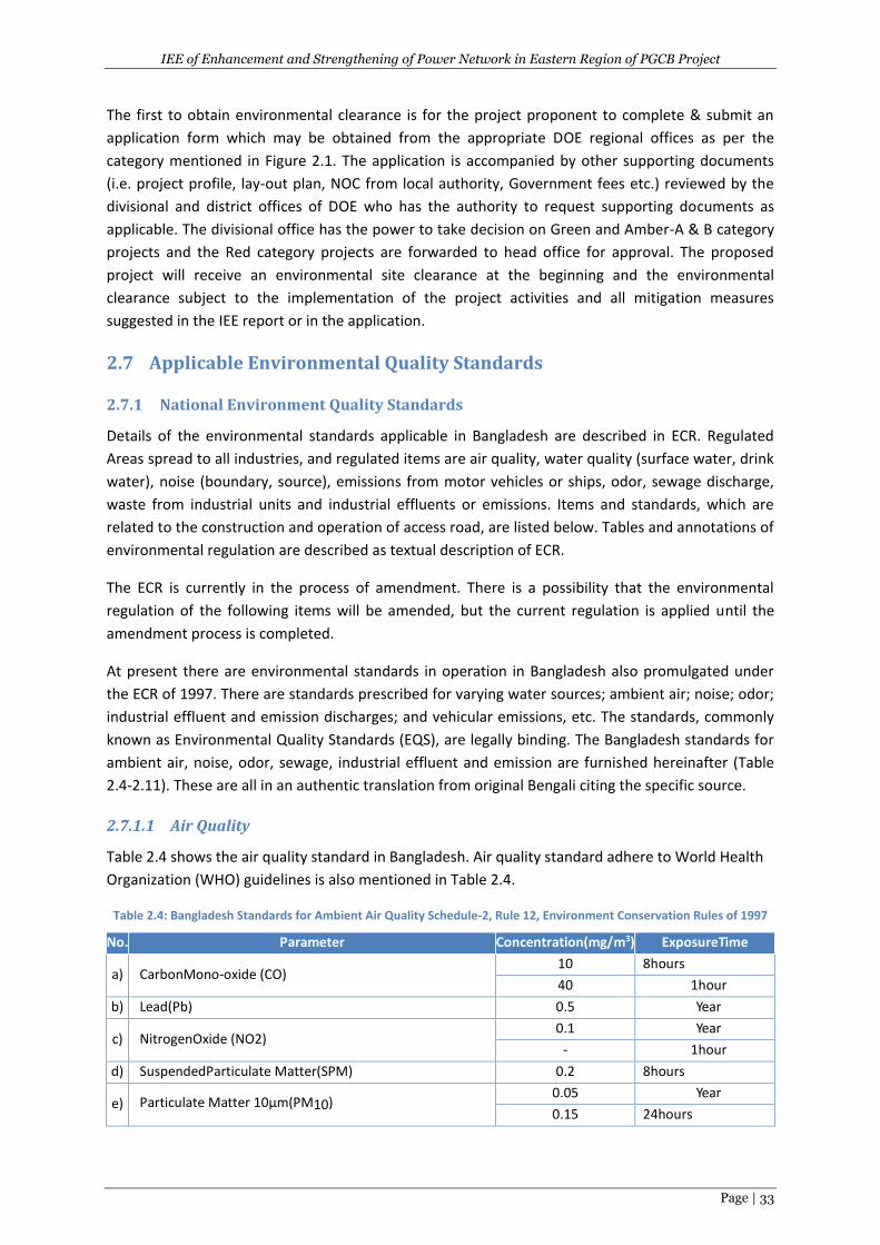
IEE of Enhancement and Strengthening of Power Network in Eastern Region of PGCB Project
Page | 33
The first to obtain environmental clearance is for the project proponent to complete & submit an
application form which may be obtained from the appropriate DOE regional offices as per the
category mentioned in Figure 2.1. The application is accompanied by other supporting documents
(i.e. project profile, lay-out plan, NOC from local authority, Government fees etc.) reviewed by the
divisional and district offices of DOE who has the authority to request supporting documents as
applicable. The divisional office has the power to take decision on Green and Amber-A & B category
projects and the Red category projects are forwarded to head office for approval. The proposed
project will receive an environmental site clearance at the beginning and the environmental
clearance subject to the implementation of the project activities and all mitigation measures
suggested in the IEE report or in the application.
2.7 Applicable Environmental Quality Standards
2.7.1 National Environment Quality Standards
Details of the environmental standards applicable in Bangladesh are described in ECR. Regulated
Areas spread to all industries, and regulated items are air quality, water quality (surface water, drink
water), noise (boundary, source), emissions from motor vehicles or ships, odor, sewage discharge,
waste from industrial units and industrial effluents or emissions. Items and standards, which are
related to the construction and operation of access road, are listed below. Tables and annotations of
environmental regulation are described as textual description of ECR.
The ECR is currently in the process of amendment. There is a possibility that the environmental
regulation of the following items will be amended, but the current regulation is applied until the
amendment process is completed.
At present there are environmental standards in operation in Bangladesh also promulgated under
the ECR of 1997. There are standards prescribed for varying water sources; ambient air; noise; odor;
industrial effluent and emission discharges; and vehicular emissions, etc. The standards, commonly
known as Environmental Quality Standards (EQS), are legally binding. The Bangladesh standards for
ambient air, noise, odor, sewage, industrial effluent and emission are furnished hereinafter (Table
2.4-2.11). These are all in an authentic translation from original Bengali citing the specific source.
2.7.1.1 Air Quality
Table 2.4 shows the air quality standard in Bangladesh. Air quality standard adhere to World Health
Organization (WHO) guidelines is also mentioned in Table 2.4.
Table 2.4: Bangladesh Standards for Ambient Air Quality Schedule-2, Rule 12, Environment Conservation Rules of 1997
No. Parameter Concentration(mg/m3) ExposureTime
a) CarbonMono-oxide (CO) 10 8hours
40 1hour
b) Lead(Pb) 0.5 Year
c) NitrogenOxide (NO2) 0.1 Year
- 1hour
d) SuspendedParticulate Matter(SPM) 0.2 8hours
e) Particulate Matter 10μm(PM10) 0.05 Year
0.15 24hours
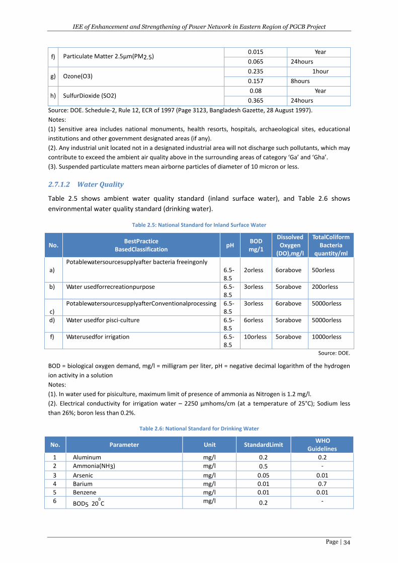
IEE of Enhancement and Strengthening of Power Network in Eastern Region of PGCB Project
Page | 34
f) Particulate Matter 2.5μm(PM2.5) 0.015 Year
0.065 24hours
g) Ozone(O3) 0.235 1hour
0.157 8hours
h) SulfurDioxide (SO2) 0.08 Year
0.365 24hours
Source: DOE. Schedule-2, Rule 12, ECR of 1997 (Page 3123, Bangladesh Gazette, 28 August 1997).
Notes:
(1) Sensitive area includes national monuments, health resorts, hospitals, archaeological sites, educational
institutions and other government designated areas (if any).
(2). Any industrial unit located not in a designated industrial area will not discharge such pollutants, which may
contribute to exceed the ambient air quality above in the surrounding areas of category ‘Ga’ and ‘Gha’.
(3). Suspended particulate matters mean airborne particles of diameter of 10 micron or less.
2.7.1.2 Water Quality
Table 2.5 shows ambient water quality standard (inland surface water), and Table 2.6 shows
environmental water quality standard (drinking water).
Table 2.5: National Standard for Inland Surface Water
No. BestPractice
BasedClassification pH
BOD mg/1
Dissolved Oxygen
(DO),mg/l
TotalColiform Bacteria
quantity/ml
a)
Potablewatersourcesupplyafter bacteria freeingonly 6.5-8.5
2orless
6orabove
50orless
b) Water usedforrecreationpurpose 6.5-8.5
3orless 5orabove 200orless
c)
PotablewatersourcesupplyafterConventionalprocessing 6.5-8.5
3orless 6orabove 5000orless
d) Water usedfor pisci-culture 6.5-8.5
6orless 5orabove 5000orless
f) Waterusedfor irrigation 6.5-8.5
10orless 5orabove 1000orless
Source: DOE.
BOD = biological oxygen demand, mg/l = milligram per liter, pH = negative decimal logarithm of the hydrogen
ion activity in a solution
Notes:
(1). In water used for pisiculture, maximum limit of presence of ammonia as Nitrogen is 1.2 mg/l.
(2). Electrical conductivity for irrigation water – 2250 μmhoms/cm (at a temperature of 25°C); Sodium less
than 26%; boron less than 0.2%.
Table 2.6: National Standard for Drinking Water
No. Parameter Unit StandardLimit WHO
Guidelines
1 Aluminum mg/l 0.2 0.2
2 Ammonia(NH3) mg/l 0.5 -
3 Arsenic mg/l 0.05 0.01
4 Barium mg/l 0.01 0.7
5 Benzene mg/l 0.01 0.01
6 BOD5 200C mg/l 0.2 -
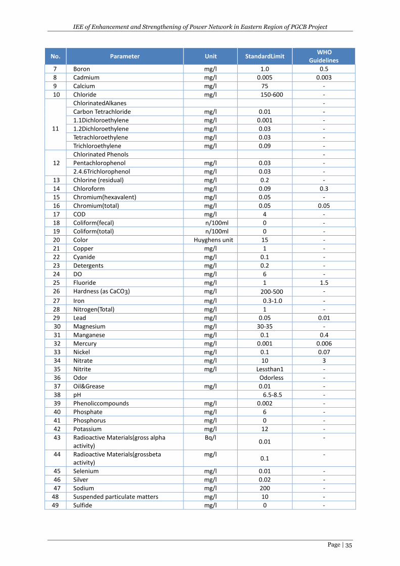
IEE of Enhancement and Strengthening of Power Network in Eastern Region of PGCB Project
Page | 35
No. Parameter Unit StandardLimit WHO
Guidelines
7 Boron mg/l 1.0 0.5
8 Cadmium mg/l 0.005 0.003
9 Calcium mg/l 75 -
10 Chloride mg/l 150-600 -
11
ChlorinatedAlkanes -
Carbon Tetrachloride mg/l 0.01 -
1.1Dichloroethylene mg/l 0.001 -
1.2Dichloroethylene mg/l 0.03 -
Tetrachloroethylene mg/l 0.03 -
Trichloroethylene mg/l 0.09 -
12
Chlorinated Phenols -
Pentachlorophenol mg/l 0.03 -
2.4.6Trichlorophenol mg/l 0.03 -
13 Chlorine (residual) mg/l 0.2 -
14 Chloroform mg/l 0.09 0.3
15 Chromium(hexavalent) mg/l 0.05 -
16 Chromium(total) mg/l 0.05 0.05
17 COD mg/l 4 -
18 Coliform(fecal) n/100ml 0 -
19 Coliform(total) n/100ml 0 -
20 Color Huyghens unit 15 -
21 Copper mg/l 1 -
22 Cyanide mg/l 0.1 -
23 Detergents mg/l 0.2 -
24 DO mg/l 6 -
25 Fluoride mg/l 1 1.5
26 Hardness (as CaCO3) mg/l 200-500 -
27 Iron mg/l 0.3-1.0 -
28 Nitrogen(Total) mg/l 1 -
29 Lead mg/l 0.05 0.01
30 Magnesium mg/l 30-35 -
31 Manganese mg/l 0.1 0.4
32 Mercury mg/l 0.001 0.006
33 Nickel mg/l 0.1 0.07
34 Nitrate mg/l 10 3
35 Nitrite mg/l Lessthan1 -
36 Odor Odorless -
37 Oil&Grease mg/l 0.01 -
38 pH 6.5-8.5 -
39 Phenoliccompounds mg/l 0.002 -
40 Phosphate mg/l 6 -
41 Phosphorus mg/l 0 -
42 Potassium mg/l 12 -
43 Radioactive Materials(gross alpha activity)
Bq/l 0.01
-
44 Radioactive Materials(grossbeta activity)
mg/l 0.1
-
45 Selenium mg/l 0.01 -
46 Silver mg/l 0.02 -
47 Sodium mg/l 200 -
48 Suspended particulate matters mg/l 10 -
49 Sulfide mg/l 0 -
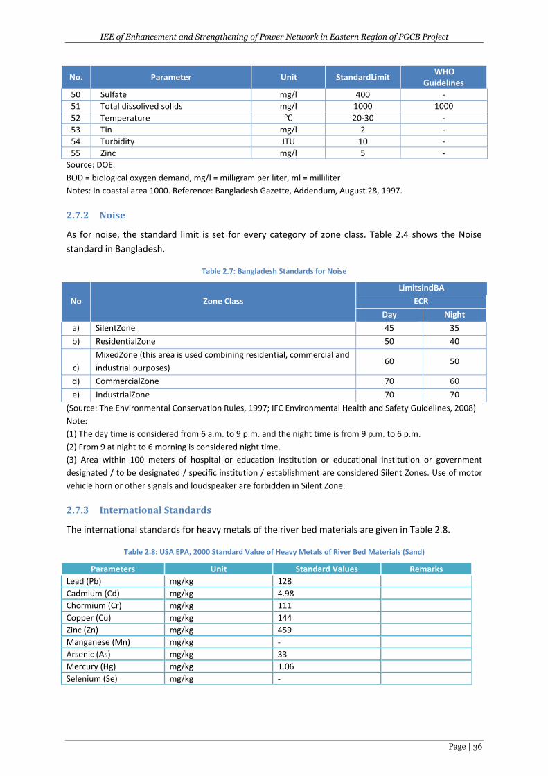
IEE of Enhancement and Strengthening of Power Network in Eastern Region of PGCB Project
Page | 36
No. Parameter Unit StandardLimit WHO
Guidelines
50 Sulfate mg/l 400 -
51 Total dissolived solids mg/l 1000 1000
52 Temperature ℃ 20-30 -
53 Tin mg/l 2 -
54 Turbidity JTU 10 -
55 Zinc mg/l 5 -
Source: DOE.
BOD = biological oxygen demand, mg/l = milligram per liter, ml = milliliter
Notes: In coastal area 1000. Reference: Bangladesh Gazette, Addendum, August 28, 1997.
2.7.2 Noise
As for noise, the standard limit is set for every category of zone class. Table 2.4 shows the Noise
standard in Bangladesh.
Table 2.7: Bangladesh Standards for Noise
No Zone Class
LimitsindBA
ECR
Day Night
a) SilentZone 45 35
b) ResidentialZone 50 40
c)
MixedZone (this area is used combining residential, commercial and
industrial purposes) 60 50
d) CommercialZone 70 60
e) IndustrialZone 70 70
(Source: The Environmental Conservation Rules, 1997; IFC Environmental Health and Safety Guidelines, 2008)
Note:
(1) The day time is considered from 6 a.m. to 9 p.m. and the night time is from 9 p.m. to 6 p.m.
(2) From 9 at night to 6 morning is considered night time.
(3) Area within 100 meters of hospital or education institution or educational institution or government
designated / to be designated / specific institution / establishment are considered Silent Zones. Use of motor
vehicle horn or other signals and loudspeaker are forbidden in Silent Zone.
2.7.3 International Standards
The international standards for heavy metals of the river bed materials are given in Table 2.8.
Table 2.8: USA EPA, 2000 Standard Value of Heavy Metals of River Bed Materials (Sand)
Parameters Unit Standard Values Remarks
Lead (Pb) mg/kg 128
Cadmium (Cd) mg/kg 4.98
Chormium (Cr) mg/kg 111
Copper (Cu) mg/kg 144
Zinc (Zn) mg/kg 459
Manganese (Mn) mg/kg -
Arsenic (As) mg/kg 33
Mercury (Hg) mg/kg 1.06
Selenium (Se) mg/kg -
IEE of Enhancement and Strengthening of Power Network in Eastern Region of PGCB Project
Page | 37
3 PROJECT DESCRIPTION
3.1 Project Location
The project components such as substations (12 numbers), transmission lines (total length is 283.64
km) and 11 LILO lines (toatal 44 km) are located in the 7 districts of Bangladesh. Among them six
districts (such as Chittagong, Feni, Noakhali, Laxmipur, Comilla and Chandpur district) are in
Chittagong division of the eastern region of PBCB’s jurisdiction and Munshiganj district (small part of
45.09km long Gazaria (Munshiganj)-Kachua (Chandpur) TL is in Dhaka division (Figure 3.1). There are
12 subprojects of the substations, 8 subprojects of the TL and 8 subprojects of the LILO lines.
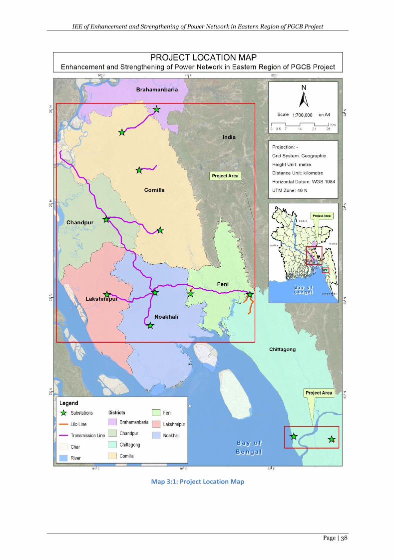
IEE of Enhancement and Strengthening of Power Network in Eastern Region of PGCB Project
Page | 38
Map 3:1: Project Location Map
IEE of Enhancement and Strengthening of Power Network in Eastern Region of PGCB Project
Page | 39
3.2 Project Components/Subprojects
The proposed project will have three components with the following estimated cost: 1)
enhancement and strengthening of power network in eastern region (US$440 million); 2) Technical
assistance for institutional development and implementation support (US$5 million); and 3)
Equipment and tools for improved maintenance practice (US$10 million). However, thisIEE report is
only for the first component of the main project and can be described as below.
This component will cover the following activities:
1. Two nos. of 230/132kV substations and nine (9) nos. of 132/33kV substations will be built.
230/133kV substations are Chowmuhoni and Kachua. 132/33 kV substations are Kosba,
Muradnagar, Chandina, Laksham, Laxmipur, Bashurhat, Maijdee, Patiya and New Mooring.
Keeping in mind the scarcity of land in the project areas (due to high population density), all
these substations are planned with GIS configuration. The 132/33kV New Mooring
substation to be built on the western side of Chittagong City will become a
400/230/132/33kV power hub in future. The 132/33kV part will be built by this project but
the land acquisition and layout planning will incorporate the future 400/230/132kV design.
Some other 132/33kV substations will also be designed keeping provisions for upgradation
to 230kV in future.
1 The only substation that will be replaced under this project is the Halishahar 132/33kV air
insulated substation (AIS). This substation is one of the oldest substations of PGCB and will be
replaced by advanced gas insulated substation (GIS) after the commissioning of the New
Mooring substation. This will require modification and extension of local 33kV and 11 kV
network so that load at Halishahar can be fed from New Mooring S/S during replacement works
at Halishahar.
2 A 230kV high capacity four circuit backbone transmission line (with twin Finch conductor per
phase and only two circuits will be stringing now) has been planned through greater Comilla
region (Korerhat– Chowmuhoni – Kachua-Gazaria) to make it the primary transmission backbone
of this area for future. This line will supplement the existing 230kV double circuit line which is a
low capacity (300 MW per circuit) line currently acting as the main transmission backbone
between Comilla and Chittagong. Four (4) short distance 132kV double circuit lines are planned
to be built to connect the new 132/33kV substations to the existing ones in Comilla and Noakhali
area. Summary of the proposed scope of works under this project is given below (Table 3.1):
Table 3.1: Summary of Proposed Scope of Works
Transmission Lines Substations
Voltage level Circuit Km Voltage Level No of S/S
230kV 386 230/132kV 2
132kV 266 132/33kV 10
About 283.642 km new transmission line (TL) involved with proposed 12 new substations.The
following transmission systems are proposed under the project.The diagrammatic representation of
the proposed transmission system is shown in Map 3.2.
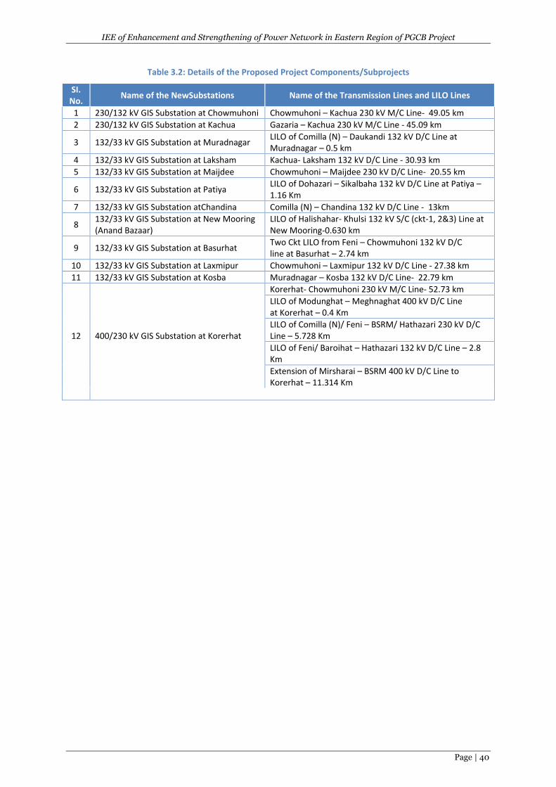
IEE of Enhancement and Strengthening of Power Network in Eastern Region of PGCB Project
Page | 40
Table 3.2: Details of the Proposed Project Components/Subprojects
SI. No.
Name of the NewSubstations Name of the Transmission Lines and LILO Lines
1 230/132 kV GIS Substation at Chowmuhoni Chowmuhoni – Kachua 230 kV M/C Line- 49.05 km
2 230/132 kV GIS Substation at Kachua Gazaria – Kachua 230 kV M/C Line - 45.09 km
3 132/33 kV GIS Substation at Muradnagar LILO of Comilla (N) – Daukandi 132 kV D/C Line at Muradnagar – 0.5 km
4 132/33 kV GIS Substation at Laksham Kachua- Laksham 132 kV D/C Line - 30.93 km
5 132/33 kV GIS Substation at Maijdee Chowmuhoni – Maijdee 230 kV D/C Line- 20.55 km
6 132/33 kV GIS Substation at Patiya LILO of Dohazari – Sikalbaha 132 kV D/C Line at Patiya – 1.16 Km
7 132/33 kV GIS Substation atChandina Comilla (N) – Chandina 132 kV D/C Line - 13km
8 132/33 kV GIS Substation at New Mooring (Anand Bazaar)
LILO of Halishahar- Khulsi 132 kV S/C (ckt-1, 2&3) Line at New Mooring-0.630 km
9 132/33 kV GIS Substation at Basurhat Two Ckt LILO from Feni – Chowmuhoni 132 kV D/C line at Basurhat – 2.74 km
10 132/33 kV GIS Substation at Laxmipur Chowmuhoni – Laxmipur 132 kV D/C Line - 27.38 km
11 132/33 kV GIS Substation at Kosba Muradnagar – Kosba 132 kV D/C Line- 22.79 km
12 400/230 kV GIS Substation at Korerhat
Korerhat- Chowmuhoni 230 kV M/C Line- 52.73 km
LILO of Modunghat – Meghnaghat 400 kV D/C Line at Korerhat – 0.4 Km
LILO of Comilla (N)/ Feni – BSRM/ Hathazari 230 kV D/C Line – 5.728 Km
LILO of Feni/ Baroihat – Hathazari 132 kV D/C Line – 2.8 Km
Extension of Mirsharai – BSRM 400 kV D/C Line to Korerhat – 11.314 Km
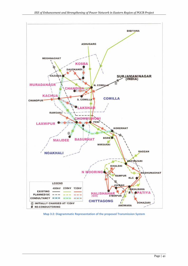
IEE of Enhancement and Strengthening of Power Network in Eastern Region of PGCB Project
Page | 41
Map 3:2: Diagrammatic Representation of the proposed Transmission System
IEE of Enhancement and Strengthening of Power Network in Eastern Region of PGCB Project
Page | 42
4 DESCRIPTION OF ENVIRONMENTAL BASELINE
4.1 General
The baseline condition of environmental quality in the locality of sub-project site serves as the basis
for identification, prediction and evaluation of impacts. The baseline environmental quality is
assessed through field studies within the impact zone for various components of the environment,
viz. air, noise, water, land and socio-economic, etc.
Information of baseline environmental status of the project area is useful for impact assessment
process of assessing and predicting the environmental consequences of the significant actions.
Based on the existing environmental scenario, potential impacts of subprojects associated will be
identified and accordingly management plan will be proposed in forthcoming sections. The baseline
environmental conditions will help in comparing and to monitor the predicted negative and positive
impacts resulting from the project during pre-construction, construction and operation phases.
Significant action depicts direct adverse changes caused by the action and its effect on the health of
the biota including flora, fauna and human being, socio-economic conditions, current use of land and
resources, climate change aspects, physical and cultural heritage properties and biophysical
surroundings. Baseline data generation of the following environmental attributes is essential in IEE
studies.
Data/information was collected from secondary sources for the macro-environmental setting like
climate (temperature, rainfall, humidity, and wind speed), topography, geology, soils etc. Firsthand
information have been collected to record the micro-environmental features within and adjacent to
the project corridor. Collection of primary/field data/information includes extrapolating
environmental features on proposed subprojects design, tree inventories, location and
measurement of socio-cultural features adjoining proposed subprojects. Ambient air, noise quality,
surface water and ground/drinking water quality have been assessed based on measurement/testing
as well as visual inspection to prepare a baseline database. Consultation was another source of
information and to explain local environmental conditions, impacts, and suggestions, etc.
The following section describes the baseline environment in three broad categories:
Physical Environment- factors such topography, geology, earthquake, climate and
hydrology/drainage, environmental pollution, ;
Biological Environment- factors related to life such as flora, fauna and ecosystem; and
Socio-economic Environment- anthropological factors like demography, income, land use,
land requirement and infrastructure.
As mentioned earlier in chapter 3, all the subprojects under the Enhancement and Strengthening of
Power Network in Eastern Region (ESPNER) project of PGCB are located in six districts of Chittagong
division one district of Dhaka Division. The environmental baseline chapter is described according to
the classification, nature and primary observation during field survey. The subproject specific
Environmental Baseline data of Substations (SS),Transmission Lines(TL) andLILOlines (LL) are given in
the following Table 4.1.
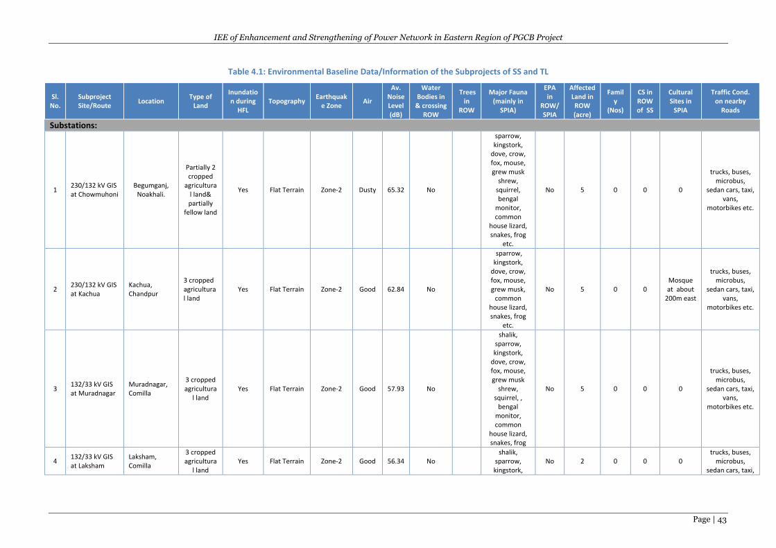
IEE of Enhancement and Strengthening of Power Network in Eastern Region of PGCB Project
Page | 43
Table 4.1: Environmental Baseline Data/Information of the Subprojects of SS and TL
Sl. No.
Subproject Site/Route
Location Type of
Land
Inundation during
HFL Topography
Earthquake Zone
Air
Av. Noise Level (dB)
Water Bodies in
& crossing ROW
Trees in
ROW
Major Fauna (mainly in
SPIA)
EPA in
ROW/ SPIA
Affected Land in ROW (acre)
Family
(Nos)
CS in ROW of SS
Cultural Sites in
SPIA
Traffic Cond. on nearby
Roads
Substations:
1 230/132 kV GIS at Chowmuhoni
Begumganj, Noakhali.
Partially 2 cropped
agricultural land& partially
fellow land
Yes Flat Terrain Zone-2 Dusty 65.32 No
sparrow, kingstork,
dove, crow, fox, mouse, grew musk
shrew, squirrel, bengal
monitor, common
house lizard, snakes, frog
etc.
No 5 0 0 0
trucks, buses, microbus,
sedan cars, taxi, vans,
motorbikes etc.
2 230/132 kV GIS at Kachua
Kachua, Chandpur
3 cropped agricultural land
Yes Flat Terrain Zone-2 Good 62.84 No
sparrow, kingstork,
dove, crow, fox, mouse, grew musk,
common house lizard, snakes, frog
etc.
No 5 0 0 Mosque at about
200m east
trucks, buses, microbus,
sedan cars, taxi, vans,
motorbikes etc.
3 132/33 kV GIS at Muradnagar
Muradnagar, Comilla
3 cropped agricultura
l land Yes Flat Terrain Zone-2 Good 57.93 No
shalik, sparrow, kingstork,
dove, crow, fox, mouse, grew musk
shrew, squirrel, ,
bengal monitor, common
house lizard, snakes, frog
No 5 0 0 0
trucks, buses, microbus,
sedan cars, taxi, vans,
motorbikes etc.
4 132/33 kV GIS at Laksham
Laksham, Comilla
3 cropped agricultura
l land Yes Flat Terrain Zone-2 Good 56.34 No
shalik, sparrow, kingstork,
No 2 0 0 0 trucks, buses,
microbus, sedan cars, taxi,
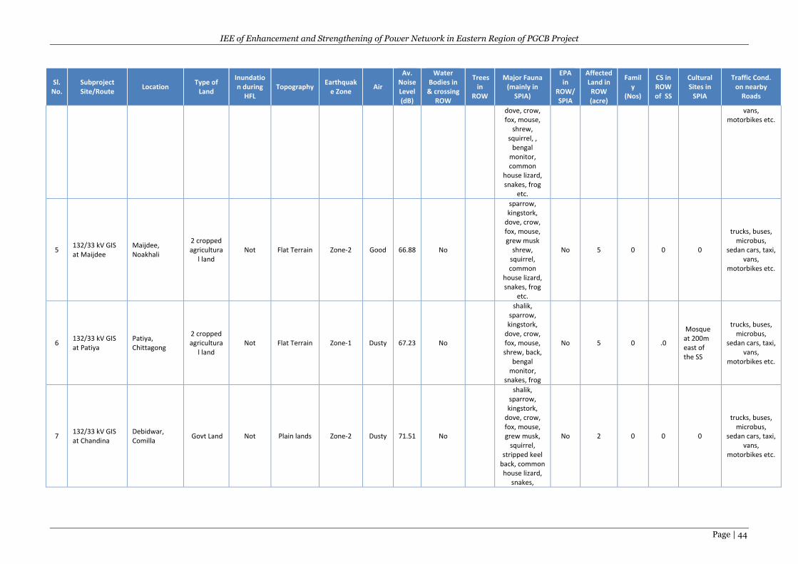
IEE of Enhancement and Strengthening of Power Network in Eastern Region of PGCB Project
Page | 44
Sl. No.
Subproject Site/Route
Location Type of
Land
Inundation during
HFL Topography
Earthquake Zone
Air
Av. Noise Level (dB)
Water Bodies in
& crossing ROW
Trees in
ROW
Major Fauna (mainly in
SPIA)
EPA in
ROW/ SPIA
Affected Land in ROW (acre)
Family
(Nos)
CS in ROW of SS
Cultural Sites in
SPIA
Traffic Cond. on nearby
Roads
dove, crow, fox, mouse,
shrew, squirrel, ,
bengal monitor, common
house lizard, snakes, frog
etc.
vans, motorbikes etc.
5 132/33 kV GIS at Maijdee
Maijdee, Noakhali
2 cropped agricultura
l land Not Flat Terrain Zone-2 Good 66.88 No
sparrow, kingstork,
dove, crow, fox, mouse, grew musk
shrew, squirrel, common
house lizard, snakes, frog
etc.
No 5 0 0 0
trucks, buses, microbus,
sedan cars, taxi, vans,
motorbikes etc.
6 132/33 kV GIS at Patiya
Patiya, Chittagong
2 cropped agricultura
l land Not Flat Terrain Zone-1 Dusty 67.23 No
shalik, sparrow, kingstork,
dove, crow, fox, mouse, shrew, back,
bengal monitor,
snakes, frog
No 5 0 .0
Mosque at 200m east of the SS
trucks, buses, microbus,
sedan cars, taxi, vans,
motorbikes etc.
7 132/33 kV GIS at Chandina
Debidwar, Comilla
Govt Land Not Plain lands Zone-2 Dusty 71.51 No
shalik, sparrow, kingstork,
dove, crow, fox, mouse, grew musk,
squirrel, stripped keel
back, common house lizard,
snakes,
No 2 0 0 0
trucks, buses, microbus,
sedan cars, taxi, vans,
motorbikes etc.
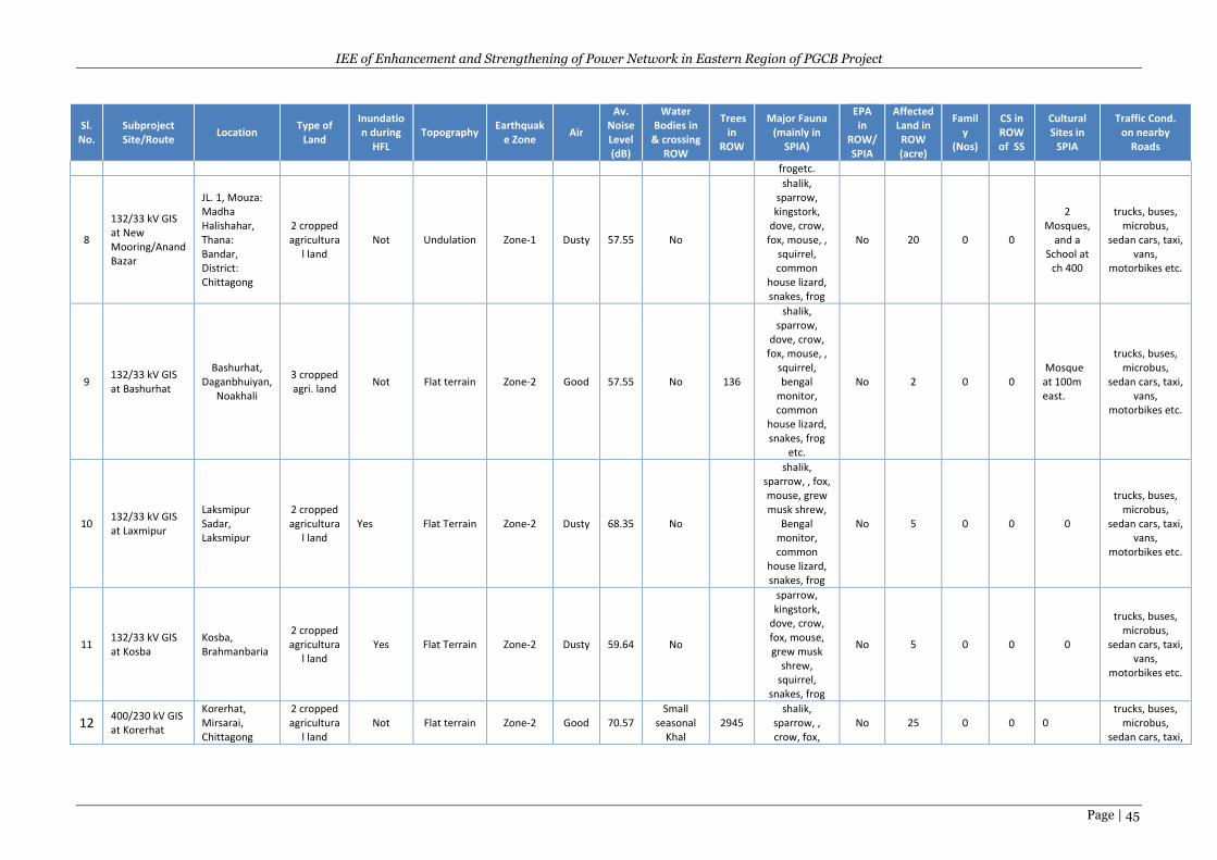
IEE of Enhancement and Strengthening of Power Network in Eastern Region of PGCB Project
Page | 45
Sl. No.
Subproject Site/Route
Location Type of
Land
Inundation during
HFL Topography
Earthquake Zone
Air
Av. Noise Level (dB)
Water Bodies in
& crossing ROW
Trees in
ROW
Major Fauna (mainly in
SPIA)
EPA in
ROW/ SPIA
Affected Land in ROW (acre)
Family
(Nos)
CS in ROW of SS
Cultural Sites in
SPIA
Traffic Cond. on nearby
Roads
frogetc.
8
132/33 kV GIS at New Mooring/Anand Bazar
JL. 1, Mouza: Madha Halishahar, Thana: Bandar, District: Chittagong
2 cropped agricultura
l land Not Undulation Zone-1 Dusty 57.55 No
shalik, sparrow, kingstork,
dove, crow, fox, mouse, ,
squirrel, common
house lizard, snakes, frog
No 20 0 0
2 Mosques,
and a School at
ch 400
trucks, buses, microbus,
sedan cars, taxi, vans,
motorbikes etc.
9 132/33 kV GIS at Bashurhat
Bashurhat, Daganbhuiyan,
Noakhali
3 cropped agri. land
Not Flat terrain Zone-2 Good 57.55 No 136
shalik, sparrow,
dove, crow, fox, mouse, ,
squirrel, bengal
monitor, common
house lizard, snakes, frog
etc.
No 2 0 0 Mosque at 100m east.
trucks, buses, microbus,
sedan cars, taxi, vans,
motorbikes etc.
10 132/33 kV GIS at Laxmipur
Laksmipur Sadar, Laksmipur
2 cropped agricultura
l land Yes Flat Terrain Zone-2 Dusty 68.35 No
shalik, sparrow, , fox, mouse, grew musk shrew,
Bengal monitor, common
house lizard, snakes, frog
No 5 0 0 0
trucks, buses, microbus,
sedan cars, taxi, vans,
motorbikes etc.
11 132/33 kV GIS at Kosba
Kosba, Brahmanbaria
2 cropped agricultura
l land Yes Flat Terrain Zone-2 Dusty 59.64 No
sparrow, kingstork,
dove, crow, fox, mouse, grew musk
shrew, squirrel,
snakes, frog
No 5 0 0 0
trucks, buses, microbus,
sedan cars, taxi, vans,
motorbikes etc.
12 400/230 kV GIS at Korerhat
Korerhat, Mirsarai, Chittagong
2 cropped agricultura
l land Not Flat terrain Zone-2 Good 70.57
Small seasonal
Khal 2945
shalik, sparrow, , crow, fox,
No 25 0 0 0 trucks, buses,
microbus, sedan cars, taxi,
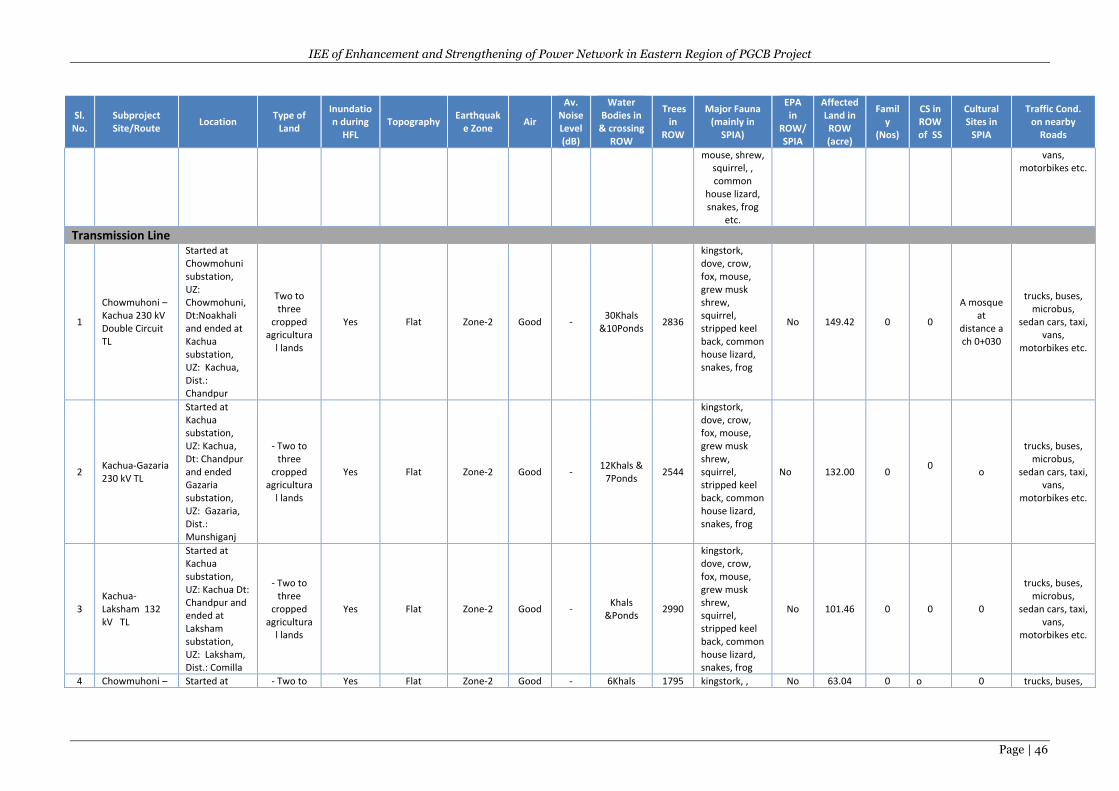
IEE of Enhancement and Strengthening of Power Network in Eastern Region of PGCB Project
Page | 46
Sl. No.
Subproject Site/Route
Location Type of
Land
Inundation during
HFL Topography
Earthquake Zone
Air
Av. Noise Level (dB)
Water Bodies in
& crossing ROW
Trees in
ROW
Major Fauna (mainly in
SPIA)
EPA in
ROW/ SPIA
Affected Land in ROW (acre)
Family
(Nos)
CS in ROW of SS
Cultural Sites in
SPIA
Traffic Cond. on nearby
Roads
mouse, shrew, squirrel, , common
house lizard, snakes, frog
etc.
vans, motorbikes etc.
Transmission Line
1
Chowmuhoni – Kachua 230 kV Double Circuit TL
Started at Chowmohuni substation, UZ: Chowmohuni, Dt:Noakhali and ended at Kachua substation, UZ: Kachua, Dist.: Chandpur
Two to three
cropped agricultura
l lands
Yes Flat Zone-2 Good - 30Khals
&10Ponds 2836
kingstork, dove, crow, fox, mouse, grew musk shrew, squirrel, stripped keel back, common house lizard, snakes, frog
No 149.42 0 0
A mosque at
distance a ch 0+030
trucks, buses, microbus,
sedan cars, taxi, vans,
motorbikes etc.
2 Kachua-Gazaria 230 kV TL
Started at Kachua substation, UZ: Kachua, Dt: Chandpur and ended Gazaria substation, UZ: Gazaria, Dist.: Munshiganj
- Two to three
cropped agricultura
l lands
Yes Flat Zone-2 Good - 12Khals &
7Ponds 2544
kingstork, dove, crow, fox, mouse, grew musk shrew, squirrel, stripped keel back, common house lizard, snakes, frog
No 132.00 0 0
o
trucks, buses, microbus,
sedan cars, taxi, vans,
motorbikes etc.
3 Kachua-Laksham 132 kV TL
Started at Kachua substation, UZ: Kachua Dt: Chandpur and ended at Laksham substation, UZ: Laksham, Dist.: Comilla
- Two to three
cropped agricultura
l lands
Yes Flat Zone-2 Good - Khals
&Ponds 2990
kingstork, dove, crow, fox, mouse, grew musk shrew, squirrel, stripped keel back, common house lizard, snakes, frog
No 101.46 0 0 0
trucks, buses, microbus,
sedan cars, taxi, vans,
motorbikes etc.
4 Chowmuhoni – Started at - Two to Yes Flat Zone-2 Good - 6Khals 1795 kingstork, , No 63.04 0 o 0 trucks, buses,
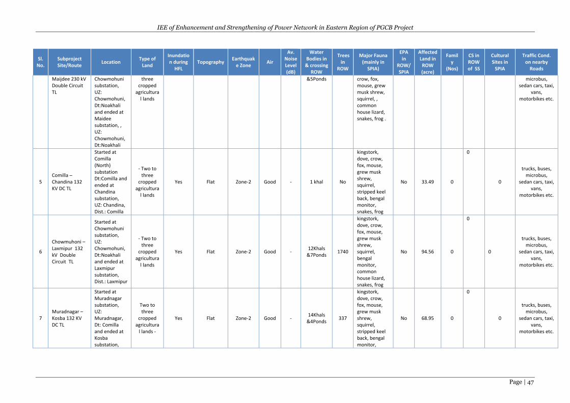
IEE of Enhancement and Strengthening of Power Network in Eastern Region of PGCB Project
Page | 47
Sl. No.
Subproject Site/Route
Location Type of
Land
Inundation during
HFL Topography
Earthquake Zone
Air
Av. Noise Level (dB)
Water Bodies in
& crossing ROW
Trees in
ROW
Major Fauna (mainly in
SPIA)
EPA in
ROW/ SPIA
Affected Land in ROW (acre)
Family
(Nos)
CS in ROW of SS
Cultural Sites in
SPIA
Traffic Cond. on nearby
Roads
Maijdee 230 kV Double Circuit TL
Chowmohuni substation, UZ: Chowmohuni, Dt:Noakhali and ended at Maidee substation, , UZ: Chowmohuni, Dt:Noakhali
three cropped
agricultural lands
&5Ponds crow, fox, mouse, grew musk shrew, squirrel, , common house lizard, snakes, frog .
microbus, sedan cars, taxi,
vans, motorbikes etc.
5 Comilla –Chandina 132 KV DC TL
Started at Comilla (North) substation Dt:Comilla and ended at Chandina substation, UZ: Chandina, Dist.: Comilla
- Two to three
cropped agricultura
l lands
Yes Flat Zone-2 Good - 1 khal No
kingstork, dove, crow, fox, mouse, grew musk shrew, squirrel, stripped keel back, bengal monitor, snakes, frog
No 33.49 0
0
0
trucks, buses, microbus,
sedan cars, taxi, vans,
motorbikes etc.
6
Chowmuhoni – Laxmipur 132 kV Double Circuit TL
Started at Chowmohuni substation, UZ: Chowmohuni, Dt:Noakhali and ended at Laxmipur substation, Dist.: Laxmipur
- Two to three
cropped agricultura
l lands
Yes Flat Zone-2 Good - 12Khals
&7Ponds 1740
kingstork, dove, crow, fox, mouse, grew musk shrew, squirrel, bengal monitor, common house lizard, snakes, frog
No 94.56 0
0
0
trucks, buses, microbus,
sedan cars, taxi, vans,
motorbikes etc.
7 Muradnagar – Kosba 132 KV DC TL
Started at Muradnagar substation, UZ: Muradnagar, Dt: Comilla and ended at Kosba substation,
Two to three
cropped agricultura
l lands -
Yes Flat Zone-2 Good - 14Khals
&4Ponds 337
kingstork, dove, crow, fox, mouse, grew musk shrew, squirrel, stripped keel back, bengal monitor,
No 68.95 0
0
0
trucks, buses, microbus,
sedan cars, taxi, vans,
motorbikes etc.
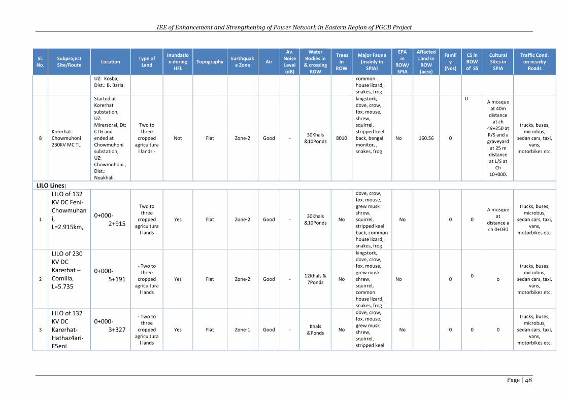
IEE of Enhancement and Strengthening of Power Network in Eastern Region of PGCB Project
Page | 48
Sl. No.
Subproject Site/Route
Location Type of
Land
Inundation during
HFL Topography
Earthquake Zone
Air
Av. Noise Level (dB)
Water Bodies in
& crossing ROW
Trees in
ROW
Major Fauna (mainly in
SPIA)
EPA in
ROW/ SPIA
Affected Land in ROW (acre)
Family
(Nos)
CS in ROW of SS
Cultural Sites in
SPIA
Traffic Cond. on nearby
Roads
UZ: Kosba, Dist.: B. Baria.
common house lizard, snakes, frog
8 Korerhat- Chowmuhoni 230KV MC TL
Started at Korerhat substation, UZ: Mirersorai, Dt: CTG and ended at Chowmuhoni substation, UZ: Chowmuhoni , Dist.: Noakhali.
Two to three
cropped agricultura
l lands -
Not Flat Zone-2 Good - 30Khals
&10Ponds 8010
kingstork, dove, crow, fox, mouse, shrew, squirrel, stripped keel back, bengal monitor, , snakes, frog
No 160.56 0
0 A mosque
at 40m distance
at ch 49+250 at R/S and a graveyard
at 25 m distance at L/S at
Ch 10+000.
trucks, buses, microbus,
sedan cars, taxi, vans,
motorbikes etc.
LILO Lines:
1
LILO of 132 KV DC Feni-Chowmuhani, L=2.915km,
0+000-2+915
Two to three
cropped agricultura
l lands
Yes Flat Zone-2 Good - 30Khals
&10Ponds No
dove, crow, fox, mouse, grew musk shrew, squirrel, stripped keel back, common house lizard, snakes, frog
No 0 0
A mosque at
distance a ch 0+030
trucks, buses, microbus,
sedan cars, taxi, vans,
motorbikes etc.
2
LILO of 230 KV DC Karerhat –Comilla, L=5.735
0+000-5+191
- Two to three
cropped agricultura
l lands
Yes Flat Zone-2 Good - 12Khals &
7Ponds No
kingstork, dove, crow, fox, mouse, grew musk shrew, squirrel, common house lizard, snakes, frog
No 0 0
o
trucks, buses, microbus,
sedan cars, taxi, vans,
motorbikes etc.
3
LILO of 132 KV DC Karerhat-Hathaz4ari-F5eni
0+000-3+327
- Two to three
cropped agricultura
l lands
Yes Flat Zone-1 Good - Khals
&Ponds No
dove, crow, fox, mouse, grew musk shrew, squirrel, stripped keel
No 0 0 0
trucks, buses, microbus,
sedan cars, taxi, vans,
motorbikes etc.
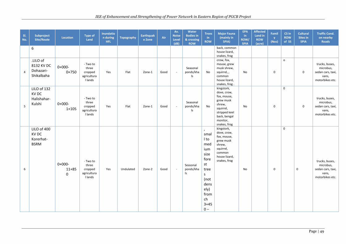
IEE of Enhancement and Strengthening of Power Network in Eastern Region of PGCB Project
Page | 49
Sl. No.
Subproject Site/Route
Location Type of
Land
Inundation during
HFL Topography
Earthquake Zone
Air
Av. Noise Level (dB)
Water Bodies in
& crossing ROW
Trees in
ROW
Major Fauna (mainly in
SPIA)
EPA in
ROW/ SPIA
Affected Land in ROW (acre)
Family
(Nos)
CS in ROW of SS
Cultural Sites in
SPIA
Traffic Cond. on nearby
Roads
6 back, common house lizard, snakes, frog
4
.LILO of 8132 KV DC Dohazari- Shikalbaha
0+000-0+750
- Two to three
cropped agricultura
l lands
Yes Flat Zone-1 Good - Seasonal
ponds/khals
No
crow, fox, mouse, grew musk shrew, squirrel, , common house lizard, snakes, frog .
No 0
o
0
trucks, buses, microbus,
sedan cars, taxi, vans,
motorbikes etc.
5
LILO of 132 KV DC Halishahar-Kulshi 0+000-
1+105
- Two to three
cropped agricultura
l lands
Yes Flat Zone-1 Good - Seasonal
ponds/khals
No
kingstork, dove, crow, fox, mouse, grew musk shrew, squirrel, stripped keel back, bengal monitor, snakes, frog
No 0
0
0
trucks, buses, microbus,
sedan cars, taxi, vans,
motorbikes etc.
6
LILO of 400 KV DC Korerhat-BSRM
0+000-11+850
- Two to three
cropped agricultura
l lands
Yes Undulated Zone-2 Good - Seasonal ponds/khals
, small to medium size forest trees (not densely) from ch 3+450 –
kingstork, dove, crow, fox, mouse, grew musk shrew, squirrel, common house lizard, snakes, frog
No 0
0
0
trucks, buses, microbus,
sedan cars, taxi, vans,
motorbikes etc.
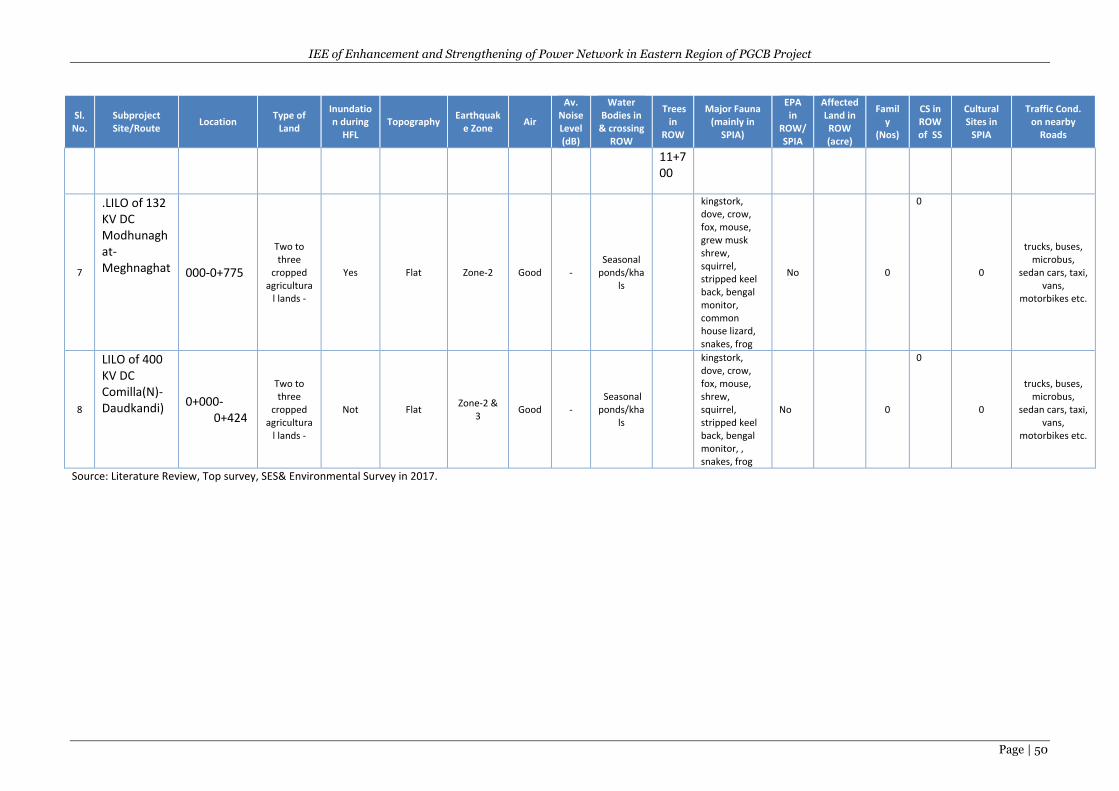
IEE of Enhancement and Strengthening of Power Network in Eastern Region of PGCB Project
Page | 50
Sl. No.
Subproject Site/Route
Location Type of
Land
Inundation during
HFL Topography
Earthquake Zone
Air
Av. Noise Level (dB)
Water Bodies in
& crossing ROW
Trees in
ROW
Major Fauna (mainly in
SPIA)
EPA in
ROW/ SPIA
Affected Land in ROW (acre)
Family
(Nos)
CS in ROW of SS
Cultural Sites in
SPIA
Traffic Cond. on nearby
Roads
11+700
7
.LILO of 132 KV DC Modhunaghat-Meghnaghat
000-0+775
Two to three
cropped agricultura
l lands -
Yes Flat Zone-2 Good - Seasonal
ponds/khals
kingstork, dove, crow, fox, mouse, grew musk shrew, squirrel, stripped keel back, bengal monitor, common house lizard, snakes, frog
No 0
0
0
trucks, buses, microbus,
sedan cars, taxi, vans,
motorbikes etc.
8
LILO of 400 KV DC Comilla(N)-Daudkandi) 0+000-
0+424
Two to three
cropped agricultura
l lands -
Not Flat Zone-2 &
3 Good -
Seasonal ponds/kha
ls
kingstork, dove, crow, fox, mouse, shrew, squirrel, stripped keel back, bengal monitor, , snakes, frog
No 0
0
0
trucks, buses, microbus,
sedan cars, taxi, vans,
motorbikes etc.
Source: Literature Review, Top survey, SES& Environmental Survey in 2017.
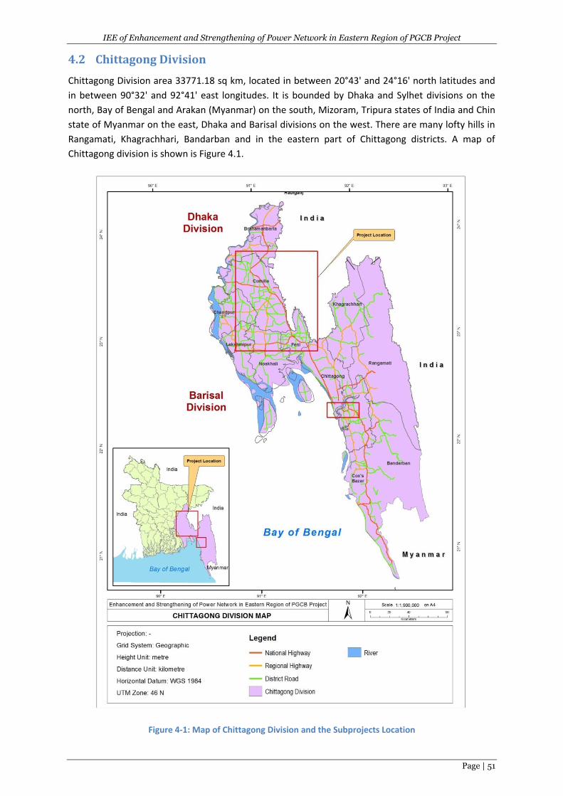
IEE of Enhancement and Strengthening of Power Network in Eastern Region of PGCB Project
Page | 51
4.2 Chittagong Division
Chittagong Division area 33771.18 sq km, located in between 20°43' and 24°16' north latitudes and
in between 90°32' and 92°41' east longitudes. It is bounded by Dhaka and Sylhet divisions on the
north, Bay of Bengal and Arakan (Myanmar) on the south, Mizoram, Tripura states of India and Chin
state of Myanmar on the east, Dhaka and Barisal divisions on the west. There are many lofty hills in
Rangamati, Khagrachhari, Bandarban and in the eastern part of Chittagong districts. A map of
Chittagong division is shown is Figure 4.1.
Figure 4-1: Map of Chittagong Division and the Subprojects Location
IEE of Enhancement and Strengthening of Power Network in Eastern Region of PGCB Project
Page | 52
4.3 Physical Environment
4.3.1 Climate
The Project area has a tropical monsoon climate with four seasons: dry or winter season (December–
February); pre-monsoon or hot season (March–May); monsoon or rainy season (June–September);
and post–monsoon or autumn season (October–November). Although less than half of Bangladesh
lies within the tropics, the presence of the Himalaya mountain range has created a tropical
macroclimate across most of the east Bengal land mass. Bangladesh can be divided into seven
climatic zones. According to the classification, the project areas are located in the south-central and
south-eastern region climatic zones (Figure 4.2).
South-Central Zone: In this zone rainfall is abundant, being above 1,900 mm. The range of
temperature is, as can be expected, much less than to the west, but somewhat more than in South-
eastern zone. This is a transitory zone between the South-eastern, North-western and South-
western zones and most of the severe hail storms, nor'westers and tornadoes are recorded in this
area.
South-Eastern Zone: It comprises the Chittagong sub-region and a strip of land extending from
southwest Sundarbans to the south of Comilla. The hills over 300m in height have north-eastern
zone climate. The rest of the area has a small range of temperature, rarely goes over a mean of 320
°C and below a mean of 130 °C. Rainfall is heavy, usually over 2,540 mm. In winter dew fall is heavy.
Like other parts of the country, the project areas are heavily influenced by the asiatic monsoon, and
it has these three distinct seasons:
Pre-monsoon hot season (from March to May),
Rainy monsoon season (from June to October), and
Cool dry winter season (from November to February).
The pre-monsoon hot season is characterized by high temperatures and thunderstorms. April is the
hottest month in the country with mean temperatures ranging from 27°C in the east and south, to
31°C in the west-central part of the country. After April, increasing cloud-cover reduces the
temperature. Wind direction is variable during this season, especially during the early part. Rainfall,
mostly caused by thunderstorms, at this time can account for 10 to 25 percent of the annual total.
The rainy monsoon season is characterized by southerly or south-westerly winds, very high humidity,
heavy rainfall and long periods of consecutive days of rainfall. The monsoon rain is caused by a
tropical depression that enters the country from the Bay of Bengal. About 90% of the annual
precipitation occurs during the five-month monsoon season from May to September.
The cool dry season is characterized by low temperatures, cool air blowing from the west or
northwest, clear skies and meager rainfall. The average temperature in January varies from 17°C in
the south west and south-eastern parts of the country to 20°C to 21°C in the coastal areas. Minimum
temperatures in the extreme in late December and early January reach even in between 7°C to 8°C.
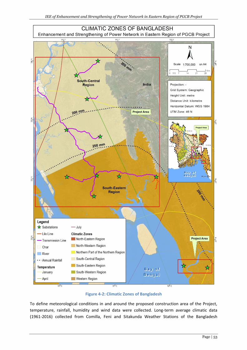
IEE of Enhancement and Strengthening of Power Network in Eastern Region of PGCB Project
Page | 53
Figure 4-2: Climatic Zones of Bangladesh
To define meteorological conditions in and around the proposed construction area of the Project,
temperature, rainfall, humidity and wind data were collected. Long-term average climatic data
(1961-2016) collected from Comilla, Feni and Sitakunda Weather Stations of the Bangladesh
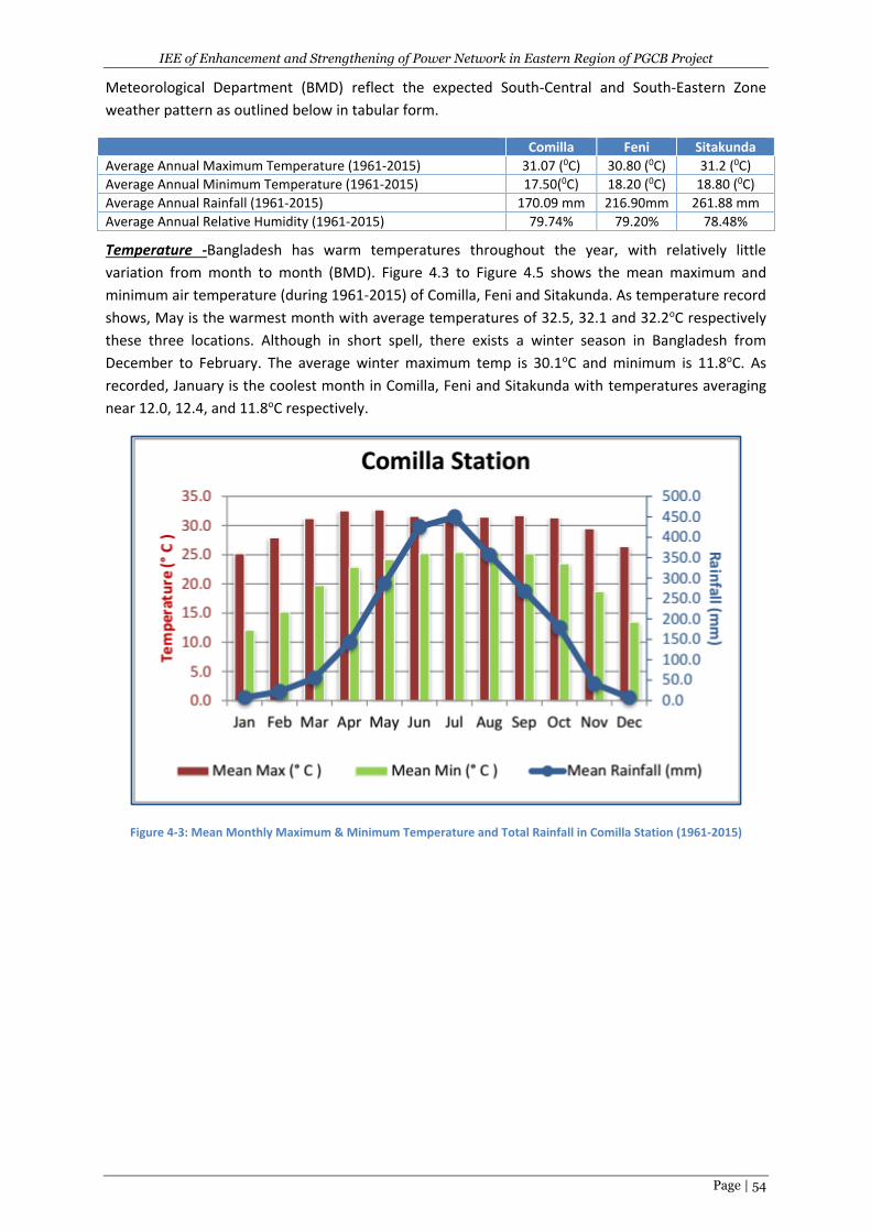
IEE of Enhancement and Strengthening of Power Network in Eastern Region of PGCB Project
Page | 54
Meteorological Department (BMD) reflect the expected South-Central and South-Eastern Zone
weather pattern as outlined below in tabular form.
Comilla Feni Sitakunda
Average Annual Maximum Temperature (1961-2015) 31.07 (0C) 30.80 (0C) 31.2 (0C)
Average Annual Minimum Temperature (1961-2015) 17.50(0C) 18.20 (0C) 18.80 (0C)
Average Annual Rainfall (1961-2015) 170.09 mm 216.90mm 261.88 mm
Average Annual Relative Humidity (1961-2015) 79.74% 79.20% 78.48%
Temperature -Bangladesh has warm temperatures throughout the year, with relatively little
variation from month to month (BMD). Figure 4.3 to Figure 4.5 shows the mean maximum and
minimum air temperature (during 1961-2015) of Comilla, Feni and Sitakunda. As temperature record
shows, May is the warmest month with average temperatures of 32.5, 32.1 and 32.2oC respectively
these three locations. Although in short spell, there exists a winter season in Bangladesh from
December to February. The average winter maximum temp is 30.1oC and minimum is 11.8oC. As
recorded, January is the coolest month in Comilla, Feni and Sitakunda with temperatures averaging
near 12.0, 12.4, and 11.8oC respectively.
Figure 4-3: Mean Monthly Maximum & Minimum Temperature and Total Rainfall in Comilla Station (1961-2015)
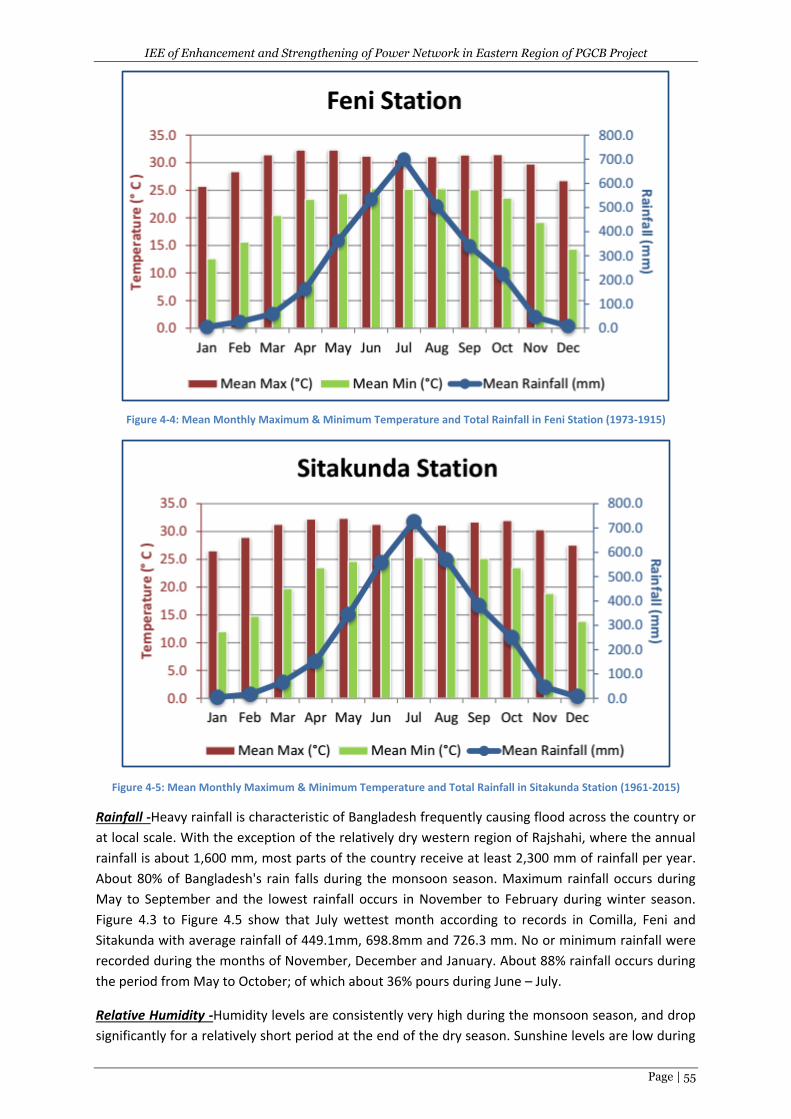
IEE of Enhancement and Strengthening of Power Network in Eastern Region of PGCB Project
Page | 55
Figure 4-4: Mean Monthly Maximum & Minimum Temperature and Total Rainfall in Feni Station (1973-1915)
Figure 4-5: Mean Monthly Maximum & Minimum Temperature and Total Rainfall in Sitakunda Station (1961-2015)
Rainfall -Heavy rainfall is characteristic of Bangladesh frequently causing flood across the country or
at local scale. With the exception of the relatively dry western region of Rajshahi, where the annual
rainfall is about 1,600 mm, most parts of the country receive at least 2,300 mm of rainfall per year.
About 80% of Bangladesh's rain falls during the monsoon season. Maximum rainfall occurs during
May to September and the lowest rainfall occurs in November to February during winter season.
Figure 4.3 to Figure 4.5 show that July wettest month according to records in Comilla, Feni and
Sitakunda with average rainfall of 449.1mm, 698.8mm and 726.3 mm. No or minimum rainfall were
recorded during the months of November, December and January. About 88% rainfall occurs during
the period from May to October; of which about 36% pours during June – July.
Relative Humidity -Humidity levels are consistently very high during the monsoon season, and drop
significantly for a relatively short period at the end of the dry season. Sunshine levels are low during
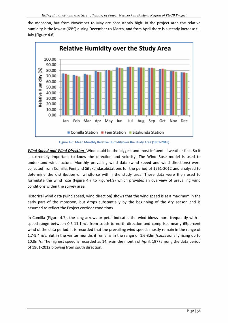
IEE of Enhancement and Strengthening of Power Network in Eastern Region of PGCB Project
Page | 56
the monsoon, but from November to May are consistently high. In the project area the relative
humidity is the lowest (69%) during December to March, and from April there is a steady increase till
July (Figure 4.6).
Figure 4-6: Mean Monthly Relative Humidityover the Study Area (1961-2016)
Wind Speed and Wind Direction -Wind could be the biggest and most influential weather fact. So it
is extremely important to know the direction and velocity. The Wind Rose model is used to
understand wind factors. Monthly prevailing wind data (wind speed and wind directions) were
collected from Comilla, Feni and Sitakundasubstations for the period of 1961-2012 and analysed to
determine the distribution of windforce within the study area. These data were then used to
formulate the wind rose (Figure 4.7 to Figure4.9) which provides an overview of prevailing wind
conditions within the survey area.
Historical wind data (wind speed, wind direction) shows that the wind speed is at a maximum in the
early part of the monsoon, but drops substantially by the beginning of the dry season and is
assumed to reflect the Project corridor conditions.
In Comilla (Figure 4.7), the long arrows or petal indicates the wind blows more frequently with a
speed range between 0.5-11.1m/s from south to north direction and comprises nearly 65percent
wind of the data period. It is recorded that the prevailing wind speeds mostly remain in the range of
1.7-9.4m/s. But in the winter months it remains in the range of 1.6-3.6m/soccasionally rising up to
10.8m/s. The highest speed is recorded as 14m/sin the month of April, 1977among the data period
of 1961-2012 blowing from south direction.
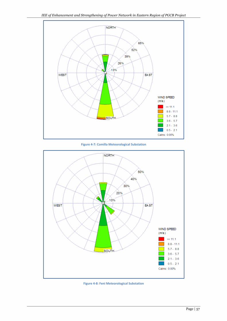
IEE of Enhancement and Strengthening of Power Network in Eastern Region of PGCB Project
Page | 57
Figure 4-7: Comilla Meteorological Substation
Figure 4-8: Feni Meteorological Substation
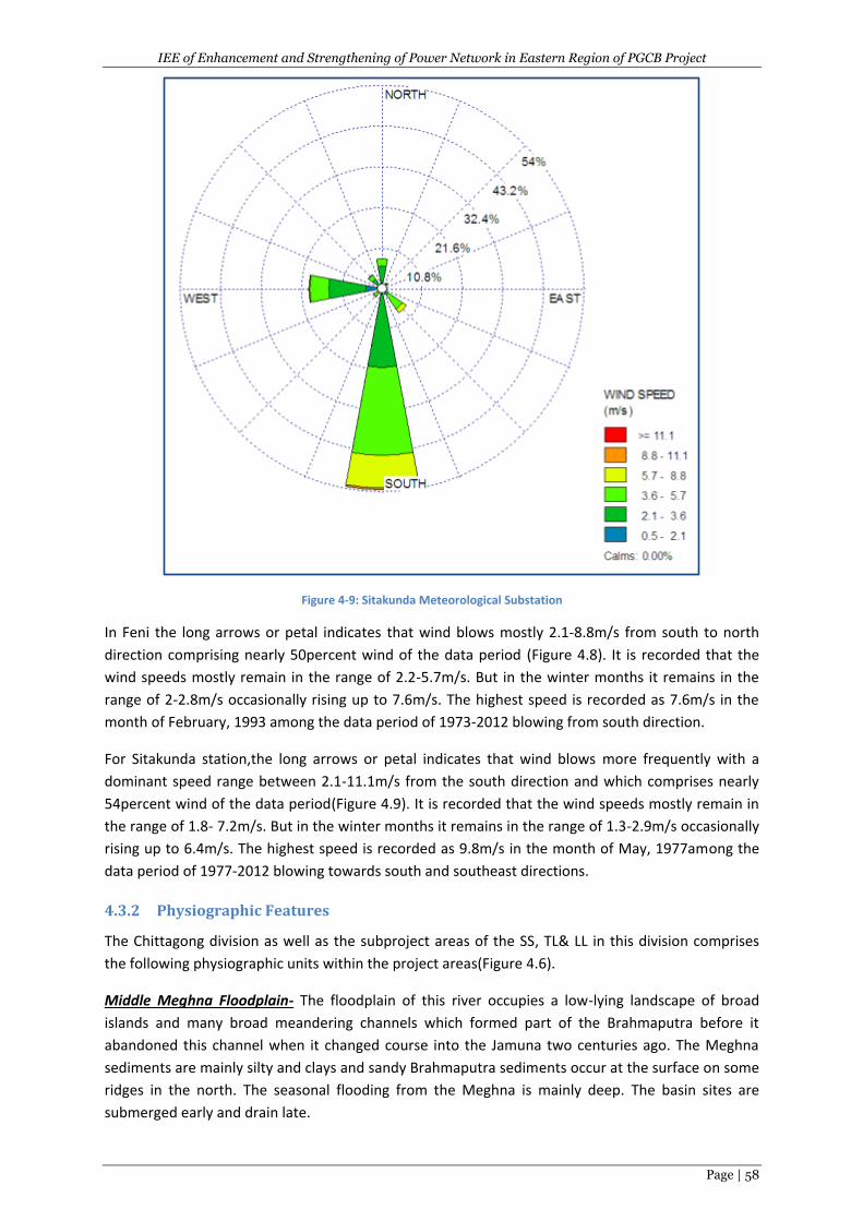
IEE of Enhancement and Strengthening of Power Network in Eastern Region of PGCB Project
Page | 58
Figure 4-9: Sitakunda Meteorological Substation
In Feni the long arrows or petal indicates that wind blows mostly 2.1-8.8m/s from south to north
direction comprising nearly 50percent wind of the data period (Figure 4.8). It is recorded that the
wind speeds mostly remain in the range of 2.2-5.7m/s. But in the winter months it remains in the
range of 2-2.8m/s occasionally rising up to 7.6m/s. The highest speed is recorded as 7.6m/s in the
month of February, 1993 among the data period of 1973-2012 blowing from south direction.
For Sitakunda station,the long arrows or petal indicates that wind blows more frequently with a
dominant speed range between 2.1-11.1m/s from the south direction and which comprises nearly
54percent wind of the data period(Figure 4.9). It is recorded that the wind speeds mostly remain in
the range of 1.8- 7.2m/s. But in the winter months it remains in the range of 1.3-2.9m/s occasionally
rising up to 6.4m/s. The highest speed is recorded as 9.8m/s in the month of May, 1977among the
data period of 1977-2012 blowing towards south and southeast directions.
4.3.2 Physiographic Features
The Chittagong division as well as the subproject areas of the SS, TL& LL in this division comprises
the following physiographic units within the project areas(Figure 4.6).
Middle Meghna Floodplain- The floodplain of this river occupies a low-lying landscape of broad
islands and many broad meandering channels which formed part of the Brahmaputra before it
abandoned this channel when it changed course into the Jamuna two centuries ago. The Meghna
sediments are mainly silty and clays and sandy Brahmaputra sediments occur at the surface on some
ridges in the north. The seasonal flooding from the Meghna is mainly deep. The basin sites are
submerged early and drain late.
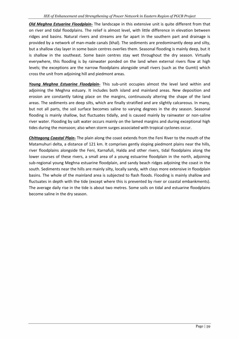
IEE of Enhancement and Strengthening of Power Network in Eastern Region of PGCB Project
Page | 59
Old Meghna Estuarine Floodplain- The landscape in this extensive unit is quite different from that
on river and tidal floodplains. The relief is almost level, with little difference in elevation between
ridges and basins. Natural rivers and streams are far apart in the southern part and drainage is
provided by a network of man-made canals (khal). The sediments are predominantly deep and silty,
but a shallow clay layer in some basin centres overlies them. Seasonal flooding is mainly deep, but it
is shallow in the southeast. Some basin centres stay wet throughout the dry season. Virtually
everywhere, this flooding is by rainwater ponded on the land when external rivers flow at high
levels; the exceptions are the narrow floodplains alongside small rivers (such as the Gumti) which
cross the unit from adjoining hill and piedmont areas.
Young Meghna Estuarine Floodplain- This sub-unit occupies almost the level land within and
adjoining the Meghna estuary. It includes both island and mainland areas. New deposition and
erosion are constantly taking place on the margins, continuously altering the shape of the land
areas. The sediments are deep silts, which are finally stratified and are slightly calcareous. In many,
but not all parts, the soil surface becomes saline to varying degrees in the dry season. Seasonal
flooding is mainly shallow, but fluctuates tidally, and is caused mainly by rainwater or non-saline
river water. Flooding by salt water occurs mainly on the lamed margins and during exceptional high
tides during the monsoon; also when storm surges associated with tropical cyclones occur.
Chittagong Coastal Plain- The plain along the coast extends from the Feni River to the mouth of the
Matamuhuri delta, a distance of 121 km. It comprises gently sloping piedmont plains near the hills,
river floodplains alongside the Feni, Karnafuli, Halda and other rivers, tidal floodplains along the
lower courses of these rivers, a small area of a young estuarine floodplain in the north, adjoining
sub-regional young Meghna estuarine floodplain, and sandy beach ridges adjoining the coast in the
south. Sediments near the hills are mainly silty, locally sandy, with clays more extensive in floodplain
basins. The whole of the mainland area is subjected to flash floods. Flooding is mainly shallow and
fluctuates in depth with the tide (except where this is prevented by river or coastal embankments).
The average daily rise in the tide is about two metres. Some soils on tidal and estuarine floodplains
become saline in the dry season.
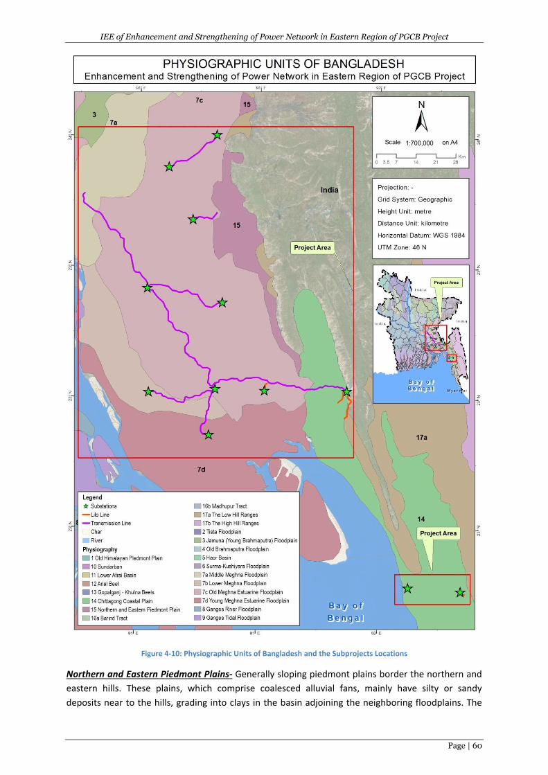
IEE of Enhancement and Strengthening of Power Network in Eastern Region of PGCB Project
Page | 60
Figure 4-10: Physiographic Units of Bangladesh and the Subprojects Locations
Northern and Eastern Piedmont Plains- Generally sloping piedmont plains border the northern and
eastern hills. These plains, which comprise coalesced alluvial fans, mainly have silty or sandy
deposits near to the hills, grading into clays in the basin adjoining the neighboring floodplains. The
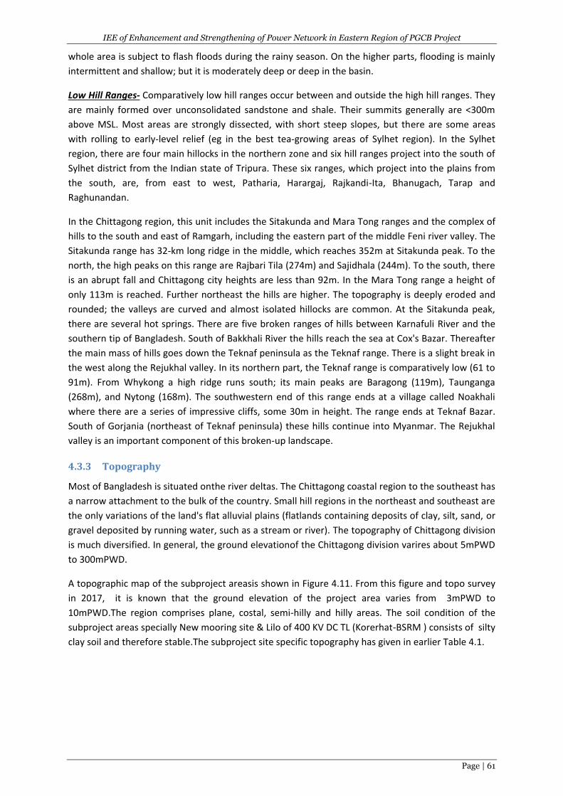
IEE of Enhancement and Strengthening of Power Network in Eastern Region of PGCB Project
Page | 61
whole area is subject to flash floods during the rainy season. On the higher parts, flooding is mainly
intermittent and shallow; but it is moderately deep or deep in the basin.
Low Hill Ranges- Comparatively low hill ranges occur between and outside the high hill ranges. They
are mainly formed over unconsolidated sandstone and shale. Their summits generally are <300m
above MSL. Most areas are strongly dissected, with short steep slopes, but there are some areas
with rolling to early-level relief (eg in the best tea-growing areas of Sylhet region). In the Sylhet
region, there are four main hillocks in the northern zone and six hill ranges project into the south of
Sylhet district from the Indian state of Tripura. These six ranges, which project into the plains from
the south, are, from east to west, Patharia, Harargaj, Rajkandi-Ita, Bhanugach, Tarap and
Raghunandan.
In the Chittagong region, this unit includes the Sitakunda and Mara Tong ranges and the complex of
hills to the south and east of Ramgarh, including the eastern part of the middle Feni river valley. The
Sitakunda range has 32-km long ridge in the middle, which reaches 352m at Sitakunda peak. To the
north, the high peaks on this range are Rajbari Tila (274m) and Sajidhala (244m). To the south, there
is an abrupt fall and Chittagong city heights are less than 92m. In the Mara Tong range a height of
only 113m is reached. Further northeast the hills are higher. The topography is deeply eroded and
rounded; the valleys are curved and almost isolated hillocks are common. At the Sitakunda peak,
there are several hot springs. There are five broken ranges of hills between Karnafuli River and the
southern tip of Bangladesh. South of Bakkhali River the hills reach the sea at Cox's Bazar. Thereafter
the main mass of hills goes down the Teknaf peninsula as the Teknaf range. There is a slight break in
the west along the Rejukhal valley. In its northern part, the Teknaf range is comparatively low (61 to
91m). From Whykong a high ridge runs south; its main peaks are Baragong (119m), Taunganga
(268m), and Nytong (168m). The southwestern end of this range ends at a village called Noakhali
where there are a series of impressive cliffs, some 30m in height. The range ends at Teknaf Bazar.
South of Gorjania (northeast of Teknaf peninsula) these hills continue into Myanmar. The Rejukhal
valley is an important component of this broken-up landscape.
4.3.3 Topography
Most of Bangladesh is situated onthe river deltas. The Chittagong coastal region to the southeast has
a narrow attachment to the bulk of the country. Small hill regions in the northeast and southeast are
the only variations of the land's flat alluvial plains (flatlands containing deposits of clay, silt, sand, or
gravel deposited by running water, such as a stream or river). The topography of Chittagong division
is much diversified. In general, the ground elevationof the Chittagong division varires about 5mPWD
to 300mPWD.
A topographic map of the subproject areasis shown in Figure 4.11. From this figure and topo survey
in 2017, it is known that the ground elevation of the project area varies from 3mPWD to
10mPWD.The region comprises plane, costal, semi-hilly and hilly areas. The soil condition of the
subproject areas specially New mooring site & Lilo of 400 KV DC TL (Korerhat-BSRM ) consists of silty
clay soil and therefore stable.The subproject site specific topography has given in earlier Table 4.1.
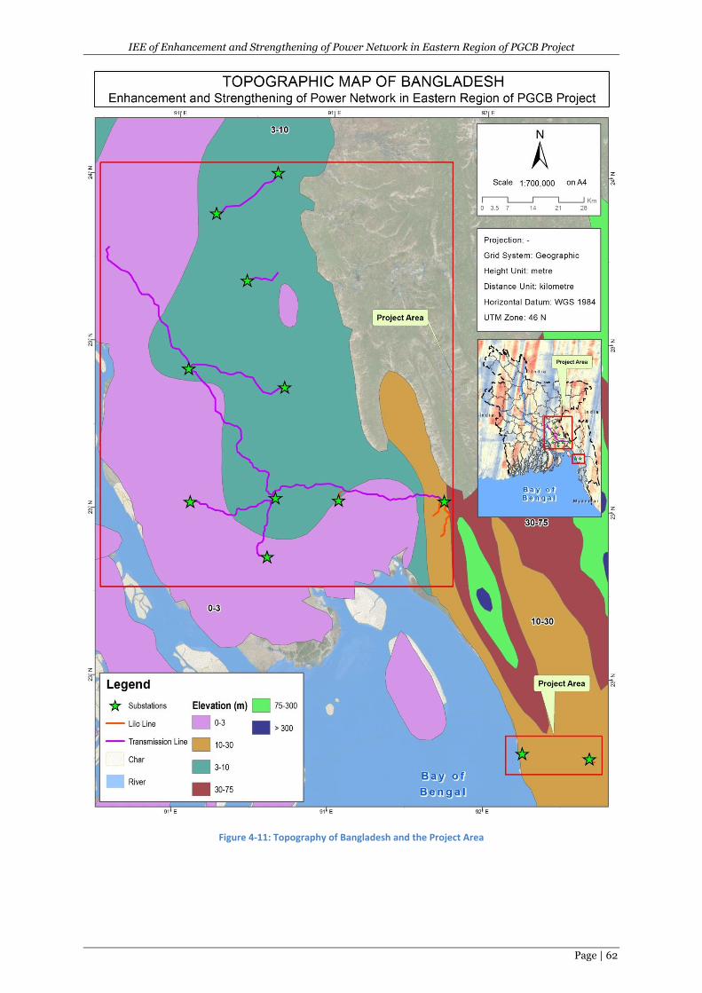
IEE of Enhancement and Strengthening of Power Network in Eastern Region of PGCB Project
Page | 62
Figure 4-11: Topography of Bangladesh and the Project Area
IEE of Enhancement and Strengthening of Power Network in Eastern Region of PGCB Project
Page | 63
4.3.4 Geology
Bangladesh is situated to the east of the Indian sub-continental plate. Nearly 85% of Bangladesh is
underlain by deltaic and alluvial deposits of the Ganges, Brahmaputra, and Meghna river systems.
The project area consists of Holocene alluvial deposits flood plain and predominantly consisting of
fine sand, silts and clay. The site is on deep Cainozoic deposits that overlie Precambrian basement
rock. The Precambrian rocks form the basement of all geological formations of Bengal Basin and
shield areas. The materials deposited are a mixture of sediments transported by the old
Brahmaputra and by the Jamuna (Brahmaputra) River. The generalized geological features of the
project area are shown in the geological map of Bangladesh (Figures 4.12). The majority areas of the
subprojects are under the Barisal GravityHigh. However, some portions are also under the Hatia
Trough and Barisal Gravity High.
4.3.5 Soil
The subprojects’ areasfall in to the ten different soil formation zones (Figure 4.13). The general soil
types of the Chittagong division predominantly include the following:
I. Calcareous Alluvium Soils (saline): The properties of this type of soil are similar to acid
sulphate soils.
II. Non-calcareous Dark Grey & Grey Floodplain Soils: They have a cambic B-horizon, non-
calcareous dark grey topsoil and subsoil. They occur extensively on the Old Brahmaputra and
old Meghna estuarine floodplain. Silt loam and silty clay loam are predominant on the
Meghna estuarine floodplain and in the Tista meander floodplain, whereas silty clays and
heavy clays are extensive on the Old Brahmaputra floodplain. The majority of these soils are
Eutric Gleysols.
III. Non-calcareous Grey Floodplain Soils: Generally, comprise a grey topsoil and a cambic B-
horizon in the subsoil with a grey matrix or grey gleans. They extensively occupy Tista,
Karatoya-Bangali, Jamuna, middle Meghna and eastern Surma-Kushiyara floodplains.
However, there are considerable regional differences in the proportions occupied by
individual soil textures. Silt loam texture is dominant in the Tista meander floodplain
whereas silty clays are predominant in the Ganges tidal floodplain and in the Surma-
Kushiyara floodplain. But the Jamuna floodplain has a more even distribution of silt loam,
silty clay loam and silty clays. Most of these soils have been included in Eutric Gleysols.
IV. Acid Sulphate Soils: Occur predominantly on the Chittagong coastal plain and in minor areas
of the Ganges tidal floodplain. These soils contain sulphidic material, which turns extremely
acid if exposed to air. The soils, which are under Mangrove Forest and flooded by saline tidal
water, are finely stratified soft muddy sediments. But where it has been embanked to
prevent flooding with saline water, the soils of these areas have developed profiles similar to
non-calcareous grey and dark grey floodplain soils with extremely acidic horizon. They are
either Thionic Fluvisols or Thionic Gleysols.
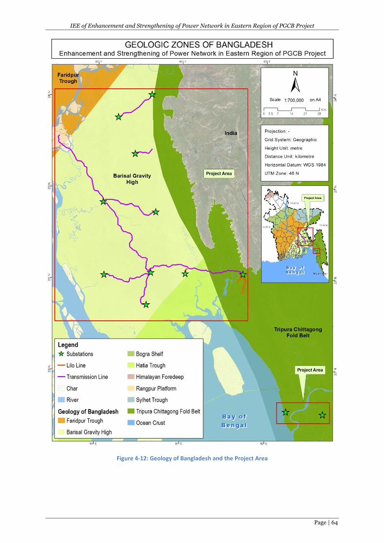
IEE of Enhancement and Strengthening of Power Network in Eastern Region of PGCB Project
Page | 64
Figure 4-12: Geology of Bangladesh and the Project Area
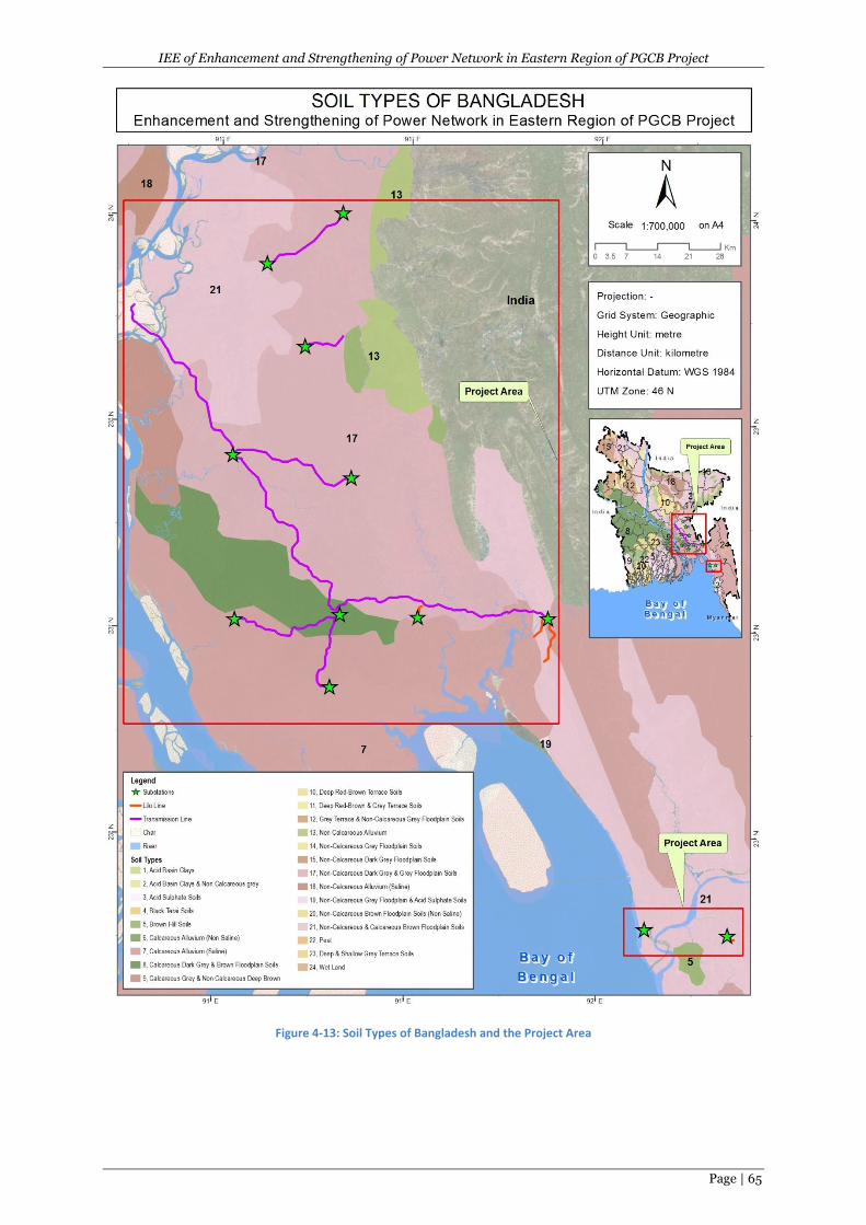
IEE of Enhancement and Strengthening of Power Network in Eastern Region of PGCB Project
Page | 65
Figure 4-13: Soil Types of Bangladesh and the Project Area
IEE of Enhancement and Strengthening of Power Network in Eastern Region of PGCB Project
Page | 66
4.3.6 Agro-ecological Zones
A 1988 study carried out by the United Nations Development Program (UNDP) classified Bangladesh
into a series of Agro-ecological Zones (AEZs) based on an assessment of commonalities in
characteristics such as physiography, soil types, climate and drainage. In total, 34 regions were
identified and characterized, however this information has been updated and further refined on
numerous occasions since the original study was undertaken.
The purpose of assessing the AEZs within the project area is to establish a broad overview of
expected soil conditions which can be compared against more detailed, upazila-level data sources.
The most recent assessment was completed by the Soil Resource Development Institute (SRDI), 1998
which classified Bangladesh into 30 AEZs. The subproject areas contain the following major AEZ
(Figure 4.14):
I. Lower Meghna River Floodplain - This area occupies the transitional area between the
middle Meghna river floodplain and the young Meghna estuarine floodplain. Soils of this
area are relatively uniform, silt loams occupy relatively higher areas and silty clay loams
occupy the depressions. Non-calcareous dark grey floodplain and calcareous grey floodplain
soils are major components of general soil types. Topsoils are moderately acidic and subsoils
neutral in reaction. General fertility level is medium to high with low to medium organic
matter status and K-bearing minerals.
II. Young Meghna Estuarine Floodplain- This region occupies young alluvial land in and
adjoining the Meghna estuary. The major soils are grey to olive, deep calcareous silt loam
and silty clay loams, and are stratified either throughout or at shallow depth. Calcareous
alluvium and non-calcareous grey floodplain soils are the dominant general soil types.
Topsoils and subsoils of the area are mildly alkaline. General fertility is medium but low in N
and organic matter.
III. Old Meghna Estuarine Floodplain- This region occupies a large area, mainly low-lying land
between the south of the Surma-Kushiyara floodplain and the northern edge of the young
Meghna estuarine floodplain. Silt loam soils predominate on highlands and silty clay to clay
on lowlands. Organic matter content of the soils is moderate. Topsoils are moderately acidic,
but subsoils neutral in reaction. General fertility level is medium.
IV. Northern and Eastern Piedmont Plains- This is a discontinuous region occurring as a narrow
strip of land at the foot of the northern and eastern hills. The region comprises merging
alluvial fans which slope gently outward from the foot of the northern and eastern hills into
smooth, low-lying basins. Grey piedmont soils and non-calcareous grey floodplain soils are
the major general soil types of the area. Soils of the area are loams to clays, slightly acidic to
strongly acidic in reaction. General fertility level is low to medium.
V. Chittagong Coastal Plain- This region occupies the plain land in greater Chittagong district
and the eastern part of Feni district. It is a compound unit of piedmont, river, tidal and
estuarine floodplain landscapes. The major problem in these soils is high salinity during the
dry season (October to May). Grey silt loams and silty clay loam soils are predominant. Acid
sulphate soils occur in mangrove tidal floodplains. General fertility level of the soils is
medium, but N and K are limiting. Organic matter content is low to moderate.
VI. Northern and Eastern Hills- This region includes the country's hill areas. Relief is complex.
Hills have been dissected to different degrees over different rocks. In general, slopes are
very steep and few low hills have flat summits. Brown hill soils are the predominant general
soil type of the area. Organic matter content and general fertility level are low.
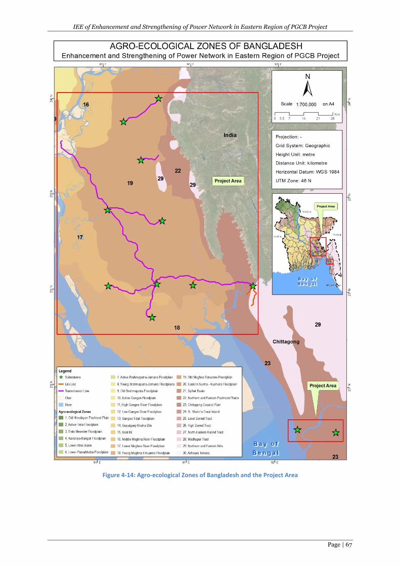
IEE of Enhancement and Strengthening of Power Network in Eastern Region of PGCB Project
Page | 67
Figure 4-14: Agro-ecological Zones of Bangladesh and the Project Area
IEE of Enhancement and Strengthening of Power Network in Eastern Region of PGCB Project
Page | 68
4.3.7 Hydrology/Drainage
The Chittagong division forms with several notable river systems. The Meghna, Matamuhuri, Titas,
Dakatia, Gumti, Feni, Karnafuli, Halda, Bagkhali and Sangu are the major rivers of this division. Some
of the rivers are among the longest river systems in the country and drains significant water of this
area. These rivers are used extensively by the local population as a transport route, irrigation and for
other livelihood activities.
The hydrology of this division is dominated by the Sangu, Bagkhali, Matamuhuri, and Tributary of the
Matamuhuri Rivers, all originating in India and Myanmar. These rivers, especially the Bagkhali,
Matamuhuri and Sangu exhibit flash flooding during heavy monsoon rains. The Bagkhali,
Matamuhuri and Sangu and its tributaries have no or less than 10% of normal flow during the dry
season (November–April), due to withdrawal of water for irrigation by low-lift pumps. Generally,
ponds remain unchanged from year to year due to rejuvenation during the rainy season.
Most of the areas of this division are not flood-prone. However, the area adjacent to the other
divisions is affected to flood every year during monsoon from severe to normal flooding. A flood
map focusing the sub-projects areas is shown in Figure 4.15 and the inundation of the sub-project
sites for the last 30 years ( from 1987-2017) has presented in Table 4.1.
An overview of the surface water bodies and catchments within the Chittagong division is provided
in the following Figure 4.16.
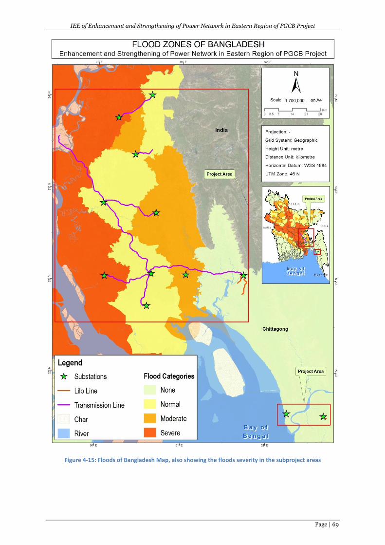
IEE of Enhancement and Strengthening of Power Network in Eastern Region of PGCB Project
Page | 69
Figure 4-15: Floods of Bangladesh Map, also showing the floods severity in the subproject areas
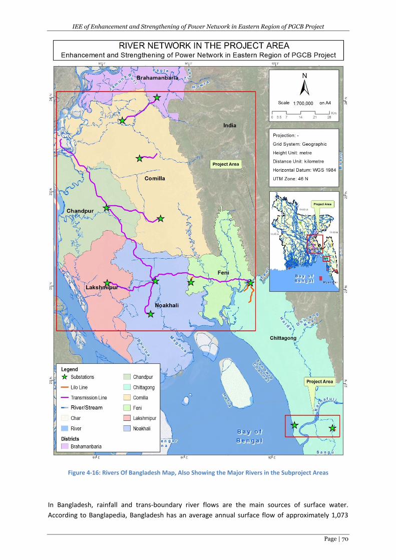
IEE of Enhancement and Strengthening of Power Network in Eastern Region of PGCB Project
Page | 70
Figure 4-16: Rivers Of Bangladesh Map, Also Showing the Major Rivers in the Subproject Areas
In Bangladesh, rainfall and trans-boundary river flows are the main sources of surface water.
According to Banglapedia, Bangladesh has an average annual surface flow of approximately 1,073
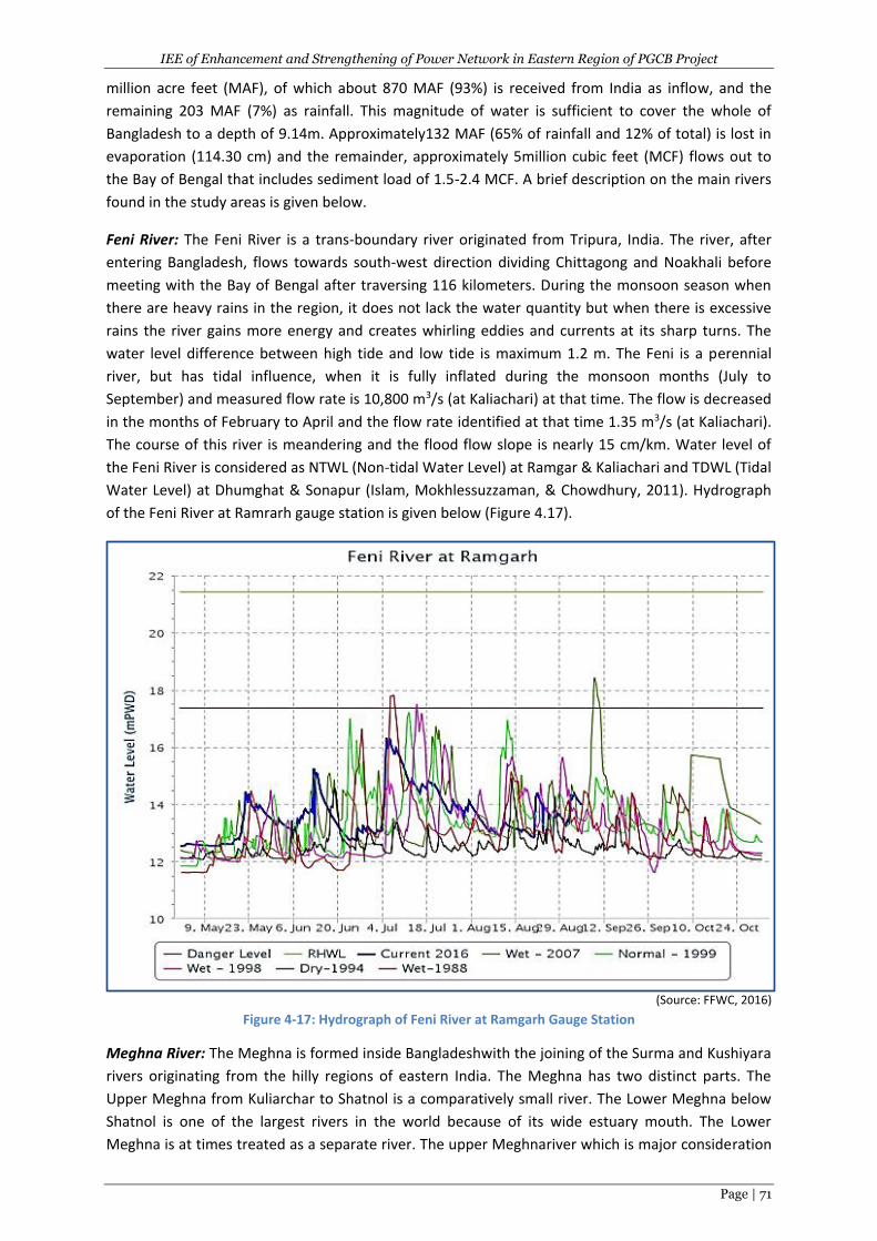
IEE of Enhancement and Strengthening of Power Network in Eastern Region of PGCB Project
Page | 71
million acre feet (MAF), of which about 870 MAF (93%) is received from India as inflow, and the
remaining 203 MAF (7%) as rainfall. This magnitude of water is sufficient to cover the whole of
Bangladesh to a depth of 9.14m. Approximately132 MAF (65% of rainfall and 12% of total) is lost in
evaporation (114.30 cm) and the remainder, approximately 5million cubic feet (MCF) flows out to
the Bay of Bengal that includes sediment load of 1.5-2.4 MCF. A brief description on the main rivers
found in the study areas is given below.
Feni River: The Feni River is a trans-boundary river originated from Tripura, India. The river, after
entering Bangladesh, flows towards south-west direction dividing Chittagong and Noakhali before
meeting with the Bay of Bengal after traversing 116 kilometers. During the monsoon season when
there are heavy rains in the region, it does not lack the water quantity but when there is excessive
rains the river gains more energy and creates whirling eddies and currents at its sharp turns. The
water level difference between high tide and low tide is maximum 1.2 m. The Feni is a perennial
river, but has tidal influence, when it is fully inflated during the monsoon months (July to
September) and measured flow rate is 10,800 m3/s (at Kaliachari) at that time. The flow is decreased
in the months of February to April and the flow rate identified at that time 1.35 m3/s (at Kaliachari).
The course of this river is meandering and the flood flow slope is nearly 15 cm/km. Water level of
the Feni River is considered as NTWL (Non-tidal Water Level) at Ramgar & Kaliachari and TDWL (Tidal
Water Level) at Dhumghat & Sonapur (Islam, Mokhlessuzzaman, & Chowdhury, 2011). Hydrograph
of the Feni River at Ramrarh gauge station is given below (Figure 4.17).
(Source: FFWC, 2016) Figure 4-17: Hydrograph of Feni River at Ramgarh Gauge Station
Meghna River: The Meghna is formed inside Bangladeshwith the joining of the Surma and Kushiyara
rivers originating from the hilly regions of eastern India. The Meghna has two distinct parts. The
Upper Meghna from Kuliarchar to Shatnol is a comparatively small river. The Lower Meghna below
Shatnol is one of the largest rivers in the world because of its wide estuary mouth. The Lower
Meghna is at times treated as a separate river. The upper Meghnariver which is major consideration
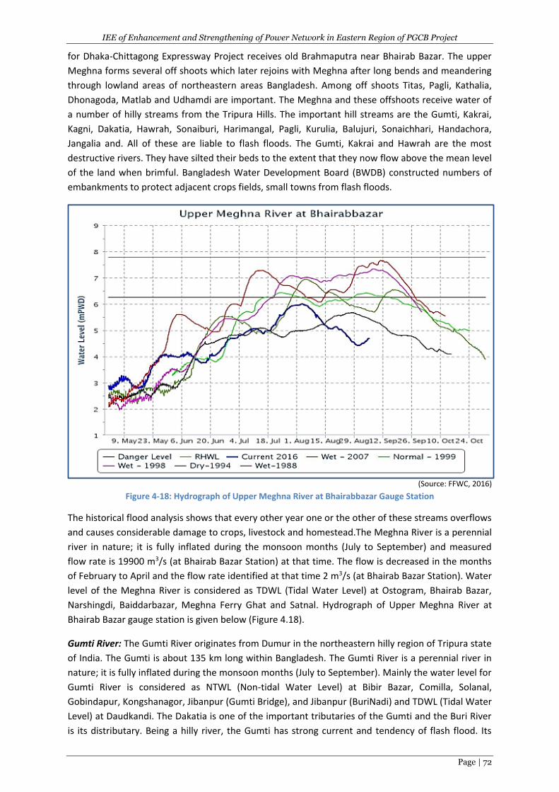
IEE of Enhancement and Strengthening of Power Network in Eastern Region of PGCB Project
Page | 72
for Dhaka-Chittagong Expressway Project receives old Brahmaputra near Bhairab Bazar. The upper
Meghna forms several off shoots which later rejoins with Meghna after long bends and meandering
through lowland areas of northeastern areas Bangladesh. Among off shoots Titas, Pagli, Kathalia,
Dhonagoda, Matlab and Udhamdi are important. The Meghna and these offshoots receive water of
a number of hilly streams from the Tripura Hills. The important hill streams are the Gumti, Kakrai,
Kagni, Dakatia, Hawrah, Sonaiburi, Harimangal, Pagli, Kurulia, Balujuri, Sonaichhari, Handachora,
Jangalia and. All of these are liable to flash floods. The Gumti, Kakrai and Hawrah are the most
destructive rivers. They have silted their beds to the extent that they now flow above the mean level
of the land when brimful. Bangladesh Water Development Board (BWDB) constructed numbers of
embankments to protect adjacent crops fields, small towns from flash floods.
(Source: FFWC, 2016) Figure 4-18: Hydrograph of Upper Meghna River at Bhairabbazar Gauge Station
The historical flood analysis shows that every other year one or the other of these streams overflows
and causes considerable damage to crops, livestock and homestead.The Meghna River is a perennial
river in nature; it is fully inflated during the monsoon months (July to September) and measured
flow rate is 19900 m3/s (at Bhairab Bazar Station) at that time. The flow is decreased in the months
of February to April and the flow rate identified at that time 2 m3/s (at Bhairab Bazar Station). Water
level of the Meghna River is considered as TDWL (Tidal Water Level) at Ostogram, Bhairab Bazar,
Narshingdi, Baiddarbazar, Meghna Ferry Ghat and Satnal. Hydrograph of Upper Meghna River at
Bhairab Bazar gauge station is given below (Figure 4.18).
Gumti River: The Gumti River originates from Dumur in the northeastern hilly region of Tripura state
of India. The Gumti is about 135 km long within Bangladesh. The Gumti River is a perennial river in
nature; it is fully inflated during the monsoon months (July to September). Mainly the water level for
Gumti River is considered as NTWL (Non-tidal Water Level) at Bibir Bazar, Comilla, Solanal,
Gobindapur, Kongshanagor, Jibanpur (Gumti Bridge), and Jibanpur (BuriNadi) and TDWL (Tidal Water
Level) at Daudkandi. The Dakatia is one of the important tributaries of the Gumti and the Buri River
is its distributary. Being a hilly river, the Gumti has strong current and tendency of flash flood. Its
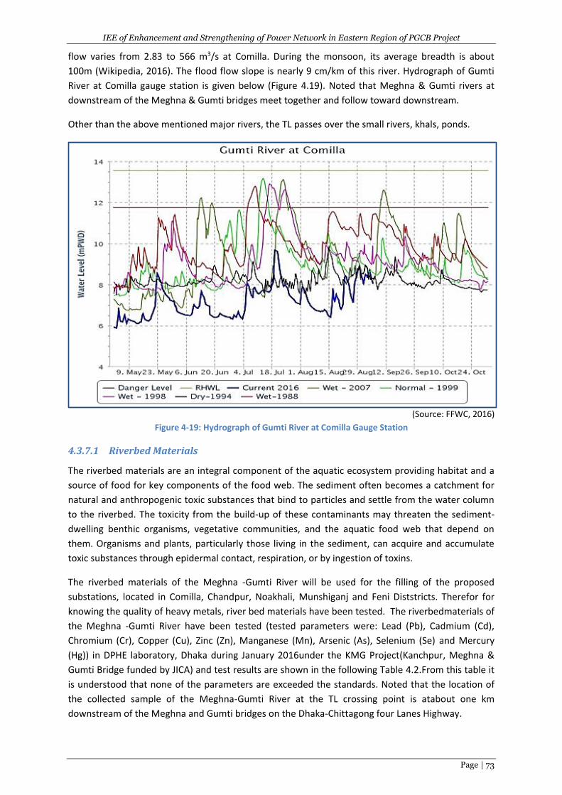
IEE of Enhancement and Strengthening of Power Network in Eastern Region of PGCB Project
Page | 73
flow varies from 2.83 to 566 m3/s at Comilla. During the monsoon, its average breadth is about
100m (Wikipedia, 2016). The flood flow slope is nearly 9 cm/km of this river. Hydrograph of Gumti
River at Comilla gauge station is given below (Figure 4.19). Noted that Meghna & Gumti rivers at
downstream of the Meghna & Gumti bridges meet together and follow toward downstream.
Other than the above mentioned major rivers, the TL passes over the small rivers, khals, ponds.
(Source: FFWC, 2016)
Figure 4-19: Hydrograph of Gumti River at Comilla Gauge Station
4.3.7.1 Riverbed Materials
The riverbed materials are an integral component of the aquatic ecosystem providing habitat and a
source of food for key components of the food web. The sediment often becomes a catchment for
natural and anthropogenic toxic substances that bind to particles and settle from the water column
to the riverbed. The toxicity from the build-up of these contaminants may threaten the sediment-
dwelling benthic organisms, vegetative communities, and the aquatic food web that depend on
them. Organisms and plants, particularly those living in the sediment, can acquire and accumulate
toxic substances through epidermal contact, respiration, or by ingestion of toxins.
The riverbed materials of the Meghna -Gumti River will be used for the filling of the proposed
substations, located in Comilla, Chandpur, Noakhali, Munshiganj and Feni Diststricts. Therefor for
knowing the quality of heavy metals, river bed materials have been tested. The riverbedmaterials of
the Meghna -Gumti River have been tested (tested parameters were: Lead (Pb), Cadmium (Cd),
Chromium (Cr), Copper (Cu), Zinc (Zn), Manganese (Mn), Arsenic (As), Selenium (Se) and Mercury
(Hg)) in DPHE laboratory, Dhaka during January 2016under the KMG Project(Kanchpur, Meghna &
Gumti Bridge funded by JICA) and test results are shown in the following Table 4.2.From this table it
is understood that none of the parameters are exceeded the standards. Noted that the location of
the collected sample of the Meghna-Gumti River at the TL crossing point is atabout one km
downstream of the Meghna and Gumti bridges on the Dhaka-Chittagong four Lanes Highway.
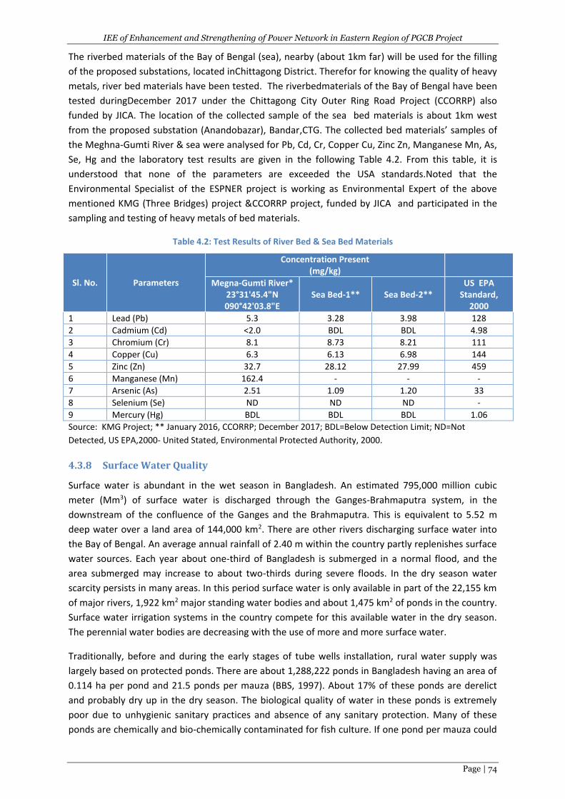
IEE of Enhancement and Strengthening of Power Network in Eastern Region of PGCB Project
Page | 74
The riverbed materials of the Bay of Bengal (sea), nearby (about 1km far) will be used for the filling
of the proposed substations, located inChittagong District. Therefor for knowing the quality of heavy
metals, river bed materials have been tested. The riverbedmaterials of the Bay of Bengal have been
tested duringDecember 2017 under the Chittagong City Outer Ring Road Project (CCORRP) also
funded by JICA. The location of the collected sample of the sea bed materials is about 1km west
from the proposed substation (Anandobazar), Bandar,CTG. The collected bed materials’ samples of
the Meghna-Gumti River & sea were analysed for Pb, Cd, Cr, Copper Cu, Zinc Zn, Manganese Mn, As,
Se, Hg and the laboratory test results are given in the following Table 4.2. From this table, it is
understood that none of the parameters are exceeded the USA standards.Noted that the
Environmental Specialist of the ESPNER project is working as Environmental Expert of the above
mentioned KMG (Three Bridges) project &CCORRP project, funded by JICA and participated in the
sampling and testing of heavy metals of bed materials.
Table 4.2: Test Results of River Bed & Sea Bed Materials
Sl. No. Parameters
Concentration Present (mg/kg)
Megna-Gumti River* 23°31'45.4"N 090°42'03.8"E
Sea Bed-1** Sea Bed-2** US EPA
Standard, 2000
1 Lead (Pb) 5.3 3.28 3.98 128
2 Cadmium (Cd) <2.0 BDL BDL 4.98
3 Chromium (Cr) 8.1 8.73 8.21 111
4 Copper (Cu) 6.3 6.13 6.98 144
5 Zinc (Zn) 32.7 28.12 27.99 459
6 Manganese (Mn) 162.4 - - -
7 Arsenic (As) 2.51 1.09 1.20 33
8 Selenium (Se) ND ND ND -
9 Mercury (Hg) BDL BDL BDL 1.06
Source: KMG Project; ** January 2016, CCORRP; December 2017; BDL=Below Detection Limit; ND=Not
Detected, US EPA,2000- United Stated, Environmental Protected Authority, 2000.
4.3.8 Surface Water Quality
Surface water is abundant in the wet season in Bangladesh. An estimated 795,000 million cubic
meter (Mm3) of surface water is discharged through the Ganges-Brahmaputra system, in the
downstream of the confluence of the Ganges and the Brahmaputra. This is equivalent to 5.52 m
deep water over a land area of 144,000 km2. There are other rivers discharging surface water into
the Bay of Bengal. An average annual rainfall of 2.40 m within the country partly replenishes surface
water sources. Each year about one-third of Bangladesh is submerged in a normal flood, and the
area submerged may increase to about two-thirds during severe floods. In the dry season water
scarcity persists in many areas. In this period surface water is only available in part of the 22,155 km
of major rivers, 1,922 km2 major standing water bodies and about 1,475 km2 of ponds in the country.
Surface water irrigation systems in the country compete for this available water in the dry season.
The perennial water bodies are decreasing with the use of more and more surface water.
Traditionally, before and during the early stages of tube wells installation, rural water supply was
largely based on protected ponds. There are about 1,288,222 ponds in Bangladesh having an area of
0.114 ha per pond and 21.5 ponds per mauza (BBS, 1997). About 17% of these ponds are derelict
and probably dry up in the dry season. The biological quality of water in these ponds is extremely
poor due to unhygienic sanitary practices and absence of any sanitary protection. Many of these
ponds are chemically and bio-chemically contaminated for fish culture. If one pond per mauza could
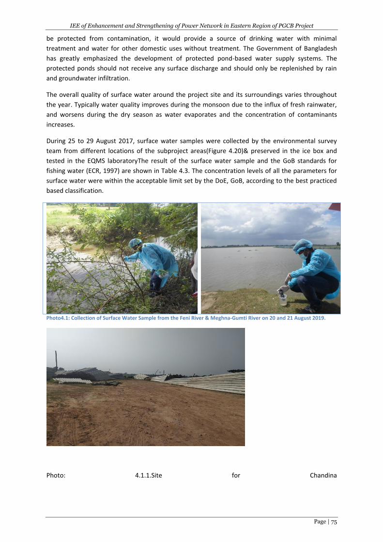
IEE of Enhancement and Strengthening of Power Network in Eastern Region of PGCB Project
Page | 75
be protected from contamination, it would provide a source of drinking water with minimal
treatment and water for other domestic uses without treatment. The Government of Bangladesh
has greatly emphasized the development of protected pond-based water supply systems. The
protected ponds should not receive any surface discharge and should only be replenished by rain
and groundwater infiltration.
The overall quality of surface water around the project site and its surroundings varies throughout
the year. Typically water quality improves during the monsoon due to the influx of fresh rainwater,
and worsens during the dry season as water evaporates and the concentration of contaminants
increases.
During 25 to 29 August 2017, surface water samples were collected by the environmental survey
team from different locations of the subproject areas(Figure 4.20)& preserved in the ice box and
tested in the EQMS laboratoryThe result of the surface water sample and the GoB standards for
fishing water (ECR, 1997) are shown in Table 4.3. The concentration levels of all the parameters for
surface water were within the acceptable limit set by the DoE, GoB, according to the best practiced
based classification.
Photo4.1: Collection of Surface Water Sample from the Feni River & Meghna-Gumti River on 20 and 21 August 2019.
Photo: 4.1.1.Site for Chandina
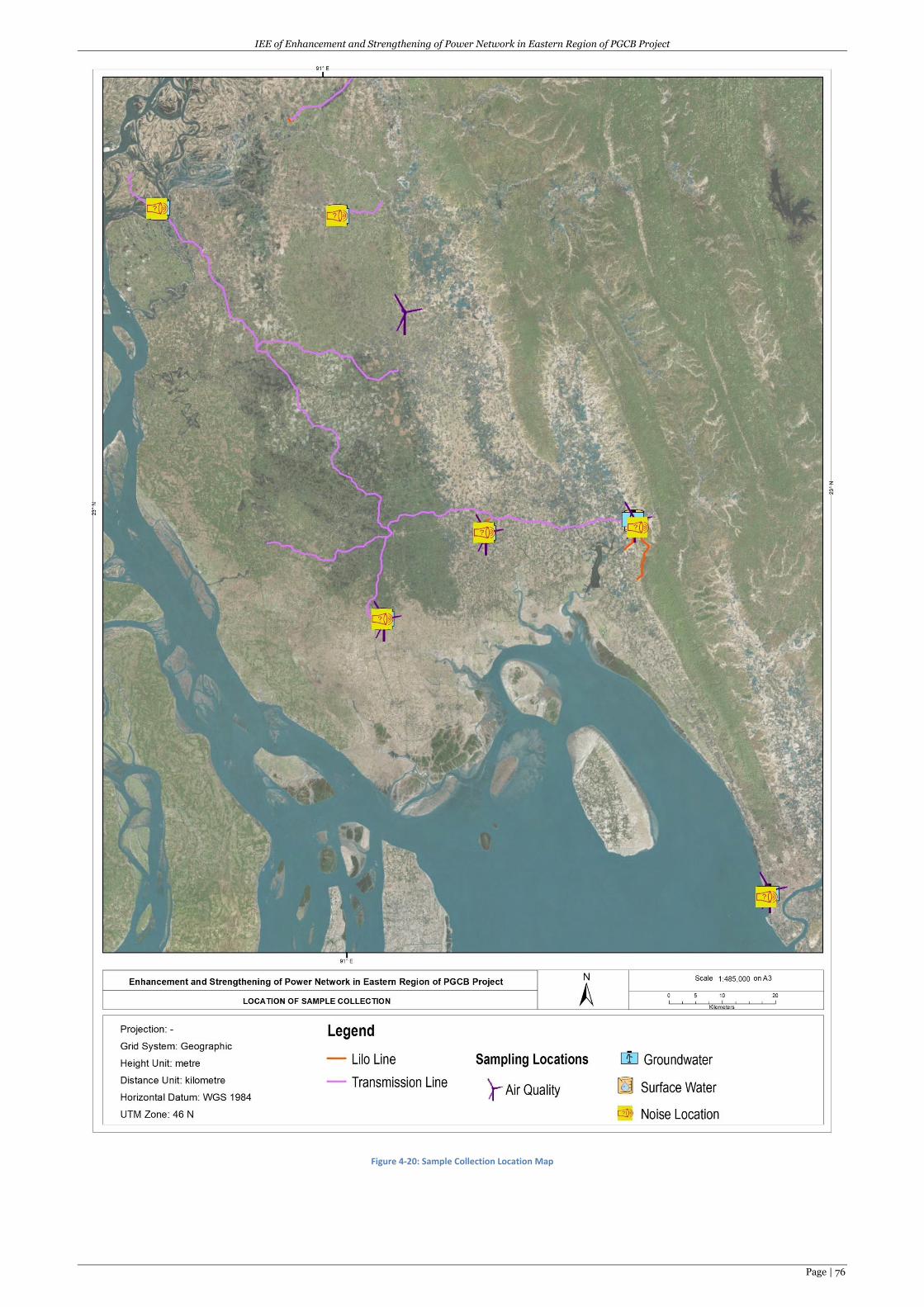
IEE of Enhancement and Strengthening of Power Network in Eastern Region of PGCB Project
Page | 76
Figure 4-20: Sample Collection Location Map
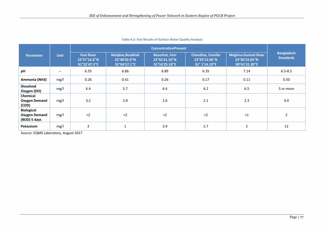
IEE of Enhancement and Strengthening of Power Network in Eastern Region of PGCB Project
Page | 77
Table 4.3: Test Results of Surface Water Quality Analysis
Parameter Unit
ConcentrationPresent Bangladesh Standards
Feni River 22°57'16.6"N 91°32'47.3"E
Maijdee,Noakhali 22°48'02.0"N 91°04'57.1"E
Basurhat, Feni 22°56'31.10"N 91°16'25.10"E
Chandina, Comilla 23°29'13.06"N 91° 1'14.19"E
Meghna-Gumoti River 23°30'19.65"N 90°41'31.30"E
pH -- 6.35 6.86 6.89 6.35 7.14 6.5-8.5
Ammonia (NH3) mg/l 0.26 0.41 0.26 0.17 0.11 0.50
Dissolved Oxygen (DO)
mg/l 6.4 5.7 6.4 6.2 6.5 5 or more
Chemical Oxygen Demand (COD)
mg/l 3.2 2.8 2.6 2.1 2.3 4.0
Biological Oxygen Demand (BOD) 5 days
mg/l <2 <2 <2 <2 <1 2
Potassium mg/l 3 1 3.9 2.7 2 12
Source: EQMS Laboratory, August 2017
IEE of Enhancement and Strengthening of Power Network in Eastern Region of PGCB Project
Page | 78
4.3.9 Ground/DrinkingWaterQuality
Groundwater is the most important source of water supply in Bangladesh. Except for few hilly
regions Bangladesh is entirely underlain by water-bearing aquifers at depths varying from zero to 20
m below ground surface. The soil is mostly stratified and formed by alluvial deposits of sand and silt,
having occasional lenses of clay. The main constituent of the aquifer materials is the medium-
grained sand deposited at the lower reach by the mighty rivers - the Ganges, the Brahmaputra and
the Meghna with their tributaries. Groundwater can be easily abstracted by installation of wells for
the development of water supply systems. The water abstracted for various purposes is replenished
in the monsoon.
Physically groundwater is generally clear, colorless with little or no suspended solids and has a
relatively constant temperature. Groundwater is also free from disease-producing micro-organisms
which are normally present in large numbers in surface waters. The slow filtering action of fine-
grained soil through which the surface water percolates to join the groundwater removes almost all
suspended impurities. Moreover, the lack of oxygen and nutrients in groundwater makes it an
unfavorable environment for disease-producing micro-organisms to survive, grow or multiply. On
the other hand, being a universal solvent, water dissolves many of the minerals present in earth’s
crust during its slow travel through the ground. Anaerobic conditions in soils in some flood plains,
and the presence of organic acids and carbon dioxide increase the solubility of groundwater. As a
result, groundwater may contain minerals in varying concentrations depending on soil conditions.
Arsenic contamination of groundwater is believed to be the result of such reactions in the adverse
geo-environment.
In the context of high prevalence of diarrheal diseases in Bangladesh, groundwater received priority
as a source of water supply because it is generally free from pathogenic micro-organisms. Almost all
rural water supplies and most of urban water supplies are groundwater based. Groundwater
collected by tube wells is fit for consumption. Groundwater abstracted from shallow aquifers by
hand tube wells has received acceptance in rural areas for drinking purposes, but due to its high iron
content, hardness, etc. people do not want to use hand tube well water for other domestic purposes
like cooking, bathing and washing. The high iron in groundwater makes the cooked food blackish in
color and produces stains on utensils.
Arsenic is a problem in large part of Bangladesh ground water. The project areas particularly in
Chandpur and Lakshmipur havehigh level of Arsenic in ground water. The acceptable quantity of
arsenic in potable water is 0.05 mg per liter under the Department of Environment standard and
0.01 mg per liter under the WHO standards (Figure 4.21).
Based on field observations and interviews with local residents it was found that groundwater in the
area is used as a drinking water source in many instances, as well as for irrigation purposes. Water is
generally extracted via hand pump (tube wells) from the shallow regions of the composite aquifer,
and via machine-driven pumps (deep tube wells) which draw from the deeper main aquifers. The
ground water reservoir usually recharges from rainfall, floods and river. In summer season, the
water table slightly goes down and goes up in rainy season.
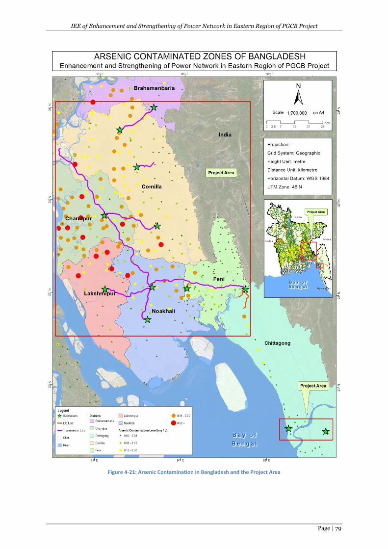
IEE of Enhancement and Strengthening of Power Network in Eastern Region of PGCB Project
Page | 79
Figure 4-21: Arsenic Contamination in Bangladesh and the Project Area
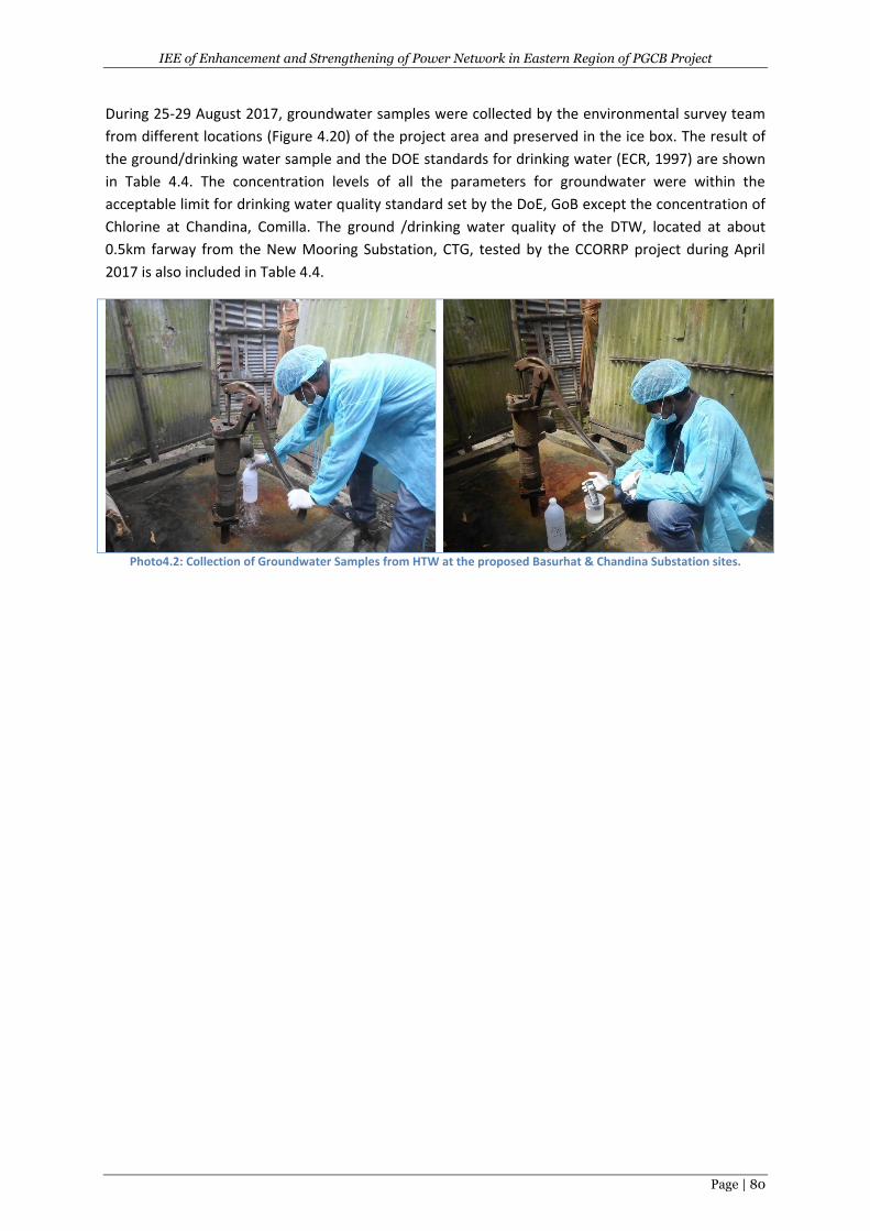
IEE of Enhancement and Strengthening of Power Network in Eastern Region of PGCB Project
Page | 80
During 25-29 August 2017, groundwater samples were collected by the environmental survey team
from different locations (Figure 4.20) of the project area and preserved in the ice box. The result of
the ground/drinking water sample and the DOE standards for drinking water (ECR, 1997) are shown
in Table 4.4. The concentration levels of all the parameters for groundwater were within the
acceptable limit for drinking water quality standard set by the DoE, GoB except the concentration of
Chlorine at Chandina, Comilla. The ground /drinking water quality of the DTW, located at about
0.5km farway from the New Mooring Substation, CTG, tested by the CCORRP project during April
2017 is also included in Table 4.4.
Photo4.2: Collection of Groundwater Samples from HTW at the proposed Basurhat & Chandina Substation sites.
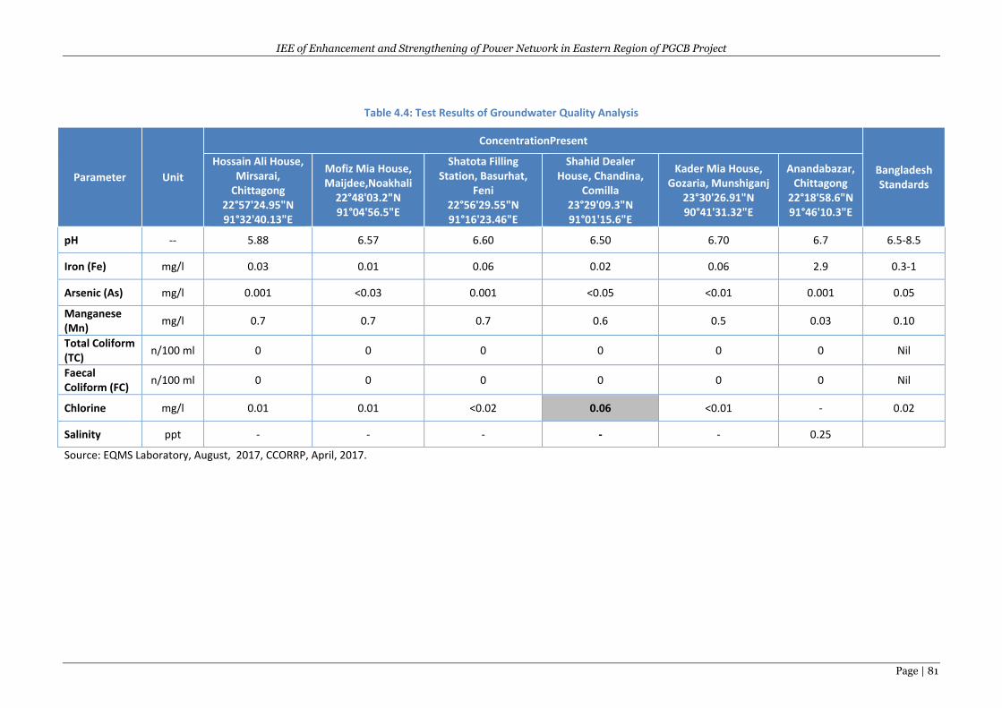
IEE of Enhancement and Strengthening of Power Network in Eastern Region of PGCB Project
Page | 81
Table 4.4: Test Results of Groundwater Quality Analysis
Parameter Unit
ConcentrationPresent
Bangladesh Standards
Hossain Ali House, Mirsarai,
Chittagong 22°57'24.95"N 91°32'40.13"E
Mofiz Mia House, Maijdee,Noakhali
22°48'03.2"N 91°04'56.5"E
Shatota Filling Station, Basurhat,
Feni 22°56'29.55"N 91°16'23.46"E
Shahid Dealer House, Chandina,
Comilla 23°29'09.3"N 91°01'15.6"E
Kader Mia House, Gozaria, Munshiganj
23°30'26.91"N 90°41'31.32"E
Anandabazar, Chittagong
22°18'58.6"N 91°46'10.3"E
pH -- 5.88 6.57 6.60 6.50 6.70 6.7 6.5-8.5
Iron (Fe) mg/l 0.03 0.01 0.06 0.02 0.06 2.9 0.3-1
Arsenic (As) mg/l 0.001 <0.03 0.001 <0.05 <0.01 0.001 0.05
Manganese (Mn)
mg/l 0.7 0.7 0.7 0.6 0.5 0.03 0.10
Total Coliform (TC)
n/100 ml 0 0 0 0 0 0 Nil
Faecal Coliform (FC)
n/100 ml 0 0 0 0 0 0 Nil
Chlorine mg/l 0.01 0.01 <0.02 0.06 <0.01 - 0.02
Salinity ppt - - - - - 0.25
Source: EQMS Laboratory, August, 2017, CCORRP, April, 2017.
IEE of Enhancement and Strengthening of Power Network in Eastern Region of PGCB Project
Page | 82
4.3.10 Ambient Air Quality
Within Bangladesh there are two major sources of air pollution: industrial emissions and vehicular
emissions. Industrial sources include power generation, fertilizer factories, mills (sugar, paper, jute
and textile), brick kilns, tanneries, chemical and pharmaceutical industries and the burning of solid
waste. Emissions from these various sources contribute to the formation of the smog that regularly
shrouds the major cities (Rahman et al, 2005).
Pollutants emitted from industrial sources include hydrogen sulfide, ammonia, and chlorine; all of
which can result in health complaints such as skin irritation, headaches and nausea. Sustained
exposure to these pollutants can result in other severe health effects such as severe respiratory
health issues and birth defects (Rahman et al, 2005). In Bangladesh – where some 89% of the
population use solid fuel – air-quality related deaths were estimated to be over 56,000 in 2007 alone
(WHO, 2007). With increasing rates of urbanization, it is anticipated that vehicular ownership and
usage will also increase, leading to a continued decline in air quality. DoE has identified two-stroke
engines as a major polluter, and now discourages their use within Dhaka (Rahman et al, 2005).
Within the rural areas of Bangladesh, the main sources of air pollution are brick kilns and domestic
heating and cooking – with wood, coal, diesel and biofuel (often manure) used as sources of energy
(UNEP, 2002). It is therefore likely in rural areas that the principal air contaminants are particulate
matter and volatile organic compounds (VOCs). Rural areas often also experience problems,
particularly in the dry season, with dust generation due to construction, transport and agricultural
activities such as tilling, threshing and plowing.
Ambient air quality measurements are essential to provide a description of the existing conditions or
the baseline against which changes can be measured and to assist in the determination of potential
impacts of the proposed project. Two hours air quality measurement (except CO) has been
conducted during 25 to 29 August 2017at the various locations of the subprojects by using LATA
ENVIROTECH PM 250 (Combined P10/P2.5 Sampler) as an air pollution monitoring equipment
(Figure 4.20) and an analysis of parametrs was done by EQMS Environmental Laboratory. The
measurement results are given in the below Table 4.5-. According to Bangladesh National Ambient
Air Quality Standards from the Environmental Conservation Rules, 1997 which was amended on
19thJuly 2005 vide S.R.O. No. 220-Law/2005; any of the measures parameter of the local ambient air
does not exceed Bangladesh standard.The air quality measurement at Anandabazar under CCORRP,
located at about 0.5km farway from the New Mooring Substation, CTG, mearued by the CCORRP
project during April 2017 is also included in Table 5.5 and found that except CO, all parameters were
within DOE standards. The measurement value of CO exceeded due to nearby (about 200m) location
of CTG central waste dumping site and industires/factories.
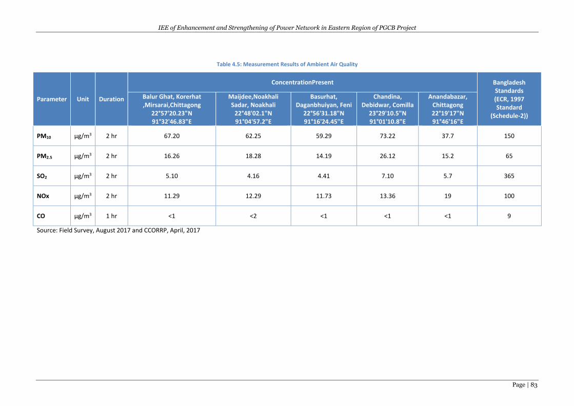
IEE of Enhancement and Strengthening of Power Network in Eastern Region of PGCB Project
Page | 83
Table 4.5: Measurement Results of Ambient Air Quality
Parameter Unit Duration
ConcentrationPresent Bangladesh Standards (ECR, 1997 Standard
(Schedule-2))
Balur Ghat, Korerhat ,Mirsarai,Chittagong
22°57'20.23"N 91°32'46.83"E
Maijdee,Noakhali Sadar, Noakhali
22°48'02.1"N 91°04'57.2"E
Basurhat, Daganbhuiyan, Feni
22°56'31.18"N 91°16'24.45"E
Chandina, Debidwar, Comilla
23°29'10.5"N 91°01'10.8"E
Anandabazar, Chittagong 22°19'17"N 91°46'16"E
PM10 µg/m3 2 hr 67.20 62.25 59.29 73.22 37.7 150
PM2.5 µg/m3 2 hr 16.26 18.28 14.19 26.12 15.2 65
SO2 µg/m3 2 hr 5.10 4.16 4.41 7.10 5.7 365
NOx µg/m3 2 hr 11.29 12.29 11.73 13.36 19 100
CO µg/m3 1 hr <1 <2 <1 <1 <1 9
Source: Field Survey, August 2017 and CCORRP, April, 2017
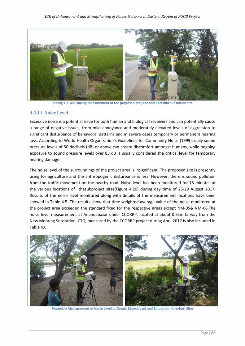
IEE of Enhancement and Strengthening of Power Network in Eastern Region of PGCB Project
Page | 84
Photog 4.3: Air Quality Measurement at the proposed Maijdee and Korerhat substation site.
4.3.11 Noise Level
Excessive noise is a potential issue for both human and biological receivers and can potentially cause
a range of negative issues, from mild annoyance and moderately elevated levels of aggression to
significant disturbance of behavioral patterns and in severe cases temporary or permanent hearing
loss. According to World Health Organization’s Guidelines for Community Noise (1999), daily sound
pressure levels of 50 decibels (dB) or above can create discomfort amongst humans, while ongoing
exposure to sound pressure levels over 85 dB is usually considered the critical level for temporary
hearing damage.
The noise level of the surroundings of the project area is insignificant. The proposed site is presently
using for agriculture and the anthropogenic disturbance is less. However, there is sound pollution
from the traffic movement on the nearby road. Noise level has been monitored for 15 minutes at
the various locations of thesubproject sites(Figure 4.20) during day time of 25-29 August 2017.
Results of the noise level monitored along with details of the measurement locations have been
showed in Table 4.5. The results show that time weighted average value of the noise monitored at
the project area exceeded the standard fixed for the respective areas except NM-05& NM-06.The
noise level measurement at Anandabazar under CCORRP, located at about 0.5km farway from the
New Mooring Substation, CTG, measured by the CCORRP project during April 2017 is also included in
Table 4.6.
Photo4.4: Measurement of Noise Level at Gazari, Munshiganj and Balurghat (Korerhat) Sites
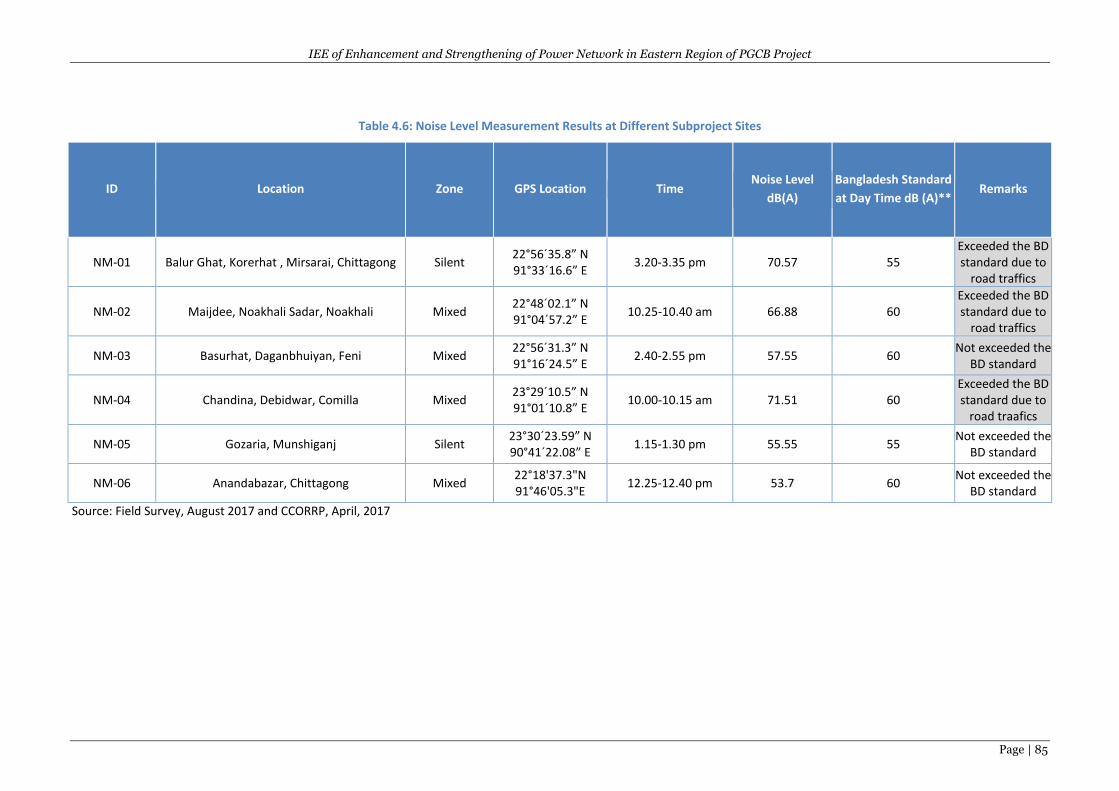
IEE of Enhancement and Strengthening of Power Network in Eastern Region of PGCB Project
Page | 85
Table 4.6: Noise Level Measurement Results at Different Subproject Sites
ID Location Zone GPS Location Time Noise Level
dB(A)
Bangladesh Standard
at Day Time dB (A)** Remarks
NM-01 Balur Ghat, Korerhat , Mirsarai, Chittagong Silent 22°56ˊ35.8ˮ N 91°33ˊ16.6ˮ E
3.20-3.35 pm 70.57 55 Exceeded the BD standard due to
road traffics
NM-02 Maijdee, Noakhali Sadar, Noakhali Mixed 22°48ˊ02.1ˮ N 91°04ˊ57.2ˮ E
10.25-10.40 am 66.88 60 Exceeded the BD standard due to
road traffics
NM-03 Basurhat, Daganbhuiyan, Feni Mixed 22°56ˊ31.3ˮ N 91°16ˊ24.5ˮ E
2.40-2.55 pm 57.55 60 Not exceeded the
BD standard
NM-04 Chandina, Debidwar, Comilla Mixed 23°29ˊ10.5ˮ N 91°01ˊ10.8ˮ E
10.00-10.15 am 71.51 60 Exceeded the BD standard due to
road traafics
NM-05 Gozaria, Munshiganj Silent 23°30ˊ23.59ˮ N 90°41ˊ22.08ˮ E
1.15-1.30 pm 55.55 55 Not exceeded the
BD standard
NM-06 Anandabazar, Chittagong Mixed 22°18'37.3"N 91°46'05.3"E
12.25-12.40 pm 53.7 60 Not exceeded the
BD standard
Source: Field Survey, August 2017 and CCORRP, April, 2017
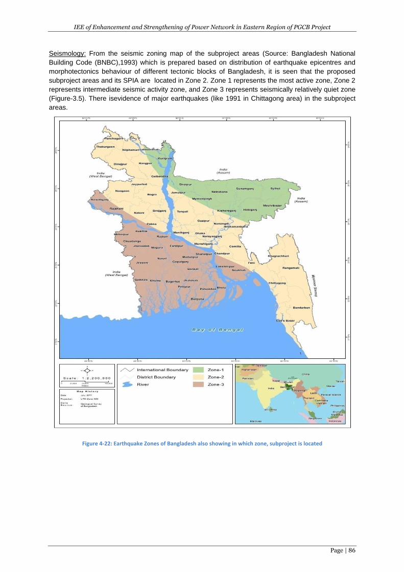
IEE of Enhancement and Strengthening of Power Network in Eastern Region of PGCB Project
Page | 86
Seismology: From the seismic zoning map of the subproject areas (Source: Bangladesh National
Building Code (BNBC),1993) which is prepared based on distribution of earthquake epicentres and
morphotectonics behaviour of different tectonic blocks of Bangladesh, it is seen that the proposed
subproject areas and its SPIA are located in Zone 2. Zone 1 represents the most active zone, Zone 2
represents intermediate seismic activity zone, and Zone 3 represents seismically relatively quiet zone
(Figure-3.5). There isevidence of major earthquakes (like 1991 in Chittagong area) in the subproject
areas.
Figure 4-22: Earthquake Zones of Bangladesh also showing in which zone, subproject is located
IEE of Enhancement and Strengthening of Power Network in Eastern Region of PGCB Project
Page | 87
4.4 Biological/Ecological Environment
4.4.1 Bio-ecological Zones
Within a relatively small geographic boundary, Bangladesh enjoys a diverse array of ecosystems.
Being a low-lying deltaic country, seasonal variation in water availability is the major factor, which
generates different ecological scenarios of Bangladesh. Temperature, rainfall, physiographic
variations in soil and different hydrological conditions play vital roles in the country's diverse
ecosystems. The ecosystems of Bangladesh could be categorized into two major groups, i.e. (i) land
based and (ii) aquatic. The land-based ecosystems include forest and hill ecosystems, agro-
ecosystems and homestead ecosystems; while seasonal and perennial wetlands, rivers, lakes, coastal
mangroves, coastal mudflats and chars, and marine ecosystems fall into the aquatic category.
Each of the ecosystems has many sub-units with distinct characteristics as well. IUCN Bangladesh in
2002 classified the country into twenty five bio-ecological zones (Figure 4.22). The project area falls
below the bio-ecological zone.
I. Meghna Floodplain: A major part of the Meghna floodplain was created by the deposition
of sediments brought in by the old Brahmaputra River, before it changed its course. The rest
of the sediments were laid down principally by the Meghna River itself and by some minor
rivers draining from Tiperrah hills. The floodplain is characterized by many broad
meandering channels, char and low lying landscape and is mostly affected by seasonal
flooding while river bank erosion is occurred commonly. The luxuriant growth of palm trees
is the dominant characteristic feature of the vegetation type of this zone. The Betel nut
“Supari” (Areca catechu) is most visible as the dominant species in the western portion of
this region. This zone also abundance in several varieties of cane, a good deal of bamboo
and thatching grass. Faunal diversity is richer in here than other part of the country. In
mammalian species, different species of cats, bats, otters, pangolins, and raptorial birds are
found (IUCN, 2002f).
II. The Coastal Plains: The coastal plains are underlain by heavy marine or tidal clays but these
have been buried under by more sand or silty deposits near the foot of the hills and along
the courses of rivers and streams, which run across the plains. The eastern coastline,
extending from the mouth of the Feni River to the southern tip of mainland along
Chittagong, is regular and unbroken and protected along the sea by mud-flats and
submerged sands. This zone is important for a wide variety of waterfowls (IUCN, 2002f).
III. Meghna Estuarine Floodplains: A huge newly accreted mudflat is the main physiographic
feature of the Meghna estuarine floodplains, which is situated at the southern part of the
Southeast region. Deposition and erosion are constantly taking place on the land margins. In
many places during the dry season, part of the zone and surface becomes saline in varying
degrees. Urighash (Portaresia coarctata) is the pioneer plant species in the new land
formation whereas the luxuriant growths of Palms are the dominant. All the accreted inter-
tidal lands are important wintering grounds for migratory waterfowls.
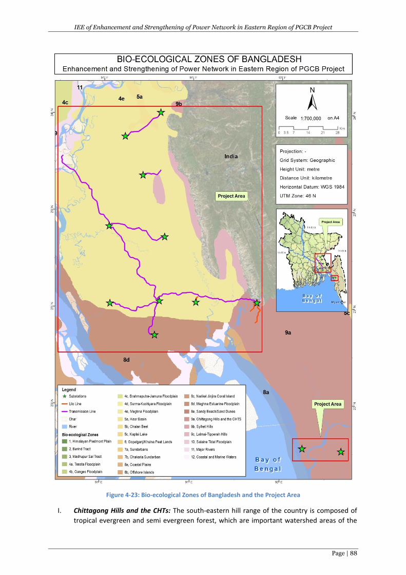
IEE of Enhancement and Strengthening of Power Network in Eastern Region of PGCB Project
Page | 88
Figure 4-23: Bio-ecological Zones of Bangladesh and the Project Area
I. Chittagong Hills and the CHTs: The south-eastern hill range of the country is composed of
tropical evergreen and semi evergreen forest, which are important watershed areas of the
IEE of Enhancement and Strengthening of Power Network in Eastern Region of PGCB Project
Page | 89
country. The majority of the species in the lower canopy are evergreen, and the upper
canopy of the forest is deciduous type. Tropical evergreen forest is found in the valleys of
this zone. Knowledge on the diversity of reptiles and amphibians of this zone is rather
rudimentary, as few surveys of these animals have been made. This zone possesses richest
avifauna population of the country mostly marine and shore birds (IUCN, 2002f).
4.4.2 Diversity of Floral and Faunal Species
The sub-project influence area (SPIA) is mixed with different vegetation. Crops, vegetables are
cultivated at the surrounding mainly include rice, wheat, rabi crops and variety of homestead
vegetables. A sizeable number of fruit trees with economic value have been observed in the SPIA.
The fruit trees include jackfruit, mangoes, litchi, banana, coconut, blackberry etc. and timber trees
include mehegoni, neem, epil-epil, koroi etc. Considerable number of trees and bushes in the SPIA
site provide habitat for birds and other animals. The composition of plant community includes low
growing grasses, trees, herbs and shrubs. The data collected from the field survey and suggests that
the predominant species are those of cultivated vegetables and trees. .
The Project will require removal of trees of various sizes and species. The census and IOL survey
during 2017 found varieties of trees on acquisition and transmission line area. Total numbers of
affected trees on acquisition and transmission line area together in the Project area by category are
presented in the following Table 4.7. Total numbers of affected trees are 23,753. The highest
number of trees is found under timber (9305) category followed by fruit trees (7503) and bamboo
(6836) in the Project area. Out of the total number of affected trees, 12055 are large, 5900 are
medium, 4641 are small, and 1157 are saplings. Size of trees has been determined based on the girth
category by considering species but the Forest Department (FD) will further assess it during land
acquisition process. All the PAPs will receive compensation for the trees and fruits. Also, they will be
able to take away the timber. PAPs will get also additional compensation for fruit bearing trees.
Table 4.7: Lose of trees by category
Type of trees No Percentage Large Medium Small Sapling Total
Fruit bearing 7503 31.59 4437 1517 939 610 7503
Timber 9305 39.17 2257 3408 3093 547 9305
Firewood 97 0.41 68 13 16 0 97
Medicinal 12 0.05 9 0 3 0 12
Bamboo 6836 28.78 5284 962 590 0 6836
Total: 23753 100 12055 5900 4641 1157 23753
A detailed list of terrestrial floral species found in the SPIA of sub-projects is given in the following
Table 5.8.
IEE of Enhancement and Strengthening of Power Network in Eastern Region of PGCB Project
Page | 90
Table 4.8: List of Terrestrial Flora available in the SPIA
Scientific Name Local Name
(English Name) Habit Habitat Status
Timber/Wood Trees
Swietenia mahagoni Mehogoni T RS, HS C
Azadirachta indica Neem T HS C
Albizzia procera Koroi T RS, HS C
Eucalyptus citriodora U-caliptas T RS, HS C
Dalbergia sisoo Shishu T RS, HS C
Bambosa spp. Bash (Bamboo) S HS C
Samanea saman Raintree T RS, HS C
Bombax ceiba Shimul (Cotton Tree) T RS, HS LC
Ficus infectoria Pakur T HS LC
Polyalthia longifolia Debdaru T RS LC
Acacia aurculiformios Akashmoni T RS, HS C
Tectona grandis Shegun T RS, HS LC
Teominalia arjunna Arjun T HS,RS LC
Fruit Trees
Musa sapientum Kalagash (Banana) H HS C
Psidium guajava Piara (Guava) T HS LC
Cocos nucifera Narikel (Coconut) T HS C
Moringa oleifera Sajna T HS LC
Zizyphusm auritiana Boroi T HS LC
Citrus grandis Jambura/Badam S HS C
Aegle marmelos Bel T HS C
Feronia limonia Kodbel T HS LC
Phoenix sylvestris Date Tree (Khejur) T HS,RS C
Areca catechu Supari (Betel Nut/Nut) T HS C
Carica papaya Pepe (Papya) T HS C
Citrus aurantifolia Labu (Lemon) S HS C
Annona reticulate Atafal T HS C
Averrhoa carambola Kamranga T HS C
Punica granatum Dalim S HS LC
Manilkara sapota Sobeda T HS LC
Dellenia indica Chalta T HS LC
Fruit cum Timer Trees
Artocarpus heterophyllus Kathal (Jackfruits) T HS LC
Mangifera indica Aam(Mango) T HS C
Syzygiumcumini Jam(Blackberry) T HS C
Tamerindusindica Tetul (Tamarind) T HS C
Borassusflabellifer Tal (Palm Tree) T RS LC
Elaeocarpus robustus Jolpai (Olive) T HS LC
Diospyros peregrina Gub T HS,RS LC
Medicinal Trees
Azadirachta indica Neem T HS C
Teominalia arjunna Arjun T HS,RS LC
Bohera T HS LC
IEE of Enhancement and Strengthening of Power Network in Eastern Region of PGCB Project
Page | 91
Scientific Name Local Name
(English Name) Habit Habitat Status
Tejpata T HS LC
Ocimum canum Tulshi H HS LC
Coccinea cordifolia Telakachu S HS C
Fuel Trees
Paiya T HS C
Ficus benghalensis Bot(Banyan Tree) T RS LC
Acacia nilotica Babla T HS C
Ricinus communes Venna T HS C
Lannea coromandelica Ziga T HS, RS C
Bonziga T HS C
Ficushispida Dumoor T RS C
Anthocephalus cadamba Kadom T HS C
Shewra T HS C
Bakul T HS LC
Aesthetic
Delonix regia Krisnochura T HS LC
Cassia fistula Sonalu T HS LC
Codiaeum variegatum Patabahar S HS LC
Lawsenia inermis Mehendi S HS C
Gardenia coronaria Gandha raj S HS C
Casuarina littorea Jaw T HS LC
Nymphaea nouchalli Shapla H WL C Source: Field level survey,2017. Note: C-Common, LC- Less Common, UC- Uncommon, CU- Cultivated Habit: T=Tree, H= Herb, S=Shrub, G=Grass; Habitat: HS=Homestead, RS-Road side
While most of the aquatic plant species of the subproject areas are subject to seasonal water level
fluctuations, the abundance of wetlands supports a wide variety of aquatic biota. The common
aquatic plants are Helencha (Enhydrofluctuans) Kalmi (Ipomoea aquatica), DholKalmi
(Ipomaoafistulosa), Cheicha (Scirpusarticulatus), Kochuripana (Eichorinacrassipes), Shapla
(Nymphaeanouchali), Ducbweed (Spiredella sp.), Khudipana (Lemna minor), and Topapana (Pistia
stratiotes).
The diversified habitat and ecosystem in the project area support various types of wildlife as given in
Table 4.9. Primary and secondary mode was adopted for identification of fauna. Most of the funal
spieces such as (Avians, Amphibians, Reptiles and Mammals) were identified in the SPIA of the
subproject areas by using books and description of the local people during the field survey which are
given in the following Table 4.9.
Table 4.9: List of Funal Species Available in the SPIA of the Subprojects
Scientific Name English Name Local Name Local
Status
Class: Amphibia
Bufo melanostictus Common Toad Kuno bang NO
Rana temporalis Bull Frog Kola bang NO
R. pipens Grass Frog Sona bang NO
Class: Reptilia
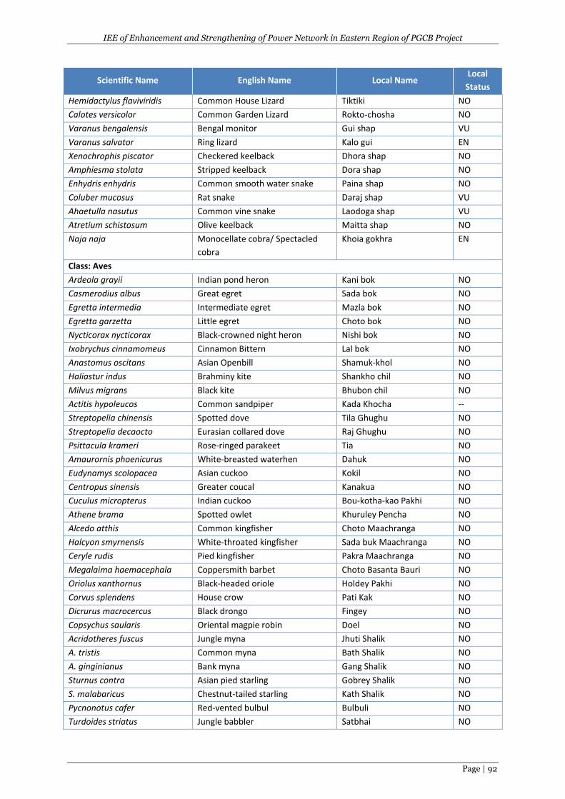
IEE of Enhancement and Strengthening of Power Network in Eastern Region of PGCB Project
Page | 92
Scientific Name English Name Local Name Local
Status
Hemidactylus flaviviridis Common House Lizard Tiktiki NO
Calotes versicolor Common Garden Lizard Rokto-chosha NO
Varanus bengalensis Bengal monitor Gui shap VU
Varanus salvator Ring lizard Kalo gui EN
Xenochrophis piscator Checkered keelback Dhora shap NO
Amphiesma stolata Stripped keelback Dora shap NO
Enhydris enhydris Common smooth water snake Paina shap NO
Coluber mucosus Rat snake Daraj shap VU
Ahaetulla nasutus Common vine snake Laodoga shap VU
Atretium schistosum Olive keelback Maitta shap NO
Naja naja Monocellate cobra/ Spectacled
cobra
Khoia gokhra EN
Class: Aves
Ardeola grayii Indian pond heron Kani bok NO
Casmerodius albus Great egret Sada bok NO
Egretta intermedia Intermediate egret Mazla bok NO
Egretta garzetta Little egret Choto bok NO
Nycticorax nycticorax Black-crowned night heron Nishi bok NO
Ixobrychus cinnamomeus Cinnamon Bittern Lal bok NO
Anastomus oscitans Asian Openbill Shamuk-khol NO
Haliastur indus Brahminy kite Shankho chil NO
Milvus migrans Black kite Bhubon chil NO
Actitis hypoleucos Common sandpiper Kada Khocha --
Streptopelia chinensis Spotted dove Tila Ghughu NO
Streptopelia decaocto Eurasian collared dove Raj Ghughu NO
Psittacula krameri Rose-ringed parakeet Tia NO
Amaurornis phoenicurus White-breasted waterhen Dahuk NO
Eudynamys scolopacea Asian cuckoo Kokil NO
Centropus sinensis Greater coucal Kanakua NO
Cuculus micropterus Indian cuckoo Bou-kotha-kao Pakhi NO
Athene brama Spotted owlet Khuruley Pencha NO
Alcedo atthis Common kingfisher Choto Maachranga NO
Halcyon smyrnensis White-throated kingfisher Sada buk Maachranga NO
Ceryle rudis Pied kingfisher Pakra Maachranga NO
Megalaima haemacephala Coppersmith barbet Choto Basanta Bauri NO
Oriolus xanthornus Black-headed oriole Holdey Pakhi NO
Corvus splendens House crow Pati Kak NO
Dicrurus macrocercus Black drongo Fingey NO
Copsychus saularis Oriental magpie robin Doel NO
Acridotheres fuscus Jungle myna Jhuti Shalik NO
A. tristis Common myna Bath Shalik NO
A. ginginianus Bank myna Gang Shalik NO
Sturnus contra Asian pied starling Gobrey Shalik NO
S. malabaricus Chestnut-tailed starling Kath Shalik NO
Pycnonotus cafer Red-vented bulbul Bulbuli NO
Turdoides striatus Jungle babbler Satbhai NO
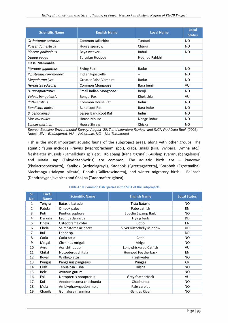
IEE of Enhancement and Strengthening of Power Network in Eastern Region of PGCB Project
Page | 93
Scientific Name English Name Local Name Local
Status
Orthotomus sutorius Common tailorbird Tuntuni NO
Passer domesticus House sparrow Charui NO
Ploceus philippinus Baya weaver Babui NO
Upupa epops Eurasian Hoopoe Hudhud Pahkhi
Class: Mammalia
Pteropus giganteus Flying Fox Badur NO
Pipistrellus coromandra Indian Pipistrelle -- NO
Megaderma lyra Greater False Vampire Badur NO
Herpestes edwarsi Common Mongoose Bara benji VU
H. auropunctatus Small Indian Mongoose Benji NO
Vulpes bengalensis Bengal Fox Khek shial VU
Rattus rattus Common House Rat Indur NO
Bandicota indica Bandicoot Rat Bara indur NO
B. bengalensis Lesser Bandicoot Rat Indur NO
Mus musculus House Mouse Nengri indur NO
Suncus murinus House Shrew Chicka NO
Source: Baseline Environmental Survey, August 2017 and Literature Review and IUCN Red Data Book (2003). Notes: EN – Endangered, VU – Vulnerable, NO – Not Threatened
Fish is the most important aquatic fauna of the subproject areas, along with other groups. The
aquatic fauna includes Prawns (Macrobrachium spp.), crabs, snails (Pila, Vivipara, Lymna etc.),
freshalater mussels (Lamellidens sp.) etc. Kolabang (Rana tigrina); Guishap (Varanusbengalensis)
and Matia sap (Enhydrisenhydris) are common. The aquatic birds are – Pancowri
(Phalacrocoraxcarto), Kanibok (Ardeolagrayii), Sadabok (Egrettagarzetta), Borobok (Egrettaalba),
Machranga (Halcyon pileata), Dahuk (Gallicrexcinerea), and winter migratory birds – Balihash
(Dendrocygnajavanica) and Chakha (Tadornaferruginea).
Table 4.10: Common Fish Species in the SPIA of the Subprojects
Sl. No.
Local Name
Scientific Name English Name Local Status
1 Tengra Batasio batasio Tista Batasio NO
2 Pabda Ompok pabo Pabo catfish EN
3 Puti Puntius sophore Spotfin Swamp Barb NO
4 Darkina Esomus danricus Flying barb DD
5 Dhela Osteobrama cotio Cotio EN
6 Chela Salmostoma acinaces Silver Razorbelly Minnow DD
7 Rui Labeo sp. DD
8 Catla Catla catla Catla NO
9 Mrigal Cirrhinus mrigala Mrigal NO
10 Ayre Aorichthus aor Longwhiskered Catfish VU
11 Chital Notopterus chitala Humped Featherback EN
12 Boyal Wallago attu Freshwater NO
13 Pungus Pangasius pangasius Pungas CR
14 Elish Tenualosa ilisha Hilsha NO
15 Bele Awaous gutum NO
16 Foli Notopterus notopterus Grey featherback VU
17 Koi Anodontosoma chachunda Chachunda NO
18 Mola Amblypharyngodon mola Pale carplet NO
19 Chapila Gonialosa manmina Ganges River NO
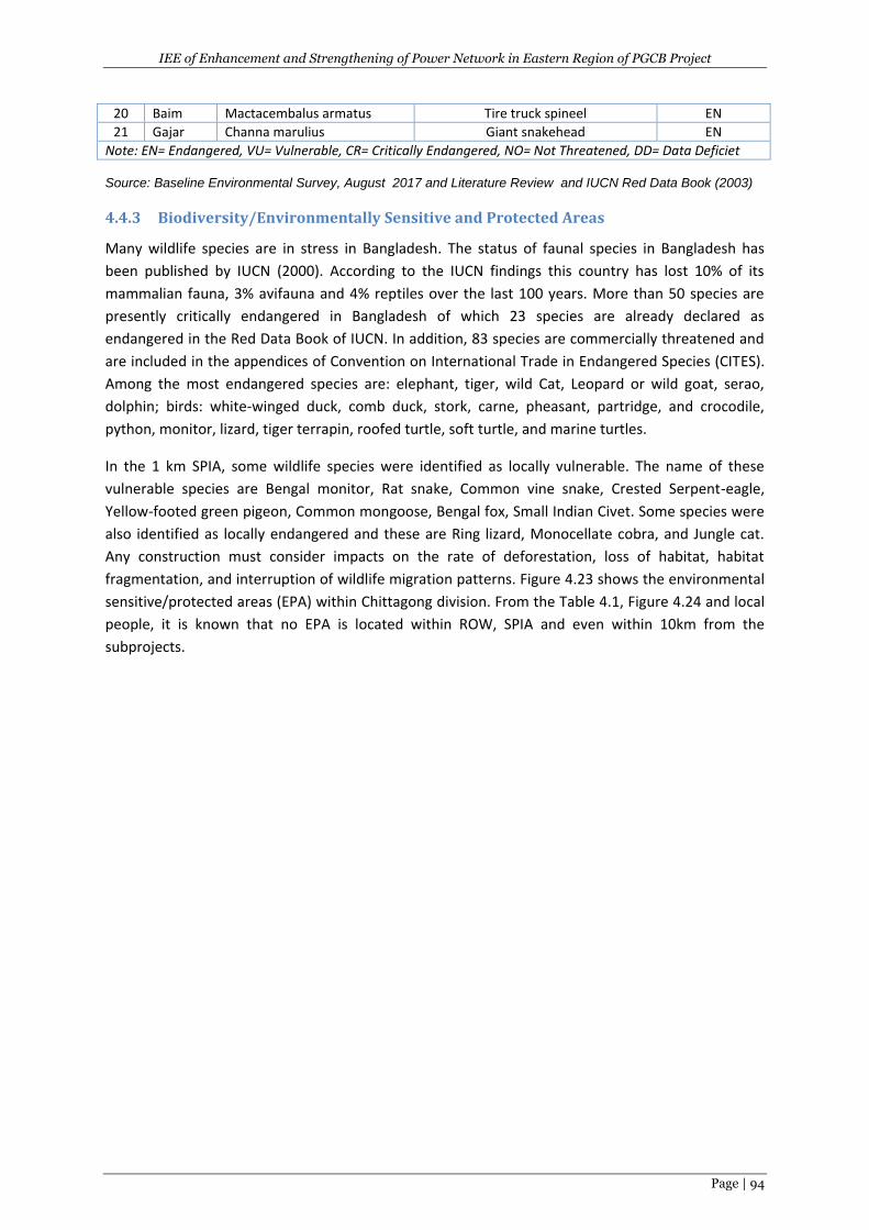
IEE of Enhancement and Strengthening of Power Network in Eastern Region of PGCB Project
Page | 94
Source: Baseline Environmental Survey, August 2017 and Literature Review and IUCN Red Data Book (2003)
4.4.3 Biodiversity/Environmentally Sensitive and Protected Areas
Many wildlife species are in stress in Bangladesh. The status of faunal species in Bangladesh has
been published by IUCN (2000). According to the IUCN findings this country has lost 10% of its
mammalian fauna, 3% avifauna and 4% reptiles over the last 100 years. More than 50 species are
presently critically endangered in Bangladesh of which 23 species are already declared as
endangered in the Red Data Book of IUCN. In addition, 83 species are commercially threatened and
are included in the appendices of Convention on International Trade in Endangered Species (CITES).
Among the most endangered species are: elephant, tiger, wild Cat, Leopard or wild goat, serao,
dolphin; birds: white-winged duck, comb duck, stork, carne, pheasant, partridge, and crocodile,
python, monitor, lizard, tiger terrapin, roofed turtle, soft turtle, and marine turtles.
In the 1 km SPIA, some wildlife species were identified as locally vulnerable. The name of these
vulnerable species are Bengal monitor, Rat snake, Common vine snake, Crested Serpent-eagle,
Yellow-footed green pigeon, Common mongoose, Bengal fox, Small Indian Civet. Some species were
also identified as locally endangered and these are Ring lizard, Monocellate cobra, and Jungle cat.
Any construction must consider impacts on the rate of deforestation, loss of habitat, habitat
fragmentation, and interruption of wildlife migration patterns. Figure 4.23 shows the environmental
sensitive/protected areas (EPA) within Chittagong division. From the Table 4.1, Figure 4.24 and local
people, it is known that no EPA is located within ROW, SPIA and even within 10km from the
subprojects.
20 Baim Mactacembalus armatus Tire truck spineel EN
21 Gajar Channa marulius Giant snakehead EN
Note: EN= Endangered, VU= Vulnerable, CR= Critically Endangered, NO= Not Threatened, DD= Data Deficiet
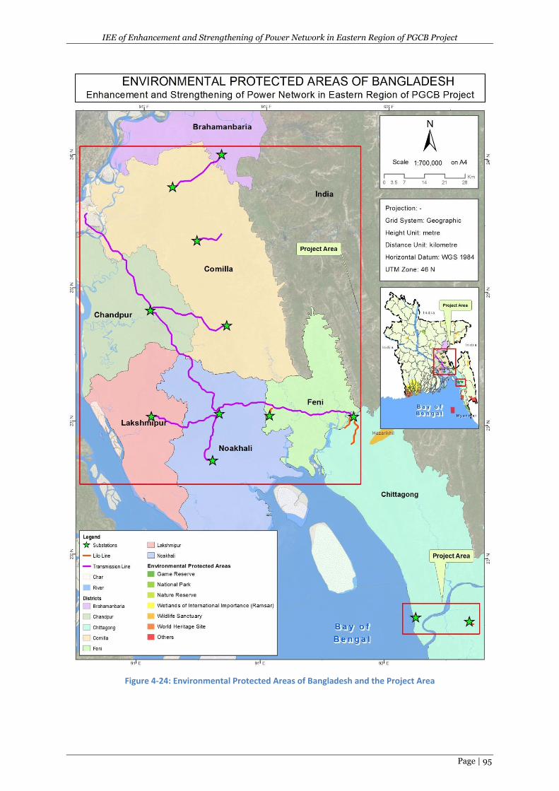
IEE of Enhancement and Strengthening of Power Network in Eastern Region of PGCB Project
Page | 95
Figure 4-24: Environmental Protected Areas of Bangladesh and the Project Area
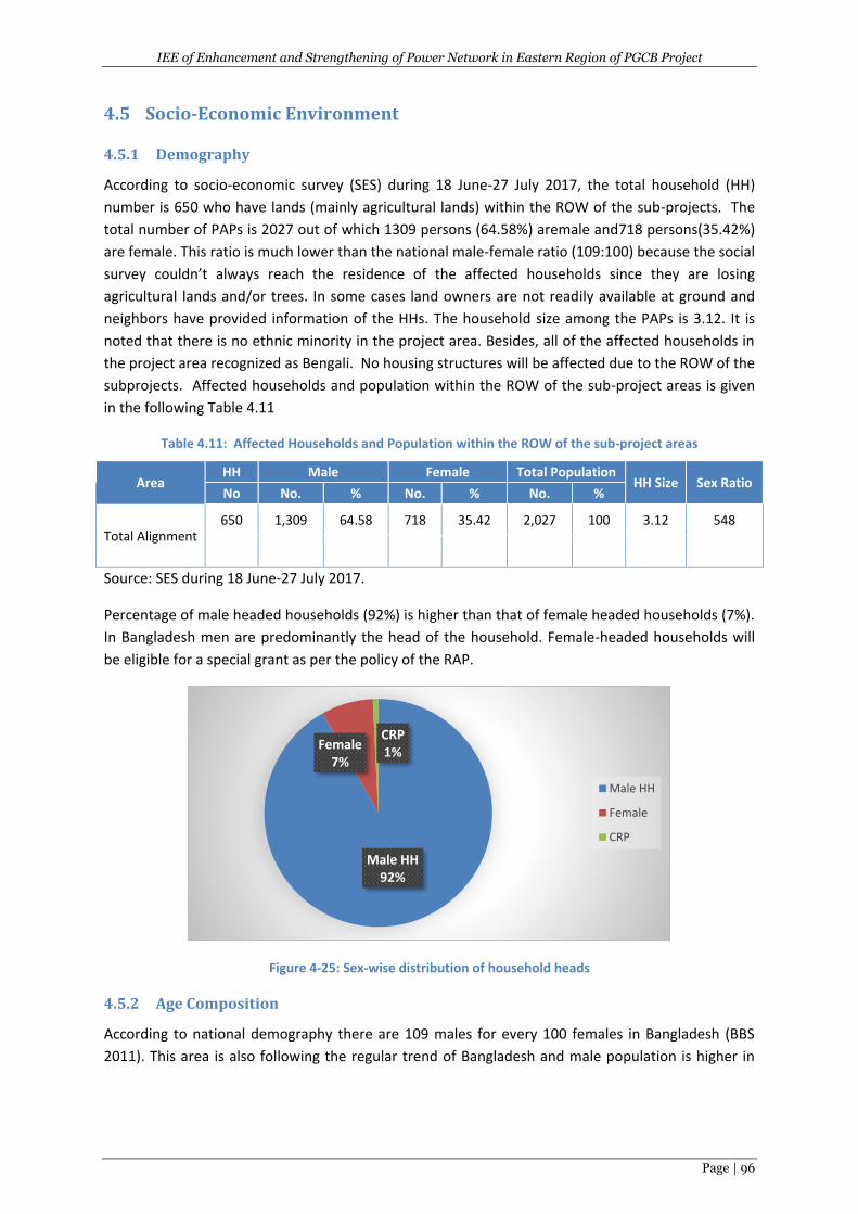
IEE of Enhancement and Strengthening of Power Network in Eastern Region of PGCB Project
Page | 96
4.5 Socio-Economic Environment
4.5.1 Demography
According to socio-economic survey (SES) during 18 June-27 July 2017, the total household (HH)
number is 650 who have lands (mainly agricultural lands) within the ROW of the sub-projects. The
total number of PAPs is 2027 out of which 1309 persons (64.58%) aremale and718 persons(35.42%)
are female. This ratio is much lower than the national male-female ratio (109:100) because the social
survey couldn’t always reach the residence of the affected households since they are losing
agricultural lands and/or trees. In some cases land owners are not readily available at ground and
neighbors have provided information of the HHs. The household size among the PAPs is 3.12. It is
noted that there is no ethnic minority in the project area. Besides, all of the affected households in
the project area recognized as Bengali. No housing structures will be affected due to the ROW of the
subprojects. Affected households and population within the ROW of the sub-project areas is given
in the following Table 4.11
Table 4.11: Affected Households and Population within the ROW of the sub-project areas
Area HH Male Female Total Population
HH Size Sex Ratio No No. % No. % No. %
Total Alignment 650 1,309 64.58 718 35.42 2,027 100 3.12 548
Source: SES during 18 June-27 July 2017.
Percentage of male headed households (92%) is higher than that of female headed households (7%).
In Bangladesh men are predominantly the head of the household. Female-headed households will
be eligible for a special grant as per the policy of the RAP.
Figure 4-25: Sex-wise distribution of household heads
4.5.2 Age Composition
According to national demography there are 109 males for every 100 females in Bangladesh (BBS
2011). This area is also following the regular trend of Bangladesh and male population is higher in
Male HH92%
Female 7%
CRP1%
Male HH
Female
CRP
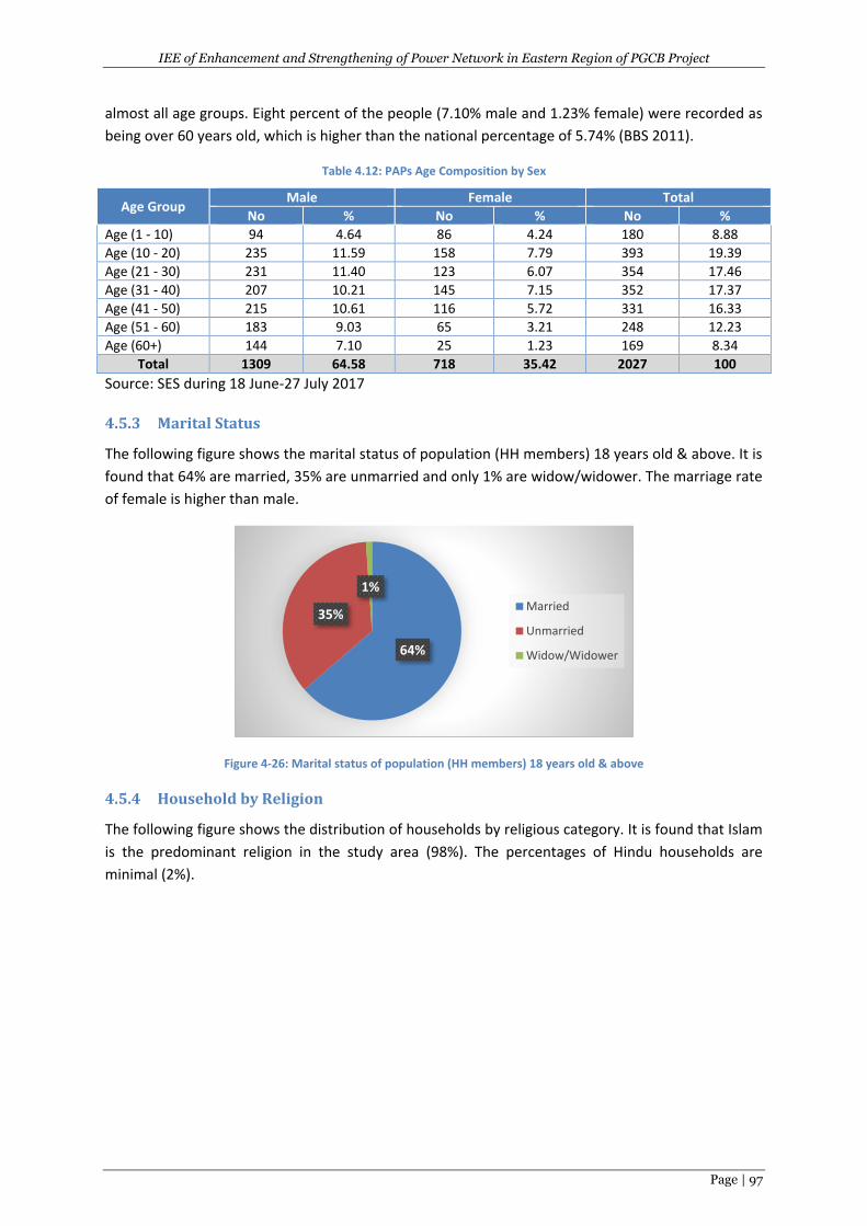
IEE of Enhancement and Strengthening of Power Network in Eastern Region of PGCB Project
Page | 97
almost all age groups. Eight percent of the people (7.10% male and 1.23% female) were recorded as
being over 60 years old, which is higher than the national percentage of 5.74% (BBS 2011).
Table 4.12: PAPs Age Composition by Sex
Age Group Male Female Total
No % No % No %
Age (1 - 10) 94 4.64 86 4.24 180 8.88
Age (10 - 20) 235 11.59 158 7.79 393 19.39
Age (21 - 30) 231 11.40 123 6.07 354 17.46
Age (31 - 40) 207 10.21 145 7.15 352 17.37
Age (41 - 50) 215 10.61 116 5.72 331 16.33
Age (51 - 60) 183 9.03 65 3.21 248 12.23
Age (60+) 144 7.10 25 1.23 169 8.34
Total 1309 64.58 718 35.42 2027 100
Source: SES during 18 June-27 July 2017
4.5.3 Marital Status
The following figure shows the marital status of population (HH members) 18 years old & above. It is
found that 64% are married, 35% are unmarried and only 1% are widow/widower. The marriage rate
of female is higher than male.
Figure 4-26: Marital status of population (HH members) 18 years old & above
4.5.4 Household by Religion
The following figure shows the distribution of households by religious category. It is found that Islam
is the predominant religion in the study area (98%). The percentages of Hindu households are
minimal (2%).
64%
35%
1%
Married
Unmarried
Widow/Widower
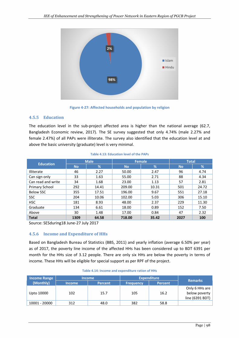
IEE of Enhancement and Strengthening of Power Network in Eastern Region of PGCB Project
Page | 98
Figure 4-27: Affected households and population by religion
4.5.5 Education
The education level in the sub-project affected area is higher than the national average (62.7,
Bangladesh Economic review, 2017). The SE survey suggested that only 4.74% (male 2.27% and
female 2.47%) of all PAPs were illiterate. The survey also identified that the education level at and
above the basic university (graduate) level is very minimal.
Table 4.13: Education level of the PAPs
Education Male Female Total
No % No % No %
Illiterate 46 2.27 50.00 2.47 96 4.74
Can sign only 33 1.63 55.00 2.71 88 4.34
Can read and write 34 1.68 23.00 1.13 57 2.81
Primary School 292 14.41 209.00 10.31 501 24.72
Below SSC 355 17.51 196.00 9.67 551 27.18
SSC 204 10.06 102.00 5.03 306 15.10
HSC 181 8.93 48.00 2.37 229 11.30
Graduate 134 6.61 18.00 0.89 152 7.50
Above 30 1.48 17.00 0.84 47 2.32
Total 1309 64.58 718.00 35.42 2027 100
Source: SESduring18 June-27 July 2017
4.5.6 Income and Expenditure of HHs
Based on Bangladesh Bureau of Statistics (BBS, 2011) and yearly inflation (average 6.50% per year)
as of 2017, the poverty line income of the affected HHs has been considered up to BDT 6391 per
month for the HHs size of 3.12 people. There are only six HHs are below the poverty in terms of
income. These HHs will be eligible for special support as per RPF of the project.
Table 4.14: Income and expenditure ration of HHs
Income Range (Monthly)
Income Expenditure Remarks
Income Percent Frequency Percent
Upto 10000 102 15.7 105 16.2 Only 6 HHs are below poverty
line (6391 BDT)
10001 - 20000 312 48.0 382 58.8
98%
2%
Islam
Hindu
IEE of Enhancement and Strengthening of Power Network in Eastern Region of PGCB Project
Page | 99
Income Range (Monthly)
Income Expenditure Remarks
Income Percent Frequency Percent
20001 - 30000 145 22.3 118 18.2
30001 - 40000 49 7.5 15 2.3
40001 - 50000 14 2.2 3 .5
Above 50000 28 4.3 27 4.2
Total 650 100.0 650 100.0
Source: SES during 18 June-27 July 2017
4.5.7 Occupation Pattern
Among the affected people, businesses and services appear to be the main occupations (26.74%).
Among the male population, most of the eligible and capable members are involved in income
generating activities. Female are mostly housewife and also involved in allied activities focusing on
maintaining the home and families. As per the survey 2.27 % male and 1.23 % female are found to
be totally unemployed. Income and livelihood restoration program can enhance capacity of the
people particularly female and vulnerable people for doing more income generating activities.
Table 4.15: Principal occupation of the affected population in the Project area
Sl. No
Occupation Male Female Total
Employed Unemployed No % No % No %
1 Service 241 11.89 - - 241 11.89 241 -
2 Business 301 14.85 - - 301 14.85 301 -
3 Day Labor 56 2.76 - - 56 2.76 56 -
4 Agriculture 137 6.76 - - 137 6.76 137 -
5 Boatman - - - - - - - -
6 Motor driver 25 1.23 - - 25 1.23 25 -
7 Carpenter 3 0.15 - - 3 0.15 3 -
8 Mason 5 0.25 - - 5 0.25 5 -
9 Electrician 1 0.05 - - 1 0.05 1 -
10 Housewife - - 468 23.09 468 23.09 - 468
11 Unemployed 46 2.27 25 1.23 71 3.50 - 71
12 Student 337 16.63 101 4.98 438 21.61 - 438
13 Medical practitioner 3 0.15 - - 3 0.15 3 -
14 Layer 1 0.05 - - 1 0.05 1 -
15 Others 65 3.20 - - 65 9.43 65 -
16 Child 80 3.94 124 6.14 204 3.85 - 204
17 Disabled 8 0.39 - - 8 0.39 - 8
Total 1,309 64.56 718 35.44 2,027 100.00 838 1,189
41.34 58.66
Source: SES during 18 June-27 July 2017
4.5.8 Economic Activities of HHs
The survey identified that business/shop keeping and agriculture are the main economic sources of
the HHs. On the other hand the figure below shows that share cropping and agriculture are the
allied/secondary economic income sources of HH as women mostly connected to such activities
along with household activities.
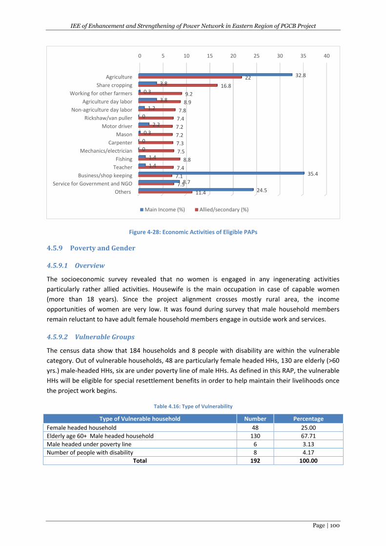
IEE of Enhancement and Strengthening of Power Network in Eastern Region of PGCB Project
Page | 100
Figure 4-28: Economic Activities of Eligible PAPs
4.5.9 Poverty and Gender
4.5.9.1 Overview
The socioeconomic survey revealed that no women is engaged in any ingenerating activities
particularly rather allied activities. Housewife is the main occupation in case of capable women
(more than 18 years). Since the project alignment crosses mostly rural area, the income
opportunities of women are very low. It was found during survey that male household members
remain reluctant to have adult female household members engage in outside work and services.
4.5.9.2 Vulnerable Groups
The census data show that 184 households and 8 people with disability are within the vulnerable
category. Out of vulnerable households, 48 are particularly female headed HHs, 130 are elderly (>60
yrs.) male-headed HHs, six are under poverty line of male HHs. As defined in this RAP, the vulnerable
HHs will be eligible for special resettlement benefits in order to help maintain their livelihoods once
the project work begins.
Table 4.16: Type of Vulnerability
Type of Vulnerable household Number Percentage
Female headed household 48 25.00
Elderly age 60+ Male headed household 130 67.71
Male headed under poverty line 6 3.13
Number of people with disability 8 4.17
Total 192 100.00
0 5 10 15 20 25 30 35 40
Agriculture
Share cropping
Working for other farmers
Agriculture day labor
Non-agriculture day labor
Rickshaw/van puller
Motor driver
Mason
Carpenter
Mechanics/electrician
Fishing
Teacher
Business/shop keeping
Service for Government and NGO
Others
32.8
3.8
0.3
3.8
1.2
0
2.2
0.3
0
0
1.4
1.4
35.4
8.7
24.5
22
16.8
9.2
8.9
7.8
7.4
7.2
7.2
7.3
7.5
8.8
7.4
7.1
7.5
11.4
Main Income (%) Allied/secondary (%)
IEE of Enhancement and Strengthening of Power Network in Eastern Region of PGCB Project
Page | 101
4.5.9.3 Health Status of the Local People
During stakeholder consultations at the project sites it was gathered that overall health status of the
project areas is good. However the people in the project areas are affected by the following
common diseases such as stomach diseases, skin disesas, fever etc. In addition,people in the project
areas are affected by contagious diseases such as flu, sexually transmitted diseases, Hepatitis A and
Hepatitis B but insignificantly. Noted thatcommon contagious diseases in the world are: CRE,Ebola,
Enterovirus D68, Flu, Hantavirus, Hepatitis A, Hepatitis B, HIV/AIDS, Measles, MRSA, Pertussis,
Rabies, Sexually Transmitted Diseases, Shigellosis, Tuberculosis, West Nile Virus andZika.
4.5.10 Land Acquisition and Requisition
4.5.10.1 Overview
Census and IOL were conducted to determine the overall impact of the project. Private lands are to
be acquired mainly for the 12 substation subprojectsof the project. For the erection of total 884 no.
towers of the eight TLs & eight LLs of the project, lands also will be required but temporarily. The
project avoided physical displacement during planning of the project. In case of impact on premises,
local PAPs were consulted to find alternative place to elude avoid physical displacement and impacts
on any structures.
4.5.10.2 Land Acquisition & Temporary Requirement
According to SES, the project will require acquisition of 86 acres of private land for the 12
substations. The proposed lands for acquisition are longed in null category as are being used for
agricultural purpose. Compensation of the private land and government land has been provisioned
in theResettlement Action Plan (RAP). By law, the Deputy Commissioner (DC) will pay compensation
for all categories of land to be permanently acquired or temporarily taken for the project following
the ARIPO 1982. A Property Valuation Advisory Team (PVAT) will determine the final replacement
value for acquired land during implementation of the RAP. The RAP includes replacement costs
based on tax roll data and market survey, for the amounts shown in Table 4.17.
According to SES, a total 804 acres of land for the erection of the total 884 towers of the eight TLs&
8 LLs will be taken temporarily and only crop compensation will be provided for the standing crops
(if any) of cropping period if the civil construction makes a bar to cultivate the land during cropping
time.
Table 4.17: Land by GIS Locations; permanently acquired (in Acre)
Sl. No. District Name Substation Name Area (Acre) Percentage
1 Noakhali 230/132 kV: Chowmuhoni GIS 3x250/350 MVA 5 6%
2 Chandpur 230/132 kV: Kachua GIS 2x250/350 MVA 5 6%
3 Comilla 132/33 kV: Muradnagar AIS 2x50/75 MVA 5 6%
4 Comilla 132/33 kV: Lakhsam GIS 2x50/75 MVA 2 2%
5 Noakhali 132/33 kV: Maijdee GIS 2x50/75 MVA 5 6%
6 Chittagong 132/33 kV: Patiya GIS 2x50/75 MVA 5 6%
7 Comilla 132/33 kV: Chandina GIS 2x50/75 MVA 2 2%
8 Chittagong 132/33 kV: Anandabazar (New Mooring) GIS 3x80/120 MVA (Future 400kV Provision)
20 23%
9 Noakhali 132/33 kV: Basurhat GIS 2x50/75 MVA 2 2%
10 Laxmipur 132/33 kV: Laxmipur GIS 2x50/75 MVA 5 6%

IEE of Enhancement and Strengthening of Power Network in Eastern Region of PGCB Project
Page | 102
11 Brahmanbaria 132/33 kV: Kosba GIS 2x50/75 MVA 5 6%
12 Chittagong 400 kV Korerhat 25 29%
Total 86
Note: Mirsharai Substation in located in newly raised char land which is still not included into government
records.
4.5.10.3 Cultural Sites
From the toposurvey, SES and environmental survey of the project, it is understood that no cultural
sites (such as mosque, school, madrasha, graveyard, monument and eidgah) are located within the
ROW of the SS, TL& LL. It is known that there is a mosque 200m on east side of the Kachua
substation and a mosque 100m on east side of Bashurhat substation . It is also known that a mosque
is 20m away at ch 48+300 and a school 40m at 49+250 from the boundary line of Korerhat-
Chowmuhi TL.
5 ANALYSES OF ALTERNATIVES
5.1 Analyses of Alternatives forTL &LILO Route Selection - (Assessment &
Management Process)
Activities like construction of transmission lines and its subsequent operation and maintenance are
non-polluting in nature and its environmental impact are also negligible and are restricted to Right of
Way (ROW only. Another feature which is also very crucial in making this statement is the inherent
flexibility available in routing of power transmission lines and locating substations, which help to the
great extent in avoiding environmentally sensitive areas such as fragile ecosystems with their
inherent biodiversity, and also dense human habitats and areas of cultural significance.
Generally, speaking all the potential environmental impacts of transmission lines can be avoided or
mitigated through careful route and site selection as explained above. Keeping this aspect in mind
due consideration has been provided in deciding the route alignment including study of different
alternatives for proposed transmission lines under the scope of two projects. During route alignment
all possible efforts are made to avoid the forest area involvement completely or to keep it to the
barest minimum, whenever it becomes unavoidable due to the geography of terrain or heavy cost
involved in avoiding it.
5.2 Study of Alternatives
5.2.1 Environmental Criteria for TL and LILO Route Selection
For selection of optimum route, the following points are taken into considerations:
i) The route of the proposed transmission lines does not involve any human rehabilitation.
ii) Any monument of cultural or historical importance is not affected by the route of the
transmission line.
iii) The proposed route of transmission line does not create any threat to the survival of any
community with special reference to Tribal Community.
iv) The proposed route of transmission line does not affect any public utility services like
playgrounds, schools, other establishments etc.
v) The line route does not pass through any sanctuaries, National Park etc.
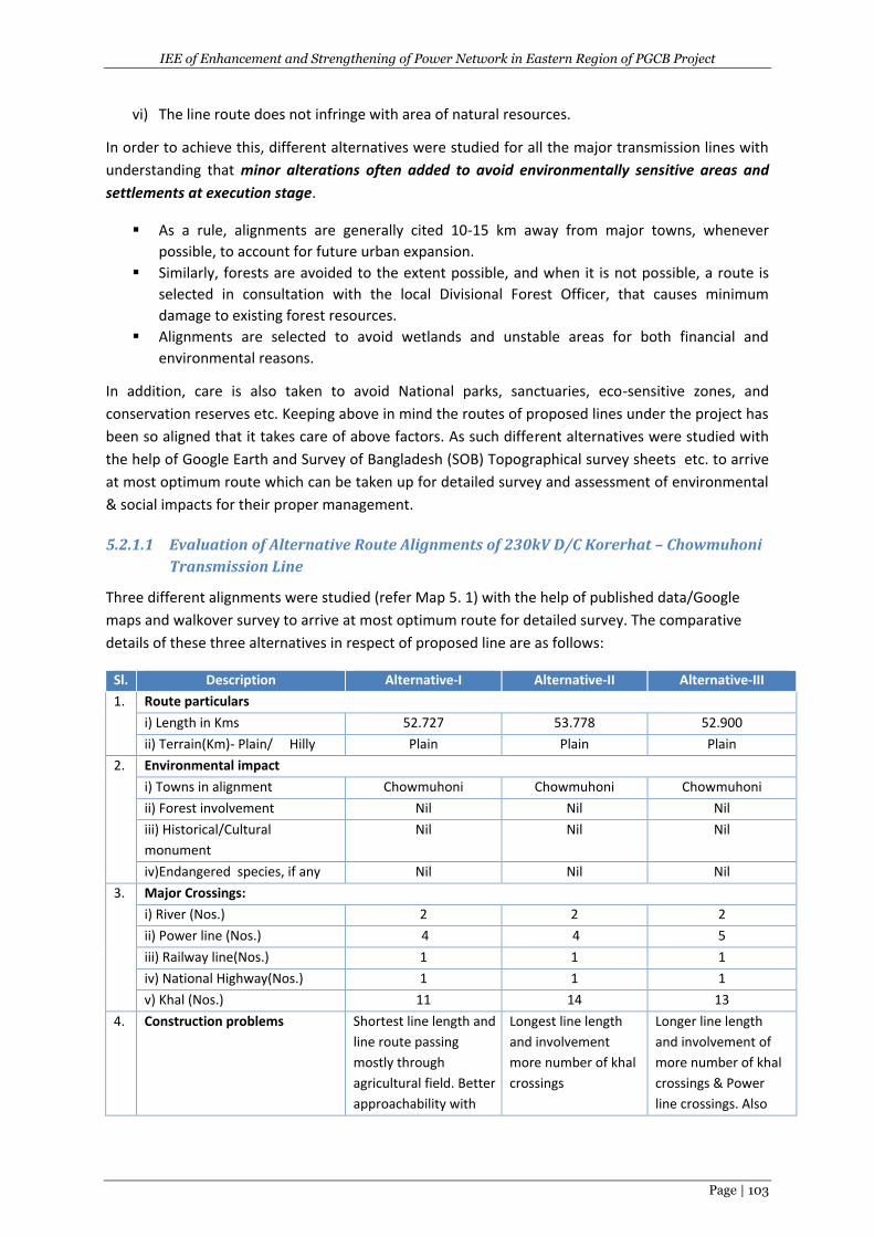
IEE of Enhancement and Strengthening of Power Network in Eastern Region of PGCB Project
Page | 103
vi) The line route does not infringe with area of natural resources.
In order to achieve this, different alternatives were studied for all the major transmission lines with
understanding that minor alterations often added to avoid environmentally sensitive areas and
settlements at execution stage.
As a rule, alignments are generally cited 10-15 km away from major towns, whenever
possible, to account for future urban expansion.
Similarly, forests are avoided to the extent possible, and when it is not possible, a route is
selected in consultation with the local Divisional Forest Officer, that causes minimum
damage to existing forest resources.
Alignments are selected to avoid wetlands and unstable areas for both financial and
environmental reasons.
In addition, care is also taken to avoid National parks, sanctuaries, eco-sensitive zones, and
conservation reserves etc. Keeping above in mind the routes of proposed lines under the project has
been so aligned that it takes care of above factors. As such different alternatives were studied with
the help of Google Earth and Survey of Bangladesh (SOB) Topographical survey sheets etc. to arrive
at most optimum route which can be taken up for detailed survey and assessment of environmental
& social impacts for their proper management.
5.2.1.1 Evaluation of Alternative Route Alignments of 230kV D/C Korerhat – Chowmuhoni
Transmission Line
Three different alignments were studied (refer Map 5. 1) with the help of published data/Google
maps and walkover survey to arrive at most optimum route for detailed survey. The comparative
details of these three alternatives in respect of proposed line are as follows:
Sl. Description Alternative-I Alternative-II Alternative-III
1. Route particulars
i) Length in Kms 52.727 53.778 52.900
ii) Terrain(Km)- Plain/ Hilly Plain Plain Plain
2. Environmental impact
i) Towns in alignment Chowmuhoni Chowmuhoni Chowmuhoni
ii) Forest involvement Nil Nil Nil
iii) Historical/Cultural
monument
Nil Nil Nil
iv)Endangered species, if any Nil Nil Nil
3. Major Crossings:
i) River (Nos.) 2 2 2
ii) Power line (Nos.) 4 4 5
iii) Railway line(Nos.) 1 1 1
iv) National Highway(Nos.) 1 1 1
v) Khal (Nos.) 11 14 13
4. Construction problems Shortest line length and
line route passing
mostly through
agricultural field. Better
approachability with
Longest line length
and involvement
more number of khal
crossings
Longer line length
and involvement of
more number of khal
crossings & Power
line crossings. Also
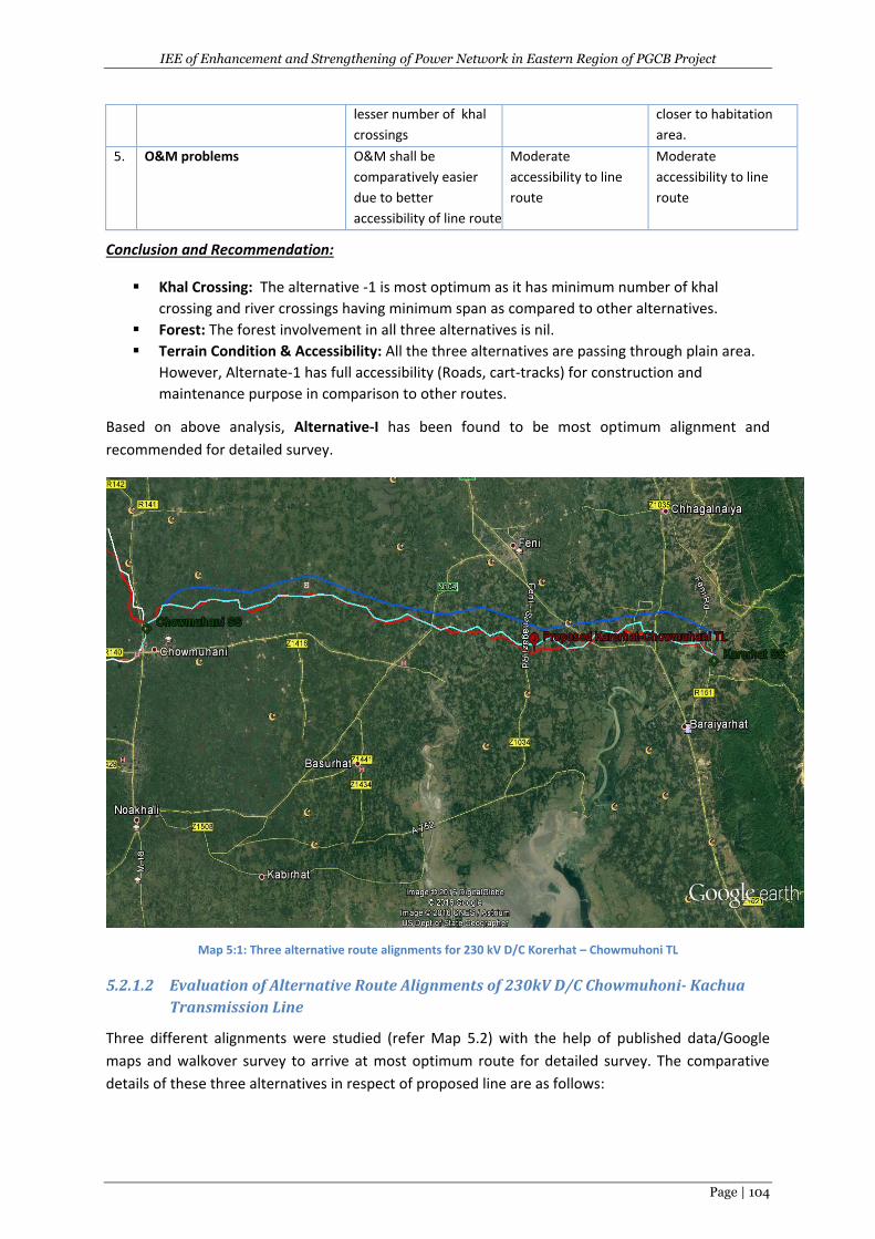
IEE of Enhancement and Strengthening of Power Network in Eastern Region of PGCB Project
Page | 104
lesser number of khal
crossings
closer to habitation
area.
5. O&M problems O&M shall be
comparatively easier
due to better
accessibility of line route
Moderate
accessibility to line
route
Moderate
accessibility to line
route
Conclusion and Recommendation:
Khal Crossing: The alternative -1 is most optimum as it has minimum number of khal
crossing and river crossings having minimum span as compared to other alternatives.
Forest: The forest involvement in all three alternatives is nil.
Terrain Condition & Accessibility: All the three alternatives are passing through plain area.
However, Alternate-1 has full accessibility (Roads, cart-tracks) for construction and
maintenance purpose in comparison to other routes.
Based on above analysis, Alternative-I has been found to be most optimum alignment and
recommended for detailed survey.
Map 5:1: Three alternative route alignments for 230 kV D/C Korerhat – Chowmuhoni TL
5.2.1.2 Evaluation of Alternative Route Alignments of 230kV D/C Chowmuhoni- Kachua
Transmission Line
Three different alignments were studied (refer Map 5.2) with the help of published data/Google
maps and walkover survey to arrive at most optimum route for detailed survey. The comparative
details of these three alternatives in respect of proposed line are as follows:
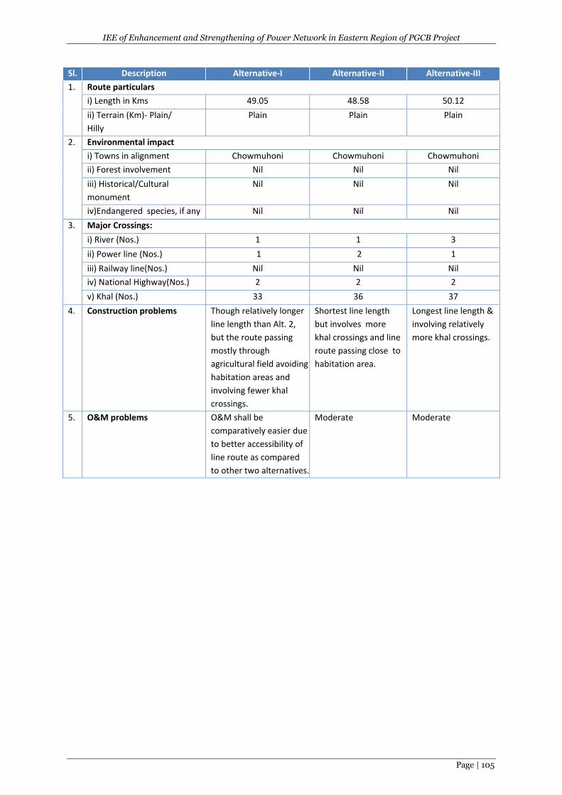
IEE of Enhancement and Strengthening of Power Network in Eastern Region of PGCB Project
Page | 105
Sl. Description Alternative-I Alternative-II Alternative-III
1. Route particulars
i) Length in Kms 49.05 48.58 50.12
ii) Terrain (Km)- Plain/
Hilly
Plain Plain Plain
2. Environmental impact
i) Towns in alignment Chowmuhoni Chowmuhoni Chowmuhoni
ii) Forest involvement Nil Nil Nil
iii) Historical/Cultural
monument
Nil Nil Nil
iv)Endangered species, if any Nil Nil Nil
3. Major Crossings:
i) River (Nos.) 1 1 3
ii) Power line (Nos.) 1 2 1
iii) Railway line(Nos.) Nil Nil Nil
iv) National Highway(Nos.) 2 2 2
v) Khal (Nos.) 33 36 37
4. Construction problems Though relatively longer
line length than Alt. 2,
but the route passing
mostly through
agricultural field avoiding
habitation areas and
involving fewer khal
crossings.
Shortest line length
but involves more
khal crossings and line
route passing close to
habitation area.
Longest line length &
involving relatively
more khal crossings.
5. O&M problems O&M shall be
comparatively easier due
to better accessibility of
line route as compared
to other two alternatives.
Moderate Moderate
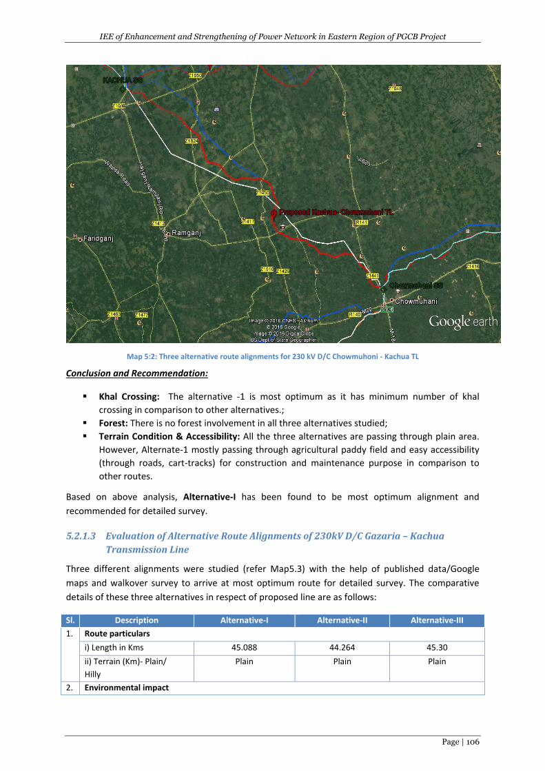
IEE of Enhancement and Strengthening of Power Network in Eastern Region of PGCB Project
Page | 106
Map 5:2: Three alternative route alignments for 230 kV D/C Chowmuhoni - Kachua TL
Conclusion and Recommendation:
Khal Crossing: The alternative -1 is most optimum as it has minimum number of khal
crossing in comparison to other alternatives.;
Forest: There is no forest involvement in all three alternatives studied;
Terrain Condition & Accessibility: All the three alternatives are passing through plain area.
However, Alternate-1 mostly passing through agricultural paddy field and easy accessibility
(through roads, cart-tracks) for construction and maintenance purpose in comparison to
other routes.
Based on above analysis, Alternative-I has been found to be most optimum alignment and
recommended for detailed survey.
5.2.1.3 Evaluation of Alternative Route Alignments of 230kV D/C Gazaria – Kachua
Transmission Line
Three different alignments were studied (refer Map5.3) with the help of published data/Google
maps and walkover survey to arrive at most optimum route for detailed survey. The comparative
details of these three alternatives in respect of proposed line are as follows:
Sl. Description Alternative-I Alternative-II Alternative-III
1. Route particulars
i) Length in Kms 45.088 44.264 45.30
ii) Terrain (Km)- Plain/
Hilly
Plain Plain Plain
2. Environmental impact
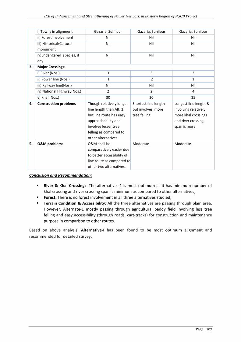
IEE of Enhancement and Strengthening of Power Network in Eastern Region of PGCB Project
Page | 107
i) Towns in alignment Gazaria, Suhilpur Gazaria, Suhilpur Gazaria, Suhilpur
ii) Forest involvement Nil Nil Nil
iii) Historical/Cultural
monument
Nil Nil Nil
iv)Endangered species, if
any
Nil Nil Nil
3. Major Crossings:
i) River (Nos.) 3 3 3
ii) Power line (Nos.) 1 2 1
iii) Railway line(Nos.) Nil Nil Nil
iv) National Highway(Nos.) 2 2 4
v) Khal (Nos.) 30 30 35
4. Construction problems Though relatively longer
line length than Alt. 2,
but line route has easy
approachability and
involves lesser tree
felling as compared to
other alternatives.
Shortest line length
but involves more
tree felling
Longest line length &
involving relatively
more khal crossings
and river crossing
span is more.
5. O&M problems O&M shall be
comparatively easier due
to better accessibility of
line route as compared to
other two alternatives.
Moderate Moderate
Conclusion and Recommendation:
River & Khal Crossing: The alternative -1 is most optimum as it has minimum number of
khal crossing and river crossing span is minimum as compared to other alternatives;
Forest: There is no forest involvement in all three alternatives studied;
Terrain Condition & Accessibility: All the three alternatives are passing through plain area.
However, Alternate-1 mostly passing through agricultural paddy field involving less tree
felling and easy accessibility (through roads, cart-tracks) for construction and maintenance
purpose in comparison to other routes.
Based on above analysis, Alternative-I has been found to be most optimum alignment and
recommended for detailed survey.
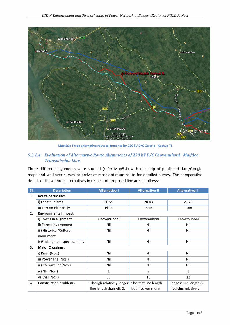
IEE of Enhancement and Strengthening of Power Network in Eastern Region of PGCB Project
Page | 108
Map 5:3: Three alternative route alignments for 230 kV D/C Gajaria - Kachua TL
5.2.1.4 Evaluation of Alternative Route Alignments of 230 kV D/C Chowmuhoni - Maijdee
Transmission Line
Three different alignments were studied (refer Map5.4) with the help of published data/Google
maps and walkover survey to arrive at most optimum route for detailed survey. The comparative
details of these three alternatives in respect of proposed line are as follows:
Sl. Description Alternative-I Alternative-II Alternative-III
1. Route particulars
i) Length in Kms 20.55 20.43 21.23
ii) Terrain Plain/Hilly Plain Plain Plain
2. Environmental impact
i) Towns in alignment Chowmuhoni Chowmuhoni Chowmuhoni
ii) Forest involvement Nil Nil Nil
iii) Historical/Cultural
monument
Nil Nil Nil
iv)Endangered species, if any Nil Nil Nil
3. Major Crossings:
i) River (Nos.) Nil Nil Nil
ii) Power line (Nos.) Nil Nil Nil
iii) Railway line(Nos.) Nil Nil Nil
iv) NH (Nos.) 1 2 1
v) Khal (Nos.) 11 15 13
4. Construction problems Though relatively longer
line length than Alt. 2,
Shortest line length
but involves more
Longest line length &
involving relatively
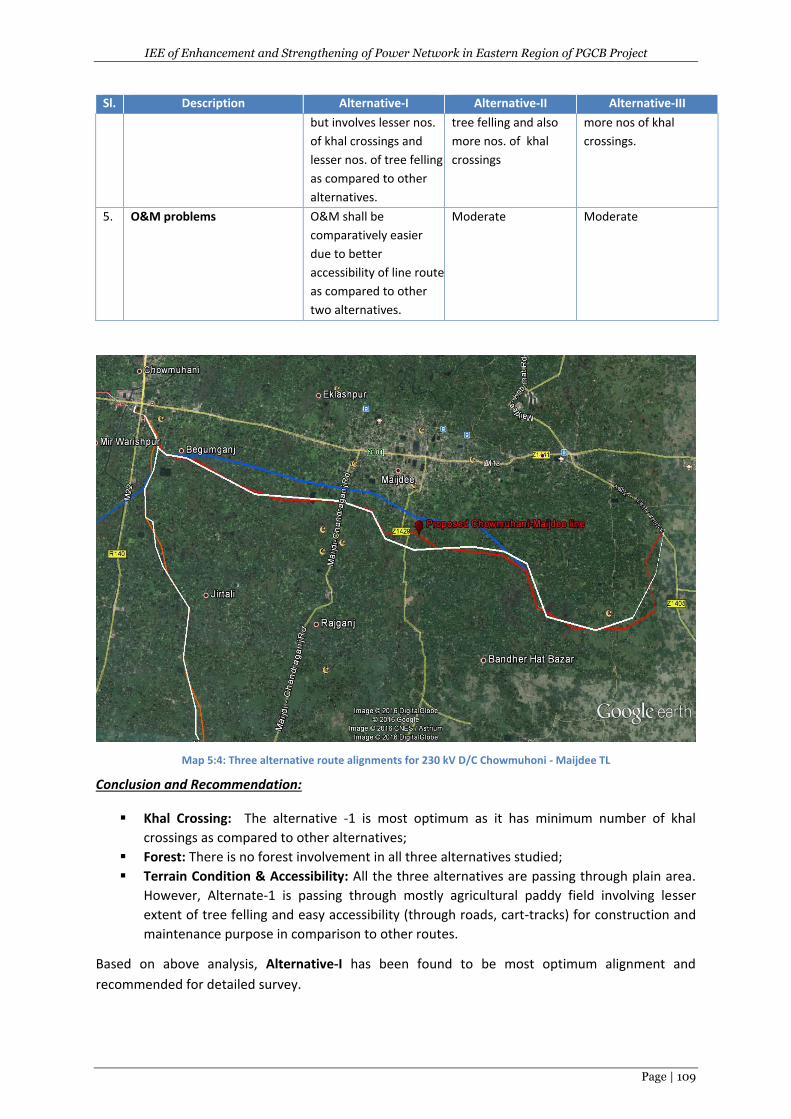
IEE of Enhancement and Strengthening of Power Network in Eastern Region of PGCB Project
Page | 109
Sl. Description Alternative-I Alternative-II Alternative-III
but involves lesser nos.
of khal crossings and
lesser nos. of tree felling
as compared to other
alternatives.
tree felling and also
more nos. of khal
crossings
more nos of khal
crossings.
5. O&M problems O&M shall be
comparatively easier
due to better
accessibility of line route
as compared to other
two alternatives.
Moderate Moderate
Map 5:4: Three alternative route alignments for 230 kV D/C Chowmuhoni - Maijdee TL
Conclusion and Recommendation:
Khal Crossing: The alternative -1 is most optimum as it has minimum number of khal
crossings as compared to other alternatives;
Forest: There is no forest involvement in all three alternatives studied;
Terrain Condition & Accessibility: All the three alternatives are passing through plain area.
However, Alternate-1 is passing through mostly agricultural paddy field involving lesser
extent of tree felling and easy accessibility (through roads, cart-tracks) for construction and
maintenance purpose in comparison to other routes.
Based on above analysis, Alternative-I has been found to be most optimum alignment and
recommended for detailed survey.
IEE of Enhancement and Strengthening of Power Network in Eastern Region of PGCB Project
Page | 110
5.2.1.5 Evaluation of Alternative Route Alignments of 132kV D/C Kachua-Laksham
Transmission Line
Three different alignments were studied (refer Map5.5) with the help of published data/Google
maps and walkover survey to arrive at most optimum route for detailed survey. The comparative
details of these three alternatives in respect of proposed line are as follows:
Sl. Description Alternative-I Alternative-II Alternative-III
1. Route particulars
i) Length in Kms 30.933 32.19 29.30
ii) Terrain– Plain/Hilly Plain Plain Plain
2. Environmental impact
i) Towns in alignment Nearby township is
Laksham
Nearby township is
Laksham
Nearby township is
Laksham
ii) Forest involvement Nil Nil Nil
iii) Historical/Cultural
monument
Nil Nil Nil
iv)Endangered species, if
any
Nil Nil Nil
3. Major Crossings:
i) River (Nos.) Nil Nil Nil
ii) Power line (Nos.) 2 3 2
iii) Railway line(Nos.) Nil Nil Nil
iv) NH(Nos.) 1 2 1
v) Khal (Nos.) 22 26 29
4. Construction problems Though relatively
longer line length than
Alt. 3, but involves
fewer khal crossings
and lesser tree felling
as the route is passing
mostly through paddy
fields compared to
other alternatives.
Longest line length,
involves more tree
felling and more nos.
khal crossings.
Shortest line length but
line route is passing
mostly through
vegetation area
requiring more tree
felling. The route also
involves more khal
crossings.
5. O&M problems O&M shall be
comparatively easier
due to better
accessibility of line route
as compared to other
two alternatives.
Moderate High
Conclusion and Recommendation:
Khal Crossing: The alternative -1 is most optimum as it has minimum number of khal
crossings as compared to other alternatives;
Forest: There is no forest involvement in all three alternatives studied;
Terrain Condition & Accessibility: All the three alternatives are passing through plain area.
However, Alternate-1 mostly passing through mostly agricultural paddy field which involve
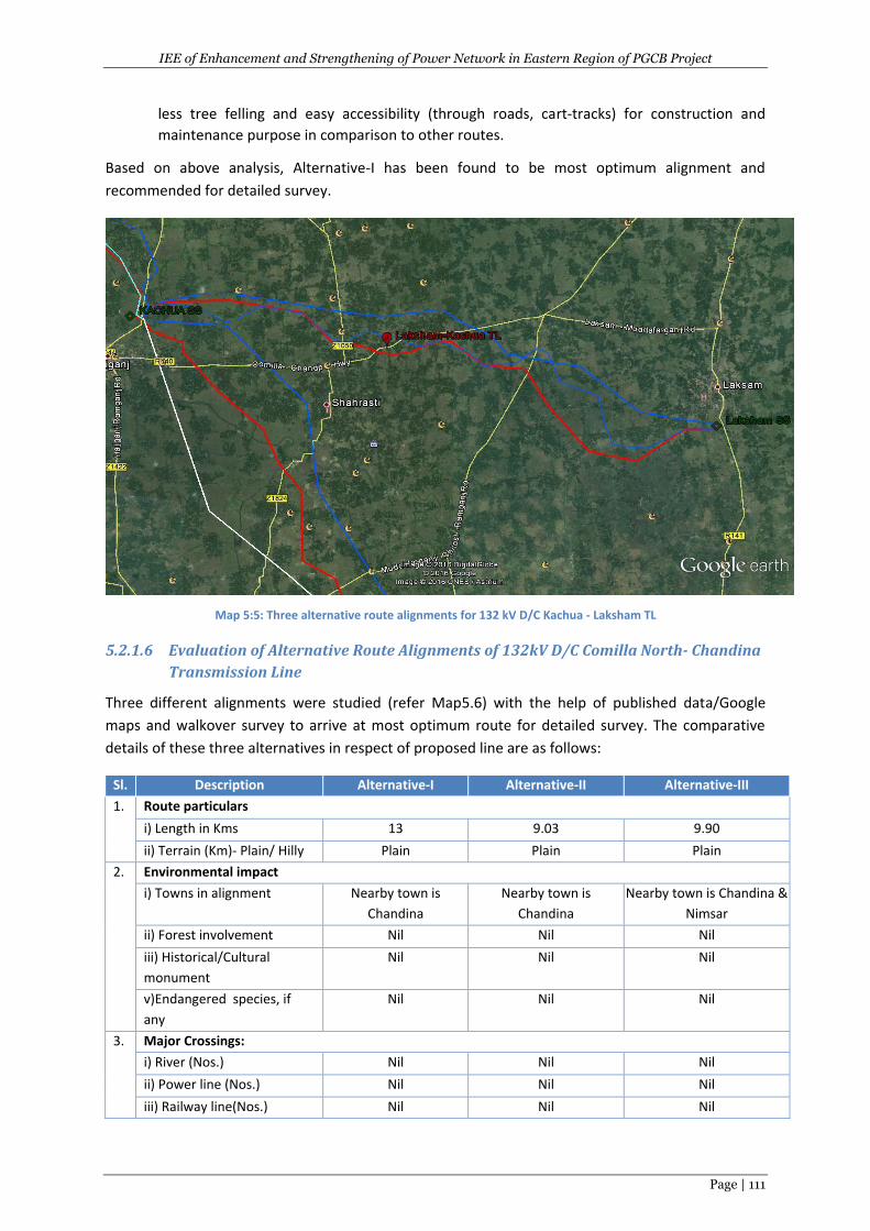
IEE of Enhancement and Strengthening of Power Network in Eastern Region of PGCB Project
Page | 111
less tree felling and easy accessibility (through roads, cart-tracks) for construction and
maintenance purpose in comparison to other routes.
Based on above analysis, Alternative-I has been found to be most optimum alignment and
recommended for detailed survey.
Map 5:5: Three alternative route alignments for 132 kV D/C Kachua - Laksham TL
5.2.1.6 Evaluation of Alternative Route Alignments of 132kV D/C Comilla North- Chandina
Transmission Line
Three different alignments were studied (refer Map5.6) with the help of published data/Google
maps and walkover survey to arrive at most optimum route for detailed survey. The comparative
details of these three alternatives in respect of proposed line are as follows:
Sl. Description Alternative-I Alternative-II Alternative-III
1. Route particulars
i) Length in Kms 13 9.03 9.90
ii) Terrain (Km)- Plain/ Hilly Plain Plain Plain
2. Environmental impact
i) Towns in alignment Nearby town is
Chandina
Nearby town is
Chandina
Nearby town is Chandina &
Nimsar
ii) Forest involvement Nil Nil Nil
iii) Historical/Cultural
monument
Nil Nil Nil
v)Endangered species, if
any
Nil Nil Nil
3. Major Crossings:
i) River (Nos.) Nil Nil Nil
ii) Power line (Nos.) Nil Nil Nil
iii) Railway line(Nos.) Nil Nil Nil
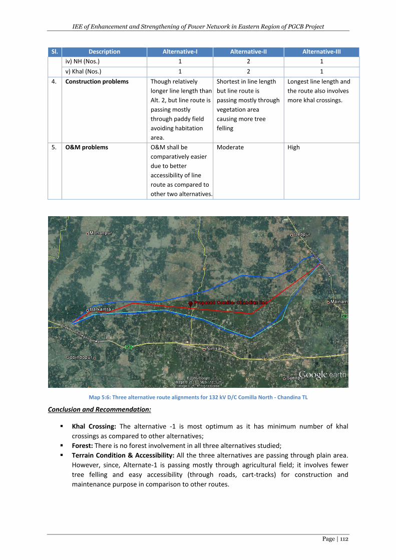
IEE of Enhancement and Strengthening of Power Network in Eastern Region of PGCB Project
Page | 112
Sl. Description Alternative-I Alternative-II Alternative-III
iv) NH (Nos.) 1 2 1
v) Khal (Nos.) 1 2 1
4. Construction problems Though relatively
longer line length than
Alt. 2, but line route is
passing mostly
through paddy field
avoiding habitation
area.
Shortest in line length
but line route is
passing mostly through
vegetation area
causing more tree
felling
Longest line length and
the route also involves
more khal crossings.
5. O&M problems O&M shall be
comparatively easier
due to better
accessibility of line
route as compared to
other two alternatives.
Moderate High
Map 5:6: Three alternative route alignments for 132 kV D/C Comilla North - Chandina TL
Conclusion and Recommendation:
Khal Crossing: The alternative -1 is most optimum as it has minimum number of khal
crossings as compared to other alternatives;
Forest: There is no forest involvement in all three alternatives studied;
Terrain Condition & Accessibility: All the three alternatives are passing through plain area.
However, since, Alternate-1 is passing mostly through agricultural field; it involves fewer
tree felling and easy accessibility (through roads, cart-tracks) for construction and
maintenance purpose in comparison to other routes.
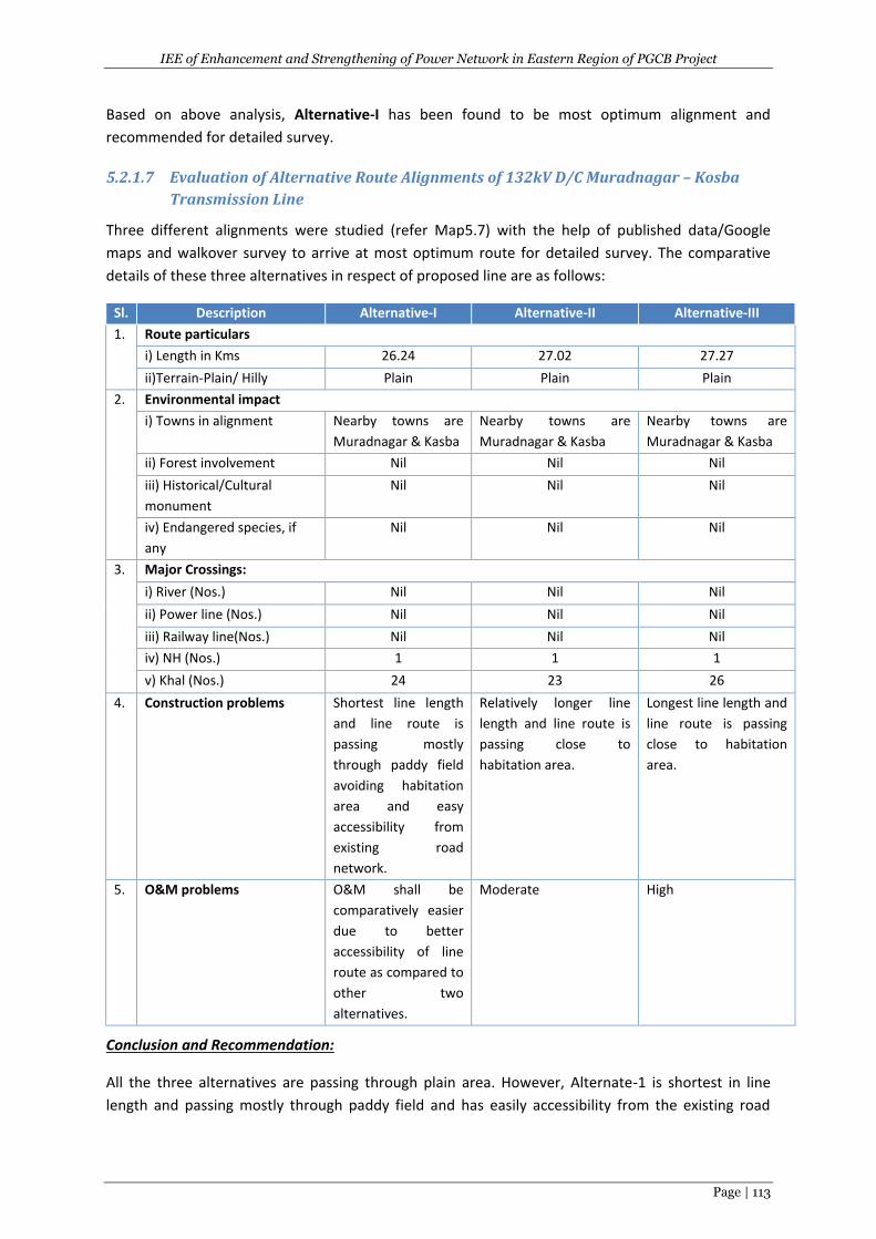
IEE of Enhancement and Strengthening of Power Network in Eastern Region of PGCB Project
Page | 113
Based on above analysis, Alternative-I has been found to be most optimum alignment and
recommended for detailed survey.
5.2.1.7 Evaluation of Alternative Route Alignments of 132kV D/C Muradnagar – Kosba
Transmission Line
Three different alignments were studied (refer Map5.7) with the help of published data/Google
maps and walkover survey to arrive at most optimum route for detailed survey. The comparative
details of these three alternatives in respect of proposed line are as follows:
Sl. Description Alternative-I Alternative-II Alternative-III
1. Route particulars
i) Length in Kms 26.24 27.02 27.27
ii)Terrain-Plain/ Hilly Plain Plain Plain
2. Environmental impact
i) Towns in alignment Nearby towns are
Muradnagar & Kasba
Nearby towns are
Muradnagar & Kasba
Nearby towns are
Muradnagar & Kasba
ii) Forest involvement Nil Nil Nil
iii) Historical/Cultural
monument
Nil Nil Nil
iv) Endangered species, if
any
Nil Nil Nil
3. Major Crossings:
i) River (Nos.) Nil Nil Nil
ii) Power line (Nos.) Nil Nil Nil
iii) Railway line(Nos.) Nil Nil Nil
iv) NH (Nos.) 1 1 1
v) Khal (Nos.) 24 23 26
4. Construction problems Shortest line length
and line route is
passing mostly
through paddy field
avoiding habitation
area and easy
accessibility from
existing road
network.
Relatively longer line
length and line route is
passing close to
habitation area.
Longest line length and
line route is passing
close to habitation
area.
5. O&M problems O&M shall be
comparatively easier
due to better
accessibility of line
route as compared to
other two
alternatives.
Moderate High
Conclusion and Recommendation:
All the three alternatives are passing through plain area. However, Alternate-1 is shortest in line
length and passing mostly through paddy field and has easily accessibility from the existing road
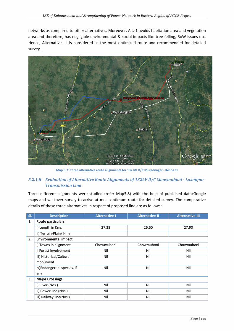
IEE of Enhancement and Strengthening of Power Network in Eastern Region of PGCB Project
Page | 114
networks as compared to other alternatives. Moreover, Alt.-1 avoids habitation area and vegetation
area and therefore, has negligible environmental & social impacts like tree felling, RoW issues etc.
Hence, Alternative - I is considered as the most optimized route and recommended for detailed
survey.
Map 5:7: Three alternative route alignments for 132 kV D/C Muradnagar - Kosba TL
5.2.1.8 Evaluation of Alternative Route Alignments of 132kV D/C Chowmuhoni - Laxmipur
Transmission Line
Three different alignments were studied (refer Map5.8) with the help of published data/Google
maps and walkover survey to arrive at most optimum route for detailed survey. The comparative
details of these three alternatives in respect of proposed line are as follows:
Sl. Description Alternative-I Alternative-II Alternative-III
1. Route particulars
i) Length in Kms 27.38 26.60 27.90
ii) Terrain-Plain/ Hilly
2. Environmental impact
i) Towns in alignment Chowmuhoni Chowmuhoni Chowmuhoni
Ii Forest involvement Nil Nil Nil
iii) Historical/Cultural
monument
Nil Nil Nil
iv)Endangered species, if
any
Nil Nil Nil
3. Major Crossings:
i) River (Nos.) Nil Nil Nil
ii) Power line (Nos.) Nil Nil Nil
iii) Railway line(Nos.) Nil Nil Nil
IEE of Enhancement and Strengthening of Power Network in Eastern Region of PGCB Project
Page | 115
Sl. Description Alternative-I Alternative-II Alternative-III
iv) National Highway 1 1 1
v) Khal (Nos.) 22 20 24
4. Construction problems Though relatively longer
line length than Alt. 2
but the line route avoids
habitation area as well
as also vegetation area
as compared other
alternatives.
Shorter in line length
line route is passing
through some
habitation area.
Longer line length
and line route is
passing through
vegetation area and
also very closed to
habitation area.
5. O&M problems O&M shall be
comparatively easier due
to better accessibility of
line route as compared
to other two
alternatives.
Moderate High
Map 5:8: Three alternative route alignments for 132 kV D/C Chowmuhoni - Laxmipur TL
Conclusion and Recommendation:
All the three alternatives are passing through plain area without involvement of any forest &
protected area. Alternative-1 is having relatively longer line length than Alt.-2 but line route is
passing mostly through agricultural field with minimum vegetation and away from habitation area
and hence minimum tree felling & RoW issues anticipated as compared to other two alternatives.
Hence, Alternative - I is considered as the most optimum route and recommended for detailed
survey.
IEE of Enhancement and Strengthening of Power Network in Eastern Region of PGCB Project
Page | 116
5.2.1.9 Evaluation of Alternative Route Alignments of LILO of 132 kV D/C Comila (N) -
Daudkandi Transmission Line
The line length of the proposed transmission line is 0.5 Km, which is quite short. Due to the short
line length, the associated environmental and social impacts will be negligible. Hence, the evaluation
of alternative route alignment for this line was not conducted.
5.2.1.10 Evaluation of Alternative Route Alignments of LILO of 132 kV D/C Dohazari -
Sikalbaha Transmission Line at Ratiya
The line length of the proposed transmission line is 0.586 Km, which is quite short. Due to short line
length, the associated environmental and social impacts will be negligible. Hence, the evaluation of
Alternative Route Alignment for this line was not conducted.
5.2.1.11 Evaluation of Alternative Route Alignments of Two Ckt LILO of 132kV D/C Feni -
Chowmuhoni Transmission Line at Basurhat
The line length of the proposed transmission line is 2.74 Km, which is quite short. Due to short line
length, the associated environmental and social impacts will be negligible. Hence, the evaluation of
Alternative Route Alignment for this line was not conducted.
5.2.1.12 Evaluation of Alternative Route Alignments of LILO of 132 kV D/C Halishahr-
Khulsi Transmission Line
The line length of the proposed transmission line is 0.63 Km, which is quite short. Due to short line
length, the associated environmental and social impacts will be negligible. Hence, the evaluation of
Alternative Route Alignment for this line was not conducted.
5.2.1.13 LILO of 400 kV D/C Modhunaghat- Meghnaghat Transmission Line at Korerhat
The line length of the proposed transmission line is 0.4 Km, which is quite short. Due to short line
length, the associated environmental and social impacts will be negligible. Hence, the evaluation of
Alternative Route Alignment for this line was not conducted.
5.2.1.14 LILO of 230 kV D/C Comilla (N) - Hathazari Transmission Line
The line length of the proposed transmission line is 5.73 Km, which is quite short. Due to short line
length, the associated environmental and social impacts will be negligible. Hence, the evaluation of
Alternative Route Alignment for this line was not conducted.
5.2.1.15 LILO of 132 kV D/C Feni- Hathazari Transmission Line
The line length of the proposed transmission line is 2.80 Km, which is quite short. Due to short line
length, the associated environmental and social impacts will be negligible. Hence, the evaluation of
Alternative Route Alignment for this line was not conducted.
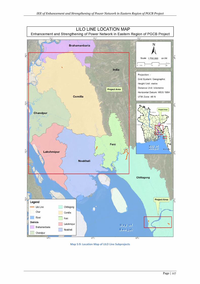
IEE of Enhancement and Strengthening of Power Network in Eastern Region of PGCB Project
Page | 117
Map 5:9: Location Map of LILO Line Subprojects
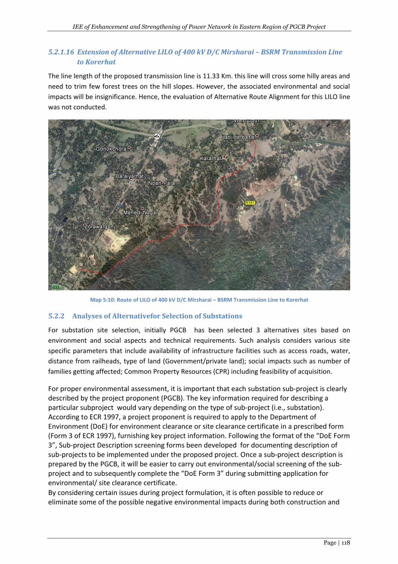
IEE of Enhancement and Strengthening of Power Network in Eastern Region of PGCB Project
Page | 118
5.2.1.16 Extension of Alternative LILO of 400 kV D/C Mirsharai – BSRM Transmission Line
to Korerhat
The line length of the proposed transmission line is 11.33 Km. this line will cross some hilly areas and
need to trim few forest trees on the hill slopes. However, the associated environmental and social
impacts will be insignificance. Hence, the evaluation of Alternative Route Alignment for this LILO line
was not conducted.
Map 5:10: Route of LILO of 400 kV D/C Mirsharai – BSRM Transmission Line to Korerhat
5.2.2 Analyses of Alternativefor Selection of Substations
For substation site selection, initially PGCB has been selected 3 alternatives sites based on
environment and social aspects and technical requirements. Such analysis considers various site
specific parameters that include availability of infrastructure facilities such as access roads, water,
distance from railheads, type of land (Government/private land); social impacts such as number of
families getting affected; Common Property Resources (CPR) including feasibility of acquisition.
For proper environmental assessment, it is important that each substation sub-project is clearly described by the project proponent (PGCB). The key information required for describing a particular subproject would vary depending on the type of sub-project (i.e., substation). According to ECR 1997, a project proponent is required to apply to the Department of Environment (DoE) for environment clearance or site clearance certificate in a prescribed form (Form 3 of ECR 1997), furnishing key project information. Following the format of the “DoE Form 3”, Sub-project Description screening forms been developed for documenting description of sub-projects to be implemented under the proposed project. Once a sub-project description is prepared by the PGCB, it will be easier to carry out environmental/social screening of the sub-project and to subsequently complete the “DoE Form 3” during submitting application for environmental/ site clearance certificate.
By considering certain issues during project formulation, it is often possible to reduce or eliminate some of the possible negative environmental impacts during both construction and
IEE of Enhancement and Strengthening of Power Network in Eastern Region of PGCB Project
Page | 119
operational phases of a project. For example, efforts to avoid, where possible, critical homestead areas or crossing of rivers/hills/bamboo groves on the substation subprojects could greatly reduce negative impacts during construction and operational phases. Such considerations at the project formulation stage could greatly reduce negative impacts and facilitate proper environmental management of a project. A number of such environmental and social issues to be considered for substation subprojects are identified and given below as bullet form. These issues should be adequately addressed during the project formulation stage, as a part of overall environmental management.
Use of government-owned land or vacant/fallow (non-productive) land for construction of substation, where possible.
Use of land located at close proximity to existing power lines/load centers, and road network (for easier transportation of material and equipment), where available.
Avoiding lands that are susceptible to inundation/ storm surge.
Avoiding ecologically and socially critical areas while selecting land for substations.
Use of Gas Insulated Switchgear (GIS) instead of Air Insulated Switchgear (AIS), in order to reduce land requirement for substation and avoid possible generation of toxic fumes in control building due to flashover inside AIS (especially under high humidity and saline conditions).
Ensuring purchase and installation of PCB free new transformers.
Treating PCB contained in old transformers available technologies; namely, super critical oxidation, electro-chemical oxidation, solvated electron technology, chemical reduction method, dehalogenation process, and thermal desorption using pyrolysis, catalyzed dehalogination and vitrification before disposal.
Designing substations considering maximum flood level, and considering wind speed and earthquake load suggested in the Bangladesh National Building Code (BNBC).
Considering the above issues and site inspection/verification, the proposed substation subproject
land has been selected and finalized.. The selected location for the substation subprojects is given in
below Map 5.11. The social aspects are provided due weightage after technical requirement in
decision making for selection/finalization of land for substation. The details of the selected site for
proposed substations along with are given below in tabular form:
Sl. No.
Name of Substation Area (acre)
Location Current
Land use Remarks
1 230/132 kV GIS at Chowmuhoni, Noakhali
5 Nazirpur
22°56’47.93”N 91°06’11.02”E
Agriculture
Fellow land not available, but
nearby road & no houses on or
nearby the SS.
2 230/132 kV GIS at Kachua, Chandpur
5 Toraghat
23°21’21.75”N 90°53’11.93”E
Agriculture Same as above
3 132/33 kV GIS at Muradnagar, Comilla
5
Paschim Bhabanipur
23°39’13.62”N 90°56’02.75”E
Agriculture
Same as above
4 132/33 kV GIS at Laksham, Comilla
2
Gaziramura
23°19’99.41”N 91°13’24.96” E
Agriculture
Same as above
5 132/33 kV GIS at Maijdee, 5 Noakhali Agriculture Same as above
IEE of Enhancement and Strengthening of Power Network in Eastern Region of PGCB Project
Page | 120
Sl. No.
Name of Substation Area (acre)
Location Current
Land use Remarks
Noakhali 22°47’57.88”N 91°04’59.06”E
6 132/33 kV GIS at Patiya, Chittagong
5 Allai
22°17’56.55”N 91°57’56.23”E
Agriculture Same as above
7 132/33 kV GIS at Chandina, Comilla
2
Chandina
23°29’37.67”N 91°58’29”E
Govt. Barren land
Same as above
8 132/33 kV GIS at New Mooring/Anand Bazar, Chittagong
20 Madha Halishar 22°18’57.67”N 91°46’21.46”E
Agriculture Same as above
9 132/33 kV GIS at Bashurhat, Daganbhuiyan, Feni
2 Sekandarpur
22°56’23.72”N 91°16’22.70”E
Agriculture Same as above
10 132/33 kV GIS at Laksmipur, Lksmipur
5 Atiatalai
22°56’05.03”N 90°52’25.62”E
Agriculture Same as above
11 132/33 kV GIS at Kosba, Brahmanbaria
5
Kaliara
23°45’37.96”N 91°12’51.44” E
Agriculture
Same as above
12 400/230 kV GIS at Korerhat, Chittagong
25 Baria
22°56’34.91”N 91°33’26.84”E
Agriculture
Same as above
Source: ESMF report,2013 of Power Cell& Site Inspection in 2017.
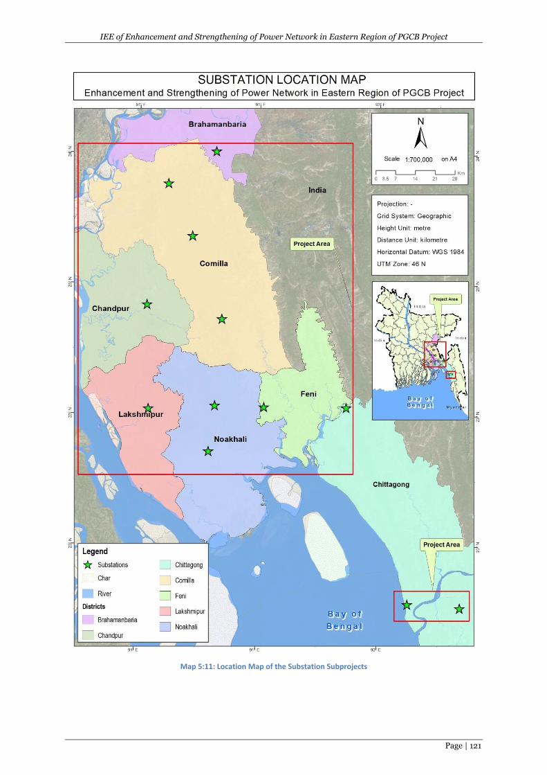
IEE of Enhancement and Strengthening of Power Network in Eastern Region of PGCB Project
Page | 121
Map 5:11: Location Map of the Substation Subprojects
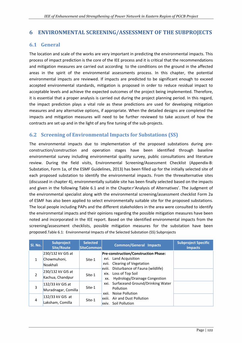
IEE of Enhancement and Strengthening of Power Network in Eastern Region of PGCB Project
Page | 122
6 ENVIRONMENTAL SCREENING/ASSESSMENT OF THE SUBPROJECTS
6.1 General
The location and scale of the works are very important in predicting the environmental impacts. This
process of impact prediction is the core of the IEE process and it is critical that the recommendations
and mitigation measures are carried out according to the conditions on the ground in the affected
areas in the spirit of the environmental assessments process. In this chapter, the potential
environmental impacts are reviewed. If impacts are predicted to be significant enough to exceed
accepted environmental standards, mitigation is proposed in order to reduce residual impact to
acceptable levels and achieve the expected outcomes of the project being implemented. Therefore,
it is essential that a proper analysis is carried out during the project planning period. In this regard,
the impact prediction plays a vital role as these predictions are used for developing mitigation
measures and any alternative options, if appropriate. When the detailed designs are completed the
impacts and mitigation measures will need to be further reviewed to take account of how the
contracts are set up and in the light of any fine tuning of the sub-projects.
6.2 Screening of Environmental Impacts for Substations (SS)
The environmental impacts due to implementation of the proposed substations during pre-
construction/construction and operation stages have been identified through baseline
environmental survey including environmental quality survey, public consultations and literature
review. During the field visits, Environmental Screening/Assessment Checklist (Appendix-B:
Substation, Form 1a, of the ESMF Guidelines, 2013) has been filled up for the initially selected site of
each proposed substation to identify the environmental impacts. From the threealternative sites
(discussed in chapter 4), environmentally suitable site has been finally selected based on the impacts
and given in the following Table 6.1 and in the Chapte:r‘Analysis of Alternatives’. The Judgment of
the environmental specialist along with the environmental screening/assessment checklist Form 2a
of ESMF has also been applied to select environmentally suitable site for the proposed substations.
The local people including PAPs and the different stakeholders in the area were consulted to identify
the environmental impacts and their opinions regarding the possible mitigation measures have been
noted and incorporated in the IEE report. Based on the identified environmental impacts from the
screening/assessment checklists, possible mitigation measures for the substation have been
proposed.Table 6.1: Environmental Impacts of the Selected Substation (SS) Subprojects
Sl. No. Subproject Site/Route
Selected SiteCommon
Common/General Impacts Subproject Specific
Impacts
1
230/132 kV GIS at
Chowmuhoni,
Noakhali
Site-1
Pre-construction/Construction Phase: xvi. Land Acquisition
xvii. Clearing of Vegetation xviii. Disturbance of Fauna (wildlife)
xix. Loss of Top Soil xx. Hydrology/Drainage Congestion
xxi. Surfaceand Ground/Drinking Water Pollution
xxii. Noise Pollution xxiii. Air and Dust Pollution xxiv. Soil Pollution
2 230/132 kV GIS at
Kachua, Chandpur Site-1
3 132/33 kV GIS at
Muradnagar, Comilla Site-1
4 132/33 kV GIS at
Laksham, Comilla Site-1
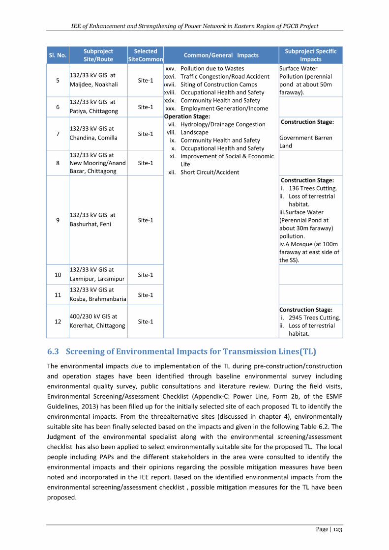
IEE of Enhancement and Strengthening of Power Network in Eastern Region of PGCB Project
Page | 123
Sl. No. Subproject Site/Route
Selected SiteCommon
Common/General Impacts Subproject Specific
Impacts
5 132/33 kV GIS at
Maijdee, Noakhali Site-1
xxv. Pollution due to Wastes xxvi. Traffic Congestion/Road Accident
xxvii. Siting of Construction Camps xxviii. Occupational Health and Safety
xxix. Community Health and Safety xxx. Employment Generation/Income
Operation Stage: vii. Hydrology/Drainage Congestion
viii. Landscape ix. Community Health and Safety x. Occupational Health and Safety
xi. Improvement of Social & Economic Life
xii. Short Circuit/Accident
Surface Water Pollution (perennial pond at about 50m faraway).
6 132/33 kV GIS at
Patiya, Chittagong Site-1
7 132/33 kV GIS at
Chandina, Comilla Site-1
Construction Stage: Government Barren Land
8 132/33 kV GIS at New Mooring/Anand Bazar, Chittagong
Site-1
9 132/33 kV GIS at
Bashurhat, Feni Site-1
Construction Stage: i. 136 Trees Cutting.
ii. Loss of terrestrial habitat.
iii.Surface Water (Perennial Pond at about 30m faraway) pollution. iv.A Mosque (at 100m faraway at east side of the SS).
10 132/33 kV GIS at
Laxmipur, Laksmipur Site-1
11 132/33 kV GIS at
Kosba, Brahmanbaria Site-1
12 400/230 kV GIS at
Korerhat, Chittagong Site-1
Construction Stage: i. 2945 Trees Cutting.
ii. Loss of terrestrial habitat.
6.3 Screening of Environmental Impacts for Transmission Lines(TL)
The environmental impacts due to implementation of the TL during pre-construction/construction
and operation stages have been identified through baseline environmental survey including
environmental quality survey, public consultations and literature review. During the field visits,
Environmental Screening/Assessment Checklist (Appendix-C: Power Line, Form 2b, of the ESMF
Guidelines, 2013) has been filled up for the initially selected site of each proposed TL to identify the
environmental impacts. From the threealternative sites (discussed in chapter 4), environmentally
suitable site has been finally selected based on the impacts and given in the following Table 6.2. The
Judgment of the environmental specialist along with the environmental screening/assessment
checklist has also been applied to select environmentally suitable site for the proposed TL. The local
people including PAPs and the different stakeholders in the area were consulted to identify the
environmental impacts and their opinions regarding the possible mitigation measures have been
noted and incorporated in the IEE report. Based on the identified environmental impacts from the
environmental screening/assessment checklist , possible mitigation measures for the TL have been
proposed.
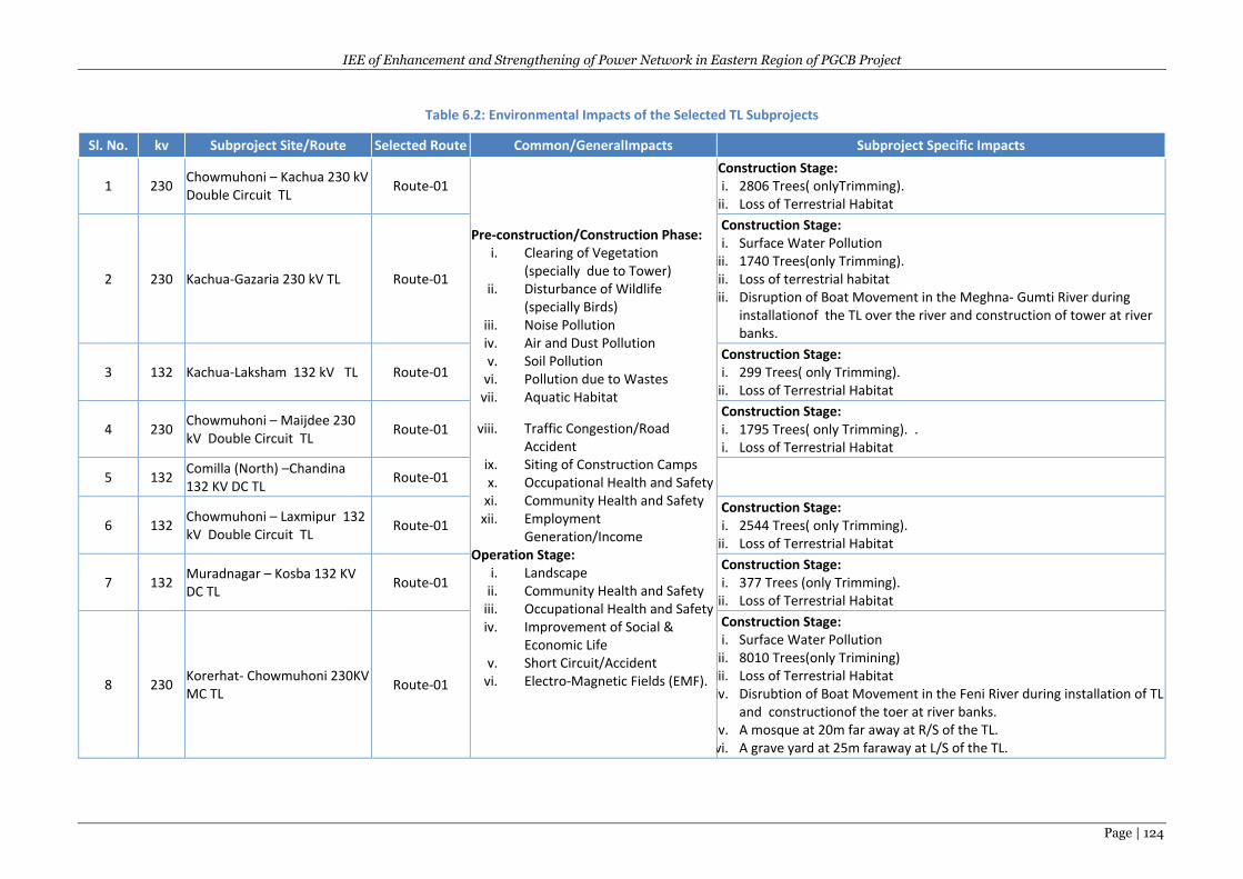
IEE of Enhancement and Strengthening of Power Network in Eastern Region of PGCB Project
Page | 124
Table 6.2: Environmental Impacts of the Selected TL Subprojects
Sl. No. kv Subproject Site/Route Selected Route Common/GeneralImpacts Subproject Specific Impacts
1 230 Chowmuhoni – Kachua 230 kV Double Circuit TL
Route-01
Pre-construction/Construction Phase: i. Clearing of Vegetation
(specially due to Tower) ii. Disturbance of Wildlife
(specially Birds) iii. Noise Pollution iv. Air and Dust Pollution v. Soil Pollution
vi. Pollution due to Wastes vii. Aquatic Habitat
viii. Traffic Congestion/Road Accident
ix. Siting of Construction Camps x. Occupational Health and Safety
xi. Community Health and Safety xii. Employment
Generation/Income Operation Stage:
i. Landscape ii. Community Health and Safety
iii. Occupational Health and Safety iv. Improvement of Social &
Economic Life v. Short Circuit/Accident
vi. Electro-Magnetic Fields (EMF).
Construction Stage: i. 2806 Trees( onlyTrimming).
ii. Loss of Terrestrial Habitat
2 230 Kachua-Gazaria 230 kV TL Route-01
Construction Stage: i. Surface Water Pollution
iii. 1740 Trees(only Trimming). ii. Loss of terrestrial habitat
iii. Disruption of Boat Movement in the Meghna- Gumti River during installationof the TL over the river and construction of tower at river banks.
3 132 Kachua-Laksham 132 kV TL Route-01 Construction Stage: i. 299 Trees( only Trimming).
ii. Loss of Terrestrial Habitat
4 230 Chowmuhoni – Maijdee 230 kV Double Circuit TL
Route-01 Construction Stage: i. 1795 Trees( only Trimming). . i. Loss of Terrestrial Habitat
5 132 Comilla (North) –Chandina 132 KV DC TL
Route-01
6 132 Chowmuhoni – Laxmipur 132 kV Double Circuit TL
Route-01 Construction Stage: i. 2544 Trees( only Trimming).
ii. Loss of Terrestrial Habitat
7 132 Muradnagar – Kosba 132 KV DC TL
Route-01 Construction Stage: i. 377 Trees (only Trimming).
ii. Loss of Terrestrial Habitat
8 230 Korerhat- Chowmuhoni 230KV MC TL
Route-01
Construction Stage: i. Surface Water Pollution
ii. 8010 Trees(only Trimining) iii. Loss of Terrestrial Habitat iv. Disrubtion of Boat Movement in the Feni River during installation of TL
and constructionof the toer at river banks. v. A mosque at 20m far away at R/S of the TL.
vi. A grave yard at 25m faraway at L/S of the TL.
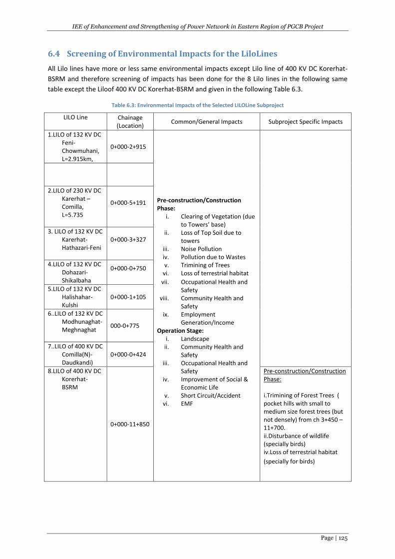
IEE of Enhancement and Strengthening of Power Network in Eastern Region of PGCB Project
Page | 125
6.4 Screening of Environmental Impacts for the LiloLines
All Lilo lines have more or less same environmental impacts except Lilo line of 400 KV DC Korerhat-
BSRM and therefore screening of impacts has been done for the 8 Lilo lines in the following same
table except the Liloof 400 KV DC Korerhat-BSRM and given in the following Table 6.3.
Table 6.3: Environmental Impacts of the Selected LILOLine Subproject
LILO Line Chainage (Location)
Common/General Impacts Subproject Specific Impacts
1.LILO of 132 KV DC Feni-Chowmuhani, L=2.915km,
0+000-2+915
Pre-construction/Construction Phase:
i. Clearing of Vegetation (due to Towers’ base)
ii. Loss of Top Soil due to towers
iii. Noise Pollution iv. Pollution due to Wastes v. Trimining of Trees
vi. Loss of terrestrial habitat
vii. Occupational Health and Safety
viii. Community Health and Safety
ix. Employment Generation/Income
Operation Stage: i. Landscape
ii. Community Health and Safety
iii. Occupational Health and Safety
iv. Improvement of Social & Economic Life
v. Short Circuit/Accident vi. EMF
2.LILO of 230 KV DC Karerhat –Comilla, L=5.735
0+000-5+191
3. LILO of 132 KV DC Karerhat-Hathazari-Feni
0+000-3+327
4.LILO of 132 KV DC Dohazari- Shikalbaha
0+000-0+750
5.LILO of 132 KV DC Halishahar-Kulshi
0+000-1+105
6..LILO of 132 KV DC Modhunaghat-Meghnaghat
000-0+775
7..LILO of 400 KV DC Comilla(N)-Daudkandi)
0+000-0+424
8.LILO of 400 KV DC Korerhat-BSRM
0+000-11+850
Pre-construction/Construction Phase: i.Trimining of Forest Trees ( pocket hills with small to medium size forest trees (but not densely) from ch 3+450 – 11+700. ii.Disturbance of wildlife (specially birds) iv.Loss of terrestrial habitat
(specially for birds)
IEE of Enhancement and Strengthening of Power Network in Eastern Region of PGCB Project
Page | 126
6.5 Impact Assessment
Based on the environmental baseline data, given in chapter 4 and environmental screening, impacts
assessment for the above finally selected subprojects (Substations, Transmission Lines and LILO
lines) have been done and presented in the following subchapters. Potential environmental impacts
have been categorized into: (a) general/common impacts, which are typical common impacts to be
experienced in all the subprojects and (b) subproject specific impacts.
6.5.1 General/Common Impacts due to Substation Subprojects
6.5.1.1 Pre-construction/Construction Phase
Land Acquisition: As mentioned earlier in chapter 4, due to construction of the proposed
substations, a total of 86acre (around 34.82 ha for total 12 substations) of private agricultural land
will be acquired. As a result, permanent land loss and crop loss will be occurred. In addition, a small
quantity of land will be required temporarily for the construction camp of each substation site.
Clearing of Vegetation: Prior to start construction, the substations sites need to be cleared and as a
result, standing vegetation (e.g. crops, grass, bushes etc.) loss will be occurred.
Disturbance of Wildlife (Specially Birds): As mentioned in Chapter 4 due to project activities such as
earthworks, movement of project heavy equipment & transports with noise especially during night
time, wildlife specially birds will be disturbed.
Loss of Top Soil: Filling of the proposed substations area will cause loss of top clay silt soil of the site
(thickness about 0.5m) which is suitable for the boundary slope protection of the substation site.
There are possibilities of soil erosion occurring during the construction of the proposed substations
especially during rainy and windy seasons. The impact will however be minimal as area to be filled, is
very small.
Hydrology/Drainage Congestion: During monsoon period due to filling of the substation subproject
sites by earth and construction of temporary earth embankment surrounding the site to keep the
site dry as well as reduction of flood prone area, rising of local flood level and drainage congestion
will be occurred. Changes in surface hydrology alter the flow of water through the landscape.
Construction of impervious surfaces such as parking lots, roads and buildings increase the volume
and rate of runoff, resulting in habitat destruction, increased pollutant loads, and flooding.During
monsoon period due to intensive rainfall, drainage congestion will be occurred around the
substation areas if adequate drainage facilities are not provided in the connecting access road in
between exiting roads and substations.
Ground Water Pollution: Contaminated soil or ground water in the path of the project could be
disturbed by excavation resulting in a potential transfer of the contamination to surface water. Oil
spills during construction could introduce contaminants into subsurface which may end-up into
ground water. Development activities such as substations development as well as the spill-over
effects of development such as increased demand for water use and increased auto use can impact
water quality by contributing sediment, nutrients, and other pollutants to limit water supplies,
increasing the temperature of the water, and increasing the rate and volume of runoff.
IEE of Enhancement and Strengthening of Power Network in Eastern Region of PGCB Project
Page | 127
Noise Pollution: The proposed areas are relatively rural areas. Generation of noise pollution will be
occurred from the construction activities for the substation sites such as earth filling, crushing of
bricks and stones, concrete mixing plant, movement of heavy construction vehicles, functioning of
generators and as result, local community, project workers, wildlife and other lives will be affected
specially during night time.
Air and Dust Pollution: Exhaust emissions are likely to be generated by the construction equipment
during the construction phase of proposed substations. Motor vehicles that will be used to carry
construction materials would cause air quality impact by emitting pollutants through exhaust
emissions. But the impacts will not be significant.
Particulate matter pollution is likely to occur during the site clearance, excavation and spreading of
the topsoil during construction of proposed substations. There is a very small possibility of PM10
suspended and settleable particles affecting the site workers and even neighbors’ health, it is
minimal given the construction method of minimum excavation and nil cart away of soil.
Soil Pollution: The carried river bed materials (if contain heavy metals) from the nearby river for the
filling of the substation site will contaminate the soil of the nearby agricultural land and as a result,
crop production and biodiversity will be affected. In addition, during construction, due to accidental
spillage and leakage of oil and toxic chemical (if falls on the soil surface) will also pollute the local
soil.
Pollution due to Wastes: Generation of construction wastes (such as solid wastes: electric wire,
pipes, stones, woods, rods etc., and liquid waste: paint, oil, bitumen etc.,) from the construction
camp and general wastes (solid wastes: papers, containers, residues of food, fruits etc., and liquid
waste: waste water from bathroom and kitchen etc.) from workers’ camp will impact on H&S of the
local community and workers as well as on aesthetic beauty of the area, air and soil if inadequate
arrangements exist for the disposal of wastes.
Traffic Congestion/Road Accident: The heavy construction vehicles will be required for carrying of
construction materials and equipment. Vehicles such as trucks, buses, jeeps, microbuses, cars,
rickshaw vans, votvoti, motor bikes, bicycles as well as students and local people walk on the roads
and as a result, traffic jams occur specially during morning and evening times as observed during
field survey. The construction vehicles will add more traffic and as a result, traffic congestion and
road accident will be increased. Traffic congestion also will be occurred, if the stock piling of
construction materials will be at the road sides.
Siting of Construction Camps: The precise locations for construction camps for the proposed
substations will be decided by the PGCB in consultation with the project contractors. However, the
siting of the camps may cause a number of issues such as loss of plantation and vegetation,
permanent physical and visual impact on the area, siltation and pollution risks if construction
materials are collected from the river bed. The construction process will take minimum 3 years, with
the result that the camps will take on a semi-permanent appearance. The people and the changes
they bring can have significant impacts on the local communities and social structures. Substantial
numbers of workers will inhabit the area in temporary camps loading local infrastructure and
causing ambient social influence. Most important aspects are: pollution risk of soil and surface water
due to sanitation of the labour camps and wastes from the camps.
IEE of Enhancement and Strengthening of Power Network in Eastern Region of PGCB Project
Page | 128
Occupational Health and Safety: Construction workers are more likely to face occupational health
hazards such as minor or major injuries due to lack of general safety requirements and precautions
applicable while working at construction sites, and handling with machines and equipment, use of
equipment and driving vehicles and so on. Poorly designed temporary labour camp and sanitation
facilities may pose a health threat and nuisance to the workers. Uncontrolled vending of food and
drinking water at the work site may also pose a risk with respect to the transmission of contagious
diseases like Typhoid, Diarrhea, Malaria, and Dengue in particular. Although presently, total ratio of
the affected people in Bangladesh by HIV/AIDS is far less than 0.1%, however this % is slowly being
increased due to injection drug users and overseas migrant workers returned to Bangladesh.
Construction workers will be required to handle hazardous materials such as cement, bitumen,
chemicals, fuels, and so on which will increase health risks of the workers if personal protective
equipment are not used.
Community Health and Safety: Improper health and safety policy maintained at the site may lead to
outbreak of different diseases to the surrounding communities/public through the sick construction
workers. From the traffic survey, it is known that all types of motorized transports such as trucks,
buses, oil tankers, jeeps, pick up, cars, auto rickshaws, tempo and motor cycles move on the roads
and as a result, traffic jams occur frequently specially during 8:00 to 10:00 and 17:00 to 21:00 on
these roads which will affect the health of the local community.
Employment Generation/Income: During construction a considerable quantity of workers (both
male & female) will be required for the construction of the substation. Conflict between male &
female may be arisen if women workers are deprived. Some local people may also involve
themselves in small businesses (e.g. tea stall, grocery shop etc.). Local people can be involved in the
project construction work as per their skill.
6.5.1.2 Operation Stage
Drainage Congestion: During monsoon period due to intensive rainfall, drainage congestion will be
occurred inside the substation area if proper drainage facilities are not provided. Drain will be
blocked due to disposal of solid waste in to the drain if proper maintenance is not done regularly.
Landscape: Due to construction of substation in the rural areas, the natural landscape in rural areas
will be changed but not significantly.
Community Health and Safety: A total of 41 people are killed per year in Bangladesh due to short
circuit. Short circuit may be occurred if large trees come in contact with the substation during storm
and as a result, accident may be happened.
Occupational Health and Safety: Workers specially engaged with the operation of transformers and
other electrical equipment will be affected. Short circuit may be occurred if large trees come in
contact with the substation during storm and as a result, accident may be happened.
Improvement of Social & Economic Life: Due to increase of power generation and the reliability of
power supply, social life and economic condition of the people will be improved.
Short Circuit/Accident: Due to short circuit of the substation, disruption of power and accident will
be occurred.
IEE of Enhancement and Strengthening of Power Network in Eastern Region of PGCB Project
Page | 129
6.5.2 Substation Subproject Specific Impacts
6.5.2.1 Pre-construction/Construction Stage
Subproject specific impacts are as follows:
Substation Potential Impacts
400 kV Korerhat Substation, Mirsarai, Chittagong
Tree Cutting: At the selected location 2,945 different sizes trees are present. During the construction period site clearance will be required and these trees will need to be felled.
132/33 kV: Basurhat GIS 2x50/75 MVA Substation, Daganbhuiyan, Feni
Tree Cutting: At the selected location 136 different sizes trees are present. During the construction period site clearance will be required and these trees will need to be felled. SW Pollution: Due to disposal of general and construction wastes into the nearby pond water, water will be contaminated. Due to washing of project vehicles, equipment etc. pond water also will be polluted. Cultural Site: Due to earth work, a mosque at about 100m faraway will be affected specially by dust and noise.
132/33 kV: Chandina GIS 2x50/75 MVA Substation, Debidwar, Comilla
Tree Cutting: At the selected location 420 different sizes trees are present. During the construction period site clearance will be required and these trees will need to be felled. SW Pollution: Due to disposal of general and construction wastes into the nearby pond water, water will be contaminated. Due to washing of project vehicles, equipment etc. pond water also will be polluted.
132/33 kV GIS atMaijdeeSubstation, Noakhali.
SW Pollution: Due to disposal of general and construction wastes into the nearby khal water, water will be contaminated. Due to washing of project vehicles, equipment etc. khal water also will be polluted.
6.5.3 General/Common Impacts due to TL and Lilo Lines Subprojects
6.5.3.1 Pre-construction/ Construction Phase
Clearing of Vegetation: As mentioned earlier , a total of 20,252 trees will be partially affected by
trimming during construction of the eight TLs. The proposed TLs stretch approximately 210.762 Km
will require clearance of ROW and will result in temporarily loss of vegetation. Out of the 8 LILO
lines, only 11.334 Korerhat –BSRM line is passing over the pocket of hilly area (upto 6m ht) with
forest trees from ch 3+450-11+700 which need to be trimming (if required). However, most of the
trees need to be trimmed instead of cutting and thus the impact will be medium significant. In
general vegetation destruction shall result in reduction of biodiversity as valuable trees such as
those of medicinal importance, wild fruits, and endangered species may be negatively impacted
upon. Fauna (wildlife) providing habitat for most birds, snakes and other predators may also be
affected, as vegetation cover of the understory is reduced. Disturbaning to flora will lead to
reduction in biodiversity.
Disturbance of Fauna: As mentioned in Chapter 5 due to project activities such as earthworks for
towers of the TL &LILO lines, movement of project heavy equipment & transports with noise
especially during night time, wildlife specially birds will be disturbed.
The way leave for the proposed TL & LL lines could open or truncate some migratory routes for wild
animals. However, open areas under the way leave could provide new browsing grounds for various
animals. The presence of the construction workers in the project area may induce poaching. Leftover
aluminum conductors from construction works may give rise to snare wire that poachers eventually
IEE of Enhancement and Strengthening of Power Network in Eastern Region of PGCB Project
Page | 130
use to trap animals. Tower foundation works could disturb habitats for smaller mammals such as
rodents and rats.
Negative impacts may arise, from erected transmission lines, through accidental ramming of large
birds into the power lines during their normal or regional and seasonal migratory flights. All
vegetation layers, emergent, canopy and under-storey, allows for birds’ habitat and nesting and
therefore, the removal of vegetation may impact negatively on these activities.
Loss of Top Soil:For the construction of tower base for the TL &LILO lines approximately 804 acres
(325.50 ha) land will be temporarily used. Construction of the lines might open up areas that could
be exposed to soil erosion. The variability in soil texture in the study area entails that certain
sections of the route could be exposed without any serious threat to water induced erosion. For
instance, clayey top soils are highly prone to water induced erosion once exposed. The impact will
however be minimal as the area to be disturbed is small.
Noise Pollution: The proposed areas are relatively tranquil. Noise shall be created during
construction especially since heavy-duty equipment shall be used in excavating, stringing and tower
erection. Noise pollution shall, however, be limited to the construction and routing maintenance
period. As a result, local community, project workers, wildlife and other lives will be affected
specially during night time.
Air and Dust Pollution: Exhaust emissions are likely to be generated by the construction equipment
during the construction phase of proposed transmission line. Motor vehicles that will be used to
ferry construction materials would cause air quality impact by emitting pollutants through exhaust
emissions. The impacts will not be significant.
Particulate matter pollution is likely to occur during the site clearance, excavation and spreading of
the topsoil during construction of proposed substations. There is a very small possibility of PM10
suspended and settleable particles affecting the site workers and even neighbors’ health, it is
minimal given the construction method of minimum excavation and nil cart away of soil.
Soil Pollution: Due to accidental spillage and leakage of oil and toxic chemical (if falls on the soil
surface) will pollute the local soil.
Pollution due to Wastes: Generation of construction wastes (such as solid wastes: electric wire,
pipes, stones, woods, rods etc., and liquid waste: paint, oil, bitumen etc.,) from the construction
camp and general wastes (solid wastes: papers, containers, residues of food, fruits etc., and liquid
waste: waste water from bathroom and kitchen etc.) from workers’ camp will impact on H&S of the
local community and workers as well as on aesthetic beauty of the area, air and soil if inadequate
arrangements exist for the disposal of wastes.
Traffic Congestion/Road Accident: The heavy construction vehicles will be required for carrying of
construction materials and equipment. Vehicles such as trucks, buses, jeeps, microbuses, cars,
rickshaw vans, votvoti, motor bikes, bicycles as well as students and local people walk on the roads
and as a result, traffic jams occur specially during morning and evening times as observed during
field survey. The construction vehicles will add more traffic and as a result, traffic congestion and
road accident will be increased. Traffic congestion also will be occurred, if the stock piling of
construction materials will be at the road sides.
IEE of Enhancement and Strengthening of Power Network in Eastern Region of PGCB Project
Page | 131
Siting of Construction Camps: The precise locations for construction camps for the proposed project
will be decided by the PGCB in consultation with the project contractors. However, the siting of the
camps may cause a number of issues such as loss of plantation and vegetation, permanent physical
and visual impact on the area. The construction process will take several years, with the result that
the camps will take on a semi-permanent appearance. The people and the changes they bring can
have significant impacts on the local communities and social structures. Substantial numbers of
workers will inhabit the area in temporary camps loading local infrastructure and causing ambient
social influence. Most important aspects are: pollution risk of soil and surface water due to
sanitation of the labour camps and wastes from the camps.
Occupational Health and Safety: Construction workers are more likely to face occupational health
hazards such as minor or major injuries due to lack of general safety requirements and precautions
applicable while working at construction sites, and handling with machines and equipment, use of
equipment and driving vehicles and so on. Poorly designed temporary labour camp and sanitation
facilities may pose a health threat and nuisance to the workers. Uncontrolled vending of food and
drinking water at the work site may also pose a risk with respect to the transmission of contagious
diseases like Typhoid, Diarrhea, Malaria, and Dengue in particular. Although presently, total ratio of
the affected people in Bangladesh by HIV/AIDS is far less than 0.1%, however this % is slowly being
increased due to injection drug users and overseas migrant workers returned to Bangladesh.
Construction workers will be required to handle hazardous materials such as cement, bitumen,
chemicals, fuels, and so on which will increase health risks of the workers if personal protective
equipment are not used.
Community Health and Safety: Improper health and safety policy maintained at the site may lead to
outbreak of different diseases to the surrounding communities/public through the sick construction
workers. From the traffic survey, it is known that all types of motorized transports such as trucks,
buses, oil tankers, jeeps, pick up, cars, auto rickshaws, tempo and motor cycles move on the roads
and as a result, traffic jams occur frequently specially during 8:00 to 10:00 and 17:00 to 21:00 on
these roads which will affect the health of the local community.
Employment Generation/Income: During construction a considerable quantity of workers (both
male & female) will be required for the construction of the substation. Conflict between male &
female may be arisen if women workers are deprived. Some local people may also involve
themselves in small businesses (e.g. tea stall, grocery shop etc.). Local people can be involved in the
project construction work as per their skill.
6.5.3.2 Operation Stage
Landscape: Due to construction of transmission line in the rural areas, the natural landscape will be
changed but not significantly.
Collision of Birds with Overhead Earth Wire: Collision of birds with overhead earth wire has been
identified as one of the most significant impacts on avifauna for the project. Mitigation in the form
of route selection and earth wire marking will reduce the impact to Medium. The preferred route
passes through habitat areas should be avoided in order to reduce the chances of collisions. The
open patches of grassland however would attract species such as storks, which could be at risk of
collisions.
IEE of Enhancement and Strengthening of Power Network in Eastern Region of PGCB Project
Page | 132
Community Health and Safety: A total of 41 people are killed per year in Bangladesh due to short
circuit. Short circuit may be occurred if large trees come in contact with the substation during storm
and as a result, accident may be happened.
Occupational Health and Safety: Workers specially engaged with the operation of transformers and
other electrical equipment will be affected. Short circuit may be occurred if large trees come in
contact with the substation during storm and as a result, accident may be happened.
Improvement of Social & Economic Life: Due to increase of power generation and the reliability of
power supply, social life and economic condition of the people will be improved.
Short Circuit/Accident: Due to short circuit of the substation, disruption of power and accident will
be occurred.
EMF: Health concerns over exposure to EMF are often raised when a new TL is proposed. To date the research has not been able to establish a cause and effect relationship between exposure to magnetic fields and human disease, nor a plausible biological mechanism by which exposure to EMF could cause disease. Rehabilitation of existing power lines is unlikely to increase EMF but new lines may induce EMF. Although any TL/Lilo lines do not pass over the housing areas/popuplated areas however health may be affected however inspection of existing EMF along the selected routes of the existing and new Transmission and Distribution lines and around the Substation sites would be necessary, as a part of carrying out IEE/IEE (by the consultant engaged for this purpose).
Corona Effect:The effects of the corona are are as follows: (i) The glow appear across the
conductor which shows the power loss occur on it; (ii) The audio noise occurs because of the
corona effect which causes the power loss on the conductor; (iii) The vibration of conductor
occurs because of corona effect; (iv) The corona effect generates the ozone because of which the
conductor becomes corrosive; (v) The corona effect produces the non-sinusoidal signal thus the
non-sinusoidal voltage drops occur in the line; (vi) The corona power loss reduces the efficency
of the line; and (vii) The radio and TV interference occurs on the line because of corona effect.
6.5.4 TL/Lilo Line Subproject Specific Impacts
6.5.4.1 Preconstruction/Construction Stage
Subproject specific impacts are as follows:
Subproject Potential Impacts
230kV D/C Korerhat – Chowmuhoni Transmission Line
Disruption of boats (such as non engine and engine country boats and trallers) movement in the Feni River (perennial water body) during installation of TLs over the river and construction of the TL’s tower on both the river banks. SW Pollution: Due to disposal of general and construction wastes into the nearby pond water, water will be contaminated. Due to washing of project vehicles, equipment etc. pond water also will be polluted.
230kV D/C Gazaria – Kachua Transmission Line
Disruption of boats (such as non engine and engine country boats, trallers, launches, bulkhead sand boats, speed boats and vessels) movement in the Meghna-Gumti River(perennial water body) during installation of TLs over the river and construction of the TL’s tower on both the river banks .
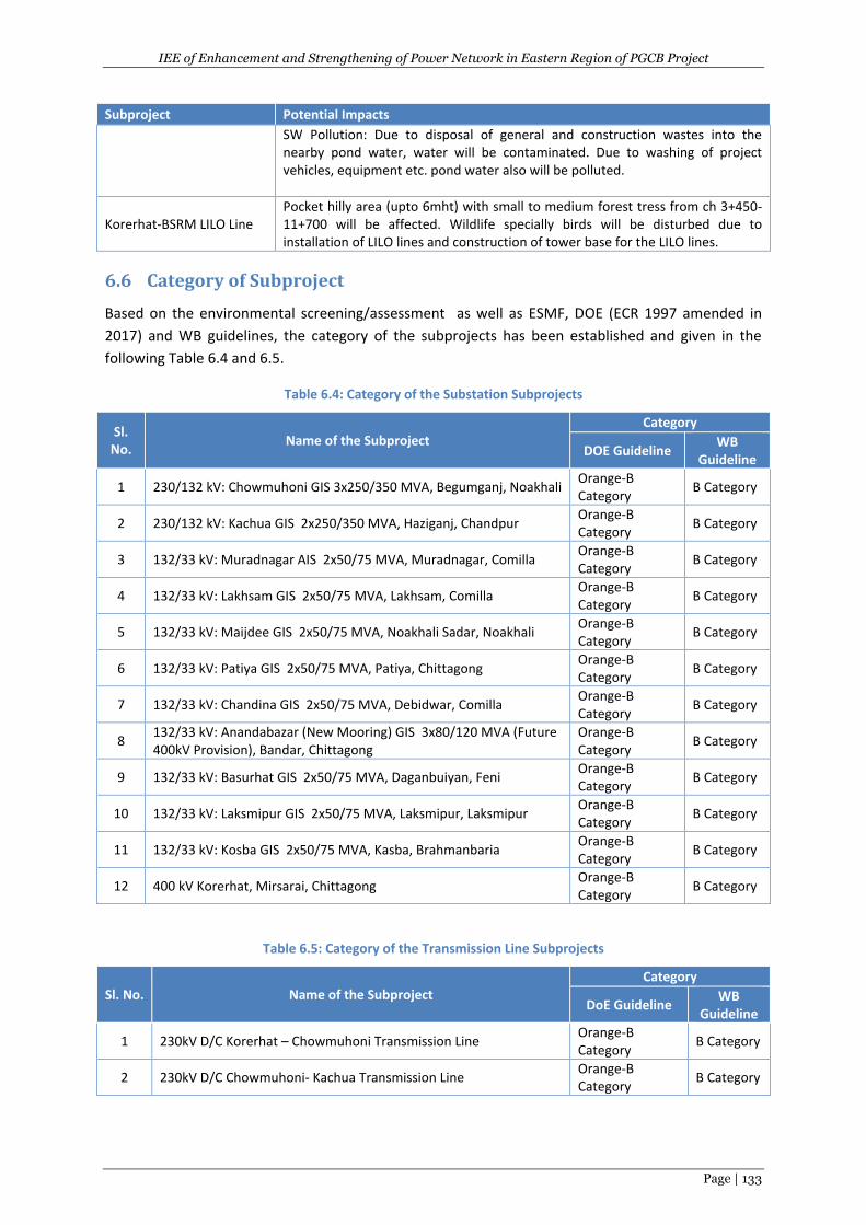
IEE of Enhancement and Strengthening of Power Network in Eastern Region of PGCB Project
Page | 133
Subproject Potential Impacts
SW Pollution: Due to disposal of general and construction wastes into the nearby pond water, water will be contaminated. Due to washing of project vehicles, equipment etc. pond water also will be polluted.
Korerhat-BSRM LILO Line Pocket hilly area (upto 6mht) with small to medium forest tress from ch 3+450-11+700 will be affected. Wildlife specially birds will be disturbed due to installation of LILO lines and construction of tower base for the LILO lines.
6.6 Category of Subproject
Based on the environmental screening/assessment as well as ESMF, DOE (ECR 1997 amended in
2017) and WB guidelines, the category of the subprojects has been established and given in the
following Table 6.4 and 6.5.
Table 6.4: Category of the Substation Subprojects
Sl. No.
Name of the Subproject Category
DOE Guideline WB
Guideline
1 230/132 kV: Chowmuhoni GIS 3x250/350 MVA, Begumganj, Noakhali Orange-B Category
B Category
2 230/132 kV: Kachua GIS 2x250/350 MVA, Haziganj, Chandpur Orange-B Category
B Category
3 132/33 kV: Muradnagar AIS 2x50/75 MVA, Muradnagar, Comilla Orange-B Category
B Category
4 132/33 kV: Lakhsam GIS 2x50/75 MVA, Lakhsam, Comilla Orange-B Category
B Category
5 132/33 kV: Maijdee GIS 2x50/75 MVA, Noakhali Sadar, Noakhali Orange-B Category
B Category
6 132/33 kV: Patiya GIS 2x50/75 MVA, Patiya, Chittagong Orange-B Category
B Category
7 132/33 kV: Chandina GIS 2x50/75 MVA, Debidwar, Comilla Orange-B Category
B Category
8 132/33 kV: Anandabazar (New Mooring) GIS 3x80/120 MVA (Future 400kV Provision), Bandar, Chittagong
Orange-B Category
B Category
9 132/33 kV: Basurhat GIS 2x50/75 MVA, Daganbuiyan, Feni Orange-B Category
B Category
10 132/33 kV: Laksmipur GIS 2x50/75 MVA, Laksmipur, Laksmipur Orange-B Category
B Category
11 132/33 kV: Kosba GIS 2x50/75 MVA, Kasba, Brahmanbaria Orange-B Category
B Category
12 400 kV Korerhat, Mirsarai, Chittagong Orange-B Category
B Category
Table 6.5: Category of the Transmission Line Subprojects
Sl. No. Name of the Subproject Category
DoE Guideline WB
Guideline
1 230kV D/C Korerhat – Chowmuhoni Transmission Line Orange-B Category
B Category
2 230kV D/C Chowmuhoni- Kachua Transmission Line Orange-B Category
B Category
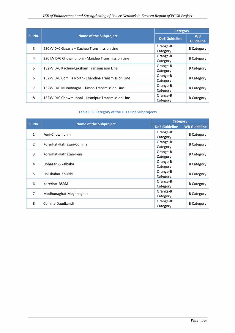
IEE of Enhancement and Strengthening of Power Network in Eastern Region of PGCB Project
Page | 134
Sl. No. Name of the Subproject Category
DoE Guideline WB
Guideline
3 230kV D/C Gazaria – Kachua Transmission Line Orange-B Category
B Category
4 230 kV D/C Chowmuhoni - Maijdee Transmission Line Orange-B Category
B Category
5 132kV D/C Kachua-Laksham Transmission Line Orange-B Category
B Category
6 132kV D/C Comilla North- Chandina Transmission Line Orange-B Category
B Category
7 132kV D/C Muradnagar – Kosba Transmission Line Orange-B Category
B Category
8 132kV D/C Chowmuhoni - Laxmipur Transmission Line Orange-B Category
B Category
Table 6.6: Category of the LILO Line Subprojects
Sl. No. Name of the Subproject Category
DoE Guideline WB Guideline
1 Feni-Chowmuhini Orange-B Category
B Category
2 Korerhat-Hathazari-Comilla Orange-B Category
B Category
3 Korerhat-Hathazari-Feni Orange-B Category
B Category
4 Dohazari-Sikalbaha Orange-B Category
B Category
5 Halishahar-Khulshi Orange-B Category
B Category
6 Korerhat-BSRM Orange-B Category
B Category
7 Modhunaghat-Meghnaghat Orange-B Category
B Category
8 Comilla-Daudkandi Orange-B Category
B Category
IEE of Enhancement and Strengthening of Power Network in Eastern Region of PGCB Project
Page | 135
7 PUBLIC CONSULTATION
7.1 Objectives
The Public Consultation (PC) was undertaken as a part of the IEE in order to obtain the views of
members of the immediate community and interested and project affected persns (PAPs) within the
site’s immediate area of influence. The consultations were done with randomly selected people in
the neighborhood of the proposed sites and involved use of a semi-structured public participation
form. In general, the project is acceptable and no objections were raised concerning the
development as proposed by the local people.
The Public Consultation has been conducted during August 2017 through Stakeholder Consultations
(SC),& individual during the environmental study of the proposed project in conformity with the
WB’s and DOE’s environmental guidelines to achieve the following objectives:
To share information( such as existing environment, sio-economic , health status etc.) on the
subprojects (SS,TL and LILO lines) of the proposed project;
To understand stakeholders’ including PAPs‘ concerns regarding various aspects of the
proposed project including existing power supply facilities/system and expected potential
environmental impacts along with possible mitigation measures during construction &
operation stages of the proposed project;
To identify the conflict issues in advance & to find acceptable solutions; and
To gather local knowledge before decision making of the proposed project;
7.2 Categories of Stakeholders
Consultations have been carried out with the following stakeholders at different venues:
Project related government and non government officials ( such as PC, PGCB, Union
Parishad Office, WB etc .);
Project Affected Persons (PAPs):
People (direct PAPs) who will lose their lands permanently and temporarily due to
implementatyion of the proposed project;
Shopkeepers who have even temporarily shops within the ROW of the project
People (indirect PAPs) living in the proposed subproject influence area (SPIA).
Local beneficiaries;
Villagers;
Urban people;
Businessmen; and
General public.
These public consultations have been provided key inputs for the identification of the potential
environmental impacts along with possible mitigation measures for the negative impacts and
enhancement for the positive impacts due to implementation of the subprojects of proposed
project.
IEE of Enhancement and Strengthening of Power Network in Eastern Region of PGCB Project
Page | 136
7.3 Consultation Process
The consultation locations at the subproject sites were selected based on the criterias which are as
follows:
The environmental, social and cultural importance of the subproject area;
All the selected locations are at the human settlement areas, at the local authority (such as
union parishad) which are located nearby the subproject sites; particularly at the junction of
substation and transmission line and in some cases Lilo line also. So, the consultants were
able to discuss on the project features, environmental and social impacts due to the
implementation of the subprojects along with mitigation measures with the local people
specially PAPs. Moreover, the selected locations are rich in terms of availability of surface
water sources, vegetation, agricultural land, cultural sites etc.
The consultants held meeting with the stakeholders. The stakeholder consultationswere held at the
PC, PGCB, Union Parishad office and WB offices, subprojects’ sites and SPIA (within about 1km far
from the subproject sites). A map, showing the locations of consultations is given in Figure 7.1.
At the starting of the consultations, the consultants described about the subproject & its activities
including environment & following these, detailed discussions were held. In the meetings, the
participants shared their valuable questions, opinions & suggestions with the consultants which
were noted & incorporated in the report. The consultation with Individual person in the subproject
areas were also held.
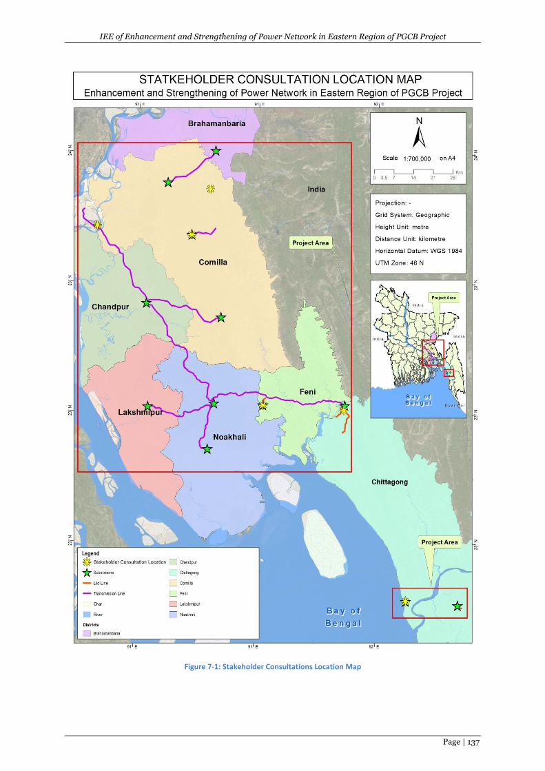
IEE of Enhancement and Strengthening of Power Network in Eastern Region of PGCB Project
Page | 137
Figure 7-1: Stakeholder Consultations Location Map
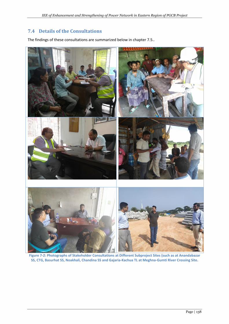
IEE of Enhancement and Strengthening of Power Network in Eastern Region of PGCB Project
Page | 138
7.4 Details of the Consultations
The findings of these consultations are summarized below in chapter 7.5..
Figure 7-2: Photographs of Stakeholder Consultations at Different Subproject Sites (such as at Anandabazar
SS, CTG, Basurhat SS, Noakhali, Chandina SS and Gajaria-Kachua TL at Meghna-Gumti River Crossing Site.
IEE of Enhancement and Strengthening of Power Network in Eastern Region of PGCB Project
Page | 139
7.5 Findings of the Consultations
The following issues were raised by the proposed project neighbours who were interviewed during
public participation of the proposed rural electrification, transmission and distribution project. Most
comments were of a similar nature.
7.5.1 Positive Issues
7.5.1.1 Employment Opportunities
Most neighbours close to the proposed project sites especially expected the project to create casual
and permanent employment opportunities during the proposed project construction work,
operation and decommissioning phases. The employment opportunities could be either directly in
the project or indirectly through associated businesses. One of the main positive impacts during
projects construction phase will be the availability of job opportunities especially to casual workers
and several other specialized workers.
Employment opportunities are of benefit both economically and in a social sense. In the economic
sense it means abundant unskilled labour will be used in construction hence economic production
and circulation of money. In the social sense the young and energetic labour force will be engaged in
productive employment other than remaining idle which may lead them into social ills such as drug
abuse and criminology. Several workers including casual labourers, masons, carpenters, joiners,
electricians and plumbers are expected to work on the site for a period that the project will start to
the end. Apart from casual labour, semi-skilled and unskilled labour and formal employees are also
expected to obtain gainful employment during the period of construction.
7.5.1.2 Improvement of Local and National Economy
Through the use of locally available materials during the construction phase of the proposed
subprojects will contribute towards growth of the economy by contributing to the gross domestic
product. The procurement of substation construction materials and the eventual increased
consumption of electricity will attract taxes including VAT which will be payable to the government
hence increasing government revenue while the cost of raw materials will be payable directly to the
producers.
7.5.1.3 Boosting of the Informal Sector
During the construction, operational and decommissioning phase of the proposed subprojects, it is
expected that the other businesses in the informal sector will flourish. These include activities such
as food vending who will be benefiting directly from the construction, operational and
decommissioning staff members who will be buying food and other commodities from them. This
will promote the informal sector in securing some temporary revenue and hence livelihood.
7.5.1.4 Improvement of Health, Safety and Security (HSS)
HSS within the proposed project site will be enhanced by employment of guards so as to make the
subprojects equipment and facilities more secure from theft/vandalism. Security lights will be
installed at the Sub-stations, thus lighting up the general area.
IEE of Enhancement and Strengthening of Power Network in Eastern Region of PGCB Project
Page | 140
7.5.1.5 Improved of Electricity Supply
The project aims to provide improved distribution and retail of electricity. The neighbours were
optimistic that power outages will be minimized and that they will not be subjected to power
rationing. They were also optimistic that power fluctuation/surges will be a thing of the past. With
this additional reliable electricity in the national grid, the country and the local area are expected to
attract more investments.
7.5.2 Negative Issues
7.5.2.1 Loses of lands(permanently & Temporary) and Existing Vegetation
The construction of the proposed subprojects will involve the loses of land permanently (SS) and
temporary (TL/Lilo lines) and clearing of the existing vegetation cover.
7.5.2.2 Increasing of Emissions (Air Pollution)
During construction and decommissioning phase of the proposed subprojects, there will be
undesirable emissions that will be emitted especially from heavy machines that could be used for
construction and decommissioning. Dust will be emitted during construction and decommissioning
phases. Neighbours asked for air pollution control measures to be put in place, especially during
construction.
7.5.2.3 Increasing of Noise Level and Vibration
There was concern over the possibility high noise and vibration levels in the project site as a result of
construction works. However, the proponent will have to take appropriate steps to minimize noise
production by ensuring that all construction equipment is well maintained.
7.5.2.4 Accidents during Construction
Some neighbours thought that there workplace accidents could occur during construction,
implementation and decommissioning of the project. However, they expected accident prevention
measures to be put in place. During construction there could be road accidents on the adjacent road
as vehicles entering or leaving the site area could experience blind corner spots. The transporters to
the project sites will be encouraged to adhere to road safety measures and to be more vigilant.
7.5.2.5 Site Specific Risks
For Substation:
SI. No.
Name of the NewSubstations Possible Risks
1 230/132 kV GIS Substation at Chowmuhoni Thundering
2 230/132 kV GIS Substation at Kachua Thundering, flooding
3 132/33 kV GIS Substation at Muradnagar Thundering, flooding
4 132/33 kV GIS Substation at Laksham Thundering, flooding
5 132/33 kV GIS Substation at Maijdee Thundering
6 132/33 kV GIS Substation at Patiya Thundering, cyclone & tidal surge
7 132/33 kV GIS Substation atChandina Thundering, flooding
8 132/33 kV GIS Substation at New Mooring (Anand Bazaar)
Thundering cyclone & tidal surge
9 132/33 kV GIS Substation at Basurhat Thundering
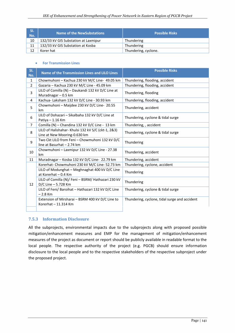
IEE of Enhancement and Strengthening of Power Network in Eastern Region of PGCB Project
Page | 141
SI. No.
Name of the NewSubstations Possible Risks
10 132/33 kV GIS Substation at Laxmipur Thundering
11 132/33 kV GIS Substation at Kosba Thundering
12 Korer hat Thundering, cyclone.
For Transmission Lines
SI. No.
Name of the Transmission Lines and LILO Lines Possible Risks
1 Chowmuhoni – Kachua 230 kV M/C Line- 49.05 km Thundering, flooding, accident
2 Gazaria – Kachua 230 kV M/C Line - 45.09 km Thundering, flooding, accident
3 LILO of Comilla (N) – Daukandi 132 kV D/C Line at Muradnagar – 0.5 km
Thundering, flooding
4 Kachua- Laksham 132 kV D/C Line - 30.93 km Thundering, flooding, accident
5 Chowmuhoni – Maijdee 230 kV D/C Line- 20.55 km
Thundering, accident
6 LILO of Dohazari – Sikalbaha 132 kV D/C Line at Patiya – 1.16 Km
Thundering, cyclone & tidal surge
7 Comilla (N) – Chandina 132 kV D/C Line - 13 km Thundering, , accident
8 LILO of Halishahar- Khulsi 132 kV S/C (ckt-1, 2&3) Line at New Mooring-0.630 km
Thundering, cyclone & tidal surge
9 Two Ckt LILO from Feni – Chowmuhoni 132 kV D/C line at Basurhat – 2.74 km
Thundering
10 Chowmuhoni – Laxmipur 132 kV D/C Line - 27.38 km
Thundering, accident
11 Muradnagar – Kosba 132 kV D/C Line- 22.79 km Thundering, accident
12
Korerhat- Chowmuhoni 230 kV M/C Line- 52.73 km Thundering, cyclone, accident
LILO of Modunghat – Meghnaghat 400 kV D/C Line at Korerhat – 0.4 Km
Thundering
LILO of Comilla (N)/ Feni – BSRM/ Hathazari 230 kV D/C Line – 5.728 Km
Thundering
LILO of Feni/ Baroihat – Hathazari 132 kV D/C Line – 2.8 Km
Thundering, cyclone & tidal surge
Extension of Mirsharai – BSRM 400 kV D/C Line to Korerhat – 11.314 Km
Thundering, cyclone, tidal surge and accident
7.5.3 Information Disclosure
All the subprojects, environmental impacts due to the subprojects along with proposed possible
mitigation/enhancement measures and EMP for the management of mitigation/enhancement
measures of the project as document or report should be publicly available in readable format to the
local people. The respective authority of the project (e.g. PGCB) should ensure information
disclosure to the local people and to the respective stakeholders of the respective subproject under
the proposed project.

IEE of Enhancement and Strengthening of Power Network in Eastern Region of PGCB Project
Page | 142
8 ENVIRONMENTAL MANAGEMENT PLAN
8.1 General
The primary objective of the Environmental Management Plan (EMP) is to avoid or eliminate or
reduce the negative environmental impacts by possible mitigation measures and to enhance the
positive impacts by enhancement measures. It would also address any unexpected or unforeseen
impacts that may arise during construction and operation stages of the subprojects. The aim of the
EMP is to ensure implementation of the recommended mitigation and enhancement measures
effectively. The mitigation measures are designed either to prevent impacts or by mitigating those to
reduce the negative impacts to an acceptable level that complies with the environmental guidelines
of the DOE and WB.
The EMP is an integrated part of the project planning and implementation. The EMP should be a part
of the contract document for all subprojects (substations and TLs/LILO lines) under the project. The
main components of the EMP are:
Mitigation Plan;
Monitoring Plan;
EMP budget; and
Institutional arrangement for implementation of the EMP.
8.2 Environmental Mitigation Plan
As mentioned earlier in chapter 6, the overall impact assessment of the subprojects of the SS and
TLs/LILO lines) shows that most of the negative impacts could be eliminated or minimized by
adopting appropriate mitigation measures as well as positive impacts could be enhanced by taking
enhancement measures. The mitigation/enhancement measures for the potential impacts due to
subprojects (substations and TL/Lilo lines) have been formulated and given in the following tables
8.1-8.4. Responsible agency for the implementation and supervision of each of the environmental
issues/impacts has also been given in this table. Mitigation measures have been suggested based on
the knowledge of the environmental specialist, suggestions of the stakeholders including PAPs,
gathered during public consultation as well as opinions from the other relevant specialists.
The mitigation measures will be considered as successful when it complies with the Environmental
Quality Standards (EQS), policies, legal requirements set by DOE and other relevant GOB
organizations and WB. In absence of DOE’s own EQS, other relevant international or other
recognized organization’s quality standard will have to be followed:
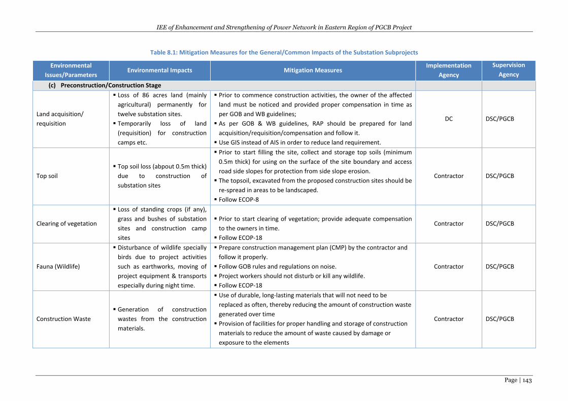
IEE of Enhancement and Strengthening of Power Network in Eastern Region of PGCB Project
Page | 143
Table 8.1: Mitigation Measures for the General/Common Impacts of the Substation Subprojects
Environmental
Issues/Parameters Environmental Impacts Mitigation Measures
Implementation
Agency
Supervision
Agency
(c) Preconstruction/Construction Stage
Land acquisition/
requisition
Loss of 86 acres land (mainly
agricultural) permanently for
twelve substation sites.
Temporarily loss of land
(requisition) for construction
camps etc.
Prior to commence construction activities, the owner of the affected
land must be noticed and provided proper compensation in time as
per GOB and WB guidelines;
As per GOB & WB guidelines, RAP should be prepared for land
acquisition/requisition/compensation and follow it.
Use GIS instead of AIS in order to reduce land requirement.
DC DSC/PGCB
Top soil
Top soil loss (abpout 0.5m thick)
due to construction of
substation sites
Prior to start filling the site, collect and storage top soils (minimum
0.5m thick) for using on the surface of the site boundary and access
road side slopes for protection from side slope erosion.
The topsoil, excavated from the proposed construction sites should be
re-spread in areas to be landscaped.
Follow ECOP-8
Contractor DSC/PGCB
Clearing of vegetation
Loss of standing crops (if any),
grass and bushes of substation
sites and construction camp
sites
Prior to start clearing of vegetation; provide adequate compensation
to the owners in time.
Follow ECOP-18
Contractor DSC/PGCB
Fauna (Wildlife)
Disturbance of wildlife specially
birds due to project activities
such as earthworks, moving of
project equipment & transports
especially during night time.
Prepare construction management plan (CMP) by the contractor and
follow it properly.
Follow GOB rules and regulations on noise.
Project workers should not disturb or kill any wildlife.
Follow ECOP-18
Contractor DSC/PGCB
Construction Waste
Generation of construction
wastes from the construction
materials.
Use of durable, long-lasting materials that will not need to be
replaced as often, thereby reducing the amount of construction waste
generated over time
Provision of facilities for proper handling and storage of construction
materials to reduce the amount of waste caused by damage or
exposure to the elements
Contractor DSC/PGCB
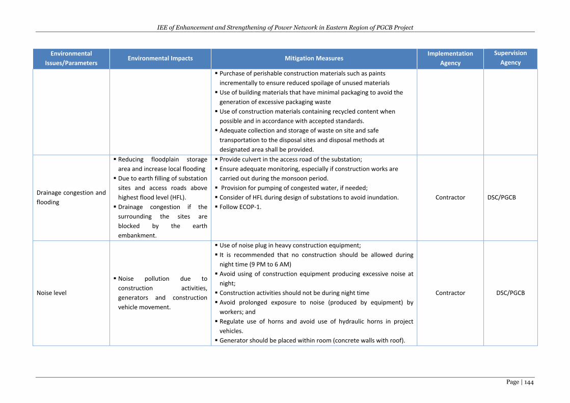
IEE of Enhancement and Strengthening of Power Network in Eastern Region of PGCB Project
Page | 144
Environmental
Issues/Parameters Environmental Impacts Mitigation Measures
Implementation
Agency
Supervision
Agency
Purchase of perishable construction materials such as paints
incrementally to ensure reduced spoilage of unused materials
Use of building materials that have minimal packaging to avoid the
generation of excessive packaging waste
Use of construction materials containing recycled content when
possible and in accordance with accepted standards.
Adequate collection and storage of waste on site and safe
transportation to the disposal sites and disposal methods at
designated area shall be provided.
Drainage congestion and
flooding
Reducing floodplain storage
area and increase local flooding
Due to earth filling of substation
sites and access roads above
highest flood level (HFL).
Drainage congestion if the
surrounding the sites are
blocked by the earth
embankment.
Provide culvert in the access road of the substation;
Ensure adequate monitoring, especially if construction works are
carried out during the monsoon period.
Provision for pumping of congested water, if needed;
Consider of HFL during design of substations to avoid inundation.
Follow ECOP-1.
Contractor DSC/PGCB
Noise level
Noise pollution due to
construction activities,
generators and construction
vehicle movement.
Use of noise plug in heavy construction equipment;
It is recommended that no construction should be allowed during
night time (9 PM to 6 AM)
Avoid using of construction equipment producing excessive noise at
night;
Construction activities should not be during night time
Avoid prolonged exposure to noise (produced by equipment) by
workers; and
Regulate use of horns and avoid use of hydraulic horns in project
vehicles.
Generator should be placed within room (concrete walls with roof).
Contractor DSC/PGCB
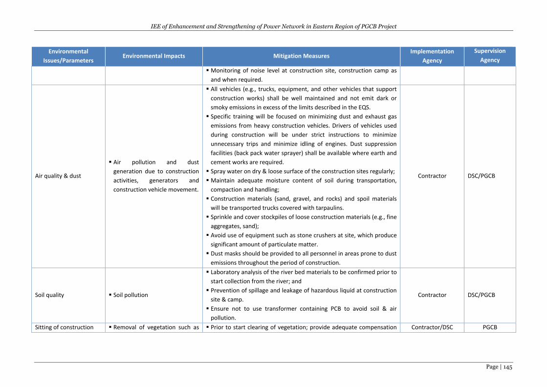
IEE of Enhancement and Strengthening of Power Network in Eastern Region of PGCB Project
Page | 145
Environmental
Issues/Parameters Environmental Impacts Mitigation Measures
Implementation
Agency
Supervision
Agency
Monitoring of noise level at construction site, construction camp as
and when required.
Air quality & dust
Air pollution and dust
generation due to construction
activities, generators and
construction vehicle movement.
All vehicles (e.g., trucks, equipment, and other vehicles that support
construction works) shall be well maintained and not emit dark or
smoky emissions in excess of the limits described in the EQS.
Specific training will be focused on minimizing dust and exhaust gas
emissions from heavy construction vehicles. Drivers of vehicles used
during construction will be under strict instructions to minimize
unnecessary trips and minimize idling of engines. Dust suppression
facilities (back pack water sprayer) shall be available where earth and
cement works are required.
Spray water on dry & loose surface of the construction sites regularly;
Maintain adequate moisture content of soil during transportation,
compaction and handling;
Construction materials (sand, gravel, and rocks) and spoil materials
will be transported trucks covered with tarpaulins.
Sprinkle and cover stockpiles of loose construction materials (e.g., fine
aggregates, sand);
Avoid use of equipment such as stone crushers at site, which produce
significant amount of particulate matter.
Dust masks should be provided to all personnel in areas prone to dust
emissions throughout the period of construction.
Contractor DSC/PGCB
Soil quality Soil pollution
Laboratory analysis of the river bed materials to be confirmed prior to
start collection from the river; and
Prevention of spillage and leakage of hazardous liquid at construction
site & camp.
Ensure not to use transformer containing PCB to avoid soil & air
pollution.
Contractor DSC/PGCB
Sitting of construction Removal of vegetation such as Prior to start clearing of vegetation; provide adequate compensation Contractor/DSC PGCB
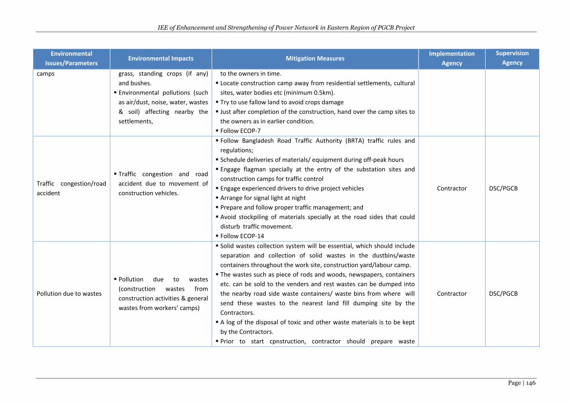
IEE of Enhancement and Strengthening of Power Network in Eastern Region of PGCB Project
Page | 146
Environmental
Issues/Parameters Environmental Impacts Mitigation Measures
Implementation
Agency
Supervision
Agency
camps grass, standing crops (if any)
and bushes.
Environmental pollutions (such
as air/dust, noise, water, wastes
& soil) affecting nearby the
settlements,
to the owners in time.
Locate construction camp away from residential settlements, cultural
sites, water bodies etc (minimum 0.5km).
Try to use fallow land to avoid crops damage
Just after completion of the construction, hand over the camp sites to
the owners as in earlier condition.
Follow ECOP-7
Traffic congestion/road
accident
Traffic congestion and road
accident due to movement of
construction vehicles.
Follow Bangladesh Road Traffic Authority (BRTA) traffic rules and
regulations;
Schedule deliveries of materials/ equipment during off-peak hours
Engage flagman specially at the entry of the substation sites and
construction camps for traffic control
Engage experienced drivers to drive project vehicles
Arrange for signal light at night
Prepare and follow proper traffic management; and
Avoid stockpiling of materials specially at the road sides that could
disturb traffic movement.
Follow ECOP-14
Contractor DSC/PGCB
Pollution due to wastes
Pollution due to wastes
(construction wastes from
construction activities & general
wastes from workers’ camps)
Solid wastes collection system will be essential, which should include
separation and collection of solid wastes in the dustbins/waste
containers throughout the work site, construction yard/labour camp.
The wastes such as piece of rods and woods, newspapers, containers
etc. can be sold to the venders and rest wastes can be dumped into
the nearby road side waste containers/ waste bins from where will
send these wastes to the nearest land fill dumping site by the
Contractors.
A log of the disposal of toxic and other waste materials is to be kept
by the Contractors.
Prior to start cpnstruction, contractor should prepare waste
Contractor DSC/PGCB
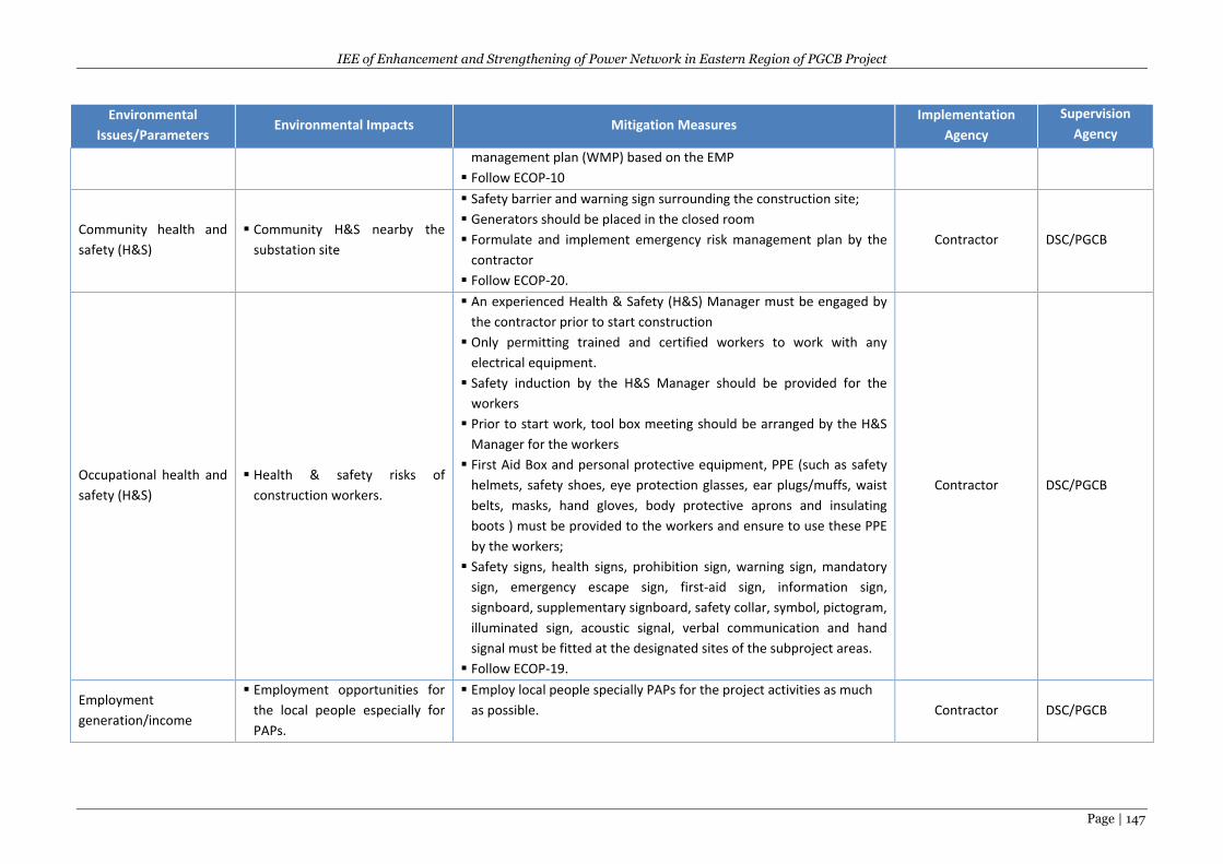
IEE of Enhancement and Strengthening of Power Network in Eastern Region of PGCB Project
Page | 147
Environmental
Issues/Parameters Environmental Impacts Mitigation Measures
Implementation
Agency
Supervision
Agency
management plan (WMP) based on the EMP
Follow ECOP-10
Community health and
safety (H&S)
Community H&S nearby the
substation site
Safety barrier and warning sign surrounding the construction site;
Generators should be placed in the closed room
Formulate and implement emergency risk management plan by the
contractor
Follow ECOP-20.
Contractor DSC/PGCB
Occupational health and
safety (H&S)
Health & safety risks of
construction workers.
An experienced Health & Safety (H&S) Manager must be engaged by
the contractor prior to start construction
Only permitting trained and certified workers to work with any
electrical equipment.
Safety induction by the H&S Manager should be provided for the
workers
Prior to start work, tool box meeting should be arranged by the H&S
Manager for the workers
First Aid Box and personal protective equipment, PPE (such as safety
helmets, safety shoes, eye protection glasses, ear plugs/muffs, waist
belts, masks, hand gloves, body protective aprons and insulating
boots ) must be provided to the workers and ensure to use these PPE
by the workers;
Safety signs, health signs, prohibition sign, warning sign, mandatory
sign, emergency escape sign, first-aid sign, information sign,
signboard, supplementary signboard, safety collar, symbol, pictogram,
illuminated sign, acoustic signal, verbal communication and hand
signal must be fitted at the designated sites of the subproject areas.
Follow ECOP-19.
Contractor DSC/PGCB
Employment
generation/income
Employment opportunities for
the local people especially for
PAPs.
Employ local people specially PAPs for the project activities as much
as possible. Contractor DSC/PGCB
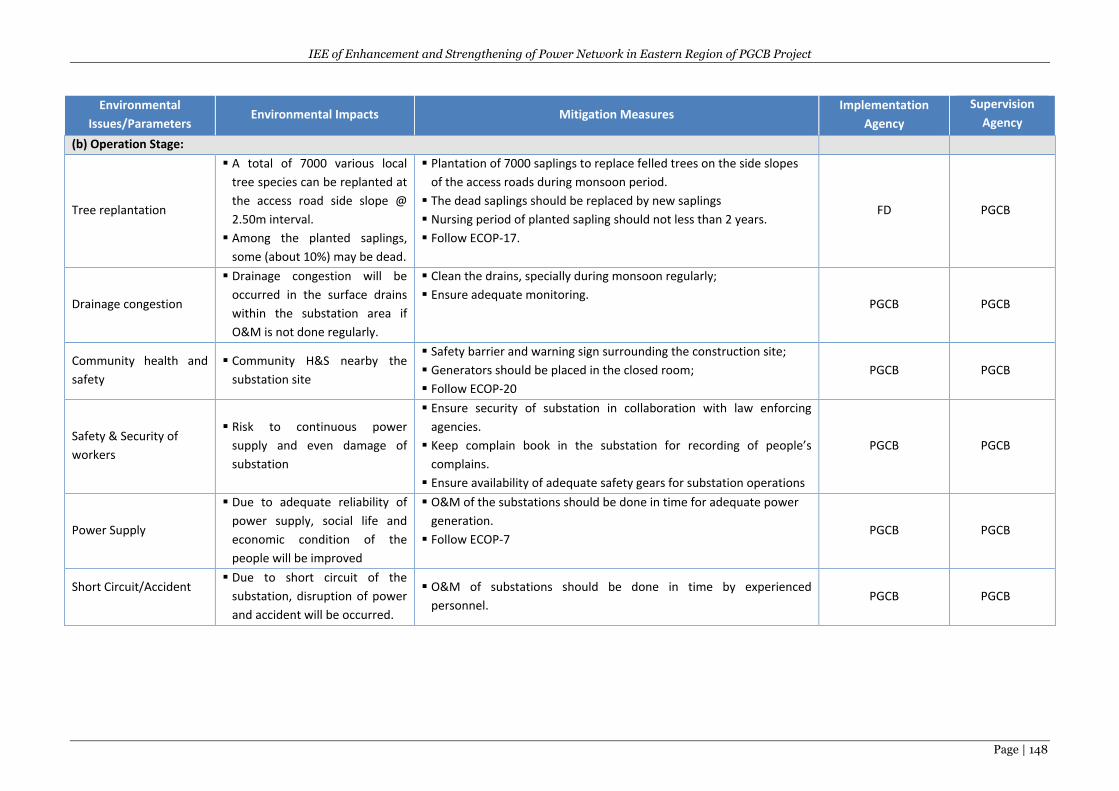
IEE of Enhancement and Strengthening of Power Network in Eastern Region of PGCB Project
Page | 148
Environmental
Issues/Parameters Environmental Impacts Mitigation Measures
Implementation
Agency
Supervision
Agency
(b) Operation Stage:
Tree replantation
A total of 7000 various local
tree species can be replanted at
the access road side slope @
2.50m interval.
Among the planted saplings,
some (about 10%) may be dead.
Plantation of 7000 saplings to replace felled trees on the side slopes
of the access roads during monsoon period.
The dead saplings should be replaced by new saplings
Nursing period of planted sapling should not less than 2 years.
Follow ECOP-17.
FD PGCB
Drainage congestion
Drainage congestion will be
occurred in the surface drains
within the substation area if
O&M is not done regularly.
Clean the drains, specially during monsoon regularly;
Ensure adequate monitoring. PGCB PGCB
Community health and
safety
Community H&S nearby the
substation site
Safety barrier and warning sign surrounding the construction site;
Generators should be placed in the closed room;
Follow ECOP-20
PGCB PGCB
Safety & Security of
workers
Risk to continuous power
supply and even damage of
substation
Ensure security of substation in collaboration with law enforcing
agencies.
Keep complain book in the substation for recording of people’s
complains.
Ensure availability of adequate safety gears for substation operations
PGCB PGCB
Power Supply
Due to adequate reliability of
power supply, social life and
economic condition of the
people will be improved
O&M of the substations should be done in time for adequate power
generation.
Follow ECOP-7 PGCB PGCB
Short Circuit/Accident
Due to short circuit of the
substation, disruption of power
and accident will be occurred.
O&M of substations should be done in time by experienced
personnel. PGCB PGCB
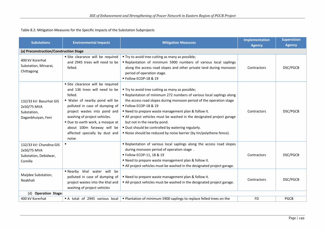
IEE of Enhancement and Strengthening of Power Network in Eastern Region of PGCB Project
Page | 149
Table 8.2: Mitigation Measures for the Specific Impacts of the Substation Subprojects
Substations Environmental Impacts Mitigation Measures Implementation
Agency
Supervision
Agency
(a) Preconstruction/Construction Stage
400 kV Korerhat
Substation, Mirsarai,
Chittagong
Site clearance will be required
and 2945 trees will need to be
felled.
Try to avoid tree cutting as many as possible;
Replantation of minimum 5900 numbers of various local saplings
along the access road slopes and other private land during monsoon
period of operation stage.
Follow ECOP-18 & 19
Contractors DSC/PGCB
132/33 kV: Basurhat GIS
2x50/75 MVA
Substation,
Daganbhuiyan, Feni
Site clearance will be required
and 136 trees will need to be
felled.
Water of nearby pond will be
polluted in case of dumping of
project wastes into pond and
washing of project vehicles.
Due to earth work, a mosque at
about 100m faraway will be
affected specially by dust and
noise.
Try to avoid tree cutting as many as possible;
Replantation of minimum 272 numbers of various local saplings along
the access road slopes during monsoon period of the operation stage
Follow ECOP-18 & 19
Need to prepare waste management plan & follow it.
All project vehicles must be washed in the designated project garage
but not in the nearby pond.
Dust should be controlled by watering regularly.
Noise should be reduced by noise barrier (by tin/polythene fence).
Contractors DSC/PGCB
132/33 kV: Chandina GIS
2x50/75 MVA
Substation, Debidwar,
Comilla
Replantation of various local saplings along the access road slopes
during monsoon period of operation stage .
Follow ECOP-11, 18 & 19
Need to prepare waste management plan & follow it.
All project vehicles must be washed in the designated project garage.
Contractors DSC/PGCB
Maijdee Substation,
Noakhali
Nearby khal water will be
polluted in case of dumping of
project wastes into the khal and
washing of project vehicles
Need to prepare waste management plan & follow it.
All project vehicles must be washed in the designated project garage. Contractors DSC/PGCB
(d) Operation Stage:
400 kV Korerhat A total of 2945 various local Plantation of minimum 5900 saplings to replace felled trees on the FD PGCB
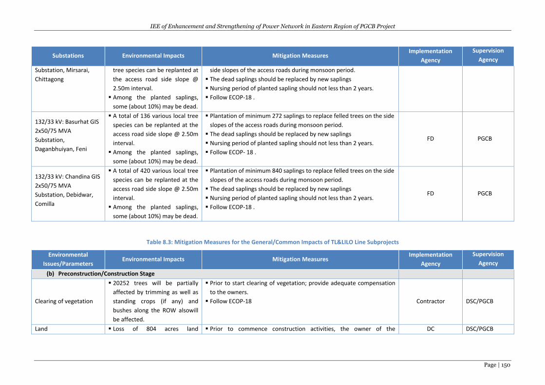
IEE of Enhancement and Strengthening of Power Network in Eastern Region of PGCB Project
Page | 150
Substations Environmental Impacts Mitigation Measures Implementation
Agency
Supervision
Agency
Substation, Mirsarai,
Chittagong
tree species can be replanted at
the access road side slope @
2.50m interval.
Among the planted saplings,
some (about 10%) may be dead.
side slopes of the access roads during monsoon period.
The dead saplings should be replaced by new saplings
Nursing period of planted sapling should not less than 2 years.
Follow ECOP-18 .
132/33 kV: Basurhat GIS
2x50/75 MVA
Substation,
Daganbhuiyan, Feni
A total of 136 various local tree
species can be replanted at the
access road side slope @ 2.50m
interval.
Among the planted saplings,
some (about 10%) may be dead.
Plantation of minimum 272 saplings to replace felled trees on the side
slopes of the access roads during monsoon period.
The dead saplings should be replaced by new saplings
Nursing period of planted sapling should not less than 2 years.
Follow ECOP- 18 .
FD PGCB
132/33 kV: Chandina GIS
2x50/75 MVA
Substation, Debidwar,
Comilla
A total of 420 various local tree
species can be replanted at the
access road side slope @ 2.50m
interval.
Among the planted saplings,
some (about 10%) may be dead.
Plantation of minimum 840 saplings to replace felled trees on the side
slopes of the access roads during monsoon period.
The dead saplings should be replaced by new saplings
Nursing period of planted sapling should not less than 2 years.
Follow ECOP-18 .
FD PGCB
Table 8.3: Mitigation Measures for the General/Common Impacts of TL&LILO Line Subprojects
Environmental
Issues/Parameters Environmental Impacts Mitigation Measures
Implementation
Agency
Supervision
Agency
(b) Preconstruction/Construction Stage
Clearing of vegetation
20252 trees will be partially
affected by trimming as well as
standing crops (if any) and
bushes along the ROW alsowill
be affected.
Prior to start clearing of vegetation; provide adequate compensation
to the owners.
Follow ECOP-18 Contractor DSC/PGCB
Land Loss of 804 acres land Prior to commence construction activities, the owner of the DC DSC/PGCB
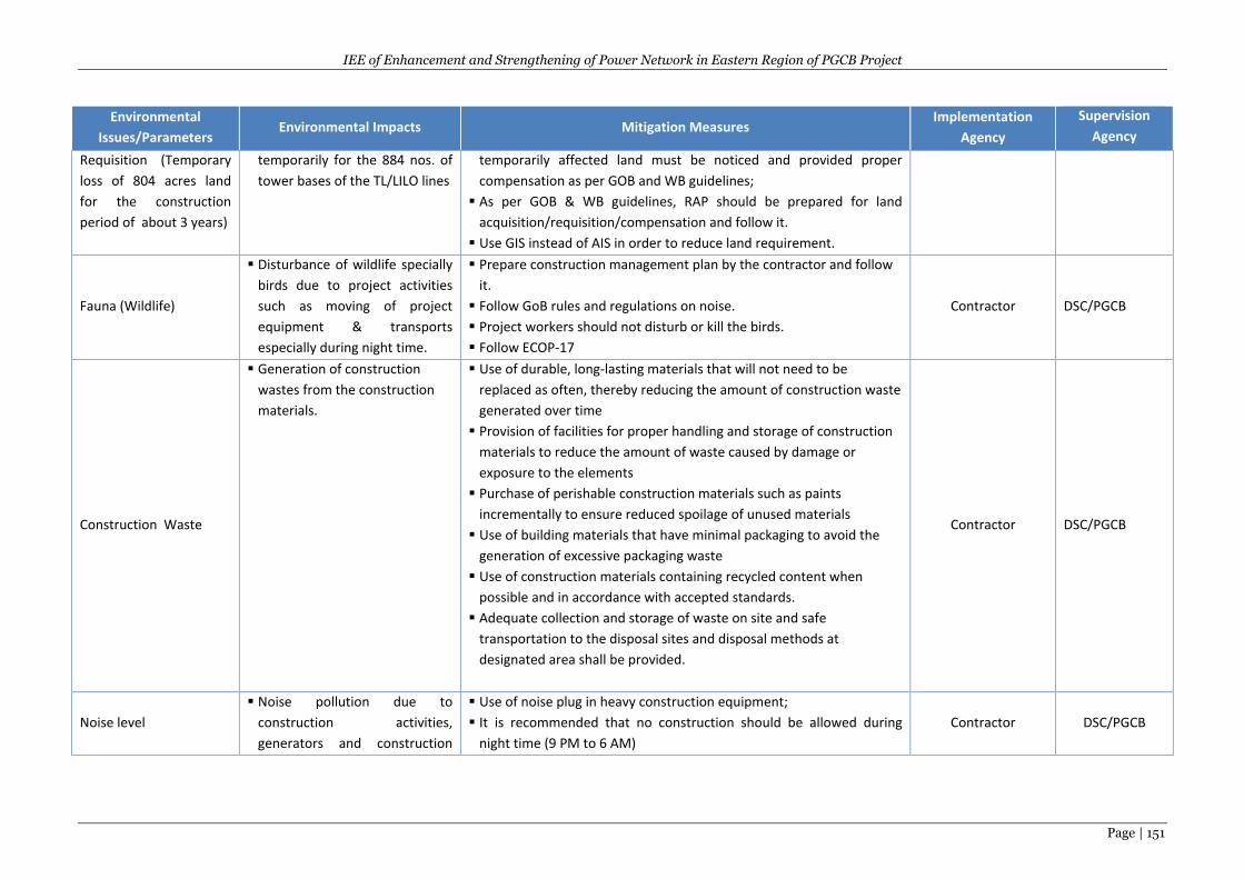
IEE of Enhancement and Strengthening of Power Network in Eastern Region of PGCB Project
Page | 151
Environmental
Issues/Parameters Environmental Impacts Mitigation Measures
Implementation
Agency
Supervision
Agency
Requisition (Temporary
loss of 804 acres land
for the construction
period of about 3 years)
temporarily for the 884 nos. of
tower bases of the TL/LILO lines
temporarily affected land must be noticed and provided proper
compensation as per GOB and WB guidelines;
As per GOB & WB guidelines, RAP should be prepared for land
acquisition/requisition/compensation and follow it.
Use GIS instead of AIS in order to reduce land requirement.
Fauna (Wildlife)
Disturbance of wildlife specially
birds due to project activities
such as moving of project
equipment & transports
especially during night time.
Prepare construction management plan by the contractor and follow
it.
Follow GoB rules and regulations on noise.
Project workers should not disturb or kill the birds.
Follow ECOP-17
Contractor DSC/PGCB
Construction Waste
Generation of construction
wastes from the construction
materials.
Use of durable, long-lasting materials that will not need to be
replaced as often, thereby reducing the amount of construction waste
generated over time
Provision of facilities for proper handling and storage of construction
materials to reduce the amount of waste caused by damage or
exposure to the elements
Purchase of perishable construction materials such as paints
incrementally to ensure reduced spoilage of unused materials
Use of building materials that have minimal packaging to avoid the
generation of excessive packaging waste
Use of construction materials containing recycled content when
possible and in accordance with accepted standards.
Adequate collection and storage of waste on site and safe
transportation to the disposal sites and disposal methods at
designated area shall be provided.
Contractor DSC/PGCB
Noise level
Noise pollution due to
construction activities,
generators and construction
Use of noise plug in heavy construction equipment;
It is recommended that no construction should be allowed during
night time (9 PM to 6 AM)
Contractor DSC/PGCB
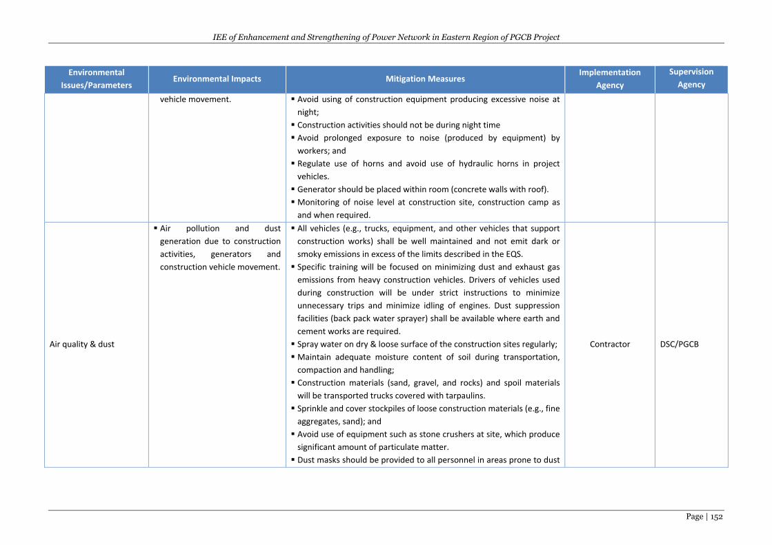
IEE of Enhancement and Strengthening of Power Network in Eastern Region of PGCB Project
Page | 152
Environmental
Issues/Parameters Environmental Impacts Mitigation Measures
Implementation
Agency
Supervision
Agency
vehicle movement. Avoid using of construction equipment producing excessive noise at
night;
Construction activities should not be during night time
Avoid prolonged exposure to noise (produced by equipment) by
workers; and
Regulate use of horns and avoid use of hydraulic horns in project
vehicles.
Generator should be placed within room (concrete walls with roof).
Monitoring of noise level at construction site, construction camp as
and when required.
Air quality & dust
Air pollution and dust
generation due to construction
activities, generators and
construction vehicle movement.
All vehicles (e.g., trucks, equipment, and other vehicles that support
construction works) shall be well maintained and not emit dark or
smoky emissions in excess of the limits described in the EQS.
Specific training will be focused on minimizing dust and exhaust gas
emissions from heavy construction vehicles. Drivers of vehicles used
during construction will be under strict instructions to minimize
unnecessary trips and minimize idling of engines. Dust suppression
facilities (back pack water sprayer) shall be available where earth and
cement works are required.
Spray water on dry & loose surface of the construction sites regularly;
Maintain adequate moisture content of soil during transportation,
compaction and handling;
Construction materials (sand, gravel, and rocks) and spoil materials
will be transported trucks covered with tarpaulins.
Sprinkle and cover stockpiles of loose construction materials (e.g., fine
aggregates, sand); and
Avoid use of equipment such as stone crushers at site, which produce
significant amount of particulate matter.
Dust masks should be provided to all personnel in areas prone to dust
Contractor DSC/PGCB
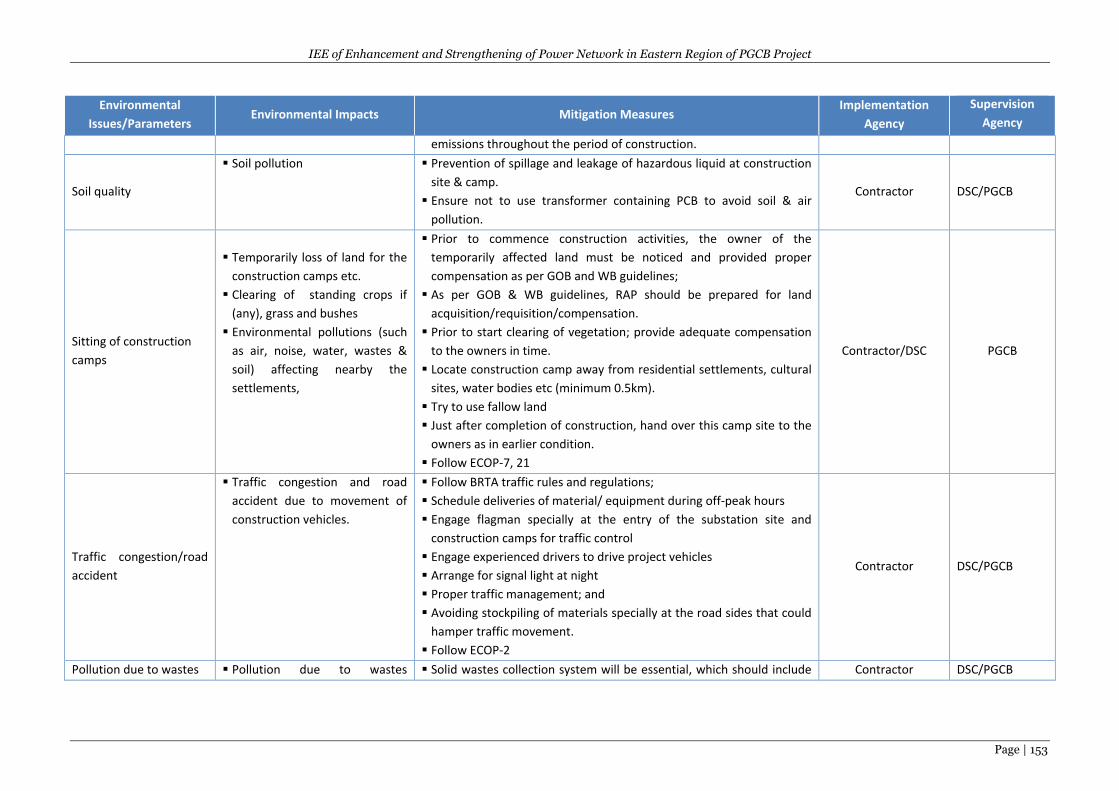
IEE of Enhancement and Strengthening of Power Network in Eastern Region of PGCB Project
Page | 153
Environmental
Issues/Parameters Environmental Impacts Mitigation Measures
Implementation
Agency
Supervision
Agency
emissions throughout the period of construction.
Soil quality
Soil pollution Prevention of spillage and leakage of hazardous liquid at construction
site & camp.
Ensure not to use transformer containing PCB to avoid soil & air
pollution.
Contractor DSC/PGCB
Sitting of construction
camps
Temporarily loss of land for the
construction camps etc.
Clearing of standing crops if
(any), grass and bushes
Environmental pollutions (such
as air, noise, water, wastes &
soil) affecting nearby the
settlements,
Prior to commence construction activities, the owner of the
temporarily affected land must be noticed and provided proper
compensation as per GOB and WB guidelines;
As per GOB & WB guidelines, RAP should be prepared for land
acquisition/requisition/compensation.
Prior to start clearing of vegetation; provide adequate compensation
to the owners in time.
Locate construction camp away from residential settlements, cultural
sites, water bodies etc (minimum 0.5km).
Try to use fallow land
Just after completion of construction, hand over this camp site to the
owners as in earlier condition.
Follow ECOP-7, 21
Contractor/DSC PGCB
Traffic congestion/road
accident
Traffic congestion and road
accident due to movement of
construction vehicles.
Follow BRTA traffic rules and regulations;
Schedule deliveries of material/ equipment during off-peak hours
Engage flagman specially at the entry of the substation site and
construction camps for traffic control
Engage experienced drivers to drive project vehicles
Arrange for signal light at night
Proper traffic management; and
Avoiding stockpiling of materials specially at the road sides that could
hamper traffic movement.
Follow ECOP-2
Contractor DSC/PGCB
Pollution due to wastes Pollution due to wastes Solid wastes collection system will be essential, which should include Contractor DSC/PGCB
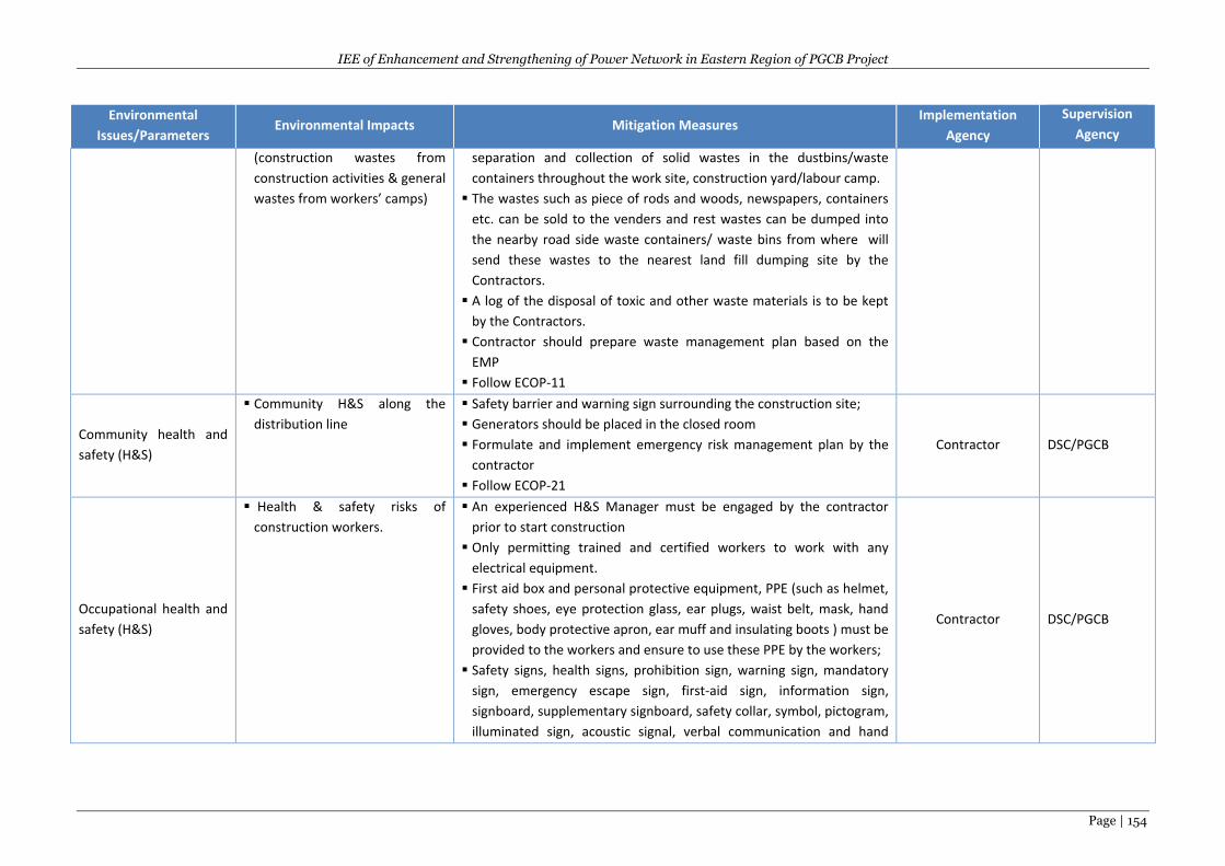
IEE of Enhancement and Strengthening of Power Network in Eastern Region of PGCB Project
Page | 154
Environmental
Issues/Parameters Environmental Impacts Mitigation Measures
Implementation
Agency
Supervision
Agency
(construction wastes from
construction activities & general
wastes from workers’ camps)
separation and collection of solid wastes in the dustbins/waste
containers throughout the work site, construction yard/labour camp.
The wastes such as piece of rods and woods, newspapers, containers
etc. can be sold to the venders and rest wastes can be dumped into
the nearby road side waste containers/ waste bins from where will
send these wastes to the nearest land fill dumping site by the
Contractors.
A log of the disposal of toxic and other waste materials is to be kept
by the Contractors.
Contractor should prepare waste management plan based on the
EMP
Follow ECOP-11
Community health and
safety (H&S)
Community H&S along the
distribution line
Safety barrier and warning sign surrounding the construction site;
Generators should be placed in the closed room
Formulate and implement emergency risk management plan by the
contractor
Follow ECOP-21
Contractor DSC/PGCB
Occupational health and
safety (H&S)
Health & safety risks of
construction workers.
An experienced H&S Manager must be engaged by the contractor
prior to start construction
Only permitting trained and certified workers to work with any
electrical equipment.
First aid box and personal protective equipment, PPE (such as helmet,
safety shoes, eye protection glass, ear plugs, waist belt, mask, hand
gloves, body protective apron, ear muff and insulating boots ) must be
provided to the workers and ensure to use these PPE by the workers;
Safety signs, health signs, prohibition sign, warning sign, mandatory
sign, emergency escape sign, first-aid sign, information sign,
signboard, supplementary signboard, safety collar, symbol, pictogram,
illuminated sign, acoustic signal, verbal communication and hand
Contractor DSC/PGCB
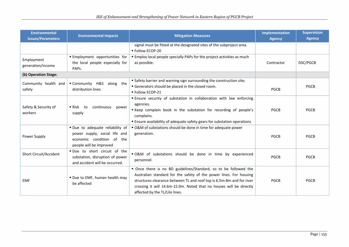
IEE of Enhancement and Strengthening of Power Network in Eastern Region of PGCB Project
Page | 155
Environmental
Issues/Parameters Environmental Impacts Mitigation Measures
Implementation
Agency
Supervision
Agency
signal must be fitted at the designated sites of the subproject area.
Follow ECOP-20
Employment
generation/income
Employment opportunities for
the local people especially for
PAPs.
Employ local people specially PAPs for the project activities as much
as possible. Contractor DSC/PGCB
(b) Operation Stage:
Community health and
safety
Community H&S along the
distribution lines
Safety barrier and warning sign surrounding the construction site;
Generators should be placed in the closed room.
Follow ECOP-21
PGCB PGCB
Safety & Security of
workers
Risk to continuous power
supply
Ensure security of substation in collaboration with law enforcing
agencies.
Keep complain book in the substation for recording of people’s
complains.
Ensure availability of adequate safety gears for substation operations
PGCB PGCB
Power Supply
Due to adequate reliability of
power supply, social life and
economic condition of the
people will be improved
O&M of substations should be done in time for adequate power
generation. PGCB PGCB
Short Circuit/Accident
Due to short circuit of the
substation, disruption of power
and accident will be occurred.
O&M of substations should be done in time by experienced
personnel. PGCB PGCB
EMF Due to EMF, human health may
be affected
Once there is no BD guidelines/Standard, so to be followed the
Australian standard for the safety of the power lines. For housing
structures clearance between TL and roof top is 6.5m-8m and for river
crossing it will 14.6m-15.9m. Noted that no houses will be directly
affected by the TL/Lilo lines.
PGCB PGCB
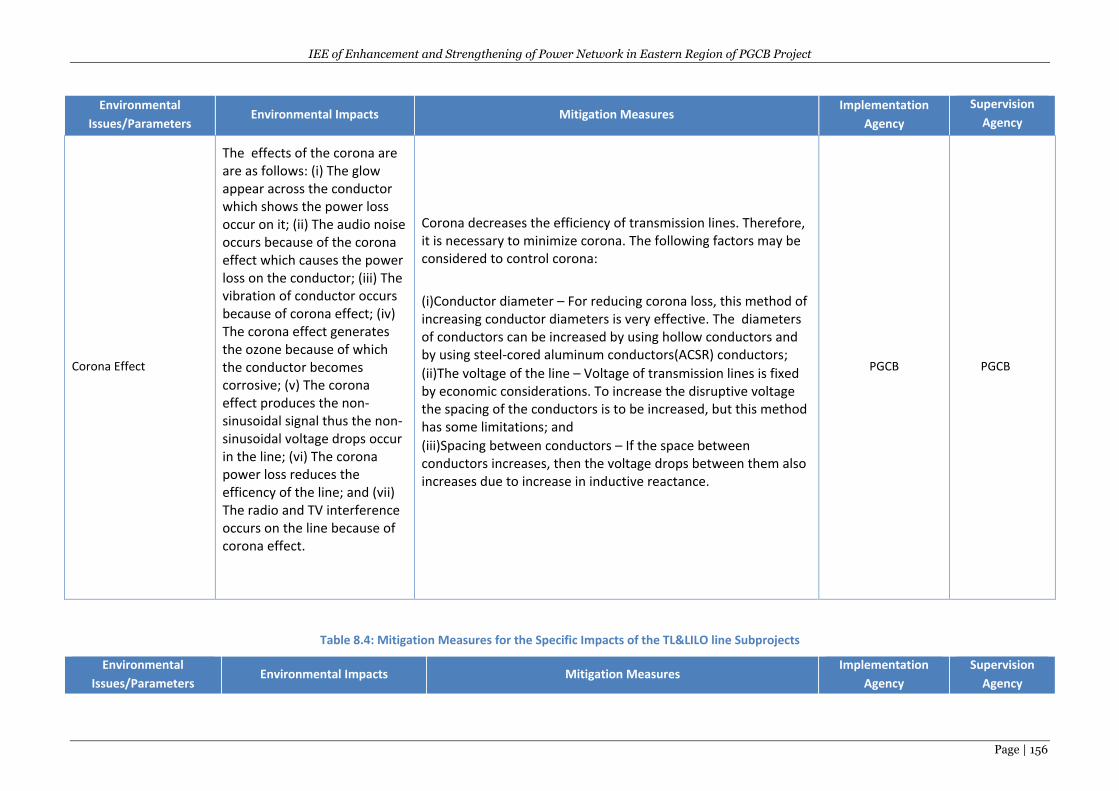
IEE of Enhancement and Strengthening of Power Network in Eastern Region of PGCB Project
Page | 156
Environmental
Issues/Parameters Environmental Impacts Mitigation Measures
Implementation
Agency
Supervision
Agency
Corona Effect
The effects of the corona are are as follows: (i) The glow appear across the conductor which shows the power loss occur on it; (ii) The audio noise occurs because of the corona effect which causes the power loss on the conductor; (iii) The vibration of conductor occurs because of corona effect; (iv) The corona effect generates the ozone because of which the conductor becomes corrosive; (v) The corona effect produces the non-sinusoidal signal thus the non-sinusoidal voltage drops occur in the line; (vi) The corona power loss reduces the efficency of the line; and (vii) The radio and TV interference occurs on the line because of corona effect.
Corona decreases the efficiency of transmission lines. Therefore, it is necessary to minimize corona. The following factors may be considered to control corona:
(i)Conductor diameter – For reducing corona loss, this method of increasing conductor diameters is very effective. The diameters of conductors can be increased by using hollow conductors and by using steel-cored aluminum conductors(ACSR) conductors;
(ii)The voltage of the line – Voltage of transmission lines is fixed by economic considerations. To increase the disruptive voltage the spacing of the conductors is to be increased, but this method has some limitations; and
(iii)Spacing between conductors – If the space between conductors increases, then the voltage drops between them also increases due to increase in inductive reactance.
PGCB PGCB
Table 8.4: Mitigation Measures for the Specific Impacts of the TL&LILO line Subprojects
Environmental
Issues/Parameters Environmental Impacts Mitigation Measures
Implementation
Agency
Supervision
Agency
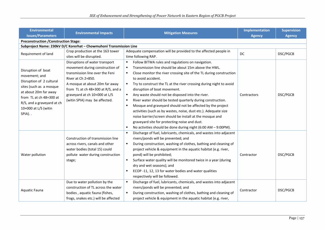
IEE of Enhancement and Strengthening of Power Network in Eastern Region of PGCB Project
Page | 157
Environmental
Issues/Parameters Environmental Impacts Mitigation Measures
Implementation
Agency
Supervision
Agency
Preconstruction /Construction Stage:
Subproject Name: 230kV D/C Korerhat – Chowmuhoni Transmission Line
Requirement of land Crop production at the 163 tower
sites will be disrupted.
Adequate compensation will be provided to the affected people in
time following RAP. DC DSC/PGCB
Disruption of boat
movement; and
Disruption of 2 cultural
sites (such as a mosque
at about 20m far away
from TL at ch 48+300 at
R/S, and a graveyard at ch
10+000 at L/S (witin
SPIA). .
Disruptions of water transport
movement during construction of
transmission line over the Feni
River at Ch 2+850.
A mosque at about 20m far away
from TL at ch 48+300 at R/S, and a
graveyard at ch 10+000 at L/S
(witin SPIA) may be affected.
Follow BITWA rules and regulations on navigation.
Transmission line should be about 15m above the HWL.
Close monitor the river crossing site of the TL during construction
to avoid accident.
Try to construct the TL at the river crossing during night to avoid
disruption of boat movement.
Any waste should not be disposed into the river.
River water should be tested quarterly during construction.
Mosque and graveyard should not be affected by the project
activities (such as by wastes, noise, dust etc.). Adequate size
noise barrier/screen should be install at the mosque and
graveyard site for protecting noise and dust.
No activities should be done during night (6:00 AM – 9:00PM).
Contractors DSC/PGCB
Water pollution
Construction of transmission line
across rivers, canals and other
water bodies (total 15) could
pollute water during construction
stage;
Discharge of fuel, lubricants, chemicals, and wastes into adjacent
rivers/ponds will be prevented; and
During construction, washing of clothes, bathing and cleaning of
project vehicle & equipment in the aquatic habitat (e.g. river,
pond) will be prohibited;
Surface water quality will be monitored twice in a year (during
dry and wet seasons); and
ECOP -11, 12, 13 for water bodies and water qualities
respectively will be followed.
Contractor DSC/PGCB
Aquatic Fauna
Due to water pollution by the
construction of TL across the water
bodies , aquatic fauna (fishes,
frogs, snakes etc.) will be affected
Discharge of fuel, lubricants, chemicals, and wastes into adjacent
rivers/ponds will be prevented; and
During construction, washing of clothes, bathing and cleaning of
project vehicle & equipment in the aquatic habitat (e.g. river,
Contractor DSC/PGCB
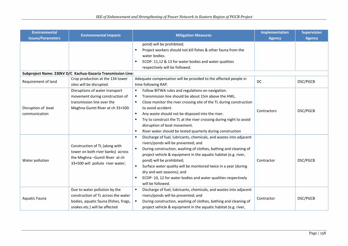
IEE of Enhancement and Strengthening of Power Network in Eastern Region of PGCB Project
Page | 158
Environmental
Issues/Parameters Environmental Impacts Mitigation Measures
Implementation
Agency
Supervision
Agency
pond) will be prohibited;
Project workers should not kill fishes & other fauna from the
water bodies.
ECOP- 11,12 & 13 for water bodies and water qualities
respectively will be followed.
Subproject Name: 230kV D/C Kachua-Gazaria Transmission Line:
Requirement of land Crop production at the 134 tower
sites will be disrupted.
Adequate compensation will be provided to the affected people in
time following RAP. DC DSC/PGCB
Disruption of boat
communication
Disruptions of water transport
movement during construction of
transmission line over the
Meghna-Gumti River at ch 33+500.
Follow BITWA rules and regulations on navigation.
Transmission line should be about 15m above the HWL.
Close monitor the river crossing site of the TL during construction
to avoid accident.
Any waste should not be disposed into the river.
Try to construct the TL at the river crossing during night to avoid
disruption of boat movement.
River water should be tested quarterly during construction
Contractors DSC/PGCB
Water pollution
Construction of TL (along with
tower on both river banks) across
the Meghna –Gumti River at ch
33+500 will pollute river water;
Discharge of fuel, lubricants, chemicals, and wastes into adjacent
rivers/ponds will be prevented; and
During construction, washing of clothes, bathing and cleaning of
project vehicle & equipment in the aquatic habitat (e.g. river,
pond) will be prohibited;
Surface water quality will be monitored twice in a year (during
dry and wet seasons); and
ECOP- 10, 12 for water bodies and water qualities respectively
will be followed.
Contractor DSC/PGCB
Aquatic Fauna
Due to water pollution by the
construction of TL across the water
bodies, aquatic fauna (fishes, frogs,
snakes etc.) will be affected
Discharge of fuel, lubricants, chemicals, and wastes into adjacent
rivers/ponds will be prevented; and
During construction, washing of clothes, bathing and cleaning of
project vehicle & equipment in the aquatic habitat (e.g. river,
Contractor DSC/PGCB
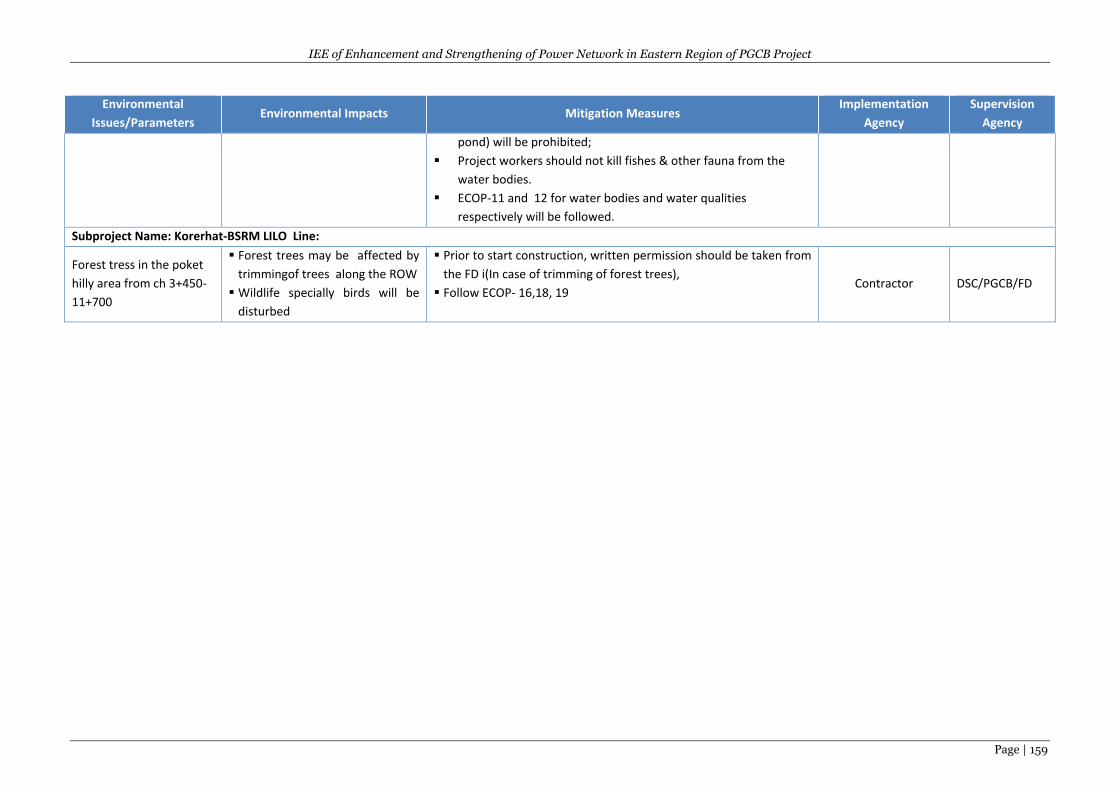
IEE of Enhancement and Strengthening of Power Network in Eastern Region of PGCB Project
Page | 159
Environmental
Issues/Parameters Environmental Impacts Mitigation Measures
Implementation
Agency
Supervision
Agency
pond) will be prohibited;
Project workers should not kill fishes & other fauna from the
water bodies.
ECOP-11 and 12 for water bodies and water qualities
respectively will be followed.
Subproject Name: Korerhat-BSRM LILO Line:
Forest tress in the poket
hilly area from ch 3+450-
11+700
Forest trees may be affected by
trimmingof trees along the ROW
Wildlife specially birds will be
disturbed
Prior to start construction, written permission should be taken from
the FD i(In case of trimming of forest trees),
Follow ECOP- 16,18, 19 Contractor DSC/PGCB/FD
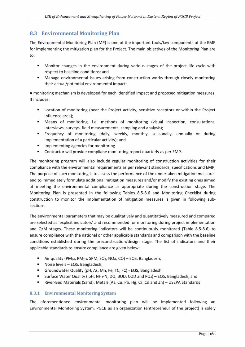
IEE of Enhancement and Strengthening of Power Network in Eastern Region of PGCB Project
Page | 160
8.3 Environmental Monitoring Plan
The Environmental Monitoring Plan (MP) is one of the important tools/key components of the EMP
for implementing the mitigation plan for the Project. The main objectives of the Monitoring Plan are
to:
Monitor changes in the environment during various stages of the project life cycle with
respect to baseline conditions; and
Manage environmental issues arising from construction works through closely monitoring
their actual/potential environmental impacts.
A monitoring mechanism is developed for each identified impact and proposed mitigation measures.
It includes:
Location of monitoring (near the Project activity, sensitive receptors or within the Project
influence area);
Means of monitoring, i.e. methods of monitoring (visual inspection, consultations,
interviews, surveys, field measurements, sampling and analysis);
Frequency of monitoring (daily, weekly, monthly, seasonally, annually or during
implementation of a particular activity); and
Implementing agencies for monitoring.
Contractor will provide compliane monitoring report quarterly as per EMP.
The monitoring program will also include regular monitoring of construction activities for their
compliance with the environmental requirements as per relevant standards, specifications and EMP;
The purpose of such monitoring is to assess the performance of the undertaken mitigation measures
and to immediately formulate additional mitigation measures and/or modify the existing ones aimed
at meeting the environmental compliance as appropriate during the construction stage. The
Monitoring Plan is presented in the following Tables 8.5-8.6 and Monitoring Checklist during
construction to monitor the implementation of mitigation measures is given in following sub-
section-.
The environmental parameters that may be qualitatively and quantitatively measured and compared
are selected as ‘explicit indicators’ and recommended for monitoring during project implementation
and O/M stages. These monitoring indicators will be continuously monitored (Table 8.5-8.6) to
ensure compliance with the national or other applicable standards and comparison with the baseline
conditions established during the preconstruction/design stage. The list of indicators and their
applicable standards to ensure compliance are given below:
Air quality (PM10, PM2.5, SPM, SO2, NOx, CO) – EQS, Bangladesh;
Noise levels – EQS, Bangladesh;
Groundwater Quality (pH, As, Mn, Fe, TC, FC) - EQS, Bangladesh;
Surface Water Quality ( pH, NH3-N, DO, BOD, COD and PO4) – EQS, Bangladesh, and
River-Bed Materials (Sand): Metals (As, Cu, Pb, Hg, Cr, Cd and Zn) – USEPA Standards
8.3.1 Environmental Monitoring System
The aforementioned environmental monitoring plan will be implemented following an
Environmental Monitoring System. PGCB as an organization (entrepreneur of the project) is solely
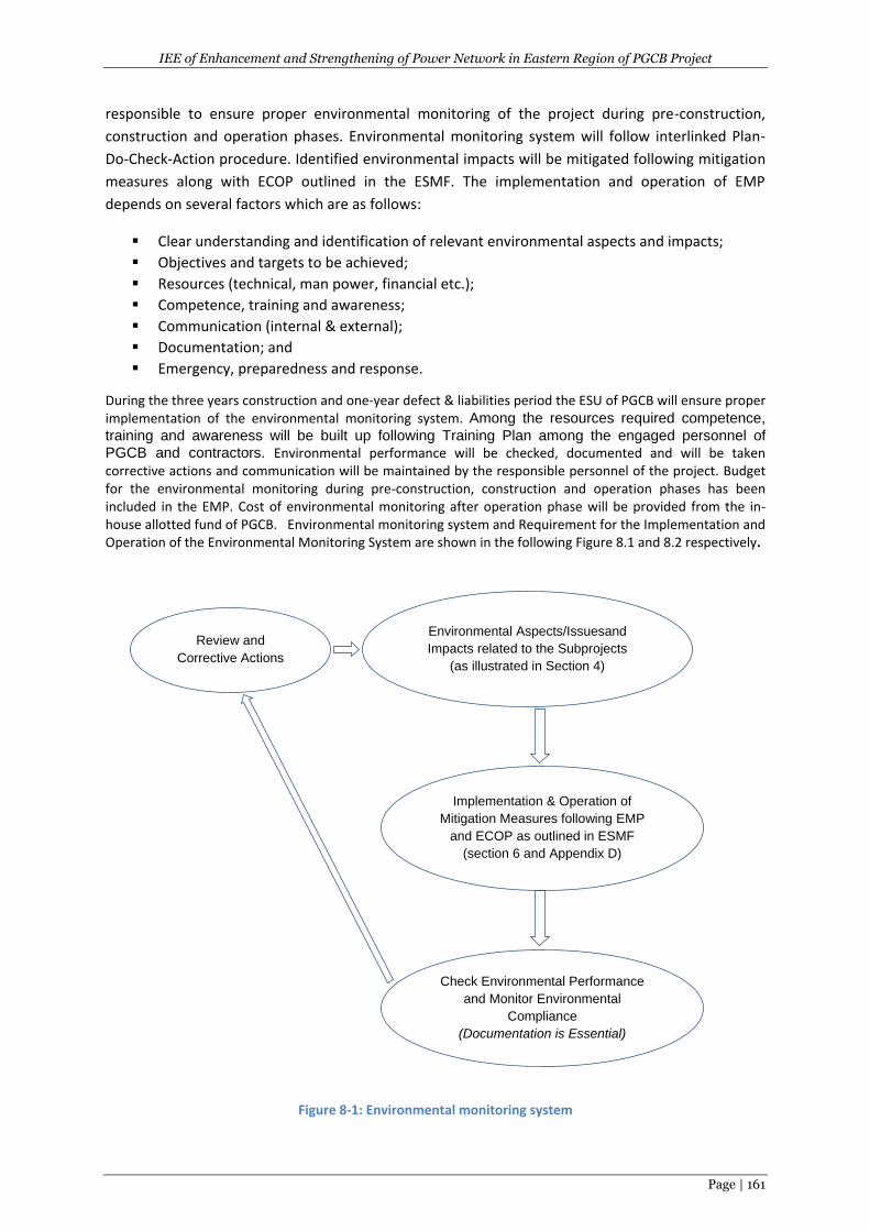
IEE of Enhancement and Strengthening of Power Network in Eastern Region of PGCB Project
Page | 161
responsible to ensure proper environmental monitoring of the project during pre-construction,
construction and operation phases. Environmental monitoring system will follow interlinked Plan-
Do-Check-Action procedure. Identified environmental impacts will be mitigated following mitigation
measures along with ECOP outlined in the ESMF. The implementation and operation of EMP
depends on several factors which are as follows:
Clear understanding and identification of relevant environmental aspects and impacts;
Objectives and targets to be achieved;
Resources (technical, man power, financial etc.);
Competence, training and awareness;
Communication (internal & external);
Documentation; and
Emergency, preparedness and response.
During the three years construction and one-year defect & liabilities period the ESU of PGCB will ensure proper implementation of the environmental monitoring system. Among the resources required competence,
training and awareness will be built up following Training Plan among the engaged personnel of
PGCB and contractors. Environmental performance will be checked, documented and will be taken corrective actions and communication will be maintained by the responsible personnel of the project. Budget for the environmental monitoring during pre-construction, construction and operation phases has been included in the EMP. Cost of environmental monitoring after operation phase will be provided from the in-house allotted fund of PGCB. Environmental monitoring system and Requirement for the Implementation and Operation of the Environmental Monitoring System are shown in the following Figure 8.1 and 8.2 respectively.
Figure 8-1: Environmental monitoring system
Environmental Aspects/Issuesand
Impacts related to the Subprojects
(as illustrated in Section 4)
Implementation & Operation of
Mitigation Measures following EMP
and ECOP as outlined in ESMF
(section 6 and Appendix D)
Check Environmental Performance
and Monitor Environmental
Compliance
(Documentation is Essential)
Review and
Corrective Actions
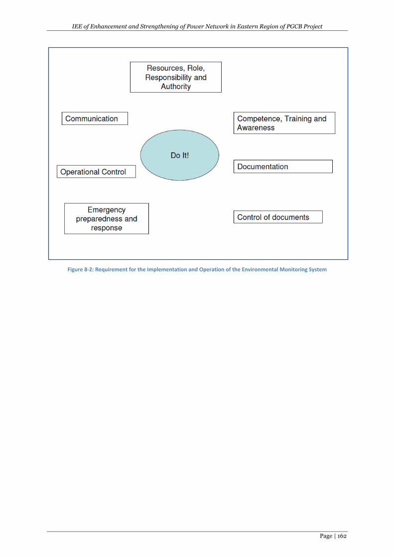
IEE of Enhancement and Strengthening of Power Network in Eastern Region of PGCB Project
Page | 162
Figure 8-2: Requirement for the Implementation and Operation of the Environmental Monitoring System
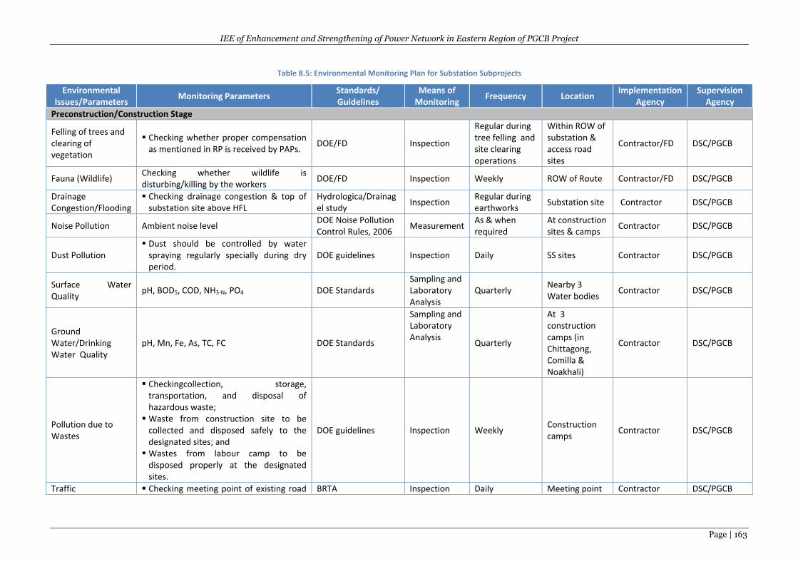
IEE of Enhancement and Strengthening of Power Network in Eastern Region of PGCB Project
Page | 163
Table 8.5: Environmental Monitoring Plan for Substation Subprojects
Environmental Issues/Parameters
Monitoring Parameters Standards/ Guidelines
Means of Monitoring
Frequency Location Implementation
Agency Supervision
Agency
Preconstruction/Construction Stage
Felling of trees and clearing of vegetation
Checking whether proper compensation as mentioned in RP is received by PAPs.
DOE/FD Inspection
Regular during tree felling and site clearing operations
Within ROW of substation & access road sites
Contractor/FD DSC/PGCB
Fauna (Wildlife) Checking whether wildlife is disturbing/killing by the workers
DOE/FD Inspection Weekly ROW of Route Contractor/FD DSC/PGCB
Drainage Congestion/Flooding
Checking drainage congestion & top of substation site above HFL
Hydrologica/Drainagel study
Inspection Regular during earthworks
Substation site Contractor DSC/PGCB
Noise Pollution Ambient noise level DOE Noise Pollution Control Rules, 2006
Measurement As & when required
At construction sites & camps
Contractor DSC/PGCB
Dust Pollution Dust should be controlled by water
spraying regularly specially during dry period.
DOE guidelines Inspection Daily SS sites Contractor DSC/PGCB
Surface Water Quality
pH, BOD5, COD, NH3-N, PO4 DOE Standards Sampling and Laboratory Analysis
Quarterly Nearby 3 Water bodies
Contractor DSC/PGCB
Ground Water/Drinking Water Quality
pH, Mn, Fe, As, TC, FC DOE Standards
Sampling and Laboratory Analysis
Quarterly
At 3 construction camps (in Chittagong, Comilla & Noakhali)
Contractor DSC/PGCB
Pollution due to Wastes
Checkingcollection, storage, transportation, and disposal of hazardous waste;
Waste from construction site to be collected and disposed safely to the designated sites; and
Wastes from labour camp to be disposed properly at the designated sites.
DOE guidelines Inspection Weekly Construction camps
Contractor DSC/PGCB
Traffic Checking meeting point of existing road BRTA Inspection Daily Meeting point Contractor DSC/PGCB
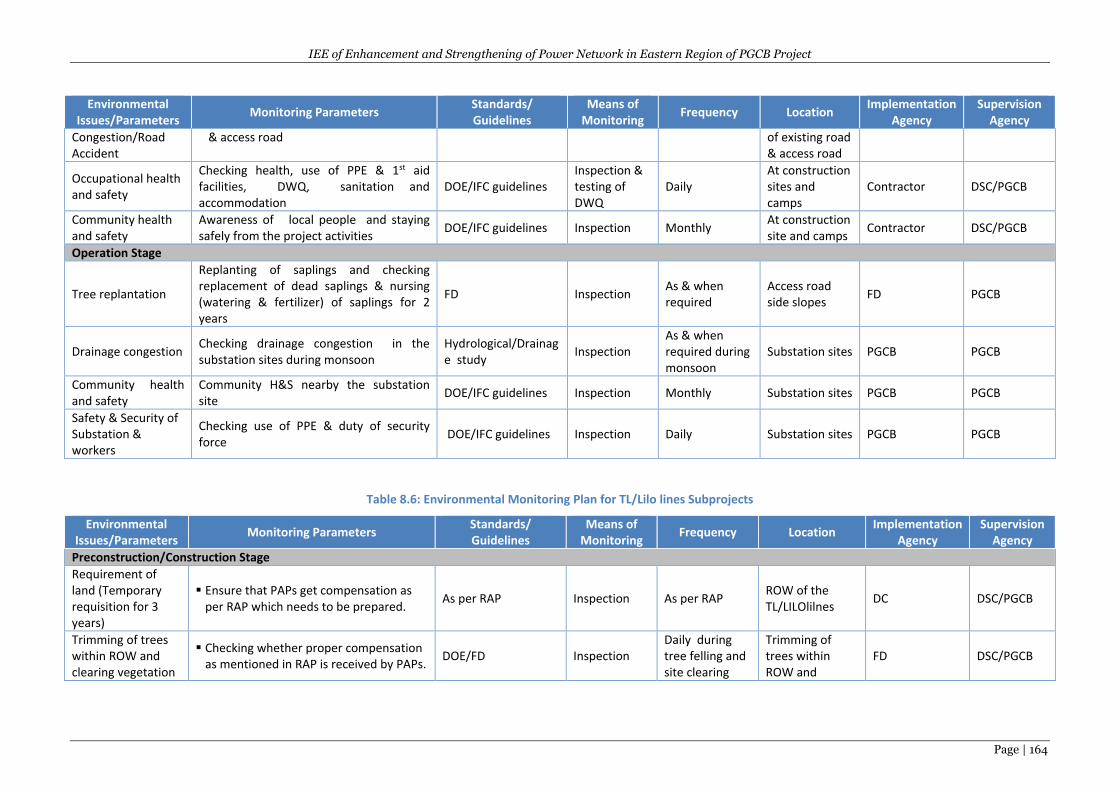
IEE of Enhancement and Strengthening of Power Network in Eastern Region of PGCB Project
Page | 164
Environmental Issues/Parameters
Monitoring Parameters Standards/ Guidelines
Means of Monitoring
Frequency Location Implementation
Agency Supervision
Agency
Congestion/Road Accident
& access road of existing road & access road
Occupational health and safety
Checking health, use of PPE & 1st aid facilities, DWQ, sanitation and accommodation
DOE/IFC guidelines Inspection & testing of DWQ
Daily At construction sites and camps
Contractor DSC/PGCB
Community health and safety
Awareness of local people and staying safely from the project activities
DOE/IFC guidelines Inspection Monthly At construction site and camps
Contractor DSC/PGCB
Operation Stage
Tree replantation
Replanting of saplings and checking replacement of dead saplings & nursing (watering & fertilizer) of saplings for 2 years
FD Inspection As & when required
Access road side slopes
FD PGCB
Drainage congestion Checking drainage congestion in the substation sites during monsoon
Hydrological/Drainage study
Inspection As & when required during monsoon
Substation sites PGCB PGCB
Community health and safety
Community H&S nearby the substation site
DOE/IFC guidelines Inspection Monthly Substation sites PGCB PGCB
Safety & Security of Substation & workers
Checking use of PPE & duty of security force
DOE/IFC guidelines Inspection Daily Substation sites PGCB PGCB
Table 8.6: Environmental Monitoring Plan for TL/Lilo lines Subprojects
Environmental Issues/Parameters
Monitoring Parameters Standards/ Guidelines
Means of Monitoring
Frequency Location Implementation
Agency Supervision
Agency
Preconstruction/Construction Stage Requirement of land (Temporary requisition for 3 years)
Ensure that PAPs get compensation as per RAP which needs to be prepared.
As per RAP Inspection As per RAP ROW of the TL/LILOlilnes
DC DSC/PGCB
Trimming of trees within ROW and clearing vegetation
Checking whether proper compensation as mentioned in RAP is received by PAPs.
DOE/FD Inspection Daily during tree felling and site clearing
Trimming of trees within ROW and
FD DSC/PGCB
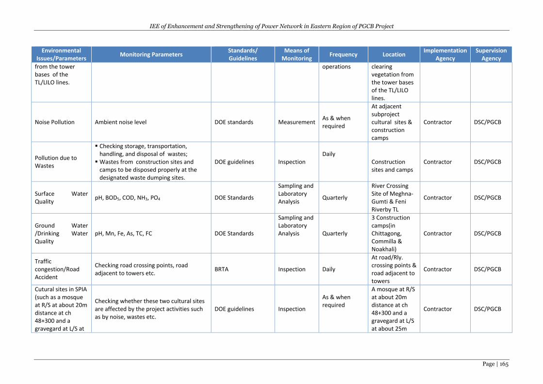
IEE of Enhancement and Strengthening of Power Network in Eastern Region of PGCB Project
Page | 165
Environmental Issues/Parameters
Monitoring Parameters Standards/ Guidelines
Means of Monitoring
Frequency Location Implementation
Agency Supervision
Agency
from the tower bases of the TL/LILO lines.
operations clearing vegetation from the tower bases of the TL/LILO lines.
Noise Pollution Ambient noise level DOE standards Measurement As & when required
At adjacent subproject cultural sites & construction camps
Contractor DSC/PGCB
Pollution due to Wastes
Checking storage, transportation, handling, and disposal of wastes;
Wastes from construction sites and camps to be disposed properly at the designated waste dumping sites.
DOE guidelines Inspection
Daily
Construction sites and camps
Contractor DSC/PGCB
Surface Water Quality
pH, BOD5, COD, NH3, PO4 DOE Standards
Sampling and Laboratory Analysis
Quarterly
River Crossing Site of Meghna-Gumti & Feni Riverby TL
Contractor DSC/PGCB
Ground Water /Drinking Water Quality
pH, Mn, Fe, As, TC, FC DOE Standards
Sampling and Laboratory Analysis Quarterly
3 Construction camps(in Chittagong, Commilla & Noakhali)
Contractor DSC/PGCB
Traffic congestion/Road Accident
Checking road crossing points, road adjacent to towers etc.
BRTA Inspection Daily
At road/Rly. crossing points & road adjacent to towers
Contractor DSC/PGCB
Cutural sites in SPIA (such as a mosque at R/S at about 20m distance at ch 48+300 and a gravegard at L/S at
Checking whether these two cultural sites are affected by the project activities such as by noise, wastes etc.
DOE guidelines Inspection
As & when required
A mosque at R/S at about 20m distance at ch 48+300 and a gravegard at L/S at about 25m
Contractor DSC/PGCB
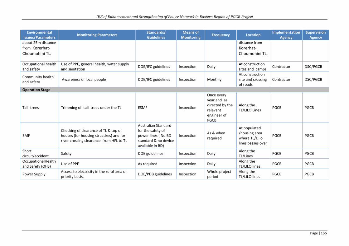
IEE of Enhancement and Strengthening of Power Network in Eastern Region of PGCB Project
Page | 166
Environmental Issues/Parameters
Monitoring Parameters Standards/ Guidelines
Means of Monitoring
Frequency Location Implementation
Agency Supervision
Agency
about 25m distance
from Korerhat- Choumohini TL.
distance from
Korerhat- Choumohini TL.
Occupational health and safety
Use of PPE, general health, water supply and sanitation
DOE/IFC guidelines Inspection Daily At construction sites and camps
Contractor DSC/PGCB
Community health and safety
Awareness of local people DOE/IFC guidelines Inspection Monthly At construction site and crossing of roads
Contractor DSC/PGCB
Operation Stage
Tall trees Trimming of tall trees under the TL ESMF Inspection
Once every year and as directed by the relevant engineer of PGCB
Along the TL/LILO Lines
PGCB PGCB
EMF Checking of clearance of TL & top of houses (for housing structires) and for river crossing clearance from HFL to TL
Australian Standard for the safety of power lines ( No BD standard & no device available in BD)
Inspection As & when required
At populated /housing area where TL/Lilio lines passes over
PGCB PGCB
Short circuit/accident
Safety DOE guidelines Inspection Daily Along the TL/Lines
PGCB PGCB
OccupationalHealth and Safety (OHS)
Use of PPE As required Inspection Daily Along the TL/LILO lines
PGCB PGCB
Power Supply Access to electricity in the rural area on priority basis.
DOE/PDB guidelines Inspection Whole project period
Along the TL/LILO lines
PGCB PGCB
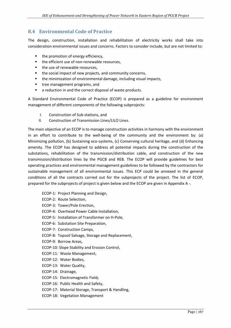
IEE of Enhancement and Strengthening of Power Network in Eastern Region of PGCB Project
Page | 167
8.4 Environmental Code of Practice
The design, construction, installation and rehabilitation of electricity works shall take into
consideration environmental issues and concerns. Factors to consider include, but are not limited to:
the promotion of energy efficiency,
the efficient use of non-renewable resources,
the use of renewable resources,
the social impact of new projects, and community concerns,
the minimization of environmental damage, including visual impacts,
tree management programs, and
a reduction in and the correct disposal of waste products.
A Standard Environmental Code of Practice (ECOP) is prepared as a guideline for environment
management of different components of the following subprojects:
I. Construction of Sub-stations, and
II. Construction of Transmission Lines/LILO Lines.
The main objective of an ECOP is to manage construction activities in harmony with the environment
in an effort to contribute to the well-being of the community and the environment by: (a)
Minimizing pollution, (b) Sustaining eco-systems, (c) Conserving cultural heritage, and (d) Enhancing
amenity. The ECOP has designed to address all potential impacts during the construction of the
substations, rehabilitation of the transmission/distribution cable, and construction of the new
transmission/distribution lines by the PGCB and REB. The ECOP will provide guidelines for best
operating practices and environmental management guidelines to be followed by the contractors for
sustainable management of all environmental issues. This ECP could be annexed in the general
conditions of all the contracts carried out for the subprojects of the project. The list of ECOP,
prepared for the subprojects of project is given below and the ECOP are given in Appendix A -.
ECOP-1: Project Planning and Design,
ECOP-2: Route Selection,
ECOP-3: Tower/Pole Erection,
ECOP-4: Overhead Power Cable Installation,
ECOP-5: Installation of Transformer on H-Pole,
ECOP-6: Substation Site Preparation,
ECOP-7: Construction Camps,
ECOP-8: Topsoil Salvage, Storage and Replacement,
ECOP-9: Borrow Areas,
ECOP-10: Slope Stability and Erosion Control,
ECOP-11: Waste Management,
ECOP-12: Water Bodies,
ECOP-13: Water Quality,
ECOP-14: Drainage,
ECOP-15: Electromagnetic Field,
ECOP-16: Public Health and Safety,
ECOP-17: Material Storage, Transport & Handling,
ECOP-18: Vegetation Management
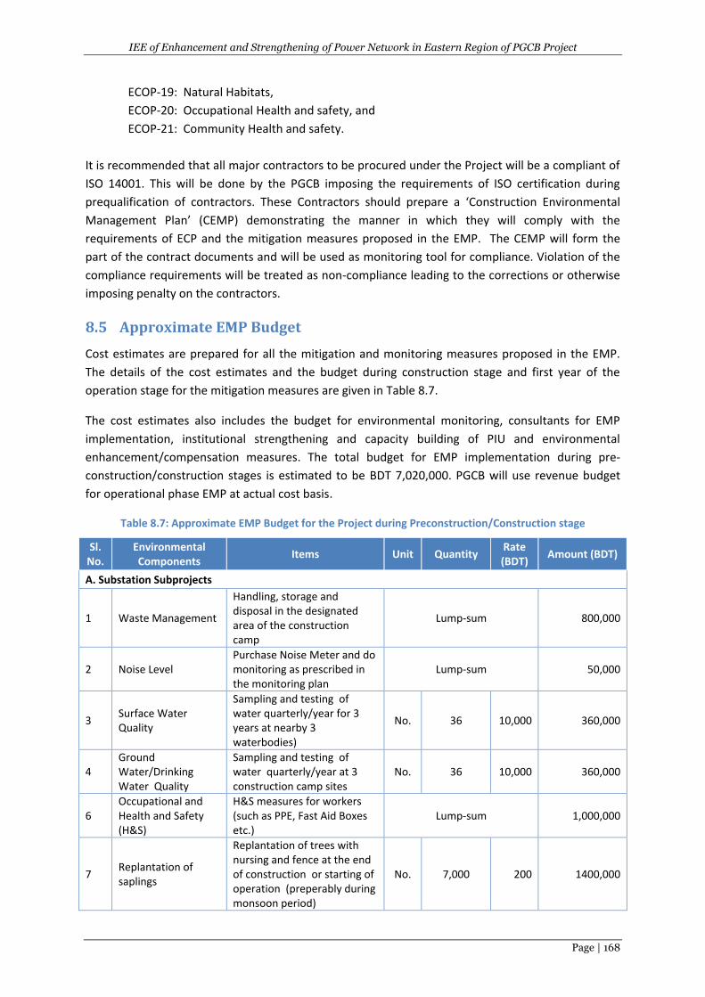
IEE of Enhancement and Strengthening of Power Network in Eastern Region of PGCB Project
Page | 168
ECOP-19: Natural Habitats,
ECOP-20: Occupational Health and safety, and
ECOP-21: Community Health and safety.
It is recommended that all major contractors to be procured under the Project will be a compliant of
ISO 14001. This will be done by the PGCB imposing the requirements of ISO certification during
prequalification of contractors. These Contractors should prepare a ‘Construction Environmental
Management Plan’ (CEMP) demonstrating the manner in which they will comply with the
requirements of ECP and the mitigation measures proposed in the EMP. The CEMP will form the
part of the contract documents and will be used as monitoring tool for compliance. Violation of the
compliance requirements will be treated as non-compliance leading to the corrections or otherwise
imposing penalty on the contractors.
8.5 Approximate EMP Budget
Cost estimates are prepared for all the mitigation and monitoring measures proposed in the EMP.
The details of the cost estimates and the budget during construction stage and first year of the
operation stage for the mitigation measures are given in Table 8.7.
The cost estimates also includes the budget for environmental monitoring, consultants for EMP
implementation, institutional strengthening and capacity building of PIU and environmental
enhancement/compensation measures. The total budget for EMP implementation during pre-
construction/construction stages is estimated to be BDT 7,020,000. PGCB will use revenue budget
for operational phase EMP at actual cost basis.
Table 8.7: Approximate EMP Budget for the Project during Preconstruction/Construction stage
Sl. No.
Environmental Components
Items Unit Quantity Rate (BDT)
Amount (BDT)
A. Substation Subprojects
1 Waste Management
Handling, storage and disposal in the designated area of the construction camp
Lump-sum 800,000
2 Noise Level Purchase Noise Meter and do monitoring as prescribed in the monitoring plan
Lump-sum 50,000
3 Surface Water Quality
Sampling and testing of water quarterly/year for 3 years at nearby 3 waterbodies)
No. 36 10,000 360,000
4 Ground Water/Drinking Water Quality
Sampling and testing of water quarterly/year at 3 construction camp sites
No. 36 10,000 360,000
6 Occupational and Health and Safety (H&S)
H&S measures for workers (such as PPE, Fast Aid Boxes etc.)
Lump-sum 1,000,000
7 Replantation of saplings
Replantation of trees with nursing and fence at the end of construction or starting of operation (preperably during monsoon period)
No. 7,000 200 1400,000
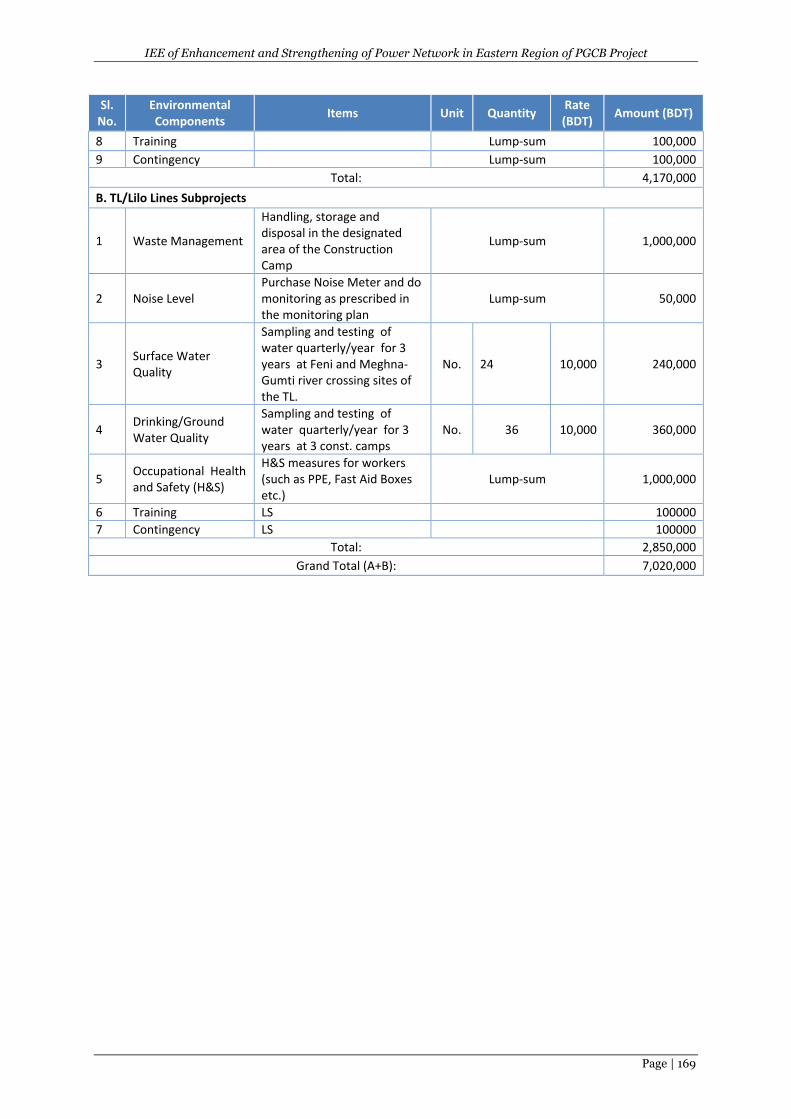
IEE of Enhancement and Strengthening of Power Network in Eastern Region of PGCB Project
Page | 169
Sl. No.
Environmental Components
Items Unit Quantity Rate (BDT)
Amount (BDT)
8 Training Lump-sum 100,000
9 Contingency Lump-sum 100,000
Total: 4,170,000
B. TL/Lilo Lines Subprojects
1 Waste Management
Handling, storage and disposal in the designated area of the Construction Camp
Lump-sum 1,000,000
2 Noise Level Purchase Noise Meter and do monitoring as prescribed in the monitoring plan
Lump-sum 50,000
3 Surface Water Quality
Sampling and testing of water quarterly/year for 3 years at Feni and Meghna-Gumti river crossing sites of the TL.
No. 24 10,000 240,000
4 Drinking/Ground Water Quality
Sampling and testing of water quarterly/year for 3 years at 3 const. camps
No. 36 10,000 360,000
5 Occupational Health and Safety (H&S)
H&S measures for workers (such as PPE, Fast Aid Boxes etc.)
Lump-sum 1,000,000
6 Training LS 100000
7 Contingency LS 100000
Total: 2,850,000
Grand Total (A+B): 7,020,000
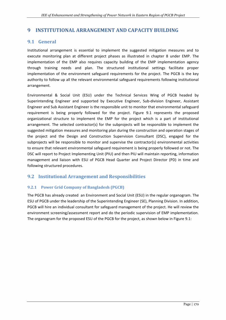
IEE of Enhancement and Strengthening of Power Network in Eastern Region of PGCB Project
Page | 170
9 INSTITUTIONAL ARRANGEMENT AND CAPACITY BUILDING
9.1 General
Institutional arrangement is essential to implement the suggested mitigation measures and to
execute monitoring plan at different project phases as illustrated in chapter 8 under EMP. The
implementation of the EMP also requires capacity building of the EMP implementation agency
through training needs and plan. The structured institutional settings facilitate proper
implementation of the environment safeguard requirements for the project. The PGCB is the key
authority to follow up all the relevant environmental safeguard requirements following institutional
arrangement.
Environmental & Social Unit (ESU) under the Technical Services Wing of PGCB headed by
Superintending Engineer and supported by Executive Engineer, Sub-division Engineer, Assistant
Engineer and Sub Assistant Engineer is the responsible unit to monitor that environmental safeguard
requirement is being properly followed for the project. Figure 9.1 represents the proposed
organizational structure to implement the EMP for the project which is a part of institutional
arrangement. The selected contractor(s) for the subprojects will be responsible to implement the
suggested mitigation measures and monitoring plan during the construction and operation stages of
the project and the Design and Construction Supervision Consultant (DSC), engaged for the
subprojects will be responsible to monitor and supervise the contractor(s) environmental activities
to ensure that relevant environmental safeguard requirement is being properly followed or not. The
DSC will report to Project Implementing Unit (PIU) and then PIU will maintain reporting, information
management and liaison with ESU of PGCB Head Quarter and Project Director (PD) in time and
following structured procedures.
9.2 Institutional Arrangement and Responsibilities
9.2.1 Power Grid Company of Bangladesh (PGCB)
The PGCB has already created an Environment and Social Unit (ESU) in the regular organogram. The
ESU of PGCB under the leadership of the Superintending Engineer (SE), Planning Division. In addition,
PGCB will hire an individual consultant for safeguard management of the project. He will review the
environment screening/assessment report and do the periodic supervision of EMP implementation.
The organogram for the proposed ESU of the PGCB for the project, as shown below in Figure 9.1:
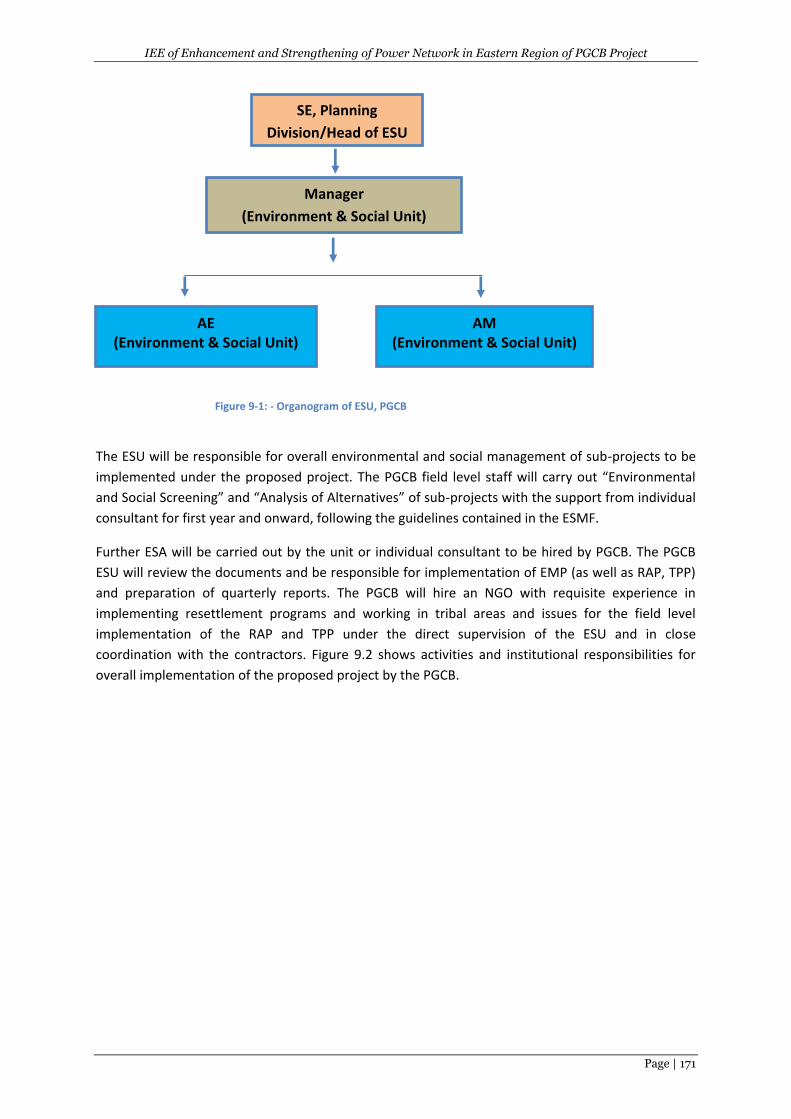
IEE of Enhancement and Strengthening of Power Network in Eastern Region of PGCB Project
Page | 171
Figure 9-1: - Organogram of ESU, PGCB
The ESU will be responsible for overall environmental and social management of sub-projects to be
implemented under the proposed project. The PGCB field level staff will carry out “Environmental
and Social Screening” and “Analysis of Alternatives” of sub-projects with the support from individual
consultant for first year and onward, following the guidelines contained in the ESMF.
Further ESA will be carried out by the unit or individual consultant to be hired by PGCB. The PGCB
ESU will review the documents and be responsible for implementation of EMP (as well as RAP, TPP)
and preparation of quarterly reports. The PGCB will hire an NGO with requisite experience in
implementing resettlement programs and working in tribal areas and issues for the field level
implementation of the RAP and TPP under the direct supervision of the ESU and in close
coordination with the contractors. Figure 9.2 shows activities and institutional responsibilities for
overall implementation of the proposed project by the PGCB.
SE, Planning
Division/Head of ESU
(ESU)
Manager
(Environment & Social Unit)
AE (Environment & Social Unit)
AM (Environment & Social Unit)
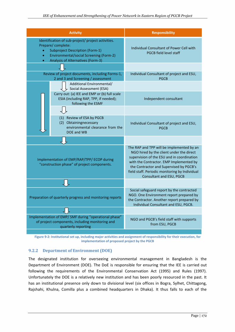
IEE of Enhancement and Strengthening of Power Network in Eastern Region of PGCB Project
Page | 172
Activity Responsibility
Identification of sub-project/ project activities. Prepare/ complete:
Subproject Description (Form-1)
Environmental/social Screening (Form-2)
Analysis of Alternatives (Form-3)
Individual Consultant of Power Cell with PGCB field level staff
Review of project documents, including Forms-1, 2 and 3 and Screening / assessment
Individual Consultant of project and ESU, PGCB
Additional Environmental/ Social Assessment (ESA)
Carry out: (a) IEE and EMP or (b) full scale ESIA (including RAP, TPP, if needed);
following the ESMF Independent consultant
(1) Review of ESA by PGCB (2) Obtainingnecessary
environmental clearance from the DOE and WB
Individual Consultant of project and ESU, PGCB
Implementation of EMP/RAP/TPP/ ECOP during “construction phase” of project components.
The RAP and TPP will be implemented by an NGO hired by the client under the direct
supervision of the ESU and in coordination with the Contractor. EMP Implemented by the Contractor and Supervised by PGCB’s
field staff. Periodic monitoring by Individual Consultant and ESU, PGCB
Preparation of quarterly progress and monitoring reports
Social safeguard report by the contracted NGO. One Environment report prepared by the Contractor. Another report prepared by
Individual Consultant and ESU, PGCB.
Implementation of EMP/ SMF during “operational phase” of project components, including monitoring and
quarterly reporting
NGO and PGCB’s field staff with supports from ESU, PGCB
Figure 9-2: Institutional set up, including major activities and assignment of responsibility for their execution, for
implementation of proposed project by the PGCB
9.2.2 Department of Environment (DOE)
The designated institution for overseeing environmental management in Bangladesh is the
Department of Environment (DOE). The DoE is responsible for ensuring that the IEE is carried out
following the requirements of the Environmental Conservation Act (1995) and Rules (1997).
Unfortunately the DOE is a relatively new institution and has been poorly resourced in the past. It
has an institutional presence only down to divisional level (six offices in Bogra, Sylhet, Chittagong,
Rajshahi, Khulna, Comilla plus a combined headquarters in Dhaka). It thus falls to each of the
IEE of Enhancement and Strengthening of Power Network in Eastern Region of PGCB Project
Page | 173
government line agencies to ensure that their work abides by the environmental laws, rules and
procedures, with overall direction given by the DOE.
9.2.3 Forest Department (FD)
The Forest Department (FD) sometimes requires authorization for the cutting of trees, especially if
they are in specially planted areas under their jurisdiction. To obtain the correct clearance
documentation can be time consuming, although with the proposed project tree planting programs
there will be far more tree cover as a result of the project. It is thus vital to ensure that adequate
time is made available to obtain the required clearance. As for the FD, it is vital to ensure that
adequate time is made available in the program for obtaining any such clearance that may be
required. It is noted that due to running of 11.334 km longKorerhat-BSRM LILO line over the pocket
hilly area (max. 6m ht)with forest trees (from ch 3+450-11+700), prior to start construction need
clearance from the Forest Department (FD) of Bangladesh.
9.2.4 Design and Supervision Consultants (DSC)
The proposed framework for implementation of the project shall utilize consultancy services from
both international and national companies for the overall design, management and supervision of
construction works of the subprojects under the project.
9.2.5 Contractors
The tender for the construction of the subproject would be national/international competitive
bidding contractors. There will be a need for environmental awareness rising, particularly as it
relates to directly construction impacts and especially site health and safety issues. The need to
develop self-regulation of the contractors will have to be emphasized, with the consultants
supervising role being to check on conformity with the relevant clauses in construction contracts as
well as national and WB legislation and regulations.
In these regards, the following clauses can be incorporated in the project contract document:
The contractor shall take all reasonable steps to protect the environment and avoid damage
and nuisance arising because of his construction activities/operations.
The contractor shall comply with all statutes and regulations concerning the execution of
works as mentioned in DOE and WB environmental guidelines.
The contractor shall be responsible for familiarizing himself with all legislation elating to
environmental protection that is relevant to his activities. Reference to national
environmental quality guidelines should be made.
The contractor shall be responsible for the costs of cleaning up any environmental pollution
resulting from his activities if methods for doing so are available and effective.
In case of surface water pollution from contractor activities, the contractor shall take
adequate preventive measures for not doing so and in case of pollution if occurred the
contractor shall be responsible to make the water to its original quality especially where the
surface water has potential use. Cost including for the tests and the purification shall be to
the contractor’s own costs.
Where abstraction from a borehole by the contractor results in adverse effects on
groundwater, which at the time of commencement of the contract was being used by the
IEE of Enhancement and Strengthening of Power Network in Eastern Region of PGCB Project
Page | 174
local people, the contractor shall arrange supplies of equivalent quality and quantity to that
previously.
The contractor shall, at all times, maintain all sites under his control in a clean and tidy
condition and shall provide appropriate and adequate facilities for the temporary storage of
all wastes before disposal.
The contractor shall be responsible for the safe transportation and disposal of all wastes
generated because of his activities in such a manner as to not cause environmental pollution
or hazards to health in any form. In the event of any third party being employed to dispose
of wastes, the contractor shall be considered to have discharged his responsibilities under
this clause from the time the wastes leave sites under his control, providing that he has
exercised due diligence in ascertaining that the proposed transport and disposal
arrangements such as to not cause pollution or health hazards.
The contractor shall not allow waste oils or other petroleum derived wastes to be used as
dust suppressants and that all reasonable precautions shall be taken to prevent accidental
spillage of petroleum products, their contact with soil or discharge into water courses.
The contractor shall be responsible for the provision of adequate sanitary facilities for the
construction workforce (including those employed under subcontracts) at all construction
and camp sites. The contractor shall not knowledgably allow the discharge of any untreated
sanitary wastes to groundwater or surface water. Before mobilization of the construction
workforce, the contractor shall provide details of sanitary arrangements to the Engineer for
approval. The detail should include maintenance and operation plants and generally be
sufficient to allow the Engineer to assess whether the proposed facilities are adequate.
All vehicles and plant operated by the Contractor (including subcontractors) shall be
maintained according to the original manufacturers' specifications and manuals, with
particular regard to the control of noise and/or smoke emissions. The Engineer shall have
the right to require the contractor to replace or rectify any vehicle or plant that he thinks
emits excessive noise and/or smoke, within 48 hours of notice in writing.
The contractor shall make every reasonable effort to reduce noise nuisance caused by
construction activities, including siting of crusher and ancillary plant in locations where the
distance between them and residential areas such it results in attenuation of noise at
existing residential areas is.
In case of any traffic disruption by the construction activities of the contractor (or his
appointed subcontractors), the contractor shall be responsible to provide alterative road
access to the full operational use for the vehicles. The facilities in this regard shall be such
that either party is not disturbed.
In case of any existing infrastructure/properties, damaged by the contractor (or his
appointed subcontractor), the contractor shall notify the Engineer of it and at his own cost
shall repair the road to its original condition.
Upon completion of the construction works, the contractor shall remove all equipment,
surplus material, wastes and temporary works of every kind, and the site in clean condition
to the satisfaction of the Engineer.
In addition of Contractor’s general arrangement to continue the construction and rehabilitation
work under the project, contractor must hire at least one environment, health and safety
supervisor/engineer for each subproject before the commencement of work. The
Contractor/Subcontractor shall abide by the rules of regulation of the Occupational health and
safety as stipulated in the Labour Act-2006 and BNBC codes of Bangladesh. The contractor shall also
IEE of Enhancement and Strengthening of Power Network in Eastern Region of PGCB Project
Page | 175
abide by the clauses of health and safety in the clauses at General Condition and subsequent
Particular Condition of the bid document.
Role of Environment, Health and Safety Supervisor/Engineer: Primary role is to monitor the
movement of people, workers and equipment, give timely warnings of any risk or non-compliance
with safe work procedures and, where necessary, stop work if a risk situation escalates or cannot be
minimized as well as look the potential environmental issues (air pollution, noise level, water quality,
waste management etc.).
The tasks of environment and safety supervisor/manager include the following:
Ensure first aid facilities and PPE as mentioned in Table 6.1 and 6.2 for workers at the sites.
Provide orientation to workers before start of the subproject activities.
Warn the workers of any imminent or deteriorating risk situation that could result in an
accident, and instruct when it is safe to proceed
Ensure restrain from undertaking any other tasks that may distract the workers focus on the
work, mainly, work on or near live overhead conductors, work on transmission and
communication towers.
Stop the work, if necessary, safety would not be ensured.
Pause the work while the safety observer changes position.
Ensure special safety during elevated work platform work or crane operations on or near live
conductors.
Ensure proper collection and disposal of solid wastes within the construction site.
Ensure proper infrastructure facilities, water supply and sanitation facilities for all workers.
The contractor will prepare a monitoring report on environment and safety for each subproject at
every month during the construction/rehabilitation of transmission line and substation.
The proposed overall organizational structure of the implementation arrangement of the EMP of the
project is shown in the Figure 9.3.
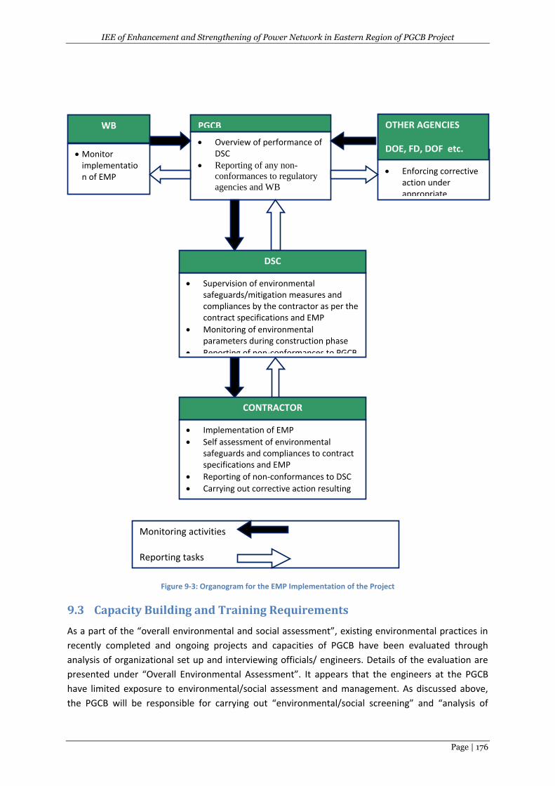
IEE of Enhancement and Strengthening of Power Network in Eastern Region of PGCB Project
Page | 176
Figure 9-3: Organogram for the EMP Implementation of the Project
9.3 Capacity Building and Training Requirements
As a part of the “overall environmental and social assessment”, existing environmental practices in
recently completed and ongoing projects and capacities of PGCB have been evaluated through
analysis of organizational set up and interviewing officials/ engineers. Details of the evaluation are
presented under “Overall Environmental Assessment”. It appears that the engineers at the PGCB
have limited exposure to environmental/social assessment and management. As discussed above,
the PGCB will be responsible for carrying out “environmental/social screening” and “analysis of
Monitoring activities
Reporting tasks
Overview of performance of DSC
Reporting of any non-
conformances to regulatory
agencies and WB
Enforcing corrective action under appropriate legislations
Supervision of environmental safeguards/mitigation measures and compliances by the contractor as per the contract specifications and EMP
Monitoring of environmental parameters during construction phase
Reporting of non-conformances to PGCB
Implementation of EMP
Self assessment of environmental safeguards and compliances to contract specifications and EMP
Reporting of non-conformances to DSC
Carrying out corrective action resulting from non-conformances.
PGCB OTHER AGENCIES
DOE, FD, DOF etc.
MoEF, DoEF
DSC
CONTRACTOR
WB
Monitor implementation of EMP
IEE of Enhancement and Strengthening of Power Network in Eastern Region of PGCB Project
Page | 177
alternatives”, and guidelines have been provided in the ESMF for carrying out these activities.
However, basic training on regulatory requirements, environmental impacts, and environmental
assessment and management would greatly improve the capability of relevant PGCB
engineers/officials in carrying out their responsibilities under the proposed project.
The PGCB will employ individual/supervision/DSM consultant, who would support PGCB in overall
environmental/social management. However, since the overall responsibility of environmental
management lies with the PGCB, they need to ensure that the consultants are carrying out their
responsibilities properly. For this purpose, it is important that the PGCB engineers/officials receive
advanced training on environmental management and monitoring. Such training will assist them in
properly overseeing the activities of the consultant engaged in environmental management of the
proposed project, following the ESMF.
During the implementation of the project, the PGCB will develop their own organizational
environment and occupational health & safety strategy and guidelines for their regular development
work.
The training requirements of the PGCB staff are summarized in Table 9.1. It is also advised to provide
the basic training for key personnel on regulatory requirements, environmental impacts, and
environmental assessment and management in home or abroad. It may be mentioned that cost of
training and capacity building is included in the project resources.
Table 9.1: Training Plan for the Proposed Project
Target Group Subject(s) Method Time Frame
Project relevant engineers/officers of PGCB, contractors
General environmental awareness, regulatory requirements, environmental impacts and mitigation, analysis of alternatives, environmental management (EMP and ECOP) and H&S
Workshop/Seminar Prior to start the construction activities of the subprojects
Project relevant engineers/officers of PGCB, contractors
Environmental assessment, environmental management (EMP, ECOP), monitoring activities, H&S.
Workshop /Seminar Just after starting the construction of subprojects
It would be essential to understand the legislative framework and enhance capacity of ESU of PGCB
and Field Officer (Environment) for analysing the applicability of various environmental legislations
and clearances, approvals and compliance monitoring requirements. An environmental legislation
applicability matrix framework has already been given in Chapter 2 of this report for ready
reference.
9.4 Grievance Redress Mechanism
The concern/grievances from local/affected people may come up related to inappropriate
implementation of various components of EMP or the overall components/activities of the
subproject itself. These issues will be addressed through acknowledgement, evaluation and
corrective action and response approach. A Grievance Redress Mechanism (GRM) will be established
to receive, evaluate, and facilitate the resolution of affected people’s concerns, complaints, and
grievances about the social and environmental performance of the project. The GRM aims to
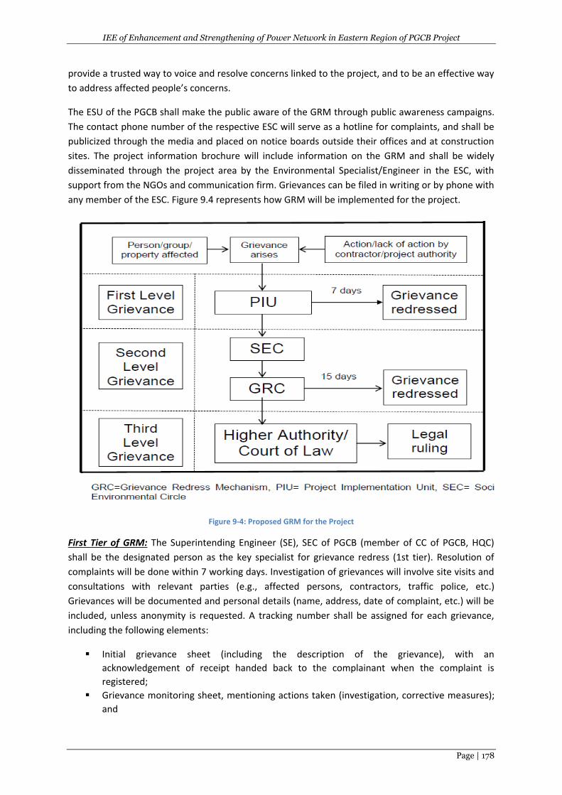
IEE of Enhancement and Strengthening of Power Network in Eastern Region of PGCB Project
Page | 178
provide a trusted way to voice and resolve concerns linked to the project, and to be an effective way
to address affected people’s concerns.
The ESU of the PGCB shall make the public aware of the GRM through public awareness campaigns.
The contact phone number of the respective ESC will serve as a hotline for complaints, and shall be
publicized through the media and placed on notice boards outside their offices and at construction
sites. The project information brochure will include information on the GRM and shall be widely
disseminated through the project area by the Environmental Specialist/Engineer in the ESC, with
support from the NGOs and communication firm. Grievances can be filed in writing or by phone with
any member of the ESC. Figure 9.4 represents how GRM will be implemented for the project.
Figure 9-4: Proposed GRM for the Project
First Tier of GRM: The Superintending Engineer (SE), SEC of PGCB (member of CC of PGCB, HQC)
shall be the designated person as the key specialist for grievance redress (1st tier). Resolution of
complaints will be done within 7 working days. Investigation of grievances will involve site visits and
consultations with relevant parties (e.g., affected persons, contractors, traffic police, etc.)
Grievances will be documented and personal details (name, address, date of complaint, etc.) will be
included, unless anonymity is requested. A tracking number shall be assigned for each grievance,
including the following elements:
Initial grievance sheet (including the description of the grievance), with an
acknowledgement of receipt handed back to the complainant when the complaint is
registered;
Grievance monitoring sheet, mentioning actions taken (investigation, corrective measures);
and
IEE of Enhancement and Strengthening of Power Network in Eastern Region of PGCB Project
Page | 179
Closure sheet, one copy of which will be handed to the complainant after he/she has agreed
to the resolution and signed off.
The updated register of grievances and complaints will be available to the public at the SEC office,
construction site, and other key public offices along the project area. Should the grievance remain
unresolved, it will be elevated to the second tier.
Second Tier of GRM: Adl. CE of MSW of PGCB, will activate the second tier of GRM by referring the
unresolved issue (with written documentation). The GRC shall be established by the SEC of PGCB
before commencement of site works. The GRC will consist of the following persons: (i) project
director; (ii) representative of city ward; (iii) representative of the affected persons; (iv)
representative of the local deputy commissioner’s office (land); and (v) representative of the
Department of Environment (DOE) for environmental related grievances. A hearing will be called
with the GRC, if necessary, where the affected person can present his or her concerns and issues.
The process will facilitate resolution through mediation. The local GRC will meet as necessary when
there are grievances to be addressed. The local GRC will suggest corrective measures at the field
level and assign clear responsibilities for implementing its decision within 15 working days. The
contractor will have observer status on the committee. If unsatisfied with the decision, the existence
of the GRC shall not impede the complainant’s access to the government’s judicial or administrative
remedies.
The functions of the local GRC are as follows: (i) resolve problems and provide support to affected
persons arising from various environmental issues, including dust, noise, utilities, power and water
supply, waste disposal, traffic interference, and public safety, as well as social issues such as land
acquisition, asset acquisition, and eligibility for entitlements, compensation, and assistance; (ii)
reconfirm grievances of displaced persons, categorize and prioritize them, and aim to provide
solutions within a month; and (iii) report to the aggrieved parties about developments regarding
their grievances and decisions of the GRC. The SE, SEC will be responsible for processing and placing
all papers before the GRC, maintaining database of complaints, recording decisions, issuing minutes
of the meetings, and monitoring to see that formal orders are issued and the decisions carried out.
Third Tier of GRM: In the event that a grievance cannot be resolved directly by the PIU (first tier) or
GRC (second tier), the affected person can seek alternative redress through the city ward
committees or in appropriate courts. The PIU or GRC will be kept informed by the city corporation
authority. The grievance redress mechanism and procedure has depicted in Figure 9.4. The
monitoring reports of the EMP and the resettlement plan implementation shall include the following
aspects pertaining to progress on grievances: (i) number of cases registered with the GRC, level of
jurisdiction (first, second, and third tiers), number of hearings held, decisions made, and the status
of pending cases; and (ii) lists of cases in process and already decided upon, which may be prepared
with details such as name, identification (I.D.) with unique serial number, date of notice, date of
application, date of hearing, decisions, remarks, actions taken to resolve issues, and status of
grievance (i.e., open, closed, or pending).
IEE of Enhancement and Strengthening of Power Network in Eastern Region of PGCB Project
Page | 180
10 CONCLUSIONS AND RECOMMENDATIONS
10.1 Conclusions
The proposed Enhancement and Strengthening of Power Network in Eastern Region (ESPNER)
project, funded by WB is expected to provide support for the construction of the substations and
TLs/LILOlines of thePGCB of Bangladesh. Main components of the project include:
Construction of new 230/132 kV two substations and new 132/33 kV 10 substations;
Construction of eight new 288.642 km long 132 kV, 230kVand 400kV TL; and
Construction of new eightLILO lines ;
The present power network in Greater Comilla, Noakhali and Chittagong areas of Bangladesh is aged
and suffering numerous problems as system demand is growing rapidly. The greater Comilla and
Noakhali areas are the second largest demand areas after the capital city of Dhaka. The greater
Chittagong area is on the verge of massive industrialization as the government is taking initiatives to
set up multiple economic zones, upgrade port facility and transportation network. Hence, the
project was conceptualized with a rationale to expand the 230 kV transmission systems and to
strengthen the 132 kV transmission systems in the project area, in order to, eliminate the
operational bottlenecks caused due to inadequacy of the existing system. The project will also
provide an adequate infrastructure for the future power sector development of the area.
The TOR has prepared to carryout detailed IEE for the project in accordance with the relevant laws
and regulations of the GOB and the WB. The specific environmental guideline for the power sector is
not available in Bangladesh. However the DOE environmental guidelines for the industries/projects
provide a general framework for conducting environmental study for the entire sector. Therefore
the proposed IEE will be conducted following the DOE environmental guidelines. In addition, it is
suggested to follow the ESMF of Rural Electricity Transmission and Distribution Project (RETDP) of
PGCB and BREB as well as WB environmental guidelines for the power sector.
The scope of work of the IEEincludes: (a) Review of relevant information/data/documents from
secondary sources, and identify gaps to be filled, relevant to the environmental screening needs
from primary surveys. (b) Provide a description of the environment (such as baseline data on
physical, biological/ecological and socio-economic characteristics of the subproject sites along with
SPIA). (c) Represent the primary surveys where include baseline (air, water, noise, and riverbed)
environmental quality monitoring at representative and sensitive locations, and identification of all
macro-level environmental issues within the SPIA. (d)Survey the environmentally sensitive locations
on and along the sub-projects and within the SPIA. (e)Arrange stakeholder consultations/individual
consultations within the local people from all professions to find out their opinions on the
subprojects. (f) Analysis of alternatives to the proposed subproject. (g) Identify and assessment of
potential environmental impacts due to implementation of the subproject. (h) Formulation of
Environmental Management Plan (EMP)
Initially, 3 sites for each proposed substation and 3 routes for each proposed TL have been selected
and environmental screening and assessment for these 3 substation sites and TL routes have been
done for identifying the potential impacts based on the collected baseline information/data by the
environmental specialist and survey team . From these 3 sites/routes, environmentally suitable
IEE of Enhancement and Strengthening of Power Network in Eastern Region of PGCB Project
Page | 181
substation site and TL have been finally selected. The potential impacts for the selected substation
sites and TL routes during preconstruction/construction and operation stages of the subprojects are:
(a) For Substation Subprojects:
General/Common Potential Impacts:
(i) During Preconstruction/Construction: A total of 86.62 acres land acquisition, clearing of
vegetation including 3,501 trees , hydrology/ drainage congestion, top soils, and dust pollution,
noise pollution, waste pollution , soil pollution, traffic congestion, occupational H&S, community
H&S, and employment generation; and
(ii) During Operation: Drainage congestion, tree replantation (a total 7000 various trees), landscape,
occupational H&S, community H&S, and improvement of social and economical life of the people.
Specific Impacts ofSubstations
(i) During Preconstruction/Construction: 2945 trees, 136 trees & 420 trees need to be cut due to
construction of Korerhat, Basurhat & Chandina substation respectfully. SW pollution of waterbodies
will be occurred due to construction of Maijdee, Basurhat& Chandina substation respectfully.
(b) For Subproject: TL&LILO Lines
General/Common Impacts:
(i) Pre-construction/Construction Phase: Trimming of 20,252 trees, disturbance of fauna (wildlife),
loss of top soil due to tower, noise pollution , air/dust pollution , soil pollution, pollution due to
wastes, aquatic habitat , traffic congestion/road accident , siting of construction camps, occupational
H&S, community H&S and employment generation/income
(ii) Operation Stage: Landscape, community HS&, Occupational H&S, improvement of social &
economic life, short circuit/accident, electro-magnetic fields (EMF).
Specific Impacts
(i) Preconstruction/Construction Stage: Disrubtion of boat movement and water pollurion in the
Meghna- Gumti River at ch 33+500 due to construction of the Kachua-Gazaria TL and disrubtion of
boat movement and water pollution in the Feni River at ch 2+850 due to Korerhat-Chowmuhini TL; a
mosque due at 20m far away at R/S of the TL at ch 48+300 and a graveyard at 25m faraway at L/S
of the TL due to construction of the Korerhat- Choumohini TL.Pocket hilly areas with forest small to
medium trees will be affected by trimming due construction of Korerhat-BSRM LILO line.
The potential impacts during construction stage are short-term that can be avoided or eliminate to
ed or reduced by adopting the mitigation measures properly. Therefore, the anticipated negative
construction related impacts could be mostly controlled/minimized or eliminated by taking
suggested mitigation measures and manage the implementation of the mitigation measures through
the EMP including effective monitoring plan during pre-construction/construction and operation
phases of the project.
The potential impacts during operation are long term and PGCB should ensure to mitigate these
impacts through implementation of the EMP including monitoring plan properely. Total
approximatebudget for EMP is about BDT7,124,000.
IEE of Enhancement and Strengthening of Power Network in Eastern Region of PGCB Project
Page | 182
10.2 Recommendations
Based on the findings of the IEE study, the following can be recommended:
Based on the EMP of the IEE, Construction Environmental Management Plan (CEMP) should
be prepared by the contractor prior to start construction of the project and act accordingly
during construction;
The EMP will be included in the bid document of the civil works along with adequate EMP
budget and eventually become part of the civil works contract (s);
The mitigation measures for the negative impacts and enhancement measures for the
positive impacts of the project as mentioned in the EMP must be implemented by the
contractor (s) properly in schedule time; and
The main tool for the successful implementation of the EMP is the environmental
monitoring during various stages of the project, which must be carried out properly in time
by the client/DSC/other relevant organisations.
IEE of Enhancement and Strengthening of Power Network in Eastern Region of PGCB Project
Page | 183
11. REFERENCES
1.Bangladesh Bureau of Statistics (BBS). 2011. Population and Housing Census. Dhaka, Bangladesh:
Bangladesh Bureau of Statistics.
2.Bangladesh Centre for Advanced Studies (BCAS). 1999. Guide to the Environmental Conservation Act 1995 and Rules 1997. Dhaka: BCAS.
3.Bangladesh Meteorological Department (BMD), Ministry of Defense, Government of the People’s Republic of Bangladesh, 2016.Climatic Database: Rainfall, Temperature, Relative Humidity and Wind Speed for Comilla, Feni and Sitakundo station, 2061-2015. Dhaka: BMD.
4.Graphosman, World Atlas, January 1996.
5.Brammer, H., 1996. The Geography of the Soils of Bangladesh. Dhaka: University Press Limited.
6.Department of Environment (DOE), Ministry of Environment and Forest, Government of the People's Republic of Bangladesh, 1997.IEE Guidelines for Industries. Dhaka: DOE.
7.Environmental Conservation Rules 1997. (Schedule 3), Dhaka: Ministry of Law and Justice, Government of the People’s Republic of Bangladesh.
8.Farooque, M. & Hasan, S. R., 2004. Laws Regulating Environment in Bangladesh. Dhaka: Bangladesh Environmental Lawyers Association (BELA).
9.International Union for Conservation of Nature (IUCN), 2000a.Red Book of Threatened Animals of Bangladesh. Dhaka: IUCN-Bangladesh.
10.International Union for Conservation of Nature (IUCN), 2000b.Red Book of Threatened Birds of Bangladesh. Dhaka: IUCN-Bangladesh.
11.International Union for Conservation of Nature (IUCN), 2000c.Red Book of Threatened Amphibians and Reptiles of Bangladesh. Dhaka: IUCN-Bangladesh.
12.International Union for Conservation of Nature (IUCN), 2003.Threatened Animals of Bangladesh. Dhaka: IUCN-Bangladesh.
13.Rashid, H., 1977. Geography of Bangladesh. Dhaka: University Press Limited.
14.Soil Resource Development Institute (SRDI), 1997. Physiography of Bangladesh. Dhaka: SRDI, Ministry of Agriculture.
15.Soil Resource Development Institute (SRDI), 1998. Agro-ecological regions of Bangladesh. Dhaka: SRDI, Ministry of Agriculture.
16. Topographical Survey of the SS and TL/Lilo Lines Subproject Area, 2017
17. Socio-Economic Survey of the ESPNER Project, June-July, 2017.
18. TOR of the proposed ESPNER Project, 2017.
19. Monthly Environmental Progress Report of the KMG Project under RHD , funded by JICA, January 2016.
20. Monthly Environmental Progress Report of the CCORRP Project under CDA, Funded by JICA, May 2017.
IEE of Enhancement and Strengthening of Power Network in Eastern Region of PGCB Project
Page | 184
APPENDIX – A: ENVIRONMENTAL CODE OF PRACTICE (ECOP)
The Environmental Code of Practice (ECOP) is a guideline for eliminate or reducing environment
impacts/risks due to construction of the subprojects under RETDP of PGCB (construction of
substations, construction of 33kV /132kV Transmission Lines). The relevant ECOP of the ESPNER
under PGCB are as follows:
ECOP 1.0: Planning and Design Phases of a Project
1.1 General
This ECOP details the factors to be considered during project preparation to avoid/address
environmental concerns through modifications in project design and incorporation of mitigation
measures.
1.2 Compliance to Legal Requirements
The bid document shall include the various applicable clearances pertaining to environmental
management and shall contain the necessary procedures for compliance of the same.
ECOP 2.0: Route Selection
2.1 Selection and Finalization of Alignment/Project Location
Adequate consultations with the communities to identify the concerns and preferences need to be
taken up during selection of the alignment of the Transmission Lines (TL).
Alignment shall conform to the natural topography as far as possible to avoid excessive cut and fill.
Special care should be taken to align the routes along the hillside, which is stable and where cutting
on hillside causes least disturbance.
Consultations with the local communities are to be conducted to obtain their suggestions and
incorporate their concerns to address the potential environmental impacts.
Selection of site for substations should be done in consultation with the local communities
addressing the environmental as well as social issues so as to cause least possible adverse impacts.
In case of flood prone areas and/or areas with very flat slopes, hydrological surveys have to be
conducted before alignment finalization.
ECOP 3.0: Tower/Pole Erection
3.1 General
Erection of poles/towers for installation of 33kV/132kV power transmission lines of the PGCB
involves:
Informing the local community about the installation schedule;
IEE of Enhancement and Strengthening of Power Network in Eastern Region of PGCB Project
Page | 185
Marking and clearance of the designated locations for installation/replacement of SPC poles/Steel
tower. Scope of this ECoP includes only the measures to address environmental concerns expected
during the Pole erection process.
3.2 Pole/Tower Erection Activities by PGCB
Informing the community and local city/village councils about the likely schedule of erection;
After obtaining the consent of the community PGCB shall be responsible to stake out the designated
locations.
3.3 Pole/Tower Erection Activities by the Contractor
The contractor shall submit the schedules and methods of operations for various items during the
Pole/Tower erection operations to the PGCB for approval.
The clearance of sites shall involve the removal of all materials such as trees, bushes, shrubs,
stumps, roots, grass, weeds, part of topsoil and rubbish. Towards this end, the Contractor shall
adopt the following measures:
To minimize the adverse impact on flora and vegetation, only ground cover/shrubs that impinge
directly on the permanent works shall be removed.
In locations where erosion or sedimentation is likely to be a problem, clearing and grubbing
operations should be so scheduled and performed that grading operations and permanent erosion
and sedimentation control features can follow immediately, if the project conditions permit.
The disposal of wastes shall be in accordance with the provisions of ECOP 11.0, “Waste
Management”.
3.4 River Crossing Towers
All regulatory clearances shall be obtained before actual start of work. River Crossing Towers are
very high electric towers specially designed to cross large rivers. Tower construction for river
crossing will require proper protective measures against bank collapse. Sheet-Piling or Shore
protection measures should be ensured while laying the foundation of the tower near the river bank
or in the river bed. Pre-cast piles should be driven in with extreme care so as to expose the workers
to the least possible danger.
Foundation should be checked for damages or uneven settlement following construction.
Proper safety measures should be ensured prior to river crossing jobs.
The work plans should be submitted by the contractor/engineer prior to commencement of the
erection work. The work plan should provide detailed steps of foundation works in the river. River
traffic movement should not be obstructed t any stage.
Proper protective measures should be adopted to prevent or minimize river water pollution.
Using of vibratory hammer for pile work is oreferable to reduce impact on acuatic habitat
IEE of Enhancement and Strengthening of Power Network in Eastern Region of PGCB Project
Page | 186
Installation of underwater enclosures to minimize sound.
Use signage and construct fender( if necessary) to prevent collision with vessel
ECOP 4.0: Overhead Power Cable Installation
4.1 General
Installation of 33kV/132kV power distribution/transmission lines of the PGCB involves:
Informing the local community about the installation schedule;
Marking and clearance of the designated routes for installation/rehabilitation of overhead power
lines. Scope of this ECOP includes only the measures to address environmental concerns expected
during the power cable installation process.
4.2 Overhead Distribution/Transmission Cable Installation Activities by PGCB
Informing the community and local city/village councils about the likely schedule of installation;
After obtaining the consent of the community PGCB shall be responsible to stake out the designated
route.
4.3 Overhead Distribution/Transmission Cable Installation Activities by the Contractor
The contractor shall submit the schedules and methods of operations for various items during the
overhead power cable installation/rehabilitation operations to the PGCB for approval.
The clearance of sites shall involve the removal of all materials such as trees, bushes and rubbish.
Towards this end, the Contractor shall adopt the following measures:
To minimize the adverse impact on flora and vegetation, only ground cover/shrubs that impinge
directly on the permanent works, if any, shall be removed.
The disposal of wastes shall be in accordance with the provisions of ECOP 11.0, “Waste
Management”.
All regulatory clearances shall be obtained before actual start of work.
ECOP 5.0: Installation of Transformers on H-Pole
5.1 General
Installation of Transformers on H-Poles along the route:
Informing the local community about the installation schedule;
Marking and clearance of the designated locations for installation of transformers on H-poles Scope
of this ECOP includes only the measures to address environmental concerns expected during the
power cable installation process.
IEE of Enhancement and Strengthening of Power Network in Eastern Region of PGCB Project
Page | 187
5.2 Activities Involved in Transformer Installation on H-Pole by PGCB
Informing the community and local city/village councils about the likely schedule of installation;
After obtaining the consent of the community PGCB shall be responsible to stake out the designated
locations.
5.3 Activities Involved in Transformer Installation on H-Pole by the Contractor
The contractor shall submit the schedules and methods of operations for various items during the
installation operations of the transformers on H-Pole to the PGCB for approval.
The clearance of sites shall involve the removal of all materials such as trees, bushes and rubbish.
Towards this end, the Contractor shall adopt the following measures:
To minimize the adverse impact on flora and vegetation, only ground cover/shrubs that impinge
directly on the permanent works, if any, shall be removed.
The disposal of wastes shall be in accordance with the provisions of ECOP 7.0, “Waste
Management”.
All regulatory clearances shall be obtained before actual start of work.
ECOP 6.0: Site Preparation for Substations
6.1 General
The preparation of site for construction of electrical substations involves:
Marking and clearance of the required project area of all encroachments by the PGCB prior to
mobilization of Contractor;
Informing the local community about construction schedule; and
Site preparation by the contractor prior to commencement of construction. Scope of this ECOP
includes only the measures to address environmental concerns expected during the site preparation.
2.2 Site Preparation Activities by the PGCB
Informing the community and local village councils about the likely schedule of construction
After obtaining the consent of the community the PGCB shall be responsible to stake out the
substation locations and boundary.
2.3 Site Preparation Activities by the Contractor
The contractor shall submit the schedules and methods of operations for various items during the
construction operations to the PGCB for approval.
The clearance of site shall involve the removal of all materials such as trees, bushes, shrubs, stumps,
roots, grass, weeds, part of topsoil and rubbish. Towards this end, the Contractor shall adopt the
following measures:
IEE of Enhancement and Strengthening of Power Network in Eastern Region of PGCB Project
Page | 188
To minimize the adverse impact on flora and vegetation, only ground cover/shrubs that impinge
directly on the permanent works shall be removed.
In locations where erosion or sedimentation is likely to be a problem, clearing and grubbing
operations should be so scheduled and performed that grading operations and permanent erosion
and sedimentation control features can follow immediately, if the project conditions permit.
The disposal of wastes shall be in accordance with the provisions of ECOP 11.0, “Waste
Management”.
All regulatory clearances shall be obtained before actual start of work.
ECOP 7.0: Construction Camps
7.1 General
This ECOP provides guidelines on the selection, development, maintenance and restoration of
construction camp sites in order to avoid or to mitigate against significant adverse environmental
effects, both transient and permanent.
7.2 Construction Camp Location
During planning of the works consideration shall be given to the location of construction camps for
the field implementation of the project. Construction camps and areas identified that may be
suitable for the development of such camps shall be selected in consultation with the Engineer of
the REB/PGCB. Areas which are not suitable for reasons such as environmental, cultural or social
sensitivity shall also be identified. Wherever possible, construction camps shall be planned in areas
that will have minimal adverse environmental effects. In identifying such areas particular care shall
be taken to evaluate the adverse affects on water, noise and air pollution, which, although transient,
will preclude the use of some areas as construction camp sites. The contractor shall consult with the
local community in selecting the location of the construction camp. It should be ideally in a distant
location from the community so that the regular day-to-day activities of the communities are not
disturbed due to the construction camps.
Construction camp sites shall be located such that permanent adverse environmental effects can be
avoided or mitigated against and transient adverse environmental effects are minimized. Camp sites
shall not be located in areas identified during the planning stage as unsuitable for such use. The site
or sites shall be selected such that mitigation measures stipulated in this ECOP can be implemented
with reasonable facility.
7.3 Private Land
Where construction camps are to be located on land outside the road reserve the contractor shall
obtain the approval of the landowner to establish the camp site on such land and pay agreed
compensation as per the Resettlement and Rehabilitation Framework. Environmental protection
measures established by this ECoP shall apply to all land regardless of ownership.
7.4 Construction Camp Facilities
IEE of Enhancement and Strengthening of Power Network in Eastern Region of PGCB Project
Page | 189
The construction camp shall be provided with the following minimum facilities:
A perimeter security fence at least 1.5m in height constructed from appropriate materials.
Ablution block with a minimum of one water closet toilet or Pota-cabin, one urinal and one shower
for personnel engaged either permanently or temporarily on the project. Pota-cabins or separate
toilet and wash facilities shall be provided for male and female employees.
A sickbay and first aid station.
Areas for the storage of fuel or lubricants and for a maintenance workshop. Such an area shall be
bounded and have a compacted/impervious floor to prevent the escape of accidental spillage of fuel
and or lubricants from the site. Surface water drainage from bounded areas shall be discharged
through purpose designed and constructed oil traps. Empty fuel or oil drums may not be stored on
site.
Storm water drainage system to discharge all surface run off from the camp site to a silt retention
pond which shall be sized to provide a minimum of 20 minutes retention for storm water flow from
the whole site that will be generated by a 20 year return period rainfall having a duration of at least
15 minutes. The run-off coefficient to be used in the calculation of the silt pond volume shall be 0.9.
Silt ponds shall be maintained in an efficient condition for use throughout the construction period
with trapped silt and soil particles being regularly removed and transported and placed in waste
material disposal areas as per ECOP 11.0.
All discharge from the silt retention pond shall be channeled to discharge to natural water via a
grassed swale at least 10 meters in length with suitable longitudinal gradient.
All camp facilities shall be maintained in a safe clean and or appropriate condition throughout the
construction period.
7.4.1 Construction Camp Development Plan
A development plan of the construction camp shall be prepared describing the following:
Perimeter fence and lockable gates
Workshop
Accommodation
Ablutions
Water supply
Wastewater disposal system
Bounded fuel storage area
Proposed power supply
Proposed all weather-surfaced areas.
IEE of Enhancement and Strengthening of Power Network in Eastern Region of PGCB Project
Page | 190
7.5 Site Restoration
At the completion of the construction work, all construction camp facilities shall be dismantled and
removed from the site and the whole site restored to a similar condition to that prior to the
commencement of the works or to a condition agreed to with the owner of the land. All oil or fuel
contaminated soil shall be removed from the site and transported and buried in waste soil disposal
areas.
ECOP 8.0: Topsoil Salvage, Storage and Replacement
8.1 General
Loss of topsoil will be a long-term impact along the process of construction of substations,
installation or rehabilitation of the overhead power cables by the PGCB due to,
Site clearance and excavation for temporary road, substation, protective embankment, etc.
Development of borrow areas
Temporary construction activities as material storage locations, diversion routes, etc.
Scope of this ECoP includes removal, conservation and replacement of topsoil.
8.2 Pre-construction Stage
The arrangements for temporary usage of land, borrowing of earth and materials by the Contractor
with the land owner shall include the conservation/preservation of topsoil.
8.3 Construction Stage
The stockpiles for storing the topsoil shall be designed such that the slope does not exceed 1:2
(vertical to horizontal), and the height of the pile is restricted to 2m.
In cases where the topsoil has to be preserved for more than a month, the stockpile is to be
stabilized within 7 days. The stabilization shall be carried out through temporary seeding. It consists
of planting rapid-growing annual grasses or small grains, to provide initial, temporary cover for
erosion control.
After spreading the topsoil on disturbed areas, it must be ensured that topsoil is seeded, and
mulched within 30 days of final grading.
During construction, if erosion occurs from stockpiles due to their location in small drainage paths,
the sediment-laden runoff should be prevented from entering nearby watercourses.
The Contractor shall preserve the stockpile material for later use on slopes or shoulders.
8.4 Post-construction Stage
The topsoil shall be re-laid on the area after taking the borrow earth to maintain fertility of the
agricultural field, finishing it to the required levels and satisfaction of the farmer.
IEE of Enhancement and Strengthening of Power Network in Eastern Region of PGCB Project
Page | 191
All temporary arrangements made for stockpile preservation and erosion control are to be removed
after reusing the stockpile material.
ECOP 9.0: Borrow Areas
9.1 General
In general transmission line will pass over the agrituaral land, low lying area. A high level temporary
access may be required for tower foundation or mobilization of equipment and vehicles.
Embankment or filling material, if needed, is to be procured from borrow areas designated for the
purpose. The scope of this ECOP extends to measures that need to be incorporated during borrow
area identification, material extraction and rehabilitation with regard to environment management.
9.2 Pre-construction Stage
The contractor shall identify the borrow area locations in consultation with the owners, after
assessing the suitability of the material. The suitable sites shall be selected and finalized in
consultation with PGCB.
9.3 Construction Stage
The contractor should adopt the following precautionary measures to minimize any adverse impacts
on the environment:
Borrow pits situated less than 0.5 km (if unavoidable) from villages and settlements should not be
dug for more than 30 cm after removing 15cm of topsoil and should be drained.
The Contractor shall maintain erosion and drainage control in the vicinity of all borrow pits and make
sure that surface drains do not affect the adjacent land or future reclamation.
In case the borrow pit is on agricultural land, the depth of borrow pits shall not exceed 45 cm and
may be dug out to a depth of not more than 30 cm after stripping the 15 cm top soil aside.
In case of riverside, borrow pit should be located not less than 15m from the toe of the bank,
distance depending on the magnitude and duration of flood to be withstood.
9.4 Post-construction Stage
It needs to be ensured that all reclamation has been carried out in accordance with the restoration
plan. Certificate of Completion of Reclamation is to be obtained by the Contractor from the
landowner that “the land is restored to his satisfaction”. The final payment shall be made after the
verification by the PGCB.
ECOP 10.0: Slope Stability and Erosion Control
10.1 General
Stability of slopes is a major concern in hill areas and locations of high embankment.
Soil erosion is consequent to high runoff on hill slopes, high wind velocities cause erosion of
embankments made up of cohesion-less sandy soils.
IEE of Enhancement and Strengthening of Power Network in Eastern Region of PGCB Project
Page | 192
Embankments made up of silty and sandy soils are eroded, in the absence of vegetative cover, when
the slopes are steep, say more than 20 degrees.
Erosion control is provided to prevent soil damage done by moving water.
The scope of this ECoP includes measures to minimize the adverse environmental impacts on slope
stability and soil erosion due to the construction of embankments. The adverse environmental
impact can be:
damage to adjacent land,
silting of ponds and lakes disturbing the aquatic habitat
erosion of rich and top fertile top layer of soil
contamination of surface water bodies and
reduction in road formation width due to erosion of shoulders/berms.
10.2 Pre-construction Stage
Interceptor ditches are constructed in hill areas to protect the road bench and hillside slope from
erosion due to heavy rainfall and runoff.
Interceptor ditches are very effective in the areas of high intensity rainfall and where the slopes are
exposed.
10.3 Construction Stage
The vegetative cover should be planted in the region where the soil has the capacity to support the
plantation and at locations where meteorological conditions favors vegetative growth.
On side slopes in hills, immediately after cutting is completed and debris is removed, vegetative
growth has to be initiated by planting fast growing species of grass.
In regions of intensive rainfall, locations of steep slopes, regions of high soil erosion potential and
regions of short growing seasons, erosion control matting should be provided.
Adequacy of drainage for erosion control
10.4 Post-construction Stage
All the exposed slopes shall preferably be covered with vegetation using grasses, bushes etc. Locally
available species possessing the properties of (i) good growth (ii) dense ground cover and (iii) deep
root shall be used for stabilization.
ECOP 11.0: Waste Management
11.1 General
IEE of Enhancement and Strengthening of Power Network in Eastern Region of PGCB Project
Page | 193
This code of practice describes procedures for handling, reuse and disposal of waste materials during
construction of the substations, rehabilitation of the existing substations/transmission or
distribution lines. The waste materials generated can be classified into
Construction Waste;
Domestic waste;
Discarded conductors from rehabilitated power lines; and
Discarded switchboxes, bus-bars, transformers, etc. from rehabilitated substations.
11.2 Pre-construction Stage
The contractor shall identify the activities during construction that have the potential to generate
waste and work out measures for the same in the construction schedule.
The Contractor shall educate his workforce on issues related to disposal of waste, the location of
disposal site as well as the specific requirement for the management of these sites.
11.3 Construction Stage
The contractor shall either re-use or dispose the waste generated during construction depending
upon the nature of waste.
The contractor shall dispose off wastes that could not be re-used safely.
The waste management practices adopted by the Contractor shall be reviewed by PGCB during the
progress of construction.
Discarded conductors resulting from the rehabilitation of power lines should be recycled under the
guidance PGCB.
Discarded transformers should be properly disposed of as per the guidelines of PGCB so as to
minimize environmental pollution.
The old transformers may contain hazardous chemicals such as PCB which should be handled as per
the national/international Hazardous Waste Management guidelines. However, the more recent
transformers do not contain such hazardous oil. Therefore, such non-hazardous oil should be
discarded following the waste disposal guidelines as stipulated in ECR ’97. Therefore, during the
substation rehabilitation process the old transformers containing PCB should be discarded following
available technologies; namely, super critical oxidation, electro-chemical oxidation, solvated electron
technology, chemical reduction method, dehalogenation process, and thermal desorption using
pyrolysis, catalyzed dehalogination and vitrification. ( ECOP 22.0)
The waste generated from the discarded switchgears, bus-bars, etc. following the rehabilitation
process should be handled as per the guidelines for E-waste management specified in ECR ’97.
11.4 Post-construction Stage
IEE of Enhancement and Strengthening of Power Network in Eastern Region of PGCB Project
Page | 194
After decommissioning of construction sites, the Contractor shall hand over the site after clearing
the site of all debris/wastes to the PGCB.
In case of disposal of wastes on private land, certificate of Completion of Reclamation is to be
obtained by the Contractor from the landowner that “the land is restored to his satisfaction”.
ECOP 12.0: Water Bodies
12.1 General
Water bodies may be impacted when the infrastructure development project activities are adjacent
to it or the runoff to the water body is affected by change of drainage pattern due to construction of
embankment. The following activities are likely to have an adverse impact on the ecology of the
area:
Earth moving
Removal of vegetation
Waste disposal from construction works
12.2 Pre-Construction Stage
When there is interruption to regular activities of the inhabitants near water body due to
construction or rehabilitation work, following are the Contractor’s responsibilities:
Restriction on use of water during construction, if any, should be intimated to the community in
advance.
Alternate access to the water body is to be provided in case there is interruption to use of exiting
access.
If the water body affected is a drinking water source for a habitation, alternate sources of water are
to be provided to the users during the period for which its use is affected.
12.3 Construction Stage
It should be ensured by the contractor that the runoff from construction site entering the water
body is generally free from sediments.
Silt/sediment should be collected and stockpiled for possible reuse as surfacing of slopes where they
have to be re-vegetated.
Cutting of embankment reduces the water retention capacity and also weakens it, hence:
The contractor should ensure that the decrease in water retention should not lead to flooding of the
construction site and surroundings causing submergence and interruption to construction activities.
Any perceived risks of embankment failure and consequent loss/damage to the property shall be
assessed and the contractor should undertake necessary precautions as provision of toe protection,
erosion protection, sealing of cracks in embankments. Failure to do so and consequences arising out
IEE of Enhancement and Strengthening of Power Network in Eastern Region of PGCB Project
Page | 195
of embankment failure shall be the responsibility of the contractor. The PGCB shall monitor regularly
whether safe construction practices near water bodies are being followed.
Alternate drain inlets and outlets shall be provided in the event of closure of existing drainage
channels of the water body.
Movement of workforce shall be restricted around the water body, and no waste from construction
sites shall be disposed into it.
12.4 Post-construction Stage
The zones of the water body have to be left clean and tidy with the completion of construction.
Engineers of PGCB will check if drainage channels of adequate capacity have been provided for the
impacted water body.
ECOP 13.0: Water Qualities
13.1 General
Construction of the substations, small-scale access road construction and small-scale embankment
construction may affect the aquatic environment, by lowering or raising water levels, and decreasing
water quality.
Deterioration of water quality and disturbance of aquatic environment by lowering or rising of water
levels.
13.2 Pre-construction Stage
Following measures are to be undertaken by the contractor prior to the commencement of
construction:
Base line data of the water quality is necessary.
In addition, the availability of enough water during the lean season needs to be assessed as part of
the baseline data collection.
13.3 Construction Phase
Improper disposal of solid and liquid waste including excreta generate from sites will pollute the
water quality and proper prevention measure should be taken.
Wastewater and toxic chemicals disposal, sanitation/latrines may have positive cumulative effects
on human health, but if not properly implemented may affect ground and surface and ground water
quality; the contractor should give proper attention on it during construction stage.
Protect water bodies from sediment loads by silt screen or bubble curtains or other barriers.
13.4 Post-construction Phase
IEE of Enhancement and Strengthening of Power Network in Eastern Region of PGCB Project
Page | 196
Inspection of water quality shall be done regularly.
ECOP 14.0: Drainage
14.1 General
Drainage is designed for temporary access roads to direct surface or subsurface flow away to a safe
outfall without damage to the structure, adjoining property or agricultural fields.
14.2 Pre-construction Stage
Following measures are to be undertaken by the contractor prior to the commencement of
construction:
The downstream as well as upstream user shall be informed one month in advance
The contractor shall schedule the activities based on the nature of flow in the stream while
constructing the substations and access roads.
The contractor should inform the concerned departments about the scheduling of work. This shall
form part of the overall scheduling of the civil works to be approved by REB/PGCB.
All the safety/warning signs are to be installed by the contractor before start of construction
In case of utilization of water from the stream, for the construction, the contractor has to take the
consent from the concerned department.
14.3 Construction Phase
Temporary drainage at construction site shall be provided at the earliest to ensure proper
compaction
In hill areas sub-surface drains, if required, shall be provided immediately after cutting the slopes
and forming the roadbed (sub grade).
Safety devises and flood warning signs to be erected while working over streams and canals.
14.4 Post-construction Phase
Inspection and cleaning of drain shall be done regularly to remove any debris or vegetative growth
that may interrupt the flow.
Temporary structures constructed during construction shall be removed before handing over to
ensure free flow through the channels.
ECOP 15.0: Electromagnetic Field
15.1 General
Electromagnetic Field during the rehabilitation of the existing transmission or distribution lines may
be a cause of concern. Thus, appropriate protective measures should be adopted during the
implementation phase.
IEE of Enhancement and Strengthening of Power Network in Eastern Region of PGCB Project
Page | 197
Electric and magnetic fields (EMF) are invisible lines of force emitted by and surrounding any
electrical device (e.g. power lines and electrical equipment). Electric fields are produced by voltage
and increase in strength as the voltage increases. Electric field strength is measured in volts per
meter (V/m). Magnetic fields result from the flow of electric current and increase in strength as the
current increases. Magnetic fields are measured in units of gauss (G) or tesla (T), where 1T equals
10,000G. Electric fields are shielded by materials that conduct electricity, and other materials, such
as trees and building materials. Magnetic fields pass through most materials and are difficult to
shield. Both electric and magnetic fields decrease rapidly with distance. Power frequency EMF
typically has a frequency in the range of 50 – 60 Hertz (Hz), and is considered Extremely Low
Frequency (ELF). Although there is public and scientific concern over the potential health effects
associated with exposure to EMF (not only high voltage power lines and substations, but also from
everyday household uses of electricity), there is no empirical data demonstrating adverse health
effects from exposure to typical EMF levels from power transmissions lines and equipment.
However, while the evidence of adverse health risks is weak, it is still sufficient to warrant limited
concern. Recommendations applicable to the management of EMF exposures include: Evaluating
potential exposure to the public against the reference levels developed by the International
Commission on Non-Ionizing Radiation Protection (ICNIRP). Average and peak exposure levels should
remain below the ICNIRP recommendation for General Public Exposure. Considering siting new
facilities so as to avoid or minimize exposure to the public. Installation of transmission lines or other
high voltage equipment above or adjacent to residential properties or other locations intended for
highly frequent human occupancy, (e.g. schools or offices),should be avoided;
If EMF levels are confirmed or expected to be above the recommended exposure limits, application
of engineering techniques should be considered to reduce the EMF produced by power lines,
substations, or transformers. Examples of these techniques include:
o Shielding with specific metal alloys
o Burying transmission lines
o Increasing height of transmission towers
o Modifications to size, spacing, and configuration of conductors
15.2 Post Construction :
During the Post-construction phase, PGCB should monitor the EMF around the substations and
under the Distribution/Transmission lines on a regular basis.
Construction of residential buildings and/or small households should only be allowed ensuring the
safe distance as specified in the Code.
ECOP 16.0: Public Health and Safety
16.1 General
The safety and health of the public is impacted due to the hazards created during the construction
period. This code of practice describes the measures that need to be taken to mitigate the impacts.
IEE of Enhancement and Strengthening of Power Network in Eastern Region of PGCB Project
Page | 198
16.2 Pre-construction Phase
In order to incorporate public health and safety concerns, PGCB and the Contractor shall disseminate
the following information to the community:
Location of project activities,
Borrow areas,
Extent of work
Time of construction
Involvement of local labors in the construction
Health issues - exposure to dust, communicable diseases etc.
16.3 Construction Phase
The Contractor shall schedule the construction activities , such as:
Sowing of crops
Harvesting
Local hindrances such as festivals, etc.
Availability of labor during particular periods
Proper safety/warning signs are to be installed by the contractor to inform the public of potential
health and safety hazard situations during the construction phase in the vicinity of the project.
The PGCB shall carry out periodic inspections in order to ensure that all the measures are being
undertaken as per this ECOP.
16.3 Post-construction Phase
The construction site shall be cleaned of all debris, scrap materials and machinery on completion of
construction for the safety of public and users. During operation phase (especially during reglar
maintenance) following issues should be addressed:
Regular patrolling along the power lines to identify the need for regular and immediate maintenance
operation.
Inspection immediately after a major storm/rainfall event
Regular cutting and trimming of trees around power lines.
Provision for shutting down of line in case of snapping of line.
Regular monitoring of power lines to prevent electricity pilferage especially when Axially Bundled
Cables (ABC) are used which may lead to accident.
IEE of Enhancement and Strengthening of Power Network in Eastern Region of PGCB Project
Page | 199
No temporary/permanent shops underneath the H-pole to be allowed
No Dumpster to be allowed underneath the H-Pole.
ECOP 17.0: Material Storage, Transport and Handling
17.1 General
Activities related to materials storage, handling, and transfer that are considered to potentially have
negative environmental effects include:
Transportation, storage, handling and of construction materials;
Storage, handling, and transfer of petroleum, oil, and lubricant (POL) products;
Application of asphaltic concrete and asphalt binder;
Storage and handling of hazardous materials other than POL products; and
Storage and application of transformer oil.
Some materials used during implementation of projects may have potentially hazardous effects on
the environment if not properly stored and handled.
17.2 Transportation, Handling and Storage of Cement and Aggregates
The Contractor shall be responsible for ensuring that all trucks and carriers are clean and dry prior to
loading them with cement or aggregates. All trucks and carriers for transporting cement/aggregates
shall be equipped with weather proof closures on all openings.
All cement/aggregates that will be brought to the site shall be kept free from contact with
deleterious matter.
All cement/aggregates shall be placed on impervious mat spread over the storage area to prevent
direct contamination of top soil in the storage area. Stockpiling of cement/aggregates should be
limited to minimum space and should be covered with weatherproof closures.
Stockpiles shall be built up in horizontal or gently sloping layers. Overlap of different materials shall
be prevented by suitable walls of ample distance between stockpiles.
The Engineer shall approve the site for the storage of all aggregates.
The Engineer shall approve the methods of handling aggregates and the equipment used.
17.3 Environmental Concerns with Materials used for Construction and Maintenance of
Infrastructure Development Projects. Concerns are related to accidental releases into the
environment, such as spills, refueling losses, and leakage from equipment that could result in
contamination of soil, groundwater, or surface waters.
Groundwater may transport the contaminants off-site to down-gradient aquifers or water supplies,
or discharge them into surface waters. Therefore, release of potential contaminants on the ground
surface could have significant environmental impacts that could ruin groundwater (well supplies).
IEE of Enhancement and Strengthening of Power Network in Eastern Region of PGCB Project
Page | 200
17.3.1 Petroleum, Oil, Lubricants and Transformer Oil
The toxic effect of a petroleum product in the aquatic environment varies considerably due to the
different chemical composition of each petroleum product. The toxicity of petroleum products is
related largely to its solubility in water. Petroleum pollution from accidental spills may affect aquatic
birds, fish and vegetation. The effect of oil on birds’ feathers (loss of insulation) is an important
cause of death. Oil polluting the water may also be toxic to birds if they ingest it. Plants in marshes
or in wetlands (haor, baor, ponds and others) and steams may die off for short periods. Long-term
impacts of spilled petroleum products are associated with the portion, which sinks and becomes
incorporated into bottom sediments. This causes the petroleum products to degrade very slowly and
they may persist for many years.
Petroleum products can stick to the gills of fish and interfere with normal respiration. Under
relatively mild pollution, fish may produce mucus as a defensive mechanism to remove the oil.
However, in heavy pollution, this mechanism is inefficient and the oil tends to accumulate on the
gills and smother the fish. Petroleum products contain soluble materials, which can be ingested by
fish. The flavor of the fish flesh may, therefore, become tainted, or if ingested in enough quantity,
may become lethal. Groundwater sources contaminated with petroleum products may have
potentially toxic effects on consumers.
17.3.2 Asphalt Products
Environmental concerns with tack asphalt binder, and asphaltic concrete are also related to the
hydrocarbon components, which are toxic to aquatic life, wildlife, and humans. As mentioned above,
if these materials sink to the bottom, they may destroy the fish’s source of food supply and smother
the eggs or emerging fry.
17.3.3 Other Hazardous Materials
The following hazardous materials are likely to be generated in construction, rehabilitation or
maintenance activities of substation and power lines and have potential environmental concerns:
Paints;
Solvents;
Transformer Oil; and
Fresh concrete and admixtures.
Paint materials, which are lead – or oil-based, may affect aquatic life if significant amounts enter a
watercourse. Specific concern exists with lead, as this compound may have a direct toxic effect on
young fish. Toxins can accumulate over time in aquatic fish, bugs, and plants. Upon consumption by
animals such as birds and small mammals, some metals could be transferred to the consumer and
affect their health.
Some solvents used for cleaning purposes may contain components, which are toxic to aquatic life,
wildlife, and humans. If solvents enter a watercourse/water supply, and significant concentrations
occur in the water, this could be harmful to users.
IEE of Enhancement and Strengthening of Power Network in Eastern Region of PGCB Project
Page | 201
Concrete, which is typically made up of aggregates, cement, water, and possibly admixtures, is very
alkaline because of its calcium (lime) content. If concrete enters a watercourse in significant
amounts, the pH of the water may be affected locally over the short-term. If the pH of the receiving
water is altered, this may cause physiological stress in fish, which may result in death.
When a power line (Transmission and/or Distribution) is re-conductored the old conductors are
discarded. Recylcing of these metal conductors should be practiced to reduce waste generation.
The old transformers contained transformer oil which is hazardous to the human and environment.
17.4 Storage, Transport and Handling of POL Products
Care must be taken with the storage, transfer, handling of POL products to prevent potential
environmental damage. All empty containers and drums shall be returned to the maintenance
depot. It shall be ensured that all drums and containers are closed and not tipped over and all waste
oil, lubricants, and solvents shall be stored in closed containers.
17.4.1 Storage
Any container, drum, or tank that is dented, cracked, or rusted will probably eventually leak. Make
sure all containers, drums, and tanks that are used for storage are in good condition. Check for
leakage regularly to identify potential problems before they occur.
The proper storage of materials will greatly reduce the risk of accidental spills or discharges into the
environment.
For temporary outdoor storage, put containers and drums in clearly marked areas, where they will
not be run over by vehicles or heavy machinery. The area should preferably slope or drain to a safe
collection area in the event of a spill. Tanks should have appropriate secondary containment (i.e.
double-walled or surrounded by a dyke) that will collect spilled material in case of a leak. Permanent
storage areas for containers or drums should be on an impermeable floor that slopes to a safe
collection area in the event of a spill or leak.
17.4.2 Transport and Handling
At all times when products are being handled or transported, care must be taken to prevent any
product from being spilled, misplaced, or lost and possibly entering and contaminating the soil or a
natural waterway. When equipment and vehicle maintenance or repair is required in the field, it
should be undertaken at least 30 m away from any watercourse. Minimize the potential for entry of
hydraulic fluids or oil into a watercourse by using sorbent materials to collect spilled petroleum
products. Return all used sorbent materials to the appropriate storage yards for safe disposal.
Return all diesel or fuel used to wash asphalt emulsion pumps to the maintenance depot for safe
storage or disposal. Also return all solvents used to wash spray-painting or other equipment to the
appropriate storage yards for safe disposal.
Wash equipment in maintenance areas equipped with oil/water separators so that any petroleum
products can be removed prior to discharge of the wastewater. Oil/water separators are only
effective if they are properly maintained. At sites without oil/water separators, minimize the amount
IEE of Enhancement and Strengthening of Power Network in Eastern Region of PGCB Project
Page | 202
of wash water used and wash in areas where the potential for entry of wash water into a waterway
is minimized by proper grading or curbing.
Tankers should not be washed near watercourses. Wash out should be done in places where proper
grading or curbing minimizes the potential for entry of wash water into a waterway. Re-fuelling or
servicing of equipment and vehicles to be done at least 30 m away from any watercourse. Re-
fuelling over liner material with an absorbent pad (e.g. sand bed) will help to contain potential spills.
If re-fuelling is done from a bulk tanker, the hose/nozzle assembly should be replaced to its proper
position upon completion.
17.5 Spills and Spill Cleanup
Quick action in the event of a spill of hazardous materials is important in order to prevent
environmental damage.
Things to do when a spill occurs:
Identify the material Involved and make a quick assessment:
How extensive is the spill?
Are there any watercourses nearby?
Are the watercourses down gradient from the spill?
Are there drainage systems down gradient from the spill, which lead toa nearby watercourse?
Stop the flow of product, if it can be done safely.
Notify the Engineer and Authorities immediately.
Control and contain spilled product until expert help arrives, if it can be done safely.
17.5.1 How to Control and Contain a Spill
When a limited oil spill occurs on level land, scoop up the affected soil and dispose at a site
approved by the Engineer and the Department of Environment. When an extensive oil spill occurs on
level land, dig sump hole and pump excess oil into a temporary container. The remaining
contaminated soil must be scooped up and disposed of at a site approved by the Engineer and the
Department of Environment.
When an extensive spill occurs on a slope or hillside, a trench can be dug downhill from the spill to
intercept the spilt material.
Should petroleum products reach a watercourse, several temporary spill containment measures can
be sued to help stop the spreading of products.
17.6 Storage and Handling of Dangerous Materials
Workers may be at risk from exposure to dust particles or toxic fumes from chemicals used in road
works and materials testing.
IEE of Enhancement and Strengthening of Power Network in Eastern Region of PGCB Project
Page | 203
Specific measures to reduce risks include limiting time of exposure to dust particles, chemicals and
noise; enhancing safety and inspection procedures; and improving materials safe handling.
ECOP 18.0: Vegetation Management
18.1 General
Besides improving aesthetics and ecology of the area, the vegetation provide fuel wood, act as noise
barriers, provide visual screen for sensitive areas and also generate revenue by sale of its produce.
This code of practice elaborates on the approach towards planting trees. Emphasis has been laid on
a greater involvement of communities in planting and maintenance of trees.
18.2 Project Planning and Design Phase
During alignment of transmission line finalization, due consideration shall be given to minimize the
loss of existing tree cover
Tree felling, if unavoidable, shall be done only after compensatory plantation of at least two saplings
for every tree cut is done.
The species shall be identified in consultation with officials of forest department/local community,
giving due importance to local flora, preferably same species as cut. It is recommended to plant
mixed species in case of both avenue or cluster plantation.
Design of plantation of fruit bearing trees and other suitable trees.
It should be ensured that plantation is carried out only in areas where water can be made available
during dry seasons and the plant can be protected during the initial stages of their growth.
18.3 Post-construction Phase
During the operational phase regular trimming of trees along the route, PGCB personnel may
become essential to prevent accidents due to over-growth onto the power lines. However, his
activity should be conducted with minimal damage to the existing vegetation.
The project proponents would take up the planting of fruit bearing and other suitable trees, on both
sides of the roads or other infrastructure development projects location from their own funds
ECoP 19.0: Natural Habitats
19.1 General
The activities associated with construction a transmission line through or along the edge of Natural
habitat areas may destroy and degrade the habitat. The activities can have impacts on the number,
health, and survival of interior Native Plant and animal species, many of which are rare.
The code of practice envisages measures to be undertaken during implementation of the proposed
subprojects by the PGCB near natural habitats. These measures shall be undertaken in addition to
the measures laid down in the other ECOP.
IEE of Enhancement and Strengthening of Power Network in Eastern Region of PGCB Project
Page | 204
As per the World Bank OP 4.04, the conservation of natural habitats, like other measures that
protect and enhance the environment, is essential for long-term sustainable development. A
precautionary approach to natural resource management to ensure opportunities for
environmentally sustainable development has been adopted for the project.
19.2 Main features of the Bank’s Natural Habitats Policy (OP 4.04)
The policy on natural habitats contains two major provisions with respect to biodiversity
conservation and EA. Firstly, it prohibits Bank involvement in projects, which involve significant
conversion or degradation of critical natural habitats. These include: existing protected areas and
adjoining or linked areas or resources (such as water sources) on which the protected areas depend;
and sites identified as meriting protection. Secondly, where natural habitats out-side protected
areas are within a project’s area of influence, the project must not convert them significantly unless:
There are no feasible alternatives
The EA demonstrates that benefits substantially outweigh the costs
Mitigation measures acceptable to the Bank are implemented, which would normally include
support for one or more compensatory protected areas that are ecologically similar to, and no
smaller than, the natural habitats adversely affected by the project
19.3 Project Planning and Design
Proper line route selection, appropriate timing of operations and proper construction and
maintenance of the development of the transmission line can ensure that terrestrial, riparian and
aquatic habitat values and fish and wildlife populations are protected from the adverse impacts.
Following issues should be considered in Project Planning and Design stage.
A detailed inventory of ecological features along the proposed rural road shall be prepared with the
help of experts and the nature and type of impact on natural habitats shall be identified.
Avoid concentrations of wildlife, areas of high value wildlife habitat and/or rare plant communities,
when determining locations and routes for transmission line. A biologist or ecologist specialized in
the discipline of concerns must be retained to identified and asses such areas of concern.
In areas of continuous high value habitat, consider not developing the project or determine an
alternative routing, if feasible.
Adjusting pole placement and span length to minimize the impacts;
19.4 Pre-construction Phase
Contractor in consultation with local expert or any other concerned authority shall prepare a
schedule of construction within the natural habitat. Due consideration shall be given to the time of
migration, time of crossing, breeding habits and any other special phenomena taking place in the
area for the concerned flora or fauna.
No Construction Camps, Stockyards, Concrete Batching or Hot Mix Plants shall be located within the
natural habitat or within 500m from its boundary.
IEE of Enhancement and Strengthening of Power Network in Eastern Region of PGCB Project
Page | 205
19.5 Construction Phase
Collection of any kind of construction material from within the natural habitat shall be strictly
prohibited.
In the event that concentrations of wildlife species are present in the proposed construction area,
consider re-scheduling construction and maintenance activities until such time when the numbers of
animals present are reduced or absent from the worksite.
When removing vegetation from right of ways, workspaces etc., featheredge the cut to ensure that
line of site and cover (both security and thermal protection) issues are addressed.
No water resources within the natural habitat shall be disturbed.
During construction, prevent human disturbance and ecosystem impacts on sensitive areas adjacent
to projects by using temporary fencing or flag off area to restrict travel to construction zones, right
of ways and workspaces.
Disposal of construction waste within the natural habitat shall be strictly prohibited.
19.6 Post-construction Phase
The infrastructure development projects near the natural habitat shall be declared as a silence zone.
Allowing tree and shrub species that reach heights of 12 to 15 feet to grow within the ROW, which
may control to trespassing and vandalism;
Compensatory tree plantation within the project area shall be done.
The PGCB must ensure maintenance of drainage structure as per ECOP 14.0.
ECOP 20.0: Occupational Health and Safety1
Most occupational health and safety issues during the construction, operation, maintenance, and
decommissioning of electric power distribution projects are common to those of large industrial
facilities, and their prevention and control is discussed in the General EHS Guidelines. These impacts
include, among others, exposure to physical hazards from use of heavy equipment and cranes; trip
and fall hazards; exposure to dust and noise; falling objects; work in confined spaces; exposure to
hazardous materials; and exposure to electrical hazards from the use of tools and machinery.
Occupational health and safety hazards specific to electric power transmission and distribution
projects primarily include:
Live power lines
Working at height
1 IFC Environmental.Health and Safety Guidelines for Electric Power Transmission and Distribution
IEE of Enhancement and Strengthening of Power Network in Eastern Region of PGCB Project
Page | 206
Electric and magnetic fields.
Live Power Lines
Workers may be exposed to occupational hazards from contact with live power lines during
construction, maintenance, and operation activities. Prevention and control measures associated
with live power lines include:
Only allowing trained and certified workers to install, maintain, or repair electrical equipment;
Deactivating and properly grounding live power distribution lines before work is performed on, or in
close proximity, to the lines;
Ensuring that live-wire work is conducted by trained workers with strict adherence to specific safety
and insulation standards. Qualified or trained employees working on transmission or distribution
systems should be able to achieve the following:
Distinguish live parts from other parts of the electrical system
Determine the voltage of live parts
Understand the minimum approach distances outlined for specific live line voltages
Ensure proper use of special safety equipment and procedures when working near or on exposed
energized parts of an electrical system
Workers should not approach an exposed energized or conductive part even if properly trained
unless:
The worker is properly insulated from the energized part with gloves or other approved insulation;
or,
The energized part is properly insulated from the worker and any other conductive object; or,
The worker is properly isolated and insulated from any other conductive object (live-line work).
Where maintenance and operation is required within minimum setback distances, specific training,
safety measures, personal safety devices, and other precautions should be defined in a health and
safety plan.
Workers not directly associated with power transmission and distribution activities who are
operating around power lines or power substations should adhere to local legislation, standards,
and guidelines relating to minimum approach distances for excavations, tools, vehicles, pruning, and
other activities;
Minimum hot stick distances may only be reduced provided that the distance remaining is greater
than the distance between the energized part and a grounded surface.
Working at height on poles and structures
IEE of Enhancement and Strengthening of Power Network in Eastern Region of PGCB Project
Page | 207
Workers may be exposed to occupational hazards when working at elevation during construction,
maintenance, and operation activities. Prevention and control measures for working at height
include:
Testing structures for integrity prior to undertaking work;
Implementation of a fall protection program that includes training in climbing techniques and use of
fall protection measures; inspection, maintenance, and replacement of fall protection equipment;
and rescue of fall-arrested workers, among others;
Establishment of criteria for use of 100 percent fall protection (typically when working over 2 meters
above the working surface, but sometimes extended to 7 meters, depending on the activity). The fall
protection system should be appropriate for the tower structure and necessary movements,
including ascent, descent, and moving from point to point;
Installation of fixtures on tower components to facilitate the use of fall protection systems;
Provision of an adequate work-positioning device system for workers. Connectors on positioning
systems should be compatible with the tower components to which they are attached;
Hoisting equipment should be properly rated and maintained and hoist operators properly trained;
Safety belts should be of not less than 16 millimeters (mm) (5/8 inch) two-in-one nylon or material
of equivalent strength. Rope safety belts should be replaced before signs of aging or fraying of fibers
become evident;
When operating power tools at height, workers should use a second (backup) safety strap;
Signs and other obstructions should be removed from poles or structures prior to undertaking work;
An approved tool bag should be used for raising or lowering tools or materials to workers on
structures.
Electric and magnetic fields
Electric and magnetic fields (EMF) are described earlier. Electric utility workers typically have a
higher exposure to EMF than the general public due to working in proximity to electric power lines.
Occupational EMF exposure should be prevented or minimized through the preparation and
implementation of an EMF safety program including the following components:
Identification of potential exposure levels in the workplace, including surveys of exposure levels in
new projects and the use of personal monitors during working activities; A 1994 study estimated the
average exposure of electrical workers (including jobs in electric utilities and other industries) in Los
Angeles, California to be 9.6 milligauss (mG), compared to 1.7 mG for workers in other fields (S. J.
London et al., 1994). 35 Although detailed studies of workplace exposure to EMF in the United
States, Canada, France, England, and several Northern European countries have found no conclusive
link or correlation between typical occupational EMF exposure and adverse health effects, some
studies have identified a possible association between occupational exposure to EMF and cancer,
IEE of Enhancement and Strengthening of Power Network in Eastern Region of PGCB Project
Page | 208
such as brain cancer (U.S. National Institute of Environmental Health Sciences 2002) indicating there
is evidence to warrant limited concern.
Training of workers in the identification of occupational EMF levels and hazards;
Establishment and identification of safety zones to differentiate between work areas with expected
elevated EMF levels compared to those acceptable for public exposure, limiting access to properly
trained workers;
Implementation of action plans to address potential or confirmed exposure levels that exceed
reference occupational exposure levels developed by international organizations such as the
International Commission on Non-Ionizing Radiation Protection (ICNIRP), and the Institute of
Electrical and Electronics Engineers (IEEE). Personal exposure monitoring equipment should be set to
warn of exposure levels that are below occupational exposure reference levels (e.g. 50 percent).
Action plans to address occupational exposure may include limiting exposure time through work
rotation, increasing the distance between the source and the worker, when feasible, or the use of
shielding materials.
ECoP 21.0: Community Health and Safety
Community health and safety impacts during the construction and decommissioning of transmission
and distribution power lines are common and in addition to occupational health and safety
standards code of practices, the operation of live power distribution lines and substations may
generate the following industry-specific impacts:
Electrocution
Electromagnetic interference
Visual amenity
Noise and Ozone
Aircraft Navigation Safety
Electrocution
Hazards most directly related to power transmission and distribution lines and facilities occur as a
result of electrocution from direct contact with high-voltage electricity or from contact with tools,
vehicles, ladders, or other devices that are in contact with high-voltage electricity. Recommended
techniques to prevent these hazards include:
Use of signs, barriers (e.g. locks on doors, use of gates, use of steel posts surrounding transmission
towers, particularly in urban areas), and education / public outreach to prevent public contact with
potentially dangerous equipment;
Grounding conducting objects (e.g. fences or other metallic structures) installed near power lines, to
prevent shock.
Electromagnetic Interference
IEE of Enhancement and Strengthening of Power Network in Eastern Region of PGCB Project
Page | 209
The corona of overhead transmission line conductors and high frequency currents of overhead
transmission lines may result in the creation of radio noise. Typically, transmission line rights-of way
and conductor bundles are created to ensure radio reception at the outside limits remains normal.
However, periods of rain, sleet or freezing rain sharply increases the streaming corona on
conductors and may affect radio reception in residential areas near transmission lines.
Visual Amenity
Power transmission and distribution are necessary to transport energy from power facilities to
residential communities, but may be visually intrusive and undesirable to local residents. To mitigate
the visual impact of power distribution projects, the following mitigation measures should be
implemented:
Extensive public consultation during the planning of power line and power line right-of-way
locations;
Accurate assessment of changes in property values due to power line proximity;
Siting power lines, and designing substations, with due consideration to landscape views and
important
environmental and community features;
Location of high-voltage transmission and distribution lines in less populated areas, where possible;
Burying transmission or distribution lines when power must be transported through dense
residential or commercial areas.
Noise and Ozone
Noise in the form of buzzing or humming can often be heard around transformers or high voltage
power lines producing corona. Ozone, a colorless gas with a pungent odor, may also be produced.
Neither the noise nor ozone produced by power distribution lines or transformers carries any known
health risks. The acoustic noise produced by transmission lines is greater with high voltage power
lines (400-800 kilo volts [kV]) and even greater with ultra-high voltage lines (1000 kV and higher).
Noise from transmission lines reaches its maximum during periods of precipitation, including rain,
sleet, snow or hail, or as the result of fog. The sound of rain typically masks the increase in noise
produced by the transmission lines, but during other forms of precipitation (e.g. snow and sleet) and
fog, the noise from overhead power lines can be troubling to nearby residents. Measures to mitigate
this impact may be addressed during project planning stages to locate rights-of-way away from
human receptors, to the extent possible. Use of noise barriers or noise canceling acoustic devices
should be considered as necessary.
Aircraft Navigation Safety
IEE of Enhancement and Strengthening of Power Network in Eastern Region of PGCB Project
Page | 210
Power transmission towers, if located near an airport or known flight paths, can impact aircraft
safety directly through collision or indirectly through radar interference. Aircraft collision impacts
may be mitigated by:
Avoiding the siting of transmission lines and towers close to airports and outside of known flight
path envelopes;
Consultation with regulatory air traffic authorities prior to installation;
Adherence to regional or national air traffic safety regulations;
Use of buried lines when installation is required in flight sensitive areas.
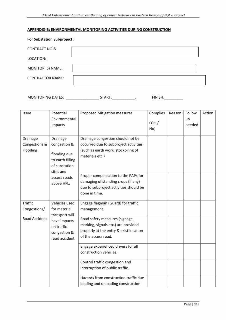
IEE of Enhancement and Strengthening of Power Network in Eastern Region of PGCB Project
Page | 211
APPENDIX-B: ENVIRONMENTAL MONITORING ACTIVITIES DURING CONSTRUCTION
For Substation Subproject :
CONTRACT NO &
LOCATION:
MONITOR (S) NAME:
CONTRACTOR NAME:
MONITORING DATES: ________________ START:___________, FINISH:_________
Issue Potential
Environmental
Impacts
Proposed Mitigation measures Complies
(Yes /
No)
Reason Follow
up
needed
Action
Drainage
Congestions &
Flooding
Drainage
congestion &
flooding due
to earth filling
of substation
sites and
access roads
above HFL.
Drainage congestion should not be
occurred due to subproject activities
(such as earth work, stockpiling of
materials etc.)
Proper compensation to the PAPs for
damaging of standing crops (if any)
due to subproject activities should be
done in time.
Traffic
Congestions/
Road Accident
Vehicles used
for material
transport will
have impacts
on traffic
congestion &
road accident
Engage flagman (Guard) for traffic
management.
Road safety measures (signage,
marking, signals etc.) are provided
properly at the entry & exist location
of the access road.
Engage experienced drivers for all
construction vehicles.
Control traffic congestion and
interruption of public traffic.
Hazards from construction traffic due
loading and unloading construction
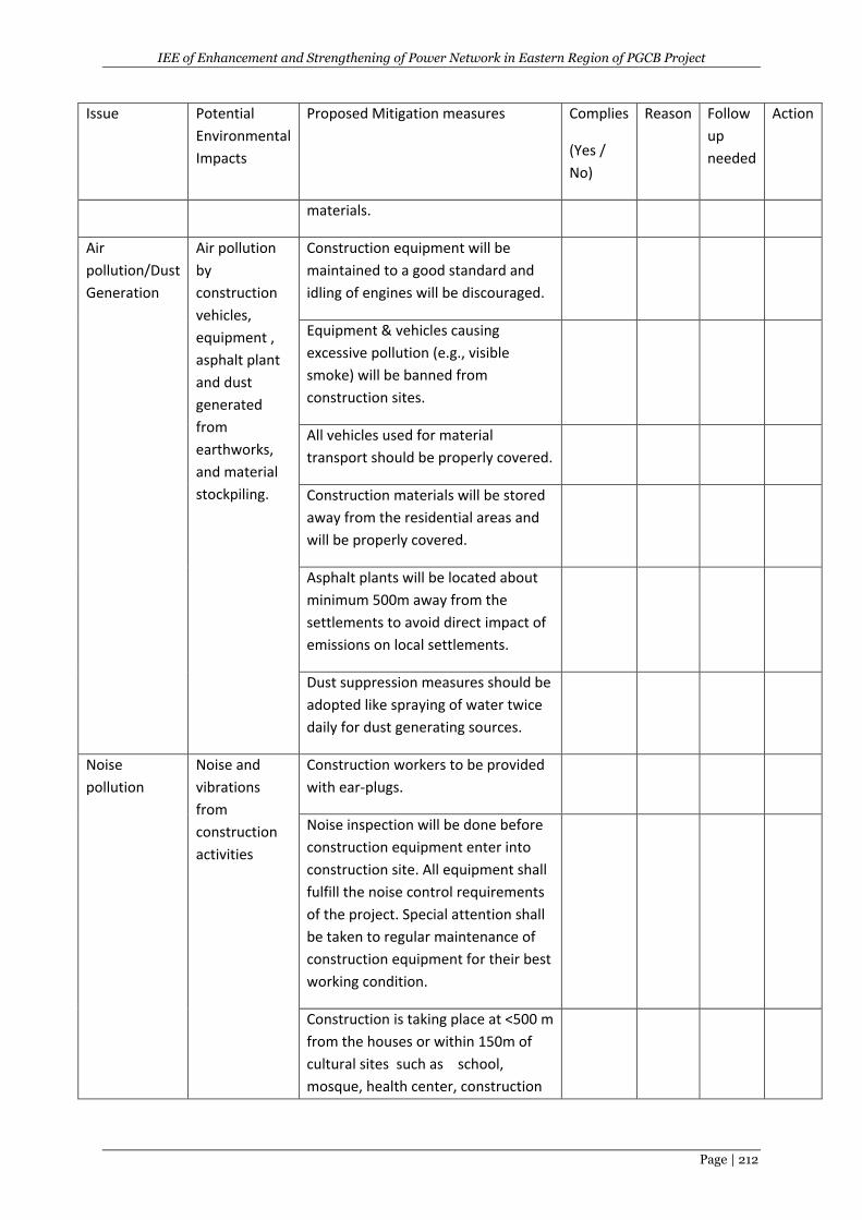
IEE of Enhancement and Strengthening of Power Network in Eastern Region of PGCB Project
Page | 212
Issue Potential
Environmental
Impacts
Proposed Mitigation measures Complies
(Yes /
No)
Reason Follow
up
needed
Action
materials.
Air
pollution/Dust
Generation
Air pollution
by
construction
vehicles,
equipment ,
asphalt plant
and dust
generated
from
earthworks,
and material
stockpiling.
Construction equipment will be
maintained to a good standard and
idling of engines will be discouraged.
Equipment & vehicles causing
excessive pollution (e.g., visible
smoke) will be banned from
construction sites.
All vehicles used for material
transport should be properly covered.
Construction materials will be stored
away from the residential areas and
will be properly covered.
Asphalt plants will be located about
minimum 500m away from the
settlements to avoid direct impact of
emissions on local settlements.
Dust suppression measures should be
adopted like spraying of water twice
daily for dust generating sources.
Noise
pollution
Noise and
vibrations
from
construction
activities
Construction workers to be provided
with ear-plugs.
Noise inspection will be done before
construction equipment enter into
construction site. All equipment shall
fulfill the noise control requirements
of the project. Special attention shall
be taken to regular maintenance of
construction equipment for their best
working condition.
Construction is taking place at <500 m
from the houses or within 150m of
cultural sites such as school,
mosque, health center, construction
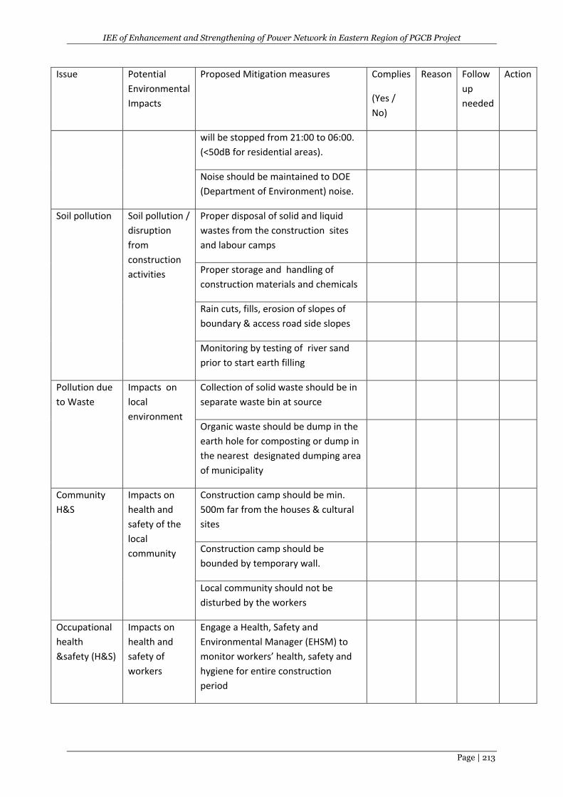
IEE of Enhancement and Strengthening of Power Network in Eastern Region of PGCB Project
Page | 213
Issue Potential
Environmental
Impacts
Proposed Mitigation measures Complies
(Yes /
No)
Reason Follow
up
needed
Action
will be stopped from 21:00 to 06:00.
(<50dB for residential areas).
Noise should be maintained to DOE
(Department of Environment) noise.
Soil pollution Soil pollution /
disruption
from
construction
activities
Proper disposal of solid and liquid
wastes from the construction sites
and labour camps
Proper storage and handling of
construction materials and chemicals
Rain cuts, fills, erosion of slopes of
boundary & access road side slopes
Monitoring by testing of river sand
prior to start earth filling
Pollution due
to Waste
Impacts on
local
environment
Collection of solid waste should be in
separate waste bin at source
Organic waste should be dump in the
earth hole for composting or dump in
the nearest designated dumping area
of municipality
Community
H&S
Impacts on
health and
safety of the
local
community
Construction camp should be min.
500m far from the houses & cultural
sites
Construction camp should be
bounded by temporary wall.
Local community should not be
disturbed by the workers
Occupational
health
&safety (H&S)
Impacts on
health and
safety of
workers
Engage a Health, Safety and
Environmental Manager (EHSM) to
monitor workers’ health, safety and
hygiene for entire construction
period
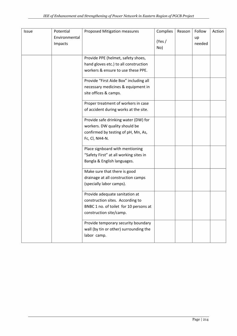
IEE of Enhancement and Strengthening of Power Network in Eastern Region of PGCB Project
Page | 214
Issue Potential
Environmental
Impacts
Proposed Mitigation measures Complies
(Yes /
No)
Reason Follow
up
needed
Action
Provide PPE (helmet, safety shoes,
hand gloves etc.) to all construction
workers & ensure to use these PPE.
Provide “First Aide Box” including all
necessary medicines & equipment in
site offices & camps.
Proper treatment of workers in case
of accident during works at the site.
Provide safe drinking water (DW) for
workers. DW quality should be
confirmed by testing of pH, Mn, As,
Fc, Cl, NH4-N.
Place signboard with mentioning
“Safety First” at all working sites in
Bangla & English languages.
Make sure that there is good
drainage at all construction camps
(specially labor camps).
Provide adequate sanitation at
construction sites. According to
BNBC 1 no. of toilet for 10 persons at
construction site/camp.
Provide temporary security boundary
wall (by tin or other) surrounding the
labor camp.
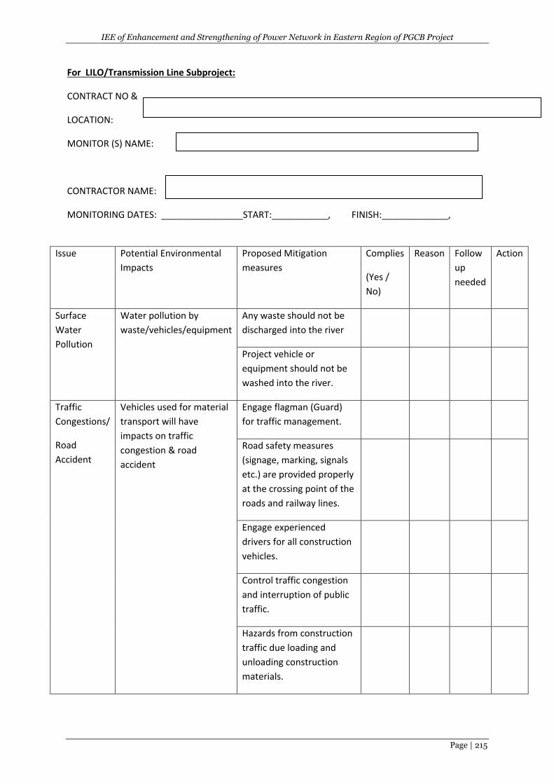
IEE of Enhancement and Strengthening of Power Network in Eastern Region of PGCB Project
Page | 215
For LILO/Transmission Line Subproject:
CONTRACT NO &
LOCATION:
MONITOR (S) NAME:
CONTRACTOR NAME:
MONITORING DATES: ________________START:___________, FINISH:_____________,
Issue Potential Environmental
Impacts
Proposed Mitigation
measures
Complies
(Yes /
No)
Reason Follow
up
needed
Action
Surface
Water
Pollution
Water pollution by
waste/vehicles/equipment
Any waste should not be
discharged into the river
Project vehicle or
equipment should not be
washed into the river.
Traffic
Congestions/
Road
Accident
Vehicles used for material
transport will have
impacts on traffic
congestion & road
accident
Engage flagman (Guard)
for traffic management.
Road safety measures
(signage, marking, signals
etc.) are provided properly
at the crossing point of the
roads and railway lines.
Engage experienced
drivers for all construction
vehicles.
Control traffic congestion
and interruption of public
traffic.
Hazards from construction
traffic due loading and
unloading construction
materials.
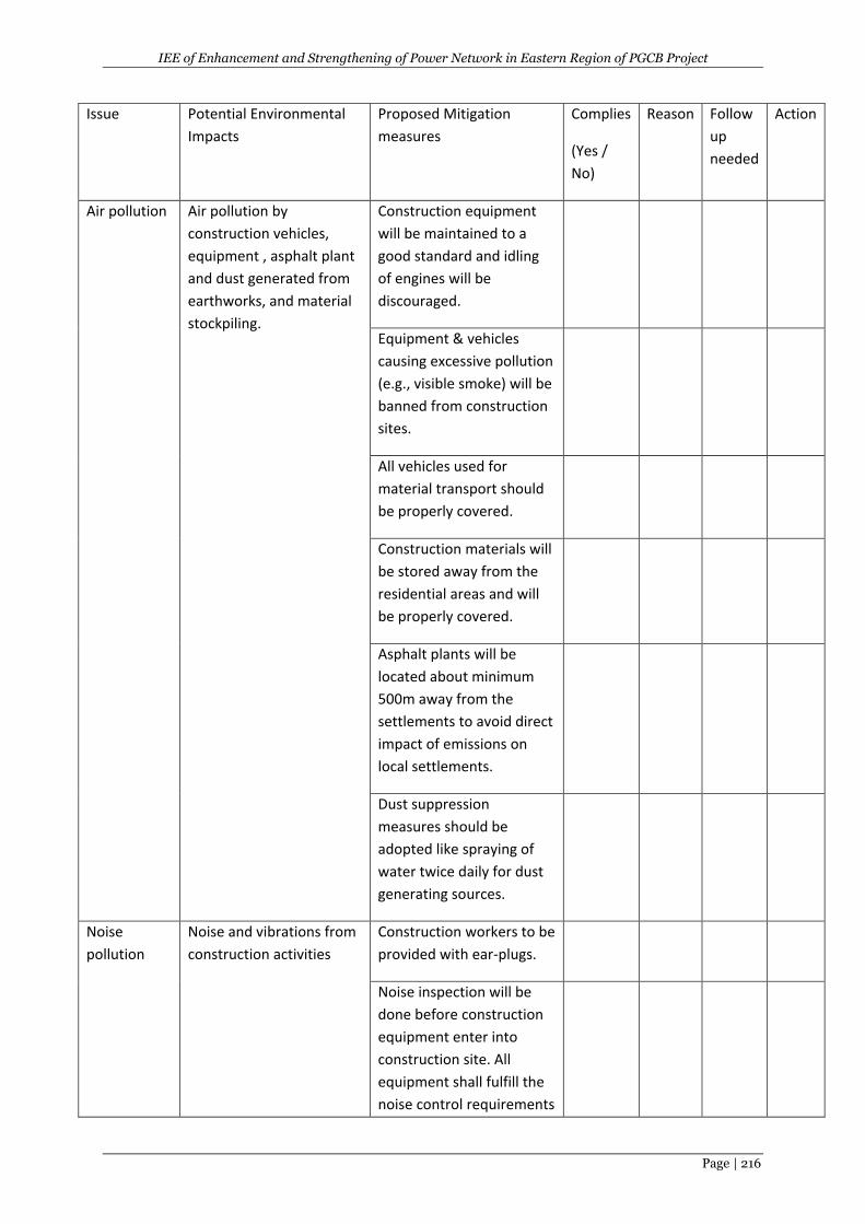
IEE of Enhancement and Strengthening of Power Network in Eastern Region of PGCB Project
Page | 216
Issue Potential Environmental
Impacts
Proposed Mitigation
measures
Complies
(Yes /
No)
Reason Follow
up
needed
Action
Air pollution Air pollution by
construction vehicles,
equipment , asphalt plant
and dust generated from
earthworks, and material
stockpiling.
Construction equipment
will be maintained to a
good standard and idling
of engines will be
discouraged.
Equipment & vehicles
causing excessive pollution
(e.g., visible smoke) will be
banned from construction
sites.
All vehicles used for
material transport should
be properly covered.
Construction materials will
be stored away from the
residential areas and will
be properly covered.
Asphalt plants will be
located about minimum
500m away from the
settlements to avoid direct
impact of emissions on
local settlements.
Dust suppression
measures should be
adopted like spraying of
water twice daily for dust
generating sources.
Noise
pollution
Noise and vibrations from
construction activities
Construction workers to be
provided with ear-plugs.
Noise inspection will be
done before construction
equipment enter into
construction site. All
equipment shall fulfill the
noise control requirements
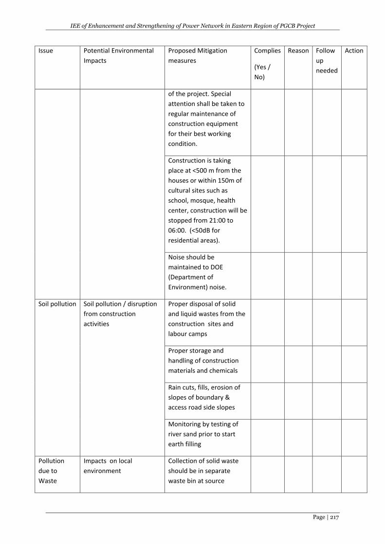
IEE of Enhancement and Strengthening of Power Network in Eastern Region of PGCB Project
Page | 217
Issue Potential Environmental
Impacts
Proposed Mitigation
measures
Complies
(Yes /
No)
Reason Follow
up
needed
Action
of the project. Special
attention shall be taken to
regular maintenance of
construction equipment
for their best working
condition.
Construction is taking
place at <500 m from the
houses or within 150m of
cultural sites such as
school, mosque, health
center, construction will be
stopped from 21:00 to
06:00. (<50dB for
residential areas).
Noise should be
maintained to DOE
(Department of
Environment) noise.
Soil pollution Soil pollution / disruption
from construction
activities
Proper disposal of solid
and liquid wastes from the
construction sites and
labour camps
Proper storage and
handling of construction
materials and chemicals
Rain cuts, fills, erosion of
slopes of boundary &
access road side slopes
Monitoring by testing of
river sand prior to start
earth filling
Pollution
due to
Waste
Impacts on local
environment
Collection of solid waste
should be in separate
waste bin at source
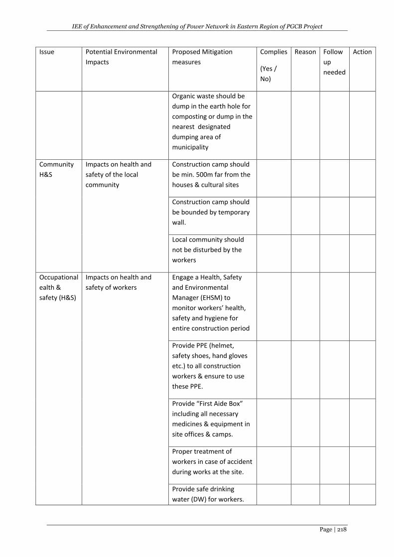
IEE of Enhancement and Strengthening of Power Network in Eastern Region of PGCB Project
Page | 218
Issue Potential Environmental
Impacts
Proposed Mitigation
measures
Complies
(Yes /
No)
Reason Follow
up
needed
Action
Organic waste should be
dump in the earth hole for
composting or dump in the
nearest designated
dumping area of
municipality
Community
H&S
Impacts on health and
safety of the local
community
Construction camp should
be min. 500m far from the
houses & cultural sites
Construction camp should
be bounded by temporary
wall.
Local community should
not be disturbed by the
workers
Occupational
ealth &
safety (H&S)
Impacts on health and
safety of workers
Engage a Health, Safety
and Environmental
Manager (EHSM) to
monitor workers’ health,
safety and hygiene for
entire construction period
Provide PPE (helmet,
safety shoes, hand gloves
etc.) to all construction
workers & ensure to use
these PPE.
Provide “First Aide Box”
including all necessary
medicines & equipment in
site offices & camps.
Proper treatment of
workers in case of accident
during works at the site.
Provide safe drinking
water (DW) for workers.
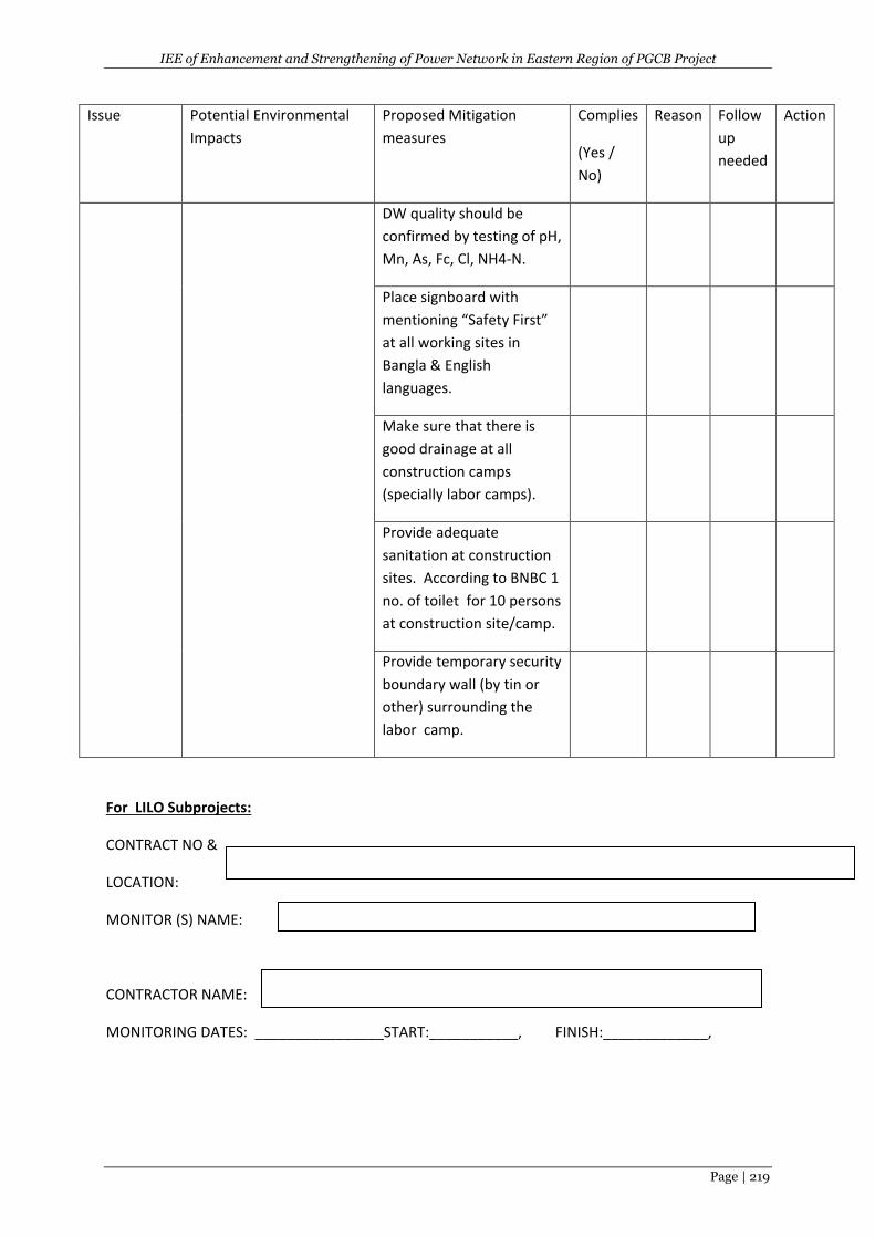
IEE of Enhancement and Strengthening of Power Network in Eastern Region of PGCB Project
Page | 219
Issue Potential Environmental
Impacts
Proposed Mitigation
measures
Complies
(Yes /
No)
Reason Follow
up
needed
Action
DW quality should be
confirmed by testing of pH,
Mn, As, Fc, Cl, NH4-N.
Place signboard with
mentioning “Safety First”
at all working sites in
Bangla & English
languages.
Make sure that there is
good drainage at all
construction camps
(specially labor camps).
Provide adequate
sanitation at construction
sites. According to BNBC 1
no. of toilet for 10 persons
at construction site/camp.
Provide temporary security
boundary wall (by tin or
other) surrounding the
labor camp.
For LILO Subprojects:
CONTRACT NO &
LOCATION:
MONITOR (S) NAME:
CONTRACTOR NAME:
MONITORING DATES: ________________START:___________, FINISH:_____________,
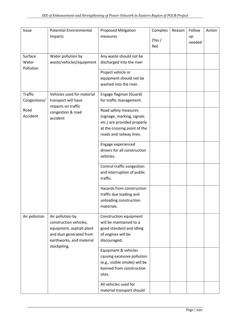
IEE of Enhancement and Strengthening of Power Network in Eastern Region of PGCB Project
Page | 220
Issue Potential Environmental
Impacts
Proposed Mitigation
measures
Complies
(Yes /
No)
Reason Follow
up
needed
Action
Surface
Water
Pollution
Water pollution by
waste/vehicles/equipment
Any waste should not be
discharged into the river
Project vehicle or
equipment should not be
washed into the river.
Traffic
Congestions/
Road
Accident
Vehicles used for material
transport will have
impacts on traffic
congestion & road
accident
Engage flagman (Guard)
for traffic management.
Road safety measures
(signage, marking, signals
etc.) are provided properly
at the crossing point of the
roads and railway lines.
Engage experienced
drivers for all construction
vehicles.
Control traffic congestion
and interruption of public
traffic.
Hazards from construction
traffic due loading and
unloading construction
materials.
Air pollution Air pollution by
construction vehicles,
equipment, asphalt plant
and dust generated from
earthworks, and material
stockpiling.
Construction equipment
will be maintained to a
good standard and idling
of engines will be
discouraged.
Equipment & vehicles
causing excessive pollution
(e.g., visible smoke) will be
banned from construction
sites.
All vehicles used for
material transport should
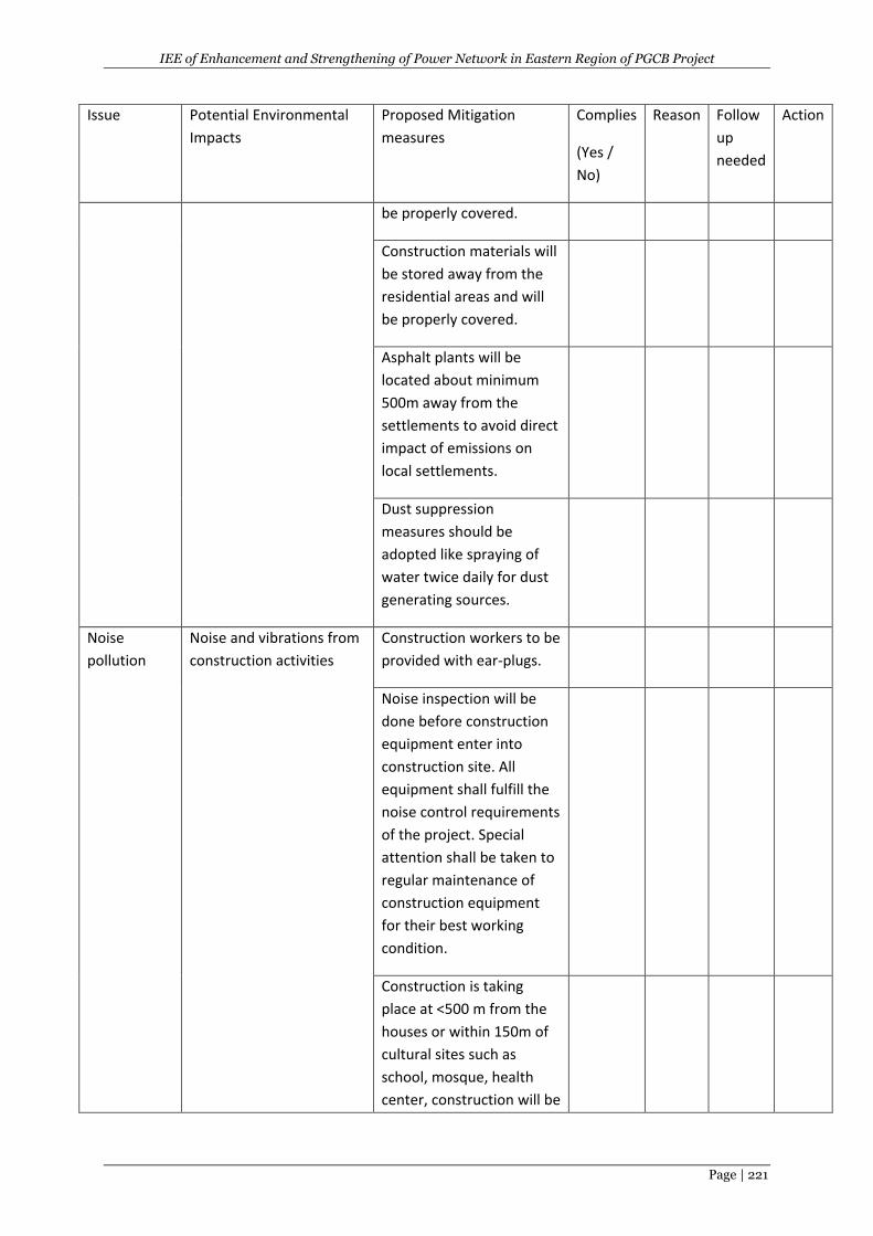
IEE of Enhancement and Strengthening of Power Network in Eastern Region of PGCB Project
Page | 221
Issue Potential Environmental
Impacts
Proposed Mitigation
measures
Complies
(Yes /
No)
Reason Follow
up
needed
Action
be properly covered.
Construction materials will
be stored away from the
residential areas and will
be properly covered.
Asphalt plants will be
located about minimum
500m away from the
settlements to avoid direct
impact of emissions on
local settlements.
Dust suppression
measures should be
adopted like spraying of
water twice daily for dust
generating sources.
Noise
pollution
Noise and vibrations from
construction activities
Construction workers to be
provided with ear-plugs.
Noise inspection will be
done before construction
equipment enter into
construction site. All
equipment shall fulfill the
noise control requirements
of the project. Special
attention shall be taken to
regular maintenance of
construction equipment
for their best working
condition.
Construction is taking
place at <500 m from the
houses or within 150m of
cultural sites such as
school, mosque, health
center, construction will be
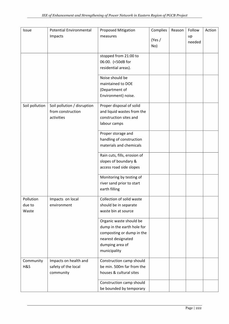
IEE of Enhancement and Strengthening of Power Network in Eastern Region of PGCB Project
Page | 222
Issue Potential Environmental
Impacts
Proposed Mitigation
measures
Complies
(Yes /
No)
Reason Follow
up
needed
Action
stopped from 21:00 to
06:00. (<50dB for
residential areas).
Noise should be
maintained to DOE
(Department of
Environment) noise.
Soil pollution Soil pollution / disruption
from construction
activities
Proper disposal of solid
and liquid wastes from the
construction sites and
labour camps
Proper storage and
handling of construction
materials and chemicals
Rain cuts, fills, erosion of
slopes of boundary &
access road side slopes
Monitoring by testing of
river sand prior to start
earth filling
Pollution
due to
Waste
Impacts on local
environment
Collection of solid waste
should be in separate
waste bin at source
Organic waste should be
dump in the earth hole for
composting or dump in the
nearest designated
dumping area of
municipality
Community
H&S
Impacts on health and
safety of the local
community
Construction camp should
be min. 500m far from the
houses & cultural sites
Construction camp should
be bounded by temporary
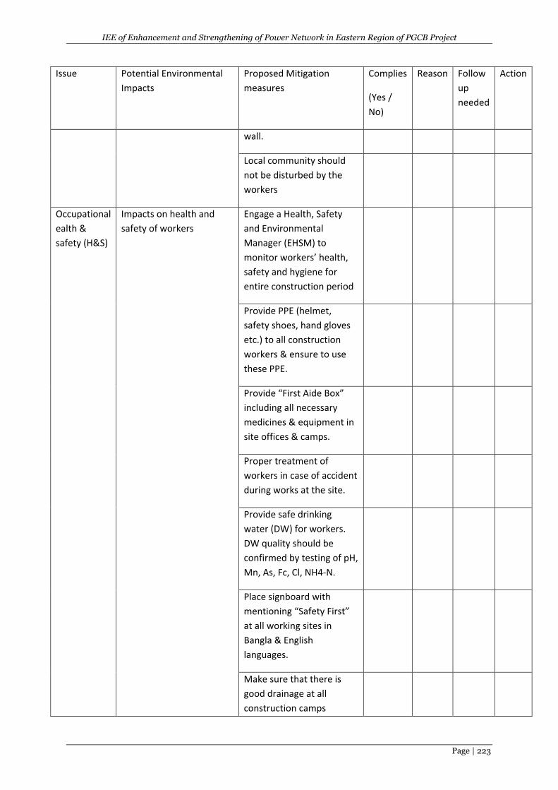
IEE of Enhancement and Strengthening of Power Network in Eastern Region of PGCB Project
Page | 223
Issue Potential Environmental
Impacts
Proposed Mitigation
measures
Complies
(Yes /
No)
Reason Follow
up
needed
Action
wall.
Local community should
not be disturbed by the
workers
Occupational
ealth &
safety (H&S)
Impacts on health and
safety of workers
Engage a Health, Safety
and Environmental
Manager (EHSM) to
monitor workers’ health,
safety and hygiene for
entire construction period
Provide PPE (helmet,
safety shoes, hand gloves
etc.) to all construction
workers & ensure to use
these PPE.
Provide “First Aide Box”
including all necessary
medicines & equipment in
site offices & camps.
Proper treatment of
workers in case of accident
during works at the site.
Provide safe drinking
water (DW) for workers.
DW quality should be
confirmed by testing of pH,
Mn, As, Fc, Cl, NH4-N.
Place signboard with
mentioning “Safety First”
at all working sites in
Bangla & English
languages.
Make sure that there is
good drainage at all
construction camps
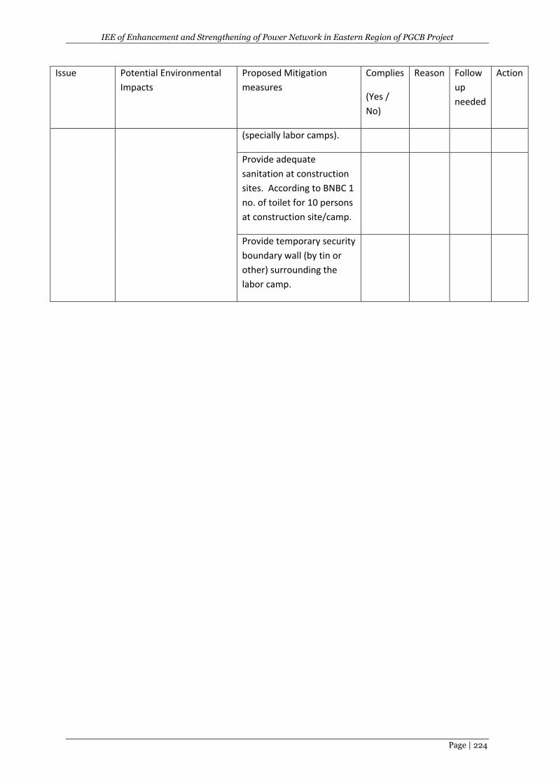
IEE of Enhancement and Strengthening of Power Network in Eastern Region of PGCB Project
Page | 224
Issue Potential Environmental
Impacts
Proposed Mitigation
measures
Complies
(Yes /
No)
Reason Follow
up
needed
Action
(specially labor camps).
Provide adequate
sanitation at construction
sites. According to BNBC 1
no. of toilet for 10 persons
at construction site/camp.
Provide temporary security
boundary wall (by tin or
other) surrounding the
labor camp.

IEE of Enhancement and Strengthening of Power Network in Eastern Region of PGCB Project
Page | 225
APPENDIX – C: NOC FROM LOCAL AUTHORITY (To be included).