Disaster, displacement and adaptation: Recovering from the Kosi flood 2008
21
A paper presented in “Orientation Workshop on Care and Protection of Refugees and IDPs in Nepal” organized by Mahanirban Calcutta Research Group (CRG) in collaboration with Nepal Institute of Peace (NIP) and United Nations High Commission for Refugees, Kathmandu, 21-23 November 2010, in Lalitpur, Nepal. Disaster, Displacement and Adaptation Recovering from the Kosi flood 2008 in Nepal Sharad Ghimire Martin Chautari Researchers and policy makers have increased their attention on the displacement due to disasters like floods and adaptation to such disasters, particularly in the context of climate change. Many studies have shown that such incidences would increase in the coming days due to the climate change. Discussion on this issue is important to understand people's recovery in the post-disaster phase and to move the discussion on dealing with such disasters beyond the narrow focus on the relief and rescue after the incidence through the formal bureaucratic-administrative mechanisms. In this context, this paper analyzes the case of Kosi flood of 2008 occurred due to the breaching of the eastern embankment of the Kosi river, a major tributary of Ganges, in the eastern Tarai of Nepal. The aim of the paper is to analyze the situation of the displaced people while recovering from the disaster. The case will broaden our understanding on the micro-level situation created by the flood such as the displacement and return of the displaced people and on how recovery occurs in such setting. Migration and population displacement have been linked with environmental change in different ways. For example, movement of people may be caused by natural disasters like floods, hurricanes, landslides etc. or caused by gradual and cumulative change in environmental quality such as deforestation, desertification and so on (Bilsborrow 2002:
Transcript of Disaster, displacement and adaptation: Recovering from the Kosi flood 2008

A paper presented in “Orientation Workshop on Care and Protectionof Refugees and IDPs in Nepal” organized by Mahanirban Calcutta Research Group (CRG) in collaboration with Nepal Institute of Peace (NIP) and United Nations High Commission for Refugees, Kathmandu, 21-23 November 2010, in Lalitpur, Nepal.
Disaster, Displacement and AdaptationRecovering from the Kosi flood 2008 in Nepal
Sharad GhimireMartin Chautari
Researchers and policy makers have increased their attentionon the displacement due to disasters like floods and adaptation to such disasters, particularly in the context ofclimate change. Many studies have shown that such incidenceswould increase in the coming days due to the climate change.Discussion on this issue is important to understand people'srecovery in the post-disaster phase and to move the discussion on dealing with such disasters beyond the narrow focus on the relief and rescue after the incidence through the formal bureaucratic-administrative mechanisms. In this context, this paper analyzes the case of Kosi flood of 2008 occurred due to the breaching of the eastern embankment of the Kosi river, a major tributary of Ganges, in the eastern Tarai of Nepal. The aim of the paper is to analyze the situation of the displaced people while recovering from the disaster. The case will broaden our understanding on the micro-level situation created by the flood such as the displacement and return of the displaced people and on how recovery occurs in such setting.
Migration and population displacement have been linked with environmental change in different ways. For example, movement of people may be caused by natural disasters like floods, hurricanes, landslides etc. or caused by gradual andcumulative change in environmental quality such as deforestation, desertification and so on (Bilsborrow 2002:

14). Both types of movements are also discussed in the climate change context. There are few examples of environment induced displacement from Nepal. Floods in the Tarai region, landslides in the hill region and glacial lakeoutburst flood (GLOF) in the high mountain region are examples of disasters which create displacements every year.These disasters are also linked directly or indirectly with the climate change impacts. Similarly there are also few literatures that link gradual incremental change in environment with migration and displacement in the context of Nepal. According to these literatures, such links are mediated through the livelihood process. For example, peopleleave their places when there is relative deprivation causedby environmental degradation (Bhandari 2004). According to Menon (2008) rural agrarian households tends to diversify their livelihood sources when there is rainfall uncertainty.Migration is one way of diversifying the livelihood options.Very recently a case that came frequently in the Nepali newspapers is about a village in Manang, where the entire village is being relocated due to the scarcity of water, particularly caused by climate change. Therefore examples ofboth types of environmental change induced displacement are found in case of Nepal. However the later types are more complicated since the gradual change in environment causes migration through the complex process of livelihood. The process is also widely debated in the migration literatures.The first type of linkage of environmental change and displacement through disasters, which is focus of this paper, is more obvious and is based on the 'common sense' that flood like disasters destroy people's land, houses and other tangible goods and assets and people leave the place (Perch-Nielson et al 2008: 377).
Another example of debate on environment induced displacement is taking place on the issue of "environmental / climate refugee". The debate is also related to the various discourses of environmental security.That is about how the displaced people could be or could notbe the security threat. Most of the debates on environmental

/ climate refugee are centered on whether there is somethinglike environmental / climate refugee or not and how to protect such 'refugee'. This is also related to should we consider them as security threat or address their human security. Discourse of environmental refugee is not new to Nepal. People displaced either by development and conservation projects or by decline of resources and disasters are discussed under this rubric. Very recently Manang people who were being displaced due to climate changeinduced water scarcity were also put under the rubric of climate refugee. We may assess critically the causal weightsof environmental change to make people migrate or can debatethe term environmental or climate refugee on the normative or analytical ground. This paper rather accepts the fact that people are displaced by certain types of environmental change, for example rapidly coming flood like disasters. Thepaper, by focusing on what happens to people after the displacement and what determines their recovery in the post disaster period, aims to bring some lessons for adaptation and resilience from a case of flood in Nepal. The analysis will have certain implications on understanding the adaptation and resilience of communities/ households / individuals who are vulnerable to such types of disasters inthe days to come due to climate change.
Therefore the aim of this paper is to analyze a case of flood under the terms like disaster, displacement, return and recovery. The case is about the Kosi flood of 2008 and flood victims. The case is chosen since it is a very recent incidence where people and supporting agencies are working for recovery. The discussion is based on the question, how people are or are not recovering from the shock. As mentioned above, the flood itself was not caused by any climatic or environmental factors per se, similar cases will become more frequent in the Tarai region of Nepal in the future due to climate change. The case will reveal how people cope with such situation and what are issues and reasons behind their ability / inability of coping with suchincidents.

The paper starts with discussion on the flood incidence of 2008, how people responded to that incidence particularly through the displacement, what types of relief activities were employed, and how the present situation is. It is basedon secondary literatures and interviews with stakeholders during a brief field visit made during October 2010. The discussion highlights the post disaster situation of displaced (now returned) people. At the end, after the discussion on the case, the paper highlights some conclusions drawn from the case related to the post-disasterrecovery of flood affected people. The discussion is important to understand adaptation and resilience in the context of climate change.
Kosi flood of 2008: Disaster, displacement, return and recoveryDisaster and displacementKosi river breached its eastern embankment of flood control at about 12 km north from the Kosi barrage in Sunsari, Nepal. Although the incidence occurred during the monsoon period when the river brings loads of sediments, the cause of that breach was not just climatic or environmental (Dixit2009: 70, Pun 2009: 4). It was mainly due to the embankment,its low maintenance and high siltation in the river. When the river breached the embankment, its major portion startedflowing along its older course (the course before the barrage construction) inundating large area of settlement and agriculture in Nepal and India until it reached to the Ganges in Bihar, almost 150 km downstream.
The flood had devastating impacts on three VDCs (Paschim Kushaha, Shreepur and Haripur) of Sunsari districts in Nepaland four districts (Supaul, Saharsa, Madhepura and Khagariya) of the North Bihar. Initial estimation of damage revealed that almost 50,000 population (more than 7000 households) in Nepal and 3.5 million population (30000 households) in India were affected and almost 6000 ha of

agricultural land in Nepal and 35,000 ha in India was damaged (Dixit 2009: 71). Estimated loss in Nepal was almostequal to NRs. 881.7 million.
Recent statistics of District Administration Office (DAO) inInaruwa, Sunasari shows that total number of Kosi flood 2008directly affected population in Nepal is 42,765 and number of household is 7,563. Table 1 shows number of directly affected and displaced population and households in all village wards of three VDCs in Nepal.
Table 1: Number of affected population and households in Sunsari by Kosi flood 2008Ward Shreepur VDC Haripur VDC Paschim Kusaha VDC
HouseholdsIndividuals
Households
Individuals Households
Individuals
1 325 1719 256 13152 162 856 211 10153 429 2418 130 591 218 12024 259 1410 190 810 881 50165 441 2606 306 13866 268 1437 235 1116 1 67 829 5765 452 2288 1 28 648 4301 370 2101 2 89 186 1113 238 1278 525 3006
Totals 3547 21625 2388 11900 1628 9240Source: Statistics of DAO, Sunsari (October 2010)
It seems authorities of both countries were aware about the weakening of spurs of the eastern embankment in Paschim Kusaha to some extent (see for example Pun 2009). It was also verified by local people who told that there were notices about the breach even before the incidence. People also shared the fact that they neglected such notices takingthem as rumors because such types of rumors used to come across frequently every year. Some people neglected the warning coming even after the breach which increased loss ofproperties. In fact DAO Sunsari had disseminated warnings all across, but people dismissed these warning considering

them as rumors. When the river breached the embankment in the morning of 18 August 2008, few local residents along with some local journalists and authorities were present at the site of the breach. Some journalists have even filmed the incidence1. When the river flooded the farmland and settlement area, there was a kind of winter fog like situation all around decreasing the visibility. Then starteddissemination of the information through phones and micking and some organizations and security agencies started their rescue operation. Proper rescue operations only began in thenext day.
People in the lower villages, such as Shreepur and Haripur, where the river hit few hours later, were informed about theflood through the phones and loudspeakers from authorities like security personnel and from their own relatives and fellow villagers. Most of people who did not have concrete-buildings and did not possess much property / assets at homeleft villages with rescuers from that evening to the next day in vehicles and on boats. Others leave their home in later days. After few days, there was frequent movement of people and rescuer through boats and other means. Those people, who were more alert and who got boats, could bring some of their properties and assets. Some were able to bringtheir stored grains too. Those who were left at home were rescued by army helicopters.
Displaced people were brought in the public places like schools, temples, Madarasas etc. in the both sides of main Kosi river: Bhardaha in the western side in Saptari districtand Laukahi and Inaruwa in the eastern side in Sunsari district. Most of displaced people stayed in the camps with their families. Only few of those who had other options, forexample having home in other places or having relatives in other areas either went there or at least send their children and elders there. A retired policeman from
1 Sunsari based NTV journalist of that time Mr. Mahesh Shrestha has madea documentary on this event, which was screened and discussed at Martin Chautari, Kathmandu in ...2010.

Shreepur-1 told that he sent his children to Biratnagar (a nearby town) with relatives where they stayed safely and continued their study but himself stayed in a rented house in Inaruwa and got ration and other supports form the agencies and organizations.
People residing in the public places were shifted later on in the proper camps with the support from NGOs and INGOs. There were more than two dozens of temporary camps and couple of permanent camps. When people were relocated in thecamps from the public places, different agencies and organizations started providing various supports, materials and facilities, in the coordination with the relevant government offices. For example, UN's World Food Program started food distribution with government coordination. To determine whom to give what supports and what amount of fooditems, a white card was given initially by DAO to every affected family. Some problems came at the beginning when 2-3 members of a family got the card. There were also issues of Indians getting supports. There was no any proper documentation system to resolve all these issues. Then another slightly modified card was distributed to each family. There were also Red Cross cards through which WFP distributed foods. Different organizations supported in different aspects. For example, some distributed clothing, some worked for health and sanitation, some helped to construct / maintain tent, and some worked on raising awareness on different issues, like health and sanitations.
Most of the responses to the displaced flood victims were made through highly administrative and formal way. In order to coordinate the relief and rescue efforts, coordination committee was formed under the leadership of Chief District Officer, participated by different district based governmentagencies, security personnel and NGOs and INGOs. Every decision was made through the meetings of coordination committee which used to hold twice a day at the beginning. These meetings used to monitor ongoing activities in different aspects by different agencies and resolve any

disputes or fulfill any demands. It seems such meeting did not involve flood victims at beginnings. If there were any unresolved problems, they would invite political parties' local representatives. Frequency of such meetings decreased in the subsequent days and months. Such meetings were still continued during the field study (October 2010) at least once in a month. Therefore response to displaced people was done mainly through the government (including security personnel) - I/NGOs interface backed by local politicians ifneeded. Later on Badhi Pidit Sangharsha Samiti (flood victims' struggle committee)2 made authorities involve floodvictims in the decision making process.
People seemed satisfied with the facilities and supports they received in the camps during the displaced time. Most of them acknowledged the support provided particularly by NGOs and INGOs. Activities of I/NGOs were coordinated with government agencies. Some of the displaced people were unsatisfied with basic services at the camp like food, drinking water, sanitation and other raised the issue of safety and security of own assets and belongings, particularly in their homes where there were nobody and thieves used to come by boats and stole the left assets.
Return of the displaced peoplePeople started to return back to the village with the beginning of winter (a couple of months after the incidence)when the flooded river declined drastically and achieved a definite course. Their decision of the households about return was related to the level of damage on the assets, thefamily size, and possibility to go back to home and subsist life there. Those households having less damaged properties and / or having higher number of adult members who could 2 The Sangharsha Samiti was formed almost 24 days after the flood as a pressure group and handed a memorandum in the next day to the chief district officer (CDO). This vocal group came in the limelight when it protested against the compensation package proposed by government through the strikes and Bandh which made government form a high level task force to study their demands. Later on government recognized its existence and allowed them to participate in the coordination meetings.

repair the home earlier, returned back to the village earlier. Even after increase in possibilities for return, people wanted to stay in the camp in order to be entitled tomany supports provided there.
WFP continued distribution of foods for almost 5-6 months. Then after, government brought the provision of 'return package' of NRs. 50,000. The return decision which was made by government at the top level was also favored by the situation. With the coming of spring, when the tents were being damaged by wind, people were no longer interested to stay in the camp and wanted to return back. When they started to return back to the home, the package helped them repair the house and subsist life back in village. There were other compensation packages and support provisions which were provided based on the level of damage and assets they possessed.
Categorization based on the level of damageFlood affected regions and households were categorized into submerged / mainstream (where river was still flowing as of Oct 2010), red (completely damaged and having filled with sands and gravels), yellow (partially damaged) and green (less damaged). This categorization was made based on survey, aerial map of flooded area and other digital mappingprocedure. The categorization was useful for making decisions about support / compensation packages, particularly for crops and land. Table 2 to 5 shows the landarea and household numbers under different levels of damage made by the flood. All these statistics are based on DAO record, October 2010. According to these statistics, more than half of the total affected agricultural land was hit most severely (categorized as red) (table 2).
If we see the damage according to the siltation level, almost half of land had siltation of more than 60 cm (table 4). More than one third of the displaced people were from the red zone (table 3). During the flood, almost 20 percent households were displaced from the completely submerged

region, more than 40 percent households from the complete- partial submerged region and more than 10 percent were from the partially submerged region (table 5). All these statistics show that, the level of impact of the flood was severe which made the affected area almost inhabitable for at least few months.
Table 2: Area of damaged agricultural landS.N. Area
Land(Bigha)
Percentage
1Green 2400 34.292Yellow 1000 14.29
3Main Stream in Red 360 5.14
4Only in Red 3240 46.29Total 7000
Source: Statistics of DAO, Sunsari (October 2010)
Table 3: Distribution of cards to households based on level of damage
Card DescriptionS.N. Type of Cards Numbers Percentage
1Red 2279 35.032Yellow 2234 34.343Green 1993 30.63
6506Source: Statistics of DAO, Sunsari (October 2010)
Table 4: Area of affected land categorized based on the siltation level.
Land CategorizedS. N. Land Type
siltation rate ofsand Land(ha)
Percentage
1Low Damaged (0-15) cm 455 19.44
2Medium Damaged (15-60) 786 33.59
3High Damaged More than 60 cm 1099 46.972340
Source: Statistics of DAO, Sunsari (October 2010)
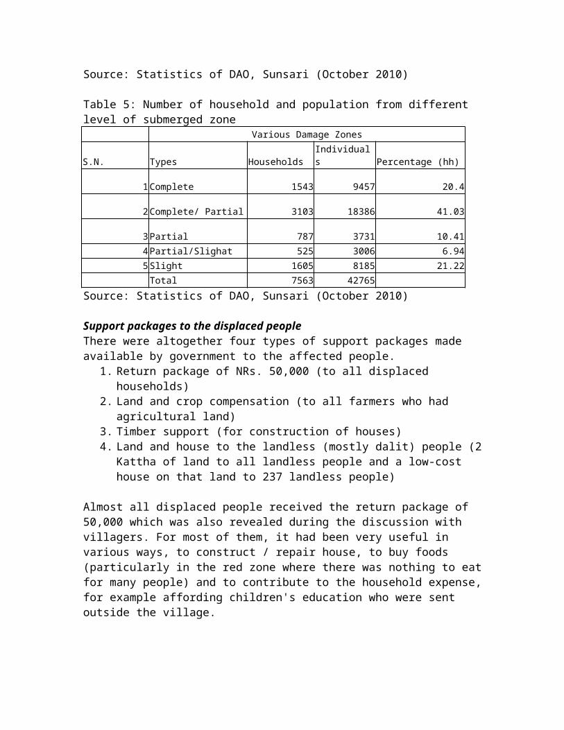
Table 5: Number of household and population from different level of submerged zone
Various Damage Zones
S.N. Types HouseholdsIndividuals Percentage (hh)
1Complete 1543 9457 20.4
2Complete/ Partial 3103 18386 41.03
3Partial 787 3731 10.414Partial/Slighat 525 3006 6.945Slight 1605 8185 21.22Total 7563 42765
Source: Statistics of DAO, Sunsari (October 2010)
Support packages to the displaced peopleThere were altogether four types of support packages made available by government to the affected people.
1. Return package of NRs. 50,000 (to all displaced households)
2. Land and crop compensation (to all farmers who had agricultural land)
3. Timber support (for construction of houses)4. Land and house to the landless (mostly dalit) people (2
Kattha of land to all landless people and a low-cost house on that land to 237 landless people)
Almost all displaced people received the return package of 50,000 which was also revealed during the discussion with villagers. For most of them, it had been very useful in various ways, to construct / repair house, to buy foods (particularly in the red zone where there was nothing to eatfor many people) and to contribute to the household expense,for example affording children's education who were sent outside the village.
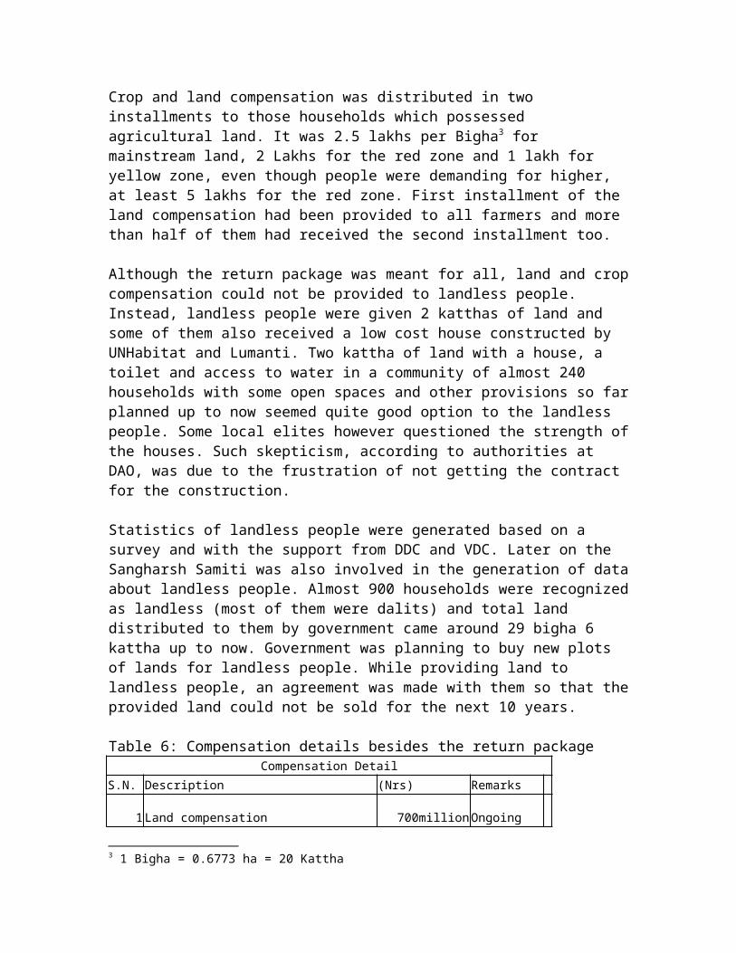
Crop and land compensation was distributed in two installments to those households which possessed agricultural land. It was 2.5 lakhs per Bigha3 for mainstream land, 2 Lakhs for the red zone and 1 lakh for yellow zone, even though people were demanding for higher, at least 5 lakhs for the red zone. First installment of the land compensation had been provided to all farmers and more than half of them had received the second installment too.
Although the return package was meant for all, land and cropcompensation could not be provided to landless people. Instead, landless people were given 2 katthas of land and some of them also received a low cost house constructed by UNHabitat and Lumanti. Two kattha of land with a house, a toilet and access to water in a community of almost 240 households with some open spaces and other provisions so farplanned up to now seemed quite good option to the landless people. Some local elites however questioned the strength ofthe houses. Such skepticism, according to authorities at DAO, was due to the frustration of not getting the contract for the construction.
Statistics of landless people were generated based on a survey and with the support from DDC and VDC. Later on the Sangharsh Samiti was also involved in the generation of dataabout landless people. Almost 900 households were recognizedas landless (most of them were dalits) and total land distributed to them by government came around 29 bigha 6 kattha up to now. Government was planning to buy new plots of lands for landless people. While providing land to landless people, an agreement was made with them so that theprovided land could not be sold for the next 10 years. Table 6: Compensation details besides the return package
Compensation DetailS.N. Description (Nrs) Remarks
1Land compensation 700million Ongoing
3 1 Bigha = 0.6773 ha = 20 Kattha

2Land purchasing for Landless 12 million Ongoing
3Crop Compensation 88million Ongoing800 million
Source: Statistics of DAO, Sunsari (October 2010)
As of October 2010, timber was being distributed. According to authorities at DAO, it had been difficult to make such a large amount of timber available at one time and needed to be distributed in certain order. But questions were raised by the Sangharsha Samiti about the process / order of distribution of the timber and suspected that real victims would not get the timber. When such questions were raised bythe Samiti in the meeting, authorities warned dismissing thetimber support process which Sangharsha Samiti representative took as a method of dividing flood victims organized under the committee. Local people also shared that only those individuals who had access to and good network with authorities and who were more vocal were getting the timber supports. It seems there were enormous suspicions and politics around the timber support, needs to be analyzed in detail. However distribution of timber was inthe progress as informed by DAO personnel.
Most of the supports to the victims were in the form of cashor good and materials which required highly formalized administrative- bureaucratic mechanism for the post disasterrecovery. There were few supports in the other aspects, suchas for the livelihood or agriculture recovery and local institution building as argued by the authorities. However local victims had not been able to enjoy any impacts of suchefforts. It demands more concentration on the long-term recovery since all people had returned back to the village.
Support for the livelihood and recovery from the disasterAccording to the local people, the most pressing issue for their recovery from the situation is about livelihoods, particularly related to revival of agriculture system in the

area. Although yellow and green zones were slowly recoveringfrom the disaster, the most affected red zones still looked barren and people looked quite helpless. Most of livelihood support activities, for instance support to cultivation by NGOs / INGOs, were concentrated in the less affected regions(yellow and green). Local people and Sangharsha Samiti members accused government and other support organizations that there was no any support activities and short or long term plan for the recovery of the red zone, such as Shreepur-5.
Most of households in the region were completely dependent on agriculture for their livelihoods. Being highly productive region in the country and fair amount of available arable land, most of households owned the productive agriculture land. It had made them self-sufficient and self content locally for food and livelihoods. But when the flood brought enormous amount of sand and sediments, almost 5 feet or more sand on half of the agriculture land (see table 4), it had devastated farmers who did not have any options outside these lands. According to local people from the red zone, they did not have anything to eat without purchasing in the market and there was nothing to do for subsistence in their knowledge. Since they did not have own saving, they used the money provided as support package just to purchase the food. But such situation could not go for very long time. Local peoplealso did not have any cultural practices and knowledge to adopt new livelihood strategies outside the agriculture. Therefore consequences of the flood to these people had beenenormous. In such situation, residents of the red zone thought that government or other support organizations had not done anything for their livelihoods and agriculture.
According to the government agencies, there had been many activities related to livelihood generation even in the red zone. Since the zone is completely devastated, it was hard to see any visible impacts of such activities very soon. Some of livelihood support activities were related to,

formation of the user groups at the village-unit (Tol) leveland carrying out different activities as a collective action. People in the red zone had been supported in agriculture or in any livelihood generation work whatever they wanted through such unit groups. They had grown some vegetables and crops which could be grown on the sand. Therewere some support to cultivate Jatropa and some efforts to engage people on various resource based income generating activities such as mat or bag making however many people were found less interested in such activities. Some culturalbarrier had been responsible to limit the adoption of new methods of farm and off-farm income generation. It would need more time and efforts. Similarly construction of ponds (for fishing) or roads had also supported them for earning to some extent. These activities were very limited to show any visible impacts, for which revival of the sandy land wasmust. Authorities also accepted that there was a need of long-term planning for the region which according to them was related to reclamation of soil by channeling the irrigation with a bigger project.
Besides problems in the agriculture related livelihoods, people were facing some health related problems as well. Sandy environment made local people mainly children suffer from various health problems like eye infection and respiration problems. Such problems became severe especiallyduring the windy season. Similarly rebuilding of local infrastructures or roads had been major concern of the localpeople.
Local elites, currently heading the Sangharsha Samiti, were more concerned mainly on the support provided by authoritiessuch as construction and rebuilding of infrastructures, leveling of sand and filling the low lying area, building houses for poor landless and timber and construction activities. The group had been able to mobilize local poor and landless people. It seemed that local elite and leader were not interested in the smaller activities that would make big changes such as education and skill generation,

making outside networks and involve in the outside and non-farm income.
Based on the picture described above, we can draw few issuesthat help us understand the recovery process more generally.
Some issues and conclusions from the caseFollowing issues are relevant for the understanding of disaster induced displacement and adaptation of flood-displaced / affected people. Some of these conclusions are provisional, needs further studies for verification.
1. Disaster induced displacement and return of the displacedpeople: Disaster like Kosi flood, which destroyed lands, houses, assets and infrastructures, made most of people displace from the region. However the consequences of disasters were lesser to those households which have strong infrastructure and houses. For example, in Shreepur-5, a local elite (in fact he was a landlord and close to UML party) having a concrete house well surrounded by bamboo andother trees was less affected by the flood. His house workedas a shelter for many villagers right after the flood for couple of days. Besides the level of damage, family size (number of adult member in the family) and level of dependence on the external support vis-à-vis possession of own asset would determine people's return decisions. If households had few or no adult working member or they were more dependent on the external support and possessed low level of assets, they would return later than other.
We can argue that flood displaced people are more likely to return back to home than migrating permanently elsewhere. Based on this assumption, we can question the argument that the disaster displaced people would move to other regions and destabilize the new destination. Such arguments are madein the context of the environmental refugee in the environmental security literatures. However the voluntary return of the displaced people as seen in this case also

needs careful interpretations since there was provision of 'return package' given only to returnees.
2. Relief operations and politics around it: During the post disaster phase, particularly the relief and support activities create a unique political environment. It is because the case brings so many actors and institutions having different interests and objectives and different levels of power and legitimacy. The case shows that most of relief and support activities were implemented by the government and the non-government agencies, external to the local people. Most of activities were carried out in purely administrative approach which had excluded local people and their institutions. Such approach was essential for the kindof support provided which was mainly in the form of cash or in the form of tangible goods and materials. But on the other hand it made local people, mainly local elites, excluded / felt excluded from the mechanism. As a response, local people formed the group like Sangharsha Samiti which was headed by local elites. The Samiti was formed beyond theexisting structures of usual political parties which were closer to the formal bureaucratic / administrative structures than to the vicitms as argued by some of leaders of Sangharsha Samiti. Such micro-level politics represented by different groups and organizations need to be analyzed indetail in order to understand the existing institutional problems on the post disaster recovery. Dixit (2003: 169) has also criticized the government-centric approach of responding to floods in the Himalaya-Ganga regions for ignoring local institutions and aspirations.
Since such types of relief activities are based on providingmonetary support, there is high possibility of corruption orfeeling of corruption on large sum of money. As a result many disgruntled groups and individuals can mobilize againstongoing activities. It suggests us to think beyond administrative bureaucratic government-centric relief operation for recovery from the disasters. Building local

institutional mechanism is also important to carry out disaster preparedness and management at the community level.
3. Diversified livelihoods and external networks of households and individuals: The case shows that impact of flood is particularly higher in the region since most of people were dependent solely on agriculture which was completely destroyed by the flood. Consequences were less severe for those households and individuals who had externalnetworks, outside the region or for those who had more diversified livelihood options particularly outside the agriculture. Therefore emphasis on education, social capitalor external networks and access to non-farm livelihood options increase the resilience of households against disaster and enhance the post disaster recovery. Some local people also accepted it and said that individual assets, such as education, are more essential to bring households inthe original situation after the shocks than some materials or goods provided in the relief support.
4. Inadequate activities for the most affected zones: The case shows that there are few options left for the post disaster recovery to the most affected regions like red zones. Since the region has been hit by the flood so adversely that relief agencies and support organizations arenot able to focus in such regions yet. It makes such zones more neglected for activities beyond immediate support. Innovative methods and more investment along with research and development are needed for highly affected regions. Usual way of doing development work, such as creating groupsand implementing usual farm or non-farm based activities through such groups may not be adequate. While conceptualizing any development options, cultural contexts should be considered seriously. E.g., one development workerrevealed that people in the affected regions are not interested for collective actions and they think every option should come in more individualistic way. If so, effectiveness of group based activities will be decreased

drastically. In such situation, development initiatives should be thought differently.
5. Impacts of flood to the households according to the economic status: Another conclusion drawn from the case is that the consequence of the flood is more severe for the middle income groups than higher and lower income groups. Most of middle income groups, being quite content during thepre-disaster time, are less likely to diversify livelihoods and increase external networks as compared with higher and lower income groups. For higher income groups, it is obviousthat they can recover from the shock more easily. Even for the lower income groups, recovery may be faster since provided support means a lot to them and they are ready to adopt any options available to them. Therefore, consequencesof flood increases with the decrease in economic status but after certain level of income, it becomes less severe. Although such formulation may require more sophisticated statistical proofs, it gives some hints about how to carry out recovery activities for various types of households.
6. Adaptation options: Most of climate change literatures onvulnerability and adaptation have conceptualized vulnerability as the exposure to the risk or perturbation, sensitivity to such risks and capacity to adapt (see for example Nelson et al 2007). Therefore vulnerability, resilience and adaptation are determined by the exposure to the risk (flood in this case) and sensitivity to the risks. Perch-Nielsen et al (2008: 383) have presented various adaptation options to floods. All these options are kept under two types of modifications: exposure modifications andsensitivity modifications. Based on the Kosi flood case, exposure modifications have major scope for the adaptation to floods in Nepal Tarai where adaptation options include forecasting and warning (credible warning mechanism), community preparedness and land use planning. Sensitivity modification at the household level include storing foods, saving income and its investment etc. and disaster aided or insurance based loss sharing mechanism. Similarly hazard

resistant design and emigrations could be also the options mainly related to the exposure modifications. Emphases more on relief and rescue operations and on post-disaster external support providing cash and goods / materials usually have limited impacts for recovery of people's livelihoods. Instead, more focus should be placed on above mentioned adaptation options. However it may need proper institutional mechanisms and shift activities beyond the bureaucratic-administrative framework.
ReferencesBhandari, Prem. (2004). Relative Deprivation and Migration
in an Agricultural Setting of Nepal. Population andEnvironment, 25(5): 475 - 499.
Bilsborrow, Richard. (2002). Migration, population changeand the rural environment. Population, EnvironmentalChange and Security Working Paper Series No. 1. AnnArbor: University of Michigan Population Fellows Program.
Dixit, Ajaya. (2003). Floods and vulnerability: Need torethink flood management. Natural Hazards, 28: 155-179.
Dixit, Ajaya. (2009). Kosi embanksment breach in Nepal: Needfor a paradigm shift in responding to floods. Economic andPolitical Weekly, Feb 7: 70-78.
Menon, Nidhiya. (2009). Rainfall Uncertainty andOccupational Choice in Agricultural Households of RuralNepal. Journal of Development Studies, 45(6): 864 — 888
Nelson, D. R., W. A. Adger and K. Brown. (2007). Adaptationto Environmental Change: Contributions of a ResilienceFramework. Annual Review of Environment and Resources, 32: 395–419.
Perch-Nielson, S. L., M. B. Battig and Dieter Imboden.(2008). Exploring the link between climate change andmigration. Climatic Change, 91: 375-393.

Pun, S. B. (2009). The Kosi Pralaya: Could the catastrophehave been averted? And what next? Hydro Nepal, 4: 2-7.