Ecosystem-based Flood Management
61
www.plan-adapt.org i Sumetee Pahwa Gajjar Hausner Wendo Ana Polgar Alannah Hofemeier Ecosystem-based Flood Management A comparative study report of the cities of Cape Town and Durban (South Africa), Nairobi and Mombasa (Kenya)
-
Upload
khangminh22 -
Category
Documents
-
view
1 -
download
0
Transcript of Ecosystem-based Flood Management

www.plan-adapt.org
i
Sumetee Pahwa Gajjar Hausner Wendo Ana Polgar Alannah Hofemeier
Ecosystem-based Flood Management
A comparative study report of the cities of Cape Town and Durban (South Africa), Nairobi and Mombasa (Kenya)

ii
Ecosystem-based Flood Management
A comparative study report of the cities of Cape Town and Durban (South Africa), Nairobi and Mombasa (Kenya) Authors:
Sumetee Pahwa Gajjar ([email protected])
Hausner Wendo ([email protected])
Ana Polgar ([email protected])
Alannah Hofemeier ([email protected])
PlanAdapt Collaborative gUG (haftungsbeschränkt) Rykestr 52 10405 Berlin E-mail: [email protected] Website: www.plan-adapt.org
Copyright © 2021, Climate and Development Knowledge Network.
This work is licensed under a Creative Commons Attribution, Non-Commercial Licence (CC BY-NC 3.0).
Cover photos by UN photo/Logan Abassi
Suggested citation:
Gajjar, S. P., Wendo, H., Polgar, A., Hofemeier, A. (2021). Ecosystem-based Flood Management: A comparative study report of the cities of Cape Town and Durban (South Africa), Nairobi and Mombasa (Kenya). PlanAdapt Collaborative. Climate and Development Knowledge Network (CDKN). Berlin. https://www.plan-adapt.org Acknowledgements:
This scoping study is produced in the spirit of collaboration and co-production of knowledge for climate change adaptation. We appreciate and acknowledge the experts, officials and decision-makers who gave of their time and wisdom to inform the study. We appreciate the leadership provided by Martin Rokitzki, Managing Director of PlanAdapt, in ensuring that we remain true to the spirit of collaboration. The author team appreciates the co-ordination and process management leadership provided by Yoliswa Molefe, from CDKN, throughout the writing of this study. We acknowledge the review comments from CDKN’s Charlotte Scott and Lisa McNamara, that helped immensely in improving the final product, and our own thinking. We deeply appreciate the steer provided by Prof. Chris Gordon, Project Lead at CDKN, at critical moments during the study.
Disclaimer: This work was carried out with the aid of a grant from the Ministry of Foreign Affairs of the Netherlands and the International Development Research Centre (IDRC), Canada, as part of the Climate and Development Knowledge Network (CDKN) Programme. The views expressed herein do not necessarily represent those of the Ministry of Foreign Affairs of the Netherlands, or of the International Development Research Centre (IDRC) or its Board of Governors, or of the entities managing CDKN.

iii
Table of Content
1 Executive Summary ............................................................................................................................ 1
2 Introduction ....................................................................................................................................... 3
3 Flood Risks and Flood Management Approaches in the Urban Context in the Global South ............ 4
4 City Profile: Accra ............................................................................................................................... 9
5 Overview of each city in the study ................................................................................................... 12
5.1 Background on national policies of South Africa and Kenya .................................................... 12
5.2 Cape Town, South Africa .......................................................................................................... 13
5.3 eThekwini (Durban), South Africa ............................................................................................ 18
5.4 Nairobi, Kenya .......................................................................................................................... 24
5.5 Mombasa, Kenya ..................................................................................................................... 33
6 Overview dashboard comparing the five cities ............................................................................... 38
7 Reflections and Recommendations ................................................................................................. 42
7.1 Reflections on Research Process .............................................................................................. 42
7.2 Recommendation for learning visit .......................................................................................... 43
8 Conclusion ........................................................................................................................................ 44
9 References ....................................................................................................................................... 45
10 Annexes ........................................................................................................................................... 52
10.1 Annex 1: List of interviewees and contacted people ............................................................... 52
10.2 Annex 2: Interview Framework ................................................................................................ 55
10.3 Annex 3: Abbreviations ............................................................................................................ 56

iv
List of Figures
Figure 1 Main causes of urban flooding (Source: Nguyen et al. 2019) ...................................................................... 5Figure 2 Structural and non-structural flood risk management solutions (adapted, source: Ilieva et al., 2018) ...... 6Figure 3 NbS as an umbrella term for a number of ecosystem-based approaches (source: Dhyani et al. 2020). ..... 8Figure 4 Flood management option priorities considering different characteristics of the floodplain (source: Tariq, Faroop & van de Giesen, 2020) ................................................................................................................................. 9Figure 5 Flood Hazard Map, Flood Vulnerability Map and Flood Risk Map of Accra, Ghana (Source: Schuurmans, 2014). ....................................................................................................................................................................... 10Figure 6 Location of Quarry Road informal settlement in the floodplains of the palmiet river (adapted, source: Khuzwayo, 2020) ..................................................................................................................................................... 19Figure 7 Flooding in Nairobi in May 2021 (source: Kahumba, 2021) ....................................................................... 25Figure 8 Overview of different urban drainage solutions and their classification within the Kibera Public Space Project in Nairobi, Kenya (Source: Mulligan et al., 2020) ........................................................................................ 29Figure 9 Proposed bio-corridor along Nairobi River (source: Architectural Association of Kenya) ......................... 30Figure 10 Map of Flood Hazard Index for Mombasa County (source: Hategekimana et al. 2018) .......................... 33
List of Tables
Table 1 Definitions of different flood measures evolving around ecosystems or natural solutions ......................... 7Table 2 Overview dashboard comparing the five cities (source: own compilation) ................................................ 38Table 3 List of interviewees and contacted experts ................................................................................................ 54Table 4 Interview Framework .................................................................................................................................. 55

www.plan-adapt.org
1
1 Executive Summary
Flooding poses a significant threat to cities in the Global South with unplanned city extensions, prevalent poverty and low adaptive capacity. Depending on location, physical characteristics, and climate change risk, urban areas can be affected by a number of flooding typologies. Urban floods are becoming more common as a result of increasing urbanization, climate change, and poor urban planning including the gap in service provision and limitations in effective solid waste management. Rapid urbanisation means cities have reduced ability to learn from mistakes and build adaptive capacity. Nevertheless, there is a broad range of interventions and measures to reduce flood risk at different scales.
Flooding is often considered as the most devastating natural hazard to manage through disaster risk reduction (DRR) strategies. Integrated Flood Risk Management (IFRM) describes a broader approach, entailing a combination of structural as well as non-structural elements, which improves resilience to flood disasters. Ecosystem-based adaptation (EbA) and nature-based solutions (NbS), which aim to restore and enhance the natural dynamics of ecosystems to buffer the adverse impacts of climate change, can provide many environmental, socioeconomic, and biodiversity benefits for flood risk management solutions.
The capital city of Ghana, Accra, and its peri-urban areas have always suffered from annual floods during the rainy seasons. Supported by CDKN, five Accra municipalities are working together with the University of Ghana to address flood risk with a special focus on the use of Ecosystem-based Adaptation (EbA) approaches to finding a lasting solution to the perennial flooding in Accra. In order to give recommendations to Accra officials and to foster exchange between Accra-based District and Municipal officials with selected cities in South Africa and Kenya, this report showcases good practices in flood management approaches by the cities of Cape Town, Durban, Nairobi and Mombasa to provide concise information on DRR practices, with a specific focus on EbA and NbS.
Information on the case study cities was gathered using literature review and guided by and expanded upon semi-structured interviews. These were conducted with representatives of city authorities, national governments, public benefit organisations whose work touched on flood resilience, community organisations and research institutions. The researchers agreed upon a survey framework in advance so that data could be collected from the different cities in a systematic and consistent manner.
While each of the cities has their very own political, social and cultural context, some of the key challenges related to flooding seem to appear in almost every city. Rapid urbanisation in response to high development needs, leads to an increase in impervious surfaces, areas with a lack of solid waste management or insufficient drainage systems. Especially affected are (informal) settlements located in flood prone areas. Moreover, every city is already observing adverse impacts by climate change such as an increase in heavy rainfall or precipitation extremes.

2
Each city responds to its particular circumstances with a combination of structural (EbA and grey solutions) as well as non-structural measures, and collaborative modes of governance that embrace a whole-of-society perspective appear to be effective. Flood and water governance needs the involvement of a wide range of stakeholders and institutions as well as intra- and cross-organizational collaboration, sometimes over a long period of time. There is value for practitioners and officials in becoming informants to the process of knowledge production. The role of civil society organisations and NGOs working with communities, is also imperative, to understand flood management from a local perspective. Ecosystem-based approaches such as restoration of rivers, mangroves and sand dunes, and protection of kelp beds and wetlands show to have wider benefits to communities through improvements to public health, the protection of livelihoods and creation of new income-generating opportunities.
While South African cities have demonstrated maturity in their response to climate change across policy, planning and action frameworks, it is clear that the cities of Mombasa and Nairobi in Kenya are in the process of climate-proofing their urban planning, particularly for flood management. The research findings, particularly interviews with Kenyan city officials, demonstrate strong traditional thinking and urban planning practices with a large bias towards grey approaches to flood management. Research and learning collaborations between city authorities and non-state actors are however instrumental in the emerging ideas for mainstreaming of NbS ideas in urban planning for both cities.
As was seen in the case of South Africa, a strong guiding role of the national government might help local governments take ownership of translating national policies like EbA into local mandates on DRR and climate protection. The challenge for the local government to fully respond to flooding remains, due to land ownership issues which means some areas are beyond their mandate. Urban flooding is a localised event, and is experienced unequally by residents of cities, based on their location in a city; in most cases, more exposed and vulnerable poor neighbourhoods, particularly in informal settlements, face greater impacts including disasters. As some of the cases showed, ecosystem- and community-based approaches offer a vehicle to address multiple challenges faced within informal settlements. Getting stakeholders on board, by identifying champions and communication of the co-benefits of EbA, through for example, improved health (by linking disaster risk management and climate protection departments) has proved beneficial. Furthermore, incorporation of social principles in the design and implementation of EbA for flood management is highly recommended, given the vulnerability of particular social groups, to the impacts of climate-exacerbated urban floods.
Our recommendation for the learning visit is for the city of Accra to collaborate with Durban in South Africa and Mombasa in Kenya. This is based on contextual similarities such as weather patterns and climate risks, physical characteristics, vegetation, geographic location on the coast, economic importance of the port serving the city and its hinterland, population size of the cities, ease of access to officials and existing partnering mechanism. This is also based on the EbA projects and programmes in both cities (at various stages of implementation), which try to address both ecological and socio-economic aspects of flood management. For example, the Transformative Riverine Management Programme in Durban, and the ongoing rehabilitation of Mangroves in Tudor Creek and Mikindani areas of Mombasa.

3
2 Introduction
Flooding is a severe threat for urban settlements in cities in the Global South. Increasing urbanization, climate change, poor urban planning and weak implementation of urban plans increase the risk of urban floods. Especially in informal settlements, the impacts are severe. In African cities, the informal settlements characterized by poor dwelling and infrastructure are mostly affected by urban floods. There is a broad range of interventions and measures to reduce flood risk at different scales, which span from grey infrastructure measures to green approaches. Ecosystem-based and nature-based solutions offer measures with multiple benefits for the environment, society and biodiversity.
The capital city of Ghana, Accra, and its peri-urban areas have always suffered from annual floods during the rainy seasons. Municipalities in Accra are increasingly seeing the impact of the unplanned and unregulated building in wetland areas and the increase in impermeable hard surfaces. However, a key challenge remains how to deal with these floods on municipal and district level. Supported by CDKN, five Accra municipalities are working together with the Institute for Environment and Sanitation Studies, University of Ghana to address flood risk with a special focus on the use of Ecosystem-based Adaptation (EbA) approaches to finding a lasting solution to the perennial flooding in Accra.
Objective
To learn from similar examples and enable peer-learning, this report showcases good practices in flood management approaches by the cities of Cape Town, Durban, Nairobi and Mombasa to provide concise information on disaster risk reduction practices, with a specific focus on ecosystem – and nature-based solutions. It aims to give recommendations for Accra officials to foster exchange between Accra-based District and Municipal officials with selected cities in South Africa or Kenya.
It is based on a desktop-based research i.e., literature review and semi-structured interviews with key actors from local governments, research institutes and civil society in the cities of Cape Town, Durban, Mombasa and Nairobi (see Annex 1). The researchers followed an interview framework, which can be seen in Annex 2.
Structure
This report starts with an overview of different flood management approaches in urban contexts with a focus on EbA and NbS (chapter 3), followed by an overview of flood management approaches in the City of Accra (chapter 4). In the next chapter 5, the country profiles of South Africa and Kenya from a national policy perspective, are followed by the city profiles of Cape Town, Durban, Nairobi and Mombasa. Each profile analyses the key challenges related to local flood risks, examples of key flood interventions with a focus on EbA and NbS and relevant policies and frameworks including a mapping of relevant actors and stakeholders. The country profiles are followed by an overview dashboard which compares the five cities, including Accra (chapter 6). Following, the report presents recommendations for Accra officials including priority areas for peer-learning and site visits based on the literature research, interviews as well as the authors’ reflections while conducting the research (chapter 7). This report closes with a brief conclusion in chapter 8, reflecting on the process of conducting the scoping study, while using a collaborative approach.

4
3 Flood Risks and Flood Management Approaches in the Urban Context in the Global South
Flooding is often considered as the most devastating natural hazard to manage through disaster risk reduction strategies (UNISDR, 2011). Moreover, flooding is the most frequent of natural disasters and
the number of reported flood events has been increasing significantly since 1990 (Jha et al. 2012). Rapid
and unplanned urbanization, together with the local impacts of climate change, increases the
vulnerability of cities in the Global South to natural hazards such as flooding (Williams, 2019). Especially
in the urban context, there is a higher density of assets and population, making damage more intense
and costly, both in terms of direct impacts (loss of lives and direct monetary impacts) as well as indirect
impacts like diseases, reduced nutrition and education opportunities (Jha et al., 2012). A key problem of
urbanisation is that it is taking place considerably faster in the Global South, where cities are least able
to cope with adverse impacts of climate change because local governments lack the capacities to provide
adequate urban infrastructures or to make urban residents pay for these services (Satterthwaite, 2008).
Almost three-quarters of the 500 cities worldwide that have over a million inhabitants are located in the
Global South. The urban population in the Global South has tripled since 1975 and currently, over 3
billion people are living in urban areas in the Global South (UN-Habitat, 2016). The inevitable result of
this has been the rapid growth of slums and squatter settlements, especially in South East Asia and Sub-
Saharan Africa. Worldwide, around a billion people live in these informal settlements (United Nations,
2019). These residents lack formal property rights and access to vital infrastructure and services, facing
poor dwelling and limited access to sanitation facilities or securing of tenure (Poku-Boansi et al., 2020).
As the majority of low-income communities living in informal settlements also occupy high-risk lands,
paired with poor-quality buildings and a lack of infrastructure, these people are expected to become
more vulnerable to the impacts of climate change (Satterthwaite et al., 2020).
Urban areas can be affected by a variety of flooding typologies, depending on location, physical aspects or climate change risk, among others. Flooding can result from a combination of meteorological
and hydrological extremes such as extreme precipitation, but also human activity such as unplanned
growth, settlement in flood prone areas, poor drainage due to lack of infrastructure or the increase in
impermeable surfaces increase the flood risk (Gordon & Kwawu, 2020; Jha et al., 2012). The interplay
can result in urban floods i.e., when the runoff of fluvial, pluvial, coastal or groundwater flows exceeds
the capacity of the urban drainage system. There are a variety of different types of floods, among others,
riverine flooding (resulting from water in a river or drainage channel exceeding the capacity of the
stream channel and therefore inundating the floodplain) or coastal floods (caused by increase in sea
level due to storm surges) (WWF, 2016). Due to rising sea levels, more frequent storm surges, increased
climate variability and extreme precipitation brought on by climate change, urban flooding has become
more frequent and more unpredictable (IPCC, 2018; Jha et al., 2012).

5
Slower growing cities are better able to adapt to changing environmental conditions and increasing risks
because of their temporised developments. Rapid urbanisation means cities have reduced ability to learn from mistakes and build adaptive capacity. High-density population growth in urban areas in
many developing countries, has led to intensive expansion of impermeable roads and rooftops; reduced
natural flood storage; and exposed a greater number of people and assets to water-related disasters
(Nguyen et al., 2019; Chan et al., 2018; Zevenbergen, Fu & Pathirana, 2018). The existing water
management systems in urbanised areas often struggle to cope with the overlapping challenges of
climate change, urbanization and inadequate urban planning (see figure 1).
Figure 1 Main causes of urban flooding (Source: Nguyen et al. 2019)
There is a broad range of interventions and measures to reduce flood risk at different scales. These span from grey infrastructure measures to green approaches. Even as cities have responded to flood risks predominantly through infrastructure solutions, natural and ecosystem-based solutions are increasingly recognized (Ilieva et al., 2018). The measures to reduce flood risks within the city can span from the city context to looking at the whole catchment or watershed area, requiring interventions at different time scales (Gunnell et al., 2019).
The literature review also reveals different terminologies and a variety of nature-based measures that can be applied in different contexts towards flood risk management (see table 1). While EbA and Eco-DRR are both recognised as part of the larger umbrella term of nature-based solutions (NbS), the terminology is still evolving. Table 1 reflects this diversity in terms and their definitions, as they have been developed through different streams of application and practice. For example, in the context of informal settlements, community-based adaptation addresses the social element, ensuring that community needs inform flood management. Some of these terms are explained below, with examples.

6
Integrated Flood Risk Management (IFRM) describes a broader approach, entailing a combination of structural as well as non-structural elements. Structural elements aim to directly control the flow of water both outside and within urban settlements, and include hard-engineered structures such as flood defences and drainage channels, but also natural measures such as wetlands and natural buffers (see figure 2). Additionally, IFRM also contains non-structural measures like better planning and management in urban development. These measures evolve around different purposes like emergency planning and management including warning systems and evacuation, increased preparedness via awareness campaigns; flood avoidance via land use planning and speeding up recovery as well as so-called “building back better” to improve resilience to future flood disasters (Ilieva et al., 2018; Jha et al., 2012).
Figure 2 Structural and non-structural flood risk management solutions (adapted, source: Ilieva et al., 2018)
Ecosystem-based adaptation (EbA) aims to restore and enhance the natural dynamics of ecosystems to buffer the adverse impacts of climate change. EbA are approaches that reduce the vulnerability and increase the resilience of socio-ecological systems to climatic and non-climatic risks, while also generating societal benefits (Swanepoel and Sauka, 2019). Considered a sub-set of the NBS portfolio, EbA is the use of biodiversity and ecosystem services for climate change adaptation and mitigation (Lo, 2016; Dhyani et al., 2020). EbA recognizes that future changes are uncertain and holds the potential to respond to these uncertainties, thus holding an advantage against hard engineering measures, which mainly aim to protect assets under an assumed magnitude of flooding (Iacob et al., 2014). Examples include the restoration of wetland habitat within a catchment area, planting wetland plants to control erosion or well conserved mangroves for coastal erosion (Gordon & Kwawu, 2020). Healthy ecosystems including forests or wetlands can also play a critical role in river basin management, by naturally attenuating water flows and mitigating the intensity and likelihood of destructive floods in built-up areas (Ilieva et al., 2018). EbA can be used as a framework to guide natural flood management (NFM) strategies, which emphasize the restoration of innate hydrological pathways (Iacob et al., 2014).

7
Flood and water governance need the engagement of a wide variety of stakeholders and institutions as well as intra- and cross-organizational collaboration, sometimes over a long period of time without the occurrence of a single flood event (Jha et al., 2012; O’Donnell et al., 2018). Collaboration and engagement are required from municipalities, district, state and sometimes national governments, since the scale of a river basin or a water catchment area and therefore the impacts and measures often span beyond municipalities (Gordon & Kwawu, 2020; Jha et al., 2012). Also, the temporal issue plays a role in selecting fitting measures, since some of the measures can be implemented more quickly like building a retention or storage pond while others take more time such as better operations and maintenance of infrastructure; greening of urban areas; cleaning of drains, improved drainage and solid waste management (Jha et al., 2012). The regulation and planning of new urban development poses a central element to prevent the predicted increase in future flood impacts (Jha et al., 2012). Preventative measures often compete with other urban development objectives in terms of land use or economic development, especially in developing countries of the Global South.
Taking a nature-based approach to flood risk reduction requires an improved understanding of the dynamics of the hydrological system. Flood risks therefore need to be addressed in an integrated manner, beyond sectoral or municipal boundaries (Ilieva et al., 2018). The selection of ecosystem-based adaptation measures must be well understood by national and local officials, embedded in already existing policies and laws (Gordon & Kwawu, 2020). Several approaches and urban planning concepts propose to deal with making cities more resilient to climate change, and more specifically for flood management. The following table synthesises the concepts and approaches from literature review, as expanded in the above text:
Table 1 Definitions of different flood measures evolving around ecosystems or natural solutions
Ecosystem-based Adaptation (EbA)
The use of biodiversity and ecosystem services as part of an overall adaptation strategy to help people adapt to the adverse effects of climate change (CBD, 2009).
Ecosystem-based Disaster Risk Reduction (Eco-DRR)
The sustainable management, conservation and restoration of ecosystems to reduce disaster risk, with the aim to achieve sustainable and resilient development (Estrella and Saalismaa, 2013).
Nature-based Solutions (NbS) Actions to protect, sustainably manage, and restore natural or modified ecosystems that address societal challenges effectively and adaptively, simultaneously providing human well-being and biodiversity benefits (Cohen-Shacham et al., 2016).
Integrated Flood Risk Management (IFRM) This approach aims to maximize the productivity and efficient use of floodplains and coastal zones, while minimizing the loss of life and impact on livelihoods and assets through protective measures (WMO, 2017).
Natural Flood Management (NFM) Strategies and practices to utilise or restore ‘natural’ land cover and channel-floodplain features within catchments, by storing or slowing down flood waters in order to increase time to peak flow and reduce flood peak (SEPA, 2013; Jacob et al, 2014)
Community-based adaptation (CbA) CbA is a community-led process, based on communities’ priorities, needs, knowledge, and capacities, which should empower people to plan for and cope with the impacts of climate change (Reid et al., 2009).

8
Putting the different terms in relation, seen in figure 3, NbS can be seen as an umbrella term for a number of ecosystem-based approaches, such as EbA and Eco-DRR, and uses ecosystem services to help achieve community resilience and realise the goals and promises of international agreements and national goals (Dhyani et al. 2020).
Furthermore, EbA has a great potential to deliver climate-just and socially equitable outcomes. The FEBA Urban EbA working group identifies seven Social Principles: Participation and inclusiveness, Capacity building, Fairness and equity, Integration of traditional/local knowledge, Livelihood improvement, Gender consideration and Appropriateness of scale (FEBA, 2021). These principles inform the planning and implementation of just EbA solutions and could help track the social contribution of specific measures.
Figure 3 NbS as an umbrella term for a number of ecosystem-based approaches (source: Dhyani et al. 2020).
After extensive literature review and interviews with field experts, Tariq, Farooq & van de Giesen (2020) compiled an overview of which flood management measures are most effective considering the characteristics of the flood plain to serve as a general guideline based on the typical social, economic and environmental costs and benefits (see figure 4). This is relevant when making a comparison between case studies of cities with different geographic or socioeconomic characteristics.

9
Figure 4 Flood management option priorities considering different characteristics of the floodplain (source: Tariq, Faroop & van de Giesen, 2020)
4 City Profile: Accra
Urban flooding is a recurring issue in Accra, Ghana as a result of heavy rainfall and storm surges with high peak discharges, increasing impervious urban landscape and land use changes due to urbanisation (Asumadu-Sarkodie, Owusu & Rufangura, 2015; Amoako & Frimpong Boamah, 2014; Rain et al., 2011; Karley, 2009). Accra’s exposure and vulnerability to flood hazards is a major concern to city authorities and residents because flood events have displaced people, destroyed property and caused livelihoods and even lives to be lost (Ahadzie & Proverbs, 2011). Over the last decades, the incidence of flood events in the city and their negative social and economic impacts have become so severe that Karley (2009) estimated the value at risk from flooding exceeds US$6 million per year and the risk is annually increasing (Asumadu-Sarkodie, Owusu & Rufangura, 2015). If there is no flood protection in Accra, a 10-year flood (flood event with a 10% probability of occurring) can affect as much as US$ 50 million GDP and 34000 people living in Accra. Low-income communities living in flood-prone areas (along the coast and the drainage basins) in mostly informal settlements are the most vulnerable to flood risk because of their poor physical and socio-economic conditions and lack of access to basic infrastructure and services (Ibid., Okyere, Yacouba & Gilgenbach, 2013; Douglas et al., 2008).
Figure 5 shows the flood hazard map, the flood vulnerability map and the flood risk map showing three hotspots of the Accra Metropolitan district. The Odaw drain and the Densu river and delta in the west are clearly visible as areas with high flood hazards. The downstream part of the catchment is less steep and more urbanised than the upstream part and the floodplain areas have largely been deforested and built on. As a result, stormwater runoff makes its way downstream quickly and the storage and discharge capacity of the Odaw drain and its tributaries has decreased. Three flood risk hotspots were identified

10
in the catchment of or directly along Odar drain in densely built-up areas: Agbogbloshie, Avenor and Odawna (Schuurmans, 2014).
Figure 5 Flood Hazard Map, Flood Vulnerability Map and Flood Risk Map of Accra, Ghana (Source: Schuurmans, 2014).
The dimensions of the drainage system are insufficient to deal with the increasing stormwater runoff caused by unpredictable precipitation events and increasing impervious surfaces, and the drainages are often clogged by solid waste, making Accra highly susceptible to floods in the years to come (Water Research Institute, 2011; Amoako & Frimpong Boamah, 2014). The multidimensional and complex nature of the floods in Accra require proactive solutions that integrate the hydrological, economic and political perspectives in order to be effective (Okyere, Yacouba & Gilgenbach, 2013). Almoradie et al. (2020) found a number of structural issues that need to be addressed on a legal level: the development of regulations or a legal instrument for flood disaster risk reduction, the development of flood zone regulation and buffer zone regulations and the establishment of a dumping regulation law to ensure proper maintenance of the waterways.
Ecosystem-based Adaptation (EbA) is a nature-based approach that uses biodiversity and ecosystem services that can be used to address the flooding problem in Accra. By increasing pervious surfaces as opposed to impervious surfaces around the flood zones the infiltration of stormwater can be increased which will reduce flooding. In addition, increased infiltration of stormwater has additional benefits for the urban drainage system in terms of retention, purification and storage of water by making use of the city’s natural hydrology. Commonly used technologies include rainwater harvesting, bioretention, permeable paving, terracing and wide and vegetated secondary and tertiary drains.
The integration of ecosystem-based solutions and infrastructure-based solutions is necessary for effective flood management. There is a need to improve the urban infrastructure, especially in the informal settlements to be able to build resilience against the negative impacts of flooding. The dimensions of drainages need to be increased, and roads, culverts, bridges, and water and sewerage networks need to be improved. However, the unplanned nature of the built-up environment in informal settlements can complicate the construction and maintenance of conventional infrastructure, and urban drainage systems are difficult to plan in this context. It is not financially feasible for individuals and households to upgrade their houses on their own – investments on the community level would be cheaper than for each household to invest in floodproofing (Green, 2010). Both community-based

11
organisations and government agencies should be involved in improving infrastructure. By cooperating with local councils, government agencies can make use of the local knowledge to reduce disaster risk, and more localised decision-making through decentralisation can be beneficial to small administrative zones, but it requires that local councils are also allocated enough resources from higher levels of government to handle the demands of the people within their jurisdiction (Pelling & Wisner, 2012). Considering uncertainty about the future, flood risk management plans will need to adopt flexible and resilient strategies that can be adapted to changing conditions to select an appropriate mixture of measures for the context of a specific site within the city (Asumadu-Sarkodie, Owusu & Rufangura, 2015).
As in many other cities with a high degree of informality, local governments in Accra have issued eviction notices and evacuation threats to their informal residents living in low-lying areas to manage flood risk. This kind of approach has proven unsuccessful but is usually adopted instead of alternative approaches to controlling urban informality (Owusu & Afutu-Kotey, 2010). Because local governments prioritise the protection of their commercial and administrative areas during a flood event, informal settlements are less prioritised while they are the most affected by floods because of their locational disadvantage and high vulnerability. As a result, communities living in informal settlements in flood-prone areas have local mitigation measures and responses shaped by incremental learning to adapt to flood events, which makes them adamant about not yielding to evacuation threats (Douglas et al., 2008; Amoako, 2018). The informal settlers in Alajo in Accra made modifications to the built environment: they raised the foundations of their buildings and used sandbags to prevent flood waters from entering houses and destroying property, and safeguarded their most critical valuables by storing them in high places which they created by stacking blocks and furniture. Without any involvement of government disaster agencies, the informal settlers rely on self-help and rescue those who are in danger because of flooding using locally manufactured boats. Another strategic flood mitigation measure adopted by the informal settlers is that the households in Alajo clear waste from their respective drains during the rainy season to ensure the free flow of water (Abubakari & Twum, 2019). Amoako (2019) outlines a number of additional community-based adaptation efforts or “grassroots resilience” approaches in the Glefe, Old Fadama and Agbogbloshie settlements in Accra.
It is crucial to rethink flood risk management in Accra and move towards more participatory processes. The systematic literature review by Almoradie et al. (2020) found that while earlier literature on flood risk management in Accra disregarded this, the majority of the more recent literature on this topic considers some sort of citizen or stakeholder participation. Incorporating participatory processes in flood risk management can be done by incorporating local experiences and information into risk-profiling efforts and fostering collaboration between relevant stakeholders to find solutions to flooding. Engagement and coordination between different stakeholders can enhance knowledge transfer via inter-organizational learning and enhance the capacities of the municipal and district assemblies and the communities, for example through resource and information transfer and access to information and flood early warning systems (Amoako, Cobbinah & Darkwah, 2019; Yankson et al., 2017).

12
5 Overview of each city in the study 5.1 Background on national policies of South Africa and Kenya
5.1.1 South Africa
As a signatory to the Sustainable Development Goals (SDGs) and various multilateral environmental agreements (such as the UN Framework Convention on Climate Change, Convention on Biological Diversity, UN Convention to Combat Desertification, the Ramsar Convention on Wetlands of International Importance and the New Urban Agenda), South Africa is strongly committed to sustainable development. Importantly, South Africa has developed the Strategic Framework and Overarching Implementation Plan for Ecosystem-based Adaptation in South Africa (2016–2021), supported by EbA guidelines, which promotes EbA as a central component of the country’s programme of work on biodiversity and climate change. In the South African policy context, EbA as ‘natural solutions to climate change’ (DEA and SANBI, 2016) promote the adoption of NbS. The National Climate Change Adaptation Strategy (NCCAS) provides a common vision of climate change adaptation and resilience for the country, and outlines priority areas for achieving this vision. The NCCAS will serve the basis for meeting South Africa’s obligations in terms of its adaptation commitments, as outlined in the Nationally Determined Contributions (DEA, 2019).
In addition, South Africa’s National Biodiversity and Action Plan (NBSAP) (2015-2025) outlines a path to ensure that the management of biodiversity assets and ecological infrastructure continue to support the country’s development and provide a robust foundation for the economy. The vision of the South African NBSAP has people and their access to the benefits of conserving, managing and using biodiversity at its core. The development of a skilled workforce and effective knowledge foundations, such as indigenous knowledge and citizen science, towards sustainable conservation and use of biodiversity, are highlighted in the NBSAP vision (GoSA, 2015). The local government is mandated to mainstream biodiversity through the Integrated Development Plan and the Spatial Development Framework at municipal level, taking bioregional plans and threatened ecosystems into account (SANBI, 2014). South Africa boasts several cities and municipalities who have developed Local Biodiversity Action Plans (LBSAPs), including Cape Town and eThekwini, since 2009 and 2008, respectively.
The above policies on EbA and Biodiversity Management together inform the adoption of ecosystem-based approaches for flood management across the different spheres of government, but especially the national and local spheres. The management of flood risks are managed under the national policies on disaster risk reduction i.e., the Disaster Management Act (2002) which summarizes the guiding principles of disaster management including floods (Mufamadi, 2005). The Act specifies the national disaster management framework as the legal instrument to address the need for consistency across multiple interest groups, promote joint efforts by different stakeholders, by providing a coherent, transparent and inclusive policy on disaster management appropriate for the Republic as a whole.
The National Disaster Management Centre (NDMC) is responsible for monitoring of disasters, mobilisation of resources and coordination and response to disasters, maintaining a repository of information on disasters, and a database of relevant stakeholders. The National Disaster Management Advisory Forum (NDMAF) provides a platform for input from all stakeholders i.e., representatives from relevant national government departments and provincial departments as well as the South African Local Government Association (SALGA). Other members come from the private sector or NGO’s. This advisory forum was recognised by the United Nations (UN) as the national platform for reducing disaster risk (Zuma et al., 2012).
13
5.1.2 Kenya
Kenya, like South Africa, is also committed to advancing sustainable development as a responsible member of the community of nations through ratification of various multilateral agreements on development and environment, key amongst them the Sustainable Development Goals (SDGs).
In Kenya, flood risk management is a cross-cutting endeavour requiring further organization and proper integration, but flood management is still generally categorized under disaster management. This highlights the bias towards flood response and mitigation (effect-oriented) rather than management of risk itself and its causes (source-oriented). As such, the legislative, policy and planning frameworks for flood risk management are not well defined and ecosystem-based approaches towards flood management not well incorporated. Kenya has a disaster management policy whose overall goal for disaster management is to build a safe, resilient and sustainable society. One of the policy’s objectives is to establish a policy and institutional framework for management of disasters, including building the capacity for disaster risk reduction at all levels (Government of Kenya, 2009). This provides an opportunity to integrate nature-based solutions.
Governance frameworks for climate change in Kenya have recently started integrating NbS for climate adaptation and disaster risk reduction across sectors. For example, the National Climate Change Action Plan (NCCAP, 2018 – 2022) identifies disaster risk reduction as one of the seven priority sectors of focus, with drought and floods regarded as major risks. The action plan, as well as Kenya’s revised Nationally Determined Contributions (NDC) in 2020 propose integration of NbS into climate response strategies – adaptation, mitigation, and disaster risk reduction. There are no stand-alone policies, legislation, or strategy documents articulating NbS integration in adaptation or disaster risk reduction including for flood risk management. However, a significant number of NbS are implied or mentioned in sectoral strategies e.g., the climate smart agriculture strategy. The Kenya Green Economy Strategy and Implementation Plan (GESIP 2016 – 2030) also articulates green growth actions across each sector of the economy and highlights some NbS.
5.2 Cape Town, South Africa
5.2.1 Key challenges
Urban development patterns
Cape Town is South Africa’s second-most populous city at 4.5 million people (COGTA, 2020). The social inequities of the city are captured in its physical form and topography, as the most affluent areas are close to the Table Mountain and along the coasts, with low-income communities predominantly residing in the low-lying Cape Flats and informal settlements dispersed across the city, on degraded land (Abrahams et al, 2018) with ecosystems that are hard to restore and settlements often remain unserviceable. It is important to note that despite these spatial and development characteristics, the coast-line of Cape Town holds high social, economic, environmental and cultural value to all its residents, through livelihoods (some of which are natural resource-dependent, such as fishing), employment (direct and indirect, formal and informal) and recreation (especially the False Bay stretch of beaches including Strandfontein and Muizenberg).
Second order impacts of climate change
Cape Town lies in the Western Cape Province of South Africa and experiences a Mediterranean climate with dry summers and wet winters (Climate Systems Analysis Group, 2016). Projected impacts of climate change will and already lead to first order impacts on Cape Town, such as flooding, infrastructure damage, decreased water supplies or economic losses. Second order impacts on the city include “health,

14
agricultural productivity, displacement of people from homes, water quality, increased wildfires, biodiversity loss, food security and an increased need for disaster management interventions” (Climate Systems Analysis Group, 2016: p.8). Flooding during the winter season is a growing concern in Cape Town, with rapid urbanisation and encroachment and settlement on land with high flood risk (Joubert & Martindale, 2013).
Location of settlements in flood-prone areas
The informal settlements that house 15% of Cape Town’s population are highly vulnerable to flooding during the winter rains, especially those on the Cape Flats - a low-lying, sandy and poorly drained area (Ziervogel & Smit, 2009). These areas also suffer from insufficient drainage and solid waste management systems, compounding the health impacts through stagnant flood waters, in and around dwellings (Joubert & Martindale, 2013). A number of studies showed the extensive effect of flooding on households living in informal settlements such as Joe Slovo, Sweet Home, Nongubela, Khayelitsha, Philippi and Graveyard Pond (Musungu, Motala & Smit, 2012; Desportes, Waddell & Hordijk, 2016; Bouchard et al., 2007). The flood risk in Cape Town is expected to increase due to climate change impacting the frequency and intensity of extreme weather events in Cape Town as well as causing sea level to rise (Cartwright et al., 2012).
Lack of integrated flood risk management approaches
A number of countries are introducing integrated systems of flood risk management, involving a wide range of stakeholders because effective communication, clear responsibilities and collaboration between departments and levels of government, the private sector, civil society and local community has benefits for adaptive flood risk management (Ishiwatari, 2019). Ziervogel et al. (2016) found that in Cape Town limited capacities, political interest focusing on short-term issues and the dominant top-down hierarchical and technocratic approach (with a focus limited to the management of physical flood impacts) pose major constraints for collaborative flood risk management. As the flooding problem is embedded within the political, social and technical constraints inherent to informal settlements, this poses a challenge for the local government which is accountable for providing infrastructure, services and a safe living environment for all its residents (Bouchard et al., 2007; Desportes, Waddell & Hordijk, 2016).
5.2.2 Respective Interventions
This section presents different approaches to flood risk management in the city, across the different typologies of non-structural approaches, grey structural approaches, EbA and community-based approaches. Solutions aimed at coastal protection are included, due to the multi-layered impacts of sea level rise across different segments of the society, including the poor and vulnerable. Sometimes, the EbA approaches have a strong element of community interaction and participation. However, they are classified as EbA or community-based, depending upon their origins and drivers.
Non-structural Flood Management Approaches
Flood Risk Research: From 2011 to 2013, the Flooding in Cape Town under Climate Risk (FliCCR) project funded by IDRC and DFID aimed to understand and strengthen the governance systems that influence decisions with regard to flooding and sea-level rise in Cape Town (Desportes, Waddell & Hordijk, 2016). The research revealed that disaster management, as a function within the City of Cape Town (COCT), does not have a strategic position institutionally, since it is not a department with a directorate, and has a reactive response to disaster events, rather than building up a disaster prevention strategy and role (interview with Gina Ziervogel, 2021). Addressing flood risk in informal settlements is complex, and often

15
relates back to land issues around ownership and tenure, and the decision-making surrounding the choice of locating shacks. As a result, settlement dwellers are reluctant to invest in properties, since they do not own the land, and the local government responds based on whether informal settlements are established on private land, or on areas reserved for stormwater drainage (ibid). The research project enabled knowledge exchange between dwellers of informal settlements in the Philippi area, with city officials (the community’s relations with city officials are often tenuous, based on lack of service delivery), with the academics (including Gina Ziervogel) performing the role of intermediaries. However, the project is not exemplary of knowledge co-production, which remained unrealised (ibid.).
Mapping Flood Vulnerability in Informal Settlement: In addition, there have been a number of projects focusing on local participation in flood vulnerability mapping in the informal settlements of Cape Town. In particular, the informal settlement of Masiphumele in Hout Bay is expanding northwards into an ecologically important wetland, and at the same time faces risks from coastal storm surge. The people identified as most at risk are the new arrivals who settle in the highly flood-prone wetland in the north (Tyler, 2011). While the project showed increased reliability of data, empowerment of residents and the removal of barriers in collaboration between researchers and residents as positive outcomes of local participation in data acquisition, there were some drawbacks. The project had to focus on certain areas of the settlement due to the time-consuming nature of the methods. Other lessons to take into account are that participatory data acquisition can be subject to the bias of the interviewer, errors can occur as the techniques are new to the participants and questions may be misunderstood due to illiteracy, and it can be dangerous due to racial tensions (Ibid.). A decade ago, knowledge about EbA for flood risk management was limited. Concepts around sustainable urban drainage were around, but the level of information on how exactly to implement them was low among officials (interview with Gina Ziervogel, 2021). Any collaborative knowledge building efforts, despite their challenges, would help in building relations and growing awareness and understanding of issues, from the perspective of those affected by flooding, such as residents or informal settlements. Currently, the city has a partnership with the Community Organisation Research Centre (CORC) and Slumdwellers’ International (SDI).
Progressive storm water management approaches: The Climate Change Policy of Cape Town, cites several initiatives, in relation to flood risk management and stormwater management (SWM). For example, detailed mapping and modelling of 2 key catchments include climate change projections, as part of SWM. The Stormwater Management (2005) by-law is currently under review to incorporate water sensitive urban design principles, and other progressive SWM approaches. Furthermore, the Management of Urban Stormwater Impacts Policy (2009) promotes water-sensitive urban design principles and spatial design is oriented towards sustainability and construction of roads to withstand increased temperature and flooding (COCT, 2017).
Structural Flood Management approaches
Grey Structural Approaches
Sea walls: Infrastructural approaches such as sea walls were utilised in Cape Town, despite the growing acknowledgement that these approaches are not always effective, foster a false sense of security and have proven costly to maintain. The city spent 12.5 million South Africa Rand or US$1.7 million for repairs of a seawall in 2008 (Grimsditch, 2011).
Gravel Platforms: In Green Parks, an informal settlement on the Cape Flats, gravel platforms were constructed under residential dwellings (slightly sloped so that rain and excess water can run off) to reduce their flood exposure. This was a temporary measure as part of an Emergency Relief Project until the long-term plan of formal housing of the Human Settlement Directorate in the City of Cape Town is implemented (Jordhus-Lier et al., 2019). Although this is not a permanent solution, it recognises the need for water to flow and for dwellings to be raised above a minimum level in order for them not to get flooded, thereby adapting to the topography of the land.
16
Ecosystem-based Structural Approaches
EbA is a natural approach to climate adaptation, utilising ecosystem services and is less likely to produce adverse consequences and is more cost-effective than most physical interventions. Following are some examples of EbA utilised in Cape Town towards coastal protection, and flood risk reduction.
Dune Restoration: Cape Town is a good example of how ecosystem services can be used in a coastal setting (Cartwright, Brundit & Fairhurst, 2008). The city’s coastal dunes are cut off from their natural source of sand as the tidal transport from marine sand is disrupted (by built-up settlements) and the movement of sand from the inner flats and rivers is restricted by dams and weirs. Cape Town addressed this through the protection and restoration of a number of sand dunes (in the areas Blaauwberg, Milnerton, Hout Bay, Fish Hoek, Strand) seeing that the vegetation (like dune grass) can retain sand and support the dunes. Restored sand dunes can offer coastal protection for the city and in Hout Bay restored sand dunes were used to replace a sea wall. On the downside, maintenance and monitoring of coastal areas such as the Hout Bay and Table View dune systems are costly for the municipality to deliver on, and compete with other pressing urban demands, such as drought management (Swanepoel and Souka, 2019).
Kelp Beds and Wetlands: Other examples of ecosystem-based adaptation in Cape Town include the protection of kelp beds that play a major role in dissipating wave energy during storms, and the protection of the Ramsar-designated wetlands around Cape Town which can absorb large volumes of water and also dissipate tidal energy (Grimsditch, 2011). The city recognises that the protection of kelp beds is also important for establishing a natural buffer against erosion, for creating and stabilizing of sand dunes, attracting a range of organisms vital for the nutrient cycle and to protect biodiversity (Coastal Management Branch, n.d.).
The Source to Sea project: The City of Cape Town’s Stormwater and Sustainability Branch collaborated with South African National Parks and civil society organisations to manage and improve riverine habitats to rehabilitate and maintain the Zandvlei catchment. This is an example of urban EbA, where maintenance and use of natural infrastructure is used to reduce flood risk and improve water quality. The interventions included widening rivers, constructing litter traps and formal detention basins to store water and protect against flooding. In addition, the implementation of water sensitive urban design (WSUD) was promoted through effective communication and training as part of this project (Goodbrand, 2019). While it was possible to implement this project on formally owned stretches of land, it is challenging to implement such land-intensive, long-term solutions in informal settlements as land ownership remains an issue for the local authorities to resolve. Another challenge found throughout the implementation of the project was the silo nature of the different municipal departments, while cross communication was essential for realising integrated adaptation plans (Goodbrand, 2019).
Community-based Spatial Redesign: At Khayelitsha, a site which was initially thought to have a high water-table was discovered to be a detention pond, as part of the city’s stormwater management system and could therefore be converted into a safe, social space with access to uncontaminated water and reduced flood risk. Part of the project included the implementation of a sub-surface drainage system with an open drainage channel, the construction of two community halls and a playing area for children, as well as 120 flush toilets and water taps. The project is an example of locally-led action, as the community and the Informal Settlement Network (ISN) leadership engaged in partnerships with different city departments, which, while challenging, proved to be an important success factor in the project (SA SDI Alliance, 2018). Research by Fox, Ziervogel and Scheba (2021) has strengthened the important role of local knowledge and organisations, especially in informal settlements, to reduce flood risks. CBA can therefore be an effective strategy to integrate bottom-up knowledge since communities themselves understand local dynamics and therefore recognize what type of interventions are the most

17
likely to be sustainable and accepted by the community to reduce environmental risks. Their research displays that a community designed and spear-headed reblocking process (rearranging shacks in a settlement to allow for flood drainage and service delivery) is a powerful example of CBA and transformative action (ibid.)
5.2.3 Relevant policy responses
Projected climatic changes are expected to exacerbate first order impacts in the city such as flooding, infrastructure damages, decreased water supply and economic losses. The City of Cape Town (COCT) works towards addressing the inter-linked challenges of stormwater management and flood risk management, through a number of integrated policy responses, within the larger climate change, DRR and EbA policy framework.
The Cape Town Climate Change Policy, 2017 provides the co-ordinating framework for climate change work in the city, and supports the implementation of Cape Town’s Environmental Strategy. As part of the Integrated Development Plan (2012-17) the city has 5 pillars including ‘A Caring City’. Reducing flood risk and addressing property damage through insurance are part of this pillar. Poor people often settle in high-density peri-urban areas of Cape Town, or on degraded land prone to flooding. Building and promoting safe neighbourhoods, will require a reorientation of service delivery, to make these areas less vulnerable to fires, floods and other disasters. The inadequate services and informality (non-adherence to building regulations) contributes to people’s vulnerability to flood-risk prone areas.
The Floodplain and River Corridor Management Policy (2009) recommends maintaining the integrity of and protecting natural water courses and bodies. The policy assists in flood prevention by providing guidance and control over a variety of local government activities. The Floodplain and River Corridor Management Policy attempts to balance flood risk, ecological and socio-economic considerations in developments near watercourses and wetlands. It recognises an integrated management of water-courses, associated wetlands, the floodplain and the ecological buffer, as an integral part of the city’s water management system, and as an important part of the city’s biodiversity network.
The city’s engagement with biodiversity for climate change and coastal risks is guided by these key documents – the LBSAP (2009-2019), the Cape Bioregional Plan, 2015 (which includes a biodiversity profile, the Biodiversity Network and management guidelines) and Integrated Coastal Management Policy, 2014 and Coastal Management Plan, 2015. As the coastline holds important social, economic and environmental value to Cape Town, the city adopted a Coastal Management Strategy in 2003 to address the threat of sea level rise and projected increase in intensity and frequency of storm events.
5.2.4 Actor mapping within the frameworks
The National Government of South Africa has an important coordinating and guiding role on the coordination of EbA efforts to reduce climate risks and strengthen urban resilience through the above-mentioned policies to inform the adoption of ecosystem-based approaches for flood management. In addition, the National Disaster Management Centre (NDMC) has an important monitoring role and provides resources to the local governments during a flooding disaster.
The City of Cape Town (COCT) has successfully translated national guiding frameworks into local level policies and plans for climate change, flood management in the context of climate risks and potential impacts, through the closely related domains of stormwater management (to plan, design and build water sensitive urban drainage systems and collect the related base knowledge), biodiversity and conservation (to inform EbA measures along the coast and on wetlands) and solid waste management plans and by-laws and their implementation. The COCT also conducts public education and awareness programmes, including interacting with vulnerable and at-risk communities. In particular, flood-wise
18
programmes in participating schools and 2-day community-based risk assessment workshops. The local-level planning, policy formulation and evidence-generation is undertaken by the departments of the City of Cape Town in the larger framework of the Integrated Development Plan’s caring city pillar. This attempts to ensure coordination across the several departments at the local level that are responsible for ensuring that climate-induced flood risk is minimised, and when extreme weather events do occur, the damage due to floods is avoided.
Disaster Risk Management (DRM) Department has undertaken a mapping of informal settlements that are at high risk of flooding, for targeted flood protection measures. The SA Weather Service and the City’s DRM function have an agreement for notification and transmission of early warnings for floods, storm surges, gale force winds etc.
Civil Society Organisations: Several NGOs are active in the space of community development and upliftment such as the Slum Dwellers International (SDI) Alliance of South Africa, Community Organisation Research Centre (CORC), Informal Settlement Network (ISN) and Development Action Group (DAG). DAG advocates for affordable housing and has found that successive governments in Cape Town have been unable to deal with winter flooding in informal settlements. They have found that due to overcrowding of existing settlements, people have no option to build their houses on floodplains, and that when they do so on privately owned land, the local government is unable to either formalise the housing or provide services. In such situations, humanitarian aid during flooding events is one of the available options (Mail & Guardian 2020).
International collaborations: The City of Cape Town is part of the C40 network, ICLEI-Africa and the Global Covenant of Mayors. These partnerships enable cross-city learning from across the world.
5.3 eThekwini (Durban), South Africa
Durban (eThekwini) is the third most populous city in South Africa and situated on the Indian Ocean coast. Storms landing on the South-eastern coastline of South Africa have the ability to unleash large wave events along the coast. Durban is a port city, serving its surrounding region through freight and transportation networks (mostly road-based). The eThekwini municipality has 98 km of coastline, 18 major river catchments, 16 estuaries and 4 000 km of rivers. The city of Durban itself lies low in the catchment full of steep slopes, in the vicinity of the mouth of the uMngeni River. Durban’s climate future is projected to include higher temperatures, more frequent precipitation and greater variability, as well as increased storm intensity. All these point to increased flooding and reduced water quality in the future as a result (C40 Cities Finance Facility, 2019).
5.3.1 Key challenges
Impacts of Climate Change
The coastline along eThekwini is vulnerable to flooding and erosion, and the impacts of climate change and sea level rise are likely to exacerbate these issues and result in an increase in precipitation, flooding and storm events (Mather & Stretch, 2012; Friedrich & Kretzinger, 2012). Due to extreme coastal storm surges, the city of Durban experiences disasters like strong winds, floods, lightning and fires. Because a large part of Durban’s population lives in flood plains and informal settlements, the city is vulnerable to the impacts of floods, and flash flood-related disasters occur almost every year (Duze & Reddy, 2020).
Settlements in Flood prone Areas
The Palmiet River, flowing through the city, drops rapidly in gradient and flows through a valley with increasingly hardened surfaces on its steep sides in the industrial and residential areas of its catchment.

19
The impermeable steep surfaces increase the risk of flooding and the river rapidly peaks after heavy precipitation. Informal settlements like Quarry Road are built in flood prone areas, due to their location in the narrow floodplain of the Palmiet River (Mazeka et al., 2019). The development is driven, among other reasons, by rural workers migrating to urban areas for economic reasons, staying in the open spaces which were initially not built upon by the city due to flood risks. Even though the city viewed the settlements as being transient, residents have been living in the settlements for up to 20 years. Prior attempts by the city to relocate people have failed, since new people settled down in the available spaces quickly (interview with Geoff Tooley, 2021).
Figure 6 Location of Quarry Road informal settlement in the floodplains of the palmiet river (adapted, source: Khuzwayo, 2020)
Conditions of the river
The Palmiet River as well as the uMngeni River have to face several stresses along their stream including illegal dumping, waste disposal, invasion of alien species or sand mining (Naidoo, 2005; C40 Cities Finance Facility, 2019). These range of factors influence the performance of the riverine corridors as well as the liveability of residents along the stream using its water for various recreational and sanitation purposes. An increase in invasive alien vegetation – which is pulled out by stormwater due to lack of deep roots - combined with solid waste, has led to more damage in road crossings and upstream properties due to blockages and floods (interview with Geoff Tooley, 2021; STEER 2017). Under climate change, more stormwater and damage is expected. Additionally, the deficient installation of waste or drinking water infrastructure is threatening human health since people living in the informal settlements along the river use its water for bathing, washing or cooking (Naidoo, 2005).
Palmiet River

20
5.3.2 Respective Interventions
Non-structural Flood Management Approaches
eThekwini began planning city-wide climate-related efforts as early as 2004, through its Municipal Climate Protection Programme (MCPP) (Roberts, et al, 2012). It is thus a forerunner in climate adaptation planning and implementation (Martel and Sutherland, 2019), in order to increase the adaptive range of the city. In the absence of provincial or national guiding policies or legislation on climate change, the city adopted an incremental and non-linear approach to respond to specific climate change impacts such as increased storm-water run-off, urban heat island effect, water conservation and sea level rise. Over the next decade, the MCPP, with the establishment of dedicated cells such as the Environmental Planning and Climate Protection Department, had evolved to develop key components such as a pathway for a green economy, community-based ecosystem adaptation, and adaptation plans in the water, health and disaster management sectors.
Given the high levels of inequality and disempowerment due to South Africa’s apartheid past, solutions that also generated societal co-benefits, such as jobs, economic returns and / or community ownership of conservation efforts, garnered considerable support among different social groups. A knowledge partnership with the University of KwaZulu-Natal (UKZN) has meant that several of the components of the MCPP have benefitted from cross-learning between practitioners and scientists and scholars, and the evolution of specific components have been captured as case studies in book chapters or journal articles. The work of the MCPP and associated projects help understand urban EbA beyond a homogenised approach of street trees and parks, towards addressing socially differentiated exposure to climate change impacts, such as flood risk management.
As part of the Palmiet River Rehabilitation Project (further explained in the next section), researchers at School of Built Environment and Development Studies (BEDS) at University of Kwazulu-Natal (UKZN) started to engage with the communities in Quarry Road to study the relations between the informal settlers and the Palmiet River (Vogel et al., 2016). This revealed the need to co-produce a map of the area in preparation of the project, and in the next stage, participatory community-based mapping for climate change adaptation was conducted in the Quarry Road West informal settlement. This equipped the community with a methodology, as well as knowledge on climate risks and relevant terminology. As such, an exchange of insider knowledge of local communities with outsider perspectives from researchers enabled social learning and knowledge co-production, and provided new pathways for climate change adaptation (Mazeka et al., 2019).
In 2020, Durban’s Coastal Stormwater and Catchments Management Department launched the Forecast Early Warning System, which delivers reliable weather forecast data, predicting the effects of natural disasters ahead of time, allowing the information to filter down to emergency resources (Singh, 2020; interview with Geoff Tooley, 2021). The information can be directly communicated to the community e.g., through a WhatsApp group or SMS. Based on the community-based mapping and knowledge sharing on climate risks, the community is able to take-in the information, understand it and react accordingly. In case of an emergency, community members can therefore directly respond to it by taking precautious actions (e.g., taking children to flood-safe areas or saving belongings and valuables from their shacks) (ibid.).

21
Structural Flood Management Approaches
Green-Grey Structural Approaches
To guide the stormwater run-off, the city has installed a variety of different measures including up to 3 600 km of stormwater pipes, over 171 300 manholes, 620 km of culverts and canals and 19 detention ponds, as well as several attenuation ponds which slow down the flow of water during floods (50 liters, n.d.). Grey infrastructure measures, like gabions or river mattresses, have been traditionally used to prevent flooding and erosions. However, it has been observed that these measures only increased the speed flow of the river, replacing the risks downstream. The city therefore shifted their perspective on how the river deals naturally with velocity and erosion control, shifting the measures to combine green and grey infrastructure e.g., combining gabions and check dams and creating mini wetlands upstream (interview with Geoff Tooley, 2021). Together with the C40/CFF, the city developed an “Ecological Infrastructure and socio-ecological toolkit”, helping to identify and prioritize the problems within the catchment and decide on possible interventions. These measures range from light grey and green measures to socio-ecological interventions (C40 Cities Finance Facility, 2020).
Community-based and Ecosystem-based Structural Approaches
There have been a variety of different projects within the eThekwini municipality on flood risk management. Influenced by the experiences made within the development of the MCPP (as mentioned above), most of these have a high level of community involvement, creating job opportunities, while leading to a cleaner environment. With support from the C40 Cities Finance Facility, the municipality is engaged in city-wide urban river management programme, especially in three projects: (i) the Sihlanzimvelo Project, (ii) Aller River Pilot Project, and (iii) the Green Corridors special purpose vehicle.
(i) Sihlanzimvelo Stream Cleaning Project: This project is located within the uMhlangane River Catchment to help the city manage flooding and stormwater blockages (Goodbrand, 2019). With the help of communities, the project targets the removal of solid waste and alien and invasive vegetation along 295 km of streams (Tooley, n.d.). Community co-operatives are employed to clean the streams, while community members are involved in re-planting indigenous plants in riparian zones (interview with Geoff Tooley, 2021). Circulating knowledge about species and vegetation with the community has been shown to be an important part of resilience. The streams are located in high density, low-income settlements where poor river quality is associated with human health risks and flooding impacts. It holds a range of different benefits for the ecosystem as well as the community and local economy by creating local employment or diminishing health risks through water contamination. Learnings from this project emphasized the collaboration and involvement of different City departments by creating a common understanding of climate impacts and encouraging people to assess how this would affect their sector. Especially showcasing the co-benefits for the departments created their buy-in and fostered support. Additionally, the finding of champions within different departments who are willing to do things differently has been shown to be successful and worth replicating (ibid.).
The project is led by the Roads and Stormwater Maintenance Unit in partnership with the Coastal Stormwater and Catchment Management Department of the eThekwini Municipality, while 11 other city departments participate in a project-steering committee (C40 Cities Finance Facility, 2019; C40 Cities Finance Facility, 2018). The project showcases the role of systemic and structural shifts to achieve transformation. Partnerships between the city, local businesses and industry are emerging to invest in the project and water management more broadly, which signals high potential for transformation. The project involves a shift in values, ideology and mindset, from an extractive and segregated view of water, treated as a disposable resource (or a threat in the case of floods) by municipal departments, to a circular and holistic view of water as a resource, towards achieving economic, social, environmental and climate change benefits (C40 Cities Finance Facility, 2018).

22
(ii) Aller River Pilot Project: This (sub-) project was part of the “Take Back Our Rivers” Project, conducted by the eThekwini Conservancies Forum that seeks to restore the river health of rivers across eThekwini Municipality, through a process of hands-on river assessments, rehabilitation interventions and various restoration strategies including the clearing of invasive alien species and mobilising the communities. This pilot project is implemented by Kloof Conservancy (a community-based organization) and focused on the restoration of sections of the Aller River, aiming to improve water quality and the removal of invasive species. This initiative takes a community-led, partnership-based, practical and action orientated approach, with a particular focus on engaging communities from various economic backgrounds, intended to encourage these communities to take co-responsibility with the designated authorities for the health of the stretch of river that they live on and/or use (C40 Cities Finance Facility, 2019; Kloof Conservancy, 2021).
(iii) Green Corridors / Green Spaces project: This project is implemented by Green Corridors, a non-profit organisation which works closely with the eThekwini municipality as well as the Duzi uMngeni Conservation Trust. The environmental project focuses on co-creation as a way to balance the needs of the environment with community prosperity and resilience. They build multi-layered partnerships, driving nature-based youth development, open space management and restoration, community-based eco-tourism and learning. Within their so called ‘Purpose Projects’ they focus on local sustainability, balanced habitats and community resilience (Green Corridors, 2019). In one of their project areas, local communities are employed to maintain, improve and create new riverine open spaces. It also supports the upcycling and recycling waste from rivers and growing food near restored streams (C40 Cities Finance Facility, 2019). The local municipality encourages communities to engage with productive activities along the rivers, such as small-scale farming, in order for community members to stay involved, and protect and benefit from the natural resources (interview with Mazwi Madlala, 2021). Non-recyclable waste from the uMngeni river is collected and reused as part of the paving network, walkways or eco-landscape. These Eco-pavers are one of several innovations under the Green Corridors initiative, and first prototypes are established. Besides converting glass, plastic or crushed boulder, also alien vegetation shall be included in the pavers. The general idea is to promote using waste as a resource (Kirsten, 2020). Palmiet River Rehabilitation Project: This project operates in the Palmiet River catchment area of the urban core which faces intense flooding events, exacerbated by different land uses along the river (Gajjar, 2020). The eThekwini municipality has identified strategic positions along the Palmiet River to construct artificial wetlands aimed at restoring watershed services (SANBI, n.d.). The project foresees a community-based river management program, keeping in mind the informal settlements and their vulnerability to flooding. Additionally, it includes the clearance of invasive species along the catchment area and the creation of rehabilitation plans. It particularly focuses on the engagement of different stakeholders like habitants in informal settlements, students or different government departments. For instance, canalizing of the riverbed by the infrastructure department, public awareness on river health management practices by the Cleansing and Solid waste department. The project applied a socialist constructivist approach, recognizing socially constructed knowledge on community issues and the community’s relationship with the Palmiet River. As mentioned above, the evaluation by Martel and Sutherland (2019) emphasized the critical role of trust-building in participatory governance, which takes years to evolve. Horizontal governance arrangements where power is shared equally among people with divergent worldviews and political leanings, result from slow processes.

23
5.3.3 Relevant policy responses
eThekwini municipality re-designed their adaptation plans in a bottom-up approach, paying close attention that each sector identifies and assesses their climate impacts, especially on what is needed to understand the risks and impacts of climate change and how can they respond to it. The adaptation plans were approved in 2009, and sector-specific Municipal Adaptation Plans were developed for the three priority high risk sectors: Health, Water and Disaster management. One work package focuses on riverine corridors, especially how to strengthen degraded and altered urban streams and reinforcing the natural system (eThekwini Municipality, 2011).
In 2015 the Durban Climate Change Strategy has been approved, which included both adaptation and mitigation aspects, derived from an inclusive and participatory process. The strategy is currently under its first revision. It mentions the expected increase in intensity and frequency of floods, while acknowledging the specific risks for informal communities living in low-lying areas and flood plains (eThekwini Municipality, 2014). Within one of their flagship programmes, the uMngeni Ecological Infrastructure Programme (UEIP) is mentioned, which focuses on investing in natural systems within the uMngeni River Catchment to improve ecosystem services, like improved water quality and supply derived from these systems. Prior to the climate change strategy, the city commissioned a study in 2010 on the impacts of projected climate change on rainfall patterns and streamflow in the eThekwini metro area (Schulze et al. 2010). The study was funded by C40/CFF and was revised in 2020, showing that the impacts have not changed much (interview with Geoff Tooley, 2021).
As the City is growing and developed areas are increasing, the amount of water rushing down the hard surfaces is increasing. Therefore, the Stormwater Management Policy requires new greenfield development to have stormwater reticulation designed in such a way to distribute stormwater, as if the site were undeveloped. Such a treatment would build resilience into the flood line/floodplain management (eThekwini Municipality, 2008).
5.3.4 Actor mapping within the frameworks
eThekwini Municipality plays an important role in the flood risk management of the city with its Coastal Engineering Stormwater Catchment Management Department and Climate Protection Department. The Roads & Stormwater Department falls within the Engineering Unit and is responsible for the structural design, assessment and maintenance of infrastructure such as stormwater culverts, outfall structures and retaining walls which are essential for flood risk management. In addition, the Parks, Recreation and Cultural Unit, and the Cleansing and Solid Waste Department are important collaborators. The municipal department responsible for planting on river-banks to prevent falling embankments, sources these from conservation areas in the larger metropolitan region. As part of the 100 Resilient Cities Programme (funded by the Rockefeller Foundation from 2012-2020) several municipal-led activities towards resilience-building were undertaken by the city, leading to co-benefits towards flood risk reduction (for more information see 100RC Resilient Cities Network, 2017).
University of KwaZulu-Natal (UKZN) partnered with the municipality on the Municipal Climate Protection Programme, fostering knowledge exchanges and enabled cross-learning between practitioners, scientists and scholars on climate adaptation planning. The University has captured the evolution of specific components as case studies in book chapters or journal articles. Within the frame of the Palmiet River Project, researchers at the School of Built Environment and Development Studies (BEDS) at UKZN engaged with the communities in informal settlements, enabling participatory climate

24
risk mapping, equipping the community with a methodology, as well as knowledge on climate risks and relevant terminology.
Civil Society Organisations: The city has been engaged with a variety of civil society organisations (CSO) within the scope of the transformative riverine programme. Kloof Conservancy, a conservation NGO in eThekwini, focuses on the protection of ecosystems of the Kloof area and promoting environmental awareness. It has been the implementing organisation for the Aller River Pilot Project, taking a community-led, partnership-based, practical and action orientated approach, with a particular focus on engaging communities. Another non-profit organisation is Green Corridors which works closely with the eThekwini municipality in the Green Corridors / Green Spaces Project.
Catchment Management Forums: The municipal stormwater department works with a range of partners such as the national Department of Water and Sanitation, which is the custodian of several catchment management forums, beyond the immediate eThekwini metropolitan jurisdiction:
● uMdloti-Tongaat Catchment Management Forum ● Isipingo -Toti Catchment Management Forum ● Inanda Catchment Management Forum
International and donor-funded partnerships: The city is involved in a number of relevant partnerships:
● The Miji Bora Project is a collaboration between eThekwini and Mombasa described in further detail under the section on Mombasa.
● The uMngeni Ecological Infrastructure Partnership (UEIP) between key organizations from national, provincial and local government departments, business and academic institutions as well as civil society, committed to integrate ecological infrastructure solutions to address water challenges in the uMngeni catchment.
● Regarding climate mitigation, eThekwini is part of the C40 Cities Finance Facility, which supports cities in developing finance-ready projects to reduce emissions.
● eThekwini municipality and the City of Bremen, Germany have been engaged in a Climate Partnership for the Sihlanzimvelo project
5.4 Nairobi, Kenya
Nairobi is the capital city of Kenya and one of the most important economic centres in East and Central
Africa with a population of approximately 4.4 million people (KNBS, 2019). The city plays an important
political and administrative centre role in Kenya while also acting as a model for economic and social
development in the country.
The Nairobi Integrated Urban Development Master Plan (NIUPLAN) completed in 2014 indicates that
the city has a rapid population growth and its environs are also rapidly developing to function as part of
the expanding national capital generally called the Greater Nairobi or the Nairobi metropolitan Area
encompassing portions of the surrounding counties adjacent to the city. According to the NIUPLAN, the
estimated population of Nairobi City in 2030 is 5,212,500; the day-time population of Nairobi City was
estimated to grow from 3,280,000 in 2009 to 5,468,000 in 2030, by simply adding the net inflow of
commuters from outside of the city to the night-time population.

25
5.4.1 Key challenges
Heavy rainfall and precipitation extremes
Nairobi has a subtropical highland climate with a wet season and a dry season. Broader variations in climate will also translate into more frequent and/or severe storms, rain, flooding and drought cycles (IPCC, 2018). According to the C40 Cities Finance Facility (2020b), one of the main climate-related risks East African cities face is the destruction and harm caused by flooding. During heavy rains, floods obstruct critical infrastructure in Nairobi and casualties and increased maintenance costs are the result. For example, recent heavy rains in the city in May 2021 have already caused storm water floods within the Central Business District (CBD) and other areas in a month when the Kenya Meteorological Department has projected high levels of rainfall.
“2 inches of rain & Nairobi is flooded - no surprise here, East Africa’s economic hub has been built by destroying nature, felling trees, draining swamps, concrete & tarmac cannot absorb rainwater - GR8 source of sustainable jobs in road work, lawyers, plumbing ...we never learn" (Dr Paula Kahumbu on Twitter @paulakahumbu 9:36 AM · May 9, 2021)
Urbanization
With population growth and increasing infrastructural development, shrinking green spaces and increased impervious areas leading to water runoff – flash floods triggered by intense rainfall in Nairobi occur in most parts of the city because of inadequate water percolation opportunities due to paving of surfaces and lack of soil cover in most other places without paved surfaces. Flood events coincide with episodes of heavy rains within the city and its water catchment area and have been increasingly challenging to city planners and managers.
Ineffective solid waste management strategies
In most parts of Nairobi city, particularly in informal settlements and community areas outside the CBD, which benefits from better waste management, there is extensive solid waste clogging of water drainage systems; this contributes significantly to flooding. For example, a study conducted in Mukuru slum attributed flooding to poor solid waste disposal in the drainage systems (Baariu, 2017). The Nairobi Integrated Urban Development Master Plan (2014) indicates that the stormwater drainage network is not functioning effectively. Many drainage sections and/or outfalls remain blocked/clogged, due mainly
Figure 7 Flooding in Nairobi in May 2021 (source: Kahumba, 2021)

26
to sediment, garbage and the difficulty in identifying such locations in densely built-up areas when repair and maintenance is scheduled (e.g., in informal settlements).
Poor urban planning
Based on flood disaster risk research conducted for Mombasa and Nairobi, particularly on governance aspects, interviews with Victor Orindi, Adaptation Consortium and Dr. Oliver Wasonga, University of Nairobi (2021) indicate that incoherent flood management policies across sectors and between key actors is an important factor hampering effective flood management. This also applies to all other types of disasters across urban areas in Kenya leading to a lack of coherence in the management of different disaster risks in Kenya, including floods. The situation is attributed to absence of a national-level governance framework for multiple hazards; the same is replicated at county government level where for example Nairobi City County lacks well-articulated governance mechanism for management of storm water and floods. In Nairobi, flood management is handled across various departments in the county government. Without coherence in policy and governance to enable joint planning, multi-actor engagement and collaboration, flood management remains responsive rather than pro-active.
Settlement and development on flood plains
Illegal allocation (grabbing) of land previously planned for way leaves, drainage and water dispersal leaves informal settlements in high flood risk areas e.g., along Nairobi River tributaries. According to Mulligan et al. (2020) the informal settlements of Nairobi are consistently located on the city’s major watercourses. Kibera, Nairobi’s largest informal settlement, is subject to significant flood risk due to poor drainage and its location adjacent to the Ngong River, with up to 50% of houses flooding during the 2015 March–April–May ‘long’ rains. Many people settle on available land along the Nairobi River system or on floodplains as the only affordable option. Up to 4 other slums are located in such areas, which are prone to flooding; these populations are more vulnerable to floods because of their location. While flooding is one specific climate risk in informal settlements, it also ties to a much broader set of vulnerability issues like waterborne disease, public health, livelihoods, urban fragility.
Another area that is particularly vulnerable is South C. Parts of the settlement are located in a flood plain previously deliberately left open to absorb stormwater runoff. In the estate floods cause loss and damage to property as the stormwater enters people’s houses and shops. Due to its lower elevation, the stormwater runoff from other areas such as Langata, Karen and Ngong flows down to South C, causing frequent floods in this area (Odhiambo, 2015).
Deteriorated or inappropriate drainage systems
Nairobi City mainly faces pluvial floods. Two types of pluvial flood commonly affect the city: surface-water and flash floods (C40 Cities Finance Facility, 2020). Surface-water floods occur when the urban drainage system is overwhelmed and water floods onto the streets. This type of floods is very common in Nairobi where rapid expansion of settlements, road networks and other developments has not been matched by expansion and proper maintenance of drainage systems over the last few decades. During heavy rains, the stormwater runoff increasingly exceeds the capacity of the drainage infrastructure of Nairobi and as a result the city has faced floods, which result in economic losses and damage to public health due to pollution of stormwater (Odhiambo, 2015).
The inadequacy of physical infrastructure such as stormwater drainage is attributed to poor implementation of Nairobi’s master plans due to inadequate capital outlay to respond to the city’s rapid population growth (Baariu, 2017; Vogel, 2008). These gaps in urban planning led uncontrolled urbanization and its impacts on flood management. Infrastructure growth is not keeping pace with the rate of urbanization, leading to shortage of housing and other basic services.
The Nairobi Integrated Urban Development Master Plan (NCC, 2014) identifies the causes of frequent storm flooding in Nairobi as being the following:

27
- Roadside drains are not functioning effectively due to improper design and/or construction, structural deterioration, and non-removal of sediment and garbage.
- The storm-water drainage network is not functioning effectively. Many drainage sections and/or outfalls remain blocked/clogged, due mainly to the difficulty in identifying such locations in densely built-up areas (e.g., informal settlements).
- Unsystematic identification of problems on the stormwater drainage system, and localised works are done on ad-hoc basis, only to create another problem elsewhere.
5.4.2 Respective Interventions
Localized river remediation and adaptation projects have been carried out at the small scale by governmental and non-governmental parties in Nairobi. However, they have not been carried out with a holistic understanding of flood risk, housing or land, impacts on residents or cost (Ngobi et al. 2015).
In a media interview in December 2018, the County Executive Committee Member in charge of Roads and Infrastructure indicated that the county government had been mapping specific flood-prone areas identified over the years in the capital and it has come up with a comprehensive programme to address flash floods. His message was that City Hall and the National Government would embark on the construction of major outfalls and rehabilitation of the existing drainage systems across the city. He also highlighted that green infrastructure would be incorporated particularly along the rivers and that there was a long-term plan to rehabilitate wetlands within flood plains to take up water. Basically, this points to the intention by the Nairobi City County Government to integrate structural and non-structural solutions to flood management in the long term through various instruments including policy, planning and implementation frameworks.
Non-Structural Flood Management Approaches
Policy and Legislation
In 2018, the Nairobi City County Government identified disaster management and coordination as one of the key sectors, with floods as one of the targeted hazards for management. A cross-sectorial coordination team was created which started working on a 'Nairobi County Disaster Management Plan' and a Bill to be enacted to provide different mandates for disaster management. These are currently unfinished and responses were not obtained from the team coordinator on progress.
Flood management through by-laws, codes and regulations
Nairobi City has not enacted by-laws or regulations that directly affect flood management. Some county by-laws however indirectly affect factors associated with flood management e.g., solid waste disposal. The by-laws on solid waste disposal regulate where and how such waste must be disposed but many cases exist where these are flouted leading to clogging of drainage in the city.
Land use planning
The Ministry of Nairobi Metropolitan Development in 2017 set out to develop a spatial plan for the city and called for a “spatial planning concept” proposal “to develop a sustainable land-use system for the Nairobi Metropolitan Region”. In this spatial plan, proposals were supposed to address various land-use issues and related hazards including management of storm water and flooding from source to impact. No response has been received on the progress of this task. This and other land use planning components for the city are guided by the Nairobi Integrated Urban Development Master Plan (NIUPLAN, see next paragraph).

28
Urban Planning
The Nairobi Integrated Urban Development Master Plan (NIUPLAN) proposes an environment
improvement program that includes storm water drainage and sewerage, solid waste management, and
air pollution management. The plan identifies “Capacity development for storm water drainage system
in Nairobi city” as a priority project for storm water drainage sector with the City Engineering
Department of the Nairobi City County leading. The plan further outlines the main objective for this
program as being to restore its administrative functions to maintain the storm water drainage systems,
to establish its administrative capability to manage the plan, design and construction of storm water
drainage works within the catchment areas of the Nairobi River and its major tributaries.
Community flood awareness, preparedness and engagement
In Nairobi, Kounkuey Development Initiative (KDI) works with local communities in Kibera informal settlement in Nairobi using participatory approaches to address various development challenges including flood risk management. The organization, working with other partners, has carried out community flood risk planning and disaster risk reduction activities integrating some key studies e.g., “Participatory flood modelling for negotiation and planning in urban informal settlements” (Mulligan et al. 2019) and “Community-responsive adaptation to flooding in Kibera, Kenya” (Mulligan et al. 2016). In the Realising Urban Nature-based solutions project, KDI used participatory methods to select and implement nature-based solutions to flood as well as water scarcity challenges. Figure 6 gives an overview of the urban drainage solutions implemented in this project, showing a combination of green, blue and grey infrastructure (Mulligan et al., 2020).
Thorn, Thornton & Helfgott (2015) found a number of community-based adaptation processes demonstrated in the Mathare Valley Slums, such as modifications to the built environment to prevent the water from entering structures by elevation and insulating, rationing and community saving schemes for recovery during and after a flood, pooling of labour for reconstruction after flood events. There are also self-established DRR volunteer-based committees in these settlements, who create maps of flood prone zones, assembly areas and evacuation routes, and regularly meet to raise awareness of flood risks and available emergency services and conduct drills. A combination of CbA and EbA found in these informal settlements is an initiative by youth groups to plant trees along the riverbanks to prevent erosion and flooding (Ibid.).

29
Figure 8 Overview of different urban drainage solutions and their classification within the Kibera Public Space Project in Nairobi, Kenya (Source: Mulligan et al., 2020)
Structural Flood Management Approaches
Grey Structural Approaches
Household level flood resilience and adaptation measures are often structural and low cost. Examples include improved drainage in and around the household, or raised foundation levels. Community-level actions include: local grading to improve drainage; drainage clearance; drainage expansion (Mulligan et al. 2015)
Although no particular projects are being implemented currently to specifically address storm water flooding in Nairobi, the City County Government has not provided response to what plans are in place for such future projects related to the city Master plan. Road construction and improvement projects by the national government, mostly targeting trunk roads, include drainage systems. However, these do not address the systematic drainage issues in the city causing massive floods every rain season including in May 2021.
Nature-based Solutions
Planned NbS activities by the City authorities include incorporation of green infrastructure across the city particularly along the rivers and long-term rehabilitation of wetlands within flood plains to improve capacity of natural flood water storage. The city has also worked with the National Environmental Management Authority (NEMA) and the Lands Department to eliminate or reduce encroachment on

30
riparian land and floodplains thus restore natural drainage pathways – this initiative has been largely unsuccessful due to the high cost involved and poor capacity for enforcement. For example, in 2018 the Nairobi City Government, working with the NEMA (the agency in charge of riparian land management) enlisted the help of the National Land Commission to evict owners and demolish structures built along riparian lands in Nairobi and associated with flooding (see press article). The plan faced a lot of opposition and legal suits and petitions (example here) which later led to its abandonment.
One initiative by the government for rehabilitation and enhancement of NbS that has succeeded as a demonstration/pilot of what the county government would like to achieve with riverine rehabilitation in Nairobi is the 'John Michuki Memorial Park' project. The project involved eviction of individuals that had previously grabbed part of the riparian land and other illegal users (e.g., motor vehicle mechanics operating open air garages), extensive rehabilitation of the portion of river within the park area and its conversion to a public recreational park (See NEMA press release).
In a bold strategy to influence sustainable urban planning in Nairobi through NbS, the Architectural Association of Kenya (AAK) proposes an integrated waterfront development approach in Nairobi with the potential to partially address natural drainage problems along the Nairobi River while opening up a link road, a bio-corridor and a linear park. The proposal, to be discussed in a convention planned for August 2021, also aims to influence collaboration between key State and Non-State urban planning actors, citizens and other stakeholders under an umbrella initiative called Friends of Nairobi River (FONAR) (see figure 7 and Twitter Post, 2021). The Association aims to work with other professional bodies to provide planning support while the County government mobilizes resources and public-private partnerships to actualize the designs.
Figure 9 Proposed bio-corridor along Nairobi River (source: Architectural Association of Kenya)
31
5.4.3 Relevant policy responses
Kenya has a Disaster Management Policy whose overall goal for Disaster Management is to build a safe, resilient and sustainable society. Although the policy was in place before the establishment of the County Government of Nairobi, one of its objectives is to establish a policy, legal and institutional framework for management of disasters. This includes the promotion of a culture of disaster awareness and for building the capacity for disaster risk reduction at all levels of government, this includes at city authority level (National Policy for Disaster Management 2009).
The National Climate Change Framework Policy (2016) in its contextual analysis identifies floods as one of the two major climate-driven hazards in Kenya. One of the policy recommendations under ‘mainstreaming climate change in development’ is to ‘Ensure that national and county planning processes and documents account for climate risk analyses and vulnerability assessments, and identify opportunities to build climate resilience and achieve low carbon development’ (p.21). This is addressed through various action planning strategies at national and county level that put disaster risk reduction – including for flooding - into consideration. At national level, the National Climate Change Action Plan (NCCAP, 2018 – 2022) identifies disaster risk reduction as one of the seven priority sectors of focus, with drought and floods regarded as major risks. The action plan, as well as Kenya’s revised NDCs in 2020 propose integration of NbS into climate response strategies – adaptation, mitigation, and disaster risk reduction.
As evident in the Nairobi Disaster Management Act (2015), the city’s approach to disaster risk has mainly focused on emergency response, which has exposed the policy gaps in terms of the recorded economic as well as social impacts. The Disaster and Emergency Management Act (2015) for Nairobi city directs that a County Disaster Management Plan be developed with guidance from the National Disaster Management Policy. Analysis of the provisions in the Act with regard to the proposed County Disaster Management Plan shows the absence of consideration for disaster risk reduction and its various approaches including NbS. The main priorities for the Plan are disaster response, emergency and relief. Nairobi city also has a land use plan in which it aims to preserve and restore green and blue infrastructure to create an ecological network; some of the actions highlighted that are relevant as NbS for flood management include preservation of existing forests and woods, and restoration of rivers and river banks will be to open recreational space.
Recent developments within the Nairobi County government governance systems have led to some essential services including Planning and Development, and Public Works being transferred to the newly established National Government led Nairobi Metropolitan Services (NMS). Initial research by Nairobi Risk Hub indicates that ‘disaster management and related policies in the city are either ineffective, non-existent or still developing’ (Nairobi Risk Hub, 2021). Impacts of flood disasters range from loss of lives and livelihoods, damage to property, and disruption of basic and essential services to the city residents. The Nairobi City County Government is exploring comprehensive integration of risk management into its development planning through legislative and policy review, particularly by developing a disaster management plan and policy which is at draft stage. The process provides an opportunity for integration of Nature based Solutions for climate adaptation and disaster risk reduction. Interview with the former County Director of Meteorology for Nairobi City, who was also a member of a multi-agency coordination team of disaster management, indicated that there is a draft version of Nairobi County Disaster Management Plan. The coordinating officer in the county government did not respond to requests to provide details pending authorization to provide interview.

32
5.4.4 Actor mapping within the frameworks
National Government: The national government supports the Nairobi City County Government in flood management interventions through its various ministries and agencies with each playing a different role across the spectrum of risk management, flood mitigation, preparedness and disaster response. For example, the Kenya Meteorological Department was instrumental in creating a disaster management unit in the county in 2018 which convened key stakeholders including the Ministry of Transport and Infrastructure, Kenya Red Cross Society (KRCS), Faith-based Organizations and Civil Society Organizations within the slum areas. This unit focused on creating flood scenarios and advisories to communities through media and public meeting with the aim of particularly enhancing forecast-based flood early warning. The unit has evolved under the management of the county government but it is unclear how it is currently constituted.
Nairobi Metropolitan Services Improvement Project (NaMSIP): A US$330 million metro-wide urban development initiative under the State Department for Housing and Urban Development. The project is financed through counterpart financing by both the National Government of Kenya and the International Development Association (IDA), World Bank.
Nairobi City County has a Disaster Management and Coordination Department which oversees the flood risk management in Nairobi.
The United Nations Office for Disaster Risk Reduction (UNDRR): The office is working with cities across the world to integrate ecosystem-based DRR in urban planning. For example, on 30 September 2020, the office organized a webinar on Making Cities Resilient by Integrating Nature-Based Solutions into Urban Planning, this involved the cities of Nairobi, Cape Town and Abuja. Through the Making Cities Resilient Campaign, the United Nations Office for Disaster Risk Reduction (UNDRR) and its partners have been supporting local governments in defining coherent risk reduction policies and practices that include nature-based solutions into urban planning.
The Nairobi Risk Hub: The Nairobi Risk Hub research project is collaborating with other local DRR actors with a promise to facilitate the city government to better address the multiple risks that the city residents are exposed to, including flooding.
KDI (Kounkuey Design Initiative) is a non-profit urban planning organisation that works on community development and design. This organisation has been involved in a number of flood risk reduction projects in informal settlements in Nairobi, partnering through a memorandum of understanding with community-based organisations to ensure community ownership of what is being built, with village elders and residents surrounding the area of intervention and with the local administration through the area Chief who can give approval for small scale development. While the county government was informed about this project and involved in conversations with KDI, the county government itself was not involved in approval due to a shift in responsibilities in the administration it was not clear who was in charge of development in informal settlements, so it was the local administration that signed off for the interventions in the project.
The Architectural Association of Kenya (AAK): The association is one of the emerging influential stakeholders in the urban planning actor's framework of Nairobi and has come up with recent ideas on greening of infrastructure in the city as well as restoration of city river ecosystems. The Association proposes a convention planned for August 2021, that aims to foster inclusive collaborations under an umbrella initiative called Friends of Nairobi River (FONAR). Some of the immediate urban planning ideas emerging from this proposal directly affect flood management in the city as highlighted under Nature-based Solutions above.

33
5.5 Mombasa, Kenya
5.5.1 Key challenges
Climate change, Heavy rainfall and precipitation extremes
Mombasa is the second largest city in Kenya and is vulnerable to flood risk due to its low-lying coastal location (between 0 and 45 m above the sea level) in combination with the impacts of climate change and increased precipitation variability (Okaka & Odhiambo, 2019). In recent history, severe flooding in October 2006 affected about 60,000 people in the city and the wider county. It is projected that around 17 per cent of Mombasa’s area could be submerged by a climate-related sea-level rise of 0.3 meters, with a larger area rendered uninhabitable (Awuor et al., 2008). The city has a history of floods and it has become a frequent phenomenon that occurs more than twice a year, causing damage and affecting a large part of the population (Kebede et al., 2012).
The areas with high and very high flood hazard index as on figure 8 are in danger of flooding and with demand for housing this will result in an increased pressure on land. Especially the areas along the shoreline and Fort Jesus are vulnerable to flooding, which means it is important to improve the coastal defence and address the clogging of drains (Hategekimana et al., 2018)
Urbanization
Increased runoff due to increase in impervious surfaces
The state of the built environment having mostly bare environment devoid of undergrowth leads to increased siltation of available drainage systems. Development project activities that undergo Environmental Impact Assessments (EIA), but do not appropriately adjust their plans to conform with the outcomes of the EIAs to reduce their impact, contribute significantly to exposure and degradation of land and natural spaces adding to the siltation of drainage. In recent years, Mombasa has undergone port, railway and road upgrading and expansion processes with significant environmental impacts considered in the attitude of government officials a small trade-off for achievement of key development goal.
Figure 10 Map of Flood Hazard Index for Mombasa County (source: Hategekimana et al. 2018)

34
Diminished green spaces and natural flood storage systems
Some people have drained and settled in wetlands and other low-lying areas that previously acted as sponges for the city taking up extra water during heavy rain seasons. This is prevalent in areas of Mikindani, Tudor and the beach area around Old Town near Fort Jesus.
Urban planning weaknesses
Weaknesses in enforcement of planning codes
A study by Migosi (2014) demonstrates that planning greatly affects stormwater management and has a significant role in reducing flooding in Mombasa County. But the actual compliance to planning regulations and by-laws poses a big challenge to the city management of Mombasa County. To enforce existing land-use regulations, the administrator of a floodplain or the city management or county government requires a series of legal powers they currently do not have.
Availability of land is a major issue because some of the people who settled on natural water drainage ways have official allotment letters or titles to the properties and consider it private. This hampers the capacity for clearing up the areas and implementing engineered solutions for flooding as well as integrating NbS: there is no space for these interventions. The issue is also more political than technical, as political solutions are required to solve the issue of illegal and unplanned settlements in high-risk areas.
Settlement and development on flood plains
Population increases coupled with low incomes and unplanned development over the decades have been the drivers for illegal settlement along the ocean shores. This exposes the affected population to high risk of ocean flooding, particularly with climate-related sea level rise. The situation results from lack of effective spatial planning or poor implementation of planned development over many decades. For example, the Mombasa district commissioner, while inspecting the extent of damage caused by floods in April/May 2006 attributed the poor drainage to the mushrooming of slums and land grabbing in Mombasa (Awuor et al., 2008).
According to planners in the Mombasa County Government, over the decades the increasing population in Mombasa has driven the demand for land for human settlements, this along with years of uncontrolled development in parts of the city led to grabbing of public land and settlement on land meant for natural drainage thus blocking proper water drainage during rains. The city engineers indicate that typically, areas for water percolation have been taken up by settlements and the unbuilt environment is mostly bare leading to increased runoff. During heavy rains, some of the houses built in flood zones are completely inundated e.g., in Tudor area where low-cost settlements have proliferated in the Tudor Creek and its surroundings.
Deteriorated or inappropriate drainage systems
The County Engineer in charge of transport and infrastructure identifies several challenges relating to the built environment’s infrastructural capacity to handle flash flooding in the city. First, the City master plan maps out over 400 Km of trunk drains required for effective drainage in the city. Over the last 10 years, only 70 Km of such drains have been built, with minimum integration of nature-based options. At this rate, it would require 5 decades to complete the trunk drainage upgrading works in the city; the underlying factors include limited financial resources and constraints on land.
Poor solid waste management
Heavy rains coupled with insufficient drainage systems often clogged by waste and limited green spaces and pervious surfaces to absorb stormwater runoff cause stormwater to flood commercial and

35
residential areas of Mombasa County, home to approximately 2 million people (Hategekimana et al., 2018). Also, poor solid waste management results in waste combining with silt to clog the system; this is a major cause of flooding in areas such as Bokole and the Airport Ward because rainwater runoff cannot drain quickly enough to wards trunk drainages on the highway and towards the ocean.
Financial constraints
The county officers interviewed identify insufficient financial resources as a major factor hindering implementation of flood risk management actions, including those in the master plan. Typically, revenue sharing in the city allocates very limited resources to flood management – mostly budgeted for engineered solutions like drainage, this hardly includes consideration for nature-based solutions.
5.5.2 Respective Interventions
Non-Structural Flood Management Approaches
Creation of management structures and formalized processes for flood management is still an ongoing process in the city of Mombasa. However, the county has created Village Disaster Management Committees to deal with floods and other disaster risks at the local level through locally-led solutions.
The city also developed the Mombasa Gate City Master plan in 2016, which is implemented gradually through the development planning framework of the County called the County Integrated Development Plan, a plan reviewed after 5 years. In this plan, activities targeting flood risk management are included but further integration and prioritization is required for nature-based solutions to flood management.
Structural Flood Risk Management Solutions
Grey Structural Approaches
The city has also been taking advantage of construction of roads to improve trunk drainage systems and integrate greening options that minimize runoff. For example, the main highway leading from the island city to the Makupa Causeway that links Mombasa to the mainland.
Nature-based Solutions
City planners indicate that Mombasa city has a target of 10% green infrastructure by 2040 in its City Master Plan but so far only 1% has been achieved. This demonstrates the low level of integration of nature-based approaches in issues such as flood management. The master plan identifies and recommends areas for restricted development which are considered to have most of the potential for green infrastructure, this is because scarcity of land for effective greening is a key factor. It is indicated that most of the available green infrastructure, limited mostly to landscape beautification, is along roads and the new Mama Ngina Park available in the city; thus, road reserves currently provide significant potential for green infrastructure and integration of NbS for flooding with the drainage systems.
There are efforts from the county government to make use of available opportunities and spaces to integrate green infrastructure and rehabilitate local ecosystems for flood mitigation. Examples include:
- Working with the national government to address land grabbing issues and open up natural waterways draining to the sea for rehabilitation; land issues in Mombasa County are currently being addressed through the National Land Commission and the Ministry of Lands in the national governments but most cases are protracted by litigation and other challenges.
36
- Rehabilitation of wetlands which have not already been drained and settled. E.g., ongoing rehabilitation of Mangroves in Tudor Creek and Mikindani areas which basically involves cleaning up and reforestation with mangrove.
- The city developed the Mombasa Gate City Master Plan, 2016 - 2040 (see www.gatecitymp.mombasa.go.ke), which prioritizes 10% greening of the city and identifies potential areas and green infrastructure to be integrated.
According to Obura (2020), recent consultations on key challenges facing Mombasa as a city applied the ‘ocean risks’ framework developed by the International Union for Conservation of Nature (IUCN). The stakeholders provided the following priorities for flood management highlighting the potential for climate-resilient actions based on natural ecosystems, nature-based solutions and innovative ‘green’ technologies; and the critical role of ‘social capital’ across the key challenges.
● Map/zone vulnerable areas, with restrictions/ provisions for their alteration and impacts from adjacent/distant construction
● Promote rainwater harvesting and storage through legislation for new developments, green technologies, water collection from roofs etc.
● Invest in nature-based flood control solutions, e.g., vegetation and mangrove rehabilitation ● Upgrade drainage systems; physical works required, but may be integrated with nature-based
solutions (green and grey) ● Develop disaster management strategies that are fully integrated across relevant sectors, and
with social/business stakeholders ● Redesign water management systems around natural ecosystem assets and processes to
manage surface and groundwater flows, to store water in wetlands and to treat grey water via wetlands and natural processes
● Restore and strengthen mangrove forest fringes around sheltered coastlines to buffer flooding from the sea to the land, and from the land to the sea
● Improve water harvesting to reduce loss and surface flow, and increase access to water, sanitation and resilience
● Reduce impervious surfaces that increase surface water flows ● Design waste management systems to minimize blockages of and interference by waste and
flood water flows
5.5.3 Relevant policy responses
Like Nairobi and other cities in Kenya, Mombasa is guided by the national level policy and legislative framework for disaster risk management and climate change response. In June 2017, Mombasa County Assembly enacted legislation on disaster management for the county. Like in the case of Nairobi, the Mombasa County Disaster Preparedness and Emergency Management Act (2017) addresses mainly emergency response with insignificant focus on disaster risk reduction. Accordingly, there is no legislative guidance at the Mombasa County Government level on flood risk management or the application of nature-based approaches for the same.
Flood risk management in Mombasa city falls under disaster risk management which is governed as a cross-cutting issue by the county government. There is a Disaster Risk Management team that is multi-departmental and reports to the executive leadership of the Mombasa City County. The team is coordinated by the Chief Executive Committee Member for Transport and Infrastructure. Some of the county departments involved include:
37
- Finance and economic planning - Transport, Infrastructure and public works - Health - Lands, planning and housing - Water, Sanitation and Natural Resources - Environment, waste management and Energy - Inspectorate
The city has a Disaster and Emergency Management Act but there is currently no formal policy for flood management. Creation of management structures and formalized processes for flood management is still an ongoing process. However, the county has created Village Disaster Management Committees to deal with floods and other disaster risks, these are inclusive and bring on board non-governmental organizations and other players but are mainly responsive; getting active during times of disaster emergencies or when the county is at the stage of alert due to heavy rainfall.
5.5.4 Actor mapping within the frameworks
Municipal Level: The county government collaborated with national government ministries and agencies mostly during flood response activities. At such times, non-governmental actors such as the Kenya Red Cross Red Crescent Societies get involved with a focus on flood emergency response. In summary, disaster management in the city still required further streamlining; this includes proper multi-stakeholder governance framework for flood risk management that focuses on prevention, preparedness and response rather than just emergency response operations.
International Partnerships: Mombasa is involved in city-to-city collaboration for learning and planning with a number of other similar cities through Memoranda of Understanding (MoUs) and collaborative engagements on knowledge sharing, cultural exchanges, capacity building, etc. Examples include Long Beach Island (USA), Odessa (Ukraine), Durban (South Africa); and Zanzibar. The county is also working with other actors in flood risk management and coastal city planning in general. Some of the actors involved and the projects they work together include:
● The MijiBora Project financed through the Western Indian Ocean Marine Science Association’s (WIOMSA) Cities and Coasts Project: The MijiBora (‘smart’ cities in Kiswahili) Project is a research and action project linking two East African cities – Mombasa in Kenya and eThekwini municipality in South Africa. It combines research and learning activities to fast-track new information into managing priority urban challenges, particularly in Mombasa. The priorities of the project confirm the nexus between solid waste management, flooding and climate change. The project addresses this through multiple approaches. The project is investigating aspects related to the inadequate storm water system and poor solid waste management, and inadequate urban planning and management. It has undertaken an assessment of informal settlements in relation to their vulnerability to the identified challenges (MijiBora, https://mijibora.org/).

38
6 Overview dashboard comparing the five cities Table 2 Overview dashboard comparing the five cities (source: own compilation)
City Flood Risk / Type of Floods Policies, Linkages, Actors EbA Measures Non-EbA Measures CBA
Accra, Ghana
(2.5 million inhabitants, 5 million in metropolitan area)
- Flooding as a result of heavy rainfall and storm surges with high peak discharges
- Increasing impervious urban landscape
- Insufficient drainage infrastructure and solid waste management services
- High flood risk along coast and drainage basins of the Odaw catchment and Densu river
Policies / Legislation
- National Flood Contingency Plan - Disaster Management Plans (district and
municipal level)
Actors
- Ministry of Works and Housing - City Engineers of Accra Metropolitan
Assembly - Lands Department - National Disaster Management
Organisation (NADMO)
Adentan Municipal Assembly
Ongoing interventions:
- Planting vegetation on slopes to prevent erosion and around water bodies that serve as drainage systems for communities
Planned interventions:
- Requirement for homeowners to plant three trees to be granted building permit
- Turning ponds into fish farms
- Building culverts and stormwater drains in flood hotspots
- Education of citizens on responsible waste disposal to prevent clogging of drains
- Demolition of houses built on waterways
Alajo, Glefe, Old Fadama settlements:
- Community raised foundation of buildings and used sandbags to prevent flood waters from entering houses
- Self-help and rescue with locally manufactured boats during floods
- Waste clearing by households from respective drains
Cape Town, South Africa
(4.5 million inhabitants)
- Flooding of low-lying, poorly-drained areas (esp. informal settlements)
- Lack of solid waste management services
- Annual flooding events, even during drought years, expected to increase due to CC
- Sea level rise (along the coasts)
a) National Policies & Actors:
- Disaster Management Act, 2002, - EbA Guidelines & Framework, 2018 - National CC Adaptation Strategy - National Disaster Management Centre &
Advisory Forum
b) City Level Policies - Cape Town Climate Change Policy, 2017 - Urban Stormwater Impacts Policy, 2009 - Floodplain & River Corridor Management
Policy, 2009 - Stormwater Management By-law (2005) - Coastal Management Plan, 2014 c) Sub-national Actors - City of Cape Town, has translated
national frameworks into local plans (incl. flood management)
- Disaster Risk Management Department - CSO like SDI, CORC, DAG are much
engaged in community development
- Restoration of sand dunes, protection of kelp beds and Ramsar-designated wetlands to reduce coastal flooding and dissipate tidal energy
- Source to the Sea project: maintenance of natural infrastructure in the Zandvlei catchment to store water and protect against flooding.
- Sea walls along the coastline - Gravel platforms under
residential dwellings to reduce flood exposure in Green Parks settlement
- FliCCR flood risk research to understand and strengthen governance systems
- Progressive storm water management approaches
- Khayelitsa Open Space Upgrading to make multifunctional use of a detention pond as a safe social space
- Installation of flush toilets and water traps to improve quality of life and contain negative health impacts of floods
- Including local knowledge and organisations in the process of managing flood risks (e.g. through reblocking)
- Vulnerability mapping to flood risk within the Masiphumelele settlement (with local participation)

39
Durban, South Africa
(3.4 million inhabitants)
- Pluvial floods, increasingly hardened surfaces
- Location of informal settlements next to rivers
- Blockages due to alien species and littering along water bodies
- Lack of solid waste management services
- Embankments fall due to land degradation
a) National Policies & Actors (see Cape
Town)
b) City-level Policies
- Durban Climate Change Strategy, 2015 - Municipal Adaptation Plans (e.g. on DRR) - Stormwater Management Policy
c) Sub-national Actors:
- eThekwini municipality: - Roads and Stormwater Maintenance
Department; - Environmental Planning & Climate
Protection Department; - Parks, Recreation and Culture Unit; - Cleansing and Solid Waste
department, - University of Kwazulu-Natal - CSO like Kloof Conservancy, Green
Corridor - Int. Partnerships like UEIP or C40/CFF - Several Catchment Management Forums
- Cleaning of waterways and restoring river parts i.e. the removal of waste and invasive species as part of several projects - (i) Sihlanzimvelo Stream
Cleaning Project; (ii) Aller River Pilot Project; (iii) Green Corridors; and (iv) Palmiet River Rehabilitation Project
- Many project create jobs for local communities;
- City-wide climate-related planning as early as 2004, through its Municipal Climate Protection Programme (MCPP)
- Participatory climate risk mapping as part of the Palmiet River Project
- Forecast Early warning system
- Installation of groynes in order to redirect water flow in streams and rivers as part of several projects
Most of the projects adopt a combination of EbA and community-based approaches
- See (i) Sihlanzimvelo Stream Cleaning Project (ii) Aller River Pilot Project and (iv) Palmiet River Rehabilitation as citizens are involved in cleaning water ways
- Urban Agriculture in the form of small-scale farming along the urban rivers
Nairobi, Kenya
(4.4 million inhabitants)
- Pluvial floods: surface-water floods when runoff exceeds capacity of urban drainage system and flash floods during intense rainfall
- Increasing rainfall and precipitation extremes due to CC
- Ineffective solid waste management
- Settlement and development on flood plains
- Deteriorated or inappropriate drainage systems
a) National Policies & Actors
- Flood management is handled under the National Policy for Disaster Management 2009
- National Climate Change Framework Policy, 2016 mentions use of NbS in DRR; but focuses more on flood emergency response and mitigation and less on risk management.
- The National Climate Change Action Plan (NCCAP 2018 – 2022) prioritizes DRR for drought and floods, and includes NbS options
a) City Level Policies - Nairobi Disaster Risk Management Act,
2015 mainly focuses on disaster and emergency response
Ongoing Activities
- Incorporation of green infrastructure particularly in the riparian areas of Nairobi River and increase of green spaces;
- Evictions of illegal settlements from riparian areas and flood plains to restore natural drainage pathways (eviction programmes are not always successful).
Planned Interventions
- Restoration of wetlands to improve flood water storage capacity;
- Plan by Architectural Association of Kenya (AAK) to host a convention in August to for the FRIENDS OF NAIROBI RIVER to reclaim nature in the city e.g., by actualizing the planned integrated
Ongoing Activities
- Low-cost household level structural flood resilience and adaptation measures (supported by KDI)
Examples: - improved drainage in and
around the household; - raised foundation levels.
Community-level actions include: local grading to improve drainage;
- drainage clearance and expansion
With support of KDI, Kibera Informal Settlement community is implementing Community-responsive adaptation to flooding through actions such as river bank stabilization, drainage improvement and solid waste management

40
b) Actors:
- City Authorities collaborate with National Government Agencies e.g., line Ministries;
- Nairobi Metropolitan Services Improvement Project (NaMSIP);
- Kenya Meteorological Department; - National Environmental Management
Authority. - Key non-State actors include KDI,
UNDRR and the Nairobi Risk Hub Project.
Nairobi metropolitan trunk road/bio-corridor/ linear park along Nairobi River
Mombasa, Kenya
(1.2 million inhabitants, 3.5 million in metropolitan area)
- Pluvial floods; surface runoff due to overwhelmed drainage system.
- Risk of coastal flooding due to sea level rise and marine geological events e.g., Tsunamis
- Increasing impacts of CC - Ineffective solid waste
management - Settlement and
development on flood plains
- Deteriorated or inappropriate drainage systems
a) National Policies and Actors (see Nairobi)
b) City Level Policies
- The Mombasa County Disaster Preparedness and Emergency Management Act, 2017 dwells mainly on response and emergency
- No specific policies targeting flood risk management and Nbs
c) Sub-national Actors:
- City Authorities collaborate with National Government Agencies and line ministries.
- Non-state actors working on and flood management include Kenya Red Cross Red Crescent Societies; WIOMSA
- Mombasa is collaborating with other cities regionally and internationally (notably Durban).
Ongoing Activities
- Greening programmes are being integrated particularly in transport infrastructure and public spaces;
- Rehabilitation of Mangroves in Tudor Creek
- Improvement of trunk drainage systems and integration of greening options that minimize runoff
Planned Interventions
- The Mombasa gate city master plan targets 10% green infrastructure by 2040
- Mombasa Gate City Master plan has provisions for integration of green infrastructure with grey engineered solutions for flood management;
Rehabilitation of city drainage system;
41
Based on the above dashboard review of the five cities, the practices that were identified as part of a suite of flood management approaches, can be broadly categorised as the following:
1. National policies for EbA, flood management, disaster risk reduction, climate change, biodiversity and conservation, which provide the legislative framework for local planning and financial allocations towards state-led flood management approaches.
2. Local level policies, plans and engagement forums that facilitate the implementation of local government-led flood management practices, and their integration with other donor-funded initiatives
3. Ecosystem or nature-based interventions, such as restoration of sand dunes, protection of wetlands (Cape Town), river rehabilitation projects (Durban), rehabilitation of wetlands (Nairobi) and rehabilitation of mangroves (Mombasa).
4. Planning interventions such as creating a buffer zone along a river and estuarine system (Source to Sea project, Cape Town), Master plan with provisions for green infrastructure (Mombasa), integrated waterfront development to address natural riverine functions (Nairobi).
5. Engineered and built-environment solutions that work alongside ecosystem-based approaches (at implementation or planning stage) such as storm-water drains and culverts (Accra), placement of groynes as part of river flow management (Durban) and improvement of living conditions in informal settlements through better sanitation, hygiene and material used for building shelters (Cape Town).
6. Community-based approaches were often part of Ecosystem or nature-based solutions, but sometimes they also present as coping strategies to reduce the negative impacts of flooding and stagnant waters (raising of the dwelling floor, placing sand-bags to absorb rainwater). Other times, they present as locally-led adaptation strategies that deliver on social and environmental benefits simultaneously, such as the Khayelitsha Open Space project (Cape Town) and riverbank stabilisation, drainage improvement and solid waste management (Nairobi).
7. Urban agriculture, as is being practised along the riverbanks in Durban and in specific low-lying, flood plains of Cape Town, and may be considered a nature-based solution, that increases the food security among communities, while absorbing floodwaters, protecting natural resources and benefiting local communities.
8. Knowledge-based partnerships to conduct evidence generation and groundwork for planning and awareness-building among citizens, often with local community participation, such as the Masiphumelele informal settlement in Cape Town and the Kibera informal settlement in Nairobi.
9. Partnerships with relevant national and provincial departments and engagement forums active in the region in sectors such as water management (Catchment forums in KwazuluNatal), sanitation and conservation (Working for water programmes in the Western Cape)
The impact of flooding is on more people than the immediate population, due to daily commutes for jobs, from neighbouring counties (Mombasa) or informal settlements (Cape Town and Durban) to the core city, or city centre. Therefore, we have provided the population figures for the larger population of the metropolitan region, and not just the city's municipal jurisdiction on the dashboard.

42
7 Reflections and Recommendations 7.1 Reflections on Research Process
This section captures reflections based on the process of conducting the research, within the larger objective of knowledge production, value addition and application.
● While each city responds to its particular context, collaborative forms of governance embracing an all-of-society approach, seem to work well. This trend can be observed through the following examples:
● A number of community-based projects, that also generate employment opportunities, are able to do so when linkages with markets or funding sources are established, either by local governments or civil society organisations, or both.
● Scholars and knowledge holders from academic institutes and places of learning become knowledge brokers or intermediaries, and are able to help facilitate knowledge exchange between community members and local government officials, while also helping to build trust.
● International NGOs such as C40, ICLEI-CBC and ICLEI-Africa, as well as the Global Covenant of Mayors, help build alliances with cities from across different countries, and enable learning and cross-pollination of ideas.
● There is value for practitioners and officials in becoming informants to the process of knowledge production, and these include the following:
● Exposure to scientific evidence, broadening of their knowledge base, through learning about other local initiatives,
● Assistance with the strategic direction of their own work and that of cities in other countries, around flood risk management.
● However, the above can only be achieved if the scoping study or elements of it are made available to the informants, either at the final stage of knowledge products, or along the process. We therefore recommend that the study be shared with interviewees.
● Each of the cities has a range of examples of EbA and non-EbA measures that contribute to flood risk management. The cities differ in their political, social and cultural contexts, which determine several outcomes, such as:
● Access to officials for knowledge gathering exercises such as interviews for the scoping study
● Availability of land to implement ecosystem and nature-based solutions, such as ecological corridors,
● Governance environment around flood risk management including the legal, policy and institutional frameworks under which flood management is guided, for instance integration in disaster management.
● Whereas integration of response to climate change across the policy, planning and action frameworks shows evidence of maturity in South African cities, it is evident that the cities of Mombasa and Nairobi in Kenya are in the process of climate-proofing their urban planning, particularly for flood management.
● This is evident in the general absence of clear policies and plans for climate action in both cities even though a framework policy and action plan are in place at national level that envisage adaption and implementation by counties and city authorities.

43
● There are few cases of Nature-based Solutions, including ecosystem-based adaptation that stand out as deliberately planned and implemented by the city authorities to address climate risks including the well documented risk of flooding during precipitation extremes.
● Review of literature and search for secondary information on nature-based solutions and EbA generates significantly few publications, both grey and peer-reviewed, for both cities.
● The research experience, particularly interviews with city authorities in Kenya reveal strong tendencies of traditional thinking and approaches to urban planning with a significant bias towards grey options for flood management. It is also clear that nature-based solutions are not extensively explored or integrated in urban planning beyond ‘greening of urban spaces’ which appears limited to parks and beautification roads. A strong guiding role of the national government, as was seen in the case of South Africa, could help to enable local governments to take ownership of translating national policies such as EbA into the local mandate on disaster risk reduction and climate protection. The challenge for the local government to fully respond to flooding remains, due to land ownership issues which means some areas are beyond their mandate and remain underserviced. In such situations, we find that community-based organisations step-in and are sometimes able to address adaptation gaps.
7.2 Recommendation for learning visit The cross-comparison of the cities in the dashboard gives a synthesized overview and can inform EbA practices in different contexts. Based on the similarities in context, such as weather patterns and
climate risks, physical characteristics, vegetation, geographic location on the coast, the economic
importance of the port serving city and its hinterland, the population size of the cities, the ease of
access to officials and the existing partnering mechanisms, our recommendation for the learning visit
are for the city of Accra to collaborate with Durban in South Africa and Mombasa in Kenya. The similarities between these three cities create a good opportunity for sharing knowledge and practices on EbA measures for flood risk management. In both Durban and Mombasa, the county government is collaborating with other actors, and city-to-city collaborative engagements. Through the Mijibora project, these two cities are already engaged in a knowledge sharing space on the nexus between solid waste management, flooding and climate change. Since the city of Accra shares a number of characteristics and challenges with these cities, a learning visit holds valuable learning potential.
In addition, it is relevant to note that KDI is facilitating a learning exchange between cities in East Africa on the application of nature-based solutions to address flood risk in informal settlements, including Nairobi in Kenya and Dar es Salaam in Tanzania. While Accra is not situated in East Africa, it could be valuable to learn from such knowledge exchanges which address challenges that are also prevalent in the context of Accra.

44
8 Conclusion This report was undertaken to showcase good practices in flood management approaches, in the cities of Cape Town, Durban, Mombasa and Nairobi. The report aims to provide concise information on disaster risk reduction practices, with a specific focus on ecosystem and nature-based solutions. The report also provides information on the policy landscape (at national and local levels) that guides the interventions in terms of flood management practices.
Our scoping work, through desk-top based research and a preliminary set of interviews, found that cities in South Africa and Kenya face similar drivers that increase flood risk, especially for the vulnerable communities, such as urbanisation patterns, building on unsuitable land and greater climate variability. However, our study shows that local contexts and responses are very grounded in the particularities of experiences, and social and network configurations that play out when translating national policies into local level plans and policies. We have found a wide breadth of ecosystem and nature-based solutions, suitable to the scale of intervention, and also an interesting array of reactive community responses, that provide short-term respite from some of the impacts of flood events. Locally-led adaptations for flood risk management provide much learning content for officials from other cities in Africa, such as Accra, and can be reviewed by officials and community representatives for adoption, through a process of contextualisation, application and ownership.
The solution typologies, captured in the dashboard provide officials with options for choosing particular site and cities, that can inform a flood management strategy for Accra to include the following:
● Dialogue and liaison with relevant national government departments ● Aligning projects and programmes with relevant departments at local level (that include
stormwater management, solid waste management, conservation, spatial planning and housing, disaster risk management and weather services)
● Establishing knowledge partnerships with local universities, think tanks and research institutes, as well as civil society organisations
● Joining international city networks to access similar approaches being practised in cities globally, and particularly in Sub-Saharan Africa
● Developing a suite of options that are at different temporal and spatial scales, requiring the most suitable configuration of partnerships and alliances among actors (networks, institutions, local government departments and civil society actors)
● Adopt a learning by doing approach that factors in climatic, social and economic drivers of flood events and impacts, and proceeds by designing solutions in consultation and collaboration with the broad range of affected parties, at different sites, and scales
● Establish a monitoring framework that tailors processes as new information comes in, requiring adaptation of plans and timeframes
● Put in place learning, capacity building and mentoring processes that encourage the application of social principles in the design and implementation of Ecosystem-based flood management approaches

45
9 References
50 liters (n.a.). The promise and peril of stormwater management in Durban. URL: http://50liters.com/the-promise-and-peril-of-stormwater-management-in-durban/
100RC Resilient Cities Network (2017). Durban – Resilience Strategy 2017. eThekwini Municipality Council. URL: https://resilientcitiesnetwork.org/downloadable_resources/Network/Durban-Resilience-Strategy-English.pdf
Abrahams, C. et al. (2018). South Africa: National Urban Policies and City Profiles for Johannesburg and Cape Town. The GCRF Centre for Sustainable, Healthy and Learning Cities and Neighbourhoods (SHLC).
Abubakari, M., & Twum, K. O. (2019). Cities and floods: A pragmatic insight into the determinants of households’ coping strategies to floods in informal Accra, Ghana. Jamba: Journal of Disaster Risk
Studies, 11(1), 1-14.
Ahadzie, D. K., & Proverbs, D. G. (2011). Emerging issues in the management of floods in Ghana. International Journal of Safety and Security Engineering, 1(2), 182-192.
Almoradie, A. & de Brito, M. & Evers, M. & Bossa, A.Y. & Lumor, M.& Norman, C. & Yacouba, Y. & Hounkpe, J. (2020). Current flood risk management practices in Ghana: Gaps and opportunities for improving resilience. Journal of Flood Risk Management. 13. 10.1111/jfr3.12664.
Amoako, C., & Frimpong Boamah, E. (2015). The three-dimensional causes of flooding in Accra, Ghana. International Journal of Urban Sustainable Development, 7(1), 109-129.
Amoako, C., Cobbinah, P. B., & Darkwah, R. M. (2019). Complex twist of fate: the geopolitics of flood management regimes in Accra, Ghana. Cities, 89, 209-217.
Asumadu-Sarkodie, S., Owusu, P.A., & Rufangura, P. (2015). Impact analysis of flood in Accra, Ghana. Advances in Applied Science Research, 6.
Awuor, C. B., Orindi, V. A., & Ochieng Adwera, A. (2008). Climate change and coastal cities: the case of Mombasa, Kenya. Environment and urbanization, 20(1), 231-242.
Baariu, P. (2017). Assessment of Flood Management in South C Ward of Nairobi City County, Kenya (Masters dissertation, University of Nairobi).
Bouchard, B., Goncalo, A., Susienka, M., Wilson, K., Weininger, S., Jiusto, S., ... & Kenny, M. (2007). Improving flood risk management in informal settlements of Cape Town (Doctoral dissertation, Worcester Polytechnic Institute (WPI)).
C40 Cities Finance Facility. (2018). Transforming Cities and Finance to address Climate Change.: The Example of the C40 Cities Finance Facility, November 2018. URL: https://www.c40cff.org/knowledge-library/transforming-cities-and-finance-to-address-climate-change
C40 Cities Finance Facility. (2019). Transformative riverine management projects in Durban: Background and structuring. URL: https://cff-prod.s3.amazonaws.com/storage/files/s1Js6cQiTg7m4x393utegmODlxW05oVuGniwjneS.pdf
C40 Cities Finance Facility (2020). Transformative adaptation of rivers in an urban context: An ecological infrastructure and socio-ecological toolkit. URL: https://cff-prod.s3.amazonaws.com/storage/files/ZuhZ6NLqbmb7PPiR8872Aod04b1fIhkyFVrl3PV4.pdf
C40 Cities Finance Facility (2020b). ‘Flooding in East Africa’.

46
COGTA, 2020. Profile: City of Cape Town. Department of Co-operative Governance and Traditional Affairs, Republic of South Africa. Accessed on 20 May 2021. URL: https://www.cogta.gov.za/ddm/wp-content/uploads/2020/11/City-of-CT-September-2020.pdf
Cartwright, A., Brundrit, G. B., & Fairhurst, L. (2008). Global climate change and adaptation–A sea-level rise risk assessment. Phase four: Adaptation and risk mitigation measures for the City of Cape Town.
Prepared for the City of Cape Town by LaquaR Consultants CC.
Cartwright, A., Parnell, S., Oelofse, G., & Ward, S. (Eds.). (2012). Climate change at the city scale: Impacts,
mitigation and adaptation in Cape Town. Routledge.
Chan, F. K. S., Griffiths, J. A., Higgitt, D., Xu, S., Zhu, F., Tang, Y. T., ... & Thorne, C. R. (2018). “Sponge City” in China—a breakthrough of planning and flood risk management in the urban context. Land Use
Policy, 76, 772-778.
Climate Systems Analysis Group (CSAG), UCT. (2016). Climate Change Projections for the City of Cape Town. Cape Town.
City of Cape Town (COCT) (2017). The Climate Change Policy (Policy Number 46824).
Coastal Management Branch. (N.D.) Kelp management on Cape Town's beaches. City of Cape Town. Accessible on https://resource.capetown.gov.za/documentcentre/Documents/Graphics%20and%20educational%20material/CCT_Kelp-mngt-brochure.pdf
Cohen-Shacham, E., Walters, G., Janzen, C., & Maginnis, S. (2016). Nature-based solutions to address global societal challenges. IUCN: Gland, Switzerland, 97.
Department of Environmental Affairs (DEA), 2019. National Climate Change Adaptation Strategy. Pretoria: Department of Environmental Affairs.
Department of Environmental Affairs (DEA) and South African National Biodiversity Institute (SANBI), 2016. Strategic Framework and Overarching Implementation Plan for Ecosystems-based Adaptation in South Africa: 2016-2021. Pretoria: Department of Environmental Affairs.
Desportes, I., Waddell, J., & Hordijk, M. (2016). Improving flood risk governance through multi-stakeholder collaboration: a case study of Sweet Home informal settlement, Cape Town. South
African Geographical Journal, 98(1), 61-83.
Dhyani, S., Karki, M., & Gupta, A. K. (2020). Opportunities and Advances to Mainstream Nature-Based Solutions in Disaster Risk Management and Climate Strategy. In Nature-based Solutions for Resilient
Ecosystems and Societies (pp. 1-26). Springer, Singapore.
Douglas, I., Alam, K., Maghenda, M., Mcdonnell, Y., McLean, L., & Campbell, J. (2008). Unjust waters: climate change, flooding and the urban poor in Africa. Environment and urbanization, 20(1), 187-205.
Duze, M., & Reddy, P. S. (2020). Disaster Risk Management at the Local Level: The Case of eThekwini City Council in South Africa. In Reflections on African Cities in Transition (pp. 247-271). Springer, Cham.
Estrella, M., Saalismaa, N. (Eds.), 2013. Ecosystem based disaster risk reduction (Eco-DRR): An overview, in: The Role of Ecosystems in Disaster Risk Reduction. United Nations University Press, Shibuyaku, Tokyo
eThekwini Municipality (2008). Guidelines and policy for the design of stormwater drainage and stormwater management systems. URL: http://www.durban.gov.za/Documents/CityServices/Engineering/4_ETHEKWINI_DESIGN_MANUALmay_2008.pdf
47
eThekwini Municipality (2011). Municipal Adaptation Plans. URL: http://www.durban.gov.za/City_Services/development_planning_management/environmental_planning_climate_protection/Projects/Pages/Municipal-Adaptation-Plans.aspx
eThekwini Municipality (2014). Durban Climate Change Strategy. URL: https://www.globalcovenantofmayors.org/wp-content/uploads/2015/06/Durban-Action-Plan.pdf
FEBA (Friends of Ecosystem-based Adaptation) (2021). Climate Justice for people and nature through urban Ecosystem-based Adaptation (EbA): A focus on the Global South. Vidal Merino, M., Tuhkanen, H., Kang, Y.H., Nisbet, R., Pahwa Gajjar, S., DeMaria-Kinney, J., Bray, B., Arce Romeo, A., Min, A., Atieno, W., Chabaneix, N., and Singh, C., (authors). PlanAdapt, Berlin, Germany and IUCN, Gland, Switzerland. 41pp.
Fox, A., Ziervogel, G., & Scheba, S. (2021): Strengthening community-based adaptation for urban transformation: managing flood risk in informal settlements in Cape Town, Local Environment, DOI: 10.1080/13549839.2021.1923000
Friedrich, E., & Kretzinger, D. (2012). Vulnerability of wastewater infrastructure of coastal cities to sea level rise: A South African case study. Water Sa, 38(5), 755-764.
Gajjar, S. (2020). Nature-based Solutions to Climate Change in Coastal Cities. 17. Cape Town: South African Institute of International Affairs
Goodbrand, S. A. (2019). Ecosystem-based adaptation of urban hydrology to climate change in three
South African cities (Doctoral dissertation).
Gordon, C., & Kwawu, M. (2020). Ecosystem-based disaster risk reduction: District-level collaboration for
flood mitigation in Accra, Ghana. CDKN.
Government of Kenya (GoK). (2009). National Policy for Disaster Management, Ministry of State for Special Programmes, office of the President. Nairobi.
Government of South Africa (GoSA). (2015). National Biodiversity Strategy and Action Plan, Department of Environmental Affairs. Pretoria.
Green, C. (2010). Towards sustainable flood risk management. International Journal of Disaster Risk
Science, 1(1), 33-43.
Green Corridors (2019). Purpose Projects – Land Rivers and Oceans. URL: https://durbangreencorridor.co.za/eco-restoration-litter-booms
Grimsditch, G. (2011). Ecosystem-based adaptation in the urban environment. In Resilient Cities (pp. 429-440). Springer, Dordrecht.
Gunnell, K., Mulligan, M., Francis, R. A., & Hole, D. G. (2019). Evaluating natural infrastructure for flood management within the watersheds of selected global cities. Science of the Total Environment, 14.
Hategekimana, Y., Yu, L., Nie, Y., Zhu, J., Liu, F., & Guo, F. (2018). Integration of multi-parametric fuzzy analytic hierarchy process and GIS along the UNESCO World Heritage: a flood hazard index, Mombasa County, Kenya. Natural Hazards, 92(2), 1137-1153.
Iacob, O., Rowan, J. S., Brown, I., & Ellis, C. (2014). Evaluating wider benefits of natural flood management strategies: An ecosystem-based adaptation perspective. Hydrology Research, 45(6), 774–787. https://doi.org/10.2166/nh.2014.184
Ilieva, L., McQuistan, C., van Breda, A., Rodriguez, A. V., Guevara, O., Cordero, D., Podvin, K., & Renaud, F. G. (2018). Adopting nature-based solutions for flood risk reduction in Latin America. 24.
International Panel on Climate Change (IPCC) (2018). Global warming of 1.5° C: An IPCC Special Report on the impacts of global warming of 1.5° C above pre-industrial levels and related global greenhouse gas emission pathways, in the context of strengthening the global response to the

48
threat of climate change, sustainable development, and efforts to eradicate poverty. Intergovernmental Panel on Climate Change.
Ishiwatari, M. (2019). Flood risk governance: Establishing collaborative mechanism for integrated approach. Progress in Disaster Science, 2, 100014.
Jha, A. K., Bloch, R., & Lamond, J. (2012). Cities and Flooding: A Guide to Integrated Urban Flood Risk
Management for the 21st Century. The World Bank. https://doi.org/10.1596/978-0-8213-8866-2
Jordhus-Lier, D., Saaghus, A., Scott, D., & Ziervogel, G. (2019). Adaptation to flooding, pathway to housing or ‘wasteful expenditure’? Governance configurations and local policy subversion in a flood-prone informal settlement in Cape Town. Geoforum, 98, 55-65.
Joubert, L., & Martindale, L. (2013). Rising waters: working together to solve Cape Town's flooding. ACC.
Kahumba, P. (2021). Flooding in Nairobi. Twitter @paulakahumba. URL: https://twitter.com/paulakahumbu/status/1391280877041242113
Karley, N. K. (2009). Flooding and physical planning in urban areas in West Africa: situational analysis of Accra, Ghana. Theoretical and Empirical Researches in Urban Management, 4(4 (13), 25-41.
Kebede, A. S., Nicholls, R. J., Hanson, S., & Mokrech, M. (2012). Impacts of climate change and sea-level rise: a preliminary case study of Mombasa, Kenya. Journal of Coastal Research, 28(1A), 8-19.
Kenya National Bureau of Statistics (2019). 2019 Kenya Population and Housing Census Volume I: Population by County and Sub-County. knbs.or.ke. URL: https://www.knbs.or.ke/?wpdmpro=2019-kenya-population-and-housing-census-volume-i-population-by-county-and-sub-county
Khuwayo, Zama (2020). Palmiet catchment rehabilitation project: progress report 2019/2020. URL: http://www.durban.gov.za/City_Services/development_planning_management/environmental_planning_climate_protection/Projects/Documents/20200218_Palmiet%20Rehabilitation%20Project_Progress_FINAL.pdf
Kirsten, Elise (2020). Non-recyclable waste could pave Durban’s walkways. Getaway. URL: https://www.getaway.co.za/travel/nature-and-conservation/non-recyclable-waste-could-pave-durbans-walkways/
Kloof Conservancy. (2021). Take Back Our Rivers Project. https://www.kloofconservancy.org.za/projects/take-back-our-rivers-project/
Lo, V. (2016). Synthesis report on experiences with ecosystem-based approaches to climate change adaptation and disaster risk reduction. Technical Series No. 85. Secretariat of the Convention on Biological Diversity, Montreal, 106 pages.
Mail & Guardian (2020). “Wet Worries for Cape Town’s Poorest a Perennial Issue” by Lester Kiewit. 22 July, 2020. https://mg.co.za/news/2020-07-22-wet-worries-for-cape-towns-poorest-a-perennial-issue/
Martel P., Sutherland C. (2019) Governing River Rehabilitation for Climate Adaptation and Water Security in Durban, South Africa. In: Cobbinah P., Addaney M. (eds) The Geography of Climate Change Adaptation in Urban Africa. Palgrave Macmillan, Cham, Switzerland.
Mather, A. A., & Stretch, D. D. (2012). A perspective on sea level rise and coastal storm surge from Southern and Eastern Africa: A case study near Durban, South Africa. Water, 4(1), 237-259.
Mazeka, B., Sutherland, C., Buthelezi, S., & Khumalo, D. (2019). Community-based mapping methodology for climate change adaptation: A case study of Quarry Road West informal settlement, Durban, South Africa. In The Geography of Climate Change Adaptation in Urban Africa (pp. 57-88). Palgrave Macmillan, Cham

49
Migosi, P. (2014). Effects of Urban Storm water Management Strategy in Reducing Flooding; a Case of Mombasa. International Journal of Managerial Studies and Research (IJMSR). Volume 2(4).
Migosi, J., Ombuki, C., & Evusa, Z. (2015). Consequences of procurement non-compliance behavior in public sectors in Kenya. Journal of Supply Chain Management, 39(1), 14-25.
Mufamadi, F. S. (2005). General Notice—MINISTER FOR PROVINCIAL AND LOCAL GOVERNMENT
DISASTER MANAGEMENT ACT, 2002 (ACT NO. 57 OF 2002) (p. 140). Ministry of Provincial and Local Government.
Mulligan, J., Harper, J., Kipkemboi, P., Ngobi, B., & Collins, A. (2016). Community-responsive adaptation to flooding in Kibera, Kenya. In Proceedings of the Institution of Civil Engineers-Engineering
Sustainability (Vol. 170, No. 5, pp. 268-280). Thomas Telford Ltd.
Mulligan, J., Bukachi, V., Gregoriou, R., Venn, N., Ker-Reid, D., Travers, A., ... & Olang, L. O. (2019). Participatory flood modelling for negotiation and planning in urban informal settlements. In Proceedings of the institution of civil engineers-engineering sustainability (Vol. 172, No. 7, pp. 354-371). Thomas Telford Ltd.
Mulligan, J., Bukachi, V., Clause, J. C., Jewell, R., Kirimi, F., & Odbert, C. (2020). Hybrid infrastructures, hybrid governance: new evidence from Nairobi (Kenya) on green-blue-grey infrastructure in informal settlements. Anthropocene, 29, 100227.
Musungu, K., Motala, S., & Smit, J. (2012). Using multi-criteria evaluation and GIS for flood risk analysis in informal settlements of Cape Town: the case of Graveyard Pond. South African Journal of
Geomatics, 1(1), 92-108.
Naidoo, K. (2005). The Anthropogenic impacts of Urbanization and Industrialisation on the Water quality, Ecology and Health status of the Palmiet River catchment in Durban, KwaZulu-Natal. Master thesis. University of KwaZulu-Natal. URL: https://ukzn-dspace.ukzn.ac.za/bitstream/handle/10413/3388/Naidoo_Kushela_2005.pdf
Nairobi City County (NCC) (2014). The project on Integrated Urban Development Master Plan for the City of Nairobi in the Republic of Kenya. Final Report. URL: http://www.kpda.or.ke/documents/Nairobi%20Integarted%20Urban%20Development%20Master%20Plan.pdf
Ngobi, B., Mulligan, J., Odbert, C., (2015). Re-imagining the future waterways of Nairobi. International Federation of Landscape Architects Africa Symposium Nairobi, Kenya
Nguyen, T. T., Ngo, H. H., Guo, W., Wang, X. C., Ren, N., Li, G., Ding, J. & Liang, H. (2019). Implementation of a specific urban water management-Sponge City. Science of the Total Environment, 652, 147-162.
O’Donnell, E. C., Lamond, J. E., & Thorne, C. R. (2018). Learning and Action Alliance framework to facilitate stakeholder collaboration and social learning in urban flood risk management. Environmental Science & Policy, 80, 1–8. https://doi.org/10.1016/j.envsci.2017.10.013
Obura, D. 2020. Policy Insights 89. MOMBASA: STEPPING STONES TO A CLIMATE-RESILIENT FUTURE?
Odhiambo, L. P. (2015). Using GIS in urban storm water management: a case study of south c estate,
Nairobi (Doctoral dissertation, University of Nairobi).
Okaka, F. O., & Odhiambo, B. D. (2019). Households’ perception of flood risk and health impact of exposure to flooding in flood-prone informal settlements in the coastal city of Mombasa. International Journal of Climate Change Strategies and Management.
Okyere, C. Y., Yacouba, Y., & Gilgenbach, D. (2013). The problem of annual occurrences of floods in Accra: an integration of hydrological, economic and political perspectives. Theoretical and Empirical
Researches in Urban Management, 8(2), 45-79.

50
Owusu, G. & Afutu-Kotey, R. L. (2010). Poor Urban Communities and Municipal Interface in Ghana: A Case Study of Accra and Sekondi-Takoradi Metropolis. African Studies Quarterly. 12.
Pelling, M., & Wisner, B. (2012). Disaster risk reduction: Cases from urban Africa. Routledge.
Poku-Boansi, M., Amoako, C., Owusu-Ansah, J. K., & Cobbinah, P. B. (2020). What the state does but fails: Exploring smart options for urban flood risk management in informal Accra, Ghana. City and
Environment Interactions, 5, 100038. https://doi.org/10.1016/j.cacint.2020.100038
Rain, D., Engstrom, R., Ludlow, C., & Antos, S. (2011). Accra Ghana: A city vulnerable to flooding and drought-induced migration. Case study prepared for cities and climate Change: Global Report on
Human Settlements, 2011, 1-21.
Reid, H., Cannon, T., Berger, R., Alam, M., & Milligan, A. (Eds.). (2009). Community-based adaptation to
climate change. Participatory Learning and Action 60. London: IIED
Roberts, D., Boon, R., Diederichs, N., Douwes, E., Govender, N., Mcinnes, A., ... & Spires, M. (2012). Exploring ecosystem-based adaptation in Durban, South Africa: “learning-by-doing” at the local government coal face. Environment and Urbanization, 24(1), 167-195.
SANBI. (n.d.). Palmiet River Rehabilitation Project. URL: https://www.sanbi.org/wp-content/uploads/2018/04/ethekwini-project.pdf
SANBI. (2014). Biodiversity Mainstreaming Toobox for land-use planning and development in Gauteng. Compiled by ICLEI – Local Governments for Sustainability. 116 pages.
South Africa Slum Dwellers International Alliance, 2018. Khayelitsha Open Space Upgrading, Site B (Cape Town). Accessible through https://sasdialliance.org.za/portfolio/khayelitsha-open-space-upgrading-site-b-cape-town/
Satterthwaite, D. (2008). Climate change and urbanization: Effects and implications for urban governance. In United Nations Expert Group meeting on population distribution, urbanization,
internal migration and development (pp. 21-23). DESA New York.
Satterthwaite, D., Archer, D., Colenbrander, S., Dodman, D., Hardoy, J., Mitlin, D., & Patel, S. (2020). Building Resilience to Climate Change in Informal Settlements. One Earth, 2(2), 143–156. https://doi.org/10.1016/j.oneear.2020.02.002
Schulze, R.E., Knoesen, D.M., Kunz, R.P. and van Niekerk, L.M. (2010). Impacts of Projected Climate Change on Design Rainfall and Streamflows in the Ethekwini Metro Area. University of KwaZulu-Natal, Pitermaritzburg, RSA, School of Bioresources Engineering and Environmental Hydrology, ACRUcons Report 62. pp 23.
Schuurmans, H. (2014) Risk Profiles of Hotspots in the Pilot Districts: Technical Report. UNDP Ghana.
Secretariat of the Convention on Biological Diversity (CBD). (2009). Review of the Literature on the Links Between Biodiversity and Climate Change: Impacts, adaptation, and mitigation.
SEPA. (2013). Identifying opportunities for Natural Flood Management (p. 13).
Swanepoel, E. and Sauka, S. (2019). Ecosystem-based Adaptation in South African Coastal Cities. Occasional Paper 297, May 2019. Cape Town: South African Institute of International Affairs.
Tariq, M. A. U. R., Farooq, R., & van de Giesen, N. (2020). A Critical Review of Flood Risk Management and the Selection of Suitable Measures. Applied Sciences, 10(23), 8752.
Thorn, J., Thornton, T. F., & Helfgott, A. (2015). Autonomous adaptation to global environmental change in peri-urban settlements: Evidence of a growing culture of innovation and revitalisation in Mathare Valley Slums, Nairobi. Global Environmental Change, 31, 121-131.
Tooley, G. (n.d.). The C40 Cities Finance Facility and The Sihlanzimvelo Project, eThekwini. 30. Presentation

51
Tyler, R. (2011). Incorporating local participation and GIS in assessing flood vulnerability in informal settlements : Masiphumelele case study. (Thesis). University of Cape Town ,Faculty of Engineering & the Built Environment ,Division of Geomatics. Retrieved from http://hdl.handle.net/11427/10922
UN-Habitat (2016). Urbanization and development: emerging futures. World cities report, 3(4), 4-51.
UNISDR (2011). Global Assessment Report on Disaster Individual flood protection. Revealing Risk, Redefining Development. In: UNISDR (ed.). Geneva, Switzerland.
United Nations (2019). The Sustainable Development Goals Report 2019, UN, New York. Available on: https://doi.org/10.18356/55eb9109-en.
Vogel, M. (2008). History of urban Planning of Nairobi. Nairobi, ETH Studio Basel.
Vogel, C., Scott, D., Culwick, C. E., & Sutherland, C. (2016). Environmental problem-solving in South Africa: harnessing creative imaginaries to address ‘wicked’challenges and opportunities. South
African Geographical Journal, 98(3), 515-530.
Water Research Institute (WRI). (2011). Prevention of hydro-hazard disasters in Ghana: update of flood
phenomenon in Ghana. Accra: UNESCO Cluster Office.
Williams, D. S., Máñez Costa, M., Sutherland, C., Celliers, L., & Scheffran, J. (2019). Vulnerability of informal settlements in the context of rapid urbanization and climate change. Environment and
Urbanization, 31(1), 157-176.
WWF. (2016). Natural and Nature-Based Flood Management: A Green Guide. World Wildlife Fund
Yankson, P. W. K., Owusu, A. B., Owusu, G., Boakye-Danquah, J., & Tetteh, J. D. (2017). Assessment of coastal communities’ vulnerability to floods using indicator-based approach: a case study of Greater Accra Metropolitan Area, Ghana. Natural hazards, 89(2), 661-689.
Zevenbergen, C., Fu, D., & Pathirana, A. (2018). Transitioning to sponge cities: challenges and opportunities to address urban water problems in China.
Ziervogel, G., & Smit, W. (2009, December). Learning to swim: Strengthening flooding governance in the city of Cape Town. In Amsterdam Conference on the Human Dimensions of Global Environmental
Change, Amsterdam (Vol. 24).
Ziervogel, G., Waddell, J., Smit, W., & Taylor, A. (2016). Flooding in Cape Town's informal settlements: barriers to collaborative urban risk governance. South African Geographical Journal, 98(1), 1-20.
Zuma, B. M., Luyt, C. D., Chirenda, T., & Tandlich, R. (2012). Flood Disaster Management in South Africa:6
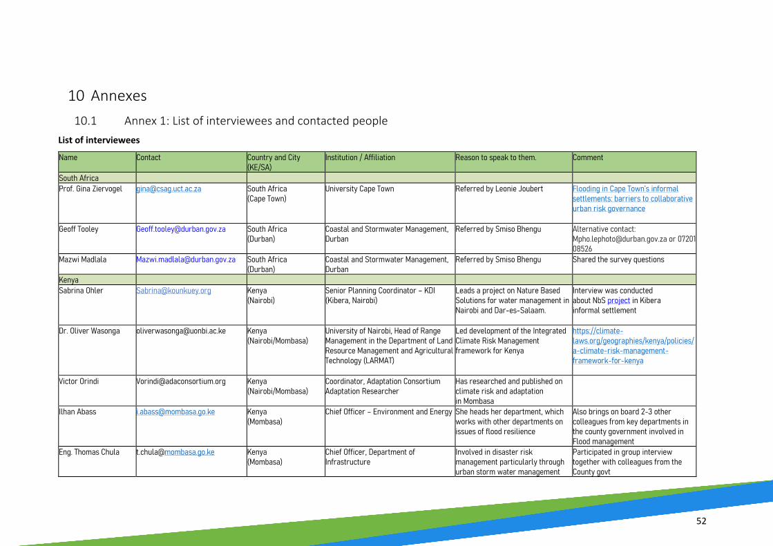
52
10 Annexes 10.1 Annex 1: List of interviewees and contacted people
List of interviewees Name Contact Country and City
(KE/SA) Institution / Affiliation Reason to speak to them. Comment
South Africa Prof. Gina Ziervogel [email protected] South Africa
(Cape Town) University Cape Town Referred by Leonie Joubert Flooding in Cape Town’s informal
settlements: barriers to collaborative urban risk governance
Geoff Tooley [email protected]
South Africa (Durban)
Coastal and Stormwater Management, Durban
Referred by Smiso Bhengu Alternative contact: [email protected] or 0720108526
Mazwi Madlala [email protected] South Africa (Durban)
Coastal and Stormwater Management, Durban
Referred by Smiso Bhengu Shared the survey questions
Kenya Sabrina Ohler
[email protected] Kenya (Nairobi)
Senior Planning Coordinator – KDI (Kibera, Nairobi)
Leads a project on Nature Based Solutions for water management in Nairobi and Dar-es-Salaam.
Interview was conducted about NbS project in Kibera informal settlement
Dr. Oliver Wasonga [email protected] Kenya (Nairobi/Mombasa)
University of Nairobi, Head of Range Management in the Department of Land Resource Management and Agricultural Technology (LARMAT)
Led development of the Integrated Climate Risk Management framework for Kenya
https://climate-laws.org/geographies/kenya/policies/a-climate-risk-management-framework-for-kenya
Victor Orindi [email protected] Kenya (Nairobi/Mombasa)
Coordinator, Adaptation Consortium Adaptation Researcher
Has researched and published on climate risk and adaptation in Mombasa
Ilhan Abass [email protected] Kenya (Mombasa)
Chief Officer – Environment and Energy She heads her department, which works with other departments on issues of flood resilience
Also brings on board 2-3 other colleagues from key departments in the county government involved in Flood management
Eng. Thomas Chula [email protected]
Kenya (Mombasa)
Chief Officer, Department of Infrastructure
Involved in disaster risk management particularly through urban storm water management
Participated in group interview together with colleagues from the County govt

53
Eng. Albert Keno [email protected] Kenya (Mombasa)
Chief Officer, Department of Transport Involved in disaster risk management particularly through urban storm water management
Participated in group interview together with colleagues from the County govt
Mary Kilavi [email protected] Kenya (Nairobi)
Former Meterological Director for Nairobi City County
Played an important role as County Director of Meteorology and participated in the Disaster Risk Management Committee
Interview shed light on the evolution of DRM and the governance environment in Nairobi
List of contacts Name Contact Country
(KE/SA) Institution / Affiliation Reason to speak to them. Response Comment
South Africa Dr Warren Smit South Africa
(Cape Town) ACC, UCT Led the Urban Flooding
CityLab from (2008-12)
No response Flooding of informal settlements in Cape Town (followed a collaborative research project)
Dr Anna Taylor South Africa (Cape Town)
ACDI, UCT Published with the Urban Flooding CityLab
No response Flooding in Cape Town’s informal settlements: barriers to collaborative urban risk governance
Charlotte Powell 021 597 5013; [email protected]
South Africa (Cape Town)
Disaster Risk Management Training Centre
Head: Public Awareness and Preparedness
Spoke on the phone, request to resend e-mail
Has forwarded email to Enock Kopele
Leonie Joubert 083 443 2988 South Africa (Cape Town)
Author, Journalist Author of Rising Waters
Responded Has suggested that we reach out to Gina Ziervogel for further contacts
Mpho Lephoto [email protected] or 0720108526
South Africa (Durban)
Coastal and Stormwater Management, Durban
Referred by Geoff Tooley Responded Suggested to await return of Geoff Toley (by 17th May)
Enock Kopele [email protected]
South Africa (Cape Town)
Disaster Risk Management Centre, Cape Town
Referred by Charlotte Powell Responded Wanted to send further links
Smiso Bhengu [email protected]
South Africa (Durban) Climate Protection Scientist, Durban
Responded tot he FEBA Urban EbA survey and was interviewed fort he FEBA Urban EbA technical report
Has shared further contacts: Geoff Tooley, Mazwi Madlala
Technical officer working on Palmiet Catchment Rehabilitation project, among others

54
Kenya Kazungu Kazungu [email protected]
Kenya (Nairobi)
Director, Urban Planning Department – Nairobi County Government
Technical planning officer with experience on urban storm water flooding in Nairobi City
Declined: Lack of authorization from boss
Will provide linkage with other relevant county government officers
Brian Kisali [email protected]
Kenya (Nairobi)
Coordinator, Disaster management in Nairobi City County
Can provide useful information and linkage to other key officer involved in flood management
Pending authorization to respond; Response from County Secretary authorizing interview not provided despite official written request
Supposed to provide key information on disaster risk reduction governance arrangement in the county and existing plans
Table 3 List of interviewees and contacted experts

55
10.2 Annex 2: Interview Framework
Broad areas for questions
Categories of Respondents
City Authorities (City county government
and city management authorities & dpts.)
National (or Provincial) Government (e.g. relevant Ministries &
Departments/ public administration)
Public Benefit Organizations with work touching on flood
resilience (Dev orgs and NGOs)
Community representatives (Community
organizations e.g. CBOS and residential associations)
Research Institutions (Universities etc)
a. Challenges related to flood management and their responses
• Their outlook on local flooding challenges
• Their responses
• Their outlook on local flooding challenges
• Their support to city authorities
• Their outlook on local flooding challenges
• Their support to communities and city authorities on flood response
• How urban flooding affects them
• Their response strategies • What authorities are doing • Level of community
participation
• Their role in flood management • Their current focus on flood
resilience research/innovation
b. Application of NbS as part of flood resilience/flood management strategies (Planning/execution/ policy etc)
• How they are integrating NbS in flood resilience/ response
• How they enable integration NbS in flood management
• Do they integrate NbS in flood management or advocate for it
• Do they integrate NbS in flood management or advocate for it
• Involvement in research and innovation on NbS to urban flooding
c. Institutional and stakeholder analysis (Key institutions, actors and their roles/ achievements)
• Key institutions for flood mgt at city level
• Key institutions for flood mgt at national government level
• They main PBOs involved in flood response and management
• They community institutions involved in flood response and management and their roles
• Research and innovation institutions involved in flood management research
• Their outputs/impact
d. Governance frameworks in place for flood risk management (policies/ legislation/strategies and plans etc)
• Governance frameworks for flood mgt at city level
• Governance frameworks for flood mgt at national level (affecting cities)
• How they collaborate and work with communities on flood response and resilience
• How communities, business and others locally organize themselves for flood response
• How they work with other stakeholders toward research-policy-practice on flood management
Table 4 Interview Framework

56
10.3 Annex 3: Abbreviations
CDKN Climate and Development Knowledge Network
NCCAP National Climate Change Action Plan (Kenya)
COCT City of Cape Town NDMAF National Disaster Management Advisory Forum (South Africa)
DAG Development Action Group (Cape Town)
NDMC National Disaster Management Centre (South Africa)
DEA Department of Environmental Affairs (South Africa)
NEMA National Environmental Management Authority (Kenya)
DFID Department for International Development (now: Foreign, Commonwealth & Development Office, FCDO)
NFM Natural Flood Management
DRR Disaster Risk Reduction NGO Non-governmental organisation
EbA Ecosystem-based Adaptation NIUPLAN Nairobi Integrated Urban Development Master Plan
Eco-DRR Ecosystem-based Disaster Risk Reduction
MCPP Municipal Climate Protection
Programme (eThekwini)
ES Ecosystem Services SA South Africa
FliCCR Flooding in Cape Town under Climate Risk
SALGA South African Local Government Association
GESIP Kenyan Green Economy Strategy and Implementation Plan
SANBI South African National Biodiversity
Institute
IDRC International Development Research Center
SDG Sustainable Development Goals
IFRM Integrated Flood Risk Management SDI Slum Dwellers International
IPCC Intergovernmental Panel on Climate Change
SWM Stormwater Management
KDI Kounkuey Development Initiative UEIP uMngeni Ecological Infrastructure Programme (Durban)
LBSAP Local Biodiversity and Action Plan UN United Nations
MGT Management UNISDR United Nations Office for Disaster
Risk Reduction
NbS Nature-based Solution UKZN University of KwaZulu-Natal
NBSAP National Biodiversity and Action Plan WWF World Wide Fund for Nature
NCCAS National Climate Change Adaptation Strategy (South Africa)
NDC Nationally Determined Contribution