Priority River Basins Flood Risk Management Project - Asian ...
126
Priority River Basins Flood Risk Management Project (RRP NEP 52195) Social Safeguards Due Diligence Report Project Number: 52195-001 June 2020 Nepal: Priority River Basins Flood Risk Management Project Prepared by Department of Water Resources and Irrigation, and the Department of Hydrology and Meteorology, Ministry of Energy, Water Resources and Irrigation for the Asian Development Bank. This social safeguards due diligence report is a document of the borrower. The views expressed herein do not necessarily represent those of ADB's Board of Directors, Management, or staff, and may be preliminary in nature. Your attention is directed to the “terms of use” section of this website. In preparing any country program or strategy, financing any project, or by making any designation of or reference to a particular territory or geographic area in this document, the Asian Development Bank does not intend to make any judgments as to the legal or other status of any territory or area.
-
Upload
khangminh22 -
Category
Documents
-
view
3 -
download
0
Transcript of Priority River Basins Flood Risk Management Project - Asian ...

Priority River Basins Flood Risk Management Project (RRP NEP 52195)
Social Safeguards Due Diligence Report
Project Number: 52195-001 June 2020
Nepal: Priority River Basins Flood Risk Management Project
Prepared by Department of Water Resources and Irrigation, and the Department of Hydrology and Meteorology, Ministry of Energy, Water Resources and Irrigation for the Asian Development Bank. This social safeguards due diligence report is a document of the borrower. The views expressed herein do not necessarily represent those of ADB's Board of Directors, Management, or staff, and may be preliminary in nature. Your attention is directed to the “terms of use” section of this website. In preparing any country program or strategy, financing any project, or by making any designation of or reference to a particular territory or geographic area in this document, the Asian Development Bank does not intend to make any judgments as to the legal or other status of any territory or area.

CURRENCY EQUIVALENTS (as of 11 June 2020)
Currency unit – Nepalese Rupee (NRe)
NRe1.00 = $ 0.0082658291 $1.00 = NRe120.98
ABBREVIATIONS
ADB - Asian Development Bank AP - Affected person CBDRM - Community-Based Disaster Risk Management CBS - Central Bureau of Statistics CDMC - Community Disaster Management Committee DWRI - Department of Water Resources and Irrigation FFEW - Flood Forecasting and Early Warning GIS - Geographic Information System GoN - Government of Nepal GRC - Grievance Redress Committee HH - Household IP - Indigenous people IR - Involuntary Resettlement MoU - Memorandum of Understanding NGO - non-governmental organization PIU - Project Implementation Unit PMU - Project Management Unit PRBFRMP - Priority River Basins Flood Risk Management Project PRTW - Proposed River Training Works SPS - ADB’s Safeguard Policy Statement TA - Technical Assistance VDC - Village Development Council VDLUR - Voluntary Donation of Land Use Rights
WEIGHTS AND MEASURES
1ha (hectare) – Is equivalent to 29.58 katthas
km – Kilometre

Table of Contents Executive Summary i I. Project Overview 1
II. Social Due Diligence Methodology 4
III. Subproject Description 6
IV. Subproject Social Due Diligence 13
A. Mohana – Khutiya 13
1. Project Impacts to Land 15
2. Socio-economic Information and Profile of Affected Persons 18
3. Gender Impacts and Mitigation Measures 22
B. Mawa – Ratuwa Sub project 22
1. Field Work 22
2. Scope of Impact on Land 24
3. Socio-economic Information and Profile of Affected Persons 27
4. Gender Impacts and Mitigation Measures 30
C. West Rapti Sub project 32
1. Field Work 32
2. Scope of Impact on Land 34
3. Socio-economic Information and Profile of Affected Persons 37
4. Gender Impacts and Mitigation Measures 41
D. Bakraha Sub project 42
1. Field work 42
2. Scope of Impact on Land 44
3. Socio-economic Information and Profile of Affected Persons 46
4. Gender Impacts and Mitigation Measures 50
E. Lakhandei Sub Project 52
1. Field Works 52
2. Scope of Impact on Land 54
3. Loss of Income 55
4. Socio-economic Information and Profile of Affected Persons 56
V. Grievance Redress Mechanism 61
VI. Voluntary Land Use Donation/Permission for land use 62
VII. Gender Impacts and Mitigation Measures 64
VIII. Indigenous People and Project Impact: 65
IX. Social Due Diligence Conclusions 66
APPENDICES
Appendix-1: Participants of the Orientation Workshop 68
Appendix-2: Sample Meeting Minute of Social Consultation (Translation from Nepali) 70
Appendix-3: Mohana Khutiya - Key Findings of Social Consultations 71
Appendix-4: Questionnaire for Socioeconomic Survey 81
Appendix- 5 -Details of landowners and land parcels owned 86
Appendix-6. Estimation of Loss of Income by Affected HHs 100
Appendix-7: Project Screening Checklist for Involuntary Resettlement 112
Appendix -8: Project Screening Checklist for Indigenous People 113

LIST OF TABLES Table 1: Summary Technical Detail of the Proposed Embankments 2
Table 2: Details of Proposed Mohana-Khutiya PRTW 8
Table 3: Details of Proposed PRTW in Mawa-Ratuwa 9
Table 4: Details of Proposed PRTW in West Rapti 10
Table 5: Flood Shelters Desired by Local Community in West Rapti Basin 10
Table 6: Details of Proposed PRTW in Bakraha Basin 11
Table 7: Details of Proposed PRTW in Lakhandehi 12
Table 8: Community Consultation Meetings and Participants 14
Table 9:Summary of Participants in Community Consultations 15
Table 10:Type of Land Owned/Occupied by Affected Households 16
Table 11:Details of Private Land ownership 16
Table 12:Composition of HHs by Caste and Ethnic Groups 18
Table 13: Educational Status of the Affected Households 18
Table 14: Average landholding size of affected HHs 19
Table 15: Major Occupation of Affected HHs 19
Table 16: Major Assets/Amenities Owned by the Affected Households 20
Table 17: Average Annual Income of the Interviewed Households 20
Table 18: Average Annual Expenditure of the Affected HHs 21
Table 19: HHs by vulnerability Type 21
Table 20: Community Consultation Meetings and Participants 23
Table 21: Participants in Community Consultation 24
Table 22:Types of Affected HHs owning private land 25
Table 23:Type of Land Owned/Occupied by affected Households 25
Table 24: Composition HHs by Cast and Ethnic Groups 26
Table 25: Households having Trees in the Lands in Construction Sites 26
Table 26: Educational Status of the Interviewed Households 27
Table 27: Average landholding size of affected HHs 27
Table 28: Major Occupation of Affected HHs 28
Table 29: Major Assets/Amenities Owned by the Affected Households 28
Table 30: Average Annual Income of the Interviewed Households 29
Table 31: Average Annual Expenditure for the Interviewed HHs 29
Table 32: HHs by Vulnerability Type 30
Table 33: Community Consultation Meetings and Participants 33
Table 34: Summary of Participants in Community Consultations 34
Table 35: Types of Affected HHs owning private land 35
Table 36: Distribution of HHs by Number of Verified Land in Locations 35
Table 37: Type of Land Owned/Occupied by affected Households 36
Table 38: Composition of HHs by Caste and Ethnic Groups 36
Table 39: Households having Trees in the Lands in Construction Sites 36
Table 40: Educational Status of the Affected Households 37
Table 41: Average landholding size of affected HHs 38
Table 42: Major Occupation of Affected HHs 38
Table 43: Major Assets/Amenities Owned by the Affected Households 39
Table 44: Average Annual Income of the Affected Households 39
Table 45: Average Annual Expenditure for the Affected HHs 40
Table 46: HHs by Vulnerability Type 40
Table 47: Community Consultation Meetings and Participants 43
Table 48: Participants in Community Consultation 43
Table 49: Types of Affected HHs owning private land 44

Table 50: Type of Land Owned/Occupied by affected Households 45
Table 51: Composition of HHs by Caste and Ethnic Groups 45
Table 52: Households having Trees at the Embankment Sites 46
Table 53: Educational Status of the Interviewed Households 47
Table 54: Average landholding size of affected HHs 47
Table 55: Major Occupation of Affected HHs 47
Table 56: Major Assets/Amenities Owned by the Affected Households 48
Table 57: Average Annual Income of the Interviewed Households 49
Table 58: Average Annual Expenditure for the Interviewed HHs 49
Table 59: HHs by Vulnerability Type 50
Table 60: Community Consultation Meetings and Participants 53
Table 61: Summary of Participants in Community Consultations 53
Table 62: Composition HHs by Cast and Ethnic Groups 55
Table 63: Households having Trees in the Proposed PRTW Sites 55
Table 64: Educational Status of the Interviewed Households 56
Table 65: Average landholding size of HHs at Construction Sites 57
Table 66: Major Occupation of Affected HHs 57
Table 67: Major Assets/Amenities Owned by the Affected Households 58
Table 68: Average Annual Income of the Affected Households 58
Table 69: Average Annual Expenditure for the Interviewed HHs 59
Table 70: HHs by Vulnerability Type 59
LIST OF FIGURES Figure 1: Location of Project Basins 2
Figure 2: East Rapti River Basin 7
Figure 3 Mohana-Khutiya 7
Figure 4: Mawa Ratuwa River Basin 8
Figure 5: West Rapti River Basin 9
Figure 6: Bakraha River Basin 11

GLOSSARY Affected Person (AP) – Affected persons are people (households) who may lose their land use right or source of livelihood due to the project. It may be all or part of their physical and non-physical assets, irrespective of legal or ownership titles. The term has been used in this report to broadly indicate people (households) willing to voluntarily donate land use right for the project. ‘Ailani Land’– All the land not registered as private land in the government record – people informally ‘own’ and transact this land – i.e. sell occupied govt land use rights to other informal people [de facto land use rights]. Economic Displacement – Loss of land, assets, access to assets, income sources, or means of livelihood as a result of (i) involuntary acquisition of land, or (ii) involuntary restriction on land use or on access to legally designated parks and protected areas. Project Beneficiaries – People who stand to benefit from the project Physical Displacement – Relocation, loss of residential land, or loss of shelter as a result of (i) involuntary acquisition of land, or (ii) involuntary restriction on land use or access to legally designated parks and protected areas. Lalpurja – Title of Land Ownership Certificate which literally means “Red Certificate” – land ownership certificate officially distributed by the Land Revenue Office; also known as the land title in the international context. Terai – Lowland region in southern Nepal that lies south of the outer foothills of the Himalayas, the Siwalik Hills and the north of Indo-Gangetic Plains.

Executive Summary
1. The Priority River Basins Flood Risk Management Project (“the Project”) will implement physical infrastructure, including about 36km of embankments, about 4.6 km of additional revetments and 439 spurs to protect against flooding and erosion. In addition, modelling for flood forecasting and early warning systems (FFEWS) will be carried out and systems put in place to provide warning of impending floods to communities along the rivers. Community based disaster risk management (CBDRM) measures will be implemented to provide communities with the warnings procedures to move themselves and their livestock safely to higher ground when flooding is imminent. Flood shelters will be designed and built in collaboration with local communities in each subproject area, especially for the population which will still be outside the protected areas after subproject implementation.
2. This social safeguard due diligence report has been prepared by the project’s implementing agency, the Department of Water Resources and Irrigation (DWRI). The report demonstrates: (i) The project’s approach to addressing social impacts and risks in relation to Safeguard Requirements; (ii) Involuntary Resettlement and Safeguard Requirements; and (iii) Indigenous Peoples.
3. The Project is comprised of six sub-projects: Mohana Khutiya, Mawa Ratuwa, East Rapti, West Rapti, Lakhandei and Bakraha River Basins. Safeguards due diligence screening is based on the most updated project designs as of December 2019. The Mohana Khutiya, and Mawa Ratuwa sub-projects have detailed embankment design, West Rapti, Lakhandei and Bakraha have feasibility embankment design and the East Rapti and all other subprojects will involve community flood shelter design during the project implementation period. The findings of this report are subject to verification and/or updating by the implementing agency ahead of the construction season in all sub-projects, including the subprojects with detailed design. Project designs are subject to minor changes due to the monsoon season as the river course may erode lands earmarked for embankment. DWRI is required to submit finalized social due diligence to ADB for all sub-projects ahead of construction starting.
4. DWRI undertook an extensive social safeguards due diligence screening between August and November 2018 and March and November 2019 to determine social impacts and risks associated with the project. The following safeguards screening methods were utilized in review of the six-sub-projects: (i) desk-based review of sub-project technical plans, social assessment reports prepared by the TA consultants, analysis of secondary data sources; and (ii) primary data collection, including repeated field site visitations to all sub-projects; 432 total household surveys and 48 documented community consultations with 1,596 people total participants, of which 64% were male, 36% women and 66% indigenous (as per the ADB definition). Throughout the social safeguards screening exercise, ADB Social Safeguard Staff worked closely with DWRI and consultants to ensure that ADB’s Safeguard Policy Statement (SPS 2009) due diligence requirements were met. Staff periodically participated in community consultations, provided DWRI with safeguards training and participated in the review and validation of due diligence findings.
5. This Social Safeguards due diligence report finds that the project is classified as category C for the Involuntary Resettlement safeguard in accordance with ADB’s SPS 2009. Land for embankment construction will require approximately 58.79 ha of total land. The social safeguards screening identified 432 households with lands impacted by the embankment construction. Of this total, 182 households are private landowners and 250 households are non-title holders or encroachers occupying government lands on a seasonal basis to plants crops.

ii
6. The report finds that no involuntary land acquisition, economic or physical displacement will be required for the project. No structures are present in the corridor of impact and crop losses will be avoided as local people unanimously agree to avoid planting seasonal crops in the project corridor ahead of the construction season. All 182 private landowners were found eligible to voluntarily donate land to the project; 179 memorandums of understanding (MoU) for land use were signed by landowners and third party witnessed during the screening exercise. Two landowners were not present to undertake signing at the time of the due diligence exercise, however their family members expressed high willingness to donate lands for the project. The safeguard screening exercise finds that people who own and use the embankment lands are highly willing to contribute lands to the project. Household surveys confirm that the donation will not cause significant income losses or impoverishment. Rather, landowners and users will directly benefit as project works will increase utility and value of protected lands. Landowners or users will be able to plant year-round crops on the protected land and will have increased security.
7. The project is classified as category B for Indigenous Peoples safeguards in accordance with ADB’s Safeguard Policy Statement. Due diligence screening confirmed that the targeted beneficiary population are majority indigenous as per the ADB definition; ethically distinct and vulnerable. The Thru and Chaudhari are the ethnic minority groups identified in the sub-project areas; they are defined as indigenous according to the Nepal Federation of Indigenous Nationality.1 Safeguards due diligence consultations with the Thru and Chaudhari highlight that the indigenous people groups interact and participate in the broader community activities however they also maintain their own local Tharu and Chaudhari languages, customs and rituals. They also maintain a collective attachment to place, but they do not consider their land ancestral territories, nor do they claim an indigenous or distinct attachment to any natural resources. The government has not specifically allocated any specific place only focusing on the ancestral domain. Rather in some places land has been allocated and even with ownership transfer for the victims of flood in the past and recently for the emancipated bandaged labors which also include other caste and ethnic groups.
8. The Thru and Chaudhari peoples participate in the same governance system to the broader community, including in the same educational, economic, and political activities and the broader community. They also participate in organization focused on their ethnic group, particularly initiatives that seek to contribute to their development, welfare, and cultural protection. While the stance of the Thru and Chaudhari ethnic groups has been improving since government reforms introduced in the 90s, these indigenous people groups have been historically marginalized, economically disempowered and socially excluded from the broader society as a result of their indigeneity. There is an Act on National Foundation for the upliftment of Aadibasi Janajati 2002 to consider these groups present in the project area as ethnic minority indigenous groups.
9. Consultations with the Thru and Chaudhari community members indicates that the proposed project works will provide direct benefit to the Indigenous people by protecting them from floods, land cutting, and loss of crop production. Protection of land, infrastructures such as a house, schools, health facilities, community structures and life from the flood. The social safeguards due diligence screening finds that that no adverse impacts are anticipated as a result of the project. The project will not physically displace indigenous people, affect indigenous
1 http://www.nefin.org.np/list/Categorization-of-Indigenous-People-based-on-development-/5/95/6.

iii
people common property resources or indigenous people ancestral lands. The indigenous people population expects to benefit from flood protection and enhanced disaster readiness.
10. projects, and (iii) can participate actively in projects that affect them. As per ADB’s SPS 2009, the project is not required to produce a separate indigenous people plan because the majority of direct project beneficiaries are indigenous peoples and only positive impacts are identified.2 The project meets these criteria and as such, the indigenous people plan elements have been integrated throughout the project design.
2 ADB. 2009. Safeguards Policy Statement. Manila. See Appendix 3, Safeguards Requirements 3: Indigenous
Peoples, para. 17.


I. Project Overview
1. Nepal is considered one of the most disaster-prone countries in the world. The Terai region, also known as the sub-Himalayan hills, at low altitude is severely affected by recurrent annual flooding that cause damage to infrastructure, crops and erodes agricultural land affecting the lives and livelihood of the population living in the area, public infrastructure and communities annually.
2. Communities vulnerable to floods in the Terai have been increasing due to migration of people from the mountains and hilly regions in search of better livelihood and settling in the flood prone areas. Farmers and communities are not fully prepared for flooding due to limited precautionary measures like; absence or limited river training works, preparedness to manage the issues associated with flood (e.g. skill of rescuing the flood victims and their rehabilitation, handling and rescuing of vulnerable persons like; women, senior citizens, children, lack of flood shelter house and warnings of impending flood events. The region’s inadequate investment in disaster risk management including flood protection affects the poor and marginalized who are occupying the most hazard exposed areas along the river embankments.
3. The Priority River Basins Flood Risk Management Project aims to reduce the incidence and severity of flooding in the prioritized river basins in the Terai. It will contribute to a reduction in potential loss of life, economic and natural resource degradation. Various components under the project are (i) provide flood control through bio-engineering and river training infrastructure (ii) enhance flood forecasting and early warning systems (FFEWS) and (iii) enhance emergency preparedness and response readiness; including investing in community-based disaster risk management (CBDRM) and capacity building for DWRI officials, stakeholders and beneficiaries in best practice flood risk management
4. This social safeguards due diligence report aims to understand the social impacts and safeguards issues to support decision making about funding the proposed investment program. Social safeguards due diligence is one of the requirements of the Asian Development Bank for project processing. This due diligence report addresses the Involuntary Resettlement and Indigenous Peoples safeguards assessment of the five subprojects with feasibility and detailed designs, including: (i) Mohana-Khutiya; (ii) Mawa Taruwa; (iii) West Rapti; (iv) Lakhandei; and (v) Bakraha. Due diligence activities for the East Rapti subproject will be undertaken by the Project PMU during implementation as the subproject will involve design of community flood shelters during implementation. This due diligence report is based on the most updated project design as of December 2019. The report will require updating and finalization prior to embankment construction in each subproject as the river course is likely to have moved following the monsoon season and design modifications may be required.
5. The Department of Water Resources and Irrigation (DWRI) is responsible for all protection works related to water-induced disasters. The Government of Nepal has requested the Asian Development Bank (ADB) to support the development of the ‘Priority River Basins Flood Risk Management Project’ which focuses on flood control and river training infrastructure in six rivers basins in the Terai region.3 The location of the six river basins is shown in Figure 1 and a summary of the embankment technical detail is incorporated in Table 1.
3 Mohana – Khutiya basin, Mawa – Ratuwa basin, Lakhandei basin, West Rapti basin, East Rapti basin and Bakraha
basin.

2
Figure 1: Location of Project Basins
6. The details of works to be carried out in the project river basins are summarized in Table-1 below.
Table 1: Summary Technical Detail of the Proposed Embankments4
River Basin District Number of
embankments Embankment Length (m)
Additional Revetments
(m) Spurs Outlets
Mawa Ratuwa
Jhapa, Morang
13 10,485 1,330 188 19
Mohana Khutiya
Kanchanpur Kailali
11 10,280 2,150 146 16
West Rapti Dang 6 12,530 0 36 -
Lakhandei Sarlahi 2 1,600 1,160 27 -
Bakraha Morang 8 4,365 0 42 -
East Rapti Chitawan 0 - - - -
Total 49 36,230 4,640 439 36
7. The project aims to achieve the following outputs.
4 Several embankments were dropped in the Lakhandei River Basin since this due diligence exercise was
undertaken. This table will be updated to reflect actual figures once due diligence is finalized.

3
(i) Output 1- Flood Protection Infrastructure Improved: Specifically, the project will reduce direct impacts from flooding through a) rehabilitation and construction of flood control infrastructure b) demonstration of nature-based solutions for better flood risk management such as bio-engineering along the river embankments with suitable flora/vegetation to reduce embankment cutting and prevent soil erosion; and c) development of flood protection infrastructure manuals and monitoring systems.
(ii) Output 2. Flood forecasting and response systems enhanced: The project will support government and communities in flood-prone areas to improve early warning systems through a) installation of hydro-meteorological stations and strengthening capacity for flood forecasting, b) strengthening early warning communications system, possibly using sirens, mobile phone technology, to communicate advance flood warnings to local communities, and c) maintenance of flood forecasting and early warning system.
(iii) Output 3. Flood Prevention and Preparedness Capacity Improved: This will be delivered by a) preparing and implementing a project stakeholder communication and outreach program, b) undertaking organizational capacity building program on flood risk management and infrastructure planning for DWRI and c) developing CBDRM plans in line with local development plans and budgets that integrates disaster risk information.

4
II. Social Due Diligence Methodology
8. This social safeguard due diligence report has been prepared to determine the social safeguards categorization for both Involuntary Resettlement and Indigenous Peoples. Impacts and mitigation measures were assessed and determined based on the following methods: (i) desk-based review of technical plans, social assessment reports prepared by the TA consultants, relevant secondary data; (i) primary data collection: household survey and focus groups discussions with local community and affected persons across the Mohana-Khutiya river basin covering all the proposed construction sites.
9. Land use requirements and proposed arrangements were further investigated and verified by a team of two social safeguard officers who examined GIS maps of the sub-project designs against the cadastral maps. The social safeguards officers held community meetings along all the proposed embankments and spoke directly with families whose lands would be impacted by embankment construction to determine their eligibility and interest to donate lands to the project. Local government representatives and DWRI engineers also participated in this verification/due diligence exercise in order to explain the project and clarify questions from the beneficiary population. The following steps were involved in carrying out the due diligence.
10. Step 1: Preparatory Activities On 16 June 2019, ADB Social Development Consultants held a one-day training workshop at the DWRI project office, in Kathmandu to explain the requirements of ADB SPS 2009. The workshop was attended by the DWRI Dy. Project Director, the DWRI Sociologist, project engineers, and other field survey staff comprising male and female members to be deployed for safeguards due diligence. The ADB Social Development Consultants clarified the due diligence process requirements, including for community consultation and information sharing and the eligibility criteria and process for negotiated settlements and voluntary donation. During the training workshop, the participants developed a field work plan and reviewed survey tools for community consultations and household surveys, as well as the MOU in the event of voluntary land use donations. Appendix 1 presents the list of participants in the workshop.
11. Step 2: Fieldwork Verification. The Project social safeguards team visited the project sites in July and August 2019 for due diligence assessments. The aim of the social safeguards due diligence was to consult local beneficiary communities about the project and anticipated impacts; determine the extent to which Indigenous Peoples were present and impacted by the project development and agree on an approach to land use. Field notes from all community consultations and household level surveys were recorded and stored at the DWRI office.
12. Prior to initiating the social safeguards due diligence, considerable effort was made to ensure affected persons (project beneficiaries) were present for community consultation and household meetings. First, the DWRI engineers and ward representatives contacted persons owning/occupying land at the proposed embankment construction sites and invited them to participate in the due diligence assessment. Landowners and users (both titled and non-titled) were identified by comparing the PRTWs designs against the cadastre maps. The cadastre maps had been earlier retrieved for the identified villages from District Land Survey Office. Second, local community members, including persons representing different caste and the ethnic groups; indigenous people, women, seniors, disabled persons etc were invited and informed about the consultation meetings and invited to participate.
13. Social safeguards assessments were carried out along proposed PRTWs. The assessment initially involved holding the community consultations, which were facilitated by the DWRI engineer, Ward representative and the Social Safeguards Officers. The community

5
consultations initially sought to inform local people about the proposed project works, its intended benefits and land use requirements. The meetings also focused on obtaining feedback from local people about any perceived adverse impacts, particularly to vulnerable and marginalized groups such as indigenous peoples, lower caste and women.
14. Detailed information on the fieldwork completed for each subproject is presented in Section III.

6
III. Subproject Description
15. The following section provides a brief description of the six subprojects and proposed project interventions. Common to all subprojects is the proposed flood control and river training infrastructure (embankments, spurs and outlets), Flood Forecasting and Early Warning Systems (FFEWS) and a training program for Community Based Disaster Risk Management (CBDRM). The following activities and infrastructure are included under the FFEWS and CBDRM;
(i) Rain gauge network installation (ii) Hydrometric gauge network installation (iii) Hydrometric equipment (iv) A topographic survey cross-section (v) Training of trainers to guide the communities in the event of a flood warning and
to increase their resilience to respond (vi) Where not existing, a Community Disaster Management Committee (CDMC) per
community will be established (vii) An inventory of the different houses and buildings in the agreed community to
identify the vulnerable and non-vulnerable places. (viii) Community flood shelters
16. The community flood shelters will be designed under the CBDRM project component in collaboration with flood affected people. This component will be designed during the implementation phase and hence, DWRI will need to undertake social safeguards screening and reporting to ensure that lands for the community shelter will not trigger the SPS Involuntary Resettlement safeguard. In principle, the project will identify government lands to construct the shelters, or if preferred, local people will have the option to donate lands for the flood shelter where eligibility criteria is met. The project’s principles for undertaking land negotiation and/or voluntary land use donation is included within the Project Administration Manual and meets the criteria of ADB, national and international best practice.
17. The East Rapti Subproject. For East Rapti Basin (Figure- 2) there will be no structural measures along the river. The catchment of the East Rapti Basin lies between Northing 3,024,000 m to 3,080,000 m (84°8'42.905"N to 27°20'22.455"N), and between Easting 219,000 m to 324,000 m (longitude 85°11'38.029 E– 27°46'56.346 E) in WGS 84, UTM Zone 45 N. the basin extends from the southern slopes of the Mahabharata Range in the north, Chure Hills (Siwalik Hills, also known as sub-Himalayan hills, at low altitude) in the Middle and in Terai (meaning low flat land) in the south up to the Indo-Nepal border. East Rapti is the main water body, which is joined by the Mahanahari, Lothar and Budhi Rapti in the west. In the east it is joined by the Karra Khola, and Khukreni Khola and in the Southwest by Riu Khola. The catchment covers an area of 2,963 km2 in the central Nepal, Province No. 3. East Rapti River system lies in the districts Makwanpur and Chitwan. The basin has 1,564 settlements distributed over rural and urban municipalities with a population about 610,000 and households about 13,000 (CBS, 2011). Hetuada Municipality, Bhandara, Bhimphedi, Makwanpur Gadi, Bhainse, Bharatpur Metropolitan City, Ratnanagar, Ayodhapuri are the major cities, towns and settlements. East Rapti Basin has two valleys, i.e., East Rapti Valley and Madi Valley in the south. The famous Chitwan National Park, and a part of Parsa Wildlife reserve are located in this basin. As mentioned above, only FFEWS and CBDRM components will be developed in this sub-project. The project will need to perform a social due diligence screening when the locations for the community flood shelters are identified.

7
Figure 3 Mohana-Khutiya
Figure 2: East Rapti River Basin
18. The Mohana-Khutiya Sub-project. The Mohana-Khutiya (Figure-3) extends from Chure Hills (Siwalik Hills, also known as sub-Himalayan hills, at low altitude) in the north and the Terai plains in the north to Nepal - India border in the south. The catchment covers an area of 702.4 km2 and is located in the far west of Nepal. The Mohana - Khutiya basin system lies in the districts of Kailali and Kanchanpur in Province no 7. This river system has 359 settlements distributed over rural and urban municipalities with a population of 190,063 and 37,681 households (CBS, 2011). Dhangadhi and Atrariya are the two major towns located in this catchment.
19. In addition to FFEWS and CBDRM mentioned in para 15, the Mohana – Khutiya Subproject will involve 12 Priority River Training Works (PRTW). The PRTW includes construction of embankments, revetments, spurs, and outlets. The embankments will be between 9 m–12 m wide and have gravel surfacing and used for road access, revetments, spurs, and outlets. Table 2 provides details of the proposed PRTWs in the Mohana – Khutiya subproject.

8
Figure 4: Mawa Ratuwa River Basin
Table 2: Details of Proposed Mohana-Khutiya PRTW5
PRTW No Location and Length
Nagar/ Village Palika and Ward No. Village Embankment’ Length (m)
PRTW 01 Krishnapur- 7 Shantipur 700 PRTW 02 Krishnapur-7 Majgain 800 PRTW 03 Dhangadhi, Nagar Palika-13 Srilanka 330 PRTW 06 Godawari Nagar Palika -9 Arjun Tole 1630 PRTW 07 Godawari Nagar Palika -9 Murkatti 715 PRTW 08 Dhangadhi Nagarpalika -17 Uttar Khairini 800 PRTW 09 Dhangadhi Nagarpalika-15 Tarbaria 520 PRTW 10 Krishnapur Nagarpalika -9 Rajghat 400 PRTW 11a Krishnapur Nagarpalika -9 Sanagaun 1345 PRTW 11b Krishnapur Nagarpalika -9 Jorayal Tole 510 PRTW 12 Dhangadhi Nagarpalika -3 Chatakpur (Gaushala) 750 PRTW 13 Godawari Nagar Palika-9 Dhanchauri
1000
20. The Mawa – Ratuwa Subproject. The Mawa - Ratuwa catchment of the Mawa - Ratuwa Basin (Figure-4) lies between Northing 2,919,087 m to 2,973,609 m (latitude 26°25′ 56.89″–26°49′ 05.14″N), and between Easting 561,528 m to 580,023 m (longitude 87°36’36.31″E–87°47′24.97″E) in WGS 84, UTM Zone 45 N. The basin extends from Chure Hills (Siwalik Hills, also known as sub-Himalayan hills, at low altitude) in the North and in Terai in the south up to the Nepal - India border. Ratuwa is the main water body, which is joined by the Mawa in the West, and Bidhawa and Chanju Khola in the East. The catchment covers an area of 413 km2 is located in the East of Nepal. The Mawa - Ratuwa Basin shares the districts of Morang and Jhapa, both in Province No. 1. The basin has 366 settlements distributed over rural and urban municipalities with a population of 165,260 and 36,871 households (CBS, 2011). Damak and Urlabari are the two major towns located in this catchment.
21. In addition to FFEWS and CBDRM mentioned in para 15, the Mawa – Ratuwa subproject proposed to develop 17 PRTWs (Table-3). The embankments will be between 9 m-12 m wide and have gravel surfacing and used for road access, revetments, spurs, and outlets. Embankments are proposed at the following locations.
5 PRTW 4 and PRTW 5 have been excluded from the proposal for ADB funding.

9
Table 3: Details of Proposed PRTW in Mawa-Ratuwa
PRTW Site Name Municipality/ Village
Ward No
Embankment Length (m)
01 Chandra Dovan
Gauradaha Municipality
5 2200
02 Mangalbare Ratuwamai Village Municipality 10 825 03 Dumse Damak Municipality 3 535 04 Shanti Tole Urlabari Municipality 7 785
05 A Tapu Urlabari Municipality 1 470 05 B Tapu Urlabari Municipality 1 250
07 Mirchagadi Urlabari Municipality 3 930 08 Chaukighat Ratuwamai Municipality- 3&4 1330
09 (a) Nayabasti, Triveni Tole Damak Municipality 2 205 09 (b) Nayabasti, Triveni Tole Damak Municipality 2 820
9 (c)&(d) Himalaya Tole Damak Municipality 1 1005
10. Rubber Plant Area Damak Municipality 6 265 11. Near Mahesh Chowk Urlabari Municipality 9 650
12 LB Khayarbari Kamal Rural Municipality 6 500 12 RB Panchthare Tole Damak Municipality 10 500 13 LB Udaya Tole Damak Municipality 4 175
13 RB Shanti Tole Urlabari Municipality 7 370 Source: Census Survey, JulyAugust 2019
22. The West Rapti Sub-project: West Rapti river drains Rapti Zone in the Mid-Western Region, Nepal and Purvanchal regions of India before joining the Ghaghara (Figure-5)- a major left-bank tributary of the Ganges known as the Karnali inside Nepal. It rises south of a prominent E-W ridgeline midway between the western Dhaulagiri Himalaya and the Mahabharat Range. A 3,500 meter (11,500 ft) summit on this ridgeline marks a triple divide. North of the triple divide the Karnali and Gandaki basins are adjacent; south of it the Rapti and similar but smaller Babai River separate the two larger basins. After crossing into India, the Babai and Rapti separately join the Karnali's continuation called Ghaghara. The Ghaghara ultimately joins the Ganges. The main river emerges from its gorge into the lower Siwalik Hills and Dang District at Bhalubang Bazaar, Nepal's east-west Mahendra Highway bridges the river.
23. In addition to FFEWS and CBDRM mentioned in para 15, the West Rapti subproject proposed to develop 8 PRTWs (Table-4). The embankments will be between 9-12 meters wide and have gravel surfacing and used for road
access, revetments, spurs, and outlets. Embankments are proposed at the following locations.
Figure 5: West Rapti River Basin

10
Table 4: Details of Proposed PRTW in West Rapti
PRTW Site Name Municipality/ Village
Ward No
Embankment Length
01*
(a) Pachaha Gadhawa, Rural Municipality-Ward -2
2 2340 (b) Mahadeva
(c) Kothari
02* (a) Khadkapur Gadhawa, Rural
Municipality 4 2100
(b) Chingatpur
03 (a) Parsiya (b) Lokharpur (c) Lokharpur
Gadhawa 2,3,5,7 5655
04 (a) Batkauwa (b) Semarhawa (below Rapti bridge)
Lamahi Municipality 4 500
05 (a) Balarampur (b) Dhikpur
Lamahi Municipality 7 500
06 (a) Kanchhi Gaun (b) Jharbaira
Gadhwa Village Municipality
7 750
07* & 08 (a) Nahartole (b) Kachanapur (c) Gurukhola
Rapti sonari Rural Municipality
2 500+730
Source: Feasibility Report by TA Consultants *PRTW will not be funded under ADB project (after not passing economic assessment)
24. For the subproject’s FFEWS the project will install 12 rain gauge network installation and 9 Hydrometric gauge network installation. Flood shelters will also be constructed. At this stage, only four communities during the community consultations have desired to have floods rehabilitation shelters in their respective area as per Table 5.
Table 5: Flood Shelters Desired by Local Community in West Rapti Basin
S.N. PRTW Location Land Available Place as suggested
1. 01 Gadhwa Rural Municipality-2 Kothari
The land is available at Kothari, Gadhwa-2
2 06 Lamahi Municipality-4 Batkauwa
Ailani land is available in the ward
3 07 Rapti Sonari Rural Municipality -2, Kachanapur
The land is available within Ward No. 2 itself. About 10 Kattha (3380 sqm) can be managed
4 08 Gadhwa Rural Municipality-7, Karchha Village
There is always a flood risk in this village. People are willing to donate land if there is no Ailani land available.
Source: Census Survey, JulyAugust 2019
25. Bakraha Subproject. The Bakraha Basin is located in the eastern Terai region of Nepal. It is severely affected by floods causing loss of cultivating land, community infrastructure and even life and properties in the settlements along the basin. The Bakraha river basin extends from Chure Hills (Siwalik Hills, also known as sub-Himalayan hills, at low altitude) in the North and in Terai in the south up to the Nepal - India border. The catchment of the Bakraha Basin lies between latitude 26°25′ 56.89″–26°49′ 05.14″N, and between longitude 87°36’36.31″E–87°47′24.97″E in Morang district of Province No. 1. The basin has 366 settlements distributed over rural and urban municipalities with a population of 165,260 and 36,871 households (CBS, 2011). Damak and Urlabari are the two major towns located in this catchment.

11
Figure 6: Bakraha River Basin
26. In addition to FFEWS (6 rain gauges and 5 hydrometric gauges) and CBDRM mentioned in para 15, the Bakraha subproject proposed to develop 8 PRTWs (Table-6). The embankments will be between 9 m12 m wide and have gravel surfacing and used for road access, revetments, spurs, and outlets. Embankments are proposed at the following locations.
Table 6: Details of Proposed PRTW in Bakraha Basin
PRTW Site Name Municipality/ Village
Ward No
Embankment Length
Remarks
01* Kasani Miklajung, Morang 7 600 LB
02* Chisapani UrlabariMunicipality 1 250 RB 03* Jhumra, Bishal Tole Urlabari Municipality 4&5 380 LB 04 Thapadangi Urlabari Municipality 4 200 RB 06 Bistadanda,
Pipalchowk Sanischare Municipality
3 1300 RB
07 Kaseni, Leti Ratuwa Mai Municipality
5 2365 LB
08 Bardanga, Chauki tole
Sanbarasi Municipality-
6 500 RB
09* Urlabari, Miklajung Urlabari Municipality 9 1000 RB Source: Census Survey, July–August 2019
*PRTW will not be funded under ADB project (after not passing ADB economic threshold)

12
27. Based on community consultation, local community in 6 PRTW sites6 expressed their need for the rehabilitation building. For this purpose, government and community lands is available and even in case of unavailability of such land the community is willing to voluntarily donate land for the shelters.
28. Lakhandehi Subproject. Lakhandehi River lies in the Central part of the country’s province number 2 in Sarlahi district and is a tributary of Bagmati River. It originates in the Chure range of Central Nepal and flows in a southerly direction to the Nepal-Indian border. The river flows west of Lalbandi city which is one of the fast-growing cities of Central Nepal. The topography of the catchment area is steeped in the upper reaches of the basin and very mild in the lower part of the basin which is also referred to as the Terai region. The total catchment area of the Lakhandehi basin up to the Nepal-Indian border is 344km2.
29. Lakhandehi River is a non-perennial river and the flooding in this river is characterized as being flashy in nature. There has been a history of 69 flood events between 1993 and 2015 with widespread damage and loss of life, particularly in the downstream part of the basin in the border region. In recent years, the river has experienced high sediment loads often aggravated by landslides in the upper catchment. This has led to a slow rise in the bed level over time.
30. The basin extends from Chure Hills (Siwalik Hills, also known as sub-Himalayan hills, at low altitude) in the North and in Terai in the south up to the Nepal - India border. The Sarlahi district has a population of 769,729 and 132,844 households (CBS, 2011). Lalbandi and Hariaun are the two major towns except the district headquarter Malangwa which is located in this catchment.
31. In addition to FFEWS (5 rain gauges and 4 hydrometerlogical stations) and CBDRM mentioned in para 15, the Lakhandei subproject proposed to develop 2 PRTWs (Table-7). The embankments will be between 9 m-12 m wide and have gravel surfacing and used for road access, revetments, spurs, and outlets. Embankments are proposed at the following locations.
Table 7: Details of Proposed PRTW in Lakhandehi
PRTW No
Site Name Municipality/ Village
Ward No
Embankment Length
Remarks
01 Pattharkot, Jiyajor Lalbandi Municipality 12 2324 RB
08 Kachhariya Tole Haripur Municipality 8 420 LB
Source: Census Survey, JulyAugust 2019
32. In case of the absence of appropriate buildings for use, flood shelters will be constructed. Based on community consultation, local community in both the PRTW sites expressed their need for the rehabilitation building. For this purpose, government and community lands is available and even in case of unavailability of such land the community is willing to voluntarily donate land for the shelters.
6 1) PRTW 01 Miklajung Rural Municipality-7 PRTW 2: rehab center necessary, but land uncertain), 2) PRTW
02:Chisapani, Urlabari-2, land available at ward No.2, 3)PRTW 04: Thapadangi, Urlabari-4, Land can be arranged for rehan center, 5) PRTW 06: Bistadanda, Sanischare-3, land can be managed, 6) PRTW 07: Bardanga- Sonbarsi-7, land can be made available at ward no 7 near temple.

13
IV. Subproject Social Due Diligence
A. Mohana – Khutiya
33. Fieldwork Verification. The Project social safeguards team visited the Mohana – Khutiya basin from 22 to 28 July 2019. The aim of the social safeguards due diligence was to consult local beneficiary communities about the project and anticipated impacts; determine the extent to which Indigenous Peoples were present and impacted by the project development and agree on an approach to land use. Field notes from all community consultations and household level surveys were recorded and stored at the DWRI office.
34. Social safeguard assessments were carried out along all 12 proposed PRTWs. The assessment initially involved holding the community consultations, which were facilitated by the DWRI engineer, Ward representative and the Social Safeguards Officers. The community consultations initially sought to inform local people about the proposed project works, its intended benefits and land use requirements. They were also informed that the embankment would be used for road access to their agriculture fields and constructed in a way convenient to river access with provision of the ramp and other facilities depending upon the location and size of the embankment. The meetings also focused on obtaining feedback from local people about any perceived adverse impacts, particularly to vulnerable and marginalised groups such as indigenous peoples, lower caste and women.
35. The meetings also covered the topic of voluntary land donations and eligibility criteria (see details on voluntary donation eligibility on page 24). As the embankments would pass through sections of private lands, landowners and users of publics lands were asked about their willingness to donate lands to the project. The community consultation meetings were concluded after signing the minutes and attendance record of each participant including local Government representative (e.g. mayor/chairperson of rural municipality/ ward members and DWRI engineer). The meeting minutes contained texts in Nepali on all meeting details including the local people’s general willingness to voluntarily donate land use right for the land at the embankment site to the project. The text was read out loudly to the community for their easy understanding.
36. A household survey was completed with present households in order to establish a baseline profile of the beneficiary population. Collected information included details such as the household size, major caste and ethnic composition of the population including Dalit, ethnic and disadvantaged groups, major occupation, information on flood and associated impacts and its management etc.
37. Ground verification of affected plot/ land parcel and its owners/occupants was conducted following the community consultation using data from GIS overlays on cadastral maps and other local information. The social consultants and the census team walked along the proposed embankment with a group of 5 to 10 local community members comprising the ward

14
representative, persons having land in the construction sites and DWRI engineer to invite additional participants to verify ownership details.
38. Two types of affected persons were identified during these walks i) persons with formal land title, known as ‘lal purja’ in Nepali language. It was observed that the cadastral maps were not always updated, with some persons having land titles in the construction site that were not formally mapped in the cadastral and ii) non-title holders’ or persons without formal land title occupying Government/ Ailani land for agricultural activity that is likely to be affected.
39. The census team however, could not collect complete information from all the households likely to have their private lands in the proposed embankment sites as there were some absentees and some of the land parcels were not matching with the GIS overlay on the cadastral maps that are not updated. In such cases, information regarding land parcels of affected parties were collected from local government representatives and the local community. The social consultants explained that only the private landowner and/or non-title holder can give consent for land use arrangement and the project team would have to confirm eligibility and obtain signatures ahead of construction. Appendix- 2 provides a sample English translation of the text read to the community.
40. In total, 12 community consultation sessions were organized, one at each PRTW location. Location of the consultation meetings and number of participants is presented in Table 8.
Table 8: Community Consultation Meetings and Participants
S.N. Name of Place District Municipality /Village Palika PRTW No
No. of Participants
1 Arjuntole Kanchanpur Godawari Municipality-9 06 47 2 Murkatti Kanchanpur Godawari Municipality-9 07 48 3 Uttarkhandini Kanchanpur Dhangadhi Submetropolitan-
17 08 67
4 Tarvairiya Kanchanpur Dhangadhi Submetropolitan-15
09 65
5 Dhanchauri Kanchanpur Godawari Municipality-9 13 71 6 Srilanka Dhangadhi Dhangadhi Sub-metropolitan-
14 03 58
7 Chatakpur, Gausala Dhangadhi Dhangadhi Sub-metropolitan-03
12 43
8 Rajghat Dhangadhi Krishnapur Municipality-9 10 44 9 Sanagaun Kanchanpur Krishnapur Municipality-9 11 (a) 64 10 Sanagaun Kanchanpur Krishnapur Municipality-9 11 (b) 28 11 Shantipur Kanchanpur Krishnapur Municipality-7 01 17 12 Majhgaun Kanchanpur Krishnapur Municipality-7 02 29
Total Number of Participants 581
41. Each consultation session was attended by at least one local government personnel (ward representative) and the field engineer of DWRI. Of the total 581 participants, 238 (40.96%) were women and 243 (59.04%) were men. In terms of indigenous people and Dalit; the representation of indigenous people was 311 persons (53.53%) and 51 persons (8.78%) were Dalits. Table 8 presents summary details of participants in the consultation meetings and Key findings of the community consultation and issues raised are summarized in Appendix 3.

15
Table 9: Summary of Participants in Community Consultations
S.N. Participants No. % of Total Participants
Participation by Gender
1 Women 238 40.96 2 Men 343 59.04 3 Total 581 100.00
Participation by Vulnerable and Non-vulnerable Groups
1 Dalit 51 8.78 2 Indigenous People 311 53.53 3 Brahmins and Other Caste Groups 219 37.69 4 Total 581 100.00
Source: Community Consultation Record, July 2019
42. The census team with the help of local representatives and community listed names of all affected persons covering those having land at the site of the proposed embankment with officially verified land ownership certificates as well as HHs not having verified land ownership certificate including the occupants of government or Ailani land. The census team collected socioeconomic information along with the details of assets owned by administering a semi-structured questionnaire. A set of the socio-economic questionnaire is presented in Appendix 4.
43. The census team also collected signatures of the landowner/occupant on the MOU for voluntary land use. The MOU was countersigned by a representative of local Government (independent third party) and the DWRI engineer.
1. Project Impacts to Land
44. The Safeguards due diligence finds that the project will not cause involuntary land acquisition or involuntary economic or physical displacement. Consultations with persons living along the river embankment and nearby communities highlighted that no structures are present at any site of the proposed 12 PRTW project sites. Further, no economic displacement will occur at the time of project construction as community members, landowners and non-title holders expressed their interest and willingness to avoid planting seasonal crops in the project corridor of impact ahead of construction. Local people will directly benefit from the embankments construction because they will have year-round access to the lands protected by the project works. Affected people expect that following the PRTW construction, they will increase their crop productivity as a result of year-round access to the remining land and the certainty that the land will not be washed into the river.
45. The estimated area required for construction of 12 embankments in Mohana Khutiya basin is 12.29 ha.7 The social due diligence exercise involved interviews with 73 affected households, of which 13 households are private landowners and 60 households are non-title holders (Ailani land users). These households were identified as owning or using lands within the project corridor of impact. Details of the affected households, land parcels and estimated annual income loss as a result of not being able to plant crops in the project corridor of impact are provided in Appendix-5. All identified affected households were found to be eligible for voluntary donation and signed MoUs; all land use agreements (MOUs) made must be verified ahead of civil works. Table 10 outlines the total number of landowners and non-title holders.
7 As per estimate of GIS overlay on cadastral maps

16
Note that no physical displacement is required for the project as no structures were located within or near the project corridor of impact, hence non-title or Ailani land users will not be moved or restricted from ongoing use of the remaining government lands.
Table 10:Type of Land Owned/Occupied by Affected Households
Landowners Type No. of Owning HHs
Private Land only 13 Encroachers 24 Squatters 36
Total 73 Source: Census Survey, July 2019
46. Private Landowners: Thirteen private landowners will be impacted by embankment construction in PRTW no. 2, 3 and 10. Six landowners were able to produce land ownership certificates (Lal purja) and were verified on the cadastral maps. The remaining seven landowners were not verified as their plots were not reflected on the cadastral map and/or they did not produce their certificate at the time of the census. All 13 households signed MOUs confirming their willingness to voluntarily contribute land use for the project purposes. Details of land parcels owned at the construction site is provided in Table 11.
Table 11:Details of Private Land ownership
S.N. Interviewed Landowners Land Parcel
No.
Area in (Bigha-Kattha-Dhur)
Area in sq.m.
Land Type
Krishnapur Municipality-9, Rajghat, Kanchanpur District PRTW 10
1 Deumani Dagaura# 11 1-19-5
Not Verified 12 1-7-1
Krishnapur Municipality-8, Majgain, Kanchanpur District PRTW 08
2 Phulpati Dagaura 45 - 1,6940 Verified ownership and parcel number with GIS Sheet
3 Buddhiram Chaudhari 697 6,839
4 Hargudi Dagaura 15 0-3-0
27 0-5-0 5. Bhangiram Dagaura 42 0-7-0 6 Kabir Bhagat# Not Verified 7 Nanda Lal Rana$ 672 Not Verified 8 Banda Chaudhari$ Not having ownership document during
census survey Not Verified
9 Dhani Ram Chaudhari 16 - 03620 Verified 10 Jaggu Dagaura
Chaudhari$
Not Verified
11 Phaku Ram Dagaura 17 & 28 - 15570 Verified
12 Bhaktaram Chaudhari 18 & 30 - 14872 Dhangadhi Municipality – 13, Srilanka 13 Ram Bahadur Chaudhari Not having ownership document during
census survey Not Verified
Source: Census Survey, July 2019 # not matching the parcel number with GIS $ Could not produce ownership certificate during the survey
47. One man claimed to own a land plot affected by the project corridor of impact and stated that he did not want to donate lands to the project. The social due diligence team were unable to locate the man’s land plot on the cadastral map as the man did not have any documentation

17
and would not show the location of the plot. Community members and local officials could verify the location of this man’s land holding. The man was requested to produce documentation, which will be verified ahead of construction. As per the voluntary donation eligibility criteria, if this man is found to have land within the corridor of impact then the land cannot be donated to the project. The DWRI project director and design engineers are aware of this case (the only case in the whole project) and have agreed to find design solutions to avoid the land once verified. This verification will be finalized ahead of construction.
48. Non-titleholders: Sixty non-titled households were identified as using Ailani (government) land for economic purposes in the subproject. Socio economic information as well as information on the area of occupied Ailani land was estimated by the respondents and collected from all the 60 households. Of the 60 non-title holders encroaching on government land, 24 have private lands elsewhere and 36 are using land in the project corridor of impact for seasonal crops..
49. Crop and associated income loss: Sixty-seven households indicated that seasonal crops are planted on the affected land area (7 private landowners and 60 non-title holders). Crops generally include wheat, rice and maize. Affected households explained that paddy is generally planted between June and July, wheat in February and maize in April, Athe time of the social safeguard due diligence assessment during the monsoon season (JuneAugust) few crops were present along the embankment. The impact to crops as a result of the project land use requirement was therefore estimated on the basis of the landowner and users feedback recorded in the household’s survey.
50. Appendix-5 indicates that affected households’ livelihoods will not be significantly impacted by land use donation for the project. All households are expected to lose less than 10% annual income as a result of land use donation.8 Screening activities highlighted that households already plant crops about 4 m –5 m form the river’s edge to create a buffer zone between the crop and river. As the embankment construction is expected to take up about 9 m-12 m, embankment construction is expected to impact a strip of around 6 m7 m of crop land. As agreed with the local communities, affected households will be given advance notice about the construction timeline so that they can avoid planning crops in the project corridor of impact. In the unlikely event that crops are planted in the corridor of impact, the contractor will pay for any damages at the prevailing district rate at the district level agriculture office. The provision is included in the contractor bidding documents.
8 For estimation of income loss by these households, the census team collected information on average annual
income of the affected HHs from different sources including farming from all the land owned as well as from the ailani land. Total land requirement for each PRTW was available from the GIS overlay on the old cadastral map. As all the affected HHs were not identified in the GIS overlay, census team first estimated the government land available at each PRTW site with help of the local community and subsequently the gross total non-government land (private and ailani) required at each PRTW was estimated leaving out the government land available.This land required at the site was apportioned by the local community among the HHs required to donate land use right according to the total size of the land parcel that is affected. Income loss to the affected HHs is estimated by applying this loss of land to the total land owned by the HH and apportioning the percentage of land loss to the income from farming by the HHs. An estimation of Loss of Income by affected HHs and their vulnerability by category is provided in Appendix 5.

18
2. Socio-economic Information and Profile of Affected Persons
51. A baseline socio economic survey was conducted covering 100% of the affected households: total 73 affected households. Key findings of the survey are summarized in the section below.
Demographic Characteristics
(i) Household and Population
52. Total population of the 73 affected households is 373 with 184 (49.33%) male and 189 (50.67%) females, with an average household size of 5.12 people.
(ii) Households by Caste and Ethnicity
53. There are two major ethnic groups in the project districts (Kailali and Kanchanpur). They are “Tharu” also known as Chaudhari, Rana Tharu, Dagaura Tharu and the hill community broadly known as “Pahadiyas” (including Brahmins, Chhetries, and other schedule caste polulation). The census data presented in Table 12 shows that the proportion of indigenous people is higher both among private landholders as well as Ailani land occupants along the Mohana-Khutiya basin. Percentage of indigenous people among the 13 private landowners is 92.31 percent and among the Ailani land occupiers it was 70%.
Table 12: Composition of HHs by Caste and Ethnic Groups
Caste and Ethnic Group
HH having Private Land in the project Area and
also other places
HHs Owning Ailani Land
No % No %
Ethnic minority/indigenous (Chaudhari, Rana Tharu, Dagaura Tharu)
12 92.31 42 70
Brahmin Chhetries and others (1 Bhagat) 1 7.68 17 28.33 Dalit and Disadvantaged - - 1 1.67
Total 13 100.00 60 100.00 Source: Census Survey, July 2019
(iii) Literacy and Educational Attainments
54. Illiterates (77 nos.) comprised 20.6% of the total population. Among the literates 262 nos. (88.51%) were educated maximum up to high school level. Only 6 nos (2.03%) were educated up to bachelors and above. Table 13 provides details of the level of education among the family members of affected households.
Table 13: Educational Status of the Affected Households
S.N. Educational Status Male Female Total
No % No % No % 1 Illiterate 27 14.7 50 26.5 77 20.6 2 Literate 15 8.2 30 15.9 45 12.1 3 Primary 43 23.4 27 14.3 70 18.8 3 Lower Secondary 47 25.5 34 18.0 81 21.7 4 High School 35 19.0 31 16.4 66 17.7 5 10+ 2 14 7.6 14 7.4 28 7.5 6 Bachelor 2 1.1 3 1.6 5 1.3 7 Master and Above 1 0.5 0 0.0 1 0.3
Total 184 100.0 189 100.0 373 100.0 Source: Census Survey, July 2019

19
(iv) Average Landholding Size
55. The average landholding size of the 73 affected households is 0.80 Kattha (270.40 sqm). Majority households (44 HHs – 60.3%) had landholding size less than 0.5 Kattha (87.88 sqm), followed by 16 HHs (21.9%) owning land between 0.5 to 1 Katha. Only 13 out of the 73 HHs (17.8%) owned land above 1 Kattha. Table 14 provides a summary of the landholding sizes of the affected households.
Table 14: Average landholding size of affected HHs
SN Land Holding on Ranges
Households Average Landholding Size
No. % Kattha Sqm
1 < 0.5 Kattha 44 60.3 0.26 87.88 2 0.5 - 1 Kattha 16 21.9 0.72 243.36 3 1-1.5 Kattha 3 4.1 1.42 479.96 4 1.5-2 Kattha 2 2.7 1.97 665.86 5 2- 5 Kattha 7 9.6 2.93 990.34 6 > 5 Kattha 1 1.4 7.15 2416.70
Overall 73 100.0 0.80 270.4 Source: Census Survey, July 2019
(v) Major Occupation
56. Agriculture was reported as the major occupation of most households (106 nos-28.4%) followed by skilled labor (10.5%), wage labor (4%), overseas employment (6.4%) and service (2.4%). Students comprised 110 nos (29.5%) and 37 nos (9.9%) were housewives. Table 15 presents the occupation wise distribution of the affected HH members.
Table 15: Major Occupation of Affected HHs
S.N. Occupations Male Female Total
No % No % No %
1 Agriculture 43 23.4 63 33.3 106 28.4 2 Student 49 26.6 61 32.3 110 29.5
3 Skilled Labour
35 19.0 4 2.1 39 10.5
4 Housewife 0.0 37 19.6 37 9.9 5 Overseas 23 12.5 1 0.5 24 6.4 6 Business 9 4.9 9 4.8 18 4.8 7 Wage Labour 12 6.5 3 1.6 15 4.0 8 Service 8 4.3 1 0.5 9 2.4 9 Teaching 1 0.5 1 0.5 2 0.5 10 Others 4 2.2 9 4.8 13 3.5
Total 184 100.0 189 100.0 373 100.0 Source: Census Survey, July 2019
(vi) Ownership of Household Assets/Amenities
57. All the affected households have their own houses for residential purpose. Ownership of bicycle, fan/cooler, and cell/mobile among the 73 HHs was 86.3%, 82.2%, and 89.0% respectively. About 26% households owned motor bike/scooter while 34% households have television in the house. Table 16 presents ownership of household amenities by the affected HHs.

20
Table 16: Major Assets/Amenities Owned by the Affected Households
S.N. Type of HH Amenities Total
No. %
1. Own Residential House 73 100 2. Bicycle 63 86.3 3. Motorbike/scooter 19 26.0 4. Motor Car 0 0.0 5. Jeep/van/Truck/Tractor 1 1.4 6. Tempo 0 0.0 7. TV 25 34.2 8. Invertors 3 4.1 9. Solar Panel 3 4.1 10. Drinking-Water Tank 2 2.7 11. Fan/cooler 60 82.2 12. Cell/Mobile 65 89.0 13. House on rent 0 0.0 14. Other assets gave on rent (e.g. land, transport etc) 0 0.0 15. Have land in other places 8 11.0
Source: Census Survey, July 2019
(vii) Households Income and Expenditure
58. Farming, service, wage earnings, foreign remittance, and small business are the major sources of household income. Average annual income from all sources works out to NPR 223,095. Income from farming contributes 21.54 percentage of the average annual income followed by foreign remittance (15.01%), wage earnings (33.92%), sell of animals (36.39%) and so on. Table 17 provides source wise average share the annual household income.
Table 17: Average Annual Income of the Interviewed Households
S.N. Sources of Income Average Annual Income
Income (NPR) Percentage
1 Farming 48,055 21.54 2 Service 29,726 13.32 3 Business/Small Industry 26,780 12 4 Wage earnings 75,685 33.92 5 Foreign Remittance 33,493 15.01 6 Interest - - 7 Rent received by renting house/ land etc - - 8 Sell of animal 8,041 36.39 9 Sell of Milk - - 10 Social Security Allowance 1,315 0.5 Overall HH Income 223,095 100.00 Source: Census Survey, July 2019
59. The average annual expenses of the households are NPR 170,767 which is less than the average annual household income with an average surplus of NPR. 52,328. Major heads of expenses are food items (45.84%) followed by education (12.31%), celebrating festivals (12.70%), clothing (10.96%), and health care (7.25%). Table 18 provides breakdown of the average annual expenditures of the interviewed households.

21
Table 18: Average Annual Expenditure of the Affected HHs
S.N. Expenditure Items Average Annual Expenditure NPR
Expenditure (NPR) Percentage
1 Food 78287 45.84%
2 Education 21027 12.31% 3 Health Care 12383 7.25% 4 House Repair 8000 4.68% 5 Clothing 18726 10.96% 6 Festivals 21685 12.70% 7 Sending family member abroad 3424 2.00% 8 Loan/Interest Repayment 7235 4.24% 9 Other Specify - -
Overall HH Expenditure 170,767 100.00 Source: Census Survey, July 2019
a. Vulnerable Households
60. ADB guidelines considers; indigenous people, Dalit (including schedule caste) people, households headed by senior members, single women headed households, households with physically handicapped person, and Below Poverty Level (BPL) HHs as vulnerable. Similarly, these catagories of households have also been classified under constitution of Nepal. In Nepal, the standard method of calculating BPL has been determined by Central Bureau of Statistics (CBS) under the National Planning Commission (NPC). As per NPC/CBS9 2011 an individual in Nepal is considered poor if his/her per-capita total annual consumption is below NPR 19,261. The socio-economic survey recorded one of the 73 affected HHs falling below this criterion to be termed as Below Poverty Line (BPL).
61. Table 19 presents distribution of affected HHs by vulnerability types.
Table 19: HHs by Vulnerability Type
Table 19: HHs by Vulnerability Type (MOHANA-KHUTIYA)
S.N. Vulnerability Type Existing
No. of HH %
1 Below Poverty Line Households 1 1.37 2 IP Households 55 75.34
3 Dalit Households 1 1.37
4 HHs headed by senior citizens (>65 Years old) 12 16.44
5 Women Headed Households 3 4.11
6 Households with Disable Persons 1 1.37
7 Households having more than one vulnerability -8 -10.96
8 Total Vulnerable Households (All 73 Interviewed HHs) 73 100.00
Source: Census Survey, July 2019
9 National Planning Commission/Central Bureau of Statistics

22
3. Gender Impacts and Mitigation Measures
62. Among the affected HHs due to the project three female-headed households have been identified to have their land in the construction sites. Discussions carried out with the affected families and local communities showed concerns relating to gender inclusiveness in the project design and mitigation of adverse impacts especially to women. The concerns specifically related to access to river and use of natural resources (river water), extracting materials from the river (e.g. boulders, sand etc) embankment safety, employment opportunity during construction and post-construction phases.
63. The project is categorized as ‘Effective Gender Mainstreaming’ and a Gender and Social Inclusion (GESI) Plan has been prepared for the project. The DWRI will be responsible for overseeing the timely and appropriate implementation of the GESI and any other technical assistance or grant-related funds/activities that may be mobilized for the project to optimize social and gender benefits. All consultative and participatory processes will be followed socially and gender inclusively, ensuring timely disclosure of information, and providing a platform for open, fair and transparent dialogue and communication.
B. Mawa – Ratuwa Sub Project
1. Field Work
64. The social safeguards team carried out fieldwork at Mawa-Ratuwa basin from 20 August to 29 August 2019. During the site visit, the team carried out social safeguard assessments in the locations of all the proposed PRTWs. Stakeholder consultations were held with the local community (project beneficiaries) residing near each construction site followed by the census of affected families having land in the construction sites and collection of socioeconomic information of HHs.
65. Prior to conducting community sessions, DWRI engineers with assistance from the ward representatives, contacted persons owning/occupying land at the proposed embankment construction sites. Various sections/groups of the local community including persons representing different caste and the ethnic groups, indigenous people, women, etc participated in the consultation meetings held at all construction sites.
66. At the start of the field activities, the social consultants and the census team walked along the proposed embankment sites with a group of 5 to 10 local community members comprising the ward representative, persons having land in the construction sites and DWRI engineer. Ground verification of affected plot/ land parcel and its owners/occupants was conducted during the walk using data from GIS overlays on cadastral maps and other local information. It was observed that the cadastral maps were not updated and not matching in some cases with the GIS overlays; also, there were other persons having land in the construction site but have not been formally mapped in the cadastral. Two types of affected persons were identified during these walks: (i) persons with formal land title having ‘lal purja’. Some of them were

23
already mapped and some have not been formally mapped as the cadastral maps were not updated, and (ii) persons without formal land title but are occupying Government/ Ailani land for agricultural activity that is likely to be affected.
67. The Social Development consultants with support of the DWRI engineer and Ward representative held consultations with the local community. Initially, the community was informed about the proposed project works, its benefits and the need for voluntary permission for use of land. It was followed by collection of key socio economic baseline information of the construction sites (e.g. information of HHs size, major caste and ethnic composition of the population including Dalit, ethnic and disadvantaged groups, major occupation, information on flood and associated impacts and its management etc). They were also informed that the embankment would be used for road access to their agriculture fields and constructed in a way convenient to river access with provision of the ramp and other facilities depending upon the location and size of the embankment. The community consultation meetings were concluded after signing the minutes and attendance record of each participant including local Government representative (e.g. mayor/chairperson of rural municipality/ ward members and DWRI engineer). Each signed document was officially attested by the relevant Government organizations in the project district. Among others the minute contained texts in Nepali on willingness to voluntarily donate land use right for the land at the embankment site to the project. The text was read out loudly to the community for their easy understanding.
68. The census team however, could not collect complete information from all the households likely to have their private land in the proposed embankment sites as there were some absentees and some of the land parcels were not matching with the GIS overlay on the cadastral maps that are not updated. In such cases, information regarding land parcels affected and consent for VDLUR at community level was collected with the support of local government representatives and the local community. Appendix- 2 provides a sample English translation of the text read to the community.
69. In total 15 community consultation sessions were organized, one at each PRTW location. Locations of the consultation meetings and number of participants in the meetings is presented in Table 20.
Table 20: Community Consultation Meetings and Participants S.N. Name of Place District Municipality /Village Palika PRTW
No No. of Participants
1 Chapramari Bazaar Jhapa Gauradaha Municipality-5 01 37 2 Mangalbare
Satmedi Jhapa Ratuwa Mai Municipality 02 34
3 Dumse Jhapa Damak Municipality-3 03 54 4 Shanti Tole Morang Urlabari Municipality-7 04 16 5 Tapu Morang Urlabari Municipality-1&7 5A,5B 23 6 Borderline Morang Urlabari Municipality-9 7 42 7 Chaukighat Jhapa Ratuwamai Municipality-3 8 27 8 Pragati Tole Jhapa Damak Municipality-2 9a,9b 44 9 Buddha Tole Jhapa Damak Municipality-1 9c 49 10 Srijana Tole Jhapa Damak Municipality-7 9D 50 11 Magar Tole Jhapa Damak Municipality-3 10 14 12 Mahesh Chowk Morang Miklajung Rural Municipality-9 11 52 13 Panchghare Tole Jhapa Damak Municipality-10 12 18 14 Khayar Bari Jhapa Kamal Rural Municipality-6 12L 21

24
15 Udaya Tole Jhapa Damak Municipality 13 15 Total Number of Participants 496
70. Each consultation session was attended by at least one local government personnel (ward representative) and the field engineer of DWRI. Of the total 496 participants, 272 (54.83%) were men and 224 (45.17%) were women. In terms of IP and Dalit; the representation of IP was 206 persons (41.53%) and 81 persons (16.33%) were Dalits. Table 21 presents summary details of participants in the consultation meetings and Key findings of the community consultation and issues raised are summarized in Appendix 3.
Table 21: Participants in Community Consultation
S.N. Participants No. % of Total Involved
Participation by Gender
1 Women 224 33.97 2 Men 272 66.03 3 Total 496 100.00
Participation by Vulnerable and Non vulnerable Groups
1 Dalit 81 16.33 2 Indigenous People 206 41.53 3 Brahmins and Other Caste Groups 209 42.14 4 Total 496 100.00
Source: Community Consultation Record, July-August 2019
71. The census team with the help of local representatives and community, listed names of all affected persons covering those having land at the site of the proposed embankment with officially verified land ownership certificates as well as HHs not having verified land ownership certificate including the occupants of Ailani land. The census team collected socioeconomic information along with the details of assets owned by administering a semi-structured questionnaire. A set of the socio-economic questionnaire is presented in Appendix 4.
72. The census team also collected signature of the land owner/occupant on the Memorandum of Understanding (MoU) for voluntary permission of land use right to the project and also got countersigned by representative of local Government and DWRI engineer.
2. Scope of Impact on Land
a. Impact on Private Land
73. The estimated area required for embankment construction in Mawa-Ratuwa basin is 118521.8 sqm10 All together 85 households were recorded to be affected by the proposed construction of 12 embankments along prioritized sections along the basin. Out of these 85 HHs, 43 HHs are private landowners. These 43 affected HHs owning private land are of two types, type 1 having land ownership certificate (Lal purja) matching with the parcel number arrived through GIS overlay on the cadastral, and type 2 private land owners who could not be verified as they were not appearing in the list arrived through GIS overlay. The remaining 42 affected HHs were occupants of Ailani land without formal ownership over the land (type 3 affected HHs). Details of landowners and land parcels owned at the construction site are provided in Appendix-5.
10 As per estimate of GIS overlay on cadastral maps

25
74. Of the 43 affected households having private land 18 households were of type 1 who could be verified with their land ownership certificates at PRTWs 1,2,4,6,7,10 and 12. However, all these 43 households were interviewed for collecting socio economic data and MOUs were obtained for voluntary permission of land use right to the project authorities. Table 22 presents the types of affected HHs owning private land in Mawa-Ratuwa basin.
Table 22:Types of Affected HHs owning private land
S.N. Type of Affected Private Landowners No. of HHs
Type 1 Private Land: Ownership Verified 18 Type 2 Private Land: Ownership but could not be verified 25
Total 43 Source: Census Survey, July 2019
75. The affected lands are part of either remaining potions of land parcels after river erosion or land where the river was flowing earlier. Among them, some are being used for cultivation only once in a year at the owner/occupant’s risk as it is uncertain when which part of the land will get affected by change in the flow of the river and some are left as fallow or abandoned for the purpose of protecting the remaining portion of the land parcel away from the river. Based on the information collected during community consultations it was evident that the increasing trend of floods and river erosion has been threatening the land put to cultivation and the residential areas in the main village habitation since the early seventies due to increased migration, deforestation and encroachment of river side area followed by practice of continuous uncontrolled and unmanaged exploitation of construction materials from the river bed. Therefore, people at all the construction sites of in Mawa-Ratuwa basin expressed strong support for the project and their willingness to voluntary permission of land use right to the project authorities. It was also revealed that the local community had submitted demand to DWRI office for construction of embankments at critical locations.
b. Impact on Ailani Land
76. During survey 42 households were identified occupying Ailani land at different embankment construction sites. Socio economic information as well as information on the area of occupied Ailani land (estimated by the respondent) was collected from all the 42 households.
77. A breakup of the affected 42 HHs by land ownership is presented in table 23. The data shows them to be of two categories: those owning both private and Ailani land, and only Ailani land respectively. About 50% of households having land in the construction sites belong to those who are occupying only Ailani land.
Table 23:Type of Land Owned/Occupied by affected Households
Landowners Type No. of Owning HHs %
Having both private and Ailani land 21 50.00 Ailani land only 21 50.00 Total 42 100.00 Source: Census Survey, July 2019
c. Affected Households by Caste and Ethnicity 78. There mixed population groups in the project districts (Morang and Jhapa). They are; indigenous groups (e.g. Tharu, Rajbansi, Dhimal, Satar, Newar, Magar, Rai, Limbu, etc) and

26
caste groups; (e.g. Brahmin, Chhetries, Giri/Puri/Sanyasi, Yadav, Mandal, and other schedule caste subgroups. The census data presented in Table 24 shows that the proportion of Brahmin Chhetries and others is higher among the affected HHs. Percentage of Ethnic minority/indigenous people among affected HHs is 36.47 percent.
Table 24: Composition HHs by Cast and Ethnic Groups
Caste and Ethnic Group
HH having Private Land in the project Area and
also other places
No %
Ethnic minority/indigenous (Chaudhari, Rana Tharu, Dagaura Tharu) 31 36.47 Brahmin Chhetries and others (1 Bhagat) 48 56.47 Dalit and Disadvantaged 6 7.05
Total 85 100.00 Source: Census Survey, July-August 2019
d. Impact on Trees
79. Table 25 shows that altogether 3 households reported having trees in their land at the proposed embankment sites. Among them, two households have fruit trees while one has a fodder/firewood tree.
Table 25: Households having Trees in the Lands in Construction Sites
S.N. Description Total
No. %
1. Fruit Trees 2 66.66 2. Fodder/ firewood Trees 1 33.33 3 Community Plantation - - 4 Community Plantation - - 5. Others - -
Total 3 100 Source: Census Survey, July-August, 2019
e. Loss of Income
80. During the transect walk along the proposed PRTW alignment local community members in different sections identified the government land available and households who are required to donate land use right for the project. For estimation of income loss by these households, the census team collected information on average annual income of the affected HHs from different sources including farming from all the land owned as well as from the ailani land. Total land requirement for each PRTW was available from the GIS overlay on the old cadastral map. As all the affected HHs were not identified in the GIS overlay, census team first estimated the government land available at each PRTW site with help of the local community and subsequently the gross total non-government land (private and ailani) required at each PRTW was estimated leaving out the government land available. This land required at the site was apportioned by the local community among the HHs required to donate land use right according to the total size of the land parcel that is affected. Income loss to the affected HHs is estimated by applying this loss of land to the total land owned by the HH and apportioning the percentage of land loss to the income from farming by the HHs. An estimation of Loss of Income by affected HHs and their vulnerability by category is provided in Appendix 6.

27
81. No structure or community property resources will be affected due to the project.
3. Socio-economic Information and Profile of Affected Persons
82. The baseline socio economic survey was conducted covering all the 85 affected households. Key findings of the survey are summarized in the section below.
a. Demographic Characteristics
(i) Household and Population
83. The total population of the 85 affected households is 443 with 235 (53.05%) male and 208 (46.95%) females. Average household size works out to 5.72.
(ii) Literacy and Educational Attainments
84. Illiterates (52 nos.) comprised 11.7% of the total population. Among the literates 295 nos. (66.59%) were educated maximum up to high school level. Only 33 nos (7.4%) were educated up to bachelors and above. Table 26 provides details of the level of education among the family members of affected households.
Table 26: Educational Status of the Interviewed Households
S.N. Educational
Status
Male Female Total
No % No % No %
1 Illiterate 13 5.5 39 18.8 52 11.7
2 Literate 30 12.8 42 20.2 72 16.3
3 Primary 51 21.7 30 14.4 81 18.3
3 Lower Secondary 36 15.3 22 10.6 58 13.1
4 High School 49 20.9 35 16.8 84 19.0
5 10+ 2 37 15.7 26 12.5 63 14.2
6 Bachelor 12 5.1 12 5.8 24 5.4
7 Master and Above 7 3.0 2 1.0 9 2.0
Total 235 100 208 100 443 100 Source: Census Survey, July-August 2019
(iii) Average Landholding Size
85. The average landholding size of the 85 affected households is 16.09 Kattha (5712.2 sqm). Majority households (44 HHs – 60.3%) had landholding size less than 0.5 Kattha (87.88 sqm), followed by 16 HHs (21.9%) owning land between 0.5 to 1 Katha. Only 13 out of the 73 HHs (17.8%) owned land above 1 Kattha. Table 10 provides a summary of the landholding sizes of the affected households.
Table 27: Average landholding size of affected HHs
SN Land Holding on Ranges No of HHs Average Landholding Size
Kattha Sqm
1 Less than 1 Kattha 8 0.4 135.20
2 1-1.5 Kattha 1 1 338
3 1.5-2 Kattha 0 - -

28
SN Land Holding on Ranges No of HHs Average Landholding Size
Kattha Sqm
4 2- 5 Kattha 7 4.5 1521
5 5-10 Kattha 11 8.2 2771.6
6 10 Kattha-20 Kattha (1 Bigha) 14 15.9 5374.2
7 1 Bigha to 2 Bigha 14 31.0 10478
8 2 Bigha – 5 Bigha 27 63.4 21429.2 9 >5 Bigha 3 12.4 4191.2
Overall 85 16.9 5712.2 Source: Census Survey, July 2019
(iv) Major Occupation
86. Agriculture was reported as the major occupation of most households (162 nos-36.6%) followed by overseas employment (9.7%) skilled labor (4.7%), business (4.7%) and service (4.3%). Students comprised 108 nos (24.4%) and 37 nos (84%) were housewives. Table 28 presents the occupation wise distribution of the affected HH members.
Table 28: Major Occupation of Affected HHs
S.N. Occupations Male Female Total
No % No % No %
1 Agriculture 74 31.5 88 42.3 162 36.6 2 Wage Labour 8 3.4 3 1.4 11 2.5 3 Overseas 40 17.0 3 1.4 43 9.7 4 Business 12 5.1 9 4.3 21 4.7 5 Skilled Labour 19 8.1 2 1.0 21 4.7 6 Service 13 5.5 6 2.9 19 4.3 7 Teaching 1 0.4 0.0 1 0.2 8 Student 60 25.5 48 23.1 108 24.4 9 House Wife 0 0.0 37 17.8 37 8.4 10 Others 8 3.4 12 5.8 20 4.5
Total 235 100.0 208 100.0 443 100.0 Source: Census Survey, July-August 2019
(v) Ownership of Household Assets/Amenities
87. Of the total 85 households interviewed, 84 (99%) have their own houses for residential purpose; remaining 1 household was just separated from the joint family but sharing the same house. Ownership of bicycle, fan/cooler, and cell/mobile among the 85 HHs was 75.3%, 89.4%, and 97.6% respectively. About 35% households owned motor bike/scooter while 80% households have television in the house. Table 29 presents ownership of household amenities by the affected HHs.
Table 29: Major Assets/Amenities Owned by the Affected Households
S.N. Type of HH Amenities Total No. %
1. Own Residential House 84 98.8 2. Bicycle 64 75.3 3. Motorbike/scooter 30 35.3 4. Motor Car 4 4.7

29
S.N. Type of HH Amenities Total
No. %
5. Jeep/van/Truck/Tractor 1 1.2 6. Tempo - - 7. TV 68 80.0 8. Invertors 10 11.8 9. Solar Panel 37 43.5 10. Drinking-Water Tank 15 17.6 11. Fan/cooler 76 89.4 12. Cell/Mobile 83 97.6 13. House on rent 7 8.2 14. Other assets gave on rent (e.g. land, transport etc) - - 15. Have land in other places 23 27.1
Source: Census Survey, July-August 2019
(vi) Households Income and Expenditure
88. Foreign remittance, wage earnings, farming, service and business are the major sources of household income. Average annual income from all sources works out to NPR 352762. Income from foreign remittance contributes 36.63 percentage of the average annual income followed by wage earnings (17.72%), farming (13.99%), service (12.99%) and business (9.54%). Table 30 provides source wise average share the annual household income.
Table 30: Average Annual Income of the Interviewed Households
S.N. Sources of Income Average Annual Income
Income (NPR) Percentage
1 Farming 49,365.00 13.99 2 Service 45,835.00 12.99 3 Business/Small Industry 33,647.00 9.54 4 Wage earnings 62,529.00 17.72 5 Foreign Remittance 129, 223.000 36.63 6 Interest - 7 Rent received by renting house/ land etc - 8 Sell of animal 16,658.00 4.72 9 Sell of Milk 12,000.00 3.40
10 Social Security Allowance 3,505.00 0.99 Overall HH Income 352762.00 100.00
Source: Census Survey, July 2019
89. The average annual expenses of the households are NPR 233343 which is less than the average annual household income with an average surplus of NPR. 119419. Major heads of expenses are food items (40.15%) followed by celebrating festivals (13.9%), education (12.5%), clothing (10.56%), and health care (7.36%). Table 31 provides breakdown of the average annual expenditures of the interviewed households.
Table 31: Average Annual Expenditure for the Interviewed HHs
S.N. Expenditure Items Average Annual Expenditure NPR
Expenditure (NPR) Percentage
1 Food 93,695.00 40.15
2 Education 29,176.00 12.50

30
3 Health Care 17,188.00 7.36 4 House Repair 6,059.00 2.59 5 Clothing 24,659.00 10.56 6 Festivals 34,458.00 13.90 7 Sending family member abroad 12,470.00 5.34 8 Loan/Interest Repayment 15,638.00 6.70 9 Other Specify - -
Overall HH Expenditure 233,343.00 100.00 Source: Census Survey, July-August 2019
b. Vulnerable Households
90. ADB guidelines considers; Indigenous People (IP), Dalit (including schedule caste) people, households headed by senior members, single women headed households, households with physically handicapped person, and Below Poverty Level (BPL) HHs as vulnerable. Similarly, these catagories of households have also been classified under constitution of Nepal. In Nepal, the standard method of calculating BPL has been determined by Central Bureau of Statistics (CBS) under the National Planning Commission (NPC). As per NPC/CBS11 2011an individual in Nepal is considered poor if his/her per-capita total annual consumption is below NPR 19,261. None of the HHs interviewed in Mawa Ratuwa basin fall Below Poverty Line (BPL).
91. Table 32 presents distribution of affected HHs by vulnerability types.
Table 32: HHs by Vulnerability Type
S.N. Type No. of HH %
1 Below Poverty Line Households 0 0.00
2 IP Households 28 32.94
3 Dalit Households 11 12.94
4 HHs headed by senior citizens (>65 Years old) 22 25.88
5 Women Headed Households 9 10.59
6 Households with Disable Persons 4 4.71
7 Total Vulnerable HHs (out of 85 Interviewed HHs) 74 87.06 Source: Household Survey of Affected HHs, Jul-Sep, 2019
Source: Household Survey of Affected HHs, Jul-Sep, 2019
4. Gender Impacts and Mitigation Measures
92. Among the affected HHs due to the project twelve female-headed households have been identified to have their land in the construction sites. Discussions carried out with the affected families and local communities showed concerns relating to gender inclusiveness in the project design and mitigation of adverse impacts especially to women. The concerns specifically related to access to river and use of natural resources (river water), extracting materials from the river (e.g. boulders, sand etc) embankment safety, employment opportunity during construction and post-construction phases.
11 National Planning Commission/Central Bureau of Statistics

31
93. The project is categorized as ‘Effective Gender Mainstreaming’ and a Gender and Social Inclusion (GESI) Plan has been prepared for the project. The DWRI will be responsible for overseeing the timely and appropriate implementation of the GESI and any other technical assistance or grant-related funds/activities that may be mobilized for the project to optimize social and gender benefits. All consultative and participatory processes will be followed socially and gender inclusively, ensuring timely disclosure of information, and providing a platform for open, fair and transparent dialogue and communication.

32
C. West Rapti Sub project
1. Field Work
94. The social safeguard team visited the West Rapti basin from Jul 29- Aug 7, 2019 for the field works. During the site visit, the team carried out social safeguard assessments in the locations of all the proposed PRTWs. Stakeholder consultations were held with the local community (project beneficiaries) residing near each construction site followed by the census of affected families having land in the construction sites and collection of socioeconomic information of HHs.
95. Prior to conducting community sessions, DWRI engineers with assistance from the ward representatives, contacted persons owning/occupying land at the proposed embankment construction sites. Various sections/groups of the local community including persons representing different caste and the ethnic groups, indigenous people, women, etc participated in the consultation meetings held at all construction sites.
96. At the start of the field activities, the social consultants and the census, the team walked along the proposed embankment with a group of 5 to 10 local community members comprising the ward representative, persons having land in the construction sites and DWRI engineer. Ground verification of affected plot/ land parcel and its owners/occupants was conducted during the walk using data from GIS overlays on cadastral maps and other local information. It was observed that the cadastral maps were not updated and not matching in some cases with the GIS overlays; also there were other persons having land in the construction site but have not been formally mapped in the cadastral. Two types of affected persons were identified during these walks i) persons with formal land title having ‘lal purja’. Some of them were already mapped and some have not been formally mapped as the cadastral maps were not updated ii) persons without formal land title but are occupying Government/ Ailani land for agricultural activity that is likely to be affected.
97. The Social Development consultants with support of the DWRI engineer and Ward
representative held consultations with the local community. Initially, the community was informed about the proposed project works, its benefit and the need for voluntary permission for use of land. It was followed by collection of key socio economic baseline information of the construction sites (e.g. information of HHs size, major caste and ethnic composition of the population including Dalit, ethnic and disadvantaged groups, major occupation, information on flood and associated impacts and its management etc). They were also informed that the embankment would be used for road access to their agriculture fields and constructed in a way convenient to river access with provision of the ramp and other facilities depending upon the location and size of the embankment. The community consultation meetings were concluded after signing the minutes and attendance record of each participant including local Government representative (e.g. mayor/chairperson of rural municipality/ ward members and DWRI engineer). Each signed document was officially attested by the relevant Government organizations in the project district.

33
Among others the minute contained texts in Nepali on willingness to voluntarily donate land use right for the land at the embankment site to the project. The text was read out loudly to the community for their easy understanding.
98. The census team however, could not collect complete information from all the households likely to have their private lands in the proposed embankment sites as there were some absentees and some of the land parcels were not matching with the GIS overlay on the cadastral maps that are not updated. In such cases, information regarding land parcels affected and consent for VLUDR at community level was collected with the support of local government representatives and the local community. Appendix- 2 provides a sample English translation of the text read to the community.
99. In total, 10 community consultation sessions were organized, one at each PRTW location except in the location of PRTW 04 where local people denied for responsive participation and to sign in the community consultation session and other associated activities (e.g signing on meeting minute, interviewing with the people having land in the construction site, preparation of memorandum of understanding for voluntary land use right, etc) expressing their disagreement for the proposed embankment location below the Rapti bridge. Location of the consultation meetings and number of participants in the meetings is presented in Table 33.
Table 33: Community Consultation Meetings and Participants
S.N. Name of Place District Municipality /Village Palika PRTW No
No. of Participants
1 Kothati Dang Gadhwa Village Palika-3 01 a 13
2 Mahadeva Dang Gadhwa Village Palika—2 01 a 18
3 Pachaha Dang Gadhwa Village Palika-2 02 a 15
4 Khadgapur Dang Gadhwa Village Palika-4 02 a 23
5 Parsiya Dang Gadhwa Village Palika-5 03 67
6 Semrahawa Dang Lamahi-4 04 NAb
7 Butkauwa Dang Lamahi-4 04 21
8 Dhikpur Dang Lamahi-7 05 12
9 Kanchhi Gaun Dang Gadhwa-7 06 29
10 Kanchhi Gaun Dang Rapti Sonari-2 07 a +08
20
Total Number of Participants 218
Source: Census Survey July 2019
aPRTW will not be funded under ADB project (after not passing ADB economic threshold)
bMinutes not signed by participants.
100. Each consultation session was attended by at least one local government personnel (ward representative) and the field engineer of DWRI. Of the total 218 participants, 48 (22.02%) were women and 170 (77.98%) were men. In terms of IP and Dalit; the representation of IP was 194 persons (88.99%) and 1 person (0.42%) was Dalit. Table 34 presents summary details of participants in the consultation meetings and Key findings of the community consultation and issues raised are summarized in Appendix 3

34
Table 34: Summary of Participants in Community Consultations
S.N. Participants No. % of Total Participants
Participation by Gender
1 Women 48 22.02 2 Men 170 77.98 3 Total 218 100.00
Participation by Vulnerable and Non-vulnerable Groups
1 Dalit 1 0.42 2 Indigenous People 194 88.99 3 Brahmins and Other Caste Groups 22 10.09 4 Total 218 100.00
Source: Community Consultation Record, July-August 2019
101. The census team with the help of local representatives and community listed names of all affected persons covering those having land at the site of the proposed embankment with officially verified land ownership certificates as well as HHs not having verified land ownership certificate including the occupants of Ailani land. The census team collected socioeconomic information along with the details of assets owned by administering a semi-structured questionnaire. A set of the socio-economic questionnaire is presented in Appendix 4.
102. The census team also collected signature of the land owner/occupant on the Memorandum of Understanding (MoU) for voluntary permission of land use right to the project and also got countersigned by representative of local Government and DWRI engineer.
2. Scope of Impact on Land
a. Impact on Private Land
103. The estimated area required for embankment construction in West Rapti basin is 203508.4 sqm12. All together 170 households were recorded to be affected by the proposed construction of embankments in the basin. Out of these 170 HHs, 89 HHs are private land owners located at PRTW no. 1, 2, 3, 6, 7 and 8. These 89 affected HHs owning private land are of two types, type 1 having land ownership certificate (Lal purja) matching with the parcel number arrived through GIS overlay on the cadastral, and type 2 private land owners who could not be verified as they were not appearing in the list arrived through GIS overlay. Rest 81 affected HHs are occupants of Ailani land without formal ownership over the land (type 3 affected HHs).
104. Of the 89 affected households having private land 74 households were of type 1 whose ownership certificates could be verified and the rest 15 HHs were of type 2 whose ownership certificates could not be verified. However, all these 89 households were interviewed for collecting socio economic data and MOUs were obtained for voluntary permission of land use right to the project authorities. Of the 89 private landowners 79 persons are male and 10 are women. Table 35 presents the types of affected HHs owning private land and Table 36 presents location wise verified number of private landowners in West Rapti basin.
12 As per estimate of GIS overlay on cadastral maps

35
Table 35: Types of Affected HHs owning private land
Types of Identified Land in the Construction Sites
No. of HHs Having Land %
Ownership Verified Private Land 74 83.15 Private Land Required Ownership Verification 15 16.85 Total 89 100.00
Source: Census Survey, July – August 2019
Table 36: Distribution of HHs by Number of Verified Land in Locations
PRTW No Location No. of HHs with Verified Land % PRTW-1a Gadhwa 49 66.22 PRTW-2 Gadhwa:Khadgapur 9 12.16 PRTW-3 Gadhwa:3 Lokharpur 3 4.05 PRTW-6 Gadhwa_Kanchi Gaun 8 10.81 PRTW-7a &8 Kachanapur 5 6.76 Sub Total of Ownership Verified HHs 74 83.15 Ownership Not verified HHs 15 16.85 Total Interviewed HHs Having Private Land 89 100
Source: Census Survey, July – August 2019 aPRTW will not be funded under ADB project (after not passing ADB economic threshold)
105. The affected lands are part of either remaining potions of land parcels after river erosion or land where the river was flowing earlier. Among them, some are being used for cultivation only once in a year at the owner/occupant’s risk as it is uncertain when and which part of the land will get affected by change in the river flow and some are left as fallow or abandoned for the purpose of protecting the remaining portion of the land parcel which are away from the river. Based on the information collected during community consultations it was evident that the increasing trend of floods and river erosion has been threatening the land put to cultivation and the residential areas in the main village habitation since the early seventies due to increased migration, deforestation and encroachment of river side area followed by practice of continuous uncontrolled and unmanaged exploitation of construction materials from the river bed. Therefore, people at all the proposed construction sites in West Rapti basin except at PRTW 4 expressed strong support for the project and their willingness to voluntary permission of land use right to the project authorities. The local community at the location of PRTW 4 had submitted demand to DWRI office for construction of embankment at a location closer to the river.
b. Impact on Ailani Land
106. During survey 81 households were identified occupying Ailani land at different embankment construction sites. Appendix 5 provides detailed list of the 81 HHs. Socio economic information as well as information on the area of occupied Ailani land (estimated by the respondent) were collected from these households.
107. A breakup of the affected 81 HHs by land ownership is presented in Table 37. The data shows them to be of two categories: those owning both private and Ailani land, and others only Ailani land. About 35% of households having land in the construction sites belong to those who are occupying only Ailani land.

36
Table 37: Type of Land Owned/Occupied by affected Households
Landowners Type No. of HHs %
Occupying only Ailani land 28 34.57 Having both private and Ailani land 53 65.43 Total 81 100.00
Source: Census Survey, July 2019
c. Land Owning/Occupying Households by Caste and Ethnicity
108. There are two major ethnic groups in the project basin area; namely “Tharu” also known as Chaudhari, and the hill community broadly known as “Pahadiyas”. The census data presented in Table 38 shows that the proportion of indigenous people is higher both among private landholders as well as Ailani land occupants. Percentage of indigenous people among the 89 private landowners is 97.7% and among the Ailani land occupiers it was 97.53%.
Table 38: Composition of HHs by Caste and Ethnic Groups
Caste and Ethnic Group
HH having Private Land in the project Area
HHs Owning Ailani Land
No % No %
Ethnic minority/indigenous (Chaudhari/Tharu) 87 97.7 79 97.53 Brahmin Chhetries 2 2.3 2 2.47
Total 89 100.00 81 100.00 Source: Census Survey, July-August 2019
d. Impact on Tree
109. Table 39 shows that altogether 4 households reported having trees in their land at the proposed embankment sites.
Table 39: Households having Trees in the Lands in Construction Sites
S.N. Description No. %
1. Fruit Trees 4 100 2. Fodder/ firewood Trees - - 3 Community Plantation - - 4 Community Plantation - - 5. Others - -
Total 4 100 Source: Census Survey, July-August 2019
e. Loss of Income
110. During the transect walk along the proposed PRTW alignment local community members identified the government land available and households who are required to donate land use right for the project. For estimation of income loss by these households, the census team collected information on average annual income of the affected HHs from different sources including farming from all the land owned as well as from the ailani land. Total land requirement for each PRTW was available from the GIS overlay on the old cadastral map. As all the affected

37
HHs were not identified in the GIS overlay, census team first estimated the government land available at each PRTW site with help of the local community and subsequently the gross total non-government land (private and ailani) required at each PRTW was estimated leaving out the government land available. This land required at the site was apportioned by the local community among the HHs required to donate land use right according to the total size of the land parcel that is affected. Income loss to the affected HHs is estimated by applying this loss of land to the total land owned by the HH and apportioning the percentage of land loss to the income from farming by the HHs. An estimation of Loss of Income by affected HHs and their vulnerability by category is provided in Appendix 6.
111. No structure or community property resources will be affected due to the project.
3. Socio-economic Information and Profile of Affected Persons
112. The baseline socio economic survey was conducted covering all the 170 households. Donating land use right for project. Key findings of the survey are summarized in the section below.
a. Demographic Characteristics
(i) Household and Population
113. The total population of the 170 affected households is 908 with 470 (51.76%) male and 438 (48.24%) females. Average household size works out to 5.34.
(ii) Literacy and Educational Attainments
114. Illiterates (160 nos.) comprised 17.6% of the total population. Among the literate population, 209 persons (23%) have obtained education only up-to primary level and another 176 persons (19.4%) have acquired education up-to lower secondary level. The population obtaining their education up-to high school and above is 26.3%. Table 40 provides details of the level of education among the family members of affected households.
Table 40: Educational Status of the Affected Households
S.N. Educational
Status
Male Female Total
No % No % No %
1 Illiterate 57 12.1 103 23.5 160 17.6
2 Literate 49 10.4 76 17.4 125 13.8
3 Primary 117 24.9 92 21.0 209 23.0
3 Lower Secondary 111 23.6 65 14.8 176 19.4
4 High School 83 17.7 61 13.9 144 15.9
5 10+ 2 32 6.8 27 6.2 59 6.5
6 Bachelor 16 3.4 13 3.0 29 3.2
7 Master and Above 5 1.1 1 0.2 6 0.7
Total 470 100.0 438 100.0 908 100.0 Source: Census Survey, July 2019
(iii) Average Landholding Size
115. The average landholding size of the 170 affected households is 32.7 Kattha (1268.76 sqm). Majority households (74 HHs – 43.53%) had average landholding size of 10 kattha

38
followed by 41 HHs (24.11%) owning average land between 1 to 2 bigha. Table 41 provides a summary of the landholding sizes of the affected households.
Table 41: Average landholding size of affected HHs
S.N. Average Land Holding on Ranges
No. of HHs
Average Landholding Size In Kattha In sqm
1 Less than 1 Kattha 1 0.4 15.52
2 1-1.5 Kattha 2 1.2 46.56
3 1.5-2 Kattha 2 2 77.6
4 2- 5 Kattha 9 3.6 139.68
5 5-10 Kattha 22 8.5 329.8
6 10 Kattha 20 Kattha (1 Bigha) 74 15.6 605.28
7 1 Bigha-2 Bigha 41 29.4 1140.72
8 2 Bigha.-.5 Bigha 12 64.2 2490.96
9 >5 Bigha 7 312.1 12109.48
Total 170 32.7 1268.76 Source: Census Survey, July-August 2019
(iv) Major Occupation
116. Only 630 out of the 908 persons in affected HHs are involved in income-generating activities while the rest were students, housewives or senior citizen. Agriculture was reported as the major occupation of most households (391 nos- 43.1%) followed by skilled labor (8.3%), service (6.6%), wage labor (6.3%), business (2.9%). Students comprised 213 nos (23.5%) and 34 nos (3.7%) were housewives. Table 42 presents the occupation wise distribution of the affected HH members.
Table 42: Major Occupation of Affected HHs
S.N. Occupations Male Female Total
No % No % No %
1 Agriculture 149 31.7 242 55.3 391 43.1 2 Wage Labour 41 8.7 16 3.7 57 6.3 3 Overseas 22 4.7 1 0.2 23 2.5 4 Business 17 3.6 9 2.1 26 2.9 5 Skilled Labour 70 14.9 5 1.1 75 8.3 6 Service 45 9.6 15 3.4 60 6.6 7 Teaching 2 0.4 2 0.5 4 0.4 8 Student 110 23.4 103 23.5 213 23.5 9 House Wife 0 0.0 34 7.8 34 3.7 10 Others 14 3.0 11 2.5 25 2.8
Total 470 100.0 438 100.0 908 100.0 Source: Census Survey, July 2019
(v) Ownership of Household Assets/Amenities
117. Of the total 170 households interviewed, 169 (99.4%) have their own houses for residential purpose; remaining 1 household was just separated from the joint family but sharing the same house. Ownership of bicycle, fan/cooler, and cell/mobile among the 170 HHs was 86.5%, 89.4%, and 95.3% respectively. About 16% households owned motor bike/scooter while

39
32% households have television in the house. Table 43 presents ownership of household amenities by the affected HHs.
Table 43: Major Assets/Amenities Owned by the Affected Households
S.N. Type of HH Amenities Total
No. %
1. Own Residential House 169 99.4 2. Bicycle 147 86.5 3. Motorbike/scooter 27 15.9 4. Motor Car 1 0.6 5. Jeep/van/Truck/Tractor 9 5.3 6. Tempo 1 0.6 7. TV 55 32.4 8. Invertors 6 3.5 9. Solar Panel 7 4.1 10. Drinking-Water Tank 11 6.5 11. Fan/cooler 152 89.4 12. Cell/Mobile 162 95.3 13. House on rent 1 0.6 14. Other assets gave on rent (e.g. land, transport, etc)
15. Have land in other places 16 21.9 Source: Census Survey, July–August 2019
(vi) Households Income and Expenditure
118. Farming, wage earnings, sell of animals, service and small business are the major sources of household income. Average annual income from all sources works out to NPR 2,30,920. Income from wage earning contributes 30.66 percentage of the average annual income followed by service (27.2%), farming (23.34%) and small business (8.47%). Table 44 provides source wise average share the annual household income.
Table 44: Average Annual Income of the Affected Households
S.N. Sources of Income No. of Reported
Households
Average Annual Income
NPR
%
1 Farming 166 53,906 23.34 2 Service 58 62,812 27.20 3 Business/Small Industry 22 19,558 8.47 4 Wage earnings 106 70,802 30.66 5 Foreign Remittance 11 10,647 4.61 6 Interest - 7 The rental amount received by
renting House/ land etc - - -
8 Sell of animal 68 10,877 4.71 9 Sell of Milk 5 1,000 0.43
10 Social Security Allowance 5 1,318 0.57 Overall 170 2,30,920 100.00
Source: Census Survey, July-August 2019
119. The average annual expenses of the households are NPR 1,88,161 which is less than the average annual household income with an average surplus of NPR. 42,759. Major heads of

40
expenses are food items (38.98%) followed by celebrating festivals (14.21%), education (13.78%), clothing (12.75%), and health care (6.67%). Table 45 provides breakdown of the average annual expenditures of the interviewed households.
Table 45: Average Annual Expenditure for the Affected HHs
S.N. Expenditure Items No. of Reported Households
Average Annual Expenses of the HHs NPR
1 Food 170 73,341
2 Education 129 25,926 3 Health Care 169 12,556 4 House Repair 17 9,747 5 Clothing 170 23,982 6 Festivals 170 26,732 7 Sending family member abroad 3 7,141 8 Loan/Interest Repayment 56 8,736 9 Other Specify - 0 Overall - 188,161
Source: Census Survey, July-August 2019
b. Vulnerable Households
120. ADB guidelines considers; Indigenous People (IP), Dalit (including schedule caste) people, households headed by senior members, single women headed households, households with physically handicapped person, and Below Poverty Level (BPL) HHs as vulnerable. Similarly, these catagories of households have also been classified under constitution of Nepal. In Nepal, the standard method of calculating BPL has been determined by Central Bureau of Statistics (CBS) under the National Planning Commission (NPC). As per NPC/CBS13 2011an individual in Nepal is considered poor if his/her per-capita total annual consumption is below NPR 19,261. The socio-economic survey recorded five of the 170 affected HHs falling below this criterion to be termed as Below Poverty Line (BPL).
121. Table 46 presents distribution of affected HHs by vulnerability types.
Table 46: HHs by Vulnerability Type
S.N. Vulnerability Type No. of HH %
1 Below Poverty Households 5 2.94
2 IP Households 166 97.65
3 Dalit Households 0 0.00
4 HHs headed by senior citizens (>65 Years old) 27 15.88
5 Women Headed Households 18 10.59
6 Households with disable persons 4 2.35
7 HHs having more than one type of vulnerability -52 -30.59
8 Total Vulnerable HHs (out of 170 interviewed HHs) 168 98.82
Source: Census Survey, July-August 2019
13 National Planning Commission/Central Bureau of Statistics

41
c. Indigenous People and Project Impact:
122. Almost all households interviewed in the West Rapti river basin area belong to the ethnic minority groups known as Tharu/Chaudhari/Dagaura etc. This community has been defined as an indigenous group by the Nepal Federation of Indigenous Nationality14
. The social safeguard team had detailed discussion with ethnic households belonging to Chaudhari/Tharu community and it revealed that they have been following the same socio-economic practices that are followed by other local community members. No involuntary physical or economic displacement is anticipated as the proposed project will be constructed in the existing “buffer” zone between the cultivated areas and the riverbank that is used by the local community to access the agricultural fields including the affected land. The project will not affect traditional lands. Furthermore, the project is unlikely to impact indigenous peoples’ identity, dignity, human rights, livelihood systems, or cultural uniqueness. The project will protect their land from erosion by recurring floods and positively contribute to improve their economic condition.
4. Gender Impacts and Mitigation Measures
123. Among the affected HHs due to the project three female-headed households have been identified to have their land in the construction sites. Discussions carried out with the affected families and local communities showed concerns relating to gender inclusiveness in the project design and mitigation of adverse impacts especially to women. The concerns specifically related to access to river and use of natural resources (river water), extracting materials from the river (e.g. boulders, sand etc) embankment safety, employment opportunity during construction and post-construction phases.
124. The project is categorized as ‘Effective Gender Mainstreaming’ and a Gender and Social Inclusion (GESI) Plan has been prepared for the project. The DWRI will be responsible for overseeing the timely and appropriate implementation of the GESI and any other technical assistance or grant-related funds/activities that may be mobilized for the project to optimize social and gender benefits. All consultative and participatory processes will be followed socially and gender inclusively, ensuring timely disclosure of information, and providing a platform for open, fair and transparent dialogue and communication.
14 http://www.nefin.org.np/list/Categorization-of-Indigenous-People-based-on-development-/5/95/6.
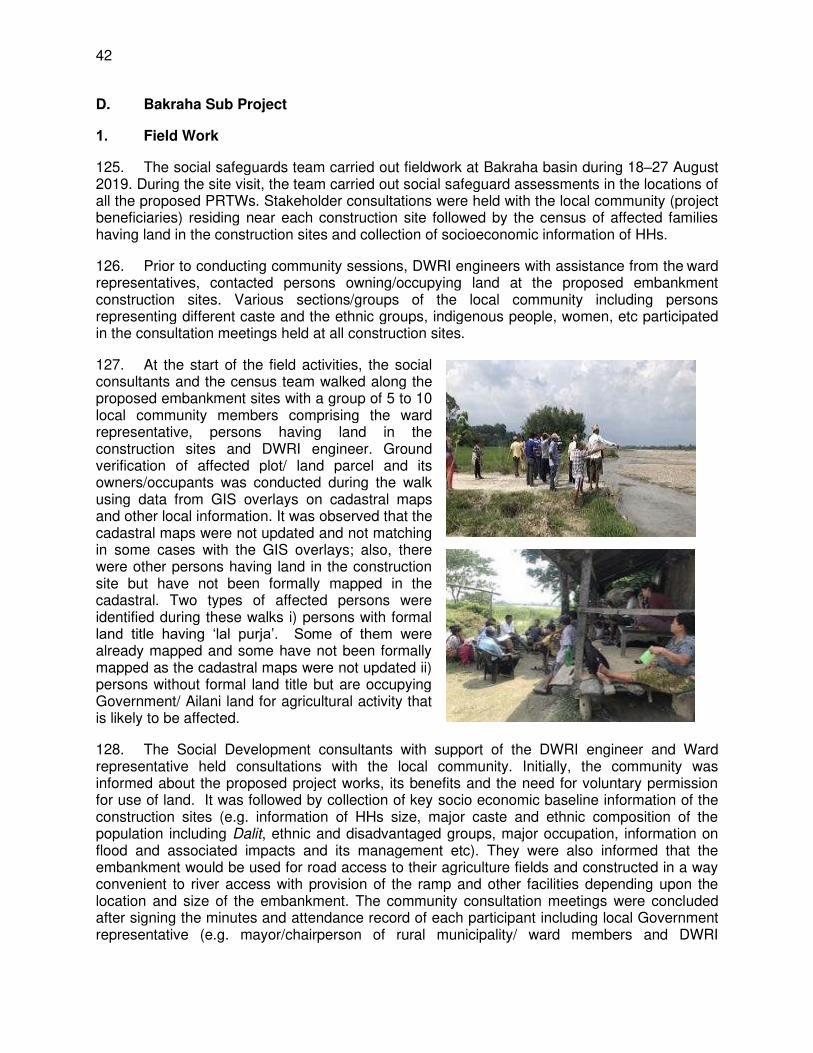
42
D. Bakraha Sub Project
1. Field Work
125. The social safeguards team carried out fieldwork at Bakraha basin during 18–27 August 2019. During the site visit, the team carried out social safeguard assessments in the locations of all the proposed PRTWs. Stakeholder consultations were held with the local community (project beneficiaries) residing near each construction site followed by the census of affected families having land in the construction sites and collection of socioeconomic information of HHs.
126. Prior to conducting community sessions, DWRI engineers with assistance from the ward representatives, contacted persons owning/occupying land at the proposed embankment construction sites. Various sections/groups of the local community including persons representing different caste and the ethnic groups, indigenous people, women, etc participated in the consultation meetings held at all construction sites.
127. At the start of the field activities, the social consultants and the census team walked along the proposed embankment sites with a group of 5 to 10 local community members comprising the ward representative, persons having land in the construction sites and DWRI engineer. Ground verification of affected plot/ land parcel and its owners/occupants was conducted during the walk using data from GIS overlays on cadastral maps and other local information. It was observed that the cadastral maps were not updated and not matching in some cases with the GIS overlays; also, there were other persons having land in the construction site but have not been formally mapped in the cadastral. Two types of affected persons were identified during these walks i) persons with formal land title having ‘lal purja’. Some of them were already mapped and some have not been formally mapped as the cadastral maps were not updated ii) persons without formal land title but are occupying Government/ Ailani land for agricultural activity that is likely to be affected.
128. The Social Development consultants with support of the DWRI engineer and Ward representative held consultations with the local community. Initially, the community was informed about the proposed project works, its benefits and the need for voluntary permission for use of land. It was followed by collection of key socio economic baseline information of the construction sites (e.g. information of HHs size, major caste and ethnic composition of the population including Dalit, ethnic and disadvantaged groups, major occupation, information on flood and associated impacts and its management etc). They were also informed that the embankment would be used for road access to their agriculture fields and constructed in a way convenient to river access with provision of the ramp and other facilities depending upon the location and size of the embankment. The community consultation meetings were concluded after signing the minutes and attendance record of each participant including local Government representative (e.g. mayor/chairperson of rural municipality/ ward members and DWRI

43
engineer). Each signed document was officially attested by the relevant Government organizations in the project district. Among others the minute contained texts in Nepali on willingness to voluntarily donate land use right for the land at the embankment site to the project. The text was read out loudly to the community for their easy understanding.
129. The census team however, could not collect complete information from all the households who have their land in the proposed embankment sites as there were some absentees and some of the land parcels were not matching with the GIS overlay on the cadastral maps that are not updated. In such cases, information regarding land parcels affected and consent for VLUDR at community level was collected with the support of local government representatives and the local community. Appendix- 2 provides a sample English translation of the text read to the community.
130. In total 7 community consultation sessions were organized, one at each PRTW location. Location of the consultation meetings and number of participants in the meetings is presented in Table 47.
Table 47: Community Consultation Meetings and Participants
S.N. Name of Place District Municipality /
Village Palika
PRTW
No
No. of
Participants
1 Kasheni Morang Miklajung-VP-7 01a 19
2 Chisapani, Morang Urlabari Municipality-1 02 a 41
3 Bishal Tile, Juhumra Morang Urlabari-4&5 03 a 23
4 Thapadangi Morang Urlabari Municipality-4 04 20
5 Pipalchowk,Bistadada Morang Sanischare Municipality -3 06 23
6 Bardanga Chauki Tole Morang Sunbarse Municipality-7 08 27
7 Katle Morang Urlabari Municipality-06 09 a 37
Total Number of Participants 190 aPRTW will not be funded under ADB project (after not passing ADB economic threshold)
131. Each consultation session was attended by at least one local government personnel (ward representative) and the field engineer of DWRI. Of the total 187 participants, 161 (86.1%) were men and 124 (13.9%) were women. In terms of IP and Dalit; the representation of IP was 68 persons (36.36%) and 33 persons (18.54%) were Dalits. Table 48 presents summary details of participants in the consultation meetings and Key findings of the community consultation and issues raised are summarized in Appendix 3
Table 48: Participants in Community Consultation
S.N. Participants No. % of Total Involved
Participation by Gender
1 Women 30 15.79 2 Men 160 84.21 3 Total 190 100.00
Participation by Vulnerable and Non vulnerable Groups 1 Dalit 33 17.37 2 Indigenous People 68 35.79 3 Brahmins and Other Caste Groups 89 46.84 4 Total 190 100.00
Source: Community Consultation Record, July-August 2019

44
132. The census team with the help of local representatives and community, listed names of all affected persons covering those having land at the site of the proposed embankment with officially verified land ownership certificates as well as HHs not having verified land ownership certificate including the occupants of Ailani land. The census team collected socioeconomic information along with the details of assets owned by administering a semi-structured questionnaire. A set of the socio-economic questionnaire is presented in Appendix 4.
133. The census team also collected signature of the land owner/occupant on the Memorandum of Understanding (MoU) for voluntary permission of land use right to the project and also got countersigned by representative of local Government and DWRI engineer.
2. Scope of Impact on Land
a. Impact on Private Land
134. The estimated area required for embankment construction in Bakraha basin is 130993.2 sqm15 All together 53 households were recorded to have land at the location of the 8 proposed embankments in the basin. The Memorandum of Understanding was signed between the identified private landowners and the DWRI engineer in the presence of the Ward representative for voluntary donation of land-use rights for construction of the PRTWs. In case of Ailani land owners, their consent for voluntary donation of land-use rights (VDLUR) was obtained through signing of community meeting minutes. Out of these 53 HHs, 23 HHs are private land owners. These 23 affected HHs owning private land are of two types, type 1 having land ownership certificate (Lal purja) matching with the parcel number arrived through GIS overlay on the cadastral, and type 2 private land owners who could not be verified as they were not appearing in the list arrived through GIS overlay. Rest 30 affected HHs were occupants of Ailani land without formal ownership over the land (type 3 affected HHs).
135. Of the 23 affected households having private land 18 households were of type 1 who could be verified with their land ownership certificates. However, all these 23 households were interviewed for collecting socio economic data and MOUs were obtained for voluntary permission of land use right to the project authorities. Table 49 presents the types of affected HHs owning private land in Bakraha basin.
Table 49: Types of Affected HHs Owning Private Land
S.N. Type of Affected Private Land Owners No. of HHs
Type 1 Private Land: Ownership Verified 18 Type 2 Private Land: Ownership but could not be verified 5 Total 23 Source: Census Survey, July-August 2019
136. The affected lands are part of either remaining potions of land parcels after river erosion or land where the river was flowing earlier. Among them, some are being used for cultivation only once in a year at the owner/occupant’s risk as it is uncertain when which part of the land will get affected by change in the flow of the river and some are left as fallow or abandoned for the purpose of protecting the remaining portion of the land parcel away from the river. Based on the information collected during community consultations it was evident that the increasing trend
15 As per estimate of GIS overlay on cadastral maps

45
of floods and river erosion has been threatening the land put to cultivation and the residential areas in the main village habitation since the early seventies due to increased migration, deforestation and encroachment of river side area followed by practice of continuous uncontrolled and unmanaged exploitation of construction materials from the river bed. Therefore, people at all the construction sites of in Bakraha basin expressed strong support for the project and their willingness to voluntary permission of land use right to the project authorities. It was also revealed that the local community had submitted demand to DWRI office for construction of embankments at critical locations. Details of landowners and land parcels owned at the construction site are provided in Appendix-5.
b. Impact on Ailani Land
137. During survey 30 households were identified occupying Ailani land at different embankment sites. Socio economic information as well as information on the area of occupied Ailani land (estimated by the respondent) was collected from all the 30 households.
138. A breakup of these 30 HHs by land ownership type is presented in Table 50. The data shows them to be of two categories: those owning both private and Ailani land, and only Ailani land.
Table 50: Type of Land Owned/Occupied by affected Households
Land Owners Type No. of Owning HHs % Having both private and Ailani land 20 66.67 Ailani land only 10 33.33 Total 30 100.00
Source: Census Survey, July-August, 2019
c. Affected Households by Caste and Ethnicity
139. There are mixed population groups in the project district (Morang). They are; indigenous groups (e.g. Tharu, Rajbansi, Dhimal, Satar, Newar, Magar, Rai, Limbu, etc) and caste groups; (e.g. Brahmin, Chhetries, Giri/Puri/Sanyasi, Yadav, Mandal, and other schedule caste subgroups. The census data presented in Table 51 shows that the proportion of Brahmin Chhetries and others is higher among the affected HHs. Percentage of Ethnic minority/indigenous people among affected HHs is 36.47 percent.
Table 51: Composition of HHs by Caste and Ethnic Groups
Caste and Ethnic Group
HH having Private Land in the project Area and also other places
No %
Ethnic minority/indigenous (Chaudhari, Rana Tharu, Dagaura Tharu)
32 60.4
Brahmin Chhetries and others (1 Bhagat) 17 32.1 Dalit and Disadvantaged 4 7.5
Total 53 100.00 Source: Census Survey, July-August, 2019
d. Impact on Trees

46
140. Table 52 shows that altogether 3 households reported having trees in their land at the proposed embankment sites. Among them, two households have fruit trees while one has a fodder/firewood tree.
Table 52: Households having Trees at the Embankment Sites
S.N. Description Total
No. %
1. Fruit Trees 1 11.1 2. Fodder/ firewood Trees 5 55.6 3 Community Plantation - - 4 Others 3 33.3
Total 9 100 Source: Census Survey, July-August 2019
e. Loss of Income
141. During the transect walk along the proposed PRTW alignment local community members identified the government land available and households who are required to donate land use right for the project. For estimation of income loss by these households, the census team collected information on average annual income of the affected HHs from different sources including farming from all the land owned as well as from the ailani land. Total land requirement for each PRTW was available from the GIS overlay on the old cadastral map. As all the affected HHs were not identified in the GIS overlay, census team first estimated the government land available at each PRTW site with help of the local community and subsequently the gross total non government land (private and ailani) required at each PRTW was estimated leaving out the government land available. This land required at the site was apportioned by the local community among the HHs required to donate land use right according to the total size of the land parcel that is affected. Income loss to the affected HHs is estimated by applying this loss of land to the total land owned by the HH and apportioning the percentage of land loss to the income from farming by the HHs. An estimation of Loss of Income by affected HHs and their vulnerability by category is provided in Appendix 6.
142. No structure or community property resources will be affected due to the project.
3. Socio-economic Information and Profile of Affected Persons
143. The baseline socio economic survey was conducted covering all the 53 affected households. Key findings of the survey are summarized in the section below.
a. Demographic Characteristics
(i) Household and Population
144. The total population of the 53 affected households is 257 with 133 (51.75%) male and 124 (48.25%) females. Average household size works out to 4.84.
(ii) Literacy and Educational Attainments
145. Illiterates (32 nos.) comprised 12.41% of the total population. Among the literates 184 nos. (71.59%) were educated maximum up to high school level. Only 11 nos (4.3%) were

47
educated up to bachelors and above. Table 53 provides details of the level of education among the family members of affected households.
Table 53: Educational Status of the Interviewed Households
S.N. Educational Status Male Female Total
No % No % No %
1 Illiterate 10 7.5 22 17.7 32 12.5
2 Literate 11 8.3 19 15.3 30 11.7
3 Primary 28 21.1 18 14.5 46 17.9
3 Lower Secondary 26 19.5 17 13.7 43 16.7
4 High School 37 27.8 28 22.6 65 25.3
5 10+ 2 14 10.5 16 12.9 30 11.7
6 Bachelor 6 4.5 4 3.2 10 3.9
7 Master and Above 1 0.8 0.0 1 0.4
Total 133 100 124 100 257 100
Source: Census Survey, July-August 2019
(iii) Average Landholding Size
146. The average landholding size of the 53 affected households is 16.9 Kattha (5712.2 sqm). Majority households (19 HHs – 35.84%) have landholding size between 1 to 2 Bigha), followed by 11 HHs (20.75%) each in the category 10 to 20 Kattha and 2 to 5 Bigha, 5 HHs (9.43%) between 5 to 10 Kattha, 4 HHs (7.55%) owning land above 5 Bighas and 3 HHs (5.66%) between 2 to 5 Katthas. Table 54 provides a summary of the landholding sizes of the affected households.
Table 54: Average landholding size of affected HHs
SN Land Holding on Ranges No of HHs Average Landholding Size
Kattha Sqm
1 Less than 1 Kattha - - -
2 1-1.5 Kattha - - - 3 1.5-2 Kattha - - - 4 2- 5 Kattha 3 4.5 1521 5 5-10 Kattha 5 8.3 2805.4 6 10 Kattha-20 Kattha (1 Bigha) 11 16.5 5577 7 1 Bigha to 2 Bigha 19 28.5 9633 8 2 Bigha – 5 Bigha 11 66.6 22510.8 9 > 5 Bigha 4 121.3 40898
Overall 53 16.9 5712.2 Source: Census Survey, July-August 2019
(iv) Major Occupation
147. Agriculture was reported as the major occupation of most households (98 nos-38.1%) followed by overseas employment (7.8%). Business and service each contributed 3.9% of the occupations followed by skilled labor (3.5%), Students comprised 64 nos (24.9%) and 26 nos (10.1%) were housewives. Table 55 presents the occupation wise distribution of the affected HH members.
Table 55: Major Occupation of Affected HHs

48
S.N. Occupations Male Female Total
No % No % No %
1 Agriculture 53 39.8 45 36.3 98 38.1 2 Wage Labour 3 2.3 2 1.6 5 1.9 3 Overseas 17 12.8 3 2.4 20 7.8 4 Business 6 4.5 4 3.2 10 3.9 5 Skilled Labour 8 6.0 1 0.8 9 3.5 6 Service 6 4.5 4 3.2 10 3.9 7 Teaching 1 0.8 1 0.8 2 0.8 8 Student 35 26.3 29 23.4 64 24.9 9 House Wife - 0.0 26 21.0 26 10.1 10 Others 4 3.0 9 7.3 13 5.1
Total 133 100.0 124 100.0 257 100.0 Source: Census Survey, July-August 2019
(v) Ownership of Household Assets/Amenities
148. All the total interviewed households 53 (100%) have their own houses for residential purposes. Ownership of bicycle, fan/cooler, and cell/mobile among the 53 HHs was 77.4%, 84.9%, and 96.2% respectively. About 24.5% households owned motor bike/scooter while 79.2% households have television in the house. Table 56 presents ownership of household amenities by the affected HHs.
Table 56: Major Assets/Amenities Owned by the Affected Households
S.N. Type of HH Amenities Total
No. %
1. Own Residential House 53 100.0 2. Bicycle 41 77.4 3. Motorbike/scooter 13 24.5 4. Motor Car 0.0 5. Jeep/van/Truck/Tractor 4 7.5 6. Tempo 0.0 7. TV 42 79.2 8. Invertors 6 11.3 9. Solar Panel 10 18.9 10. Drinking-Water Tank 3 5.7 11. Fan/cooler 45 84.9 12. Cell/Mobile 51 96.2 13. House on rent 1 1.9 14. Other assets gave on rent (e.g. land, transport etc) 15. Have land in other places 10 18.9
Source: Census Survey, July-August 2019
(vi) Households Income and Expenditure
149. Foreign remittance, wage earnings, farming, service and business are the major sources of household income. Average annual income from all sources works out to NPR 310471. Income from foreign remittance contributes 24.55 percentage of the average annual income followed by farming (20.61%), wage earnings (20.52%), service (15.71%) and business (7.4%). Table 57 provides source wise average share the annual household income.

49
Table 57: Average Annual Income of the Interviewed Households
S.N. Sources of Income Average Annual Income
Income (NPR) Percentage
1 Farming 63981 20.61 2 Service 48774 15.71 3 Business/Small Industry 22981 7.40 4 Wage earnings 63698 20.52 5 Foreign Remittance 76226 24.55 6 Interest - - 7 Rent received by renting house/ land etc - - 8 Sell of animal 25792 8.31 9 Sell of Milk - - 10 Social Security Allowance 9019 2.90
Overall HH Income 310471 100.0
Source: Census Survey, July 2019
150. The average annual expenses of the households are NPR 222,392 which is less than the average annual household income (310471) with an average surplus of NPR. 88079. Major heads of expenses are food items (39.51%) followed by celebrating festivals (12.81%), education (12.41%), clothing (9.9%), and health care (6.82%). Table 58 provides breakdown of the average annual expenditures of the interviewed households.
Table 58: Average Annual Expenditure for the Interviewed HHs
S.N. Expenditure Items Average Annual Expenditure NPR
Expenditure (NPR) Percentage
1 Food 87886 39.51
2 Education 27604 12.41 3 Health Care 15189 6.82 4 House Repair 13019 5.84 5 Clothing 22038 9.90 6 Festivals 28490 12.81 7 Sending family member abroad 14717 6.61 8 Loan/Interest Repayment 13449 6.04 9 Other Specify 0 -
Overall HH Expenditure 222,392 100.00 Source: Census Survey, July-August 2019
b. Vulnerable Households
151. ADB guidelines considers; Indigenous People (IP), Dalit (including schedule caste) people, households headed by senior members, single women headed households, households with physically handicapped person, and Below Poverty Level (BPL) HHs as vulnerable. Similarly, these catagories of households have also been classified under constitution of Nepal. In Nepal, the standard method of calculating BPL has been determined by Central Bureau of Statistics (CBS) under the National Planning Commission (NPC). As per NPC/CBS16 2011an individual in Nepal is considered poor if his/her per-capita total annual consumption is below NPR 19,261. None of the HHs interviewed fall Below Poverty Line (BPL).
16 National Planning Commission/Central Bureau of Statistics

50
152. Table 59 presents distribution of affected HHs by vulnerability types.
Table 59: HHs by Vulnerability Type
S.N. Vulnerability Type No. of HH %
1 Below Poverty Households 0 0.00
2 IP Households 32 52.46
3 Dalit Households 4 6.56
4 HHs headed by senior citizens (>65 Years old) 13 21.31
5 Women Headed Households 7 11.48
6 Households with disable persons 5 8.20
7 Total Vulnerable HHs (out of 170 interviewed HHs) 61 100.00
Source: Census Survey, July-August, 2019
Source: Household Survey of Affected HHs, Jul-Sep, 2019
c. Indigenous People and Project Impact:
153. Tharu/Chaudhari, Rajbansi, Rai, Limbu, Magar, Dhimal, Newar, etc have been defined as indigenous group according to the Nepal Federation of Indigenous Nationality17
. The social safeguard team had detailed discussion with ethnic households belonging to these communities and it revealed that they have been following the same socio-economic practices that are followed by other local community members. No involuntary physical or economic displacement is anticipated as the proposed project will be constructed in the existing “buffer” zone between the cultivated areas and the riverbank that is used by the local community to access the agricultural fields including the affected land. The project will not affect traditional lands. Furthermore, the project is unlikely to impact indigenous peoples’ identity, dignity, human rights, livelihood systems, or cultural uniqueness. The project will protect their land from erosion by recurring floods and positively contribute to improve their economic condition
4. Gender Impacts and Mitigation Measures
154. Among the affected HHs due to the project twelve female-headed households have been identified to have their land in the construction sites. Discussions carried out with the affected families and local communities showed concerns relating to gender inclusiveness in the project design and mitigation of adverse impacts especially to women. The concerns specifically related to access to river and use of natural resources (river water), extracting materials from the river (e.g. boulders, sand etc) embankment safety, employment opportunity during construction and post-construction phases
155. The project is categorized as ‘Effective Gender Mainstreaming’ and a Gender and Social Inclusion (GESI) Plan has been prepared for the project. The DWRI will be responsible for overseeing the timely and appropriate implementation of the GESI and any other technical assistance or grant-related funds/activities that may be mobilized for the project to optimize social and gender benefits. All consultative and participatory processes will be followed socially
17 http://www.nefin.org.np/list/Categorization-of-Indigenous-People-based-on-development-/5/95/6.

51
and gender inclusively, ensuring timely disclosure of information, and providing a platform for open, fair and transparent dialogue and communication.

52
E. Lakhandei Sub Project
1. Field Works
156. The social safeguard team visited the Lakhandehi basin starting 7th September 2019 for the field works. During the site visit, the team carried out social safeguard assessments in the locations of all the 12 PRTWs. Stakeholder consultations were held with the local community (project beneficiaries) residing near each construction site followed by the census of affected families having land in the construction sites and collection of socioeconomic information of HHs.
157. Prior to conducting community sessions, DWRI engineers with assistance from the ward representatives, contacted persons owning/occupying land at the proposed embankment construction sites. Various sections/groups of the local community including persons representing different caste and the ethnic groups, indigenous people, women, etc participated in the consultation meetings held at all construction sites.
158. At the start of the field activities, the social consultants and the census team walked along the proposed embankment with a group of 5 to 10 local community members comprising the ward representative, persons having land in the construction sites and DWRI engineer. Ground verification of affected plot/ land parcel and its owners/occupants was conducted during the walk using data from GIS overlays on cadastral maps and other local information. It was observed that the cadastral maps were not updated and not matching in some cases with the GIS overlays; also, there were other persons having land in the construction site but have not been formally mapped in the cadastral. Two types of affected persons were identified during these walks i) persons with formal land title having ‘lal purja’. Some of them were already mapped and some have not been formally mapped as the cadastral maps were not updated ii) persons without formal land title but are occupying Government/ Ailani land for agricultural activity that is likely to be affected.
159. The Social Development consultants with support of the DWRI engineer and Ward representative held consultations with the local community. Initially, the community was informed about the proposed project works, its benefits and the need for voluntary permission for use of land. It was followed by collection of key socio economic baseline information of the construction sites (e.g. information of HHs size, major caste and ethnic composition of the population including Dalit, ethnic and disadvantaged groups, major occupation, information on flood and associated impacts and its management etc). They were also informed that the embankment would be used for road access to their agriculture fields and constructed in a way convenient to river access with provision of the ramp and other facilities depending upon the

53
location and size of the embankment. The community consultation meetings were concluded after signing the minutes and attendance record of each participant including local Government representative (e.g. mayor/chairperson of rural municipality/ ward members and DWRI engineer). Each signed document was officially attested by the relevant Government organizations in the project district. Among others the minute contained texts in Nepali on willingness to voluntarily donate land use right for the land at the embankment site to the project. The text was read out loudly to the community for their easy understanding.
160. The census team however, could not collect complete information from all the households likely to have their private lands in the proposed embankment sites as there were some absentees and some of the land parcels were not matching with the GIS overlay on the cadastral maps that are not updated. In such cases, information regarding land parcels affected and consent for VDLUR at community level was collected with the support of local government representatives and the local community. Appendix- 2 provides a sample English translation of the text read to the community.
161. In total 2 community consultation sessions were organized, one at each proposed PRTW sites. Location of the consultation meetings and number of participants in the meetings is presented in Table 3.
Table 60: Community Consultation Meetings and Participants
S.N. Name of Place District Municipality /Village Palika PRTW
No
No. of
Participants
1 Kachhadiya Tole Sarlahi Haripur Municipality-8&2 8 36
2 Jiyajor Sarlahi Lalbandi Municipality-11,12,13 1 74
Total Number of Participants 110
Source: Community Consultation Record, September 2019
162. Each consultation session was attended by at least one local government personnel (ward representative) and the field engineer of DWRI. Of the total participants in the community consultation; 34 (31%) were women and 76 (69%) were men. Representation of IP was 87 persons (79%) whereas in case of dalits it was 11 persons (10%). Table 4 presents summary details of participants in the consultation meetings and Key findings of the community consultation and issues raised are summarized in Appendix 3.
Table 61: Summary of Participants in Community Consultations
S.N. Participants No. % of Total Participants
Participation by Gender
1 Women 34 31 2 Men 76 69 3 Total 110 100.00
Participation by Vulnerable and Non-vulnerable Groups
1 Dalit, Madhesi and Muslim 11 10 2 Indigenous People 87 79 3 Brahmins and Chhetri 12 11 4 Total 110 100.00
Source: Community Consultation Record, September 2019

54
163. The census team with the help of local representatives and community listed names of all affected persons covering those having land at the site of the proposed embankment with officially verified land ownership certificates as well as HHs not having verified land ownership certificate including the occupants of Ailani land. The census team collected socioeconomic information along with the details of assets owned by administering a semi-structured questionnaire. A set of the socio-economic questionnaire is presented in Appendix 4.
164. The census team also collected signature of the landowner/ailani land occupant on the Memorandum of Understanding (MoU) for voluntary permission of land use right to the project and also got countersigned by representative of local Government and DWRI engineer.
2. Scope of Impact on Land
a. Impact on Private and Ailani Land
165. The estimated area required for embankment construction in Lakhandehi basin is 1312.55 sqm18. All together 51 households reported to have land in the proposed two embankment sites in the basin. Out of these 51 HHs, 6 HHs are private landowners, 8 are owners of both private and ailani Land and the rest 37 HHs have only ailani land.
166. Out of the 14 households reporting to have private land in the proposed construction area, none could be verified as their land ownership certificate did not match with old plot numbers in the cadastral obtained through GIS overlay. Among these 14 HHs 6 (11.8%) have only private land and rest 8 HHs reportedly owned both private and Ailani land. Out of the total 51 HHs, Ailani land of 37 HHs will be affected.
167. The affected lands are part of either remaining potions of land parcels after river erosion or land where the river was flowing earlier. Among them, some are being used for cultivation only once in a year at the owner/occupant’s risk as it is uncertain when which part of the land will get affected by change in the flow of the river and some are left as fallow or abandoned for the purpose of protecting the remaining portion of the land parcel away from the river. Based on the information collected during community consultations it was evident that the increasing trend of floods and river erosion has been threatening the land put to cultivation and the residential areas in the main village habitation since the early seventies due to increased migration, deforestation and encroachment of river side area followed by practice of continuous uncontrolled and unmanaged exploitation of construction materials from the river bed. Therefore, people at all the construction sites of in Lakhandehi basin expressed strong support for the project and their willingness to voluntary permission of land use right to the project authorities. Details of landowners and land parcels owned at the construction site are provided in Appendix-5.
b. Land owning/Occupying Households by Caste and Ethnicity
168. There mixed population groups in the project district Sarlahi under the Lakhadehi basin. They are; indigenous groups (e.g. Chaudhari, Kachhadiya, Tamang, Majhi, Newar, Magar, and Rai, etc) and caste groups; (e.g. Brahmin, Chhetries, Giri/Puri/Sanyasi, and other Dalit/Disadvantage caste subgroups like; Danuwar. The census data presented in Table 5 shows that indigenous people comprise 70% of the HHs having their land at the embankment construction sites.
18 As per estimate of GIS overlay on cadastral maps

55
Table 62: Composition HHs by Cast and Ethnic Groups
Caste and Ethnic Group
HH having their Land at the Embankment Construction Sites
No % HHs having Private Land in Construction Sites
Ethnic minority/indigenous (Danuwar, Cahudhari, Tamang, Majhi, and Newar ,
44 86.3
Brahmin Chhetries and others 5 9.8 Dalit and Disadvantaged 2 3.9
Total 51 100.00 Source: Census Survey, September 2019
c. Impact on Tree
169. Table 6 shows that only 1 out of the 51 HHs interviewed reported trees in his land in the Proposed PRTW sites.
Table 63: Households having Trees in the Proposed PRTW Sites
S.N. Description HHs
No. %
1. Fruit Trees
2. Fodder/ firewood Trees 1 100
3 Community Plantation - -
4 Community Plantation - -
5. Others - -
Total 1 100
Source: Census Survey, September 2019
3. Loss of Income
170. During the transect walk along the proposed PRTW alignment local community members identified the government land available and households who are required to donate land use right for the project. For estimation of income loss by these households, the census team collected information on average annual income of the affected HHs from different sources including farming from all the land owned as well as from the ailani land. Total land requirement for each PRTW was available from the GIS overlay on the old cadastral map. As all the affected HHs were not identified in the GIS overlay, census team first estimated the government land available at each PRTW site with help of the local community and subsequently the gross total non-government land (private and ailani) required at each PRTW was estimated leaving out the government land available. This land required at the site was apportioned by the local community among the HHs required to donate land use right according to the total size of the land parcel that is affected. Income loss to the affected HHs is estimated by applying this loss of land to the total land owned by the HH and apportioning the percentage of land loss to the income from farming by the HHs. An estimation of Loss of Income by affected HHs and their vulnerability by category is provided in Appendix 6
171. No structure or community property resources will be affected due to the project.

56
4. Socio-economic Information and Profile of Affected Persons
172. The baseline socio economic survey was conducted covering all the 51 households having their land (both private and alani) at the proposed embankment sites. Key findings of the survey are summarized in the section below.
a. Demographic Characteristics
(i) Household and Population
173. The total population of the 51 interviewed households is 308 with 162 male (52.6%) and 146 females (47.4%). Average household size works out to 6.03.
(ii) Literacy and Educational Attainments
174. Illiterates (55 nos.) comprised 17.9% of the total population. Among the literates 190 nos. (61.69%) were educated maximum up to high school level. Only 6 nos (1.6%) were educated up to bachelors and above. Table 7 provides details of the level of education among the family members of the HHs donating for the project.
Table 64: Educational Status of the Interviewed Households
S.N. Educational
Status
Male Female Total
No % No % No %
1 Illiterate 21 13.0 34 23.3 55 17.9
2 Literate 10 6.2 20 13.7 30 9.7
3 Primary 32 19.8 25 17.1 57 18.5
3 Lower Secondary 34 21.0 16 11.0 50 16.2
4 High School 29 17.9 24 16.4 53 17.2
5 10+ 2 28 17.3 20 13.7 48 15.6
6 Bachelor 7 4.3 6 4.1 13 4.2
7 Master and Above 1 0.6 1 0.7 2 0.6
Total 162 100.0 146 100.0 308 100.0 Source: Census Survey, September 2019
(iii) Average Landholding Size
175. The average landholding size of the 51 interviewed households is 25.7 Kattha (8686.6sqm). Majority households (14 HHs – 27.45%) had landholding size between 10 to 20 Kattha (4664.4 sqm), followed by 13 HHs (25.49%) owning land between 1 to 2 bigha (8957.0). Table 8 provides summary of the landholding sizes.

57
Table 65: Average landholding size of HHs at Construction Sites
SN Land Holding on Ranges Households No.
Average Landholding Size
Kattha Sqm
1 Less than 1 Kattha Nil - - 2 1-1.5 Kattha Nil - - 3 1.5-2 Kattha Nil - - 4 2- 5 Kattha 6 3.4 1149.2 5 5-10 Kattha 9 7.3 2467.4 6 10 Kattha-20 Kattha (1 Bigha) 14 13.8 4664.40 7 1 Bigha to 2 Bigha 13 26.5 8957.0 8 2 Bigha – 5 Bigha 7 54.0 18252.0 9 >5 Bigha 2 155.0 52390.0 Overall 51 25.7 8686,6
Source: Census Survey, September 2019
(iv) Major Occupation
176. Agriculture was reported as the major occupation of most households (131 nos- 42.5%) followed by service (7.5%), skilled labor (6.5%), and business (4.2%). Students comprised 83 nos (26.9%) and 13 nos (4.2%) were housewives. Table 9 presents the occupation wise distribution of affected HH members.
Table 66: Major Occupation of Affected HHs
S.N. Occupations Male Female Total
No % No % No % 1 Agriculture 51 31.5 80 54..8 131 42.5
2 Wage Labour 5 3.1 1 0.7 6 1.9
3 Overseas 11 6.8 1 0.7 12 3.9
4 Business 10 6.2 3 2.1 13 4.2
5 Skilled Labour 20 12.3 0 0.0 20 6.5
6 Service 17 10.5 6 4.1 23 7.5
7 Teaching 0 0.0 0.0 0 0.0
8 Student 43 26.5 40 27.4 83 26.9
9 Housewife 0.0 13 8..9 13 4.2
10 Others 5 3.1 2 1.4 7 2.3
Total 162 100.0 146 100.0 308 100.0
Source: Census Survey, September 2019
(v) Ownership of Household Assets/Amenities
177. All the affected households have their own houses for residential purpose. Ownership of bicycle, fan/cooler, and cell/mobile among the 51 HHs was 78.4%, 86.3%, and 96.1% respectively. About 43% households owned motor bike/scooter while approximately 69% households have television in the house. Table 10 presents ownership of household amenities by the affected HHs.

58
Table 67: Major Assets/Amenities Owned by the Affected Households
S.N. Type of HH Amenities Total
No. % 1. Own Residential House 51 100 2. Bicycle 40 78.4 3. Motorbike/scooter 22 43.1 4. Motor Car 0 0.0 5. Jeep/van/Truck/Tractor 2 3.9 6. Tempo (three-wheeler vehicle) 2 3.9 7. TV 35 68.6 8. Invertors 3 5..9 9. Solar Panel 24 47.1 10. Drinking-Water Tank 4 7.8 11. Fan/cooler 44 86.3 12. Cell/Mobile 49 96.1 13. House on rent 2 3.9 14. Other assets gave on
rent (e.g. land, transport, etc) - -
15. Have land in other places 5 9.8 Source: Census Survey, September 2019
(vi) Household Income and Expenditure
178. The average annual income of the affected household is NPR 291430.00. Main sources of income are farming (20.43%), service (22.64%), wage labour (25.48%) and remittance (36.63%). Table 11 provides source wise average annual household income.
Table 68: Average Annual Income of the Affected Households
S.N. Major Sources of Income Average Annual Income (NPR)
1 Farming 59549.00 20.43
2 Service 65980.00 22.64
3 Business/small business 28804.00 9.88
4 Wage 74274.00 25.48
5 Remittances 36255.000 36.63
6 Interest - -
7 Rental of house, land, vehicle, etc - -
8 Sell of animal 24411.00 8.37
9 Other Sources 00.00 3.40
10 Social Security Allowance 2157.00 0.74
Overall HH Income 291430.00 100 Source: Census Survey, September 2019
179. The average annual expenses of the households are NPR 190020.00. Major heads of expenses are food items (36.45%) followed by celebrating festivals (20.02%), education (15.81%), clothing (14.69%), and health care (9.01%). Table 12 provides breakdown of the average annual expenditures of the interviewed households. The average households annual

59
expenditure (NPR. 190020.00) is NPR 101, 410.00 less, than the average annual income (NPR. 291430.00).
Table 69: Average Annual Expenditure for the Interviewed HHs
S.N. Expenditure Items Average Annual Expenditure NPR
Expenditure (NPR) Percentage
1 Food 69,275.00 36.45
2 Education 30,060.00 15.81
3 Health Care 17,137.00 9.01
4 House Repair 0.00 0.00
5 Clothing 27922.00 14.69
6 Festivals 38,058.00 20.02
7 Sending family member abroad 0.00 0.00
8 Loan/Interest Repayment 7,568.00 3.98
9 Other Specify - -
Overall HH Expenditure 190,020.00 100.00 Source: Census Survey, September 2019
b. Vulnerable Households
180. ADB guidelines considers; Indigenous People (IP), Dalit (including schedule caste) people, households headed by senior members, single women headed households, households with physically handicapped person, and Below Poverty Level (BPL) HHs as vulnerable. Similarly, these catagories of households have also been classified under constitution of Nepal. In Nepal, the standard method of calculating BPL has been determined by Central Bureau of Statistics (CBS) under the National Planning Commission (NPC). As per NPC/CBS19 2011an individual in Nepal is considered poor if his/her per-capita total annual consumption is below NPR 19,261. As per the findings of the socio-economic survey, none of the 51 HHs interviewed fall Below Poverty Line (BPL). Table 13 presents distribution of affected HHs by vulnerability types.
Table 70: HHs by Vulnerability Type
S.N. Vulnerability Type No. of HH %
1 Below Poverty Line Households 0 0.00 2 IP Households 44 86.27 3 Dalit Households 2 3.92 4 HHs headed by senior citizens (>65 Years old) 9 17.65 5 Women Headed Households 5 9.80 6 Households with disable persons 2 3.92 7 Households having more than one Vulnerability -22 -43.14
8 Total Vulnerable HHs (out of 51 interviewed HHs) 51 78.43
Source: Census Survey, September 2019
19 National Planning Commission/Central Bureau of Statistics

60
c. Indigenous People and Project Impact:
181. Chaudhari/Tharu, Rajbansi, Rai, Limbu, Magar, Dhimal, Newar, etc are the mixed groups of people found in the river basin. Tharu/Chaudhari has been defined as indigenous group according to the Nepal Federation of Indigenous Nationality20
. The social safeguard team had detailed discussion with ethnic households belonging to Chaudhari/Tharu, Rajbansi, Rai, Limbu, Magar, Dhimal, and Newar community and it revealed that they have been following the same socio-economic practices that are followed by other local community members. No involuntary physical or economic displacement is anticipated as the proposed project will be constructed in the existing “buffer” zone between the cultivated areas and the river bank that is used by the local community to access the agricultural fields including the affected land. The project will not affect traditional lands. Furthermore, the project is unlikely to impact indigenous peoples’ identity, dignity, human rights, livelihood systems, or cultural uniqueness. The project will protect their land from erosion by recurring floods and positively contribute to improve their economic condition.
20 http://www.nefin.org.np/list/Categorization-of-Indigenous-People-based-on-development-/5/95/6.

61
V. Grievance Redress Mechanism
182. A grievance redress mechanism has been proposed for the project. This grievance redress mechanism will have three levels: VDC Level, District/PIU level and PMU level. Simple and easily manageable grievances will be addressed at the VDC level and more complex grievances will be addressed at the District/PIU level. Grievances that could not be resolved at the VDC and PIU level will be referred to the PMU located at the project headquarters at Kathmandu. Further details have been provided in the Project Administration Manual.
183. The key functions of the GRCs are to (i) provide support for APs to lodge their complaints; (i) record the complaints, categories and prioritize them; (iii) settle the grievances in consultation with APs and project officials; (v) report to the aggrieved parties about the decision/solution; and (vi) forward the unresolved cases to higher authorities

62
VI. Voluntary Land Use Donation/Permission for land use
184. As per the SPS 2009, voluntary land donation should be limited to less than 10% of the total landholding. During the community consultations it emerged that some of the affected HHs will be losing more than 10% of their landholding. It was observed that the community has been suffering due to the loss of land and crops every year caused by recurring floods and river erosion. Local people are desperate to have the embankments built to save their existing assets located nearby the embankments.
185. It has been envisaged that the project will not seek voluntary land donation (title transfer) but only voluntary land use donation. The land will stay in the name of the private land owner so that in future when the river course changes, private land owners can re-gain access to their land and will not have the title cut in half from donation of a land strip to the project.
186. The transect walk along the embankment alignments and community consultations revealed that some affected landowners are very poor and were provided small land lots in the flood plain as part of the governments land for land less scheme. These people stand to lose a percentage of their livelihood source which could make them poorer. Providing cash compensation to people in these areas will cause complications due to jealousy and will also create a legacy for future embankment projects (both bank funded, and non-bank funded).
187. In view of the urgent requirement and community’s eagerness for the project, meaningful criteria for voluntary donation here is not the percentage of land (use) loss, but the extent of (i) income loss and (ii) household vulnerability. The project risk is to people, who depended on income from the affected land plots, and particularly, people who have limited or no other livelihood source.
188. For the affected households, the project has an economic assistance programme integrated with the project construction and maintenance viz. ensuring that these people especially the vulnerable ones get employment as unskilled labor in the project during the construction, setting up nurseries to be maintained by them to supply plants to minimize river erosion through bio engineering measures etc.
189. The project also envisages to train and organized embankment neighbors having their land in the area, for the sustainability of embankment and effective/productive utilization of land along the embankment corridor. DWRI will examine options to facilitate the local community on forming maintenance groups, get training associated to embankment protection and utilization of land along the embankment side and, help to coordinate with relevant agencies at the district levels. There could be several options to implement the program during construction and post-construction phase (i) either under the regular program of DWRI or in collaboration with relevant district level relevant stakeholder agencies (e.g. district agricultural office, forest office, etc) or with the assistance of interested external sources. Some of the potential activities that can be carried out under such program may also include; (i) formation of embankment location and length specific Embankment Maintenance Groups, (ii) Train local people on regular maintenance of embankments, commercial utilization of the land along the corridor of embankment through agro-farming, agro-forestry, desert cultivation (watermelon, sugarcane, peanuts, pumpkins, ladies fingers, gourds) fish farming, etc for income generation.
190. Before the construction phase, final design drawings will require review as the river is likely to have moved and design modifications may be required. After the final verification, information of persons contributing their land to be recorded officially in the GIS database and linked to the project assistance program for the APs. Eligibility criteria for voluntary donation is available in the Project Administration Manual.

63
Proposed Procedure for Volunatary land donation or negotiated settlement
191. The project will satisfy land use requirements through a combination of government land, negotiated settlement and voluntary land contributions from direct project beneficiaries. The following paragraphs outline the project’s procedures for undertaking negotiated land settlements and or voluntary land or land use donations in a transparent, consistent, and equitable manner so that people entering into agreements maintain the same or better income and livelihood status. Details are found in the Project Administration Manual (PAM).21
192. Procedure for voluntary land or land use donation. Land for embankment construction will be contributed on a voluntarily basis by eligible project beneficiaries. Landowners and users are deemed eligible to contribute land or land use to the project when: (i) the donation is verified as voluntary and not resulting from coercion or force,22 (ii) the donation is verified to not negatively impact or impoverished the land owner or user,23 (iii) the project benefit will realistically offset the affected party’s land or land use donation, (iv) the donation is verified in verbal and written records as confirmed and witnessed by an independent third party.24 Recognizing that landowners and users living in flood affected areas are majority poor and marginalized, the project will provide livelihoods enhancement training for all landowners and users that contributed to the project.25 Private land owners will choose to transfer the contributed land title deed to the government or maintain the land title deed in their own name; whichever option is deemed preferable in the landowner interest.26 All land and land user contributions must be verified by the field office Social Development Officers in collaboration with local representatives (ward members) before land is provided by PMU to the contractors. The PMU will ensure that all voluntary land and land use donations are documented, overseen by an independent third party and reported within the project’s semi-annual Social Safeguards Monitoring Reports.
193. Procedure for negotiated settlement. Where landowners or users are ineligible or do not wish to donate land, the project has the option to enter into a negotiated settlement. Compensation for the negotiated settlement will be provided in the form of replacement of assets (land for land) or cash compensation. Embankment user associations will be formed with the ward representative to identify cases and appropriate compensation provisions. As per ADB SPS 2009, negotiated settlement is achieved by providing fair and appropriate compensation and other incentives to the willing seller, negotiated through meaningful and well documented consultations. To the extent negotiation is based on the concept of willing buyer and willing
21 PAM (accessible from the list of linked documents in RRP Appendix 2). 22 Including from other community members, government authorities or any other party. 23 Donations resulting in a loss of more than 10% of the household annual income OR a loss of more than 10% of
the household total land holding cannot be contributed on a voluntary basis to the project, irrespective of the affected party’s willingness to do so. Furthermore, no structures including residential, business, animal or food storage can be donated to the project on a voluntary basis.
24 An independent third party is a designated nongovernmental organization, government or legal authority who does not serve to benefit from the Project and is impartial to the donation outcome.
25 The Social Safeguard Focal will be responsible for overseeing the design, preparation and implementation of the livelihood’s enhancement for eligible households. A budget has been assigned to the activities; a time-bound work plan will be submitted to ADB following the verification of land use arrangements.
26 Landowners will not be obliged to transfer their land title deeds to the government as the river course will change in time and the landowner may be able to reclaim their land. As per the Memorandum of Understanding, landowners will only be able to access the donated land once the embankment is no longer functional. The expected life of the embankment is 25 years.

64
seller, negotiated settlement is voluntary (para 67). If negotiations fail, the project must avoid the affected asset by changing the project design. The project management will ensure that negotiated settlements are documented, overseen by an independent third party and reported within the project’s semi-annual Social Safeguards Monitoring Reports.
VII. Gender Impacts and Mitigation Measures
194. Discussions carried out with the affected families and local communities showed concerns relating to gender inclusiveness in the project design and mitigation of adverse impacts especially to women.27 The concerns specifically related to access to river and use of natural resources (river water), extracting materials from the river (e.g. boulders, sand etc) embankment safety, employment opportunity during construction and post-construction phases.
195. The project is categorized as Effective Gender Mainstreaming’ and a Gender and Social Inclusion (GESI) Plan has been prepared for the project. The DWRI will be responsible for overseeing the timely and appropriate implementation of the GESI and any other technical assistance or grant-related funds/activities that may be mobilized for the project to optimize social and gender benefits. All consultative and participatory processes will be followed socially and gender inclusively, ensuring timely disclosure of information, and providing a platform for open, fair and transparent dialogue and communication.
27 Among the affected HHs due to the project female-headed households have been identified to have their land in
the construction sites – Mawa Ratuwa – 12 HHs; West Rapti 3 HHs, Bakraha – 12, Lakhandei – 3 HHs

65
VIII. Indigenous People and Project Impact:
196. Tharu/Chaudhari, Tamang, Newar, Rajbansi, Rana Tharu, has been defined as indigenous group according to the Nepal Federation of Indigenous Nationality28
. The social safeguard team had detailed discussion with ethnic households belonging to Chaudhari/Tharu and other indigenous community and it revealed that they do not have differentiated impacts or expectations of the project compared to other local community members. No involuntary physical or economic displacement is anticipated as the proposed project will be constructed in the existing “buffer” zone between the cultivated areas and the riverbank that is used by the local community to access the agricultural fields including the affected land. The project will not affect traditional lands. Furthermore, the project is unlikely to impact indigenous peoples’ identity, dignity, human rights, livelihood systems, or cultural uniqueness. The project will protect their land from erosion by recurring floods and positively contribute to improve their economic condition. The anticipated positive impact to indigenous people’s livelihoods has triggered the project as a category B for IP.
197. ADB’s SPS 2009 indigenous people safeguard seeks to ensure that indigenous peoples (i) receive culturally appropriate social and economic benefits, (ii) do not suffer adverse impacts as a result of projects, and (iii) can participate actively in projects that affect them. As per ADB’s SPS 2009, the project in not required to produce a separate indigenous people plan when the majority of direct project beneficiaries are indigenous peoples and only positive impacts are identified.29 The project meets these criteria and as such, the indigenous people plan elements have been integrated throughout the project design. The following paragraphs describe how the project has ensuring meaningful and ongoing consultations with indigenous people and culturally appropriate benefit sharing mechanisms
28 http://www.nefin.org.np/list/Categorization-of-Indigenous-People-based-on-development-/5/95/6. 29 ADB. 2009. Safeguards Policy Statement. Manila. See Appendix 3, Safeguards Requirements 3: Indigenous
Peoples, para. 17.
66
IX. Social Due Diligence Conclusions
198. The Mohana-Khutiya and the Mawa Ratuwa sub projects were screened for involuntary resettlement and indigenous peoples impacts based on the detailed design. The Lakhandehi, West Rapti and Bakraha subprojects were screened for involuntary resettlement impacts and indigenous peoples impacts based on the feasibility design.
199. The objective of the screening exercise was to determine the impacts and appropriate mitigation measures to avoid or reduce adverse impacts to local people and increase the benefits.
200. No physical displacement will occur as the proposed project will be constructed in the existing “buffer” zone or abandoned land between the agriculture fields and the riverbank or on the land given for user right to the DWRI. The social safeguard team noted that the proposed project is unlikely to trigger involuntary resettlement (IR) safeguards and would be category ‘C’ as per the SPS 2009. The project is also unlikely to impact indigenous peoples’ identity, dignity, human rights, livelihood systems, or cultural uniqueness. On the other hand, it will protect their land from erosion by recurring floods and positively contribute to improve their economic condition. Thus, the project would be category ‘B’ as per the SPS 2009 for impact on indigenous people.
201. Following are some of the key findings of the field surveys: (i) Each year land is eroding into the river system therefore landowners are losing
their land and no compensation is provided from the government. (ii) Once the embankments are built, landowners (and non-title holders or ‘Alaini’
land users) will directly benefit by gaining all year-round access to the remaining portion of land. Land value would likely increase, and people can potentially plant crops in the monsoon season as well.
(iii) No physical displacement will occur. (iv) No structures are located on the land earmarked for embankment construction
and this is because of the recurrent annual flooding. (v) Local people are desperate to have the embankments built to save their existing
assets located nearby the embankments.
202. During the field surveys and consultations with local community the social safeguard team held focus group discussions with communities along all proposed embankments and available landowners and non-title holders using embankment land. All affected households have agreed to donate land for construction of the embankment and signed MoUs in presence of local Government representative and DWRI engineer.
203. A four-tier grievance redress mechanism will be in place for addressing any grievance that may arise. Land use agreements (MoUs) will be verified by the DWRI PMU/PIU ahead of construction.

67
APPENDICES

68 Appendix 1
Appendix-1: Participants of the Orientation Workshop

Appendix 1 69

70 Appendix 1
Appendix-2: Sample Meeting Minute of Social Consultation (Translation from Nepali)
This minute has been signed today on the date of 08-04-2076 (........) at Arjun Tole of Godawari Municipality in Kailali district, after a social consultation chaired by Mr. Lahanu Chaudhari, Chairperson of the Ward regarding construction of an embankment along the Mohana-Khutiya basin at Arjun Tole under the Nepal Priority River Basin Flood Risk Management Project to be implemented by Department of Water Resources and Irrigation (DWRI). The meeting was also participated by the Government engineer representing DWRI. All the participants in the social consultation meeting have been found happy after knowing about an embankment construction in this section along the basin. Construction of the proposed embankment will ensure the protection of life and properties in this area from the likely inundation including loss of life and properties due to floods. On the other hand, this will also let the local people get freely involved in the cultivating activities being free from the fear of floods and associated problems protecting from the likely floods and other water-induced disasters. The construction works of embankments and other structures will be carried out mainly at the bank of river focusing on river way or Ailani land. However, private lands may also be required at several locations for embankment construction. Nevertheless, such land will be limited only up to the extent required to construct embankment and associated project structures to protect the valuable cultivating land in the area owned by the titleholders in the construction sites and even for protecting others' life and properties. In consideration of the benefits of embankment on protecting the lands in the area mainly owned by local people, they have unanimously voluntarily agreed to delegate their users’ right to use the portion/s of their land likely to be influenced by the design drawing of the proposed embankment. However, the ownership of the land will remain intact in the name of respective titleholders/users and the landowners will also not be supposed to pay any sort of tax or fees for the embankment construction.

Appendix 3 71
Appendix-3: Key Findings of Social Consultations
Key Findings of Social Consultations in Mohana Khutiya - Following are some of the key findings derived from the consultation carried out will local community in the construction locations are summarized in Table below: S.N. Variables: Findings 1 Estimated number of
Immediately beneficiary HHs 2447
2 Caste and ethnic composition IP Brahmin/ Chhetries
/Other
Dalit Total
62.21% 22.72% 15.07% 100%
3 Type of land owned Both private and Government land (Ailani)
4 Use of land Cultivation and settlement 5 Dominant Cast and ethnic
group Chaudhari, Brahmin/Chhetries, Dalits
6 Settlement composition Mostly mixed group with a majority of ethnic groups Chaudhari and in someplace all ethnic group (Chaudhari).
7 Major sources of HH income Agriculture, wage labor, seasonal migration to India overseas migration and small business.
5 Major existing infrastructures in the area
Ward office, public structures like; temple and shrines, community building, health facility building, and the local club, women’s cooperative group in some community.
6 Flood related experiences The community in all locations experience flood 7 Gender role in managing
flood Generally, both male and female of the household facing flood use to get involved in rescuing life. However, women were found with more difficulties due to several roles they have to play in the family-like: taking care of senior family members, children, cattle, managing energy and grins for food, managing safe drinking water, etc. As learned from the discussion pregnant women and mothers of young children have even more physical difficulties during the flood and its impact up-to household level and even due to spread of several diseases like; fever, diarrhoea, scabies, fever to themselves and family members. Next, this sort of situation may also cause serious loss of stored grains required for day to day consumption.
8 Experience of flood As responded by the community in all sections, they experience flood each year. However, generally, the flood becomes sever only if there is heavy rain in the upstream area bringing the result of; (i) riverbank and land cutting, (ii) deposition of silt in cultivated land, (iii) occasional impact on residential houses also swiping away depending upon its extremity.

72 Appendix 3
9 Average land loss due to the flood
Based on information culled from community consultation on and average within five years the flood had affected agricultural land ranging from 10 to 50 Bigha [ 1 Bigha = 1621.344 sqm].
10. Methods being adopted to combat flood’s effect
In some community, local people were found trained on rescuing and managing during the flood. Red Cross support in the task of rescuing the people and distributing the materials of immediate needs to some extent (e.g. instant foods, biscuits, blankets etc).
11. Provision/system of notifying about flood
No flood notification found.
12 Type of diseases that use to be spread during flood
Diarrhoea, fever, skin diseases, eye infection, etc
13 Knowledge about upcoming embankment construction.
Most of the people were aware of the program as they have also submitted their request to DWRI through local government.
14. Information about the upcoming embankment construction program
All people were found familiar about the project.
15 People’s expectation after the embankment construction
People expect to get relieved permanently from the flood
16 Peoples willingness to get involved in embankment protection and small-scale community development program.
People showed interest and willingness on embankment protection and other small-scale community development program
17 People’s felt need for rehabilitation centers
People expect rehabilitation center in all sites as they don’t have any such center which may be useful in several difficult situations (fire, flood, earthquake, gathering for social works, etc.)
18 Availability of land for community rehabilitation centers.
Availability of land will not be an issue for constructing community rehabilitation centers as there is adequate government land in all construction site in Mohna-Khutiya basin.
Key Findings of Community Consultation in Mawa-Ratuwa Following are some of the key findings derived from the consultation carried out will local community in the construction locations are summarized in Table below:
Summary of Key Findings of the Social Consultation S.N. Variables: Findings
1 Estimated number of Immediately beneficiary HHs
1939 HHs
2 Caste and ethnic composition IP Brahmin/ Chhetries
/Other
Dalit Others
Total
206 (41.53%)
209 (42.14%)
81 (16.33%)
496 (100)
4 Type of land owned • Both private and

Appendix 3 73
• Government land (Ailani) • In some cases, the proportion of HHs having Ailani
land is higher than private land ownership (e.g. PRTW 9A,9B, 9c, 9d, 11 etc)
5 Use of land • Cultivation and • Settlement
6 Dominant Cast and ethnic group • Chaudhari, • Rajbansi • Dhimal • Rai, • Limbu, • Magar, Tamang • Brahmin/Chhetries, • Dalits, and other disadvantaged groups like
Madhesi and Muslims 7 Settlement composition • Mostly mixed group. In some caes In some
construction sites proportion of IP has been notices (eg. PRTW 5a&5b, PRTW8, PRTW 9a, 9b, 9c,9d,11, PRTW 3 etc)
8 Major sources of HH income • Agriculture • wage labor, • seasonal migration and • overseas migration (in some places it is higher after
agriculture) • small business.
9 Major existing infrastructures in the area
• Ward office, • Public structures like; temple and shrines,
community building, health facility building, and the local club,
• Cooperative group in some community. 10 Flood related experiences • Generally, the community in all location have
experience flood directly or indirectly 11 Gender role in managing flood • Both male and female of the household facing flood
and use to get involved in rescuing life, • Women were found feeling more difficulties due to
several roles they have to play in the family-like; taking care of senior family members, children, cattle, managing energy and grins for food, managing safe drinking water, etc. As learned from the discussion pregnant women and
• Fever, diarrhoea, scabies, serious loss of stored grains required for day to day consumption.
12. Experience of flood • Community in all sections experience flood each year.
• The flood becomes sever only if there is heavy rain in the upstream area bringing the result of; (i) riverbank and land cutting, (ii) deposition of silt in cultivated land, (iii) occasional impact on residential houses also swiping away depending upon its extremity.
• However, due to lack of outlet for the tributary water and canal water the people are also facing water logging problems in addition to flood.
13. Average land loss due to the flood • Maximum 1000 Bigha to Minimum 10 Bigha) * 1 Bigha = 6772.41 sqm.

74 Appendix 3
14 Methods being adopted to combat flood’s effect
• Local support for immediate management • Red Cross support for rescuing and distributing
assistance (e.g. instant foods, biscuits, blankets etc).
15 Provision/system of notifying about flood
• No flood notification found
16. Type of diseases that use to be spread during flood
• Diarrhoea, fever, skin diseases, eye infection, etc
17 Knowledge about upcoming embankment construction.
• Generally, people were aware about embankment construction project
18 Information about the upcoming embankment construction program
• Through DWRI district office and local leaders they were found aware
19 People’s expectation after the embankment construction
• People expect to get relieved permanently from the flood
• People also expect for the proper management for the water coming from tributary rivers and other flash streams,
• People also expect to get back the land in the river while constricting embankment as far as possible
20 Peoples willingness to get involved in embankment protection and small-scale community development program.
• Interested
21 People’s felt need for rehabilitation centers
• Expect rehabilitation centre also to combat several local difficulties (fire, flood, earthquake, etc.
22 Availability of land for community rehabilitation centers.
• Availability of land will not be an issue for constructing community as there is adequate government land in all construction site in Mawa-Ratuwa basin.

Appendix 3 75
West Rapti - Key Findings of Social Consultations S.N. Variables: Findings
1 Estimated number of Immediately beneficiary HHs
1939 HHs
2 Caste and ethnic composition IP Brahmin/ Chhetries
/Other
Dalit Others Total
1579 (81.93)
278 (14.34)
53 (2.73)
29 (1.50)
1939 (100)
3 Major sources of livelihood • Agriculture • Wage Labour • Remittance
4 Type of land owned • Both private and • Government land (Ailani)
5 Use of land • Cultivation and residential settlements
6 Dominant Cast and ethnic group • Chaudhari, • Brahmin/Chhetries, • Dalits, Madhesi and Muslims
7 Settlement composition • Mostly mixed group
8 Major sources of HH income • Agriculture • wage labor, • seasonal migration and • overseas migration • small business.
9 Major existing infrastructures in
the area
• Ward office, • Public structures like; temple and shrines,
community building, health facility building, and the local club,
• The cooperative group in some communities. 10 Flood related experiences • Generally, the community in all location have
experience flood 11 Gender role in managing flood • Both male and female of the household facing flood
and use to get involved in rescuing life, • Women were found feeling more difficulties due to
several roles they have to play in the family-like: taking care of senior family members, children, cattle, managing energy and grins for food, managing safe drinking water, etc. As learned from the discussion pregnant women and
• Fever, diarrhea, scabies, serious loss of stored grains required for day to day consumption.
12. Experience of flood • The community in all sections, they experience flood each year.
• The flood becomes sever only if there is heavy rain in the upstream area bringing the result of; (i) riverbank and land cutting, (ii) deposition of silt in cultivated land, (iii) occasional impact on residential houses also swiping away depending upon its extremity.
• However, due to lack of outlets for the tributary water and canal water the people are also facing water logging problems in addition to floods.

76 Appendix 3
S.N. Variables: Findings
13. Average land loss due to the
flood
• 74.37 Bigha (3.81 ha) [1 bigha=19.5 ha]
14 Methods being adopted to
combat flood’s effect • Local support for immediate management • Red Cross support for rescuing and distributing
assistance (e.g. instant foods, biscuits, blankets, etc).
15 Provision/system of notifying
about flood
• No flood notification found
16. Type of diseases that use to be
spread during flood
• Diarrhoea, fever, skin diseases, eye infection, etc
17 Knowledge about upcoming
embankment construction.
• Generally, people were aware of embankment construction project
18 Information about the upcoming
embankment construction
program
• Through DWRI district office and local leaders, they were found aware
19 People’s expectation after the
embankment construction
• People expect to get relieved permanently from the flood
• People also expect the proper management for the water coming from the tributaries of Rapti river and other flash streams
20 People's willingness to get
involved in embankment
protection and small-scale
community development
program.
• Interested
21 People’s felt need for rehabilitation centers
• Expect rehabilitation center also to combat several local difficulties (fire, flood, earthquake, etc.
22 Availability of land for
community rehabilitation
centers.
• Availability of land will not be an issue for constructing the community as there is adequate government land in all construction sites in West Rapti basin.

Appendix 3 77
Key Findings of Community Consultation in Bakraha Basin Following are some of the key findings derived from the consultation carried out will local community in the construction locations are summarized in Table below:
Summary of Key Findings of the Social Consultation S.N. Variables: Findings
1 Estimated number of Immediately beneficiary HHs
1939 HHs
2 Caste and ethnic composition IP Brahmin/ Chhetries/ Other
Dalit Others
Total
68 (26.26%)
86 (45.49%)
33 (18.54%)
187 (100)
4 Type of land owned • Both private and Government land (Ailani) 5 Use of land • Cultivation and
• Settlement 6 Dominant Cast and ethnic group • Chaudhari,
• Rajbansi • Dhimal • Rai, • Limbu, • Magar, Tamang • Brahmin/Chhetries, • Dalits, and other disadvantaged groups like Madhesi
and Muslims
7 Settlement composition • Mostly mixed group. In some construction sites proportion of IP has been notices higher
8 Major sources of HH income • Agriculture • wage labor, • seasonal migration and • overseas migration (in some places it is higher after
agriculture) • small business.
9 Major existing infrastructures in the area
• Ward office, • Public structures like; temple and shrines,
community building, health facility building, and the local club,
• Cooperative group in some community.
10 Flood related experiences • Generally, the community in all location have
experience flood directly or indirectly
11 Gender role in managing flood • Both male and female of the household facing flood and use to get involved in rescuing life,
• Women were found feeling more difficulties due to several roles they have to play in the family-like; taking care of senior family members, children, cattle, managing energy and grins for food, managing safe drinking water, etc. As learned from the discussion pregnant women and
• Fever, diarrhoea, scabies, serious loss of stored grains required for day to day consumption.
12. Experience of flood • Community in all sections experience flood each year.
• The flood becomes sever only if there is heavy rain in the upstream area bringing the result of; (i)

78 Appendix 3
S.N. Variables: Findings
riverbank and land cutting, (ii) deposition of silt in cultivated land, (iii) occasional impact on residential houses also swiping away depending upon its extremity.
• However, due to lack of outlet for the tributary water and canal water the people are also facing water logging problems in addition to flood.
13. Average land loss due to the flood within five years
• Maximum 200 Bigha to Minimum 20 Bigha) i different locations
* 1 Bigha = 6772.41 sqm. 14 Methods being adopted to
combat flood’s effect • Local support for immediate management • Red Cross support for rescuing and distributing
assistance (e.g. instant foods, biscuits, blankets etc). 15 Provision/system of notifying
about flood • No flood notification found
16. Type of diseases that use to be spread during flood
• Diarrhoea, fever, skin diseases, eye infection, etc
17 Knowledge about upcoming embankment construction.
• Generally people were aware about embankment construction project
18 Information about the upcoming embankment construction program
• Through DWRI district office and local leaders they were found aware
19 People’s expectation after the embankment construction
• People expect to get relieved permanently from the flood
• People also expect for the proper management for the water coming from tributary rivers and other flash streams,
• People also expect to get back the land in the river while constricting embankment as far as possible
20 Peoples willingness to get involved in embankment protection and small-scale community development program.
• Interested
21 People’s felt need for rehabilitation centers
• Expect rehabilitation centre also to combat several local difficulties (fire, flood, earthquake, etc.
22 Availability of land for community rehabilitation centers.
• Availability of land will not be an issue for constructing community as there is adequate government land in all construction site in Bakraha basin.
Key Findings of Community Consultation in Lakhandei S.N. Variables: Findings
1 Estimated number of Immediately beneficiary HHs
110
2 Caste and ethnic composition IP Brahmin/ Chhetries /Other
Dalit Total
79.09% 10.90% 10% 100%
3 Use of land Cultivation and settlement 4 Major sources of livelihood • Cultivation, agriculture labour, small business 5 Type of land owned • Both private and
• Government land (Ailani)

Appendix 3 79
S.N. Variables: Findings
6 Use of land • Cultivation and • Settlement
7 Dominant Cast and ethnic group • Kachhadiya, • Brahmin/Chhetries, • Dalits
5 Settlement composition • Mostly mixed group 6 Major sources of HH income • Agriculture
• wage labour, • seasonal migration to India and • overseas migration • small business.
7 Major existing infrastructures in the area
• The location is near to high way • Ward office, • Public structures like; temple and shrines, community building, health facility building, and the local club, • Women’s cooperative group in some communities. • Local market in the accessible area
8 Flood related experiences • The community in all location have experience flood
9 Gender role in managing flood • Both male and female of the household facing flood use to get involved in rescuing life, • Women were found feeling more difficulties due to several roles they have to play in the family-like; taking care of senior family members, children, cattle, managing energy and grins for food, managing safe drinking water, etc. As learned from the discussion pregnant women and • Fever, diarrhoea, scabies, serious loss of stored grains required for day to day consumption.
10. Experience of flood • The community in all sections, they experience flood each year. • The flood becomes sever only if there is heavy rain in the upstream area bringing the result of; (i) riverbank and land cutting, (ii) deposition of silt in cultivated land, (iii) occasional impact on residential houses also swiping away depending upon its extremity.
11. Average land loss due to the flood
• On and average within five years the flood had affected hundreds of bigha of cultivated land..
12 Methods being adopted to combat flood’s effect
• Local people for immediate support, • Red Cross support the task of rescuing the people and distributing the materials of immediate needs • Health post for in case of an epidemic
13 Provision/system of notifying about flood
• No flood notification found
14. Type of diseases that use to be spread during flood
• Diarrhoea, fever, skin diseases, eye infection, etc
15 Knowledge about upcoming embankment construction.
• Most of the people were aware of the program as they have also submitted their request to DWRI through local government.
16 Information about the upcoming embankment construction program
• All people were found familiar about the project.

80 Appendix 3
S.N. Variables: Findings
17 People’s expectation after the embankment construction
• People expect to get relieved permanently from the flood
18 People's willingness to get involved in embankment protection and small scale community development program.
• People has shown their interest and willingness on embankment protection and other small-scale community development program
19 People’s felt need for rehabilitation centres
• People expect rehabilitation centres in all sites as they don’t have any such centre which may be useful in several difficult situations (fire, flood, earthquake, gathering for social works, etc.
20 Availability of land for community rehabilitation centres.
• The availability of land will not be an issue for constructing the community as there is adequate government land in all construction sites in Lakhandehi basin.

Appendix 4 81
(a) Male (b) Female (c) Others
Appendix-4: Questionnaire for Socioeconomic Survey Government of Nepal
Department of Water Resources and Irrigation Flood Protection Project in the Selected River Basin of the Country
Socio-economic Information of Affected HHs
Date of Interview: / /2076 V.S.
DD /MM / YY
Section A: General Information
S.N River Basin’s Name:
1 Province:
2 District:
3 Municipality/VDC:
4 Ward No.
5 Name of City or Village:
6 Construction site chain- age
7 Contact No. of respondent
8 Interviewers Name
9 Interviewers contact No
10. Name of Affected Landowner
Section- B: Respondent’s Background
1. Respondent’s Name :
2. Respondent’s Contact Number:
3. Relation with HH Head :
4. Completed Age (in years):…………………………………………………………
5. Gender :
6. Caste/Ethnic Group :
7. Do you belong to any of the following group; (IP) (Dalit)
8. Religion : (a) Hindu (ii) Muslim (iii) Buddhist (iv) Christian (v) Others
9. How long you have been staying here?....................................................
(i) Was born here, (ii) since 10 years, (iii) since 10-20 years, (iv) before 20 years
(v) Even before 20 years (v) Others……………..

82 Appendix 4
Section-C: Demographic Information of the HHs
C-1. Total family members in the HHs (Pls write in the column):
S.N. Family Members’
Name
Relation with HH Head [1]
Sex [2]
Completed Age [3]
Marital Status
[4]
Education (> 5 years) [5]
Current Main Occupation
[6]
Disability Y/N[7]
1
2
3
4
5
6
7
8 9
10
(Can be added table back side to this page for more family members in the HHs as applicable)
Coding instructions: [1] Relation: (a) grandfather/ grandmother (c) Father/mother (d) Son/ daughter in laws (e) grandson/granddaughter (f) Relatives (g) Spouse, (h) others………………
[2] Gender/Sex: (a) Female (b) Male (c) Others [3] Age: (1) < 1 year, (2) below 5 years, (3) 5- 16 Years, (4) 16-65 years (5) Above 65 years [4] Marital Status: (1) Married (2) Unmarried (3) Others ………. [5] Education: (1) Can’t read and write (2) Can sign only (3) Just can read and write (4) Primary, (5) Lower Secondary (up to 7) (6) Secondary or high school (8,9,10), (7) higher secondary, (8) Intermediate (9) Bachelor (Masters) (10) Above master and PHD [6] Occupation (1) agriculture (2) wage laborer (3) Overseas employment, (4) business, (5) skill works (6) Business, (7) service (8) Others
C.2: Major Household Amenities
Please mentions Major Household Amenities in your HHs
S.N Description If Yes, Please Tick -√_ Number
1 Residential House
2 Bicycle
3 Motorbike
4 Motorcar
5 Jeep/van/truck/Tracktor
6 Tempo
7 TV
8 Invertors
9 Solar
10 Drinking-Water Tank
11 Fan/ Cooler
12 Cell mobile
13 House on Rent
14 Other assets given in rent
15 Have land in another place

Appendix 4 83
Section-D: Land Holdings
D-1 Land Holding Size of HHs by Type and Estimated Area to be Affected by Project
S.N.
Type of Land Owned Total Area Owned (Bigha-Kattha-Dhur)
Sqm Affected Area for Project work
Percent of Loss
Big-Kath-Dhr
sqm Area (sqm)
Percent of total
owned Land
1. Private Land in project location with
2. Government Land
Total
Section E: Information on Likely Affected Structures
E-1: Information on affected Structures: S.N Description Tick (√) No Construction
Type Current Market
Value Approx. (NPR)
1. No loss of structures 2. Residential 3. Business shed 4. Animal or poultry shed 5. Other structures in any Total
F: Impact on Trees F-1: Information on likely affected Trees
S.N Description Tick (√)
Major Species
Nos. Per Year Productive Value(estimated NPR)
1. Fruit Trees 2. Fodder/fire wood tree 3. Community plantation for flood protection 4. Others………………………… Total
G: Information on Community and Cultural Structures G-1: Is there any of the following public places/structure near the riverbank in this area?
S.N Description Tick (√) Associated Impacts
1. School
2. Religious/Cultural Place
3. Playground
4. Grazing land
5 Ongoing construction works (e.g. or existing bridges or canals etc)
6. Other Specify

84 Appendix 4
H: Impact of Flood and Water Induced Disasters H-1: Name of River causing a flood in this area : ..........................................................................
H-2 How frequent rivers cause a flood in your area?
S.N Frequency Tick (√)
Major Consequences
Embankment cutting
Land Cutting
Damage of Cultivated
Crops
Flood in Settlement
Loss of animals
Loss of Human
life
1. Occasionally 2. Annually 3. Only during
heavy rain
4. Other Specify
H-3 Flood Impact during Last Time
S.N. Type of Loosed Assets in Last Flood Quantity/Area/Unit
1. Damage/loss of crops
2. Loss of residential/cattle shed and other structure
3. Land Cutting
4. Loss of cattle/chickens/birds
5. Death of birds (chicken, duck, etc)
6. Loss of family members……………….No
7. Trees plan and vegetable
8. Other specify…………………………….
9. In which year the last flood was occurred
H-4 Do you have any further to share about flood? ……………………………………………………………………………………………………………
……………………………………………………………………………………………………………
...................................................................................................................................................
..................................................................................................................................................
I. Household Economy
I-1 What is the average expenditure (Based on last years income)
S.N. Major Sources of HHs Expenditures Average Annual Expenditure
1 Food
2 Education
3 Medicine/treatment
4 House repair
5 Clothing 6 Festival 7 Wedding, and other ritual and cultural festivals
8 For going to overseas employment
9 Purchasing house, vehicle etc 10. Prepayment of loan or payment of interests 11. Other specify

Appendix 4 85
I-2 Source and amount of gross income in last year
I-2-1: Estimated annual household expenditure
S.N. Major expenditure Items Expenditure Amount in NPR
1 Food 2 Education
3 Medical Care 4 Housing(maintenance/rent) 5 Clothing, shoes and other personal effect 6 Festivals 7 Marriage/ birth or death of family 8 Sending family member abroad for job 9 Purchase of new land / house/ vehicle etc
10. Repayment of Loan 11 Others (Specify)
I-2-2 Source and amount of gross income in last year
S.N. Major Sources of Income Average Income Amount in NPR
1 Farming
2 Service
3 Business/small business
4 Wage
5 Remittances
6 Interest
7 Rental of house, land, vehicle etc
8 Sell of animal
9 Others (rental of properties, forest product sale/ gift
Total Average Annual Income
J Right to utilize the Land
J-1 Have you kept your land on mortgage? If yes for how long? .............................................
J-2 Name of Bank………………………………………………………
J-3 When is the maturation day……………………………………….
K Do you want to say something about flood protection? ........................................................................................................................................................ ........................................................................................................................................................ ........................................................................................................................................................
L What are the major problems here related to flood protection? ………………………………………………………………………………………………………………………………………………………………………………………………………………………………………………………………………………………………………………………………………
M. On behalf of my family and myself, I hereby would like to express my confirmation willingness to use my land for embankment construction to protect mime as well as other’s land in the area. (i) Land Owners Name:……………………
(ii) Relationship in the HHs:………………. (iii) Signature:………………………………….. (iv) Date:…………………………………………
Thank You So Much and Namaste

86 Appendix 5
Appendix- 5 -Details of landowners and land parcels owned Mohana Khutiya -Details of landowners and land parcels owned
HHs having Land In Construction Sites
(Private+Ailani) Mohana-Khutiya
S.N PRTW No Survey data
Land in Katha
District GP_NP Ward_
No Village
1 2 3 4 5 6 7
1 PRTW 2 Jaggu Dagaura 2.0 Kanchanpur Krishnapur 8 Majghai
2 Kabir Bhagat 4.2 Kanchanpur Krishnapur 8 Majghai
3 Bhangiram Dagaura 7.0 Kanchanpur Krishnapur 8 Majghai
4 Harguhi Dagaura 8.0 Kanchanpur Krishnapur 8 Majghai
5 Phakuram Dagaura 16.6 Kanchanpur Krishnapur 8 Majghai
6 Dhaniram Chaudhari 18.0 Kanchanpur Krishnapur 8 Majghai
7 Nanda Lal Rana 15.4 Kanchanpur Krishnapur 8 Majghai
8 Buddhi Ram Chaudhari 42.0 Kanchanpur Krishnapur 8 Majghai
9 Bhakta Ram Chaudhari 44.0 Kanchanpur Krishnapur 8 Majghai
10 Banda Chaudhari 64.0 Kanchanpur Krishnapur 8 Majghai
11 Phulpati Dagaura 143.0 Kanchanpur Krishnapur 8 Majghai
12 PRTW 3 Lautan Chaudhari 0.60 Kailali Dhangadi 13 SriLanka
13 Aashish Rana 0.60 Kailali Dhangadi 13 SriLanka
14 Sante Kami 1.00 Kailali Dhangadi 13 SriLanka
15 Man Bdr. Gurung 1.00 Kailali Dhangadi 13 SriLanka
16 Rabi Lal Chaudhari 1.60 Kailali Dhangadi 13 SriLanka
17 Lal Bdr. Saud 1.60 Kailali Dhangadi 13 SriLanka
18 Raj Bdr. Chaudhari 4.00 Kailali Godawari 9 Murkati
19 Sampat Lal Chaudhari 4.00 Kanchanpur Krishnapur 9 Jorayal Tole
20 Jagat Ram Rana 4.00 Kailali Godawari 9 Arjun Tole
21 Bandhu Ram Chaudhari 5.00 Kanchanpur Krishnapur 9 SriLanka
22 Man Bdr. Dagaura 8.00 Kailali Dhangadi 13 SriLanka
23 Chhotelal Chaudhari 9.00 Kailali Dhangadi 13 SriLanka
24 Sunita Chaudhari 5.20 Kailali Dhangadi 13 SriLanka
25 Bandhu Ram Chaudhari 5.60 Kailali Godawari 9 Arjun Tole
26 Ram Kumar Chaudhari 4.20 Kailali Godawari 9 Arjun Tole
27 Bir Bdr. Chaudhari 7.60 Kailali Godawari 9 Arjun Tole
28 Ram Bdr. Chaudhari 5.60 Kailali Dhangadi 13 SriLanka
29 Autoriya Chaudhari 5.60 Kailali Godawari 9 Arjun Tole
30 Phul Chandra Rana 11.00 Kailali Godawari 9 Arjun Tole
PRTW 4 Govt. Land
31 PRTW 6 Debendra Saud 2.60 Kailali Godawari 9 Murkati
32 Bahali Rana 4.00 Kailali Godawari 9 Dhanchauri
33 Jaumati Thapa 4.00 Kailali Dhangadi 13 SriLanka
34 Chhabilal Saud 4.00 Kailali Godawari 9 Arjun Tole

Appendix 5 87
HHs having Land In Construction Sites
(Private+Ailani) Mohana-Khutiya
S.N PRTW No Survey data
Land in Katha
District GP_NP Ward_
No Village
1 2 3 4 5 6 7
35 Dhana Singh Bohora 5.00 Kailali Godawari 9 Arjun Tole
36 Rasi Rana 5.00 Kailali Dhangadi 13 SriLanka
37 Dal Bdr. Shah 5.00 Kailali Godawari 9 Arjun Tole
38 Dirgha Air 6.60 Kailali Godawari 9 Arjun Tole
39 Ishwor Datta Joshi 8.00 Kailali Godawari 9 Murkati
40 Shahali Rana 8.00 Kailali Godawari 9 Dhanchauri
41 Harka Bdr. Saud 9.00 Kailali Godawari 9 Dhanchauri
42 Khadga Bdr. Mahara 10.00 Kailali Godawari 9 Murkati
43 Dararu Chaudhari 74.00 Kailali Godawari 9 Murkati
44 Shree Prasad Chaudhari 20.00 Kailali Godawari 9 Dhanchauri
45 Phulchandra Rana 30.00 Kailali Dhangadi 13 SriLanka
46 PRTW 7 Hukum Bdr. Shahu 1.60 Kailali Godawari 9 Murkati
47 Manu Devi Bohara 5.20 Kanchanpur Krishnapur 9 Jorayal Tole
48 Bhoj Raj Chaudhari 6.00 Kailali Godawari 9 Dhanchauri
49 Lal Bdr. Bohara 7.00 Kailali Dhangadi 13 SriLanka
50 Bal Bdr. Jethara 10.00 Kailali Dhangadi 13 SriLanka
51 Sinha Raj Chaudhari 15.00 Kailali Godawari 9 Arjun Tole
52 Sanu Ram Rana 15.00 Kailali Dhangadi 13 SriLanka
53 Sheru Bohara 10.60 Kailali Dhangadi 13 SriLanka
54 Lal Bdr. Chaudhari 10.80 Kailali Godawari 9 Murkati
55 Chamaru Rana 13.00 Kailali Godawari 9 Murkati
56 Chaudhari Rana 15.00 Kailali Godawari 9 Dhanchauri
57 Hem Raj Rana 14.00 Kailali Godawari 9 Murkati
58 Santa Ram Rana 14.00 Kailali Godawari 9 Murkati
59 Gopal Rana 14.00 Kailali Godawari 9 Dhanchauri
60 Gopi Ram Rana 43.00 Kailali Godawari 9 Murkati
61 PRTW 10 Deumani Dagaura 57.4 Kanchanpur Krishnapur 9 Majhgaun
62 PRTW 11 a Sheer Dagaura 3.00 Kanchanpur Godawari 9 Srilanka
63 PRTW 11 b Bharat Thapa 2.00 Kanchanpur Krishnapur 9 Jorayal
64 Purnaram Chaudhari 11.00 Kanchanpur Krishnapur 9 Jorayal
65 Ganesh Bdr. Singh 86.00 Kanchanpur Krishnapur 9 Jorayal
66 Harka Bdr. Shaud 39.00 Arjuntole Godawari 9 Kailali
67 PRTW 13 Asharam Chaudhari 7.00 Kailali Godawari 9 Dhanchauri
68 Tika Ram Chaudhari 10.00 Kailali Godawari 9 Dhanchauri
69 Ram Bdr. Chaudhari 10.00 Kailali Godawari 9 Dhanchauri
70 Bujhauna Dagaura 40.00 Kailali Godawari 9 Dhanchauri
71 Sujhauna Dagaura 26.00 Kailali Godawari 9 Dhanchauri

88 Appendix 5
HHs having Land In Construction Sites
(Private+Ailani) Mohana-Khutiya
S.N PRTW No Survey data
Land in Katha
District GP_NP Ward_
No Village
1 2 3 4 5 6 7
72 Man Bdr. Chaudhari 17.00 Kailali Dhangadhui 13 Srilanka
73 Kadhera Rana 29.00 Kailali Godawari 9 Dhanchauri

Appendix 5 89
Mawa- Ratuwa - List of landowners having land at construction site A) Households with Private Land
S.N. PRTW Name of Land Owner Private Area ( in Kattha)
1 012 L Apsara Devi Nemwang 29.4
2 012 L Harka Maya Bhandari 75
3 012 L Man Bdr. Bhujel 39
4 08 Murari Mishra 80
5 07 Chandra Bdr. Rai 4.9
6 07 Krishna Bdr. Badaiwa 100
7 04 Sanchita Lamsal 9
8 02 Tulasa Devi Adhikari 72
9 02 Dev Kumari Karki 46.55
10 02 Sudan Limbu 20
11 02 Chandra Kumari Limbu 38
12 02 Bishnu Maya Thapa 40
13 02 Khem Raj Khadka 10
14 02 Bhim Bdr. Khadka 9.85
15 02 Rudra Bdr. Katuwal 21.6
16 02 Sammi Dhami 5
17 01 Taranath Rajbansi 80
18 01 Dukho Devi Rajbansi 15
19 01 Harish Chandra Rajbansi 61.6
20 01 Bajra Bdr. Basnet 60
21 01 Balaram Basnet 20
22 10 Rana Maya Neupane 58
23 08 Raj Singh 10
24 07 Nanu Baba Shakya 80
25 07 Tek Bdr. Dahal 43
26 05 A - 05B Jit Maya Angdembu 15.5
27 04 Yogendra Bdr Karki 54
28 04 Sher Bdr. Baniya 55
29 04 Mahendra Karki 44
30 04 Kalpana Devi Lamsal 7
31 02 Bhakta Bdr. Basnet 52
32 02 Man Bdr. Katuwal 15
B) Households with Private and Ailani Land
S.N. PRTW Name of Land Owners Ailani Private Total
( in Kattha)
1 12 L Nara Kumari Shahi 3 25.5 28.5
2 12 L Tulasa Devi Mishra 2 2 4
3 09 A - 09 B Tika Ram Poudel 15 6 21
4 09 A - 09 B Maniraj Iwa Limbu 40 8 48

90 Appendix 5
S.N. PRTW Name of Land Owners Ailani Private Total
( in Kattha)
5 09 A - 09 B Deepak Tamang 7 4 11
6 09 A - 09 B Harka Bdr. Limbu 30 1 31
7 09 A - 09 B Rana Bdr. Adhikari 20 40 60
8 09 A - 09 B Chudamani Regmi 2 40 42
9 09 A - 09 B Deshu Sauden 5 40 45
10 07 Chhali Maya Rai 22 7.5 29.5
11 07 Bhakta Kumar Tamang 88.55 8 96.55
12 05 A - 05 B Prem Limbu 6 0.5 6.5
13 05 A - 05 B Mangal Kumari Darnal 10 0.5 10.5
14 05 A - 05 B Sukmaya Chaudhari 1.5 3 4.5
15 03 Sabidra Bhandari 10 30 40
16 03 Dil Kumari Lawati 6.5 10 16.5
17 03 Prem Lawati 17 46 63
18 03 Tek Bdr. Limbu 10 6 16
19 03 Birendra Bohora 6 20 26
20 03 Gauri Pd. Bohora 15 18 33
21 01 Dambar Bdr. Basnet 10 1.5 11.5
22 012 L Rupa Devi Gautam 25 83 108
23 07 Chakra Bdr. Shrestha 30 26 56
24 07 Bhim Bdr. Rai 40 23 63
25 02 Dil Bdr. Katuwal 55 70 125
26 02 Lila Devi Gautam 15 30 45
27 02 Deva Kumar Katuwal 15 15 30
28 02 Manama Adhikari 2.5 25 27.5
29 01 Bhagwan Pd. Rajbansi 50 90 140
30 01 Nara Bdr. Basnet 50 31.75 81.75
31 01 Min Pd. Dulal 30 70 100
32 01 Bandor Badai Sharma 1.5 18.25 19.75
C) Households with Ailani Land only
S.N. PRTW Name of Land Owner Ailani Land in Kattha
1 09 D Ambar Bdr. Magar 0.35
2 09 C Saraswoti Lamichhane 0.3
3 09 C Mohan Limbu 5
4 09 C Madan Darjee 0.25
5 09 C Nir Bdr. Darjee 0.2
6 09 A - 09 B Padam Bdr. Shrestha 6
7 09 A - 09 B Nirajan Nepali 1
8 09 A - 09 B Ganesh Bdr. Poudel 50
9 09 A - 09 B Sharan Kumar Darjee 3
10 05 A - 05 B Dil Bdr. Mahat 0.5
11 05 A - 05 B Sukamaya B.K. 20
12 05 A - 05 B Bhupal Mahat 0.5
13 05 A - 05 B Prakash Mahat 0.5

Appendix 5 91
S.N. PRTW Name of Land Owner Ailani Land in Kattha
14 05 A - 05 B Ramesh Karki 0.55
15 03 Kiran Devi Rai 7
16 03 Rajkumar Shrestha 8
17 03 Dudhraj Basnet 12
18 03 Bhim Pd. Lawati 20
19 03 Anita Tamang 7
20 03 Dhirendra Kumar Shrestha 5
21 03 Bhim Bdr. Khadka 10
West Rapti - Details of landowners and land parcels owned
A) Private Land Owners
S.N. PRTW
No Land Owners
Total Land in Kattha
District GP/NP Ward No.
Village/ Location
1 01 Dukhiram Chaudhari 20 Dang Gadhawa 2 Mahadeva
2 01 Gyan Prasad Chaudhari 54 Dang Gadhawa 2 Mahadeva
3 01 Jagani Chaudhari 15.6 Dang Gadhawa 2 Kothari
4 01 Sagani Chaudhari 6 Dang Gadhawa 2 Kothari
5 01 Chhoteram Chaudhari 8 Dang Gadhawa 2 Pachaha
6 01 Theman Prasad Chaudhari 9 Dang Gadhawa 2 Pachaha
7 01 Shyam Raj Chaudhari 60 Dang Gadhawa 2 Pachaha
8 01 Brij Nanda Chaudhari 9 Dang Gadhawa 2 Pachaha
9 01 Rukmaniya Chaudhari 7 Dang Gadhawa 2 Kothari
10 01 Sarpal Chaudhari 22 Dang Gadhawa 2 Kothari
11 07-08 Pujaram Chaudhari 40 Dang Rapti Sonari 2 Kachanapur
12 07-08 Bhagilal, Kulram, Kali Prasad Tharu
19 Dang Rapti Sonari 2 Kachanapur
13 01 Bhoj Raj Chaudhari 28.2 Dang Gadhawa 2 Pachaha
14 01 Narendra Kumar Chaudhari 200 Dang Gadhawa 2 Pachaha
15 01 Dev Prasad Chaudhari 17 Dang Gadhawa 2 Kothari
16 01 Asaram Chaudhari 18 Dang Gadhawa 2 Kothari
17 01 Khusiram Chaudhari 21 Dang Gadhawa 2 Kothari
18 01 Jayarkhan Chaudhari 24 Dang Gadhawa 2 Mahadeva
19 01 Guru Prasad Chaudhari 17 Dang Gadhawa 2 Mahadeva
20 01 Kaliram Chaudhari 1.4 Dang Gadhawa 2 Mahadeva
21 02 Kanhaiya Lal Chaudhari 22 Dang Gadhawa 4 Khadagpur
22 02 Bodhi Lal Chaudhari 35 Dang Gadhawa 4 Khadagpur
23 02 Rajaram Chaudhari 36.4 Dang Gadhawa 4 Khadagpur
24 02 Ram Gopal Chaudhari 52.6 Dang Lamahi 2 Chhigatpur
25 03 Hiramani Chaudhari 16.4 Dang Gadhawa 5 Prasiya
26 02 Rajendra Pd. Chaudhari 292 Dang Gadhawa 4 Khadagpur
27 06 Sukadevi Chaudhari 20 Dang Gadhawa 7 Kanchhi Gaun
28 06 Basanta Dangi 17.6 Dang Gadhawa 7 Jharbaira
29 01 Laxmi Prasad Chaudhari 9 Dang Gadhawa 2 Pachaha
30 01 Paradeshi Chaudhari 11 Dang Gadhawa 2 Pachaha
31 01 Shree Ram Chaudhari 15 Dang Gadhawa 2 Pachaha
32 01 Mahesh Kumar Chaudhari 80 Dang Gadhawa 2 Pachaha
33 01 Phiriya Chaudhari 5 Dang Gadhawa 2 Kothari
34 01 Prithvi Raj Chaudhari 10 Dang Gadhawa 2 Kothari

92 Appendix 5
S.N. PRTW
No Land Owners
Total Land in Kattha
District GP/NP Ward No.
Village/ Location
35 01 Ram Prasad Chaudhari 19 Dang Gadhawa 2 Kothari
36 01 Ram Nath Chaudhari 14 Dang Gadhawa 2 Mahadeva
37 01 Thagilal Chaudhari 2 Dang Gadhawa 2 Mahadeva
38 02 Tilak Chaudhari 303 Dang Gadhawa 4 Khadagpur
39 02 Kali Prasad Chaudhari 35 Dang Gadhawa 4 Khadagpur
40 02 Shiva Narayan Chaudhari 19 Dang Gadhawa 4 Khadagpur
41 02 Khusal Ram Chaudhari 40 Dang Lamahi 2 Chhigatpur
42 03 Dash Chaudhari 130 Dang Gadhawa 5 Lokharpur
43 06 Tularam Chaudhari 32.6 Dang Gadhawa 7 Kanchhi Gaun
44 01 Bir Prasad Chaudhari 7 Dang Gadhawa 2 Pachaha
45 01 Shiva Devi Chaudhari 34 Dang Gadhawa 2 Pachaha
46 02 Prameshwori Devi
Chaudhari 20 Dang Gadhawa 4 Khadagpur
47 03 Thagu Chaudhari 18 Dang Gadhawa 5 Prasiya
48 06 Shovaram Chaudhari 30 Dang Gadhawa 7 Kanchhi Gaun
49 06 Laxman Chaudhari 56 Dang Gadhawa 7 Kanchhi Gaun
50 07-08 Khushiram Tharu 40 Dang Rapti Sonari 2 Kachanapur
51 07-08 Shanti Tharuni 15 Dang Rapti Sonari 2 Kachanapur
52 07-08 Sundar Lal Tharu 18 Dang Rapti Sonari 2 Kachanapur
53 01 Ramsworup Chaudhari 30 Dang Gadhawa 2 Mahadeva
54 01 Hari Lal Chaudhari 30 Dang Gadhawa 2 Kothari
55 01 Rajaram Chaudhari 20.2 Dang Gadhawa 2 Kothari
56 01 Bidesh Chaudhari 45 Dang Gadhawa 2 Pachaha
57 01 Dosh Haran Chaudhari 50 Dang Gadhawa 2 Pachaha
58 01 Gokul Prasad Chaudhari 75 Dang Gadhawa 2 Pachaha
59 01 Shyam Kishor Chaudhari 31.6 Dang Gadhawa 2 Pachaha
60 01 Pradeshi Chaudhari 21.6 Dang Gadhawa 2 Kothari
61 01 Kram Bdr. Chaudhari 7 Dang Gadhawa 2 Kothari
62 01 Shiva Kumari Chaudhari 12 Dang Gadhawa 2 Mahadeva
63 02 Hari Narayan Chaudhari 40 Dang Gadhawa 2 Chhigatpur
64 02 Baikuntha Prasad Chaudhari 30 Dang Gadhawa 4 Khadagpur
65 02 Lahanu Chaudhari 3.2 Dang Gadhawa 4 Khadagpur
66 03 Jel Prasad Chaudhari 50 Dang Gadhawa 5 Lokharpur
67 06 Girdhari Chaudhari 32 Dang Gadhawa 7 Kanchhi Gaun
68 07-08 Prem Lal Chaudhari 12 Dang Rapti Sonari 2 Kachanapur
69 01 Ganesh Chaudhari 3.4 Dang Gadhawa 2 Kothari
70 01 Shuka Dev Chaudhari 4.4 Dang Gadhawa 2 Kothari
71 01 Lalata Chaudhari 5.8 Dang Gadhawa 2 Pachaha
72 01 Labaru Chaudhari 0.4 Dang Gadhawa 2 Kothari
73 01 Ram Karan Chaudhari 2.4 Dang Gadhawa 2 Kothari
74 01 Shiva Kumar Chaudhari 1 Dang Gadhawa 2 Kothari
75 01 Dubaru Chaudhari 3.2 Dang Gadhawa 2 Mahadeva
76 01 Paltu Chaudhari 3 Dang Gadhawa 2 Mahadeva
77 01 Ram Lakhan Chaudhari 9.8 Dang Gadhawa 2 Mahadeva
78 01 Dukhiram Chaudhari 12.4 Dang Gadhawa 2 Pachaha
79 01 Prem Kumar Chaudhari 14 Dang Gadhawa 2 Pachaha
80 01 Prem Lal Chaudhari 2 Dang Gadhawa 2 Pachaha
81 02 Dukhiram Chaudhari 85.2 Dang Gadhawa 4 Khadagpur

Appendix 5 93
S.N. PRTW
No Land Owners
Total Land in Kattha
District GP/NP Ward No.
Village/ Location
82 02 Shivahari Chaudhari 29.6 Dang Gadhawa 4 Khadagpur
83 02 Bishnumati Chaudhari 20 Dang Gadhawa 4 Khadagpur
84 03 Krishna Kumar Chaudhari 18 Dang Gadhawa 5 Lokharpur
85 06 Sujita Chaudhari 83.2 Dang Gadhawa 7 Kanchhi Gaun
86 06 Kesh Kumar Chaudhari 80 Dang Gadhawa 7 Kanchhi Gaun
87 06 Ram Pati Chaudhari 320 Dang Gadhawa 7 Kanchhi Gaun
88 07-08 Prem, Sushil, Sudhir and Surendra Bhandari 440 Dang Rapti Sonari 2 Kachanapur
89 07-08 Keshab Raj Poudel 500 Dang Rapti Sonari 2 Kachanapur
B) Households having Ailani Land in Construction Sites
S.N PRTW
No. Name of Land Owner
Total Land Owned in
Kattha District GP/NP
Ward No
Village /Place
1 03 Dhana Bdr. Chaudhari 17 Dang Gadhawa 5 Prasiya
2 03 Phaguram Chaudhari 15 Dang Gadhawa 5 Prasiya
3 03 Ramesh Chaudhari 18 Dang Gadhawa 5 Prasiya
4 03 Bhojram Chaudhari 17 Dang Gadhawa 5 Prasiya
5 03 Kalu Chaudhari 15 Dang Gadhawa 5 Prasiya
6 03 Dhotiram Chaudhari 15 Dang Gadhawa 5 Prasiya
7 03 Guruji Chaudhari 15 Dang Gadhawa 5 Prasiya
8 03 Deumayi Chaudhari 15 Dang Gadhawa 5 Prasiya
9 07-08 Sahayab Din Tharu 26 Dang Gadhawa 5 Prasiya
10 07-08 Lal Bdr. Tharu 8 Dang Gadhawa 5 Prasiya
11 03 Chandra Pd. Chaudhari 12 Dang Gadhawa 5 Prasiya
12 03 Krishna Chaudhari 10 Dang Gadhawa 5 Prasiya
13 03 Dukhiram Chaudhari 3 Dang Gadhawa 5 Prasiya
14 03 Deu Kumari Chaudhari 15 Dang Gadhawa 7 Kanchhi Gaun
15 03 Hema Chaudhari 15.4 Dang Gadhawa 7 Kanchhi Gaun
16 03 Puran Lal Chaudhari 16 Dang Rapti Sonari 2 Kachanapur
17 03 Ram Lal Chaudhari 36 Dang Rapti Sonari 2 Kachanapur
18 03 Tularam Chaudhari 25 Dang Rapti Sonari 2 Kachanapur
19 03 Shir Bdr. Chaudhari 7 Dang Gadhawa 2 Mahadeva
20 03 Lahiya Chaudhari 16 Dang Gadhawa 2 Kothari
21 03 Ramu Chaudhari 17 Dang Gadhawa 2 Kothari
22 03 Indra Prasad Chaudhari 15.6 Dang Gadhawa 2 Pachaha
23 03 Ganga Prasad Chaudhari 10 Dang Gadhawa 2 Pachaha
24 03 Aasha Chaudhari 11 Dang Gadhawa 2 Pachaha
25 03 Arjun Chaudhari 7 Dang Gadhawa 2 Pachaha
26 03 Rajman Chaudhari 8 Dang Gadhawa 2 Kothari
27 03 Ram Shankar Chaudhari 27 Dang Gadhawa 2 Kothari
28 03 Santosh Chaudhari 31 Dang Gadhawa 2 Mahadeva
29 03 Sitaram Chaudhari 26 Dang Gadhawa 2 Chhigatpur
30 03 Om Prakash Chaudhari 23 Dang Gadhawa 4 Khadagpur
31 03 Hari Prasad Chaudhari 16 Dang Gadhawa 4 Khadagpur
32 03 Hari Charan Chaudhari 17 Dang Gadhawa 5 Prasiya
33 03 Kali Ram Chaudhari 22 Dang Gadhawa 5 Prasiya

94 Appendix 5
S.N PRTW
No. Name of Land Owner
Total Land Owned in
Kattha District GP/NP
Ward No
Village /Place
34 03 Purna Bdr. Chaudhari 16 Dang Gadhawa 5 Prasiya
35 03 Kallu Chaudhari 26 Dang Gadhawa 5 Prasiya
36 03 Aasha Ram Chaudhari 18 Dang Gadhawa 5 Prasiya
37 03 Laiparan Chaudhari 25 Dang Gadhawa 5 Prasiya
38 03 Buddhi Ram Chaudhari 34 Dang Gadhawa 5 Prasiya
39 03 Bharat Mani Chaudhari 16 Dang Gadhawa 5 Prasiya
40 03 Laxman Chaudhari 5 Dang Gadhawa 5 Prasiya
41 03 Shree Ram Chaudhari 20 Dang Gadhawa 5 Prasiya
42 03 Prasadu Chaudhari 10.8 Dang Gadhawa 5 Prasiya
43 03 Lal Bdr. Chaudhari 12.6 Dang Gadhawa 5 Lokharpur
44 03 Bal Bdr. Chaudhari 13 Dang Gadhawa 5 Prasiya
45 03 Hari Lal Chaudhari 18 Dang Gadhawa 5 Prasiya
46 03 Dukhiram Chaudhari 13 Dang Gadhawa 5 Prasiya
47 03 Bhojlal Chaudhari 14 Dang Gadhawa 7 Kanchhi Gaun
48 03 Gyan Bdr. Chaudhari 10 Dang Rapti Sonari 2 Kachanapur
49 03 Asaram Chaudhari 22 Dang Gadhawa 2 Kothari
50 03 Manirami Chaudhari 20 Dang Gadhawa 2 Kothari
51 03 Pateshwori Chaudhari 35 Dang Gadhawa 2 Pachaha
52 03 Ishru Chaudhari 13 Dang Gadhawa 2 Kothari
53 03 Madhu Chaudhari 18 Dang Gadhawa 2 Kothari
54 03 Jallu Chaudhari 16.8 Dang Gadhawa 2 Kothari
55 03 Hariram Chaudhari 18 Dang Gadhawa 2 Mahadeva
56 03 Bhagmani Chaudhari 21 Dang Gadhawa 2 Mahadeva
57 03 Lalawa Chaudhari 20.2 Dang Gadhawa 2 Mahadeva
58 03 Shyam Bdr. Chaudhari 16 Dang Gadhawa 2 Pachaha
59 03 Bhagmani Chaudhari 11.2 Dang Gadhawa 2 Pachaha
60 03 Mangal Prasad Chaudhari 15 Dang Gadhawa 2 Pachaha
61 03 Balak Ram Chaudhari 17 Dang Gadhawa 4 Khadagpur
62 03 Chetram Chaudhari 13 Dang Gadhawa 4 Khadagpur
63 03 Hirman Chaudhari 18 Dang Gadhawa 4 Khadagpur
64 03 Kalluram Chaudhari 10 Dang Gadhawa 5 Prasiya
65 03 Phahari Chaudhari 9 Dang Gadhawa 5 Prasiya
66 03 Min Bdr. BC 40 Dang Gadhawa 5 Prasiya
67 03 Dhruba Bdr. BC 15 Dang Gadhawa 5 Lokharpur
68 03 Parema Chaudhari 15 Dang Gadhawa 5 Prasiya
69 03 Shukku Chaudhari 15 Dang Gadhawa 5 Prasiya
70 03 Sukhiram Chaudhari 15 Dang Gadhawa 5 Prasiya
71 03 Satguru Chaudhari 15 Dang Gadhawa 5 Prasiya
72 03 Chitamani Chaudhari 15 Dang Gadhawa 5 Prasiya
73 03 Madhu Chaudhari 15 Dang Gadhawa 5 Prasiya
74 03 Tara BC 40 Dang Gadhawa 5 Prasiya
75 03 Yam Bdr. Chaudhari 12 Dang Gadhawa 5 Prasiya
76 03 Saniram Chaudhari 10 Dang Gadhawa 5 Prasiya
77 03 Bhagmani Chaudhari 11 Dang Gadhawa 5 Prasiya
78 03 Devabhumi Chaudhari 12 Dang Gadhawa 5 Prasiya
79 03 Mahabir Chaudhari 12 Dang Gadhawa 5 Prasiya
80 03 Tulasi Ram Chaudhari 10 Dang Gadhawa 5 Prasiya
81 07-08 Dhanabir Thapa 25 Dang Gadhawa 5 Lokharpur

Appendix 5 95
Bakraha - Details of landowners and land parcels owned
S.N. Affect Type Parcel No Name of Respondent Ailani in Kattha
Private Kattha
Total Kattha
sq.m Area
Required Sq m
% of Land Loss
1 Private 430,426,298,397, 301, 296,40
Sanjaya Kumar Yadav 0 40 40 13520 426.22 3.15
2 Private 17,19,21,24,26,77,4,28,75
Bagalal Amat 0 40 40 13520 1717.58 12.70
3 Private 304,306,309,285,100,185,84,86223
Manmohan Singh Ganagai
0 110 110 37180 1585.26 4.26
4 Private Kishan Prasad Amat 0 14 14 NA
5 Private 343443483,51,410 Sanoth Kumar Yadav 0 40 40 13520 1060.11 7.84
6 Private 355 Binod Kumar Yadav 0 88.9 88.9 30048.2 NA
7 Private/Ailani 446,441,38, 300, 411
Sachida Nanda Yadav 10.5 60 70.5 NA
8 Private/Ailani 3832,08,369 Om Prakash Yadav 5 53.35 58.35 19722 141.16 0.72
9 Private Singeshwor Singh 0 110 110 37180 699.66 1.88
10 Private/Ailani 1,46,231 Lalit Prasad Yadav 31 131.85 162.85 55060 149.95 0.27
11 Private/Ailani 1831953,46,347 Sanjeev Kumar Yadav 15 60 75 NA
12 Private/Ailani 27,127 Surendra Lingden 5 80 85 28730 871.25 3.03
13 Private
2,19,221 Ganesh Bdr. Basnet+Dal Bdr
0 38 38 12844 75.58 0.59
14 Private 19,103 Saulen Lingden 0 24 24 8112 380.24 4.69
15 Private 32 Krishna Kumar Lama 0 102.65 102.65 34712.6 306.16 0.88
16 Private Ganesh Bdr. Basnet 0 45.4 45.4 NA
17 Private/Ailani 1411,42,146 Sharmila Sewa 50 34 84 28392 830.79 2.93
18 Private 1,40,144 Sharmila Sewa 0 7.5 7.5 2535 451.01 17.79
19 Private/Ailani 108,96 Sharmila Rimal 20 21.05 41.05 13874.9 926.01 6.67
20 Private 80 Pushpa Bdr Thapa 0 31.25 31.25 10562.5 254.88 2.41
21 Private 7 Jagannath Kuikel 0 27 27 2366 1428.98 60.40
22 Private 501 Tej Bdr. Dhimal 0 4.5 4.5 1521 604.68 39.76
23 Private 336 Lok Prasad Bhattarai 0 14 14 4732 275.11 5.81
24 Private/Ailani Dal Bdr. Rana Magar 23 0 23

96 Appendix 5
S.N. Affect Type Parcel No Name of Respondent Ailani in Kattha
Private Kattha
Total Kattha
sq.m Area
Required Sq m
% of Land Loss
25 Private/Ailani Dhana Kumari B.K. 10 38 48
26 Private/Ailani Ram Bdr. Rana Magar 23 5 28
27 Ailani Tara Kumar Kurungbang 7 0 7
28 Private/Ailani Lila Bdr. Shrestha 10 1 11
29 Ailani Singha Bdr. Rai 18 0 18
30 Ailani Man Bdr. Limbu 25 0 25
31 Ailani Dal Bdr. Lawati 20 0 20
32 Ailani Bishnu Kumar Pyangu 15 0 15
33 Private/Ailani Rita Pariyar 27 40 67
34 Ailani Dambar Payangu 15 0 15
35 Ailani Tika Bdr. Jogi 4 0 4
36 Ailani Manju Dhimal 15 0 15
37 Ailani Kamal Maya Limbu 8 0 8
38 Ailani Jamuna Kurumbang 10 0 10
39 Ailani Tek Bdr. Limbu 5 0 5
40 Private/Ailani Gyanendra Lawati 20 3 23
41 Private/Ailani Dil Kumar Chemjong 22 2 24
42 Private/Ailani Ganesh Kumar Shrestha 20 5 25
43 Private/Ailani Ram Prasad Dhimal 16 4 20
44 Private/Ailani Dal Bdr. Limbu 20 2 22
45 Ailani Chandra Bdr. Limbu 20 0 20
46 Private/Ailani Lek Bdr. Shrestha 40 30 70
47 Ailani Devananda Limbu 20 0 20
48 Ailani Tara Devi Katuwal 30 0 30
49 Private/Ailani Kushmamaya Shrestha 8 1 9
50 Ailani Mani Kumar Kerung 22 0 22

Appendix 5 97
S.N. Affect Type Parcel No Name of Respondent Ailani in Kattha
Private Kattha
Total Kattha
sq.m Area
Required Sq m
% of Land Loss
51 Private/Ailani Tika Dhwoj Chemjung 30 5 35
52 Private/Ailani Surya Bdr. Lawati 20 0.5 20.5
53 Private/Ailani Lok Bdr. Thapa 15 10 25
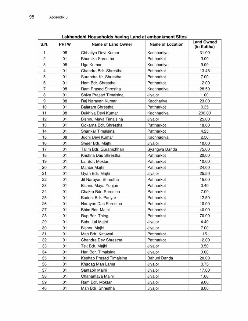
98 Appendix 5
Lakhandehi Households having Land at embankment Sites
S.N. PRTW Name of Land Owner Name of Location Land Owned (in Kattha)
1 08 Chhatiya Devi Kumar Kachhadiya 31.00
2 01 Bhumika Shrestha Pattharkot 3.00
3 08 Uga Kumar Kachhadiya 9.00
4 01 Chandra Bdr. Shrestha Pattharkot 13.45
5 01 Surendra Kr. Shrestha Pattharkot 7.00
6 01 Hem Bdr. Shrestha Pattharkot 12.00
7 08 Ram Prasad Shrestha Kachhadiya 28.50
8 01 Shiva Prasad Timalsina Jiyajor 1.00
9 08 Raj Narayan Kumar Kacchariya 23.00
10 01 Balaram Shrestha Pattharkot 0.35
11 08 Dukhiya Devi Kumar Kachhadiya 200.00
12 01 Bishnu Maya Timalsina Jiyajor 25.00
13 01 Gokarna Bdr. Shrestha Pattharkot 18.00
14 01 Shankar Timalsina Pattharkot 4.25
15 08 Jugni Devi Kumar Kachhadiya 2.50
16 01 Sheer Bdr. Majhi Jiyajor 10.00
17 01 Talim Bdr. Guramchhan Syangwa Danda 75.00
18 01 Krishna Das Shrestha Pattharkot 20.00
19 01 Lal Bdr. Moktan Pattharkot 10.00
20 01 Manbir Majhi Pattharkot 24.00
21 01 Gyan Bdr. Majhi Jiyajor 25.50
22 01 Jit Narayan Shrestha Pattharkot 15.00
23 01 Bishnu Maya Yonjan Pattharkot 0.40
24 01 Chakra Bdr. Shrestha Pattharkot 7.00
25 01 Buddhi Bdr. Pariyar Pattharkot 12.50
26 01 Narayan Das Shrestha Pattharkot 10.00
27 01 Bhim Bdr. Majhi Pattharkot 40.00
28 01 Rup Bdr. Thing Pattharkot 70.00
29 01 Babu Lal Majhi Jiyajor 4.40
30 01 Bishnu Majhi Jiyajor 7.00
31 01 Man Bdr. Katuwal Pattharkot 15
32 01 Chandra Dev Shrestha Pattharkot 12.00
33 01 Tek Bdr. Majhi Jiyajor 3.50
34 01 Hari Bdr. Timalsina Jiyajor 3.00
35 01 Keshab Prasad Timalsina Bahuni Danda 20.00
36 01 Khadag Man Lama Jiyajor 0.75
37 01 Santabir Majhi Jiyajor 17.00
38 01 Chanamaya Majhi Jiyajor 1.60
39 01 Ram Bdr. Moktan Jiyajor 9.00
40 01 Man Bdr. Shrestha Jiyajor 8.00

Appendix 5 99
S.N. PRTW Name of Land Owner Name of Location Land Owned (in Kattha)
41 01 Dayawati Majhi Lalbandi 3.50
42 01 Raju Bardewa Lalbandi 3.00
43 01 Lal Bdr. Ghising Lalbandi 13.00
44 01 Dhogbir Majhi Lalbandi 7.00
45 01 Purna Majhi Lalbandi 2.00
46 01 Shree Lal Majhi Lalbandi 11.00
47 01 Rajman Majhi Lalbandi 2.00
48 01 Dil Bdr. Majhi Lalbandi 12.00
49 01 Man Bdr. Majhi Lalbandi 40.00
50 01 Chandra Bdr. Majhi Lalbandi 16.00
51 01 Bishnu Majhi Lalbandi 36.00

100 Appendix 6
Appendix-6. Estimation of Loss of Income by Affected HHs
Mohana Khutiya -Estimation of Loss of Income by Affected HHs
PRTW Name of Land Owner Total Land
Owned (Kattha)
Avg. Annual Income
Income from
Farming
Income Loss due
to Project
% loss of Total Income
02 Jaggu Dagaura 2 130000 10000 776 0.60
02 Kabir Bhagat 4.2 213000 0 0 0.00
02 Bhangiram Dagaura 7 185000 50000 3879 2.10
02 Harguhi Dagaura 8 270000 50000 3879 1.44
02 Phakuram Dagaura 16.6 170000 75000 5819 3.42
02 Dhaniram Chaudhari 18 340000 100000 7759 2.28
02 Nanda Lal Rana 15.4 295000 100000 7759 2.63
02 Buddhi Ram Chaudhari 42 265000 110000 8534 3.22
02 Bhakta Ram Chaudhari 44 301000 80000 6207 2.06
02 Banda Chaudhari 64 310000 90000 6983 2.25
02 Phulpati Dagaura 143 225000 225000 17457 7.76
03 Lautan Chaudhari 0.6 130000 10000 776 0.60
03 Aashish Rana 0.6 90000 0 0 0.00
03 Sante Kami 1 120000 0 0 0.00
03 Man Bdr. Gurung 1 180000 0 0 0.00
03 Rabi Lal Chaudhari 1.6 302000 2000 663 0.22
03 Lal Bdr. Saud 1.6 158000 8000 2653 1.68
03 Raj Bdr. Chaudhari 4 195000 15000 4975 2.55
03 Sampat Lal Chaudhari 4 190000 35000 11608 6.11
03 Jagat Ram Rana 4 270000 20000 6633 2.46
03 Bandhu Ram Chaudhari 5 160000 10000 3317 2.07
03 Man Bdr. Dagaura 8 195000 20000 6633 3.40
03 Chhotelal Chaudhari 9 340000 60000 19899 5.85
03 Sunita Chaudhari 5.2 190000 30000 9950 5.24
03 Bandhu Ram Chaudhari 5.6 185000 35000 11608 6.27
03 Ram Kumar Chaudhari 4.2 250000 0 0 0.00
03 Bir Bdr. Chaudhari 7.6 217000 22000 7296 3.36
03 Ram Bdr. Chaudhari 5.6 160000 35000 11608 7.25
03 Autoriya Chaudhari 5.6 210000 10000 3317 1.58
03 Phul Chandra Rana 11 150000 0 0 0.00
06 Debendra Saud 2.6 140000 15000 2171 1.55
06 Bahali Rana 4 67000 32000 4632 6.91
06 Jaumati Thapa 4 43000 19000 2750 6.40
06 Chhabilal Saud 4 134000 10000 1448 1.08
06 Dhana Singh Bohora 5 240000 20000 2895 1.21

Appendix 6 101
PRTW Name of Land Owner Total Land
Owned (Kattha)
Avg. Annual Income
Income from
Farming
Income Loss due
to Project
% loss of Total Income
06 Rasi Rana 5 102000 22000 3185 3.12
06 Dal Bdr. Shah 5 190000 20000 2895 1.52
06 Dirgha Air 6.6 280000 30000 4343 1.55
06 Ishwor Datta Joshi 8 167000 32000 4632 2.77
06 Shahali Rana 8 210000 50000 7238 3.45
06 Harka Bdr. Saud 9 240000 40000 5790 2.41
06 Khadga Bdr. Mahara 10 165000 45000 6514 3.95
06 Dararu Chaudhari 74 480000 200000 28952 6.03
06 Shree Prasad Chaudhari 20 210000 100000 14476 6.89
06 Phulchandra Rana 30 325000 80000 11581 3.56
07 Hukum Bdr. Shahu 1.6 160000 15000 2183 1.36
07 Manu Devi Bohara 5.2 225000 40000 5820 2.59
07 Bhoj Raj Chaudhari 6 365000 80000 11640 3.19
07 Lal Bdr. Bohara 7 172000 32000 4656 2.71
07 Bal Bdr. Jethara 10 250000 50000 7275 2.91
07 Sinha Raj Chaudhari 15 400000 80000 11640 2.91
07 Sanu Ram Rana 15 250000 60000 8730 3.49
07 Sheru Bohara 10.6 260000 40000 5820 2.24
07 Lal Bdr. Chaudhari 10.8 225000 75000 10913 4.85
07 Chamaru Rana 13 180000 55000 8003 4.45
07 Chaudhari Rana 15 153000 53000 7712 5.04
07 Hem Raj Rana 14 335000 60000 8730 2.61
07 Santa Ram Rana 14 130000 50000 7275 5.60
07 Gopal Rana 14 325000 40000 5820 1.79
07 Gopi Ram Rana 43 155000 120000 17460 11.2630
10 Deumani Dagaura 57.4 254000 150000 18763 7.39
11A Sheer Dagaura 3 150000 10000 3335 2.22
11B Bharat Thapa 2 214000 10000 3159 1.48
11B Purnaram Chaudhari 11 405000 45000 14217 3.51
11B Ganesh Bdr. Singh 86 260000 40000 12638 4.86
11B Harka Bdr. Shaud 39 385000 85000 26855 6.98
13 Asharam Chaudhari 7 220000 40000 4342 1.97
30Gopi Ram Rana was identified as losing 11.26% of annual income as a result of donating lands to the project on the
embankment. Gopi Ram Rana estimates that this would be the annual crop loss associated with the embankment construction on a portion of his land. Consultation with Gopi confirms that he is nonetheless very interested to donate the strip of land because he will be able to use the remaining land portion all year round instead of on a seasonal basis and therefore expects to increase his annual income. The social Safeguardss due diligence team are satisfied that Gobi will not be impoverished as a result of the donation and will instead improve his livelihood outcomes as a result of the project.

102 Appendix 6
PRTW Name of Land Owner Total Land
Owned (Kattha)
Avg. Annual Income
Income from
Farming
Income Loss due
to Project
% loss of Total Income
13 Tika Ram Chaudhari 10 286000 46000 4994 1.75
13 Ram Bdr. Chaudhari 10 290000 140000 15199 5.24
13 Bujhauna Dagaura 40 270000 50000 5428 2.01
13 Sujhauna Dagaura 26 295000 35000 3800 1.29
13 Man Bdr. Chaudhari 17 110000 35000 3800 3.45
13 Kadhera Rana 29 250000 60000 6514 2.61
Mawa- Ratuwa - Estimated Loss of Income by Affected Households
PRTW No Respondent Name Land
owned in Katha
Avg. Annual Income
Avg. Annual Income from
Farming
Income Loss
due to Project
% loss of
Total Income
1 Taranath Rajbansi 80 510000 60000 4109 0.81
1 Dukho Devi Rajbansi 15 295000 50000 3424 1.16
1 Harish Chandra Rajbansi 61.6 472000 32000 2192 0.46
1 Bajra Bdr. Basnet 60 459000 75000 5137 1.12
1 Balaram Basnet 20 420000 0 0 0.00
1 Dambar Bdr. Basnet 11.5 424000 124000 8492 2.00
1 Bhagwan Pd. Rajbansi 140 500000 100000 6849 1.37
1 Nara Bdr. Basnet 81.75 474000 70000 4794 1.01
1 Min Pd. Dulal 100 375000 45000 3082 0.82
1 Bandor Badai Sharma 19.75 275000 20000 1370 0.50
2 Tulasa Devi Adhikari 72 330000 90000 5904 1.79
2 Dev Kumari Karki 46.55 420000 90000 5904 1.41
2 Sudan Limbu 20 340000 15000 984 0.29
2 Chandra Kumari Limbu 38 337000 25000 1640 0.49
2 Bishnu Maya Thapa 40 204000 120000 7872 3.86
2 Khem Raj Khadka 10 225000 25000 1640 0.73
2 Bhim Bdr. Khadka 9.85 145000 55000 3608 2.49
2 Rudra Bdr. Katuwal 21.6 270000 70000 4592 1.70
2 Sammi Dhami 5 375000 25000 1640 0.44
2 Bhakta Bdr. Basnet 52 370000 110000 7216 1.95
2 Man Bdr. Katuwal 15 275000 25000 1640 0.60
2 Dil Bdr. Katuwal 125 410000 50000 3280 0.80
2 Lila Devi Gautam 45 305000 35000 2296 0.75
2 Deva Kumar Katuwal 30 472000 40000 2624 0.56
2 Manama Adhikari 27.5 330000 30000 1968 0.60
3 Sabidra Bhandari 40 335000 50000 2896 0.86
3 Dil Kumari Lawati 16.5 280000 20000 1158 0.41

Appendix 6 103
PRTW No Respondent Name Land
owned in Katha
Avg. Annual Income
Avg. Annual Income from
Farming
Income Loss
due to Project
% loss of
Total Income
3 Prem Lawati 63 155000 35000 2027 1.31
3 Tek Bdr. Limbu 16 330000 30000 1737 0.53
3 Birendra Bohora 26 125000 80000 4633 3.71
3 Gauri Pd. Bohora 33 265000 100000 5791 2.19
3 Kiran Devi Rai 7 370000 35000 2027 0.55
3 Rajkumar Shrestha 8 305000 15000 869 0.28
3 Dudhraj Basnet 12 324000 65000 3764 1.16
3 Bhim Pd. Lawati 20 190000 80000 4633 2.44
3 Anita Tamang 7 340000 20000 1158 0.34
3 Dhirendra Kumar Shrestha 5 150000 50000 2896 1.93
3 Bhim Bdr. Khadka 10 286000 40000 2316 0.81
4 Sanchita Lamsal 9 444000 100000 23409 5.27
4 Yogendra Bdr Karki 54 378000 84000 19664 5.20
4 Sher Bdr. Baniya 55 621000 50000 11705 1.88
4 Mahendra Karki 44 640000 20000 4682 0.73
4 Kalpana Devi Lamsal 7 390000 25000 5852 1.50
05 A - 05B Jit Maya Angdembu 15.5 260000 50000 9426 3.63
05 A - 05 B Prem Limbu 6.5 207000 18000 3393 1.64
05 A - 05 B Mangal Kumari Darnal 10.5 298000 18000 3393 1.14
05 A - 05 B Sukmaya Chaudhari 4.5 125000 15000 2828 2.26
05 A - 05 B Dil Bdr. Mahat 0.5 250000 0 0 0.00
05 A - 05 B Sukamaya B.K. 20 225000 35000 6598 2.93
05 A - 05 B Bhupal Mahat 0.5 145000 0 0 0.00
05 A - 05 B Prakash Mahat 0.5 240000 0 0 0.00
05 A - 05 B Ramesh Karki 0.55 210000 0 0 0.00
07 Chandra Bdr. Rai 4.9 415000 70000 2004 0.48
07 Krishna Bdr. Badaiwa 100 470000 70000 2004 0.43
07 Nanu Baba Shakya 80 354000 10000 286 0.08
07 Tek Bdr. Dahal 43 195000 30000 859 0.44
07 Chhali Maya Rai 29.5 230000 50000 1432 0.62
07 Bhakta Kumar Tamang 96.55 270000 60000 1718 0.64
07 Chakra Bdr. Shrestha 56 158000 40000 1145 0.72
07 Bhim Bdr. Rai 63 430000 80000 2291 0.53
8 Murari Mishra 80 325000 80000 26006 8.00
8 Raj Singh 10 195000 50000 16254 8.34
09 A - 09 B Tika Ram Poudel 21 189000 65000 8387 4.44
09 A - 09 B Maniraj Iwa Limbu 48 345000 100000 12903 3.74
09 A - 09 B Deepak Tamang 11 290000 20000 2581 0.89

104 Appendix 6
PRTW No Respondent Name Land
owned in Katha
Avg. Annual Income
Avg. Annual Income from
Farming
Income Loss
due to Project
% loss of
Total Income
09 A - 09 B Harka Bdr. Limbu 31 274000 60000 7742 2.83
09 A - 09 B Rana Bdr. Adhikari 60 420000 100000 12903 3.07
09 A - 09 B Chudamani Regmi 42 405000 50000 6452 1.59
09 A - 09 B Deshu Sauden 45 325000 80000 10323 3.18
09 D Ambar Bdr. Magar 0.35 235000 10000 1290 0.55
09 C Saraswoti Lamichhane 0.3 224000 0 0 0.00
09 C Mohan Limbu 5 240000 15000 1935 0.81
09 C Madan Darjee 0.25 200000 0 0 0.00
09 C Nir Bdr. Darjee 0.2 230000 0 0 0.00
09 A - 09 B Padam Bdr. Shrestha 6 195000 30000 3871 1.99
09 A - 09 B Nirajan Nepali 1 314000 0 0 0.00
09 A - 09 B Ganesh Bdr. Poudel 50 470000 80000 10323 2.20
09 A - 09 B Sharan Kumar Darjee 3 210000 10000 1290 0.61
10 Rana Maya Neupane 58 289000 100000 14347 4.96
012 L Apsara Devi Nemwang 29.4 178000 130000 3565 2.00
012 L Harka Maya Bhandari 75 520000 100000 2742 0.53
012 L Man Bdr. Bhujel 39 145000 100000 2742 1.89
12 L Nara Kumari Shahi 28.5 380000 30000 823 0.22
12 L Tulasa Devi Mishra 4 360000 60000 1645 0.46
012 L Rupa Devi Gautam 108 500000 100000 2742 0.55
West Rapti Estimated Loss of Income by Affected Households
PRTW Name of Land Owner Total Land
Owned (Kattha)
Avg. Annual Income
Income from
Farming
Income Loss due to Project
% loss of Total
Income
1 Dukhiram Chaudhari 20 305000 75000 5527 1.81
1 Gyan Prasad Chaudhari 54 195000 50000 3685 1.89
1 Jagani Chaudhari 15.6 156000 36000 2653 1.70
1 Sagani Chaudhari 6 170000 20000 1474 0.87
1 Chhoteram Chaudhari 8 325000 40000 2948 0.91
1 Theman Prasad Chaudhari 9 125000 30000 2211 1.77
1 Shyam Raj Chaudhari 60 280000 240000 17686 6.32
1 Brij Nanda Chaudhari 9 175000 25000 1842 1.05
1 Rukmaniya Chaudhari 7 355000 15000 1105 0.31
1 Sarpal Chaudhari 22 220000 40000 2948 1.34
1 Bhoj Raj Chaudhari 28.2 280000 70000 5158 1.84
1 Narendra Kumar Chaudhari 200 400000 200000 14738 3.68
1 Dev Prasad Chaudhari 17 380000 80000 5895 1.55
1 Asaram Chaudhari 18 275000 35000 2579 0.94
1 Khusiram Chaudhari 21 395000 55000 4053 1.03
1 Jayarkhan Chaudhari 24 300000 120000 8843 2.95
1 Guru Prasad Chaudhari 17 268000 112000 8253 3.08
1 Kaliram Chaudhari 1.4 133000 13000 958 0.72
1 Laxmi Prasad Chaudhari 9 425000 20000 1474 0.35

Appendix 6 105
PRTW Name of Land Owner Total Land
Owned (Kattha)
Avg. Annual Income
Income from
Farming
Income Loss due to Project
% loss of Total
Income
1 Paradeshi Chaudhari 11 280000 60000 4422 1.58
1 Shree Ram Chaudhari 15 140000 35000 2579 1.84
1 Mahesh Kumar Chaudhari 80 320000 80000 5895 1.84
1 Phiriya Chaudhari 5 280000 15000 1105 0.39
1 Prithvi Raj Chaudhari 10 180000 10000 737 0.41
1 Ram Prasad Chaudhari 19 155000 20000 1474 0.95
1 Ram Nath Chaudhari 14 195000 30000 2211 1.13
1 Thagilal Chaudhari 2 186000 6000 442 0.24
1 Bir Prasad Chaudhari 7 89000 54000 3979 4.47
1 Shiva Devi Chaudhari 34 135000 55000 4053 3.00
1 Ramsworup Chaudhari 30 245000 45000 3316 1.35
1 Hari Lal Chaudhari 30 145000 15000 1105 0.76
1 Rajaram Chaudhari 20.2 280000 40000 2948 1.05
1 Bidesh Chaudhari 45 195000 45000 3316 1.70
1 Dosh Haran Chaudhari 50 355000 55000 4053 1.14
1 Gokul Prasad Chaudhari 75 155000 100000 7369 4.75
1 Shyam Kishor Chaudhari 31.6 135000 50000 3685 2.73
1 Pradeshi Chaudhari 21.6 260000 40000 2948 1.13
1 Kram Bdr. Chaudhari 7 205000 25000 1842 0.90
1 Shiva Kumari Chaudhari 12 250000 15000 1105 0.44
1 Ganesh Chaudhari 3.4 366000 42000 3095 0.85
1 Shuka Dev Chaudhari 4.4 265000 45000 3316 1.25
1 Lalata Chaudhari 5.8 205000 35000 2579 1.26
1 Labaru Chaudhari 0.4 400000 0 0.00
1 Ram Karan Chaudhari 2.4 365000 65000 4790 1.31
1 Shiva Kumar Chaudhari 1 275000 15000 1105 0.40
1 Dubaru Chaudhari 3.2 210000 0 0.00
1 Paltu Chaudhari 3 275000 0 0.00
1 Ram Lakhan Chaudhari 9.8 267000 25000 1842 0.69
1 Dukhiram Chaudhari 12.4 280000 35000 2579 0.92
1 Prem Kumar Chaudhari 14 365000 30000 2211 0.61
1 Prem Lal Chaudhari 2 251000 35000 2579 1.03
2 Kanhaiya Lal Chaudhari 22 222000 60000 1351 0.61
2 Bodhi Lal Chaudhari 35 225000 65000 1463 0.65
2 Rajaram Chaudhari 36.4 204000 70000 1576 0.77
2 Ram Gopal Chaudhari 52.6 357000 112000 2521 0.71
2 Rajendra Pd. Chaudhari 292 500000 100000 2251 0.45
2 Tilak Chaudhari 303 350000 50000 1126 0.32
2 Kali Prasad Chaudhari 35 230000 80000 1801 0.78
2 Shiva Narayan Chaudhari 19 180000 50000 1126 0.63
2 Khusal Ram Chaudhari 40 360000 60000 1351 0.38
2 Prameshwori Devi Chaudhari 20 149000 65000 1463 0.98
2 Hari Narayan Chaudhari 40 225000 60000 1351 0.60
2 Baikuntha Prasad Chaudhari 30 255000 45000 1013 0.40
2 Lahanu Chaudhari 3.2 30500 20000 450 1.48
2 Dukhiram Chaudhari 85.2 345000 45000 1013 0.29
2 Shivahari Chaudhari 29.6 280000 55000 1238 0.44
2 Bishnumati Chaudhari 20 230000 45000 1013 0.44
3 Hiramani Chaudhari 16.4 155000 70000 8357 5.39
3 Dash Chaudhari 130 365000 15000 1791 0.49
3 Thagu Chaudhari 18 173000 36000 4298 2.48

106 Appendix 6
PRTW Name of Land Owner Total Land
Owned (Kattha)
Avg. Annual Income
Income from
Farming
Income Loss due to Project
% loss of Total
Income
3 Jel Prasad Chaudhari 50 385000 65000 7760 2.02
3 Krishna Kumar Chaudhari 18 304000 82000 9789 3.22
3 Dhana Bdr. Chaudhari 17 201000 66000 7879 3.92
3 Phaguram Chaudhari 15 185000 60000 7163 3.87
3 Ramesh Chaudhari 18 185000 55000 6566 3.55
3 Bhojram Chaudhari 17 197000 72000 8596 4.36
3 Kalu Chaudhari 15 176000 61000 7282 4.14
3 Dhotiram Chaudhari 15 220000 55000 6566 2.98
3 Guruji Chaudhari 15 105000 60000 7163 6.82
3 Deumayi Chaudhari 15 132000 42000 5014 3.80
3 Chandra Pd. Chaudhari 12 110000 50000 5969 5.43
3 Krishna Chaudhari 10 184000 20000 2388 1.30
3 Dukhiram Chaudhari 3 187000 10000 1194 0.64
3 Deu Kumari Chaudhari 15 152000 50000 5969 3.93
3 Hema Chaudhari 15.4 180000 30000 3582 1.99
3 Puran Lal Chaudhari 16 210000 50000 5969 2.84
3 Ram Lal Chaudhari 36 145000 30000 3582 2.47
3 Tularam Chaudhari 25 254000 80000 9551 3.76
3 Shir Bdr. Chaudhari 7 190000 20000 2388 1.26
3 Lahiya Chaudhari 16 220000 0 0.00
3 Ramu Chaudhari 17 160000 20000 2388 1.49
3 Indra Prasad Chaudhari 15.6 175000 40000 4775 2.73
3 Ganga Prasad Chaudhari 10 269000 60000 7163 2.66
3 Aasha Chaudhari 11 145000 20000 2388 1.65
3 Arjun Chaudhari 7 130000 20000 2388 1.84
3 Rajman Chaudhari 8 165000 70000 8357 5.06
3 Ram Shankar Chaudhari 27 340000 48000 5730 1.69
3 Santosh Chaudhari 31 200000 40000 4775 2.39
3 Sitaram Chaudhari 26 110000 45000 5372 4.88
3 Om Prakash Chaudhari 23 197000 42000 5014 2.55
3 Hari Prasad Chaudhari 16 154000 55000 6566 4.26
3 Hari Charan Chaudhari 17 175000 70000 8357 4.78
3 Kali Ram Chaudhari 22 242000 42000 5014 2.07
3 Purna Bdr. Chaudhari 16 234000 50000 5969 2.55
3 Kallu Chaudhari 26 290000 90000 10745 3.71
3 Aasha Ram Chaudhari 18 205000 80000 9551 4.66
3 Laiparan Chaudhari 25 260000 60000 7163 2.76
3 Buddhi Ram Chaudhari 34 165000 45000 5372 3.26
3 Bharat Mani Chaudhari 16 202000 42000 5014 2.48
3 Laxman Chaudhari 5 280000 15000 1105 0.39
3 Shree Ram Chaudhari 20 200000 45000 5372 2.69
3 Prasadu Chaudhari 10.8 294000 80000 9551 3.25
3 Lal Bdr. Chaudhari 12.6 215000 60000 7163 3.33
3 Bal Bdr. Chaudhari 13 240000 60000 7163 2.98
3 Hari Lal Chaudhari 18 294000 64000 7641 2.60
3 Dukhiram Chaudhari 13 185000 20000 2388 1.29
3 Bhojlal Chaudhari 14 225000 60000 7163 3.18
3 Gyan Bdr. Chaudhari 10 182000 25000 2985 1.64
3 Asaram Chaudhari 22 220000 60000 7163 3.26
3 Manirami Chaudhari 20 148000 40000 4775 3.23
3 Pateshwori Chaudhari 35 205000 55000 6566 3.20

Appendix 6 107
PRTW Name of Land Owner Total Land
Owned (Kattha)
Avg. Annual Income
Income from
Farming
Income Loss due to Project
% loss of Total
Income
3 Ishru Chaudhari 13 134000 30000 3582 2.67
3 Madhu Chaudhari 18 266000 30000 3582 1.35
3 Jallu Chaudhari 16.8 115000 25000 2985 2.60
3 Hariram Chaudhari 18 160000 40000 4775 2.98
3 Bhagmani Chaudhari 21 175000 40000 4775 2.73
3 Lalawa Chaudhari 20.2 215000 95000 11341 5.28
3 Shyam Bdr. Chaudhari 16 187000 45000 5372 2.87
3 Bhagmani Chaudhari 11.2 140000 35000 4178 2.98
3 Mangal Prasad Chaudhari 15 173000 25000 2985 1.73
3 Balak Ram Chaudhari 17 130000 25000 2985 2.30
3 Chetram Chaudhari 13 75000 30000 3582 4.78
3 Hirman Chaudhari 18 120000 30000 3582 2.98
3 Kalluram Chaudhari 10 375000 45000 5372 1.43
3 Phahari Chaudhari 9 305000 90000 10745 3.52
3 Min Bdr. BC 40 411000 150000 17908 4.36
3 Dhruba Bdr. BC 15 295000 25000 2985 1.01
3 Parema Chaudhari 15 175000 45000 5372 3.07
3 Shukku Chaudhari 15 200000 45000 5372 2.69
3 Sukhiram Chaudhari 15 160000 35000 4178 2.61
3 Satguru Chaudhari 15 260000 35000 4178 1.61
3 Chitamani Chaudhari 15 265000 45000 5372 2.03
3 Madhu Chaudhari 15 228000 35000 4178 1.83
3 Tara BC 40 260000 120000 14326 5.51
3 Yam Bdr. Chaudhari 12 125000 75000 8954 7.16
3 Saniram Chaudhari 10 260000 45000 5372 2.07
3 Bhagmani Chaudhari 11 285000 65000 7760 2.72
3 Devabhumi Chaudhari 12 370000 70000 8357 2.26
3 Mahabir Chaudhari 12 185000 50000 5969 3.23
3 Tulasi Ram Chaudhari 10 380000 55000 6566 1.73
6 Sukadevi Chaudhari 20 245000 45000 1578 0.64
6 Basanta Dangi 17.6 170000 70000 2455 1.44
6 Tularam Chaudhari 32.6 240000 20000 701 0.29
6 Shovaram Chaudhari 30 220000 80000 2806 1.28
6 Laxman Chaudhari 56 455000 80000 2806 0.62
6 Girdhari Chaudhari 32 205000 55000 1929 0.94
6 Sujita Chaudhari 83.2 286000 45000 1578 0.55
6 Kesh Kumar Chaudhari 80 310000 80000 2806 0.91
6 Ram Pati Chaudhari 320 210000 80000 2806 1.34
07-08 Pujaram Chaudhari 40 195000 175000 14796 7.59
07-08 Bhagilal, Kulram, Kali Prasad Tharu 19 155000 120000 10146 6.55
07-08 Khushiram Tharu 40 270000 100000 8455 3.13
07-08 Shanti Tharuni 15 242000 60000 5073 2.10
07-08 Sundar Lal Tharu 18 422000 60000 5073 1.20
07-08 Prem Lal Chaudhari 12 134000 10000 846 0.63
07-08 Prem, Sushil, Sudhir and Surendra Bhandari
440 250000 250000 21138 8.46
07-08 Keshab Raj Poudel 500 250000 250000 21138 8.46
07-08 Sahayab Din Tharu 26 345000 45000 3805 1.10
07-08 Lal Bdr. Tharu 8 132000 22000 1860 1.41
07-08 Dhanabir Thapa 25 287000 95000 8032 2.80

108 Appendix 6
Bakraha -Estimated Loss of Income by Affected Households
PRTW Name of Land Owner Total Land
Owned (Kattha)
Avg. Annual Income
Income from
Farming
Income Loss due
to Project
% loss of Total Income
1 Lok Bdr. Thapa 25 210000 40000 2400 1.14
2 Ram Bdr. Rana Magar 28 280000 60000 454 0.16
2 Tara Kumar Kurungbang 7 263000 40000 302 0.11
2 Lila Bdr. Shrestha 11 249000 45000 340 0.14
2 Singha Bdr. Rai 18 204000 0 0.00
2 Man Bdr. Limbu 25 382000 52000 393 0.10
2 Puna Raj Lawati 20 149000 35000 265 0.18
2 Bishnu Kumar Pyangu 15 241000 21000 159 0.07
2 Dhana Bdr. Pariyar 67 299000 65000 491 0.16
2 Dambar Payangu 15 204000 60000 454 0.22
2 Tika Bdr. Jogi 4 170000 25000 189 0.11
2 Kaluram Dhimal 15 289000 50000 378 0.13
2 Kamal Maya Limbu 8 157000 20000 151 0.10
2 Singha Bdr. Kurumbang 10 280000 20000 151 0.05
2 Tek Bdr. Limbu 5 544000 34000 257 0.05
2 Gyanendra Lawati 23 323000 70000 529 0.16
2 Dil Kumar Chemjong 24 390000 65000 491 0.13
2 Ganesh Kumar Shrestha 25 298000 18000 136 0.05
2 Ram Prasad Dhimal 20 370000 70000 529 0.14
2 Eit Maya Lawati 22 175000 80000 605 0.35
2 Chandra Bdr. Limbu 20 345000 60000 454 0.13
2 Lek Bdr. Shrestha 70 499000 130000 983 0.20
2 Devananda Limbu 20 215000 60000 454 0.21
2 Tara Devi Katuwal 30 210000 90000 680 0.32
2 Kushmamaya Shrestha 9 414000 80000 605 0.15
2 Mani Kumar Kerung 22 300000 45000 340 0.11
2 Tika Dhwoj Chemjung 35 189000 62000 469 0.25
2 Surya Bdr. Lawati 20.5 370000 70000 529 0.14
4 Tej Bdr. Dhimal 4.5 237000 17000 2066 0.87
4 Lok Prasad Bhattarai 14 399000 0 0.00
4 Karna Bdr. B.K. 48 222000 50000 6077 2.74
6 Pushpa Bdr Thapa 31.25 144000 20000 9961 6.92
6 Jagannath Kuikel 27 489000 0 0.00
7 Sharmila Rimal 41.05 260000 20000 4331 1.67
8 Sanjaya Kumar Yadav 40 375000 75000 1402 0.37
8 Bagalal Amat 40 242000 52000 972 0.40
8 Manmohan Singh Ganagai 110 490000 145000 2711 0.55

Appendix 6 109
PRTW Name of Land Owner Total Land
Owned (Kattha)
Avg. Annual Income
Income from
Farming
Income Loss due
to Project
% loss of Total Income
8 Kishan Prasad Amat 14 200000 80000 1496 0.75
8 Sanoth Kumar Yadav 40 225000 100000 1870 0.83
8 Binod Kumar Yadav 88.9 350000 50000 935 0.27
8 Sachida Nanda Yadav 70.5 580000 100000 1870 0.32
8 Om Prakash Yadav 58.35 300000 150000 2805 0.93
8 Singeshwor Singh 110 460000 100000 1870 0.41
8 Lalit Prasad Yadav 162.9 440000 120000 2244 0.51
8 Sanjeev Kumar Yadav 75 245000 200000 3740 1.53
9 Surendra Lingden 85 500000 80000 11455 2.29
9 Ganesh Bdr. Basnet+Dal Bdr 38 270000 50000 7159 2.65
9 Saulen Lingden 24 390000 70000 10023 2.57
9 Krishna Kumar Lama 102.7 432000 180000 25773 5.97
9 Ganesh Bdr. Basnet 45.4 397000 120000 17182 4.33
9 Sharmila Sewa 84 504000 80000 11455 2.27
9 Sharmila Sewa 7.5 220000 20000 2864 1.30
9 Dal Bdr. Rana Magar 23 214000 80000 11455 5.35

110 Appendix 6
Lakhandehi Estimated Loss of Income by Affected Households
PRTW No
Respondent Name
Land owned in
Katha
Avg. Annual Income
Avg. Annual Income from Farming
Income Loss due
to Project
% loss of Total Income
1 Bhumika Shrestha 3 215000 50000 218 0.10
1 Chandra Bdr. Shrestha 13.45 325000 75000 327 0.10
1 Surendra Kr. Shrestha 7 268000 65000 283 0.11
1 Hem Bdr. Shrestha 12 244000 54000 235 0.10
1 Shiva Prasad Timalsina 1 353000 10000 44 0.01
1 Balaram Shrestha 0.35 315000 15000 65 0.02
1 Bishnu Maya Timalsina 25 104000 45000 196 0.19
1 Gokarna Bdr. Shrestha 18 299000 120000 523 0.17
1 Shankar Timalsina 4.25 345000 50000 218 0.06
1 Sheer Bdr. Majhi 10 374000 90000 392 0.10
1 Talim Bdr. Guramchhan 75 479000 120000 523 0.11
1 Krishna Das Shrestha 20 320000 100000 436 0.14
1 Lal Bdr. Moktan 10 300000 100000 436 0.15
1 Manbir Majhi 24 214000 60000 261 0.12
1 Gyan Bdr. Majhi 25.5 210000 100000 436 0.21
1 Jit Narayan Shrestha 15 250000 90000 392 0.16
1 Bishnu Maya Yonjan 0.4 282000 30000 131 0.05
1 Chakra Bdr. Shrestha 7 430000 85000 370 0.09
1 Buddhi Bdr. Pariyar 12.5 265000 35000 152 0.06
1 Narayan Das Shrestha 10 245000 65000 283 0.12
1 Bhim Bdr. Majhi 40 266000 35000 152 0.06
1 Rup Bdr. Thing 70 255000 55000 240 0.09
1 Babu Lal Majhi 4.4 385000 50000 218 0.06
1 Bishnu Majhi 7 333000 70000 305 0.09
1 Chandra Dev Shrestha 12 227000 50000 218 0.10
1 Tek Bdr. Majhi 3.5 375000 55000 240 0.06
1 Hari Bdr. Timalsina 3 375000 45000 196 0.05
1 Keshab Prasad Timalsina 20 525000 100000 436 0.08
1 Khadag Man Lama 0.75 270000 100000 436 0.16
1 Santabir Majhi 17 275000 50000 218 0.08
1 Chanamaya Majhi 1.6 310000 50000 218 0.07
1 Ram Bdr. Moktan 9 358000 100000 436 0.12
1 Man Bdr. Shrestha 8 343000 20000 87 0.03
1 Janga Bdr. Majhi 30 205000 45000 196 0.10
1 Dayawati Majhi 3.5 205000 60000 261 0.13
1 Raju Bardewa 3 292000 22000 96 0.03
1 Lal Bdr. Ghising 13 288000 40000 174 0.06
1 Dhogbir Majhi 7 218000 60000 261 0.12
1 Purna Majhi 2 255000 55000 240 0.09
1 Shree Lal Majhi 11 167000 45000 196 0.12

Appendix 6 111
PRTW No
Respondent Name
Land owned in
Katha
Avg. Annual Income
Avg. Annual Income from Farming
Income Loss due
to Project
% loss of Total Income
1 Rajman Majhi 2 369000 55000 240 0.06
1 Dil Bdr. Majhi 12 139000 60000 261 0.19
1 Man Bdr. Majhi 40 106000 40000 174 0.16
1 Chandra Bdr. Majhi 16 220000 75000 327 0.15
1 Bishnu Majhi 36 389000 20000 87 0.02
8 Chhatiya Devi Kumar 31 304000 124000 412 0.14
8 Uga Kumar 9 185000 55000 183 0.10
8 Ram Prasad Shrestha 28.5 500000 45000 150 0.03
8 Raj Narayan Kumar 23 260000 60000 200 0.08
8 Dukhiya Devi Kumar 200 305000 15000 50 0.02
8 Jugni Devi Kumar 2.5 322000 22000 73 0.02

112 Appendix 6
Appendix-7: Project Screening Checklist for Involuntary Resettlement
Probable Involuntary Resettlement Effects
Yes No Not Known
Remarks
Involuntary Acquisition of Land 1. Will there be land acquisition? √ The project does not involve any land
acquisition. The project’s construction works involve embankment construction in different sections to protect the cultivation land and settlements.
2. Is the site for land acquisition known? √ No land acquisition involved 3. Is the ownership status and current usage of land to be acquired known
√ There are no land acquisition of resettlement impacts
4. Will easement be utilized within an existing Right of Way
√ All the activities will be carried out in construction sites
1. Will there be losses of shelter and residential land due to land acquisition?
√
2. Will, there be loss of Agriculture and other productive assets due to land acquisition
√
3. Will, there be losses of crops, trees, and fixed assets due to land acquisition
√
4. Will the be losses of business or enterprises due to land acquisition?
√
5. Will there be losses of income sources and means of livelihood due to land acquisition?
√
Involuntary Restrictions on Land Use or on Access to Legally Designated Parks and Protected Areas
6. Will people lose access to natural resources, communal facilities, and services?
√
7. Will land use is changed, will it have an adverse impact on social and economic activities?
√
8. Will access to land and resources owned community or by the state be restricted
√
Information on displaced persons:
Any estimate of the likely number of persons that will be displaced by the project? [ ] No [ ] Yes If yes, approximately how many? Not applicable as no one will be relocated Are any of the poor, female heads of house, or vulnerable to poverty risk? [ ] No [ ] Yes Are any displaced persons from Indigenous or ethnic community groups? [ ] No [ ] Yes

Appendix -8: Project Screening Checklist for Indigenous People
Key Concerns (Please provide elaborations on the
remarks column)
Yes No Not Known
Remarks
B. Indigenous People Identification 1. Are there socio-cultural groups present in or use the project area who may be considered as “tribes” (hill tribes, schedule tribes, tribal peoples), “minorities (ethnic or national minorities or cultural community?
√ There are ethnic minority groups mainly known as Thru and Chaudhari in the location of construction sites.
2. Are there national or local laws or policies as well as anthropological research/studies that consider these groups present in or using the project area as belonging to “ethnic minorities”, scheduled tribes, tribal peoples, national minorities or cultural communities?
√ There is an Act on National Foundation for the upliftment of Aadibasi Janajati 2002 to consider these groups present in the project area as ethnic minority indigenous groups.
3. Do such groups self-identify as being part of a distinct social and cultural group?
√ Yes, however, they almost have also assimilated with the mainstream in every aspect (e.g. cultural, social, economic, political, etc) and they also share their cultural reciprocity with other mainstream groups. Both the mainstream community and the minority group equally interact in both Napali as well as local Tharu and Chaudhari languages.
4. Do such groups maintain collective attachments to distinct habitats or ancestral territories and/or to the natural resources in these habitats and territories?
√ They are maintaining their collective attachments with the culture and place. However, they are not static on ancestral territories and on natural resources; rather they share their culture with other mainstream groups in terms of everything (social, cultural, geographical, educational, economic, political, etc aspects.
5. Do such groups maintain cultural, economic, social, and political institutions distinct from the dominant society or culture?
√ They have also organized under different mainstream organizations as well as an organization focused on their group for their development, welfare, and cultural protection.
6. Have such groups speak a distinct language or dialect?
√ Even the senior citizens can communicate both in their language and national (Nepali) language. The educated persons can also communicate in different other national and even international languages.
7. Has such a group been historically, socially and economically marginalized disempowered, excluded, and/or discriminated against?
√ Earlier, the group had been historically, socially, and economically marginalized and disempowered, excluded. However, their overall social status and role have been changed

114 Appendix 8
Key Concerns (Please provide elaborations on the
remarks column)
Yes No Not Known
Remarks
especially the imitative taken by the Government to liberate the poor and deprived community from the traditional bonded labor system, especially during the nineties.
8. Are such groups represented as “Indigenous People” or as “ethnic minorities”, or scheduled tribes or “tribal population” in any formal decision making bodies at the national or local levels?
√ The constitution of Nepal and the relevant act has given equal opportunities even to the indigenous population to be part of any type of institution up-to capacity and even for formal decision making. Recently these communities have been participating and making the decision in several facets of society as politicians, ministers, diplomats, bureaucrats, teachers and academician and so on.
B. Identification of Potential Impacts
9. Will the project directly or indirectly benefit or target Indigenous People
√ The proposed will provide direct benefit to the Indigenous people by protecting them from floods, land cutting, loss of crop production.
10. Will the project directly or indirectly affect Indigenous Peoples’ traditional socio-cultural and belief practices? (e.g. child-rearing, health education, arts, and Governance)
√
11. Will the project affect the livelihood system of indigenous people? (e.g. food production system, rural resource management, crafts and trade employment status)
√ The implementation of the project also ensures increase food protection due to possibilities of cultivation even in abandoned fallow land, protection of land, property, and life from the flood.
12. Will the project be in an area (land or territory) occupied, owned, or used by Indigenous peoples, and /or claimed as the ancestral domain?
√ The government has not specifically allocated any specific place only focusing on the ancestral domain. Rather in some places land has been allocated and even with ownership transfer for the victims of flood in the past and recently for the emancipated bandaged labors which also include other caste and ethnic groups except Tharu and Chaudhari.
C. Identification of Special Requirements: will the project activities include?
13. Commercial development of the cultural resources and knowledge of indigenous peoples?
√ The project is also accessing the scope of incorporating such viable activities in close consultation and coordination with the project office at the central level, district level as well as local communities neighboring to the embankment locations for the protection and sustainability of the

Key Concerns (Please provide elaborations on the
remarks column)
Yes No Not Known
Remarks
constructed embankments.
14. Physical displacement from traditional or customary lands
√ No physical displacement will occur. The embankment will be constructed along the bank of the river by maximum utilizing the lands along the river bed and government lands. Wherever such land is not available and unavoidable part of construction work, the project will use a portion of such private or another type of occupied land through the approach of voluntary land donation without transferring the ownership. This will ensured by the official Memorandum of Understanding (MoUu) made between the project and the landowners with the representation of government bodies.
15. Commercial development of Natural Resources (such as minerals, hydrocarbon, forest, water, hunting or fishing groups)within customary lands underuse that would impact the livelihood or the cultural ceremonial, spiritual usages that define the identity and the community of Indigenous People?
√ The project envisages to incorporate such components in collaboration with the Project at the central level, district level offices, and local community residing in the neighboring location of the embankments.
16. Establishing legal recognition of rights to land and territories that are traditionally owned or customary used or claimed by indigenous people?
√ Generally, this sort of task is being undertaken time to time by the Government since the beginning through the commission of different types (e.g. commission for providing land and ownership certificate to all sorts of landless people as well as for indigenous peoples in Dang districts.
17. Acquisition of lands that are traditionally owned or customarily used, occupied or claimed by indigenous peoples?
√ There will be no land acquisition at all. The project is just constructing the embankment at the edge of the river and government land. Wherever necessary permission will be granted with the landowners for Voluntary Land Donation through an MOU as described before to ensure relevant landowners’ permission to protect their and their neighbors valuable productive land by constructing embankment based on their demand.
D. Anticipated Project Impact on Indigenous People
Project Component/ Activity/Output
Anticipated Positive Effects Anticipated Negative Effects

116 Appendix 8
Key Concerns (Please provide elaborations on the
remarks column)
Yes No Not Known
Remarks
Construction of embankments, revetments, spurs, and outlets
Flood protection to cultivating land, settlements, and infrastructures such as a house, schools, health facilities, community structures, and income-generating activities
None