Flood Management in Selected River Basins Sector Project
143
Initial Environmental Examination: Wai Batu Merah Flood Control Ambon – Maluku (CW 04) March 2020 Indonesia: Flood Management in Selected River Basins Sector Project Prepared by Directorate General of Water Resources, Ministry of Public Works and Housing for the Republic of Indonesia and the Asian Development Bank.
-
Upload
khangminh22 -
Category
Documents
-
view
4 -
download
0
Transcript of Flood Management in Selected River Basins Sector Project

Initial Environmental Examination: Wai Batu Merah Flood Control Ambon – Maluku (CW 04)
March 2020
Indonesia: Flood Management in Selected River
Basins Sector Project
Prepared by Directorate General of Water Resources, Ministry of Public Works and Housing for
the Republic of Indonesia and the Asian Development Bank.

CURRENCY EQUIVALENTS (as of 30 March 2020)
Currency unit – rupiah (Rp) Rp1.00 = $0.0000617551
$1.00 = Rp16,193
ABBREVIATIONS
ADB – Asian Development Bank
AMDAL – Environmental Impact Assessment, EIA
AP – Affected Persons
BWS – Major River Basin Organization
BLH – City Environmental Management, established in Kota Ambon
BWS – River Basin Organization
CPMU – Central Project Management Unit
DED – Detailed Engineering Design
DGWR – Directorate General of Water Resources
DLH – Provincial/City Environmental Agency
EARF – Environmental Assessment and Review Framework
EARR – Emergency Assistance for Rehabilitation and Reconstruction
EIA – Environmental Impact Assessment
EMP – Environmental Management Plan
FGD – Focus Group Discussions
FMSRB – Flood Management in Selected River Basins
GERHAN – National Movement for Forest and Land Rehabilitation
GOI – Government of Indonesia
GR – Government Regulation
IA – Implementing Agency
IEE – Initial Environmental Examination
IUCN – International Union for Conservation of Nature
JICA – Japan International Cooperation Agency
LARP – Land Acquisition and Resettlements Plan
LG – Local Government
MOEF – Ministry of Environment and Forestry
NGO – Non-government organizations
O&M – Operation and Maintenance
OPD – Regional Organization (Organisasi Perangkat Daerah)
PAM – Project Administration Manual
PIU – Project Implementation Unit
PMU – Project Management Unit
POLA – Pola Pengelolaan SDA (“Water Resource Strategic Plan”) PU – Public Works
REA – Rapid Environmental Assessment
RKL/RPL – Environmental Management & Monitoring Plan, Complementary of AMDAL Report
RTRW – Regional Spatial Plan
SKKLH – Decree on Environmental Feasibility
SPPL – Commitment Letter for Environmental Management and Monitoring
SPS – Safeguard Policy Statement
TOR – Terms of Reference
UKL/UPL – Environmental Management & Monitoring Plan, substitute of AMDAL
NOTES
(i) The fiscal year (FY) of the Government of Indonesia and its agencies ends on 31 December. FY before a calendar year denotes the year in which the fiscal year ends, e.g., FY2011 ends on 31 December 2011.
(ii) In this report, "$" refers to United States dollars This initial environmental examination is a document of the borrower. The views expressed herein do not necessarily represent those of ADB's Board of Directors, Management, or staff, and may be preliminary in nature. In preparing any country program or strategy, financing any project, or by making any designation of or reference to a particular territory or geographic area in this document, the Asian Development Bank does not intend to make any judgments as to the legal or other status of any territory or area.
IEE CW04 Wai Batu Merah Flood Control i
Table of Contents
EXECUTIVE SUMMARY ........................................................................................................... 1
A. POLICY, LEGAL AND ADMINISTRATIVE FRAMEWORK ................................................. 4
A.1. Policy Legal and Administrative Framework .............................................................. 6
A.2. Government of Indonesia’s Environmental Policy and Regulatory Framework .......... 7
A.3. Purpose of the IEE .................................................................................................... 8
B. DESCRIPTION OF THE PROJECT ................................................................................. 10
B.1. Type, Category, and Purpose ................................................................................. 10
B.2. Description of the Project ........................................................................................ 11
B.2.1. Project Location ........................................................................................... 11
B.2.2. Design, Magnitude and Construction Description ............................................ 15
B.3. Description of the Subproject .................................................................................. 39
B.4. Indicative Project Activities ..................................................................................... 43
B.4.1. Pre-Construction Phase ................................................................................ 43
B.4.2. Construction Phase ...................................................................................... 43
B.4.3. Post Construction Phase .............................................................................. 44
C. DESCRIPTION OF THE ENVIRONMENT ........................................................................ 45
C.1. Physical Resources ................................................................................................. 45
C.1.1. Administration .............................................................................................. 45
C.1.2. Topography .................................................................................................. 46
C.1.3. Climate ........................................................................................................ 47
C.1.4. Ambient Air Quality ...................................................................................... 48
C.1.5. Hydrology ..................................................................................................... 49
C.1.6. Water Quality ............................................................................................... 55
D.1.7. Geology and Soil .......................................................................................... 57
C.1.8. Land Use ..................................................................................................... 58
D.1.9. Critical Land ................................................................................................. 58
D.1.10. Landslide ..................................................................................................... 60
C.2. Ecological Resources .............................................................................................. 61
C.2.1. Flora ............................................................................................................ 61
C.2.2. Fauna .......................................................................................................... 61
C.2.3. Water Biota .................................................................................................. 63
C.3. Social Economic Resources and Culture ................................................................. 64
D. ANTICIPATED ENVIRONMENTAL IMPACTS AND MITIGATION MEASURES ............... 71
D.1. Environmental Impact Identification......................................................................... 71
D.2. Potential Environmental Impacts Screening ............................................................ 76
D.3. Anticipated Environmental and Mitigation Measures ............................................... 80
E. ANALYSIS OF ALTERNATIVES ...................................................................................... 87

IEE CW04 Wai Batu Merah Flood Control ii
F. INFORMATION DISCLOSURE, CONSULTATION, AND PARTICIPATION ..................... 90
F.1. Public Consultation ................................................................................................. 91
G. GRIEVANCE REDRESS MECHANISM ........................................................................... 93
H. ENVIRONMENTAL MANAGEMENT PLAN ...................................................................... 96
H.1. Environmental Management and Monitoring Plan ................................................... 96
H.2. Implementation Arrangement ................................................................................ 108
H.3. GOI Permits .......................................................................................................... 109
H.4. Capacity Building .................................................................................................. 109
H.5. Environmental Monitoring Cost ............................................................................. 110
H.6. Implementation Schedule ...................................................................................... 110
I. CONCLUSION AND RECOMENDATIONS .................................................................... 111
I.1. Conclusions .......................................................................................................... 111
I.2. Recommendations ................................................................................................ 111
IEE CW04 Wai Batu Merah Flood Control iii
List of Tables
Table 1: History of AMDAL Preparation for Wai Batu Merah Flood Control ..........................................5 Table 2: IFC guidelines applicable to this project ..................................................................................6 Table 3: Features of Petra and Yacobus Check Dams ....................................................................... 15 Table 4: Excavated volume sediment removal from Rinjani ............................................................... 28 Table 5: Types and Requirements of Heavy Equipment for construction Ambon Wai Batu Merah
Flood Control ......................................................................................................................... 31 Table 6: Material Transport Vehicle .................................................................................................... 32 Table 7: Labor Requirements during the Construction Phase of the Flood Control Wai Batu Merah
Ambon ................................................................................................................................... 32 Table 8: Summary of Impacts for Petra and Yacobus Check Dam .................................................... 35 Table 9: The 10 biggest diseases in the Sirimau District area ............................................................ 37 Table 10: Results of the erosion rate calculation using the USLE method for each sediment check dam
.............................................................................................................................................. 39 Table 11: Description of Subproject in Batu Merah Watershed ............................................................ 40 Table 12: Features of Rinjani Check Dam ............................................................................................ 41 Table 13: Ambient Air Quality Measurement Results on the Project Site Ambon Flood Control Wai
Batu Merah ............................................................................................................................ 49 Table 14: Batu Merah Inundation ‘Without The Project’ per Flood Depth per Probability (Ha) ............ 55 Table 15: Water Quality of the Wai Batu Merah River ......................................................................... 55 Table 16: Bird species in the Sirimau protected area forest ................................................................. 63 Table 17: Diversity, Equitability and Dominance Indexes ..................................................................... 63 Table 18: Population Structure Based on Age Groups in Ambon City Area ......................................... 64 Table 19: Population aged 15 years and above according to the main activities and gender in Ambon
City 2017 ............................................................................................................................... 66 Table 20: The 10 biggest diseases in the Sirimau District area ............................................................ 69 Table 21: Screening of Potential Environmental Impacts ..................................................................... 76 Table 22: Batu Merah Inundation ‘With The Project’ per Flood Depth per Probability (Ha) ................. 89 Table 22: Disclosure Process Implementation ...................................................................................... 90 Table 23: Public consultation concerns raised and responses ............................................................. 92 Table 24: Mitigation Plan ....................................................................................................................... 97 Table 25: Environmental Monitoring ................................................................................................... 103 Table 26: Estimate Environmental Monitoring Cost ............................................................................ 110 Table 27: Implementation Schedule .................................................................................................... 110

IEE CW04 Wai Batu Merah Flood Control iv
List of Figures
Figure 1: Location of Batu Merah River Basin and Pattimura Airport Rainfall Station ......................... 11 Figure 2: Project Location .................................................................................................................... 12 Figure 3: Location of Ambon Flood Control in Way Batu Merah Watershed ....................................... 13 Figure 4: Location of Check Dam Petra, Check Dam Yacobus and Check Dam Rinajni (eksisting) in
Way Batu Merah ................................................................................................................... 14 Figure 5: Physical Interventions in Wai Batu Merah ............................................................................ 16 Figure 6: Plan of Petra check dam ....................................................................................................... 17 Figure 7: Check Dam Petra I Plan ........................................................................................................ 18 Figure 8: Check Dam Petra II ............................................................................................................... 19 Figure 9: Longitudinal Profile of Petra Check Dam .............................................................................. 20 Figure 10: Section of Petra Check Dam (1/3) ........................................................................................ 20 Figure 11: Plan of Yakobus check dam .................................................................................................. 21 Figure 12: Check Dam Yacobus Detailed Plan ...................................................................................... 22 Figure 13: Longitudinal Profile of Yacobus Check Dam ......................................................................... 23 Figure 14: Layout of Upgrading of Rinjani .............................................................................................. 24 Figure 15: Layout Rinjani Check Dam ....................................................................................................... 25 Figure 16: Outline plan Rinjani Retention Pond ..................................................................................... 26 Figure 17: Rinjani Check Dam Cross Section ........................................................................................... 27 Figure 18: Material transportation routes from quarry to project and to Disposal Area. ........................ 29 Figure 19: Access road, Location Bacthing Plant and Base Camp/ Management Shack ..................... 30 Figure 20: Water Balance Construction Stage ....................................................................................... 34 Figure 21: Additional Land Acquisition Need Rinjani ............................................................................. 36 Figure 22: Map of Batu Merah Watershed ............................................................................................. 38 Figure 23: Sub-project Location within Kota Ambon .............................................................................. 45 Figure 24: Administrative area of the Wai Batu Merah Flood Control Project ....................................... 46 Figure 25: Topographic Map Ambon City ............................................................................................... 47 Figure 26: Average Temperature and Rainfall ....................................................................................... 48 Figure 27: Sub-catchments delineation for HEC-HMS modelling .......................................................... 50 Figure 28: Physical Characteristic of Batu Merah River for Rainfall-Runoff Modelling .......................... 51 Figure 29: Flood hydrograph of Batu Merah River at WBMN9 .............................................................. 52 Figure 30: Flood hydrograph of Batu Merah River at WBMN10 (River Mouth) ..................................... 52 Figure 31: Q25 Flood hydrograph of Batu Merah River by Modification of Maximum Daily Rainfall
Distribution ............................................................................................................................ 53 Figure 32: Q50 Flood hydrograph of Batu Merah River by Modification of Maximum Daily Rainfall
Distribution. ........................................................................................................................... 53 Figure 33: Q100 Flood hydrograph of Batu Merah River by Modification of Maximum Daily Rainfall
Distribution ............................................................................................................................ 54 Figure 34: Flood Prone Area ‘Without the Project’ ................................................................................. 54 Figure 35: Types of soil found in Seram and Kota Ambon ..................................................................... 57 Figure 36: Land use in Kota Ambon ....................................................................................................... 58 Figure 37: Critical Land Ambon Island ................................................................................................... 59 Figure 38: Landslide Risk Zone of Batu Merah River Basin .................................................................. 60 Figure 39: Ambon Site of Diversity Importance ...................................................................................... 62 Figure 40: Population Pyramid Structure of Ambon City ........................................................................ 65 Figure 41: Main Livelihoods of Villagers in the Location of Activities ..................................................... 66 Figure 42: Income Level from Main Job per Month Population in the Village / Kelurahan in the Ambon
Planned Flood Control Wai Batu Activity Area ...................................................................... 67 Figure 43: Distribution of cultural and historical sites in Ambon ............................................................ 69 Figure 44: Flow Chart of Pre Construction Phase .................................................................................. 72 Figure 45: Flow Chart of Construction Phase ........................................................................................ 74 Figure 46: Flow Chart of Post Construction Phase ................................................................................ 75 Figure 47: Flood Prone Area ‘Without the Project’ ................................................................................. 87 Figure 48: Flood Prone Area ‘With Petra, Yacobus, Upgrading Rinjani excluding downstream Dredging
and Parapet’ .......................................................................................................................... 87 Figure 49: Flood Prone Area ‘With Petra, Yacobus, Upgrading Rinjani including downstream Dredging
and Parapet’ .......................................................................................................................... 88 Figure 50: Flood Prone Area ‘With Petra, Yacobus, Upgrading Rinjani including downstream Dredging
and Parapet’ .......................................................................................................................... 88 Figure 47: Scheme for GRM in Wai Batu Merah Flood Control Neighborhood ..................................... 94

IEE CW04 Wai Batu Merah Flood Control v
Figure 48: Proposed Management and Monitoring Environmental Impact Locations ......................... 106 Figure 49: Chart of the Flood Control Wai Batu Merah project's environmental management
organization structure .......................................................................................................... 108 Figure 50: Organizational Structure in PIU Environment ..................................................................... 109

IEE CW04 Wai Batu Merah Flood Control vi
List of Appendixes
Appendix 1 Rapid Environmental Assessment (REA)
Appendix 2 Screening Results of FMSRB Phase II (Batu Merah River Basin)
Appendix 3 Indonesia AMDAL Screening Criteria (Selected Sectors)
Appendix 4 DLH’s Directive on the preparation of the Wai Batu Merah Flood Control Environmental Permit Change
Appendix 5 Field Visits, Meetings and Institutional/Public Consultation
Appendix 6: Environmental Safeguard Monitoring Report (ESMR) Outline
IEE CW04 Wai Batu Merah Flood Control 1
EXECUTIVE SUMMARY A. Introduction
This Initial Environmental Examination (IEE) for the Batu Merah flood management works was initiated on August 2018. With assistance of ADB, the local River Basin Organization (Balai Wilayah Sungai Maluku – BWS Maluku) in association with the Directorate General of Water Resources (DGWR), Ministry of Public Works and Housing has prepared a strategic plan and program for managing floods in the Batu Merah River Basin, 2013. It identified a comprehensive list of possible structural and non-structural interventions throughout the basin. An initial structural core sub-project was proposed for initial loan funding for the flood management of the Wai Batu Merah, Ambon City, Maluku Province, which has been suffering flooding, the largest one occurred in late July 2013.
• Under ADB’s Safeguard Policy Statement (SPS) 2009, the Environmental Assessment and Review Framework (EARF) categorized the Petra and Yacobus Sub-project as Category B, hence requires an IEE.
• Under Indonesia regulation, the BWS Maluku has decided to proceed with an Environmental Impact Assessment (AMDAL).
• The Environmental Screening documents that must compiled for the Wai Batu Merah Flood Control Project is carried out by the Environmental Agency of Maluku Province (DLH). The results of the screening of the DLH of Maluku Province through letter No.660 / 134.a / DLH / VII / 2018, Based on changes in the technical specifications of the Wai Batu Merah Flood Control project, BWS Maluku is required to make changes to the Environmental Permit by compiling an AMDAL Addendum (Andal, RKL and RPL) document for the Ambon Wai Batu Merah Flood Control.
B. Description of the Project
The project location covers 2 villages: Batu Merah and Wai Hoka in Sirimau Sub-District. Wai Batu Merah Flood Control project consist of Petra Check Dam (Total length: 58.51 m; dam length 31.30 m; total width 23.50m The volume of excavated material for Petra check-dam is 10,007 m³, for check-dam Yacobus 8.473,5 m³ and upgrading Rinjani (depth of excavation of 6 m, total area 5,528 m², excavated volume 13,267.2 m²). Fill volume for Petra check-dam is 1,711 m³, for Yacobus check-dam 286 m³ and Rinjani Check dam 26,000 m³.
The volume of the planned excavation in accordance with the flow of the river which is still running normally up to now is 13.267,2 m³. It is estimated that 1 PC 200 excavator has a bucket capacity of 0.7 m³ with a total excavation volume of 13,267.2 m³. So the productivity of a PC 200 excavator in 1 day (8 working hours) can produce as much as 8 trips. Where 1 trip comprises 5-6 m³. So the volume (total excavation / productivity of 1 PC 200 excavator can be completed during (13,267.2 / 8 x 6) = 276 days equivalent to 9.2 months for 1 PC 200 excavator. The material transportation process requires 668 trips of mixer trucks (6 mixer trucks per day) and 939 trips of dump trucks (8 dump trucks per day).
Mobilization of equipment and materials to the project site will use the roads in the Ambon City area, closest to the location of the construction activities, namely from Jenderal Sudirman (SPBU Kebun Cengkah) road heading to the location of the Ambon Flood Control Wai Batu Merah construction activities.
The construction work requires 410 workers, consisting of 15 workers from BWSM, 85 skilled workers from the contractor, and 310 workers from the sub-contractor of which 60 skilled personnel (senior high schools – and higher) and 250 unskilled personnel (education under senior high school - non-school). 75% of unskilled workforce is expected from local workers from around the project site. By recruiting local workers, the anxiety of people affected by loss of livelihoods can be minimized.
IEE CW04 Wai Batu Merah Flood Control 2
C. Description of Environment
Description of the existing environmental conditions consisting of physical, ecological, and socio-economic-cultural resources. Physical resources studied includes: Administration topography, climate, ambient air quality, hydrology, water quality, geology and soil, land use, critical land, and landslide. Ecological resources studied includes: flora fauna and water biota. Social Economic and cultural resources studied includes: demographic structure, labor, livelihood, community income level, customs and public health.
D. Forecasting Environmental Impacts and Mitigation Measures
An assessment of potential impacts has been carried out considering proposed project activities and their effects on the existing environment. Based on this assessment, mitigation measures have been formulated to ensure that environmental impact can be minimized to acceptable levels. During the pre-construction phase, the main concern related to potential impact include: loss of assets, community income and potential nuisance and problems to the public. Potential impact during the construction phase include: increased employment, increased traffic density, noise and vibration, air pollution, soil erosion and sedimentation, occupational health, and hazards to public due construction activities. Potential impact during the operation phase: reduce sediment and decrease run off.
E. Institutional Requirements and Environmental Monitoring Plan
The environmental assessment carried out for the proposed subproject, was undertaken on all relevant environmental components including physical, biological, and socio-cultural aspects. An Environmental Management and Monitoring Plan for the Wai Batu Merah Flood Control project is formulated based on the predicted environmental impacts on the existing environment of the subproject interventions, and includes mitigation measures to address adverse environmental impacts. Environmental management will be implemented by the Subproject, under the supervision of BWS Maluku as PIU. The Environmental Management Plan has been prepared considering the following aspects:
A. Environmental Mitigation during the preparation phase, construction phase and post construction phase per potential environmental impact considering the following items: Project Activity, Potential Environmental Impact, Proposed Mitigation Measure or Enhancement Measure, Location, Mitigation Cost, Responsibility Implementation / Supervision, Implementation Schedule
B. Environmental Monitoring, to monitor above mitigation including the following items: Aspects/ Parameters to be monitored, Location, Means of Monitoring, Monitoring Frequency, Mitigation Responsibility, Compliance Monitoring Responsibility, and Monitoring Cost
F. Public Consultation and Disclosure
A public consultation and FGD (Focus Group Discussions) were held with stakeholders in Ambon on 4 October 2013 as part of the environmental assessment process. Some of the issues raised by the public consultation participants include:
• Relocation issues: land status, land prices, compensation and location
• Overcome the causes of flooding (waste and sedimentation)
• Clarity of project information
G. Findings and Recommendation
The IEE of the proposed Wai Batu Merah Flood Control subproject concludes that there are no significant adverse impacts that cannot be mitigated. With proper mitigation measures, the

IEE CW04 Wai Batu Merah Flood Control 3
subproject can be implemented in an environmentally acceptable manner, without the need for a further environmental assessment study.
H. Conclusions
Mitigation measures and recommendations presented in this IEE should be implemented to minimize environmental impacts caused by the subproject. The subproject will conduct regular monitoring on project implementation, supervised by PIU (BWS Maluku), and environmental monitoring report will be prepared every 6 months to be submitted to the ADB
IEE CW04 Wai Batu Merah Flood Control 4
A. POLICY, LEGAL AND ADMINISTRATIVE FRAMEWORK
This Initial Environmental Examination (IEE) for the Batu Merah flood management works was initiated on August 2018. With assistance of ADB, the local River Basin Organization (Balai Wilayah Sungai Maluku – BWS Maluku) in association with the Directorate General of Water Resources (DGWR), Ministry of Public Works and Housing has prepared a strategic plan and program for managing floods in the Batu Merah River Basin, 2013. It identified a comprehensive list of possible structural and non-structural interventions throughout the basin. An initial structural core sub-project was proposed for initial loan funding for the flood management of the Wai Batu Merah, Ambon City, Maluku Province, which has been suffering flooding, the largest one occurred in late July 2013
The policy and legal framework for environmental management for the overall project has been established in the Flood Management for Selected River Basin (FMSRB) Environmental Assessment and Review Framework (EARF), which since has become the umbrella for environmental documentation.
The environmental screening of subprojects and interventions, in accordance with the ADB Environmental Assessment Guidelines (2003), requires project activities to be assessed based on Rapid Environmental Assessment (REA). However, there is no specific REA checklist for flood management in the guideline. Therefor the drainage REA is used, which is closest characteristic REA with flood management. Checklists and screening matrix used for River Flood Management of Batu Merah under FMSRB Phase 2 are provided in Appendix 1.
All studies to date indicate that the flood management of downstream Batu Merah River is a Category B subproject under ADB Safeguard Policy Statement (SPS) 2009; requiring preparation of this IEE.
The scope of the Batu Merah subproject is relatively small, hence only requires the preparation of an Environmental Management and Monitoring Plan (UPL and UKL) and doesn’t require a full AMDAL according to Government of Indonesia (GOI) regulations. This IEE report is prepared based on the AMDAL, which was initially prepared for Batu Merah River Flood management by BWS Maluku in late 2013. The initial AMDAL includes the basis of screening and analysis of all environmental parameters, field investigations, and stakeholder consultations to meet the requirements for environmental assessment process and documentation based on SPS 2009. In addition, the IEE also considers Indonesian National Regulations (especially Government Regulation No. 27/2012 on Environmental Permit and Decree of Minister of Environment No. 05/2012 on Screening Criteria (type/scale/magnitude of activities requiring AMDAL). On the eve of construction, the AMDAL study that has never been carried out never reports on environmental monitoring and management that must be carried out by BWS Maluku every 6 months (According to environmental permit requirements). Based on the directives from the Maluku Province DLH through letter No.660 / 134.a / DLH / VII / 2018, based on changes in the check dam location in the previous AMDAL document, the BWS must make changes to the previously issued Environmental Permit. Change of Environmental Permit through Wai Batu Merah AMDAL Addendum study. The IEE Study will update based on the Wai Batu Merah AMDAL Flood Control Amdal Addendum study.
The IEE study examines and assesses the environmental impacts of subprojects and considers the following aspect:
⚫ Wide range of potential environmental impacts, positive and negative, resulting from activities at the different stages of the project, including interrelationships between environmental components
⚫ Phases of pre-construction, construction, and post construction
⚫ Environmental impacts caused by activities other than the flood management works within the catchment
IEE CW04 Wai Batu Merah Flood Control 5
The IEE carried out for the proposed subproject: Construction of Yacobus and Petra Checkdams in Batu Merah River. The data sources used in IEE are:
• Flood Control Study for Ambon and Pasahari Area, November 1997 (Yachiyo Engineering Co, Ltd for JICA).
• POLA (Water Resource Policy Plan) of Ambon-Seram Rivers, November 2009 (PT Jasa Patria Gunatama).
• Ambon-Seram River Basin Master Plan, May 2012 (PT Gracia Widyakarsa)
• Project Digest of Ambon Flood Control, June 2012 (BWS Maluku).
• Amdal Flood Control Wai Batu Merah Ambon, 2013
• Draft Addendum Amdal Flood Control Wai Batu Merah
Table 1: History of AMDAL Preparation for Wai Batu Merah Flood Control
Date Description Remark
2012 – 2013
(Severe Flood Events Occurred) Ambon City suffered heavy flood particularly along Batu Merah River and Ruhu River which caused massive economic and social losses in 2012 and 2013. Damage from flash floods occurs annually because of insufficient flood management infrastructure.
July 2013 (Strategic P lan for Flood Management) With assistance from ADB, the local River Basin Organization (Balai Wilayah Sungai Maluku – BWS Maluku) in association with the Directorate General of Water Resources (DGWR), Ministry of Public Works has prepared a strategic plan and program for managing floods in the Batu Merah River Basin
Batu Merah River Flood Control Plan must be accompanied by an environmental feasibility study in the form of Environmental Impact Assessment (AMDAL)
August 2013
(AMDAL Preparation) Preparation of Wai Batu Merah Food Control Amdal
March 2015
(AMDAL Approved) Wai Batu Merah Food Control AMDAL has obtained Environmental Permits from the Mayor of Ambon, with Decree No. 206 of 2015, 16 March 2015.
(Report to Environmental office every 6 month) Maluku BWS must conduct environmental management and monitoring reporting activities every 6 months to the Environmental Office of Maluku Province
July 2018 (Renewal of AMDAL requested) Request from BWS Maluku regarding directives for AMDAL Addendum Wai Batu Merah Environmental Permit Flood Control, at Environmental Department of Maluku Province
This is done because since the Environmental Permit of the Batu Merah Flood Control Project with the project implementation plan for more than 3 years.
July 2018 (Scoping of AMDAL Addendum) A reference letter from the Maluku Provincial Environmental Office regarding the preparation of the Flood Control Wai Batu Merah Amdal Ambon Addendum document
A recommendation from the Provincial Environmental Service (DLH Province Maluku) is required regarding the type of Amdal Addendum (type A, B or C)
IEE CW04 Wai Batu Merah Flood Control 6
A.1. Policy Legal and Administrative Framework ADB’s Safeguard Policy Statement (SPS), 2009. ADB requires that its environmental
safeguard measures to be adhered in all aspects of ADB operations. The Policy stated that all projects supported by ADB must comply with ADB’s SPS (2009). It sets out the policy objectives, scope and triggers, and principles for Environmental safeguard areas for all aspects of its operations. ADB adopts a set of specific safeguard requirements that borrowers/clients are required to meet in addressing environmental impacts and risks. Borrowers/clients must comply with these requirements during the project preparation and implementation phases. ADB’s environmental safeguard requirements are defined in ADB’s SPS, Appendix 1 (Safeguard Requirements 1: Environment. Pages 30-40).
The type of environmental assessment required depends on the nature, magnitude, significance, and sensitivity of environmental impact of the project. ADB uses the following categorization to screen expected environmental impacts of a project: (i) Category A: Projects could have significant and adverse environmental impacts that are irreversible, diverse, or unprecedented. An Environmental Impact Assessment (EIA) is required for the category A project.; (ii) Category B: Projects could have some adverse environmental impacts, but of less degree or significance than those of category A. These impacts are site-specific and can be readily addressed through common mitigation measures. An Initial Environmental Examination (IEE) is required for the category B project; (iii) Category C: Projects are likely to have minimal or no adverse environmental impacts. No environmental assessment is required. Besides, there is Category Financial Intermediary (FI) which include projects involves a credit line through financial intermediary or an equity investment.
Wai Batu Merah Flood Control project will construct check-dams to prevent sedimentation from upstream to downstream and reduce the flood flow. The Project is expected to generate some environmental impacts typically associated with relatively small-scale and short duration of construction activities. These impacts, which are neither adverse nor significant, can be readily mitigated with available mitigation measures. Therefore, the Wai Batu Merah Flood Control is classified as environmental Category B which needs an IEE.
International good practice. ADB’s SPS requires that the borrower/client will apply pollution prevention and control technologies and practices consistent with international good practice, as reflected in internationally recognized standards, particularly the World Bank Group’s Environment, Health and Safety Guidelines, which is derived from the IFC environmental guidelines. These standards contain performance levels and measures that are normally acceptable and applicable to projects. When host country regulations differ from these levels and measures, the borrower/client will achieve whichever is more stringent. The following Table 2 presents a list of IFC guidelines applicable to all activities supported under the Emergency Assistance for Rehabilitation and Reconstruction (EARR) and should be used and referred to in environmental safeguard documents, i.e. initial environmental examination (IEE) and environmental management plan (EMP).
Table 2: IFC guidelines applicable to this project
EHS Guideline Description, Relevance to EARR EHS General Guidelines (2007)
Define general and GIIP that must be applied for facilities and activities to be supported under the EARR. Key sections of the General Guidelines of relevance to EARR include:
• Environmental Guidelines (covering air emissions, wastewater and ambient water quality, hazardous materials management, waste management, noise)
• Occupational health and safety
• Community health and safety
• Construction and decommissioning (including debris removal and clearance).

IEE CW04 Wai Batu Merah Flood Control 7
EHS Guideline Description, Relevance to EARR The General Guidelines are designed to be used together
with the relevant Industry Sector EHS Guidelines which provide guidance to users on EHS issues in specific industry sectors (see below).
EHS: Environmental, Health, and Safety; GIIP: Good International Industry Practice; HCF: health care facilities; HWMS: health care waste management system
A.2. Government of Indonesia’s Environmental Policy and Regulatory Framework
Besides, ADB’s SPS (2009), the EARR’s subprojects shall also comply with the Government of Indonesia’s environmental laws, standards, rules, and requirements which impose restrictions on activities to avoid, minimize, or mitigate likely impact on the environment.
National environmental regulatory framework
Law No 32 of 2009. Article 22 of the main Indonesian law on environmental management, i.e. Law No 32 of 2009 on Protection and Management of Environment, stated that any business and activity that has significant impact on the environment shall have an environmental impact assessment (AMDAL), and article 34 specifies that ‘Any business and activity that does not require an AMDAL, shall undertake Upaya Pengelolaan Lingkungan Hidup dan Upaya Pemantauan Lingkungan Hidup (UKL-UPL), whereas for small activities that do not require an UKL-UPL, a statement of ability to undertake environmental management and monitoring of their activity a Surat Pernyataan Pengelolaan Lingkungan (SPPL) is required’. These documents are subject to approval by the Ministry of Environment and Forestry or local governments (i.e. provincial and district/city) depending on the nature, scope, and administrative location of the business and/or activity. Based on the AMDAL or UKL-UPL approval, Government Regulation P 23/2018 requires that the business and/or activity must apply for the Environmental Permit (Izin Lingkungan) to the same government authority granting the AMDAL and UKL-UPL approval.
Other key regulations related to the environmental assessment that are adhered to by Wai Batu Merah Flood Control Project are:
• Minister of Environment Regulation No. P38/2019 on Type of Business and/or Activity Requiring AMDAL.
• Minister of Environment Regulation No. 16/2012 on Guidelines for the Preparation of Environmental Documents.
• Minister of Public Works Regulation No. 10/PRT/M/2008 on Types of Business and/or Activity in Public Works Sector Requiring UKL-UPL.
Article 22 of GOI’s Law No. 32 of 2009 on protection and Management of Environment stated that any business and activity that has significant impact on the environment shall have environmental impact assessment (AMDAL).
Environmental assessment procedures. Environmental assessment procedures are described in Indonesia’s environment law and regulations. All project or business proposals will undergo screening to classify whether a project proposal would need AMDAL, or UKL/UPL (equal to category B that needs IEE), or SPPL (equal to category C). Indonesian environmental assessment procedure and requirements are presented in several laws and regulations related to Environmental Impact Assessment, among others:
• Law No. 26 of 2007 on Spatial Planning;
• Law No. 14 of 2008 on Public Information Disclosure;
• Law No. 32 of 2009 on Protection and Management of the Environment;
• Minister of Environment Decree P 38/2019 on Types of Business Plans and/or Activities Subject to Environmental Impact Analysis;
IEE CW04 Wai Batu Merah Flood Control 8
• Minister of Environment Decree 16 of 2012 on Guidelines for Preparation of Environmental Documentation;
• Government Regulation 12 of 2010 on Living Environment Management and Monitoring Efforts and Statement of Capability to Manage and Monitor the Living Environment;
• Government Regulation 17 of 2012 on Guidelines for Community Participation and Environment Disclosure in Environmental Impact Assessment and Environmental Permitting;
• Government Regulation P 23 /2018 on Environment License/Permit;
• Decree of Minister of Environmental Affairs 45 of 2005 on Guidelines for the Formulation of Reports on the Realization of Environmental Management Plans (RKL) and Environmental Monitoring Plans (RPL);
• Minister of Environment Decree 9 of 2010 on Guidelines on Community Grievances and Handling of Grievances Caused by Pollution and/or Degradation.
Minister of Environment Decree No P38/2019 The Government’s screening procedure is
presented in the Minister of Environment Decree NoP38/2019 on Types of Business Plans and/or Activities Subject to Environmental Impact Analysis. The screening considers potential significant impacts as well as magnitude or size of business plan or activities. Decree No. P 38/2019 indicates that potential significant impacts for each type of business and/or activity are determined based on the following aspects:
• Amount of people who will be affected by the planned business and/or activity;
• Spread area of the impact;
• Intensity and duration of the impact;
• Number of other environmental components that will be affected;
• Cumulative nature of the impact;
• Reversal or irreversibility of the impact;
• Other criteria in accordance with the development of science and technology;
• International references applied by several countries as a basis for Amdal policy.
Minister of Transportation Regulations No 75 /2015 Traffic Impact Analysis. Every infrastructure development plan that can cause disruption to security, order, safety, traffic smoothness and transportation is required to conduct a traffic impact analysis.
A.3. Purpose of the IEE
Though the Project aims to improve the environmental condition of urban areas and reduce flood risk, the proposed improvements of flood control infrastructure/facilities (structural interventions) may have certain adverse impacts on the natural environment. While developing flood control facilities, impacts during the construction stage are expected to be more apparent than impacts during the operation phase, though only for a short duration.
This IEE report covers the general environmental profile of Batu Merah River Basin and includes an overview of the potential environmental impacts from flood management activities and their magnitude on physical, ecological, economic, social, and cultural resources within the subproject’s influence area during design, construction, and operation stages. An indicative Environmental Management Plan (EMP) is presented in Chapter H, which includes mitigation measures for significant environmental impacts during implementation of the project, an environmental monitoring program, and the responsible entities for mitigation and monitoring. This IEE report includes the following contents for each subproject:
⚫ Description of the proposed subproject interventions;
⚫ Baseline of environmental and socioeconomic conditions in the Project area;
⚫ Screening to identify proposed subproject interventions that may result in significant environmental impacts;

IEE CW04 Wai Batu Merah Flood Control 9
⚫ Prediction and assessment of characteristics and magnitude of impacts for those interventions identified in the screening that may result in negative potential impacts;
⚫ Recommendation on appropriate mitigation measures to minimize negative potential impacts, and predict and assess residual impacts
⚫ Environmental management plan that facilitates mitigation implementation, monitoring and reporting;

IEE CW04 Wai Batu Merah Flood Control 10
B. DESCRIPTION OF THE PROJECT
B.1. Type, Category, and Purpose
Type
This structural subproject (i.e., flood management of Batu Merah River) is intended to improve the current situation of flood management in Wai Batu Merah River, and more specifically where the river flows through the urban area and where there is a history of damaging flash floods. The location with the term “lower” being taken to be the 2,500 m stretch of river downstream of an existing check dam to the mouth of the river where it enters Ambon Bay. It is being coordinated for integration with the overall planning by the City of Ambon for improvement of waterway precincts in the downstream Batu Merah River and adjoining Ambon Bay. The types of activities to be included in the overall Batu Merah subproject cover structural and non-structural interventions.
Category
Under ADB procedures, the downstream Batu Merah River Flood management is categorized as Category B and requires an IEE. Under Indonesia regulation, the downstream Batu Merah River Flood management falls within Environmental Management and Monitoring Plans (Upaya Pengelolaan dan Pemantauan Lingkungan or UKL/UPL) requirement, but because of the volume of dredging approximately 50,000 m³ (in dense populated urban area) and its special spatial and social setting, the authorized agency may override to classify into AMDAL mandatory, and BWS Maluku has decided to proceed with an AMDAL.
Purpose
Flooding in Ambon is mainly concentrated along the Batu Merah river and along the neighboring Tomu, Batu Gajah, Batu Gantung, and Ruhu rivers. Flooding along the downstream Batu Merah River is mainly caused by large storm water runoff from the catchment of Batu Merah, which cannot be discharged safely through the limited capacity of the existing waterway, therefor frequently overflows its embankments and causes significant flood damage in the dense residential areas. The downstream Batu Merah River Flood management subproject is needed to improve present flood management in the downstream Batu Merah River.

IEE CW04 Wai Batu Merah Flood Control 11
B.2. Description of the Project
B.2.1. Project Location
The Batu Merah River flows north-westward down the mountain side, towards Ambon Bay via hilly plateaus and alluvial lowlands. The river passes through the residential and commercial areas in Ambon city.
The river flood management/rehabilitation of Wai Batu Merah is located in one sub-district, i.e., Kecamatan Sirimau (composing of villages: Batu Merah, and Wai Hoka). Way Batu Merah Watershed (DAS) has a catchment area of around 7.2 km² with a river length of 6.8 km.
Figure 1: Location of Batu Merah River Basin and Pattimura Airport Rainfall Station
..
IEE CW04 Wai Batu Merah Flood Control 12
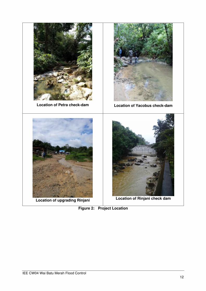
Location of Petra check-dam
Location of Yacobus check-dam
Location of upgrading Rinjani
Location of Rinjani check dam
Figure 2: Project Location

IEE CW04 Wai Batu Merah Flood Control 13
Figure 3: Location of Ambon Flood Control in Way Batu Merah Watershed

IEE CW04 Wai Batu Merah Flood Control 14
Figure 4: Location of Check Dam Petra, Check Dam Yacobus and Check Dam Rinajni (eksisting) in Way Batu Merah

IEE CW04 Wai Batu Merah Flood Control 15
B.2.2. Design, Magnitude and Construction Description
B.2.2.1. Design and Magnitude
The Batu Merah river is 7 km long and has a catchment area of about 7 km². The average gradient of River is about 1/320 and the elevation of upstream highlands is above 375 m. The river width particularly in the downstream area is about 6~20 meters and in most places confined between concrete walls of various sizes and heights. The river discharge capacity at the river mouth was estimated at 40 m³/s in 1997 by a JICA study, which also estimated that the peak flow in the river often exceeds 100 m³/s
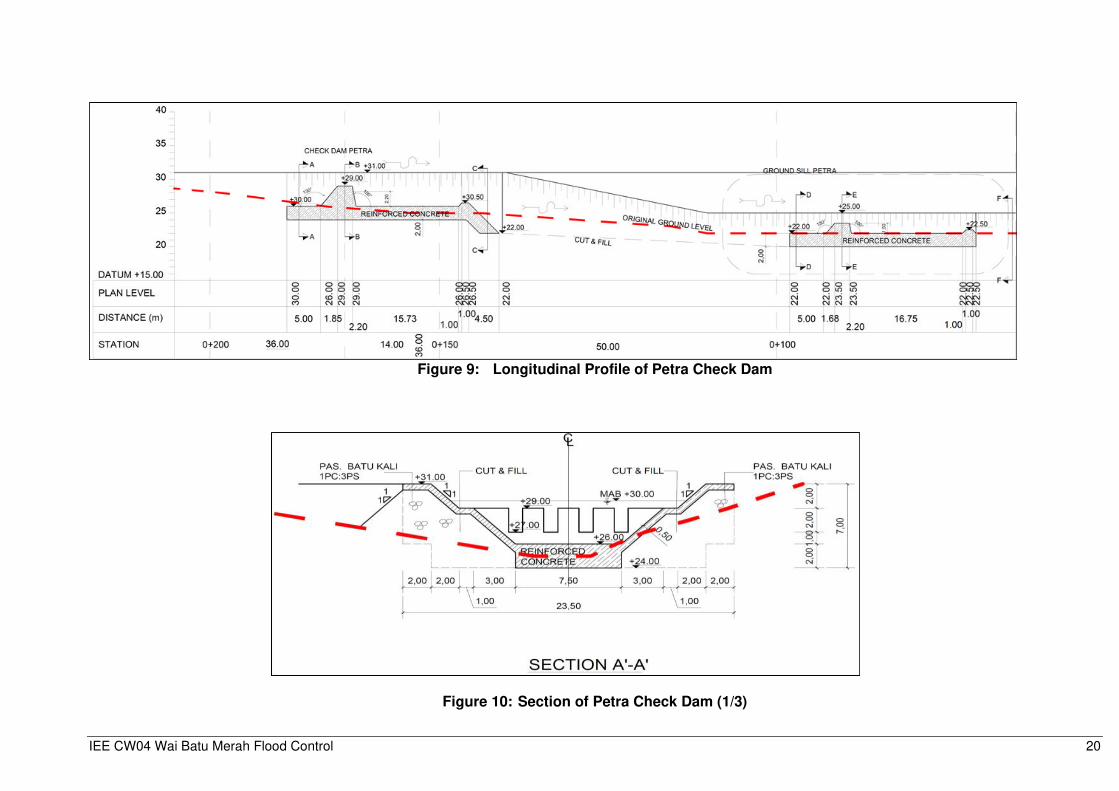
Table 3: Features of Petra and Yacobus Check Dams
Features Petra Check
Dam Yacobus
Check Dam
Total length 58.51 m 58.51 m Dam length 15.50 m 31.30 m Total width 23.50 m 23.50 m Dam crest width 7.50 m 19.50 m Opening top width 19.50 m 13.00 m Opening crest width 13.50 m 7.50 m Bottom width 7.50 m 7.50 m Total dam height 5.0 m 5.00 m Opening crest height 3.0 m 3.00 m Upstream apron (reinforced concrete) 5.0 m 5.00 m Downstream apron (reinforced concrete) 15.0 m 15.00 m Dam crest elevation EL ±31.00 EL 45.00 Opening crest elevation EL ±29.00 EL 43.00 Upstream apron elevation EL ±30.00 EL 40.00 Downstream apron elevation EL ±30.00 EL 40.00 End sill elevation EL ±30.50 EL 40.50 Type of check dam Slit type Slit type
Hydraulic modelling using Lidar acquisition shows the impact of upgraded Rinjani check dam
with Q25 flood event. The Rinjani will be upgraded to have flood detention function.

IEE CW04 Wai Batu Merah Flood Control 16
Figure 5: Physical Interventions in Wai Batu Merah
IEE CW04 Wai Batu Merah Flood Control 17
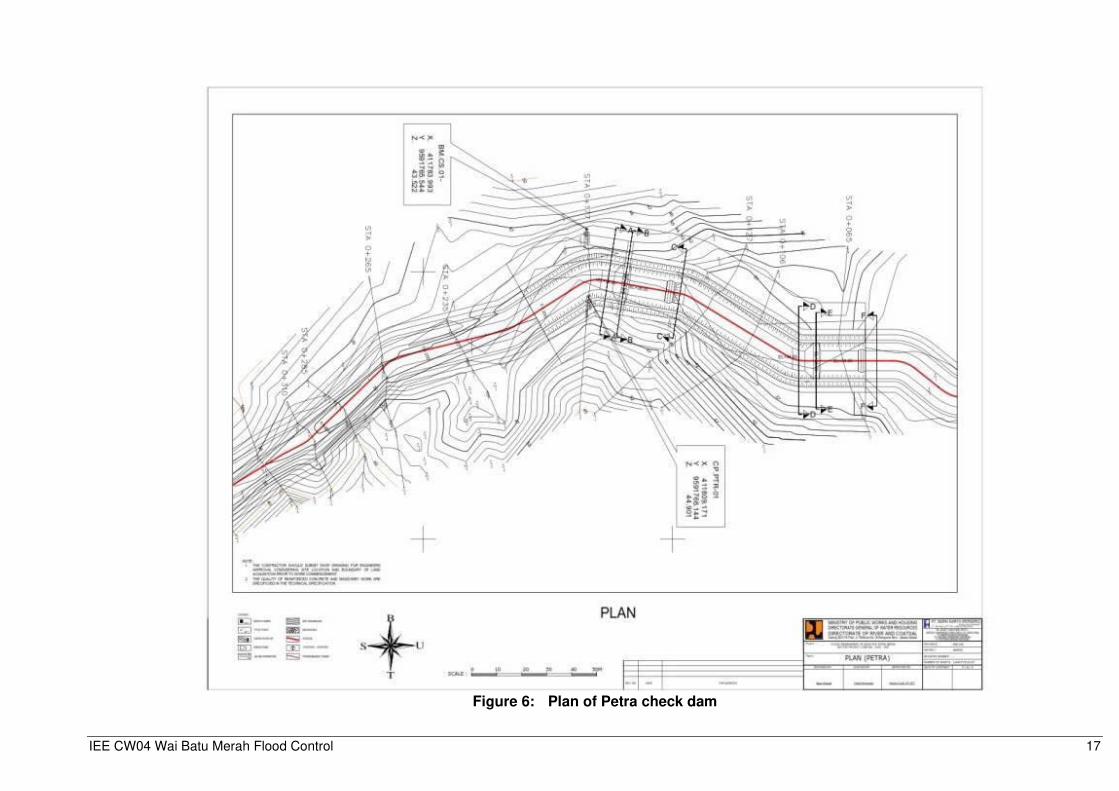
Figure 6: Plan of Petra check dam

IEE CW04 Wai Batu Merah Flood Control 18
Figure 7: Check Dam Petra I Plan

IEE CW04 Wai Batu Merah Flood Control 19
Figure 8: Check Dam Petra II
IEE CW04 Wai Batu Merah Flood Control 20
Figure 9: Longitudinal Profile of Petra Check Dam
Figure 10: Section of Petra Check Dam (1/3)

IEE CW04 Wai Batu Merah Flood Control 21
Figure 11: Plan of Yakobus check dam

IEE CW04 Wai Batu Merah Flood Control 22
Figure 12: Check Dam Yacobus Detailed Plan
IEE CW04 Wai Batu Merah Flood Control 23
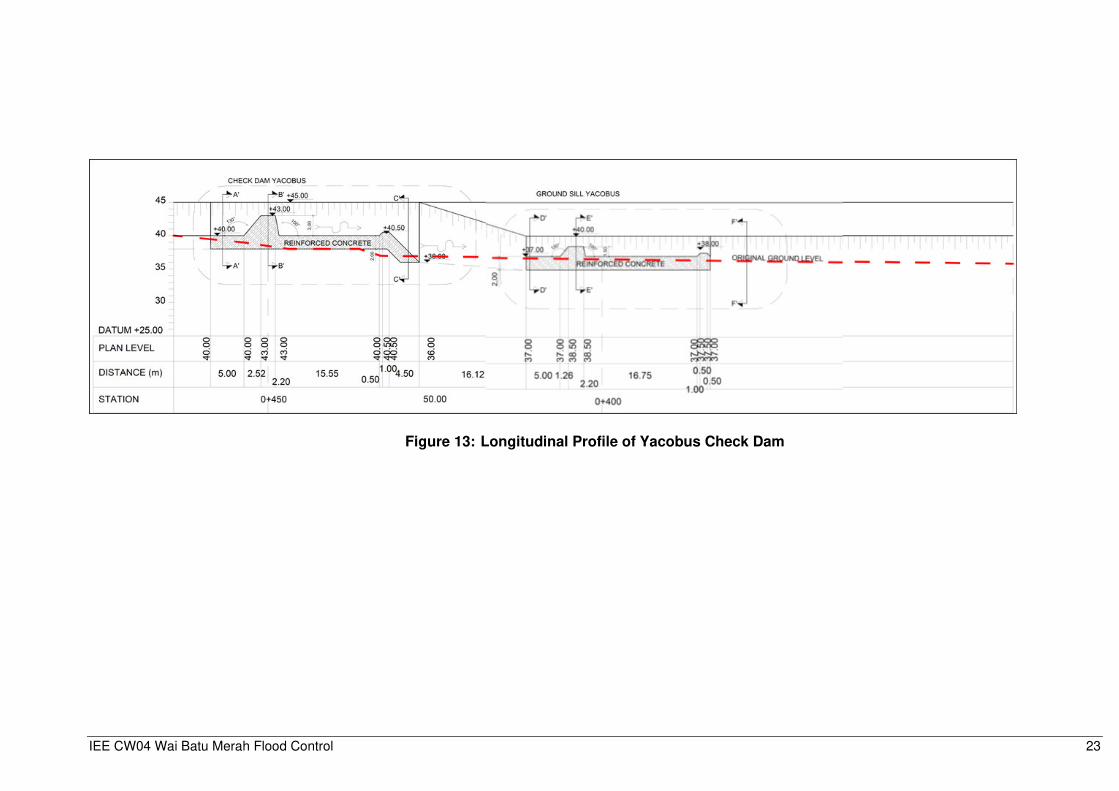
Figure 13: Longitudinal Profile of Yacobus Check Dam

IEE CW04 Wai Batu Merah Flood Control 24
Figure 14: Layout of Upgrading of Rinjani

IEE CW04 Wai Batu Merah Flood Control 25
Figure 15: Layout Rinjani Check Dam

IEE CW04 Wai Batu Merah Flood Control 26
Figure 16: Outline plan Rinjani Retention Pond
INFORMATION
Dredging Area 6m = 4.47 Ha
Volume Dredging = 268,200 m3
Dredging 6m
El. +12.00 m
Rinjani Upgrade 2m
Crest El. +20.00 m
LEGEND
1
Dredging
Area 6m
Retenstion Pond Dike Top. El +22.00 m
River Parapet Top. El +24.00 m
Embankment
Parapet
Diversion
Channel
River Channel Diversion
B = 8 m

IEE CW04 Wai Batu Merah Flood Control 27
Figure 17: Rinjani Check Dam Cross Section

IEE CW04 Wai Batu Merah Flood Control 28
B.2.2.2. Construction Description
Equipment and Material Mobilization
There are two material mobilization processes for construction, namely the mobilization of materials from the quarry to the location of the construction plan (both for check dam construction and embankment construction) and mobilization of excavated material from check-dam construction to the disposal area. Volume cutting of Petra area is estimated to be left upstream to downstream of 28,427.88 m³, volume cutting of Petra area is estimated to be right upstream to downstream 21,109.01 m³. Total volume of excavated material for Petra check-dam is 49,536.88m³, and for Yacobus check-dam is 8.473,5 m³. Fill volume for Petra check-dam is 1.711 m³, and for Yacobus check-dam is 286 m³.
Table 4: Excavated volume sediment removal from Rinjani
Area of sediment to the right of Rinjani 2,330 m² Area of sediment to the left of Rinjani 3,198 m² Total area 5,528 m² Safety factor (1,2) 6,633.6 m² High plan excavation -2 m Excavated volume 13,267.2 m3
The volume of the planned excavation in accordance with the flow of the river which is
still running normally up to now is 13,267.2 m³. It is estimated that 1 Komatsu PC 200 excavator has a bucket capacity of 0.7 m³ with a total excavation volume of 13,267.2 m³. So the productivity of a PC 200 excavator in 1 day (8 working hours) can produce as much as 8 trips. Where 1 trip 5-6 m³. So the volume (total excavation / productivity of 1 PC 200 excavator can be completed during (13,267.2 / 8 x 6) = 276 days equivalent to 9.2 months for 1 PC 200 excavator.
The disposal area is located in Tantui Sirimau District near Maluku Regional Police
Ceremony Field, distance from Petra and Yacobus check dam ± 5 km. The spoil disposal location of this area still needs to be coordinated with the BWS Maluku and related agencies. Figure 18 shows the location of the batching plant, the contractor informed.
not made in the project area with its own batching plant

IEE CW04 Wai Batu Merah Flood Control 29
Figure 18: Material transportation routes from quarry to project and to Disposal Area.

IEE CW04 Wai Batu Merah Flood Control 30
Figure 19: Access road, Location Bacthing Plant and Base Camp/ Management Shack

IEE CW04 Wai Batu Merah Flood Control 31
Alternative quarry locations:
1. Baching plant and quarry loaction located near Pattimura Airport (Sakula area) with ±24 km from work station.
2. Quarry loaction on Teluk Baguala district with distance ±15 km from work station (quarry slit and sand)
3. Batching plant Nindya Karya location ± 5 km from work station Alternative disposal area locations:
1. Located in Tantui Sirimau District near Polda Maluku Ceremony Field with distance ±5 km
The material transportation process requires 8 trips of dump trucks per day. The process of transporting the material and disposal will go through the main road Jendral Sudirman-Jembatan Merah Putih- Dr J Leimena (route from quarry to check dam Petra and Yacobus).
The quarry location is estimated to be in the Bay of Baguala District, (15 km from work station) but it needs to be confirmed with the contractor, regarding the permits owned by the quarry manager. The contractor is required to require ownership of a valid quarry management permit and also an environmental permit.
Table 5: Types and Requirements of Heavy Equipment for construction Ambon Wai Batu Merah Flood Control
No Name equipment
Type Required Activities
1 Bulldozer 15 Ton 1 ▪ Land clearing
▪ Dumping area (Heap leveling and compaction)
▪ Construction
2 Bulldozer 10 ton 1 ▪ Dumping area (Heap leveling and compaction)
3 Excavator 1.2 m³ 1 ▪ Land Preparation (Dredging and Excavation)
▪ Dumping area (Lifting Materials)
▪ Construction (Lifting soil and rock excavations)
4 Backhoe 1.2 m³ 1 ▪ Dumping area (Lifting Materials))
▪ Construction (Lifting Materials))
6 Dump Truck 10 Ton 20 ▪ Dumping area (Transport material from the pile of material to the construction site)
7 Vibrating Roller 10 ton 2 ▪ Dumping area (compaction)
8 Motor Grader 3.1 m 1 ▪ Dumping area (pile surface formation)
9 Truck Crane 5 Ton 2 ▪ Lifting loads in large quantities
10 Bore Pile Yanmar J1000
1 ▪ Tools to drill the ground for building foundation needs

IEE CW04 Wai Batu Merah Flood Control 32
Table 6: Material Transport Vehicle
No Type Transport vehicle Capacity
1 Truck 4 Ton
2 Dump Truck 8 Ton
3 Flat-bed truck 20 Ton
4 Water truck 5,000 Liter
5 Concrete Mixer truck 5 Ton
Construction material:
• Sand : 810 m³
• Gravel : 1.137 m³
• Cement : 884 sacks
• Cast iron : 377 ton
• Wood formwork : 311 m³ Mobilization of equipment and materials to the site of the project site is planned by using
the roads in the Ambon City area to the closest location to the construction activities, namely Jenderal Sudirman road (SPBU Kebun Cengkah) heading to the location of the Ambon Flood Control Wai Batu Merah construction activities (Check dam Petra, Yacobus and Rinjani). Check dam Petra and Yacobus route also can go through the main road Jendral Sudirman-Jembatan Merah Putih- Dr J Leimena road. Labor
The construction work requires 410 workers, consisting of 15 workers from BWSM, 85 skilled workers from the contractor, and 310 workers from the sub-contractor of which 60 skilled personnel (senior high schools – and higher) and 250 unskilled personnel (education under senior high school - non-school). 75% of unskilled workforce is expected from local workers from around the project site. Table 7: Labor Requirements during the Construction Phase of the Flood Control Wai
Batu Merah Ambon
No Area Expertise Needs
(man)
Priority of origin of labor
Education Labor classification
Business Owner (Balai Wilayah Sungai Maluku)
1 General Manager 1 Comer S1 --
2 Project Manager 1 Comer S1 --
3 Planning and Supervisor 5 Comer S1 --
4 Environmental and Safety 4 Comer S1 --
5 Administration and Finance 4 Comer S1 --
Total 15 --
Contractor
1 Project Manager 1 Comer S1 Special expertise according to position and Certificate of Expertise / Training
2 Site Engineering Manager 1 Comer S1
3 Site Operation Manager 1 Comer S1
4 Site Administration Manager 1 Comer S1
5 Supervisor 6 Comer S1
6 Geotechnical Civil Field 10 Comer S1
7 Civil Field Building 10 Comer S1
8 Civil Hydrology 10 Comer S1
9 Mechanical Engineering 5 Comer S1

IEE CW04 Wai Batu Merah Flood Control 33
No Area Expertise Needs
(man)
Priority of origin of labor
Education Labor classification
10 Mechanical Electrical Engineering
5 Comer S1
11 The Mechanical Fluid Field 5 Comer S1
12 Environment and Safety 5 Comer S1
13 IT Field 5 Comer S1
14 Administration and Finance 5 Comer S1
15 Legal and Cooperation Affairs
5 Comer S1
16
Social Affairs, Public Relations, and HR
5 Local – Comer SMA
17 Logistic and Equipment 5 Local – Comer SMA
Sum 85
Sub-contractor
1 Implementation 10 Local – Comer SMA – S1 Special expertise according to position and Certificate of Expertise / Training
2 Supervisor 25 Local – Comer SMA
3 Operator 25 Local – Comer SMA
4 Driver
25
Local – Comer --
5 Foreman 25 Local -- Expertise: • Head Builders and builders have basic skills in the field of building construction • Workers do not need expertise
6 Artisan 50 Local --
7 Worker 150 Local --
Total 310
Grand Total 410
Source: Consultant Analyses, 2019
Employment Services and Opportunities for Job Related Projects
The project to construct check dams in Batu Merah will provide employment, especially during the construction phase for communities along the impact corridor. The estimated workforce needed is 410 workers during the 12-month construction period.
Current livelihoods and activities that generate income from affected households can be described as trade-based and unskilled with income below the City's Minimum Wage. They need alternative or additional sources of income to meet their daily needs. It is expected that there will be sufficient employment opportunities, which do not require special skills, during the construction phase.
Management Basecamp To expedite the process of construction activities a Management Basecamp will be prepared. The size of the Management basecamp is 40 m² and the size of the workshop is 50 m². Management basecamp and workshops are planned to be provided in both Petra and Jacobus check-dam projects areas. Management of Clean Water and Wastewater
Out of 410 workers, it is estimated that 395 workers will live in the base camp, which will require 23.7 m³ of clean water per day, based on a daily need for clean water for workers of 60 liters / person/day (Permen PU No.14/PRT/M/2010). For watering the project site location is estimated at 5 m³ / day which fulfillment is sourced from water trucks. Drinking water needs are

IEE CW04 Wai Batu Merah Flood Control 34
estimated at 2 liters / person / day, so the required amount of drinking water is 820 liters / day (0.82 m³/day). So the total need for clean water during the construction stage is 30.42 m³ / day. Fulfillment of clean water needs for MCK workers is planned from water tank trucks. The water usage balance at the construction stage is presented in the following chart.
Figure 20: Water Balance Construction Stage
Domestic wastewater originates from used clean water from the labor force, discharged from MCK facilities. Domestic wastewater generated is 19.68 m³ / day (80% of the use of clean water). Domestic wastewater management is planned through temporary septic tanks near the MCK. Outflow from these septic tanks then infiltrated into the ground, while the sludge from the septic tank is suctioned through collaboration with third parties.
Domestic Solid Waste Management Besides domestic wastewater production, the workforce activities will also produce solid
waste in the form of domestic waste from the remnants of individual activities. The type of waste produced is generally in the form of food and beverage packages. This labor waste generation is assumed to be the same as the settlement's domestic waste generation, which is 2.75 – 3.25 liters / person / day (SNI 19-3983-1995). With waste generation of 3 liters / person / day, at peak construction conditions, domestic waste generation is estimated at 1,230 liters / day (1.23 m³ / day). Domestic waste management is carried out by providing 2 units of trash capacity in the room, and 2 container of 1 m³ capacity at the project site. Waste transportation is carried out in collaboration with relevant agencies in the Ambon City area, or waste can be transported directly to the final waste treatment site. Land Acquisition and Resettlement
Balai Wilayah Sungai Maluku (BWSM) has settled down the land acquisition for construction of both Yacobus and Petra check dam, as follows:
- Yacobus check dam: 960 m² - Petra check dam: 2,231 m² - Upgrading Rinjani 14,090.3 m²
Water needs 30.42 m3/day
Water tank truck 29.6m3/day
Mineral Water 0.82 m3/day
Drinking Water 0.82m3/day
Consumed
Toilet worker 23.7m3/day
Sprinkling 5.9 m3/day
Infiltrate into the ground
Septic Tank
Outflow 18.96m3/day
Domestic waste water
(80%= 18.96m3/day)
IEE CW04 Wai Batu Merah Flood Control 35
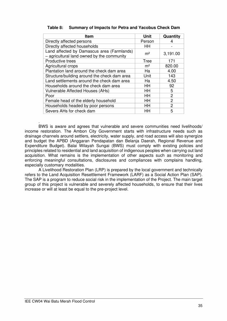
Table 8: Summary of Impacts for Petra and Yacobus Check Dam
Item Unit Quantity Directly affected persons Person 4 Directly affected households HH - Land affected by Damascus area (Farmlands) – agricultural land owned by the community
m² 3,191.00
Productive trees Tree 171 Agricultural crops m² 820.00 Plantation land around the check dam area Ha 4.00 Structure/building around the check dam area Unit 143 Land settlements around the check dam area Ha 4.50 Households around the check dam area HH 92 Vulnerable Affected Houses (AHs) HH 5 Poor HH 2 Female head of the elderly household HH 2 Households headed by poor persons HH 2
Severs AHs for check dam HH 5
. BWS is aware and agrees that vulnerable and severe communities need livelihoods/
income restoration. The Ambon City Government starts with infrastructure needs such as drainage channels around settlers, electricity, water supply, and road access will also synergize and budget the APBD (Anggaran Pendapatan dan Belanja Daerah, Regional Revenue and Expenditure Budget). Balai Wilayah Sungai (BWS) must comply with existing policies and principles related to residential and land acquisition of indigenous peoples when carrying out land acquisition. What remains is the implementation of other aspects such as monitoring and enforcing meaningful consultations, disclosures and compliances with complains handling, especially customary modalities.
A Livelihood Restoration Plan (LRP) is prepared by the local government and technically refers to the Land Acquisition Resettlement Framework (LARF) as a Social Action Plan (SAP). The SAP is a program to reduce social risk in the implementation of the Project. The main target group of this project is vulnerable and severely affected households, to ensure that their lives increase or will at least be equal to the pre-project level.
IEE CW04 Wai Batu Merah Flood Control 36
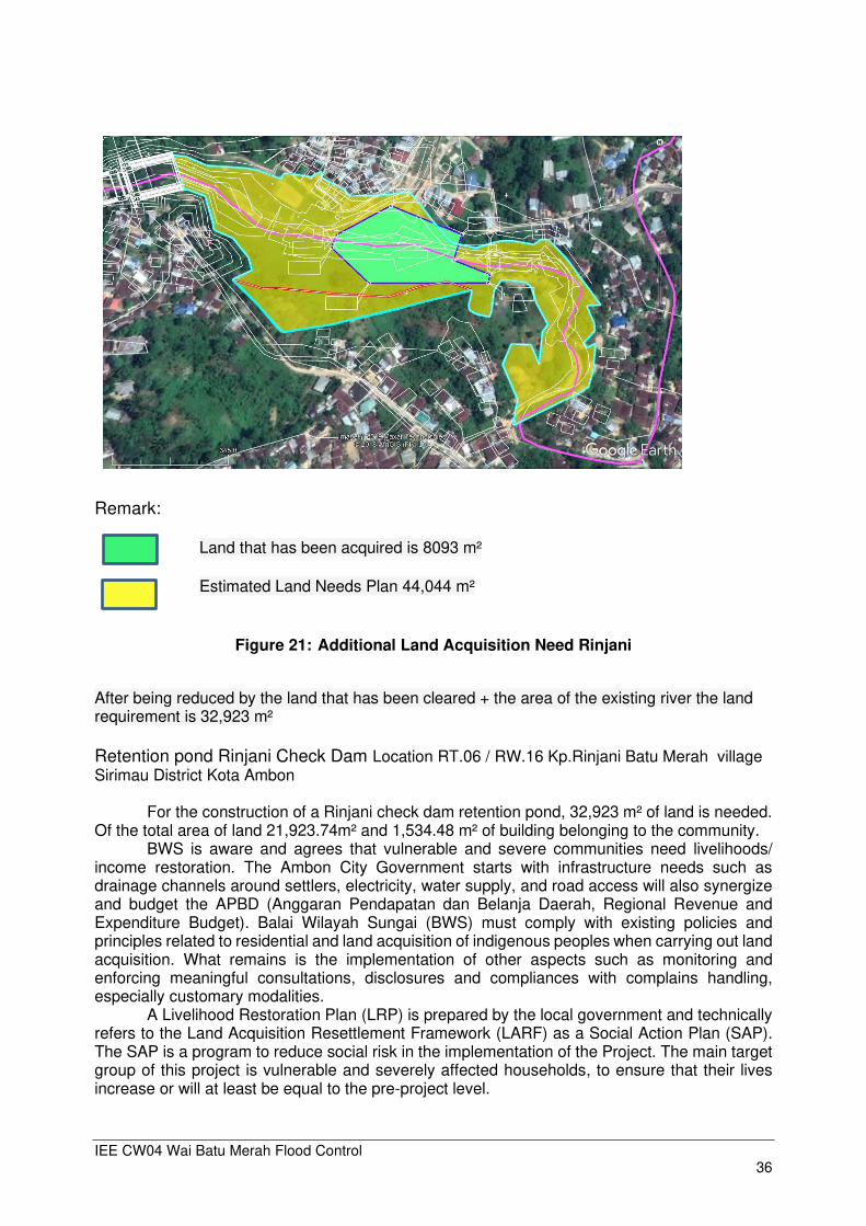
Remark: Land that has been acquired is 8093 m²
Estimated Land Needs Plan 44,044 m²
Figure 21: Additional Land Acquisition Need Rinjani
After being reduced by the land that has been cleared + the area of the existing river the land requirement is 32,923 m²
Retention pond Rinjani Check Dam Location RT.06 / RW.16 Kp.Rinjani Batu Merah village Sirimau District Kota Ambon
For the construction of a Rinjani check dam retention pond, 32,923 m² of land is needed. Of the total area of land 21,923.74m² and 1,534.48 m² of building belonging to the community.
BWS is aware and agrees that vulnerable and severe communities need livelihoods/ income restoration. The Ambon City Government starts with infrastructure needs such as drainage channels around settlers, electricity, water supply, and road access will also synergize and budget the APBD (Anggaran Pendapatan dan Belanja Daerah, Regional Revenue and Expenditure Budget). Balai Wilayah Sungai (BWS) must comply with existing policies and principles related to residential and land acquisition of indigenous peoples when carrying out land acquisition. What remains is the implementation of other aspects such as monitoring and enforcing meaningful consultations, disclosures and compliances with complains handling, especially customary modalities.
A Livelihood Restoration Plan (LRP) is prepared by the local government and technically refers to the Land Acquisition Resettlement Framework (LARF) as a Social Action Plan (SAP). The SAP is a program to reduce social risk in the implementation of the Project. The main target group of this project is vulnerable and severely affected households, to ensure that their lives increase or will at least be equal to the pre-project level.
IEE CW04 Wai Batu Merah Flood Control 37
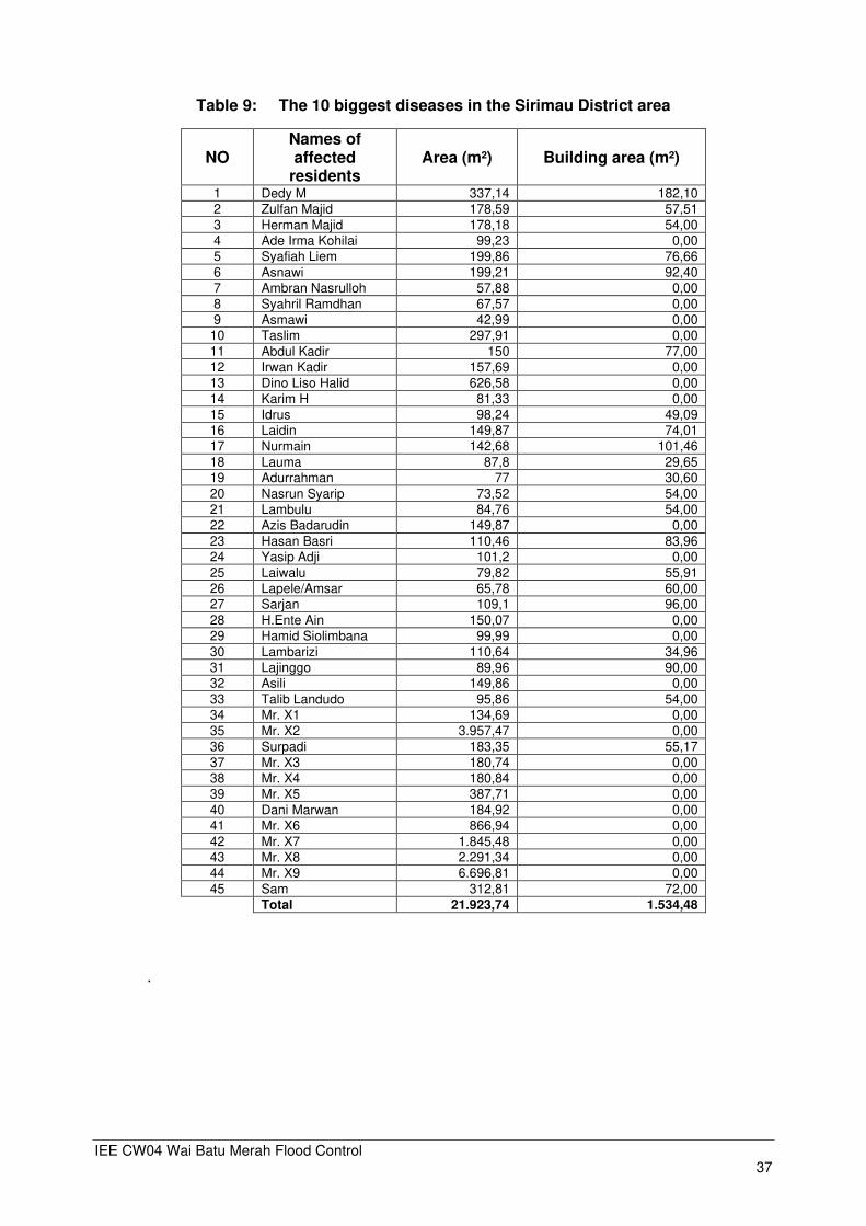
Table 9: The 10 biggest diseases in the Sirimau District area
NO Names of affected
residents Area (m²) Building area (m²)
1 Dedy M 337,14 182,10 2 Zulfan Majid 178,59 57,51
3 Herman Majid 178,18 54,00 4 Ade Irma Kohilai 99,23 0,00 5 Syafiah Liem 199,86 76,66
6 Asnawi 199,21 92,40 7 Ambran Nasrulloh 57,88 0,00
8 Syahril Ramdhan 67,57 0,00 9 Asmawi 42,99 0,00
10 Taslim 297,91 0,00
11 Abdul Kadir 150 77,00 12 Irwan Kadir 157,69 0,00
13 Dino Liso Halid 626,58 0,00
14 Karim H 81,33 0,00
15 Idrus 98,24 49,09 16 Laidin 149,87 74,01 17 Nurmain 142,68 101,46
18 Lauma 87,8 29,65 19 Adurrahman 77 30,60
20 Nasrun Syarip 73,52 54,00 21 Lambulu 84,76 54,00 22 Azis Badarudin 149,87 0,00
23 Hasan Basri 110,46 83,96 24 Yasip Adji 101,2 0,00
25 Laiwalu 79,82 55,91 26 Lapele/Amsar 65,78 60,00 27 Sarjan 109,1 96,00
28 H.Ente Ain 150,07 0,00 29 Hamid Siolimbana 99,99 0,00
30 Lambarizi 110,64 34,96 31 Lajinggo 89,96 90,00 32 Asili 149,86 0,00
33 Talib Landudo 95,86 54,00 34 Mr. X1 134,69 0,00
35 Mr. X2 3.957,47 0,00 36 Surpadi 183,35 55,17
37 Mr. X3 180,74 0,00 38 Mr. X4 180,84 0,00 39 Mr. X5 387,71 0,00
40 Dani Marwan 184,92 0,00 41 Mr. X6 866,94 0,00
42 Mr. X7 1.845,48 0,00 43 Mr. X8 2.291,34 0,00 44 Mr. X9 6.696,81 0,00
45 Sam 312,81 72,00
Total 21.923,74 1.534,48
.

IEE CW04 Wai Batu Merah Flood Control 38
Figure 22: Map of Batu Merah Watershed

IEE CW04 Wai Batu Merah Flood Control 39
Sedimentation The potential sediment is estimated as 30,163 m³/year (or 374.5 mm/year), 4,410 m³/year
(or 7.7 mm/year) and 8,061 m³/year (or 6,9 mm/year) at the existing sites of Rinjani, Petra and Yacobus Check Dam, respectively. The total potential sediment of Batu Merah River Basin is estimated as 2,614,328 m³/year. It shows that Rinjani, Petra and Yacobus Check Dams will possibly trap sediment 42,634 m³ in total and can re-operate with significant trap capacity with good operation and maintenance. There is still some residual sediment that must be overcome and regulated in the downstream of the remaining sediment release.
Table 10: Results of the erosion rate calculation using the USLE method for each
sediment check dam
Sediment control Matrix
Area Catchment USLE Method
Sediment rate Sediment potential
km² cumulative
(km²) mm/year
cumulative (mm/year)
m³/year cumulative (m³/year)
Rinjani 4.69 4.69 6.4 6.4 30,163 30,163
Petra 0.57 5.26 7.7 14.2 4,410 34,573
Yacobus 1.17 6.43 6.9 21.1 8,061 42,634 The disposal of dredging material requires careful consideration to minimize adverse
social and environmental effects. Currently the identified location is to use the dredged material from Batu Merah for land filling at Tantui Sirimau District near Maluku Regional Police Ceremony Field, thereby obtaining positive benefits. Currently the location of the disposal site is still tentative, and need to be confirmed. The process of stockpiling excavated materials at the Tantui Sirimau District location requires permission from the Ambon City Government before land filling can start.
B.3. Description of the Subproject
The project consists of river widening, limited dredging, strengthening the widened river banks with concrete and parapet and construction of inspection road at the right and left of the river. This concept supports the overall city river/waterside development plan, enabling for Batu Merah public use of both banks of the river. The existing width of river is from 6 to 30 m, and overall works will require an approximate 8 to 25 m (more than 50% less than 15 m) land acquisition corridor on both banks, to provide for a combination of river widening and strengthening for increased flow capacity and ready maintenance.
IEE CW04 Wai Batu Merah Flood Control 40
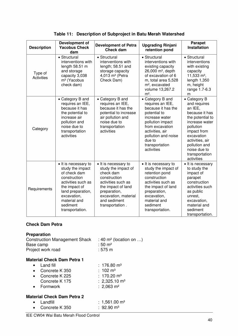
Table 11: Description of Subproject in Batu Merah Watershed
Description Development of Yacobus Check
dam
Development of Petra Check dam
Upgrading Rinjani retention pond
Parapet Installation
Type of Activities
• Structural interventions with length 58.51 m and storage capacity 3,038 m³ (Yacobus check dam)
• Structural interventions with length; 58.51 and storage capacity 4,013 m³ (Petra Check Dam)
• Structural interventions with existing capacity 26,000 m³, depth of excavation of 6 m, total area 5,528 m², excavated volume 13,267.2 m².
• Structural interventions with existing capacity 11,533 m³, length 1,350 m, height range 1.7-6.3 m
Category
• Category B and requires an IEE, because it has the potential to increase air pollution and noise due to transportation activities
• Category B and requires an IEE, because it has the potential to increase air pollution and noise due to transportation activities
• Category B and requires an IEE, because it has the potential to increase water pollution impact from excavation activities, air pollution and noise due to transportation activities
• Category B and requires an IEE, because it has the potential to increase water pollution impact from excavation activities, air pollution and noise due to transportation activities
Requirements
• It is necessary to study the impact of check dam construction activities such as the impact of land preparation, excavation, material and sediment transportation.
• It is necessary to study the impact of check dam construction activities such as the impact of land preparation, excavation, material and sediment transportation .
• It is necessary to study the impact of retention pond construction activities such as the impact of land preparation, excavation, material and sediment transportation.
• It is necessary to study the impact of parapet construction activities such as public unrest, excavation, material and sediment transportation.
Check Dam Petra Preparation Construction Management Shack : 40 m² (location on …) Base camp : 50 m² Project work road : 575 m Material Check Dam Petra 1
• Land fill : 176.80 m³
• Concrete K 350 : 102 m³
• Concrete K 225 : 170.20 m³ Concrete K 175 : 2,325.10 m³
• Formwork : 2,063 m² Material Check Dam Petra 2
• Landfill : 1,561.00 m³
• Concrete K 350 : 92.90 m³

IEE CW04 Wai Batu Merah Flood Control 41
• Concrete K 225 : 161 m³
• Concrete K 175 : 2,432 m³
• Formwork : 2,063 m² Check Dam Yacobus Preparation Construction Management Shack : 40 m² (location on …) Base camp : 50 m² Project work road : 575 m Material Check Dam Yacobus
• Land fill : 176.80 m³
• Concrete K 350 : 105 m³
• Concrete K 225 : 204 m³
• Concrete K 175 : 2,787 m³
• Formwork : 2,063 m² Material Retention pond Rinjani
Table 12: Features of Rinjani Check Dam
Features Dimension Unit
1. Type of check dam Slit Type
2. Crest Dam Elevation +20.00
3. Crest Width 25.00 m
4. Slit hole 2 x 2 // 3 unit m
5. Weir height 8.00 m
6. US apron El. +12.00
7. US apron length 38.00 m
8. DS apron 1 El. +11.00
9. DS apron 1 length 30.00 m
10. Sill 1 height 1.00 m
11. DS apron 2 El. +8.00
12. DS apron 2 length 20.00 m
13. Sill 2 height 0.50 m
Table 13: Soil Excavation Volume
Features Volume Downstream Retaining Wall
Reservoir Area 450,730.5 m3 Chanel 182,710 m3 Volume Total 633,440.50 m3
Rinjani Check Dam Soil embankment 32,164 m3 Soil Excavation 633,440 m3
IEE CW04 Wai Batu Merah Flood Control 42
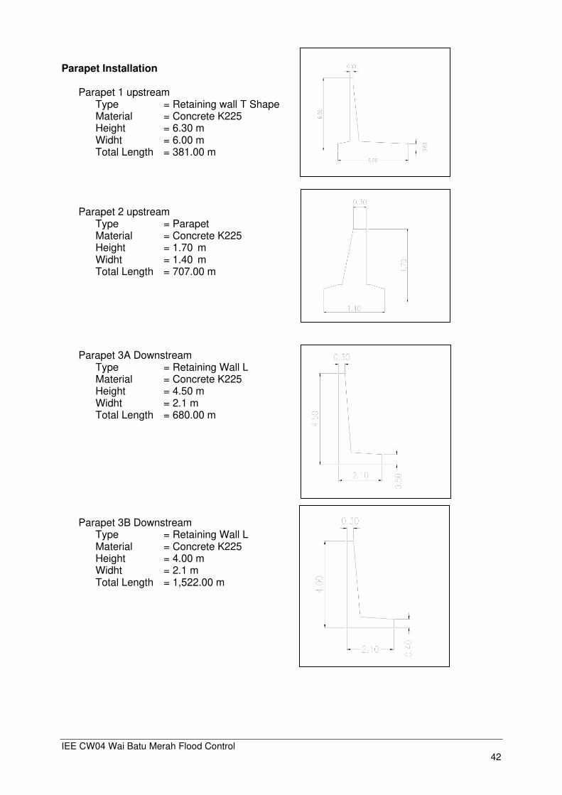
Parapet Installation
Parapet 1 upstream Type = Retaining wall T Shape Material = Concrete K225 Height = 6.30 m Widht = 6.00 m Total Length = 381.00 m
Parapet 2 upstream Type = Parapet Material = Concrete K225 Height = 1.70 m Widht = 1.40 m Total Length = 707.00 m
Parapet 3A Downstream
Type = Retaining Wall L Material = Concrete K225 Height = 4.50 m Widht = 2.1 m Total Length = 680.00 m
Parapet 3B Downstream Type = Retaining Wall L Material = Concrete K225 Height = 4.00 m Widht = 2.1 m Total Length = 1,522.00 m

IEE CW04 Wai Batu Merah Flood Control 43
B.4. Indicative Project Activities
B.4.1. Pre-Construction Phase
Activities completed in 2019. Some activities already undertaken by the Project Executing Agency as part of the project:
• The screening of the project has been carried out by ADB with the result: Environmental category B; (b) screening by DLH Province Maluku is presented in letter No.660 / 134.a / DLH / VII / 2018, based on changes in the check dam location in the previous AMDAL document, the BWS must make changes to the previously issued Environmental Permit: Change of Environmental Permit through Wai Batu Merah AMDAL Addendum study.
• The Petra and Yacobus Check Dam Construction Design Process is in the final stage and the process of preparing the SSR (Summary Subproject Report) CW04A.
• The process of preparing the Land Acquisition Report Plan (LARP) for the Petra and Yacobus Check Dam location plan, which was almost complete when the IEE report was prepared
• The process of preparing of the DED for Upgrading Rinjani.
B.4.2. Construction Phase
Land Clearing
A minor land clearing of Yacobus Check Dam 960 m², Petra Check Dam 2, 231 m² and upgrading Rinjani 14,090 m² are needed (source: LARP Survey 2019). Recruitment of construction labors
The construction of facilities and infrastructure Petra and Yacobus check dam will require skilled and unskilled labors, consisting of drivers, heavy equipment operators, project supervisor/foremen, stone men, carpenters, electricians, and daily labors. It is expected that most of the labor needs will be recruited from the community around the project site from Batu Merah and Wai Hoka village. For construction work it requires 410 workers. Business owner 15 workers, from 85 workers and sub-contractor 260. Contract Workers' qualifications consist of trained staff (secondary schools - tertiary institutions) and unskilled personnel 310 unskilled personnel (education under secondary school - non-school), but this number will be reduced as the works are gradually completed. Basecamp Activities
With the existence of 410 project workers who will carry out activities, the activities in the base camp will potentially cause the impact of water pollution and domestic solid waste. Out of 410 workers, it is estimated that 395 workers will live in the base camp, which will require 23.7 m³ of clean water per day, based on a daily need for clean water for workers of 60 liters/ person/day (Permen PU No.14/PRT/M/2010). For watering the project site location is estimated at 5 m³ / day which fulfillment is sourced from water trucks. Basecamp activities will produce liquid waste 18.96 m³/day, which will be managed with a septic tank.
Waste generated during the construction phase is produced from used food packaging,
including toiletries, beverages and others. The waste generation standard uses the criteria in SNI 19-3983-1995, which is 2.50 liters/person/day with a weight of 0.625 kg / person / day. With a total workforce of ± 410 people / day, the amount of waste generation from construction workers is 2.50 liters / person / day x 410 people = 1,025 liters / day (1 m³ / day) or with a heavy waste generation of 0.625 kg / person / day x 410 people = 256.25 kg/day. Workforce waste management is carried out by providing a 1 m³ mini container as a temporary waste collection site. The collected waste is then transported through collaboration with relevant agencies in Ambon city.
IEE CW04 Wai Batu Merah Flood Control 44
Mobilization of equipment and construction materials The mobilization of equipment will include small to medium-sized excavators and
bulldozer for earthworks, excavator, backhoe and small tonnage dump trucks for transportation of construction materials, etc. Construction materials to be mobilized are soils, rock/stones, sand, cement, cast iron, wood formwork, etc. Transportation activities are carried out both on construction materials and on the resultant sediment that must be disposed of at an authorized disposal site. The material transportation process requires 8 trips of trucks per day. The process of transporting the material and disposal will go through the main road Jendral Sudirman-Jembatan Merah Putih- Dr J Leimena (route from quarry to check dam Petra and Yacobus).
The disposal area is located in Tantui Sirimau District near Maluku Regional Police
Ceremony Field, on a distance from Petra and Yacobus check dam of ± 5 km. The volume to be cut of Petra area is estimated at 49,109 m³ , Yacobus check dam 286 m³ and excavated volume from Rinjani 13,267.2m³ total disposal sediment 62,662 m³ Fill volume for Petra check-dam is 1.711 m³, and for Yacobus check-dam is 286 m³, total 1,997 m³ Transportation by using a truck volume of 6 m³, then trips per day is 8 truck trips per day for transportation to disposal area . Construction Construction activities include the construction of diversion channels, check dam location dewatering, cofferdam construction, concrete works (reinforcing bars) and formwork, stone works, earth dike works (stripping, excavation, backfill, embankment on the right and left bank of rivers).
B.4.3. Post Construction Phase
Maintenance of flood control structures
Check dam failure can be prevented if the structures are properly maintained. Maintenance is an ongoing process that not only involves routine activities such as mowing the grass and clearing the trash-rack, but also includes regularly inspecting the structure and properly
operating its components. Maintenance activities also include excavation of sediment that has accumulated in check dams, at the location of sediment disposal allowed by the local government. Operation of flood control structures Check dams require regular maintenance as they are used primarily as a temporary structure and thereby are not designed to withstand long-term use. Dams should be inspected every week that it is sited in the channel and after every large storm. It is important that rubble, litter, and leaves are removed from the upstream side of the dam. This is typically done when the sediment has reached a height of one-half the original height of the dam. Conservation riverside area
Planting activities on the right and left bank of the river embankment are carried out to reduce the erosion of existing soil embankments. Reinforcement of embankment slopes using grass to reduce the rate of soil erosion.
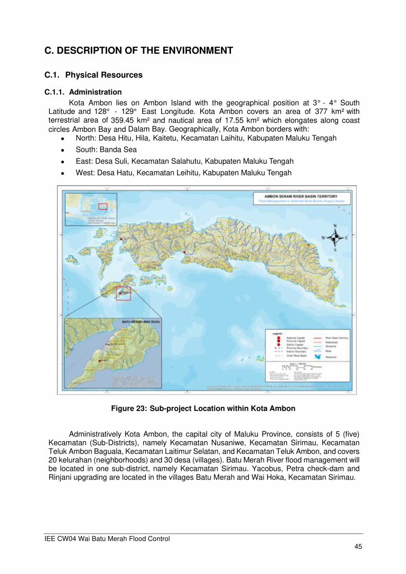
IEE CW04 Wai Batu Merah Flood Control 45
C. DESCRIPTION OF THE ENVIRONMENT
C.1. Physical Resources
C.1.1. Administration
Kota Ambon lies on Ambon Island with the geographical position at 3° - 4° South Latitude and 128° - 129° East Longitude. Kota Ambon covers an area of 377 km² with terrestrial area of 359.45 km² and nautical area of 17.55 km² which elongates along coast circles Ambon Bay and Dalam Bay. Geographically, Kota Ambon borders with:
⚫ North: Desa Hitu, Hila, Kaitetu, Kecamatan Laihitu, Kabupaten Maluku Tengah
⚫ South: Banda Sea
⚫ East: Desa Suli, Kecamatan Salahutu, Kabupaten Maluku Tengah
⚫ West: Desa Hatu, Kecamatan Leihitu, Kabupaten Maluku Tengah
Figure 23: Sub-project Location within Kota Ambon
Administratively Kota Ambon, the capital city of Maluku Province, consists of 5 (five)
Kecamatan (Sub-Districts), namely Kecamatan Nusaniwe, Kecamatan Sirimau, Kecamatan Teluk Ambon Baguala, Kecamatan Laitimur Selatan, and Kecamatan Teluk Ambon, and covers 20 kelurahan (neighborhoods) and 30 desa (villages). Batu Merah River flood management will be located in one sub-district, namely Kecamatan Sirimau. Yacobus, Petra check-dam and Rinjani upgrading are located in the villages Batu Merah and Wai Hoka, Kecamatan Sirimau.
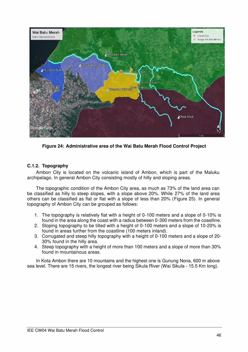
IEE CW04 Wai Batu Merah Flood Control 46
Figure 24: Administrative area of the Wai Batu Merah Flood Control Project
C.1.2. Topography
Ambon City is located on the volcanic island of Ambon, which is part of the Maluku archipelago. In general Ambon City consisting mostly of hilly and sloping areas.
The topographic condition of the Ambon City area, as much as 73% of the land area can
be classified as hilly to steep slopes, with a slope above 20%. While 27% of the land area others can be classified as flat or flat with a slope of less than 20% (Figure 25). In general topography of Ambon City can be grouped as follows:
1. The topography is relatively flat with a height of 0-100 meters and a slope of 0-10% is found in the area along the coast with a radius between 0-300 meters from the coastline.
2. Sloping topography to be tilted with a height of 0-100 meters and a slope of 10-20% is found in areas further from the coastline (100 meters inland).
3. Corrugated and steep hilly topography with a height of 0-100 meters and a slope of 20-30% found in the hilly area.
4. Steep topography with a height of more than 100 meters and a slope of more than 30% found in mountainous areas.
In Kota Ambon there are 10 mountains and the highest one is Gunung Nona, 600 m above sea level. There are 15 rivers, the longest river being Sikula River (Wai Sikula - 15.5 Km long).
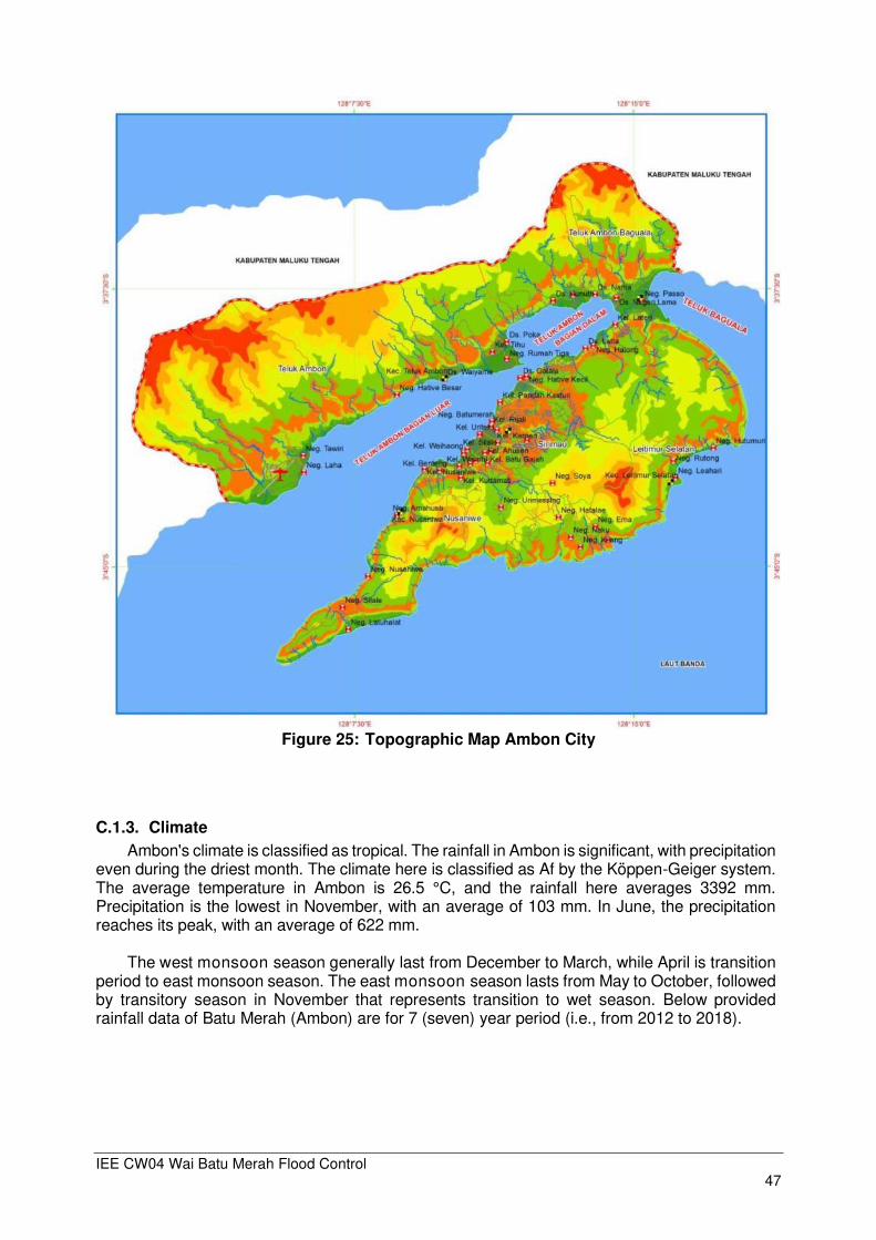
IEE CW04 Wai Batu Merah Flood Control 47
Figure 25: Topographic Map Ambon City
C.1.3. Climate
Ambon's climate is classified as tropical. The rainfall in Ambon is significant, with precipitation even during the driest month. The climate here is classified as Af by the Köppen-Geiger system. The average temperature in Ambon is 26.5 °C, and the rainfall here averages 3392 mm. Precipitation is the lowest in November, with an average of 103 mm. In June, the precipitation reaches its peak, with an average of 622 mm.
The west monsoon season generally last from December to March, while April is transition
period to east monsoon season. The east monsoon season lasts from May to October, followed by transitory season in November that represents transition to wet season. Below provided rainfall data of Batu Merah (Ambon) are for 7 (seven) year period (i.e., from 2012 to 2018).
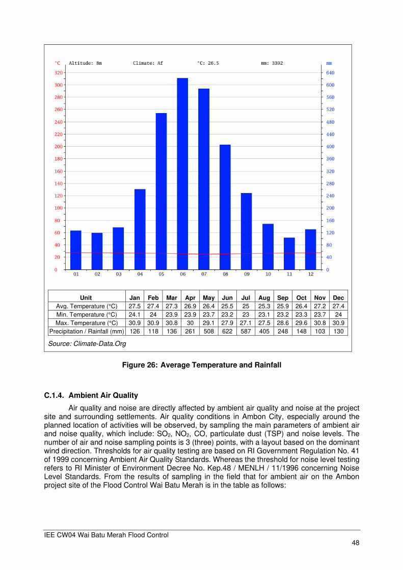
IEE CW04 Wai Batu Merah Flood Control 48
Unit Jan Feb Mar Apr May Jun Jul Aug Sep Oct Nov Dec
Avg. Temperature (°C) 27.5 27.4 27.3 26.9 26.4 25.5 25 25.3 25.9 26.4 27.2 27.4
Min. Temperature (°C) 24.1 24 23.9 23.9 23.7 23.2 23 23.1 23.2 23.3 23.7 24
Max. Temperature (°C) 30.9 30.9 30.8 30 29.1 27.9 27.1 27.5 28.6 29.6 30.8 30.9
Precipitation / Rainfall (mm) 126 118 136 261 508 622 587 405 248 148 103 130
Source: Climate-Data.Org
Figure 26: Average Temperature and Rainfall
C.1.4. Ambient Air Quality
Air quality and noise are directly affected by ambient air quality and noise at the project site and surrounding settlements. Air quality conditions in Ambon City, especially around the planned location of activities will be observed, by sampling the main parameters of ambient air and noise quality, which include: SO2, NO2, CO, particulate dust (TSP) and noise levels. The number of air and noise sampling points is 3 (three) points, with a layout based on the dominant wind direction. Thresholds for air quality testing are based on RI Government Regulation No. 41 of 1999 concerning Ambient Air Quality Standards. Whereas the threshold for noise level testing refers to RI Minister of Environment Decree No. Kep.48 / MENLH / 11/1996 concerning Noise Level Standards. From the results of sampling in the field that for ambient air on the Ambon project site of the Flood Control Wai Batu Merah is in the table as follows:
IEE CW04 Wai Batu Merah Flood Control 49
Table 14: Ambient Air Quality Measurement Results on the Project Site Ambon Flood Control Wai Batu Merah
No Parameter Unit Threshold**) Result
Location1 Location 2 Location 3
1 Sulfur Dioxide (SO2) µg/Nm³ 900 <8,28 <8,28 <8,28
2 Carbon Monoxide (CO)
µg/Nm³ 30,000 <1150 <1150 <1,150
3 Nitrogen Dioxide (NO2) µg/Nm³ 400 <6.5 <6.5 <6.5
4 Oxidan (O3) µg/Nm³ 235 <6.8 <6.8 <6.8
5 Hidrocarbon (HC) µg/Nm³ -- 25.4 27.3 26.7
6 Hidrogen Sufide (H2S) µg/Nm³ -- <0.017 <0.017 <0.017
7 Ammonia (NH3) µg/Nm³ -- <9.5 <9.5 <9.5
8 TSP (Dust) µg/Nm³ 90 0.005 1.98 76.6
9 Lead (Pb) µg/Nm³ 1 0.008 0.004 0.03
10 Noise***) dBA 55/70 48.6 49.0 52.3
11 Temperature 0C -- 29.8 31.8 33.5
12 Humidity % -- 62.2 60.0 52.4
13 Wind direction 0 -- 255 190 175
14 Wind speed m/s -- 0,8 – 1,8 0,5 – 1,2 0,3 – 0,7
15 Climate - -- Clear Clear Clear
16 Air pressure mmHg -- 759 759 759
*) Source: Addendum Amdal Wai Batu Merah Flood Control 2019(Laboratory PT Envilab Indonesia with KAN Certificate) **) Government Regulation No. 41 of 1999 concerning Ambient Air Quality Standards. ***) RI Minister of Environment Decree No. Kep.48 / MENLH / 11/1996 concerning Standard Noise Levels
From the results of air quality measurements from the 3 sampling locations, no air quality
parameters were found that exceeded the threshold.
C.1.5. Hydrology
Delineation of the Wai Batu Merah sub-region was carried out based on a 1: 50,000 scale topographic map as shown in Figure 27, published by the National Survey and Mapping Coordinating Board (BAKOSURTANAL), edition 2008. Due to the absence of automatic data, the distribution of maximum hourly rainfall from DGWR (PSA 007 and SNI2415-2016 Flood Safety Dam Guidelines) is directly used in the modeling, where the distribution of maximum rainfall every hour varies depending on the return period, with peak rainfall occurring in the first hour and gradual decrease over time, with an average percentage of rainfall distribution per hour of 47.00% in the first hour and 14; 7.57; 5.00; 4.00; 3.00; 2.00 and 1.00% for the following hours.
The HEC-HMS model was chosen and applied for hydrological simulations in the Wai
Batu Merah Watershed. Using maximum daily rainfall data and updating the CN value based on appropriate land use maps in each sub-watershed, further runoff rainfall modeling was performed to analyze flood hydrograph discharges Q5, Q10, Q25, Q50, and Q100 at the river branches of Wai Batu Merah, at the Rinjani Check Dam location (Figure 29) and at the river mouth (Figure 30). With a length of the main river of 6.76 km, and a ‘Time of Concentration’ of 85 minutes (time to reach the peak of the flood after the rain has started), the average flood velocity of 1.33 m/s was obtained.
In addition, a modified scenario of maximum rainfall distribution was simulated, where the amount of rainfall in the first hour is only about 100 mm. This resulted in the flood discharge
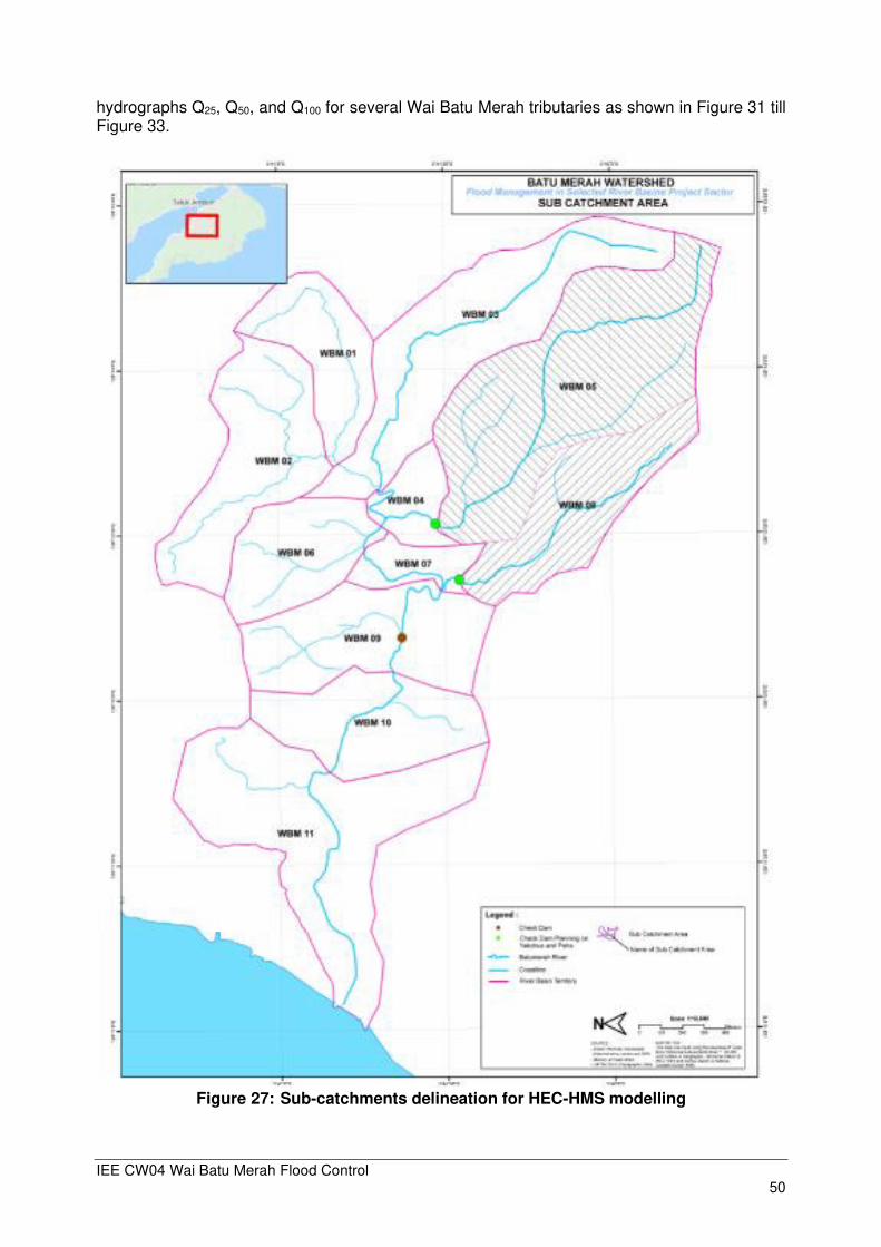
IEE CW04 Wai Batu Merah Flood Control 50
hydrographs Q25, Q50, and Q100 for several Wai Batu Merah tributaries as shown in Figure 31 till Figure 33.
Figure 27: Sub-catchments delineation for HEC-HMS modelling
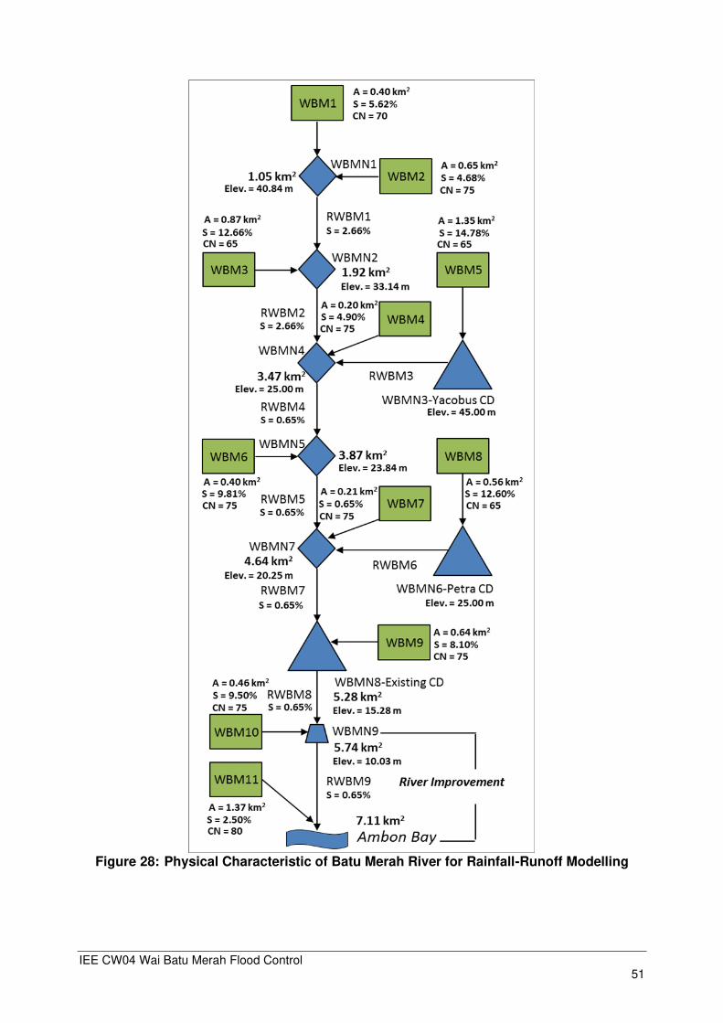
IEE CW04 Wai Batu Merah Flood Control 51
Figure 28: Physical Characteristic of Batu Merah River for Rainfall-Runoff Modelling

IEE CW04 Wai Batu Merah Flood Control 52
Figure 29: Flood hydrograph of Batu Merah River at WBMN9
Figure 30: Flood hydrograph of Batu Merah River at WBMN10 (River Mouth)

IEE CW04 Wai Batu Merah Flood Control 53
Figure 31: Q25 Flood hydrograph of Batu Merah River by Modification of Maximum Daily Rainfall Distribution
Figure 32: Q50 Flood hydrograph of Batu Merah River by Modification of Maximum Daily Rainfall Distribution.
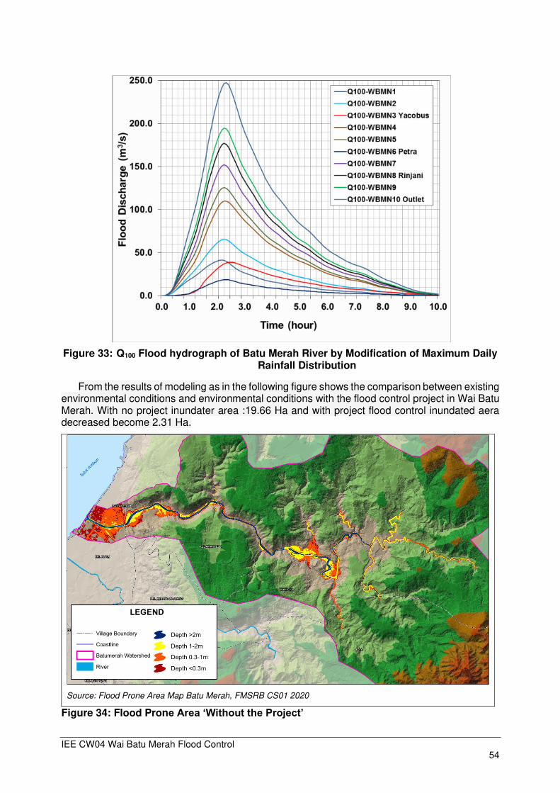
IEE CW04 Wai Batu Merah Flood Control 54
Figure 33: Q100 Flood hydrograph of Batu Merah River by Modification of Maximum Daily
Rainfall Distribution
From the results of modeling as in the following figure shows the comparison between existing environmental conditions and environmental conditions with the flood control project in Wai Batu Merah. With no project inundater area :19.66 Ha and with project flood control inundated aera decreased become 2.31 Ha.
Figure 34: Flood Prone Area ‘Without the Project’
Source: Flood Prone Area Map Batu Merah, FMSRB CS01 2020
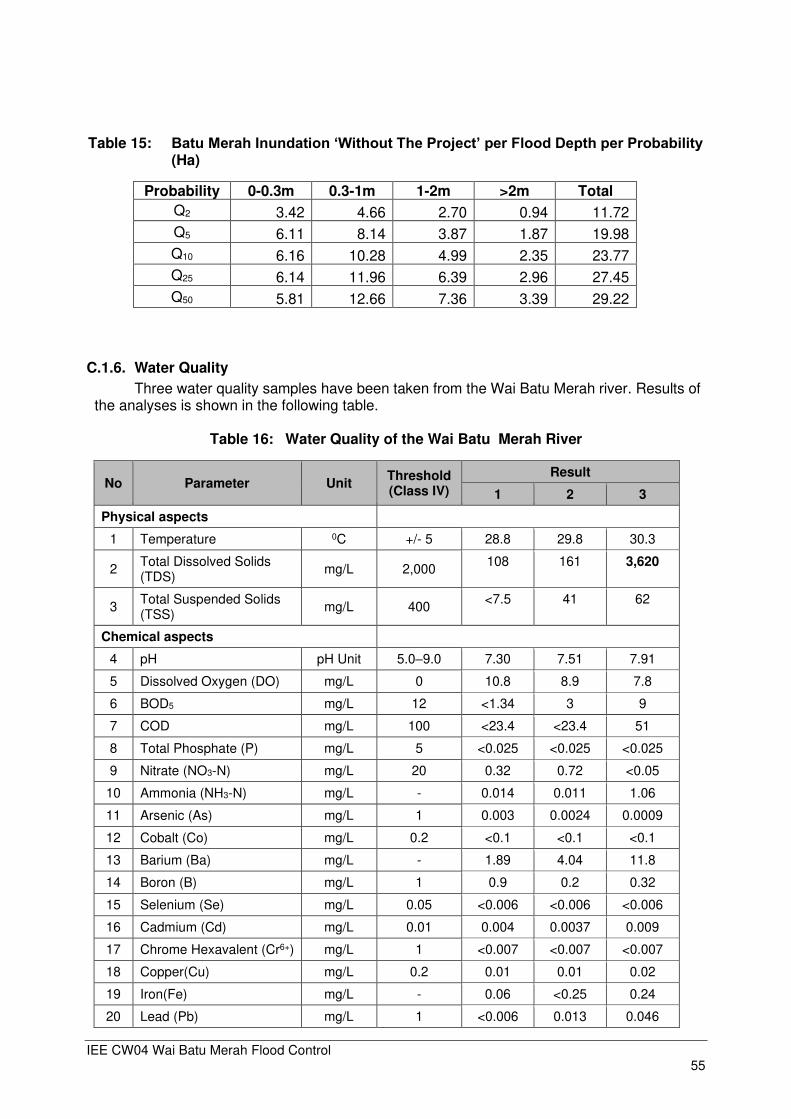
IEE CW04 Wai Batu Merah Flood Control 55
Table 15: Batu Merah Inundation ‘Without The Project’ per Flood Depth per Probability (Ha)
Probability 0-0.3m 0.3-1m 1-2m >2m Total
Q2 3.42 4.66 2.70 0.94 11.72
Q5 6.11 8.14 3.87 1.87 19.98
Q10 6.16 10.28 4.99 2.35 23.77
Q25 6.14 11.96 6.39 2.96 27.45
Q50 5.81 12.66 7.36 3.39 29.22
C.1.6. Water Quality
Three water quality samples have been taken from the Wai Batu Merah river. Results of the analyses is shown in the following table.
Table 16: Water Quality of the Wai Batu Merah River
No Parameter Unit Threshold (Class IV)
Result
1 2 3
Physical aspects
1 Temperature 0C +/- 5 28.8 29.8 30.3
2 Total Dissolved Solids (TDS)
mg/L 2,000 108 161 3,620
3 Total Suspended Solids (TSS)
mg/L 400 <7.5 41 62
Chemical aspects
4 pH pH Unit 5.0–9.0 7.30 7.51 7.91
5 Dissolved Oxygen (DO) mg/L 0 10.8 8.9 7.8
6 BOD5 mg/L 12 <1.34 3 9
7 COD mg/L 100 <23.4 <23.4 51
8 Total Phosphate (P) mg/L 5 <0.025 <0.025 <0.025
9 Nitrate (NO3-N) mg/L 20 0.32 0.72 <0.05
10 Ammonia (NH3-N) mg/L - 0.014 0.011 1.06
11 Arsenic (As) mg/L 1 0.003 0.0024 0.0009
12 Cobalt (Co) mg/L 0.2 <0.1 <0.1 <0.1
13 Barium (Ba) mg/L - 1.89 4.04 11.8
14 Boron (B) mg/L 1 0.9 0.2 0.32
15 Selenium (Se) mg/L 0.05 <0.006 <0.006 <0.006
16 Cadmium (Cd) mg/L 0.01 0.004 0.0037 0.009
17 Chrome Hexavalent (Cr6+) mg/L 1 <0.007 <0.007 <0.007
18 Copper(Cu) mg/L 0.2 0.01 0.01 0.02
19 Iron(Fe) mg/L - 0.06 <0.25 0.24
20 Lead (Pb) mg/L 1 <0.006 0.013 0.046

IEE CW04 Wai Batu Merah Flood Control 56
No Parameter Unit Threshold (Class IV)
Result
1 2 3
21 Manganese (Mn) mg/L - <0.03 <0.03 0.15
22 Mercury (Hg) mg/L 0.005 0.0021 0.0017 0.0013
23 Zinc (Zn) mg/L 2 0,02 0,016 0.023
24 Chloride (Cl) mg/L - 10 7 3,319
25 Cyanide (CN) mg/L - <0.004 <0.004 <0.004
26 Fluoride (F) mg/L - <0.09 0.38 0.6
27 Nitrate (NO2-N) mg/L - 0.008 0.02 0.021
28 Sulfate (SO4) mg/L - 44.8 44.3 244.7
29 Free chlorine (Cl2) mg/L - <0.04 <0.04 0.06
30 Sulfide (H2S) mg/L - <0.002 <0.002 0.004
31 Oil and grease µg/L - <1,000 <1,000 <1,000
32 Surfactant (MBAS) µg/L - 436 436 353
33 Fenol µg/L - <5 <5 <5
Biology
34 Fecal Coli CFU/100 mL 2000 0 0 1,000
35 Total Coli CFU/100 mL 10000 15,000 4,100 12,300
*) base on PP No 82/2001 regarding water quality management and water pollution control Location 1 : Upstream Wai Batu Merah in Kelurahan Amantelu (03041`12.3” LS dan 128011`55.2” BT) Location 2 : Midlle Wai Batu Merah in Negeri Batu Merah (03041`09.1” LS dan 128011`32.9” BT) Location 3 : Downstream Wai Batu Merah in Kelurahan Rijali (03041`10.9” LS dan 128011`04.7” BT) Source: Addendum Amdal Wai Batu Merah Flood Control 2019 (Laboratory PT Envilab Indonesia with KAN Certificate)
Water quality parameters (physical and chemical) that exceeded the quality threshold
according to PP No. 82 of 2001 concerning water quality management and water pollution control, Class IV (suitable for irrigation) include TDS, Surfactant and Total Coli. The results of coli bacterial examination show that the Wai Batu Merah has been contaminated with human fecal waste.

IEE CW04 Wai Batu Merah Flood Control 57
D.1.7. Geology and Soil
Based on geological and topographical map of Pulau Ambon1, Leitimur Peninsula composed by two indigenous material, namely alluvium of 61.55 ha (30.87 %) and korakkalk of 10.10 ha (5.06 %). In Leitimur Peninsula, there are two indigenous materials, namely alluvial and denudational which divided into alluvial plain, slightly eroded denudasional hill, medium eroded denudational hill, and strongly eroded denudational hill. Alluvial plain represents form of land existing between coastal area and hilly area. Alluvium formation and limestone represents indigenous material that composes this area with associated soil types such as alluvial, regosol, rensina, podsolik, and brunizem. Denudational hilly area represents the widest form of land in Leitimur Peninsula, namely 2,589 ha or 90.33 % which spreads over in wavy area such as hilly area, this land is affected by geomorphology process such as movement beneath the earth. Types of soil found in Seram and Kota Ambon based on USDA Keys Taxonomy (1988) as follows:
⚫ Regosol (Psamments) ⚫ Gleisol (Aquents/Aquepts) ⚫ Litosol (Lithic Ortents) ⚫ Kambisol (Tropepts) ⚫ Rensina (Rendolls) ⚫ Brunizem (Udalfs) ⚫ Podsolik (Udults)
Figure 35: Types of soil found in Seram and Kota Ambon
1 Made by Veerbek and Van Bos in 1898
Geology Ambon City
Alluvium Ambon Volcanic Rock Ultramafic Rock Kanikeh Formation Ambon Granite Lifted Coral Reefs
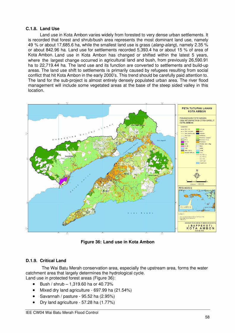
IEE CW04 Wai Batu Merah Flood Control 58
C.1.8. Land Use
Land use in Kota Ambon varies widely from forested to very dense urban settlements. It is recorded that forest and shrub/bush area represents the most dominant land use, namely 49 % or about 17,685.6 ha, while the smallest land use is grass (alang-alang), namely 2.35 % or about 842.96 ha. Land use for settlements recorded 5,393.4 ha or about 15 % of area of Kota Ambon. Land use in Kota Ambon has changed or shifted within the latest 5 years, where the largest change occurred in agricultural land and bush, from previously 26,590.91 ha to 22,719.44 ha. The land use and its function are converted to settlements and build-up areas. The land use shift to settlements is primarily caused by refugees resulting from social conflict that hit Kota Ambon in the early 2000’s. This trend should be carefully paid attention to. The land for the sub-project is almost entirely densely populated urban area. The river flood management will include some vegetated areas at the base of the steep sided valley in this location.
Figure 36: Land use in Kota Ambon
D.1.9. Critical Land
The Wai Batu Merah conservation area, especially the upstream area, forms the water catchment area that largely determines the hydrological cycle. Land use in protected forest areas (Figure 36):
• Bush / shrub – 1,319.60 ha or 40.73% • Mixed dry land agriculture - 697.99 ha (21.54%) • Savannah / pasture - 95.52 ha (2.95%) • Dry land agriculture - 57.28 ha (1.77%)

IEE CW04 Wai Batu Merah Flood Control 59
• Settlement - 17.00 ha (0.52%) • Primary dry land forest - 752.25 ha (23.22%) • Secondary dryland forest - 300.12ha (9.26%)
This shows that 67.51% of the Mount Sirimau protected forest area is cleared of forest stands, but has been transformed into other uses.
• Very critical - 3.02 ha (0.09%).
• Critical - 1221.58 ha (37.71%)
• Rather critical - 940.30 ha (29.02%)
• Potential critical - 953.83 ha (29.44%)
• Not critical - 121.01 ha (3.74%)
The level of land criticality in the Mount Sirimau protected forest area is rather critical. If this condition is not immediately managed properly, the potential for an increase in the level of land
criticality in the Mount Sirimau protected forest area is very large. In order to reduce the critical
land several rehabilitation efforts are carried out as set forth in POLA SDA Ambon Seram (long term plan, 2009 – 2029), among others:
• Inventory and analysis of critical land, erosion and sedimentation
• Reforestation (especially in critical land)
• Plantation along the river corridor (demarcation)
• Construction of check dam, dike, and bench terrace to recover land condition
• Construction of reservoir and embung (small water storage)
The forest and land conservation also was initiated through “National Movement on Forest and Land Rehabilitation or GERHAN2, including on Ambon Island.
Figure 37: Critical Land Ambon Island
2 GERHAN Program was implemented from 2003 to 2009 with the aim to stimulate various parties to participate in combating forest and land degradation so as to grow the culture of planting trees for Indonesian people

IEE CW04 Wai Batu Merah Flood Control 60
D.1.10. Landslide
Based on its potential, landslides that occur in Wai Batu Merah watershed are divided into 3 (three) namely high risk (red), medium risk (yellow) and low risk (green) and no risk (dark green). High landslide potential is found in the Wai Batu Watershed area in the upper reaches, which is generally a hilly area with steep slopes and a small portion in the midstream Wai Batu Watershed area.
Figure 38: Landslide Risk Zone of Batu Merah River Basin

IEE CW04 Wai Batu Merah Flood Control 61
C.2. Ecological Resources
C.2.1. Flora
The types of flora found in the planned activity site in the Wai Batu Merah upper-watershed (DAS hulu) are generally secondary dryland forest ecosystems and shrubs. Whereas in the mid- and downstream areas of Wai Batu Merah watershed, it is generally a cultivation ecosystem consisting of upland / field vegetation and mixed dryland gardens, the majority of which are cultivated plants, shrub vegetation and riparian vegetation. Based on the results of surveys and observations, plant populations that grow in the study area show moderate to sparse density levels. Whereas other plant species show low density. Dryland Forest Vegetation The predominant vegetation types at the level of trees in the Sirimau Mountain forest area in the upper reaches of Wai Batu Merah include Agathis (Agathis dammara) or Damar, Kayu Merah (Augenis sp), Meranti (Shorea Sp), Clove (Eugenia aromatica), Matoa (Pometia pinnata), Biroro (Ficus hispida), Forest Mangosteen (Gracinia sp) and Forest Nutmeg (Horsfieldia sylfestris). Cultivation Vegetation The types of vegetation that are cultivated are generally trees and food plants. At present agricultural activities in the form of farming and community-owned gardens are quite common in Wai Batu Merah watershed, which is generally dry land agriculture. Plants that are planted in this cultivation are generally palawija especially Peanuts (Arachis hypogea), Corn (Zea mays), Sweet Potatoes (Ipomoea batatas L.) and Cassava (Manihot esculenta) as well as other types of vegetable and palawija plants. Fruit trees are also found in the fields and in the residents' yards. Shrub Vegetation The types of plants found in shrubs include Babadotan (Ageratum Conyzoides), Suplir (Adiantum Sp), Talas (Colocasia esculenta), Awar-awar (Ficus septicum), Suruhan (Peperomia pellucida), Mikania (Mikania micrantha) and Wedelia (Sphagneticola trilobata). Riparian Vegetation Riparian vegetation that is often found in Wai Batu Merah river border is generally at the level of trees and shrubs (terna), both natural and aquaculture, some of which also function as plants for reinforcement on river banks. Some types of plants found include Bamboo (Bambusa sp, Gigantochloa sp.), Coconut (Cocos nucifera), Ketapang (Terminalia catappa), Banana (Musa paradisiaca) and several types of fruit plants such as Mango (Mangifera indica), Water Guava (Syzgyum aqueum).
C.2.2. Fauna
Maluku Province consists of 1,027 small and large islands, therefore it is well known as “Province of Thousands Island”. The province lies on the oriental area that located at the east side of Wallacea line and at the west side of Mayr line. For that reason, flora and fauna in Maluku (including Ambon and Seram) grouped into unit of Wallacea biogeography, which has unique flora and fauna (endemic), but also represent elements of Oriental and Australesia region. Such condition make Maluku has collection of very important endemic flora and fauna, especially in term of its biodiversity.
Especially for diversity of birds, Maluku has 348 types of birds with 90 endemic species. These types spread over in 5 DBE (Endemic Bird Area). Especially for crooked beak birds (cockatoo and Nuri) in Maluku there are 32 types and 12 types among them are only live in Maluku. The only known “Significant Bird” in Ambon is the Ambon Yellow White-eye Zosterops kueh3 which inhabits lowland forest, scrub and gardens up to 500 m, or remnant patches of secondary forest and woodland and lightly wooded cultivation to 300 m”. “As it is able to persist in degraded secondary habitats, the magnitude of this decline is unlikely to be great, but the
3 http://www.birdlife.org/datazone/speciesfactsheet.php?id=7485
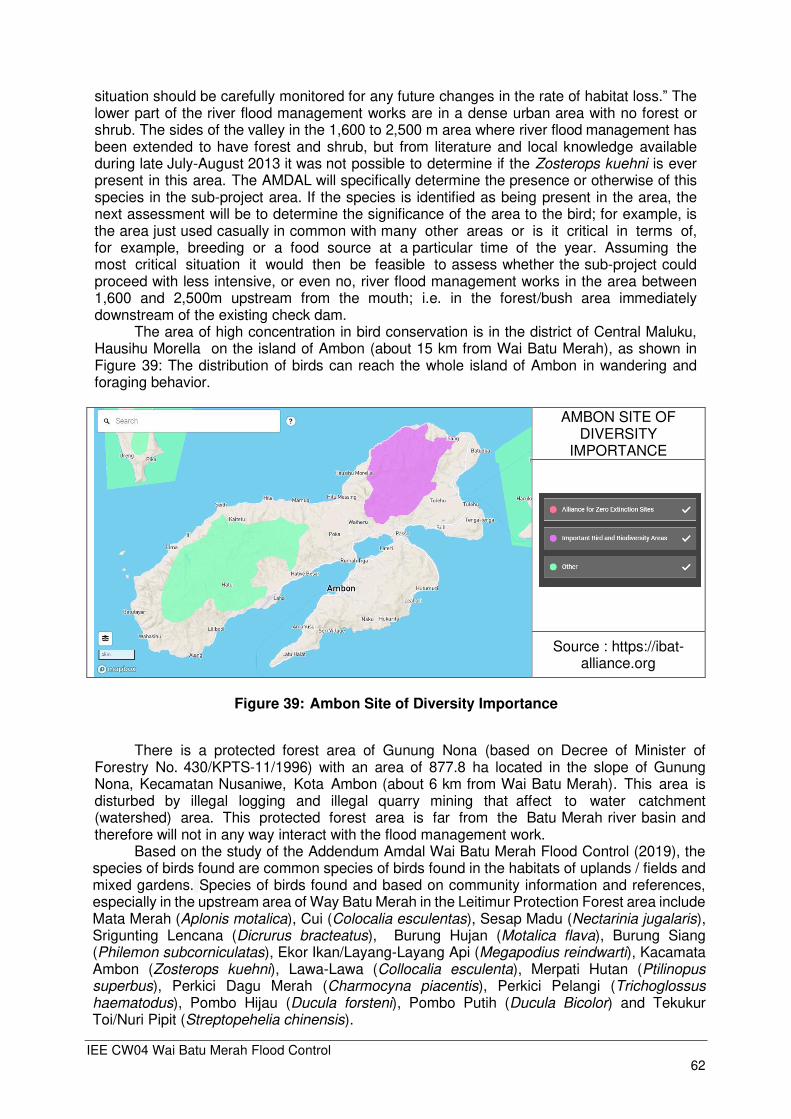
IEE CW04 Wai Batu Merah Flood Control 62
situation should be carefully monitored for any future changes in the rate of habitat loss.” The lower part of the river flood management works are in a dense urban area with no forest or shrub. The sides of the valley in the 1,600 to 2,500 m area where river flood management has been extended to have forest and shrub, but from literature and local knowledge available during late July-August 2013 it was not possible to determine if the Zosterops kuehni is ever present in this area. The AMDAL will specifically determine the presence or otherwise of this species in the sub-project area. If the species is identified as being present in the area, the next assessment will be to determine the significance of the area to the bird; for example, is the area just used casually in common with many other areas or is it critical in terms of, for example, breeding or a food source at a particular time of the year. Assuming the most critical situation it would then be feasible to assess whether the sub-project could proceed with less intensive, or even no, river flood management works in the area between 1,600 and 2,500m upstream from the mouth; i.e. in the forest/bush area immediately downstream of the existing check dam.
The area of high concentration in bird conservation is in the district of Central Maluku, Hausihu Morella on the island of Ambon (about 15 km from Wai Batu Merah), as shown in Figure 39: The distribution of birds can reach the whole island of Ambon in wandering and foraging behavior.
AMBON SITE OF DIVERSITY
IMPORTANCE
Source : https://ibat-alliance.org
Figure 39: Ambon Site of Diversity Importance
There is a protected forest area of Gunung Nona (based on Decree of Minister of
Forestry No. 430/KPTS-11/1996) with an area of 877.8 ha located in the slope of Gunung Nona, Kecamatan Nusaniwe, Kota Ambon (about 6 km from Wai Batu Merah). This area is disturbed by illegal logging and illegal quarry mining that affect to water catchment (watershed) area. This protected forest area is far from the Batu Merah river basin and therefore will not in any way interact with the flood management work.
Based on the study of the Addendum Amdal Wai Batu Merah Flood Control (2019), the species of birds found are common species of birds found in the habitats of uplands / fields and mixed gardens. Species of birds found and based on community information and references, especially in the upstream area of Way Batu Merah in the Leitimur Protection Forest area include Mata Merah (Aplonis motalica), Cui (Colocalia esculentas), Sesap Madu (Nectarinia jugalaris), Srigunting Lencana (Dicrurus bracteatus), Burung Hujan (Motalica flava), Burung Siang (Philemon subcorniculatas), Ekor Ikan/Layang-Layang Api (Megapodius reindwarti), Kacamata Ambon (Zosterops kuehni), Lawa-Lawa (Collocalia esculenta), Merpati Hutan (Ptilinopus superbus), Perkici Dagu Merah (Charmocyna piacentis), Perkici Pelangi (Trichoglossus haematodus), Pombo Hijau (Ducula forsteni), Pombo Putih (Ducula Bicolor) and Tekukur Toi/Nuri Pipit (Streptopehelia chinensis).

IEE CW04 Wai Batu Merah Flood Control 63
Species of birds found based references, especially in the upstream area of Wai Batu Merah in the protected forest area of Mount Sirimau include species of bird4
Table 17: Bird species in the Sirimau protected area forest
Local Name Latin Name IUCN Status Mata Merah Aplonis motalica Least Concern (LC) Cui/Lawa lawa Collocalia esculenta Least Concern (LC) Honey Suck Nectarinia jugalaris Least Concern (LC) Srigunting Lencana Dicrurus bracteatus Least Concern (LC) Burung Hujan Motalica flava Least Concern (LC) Burung Siang Philemon subcorniculatas Least Concern (LC) Burung Ekor Ikan Megapodius reinwardtii Least Concern (LC) Burung Kaca mata Zosterops kuehni NT (Near Threatened) Forest Pigeons Megapodius reinwardtii Least Concern (LC) Perkici Dagu Merah Charmocyna piacentis Least Concern (LC) Perkici Pelangi Trichoglossus haematodus Least Concern (LC) Green Pombo Ducula forsteni Least Concern (LC) White Pombo Ducula Bicolor Least Concern (LC) Teki Toi / Nuri Pipit Streptopelia chinensis Least Concern (LC)
Sources : Public Information and reference 2019 Based on direct observation at the project site, no habitat was found for the bird species
mentioned above. The existence of birds based on observations by the local community, is a wandering behavior to find food, outside the habitat area of these birds.
While in residential areas also found types of community pets such as chickens (Gallus gallus domesticus) and ducks (Anas anas). The types of mammals that are found directly at the study site are generally types of community mammals, namely Goat (Capra hircus), Cows (Bos primigenius), Cats (Felis catus) and Dogs (Canis lupus).
C.2.3. Water Biota
Aquatic biota consists of phytoplankton, zooplankton and Benthos. From the results of observations, identification of species and measurements of the ecological index obtained the following results.
Table 18: Diversity, Equitability and Dominance Indexes
Parameter Location
Upstream Midstream Downstream 1 2 3 1 2 3 1 2 3
Diversity (H’) 1.82 1.31 1.39 1.93 1.33 1.56 1,67 1.04 0.69 Equitability (E) 0.79 0.94 1.00 0.80 0.96 0,97 0.76 0.95 1 Dominance (D) 0.20 0.29 0.25 0.18 0.28 0,22 0.24 0.38 0.50
Remarks: 1: Phytoplankton 2: Zooplankton 3: Bentos From the analysis of aquatic biota, the diversity of Wai Batu Merah fair shows that the condition is mild to moderate. Severe polluted water conditions in benthic parameters at downstream sampling locations.
4 Latumahina, FS and Mardiatmoko, G, 2019, “Distribution of Endemic Birds in Protected Forests in Indonesia” International Journal of Environmental and Science Education, vol. 14 no 7, p 405-416.
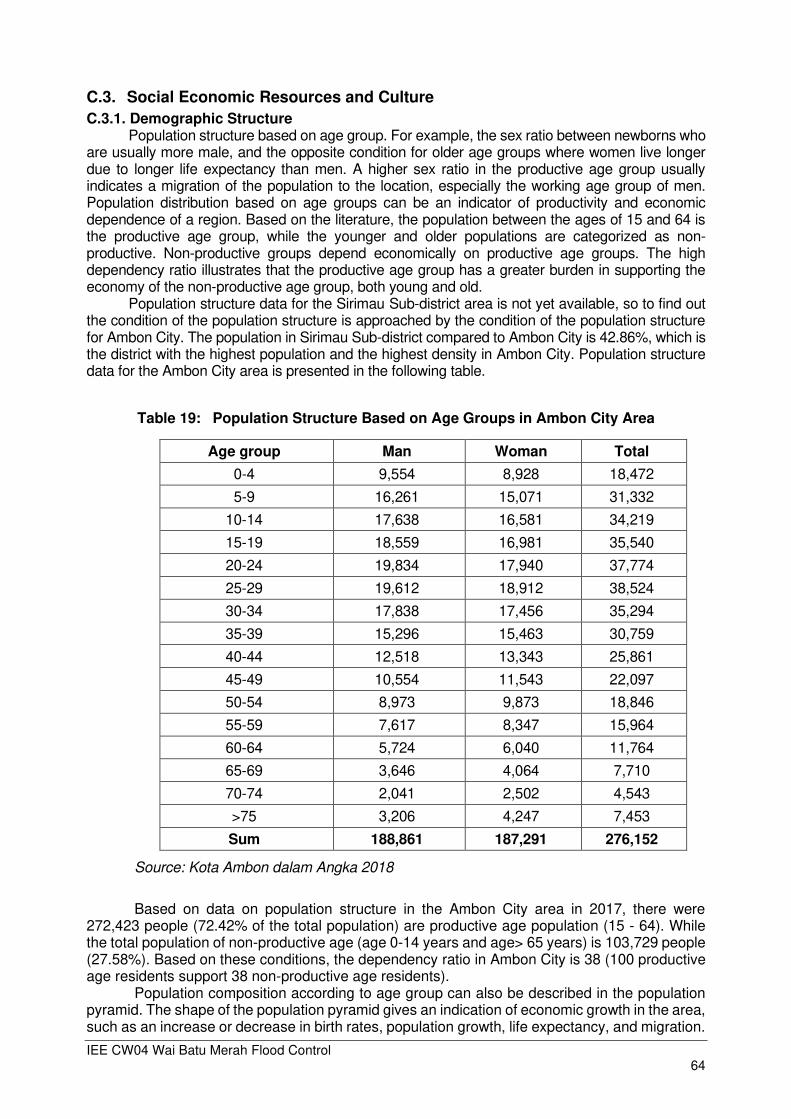
IEE CW04 Wai Batu Merah Flood Control 64
C.3. Social Economic Resources and Culture
C.3.1. Demographic Structure Population structure based on age group. For example, the sex ratio between newborns who
are usually more male, and the opposite condition for older age groups where women live longer due to longer life expectancy than men. A higher sex ratio in the productive age group usually indicates a migration of the population to the location, especially the working age group of men. Population distribution based on age groups can be an indicator of productivity and economic dependence of a region. Based on the literature, the population between the ages of 15 and 64 is the productive age group, while the younger and older populations are categorized as non-productive. Non-productive groups depend economically on productive age groups. The high dependency ratio illustrates that the productive age group has a greater burden in supporting the economy of the non-productive age group, both young and old.
Population structure data for the Sirimau Sub-district area is not yet available, so to find out the condition of the population structure is approached by the condition of the population structure for Ambon City. The population in Sirimau Sub-district compared to Ambon City is 42.86%, which is the district with the highest population and the highest density in Ambon City. Population structure data for the Ambon City area is presented in the following table.
Table 19: Population Structure Based on Age Groups in Ambon City Area
Age group Man Woman Total
0-4 9,554 8,928 18,472
5-9 16,261 15,071 31,332
10-14 17,638 16,581 34,219
15-19 18,559 16,981 35,540
20-24 19,834 17,940 37,774
25-29 19,612 18,912 38,524
30-34 17,838 17,456 35,294
35-39 15,296 15,463 30,759
40-44 12,518 13,343 25,861
45-49 10,554 11,543 22,097
50-54 8,973 9,873 18,846
55-59 7,617 8,347 15,964
60-64 5,724 6,040 11,764
65-69 3,646 4,064 7,710
70-74 2,041 2,502 4,543
>75 3,206 4,247 7,453
Sum 188,861 187,291 276,152
Source: Kota Ambon dalam Angka 2018
Based on data on population structure in the Ambon City area in 2017, there were
272,423 people (72.42% of the total population) are productive age population (15 - 64). While the total population of non-productive age (age 0-14 years and age> 65 years) is 103,729 people (27.58%). Based on these conditions, the dependency ratio in Ambon City is 38 (100 productive age residents support 38 non-productive age residents).
Population composition according to age group can also be described in the population pyramid. The shape of the population pyramid gives an indication of economic growth in the area, such as an increase or decrease in birth rates, population growth, life expectancy, and migration.

IEE CW04 Wai Batu Merah Flood Control 65
The population pyramid in the form of a triangle is an indication of high birth rates with low life expectancy, usually seen in developing countries or regions with a high number of dependents for young people. When the economy of a region is more developed and developed, the population pyramid will tend to be in the form of barrels, which shows the population has a low birth rate and increased life expectancy. Areas dominated by an aging population with very low birth rates will have an inverted pyramid shape.
Figure 40: Population Pyramid Structure of Ambon City
The shape of the population structure pyramid of Ambon City is classified as an old
(constructive) pyramid. The constructive pyramid illustrates a higher median (middle) population. This proves that the population aged 20-39 years is the highest number, amounting to 142,351 inhabitants. While the population of young and old age is relatively smaller. So it can be concluded that most of the population in the Ambon City area (5 Districts) are of productive age.
C.3.2. Labor
Potential population and skilled human resources are one of the supporters in the process of regional development activities. Working age population is defined as population aged 15 years and over. Apart from being a potential, labor can also be a problem now, where there is an imbalance between the number of job seekers that is greater than the available employment opportunities. Based on the recorded job seekers' data (from BPS data), every year not all job seekers can be distributed and get jobs. In 2017, the total workforce in Ambon City was 179,155 where 154,091 were employed and 25,064 were open unemployment. Data on the labor force in the Ambon City area is presented in the following table.
Woman Man

IEE CW04 Wai Batu Merah Flood Control 66
Table 20: Population aged 15 years and above according to the main activities and gender in Ambon City 2017
Types of Main Activities Man Woman Total
Workforce 110,284 68,871 179,155
Work 96,043 58,048 154,091
Open unemployment 14,241 10,923 25,064
Not Workforce 52,308 96,796 140,364
School 34,505 39,813 74,318
Taking care of household 10,126 53,878 64,004
Others 7,677 3,105 10,782
Total working age population 162,592 165,667 328,259
Labor force participation rate (%) 67.83 41.57 54.58
Open unemployment rate 12.91 15.71 13.99
Source: Kota Ambon dalam Angka 2018
C.3.3. The Livelihoods
The type of community work is related to the main job as a source of income to meet household needs. The majority of community work from the results of surveys and interviews in rural / urban villages in the location of the Ambon Flood Control Wai Batu Merah is in the field of business / trade, private employees / civil servants and other businesses. The livelihoods of the people who are respondents are as presented in the following chart.
Figure 41: Main Livelihoods of Villagers in the Location of Activities
Most of the respondents have other jobs besides the main job; the most part-time job as
a handyman. Job profiles can be used as a guide to the size of the risk of loss. Trading businesses, processing businesses and other home-based businesses, tend to have a large risk of loss compared to businesses that are carried out outside the house that is not affected by flooding.
Non-formal economic activities have developed sufficiently in the Sirimau sub-district, especially in the villages / kelurahans at the location of the Ambon Flood Control Wai Batu Merah activity plan. Based on the population's livelihood structure, it can be seen that the work of the
Privat/gov. employees Trading Management effor Productive bussines Others bussines No answes

IEE CW04 Wai Batu Merah Flood Control 67
majority of the community is non-formal activities. The activities of these non-formal activities include laborers, farmers, shop owners / stalls and others.
C.3.4. Community Income Level
Community income, which is related to the respondent's income, will be related to the economic level of the family or household. The location of the Ambon Flood Control Wai Batu Merah is in the Amantelu Village, Waihoka Village, Batu Merah Village and Rijali Village, so that data collection on social and economic conditions is carried out in the region. Data on the level of community income in the area of the location of the Ambon Flood Control Wai Batu Merah activity was obtained from the results of the Rapid Review Wai Batu Merah Flood Study, Ambon (2019) and supplemented with the latest survey results related to the implementation of the Addendum Andal and RKL-RPL studies. The main income is income derived from the main job. This main work has been explained in the description of the previous section, which is related to the livelihood of the respondent. Monthly family income at the study location is presented in the following figure.
Figure 42: Income Level from Main Job per Month Population in the Village / Kelurahan
in the Ambon Planned Flood Control Wai Batu Activity Area
Most residents in the area in the planned location of the Ambon Flood Control Wai Batu Merah have an income of less than 2 Million Rupiah / month from main work. UMK standard (Ambon City minimum wage) in 2018 is Rp. 2.3 million. Most respondents' income is below the UMK (City Minimum Wage) of 54.3%.
Based on the results of a survey of the level of community income that has been done, as many as 54.3% of the people have an income of less than Rp. 2,000,000 / month which is the highest percentage of income level. Secondly, there is a percentage of income level of Rp. 2,000,000 up to Rp. 5,000,000 by 32.9%. Meanwhile the community with income level> Rp. 5,000,000 ranks third with a percentage of 4.3%
The results of the income level survey indicate that the distribution of income in the village / kelurahan in the location of the Wai Batu Merah Ambon activity plan that was used as the object of research was not evenly distributed and there were social gaps, which can be seen from the condition of the household population, especially around the Wai Batu Merah river, which tends to approach slums and disorganized environments. Based on data from the Ambon City Central Statistics Agency (BPS) in 2018, the poverty line that applies in Ambon City is Rp. 456,457, - per capita per month in March 2018. Based on this condition, most of the people are already above the poverty line.
≤ 2 million
2-5 million
>5 million
No answer
IEE CW04 Wai Batu Merah Flood Control 68
C.3.5. Customs
In general, the people in the location of the Ambon Flood Control Wai Batu Merah planned activities, especially in the Sirimau District area, can be classified into open community units. The population in this region is plural because it comes from various ethnic groups, religions and races. The majority of the people come from Ambonese who are descendants of the Alifuru tribe, which is a local tribe other than migrants, where Ambon City is the largest city in Maluku Province and is a center of economic and government activities so that there are quite a large number of people arriving.
In everyday life, the people, especially from the Ambon Tribe, still carry out certain traditional activities from the old culture, and become one of the prominent ethnic identities, such as holding a Nae Baileu ceremony or a state washing ceremony which is a legacy of the beliefs of their ancestors. In the framework of the ceremony, villagers are required to clean everything properly such as the village hall (baileu), house, yard, then a feast of food, drink and make merry. The main purpose of the Nae Baileu ceremony is to keep the bad elements from the country, asking for protection to the spirits of the ancestors, and to strengthen again the peaceful social ties between all families in the country. In dealing with the problem of death and the implementation of the ceremony, they have resolved it through a traditional social unit called mubabet.
In addition, Ambonese people are familiar with two kinds of traditional ceremonies performed before going to sea namely the ceremony to get off a new boat and the ceremony to get off a new net. The main purpose of this ceremony is to avoid the boat from distress and with the boat can get a lot of catch and to avoid the spirits that interfere. For the ceremony down the net is almost the same as the ceremony down the net only different where the implementation is in the home of the owner of the net.
Kinship in the Ambon Tribe, Ambonese count kinship through the father's lineage (patrilineal), and the pattern of settling after marriage is within the father's side (patrilocal). The most important kinship unit is matarumah (batih family), which is a family unit that consists of one senior nuclear family and junior nuclear families from a male line.
On a broader level they recognize the form of kinship unity in the form of a limited extended family called ‘soa’. At present they often confuse the term soa with the term fam (family, from Dutch). Ambonese people call their villages the country. The unity of local life is led by Kepala Negri who is more often called the Bapa Raja, incidentally this position is indeed owned for generations by matarumah from the most senior soa in the village.
In his position, a Bapa Raja was assisted by a traditional institution called the Saniri Negeri. There are several types of this institution. First Saniri white king consisting of kings and chiefs only. Second, saniri complete country consisting of the king and the heads of soa and customary leaders. Third, saniri large country consisting of kings, soa heads, customary heads and matarumah heads or community members who have grown up. Bapa Raja has a right hand called marinyo (errand boy). In the old days between one country and another there was a group that was incorporated into a customary association called pela, where they can't attack each other, instead they have to help if one is attacked by an enemy. The present custom of Pela ties is manifested in the form of social cooperation between villages.
The historical cultural site in Sirimau District is Victoria Fort on the Slamet Riyadi street, Uritetu. The location of this historical site is 0.82 km from the Wai Batu Merah river. Other historical sites are the statue of Martha Christina Tiahahu, Tugu Dolan, Peace Gong. All of them are located at a considerable distance from the disruption of the Wai Batu Merah River Flood Control project activities
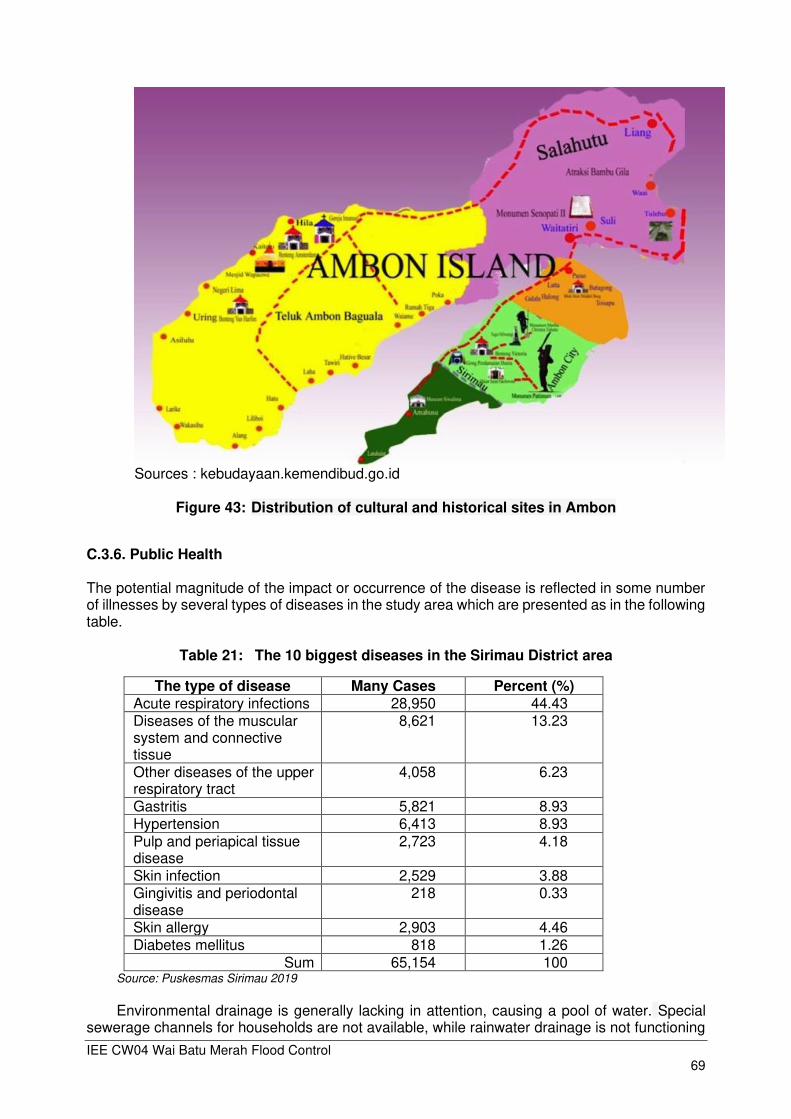
IEE CW04 Wai Batu Merah Flood Control 69
Sources : kebudayaan.kemendibud.go.id
Figure 43: Distribution of cultural and historical sites in Ambon
C.3.6. Public Health
The potential magnitude of the impact or occurrence of the disease is reflected in some number of illnesses by several types of diseases in the study area which are presented as in the following table.
Table 21: The 10 biggest diseases in the Sirimau District area
The type of disease Many Cases Percent (%) Acute respiratory infections 28,950 44.43 Diseases of the muscular system and connective tissue
8,621 13.23
Other diseases of the upper respiratory tract
4,058 6.23
Gastritis 5,821 8.93 Hypertension 6,413 8.93 Pulp and periapical tissue disease
2,723 4.18
Skin infection 2,529 3.88 Gingivitis and periodontal disease
218 0.33
Skin allergy 2,903 4.46 Diabetes mellitus 818 1.26
Sum 65,154 100 Source: Puskesmas Sirimau 2019
Environmental drainage is generally lacking in attention, causing a pool of water. Special
sewerage channels for households are not available, while rainwater drainage is not functioning

IEE CW04 Wai Batu Merah Flood Control 70
due to its small dimensions and lack of maintenance so it cannot drain water optimally. Wastewater from washing clothes and bathrooms, especially in the vicinity of the river, is generally channeled directly into the river thereby increasing the risk of pollution of river water.
The state of the residential environment (houses and yards) of the population is generally in the form of permanent and semi-permanent houses. Permanent and semi-permanent houses have cement walls with partially walled walls. Room ventilation is good enough by installing windows and vent in the living room, family room and bedroom. Almost all houses around the river border do not have a yard / yard.
Garbage is closely related to public health, because from the garbage will live various micro-organisms that cause disease (pathogenic bacteria), and also insect animals as disease transmitters / vectors. Therefore, it is necessary to do good waste management, so that waste does not trigger disease in the community. In general, some of the community's domestic waste is managed by the Ambon City cleaning staff and partly disposed of in the river water body.

IEE CW04 Wai Batu Merah Flood Control 71
D. ANTICIPATED ENVIRONMENTAL IMPACTS AND MITIGATION MEASURES
D.1. Environmental Impact Identification
To be able to estimate the potential environmental impacts that will arise from the implementation of Wai Batu Merah Flood Control activities, an impact identification is carried out. Identification of potential impacts is carried out with the following flow chart. Identification of potential impacts on the project Wai Batu Merah flood control includes pre-construction, construction and operation stages.

IEE CW04 Wai Batu Merah Flood Control 72
Pre-Construction Phase
Figure 44: Flow Chart of Pre Construction Phase
Pre- Construction
Potential nuisance and problems to the public
Conformance with spatial planning
Encroachment to environmental sensitive area
Impact and risk to biodiversity conservation
Loss of assets Public unrest
Land use change
Land acquisition
Phase Activity Primary Potential Impact
Planning, investigation and survey
Potential damage to archeological and cultural assets
Secondary Potential Impact
Community income

IEE CW04 Wai Batu Merah Flood Control 73
Construction
Removal tree
Displacement of rare or endangered species
Aquatic biota
Local air pollution
Vehicular traffic congestion and public access
Increase employment opportunity
Road damage
Phase Activity Primary Potential Impact
Secondary Potential Impact
Recruitment of workers
Land Clearing
Mobilization heavy equipment and materials
Material vehicle noise
Climate change vulnerability
Soil erosion and sediments of construction siter
Public health
Water quality
loss of wild bird range

IEE CW04 Wai Batu Merah Flood Control 74
Figure 45: Flow Chart of Construction Phase
Soil Erosion and Sediments
Noise from construction
Oil and other hazardous materials releases
Hazards to public due construction activities
Air Pollution
Occupational health and safety at work sites
Aquatic biota
Activities on base camp
Construction process
Public unrest
Phase Activity Primary Potential Impact
Secondary Potential Impact
Occupational health and safety
Water pollution
Public health
Public perception
Public unrest

IEE CW04 Wai Batu Merah Flood Control 75
Figure 46: Flow Chart of Post Construction Phase
Maintenance of flood control structures
Traffic congestion
Decrease air quality
Public unrest
Increase noise
Decrease water quality Disruption Aquatic Biota
Operation of flood control structures
Reduce Flooding
Conservation riverside area
Aesthetic
Decrease erosion
Increase diversity of flora
Decrease run off
Phase Activity Primary Potential
Impact Secondary
Potential Impact
Decrease river sedimentation
Public perception
Public perception
Post Construction
IEE CW04 Wai Batu Merah Flood Control 76
D.2. Potential Environmental Impacts Screening
Evaluation of the potential impacts identified in the flowchart above is filtered into potential impacts which hypothetically whether or not they really need to be addressed further. Determination whether an impact is truly significant is done based on the following criteria of the Guidelines for Determining Significant Impacts from the Indonesian Ministry of Environment: 1. Is the burden on certain environmental components already high? This can be seen from
the results of secondary data analysis and field visits. 2. Does the environmental component play an important role in the daily life of the
surrounding community (social and economic value) and to other environmental components (ecological value), so that large changes in the condition of these environmental components will greatly affect people's lives and the integrity of the ecosystem? This can be seen from the results of the field visit.
3. Are there high public concerns about these environmental components? This can be seen from the translation of the results of community consultations.
4. Are there rules or policies that will be violated and or exceeded by these impacts? This can be answered by studying the regulations that set environmental quality standards, emission waste quality standards, spatial planning, and so on.
Evaluation of potential impacts is only done on direct impacts, because by dealing with direct
impacts, the indirect impacts will also be automatically resolved.
Table 22: Screening of Potential Environmental Impacts
Project Activity Potential Environmental Impacts Significant /
Not Significant
1) Pre Construction
Land acquisition Loss of assets Land acquisition will result in loss of assets of the community living at the location of the planned activity, both housing assets, land and plants. Impact of losing assets will cause unrest for the affected communities.
-3 Significant
Land use change The land needed for check dam development activities is 2.191 m² (Check Dam Petra and Yacobus) only 2,6 % from the area of Sirimau District
-1 Not Significant
Community Income Land acquisition will have an impact on the community whose business is carried out at home. Moving a house to another location will result in a decrease in business income in the new place, which may not necessarily have the same potential as the original place of their business.
-3 Significant
Planning, investigation and survey
Conformance to spatial planning The check-dams, will be included in the revised Regional Spatial Plan. Activities do not trigger spatial changes
0 Not Significant
Encroachment to environmentally sensitive areas In this project there are no sensitive areas that will be ecologically disturbed. At the check dam project location and surrounding areas no protected forests were found, generally bush land and human settlements
0 Not Significant
Impacts and risks to biodiversity conservation No potential impacts arising from project activities will reduce biodiversity. This is because the community along Wai Batu Merah is dominated by the fostered community. The types of plants that exist at the location of the planned activity are generally cultivation, greening and ornamental plants. While the types of animals that exist in general are pets and livestock.
-1 Not Significant

IEE CW04 Wai Batu Merah Flood Control 77
Project Activity Potential Environmental Impacts Significant /
Not Significant
Potential nuisance and problems to the public Land acquisition activities for check dam construction activities will disturb the community, especially related to land compensation issues, and has the potential to cause unrest for affected communities
-3 Significant
Potential damage to archaeological and cultural assets As long as the project plan in Wai Batu Merah is not found archeological and cultural assets, which will be displaced or affected by the project plan. If at the time of excavation the project found a archeology site to avoid further damage any archaeological and cultural assets by inclusion of provisions in tender and construction documents requiring the contractors to immediately stop excavation activities and inform the local authorities and the Balai Arkeologi if archaeological and cultural assets are discovered.
-3 Significant
2) Construction
Recruitment of workers
Increase Employment opportunity The Wai Batu Merah flood control project is a project that requires a lot of labor, especially unskilled labor, which does not require special specifications. So it has the potential to employ local workers.
+3 Significant
Land Clearing / Preparation
Tree removal Land clearing activities will cut down trees that exist at the location of the planned activity. Tree cutting reduces tree density. However, the types of plants that are cut are generally shrubs and trees. Trees as a means of transit for several species of wild birds, the reduced density of trees will reduce the range of flying wild birds, which include rare bird species, such as the Ambon Yellow White-Eye (Zosterops kueh). The distribution of Yellow White-Eye wandering birds covers the entire island of Ambon.
-3 Significant
Aquatic biota Land preparation activities for the construction of check dam, embankment, will potentially cause sediment mixtures. Land preparation works in river land will lead to increased levels of fine sediments in river waters, which will have an impact on the life of river biota. However, the impact of decreasing the abundance level of aquatic biota due to land preparation activities is only temporary. So the impact of the activity is not significant
-2 Not Significant
Displacement of Rare or Endangered Species The Wai Batu Merah flood control project does not disrupt the lives of endangered species, because no endangered species of animal / plant are found at the location of the project plan
0 Not Significant
Climate change vulnerability (design aspect) Activities that have the potential to increase climate change are land preparation in retention pond construction projects, which reduce plant abundance. However, the condition of existing vegetation density is estimated to not significantly affect the increase in greenhouse gas emissions.
-2 Not Significant
Soil erosion and sediments of construction sites Dredging activities have the potential to increase erosion and sedimentation in Wai Batu Merah waters. This dredging activity only takes place during the construction period.
-2 Not Significant
Mobilization heavy equipment and materials
Increase traffic congestion and public access The transportation of materials from quarry, materials and sediments from the excavation will increase traffic density on existing roads. Increased traffic density due to material
-4 Significant

IEE CW04 Wai Batu Merah Flood Control 78
Project Activity Potential Environmental Impacts Significant /
Not Significant
transportation will also increase damage to the roads that are passed by transport vehicles
Noise and vibration Activities that have the potential to increase noise and vibration levels are the transportation of materials along the transportation path. Other noise levels occur due to heavy equipment operations at the project site.
-4 Significant
Air Pollution Transportation of materials and equipment for check dam, and embankment construction have the potential to increase air pollution. Air pollution occurs as a result of exhaust emissions of material transport vehicles and equipment.
-4 Significant
Management shack activities
Oil and other hazardous materials releases Workshop for heavy equipment and material transportation vehicles at the management shack will potentially cause contamination of used oil and diesel residue. However, the emergence of waste oil and diesel residue at the base camp can be managed by collecting and submitting it to certified parties
-1 Not Significant
Occupational health and safety Activities in the Management Shack such as stockpiling of materials and equipment, operational vehicle traffic, and daily activities, expose the employees and project workers to risks of increasing work accidents and decreasing employee health. However, the contractor has an obligation to implement the Occupational Safety and Health and Environmental Management (K3LH) system, hence the impact of accidents and occupational health that occurs on employees and the community is not significant
-1 Not Significant
Check-dam, excavation retention pond and embankment construction
Noise and vibration Heavy equipment operations such as excavators and others have the potential to increase noise. But the operation of heavy equipment only lasts during the day, and during limited time (only when dredging), hence the impact of noise is not significant to the community.
-2 Not Significant
Air Pollution Heavy equipment operations such as excavators and others have the potential to increase air pollution. But the operation of heavy equipment only lasts during the day, and limited time (only when dredging), hence the impact of air pollution is not significant to the community.
Not Significant
Soil erosion and sediment The work of digging diversion channels and concrete construction will increase soil erosion and dissolved soil sediments potential in river waters. Increased sediment and soil erosion will take place during construction activities. The excavated material has a possibility that needs to be examined, namely whether the excavated material moved to the disposal area is free of hazardous and toxic materials.
-4 Significant
Water pollution Soil excavation to increase the depth of both the retention pond and the channel from the Rinjani check dam to the estuary, will potentially cause river bed stirring. Stirring the riverbed will cause an increase in sediment pollution along the river. However, due to the short excavation process, and the lack of river and estuary utilization for fisheries, the negative impact of sediment pollution is considered insignificant
-2 Not significant
Occupational health and safety at work sites -4 Significant
IEE CW04 Wai Batu Merah Flood Control 79
Project Activity Potential Environmental Impacts Significant /
Not Significant Construction work has the potential to cause work accidents and risks to the deterioration of health for project workers. Activities like concrete construction, digging of diversion channels, and installation of check-dam foundations are prone to accidents. Air pollution and noise from construction activities have the potential to reduce the health of construction workers
Hazards to public due construction activities The construction work has the potential to cause accidents to the communities around the project. Activities like concrete construction, digging of diversion channels, and installation of check-dam foundations are prone to accidents. Air pollution and noise from construction activities have the potential to reduce the health of the communities surrounding the project.
-4 Significant
Public unrest The river deepening process from the Rinjani check dam to the downstream direction and the installation of the parapet will cause unrest for people who live along the river. However, because the construction and excavation process did not require a long time the impact of public unrest was insignificant
-2 Not Significant
3) Operation & Maintenance Phase
Maintenance of flood control structures
Traffic congestion Check dam construction and maintenance work, and transportation of sediment to the disposal area, has the potential to cause an increase in traffic density. However, dredging activities are carried out during a short time and periodically with long time intervals, hence the impact is not significant
-1 Not Significant
Decreased air quality Check dam construction work, transportation of sediment to the disposal area, has the potential to cause an increase in air pollution from transport vehicles. However, dredging activities are carried out during a short time and periodically with long time intervals, hence the impact is not significant
-1 Not Significant
Increased noise Check dam construction and maintenance work, and transportation of sediment to the disposal area, has the potential to cause an increase in noise from transport vehicles. However, dredging activities are carried out during a short time and periodically with long time intervals, hence the impact is not significant
-1 Not Significant
Decrease water quality Check dam construction and maintenance work, and sediment excavation has the potential to have an increased impact on sediment pollution in river water. However, dredging activities are carried out during a short time and periodically with long time intervals, hence the impact is not significant
-1 Not Significant
Check Dam and retention pond Operation
Reduce Sediment With the operation of the Petra and Yacobus check dams, the sedimentation process in the downstream area can be reduced, so that river siltation can be reduced. The existence of check dam has a positive impact on reducing flood discharge.
+4 Significant
Conservation riverside area
Aesthetic Structuring river banks and embankments by planting erosion-retaining plants will improve the aesthetics of the environment.
+2 Not Significant
Decrease run off Structuring river banks and embankments by planting erosion-resistant plants will reduce the run-off rate and soil erosion. The reduction in soil erosion will have an impact on prolonging the
+4 Significant
IEE CW04 Wai Batu Merah Flood Control 80
Project Activity Potential Environmental Impacts Significant /
Not Significant
age of embankments and reducing river water pollution by soil sediment pollution.
Increase diversity of flora Structuring river banks and embankments by planting erosion-resistant plants will increase the diversity of flora. However, because the number of species planted is limited the effect of increasing plant diversity is not significant
+1 Not Significant
Note: +/- 0-2 Not Significant impact, +/- 3-5 Significant impact Valuation based on expert judgement
D.3. Anticipated Environmental and Mitigation Measures
D.3.1. Loss of assets
The process of land acquisition for check dam projects and river embankments, will result in the affected communities losing their assets, both property assets (houses), yard, plants, as well as businesses carried out at home. The process of land acquisition will cause unrest for residents related to concerns about the low compensation they will get. The impact of public unrest began to emerge during the Survey and Investigation activities, then the Land Acquisition activity. The emergence of community unrest related to fears of land acquisition or acquisition that will be carried out. Concern about the incompatibility of compensation prices. However, in the planning of this project, a LARAP study was conducted which would assess compensation for land, buildings and cultivated plants owned by the people affected by the project plan. Determination of the price of compensation will follow the rules and regulations. LARAP studies will be disseminated gradually to affected communities, so that the potential impact of the emergence of community unrest can be suppressed. With the existence of rules and regulations in managing impacts, the potential impact of community unrest is considered insignificant.
Mitigation:
• Carry out periodic public consultations
• Carry out the compensation process in accordance with applicable regulations
D.3.2. Community Income
Land acquisition activities will eliminate some of the livelihoods of affected populations whose livelihoods are at home. The planning of the Wai Batu Merah flood control project activity is accompanied by a LARAP study, which includes resettlement activities at the new settlement location. The resettlement activities will be accompanied by community work skills training carried out by the Regional Organization (OPD). But the job training activities provided by OPD may not match the interests and talents of the displaced community. The problem of inappropriate job skills provided can lead to job losses from affected communities, which in turn will reduce or eliminate income. The impact of resettlement has the potential to increase poverty and is a significant impact for further study.
Mitigation:
• Conduct skills training and business development in accordance with the interests and talents of the communities whose businesses are moved
• Provide low interest loans and business coaching D.3.3. Potential nuisance and problem to the public
Land acquisition activities for check dam construction activities will disturb the community, especially related to land compensation issues, has the potential to cause unrest for affected communities. Community concerns appear to be low compensation that they will get, will trigger social conflict and rejection of project plans. In addition to concerns about the low value of compensation, there is also a plan for resettlement that is not desired by affected communities.

IEE CW04 Wai Batu Merah Flood Control 81
Mitigation:
• Carry out periodic public consultations to explain the system and legal basis for land acquisition, as well as an overview of project plans
• Carry out the compensation process in accordance with applicable regulations
• Look for a transfer location that has similar characteristics with the location of the original residence.
• Approach community leaders, both formal and informal, to anticipate the possibility of social unrest.
D.3.4. Increased employment opportunities
At the beginning of the construction work, recruitment activities were carried out. From the construction planning of the overall workforce needs (Yacobus and Petra check dams) are 410 people for 12 months’ construction phase. Of 310 unskilled personnel (education under secondary school - non-school), it is expected that most (76 %) will be from local workers. The workforce needed consists mainly of unskilled labor, which can be met from unemployed workers from secondary to lower education levels. The potential impact of labor recruitment on reducing the unemployment rate, even if it does not reduce the open unemployment rate by 1% (reduced 0,7%)5, but the impact is followed by an indirect impact on increasing income which will lead to changes in people's perception of the project. The positive impact of workforce recruitment activities must be managed and developed, so that the potential impact of increasing local employment is a significant impact.
Mitigation
• Work contractor performs the recruitment of workers from the community around the project site in coordination with the village / sub-district.
D.3.5. Increase traffic congestion and public access
There are 2 material mobilization activities for construction, namely the mobilization of materials from the quarry to the location of the construction plan (both for checkpoint construction, embankment and construction) and the mobilization of excavated material from check-dam construction to the disposal area (The disposal area can be a hoarding dike on both sides of the river). Material transportation by truck from the quarry location to the construction site will be carried out by dump truck. Material mobilization activities have the potential to cause an environmental impact on locations along the material transportation route, especially in densely populated areas. The problem that arises is a traffic jam. The following impacts that arise due to traffic congestion are air and dust pollution, noise, and decreasing levels of safety and public health.
Mitigation
• The impact of traffic congestion due to the material mobilization process can be reduced by carrying out transportation not at rush hour traffic
• The contractor will maintain the security of the intensive material entry and exit lane by placing guard posts.
• Implementing contractors use alternative routes which are not congested.
• Feasibility test of vehicles used for construction activities
• Because the location for transporting materials and excavated waste materials will be via public roads which are congested with vehicles, traffic management needs to be supported by the AMDAL Traffic Assessment Study
D.3.7. Tree Removal
In the land clearing activities for the project site will reduce the abundance of plants both cultivated plants and wild plants. Trees as a means of transit for several species of wild birds, the
5 Sakernas Aug 2018 (BPS Maluku Province 2018),
IEE CW04 Wai Batu Merah Flood Control 82
reduced density of trees will reduce the range of flying wild birds, which include rare bird species, such as the Ambon Yellow White-Eye (Zosterops kueh). The distribution of Yellow White-Eye
wandering birds covers the entire island of Ambon. Reducing the range of wild birds will narrow
the space for birds, which will cause environmental stress. Indirectly, continuous environmental
stress on wild birds will reduce the bird population.
Mitigation
• Providing compensation for planting felled trees by planting endemic species of Ambon island with an amount of 3 times the number of trees that are cut down.
• Planting trees that have strong supporting roots to reduce the risk of landslides on sloping lands in the watershed
• Conducting greening on the embankment slopes with ground cover plants, to reduce the potential for soil erosion on the embankment slopes.
• Installing a sign prohibiting hunting wild birds in river conservation areas which is a compensation area for tree felling during land clearing activities.
D.3.8. Air Pollution
The process of transporting materials and equipment from the quarry to the project site as well as the transportation of excavated products to the disposal area, has the potential to increase air pollution from transport vehicles. Transport of materials and equipment to support the construction of check dams and dykes. The material transportation process requires 668 units of mixer trucks (6 mixer trucks per day) and 939 units of dump trucks (8 dump trucks per day).
As a result of transportation activities both material and soil excavation, will increase air pollution from parameters: dust, CO, Sox Nox, Pb, CO2. As a benchmark for air quality testing based on RI Government Regulation No. 41 of 1999 concerning Ambient Air Quality Standards Decreased air quality will have a direct impact on the health of the people who live around the
transport line.
Mitigation.
• Feasibility test of vehicles used for construction activities
• Washing vehicle tires coming out of the project site
• Cover sediment transport trucks and material carriers with tarpaulin covers
• Periodic inspection of transport vehicles
• Minimizing dust from open area sources, including storage piles, by using control measures such as installing enclosures and covers, and increasing the moisture content.
• Do the watering the road passed by vehicles carrying material around which there are residential settlements
D.3.9. Increased noise and vibration
During construction phase, noise will be generated from various activities such as site clearing, excavation, erection, finishing, etc. The general noise levels during construction phase such as due to working of heavy earth moving equipment installation can potentially go up to 100 dB(A) at the work sites. It is also to be noted that significant amount of manual labor will be involved during construction of embankments.
Mitigation
• Test the feasibility of the transport vehicle's engine, so that high-noise carrier vehicles can be avoided on the road
• Placing traffic control guards at the crossroads of vehicles transported, so as to reduce congestion that might occur.
• Try not to place heavy equipment that creates high noise near settlements
• Scheduling of Project Activities: Operations will be scheduled to when people would be least likely to be affected. Construction activities shall be restricted between 10 P.M and 6 A.M near residential areas.
IEE CW04 Wai Batu Merah Flood Control 83
• Protection devices (ear plugs or ear muffs) will be provided to the workers operating in the vicinity of high noise generating machines.
• Construction equipment shall be fitted with silencers and maintained properly.
IEE CW04 Wai Batu Merah Flood Control 84
D.3.10. Soil Erosion and Sedimentation
Activities for embankment, check-dam and excavation retention pond construction activities, will increase sedimentation and soil erosion into Wai Batu Merah waters. From Addendum Amdal Way Batu Merah Flood Control the disposal area is located in Tantui Sirimau District near Maluku Regional Police Ceremony Field, distance from Petra and Yacobus check dam ± 5 km. The spoil disposal location of this area still needs to be coordinated with the BWS Maluku and related agencies. Suitability of the dredged material for landfilling is subject to testing and further study. The impacts at the disposal site will be managed by the recipient.
The excavated material has a possibility that needs to be studied, namely whether the excavated material moved to the disposal area is free of hazardous and toxic materials (B3). This needs to be done given that hazardous and toxic materials both storage, transportation and management must follow Government Regulation No. 101 of 2014 concerning Waste Management of Toxic and Hazardous Materials (B3).
Mitigation:
• Construction of temporary reservoirs and storm water discharges around the site of the Ambon Flood Control Way land preparation activity to control runoff water before entering the Wai Batu Merah water body
• Excavation is carried out in stages and creates a channel for surface runoff to flow into the natural drainage channel (Wai Batu Merah)
• Making slope protection installations on areas on the edge of the inundation area with steep slopes to avoid landslides
• Dredging at shallow locations due to sedimentation.
• Provide a disposal area for excavated soil material and dredged material at the site of the Ambon Flood Control Wai Batu Merah site preparation activities which are sufficient to be equipped with a control tub / sediment trap during construction activities
• Laying of excavated soil material and dredging material away from water flow and river banks to reduce soil particles so that they are not carried directly by water flow or runoff to Wai Batu Merah water bodies
• It is necessary to test the content of hazardous and toxic materials (B3) on sediment samples that will be piled up in the disposal area by a laboratory that has a KAN certificate.
D.2.11. Occupational health and safety at work sites Construction work has the potential to cause work accidents and risks to the deterioration of health for project workers. Concrete activities, construction of diversion lines, installation of check dam foundations are prone to accidents. Air pollution and noise from construction activities have the potential to reduce the health of construction workers
Mitigation
• Mitigation will include provide adequate lighting and fluorescent signage shall be provided at the construction sites. Signage shall be made in local language.
• The workers shall be provided with necessary Personal Protective Equipment and a First Aid kit. In case of emergency the victims will be referred to the nearest hospitals or clinics
• Intensive training on procedures for using heavy equipment, handling emergencies, using safety equipment, procedures for each work unit.
D.3.12. Hazards to public due construction activities
The construction work has the potential to cause accidents to the communities around the project. Concrete activities, construction of diversion lines, installation of check dam foundations are prone to accidents. Air pollution and noise from construction activities have the potential to reduce the health of the communities surrounding the project.
IEE CW04 Wai Batu Merah Flood Control 85
Mitigation:
• Installing a guardrail at the project site, so that the community cannot easily enter the project site.
• Provide adequate lighting and fluorescent signage shall be provided at the construction sites. Signage shall be made in local language
• Put up a prohibition sign in addition to the project worker.
• Placing project security supervisors at the project site and at the intersection of transportation vehicles and heavy equipment.
• Do the watering the road passed by vehicles carrying material around which there are residential settlements
• Immediately repair public roads that are passed by vehicles carrying damaged material, to prevent people from accidents due to damaged roads.
• Monitor the maximum safe speed of material transport vehicles when passing through public roads, as well as cracking down on drivers who violate the maximum allowed speed limit.
D.3.13. Reduce Flooding and Sedimentation
With the operation of the Petra and Yacobus check dams and retention pond, flooding and the sedimentation process in the downstream area can be reduced, so that river siltation can be reduced. The existence of check dam has a positive impact on reducing sedimentation and the presence of retention ponds will accommodate water discharge, thereby reducing the risk of
flooding in the downstream areas. To increase the positive impact of the presence of the built
check dam, which is prolonging the high sediment deposition, it is necessary to do some efforts to reduce levels of dissolved sediment in the river flow.
Mitigation:
• Increase plant density in the form of trees, shrubs and shrubs in the upstream area of the Wai Batu Merah river (catchment area), to increase infiltration of runoff water and decrease erosion from the upstream area, and reduce flood discharge.
• Counseling and fostering the surrounding community, especially those living in the upstream area of Wai Batu Merah, to maintain river cleanliness by not throwing garbage in the river
• Counseling and fostering the surrounding community, especially those living in the upstream area of Wai Batu Merah, to maintain river cleanliness by not throwing garbage in the river
D.3.14. Decrease run off
Structuring river banks and embankments by planting erosion-resistant plants will reduce the run-off rate and soil erosion. The reduction in soil erosion will have an impact on prolonging
the age of embankments and reducing river water pollution by soil sediment pollution.
Mitigation:
• Planting on embankment slopes with vegetation types that have the potential to withstand erosion, such as grasses and shrubs
• Carry out maintenance on the presence of erosion-bearing vegetation periodically, replanting if there is damage to vegetation ground cover
• Install a prohibition against grazing livestock on vegetated embankments
D.3.15. Potential damage to archaeological and cultural assets
The community's environment along Wai Batu Merah especially in the upstream area of community life is still influenced by local cultural elements. It is possible that along the path of the planned Wai Batu Merah flood control development site there are still local cultural sites affected by project activities, even though from the results of the AMDAL study there were no cultural sites affected.

IEE CW04 Wai Batu Merah Flood Control 86
Mitigation:
• If during excavation an archeology site is found, to avoid further damage any archaeological and cultural assets by inclusion of provisions in tender and construction documents requiring the contractors to immediately stop excavation activities and inform the local authorities and the ‘Balai Arkeologi’ that archaeological and cultural assets are discovered.

IEE CW04 Wai Batu Merah Flood Control 87
E. ANALYSIS OF ALTERNATIVES Three alternatives have been considered for the flood risk improvement of the Batu Merah
Watershed. These alternatives are:
(1) ‘No project implementation’ If the Wai Batu Merah sub-project is not implemented regular flooding will occur, with significant impact, especially down-stream in the high density urban area of Ambon City. The downstream Q25 flood inundation area measures 19.66 Ha (at Q25), and threatens 1498 buildings, in case the project is not implemented (See Figure 47).
Figure 47: Flood Prone Area ‘Without the Project’
Source: Flood Prone Area Map Batu Merah, FMSRB CS01 2020
(2) ‘Implementation of Petra and Yacobus Check-dams, and upgrading of Rinjani to
retention pond including upstream dredging’ If the Wai Batu Merah sub-project is implemented without downstream dredging and parapet, floods with significant impact still occur, especially down-stream in the high density urban area of Ambon City. For this alternative the downstream Q25 flood inundation area measures 9.10 Ha, and threatens ±500 buildings (See Figure 48).
Figure 48: Flood Prone Area ‘With Petra, Yacobus, Upgrading Rinjani excluding downstream Dredging and Parapet’
Source: Flood Prone Area Map Batu Merah, FMSRB CS01 2020

IEE CW04 Wai Batu Merah Flood Control 88
(3) ‘Implementation of Petra and Yacobus Check-dams, and upgrading of Rinjani to retention pond including upstream dredging
If the Wai Batu Merah sub-project is implemented including downstream dredging and parapet, no significant floods will occur down-stream in the high density urban area of Ambon City. For this alternative the downstream Q25 flood inundation area measures 2.31 Ha, and 13 buildings are threatened (See Figure 49).
Figure 49: Flood Prone Area ‘With Petra, Yacobus, Upgrading Rinjani including downstream Dredging and Parapet’
Source: Flood Prone Area Map Batu Merah, FMSRB CS01 2020
The last alternative (3) from the above three alternatives is proposed for implementation. In Figure 50 and Table 23 below the inundation depths are given for this alternative as used for benefit analysis.
Figure 50: Flood Prone Area ‘With Petra, Yacobus, Upgrading Rinjani including downstream Dredging and Parapet’
Source: Flood Prone Area Map Batu Merah, FMSRB CS01 2020

IEE CW04 Wai Batu Merah Flood Control 89
Table 23: Batu Merah Inundation ‘With The Project’ per Flood Depth per Probability (Ha)
Probability 0-0.3m 0.3-1m 1-2m >2m Total
Q2 1.03 2.30 1.98 5.04 10.35
Q5 1.03 2.39 2.13 5.73 11.28
Q10 1.01 2.39 2.19 6.19 11.78
Q25 1.11 2.47 2.31 6.79 12.69
Q50 1.25 2.87 2.77 7.19 14.08
Q100 1.63 3.38 3.18 7.50 15.68
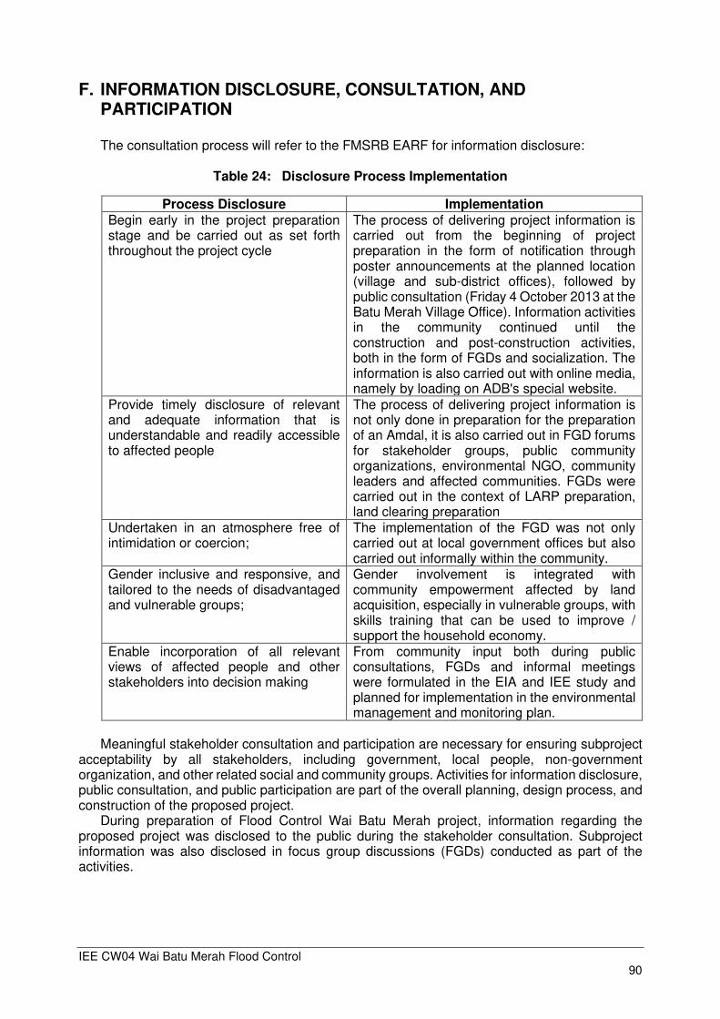
IEE CW04 Wai Batu Merah Flood Control 90
F. INFORMATION DISCLOSURE, CONSULTATION, AND PARTICIPATION The consultation process will refer to the FMSRB EARF for information disclosure:
Table 24: Disclosure Process Implementation
Process Disclosure Implementation Begin early in the project preparation stage and be carried out as set forth throughout the project cycle
The process of delivering project information is carried out from the beginning of project preparation in the form of notification through poster announcements at the planned location (village and sub-district offices), followed by public consultation (Friday 4 October 2013 at the Batu Merah Village Office). Information activities in the community continued until the construction and post-construction activities, both in the form of FGDs and socialization. The information is also carried out with online media, namely by loading on ADB's special website.
Provide timely disclosure of relevant and adequate information that is understandable and readily accessible to affected people
The process of delivering project information is not only done in preparation for the preparation of an Amdal, it is also carried out in FGD forums for stakeholder groups, public community organizations, environmental NGO, community leaders and affected communities. FGDs were carried out in the context of LARP preparation, land clearing preparation
Undertaken in an atmosphere free of intimidation or coercion;
The implementation of the FGD was not only carried out at local government offices but also carried out informally within the community.
Gender inclusive and responsive, and tailored to the needs of disadvantaged and vulnerable groups;
Gender involvement is integrated with community empowerment affected by land acquisition, especially in vulnerable groups, with skills training that can be used to improve / support the household economy.
Enable incorporation of all relevant views of affected people and other stakeholders into decision making
From community input both during public consultations, FGDs and informal meetings were formulated in the EIA and IEE study and planned for implementation in the environmental management and monitoring plan.
Meaningful stakeholder consultation and participation are necessary for ensuring subproject
acceptability by all stakeholders, including government, local people, non-government organization, and other related social and community groups. Activities for information disclosure, public consultation, and public participation are part of the overall planning, design process, and construction of the proposed project.
During preparation of Flood Control Wai Batu Merah project, information regarding the proposed project was disclosed to the public during the stakeholder consultation. Subproject information was also disclosed in focus group discussions (FGDs) conducted as part of the activities.
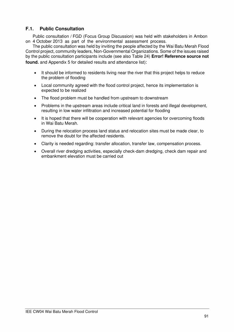
IEE CW04 Wai Batu Merah Flood Control 91
F.1. Public Consultation
Public consultation / FGD (Focus Group Discussion) was held with stakeholders in Ambon on 4 October 2013 as part of the environmental assessment process.
The public consultation was held by inviting the people affected by the Wai Batu Merah Flood Control project, community leaders, Non-Governmental Organizations. Some of the issues raised by the public consultation participants include (see also Table 24) Error! Reference source not
found. and Appendix 5 for detailed results and attendance list):
• It should be informed to residents living near the river that this project helps to reduce the problem of flooding
• Local community agreed with the flood control project, hence its implementation is expected to be realized
• The flood problem must be handled from upstream to downstream
• Problems in the upstream areas include critical land in forests and illegal development, resulting in low water infiltration and increased potential for flooding
• It is hoped that there will be cooperation with relevant agencies for overcoming floods in Wai Batu Merah.
• During the relocation process land status and relocation sites must be made clear, to remove the doubt for the affected residents.
• Clarity is needed regarding: transfer allocation, transfer law, compensation process.
• Overall river dredging activities, especially check-dam dredging, check dam repair and embankment elevation must be carried out
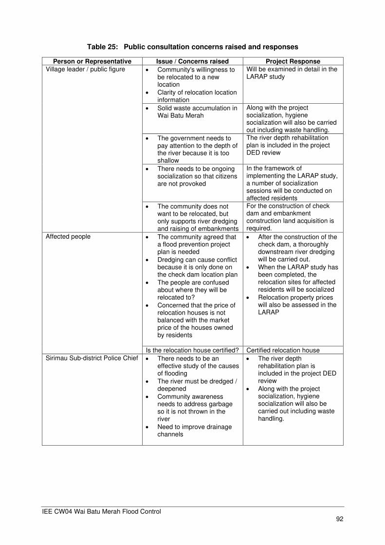
IEE CW04 Wai Batu Merah Flood Control 92
Table 25: Public consultation concerns raised and responses
Person or Representative Issue / Concerns raised Project Response
Village leader / public figure • Community's willingness to be relocated to a new location
• Clarity of relocation location information
Will be examined in detail in the LARAP study
• Solid waste accumulation in Wai Batu Merah
Along with the project socialization, hygiene socialization will also be carried out including waste handling.
• The government needs to pay attention to the depth of the river because it is too shallow
The river depth rehabilitation plan is included in the project DED review
• There needs to be ongoing socialization so that citizens are not provoked
In the framework of implementing the LARAP study, a number of socialization sessions will be conducted on affected residents
• The community does not want to be relocated, but only supports river dredging and raising of embankments
For the construction of check dam and embankment construction land acquisition is required.
Affected people • The community agreed that a flood prevention project plan is needed
• Dredging can cause conflict because it is only done on the check dam location plan
• The people are confused about where they will be relocated to?
• Concerned that the price of relocation houses is not balanced with the market price of the houses owned by residents
• After the construction of the check dam, a thoroughly downstream river dredging will be carried out.
• When the LARAP study has been completed, the relocation sites for affected residents will be socialized
• Relocation property prices will also be assessed in the LARAP
Is the relocation house certified? Certified relocation house
Sirimau Sub-district Police Chief • There needs to be an effective study of the causes of flooding
• The river must be dredged / deepened
• Community awareness needs to address garbage so it is not thrown in the river
• Need to improve drainage channels
• The river depth rehabilitation plan is included in the project DED review
• Along with the project socialization, hygiene socialization will also be carried out including waste handling.

IEE CW04 Wai Batu Merah Flood Control 93
G. GRIEVANCE REDRESS MECHANISM An affected person (AP) can approach the village heads or BWSM to raise his/her
complaints/concerns. If a lodged complaint is not acted on promptly, or if AP is not satisfied with the resolution undertaken, he/she can avail of the Grievance Redress Mechanism (GRM).
During structural subproject implementation the issue clearly identified as being of most
interest to the local communities, namely land acquisition and resettlement (LAR), has a very well defined and established Grievance Redress Mechanism (GRM) as defined in the LARP /Resettlement Framework. The other aspects of probable community complaints during project implementation can generally be categorized as “nuisance” such as noise, dust, altered access, and traffic congestion as may occur during construction. The GRM will apply for all complaints that are associated with the project (not only social related issues, but also environmental, technical issues and others). The project GRM will follow the following key principles:
(i) Complainants can file complaints at no costs, through different alternative media,
addressed to complaint handling units set up at different levels and/or to a contact addresses and/or website dedicated specially for complaint handling;
(ii) Complainants will be given an accessible, non-threatening, equal, and fair treatment for complaint follow-up and for dispute resolution, regardless of origins, religion, citizenship status, social and economic background;
(iii) Complaints or disputes will be preferably resolved at the earliest time at the subproject site. Only in the case that follow-up on complaints and disputes are unresolved at the lower level, the cases will be brought to the attention of the higher levels of the government structure;
(iv) Follow-up on complaints and resolution of any disputes will be made based on agreements reached among all involved parties through a well-informed consultation processes with facilitation by a competent, trustworthy and credible team;
(v) The complaint handling mechanisms/system will maintain the objectivity, transparency, and fairness principles;
(vi) Complaints and disputes, as well as follow-up actions and resolutions will be recorded in real time through a web-based system and/or disclosed to the public;
(vii) Socialization, dissemination, and disclosure of the complaint handling system/ procedures as well as of the complaints and follow-up actions and dispute resolution will be done continuously at the sub-project site, municipality and provincial levels
The CPMU, PIUs, and BBWS/BWS will make the public aware of the GRM through public awareness campaigns, training and capacity building. The BWSM will nominate and train one of their staff to be a Grievance Point Person (GPP). Any person who has complaints regarding the environmental performance of the subproject during pre-construction, construction and operation phases shall have access to the GRM described in Figure 51. The GPP will determine if the complaint is eligible and will work with the contractor to ensure all eligible concerns are addressed.
The core of the Grievance Redress Mechanism (GRM) process is an iterative process in which the complaint is being resolved in steps from local informal stage till judicial proceedings. If a complaint/problem cannot be resolved in a certain stage it will be brought to a higher level. The various stages/levels identified are:
• Stage 1: Informal Submission of Complaint & Resolution
• Stage 2: Formal Submission of Complaint
• Stage 3: Multi-stakeholder Meeting
• Stage 4: ADB Special Mission
• Stage 5: Judicial Proceedings
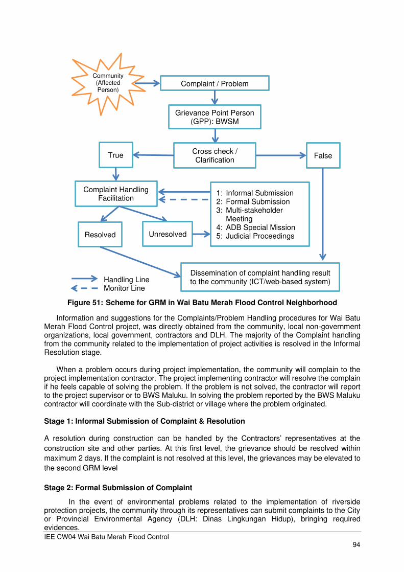
IEE CW04 Wai Batu Merah Flood Control 94
Figure 51: Scheme for GRM in Wai Batu Merah Flood Control Neighborhood
Information and suggestions for the Complaints/Problem Handling procedures for Wai Batu Merah Flood Control project, was directly obtained from the community, local non-government organizations, local government, contractors and DLH. The majority of the Complaint handling from the community related to the implementation of project activities is resolved in the Informal Resolution stage.
When a problem occurs during project implementation, the community will complain to the
project implementation contractor. The project implementing contractor will resolve the complain if he feels capable of solving the problem. If the problem is not solved, the contractor will report to the project supervisor or to BWS Maluku. In solving the problem reported by the BWS Maluku contractor will coordinate with the Sub-district or village where the problem originated. Stage 1: Informal Submission of Complaint & Resolution
A resolution during construction can be handled by the Contractors’ representatives at the construction site and other parties. At this first level, the grievance should be resolved within
maximum 2 days. If the complaint is not resolved at this level, the grievances may be elevated to
the second GRM level
Stage 2: Formal Submission of Complaint
In the event of environmental problems related to the implementation of riverside protection projects, the community through its representatives can submit complaints to the City or Provincial Environmental Agency (DLH: Dinas Lingkungan Hidup), bringing required evidences.
Complaint Handling Facilitation
Community (Affected Person)
Complaint / Problem
Grievance Point Person (GPP): BWSM
True Cross check / Clarification
False
1: Informal Submission 2: Formal Submission 3: Multi-stakeholder
Meeting 4: ADB Special Mission 5: Judicial Proceedings Unresolved Resolved
Dissemination of complaint handling result to the community (ICT/web-based system) Handling Line
Monitor Line

IEE CW04 Wai Batu Merah Flood Control 95
Stage 3: Multi Stake-holder Meeting:
At village level, where a construction activity is implemented, an ad-hoc committee will be established. At this stage through mediation by the Municipality or Provincial Environmental Office, an environmental communication forum will be formed, which will accommodate community complaints related to problems arising from Wai Batu Merah Flood Control project activities and other related projects. Through this forum, solutions to solve the environmental problems that arise will be sought. The forum also involved the BWS Maluku, the implementing
contractor, community leaders, representatives of NGOs and local governments.
Stage 4: ADB Special Mission
Environmental problems due to the implementation of the Wai Batu Merah Flood Control subproject, which have not been resolved formally or informally, can ask for assistance from an ADB Mission. The ADB Mission will examine the implementation of projects that cause these problems in more depth to be able to provide advice.
Stage 5: Judicial Proceedings
When all above stages have not resolved the problem, the community can submit a case of environmental problems to the court. Communities can submit claims against BWS Maluku to the court through a designated lawyer accompanied by relevant evidence.
In accordance with the 2009 SPS guidelines on GRM, the Maluku BWS is obliged to form / appoint a responsible party for complaints from affected communities. The person responsible for handling complaints is the Grievance Point Person (GPP) appointed to receive complaints from the public. GPP will verify the truth of the complaint which was previously documented. If true, an attempt is made to resolve the problem facilitated by CPMU / PMU / PIU. If the problem can be solved it will be documented and published openly to the public through mass media / the web. Scheme for GRM in Wai Batu Merah Flood Control neighborhood can be seen in the following flowchart.
This complaint handling procedure enters Stage 2: Formal Submission of Complaint. If the facilitation with CPMU / PIU does not find a way out, facilitation is carried out with the help of DLH Province. In a large scale problem, facilitation of the problem also needs to be done multi stakeholder holder meeting. The forum involved the BWS Maluku, the implementing contractor, community leaders, representatives of NGOs and local governments.

IEE CW04 Wai Batu Merah Flood Control 96
H. ENVIRONMENTAL MANAGEMENT PLAN
H.1. Environmental Management and Monitoring Plan
In order to evaluate effectiveness of environmental management, it is necessary to conduct monitoring. The monitoring activities are carried out by related agencies at provincial, district, and local level in accordance with their respective authority.
The BWS Maluku as PIU will monitor and measure the progress of the Environmental
Management Plan (EMP) implementation. In addition to recording information to track performance, the PIU will undertake inspections to verify compliance with the EMP and progress toward the expected outcomes. The PIU will document monitoring results, identify necessary corrective actions, and reflect them in a corrective action plan, and will implement these corrective actions and follow up on these actions to ensure their effectiveness. The PIU will prepare periodic monitoring reports that describe progress with implementation of the EMP and any compliance issues and corrective actions. The PIU will submit at least semi-annual monitoring reports during construction / implementation for subprojects likely to have significant adverse environmental impacts. Such periodic reports will be posted in a location accessible to the public. In line with contracting practice for this project, the Contractor will be responsible to produce Contractor’s Environmental Management Plans (CEMP) including methods to control. The Supervising Engineer will be responsible for immediate monitoring of compliance of environmental conditions and under Contract Conditions will be able to enforce immediate remedial action.
.
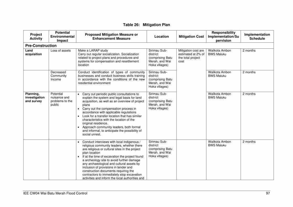
IEE CW04 Wai Batu Merah Flood Control 97
Table 26: Mitigation Plan
Project Activity
Potential Environmental
Impact
Proposed Mitigation Measure or Enhancement Measure
Location Mitigation Cost Responsibility
Implementation/Supervision
Implementation Schedule
Pre-Construction
Land acquisition
Loss of assets Make a LARAP study Carry out regular socialization. Socialization related to project plans and procedures and systems for compensation and resettlement location
Sirimau Sub-district (comprising Batu Merah, and Wai Hoka villages)
Mitigation cost are estimated at 2% of the total project cost
Walikota Ambon BWS Maluku
2 months
Decreased Community Income
Conduct identification of types of community businesses and conduct business skills training in accordance with the conditions of the new residential environment
Sirimau Sub-district (comprising Batu Merah, and Wai Hoka villages)
Walikota Ambon BWS Maluku
2 months
Planning, investigation and survey
Potential nuisance and problems to the public
• Carry out periodic public consultations to explain the system and legal basis for land acquisition, as well as an overview of project plans
• Carry out the compensation process in accordance with applicable regulations
• Look for a transfer location that has similar characteristics with the location of the original residence.
• Approach community leaders, both formal and informal, to anticipate the possibility of social unrest.
Sirimau Sub-district (comprising Batu Merah, and Wai Hoka villages)
Walikota Ambon BWS Maluku
2 months
• Conduct interviews with local indigenous / religious community leaders, whether there are religious or cultural sites in the project plan location
• If at the time of excavation the project found a archeology site to avoid further damage any archaeological and cultural assets by inclusion of provisions in tender and construction documents requiring the contractors to immediately stop excavation activities and inform the local authorities and
Sirimau Sub-district (comprising Batu Merah, and Wai Hoka villages)
Walikota Ambon BWS Maluku
2 months
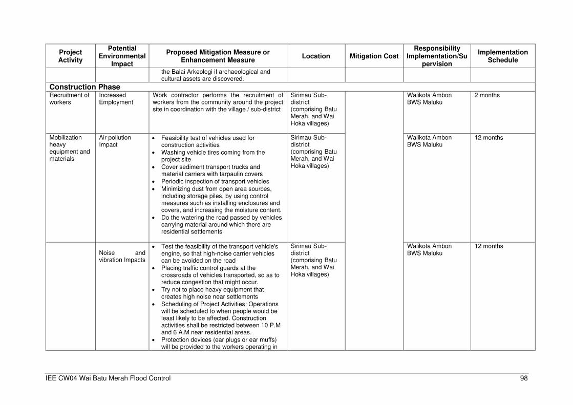
IEE CW04 Wai Batu Merah Flood Control 98
Project Activity
Potential Environmental
Impact
Proposed Mitigation Measure or Enhancement Measure
Location Mitigation Cost Responsibility
Implementation/Supervision
Implementation Schedule
the Balai Arkeologi if archaeological and cultural assets are discovered.
Construction Phase
Recruitment of workers
Increased Employment
Work contractor performs the recruitment of workers from the community around the project site in coordination with the village / sub-district
Sirimau Sub-district (comprising Batu Merah, and Wai Hoka villages)
Walikota Ambon BWS Maluku
2 months
Mobilization heavy equipment and materials
Air pollution Impact
• Feasibility test of vehicles used for construction activities
• Washing vehicle tires coming from the project site
• Cover sediment transport trucks and material carriers with tarpaulin covers
• Periodic inspection of transport vehicles
• Minimizing dust from open area sources, including storage piles, by using control measures such as installing enclosures and covers, and increasing the moisture content.
• Do the watering the road passed by vehicles carrying material around which there are residential settlements
Sirimau Sub-district (comprising Batu Merah, and Wai Hoka villages)
Walikota Ambon BWS Maluku
12 months
Noise and vibration Impacts
• Test the feasibility of the transport vehicle's engine, so that high-noise carrier vehicles can be avoided on the road
• Placing traffic control guards at the crossroads of vehicles transported, so as to reduce congestion that might occur.
• Try not to place heavy equipment that creates high noise near settlements
• Scheduling of Project Activities: Operations will be scheduled to when people would be least likely to be affected. Construction activities shall be restricted between 10 P.M and 6 A.M near residential areas.
• Protection devices (ear plugs or ear muffs) will be provided to the workers operating in
Sirimau Sub-district (comprising Batu Merah, and Wai Hoka villages)
Walikota Ambon BWS Maluku
12 months

IEE CW04 Wai Batu Merah Flood Control 99
Project Activity
Potential Environmental
Impact
Proposed Mitigation Measure or Enhancement Measure
Location Mitigation Cost Responsibility
Implementation/Supervision
Implementation Schedule
the vicinity of high noise generating machines.
• Construction equipment shall be fitted with silencers and maintained properly
Traffic Density
• The impact of traffic congestion due to the material mobilization process can be reduced by carrying out transportation not at rush hour traffic
• The contractor will maintain the security of the intensive material entry and exit lane by placing guard posts.
• Feasibility test of vehicles used for construction activities
• Cover sediment transport trucks and material carriers with tarpaulin covers
• Periodic inspection of transport vehicles
• Transporting material with an alternative route by sea and dropped at Yos Soedarso port, thus avoiding congestion on the Sudirman road.
• The contractors should carry out compensation for road repairs, periodically during the construction period and thereafter.
• Because the location for transporting materials and excavated waste materials will be via public roads which are congested with vehicles, traffic management needs to be supported by the AMDAL Traffic Assessment Study
•
Sirimau Sub-district (comprising Batu Merah, and Wai Hoka villages)
Walikota Ambon BWS Maluku
12 months
Construction Check Dam, Embankment,
Soil erosion and sediment
• Construction of temporary reservoirs and stormwater discharges around the site of the Ambon Flood Control Way land preparation
Sirimau Sub-district (comprising Batu
Walikota Ambon BWS Maluku
12 months

IEE CW04 Wai Batu Merah Flood Control 100
Project Activity
Potential Environmental
Impact
Proposed Mitigation Measure or Enhancement Measure
Location Mitigation Cost Responsibility
Implementation/Supervision
Implementation Schedule
and retention pond
activity to control runoff water before entering the Wai Batu Merah water body
• Excavation is carried out in stages and creates a channel for surface runoff to flow into the natural drainage channel (Wai Batu Merah)
• Making slope protection installations on areas on the edge of the inundation area with steep slopes to avoid landslides
• Dredging at shallow locations due to sedimentation.
• Provide a disposal area for excavated soil material and dredged material at the site of the Ambon Flood Control Wai Batu Merah site preparation activities which are sufficient to be equipped with a control tub / sediment trap during construction activities
• Laying of excavated soil material and dredging material away from water flow and river banks to reduce soil particles so that they are not carried directly by water flow or runoff to Wai Batu Merah water bodies
• It is necessary to test the content of hazardous and toxic materials (B3) on sediment samples that will be piled up in the disposal area by a laboratory that has a KAN certificate.
Merah, and Wai Hoka villages)
Occupational health and safety
• Mitigation will include provide adequate lighting and fluorescent signage shall be provided at the construction sites. Signage shall be made in local language.
• The workers shall be provided with necessary Personal Protective Equipment and a First Aid kit. In case of emergency the victims will be referred to the nearest hospitals or clinics
• Intensive training on procedures for using heavy equipment, handling emergencies,
Sirimau Sub-district (comprising Batu Merah, and Wai Hoka villages)
Walikota Ambon BWS Maluku
12 months
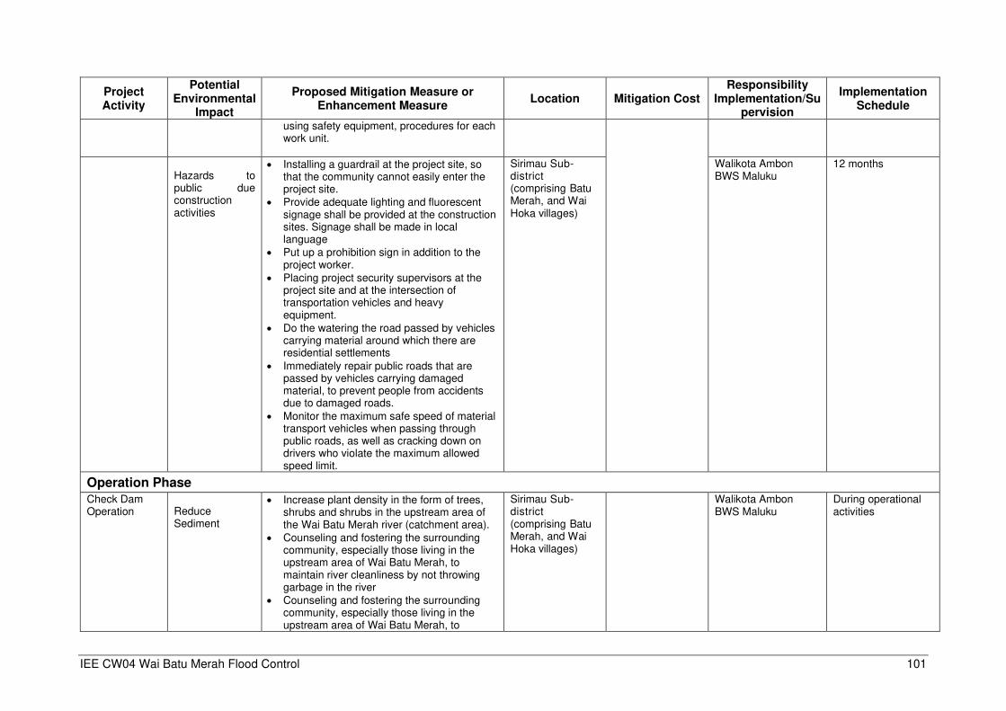
IEE CW04 Wai Batu Merah Flood Control 101
Project Activity
Potential Environmental
Impact
Proposed Mitigation Measure or Enhancement Measure
Location Mitigation Cost Responsibility
Implementation/Supervision
Implementation Schedule
using safety equipment, procedures for each work unit.
Hazards to public due construction activities
• Installing a guardrail at the project site, so that the community cannot easily enter the project site.
• Provide adequate lighting and fluorescent signage shall be provided at the construction sites. Signage shall be made in local language
• Put up a prohibition sign in addition to the project worker.
• Placing project security supervisors at the project site and at the intersection of transportation vehicles and heavy equipment.
• Do the watering the road passed by vehicles carrying material around which there are residential settlements
• Immediately repair public roads that are passed by vehicles carrying damaged material, to prevent people from accidents due to damaged roads.
• Monitor the maximum safe speed of material transport vehicles when passing through public roads, as well as cracking down on drivers who violate the maximum allowed speed limit.
Sirimau Sub-district (comprising Batu Merah, and Wai Hoka villages)
Walikota Ambon BWS Maluku
12 months
Operation Phase
Check Dam Operation
Reduce Sediment
• Increase plant density in the form of trees, shrubs and shrubs in the upstream area of the Wai Batu Merah river (catchment area).
• Counseling and fostering the surrounding community, especially those living in the upstream area of Wai Batu Merah, to maintain river cleanliness by not throwing garbage in the river
• Counseling and fostering the surrounding community, especially those living in the upstream area of Wai Batu Merah, to
Sirimau Sub-district (comprising Batu Merah, and Wai Hoka villages)
Walikota Ambon BWS Maluku
During operational activities
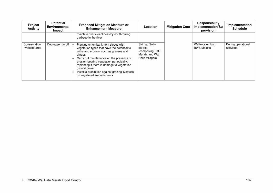
IEE CW04 Wai Batu Merah Flood Control 102
Project Activity
Potential Environmental
Impact
Proposed Mitigation Measure or Enhancement Measure
Location Mitigation Cost Responsibility
Implementation/Supervision
Implementation Schedule
maintain river cleanliness by not throwing garbage in the river
Conservation riverside area
Decrease run off
• Planting on embankment slopes with vegetation types that have the potential to withstand erosion, such as grasses and shrubs
• Carry out maintenance on the presence of erosion-bearing vegetation periodically, replanting if there is damage to vegetation ground cover
• Install a prohibition against grazing livestock on vegetated embankments
Sirimau Sub-district (comprising Batu Merah, and Wai Hoka villages)
Walikota Ambon BWS Maluku
During operational activities
IEE CW04 Wai Batu Merah Flood Control 103
Table 27: Environmental Monitoring
Aspects/ Parameters to be
monitored Location
Means of Monitoring
Monitoring Frequency
Mitigation Responsibility
Compliance Monitoring
Responsibility Monitoring Cost
Pre-Construction Phase
Land acquisition
Loss of assets At the project plan location
The frequency with which dissatisfaction emerges will be compensation from affected communities
2 times during the land acquisition period
BWS Maluku DLH Ambon city
DLH Province
Total monitoring cost is estimated at Rp. 340 million.
Decreased Community Income
At the project plan location
Monitor whether there are complaints about decreasing the level of income of the affected people.
2 times during the land acquisition period and 2 times after the land aquisition
BWS Maluku DLH Ambon city
DLH Province
Planning, investigation and survey
Potential nuisance and problems to the public
At the project plan location
Frequency of questions raised by the community and expressions of concern from the community related to project plan information
2 times during planning, investigation and survey
BWS Maluku DLH Ambon City
DLH Province
Potential damage to archaeological and cultural assets
At the project plan location
Once before physical activity is carried out at the project plan location, to interview religious / community leaders
1 times during the land acquisition period
BWS Maluku DLH Ambon City
DLH Province
Dinas Purbakala
Construction Phase
Recruitment of workers
Increased Employment In the community around the project site in the Sirimau Sub-District area
Number of peoples around the project site who can work on construction projects and others
Once before the implementation of activities and secondly after the activity is running
BWS Maluku DLH Ambon city
DLH Province
IEE CW04 Wai Batu Merah Flood Control 104
Aspects/ Parameters to be
monitored Location
Means of Monitoring
Monitoring Frequency
Mitigation Responsibility
Compliance Monitoring
Responsibility Monitoring Cost
Mobilization heavy equipment and materials
Air pollution Impact
• In the material transportation lane, at the point prone to traffic jams.
• At the location in and out of the project
Monitoring if parameters of air pollution (NOx, SOx, CO, PM10, dust, Pb) do not exceed air quality standards in accordance with PP No. 41 of 1999 concerning Air Pollution Control
One a month BWS Maluku DLH Ambon city
DLH Province
Noise and vibration Impacts
• In the material transportation lane, at the point prone to traffic jams.
• At the location in and out of the project
Noise level does not exceed the quality standard of Kep Men LH No. 48 of 1996 concerning Noise Level Quality Standards
One a month BWS Maluku DLH Ambon city
DLH Province
Traffic Density • In the material transportation lane, at the point prone to traffic jams.
• At the location in and out of the project
Monitoring the level of traffic density in accordance with Law No. 22 of 2009 concerning Road Traffic and Transportation
One a month BWS Maluku DLH Ambon city
DLH Province
Check Dam, Embankment,Parapet and Retention Pond Construction
Soil erosion and sediment
In the waters around the check dam location and waters after the retention pond excavation project
Retention pond located (soil samples)
Monitoring the level of pollution of Total Suspended Solid (TSS), Total Dissolved Solid (TDS) and no toxic and hazardous material do not exceed the quality standards in accordance with PP No. 82 of 2001 concerning Management of Water Quality and Water Pollution Control
One a month BWS Maluku DLH Ambon city
DLH Province
IEE CW04 Wai Batu Merah Flood Control 105
Aspects/ Parameters to be
monitored Location
Means of Monitoring
Monitoring Frequency
Mitigation Responsibility
Compliance Monitoring
Responsibility Monitoring Cost
Occupational health and safety
At direction shack Monitor efforts to implement the safety and health of project workers in accordance with Law RI No. 05 of 2014 concerning occupational safety and health in construction activities
One a month BWS Maluku DLH Ambon city
DLH Province
Hazards to public due construction activities
In the vicinity of the project site In the densely populated material transportation lane
Monitor efforts to implement the safety and health of project workers in accordance with Law RI No. 05 of 2014 concerning occupational safety and health in construction activities
One a month BWS Maluku DLH Ambon city
DLH Province
Operation Phase Operation of Check Dam and Retention Pond
Reduce Sedimentation and flooding
At the Wai Batu Merah river before going through the check dam , at the check dam location and after retention pond
Monitoring the level of pollution of Total Suspended Solid (TSS) and Total Dissolved Solid (TDS) do not exceed the quality standards in accordance with PP No. 82 of 2001 concerning Management of Water Quality and Water Pollution Control
Each 6 month BWS Maluku DLH Ambon city
DLH Province
Conservation riverside area
Decrease run off
Along the Wai Batu Merah river embankment before going through the check dam
Monitor the run off flow rate with a rational method (US Soil Conservation Service, 1973), to calculate the peak flow discharge of surface water.
Each 6 month BWS Maluku DLH Ambon city
DLH Province

IEE CW04 Wai Batu Merah Flood Control 106
Figure 52: Proposed Management and Monitoring Environmental Impact Locations
Water quality
Air quality
Traffic density
Public unrest
IEE CW04 Wai Batu Merah Flood Control 107
Monitoring point coordinates: Air quality Air quality 1 (Check dam Petra ) : S 03’41’34,14” and E128’12’20,83” Air quality 2(Check dam Yacobus) : S03’41’31,78” and E128’12’30,26” Air quality 3 (Check dam Rinjani) : S03’41’20,80”and E128’12’06,21” Air quality 4 : Sudirman road T junction Santika Hotel (S3040`42.94” and
E128011`39.52”) Air quality 5 : DR J Leimena T junction Putuhena roads (S3038`57.53”
and E128011`36.75”) Air quality 6 : Pertamina BBM Depot, Putuhena roads (S3039`42.77”
and E128010`25.94”) Air quality 7 : TNI AL Hospital, Kapten Piere Tendean road
(S3039`22.11” and E128013`24.02”) Water quality(include aquatic biota) Location 1 : Upstream Wai Batu Merah in Amantelu
village(S03041`12.3” and E 128011`55.2”) Location 2 : Midlle Wai Batu Merah in Negeri Batu Merah
(S03041`09.1” and E128011`32.9”) Location 3 : Downstream Wai Batu Merah in Rijali village
(S3041`10.9” and E128011`04.7”)
Traffic density
Location 1 : Wiem Tehupiory road (S03041’8.14” and E 128011`28.72”) Location 2 : Sudirman road T jungtion Tehupiory road(S03041`12.44” and E128015.77”) Location 3 : Sudirman road T junction Santika Hotel (S3040`42.94” and E128011`39.52”) Location 4 : DR J Leimena T junction Putuhena roads (S3038`57.53” and E128011`36.75”) Location 5 : Pertamina BBM Depot, Putuhena roads (S3039`42.77” and E128010`25.94”) Location 6 :TNI AL Hospital, Kapten Piere Tendean road (S3039`22.11” and
E128013`24.02”) Public Unrest Location 1 (Check dam Petra ) : S 03’41’34,14” and E128’12’20,83” Location 2(Check dam Yacobus) : S03’41’31,78” and E128’12’30,26” Location 3 (Check dam Rinjani) : S03’41’20,80”and E128’12’06,21”
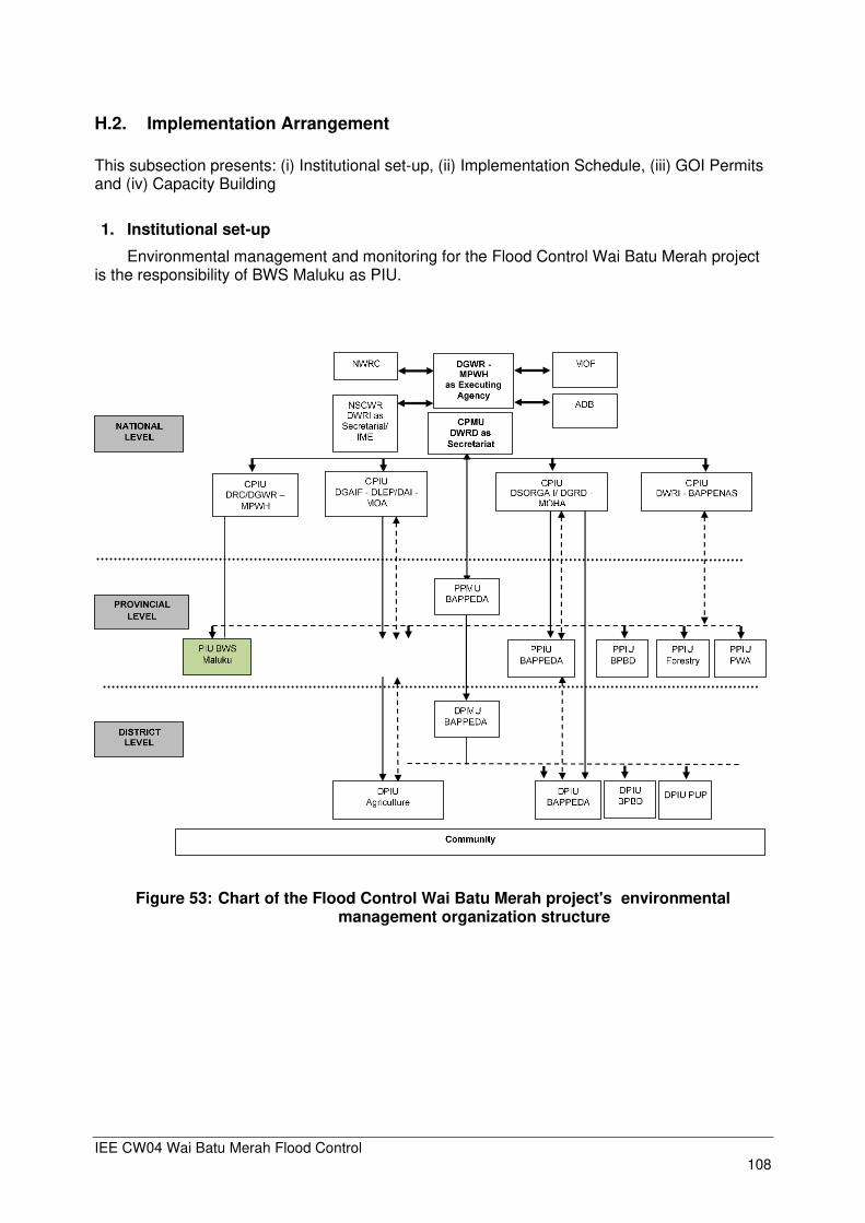
IEE CW04 Wai Batu Merah Flood Control 108
H.2. Implementation Arrangement
This subsection presents: (i) Institutional set-up, (ii) Implementation Schedule, (iii) GOI Permits and (iv) Capacity Building
1. Institutional set-up
Environmental management and monitoring for the Flood Control Wai Batu Merah project is the responsibility of BWS Maluku as PIU.
Figure 53: Chart of the Flood Control Wai Batu Merah project's environmental management organization structure

IEE CW04 Wai Batu Merah Flood Control 109
Figure 54: Organizational Structure in PIU Environment
In addition to recording information to track performance, the PIU will undertake inspections to verify compliance with the EMP and progress toward the expected outcomes. The PIU will document monitoring results, identify necessary corrective action, and reflect them in corrective action plan, and will implement these corrective actions and follow up on these action to ensure their effectiveness. PIU will prepare periodic monitoring reports that describe progress with implementation of the EMP and any compliance issues and corrective actions. The PIU will submit at least semi-annual report to ADB on environmental safeguard monitoring report (ESMR), where the result of environmental monitoring of project implementation will be reported. Such periodic reports will be submitted to ADB for review, and when approved it will be posted in ADB website. The ESMR will be made available in a location accessible to the public.
H.3. GOI Permits
The process of compiling the Amdal Wai Batu Merah Flood Control document is currently at the stage of the issuance of the SKKLH letter from DLH Maluku Province and is being submitted for the issuance of an Environmental Permit Letter from the Mayor of Ambon
H.4. Capacity Building
To support the implementation of management and environmental monitoring of the Flood Control Wai Batu Merah project, institutional empowerment needs to be prepared in the PIU environment, which includes:
• Strengthen environmental management capability
• Technical assistance program
• Training program
• Procurement of equipment and supplies related to environmental management and monitoring

IEE CW04 Wai Batu Merah Flood Control 110
H.5. Environmental Monitoring Cost
Monitoring activities are carried out every 6 months in accordance with AMDAL Environmental Permit demands. Based on three times reporting needed during the construction period, the total monitoring and mitigation cost are estimated at Rp. 6,6 million. These monitoring cost may be adjusted as required
Table 28: Estimate Environmental Monitoring Cost
No MONITORING NUMBER OF SAMPLES
FREQ UNIT PRICE
(Rp)
COST
(Rp)
1 Air quality 7 3 2,000,000 42.000.000
2 Water quality 3 3 2,000,000 18,000,000
3 Aquatic biota 3 3 500,000 4,500,000
4 Transportation 6 3 500,000 9.000.000
5 Social-Economic 100 2 300.000 60.000.000
6 Reporting ls 20.000.000 20.000.000
Total 153.500.000
The construction contract documents shall contain a provision allocating part of the
construction cost for the implementation of the environmental mitigating measures during construction. For budgetary purposes this is estimated at 2% of the total direct cost of the Project (around Rp.330,999 million), including for recruiting national environmental specialist under PMU, conducting trainings/workshops, etc.
To ensure that funds will be allocated for the implementation of the Project, the tender
documents during the bidding process shall include a lump sum bid item in the bill of quantities to be titled “Environmental Mitigation Measures”. It shall be clarified in the specification documents appended to the tender document, that the environmental mitigating measures identified in the construction are to be charged to this item. This will allow the construction supervision engineer to require the Contractor to quickly address the environmental issues during construction.
H.6. Implementation Schedule
Table 29: Implementation Schedule
No Activity Plan 1 2 3 4 5 6 7 8 9 10 11 12 13
A Pre-Construction Phase Survey, Investigation
Land Acquisition B Construction Phase
Mobilization of Labor Mobilization Material
Base Camp Construction
Construction C Operation Phase
Operation Check Dam Conservation riverside
area
IEE CW04 Wai Batu Merah Flood Control 111
I. CONCLUSION AND RECOMENDATIONS
I.1. Conclusions
The IEE Wai Batu Merah Flood Control report has been prepared based on field data as well
as secondary data collection. The following conclusions can be drawn:
1. Screening of environmental impacts found that all potential impacts that may arise can be mitigated to acceptable levels, hence negative impacts can be mitigated, while positive impacts can be enhanced.
2. During the public consultations the local community agreed with the flood control subproject and expects its implementation to be realized.
3. The Environmental Management Plan will be implemented under the responsibility of PIU (BWS Maluku) assisted by the implementing contractor. Supervision of environmental management from the Wai Batu Merah Flood Control activities is carried out by the Provincial DLH together with the Ambon City DLH.
I.2. Recommendations
• Based on the IEE of the proposed Wai Batu Merah Flood Control subproject, there are no significant adverse impacts that cannot be mitigated. With proper mitigation measures, the subproject can be implemented in an environmentally acceptable manner. There is no need for further environmental assessment study. A full EIA is not warranted and the subproject’s environmental classification as Category B is considered appropriate. The IEE shall therefore be considered as the final environmental assessment document of the proposed Wai Batu Merah Flood Control subproject.
• Mitigation measures and recommendation presented in this IEE, specifically in the Environmental Management Plan (EMP), should be implemented to minimize environmental impacts caused by the Project. The Project will conduct regular monitoring on project implementation supervised by DPIU (BWS Maluku). Every 6 months the Project will prepare an environmental monitoring report and submit to ADB. The contents of this monitoring report (Environmental Safeguard Monitoring Report - ESMR) should follow the ESMR format as presented in the Appendix of Environmental Assessment Review Framework (EARF) of the “Emergency Assistance for Rehabilitation and Reconstruction”. (See Appendix 6)
• Costs related to the implementation of the Environmental Management Plan (EMP), should be included in the project cost estimate. These cost include “Environmental Mitigation Measures” cost to be borne by contractor, which are estimated at 2% of the total project cost (Rp. 1,382 million), and the “Environmental Monitoring Cost” is estimated at Rp. 340 million, which should be allocated by BWSM as part of their supervision budget. To make sure contractors are aware of these cost, they will be appended to the tender documents.
• The removal of significant amounts of sediment from Rinjani check-dam, and the Batu Merah river bottom may result in traffic congestion. Implementation of a Traffic Impact Assessment (AMDAL Lalu-lintas) is therefore needed, before the implementation can start.

APPENDIXES

IEE CW04A Petra and Yacobus Check Dams Appendix 1 - 1
Appendix 1 Rapid Environmental Assessment (REA) Subproject Name Wai Batu Merah Flood Control Location Ambon City Date 15 September 2019 Person Preparing the Checklist
Iwan Stefanus M
Signature
Environmental Category ADB Category A
V ADB Category B
ADB Category C
PART 1. SCREENING BASED INDONESIA PROCEDURE V AMDAL TYPE PROJECT UKL/UPL TYPE PROJECT SPPL TYPE PROJECT
Is categorization confirmed by provincial or district DLH No Yes PART 2 : SCREENING BASED ON ENVIRONMENTAL FACTORS – Environmental Checklists
V
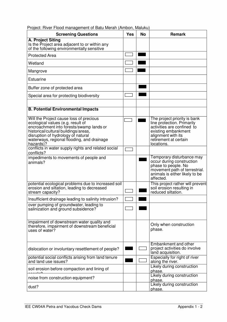
IEE CW04A Petra and Yacobus Check Dams Appendix 1 - 2
Screening Questions Yes No Remarks A. Project Siting
Is the Project area adjacent to or within any of the following environmentally sensitive areas ?
Protected Area
Wetland
Mangrove
Estuarine
Buffer zone of protected area
Special area for protecting biodiversity
B. Potential Environmental Impacts
Will the Project cause loss of precious ecological values (e.g. result of encroachment into forests/swamp lands or historical/cultural buildings/areas, disruption of hydrology of natural waterways, regional flooding, and drainage hazards)?
The project priority is bank line protection. Primarily activities are confined to existing embankment alignment with its retirement at certain locations.
conflicts in water supply rights and related social conflicts?
impediments to movements of people and animals?
Temporary disturbance may occur during construction phase to people. No movement path of terrestrial. animals is either likely to be affected.
potential ecological problems due to increased soil erosion and siltation, leading to decreased stream capacity?
This project rather will prevent soil erosion resulting in reduced siltation.
Insufficient drainage leading to salinity intrusion?
over pumping of groundwater, leading to salinization and ground subsidence?
impairment of downstream water quality and therefore, impairment of downstream beneficial uses of water?
Only when construction phase.
dislocation or involuntary resettlement of people?
Embankment and other project activities do involve land acquisition.
potential social conflicts arising from land tenure and land use issues?
Especially for right of river along the river.
soil erosion before compaction and lining of canals?
Likely during construction phase.
noise from construction equipment? Likely during construction phase.
dust? Likely during construction phase.
Project: River Flood management of Batu Merah (Ambon, Maluku)

IEE CW04A Petra and Yacobus Check Dams Appendix 1 - 3
Screening Questions Yes No Remarks
labor-related social problems especially if workers from different areas are hired?
water logging and soil salinization due to inadequate drainage and farm management?
No disturbance is expected to existing drainage pattern
leaching of soil nutrients and changes in soil characteristics due to excessive application of irrigation water?
reduction of downstream water supply during peak seasons?
Only when construction phase.
soil pollution, polluted farm runoff and groundwater, and public health risks due to excessive application of fertilizers and pesticides?
soil erosion (furrow, surface)? .
scouring of canals?
logging of canals by sediments?
clogging of canals by weeds?
seawater intrusion into downstream freshwater systems?
introduction of increase in incidence of waterborne or water related diseases?

IEE CW04A Petra and Yacobus Check Dams Appendix 1 - 4
Table 2 : Preliminary Climate Risk Screening Screening Questions
Score
Remarks
Location and Design of project
Is silting and/or routing of the project (or its components) likely to be affected by climate conditions including extreme weather-related events such as floods, droughts, storms, landslides?
2
2
Would the project design (e.g. the clearance for bridges) need to consider any hydro-meteorological parameters (e.g., sea-level, peak river flow, reliable water level, peak wind speed etc.)?
Materials and Maintenance
Would weather, current and likely future climate conditions (e.g. prevailing humidity level, temperature contrast between hot summer days and cold winter days, exposure to wind and humidity hydro-meteorological parameters likely affect the selection of project inputs over the life of project outputs (e.g. construction material)?
0
0
Would weather, current and likely future climate conditions, and related extreme events likely affect the maintenance (scheduling and cost) of project output(s)?
Performance of project outputs
Would weather/climate conditions, and related extreme events likely affect the performance (e.g. annual power production) of project output(s) (e.g. hydro-power generation facilities) throughout their design life time?
0
Result of Initial Screening (Low, Medium, High): 4
Project Wai Batu Merah Flood Control is included MEDIUM RISK
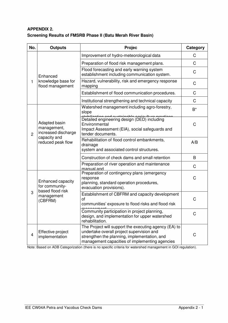
IEE CW04A Petra and Yacobus Check Dams Appendix 2 - 1
APPENDIX 2.
Screening Results of FMSRB Phase II (Batu Merah River Basin)
No. Outputs Projects
Category
1
Enhanced knowledge base for flood management
Improvement of hydro-meteorological data management
C
Preparation of flood risk management plans. C
Flood forecasting and early warning system establishment including communication system.
C
Hazard, vulnerability, risk and emergency response mapping
C
Establishment of flood communication procedures. C
Institutional strengthening and technical capacity building.
C
2
Adapted basin management, increased discharge capacity and reduced peak flow
Watershed management including agro-forestry, slope stabilization and sustainable agriculture practices.
B*
Detailed engineering design (DED) including Environmental Impact Assessment (EIA), social safeguards and tender documents.
C
Rehabilitation of flood control embankments, drainage system and associated control structures.
A/B
Construction of check dams and small retention ponds.
B
Preparation of river operation and maintenance manual and
C
3
Enhanced capacity for community-based flood risk management (CBFRM)
Preparation of contingency plans (emergency response planning, standard operation procedures, evacuation provisions).
C
Establishment of CBFRM and capacity development of communities’ exposure to flood risks and flood risk management.
C
Community participation in project planning, design, and implementation for upper watershed rehabilitation.
C
4
Effective project implementation
The Project will support the executing agency (EA) to undertake overall project supervision and strengthen the planning, implementation, and management capacities of implementing agencies (IAs).
C
Note: Based on ADB Categorization (there is no specific criteria for watershed management in GOI regulation).

IEE CW04A Petra and Yacobus Check Dams Appendix 3 - 1
No.
Type of Activities
Scale/Magnitude Scientific Reasons
Special Reasons
UKL/UPL AMDAL
1 Development of dam/reservoir
a.
Development of dam/reservoir or other water storages - Height - Spread of
inundation - Volume of storage
6 to < 15 m 50 to < 200 ha 300,000 - 500,000 m
3
> 15 m > 200 ha > 500,000
Change of natural landscape and topography, change of environment and aquatic ecosystem, and exploitation of natural resource, river morphology, effect to social, economic and cultural setting and technology application
Rehabilitation that affect environment in term of river morphology, aquatic ecosystem, change of groundwater head, land conversion, social and culture change.
b.
Rehabilitation of dam/reservoir or other water storages - Height - Spread of inundation - Volume of storage
6 to < 15 m 50 to < 200 ha
3
300,000 - 500,000 m
> 15 m > 200 ha > 500,000
2 Irrigation Scheme
a.
New development with width
500 ha to < 2,000 ha
> 2,000 ha
Change of natural landscape and topography, increased commercialization and use of water resources that affect to decreased availability of water resource, affect social, economic and
Change of regional ecosystem, water balance, pesticide pollution, potential erosion and sedimentation, utilization of water resource, change of social,
b.
Improvement with width
500 ha to < 1,000 ha
> 1,000 ha
Change of natural landscape and topography, increased commercialization and use of water resources, affect social, economic and culture of local
Change of water balance, pesticide pollution, potential erosion and sedimentation, utilization of water resource, change of
c.
Construction of new rice fields with width (per cluster)
100 ha to < 500 ha
> 500 ha
Change of natural landscape and topography, increased commercialization and use of water resources, affect
Change of regional ecosystem, water balance, change of social, economic and culture.
APPENDIX 3
Indonesia AMDAL Screening Criteria (Selected Sectors)
4.1. Public Works (Permen PU No.10/2008)

IEE CW04A Petra and Yacobus Check Dams Appendix 3 - 2
No.
Type of Activities
Scale/Magnitude Scientific Reasons
Special Reasons
UKL/UPL AMDAL
social, economic and culture of local
3
Swamp Development (swamp reclamation for agriculture cultivation)
500 ha to < 1000 ha
> 1,000 ha
Change of natural landscape, affect regional natural resource conservation, protection of cultural sanctuary and social, economic and
Change of regional ecosystem, change of water system, change of social and culture of local people.
4 Development of coastal defense and improvement of estuary
a. Parallel with coast (sea wall/revetment)
< 1 km
> 1 km Change of rate of sediment transport along the coast that affect to landscape and land topography, affect to aquatic
Change of coastal line, aesthetics, and change of cultural asset value.
b.
Perpendicular with coast (groin, breakwater)
10 to < 500 m
> 500 m
5 River flood management (including diversion) and construction of flood canal
a.
In metropolitan/large city - Length OR - Volume of
dredging
1 to < 5 km 50,000 to <500,000 m³
> 5 km
> 500,000 m³
Change of natural landscape, topography, change of river ecosystem, change of river morphology, and effect to social, economic and culture of local people.
Change of river path, bed, and wall in achieving new balance, increased water pollution, traffic disturbance, and nuisance to aesthetics.
b.
In medium city - Length OR - Volume of
dredging
3 km to < 5 km 100,000 to <500,000 m³
> 5 km
> 500,000 m³
c.
In rural areas - Length OR - Volume of
dredging
5 km to < 15 km 150,000 to < 500,000 m³
> 15 km
> 500,000 m³

IEE CW04A Petra and Yacobus Check Dams Appendix 3 - 3
No. Type of Activities Scale/Magnitude
Amdal category
Scientific Reason
1 River Normalization (including sodetan) and Flood Canal
a. Rural - Long > 15 km
> 500.000 m3
A Category Is an activity that is not complex but is in a wide area;
Volumen -Dredging
> 500.000 m3 Requires study not too complex;
4.2. Other Related Multi Sectors (Permen LH No. P 38/2019)
Below provided AMDAL criteria for other sectors Public Works that may be involved in FMSRB

IEE CW04A Petra and Yacobus Check Dams Appendix 4 - 1
APPENDIX 4
DLH's Directive on the preparation of the Wai Batu Merah Flood Control Environmental Permit Change

IEE CW04A Petra and Yacobus Check Dams Appendix 4 - 2

IEE CW04A Petra and Yacobus Check Dams Appendix 5 - 1
APPENDIX 5 Field Visits, Meetings and Institutional/Public Consultation
The Consultants made site visits to two core subprojects during the assignment. The
purpose of the visits was to discuss the subprojects with government authorities at central, provincial and local level, collect data and see flood prone areas first hand (including from non-formal sources such as residents fishermen, and others). The following site visits were made:
Petra Check dam plan site visit Yacobus check dam plan site visit
Discussion forum with the community Discussion forum with stakeholder

IEE CW04A Petra and Yacobus Check Dams Appendix 5 - 2
PUBLIC CONSULTATION
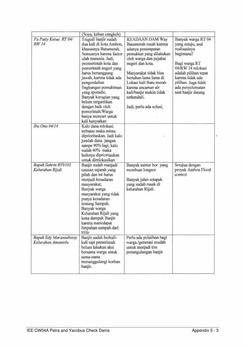
IEE CW04A Petra and Yacobus Check Dams Appendix 5 - 3

IEE CW04A Petra and Yacobus Check Dams Appendix 5 - 4

IEE CW04A Petra and Yacobus Check Dams Appendix 5 - 5

IEE CW04A Petra and Yacobus Check Dams Appendix 5 - 6

IEE CW04A Petra and Yacobus Check Dams Appendix 5 - 7
List of attendees
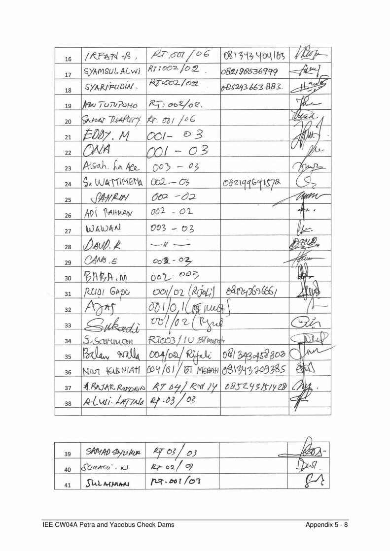
IEE CW04A Petra and Yacobus Check Dams Appendix 5 - 8

IEE CW04A Petra and Yacobus Check Dams Appendix 6 - 1
Appendix 6: Environmental Safeguard Monitoring Report (ESMR) Outline (Annotated Format)
I. INTRODUCTION
a. Report Purpose and Rationale
b. Project Objective and Components
II. PROJECT IMPLEMENTATION PROGRESS
Using most recent project progress report, describe status of project implementation, including full list of contracts, status of contract implementation, name of contractors, availability of site-EMPs.
III. INSTITUTIONAL SETUP AND RESPONSIBILITIES FOR EMP IMPLEMENTATION
AND SUPERVISION
a. Institutional responsibilities for environmental management
Describe institutional arrangements and responsibilities for EMP implementation, monitoring, and reporting, defining roles and capacities of CPIU, Implementation Consultant, Contractors. (Table format appropriate)
b. Incorporation of Environmental Requirements into Project Contractual Arrangements
• Define manner by which EMP requirements are incorporated into contractual arrangements, such as with contractors or other parties.
• Indicate when CEMPs were submitted by Contractors, and when these were approved by Engineer/Supervision Consultant (Table format appropriate).
IV. COMPLIANCE WITH ENVIRONMENT RELATED PROJECT COVENANTS
List all environment related loan covenants, and assess projectse were approved by Engineer/Supervision Consultant (Table format appropriate).PIU, Implementation Consultant, Contracte, and corrective actions as needed)
V. ENVIRONMENTAL MITIGATIONS MEASURES IMPLEMENTED IN THE
REPORTING PERIOD
• Summarize main mitigation/protection measures implemented in the reporting period (narrative section). Structure in accordance to phases (detailed design, construction preparation, construction, and operation).
• Include EMP table or updated EMP table if applicable. Assess compliance of environmental management activities with the original or updated EMP. For that purpose, include an additional column in the EMP entitled “Implementation status and compliance”. E.g. is provided below:

IEE CW04A Petra and Yacobus Check Dams Appendix 6 - 2
Impact Factor/ Stage
Potential Impacts and/or Issues
Mitigation Measures defined in the EMP
NEW COLUMN Implementation status
and compliance with EMP
Pre-construction Phase
1. Design Stage Establishing CPIU • An environmental management unit
(EMU) will be established within CPIU
EMU established in CPIU, consisting of xxx persons. ➔ Complied with
… • …
…
3. Biding and Construction Preparation
Bidding documents and contractors’ qualifications
• Environmental section will be included in the TOR for bidders.
• Environmental clauses for contractors in reference to the EMP and monitoring plan will be included in the construction and supply contracts.
Environmental section was included in TOR for bidders, environmental clauses were included in contracts (see chapter xxx). ➔ Complied with
Environmental operation and supervision manual
• Contractors will be required to prepare an environmental operation and supervision manual, for approval by PIC.
6 out of 7 contractors have prepared manuals, submitted to the respective IA. Contractor xxx was requested to prepare a manual, to be submitted by end of xxx 2016. ➔ Partly complied with
… … …
Construction Phase
1. Soil Erosion Excavation • Strip and stockpile topsoil, build
retaining walls where necessary before dumping.
• Provide temporary detention ponds or containment to control silt runoff.
• Construct intercepting ditches and chutes to prevent outside runoff entering disposal sites, and divert runoff from sites to existing drainage or ponds.
Soil erosion protection measures are implemented at each site, fully complying with the measures defined in this EMP. ➔ Complied with
… … … ➔ Not complied with. Corrective action plan developed.
Commissioning Phase
… … … …
Operation Phase
… … … … ➔ Not yet due

IEE CW04A Petra and Yacobus Check Dams Appendix 6 - 3
VI. ENVIRONMENTAL MONITORING
a. Monitoring plan and responsibilities
Present the monitoring plan as defined in the EMP or adjusted monitoring plan. Describe monitoring responsibilities. Differentiate between internal and external/compliance monitoring responsibilities.
b. Environmental quality targets, sampling and analytical methods
Describe environmental quality targets for the different sites and environmental media (e.g. effluent quality standards, ambient air, noise, water quality standards etc). Define analytical methods applied for monitoring.
c. Monitoring Results
i. Emission Discharge (Source) Monitoring Results (if relevant)
1. Results Table format is appropriate. Discharge levels should be compared to the relevant discharge standards and/or performance indicators noted in the EMP. Any non-compliance should be highlighted for attention and follow-up.
2. Assessment Discharge levels should be compared to baseline conditions (if baseline data is available) and described in qualitative terms. Additional explanatory comments should be provided as necessary. Possible reasons for non-compliance should be identified.
ii. Ambient Monitoring Program
1. Results Table format is appropriate. Ambient environmental conditions should be compared to the relevant ambient standards and/or performance indicators noted in the EMP. Any non-compliance should be highlighted for attention and follow-up.
2. Assessment
Ambient environmental conditions should be compared to the baseline conditions (if baseline data is available) and described in qualitative terms. Additional explanatory comments should be provided as necessary. Possible reasons for non-compliance should be identified.
VII. PUBLIC CONSULTATION, GRIEVANCE REDRESS MECHANISM
Describe mechanisms established to address and redress public complaints and grievances. Summarize grievances received, if any, and measures implemented to redress them. Describe public consultation activities during the reporting period. Present planned consultation activities in next reporting period.
VIII. HEALTH AND SAFETY
Describe health and safety management arrangements at project and contract level, including safety supervision and reporting procedures, people assigned (table format appropriate), training provided (table format appropriate), full list of fatal and serious occupational accidents including reference to minutes of investigation report meetings.
IEE CW04A Petra and Yacobus Check Dams Appendix 6 - 4
IX. INSTITUTIONAL STRENGTHENING AND TRAINING Present training activities conducted in the reporting period (Table format appropriate). Compare training activities with approved training plan defined in EMP/PAM, if any. Present planned training and institutional strengthening activities in next reporting period.
X. KEY ENVIRONMENTAL ISSUES
a. Key Issues Identified, Actions Taken, Additional Actions Required
Include a concise and clearly articulated table that lists (i) all observed non-compliances with the approved EMP or SEMP (both at project and contract level), (ii) corrective actions taken; (iii) implementation responsibility and timeframe.
XI. CONCLUSION
a. Overall Progress of Implementation of Environmental Management Measures
b. Problems Identified and Actions Recommended
XII. APPENDICES 1. Site Inspection / Monitoring Reports 2. Monitoring Results 3. Accidents/Incident investigation meeting minutes 4. Photographs 5. Others