
DEVELOPMENT OF FLOOD PREVENTION M
313
REPUBLIC OF TUNISIA MINSTRY OF AGRICALTURE DIRECTORATE GENERAL FOR DAMS AND MAJOR HYDRAULIC WORKS PREPARATORY SURVEY ON INTEGRATED BASIN MANAGEMENT AND FLOOD CONTROL PROJECT FOR MEJERDA RIVER: DEVELOPMENT OF FLOOD PREVENTION MEASURES RESOURCE DOCUMENT MARCH 2013 JAPAN INTERNATIONAL COOPERATION AGENCY (JICA) YACHIYO ENGINEERING CO., LTD
-
Upload
khangminh22 -
Category
Documents
-
view
1 -
download
0
Transcript of DEVELOPMENT OF FLOOD PREVENTION M

REPUBLIC OF TUNISIA
MINSTRY OF AGRICALTURE
DIRECTORATE GENERAL FOR DAMS AND MAJOR
HYDRAULIC WORKS
PREPARATORY SURVEY ON
INTEGRATED BASIN MANAGEMENT
AND FLOOD CONTROL PROJECT FOR
MEJERDA RIVER: DEVELOPMENT OF
FLOOD PREVENTION MEASURES
RESOURCE DOCUMENT
MARCH 2013
JAPAN INTERNATIONAL COOPERATION AGENCY (JICA)
YACHIYO ENGINEERING CO., LTD

Table of Contents
1 Details and Consultation Minutes of Site Survey ............................................................................ 1
1.1 Team Members and Dates of Government-Based Study ................................................................. 1
1.1.1 Explanation of Inception Report ..................................................................................... 1
1.1.2 Fact Finding Mission ..................................................................................................... 1
1.2 Consultation Minutes of the Site Survey ......................................................................................... 2
1.2.1 Minutes about the explanation of Inception Report (August 16, 2012) ............................... 2
1.2.2 Technical notes of Site Survey (September 13, 2012) ....................................................... 7
1.2.3 Aid-Memorie from Fact Finding Mission (September 7, 2012) ........................................ 11
1.2.4 Technical notes of interim report of Draft Final Report (February 5, 2013) ...................... 17
1.2.5 Minutes of Discussion of explanation of Draft Final Report (February 5, 2013) ............... 25
2 An Overview of the Basin and Flood Damage ..................................................................... 29
2.1 Topographical Survey Data ........................................................................................................... 29
2.2 Geographic Coordinate System Used in this Study....................................................................... 31
2.3 Geological Conditions of the D2 Zone .......................................................................................... 32
2.4 Ground Conditions in Zone D2 ..................................................................................................... 39
2.5 Overview of the River in Zone D2 ................................................................................................ 72
2.6 Overview of Dams in the D2 Zone................................................................................................ 78
2.7 Current Condition of Bridges in Zone D2 ..................................................................................... 82
2.8 Overview of Major Structures in El Mabtouh Retarding Basin .................................................... 87
2.9 Survey of Sluiceways Established on the Mejerda Main River in Zone D2 ................................. 93
3 Related Documents of Chapter 3 (Current State of Flood Control Measures) ............... 109
3.1 Donor Field of Water Application Activities in Tunisia .............................................................. 109
4 Related Documents of Chapter 4 (Basic Design of Bridge) .......................................................... 115
4.1 Specifications of current bridges ................................................................................................. 115
4.2 Studies of Existing Bridges ......................................................................................................... 148
4.3 Railway Bridge Renovation Project ............................................................................................ 163
5 Related Documents of Chapter 8 (Environmental Social Considerations) ................................... 166
5.1 EIA Study Report (Draft) ............................................................................................................ 166
6 Related Documents of Chapter 9 (Land Acquisition and Resident Relocation) ............................ 168
6.1 Abbreviated Resettlement Action Plan (Draft) ............................................................................ 168
6.2 Results of Land Acquisition and Resident Relocation conducted by the Ministry of Agriculture in
recent years .............................................................................................................................................. 170
7 Related Documents of Chapter 10 (Project Implementing Plan) ................................................... 171
7.1 Partial translation of the Presidential Decrees related to the establishment of PMU for recent
projects implemented by the Ministry of Agriculture ............................................................................. 171

Preparatory Survey on Integrated Basin Management and Flood Control Project for Mejerda River:
Development of Flood Prevention Measures
Yachiyo Engineering Co., Ltd.
Final Report
1
1 Details and Consultation Minutes of Site Survey
1.1 Team Members and Dates of Government-Based Study
1.1.1Explanation of Inception Report 1) Members
Name TOR Position Yusuke AMANO
General Senior Advisor, Global Environment Dept.
Yukio TANAKA
Flood Control
Water Resources Management Div. I, Global Environment Dept.
2) Dates
August 11 - 15, 2012
1.1.2 Fact Finding Mission 1) Members
Name TOR Position Yusuke AMANO
General Senior Advisor, Global Environment Dept.
Yukio TANAKA
Flood Control
Water Resources Management Div. 1, Global Environment Dept.
Naohiro NOZAKA
Cooperation Planning
Middle East Div. 1, Middle East and Europe Dept.
2) Dates
September 4 - 8, 2012

Preparatory Survey on Integrated Basin Management and Flood Control Project for Mejerda River:
Development of Flood Prevention Measures
Yachiyo Engineering Co., Ltd.
Final Report
2
1.2 Consultation Minutes of the Site Survey
1.2.1 Minutes about the explanation of Inception Report (August 16, 2012)

Preparatory Survey on Integrated Basin Management and Flood Control Project for Mejerda River:
Development of Flood Prevention Measures
Yachiyo Engineering Co., Ltd.
Final Report
3

Preparatory Survey on Integrated Basin Management and Flood Control Project for Mejerda River:
Development of Flood Prevention Measures
Yachiyo Engineering Co., Ltd.
Final Report
4

Preparatory Survey on Integrated Basin Management and Flood Control Project for Mejerda River:
Development of Flood Prevention Measures
Yachiyo Engineering Co., Ltd.
Final Report
5

Preparatory Survey on Integrated Basin Management and Flood Control Project for Mejerda River:
Development of Flood Prevention Measures
Yachiyo Engineering Co., Ltd.
Final Report
6

Preparatory Survey on Integrated Basin Management and Flood Control Project for Mejerda River:
Development of Flood Prevention Measures
Yachiyo Engineering Co., Ltd.
Final Report
7
1.2.2 Technical notes of Site Survey (September 13, 2012)

Preparatory Survey on Integrated Basin Management and Flood Control Project for Mejerda River:
Development of Flood Prevention Measures
Yachiyo Engineering Co., Ltd.
Final Report
8

Preparatory Survey on Integrated Basin Management and Flood Control Project for Mejerda River:
Development of Flood Prevention Measures
Yachiyo Engineering Co., Ltd.
Final Report
9

Preparatory Survey on Integrated Basin Management and Flood Control Project for Mejerda River:
Development of Flood Prevention Measures
Yachiyo Engineering Co., Ltd.
Final Report
10

Preparatory Survey on Integrated Basin Management and Flood Control Project for Mejerda River:
Development of Flood Prevention Measures
Yachiyo Engineering Co., Ltd.
Final Report
11
1.2.3 Aid-Memorie from Fact Finding Mission (September 7, 2012)

Preparatory Survey on Integrated Basin Management and Flood Control Project for Mejerda River:
Development of Flood Prevention Measures
Yachiyo Engineering Co., Ltd.
Final Report
12

Preparatory Survey on Integrated Basin Management and Flood Control Project for Mejerda River:
Development of Flood Prevention Measures
Yachiyo Engineering Co., Ltd.
Final Report
13

Preparatory Survey on Integrated Basin Management and Flood Control Project for Mejerda River:
Development of Flood Prevention Measures
Yachiyo Engineering Co., Ltd.
Final Report
14

Preparatory Survey on Integrated Basin Management and Flood Control Project for Mejerda River:
Development of Flood Prevention Measures
Yachiyo Engineering Co., Ltd.
Final Report
15

Preparatory Survey on Integrated Basin Management and Flood Control Project for Mejerda River:
Development of Flood Prevention Measures
Yachiyo Engineering Co., Ltd.
Final Report
16
AnnexII The following Annex is omitted

Preparatory Survey on Integrated Basin Management and Flood Control Project for Mejerda River:
Development of Flood Prevention Measures
Yachiyo Engineering Co., Ltd.
Final Report
17
1.2.4 Technical notes of interim report of Draft Final Report (February 5, 2013)

Preparatory Survey on Integrated Basin Management and Flood Control Project for Mejerda River:
Development of Flood Prevention Measures
Yachiyo Engineering Co., Ltd.
Final Report
18

Preparatory Survey on Integrated Basin Management and Flood Control Project for Mejerda River:
Development of Flood Prevention Measures
Yachiyo Engineering Co., Ltd.
Final Report
19

Preparatory Survey on Integrated Basin Management and Flood Control Project for Mejerda River:
Development of Flood Prevention Measures
Yachiyo Engineering Co., Ltd.
Final Report
20

Preparatory Survey on Integrated Basin Management and Flood Control Project for Mejerda River:
Development of Flood Prevention Measures
Yachiyo Engineering Co., Ltd.
Final Report
21

Preparatory Survey on Integrated Basin Management and Flood Control Project for Mejerda River:
Development of Flood Prevention Measures
Yachiyo Engineering Co., Ltd.
Final Report
22
(English Translation)

Preparatory Survey on Integrated Basin Management and Flood Control Project for Mejerda River:
Development of Flood Prevention Measures
Yachiyo Engineering Co., Ltd.
Final Report
23

Preparatory Survey on Integrated Basin Management and Flood Control Project for Mejerda River:
Development of Flood Prevention Measures
Yachiyo Engineering Co., Ltd.
Final Report
24

Preparatory Survey on Integrated Basin Management and Flood Control Project for Mejerda River:
Development of Flood Prevention Measures
Yachiyo Engineering Co., Ltd.
Final Report
25
1.2.5 Minutes of Discussion of explanation of Draft Final Report (February 5, 2013)

Preparatory Survey on Integrated Basin Management and Flood Control Project for Mejerda River:
Development of Flood Prevention Measures
Yachiyo Engineering Co., Ltd.
Final Report
26

Preparatory Survey on Integrated Basin Management and Flood Control Project for Mejerda River:
Development of Flood Prevention Measures
Yachiyo Engineering Co., Ltd.
Final Report
27

Preparatory Survey on Integrated Basin Management and Flood Control Project for Mejerda River:
Development of Flood Prevention Measures
Yachiyo Engineering Co., Ltd.
Final Report
28

Preparatory Survey on Integrated Basin Management and Flood Control Project for Mejerda River:
Development of Flood Prevention Measures
Yachiyo Engineering Co., Ltd.
Final Report
29
2 An Overview of the Basin and Flood Damage
2.1 Topographical Survey Data
The existing topographical survey data shown in Table 2.2.1-2 was obtained, and sluice way and pipe
survey of river improvement candidate part and simple cross section survey (leveling) of the bridge
improvement candidate part were carried out in this preparatory survey. The location of topographical
survey is shown in Figure 2-1.
Table 2-1: Existing Topographic Survey Data and Supplemental Single Survey
Topographic Survey data Description Source
Topographical map Scale:1/25,000 & 1/50,000 Office de la Topographie et de la Cartographie
DEM data 76m x 76m mesh altitude data NASA SRTM3 remote sensing data
Mejerda River longitudinal section and cross section (1)
From Sidi Salem dam to estuary 150km of longitudinal section and 447cross sections (375 cross sections + 72 detail cross sections) , cross section interval: 400m
MARHP (MA) 2007
Mejeruda River longitudinal section and cross section (2)
From Sidi Salem upstream to boundary of Argeria 180km of longitudinal section and 360cross sections, cross section interval: 500m
M/P Study Survey 2008
Branch Rivers longitudinal section and cross section
Main branch rivers of upstream of Sidi Salem dam (O. Mellege, O. Tessa, O.Raghai, O.Bajer, O.Bou Heurtma, O. Kasseb and O. Beja)
141km of longitudinal section and 476 cross sections
M/P Study 2008
Flood control structure candidate places (at M/P Study) longitudinal section and cross section
55km of longitudinal section and 72cross sections M/P Study 2008
Mejeruda River longitudinal section and cross section (Supplemental survey)
Longitudinal section and cross sections added to the interstitial sections of the MARHP 2007 survey Additional 66km of longitudinal section and 146 cross sections
Former Preparatory Survey 2010
El Mabtouh retarding basin plane survey Scale: 1/5,000, 15.916ha
Former Preparatory Survey 2010
El Mabtouh channel longitudinal section and cross section
25.5km of longitudinal section and 102 cross sections
Former Preparatory Survey 2010
Plane survey of surrounding area of inlet and outlet in El Mabtouh retarding basin
Scale: 1/200, 12 structures 18ha Former Preparatory Survey 2010
Kalaat Landalous road longitudinal section and cross section
4.5km of longitudinal section and 46 cross sections
Former Preparatory Survey 2010

Preparatory Survey on Integrated Basin Management and Flood Control Project for Mejerda River:
Development of Flood Prevention Measures
Yachiyo Engineering Co., Ltd.
Final Report
30
Topographic Survey data Description Source
Chaffrou River longitudinal section and cross section
Longitudinal section and cross sections added to the interstitial sections of the MARHP 2007 survey Additional 2.3km of longitudinal section and 8 cross sections
Former Preparatory Survey 2010
Survey data of sluice ways and pipes D2 zone river improvement candidate part
Survey table of structure location and dimension This Preparatory Survey 2012
Simple cross section survey of D2 zone bridge improvement candidate plart
Bridge portions of El Mabtouh channel and Chaffrou River, 3 smple cross sections
This Preparatory Survey 2012
(Source: Arrangement based on former preparatory survey report)

Preparatory Survey on Integrated Basin Management and Flood Control Project for Mejerda River:
Development of Flood Prevention Measures
Yachiyo Engineering Co., Ltd.
Final Report
31
(Source: Former preparatory survey report, additional description in this report)
Figure 2-1: Location of Survey Data 2.2 Geographic Coordinate System Used in this Study
The decree declared on February 10, 2009 by the Tunisian Department of Defense determines the
official geographic coordinate system of Tunisia1. This coordinate system and its data consist of the
following:
– Geodetic survey system: NTT (New Triangulation of Tunisia) system — Combining Spheroids:
French Clarke 1880 (Clarke IGN).
– Projection: UTM (Universal Transverse Mercator's projection) cylindrical projection — Zone
32N
This coordinate system replaces the old STT (Topographical Survey Service of Tunisia) by revising the
system. The parameters of this system are as follows.
1 A. Ben Hadj Salem. OTC (Office of Topography and Cadastre). "Bridging the Gap between Cultures" Chapter 13,
"Unifying Tunisia's Geodetic Survey System", Technology Summit hosted in Marrakesh, Morocco on May 18 - 22, 2011
a Additional simple cross section survey for bridge
a
b
c
Preparatory Survey on Integrated Basin Management and Flood Control Project for Mejerda River:
Development of Flood Prevention Measures
Yachiyo Engineering Co., Ltd.
Final Report
32
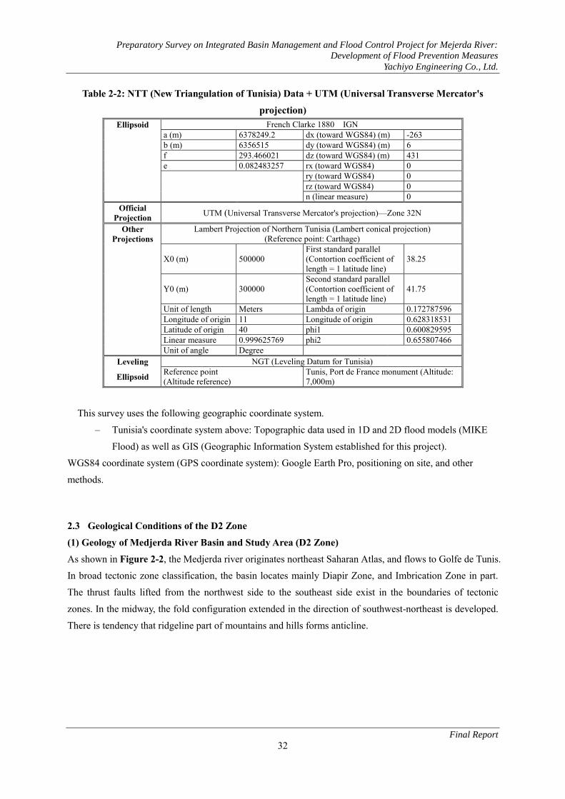
Table 2-2: NTT (New Triangulation of Tunisia) Data + UTM (Universal Transverse Mercator's
projection) Ellipsoid French Clarke 1880 IGN
a (m) 6378249.2 dx (toward WGS84) (m) -263 b (m) 6356515 dy (toward WGS84) (m) 6 f 293.466021 dz (toward WGS84) (m) 431 e 0.082483257 rx (toward WGS84) 0 ry (toward WGS84) 0 rz (toward WGS84) 0 n (linear measure) 0
Official Projection UTM (Universal Transverse Mercator's projection)—Zone 32N
Other Projections
Lambert Projection of Northern Tunisia (Lambert conical projection) (Reference point: Carthage)
X0 (m) 500000 First standard parallel (Contortion coefficient of length = 1 latitude line)
38.25
Y0 (m) 300000 Second standard parallel (Contortion coefficient of length = 1 latitude line)
41.75
Unit of length Meters Lambda of origin 0.172787596 Longitude of origin 11 Longitude of origin 0.628318531 Latitude of origin 40 phi1 0.600829595 Linear measure 0.999625769 phi2 0.655807466 Unit of angle Degree
Leveling NGT (Leveling Datum for Tunisia)
Ellipsoid Reference point (Altitude reference)
Tunis, Port de France monument (Altitude: 7,000m)
This survey uses the following geographic coordinate system.
– Tunisia's coordinate system above: Topographic data used in 1D and 2D flood models (MIKE
Flood) as well as GIS (Geographic Information System established for this project).
WGS84 coordinate system (GPS coordinate system): Google Earth Pro, positioning on site, and other
methods. 2.3 Geological Conditions of the D2 Zone
(1) Geology of Medjerda River Basin and Study Area (D2 Zone) As shown in Figure 2-2, the Medjerda river originates northeast Saharan Atlas, and flows to Golfe de Tunis.
In broad tectonic zone classification, the basin locates mainly Diapir Zone, and Imbrication Zone in part.
The thrust faults lifted from the northwest side to the southeast side exist in the boundaries of tectonic
zones. In the midway, the fold configuration extended in the direction of southwest-northeast is developed.
There is tendency that ridgeline part of mountains and hills forms anticline.

Preparatory Survey on Integrated Basin Management and Flood Control Project for Mejerda River:
Development of Flood Prevention Measures
Yachiyo Engineering Co., Ltd.
Final Report
33
(Source: Tunisian Transtensive Basin in Tethyan Geodynamic Context and Their Post-Tortonian Inversion)
Figure 2-2: Tectonics of the Mejerda Basin
A: General context, B: Schematic tectonic map, a: Major thrust, b: Major faults, c: Major anticlines,
d: Trias, e: Graben, f: Limit of Kasserine Island

Preparatory Survey on Integrated Basin Management and Flood Control Project for Mejerda River:
Development of Flood Prevention Measures
Yachiyo Engineering Co., Ltd.
Final Report
34
The geology of the Medjerda basin consists of sedimentary rocks (limestone, dolomite, marl, sandstone,
shale, evaporite) of Mesozoic era Triassic, Jurassic, Cretaceous periods and Cenozoic era Eocene,
Oligocene, Miocene, Pliocene epocks in highland and hill part as shown in Figure 2-3. In the lowland part,
sedimentary layers such as sand and clay of Quaternary Pleistocene and Holocene ages are distributed
(Source : Material prepared by MA, editing of legend and addition of Mejerda river basin in this report)
Figure 2-3: Geological Summary Map of Tunisia

Preparatory Survey on Integrated Basin Management and Flood Control Project for Mejerda River:
Development of Flood Prevention Measures
Yachiyo Engineering Co., Ltd.
Final Report
35
As shown in Figure 2-4, the following geological distribution is found around the study area (D2 zone).
i) A-highland elongates in the direction of southwest-northeast at the northwest side of Laroussia dam -
Tebourba downstream. Triassic system (claystone, dolomite, sandstone, evaporite, etc.), Cretaceous
system (marl, limestone, etc.), and Tertiary system (limestone, flint, sandstone, claystone, marl, etc.)
are mainly distributed.
ii) B hill elongates in the direction of southwest-northeast from north side of El Mabtouh to the seashore.
Miocene-Pliocene series (congromerate, sandstone, claystone, marl) is mainly distributed.
iii) C hill forms wide low hill in the south of Laroussia dam to Jedeida. Miocene-Pliocene series
(congromerate, sandstone, claystone) is mainly distributed. In the upper stream side, the altitude of hill
increases, and Cretaceous system, Eocene and Oligocene seies are distributed.
iv) D hill forms small isolated hills in the north side of Tunis. Cretaceous system (marl, limestone, etc.),
and partly Eocene, Oligocene, Miocene and Pliocene are distributed.

Preparatory Survey on Integrated Basin Management and Flood Control Project for Mejerda River:
Development of Flood Prevention Measures
Yachiyo Engineering Co., Ltd.
Final Report
36
Source: Former preparatory survey report, Origin:
Geological Map of Tunisia 1/500,000 ( Office
National des Mines (ONM), Editing in this report
B
A D
C
Figure 2-4: Geological Map of Surrounding Study Area (D2 Zone)

Preparatory Survey on Integrated Basin Management and Flood Control Project for Mejerda River:
Development of Flood Prevention Measures
Yachiyo Engineering Co., Ltd.
Final Report
37
The stratigraphy of the circumference of D2 zone is summarized as shown in Figure 2-5. Main geological
composition and the formation thickness are shown in Table 2-3. Hard rocks are restricted to the calcareous
rocks before Mesozoic era, and the distribution is narrow.
Table 2-3: Major Geological Composition of Surrounding Study Area Era Period/
Epoch Formation Lithology, Soil Thickness(
Max.)
Cenozoic
Quaternary Clay, Silt, Sand, Gravel 60m
Pliocene Proto-Farina Sandstone 300m Raf-Raf Calcareous claystone, Sandstone 300m
Miocene
Oued Bel Khedim Evaporite, Continental/Lagoonal shale, Limestone 300m Kechabta Continental/Lagoonal shale, Sandstone 200m Qued El Melah Claystone, Gypsum, Dolomite, Limestone 150m Mellaha Evaporite, Claystone, Unhydrite, Dolomite 350m
Mesozoic Cretaceous Marl, Claystone, Sandstone, Dolomite Triassic Dolomite, Claystone, Arenite, Pitchstone
(Source: Editing based on“Evidence of Quaternary active folding near Utique (NE Tunisia) from tectonic observations and a seismic profile”)
Figure 2-5: Geology, Major Fault and Historical Earthquake of Surrounding Study Area
1: Upper Quaternary, 2: Lower Quaternary, 3: Pliocene, 4: Miocene, 5: Cretaceous, 6: Trias, 7: Oil well, 8: Fault, 9: Seismic line, 10: Administrative boundary Seismicity from the historical catalog covers the period between412AD and 1975AD (Source: Evidence of Quaternary active folding near Utique (NE Tunisia) from tectonic observations and a seismic profile)

Preparatory Survey on Integrated Basin Management and Flood Control Project for Mejerda River:
Development of Flood Prevention Measures
Yachiyo Engineering Co., Ltd.
Final Report
38
Existence of a thrust fault is presumed by seismic survey in the Menzel Ghoul mountain of the above figure.
As shown in Figure 2-6, the analysis result shows the activity by early Quaternary, and namely it is a
Quaternary fault. It is suggested that the same dislocation structure exists in the highland and the hill
around the study area. In the plain area around the Medjerda river where is covered with Quaternary strata,
the dislocation is not confirmed. Moreover, it has not appeared in landform feature.
Figure 2-6: Analysis Result of Seismic Survey and Outcrop Observation of Utique Fault
(2) Earthquake of Surrounding Study Area (D2 Zone) Earthquake damage is not generated in Tunisia in 1980 and afterwards (Prevention Web data). the past
earthquake is recorded as shown in Table 2-4. In surrounding study area, historical earthquakes containing
more than Magnitude 7 or more are recorded as shown in Table 2-4.
a) Seismic profile, b) Interpretation, c) Estimated
cross section, d) Unfolding cross section back to
lowermost Miocene
a) Photo of the main fault, b) c) Interpretation,
d) Cross section of the fault
1) Gully basement, 2) Sandstone and conglomerate
(Pliocene materials), 3) Grey clay, 4) Calcareous
crust, 5) Red clay, 6) Recent conglomerate,
7) Colluvium wedge, 8) Soil, 9) Undetermined,
10) Pottery location
(Source: Evidence of Quaternary active folding near Utique (NE Tunisia) from tectonic observations and a seismic profile)

Preparatory Survey on Integrated Basin Management and Flood Control Project for Mejerda River:
Development of Flood Prevention Measures
Yachiyo Engineering Co., Ltd.
Final Report
39
Table 2-4: Past Earthquake Reord of Tunisia Date Epicenter Magnitude Comment
1758 Jan. Constantine and Tunis Sebral dead 1941 Dec. 27 Tunis 6.8 (Source: Earthquake Risk in Africa - A community leader’s guide-, University of Science & Technology Houari Boumediene (USTHB), Algeria)
2.4 Ground Conditions in Zone D2
(1) Existing Geotechnical Survey of the Study Area In former preparatory survey, boring survey (All coring), pressure meter test (at main boring points),
standard penetration test (selected boring points), soil tests using collected core samples (moisture content
test, sand equivalent test, grain size analysis, density test, consolidation test, box shear test) were carried
out. The boring dimension and test quantity are shown in Table 2-5, and location of boring points are
shown in Figure 2-11.

Preparatory Survey on Integrated Basin Management and Flood Control Project for Mejerda River:
Development of Flood Prevention Measures
Yachiyo Engineering Co., Ltd.
Final Report
40
Table 2-5: Dimension and Quantity of Boring Survey and Soil Tests
Boring No.
Depth (m) Coordinate (UTM) Soil test quantity
Remarks Core PMT SPT E(m) N(m) Altitude (m)
③ ② ③ ④ ⑤ ⑥ ⑦
BH I 01 6.0 - - 571043 4074333 35.6 - - - - - - - Mejerda A , left BH I 02 6.0 - - 571088 4074267 27.4 - - - - - - - Mejerda A, right BH I 03 6.0 - - 579139 4075019 20.2 - - - - - - - Mejerda A, left BH I 04 6.0 - - 579179 4074933 26.8 1 - 1 1 - - - Mejerda A, right BH I 05 6.0 - - 583442 4075024 20.0 - - - - - - - Chaffrou, left BH I 06 6.0 - - 583466 4075008 20.2 2 - 2 2 - - - Chaffrou, right BH I 07 33.0 33.0 33.0 585785 4077510 20.2 5 1 5 5 - - - Railway Bridge BH I 08 Unused Number BH I 09 30.0 30.0 30.0 585836 4077454 20.2 3 - 3 3 1 1 - Railway Bridge BH I 10 6.0 - - 587464 4079015 18.2 - - - - - - - Mejerda B, left BH I 11 6.0 - - 587495 4079091 14.8 - - - - - - - Mejerda B, right BH I 12 6.0 - - 590742 4089797 11.6 - - - - - - - Mejerda B, left BH I 13 6.0 - - 590840 4089779 15.1 - - - - - - - Mejerda B, right BH I 14 45.0 45.0 45.0 593916 4095069 8.5 5 - 5 5 1 1 - GP8 road bridge BH I 15 45.0 45.0 45.0 593935 4095019 7.0 6 - 6 6 1 1 - GP8 road bridge BH I 16 41.0 45.0 45.0 593959 4094963 8.8 6 - 6 6 1 1 - GP8 road bridge BH I 17 6.0 12.0 - 597090 4097709 4.2 1 - 1 1 1 1 1 Mejerda C, left BH I 18 6.0 12.0 - 597164 4097642 4.7 1 - 1 1 1 1 1 Mejerda C, right BH I 19 45.0 45.0 - 601419 4097618 1.6 5 - 5 5 1 1 - K. Landalous bridge BH I 20 45.0 45.0 - 601453 4097534 1.3 6 - 6 6 1 1 - K. Landalous bridge BH I 21 45.0 45.0 45.0 601468 4097497 2.8 7 - 7 7 1 1 - K. Landalous bridge BH I 22 45.0 45.0 45.0 592153 4093588 8.4 6 - 6 6 1 1 - Highway bridge BH I 23 30.0 45.0 45.0 592187 4093561 7.6 4 - 4 4 1 1 - Highway bridge BH I 24 30.0 45.0 45.0 592241 4093533 8.6 4 - 4 4 1 1 - Highway bridge BH I 25 30.0 30.0 30.0 583274 4077893 18.8 5 5 5 5 - - - Jedeida bridge BH I 26 50.0 50.0 - 595569 4097043 7.3 - - - - - - - Tobias bridge BH II 01 15.0 - - 588568 4081457 15.5 - - - - - - - El Mabtouh channel BH II 02 15.0 - - 586559 4084863 12.7 - - - - - - - El Mabtouh channel BH II 03 15.0 - - 585859 4086048 12.1 - - - - - - - El Mabtouh channel BH II 04 15.0 - - 584824 4088459 10.5 - - - - - - - El Mabtouh channel BH II 05 15.0 - - 584439 4090210 10.3 - - - - - - - El Mabtouh channel BH II 06 30.0 30.0 30.0 583955 4091244 10.3 1 - 1 1 1 1 - El M. Retarding basin BH II 07 8.0 - - 583066 4093721 8.0 2 - 2 2 2 - 2 El M. Retarding basin BH II 08 8.0 - - 582207 4096094 8.2 1 - 1 1 1 - 1 El M. Retarding basin BH II 09 8.0 - - 583996 4097674 8.4 2 - 2 2 2 - 2 El M. Retarding basin BH II 10 12.0 12.0 - 587166 4097465 8.9 - - - - - - - El M. Structure BH II 11 8.0 - - 588709 4097295 8.0 - - - - - - - El Mabtouh channel BH II 12 8.0 - - 593275 4096692 7.3 2 - 2 2 - - - El Mabtouh channel BH II 13 12.0 12.0 - 588764 4081285 14.2 - - - - - - - El Mabtouh channel BH II 14 12.0 12.0 - 588835 4081265 14.6 - - - - - - - El Mabtouh intake BH II 15 12.0 - - 594788 4096449 8.9 - - - - - - - El Mabtouh channel BH II 16 12.0 - - 587398 4083746 14.5 - - - - - - - El M. bridge BH II 17 12.0 - - 587090 4084218 13.3 - - - - - - - El M. Structure BH II 18 30.0 - - 592501 4098802 8.2 10 - 10 10 8 8 2 Zana Utique
Remarks; PMT: Pressure meter test (1m interval), SPT: Standard penetration test (1m interval), Soil test: ①: Water content test, ②: Sand equivalent test, ③: Liquid and plastic limit test, ④: Grain size analysis test, ⑤: Density test, ⑥: Consolidation test, ⑦ : Box shear test, Mejerda A: Laroussia Dam-Tebourba downstream, Mejerda B: Tebourba downstream-Tobias weir, Mejerda C: Tobias weir-Estuary (Source: Preparation based on former preparatory survey report)

Preparatory Survey on Integrated Basin Management and Flood Control Project for Mejerda River:
Development of Flood Prevention Measures
Yachiyo Engineering Co., Ltd.
Final Report
41
Figure 2-7: Location of Boring Survey of Former Preparatory Survey
(2) Foundation of Study Area (Constitution and Structure) The result of the boring survey (all core sampling) and in-situ tests (pressure meter test and standard
penetration test) carried out by the former preparatory survey are summarized as follows. Although soil
naming is based on core observation result of the former preparatory survey report, since it became
complicated, in geotechnical sections of this report, soil name is unified with similar soil group and is
summarized to silty clay, sandy clay, muddy clay, sand and base rock (Refer to Figure 2-8).
1) Foundation along Main River (Refer to Figure 2-9 and Figure 2-10)
(a) Upstream Side The following soil composition is presumed from Jedeida bridge BHI25 (total depth 30m) and railway
bridge BHI07 (33m), BHI09 (30m), etc.
a) Sandy clay, partly silty caly (thickness: 5~15m)
b) Sand (medium grain, partly fine grain, thickness 5~15m)
c) Silty clay – sandy clay at lower part, partly alternation of sand and clay, and base rock (sandstone,
weathered sandstone and weathered alternation)
Remarks; Red star mark: Boring point of Mejerda main river and Chaffrou river, Green star mark: Boring point of retarding basin, Brown triangle mark: Sampling place of aggregate test in Former Preparatory Survey (Source: Former preparatory survey report, additional description in this report)

Preparatory Survey on Integrated Basin Management and Flood Control Project for Mejerda River:
Development of Flood Prevention Measures
Yachiyo Engineering Co., Ltd.
Final Report
42
BHI25 shows that base rock appears under depth 13m. At upstream side from midpoint between Tebourba
and Jedeida, it is presumed base rock is shallow closing Jbel Mayana from northern side and low hills from
southern side. At railway bridge BHI07 and BHI09 of directly downstream, base rock is not encountered up
to depth 33m.
(b) Downstream Side The following soil composition is presumed from the highway bridge BHI22-24, GP8 road bridge
BHI14-16, Tobias bridge BHI26, and Kalaat Landalous bridge BHI19-21, etc.
a) Sandy clay, partly sand and silty clay (thickness 5-10m)
b) Sandy clay and silty clay, muddy clay at downstream, partly clay (thickness 25-30m)
c) Sandy clay, partly silty clay (thickness 15-20m, it is unconfirmed under depth 45-50m)
(c) Soft Ground (Refer to Figure 2-12, Figure 2-13) Soft ground (Clayey soil with N value 4 or less) is recognized continuously from highway bridge to Kalaat
Landalous bridge. The thickness shows 15-27m. It lies in upper part of b) layer at upstream side, and also
lies in almost all of b) layer at downstream side with tendency to become thicker to downstream side.
2) Foundation of Jedeida Bridge and Railway Bridge (Refer to Figure 2-14)
(a) Jedeida Bridge Part The following soil composition is recognized from BHI25.
a) Sandy clay (thickness 3m)
b) Sand (fine to medium grain, thickness 10m)
c) Base rock (sandstone, alternation of weathered sandstone and shale, distribution less than depth 13m)
(b) Railway Bridge Part The following soil composition is recognized from BHI07 and BHI09.
a) Embankment (thickness 3m)
b) Sand (medium grain, thickness 3-6m)
c) Silty clay (thickness 14-22m)
d) Alternation of sand and clay, and sandy clay
3) Foundation of Highway Bridge Part (Refer to Figure 2-15 and Figure 2-16)
The following soil composition is recognized from BHI22, BHI23 and BHI24.
a) Sandy clay, partly silty clay (thickness 2-3m)
b) Sand (medium grain, partly coarse grain, thickness 2-6m)
c) Silty clay, Muddy clay, partly sandy clay (thickness 20-25m)
d) Sand (fine grain, partly coarse grain, thickness 1-3m)
e) Sandy clay and silty clay (thickness 18mand more)
f) Soft ground lies in depth 8-13m to depth 24-27m in upper to middle part of c) layer muddy clay to
sandy clay, and thickness is 15-19m. 4) Foundation of GP8 Road Bridge (Refer to Figure 2-17 and Figure 2-18)
The following soil composition is recognized from BHI14, BHI15 and BHI16.
a) Sandy clay (thickness 4m)

Preparatory Survey on Integrated Basin Management and Flood Control Project for Mejerda River:
Development of Flood Prevention Measures
Yachiyo Engineering Co., Ltd.
Final Report
43
b) Sand (medium grain, thickness 2-4m)
c) Sandy clay, and silty clay in part and left side bank (thickness 38m and more)
Soft ground lies in depth 7-8m to depth 21-24m in upper part of b)layer (sandy clay to silty clay), and the
thickness is 13-16m.
5) Foundation of Tobias Bridge and Its Directly Downstream Part (Refer to Figure 2-19 and Figure 2-20)
The following soil composition is recognized from BHI26, BHI17 and BHI18.
a) Silty clay, sandy clay in middle to lower part of downstream side (thickness 24m, it is unconfirmed
under 12m at downstream side)
b) Muddy clay, partly clay (thickness 14m)
c) Sand and silty clay (thickness 14m and more)
Soft ground lies in depth 1-6m to 4-14m in upper part of a)layer (silty clay, partly sandy clay), and the
thickness is 3-8m. It becomes thinner at downstream side, but locates in shallow part directly under surface
soil.
6) Foundation of Kalaat Landalous Bridge Part (Refer to Figure 2-21 and Figure 2-22)
The following soil composition is recognized from BHI19, BHI20 and BHI21.
a) Sandy silt, partly silty clay (thickness 1-6m)
b) Muddy clay, sandy clay at left side (thickness 27-32m)
c) Sandy clay, partly sand (thickness 17m and more)
Soft ground lies in depth 1-7m to depth 25-34m in 80% of b) layer, and the thickness is 24-30m. Upper
boundary of soft ground locates in shallow part directly under surface soil (thickness 1-2m) at both banks,
and locates in slightly deep part with depth 7m or more at right side.
7) Foundation of El Mabtouh Retarding Basin (Refer to Figure 2-23 and Figure 2-24)
The soil composition of driving channel, retarding basin and discharge channel of El Mabtouh is presumed
as follows.
a) Silty clay and sandy clay (thickness 8-12m)
b) Silty clay, partly sandy clay and sand (medium grain, thickness 18m and more)
Soft ground leis in depth 10-15m and 17-20m at BHI06, it is presumed to continue from Tobias bridge
BHI26, and to become thinner to upstream part, and to disappear at more upstream part.

Preparatory Survey on Integrated Basin Management and Flood Control Project for Mejerda River:
Development of Flood Prevention Measures
Yachiyo Engineering Co., Ltd.
Final Report
44
(Source: Editing based on geotechnical survey report of former preparatory survey)
Figure 2-8: Legend of Boring Columnar and Legend of Geotechnical Longitudinal Section and Cross Section

Preparatory Survey on Integrated Basin Management and Flood Control Project for Mejerda River:
Development of Flood Prevention Measures
Yachiyo Engineering Co., Ltd.
Final Report
45
Figure 2-9: Location of Soil Layer Profiles

Preparatory Survey on Integrated Basin Management and Flood Control Project for Mejerda River:
Development of Flood Prevention Measures
Yachiyo Engineering Co., Ltd.
Final Report
46
60K
50K
40K
30K
20K
10K
0K
Laro
usi
a D
am
BH
I 01
/ 02
El B
atta
n B
rid
geB
H I
03/
04
GP
7B
rid
ge, J
ud
eid
a
Ch
afro
uC
on
flu
en
ce
Rai
lway
Bri
dge
BH
I 10
/11
BH
II 1
/ 13
/ 14
BH
I 12
/13
A4
Bri
dge
BH
I22
/ 23
/24
GP
8B
rid
geB
H I
14/
15/
16
EL M
abto
uh
Gat
eB
H II
15
BH
I17
/18
Jed
eu
da
Bri
dge
Kal
aat
Lan
dal
ou
s B
rid
geB
H I
19/
20/
21To
bia
sW
eir
BH
I 26
EL(
m)
EL
(m)
4040
3535
3030
2525
2020
1515
1010
55
00
-5-5
-10
-10
-15
-15
-20
-20
-25
-25
-30
-30
-50
-50
-35
-35
-40
-40
-45
-45
60K
50K
40K
30K
20K
10K
0K
Laro
usi
a D
am
BH
I 01
/ 02
El B
atta
n B
rid
geB
H I
03/
04
GP
7B
rid
ge, J
ud
eid
a
Ch
afro
uC
on
flu
en
ce
Rai
lway
Bri
dge
BH
I 10
/11
BH
II 1
/ 13
/ 14
BH
I 12
/13
A4
Bri
dge
BH
I22
/ 23
/24
GP
8B
rid
geB
H I
14/
15/
16
EL M
abto
uh
Gat
eB
H II
15
BH
I17
/18
Jed
eid
aB
rid
ge
Kal
aat
Lan
dal
ou
s B
rid
geB
H I
19/
20/
21
Tob
ias
We
irB
H I
26
EL(
m)
EL
(m)
4040
3535
3030
2525
2020
1515
1010
55
00
-5-5
-10
-10
-15
-15
-20
-20
-25
-25
-30
-30
-50
-50
-35
-35
-40
-40
-45
-45
(So
urce
: Dra
win
g ba
sed
on so
il su
rvey
repo
rt of
form
er p
repa
rato
ry su
rvey)
Figu
re 2
-10
Geo
tech
nica
l Lon
gitu
dina
l Sec
tion
alon
g M
ain
Mej
erda
Riv
er (A
-A’)
(So
urce
: Dra
win
g ba
sed
on so
il su
rvey
repo
rt of
form
er p
repa
rato
ry su
rvey)
Figu
re 2
-11:
Geo
tech
nica
l Lon
gitu
dina
l Sec
tion
alon
g M
ain
Mej
erda
Riv
er (I
ndic
atio
n of
Sof
t Gro
und)
(A-A
’)

Preparatory Survey on Integrated Basin Management and Flood Control Project for Mejerda River:
Development of Flood Prevention Measures
Yachiyo Engineering Co., Ltd.
Final Report
47
20K 10K 0K
BH I 12/13A4 BridgeBH I 22/ 23/ 24
GP8 BridgeBH I 14/ 15/ 16
EL Mabtouh GateBH II 15
BH I 17/18
Kalaat Landalous BridgeBH I 19/ 20/ 21
Tobias WeirBH I 26
EL(m) EL(m)
40 40
35 35
30 30
25 25
20 20
15 15
10 10
5 5
0 0
-5 -5
-10 -10
-15 -15
-20 -20
-25 -25
-30 -30
-50 -50
-35 -35
-40 -40
-45 -45
(Source: Drawing based on soil survey report of former preparatory survey)
Figure 2-12: Geotechnical Longitudinal Section along Main Mejerda River Downstream (A-1)
(Source: Drawing based on soil survey report of former preparatory survey) Figure 2-13: Geotechnical Longitudinal Section along Main Mejerda River Downstream (Indication
of Soft Ground) (A-1)
20K 10K 0K
BH I 12/13A4 BridgeBH I 22/ 23/ 24
GP8 BridgeBH I 14/ 15/ 16
EL Mabtouh GateBH II 15
BH I 17/18
Kalaat Landalous BridgeBH I 19/ 20/ 21
Tobias WeirBH I 26
EL(m) EL(m)
40 40
35 35
30 30
25 25
20 20
15 15
10 10
5 5
0 0
-5 -5
-10 -10
-15 -15
-20 -20
-25 -25
-30 -30
-50 -50
-35 -35
-40 -40
-45 -45
EL(m) EL(m)
40 40
35 35
30 30
25 25
20 20
15 15
10 10
5 5
0 0
-5 -5
-10 -10
-15 -15
-20 -20
-25 -25
-30 -30
-50 -50
-35 -35
-40 -40
-45 -45

Preparatory Survey on Integrated Basin Management and Flood Control Project for Mejerda River:
Development of Flood Prevention Measures
Yachiyo Engineering Co., Ltd.
Final Report
48
(So
urce
: Dra
win
g ba
sed
on so
il su
rvey
repo
rt of
form
er p
repa
rato
ry su
rvey)
Figu
re 2
-14
Geo
tech
nica
l Lon
gitu
dina
l Sec
tion
of J
edei
da B
ridg
e an
d C
ross
Sec
tion
of R
ailw
ay B
ridg
e (A
-3)

Preparatory Survey on Integrated Basin Management and Flood Control Project for Mejerda River:
Development of Flood Prevention Measures
Yachiyo Engineering Co., Ltd.
Final Report
49
(Source: Drawing based on soil survey report of former preparatory survey)
Figure 2-15: Geotechnical Cross Section of Highway Bridge Part (C)
(Source: Drawing based on soil survey report of former preparatory survey)
Figure 2-16: Geotechnical Cross Section of Highway Bridge Part (Indication of Soft Ground) (C)

Preparatory Survey on Integrated Basin Management and Flood Control Project for Mejerda River:
Development of Flood Prevention Measures
Yachiyo Engineering Co., Ltd.
Final Report
50
(Source: Drawing based on soil survey report of former preparatory survey)
Figure 2-17: Geotechnical Cross Section of GP8 Road Bridge Part (D)
(Source: Drawing based on soil survey report of former preparatory survey)
Figure 2-18: Geotechnical Cross Section of GP8 Road Bridge Part (Indication of Soft Ground) (D)

Preparatory Survey on Integrated Basin Management and Flood Control Project for Mejerda River:
Development of Flood Prevention Measures
Yachiyo Engineering Co., Ltd.
Final Report
51
(Source: Drawing based on soil survey report of former preparatory survey)
Figure 2-19: Geotechnical Longitudinal Section of Tobias Road Bridge and Directly Downstream Part (E)
(Source: Drawing based on soil survey report of former preparatory survey)
Figure 2-20: Geotechnical Longitudinal Section of Tobias Road Bridge and Directly Downstream Part (Indication of Soft Ground) (E)

Preparatory Survey on Integrated Basin Management and Flood Control Project for Mejerda River:
Development of Flood Prevention Measures
Yachiyo Engineering Co., Ltd.
Final Report
52
(Source: Drawing based on soil survey report of former preparatory survey)
Figure 2-21: Geotechnical Cross Section of Kalaat Landalous Road Bridge Part (F)
(Source: Drawing based on soil survey report of former preparatory survey)
Figure 2-22: Geotechnical Cross Section of Kalaat Landalous Road Bridge Part (Indication of Soft Ground) (F)

Preparatory Survey on Integrated Basin Management and Flood Control Project for Mejerda River:
Development of Flood Prevention Measures
Yachiyo Engineering Co., Ltd.
Final Report
53
BH
II 1
3/ 1
4
BH
II 0
1B
H II
03
BH
II 0
4B
HII
07
BH
II 0
9B
H II
11
BH
II 1
5B
H II
02
BH
II 0
5B
H II
06
BH
II 0
8B
H II
10
BH
II 1
2
BH
II 1
8
BH
II 1
6/ 1
7
05
1015
2025
30
-50
-50
-35
-35
-40
-40
-45
-45
-20
-20
-25
-25
-30
-30
-5-5
-10
-10
-15
-15
1010
55
00
EL
(m)
EL
(m)
1515
05
1015
2025
30
-50
-50
-35
-35
-40
-40
-45
-45
-20
-20
-25
-25
-30
-30
-5-5
-10
-10
-15
-15
1010
55
00
EL
(m)
EL
(m)
1515
BH
II 1
3/ 1
4
BH
II 0
1B
H II
03
BH
II 0
4B
HII
07
BH
II 0
9B
H II
11
BH
II 1
5B
H II
02
BH
II 0
5B
H II
06
BH
II 0
8B
H II
10
BH
II 1
2
BH
II 1
8
BH
II 1
6/ 1
7
(So
urce
: Dra
win
g ba
sed
on so
il su
rvey
repo
rt of
form
er p
repa
rato
ry su
rvey)
Fi
gure
2-2
3: G
eote
chni
cal L
ongi
tudi
nal S
ectio
n of
Dri
ving
Cha
nnel
, Ret
ardi
ng B
asin
and
Dra
inag
e C
hann
el o
f El M
abto
uh (B
-B’)
(So
urce
: Dra
win
g ba
sed
on so
il su
rvey
repo
rt of
form
er p
repa
rato
ry su
rvey)
Fi
gure
2-2
4: G
eote
chni
cal
Lon
gitu
dina
l Se
ctio
n of
Dri
ving
Cha
nnel
, R
etar
ding
Bas
in a
nd D
rain
age
Cha
nnel
of
El
Mab
touh
(I
ndic
atio
n of
Sof
t Gro
und)
(B-B
’)

Preparatory Survey on Integrated Basin Management and Flood Control Project for Mejerda River:
Development of Flood Prevention Measures
Yachiyo Engineering Co., Ltd.
Final Report
54
SPT_ N PMT_Pf PMT_Pl PMT_Em(bar) (bar) (bar)
Min 9 1.5 2.3 32Max 15 3.2 5.8 75Ave. 12 2.4 4.1 54Min 0 0.9 1.5 17Max 55 14.7 23.7 278Ave. 19 4.9 7.7 95Min 21 2.8 4.7 58Max 57 10 16.6 161Ave. 33 5.2 8.4 103Min 0 1.3 2.3 23Max 60 21 35.1 675Ave. 20 6.5 10.2 152Min 0 1 1 22Max 60 19.5 30.2 597Ave. 24 6.9 10.9 143Min 0 1.1 1.9 22Max 9 7.9 12.4 98Ave. 0.4 2.5 4.1 54Min 59 14.6 21.4 303Max 60 31.2 49.2 834Ave. 60 21.9 34.4 617
Classification Sample No.
Rock
2
43
8
179
111
66
18
Embankment
Sand
Alternation
Sandy clay
Silty clay
Muddy clay
SPT_ N PMT_Pf PMT_Pl PMT_Em(bar) (bar) (bar)
Min 9 1.5 2.3 32Max 15 3.2 5.8 75Ave. 12 2.4 4.1 54Min 2 1.1 1.8 19Max 41 14.7 23.7 278Ave. 19 4.5 7.1 84Min 0 1.4 2.3 23Max 24 10.5 13.5 221Ave. 7 3.1 4.8 57Min 0 1 2 23Max 20 4.4 7 73Ave. 8 2.7 4.2 47Min 0 1.3 2 22Max 6 3.2 5.1 53Ave. 1 1.8 2.9 37
Classification Sample No.
Embankment
Sand
Sandy clay
Silty clay
Muddy clay
2
33
35
21
8
(3) Summary of Existing In-situ Test and Soil Test Results Result of existing in-situ test and soil test carried out in the former preparatory survey is summarized as
follows.
1) Relation of SPT N Value and PMT Creep Stress, Limit stress, Deformation Modulus Result of standard penetration test (SPT) N value and pressure meter test (PMT) creep stress (Pf), limit
stress (Pl), deformation modulus (Em) is summarized as shown in Table 2-6. The average, minimum,
maximum of each soil layer are calculated, and it is divided into 2 categories, namely all and shallow group
with depth 10m or less.
Table 2-6: Results of SPT and PMT (A)All soil layer (B)Shallow soil layer with depth 10m and less
(Source: Preparation based on geotechnical survey report data of former preparatory survey)
Relation of SPT N value and PMT creep stress (Pf), limit stress (Pl), deformation modulus (Em) of each
soil layer is shown in Figure 2-25. Relations are summarized as follows.
i) Silty clay and Sandy clay have high correlation between SPT-N and PMT-Pf, Pl, Em comparing with
sand.
ii) Renges of PMT-Pf,Pl toward SPT-N of silty clay and sandy clay are similar. There is a tendency that
PMT-Em toward SPT-N of sandy clay is slightly higher than silty clay.
iii) PMT-Pf of soft ground (clayey soil with N value 0-4) is almost 5bar (500kN/m2) or less in each soil
layer. PMT-Pl of soft ground is 6 bar (600kN/m2) or less in silty clay, 10 bar (1000kN/m2) or less in
sandy clay and muddy clay. PMT-Em of soft ground is almost 100bar (1000kN/m2) or less in each soil
layer.

Preparatory Survey on Integrated Basin Management and Flood Control Project for Mejerda River:
Development of Flood Prevention Measures
Yachiyo Engineering Co., Ltd.
Final Report
55
(Source: Preparation based on geotechnical survey report data of former preparatory survey)
Figure 2-25: Relation of SPT-N value and PMT Creep Stress (Pf), Limit Stress (Pl), Deformation
Modulus (Em) in Each Soil Layer
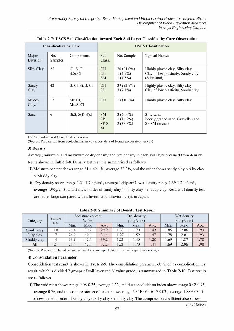
2) Soil Classification Toward soil classification by core observation, soil classification based on Unified Soil Classification
System (USCS) using soil test results of soil classification items such as water content test, liquid and
plastic limit test, and grain size analysis test are carried out, and are shown in Table 2-7.
90% or more of silty clay and sandy clay are classified to CH (typical soil names such as high plastic clay,
silty clay, etc. are contained), and soils classified to CL (typical soil names such as low plastic clay, sandy
clay. etc. are contained) are rather rare. Therefore, in the coverage area of soil test implementation, the
downstream area from the railway bridge is almost occupied by clayey soil, and almost all of the clayey
soil is classified CH.
N Value
P/Em
(bar)
N - Pl N - Pf N-Em
P/Em
(bar)
P/Em
(bar)
P/Em
(bar)
Silty Clay
Mudy Clay
Sand
N Value
N Value
N Value

Preparatory Survey on Integrated Basin Management and Flood Control Project for Mejerda River:
Development of Flood Prevention Measures
Yachiyo Engineering Co., Ltd.
Final Report
56
Meanwhile, sand distribution is very narrow. Although number of soil test is little, 50% of sand is classified
to SM (typical soil names such as silty sand, etc. are contained), 17% of sand is classified to SP (typical soil
names such as not well sorting sand, gravely sand etc. are contained), and 33% of sand is intermediate.
Sand of the study area is rather fine, but includes fine grain to coarse grain.
Preparatory Survey on Integrated Basin Management and Flood Control Project for Mejerda River:
Development of Flood Prevention Measures
Yachiyo Engineering Co., Ltd.
Final Report
57
Table 2-7: USCS Soil Classification toward Each Soil Layer Classified by Core Observation
Classification by Core USCS Classification
Major Division
No. Samples
Components Soil Class.
No. Samples Typical Names
Silty Clay 22 Cl. Si.Cl, S.Si.Cl
CH CL SM
20 (91.0%) 1 (4.5%) 1 (4.5%)
Highly plastic clay, Silty clay Clay of low plasticity, Sandy clay (Silty sand)
Sandy Clay
42 S. Cl, Si. S. Cl CH CL
39 (92.9%) 3 (7.1%)
Highly plastic clay, Silty clay Clay of low plasticity, Sandy clay
Muddy Clay.
13 Mu.Cl, Mu.Si.Cl
CH 13 (100%) Highly plastic clay, Silty clay
Sand 6 Si.S, S(f)-S(c) SM SP SP-SM
3 (50.0%) 1 (16.7%) 2 (33.3%)
Silty sand Poorly graded sand, Gravelly sand SP SM mixture
USCS: Unified Soil Classification System (Source: Preparation from geotechnical survey report data of former preparatory survey)
3) Density Average, minimum and maximum of dry density and wet density in each soil layer obtained from density
test is shown in Table 2-8. Density test result is summarized as follows.
i) Moisture content shows range 21.4-42.1%, average 32.2%, and the order shows sandy clay < silty clay
< Muddy clay.
ii) Dry density shows range 1.21-1.70g/cm3, average 1.44g/cm3, wet density range 1.69-1.20g/cm3,
average 1.90g/cm3, and it shows order of sandy clay >= silty clay > muddy clay. Results of density test
are rather large compared with alluvium and diluvium clays in Japan.
Table 2-8: Summary of Density Test Result
Category Sanple No.
Moisture content W (%)
Dry density γd (g/cm3)
Wet density γh (g/cm3)
Min. Max. Ave. Min. Max. Ave. Min. Max. Ave. Sandy clay 10 21.4 39.2 29.9 1.33 1.70 1.49 1.85 2.06 1.93 Silty clay 7 26.0 40.1 31.4 1.27 1.59 1.47 1.78 2.01 1.93
Muddy clay 4 33.6 42.1 39.2 1.21 1.40 1.28 1.69 1.87 1.78 All 21 21.4 42.1 32.2 1.21 1.70 1.44 1.69 2.06 1.90
(Source: Preparation based on geotechnical survey report data of former preparatory survey)
4) Consolidation Parameter Consolidation test result is shown in Table 2-9. The consolidation parameter obtained as consolidation test
result, which is divided 2 groups of soil layer and N value grade, is summarized in Table 2-10. Test results
are as follows.
i) The void ratio shows range 0.08-0.35, average 0.22, and the consolidation index shows range 0.42-0.95,
average 0.76, and the compression coefficient shows range 6.34E-05~ 6.17E-03 , average 1.88E-03. It
shows general order of sandy clay < silty clay < muddy clay. The compression coeffcient also shows

Preparatory Survey on Integrated Basin Management and Flood Control Project for Mejerda River:
Development of Flood Prevention Measures
Yachiyo Engineering Co., Ltd.
Final Report
58
SPTCore USCS N Value Pf Pl Em e0 Cc Cv
(kN/cm2) (kN/cm2) (kN/cm2) (cm3/s)BH I 09 4.00-4.50 S.Cl CH 19 440 690 7500 0.47 0.14 3.16E-03BH I 15 8.50-9.00 S.Cl CH 0 210 350 3600 0.88 0.24 1.95E-03BH I 16 4.00-4.50 S.Cl CH 13 140 230 2400 0.65 0.18 2.05E-03BH I 17 3.00-3.50 S.Cl CH - 130 210 2400 0.86 0.27 1.23E-03BH I 19 13.00-13.50 S.Cl CH - 180 290 4200 0.92 0.26 3.14E-04BH I 22 11.00-11.50 S.Cl CH 0 320 520 6300 0.70 0.21 5.83E-03BH II 18 2.00-2.50 S.Cl CH - - - - 0.63 0.15 5.18E-04BH II 18 5.00-5.50 S.Cl CH - - - - 0.69 0.18 3.60E-04BH II 18 8.50-9.00 S.Cl CH - - - - 0.85 0.19 3.32E-05BH II 18 10.00-10.50 S.Cl CH - - - - 0.60 0.11 2.09E-03
0.73 0.19 1.75E-03BH I 14 9.00-9.50 Si.Cl CH 0 170 310 5200 0.85 0.24 6.17E-03BH I 18 4.00-4.50 Si.Cl CH - 390 650 4600 0.67 0.18 6.30E-04BH I 23 11.50-12.00 Si.Cl CH 9 310 470 6200 1.09 0.35 6.34E-05BH II 06 6.50-7.00 Si.Cl CH 5 440 700 6300 0.73 0.23 1.24E-03BH II 18 18.00-18.50 Si.Cl CH - - - - 0.72 0.18 2.83E-03BH II 18 22.00-22.50 Si.Cl CH - - - - 0.61 0.18 1.90E-03BH II 18 24.50-25.00 Si.Cl CH - - - - 0.42 0.08 2.26E-04
0.73 0.21 1.87E-03BH I 20 12.50-13.00 Mu.Cl CH - 140 220 2600 0.95 0.35 3.03E-03BH I 21 12.50-13.00 Mu.Cl CH 0 110 200 4900 0.94 0.26 3.38E-03BH I 24 11.50-12.00 Mu.Cl CH 0 410 640 4300 0.89 0.26 2.98E-04BH II 18 14.00-14.50 Mu.Cl CH - - - - 0.84 0.32 9.84E-04
0.91 0.30 1.92E-030.76 0.22 1.82E-03
Compaction Parameter
Average
Soil Classification PMT
Sub-average
Sub-average
Sub-average
BoreholeNo.
Depth
same order of sandy clay < silty clay < muddy clay, and the result is reversed in comparison with the
weak grade generally presumed from strengh, etc.
ii) According to N value grade, the soft ground (clayey soil with N value 4 or less) shows the void ratio
average of 0.85, compaction index average of 0.24 and compression coefficient average of 3.53E-03.
As compared with the average value of the muddy clay, the consolidation index is small and the
compression coefficient is large. It shows that average of muddy clay is softer than others.
Table 2-9: Consolidation Test Result (Source: Preparation based on geotechnical survey report data of former preparatory survey)

Preparatory Survey on Integrated Basin Management and Flood Control Project for Mejerda River:
Development of Flood Prevention Measures
Yachiyo Engineering Co., Ltd.
Final Report
59
SPTCore USCS N Value Pf Pl Em Cu φ
(kN/cm2) (kN/cm2) (kN/cm2) (kN/cm2) (deg)
BH I 17 3.00-3.50 S.Cl CH - 130 210 2400 10.00 3BH II 07 6.00-6.50 S.Cl CH - - - - 31.00 13BH II 09 2.00-2.50 S.Cl CH - - - - 119.00 23BH II 09 6.50-7.00 S.Cl CH - - - - 146.00 16BH II 18 2.00-2.50 S.Cl CH - - - - 76.00 15BH II 18 5.00-5.50 S.Cl CH - - - - 130.00 19
85.0 14BH I 18 4.00-4.50 Si.Cl CH - 390 650 4600 59.00 8BH II 07 2.00-2.50 Si.Cl CH - - - - 76.00 15BH II 08 3.50-4.00 Si.Cl CH - - - - 47.00 10
61.00 877.00 14
Sub-average
Sub-averageAverage
Soil Classification PMT Shear TestBoreholeNo.
Depth
Table 2-10: Consolidation Parameter of Consolidation Test
(Source: Preparation based on geotechnical survey report data of former preparatory survey)
5) Shear Strength The shear strength (cohesion and inner friction angle) obtained as box shear test result is shown in Table
2-11. The summary of each soil layer is shown in Table 2-12.
i) There are few examinations and the examination part has deviation. Adhesion shows 10-146 kN/m2 and
average of 77kN/m2, and internal friction angle shows 3 to 23 degrees, and average of 14 degrees. The
tendency of the order of sandy clay > silty clay is shown.
ii) It seems that the shear strength of clayey soils obtained from test result has high intensity compared
with alluvium and diluvium clays in Japan. The examination may have been done in the good part of
core state. In addition, the depth 3.0-3.5m (weak ground part) of BHI17 shows adhesion 10kN/m2 and
3 degrees of internal friction angle, and is low intensity compared with others.
Table 2-11: Shear Test Result
(Source: Preparation based on geotechnical survey report data of former preparatory survey)
Category Sanple No.
Initial void ratio e0
Preconsolidation stress
σ’p (kN/m2)
Compression Index Cc
Coefficient of consolidation
Cv(cm3/s)
Min. Max. Ave. Min. Max. Ave. Min. Max. Ave. Min. Max. Ave.
Sandy clay 10 0.47 0.92 0.73 63 148 116 0.11 0.27 0.19 3.14E-04
5.83E-03
1.75E-03
Silty clay 6 0.42 1.09 0.74 75 253 165 0.08 0.35 0.21 6.34E-05
6.17E-03
1.87E-03
Muddy clay 4 0.84 0.95 0.91 83 173 118 0.26 0.35 0.30 2.98E-03
3.38E-03
1.92E-03
All 20 0.42 1.09 0.76 63 253 131 0.08 0.35 0.22 6.34E-05
6.17E03
1.88E-03
N 値 N=0-4 5 0.70 0.94 0.85 83 173 120 0.21 0.26 0.24 2.98E-04
6.17E-03
3.53E-03
N値N=5-19 4 0.47 1.09 0.73 75 121 109 0.14 0.35 0.23 6.34E-05
3.16E-3
1.63E-03
All 9 0.47 1.09 0.80 75 173 115 0.14 0.35 0.23 6.34E-05
6.17E-03
2.68E-03

Preparatory Survey on Integrated Basin Management and Flood Control Project for Mejerda River:
Development of Flood Prevention Measures
Yachiyo Engineering Co., Ltd.
Final Report
60
Table 2-12: Summary of Shear Strength
Category Sanple No.
Adhesion (Undrained) Cu (bar)
Internal friction angle φ (degree)
Min. Max. Ave. Min. Max. Ave. Sandy clay 6 10 146 85 3 23 14
Silty clay 3 47 76 62 8 15 8
All 7 10 146 77 3 23 14
(Source: Preparation based on geotechnical survey report data of former preparatory survey)
(4) Foundation Analysis 1) Geotechnical Soil Parameter on Foundation Analysis The Geotechnical soil parameter for examination of the foundation stability and consolidation analysis is
shown in Table 2-13.
Table 2-13: Geotechnical Soil Parameter for Foundation Analysis
Category Density Shear Srength Compaction Parameater
γh (g/cm3)
γ’ (g/cm3)
Cu (kN/m2)
φ (Degree)
e0
Cc Cv (cm3/s)
Embankmemt 1.60 - 43 0 Surface soil 1.93 0.93 43 9 0.75 0.21 8.74E-04 River deposit 1.70 0.70 0 25 - - - Sandy clay 1.93 0.93 31 13 0.73 0.19 1.75E-03 Silty clay 1.93 0.93 47 10 0.74 0.21 1.87E-03 Muddy clay 1.78 0.78 21 0 0.91 0.31 1.92E-03 Sand 1.80 0.80 0 30 - - - Soft ground 1.78 0.78 10 3 0.91 0.31 1.92E-03
(Source: Preparation based on geotechnical survey report data of former preparatory survey) The setup of the parameter was carried out as follows.
i) Wet density is applied the average value of each soil layer. In addition, many of muddy clay portions are
soft ground, and the wet density of muddy clay is applied as the wet density of soft ground. Underwater
weight deducts the unit volume weight of water from wet weight as 1tf/m3 (9.8kN/m3).
ii) As the shear strength of soft ground, the test result of BHI17 is applied. Since the shear strength of each
soil layer has brought a high result at the whole, the minimum value of each soil layer except for soft
ground portion is applied.
iii) The consolidation parameter uses the average value obtained in each soil layer. In addition, the soft
ground uses the average value of the muddy clay.
iv) Since surface soil is mainly sandy clay in many cases, the average value of BHI17 (3.0 to 3.5 m depth),
and BHII18 (2.0 to 2.5 m depth) of the surface of sandy clay is applied.
v) About the following soil layers, since the shear test is not carried out, the intensity is presumed from the
empirical equation by N value (refer to Table 2-14). - Sandy soil: The value with smaller one of Peck; phi=27+0.3N (degree) and Dunham; phi=root(12N)+ (15 to
20) (degree) - Clayey soil: the value of the smaller one of Terzaghi-Peck; C=qu/2= (N/0.8) /2x10 (kN/m2), and Osaki;
C=qu/2=(4+N/2)2x10 (kN/m2) - Embankment: Calculation from the minimum of N values of 2 samples

Preparatory Survey on Integrated Basin Management and Flood Control Project for Mejerda River:
Development of Flood Prevention Measures
Yachiyo Engineering Co., Ltd.
Final Report
61
SPT_ NPeck Dunham Terzagi-Peck Osaki
Min 9 - - 56 43Max 15 - - 94 58Ave. 12 - - 75 50Min 0 27 15 - -Max 55 44 41 - -Ave. 19 33 30 - -Min 0 - - 0 20Max 60 - - 375 170Ave. 20 - - 122 69Min 0 - - 0 20Max 60 - - 375 170Ave. 24 - - 148 79Min 0 - - 0 20Max 9 - - 56 43Ave. 0.4 - - 3 21
Sand (φ, dgree) Clay (Cu, kN/m2)
Muddy clay 66
Sandy clay 179
Silty clay 111
Classification Sample No.
Embankment 2
Sand 43
SPT_ NPeck Dunham Terzagi-Peck Osaki
Min 9 56 43Max 15 94 58Ave. 12 75 50Min 2 28 20Max 41 39 37Ave. 19 33 30Min 0 0 20Max 24 150 80Ave. 7 45 38Min 0 0 20Max 20 125 70Ave. 8 49 40Min 0 0 20Max 6 38 35Ave. 1 9 23
Silty clay 21
Muddy clay 8
Sand (φ, dgree) Clay (Cu, kN/m2)
Embankment 2
Sand 33
Sandy clay 35
Classification Sample No.
- River deposit: It is thought that river bed sediment strength is smaller than the average of the sand of shallow portion, and the calculation from the average of N value of a)the minimum N values and b)average of N value of shallow portion.
- Muddy clay: Calculation from the average of N value of muddy clay - Sand: Calculation from the average of N values of the whole sand layer Table 2-14: Presumption of Adhesion of Clayey Soil and Internal Friction Angle of Sandy Soil by Empirical Equation (Source: Arrangement based on geotechnical survey report data of former preparatory survey)
(A) Whole Soil Layer (B) Shallow Soil Layer with Depth 10m or less

Preparatory Survey on Integrated Basin Management and Flood Control Project for Mejerda River:
Development of Flood Prevention Measures
Yachiyo Engineering Co., Ltd.
Final Report
62
2) Distribution of Soft Ground Distribution of soft ground is summarized as shown in Table 2-15. The soft ground is the clayey soil
portion with N value 0 to 4. In the part which is not carried out the standard penetration test, the extension
portion of soft ground with weak strength on pressure meter test (5 or less bar of creep pressure, 10 or less
bar of limit pressure, and 100 or less bar of deformation modulus as shown in (3) (a) iii) clause) is treated
as soft ground.
Table 2-15: Distribution of Soft Ground
Location Boring No. Depth (m) Thickness
(m) Remarks SPT PMT (Presumption) Surface Bottom
Highway Bridge BHI22,23,24 - 8-12 24-27 13-19 GP8 Road Bridge
BHI14,15,16 - 7-9 22-24 13-15
Tobias Bridge BHI26 - 6 14 8 Downstreem of Tobias - BHI17,18 1 4-6 3-5 Soft ground locates just
under surface soil. K.Landalous Bridge
BHI21 BHI19,20 1-7 25-34 24-30 At BHI19 and 20, Soft ground locates just under surface soil.
El Mabtouh reterding basin
BHII06 -
10 20 5 and 3 (2 layers)
Soft ground separates 2 layers intercalating thin sand layer.
(Source: Preparation based on geotechnical survey report data of former preparatory survey) The soft ground is located in the lower part covered by some shallow soil layers with depth 5 to 12 m in
many parts. In the area from the Tobias bridge downstream BHI17 and BHI18 to the Kalaat Landalous
bridge BHI19 and BHI20, the soft ground is located directly under a thin surface soil layer (thickness 1 to 2
m) and will easily appear on the surface of the earth.
3) Excavation Gradient on Channel Expantion The planned excavation gradient in channel expannsion is 1:2 (height 1: horizontal distance 2), and has the
3m wide banquette in 5m in height. The calculation result of minimum safety ratio of rotational slip for the
excavation with total height 8m is shown in Table 2-16.
In case of soft ground, the minimum safety ratio is set to 0.46, and it collapses. In case of sandy clay and
silty clay except for soft ground, even if the minimum strength obtained by the geotechnical soil survey of
the former preparatory survey is used, the calculated safety ratio is large. In excavation of the upper part of
the water surface in dry season, it is stable (refer to Figure 2-26). Moreover, from reverse calculation result,
if clay monolayer has the shear strength (C=32kN/m2, phi= 0 degree) or more and sand monolayer has the
shear strength (C=0kN/m2, phi= 27 degrees) and over, the safety ratio of 1 or more can be secured (Refer
to Figure 2-27).

Preparatory Survey on Integrated Basin Management and Flood Control Project for Mejerda River:
Development of Flood Prevention Measures
Yachiyo Engineering Co., Ltd.
Final Report
63
Table 2-16: Safety Ratio of Planned Excavation Gradient(Ordinary condition) Soil Condition Adhesion
C (kN/m2) Internal Friction
Angle φ (°)
Minimum Safty
Factor
Remarks
Soft Ground (Single layer) 10 3 0.480 Soft Ground(Sand intercalation) (Sand: 0) (Sand: 30) 0.808 Sandy clay in bottom
layer Silty Clay(Single layer) 47 10 1.934 Minimum strength
without soft ground Silty Clay(Sand intercalation) (Sand: 0) (Sand: 30) 1.821 Ditto Sandy Clay(Single layer) 31 13 1.588 Minimum strength
without soft ground Sandy Clay(Sand intercalation) (Sand: 0) (Sand:30) 1.544 Ditto (Source: Preparation of this preparatory survey)
Moreover, the safety ratio of 5m height excavation calculated changing slope gradient is shown in Table
2-17 and Figure 2-28. Except soft ground and sand layer, even if the excavation is carried out with steep
slope in the upper part of the water surface in the dry season, it is safe. However, it is examination from the
test result of the geotechnical soil survey of the former preparatory survey. In silty clay layer and sandy
clay layer, the part, which shows less than the minimum strength set up now, may appear. In case of
excavation by steep slope, it is necessary to design and construct after conducting detailed check.
Table 2-17: Minimum Safety Ratio of 5m Height Excavation on Gradient Change (Ordinary condition)
Gradient Safty Factor Remarks Soft Ground Silty Clay Sndy Clay Sand 1 : 0.25 0.578 2.625 1.945 0.460 1 : 0.50 0.662 - - 0.608
Calculation of intermediate two items is omitted because of high safety factor.
1 : 0.75 0.737 - - 0.727 1 : 1.0 0.809 - - 0.776 1 : 1.5 0.945 - - 0.944 1 : 2.0 1.066 - - 1.166 1 : 2.5 1.203 - - 1.386
(Source: Preparation of this preparatory survey)

Preparatory Survey on Integrated Basin Management and Flood Control Project for Mejerda River:
Development of Flood Prevention Measures
Yachiyo Engineering Co., Ltd.
Final Report
64
(Source: Preparation of this preparatory survey)
Figure 2-26: Minimum Safety Ratio of River Bank Excavation (Height:8m, Gradient: 1:2, Banquette width: 3m)
(A) Soft Ground (Monolayer) (B) Soft Ground (Intercalation of Sand)
(C) Silty Clay (Monolayer) (D) Sandy Clay (Monolayer)

Preparatory Survey on Integrated Basin Management and Flood Control Project for Mejerda River:
Development of Flood Prevention Measures
Yachiyo Engineering Co., Ltd.
Final Report
65
(Source: Preparation of this preparatory survey)
Figure 2-27: Reverse Calculation for Excavation of River Bank (Height: 8m, Gradient: 1:2,
Banquette width: 3m)Obtained Safety Ratio 1.00
(Source: Preparation of this preparatory survey)
Figure 2-28: Minimum Safety Ratio of River Bank Excavation (Soft Ground, Height: 5m)
(A) Reverse Calculation Result (B) Reverse Calculation Sliding Surface
(A) Gradient 1:2 (B) Gradient 1:2.5

Preparatory Survey on Integrated Basin Management and Flood Control Project for Mejerda River:
Development of Flood Prevention Measures
Yachiyo Engineering Co., Ltd.
Final Report
66
4) Stability of Dike Embankment In case that soft ground exists directly under surface soil layer, the stability of dike embankment
(embankment height: 3m and 5m, upper surface width 10m, slope gradient 1:2) is examined by rotation slip
calculation. The calculated minimum safety ratio shows 1.159 in 6m embankment height, 1.037 in 7m
height, and 0.944 in 8m height. Bank embankment will become unstable if the embankment height exceeds
7m (Refer to Figure 2-29). In addition, the influence of shape modification by subsidence of soft ground
and riverbank slope condition etc. is not taken into consideration. Detailed examination united with each
part is required.
(Source: Preparation of this preparatory survey)
Figure 2-29: Examination for Stability of Embankment on Soft Ground
5) Subsidence of Dike Embankment The outline examination result of the amount of subsidence and
the subsidence time in case of dike embankment on the part
including thick soft ground layer is as follows. The embankment
height 5m, upper surface width 10m and under surface width 30m,
and traffic load 1 tf/m2 (9.8kN/m2) are set up.
The amount of subsidence and the time directly under a trapezoid
center (Osterberg influence coefficient application) are calculated
on normal consolidation and double-sided drainage condition
(Refer to Figure 2-30).
i) Kalaat Landalous Bridge Part: Amount of subsidence: 88.4cm,
Subsidence time: 309 months (90% of compaction index)
ii) GP8 Highway Bridge Part: Amount of subsidence: 45.3cm
Subsidence time: 246 months (90% of compaction index)
(A) Embankment height 7m (B) Embankment height 8m
(A) K. Landalous bridge part (B) GP8 road bridge part (Source: Preparation based on the geotechnical soil survey data of the former preparatory survey) Figure 2-30: Type Soil Column for Examination of Subsidence
(A) (B) Embankment Embankment(Trapezoid) (Trapezoid)
WL 0 WL 0
1 .0 1 1 .0 1
4
8
22
28
45 45

Preparatory Survey on Integrated Basin Management and Flood Control Project for Mejerda River:
Development of Flood Prevention Measures
Yachiyo Engineering Co., Ltd.
Final Report
67
Wet Weight Weight in water Initial void ratioConsolidation
index
Consolidation
CoefficientThickness
Initial vertical
load
Contact
pressure
Influence
coefficient
Increase
pressureSinkage
γt γ’ e0 Cc Cv H P0 q I Δ P=σz S Compaction Compaction
(t/m3) (t/m3) (cm2/s) (cm) (tf/m2) (tf/m2) (tf/m2) (cm) 80% (month) 90% (month)
Surface soil 1.93 0.93 0.75 0.21 8.74E-04 100 0.965 9 0.99 8.91 12.1 1 1Soft ground 1.78 0.78 0.91 0.31 1.92E-03 3000 13.54 9 0.64 5.76 67.5 208 309Sandy clay 1.93 0.93 0.73 0.19 1.75E-03 2900 41.08 9 0.38 3.42 6.5 90 134
Total 86.1 208 309
Soil LayerSubsidence time
Wet Weight Weight in water Initial void ratioConsolidation
index
Consolidation
CoefficientThickness
Initial vertical
load
Contact
pressure
Influence
coefficient
Increase
pressureSinkage
γt γ’ e0 Cc Cv H P0 q I Δ P=σz S Compaction Compaction
(t/m3) (t/m3) (cm2/s) (cm) (tf/m2) (tf/m2) (tf/m2) (cm) 80% (month) 90% (month)
Surface Soil 1.92 0.92 0.75 0.21 8.74E-04 100 0.96 9 0.99 8.91 12.1 1 1sand 1.8 0.8 0.6 - - 400 5.52 9 0.46 4.14 - - -
Silty Clay 1.93 0.93 0.73 0.21 1.87E-03 500 10.445 9 0.42 8.91 12.1 5 7Soft Ground 1.78 0.78 0.91 0.3 1.92E-03 1500 18.62 9 0.29 2.61 12.5 56 83Sandy Clay 1.93 0.93 0.73 0.19 1.75E-03 2500 36.095 9 0.16 1.44 4.3 165 246
Total 41.0 165 246
Soil LayerSubsidence time
(however, in case of ii), If it takes into consideration that the subsidence amount of soft ground layer and
the lowermost part layer (sandy clay) are small, the actual subsidence time will become short.)
If soft ground layer becomes thick, subsidence will take time. Examination for measure such as preload or
sand drain method, etc. against the subsidence time is needed.
Table 2-18: Outline Examination for Subsidence of Embankment (Kalaat Landalous Bridge Part)
(Source: Preparation based on the geotechnical survey report data of the former preparatory survey)
Table 2-19: Outline Examination for Subsidence of Embankment (GP8 Road Bridge Part)
(Source: Preparation based on the geotechnical survey report data of the former preparatory survey)
6) Bearing Layer of Structure Foundation The bearing layers which become the foundation of structure are summarized as shown in Table 2-20.
In the Kalaat Landalous bridge part, the bearing layer is not encountered up to depth 45m of boring bottom,
and the confirmation of the deeper part is required. Moreover, in El Mabtouh retarding basin BHII06, the
silty clay layer with N values 20 or more which can become bearing layer is thin. It is in the state where
bearing layer are not confirmed. The confirmation of the depth is required when the pile foundation is
needed by bridge improvement.
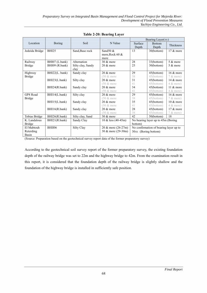
Preparatory Survey on Integrated Basin Management and Flood Control Project for Mejerda River:
Development of Flood Prevention Measures
Yachiyo Engineering Co., Ltd.
Final Report
68
Table 2-20: Bearing Layer
Location Boring Soil N Value Bearing Layer(m)
Surface Depth
Bottom Depth Thickness
Jedeida Bridge BHI25 Sand,Base rock Sand50 & more,Rock 60 & more
13 30(bottom) 17 & more
Railway Bridge
BHI07 (L.bank) BHI09 (R.bank)
Alternation Silty clay, Sandy clay
30 & more 20 & more
28 25
33(bottom) 30(bottom)
5 & more 5 & more
Highway Bridge
BHI22(L. bank) BHI23(L.bank) BHI24(R.bank)
Sandy clay Silty clay Sandy clay
20 & more (50 & more 20 & more (50 & more 20 & more (50 & more
29 38 31 41 34 41
45(bottom) 45(bottom) 45(bottom) 45(bottom) 45(bottom) 45(bottom)
16 & more 7 & more) 14 & more 4 & more) 11 & more 4 & more)
GP8 Road Bridge
BHI14(L.bank) BHI15(L.bank) BHI16(R.bank)
Silty clay Sandy clay Sandy clay
20 & more (50 & more 20 & more (50 & more 20 & more (50 & more
29 38 35 41 28 38
45(bottom) 45(bottom) 45(bottom) 45(bottom) 45(bottom) 45(bottom)
16 & more 7 & more) 10 & more 4 & more) 17 & more 7 & more)
Tobias Bridge BHI26(R.bank) Silty clay, Sand 30 & more 42 50(bottom) 18 K. Landalous Bridge
BHI21(R.bank) Sandy Clay 10 & less (40-45m) No bearing layer up to 45m (Boring bottom)
El Mabtouh Reterding Basin
BHII06 Silty Clay 20 & more (26-27m) 30 & more (29-30m)
No confirmation of bearing layer up to 30m (Boring bottom)
(Source: Preparation based on the geotechnical survey report data of the former preparatory survey)
According to the geotechnical soil survey report of the former preparatory survey, the existing foundation
depth of the railway bridge was set to 22m and the highway bridge to 42m. From the examination result in
this report, it is considered that the foundation depth of the railway bridge is slightly shallow and the
foundation of the highway bridge is installed in sufficiently safe position.

Preparatory Survey on Integrated Basin Management and Flood Control Project for Mejerda River:
Development of Flood Prevention Measures
Yachiyo Engineering Co., Ltd.
Final Report
69
(5) Examination of Structure Materials In order to examine the proposed site for structure aggregate, quarry sites in Tebouraba and Ariana and
concrete plant of Ariana were visited. Their locations are shown in Fig. 2.1.3-24. The outline of each
facility is shown in Table 2-21. All are possible for procurement of required materials.
(Source: Preparation using Google Earth 2012 as base map)
Figure 2-31: Location of Quarry and Concrete Plant
Société Caza Quarry

Preparatory Survey on Integrated Basin Management and Flood Control Project for Mejerda River:
Development of Flood Prevention Measures
Yachiyo Engineering Co., Ltd.
Final Report
70
(A) Caza Quarry (B) Fahdli Quarry
(Source: This preparatory survey, taking photo in August, 2012)
Figure 2-32: Crushing Equipment and Raw Stone of Caza Quarry and Fahdli Quarry
Table 2-21: Outline of Quarry and Concrete Plant
(Source: Preparation of this preparatory survey)
About the quality of concrete aggregate, a part of aggregate tests and reference collection are performed by
the former preparatory survey. The result is shown in Table 2-22.
Société Caza Quarry(Tebourba)
Fadhli Quarry (Ariana)
Afrique Béton Concrete Plant (Ariana)
Operation and End Year
1982 (Full operation from 1989) – 2030 (Plan)
1999(Full operation from 2002)- 2016 (Application)
1992(as Construction company), Plant operation from 2001
Area 14ha 18ha
Material Marl, Limestone Marl Limestone ( Transportation from Jebel El Errssas)
Production 3000t/day(12hr in Ramadan period), Ordinary 12-16hr
3000t/day(10hr in Ramadan period) Ordinary 12-16hr
700-750m3/day
Main equipment
Impact Crusher 1 Jaw Crusher 1
Impact Crusher 1 Mixing Car(7-11m3)28, Pump placement car 3
Supply Destination
General civil work, Road, Building, Bridge
General civil work, Road, Building, Bridge
Building, Bridge
Quality Test Head office, CTEC (Company)
Public organization at application procedure
Laboratory in the plant
Others Truck scale Having schedule of truck scale installation
ISO9001 Obtain

Preparatory Survey on Integrated Basin Management and Flood Control Project for Mejerda River:
Development of Flood Prevention Measures
Yachiyo Engineering Co., Ltd.
Final Report
71
Table 2-22: Aggregate Test Result of the Former Preparatory Survey
Aggregates Quarry-run Gravel 0/20
Gravel 4/15
Gravel 14/16
Gravel 20/30
Gravel 14/25
Quarry Location Jbel Mayana(Eastern Teboruba) Aliana (Northern Tunis)
Laboratory Former Preparatory Study (GEOCONSEIL) LCAE
Density ρ(g/cm3) 2.60 2.56 2.50 Water absorption ab(%) 2.56 2.54 2.68 Sand equivalent ES(%)/Liquid limit LL(%) 63.5/20.7 Los Ageles Test, Abrasion LA(%) 26 20 21 22 24 Micro-Deval Test, Abrasion dry condition (%)/Abrasion wet condition (%)
29/12
Deval Test, Abrasion (%) 2.9 Modified Proctor Test, Dry density γd(g/cm3)/Optimum Moisture content Wopt (%)
2,26/6
Adhesion to bitumen 87 Remarks; Los Angeles Test based on NT21.21(1990), Micro-Deval Test based on NT21.08(1984), Deval Test based on NF P 18.577, LCAE: Laboratoire Central d’Analyses et d’Essais (Source: Arrangement from the geotechnical survey report of the former preparatory survey) From the aggregate test result of the former preparatory survey and the this preparatory survey results, marl
and limestone in part are mainly quarried around the study area, and marl shows slightly large abrasion and
has the tendency of slightly soft and easily breaking (Refer to Figure 2-32). When some improved structure
needs high intensity, it is necessary to receive from the quarry produces more hard limestone or to make
severe the quality control such as strict sorting of use aggregates and frequent conducting of concrete
strength test. In addition, dolomitic limestone sometimes shows alkali aggregate reaction, and it is
necessary to check by alkali aggregate reaction examination and to cope with mixing alkali aggregate.
Moreover, in the study area, although there are few sand layers, the sand equivalent test is performed in
BHI07 and BHI25 by the geotechnical soil survey of the former preparatory survey. As the result, 5
samples show 46-49% and 1 sample shows 82% among 6 samples. The sand materials of sand layers have
rather high content of fine particle, and are not suitable as fine aggregate for concrete. It is necessary to
obtain sand produced in quarry.

Preparatory Survey on Integrated Basin Management and Flood Control Project for Mejerda River:
Development of Flood Prevention Measures
Yachiyo Engineering Co., Ltd.
Final Report
72
2.5 Overview of the River in Zone D2
Distance Mark 0 km
Site Name River Mouth
Photo Direction: Upstream
Details
Distance Mark 4 km
Site Name Delta Bridge Outlet
Photo Direction: Downstream
Details View is further downstream than the Delta Bridge

Preparatory Survey on Integrated Basin Management and Flood Control Project for Mejerda River:
Development of Flood Prevention Measures
Yachiyo Engineering Co., Ltd.
Final Report
73
Distance Mark 11 km
Site Name Tobias Barrage
Photo Direction: Downstream
Details River condition after overflowing the Tobias Barrage
Distance Mark 14 km
Site Name GP8 Bridge Area
Photo Direction: Downstream
Details View is downstream from the bridge

Preparatory Survey on Integrated Basin Management and Flood Control Project for Mejerda River:
Development of Flood Prevention Measures
Yachiyo Engineering Co., Ltd.
Final Report
74
Distance Mark 17 km
Site Name Left bank at 17k
Photo Direction: Upstream
Details View is upstream from the left bank
Distance Mark 32 km
Site Name Left bank at 32k
Photo Direction: Downstream
Details Near diversion facility project

Preparatory Survey on Integrated Basin Management and Flood Control Project for Mejerda River:
Development of Flood Prevention Measures
Yachiyo Engineering Co., Ltd.
Final Report
75
Distance Mark 38 km
Site Name Jedeida Railroad Bridge area
Photo Direction: Downstream
Details View is downstream from the bridge
Distance Mark 41 km
Site Name Jedeida Road Bridge area
Photo Direction: Downstream
Details
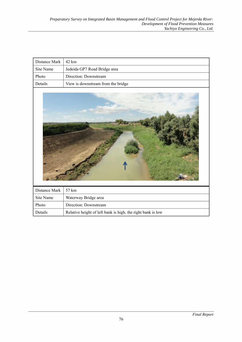
Preparatory Survey on Integrated Basin Management and Flood Control Project for Mejerda River:
Development of Flood Prevention Measures
Yachiyo Engineering Co., Ltd.
Final Report
76
Distance Mark 42 km
Site Name Jedeida GP7 Road Bridge area
Photo Direction: Downstream
Details View is downstream from the bridge
Distance Mark 57 km
Site Name Waterway Bridge area
Photo Direction: Downstream
Details Relative height of left bank is high, the right bank is low

Preparatory Survey on Integrated Basin Management and Flood Control Project for Mejerda River:
Development of Flood Prevention Measures
Yachiyo Engineering Co., Ltd.
Final Report
77
Distance Mark 65 km
Site Name Laroussia Dam
Photo Direction: Downstream
Details View is downstream from the crown of dam

Preparatory Survey on Integrated Basin Management and Flood Control Project for Mejerda River:
Development of Flood Prevention Measures
Yachiyo Engineering Co., Ltd.
Final Report
78
2.6 Overview of Dams in the D2 Zone (1) Tobias Barrage
Facility
Name
Tobias Dam MD416 (10.836km)
・2 tumble gates for left bank
・Fixed weir installed on right bank
・Current condition of tumble weir

Preparatory Survey on Integrated Basin Management and Flood Control Project for Mejerda River:
Development of Flood Prevention Measures
Yachiyo Engineering Co., Ltd.
Final Report
79
・Current condition of fixed weir
・Water pump station of intake facility
immediately upstream
・Water intake of intake facility
Intake facility upstream of Tobias/water is
taken in depending on water level of
afflux.

Preparatory Survey on Integrated Basin Management and Flood Control Project for Mejerda River:
Development of Flood Prevention Measures
Yachiyo Engineering Co., Ltd.
Final Report
80
(General Drawing of Tobias Barrage)

Preparatory Survey on Integrated Basin Management and Flood Control Project for Mejerda River:
Development of Flood Prevention Measures
Yachiyo Engineering Co., Ltd.
Final Report
81
(2) Laroussia Dam
Facility
Name:
Laroussia Dam MD252(64.974km)
・Panorama of upstream region
・Panorama of downstream region
・Current flood condition of the upstream region ・Channel installed in upstream region to
reuse water for irrigation.

Preparatory Survey on Integrated Basin Management and Flood Control Project for Mejerda River:
Development of Flood Prevention Measures
Yachiyo Engineering Co., Ltd.
Final Report
82
・Current flood condition of the upstream
region
2.7 Current Condition of Bridges in Zone D2
No.1 K.LANDAOUS BRIDGE
・Submersible bridge ・Not covered in this project
No.2 TOBIAS BRIDGE
・The old bridge is still intact, but because the new bridge and pier are not aligned, it obstructs the cross sectional area ・Constructed in 2011, condition is good; blueprints available (attached to Resource Document)

Preparatory Survey on Integrated Basin Management and Flood Control Project for Mejerda River:
Development of Flood Prevention Measures
Yachiyo Engineering Co., Ltd.
Final Report
83
No.9 JEDEIDA RAILWAY BRIDGE
・The old bridge (right) is still intact, but because the new bridge and pier are not aligned, it obstructs the cross sectional area ・Vestiges of the afflux during floods on the girder suggest the clearance for the river is insufficient ・Constructed in 1982, blueprints available (attached to Appendix)
No.10 JEDEIDA BRIDGE
・Along with the narrow river channel, there are private houses and schools. ・Constructed in 2011, condition is good, blueprint available (attached to Appendix)
No.11 JEDEIDA OLD BRIDGE
・Constructed of a stone arch and steel railway arch, the stone part is a historically significant structure. ・The stone part located on the narrow river channel particularly obstructs the cross sectional area, remarkably

Preparatory Survey on Integrated Basin Management and Flood Control Project for Mejerda River:
Development of Flood Prevention Measures
Yachiyo Engineering Co., Ltd.
Final Report
84
accumulates earth and sand.

Preparatory Survey on Integrated Basin Management and Flood Control Project for Mejerda River:
Development of Flood Prevention Measures
Yachiyo Engineering Co., Ltd.
Final Report
85
No.13 EL BATTAN BRIDGE
・Historically significant structure ・Largely obstructs the cross sectional area and remarkably accumulates earth and sand
No.15 GP7 BRIDGE ON CHAFUROU
・The old bridge (right) is still intact, but because the new bridge and pier are not aligned, it obstructs the cross sectional area ・The abutment and dike are not aligned, so they obstruct the cross sectional area.

Preparatory Survey on Integrated Basin Management and Flood Control Project for Mejerda River:
Development of Flood Prevention Measures
Yachiyo Engineering Co., Ltd.
Final Report
86
No.21 FARM BRIDGE
・This small-scale farm bridge located in El Mabtouh appears old ・There are many similar bridges

Preparatory Survey on Integrated Basin Management and Flood Control Project for Mejerda River:
Development of Flood Prevention Measures
Yachiyo Engineering Co., Ltd.
Final Report
87
2.8 Overview of Major Structures in El Mabtouh Retarding Basin
Facility
Name
Inlet channel
・An inlet channel established to receive
the outflow from the mountainous district
of the west bank.
・The water channel is an unsupported excavation.
Facility
Name
Flow control facilities
Control gates, Inlet channel (Left, Zone 3)
and Control gates, Inner channel (Right,
Zone 2)
・Control gates, Inlet Channel
・It is used to adjust the flow rate of flood effluent retained in Zone 3
・The three installed gates are currently
nonfunctional and not being used.
・There are Control gates, Inner Channel
on the other side. It is used to adjust the
flow rate of effluent retained in Zone 2
to the drainage.
Zone 2 Zone 3
Control gates, Inlet channel Control gates, Inner channel
Zone 3 Zone 2
Zone 3
Zone 2 Control gates, Inlet channel
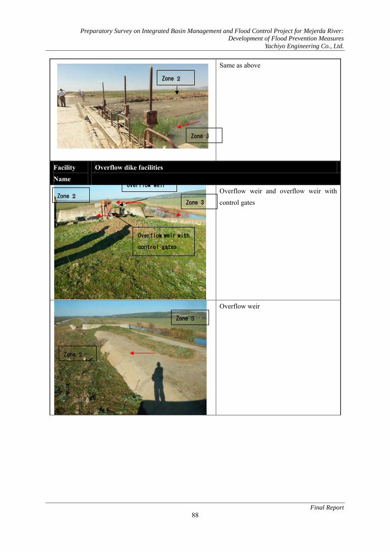
Preparatory Survey on Integrated Basin Management and Flood Control Project for Mejerda River:
Development of Flood Prevention Measures
Yachiyo Engineering Co., Ltd.
Final Report
88
Same as above
Facility
Name
Overflow dike facilities
Overflow weir and overflow weir with
control gates
Overflow weir
Zone 3
Zone 2
Overflow weir
Overflow weir with
control gates
Zone 2 Zone 3
Zone 3
Zone 2

Preparatory Survey on Integrated Basin Management and Flood Control Project for Mejerda River:
Development of Flood Prevention Measures
Yachiyo Engineering Co., Ltd.
Final Report
89
Overflow weir with control gates
Fuse levee
Facility Name:
Box culvert crossing the highway
・ The motorway has become an embankment, and a box culvert and
bridge are installed where the water
channel crosses.
Zone3
Zone 2
Zone 1

Preparatory Survey on Integrated Basin Management and Flood Control Project for Mejerda River:
Development of Flood Prevention Measures
Yachiyo Engineering Co., Ltd.
Final Report
90
Facility Name
Outlet channel (crossing the highway)
・The outlet channel crosses the highway at the bridge.
Facility
Name:
Outlet channel (crossing the road)
・The outlet channel cross the road at the
bridge.
Facility Name:
Confluence facilities to Mejerda river
・Backflow prevention gates are installed at confluence points to the main river.

Preparatory Survey on Integrated Basin Management and Flood Control Project for Mejerda River:
Development of Flood Prevention Measures
Yachiyo Engineering Co., Ltd.
Final Report
91
Same as above
・ Gates are nonfunctional and are
currently not being opened and closed.
・The gates are slightly open.
・A high water channel is established on
the foundation height to the side of the
water gate facilities (newer than
facilities), water overflows to merge with
the main river.

Preparatory Survey on Integrated Basin Management and Flood Control Project for Mejerda River:
Development of Flood Prevention Measures
Yachiyo Engineering Co., Ltd.
Final Report
92
Facility Name
Flap Gate and Sluice way
Sluiceways are installed along the course
from diversion channel to drainage
channel in Retarding Basin to drain water
off the Zone 2 or Zone 3 into waterways
under embankment. Flap gate is installed
on the side of waterways.
View from behind the same flap gate.
In case the scale of sluiceway is large, box
culvert is adopted for the structure.
Although gates are not installed on the
outlet side, it would be necessary to install
a sluice gate in case of renewal.

Preparatory Survey on Integrated Basin Management and Flood Control Project for Mejerda River:
Development of Flood Prevention Measures
Yachiyo Engineering Co., Ltd.
Final Report
93
2.9 Survey of Sluiceways Established on the Mejerda Main River in Zone D2
Record of Sluiceway Survey No.: 3 Name Coordinate N: 4077827.03 E: 582562.24 Altitude Photos
Sketch of Mouth Portion and Size Survey Diagrammatic Sketch of Access to the Sluiceway
Description Sluiceway which is not used now

Preparatory Survey on Integrated Basin Management and Flood Control Project for Mejerda River:
Development of Flood Prevention Measures
Yachiyo Engineering Co., Ltd.
Final Report
94
Record of Sluiceway Survey No.: 3-1 Name Coordinate N: 4078024.42 E: 582788.99 Altitude Photos
Sketch of Mouth Portion and Size Survey Diagrammatic Sketch of Access to the Sluiceway
Description Waste water of jdeida city Diameter pipe is 500 mm

Preparatory Survey on Integrated Basin Management and Flood Control Project for Mejerda River:
Development of Flood Prevention Measures
Yachiyo Engineering Co., Ltd.
Final Report
95
Record of Sluiceway Survey No.: 4 Name Coordinate N: E: Altitude Photos
Sketch of Mouth Portion and Size Survey Diagrammatic Sketch of Access to the Sluiceway
Description

Preparatory Survey on Integrated Basin Management and Flood Control Project for Mejerda River:
Development of Flood Prevention Measures
Yachiyo Engineering Co., Ltd.
Final Report
96
Record of Sluiceway Survey No.: 5 Name Coordinate N: 76383.10 E: 581116.73 Altitude Photos
Sketch of Mouth Portion and Size Survey Diagrammatic Sketch of Access to the Sluiceway
Description

Preparatory Survey on Integrated Basin Management and Flood Control Project for Mejerda River:
Development of Flood Prevention Measures
Yachiyo Engineering Co., Ltd.
Final Report
97
Record of Sluiceway Survey No.: 7 Name Coordinate N: 4077970.58 E:582839.56 Altitude Photos
Sketch of Mouth Portion and Size Survey Diagrammatic Sketch of Access to the Sluiceway
Description
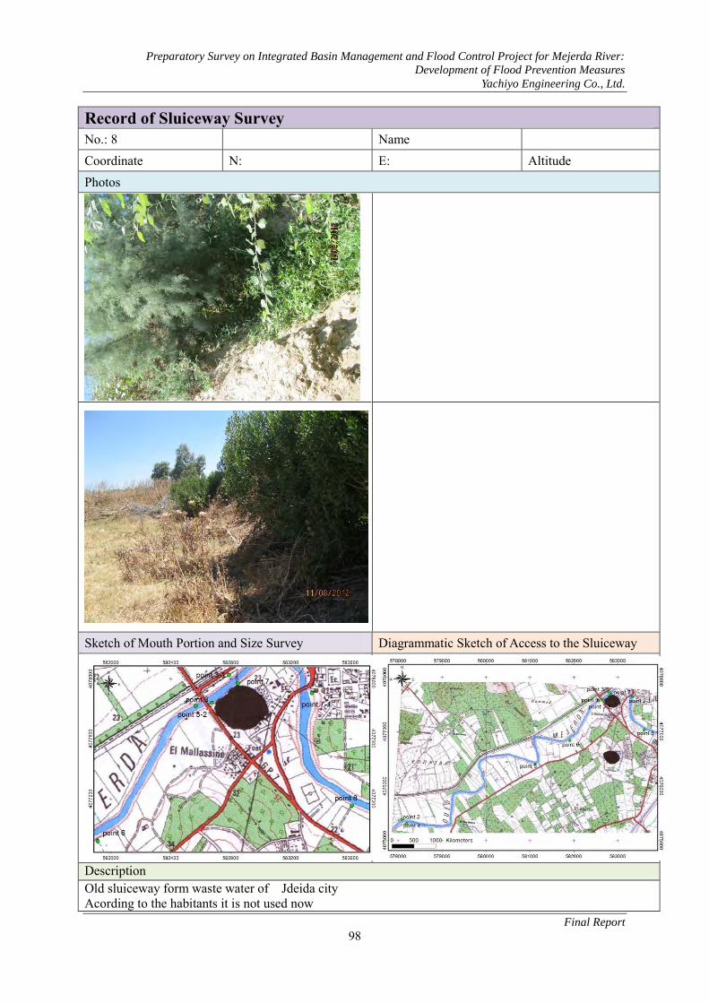
Preparatory Survey on Integrated Basin Management and Flood Control Project for Mejerda River:
Development of Flood Prevention Measures
Yachiyo Engineering Co., Ltd.
Final Report
98
Record of Sluiceway Survey No.: 8 Name Coordinate N: E: Altitude Photos
Sketch of Mouth Portion and Size Survey Diagrammatic Sketch of Access to the Sluiceway
Description Old sluiceway form waste water of Jdeida city Acording to the habitants it is not used now

Preparatory Survey on Integrated Basin Management and Flood Control Project for Mejerda River:
Development of Flood Prevention Measures
Yachiyo Engineering Co., Ltd.
Final Report
99
Record of Sluiceway Survey No.: 10 Name Coordinate N: 4079015.530 E: 588177.85 Altitude Photos
Sketch of Mouth Portion and Size Survey Diagrammatic Sketch of Access to the Sluiceway
Description Bridge with two passes Dimensions: 3.20×1.20

Preparatory Survey on Integrated Basin Management and Flood Control Project for Mejerda River:
Development of Flood Prevention Measures
Yachiyo Engineering Co., Ltd.
Final Report
100
Record of Sluiceway Survey No.: 11 Name Coordinate N: 4081537.00 E: 589381.55 Altitude Photos
Sketch of Mouth Portion and Size Survey Diagrammatic Sketch of Access to the Sluiceway
Description Drainage of water. Dimension: 1.04*0.8

Preparatory Survey on Integrated Basin Management and Flood Control Project for Mejerda River:
Development of Flood Prevention Measures
Yachiyo Engineering Co., Ltd.
Final Report
101
Record of Sluiceway Survey No.: 11-a Name Coordinate N: 40482029.64 E: 585910.17 Altitude Photos
Sketch of Mouth Portion and Size Survey Diagrammatic Sketch of Access to the Sluiceway
Description

Preparatory Survey on Integrated Basin Management and Flood Control Project for Mejerda River:
Development of Flood Prevention Measures
Yachiyo Engineering Co., Ltd.
Final Report
102
Natural water way serving for evacuating excess water form a reservoir located at the upstream.
Record of Sluiceway Survey No.:12 Name Coordinate N: 40833369.250 E: 590080.480 Altitude Photos
Sketch of Mouth Portion and Size Survey Diagrammatic Sketch of Access to the Sluiceway
Description

Preparatory Survey on Integrated Basin Management and Flood Control Project for Mejerda River:
Development of Flood Prevention Measures
Yachiyo Engineering Co., Ltd.
Final Report
103
A gate for an old channel which was used for irrigation. The network isn’t used now for irrigation. We can observe waste water from a tomate manufactory Dimension : (2.2*1.20)m2 Record of Sluiceway Survey No.: 13 Name Coordinate N: 4087860.83 E: 589609.3 Altitude Photos
Sketch of Mouth Portion and Size Survey Diagrammatic Sketch of Access to the Sluiceway

Preparatory Survey on Integrated Basin Management and Flood Control Project for Mejerda River:
Development of Flood Prevention Measures
Yachiyo Engineering Co., Ltd.
Final Report
104
Description Old trace of Mejerda River A cutting meander was done in this zone Record of Sluiceway Survey No.: 14 Name Coordinate N: 4093253.62 E:591561.8 Altitude Photos
Sketch of Mouth Portion and Size Survey Diagrammatic Sketch of Access to the Sluiceway

Preparatory Survey on Integrated Basin Management and Flood Control Project for Mejerda River:
Development of Flood Prevention Measures
Yachiyo Engineering Co., Ltd.
Final Report
105
Description The meander was stabilized by a digue some gabion structure during the seventeenth, and a part of the large bed of the river is cultivated. We can observe a sluiceway pipe from channel irrigation
Record of Sluiceway Survey No.: 15 Name Coordinate N: 4093837.200 E: 592246.260 Altitude Photos
Sketch of Mouth Portion and Size Survey Diagrammatic Sketch of Access to the Sluiceway
Description

Preparatory Survey on Integrated Basin Management and Flood Control Project for Mejerda River:
Development of Flood Prevention Measures
Yachiyo Engineering Co., Ltd.
Final Report
106
Old water way which is condemned by a dike on the left side of Mejerda
Record of Sluiceway Survey No.: 16 Name Coordinate N: 4487.10 E: 594584.21 Altitude Photos None
Sketch of Mouth Portion and Size Survey Diagrammatic Sketch of Access to the Sluiceway
Description The endpoint of cutting meander We can see also the old water way

Preparatory Survey on Integrated Basin Management and Flood Control Project for Mejerda River:
Development of Flood Prevention Measures
Yachiyo Engineering Co., Ltd.
Final Report
107
Record of Sluiceway Survey No.: 17 Name Coordinate N: 4097039.67 E: 4097039.17 Altitude Photos
Sketch of Mouth Portion and Size Survey Diagrammatic Sketch of Access to the Sluiceway
Description Tobias weir

Preparatory Survey on Integrated Basin Management and Flood Control Project for Mejerda River:
Development of Flood Prevention Measures
Yachiyo Engineering Co., Ltd.
Final Report
108
Record of Sluiceway Survey No. 18 Name Coordinate N: 4097115.86 E: 595607.17 Altitude Photos
Sketch of Mouth Portion and Size Survey Diagrammatic Sketch of Access to the Sluiceway
Description The old sluiceway before construction of Tobias weir.

Preparatory Survey on Integrated Basin Management and Flood Control Project for Mejerda River:
Development of Flood Prevention Measures
Yachiyo Engineering Co., Ltd.
Final Report
109
3 Related Documents of Chapter 3 (Current State of Flood Control Measures)
3.1 Donor Field of Water Application Activities in Tunisia
(1) World Bank The World Bank has aided Tunisia in many ways to date. In the water sector, their greatest
contribution was establishing a water supply and network of water and sewerage. Their major projects
implemented to date are listed below.
Project Name Implement
ation Period
Cost Project Details
Greater Tunis Sewerage and Reuse Project
1997-2005 107 mil. USD
Improve services by the National Sanitation Utility (ONAS) and the Ministry of Agriculture, Hydraulic Resources and Fisheries (MARHP) by constructing facilities to reinforce the sewerage network and reuse wastewater.
Water Sector Investment Project Phase I (PISEAU1)
2000-2007 258 mil. USD
MARHP constructed a water resource management system to protect water resources and conserve the environment. A joint investment between the World Bank (103 mil. USD) and KfW (17.5 mil. USD) (note:: Water Sector Investment Project Phase II (PISEAU II), see AfDB)
Water Supply & Sewerage Project
1994-2003 110.9 mil. USD
Manages the needs of the National Water Distribution Utility (SONEDE) and ONAS, and reinforces management capability.
Northwest Mountainous Areas Development Project
1993-2001 50.7 mil. USD
The project addresses the important problems of rural poverty and natural resource degradation. Increase agricultural production and income, and reduce sediment in reservoirs.
Urban Water Supply Project 2005-2012 47.15 mil. USD
SONEDE project to improve the water supply system to Tunis and other urban areas.
Tunis West Sewerage Project
2006-2011 71.9 mil. USD
ONAS project to create a sewerage network for western districts in Tunis.
Second Water and Sewerage Sector Project
2009-2015 162.95 mil. USD
Project to increase the demand for drinking water, take measures against the reduction of water resources, and increase access to drinking water by the farming region. Joint investment between AFD and AfDB.
Northern Tunis Wastewater Project
2010-2015 68.6 mil. USD
Project to increase wastewater treatment in the northern districts of Tunis and adeptly reuse effluent.
(2) German Agency for International Cooperation (GIZ) GIZ has been providing aid to Tunisia since 1975, and currently focuses on economic growth and
environmental conservation as an organization. From 1995 to 2004, GIZ implemented a large-scale
project named GEORE that coordinates water resources, supervised by the Ministry of Agriculture. The
projects below are currently active.

Preparatory Survey on Integrated Basin Management and Flood Control Project for Mejerda River:
Development of Flood Prevention Measures
Yachiyo Engineering Co., Ltd.
Final Report
110
Project Name Project Details
AERE (Effective Administration of Water Resources) Project - General Coordination of Water Resources
Derivation from the GEORE Project.
Water Measuring Project at the Algerian Border Zone
Implemented by an investment from NEPAD, this project measured water quality and volumes on the Tunisian side of the border.
PISEAU (Water Sector Investment) Project
The main purpose is to newly construct a weather measurement station for the weather and water of the Mejerda River. Joint investment between AFD, World Bank, GITZ, and other organizations.
(3) French Development Agency (AFD) French Development Agency (AFD) has been active in Tunisia since 1992 and has particularly
focused on the field of water use including drinking water for farms and sewerage. AFD has invested a
total of 244 million Euro in the field of water use. In recent years, they have been financing at an annual
rate of 35 to 40 million Euro.
1) Field of Drinking Water for Farms AFD has implemented the projects below starting in 1998.
Project Name Implementation Period Cost Project Details
Reliable Supply of Drinking Water to Sahel2 and Sfax through a Direct Loan to SONEDE Guaranteed by the Government
2001 25 mil. Euro
The capacity for the supply of water between Belli3 and Sousse4 doubled, and the water consumption of southlands stabilized during peak periods due to the construction of multiple reservoirs.
Water Supply Financed by Returned Loans as Subsidiary Aid
First Project
1998-2004 19 mil. Euro
(Water supply to farming area 9) Drinking water was made suppliable to the 168,000 residents of the farming area. The provision rate to farming areas rose from 75% in April 1999 to 83.3%.
Water Supply Financed by Returned Loans as Subsidiary Aid
Second Project
2003-2009 33 mil. Euro
(Water supply to farming area 10) With the goal of supplying drinking water to 124 000 residents, this was continued as a part of the Tenth Project.
Water Supply Financed by Returned Loans as Subsidiary Aid
Third Project
2008-2014 21.4 mil. Euro
(Water supply to farming area 11)
Water Sector Investment Project Phase I (PISEAU 1)
2002-2007 Joint investment between AFD, World Bank, and KfW.
Water Sector Investment Project Phase II (PISEAU 2)
2009-2013 102.3 mil.
Contributions made by AfDB: 19.22 mil. Euro, World Bank: 31 mil. USD, and AFD: 61 mil. USD. Of the total, 31.76 mil. Euro went towards the "Water Supply to Farming Areas" component, and 57.46 mil. Euro to Irrigation Work.
2 Sahel 3 Belli 4 Belli

Preparatory Survey on Integrated Basin Management and Flood Control Project for Mejerda River:
Development of Flood Prevention Measures
Yachiyo Engineering Co., Ltd.
Final Report
111
2) Field of Water and Sewerage French Development Agency (AFD) gave funds to ONAS to repair and expand existing sewerage
facilities for low-income neighborhoods to enlarge farming areas. The following projects were
implemented.
a) National Sanitation Project for Low-Income Neighborhoods (PNAQP)
Continuing the national project for socio-economic development, this project was implemented
from 1989-2013. In the end, 1,008 districts were serviced with a sewerage network, benefitting
208,000 households and 1.4 million people. These investment projects mobilize a total of
200,004,500 TND (134 million Euro). Active projects include pilot programs to service 15
settlements with sewerage.
b) Repair and Expansion Projects
The following two projects were constructed to meet the need to repair saturated wastewater
purification plants and sewerage networks. Relevant Projects Details
1 Facility Maintenance for the Expansion of Sewerage Capacity
Agreed to finance 80 million Euro during 2007-2012.
2 Wastewater Purification Plant (STEP) Maintenance for the Expansion of Sewerage Capacity
In December 2008, a joint investment of 18.5 million Euro between KfW and the European Commission Neighborhood Investment Facility was approved by the AFD National Committee.
c) Lowering Interest Rates on Loans for Installing Corporate Decontamination Equipment
To lower the interest rates on loans for installing corporate decontamination equipment in 2007,
the KfW cooperated with the European Commission to establish a 40 million Euro ceiling on loans
for the three banks in Tunisia. These loans supplement the decontamination fund FODEP, which
urge private enterprises to curb corporate activities that impact the environment (water, atmosphere,
solid waste) through this investment5.
3) Supporting the Government Body of Tunisia as a Partner AFD works to support the coordination of water resource management with the following three
partners.
a) Ministry of Agriculture
Supported the Ministry of Agriculture (MOA) by contributing to the Water Sector Investment
Project (PISEAU) (45 million Euro), a joint investment between AfDB and World Bank as well as
the River Basin Management Project (40 million Euro). These projects improve the supply and
effects of water on agriculture, monitors water resource conditions, and preserves Tunisian basins
from negative influences.
b) ONAS
Supported ONAS in the national project to manage wastewater of common residential areas and to
expand and repair sewerage networks.
5 Source: AFD Resource: Tunisian Water Sector: Challenge and Education
Preparatory Survey on Integrated Basin Management and Flood Control Project for Mejerda River:
Development of Flood Prevention Measures
Yachiyo Engineering Co., Ltd.
Final Report
112
c) SONEDE
Supported SONEDE by managing the water network in farming areas and national project to
reinforce the productive competence of SONEDE.
4) Role of French Global Environment Facility (FFEM) The role of the FFEM should be noted. The AFD serves as their secretariat, and they focus on water
saving agriculture and the maintenance of systems.
(4) African Development Bank (AfDB) AfDB has invested in various projects in Tunisia in the field of water use, as noted in the following.
1) Water Sector Investment Project Phase II (PISEAU II)
Started in 2009, this project is scheduled to be implemented over five years. Project costs total to
102.3 million Euro, of which the AfDB has contributed 19.22 million Euro.
2) "EAU2050" Project based on the long-term outlook of water demand in Tunisia
This long-term strategy is associated with PISEAU II, and is an opportunity to tackle the issues of
technology, capital, human resources, and system necessary Tunisia to resolve water shortage. The
project implementation period is 3 years, and the total cost is estimated to be 1.52 million Euro. The
African Facility for Water will fund 78% of that total. The main details of the project are as follows.
a) Create an implementation framework
b) Establishing a prospect and strategy for 2050
c) Creating a TOR, master plan, and action plan
d) Project management
(5) European Funds Two European Funds - European Investment Bank(EIB/BEI) and Neighborhood Investment Facility
(NIF, FIV in French) - are active in Tunisia.
1) European Investment Bank (EIB/BEI) EIB has financed the relevant projects below.
Relevant Projects Fund Period
Fund Amount
1 3 projects to supply water to Sahel and the eastern coast of Sfax (SONEDE)
2001 95 million Euro
2 Project with the objective to treat collected wastewater in each urban area - "ONAS 4"
2006 90 million Euro
2) Neighborhood Investment Facility (NIF/FIV) NIF is a financial mechanism that was started in May 2008 as a European Neighborhood Policy (ENP).
It aims to finance capital-intensive infrastructure projects in the EU covered by the ENP in sectors such
as transport, energy, the environment, and social issues through grants and loans, and also supports the
development of the private sector (particularly smaller enterprises). The main project and implemented
period is as follows.

Preparatory Survey on Integrated Basin Management and Flood Control Project for Mejerda River:
Development of Flood Prevention Measures
Yachiyo Engineering Co., Ltd.
Final Report
113
Relevant Project Implementation Period
Amount Details
Repair and expansion of 19 purification plants and 130 pump stations
2008 - 2009 8 million Euro (grant aid)
Project to improve the living environment of residents by protecting water quality and the environment from pollution. (Note: Project Leader: KfW, Other contributor: AFD, Total project cost: 127.8 million Euro)
(Details: http://ec.europa.eu/europeaid/where/neighbourhood/regionalcooperation/irc/investment_fr.htm)
(6) Arab Fund for Economic and Social Development (FADES) FADES has provided a large sum in funds towards dam construction. Projects are specifically listed as
follows.
Relevant Projects Implementation
Period Fund
Amount 1 Constructed 6 large scale dams with a total capacity of 77 Mm3 (Rmil,
Breck6, El Hma7, El Abid8, Zerga9, Sfisfa10) 2000 - 2006 120 million
USD 2 Constructed 6 large scale dams with a total capacity of 117 Mm3
(Gamgoum11, El Harka12, Melah13, Tine14, Douimis15, Ziatine16) 2002 - 2011
Source: High level conference on water for agriculture and energy in Africa
6 Breck 7 El Hma 8 El Abid 9 Zerga 10 Sfisifa 11 Breck 11 El Hma 11 El Abid 11 Zerga 11 Sfisifa 11 Gamgoum 12 El Harka 13 Melah 14 Tine 15 Douimis 16 Ziatine

Preparatory Survey on Integrated Basin Management and Flood Control Project for Mejerda River:
Development of Flood Prevention Measures
Yachiyo Engineering Co., Ltd.
Final Report
114
(7) Japan International Cooperation Agency (JICA) Entered a LA as loan assistance to implement the renovation project of the water supply network of
suburban areas in 2011. Also entered an exchange of notes as grant aid for the desalination of
underground water in southlands project in 2009.
JICA has also entered LAs for the Jendouba Water Supply Project in 2006 and the Water Conveyance
to Northern Regions Project in 2003.
Renovation Project of Water Supply Network in Suburban Areas
National Water Distribution Utility (SONEDE)
2011 LA 609.4 billion yen
Loan Assistance
Contributed to the revitalization of regional economy and improved living conditions by improving the 32 existing water supply facilities in the suburban areas of Tunisia to increase supply capacity for water demands in the future and improve stability. Civil engineering work was done and materials were procured for the repair and expansion of existing water supply facilities throughout Tunisia. Desalination of Underground Water in Southlands Project
2009 LA 1 billion yen
Grant Aid
Constructed plant to desalinate pumped underground water high in salinity by using reverse osmosis membrane to secure a stable water supply for the Ben Gardane district, a southern Tunisian town with a remarkable shortage of water. Jendouba Water Supply Project Ministry of
Agriculture 2006 LA 5.412
billion yen Loan Assistance
Aimed to improve living conditions and revitalize the regional economy by supplying water though water conveyance and drainage networks to the northwestern farming region of Tunisia, where the rate of water supply is lowest. Loans associated with this project was allocated towards the water supply facility and procurement of related equipment (pumps, drainage pipes, etc.). Water Conveyance to Northern Regions Project
2003 LA 8.026 billion yen
Loan Assistance
Provided the necessary capital for channel construction (extended approx. 90 meters) and expansion of existing pump stations in the northern part of Tunisia to create a supply of superior drinking water, industrial water, and irrigation water for Greater Tunis, the capital of Tunisia, and surrounding areas. Implementing this project should increase the population supplied with water as it has improved from 4.4 million people (2002) to 5.6 million people (2010).

Preparatory Survey on Integrated Basin Management and Flood Control Project for Mejerda River:
Development of Flood Prevention Measures
Yachiyo Engineering Co., Ltd.
Final Report
115
4 Related Documents of Chapter 4 (Basic Design of Bridge)
4.1 Specifications of current bridges
No
. Bridge Name
Channel Route
Bridge
Length
Bridge
Width Remarks
Name Distance
1 K.LANDAOUS BRIDGE Medjerda 4.664 Rue Sadok
Belhadi 19.600 8.750
2 TOBIAS BRIDGE Medjerda 10.828 MC50 87.400 10.500
3 TOBIAS OLD BRIDGE Medjerda 10.836 MC50 81.400 5.100 New bridge and location
of piers do not match up
4 GP8 BRIDGE OVER OUED MEJERDA Medjerda 13.728 GP8 145.200 9.040
5 A4 MOTORWAY BRIDGE Medjerda 16.017 MOTORWAY
A4 126.500 14.500
6 FOOTBRIDGE Medjerda Sidewalk 60.000 1.200 Wooden suspension
bridge
7 WATER PIPE BRIDGE Medjerda 34.440 Water supply - 5.540
8 JEDEIDA RAILWAY OLD BRIDGE Medjerda 37.848 RAILWAY 60.500 4.160 New bridge and location
of piers do not match up
9 JEDEIDA RAILWAY BRIDGE Medjerda 37.834 RAILWAY 63.000 10.000 Girders show evidence of
afflux from flooding
10 JEDEIDA BRIDGE Medjerda 41.071 RVE507 87.200 12.000
11 JEDEIDA OLD BRIDGE Medjerda 41.091 RVE507 64.500 5.600 Historical bridge over
narrow channel
12 JEDEIDA BRIDGE ON GP7 Medjerda 41.926 GP7 73.600 11.300
13 EL BATTAN BRIDGE Medjerda 53.111 MC64 94.070 8.500 Historical bridge
14 TEBOURBA IRRIGATION CANALS BRIDGE Medjerda 56.899 IRRIGATION
CANALS 125.000 5.540
15 GP7 BRIDGE ON CHAFUROU Chafurou GP7 38.200 11.000 Bridge abutments located
in flood channel
16 GP7 OLD BRIDGE ON CHAFUROU Chafurou GP7 - - New bridge and location
of piers do not match up
17 EL H'BIBIA BRIDGE Chafurou Local Road 16.900 8.140
18 Bridge on the local road Mabtouh Local Road 20.700 5.700
19 FARM BRIDGE ON Driving CHANNEL Mabtouh Farm Road - - Bridge for small farm
road
20 FARM BRIDGE ON Driving CHANNEL Mabtouh Farm Road - - Bridge for small farm
road
21 FARM BRIDGE Mabtouh Farm Road - - Bridge for small farm
road
22 MC50 EL MABTOUH BRIDGE Mabtouh MC50 20.460 14.610
23 FARM BRIDGE ON Oued Mabtouh Mabtouh Farm Road - - Bridge for small farm
road
24 A4 BRIDGE OVER Mabtouh Mabtouh MOTORWAY
A4 52.600 14.000
25 FARM BRIDGE ON Oued Mabtouh Mabtouh Farm Road - - Bridge for small farm
road
26 FARM BRIDGE ON Oued Mabtouh Mabtouh Farm Road - - Bridge for small farm
road
27 GP8 BRIDGE AND ROAD OVER Mabtouh Mabtouh GP8 36.500 9.900
28 FARM BRIDGE ON Oued Mabtouh Mabtouh Farm Road - - Bridge for small farm
road
29 FARM BRIDGE ON Oued Mabtouh Mabtouh Farm Road - - Bridge for small farm
road

□ □ ■ □ □ □ ■ □ □ □ □
□■
□□
□□
□■
□□
□□
□■
□
□□
□□
■□
□□
□■
■□
□□
□■
MainDeterioration
無し
Const
ruct
ion
Over
vie
w1.Widening channel & Reconstruction
Oth
er Im
port
ant
Issu
es冠
水橋
のた
め架
け替
え
Picture-5
Bearing or Attachment
Picture-6
Enviroment
unknown
Loc
ation m
ap
Picture-3
The underside of the beam
Picture-4
Substructure
-Wall
-
Condition
Good
Det
erio
ration
& d
am
age
Stone
Other
Abutment
Material
RC
Form
Inverted T type
Gravity type
Other
Width of abutment(m)
Height(m)
Pier
unknown
beam
-
Height(m)
Parapet
Width of Pillar(m)Longitudinal
0.37
Transverse
unknown
-
Peir
Material
RC
Metal
Composite
Stone
Other
Other
Other
Form
Angle
Skew(deg.)
73
Crossing(deg.)
Pile bent
Rahmen
Single column
Bearing wall
Main girder
The number of girder
1Height(m)
0.30
I beam
T beam
Box/Hollow
Full
Form
Simple
Continuous
Culvert
Arch
Other
Bridge
sur
vey
Superstructure
Material
PC
RC
Metal
Composite
Stone
Picture-2
Side
100 ye
ars
780
Margin
-2.34(m)
(10 years)
No measures
Cross-sectional shape
6.20
Discharge
(m3/sec)
10 yea
rs
660
Lower surface of the deck
1.33
(NGT)
Other
Picture-1
Deck surface
Removal of sediment
H.W.L
(NGT)
10 yea
rs
3.67
His
tori
cal
valu
eNo
banking
100 ye
ars
Excavation
distance
4.664(km)
Detour
No
widening
Sidewalk
Surrounding
environment
Purpose
Arable land
Road surface
1.93
(NGT)
No
19.6
Structure
format
Intersection property
channel
Medjerda
Spans
4(spans)
Year of const.
unknown
Typ
e of
pav
emen
tAsphalt
Bridge length
(mm)
(m)
Purpose of the bridge
Main road
Rein
force
d co
ncret
e bo
xcul
vert
Location
QaL'at al Andalus
Planar shape
right bridge
Route Name
RueSadok Belhadi
Effective width
8.20
2012
/9/1
Basi
csDec
isio
nPic
ture
s of
Site
Shooting Date
No. Name
1.
K.L
AND
AOUS
BRID
GEMax
imu
m s
pan
Total width
6.20(m)
Ver
ific
atio
n d
igit m
argi
n
Pla
n fo
r re
novation
Demolish
No measures
(m)
Pla
n for
impro
vem
ent
of ch
annel
Reconstruction
Other
8.75
Substructures
(m)
NG
5(substructures)
Improvement
Pavement thickness
unknown
Lis
t re
cord
fie
ld s
urv
ey a
nd
renovation p
olic
y d
ecis
ion(1
)Creation Date
2012
/8/8
Revis
ed
Date
116
Preparatory Survey on Integrated Basin Management and Flood Control.Project for Mejerda River: Development of Flood Prevention Measures.
YACHIYO ENGINEERING CO., LTD.
Final Report.

■ □ □ □ □ ■ □ □ □ □ □
■□
□□
□□
■□
□□
■□
□□
□
■□
□□
□□
□■
□□
■□
□■
□□
MainDeterioration
Nothing
Const
ruct
ion
Over
vie
w1.Excavation & Corrosion measures
Oth
er Im
port
ant
Issu
es2011架
設の
新設
橋で
ある
。
Picture-5
Bearing or Attachment
Picture-6
Enviroment
10.50
Loc
ation m
ap
Picture-3
The underside of the beam
Picture-4
Substructure
2.26
Wall
1.20
Condition
Good
Det
erio
ration
& d
am
age
Stone
Other
Abutment
Material
RC
Form
Inverted T type
Gravity type
Other
Width of abutment(m)
Height(m)
Pier
8.55
beam
1.20
Height(m)
Parapet
Width of Pillar(m)Longitudinal
φ1.0
Transverse
φ1.0×
3
-
Peir
Material
RC
Metal
Composite
Stone
Other
Other
Other
Form
Angle
Skew(deg.)
90
Crossing(deg.)
Pile bent
Rahmen
Single column
Bearing wall
Main girder
The number of girder
4Height(m)
1.80
I beam
T beam
Box/Hollow
Full
Form
Simple
Continuous
Culvert
Arch
Other
Bridge
sur
vey
Superstructure
Material
PC
RC
Metal
Composite
Stone
Picture-2
Side
100 ye
ars
1100
Margin
2.59(m)
(10 years)
No measures
Cross-sectional shape
9.85
Discharge
(m3/sec)
10 yea
rs
660
Lower surface of the deck
9.68
(NGT)
Other
Picture-1
Deck surface
Removal of sediment
H.W.L
(NGT)
10 yea
rs
7.09
His
tori
cal
valu
eNo
banking
100 ye
ars
Excavation
distance
10.828(km)
Detour
No
widening
Sidewalk
environ
Purpose
Arable land
Road surface
12.43
(NGT)
Yes
87.4
Structure
format
Intersection property
channel
Medjerda
Spans
3(spans)
Year of const.
2011
Typ
e of
pav
emen
tAsphalt
Bridge length
(mm)
(m)
Purpose of the bridge
Main road
Preca
st I
-gir
der
s wi
th on
-sit
eco
ncre
te sl
ab3
isos
tati
c s
pans
Location
El Kantara
Planar shape
right bridge
Route Name
MC50
Effective width
9.80
2012
/9/1
Basi
csDec
isio
nPic
ture
s of
Site
Shooting Date
No. Name
2.
TOBI
AS B
RIDG
EMax
imu
m s
pan
Total width
29.10(m)
Ver
ific
atio
n d
igit m
argi
n
Pla
n fo
r re
novation
Demolish
No measures
(m)
Pla
n for
impro
vem
ent
of ch
annel
Reconstruction
Other
10.50
Substructures
(m)
OK
4(substructures)
Improvement
Pavement thickness
90.00
Lis
t re
cord
fie
ld s
urv
ey a
nd
renovation p
olic
y d
ecis
ion(1
)Creation Date
2012
/8/8
Revis
ed
Date
117
Preparatory Survey on Integrated Basin Management and Flood Control.Project for Mejerda River: Development of Flood Prevention Measures.
YACHIYO ENGINEERING CO., LTD.
Final Report.

□ □ ■ □ □ ■ □ □ □ □ □
■□
□□
□□
■□
□□
□■
□□
□
■□
□□
□□
■□
□□
■□
□■
□□
MainDeterioration
路面
のひ
び割
れ、
滞水
、鋼
製高
欄の
劣化
Const
ruct
ion
Over
vie
w1.Demolish
Oth
er Im
port
ant
Issu
es①
桁下
に添
架管
有り
(未
使用
)。
Picture-5
Bearing or Attachment
Picture-6
Enviroment
5.10
Loc
ation m
ap
Picture-3
The underside of the beam
Picture-4
Substructure
unknown
Wall
unknown
Condition
Not good
Det
erio
ration
& d
am
age
Stone
Other
Abutment
Material
RC
Form
Inverted T type
Gravity type
Other
Width of abutment(m)
Height(m)
Pier
unknown
beam
-
Height(m)
Parapet
Width of Pillar(m)Longitudinal
0.50
Transverse
5.10
-
Peir
Material
RC
Metal
Composite
Stone
Other
Other
Other
Form
Angle
Skew(deg.)
90
Crossing(deg.)
Pile bent
Rahmen
Single column
Bearing wall
Main girder
The number of girder
2Height(m)
3.30
I beam
T beam
Box/Hollow
Full
Form
Simple
Continuous
Culvert
Arch
Other
Bridge
sur
vey
Superstructure
Material
PC
RC
Metal
Composite
Stone
Picture-2
Side
100 ye
ars
1100
Margin
unknown
(10 years)
No measures
Cross-sectional shape
9.85
Discharge
(m3/sec)
10 yea
rs
660
Lower surface of the deck
unknown
(NGT)
Other
Picture-1
Deck surface
Removal of sediment
H.W.L
(NGT)
10 yea
rs
7.10
His
tori
cal
valu
eNo
banking
100 ye
ars
Excavation
distance
10.836(km)
Detour
No
widening
Sidewalk
environ
Purpose
Arable land
Road surface
unknown
(NGT)
Yes
81.4
Structure
format
Intersection property
channel
Medjerda
Spans
5(spans)
Year of const.
Berore 1948
Typ
e of
pav
emen
tConcrete
Bridge length
(mm)
(m)
Purpose of the bridge
Nonuse
Gir
der
type
rein
forc
rd
conc
rete
bri
dge
wit
h 5 s
pans
Location
El Kantara
Planar shape
right bridge
Route Name
MC50
Effective width
3.60
2012
/9/1
Basi
csDec
isio
nPic
ture
s of
Site
Shooting Date
No. Name
3.
TOB
IAS
OLD
BRID
GEMax
imu
m s
pan
Total width
15.20(m)
Ver
ific
atio
n d
igit m
argi
n
Pla
n fo
r re
novation
Demolish
No measures
(m)
Pla
n for
impro
vem
ent
of ch
annel
Reconstruction
Other
5.10
Substructures
(m)
unknown
6(substructures)
Improvement
Pavement thickness
unknown
Lis
t re
cord
fie
ld s
urv
ey a
nd
renovation p
olic
y d
ecis
ion(1
)Creation Date
2012
/8/8
Revis
ed
Date
118
Preparatory Survey on Integrated Basin Management and Flood Control.Project for Mejerda River: Development of Flood Prevention Measures.
YACHIYO ENGINEERING CO., LTD.
Final Report.

□ □ ■ □ □ ■ □ □ □ □ □
■□
□□
□□
■□
□□
□■
□□
□
■□
□□
□□
□□
■□
■□
□□
□■
MainDeterioration
支間
中央
の曲
げひ
びわ
れ、
支点
付近
のせ
ん断
ひび
われ
、コ
ンク
リー
ト剥
離、
鉄筋
露出
、鋼
材腐
食
Const
ruct
ion
Over
vie
w1.Excavation
2.Reconstruction(1.の
みで
は困
難の
場合
)
Oth
er Im
port
ant
Issu
es①
劣化
・損
傷程
度が
大き
い。
②交
通量
が多
く、
架け
替え
時は
仮橋
が必
要。
Picture-5
Bearing or Attachment
Picture-6
Enviroment
8.20
Loc
ation m
ap
Picture-3
The underside of the beam
Picture-4
Substructure
unknown
Wall
unknown
Condition
Not good
Det
erio
ration
& d
am
age
Stone
Other
Abutment
Material
RC
Form
Inverted T type
Gravity type
Other
Width of abutment(m)
Height(m)
Pier
unknown
beam
unknown
Height(m)
Parapet
Width of Pillar(m)Longitudinal
0.60
Transverse
0.6×
2
-
Peir
Material
RC
Metal
Composite
Stone
Other
Other
Other
Form
Angle
Skew(deg.)
75
Crossing(deg.)
Pile bent
Rahmen
Single column
Bearing wall
Main girder
The number of girder
2Height(m)
3.30
I beam
T beam
Box/Hollow
Full
Form
Simple
Continuous
Culvert
Arch
Other
Bridge
sur
vey
Superstructure
Material
PC
RC
Metal
Composite
Stone
Picture-2
Side
100 ye
ars
600
Margin
1.57(m)
(10 years)
No measures
Cross-sectional shape
11.40
Discharge
(m3/sec)
10 yea
rs
660
Lower surface of the deck
10.11
(NGT)
Other
Picture-1
Deck surface
Removal of sediment
H.W.L
(NGT)
10 yea
rs
8.54
His
tori
cal
valu
eNo
banking
100 ye
ars
Excavation
distance
13.728(km)
Detour
No
widening
Sidewalk
environ
Purpose
Arable land
Road surface
12.38
(NGT)
Yes
145.2
Structure
format
Intersection property
channel
Medjerda
Spans
9(spans)
Year of const.
Berore 1973
Typ
e of
pav
emen
tAsphalt
Bridge length
(mm)
(m)
Purpose of the bridge
Main road
9 i
sost
atic
rein
forc
ed
con
crete
spa
ns
Location
El Kantara
Planar shape
skew bridge
Route Name
GP8
Effective width
8.50
2012
/9/1
Basi
csDec
isio
nPic
ture
s of
Site
Shooting Date
No. Name
4.
GP8
BRID
GE OV
ER O
UED
MEJ
ERDA
Max
imu
m s
pan
Total width
16.10(m)
Ver
ific
atio
n d
igit m
argi
n
Pla
n fo
r re
novation
Demolish
No measures
(m)
Pla
n for
impro
vem
ent
of ch
annel
Reconstruction
Other
9.04
Substructures
(m)
OK
10
(substructures)
Improvement
Pavement thickness
90.00
Lis
t re
cord
fie
ld s
urv
ey a
nd
renovation p
olic
y d
ecis
ion(1
)Creation Date
2012
/8/8
Revis
ed
Date
119
Preparatory Survey on Integrated Basin Management and Flood Control.Project for Mejerda River: Development of Flood Prevention Measures.
YACHIYO ENGINEERING CO., LTD.
Final Report.

■ □ □ □ □ ■ □ □ □ □ □
■□
□□
□□
■□
□□
■□
□□
□
■□
□□
□□
□■
□□
■□
□■
□□
MainDeterioration
1999-2002架
設の
新橋
のた
め、
損傷
なし
。
Const
ruct
ion
Over
vie
w1.Excavation
Oth
er Im
port
ant
Issu
es①
1999-2002架
設②
上下
線分
離の
橋梁
であ
る。
Picture-5
Bearing or Attachment
Picture-6
Enviroment
12.00
Loc
ation m
ap
Picture-3
The underside of the beam
Picture-4
Substructure
2.10
Wall
unknown
Condition
Good
Det
erio
ration
& d
am
age
Stone
Other
Abutment
Material
RC
Form
Inverted T type
Gravity type
Other
Width of abutment(m)
Height(m)
Pier
unknown
beam
unknown
Height(m)
Parapet
Width of Pillar(m)Longitudinal
φ2.0
Transverse
φ2.0×
4
-
Peir
Material
RC
Metal
Composite
Stone
Other
Other
Other
Form
Angle
Skew(deg.)
78
Crossing(deg.)
Pile bent
Rahmen
Single column
Bearing wall
Main girder
The number of girder
14
Height(m)
1.80
I beam
T beam
Box/Hollow
Full
Form
Simple
Continuous
Culvert
Arch
Other
Bridge
sur
vey
Superstructure
Material
PC
RC
Metal
Composite
Stone
Picture-2
Side
100 ye
ars
600
Margin
2.29(m)
(10 years)
No measures
Cross-sectional shape
12.05
Discharge
(m3/sec)
10 yea
rs
660
Lower surface of the deck
11.98
(NGT)
Other
Picture-1
Deck surface
Removal of sediment
H.W.L
(NGT)
10 yea
rs
9.69
His
tori
cal
valu
eNo
banking
100 ye
ars
Excavation
distance
16.017(km)
Detour
No
widening
Sidewalk
environ
Purpose
Arable land
Road surface
13.98
(NGT)
No
126.5
Structure
format
Intersection property
channel
Medjerda
Spans
6(spans)
Year of const.
2002
Typ
e of
pav
emen
tAsphalt
Bridge length
(mm)
(m)
Purpose of the bridge
MOTORWAY
6 i
sost
atic
rein
forc
ed
con
crete
spa
ns
Location
El Kantara
Planar shape
skew bridge
Route Name
MOTORWAY A4
Effective width
14.00
2012
/9/1
Basi
csDec
isio
nPic
ture
s of
Site
Shooting Date
No. Name
5.
A4
MOTO
RWA
Y BR
IDGE
Max
imu
m s
pan
Total width
22.50(m)
Ver
ific
atio
n d
igit m
argi
n
Pla
n fo
r re
novation
Demolish
No measures
(m)
Pla
n for
impro
vem
ent
of ch
annel
Reconstruction
Other
14.50
Substructures
(m)
OK
7(substructures)
Improvement
Pavement thickness
unknown
Lis
t re
cord
fie
ld s
urv
ey a
nd
renovation p
olic
y d
ecis
ion(1
)Creation Date
2012
/8/8
Revis
ed
Date
120
Preparatory Survey on Integrated Basin Management and Flood Control.Project for Mejerda River: Development of Flood Prevention Measures.
YACHIYO ENGINEERING CO., LTD.
Final Report.

□ ■ □ □ □ □ □ □ □ ■ □
□□
□□
□□
□□
□□
□□
□□
□
□□
□□
□□
□□
□□
□□
□□
□□
No. Name
6.
SOUT
HER
N FO
OTBR
IDG
EMax
imu
m s
pan
Total width
Lis
t re
cord
fie
ld s
urv
ey a
nd
renovation p
olic
y d
ecis
ion(1
)
Basi
csDec
isio
nPic
ture
s of
Site
unknown
Creation Date
2012/8/8
Revis
ed
Date
2012/9/1
Shooting Date
Reconstruction
Excavation
Sidewalk
Effective widthunknown
(m)
Ver
ific
atio
n d
igit m
argi
n
Pla
n fo
r re
novation
Demolish
(m)
No measures
Location
Sidi Thabet
Planar shape
unknown
unknown
(m)
unknown
Route Name
unknown
(substructures)
Year of const.
unknown
Typ
e of
pav
emen
tNo pavement
(mm)
Side Walk
Other
Improvement
Yes
Pla
n for
impro
vem
ent
of ch
annel
Structure
format
Simpl
e fo
otbr
idg
e?Pavement thickness
0.00
Substructures
Bridge lengthunknown
Spans
unknown(spans)
Sidewalk
(m)
Purpose of the bridge
Purpose
Arable land
Road surface
unknown
(NGT)
Intersection property
channel
Medjerda
environ
distance-
(km)
Detour
No
widening
19.40
Removal of sediment
100 years
950
H.W.L
(NGT)
10 years
17.51
His
tori
cal
valu
eNo
banking
100 years
Discharge
(m3/sec)
10 years
660
Lower surface of the deck
unknown
(NGT)
Other
Picture-1
Deck surface
Picture-2
Side
Other
Other
Composite
Stone
Height(m)
Margin
unknown
(10 years)
No measures
Other
Cross-sectional shape
Bridge
sur
vey
Superstructure
Material
PC
RC
Metal
Full
Form
Simple
Continuous
Culvert
Arch
Other
Angle
Crossing(deg.)
I beam
T beam
Box/Hollow
Form
Single column
Stone
Other
Rahmen
Main girder
The number of girder
Bearing wall
Pile bent
Skew(deg.)
Peir
Material
RC
Metal
Composite
Width of Pillar(m)Longitudinal
Transverse
Height(m)
Pier
beam
Height(m)
Parapet
Other
Picture-4
Substructure
Det
erio
ration
& d
am
age
Condition
Gravity type
Wall
Width of abutment(m)
Picture-3
The underside of the beam
Loc
ation m
ap
Abutment
Material
RC
Stone
Form
Inverted T type
Oth
er Im
port
ant
Issu
esお
そら
く単
純桁
で再
利用
不可
のた
め、
詳細
調査
は不
要、
橋長
、幅
員の
計測
のみ
Picture-5
Bearing or Attachment
Picture-6
Enviroment
Const
ruct
ion
Over
vie
wNo measures
Good
MainDeterioration
121
Preparatory Survey on Integrated Basin Management and Flood Control.Project for Mejerda River: Development of Flood Prevention Measures.
YACHIYO ENGINEERING CO., LTD.
Final Report.
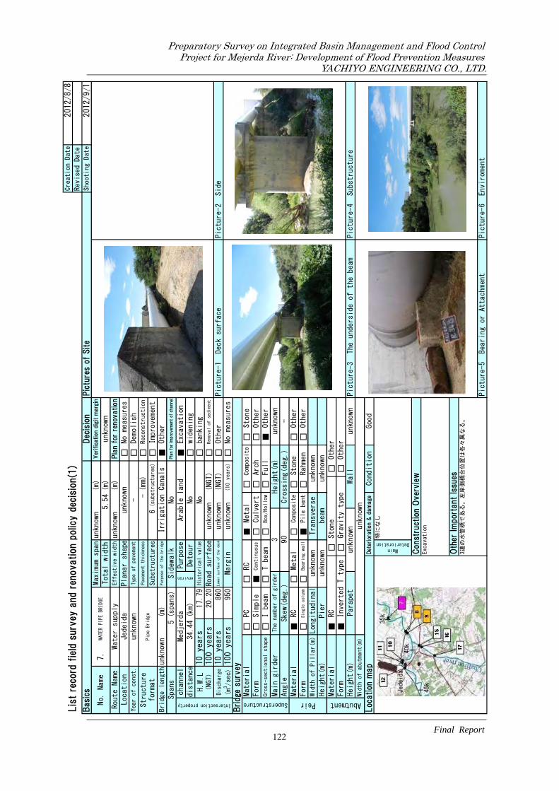
□ □ □ □ ■ ■ □ □ □ □ □
□□
■□
□□
■□
□□
□□
□□
■
■□
□□
□□
□■
□□
■□
□■
□□
No. Name
7.
WAT
ER
PIPE
BRID
GEMax
imu
m s
pan
Total width
Lis
t re
cord
fie
ld s
urv
ey a
nd
renovation p
olic
y d
ecis
ion(1
)
Basi
csDec
isio
nPic
ture
s of
Site
unknown
Creation Date
2012
/8/8
Revis
ed
Date
2012
/9/1
Shooting Date
Reconstruction
Excavation
Water supply
Effective widthunknown
(m)
Ver
ific
atio
n d
igit m
argi
n
Pla
n fo
r re
novation
Demolish
(m)
No measures
Location
Jedeida
Planar shape
unknown
5.54(m)
unknown
Route Name
6(substructures)
Year of const.
unknown
Typ
e of
pav
emen
t-
(mm)
Irrigation Canals
Other
Improvement
No
Pla
n for
impro
vem
ent
of ch
annel
Structure
format
Pip
e Br
idge
Pavement thickness
-Substructures
Bridge lengthunknown
Spans
5(spans)
Sidewalk
(m)
Purpose of the bridge
Purpose
Arable land
Road surface
unknown
(NGT)
Intersection property
channel
Medjerda
environ
distance
34.44(km)
Detour
No
widening
20.20
Removal of sediment
100 ye
ars
950
H.W.L
(NGT)
10 yea
rs
17.79
His
tori
cal
valu
eNo
banking
100 ye
ars
Discharge
(m3/sec)
10 yea
rs
860
Lower surface of the deck
unknown
(NGT)
Other
Picture-1
Deck surface
Picture-2
Side
Other
Other
unknown
unknown
Composite
Stone
Height(m)
Margin
unknown
(10 years)
No measures
Other
Cross-sectional shape
Bridge
sur
vey
Superstructure
Material
PC
RC
Metal
Full
3
Form
Simple
Continuous
Culvert
Arch
Other
Angle
90
Crossing(deg.)
-
I beam
T beam
Box/Hollow
Form
Single column
Stone
Other
Rahmen
Main girder
The number of girder
Bearing wall
Pile bent
Skew(deg.)
Peir
Material
RC
Metal
Composite
Width of Pillar(m)Longitudinal
unknown
Transverse
Height(m)
Pier
unknown
beam
unknown
Height(m)
Parapet
Other
Picture-4
Substructure
unknown
Det
erio
ration
& d
am
age
Condition
Gravity type
Wall
Width of abutment(m)
unknown
Picture-3
The underside of the beam
特に
なし
Loc
ation m
ap
Abutment
Material
RC
Stone
unknown
Form
Inverted T type
Oth
er Im
port
ant
Issu
es3連
の水
管橋
であ
る。
左岸
側橋
台位
置は
各々
異な
る。
Picture-5
Bearing or Attachment
Picture-6
Enviroment
Const
ruct
ion
Over
vie
wExcavation
Good
MainDeterioration
122
Preparatory Survey on Integrated Basin Management and Flood Control.Project for Mejerda River: Development of Flood Prevention Measures.
YACHIYO ENGINEERING CO., LTD.
Final Report.

□ ■ □ □ □ ■ □ □ □ □ □
□□
■□
□□
■□
□□
□□
□□
■
□□
□■
□□
■□
□□
□■
□□
□■
No. Name
8.
JEDE
IDA
RAI
LWAY
OL
DBR
IDGE
Max
imu
m s
pan
Total width
Lis
t re
cord
fie
ld s
urv
ey a
nd
renovation p
olic
y d
ecis
ion(1
)
Basi
csDec
isio
nPic
ture
s of
Site
30.25
Creation Date
2012
/8/8
Revis
ed
Date
2012
/9/1
Shooting Date
Reconstruction
Excavation
RAILWAY
Effective width
4.00
(m)
Ver
ific
atio
n d
igit m
argi
n
Pla
n fo
r re
novation
Demolish
(m)
No measures
Location
Jedeida
Planar shape
right bridge
4.16(m)
unknown
Route Name
3(substructures)
Year of const.More than 50 years ago
Typ
e of
pav
emen
t-
(mm)
Nonuse
Other
Improvement
No
Pla
n for
impro
vem
ent
of ch
annel
Structure
format
2 spa
ns c
onti
nuo
us s
teel
trus
sgi
rder
Pavement thickness
0.00
Substructures
Bridge length
60.5
Spans
2(spans)
Sidewalk
(m)
Purpose of the bridge
Purpose
Arable land
Road surface
unknown
(NGT)
Intersection property
channel
Medjerda
environ
distance
37.848(km)
Detour
No
widening
22.65
Removal of sediment
100 ye
ars
950
H.W.L
(NGT)
10 yea
rs
19.28
His
tori
cal
valu
eNo
banking
100 ye
ars
Discharge
(m3/sec)
10 yea
rs
860
Lower surface of the deck
unknown
(NGT)
Other
Picture-1
Deck surface
Picture-2
Side
Other
Other
unknown
6.50
Composite
Stone
Height(m)
Margin
unknown
(10 years)
No measures
Other
Cross-sectional shape
Bridge
sur
vey
Superstructure
Material
PC
RC
Metal
Full
2
Form
Simple
Continuous
Culvert
Arch
Other
Angle
90
Crossing(deg.)
-
I beam
T beam
Box/Hollow
Form
Single column
Stone
Other
Rahmen
Main girder
The number of girder
Bearing wall
Pile bent
Skew(deg.)
Peir
Material
RC
Metal
Composite
Width of Pillar(m)Longitudinal
2.28
Transverse
Height(m)
Pier
unknown
beam
unknown
Height(m)
Parapet
Other
Picture-4
Substructure
6.00
Det
erio
ration
& d
am
age
Condition
Gravity type
Wall
Width of abutment(m)
unknown
Picture-3
The underside of the beam
①鋼
材腐
食
Loc
ation m
ap
Abutment
Material
RC
Stone
unknown
Form
Inverted T type
Oth
er Im
port
ant
Issu
es①
鋼2径
間連
続下
路式
トラ
ス橋
であ
る。
②桁
側面
(上
流側
)に
添架
管有
り。
③鉄
道は
2011年
に新
橋に
移設
済み
。④
新設
とス
パン
長が
異な
り、
流下
を阻
害し
てい
る。
Picture-5
Bearing or Attachment
Picture-6
Enviroment
Const
ruct
ion
Over
vie
wDemolish
Not good
MainDeterioration
123
Preparatory Survey on Integrated Basin Management and Flood Control.Project for Mejerda River: Development of Flood Prevention Measures.
YACHIYO ENGINEERING CO., LTD.
Final Report.

■ □ □ □ □ ■ □ □ □ □ □
■□
□□
□□
■□
□□
□■
□□
□
■□
□□
□□
■□
□□
■□
□■
□□
No. Name
9.
JED
EIDA
RAIL
WAY
BRID
GE
Max
imu
m s
pan
Total width
Lis
t re
cord
fie
ld s
urv
ey a
nd
renovation p
olic
y d
ecis
ion(1
)
Basi
csDec
isio
nPic
ture
s of
Site
21.00
Creation Date
2012
/8/8
Revis
ed
Date
2012
/9/1
Shooting Date
Reconstruction
Excavation
RAILWAY
Effective width
9.40
(m)
Ver
ific
atio
n d
igit m
argi
n
Pla
n fo
r re
novation
Demolish
(m)
No measures
Location
Jedeida
Planar shape
right bridge
10.00(m)
NG
Route Name
4(substructures)
Year of const.
1982
Typ
e of
pav
emen
tballast (mm)
Railway
Other
Improvement
No
Pla
n for
impro
vem
ent
of ch
annel
Structure
format
3 is
osta
tic
spa
ns r
einfo
rced
conc
rete
sect
ion
Pavement thickness
30.00
Substructures
Bridge length
63
Spans
3(spans)
Sidewalk
(m)
Purpose of the bridge
Purpose
Arable land
Road surface
21.00
(NGT)
Intersection property
channel
Medjerda
environ
distance
37.834(km)
Detour
No
widening
22.65
Removal of sediment
100 ye
ars
950
H.W.L
(NGT)
10 yea
rs
19.27
His
tori
cal
valu
eNo
banking
100 ye
ars
Discharge
(m3/sec)
10 yea
rs
860
Lower surface of the deck
19.20
(NGT)
Other
Picture-1
Deck surface
Picture-2
Side
Other
Other
1.70
10.00
Composite
Stone
Height(m)
Margin
-0.07(m)
(10 years)
No measures
Other
Cross-sectional shape
Bridge
sur
vey
Superstructure
Material
PC
RC
Metal
Full
4
Form
Simple
Continuous
Culvert
Arch
Other
Angle
90
Crossing(deg.)
-
I beam
T beam
Box/Hollow
Form
Single column
Stone
Other
Rahmen
Main girder
The number of girder
Bearing wall
Pile bent
Skew(deg.)
Peir
Material
RC
Metal
Composite
Width of Pillar(m)Longitudinal
1.00
Transverse
Height(m)
Pier
9.60
beam
-
Height(m)
Parapet
Other
Picture-4
Substructure
10.30
Det
erio
ration
& d
am
age
Condition
Gravity type
Wall
Width of abutment(m)
1.00
Picture-3
The underside of the beam
①衝
突に
よる
コン
クリ
ート
剥離
・鉄
筋露
出(橋
脚)
Loc
ation m
ap
Abutment
Material
RC
Stone
2.20
Form
Inverted T type
Oth
er Im
port
ant
Issu
es①
鉄道
橋で
あり
、嵩
上げ
の場
合は
影響
範囲
が大
きく
なる
。
Picture-5
Bearing or Attachment
Picture-6
Enviroment
Const
ruct
ion
Over
vie
wExcavation(底
版上
面ま
での
掘削
) & Constracticting of
by-pass
Mild damage
MainDeterioration
124
Preparatory Survey on Integrated Basin Management and Flood Control.Project for Mejerda River: Development of Flood Prevention Measures.
YACHIYO ENGINEERING CO., LTD.
Final Report.

■ □ □ □ □ ■ □ □ □ □ □
■□
□□
□□
■□
□□
■□
□□
□
■□
□□
□□
□■
□□
■□
□■
□□
MainDeterioration
2011架
設の
新橋
のた
め、
なし
。
Const
ruct
ion
Over
vie
w1.removing of sediment
2.constracticting of by-pass
Oth
er Im
port
ant
Issu
es①
2011架
設②
周辺
宅地
のた
め、
河積
不足
の場
合は
掘削
が望
まし
い。
Picture-5
Bearing or Attachment
Picture-6
Enviroment
12.00
Loc
ation m
ap
Picture-3
The underside of the beam
Picture-4
Substructure
2.10
Wall
1.20
Condition
Good
Det
erio
ration
& d
am
age
Stone
Other
Abutment
Material
RC
Form
Inverted T type
Gravity type
Other
Width of abutment(m)
Height(m)
Pier
7.30
beam
1.20
Height(m)
Parapet
Width of Pillar(m)Longitudinal
φ1.0
Transverse
φ1.0×
4
-
Peir
Material
RC
Metal
Composite
Stone
Other
Other
Other
Form
Angle
Skew(deg.)
90
Crossing(deg.)
Pile bent
Rahmen
Single column
Bearing wall
Main girder
The number of girder
4Height(m)
1.80
I beam
T beam
Box/Hollow
Full
Form
Simple
Continuous
Culvert
Arch
Other
Bridge
sur
vey
Superstructure
Material
PC
RC
Metal
Composite
Stone
Picture-2
Side
100 ye
ars
1000
Margin
0.55(m)
(10 years)
No measures
Cross-sectional shape
23.95
Discharge
(m3/sec)
10 yea
rs
780
Lower surface of the deck
21.40
(NGT)
Other
Picture-1
Deck surface
Removal of sediment
H.W.L
(NGT)
10 yea
rs
20.85
His
tori
cal
valu
eNo
banking
100 ye
ars
Excavation
distance
41.071(km)
Detour
No
widening
Sidewalk
environ
Purpose
urban area
Road surface
24.04
(NGT)
Yes
87.2
Structure
format
Intersection property
channel
Medjerda
Spans
3(spans)
Year of const.
2011
Typ
e of
pav
emen
tAsphalt
Bridge length
(mm)
(m)
Purpose of the bridge
General road
Preca
st I
-gir
der
s wi
th on
-sit
eco
ncre
te sl
ab3
isos
tati
c s
pans
Location
Jedeida
Planar shape
right bridge
Route Name
RVE507
Effective width
11.40
2012
/9/1
Basi
csDec
isio
nPic
ture
s of
Site
Shooting Date
No. Name
10.
JED
EIDA
BRID
GEMax
imu
m s
pan
Total width
28.00(m)
Ver
ific
atio
n d
igit m
argi
n
Pla
n fo
r re
novation
Demolish
No measures
(m)
Pla
n for
impro
vem
ent
of ch
annel
Reconstruction
Other
12.00
Substructures
(m)
OK
4(substructures)
Improvement
Pavement thickness
80.00
Lis
t re
cord
fie
ld s
urv
ey a
nd
renovation p
olic
y d
ecis
ion(1
)Creation Date
2012
/8/8
Revis
ed
Date
125
Preparatory Survey on Integrated Basin Management and Flood Control.Project for Mejerda River: Development of Flood Prevention Measures.
YACHIYO ENGINEERING CO., LTD.
Final Report.

□ ■ □ □ □ ■ □ □ □ □ □
□□
■□
□□
□□
□■
□□
□□
■
□□
□■
□□
□□
□■
□■
□□
□■
MainDeterioration
①舗
装の
ひび
割れ
、滞
水②
主径
間の
深刻
な損
傷③
土砂
堆積
によ
る部
分的
な河
道閉
塞
Const
ruct
ion
Over
vie
w1.removing of sediment
2.constracticting of by-pass
Oth
er Im
port
ant
Issu
esBecause of historical biridge,removing bridge is
difficult.
Picture-5
Bearing or Attachment
Picture-6
Enviroment
5.60
Loc
ation m
ap
Picture-3
The underside of the beam
Picture-4
Substructure
unknown
Wall
unknown
Condition
Not good
Det
erio
ration
& d
am
age
Stone
Other
Abutment
Material
RC
Form
Inverted T type
Gravity type
Other
Width of abutment(m)
Height(m)
Pier
unknown
beam
-
Height(m)
Parapet
Width of Pillar(m)Longitudinal
4.70
Transverse
11.70
-
Peir
Material
RC
Metal
Composite
Stone
Other
Other
Other
Form
Angle
Skew(deg.)
90
Crossing(deg.)
Pile bent
Rahmen
Single column
Bearing wall
Main girder
The number of girder
2Height(m)
unknown
I beam
T beam
Box/Hollow
Full
Form
Simple
Continuous
Culvert
Arch
Other
Bridge
sur
vey
Superstructure
Material
PC
RC
Metal
Composite
Stone
Picture-2
Side
100 ye
ars
1000
Margin
unknown
(10 years)
No measures
Cross-sectional shape
23.95
Discharge
(m3/sec)
10 yea
rs
780
Lower surface of the deck
unknown
(NGT)
Other
Picture-1
Deck surface
Removal of sediment
H.W.L
(NGT)
10 yea
rs
20.86
His
tori
cal
valu
eYes
banking
100 ye
ars
Excavation
distance
41.091(km)
Detour
No
widening
Sidewalk
environ
Purpose
urban area
Road surface
unknown
(NGT)
No
64.5
Structure
format
Intersection property
channel
Medjerda
Spans
4(spans)
Year of const.
the 16th century
Typ
e of
pav
emen
tAsphalt
Bridge length
(mm)
(m)
Purpose of the bridge
Nonuse
Stee
l up
per
arc
h typ
e tr
uss
gird
er o
n the
mai
n sp
an,
Mas
sive
st
one
arch
br
idge
for
Location
Jedeida
Planar shape
right bridge
Route Name
RVE507
Effective width
5.00
2012
/9/1
Basi
csDec
isio
nPic
ture
s of
Site
Shooting Date
No. Name
11.
JED
EIDA
OL
D BR
IDGE
Max
imu
m s
pan
Total width
33.50(m)
Ver
ific
atio
n d
igit m
argi
n
Pla
n fo
r re
novation
Demolish
No measures
(m)
Pla
n for
impro
vem
ent
of ch
annel
Reconstruction
Other
5.60
Substructures
(m)
unknown
5(substructures)
Improvement
Pavement thickness
unknown
Lis
t re
cord
fie
ld s
urv
ey a
nd
renovation p
olic
y d
ecis
ion(1
)Creation Date
2012
/8/8
Revis
ed
Date
126
Preparatory Survey on Integrated Basin Management and Flood Control.Project for Mejerda River: Development of Flood Prevention Measures.
YACHIYO ENGINEERING CO., LTD.
Final Report.

■ □ □ □ □ ■ □ □ □ □ □
■□
□□
□□
■□
□□
■□
□□
□
■□
□□
□□
■□
□□
■□
□■
□□
MainDeterioration
①橋
梁本
体に
損傷
は確
認で
きな
い。
②側
径間
の橋
脚~
橋台
間に
土砂
堆積
があ
る。
Const
ruct
ion
Over
vie
w1.Excavation
Oth
er Im
port
ant
Issu
es①
中央
径間
の橋
脚は
パイ
ルベ
ント
式橋
脚で
ある
。②
近接
橋と
して
、水
管橋
があ
る(Picture-6)。
Picture-5
Bearing or Attachment
Picture-6
Enviroment
11.10
Loc
ation m
ap
Picture-3
The underside of the beam
Picture-4
Substructure
unknown
Wall
unknown
Condition
Good
Det
erio
ration
& d
am
age
Stone
Other
Abutment
Material
RC
Form
Inverted T type
Gravity type
Other
Width of abutment(m)
Height(m)
Pier
unknown
beam
-
Height(m)
Parapet
Width of Pillar(m)Longitudinal
2.00
Transverse
12.00
-
Peir
Material
RC
Metal
Composite
Stone
Other
Other
Other
Form
Angle
Skew(deg.)
90
Crossing(deg.)
Pile bent
Rahmen
Single column
Bearing wall
Main girder
The number of girder
unknown
Height(m)
1.50
I beam
T beam
Box/Hollow
Full
Form
Simple
Continuous
Culvert
Arch
Other
Bridge
sur
vey
Superstructure
Material
PC
RC
Metal
Composite
Stone
Picture-2
Side
100 ye
ars
1000
Margin
3.85(m)
(10 years)
No measures
Cross-sectional shape
24.55
Discharge
(m3/sec)
10 yea
rs
780
Lower surface of the deck
25.13
(NGT)
Other
Picture-1
Deck surface
Removal of sediment
H.W.L
(NGT)
10 yea
rs
21.28
His
tori
cal
valu
eNo
banking
100 ye
ars
Excavation
distance
41.926(km)
Detour
No
widening
Sidewalk
environ
Purpose
Arable land
Road surface
26.70
(NGT)
Yes
73.6
Structure
format
Intersection property
channel
Medjerda
Spans
5(spans)
Year of const.
1945(repairing2009)
Typ
e of
pav
emen
tAsphalt
Bridge length
(mm)
(m)
Purpose of the bridge
Main road
Conc
rete
ge
rder
beam
bri
dge
Location
Jedeida
Planar shape
right bridge
Route Name
GP7
Effective width
10.50
2012
/9/1
Basi
csDec
isio
nPic
ture
s of
Site
Shooting Date
No. Name
12.
JED
EIDA
BRID
GE O
N G
P7Max
imu
m s
pan
Total width
31.80(m)
Ver
ific
atio
n d
igit m
argi
n
Pla
n fo
r re
novation
Demolish
No measures
(m)
Pla
n for
impro
vem
ent
of ch
annel
Reconstruction
Other
11.30
Substructures
(m)
OK
6(substructures)
Improvement
Pavement thickness
unknown
Lis
t re
cord
fie
ld s
urv
ey a
nd
renovation p
olic
y d
ecis
ion(1
)Creation Date
2012
/8/8
Revis
ed
Date
127
Preparatory Survey on Integrated Basin Management and Flood Control.Project for Mejerda River: Development of Flood Prevention Measures.
YACHIYO ENGINEERING CO., LTD.
Final Report.

□ □ □ □ ■ □ □ □ □ ■ □
□□
□□
■□
□□
■□
□□
□■
□
□□
□■
□□
□□
□■
□■
□□
□■
(substructures)
1.Removing of sediment
2.Constracticting of by-pass
Because of historical biridge,removing bridge is
difficult.
Composite
unknown
Other
Arch
Other
Crossing(deg.)
Full
Other
Stone
Superstructure
unknown
-
Pile bent
Transverse
Metal
Stone
Abutment
2.24
Form
Width of Pillar(m)
RC
-Width of abutment(m)
Height(m)
Parapet
Loc
ation m
ap
94.07(m)
53.111(km)
Form
Peir
unknown
Bearing wall
No. Name
13.
Max
imu
m s
pan
Total width
His
tori
cal
valu
e
Margin
10 yea
rs
100 ye
ars
Effective width
Removal of sediment
Ver
ific
atio
n d
igit m
argi
n
Other
Reconstruction
Improvement
banking
Pla
n fo
r re
novation
Pla
n for
impro
vem
ent
of ch
annel
Excavation
widening
8.00
(m)
(m)
(m)
No
Residential area
5.11
right bridge
(mm)
21
unknown
Sidewalk
No measures
Demolish
Asphalt
Pic
ture
s of
Site
8.50
unknown
T beam
Culvert
Yes
29.10
(NGT)
(NGT)
Road surface
28.05
Lower surface of the deck
Material
RC
Metal
Continuous
Bridge length
Spans
unknown
Pavement thickness
Typ
e of
pav
emen
t
Location
Al Battan
More than 100 years ago
Substructures
Purpose of the bridge
distance
Purpose
Simple
1200
Medjerda
100 ye
ars
unknown
30.40
Route Name
MC64
10 yea
rs
Intersection property
Year of const.
20(spans)
H.W.L
(NGT)
780
Discharge
(m3/sec)
EL B
ATTAN
BRI
DGE
Structure
format
Planar shape
Main road
Ancie
nt a
rch
typ
e st
one b
ridg
e
(10 years)
Yes
environ
Detour
channel
No measures
Other
Other
Bridge
sur
vey
Height(m)
PC
RC
Single column
I beam
Picture-4
Substructure
Picture-5
Bearing or Attachment
Picture-6
Enviroment
Picture-3
The underside of the beam
2012
/9/1
Shooting Date
Picture-1
Deck surface
Picture-2
Side
Basi
csDec
isio
n
Form
Material
Cross-sectional shape
Main girder
Angle
Material
Lis
t re
cord
fie
ld s
urv
ey a
nd
renovation p
olic
y d
ecis
ion(1
)Creation Date
Revis
ed
Date
2012
/8/8
--
Wall
Longitudinal
Pier
MainDeterioration
1.water stagnation of surface
2.Preventing water flow brought Tamarix
vegetation
3.Narrowness of gates call for jamming of
debris
Const
ruct
ion
Over
vie
w
Good
Oth
er Im
port
ant
Issu
es
Condition
Det
erio
ration
& d
am
age
Inverted T type
Gravity type
-
The number of girder
Skew(deg.)
1 90
beam
Other
Rahmen
Box/Hollow
Composite
Height(m)
Stone
Other
128
Preparatory Survey on Integrated Basin Management and Flood Control.Project for Mejerda River: Development of Flood Prevention Measures.
YACHIYO ENGINEERING CO., LTD.
Final Report.

□ □ □ □ ■ □ ■ □ □ □ □
■□
□□
□□
■□
□□
□□
□□
■
■□
□□
□■
□□
□□
■□
□■
□□
No. Name
14.
TEBO
URB
A IR
RIGA
TIO
NCA
NALS
BRI
DGE
Max
imu
m s
pan
Total width
Lis
t re
cord
fie
ld s
urv
ey a
nd
renovation p
olic
y d
ecis
ion(1
)
Basi
csDec
isio
nPic
ture
s of
Site
unknown
Creation Date
2012
/8/8
Revis
ed
Date
2012
/9/1
Shooting Date
Reconstruction
Excavation
IRRIGATION CANALS
Effective widthunknown
(m)
Ver
ific
atio
n d
igit m
argi
n
Pla
n fo
r re
novation
Demolish
(m)
No measures
Location
Tebourba
Planar shape
unknown
5.54(m)
unknown
Route Name
5(substructures)
Year of const.
Before 1958
Typ
e of
pav
emen
t-
(mm)
Irrigation Canals
Other
Improvement
No
Pla
n for
impro
vem
ent
of ch
annel
Structure
format
Rei
nfor
ced
con
cret
e s
truc
ture
Pavement thickness
-Substructures
Bridge length
125
Spans
4(spans)
Sidewalk
(m)
Purpose of the bridge
Purpose
Residential area
Road surface
33.93
(NGT)
Intersection property
channel
Medjerda
environ
distance
56.899(km)
Detour
No
widening
33.00
Removal of sediment
100 ye
ars
1930
H.W.L
(NGT)
10 yea
rs
unknown
His
tori
cal
valu
eNo
banking
100 ye
ars
Discharge
(m3/sec)
10 yea
rs
780
Lower surface of the deck
unknown
(NGT)
Other
Picture-1
Deck surface
Picture-2
Side
Other
Other
unknown
unknown
Composite
Stone
Height(m)
Margin
unknown
(10 years)
No measures
Other
Cross-sectional shape
Bridge
sur
vey
Superstructure
Material
PC
RC
Metal
Full
1
Form
Simple
Continuous
Culvert
Arch
Other
Angle
90
Crossing(deg.)
-
I beam
T beam
Box/Hollow
Form
Single column
Stone
Other
Rahmen
Main girder
The number of girder
Bearing wall
Pile bent
Skew(deg.)
Peir
Material
RC
Metal
Composite
Width of Pillar(m)Longitudinal
unknown
Transverse
Height(m)
Pier
unknown
beam
unknown
Height(m)
Parapet
Other
Picture-4
Substructure
unknown
Det
erio
ration
& d
am
age
Condition
Gravity type
Wall
Width of abutment(m)
unknown
Picture-3
The underside of the beam
①水
漏れ
Loc
ation m
ap
Abutment
Material
RC
Stone
unknown
Form
Inverted T type
Oth
er Im
port
ant
Issu
es①
水漏
れ対
策が
必要
。②
左岸
側は
市街
地、
右岸
側は
農地
③谷
がや
や深
いPicture-5
Bearing or Attachment
Picture-6
Enviroment
Const
ruct
ion
Over
vie
wExcavation
Not good
MainDeterioration
129
Preparatory Survey on Integrated Basin Management and Flood Control.Project for Mejerda River: Development of Flood Prevention Measures.
YACHIYO ENGINEERING CO., LTD.
Final Report.

□ □ ■ □ □ □ ■ □ □ □ □
■□
□□
□□
■□
□□
□□
■□
□
■□
□□
□□
□■
□□
■□
□■
□□
MainDeterioration
特に
なし
。
Const
ruct
ion
Over
vie
wNo measures
Oth
er Im
port
ant
Issu
es①
水理
評価
のた
め断
面の
把握
(測
量)が
必要
。②
旧橋
には
添架
管有
り。
③近
接し
て水
路橋
?が
ある
。Picture-5
Bearing or Attachment
Picture-6
Enviroment
unknown
Loc
ation m
ap
Picture-3
The underside of the beam
Picture-4
Substructure
-Wall
-
Condition
Good
Det
erio
ration
& d
am
age
Stone
Other
Abutment
Material
RC
Form
Inverted T type
Gravity type
Other
Width of abutment(m)
Height(m)
Pier
unknown
beam
-
Height(m)
Parapet
Width of Pillar(m)Longitudinal
unknown
Transverse
unknown
-
Peir
Material
RC
Metal
Composite
Stone
Other
Other
Other
Form
Angle
Skew(deg.)
unknown
Crossing(deg.)
Pile bent
Rahmen
Single column
Bearing wall
Main girder
The number of girder
1Height(m)
unknown
I beam
T beam
Box/Hollow
Full
Form
Simple
Continuous
Culvert
Arch
Other
Bridge
sur
vey
Superstructure
Material
PC
RC
Metal
Composite
Stone
Picture-2
Side
100 ye
ars
120
Margin
1.61(m)
(10 years)
No measures
Cross-sectional shape
23.25
Discharge
(m3/sec)
10 yea
rs
50
Lower surface of the deck
21.41
(NGT)
Other
Picture-1
Deck surface
Removal of sediment
H.W.L
(NGT)
10 yea
rs
19.80
His
tori
cal
valu
eNo
banking
100 ye
ars
Excavation
distance-
(km)
Detour
No
widening
Sidewalk
environ
Purpose
Arable land
Road surface
22.41
(NGT)
Yes
38.2
Structure
format
Intersection property
channel
Chafurou
Spans
3(spans)
Year of const.
unknown
Typ
e of
pav
emen
tAsphalt
Bridge length
(mm)
(m)
Purpose of the bridge
Main road
3 s
pans
co
ntin
uous
re
info
rced
conc
rete
sl
ab b
ridge
Location
Jedeida
Planar shape
unknown
Route Name
GP7
Effective widthunknown
2012
/9/1
Basi
csDec
isio
nPic
ture
s of
Site
Shooting Date
No. Name
15.
GP7
BRI
DGE O
N CH
AFUR
OU
Max
imu
m s
pan
Total width
unknown
(m)
Ver
ific
atio
n d
igit m
argi
n
Pla
n fo
r re
novation
Demolish
No measures
(m)
Pla
n for
impro
vem
ent
of ch
annel
Reconstruction
Other
11.00
Substructures
(m)
OK
4(substructures)
Improvement
Pavement thickness
unknown
Lis
t re
cord
fie
ld s
urv
ey a
nd
renovation p
olic
y d
ecis
ion(1
)Creation Date
2012
/8/8
Revis
ed
Date
130
Preparatory Survey on Integrated Basin Management and Flood Control.Project for Mejerda River: Development of Flood Prevention Measures.
YACHIYO ENGINEERING CO., LTD.
Final Report.

□ □ ■ □ □ □ ■ □ □ □ □
■□
□□
□□
■□
□□
□□
■□
□
■□
□□
□□
□■
□□
■□
□■
□□
Const
ruct
ion
Over
vie
wNo measures
Oth
er Im
port
ant
Issu
es①
水理
評価
のた
め断
面の
把握
(測
量)が
必要
。②
旧橋
には
添架
管有
り。
③近
接し
て水
路橋
?が
ある
。Picture-5
Bearing or Attachment
Picture-6
Enviroment
Det
erio
ration
& d
am
age
Condition
Good
MainDeterioration
特に
なし
。
-Wall
-Picture-3
The underside of the beam
Picture-4
Substructure
Width of abutment(m)
unknown
Loc
ation m
ap
Abutment
Material
RC
Stone
Other
Form
Inverted T type
Gravity type
Other
Height(m)
Pier
unknown
beam
-
Height(m)
Parapet
Bearing wall
Pile bent
Rahmen
Other
Width of Pillar(m)Longitudinal
unknown
Transverse
unknown
Peir
Material
RC
Metal
Composite
Stone
Other
Form
Single column
Main girder
The number of girder
1Height(m)
unknown
Angle
Skew(deg.)
unknown
Crossing(deg.)
-
I beam
T beam
Box/Hollow
Full
Other
Form
Simple
Continuous
Culvert
Arch
Other
Bridge
sur
vey
Superstructure
Material
PC
RC
Metal
Composite
Stone
Picture-2
Side
100 ye
ars
120
Margin
1.61(m)
(10 years)
No measures
Cross-sectional shape
Removal of sediment
Discharge
(m3/sec)
10 yea
rs
50
Lower surface of the deck
21.41
(NGT)
Other
Picture-1
Deck surface
H.W.L
(NGT)
10 yea
rs
19.80
His
tori
cal
valu
eNo
banking
100 ye
ars
23.25
Excavation
distance-
(km)
Detour
No
widening
Intersection property
channel
Chafurou
environ
Purpose
Arable land
Road surface
22.41
(NGT)
Spans
3(spans)
Sidewalk
Yes
Pla
n for
impro
vem
ent
of ch
annel
Bridge length
38.2(m)
Purpose of the bridge
Main road
Other
Substructures
4(substructures)
Improvement
Structure
format
3 s
pans
co
ntin
uous
re
info
rced
conc
rete
sl
ab b
ridge
Pavement thickness
unknown(mm)
Reconstruction
Location
Jedeida
Planar shape
unknown
No measures
Year of const.
unknown
Typ
e of
pav
emen
tAsphalt
Total width
11.00(m)
OK
Route Name
GP7
Effective widthunknown
(m)
unknown
(m)
Ver
ific
atio
n d
igit m
argi
n
Pla
n fo
r re
novation
Demolish
Basi
csDec
isio
nPic
ture
s of
Site
Shooting Date
2012
/9/1
Revis
ed
Date
Lis
t re
cord
fie
ld s
urv
ey a
nd
renovation p
olic
y d
ecis
ion(1
)Creation Date
2012
/8/8
No. Name
16.
GP7
BRI
DGE O
N CH
AFUR
OU
Max
imu
m s
pan
131
Preparatory Survey on Integrated Basin Management and Flood Control.Project for Mejerda River: Development of Flood Prevention Measures.
YACHIYO ENGINEERING CO., LTD.
Final Report.

□ □ ■ □ □ □ ■ □ □ □ □
□■
□□
□□
□■
□□
□□
□■
□
□□
□□
■□
□□
□■
■□
□□
□■
MainDeterioration
全体
的に
良く
ない
。
Const
ruct
ion
Over
vie
wNo measures
Oth
er Im
port
ant
Issu
es①
水理
評価
のた
め断
面の
把握
(測
量)が
必要
。
Picture-5
Bearing or Attachment
Picture-6
Enviroment
unknown
Loc
ation m
ap
Picture-3
The underside of the beam
Picture-4
Substructure
-Wall
-
Condition
Not good
Det
erio
ration
& d
am
age
Stone
Other
Abutment
Material
RC
Form
Inverted T type
Gravity type
Other
Width of abutment(m)
Height(m)
Pier
unknown
beam
-
Height(m)
Parapet
Width of Pillar(m)Longitudinal
unknown
Transverse
unknown
-
Peir
Material
RC
Metal
Composite
Stone
Other
Other
Other
Form
Angle
Skew(deg.)
unknown
Crossing(deg.)
Pile bent
Rahmen
Single column
Bearing wall
Main girder
The number of girder
1Height(m)
unknown
I beam
T beam
Box/Hollow
Full
Form
Simple
Continuous
Culvert
Arch
Other
Bridge
sur
vey
Superstructure
Material
PC
RC
Metal
Composite
Stone
Picture-2
Side
100 ye
ars
120
Margin
0.60(m)
(10 years)
No measures
Cross-sectional shape
23.50
Discharge
(m3/sec)
10 yea
rs
50
Lower surface of the deck
20.40
(NGT)
Other
Picture-1
Deck surface
Removal of sediment
H.W.L
(NGT)
10 yea
rs
19.80
His
tori
cal
valu
eNo
banking
100 ye
ars
Excavation
distance-
(km)
Detour
Yes
widening
Sidewalk
environ
Purpose
Wasteland
Road surface
21.53
(NGT)
No
16.9
Structure
format
Intersection property
channel
Chafurou
Spans
4(spans)
Year of const.
unknown
Typ
e of
pav
emen
tAsphalt
Bridge length
(mm)
(m)
Purpose of the bridge
General road
4 sp
ans
rei
nfor
ced c
oncr
ete
box
cul
vert
Location
Jedeida
Planar shape
unknown
Route Name
Local Road
Effective widthunknown
2012
/9/1
Basi
csDec
isio
nPic
ture
s of
Site
Shooting Date
No. Name
17.
EL
H'B
IBIA
BRID
GEMax
imu
m s
pan
Total width
4.50(m)
Ver
ific
atio
n d
igit m
argi
n
Pla
n fo
r re
novation
Demolish
No measures
(m)
Pla
n for
impro
vem
ent
of ch
annel
Reconstruction
Other
8.14
Substructures
(m)
OK
5(substructures)
Improvement
Pavement thickness
unknown
Lis
t re
cord
fie
ld s
urv
ey a
nd
renovation p
olic
y d
ecis
ion(1
)Creation Date
2012
/8/8
Revis
ed
Date
132
Preparatory Survey on Integrated Basin Management and Flood Control.Project for Mejerda River: Development of Flood Prevention Measures.
YACHIYO ENGINEERING CO., LTD.
Final Report.

□ □ □ □ ■ □ □ □ □ ■ □
□□
□□
□□
□□
□□
□□
□□
□
□□
□□
□□
□□
□□
□□
□□
□□
No. Name
18.
Brid
ge o
n the
loc
al r
oad
Max
imu
m s
pan
Total width
Lis
t re
cord
fie
ld s
urv
ey a
nd
renovation p
olic
y d
ecis
ion(1
)
Basi
csDec
isio
nPic
ture
s of
Site
unknown
Creation Date
2012/8/8
Revis
ed
Date
2012/9/1
Shooting Date
Reconstruction
Excavation
Local Road
Effective widthunknown
(m)
Ver
ific
atio
n d
igit m
argi
n
Pla
n fo
r re
novation
Demolish
(m)
No measures
Location
El Kantara
Planar shape
unknown
unknown
(m)
unknown
Route Name
unknown
(substructures)
Year of const.
unknown
Typ
e of
pav
emen
tAsphalt (mm)
Main road
Other
Improvement
Yes
Pla
n for
impro
vem
ent
of ch
annel
Structure
format
unk
nown
Pavement thickness
unknown
Substructures
Bridge lengthunknown
Spans
unknown(spans)
Sidewalk
(m)
Purpose of the bridge
Purpose
Arable land
Road surface
unknown
(NGT)
Intersection property
channel
Driving
environ
distance-
(km)
Detour
No
widening
unknown
Removal of sediment
100 years
300
H.W.L
(NGT)
10 years
13.71
His
tori
cal
valu
eNo
banking
100 years
Discharge
(m3/sec)
10 years
200
Lower surface of the deck
unknown
(NGT)
Other
Picture-1
Deck surface
Picture-2
Side
Other
Other
Composite
Stone
Height(m)
Margin
unknown
(10 years)
No measures
Other
Cross-sectional shape
Bridge
sur
vey
Superstructure
Material
PC
RC
Metal
Full
Form
Simple
Continuous
Culvert
Arch
Other
Angle
Crossing(deg.)
I beam
T beam
Box/Hollow
Form
Single column
Stone
Other
Rahmen
Main girder
The number of girder
Bearing wall
Pile bent
Skew(deg.)
Peir
Material
RC
Metal
Composite
Width of Pillar(m)Longitudinal
Transverse
Height(m)
Pier
beam
Height(m)
Parapet
Other
Picture-4
Substructure
Det
erio
ration
& d
am
age
Condition
Gravity type
Wall
Width of abutment(m)
Picture-3
The underside of the beam
Loc
ation m
ap
Abutment
Material
RC
Stone
Form
Inverted T type
Oth
er Im
port
ant
Issu
es未
調査
Picture-5
Bearing or Attachment
Picture-6
Enviroment
Const
ruct
ion
Over
vie
w
Good
MainDeterioration
133
Preparatory Survey on Integrated Basin Management and Flood Control.Project for Mejerda River: Development of Flood Prevention Measures.
YACHIYO ENGINEERING CO., LTD.
Final Report.

□ □ □ □ ■ □ □ □ □ ■ □
□□
□□
□□
□□
□□
□□
□□
□
□□
□□
□□
□□
□□
□□
□□
□□
Const
ruct
ion
Over
vie
w O
ther
Im
port
ant
Issu
es未
調査
Picture-5
Bearing or Attachment
Picture-6
Enviroment
Det
erio
ration
& d
am
age
Condition
Good
MainDeterioration
Wall
Picture-3
The underside of the beam
Picture-4
Substructure
Width of abutment(m)
Loc
ation m
ap
Abutment
Material
RC
Stone
Other
Form
Inverted T type
Gravity type
Other
Height(m)
Pier
beam
Height(m)
Parapet
Bearing wall
Pile bent
Rahmen
Other
Width of Pillar(m)Longitudinal
Transverse
Peir
Material
RC
Metal
Composite
Stone
Other
Form
Single column
Main girder
The number of girder
Height(m)
Angle
Skew(deg.)
Crossing(deg.)
I beam
T beam
Box/Hollow
Full
Other
Form
Simple
Continuous
Culvert
Arch
Other
Bridge
sur
vey
Superstructure
Material
PC
RC
Metal
Composite
Stone
Picture-2
Side
100 years
300
Margin
unknown
(10 years)
No measures
Cross-sectional shape
Removal of sediment
Discharge
(m3/sec)
10 years
200
Lower surface of the deck
unknown
(NGT)
Other
Picture-1
Deck surface
H.W.L
(NGT)
10 years
13.10
His
tori
cal
valu
eNo
banking
100 years
unknown
Excavation
distance-
(km)
Detour
Yes
widening
Intersection property
channel
Driving
environ
Purpose
Arable land
Road surface
unknown
(NGT)
Spans
unknown(spans)
Sidewalk
No
Pla
n for
impro
vem
ent
of ch
annel
Bridge lengthunknown
(m)
Purpose of the bridge
Farm road
Other
Substructuresunknown
(substructures)
Improvement
Structure
format
unk
nown
Pavement thickness
unknown(mm)
Reconstruction
Location
Shuwat
Planar shape
unknown
No measures
Year of const.
unknown
Typ
e of
pav
emen
tConcrete
Total widthunknown
(m)
unknown
Route Name
Farm Road
Effective widthunknown
(m)
unknown
(m)
Ver
ific
atio
n d
igit m
argi
n
Pla
n fo
r re
novation
Demolish
Basi
csDec
isio
nPic
ture
s of
Site
Shooting Date
2012/9/1
Revis
ed
Date
Lis
t re
cord
fie
ld s
urv
ey a
nd
renovation p
olic
y d
ecis
ion(1
)Creation Date
2012/8/8
No. Name
19.
FAR
M BR
IDGE
ON D
rivi
ng
CHA
NNEL
Max
imu
m s
pan
134
Preparatory Survey on Integrated Basin Management and Flood Control.Project for Mejerda River: Development of Flood Prevention Measures.
YACHIYO ENGINEERING CO., LTD.
Final Report.

□ □ □ □ ■ □ □ □ □ ■ □
□□
□□
□□
□□
□□
□□
□□
□
□□
□□
□□
□□
□□
□□
□□
□□
Const
ruct
ion
Over
vie
w O
ther
Im
port
ant
Issu
es未
調査
Picture-5
Bearing or Attachment
Picture-6
Enviroment
Det
erio
ration
& d
am
age
Condition
Good
MainDeterioration
Wall
Picture-3
The underside of the beam
Picture-4
Substructure
Width of abutment(m)
Loc
ation m
ap
Abutment
Material
RC
Stone
Other
Form
Inverted T type
Gravity type
Other
Height(m)
Pier
beam
Height(m)
Parapet
Bearing wall
Pile bent
Rahmen
Other
Width of Pillar(m)Longitudinal
Transverse
Peir
Material
RC
Metal
Composite
Stone
Other
Form
Single column
Main girder
The number of girder
Height(m)
Angle
Skew(deg.)
Crossing(deg.)
I beam
T beam
Box/Hollow
Full
Other
Form
Simple
Continuous
Culvert
Arch
Other
Bridge
sur
vey
Superstructure
Material
PC
RC
Metal
Composite
Stone
Picture-2
Side
100 years
300
Margin
unknown
(10 years)
No measures
Cross-sectional shape
Removal of sediment
Discharge
(m3/sec)
10 years
200
Lower surface of the deck
unknown
(NGT)
Other
Picture-1
Deck surface
H.W.L
(NGT)
10 years
11.82
His
tori
cal
valu
eNo
banking
100 years
unknown
Excavation
distance-
(km)
Detour
Yes
widening
Intersection property
channel
Driving
environ
Purpose
Arable land
Road surface
unknown
(NGT)
Spans
unknown(spans)
Sidewalk
No
Pla
n for
impro
vem
ent
of ch
annel
Bridge lengthunknown
(m)
Purpose of the bridge
Farm road
Other
Substructuresunknown
(substructures)
Improvement
Structure
format
unk
nown
Pavement thickness
unknown(mm)
Reconstruction
Location
Shuwat
Planar shape
unknown
No measures
Year of const.
unknown
Typ
e of
pav
emen
tConcrete
Total widthunknown
(m)
unknown
Route Name
Farm Road
Effective widthunknown
(m)
unknown
(m)
Ver
ific
atio
n d
igit m
argi
n
Pla
n fo
r re
novation
Demolish
Basi
csDec
isio
nPic
ture
s of
Site
Shooting Date
2012/9/1
Revis
ed
Date
Lis
t re
cord
fie
ld s
urv
ey a
nd
renovation p
olic
y d
ecis
ion(1
)Creation Date
2012/8/8
No. Name
20.
FAR
M BR
IDGE
ON D
rivi
ng
CHA
NNEL
Max
imu
m s
pan
135
Preparatory Survey on Integrated Basin Management and Flood Control.Project for Mejerda River: Development of Flood Prevention Measures.
YACHIYO ENGINEERING CO., LTD.
Final Report.

□ □ ■ □ □ ■ □ □ □ □ □
■□
□□
□■
□□
□□
□■
□□
□
□□
□□
□□
□□
□□
■□
□■
□□
No. Name
21.
FAR
M BR
IDGE
Max
imu
m s
pan
Total width
Lis
t re
cord
fie
ld s
urv
ey a
nd
renovation p
olic
y d
ecis
ion(1
)
Basi
csDec
isio
nPic
ture
s of
Site
unknown
Creation Date
2012
/8/8
Revis
ed
Date
2012
/9/1
Shooting Date
Reconstruction
Excavation
Farm Road
Effective widthunknown
(m)
Ver
ific
atio
n d
igit m
argi
n
Pla
n fo
r re
novation
Demolish
(m)
No measures
Location
Dawwar Guerfdjana
Planar shape
unknown
5.70(m)
NG
Route Name
2(substructures)
Year of const.
unknown
Typ
e of
pav
emen
tConcrete (mm)
Farm road
Other
Improvement
No
Pla
n for
impro
vem
ent
of ch
annel
Structure
format
Sin
gle
span
rein
forc
ed
conc
rete
sl
ab
Pavement thickness
unknown
Substructures
Bridge length
20.7
Spans
1(spans)
Sidewalk
(m)
Purpose of the bridge
Purpose
Arable land
Road surface
unknown
(NGT)
Intersection property
channel
Driving
environ
distance-
(km)
Detour
Yes
widening
unknown
Removal of sediment
100 ye
ars
300
H.W.L
(NGT)
10 yea
rs
10.97
His
tori
cal
valu
eNo
banking
100 ye
ars
Discharge
(m3/sec)
10 yea
rs
200
Lower surface of the deck
-10.91
(NGT)
Other
Picture-1
Deck surface
Picture-2
Side
Other
Other
unknown
-
Composite
Stone
Height(m)
Margin
-21.88(m)
(10 years)
No measures
Other
Cross-sectional shape
Bridge
sur
vey
Superstructure
Material
PC
RC
Metal
Full
2
Form
Simple
Continuous
Culvert
Arch
Other
Angle
90
Crossing(deg.)
-
I beam
T beam
Box/Hollow
Form
Single column
Stone
Other
Rahmen
Main girder
The number of girder
Bearing wall
Pile bent
Skew(deg.)
Peir
Material
RC
Metal
Composite
Width of Pillar(m)Longitudinal
-Transverse
Height(m)
Pier
-beam
-
Height(m)
Parapet
Other
Picture-4
Substructure
unknown
Det
erio
ration
& d
am
age
Condition
Gravity type
Wall
Width of abutment(m)
unknown
Picture-3
The underside of the beam
①排
水装
置の
欠陥
Loc
ation m
ap
Abutment
Material
RC
Stone
unknown
Form
Inverted T type
Oth
er Im
port
ant
Issu
es
Picture-5
Bearing or Attachment
Picture-6
Enviroment
Const
ruct
ion
Over
vie
wReconstruction
(既
存水
路50m3/sか
ら200m3/sへ
の改
修の
ため
、断
面不
足は
明ら
か)
Mild damage
MainDeterioration
136
Preparatory Survey on Integrated Basin Management and Flood Control.Project for Mejerda River: Development of Flood Prevention Measures.
YACHIYO ENGINEERING CO., LTD.
Final Report.

□ □ ■ □ □ □ ■ □ □ □ □
□■
□□
□□
□■
□□
□□
□■
□
■□
□□
□□
□□
□■
■□
□□
□■
No. Name
22.
MC5
0 EL
MABT
OUH
BRID
GE
Max
imu
m s
pan
Total width
Lis
t re
cord
fie
ld s
urv
ey a
nd
renovation p
olic
y d
ecis
ion(1
)
Basi
csDec
isio
nPic
ture
s of
Site
unknown
Creation Date
2012
/8/8
Revis
ed
Date
2012
/9/1
Shooting Date
Reconstruction
Excavation
MC50
Effective widthunknown
(m)
Ver
ific
atio
n d
igit m
argi
n
Pla
n fo
r re
novation
Demolish
(m)
No measures
Location
Dawwar Guerfdjana
Planar shape
unknown
14.61(m)
NG
Route Name
7(substructures)
Year of const.
unknown
Typ
e of
pav
emen
tAsphalt (mm)
Main road
Other
Improvement
Yes
Pla
n for
impro
vem
ent
of ch
annel
Structure
format
6 sp
ans
rei
nfor
ced c
oncr
ete
box
cul
vert
Pavement thickness
unknown
Substructures
Bridge length
20.46
Spans
6(spans)
Sidewalk
(m)
Purpose of the bridge
Purpose
Arable land
Road surface
unknown
(NGT)
Intersection property
channel
Driving
environ
distance-
(km)
Detour
No
widening
unknown
Removal of sediment
100 ye
ars
300
H.W.L
(NGT)
10 yea
rs
10.44
His
tori
cal
valu
eNo
banking
100 ye
ars
Discharge
(m3/sec)
10 yea
rs
200
Lower surface of the deck
-10.75
(NGT)
Other
Picture-1
Deck surface
Picture-2
Side
Other
Other
unknown
unknown
Composite
Stone
Height(m)
Margin
-21.19(m)
(10 years)
No measures
Other
Cross-sectional shape
Bridge
sur
vey
Superstructure
Material
PC
RC
Metal
Full
1
Form
Simple
Continuous
Culvert
Arch
Other
Angle
unknown
Crossing(deg.)
-
I beam
T beam
Box/Hollow
Form
Single column
Stone
Other
Rahmen
Main girder
The number of girder
Bearing wall
Pile bent
Skew(deg.)
Peir
Material
RC
Metal
Composite
Width of Pillar(m)Longitudinal
unknown
Transverse
Height(m)
Pier
unknown
beam
-
Height(m)
Parapet
Other
Picture-4
Substructure
unknown
Det
erio
ration
& d
am
age
Condition
Gravity type
Wall
Width of abutment(m)
-Picture-3
The underside of the beam
特に
なし
Loc
ation m
ap
Abutment
Material
RC
Stone
-
Form
Inverted T type
Oth
er Im
port
ant
Issu
es平
面図
と側
面図
・写
真が
不一
致(平
面図
は単
純の
桁橋
、写
真は
6径
間の
BoxCulvert)
Picture-5
Bearing or Attachment
Picture-6
Enviroment
Const
ruct
ion
Over
vie
w1.Reconstruction
(既
存水
路50m3/sか
ら200m3/sへ
の改
修の
ため
、断
面不
足は
明ら
か)
Good
MainDeterioration
137
Preparatory Survey on Integrated Basin Management and Flood Control.Project for Mejerda River: Development of Flood Prevention Measures.
YACHIYO ENGINEERING CO., LTD.
Final Report.
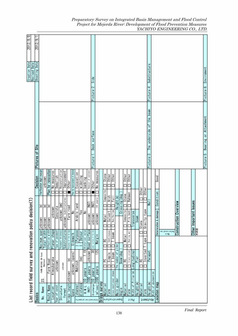
□ □ □ □ ■ □ □ □ □ ■ □
□□
□□
□□
□□
□□
□□
□□
□
□□
□□
□□
□□
□□
□□
□□
□□
Const
ruct
ion
Over
vie
w O
ther
Im
port
ant
Issu
es未
調査
Picture-5
Bearing or Attachment
Picture-6
Enviroment
Det
erio
ration
& d
am
age
Condition
Good
MainDeterioration
Wall
Picture-3
The underside of the beam
Picture-4
Substructure
Width of abutment(m)
Loc
ation m
ap
Abutment
Material
RC
Stone
Other
Form
Inverted T type
Gravity type
Other
Height(m)
Pier
beam
Height(m)
Parapet
Bearing wall
Pile bent
Rahmen
Other
Width of Pillar(m)Longitudinal
Transverse
Peir
Material
RC
Metal
Composite
Stone
Other
Form
Single column
Main girder
The number of girder
Height(m)
Angle
Skew(deg.)
Crossing(deg.)
I beam
T beam
Box/Hollow
Full
Other
Form
Simple
Continuous
Culvert
Arch
Other
Bridge
sur
vey
Superstructure
Material
PC
RC
Metal
Composite
Stone
Picture-2
Side
100 years
125
Margin
unknown
(10 years)
No measures
Cross-sectional shape
Removal of sediment
Discharge
(m3/sec)
10 years
30
Lower surface of the deck
unknown
(NGT)
Other
Picture-1
Deck surface
H.W.L
(NGT)
10 years
7.19
His
tori
cal
valu
eNo
banking
100 years
unknown
Excavation
distance-
(km)
Detour
Yes
widening
Intersection property
channel
Mabtouh
environ
Purpose
Arable land
Road surface
unknown
(NGT)
Spans
unknown(spans)
Sidewalk
No
Pla
n for
impro
vem
ent
of ch
annel
Bridge lengthunknown
(m)
Purpose of the bridge
Farm road
Other
Substructuresunknown
(substructures)
Improvement
Structure
format
unk
nown
Pavement thickness
unknown(mm)
Reconstruction
Location
Almoubaraka
Planar shape
unknown
No measures
Year of const.
unknown
Typ
e of
pav
emen
tConcrete
Total widthunknown
(m)
unknown
Route Name
Farm Road
Effective widthunknown
(m)
unknown
(m)
Ver
ific
atio
n d
igit m
argi
n
Pla
n fo
r re
novation
Demolish
Basi
csDec
isio
nPic
ture
s of
Site
Shooting Date
2012/9/1
Revis
ed
Date
Lis
t re
cord
fie
ld s
urv
ey a
nd
renovation p
olic
y d
ecis
ion(1
)Creation Date
2012/8/8
No. Name
23.
FARM
BR
IDGE
ON
Oue
dMab
touh
Max
imu
m s
pan
138
Preparatory Survey on Integrated Basin Management and Flood Control.Project for Mejerda River: Development of Flood Prevention Measures.
YACHIYO ENGINEERING CO., LTD.
Final Report.

■ □ □ □ □ ■ □ □ □ □ □
□■
□□
□□
■□
□□
□■
□□
□
■□
□□
□□
□■
□□
■□
□■
□□
No. Name
24.
A4
BRID
GE OV
ER M
abto
uh
Max
imu
m s
pan
Total width
Lis
t re
cord
fie
ld s
urv
ey a
nd
renovation p
olic
y d
ecis
ion(1
)
Basi
csDec
isio
nPic
ture
s of
Site
unknown
Creation Date
2012
/8/8
Revis
ed
Date
2012
/9/1
Shooting Date
Reconstruction
Excavation
MOTORWAY A4
Effective widthunknown
(m)
Ver
ific
atio
n d
igit m
argi
n
Pla
n fo
r re
novation
Demolish
(m)
No measures
Location
El Kantara
Planar shape
unknown
14.00(m)
OK
Route Name
3(substructures)
Year of const.
2002
Typ
e of
pav
emen
tAsphalt (mm)
MOTORWAY
Other
Improvement
No
Pla
n for
impro
vem
ent
of ch
annel
Structure
format
2径間
連続
PCT桁
(想定
)Pavement thickness
unknown
Substructures
Bridge length
52.6
Spans
2(spans)
Sidewalk
(m)
Purpose of the bridge
Purpose
Arable land
Road surface
13.50
(NGT)
Intersection property
channel
Mabtouh
environ
distance-
(km)
Detour
No
widening
11.15
Removal of sediment
100 ye
ars
125
H.W.L
(NGT)
10 yea
rs
7.13
His
tori
cal
valu
eNo
banking
100 ye
ars
Discharge
(m3/sec)
10 yea
rs
30
Lower surface of the deck
11.30
(NGT)
Other
Picture-1
Deck surface
Picture-2
Side
Other
Other
unknown
unknown
Composite
Stone
Height(m)
Margin
4.17(m)
(10 years)
No measures
Other
Cross-sectional shape
Bridge
sur
vey
Superstructure
Material
PC
RC
Metal
Full
unknown
Form
Simple
Continuous
Culvert
Arch
Other
Angle
unknown
Crossing(deg.)
-
I beam
T beam
Box/Hollow
Form
Single column
Stone
Other
Rahmen
Main girder
The number of girder
Bearing wall
Pile bent
Skew(deg.)
Peir
Material
RC
Metal
Composite
Width of Pillar(m)Longitudinal
unknown
Transverse
Height(m)
Pier
unknown
beam
-
Height(m)
Parapet
Other
Picture-4
Substructure
unknown
Det
erio
ration
& d
am
age
Condition
Gravity type
Wall
Width of abutment(m)
-Picture-3
The underside of the beam
特に
なし
Loc
ation m
ap
Abutment
Material
RC
Stone
-
Form
Inverted T type
Oth
er Im
port
ant
Issu
es橋
梁の
詳細
が不
明の
ため
、測
量を
実施
する
必要
があ
る。
Picture-5
Bearing or Attachment
Picture-6
Enviroment
Const
ruct
ion
Over
vie
wNo measures
Good
MainDeterioration
139
Preparatory Survey on Integrated Basin Management and Flood Control.Project for Mejerda River: Development of Flood Prevention Measures.
YACHIYO ENGINEERING CO., LTD.
Final Report.

□ □ □ □ ■ □ □ □ □ ■ □
□□
□□
□□
□□
□□
□□
□□
□
□□
□□
□□
□□
□□
□□
□□
□□
Const
ruct
ion
Over
vie
w O
ther
Im
port
ant
Issu
es未
調査
Picture-5
Bearing or Attachment
Picture-6
Enviroment
Det
erio
ration
& d
am
age
Condition
Good
MainDeterioration
Wall
Picture-3
The underside of the beam
Picture-4
Substructure
Width of abutment(m)
Loc
ation m
ap
Abutment
Material
RC
Stone
Other
Form
Inverted T type
Gravity type
Other
Height(m)
Pier
beam
Height(m)
Parapet
Bearing wall
Pile bent
Rahmen
Other
Width of Pillar(m)Longitudinal
Transverse
Peir
Material
RC
Metal
Composite
Stone
Other
Form
Single column
Main girder
The number of girder
Height(m)
Angle
Skew(deg.)
Crossing(deg.)
I beam
T beam
Box/Hollow
Full
Other
Form
Simple
Continuous
Culvert
Arch
Other
Bridge
sur
vey
Superstructure
Material
PC
RC
Metal
Composite
Stone
Picture-2
Side
100 years
125
Margin
unknown
(10 years)
No measures
Cross-sectional shape
Removal of sediment
Discharge
(m3/sec)
10 years
30
Lower surface of the deck
unknown
(NGT)
Other
Picture-1
Deck surface
H.W.L
(NGT)
10 years
6.55
His
tori
cal
valu
eNo
banking
100 years
unknown
Excavation
distance-
(km)
Detour
Yes
widening
Intersection property
channel
Mabtouh
environ
Purpose
Arable land
Road surface
unknown
(NGT)
Spans
unknown(spans)
Sidewalk
No
Pla
n for
impro
vem
ent
of ch
annel
Bridge lengthunknown
(m)
Purpose of the bridge
Farm road
Other
Substructuresunknown
(substructures)
Improvement
Structure
format
unk
nown
Pavement thickness
unknown(mm)
Reconstruction
Location
El Kantara
Planar shape
unknown
No measures
Year of const.
unknown
Typ
e of
pav
emen
tConcrete
Total widthunknown
(m)
unknown
Route Name
Farm Road
Effective widthunknown
(m)
unknown
(m)
Ver
ific
atio
n d
igit m
argi
n
Pla
n fo
r re
novation
Demolish
Basi
csDec
isio
nPic
ture
s of
Site
Shooting Date
2012/9/1
Revis
ed
Date
Lis
t re
cord
fie
ld s
urv
ey a
nd
renovation p
olic
y d
ecis
ion(1
)Creation Date
2012/8/8
No. Name
25.
FARM
BR
IDGE
ON
Oue
dMab
touh
Max
imu
m s
pan
140
Preparatory Survey on Integrated Basin Management and Flood Control.Project for Mejerda River: Development of Flood Prevention Measures.
YACHIYO ENGINEERING CO., LTD.
Final Report.

□ □ □ □ ■ □ □ □ □ ■ □
□□
□□
□□
□□
□□
□□
□□
□
□□
□□
□□
□□
□□
□□
□□
□□
Const
ruct
ion
Over
vie
w O
ther
Im
port
ant
Issu
es未
調査
Picture-5
Bearing or Attachment
Picture-6
Enviroment
Det
erio
ration
& d
am
age
Condition
Good
MainDeterioration
Wall
Picture-3
The underside of the beam
Picture-4
Substructure
Width of abutment(m)
Loc
ation m
ap
Abutment
Material
RC
Stone
Other
Form
Inverted T type
Gravity type
Other
Height(m)
Pier
beam
Height(m)
Parapet
Bearing wall
Pile bent
Rahmen
Other
Width of Pillar(m)Longitudinal
Transverse
Peir
Material
RC
Metal
Composite
Stone
Other
Form
Single column
Main girder
The number of girder
Height(m)
Angle
Skew(deg.)
Crossing(deg.)
I beam
T beam
Box/Hollow
Full
Other
Form
Simple
Continuous
Culvert
Arch
Other
Bridge
sur
vey
Superstructure
Material
PC
RC
Metal
Composite
Stone
Picture-2
Side
100 years
125
Margin
unknown
(10 years)
No measures
Cross-sectional shape
Removal of sediment
Discharge
(m3/sec)
10 years
30
Lower surface of the deck
unknown
(NGT)
Other
Picture-1
Deck surface
H.W.L
(NGT)
10 years
6.14
His
tori
cal
valu
eNo
banking
100 years
unknown
Excavation
distance-
(km)
Detour
Yes
widening
Intersection property
channel
Mabtouh
environ
Purpose
Arable land
Road surface
unknown
(NGT)
Spans
unknown(spans)
Sidewalk
No
Pla
n for
impro
vem
ent
of ch
annel
Bridge lengthunknown
(m)
Purpose of the bridge
Farm road
Other
Substructuresunknown
(substructures)
Improvement
Structure
format
unk
nown
Pavement thickness
unknown(mm)
Reconstruction
Location
Shuwat
Planar shape
unknown
No measures
Year of const.
unknown
Typ
e of
pav
emen
tConcrete
Total widthunknown
(m)
unknown
Route Name
Farm Road
Effective widthunknown
(m)
unknown
(m)
Ver
ific
atio
n d
igit m
argi
n
Pla
n fo
r re
novation
Demolish
Basi
csDec
isio
nPic
ture
s of
Site
Shooting Date
2012/9/1
Revis
ed
Date
Lis
t re
cord
fie
ld s
urv
ey a
nd
renovation p
olic
y d
ecis
ion(1
)Creation Date
2012/8/8
No. Name
26.
FARM
BR
IDGE
ON
Oue
dMab
touh
Max
imu
m s
pan
141
Preparatory Survey on Integrated Basin Management and Flood Control.Project for Mejerda River: Development of Flood Prevention Measures.
YACHIYO ENGINEERING CO., LTD.
Final Report.

□ □ ■ □ □ □ ■ □ □ □ □
□■
□□
□□
□■
□□
□□
□■
□
■□
□□
□□
□□
□■
■□
□□
□■
No. Name
27.
GP8
BRID
GE AN
D RO
AD O
VER
Mab
touh
Max
imu
m s
pan
Total width
Lis
t re
cord
fie
ld s
urv
ey a
nd
renovation p
olic
y d
ecis
ion(1
)
Basi
csDec
isio
nPic
ture
s of
Site
8.90
Creation Date
2012
/8/8
Revis
ed
Date
2012
/9/1
Shooting Date
Reconstruction
Excavation
GP8
Effective width
9.40
(m)
Ver
ific
atio
n d
igit m
argi
n
Pla
n fo
r re
novation
Demolish
(m)
No measures
Location
El Kantara
Planar shape
skew bridge
9.90(m)
OK
Route Name
5(substructures)
Year of const.
unknown
Typ
e of
pav
emen
tAsphalt (mm)
Main road
Other
Improvement
No
Pla
n for
impro
vem
ent
of ch
annel
Structure
format
4 sp
ans
rei
nfor
ced c
oncr
ete
box
cul
vert
Pavement thickness
unknown
Substructures
Bridge length
36.5
Spans
4(spans)
Sidewalk
(m)
Purpose of the bridge
Purpose
Arable land
Road surface
8.68
(NGT)
Intersection property
channel
Mabtouh
environ
distance-
(km)
Detour
No
widening
11.15
Removal of sediment
100 ye
ars
125
H.W.L
(NGT)
10 yea
rs
7.58
His
tori
cal
valu
eNo
banking
100 ye
ars
Discharge
(m3/sec)
10 yea
rs
30
Lower surface of the deck
7.68
(NGT)
Other
Picture-1
Deck surface
Picture-2
Side
Other
Other
0.80
11.70
Composite
Stone
Height(m)
Margin
0.10(m)
(10 years)
No measures
Other
Cross-sectional shape
Bridge
sur
vey
Superstructure
Material
PC
RC
Metal
Full
1
Form
Simple
Continuous
Culvert
Arch
Other
Angle
62.5
Crossing(deg.)
-
I beam
T beam
Box/Hollow
Form
Single column
Stone
Other
Rahmen
Main girder
The number of girder
Bearing wall
Pile bent
Skew(deg.)
Peir
Material
RC
Metal
Composite
Width of Pillar(m)Longitudinal
0.90
Transverse
Height(m)
Pier
unknown
beam
unknown
Height(m)
Parapet
Other
Picture-4
Substructure
10.80
Det
erio
ration
& d
am
age
Condition
Gravity type
Wall
Width of abutment(m)
-Picture-3
The underside of the beam
①伸
縮装
置の
劣化
②排
水装
置の
欠陥
Loc
ation m
ap
Abutment
Material
RC
Stone
-
Form
Inverted T type
Oth
er Im
port
ant
Issu
es①
河床
を掘
削す
る場
合は
掛け
替え
とな
る。
②側
面に
添架
管有
り。
Picture-5
Bearing or Attachment
Picture-6
Enviroment
Const
ruct
ion
Over
vie
wNo measures
Mild damage
MainDeterioration
142
Preparatory Survey on Integrated Basin Management and Flood Control.Project for Mejerda River: Development of Flood Prevention Measures.
YACHIYO ENGINEERING CO., LTD.
Final Report.

□ □ □ □ ■ □ □ □ □ ■ □
□□
□□
□□
□□
□□
□□
□□
□
□□
□□
□□
□□
□□
□□
□□
□□
Const
ruct
ion
Over
vie
w O
ther
Im
port
ant
Issu
es未
調査
Picture-5
Bearing or Attachment
Picture-6
Enviroment
Det
erio
ration
& d
am
age
Condition
Good
MainDeterioration
Wall
Picture-3
The underside of the beam
Picture-4
Substructure
Width of abutment(m)
Loc
ation m
ap
Abutment
Material
RC
Stone
Other
Form
Inverted T type
Gravity type
Other
Height(m)
Pier
beam
Height(m)
Parapet
Bearing wall
Pile bent
Rahmen
Other
Width of Pillar(m)Longitudinal
Transverse
Peir
Material
RC
Metal
Composite
Stone
Other
Form
Single column
Main girder
The number of girder
Height(m)
Angle
Skew(deg.)
Crossing(deg.)
I beam
T beam
Box/Hollow
Full
Other
Form
Simple
Continuous
Culvert
Arch
Other
Bridge
sur
vey
Superstructure
Material
PC
RC
Metal
Composite
Stone
Picture-2
Side
100 years
125
Margin
unknown
(10 years)
No measures
Cross-sectional shape
Removal of sediment
Discharge
(m3/sec)
10 years
30
Lower surface of the deck
unknown
(NGT)
Other
Picture-1
Deck surface
H.W.L
(NGT)
10 years
7.58
His
tori
cal
valu
eNo
banking
100 years
unknown
Excavation
distance-
(km)
Detour
Yes
widening
Intersection property
channel
Mabtouh
environ
Purpose
Arable land
Road surface
unknown
(NGT)
Spans
unknown(spans)
Sidewalk
No
Pla
n for
impro
vem
ent
of ch
annel
Bridge lengthunknown
(m)
Purpose of the bridge
Farm road
Other
Substructuresunknown
(substructures)
Improvement
Structure
format
unk
nown
Pavement thickness
unknown(mm)
Reconstruction
Location
Shuwat
Planar shape
unknown
No measures
Year of const.
unknown
Typ
e of
pav
emen
tConcrete
Total widthunknown
(m)
unknown
Route Name
Farm Road
Effective widthunknown
(m)
unknown
(m)
Ver
ific
atio
n d
igit m
argi
n
Pla
n fo
r re
novation
Demolish
Basi
csDec
isio
nPic
ture
s of
Site
Shooting Date
2012/9/1
Revis
ed
Date
Lis
t re
cord
fie
ld s
urv
ey a
nd
renovation p
olic
y d
ecis
ion(1
)Creation Date
2012/8/8
No. Name
28.
FARM
BR
IDGE
ON
Oue
dMab
touh
Max
imu
m s
pan
143
Preparatory Survey on Integrated Basin Management and Flood Control.Project for Mejerda River: Development of Flood Prevention Measures.
YACHIYO ENGINEERING CO., LTD.
Final Report.

□ □ □ □ ■ □ □ □ □ ■ □
□□
□□
□□
□□
□□
□□
□□
□
□□
□□
□□
□□
□□
□□
□□
□□
Const
ruct
ion
Over
vie
w O
ther
Im
port
ant
Issu
es未
調査
Picture-5
Bearing or Attachment
Picture-6
Enviroment
Det
erio
ration
& d
am
age
Condition
Good
MainDeterioration
Wall
Picture-3
The underside of the beam
Picture-4
Substructure
Width of abutment(m)
Loc
ation m
ap
Abutment
Material
RC
Stone
Other
Form
Inverted T type
Gravity type
Other
Height(m)
Pier
beam
Height(m)
Parapet
Bearing wall
Pile bent
Rahmen
Other
Width of Pillar(m)Longitudinal
Transverse
Peir
Material
RC
Metal
Composite
Stone
Other
Form
Single column
Main girder
The number of girder
Height(m)
Angle
Skew(deg.)
Crossing(deg.)
I beam
T beam
Box/Hollow
Full
Other
Form
Simple
Continuous
Culvert
Arch
Other
Bridge
sur
vey
Superstructure
Material
PC
RC
Metal
Composite
Stone
Picture-2
Side
100 years
125
Margin
unknown
(10 years)
No measures
Cross-sectional shape
Removal of sediment
Discharge
(m3/sec)
10 years
30
Lower surface of the deck
unknown
(NGT)
Other
Picture-1
Deck surface
H.W.L
(NGT)
10 years
7.58
His
tori
cal
valu
eNo
banking
100 years
unknown
Excavation
distance-
(km)
Detour
Yes
widening
Intersection property
channel
Mabtouh
environ
Purpose
Arable land
Road surface
unknown
(NGT)
Spans
unknown(spans)
Sidewalk
No
Pla
n for
impro
vem
ent
of ch
annel
Bridge lengthunknown
(m)
Purpose of the bridge
Farm road
Other
Substructuresunknown
(substructures)
Improvement
Structure
format
unk
nown
Pavement thickness
unknown(mm)
Reconstruction
Location
unknown
Planar shape
unknown
No measures
Year of const.
unknown
Typ
e of
pav
emen
tConcrete
Total widthunknown
(m)
unknown
Route Name
Farm Road
Effective widthunknown
(m)
unknown
(m)
Ver
ific
atio
n d
igit m
argi
n
Pla
n fo
r re
novation
Demolish
Basi
csDec
isio
nPic
ture
s of
Site
Shooting Date
2012/9/1
Revis
ed
Date
Lis
t re
cord
fie
ld s
urv
ey a
nd
renovation p
olic
y d
ecis
ion(1
)Creation Date
2012/8/8
No. Name
29.
FARM
BR
IDGE
ON
Oue
dMab
touh
Max
imu
m s
pan
144
Preparatory Survey on Integrated Basin Management and Flood Control.Project for Mejerda River: Development of Flood Prevention Measures.
YACHIYO ENGINEERING CO., LTD.
Final Report.
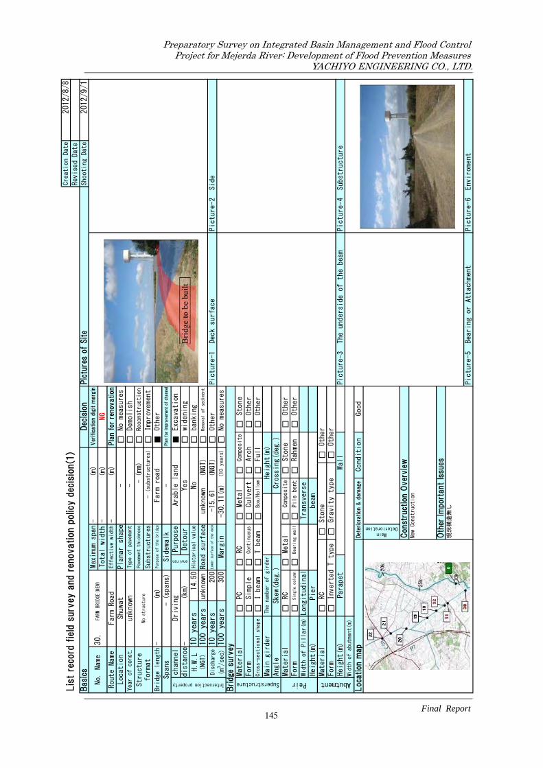
□ □ □ □ ■ ■ □ □ □ □ □
□□
□□
□□
□□
□□
□□
□□
□
□□
□□
□□
□□
□□
□□
□□
□□
No. Name
30.
FARM
BRID
GE(N
EW)
Max
imu
m s
pan
Total width
Lis
t re
cord
fie
ld s
urv
ey a
nd
renovation p
olic
y d
ecis
ion(1
)
Basi
csDec
isio
nPic
ture
s of
Site
-
Creation Date
2012
/8/8
Revis
ed
Date
2012
/9/1
Shooting Date
Reconstruction
Excavation
Farm Road
Effective width-
(m)
Ver
ific
atio
n d
igit m
argi
n
Pla
n fo
r re
novation
Demolish
(m)
No measures
Location
Shuwat
Planar shape
-
-(m)
NG
Route Name
-(substructures)
Year of const.
unknown
Typ
e of
pav
emen
t-
(mm)
Farm road
Other
Improvement
-Pla
n for
impro
vem
ent
of ch
annel
Structure
format
No s
tru
ctur
ePavement thickness
-Substructures
Bridge length-
Spans
-(spans)
Sidewalk
(m)
Purpose of the bridge
Purpose
Arable land
Road surface
unknown
(NGT)
Intersection property
channel
Driving
environ
distance-
(km)
Detour
Yes
widening
unknown
Removal of sediment
100 ye
ars
300
H.W.L
(NGT)
10 yea
rs
14.50
His
tori
cal
valu
eNo
banking
100 ye
ars
Discharge
(m3/sec)
10 yea
rs
200
Lower surface of the deck
-15.61
(NGT)
Other
Picture-1
Deck surface
Picture-2
Side
Other
Other
Composite
Stone
Height(m)
Margin
-30.11(m)
(10 years)
No measures
Other
Cross-sectional shape
Bridge
sur
vey
Superstructure
Material
PC
RC
Metal
Full
Form
Simple
Continuous
Culvert
Arch
Other
Angle
Crossing(deg.)
I beam
T beam
Box/Hollow
Form
Single column
Stone
Other
Rahmen
Main girder
The number of girder
Bearing wall
Pile bent
Skew(deg.)
Peir
Material
RC
Metal
Composite
Width of Pillar(m)Longitudinal
Transverse
Height(m)
Pier
beam
Height(m)
Parapet
Other
Picture-4
Substructure
Det
erio
ration
& d
am
age
Condition
Gravity type
Wall
Width of abutment(m)
Picture-3
The underside of the beam
Loc
ation m
ap
Abutment
Material
RC
Stone
Form
Inverted T type
Oth
er Im
port
ant
Issu
es現
況構
造無
し
Picture-5
Bearing or Attachment
Picture-6
Enviroment
Const
ruct
ion
Over
vie
wNew Construction
Good
MainDeterioration
145
Preparatory Survey on Integrated Basin Management and Flood Control.Project for Mejerda River: Development of Flood Prevention Measures.
YACHIYO ENGINEERING CO., LTD.
Final Report.

□ □ □ □ ■ ■ □ □ □ □ □
□□
□□
□□
□□
□□
□□
□□
□
□□
□□
□□
□□
□□
□□
□□
□□
No. Name
31.
FARM
BRID
GE(N
EW)
Max
imu
m s
pan
Total width
Lis
t re
cord
fie
ld s
urv
ey a
nd
renovation p
olic
y d
ecis
ion(1
)
Basi
csDec
isio
nPic
ture
s of
Site
-
Creation Date
2012
/8/8
Revis
ed
Date
2012
/9/1
Shooting Date
Reconstruction
Excavation
Farm Road
Effective width-
(m)
Ver
ific
atio
n d
igit m
argi
n
Pla
n fo
r re
novation
Demolish
(m)
No measures
Location
Shuwat
Planar shape
-
-(m)
unknown
Route Name
-(substructures)
Year of const.
unknown
Typ
e of
pav
emen
t-
(mm)
Farm road
Other
Improvement
-Pla
n for
impro
vem
ent
of ch
annel
Structure
format
No s
tru
ctur
ePavement thickness
-Substructures
Bridge length-
Spans
-(spans)
Sidewalk
(m)
Purpose of the bridge
Purpose
Arable land
Road surface
unknown
(NGT)
Intersection property
channel
Driving
environ
distance-
(km)
Detour
Yes
widening
unknown
Removal of sediment
100 ye
ars
300
H.W.L
(NGT)
10 yea
rs
14.35
His
tori
cal
valu
eNo
banking
100 ye
ars
Discharge
(m3/sec)
10 yea
rs
200
Lower surface of the deck
unknown
(NGT)
Other
Picture-1
Deck surface
Picture-2
Side
Other
Other
Composite
Stone
Height(m)
Margin
unknown
(10 years)
No measures
Other
Cross-sectional shape
Bridge
sur
vey
Superstructure
Material
PC
RC
Metal
Full
Form
Simple
Continuous
Culvert
Arch
Other
Angle
Crossing(deg.)
I beam
T beam
Box/Hollow
Form
Single column
Stone
Other
Rahmen
Main girder
The number of girder
Bearing wall
Pile bent
Skew(deg.)
Peir
Material
RC
Metal
Composite
Width of Pillar(m)Longitudinal
Transverse
Height(m)
Pier
beam
Height(m)
Parapet
Other
Picture-4
Substructure
Det
erio
ration
& d
am
age
Condition
Gravity type
Wall
Width of abutment(m)
Picture-3
The underside of the beam
Loc
ation m
ap
Abutment
Material
RC
Stone
Form
Inverted T type
Oth
er Im
port
ant
Issu
es現
況構
造無
し
Picture-5
Bearing or Attachment
Picture-6
Enviroment
Const
ruct
ion
Over
vie
wNew Construction
Good
MainDeterioration
146
Preparatory Survey on Integrated Basin Management and Flood Control.Project for Mejerda River: Development of Flood Prevention Measures.
YACHIYO ENGINEERING CO., LTD.
Final Report.

□ □ □ □ ■ □ □ □ □ ■ □
□□
□□
□□
□□
□□
□□
□□
□
□□
□□
□□
□□
□□
□□
□□
□□
Const
ruct
ion
Over
vie
w O
ther
Im
port
ant
Issu
es未
調査
Picture-5
Bearing or Attachment
Picture-6
Enviroment
Det
erio
ration
& d
am
age
Condition
Good
MainDeterioration
Wall
Picture-3
The underside of the beam
Picture-4
Substructure
Width of abutment(m)
Loc
ation m
ap
Abutment
Material
RC
Stone
Other
Form
Inverted T type
Gravity type
Other
Height(m)
Pier
beam
Height(m)
Parapet
Bearing wall
Pile bent
Rahmen
Other
Width of Pillar(m)Longitudinal
Transverse
Peir
Material
RC
Metal
Composite
Stone
Other
Form
Single column
Main girder
The number of girder
Height(m)
Angle
Skew(deg.)
Crossing(deg.)
I beam
T beam
Box/Hollow
Full
Other
Form
Simple
Continuous
Culvert
Arch
Other
Bridge
sur
vey
Superstructure
Material
PC
RC
Metal
Composite
Stone
Picture-2
Side
100 years
300
Margin
unknown
(10 years)
No measures
Cross-sectional shape
Removal of sediment
Discharge
(m3/sec)
10 years
200
Lower surface of the deck
unknown
(NGT)
Other
Picture-1
Deck surface
H.W.L
(NGT)
10 years
14.08
His
tori
cal
valu
eNo
banking
100 years
unknown
Excavation
distance-
(km)
Detour
Yes
widening
Intersection property
channel
Driving
environ
Purpose
Arable land
Road surface
unknown
(NGT)
Spans
unknown(spans)
Sidewalk
-Pla
n for
impro
vem
ent
of ch
annel
Bridge lengthunknown
(m)
Purpose of the bridge
Farm road
Other
Substructuresunknown
(substructures)
Improvement
Structure
format
unk
nown
Pavement thickness
-(mm)
Reconstruction
Location
Almoubaraka
Planar shape
unknown
No measures
Year of const.
unknown
Typ
e of
pav
emen
t-
Total widthunknown
(m)
unknown
Route Name
Farm Road
Effective widthunknown
(m)
unknown
(m)
Ver
ific
atio
n d
igit m
argi
n
Pla
n fo
r re
novation
Demolish
Basi
csDec
isio
nPic
ture
s of
Site
Shooting Date
2012/9/1
Revis
ed
Date
Lis
t re
cord
fie
ld s
urv
ey a
nd
renovation p
olic
y d
ecis
ion(1
)Creation Date
2012/8/8
No. Name
32.
FARM
BRID
GE(N
EW)
Max
imu
m s
pan
147
Preparatory Survey on Integrated Basin Management and Flood Control.Project for Mejerda River: Development of Flood Prevention Measures.
YACHIYO ENGINEERING CO., LTD.
Final Report.

Preparatory Survey on Integrated Basin Management and Flood Control Project for Mejerda River:
Development of Flood Prevention Measures
Yachiyo Engineering Co., Ltd.
Final Report
148
4.2 Studies of Existing Bridges
No. Name Drawings 2 TOBIAS BRIDGE 13 structural and other drawings
10 JEDEIDA BRIDGE Overall drawings 9 JEDEIDA RAILWAY BRIDGE Seven overall and other drawings

Preparatory Survey on Integrated Basin Management and Flood Control Project for Mejerda River:
Development of Flood Prevention Measures
Yachiyo Engineering Co., Ltd.
Final Report
149
(1) TOBIAS BRIDGE

Preparatory Survey on Integrated Basin Management and Flood Control Project for Mejerda River:
Development of Flood Prevention Measures
Yachiyo Engineering Co., Ltd.
Final Report
150

Preparatory Survey on Integrated Basin Management and Flood Control Project for Mejerda River:
Development of Flood Prevention Measures
Yachiyo Engineering Co., Ltd.
Final Report
151

Preparatory Survey on Integrated Basin Management and Flood Control Project for Mejerda River:
Development of Flood Prevention Measures
Yachiyo Engineering Co., Ltd.
Final Report
152

Preparatory Survey on Integrated Basin Management and Flood Control Project for Mejerda River:
Development of Flood Prevention Measures
Yachiyo Engineering Co., Ltd.
Final Report
153

Preparatory Survey on Integrated Basin Management and Flood Control Project for Mejerda River:
Development of Flood Prevention Measures
Yachiyo Engineering Co., Ltd.
Final Report
154
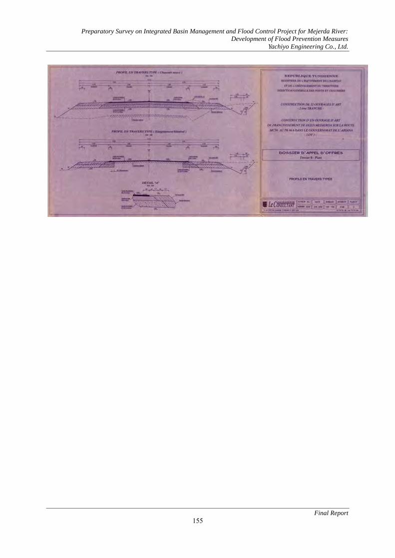
Preparatory Survey on Integrated Basin Management and Flood Control Project for Mejerda River:
Development of Flood Prevention Measures
Yachiyo Engineering Co., Ltd.
Final Report
155

Preparatory Survey on Integrated Basin Management and Flood Control Project for Mejerda River:
Development of Flood Prevention Measures
Yachiyo Engineering Co., Ltd.
Final Report
156

Preparatory Survey on Integrated Basin Management and Flood Control Project for Mejerda River:
Development of Flood Prevention Measures
Yachiyo Engineering Co., Ltd.
Final Report
157
(2) JEDEIDA BRIDGE

Preparatory Survey on Integrated Basin Management and Flood Control Project for Mejerda River:
Development of Flood Prevention Measures
Yachiyo Engineering Co., Ltd.
Final Report
158
(3) JEDEIDA RAILWAY BRIDGE

Preparatory Survey on Integrated Basin Management and Flood Control Project for Mejerda River:
Development of Flood Prevention Measures
Yachiyo Engineering Co., Ltd.
Final Report
159

Preparatory Survey on Integrated Basin Management and Flood Control Project for Mejerda River:
Development of Flood Prevention Measures
Yachiyo Engineering Co., Ltd.
Final Report
160

Preparatory Survey on Integrated Basin Management and Flood Control Project for Mejerda River:
Development of Flood Prevention Measures
Yachiyo Engineering Co., Ltd.
Final Report
161

Preparatory Survey on Integrated Basin Management and Flood Control Project for Mejerda River:
Development of Flood Prevention Measures
Yachiyo Engineering Co., Ltd.
Final Report
162

Preparatory Survey on Integrated Basin Management and Flood Control Project for Mejerda River:
Development of Flood Prevention Measures
Yachiyo Engineering Co., Ltd.
Final Report
163
4.3 Railway Bridge Renovation Project
(1) Study conditions for the railway bridge renovation
1) Design requirement for the bridge
Item Content
Bridge Length L=63.0m(21.0+21.0+21.0m)
Vertical alignment Level (Rail Level 21.0m)
Horizontal alignment R=∞
Elevation of Orbit Rail Level~Slab Level=0.600m
Superstructure Type Simple PCT girder ×3 span
Girder Heights H=1.650m(Slab t=0.250m)
2) Conditions of the river
Item Content
River Mejerda
Position 37.834km
River Width Existing W=58.92m
Plan W=86.43m(+27.51m)
Elevation of Levee Right:20.9m , Left:21.2m
3) Amount of raise
Item Content
Elevation Rail Level 21.0m
Bottom of Girder 19.200m
HWL 20.056m
Heights HWL~Bottom of Girder 1.0m~
New Girder 2.250m
Rail Level~Slab Level 0.600m
Raising Amount 3.0m
Rail Level 23.906m ~
Raising Amount 2.906m → 3.0m
4) Temporary railway installation conditions
Item Content
Horizontal alignment R=160m ~
Relaxation curve length L=400.000m
Longitudinal gradient i=9.0‰
Horizontal alignment R=2000m

Preparatory Survey on Integrated Basin Management and Flood Control Project for Mejerda River:
Development of Flood Prevention Measures
Yachiyo Engineering Co., Ltd.
Final Report
164
(2) Renovation plan
1) Renovation plan
Under given study conditions, normally the Plan A “Detour with temporally railway & Bridge
renovation” is excellent in most economic. The detour with temporally railway, however, results
longer distance than existing and it may cause larger impact on the surrounding environment.
Therefore, as an alternative solution, Plan B is compared with Plan A. This method is to construct
culvert box covering river flow area in its box without interfering with railway operations. HEP&JES
method is one of the typical. (For more detailed information, see 6.4.1 (1) in the main text).
As a result of comparing the two planes, adopt Plan A “Detour with temporally railway & Bridge
renovation”.
Image Cost(million yen)
item Quantity Cost
Plan
A
Structure 1 Unit 95
○ Excavation --- ---
Approach 775m 37
Temporary
railway
366m 8
TOTAL 140
(1.00)
Plan
B
Structure 1 Unit 154
× Excavation 90,000m3 32
Approach 748m 36
Temporary
railway
--- ---
TOTAL 222
(1.59)
RaisingExtrension New ConstructionExisting Structure
Temporary Railway
* For demolition and construction substructure, plan temporary railway
Extrension Raising
Railway routes(During construction)
Mejerda river
RaisingCulvert-Box New ConstructionExisting Structure
Culvert-Box Raising
Railway routes(During construction)
Mejerda river

Preparatory Survey on Integrated Basin Management and Flood Control Project for Mejerda River:
Development of Flood Prevention Measures
Yachiyo Engineering Co., Ltd.
Final Report
165
Extension of the railway
a) Estimation of railway track extension by elevation change
Estimate railway track extension distance by elevation change.
1. Raising height ΔH = 3.0m
2. Raising distance Plan A: L = 90m (Span 27+21+21+21m)
Plan B: L = 63m (Span 21+21+21m)
3. Travel slope i = 9%
4. Railway track construction total distance Plan A: L = 775 m
Plan B: L = 748 m
b) Estimation of railway track extension by temporally detour
Estimate railway track extension distance by temporally detour.
1. Parallel movement distance ΔB = 12.0m
2. Straight temporary railway track extension distance L = 63m
3. Branch angle 4° 46' (Slope = 8.33%)
4. Track transition curve None
4. Total railway track distance Plan A: L = 366m
Ascent 9‰ Level Descent 9‰ Level Level
Bridge section L
IP1 IP2 IP3
IP4
Travel change section Lv
Bridge section L
IP1 IP2 IP3
IP4
Temporally railway track section Lv

Preparatory Survey on Integrated Basin Management and Flood Control Project for Mejerda River:
Development of Flood Prevention Measures
Yachiyo Engineering Co., Ltd.
Final Report
166
5 Related Documents of Chapter 8 (Environmental Social Considerations) 5.1 EIA Study Report (Draft)

Preparatory Survey on Integrated Basin Management and Flood Control Project for Mejerda River:
Development of Flood Prevention Measures
Yachiyo Engineering Co., Ltd.
Environmental Study Report
i
Preparatory Survey on Integrated Basin Management
and Flood Control Project for Mejerda River:
Development of Flood Prevention Measures
Environmental Study Report (Draft)
January 2013
Japan International Cooperation Agency
Yachiyo Engineering Co., Ltd.

Preparatory Survey on Integrated Basin Management and Flood Control Project for Mejerda River:
Development of Flood Prevention Measures
Yachiyo Engineering Co., Ltd.
Environmental Study Report
ii
Table of Contents
Chapter 1. Background of the survey .................................................................................... 1
1.1 Background and purpose of the survey ................................................................. 1
1.1.1 Background ........................................................................................................ 1
1.1.2 Purpose .............................................................................................................. 1
Chapter 2. Project Overview ................................................................................................ 2
2.1 Project Overview ................................................................................................ 2
2.1.1 Overview of the Overall Project Plan .................................................................... 2
2.1.2 Contents of Construction Works ........................................................................... 2
2.2 Project and EIA Implementing Schedule ............................................................... 5
2.2.1 Project Implementing Schedule ............................................................................ 5
2.2.2 EIA Implementing Schedule ................................................................................. 6
Chapter 3. Current Status of Social Environment of Project Regions ....................................... 8
3.1 Current Status of Social Conditions ...................................................................... 8
3.1.1 Outline of Social Condition Survey ...................................................................... 8
3.1.2 Social Condition Survey Results .......................................................................... 11
3.2 Environment Conditions .................................................................................... 23
3.2.1 Preservation restrict etc. ..................................................................................... 23
3.2.2 Animals ............................................................................................................ 29
3.2.3 Environmental pollution .................................................................................... 32
Chapter 4. Legislative system and related organizations surrounding environmental social
considerations in Tunisia ................................................................................... 33
4.1 Legislative system and international treaties surrounding environmental social
considerations in Tunisia ................................................................................... 33
4.1.1 Legislative system ............................................................................................. 33
4.1.2 Approaches on Environmental Considerations Surrounding the Forest Act and
National Land Maintenance/City Planning Law ................................................... 37
4.2 Environmental Social Consideration Procedure and Flow..................................... 37
4.3 Comparison of resident resettlement regulations in Tunisia and JICA guidelines .... 39
Chapter 5. Environmental Impact of the Project ................................................................... 44
5.1 Verification of the Contingency Plan .................................................................. 44
5.2 Estimation of Scoping and potential effects ......................................................... 45
5.3 TOR for Study of Environmental Considerations (Study Items) ............................ 55

Preparatory Survey on Integrated Basin Management and Flood Control Project for Mejerda River:
Development of Flood Prevention Measures
Yachiyo Engineering Co., Ltd.
Environmental Study Report
iii
5.4 Impact Assessment Result .................................................................................. 58
5.4.1 Impact Assessment Result .................................................................................. 58
5.4.2 Comprehensive impact assessment ..................................................................... 68
Chapter 6. Mitigation Measures .......................................................................................... 70
Chapter 7. Environment Management and Monitoring Plan .................................................. 73
7.1 Environment Management Plan ......................................................................... 73
7.1.1 Issues to be Considered in the Environment Management Plan ............................. 73
7.1.2 Environmental Management Plan ....................................................................... 77
7.2 Environmental Monitoring Plan ......................................................................... 84
7.3 Budget, funding, and organizations responsible for environmental management and
monitoring ........................................................................................................ 91
Chapter 8. Stakeholder conference...................................................................................... 95
8.1 Current implementation status and conference overview ...................................... 95
8.2 Overview and schedules of new stakeholder conferences ..................................... 99

Preparatory Survey on Integrated Basin Management and Flood Control Project for Mejerda River:
Development of Flood Prevention Measures
Yachiyo Engineering Co., Ltd.
Environmental Study Report
1
Chapter 1. Background of the survey 1.1 Background and purpose of the survey
1.1.1 Background The Mejerda River is an international river through Algeria and Tunisia with a total channel length of
460 km and a basin area of 23,700 sq. km. With 312 km of the channel length (68%) and 15,830 sq. km.
(67%) of the basin area within Tunisian territory, it is the largest basin area in the country. In the northern
part of Tunisia where the river runs through, the rainy season is from September to March. Frequent
flooding during this period has obstructed land use in the flood plain of the lower basin.
The Sidi Salem Dam was constructed in 1981 as part of the flood control measures in the lower basin. In
the 22 years since its construction, there has been no flooding downstream from the dam. With a relative
abundance of rainfall and fertile lands in Tunisia over this period, agricultural development boomed and
grew into a driving force for the economy of the lower basin. In 2003, however, discharged water from the
dam caused a seriously damaging flood. It caused severe damage with submerging duration of more than a
month, 10 deaths, 27,000 evacuees, damaging field crops and houses and blocking area access. Further
floods caused by discharges from Sidi Salem Dam in 2004, 2005, 2009 and 2012 have resulted in similar
socioeconomic damage and increased poverty. These factors are impeding the continuous development that
Tunisia has achieved. The area is in urgent need of comprehensive flood measures as existing flood
safeguards are low standard.
Upon request from the Tunisia government to improve these conditions, JICA conducted the Preparatory
Survey on Integrated Basin Management and Flood Control Project for Mejerda River: Development of
Flood Prevention Measures (hereinafter referred to as the “Development Survey”) over 26 months from
2006 to 2008. As a result of the Development Survey, they devised a master plan for integrated basin
management focused on preventing flooding of the Mejerda River. The master plan comprised levees, flood
control basins and other structural measures, as well as non-structural measures, including flood forecasting
warning system, flood fighting and evacuation system, organization skill building, and land use restriction
management in the flood plain. In 2009, the Tunisia government then requested a feasibility survey (FS) for
the project proposed in the Development Survey. JICA responded by conducting the Preparatory Survey on
Integrated Basin Management and Flood Control Project for Mejerda River (hereinafter the “Preparatory
Survey”) from September 2010 to May 2012. To collect basic information and review basic
countermeasures, the Preparatory Survey focused on the lowest basin, Zone D2. This area was regarded in
the master plan as that with the biggest economic effect.
1.1.2 Purpose Based on the Preparatory Survey and the Climate Change Impact Analysis separately conducted by JICA,
we will conduct a feasibility survey for the Integrated Basin Management and Flood Control Project for
Mejerda River in order to facilitate implementation of the Project. This survey is to complement and
complete the findings of the Preparatory Survey.

Preparatory Survey on Integrated Basin Management and Flood Control Project for Mejerda River:
Development of Flood Prevention Measures
Yachiyo Engineering Co., Ltd.
Environmental Study Report
2
Chapter 2. Project Overview 2.1 Project Overview
2.1.1 Overview of the Overall Project Plan The Mejerda River Flood Control Project is to carry out river improvement works to prevent inundation
damage in Jedeida and Tebourba in the downstream and farmland on both sides of the river. The river
improvement works will be carried out in a 60.4-kilometer section from the Kalaat el Andalous Bridge to
the Laroussia Weir in the upstream. At the time of flooding, water will be diverted at a speed of 200 m3 /s
(part of the design flood discharge at a speed of 800m3/s) and temporarily stored in the El Mabtouh
Retarding Basin. As measures against flood exceeding the designed level and flood caused by global
warming, a flood forecasting warning system, a dam management system and a flood fighting and
evacuation system shall be established at the same time as structural measures of the river improvement
works.
2.1.2 Contents of Construction Works
(1) River Improvement and Retarding Basin Works (Structural Measures) For the Mejerda river projects, sufficient cross section has been secured for the design flow of
600~800m3/s with a design scale based on the return period of 10 years. The structural measures of the
Mejerda River Flood Control Project are river improvements (levee construction and river-bed excavation)
necessary for the design flow, construction of a retarding basin for diversion and storage of design flood
discharge, construction of discharge channels to the retarding basin and drainage channels from the basin to
the Mejerda River, and construction of appurtenant structures of the discharge and drainage channels.
Figure 1: Assignment of Design Flood Discharge (D2 Zone: Laroussia Dam – Kalaat Andalous
Bridge)
14 bridges over the Mejerda River, 3 bridges over the Chaffrou River, a tributary of the Mejerda River,
(in total 17 bridges in Construction Zones I and II) and 15 bridges over discharge channels from the El
Mabtouh Retarding Basin will be reconstructed or newly constructed. The following table shows the
overview of the target facilities, number of bridges, major river structures etc.
Kalaat Andalous Bridge

Preparatory Survey on Integrated Basin Management and Flood Control Project for Mejerda River:
Development of Flood Prevention Measures
Yachiyo Engineering Co., Ltd.
Environmental Study Report
3
Table 1: Overview of River Improvement and Retarding Basin Works of the Mejerda River Flood
Control Project
The following map shows the target areas of river improvement and retarding basin works and the
locations of reconstruction and construction of bridges.
Classification Works UnitRiverImprovement I
RiverImprovement II
RiverImprovement III
Total
Length Km 34.1 31.2 26.1 91.4River Improvement
Excavation 1000m3 5,659 2,361 2,048 10,068Embankment 1000m3 508 525 73 1,106Removal 1000m3 5,151 1,815 1,975 8,941
River FacilitiesEl Mabtouh
Inflow Weir Unit - 1 - 1Discharge Control Unit - 1 - 1Outflow Gate Unit - 1 - 1Overflow Weir Unit - 1 - 1
Mejerda RiverSluiceway Unit 5 0 4 9
Bridges 9 15 8 32Reconstruction Bridge 2 6 2 10Construction Bridge 0 3 0 3Raising Bridge 1 0 1 2Demolish Bridge 2 0 1 3No Measures Bridge 4 6 4 14

Preparatory Survey on Integrated Basin Management and Flood Control Project for Mejerda River:
Development of Flood Prevention Measures
Yachiyo Engineering Co., Ltd.
Environmental Study Report
4
Figure 2: Target Areas of River Improvement and Retarding Basin Works
(Construction Zones and Locations of Bridges)
(2) Nonstructural Measures
(3) Nonstructural measures play complementary roles as measures against flood exceeding the design
flood level and also as adaptation measures against climate changes with such characteristics as
smaller investment cost than structural measures and usefulness as short-term responses and measures.
Listed below are the nonstructural measures to be carried out in the Mejerda River Flood Control
Project.
Table 2: Contents of the Nonstructural Measures to Be Carried Out in the Mejerda River Flood
Control Project No. Envisioned Non-structural Measures Relative
Agencies/Bodies Project Area
1 Dam Flood Management System DGBGTH
Sidi Salem Dam
2 Warning Information System and Flood Fighting Activities Plan
MA ONPC CRDA
Mejerda River (D2 Zone)
3 Strengthening of Organization and Capacity Development for Flood Management System
MA (DGRE, DGBGTH) MEq
Mejerda River
Source: JICA Survey Team
El Mabtouh Retarding Basin
Laroussia Dam
KA Bridge
Overflow Weir

Preparatory Survey on Integrated Basin Management and Flood Control Project for Mejerda River:
Development of Flood Prevention Measures
Yachiyo Engineering Co., Ltd.
Environmental Study Report
5
2.2 Project and EIA Implementing Schedule
2.2.1 Project Implementing Schedule We set the project implementing schedule after considering the major processes listed below. The
following table shows processes and time periods required for processes concerning the project
implementation such as major loan procedures, planning survey, environment impact assessment (EIA),
detailed design, estimate of accumulation, bidding and construction management. We assume the pledge
will be made in March 2013 and 24 months will be required for the selection of the consultant.
Table 3: Time Periods Required for Major Processes and their Contents No. Process Required
time period Contents
1 Yen loan procedures 4 months Mar 2013 Pledge Jun 2013 Conclusion of E/N Jul 2013 Conclusion of L/A
2 Environment Impact Assessment (EIA)
(16 months) Selection of consultant: 5 months Local survey: 4 months Report to and examination by the National Environment Protection Agency (ANPE): 6 months Approval from ANPE: 1 month
3 Land acquisition 22 months After the completion of EIA and detailed design and before the start of construction
4 Selection of consultants 24 months Creation of RFP and short list and consent of JICA: 12 months Invitation and submittal of proposal: 2 months Evaluation of the proposal and consent of JICA: 5 months Contract negotiation: 2 months Preparation and conclusion of contract: 1 month Consent of JICA on contract and notice to commence: 2 months
5 Detailed design 18 months Location survey and research: 4 months Detailed design related to river improvement, bridges and river structures: 10 months (including 8 months for design of nonstructural objects) Volume calculation and estimation of accumulation: 4 months Preparation of bidding documents: 3 months
6 Selection of contractors 22 months Prequalification of bidders, creation of bidding documents and consent of JICA: 8 months Bidding: 3 months Bidding evaluation: 4 months Consent of JICA: 2 months Negotiation and conclusion of contract: 2 months JICA’s consent to contract, opening of L/C and issue of L/Com: 2 months
7 Implementation of main construction works and nonstructural measures
48 months River improvement of River-I, II, III, construction of bridges and a retarding basin River-I (48), River-II (48), River-III (48)
Implementation of programs related to nonstructural measures 8 Completion of
construction and delivery - Completion of facilities and delivery to the irrigation association
of each river basin Note: The time period required for JICA’s consent on procurement differs depending on the type (consultant or contractor)
and the amount.
Below are the implementation processes of the Mejerda River Flood Control Project under the
above-described conditions. The EIA that will be conducted by the Tunisian side has to be started and
obtain approval of the National Agency of Environment Protection at an early date. Land acquisition has to
be completed before the initiation of the Project.

Preparatory Survey on Integrated Basin Management and Flood Control Project for Mejerda River:
Development of Flood Prevention Measures
Yachiyo Engineering Co., Ltd.
Environmental Study Report
6
Table 4: Implementation Processes of the Mejerda River Flood Control Project
Source: JICA Survey Team
Below is the summary of major processes and implementing schedule based on the above.
Table 5: Implementing Schedule of Major Processes of the Mejerda River Flood Control Project Major Procedure Required Period (Months) Envisioned Implementation Period (From – To) 1.EIA Survey 16 2013.5 - 2014.4 2.Loan Procedure 4 2013.3 - 2013.7 3.Selection of Consultant 24 2013.8 - 2015.7 4.Consulting Service 81 2015.8 - 2022.4 4.1 Detailed Design (18) 2015.8 - 2017.2 4.2 Tender Documents (22) 2016.7 - 2018.5 4.3 Supervision works (48) 2018.5 - 2022.4 5.Selection of Contractor 22 2016.7 - 2018.4 6.Construction 48 2018.5 - 2022.4 7.Completion of the Project - 2022.5
2.2.2 EIA Implementing Schedule The general schedule from the start of the EIA to approval was confirmed during conferences with the
ANPE and is as shown in the table below.
Implementation of the EIA is based on JICA's EIA Report (draft) for this survey. A quick start will be
3 6 9 12 3 6 9 12 3 6 9 12 3 6 9 12 3 6 9 12 3 6 9 12 3 6 9 12 3 6 9 12 3 6 9 12 3 6 9 12 3 6 9 12 3 6 9 12 3 6 9 12
1 Feasibility Study (JICA) Study 3 3 1 7
2 EIA Study 3 3 3 3 3 1 Approval 16
3 Loan Appraisal 3 3
1) Pledge
2) Exchange Note (E/N)
3) Loan Agreement (L/A)
4 Selection of Consultant 1 3 3 3 3 3 3 3 2 24
1) RFP, S/L, JICA's agreement(12)
2) Invitation, submission of proposal(2)
3) Proposal evaluation, JICA's agreement(5)
4) Contract negotiation(1)
5) Contract preparation, signing(1)
6) JICA's agree, commencement order 1 3 3 3 3 3 3 3 2 24
5 Project Management Unit 1 3 3 3 3 3 3 3 3 3 3 3 3 3 3 3 3 3 3 3 3 3 3 3 3 3 3 2 81
6 Consulting Services 3 3 3 3 3 3 3 3 3 3 3 3 3 3 3 3 3 3 3 3 3 3 3 3 3 3 3 81
6.1 Detailed Design
1) Survey(4) 3 3 3 3 3 3 18
2) River structure detailed design(10) 3 3 3 3 3 3 18
3) Non structure detailed design 3 3 3 3 3 3 18
4) Cost calculation(4) 3 3 3 3 3 3 18
6.2 Tender Preparation, Assistance 3 3 3 3 3 3 1 3 22
6.3 Supervision 3 3 3 3 3 3 3 3 3 3 3 3 3 3 3 3 48
7 Selection of Contractor, Contract 1 3 3 3 3 3 3 3 22
1) Quality pre-check, documentation, JICA's agree
2) Bidding(3)
3) Bidding evaluation(4)
4) JICA's agreement(2)
5) Contract preparation, signing(2)
6) JICA's agree, opening L/C, issuing L/com
8 Land Acquisition and compensation 3 3 3 3 3 3 3 3 3 3 3 3 3 39
9 Constructure and non-structure implemenetation 3 3 3 3 3 3 3 3 3 3 3 3 3 3 3 3 48
1) River Improvement Section-I 3 3 3 3 3 3 3 3 3 3 3 3 3 3 3 3 48
2) River Improvement Section-II 3 3 3 3 3 3 3 3 3 3 3 3 3 3 3 3 48
3) River Improvement Section-III 3 3 3 3 3 3 3 3 3 3 3 3 3 3 3 3 48
4) Non structure measure(48) 3 3 3 3 3 3 3 3 3 3 3 3 3 3 3 3 48
10 Completion ● -
Month20172014 2015 2016 2018 2019 2020 2021 2022
Item2010 2011 2012 2013

Preparatory Survey on Integrated Basin Management and Flood Control Project for Mejerda River:
Development of Flood Prevention Measures
Yachiyo Engineering Co., Ltd.
Environmental Study Report
7
necessary after the TOR for the order of consultants for the EIA has been created. Additionally, close
consultation with the ANPE during this stage will be important.
Table 6: General schedule from the start of the EIA to approval
Step Duration:15 Months Duration(Month) 1 2 3 4 5 6 7 8 9 10 11 12 13 14 15
Prearation of TOR of EIA Study 2
Public tender offer and submission of bids by applicants
Analysis of tenders and preparation of tender analysisreport, submission to the Securities Commission
Opinion by the Securities Commission and marketpreparation 1
Carriying out of EIA Study by a contracted consautantcompany/ Submission of EIA Report to ANPE 6
Stake Holde Meeting 2
Duration of Evaluation and Approval of EIA Report byANPE 3
3

Preparatory Survey on Integrated Basin Management and Flood Control Project for Mejerda River:
Development of Flood Prevention Measures
Yachiyo Engineering Co., Ltd.
Environmental Study Report
8
Chapter 3. Current Status of Social Environment of Project Regions 3.1 Current Status of Social Conditions 3.1.1 Outline of Social Condition Survey
The socio-economic study subcontracted to and performed by local consultants is outlined below.
1) Purpose To collect and analyze socio-economic data to gain a clear understanding of the social conditions of the
regions in the project plan. The three main details covered by this survey are as given below:
① To confirm and grasp the socio-economic condition of communities along the Mejerda River and the El Mabtouh Wetlands coast
② To access damage sustained by local residents due to recent floods in 2003 and 2009
③ To determine ownership of the houses, agricultural facilities and other sites along the Mejerda River, especially areas in public water districts and retreat areas (construction lines and easements).
This survey was conducted using the following methods:
① We collected data at the area/sector level where possible in order to compare the data of survey areas/sectors (Imadas: smallest administrative unit). Sector is the unit used to analyze results of the
survey.
② A questionnaire given to households along the Mejerda River and the El Mabtouh Wetland coast as well as production facilities that suffered damages from increased water levels of the Mejerda River
in the past.
2) Survey Regions and Residents The target districts and sectors of this survey are shown in the table below. Survey regions were selected
based on the following criteria:
① Sectors on the administrative boundary line that at least border the Mejerda River or part of the El Mabtouh Wetlands
② Sectors that suffered damages from floods in 2003 and/or 2009 Sector Chiefs coordinated with the leaders of agricultural extension cells (CTV) and irrigation regions to
select survey households. The social condition study was conducted on residents of the Mejerda River and
the El Mabtouh Wetland, with a survey sample of 294 households. Residents surveyed belonged to 18 of 47
sectors in seven districts. The districts and sectors in this study are shown in the following table.

Preparatory Survey on Integrated Basin Management and Flood Control Project for Mejerda River:
Development of Flood Prevention Measures
Yachiyo Engineering Co., Ltd.
Environmental Study Report
9
Table 7: Study Area and Division List by Reference/Sector Governorate District Sector Mej. Mab. 03 09
Bizerte
Utique
Utique (Zana) ● ● ● Utique Nouvelle ● Besbassia ● El Houidh El Mabtouh ● ● ● Ain Gehlal ● Sidi Othmène ● ● Bach Hamba ● ● ● ●
Ghar El Melh Ghar El Melh Bajou Ousja ● Zouaouine ●
Ariana
Sidi Thabet
Sidi Thabet ● Bejaoua ● ● ● Mongi Slim ● Cebalet Ben Ammar Chorfech ● ● ●
Kalâat el-Andalous
Kalaat En Andalous Est
●
Kalaat Andalous Ouest
●
Pont de Bizerte ● ● Bou Hanach El Hessiane Ennahli
Manouba
Oued Ellil
Oued Ellil Essaida ● ● ● Er Riadh Cité El Ouerd Ennajet San Haja El Kobbaa
Jedeida
Jedeida ● ● ● Jedeida Rached ● ● ● Chaouat ● ● ● El Mansoura Es Zahra El Habibia
Tebourba
Tebourba ● ● El Ansarine Edkhila El Mellaha Banlieue Tebourba Er Raja EchChouigui
El Bataan El Battan ● ● Borj Ettoumi Mehriine El Aroussia
Note) Mej. - Sectors that border the Mejerda River Mab. - Sectors that border the El Mabtouh Wetland 03 – Sectors affected by the 2003 floods 09 – Sectors affected by the 2009 floods

Preparatory Survey on Integrated Basin Management and Flood Control Project for Mejerda River:
Development of Flood Prevention Measures
Yachiyo Engineering Co., Ltd.
Environmental Study Report
10
Table 8: Geographical distribution of surveyed households by sector and representative percentage
Area Sector
Surveyed
Households
Percentage of surveyed households from total in
2010 estimate census (%)
Utique
Ain Ghlal 4 0.7 Bach Hamba 20 3.7 El Mabtouh 23 6.9 Sidi Othmene 13 7.1 Utique 6 1.0
Sidi Thabet Bejaoua 20 3.2 Chorfesh 22 3.5 Monji Slim 8 0.8
Kalaât Andalous Kalaât Andalous Est 8 0.6 Kalaât Andalous Ouest 28 1.3 Pont de Bizerte 12 2.1
Oued Ellil Essaida 4 0.3
Jedeida Chaouet 15 1.7 Jedeida 23 2.2 Jedeida-Hached 23 1.4
Tebourba Banlieue de Tebourba 19 0.6 Medina, Tebourba 12 1.2
El Bataan El Bataan 34 1.7 Total 294 1.5
Source: 2004 General census of the population and habitat (RGPH 2004), National Institute of Statistics (INS)
Figure 3: Location Map of Target Districts/Sectors for Socio-Economic Survey
3) Survey Items Items in the socio-economic survey are shown in the table below.
Districts with municipal
offices
Sectors in this study

Preparatory Survey on Integrated Basin Management and Flood Control Project for Mejerda River:
Development of Flood Prevention Measures
Yachiyo Engineering Co., Ltd.
Environmental Study Report
11
Table 9: Social Condition Survey Items Item Sub-Item Item Description
(1) Evaluate Socio-Economic Conditions
1) Population/Gender 2) Income/Livelihood 3) Standard of Living 4) Livestock 5) Agriculture 6) Available services 7) Usage of local resources
(2) Site occupation, site usage
1) Site possession 2) Residence 3) Agricultural land 4) Site occupation a) Residential areas
b) Grazing path areas c) State owned grazing paths in El
Mabtouh Wetland (3) Flood situation/damage Flood damage
3.1.2 Social Condition Survey Results
The survey results have been tallied by district and sector for replies from survey participants and
households. The results of the socio-economic survey are as shown below.
(1) Current Socio-Economic Conditions 1) Population & Gender
a) Population The survey covered the coast of the Mejerda River, home to 18,980 households and 88,118 people in 18
sectors. 55,776 people (12,170 households) from the total live in urban sectors according to the 2004
census.
Based on the fact that the population increased an average of 1% per year between 2004−2010, we
estimate the population of surveyed regions to exceed 100,000 people. The figure below shows the average
household size (number of members per household) in each district based on the survey.

Preparatory Survey on Integrated Basin Management and Flood Control Project for Mejerda River:
Development of Flood Prevention Measures
Yachiyo Engineering Co., Ltd.
Environmental Study Report
12
Figure 4: Average Household Size (No. of Members) by Sector
b) Gender The figure below utilizes 2004 data from the INS and shows the industries the working population
belonged to split by gender for surveyed regions.
Figure 5: Classification of Working Population in Surveyed Districts by Gender and Industry in 2004
Source: 2004 General Census (RGPH), National Institute of Statistics (INS)
2) Income/Livelihood The table below shows major sources of income by sector and the percentage (%) of working people in
households. Agriculture has a high percentage as the major source of income.
Other Services
Government
Transport/Communications
Commerce
Construction/Public Works (BTP)
Mining/Energy
Industry
Agriculture/Fishing
Female
Male
Utique Medina, Tebourba
Banlieue de Tebourba Sidi Othmene
Pont de Bizerte Monji Slim
Kalaât Andalous Est Kalaât Andalous Ouest
Hached, Jedeida Jedeida Essaida
El Mabtouh Chorfesh Chaouet Bejaoua
Bataan Bach Hamba
Ain Ghlal

Preparatory Survey on Integrated Basin Management and Flood Control Project for Mejerda River:
Development of Flood Prevention Measures
Yachiyo Engineering Co., Ltd.
Environmental Study Report
13
The figure below compares the average income of households to the guaranteed minimum wage (SMIG,
250 TND/month) and splits up those averages into three categories per district. Approximately 37% of
these districts have a monthly income equal to or under the SMIG. More than 50% of those in the Jedeida,
Oued Ellil and El Bataan Districts earn the equivalent of SMIG or less.
Table 10: Source of Household Income by District (percentage (%) of the working population with
income)
District Salary Pension Social Aid Family Aid Agriculture Day Work Other
Utique 18.7 - 1.4 - 73.2 4.0 2.7 Sidi Thabet 11.5 1.9 1.9 - 80.8 3.9 - Kalaât Andalous 8.1 - - 2.1 87.7 - 2.1 Oued Ellil 50.0 - - - 50.0 - - Jedeida 37.3 1.2 1.2 1.2 43.3 15.7 - Tebourba 16.7 - 3.3 3.3 66.7 3.3 6.7 El Bataan 37.3 2.3 - - 53.4 4.7 2.3
Figure 6: Classification of Average Household Income by District (Surveyed Household %)
3) Livestock Approximately half of the households that were surveyed said they raised livestock. Results are shown in
the table below. The average number of livestock owned by households in each sector is 35 sheep and 8.4
cows. There are many farmers in Utique that own a high number of livestock. Other districts generally had
a lower average amount.
Ain Ghlal, El Mabtouh, Kalaât Andalous, Utique and other districts located on the left bank between El
Mabtouh and the river mouth raise many sheep. Sectors that have over 50 sheep are concentrated in sectors
with vast wetlands such as El Mabtouh and Kalaât Andalous.
Sectors with an extremely large amount of cows include Bach Hamba and Utique. Essaida, Chorfesh,
and Kalaât Andalous Ouest also have a large amount of cows, and many of these household also own many
sheep.
Some households (9%) pay a fee for grazing rights, which costs 910 TND annually for an average 153
days of grazing.
Inférieur au SMIG Équivalent au SMIG Supérieur au SMIGBattan 6,9% 44,8% 48,3%Jedeida 22,6% 34,0% 43,4%Kalaat Andalous 17,4% 82,6%Oued Ellil 50,0% 50,0%Sidi Thabet 14,3% 22,4% 63,3%Tébourba 3,7% 29,6% 66,7%Utique 3,2% 24,2% 72,6%
Total 9,0% 27,6% 63,4%
Under SMIG SMIG Equivalent Over SMIG

Preparatory Survey on Integrated Basin Management and Flood Control Project for Mejerda River:
Development of Flood Prevention Measures
Yachiyo Engineering Co., Ltd.
Environmental Study Report
14
Table 11: Number of Livestock of Households in Each Sector
Area Sector Sheep Cows Min Max Avg Min Max Avg
Utique
Ain Ghlal 250 250 250 1 10 5.5 Bach Hamba 4 100 18.1 1 235 21.3 El Mabtouh 2 400 104.3 1 10 4.1 Sidi Othmene 3 50 15.7 1 12 5.3 Utique 3 200 57.0 10 40 21.3
Sidi Thabet Bejaoua 3 3 3.0 1 12 4.8 Chorfesh 10 100 41.7 5 20 10.9 Monji Slim 2 2 2.0 2 8 5.8
Kalaât Andalous Kalaât Andalous Est 6 70 45.3 1 10 4.8 Kalaât Andalous Ouest 1 120 29.4 2 70 10.3 Pont de Bizerte 2 60 14.4 3 12 6.7
Oued Ellil Essaida 2 2 2.0 11 11 11.0
Jedeida Chaouet 3 40 16.3 2 6 3.8 Jedeida 1 15 8.7 1 6 4.0 Jedeida-Hached 4 15 7.0 1 1 1.0
Tebourba Banlieue de Tebourba 6 8 7.0 1 6 3.2 Medina, Tebourba 7 7 7.0 - - -
El Bataan El Bataan 4 20 7.4 1 10 3.3 Average 1 400 35 1 235 8.4
4) Agriculture Of surveyed households that said they farmed, 70% grow vegetables and use private irrigation. Some
agricultural districts, such as El Mabtouh and Sidi Othmene, cultivate produce without irrigation like trees
(El Mabtouh) and grains (El Mabtouh, Sidi Othmene). Irrigation farming in this project concentrates the
most on the Bach Hamba and Kalaât Andalous Ouest regions.
(2) Land Ownership/ Land Use
1) Ownership of Land We confirmed the following options with regard to the ownership of land on the coast of the Mejerda
River.
① Ownership of land with a certificate of rights
② Ownership of land without a certificate of rights
③ Occupation
④ Renting
⑤ Other Of the 209 households that answered our question, 37.8% owned land with a certificate of rights while
14.8% owned land without a certificate of rights.
The table below shows the number of households in each district and the manner of land ownership as
classified from (1) to (5). Jedeida and Bejaoua have a particularly high number of land owners who do not
have a certificate of rights. An extremely high number of households in each sector in Kalaât Andalous Est
and Ouest, El Mabtouh, Bach Hamba, and El Bataan held occupational rights.
In addition, compensation is owed to land owners who have a certificate of rights as well as owners that
possess land without a certificate based on Tunisian land ownership law.

Preparatory Survey on Integrated Basin Management and Flood Control Project for Mejerda River:
Development of Flood Prevention Measures
Yachiyo Engineering Co., Ltd.
Environmental Study Report
15
Table 12: Land Ownership of Agricultural Land in Sectors along the Mejerda River (Survey
Participant Households)
Area Sector (1)
Propr. aTF
(2) Propr. sTF
(3) Occ. (4) Loc. (5) Other Total
Utique
Ain Ghlal 2 1 1 0 0 4 Bach Hamba 9 0 10 2 0 21 El Mabtouh 2 1 8 0 0 11 Sidi Othmene 7 1 0 0 1 9 Utique 4 1 1 6
Sidi Thabet Bejaoua 3 7 1 2 0 13 Chorfesh 13 2 2 5 0 22 Monji Slim 2 1 2 0 0 5
Kalaât Andalous Kalaât Andalous Est 1 0 7 0 0 8 Kalaât Andalous Ouest 3 0 15 8 0 26 Pont de Bizerte 9 0 2 0 11
Oued Ellil Essaida 2 0 0 0 0 2
Jedeida Chaouet 9 2 1 0 0 12 Jedeida 1 5 2 1 0 9 Jedeida-Hached 2 0 2 2 0 6
Tebourba Banlieue de Tebourba 5 5 7 1 0 18 Medina, Tebourba 3 1 1 0 0 5
El Bataan El Bataan 2 5 10 4 0 21 Total 79 31 70 27 2 209
① Propr. aTF : Land owners with a certificate of rights ② Propr. sTF : Land owners without a certificate of rights ③ Occ. : Occupiers/Land possessors ④ Loc. : Renters
2) Residence 81% of households own homes, and the disparity between the average of sectors is big (see figure below). The
rate of home ownership is low in El Mabtouh (52%) and Kalaât Andalous Ouest (50%).
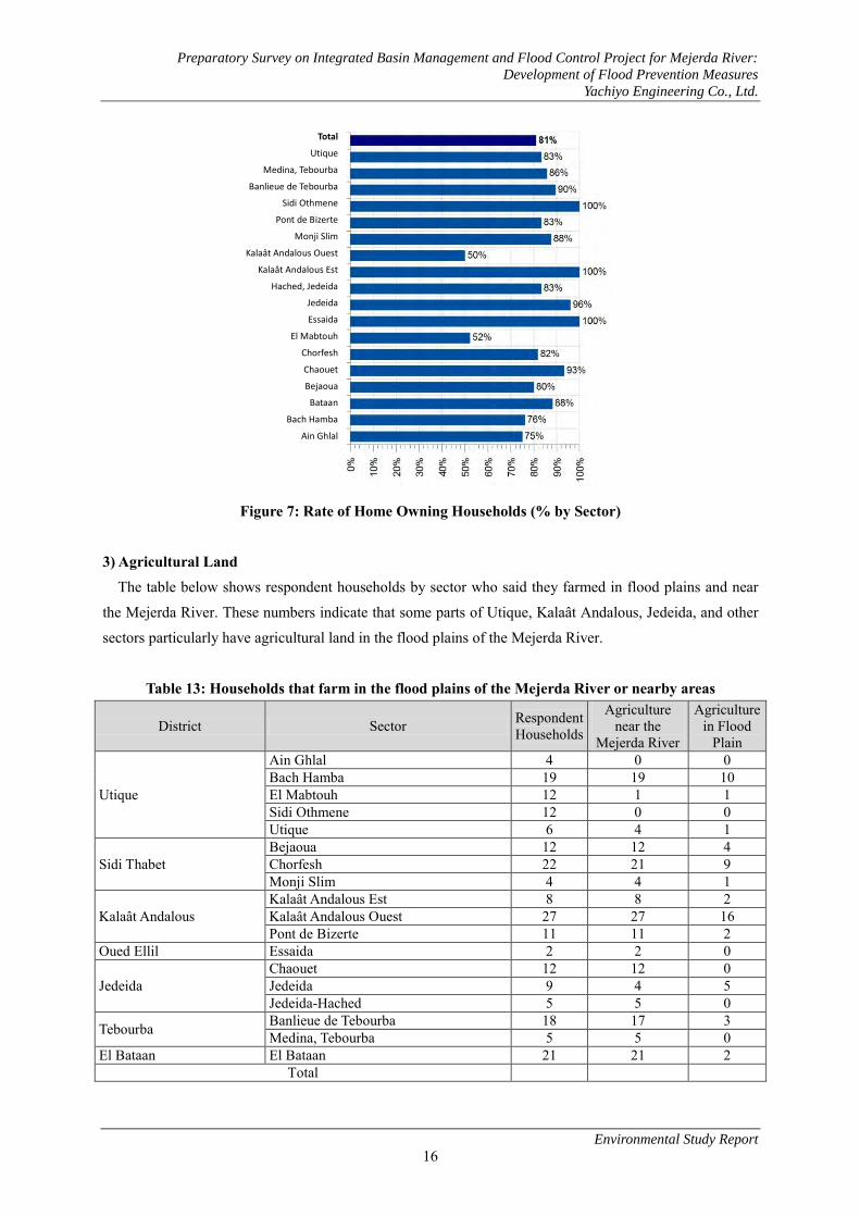
Preparatory Survey on Integrated Basin Management and Flood Control Project for Mejerda River:
Development of Flood Prevention Measures
Yachiyo Engineering Co., Ltd.
Environmental Study Report
16
Figure 7: Rate of Home Owning Households (% by Sector)
3) Agricultural Land
The table below shows respondent households by sector who said they farmed in flood plains and near
the Mejerda River. These numbers indicate that some parts of Utique, Kalaât Andalous, Jedeida, and other
sectors particularly have agricultural land in the flood plains of the Mejerda River.
Table 13: Households that farm in the flood plains of the Mejerda River or nearby areas
District Sector Respondent Households
Agriculture near the
Mejerda River
Agriculture in Flood
Plain
Utique
Ain Ghlal 4 0 0 Bach Hamba 19 19 10 El Mabtouh 12 1 1 Sidi Othmene 12 0 0 Utique 6 4 1
Sidi Thabet Bejaoua 12 12 4 Chorfesh 22 21 9 Monji Slim 4 4 1
Kalaât Andalous Kalaât Andalous Est 8 8 2 Kalaât Andalous Ouest 27 27 16 Pont de Bizerte 11 11 2
Oued Ellil Essaida 2 2 0
Jedeida Chaouet 12 12 0 Jedeida 9 4 5 Jedeida-Hached 5 5 0
Tebourba Banlieue de Tebourba 18 17 3 Medina, Tebourba 5 5 0
El Bataan El Bataan 21 21 2 Total
Total
Utique
Medina, Tebourba
Banlieue de Tebourba
Sidi Othmene
Pont de Bizerte
Monji Slim
Kalaât Andalous Ouest
Kalaât Andalous Est
Hached, Jedeida
Jedeida
Essaida
El Mabtouh
Chorfesh
Chaouet
Bejaoua
Bataan
Bach Hamba
Ain Ghlal

Preparatory Survey on Integrated Basin Management and Flood Control Project for Mejerda River:
Development of Flood Prevention Measures
Yachiyo Engineering Co., Ltd.
Environmental Study Report
17
4) Site Possession
a) Residential Area The distance between the river and residences is at least 10 to 20 meters for most sectors, but it was two
meters in the Jedeida sector. Of a total 25 households, 14 had homes within 60 meters of the river bed in
the Jedeida sector. The figures were 10 out of 23 households in the Jedeida-Hached sector, and 6 out of 15
households in Chaouet. Other sectors had a lower percentage than the aforementioned numbers. The table
below shows the distribution of residences located within 150 meters of the river bed.
Table 14: Distribution of Residences (No. of Households) Located within 150 meters of the River Bed
District Sector
Households with Residences within 150m of River Bed
(Classified by distance)
Total Households
who replied < 10 10-19 20-59 60-149
Utique
Ain Ghlal - - - - 3 Bach Hamba - 1 2 1 21 El Mabtouh - - - - 18 Sidi Othmene - - - - 12 Utique - - - - 5
Sidi Thabet Bejaoua - - 1 4 20 Chorfesh - 3 - 4 22 Monji Slim - - 1 3 8
Kalaât Andalous Kalaât Andalous Est - - 2 - 8 Kalaât Andalous Ouest - 1 4 4 27 Pont de Bizerte - - 1 2 11
Oued Ellil Essaida - - - - 4
Jedeida Chaouet - - 6 6 15 Jedeida 2 1 11 5 25 Jedeida-Hached - - 8 9 23
Tebourba Banlieue de Tebourba - - 1 2 18 Medina, Tebourba - - 1 - 14
El Bataan El Bataan - - 4 6 33 Total 2 6 42 46 287
(-): No applicable households
b) Grazing Regions Approximately 75% of households that answered questions about stock farming said they use grazing
regions near the Mejerda River while the remaining 25% replied they used the El Mabtouh Wetland or
other places.
The Mejerda River is the major grazing region for all sectors besides El Mabtouh, Sidi Othmene, and
Ain Ghlal. The El Mabtouh Wetland is the major grazing region for surveyed households in both the El
Mabtouh and Sidi Othmene sectors and is used as a secondary grazing region for households in Ain Ghlal
and Utique.

Preparatory Survey on Integrated Basin Management and Flood Control Project for Mejerda River:
Development of Flood Prevention Measures
Yachiyo Engineering Co., Ltd.
Environmental Study Report
18
c) State Owned El Mabtouh Wetland Grazing Region The state-owned El Mabtouh Wetland grazing region has an area of 3,365 hectares. Management of grazing
regions was officially transferred from the Department of Livestock to the Directorate General of Forests
(DGF) due to the change in administration on March 4, 2004. However, the DGF did not actually start
managing grazing regions until 2008. The DGF enforced the grazing region management project from 2009
to 2010, but did not enforce it from 2010 to 2011 because of the unstable state of affairs in Tunisia due to
the Jasmine Revolution. The Office of Livestock and Pastures (OEP) currently manages them.
The figure below shows the official map of the state owned El Mabtouh Wetland grazing region. They are
currently addressing the issue of unlawful occupation in the southern and northeastern regions and are in
the final stages of deciding the grazing region.
From 2009 to 2010, 54 nomadic pastoralist shepherds moved a flock of sheep and used this grazing
region. The grazing region is also used by 152 shepherds who are permanently settled nearby (see picture
below). The number of corresponding sheep for nomadic pastoralists was 15,880 sheep, and the permanent
settlers had a flock of approximately 10,000 sheep. The grazing season is from February to April. Other
government land besides grazing regions fall under forest precincts1 managed by the Department of
Forestry. Most of the nomadic pastoralists in the forest precincts of El Mabtouh are originally from the Sidi
Bouzid and Kairouan Governorates. Grazing fees for forest precincts cost 0.2 TND per livestock per month.
However, grazing fees for forest precincts have never been paid by the people who used the grazing region.
Mobile pastoralism has always been conducted in the El Mabtouh Wetland. In the 1980s, it was
conducted in wetlands without feed production and grazing issues, and the El Mabtouh Wetland became an
important grazing region for nomadic pastoralists in Tunisia. The stagnation of water from floods in either
January or February never lasted more than one month a year because the sewerage system was well
managed at the time.
However, feed production has been decreasing every year mainly because the operations of the
agricultural cooperative have gotten worse, causing perpetual overgrazing, and leading to the decrease of
sheep's fescue, a plant used as feed. According to the Office of Livestock and Pastures (OEP), another
reason for the deterioration of grazing is due to the construction of the Tunis−Bizerte motorway.
Embankment in the motorway construction blocked flood water from draining, causing water to stagnate in
wetlands over a long period of time during the rainy season. Saline buildup on the road also negatively
influences the growth of feed.
According to the Office of Livestock and Pastures (OEP), the condition of the grazing land in El
Mabtouh Wetland is extremely bad and cannot even be considered a grazing region. The forest precincts
are in a similar situation, and the outlook for feed production at the current stage is not good.
1Forest management structure for each CRDA

Pre
pa
rato
ry S
urv
ey o
n I
nte
gra
ted
Ba
sin
Ma
na
gem
ent
an
d F
loo
d C
on
tro
l P
roje
ct f
or
Mej
erd
a R
iver
: D
evel
op
men
t o
f F
loo
d P
reve
nti
on
Mea
sure
s
Ya
chiy
o E
ng
inee
rin
g C
o.,
Ltd
.
En
viro
nm
enta
l S
tud
y R
epo
rt
19
Fi
gure
8: A
rea
Map
/Off
icia
l Map
of S
tate
Ow
ned
El M
abto
uh W
etla
nd G
razi
ng R
egio
n as
pro
pose
d by
the
DG
F to
the
Min
istr
y of
Sta
te P
rope
rtie
s (F
inal
Dra
ft)
Sour
ce: B
izer
te F
ores
t Pre
cinc
t

Preparatory Survey on Integrated Basin Management and Flood Control Project for Mejerda River:
Development of Flood Prevention Measures
Yachiyo Engineering Co., Ltd.
Environmental Study Report
20
Figure 9: Grazing Conditions of State-Owned El Mabtouh Wetland (November 2010)
(3) Flood Damage
Of the 292 households that answered questions about the location of residences relative to the Mejerda
River, 206 households, or approximately 70%, said they lived in areas where flooding may occur.
Approximately 66% of respondents experienced the 1973 flood, and 98% said they experienced the floods
in 2003, 2004, and 2009.
The majority of respondents (approx. 86%) said that the 2003 flood caused the most damage. When
residents talk about floods, they always compare damage to the 2003 flood. Responses regarding the 2003
flood are as follows:
1) Submerged houses due to the 2003 flood
The percentage of submerged houses in each district: Jedeida (89%), El Bataan (88%), Tebourba
(76%), Oued Ellil (75%).
2) Submerged depth and time due to the 2003 flood
The submerged depth was the highest in each sector of Banlieue de Tebourba, Utique, Jedeida, El
Bataan, Chaouet at the peak of the flood, and the average flood time was longest in the Utique,
Jedeida, Chaouet Sectors.
Table 15: Submersion and Duration of 2003 Flood Sector Name Peak Submersion Depth of
Flood Flood Duration Submerged Houses
Medina, Tebourba 76% Banlieue de Tebourba 142cm 76% Utique 130 cm 48hr Jedeida 105 cm 43 hr 89% El Bataan 97 cm 88% Chaouet 92 cm 34 hr Oued Ellil 75%
According to the table below, the Bach Hamba, El Mabtouh, Bejaoua, Chorfesh, Kalaât Andalous Ouest,
Jedeida, Jedeida-Hached, Tebourba, and El Bataan Sectors had many flooded regions.
The average amount in damages of surveyed households exceeded 10,000 TND/household. The average
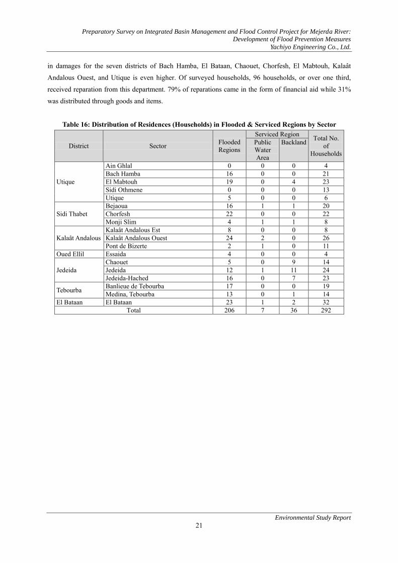
Preparatory Survey on Integrated Basin Management and Flood Control Project for Mejerda River:
Development of Flood Prevention Measures
Yachiyo Engineering Co., Ltd.
Environmental Study Report
21
in damages for the seven districts of Bach Hamba, El Bataan, Chaouet, Chorfesh, El Mabtouh, Kalaât
Andalous Ouest, and Utique is even higher. Of surveyed households, 96 households, or over one third,
received reparation from this department. 79% of reparations came in the form of financial aid while 31%
was distributed through goods and items.
Table 16: Distribution of Residences (Households) in Flooded & Serviced Regions by Sector
District Sector Flooded Regions
Serviced Region Total No. of
Households
Public Water Area
Backland
Utique
Ain Ghlal 0 0 0 4 Bach Hamba 16 0 0 21 El Mabtouh 19 0 4 23 Sidi Othmene 0 0 0 13 Utique 5 0 0 6
Sidi Thabet Bejaoua 16 1 1 20 Chorfesh 22 0 0 22 Monji Slim 4 1 1 8
Kalaât Andalous Kalaât Andalous Est 8 0 0 8 Kalaât Andalous Ouest 24 2 0 26 Pont de Bizerte 2 1 0 11
Oued Ellil Essaida 4 0 0 4
Jedeida Chaouet 5 0 9 14 Jedeida 12 1 11 24 Jedeida-Hached 16 0 7 23
Tebourba Banlieue de Tebourba 17 0 0 19 Medina, Tebourba 13 0 1 14
El Bataan El Bataan 23 1 2 32 Total 206 7 36 292

Preparatory Survey on Integrated Basin Management and Flood Control Project for Mejerda River:
Development of Flood Prevention Measures
Yachiyo Engineering Co., Ltd.
Environmental Study Report
22
Table 17: Estimate in Damages and No. of Households that Received Aid from 2003 Flood
District Sector Damage Estimate (TND/Household) Households that
Received Aid Min Max Avg
Utique
Ain Ghlal 500 1,500 1,000 0 Bach Hamba 400 150,000 25,386 2 El Mabtouh 800 210,000 17,000 11 Sidi Othmene 1,200 12,500 3746 0 Utique 2,000 60,000 14,500 3
Sidi Thabet Bejaoua 1,000 80,000 8,700 1 Chorfesh 500 80,000 11,068 0 Monji Slim 500 500 83 0
Kalaât Andalous Kalaât Andalous Est 4,000 10,000 7,214 1 Kalaât Andalous Ouest 1,000 60,000 10,844 1 Pont de Bizerte 2,000 20,000 4,250 0
Oued Ellil Essaida 1,000 10,000 3,667 1
Jedeida Chaouet 200 100,000 13,938 7 Jedeida 2, 000 40,000 7, 563 13 Jedeida-Hached 1,500 22,000 5,652 19
Tebourba Banlieue de Tebourba 800 20,000 8,000 14 Medina, Tebourba 1,000 35,000 4,536 6
El Bataan El Bataan 1,000 150,000 12,015 17 Minimum Damage Estimate 200 Households
that received aid: 96 total
Maximum Damage Estimate 210,000 Average Damage Estimate 10,014
Figure 10: Distribution of Aid for Households that Suffered Damages in 2003 Flood
Households that received money as aid
Households that received actual stuff as aid

Preparatory Survey on Integrated Basin Management and Flood Control Project for Mejerda River:
Development of Flood Prevention Measures
Yachiyo Engineering Co., Ltd.
Environmental Study Report
23
3.2 Environment Conditions 3.2.1 Preservation restrict etc. (1) Overview As Preservation restricts, Tunisia has a subscribed convention and lists of preservation restricts or the
similar level of zone as follows,
Ramsar Convention
List of the Environmentally Sensitive Areas in the Management Plan of Environmentally Sensitive
Areas in Tunisia (Ministry of Environment)
Wildlife protection area
List of 46 Important Bird Areas (ZICO)
Though Mejerda river’s downstream has been registered as a humid zone in the Ramsar Convention, the
river has not been targeted as a preservation restrict or environmental restriction area.
(2) Humid Zone 1) Overview
According to the Preparatory Study of Tunisia's Wetlands (conducted in 1996 by the University of
London for the DGF), there are 5wetland in the Mejerda River periphery as shown in the table below.
① Oued El Hmada (current course of the Mejerda)
② Oued Mejerda (former outflow of the Jedeida into the sea)
③ Garaet Bou Ammar (between the Oued Mejerda and the Garaet El Andalous)
④ Garaet Kalaat El Andalous (coastal zone south of the former course of the Mejerda)
⑤ Garaet El Mabtouh
These wetlands are difficult to differentiate. They form 2 large groups, the Garaet El Mabtouh, and the
Ghar El Melh lagoon-Mejerda delta, which the Garaet Kalaat El Andalous forms part of. The El Mabtouh
village locates in the center of the El Mabtouh wetland.

Preparatory Survey on Integrated Basin Management and Flood Control Project for Mejerda River:
Development of Flood Prevention Measures
Yachiyo Engineering Co., Ltd.
Environmental Study Report
24
Figure 11: Location of Wetlands near the Mejerda River
Source: APAL (Coastal Protection and Planning Agency)―Coastal Observatory
2)Ghar El Melh Lagoon and the Mejerda River Delta The Ghar El Melh Lagoon and Mejerda River Delta have the following characteristics:
① One section of the same region is registered under the wetland list of the Ramsar Convention.
② The same region is listed as an Environmentally Sensitive Areas in the Management Plan of
Environmentally Sensitive Areas in Tunisia (Ministry of Environment).
③ Kalaât Andalous Wetland (Ariana Governorate) and the river basin between Ghar El Melh Lake -
El Mabtouh Wetland was registered as a wildlife protection area in 2010-2011.
The registered areas of the Ghar El Melh Lagoon and Mejerda River delta under the Ramsar
Convention are shown in the figure below. The registered area of the lower basin of the Mejerda River is
3.2 kilometers towards the ocean from the delta bridge furthest to the east from the target area in this
project.
Lagoon
Wet Land

Preparatory Survey on Integrated Basin Management and Flood Control Project for Mejerda River:
Development of Flood Prevention Measures
Yachiyo Engineering Co., Ltd.
Environmental Study Report
25
The Ghar El Melh Lagoon and the Mejerda River delta district has an area of 10,373 hectares, with 7,057
hectares in the Bizerte Governorate and 3,316 hectares in the Ariana Governorate. The following factors
are the standards for designating a wetland under the Ramsar Convention:
① The body is a typical delta of the southern Mediterranean Sea and wetland. (Standard 1)
② There is great number of fishes in the final stage of the life cycle (13 of 45 inhabitant species permanently settled in the lagoon), and is a habitat for wildfowls (Standard 4)
③ In the nest building season, the population of collared pratincole crosses the 1% mark. (Standard 6)
④ During the winter season, it becomes a source of food for migratory fish. (Standard 8) The southern part of the wetland registered under the Ramsar Convention is made of up flood plains and
a saline lake, and plant life include halophilous plants such as plant species glasswort and Parish's
glasswort (Arthrocnemum). The same region becomes a wetland in the winter. The fields of halophilous
plants become the nesting grounds for collared pratincoles. However, this region is not included as an
Important Bird Area (ZICO).
This region is designated under the Ramsar Convention and as an Environmental Sensitive Area in the
Management Plan of Environmental Sensitive Areas in Tunisia.

Preparatory Survey on Integrated Basin Management and Flood Control Project for Mejerda River:
Development of Flood Prevention Measures
Yachiyo Engineering Co., Ltd.
Environmental Study Report
26
Source: DGF
Figure 12: Registered Area of the Ghar El Melh Lagoon & Mejerda River Delta under the Ramsar
Convention
Old Channel

Preparatory Survey on Integrated Basin Management and Flood Control Project for Mejerda River:
Development of Flood Prevention Measures
Yachiyo Engineering Co., Ltd.
Environmental Study Report
27
(Source: Partially revised from DGF data)
Figure 13: Lower Basin of the Mejerda River registered in the Ramsar Convention
Figure 14: Project Implementation Area
Registered Areas in the Ramsar Convention: El Mabtouh Wetland & Lower Basin of Mejerda River
3) El Mabtouh Wetland El Mabtouh Wetland is included in Tunisia's list of 46 Important Bird Areas (ZICO) (Code No. TN005).
This wetland is where frail wildfowl species like the collared pratincole (Glareola pratincola) and shoveler
(Anas clypeata) gather together periodically, and this designated colony corresponds to an Important Bird
Area under the A4i standard. The A4i standard says that if the waterfowl population form a colony of at
least 1% in the same season or if 5% of the population inhabits a region for an entire season, it is an IBA.
メジェルダ川下流域
のラムサール条約
登録範囲メジェルダ川
デルタ橋
h
凡例
ラムサール条約登録範囲
湿地
(DGF資料に加筆)
4km 0 2
El Mabtouh Wetland
Laroussia Dam
Delta Bridge
Project area along the Mejerda River
The river will be dug out and widened here
10km 0
Ramsar Convention registered area at
lower Basin of the Mejerda River
Ramsar Convention registered area
Wetland (amended to DGF material)
Delta Bridge
Mejerda River

Preparatory Survey on Integrated Basin Management and Flood Control Project for Mejerda River:
Development of Flood Prevention Measures
Yachiyo Engineering Co., Ltd.
Environmental Study Report
28
Other wildfowls hibernate in the El Mabtouh Wetland during rainy winters. We can see that the wildfowl
population in this wetland resembles the population at Ichkeul Lake located north. The El Mabtouh
Wetland also became a wildlife protection area in the 2010-2011 season due to a government ordinance
regarding hunting.
Source: Bizerte Forest Precinct
Figure 15: Boundary Map of El Mabtouh Wetland
Figure 16: Scenery of the North Side of the El Mabtouh Wetland (left: May 2011, right: November
2010)
Town
Road
Ramsar Conv. Wetland
Forest
Yew Plum Pines
Coastal Sand Dunes
Agricultural Land
River Bed & Wetland
Urban Area

Preparatory Survey on Integrated Basin Management and Flood Control Project for Mejerda River:
Development of Flood Prevention Measures
Yachiyo Engineering Co., Ltd.
Environmental Study Report
29
3.2.2 Animals 1) Wildfowls
The table below organizes the biological significance of the wetlands in the target region, especially
wildfowls in the Mejerda River delta and the El Mabtouh Wetland based on the Washington Convention,
IBA, IUCN Red List, ordinances about hunting, and ordinances that list endangered and rare species. 11 of
the 18 species shown in the table are AAO ("Friends of Birds", NGO), and the remaining seven species are
designated by the Bizerte Forest Precinct.
Table 18: Wildfowls that Inhabit Assessed Regions and Biological Significance
Scientific Name Common Name
(1)CITES (Washingt
on Conventio
n)
(2) IBA
(Important Bird Area)
(3) IUCN
Tunisia (4)
Hunting Ordinance
s
(5) Endangered
Wildlife Ordinance
Glareola pratincola Collared Pratincole ○ ● ○ ● ● Himantopus himantopus Black-winged Stilt ○ ○ ○ ● ○ Pluvialis apricaria European Golden Plover ○ ○ ○ ● ○ Vanellus vanellus Northern Lapwing ○ ○ ○ ○ ○ Anas clypeata Shoveler ○ ● ○ ○ ○ Anas Penelope Eurasian Wigeon ○ ○ ○ ○ ○ Anas crecca Eurasian Teal ○ ○ ○ ○ ○ Ardea cinerea Grey Heron ○ ○ ○ ● ○ Grus grus Eurasian Crane ● ○ ○ ● ● Circus aeruginosus Western Marsh-harrier ○ ○ ○ ● ○ Fulica atra Eurasian Coot ○ ○ ○ ○ ○ Pluvialis squatarola Grey Plover ○ ○ ○ ● ○ Ciconia ciconia White Stork ○ ○ ○ ● ● Bubulcus ibis Cattle Egret ○ ○ ○ ● ○ Ardea alba Great Egret ○ ○ ○ ● ○ Egretta garzetta Little Egret ○ ○ ○ ● ● Burhinus oedicnemus Stone Curlew ○ ○ ○ ● ○ Calidris alpina Dunlin ○ ○ ○ ● ●
●Applies to the wildfowl species/○Does not apply to wildfowl species (1) CITES (Washington Convention) Annex II (2) According to the A4i standard for IBA (Important Bird Area), pp. 953-973 "Important Bird Areas in Africa and
Associated Islands: Priority sites for conservation", L.D.C. Fishpool and M.I.Evans eds., written by Murad AmariHichem Azafzaf, Tunisia 2001. Newbury & Cambridge, UK: Pisces Publications & BirdLife International―BirdLife Conservation Series No. 11
(3) IUCN Red List, Endangered Species standard (4) August 14, 2010 Regulation regarding hunting in the 2010-2011 season (5) Ordinance List that designates endangered and rare fauna and flora (TBA)
2) Fish Species
The table below shows the native species that have biological significance based on the Washington
Convention, Barcelona Convention, IUCN, and ordinance that designates endangered and rare fauna and
flora.
Fairly old biological data for fish species in the lower basin of the delta is the only data that exists for
fish species in the Mejerda River. Principal information came from interviews with the INAT (National

Preparatory Survey on Integrated Basin Management and Flood Control Project for Mejerda River:
Development of Flood Prevention Measures
Yachiyo Engineering Co., Ltd.
Environmental Study Report
30
Institute of Agronomy of Tunisia), INSTM (National Institute of Sciences and Technologies of the Sea),
and DGPA (Directorate General for Agricultural Production).
The most endangered fish species in the Mejerda River is the European eel (Anguilla anguilla). The
Mejerda River is an important habitat for the life cycle of the European eel. This eel is also covered by
Annex II of the Washington Convention as an endangered fish species. It is also classified as a critically
endangered species in the IUCN classification system (Category CR). The DGPA set a goal in 2010 to
promote the export of eels to Europe, and established and internal document labeled the Tunisian Eel
Management Plan in November 2010. The European Commission has not approved of import from Tunisia
since 2011. The seasonal migration of Japanese eel from the sea to the river upstream generally occurs
between October to January.
The Aphanius fasciatus (Mediterranean killifish) has no value as a commercial product, but its habitat is
a protected area in the Mediterranean in the Barcelona Convention and a protected area in the protocol
(Annex II) regarding biological diversity. It is an important fish species for the biodiversity of the Mejerda
River.
Pseudophoxinus fish of the Cyprinidae family and barbels are endemic species to the northeastern part of
Maglev region and northern African region. Pseudophoxinus callensis is thought to be an endemic species
that inhabits the small tributary upstream in the Mejerda River.
Other fish species introduced to the Mejerda River because of their commercial value are carp, roach,
minnow, yellowfish, percidae, and catfish. These fish species can mostly be found in the reservoir located
upstream. The mosquitofish (Gambusia affinis holbrookii) was introduced to exterminate wigglers, and has
acclimated to Tunisian rivers.
In addition, the digging and expansion of the Mejerda River in this project will only be done to flood
plains and will not be implemented for low water channels (riverbed). As such, the impact on the European
eel and other fish species is considered low.
Table 19: Introduced Fish Species in the Mejerda River and Biological Significance
Scientific Name Common Name (1)
Washington Convention
(2) Barcelona
Convention
(3) IUCN
(4) Endangered
Wildlife Ordinance
Anguilla anguilla European eel ● ○ ● ○ Aphanius fasciatus Mediterranean killifish ○ ● ○ ○ Barbus barbus callensis Barbel ○ ○ ○ ○ Pseudophoxinus callensis Phoxinelle De la Calle ○ ○ ○ ○ Pseudophoxinus chaignoni Phoxinelle de Chaignon ○ ○ ○ ○
●Applies to fish species/○Does not apply to fish species (1) CITES (Washington Convention) Annex II (2) Barcelona Convention/Protocol (3) IUCN Red List, Threatened Species Standard (4) Ordinance List of Endangered and Rare Fauna & Flora
3) Mammals The only confirmed mammal is the wild boar, but it does not fall under any protection measures. The

Preparatory Survey on Integrated Basin Management and Flood Control Project for Mejerda River:
Development of Flood Prevention Measures
Yachiyo Engineering Co., Ltd.
Environmental Study Report
31
Mejerda River is not considered a good hunting spot by hunters, but boars are hunted on some occasions by
the authorities to prevent damage to crops.
The scientific observation of otters in the lower basin of the Mejerda River goes back to 1983 (survey site
of McDonald and Masson). According to the DGF (Directorate General of Forests), these animal species do
not inhabit the region. According to the Preparatory Study of Tunisia's Wetlands (conducted in 1996 by the
University of London for the DGF), plants that grow at the waterfront of the Mejerda River are provide
refuge for the otters (Lutra lutra linnaeus). At the time, plants that grew at the waterfront composed mainly
of nerium (Nerium oleander), willow (Salix sp.), cattail (Thypha sp.) and reed (Phragmites communis).
4) Other Animal Species Amphibians, mollusks, and invertebrates were not covered in the study. However, mussels must be
covered in the EIA according to the INSTM.
5) Plant Species In the flood plain of the Mejerda River, there is a dense population of tamarisk, also known as farash
(Tamarix articulata; see figure below), which is a natural species to central Tunisia, thought to be
introduced as a result of tree-planting to affix the riverbank. The tamarisk is a shrub to medium-tall tree
with a height of two to 10 meters. Along the Mejerda River, they branch magnificently to become
medium-height trees. The tamarisk germinates from its seeds, roots, and branches, allowing it to multiply
quickly.
According to Article 3 in the Forest Act, a forest is defined as naturally or artificially grown plants
constituted of one or more tree or shrub species or a uniform/mixed woodland. The trees along the Mejerda
River are legally a forest according to this definition. This forest is not a national forest, but is a public
water territory. However, the rights to the lumbering of tamarisks and the transport or use of any produce
from cultivating new land belong to the DGF as they fall under forest products according to the Forest Act.
Figure 17: Tamarisks (Farash) in the flood plains of the Mejerda River

Preparatory Survey on Integrated Basin Management and Flood Control Project for Mejerda River:
Development of Flood Prevention Measures
Yachiyo Engineering Co., Ltd.
Environmental Study Report
32
3.2.3 Environmental pollution 1) Sand Production
ONAS (national sanitation utility of Tunisia) and ANGED (National Waste Management Agency) do not
have any information about pollution from hazardous materials like industrial waste deposited in the lower
Mejerda River and therefore do not recognize a specified pollutant source along the river. Excavated sand
and soil is used on agricultural land, orchards, and grazing lands along the river or other places with similar
characteristics. Therefore, we believe that the potential of pollution from toxic substances is low.
The INSTM is engaged in research on ocean sediment pollution from old metal ore deposits with a focus
on researching suspended solids in the Mejerda River and the existence of heavy metals carried to the
riverbank by the Mejerda River. Pollutants covered in the study include lead, zinc, arsenic, and cadmium.
According to the results of this study, the coastal zones near the delta show a higher concentration of lead
and zinc than other parts of the Mediterranean. This project will not involve or repair any bridges further
downstream than Kalaât Andalous, so the possibility of working in dense metal zones is low.
2) Illegal Solid Waste Grounds The state of illegal solid waste is as follows.
a) Illegal dumping of industrial solid waste and municipal solid waste into the river or waterways
ANGED says there has never been a problem with illegal dumping along the Mejerda River in the past
nor the present. However, the possibility of the illegal dumping of industrial solid waste and municipal
solid waste exists for the river and waterways in the region of this Project. Therefore, appropriate measures
need to be taken if illegal solid waste dumping is discovered while the project constructs a cross-section of
the river channel and works on embankment.
b) Disposal of animal skins in the El Mabtouh Wetland
Animal skins are being illegally disposed in the El Mabtouh Wetland. According to an interview with the
AGED, that solid waste is brought in from the industrial area of Utique. This solid waste must be properly
disposed of as hazardous waste in the construction process according to Category 0602 in the list of
hazardous waste in Decree No. 2000-2339 enacted on October 10, 2000. The location of illegal dumping as
captured in 2011 is shown in the figure below.
After confirming waste disposal before construction, hazardous waste will be brought to disposal sites as
necessary when discovered on constructions grounds.

Preparatory Survey on Integrated Basin Management and Flood Control Project for Mejerda River:
Development of Flood Prevention Measures
Yachiyo Engineering Co., Ltd.
Environmental Study Report
33
Figure 18: Illegal Industrial Waste Dumping Grounds in the El Mabtouh Wetland within the Project
Site
c) Other
Unauthorized dumping of other waste such as personal waste is also a problem along the roads, river,
and water channels. However, the amount of waste disposed is small.
Chapter 4. Legislative system and related organizations surrounding
environmental social considerations in Tunisia 4.1 Legislative system and international treaties surrounding environmental social
considerations in Tunisia 4.1.1 Legislative system (1) Legislative system
Laws and regulations related to the environment in Tunisia are as follows: 1) Environmental Impact Assessment (EIA) Decree: Decree No. 2005-1991 (July 11, 2005, see table
below) establishes the targets for EIAs and specification documents 2) Forest Act and enforcement law 3) National Land Maintenance/City Planning Law and enforcement law
Of these, the categories of facilities and projects that must be assessed for environmental impact or have
specifications submitted will be stipulated by the EIA Decree. Guidelines for conducting the EIA will also
be created by the National Environmental Protection Agency (ANPE). The EIA survey will be conducted
based on these guidelines while consulting with the ANPE.
The EIA procedure in Tunisia will ultimately depend on ANPE approval of projects. The ANPE may
approve the EIA report assuming the relevant project is implemented by the implementing agency
(DGBGTH for the Project).
After consulting with ANPE regarding project implementation, we have confirmed that an EIA must be
performed and a report written based on Tunisia environmental law due to the reasons stated below.
El Mabtouh Wetland
Illegal Dumping
Grounds

Preparatory Survey on Integrated Basin Management and Flood Control Project for Mejerda River:
Development of Flood Prevention Measures
Yachiyo Engineering Co., Ltd.
Environmental Study Report
34
Approval for project implementation will be based on the EIA report.
1) New construction or repair of bridges that accompany the widening of rivers and drainage
waterways is a relevant project that falls under Category B according to the 2005 government
ordinance.
2) A section near the mouth of the Mejerda River is registered under the Ramsar Convention, and
environmental consideration is required although it does not fall under the scope of project
implementation.
(2) Details of EIA Decree The details of EIA Decree No. 2005-1991 are shown in the table below. The Terms of Reference (TOR)
by Sector created by the ANPE stated in Article 6 was drafted before the 2005 government ordinance was
promulgated, and does not include the environmental management plan. Therefore, the ANPE is currently
drafting a TOR that includes the environmental management plan.
Table 20: EIA Decree No. 2005-1991 Categories in the EIA regulated by Decree No. 2005-1991 established on July 11, 2005 for facilities and
projects that must undergo assessment or submit specification documents Article 1: The following terms used in this decree will be defined as follows: 1. Facilities and Projects: Refers to various facilities and industrial, agricultural, commercial, or other businesses whose activities pollute or degrade the environment. 2. Environmental Impact Assessment (EIA): A survey to examine, evaluate, and measure the effects that facilities and projects have on the environment in a direct or indirect manner over a short, medium or long term. Facilities and projects must submit a report to the ANPE and attain a decision by the ANPE before acquiring various licenses to operate. 3. Terms of Reference (TOR) by Sector: General TORs (TOR for EIA?) affected by the sectors in Annex 1 of this decree will be created by the ANPE in the preparation phase of an EIA to consider the client or demandant. Article 2: An EIA must be performed for facilities and projects listed in Annex 1 of this decree. EIA must be performed by a consultant or field specialist. Article 3: Facilities and projects listed in Annex 2 of this decree must submit specification documents to acquire approval from the ministry (ministerial ordinance) that governs the environment. Ministries (ministerial ordinances) establish environmental measures that clients and demandants must comply to. Article 4: Facilities and projects that are subject to an EIA or submit specification documents must conform to the aptitude and improvement project of settlement areas or environmental protection standards. Article 5: A license to operate will not be issued to the concerned authorities until a legally authorized specification document has been received for facilities and projects that must undergo an EIA. This document must confirm that the ANPE has no objections to implementation or must be signed by the minister of the ministry that governs the environment. Clients or demandants cannot use a license that does not conform to these regulations. The operation license for each facility and project that must undergo an EIA and submit specifications must include all compliance and implementation measures shown on the EIA and specification document. Article 6: Details of the EIA must reflect foreseeable incidents of facilities and projects toward the environment, and include the following items at the bare minimum: 1. A detailed description of facilities and projects. 2. An analysis of the initial condition of the site or an environmental analysis of site especially for facilities
and projects that may impact sites during implementation and sites with natural resources. 3. An analysis of the foreseeable direct and indirect impact of facilities and projects on districts whose
environments are protected by law, especially areas protected for their natural resources, fauna, flora, forests, nature, history, landscape, vulnerable regions, protected species, national parks, and urban parks.
4. Measures and an estimate of required costs that clients or demandants are considering for facilities and

Preparatory Survey on Integrated Basin Management and Flood Control Project for Mejerda River:
Development of Flood Prevention Measures
Yachiyo Engineering Co., Ltd.
Environmental Study Report
35
projects to remove or reduce damage to the environment, as well as compensation if possible. 5. A detailed Environmental Management Plan of facilities and projects. The necessary components will be stipulated in the TOR by Sector drafted by the ANPE. Article 7: The client or demandant must draft an EIA report of their facility and project based on the TOR by Sector mentioned in the last section in Article 6 of this decree. Costs for carrying out the EIA will be borne by the client or demandant. Article 8: The client or demandant must submit three signed copies of the EIA report, one copy of the legally authorized specification document to the ANPE, and one copy of the report and specification document to the relevant ministries to obtain a license. Article 9: The ANPE will decide on a petition of objection regarding the implementation of facilities and projects within 21 working days of receiving the EIA report of facilities and projects listed under Category A in Annex 1 of this decree, and three working months after receiving the EIA report of facilities and projects listed under Category B in Annex 1 of this decree. If a petition of objection is not made by the ANPE within these periods, it will be considered as an implicit approval of implementation. If facilities and projects under Category A in Annex 1 of this decree may impact districts whose environments are protected by law, especially forests, natural, historical, landscape, or vulnerable regions, protected species, national parks, or urban parks, the 21 working day period will be extended to three working months. Article 10: If facilities and projects may impact districts whose environments are protected by law, especially forests, natural, historical, landscape, or vulnerable regions, protected species, national parks, urban parks, fauna, or flora, they must request the opinion about the implementation of facilities and projects from the ANPE for relevant districts or the supervisor for protected species. The opinion from districts or supervisors of these species must be reported to the ANPE within 15 days of receiving such notification. If a statement is not received from the supervisor within this period (15 days), it will be considered as an implicit approval of implementation. Article 11: Concerned authorities or government offices will revoke licenses if the measures stated on the EIA report and specification document are not followed. Article 12: The articles and items in this decree apply to new facilities, industrial, agricultural, and commercial projects, expansions, modifications to facilities, or changes to production methods for existing facilities, industrial, agricultural, and commercial projects listed in Annex 1 and 2 of this decree. Article 13: The articles and items of EIA Decree No. 91-362 from March 13, 1991 are void. Article 14: The Minister of Environment and Sustainable Development, Minister of National Defense, Minister of Trade and Handicrafts, Minister of Regional and Local Development, Minister of Agriculture and Hydraulic Resources, Minister of State Property and Land Affairs, Ministry of Social Affairs, Solidarity and Tunisians Abroad, Ministry of Culture and Safeguard of Patrimony, Minister of Tourism, Minister of Health, and Minister of Industry, Energy, and Small Enterprises are responsible for enforcing this decree for their respective fields as published in the Official Journal of the Tunisian Republic (JORT). Established: July 11, 2005, Tunis
Annex 1: Facilities and projects that must undergo an EIA Category A: The ANPE will decide on a petition of objection regarding the implementation of facilities and projects within 21 working days of receiving an EIA report of facilities and projects. If a petition of objection is not made by the ANPE within this period, it will be considered as an implicit approval of implementation. 01) Facilities and projects involved in the management of household solid waste or food waste at a capacity
of 20 tons/day or less 02) Facilities and projects involved in the treatment and manufacture of construction material, porcelain,
and glass 03) Facilities and projects involved in the manufacture of pharmaceutical products 04) Facilities and projects involved in the manufacture of nonferrous metals 05) Facilities and projects involved in metalworking and surface treatment 06) Facilities and projects involved in the mining of oil and natural gas 07) Industrial quarries of aggregates or sand, clay pits, and marble quarries with a production output of
300,000 tons/year or less 08) Facilities and projects involved in the manufacture of sugar or baking powder 09) Facilities and projects involved in the coloring of fabrics, threads, and clothes as well as the production
and fading of jeans

Preparatory Survey on Integrated Basin Management and Flood Control Project for Mejerda River:
Development of Flood Prevention Measures
Yachiyo Engineering Co., Ltd.
Environmental Study Report
36
10) Renovation projects of agricultural districts with an area of five hectares or less 11) Urban housing plans with an area between five and 20 hectares 12) Renovation projects of tourist districts with an area between 10-30 hectares 13) Facilities and projects involved in the manufacture of mineral fiber 14) Facilities and projects involved in the production, processing, packaging, and preservation of food
products 15) Slaughterhouses 16) Facilities and projects involved in the production or assembly of automobiles, trucks, or motorbikes 17) Shipyard projects 18) Facilities and projects involved in the production, operation and maintenance of aircrafts 19) Facilities and projects involved in the aquaculture of shellfish for consumption 20) Facilities and projects involved in the desalination of industrial or tourist facilities 21) Facilities and projects involved in thalassotherapy and the use of mineral springs 22) Facilities and projects involved in lodgings with 300 beds or more 23) Facilities and projects involved in the production of paper and cardboard 24) Facilities and projects involved in manufacture of elastomer (synthetic rubber) or peroxide Category B: The ANPE will decide on a petition of objection regarding the implementation of facilities and projects within three working months of receiving an EIA report of facilities and projects. If a petition of objection is not made by the ANPE within this period, it will be considered as an implicit approval of implementation. 01) Facilities or projects involved in oil refining and facilities that liquefy or gasify at least 500 tons/day of
carbon or oil shale 02) Facilities and projects that generate electricity of at least 300 MW/day 03) Facilities and projects involved in the management of household solid waste or food waste at a capacity
of at least 20 tons/day 04) Facilities and projects involved in the management of dangerous solid waste 05) Facilities and projects involved in the production of cement, lime, or plaster 06) Facilities and projects involved in the manufacture of chemicals, pesticides, paint, wax, and bleaching
agents classified under Category 2 in the dangerous, unsanitary or hazardous building list 07) Facilities and projects involved in the iron industry 08) Industrial aggregate and sand quarries as well as mining projects of mineral resources that produce over
300,000 tons/year 09) Facilities and projects involved in the manufacture of paper pulp and cellulose 10) Construction projects of railways, motorways, expressways, bridges, and interchanges 11) Construction projects of airport runways that exceed 2,100 meters 12) Construction projects of commercial ports, fishing harbors, or leisure ports 13) Construction projects of industrial districts that exceed an area of five hectares 14) Urban housing plans that exceed an area of 20 hectares 15) Renovation projects of tourist districts that exceeds an area of 30 hectares 16) Transport facilities of crude oil or gas 17) Facilities and projects involved in urban sewage treatment 18) Industrial water treatment facilities and projects 19) Facilities and projects involved in the leather or white leather industry 20) Irrigation and cultivated land projects that use recycled wastewater for agriculture 21) Large dam projects 22) Aquaculture projects that are not included in Category A in Annex 1 23) Facilities and projects involved in desalination for supplying drinking water to urban areas 24) Resort projects that exceed 1,000 beds 25) Facilities and projects involved in the mining, treatment, and cleaning of minerals and non-minerals 26) Facilities and projects involved in the manufacture of phosphate ore and secondary products
Annex 2: Facilities and projects that must submit specification documentation 01) Urban housing plans that do not exceed an area of five hectares and renovation projects of tourist districts
that do not exceed an area of 10 hectares 02) Renovation projects of educational institutions 03) Aqueduct construction projects 04) Nature districts and vulnerable regions (areas protected by law) not included in Annex 1 that are not

Preparatory Survey on Integrated Basin Management and Flood Control Project for Mejerda River:
Development of Flood Prevention Measures
Yachiyo Engineering Co., Ltd.
Environmental Study Report
37
supplied with electricity 05) Renovation projects of coasts that are not included in Annex 1 06) Facilities and projects involved in olive pulverization (oil extraction plants) 07) Facilities and projects involved in the extraction of plant or animal oils 08) Facilities and projects classified as animal production operations 09) Facilities and projects involved in textile industry not included in Annex 1 10) Facilities and projects involved in the pressing and cutting of large metal pieces 11) Facilities and projects involved in the storage and logistics of hydrocarbons as well as gasoline stands
that wash automobiles and perform oil changes 12) Facilities and projects involved in the manufacture of starch 13) Conventional quarries 14) Facilities and projects involved in the storage of gas and chemicals 15) Manufacturing of metal containers, construction of water storage facilities, and manufacturing of steel
sheets 16) Washing areas that use water to wash clothes and blankets 17) Hill dams 18) Facilities and projects involved in the manufacture of medical support products
4.1.2 Approaches on Environmental Considerations Surrounding the Forest Act and National Land Maintenance/City Planning Law
An overview of the approach for environmental considerations surrounding the Forest Act and National
Land Maintenance/City Planning Law is shown in the table below:
Table 21: Overview of approach for environmental considerations surrounding the Forest Act and
National Land Maintenance/City Planning Law
4.2 Environmental Social Consideration Procedure and Flow The procedure and flow from the start of the EIA process to the approval of this project, which has been
confirmed by the ANPE, is shown as follows.
Law Environmental Consideration Conditions 1. Forest Act Division III Chapter 1: Nature Conservation/Article 208
If a project may potentially impact the environment due to its scale or the effect it has on nature, the project is subject to a preliminary EIA.
2. Forest Act Division III Chapter 2: Conservation of Wild Fauna and Flora /Article 209
Activities that may potentially harm wild fauna and flora that are endangered and rare are prohibited. A list of wild fauna and flora that are endangered and rare is established by a ministerial ordinance.
3. Forest Act Division III Chapter 4: Wetland Conservation/Article 225
Protects wild fauna and flora in wetlands.
4. National Land Maintenance/City Planning Law Article 11
If equipment, facilities, or established structures may potentially harm the environment due to their scale and impact, the plan or project is subject to a preliminary EIA.
5. February 22, 1989 Mines and Quarries Regulation Act No. 89-20
Small scale quarries (less than 70,000 tons/year or for clay, less than 5,000 tons/year) must provide an environmental impact summary. Industrial quarries (whose quarrying exceed small scale quarries) are subject to an EIA.

Preparatory Survey on Integrated Basin Management and Flood Control Project for Mejerda River:
Development of Flood Prevention Measures
Yachiyo Engineering Co., Ltd.
Environmental Study Report
38
① The project implementing agency (DGBGTH, Ministry of Agriculture) will determine if an EIA is necessary for the construction of facilities and implementing of projects that fall under Lists A and B
in Annex 1 of EIA Decree No. 2005-1991. The implementing agency must also submit project
specification documents to the ANPE for the construction of facilities and implementing of projects
that fall under Annex 2.
After consulting the ANPE regarding this study, this project includes the new construction or repair
of bridges, and the implementing agency has confirmed that an EIA is required as it fall under List B
in Annex 1 of the 2005 ordinance.
② A preliminary study will be conducted before the EIA is performed. The purpose of the preliminary study is to scope basic information in order to draft the TOR for the EIA after the ANPE and
implementing agency consult regarding (3) and impact to the natural and social environment. The
EIA draft report will be created based on this study.
③ The implementing agency will consult the ANPE to draft a TOR for the EIA based on (2) in order to select and hire consultants to perform the EIA.
④ Once the TOR has been prepared, the implementing agency will announce the TOR and then select, contract, and hire consultants or specialists to perform the EIA.
⑤ Consultants or specialists hired for the EIA will perform the EIA based on the TOR drafted in (2).
⑥ The implementing agency will submit the EIA report to the ANPE.
⑦ The ANPE will evaluate the relevance of the EIA report.
⑧ If the ANPE has no objections, the EIA report will be approved within 21 days for List A and within three months for List B.
⑨ The implementing agency can begin implementing the facilities and projects covered by the EIA after the EIA report has been approved.
Against the backdrop described above, the Ministry of Agriculture (DGBGTH) needs to perform EIA in
accordance with the 2005 government ordinance for EIAs in Tunisia to have the Project approval. The
Ministry of Agriculture (DGBGTH) also needs to create a TOR for placing an order for EIA survey with
consultants through consultation with ANPE. The EIA draft created based on the survey is regarded as a
TOR summary based on the results of survey that has been conducted.
An EIA has already been performed by the Tunisian-side implementing agency (National Water
Distribution Utility: SONEDE) for the existing JICA project Desalination of Southern Ben Gardane in the
Medenine Governorate. SONEDE has been recognized for performing the EIA efficiently and in a
relatively short period. SONEDE has been recognized because: 1) They performed a scoping because of the
preliminary study performed in order to draft a TOR for the EIA, and 2) when they performed the EIA,
SONEDE consulted closely with the ANPE and the consultants of the EIA.
The EIA Draft Report created during this Study includes scoping, impact assessments, easing
measures, an environmental management plan, and monitoring based on the results of this Study, and we
believe Tunisia can use this study and final considerations effectively to draft a TOR.

Preparatory Survey on Integrated Basin Management and Flood Control Project for Mejerda River:
Development of Flood Prevention Measures
Yachiyo Engineering Co., Ltd.
Environmental Study Report
39
Figure 19: Flow from start of the EIA procedure to the implementation of the project
According to the ANPE, scoping the environment in Step 2 is insufficient, and there have been cases
where the ANPE did not approve of projects over several years even though an EIA was performed in Step
5.
4.3 Comparison of resident resettlement regulations in Tunisia and JICA guidelines A table comparing resident resettlement regulations in Tunisia and JICA guidelines is shown below.
① EIE政令第2005-1991号のアネックスによる
EIA調査の必用性の判断
(事業実施者)
② EIA実施前の事前調査の実施
(事業実施者)
③ 上記事前調査結果に基づくEIA調査の
TORの検討・作成
(ANPEおよび事業実施者)
④ 上記により作成されたEIA調査
TORに基づいたEIA調査の発注
(事業実施者による)
⑤ EIA調査TORに基づいたEIA調査の実施
(EIA調査業務受注業者)
⑥ EIA調査結果報告書のANPEへの提出
(事業実施者)
⑦ EIA調査結果報告書についてのANPEによる承認審査
ないしは、ANPEからの追加指摘事項の検討・実施
(ANPE・事業実施者・EIA調査業務受注者)
⑧ EIA調査結果報告書についてのANPEによる承認
(ANPE)
⑨ 事業実施者による事業実施
本調査により作成される
「EIA報告書(案)」がこれに当たる
1. Determine the necessity of an EIA according to the Annex of EIA Decree No. 2005-1991
2. Preliminary study before performing the EIA (Implementing agency) The EIA Report (draft) will be
created based on this Study
3. The TOR of the EIA will be drafted after consultation based on the results of the preliminary study mentioned above (ANPE & Implementing agency)
4. Outsourcing for the EIA will be based on the drafted TOR of the EIA mentioned above
5. Perform EIA based on the TOR of the EIA (EIA outsourcer)
6. Submit results in an EIA report to the ANPE (Implementing agency)
7. The ANPE will review and approve the final EIA report or consider and give additional instructions on implementation (ANPE, Implementing agency, EIA Outsourcer
8. The ANPE will approve the final EIA report (ANPE)
9. The Implementing agency implements project

Preparatory Survey on Integrated Basin Management and Flood Control Project for Mejerda River:
Development of Flood Prevention Measures
Yachiyo Engineering Co., Ltd.
Environmental Study Report
40
Table 22: Comparison between Tunisian law on compensation/resettlement with JICA guidelines
JICA guidelines
Resident resettlement
regulations in Tunisia
Gaps between Tunisian law and JICA
guidelines
Resettlement policy for the Project
1 Involuntary resettlement and
loss of means of livelihood
are to be avoided when
feasible by exploring all
viable alternatives. (JICA
GL)
- This principle has not been expressly stipulated in Tunisian law. However, since all relevant government agencies have adopted policies to avoid the unfair loss of rights of citizens after the Jasmine Revolution, it is clear that this principle is honored.
A process of land acquisition and compensation following the Land Ownership Law will be applied.
2 When population
displacement is unavoidable,
effective measures to
minimize impact and to
compensate for losses
should be taken. (JICA GL)
Land Ownership Law (Decree No. 26 of 14 April 2003)
Common to both Tunisian land ownership law and JICA guidelines.
A process of land acquisition and compensation following the Land Ownership Law will be applied.
3 People who must be
resettled involuntarily and
people whose means of
livelihood will be hindered
or lost must be sufficiently
compensated and supported,
so that they can improve or
at least restore their standard
of living, income
opportunities and production
levels to pre-project levels.
(JICA GL)
Land Ownership Law (Decree No. 26 of 14 April 2003)
Same as above A process of land acquisition and compensation following the Land Ownership Law will be applied.
4 Compensation must be
based on the full
replacement cost as much as
possible. (JICA GL)
Land Ownership Law (Decree No. 26 of 14 April 2003)
Same as above A process of land acquisition and compensation following the Land Ownership Law will be applied.
5 Compensation and other
kinds of assistance must be
provided prior to
Land Ownership Law (Decree No. 26 of 14
Following the Land Ownership Law, compensation is conducted prior to
A process of land acquisition and compensation following the Land Ownership

Preparatory Survey on Integrated Basin Management and Flood Control Project for Mejerda River:
Development of Flood Prevention Measures
Yachiyo Engineering Co., Ltd.
Environmental Study Report
41
displacement. (JICA GL) April 2003) resettlement Law will be applied.
6 For projects that entail
large-scale involuntary
resettlement, resettlement
action plans must be
prepared and made available
to the public. (JICA GL)
- Preparatory policy for resettlement plans for large-scale dam projects is applied by the Division of Planning and Construction. Consultations with residents are not held with residents regarding the plan.
For the current Project draft, there will be no large-scale involuntary resettlement. (Current no. of households to be resettled: 1 HH) However, the resettlement plan drafted as a part of the Impact Assessment by the DGBGTH will be made available to the public.
7 In preparing a resettlement
action plan, consultations
must be held with the
affected people and their
communities based on
sufficient information made
available to them in
advance. (JICA GL)
- For compensation procedures following the Land Ownership Law, negotiations cannot be conducted with affected residents in advance.
For the current Project draft, there will be no large-scale involuntary resettlement. However, in the unlikely event of an occurrence of such, the DGBGTH should consult with residents regarding the resettlement process while concealing specific compensation amounts prior to the responsible ministry’s decision.
8 When consultations are held,
explanations must be given
in a form, manner, and
language that are
understandable to the
affected people. (JICA GL)
- Since the language used by affected residents is Arabic, there are no problems.
For the current Project draft, there will be no large-scale involuntary resettlement.
9 Appropriate participation of
affected people must be
promoted in planning,
implementation, and
monitoring of resettlement
action plans. (JICA GL)
- There are is no participation system for affected residents within involuntary resettlement procedures in Tunisia.
More consultations should be held with residents as a part of the Impact Assessment. Through this, affected residents can participate in planning.
10 Appropriate and accessible
grievance mechanisms must
be established for the
affected people and their
- There is no particular system for processing grievances apart from filing a lawsuit.
A system for processing grievances as a part of the land acquisition and compensation process will be proposed.

Preparatory Survey on Integrated Basin Management and Flood Control Project for Mejerda River:
Development of Flood Prevention Measures
Yachiyo Engineering Co., Ltd.
Environmental Study Report
42
communities. (JICA GL)
11 Affected people are to be
identified and recorded as
early as possible in order to
establish their eligibility
through an initial baseline
survey (including population
census that serves as an
eligibility cut-off date, asset
inventory, and
socioeconomic survey),
preferably at the project
identification stage, to
prevent a subsequent influx
of encroachers of others who
wish to take advance of such
benefits. (WB OP4.12
Para.6)
- Social, land, and initial construction surveys are stipulated as land acquisition procedures, but there are no regulations regarding cut-off dates for obtaining eligibility for loss compensation.
Following JICA guidelines, the DGBGTH will announce via the governorate offices of Ariana, Bizerte, and Manouba that the cut-off date for obtaining eligibility for loss compensation will be start date of the population census.
12 Eligibility of benefits
includes, the PAPs who have
formal legal rights to land
(including customary and
traditional land rights
recognized under law), the
PAPs who don't have formal
legal rights to land at the
time of census but have a
claim to such land or assets
and the PAPs who have no
recognizable legal right to
the land they are occupying.
(WB OP4.12 Para.15)
Land Ownership Law (Decree No. 26 of 14 April 2003)
Unless there are claims by other land owners, rules related to the cut-off date for obtaining eligibility for loss compensation for residents without legal rights to land will also be set to match Tunisian law.
A process of land acquisition and compensation following the Land Ownership Law will be applied.
13 Preference should be given
to land-based resettlement
strategies for displaced
persons whose livelihoods
are land-based. (WB OP4.12
Para.11)
-
DGBGTH policy states that preference will be given to exchanging land with that having the same or larger surface area than the owned land within a 20km radius.
The DGBGTH already has experience with this type of compensation in rural districts. This method will be preferentially applied for this Project as well.

Preparatory Survey on Integrated Basin Management and Flood Control Project for Mejerda River:
Development of Flood Prevention Measures
Yachiyo Engineering Co., Ltd.
Environmental Study Report
43
Source: JICA guidelines
14 Provide support for the
transition period (between
displacement and livelihood
restoration). (WB OP4.12
Para.6)
- Although this principle is not clearly stated in law, the DGBGTH applies it for resident resettlement due to large projects.
Although the number of residents to be resettled is small, it is possible to adapt this principle.
15 Particular attention must be
paid to the needs of the
vulnerable groups among
those displaced, especially
those below the poverty line,
landless, elderly, women and
children, ethnic minorities
etc. (WB OP4.12 Para.8)
- If the amount of compensation is insufficient for the need, this principle can be adapted in the form of subsidies from the governorates.
This will be handled in the same manner through a support system as the governorate or Regional Commissions of Expropriation level.
16 For projects that entail land
acquisition or involuntary
resettlement of fewer than
200 people, abbreviated
resettlement plan is to be
prepared. (WB OP4.12
Para.25)
- The population targeted for resettlement in this project is less than 200. Therefore, DGBGTH will make a plan based on the simplified resettlement plan (draft) prepared by the study team.
-

Preparatory Survey on Integrated Basin Management and Flood Control Project for Mejerda River:
Development of Flood Prevention Measures
Yachiyo Engineering Co., Ltd.
Environmental Study Report
44
Chapter 5. Environmental Impact of the Project 5.1 Verification of the Contingency Plan
(1) Zero Option The contingency plan for this project in the case that this project does not proceed (zero option) will be
discussed here. If this project does not take place, the region will be subject to damage caused by floods as
is the case now. Floods will continue to damage resident properties, including buildings and farmland, and
along with floods, domestic waste water will remain in the region and unsanitary conditions will occur.
Furthermore, as urbanization grows in the lower basin of the Mejerda River, injuries to residents and
damage to property caused by 10th-year floods.
The negative impacts caused by this project discussed in the previous section can be mitigated mainly by
environmental management planning during construction. Therefore, the positive effects of this project will
outweigh the negative impacts.
(2) Verification of Alternative Plans Three plans of the crosssecion of river channels shown in the table below were examined for selecting
the river channel plan of the Project.
Although all plans have minimum impacts on natural environment, they require resettlement of residents
and land acquisition. In consideration of impacts on historical structures, plan ② (excavation + expansion)
was chosen as most appropriate.

Preparatory Survey on Integrated Basin Management and Flood Control Project for Mejerda River:
Development of Flood Prevention Measures
Yachiyo Engineering Co., Ltd.
Environmental Study Report
45
Table 23: Verification of Alternative Plans Comparison of River Channels
Types of Alternative Plans ② Embankment Plan
③ Excavation Plan
(excavation + expansion)
④ Excavation + Embankment
Plan
Diagram
Summary of Alternative Plan
In consideration of 1.0 meter allowance height of current crosssection + embankment, the embankment has gradient of 1:2 and levee crown width of 4.0m.
No excavation is conducted in principle.
The river channel is excavated to the deepest possible with 1.0 meter of allowance height, 1:2 of embankment gradient, and the lower excavation limit of 2.0 to 5.0m from the riverbed. (not reaching the low-flow channel)
Based on the excavation plan, embankment is built with allowance height (1.0m) to reduce the amount of excavation.
Embankment Height and H.W.L
②Compared with the excavation plan, H.W.L is 2.4 meters higher on average, and the embankment height becomes higher accordingly.
H.W.L is around the surrounding ground level and embankment of allowance height becomes necessary.
Embankment height and H.W.L can be lower than ① thanks to the effect of excavation of river channel.
Land Use Residential land and farmland Residential land and , farmland Residential land and farmland
Environm
ental Social Considerations
Impact on natural environment
It may have minimum impact. It may have minimum impact. The excavation and expansion is carried out in flood channels.
It may have minimum impact. The excavation and expansion is carried out in flood channels.
Scope of necessary land (scope of land acquisition)
Large Large Small
Impact on historical structures
Removal or relocation of the ancient bridge of Jedeida is necessary.
No impact Removal or relocation of the ancient bridge of Jedeida is necessary.
Resettlement of residents and land acquisition
Impact: significant Construction of embankment along the river in the city requires resettlement of residents.
Impact: significant Excavation and expansion requires resettlement of residents and land acquisition along the river.
Impact: minor Although the embankment can be lower than ① thank to excavation, excavation and embankment requires land acquisition and resettlement of residents.
Other social impacts
No significant impact Same as left Same as left
Recommended Most Appropriate Plan and Reasons
This plan is not recommended. There is major impact of resettlement of residents and land acquisition and it also affects historical structures.
This is most recommended.
There is no impact on historical
structures.
This plan is not recommended. Although the impact of resettlement of residents and land acquisition is minor, it has major impact on historical structures.
5.2 Estimation of Scoping and potential effects Clarify environmental and social issues to be considered through scoping as well as items that should be
taken into account and survey methods for the EIA.
The chart below shows the scoping results for the environment and social impacts. Scoping was
conducted as per JICA guidelines.
101m
H.W.L 12.97m 102mH.W.L 11.11m
H.W.L 11.90m
92m

Pre
pa
rato
ry S
urv
ey o
n I
nte
gra
ted
Ba
sin
Ma
na
gem
ent
an
d F
loo
d C
on
tro
l P
roje
ct f
or
Mej
erd
a R
iver
: D
evel
op
men
t o
f F
loo
d P
reve
nti
on
Mea
sure
s
Ya
chiy
o E
ng
inee
rin
g C
o.,
Ltd
.
En
viro
nm
enta
l S
tud
y R
epo
rt
46
Tabl
e 24
: Sco
ping
Res
ults
for
Env
iron
men
tal a
nd S
ocia
l Con
sider
atio
ns
Impa
cts
Impa
ct A
sses
smen
t
Expe
cted
Impa
ct /
Ass
essm
ent
Bef
ore
and
Dur
ing
Con
stru
ctio
n
Afte
r C
onst
ruct
ion
Phys
ical
Env
ironm
ent a
nd P
ollu
tion
Air
Pollu
tion/
Dus
t B
- D
Bef
ore
and
Dur
ing
Con
stru
ctio
n:
Cha
pter
8: T
here
is a
pos
sibili
ty th
at tr
ucks
and
hea
vy m
achi
nery
may
pro
duce
air
pollu
tion
and
dust
dur
ing
cons
truct
ion.
How
ever
, thi
s can
be
prev
ente
d by
per
form
ing
such
act
ions
as
sele
ctin
g su
itabl
e tra
ffic
rout
es, r
egul
ar m
aint
enan
ce o
f hea
vy m
achi
nery
, and
wat
erin
g w
hile
ex
cava
ting.
A
fter C
onst
ruct
ion:
Th
ere
is n
o po
ssib
ility
of n
egat
ive
impa
cts t
o th
e su
rrou
ndin
g at
mos
pher
e.
Wat
er P
ollu
tion
B-
D
Bef
ore
and
Dur
ing
Con
stru
ctio
n:
Cha
pter
9: A
lthou
gh th
ere
is th
e po
ssib
ility
of w
ater
pol
lutio
n fr
om e
ngin
e oi
l lea
ked
from
he
avy
mac
hine
ry, t
his i
mpa
ct is
ext
rem
ely
smal
l. A
s exc
avat
ion
wor
k w
ill o
nly
be c
ondu
cted
in
floo
d ch
anne
ls a
nd w
ill n
ot b
e do
ne in
wat
er, t
here
shou
ld b
e no
turb
idity
deg
rada
tion.
A
fter C
onst
ruct
ion:
Th
ere
is n
o po
ssib
ility
of n
egat
ive
impa
cts t
o w
ater
qua
lity.
Gro
und
Pollu
tion
B-
D
Bef
ore
and
Dur
ing
Con
stru
ctio
n:
Cha
pter
10:
Alth
ough
ther
e is
the
poss
ibili
ty o
f gro
und
pollu
tion
from
eng
ine
oil l
eake
d fr
om
heav
y m
achi
nery
and
dum
p tru
cks,
impa
ct s
houl
d be
min
or.
This
ris
k ca
n be
red
uced
by
enfo
rcin
g in
spec
tions
of
co
nstru
ctio
n m
achi
nery
. W
hen
exca
vatin
g in
flo
od
chan
nels,
co
ntam
inat
ed s
edim
ent m
ay a
lso
be a
ccid
enta
lly e
xcav
ated
. If
this
occ
urs,
the
cont
amin
ated
se
dim
ent w
ill b
e de
alt w
ith in
the
appr
opria
te m
anne
r. Th
e ex
cava
tion
and
expa
nsio
n of
the
Mej
erda
Riv
er is
pla
nned
to b
e ca
rrie
d ou
t for
san
d an
d so
il us
ed a
s fa
rmla
nd a
nd r
esid
entia
l lan
d ac
cum
ulat
ed a
long
the
river
and
thus
ther
e is
littl
e po
ssib
ility
of
cont
aini
ng h
arm
ful
subs
tanc
es. T
hus,
ther
e is
ver
y lit
tle p
ossib
ility
of
grou
nd
pollu
tion
in t
he t
arge
t ar
ea. I
t ca
n be
use
d fo
r em
bank
men
t as
it
does
not
con
tain
har
mfu
l su
bsta
nces
. A
fter C
onst
ruct
ion:
Th
ere
is n
o po
ssib
ility
of n
egat
ive
impa
cts t
o th
e so
il.
Solid
Was
te
B-
D
Bef
ore
and
Dur
ing
Con
stru
ctio
n:
This
pro
ject
will
gen
erat
e a
larg
e am
ount
of
solid
was
te f
rom
exc
avat
ed e
arth
, and
rem
oved

Pre
pa
rato
ry S
urv
ey o
n I
nte
gra
ted
Ba
sin
Ma
na
gem
ent
an
d F
loo
d C
on
tro
l P
roje
ct f
or
Mej
erd
a R
iver
: D
evel
op
men
t o
f F
loo
d P
reve
nti
on
Mea
sure
s
Ya
chiy
o E
ng
inee
rin
g C
o.,
Ltd
.
En
viro
nm
enta
l S
tud
y R
epo
rt
47
Impa
cts
Impa
ct A
sses
smen
t
Expe
cted
Impa
ct /
Ass
essm
ent
Bef
ore
and
Dur
ing
Con
stru
ctio
n
Afte
r C
onst
ruct
ion
and
clea
red
tam
aris
k fo
rest
s. Th
is w
aste
nee
ds t
o be
tak
en c
are
of a
ppro
pria
tely
fro
m a
n en
viro
nmen
tal
impa
ct s
tand
poin
t. Fu
rther
mor
e, s
olid
was
te f
rom
non
-app
rove
d an
imal
ski
n di
spos
al s
ites
near
the
El
Mab
touh
wet
land
s im
pact
s th
e M
ejer
da R
iver
. It
is n
eces
sary
to
clar
ify th
e sc
ope
of d
ispo
sal s
ites
(sco
pe o
f so
lid w
aste
whi
ch c
an b
e di
spos
ed o
f) a
nd ta
ke
dang
erou
s m
ater
ials
/was
te to
app
ropr
iate
dis
posa
l site
s w
hen
with
in th
e ex
cava
tion
scop
e in
or
der t
o av
oid
impa
ctin
g th
e re
tard
ing
basi
n an
d M
ejer
da R
iver
. A
s de
scrib
ed in
“G
roun
d Po
llutio
n,”
ther
e is
ver
y lit
tle p
ossib
ility
of t
he s
oil t
o be
exc
avat
ed
alon
g th
e riv
erbe
d co
ntai
ning
har
mfu
l sub
stanc
es; e
xcav
ated
soil
can
be u
sed
for e
mba
nkm
ent.
This
ena
bles
gen
erat
ion
of le
ss w
aste
of s
oil.
Afte
r Con
stru
ctio
n:
Ther
e is
no
poss
ibili
ty th
at so
lid w
aste
will
be
crea
ted.
Noi
se
B-
D
Bef
ore
and
Dur
ing
Con
stru
ctio
n:
Riv
er E
xcav
atio
n R
iver
exc
avat
ion
and
river
stru
ctur
e co
nstru
ctio
n w
ill g
ener
ate
nois
e. I
t is
pos
sible
to
min
imiz
e no
ise
impa
ct b
y us
ing
low
-noi
se h
eavy
mac
hine
ry a
nd re
stric
ting
wor
k ho
urs.
Afte
r Con
stru
ctio
n:
Ther
e is
no
poss
ibili
ty th
at n
oise
will
be
gene
rate
d.
Odo
rs
B
D
Bef
ore
and
Dur
ing
Con
stru
ctio
n:
Sect
ion
expa
nsio
n al
ong
the
Mej
erda
Riv
er ta
rget
s the
floo
d ch
anne
l and
we
do n
ot e
xpec
t tha
t su
bsta
nces
that
pro
duce
foul
odo
rs a
re b
urie
d. F
urth
erm
ore,
we
have
not
con
firm
ed th
at th
ere
are
plac
es w
here
mas
sive
am
ount
s of
sol
id w
aste
hav
e ac
cum
ulat
ed a
t th
e riv
er s
ectio
n.
How
ever
, if
solid
was
te t
hat
prod
uces
a f
oul
odor
is
foun
d as
con
stru
ctio
n pr
ocee
ds,
it is
nece
ssar
y to
car
eful
ly re
mov
e th
e w
aste
and
take
it to
the
appr
opria
te d
ispo
sal s
ite.
Afte
r Con
stru
ctio
n:
Ther
e is
no
impa
ct fr
om th
is p
roje
ct.
Gro
und
Subs
iden
ce
D
D
Bef
ore
and
Dur
ing
Con
stru
ctio
n:
Ther
e is
no
caus
e fo
r gro
und
subs
iden
ce.
Afte
r Con
stru
ctio
n:
Ther
e is
no
caus
e fo
r gro
und
subs
iden
ce.

Pre
pa
rato
ry S
urv
ey o
n I
nte
gra
ted
Ba
sin
Ma
na
gem
ent
an
d F
loo
d C
on
tro
l P
roje
ct f
or
Mej
erd
a R
iver
: D
evel
op
men
t o
f F
loo
d P
reve
nti
on
Mea
sure
s
Ya
chiy
o E
ng
inee
rin
g C
o.,
Ltd
.
En
viro
nm
enta
l S
tud
y R
epo
rt
48
Impa
cts
Impa
ct A
sses
smen
t
Expe
cted
Impa
ct /
Ass
essm
ent
Bef
ore
and
Dur
ing
Con
stru
ctio
n
Afte
r C
onst
ruct
ion
Ris
ks to
the
Envi
ronm
ent
Nat
ure
Res
erve
s B
- D
Bef
ore
and
Dur
ing
Con
stru
ctio
n:
The
dow
nstre
am a
nd g
ulf
area
of
the
Mej
erda
Riv
er is
list
ed u
nder
the
Ram
sar
Con
vent
ion.
H
owev
er,
cons
truct
ion
will
not
tak
e pl
ace
with
in t
he a
rea
regi
ster
ed w
ith t
he R
amsa
r C
onve
ntio
n. E
l Mab
touh
wet
land
s ar
e a
natu
re r
eser
ve u
nder
ZIC
O b
ut th
e co
nstru
ctio
n th
at
will
be
cond
ucte
d in
the
wet
land
s is
onl
y al
ong
the
chan
nel s
o an
y im
pact
to b
irdlif
e fr
om
cons
truct
ion
will
be
limite
d.
Afte
r Con
stru
ctio
n:
The
flood
ana
lysi
s re
sults
in C
hapt
er 4
sho
ws
no s
igni
fican
t cha
nge
in th
e sc
ope
of f
lood
in
the
dow
nstre
am a
nd g
ulf a
rea
of th
e M
ejer
da R
iver
list
ed u
nder
the
Ram
sar C
onve
ntio
n. T
hus,
the
impa
ct a
fter c
onst
ruct
ion
is li
kely
to b
e m
inim
um. T
here
is li
kely
to b
e no
impa
ct o
n th
e El
M
abto
uh w
etla
nds a
fter t
he c
ompl
etio
n of
con
stru
ctio
n.
Nat
ural
Hab
itats
B
- D
Bef
ore
and
Dur
ing
Con
stru
ctio
n:
The
dow
nstre
am a
nd g
ulf
area
of
the
Mej
erda
Riv
er is
list
ed u
nder
the
Ram
sar
Con
vent
ion.
H
owev
er,
cons
truct
ion
will
not
tak
e pl
ace
with
in t
he a
rea
regi
ster
ed w
ith t
he R
amsa
r C
onve
ntio
n. T
he lo
w fl
ow c
hann
el w
ill n
ot b
e ex
cava
ted,
and
onl
y th
e flo
od c
hann
el w
ill b
e ex
cava
ted
and
expa
nded
. As
a ce
rtain
am
ount
of t
rees
are
pla
nned
to b
e le
ft, it
is p
ossib
le to
m
inim
ize
the
impa
ct o
n bi
rds
and
fish.
El M
abto
uh w
etla
nds
are
a na
ture
rese
rve
unde
r ZIC
O,
but t
he c
onst
ruct
ion
area
is li
mite
d an
d th
e fr
eque
ncy
of fl
oodi
ng w
ill n
ot c
hang
e so
we
expe
ct
that
the
re w
ill n
ot b
e a
larg
e im
pact
on
natu
ral
habi
tat.
Ther
efor
e, t
here
will
be
alm
ost
no
dire
ct im
pact
to n
atur
al h
abita
t fro
m th
is p
roje
ct.
Afte
r Con
stru
ctio
n:
As
expl
aine
d ab
ove,
the
re w
ill b
e no
im
pact
on
the
Mej
erda
Riv
er a
nd t
he E
l M
abto
uh
wet
land
s. Th
e Pr
ojec
t is
not l
ikel
y to
cau
se a
ny s
igni
fican
t cha
nge
in th
e sc
ope
of fl
ood
in th
e w
etla
nd li
sted
und
er th
e R
amsa
r Con
vent
ion
and
will
hav
e lit
tle im
pact
afte
r con
stru
ctio
n.
Bio
dive
rsity
B
- D
Bef
ore
and
Dur
ing
Con
stru
ctio
n:
As o
nly
the
flood
cha
nnel
at t
he M
ejer
da R
iver
will
be
exca
vate
d an
d ex
pand
ed in
this
proj
ect,
the
curr
ent s
ituat
ion
of th
e lo
w fl
ow c
hann
el (r
iver
bed
) whe
re fi
sh li
ve w
ill re
mai
n as
it is
and
th
eref
ore
ther
e w
ill b
e no
maj
or im
pact
on
fish
and
bird
s. Fu
rther
mor
e, it
is p
ossib
le to
leav
e a
certa
in n
umbe
r of t
rees
on
the
river
side
to s
ecur
e th
e bi
rds’
habi
tat.
Ther
efor
e, it
is p
ossib
le to

Pre
pa
rato
ry S
urv
ey o
n I
nte
gra
ted
Ba
sin
Ma
na
gem
ent
an
d F
loo
d C
on
tro
l P
roje
ct f
or
Mej
erd
a R
iver
: D
evel
op
men
t o
f F
loo
d P
reve
nti
on
Mea
sure
s
Ya
chiy
o E
ng
inee
rin
g C
o.,
Ltd
.
En
viro
nm
enta
l S
tud
y R
epo
rt
49
Impa
cts
Impa
ct A
sses
smen
t
Expe
cted
Impa
ct /
Ass
essm
ent
Bef
ore
and
Dur
ing
Con
stru
ctio
n
Afte
r C
onst
ruct
ion
min
imiz
e th
e im
pact
on
bird
s and
fish
, and
the
impa
ct o
n bi
odiv
ersi
ty w
ill b
e lim
ited.
A
fter C
onst
ruct
ion:
Th
e Pr
ojec
t is
not l
ikel
y to
cau
se a
ny s
igni
fican
t cha
nge
in th
e sc
ope
of fl
ood
in th
e w
etla
nd
liste
d un
der t
he R
amsa
r Con
vent
ion
and
it w
ill h
ave
little
impa
ct.
Ther
e w
ill b
e al
mos
t no
impa
ct to
nat
ural
hab
itat f
rom
this
pro
ject
.
Gro
und
Stab
ility
and
Er
osio
n R
isk
B-
D
Bef
ore
and
Dur
ing
Con
stru
ctio
n:
Con
stru
ctio
n in
the
river
may
des
tabi
lize
the
river
ban
k.
Afte
r Con
stru
ctio
n:
Slop
e gr
adie
nt is
pla
nned
for s
tabi
lity,
whi
ch a
lso
redu
ces t
he ri
sk o
f ero
sion
.
Topo
grap
hy a
nd
Geo
logy
B
- D
Bef
ore
and
Dur
ing
Con
stru
ctio
n:
Exca
vatio
n of
the
flood
cha
nnel
may
des
tabi
lize
the
river
ban
k an
d ch
ange
the
terra
in o
f th
e riv
er c
hann
el.
By
suffi
cien
tly e
asin
g th
e sl
ope
grad
ient
dur
ing
exca
vatio
n, i
t is
pos
sible
to
avoi
d an
y im
pact
cau
sed
by to
pogr
aphi
c ch
ange
. A
fter C
onst
ruct
ion:
Th
ere
is n
o po
ssib
ility
of a
ny n
egat
ive
impa
ct.
Hyd
rolo
gica
l Ph
enom
ena
D
A+
Bef
ore
and
Dur
ing
Con
stru
ctio
n:
This
pro
ject
is m
ainl
y fo
r th
e ex
cava
tion
and
expa
nsio
n of
the
flood
cha
nnel
of
the
Mej
erda
R
iver
and
no
cons
truct
ion
will
be
cond
ucte
d at
the
low
flo
w c
hann
el o
f th
e riv
er b
ank.
Th
eref
ore,
the
impa
ct w
ill b
e ne
glig
ible
. A
fter C
onst
ruct
ion:
Th
e Pr
ojec
t is
expe
cted
to h
ave
posi
tive
impa
cts
on re
side
nts
alon
g th
e riv
er a
s th
e flo
ods
in
the
rain
y se
ason
dec
reas
e. T
here
will
be
no b
ank
prot
ectio
n in
the
zon
e of
exc
avat
ion
and
expa
nsio
n. T
hus,
eros
ion,
tran
sfer
and
acc
umul
atio
n of
san
d an
d so
il in
the
river
cha
nnel
will
be
as
sam
e as
bef
ore
the
Proj
ect,
caus
ing
no im
pact
on
its tr
ansf
er. A
lthou
gh th
e fr
eque
ncy
of
soil
trans
fer a
nd a
ccum
ulat
ion
on s
urro
undi
ng fa
rmla
nd to
be
caus
ed b
y flo
ods
decr
ease
s, so
il su
pply
to th
e fa
rmla
nd w
ill c
ontin
ue a
s flo
od e
xcee
ding
the
proj
ect s
cale
will
occ
ur.
Floo
d R
isk
D
A+
Bef
ore
and
Dur
ing
Con
stru
ctio
n:
Ther
e is
no
effe
ct o
n th
e ris
k of
floo
ds.
A
fter C
onst
ruct
ion:
flo
od c
ontro
l stru
ctur
es a
re d
esig
ned
for
10th
-yea
r rai
ns. T
hese
stru
ctur
es p
rote
ct r
esid
ence
s, bu
ildin
gs,
infr
astru
ctur
e, a
nd c
ultiv
ated
lan
ds i
n re
gion
s th
at f
lood
eas
ily.
By
impr
ovin
g

Pre
pa
rato
ry S
urv
ey o
n I
nte
gra
ted
Ba
sin
Ma
na
gem
ent
an
d F
loo
d C
on
tro
l P
roje
ct f
or
Mej
erd
a R
iver
: D
evel
op
men
t o
f F
loo
d P
reve
nti
on
Mea
sure
s
Ya
chiy
o E
ng
inee
rin
g C
o.,
Ltd
.
En
viro
nm
enta
l S
tud
y R
epo
rt
50
Impa
cts
Impa
ct A
sses
smen
t
Expe
cted
Impa
ct /
Ass
essm
ent
Bef
ore
and
Dur
ing
Con
stru
ctio
n
Afte
r C
onst
ruct
ion
brid
ges,
it be
com
es p
ossib
le to
secu
re a
cces
s dur
ing
flood
seas
on.
Soci
al E
nviro
nmen
t
Invo
lunt
ary
Rel
ocat
ion
of R
esid
ents
B-
D
Bef
ore
and
Dur
ing
Con
stru
ctio
n:
Cur
rent
ly th
ere
is o
ne h
ouse
that
nee
ds to
be
relo
cate
d du
e to
the
Mej
erda
Riv
er e
xpan
sion
. R
esid
entia
l re
loca
tion
will
be
conf
irmed
bas
ed o
n th
e fin
al s
ched
ule,
but
the
re w
ill b
e no
m
ajor
relo
catio
n.
Afte
r Con
stru
ctio
n:
Ther
e is
no
nega
tive
impa
ct.
Acc
iden
tal L
oss o
r D
estru
ctio
n of
St
ruct
ures
oth
er th
an
Res
iden
ces
B-
D
Bef
ore
and
Dur
ing
Con
stru
ctio
n:
As
stat
ed p
revi
ousl
y, th
e nu
mbe
r an
d ki
nds
of s
truct
ures
oth
er th
an r
esid
entia
l bui
ldin
gs f
or
this
pro
ject
will
be
rese
arch
ed la
ter.
How
ever
, no
maj
or lo
ss o
r des
truct
ion
will
occ
ur.
The
stat
ed c
ompe
nsat
ion
by th
e M
inis
try o
f St
ate
Prop
ertie
s an
d R
eal E
stat
e A
ffairs
will
be
paid
for l
and,
fixe
d st
ruct
ures
, pla
ntin
g, a
nd a
ll st
ruct
ures
use
d to
mai
ntai
n liv
es o
f ow
ners
and
oc
cupa
nts.
If th
e va
lue
of o
rigin
al re
side
nce
was
low
and
the
com
pens
atio
n am
ount
was
als
o lo
w, th
e go
vern
orat
e w
ill o
ffer
com
pens
atio
n to
rel
ocat
e to
an
alte
rnat
ive
site
. How
ever
, the
re
loca
ting
resi
dent
will
be
resp
onsi
ble
for
cons
truct
ion
in th
e su
gges
ted
alte
rnat
ive
site
. For
re
side
nts
who
live
on
land
, lan
d-ba
sed
com
pens
atio
n w
ill h
ave
prio
rity
over
com
pens
atio
n by
ca
sh. T
he c
ompe
nsat
ion
amou
nt w
ill b
e ba
sed
on th
e la
nd p
osse
ssio
n re
gula
tions
and
JIC
A
envi
ronm
enta
l so
ciet
y gu
idel
ines
(an
noun
ced
in A
pril,
201
0). T
he l
oss
of l
ivel
ihoo
d of
the
re
cipi
ent m
ay a
lso
be c
onsi
dere
d fo
r the
com
pens
atio
n am
ount
. A
fter C
onst
ruct
ion:
Th
ere
is n
o im
pact
.
Loss
of f
arm
land
, un
harv
este
d cr
ops,
and
shru
b la
nd
B-
D
Bef
ore
and
Dur
ing
Con
stru
ctio
n:
Are
a w
ithin
thr
ee m
eter
s of
the
riv
er b
ank
will
be
publ
ic l
and.
In
urba
n ar
eas,
ease
men
t de
sign
ated
land
will
be
with
in 2
5 m
eter
s fr
om th
e riv
er b
ank
on th
e le
ft an
d rig
ht s
ides
, and
in
rura
l are
as, i
t will
be
with
in 1
00 m
eter
s on
the
left
and
right
sid
es. T
he r
iver
cha
nnel
wid
th
will
be
plan
ned
with
in t
his
rang
e so
bas
ical
ly c
onst
ruct
ion
will
be
cond
ucte
d w
ithin
st
ate-
owne
d la
nd o
r eas
emen
t des
igna
ted
land
. How
ever
, far
m la
nd w
ill b
e lo
st.
Afte
r Con
stru
ctio
n:
Ther
e is
no
impa
ct.

Pre
pa
rato
ry S
urv
ey o
n I
nte
gra
ted
Ba
sin
Ma
na
gem
ent
an
d F
loo
d C
on
tro
l P
roje
ct f
or
Mej
erd
a R
iver
: D
evel
op
men
t o
f F
loo
d P
reve
nti
on
Mea
sure
s
Ya
chiy
o E
ng
inee
rin
g C
o.,
Ltd
.
En
viro
nm
enta
l S
tud
y R
epo
rt
51
Impa
cts
Impa
ct A
sses
smen
t
Expe
cted
Impa
ct /
Ass
essm
ent
Bef
ore
and
Dur
ing
Con
stru
ctio
n
Afte
r C
onst
ruct
ion
Mea
ns o
f Liv
ing,
Po
verty
, and
V
ulne
rabl
enes
s D
A
+
Bef
ore
and
Dur
ing
Con
stru
ctio
n:
The
loss
of
farm
land
and
unh
arve
sted
cro
ps c
an b
e on
e fa
ctor
of
the
impo
veris
hmen
t of
a fa
mily
. The
sca
le o
f im
pove
rishm
ent d
epen
ds u
pon
the
livin
g en
viro
nmen
t of
the
fam
ily a
nd
the
livin
g en
viro
nmen
t dat
a w
ill b
e lo
cally
rese
arch
ed a
nd c
olle
cted
. With
the
alre
ady
obta
ined
da
ta, i
t is
not p
ossib
le to
ful
ly a
naly
ze th
e vu
lner
abili
ty o
f th
e lo
cal c
omm
unity
aga
inst
this
pr
ojec
t and
pos
sibl
e fa
ctor
s tha
t cou
ld c
ause
pov
erty
. A
fter C
onst
ruct
ion:
Th
e bu
rden
of
the
wea
kest
fam
ily a
gain
st t
he d
amag
e ris
k fr
om f
lood
will
be
redu
ced.
N
atur
ally
, the
impa
ct o
f thi
s pro
ject
on
the
poor
est f
amili
es w
ill b
e po
sitiv
e.
Min
oriti
es
D
D
Bef
ore
and
Dur
ing
Con
stru
ctio
n:
It is
nec
essa
ry t
o cl
arify
the
exi
sten
ce o
f m
inor
ity r
aces
in
the
area
thi
s pr
ojec
t w
ill b
e co
nduc
ted
in o
rder
to
defin
e th
e im
pact
cau
sed
by t
his
proj
ect
on m
inor
ity r
aces
. Th
e El
M
abto
uh w
etla
nds
are
gove
rnm
ent-o
wne
d pa
stur
es a
nd it
is p
ossib
le th
at th
e m
inor
ity r
aces
ar
e no
mad
ic. I
n th
is c
ase,
the
flood
per
iod
is li
mite
d an
d th
e im
pact
on
min
ority
race
s w
ill b
e sm
all.
Afte
r Con
stru
ctio
n:
Dep
ende
nt o
n th
e ex
iste
nce
of m
inor
ities
in th
e El
Mab
touh
wet
land
s and
thei
r cha
ract
eris
tics.
Loca
l Ec
onom
y/Em
ploy
men
t B
+ B
+
Bef
ore
and
Dur
ing
Con
stru
ctio
n:
By
cond
uctin
g th
is p
roje
ct, d
ay la
bore
r em
ploy
men
t opp
ortu
nitie
s ca
n be
offe
red
to th
ose
who
ar
e un
empl
oyed
. A
fter C
onst
ruct
ion:
Th
e re
mov
al o
f dep
osite
d sa
nd a
t the
rive
r and
div
ersi
on c
hann
el a
nd o
n-go
ing
mai
nten
ance
, su
ch a
s trim
min
g ta
mar
isk
trees
, will
be
empl
oym
ent o
ppor
tuni
ties f
or th
e lo
cal r
esid
ents
.
Land
and
R
egio
nal R
esou
rce
Usa
ge
B-
D
Bef
ore
and
Dur
ing
Con
stru
ctio
n:
Reg
iona
l res
ourc
es a
re li
mite
d to
wat
er re
sour
ces
of th
e M
ejer
da R
iver
. The
impa
ct o
n w
ater
re
sour
ces i
s des
crib
ed in
the
sect
ion
belo
w, W
ater
Res
ourc
es.
As
for l
and
use,
the
earth
fill o
f the
acc
ess
road
bec
omes
hig
her i
n ac
cord
ance
with
the
brid
ge
heig
ht in
crea
se a
nd th
e la
nd fo
r it i
s ne
eded
. It i
s in
sm
all a
mou
nt a
nd th
us th
e im
pact
is li
kely
to
be
min
imum
.
Afte
r Con
stru
ctio
n:
Bec
ause
ther
e ar
e fe
w fl
oods
in th
e El
Mab
touh
reta
rdin
g ba
sin
in th
e sc
ale
that
ope
rate
s an
d

Pre
pa
rato
ry S
urv
ey o
n I
nte
gra
ted
Ba
sin
Ma
na
gem
ent
an
d F
loo
d C
on
tro
l P
roje
ct f
or
Mej
erd
a R
iver
: D
evel
op
men
t o
f F
loo
d P
reve
nti
on
Mea
sure
s
Ya
chiy
o E
ng
inee
rin
g C
o.,
Ltd
.
En
viro
nm
enta
l S
tud
y R
epo
rt
52
Impa
cts
Impa
ct A
sses
smen
t
Expe
cted
Impa
ct /
Ass
essm
ent
Bef
ore
and
Dur
ing
Con
stru
ctio
n
Afte
r C
onst
ruct
ion
they
are
subm
erge
d le
ss th
an fo
r 20
days
, it h
as li
ttle
impa
ct o
n la
nd u
se in
the
wet
land
s.
Wat
er R
esou
rces
B
- D
Bef
ore
and
Dur
ing
Con
stru
ctio
n:
The
Mej
erda
Riv
er i
s an
im
porta
nt w
ater
res
ourc
e fo
r irr
igat
ion
for
loca
l re
side
nts.
Thes
e fa
cilit
ies
pum
p w
ater
fro
m th
e M
ejer
da R
iver
by
usin
g sm
all p
umps
. The
con
stru
ctio
n w
ork
mig
ht i
mpa
ct i
rrig
atio
n pu
mpi
ng, b
ut i
t is
pos
sible
to
min
imiz
e th
e im
pact
on
faci
litie
s by
co
nduc
ting
appr
opria
te s
uppo
rt (te
mpo
rary
rel
ocat
ion
of p
umps
and
wat
er s
uppl
y pi
pes)
du
ring
cons
truct
ion.
A
fter C
onst
ruct
ion:
Th
ere
is n
o im
pact
on
wat
er re
sour
ces.
Publ
ic In
fras
truct
ure
and
Soci
al P
roje
cts
B-
D
Bef
ore
and
Dur
ing
Con
stru
ctio
n:
Con
stru
ctio
n w
ork
may
gre
atly
affe
ct t
raffi
c in
the
sur
roun
ding
are
a w
ithou
t ad
equa
te
cont
rols
. Soi
l dis
posa
l afte
r exc
avat
ion
and
trans
porti
ng it
to d
ispo
sal s
ites
mig
ht c
ause
traf
fic
cong
estio
n an
d be
com
e a
fact
or i
n tra
ffic
acci
dent
s. Th
ere
is a
lso
a po
ssib
ility
tha
t br
idge
co
nstru
ctio
n m
ay c
ause
traf
fic ja
ms,
but a
dequ
ate
plan
ning
can
min
imiz
e th
is im
pact
. A
fter C
onst
ruct
ion:
Th
ere
is n
o ne
gativ
e im
pact
.
Loca
l Com
mun
ity
Org
aniz
atio
ns
B+
B+
Bef
ore
and
Dur
ing
Con
stru
ctio
n:
To im
plem
ent n
ew O
&M
act
ivity
for
the
river
and
cha
nnel
s du
ring
and
afte
r th
is p
roje
ct is
co
mpl
ete,
it w
ill b
e ne
cess
ary
to a
djus
t exi
stin
g sy
stem
s an
d or
gani
zatio
ns. T
his
may
als
o be
an
opp
ortu
nity
for n
ew lo
cal c
omm
uniti
es to
bec
ome
activ
e.
Afte
r Con
stru
ctio
n:
For
river
and
cha
nnel
ope
ratio
n an
d m
aint
enan
ce, t
he a
lignm
ent o
f lo
cal l
evel
sys
tem
s an
d or
gani
zatio
ns m
ay b
e ne
cess
ary.
Dis
tribu
tion
of P
rofit
s
and
Soci
al E
qual
ity
C
A+
Bef
ore
and
Dur
ing
Con
stru
ctio
n:
Loca
l em
ploy
men
t and
com
mer
cial
act
iviti
es c
an b
e an
ticip
ated
dur
ing
cons
truct
ion.
A
fter C
onst
ruct
ion:
Th
e be
nefit
s fr
om f
lood
con
trol
mea
sure
s w
ill b
e eq
ually
dis
tribu
ted
and
ther
e w
ill b
e no
ne
gativ
e im
pact
on
the
proj
ect.
Loca
lized
Con
flict
s C
D
B
efor
e an
d D
urin
g C
onst
ruct
ion:
Th
ere
is a
pos
sibili
ty th
at lo
caliz
ed c
onfli
cts m
ay o
ccur
due
to e
mpl
oym
ent f
or c
onst
ruct
ion
or
road
con
stru
ctio
n an
d an
incr
ease
in tr
affic
.

Pre
pa
rato
ry S
urv
ey o
n I
nte
gra
ted
Ba
sin
Ma
na
gem
ent
an
d F
loo
d C
on
tro
l P
roje
ct f
or
Mej
erd
a R
iver
: D
evel
op
men
t o
f F
loo
d P
reve
nti
on
Mea
sure
s
Ya
chiy
o E
ng
inee
rin
g C
o.,
Ltd
.
En
viro
nm
enta
l S
tud
y R
epo
rt
53
Impa
cts
Impa
ct A
sses
smen
t
Expe
cted
Impa
ct /
Ass
essm
ent
Bef
ore
and
Dur
ing
Con
stru
ctio
n
Afte
r C
onst
ruct
ion
Afte
r Con
stru
ctio
n:
The
bene
fits o
f rel
ief f
rom
floo
d da
mag
e w
ill b
e eq
ually
dis
tribu
ted.
His
toric
al a
nd C
ultu
ral
H
erita
ge
D
D
Bef
ore
and
Dur
ing
Con
stru
ctio
n:
The
know
n he
ritag
e lis
ted
site
s in
the
pro
ject
con
stru
ctio
n re
gion
are
the
El
Bat
aan
Wei
r B
ridge
and
Old
Jed
eida
Brid
ge. T
hese
site
s w
ere
desi
gnat
ed fo
r pro
tect
ion
as c
ultu
ral h
erita
ge
site
s on
Janu
ary
15, 2
012.
B
ecau
se th
e riv
er c
hann
el p
lan
(H.W
.L a
nd c
ross
sect
ion
of r
iver
cha
nnel
are
set
not
to c
ause
im
pact
) and
con
stru
ctio
n pl
an a
re fo
rmul
ated
with
con
side
ratio
n gi
ven
to th
e cu
ltura
l her
itage
, it
does
not
hav
e im
pact
on
it.
Afte
r Con
stru
ctio
n:
Bec
ause
the
river
cha
nnel
pla
n (H
.W.L
and
cro
ssse
ctio
n of
riv
er c
hann
el a
re s
et n
ot to
cau
se
impa
ct) a
nd c
onst
ruct
ion
plan
are
form
ulat
ed w
ith c
onsi
dera
tion
give
n to
the
cultu
ral h
erita
ge,
it do
es n
ot h
ave
impa
ct o
n it.
Scen
ery
C
D
Bef
ore
and
Dur
ing
Con
stru
ctio
n:
As
the
shap
e of
the
river
ban
k ch
ange
s an
d th
e pl
ant c
over
age
on th
e flo
od c
hann
el w
ill b
e co
mpl
etel
y re
mov
ed, t
he f
lood
cha
nnel
exc
avat
ion
on th
e M
ejer
da R
iver
and
riv
er s
truct
ure
cons
truct
ion
will
dire
ctly
impa
ct th
e sc
ener
y. H
owev
er, t
he v
alue
of t
he M
ejer
da R
iver
scen
ery
to lo
cal c
omm
uniti
es a
nd th
e go
vern
men
t is
not y
et c
lear
. Thi
s pr
ojec
t may
cau
se th
e sc
ener
y to
cha
nge.
By
anal
yzin
g th
e aw
aren
ess
of th
e lo
cal p
eopl
e of
this
proj
ect,
it w
ould
be
poss
ible
to
eva
luat
e th
e im
pact
of t
he p
lan.
A
fter C
onst
ruct
ion:
Th
ere
is n
o po
ssib
ility
tha
t th
ere
will
be
any
impa
ct o
n sc
ener
y af
ter
cons
truct
ion
is co
mpl
eted
.
Gen
der a
nd C
hild
ren’
s R
ight
s C
B
+
Bef
ore
and
Dur
ing
Con
stru
ctio
n:
It is
nec
essa
ry to
cla
rify
the
impa
ct th
is p
roje
ct m
ay h
ave
on g
ende
r eq
ualit
y an
d re
spec
t for
ch
ildre
n’s r
ight
s thr
ough
con
sulta
tion
with
stak
ehol
ders
. A
fter C
onst
ruct
ion:
A
s flo
od d
amag
e w
ill d
ecre
ase,
saf
ety
for
wom
en a
nd c
hild
ren,
who
are
vul
nera
ble,
will
in
crea
se.

Pre
pa
rato
ry S
urv
ey o
n I
nte
gra
ted
Ba
sin
Ma
na
gem
ent
an
d F
loo
d C
on
tro
l P
roje
ct f
or
Mej
erd
a R
iver
: D
evel
op
men
t o
f F
loo
d P
reve
nti
on
Mea
sure
s
Ya
chiy
o E
ng
inee
rin
g C
o.,
Ltd
.
En
viro
nm
enta
l S
tud
y R
epo
rt
54
Impa
cts
Impa
ct A
sses
smen
t
Expe
cted
Impa
ct /
Ass
essm
ent
Bef
ore
and
Dur
ing
Con
stru
ctio
n
Afte
r C
onst
ruct
ion
AID
S, S
exua
lly
Tran
smitt
ed D
isea
ses,
and
Sani
tatio
n D
D
Bef
ore
and
Dur
ing
Con
stru
ctio
n:
Ther
e is
no
chan
ce th
e co
nstru
ctio
n en
viro
nmen
t of
this
pro
ject
will
bec
ome
a fa
ctor
in th
e w
orse
ning
of A
IDS
and
spre
adin
g of
sex
ually
tran
smitt
ed d
isea
ses.
This
proj
ect a
lso w
ill n
ot
impa
ct th
e sa
nita
tion
or h
ealth
of t
he re
side
nts.
Afte
r con
stru
ctio
n:
Ther
e is
no
poss
ibili
ty th
at th
ere
will
be
any
impa
ct.
Occ
upat
iona
l Hea
lth
And
San
itatio
n/
Wor
kpla
ce S
afet
y D
D
Bef
ore
and
Dur
ing
Con
stru
ctio
n:
The
curr
ent
law
con
cern
ing
the
wor
k en
viro
nmen
t an
d on
-site
saf
ety
man
agem
ent
will
be
appl
ied,
but
thi
s pr
ojec
t w
ill n
ot p
ose
any
parti
cula
r ris
ks t
o w
orke
r he
alth
or
safe
ty
man
agem
ent.
Afte
r con
stru
ctio
n:
Ther
e is
no
poss
ibili
ty th
at th
ere
will
be
any
impa
ct.
Sour
ce: J
ICA
Stu
dy T
eam
Im
pact
Rat
ing
A+/
- : It
is p
ossi
ble
that
the
proj
ect m
ight
larg
ely
give
pos
itive
/neg
ativ
e ef
fect
s. B
+/- :
It is
pos
sible
that
the
proj
ect m
ight
slig
htly
giv
e po
sitiv
e/ne
gativ
e ef
fect
s. C
+/- :
It is
unc
lear
whe
ther
the
pro
ject
will
giv
e a
posi
tive
or n
egat
ive
impa
ct (
supp
lem
enta
l re
sear
ch i
s ne
cess
ary
and
a m
ore
adeq
uate
ev
alua
tion
of th
e ef
fect
of t
he p
roje
ct c
an b
e pe
rfor
med
as t
he re
sear
ch c
ontin
ues)
. D
: Th
e pr
ojec
t will
hav
e no
pos
itive
or n
egat
ive
impa
ct o
n th
e en
viro
nmen
t.

Preparatory Survey on Integrated Basin Management and Flood Control Project for Mejerda River:
Development of Flood Prevention Measures
Yachiyo Engineering Co., Ltd.
Environmental Study Report
55
5.3 TOR for Study of Environmental Considerations (Study Items)
The chart below shows the study items for the environmental consideration study based on JICA
guidelines.
Table 25: Study Items for Environmental Society Considerations (TOR) Environment Study Purposes and Targets Study Method
Physical Environment and Pollution
Air Pollution/Dust
・Appropriate method to dispose of plant waste to avoid incineration.
・Method to prevent circulation of dust
・Consultation with related organizations such as ANGED, INRGREF, DGF, and CRDAs
・Evaluation of similar cases
Water Pollution
・Measures to prevent suspended matter in the river
・Measures to prevent accidental engine oil leaks
・Technical methods for river expansion and excavation
Ground Pollution
・Measures to prevent accidental engine oil leaks
・Identifying previous waste disposal sites that are dangerous along the Mejerda River
・Appropriate disposal of solid waste that was accidentally excavated
・Consultation with related organizations such as ANGED and ONAS
・Evaluation of similar cases ・Confirmation of scheduled construction and
planned technical methods ・On-site inspections ・Analysis of Google Earth images
Solid Waste
・Specifying disposal methods of plant waste, excavated soil, and construction waste
Consultation with ANGED, INRGREF, DGF, the CRDAs, the Department of Quarries and Explosives, Ministry of State Properties and Real Estate Affairs, Real Estate Housing Agency (AFH), Industrial Land Agency (AFI), Tunisian Electricity and Gas Company (STEG), Society for the Study and Promotion of South Tunis (SEPTS), and other organizations
Noise ・Applying current legal standards ・Prevention of noise pollution in
areas that noise impacts
・Check regulations
Risks to the Environment
Nature Reserves
・Deciding geographical boundaries of existing wetlands listed under the Ramsar Convention, which are Ghar El Melh Lagoon and the Mejerda River delta
・A report concerning the progress status of feasibility analysis documents for listing the El Mabtouh basin under the above convention
・Consultation with related organizations such as DGF, World Wide Fund for Nature (WWF), and Coastal Protection and Planning Agency (APAL)
・Collect maps and documents related to the area listed under the Ramsar Convention
Natural Habitat
・Identify natural habitat and swamps in the project area
・Methods for protecting natural habitat that is sensitive to
・Collect data related to the Mejerda River and swamps in the project area
・Consultation with related organizations such as DGF, the CRDAs, WWF, and APAL

Preparatory Survey on Integrated Basin Management and Flood Control Project for Mejerda River:
Development of Flood Prevention Measures
Yachiyo Engineering Co., Ltd.
Environmental Study Report
56
Environment Study Purposes and Targets Study Method environmental changes
・On-site inspections
Biodiversity
・Identify species living in the study area
・Analyze the importance of the identified species and the sensitivity to any impact from this project
・Measures to protect endangered species
・Collect data related to wildlife living in the project area
・Establish standard for biological importance of wildlife
・Consultation with and collect information from related organizations such as DGF, DGPA, INSTM, INAT, WWF, AAO, and a local hunting group in Manouba
Ground Stability and Erosion Risk
・Measures for preventing river bank erosion
・Consultation with related organizations such as DGF, Economic and Social Council (CES), and the CRDAs
・Confirmation of scheduled construction and planned technical methods
Topography and Geology
・Confirm design for river expansion/excavation and bridge construction and rebuilding
・Confirmation from the implementing agency
Hydrological Phenomena
・Same as above and confirm construction methods
・Confirmation from the implementing agency
Social Conditions
Involuntary Relocation of Residents
・Confirm design for river expansion/excavation and bridge construction and rebuilding
・Clarification of the number of families impacted by this project
・Confirmation of procedure for land acquisition and compensation
・Associated measures for relocation of land and properties
・Simultaneously consider Tunisian customs and obligations as well as JICA guidelines to make a framework for relocation to alternative sites and compensation in advance (create a basic relocation plan)
・Confirmation from the implementing agency
・Clarify land and ownership status to be affected by the river extension and excavation, and building and construction work for new bridges operated by related agencies, such as DGBGTH for land acquisition, expropriation and compensation, Office of Topography and Cadastre (OTC), Detailed Survey of Water Resources Agency (BIRH), and DGRE
・Conduct supplemental study for the social survey performed by JICA
・On-site inspections ・Possibly compare Tunisian procedures for
relocation to alternative sites and compensation with JICA procedural guidelines in order to clarify any existing differences
Accidental Loss or Destruction of
Structures other than Residences
Same as above Same as above
Loss of farm land, unharvested crops, and
shrub land
・Confirm design for river expansion/excavation and bridge construction and rebuilding
・Clarification of the borders of government-owned land in the El Mabtouh wetlands
・Confirmation from the implementing agency
・Discussion with related agencies, such as DGF, forest district (especially Bizerte district in regard to El Mabtouh), OTC, BIRH, and DGRE
・Collect maps and documents related to land sections and boundaries

Preparatory Survey on Integrated Basin Management and Flood Control Project for Mejerda River:
Development of Flood Prevention Measures
Yachiyo Engineering Co., Ltd.
Environmental Study Report
57
Environment Study Purposes and Targets Study Method
Means of Living, Poverty, and
Vulnerableness
・Evaluation of the socioeconomic attributes of the surrounding households
・Measures to prevent any impact on vulnerable residents
Conduct supplemental study for the social survey performed by JICA
Minorities
・Characterization of the nomadic people in the El Mabtouh basin (the number, where they are from, the importance of migration to maintain household income)
・Impact risk evaluation ・Measures to alleviate impact
Conduct supplemental study for the social survey performed by JICA
Discuss with related agencies, such as the Office and Livestock and Pasture (OEP), DGF, the related forest districts (Bizerte and Ras Jebel), CTV permeation organizations and the CRDAs
Local Economy/Employment
・Confirm labor requirements for construction
・Confirmation and review from the implementing agency
Land and Regional Resource
Usage
・Evaluate the impact risks from the usage of regional resources and this project
Conduct supplemental study for the social survey performed by JICA
Water Resources
・Evaluate the impact risks from surrounding residents’ water usage and this project
・Mitigation measures
・Confirm with farmers who get their irrigation water from the Mejerda River
Public Infrastructure and Social Projects
・Identify community organizations that are sensitive to any impact caused by this project
・Evaluate status of access to various organizations
・Guarantee continuity of access and take measures to mitigate any impact on traffic congestion
・Supplement the social survey conducted by JICA
・On-site observation of study
Distribution of Profits and Social Equality
・Evaluation of the socioeconomic attributes of the surrounding households
・Measures to prevent uneven distribution of benefits created by this project
・Supplement the social survey conducted by JICA
Localized Conflicts
・Evaluation of the socioeconomic attributes of the surrounding households
・Measures to prevent uneven distribution of benefits created by this project
・Supplement the social survey conducted by JICA
Historical and Cultural Heritage
・Indentify places of national and regional historical/cultural heritage in the project areas
・Confirm conservation status for historical buildings and procedure to follow if an archaeological discovery occurs during construction
・Measures to prevent damage to heritage sites
・Consultation with related organizations such as The National Institute of Heritage (INP), Heritage Development/Agency for Cultural Affairs, National Development Bureau, engineers, and mayors
・Collect data related to important heritage sites in the project area
・Confirmation of contents of river channel plan examination
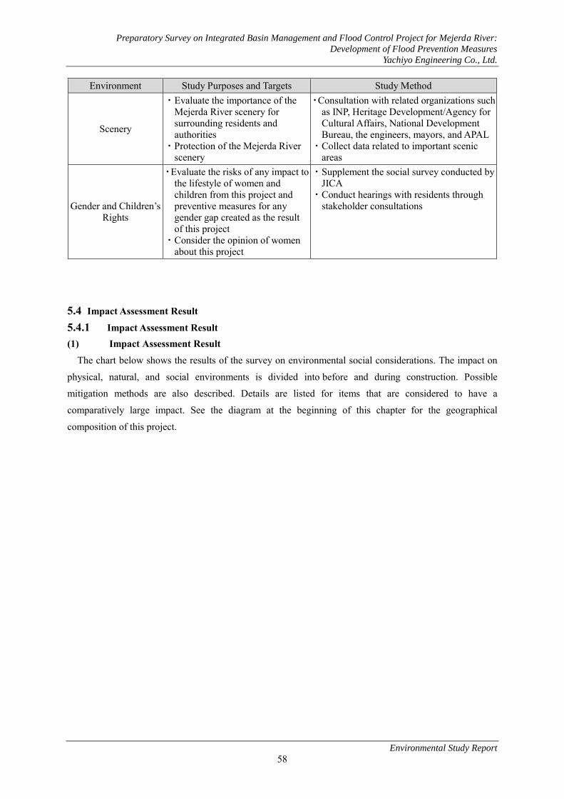
Preparatory Survey on Integrated Basin Management and Flood Control Project for Mejerda River:
Development of Flood Prevention Measures
Yachiyo Engineering Co., Ltd.
Environmental Study Report
58
Environment Study Purposes and Targets Study Method
Scenery
・Evaluate the importance of the Mejerda River scenery for surrounding residents and authorities
・Protection of the Mejerda River scenery
・Consultation with related organizations such as INP, Heritage Development/Agency for Cultural Affairs, National Development Bureau, the engineers, mayors, and APAL
・Collect data related to important scenic areas
Gender and Children’s Rights
・Evaluate the risks of any impact to the lifestyle of women and children from this project and preventive measures for any gender gap created as the result of this project
・Consider the opinion of women about this project
・Supplement the social survey conducted by JICA
・Conduct hearings with residents through stakeholder consultations
5.4 Impact Assessment Result 5.4.1 Impact Assessment Result (1) Impact Assessment Result
The chart below shows the results of the survey on environmental social considerations. The impact on
physical, natural, and social environments is divided into before and during construction. Possible
mitigation methods are also described. Details are listed for items that are considered to have a
comparatively large impact. See the diagram at the beginning of this chapter for the geographical
composition of this project.

Preparatory Survey on Integrated Basin Management and Flood Control Project for Mejerda River:
Development of Flood Prevention Measures
Yachiyo Engineering Co., Ltd.
Environmental Study Report
59
Table 26: Results of Impact Assessment on the Environment and Society
Impacts Reasons for Assessment Geographical composition
of this project Me El DL Ch Pt
Physical Environment and Pollution
Air Pollution/D
ust
During Construction When construction is close to a residential area, the air may be polluted by truck and machinery exhaust, and dust kicked up by trucks driving through the area may have a negative impact to the surrounding houses. Construction crews need to manage this during construction.
B- B- D B- B-
Water Pollution
During Construction While it normally it does not happen, there is a possibility that oil may accidentally leak from the engines of heavy machinery and other construction machinery and pollute the water. It is therefore necessary to adequately maintain machinery. It will also be necessary to manage construction so turbidity does not worsen due to excavation and expansion of the flood channel.
B- B- B- D D
Ground Pollution
During Construction The excavation and expansion of the Mejerda River is planned to be carried out for sand and soil used as farmland and residential land accumulated along the river and thus there is little possibility of containing harmful substances. While the project itself will not pollute the ground, there is a possibility of ground pollution if polluted soil is accidentally excavated and transported to a different location. It is impossible to eliminate the possibility of excavating buried waste or old, small-scale dangerous waste disposal sites along the Mejerda River.
If polluted soil is found during excavation and expansion operations, it will be taken to a disposal site and disposed of in an appropriate manner. Furthermore, polluted soil will not be used in construction materials.
B- B- D B- B-
Solid Waste
During Construction A large amount of soil waste will be excavated. As described in Ground Pollution above, there is little possibility of excavated soil along the river bed containing harmful substances. Thus, it can be used for embankment. Surplus soil, if any, shall be transported to the disposal site and disposed of surely. Due to the trimming and removal of tamarisk trees, there will be a large amount of plant waste that will be difficult to use effectively. This waste will be handled appropriately and its reuse will be investigated.
With regards to the illegal animal skin disposal site near the proposed embankment construction site in the El Mabtouh wetlands, if the site is related to the tanning industry, it will be necessary to dispose of it as designated dangerous waste (stipulated as Class 0602, Edict 2000-2339, October 10, 2010 in the Dangerous Waste List). The scope of construction and waste disposal will be confirmed before the start of construction, and if waste is found in the scope of construction, it will be transported to a disposal site and handled accordingly. This procedure can minimize the impact on the environment.
B- B- D B- B-

Preparatory Survey on Integrated Basin Management and Flood Control Project for Mejerda River:
Development of Flood Prevention Measures
Yachiyo Engineering Co., Ltd.
Environmental Study Report
60
Impacts Reasons for Assessment Geographical composition
of this project Me El DL Ch Pt
Noise
During Construction When construction is close to a residential area, the noise from trucks and machinery may affect the surrounding houses. It is necessary to confirm that the environmental standard is satisfied by regularly monitoring the noise level at construction sites and considering the transport routes of trucks.
B- B- D B- B-
Topography and
Geology
During Construction River topography will change, in particular by river expansion and excavation. It is necessary to consider slope gradient and scenery in the design.
B- B- D B- B-
Hydrological
Phenomena
During Construction This project is mainly for the excavation and expansion of the flood channel of the Mejerda River and no construction will be conducted at the low flow channel of the river bank. Therefore, we believe the impact will be negligible.
B- B- D B- B-
After construction The Project is expected to have positive impacts on residents along the river as the floods in the rainy season decrease. Although the frequency of soil transfer and accumulation on surrounding farmland to be caused by floods decreases, soil supply to the area will continue as the flood exceeding the project scale will occur. There will be no bank protection in the zone of excavation and expansion. Thus, erosion, transfer and accumulation of sand and soil in the river channel will be as same as before the Project, causing no impact on its transfer.
Soil Stability
and Erosion Risk
During Construction During the construction period, the risk of the erosion to the gradient soil may increase temporarily. It is necessary to consider an appropriate slope gradient to avoid surface erosion. It is also necessary to reduce soil erosion through silt traps during construction. Construction crews need to manage this.
B- B- D B- B-
After construction It is necessary to consider an appropriate slope gradient and vegetation at the design phase to avoid surface erosion. Periodical monitoring and maintenance are necessary.
B- B- D B- B-

Preparatory Survey on Integrated Basin Management and Flood Control Project for Mejerda River:
Development of Flood Prevention Measures
Yachiyo Engineering Co., Ltd.
Environmental Study Report
61
Impacts Reasons for Assessment Geographical composition
of this project Me El DL Ch Pt
Risks to the Environment
Biologically Important Areas for Natural Habitat
During Construction The main purpose for this project is flood channel excavation and expansion. As no construction will be conducted at the low flow channel and a certain number of trees will remain, no major impact is expected to water and bird life habitat. There is likely to be no direct impact on the wetlands listed under the Ramsar Convention because of no improvement work of river channel from the Delta bridge to the lower stream to the mouth of the Mejerda River. The flood analysis results in the wetland area before and after the Project also show no significant change in the scope of flood. Because excavation and expansion work in the upper stream does not include excavation in waters, no turbid water is caused. Thus, there will be very little impact on the wetlands. The construction area in the El Mabtouh wetlands is limited and the frequency of flooding will not change so we expect that there will not be a large impact on natural habitat. Based on the above, impacts on biologically important areas for natural habitats are believed to be minimum.
B- B- B- D D
Biodiversity of
Protected Species
During Construction There are 2 kinds of endangered species living in the Mejerda River: the European eel and the Mediterranean killfish (Aphanius fasciatus). As the project construction is excavation and expanding only at the flood channel and not at the low flow channel (riverbed) where the European eel and the Mediterranean killfish live, the impact on these important species will be small. The impact on feeding ground of birds in the low-flow channel will be also minimum. The impact on birds living in tree shades will be also minimum by securing a certain volume of trees along the river where they live.
B- D D D D
After construction It is possible to contribute to the development of biodiversity of native habitat, in particular birds, along the Mejerda River by permanently maintaining riverbed vegetation after construction is complete. Continuing maintenance after construction is crucial for maintenance of the environment. The flood analysis results in the wetlands listed under the Ramsar Convention show little change in the scope of flood between before and after the Project and there will be no impact on biodiversity there.
B+ D D D D
Possible Flooding
Before Construction Structural design for flood controls is based on the risk of 10th-year floods caused by rainfall amounts that occur once a decade. These structures protect houses, buildings, infrastructure, and crops in expected areas of flooding. The benefits brought by this project will be especially important to each sector of Tebourba, El Bataan, Jedeida, and Oued Ellil, as well as Kalaat Andalous, El Bataana, and Utica where most of houses lost their livelihoods to flooding. Improving bridges will allow residents to pass through flooded areas.
A+ A+ D A+ A+

Preparatory Survey on Integrated Basin Management and Flood Control Project for Mejerda River:
Development of Flood Prevention Measures
Yachiyo Engineering Co., Ltd.
Environmental Study Report
62
Impacts Reasons for Assessment Geographical composition
of this project Me El DL Ch Pt
After construction It is essential to maintain the riverbed to keep the benefits of the river improvement project in the long term and avoid the increase of woody plants and silt. For river vegetation, tracking and maintenance methods of vegetation need to be defined. It is necessary to select and plant the trees that are suitable for maintenance.
B+ D D D D
Social Conditions
Involuntary Relocation
of Residents
Before Construction Currently there is one house that needs to be relocated due to the Mejerda River expansion. Residential relocation will be confirmed based on the final schedule, but there will be no major relocation. The stated compensation by the Ministry of State Properties and Real Estate Affairs will be paid for land, fixed structures, planting and all structures used to maintain lives of owners and occupants. If the value of original residence was low and the compensation amount was also low, the government will offer compensation to relocate to an alternative site. However, the resident relocating will be responsible for construction on the suggested alternative site. The compensation amount will be based on the land possession regulations and JICA environmental society guidelines (announced in April, 2010). The loss of livelihood of the recipient may also be considered for in the compensation amount.
B- D D D D
Loss or Involuntary Relocation
of Structures
Other than Residences
Before Construction There are several civilian facilities in the area this project takes place. They are storage rooms for tools, barns, abandoned houses, storage facilities for river water pumps, facilities for protecting electronic devices for pumps, and so on. As stated previously, the number and kinds of structures besides residences for this project will be researched later. However, no major loss or destruction will occur. The stated compensation by the Ministry of State Properties and Real Estate Affairs will be paid for land, fixed structures, planting, and all structures used to maintain lives of owners and occupants. If the compensation amount was low, the government will offer compensation to relocate to an alternative site. However, the resident relocating will be responsible for construction on the suggested alternative site. For residents who live on land, land-based compensation will have priority over compensation by cash. The compensation amount will be based on the land possession regulations and JICA environmental society guidelines (announced in April, 2010). The loss of livelihood of the recipient may also be considered for the compensation amount.
B- D D D D

Preparatory Survey on Integrated Basin Management and Flood Control Project for Mejerda River:
Development of Flood Prevention Measures
Yachiyo Engineering Co., Ltd.
Environmental Study Report
63
Impacts Reasons for Assessment Geographical composition
of this project Me El DL Ch Pt
Crops and Trees being Cultivated
Before Construction Crops and fruit currently being cultivated as well as trees will be lost under land acquisition for this project. However, considering the number of related households and the expected loss of income, the impact is not enormous. However, the impact on livelihoods in Jedeida and El Bataan from the loss of cash income is greater than rural areas. The owners and occupants will receive compensation through the compensation procedure for land acquisition and property.
B- B- D B- B-
Land Use
Before Construction There is no particular impact. D D D D D
During Construction As bridges already exist, bridge improvements will have no impact on land usage. However, when jacking bridges, the embankment of the attached roads will be also be raised and therefore the width of the road will need to be increased. Thus, it will be necessary to acquire new land and change land usage. However, as the dimensions of the banked area are about **m2 for each point of the bridge, there will be no major impact on land usage. For any change in land usage, the stated compensation by the Ministry of State Properties and Real Estate Affairs will be paid for land, fixed structures, planting, and all structures used to maintain lives of owners and occupants. For residents who live on land, land-based compensation will have priority over compensation by cash. The compensation amount will be based on the land possession regulations and JICA environmental society guidelines (announced in April, 2010). The loss of livelihood of the recipient may also be considered for the compensation amount.
B- B- D D B-
After construction Because there are few floods in the El Mabtouh retarding basin in the scale that operates and they are submerged less than for 20 days, it has little impact on land use in the retarding basin.
B- B- B- B- B-
Water Resources
During Construction The Mejerda River is the main water resource for individual irrigation in Kalaat Andalous, Sidi Thabet, Tebourba, and El Bataan areas. Local Resources below shows the impact on and evaluation for individual irrigation. As residents in the Mejerda River construction area are supplied with drinking water either publicly or privately, there will be no impact on water resources in the construction area. As no underwater excavation or damming will be conducted during construction, the water quality should not change and there will be no impact on irrigation and drinking water.
B- D D D D
After construction Drinking water will be supplied either publicly or privately to the residents around the Mejerda River. Therefore, this project will not impact the water supply.
D D D D D

Preparatory Survey on Integrated Basin Management and Flood Control Project for Mejerda River:
Development of Flood Prevention Measures
Yachiyo Engineering Co., Ltd.
Environmental Study Report
64
Impacts Reasons for Assessment Geographical composition
of this project Me El DL Ch Pt
Local Resources/ Regional Resources
During Construction The residents in communities along the Mejerda River rarely trim trees, fish, or hunt. The only natural/regional resource that has any value in the region is the water from the Mejerda River. The water can only be gathered by placing a small pump directly into the Mejerda River or by using a small pump in a pump storage room. If such equipment exists in the construction area, it is necessary to consult with the equipment owners to temporarily relocate the pumps and hoses so there will be no problems associated with intake of water for irrigation. Furthermore, construction will not use structures that stop water and excavation work will only be done in the flood channel along the river. Therefore, there will be no change in the low flow channel (river bed) and hence there will be no major impact on local resource usage.
B- D D D D
After construction Because there are few floods in the El Mabtouh retarding basin in the scale that operates and they are submerged less than for 20 days, it has little impact on land use in the retarding basin.
D D D D D
Local Economy,
Employment, and
Livelihood
During Construction Through this project, daily employment opportunities can be offered to the local residents during construction. Priority should be given to employment for local labor.
B+ B+ D B+ B+
After construction Employment opportunities will be created for local residents to maintain the river by trimming vegetation.
B+ B+ D B+ B+
Poverty and Vulnerabilit
y
After construction According to a study about income standard, the ratio for poor or vulnerable residents is high in Jedeida, Sidi Thabet, and El Bataan. These households are greatly affected by any impact on real estate or agricultural livelihood. It is possible to minimize any impact through compensation. On the other hand, this project reduces the damage caused by floods to households that are easily affected. More than half of the houses and properties of households in Jedeida and El Bataan were severely damaged by floods, and they will benefit greatly from this project. Overall, this project is positive for the poorest households.
B+ D D D D
Localized Conflicts
Before Construction Localized conflicts appear to be complaints about land. According to the land plan, about half of the surveyed households are either owners that do not possess land title certificates or occupants. Therefore, it appears that conflicts among people will be about differences in the amount of compensation during the land acquisition procedure.
B- B- D B- C
Profit Distribution
and Equality
Before Construction There will be no negative impact on the principle of socioeconomic equality. With an equal land acquisition compensation system for this project, unequal and negative impacts will be reduced.
D D D D D

Preparatory Survey on Integrated Basin Management and Flood Control Project for Mejerda River:
Development of Flood Prevention Measures
Yachiyo Engineering Co., Ltd.
Environmental Study Report
65
Impacts Reasons for Assessment Geographical composition
of this project Me El DL Ch Pt
Minorities
Before Construction Regarding the conditions for free travel rights in El Mabtouh for semi-nomadic people, it is necessary to consider their characteristics (number of domestic animals for seasonal migration, their origins, travel frequency, and the importance of maintaining household income by migration) in the EIA.
D D D D D
Gender and Children’s
Rights
During Construction/After construction It is mainly men who get water for irrigation or do farm work. This project does not negatively affect gender equality or children’s rights.
D D D D D
Access for Schools, Medical Services, and other
Social Welfare Services
Before Construction During Construction There is a possibility that traffic could be affected during construction by river expansion, excavation work, and bridge improvement. B- D D D D
Traffic Jams and Accidents
During Construction There is a possibility that traffic could be affected during construction by river expansion, excavation work, and bridge improvement. For this reason, school access, health organizations, and other social organizations will be affected. Traffic congestion is expected due to the transportation of excavated soil. If it is transported on arterial highways or in residential areas, the impact may be great. These possibilities will be clarified by impact assessments.
B- B- D B- B-
Historical and
Cultural Heritage
Before Construction/During Construction There will be no impact on the historical and cultural heritage of El Battan weir bridge and the ancient bridge of Jedeida as the river channel is planned not to affect them.
B- D D D D
Scenery
During Construction Greenery will be lost from trimming the tamarisk trees on the river bank and therefore the scenery along the Mejerda River will change. However, it is possible to reduce this impact by planting greenery along the managed roads.
B- D D D D
Source: JICA Study Team 2011 Project Components Me : Mejerda River (The range of the excavation and expansion work conducted by this project is shown between the Laroussia Dam and Delta Bridge. See image below) El : El Mabtouh wetlands DL: Delta Bridge – Delta Region of Mejerda River Ch : Channel/diversion channel Pt: Bridge Impact Classification A+/- : Significantly positive or negative impact B+/- : Insignificant positive or negative impact C+/- : Areas of unconfirmed impact (supplemental studies required) D : No impact

Preparatory Survey on Integrated Basin Management and Flood Control Project for Mejerda River:
Development of Flood Prevention Measures
Yachiyo Engineering Co., Ltd.
Environmental Study Report
66
(2) Items that are Considered to have a Comparatively Large Impact 1) Impact to Aquatic Habitat of the Mejerda River
Because the natural landscape is likely to change due to construction to secure the cross-sectional flow of
the river bed and embankment construction, it will cause adverse effect on the aquatic habitat environment
at the low-flow channel. Taking the following measures, it will be possible to minimize the impact on the
European eels and other aquatic habitats and birds with the feeding ground in the low-flow channel:
Excavation and expansion only in the flood channel.
No excavation that causes turbid water in the river channel (low-flow channel)
2) Impact on Wetlands The use of the El Mabtouh wetlands as a retarding basin is not considered a factor in the degradation of
the physical and biological environment that birds need. As the flooding period of the El Mabtouh wetland
is short, we anticipate that the impact is the same as usual as a result.
On the other hand, there is no direct impact as no excavation or expansion work is conducted along the
Mejerda River in the lower stream of the wetlands listed under the Ramsar Convention. Flood analysis
results of the wetlands are shown in Charts 4-32 to 4-36 for the current river channel and Charts 4-37 to
4-41 for planned river channel each in terms of 1/5, 1/10, 1/20, 1/50, and 1/100. Comparison of the scope
of floods of the current and planned river channels in terms of probable annual flood occurrence shows no
significant difference. There is no difference in the frequency of flood between before and after the Project
implementation. Because the excavation and expansion work is carried out in water in the upper stream in
the scope of registered wetlands of the Mejerda River, no turbid water is caused and thus it will have no
impact on the wetlands. Therefore, the Project will have almost no impact on the wetlands listed under the
convention and their biota.
El
Laroussia Dam
Delta Bridge
Me: Mejerda River
River drilling and expansion
will be conducted in this area
Dl
Ch

Preparatory Survey on Integrated Basin Management and Flood Control Project for Mejerda River:
Development of Flood Prevention Measures
Yachiyo Engineering Co., Ltd.
Environmental Study Report
67
3) Impact on Forest Cover at the Flood Channel and Embankment Dense tamarisk trees will disappear and the natural scenery of the river will change because of the river
expansion and embankment construction. Meanwhile, the Ministry of Agriculture and residents living near
the river have a negative opinion of the forest cover at the flood channel. The former thinks that the forest
cover prevents water flow during floods and the latter thinks that tamarisk trees are useless as a forestry
product. Furthermore, farmers complain that wild pigs hide in the tamarisk trees and damage crops along
the river, and therefore trimming the tamarisk trees can be an effective method in reducing damage from
wild pigs.
4) Impact on Land Animals The impact from tree trimming on wild pigs that use tamarisk trees to hide is great, but we do not
anticipate that it will directly impact wild pig groups greatly. Furthermore, wild pigs are not protected
species.
Although birds live in trees along the river, the impact on them can be minimized by securing a certain
amount of trees. The impact on the feeding ground along the low-flow channel will be also minimum as
there is no construction work to be carried out there.
5) Impact Caused by Excavated Soil Waste A large amount of excavated soil waste will be generated by this project from excavation and expansion
work at the flood channel along the Mejerda River. When the excavated soil can be reused as material for
banking, it will be given priority and used effectively, and when soil waste needs to be disposed of, it will
be taken to a soil disposal site.
Approximate amount of soil to be excavated from the flood channel along the river during construction
is 15,500,000 m3, of which only 1,000,000 m3 is used in the construction of levees along Medjerda River.
However, as excavated surface soil of 30 to 50 cm is not utilized for embankment material, it will be soil
waste2. Final disposal of soil waste of 14,500,000 and environmental management will become an
important issue.
The excavation and expansion of the Mejerda River is planned to be carried out for sand and soil used as
farmland and residential land accumulated along the river and thus there is little possibility of containing
harmful substances. Thus, there is very little possibility of ground pollution in the target area. It can be used
for embankment as it does not contain harmful substances.
Traffic congestion can be anticipated when transporting soil for reuse or to a disposal site. If it is
transported on arterial highways or in residential areas, the impact may be great. Considering the negative
impact to surrounding residents from transporting excavated waste soil, it is necessary to take specific
action, such as selecting routes for environmental management.
2 Article 7 of Act No. 96-41 states that inert wastes mean “those which consist of soil and natural rock dug in a pit or generated from the demolition, construction or renovation, with the nature of ore mainly, and those which are not contaminated by dangerous substances and other elements potentially harmful,” Therefore, soil which is taken from the bed and embankment of Medjerda River shall be treated as an inert waste in principle.

Preparatory Survey on Integrated Basin Management and Flood Control Project for Mejerda River:
Development of Flood Prevention Measures
Yachiyo Engineering Co., Ltd.
Environmental Study Report
68
6) Impact Caused by Large Amounts of Plant Waste During river bed construction, a large amount of plant waste will be generated from trimming tamarisk
plants on the flood channel. The law regarding solid waste, Article 7 of Act No. 96-41 dated June 10th,
1996, states that it is prohibited to burn waste outside, except for plant waste, or use waste as fuel. Burning
plant waste is the most common method to dispose of it, but this generates pollution and greenhouse gases.
As this project takes place in rural areas, the impact from pollution is not significant, but reuse of materials
should be prioritized to enable control of greenhouse gas emissions.
7) Impact on Cultural Heritage Consideration is given to the historical structures of El Battan weir bridge and the ancient bridge of
Jedeida in the formulation of the river channel plan not to cause any impact on them. The construction plan
is also formulated not to cause any impact during the construction. Thus, there is no impact on such
structures.
5.4.2 Comprehensive impact assessment
A summary of the results of surveys conducted up until now and the EIA of project implementation is
summarized in the table below.
Table 27: Summary of project environmental impact assessment
Impact item
Impact assessment during at time of scoping
Impact assessment based on the results of the current survey
Pre-construction/during construction Post-construction Pre-construction/during
construction Post-construction
Physical environment and pollution 1 Air pollution/dust B- D B- D 2 Water pollution B- D B- D 3 Ground pollution B- D B- D 4 Waste B- D B- D 5 Noise B- D B- D 6 Topography and geology B- D B- D 7 Hydrosphere D A+ B- D 8 Soil stability and erosion risk B- D B- B-
Environment and risk
9 Natural habitats, biologically important areas B- D D D
10 Protected species and biodiversity B- D B- B+
11 Flood risk D A+ A+ B+ Social conditions
12 Involuntary resettlement of residents B- D B- D
13 Damage to non-residential B- D B- D

Preparatory Survey on Integrated Basin Management and Flood Control Project for Mejerda River:
Development of Flood Prevention Measures
Yachiyo Engineering Co., Ltd.
Environmental Study Report
69
Impact item
Impact assessment during at time of scoping
Impact assessment based on the results of the current survey
Pre-construction/during construction Post-construction Pre-construction/during
construction Post-construction
structures and involuntary resettlement of residents
14 Loss of vegetation and cultivated produce B- D B- D
15 Use of on-site and regional resources B- D B- D
16 Water resources B- D B- D 17 On-site resources B- D B- D
18 Regional economy/employment/livelihood B+ B+ B+ B+
19 Poverty and vulnerability C A+ D B+ 20 Regional interest and opposition C D B- D
21 Profit sharing, fairness C A+ D D
22 Minority peoples D D D D 23 Gender/children's rights C B+ D D
24 Public infrastructure and social services B- D B- D
25 Traffic congestion, traffic accidents B- C B- D
26 History/cultural heritage D D D D 27 Scenery C D B- D
Source: JICA Study Team An explanation of impact can be found in Table 20. Impact classification: A+/- : Significantly positive or negative impact B+/- : Insignificant positive or negative impact C+/- : Unconfirmed impact (additional study required) D : No impact

Preparatory Survey on Integrated Basin Management and Flood Control Project for Mejerda River:
Development of Flood Prevention Measures
Yachiyo Engineering Co., Ltd.
Environmental Study Report
70
Chapter 6. Mitigation Measures
(1) Overview of Mitigation Measures The table below shows the results of the study of the environmental management plan to mitigate the
impact based on the scoping and impact assessment results shown earlier. The environmental management
plan (impact mitigation measures) on main points is summarized.
1) Measures to Protect Aquatic Organism and Birds The measures described below are advised in order to protect aquatic organisms living in the Mejerda
River.
① Plant trees to assure an area with shade. For example, on one side of the river, areas three to five meters wide and 100 meters long per kilometer, which is about 5% of the total length, can be
preserved. This would enable the physical environment to protect creatures with shade at several
areas of the river.
② As excavation and expansion work will be limited to the flood channel, the impact to aquatic organisms, such as eels, is expected to be small.
③ The DGBGTH will coordinate so that organizations such as INSTM, INAT, DGPA, WWF3, and AAO4 can contribute to the impact assessment as necessary.
2) Impact Mitigation Measures for Tamarisk Tree Trimming To mitigate the impact of trimming tamarisk trees, alternative trees will be used to cover the flood
channel and embankment in order to control erosion. Therefore, it is necessary to select the appropriate
types of trees to plant. Furthermore, a certain number of trees will be left on the riverside to secure bird
habitat.
3) Procedure for Removal and Effective Reuse of Excavated Soil Waste The following conditions must be fulfilled for excavated soil waste removal and reuse.
① Soil waste is inert waste that is free of pollution.
② If there is a special disposal site for inert waste, this site should be used, but if there is no disposal site for inert waste, soil waste needs to be reused. According to Article 29 of Act No.
96-41 dated June 10, 1996, reuse has to be considered when disposing of solid waste.
It is necessary to select the excavated soil waste disposal and reuse methods from the following options.
3 World Wildlife Fund
The world’s largest international NGO for the environment. Their policy is to maintain biodiversity and reduce the
ecological footprint for life on earth.
4 Association ‘Les Amis Des Oiseaux’
Tunisian environmental NGO for the protection of birds. AAO is one of the NGOs in partnership with Bird Life
International (above note 5) with 18 African countries. The activity consists mainly of donations from supporters and
commissions from studies for international organizations and international NGOs.

Preparatory Survey on Integrated Basin Management and Flood Control Project for Mejerda River:
Development of Flood Prevention Measures
Yachiyo Engineering Co., Ltd.
Environmental Study Report
71
Options below are shown in order of priority.
① Embankment material
② Disposal at former quarries
③ Use as covering materials for Jebel Shakeel waste control
④ Reuse in other construction projects
⑤ Disseminate to farm land
The excavation and expansion work is planned to be conducted in the zone currently used as farmland
and residential land along the Mejerda River. It is formed as a result of erosion and accumulation of soil on
the river bank. Thus, it is unlikely that the excavated soil will contain harmful substances.
4) Effective Use of Plant Waste The following list shows the possibilities for effective use of plant waste generated from trimming
tamarisk trees.
① Composting branches
② Carbonization of tree trunks to produce charcoal
③ Crush wood to produce wood particles
④ Other uses Good quality of compost cannot be obtained from tamarisk trees and the charcoal is also poor quality.
INRGREF proposed the possibility of molded charcoal products with higher calorific power, but this has
not yet been achieved. Other effective uses have not been proposed yet. Trunks can be used as charcoal if
they are offered free of charge to agencies that want them.
On the other hand, using trunks and branches in protective dikes and consolidated foundations is an
effective use of materials as proposed in the master plan. The following are challenges for using trees as
materials for protective dikes and consolidated foundation:
① It is preferable that trunks do not have knots, are well dried, and are more than 10 centimeters in diameter (recommendations from the DGF). Trunk length of about one meter is also necessary so
that it can be secured to the ground. In reality, it is difficult to obtain trunks with this length without
knots due to the branch conditions of tamarisk plants on the Mejerda River.
② As there is no evidence that this method has been done before in Tunisia, empirical research is necessary.
5) Excavated Waste Control at Unmanaged Waste Disposal Sites It is necessary to remove waste expected to be generated from unmanaged waste disposal sites during
river bed construction to authorized managed waste disposal sites. The closest site is the Jebel Shakeel
managed waste disposal site (general waste). Industrial waste that is categorized as hazardous (such as
animal skins near El Mabtouh wetlands) has to follow transport and removal regulations. If a new waste
disposal site is established or an old disposal site is discovered during construction, the obligations of
construction contractors have to be clearly stated in the tender documents and contract conditions.

Preparatory Survey on Integrated Basin Management and Flood Control Project for Mejerda River:
Development of Flood Prevention Measures
Yachiyo Engineering Co., Ltd.
Environmental Study Report
72
(2) Required Costs for Mitigation Measures As it is possible to handle mitigation measures as normal construction and administrative activity, there
is no need to plan a special budget. Cost of individual environmental monitoring to be conducted as a
mitigation measure is shown in Table 7-25 in 7.4.

Preparatory Survey on Integrated Basin Management and Flood Control Project for Mejerda River:
Development of Flood Prevention Measures
Yachiyo Engineering Co., Ltd.
Environmental Study Report
73
Chapter 7. Environment Management and Monitoring Plan 7.1 Environment Management Plan 7.1.1 Issues to be Considered in the Environment Management Plan
The environment management plan, which includes the environment monitoring plan, needs to be
discussed in the Environmental Impact Assessment (EIA) that Tunisia creates to approve the project.
The following issues need to be discussed in the EIA.
1) Management plan for excavated soil at the Mejerda River bed
2) Protection plan for habitat environment in the Mejerda River
3) Planting plan at the Mejerda River bed
4) Plans for resident relocation to alternative sites and compensation
5) Environment monitoring plan
1) Issues to be Considered on the Management Plan for Excavated Soil at the Mejerda River Bed
a) Management Plan for Excavated Soil In the Management Plan for Excavated Soil at the Mejerda River Bed, the fact that this project will
reduce the impact on the physical, natural and human environments in the project area as well the purposes,
methods, activities, and responsibilities to be developed will be clarified so that this project can be accepted.
The targets are described below.
1. Reuse the excavated soil as much as possible.
2. Inert waste that cannot be reused will be disposed at a specialty created soil disposal site.
3. In order to reduce traffic congestion and the risks of traffic accidents, transportation of
excavated soil to reuse sites or soil disposal sites will be managed.
When reusing excavated soil, ANGED and ANPE will match the material and methods of use. When
landfill is being performed during construction work, the standard will be established with the project
officer and the project needs to be confirmed to comply with the standard. If the materials are not
compatible with reuse or categorized as inorganic waste, the appropriate disposal method needs to be
defined with ANGED, and the category for the waste and the transporting and waste disposal methods need
to be established by contractors approved by the Ministry of Environment.
b) Reusing Land In the Management Plan for Excavated Soil, reuse and disposal procedures will be proposed. The
possibility for reuse became clear after consulting concerned parties who could possibly accept excavated
soil in the area of the project or close to the project site. The chart below shows the consultation summary.
As the most of this construction will finish in 2013, they are not the subject to disposal of excavated soil
generated by this project. Therefore, it is necessary to discuss soil reuse with the related agencies again
after the project starts.

Preparatory Survey on Integrated Basin Management and Flood Control Project for Mejerda River:
Development of Flood Prevention Measures
Yachiyo Engineering Co., Ltd.
Environmental Study Report
74
c) Soil Disposal Sites Old quarries will be considered for the disposing of soil (soil disposal sites). Old quarries that were
closed before Act No. 89-20, which controls quarry development, dated February 22, 1989, and have not
been redeveloped since, are up for consideration.
As a result of interview with DGBGTH, three former government-owned quarries below are suggested
as possible soil disposal sites.
1) Ariana Nali
2) Maiana (Manouba Governorate)
3) Jebel Turki (Ariana Governorate)
DGBGTH has not created the site selection list at this stage. The inert waste disposal plan at quarries will
be created as a technical proposal for the redevelopment of quarries together with the quarry agency. In this
technical proposal, the initial conditions, the scheduled redevelopment construction, and the estimated
amount of waste will be described. The main points of the redevelopment are security to prevent accidents,
stability of slope and face, and the recovery of scenery. The recovery of scenery refers to topography
recovery and there is no obligation to plant vegetation.
A fact to be noted when burying excavated soil in old quarries is that the excavation site may have been
an illegal waste disposal site and the waste may cause pollution during construction. In order to assure
environmental approval, it is important to take measures when planning construction for proper handling
and management in case such waste is generated.
d) Disposal Affiliated with the Ministry of Environment Redevelopment Plan In the Study on Environment for Utilization and Redevelopment of Quarries: First Stage – Analysis and
Evaluation of Quarry Impact on the Environmental Plan, the Ministry of Environment planned the study
based on the redevelopment of 100 quarries in Tunisia. This study targets 12 governorates, including
Manouba, Ariana, the great Tunis bloc and Bizerte. In this project area, several quarries in the Manouba
governorate, especially quarries in Maiana and Kelidia, can be prioritized.

Pre
pa
rato
ry S
urv
ey o
n I
nte
gra
ted
Ba
sin
Ma
na
gem
ent
an
d F
loo
d C
on
tro
l P
roje
ct f
or
Mej
erd
a R
iver
: D
evel
op
men
t o
f F
loo
d P
reve
nti
on
Mea
sure
s
Ya
chiy
o E
ng
inee
rin
g C
o.,
Ltd
.
En
viro
nm
enta
l S
tud
y R
epo
rt
75
Tabl
e 28
: Rev
iew
of C
ivil
Engi
neer
ing
Plan
s with
Pos
sible
Reu
se o
f Exc
avat
ed S
oil
Plan
ning
Age
ncie
s C
onsu
ltati
on D
ate
Title
of
A
genc
y R
epre
sent
ativ
e Pl
an N
ame
and
Loca
tion
Are
a (h
a)
Req
uire
d A
mou
nt
of
Soil
Sche
dule
d C
onst
ruct
ion
Perio
d
Poss
ibili
ty
of R
euse
AFH
/Gro
und
and
Res
iden
ce A
genc
y 20
11/5
/12
Dire
ctor
of
Res
earc
h an
d Pl
anni
ng O
ffic
e
Bet
wee
n Za
na
(Utic
a G
over
nora
te) a
nd h
ighw
ay
400
- -
Not
cle
ar
AFH
A
riana
Lo
cal
Age
ncy
2011
/6/9
Lo
cal O
ffic
e D
irect
or
Tuni
s ga
rden
in
A
guba
(M
anou
ba G
over
nora
te)
30
0 0
Sum
mer
20
12
No
STEG
/Tun
isia
Pow
er G
as
Publ
ic C
orpo
ratio
n 20
11/6
/9
Dire
ctor
of
A
djus
tmen
t/Pro
duct
ion,
D
irect
or o
f Te
chno
logy
O
ffic
e
Kal
aat E
l And
alui
s
88
1,32
0,00
0 A
t th
e en
d of
201
2 N
o
AFI
/Indu
stria
l G
roun
d O
ffic
e 20
11/6
/13
Dire
ctor
of
G
roun
d Is
sue
Off
ice,
D
eput
y D
irect
or o
f Res
earc
h
Utic
a In
dust
rial A
rea
50
- Ju
ne 2
011
No
Utic
a/Ej
idid
a -
- 20
12 -
2016
N
ot c
lear
Cha
frou
Rao
ued
53
53,0
00
June
201
2 N
o
SEPT
S/Tu
nis
Sud
Ass
essm
ent
and
Dev
elop
men
t Com
pany
20
11/6
/16
Gen
eral
D
irect
or,
Dire
ctor
of
Tech
nolo
gy
Off
ice
Tuni
s/ Su
d la
ke
127
(pra
ctic
ally
50)
75
0,00
0 20
13
Yes
Tuni
s G
ulf
Dev
elop
men
t C
ompa
ny
2011
/6/2
0 A
ssis
tant
for
Gen
eral
D
irect
or
Fina
ncia
l su
ppor
t be
twee
n K
alaa
t A
ndal
ous
and
R
aoue
d 52
0 -
- Y
es

Preparatory Survey on Integrated Basin Management and Flood Control Project for Mejerda River:
Development of Flood Prevention Measures
Yachiyo Engineering Co., Ltd.
Environmental Study Report
76
2) Issues to be Considered for the Protection and Recovery Plans for Aquatic Habitat Environment
in Mejerda River It is necessary that the aquatic habitat protection and recovery plan for the Mejerda River minimizes any
impact to the environment of the Mejerda River caused by this project.
1) As the excavation and expansion work along the Mejerda River will only be conducted at the flood
channel and not at the low flow channel (river bed), the impact to European eels and other fish that
live in or migrate to the river will be minimized.
2) For birds living in trees along the river, a certain number of trees will be kept as described in 3), and
by limiting the loss of forest at the Mejerda River flood channel, the impact will be minimized.
3) Issues to be considered for the Mejerda River Bed Planting Plan In the Mejerda River bed planting plan, the targets, methods, and activities for the following issues will
be clarified in order to reduce the impact on the Mejerda River’s environment from this project.
1) The loss of forest at the Mejerda River flood channel will be limited by assuring that a certain
number of trees are kept along the river. This conservation activity considers both the natural
scenery and biology (a potential biological corridor and evacuation site).
2) Create alternative vegetation at the highest part of the river bed to compose a linear natural habitat.
3) Reinforce the ground by planting appropriate trees to curb the erosion risk at the river bed.
4) Precisely plan the planting period and work, and planting requests with the DGF or the Forestry
Department.
5) Clearly define the responsibility and methods to maintain planting at the river bed in the long run.
The existing study, through discussions with the DGF and the Forestry Department, show the most
appropriate kinds of trees for planting. The following trees were proposed to be planted on the other side of
the dike and the upper side of repaired slope.
Acacia, especially Acacia cyclops, Acacia aurida
Oleander
Caper
Robinia pseudoacacia
The following is a reference of plants to be planted at the lower part of river bed.
Sesuvium portulacastrum
Atriples
4) Plans for Compensation and Resident Relocation to Alternative Sites The status of involuntary resident relocation and land acquisition will be described in Chapter 8 (Land
Acquisition and Residents Relocation). The resident relocation and compensation plan also needs to be

Preparatory Survey on Integrated Basin Management and Flood Control Project for Mejerda River:
Development of Flood Prevention Measures
Yachiyo Engineering Co., Ltd.
Environmental Study Report
77
created as The Resident Relocation Plan, which also includes the monitoring plan, by Tunisia. Furthermore,
relocation, compensation, and monitoring must be conducted based on the created plan.
In Chapter 8 of this report, The Simple Relocation Plan for Residents (Projection) is introduced as
reference material for The Resident Relocation Plan that Tunisia composed for smooth land acquisition and
resident relocation.
7.1.2 Environmental Management Plan
Environmental Management Plan is as shown below.

Pre
pa
rato
ry S
urv
ey o
n I
nte
gra
ted
Ba
sin
Ma
na
gem
ent
an
d F
loo
d C
on
tro
l P
roje
ct f
or
Mej
erd
a R
iver
: D
evel
op
men
t o
f F
loo
d P
reve
nti
on
Mea
sure
s
Ya
chiy
o E
ng
inee
rin
g C
o.,
Ltd
.
En
viro
nm
enta
l S
tud
y R
epo
rt
78
Tabl
e 29
: Env
iron
men
tal M
anag
emen
t Pla
n
Cla
ss
Impa
cts
Ass
essm
ent
Prop
osed
Miti
gatio
n M
easu
res a
nd
Envi
ronm
ent M
anag
emen
t Pla
ns
Rel
ated
Age
ncie
s Pr
ojec
t Sta
ge
Ove
rvie
w
Pollution Countermeasures
1 A
ir Po
llutio
n/D
ust
B-
Prio
ritiz
e le
velin
g of
exc
avat
ed so
il to
redu
ce th
e am
ount
to b
e tra
nspo
rted
Cov
er th
e so
il an
d w
aste
whe
n tra
nspo
rting
to so
il di
spos
al si
tes o
r re
usin
g si
tes
Reg
ular
, sui
tabl
e in
spec
tions
and
m
aint
enan
ce fo
r hea
vy m
achi
nery
an
d tru
cks.
Con
stru
ctio
n co
mpa
nies
to
cond
uct
AN
PE to
man
age
CR
DA
s and
DH
ER to
mon
itor
Dur
ing
Con
stru
ctio
n C
onsu
ltant
is re
spon
sibl
e fo
r pre
parin
g a
mon
itorin
g st
udy
repo
rt
2 W
ater
Pol
lutio
n B
-
Reg
ular
, sui
tabl
e in
spec
tions
and
m
aint
enan
ce fo
r hea
vy m
achi
nery
an
d tru
cks.
Col
lect
and
dis
pose
of e
ngin
e oi
l or
prev
ent o
il le
aks b
y in
stal
ling
an o
il fe
nce
Prev
ent
flow
of
exce
ss s
oil
with
a
silt
trap
and
an e
xcav
atio
n sl
ope
to
prot
ect f
rom
ero
sion
. Pr
etre
atm
ent o
f con
tam
inat
ed w
ater
th
roug
h na
tura
l filt
erin
g w
hen
prep
arin
g co
ncre
te m
ade
stru
ctur
es
Rev
iew
con
stru
ctio
n m
etho
ds to
re
duce
wat
er p
ollu
tion
Con
stru
ctio
n co
mpa
nies
to
cond
uct
AN
PE to
man
age
CR
DA
s and
DH
ER to
mon
itor
Dur
ing
Con
stru
ctio
n C
onsu
ltant
is re
spon
sibl
e fo
r pre
parin
g a
mon
itorin
g st
udy
repo
rt
3 G
roun
d Po
llutio
n B
- R
egul
ar, s
uita
ble
insp
ectio
ns a
nd
mai
nten
ance
for h
eavy
mac
hine
ry
and
truck
s. C
olle
ct a
nd d
ispo
se o
f eng
ine
oil
Con
stru
ctio
n co
mpa
nies
to
cond
uct
AN
GED
to c
oord
inat
e an
d
Dur
ing
Con
stru
ctio
n C
onsu
ltant
is re
spon
sibl
e fo
r pre
parin
g a
mon
itorin
g st
udy
repo
rt

Pre
pa
rato
ry S
urv
ey o
n I
nte
gra
ted
Ba
sin
Ma
na
gem
ent
an
d F
loo
d C
on
tro
l P
roje
ct f
or
Mej
erd
a R
iver
: D
evel
op
men
t o
f F
loo
d P
reve
nti
on
Mea
sure
s
Ya
chiy
o E
ng
inee
rin
g C
o.,
Ltd
.
En
viro
nm
enta
l S
tud
y R
epo
rt
79
Adv
ance
ana
lysi
s of e
xcav
ated
soil
to d
ecid
e ho
w to
han
dle
the
soil
App
ropr
iate
dis
posa
l and
m
anag
emen
t of e
xist
ing
solid
was
te
that
was
acc
iden
tally
exc
avat
ed
durin
g co
nstru
ctio
n
deci
de
AN
PE to
man
age
CR
DA
s and
DH
ER to
mon
itor
4 So
lid W
aste
B
-
App
ropr
iate
dis
posa
l and
m
anag
emen
t of i
nert
was
te
gene
rate
d by
pla
nt w
aste
and
ex
cava
tion
Con
firm
the
exte
nt o
f dis
posa
l at
illeg
al a
nim
al sk
in d
ispo
sal s
ites a
nd
hand
le a
ppro
pria
tely
as n
eces
sary
Con
stru
ctio
n co
mpa
nies
to
cond
uct
AN
GED
to c
oord
inat
e an
d de
cide
A
NPE
to m
anag
e C
RD
As a
nd D
HER
to m
onito
r
Dur
ing
Con
stru
ctio
n C
onsu
ltant
is re
spon
sibl
e fo
r pre
parin
g a
mon
itorin
g st
udy
repo
rt
5 N
oise
B
- Pr
even
tion
of n
oise
pol
lutio
n in
ar
eas t
hat n
oise
impa
cts.
Set a
nd
adhe
re to
the
man
agem
ent s
tand
ard
and
time
limit
Con
stru
ctio
n co
mpa
nies
to
cond
uct
AN
PE to
man
age
CR
DA
s/D
HER
to m
onito
r
Dur
ing
Con
stru
ctio
n C
onsu
ltant
is re
spon
sibl
e fo
r pre
parin
g a
mon
itorin
g st
udy
repo
rt
Environment
6 N
atur
al H
abita
t B
-
Exca
vate
at t
he ri
ver f
lood
cha
nnel
w
here
it is
hig
her t
han
the
drou
ght
wat
er le
vel i
n th
e dr
y se
ason
Pr
otec
tion
plan
for t
rees
pla
nted
at
the
low
flow
cha
nnel
alo
ng th
e riv
er
bank
line
(lea
ve th
e or
igin
al sh
ady
area
on
one
side
of t
he ri
ver f
or a
t le
ast 1
00 m
eter
s per
kilo
met
er,
whi
ch is
abo
ut 5
% o
f the
tota
l by
stra
ight
line
) Pl
ant t
rees
or p
lant
s at t
he lo
wer
da
mm
ed a
rea
of th
e riv
er b
ank
cres
t an
d th
e flo
od c
hann
el sl
ope
Look
afte
r pla
nts o
n th
e riv
er b
ed
Con
stru
ctio
n co
mpa
nies
to
cond
uct
AN
PE to
coo
rdin
ate
and
deci
de
CR
DA
s/D
HER
and
DG
F to
m
onito
r
Dur
ing
and
afte
r co
nstru
ctio
n
Con
sulta
nt is
resp
onsi
ble
for p
repa
ring
a m
onito
ring
stud
y re
port

Pre
pa
rato
ry S
urv
ey o
n I
nte
gra
ted
Ba
sin
Ma
na
gem
ent
an
d F
loo
d C
on
tro
l P
roje
ct f
or
Mej
erd
a R
iver
: D
evel
op
men
t o
f F
loo
d P
reve
nti
on
Mea
sure
s
Ya
chiy
o E
ng
inee
rin
g C
o.,
Ltd
.
En
viro
nm
enta
l S
tud
y R
epo
rt
80
7 B
iodi
vers
ity
B-
Riv
er fl
ood
chan
nel e
xcav
atio
n C
onst
ruct
ion
com
pani
es
to
cond
uct
appl
icab
le
exca
vatio
n
at th
e riv
er fl
ood
chan
nel
AN
PE to
man
age
CR
DA
s/D
HER
in c
oope
ratio
n w
ith IN
AT a
nd IN
STM
to
mon
itor
Bef
ore,
du
ring
and
afte
r co
nstru
ctio
n
Con
firm
eel
mig
ratio
n ro
utes
and
hab
itat b
ased
on
EIA
rese
arch
Se
ek h
elp
from
INAT
and
IN
STM
for m
onito
ring
rese
arch
of s
peci
es th
at a
re
sens
itive
to e
nviro
nmen
tal
chan
ges (
befo
re a
nd a
fter
cons
truct
ion)
C
onsu
ltant
is re
spon
sibl
e fo
r pre
parin
g a
mon
itorin
g st
udy
repo
rt
8 G
roun
d St
abili
ty
and
Eros
ion
Ris
k B
-
Plan
t tre
es o
r pla
nts a
t the
low
da
mm
ed a
rea
of th
e riv
er b
ank
cres
t an
d th
e flo
od c
hann
el sl
ope
to
prot
ect t
he sl
ope
Man
age
plan
ts o
n th
e riv
er b
ed
Con
stru
ctio
n co
mpa
nies
to
cond
uct
AN
PE to
man
age
CR
DA
/DH
ER a
nd C
RD
A/C
ES
to m
onito
r
Dur
ing
and
afte
r co
nstru
ctio
n
Con
sulta
nt is
resp
onsi
ble
for p
repa
ring
a m
onito
ring
stud
y re
port
Social Conditions
9 In
volu
ntar
y R
eloc
atio
n of
R
esid
ents
B-
Follo
w JI
CA
gui
delin
es a
nd p
lan
com
pens
atio
n an
d re
loca
tion
for
land
acq
uisi
tion
and
com
pens
atio
n
with
in th
e fr
amew
ork
of le
gal
proc
edur
es
Land
A
cqui
sitio
n Se
ctio
n of
DG
BG
TH,
whi
ch
is
the
resp
onsi
ble
agen
cy
for
mon
itorin
g re
sear
ch,
expr
opria
ting
orga
niza
tions
, and
loca
l co
mm
ittee
s fo
r ev
alua
tion
and
oper
atio
n M
inis
try o
f Sta
te P
rope
rties
and
R
eal E
stat
e Affa
irs to
dec
ide
CR
DA
s/D
HER
to m
onito
r re
loca
tion
supp
ort
Bef
ore
and
Dur
ing
Con
stru
ctio
n
Cre
ate
a re
loca
tion
plan
for
loca
l res
iden
ts a
nd c
ondu
ct
land
acq
uisi
tion,
co
mpe
nsat
ion,
and
re
loca
tion
base
d on
the
plan
Th
e fu
ndam
enta
l do
cum
ents
are
the
mon
itorin
g st
udy
card
s si
ted
in th
e ch
apte
r de
scrib
ing
land
acq
uisi
tion
La
nd A
cqui
sitio
n Se
ctio
n of
DG
BG
TH a
nd
expr
opria
ting
orga
niza
tions
ca
n m
anag
e th
e m
onito
ring

Pre
pa
rato
ry S
urv
ey o
n I
nte
gra
ted
Ba
sin
Ma
na
gem
ent
an
d F
loo
d C
on
tro
l P
roje
ct f
or
Mej
erd
a R
iver
: D
evel
op
men
t o
f F
loo
d P
reve
nti
on
Mea
sure
s
Ya
chiy
o E
ng
inee
rin
g C
o.,
Ltd
.
En
viro
nm
enta
l S
tud
y R
epo
rt
81 Pu
blic
hea
ring
for
prep
arat
ion
of
pre-
proc
edur
e un
der
the
DG
BG
TH
(pub
lic
hear
ing
with
in
the
stak
ehol
der
disc
ussio
n an
d im
pact
asse
ssm
ent f
ram
ewor
k)
The
repr
esen
tativ
enes
s of
Om
das a
t the
stak
ehol
der i
s cu
rren
tly b
eing
re-e
valu
ated
. It
is p
refe
rabl
e th
at a
pub
lic
hear
ing
is h
eld
dire
ctly
for t
he
loca
l res
iden
ts.
stud
y to
geth
er w
ith
assi
stan
ce fr
om c
onsu
ltant
s
10
Acc
iden
tal L
oss o
r D
estru
ctio
n of
St
ruct
ures
oth
er
than
Res
iden
ces
C
Sam
e st
atus
as i
tem
9
Sam
e st
atus
as i
tem
9
Bef
ore
and
Dur
ing
Con
stru
ctio
n
Sam
e st
atus
as i
tem
9
11
Loss
of f
arm
land
, un
harv
este
d cr
ops,
and
shru
b la
nd
B-
Sam
e st
atus
as i
tem
9
Sam
e st
atus
as i
tem
9
Bef
ore
and
Dur
ing
Con
stru
ctio
n
Sam
e st
atus
as i
tem
9
12
Mea
ns o
f Liv
ing,
Po
verty
, and
V
ulne
rabl
enes
s C
Sa
me
stat
us a
s ite
m 9
bec
ause
the
land
acq
uisi
tion
cond
ition
s pos
sibly
af
fect
s liv
elih
ood
Sam
e st
atus
as i
tem
9
Bef
ore
and
Dur
ing
Con
stru
ctio
n
Sam
e st
atus
as i
tem
9
13
Min
oriti
es
D
Con
side
r req
uest
s fro
m n
omad
s at
the
final
tech
nica
l des
ign
for t
he
flood
con
trol b
asin
func
tions
Pu
blic
hea
ring
to ta
ke o
pini
ons f
rom
no
mad
ic p
eopl
e in
to
cons
ider
atio
n to
des
ign
the
flood
con
trol b
asin
(p
ublic
hea
ring
with
in th
e im
pact
as
sess
men
t fra
mew
ork)
DB
GG
TH w
ithin
the
impa
ct
asse
ssm
ent f
ram
ewor
k C
RD
A/D
HER
and
DG
F to
co
ordi
nate
and
mon
itor
AN
PE to
man
age
Bef
ore
and
Dur
ing
Con
stru
ctio
n
Publ
ic h
earin
g w
ithin
the
impa
ct a
sses
smen
t fr
amew
ork
will
be
held
w
hen
nom
ads a
re in
El
Mab
touh

Pre
pa
rato
ry S
urv
ey o
n I
nte
gra
ted
Ba
sin
Ma
na
gem
ent
an
d F
loo
d C
on
tro
l P
roje
ct f
or
Mej
erd
a R
iver
: D
evel
op
men
t o
f F
loo
d P
reve
nti
on
Mea
sure
s
Ya
chiy
o E
ng
inee
rin
g C
o.,
Ltd
.
En
viro
nm
enta
l S
tud
y R
epo
rt
82
14
Wat
er R
esou
rces
B
-
Prio
r con
firm
atio
n on
the
irrig
atio
n pu
mp
faci
lity
whe
n an
y im
pact
is
antic
ipat
ed
Whe
n a
coun
term
easu
re is
requ
ired
durin
g co
nstru
ctio
n, re
loca
te p
umps
an
d ho
ses.
Als
o co
nsid
er p
rovi
ding
al
tern
ativ
e irr
igat
ion
wat
er w
hen
nece
ssar
y
Con
stru
ctio
n co
mpa
nies
to
cond
uct
CR
DA
/DH
ER a
nd D
GR
E to
de
cide
and
mon
itor
CR
DA
/DG
RE
to m
anag
e
Dur
ing
Con
stru
ctio
n Id
entif
y th
e nu
mbe
r of
pum
p fa
cilit
ies t
hat a
re
auth
oriz
ed b
ased
on
the
EIA
15
Publ
ic
Infr
astru
ctur
e an
d So
cial
Pro
ject
s B
-
Publ
ic h
earin
g to
list
en to
the
opin
ions
of t
he su
rrou
ndin
g re
side
nts
(pu
blic
hea
ring
with
in
the
stak
ehol
der d
iscu
ssio
n an
d im
pact
ass
essm
ent f
ram
ewor
k)
Traf
fic m
anag
emen
t dur
ing
the
perio
d of
con
stru
ctio
n
Con
stru
ctio
n co
mpa
nies
to
cond
uct
DG
BG
TH a
nd C
RD
A/D
HER
to
coor
dina
te su
rrou
ndin
g re
side
nts a
nd p
olic
e
Min
istry
of
W
orks
an
d
Dep
artm
ent o
f Int
erio
r to
deci
de
and
man
age
CR
DA
/DH
ER to
mon
itor
mea
sure
s
Bef
ore
and
Dur
ing
Con
stru
ctio
n
Con
sulta
nt is
resp
onsi
ble
for p
repa
ring
a m
onito
ring
stud
y re
port
16
Loca
lized
C
onfli
cts
C
Sam
e co
nditi
on a
s ite
m 9
bec
ause
th
e la
nd a
cqui
sitio
n co
nditi
ons
poss
ibly
cau
ses l
ocal
ized
con
flict
s
Sam
e st
atus
as i
tem
9
Bef
ore
and
Dur
ing
Con
stru
ctio
n
Sam
e st
atus
as i
tem
9
17
Dis
tribu
tion
of
Prof
its
and
Soci
al
Equa
lity
C
18
His
toric
al a
nd
Cul
tura
l
Her
itage
C
Con
side
r dur
ing
desi
gn st
age
Prov
ide
thor
ough
sa
fety
m
anag
emen
t du
ring
cons
truct
ion
in
area
s w
here
in
jury
ca
n be
an
ticip
ated
Con
stru
ctio
n co
mpa
nies
to
cond
uct a
pplic
able
con
stru
ctio
n C
oope
ratio
n w
ith c
ultu
ral
herit
age
orga
niza
tions
to
Dur
ing
Con
stru
ctio
n
Con
sulta
nt is
resp
onsi
ble
for p
repa
ring
a m
onito
ring
stud
y re
port

Pre
pa
rato
ry S
urv
ey o
n I
nte
gra
ted
Ba
sin
Ma
na
gem
ent
an
d F
loo
d C
on
tro
l P
roje
ct f
or
Mej
erd
a R
iver
: D
evel
op
men
t o
f F
loo
d P
reve
nti
on
Mea
sure
s
Ya
chiy
o E
ng
inee
rin
g C
o.,
Ltd
.
En
viro
nm
enta
l S
tud
y R
epo
rt
83
co
nduc
t app
ropr
iate
co
nstru
ctio
n cl
ose
to th
e El
B
ataa
n hi
stor
ical
bui
ldin
gs
19
Scen
ery
C
Impl
emen
t con
side
ratio
ns m
ade
at
desi
gn st
age
Con
stru
ctio
n co
mpa
nies
to
cond
uct
DG
F to
coo
rdin
ate
and
deci
de
Bef
ore
Con
stru
ctio
n

Preparatory Survey on Integrated Basin Management and Flood Control Project for Mejerda River:
Development of Flood Prevention Measures
Yachiyo Engineering Co., Ltd.
Environmental Study Report
84
7.2 Environmental Monitoring Plan (1) Items that should be taken into consideration in the environmental monitoring plan
The environmental monitoring survey plan needs to be structured to include the pre-construction design
stage (the stage during which the monitoring plan is established) and monitoring activities that are to occur
both during and after construction is complete.
1) Pre-construction (monitoring) The environmental management of this project is to be based on an appropriate management plan. Upon
the formulation of an excavated soil management plan, cooperation will be required from the Department
of Quarries and Explosives, the Ministry of State Properties and Real Estate Affairs, and individuals
involved in the planning of civil engineering works related to the disposal of excavated soil. Cooperation
with the Ministry of the Environment will be required in terms of quarry redevelopment plans and the
disposal of soil waste. Because the selection of disposal sites is to be included, a pre-construction
monitoring survey will also be necessary.
2) During construction (management and monitoring) Contracts with general contractors and the environmental management incorporated into the
environmental management plan of this project are the responsibility of DGBTH, which will report the
results of management activities to ANPE.
1) Disposal of hazardous substances, on-site waste, and excavated waste of waste collection sites that
conforms to laws regulations
2) Repair or construction of bridges across the Mejerda that will allow for an unobstructed flow of traffic
while construction is taking place
3) Provision of support and alternative water supplies to farmers authorized to take water from the
Mejerda for irrigation
4) Implementation of the following items, which are directed toward management activities and place
particular focus on site environmental management.
① Status of the transport, effective use, and disposal of excavated soil
② Status of steps taken to preserve or restore underwater habitats
③ Status of cultivation plans for riverside vegetation 5) Periodic inspection and maintenance of dump trucks and other vehicles used to transport the heavy
machinery, raw materials, and soil to be used in construction
6) Observation of the water quality (particularly turbidity) at the Ramsar site located at the lowest
reaches of the Mejerda during construction
3) Monitoring activities at the project implementation stage (monitoring) Monitoring of the environmental status of the project site during project implementation will be
conducted based on a combination of visual inspection and samples collected for comparative analyses

Preparatory Survey on Integrated Basin Management and Flood Control Project for Mejerda River:
Development of Flood Prevention Measures
Yachiyo Engineering Co., Ltd.
Environmental Study Report
85
between present state and initial state values. The following points have been mentioned as preferential
items in terms of the implementation of monitoring in this project.
1) Living creatures (fish, amphibians, mollusks, and birds)
2) Status of flood channel and riverside plant coverage
3) Visual observation of accumulation phenomena and riverside erosion
4) Visual observation of the flood channel and riverside occupation of human activities (cultivated lands,
buildings)
In the event that problems are confirmed via comparisons against the initial state in the monitoring of
project implementation, the DGBGTH will take corrective measures to solve them. Because ANPE
confirmation is to be received with regard to measures proposed at the EIA and the implementation of
environmental management plans, monitoring reports are to be submitted to ANPE.
The environmental monitoring plan is shown below. Table 7-25 shows the environmental and water
quality monitoring form and standard values. Referential standard values are shown when available and the
implementation costs are the referential price in existing reports.

Pre
pa
rato
ry S
urv
ey o
n I
nte
gra
ted
Ba
sin
Ma
na
gem
ent
an
d F
loo
d C
on
tro
l P
roje
ct f
or
Mej
erd
a R
iver
: D
evel
op
men
t o
f F
loo
d P
reve
nti
on
Mea
sure
s
Ya
chiy
o E
ng
inee
rin
g C
o.,
Ltd
.
En
viro
nm
enta
l S
tud
y R
epo
rt
86
Tabl
e 30
: Env
iron
men
tal M
onito
ring
Pla
n C
las
sific atio n
Envi
ronm
enta
l Ite
ms
Para
met
ers
Mon
itorin
g M
etho
ds a
nd
Freq
uenc
y
Mon
itore
d Si
tes
Impl
emen
ting
Age
ncie
s
Pollution measures
1 A
ir po
llutio
n/du
st
PM-1
0 M
etho
d:
Air
pollu
tion
surv
ey:
dust
in
spec
tion
and
anal
ysis
Fr
eque
ncy:
1/
mon
th
Aro
und
plan
t site
s A
roun
d pu
blic
fa
cilit
ies
Insp
ectio
n an
d an
alys
is
perf
orm
ed b
y co
nsul
tant
D
GB
GTH
co
mpi
les
the
resu
lts
and
repo
rts
it to
A
NPE
.
2 W
ater
po
llutio
n
Wat
er q
ualit
y an
alys
is:
Susp
ende
d m
atte
rs
Turb
idity
B
iolo
gica
l oxy
gen
dem
and
(BO
D)
Che
mic
al o
xyge
n de
man
d (C
OD
) V
isua
l obs
erva
tion:
In
stal
latio
n ch
eck
of si
lt tra
p, e
tc.
En
gine
oi
l m
anag
emen
t on
si
te
(sto
rage
, co
llect
ion,
inci
dent
al le
akag
e)
Mai
nten
ance
reco
rds:
In
spec
tion
and
mai
nten
ance
of
heav
y m
achi
nes
and
dum
p tru
cks a
nd th
eir r
ecor
ds
Met
hod:
W
ater
qua
lity
anal
ysis
V
isua
l mon
itorin
g C
onfir
mat
ion
of
mai
nten
ance
re
cord
s Fr
eque
ncy:
1/
mon
th
One
loc
atio
n in
the
lo
wer
st
ream
of
co
nstru
ctio
n zo
ne
and
one
loca
tion
on th
e co
ntra
st s
ite
in th
e up
per s
tream
fo
r wat
er q
ualit
y
insp
ectio
n an
d an
alys
is
perf
orm
ed b
y co
nsul
tant
M
aint
enan
ce
reco
rds
and
inst
alla
tion
chec
k pe
rfor
med
by
impl
emen
ting
agen
cy a
nd
repo
rted
regu
larly
to
D
GB
GTH
D
GB
GTH
co
mpi
les
the
resu
lts
and
repo
rts
it to
A
NPE
.
3 G
roun
d po
llutio
n
Vis
ual o
bser
vatio
n:
Vis
ual
mon
itorin
g of
in
cide
ntal
en
gine
oi
l le
akag
e, e
tc.,
on si
te
Con
firm
atio
n of
mai
nten
ance
reco
rds:
C
onfir
mat
ion
of
insp
ectio
n an
d m
aint
enan
ce
reco
rds
of h
eavy
mac
hine
s an
d du
mp
truck
s in
ro
utin
e in
spec
tion
C
onfir
mat
ion
of tr
ansp
orta
tion
reco
rds:
Tr
ansp
orta
tion
reco
rds
to d
ispos
al s
ite if
ther
e is
any
pol
lute
d so
il
Met
hod:
V
isua
l mon
itorin
g C
onfir
mat
ion
of
mai
nten
ance
re
cord
s C
onfir
mat
ion
of
trans
porta
tion
reco
rds
Fr
eque
ncy:
R
outin
e m
onito
ring
Veh
icle
m
anag
emen
t at
ve
hicl
e ba
se
Engi
ne
oil
man
agem
ent o
n si
te
Tran
spor
tatio
n re
cord
s cr
eate
d on
si
te
Vis
ual
obse
rvat
ion
and
reco
rdin
g pe
rfor
med
by
co
nstru
ctio
n co
mpa
ny
and
repo
rted
to
DG
BG
TH
regu
larly
.
DG
BG
TH
visi
ts
the
cons
truct
ion
site
as
ne
cess
ary
for c
onfir
mat
ion.
D
GB
GTH
co
mpi
les
the
resu
lts
and
repo
rts
it to
A
NPE
.
4 W
aste
C
onfir
mat
ion
of w
aste
list
: G
ener
atio
n vo
lum
e m
easu
rem
ent
reco
rds,
and
Met
hod:
C
onfir
mat
ion
of w
aste
list
Ex
cava
tion
site
and
la
nd
for
stru
ctur
e V
isua
l ob
serv
atio
n an
d re
cord
ing
perf
orm
ed
by

Pre
pa
rato
ry S
urv
ey o
n I
nte
gra
ted
Ba
sin
Ma
na
gem
ent
an
d F
loo
d C
on
tro
l P
roje
ct f
or
Mej
erd
a R
iver
: D
evel
op
men
t o
f F
loo
d P
reve
nti
on
Mea
sure
s
Ya
chiy
o E
ng
inee
rin
g C
o.,
Ltd
.
En
viro
nm
enta
l S
tud
y R
epo
rt
87
Cla
ssi
fic atio n
Envi
ronm
enta
l Ite
ms
Para
met
ers
Mon
itorin
g M
etho
ds a
nd
Freq
uenc
y
Mon
itore
d Si
tes
Impl
emen
ting
Age
ncie
s
list
conf
irmat
ion
of i
nact
ive
was
te (
exca
vate
d so
il), c
onst
ruct
ion
was
te, p
lant
was
te, a
nd w
aste
le
ft on
the
site
bef
ore
proj
ect
impl
emen
tatio
n (ty
pes
of w
aste
: m
unic
ipal
was
te,
indu
stria
l w
aste
and
haz
ardo
us w
aste
bas
ed o
n th
e lis
t pr
ovid
ed u
nder
law
)
Con
firm
atio
n of
tran
spor
tatio
n re
cord
s:
Con
firm
atio
n of
lis
t of
tra
nspo
rtatio
n of
was
te
abov
e to
dis
posa
l site
Vis
ual m
onito
ring:
C
onfir
mat
ion
and
mon
itorin
g of
re
use
of
exca
vate
d so
il C
onfir
mat
ion
and
mon
itorin
g of
di
spos
al
of
surp
lus s
oil
Con
firm
atio
n of
tra
nspo
rtatio
n re
cord
s
Vis
ual m
onito
ring
Freq
uenc
y:
Rou
tine
mon
itorin
g
cons
truct
ion
cons
truct
ion
com
pany
an
d re
porte
d to
D
GB
GTH
re
gula
rly.
DG
BG
TH
visi
ts
the
cons
truct
ion
site
as
ne
cess
ary
for c
onfir
mat
ion.
D
GB
GTH
co
mpi
les
the
resu
lts
and
repo
rts
it to
A
NPE
.
5 N
oise
Noi
se m
easu
rem
ent w
ith n
oise
met
er:
N
oise
C
ompl
ianc
e w
ith n
oise
sta
ndar
d by
mea
surin
g no
ise
whe
n co
nstru
ctio
n is
car
ried
out
near
re
side
nces
an
d sc
hool
an
d ot
her
publ
ic
faci
litie
s
Setu
p w
orki
ng h
ours
and
com
plia
nce
with
them
C
ompl
ianc
e w
ith
nois
e st
anda
rds
whe
n ni
ghtti
me
wor
k is
nee
ded
Pr
oper
han
dlin
g of
com
plai
nts
Met
hod:
N
oise
m
easu
rem
ent
with
no
ise
met
er
Freq
uenc
y:
Con
duct
ed t
hrou
gh w
orki
ng h
ours
on
ce a
wee
k
Each
tim
e w
hen
nigh
ttim
e w
ork
is
need
ed
Nea
r re
side
nces
and
sc
hool
an
d ot
her
publ
ic fa
cilit
ies
Noi
se
mea
sure
men
t pe
rfor
med
by
cons
ulta
nt
DG
BG
TH
com
pile
s th
e re
sults
an
d re
ports
it
to
AN
PE.
Whe
n th
e co
nstru
ctio
n co
mpa
ny
rece
ives
a
com
plai
nt,
it re
ports
it
to
DG
BG
TH
and
the
two
parti
es d
iscu
ss m
easu
res
to
be ta
ken.
Environment
6.
Nat
ural
ha
bita
ts
Vis
ual m
onito
ring:
M
onito
ring
of n
o im
pact
of
flood
cha
nnel
wor
k on
low
-flo
w c
hann
el (r
iver
bed
area
)
Con
firm
atio
n th
at c
erta
in v
olum
e of
tre
es i
n ce
rtain
zon
e in
floo
d ch
anne
l is s
ecur
ed
Met
hod:
V
isua
l mon
itorin
g Fr
eque
ncy:
R
outin
e m
onito
ring
Poin
ts
in
the
Mej
erda
whe
re t
he
proj
ect
is im
plem
ente
d
Vis
ual m
onito
ring
perf
orm
ed
by
cons
truct
ion
com
pany
an
d re
porte
d to
D
GB
GTH
re
gula
rly.
DG
BG
TH
visi
ts
the
cons
truct
ion
site
as
ne
cess
ary
for c
onfir
mat
ion.
D
GB
GTH
co
mpi
les
the

Pre
pa
rato
ry S
urv
ey o
n I
nte
gra
ted
Ba
sin
Ma
na
gem
ent
an
d F
loo
d C
on
tro
l P
roje
ct f
or
Mej
erd
a R
iver
: D
evel
op
men
t o
f F
loo
d P
reve
nti
on
Mea
sure
s
Ya
chiy
o E
ng
inee
rin
g C
o.,
Ltd
.
En
viro
nm
enta
l S
tud
y R
epo
rt
88
Cla
ssi
fic atio n
Envi
ronm
enta
l Ite
ms
Para
met
ers
Mon
itorin
g M
etho
ds a
nd
Freq
uenc
y
Mon
itore
d Si
tes
Impl
emen
ting
Age
ncie
s
resu
lts
and
repo
rts
it to
A
NPE
.
7 B
iodi
vers
ity
Vis
ual m
onito
ring:
sa
me
as 6
In
habi
tatio
n su
rvey
: R
egul
arly
obs
erve
fis
h liv
ing
in
seve
ral
chos
en
poin
ts
alon
g th
e M
ejer
da R
iver
Inha
bita
tion
surv
ey:
Reg
ular
ly o
bser
ve f
ish
livin
g in
se
vera
l ch
osen
po
ints
al
ong
the
Mej
erda
Riv
er
Met
hod:
V
isua
l mon
itorin
g In
habi
tatio
n su
rvey
Fr
eque
ncy:
Sa
me
as 6
for v
isua
l mon
itorin
g O
nce
in
dry
seas
on
(mid
dr
y se
ason
) an
d tw
ice
in r
ainy
sea
son
(ear
ly a
nd m
id r
ainy
sea
son)
for
in
habi
tatio
n su
rvey
Alo
ng t
he M
ejer
da
Riv
er
Perf
orm
ed
by
INA
T or
IN
STM
Social conditions
8
Loss
or
de
stru
ctio
n co
ntra
ry t
o th
e in
tent
ion
of
non-
resi
dent
ial
stru
ctur
es
Fiel
d su
rvey
: C
onfir
mat
ion
of s
ituat
ion
of s
truct
ures
tha
t ar
e lik
ely
to
be
affe
cted
by
th
e Pr
ojec
t im
plem
enta
tion
Hea
ring
surv
ey:
Hea
ring
with
res
iden
ts th
at h
ave
impa
ct o
f la
nd
acqu
isiti
on
and
com
pens
atio
n fo
r lo
ss
of
stru
ctur
e
Met
hod:
Fi
eld
surv
ey
Hea
ring
surv
ey
Freq
uenc
y:
Fiel
d su
rvey
bef
ore
cons
truct
ion
H
earin
g su
rvey
on
ce
at
com
pens
atio
n fo
r los
s
Site
of
st
ruct
ures
th
at a
re l
ikel
y to
be
affe
cted
by
th
e Pr
ojec
t im
plem
enta
tion
Fiel
d su
rvey
an
d he
arin
g su
rvey
co
nduc
ted
by
cons
ulta
nt
C
onsu
ltant
su
bmits
re
cord
ca
rds
to D
GB
GTH
and
its
expr
opria
tion
and
com
pens
atio
n se
ctio
n co
nfirm
s the
m.
9 Li
ving
mea
ns,
pove
rty
and
vuln
erab
ility
Fiel
d su
rvey
: C
onfir
mat
ion
of s
ituat
ion
of r
esid
ents
on
whi
ch
land
acq
uisi
tion
for t
he P
roje
ct im
plem
enta
tion
is l
ikel
y to
hav
e im
pact
on
thei
r m
eans
of
livin
g
Hea
ring
surv
ey:
Hea
ring
with
res
iden
ts
who
are
affe
cted
by
la
nd a
cqui
sitio
n an
d co
mpe
nsat
ion
for i
t
Con
firm
atio
n of
ga
p be
twee
n re
side
nts’
re
loca
tion
plan
and
com
pens
atio
n pl
an
Met
hod:
Fi
eld
surv
ey
Hea
ring
surv
ey
Freq
uenc
y:
Fiel
d su
rvey
bef
ore
cons
truct
ion
Hea
ring
surv
ey
once
at
co
mpe
nsat
ion
for l
oss
Are
a w
here
la
nd
acqu
isiti
on
for
the
Proj
ect
is l
ikel
y to
ha
ve i
mpa
ct o
n th
e m
eans
of l
ivin
g
Fiel
d su
rvey
an
d he
arin
g su
rvey
pe
rfor
med
by
co
nsul
tant
Con
sulta
nt
subm
its
reco
rd
card
s to
DG
BG
TH a
nd i
ts ex
prop
riatio
n an
d co
mpe
nsat
ion
sect
ion
conf
irms t
hem
.
10 W
ater
re
sour
ces
Fiel
d su
rvey
: C
onfir
mat
ion
of u
se o
f w
ater
res
ourc
es o
f th
e M
ejer
da R
iver
(irr
igat
ion
use
of ri
ver w
ater
)
Met
hod:
Fi
eld
surv
ey
Vis
ual m
onito
ring
Alo
ng t
he M
ejer
da
Riv
er
Poin
ts w
here
pum
ps V
isua
l mon
itorin
g pe
rfor
med
by
co
nstru
ctio
n co
mpa
ny
and
repo
rted
to D
GB
GTH

Pre
pa
rato
ry S
urv
ey o
n I
nte
gra
ted
Ba
sin
Ma
na
gem
ent
an
d F
loo
d C
on
tro
l P
roje
ct f
or
Mej
erd
a R
iver
: D
evel
op
men
t o
f F
loo
d P
reve
nti
on
Mea
sure
s
Ya
chiy
o E
ng
inee
rin
g C
o.,
Ltd
.
En
viro
nm
enta
l S
tud
y R
epo
rt
89
Cla
ssi
fic atio n
Envi
ronm
enta
l Ite
ms
Para
met
ers
Mon
itorin
g M
etho
ds a
nd
Freq
uenc
y
Mon
itore
d Si
tes
Impl
emen
ting
Age
ncie
s
Con
firm
atio
n of
num
ber
of h
olde
rs o
f w
ater
pu
mpi
ng p
erm
its fo
r the
Mej
erda
and
the
curr
ent
circ
umst
ance
s in
ter
ms
of w
ater
pum
ping
via
pu
mps
and
hos
es
Vis
ual m
onito
ring:
C
onfir
mat
ion
of p
oint
s whe
re p
ump
relo
catio
n is
ne
eded
: C
onfir
mat
ion
of r
eloc
atio
n of
pum
ps d
urin
g co
nstru
ctio
n an
d re
turn
of
th
em
afte
r co
nstru
ctio
n
Freq
uenc
y:
Fiel
d su
rvey
on
ce
befo
re
cons
truct
ion
Vis
ual
mon
itorin
g co
nduc
ted
whe
n pu
mps
and
hos
es f
or p
umpi
ng a
re
need
ed
and
hose
s fo
r w
ater
pu
mpi
ng
need
s to
be
re
loca
ted
durin
g co
nstru
ctio
n
regu
larly
. D
GB
GTH
vis
its
the
cons
truct
ion
site
as
ne
cess
ary
for c
onfir
mat
ion.
11 Pu
blic
in
fras
truct
ure
and
soci
al
serv
ices
Vis
ual m
onito
ring:
C
onfir
mat
ion
of tr
affic
con
gest
ion
Res
iden
ts’ h
earin
g:
Com
plai
nts a
bout
traf
fic c
onge
stio
n, e
tc.
Met
hod:
V
isua
l mon
itorin
g R
esid
ents
’ hea
ring
Freq
uenc
y:
Onc
e ev
ery
half
year
for
res
iden
ces
and
infr
astru
ctur
e th
at a
re li
kely
to
be a
ffect
ed d
urin
g co
nstru
ctio
n
Onc
e du
ring
cons
truct
ion
perio
d fo
r re
side
nces
and
inf
rast
ruct
ure
that
ar
e lik
ely
to
be
affe
cted
on
ly
durin
g co
nstru
ctio
n of
the
zone
Aro
und
indi
vidu
al
cons
truct
ion
site
or
resi
dent
ial
area
and
in
fras
truct
ure
whe
re
traff
ic is
affe
cted
by
the
Proj
ect
Perf
orm
ed
by
cons
truct
ion
com
pany
an
d re
porte
d to
D
GB
GTH
regu
larly
D
GB
GTH
vi
sits
th
e co
nstru
ctio
n si
te
as
nece
ssar
y fo
r con
firm
atio
n.
Not
e:
Tabl
e 7-
25 h
as re
fere
ntia
l sta
ndar
d va
lues
are
show
n w
hen
avai
labl
e an
d th
e im
plem
enta
tion
cost
s are
the
refe
rent
ial p
rice
in e
xist
ing
repo
rts.

Preparatory Survey on Integrated Basin Management and Flood Control Project for Mejerda River:
Development of Flood Prevention Measures
Yachiyo Engineering Co., Ltd.
Environmental Study Report
90
(2) Environmental monitoring standards 1) Environment and water standards in Tunisia
According to the ANPE, Tunisian environmental management standards are in compliance with WHO guidelines and European standards. Under Pollution Indices described in JICA's environmental guidelines, the results confirmed by ANPE in terms of Tunisia's chosen management standards are shown in the diagram below. In Tunisia, there are standards for air (NT 106-04), standards for wastewater (NT 106-02), and standards for waste (NT-41-96). Water quality standards (surface water/groundwater) are currently being prepared at ANPE. In the event that impact is observed due to complaints from residents over water turbidity, measures have been taken to reduce turbidity as much as possible.
Table 31: Comparison of environmental management items included among JICA guidelines and the current indices in place in Tunisia
Classification Item Tunisian management indices
1. Pollution index
Air standards ○ (NT-106-04) Water quality standards
Surface water/groundwater standards
currently under development
Wastewater ○(NT-106-02) Waste ○(NT-41-96) Ground pollution
×
Noise/vibration × Land subsidence
×
Odor × Sediment ×
2) International standards that should be considered
The table below shows Tunisia's environmental standards (provisional values) and international standards. On the other hand, discussions with ANPE have revealed that baseline surveys on water quality, noise, and vibrations are fundamentally performed at the time of the EIA that precedes a project. Water quality and other monitoring indices that will come into play during project implementation are established based on the results of the assessment. In terms of items without national management indices, baseline surveys for water quality, noise, and vibrations will be performed during the EIA. Appropriate management values will need to be established following a review of both the assessment results and international standards.
(3) Tunisia's existing water quality monitoring observation sites/data utilization
Water quality monitoring for the Mejerda river basin is conducted at the observation stations shown in the figure below. Once a year, these observation stations observe water temperature, pH, electrical conductivity, salinity, BOD, COD, and turbidity. It may be possible to use the data and observation facilities of these observation stations to help establish standard monitoring values during project implementation and to monitor water quality throughout construction.

Preparatory Survey on Integrated Basin Management and Flood Control Project for Mejerda River:
Development of Flood Prevention Measures
Yachiyo Engineering Co., Ltd.
Environmental Study Report
91
Figure 20: Location of water quality monitoring stations in the Mejerda river basin 7.3 Budget, funding, and organizations responsible for environmental management and monitoring (1) Responsible organizations
Organizations responsible for the environmental monitoring of this project include the companies commissioned for construction (during construction) and the DGBGTH/MOA after the improvements are in use (construction is complete). (2) Budget and funding for environmental management and monitoring
The General Direction of Dams and Large Hydraulic Works of the Ministry of Agriculture (DGBGTH, / MA), the ordering party, needs to secure the budget for the environmental management and monitoring. The implementation budget for each monitoring item also needs to be clarified. The costs are to be confirmed based on interview with C/P in DFR explanation, although the table below show the referential price in existing reports of the implementation costs.

Pre
pa
rato
ry S
urv
ey o
n I
nte
gra
ted
Ba
sin
Ma
na
gem
ent
an
d F
loo
d C
on
tro
l P
roje
ct f
or
Mej
erd
a R
iver
: D
evel
op
men
t o
f F
loo
d P
reve
nti
on
Mea
sure
s
Ya
chiy
o E
ng
inee
rin
g C
o.,
Ltd
.
En
viro
nm
enta
l S
tud
y R
epo
rt
92
Tabl
e 32
: Env
iron
men
tal/w
ater
qua
lity
mon
itori
ng fo
rm, s
tand
ard
valu
es a
nd m
onito
ring
cos
t
Item
Av
erag
e m
easu
rem
ent
Max
imum
m
easu
rem
ent
Tuni
sian
stan
dard
s (1)
Inte
rnat
iona
l sta
ndar
ds (r
efer
ence
) O
bser
vatio
n po
int,
freq
uenc
y,
and
met
hod
Impl
emen
tatio
n co
sts (
TD/y
ear)
In
tern
atio
nal s
tand
ard
nam
e:
stan
dard
Ja
pan
Noi
se
Noi
se
WH
O G
uide
line:
R
esid
entia
l, In
stitu
tiona
l, E
duca
tiona
l:
Day
time
(07
:00-
22 :0
0)
55dB
A
Nig
httim
e (2
2 :0
0-07
:00)
45
dBA
In
dust
rial
, co
mm
erci
al
Day
time
(07
:00-
22 :0
0)
70dB
A
Nig
httim
e (2
2 :0
0-07
:00)
70
dBA
Type
of
ar
ea
Stan
dard
val
ues
Day
time
Nig
httim
e
AA
U
nder
50
dB
Und
er
40dB
A
and
B
U
nder
55
dB
Und
er
45dB
C
Und
er
60dB
U
nder
50
dB
(注)
(Not
es)
1 In
ter
ms
of t
ime
of
day,
day
time
refe
rs t
o th
e pe
riod
from
6A
M
until
10
PM,
whi
le
nigh
ttim
e re
fers
to th
e pe
riod
betw
een
10PM
and
6A
M.
2
Are
as w
ith a
gra
de o
f A
A
usua
lly h
ave
a nu
mbe
r of
so
cial
wel
fare
fac
ilitie
s lik
e m
edic
al
treat
men
t ce
nter
s th
at
requ
ire
an
espe
cial
ly
tranq
uil s
ettin
g.
3 A
reas
with
a g
rade
of
A a
re
alm
ost
excl
usiv
ely
resi
dent
ial.
4 A
reas
with
gra
de o
f B
are
m
ainl
y re
side
ntia
l.
5 A
reas
with
a g
rade
of C
are
a
Publ
ic
faci
litie
s an
d re
side
nces
nea
r th
e co
nstru
ctio
n si
te Onc
e a
wee
k du
ring
wor
king
ho
urs
Aco
ustic
m
easu
rem
ents
vi
a so
und
leve
l met
er
Ref
eren
ce
500
TD
(J
ICA
EIA
repo
rt fr
om D
esal
inat
ion
of
Sout
hern
B
en
Gar
dane
in
th
e M
eden
ine
Gov
erno
rate
)

Pre
pa
rato
ry S
urv
ey o
n I
nte
gra
ted
Ba
sin
Ma
na
gem
ent
an
d F
loo
d C
on
tro
l P
roje
ct f
or
Mej
erd
a R
iver
: D
evel
op
men
t o
f F
loo
d P
reve
nti
on
Mea
sure
s
Ya
chiy
o E
ng
inee
rin
g C
o.,
Ltd
.
En
viro
nm
enta
l S
tud
y R
epo
rt
93
mix
of
re
side
ntia
l, co
mm
erci
al, a
nd in
dust
rial.
Air
qual
ity
Gui
de v
alue
PM
-10
Aver
age:
40-6
0μg/
m3
24 h
ours:
120μ
g/m
3
WH
O G
uide
line:
PM
2.5:
10
μg/m
3 ann
ual m
ean
25μg
/m3 24
-hou
r mea
n PM
10:
20μg
/m3 a
nnua
l mea
n 50
μg/m
3 24-
hour
mea
n
SPM
(L
ower
th
an
PM10
):
One
da
y pe
r-hou
r av
erag
e:0.
10m
g/ m
3 O
ne h
our
valu
e:0.
20m
g/
m3
PM2.
5:
Ann
ual
aver
age
valu
e:
15μg
/m3
Dai
ly
aver
age
valu
e:
35μg
/m3
The
vici
nity
of
th
e co
nstru
ctio
n si
te
Ever
y m
onth
Insp
ectio
n/an
alys
is
of d
ust(
PM10)
Ref
eren
ce
500
TD
(JIC
A EI
A re
port
from
Des
alin
atio
n of
So
uthe
rn
Ben
G
arda
ne
in
the
Med
enin
e G
over
nora
te)
Wat
er
qual
ity
MSE
(SS)
50m
g/l
EHS
Gui
delin
e fo
r tre
ated
sa
nita
ry
sew
age
disc
harg
es
(IFC
) 50
mg/
l
25m
g/l o
r les
s(riv
ers)
Wat
er
qual
ity
DB
O5
(BO
D5)
6mg/
l O2
EHS
Gui
delin
e fo
r tre
ated
sa
nita
ry
sew
age
disc
harg
es
(IFC
) 30
mg/
l (B
OD
)
11m
g/l o
r les
s(riv
ers)
Wat
er
qual
ity
DC
O (C
OD
)
30m
g/l O
2 EH
S G
uide
line
for
treat
ed
sani
tary
se
wag
e di
scha
rges
(I
FC)
125m
g/l
1mg/
l or
le
ss(
lake
s/m
arsh
es)
Wat
er q
ualit
y D
isso
lved
oxy
gen
(DO
)
6mg/
l O2
WH
O:
no st
anda
rd
USE
PA:
no st
anda
rd
EU:
no st
anda
rd
7.5m
g/l o
r les
s(riv
ers)
Wat
er q
ualit
y pH
6-
9 W
HO:
No
stan
dard
U
SEPA:
6.5-
8.5
6.5
or m
ore
8.5
or le
ss
(riv
ers)

Pre
pa
rato
ry S
urv
ey o
n I
nte
gra
ted
Ba
sin
Ma
na
gem
ent
an
d F
loo
d C
on
tro
l P
roje
ct f
or
Mej
erd
a R
iver
: D
evel
op
men
t o
f F
loo
d P
reve
nti
on
Mea
sure
s
Ya
chiy
o E
ng
inee
rin
g C
o.,
Ltd
.
En
viro
nm
enta
l S
tud
y R
epo
rt
94
EU:
6.5-
9.5
Wat
er q
ualit
y Te
mpe
ratu
re
24-2
5.5℃
W
HO:
No
stan
dard
U
SEPA:
No
stan
dard
EU:
No
stan
dard
Non
e
Was
te
-
-
NT-
41-9
6
-
-
Con
stru
ctio
n si
te
Ever
y w
eek
Proj
ect w
aste
Ref
eren
ce
500T
D
(JIC
A EI
A re
port
from
Des
alin
atio
n of
So
uthe
rn
Ben
G
arda
ne
in
the
Med
enin
e G
over
nora
te)
Not
es (1
): M
SE, D
BO
5, D
CO
, DO
, pH
, and
tem
pera
ture
are
pro
visi
onal
figu
res a
re b
ased
on
wat
er q
ualit
y st
anda
rds (
surfa
ce w
ater
/gro
undw
ater
) tha
t are
cur
rent
ly b
eing
dev
elop
ed
by A
NPE

Preparatory Survey on Integrated Basin Management and Flood Control Project for Mejerda River:
Development of Flood Prevention Measures
Yachiyo Engineering Co., Ltd.
Environmental Study Report
95
Chapter 8. Stakeholder conference 8.1 Current implementation status and conference overview
Current environmental impact assessment procedures in Tunisia do not include legally
mandated stakeholder consultation procedures. Nevertheless, DGBGTH has already held three
stakeholder conferences regarding the implementation of this project.
(1) First conference
1) Schedule
DGBGTH, with the assistance of each CRDA and the DHER Director, held a conference with
authorities under the following schedule.
Table 33: Schedule of the first conferences Target governorate Date and time Notes
Bizerte Nov. 18, 2010 At the time of the JICA Study Team's first dispatch
Ariana Nov. 25, 2010 Same as above
Manouba Nov. 27, 2010 Same as above
2) Attendees
The limited number of participants was from the following concerned organizations.
① Representation (various areas = delegation = mutanadiyat = a government division
between governorate and sector)
② Engineers of local authorities
③ Omdas (clan leaders) (sector/Imadas)
④ Several organizations, including DHER, CTV (Cellule de Territoriale de Vulgalisation),
CES, and the CRDA which has jurisdiction over forests.
A list of conference participants is shown in the table below. ANPE representatives participated in
a conference in Manouba governorate. Local residents are represented by Omdas. The selection of
the authorities that participated is thought to have represented the various concerned parties. There
exists room for debate over Omdas representation and is being re-examined in the wake of the
Jasmine Revolution. Due to a variety of organizational reasons, the state of progress of this project
was not at a point that would allow for an expanded conference. For that reason, the number of
authorities at the first conference was limited.
However, as show in the table below, the representation of each of the organizations at the
conference was not necessarily thought to be sufficient. In Ariana for example, a lack of
communication at the local level led to only two of the expected six Omdas participating, despite
DGBGTH preparations. Those with jurisdiction over forests are top-level authorities concerned with

Preparatory Survey on Integrated Basin Management and Flood Control Project for Mejerda River:
Development of Flood Prevention Measures
Yachiyo Engineering Co., Ltd.
Environmental Study Report
96
the sections of the project related to the environment. However, they had no representatives in
attendance at the conferences in Bizerte and Ariana.
Table 34: First conference participants Participant Bizerte Ariana Manouba
Omdas(clan leaders) 6 2 6 Local authorities x 1 1
CRDA
DHER – – 1 DVPPA – – 1 CTV 1 3 5 Forest authority 1 – 1 CES – 2 2 Other 1 4 1
Other ANPE – – 1 DGBGTH 1 1 1 JICA 2 2 3
Total 12 15 23
3)Objectives
The main purpose of conferences with authorities is to get them to participate in discussions about
the project. The purpose of conferences with authorities is to gain a shared understanding of this
project's objective and its components, confirm what form that this project will take in terms of how
it will affect the local community, and to discuss the environmental problems that could possibly
occur as a result of the project.
Additionally, the re-commissioning performed by local consultants when carrying out social
surveys was explained, providing a valuable chance to receive assistance from authorities in terms of
its implementation. In actuality, Omdas and CRDA support is necessary when it comes to
identifying households and interviewing them for the social survey. A secondary goal of the
conferences is to collect data on the social conditions (particularly land use/occupation) of the each
Imadas based on materials prepared by JICA Study Team.
4) Results
Coordinating between Omdas and the various participating organizations when the conference
was held was accompanied by difficulties. DHER's strong participation allowed the conference to
progress.
As a result, this conference led to successful debate among authorities over the advantages of this
project (flood damage reduction) and the disadvantages (land seizure).
The first conference allowed participants to understand the project from various angles as well as
to understand the necessity of plan. Additionally, this first conference was thought to have helped

Preparatory Survey on Integrated Basin Management and Flood Control Project for Mejerda River:
Development of Flood Prevention Measures
Yachiyo Engineering Co., Ltd.
Environmental Study Report
97
ease the organization of the second conference, which was scheduled for September 2011.
(2) Second conference
The Jasmine Revolution occurred right before the conference.
1) Schedule
Conferences with the steering committee held at the MARHP in September 28, 2011 had already
been held.
2) Attendees
Authorities from ANPE and CRDA were in attendance.
3) Objectives
Environmental and social considerations were explained and discussed based on the progress of the
survey.
4) Results
The contents of the progress report were explained. Additionally, the land occupation of the project,
the necessity of resettlement (2 households), and the impact on the environment was also explained.
(3) Third conference
1) Schedule
The conference was held on January 31, 2012. Participation was expanded to include NGOs.
Following the Jasmine revolution, participation of the Omdas who are no longer viewed as
representatives of the citizens was substituted by the participation of local residents from the
Mejerda river area.
2) Attendees
Individuals and organizations that participated in the third stakeholders’ conference are shown in
the table below. DGBGTH invited UTAP (Union of Agriculture and Fisheries), representatives from
local environmental protection agencies, WWF representatives, and INAT, but none of them decided
to attend. In actuality, Omdas sufficiently represented local residents from around the Mejerda river,
and as a result, DGBGTH decided that it was not necessary to place the burden of participation on
the residents themselves.

Preparatory Survey on Integrated Basin Management and Flood Control Project for Mejerda River:
Development of Flood Prevention Measures
Yachiyo Engineering Co., Ltd.
Environmental Study Report
98
Table 35: Third conference participants Participant No. of people
Omdas 4 Citizen representatives 2
CRDA
DHER 1 Ressources Eau 1 CTV 3 Forest authority 1 CES 1
DGF 1 AAO 1 DGBGTH 3 Total 18
3) Objectives
The object of the conference was to explain the progress of the survey, seek participation from a
wide variety of residents from around the Mejerda and organized involved in the management of
environmental protection, and obtain the opinions of beneficiaries.
4) Results
DGBGTH presented an overview of the project (work contents, objectives) and explained that the
participation of beneficiaries was important for the success of the project in the long-term.
Additionally, the need for local residents and farmers to participate in the project's development was
emphasized. To that end, participants were encouraged to participate in the steering committee held
in March 2012 so that they would be able to contact DGBGTH and receive a copy of the master plan
and feasibility report via CD or email.
Environmental conditions of this project discussed at the conference included the desired method
of reuse for the timber waste of tamarisk trees and agricultural reuse of the soil generated by flood
channel excavations. DGBGTH explained project follow-up surveys and long-term facility
maintenance and management methods. Additionally, the NGO Association of the Friends of Birds
(AAO) mentioned that they would like to be involved in the project's impact assessment. DGBGTH
explained their interest in working on the impact assessment with benefitting organizations, relevant
organizations, and CRDAs.
In terms of land seizure, DGBGTH, after confirming that residents preferred receiving alternative
land to compensation, placed the land to be expropriated at a radius of 20 kilometers and proposed
offering a greater expanse of land as compensation. Participants also recognized the necessity of
minimizing the impact of agricultural land expropriation in the basin.
Additional topics of discussion included existing bridges in need of alterations and flood risk.

Preparatory Survey on Integrated Basin Management and Flood Control Project for Mejerda River:
Development of Flood Prevention Measures
Yachiyo Engineering Co., Ltd.
Environmental Study Report
99
8.2 Overview and schedules of new stakeholder conferences 1) Holding period
・After the EIA and during the resettlement planning stage
2) Most desired participants
・ Residents and local authorities that are expected to be impacted
3) Contents of the meeting
・Explanation and overview (components, objectives, land targeted for acquisition, etc.) of the
project.
・Explanation of the results of the first through third stakeholder conferences.
・Explanation of the procedures involved from land acquisition to resettlement as well as the
compensation to residences and local authorities that are impacted.
・Confirmation of the demands of the residents/local authorities to be impacted.
4) Other
・In preparing a simple resettlement plan, sufficient information must be prepared in advance and
followed by a conference with residents and local authorities.
・The explanation at the conference should be meaningful for the residents/local authorities to be
impacted.
・It is hoped that the resettlement plan will conform to attachment A's World Bank safeguard policy
OP 4.12.

Preparatory Survey on Integrated Basin Management and Flood Control Project for Mejerda River:
Development of Flood Prevention Measures
Yachiyo Engineering Co., Ltd.
Final Report
168
6 Related Documents of Chapter 9 (Land Acquisition and Resident Relocation) 6.1 Abbreviated Resettlement Action Plan (Draft)

Preparatory Survey on Integrated Basin Management
and Flood Control Project for Mejerda River:
Development of Flood Prevention Measures
Abbreviated Resident Resettlement Plan (Draft)
March 2013
Japan International Cooperation Agency
Yachiyo Engineering Co., Ltd.

Preparatory Survey on Integrated Basin Management and Flood Control Project for Mejerda River:
Development of Flood Prevention Measures
Yachiyo Engineering Co., Ltd.
Abbreviated Resident Resettlement Plan (Draft)
i
Table of Contents
1. Background ................................................................................................................................... 1
2. Project Overview .......................................................................................................................... 2
2.1 Project Overview ...................................................................................................................... 2
2.1.1 Overview of the Overall Project Plan ........................................................................... 2
2.1.2 Contents of Construction Works ................................................................................... 2
2.2 Schedules of Project Implementing and Environmental Impact Assessment ........................... 5
2.2.1 Schedules of Project Implementing .............................................................................. 5
3. Object of Abbreviated Resident Resettlement Plan (Draft) .......................................................... 6
4. Necessity and scale of land acquisition and resident resettlement for the Project ........................ 7
5. Results of Population census and Survey on property and land ................................................... 8
5.1 Population census...................................................................................................................... 8 5.2 Survey on property and land ..................................................................................................... 8
6. Result of the Domestic economy and household survey ............................................................ 10
6.1 Purpose.................................................................................................................................... 10 6.2 Survey Regions and Residents ................................................................................................ 10 6.3 Survey Items ........................................................................................................................... 13 6.4 Field Survey Period................................................................................................................. 13 6.5 Social Condition Survey Results............................................................................................. 13
6.5.1 Current Socio-Economic Conditions .......................................................................... 13
6.5.2 Land Ownership/Residence/Land Use ........................................................................ 19
6.5.3 Flood Damage ............................................................................................................. 25
7. Type of loss, compensation and assistance beneficiaries, compensation package...................... 28
8. Compensation for loss................................................................................................................. 29
9. Reconstruction of livelihoods ..................................................................................................... 29
10. Grievance mechanism ............................................................................................................. 30
11. Considerations for socially vulnerable people ........................................................................ 30
12. Relevant organizations for Expropriation and Compensation ................................................ 31
13. Implementation schedule ........................................................................................................ 31
14. Costs and financial resources .................................................................................................. 33
15. Land acquisition and resident resettlement monitoring .......................................................... 34
16. Consultations with residents ................................................................................................... 36

Preparatory Survey on Integrated Basin Management and Flood Control Project for Mejerda River:
Development of Flood Prevention Measures
Yachiyo Engineering Co., Ltd.
Abbreviated Resident Resettlement Plan (Draft)
1
1. Background The Mejerda River is an international river through Algeria and Tunisia with a total channel length of
460 km and a basin area of 23,700 sq. km. With 312 km of the channel length (68%) and 15,830 sq. km.
(67%) of the basin area within Tunisian territory, it is the largest basin area in the country. In the northern
part of Tunisia where the river runs through, the rainy season is from September to March. Frequent
flooding during this period has obstructed land use in the flood plain of the lower basin.
The Sidi Salem Dam was constructed in 1981 as part of the flood control measures in the lower basin. In
the 22 years since its construction, there has been no flooding downstream from the dam. With a relative
abundance of rainfall and fertile lands in Tunisia over this period, agricultural development boomed and
grew into a driving force for the economy of the lower basin. In 2003, however, discharged water from the
dam caused a seriously damaging flood. It caused severe damage with submerging duration of more than a
month, 6 deaths, 27,000 evacuees, damaging field crops and houses and blocking area access. Further
floods caused by discharges from Sidi Salem Dam in 2004, 2005, 2009 and 2012 have resulted in similar
socioeconomic damage and increased poverty. These factors are impeding the continuous development that
Tunisia has achieved. The area is in urgent need of comprehensive flood measures as existing flood
safeguards are low standard.
Upon request from the Tunisia government to improve these conditions, JICA conducted the Preparatory
Survey on Integrated Basin Management and Flood Control Project for Mejerda River: Development of
Flood Prevention Measures (hereinafter referred to as the “Development Survey”) over 26 months from
2006 to 2008. As a result of the Development Survey, they devised a master plan for integrated basin
management focused on preventing flooding of the Mejerda River. The master plan comprised levees, flood
control basins and other structural measures, as well as non-structural measures, including flood forecasting
warning system, flood fighting and evacuation system, organization skill building, and land use restriction
management in the flood plain. In 2009, the Tunisia government then requested a feasibility survey (FS) for
the project proposed in the Development Survey. JICA responded by conducting the Preparatory Survey on
Integrated Basin Management and Flood Control Project for Mejerda River (hereinafter the “Preparatory
Survey”) from September 2010 to May 2012. To collect basic information and review basic
countermeasures, the Preparatory Survey focused on the lowest basin, Zone D2. This area was regarded in
the master plan as that with the biggest economic effect.

Preparatory Survey on Integrated Basin Management and Flood Control Project for Mejerda River:
Development of Flood Prevention Measures
Yachiyo Engineering Co., Ltd.
Abbreviated Resident Resettlement Plan (Draft)
2
2. Project Overview 2.1 Project Overview
2.1.1 Overview of the Overall Project Plan The Mejerda River Flood Control Project is to carry out river improvement works to prevent inundation
damage in Jedeida and Tebourba in the downstream and farmland on both sides of the river. The river
improvement works will be carried out in a 60.4-kilometer section from the Kalaat el Andalous Bridge to
the Larousia Weir in the upstream. At the time of flooding, water will be diverted at a speed of 200 m3 /s
(part of the design flood discharge at a speed of 800m3/s) and temporarily stored in the El Mabtouh
Retarding Basin. As measures against flood exceeding the designed level and flood caused by global
warming, a flood forecasting warning system, a dam management system and a flood fighting and
evacuation system shall be established at the same time as structural measures of the river improvement
works.
2.1.2 Contents of Construction Works
(1) River Improvement and Retarding Basin Works (Structural Measures)
For the Mejerda river projects, sufficient cross section has been secured for the design flow of
600~800m3/s with a design scale based on the return period of 10 years. The structural measures of the
Mejerda River Flood Control Project are river improvements (levee construction and river-bed excavation)
necessary for the design flow, construction of a retarding basin for diversion and storage of design flood
discharge, construction of discharge channels to the retarding basin and drainage channels from the basin to
the Mejerda River, and construction of appurtenant structures of the discharge and drainage channels.
Figure 1: Assignment of Design Flood Discharge (D2 Zone: Larousia Dam – Kalaat Andalous Bridge)
14 bridges over the Mejerda River, 3 bridges over the Chaffrou River, a tributary of the Mejerda River,
(in total 17 bridges in Construction Zones I and II) and 15 bridges over discharge channels from the El
Mabtouh Retarding Basin will be reconstructed or newly constructed. The following table shows the
overview of the target facilities, number of bridges, major river structures etc.
Kalaat Andalous Bridge
Preparatory Survey on Integrated Basin Management and Flood Control Project for Mejerda River:
Development of Flood Prevention Measures
Yachiyo Engineering Co., Ltd.
Abbreviated Resident Resettlement Plan (Draft)
3
Table 1: Overview of River Improvement and Retarding Basin Works of the Mejerda River Flood
Control Project
The following map shows the target areas of river improvement and retarding basin works and the
locations of reconstruction and construction of bridges.
Classification Works UnitRiverImprovement I
RiverImprovement II
RiverImprovement III
Total
Length Km 34.1 31.2 26.1 91.4River Improvement
Excavation 1000m3 5,659 2,361 2,048 10,068Embankment 1000m3 508 525 73 1,106Removal 1000m3 5,151 1,815 1,975 8,941
River FacilitiesEl Mabtouh
Inflow Weir Unit - 1 - 1Discharge Control Unit - 1 - 1Outflow Gate Unit - 1 - 1Overflow Weir Unit - 1 - 1
Mejerda RiverSluiceway Unit 5 0 4 9
Bridges 9 15 8 32Reconstruction Bridge 2 6 2 10Construction Bridge 0 3 0 3Raising Bridge 1 0 1 2Demolish Bridge 2 0 1 3No Measures Bridge 4 6 4 14

Preparatory Survey on Integrated Basin Management and Flood Control Project for Mejerda River:
Development of Flood Prevention Measures
Yachiyo Engineering Co., Ltd.
Abbreviated Resident Resettlement Plan (Draft)
4
Figure 2: Target Areas of River Improvement and Retarding Basin Works
(Construction Zones and Locations of Bridges)
(2) Nonstructural Measures Nonstructural measures play complementary roles as measures against flood exceeding the design flood
level and also as adaptation measures against climate changes with such characteristics as smaller
investment cost than structural measures and usefulness as short-term responses and measures. Listed
below are the nonstructural measures to be carried out in the Mejerda River Flood Control Project.
Table 2: Contents of the Nonstructural Measures to Be Carried Out in the Mejerda River Flood
Control Project No. Envisioned Non-structural Measures Relative
Agencies/Bodies Project Area
1 Dam Flood Management System DGBGTH
Sidi Salem Dam
2 Warning Information System and Flood Fighting Activities Plan
MA ONPC CRDA
Mejerda River (D2 Zone)
3 Strengthening of Organization and Capacity Development for Flood Management System
MA (DGRE, DGBGTH) MEq
Mejerda River
Source: JICA Survey Team
El Mabtouh Retarding Basin
Laroussia Dam
KA Bridge
Overflow Weir

Preparatory Survey on Integrated Basin Management and Flood Control Project for Mejerda River:
Development of Flood Prevention Measures
Yachiyo Engineering Co., Ltd.
Abbreviated Resident Resettlement Plan (Draft)
5
2.2 Schedules of Project Implementing and Environmental Impact Assessment
2.2.1 Schedules of Project Implementing We set the project implementing schedule after considering the major processes listed below. The
following table shows processes and time periods required for processes concerning the project
implementation such as major loan procedures, planning survey, environment impact assessment (EIA),
detailed design, estimate of accumulation, bidding and construction management. We assume the pledge
will be made in June 2013 and 24 months will be required for the selection of the consultant.
Table 3: Time Periods Required for Major Processes and their Contents No. Process Required
time period Contents
1 Yen loan procedures 4 months Jun 2013 Pledge Sept 2013 Conclusion of E/N Oct 2013 Conclusion of L/A
2 Environment Impact Assessment (EIA)
(16 months) Selection of consultant: 5 months Local survey: 4 months Report to and examination by the National Environment Protection Agency (ANPE): 6 months Approval from ANPE: 1 month
3 Land acquisition 22 months After the completion of EIA and detailed design and before the start of construction
4 Selection of consultants 24 months Creation of RFP and short list and consent of JICA: 12 months Invitation and submittal of proposal: 2 months Evaluation of the proposal and consent of JICA: 5 months Contract negotiation: 2 months Preparation and conclusion of contract: 1 month Consent of JICA on contract and notice to commence: 2 months
5 Detailed design 18 months Location survey and research: 4 months Detailed design related to river improvement, bridges and river structures: 10 months (including 8 months for design of nonstructural objects) Volume calculation and estimation of accumulation: 4 months Preparation of bidding documents: 3 months
6 Selection of contractors 22 months Prequalification of bidders, creation of bidding documents and consent of JICA: 8 months Bidding: 3 months Bidding evaluation: 4 months Consent of JICA: 2 months Negotiation and conclusion of contract: 2 months JICA’s consent to contract, opening of L/C and issue of L/Com: 2 months
7 Implementation of main construction works and nonstructural measures
48 months River improvement of River-I, II, III, construction of bridges and a retarding basin River-I (48), River-II (48), River-III (48)
Implementation of programs related to nonstructural measures 8 Completion of
construction and delivery - Completion of facilities and delivery to the irrigation association
of each river basin Note: The time period required for JICA’s consent on procurement differs depending on the type (consultant or contractor)
and the amount.
Below are the implementation processes of the Mejerda River Flood Control Project under the
above-described conditions. The EIA that will be conducted by the Tunisian side has to be started and
obtain approval of the National Agency of Environment Protection at an early date. Land acquisition has to
be completed before the initiation of the Project.
Preparatory Survey on Integrated Basin Management and Flood Control Project for Mejerda River:
Development of Flood Prevention Measures
Yachiyo Engineering Co., Ltd.
Abbreviated Resident Resettlement Plan (Draft)
6
Table 4: Implementation Processes of the Mejerda River Flood Control Project
Source: JICA Survey Team
3. Object of Abbreviated Resident Resettlement Plan (Draft) Abbreviated Resident Resettlement Plan (Draft) specifies the locus of the policy, counter measure,
activities, responsibility in order to implement the compensation and reinstallation for the habitants directly
affected by this Project. Based on the plan, DGBGTH will finalize Abbreviated Resident Resettlement Plan.
The proposal of the Draft Plan aims these procedures will be conducted smoothly taking into account of not
only the related domestic laws but also JICA’s Guidelines.
3 6 9 12 3 6 9 12 3 6 9 12 3 6 9 12 3 6 9 12 3 6 9 12 3 6 9 12 3 6 9 12 3 6 9 12 3 6 9 12 3 6 9 12 3 6 9 12 3 6 9 12
1 Feasibility Study (JICA) Study 3 3 1 7
2 EIA Study 3 3 3 3 3 1 Approval 16
3 Loan Appraisal 3 3
1) Pledge
2) Exchange Note (E/N)
3) Loan Agreement (L/A)
4 Selection of Consultant 1 3 3 3 3 3 3 3 2 24
1) RFP, S/L, JICA's agreement(12)
2) Invitation, submission of proposal(2)
3) Proposal evaluation, JICA's agreement(5)
4) Contract negotiation(1)
5) Contract preparation, signing(1)
6) JICA's agree, commencement order 1 3 3 3 3 3 3 3 2 24
5 Project Management Unit 1 3 3 3 3 3 3 3 3 3 3 3 3 3 3 3 3 3 3 3 3 3 3 3 3 3 3 2 81
6 Consulting Services 3 3 3 3 3 3 3 3 3 3 3 3 3 3 3 3 3 3 3 3 3 3 3 3 3 3 3 81
6.1 Detailed Design
1) Survey(4) 3 3 3 3 3 3 18
2) River structure detailed design(10) 3 3 3 3 3 3 18
3) Non structure detailed design 3 3 3 3 3 3 18
4) Cost calculation(4) 3 3 3 3 3 3 18
6.2 Tender Preparation, Assistance 3 3 3 3 3 3 1 3 22
6.3 Supervision 3 3 3 3 3 3 3 3 3 3 3 3 3 3 3 3 48
7 Selection of Contractor, Contract 1 3 3 3 3 3 3 3 22
1) Quality pre-check, documentation, JICA's agree
2) Bidding(3)
3) Bidding evaluation(4)
4) JICA's agreement(2)
5) Contract preparation, signing(2)
6) JICA's agree, opening L/C, issuing L/com
8 Land Acquisition and compensation 3 3 3 3 3 3 3 3 3 3 3 3 3 39
9 Constructure and non-structure implemenetation 3 3 3 3 3 3 3 3 3 3 3 3 3 3 3 3 48
1) River Improvement Section-I 3 3 3 3 3 3 3 3 3 3 3 3 3 3 3 3 48
2) River Improvement Section-II 3 3 3 3 3 3 3 3 3 3 3 3 3 3 3 3 48
3) River Improvement Section-III 3 3 3 3 3 3 3 3 3 3 3 3 3 3 3 3 48
4) Non structure measure(48) 3 3 3 3 3 3 3 3 3 3 3 3 3 3 3 3 48
10 Completion ● -
Month20172014 2015 2016 2018 2019 2020 2021 2022
Item2010 2011 2012 2013

Preparatory Survey on Integrated Basin Management and Flood Control Project for Mejerda River:
Development of Flood Prevention Measures
Yachiyo Engineering Co., Ltd.
Abbreviated Resident Resettlement Plan (Draft)
7
4. Necessity and scale of land acquisition and resident resettlement for the Project
Although impacting homes has been avoided to the greatest extent possible in this Project,
it is necessary to conduct land acquisition and land/property compensation procedures for the
privately-owned portion of land in the Project’s target area. Due to the implementation of this
Project, the following will be affected in the target area: agricultural land (405,520m2
(including 3,630 m2 for road widening for bridge construction) in Job Division I, 1,254,766m2
in Job Division II, and 304,912m2 (including 1,110 m2 for road widening for bridge
construction) in Job Division III), unharvested crops/fruit trees/forests, structures such as
storehouses or pump sheds, and two households (approx. 15 people). However, based on the
household land area and estimated loss of income, the impact is not considered serious.
The details of impacts on immovable property due to land acquisition for the Project are
those identified in the Preliminary Social and Land Survey included in the land acquisition
procedures. They include the number affected lots and their land area, and ownership details
of land, diversion channels, and discharge channels along the Mejerda River and the El
Mabtouh retarding basin. In all target regions, the major impact on immovable property is
the loss of agricultural land.
For example, since all areas of the El Mabtouh retarding basin (Job Division II) are
state-owned land, land acquisition procedures are completed with just the change of land use
procedures for the grazing district. However, it is expected that this will generate a loss of
agricultural land and grazing land for area residents on the west and north sides of the
retarding basin.
Results of field surveys conducted by the Survey Team show that the residential districts
that will be impacted the most by acquisition of agricultural land are Jedeida and Jedeida
Rachid, which have a high dependency rate on farming income. Residents of the El Battan
district are also highly dependent on farming income, but since grazing livestock is more
important than crops in this district, it is thought that the loss of land will have a negligible
impact on their livelihoods.
In addition, since approximately half of the households along the Mejerda River are owners
without land registry certificates or are occupants/tenants, it was discovered that there is a
risk for conflict between owners/occupants regarding ownership of lots. Therefore, during
land acquisition procedures, the DGBGTH, the Regional Commissions of Assessment and
Adjustments, and other related agencies should conduct procedures as amicably as possible,
placing importance on prompt land acquisition.
Around the time of the cut-off date for expropriation procedures for land with no
proprietary rights, the start date for the population census to be implemented by the
DGBGTH in 2014 will be set based on the JICA Category B Project report guidelines for
environmental and social considerations.
To prevent an influx of new residents on to the Project land after the cut-off date, the
DGBGTH will disseminate information to citizens via the governorate offices of Ariana,
Bizerte, and Manouba regarding the areas that were demarcated for the Project. The Survey
Team coordinated and consulted with the DGBGTH during the period of this survey so that
this dissemination of information may be conducted in an effective manner. In addition, the
approval of the DGBGTH was obtained to systematically and continuously publicize this to
prevent a further population influx after boundary demarcation.

Preparatory Survey on Integrated Basin Management and Flood Control Project for Mejerda River:
Development of Flood Prevention Measures
Yachiyo Engineering Co., Ltd.
Abbreviated Resident Resettlement Plan (Draft)
8
5. Results of Population census and Survey on property and land 5.1 Population census
A population census was conducted for all land occupants affected by the Project. The number of affected persons is organized by category and shown in the table below.
Population census data will be updated at the time of formulating the detailed plan.1
Table 5: Number of Project Affected Units (PAUs) and Affected Persons (APs)
Type of loss No of PAUs No of APs
Legal Illegal Total Legal Illegal Total Required for displacement 2 0 2 15 0 15
1 HH 2 (Structure owner on Gov. land) 2 0 2 15 0 15 2 HH (Structure on Private land) 0 0 0 0 0 0 3 HH (Tenants) 0 0 0 0 0 0 4 CBEs 3 (Structure owner Gov. land) 0 0 0 0 0 0 5 CBEs (Structure owner on Private land) 0 0 0 0 0 0 6 CBEs (Tenants) 0 0 0 0 0 0
7 Community owned structures including physical cultural resources
0 0 0 0 0 0
Not required for displacement 0 0 0 0 0 0 8 Land owners 0 0 0 0 0 0 9 Wage earners 0 0 0 0 0 0 Grand Total (1-9) 2 0 2 15 0 15 Source: JICA Survey Team
5.2 Survey on property and land Through a survey on property and land conducted on land targeted for the Project, all assets that are
physically and economically affected (land, residences, shops, public facilities, trees, etc.)4 and their quantities are shown in the tables below.
1 World Bank OP4.12 states that in general, if land acquisition is not conducted within 2 years of a census, data shall be updated. 2 HH: House Hold 3 CBEs: Commercial and Business Enterprises 4It is generally not necessary to consider movable assets such as livestock as eligible for compensation. However, if it become evident that
the affected residents’ employment or other means of livelihood will change due to resettlement, it will be necessary to make these assets eligible for compensation.
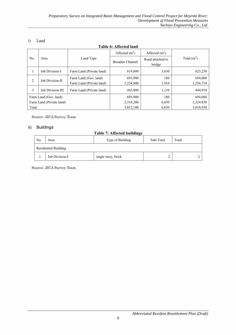
Preparatory Survey on Integrated Basin Management and Flood Control Project for Mejerda River:
Development of Flood Prevention Measures
Yachiyo Engineering Co., Ltd.
Abbreviated Resident Resettlement Plan (Draft)
9
i) Land Table 6: Affected land
No. Area Land Type Affected (m2) Affected (m2)
Total (m2) Broaden Channel
Road attached to bridge
1 Job Division-I Farm Land (Private land) 619,600 3,630 623,230
2 Job Division-II Farm Land (Gov. land) Farm Land (Private land)
693,900 1,254,800
180 1,910
694,080 1,256,710
3 Job Division-III Farm Land (Private land) 443,800 1,110 444,910
Farm Land (Gov. land) Farm Land (Private land) Total
693,900 2,318,200 3,012,100
180 6,650 6,830
694,080 2,324.850 3,018,930
Source: JICA Survey Team
ii) Buildings Table 7: Affected buildings
No. Area Type of Building Sub-Total Total
Residential Building
1 Job Division-I single story, brick 2 2
Source: JICA Survey Team

Preparatory Survey on Integrated Basin Management and Flood Control Project for Mejerda River:
Development of Flood Prevention Measures
Yachiyo Engineering Co., Ltd.
Abbreviated Resident Resettlement Plan (Draft)
10
6. Result of the Domestic economy and household survey The socio-economic study subcontracted to and performed by local consultants is outlined below.
6.1 Purpose To collect and analyze socio-economic data to gain a clear understanding of the social conditions of the
regions in the project plan. The three main details covered by this survey are as given below:
(i) To confirm and grasp the socio-economic condition of communities along the Mejerda River and
the El Mabtouh Wetlands coast
(ii) To access damage sustained by local residents due to recent floods in 2003 and 2009
(iii) To determine ownership of the houses, agricultural facilities and other sites along the Mejerda River,
especially areas in public water districts and retreat areas (construction lines and easements).
This survey was conducted using the following methods:
(i) We collected data at the area/sector level where possible in order to compare the data of survey
areas/sectors (Imadas: smallest administrative unit). Sector is the unit used to analyze results of the
survey.
(ii) A questionnaire given to households along the Mejerda River and the El Mabtouh Wetland coast as
well as production facilities that suffered damages from increased water levels of the Mejerda River
in the past.
6.2 Survey Regions and Residents The target districts and sectors of this survey are shown in the table below. Survey regions were selected
based on the following criteria:
(i) Sectors on the administrative boundary line that at least border the Mejerda River or part of the El
Mabtouh Wetlands
(ii) Sectors that suffered damages from floods in 2003 and/or 2009
Sector Chiefs coordinated with the leaders of agricultural extension cells (CTV) and irrigation regions to
select survey households. The social condition study was conducted on residents of the Mejerda River and
the El Mabtouh Wetland, with a survey sample of 294 households. Residents surveyed belonged to 18 of 47
sectors in seven districts. The districts and sectors in this study are shown in the following table.

Preparatory Survey on Integrated Basin Management and Flood Control Project for Mejerda River:
Development of Flood Prevention Measures
Yachiyo Engineering Co., Ltd.
Abbreviated Resident Resettlement Plan (Draft)
11
Table 8: Study Area and Division List by Reference/Sector Governorate District Sector Mej. Mab. 03 09
Bizerte
Utique
Utique (Zana) ● ● ● Utique Nouvelle ● Besbassia ● El Houidh El Mabtouh ● ● ● Ain Gehlal ● Sidi Othmène ● ● Bach Hamba ● ● ● ●
Ghar El Melh
Ghar El Melh Bajou Ousja ● Zouaouine ●
Ariana
Sidi Thabet
Sidi Thabet ● Bejaoua ● ● ● Mongi Slim ● Cebalet Ben Ammar Chorfech ● ● ●
Kalâat el-Andalous
Kalaat En Andalous Est
●
Kalaat Andalous Ouest
●
Pont de Bizerte ● ● Bou Hanach El Hessiane Ennahli
Manouba
Oued Ellil
Oued Ellil Essaida ● ● ● Er Riadh Cité El Ouerd Ennajet San Haja El Kobbaa
Jedeida
Jedeida ● ● ● Jedeida Rached ● ● ● Chaouat ● ● ● El Mansoura Es Zahra El Habibia
Tebourba
Tebourba ● ● El Ansarine Edkhila El Mellaha Banlieue Tebourba Er Raja EchChouigui
El Bataan
El Battan ● ● Borj Ettoumi Mehriine El Aroussia
Note) Mej. - Sectors that border the Mejerda River Mab. - Sectors that border the El Mabtouh Wetland 03 – Sectors affected by the 2003 floods 09 – Sectors affected by the 2009 floods

Preparatory Survey on Integrated Basin Management and Flood Control Project for Mejerda River:
Development of Flood Prevention Measures
Yachiyo Engineering Co., Ltd.
Abbreviated Resident Resettlement Plan (Draft)
12
Table 9: Geographical distribution of surveyed households by sector and representative percentage
Area Sector Surveyed
Households
Percentage of surveyed households from total in 2010
estimate census (%)
Utique
Ain Ghlal 4 0.7 Bach Hamba 20 3.7 El Mabtouh 23 6.9 Sidi Othmene 13 7.1 Utique 6 1.0
Sidi Thabet Bejaoua 20 3.2 Chorfesh 22 3.5 Monji Slim 8 0.8
Kalaât Andalous Kalaât Andalous Est 8 0.6 Kalaât Andalous Ouest 28 1.3 Pont de Bizerte 12 2.1
Oued Ellil Essaida 4 0.3
Jedeida Chaouet 15 1.7 Jedeida 23 2.2 Jedeida-Hached 23 1.4
Tebourba Banlieue de Tebourba 19 0.6 Medina, Tebourba 12 1.2
El Bataan El Bataan 34 1.7 Total 294 1.5
Source: 2004 General census of the population and habitat (RGPH 2004), National Institute of Statistics (INS)
Figure 3: Location Map of Target Districts/Sectors for Socio-Economic Survey
Districts with municipal
offices
Sectors in this study

Preparatory Survey on Integrated Basin Management and Flood Control Project for Mejerda River:
Development of Flood Prevention Measures
Yachiyo Engineering Co., Ltd.
Abbreviated Resident Resettlement Plan (Draft)
13
6.3 Survey Items Items in the socio-economic survey are shown in the table below.
Table 10: Social Condition Survey Items Item Sub-Item Item Description
(1) Evaluate Socio-Economic Conditions
1) Population/Gender 2) Income/Livelihood 3) Standard of Living 4) Livestock 5) Agriculture 6) Available services 7) Usage of local resources
(2) Site occupation, site usage
1) Site possession 2) Residence 3) Agricultural land 4) Site occupation a) Residential areas
b) Grazing path areas c) State owned grazing paths in El
Mabtouh Wetland (3) Flood situation/damage Flood damage
6.4 Field Survey Period The field survey was conducted from December 10, 2010 to January 10, 2011. Before the survey, the
DGBGTH held a stakeholders meeting in November 2010, where directives of the survey were given for
the districts, sectors, and CRDAs.
6.5 Social Condition Survey Results The survey results have been tallied by district and sector for replies from survey participants and
households. The results of the socio-economic survey are as shown below.
6.5.1 Current Socio-Economic Conditions
1) Population & Gender
a) Population The survey covered the coast of the Mejerda River, home to 18,980 households and 88,118 people in 18
sectors. 55,776 people (12,170 households) from the total live in urban sectors according to the 2004
census.
Based on the fact that the population increased an average of 1% per year between 2004−2010, we
estimate the population of surveyed regions to exceed 100,000 people. The figure below shows the average
household size (number of members per household) in each district based on the survey.

Preparatory Survey on Integrated Basin Management and Flood Control Project for Mejerda River:
Development of Flood Prevention Measures
Yachiyo Engineering Co., Ltd.
Abbreviated Resident Resettlement Plan (Draft)
14
Figure 4: Average Household Size (No. of Members) by Sector
b) Gender The figure below utilizes 2004 data from the INS and shows the industries the working population
belonged to split by gender for surveyed regions.
Figure 5: Classification of Working Population in Surveyed Districts by Gender and Industry in 2004
Source: 2004 General Census (RGPH), National Institute of Statistics (INS)
2) Income/Livelihood The table below shows major sources of income by sector and the percentage (%) of working people in
households. Agriculture has a high percentage as the major source of income.
Other Services
Government
Transport/Communications
Commerce
Construction/Public Works (BTP)
Mining/Energy
Industry
Agriculture/Fishing
Female
Male
Utique Medina, Tebourba
Banlieue de Tebourba Sidi Othmene
Pont de Bizerte Monji Slim
Kalaât Andalous Est Kalaât Andalous Ouest
Hached, Jedeida Jedeida Essaida
El Mabtouh Chorfesh Chaouet Bejaoua
Bataan Bach Hamba
Ain Ghlal

Preparatory Survey on Integrated Basin Management and Flood Control Project for Mejerda River:
Development of Flood Prevention Measures
Yachiyo Engineering Co., Ltd.
Abbreviated Resident Resettlement Plan (Draft)
15
The figure below compares the average income of households to the guaranteed minimum wage (SMIG,
250 TND/month) and splits up those averages into three categories per district. Approximately 37% of
these districts have a monthly income equal to or under the SMIG. More than 50% of those in the Jedeida,
Oued Ellil and El Bataan Districts earn the equivalent of SMIG or less.
Table 11: Source of Household Income by District (percentage (%) of the working population with
income)
District Salary Pension Social Aid Family Aid Agriculture Day Work Other
Utique 18.7 - 1.4 - 73.2 4.0 2.7 Sidi Thabet 11.5 1.9 1.9 - 80.8 3.9 - Kalaât Andalous 8.1 - - 2.1 87.7 - 2.1 Oued Ellil 50.0 - - - 50.0 - - Jedeida 37.3 1.2 1.2 1.2 43.3 15.7 - Tebourba 16.7 - 3.3 3.3 66.7 3.3 6.7 El Bataan 37.3 2.3 - - 53.4 4.7 2.3
Figure 6: Classification of Average Household Income by District (Surveyed Household %)
3) Livestock Approximately half of the households that were surveyed said they raised livestock. Results are shown in
the table below. The average number of livestock owned by households in each sector is 35 sheep and 8.4
cows. There are many farmers in Utique that own a high number of livestock. Other districts generally had
a lower average amount.
Ain Ghlal, El Mabtouh, Kalaât Andalous, Utique and other districts located on the left bank between El
Mabtouh and the river mouth raise many sheep. Sectors that have over 50 sheep are concentrated in sectors
with vast wetlands such as El Mabtouh and Kalaât Andalous.
Sectors with an extremely large amount of cows include Bach Hamba and Utique. Essaida, Chorfesh,
and Kalaât Andalous Ouest also have a large amount of cows, and many of these household also own many
sheep.
Some households (9%) pay a fee for grazing rights, which costs 910 TND annually for an average 153
days of grazing.
Inférieur au SMIG Équivalent au SMIG Supérieur au SMIGBattan 6,9% 44,8% 48,3%Jedeida 22,6% 34,0% 43,4%Kalaat Andalous 17,4% 82,6%Oued Ellil 50,0% 50,0%Sidi Thabet 14,3% 22,4% 63,3%Tébourba 3,7% 29,6% 66,7%Utique 3,2% 24,2% 72,6%
Total 9,0% 27,6% 63,4%
Under SMIG SMIG Equivalent Over SMIG

Preparatory Survey on Integrated Basin Management and Flood Control Project for Mejerda River:
Development of Flood Prevention Measures
Yachiyo Engineering Co., Ltd.
Abbreviated Resident Resettlement Plan (Draft)
16
Table 12: Number of Livestock of Households in Each Sector
Area Sector Sheep Cows Min Max Avg Min Max Avg
Utique
Ain Ghlal 250 250 250 1 10 5.5 Bach Hamba 4 100 18.1 1 235 21.3 El Mabtouh 2 400 104.3 1 10 4.1 Sidi Othmene 3 50 15.7 1 12 5.3 Utique 3 200 57.0 10 40 21.3
Sidi Thabet Bejaoua 3 3 3.0 1 12 4.8 Chorfesh 10 100 41.7 5 20 10.9 Monji Slim 2 2 2.0 2 8 5.8
Kalaât Andalous Kalaât Andalous Est 6 70 45.3 1 10 4.8 Kalaât Andalous Ouest 1 120 29.4 2 70 10.3 Pont de Bizerte 2 60 14.4 3 12 6.7
Oued Ellil Essaida 2 2 2.0 11 11 11.0
Jedeida Chaouet 3 40 16.3 2 6 3.8 Jedeida 1 15 8.7 1 6 4.0 Jedeida-Hached 4 15 7.0 1 1 1.0
Tebourba Banlieue de Tebourba 6 8 7.0 1 6 3.2 Medina, Tebourba 7 7 7.0 - - -
El Bataan El Bataan 4 20 7.4 1 10 3.3 Average 1 400 35 1 235 8.4
4) Agriculture Of surveyed households that said they farmed, 70% grow vegetables and use private irrigation. Some
agricultural districts, such as El Mabtouh and Sidi Othmene, cultivate produce without irrigation like trees
(El Mabtouh) and grains (El Mabtouh, Sidi Othmene). Irrigation farming in this project concentrates the
most on the Bach Hamba and Kalaât Andalous Ouest regions.
5) Standard of Living Indicators for the standard of living include household fittings (telephone, PC, washing machine, etc.),
the supply of water, gas, and electricity, and household conveniences such as a sewerage system for urban
areas and garbage collection. These indicators were used by the INS in the 2004 General Census conducted
for all districts. The figure below compares 11 items in household fittings between the national average and
surveyed districts in this study.

Preparatory Survey on Integrated Basin Management and Flood Control Project for Mejerda River:
Development of Flood Prevention Measures
Yachiyo Engineering Co., Ltd.
Abbreviated Resident Resettlement Plan (Draft)
17
Figure 7: Comparison of household fittings for surveyed districts (DZE) and the national average in
2004 Source: 2004 General Census(RGPH), National Institute of Statistics (INS)
According to the 2004 General Census, we saw that the surveyed districts in this study have a higher rate
of water and electricity supply as well as sewerage systems than the national average. The table below
shows how each sector is supplied with drinking water and the availability of electricity. Areas with the
least supply of electricity are Jedeida-Hached and the districts of Utique. Approximately 50% of drinking
water is supplied by SONEDE while the remaining half gets their water mainly from local water
management associations who are also in charge of the water supply from irrigation channels.
PC
Mobile Phone
Landline
A/C Unit
Washing Machine
Oven Unit
Refrigerator
Parabolic Antenna
TV
Stereo
Car
Tunisian Average Surveyed Districts (DZE)

Preparatory Survey on Integrated Basin Management and Flood Control Project for Mejerda River:
Development of Flood Prevention Measures
Yachiyo Engineering Co., Ltd.
Abbreviated Resident Resettlement Plan (Draft)
18
Table 13: Supply Methods of Drinking Water and Availability of Electricity (%) in Each District and
Sector
District Sector Supply Method of Drinking Water Avail. of
Electricity (%) SONEDE Well Other Water
Resource
Utique
Ain Ghlal 25 0 75 50.0 Bach Hamba 81 0 19 90.5 El Mabtouh 50 0 50 60.9 Sidi Othmene 0 0 100 84.6 Utique 0 0 100 16.7
Sidi Thabet Bejaoua 95 0 5 95.0 Chorfesh 36 5 59 50.0 Monji Slim 13 0 87 37.5
Kalaât Andalous Kalaât Andalous Est 0 0 100 - Kalaât Andalous Ouest 0 0 100 - Pont de Bizerte 83 0 17 66.7
Oued Ellil Essaida - - - -
Jedeida Chaouet - - - - Jedeida 92 0 8 48.0 Jedeida-Hached 80 0 20 16.7
Tebourba Banlieue de Tebourba 21 11 68 78.9 Medina, Tebourba - - - -
El Bataan El Bataan 92 0 8 73.5 Average 49.1 1.4 49.5 48
6) Availability of Transportation Services The major findings from this study are as follows.
– Most survey participants in Sidi Thabet and Kalaât Andalous feel they have a difficult time
accessing the main road and utilizing schools and medical services. Many survey participants in
Jedeida also responded they had trouble utilizing either schools (73.4%) or medical services
(76.6%).
– Participants in the three districts mentioned above mentioned problems commuting to work.
– Sectors where it is critically difficult to commute to work are Monji Slim, Kalaât Andalous Est and
Ouest, Chaouet, as well as Bejaoua and Chorfesh.
– Very few use cars, so walking is the main method of transportation for commuting to work and
receiving services.
– The majority (98% of participants) said it was not necessary to cross the Mejerda River to commute
to work and receive services.
7) Use of Local Resources The largest natural resource the local community utilizes is river water from the Mejerda River. Many
people privately pump the water to use for irrigation. In particular, the Kalaât Andalous, Sidi Thabet,
Tebourba, and El Bataan Districts use the Mejerda River as their main water source for private irrigation
water. Irrigation water can be privately pumped from the Mejerda River by placing a small pump directly
into the river terrace or setting up a small pump shack and installing a small pump inside. Either option

Preparatory Survey on Integrated Basin Management and Flood Control Project for Mejerda River:
Development of Flood Prevention Measures
Yachiyo Engineering Co., Ltd.
Abbreviated Resident Resettlement Plan (Draft)
19
only requires the installation of a simple pump and does not require a large scale facility. In addition, most
residents along the Mejerda River do not collect wood, fish, nor hunt.
6.5.2 Land Ownership/Residence/Land Use
1) Ownership of Land We confirmed the following options with regard to the ownership of land on the coast of the Mejerda
River.
① Ownership of land with a certificate of rights
② Ownership of land without a certificate of rights
③ Occupation
④ Renting
⑤ Other Of the 209 households that answered our question, 37.8% owned land with a certificate of rights while
14.8% owned land without a certificate of rights.
The table below shows the number of households in each district and the manner of land ownership as
classified from (1) to (5). Jedeida and Bejaoua have a particularly high number of land owners who do not
have a certificate of rights. An extremely high number of households in each sector in Kalaât Andalous Est
and Ouest, El Mabtouh, Bach Hamba, and El Bataan held occupational rights.
In addition, compensation is owed to land owners who have a certificate of rights as well as owners that
possess land without a certificate based on Tunisian land ownership law.

Preparatory Survey on Integrated Basin Management and Flood Control Project for Mejerda River:
Development of Flood Prevention Measures
Yachiyo Engineering Co., Ltd.
Abbreviated Resident Resettlement Plan (Draft)
20
Table 14: Land Ownership of Agricultural Land in Sectors along the Mejerda River (Survey
Participant Households)
Area Sector (1)
Propr. aTF
(2) Propr. sTF
(3) Occ. (4) Loc. (5) Other Total
Utique
Ain Ghlal 2 1 1 0 0 4 Bach Hamba 9 0 10 2 0 21 El Mabtouh 2 1 8 0 0 11 Sidi Othmene 7 1 0 0 1 9 Utique 4 1 1 6
Sidi Thabet Bejaoua 3 7 1 2 0 13 Chorfesh 13 2 2 5 0 22 Monji Slim 2 1 2 0 0 5
Kalaât Andalous Kalaât Andalous Est 1 0 7 0 0 8 Kalaât Andalous Ouest 3 0 15 8 0 26 Pont de Bizerte 9 0 2 0 11
Oued Ellil Essaida 2 0 0 0 0 2
Jedeida Chaouet 9 2 1 0 0 12 Jedeida 1 5 2 1 0 9 Jedeida-Hached 2 0 2 2 0 6
Tebourba Banlieue de Tebourba 5 5 7 1 0 18 Medina, Tebourba 3 1 1 0 0 5
El Bataan El Bataan 2 5 10 4 0 21 Total 79 31 70 27 2 209
① Propr. aTF : Land owners with a certificate of rights ② Propr. sTF : Land owners without a certificate of rights ③ Occ. : Occupiers/Land possessors ④ Loc. : Renters
2) Residence 81% of households own homes, and the disparity between the average of sectors is big (see figure below). The
rate of home ownership is low in El Mabtouh (52%) and Kalaât Andalous Ouest (50%).

Preparatory Survey on Integrated Basin Management and Flood Control Project for Mejerda River:
Development of Flood Prevention Measures
Yachiyo Engineering Co., Ltd.
Abbreviated Resident Resettlement Plan (Draft)
21
Figure 8: Rate of Home Owning Households (% by Sector)
3) Agricultural Land The table below shows respondent households by sector who said they farmed in flood plains and near
the Mejerda River. These numbers indicate that some parts of Utique, Kalaât Andalous, Jedeida, and other
sectors particularly have agricultural land in the flood plains of the Mejerda River.
Table 15: Households that farm in the flood plains of the Mejerda River or nearby areas
District Sector Respondent Households
Agriculture near the
Mejerda River
Agriculture in Flood
Plain
Utique
Ain Ghlal 4 0 0 Bach Hamba 19 19 10 El Mabtouh 12 1 1 Sidi Othmene 12 0 0 Utique 6 4 1
Sidi Thabet Bejaoua 12 12 4 Chorfesh 22 21 9 Monji Slim 4 4 1
Kalaât Andalous Kalaât Andalous Est 8 8 2 Kalaât Andalous Ouest 27 27 16 Pont de Bizerte 11 11 2
Oued Ellil Essaida 2 2 0
Jedeida Chaouet 12 12 0 Jedeida 9 4 5 Jedeida-Hached 5 5 0
Tebourba Banlieue de Tebourba 18 17 3 Medina, Tebourba 5 5 0
El Bataan El Bataan 21 21 2 Total
Total
Utique
Medina, Tebourba
Banlieue de Tebourba
Sidi Othmene
Pont de Bizerte
Monji Slim
Kalaât Andalous Ouest
Kalaât Andalous Est
Hached, Jedeida
Jedeida
Essaida
El Mabtouh
Chorfesh
Chaouet
Bejaoua
Bataan
Bach Hamba
Ain Ghlal

Preparatory Survey on Integrated Basin Management and Flood Control Project for Mejerda River:
Development of Flood Prevention Measures
Yachiyo Engineering Co., Ltd.
Abbreviated Resident Resettlement Plan (Draft)
22
4) Site Possession
a) Residential Area The distance between the river and residences is at least 10 to 20 meters for most sectors, but it was two
meters in the Jedeida sector. Of a total 25 households, 14 had homes within 60 meters of the river bed in
the Jedeida sector. The figures were 10 out of 23 households in the Jedeida-Hached sector, and 6 out of 15
households in Chaouet. Other sectors had a lower percentage than the aforementioned numbers. The table
below shows the distribution of residences located within 150 meters of the river bed.
Table 16: Distribution of Residences (No. of Households) Located within 150 meters of the River Bed
District Sector
Households with Residences within 150m of River Bed
(Classified by distance)
Total Households
who replied < 10 10-19 20-59 60-149
Utique
Ain Ghlal - - - - 3 Bach Hamba - 1 2 1 21 El Mabtouh - - - - 18 Sidi Othmene - - - - 12 Utique - - - - 5
Sidi Thabet Bejaoua - - 1 4 20 Chorfesh - 3 - 4 22 Monji Slim - - 1 3 8
Kalaât Andalous Kalaât Andalous Est - - 2 - 8 Kalaât Andalous Ouest - 1 4 4 27 Pont de Bizerte - - 1 2 11
Oued Ellil Essaida - - - - 4
Jedeida Chaouet - - 6 6 15 Jedeida 2 1 11 5 25 Jedeida-Hached - - 8 9 23
Tebourba Banlieue de Tebourba - - 1 2 18 Medina, Tebourba - - 1 - 14
El Bataan El Bataan - - 4 6 33 Total 2 6 42 46 287
(-): No applicable households
b) Grazing Regions Approximately 75% of households that answered questions about stock farming said they use grazing
regions near the Mejerda River while the remaining 25% replied they used the El Mabtouh Wetland or
other places.
The Mejerda River is the major grazing region for all sectors besides El Mabtouh, Sidi Othmene, and
Ain Ghlal. The El Mabtouh Wetland is the major grazing region for surveyed households in both the El
Mabtouh and Sidi Othmene sectors and is used as a secondary grazing region for households in Ain Ghlal
and Utique.
c) State Owned El Mabtouh Wetland Grazing Region The state-owned El Mabtouh Wetland grazing region has an area of 3,365 hectares. Management of grazing
regions was officially transferred from the Department of Livestock to the Directorate General of Forests

Preparatory Survey on Integrated Basin Management and Flood Control Project for Mejerda River:
Development of Flood Prevention Measures
Yachiyo Engineering Co., Ltd.
Abbreviated Resident Resettlement Plan (Draft)
23
(DGF) due to the change in administration on March 4, 2004. However, the DGF did not actually start
managing grazing regions until 2008. The DGF enforced the grazing region management project from 2009
to 2010, but did not enforce it from 2010 to 2011 because of the unstable state of affairs in Tunisia due to
the Jasmine Revolution. The Office of Livestock and Pastures (OEP) currently manages them.
The figure below shows the official map of the state owned El Mabtouh Wetland grazing region. They are
currently addressing the issue of unlawful occupation in the southern and northeastern regions and are in
the final stages of deciding the grazing region.
From 2009 to 2010, 54 nomadic pastoralist shepherds moved a flock of sheep and used this grazing
region. The grazing region is also used by 152 shepherds who are permanently settled nearby (see picture
below). The number of corresponding sheep for nomadic pastoralists was 15,880 sheep, and the permanent
settlers had a flock of approximately 10,000 sheep. The grazing season is from February to April. Other
government land besides grazing regions fall under forest precincts5 managed by the Department of
Forestry. Most of the nomadic pastoralists in the forest precincts of El Mabtouh are originally from the Sidi
Bouzid and Kairouan Governorates. Grazing fees for forest precincts cost 0.2 TND per livestock per month.
However, grazing fees for forest precincts have never been paid by the people who used the grazing region.
Mobile pastoralism has always been conducted in the El Mabtouh Wetland. In the 1980s, it was
conducted in wetlands without feed production and grazing issues, and the El Mabtouh Wetland became an
important grazing region for nomadic pastoralists in Tunisia. The stagnation of water from floods in either
January or February never lasted more than one month a year because the sewerage system was well
managed at the time.
However, feed production has been decreasing every year mainly because the operations of the
agricultural cooperative have gotten worse, causing perpetual overgrazing, and leading to the decrease of
sheep's fescue, a plant used as feed. According to the Office of Livestock and Pastures (OEP), another
reason for the deterioration of grazing is due to the construction of the Tunis−Bizerte motorway.
Embankment in the motorway construction blocked flood water from draining, causing water to stagnate in
wetlands over a long period of time during the rainy season. Saline buildup on the road also negatively
influences the growth of feed.
According to the Office of Livestock and Pastures (OEP), the condition of the grazing land in El
Mabtouh Wetland is extremely bad and cannot even be considered a grazing region. The forest precincts
are in a similar situation, and the outlook for feed production at the current stage is not good.
5Forest management structure for each CRDA

Pre
pa
rato
ry S
urv
ey o
n I
nte
gra
ted
Ba
sin
Ma
na
gem
ent
an
d F
loo
d C
on
tro
l P
roje
ct f
or
Mej
erd
a R
iver
: D
eve
lop
men
t o
f F
loo
d P
reve
nti
on
Mea
sure
s
Ya
chiy
o E
ng
inee
rin
g C
o.,
Ltd
.
Ab
bre
via
ted
Res
iden
t R
eset
tlem
ent
Pla
n (
Dra
ft)
24
Fi
gure
9: A
rea
Map
/Off
icia
l Map
of S
tate
Ow
ned
El M
abto
uh W
etla
nd G
razi
ng R
egio
n as
pro
pose
d by
the
DG
F to
the
Min
istr
y of
Sta
te
Prop
ertie
s (Fi
nal D
raft
) So
urce
: Biz
erte
For
est P
reci
nct

Preparatory Survey on Integrated Basin Management and Flood Control Project for Mejerda River:
Development of Flood Prevention Measures
Yachiyo Engineering Co., Ltd.
Abbreviated Resident Resettlement Plan (Draft) 25
Figure 10: Grazing Conditions of State-Owned El Mabtouh Wetland (November 2010)
6.5.3 Flood Damage
Of the 292 households that answered questions about the location of residences relative to the Mejerda River, 206 households, or approximately 70%, said they lived in areas where flooding may occur. Approximately 66% of respondents experienced the 1973 flood, and 98% said they experienced the floods in 2003, 2004, and 2009.
The majority of respondents (approx. 86%) said that the 2003 flood caused the most damage. When residents talk about floods, they always compare damage to the 2003 flood. Responses regarding the 2003 flood are as follows:
1) Submerged houses due to the 2003 flood The percentage of submerged houses in each district: Jedeida (89%), El Bataan (88%), Tebourba (76%), Oued Ellil (75%).
2) Submerged depth and time due to the 2003 flood The submerged depth was the highest in each sector of Banlieue de Tebourba, Utique, Jedeida, El Bataan, Chaouet at the peak of the flood, and the average flood time was longest in the Utique, Jedeida, Chaouet Sectors.
Table 17: Submersion and Duration of 2003 Flood Sector Name Peak Submersion Depth of
Flood Flood Duration Submerged Houses
Medina, Tebourba 76% Banlieue de Tebourba 142cm 76% Utique 130 cm 48hr Jedeida 105 cm 43 hr 89% El Bataan 97 cm 88% Chaouet 92 cm 34 hr Oued Ellil 75%
According to the table below, the Bach Hamba, El Mabtouh, Bejaoua, Chorfesh, Kalaât Andalous Ouest,

Preparatory Survey on Integrated Basin Management and Flood Control Project for Mejerda River:
Development of Flood Prevention Measures
Yachiyo Engineering Co., Ltd.
Abbreviated Resident Resettlement Plan (Draft) 26
Jedeida, Jedeida-Hached, Tebourba, and El Bataan Sectors had many flooded regions. The average amount in damages of surveyed households exceeded 10,000 TND/household. The average
in damages for the seven districts of Bach Hamba, El Bataan, Chaouet, Chorfesh, El Mabtouh, Kalaât Andalous Ouest, and Utique is even higher. Of surveyed households, 96 households, or over one third, received reparation from this department. 79% of reparations came in the form of financial aid while 31% was distributed through goods and items.
Table 18: Distribution of Residences (Households) in Flooded & Serviced Regions by Sector
District Sector Flooded Regions
Serviced Region Total No. of
Households
Public Water Area
Backland
Utique
Ain Ghlal 0 0 0 4 Bach Hamba 16 0 0 21 El Mabtouh 19 0 4 23 Sidi Othmene 0 0 0 13 Utique 5 0 0 6
Sidi Thabet Bejaoua 16 1 1 20 Chorfesh 22 0 0 22 Monji Slim 4 1 1 8
Kalaât Andalous Kalaât Andalous Est 8 0 0 8 Kalaât Andalous Ouest 24 2 0 26 Pont de Bizerte 2 1 0 11
Oued Ellil Essaida 4 0 0 4
Jedeida Chaouet 5 0 9 14 Jedeida 12 1 11 24 Jedeida-Hached 16 0 7 23
Tebourba Banlieue de Tebourba 17 0 0 19 Medina, Tebourba 13 0 1 14
El Bataan El Bataan 23 1 2 32 Total 206 7 36 292
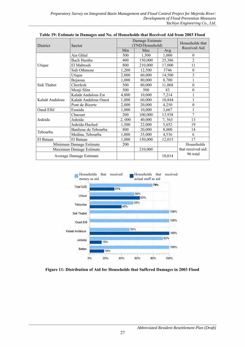
Preparatory Survey on Integrated Basin Management and Flood Control Project for Mejerda River:
Development of Flood Prevention Measures
Yachiyo Engineering Co., Ltd.
Abbreviated Resident Resettlement Plan (Draft) 27
Table 19: Estimate in Damages and No. of Households that Received Aid from 2003 Flood
District Sector Damage Estimate (TND/Household) Households that
Received Aid Min Max Avg
Utique
Ain Ghlal 500 1,500 1,000 0 Bach Hamba 400 150,000 25,386 2 El Mabtouh 800 210,000 17,000 11 Sidi Othmene 1,200 12,500 3746 0 Utique 2,000 60,000 14,500 3
Sidi Thabet Bejaoua 1,000 80,000 8,700 1 Chorfesh 500 80,000 11,068 0 Monji Slim 500 500 83 0
Kalaât Andalous Kalaât Andalous Est 4,000 10,000 7,214 1 Kalaât Andalous Ouest 1,000 60,000 10,844 1 Pont de Bizerte 2,000 20,000 4,250 0
Oued Ellil Essaida 1,000 10,000 3,667 1
Jedeida Chaouet 200 100,000 13,938 7 Jedeida 2, 000 40,000 7, 563 13 Jedeida-Hached 1,500 22,000 5,652 19
Tebourba Banlieue de Tebourba 800 20,000 8,000 14 Medina, Tebourba 1,000 35,000 4,536 6
El Bataan El Bataan 1,000 150,000 12,015 17 Minimum Damage Estimate 200 Households
that received aid: 96 total
Maximum Damage Estimate 210,000 Average Damage Estimate 10,014
Figure 11: Distribution of Aid for Households that Suffered Damages in 2003 Flood
Households that received money as aid
Households that received actual stuff as aid

Preparatory Survey on Integrated Basin Management and Flood Control Project for Mejerda River:
Development of Flood Prevention Measures
Yachiyo Engineering Co., Ltd.
Abbreviated Resident Resettlement Plan (Draft) 28
7. Type of loss, compensation and assistance beneficiaries, compensation package
Land ownership transfer conditions such as type of loss, compensation and assistance beneficiaries,
compensation package, and responsible organizations as based on JICA guidelines are shown in the table below.
Table 20: Entitlement matrix (JICA Guidelines)
Type of loss
Entitled Persons (Beneficiaries)
Entitlement (Compensation
Package)
Implementation issues/Guidelines
Organization Responsible
Loss of agricultural land, orchards, gardens Loss of residential or commercial land
Legal owner of land, Occupant with legal rights, Occupant without legal rights but recognized after 6-month public announcement
Replacement value of land (cash compensation or land based compensation according to the wish and to cover the market value of land as determined by Ministry of State Domain
i) Assessment of quantity and quality of land by DGBGTH and OTC with support of Regional Commissions of Expropriation
DGBGTH, OTC, Regional Commissions of Expropriation
ii) Assessment of Market Value by Land Market Survey
Regional Commissions of Expropriation
iii) Assessment of Cash Compensation under Law
Ministry of State Domain
iv) Updating of title of the affected persons
DGBGTH, Regional Commissions of Expropriation
v) Payment of Cash Compensation under Law
DGBGTH, Governorates
Loss of trees and standing crops Loss of built structures including house
Legal owner of land, Occupant with legal rights, Occupant without legal rights but recognized after 6-month public announcement
Replacement value of assets (cash compensation) to cover the market value of assets as determined by Ministry of State Domain
i) Assessment of quantity and quality of assets by DGBGTH and OTC with support of Regional Commissions of Expropriation and CRDA
DGBGTH, OTC, Regional Commissions of Expropriation, CRDA
ii) Assessment of Market Value by Land Market Survey
Regional Commissions of Expropriation
iii) Assessment of Cash Compensation under Law
Ministry of State Domain
iv) Payment of Cash Compensation under Law
DGBGTH, Governorates
Source: JICA Survey Team

Preparatory Survey on Integrated Basin Management and Flood Control Project for Mejerda River:
Development of Flood Prevention Measures
Yachiyo Engineering Co., Ltd.
Abbreviated Resident Resettlement Plan (Draft) 29
8. Compensation for loss
For land acquisition and compensation procedures for the Project, just and fair compensation will be provided for owners/occupants of the target land based on the Tunisian Land Ownership Law, regardless of the legality/illegality of land ownership. As recommended in the JICA guidelines, consultations will be conducted with the relevant parties, and forcible land expropriation procedures will be kept to a minimum, in accordance with existing Tunisian law regarding land acquisition and compensation. Mutual agreement reached through discussions between the acquirer and persons whose land is expropriated will be used as the fundamental principle. In order to ensure conformance with JICA guidelines, this Project will propose to the DGBGTH that matters not clearly defined by Tunisian law such as public hearings, public assistance for resettling socially vulnerable persons, and monitoring for land acquisition, compensation, and resident resettlement procedures be treated as important items.
Preparations for consultation will be conducted as a duty of the Regional Commissions of Assessment and Adjustment. Other related parties may not conduct discussions in the place of the Regional Commission of Assessment and Adjustment. Therefore, the land acquisition schedule may be greatly affected based on whether mutual consultations with this Commission are sufficiently and smoothly conducted.
When the land boundaries are set and the decree for public utility declaration has been promulgated, the DGBGTH will begin preparing the plan for acquisition, compensation, and resettlement. Compensation for all eligible structures pertaining to sustaining the livelihoods of the owners/occupants such as land, immovable facilities, planted land, etc. will be paid the compensatory amount stipulated by the Ministry of State Domains. If the amount of compensation is low due to the value of the original residence being low, the governorate may provide supplementary funds to assist with relocation to alternative land. However, the relocated person will be responsible for construction of the housing, etc. on the provided alternative land himself. For residents whose livelihoods are based on the land, compensation in the form of a land base will be preferentially provided instead of just financial compensation. The compensatory amounts will conform to JICA guidelines, with some cases taking into consideration the loss of livelihoods means of the eligible person.
The cut-off date for the Project will serve as the notification date, as based on the Land Ownership Law. For acquisition procedures for land with no proprietary rights, the start date for the population census to be implemented by the DGBGTH in 2014 will be set based on the JICA Category B Project report guidelines for environmental and social considerations.
9. Reconstruction of livelihoods
As a measure for the reconstruction of livelihood for resettled residents, it is required that the full cost in the form of subsidies be provided for resettlement and restoration of livelihoods and standards of living. This amount will be based on existing Tunisian regulations, appraisal reports prepared by the Regional Commissions of Expropriation, and the results of appraisal report evaluation by experts at the Ministry of State Domains.

Preparatory Survey on Integrated Basin Management and Flood Control Project for Mejerda River:
Development of Flood Prevention Measures
Yachiyo Engineering Co., Ltd.
Abbreviated Resident Resettlement Plan (Draft) 30
10. Grievance mechanism In Tunisian law related to land acquisition and compensation, objections to the awarded compensatory
amount can only be filed through a lawsuit in court at the time of land expropriation. A grievance processing system to support responding to the requests of residents subject to land expropriation has not been established.
For this project, a Project Team within the CRDA of each governorate will accept grievances from residents subject to land acquisition procedures as a method of support for agricultural promotion organizations. This will be spearheaded by the DGBGTH as a means of assisting residents by listening to their grievances and thinking of problem resolutions. The grievances heard will be reported to the governorate or the special Resident Resettlement Coordination Committees established within the governorate. The DGBGTH will cooperate with Service of Water Use and Agricultural Facilities of the CRDA of each governorate to conduct overall monitoring for the Project while taking into account the grievance processing system. Furthermore, in order to provide definite support to socially vulnerable residents, the governor of each governorate will notify the Regional Commissions for Assessment and Adjustment that they are to include a representative from social welfare agencies as a member of the commission.
11. Considerations for socially vulnerable people Using results of a survey on livelihoods and lifestyles conducted on 300 household in the Project area,
the effects on socially vulnerable people (the poor, women, children, ethnic minorities) were also analyzed. From these survey results, it was determined that the ratio of poor residents with household incomes
under the minimum wage, as well as residents in vulnerable positions is particularly high in the Jedeida, Sidi Thabet, and El Battan Districts. It is expected that the loss of cropland and unharvested crops due to land acquisition for the Project will have a serious impact on the agricultural livelihoods of these households. These impacts can be relieved through land and property compensation procedures. In addition, most of these households have received very serious damage to their houses and property from flooding. Therefore, the losses suffered from flood damage can be mitigated through this project.
In regard to gender rights and children’s rights, since farm work and drawing water for irrigation is mainly conducted by men, field surveys showed that women’s viewpoints were not largely reflected. However, it was determined that there are no adverse affect on gender equality or the rights/living environment of children caused by this Project. Furthermore, since flood damage will be mitigated due to the Project, an increased level of safety for people vulnerable to disaster (women and children) can be expected.
In regard to ethnic minorities, there is a group of ethnic minority people who engage in grazing activities within the Project region under the free passage rights of state-owned grazing land in El Mabtouh in particular. Although it is necessary to consider their land of origin, number of livestock migrating seasonally, and their cycle of passage, this Project is not considered to affect a specific ethnic minority group.
Although public assistance for socially vulnerable owners/occupants is not specifically written in land acquisition and compensation procedures, for land acquisition procedures for the Project, it is important to make thorough considerations of the vulnerabilities of owners/occupants based on the statement of demands written by the owner/occupants for the Regional Commissions of Assessment and Adjustment.
The DGBGTH will confirm the a representative from social welfare agencies are present during meetings of the Regional Commission of Assessment and Adjustment, and will also designate the CRDA as the responsible party for monitoring social assistance for the most vulnerable residents to facilitate backup in the establishment of a support system for socially vulnerable people.

Preparatory Survey on Integrated Basin Management and Flood Control Project for Mejerda River:
Development of Flood Prevention Measures
Yachiyo Engineering Co., Ltd.
Abbreviated Resident Resettlement Plan (Draft) 31
12. Relevant organizations for Expropriation and Compensation The legal land expropriators are the Division of Expropriation of Dams and Services of Expropriation
and Compensations within the Directorate of Large Dams of the DGBGTH. From this position, they are responsible for land acquisition procedures in cooperation with the following relevant organizations.
– The Directorate General of Acquisition and Boundary Demarcation and the Directorate General for Appraisals within the Ministry of State Domains and Land Affairs (hereinafter called “Ministry of State Domains”)
– Governorate branches of the Ministry of State Domains – Office of Rural Land Conservation (a public companies set up within the Ministry of State
Domains to handle registration management) – CRDA – Governorates and relevant districts – Regional Commissions of Expropriation
With the Governor acting as chairperson, this commission consists of representatives from the DGBGTH, MEq, Ministry of State Domains, CRDA, and relevant districts.
– Regional Commissions of Assessment and Adjustment With a government official acting as chairperson, this commission generally consists of about 12 people as standing and temporary members. They include the land expropriator, local representatives of the MEq, experts from the Ministry of State Domains, representatives of regional social welfare agencies, district court representatives, and CRDA representatives.
– Court of justice (involved if there are land expropriation procedures) – Central Committee on Land Use Planning and Development
This committee consists of the major relevant directorates, the Ministry of State Domains, and the governors of governorates in Project areas. It is only involved for special cases, such as disputes between owners during land acquisition or the discovery of cultural or archeological artifacts during construction work.
– Central Steering Committee Study on the establishment of this committee by the Ministry of State Domains, the MEq, and the ME began following the revolution in order to facilitate land acquisition procedures through government involvement. The timing of establishment and primary activities of the committee are yet undetermined.
13. Implementation schedule
The implementation schedule (draft) for land acquisition and involuntary resident resettlement is shown in the following table. The timing for beginning procedures is indicated in the table with an arrow. For this Project, it is expected that actual resettlement will begin after compensation for lost assets has been paid.

Pre
pa
rato
ry S
urv
ey o
n I
nte
gra
ted
Ba
sin
Ma
na
gem
ent
an
d F
loo
d C
on
tro
l P
roje
ct f
or
Mej
erd
a R
iver
: D
evel
op
men
t o
f F
loo
d P
reve
nti
on
Mea
sure
s
Ya
chiy
o E
ng
inee
rin
g C
o.,
Ltd
.
A
bb
revi
ate
d R
esid
ent
Res
ettl
emen
t P
lan
(D
raft
) 32
Tab
le 1
2: S
ched
ule
for
land
and
pro
pert
y ac
quis
ition
(dra
ft)
Impl
emen
tatio
n sc
hedu
le P
erio
d: 2
2 m
onth
sPe
riod
(mon
ths
)
12
34
56
78
910
1112
1314
1516
1718
1920
2122
Not
es
(1) C
onfir
mat
ion
of p
ublic
ben
efit
of th
e pr
ojec
t and
as
sess
men
t of r
equi
red
land
(2) A
ppra
isal
by
the
Regi
onal
Com
mis
sion
s of
Ex
prop
riatio
n(3
) Con
firm
atio
n of
land
ow
ners
and
land
re
gist
ratio
n ce
rtific
ates
(4) E
xam
inat
ion
of la
nd o
wne
rs a
nd c
ompe
nsat
ion
amou
nts
by th
e M
inis
try o
f Sta
te D
omai
ns
6
Base
d on
the
Abb
revi
ated
Res
iden
t Res
ettle
men
t Pl
an p
repa
red
by th
e Su
rvey
Tea
m, D
GBGT
H m
ake
its o
wn
vers
ion.
2
Con
sulta
tions
per
tain
ing
to la
nd a
cqui
sitio
n by
the
Reg
iona
l Com
mis
sion
s of
Ass
essm
ent a
nd A
djus
tmen
t, la
nd o
wne
rs, a
nd th
e im
plem
entin
g ag
ency
of t
he P
roje
ct3
From
the
com
plet
ion
of d
iscu
ssio
ns w
ith th
e R
egio
nal
Com
mis
sion
s of
Ass
essm
ent a
nd A
djus
tmen
t to
the
finis
h of
resi
dent
rese
ttle
men
t6
If th
ere
are
cour
t pro
cedu
res
13Co
urt
prep
arat
ions
If ca
rried
ove
r to
cour
t tri
als,
this
will
take
m
ore
than
one
yea
r.
Mon
itorin
g10
If ca
rried
ove
r to
cour
t tri
als,
an
inte
rvie
w
surv
ey o
n th
e co
mpe
nsat
ion
for l
oss
will
be
cond
ucte
d in
th
e 16
th o
r 22n
d m
onth
.
Land
acq
uisit
ion
thro
ugh
cons
ulta
tions
is s
et
as a
pre
cond
ition
, bu
t thi
s m
ay b
e ca
rrie
d ov
er to
cou
rt tri
als
depe
ndin
g on
th
e sit
uatio
n.
1st t
rial
(app
rox.
6 m
onth
s)2n
d/3r
d tri
al(a
ppro
x. 3
mon
ths)
So
urce
: JIC
A Su
rvey
Tea
m

Preparatory Survey on Integrated Basin Management and Flood Control Project for Mejerda River:
Development of Flood Prevention Measures
Yachiyo Engineering Co., Ltd.
Abbreviated Resident Resettlement Plan (Draft)
33
14. Costs and financial resources Relocation and compensation costs related to resident resettlement and land acquisition are
planned to be calculated based on property and land survey results that can be found within EIA
survey items. The DGBGTH will be the implementing body. In addition, it is necessary for these
relocation and compensation costs, as well as costs associated with monitoring resident resettlement
to be shown clearly in a resident relocation plan to be drafted by the DGBGTH.
Table 21: Item of the compensation No. Item Qty Unit price
(TND) Acquisition price (TND)
1 Compensation fee ( Fee for reinstallation of Structure, public infrastructure etc.)
2 - 350,000
2 Compensation fee (Crop compensation) 2,324,850 - 23,030,545
3 Compensation fee for the private land(for the legal residents)
2,324,850 (Need of
confirmation of legal or illegal)
3.5 9,000,000
4 Relocation fee( transportation fee for the luggage and the residents to the new address, tax/administration fee, Construction fee for the temporary residential house etc.)
2 - 10,000
5 Administration fee(staff cost, Monitoring management fee etc.)
- - -
6 Fee for the reconstruction of the livelihood(If the loss of the gained capital exceeds more than 10% because of the expropriation, the fee for the preparation of alternative income creation, vocational training, introducing another job should be supported.)
- - -
Total - - -

Preparatory Survey on Integrated Basin Management and Flood Control Project for Mejerda River:
Development of Flood Prevention Measures
Yachiyo Engineering Co., Ltd.
Abbreviated Resident Resettlement Plan (Draft)
34
15. Land acquisition and resident resettlement monitoring
Monitoring associated with resident resettlement procedures are not sufficiently covered by laws related to land acquisition and compensation procedures in Tunisia. Therefore, it will be supplemented by JICA guidelines. Monitoring will be conducted with the purpose of checking plan execution along with the progress of land acquisition and compensation procedures, confirming that the Project land is vacated under appropriate conditions, and ascertaining the status of resettled residents during implementation of the resident resettlement plan.
The DGBGTH Division of Expropriation of Dams or the Service of Expropriation and Compensation will be the implementing agency for monitoring and will organize a monitoring committee for the land acquisition, compensation, and resettlement plan.
The land acquisition and resettlement monitoring plan is shown in the table below. The DGBGTH will make an overall evaluation by conducting monitoring using a monitoring form while receiving advice and support from the Consultant or related agencies, and then proceed with land acquisition. Monitoring forms will be managed by the implementing agency for monitoring. The form will be created by appropriately referring to the sample monitoring form for land acquisition and involuntary resident resettlement as shown in the following table. It is recommended that the monitoring form be used for each target sector identified by results of the land registration survey conducted at the time of the Detailed Design Survey of the Project.
Table 22: Land acquisition and resident resettlement monitoring plan Purpose Item Implementation
point Frequency Responsible
agency 【Before construction】 Confirm consensus building related to business activities and compensation methods.
Follow stakeholder meetings.
Stakeholder meeting venue or resettlement residence
When stakeholder meetings are held
Evaluation and implementation : DGBGTH (Directorate General for Dams and Major Hydraulic Works) Land Acquisition Division Decision : Ministry of State Domains and Land Affairs Relocation assistance means monitoring : CRDA/DHER
Confirm the progress of land acquisition.
Record the number of land acquisitions.
Resettlement residence
Done once before construction
Confirm the progress of resettlement.
Record the number of moved people and households.
Resettlement residence
Done once before construction
Confirm the progress of compensation payment.
Record the number of residents paid compensation.
Resettlement residence
Done once before construction
【During construction】 Confirm the living conditions of resettled residents.
Record the number of incidence of complaints and their solutions.
Resettlement destination
Done once before construction

Preparatory Survey on Integrated Basin Management and Flood Control Project for Mejerda River:
Development of Flood Prevention Measures
Yachiyo Engineering Co., Ltd.
Abbreviated Resident Resettlement Plan (Draft)
35
Table 23: Example of land acquisition and resident resettlement monitoring form Monitoring form for Preparation of Resettlement Sites No.
Explanation of the land (e.g. Location, size of the area, no.
of resettlement HH, etc.)
Status (Completed (date) / not completed)
Details (e.g. Site selection, identification of candidate sites, discussion with
PAP, Classification of the land (State-owned land / Private land (Cropland / Tree plantation /
Plantation planting / Pasture / Residence and adjunct / Other)) )
Expected Date of
Completion
Public Consultation No. Date Place Contents of the consultation / main comments and answers 1. 2.
Resettlement Activities Planned
Total Unit
Progress in Quantity Progress in % Expected Date of Completion
Responsible Organization
During the
Quarter
Till the Last Quarter
Up to the Quarter
Till the Last Quarter
Up to the Quarter
Preparation of RAP Employment of Consultants Man-month Implementation of Census Survey (including Socioeconomic Survey)
Approval of RAP Date of Approval: Finalization of PAPs List No. of PAPs Progress of filling the request card (if any) No. of PAPs
No. of PAPs who need Resettlement support
No. of PAPs
No. of PAPs who have received Resettlement support
No. of PAPs
Progress of signing the administrative sales contract based on discussion
No. of HHs
Progress of Compensation Payment No. of HHs Amount of Compensation for the land in the project site
TND
Amount of Compensation for the properties in the project site
TND
Transferred Compensation payment for the land to the Finance Bureau
TND Date of Approval:
Transferred Compensation payment for the properties to the Finance Bureau
TND Date of Approval:
Progress of Land Acquisition (All Lots) ha Lot 1 ha Lot 2 ha Lot 3 ha Lot 4 ha Progress of Asset Replacement (All Lots) No. of HHs Lot 1 No. of HHs Lot 2 No. of HHs Lot 3 No. of HHs Lot 4 No. of HHs Progress of Relocation of People (All Lots) No. of HHs Lot 1 No. of HHs Lot 2 No. of HHs Lot 3 No. of HHs Lot 4 No. of HHs
Source: JICA Survey Team

Preparatory Survey on Integrated Basin Management and Flood Control Project for Mejerda River:
Development of Flood Prevention Measures
Yachiyo Engineering Co., Ltd.
Abbreviated Resident Resettlement Plan (Draft)
36
16. Consultations with residents
As was described in the previous chapter on environmental and social considerations, three stakeholders meetings were held for this Project. Participants were representatives from each relevant agency and Omdas (tribal leaders). Affected residents did not participate. This was because the DGBGTH decided that there was no need to place a burden on residents by requiring them to attend the meetings since the residents around the Mejerda River were sufficiently represented by the Omdas. However, after the Jasmine Revolution, the Omdas tend not to be seen as a representative of residents. Therefore, for resident consultations conducted in the future, residents including land owners/occupants should also be summoned.
In particular, at the third stakeholders meeting, there was an explanation by participants that it was necessary to minimize the impact created by expropriation of agricultural land in the area surrounding the El Mabtouh wetlands. In addition, the DGBGTH confirmed that is was better for land owners engaging in farming activities to be compensated with alternative land than through compensation in trust. Therefore, they proposed that compensation be made with alternative land located within a 20km radius that has the same or larger land area of the original land. Although consultations with residents is not stipulated in land acquisition procedures, it was
determined that it is necessary to publicize information on the impacts and effects of the Project and
hold multiple stakeholders meetings during the implementation of the Environmental and Social
Considerations Survey in order to facilitate the understanding of residents regarding the Project.
However, the selection of participants will respect the practices and customs of the residents and the
communities.

Preparatory Survey on Integrated Basin Management and Flood Control Project for Mejerda River:
Development of Flood Prevention Measures
Yachiyo Engineering Co., Ltd.
Final Report
170
6.2 Results of Land Acquisition and Resident Relocation conducted by the Ministry of
Agriculture in recent years
The table below shows results of Land Acquisition and Resident Relocation conducted by the Ministry of Agriculture in recent years.
Year Name of project EIA Land Acquisition and Resident Relocation
1998 Sidi El Barrak Construction Project (Beja Governorate)
Completed 4,000ha, 1,500 residents Relocation was completed, land registration is under way
2002 El Kebir Dam Construction Project (Jendouba Governorate)
Completed 250ha, 700 residents Relocation is under way
2004 El Moula Dam Construction Project (Jendouba Governorate)
Completed 200ha, 100 residents Relocation is under way
2007 Ettine Dam Construction Project (Bizerte Governorate)
Completed 1,000ha, 30 residents Relocation is under way
2007 Herka Dam Construction Project (Bizerte Governorate)
Completed 300ha, 40r residents Relocation is under way
As Sidi El Barrak Construction Project in 1998 was a very large project, Relocation destinations were 13
cities. Costs incurred on land acquisition and resident relocation in this project are as follows: Costs for installation of vegetation and structures in the destination city: 13,000,000TND Costs for preparation of destination: 500,000TND Administrative expenses: 1,000,000TND Cost of land: 11,000,000TND In addition, the following documents are available: ・Land acquisition progress report (1995) ・Land acquisition progress report (1995 - 1996) ・Land acquisition progress report (1998) ・Land acquisition progress report (2001)

Preparatory Survey on Integrated Basin Management and Flood Control Project for Mejerda River:
Development of Flood Prevention Measures
Yachiyo Engineering Co., Ltd.
Final Report
171
7 Related Documents of Chapter 10 (Project Implementing Plan)
7.1 Partial translation of the Presidential Decrees related to the establishment of PMU for
recent projects implemented by the Ministry of Agriculture
(1) Project of Interconnection of the Two Dams El Houareb and Sidi Saad for the Development of
Irrigation in the Governorate of Kairouan
Partial Translation
Decree n° 2012-1258 since 1st of August 2012, on the establishment of a unit of management by
objectives for the realization of the project of interconnection of the two dams El Houareb and Sidi
Saad for the development of irrigation in the governorate of Kairouan and setting out its organization
and operation’s procedures.
Inacts as follows:
Article 1- it is created at the ministry of agriculture a management unit by objectives for the realization
of the project of interconnection of the two dams El Houareb and Sidi Saad for the development of
irrigation in the governorate of Kairouan. It is placed under the authority of director general of dams
and large hydraulic works.
Art 2- Missions of the unit management by objectives for the realization of the project of
interconnection of the two dams El Houareb and Sidi Saad for the development of irrigation in the
governorate of Kairouan are as follows :
- Ensure the execution of different operations within the scope of the project.
- Coordinate effective realization phases of the project to ensure alignment with the objective
set.
- Take appropriate and timely decisions to readjust the running of the project
And in general manner way , the realization of all other duties within the scope of the project and
referred to it by the supervisory authority.
Art 3 ……

Preparatory Survey on Integrated Basin Management and Flood Control Project for Mejerda River:
Development of Flood Prevention Measures
Yachiyo Engineering Co., Ltd.
Final Report
172
Art 5- The unit management by objectives for the realization of the project of interconnection of the
two dams El Houareb and Sidi Saad for the development of irrigation in the governorate of Kairouan
includes the following functional jobs :
1- The director of unit with function and benefits of central administration director.
2- A deputy director in charge of programming and monitoring with the evaluation function and
benefits as director of central administration.
3- A department head in charge of monitoring and assessment with function and benefits of chief
of central administration.
4- A department head responsible for administrative and financial affairs function and benefits of
chief of central administration.
(2) Project of Triple Channel Sejnane – Joumine – Mejerda
Decree n° 2003-1081 since 5th of Mai 2003, on the establishment of a unit of management by
objectives for the realization of the project of triple channel Sejnane - Joumine - Medjerda , its
organization and operation’s procedures.
Partial Translation
In acts as follows:
Article 1- it is created at the ministry of agriculture, environment and water resources a management
unit by objectives for the realization of the project of triple channel Sejnane - Joumine – Medjerda.
It is placed under the authority of the ministry of agriculture, environment and water resources.
Art 2- Missions of the unit management objectives for the realization of the project of triple channel
Sejnane - Joumine – Medjerda, are as follows :
- Ensure the execution of different operations within the scope of the project.
- Coordinate effective realization phases of the project to ensure alignment with the objective
set
- Take appropriate and timely decisions to readjust the running of the project and their
harmonization with geological and geotechnical eventual changes.
- Ensure follow- up missions of office control and exploit them for the success of the project.
And a general manner way , the realization of all other duties within the scope of the project and
referred to it by the supervisory authority.

Preparatory Survey on Integrated Basin Management and Flood Control Project for Mejerda River:
Development of Flood Prevention Measures
Yachiyo Engineering Co., Ltd.
Final Report
173
Art 3- The duration of the project to triple channel Sejnane - Joumine – Medjerda is fixed at seven
years starting from the date of entry into force of this decree.
The time of realization of the project phases are fixed as follows: ……..


![.Noah's Flood WTJ2004[1]](https://static.fdokumen.com/doc/165x107/631c39e73e8acd997705cf6b/noahs-flood-wtj20041.jpg)

