Operating Policies for Flood Control measures in Uncertainty - A Review
Upload
khangminh22Category
view
0download
0
Impact of Flood Control and Damage Prevention Measures on
Community Resilience in Bangladesh
Final Draft
March 2018
Md. Sazzad Ansari
MSc, Sociology of Development and Change,
Development and Rural Innovation,
Wageningen University
Registration Number: 861231015060
Thesis submitted to Wageningen University of the requirements for the degree of
Master of Science in Development and Rural Innovation
March 2018
Thesis Supervisor
Dr. Jeroen Warner
Disaster Studies Group
Wageningen University, Netherlands

i
Acknowledgement
First of all, I would like to express my gratitude to the people of the study areas in Tangail
and Jamalpur District and individual respondents from NGOs and government organizations
who were willing to spare valuable time for this research. I had the sad feelings that I went
to the affected areas after the flood of 2017 to pursue my need, but could not give anything
in return. But, it was such hospitality from the local people that cannot be expressed in
words.
My sincere appreciation goes to Dr. Jeroen Warner, Associate Professor, Disaster Studies
Group, Wageningen University for patronizing this research project since the proposal
development to the end. Moreover, it has been an honor for me to work with him sharing
the same office for the last couple of months. He is an amazing person to work with.
I would like to thank the volunteers and the Unit Level Officers of Bangladesh Red Crescent
Society at Tangail and Jamalpur District Office for supporting me during the field work and
my friend Khalilur Rahman for his generous assistance in designing the survey
questionnaire in Bangla and also in data entry process. I would also like to extend my
appreciation to the Resilience Brigade project of the Wageningen University, Netherland for
providing financial contribution for the field work of this research.
Besides, I acknowledge the assistances that I received from Farhana Ahmed & CEGIS (Center
for Environmental and Geographic Information System), Kamrul Hasan and Mokit Billah
Bhai during arranging the field work and also for stakeholder mapping process for this
research.
Finally, I would like to give my deepest gratitude to my Mother, my aunt Nargis Jahan and
uncle Faizul Mazid Helali for their blessing and encouragement in my whole life.
April 2018 Md. Sazzad Ansari

ii
Abstract The study attempted to do a comparative assessment on the flood resilience in three
communities in Tangail and Jamalpur District of Bangladesh. These areas are characterized
as with and without flood protection embankment and NGO intervention areas. The
embankment from the government and disaster risk reduction/resilience interventions
from NGOs are taken into consideration while conducting the impact assessment on
resilience. Here, the Disaster Resilience of Place (DROP) model and Protection Motivation
Theory (PMT) have jointly been used as the conceptual framework for this research. The
field findings have been framed following five resilience dimensions social, economic,
infrastructure, institutional, community competency. The study also imposed a multi-
stakeholder discussion about motivation of the people to be prepared for food disaster. A
mixed approach including quantitative (i.e. survey) and qualitative research methods (i.e.
Key Informant Interview, Focus Group Discussion, Observation) are employed to collect the
required the data and information from the field. The study found that none of the
interventions alone can comply with all five resilience dimensions. For instance, flood
protective embankment has made profound contribution to enhance infrastructural and
institutional resilience of the community living inside the flood protective embankment.
Besides, the disaster risk reduction and resilience related NGO interventions are more
focused on building individual and family level flood preparedness (i.e. community
competency), creating more income generating opportunities (i.e. economic resilience) and
making bridge between stakeholders and the vulnerable community (i.e. institutional
resilience). The study found social cohesion, as part of social resilience, is an inherent
intellectual capacity of the communities during crisis moments. Besides, the flood risk
reduction interventions have also contributed to creating social tension through further
marginalization of the poor. The political influence and power relation to disaster
interventions has found a confounding issues that might have potential impact on level of
resilience. Moreover, flood vulnerable people except communities living inside of the flood
protected embankment are motivated to do flood preparedness activity. However the
challenge remains in arranging the financial resources as preparedness work requires
money and with an average month income of 40 Euros it’s simply not easy for the people.
They study suggest a collaborative approach from all the stakeholders to build the resilient
community.
Key words: Bangladesh, Flood disaster, community resilience, DROP, PMT, politics in
disaster, motivation for preparedness

iii
Contents Acknowledgement ......................................................................................................................................................i
Abstract ......................................................................................................................................................................... ii
List of Tables .............................................................................................................................................................. vi
List of Boxes ............................................................................................................................................................... vi
List of Figures ............................................................................................................................................................ vi
List of Abbreviations ............................................................................................................................................. vii
Chapter One: Introduction ................................................................................................................................ 1
1.1 Flood vulnerability of Bangladesh ............................................................................................................. 1
1.2 Problem statement ........................................................................................................................................... 2
1.3 Research objective(s) ...................................................................................................................................... 3
1.4 Research methodology.................................................................................................................................... 5
1.4.1 Survey .................................................................................................................................. 5
1.4.2 Focus Group Discussion (FGD) ............................................................................................. 6
1.4.3 Key Informant Interviews (KIIs) ........................................................................................... 7
1.4.4 Field observation ................................................................................................................. 7
1.4.5 Triangulation ....................................................................................................................... 8
1.4.6 Recording, organizing, and analyzing data .......................................................................... 8
1.5 Outline of the thesis.......................................................................................................................................... 9
Chapter Two: Flood Risk Reduction Interventions and Study Area ....................................... 10
2.1 Flood control intervention ......................................................................................................................... 10
2.1.1 Government led flood control project; CPP ...................................................................... 11
2.2 Flood management interventions ........................................................................................................... 11
2.2.1 Type of NGO interventions on DRR and Flood Resilience ................................................. 12
2.2.2 Development organizations and resilience thinking ......................................................... 13
2.3 The study area ................................................................................................................................................. 14
2.4 Context of the study area ............................................................................................................................ 16
2.4.1 Inside of the embankment ................................................................................................ 17
2.4.2 Outside of the embankment ............................................................................................. 18
2.4.3 NGO intervention area ...................................................................................................... 18
Chapter Three: Conceptual Framework ................................................................................................. 19
3.1 Introduction...................................................................................................................................................... 19
3.2 The Concept: Resilience ............................................................................................................................... 19
3.3 Disaster Resilience of Place (DROP) Model ......................................................................................... 20
3.3.1 Critical Assumption of the DROP model ............................................................................ 21

iv
3.3.2 Explanation of DROP model .............................................................................................. 21
2.3.3 Resilience dimensions and indicators ............................................................................... 22
3.4 Protection Motivation Theory (PMT) .................................................................................................... 24
3.5 Linkage between framework and research ......................................................................................... 26
Chapter Four: Results ....................................................................................................................................... 27
4.1 General information on flood exposure ................................................................................................ 27
4.2 Previous flood experience in Tangail and Jamalpur ........................................................................ 27
4.2.1 Inside of the embankment ................................................................................................ 27
4.2.2 Outside of the embankment ............................................................................................. 29
4.2.3 NGO intervention areas ..................................................................................................... 30
4.2.3.1 Migration .................................................................................................................... 31
4.2.4 Assistance received and challenges faced by the people during the Flood of 2017 ......... 32
4.4 Field findings on resilience dimensions ............................................................................................... 33
4.4.1 Social resilience ................................................................................................................. 33
4.4.1.1 Inside of the embankment ......................................................................................... 33
4.4.1.2 Outside of the embankment ...................................................................................... 34
4.4.1.3 NGO intervention areas .............................................................................................. 34
4.4.1.4 Political interference in relation to disaster interventions ........................................ 34
4.4.2 Economic resilience ........................................................................................................... 37
4.4.2.1 Inside of the embankment ......................................................................................... 37
4.4.2.2 Outside of the embankment ...................................................................................... 38
4.4.2.3 NGO intervention area ............................................................................................... 38
4.4.3 Institutional resilience ....................................................................................................... 40
4.4.3.1 Inside of the embankment ......................................................................................... 40
4.4.3.2 Outside of the embankment ...................................................................................... 41
4.4.3.3 NGO intervention areas .............................................................................................. 41
4.4.3.4 Impact of NGO interventions ..................................................................................... 43
4.4.3.5 Functionality of Disaster Management Committee at the Local Government .......... 48
4.4.4 Infrastructural resilience ................................................................................................... 50
4.4.4.1 Inside of the embankment ......................................................................................... 50
4.4.4.2 Outside of the embankment ...................................................................................... 51
4.4.4.3 NGO intervention areas .............................................................................................. 51
4.4.4.4 Impact of infrastructure on community capacity ....................................................... 52
4.4.5 Community Competence ................................................................................................... 55

v
4.4.5.1 Inside of the embankment ......................................................................................... 56
4.4.5.2 Outside of the embankment ...................................................................................... 56
4.4.5.3 NGO intervention areas .............................................................................................. 58
4.4.5.4 Assessment of flood risk by the community .............................................................. 60
4.4.5.4 Reliance and expectation of the community ............................................................. 61
Chapter Five: Discussion and Conclusions ............................................................................................ 64
5.1 Introduction...................................................................................................................................................... 64
5.2 Reflection on the results .............................................................................................................................. 64
5.3 Evaluation of conceptual framework ..................................................................................................... 69
5.4 Cross cutting issues in assessing or researching community resilience ................................. 70
5.4.1 Power/political influence in disaster interventions .......................................................... 70
5.4.1.1 How to deal political interference .............................................................................. 72
5.4.2 Responsibility of the community ....................................................................................... 73
5.4.2.1 Why are the vulnerable people not relocating to safer places? ................................ 75
5.5 Discussion on flood preparedness and NGO interventions .......................................................... 76
5.6 Expectation and reality ................................................................................................................................ 78
5.7 Limitations of the research ........................................................................................................................ 79
5.8 Research ethics and positionality ............................................................................................................ 79
5.9 Conclusion ......................................................................................................................................................... 80
References ................................................................................................................................................................ 83
Annex 1.1: Semi-structured Questionnaire for Household Survey ................................................... 89
Annex 1.2: Guiding Questions for Key Informant Interviews (KIIs) ................................................ 93
Annex 1.3: Guiding Questions for Focus Group Discussion (FGDs) .................................................. 94
Annex 1.4: Guideline for Interactive Discussion with Stakeholders ................................................ 95
Annex 1.5: Guideline for Interactive Discussion with Stakeholders ................................................ 95
Annex 1.6: Resilience thinking in the NGO Sector in Bangladesh ...................................................... 96
Annex 1.7: List of KII participants .................................................................................................................. 97

vi
List of Tables Sl. No. Title Page No.
Table 1.1 The sub-research questions and operationalization of the questions
with collection methods
4
Table 1.2 Methods used in data collection. 6
Table 3.1 List of indicators considering five dimensions of resilience 24
Table 4.1 The numbers of respondents said ‘YES’ in response to different flood
preparedness question in the communities.
57
Table 4.2 The list of expectations of the community from central government and from NGOs before and during the flood disaster (N=90).
63
Table 4.3 The list of expectations of the community from government and
NGOs after the flood disaster (N=90).
63
Table 5.1 Qualitative assessment on the level of resilience in the study areas 68
Table 5.2 The quantitative data shows that number of respondents and their
reason why they are not prepared for the flood disaster in the
research areas.
75
List of Boxes Sl. No. Title Page No.
Box 4.1 How disaster relief gets politicized and corrupt! 35
List of Figures Sl. No. Title Page No.
Figure 2.1 The map shows Danya Union under Tangail sadar Upazila of
Tangail District.
15
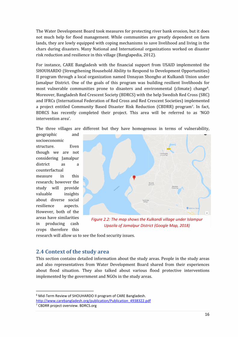
Figure 2.2 The map shows the Kulkandi village under Islampur Upazila of Jamalpur District.
16
Figure 3.1 Schematic representation of disaster resilience of the place
(DROP) model (adopted from Cutter et al., 2008).
21
Figure 3.2 Protection Motivation Theory (PMT). 26
Figure 4.1 Type of damage caused by the flood 2017 reported by
interviewees (N=30) inside of the embankment area.
28
Figure 4.2 Type of damage caused by the flood 2017 reported by
interviewees (N=30) in outside of the embankment area.
30
Figure 4.3 Type of damage caused by the flood 2017 reported by
interviewees (N=30) in the NGO intervention area.
31
Figure 4.4 Previous and future loan-taking status of the respondents 38
Figure 4.5 How local government acted during and after flood disaster? 40
Figure 4.6 Status of having community disaster management plan 43
Figure 4.7 Assessment of severity of flood disaster in future by the
community.
60
Figure 4.8 Flood risk assessment on the agriculture by the respondents 61
Figure 4.9 Reliance status of the respondents (N=90) on flood risk
management.
62

vii
List of Abbreviations ADPC Asian Disaster Preparedness Centre
ASA Association for Social Advancement
BDRCS Bangladesh and Bangladesh Red Crescent Society
BDT Bangladeshi Taka
BRAC Bangladesh Rural Advancement Committee
BUET Bangladesh University of Engineering and
Technology
BWDB Bangladesh Water Development Board
CARE Cooperatives for Assistance and Relief Everywhere
CBO Community Based Organization
CDMC Community Disaster Management Committee
CDRT Community Disaster Response Team
CEA Community Engagement and Accountability
CEGIS Center for Environment and Geographic Information
System
CFW Cash for Work
CIC Community Information Centre
CIRDAP Centre on Integrated Rural Development for Asia and
the Pacific
CPP Compartmentalization Pilot Project
CRA Capacity and Risk Assessment
CRA Capacity and Risk Assessment
DDM Department of Disaster Management
DFID Department for International Development
DMP Disaster Mitigation and Preparedness
DREF Disaster Response Emergency Fund
DROP Disaster Resilience of Place
DRR Disaster Risk Reduction
DRRO Disaster Response and Rehabilitation Office
EOS Extension Over Share
FAP Flood Action Plan
FCD Flood Control and Drainage
FCDI Flood Control Drainage and Irrigation
FFWC Forecasting Warning Center
FGD Focus Group Discussion
HYV High Yield Variety
IFRCs International federation of Red Cross and Red
Crescent Societies
IPCC Intergovernmental Panel of Climate Change
KII Key Informant Interview
LGED Local Government Engineering Department
MoDMR Ministry of Disaster Management and Relief
NGO Nongovernmental Organization
O&M Operation and Maintenance
PhD Doctor of Philosophy

viii
PMT Protection Motivation Theory
RCRC Red Cross Red Crescent
RRAP Risk Reduction Action Plan
SoD Standing Order on Disaster
SHOUHARDO Strengthening Household Ability to Respond to
Development Opportunities
SRC Swedish Red Cross
UDMC Union Disaster management Committee
UNISDR United Nations International Strategy for Disaster
Reduction
USAID United States Agency for International Development
UzDMC Upazila Disaster management Committee
VCA Vulnerability and Capacity Assessment
WDB Water Development Board
WMIP Water Management Improvement Project
WRHFWS Water Related Hazards Forecasting Warning System
1
Chapter One: Introduction
1.1 Flood vulnerability of Bangladesh Globally, floods are the primary source of disaster loss and damage. The rate of increase of
people exposed to flood vulnerability is higher than population growth in each year (Miller
et al., 2008). The geographical location of large floods and associated impact on
socioeconomic development are mainly found in South Asia, East Asia and the Pacific
(Kundzewicz et al., 2014).
Bangladesh, a low-lying, densely populated South Asian country, is highly flood prone due to
its geographical characteristics. Eighty percent of the country consists of floodplains of the
Ganges, Brahmaputra, Meghna and several other rivers (Brouwer, 2007). One-third of the
country gets severely affected by floods once every ten years, while more than 60% of the
country was inundated during the catastrophic floods in 1988, 1998 and 2004 (CEGIS,
2002). Apart from the deltaic nature of the country, climate variability and its consequences
on developing countries like Bangladesh remained another critical issue in recent decades. .
Being a low-lying country, Bangladesh is one of the most vulnerable to climate change
(Younus & Harvey, 2014). According to IPCC (2001) the increased volume of rainfall due to
climate variability in the past decades has intensified the flood problems. Besides, the
combination of geography and population density makes the population of the entire
country vulnerable to various disasters (Parvin et al., 2016). Among the risks and
vulnerabilities, flood is the most common and frequent and also considered as one of the
main threats towards development (Rayhan, 2010; Paul & Routary, 2010; Younus, Sharna &
Rahman, 2014). The flood damage and vulnerability can be seen from three different
determinants such as exposure to flood, sensitivity of flooding and adaptation. The first two
basically determines the damage caused by flood, but can also overestimate the actual
damage. The third factor is adaptation which means the capacity of the people, through
which affected population can escape some of the flood damages (Grothmann & Reusswig,
2006; McCarthy et al., 2001).
The flood history (notably in 1974, 84, 87, 88, 91, 98, 2000, 04, 07) of Bangladesh shows the
aggression of restless rivers. Most of the rivers are of foreign origin, which again means less
control over the water flow and also subject to trans-boundary political issue with
neighboring countries that caused serious destruction of properties and danger to lives and
livelihoods of the people (Khalequzzaman, 1993; Brammer, 2010). According to previous
literatures (Khalequzzaman, 1993; Brammer, 1990) the flood in Bangladesh can be
categorized into two types; annual flood (local name is Borsha) and low-frequency floods of
high magnitude (local name is Bonna). While the low frequency floods are destructive and
cause serious danger to lives, the annual floods are essential and desirable for the economic
growth of the country. Annual flood brings benefits through enhancing soil fertility, clearing
the waste, make navigation easier and accessibility of open water fishing for the poor people
(Brammer, 1990; Chowdhury, 1988).
The impact from a disaster can be both direct and indirect. The immediate destruction is
occurred by natural disasters, called direct damage and it includes mortality, morbidity and
destruction of critical assets such as housing, schools, hospitals, transport infrastructure and
businesses (UNISDR, 2009). The indirect or longer term impacts are also referred to as

2
‘losses’. It has macroeconomic and developmental impact and affects the pace and the
nature of socioeconomic development (Cavallo & Noy, 2009). In a holistic sense,
development means the five capitals and assets identified in the DFID Sustainable
Livelihoods Model: human, financial, social, natural and physical (DFID, 1999). In the
following year Baumann (2000) investigated that the model did not incorporate political
capital as an integral part. It only explains how external factors can influence sustainable
livelihood at the local level which is not enough. However, these capitals influence the
wellbeing of the people and the risk and resilience status of a community (Keating et al.,
2017). Disasters have impact on the food security, specifically on economic and physical
access to food, availability and also the stability of supply and the utilization. The
implications for food security depend mainly on whether a disaster affects primarily
people’s physical and economic access to food or the availability of food or, in the worst
cases, both. Again, people in remote areas and those for whom physical access has been
interrupted through a disaster event often suffer significant shortfalls in food intake (De
Haen & Hemrich, 2007).
Two types of measures are already being employed to reduce the damage caused by the
flood disaster in Bangladesh and those are flood control and flood management. Flood
control means the development of state led physical interventions including building
embankment, dikes in the ever changing delta. Managing flood, on the other hand,
represents a careful consideration of the inherent strength of the community including
people’s wisdom, knowledge and traditional institutions to live with flood (Rahman, 1996;
Mirza & Ericksen, 1996; Warner et al., 2002). The details on these interventions are in the
chapter two.
1.2 Problem statement In Bangladesh, government or nongovernmental organizations are responding to flood
through structural and nonstructural measures to reduce the impact of flood disaster. These
initiatives contributed to enhance coping (short term) and adaptive (longer term) capacity
of the communities to deal with environmental risks and vulnerabilities. However,
criticisms of the flood control measures are also well established through several impacts
studies conducted after 1960s. The flood control resulted in top-down technical solution for
disaster prevention based on an assumption that natural hazards cause disasters. However,
this system reached its economic limits and furthermore, there was a growing awareness
that one cannot protect oneself against all floods - a residual risk remains (Warner et al.,
2002). Moreover, according to Brammer (2010) the primary objectives of Flood Actioon
Plan (FAP) hasn’t been achieved as the people and the economy of Bangladesh are still as
exposed to flood risk today as they were before formulating the FAP. Therefore, people are
still living with vulnerabilities in the exposed flood prone areas in the floodplain. However,
studies related to flood risk management acknowledged that the people living in the flood
prone areas have flood precautionary measures to protect them and valuable assets from
almost none to extensive. This precautionary behavior could have potential implication in
reducing the risk of the residents (Grothmann & Reusswig, 2006). Besides, the International
Commission for the Protection for the Rhine (2002), for example, made estimation that
precautionary behaviors and adaptation (i.e. installation of protective water barriers) of the
households or firms that are at flood risk can reduce monetary damage by eighty percent.

3
Besides, the flood control projects focused heavily on promoting agriculture for meeting the
food security and food system resilience of the Bangladesh government. Therefore, there is
a potential risk in undermining the resilience of other occupational diversity in the
floodplains. Also the impact evaluation on the flood control projects only focused on
technology and agricultural improvements, especially crop production (Mirza & Ericksen,
1996; Salehet al., 1998; Talukder & Shamsuddin, 2012). Therefore, how these control
measures contributed towards building and enhancing social resiliencies of the
communities that are exposed to flood vulnerabilities is largely unknown. The local poor
farmers often tend to be excluded from the design and implementation of these
technocentric interventions. This poses a question whether the flood control measures
contributed to the further marginalization instead of increasing food security and resilience
of the community. Moreover, another point to be observed is whether these structural
measures are contributing to eroding livelihood diversity as the dikes are only designed to
facilitate intensification of rice production where other livelihood options are there (Pham,
2011).
The damage caused by the flood is not equally distributed across different social groups in a
community. It has been claimed in the scientific articles that the poor people are more likely
to be affected by and suffers most due to disasters (United Nations, 2009; UNISDR, 2007;
Parvin & Rajib, 2013; UNISDR, 2013; Johnson, 2006; Yodmani, 2001). The reason is that the
poor people do not have sufficient resources to deal with the crisis and cannot cope with the
damage. Thus, they are being hit the hardest in comparison to others (Brouwer et al., 2007;
IPCC, 2001). Therefore, poverty plays an important role in posing more danger for the poor
and makes them more vulnerable, which eventually makes them even poorer (Shaw, 2006;
CIRDAP, 1991). Again due to inadequate resources and institutional assistances, the
vulnerable people alone cannot develop coping and adoptive capacities to deal disasters
(Shaw, 2006). Moreover, the structural and non–structural actions towards development
are primarily led and promoted by the international donors’ community. There are
arguments that these externally driven initiatives are often unsuccessful as they do not
sufficiently understand local context, disregard traditional knowledge and engage
community in various process of the interventions (Bebbington 2000; Escobar 2002;
Doughty, 2016).
Therefore, it would be worth investigating how the government and NGOs led flood control
and damage prevention interventions are facilitating an equitable capacity enhancement
scheme for the different social groups in the flood vulnerable areas in Bangladesh. The
research objective and questions are described in the following section.
1.3 Research objective(s) The research is focusing on the community resilience in light with flood control and damage
prevention measures in the vulnerable communities of Bangladesh. The main objective of
this research is to investigate the impact of flood control and damage prevention
measures to the level of resilience of the vulnerable communities of Bangladesh. So,
the present study will find the answer of ‘what is the impact of flood control and damage
prevention measures to the level of resilience of the vulnerable community?’ Three
interconnected sub-research questions (SRQs) will be answered to finally reflect on the
main research question. The sub-research questions are as follows.

4
SRQ 1: How do households perceive their former and present flood security status in
the study areas and what is their pattern of self-protective behavior? This question
will answer the status of inherent vulnerability and self-assessment on preparedness of the
households considering flood risk. There would be several queries that will be explored
under this sub- question (see the following table). The Protection Motivation Theory (PMT)
will be employed to explore the sub-queries. The operationalization of this SRQ is in the
following table.
SRQ 2: (How) Have the government and NGO-led flood risk reduction measures
contributed to the coping capacity of the community towards facing flood disasters?
The question will answer the contribution of control/technocentric measures og the
government that includes flood protection embankment, river piling to prevent bank
erosion and also damage prevention measures from nongovernmental organizations in
flood preparedness of the local community. This question will try to link between flood
preparedness and protection measures in light of impact on the community resilience. The
Disaster Resilience of Place (DROP) model will be used here to investigate the contribution
of different flood risk reduction interventions to the capacity of the people in the
communities. The operationalization of this SRQ is in the following table.
SRQ 3: What are the advantages and drawbacks identified on the flood risk reduction
interventions that impacted on enhancing the capacity of the community? This
question will summarize the impression of different stakeholders on the flood control and
management interventions in light with flood resilience. This impression includes both
positive and negative aspects of the interventions. The operationalization of this SRQ is in
the following table.
Table 1.1: The sub-research questions and operationalization of the questions with collection methods
Sub-research
questions
Operationalization Method
used
Chapter
How do households
perceive their former
and present flood
security status in the
study areas and what
is their pattern of self-
protective behavior?
What do people think about previous flood
events in the community?
Survey
FGDs
Chapter
Three
How do people assess the future flood risk
and associated damage caused by the flood?
Survey
FGDs
Chapter
Three
What type of preparedness do the
households have considering flood disaster?
Survey
FGDs,
Chapter
Three
What is the motivation being not prepared
for the flood disaster?
Survey
FGDs
Chapter
Three
& Four
Why aren’t flood vulnerable people
relocating to a safer place?
KII,
FGDs
Chapter
Four
(How) Have the
government and NGO-
led flood risk
reduction measures
contributed to the
coping capacity of the
What type of flood risk reduction
interventions do the community people
experienced so far?
Survey
FGDs,
KII
Chapter
Three
How has government led flood protection
embankments impacted on the capacity of
the local people?
FGDs,
KII
Chapter
Three
& Four

5
Photo: Survey with a household representative in Kulkandi village, Jamalpur District in October, 2017. Source: Community People.
community towards
facing flood disasters?
How has NGO led risk reduction and
resilience projects impacted on the capacity
of the local people?
FGDs
KIIs
Chapter
Three
& Four
What are the
advantages and
drawbacks identified
on the flood risk
reduction
interventions that
impacted on
enhancing the
capacity of the
community?
How are flood protection embankments
appraised by community and external
actors?
KIIs,
FGDs
Chapter
Three &
Four
How have risk reduction and resilience
interventions appraised by community and
external actors?
KIIs,
FGDs
Chapter
Three &
Four
How do political influence and power
dynamics affect the disaster intervention?
KIIs,
FGDs
Chapter
Three &
Four
1.4 Research methodology A mixed-method approach has been followed in order to answer the research questions. The
qualitative methods include focus group discussion, interview and observation in the field.
Besides, I conducted a quantitative survey applying semi-structured questionnaire with the
household representatives in the study areas. The relevant stakeholders for the study are
people living in the areas, governmental organizations including Water Development Board
(WDB), Upazila Agricultural Office, Disaster Response and Rehabilitation office, non-
governmental organizations working on disaster risk reduction and resilience in
Bangladesh, academicians researching on flood risk management in Bangladesh. The
following section will describe the methods and techniques in detail.
1.4.1 Survey
The field work started with a survey at the household level in the study area. I choose single
member of each household as survey respondents in this research. The objective of the
survey was to assess the perception of the community people on the present and further
flood risk and also existing preparedness of the community to face a flood disaster. I used a
semi-structured questionnaire to conduct the survey (Annex 1.1). The questionnaire was
designed based on the components of the Protection Motivation Theory (PMT) which
includes threat appraisal, coping capacity,
precautionary and non-precautionary
measure (also explained in the theoretical
framework section). The questionnaire was
pre-tested in the field to check whether the
questions are contextualized enough to get
the required data from the respondents.
Based on few responses from the people I
revised it afterward.
A total of 90 households including 58 male
and 32 female respondents have been
surveyed in all three study villages. The
sample size was equal for each villages; 30
respondents. I employed simple random

6
sampling procedure under the probability sampling technique to select the households in
the villages. Even though the earlier plan was to collect a full list of the residents from the
local Union Parishad1, however I decided not to go for it. Because I thought collecting a list
after the flood disaster (as there was a flood in May 2017) would create expectation among
the people of getting some assistance from me. This quantitative survey actually allowed me
to know the inherent vulnerabilities and capacity of the people to face the shock.
Table 1.2: Methods used in data collection.
Method Explanation
Expert
consultation
(Selecting the
study area)
Purposive selection of study area Tangail District (Sadar Upazila) for with and without flood control
interventions Jamalpur District (Kulkandi community, Kulkandi Union) for flood
management interventions
Survey 90 households representatives; 58 Male & 32 Female Semi structured questionnaire Piloting the survey tool Simple Random Sampling to select the households for survey Stakeholder: Household representatives
Focus Group
Discussion
9 discussion sessions with the community people Discussion with community disaster management committee (CDMC) Stakeholder: Community people
Key Informant
Interviews
Expert opinion in selecting NGOs in Bangladesh 11 representatives from NGOs involved in DRR/Resilience initiative 2 representatives from Disaster Response and Rehabilitation Office 2 Agricultural Officers in Dynna Union, Tangail Sadar Upazila, Tangail
District and Kulkandi Union, Islampur Upazila, Jamalpur District 2 representatives from Water Development Board in Tangail and
Jamalpur District 2 academic persons working on flood risk management
1.4.2 Focus Group Discussion (FGD)
A total of nine focus group discussions with the community people have been conducted in
three villages. I developed a checklist to guide the discussion, although I could not properly
follow the order of the questions (Annex 1.3). I tried to be semi-formal while arranging and
conducting the discussion with the people of varied age groups including the young and the
old. Most of the discussions held in the village tea stalls where people gather for having tea
and do informal conversations on various topics together. As a researcher I took that chance
to talk with them while having tea with them. The research has just played the facilitation
role where the community people discussed and debated themselves on how the flood
disaster is affecting them, they survival strategies and also what type of assistances they are
receiving from different stakeholders before, during and after the event. There was a heated
debate about how flood protective embankment has created a social tension among farmers’
groups living inside of the embankment. Of course I did probing question to the group,
however it does not mean that the researcher controlled the discussion by imposing his own
research objectives. I talked about political interference and power in the field of disaster
management. In the NGO intervention area, I managed to talk with the Community Disaster
1 Fourth layer of administrative unit of Bangladesh government.

7
Management Committee (CDMC) and Community Disaster Response Team (CDRT) formed
by the NGOs. Unfortunately I could not manage time to arrange a meeting with the
community committee responsible for maintenance of the flood protective embankment
formed by the Water Development Board of Bangladesh government.
The explanations on various research issues during the focus group discussions were
helpful in getting the insights about flood risk management approaches in relation to
community resilience. I did not record the conversations as there were some culturally
sensitive issues to talk about including the political aspect of disaster.
1.4.3 Key Informant Interviews (KIIs)
A diverse group of stakeholders have been communicated and interviewed in this research.
I communicated with NGO people who have been working in the development sector for
long to map the leading humanitarian and development organizations in Bangladesh
working in the field of disaster management. A total of 11 have been covered by KIIs (Annex
1.7). The KIIs are conducted following a guideline that I prepared beforehand aligning with
the research objectives (Annex 1.2). Firstly, I interviewed the senior management staff of
the nongovernmental organizations who are dealing disaster risks reduction or resilience
project in Bangladesh. The objective of the interviews was to learn about the perception of
NGO people about the impact of disaster risk management interventions towards enhancing
the resilience of the community.
Secondly, I talked to representatives from the Disaster Response and Rehabilitation office
(DRRO) at the District2 level to know how they think the response and rehabilitation
initiatives are contributing to resilience of the vulnerable people (Annex 1.4).
Thirdly, I had a conversation with two agricultural extension officers at the Upazila3 level to
know how the agricultural assistances from the local government are being distributed to
the affected farmers after flood (Annex 1.5) and also about political interferences on the
distribution process.
Fourthly, I interviewed a representative from the Water Development Board to know how,
being a government institution, flood control/protection measures is contributing to flood
risk management. I also managed to talk with two academic persons (University professors)
and a PhD candidate from BUET4 working on flood risk management, to know the positive
sides and drawbacks associated with the flood control measures in Bangladesh.
1.4.4 Field observation
Apart from these methods, researcher also made notes that can be called as field note while
doing the field work in Tangail and Jamalpur District of Bangladesh. I tried to observe the
coping and adapting strategies of the people, activities done by the government and NGOs in
the study area. However, I admit that I could not process my observation intensively due to
time constraints. .
2 Second administrative layer of Bangladesh Government. 3 Third administrative layer of Bangladesh Government. 4 Bangladesh University of Engineering and Technology, commonly known as BUET, is a public university in Bangladesh, which focuses on the study of engineering and architecture. https://en.wikipedia.org/wiki/Bangladesh_University_of_Engineering_and_Technology

8
1.4.5 Triangulation
Triangulation of methods and information sources has been made by using different data
collection methods to collect information from different stakeholders (see the table 1.2). For
instance, I collected the information about getting agricultural assistance after the flood
from the farmers during focus group discussions and also interview of the agricultural
officer. Similarly, I interviewed the representative of Water Development Board regarding
functionality of the embankment management committees at the community level and the
organization itself in terms of operation and maintenance of the flood protective
embankment. Afterwards I discussed the same issues while conducting the focus group in
the community. In many cases I found contradictory information from two different
information sources and then I tried to go in-depth to understand exactly what the real
scenario is? In doing so, I needed to put probing questions to the respondents during the
interviews and discussions in the field. This is how I crosschecked the information and
triangulate while wrote the thesis report. However, I cannot be 100% sure that I was
successful in exploring the reality as it is hard to fully understand the community and
associated social dynamics within a short period of time.
Eventually, due to employing more than one methods and data sources in obtaining same
kinds of information gave me the opportunity to learn more about the flood risk
management approaches and associated socio-cultural dynamics of the communities. Apart
from the validity of the field findings, this triangulated information gave me confidence
while writing my thesis report.
Another issue is my position in this research. I would say I followed both constructivist and
positivist approach. During conducting my field work I respected the sharing from the
community on how the interventions from government and NGOs contributing to enhancing
their capacity to face the flood disasters. However, I also tried to find evidence on those
statements so that I can be confident on the results. When I analyzed and interpreted the
data and information in the discussion chapter I tried to combine both qualitative and
quantitative data and information to produce logical argument.
1.4.6 Recording, organizing, and analyzing data
I used both quantitative and qualitative methods to collect my data in the study area. The
quantitative data has obtained though a question paper. I used Statistical Package on Social
Science (SPSS) to design the data entry template though which I entered the raw data and
made a database for all 90 households. I acknowledge that the respondents were not
interested to answer certain questions during the survey, for instance monthly income of
the family. In that case I have a few missing data. Besides, I did cross check, the data that
were already entered into the SPSS and the hard copy of the filled-up question papers, to
avoid unwanted complications and confusion. After validating the data, I did simple
frequency analysis and prepared some graphs to use in the thesis report.
For the qualitative methods including focus group discussion, interview and observation, I
had to spend more time to process the information in a systematic way. I did not record
interviews and discussions as there were some sensitive issues including political influence
in disaster interventions. Also I wanted to keep the interview informal, so that people can
open up and say whatever they wanted to say to me. I realized that the organization of
qualitative information is much harder in comparison to quantitative data. I did not use any

9
software to process the qualitative information, rather I did it manually with the technical
assistance from my supervisor. After transcribing all the interviews and focus group
discussions, I gathered the findings based on my guiding questions. I kept the homogenous
findings at the top and then arranged the heterogeneous information with explanations. It
took long time to prepare compilation of findings for Focus Group Discussion and interviews
separately. I went through the complied documents again and started putting the findings
based on the research question in the report.
I did not quantify the level of resilience at all three communities, but I explained the status
of different dimensions of resilience based on Disaster resilience of Place (DROP) model. I
discussed what is there and what is still needs to be there in order to strengthen the
community to face a flood disaster. Besides, I collected quantitative data on various
components of Protection Motivation Theory (PMT), including former and future flood risk
perception, flood preparedness based on few common indicators, damage assessment etc.
This quantitative data has used along with the qualitative explanation to have a clear picture
on the community resilience. For instance, when I talked about social cohesion during crisis
moment, I also put quantitative dada on what people perceive about getting support from
relatives and neighbors. Therefore, qualitative and quantitative data and information
proceed together where applicable in the thesis report.
1.5 Outline of the thesis Chapter One sets out the platform of the whole research work by providing background
information, problem statement and methodology for data collection.
Chapter Two describes different types of flood control and management in interventions
and context of the three study locations.
Chapter Three contains the conceptual framework of the research.
Chapter Four represents the results on the research objectives following the conceptual
framework of the research.
Chapter Five covers the discussion and conclusion part of this research.

10
Chapter Two: Flood Risk Reduction Interventions and Study Area
This chapter covers the flood risk reduction (i.e. flood control and management)
interventions from the government of Bangladesh and nongovernmental organizations
working on disaster risk reduction and resilience building intervention in flood vulnerable
communities. It also explains how three communities have been identified and selected for
this research.
2.1 Flood control intervention Bangladesh has a long historic experience in implementing flood control projects since early
1960s as a consequence of devastating flooding in 1954 and 1955. After establishing the
water master plan in 1960, 23% of the total areas of Bangladesh were covered under water
control, drainage and irrigation project (Mirza & Ericksen, 1996). The Bangladesh Water
Development Board (BWDB) constructed more than 400 FCD/FCDI (Flood Control
Drainage/Irrigation) projects covering about 3.7 million hectare, which is about 60% of the
total flood vulnerable area (Chowdhury, Rahman & Salehin, 1997). These FCDI projects
include the Ganga-Kapotakkha, Meghna-Dhonagoda FCDI and Compartmentalization Pilot
Project (CPP). These FCDI projects provide an important protection against extreme
flooding and a semi-controlled hydrological environment for growing crops; particularly
rice (Talukder & Shamsuddin, 2012). The projects aimed at constructing a number of
physical structures including embankments, drainage systems and irrigation
infrastructures. Therefore, the primary objective of these projects was to facilitate the
increase of HYV (High Yield Variety) agricultural production by providing protection of
lands from high level flooding, and drainage facilities to dispose of excess rainfall during the
monsoon season (Alexander et al., 1998) and eventually, the agricultural growth happened
at that time (World Bank, 1989). Later on, after observing the destruction of 1987, 88 floods,
the government of Bangladesh, formulated the Flood Action Plan (FAP) which aimed at
protecting country people from river floods through structural establishments. The idea was
that flooding behind the embankments along with the main river would be managed by
means of sluice gates and additionally by a system of secondary embankments called
compartments (Brammer, 2010).
Again, the question is whether the engineering of flood control measures are successful in
reducing flood loss of the vulnerable people in Bangladesh. Embankments and barriers were
built in order to control the rivers and safeguard lives and livelihoods of the population
behind the dikes (Smith and Ward, 1998). However, after the devastating flood in 1998,
considering the recurrence interval, flooded areas and duration of inundation in Ganges and
lower Brahmaputra basins, several issues raised regarding the planning, design and
performance of Flood Control and Drainage (FCD)/FCDI projects in Bangladesh (Saleh et al.,
1998). The potential impact of structural control of flood through megaproject in
Bangladesh was made early 1990. Those include prevention of sedimentation on the
Bangladesh delta plain casing riverbed aggradations and submergence of the area behind
the embankment. The flood control structures would contribute to possible shifting of river
ways, loss of huge land areas to the project, loss of soil fertility and possible resettlement of
people. The maintenance of the embankment is also a critical issue as it has to be managed
on a regular basis, which is not an easy task for Bangladesh (Khalequzzaman, 1993). The
primary objective of FAP has not been achieved, as the people and the economy of

11
Bangladesh still remained as exposed to flood hazard these days as they were before
formulating FAP. Besides, the civil society activists see this action as a top-down
institutional approach from the government that paid less attention to social and
environmental aspects (Brammer, 2010).
2.1.1 Government led flood control project; CPP
One of the flood control project implemented by Bangladesh government is
Compartmentalization Pilot Project (CPP) under the Flood Action Plan (FAP). The initiative
was taken after the catastrophic floods during the monsoon season in 1987 and 1988. Many
people lost their life, many thousands became homeless, crops in the fields were destroyed
and infrastructures severely damaged all over Bangladesh including Tangail District. After
the 1988 flood disaster, several studies were carried out by the international community to
find a lasting solution to the flood problem. In June 1989, the World Bank agreed with the
Government of Bangladesh to coordinate the various flood control & related initiatives. The
Compartmentalization Pilot Project (CPP), approved on September 28, 1989 is one of them.
This project was formally commissioned on October 21, 1991 and funded by the Dutch and
German governments. The Compartmentalization Pilot Project (CPP) is one of twenty-six
components of exhaustive Flood Action Plan (FAP) undertaken by Government of
Bangladesh. A compartment is surrounded by embankments with gated openings mainly at
the upstream side and ungated openings mainly at the downstream side through which the
in-and outflow of the flood water can be controlled. Inside the compartment, a system of
channels and khals has the function of transporting the water.
The general objective of the project was to provide a more secure and sustainable
environment for intensive agriculture, fisheries and rural/urban development through
integrated water management, and thereby improve the economic security and quality of
life of the flood plain population. Specifically this will entail the testing of the water
management system in the compartment under real operating conditions, addressing the
relevant socio-economic, institutional and environmental issues (Water Development
Board, 1994).
2.2 Flood management interventions This approach is the potential alternative to technocentric flood control measures which
believe in the people’s knowledge and capacity to live with flood (Rahman, 1996). The
objective of these intervention is to safeguard lives, livelihoods and economic growth of the
country, were explored during developing the National Water Policy by the Water Resource
and Planning Organization (WARPO) through the consultation with government and
nongovernmental (NGO) agencies in 1998. Several recommendations emerged from the
discussion which includes: strengthening flood and cyclone early warning system, raising
the house plinth above flood level, providing flood and cyclone shelters, establishing zoning
regulations for locating new industries, and desilting river channels to improve the drainage
situation, adjust coping strategies for farmers and expand dry-season irrigation (Brammer,
2010). These are commonly used as disaster damage prevention measures taken by various
stakeholders in Bangladesh.
The role of NGOs in the emergency situation viewed since independence of the country,
specifically during the flood 1987, 1988 and 1991 as a relief and rehabilitation agency.
However, the emphasis of NGOs has shifted gradually towards disaster mitigation and

12
preparedness (DMP) aspects. NGOs also realized that DMP interventions will contribute
towards reducing vulnerability of the people who are exposed to flood and other natural
and man-made disasters in Bangladesh. Besides, NGOs have played a major role in bringing
concerns related to risk management to the national agenda and promoting a shift of focus
from mere relief response to disaster mitigation and preparedness. The government has
now accepted NGOs as major partners in these tasks (Matin & Taher, 2001). Even though
NGOs played an important role in disasters, their participation was often misperceived as
competitive rather than supportive and complementary by the local administrations. Due to
the traditional bureaucratic process of implementation of disaster interventions, local
administration failed to engage local group and NGOs in developing local disaster mitigation
program (Rahman & Ahmed, 1990). Sometimes, NGOs also tried to bypass local
administration; therefore mistrust developed between these two organizations. However,
the progress on the government and NGO relationship status had been observed during the
cyclone of 1991 and the 1995 flood where there was an excellent coordination between
government and NGOs (Rahman, 1996).
Again, many nations are now shifting their priority from flood defense or structural hard
engineering including embankment, dikes to flood management or non-structural soft
measures that covered early warning, disaster planning etc. This change comes through
believing that fail-free defense mechanism is impossible as there is always a residual risk.
The hard engineering for the flood risk management often pushed the whole approach to
technological lock-in where there is very limited scope to introduce or apply soft measures.
However, the soft approach in flood risk management is flexible where change of plan and
adoption of news thoughts considering the changing modality flood disasters and also
future flood scenarios is possible (Wesselink et al., 2015).
2.2.1 Type of NGO interventions on DRR and Flood Resilience
While I started discussing about building and enhancing the capacity of the community, I
found a common understanding among the nongovernmental organizations and academic
that it should lie with the government who has the mandate and sole responsibility to do
that. The evolution of nongovernmental organizations (NGOs) in Bangladesh was after the
devastating cyclone in 1970 and also the war of independence in 1971. At that time, NGOs
started working on the components where government was unable to reach. That means,
NGOs were filling-up the gaps where government had shortage of financial and other
resources for conducting development activities since long.
In general NGOs are working on the capacity building of the community through resilience
or Disaster Risk Reduction (DRR) or other development interventions in the flood
vulnerable communities in Bangladesh. The key objective of these activities is to enhance
the strength of the vulnerable people so that they can face the uncertain shocks well in
terms of saving human lives and reducing the damage of the assets (Interview with NGO
representatives, 2017).
The DRR interventions are usually designed through conducting needs assessments in the
vulnerable community focusing on issues including asset, vulnerability, and capacity of the
community. Therefore, the assessment results reflect on the existing vulnerability, capacity
and sources of the community in terms of facing any disasters on their own.

13
The NGOs provided both hardware and software supports to the flood vulnerable
communities in Bangladesh. The software supports include enhancement of knowledge and
skill, linkage between vulnerable people and relevant local institutions, early warning
system for flood (where government and media put lots of efforts into this) etc. According to
NGO representatives, the reduction of death toll due to flood disasters is one of the examples
of effective early warning systems in Bangladesh. The hardware supports include
community development interventions, road constructions. However, according to
respondents, NGOs and government both put much emphasis on household resilience
building in the Char Land which needs to be extended to other flood vulnerable locations in
Bangladesh. The main NGOs interventions focusing DRR and resilience are in the following.
Formation and capacity development of Community Based Organization (CBOs),
Community Disaster Management Committee (CDMC), Community Disaster response
Team (CDRT) in the flood vulnerable communities of Bangladesh. The groups’ members
are from different age groups. NGOs usually organize capacity enhancement training for
the members, so that they can become a work force to support in managing disaster risk
reduction and enhancing the capacity of the community to face shocks.
Providing financial support (both conditional and unconditional) for shelter, water &
sanitation and livelihood improvement to the vulnerable families to make the recovery
process faster.
Making collaboration between local flood vulnerable communities and Union Disaster
management Committee (UDMC) and other departments of local government for disaster
preparedness and mitigation.
Assisting the community to undertaking small-scale mitigation measures like
constructing roads and other local infrastructure through Cash for Work (CFW) scheme.
Creating linkages between producers and markets; sort of value chain. Also provide
support for Nutrition, health, and Hygiene Promotion.
Providing technical assistance to partner organization and Partner National Societies (in
RCRC Movement) in implementing comprehensive community based disaster risk
reduction programme including shelter, water & sanitation, livelihood and mitigation
components in disaster vulnerable areas of Bangladesh.
Resilience building interventions focusing education in safe school buildings, water &
sanitation and Gender Based Violence – Girl Friendly Spaces. Promoting education in
emergency like providing books and education materials to the students.
Research organizations like the Asian Disaster Preparedness Centre (ADPC) conducts
research on disasters and try to provide input at the policy and strategic level of
Bangladesh Government and NGOs working in disaster domain.
Measuring flood resilience under the financial support from Zurich Foundation where
Flood Forecasting tool is using.
2.2.2 Development organizations and resilience thinking
The representatives from twelve non-governmental organizations working in the field of
disaster risk reduction (DRR) and resilience discussed about meaning of disaster resilience
and associated interventions for resilience building in Bangladesh. Most of the responses
actually focused on enhancing the capacity of individuals or the family to deal a disaster in a
way that they can return to their normal life. A few respondents highlighted utilizing
existing capacity of the vulnerable people to develop further strength so that they can

14
anticipate disturbing events and prepare for and reduce the impact of disaster. They also
realized that the concept of resilience is dynamic so that the resilience building intervention
needs to be flexible to adjust the uncertainty. The individual responses on the resilience
thinking at the organizational level are in the Annex 1.6.
The resilience concept became a part of the organizational policy and strategic plan. The
representatives from the NGOs mentioned that the development interventions are now
designed considering the resilience concept and reflect to the ‘Resilience Framework’ of the
organization. Some organizations have specific departments and strategic plans to ensure
mainstreaming the resilience concept in development operations. Some respondents
mentioned that the logical framework which is also known as result framework of each of
the projects cover indicators on disaster resilience. Thus the concept of disaster resilience
has become an integrated theme, not a stand-alone concept for the development
organizations in Bangladesh.
2.3 The study area The study areas were defined based on the research objectives. I communicated with expert
community in Bangladesh and my supervisor to select the areas besides the river Jamuna
which has flood protective embankment and NGO interventions on Disaster Risk Reduction
and resilience project. I selected Tangail District – the Central North part of Bangladesh has
been formed by faulting and tilting. The area is very flat, between 18 and 4 m above sea level
(except the Madhupur Tract), thus as soon as the flood stage is reached, enormous tracts of
land are flooded (Banglapedia, 2012). In this area, Bangladesh government with the help of
donor countries implemented the Flood Action Plan (FAP 20) which is also known as
Compartmentalization Pilot Project (CPP). Under this project, a long embankment had been
built to protect the Sadar Upazila of Tangail District from Jamuna river flooding and also to
promote agricultural production. I provided a short description on the CPP in the earlier
section. More specifically, I selected two villages within the Daynna Union under Sadar
Upazila of Tangail District. First one is called Fatepur which is protected by the flood
protective embankment since 1995. So, Fatepur village will be considered as the area with
flood control measure from the Water Development Board of Bangladesh government.
The second area is Char Fatepur – which is situated outside of the embankment and exposed
to river flooding of mighty Jamuna. This village is surrounded by the tributaries of river
Jamuna and people usually experience flood in each year. Here a few national
nongovernmental organizations are implementing credit project in this village. They usually
provide loan with interest to the people. There is no disaster risk reduction intervention has
been implemented so far, however the people received emergency relief assistance during
and after flood event.
The third village I selected from Islampur Upazila under Jamalpur District which also
situated beside the river Jamuna. Thus area has purposefully selected to see the impact of
NGO led disaster risk reduction and resilience interventions towards enhancing the capacity
of the community to face a flood disaster. The communities of Jamalpur district are located
in distant char lands bordered by mountains of Meghalaya (India) in the north-east and
experience regular flood and northwest. The Kulkandi village is exposed to the mighty river
Jamuna and people is this village usually experience flood disaster each year.

15
Figure 2.1: The map shows Danya Union under Tangail sadar Upazila of Tangail District. I
selected two villages named Fatepur (inside of the embankment) and Char Fatepur (outside of
the embankment) village for this study (CEGIS, 20185).
5 A Public Trust and centre of excellence established by the Government of Bangladesh under the Ministry of Water Resources (MoWR); A "Not-for-Profit" organisation guided by a Board of Trustee headed by the Secretary of the MoWR. http://www.cegisbd.com/
16
Figure 2.2: The map shows the Kulkandi village under Islampur
Upazila of Jamalpur District (Google Map, 2018)
The Water Development Board took measures for protecting river bank erosion, but it does
not much help for flood management. While communities are greatly dependent on farm
lands, they are lowly equipped with coping mechanisms to save livelihood and living in the
chars during disasters. Many National and International organizations worked on disaster
risk reduction and resilience in this village (Banglapedia, 2012).
For instance, CARE Bangladesh with the financial support from USAID implemented the
SHOUHARDO (Strengthening Household Ability to Respond to Development Opportunities)
II program through a local organization named Unnayan Shongho at Kulkandi Union under
Jamalpur District. One of the goals of this program was building resilient livelihoods for
most vulnerable communities prone to disasters and environmental (climate) change6.
Moreover, Bangladesh Red Crescent Society (BDRCS) with the help Swedish Red Cross (SRC)
and IFRCs (International Federation of Red Cross and Red Crescent Societies) implemented
a project entitled Community Based Disaster Risk Reduction (CBDRR) program7. In fact,
BDRCS has recently completed their project. This area will be referred to as ‘NGO
intervention area’.
The three villages are different but they have homogenous in terms of vulnerability,
geographic and
socioeconomic
structure. Even
though we are not
considering Jamalpur
district as a
counterfactual
measure in this
research; however the
study will provide
valuable insights
about diverse social
resilience aspects.
However, both of the
areas have similarities
in producing cash
crops therefore this
research will allow us to see the food security issues.
2.4 Context of the study area This section contains detailed information about the study areas. People in the study areas
and also representatives from Water Development Board shared from their experiences
about flood situation. They also talked about various flood protective interventions
implemented by the government and NGOs in the study areas.
6 Mid-Term Review of SHOUHARDO II program of CARE Bangladesh. http://www.carebangladesh.org/publication/Publication_4938322.pdf 7 CBDRR project overview. BDRCS.org

17
2.4.1 Inside of the embankment
The Tangail District is geographically vulnerable to flood as there are 18 small, medium and
big Rivers running through various parts of this district. More interesting information is that
the Tangail Sadar Upazila is geographically lower than other surrounding Upazilas of this
district. Therefore, the Sadar Upazila is considered as the main town, where the key
infrastructures are established, is more vulnerable to flood disaster. To safeguard the town
and also promote agricultural production, a flood protective embankment has been built
under the Compartmentalization Pilot Project (CPP) during 1990-1995. The people living
insider the flood protective embankment haven’t seen flood since 1995. However, people
suffered from water logging situation in the past years, but it was severe in 2017 compared
to previous years. The situation arises when heavy rainfall occurs and the deposited water
from the inside of the embankment cannot drain out through the sluice gates and water pass
way (pipelines at different locations) installed under the flood protective embankment. In
2017, there was heavy rainfall in compare to previous years and rain water stood inside of
the embankment for 15 days.
Obviously, there are numbers of pipelines and sluice gates at different places of the
embankment, so what is the reason for the water being stacked inside of the embankment?
According to the community people and WDB, the blockage of water pass ways is mostly
due to manmade reason. When people started constructing houses nearby the water passing
pipeline or sluice gates, due to rain mud drained down and deposited in front of the water
ways and bloke the passage. Moreover, these pipelines were installed on private land and
when the land owner started utilizing and cultivating the land, mud entered into the
pipeline and blocked the space. However, many land owners mentioned that they forecast
the worst case scenario and informed local government and WDB representatives to install
bigger pipelines. But no one realized the need of doing that. Now, people of this area
realized the need of putting bigger pipeline. They think that monitoring of the water passage
in a regular basis could resolve this problem in the area. The responsibility could not be
solely on the embankment management committee members at the local level. However,
someone either the committee members or local people need to take the responsibility to
make the pipelines and sluice gates functional again.
There is another reason why the people suffered from water logging situation and that is
breakdown of embankment at some points. The respondents’ mentioned different years
when the embankment breach happened and people suffered due to that. In 2004, around
200 feet of embankment was breached at Alishakanda village under Fatepur Union. The
damage was enormous as there was a big flood going on outside of the embankment at that
time. The water stood for 15-20 days inside of the embankment. The broken part of the
embankment was repaired by the Water Development Board later.
In 2016, during monsoon periods (in July), some parts of the embankment within the
Fatepur area had breached and water entered into the community. The water stood for
around two months and caused damage of agricultural crops production and many fish
ponds inundated that caused loss of the fishery business in this area.

18
Photo: The NGO intervention area is located on the bank of river Jamuna. Source: Researcher.
In 2017, due to heavy rainfall and the flood, the water level in outside of the embankment
raised 12 inch more compared to the inside. Due to this significant water level difference the
embankment became more vulnerable to breach at many points. However, local people
continuously monitored the water level and also risky places of the embankment and they
put additional protection materials including putting extra mud, plastic bags at risky place
etc. Besides, local people communicated with the representatives of Water Development
Board (WDB) in the Tangail Sadar Upazila to share the risky situation to the embankment.
However, people claimed that local staff of WDB did not respond quickly even though they
were informed them before.
2.4.2 Outside of the embankment
The area is called Char Fatepur – an area that lies on the other side of a branch of river
Jamuna. While the monsoon came this area became an isolated area from the main land and
the boat is the only way to visit the village. This is situated outside of the flood protective
embankment of Tangail Sadar Upazila. People of this area are experiencing flood with varied
intensity and severity each year. People mentioned the big flood disaster that happened in
1988, 1998, 2004, 2007 and 2017 in this area.
People living in this exposed area suffered more from flood damage in 2017 comparing to
previous years. The heavy rainfall combined together with monsoon flood made the
situation worst as the water level went much higher this year.
The economic situation of the families in this area is weak. Most of the families (around
85%) are dependent on agricultural farming to run their livelihood. Apart from farmers,
there are other occupations like business, day labor and government and nongovernment
workers in this area.
2.4.3 NGO intervention area
The Kulkandi village under
Islampur Upazila of
Jasmalpur District is situated
beside the river Jamuna. The
people are experiencing
flooding each year with
varied intensity and severity
of damage. According to
community people, the 2017
flood is more dangerous than 2016 and previous floods. The water level was much higher
this year that caused sufferings of the vulnerable people. Someone at the Kulkandi
community was saying that -
‘The flood of 2016 was good as it was not severe and we did not loss our assets and the flood
water brought nutrients for the cultivable lands, but the flood in 2017 was devastating as it
damaged agricultural crops and family infrastructures (toilet, mud made cooking stove) for
us’.

19
Chapter Three: Conceptual Framework
3.1 Introduction This chapter includes the conceptual framework of the research based on what I organize
the results and discussion to answer the research questions. I used two frameworks in this
research. First, I used the Disaster Resilience of Place (DROP) model to assess the resilience
of the flood vulnerable communities in Tangail and Jamalpur Distrist of Bangladesh.
Secondly, I complemented DROP model with a partial adoption of Protection Motivation
Theory (PMT) to see self-protection behavior of the people living in the flood risk areas.
Eventually, I tried to find complementary or supplementary status between these two
frameworks towards flood risk management in Bangladesh. However, I shall start with
explaining the concept resilience first.
3.2 The Concept: Resilience The increasing damage from the natural hazards sort of forced the government and
nongovernmental organizations that are involved in disaster risk reduction to develop an
integrated approach to reduce the vulnerabilities of the exposed communities and to build
the resilience of the society (Djalante& Thomalla, 2010). Now, what does the term resilience
mean?
The term ‘Resilience’ evolved from the ecological system, but its application has extended to
different academic fields. Folke (2006) explored the infiltration of the term ´resilience´ to
different disciplines like anthropology in 1975, human geography in1994, psychology in
1986 and sociology in 1995. According to Holling (1973) “Resilience is the amount of
disturbance a system can withstand without changing its self-organizing structures and
processes”. Put another way, resilience comprises all those conditions and mechanisms that
make a system able to maintain function under shocks and stress (called persistability), to
adopt to external changes (called adaptability) and to transform themselves in a way that
enhanced their future functionality (called transformability) (Holling, 2001; Berkes, Colding,
& Folke, 2003; Walker & Salt, 2006; Keck & Sakdapolrak, 2013). According to López-
Marrero & Tschakert (2011) resilience is the alternative approach to the top-down
technocentric way of controlling hazards that has already been failed in the flood-prone
areas. They claimed that a resilience system is able to cope with adverse hazardous
situations without changing its basic function and also can rearrange and adopt changes.
The concept resilience was driven by former terms: coping strategy and adaptive capacity.
However, Keck & Sakdapolrak (2013) argues that resilience is beyond those two terms
because it is dynamic and relies on the Heraclitean notion of “everything changes, nothing
remains still”. Therefore, the analysis of social resilience is geared toward understanding the
mechanisms by which a system can adapt not only to the challenges that are directly at
hand, but also to those that are unexpected and unknown (Kates & Clark 1996; Streets &
Glantz 2000). The definition of social resilience concerns social entities i.e. individuals,
organizations or communities – and their abilities or capacities to tolerate, absorb, cope
with and adjust to environmental and social threats of various kinds. This type of resilience
poses some basic questions like “Resilience to what? What is the threat or risk we examine?”
(Obrist, Pfeiffer, & Henley, 2010). It is assumed that threats are external phenomenon with
regard to social units like impact of rising prices on household expenditure, however, they

20
might also originate from internal dynamics like impact of diseases on household income or
from interaction between the two (Gallopín 2006). The academic literatures on social
resilience address a wide range of threats and natural hazards and disasters is one of them
(Cinner, Fuentes, & Randriamahazo, 2009).
Academic literatures from different authors have identified three different capacities in
understanding the notion of social resilience. Those are coping capacities, adoptive
capacities and transformative capacities (Bene, at al., 2012; Keck, 2012). According to Keck & Sakdapolrak (2013) the Social Resilience has four components which are as follows.
Existing and future threat/risk that might hurt the life and livelihood of the community.
Mechanism and measures through which people became capable to immediately cope
with risk by available resources.
Preventive measures from the past experience, anticipate future risk and adjust their
livelihood accordingly.
People’s ability to access and get assistance from wider political arena, to participate in
decision making, to craft institution for welfare for future threats.
According to Adger et al., (2005) social capital including bonds of trust, reciprocal
relationships, and collective action is an important source of resilience. This social capital
can be strengthened when various stakeholders do network and collaborate together and
relevant institutions act accordingly (López-Marrero & Tschakert, 2011).
The definition of community resilience focuses on the ability of a community to bounce back
after a disaster and adopt the changing situation. The research also found that a community
learns from the previous experiences to be prepared better to face forthcoming disasters
(Djalante & Thomalla, 2010). The definition of resilience touches all the components of a
society. According to IFRC (2014) “the ability of individuals, communities, organizations or
countries exposed to disasters, crises and underlying vulnerabilities to anticipate, prepare
for, reduce the impact of, cope with and recover from the effects of shocks and stresses
without compromising their long-term prospects”. The Asian Disaster Preparedness Center
(ADPC, 2006) defined the community resilient as the capacity of the community to change,
adjust and adapt in a creative way following a disaster and ability to incorporate all actors in
the longer-term recovery activities. In another framework, IFRC defined the characteristics
of a safe and resilient community. It considers the ability of a community to foresee risks
that can do harm so that the community itself can monitor the disaster risk, and also
stresses the long-term commitment from the community to build the capacity to make and
remain safe (IFRC, 2008).
3.3 Disaster Resilience of Place (DROP) Model The DROP model is designed to represent the relationship between vulnerability and
resilience. Earlier resilience frameworks mostly captured the engineering aspects and often
undermine the antecedent social factors captures antecedent social factors that occur at the
local levels or to account for the vulnerability or resilience of the natural environment. In
this section, I shall provide a description of the DROP model following the author of this
model (Cutter et al., 2008).
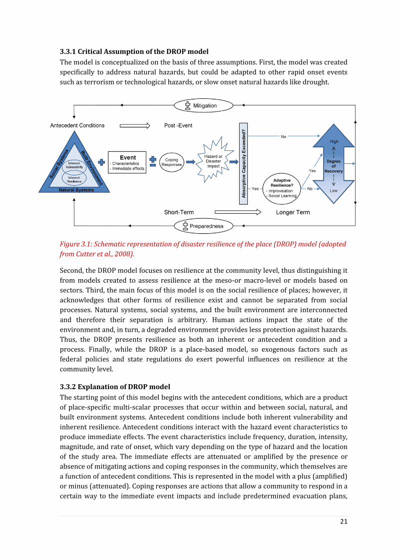
21
3.3.1 Critical Assumption of the DROP model
The model is conceptualized on the basis of three assumptions. First, the model was created
specifically to address natural hazards, but could be adapted to other rapid onset events
such as terrorism or technological hazards, or slow onset natural hazards like drought.
Figure 3.1: Schematic representation of disaster resilience of the place (DROP) model (adopted
from Cutter et al., 2008).
Second, the DROP model focuses on resilience at the community level, thus distinguishing it
from models created to assess resilience at the meso-or macro-level or models based on
sectors. Third, the main focus of this model is on the social resilience of places; however, it
acknowledges that other forms of resilience exist and cannot be separated from social
processes. Natural systems, social systems, and the built environment are interconnected
and therefore their separation is arbitrary. Human actions impact the state of the
environment and, in turn, a degraded environment provides less protection against hazards.
Thus, the DROP presents resilience as both an inherent or antecedent condition and a
process. Finally, while the DROP is a place-based model, so exogenous factors such as
federal policies and state regulations do exert powerful influences on resilience at the
community level.
3.3.2 Explanation of DROP model
The starting point of this model begins with the antecedent conditions, which are a product
of place-specific multi-scalar processes that occur within and between social, natural, and
built environment systems. Antecedent conditions include both inherent vulnerability and
inherent resilience. Antecedent conditions interact with the hazard event characteristics to
produce immediate effects. The event characteristics include frequency, duration, intensity,
magnitude, and rate of onset, which vary depending on the type of hazard and the location
of the study area. The immediate effects are attenuated or amplified by the presence or
absence of mitigating actions and coping responses in the community, which themselves are
a function of antecedent conditions. This is represented in the model with a plus (amplified)
or minus (attenuated). Coping responses are actions that allow a community to respond in a
certain way to the immediate event impacts and include predetermined evacuation plans,

22
creation of shelters, information dissemination, and emergency response plans. After these
coping responses are implemented, the hazard or disaster impact is realized.
The total hazard or disaster impact is a cumulative effect (or sum) of the antecedent
conditions, event characteristics, and coping responses. The overall local impact can be
moderated by the absorptive capacity of the community. Absorptive capacity (or threshold)
is the ability of the community to absorb event impacts using predetermined coping
responses. If a community implements sufficient coping responses, the impact of the hazard
event will be attenuated and the absorptive capacity of the community will not be exceeded,
leading to a high degree of recovery. A community’s absorptive capacity or threshold can be
exceeded in two ways. First, if the hazard event is so large it overwhelms local capacity; and
second if the event is less catastrophic, but existing coping responses are insufficient to
handle the impact, the community’s absorptive capacity will be exceeded pushing it closer to
disaster. If either occurs the community may exercise its adaptive resilience through
improvisation and learning. Improvisation includes impromptu actions which may aid in the
recovery process. Social learning is defined as ‘‘the diversity of adaptations, and the
promotion of strong local social cohesion and mechanisms for collective action’’ (Adger et
al., 2005). Social learning occurs when beneficial impromptu actions are formalized into
institutional policy for handling future events and is particularly important because
individual memory is subject to decay over time. Manifestations of social learning include
policy making and pre-event preparedness improvements. When improvisation and social
learning take place, they directly alter the inherent resilience for the next event as
illustrated by the feedback loops in Figure.
The degree of recovery can be thought of as a continuum ranging from high to low. If a
community’s absorptive capacity is not exceeded, higher rates of the recovery are reached
quickly. If the absorptive capacity is exceeded and the adaptive resilience process does not
occur, a lower degree of recovery may result. This is illustrated in the diagram with the ‘‘No’’
arrow following adaptive resilience. However, if the absorptive capacity is exceeded and the
adaptive resilience process does occur the community may be more likely to achieve a
higher degree of recovery. Regardless, overall recovery is an ongoing process and can
continue until the next event. Both the degree of recovery and the potential knowledge
gained from the adaptive resilience process influence the state of the social, natural, and
built environment systems and the resultant antecedent conditions for the next event. In
addition, the new knowledge gained through the adaptive resilience process can both
influence the antecedent conditions and enhance the inherent resilience through the
implementation of new coping strategies. The feedback process includes the potential to
modify both preparedness and mitigation. It is not assumed that preparedness and
mitigation will be enhanced; however, if social learning occurs, there is a greater likelihood
that mitigation and preparedness will be improved.
2.3.3 Resilience dimensions and indicators
In the DROP model, Cutter et al., (2008) identified six dimensions of disaster resilience:
ecological; social; economic; institutional; infrastructural; and community competence to
assess community resilience at the community level. Being a social science student, I
purposefully excluded ecological resilience (or natural systems) due to data inconsistency
and relevancy with my study track. However, I realize the importance of considering

23
ecological restoration after natural calamities and how the system is bouncing back by itself
with time. But it would be difficult to gather those data and information from the
community consultation and literature review. The availability of data and information was
one of my considerations while started designing the research techniques for my field work.
The indicators on the resilience dimensions are in the following table.
Social resilience represents different social capacities of the communities that influence
their ability to response within and between communities. Different indicators related to
socio-demographic status have been used to measure the social resilience. For instance, a
community with high literacy rate, fewer elderly people, female-headed household can be
expected to have stronger resilience than communities without these characteristics.
Likewise, communities with a high level of access to communication, social assistance
programme and health insurance shows high levels of disaster resilience. I have also
considered the socio-political dynamic and associated impacts on the disaster interventions.
Economic resilience assesses the financial ability of a community to survive during crisis
moment. The indicators for this resilience includes income, loan-income ratio, dependency
of family members, employment rate and house ownership. Indicators within this
component includes single-sector employment dependency will show whether or not the
base of local economy is, whether a single sector dependency like agriculture, fishing makes
the community less resilient. Besides, indicators including access to local banking system
and existence of community saving and credit scheme gives the people an opportunity to
economic recovery quickly after a disaster.
Institutional resilience determines how the presence of the government and
nongovernmental organizations and associated interventions in the community is
contributing towards achieving the capacity of the people to face disasters. The indicators
include: relevant legislation of emergency response and recovery enable communities to
negotiate with all stakeholders including local government to respond during the
emergency period and give them opportunity to express their needs. In this process, the
local government will be obligated to response timely for the communities. Here the
involvement of the local communities in repairing disaster risk management plans is been
prioritized towards building community resilience. Besides, the linkage between a flood-
vulnerable community and the institutions dealing with disaster management is important
in order to get assistance during post-disaster situation.
Infrastructural resilience actually represents the structural implications at the community
towards managing disaster risk. The communities with control measures including dikes,
flood protective embankment have the capacity to protect the community from flood
disasters. Besides, family level structural preparedness measures including house, latrine
and tubewell well above plinth height reduce the risk from floods and adequate capacity and
accessibility of nearest flood shelter provides a suitable environment for pre-event
evacuations for communities. Linking with the internal road network, the adequate capacity
of the nearest hospital saves human lives and allows them to take immediate medical
treatment.

24
Table 3.1: List of indicators considering five dimensions of resilience after Cutter at al., 2008.
Dimension Variable
Social
resilience
Literacy rate; age; family structure;
communication capacity; access to basic social services; coverage of social
safety nets programme; coverage of childcare programme; health
coverage.
Economic
resilience
Employment; house ownership; access to local finance system like bank;
single sector employment dependence; income; loan-income; dependency;
existence of community/group saving and credit scheme.
Institutional
resilience
Relevant legislation related with emergency response and recovery at
community level; community representative in local emergency planning;
responsibilities, resources defined in community disaster plans;
commitment of local stakeholders including local government agencies to
genuine partnerships (with open and shared principles of collaboration,
level of trust etc.); access to government and other funding and resources
for disaster recovery.
Infrastructural
resilience
Housing type; capacity of cyclone shelter; access to community managed
infrastructure like cyclone shelter, schools; capacity of dyke to protect
from floods & cyclones; sanitation; internal road network; medical
capacity.
Community
competence
Engagement in development process; community knowledge about
disaster warning; community awareness of its rights and legal obligations
of government and other stakeholders to provide protection; community
contingency planning to disasters; civic involvement in recovery activities.
Community competence measures how well the community understands the potential risk
of disaster and based on that assessment how they are prepared to face that calamity.
Adequate knowledge on disaster warning and awareness of legal obligation helps people to
act as a group or community. Community contingency planning to disasters and
involvement of civic organization in advocacy and recovery activities promote the
community functions in pre and post-disaster situation.
3.4 Protection Motivation Theory (PMT) The status of long-term precautionary flood damage prevention actions taken by the private
households in the study area will be assessed utilizing Protection Motivation Theory (PMT).
This theory is one of the major four theories within the domain of psychological research on
health behavior. It was proposed by Rogers in 1975 in the context of health threats.
However, PMT later on was used beyond the scope of health-related issues like injury
prevention, political issues, environmental concerns, and protecting others. Thus, the
protection motivation concept involves any threat for which there is an effective
recommended response that can be carried out by the individual (Floyd, Prentice‐Dunn, &
Rogers, 2000; Milne, Sheeran, & Orbell, 2000). However, using PMT in the field of natural
hazards and disaster is quite rare so far, even though it has been used in earthquake
situation in 1990 (Mulilis & Lippa, 1990). This theory has first been used in the field of flood
preparedness in Cologne, Germany to see the behaviors of the private households regarding
taking precautionary flood prevention actions. The research explored why some people take
25
precautionary action to prevent damage from flood while others not (Grothmann &
Reusswig, 2006). The slightly modified version of the PMT is presented in the in Figure 3.2.
In the following section, I will concisely discuss different components of the PMT based on
the authors Torsten Grothmann and Fritz Reusswig (2006).
The first component is ‘threat appraisal’ (also known as risk perception) which describes
how a person assesses a threat probability and damage potential to things he or she values,
assuming no change in his or her own behavior. The second one is ‘coping appraisal’ which
means a person evaluates his or her ability to cope with and avert being harmed by the
threat, along with the costs of coping. Threat appraisal has three subcomponents. Firstly, the
perceived probability is the person’s expectation of being exposed to the threat, such as a
flood reaching his or her house. Secondly, the perceived severity is the person’s estimate of
how harmful the consequences of the threat would be to things he or she values if the threat
were to actually occur (e.g., the judgment that a flood in the area would harm valued things,
such as home or property). Fear, the third component, plays an indirect role in threat
appraisal by affecting the estimate of the severity of the danger (Grothmann & Reusswig,
2006).
The coping appraisal takes place in time after the threat appraisal process, and only starts if
a specific threshold of threat appraisal is passed. Coping appraisal has three
subcomponents. First, it includes a person’s perceived protective response efficacy, the
belief that protective actions will in fact be effective to protect oneself or others from being
harmed by the threat. The second component, perceived self-efficacy is the person’s
perceived ability actually to perform or carry out these protective responses. The third
component, perceived protective response costs, is the assumed cost of taking the
preventive response, including not only monetary cost but also time and effort factors
(Grothmann & Reusswig, 2006).
Protective responses are those that prevent monetary or physical damage if an event
actually occurs, and are taken if the threat appraisal and the coping appraisal are high. Non-
protective responses – including denial of the threat, wishful thinking and fatalism – do not
prevent monetary or physical damage, but only the negative emotional consequences of the
perceived risk, such as fear. A person would take non-protective responses if his or her
threat appraisal is high, but the coping appraisal is low. If the person chooses a protective
response, he or she first forms a decision or intention to take action, labeled protection
motivation. Protection motivation does not necessarily lead to actual behavior due to actual
barriers, such as a lack of resources like time, money, knowledge or social support, not
expected at the time of intention forming. The issue of actual barriers in the theory means
circumstances that act as a barrier towards achieving a protective response goal. These are
barriers that were not foreseen in the motivational stage of a protection response, and can
be either one of the aspects such as costs, knowledge and physical capabilities (Grothmann
& Reusswig, 2006).

26
Figure 3.2: Protection Motivation Theory (PMT). Source: Grothmann & Reusswig (2009)
adopted and modified from Rogers and Prentice-Dunn (1997).
The authors extend the PMT model by including several additional indicators specific to
precautionary flood damage prevention. One is threat experience appraisal which assesses
the severity of a threat experience in the past. Threat experience appraisal should motivate
people to take precautionary action. The second one is reliance on public flood protection.
Private damage prevention by households will be redundant if public agencies successfully
build levies to prevent floodwaters reaching people’s doorsteps; if the residents at risk rely
on the efficacy of the public or administrative flood protection they will probably take less
precautionary action themselves (Grothmann & Reusswig, 2006).
3.5 Linkage between framework and research The research is focused on qualitative (primarily) assessment of the resilience of three
communities, therefore the results have been structured based on five resilience dimensions
proposed in the DROP model. One of the resilience dimensions is Community Competency
which demotes the strength of the community itself (also called inherent capacity). We
thought the individual or community preparedness to face a flood disaster is linked with the
motivation of the people living with flood. Based on this assumption, we partially adopted
the Protection Motivation Theory which talks about self preparedness to as a protection
from flood disaster. Even though there might be several reasons why people living in the
flood prone areas are motivated or not to work on their preparedness. We also wanted to
see how the DROP model and PMT can supplement or complement each other.
The next chapter is about field findings according to research questions.

27
Chapter Four: Results
4.1 General information on flood exposure The household survey started by asking general questions to the household representatives
about flood disasters and their exposure to the event. The people living in the NGO
intervention areas and outside of the flood embankment areas are very close (within 100-
500 meter) to the river Jamuna. Therefore, these people are vulnerable to flood disaster as
these areas can easily been flooded. The village called Fatepur in Tangail District has the
flood protective embankment and people are living inside of the embankment. The people
living inside of the embankment are not vulnerable to flood disasters but they suffered from
water logging situation during monsoon season of 2017. On the contrary, people in the NGO
intervention area called Kulkandi and people living outside of the embankment named Char
Fatepur are vulnerable to flood disaster as there is no flood protection embankment. Even
though people living in NGO intervention area consider the existing village road as their
flood protective embankment, but eventually it is not.
I talked to the people about the status of inundation of the houses by the flood water. The
majority of the respondents who are living outside of the embankment mentioned the flood
water might rise to a maximum of Knee to waist height. However, we found quite diverse
responses from the people living in the NGO intervention area. The majority said Knee to
waist height, but a significant number of respondents mentioned that flood water might
raise upto chest height and even more than 1st floor of the house.
4.2 Previous flood experience in Tangail and Jamalpur This section entails how the people living in three different locations namely Fatepur, Char
Fatepur and Kulkandi experienced previous flood disaster; specifically flood of 2017. This
part complies with one of the components of PMT where it says people having experience of
flood disasters are motivated to be prepared for the next flood event to reduce the damage
caused by the disaster. The flood preparedness of the community eventually represents the
existing ability of the people to face a disaster and the definition of resilience indicates these
abilities of the people. Here the community people shared how they are affected by the flood
and water logging events in 2017.
4.2.1 Inside of the embankment
People said that it was the first time in 2017 that they have experienced such water logging
situation. Even though they observed floods in 2004 and 2007 in outside of the
embankment, they did not face any problem due to living inside of the flood protective
embankment. In 2004, due to the breakdown of around 200 feet of embankment at
Alishakanda village under Fatepur Union, people of the surrounding areas inside of the
embankment suffered but nit severely as outsiders. The damage of households, inundation
of fishery resources, agricultural crops – especially Aman8 rice, and household yard
8 Aman Paddy, a tropical monsoon rain dependent crop is harvested in the month of November and
December, is one of the major cereal crops of Bangladesh.
https://agricultureandfarming.wordpress.com/2013/10/14/about-aman-rice-in-bangladesh/

28
vegetable gardens were under water. According to the locals, the day laborers were the
worst sufferers as they did not have any job to do during the water logged situation in the
area.
Photo: Water logging situation inside of the embankment in Fatepur village under Tangail
Sadar Upazila, Tangail District. The photo is taken by researcher in September, 2017.
A few respondents reported the loss of Jute products due to water logging inside of the
embankment. In an area named Ditpur (a village under Fatepur Union), a total of 15-20
households were inundated due to water logging. Besides, a few toilets were inundated and
thus some parts broke down. People needed to go to their neighbor’s house or otherwise for
open defecation.
Figure 4.1: Type of damage caused by the flood 2017 reported by interviewees (N=30) inside of
the embankment area. Here, multiple answers were allowed.
Loss in the fishery business was quite significant as many ponds were inundated in this area
and the pond fish became open water fishing. It’s mentionable that the flood protection
embankment promoted fish cultivation in the area. People who have resources including
17
18
11
2 Household damage
Crop damage
Loss in fishery business
Death of domestic animals
Water borne disease

29
Photo: A person living outside of embankment is showing the height of the flood water in 2017.
land inside of the embankment and financial solvency became entrepreneurs and started
fish cultivation along with agricultural practices.
The respondents also mentioned that the water logging situation brought water-related
diseases for both children and adults. Cold, cold with fever and skin diseases were common
diseases. The domestic animals also suffered from diseases. However, people with health
complications did not need to go outside of the area for medical consultation. They received
basic treatment locally from the community clinic and individual philanthropic doctors in
the area.
4.2.2 Outside of the embankment
According to the people, flood water entered into the house yard and in some cases into the
house. The flood water remained in the area for 15-20 days. Even though this situation is
not new to these people, but they suffered more in terms of damage of family assets
compared to inside of
the embankment.
Households with lower
basements - meaning
the house which
plinth/basement hasn’t
been raised enough -
are usually inundated
by flood water during
flood time. Most of the
cooking stoves are fully
or partially damaged.
These stoves are made
of mud and are kept
outside of the households. The fuel wood that was deposited outside of the house also
washed away with the flood water. This situation created the challenge for housewives to
cook for the while family members during and after the flood event.
People in this area lost domestic animals during the flood. The people who had domestic
animals including cows, goats, chicken faced a hard time to manage food for them. Most of
the sanitary latrines were inundated by the flood water and partially damaged due to high
velocity of flood water. The latrines are made of concrete rings and bamboo walls. Flood
water damaged the wall structure within a short time. This situation created a critical
complication for the female members of the families as they could not manage to go to the
toilet during the day. The female participants said they used the darkness to go to toilet and
used open spaces nearby.
As for safe drinking water, most of the tubewells were good (although Iron content exists in
tubewell with varied levels) as flood water did not enter into the tubewell. Therefore, the
affected people can use those as and when needed.

30
Figure 4.2: Type of damage caused by the flood of 2017 reported by interviewees (N=30) in
outside of the embankment area. Here, multiple answers were allowed.
Respondents also mentioned that sleeping at night was hard for the affected households as
water entered into the house. Even though some households made their bed higher to just
stay the night and many moved to other places. They mention receiving assistance from
their neighbors. Some people lived with nearby neighbors where flood water did not enter
into the house, even though there were a few households left. Some households left their
house and started staying at the embankment which is 1-3 kilometers from their house.
A small number of people mentioned about health challenges like colds, fever in children
and adults suffered from itching in the leg and hand as well as fever. Due to having
community clinic (CC) around three kilometers away, people used to go to the nearly
market place to consult the doctor at their own cost. The local high school was closed for at
least 10 days due to inundation.
4.2.3 NGO intervention areas
The damage due to the flood of 2017 is associated with assets, agriculture and livelihoods of
the vulnerable people of the area. Most of the houses are made of stainless tin and mud.
Flood water caused partial damage of the households through washing away the mud of the
basement of the households. So, the owners need to repair the damage of the house now and
they need to collect mud to fill-in the damaged part of the house. This task is costly for the
marginalized house owners for two reasons; mud is not for free (one might need to buy
from others) and hiring one or two people to support by carrying that mud into house
requires money as well.
Besides, all the sanitary latrines are made of stainless tin with mud. According to
respondents, about two thirds of the toilets were inundated and partially damaged as the
muds of the basement of the toilets are washed away during the flood of 2017. The flood
water height was such that it inundated the tubewells and only three remained safe in the
village. Some chickens died during this flood.
16
13
0
7
1Household damage
Crop damage
Loss in fishery business
Death of domestic animals
Water borne disease

31
Figure 4.3: Type of damage caused by the flood 2017 reported by interviewees (N=30) in the
NGO intervention area. Here, multiple answers were allowed.
The 2017 flood caused agricultural damage to crops. Cultivation of Jute during the monsoon
season and afterwards cultivation of IRRI rice is very common in the area. This flood
happened during harvesting season of the Jute crop. Most of the farmers preserved the Jute
in a traditional way9. Thus, sudden flood water with high speed washed away the preserved
Jute and made loss for them. Besides, a few farmers were processing IRRI rice cultivation
and as a part of that they were preparing the seed field. This flood also washed away those
seedbeds. Besides, a few people were culturing fish in a pond in this area. A total of 8-10
ponds with varied size were inundated during the flood of 2017 in Kulkandi village.
Many people in this area are day laborers. They are involved in cash-for-work activities like
working in the Jute field and some people go outside of the community to earn money for
their families. Due to inundation of the road and transportation system, these people could
not move to other locations for searching work. Besides, they could not work in local
agricultural field due to inundation. Thus, the flood of 2017 affected the income
opportunities for them, which obviously affected their livelihood.
Health-related complications were not much been observed, however many children
suffered from cold, fever and diarrhea during and after the flood. The female respondents
mentioned that they could not cook during the flood as the cooking stove was inundated and
damaged. They survived on dry food items. Sometimes, neighbors supplied some food to
others. Some people ate half cooked food due to not having cooking stove as well.
4.2.3.1 Migration
The local people living in the NGO intervention area reported permanent migration due to
flood disasters. According to the elderly people in this area, around 30% of the original
families10 of this area left this place to avoid flood damage and sufferings. Although they
could track those families as where they are now but they assumed that those migrated
9The traditional way of Jute decomposition is to put the whole bunch of Jute under the water. Farmers usually use heavy things on the top of the Jute so that they always remain under the water. After some days the Jute fiber becomes soft, thus farmers can easily remove the fiber form the Jute stick. 10 The families living in this area since generations
15
21
1
7
10Household damage
Crop damage
Loss in fishery business
Death of domestic animals
Water borne disease

32
families took shelter in big cities like Dhaka. Many families sold out their own land to other
people and left the village permanently. A few rented their house and started living in the
cities. These people come once a year to collect the rent. However, the community people do
not know how the migrant people are coping with the new system and environment.
4.2.4 Assistance received and challenges faced by the people during the Flood of 2017
The people living outside of the embankment and NGO intervention areas received relief
assistance like dry food from the Union Parishad during the flood of 2017, even though the
assistance was inadequate considering the large number of affected families in the
community. An organization, respondents could not remind the name of the organization,
provided 4000 BDT (40€) to the affected people after flood disaster outside of the
embankment. Recently, Caritas Bangladesh, an international NGO, has started supporting
people including cash support and installation of latrines in the community in the NGO
intervention area. But, the people living inside of the embankment did not receive any
assistance during the water logging situation.
The emergency relief assistance was made by several organizations and even individual
people. However, people said there was a communication gap between the assistance
providers and receivers. For instance, many people did not have the information that
someone is coming with relief assistance after the flood. A few observer said people came by
boat with relief assistance and they anchored at a certain place where families of that area
received support; however others did not. They also said that there was no proper
coordination among the assistance providers, thus some families received relief twice or
more while some others did not get any. Moreover, some assistance providers did not go
inside the village which is also a reason why some affected families did not receive any
supports. People living in NGO intervention area mentioned another reason why they did
not get much assistance from the external sources. They think due to having Disaster Risk
Reduction interventions in this area, other organizations weren’t interested to provide
emergency relief and longer-term assistance to the people. According local other
organizations might think that the Kulkandi community has become a flood-disaster
resilient community, thus it does not need any support.

33
4.4 Field findings on resilience dimensions This section contains the field findings on different resilience dimensions mentioned in the
Disaster Resilience of Place (DROP) Model and Protection Motivation Theory (PMT). The
resilience dimensions are social, economicical, intrastructural, institutional and community
competency. Here I have compiled the qualitative and quantitaitve information collected
from different stakeholders following the indicators on the resilience dimensions. Here I
used the survey data on PMT componets inclusing risk evaluation and preparedness for
flood disasters. Even though the indicators prposed by the DROP Model are quantitative, but
I formulated those into qualitative and collected the ifnormation through the research
techniques. The results section will provide comparetive status on resilience dimnesions
between three villages; inside of the embankment, outside of the embankment and NGO
intervention area. Thus I structured the field findings according to these areas to see the
variations on the status of the indicators under resilience dimensions.
4.4.1 Social resilience
The social resilience covers educational status and social cohesion to reflect on the flood
resilience. Although the DROP model proposed some othe indicators including coverage of
childcare program, social safety net program, but I could not go indepth on those area as
those are absense in the study areas. However, I found power and political influence as a
profound social phenomen which is linked to the resilienec of the entire community.
4.4.1.1 Inside of the embankment
The study found that the majority of the respondents are illiterate which mean they do not
have any certification from the educational institute of Bangladesh. A few people can hardly
write their name. Only around one third of the respondents living inside the embankment
passed the secondary school certificate.
From the perspective of social relations and cohesion, I asked the respondents whether they
could manage to go somewhere else to stay few days during flood disaster and if yes where
would be that place? Around two third of the respondent inside of the embankment
mentioned that they could manage a place to stay over. Among them, the majority said
about relative’s place –who is living a bit far or in another location. Around 20% of the
respondents mentioned the flood protection embankment which can be used as a safe place
to stay for few days.
Furthermore I asked about social cohesion but this time in terms of getting assistance
during and after the flood disaster. Only one third of the respondents inside of the
embankment said they will receive some assistance from the NGOs. However, these NGOs
are focused on microcredit that actually provides loans to the families with interest. People
in this area are used to taking out a loan when they need it. A few respondents also
mentioned getting support from their relatives.

34
4.4.1.2 Outside of the embankment
Similar to inside, people living outside of the embankment are illiterate (>60%) which also
means they cannot write and read. Only a few people can barely put their name on the
paper.
More than half of the respondents outside of the embankment mentioned that they can stay
few day other places if they needed. Among them, the majority said about flood protective
embankment which can be used as a safe place to stay for a few days. Around 15%
respondents mentioned a relative’s place. Besides, when I asked about getting assistance
after the flood disaster, I found people who are living outside of the embankment
pessimistic. More than 60% of the respondents mentioned that there is no possibility to
receive support from anywhere during and after the disaster. Those who were optimistic
mostly mention relatives from where they might receive some support.
4.4.1.3 NGO intervention areas
The educational status has found quite different compared to other two locations, Here, the
majority of the respondents (>50%) have found to have primary level education. It also
means that these people can read and write.
Two thirds of the respondents in the NGO intervention area mentioned that they can
manage a place to stay over. Among them, around two thirds said about flood protective
embankment which can be used as a safe place for them. Besides, the people living in NGO
intervention areas were found to be optimistic in getting support during and after the flood
disaster in the area. More than half of the people mentioned there is a possibility to receive
support during and after the disaster. The majority of them mentioned the name of
government and a few said about NGOs.
4.4.1.4 Political interference in relation to disaster interventions
The people in the study areas shared their view and sometimes frustration about how
political people have taken the lead in relief distribution through collaboration with
government and nongovernmental organizations in the area.
NGO representatives also acknowledged the political influence in the disaster programs;
however the scenario is different for national and international organizations. According to
respondents, there are international organizations (INGOs) in Bangladesh who are not
directly implementing project but through partner organizations. Those INGOs do not face
local political interferences directly; however they need to handle the political involvement
from the Upazila or District level. This influence is basically about selecting areas for
development intervention. Therefore, the local NGO/partners organizations need to take
care of the entire hurdle to manage the local political dynamics. The local political situation
sometimes forced the local organizations to take some of the recommendations from the
political persons, thus some deviation against the proposed plan of action might happen in
the field. However, when I asked to INGO representatives about how much deviation against
the actual plan they usually accept? They replied they informally assume that 10% might be
deviate during selecting beneficiary for the project considering the socio-political context of
Bangladesh. But in terms of selecting area for intervention, INGOs do not compromise
misappropriations.
35
Box 4.1: How disaster relief gets politicized and corrupted!
A humanitarian organization planned to provide cash money to the affected families
after flood of 2017 at Char Fatepur – area outside of the embankment in Tangail District.
One of the locally influential people was the board member of that organization. The
person helped the organization to prepare the beneficiary list. According to the local
people, the person actually managed the relief operation on behalf of the organization.
Therefore there was inadequate community consultation and the person included some
families whom he has good relation with.
Besides, the son of the local Ward member of Char Fatepur influenced the cash
distribution process during the flood of 2017. While the organization decided to provide
4000 BDT (€ 40) to the affected families, the person immediately communicated with
the affected families and asked for half of the money (€ 20) for including them in the
beneficiary list. He asked the money to hundred of flood affected families. Even though
the person was not involved in the beneficiary selection process, but he might have
strong linkage with someone in the organization or previous experience in influencing
the beneficiary list. As politically empowered people are influencing the NGO
intervention, the research wonders what usually happens while local government plans
to distribute assistance to the affected people.
When the information of asking money by the son of Ward member got public, some
affected families immediately communicated with the Chairman of the Union Parishad
for justice. Not only that, local people organized a meeting with the presence of the Ward
member, Chairman and local journalist to solve this issue. Here is the empowerment of
the local people comes where they showed they have nothing to lose and they want
justice.
The interesting point is the organization did not know that the son of the Ward members
tried to take advantage from the affected people. On the very first day at Char Fatepur,
the researcher found this information and communicated with the organization about
this (even though this was not the research objective). Based on that information, the
organization formed an investigation team to explore what had actually happened in the
field.
I am not generalizing this story; however who knows the same story is not happening in
many cases in Bangladesh?
According to NGO representatives, there is individual influence from the local muscle men
that hinder the smooth implementation of the intervention. While selecting the area for
intervention, recommendations usually come from the Chairman of the Union Parishad.
They try to convince the NGO to implement the project in their recommended places,
especially when they came to know that the project will provide cash grant and conditional
cash support for shelters or sanitary latrines or tubewells for the vulnerable people.
Sometimes, they also asked for including beneficiary whom they like while the organization
conducts beneficiary selection survey in the field.

36
In case of development or emergency projects, NGOs usually communicate with Upazila and
Union Parishad to discuss the proposed intervention with the local government and try to
integrate them into the interventions. The issue of defining an area for relief assistance or
development intervention by the organization became a very top-down decision making
issue with inadequate communication and consultation with the local people. Sometimes, it
happens without proper vulnerability assessment. That is how the area selection is
sometimes been biased and people who are in real need eventually go out for assistance
from external sources.
The study also found counter argument on experiencing political influence in the
development interventions made by the NGOs representatives. Many NGO representatives
mentioned that the contemporary political influences that hamper the development work is
also a result of how the NGOs have treated the political persons and representatives from
the local government since long. More straightforward, NGOs say they have also contributed
towards politicizing the development intervention. They also explain why? Before and even
during 1990s, there was a cooperative relationship between local government and
nongovernmental organizations in term of implementing development interventions. At one
point, NGOs started providing privilege to local political people and local government
through including them in project intervention (sometimes as beneficiaries, or as a guest),
capacity building training sessions, giving them priority as a supplier/vendor to supply
logistics to the project etc. May be the intention was to build a good relation with them so
that NGOs can seek some support from them as and when required for the interventions.
However, NGO people did not realize the relation went beyond the professional relation and
became a personal one that raised the expectation of the political people from the project.
Thus, the smooth working relation turned into bad culture as local government became
benefit seekers and look for getting something from the development project whenever
organization is implementing the development intervention. Thus, local politics started
influencing development projects (design & implementation) which basically created
challenges for the small National NGOs who could not be able to provide benefits to the local
government. This actually destroyed the culture of getting friendly and cooperative support
from the local government. This scenario is mostly visible in the Chittagong Hill Track
Districts of Bangladesh; however it exists everywhere in Bangladesh.
I talked to the representative of Disaster Response and Rehabilitation Office (DRRO) in
Tangail and Jamalpur District who are also concerned about political influence in the
disaster interventions. DRRO usually provides emergency relief to the disaster affected
people that include cash money, dry food, safe drinking water, and rice. They also provide
some recovery assistances including support for plinth rising of the house of flood affected
families. While discussing question pops up how to implement disaster relief and recovery
operation in a transparent way so that people who are really in need would get support
from the government. According to them, the allocation from the central government is
usually lower than the actual number of affected people. They said, the post-disaster
assistances are usually being executed by the Chairman of the local government where
DRRO office usually monitors the overall operation. Even though DRRO has specific criteria
for selecting the beneficiary for providing assistance, but local Ward (the lowest
administrative unit of Bangladesh Government) members in most of the time do not strictly
follow the criteria to select the beneficiaries. Sometimes, nepotism is being reported by the

37
local people as the Ward member select many people who are not eligible for the assistance.
Mostly, the people who support other parties (not the ruling party/government) are not
receiving proper assistance.
However, the study also found positive scenario from the Fatepur village (inside the
embankment in Tangail) where the agricultural field officer claimed that the distribution of
agricultural assistances from the Upazila Parishad is transparent and Union Parishad
authority does not interfere the beneficiary selection process. The officer said that the
agriculture department utilizes the extension officers, who work at the field level, to select
the beneficiary farmers to provide assistance. After preparing the beneficialy list by the
agricultural extension officers, they share with the Chairman and Ward Members of the
Union Parishad.
However, when I talked with the farmers in the community they raised a very valid question
to us: how does the agricultural department of local government select a small number of
farmers for assistance whereas the number of affected farmers is way high? For instance,
only 16 families received support with seed of wheat and cooking oil at Kulkandi
community whereas there are 200 farmers who suffered from the flood disaster in 2017.
According to them, as the assistance is very limited, the responsible local Ward11 Member
tried to follow less community engagement process and selected the beneficiaries they
know well. The community is calling it ‘Nepotism’. People also mentioned that the affected
families who are living on the road received more emergency relief and other assistance
from various stakeholders compared to families living inside of the village.
4.4.2 Economic resilience
This part describes the financial capacity of the community people by collecting the
information on monthly income, source of income and dependency on the source/s for
earning for livelihood. I also looked for social group who has savings for disasters in future.
The study found a group of people living in NGO intervention area which deposite money to
support themselves durng flood disaster. Other two areas donot have such group.
4.4.2.1 Inside of the embankment
The income status of the people living inside of the embankment has found to be quite
diverse by sources of income and range of earning money. The (reported) maximum and
minimum monthly income was found to be 15000 BDT (€150) and 500 BDT (€5)
respectively. Although the average income is 3185 BDT (€31.85) which is similar to other
areas, the minimum income of the people in the study area is very low.
Farming is the dominant source of income of the people. A significant percentage of people
in this area are day laborer/rickshaw/van puller that can be a reason why the minimum
income is extremely low in this area. The number of respondents with a secondary source
along with the primary source of income was very minimal in this area. Only two
respondents said they become day laborers when they do not have anything to do.
Therefore almost all the respondents are dependent on only one income source to run their
livelihood.
11 The lowest administrative layer of Bangladesh Government.

38
Besides, one third of the respondents living inside of the embankment said that there is a
possibility to take out loan after a crisis situation in future events, to support their families.
According to the respondents, they did not need to take out a loan for the water logging
situation in 2017 which also denotes the impact was manageable by the local people.
However, more than 20%of the respondents could not provide any answer during interview
whether they need to take loan or not in future.
4.4.2.2 Outside of the embankment
The maximum and minimum monthly income has found to be 12000 BDT (€120) and 900
BDT (€9) respectively. Although the average income is 3100 BDT (€31) which is similar to
people living inside of the embankment. However the minimum income of the people is still
very low. The income source is similar to people living inside of the embankment. People in
this area are dependent on one income source to run their livelihood.
Around half of the respondents living outside of the embankment said that there is a
possibility to take out a loan after the flood disaster in the future to support their families.
These people used to take loans once in a year from the microcredit organization for
investing in agricultural sector and also to run the family. Many respondents mentioned that
they eventually do not take a loan after the flood or only considering the flood disaster,
rather they consider the agricultural season when they need to invest. However, one third of
the respondents took a loan after the flood of 2017 to start their agricultural work. Even
though the majority replied with no answer, it does not mean that they did not take any loan
whatsoever. The qualitative discussion revealed that almost all the families take loans once
per year to support their livelihood that also denoted the impact of flood disaster in the
area.
4.4.2.3 NGO intervention area
The average income is 6500 BDT (€65) which is more than double in amount compared to
other two areas. The maximum and minimum monthly income has found to be 15000 BDT
(€150) and 3000 BDT (€30) respectively. Here, around one third of the respondents could
not come up with a solid amount of income. In most cases the respondents mentioned they
earn too little that cannot be expressed or calculated as the income is so uncertain and not
fixed. Here I still do not actually know whether some people are intentionally hiding their
income is higher than other people in the community.
Still, farming is the dominant source of income of the people. A few respondents doing fish
cultivation/ fishery business which can also be the cause of high income of the people. The
respondent with secondary income source is almost none in this area. Only two persons
mentioned that they became day labor when there is not work in the agricultural field. So,
again the people of this area are dependent on one income source to run their livelihood.
Around half of the respondents said that there is a possibility to take loan after the flood
disaster in the future to support their families. They took loan from the microcredit
organization last time.

39
Figure 4.4: Previous and future loan-taking status of the respondents
4.4.2.3.1 Community Fund for Disaster Response
The Community Based Disaster Risk Reduction (CBDRR) project of Bangladesh Red Crescent
Society (BDRCS) initiated a process of creating a community fund for the flood vulnerable
Kulkandi village during 2012-2016. The key objective was to strengthen the financial
capacity of the local people to respond to any small scale disaster on their own before
getting any external assistance. They call it Disaster Response Emergency Fund (DREF). A
committee with 4 people from the same community is involved in managing the whole
process. Under this fund raising process, total of 400 households provided 5 BDT in every
month and the total amount is deposited into a bank account. The people of this area
continued depositing the money for two years (2014-16). Besides, there was a commitment
from the project that during responding to any disaster with community money, the project
will provide the equal amount of money to make the response stronger. So far, DREF money
has been used in two flood events in 2015 and 2016 where community people themselves
distributed dry flood to the affected families.
However, after phasing out the project in 2016, people stopped collecting and depositing
money in the bank. According to community, mistrust developed among the people. Some
people raised the question about transparency and accountability of the management
committee members regarding handling the deposited money. The community people did
not have confidence on the committee members that the deposited money will be safely
handled and spent during the need of the community people. If we look back, there is
another reason why mistrust developed among the community people. During the floods of
2015 and 2016, the DREF was used to providing assistance to the worst sufferers; rather
than all the families of the entire community. However, there was an expectation from the
families, who deposited money in the bank account on a monthly basis, that they all will
receive the assistance under the DREF. Thus, the families who did not receive any assistance
blamed the committee members for this.
However, the people of Kulkandu community did realize that the DREF initiative was helpful
for them after the flood of 2017. They acknowledged that at least, the worst affected families
could get some support during the emergency period through DREF. The study found
another reason that contributed to this realization. The flood affected people of Kulkandi did
910
14
11
13
15
0
2
4
6
8
10
12
14
16
Inside Flood ProtectiveEmbankment (N=30)
Outside the Embankment (N=30) NGOs dominant flood exposedarea (N=30)
Loan taken in past Loan needed in future

40
not receive adequate support after the flood of 2017, which they badly needed. The people
also mentioned that many organizations did not come to lend support due to DRR or
resilience projects that were already being implemented in this community.
A few NGOs representatives believed that the DREF is not fully successful, not only due to
the challenge of resource mobilization from the project after it was phased out but also
inadequate and insufficient motivation of the community itself to continue the fund rising
process.
Besides, there are some (micro) credit organizations including ASA, Grameen Bank, working
inside and outside of the flood protective embankment. These organizations are used to
providing loans with interest. People usually take loans from them.
4.4.3 Institutional resilience
This section contains the information how the people in the study areas are linked to and
asseccing diffferent services from the govenrment and non-governmental organizations
focusing on flood disasters. The study also talkes about the exisitance and functionality of
disaster management committees formed by the NGOs and local government. Also how
these entities are mainstreamed with the local governement to facilitate better
understanding and preparedness for the flood disasters. In this part, I highlited the
contribution of NGO interventions and associated critical perspectives shared by the
respondents towards enhacing the capacity of the community.
4.4.3.1 Inside of the embankment
The people living inside of the embankment have support from the government institutions
including agricultural office, water Development Board (WDB) and also from the
microcredit originations.
According to agricultural officers, agricultural sector has been improved a lot with the
support of Ministry of Agriculture in this area. The Upazila Agricultural office regularly
organizes exhibition to showcase different variety of seeds and deliver seeds to the farmers
who have adequate land for preservation. The allocation of seeds in each exhibition for
preservation is 80 kilograms; so many farmers can use the seed later on. These are the good
quality seeds that have the capacity of germination upto 95%. The agricultural office
basically plays a facilitative role in training the farmers on how to preserve the seeds and
what to do with these afterwards. Thus, this area became a food self-sufficient area, whereas
there was severe poverty in this area during the 1980s. This Union has also been given the
distinction as the best Union by the government.
‘It was the initiative from the agricultural department of the Tangail District to introduce
different agricultural innovation after constructing the flood protective embankment. The
community was also interested to take those opportunities. It worked well and we have the
results now. Due to this good reputation of this area, most of the pilot projects on new seed
variety actually directly come here for testing and also many researchers came here to talk
with us’- Sub-assistant Agricultural Officer, Tangail

41
Figure 4.5: How local government acted during and after flood disaster?
However, the people inside of the embankment did not receive any support from anywhere
during and after the water logging situation. May be this is the reason why people said they
do not know how active was the local government was after the water logging situation. The
people inside of the embankment realized that their neighbors who are living outside of the
embankment are suffering much more and they need assistance from the government and
the nongovernmental organizations.
4.4.3.2 Outside of the embankment
The people living outside of the embankment have access to microcredit organization from
where they can take out loans with interest. Even though the area is exposed to flood
disaster, there was not much assistance provided by the NGOs and government after flood
of 2017. Some people received emergency relief items after the flood and a few people
replied they get some cash money (4000 BDT). However, people did not mention anything
about getting assistance related to flood recovery and rehabilitation support.
4.4.3.3 NGO intervention areas
The study found that this community has access to non-governmental organizations dealing
DRR or resilience building activities and local government offices including agriculture and
livestock. After the flood of 2017, people received emergency relief (i.e. dry food) from the
local administrative unit of the Bangladesh government. However, the assistance was
considered inadequate and the way they provided support to the affected people was not
transparent. The affected people received some support from locally elected person but did
not cover all the households affected by the flood disaster. People also acknowledged that
the quantity of assistance that local government received from the higher authority (the
usually chain is Division > District> Upazila > Union > Ward) is very limited considering the
number of affected people in the vulnerable areas.
Besides, several international and national development and humanitarian organizations
implemented projects focusing disaster risk reduction and resilience aspects in this
community. The organizations formed community committees, developed a community
disaster management plan involving the local people and made linkage with local
government. In the focus discussion, people mentioned that they observed the previous
flood situation including water level, damage etc. and shared those information with the
13 3
23
57
1
16
1113
42
0
5
10
15
20
25
Active roleplayed
Inactive Delayed reliefsupport by govt.
I donot know
No
of
resp
on
de
nts
Inside FloodProtectiveEmbankment
Outside theEmbankment
NGOs dominantflood exposedarea

42
organizations came here to do project to reduce potential flood risk in this community.
Besides, government institutes like the Water Development Board (WDB) worked on the
river bank erosion to protect this community from flood disaster.
Now I will briefly discuss about the community committees and community disaster
management plan formed at the community.
4.4.3.3.1 Formation of a community committee for disaster management
The community disaster management committee (CDMC) and community disaster response
team (CDRT) have been formed under the community based disaster risk reduction
(CBDRR) project implemented by the Bangladesh Red Crescent Society (BDRCS) at the
Kulkandi village during 2011-16. The objective was to strengthen the capacity of the
community people to face flood disaster. The members of the committees were excluded
from the project beneficiary list, thus they are not entitled to any assistance from the
project. These two committees are aligned with Union Disaster Management Committee
(UDMC) that has already been formed under the Standing Order on Disaster (SoD) of
Bangladesh Government. The CDMC and CDRT have received capacity building training on
search & rescue, the basics of disaster management from the projects earlier. Thus, these
people have the basic knowledge on what to do during and after the flood disaster.
These committees are functional in the community. According to the committee members,
the flood of 2017 was a bit different compared to other years’. The water level attained the
danger level so quickly this time. They described the situation like this -
‘On 14 August, water started entering the villages, and within 2-3 hours it rose above chest
height’ – community people during FGD in NGO intervention area
They think such a uncertain and rapid changing situation of the flood disaster required
prompt initiative to safe human lives and valuable assets of the community including
domestic animals. The study found that the CDMC members were active during the flood of
2017 as they helped their own families first and then extended their support to their
neighbors. It is obvious that not every member joined in the small scale Search & Rescue
operation and other activities during and after the flood, but the members from both of the
committees (i.e. CDMC & CDRT) got together to support others. According to them they
performed some activities during the flood 2017:
Monitor the update status of flood situation and disseminate the information in the
community using personal communication and utilized the mike of the local mosque for
larger coverage.
Conduct a Search & Rescue operation with the help of a boat, and helped the people
living inside the village to relocate them on the high road.
The committee members with the help of the community people tried to fix the broken
road, but could not succeed due to high velocity of flood water.
4.4.3.3.2 Community disaster management plan
The household survey data shows that people living inside and outside of the flood
protective embankment respond with ‘No’ and ‘I do not know’ while asked about having a
disaster management plan at the community level. However, more than half of the
respondents from the NGO intervention area said they have a disaster management plan for

43
the community. However, one third of the community people could not mention of having
any plan on disaster in the area and mostly are female respondents.
The community disaster management committee (CDMC) members along with the
community people and with the help of project developed a disaster management plan for
the community focusing on flood disasters. This plan actually outlined the responsibility of
the committee members, local community leaders and general people of the community
during flood situation. I asked about the effectiveness of that Plan in the 2017 flood to the
respondent during interview and discussion. The study fund the people could not do exactly
the same activity mentioned in the plan due to inadequate skill and resources. However,
they said they conducted some of the activities to save people and assets. For instance, the
members of committee members conducted a small scale search and rescue operation
during the flood of 2017.
Figure 4.6: Status of having community disaster management plan
4.4.3.4 Impact of NGO interventions
The people living in NGO intervention area have already experienced working with
nongovernmental organizations like Care Bangladesh, Unnyan Songhtha (a national level
organization) and the Bangladesh Red Crescent Society (an organization having auxiliary
status to Bangladesh government), International Federation of Red Cross and Red Crescent
Societies (IFRCs) and Caritas Bangladesh in the past. These organizations actually
implemented projects on disasters risk reduction and resilience in Kulkandi Union. The
study also found a few National organizations including Grameen Bank and ASA in all three
areas who use to provide loans with interest to the people. These are call credit
organizations by the local people.
The households received various types of assistance from the organizations. These include
installation of tube wells, latrines, cash money for house repair (BDT 20,000), tree saplings,
agricultural support like seed bank (preserves seed of rice variety, wheat, plus, vegetables
etc.), livelihood support like boats, sewing machines, cash money (BDT 12,000) for initiating
small businesses, domestic animals (i.e. cows). Besides, many families received capacity
building training and cash grant assistance for entrepreneurship development including
sewing machines and handicraft.
1
19
10
0
10
20
16
3
11
0
5
10
15
20
25
Yes No I donot know
Inside Flood Protective Embankment Outside the Embankment
NGOs dominant flood exposed area

44
The livelihood supports from the NGOs contributed towards generating income for the
selected households in Kulkandi village. The beneficiaries received support for business
support, handicraft, fishing boats and domestic animals, shared an increasing status of their
family income. These families mentioned that the assistance became an asset which can help
them to face and recover from the vulnerable situation. The female participants who
received handicraft support can now produce and sell warm clothes (Katha) in the local
market. Thus, they earn money and contribute to their family. Similarly, the participants
who received small business, fishing boat and seed bank support also shared that they are
earning money for their families. Thus, the livelihood assistance of various types turns into
financial benefits for the flood vulnerable households in the community.
Besides the financial benefits, installation of sanitary latrines and tubewells also contributed
towards reducing water and sanitation related diseases in the community. The participants
mentioned about raising cleanliness and awareness on sanitation in the community. The
court yard meetings with the small group people basically played the major role in raising
awareness on sanitation and hygiene. The respondents mentioned about mock drill on
disaster preparedness and response organized by the DRR and resilience project in this
area. It a public event where the community itself in a group played different roles designed
on flood disaster preparedness including what to do before, during and after the flood
disaster. The participants also mentioned about having a level of preparedness. For instance
being updated on flood warning, storing dry food, keeping small amount of money, arrange
transportation for the family and communicating with the neighbors for search & rescue
issues.
The Bangladesh Red Crescent Society (BDRCS) has built a Community Information Centre
(CIC) considering the previous flood water height in the community. This concrete building
has been used for multiple purposes like as flood shelter, a common place for the
community people to hold meeting, sharing events or any other social events, etc. The CIC
centre is still being used by the community people for instance; many households took
shelter support at the beginning of the flood 2017. However, as the flood water rose higher
compared to previous flood water level in Kulkandi village, CIC was inundated too. But still
many households used the CIC as a shelter by putting high beds on the floor in the CIC.
The structures that are built in the community including plinth rising of the households,
sanitary latrine, and flood markers12 have considered the previous flood water level or flood
marker. According to the local community, these establishments were safe until the flood
2017. The flood of 2017 crossed those markers and water raised at the danger level so
quickly. Thus, almost all the structures went under the water and partially damaged. People
also could not shift/transport valuable assets to a safer place. Although the disaster was
uncertain and damaging, but according to local people they were more prepared this time
compared to previous floods, thus the loss was less.
The NGO representatives acknowledged the importance of proper early warning system for
flood disasters to safe people and assets. They also mentioned few challenges to on the flood
early warning system that needs to be improved. In the flood affected areas, still people do
12 A notification stick/pillar in the community on which the level of danger and safety regarding water level have been denoted with different colors.

45
not get accurate forecast for the specific village from the Flood Forecasting Warning Center
(FFWC) of Bangladesh Water Development Board (WVB). The weather forecast can only be
possible for the Upazila or District level. Now, the FFWC is planning to provide information on
all the water related hazards in Bangladesh under the Water Related Hazards Forecasting
Warning System (WRHFWS). Therefore, it would be great to have forecast on water level for a
certain village during flood disaster. Then, the relevant actors can use this information to
design and implement more appropriate preparedness and response mechanism to reduce
harm of human lives and the damage of assets for the vulnerable community - Senior NGO staff
working on Disaster Response .
The institutional capacity building is one of the issues NGOs have been working on since
long. For instance, resilience and response interventions usually integrate Union Disaster
Management Committee (UDMC) into the needs assessment including Capacity & Risk
Assessment (CRA) and also during developing contingency plans in the community. NGOs
also conduct local level advocacy and campaign programs at Upazila and District to
strengthen participatory plans and budget process. This way, NGOs is creating a positive
sense among the key stakeholders to allocate resources for the UDMCs at the Union
Parishad (interview with NGO people, 2017).
Besides, there are some microcredit organizations that support people by providing loan
with interest. The vulnerable people usually take out loan from these organizations.
However, when people are affected by the flood disaster, they lost the capacity to reimburse
the money and could not be able to pay the weekly/monthly interest to the credit
organizations. Thus, the community people recommend lowering the interest rate for the
vulnerable people affected by the flood disaster. Moreover, the people asked to take out the
installment for some months after the flood disaster. Now-a-days, the credit organizations
basically hold-up the installment for some weeks during and after the flood disaster and add
those at the later stage.
Moreover, many NGO representatives stressed on the need of having proper contribution
from the government to NGO led interventions in order to implement effective disaster
resilience interventions for the flood vulnerable communities in Bangladesh. They are
calling it ‘co-contribution’. For instance, it is a matter of huge financial investment while
considering the re/construction of existing/new flood shelters and also NGOs do not have
the mandate to go for it. However, a joint initiative by the government and NGO could make
this possible. Moreover, it is often seen that the representatives of the local government
usually participate in the inauguration ceremony of the NGO projects. However co-
contribution would promote a joint initiative to design and implement the project based on
the need of community. This would also create ownership among the actors involved in
resilience building work.
Furthermore, the NGO professionals acknowledged the effective work done by the
Bangladesh government considering the flood disaster. These includes flood protective
embankment, flood shelters, piling at the river bank to protect river bank erosion, social
safety nets (Vulnerability Group Feeding, emergency relief) etc. However, they also
mentioned that these initiatives are also politically driven, thus real needs of the affected
people are sometimes manipulated to pursue the interest of the local government.

46
4.4.3.4.1 Criticism of DRR/resilience interventions
The NGO representatives and the community people both were critical, while conducting
focus group discussions and interviews, about the disaster related interventions
implemented by the government and nongovernmental organizations in the vulnerable
areas. It was interesting to discuss with the NGO representatives about how they evaluated
the disaster risk reduction and resilience building projects. So this section highlights the
criticisms on the DRR and resilience building interventions and also the organizations who
are implementing these in Bangladesh.
According to a resilience specialist ‘the Disaster Risk Reduction or resilience focused
development project and the organizations are usually doing ‘One-Shot Game’ in the flood
vulnerable communities in Bangladesh’. The NGO professional explained it further. The
matter is these organizations are working to enhance the capacity of the flood vulnerable
people in the flood affected area since long in Bangladesh. However, when a flood event
strikes in a certain community, NGOs become vibrant to deliver emergency assistance to the
affected people. Then the question rises that what the development organizations have done
through resilience or risk reduction interventions in that community. For instance, affected
household might lose their agricultural yield due to flood but what about the food that they
already have in their house? Therefore, the development community is not taking the
inherent capacity of the entire community into account while asking for money from the
donors to support those affected people.
Besides, the Cash for Work (CFW) activity has been criticized by the NGO people. The CFW is
a frequently used action to do community development work in the disaster affected areas.
For instance, reconstructing a mud made village road that is damaged due to flood disaster
or constructing a new road with the support of the local community as part of disaster
resilience or disaster risk reduction intervention. Here, in CFW action only marginalized
families are asked to work and in return they receive daily wage. While NGOs or government
are only focusing on poor people to be involved in CFW activity, we are unconsciously creating
a division among different classes (i.e. poor, middle income, rich families) in the society. This
separation is not ethically right because community development activities should be a
everyone’s business. That means all the existing socio-economic groups need to contribute in
community development initiative. This is also one of the reasons why people in all classes do
not own community infrastructure and also proper community engagement does not happen
in community development initiatives – NGO representative.
Many respondents believe that the NGO worked more on saving lives before and still are
heavily working on the same issue. However, in terms of saving valuable assets, NGO did not
work much and thus affected people are still losing assets when flood disaster happens. For
instance, during the emergency period, people are travelling to a flood shelter (where
feasible) or in a high road to save them, however most of the time they could not carry
domestic animals with them as they is not place to place them. Thus people are losing
assets during disasters in Bangladesh.
Almost of the NGO representatives see the need of strengthening the coordination between
government and nongovernmental organizations towards creating a good working
environment to design and implement disaster risk reduction and resilience interventions
in the flood vulnerable communities in Bangladesh. The willingness of NGOs to

47
communicate with the local government and also the way the government treats the NGOs
are quite contradictory and that is why a gap is being created among these stakeholders. For
instance, while NGOs are designing flood resilience or flood risk reduction intervention,
there is a very limited involvement of the water development board (WDB). Although, it is
difficult to make WDB on board as they have different modality of work in compare to NGOs,
however it would be an effective way to design and implement interventions for the flood
vulnerable community. Besides, the researcher believes the organizations working on the
DRR and resilience should share the success stories and associated challenges in program
implementation more within the wider network. Thus, the scope of learning within the
organizations would be increased which will ultimately contribute to institutionalization of
the efforts made by different stakeholders.
All the NGO representatives acknowledged that a proper sustainability strategy or exit plan
is missing in most of the disaster interventions. The hardware or software whatever
activities NGOs are injecting to the vulnerable community, the impact did not go further
especially after phased out of the project. According to respondents, there are two reasons.
First one is the community is not motivated to carry forward the learning that they have
from the project. The second one is lack of continuous follow-up or monitoring of the results
after the project timeframe. The first reason can also be linked with the relief/development
project syndrome of the community people. As the projects are coming up continuously in
the vulnerable areas, people usually wait for the assistance from the organizations rather
than utilizing their own resources and skills to be prepared.
The development organizations usually mentions about conducting needs assessment,
vulnerability and capacity assessment (VCA), and capacity & risk assessment (CRA) as a
process to integrate the community people into the interventions. However, these
tools/guidelines consist of several steps that require time to implement in the field. It also
requires the full concentration of the facilitator to implement a realistic assessment at the
community. However, due to time and budget constraints, in many cases NGOs try to make a
quick assessment based on our pre-set ideas and at the end we try to adopt/came up with
per-planned of actions through directing community in a certain way (Interview with NGO
representative, 2017). Thus, the local community does not get sufficient space and time to
provide their opinion on what they need in the community. A senior NGO professional
described the integration of community in the project as follows.
‘In theory, we are saying that the non-governmental organizations are developing and
implementing projects in a participatory way involving the community people. But in practice
it’s not completely happening due to having inadequate/even no needs assessment. We do
community consultation, but those are not in-depth and we also do not have enough resources
to do it’. He also described that aftermath of inadequate or even absence of needs
assessment is worst. Unrealistic needs assessment means the development aid is going to a
wrong place and also to inappropriate people. May be same people are receiving assistance
again and again. This is also creating dependency of the people on the NGOs. Thus people
might be less motivated to work and be active.
A few NGO representatives shared that development organizations might blame the donor
agencies that they are rigid in selecting or revising plan of action of the project after
conducting the needs assessment/baseline study for the resilience or DRR interventions.

48
This is true in many aspects, but the study also found some variations. Many NGO
professionals holding managerial positions mentioned that revision of plan of action of the
intervention also depends on the person who is managing the project. According to them,
most of the donors want to have a good needs assessment, thus they can be flexible in co-
opting or revising the pre-designed plan based on the assessment results. However, they
mentioned that when someone is going to revise the plan they need to place a proper
justification why the plan of action of the project needs to be adjusted after the needs
assessment. They said a development professional can be a traditional project manager who
can only follow the pre-set instructions to implement the project. But s/he can be a dynamic
project manager who is willing to design his own interventions reflecting fully on the real
need of the ground.
A few NGO professionals said the development organizations sometimes do not seriously
consider already existing capacity and skill of the people during designing a plan of action
for the intervention. This might result in producing insufficient impact for the people in the
intervention area. However, some of the organizations are more focused on building and
strengthening existing capacity and skills rather than creating a new dimension and task.
These organizations are usually motivated to utilize available resources of the community.
4.4.3.5 Functionality of Disaster Management Committee at the Local Government
The Bangladesh government has developed the Standing Order on Disaster (SoD)13 with the
support of relevant stakeholders. This document defined roles and responsibility of
different relevant actions covering Ministries to Union Parishad administrative unit of
Bangladesh to make the disaster management everyone’s business. Following the SoD, the
government formed Union Disaster Management Committee (UDMC), Upazila Disaster
Management Committee (UzDMC) at each of the Unions Parishad14 and Upazila Parishad15 of
Bangladesh. However, according to community people and NGO representatives, these
committees are not functional in the area as there is no visibility of the activity that
members of the committee perform before, during and after the flood event.
The relief operations conducted by the organizations do not always have much scope to
communicate with the UDMC regarding selecting beneficiary and area as the time is short
and the assistance is needed to be reached as soon as possible to affected people in the
affected areas. But disaster risk reduction and resilience project have the more scope to
engage the local disaster management committees into the interventions. This integration
will strengthen the local people, so that they can take facilitation role in designing and
implementing disaster operations along with the NGOs in near future. The resilience and the
DRR projects of the NGOs are aligned with government’s goals and are obviously linked to
UDMC at the local level. Nowadays, none of the disaster projects is implementing in an area
without aligning local government and UDMC and the government is trying to establish
more control over the NGOs through local government (interview with NGO staff).
13The Bangladesh Standing Orders were prepared with the objective of making the concerned persons understand their duties and responsibilities regarding disaster management at all levels, and accomplishing them. https://www.preventionweb.net/english/policies/v.php?id=18240&cid=14 14 The fourth administrative layer of Bangladesh government 15 The third administrative layer of Bangladesh Government

49
However, in terms of functionality in reality, the UDMC is not functional. This committee has
been formed aligning SoD at the local level. However, they do not have the necessary
resources to play their roles and responsibility that has already been mentioned in the SoD
document. They do not have that capacity to conduct light search & rescue or disseminate
early warning message during flood disaster at the community. The UDMC members also do
not have proper orientation on SoD, thus they are not fully aware and understand the roles
and responsibilities they supposed to perform before, during and after the disaster.
Moreover, they do not have any financial resources to organize a meeting at the Union
Parishad. Thus without all these assistance it would be difficult for the committee members
to perform the given responsibilities.
Besides, according to NGO representatives, UDMC does not have institutional support at the
local level, as the Chairman and Members of the Union Parishad are not communicating with
the UDMC members for any decision making related to disaster management. Although
UDMC sits for meetings, most of the time they do not have any specific agenda to talk about
(FGD, 2017). Moreover, the Union Parishad Law of 2009 does not have alignment with the
roles and responsibilities of UDMC. Moreover, while NGOs or other institutions conduct
Community Risk Assessment (CRA) or develop DRR Action Plan, or even while developing
annual plan for the Union Parishad, UDMC is not included in that process. This is also an
issue while relevant stakeholders are talking about creating space for the UDMC in decision
making process at the local level. Thus, the ownership feelings of the committee members
on the assigned responsibilities did not reach upto the mark. It seems policy is there but
practicing that policy is absent in reality. Besides, a few respondents mentioned that the
capacity building of the UDMC is the responsibility of the Department of Disaster
Management (DDM). However, the UDMC members need to be active and motivated
towards learning as well, because, they should have some responsibility toward the
vulnerable community.
A few respondents raised a question about accountability of the UDMC. Where this
committee shall be hold accountable; Union Parishad or the vulnerable community? Another
issue is about selecting the members for the UDMC; is the committee representing the flood
vulnerable communities? Respondents from the NGO and NGO intervention area claimed
that the formation of UDMC, UzDMC are being politicized as Chairman of Union Parishad
and local Ward Members selected the people they have a good relation with for the
committees. Therefore, these committees cannot ensure proper representation of the flood
vulnerable communities. Respondents from NGOs see a lack of accountability at local and
central level. There is an inadequate monitoring on the assigned roles and responsibility
that have been on relevant stakeholders in SoD. The local government also needs to be self-
active, ‘why always the central government needs to advise the local government to
organize activities related to disaster management at the local level’. They think there is lack
of motivation of the people to do the tasks at the local level.
Most of the NGO representatives acknowledged that external people could not make the
local people understand how to prepare for and reduce the damage caused by flood disaster
without the interest and motivation of the people themselves. Therefore, it’s also the
responsibility of the vulnerable people who are suffering from flood disasters and they need
to play a role before, during and after the disaster for his family and the community as well.
The external stakeholders can play a technical or resource mobilization role, but local

50
people need to play the main role. Here, the local committees are such a group of people
who are representing different vulnerable communities and who can play a very effective
role in the community. Thus, the local government and non-government organizations need
to work jointly to make this committee strengthened and functional with adequate
resources and capacity building training and mentoring sessions.
4.4.4 Infrastructural resilience
This section discusses how infrastructures including flood protected embankment by the
government and also family level flood resilience infrasturuces (i.e. plinth raise) from the
NGOs are understood and evaluated by the community people in light with enhancing the
capacity of the community to face a flood disaster. Here, I could not look into the flood
shelter which proposed in the DROP model as there was no flood shelter in the study areas.
4.4.4.1 Inside of the embankment
The Bangladesh Government has established flood protective embankment under the
Compartmentalization Pilot Project (CPP) under the Flood Action Plan (FAP) during the
period of 1991-2000 in Tangail Sadar Upazila of Tangail District of Bangladesh. The Water
Development Board (WVB) under the Ministry of Water Management with the help of
foreign donor constructed this long embankment in Tangail District. The key objective of
that embankment was to protect the low lying Tangail Sadar Upazila from flood disaster and
also to promote the agricultural production in the whole area. The WDB also formed local
community to manage the embankment. Now I shall briefly touch on the embankment
management committees.
4.4.4.1.1 Management of the embankment
The Water Development Board (WDB) of the local Tangail district has the responsibility to
maintain the embankment since its construction. Considering the huge work load, the WDB
has local people who usually provide flood water related information to the office specially
daring the monsoon period. They provide specific information related to risk of the flood
protective embankment including possibility of breach, leakage in the existing embankment
to the WDB staff. For instance, during the monsoon of 2017, WDB received information from
Pachbetor, Ranogati under Fatepur Unions and areas under Dala Union where the
embankment (near to Kumli River – a branch of Jamuna River) was at risk. Another location
under Vuapur Union – that is at the bank of river Jamuna broke this monsoon. Based on the
information, the WDB usually take actions like putting synthetic bags and putting mud at the
risky places in the embankment. Therefore, the local informers are quite effective in
communicating information related to risky situation of the embankment. This is one of the
ways how local people are contributing towards preventing the damage that can be caused
through breaking of embankment in the risky areas. According to the staff, the WDB is
functional in maintaining flood protection embankment.
4.4.4.1.2 Water Management Group
The WDB has formed committees involving local people to manage the sluice gates in the
area. There are 110 Water Management Group/Teams (WMG/T) where there is a 12
member Managing Committee (WMC) in each group. Each WMG/T consists of 100-150 local
people. Besides, there are 15 Associations consisting 12 persons who are from WMC;
especially the president and secretary of the WMC.

51
Officially, Extension Over Share (EOS) – staff at the WDB is responsible for
Compartmentalization Pilot Project (CPP) areas and managing water management
teams/groups. The EOS officials usually facilitate the work that needs to be done by the local
management committees. Usually the committee members spent their own money to repair
the embankment when required and if there is any scope to reimburse the cost then it
happens later on, otherwise not. Therefore, local people are identifying and solving the
challenges associated with sluice gates by themselves which is contributing to building
ownership among the local people on local water management infrastructures. It can be
called financial and institutional sustainability of the flood management/control measures.
For instance, there are challenges regarding opening and closing the sluice gates at the local
level. According to WDB officials, they let the local water management team deal with these
challenges and solve them locally.
However, when I started discussing about the management of the sluice gates and the
embankment with the local community, I found different perceptions on the WDB.
According to the local people, there is a very limited maintenance of the sluice gates and the
embankment from the Water Development Board. They only came to visit the areas when
the embankment is already at risk especially during monsoon season. The local
embankment management committee is not also functional. There is no proper initiative
from them to protect the embankment.
The staff of WDB agreed that there are some challenges in operation and maintenance
(O&M) of the existing embankment in the flood vulnerable areas. There are six places where
the embankment is risky while the water level increases during the monsoon period.
Therefore, maintenance of these places along with other areas is really urgent, however
there is no budget approved for O&M of CPP from the government. However, the Water
Development Board is developing a project called Water Management Improvement Project
(WMIP) where O&M cost for the CPP has been incorporated through a work plan and so.
4.4.4.2 Outside of the embankment
These people are living outside of the flood protective embankment. The area is known as
Char areas which means during monsoon the area became an island. There is no flood
protection embankment and even the road there is not high. So, there is no possibility for
the local people to take shelter on the road. Thus, people of this area usually migrate to the
flood protection embankment area to take shelter which is also several kilometers from
there.
4.4.4.3 NGO intervention areas
There is no flood protective embankment in Kulkandi community. But, there is a road,
passing through the middle of the village, constructed by the Union Parishad in 2008. This
road acted as the shelter during flood time for the displaced people. Besides, the Bangladesh
Water Development Board (BWDB) constructed piling at the bank side of the Jamuna River
to protect the river bank erosion.
Besides, the development organizations are also contributing to infrastructural
development through individual and community based interventions. At the individual level,
NGO supports in risk mitigation measures such as plinth rising of household, sanitary latrine
and tubewell, so that these structures can be still useful even after the flood disasters. The

52
small-scale mitigation measures for flood disaster are also effective in reducing the damage
at the community level. This includes building community infrastructures including local
road through Cash for Work (CFW) initiative, community information centre, establishing
learning center for the community schools, etc. Under the Cash-for-Work (CFW) scheme
poor people in respective area are involved in constructing village road linking to area
development scheme of the local Union Parishad. The structural works done by the NGOs
are basically aligned with the recommended model provided by clusters16 in Bangladesh.
4.4.4.4 Impact of infrastructure on community capacity
The community people identified the upsides of having an embankment and also shared the
associated challenges of the technological interventions in the areas. The positive impact
includes the increase of frequency of rice cultivation and thus an enhanced amount of
production in the area. Before 1990, these areas were frequently flooded by the monsoon
flood and low frequency high magnitude flood. Thus, the rice fields were frequently
inundated, which damaged the crop. However, after completing the embankment around
9427 hectares of agricultural areas have been protected from flood (Bangladesh Water
Development Board, 1994) and rice cultivation has been intensified upto two times in a
year. The two common rice varieties are Transplant Amon (Ropa Amon) during September-
December and Boro rice during January – May without providing any irrigation in each year.
In comparison, farmers living outside of the flood protection embankment are still
cultivating rice once per year. However before constructing the flood protection
embankment the situation was the same for both of the sides as the Irri (HYV) rice
cultivation was not possible due to high water level. However, after constructing the
embankment Irri cultivation had become possible inside of the embankment. Moreover, the
respondents living inside of the embankment mentioned cultivating more vegetables after
having the flood protecting embankment as the land are not flooded anymore like before.
Photo: The left one represents the agricultural land inside of the embankment and the right
one outside the embankment during October, 2017. We can see the rice cultivation is already
going on inside compared to outside of the embankment area. Source: Researcher.
The embankment has also created the scope for the rich farmers to cultivating fish inside of
the embankment for the local farmers. As the risk of inundation of areas inside of the
16 The cluster approach was developed by international humanitarians after the ‘tsunami after the tsunami’ of uncoordinated disaster relief Clusters are groups of humanitarian organizations, both UN and non-UN, in each of the main sectors of humanitarian action, e.g. water, health and logistics.https://www.humanitarianresponse.info/en/about-clusters/what-is-the-cluster-approach.
53
embankment by the flood water has been protected, people got confidence and started
culturing various types of fish. People are earning money by selling fish in the local markets
and also transporting fish to other areas.
On the contrary, the negative impact includes reducing the fertility of the cultivable land
inside of the embankment. According to community people, the annual monsoon flood and
low frequency high magnitude flood water carries nutrients with it and during flowing
through the land the nutrients deposited on the top soil and the land became nutrient rich.
Due to embankment, water from outside during monsoon has not been able to enter inside
since long. Thus, there is no scope for new nutrient deposition on the cultivable land and the
farmers utilizing the same lands for crop production in each year. As a result, the fertility of
the land is decreasing gradually inside of the embankment which has impacted on rice
production. Many farmers said the crop production is better outside of the embankment
now compared to inside. Because the agricultural land outside of the embankment is
flooded on a regular basis and thus flood water comes with soil nutrients that increases the
fertility of the crop lands.
Secondly, the fishermen community is deprived of catching fish inside of the embankment.
The water inside was treated as open water especially during monsoon season before
constructing the flood protective embankment and people are used to catch fish and sell
them into the local market. That was one of the sources of the fishermen’s community to
maintain their livelihood. After constructing the embankment, there is no open water source
inside of the embankment as these large areas are not flooded like before. The fish diversity
and quantity have also been reduced dramatically. Another reason is that the land owners
made the demarcation of their own land and declared as private. Thus local fishermen now
are not allowed to catch fish in other people’s land inside of the embankment. In other way,
even though the fishermen are allowed to catch fish in the private land, they need to provide
a certain percentage of fish to the land owners. Some people argued that sometimes
fishermen have to give half of the fish that they caught. According to some local people, this
approach causes the reduction of income of the poor people who were dependent on
catching and selling fish for their livelihood. As a result, the fishermen community is now
engaged in secondary occupation along with fishing and some are changed their occupation.
Some fishermen now go to the river Jamuna and elsewhere to catch fish rather than locally.
Thirdly, the study has found a conflicting situation among the farmers’ community
regarding opening and closing the sluice gates during monsoon season inside of the
embankment. Opening of gates mean water is entering and water level is increasing inside
of the embankment. Thus, the farmers who have already cultivated Ropa Aman, are being
flooded by the outside water and farmers suffer from crop damage. This situation happens
while some farmers start planting earlier than the actual cultivation season. On the other
side, the majority of the farmers may be benefiting from opening the sluice gates because it
creates an opportunity so that water can pass through the whole cultivable land. As a result
farmers who have land a bit far out can get water with nutrients which eventually impact on
the crop production. This group of farmers basically pushes the water management
committee at the community level to keep opening the gate for a certain time during the
monsoon period. Thus, there are clearly two groups of farmers with individual objectives in
the community and thus the tension also prevails in the area.

54
Opening and closing the gates is also embedded to the livelihood of the local farmers and
both of the groups have strong arguments on their side. Thus, an effective negotiation
between these two groups was difficult and in many times, the local water management
committee initiated the consensus building process but remained unsuccessful. I had a good
discussion with the elderly people about this conflicting situation. According to local people,
the local Unit of Water Development Board needs to be active in regulating the sluice gates
along with local community; for instance when to open and close the gates during the
monsoon season. The study also did realize that local farmers also have the same feelings
that a consensus among the farmers needs to be in place regarding plantation of rice during
monsoon season in this area. The opening and closing of the sluice gates might be the same
for all and thus, everyone in the community would be able to benefit equally from this. Thus,
local conflict can be minimized locally.
Fourthly, there is no fish pass in the whole embankment but there are sluice gates to pass
the water. Therefore, diversity of fish resources inside of the embankment has hindered as
there is no exchange of fish resources between inside and outside of the embankment
(interview with academia in fishery resources in Tangail University).
Besides, the embankment the Bangladesh government is investing financial and human
resources in protecting river bank erosion at different locations of Bangladesh through
Water Development Board. In the NGO intervention area, the WDB put square concrete
cubes, sand bags at the bank of the river Jamuna to protect the river bank erosion and also
to save the community living in the areas. When I talked with the DRRO representatives
about flood protection interventions in Jamalpur and Tangail raised a question about
effectiveness of these river bank erosion measures. They also asked ‘what is the impact of
that investment in building and enhancing infrastructural resilience of the surrounding
community considering the flood vulnerability and disaster’? They think the accountability
issues in these measures needs to take care seriously.
The nongovernmental organizations are also involved in small scale infrastructural
intervention including raising plinth of the houses, construction of community information
centre in the NGO intervention area. While I talked to the NGO that implemented the project
they acknowledged the importance of flood resilience structures. However, they said the
project could not deliver some of the planned activities in time in Kulkandi village. For
instance, the construction of community information centre supposed to be completed by
the half way of the project duration, but eventually done at the end of the project. Again, the
project could not be able to provide sufficient amount of money to construct the flood
resilient house. There was limited allocation of money for raising plinth of the households
where the project did not consider the cost of managing mud to raise the plinth of the house.
Thus many households needed to take loan with interest from microcredit organizations.
Furthermore, Bangladesh government has taken some initiatives towards enhancing
infrastructural strength of the vulnerable communities in Bangladesh. For instance, local
government is construction multipurpose schools, so that schools can be used as a flood
shelter along with schooling during flood. The new shelter will be a three-story building;
first floor is for animals, second & third are for people. Thus, people can also take their
domestic animals with them. As many people are still de-motivated to come to a flood
shelter without securing their valuable assets including domestic animals and this challenge

55
will be solved then. Bangladesh government is also reactivating the Mujib Forts (Shelters)17
which were built for the safety of the disaster-vulnerable people in 1971. Besides, local
government is supporting in raising plinth of the vulnerable households.
However, many NGO representatives believe there is still a lack of intra & inter
departmental coordination within the governmental and NGO sector. They said the relevant
stakeholders still consider that flood risk management or building community resilience is
the sole responsibility of Ministry of Disaster Management and Relief (MoDMR) and the
Department of Disaster Management (DDM) of Bangladesh government. In both NGO and
government, different departments are handling disaster response and resilience
interventions separately without proper communication and coordination. Therefore,
disaster risk management has become a sort of departmental approach whereas it should be
everyone’s’ business. One of the NGO staff mentioned that while roads and highways/Local
Government Engineering Department (LGED) is constructing a road, they need to think about
flood vulnerability and check the previous and future forecast about flood water height. This
consideration would guide to build the road with higher height than the flood water level
which would contribute to flood resilient infrastructure at the community. They said if this
type of consideration had come into being during 1960-70s, there could have been a
different vulnerability status in Bangladesh. If the Water Development Board thought about
the impact of climate change and engage relevant departments who are dealing with climate
change aspects, while designing and constructing the flood protective embankment, the
present situation could have been different. Now days, many river bank erosion measures
are useless as a result of inadequate consideration of future vulnerability. Thus, an inter-
departmental coordination gap exists within the government and NGOs sector which is a
drawback for putting effective interventions in place.
Besides, the academicians from the public Universities of Bangladesh felt the need to
conduct more research in the CPP intervention area. They proposed to gain in-depth
understanding on how the flood protective embankment is benefitting some groups and
creating challenges for other groups. If the government and NGOs have the proper
information of the social and technical implication on the CPP then it would be possible to
develop scenario-based interventions for the community.
4.4.5 Community Competence
This part of the research talks about individual and family level preparedness of the
community to face a flood disaster in future. I explored existing capacity of the
people/families on different flood preparedness aspects considering the indicators
proposed by DROP model and components of PMT. Here, I combine few components of PMT
to strengthen the findings on community competence.
This section can be started with a practical understanding of the term ‘community
competency’ and I captured this while talking with the representative of DRRO in Tangail
District. He laterally acknowledged the inherent capacity of the community towards facing
flood disasters in Bangladesh. Here is how he described to me.
17Shelters that were built after the war of liberation of Bangladesh in 1971. The inspiration came from the devastating Cyclone in November 1970 that took 500,000 lives. Now, the government of Bangladesh has planned to build 400 “Mujib Fort” (Shelters) in coastal and flood prone area across the country.

56
‘Vulnerable people have sudden intellectual capacity to organize themselves to face the flood
disasters. It’s quite interesting to see how people in a group supporting themselves and jointly
working to face the disasters. However, these people are not motivated to be prepared for flood
disaster earlier. I think this sudden social cohesion might only exist in Bangladesh’ – DRRO
representative, Tangail District, Bangladesh.
He also became highly critical about the preparedness of the community for flood disasters.
He said ‘some people do not want to be prepared for the flood disaster as only to receive more
relief and recovery assistances from the government and nongovernmental organizations’.
However, he also acknowledged that many people in the vulnerable areas were still
suffering from flood due to lack of financial sustainability.
4.4.5.1 Inside of the embankment
The people living inside of the embankment were not prepared for this water logging
situation this year (2017) as they did not face similar severe situation before even during
the big flood in 2004 and 2007. Moreover, the water logging condition is not a regular event
for this people. Although a few people mentioned of having animal food stored and an extra
mud cooking stove in the house, but those were not considering the severe water logging
condition in the area. After this severe situation, people are scared and seriously thinking
about raising the plinth of their house, so that water will not enter into their house anymore
in the next water logging situation.
The research has also found the existence of negative coping mechanism among the affected
households inside of the embankment. A few participants said they had to sell their
domestic animals including chicken, goat and even cow due to the fear that animals will die
due to water logging. A few respondents uttered that they have sold their assets for money
to run their livelihood after the water logging situation as water stayed for two weeks and
they did not have work at that time.
The study did not find temporary migration within the area. Only one respondent said he
needed to relocate his family to his Father In-Law’s home during the water logging situation.
Usually people did not leave their own house during water logging in the area. Though
water entered into a few houses and people mentioned that they raised the bed height by
putting some bricks under the stands of the whole bed.
4.4.5.2 Outside of the embankment
The citizens living outside of the embankment (more specifically in the Char Land18) have
the basic knowledge about what to do in case of flood. While the researcher started talking
about preparedness of the vulnerable community to face flood disaster to reduce the
damage, respondents in the focus group started mentioning about taking few initiatives by
themselves. Those include raising basement/plinth of the house, latrine, tubewell and
storing some money to run their livelihood after the flood disaster. However, these works
cost money which they do not have. The majority of the household heads are day laborers
and they are living hand to mouth. Thus, households do not have the opportunity to keep
some money aside and does the work they wanted to do for own preparedness for flood
disaster. Even with this economic situation, some of the respondents shared to preparing an
18Char - a tract of land surrounded by the waters of an ocean, sea, lake, or stream; it usually means any accretion in a river course or estuary. http://en.banglapedia.org/index.php?title=Char
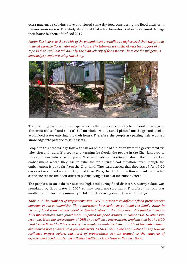
57
extra mud-made cooking stove and stored some dry food considering the flood disaster in
the monsoon season. The study also found that a few households already repaired damage
their house by them after flood 2017.
Photo: The houses in the outside of the embankment are built at a higher level than the ground
to avoid entering flood water into the house. The tubewell is stabilized with the support of a
rope so that it will not fall down by the high velocity of flood water. These are the indigenous
knowledge people are using since long.
These leanings are from their experience as this area is frequently been flooded each year.
The research has found most of the households with a raised plinth from the ground level to
avoid flood water entering into their house. Therefore, the people are putting their acquired
knowledge into practice to save assets.
People in this area usually follow the news on the flood situation from the government via
television and radio. If there is any warning for floods, the people in the Char lands try to
relocate them into a safer place. The respondents mentioned about flood protective
embankment where they use to take shelter during flood situation, even though the
embankment is quite far from the Char land. They said uttered that they stayed for 15-20
days on the embankment during flood time. Thus, the flood protection embankment acted
as the shelter for the flood-affected people living outside of the embankment.
The people also took shelter near the high road during flood disaster. A nearby school was
inundated by flood water in 2017 so they could not stay there. Therefore, the road was
another option for the community to take shelter during inundation of the village.
Table 4.1: The numbers of respondents said ‘YES’ in response to different flood preparedness
question in the communities. The quantitative household survey found the family status in
terms of flood preparedness based on few indicators in the study area. The families living in
NGO interventions have found more prepared for flood disaster in comparison to other two
locations. Here the contribution of DRR and resilience interventions implemented by the NGO
might have linked to this success of the people. Households living outside of the embankment
are showed preparedness to a few indicators. As these people are not involved in any DRR or
resilience project before, this level of preparedness can be treated as the outcome of
experiencing flood disaster via utilizing traditional knowledge to live with flood.

58
Preparedness indicators Inside embankment (N=30)
Outside embankment (N=30)
NGO intervention area (N=30)
Getting early warning for flood disaster 21 17 18 Stored dry food at home 22 19 26 Raised plinth of the household 1 15 21
Raised the basement of the tube well 2 6 22 Raised the basement of the toilet 2 6 22 Stored crop seeds for future use 10 3 6 Stored cash for carrying out the family expenses after flood
9 4 11
Having emergency equipments like light, & radio
24 21 15
Discussed with neighbors about evacuation
6 9 15
Plan to store and save valuable asset 10 6 17 Defined a place to transfer family members
4 9 7
4.4.5.3 NGO intervention areas
The people of Kulkandi are experiencing flood disaster with varied severity in each year.
The economic status of these families is poor and most of them are dependent on daily wage
to run their livelihood. Apart from their antecedent preparedness, NGO intervention was
also helped them to be ready for flood disasters. Now I shall summarize the level of
preparedness for the flood of 2017 that the families of Kulkandi community reported during
conducting survey and focus group in the following.
Photo: The toilet and tubwells are put at a higher than the grounds level to safe the
structure from damage from flood water in the NGO intervention area. These are made with
the support of NGOs. Source: Researcher.

59
People in the area raised the plinth of their houses, toilet and tubewell with the help of
NGOs, so that flood water could not cause damage to the structures. However, according to
them the flood of 2017 was different in severity as the water level went so high that the
houses are inundated even though the plinth was raised considering previous flood water
level in this area.
Families stored some food items like biscuits, puffed rice19, molasses and rice to survive
immediate after the flood disaster. They also kept non-food items like candles, matches,
mud-made cooking stove for their livelihood.
As this village becomes separated from the main land during flood disaster, families
arranged boat for transportation of their members to safer places. However, the number of
boats is inadequate considering the number of affected families. People who do not have any
boat communicated to his neighbor to arrange a place for his family during critical situation.
A few families also planned to take their members to the nearby high road during raising the
flood water level in the area. There is a road constructed by the Union Parishad in 2008
used as a high place to take shelter.
Affected families also planned to take loan from the microfinance organizations like ASA,
Bangladesh Rural Advancement Committee (BRAC), Grameen Bank. Affected people are
taking this loan with an interest that need to pay in installments in each week.
People also mentioned about following the update news in the television and radio to know
the update status of flood.
While I asked about the source of learning of what to do before, during and after a flood
disaster, the community people replied with their life experience through facing flood
disasters in the past. They also mentioned about the awareness rising sessions on flood
disaster organized during implementing disaster risk reduction interventions by different
development organizations in the community. NGOs actually conducted many awareness
rising court yard meetings on flood disaster preparedness, sanitation and hygiene with the
group of people in the area. The people also acknowledged that they knew many
preparedness things before the NGO interventions in the area; however they also learnt a lot
of new things about flood preparedness from awareness-raising sessions organized by
different organizations in the community.
The NGO representatives also see the investment on family level flood resilient structures as
an effective way to protect the families who are vulnerable to flood disaster. These
initiatives thus contribute to enhance the capacity of the people to face disasters. Besides,
the organizations also did advocacy with the local government (including District
Commissioner’s Office, Water Development Board) for infrastructural support like
strengthened river banks by putting sand bags, piling system etc. at the bank of the river
Jamuna.
19 Puffed rice is a type of puffed grain from the Indian subcontinent, made from rice, commonly used in breakfast cereal or snack foods, and served as a popular street food in India, Bangladesh and Nepal. https://en.wikipedia.org/wiki/Puffed_rice

60
4.4.5.4 Assessment of flood risk by the community
The capacity of the community people to assess the future flood disaster has been evaluated
by household survey. Although this capacity is one of the components of Protection
Motivation Theory (PMT), however it talks about the ability of a community thus can be
treated as a part of community competency. According to PMT the flood preparedness of the
community people depends on their previous experience of a flood disaster and also their
ability to foresee the risk in future.
The household survey shows that the more than 90% of the respondents living outside of
the embankment and NGO intervention area think recurrent flood disaster will happen in
the future. These people also assumed the possibility of their house being inundated by the
flood water. Even though people inside of the embankment have not been exposed to flood
disaster since long, around half of the respondents assessed for similar water logging
situation in future. When I asked about the status of inundation of the house, more than
65% of the respondents said there is a possibility of their houses being inundated by water
situation in the future. About half of the people living inside of the embankment could not
assess the future possibility of water logging or flood disaster in their area.
Figure 4.7: Assessment of severity of flood disaster in future by the community.
In reply to the question on severity of damages caused by flood disaster in future, two thirds
of the respondents from NGO intervention areas and outside of the embankment ranked
future flood disaster damage as very high and high respectively. However, the severity
status was found to be quite diverse from the respondents living inside of the embankment.
The majority of the people ranked the severity as low (35%) and around 30% said the
severity of damage could be medium-scale in this area.
I also discussed the potential damage that might be caused due to flood disaster in future. In
term of damage of households, the status for all three areas remains the same. Almost all the
people in these areas said if flood disaster and similar water logging event happen in future,
the house will be damaged. All the houses outside of the embankment and NGO intervention
areas are made of stainless tin and mud. Thus flood with a high velocity of water could easily
damage the basement and the wall of the houses, even though the basement of the house
has already been raised considering the flood water.
0
69
12
12
20
13 4
20
8
1 0 00
5
10
15
20
25
Very High High Medium Low Very Low
No
of
reso
nd
en
ts
Severity of damage
Inside Flood Protective Embankment Outside the Embankment
NGOs dominant flood exposed area

61
The research found similar status for the damage to agricultural crops and livelihood of the
people. More than 70% of the respondents in all three areas said the agricultural field and
crop will be totally damaged if a flood disaster happens in future. This answer might be a bit
exaggerated as the impact might not be the same in all three locations. It might also have
research’s effect at the flood affected community where the people expected something
from me (also explained in the discussion section). Besides, the majority of the people in
these areas are farmers and agriculture is the main earning source for them. Therefore, the
people in these areas felt a threat that disaster will heavily affect their livelihood status.
More than 80% of the respondents living outside of the embankment and NGO intervention
area said that their livelihood will be severely affected by the flood disaster.
Figure 4.8: Flood risk assessment on the agriculture by the respondents.
The respondents also evaluated the possibility of having health complication during and
after the flood disaster. More than 80% of the respondents living outside of the
embankment and NGO intervention area said that the family members will suffer from
water borne diseases.
The researcher also asked about the possible impact on the fishery sector (fish business by
the local people) and domestic animals. The majority of the respondents in all three areas
could not evaluate the future impact of impact of flood disaster on fishery business and
domestic animals, replying ‘I donot know’. However, a few people living inside of the flood
protective embankment said the fishery ponds will be inundated and there will be loss of
fish. Besides, a considerable number of respondents mentioned that domestic animals will
die due to flood.
4.4.5.4 Reliance and expectation of the community
According to the PMT reliance of the people on the flood protective infrastructures or
disaster risk reduction interventions could have impact on individual or family level
preparedness for flood disaster. In this section I shall encounter how the people living in all
three locations perceived their reliability on the embankment and DRR or resilience
intervention by the government and NGOs respectively. I also asked people what they
expect from the stakeholders including government and NGOs considering flood disaster
(see the table 4.2 & 4.3 in the following).
The quantitative survey data shows that people rely on the flood protective embankment
which can reduce the damage of the flood disaster in the vulnerable community. The people
22
4 4
21
1
8
22
7
1
0
5
10
15
20
25
Total damage Partial damage I do not know
No
of
resp
on
de
nts
Inside Flood Protective Embankment Outside the Embankment
NGOs intervene flood exposed area

62
living inside of the embankment are completely reliant on the existing embankment for
protective the flood disaster as these people did not experience any flood after 1995.
Around two thirds of the respondents from outside of the embankment also mentioned that
the embankment can save the damage in their community. This reliance actually came
through watching how their neighbors are protected from the flood disaster at the same
time they are severely suffering from flood disaster.
Figure 4.9: Reliance status of the respondents (N=90) on flood risk management. Here the
number only shows the status of positive responses on flood protective embankment of
government and DRR/resilience interventions of NGOs.
However, while I asked about the reliance of the people on the NGO led disaster risk
reduction or resilience intervention in terms of reducing damage or protect people from
flood disaster, two third (on average) of respondents from inside and outside of the
embankment replied that they do not rely on these measures. About half of the respondents
living in the NGO intervention area shared that the risk reduction or resilience interventions
could help to make them prepared and thus can save lives and assets from flood disaster. A
very possible reason of pro-development attitude of these respondents could be their
previous and present experience with various disaster preparedness intervention
implemented by the NGOs in the area.
Apart from the status of reliance of the community on different flood control and
management approaches, I asked about the general expectation of the community
considering the situation before, during and after the flood disaster in the area. The study
fund diverse expectations from the people. Taking government into account, the majority of
the people voted for establishing the flood shelter, a proper flood early warning system and
repair of roads for the people. However, people asked for safe water and sanitation facility,
distribution emergency aid and early warning (dissemination) before and during the flood
disaster from the nongovernmental organizations.
29
19
14
63
13
0
5
10
15
20
25
30
35
Inside Flood ProtectiveEmbankment
Outside the Embankment NGOs dominant floodexposed area
No
of
resp
on
de
nts
Embankment DRR/Resilience program

63
Table 4.2: The list of expectations of the community from central government and from NGOs before and during the flood disaster (N=90).
Expectation Before & during flood
from government
Before & during
flood from NGOs
(1) Establishing flood shelter 45 17
(2)Stronger search & rescue operation 3 1
(3)Stronger early warning system 32 21
(4) Enhanced evacuation of residents 7 9
(5) More care about physically unable people 11 7
(6) Safe water & sanitation 21 40
(7) Distribution of emergency aids 17 21
(8) Medical support 5 6
(9) Repair roads 22 4
However, the expectation of the community from the government and NGOs varies with the
situation. After the flood disaster, the majority of the people want to receive livelihood
support programs and cash for work assistance from both the government and NGOs.
Asking for medical support immediately after the flood disaster was quite high from the
NGOs. Besides, there was a pressing expectation to repairing embankment by the
government, especially during the monsoon season.
Table 4.3: The list of expectations of the community from government and NGOs after the flood disaster (N=90).
Expectation After flood disaster from government
After flood disaster from government
(1) Cash for work 30 23 (2) Livelihood support program 42 34 (3) Shelter support 14 10 (4) Embankment repair 30 8 (5) Special program for disabled persons 13 9 (6) Medical support 10 33 (7) Repair roads 16 0 (8) Safe water & sanitation 9 1
This chapter was all about fields finding and compilation of interviews with different
stakeholders based on the framework. The next chapter will summarize the results based on
the research objectives.

64
Chapter Five: Discussion and Conclusions
5.1 Introduction This chapter represents critical perspectives on community resilience through
interpretation of the results and making a linkage with key objective and the theoretical
framework of this research. The analysis of the results is structured according to different
resilience dimensions of the Disaster Resilience of Place (DROP) model which includes
social, financial, infrastructural, institutional, and community competency. Besides, the
status of flood preparedness and motivation of the people is being analyzed and interpreted
based on the Protection Motivation Theory (PMT) with a combination of the DROP model. In
the discussion I also presented how the politics and power relations have become an
integral part in the disaster management interventions in the study area. I also try to reflect
on the methodology that I used to assess the resilience and limitation of the research.
5.2 Reflection on the results The people in the study areas are experiencing different measures of flood control and
management introduced by both government and nongovernmental organizations. The
study found potentials of these interventions on building or enhancing the capacity of the
people towards facing flood disasters, however with few challenges. The key message would
be none of the measures alone can touch all five dimensions of the Disaster Resilience of
Place (DROP) model. For instance, the flood protective embankment has contributed
towards making the whole community living inside of the embankment protected from
flood since 1995; that means infrastructural resilience is high here in compare to other two
locations as they do not have such flood protective embankment. This also enhanced the
confidence and competencies of the community people to cultivate rice crop for two times
and vegetable for once per year (Talukder & Shamsuddin, 2012). The increase of rice
production contributes to food security and eventually the financial resilience of the families
even though monthly income status (31.85 euro) of the people living inside of the
embankment does not say much about it. But before constructing this embankment farmers
living inside were producing rice once per year similar to people living outside of the flood
protective embankment. However, after twenty years of embankment farmers are now
saying that the fertility of agriculture land is decreasing in comparison to outside lands due
to interrupting regular monsoon flooding in this area (Brammer, 2010).
Apart from these, social tension evolved within different farmers groups regarding opening
and closing the sluice gates of the embankment during monsoon season. Besides, the people
who were dependent on fishing inside of the embankment earlier, now claiming they had to
go to another places nearby river Jamuna for fishing as there is no fish inside of the
embankment. Therefore, the infrastructural resilience might be responsible in creating
further marginalization of a certain occupation in the community (Pham, 2011). Moreover,
community living inside of the embankment raised an issue about the functionality of the
Water Development Board and local management committee regarding proper maintenance
of the existing flood protective embankment. People claimed that a few sluice gates are not
functioning anymore and also during the monsoon season many parts of the embankment
became risky due to inadequate maintenance. In reply to this claim the representative of
water development board based in Tangail District said there is not budget allocated for the

65
maintenance for the embankment from the government (Khalequzzaman, 1993). People in
the area think due to inadequate management of the embankment breached at some points
in 2017. Therefore the embankment is not seems fully safe for the entire population now a
days. Apart from these, the study found political interference in indentifying and
distributing agricultural assistance from the government to the farmers and also the
emergency relief to the flood-affected people. Thus the infrastructural endowment might
have negative consequences on the already existing social cohesion and thus on social
resilience of the community living inside of the embankment compared to outside
communities.
The community people were critical about activeness of the local government in handling
flood disasters. They think there is a lack of communication between the elected persons
and the affected community while calculating the damage and assistance needed for the
community. Thus, the real number of affected households is hard to say. Again the
community people said that the Chairman of the Union Parishad did not come to visit the
affected area and people after the devastating floods. However, political persons usually
come to the community to seek vote for the local government election.
The disaster risk reduction and resilience interventions of the NGOs are contributing to
different dimensions of the resilience (Islam & Walkerden, 2015) mentioned in the DROP
model. For instance involvement of NGOs in early warning message dissemination,
development of disaster management plan and flood awareness through court yard
meetings can be linked with preparedness at the community and family level (Allen, 2006).
Thus people living in NGO interventions are more aware and achieved better understanding
about what to do before, during and after the flood disaster (Islam & Walkerden, 2015)
compared to the other two areas. The household survey found that the people living in the
NGO intervention area are more prepared for the flood disaster compared to people living
inside and outside of the flood protected embankment. The study realized that people who
are living with flood know how to deal with the disaster which can be called as inherent
capacity in the DROP model. However, the connection between people and NGOs that deal
with DRR or resilience intervention gave the flood vulnerable people necessary knowledge
and logistics towards enhancing their self-preparedness (Grothmann & Reusswig, 2006)
compared to people without any connection or having external supports (Islam &
Walkerden, 2015). The study found that the people living inside of the embankment did not
think much about flood disasters and preparing for that due to high reliability on
embankment but they became concerned about water logging situation which happen in
2017. On the other hand, people living outside have inherent capacity and traditional
knowledge to face a flood disaster with a hope of getting emergency relief assistance from
the credit organizations after flood disaster.
Moreover, NGOs invested money for constructing flood resilience structures for family and
community which includes shelter, latrine, tubewell and community centre for common
gathering at the community. Even though many of these structures have been damaged due
to the flood of 2017, but community people still see positive implication of flood resistant
structures towards infrastructural resilience. The Cash for Work (CFW) activity is
contributing to infrastructural resilience through constricting new mud road or repair of
damaged roads after the flood disaster. The whole society is benefiting from this initiative;
however only poor families are involved in CFW, not other groups in the society. Even
66
though the families are receiving financial benefits from CFW, however only targeting a
certain group definitely undermined the poor and created further socio-economic class in
the community. May be, well-off families do not need any support due to having flood
resilient shelter or secured livelihood status. But without this road that the poor people
repaired or constructed, rich families might be at risk in future flood disasters. Thus, rich
people should play some sort of responsibility in the community development initiatives.
While the issue community engagement comes in the development interventions, then
where is the contribution from the rich people? NGOs need to pay more attention to this.
The study found a few organizations are already thinking of it. For instance, Red Cross Red
Crescent (RCRC)20 Movement in Bangladesh is working on this and mobilized the whole
community to come together to support the CFW initiative. While poor families started
working in repairing the village road under the CFW initiative, other families came on board
and proposed to provide food for the people working on constructing to road. Some families
proposed to provide tree saplings along two sides of the road. This can be called beneficiary
engagement at all levels or co-contribution in disaster risk management.
Many NGO representatives believe that resilience building interventions should focus both
household and community development activities. The interventions combining community
development initiative including construction of roads or community information centre
and the individual resilience building activity like raising plinth of houses would work
better. For instance, Bangladesh Red Crescent repaired a damaged road and increased the
height of the road considering the flood water in previous flood in one of the communities of
Jamalpur District. Eventually, the road saved many families from flood damage in 2017 by
protecting flood water entering to that community. Besides, the organization also supported
to 200 families for raising the plinth of their households. However, these 200 families could
have been washed away without that high road.
Besides, a few NGO representatives stressed on well coordinated disaster intervention from
the local government and organizations; where to work and how to work better for the
community. They said the initiative can be taken by the local government as they have plans
for community development aligned with the strategic plan of the Bangladesh government.
Thus, they can ask the organizations working in the area to support a specific activity of the
action plan, thus the plan of action can jointly be implemented by government and
nongovernmental organizations. For instance, nongovernmental organizations supported
Bangladesh government to prepare the Standing Order on Disaster (SoD) and later on
revision of the document. Likewise, the annual plan of the Union Parishad can jointly be
prepared including all the actors working for development in that area.
Thus, the local government can also explore the funding and capacity gap at the beginning of
the year and actions can be taken accordingly. Thus, the local government institutions of the
Bangladesh government and the nongovernmental organizations can be ready to face any
changes made by any disasters. This can be called ‘Institutional Readiness’ – NGO
representative
20The International Red Cross and Red Crescent Movement is an international humanitarian movement with approximately 97 million volunteers, members and staff worldwide which was founded to protect human life and health, to ensure respect for all human beings, and to prevent and alleviate human suffering. https://en.wikipedia.org/wiki/International_Red_Cross_and_Red_Crescent_Movement

67
The representative of DRRO office at Jamalpur District also raised another critical question
about budgeting for disaster recovery initiatives by the government and NGOs. He said if any
of the stakeholders want to assist plinth rising of the households, did they calculate all the
associated cost in completing the task? In many case, vulnerable families need to take loan
from microcredit organization with interest to complete that task for which they received
partial money for the stakeholders. In that case we are doing hard instead helping them. For
instance, we often forgot to include the cost to purchase mud and labor hiring cost to build a
flood resilience shelter.
Besides, the community committees- formed and trained by the NGOs and government are
involved in maintaining the flood protective embankment and also disaster management at
the local level. Being an initiative from NGOs, the disaster management committees are
linked to Union Disaster Management Committee (Khan & Rahman, 2007) where they can
raise their voice on flood situation during bi-monthly meeting. Although, there is still a
question about the functionality of these committees in reality, however these initiatives
have positive implications in enhancing social and institutional resilience in the community.
The livelihood support from NGOs including cash grant and capacity development training
(i.e. handicraft, sewing) for the women and other vulnerable groups has created alternative
source for income generation that contributes to financial resilience of the poor families
(Allen, 2006). The microcredit organizations are providing loans with interest to the
affected communities and livelihood assistance from the disaster focused organizations are
linked to financial resilience of the vulnerable people. Even though credit organization are
benefitting from flood disaster as the many people are taking loan from them, however at
least the people can borrow some money after the flood disaster to survive (Parvin & Show,
2013).
The study found negative social consequences of flood control and management
interventions that could become a hindrance in strengthening the capacity of the people
living inside or outside of the embankment. For instance, the social tension among farmers
regarding opening and closing sluice gates and inadequate consideration of the fisherman
community posed a negative impact in social cohesion. Besides, empowering few people
through including them in the community committees sometimes create further domination
over others. However, the aftermaths of the interventions are often left aside or even did not
forecast as challenge during design and implementation phase of the project. Moreover,
there is a lack of follow up or monitoring of the intervention after phase out. Even though
government and NGOs are to institutionalize the interventions by forming and training
community people, in reality ownership of the local people is still remains hard to achieve
due various socio-economic factors. The educational status has found almost the same as
the majority of the people living inside and outside of the embankment are illiterate. In the
NGO interventions area the majority of the people passed primary education which means
there is a big difference in three areas. However, when any crisis rose in the community
people come together to help each other and thus social cohesion exist in all three
communities. Even though, I could not assess the effectives of those crisis handling
initiatives by the community, but it definitely contributes towards social resilience.
However, political influence and social class division can be a confounding variable that
might have negative impact on social bonding and cohesions. As we already observed the
social tension among different farmers groups inside the flop protective embankment.

68
Therefore, there is no differential impact on the social resilience and it seemed an inherent
characteristic of the communities studied in this research.
Besides, this might be the first time that the DROP model has been used to assess
community resilience for flood disasters in Bangladesh. A few quantitative indicators
proposed in the DROP model were not applicable in Bangladesh, for instance insurance for
the crisis, extensive social safety net program etc.
In summary I tried to do a qualitative (and including a small quantitative part from PMT)
assessment on the level of resilience of the study areas based on the DROP model in
combination of PMT. The assessment is based on the results and the discussion on those
results following the research objectives. Here, three plus (+++) denotes the maximum level
of resilience and one plus (+) represents the lowest. To begin with infrastructural resilience,
due to having flood protection embankment people living inside are mostly safe, but there
were a few breaches and water logging in 2017 meaning infrastructure is not ensuring
complete safety. Thus the infrastructural resilience to flood disaster is not maximum level
here, but low in other two areas due to not having flood protective embankment. People
inside and NGO intervention area have community committees to manage damage
prevention measures and also make linkage with local government & NGOs, thus have
medium level of institutional resilience even though there is still question about the
functionality of those committees. The study found cohesion within the communities while
crisis comes meaning people come together to support themselves to make them safe. Thus
social resilience is relatively equal at all three locations, although social cohesion can be
different during non crisis moments that need further research. The people living in NGO
intervention have better average monthly income thus can efforts better to restore their
livelihoods after the disaster thus financial resilience is more here compared to people
living inside and outside of the embankment. Even though I was expecting that the people
living inside of the embankment would have more income as they are producing more after
flood protection, but it did not happen in reality (according to quantitative survey data).
May be further research is need make a comparative financial analysis on before and after
flood embankment situation. Lastly, the study found more self-preparedness to flood
disasters among the people living NGO intervention area compared to other two locations.
This might be the outcome of the combination of inherent ability of the flood vulnerable
people with DRR/resilience interventions from the NGOs.
Table 5.1: The qualitative assessment of community resilience where (+++) means high level of
resilience and (+) denotes lowest (after Cutter et al., 2008).
Resilience dimensions Inside of the
embankment
Outside of the
embankment
NGO intervention
area
Infrastructural resilience ++ + +
Institutional resilience ++ + ++
Social resilience ++ ++ ++
Financial resilience + + ++
Community Competency + + ++

69
5.3 Evaluation of conceptual framework In this section I shall reflect on the conceptual framework explaining how the DROP model
and the PMT have helped me to frame my results and the discussion to reach to my research
objective/s.
The DROP model identifies different dimensions of the community resilience that helped me
to understand and investigate the concept resilience at the community level. As the model
proposed relevant indicators on each five dimensions of the community resilience, it made
my task easy to develop research techniques to collect the information from the field. Even
though the proposed indicators are quantitative, but I tried to contextualize those in a way
that they could be used in the group discussion sessions with the community people.
The research dealt with the capacity of the community people towards handling flood
disaster, whereas only the external assistance without having self-protection or motivation
towards developing that capacity is quite challenging to succeed in reality. This issue
motivation for preparedness is inadequately addressed in the DROP model. Besides, several
scientific studies conducted in Germany, Vietnam shows that self-protection attitude
eventually reduce the damage caused by the flood disaster. Rhine river association also
shows in their assessment that around half of the damage can be protected through self-
disaster preparedness. Thus, I partially adopted the Protection Motivation Theory (PMT) to
explore the status of the motivation for self-preparedness of the community including
ability of the community to assess future flood risk, their previous flood experience,
reliability on the flood protection measures and integrate those findings into main research
findings along with the DROP model. Therefore I tried to combine these PMT aspects into
the DROP model specifically in the community competence (a resilience dimension) which
has, I think, enriched the assessment criteria by deeply looking into the strength of the
community itself.
The study found evidence of having social network and embeddedness among the people
living in flood vulnerable areas. People living inside of the embankment jointly monitor the
flood protective embankment during monsoon season. When they observe any risky
situation they communicate with local water development board office. However, they did
not wait for the people to come and support them, rather they started putting mud bags and
locally managed things to keep the embankment safe. Similar status has found in the NGO
intervention area where people jointly tried to protect the village road and also conducted a
search and rescue operation during the 2017 flood. This can also be framed as the inherent
capacity of the community mentioned in the DROP model (Cutter et al., 2008), which can
also be called as survival strategy. Few people mentioned that they communicated with
neighbors about what to do during flood and also with relatives to stay a few days during
flood. Therefore, it cannot be said that vulnerable people are not taking measures to save
them rather they have traditional knowledge and individual/family level preparedness to
secure them (Schmuck, 2000). The attitude of the people towards engaging themselves into
flood precautionary measures have usually seen when they are at risk (may be immediate
after or during the floor disaster) not during normal time, however still has potential
implications in reducing the risk of the residents (Grothmann & Reusswig, 2006).
Thus, I also tried to find a connection between DROP and PMT where they can supplement
and complement each other. For instance, the previous flood experience, assessment of

70
future risk and current capacity of the community to face a flood disaster could be
integrated in the community competency dimension of the DROP model which would be a
valuable addition to the model while describing the capacity of the community from
different aspects.
5.4 Cross cutting issues in assessing or researching community
resilience The study has also identified a few aspects that might influence in building capacity of the
flood vulnerable people to deal with the flood disaster. I am calling those as cross cutting
issue for resilience and these are power or political influence in disaster intervention,
responsibility/motivation of the community to be prepared for disaster. This sub-section
will discuss on these cross cutting issues.
5.4.1 Power/political influence in disaster interventions
The study has found power exercise/political influence by and from different stakeholders
from National to community level while designing and implementing disaster operations for
the vulnerable and already affected population (Pelling & Dill, 2009). The DROP Model
proposed one quantitative variable (Cutter, Burton & Emrich, 2010; Cutter et al., 2008) on
political fragmentation (i.e. number of government and special districts) which I think is
inadequate in explaining how political dynamics can impact on level of resilience in
Bangladesh. As the research found political interference and power exercise in the flood risk
management interventions implemented by the both governmental and non-governmental
organizations, there might be profound impact on the level of resilience of the community.
Thus, functionality and transparency of the government institutions and NGOs in terms of
managing disaster risk reduction poses a question mark and that need to have a qualitative
explanation along with quantitative information. Even though the model recognized political
issue under institutional dimension of the resilience, but in this research, I found political
influence to be a cross cutting issue that might exist in every resilience dimensions of the
DROP model. While I discussed with the community people, government and NGO
representatives, they all brought the issue how current political situation influence decision
making of emergency relief distribution and longer term DRR or resilience interventions.,
For instance, non-governmental organizations often face influence or force from the local
government to take the community as an intervention area that they proposed even though
the severity of that area is less in compare to other areas. Moreover, the representatives
from the local government influence on the beneficiary selection process as they
request/push to include the families that they proposed, even though those are not meeting
the selection criteria proposed by the organizations. Besides the political people is
monitoring the flood affected areas through local agents to control the overall situation. The
research has a short story to tell:
‘Two persons followed me while conducting focus group discussion and interview with the
people living outside of the embankment (Char land) and called Char Fatepur community.
They observed the research activity and my conversation with the respondents at the
community. I noticed that they are following my each step. After a while I stopped and ask
them: how can I help you? They replied: we are just with you to show you the way back. I
politely refused to take any help from them and requested them not to follow me anymore’.

71
Now, who are they and why they were following the researcher? This attitude can be linked
to political dynamics in the flood vulnerable areas where external people come to conduct
needs assessment for providing assistance and local political people want to oversee what is
going on in the area. That is how the local political people (including local government
institution-Union Parishad) monitor every event. It has both positive and negative sites.
Upside can be an objective to support external people for better assessment and downside
is to influence the assessment considering own benefits. The situation can also be explained
from an authoritarian perspective of the local government. For instance, may be these
people are the informers of the local government to monitor the situation in the flood
affected community, so that they can take measures to control any situation’. In other way
being a flood affected area organizations came here to assist affected people and for that
they usually prepare a list of the affected families. May be the people who followed me,
thought I am preparing a list of the flood affected families to provide post-disaster
assistance. Thus they were looking for an opportunity to talk with me to access assistance.
Now, when local government provides assistance to the affected people the whole process
including beneficiary selection and distribution of assistance is usually being dealt by the
locally elected people called Ward Members without making proper communication or
consultation with the community people. As the amount of assistance is limited relative to
the total affected population, the Ward member wants to do it in silence and most of the
time the assistance goes to the families he has good contact with or the families who helped
them during public election. However, after a while the information of ‘who got the
assistance from government’ became public, the situation led to creating a ‘social whisper’
about the transparency and ultimately develops mistrust on the local government. The
study also found discrimination in terms of providing agricultural assistance to the people
living inside and outside of the flood protective embankment. The people living inside of the
embankment are more privileged in terms of becoming a part of the pilot project
implemented by the agricultural office at the Upazila Parishad. As the area is not flooding
anymore, it is safe for the local government to use as an experimentation site for a new rice
variety. Therefore, only the farmers inside of the embankment are more aware and updated
about what is happening in the field of agriculture and also benefitting from the pilot
experiment. This situation can be linked to the concept of disaster governance which is
more concerned about accountability and transparency of the relevant stakeholders in
designing and delivering disaster relief and recovery assistances to the affected people
(Frerks, Warner & Weijs, 2011). Even though community is the real first responder to any
disaster (Gaillard, 2010), but the involvement of stakeholders with adequate resources
would contribute to reducing further vulnerability.
In the flood protected embankment area, the study found a social tension among different
farmers groups which evolved regarding opening and closing the sluice gates during
monsoon season at various places on the embankment. This tension is also somehow
embedded to local politics. Because when it came into the issue of opening or closing the
gates, the farmers who have more land and close connection with the local government
influence the decision making. This could be seen as a regular socio-political dynamics in the
society. However when the negative impacts due to inadequate consideration of different
groups of farmers in case of opening and closing-up the sluice gates made small farmers
suffer and then it became a serious issue in the communities.

72
In the NGO intervention area, nongovernment organizations is creating further class
differences in the society by forming community committees (e.g. CDMC, CDRT) involving a
few people. The members of the committees are receiving capacity building training and
other technical support from the NGOs, which in one sense has contributed towards
empowering and developing capacity of the vulnerable communities (Kuhlicke &
Steinfuhrer, 2010). However, sometimes this level of involvement made those few people
autocratic in making decisions for the whole community as they might think they know
more than the people who are not part of the project. Therefore, decisions became
unrepresentative which further creates mistrust within the society. Similar situation has
been found when the members of the committee decided to utilize the disaster response
emergency fund (DREF) to only the people who are affected without having proper
communication with the whole community. So, the NGO initiatives helped a few people to
raise their voices, however that became a tool to exercise power over the community.
Moreover, this empowerment initiative (without proper monitoring) is further creating
social class within an existing social hierarchy system in the flood vulnerable communities
of Bangladesh.
The study found a detrimental impact of exercise of political influence on the level of
resilience of the people living mostly outside of the embankment and NGO intervention
areas. This influence hinders proper assistance to the marginalized people from different
stakeholders during or after the crisis period (Baumann & Sinha, 2001). These people could
not develop proper and sustainable linkages with the NGO and government organizations
due to having middle man who are mostly local political or influential people. Therefore,
political influence or power exercise can be observed in the field of disaster management
and it has an impact on the level of resilience of the vulnerable community. Thus, exercise of
power and political influence need to be considered seriously while assessing the capacity of
the community.
5.4.1.1 How to deal political interference
According to NGO representatives interviewed, it is not possible to stop political influence in
international development; however the political entities can be sensitized and turned them
into supportive stakeholders. Considering the existing complications in handling political
influence, some NGO representatives proposed enhancing community involvement and
ensure proper transparency in the interventions. They recommend being fully open to the
community people by letting the local people to handle the situation. It is called the
Community Engagement and Accountability (CEA) approach where all the people living in
the affected areas will be well informed about the intervention in details and the people will
be engaged in selecting beneficiary and type of assistance they need to survive. If this
happens properly at the community level, there would be much less scope for the local
political people to influence in the intervention. They will eventually also realize that they
could not do much here.
In the Flood of 2017, a total of 31 districts of Bangladesh have been inundated, however it
was quite impossible to support as many locations by a single organization. Some
organizations (like Bangladesh Red Crescent and International Federation of Red Cross and
Red Crescent Societies (IFRCs)) worked in only 10 districts. So, how did they prioritize those
areas? I asked them how the disaster management staffs handle the pressure from the
Managing Board members of the organization who belongs to affected area. In this situation,

73
the organization carried out the priority ranking of the affected districts based on some
indicators related to flood damage including household damage, loss of other assets, poverty
status etc. The area with ranking status was presented to the managing board members for
approval. Even though the districts after priority rank 10 were proposed by the governing
members of the organization, it became easy for the management of the organization to
exclude those areas based on the priority ranking. Thus the organization also avoided the
internal potential influence in selecting the affected area.
Moreover, the image of the organization at the local level does also matter in handling the
local political influence on the interventions. A national organization having senior
management staff involved in the local civil society and known to local political leaders and
government officials is more capable of minimizing political influence in the interventions.
For instance, a National organization called Unnoyon Shongho at the Jamalpur District is
able to handle political influences at the District, Upazila and Union level due to its strong
acceptance in the region. However, still it is hard for the organization to handle political
influence at the village level due to having different power dynamics among various groups
of people. This is even harder for the organization coming from other locations to work in
the area.
The NGOs also share the mandate of the organization and the expectation of the donors on
the proposed project with the representatives of the local government to avoid unexpected
influence. Besides, representative of the local government is usually been invited to the
inauguration of an event like cash distribution, shelter material support ceremony, capacity
building training, road construction, etc. This is how NGOs want to keep them updated and
also continue a good working relationship with local stakeholders. However, it is important
for the development organizations to understand the local socio-political dynamics and act
accordingly to run the interventions smoothly.
5.4.2 Responsibility of the community
According to Frerks, Warner & Weijs (2011) the concept of resilience is a political and policy
discourse that is shifting the responsibility of the government for disaster preparedness to
the society. Thus term resilience demands a more proactive attitude of the people who are
vulnerable to disasters. Putting in another way, the concept is creating a safe place for the
government by not taking full responsibility of the vulnerable communities. However
people in the study areas realized that they need to be prepared to face the disaster so that
they can escape the potential damage and also can return to their regular lives. However, is
it happening in the research area now?
Despite flood protection and management interventions of the government and NGO
interventions, people living in the flood-exposed areas which are still suffering from flood
disasters in Bangladesh. I encountered several underlying questions and tried to find
answers to those. For instance, what is the level of preparedness and the challenges that the
communities faced or are facing that influences the level of preparedness?
People living outside of the flood protective measure are found to be more prepared to flood
disaster than people living inside the flood protective embankment. The preparedness
mostly materialized from traditional knowledge of the vulnerable community and some are
introduced by the NGOs through DRR or resilience interventions in NGO intervention area.

74
These capacities can be called community competency, which is one of the resilience
dimension according to the DROP model. However, this preparedness is not enough to save
them and their assets during severe flood disaster. The studies on flood disaster have found
that while people experience flood disaster with varied extent and severity, they learn from
the situation and make them prepared to face the future disaster to reduce the damage
(Kreibich et al., 2005; Kreibich et al., 2011). Based on this, I held a discussion with the
community and NGO representatives on the question why the preparedness of the
households in the flood vulnerable area isn’t at maximum level. The study found several
reasons why they are not fully prepared for the flood disaster.
Firstly, the people living in the flood exposed areas have inadequate financial capacity to
invest in flood protective initiatives by themselves to make them prepared for flood disaster
(Brouwer, et al., 2007; IPCC, 2001). Both the community people and NGO representatives
mentioned that the monthly income of the flood vulnerable people is not enough to run their
families well and also daily wage earning is not the same round the year. Thus, it is not
feasible for them to invest money on self-preparedness. According to local people, about two
and three months (especially during monsoon reasons) of each year they cannot find proper
work due to having floods or simply due to heavy rainfall. At that time, people take out loans
with interest from the local organizations that run microcredit schemes. Families need to
pay a weekly installment with interest, which is again a burden for the poor people. Thus
the poor people fall into a cycle where they never get rid of poverty. Besides, the flood
preparedness initiatives also require money. If I consider raising plinth of the house,
sanitary latrines and tubewells, strengthening the walls of the houses, arrange some sort of
transport to go somewhere else with the whole family and domestic animals, store some
money to survive after the flood disaster etc. are all required financial investment to
accomplish. However, the economic situation of the vulnerable ultra-poor families does not
allow them to use their daily wage for flood preparedness. Thus, they are not motivated
enough to invest time and resource to make them prepared to reduce the damage of flood
disaster.
Secondly, the people living in the flood exposed areas usually face recurrent flood disasters
and they do not have required time to be prepared to face the flood disasters. Thus, people
suffer severely and cannot improve their economic status. This recurrent disaster may also
be one of the causes why people are not willing to prepare for flood disaster.
Thirdly, there is also the challenge of access to various services offered by the government
and nongovernmental sector for the vulnerable poor people. Besides, the way the services
are channeled to local level is complicated and bureaucratic which also hinders the
functionality of the services. For instance, the Union Parishad cannot take any decision
without informing the Upazila and District office due to a very centralized decision making
culture in Bangladesh. Besides, people need to have location specific information about
flood disaster including flood intensity, severity, continuous update status, estimation of
damage etc. They also need to know the sources where they can get some support from the
government, NGOs or private sector. Here, the issue of accountability of relevant
stakeholders/service providers comes into consideration.
Fourthly, the changing pattern of flood makes it harder for the vulnerable community to be
prepared for flood disaster. For instance, some farmers took away the Jute and placed in a

75
safe place to save those from flood water. However, the high velocity during flood 2017 and
the height of water were much higher compared to the previous year (in 2016: 2 feet and in
2017: 4 feet from the ground), thus all the stored Jute are washed away this year. Thus, the
flood markers that were installed by a project of the Bangladesh Red Crescent Society to
make the people aware of flood water level in the area did not work out.
Table 5.2: The quantitative data shows the number of respondents and their reason why they are not prepared for the flood disaster in the research areas.
Research area Inside of embankment (N=17)
Outside of embankment (N=14)
NGOs intervene area (N=5)
Natural event, so I cannot do anything 7 12 4 It won’t do any harm to me 3 1 0 I shall get support from others 0 1 1 I am not interested 2 0 0
The household survey also found some other reasons why people are not motivated to get
themselves prepared for the flood disaster. The people living outside the flood protective
embankment replied that the flood disaster is a natural event, so they do not have anything
to do. Therefore, believing in an act of God by the people can be seen as a hindrance towards
being prepared for the flood. Schmuck (2000) found that even though flood prone people in
Bangladesh are informed about the coming flood, they are reluctant to be prepared and thus
accept their fate as helpless flood victims.
Despite these challenges that the community people face, many NGO practitioners think that
the people who are suffering from flood disaster should take some responsibilities to make
them safe. Although there was a common understanding that the key responsibility to
safeguard people mainly lies with the government. However, the families who received
assistance for flood resilient shelter, sanitary latrine, tube well or livelihood improvement
during flood disaster once, they need to reflect with the preparedness that they already have
in the next flood disaster rather than looking for further assistance from NGOs or
government. In reality, it is not happening which also making it difficult to visualize the
impact of DRR or resilience interventions in the flood vulnerable communities. Here, the
responsibility of the affected people comes: they can plan and do things to reduce the
damage. A behavioral change cannot be made unless the people want it. Thus, ownership on
the part of the community itself will need to be there to keep continuing to learn from the
resilience or DRR interventions in their future lives.
5.4.2.1 Why are the vulnerable people not relocating to safer places?
The people living outside of the embankment and NGO intervention area are vulnerable to
flood disaster. The most suitable way to escape the damage due to flood disaster is to
relocate to other areas (Hooijer et al., 2004). As the complete protection from flood disaster
is impossible, the flood vulnerable areas will always remain risky for of the people and their
valuable asset (Kreibich et al., 2011). However, why aren’t the people of flood exposed
Tangail and Jamalpur areas reallocating or shifting to other safer areas? The study has found
some arguments on this.

76
The poor people are living in the flood vulnerable areas of Bangladesh. They don’t have any
other place to relocate, like the rich people who can shift their location to another place for
survival. Here, the key barrier for these poor people is financial status. Due to poor
economic status, they simply cannot investment to organize things to stay elsewhere.
Another reason is people are not motivated and confident enough to leave the place that
belongs to their ancestors. Besides, the social bonding can be another reason why they do
not want to move to other location. The people living in the vulnerable areas have already
developed ways of surviving along with their neighbors and they together face any crisis in
the community.
Another reason is easy accessibility of natural resources for their livelihood in the flood
affected areas. For instance, the open water sources are the possibility of getting fish and
also selling into the local market. Thus the poor people can manage the nutrition level in the
food consumption and money for purchasing other family needs. Moreover, the agricultural
lands are fertile so that they can produce crop easily.
5.5 Discussion on flood preparedness and NGO interventions The study found a dilemma while started talking about effectiveness of disaster risk
reduction or resilience interventions, led by the NGO, on the community preparedness
aspects considering disasters in Bangladesh. According to the NGO representatives, NGOs
are seen as the key agents by the community people who are solely responsible for making
flood vulnerable communities resilient to the upcoming disasters. However, people raise
much less concern and say about what they are supposed to receive from the government. It
seems that people rely and thus expect more from the non-governmental organizations than
from the government.
Some NGO representatives were critical about their resilience interventions through raising
explanatory sign on the impact of DRR or resilience building interventions that are
implementing since a decade. They think, with the given resources that have already been
spent to build to flood vulnerable areas to enhance the capacity of the community, by now
the vulnerable people do have some sort of capacity /resilience considering the flood
disaster. For instance, the plinth of the affected households should have been raised above
the flood level; sanitary toilets should have the same status in the flood affected
communities in Bangladesh. But eventually, it did not happen. After the flood disaster, NGOs
are asking money from the donors to provide shelter, water, sanitation, livelihood
assistances to the affected people during disaster.
‘NGOs are asking for food support for the flood affected people living in Haor areas without
considering the traditional coping mechanism of the local people. The Haor people usually
store food for six months considering the flash flood. When immediately after the flood, NGOs
asks for financial support from donors, they eventually undermine existing traditional copping
mechanism of the community. Thus, affected people became aid dependent. It also creates
scope to raise questions about the work of the development organizations by the government
authority’ – Senior NGO staff working on Resilience.
Therefore, it seems affected people cannot stand alone for a few days immediate after flood
by themselves, even though relevant actors are working on flood vulnerability in the
potential affected areas. So, why is this happening? What is the impact of all the efforts put

77
by nongovernmental organization in those areas so far? Why aren’t the hardware and
software initiatives of the actors fully successful towards making the vulnerable community
capable of surviving for at least for few days after disaster?
According to NGO representatives, it is really difficult to say how much the flood vulnerable
community has been impacted by the interventions of the NGOs. They asked for an analysis
on a specific flood affected area to report on the preparedness of the people focusing NGO
contribution; disaster resilience or DRR intervention. For instance, take a specific
community and assess the following questions for last 10 years:
How many times has the community been affected by the floods for last 10 years?
How many long term/resilience or DRR projects have been implemented in this
community?
What were the needs of the community and how has the project reflected on those?
What was the damage in each year?
According to NGO people with these data and this information, the variation of
preparedness for flood disaster by the community in terms of reducing damage of the assets
or survival of the livelihood of affected people with or without external supports can be
explored. Thus, we also can see the relief and survival cycle in that specific community.
Besides, a few respondents felt the need to conduct a micro analysis of any specific area. For
instance, about 50% of affected families have been covered through relief activities by all
the organizations working on these sectors after flood of 2017. They said while media and
other stakeholders are saying that NGOs are implementing flood risk reduction and resilience
interventions in the flood affected areas of Bangladesh since long, why people are not prepared
enough to face the disasters. The NGO representative also answered this question. They said
if we consider the number of people living in the affected areas and the numbers affected by
flood, then the relief efforts against that are low. Again, while we are working in Jamalpur
District, we are considering a specific village or several villages. Therefore, we need to evaluate
how the people faced the flood disaster, what was their level of preparedness and how they
utilize the knowledge that they received from the interventions from the NGOs. Micro analysis
is necessary to report on the effectiveness of the development aid.
The representatives of the NGOs also mentioned that sometimes in some areas people may
be reluctant to be prepared for flood disaster. They may be thinking disaster will not harm
them and in that case people suffer a lot. But, in most of the cases people want to lower the
damage cost due to disaster. In reality, the number of causalities due to flood disaster has
been reduced compared to the past in Bangladesh. This has happened through social
transformation as people did realize the damage cost and want to do something about that.
Despite the different challenges (mentioned above) that the community people face, many
NGO professionals think that the people who are suffering from flood disaster should take
some responsibilities to make them safer. As many studies have found that self-protective
attitude of the vulnerable households can reduce the damage cost of the people in the flood
prone areas (Growthmann & Reusswig, 2006; Kreibich et al., 2011). Although, there was a
common understanding that the key responsibility to safeguard people mainly lies to the
government. However, the families who received assistance for flood resilient shelter,
sanitary latrines, tube wells or livelihood improvement during flood disaster once, they

78
need to reflect on the next flood disaster rather than looking for further assistance. Here, the
responsibility of the affected people comes, like they can plan and do things to reduce the
damage. However, the study also found a critical view on the motivation of the families to be
prepared for flood disasters. According to DRRO representatives there are families are not
willing to repair their damaged house after the flood even though they might receive
assistance from somewhere. These families actually wanted to show other aid provides that
they haven’t received assistance so that they need assistance to repair the damaged house.
Thus some families receive more assistance while few others may be left out due to
limitation of resources. Besides, NGO representatives said that the people who are
vulnerable to disaster need to take ownership to keep continuing learning from the
resilience or DRR interventions in their future life.
5.6 Expectation and reality I chose three villages from two different places, situated on the same Jamuna river bank, to
see the differences among the communities towards perceiving, analyzing and preparing for
the flood disasters. However, the study did not find much variation of responses in respect
to flood preparedness. The expectation was to find a higher preparedness status among the
people living the flood exposed area, where NGOs are doing disaster resilience or risk
reduction interventions, compared to people surviving on their own without any support
from NGOs; however it did not happen in reality. The possible reason would be the
antecedent conditions that include inherent vulnerability and resilience of the flood
vulnerable people living and experiencing flood disaster. Therefore, I surmise, people living
outside of embankment do not feel the need to be prepared as they survived in the past with
or without assistance from the government and NGOs and they will in the future as well. I
am not saying that it is an ‘Act of God’ attitude of the people, although the quantitative data
suggests as such. However there are other reasons, for instance low monthly income of the
vulnerable families in the study areas thus they barely support livelihood of the family and
simply cannot invest in flood preparedness activities.
Moreover, the people who were involved in different DRR or resilience interventions
implemented by the NGOs learnt a lot regarding flood preparedness apart from their
indigenous knowledge from living with the flood. However, after phasing out of the project
people became reluctant to make an effort to keep practicing the learning and also the
assets that they received from the organizations. Therefore, continuous monitoring of the
project implementation areas after ending up the timeframe would be effective to follow-up
the uptake of the learning by the project beneficiaries.
Even though some NGO practitioners think they could not provide a ‘Dream to the flood
vulnerable people to be prepared for the flood disasters’ through disaster risk reduction and
resilience intervention’ - senior management staff of a NGO in Bangladesh.
The issue of self-protection or motivation seems complicated which needs further research,
so that diverse reasons of why people from the flood vulnerable areas do not want to be
prepared for disasters can be identified.

79
5.7 Limitations of the research The field work for this research took place after the flood of 2017, thus people in the
affected areas were still recovering from the damage and expecting some support making
the recovery process quickly. In one sense it was beneficial for the research that people in
the areas can recall their recent memories very well while sharing their stories. However,
people were busy in re-arranging their own staff, so it was quite difficult to ask for an
interview where the research does not provide anything to them. Thus being a researcher I
only envisioned taking information from them during their crisis situation without helping
them. I also assume that people sometimes overstated the contribution from the
government and NGO. The people living outside of the embankment were quite negative
about local government and NGO interventions, as they only focused on the drawbacks,
which basically undermine the assistance that community people received after the flood
disasters. Likewise, people living in flood exposed areas with NGO intervention praised
positive aspects of the development organization which helped them with resilience and
risk reduction projects at different time and thus they may be overstated the NGO
contribution. However, they did not mention river bank protection initiatives by the Water
Development Board of the government.
I could not organize any group discussion with the flood embankment management
committee that has formed by the Water Development Board at the local level due to time
and budget constraints. Even though I talked to a few committee members, an interactive
discussion with committee members could have helped me in explaining the negative
consequences of the embankment mentioned by the community people.
The quantitative household survey covered only 30 households in each area. Even though, I
followed a simple random sampling procedure to select households, however it could be
better to take more households in terms of representativeness and generalization of the
survey findings.
I could not be in the field during the flood disaster and water logging event in 2017.
Therefore I could not observe the level of community preparedness, political dynamics and
functionality of the community committees during flood and water logging situation. An
ethnographic research might have come up with different findings and more real time
scenario of the flood disaster.
5.8 Research ethics and positionality Being a professional in the field of disaster risk management in Bangladesh and also a
student of Disaster Studies, I tried not to impose my experiences and academic learning
during interviewing and conducting focus groups in the community. I wanted to learn from
the respondents following the interview/survey guideline but obviously I posed follow-up
questions to them, so that I could have views from different positions of the respondents.
Even though I realized a few field findings were similar to my understanding from the work
experiences, I learned so many new things while talking with the people living at the
vulnerable areas and also NGO people who are involved in the DRR and resilience projects.
Besides, I always had to be cautious about my position as a researcher; not to judge the
work done by the government and nongovernmental organizations regarding flood risk
management but rather listen to the perception of the respondents in the field. Moreover,

80
the information specifically on the political influence and power issues was quite
confidential and I had to comply with the research ethics about this. For instance, the
respondents mentioned about the role of local government and their level of satisfaction on
their work during flood situation. I assumed this information as confidential and felt that it
should not be disclosed to other stakeholders including government and non-governmental
organizations in the research areas. I was mostly looking at gaining the trust of the
community people so that they could open up to me and share what they actually observed
and perceive about flood risk management. I did also realize that disclosure of the
confidential information means exposure of the poor people that would be negative impact
on getting future assistance from stakeholders.
5.9 Conclusion In this section I will summarize the results and discussion based on the research questions.
More specifically I will answer the research question in light of different resilience
dimensions and the status of flood preparedness among the community people in light of
the Disaster Resilience of Place (DROP) model and the Protection Motivation Theory (PMT).
The flood control and management interventions led by the government and NGOs
respectively produced different types of resilience at the communities. Considering five
dimensions of resilience that includes infrastructure, institution, social, financial and
community competency, none of the interventions alone can contributes to all. The study
suggests a combined effort towards resilience building in the flood vulnerable communities
in Bangladesh.
Flood protection embankment by the government of Bangladesh has directly contributed
towards protecting people and the agricultural land from flood disaster. Thus the threat to
human lives and damage to crops has been reduced inside of the embankment area. People
living in this area are producing crops twice a year and the cultivation of vegetables is
increased within the community. The people in this area are benefitting from government
institutions as it became the main experiment area for agricultural department. However,
after twenty years of flood control measures people in this area are experiencing negative
impacts as well. For instance, the embankment was breached at a few points in 2017 which
did not cause much loss however this might be an indication of severe breach in near future
which will cause heavy log with causality. Besides, the people did not face any flood after
1995 which actually enhanced their confident that flood will not happen here. Thus
individual and family level awareness and preparedness is less here (Hooijer et al., 2004).
This reliance on the embankment actually made the local people less motivated to prepare
for flood disaster. People are unexpectedly experienced severe water logging due to
excessive rainfall and lost agricultural crops for the first time in 2017. Different farmers
groups complained about maintaining (i.e. opening and closing) the sluice gates during
monsoon season. Farmers also claimed that the agricultural land is gradually losing its
productivity as the land is not being regularly flooded since 1995. Besides, the operation
and maintenance of the embankment remained another challenge due to lack of budget
from the government and also there is a question on the functionality of the community
embankment management committee at the local level and also pro-activeness of the WDB
representatives during monsoon season when the embankment became risky at some

81
points. The embankment has also posed negative impact on the fisherman community as
they had to shift the fishing place due to not having open water inside of the embankment.
Therefore, flood protection embankment has enhanced the infrastructural resilient followed
by institutional and financial resilience of the community but with negative consequences
on the social resilience and community competency.
The Disaster Risk Reduction and resilience building interventions by the nongovernmental
organizations are focused on awareness raising, capacity building and also small scale
infrastructural development in the flood vulnerable communities. Livelihood assistance
including financial and capacity development training have contributed towards income
generation for the poor families and also impact on women empowerment. The conditional
cash grant assisted the flood vulnerable families to build resilient shelter, latrine and tube
well in the NGO intervention area; even through the quantity of assistance is limited in
comparison to the actual expressed need in the community. Besides, the community
developed a contingency plan for the flood with the help of NGOs where they defined the
responsibility of different people before, during and after the disaster. Members of the two
community committees (i.e. CDMC and CDRT) are trained in local disaster management and
small-scale Search & Rescue so that they can support others during floods. Moreover, this
community has developed a small fund by depositing a small monthly installment in the
bank that has already been used to support the affected people in 2016 flood. However,
after phase-out of the project the community stopped depositing the money in the bank due
to mistrust and lack of confidence on the committee who manages the fund. The study found
NGO representatives critical about their own interventions. For instance, many respondents
considered NGO-led DRR/resilience work as a ‘One Shot Game’ which has inadequate
longer-term prospects in order to sustain the change that happened through the
interventions. They also said without having proper follow-up or monitoring of the project
areas after phase out is one of the key reasons why beneficiaries forgot what they learnt
from the project. Therefore NGO interventions have had positive implications in enhancing
community competency and institutional resilience and also financial, social and
infrastructural resilience to a limited extent.
In case of social resilience, the study found existence of social cohesion among the people
living in all three study areas. During the crisis moment people come together and help each
other. Therefore, the study did not find any implication of these interventions on enhancing
the social resilience. However in some cases these interventions created social tension
among different group of people that might have negative consequences on the social
resilience.
The people in the study areas are aware and can eventually assess the potential flood and
water logging risk in future which is really an important skill that can reduce the damage of
flood disaster. However, the level of motivation towards preparedness to face those
calamities is not the same in all areas. The study found people in the NGO intervention area
are more flood prepared in comparison to others. The people living outside of the
embankment have limited self-preparedness and people inside have a basic inherent
capacity to deal with water logging and they did not think of flood.

82
The study found political interference in the disaster interventions as a cross-cutting aspect;
it might have potential negative implications on enhancing community resilience. The
people living outside of the embankment and NGO interventions areas shared their bitter
experience about how local government and (politically) empowered people influence the
beneficiary selection and assistance distribution process that resulted creating
dissatisfaction in the affected community.
Despite of having negative consequences of flood control or management approaches, both
are contributing towards enhancing different kind of resilience for the flood vulnerable
communities. As the flood risk cannot be zero, the target should be to keep the damage as
minimal as possible. It has already been found that households’ precautionary measures
have reduced the damage cost for the people living in the flood prone areas (Kreibich et al.,
2005). Therefore, a combination of flood control and management measures from the
government and NGOs to flood risk management would rather be promising and also
beneficial for the economic benefits of the entire community (Hayes, 2004; Berke &
Campanella, 2006).

83
References Adger, W.N., Hughes, T.P., Folke, C., Carpenter, S.R., Rockstrom, J., 2005. Social- ecological
resilience to coastal disasters. Science 309 (5737), 1036–1039.
Alexander, M. J., Rashid, S. M., Shamsuddin, D. S., & Alam S. M. (1998). Flood Control,
Drainage and Irrigation Projects in Bangladesh and Their Impact on Soils: An Empirical
Study, Land Degradation & Development. John Wiley & Sons, Ltd. 9, pp. 233 – 246.
Allen, K. M. (2006). Community‐based disaster preparedness and climate adaptation: local
capacity‐building in the Philippines. Disasters, 30(1), 81-101.
Baumann, P., & Sinha, S. (2001). Linking development with democratic processes in India:
Political capital and sustainable livelihoods analysis. London: Overseas Development
Institute.
Baumann, P. (2000). Sustainable livelihoods and political capital: Arguments and evidence
from decentralisation and natural resource management in India (p. 136). London: Overseas
Development Institute.
Bangladesh Water Development Board, 1994. Compartmentalization pilot project Tangail : a
new approach to integrated water management with emphasis on people's participation :
project booklet
Bebbington, A. (2000). Reencountering development: Livelihood transitions and place
transformations in the Andes. Annals of the Association of American Geographers, 90(3),
495-520.
Béné, C., Wood, R. G., Newsham, A. and Davies, M. (2012). Resilience: new utopia or new
tyranny? Reflection about the potentials and limits of the concept of resilience in relation to
vulnerability reduction programmes. IDS Working Paper 2012 (405).
Berkes, F., Colding, J. and Folke, C. (2003). Navigating social-ecological systems. Building
resilience for complexity and change. Cambridge.
Berke, P. R., & Campanella, T. J. (2006). Planning for post disaster resiliency. The Annals of
the American Academy of Political and Social Science, 604(1), 192-207.
Brammer, H. (1990). Floods in Bangladesh: II. Flood mitigation and environmental
aspects. Geographical Journal, 158-165.
Brammer, H. (2010). After the Bangladesh flood action plan: looking to the
future. Environmental Hazards, 9(1), 118-130.
Brouwer, R., Akter, S., Brander, L., & Haque, E. (2007). Socioeconomic vulnerability and
adaptation to environmental risk: a case study of climate change and flooding in
Bangladesh. Risk analysis, 27(2), 313-326.
Cavallo, Eduardo; Noy, Ilan (2009). The Economics of Natural Disasters: A Survey, IDB
Working Paper Series, No. IDB-WP-124

84
CEGIS (2002). Analytical Framework for the Planning of Integrated Water Resources
Management. Dhaka, Bangladesh: Center for Environmental and Geographic Information
Systems.
Chowdhury, A. M. R. (1988). The 1987 flood in Bangladesh: an estimate of damage in twelve
villages, Disasters 12(4), 294-300.
Chowdhury, J. U., Rahman, M. R., & Salehin, M. (1997). Flood Control in a Floodplain Country:
Experiences of Bangladesh, Institute of Flood Control and Drainage Research. Publication of
the Islamic Education, Scientific and Cultural Organization (ISESCO), Rabat, Morocco.
Cinner, J., Fuentes, M., & Randriamahazo, H. (2009). Exploring social resilience in
Madagascar’s marine protected areas. Ecology and Society, 14(1).
Cutter, S. L., Barnes, L., Berry, M., Burton, C., Evans, E., Tate, E., & Webb, J. (2008). A place-
based model for understanding community resilience to natural disasters. Global
environmental change, 18(4), 598-606.
Cutter, S. L., Burton, C. G., & Emrich, C. T. (2010). Disaster resilience indicators for
benchmarking baseline conditions. Journal of Homeland Security and Emergency
Management, 7(1).
De Haen, H., & Hemrich, G. (2007). The economics of natural disasters: implications and
challenges for food security. Agricultural economics, 37(s1), 31-45.
DfID, U. K. (1999). Sustainable livelihoods guidance sheets. London: DFID.
Djalante, R., & Thomalla, F. (2010). Community resilience to natural hazards and climate
change impacts: a review of definitions and operational frameworks.
Doughty, C. A. (2016). Building climate change resilience through local cooperation: a
Peruvian Andes case study. Regional Environmental Change, 16(8), 2187-2197.
Escobar, A. (2011). Encountering development: The making and unmaking of the Third
World. Princeton University Press.
Hayes, B. D. (2004). Interdisciplinary planning of nonstructural flood hazard
mitigation. Journal of water resources planning and management, 130(1), 15-25.
Floyd, D. L., Prentice‐Dunn, S., & Rogers, R. W. (2000). A meta‐analysis of research on
protection motivation theory. Journal of applied social psychology, 30(2), 407-429.
Frerks, G., Warner, J., & Weijs, B. (2011). The politics of vulnerability and
resilience. Ambiente & Sociedade, 14(2), 105-122.
Gaillard, J. C. (2010). Vulnerability, capacity and resilience: perspectives for climate and
development policy. Journal of International Development, 22(2), 218-232.
Gallopín, G. C. (2006). Linkages between vulnerability, resilience, and adaptive capacity. In:
Global Environmental Change 16 (3), 293–303.

85
Grothmann, T., & Reusswig, F. (2006). People at risk of flooding: why some residents take
precautionary action while others do not. Natural hazards, 38(1), 101-120.
Holling, C. S. (1973). Resilience and stability of ecological systems. Annual review of ecology
and systematics, 4(1), 1-23.
Holling, C. S. (2001). Understanding the complexity of economic, ecological, and social
systems. Ecosystems, 4(5), 390-405.
Hooijer, A., Klijn, F., Pedroli, G. B. M., & Van Os, A. G. (2004). Towards sustainable flood risk
management in the Rhine and Meuse river basins: synopsis of the findings of
IRMA‐SPONGE. River research and applications, 20(3), 343-357.
Hyogo Framework for Action in Asia and the Pacific; UNISDR: Geneva, Switzerland, 2013.
IFRC (2014). IFRC Framework for Community Resilience. IFRC.
IFRC (2008). A framework for community safety and resilience: in the face of disaster risk.
IFRC.
Intergovernmental Panel on Climate Change. (2001). Climate Change 2001: Impacts,
Adaptation, and Vulnerability. Summary for Policymakers. A Report of Working Group II of
the IPCC. Geneva: IPCC.
Islam, R., & Walkerden, G. (2015). How do links between households and NGOs promote
disaster resilience and recovery?: A case study of linking social networks on the Bangladeshi
coast. Natural Hazards, 78(3), 1707-1727.
International Commission for the Protection for the Rhine (2002): non structural flood plain
management - measures and their effectiveness. http://www.iksr.org/pdf/RZ_iksr_engl.pdf.
Johnson, J.D. (2006). Natural Disaster and Vulnerability; OECD Development Center Policy
Brief No. 29; OECD Development Center: Berlin, Germany, 2006.
Kates, R. W., & Clark, W. C. (1996). Environmental surprise: expecting the
unexpected?. Environment: Science and Policy for Sustainable Development, 38(2), 6-34.
Keating, A., Campbell, K., Mechler, R., Magnuszewski, P., Mochizuki, J., Liu, W., & McQuistan,
C. (2017). Disaster resilience: What it is and how it can engender a meaningful change in
development policy. Development Policy Review, 35(1), 65-91.
Keck, M. (2012). Market governance and social resilience. The organization of food
wholesaling in Dhaka, Bangladesh. Unpubl. PhD Thesis. Bonn.
Keck, M., & Sakdapolrak, P. (2013). What is social resilience? Lessons learned and ways
forward. Erdkunde, 5-19.
Khalequzzaman, M. D. (1994). Recent floods in Bangladesh: possible causes and solutions.
In Recent studies in geophysical hazards (pp. 65-80). Springer Netherlands.
Khan, M. R., & Rahman, M. A. (2007). Partnership approach to disaster management in
Bangladesh: a critical policy assessment. Natural Hazards, 41(2), 359-378.

86
Kreibich, H., Seifert, I., Thieken, A. H., Lindquist, E., Wagner, K., & Merz, B. (2011). Recent
changes in flood preparedness of private households and businesses in Germany. Regional
environmental change, 11(1), 59-71.
Kreibich, H., Thieken, A. H., Petrow, T., Müller, M., & Merz, B. (2005). Flood loss reduction of
private households due to building precautionary measures--lessons learned from the Elbe
flood in August 2002. Natural Hazards and Earth System Science, 5(1), 117-126.
Kuhlicke, C., & Steinführer, A. (2010). Social capacity building for natural hazards: A
conceptual frame. EC CapHaz-Net Project Research Report.
Kundzewicz, Z.; Kanae, S.; Seneviratne, S.; Handmer, J.; Nicholls, N.; Peduzzi, P.; Mechler, R.;
Bouwer, L.; Arnell, N.; Mach, K.; Muir-Wood, R.; Brakenridge, G.; Kron, W.; Benito, G.; Honda,
Y.; Takahashi, K. and Sherstyukov, B. (2014) ‘Flood risk and climate change – global and
regional perspectives’, Hydrological Sciences Journal. DOI:10.1080/02626667.2013.857411.
López-Marrero, T., & Tschakert, P. (2011). From theory to practice: building more resilient
communities in flood-prone areas. Environment and Urbanization, 23(1), 229-249.
Matin, N., & Taher, M. (2001). The changing emphasis of disasters in Bangladesh
NGOs. Disasters, 25(3), 227-239.
McCarthy, J. J., Canziani, O. F., Leary, N. A. J., Dokken, D. J. and White, K. S. (Eds.) (2001).
Climate Change 2001: Impacts, Adaptation and Vulnerability. Contribution of Working
Group II to the Third Assessment Report of the Intergovernmental Panel on Climate Change
(IPCC), Cambridge University Press.
Miller, S., Muir-Wood, R. and Boissonnade, A. (2008) ‘An Exploration of Trends in
Normalized Weather-Related Catastrophe Losses’, in H. F. Diaz and R. J. Murnane (eds),
Climate Extremes and Society. Cambridge: Cambridge University Press.
Milne, S., Sheeran, P., & Orbell, S. (2000). Prediction and intervention in health‐related
behavior: A meta‐analytic review of protection motivation theory. Journal of Applied Social
Psychology, 30(1), 106-143.
Mirza, M. Q., & Ericksen, N. J. (1996). Impact of water control projects on fisheries resources
in Bangladesh. Environmental Management, 20(4), 523-539.
Mulilis, J. P. and Lippa, R. (1990). Behavioral change in earthquake preparedness due to
negative threat appeals: a test of protection motivation theory, J. Appl. Soc. Psychol. 20, 619–
638.
O'Brien, K., Hayward, B., & Berkes, F. (2009). Rethinking social contracts: building resilience
in a changing climate. Ecology and Society, 14(2).
Obrist, B.; Pfeiffer, C. and Henley, R. (2010). Multi-layered social resilience: a new approach
in mitigation research. In: Progress in Development Studies 10 (4), 283–293. DOI:
10.1177/146499340901000402.

87
Parvin, G. A., & Shaw, R. (2013). Microfinance institutions and a coastal community's
disaster risk reduction, response, and recovery process: a case study of Hatiya,
Bangladesh. Disasters, 37(1), 165-184.
Parvin, G. A., Shimi, A. C., Shaw, R., & Biswas, C. (2016). Flood in a Changing Climate: The
Impact on Livelihood and How the Rural Poor Cope in Bangladesh. Climate, 4(4), 60.
Paul, S. K., & Routray, J. K. (2010). Flood proneness and coping strategies: the experiences of
two villages in Bangladesh. Disasters, 34(2), 489-508.
Plam, P. C. (2011). Planning and implementation of the Dyke systems in the Mekong delta,
Vietnam. Unpublished PhD thesis. Faculty of Mathematics and Natural Sciences, Rheinischen
Friedrich-Wilhelms, University of Bonn, Bonn.
Rahman, A. (1996). Peoples' perception and response to floodings: The Bangladesh
experience. Journal of contingencies and crisis management, 4(4), 198-207.
Rahman, A., and Ahmad, C.S. (1990), Disaster and Development: A Case Study in Institution
Building in Bangladesh: Volume 11, a study prepared for UNDP, Dhaka.
Rayhan, M. I. (2010). Assessing poverty, risk and vulnerability: a study on flooded
households in rural Bangladesh. Journal of Flood Risk Management, 3(1), 18-24.
Rogers, R. W. and Prentice-Dunn, S.: 1997. Protection motivation theory, In: D. S. Gochman
(Eds.), Handbook of Health Behavior Research. I: Personal and Social Determinants (pp.
113–132). New York, NY: Plenum.
Saleh, A., Ahmed, S., Mirjahan, M., Rahman, M., Salehin, M., & Mondal, M. (1998).
Performance Evaluation of FCD/FCDI Projects During the 1998 Flood. Engineering concerns
of flood, Institute of Flood Control and Drainage Research, BUET, Dhaka, Bangladesh, 253-
266.
Schmuck, H. (2000). " An Act of Allah": Religious Explanations for Floods in Bangladesh as
Survival Strategy. International journal of mass emergencies and disasters, 18(1), 85-96.
Shaw, R. (2006). Critical issues of community based flood mitigation: examples from
Bangladesh and Vietnam. Science and Culture, 72(1/2), 62.
Streets, D. G., & Glantz, M. H. (2000). Exploring the concept of climate surprise. Global
Environmental Change, 10(2), 97-107. study’, Regional Environmental Change 16(8): 2187–
2197.
Talukder, B., & Shamsuddin, D. (2012). Environmental impacts of flood control drainage and
irrigation (FCDI) projects in a non-irrigated area of Bangladesh: a case study. The Journal of
Transdisciplinary Environmental Studies, 11(2), 1-21.
Training on Integrated Approach to Rural Development and Disaster Management in
Bangladesh, Final Report of UNCRD-CIRDAP; CIRDAP: Dhaka, Bangladesh, 1991.
UNISDR, M. (2009). UNISDR Terminology for Disaster Risk Reduction. United Nations
International Strategy for Disaster Reduction (UNISDR) Geneva, Switzerland.

88
United Nations International Strategy for Disaster Reduction (UNISDR). In Hyogo
Framework for Action, 2005–2015: Building the Resilience of Nations and Communities to
Disasters; UNISDR: Geneva, Switzerland, 2007.
United Nations International Strategy for Disaster Reduction (UNISDR). In HFA-Asia Pacific,
2011–2013,
United Nations. Risk and Poverty in Changing Climate; Global Assessment Report on
Disaster Risk Reduction; United Nations: Geneva, Switzerland, 2009.
Walker, B. H. and Salt, D. (2006). Resilience thinking: sustaining ecosystems and people in a
changing World. Washington, D.C.
Warner, J. F., Waalewijn, P., & Hilhorst, D. J. M. (2002). Public participation in disaster-prone
watersheds: time for multi-stakeholder platforms (No. 6). Leerstoelgroep Rurale
Ontwikkelingssociologie.
Workshop 6: Protecting Communities—Social Funds and Disaster Management: Manila,
Philippines, 2001.
World Bank, 1989. Bangladesh: Action Plan for Flood Control. Washington, DC.
Yodmani, S. (2001). Disaster Risk Management and Vulnerability Reduction: Protecting the
Poor; Social Protection.
Wesselink, A., Warner, J., Syed, M. A., Chan, F., Tran, D. D., Huq, H., ... & Wester, P. (2015).
Trends in flood risk management in deltas around the world: Are we
going'soft'?. International Journal of Water Governance, 3(4), 25-46.
Younus, M. A. F., & Harvey, N. (2014). Economic consequences of failed autonomous
adaptation to extreme floods: A case study from Bangladesh. Local Economy, 29(1-2), 22-37.
Younus, M. A., Sharna, S. S., & Rahman, T. B. (2014). Integrated assessment and decision-
support tool for community-based vulnerability and adaptation to storm surges in four
coastal areas in Bangladesh.

89
Annex 1.1: Semi-structured Questionnaire for Household Survey
This questionnaire will be used for the purpose of master’s research under the Development and Rural Innovation program at the Wageningen University, Netherlands. The data and information will be used
to produce a master’s thesis report. The confidentiality of the interviewed person will be preserved under the research code of conduct of the University.
Serial Number: …………. Village: ……………………………. Upazila: ……………………………….
A. General information
1. How far your house is from a river? (1) Within 100 meters (2) 100-500 meters (3)
500-1000 meters (4) 1-3 kilometers (5) More than 3 kilometers (99) I do not know
2. How far your house is from embankment? (1) Within 100 meters (2) 100-500 meters (3)
500-1000 meters (4) 1-3 kilometers (5) More than 3 kilometers (99) I do not know
3. If flood comes, to what extent do you think that the maximum water level at your house rises
during flood?
(1) Maximum to knee height (2) Knee to waist height (3) Waist to chest height (4)
Chest to 1 floor high (4) More than 1 floors high (99) I do not know
4. How long does the flood water take to be completely dropped down after a big flood?
(1) Days (2) Weeks (3) Months (4) years (99) I do not know
5. Do you have flood protection embankment in your area? (1) Yes (2) No (99) I do not know
B. Threat Experience Appraisal
1. When did you experience flood in the past? ……………………………………………………………..
2. How did you suffer from those devastating events in the past? (1) Damage of house (2) Damage of
crops (3) damage of fishery (4) Death of domestic animals (5) Suffered from diseases (6) Others
3. Did you need to leave your house or migrate somewhere else during flood? (1) Yes (2) No
3.1 If yes where did you need to take shelter? (1) Flood shelter (2) Local schools (3) High
roads (4) Relative’s house (5) Neighbors house
3.2 How many days you had to stay there? ………………………….
4. Did you receive early warning message before flood? (1) Yes (2) No
4.1 If yes, mention the source? (1) Radio/TV (2) Red Crescent (3) Neighbors (4) relatives
5. Did you receive any evacuation support during flood? (1) Yes (2) No
5.1 If yes, how supported you? (1) Local government (2) Red Crescent (3) Neighbors (4) relatives
6. What type of support did you receive during and after flood? (1) Emergency Relief (2) Cash for
work (3) Cash for training (4) Cash money (5) Shelter repair support (6) Shelter material support
(7) Livelihood support (8) Agricultural seed support (9) Medical support (10) Others ……
6.1 What was the source of getting support? (1) Government (2) NGOs (3) Individual donor (4)
Others
7. Did you need to take loan during crisis? (1) Yes (2) No
8. How did you see the role of local government during and after flood disaster? (1) Active role (2)
Inactive (3) Delayed response (99) I do not know

90
9. Did you face problem in getting supports form for government and NGOs after flood? (1) Yes (2) No
9.1 If yes, please ask what are those? ………………………………………………………
10. How did you manage to run your livelihood after flood disaster? …………………………………….
C. Threat appraisal (Expected flood event in future)
1. Do you think you will face floods in future (5-10 years)? (1) Yes (2) No (99) I do not know
2. Do you think flood water will inundate your house? (1) Yes (2) No (99) I do not know
3. How you will mark the intensity of expected floods and severity of damage due to flood?
Items Very High High Not high/low Low Very Low
Intensity of flood 1 2 3 4 5
Severity of damage 1 2 3 4 5
4. What is the construction material of the house (observe by surveyor)? (1) Pacca with concrete
(2) Wooden made (3) Mud made (4) Bamboo/straw made (5) Other (specify) …………………
5. What would the condition of your house if flood hit in future? (1) Total damage (2) Partial
damage (3) No damage (99) I do not know
6. What would the situation of your agricultural production if flood hit in future? (1) Total damage
(2) Partial damage (3) No damage (99) I do not know
7. What would be the situation of fishery? (1) Total inundated (2) Partial inundated (3) No
inundation (99) I do not know
8. What would the situation of your domestic animal if flood hit in future? (1) Total death (2) A few
death (3) No death (99) I do not know
9. What would the condition of your family health status if flood hit in future? (1) Waterborne
diseases (2) No disease (99) I cannot remember
10. How do you think your livelihood will be impacted due to flood? (1) Severely affected (2)
Partially affected (3) Remains the same (99) I do not know
11. Do you think you can start earning after the flood damage? (1)Yes (2) No
12. Do you think you can manage to go somewhere else during flood? (1) Yes (2) No
13. If yes, what would be the place? (1) Flood shelter (2) Relatives house (3) Neighbors house (4)
Schools
14. Do you think you will receive assistance during and after flood? (1) Yes (2) No
15. If yes, what would be the source? (1) Government (2) NGOs (3) Relatives (4)
Neighbors
16. How much time do you need to recover from a flood? …………………….. days
17. How you will rank your fear considering the flood in your area? (1) Very high (2) High
(3) Not high, not low (4) Low (5) Very low
D. Coping Appraisal
1. Do you have any flood preparedness measures? (1) Yes (2) No

91
1.1 If yes, what type of flood precautionary measures do you have?
1. Do you have access to early warning message? (1) Yes (2) No (99) I do not know
2. Storing dry food at your house? (1) Yes (2) No (99) I do not know
3. Raised plinth of the house? (1) Yes (2) No (99) I do not know
4. Raised the basement of tubewell? (1) Yes (2) No (99) I do not know
5. Raising plinth of the toilet? (1) Yes (2) No (99) I do not know
6. Stored of agricultural seed at home? (1) Yes (2) No (99) I do not know
7. Save some cash money to support family after flood? (1) Yes (2) No (99) I do not know
8. Do you have emergency kits at home (radio/light/first aid/medicine)? (1) Yes (2) No (99) I
donot know
9. Family members know what to do during flood situation (shutdown electricity, gas lines, saving
livestock)? (1) Yes (2) No (99) I donot know
10. Do you have evacuation plan for your family? (1) Yes (2) No (99) I donot know
11. Do you know how to preserve valuable asset? (1) Yes (2) No (99) I donot know
12. Did you define any place to move during flood? (1) Yes (2) No (99) I haven’t decided
13. How you managed to learn all these flood preparedness measures? (1) Government
organizations (2) NGOs (3) Learnt from neighbors (4) Individual motivation
2. Do you have network and access to local government institutions like Union Parishad, agricultural,
livestock office to manage some assistance after flood event? (1) Yes (2) No (99) I do not know
3. Do you have linkage and access to any NGO that supports to vulnerable people? (1) Yes (2) No
(99) I do not know
4. Do you have access to take microcredit loan after flood event? (1) Yes (2) No (99) I do not know
4.1 What would be the source of taking loan? (1) Bank (2) Community Based Organization (3)
Neighbors (4) Relatives
5. Do you have any insurance on damage? (1) Health insurance (2) Life insurance (3) Property
insurance
6. Do you have disaster management plan in your community? (1) Yes (2) No (99) I do not know
7. Did you have similar preparedness in the previous flood event? (1) Yes (2) No,
1.2 If no, what is the reason of not preparing for flood disaster? (1) It’s a natural events we do not
have anything to do (2) It will not harm me (3) I will get support from others (4) I am not
motivated
1.3 If answer is (3), then what would be the source of getting support? (1) Neighbors (2) NGOs (3)
Government
E. Reliance
1. What type of flood damage prevention measures exists in your area? (1) Embankment (2) NGOs
program (99) I donot know
2. Do you believe that embankment is protecting you from flood damage? (1) Yes (2) No
3. Do you believe NGOs activities contribute to reducing damage due to flood? (1) Yes (2) No

92
F. General expectation
1. What do you expect from government before and during an extreme flood event?
(1) Establishing flood shelter (2)Stronger search & rescue operation (3)Stronger early warning
system (4) Enhanced evacuation of residents (5)More care about physically unable people (6) Safe
water & sanitation (7) Distribution of emergency aids (8) Medical support (9) Repair roads (10)
Otherwise, namely:………………………………………………………….
2. What you expect from the government after flood events? (1) Cash for work (2) Livelihood
support program (3) Shelter support (4) Embankment repair (5) Special program for disabled
persons (6) Medical support (7) Repair roads (8) Safe water & sanitation (9) Other …..
3. What do you expect from non-governmental organizations before and during an extreme flood?
(1) Establishing flood shelter (2)Stronger search & rescue operation (3)Stronger early warning
system (4) Enhanced evacuation of residents (5)More care about physically unable people (6) Safe
water & sanitation (7) Distribution of emergency aids (8) Medical support (9) Repair roads (10)
Otherwise, namely:………………………………………………………….
4. What do you expect form nongovernmental organization after flood event? (1) Cash for work (2)
Livelihood support program (3) Shelter support (4) Embankment repair (5) Special program for
disabled persons (6) Medical support (7) Repair roads (8) Safe water & sanitation (9) Other …..
5. What information do you expect from government and nongovernmental actors before and during
an extreme flood? (1) Water heights (2) What to do (3) Tips to increase survival opportunities
(4) Location of shelters (5) Evacuation routes (6) Otherwise: ……......
G. Demography and Socioeconomic Information
1. Gender status? (1) Male (2) Female (3) Transgender
2. Education status? (1) Illiterate (2) Primary school (3) Secondary (4) B.Sc (5) M.Sc (6)
Above
1. Monthly income (BDT)? …………………………………………………………
3. Primary source of income? (1) Agriculture (2) Fishing business (3) Govt. job (4)
NGO worker (5) Rickshaw/van puller (6) Teacher (7) Fisherman (8) Others
(specify): ………………………………………..
4. Alternative source of income? (1) Agriculture (2) Fishing business (3) Govt. job (4) NGO
worker (5) Rickshaw/van puller (6) Teacher (7) Fisherman (8) Others (specity)….

93
Annex 1.2: Guiding Questions for Key Informant Interviews (KIIs)
Stakeholder: Governmental (Water Resources, Disaster Management) and
Nongovernmental organizations implementing disaster risk reduction and response
interventions.
1. What do you mean by Resilience (also how Resilience is integrated in organizational
planning)?
2. What type of interventions does your organization implement considering flood
vulnerability (beneficiary coverage, type of assistance, beneficiary & area selection,
vulnerability criteria etc.)?
3. How does your project contribute to build and enhance adaptive and coping capacity of
the community (focusing preparedness, response, mitigation)?
4. How the organization consider Community Resilience in it’s annual and multi-year
development planning and strategy?
5. How does your project deal in functioning Upazila/Union Disaster Management
Committee, Early Warning, and Community Disaster Management Plan, Community
Disaster Fund?
6. How did you integrate vulnerable community and people with disability into your project
(both design and implementation phase)?
7. How your development/DRR project deals with existing local political influence and
marginalization of different social groups (also includes local political influence, elite
captures etc.)?
8. What kind of asset/capital is still lack at the HH level regarding Resilience? What type of
support still needs to be ensured to make HH resilience (including financial need,
challenges)?
9. What kinds of support do you expect from the government to enhance community resilience with your organizational support?

94
Annex 1.3: Guiding Questions for Focus Group Discussion (FGDs)
Stakeholder: Community People in Tangail and Jamalpur Area.
Hand over the stick to the community to keep the discussion get going on flood prevention and resilience aspect.
Village: …………………………………………… Union: …………………………………………………. Upazila:
……………. No. of Participants: Male: …………… Female: ……………. Average age:
…………………..
1. Experience of flood disaster in the past?
2. Damage due to flood 2017 or water logging 2017?
Household loss (HH damage):
Water & Sanitation loss:
Domestic animal loss:
Agricultural crop & vegetable loss:
Fishery/ fishery business loss:
Health complications:
Daily wage loss (day labours, occupation shift):
Economic loss in this area (n BDT)
3. Coping mechanism by the households before, during and after flood event (including
community disaster management committee, disaster mgt. plan, community based
organizations, awareness on disaster):
4. Assistance received before, during and after flood (type of support, who provided, equity
in delivering assistance, dealing marginalized group etc.):
5. Role of local government and local power holders in disaster (early warning, response of
Union Parishad, govt. support distribution, covering marginalized people, access to
government institution, influence of community leaders, role of UDMC, standing order on
disaster (SoD) etc.):
6. Role of NGOs in disaster (early warning, DRR intervention, support distribution, covering
disabled, women, livelihood options, access to NGOs, microcredit, etc.)
7. Role of flood protective embankment in disaster, agriculture and fishery sector (inside
and outside of the embankment):
8. Recommendations for effective disaster response in future?

95
Annex 1.4: Guideline for Interactive Discussion with Stakeholders
Target Group: Upazila Disaster Risk Reduction Office (DRRO)
1. What type of vulnerability exists in this Upazila?
2. How do you see the damage caused by the disaster in the past?
3. How you are dealing with the existing vulnerabilities through implementing
interventions with the community?
4. What is role of DRRO before, during and after any disaster?
5. How do you see the Resilience of the community?
6. Considering the damage caused by the disaster event, how DRRO office contributes to
build up and enhance community resilience (capacity of the people)?
7. How do you see the flood protective embankment towards reducing the damages of local
agricultural production/ fishery business or culture (applicable for Tangail)?
8. What are the things that you recommend for them to reduce the damage cost?
Annex 1.5: Guideline for Interactive Discussion with Stakeholders
Target Group: Upazila Agricultural Office
1. What type of agricultural cultivation/fishery business exists in this Upazila?
2. Do you think the flood protective embankment contribute to local agricultural
production/ fishery business or culture?
3. Can you compare the crop/fishery production status between with and without floor
protective embankment in this area?
4. How Upazila Agricultural/Fishery Office is supporting the production sustainability?
5. In your opinion, how the farmers/fisherman or fishery business suffered due to flood in
this area?
6. Is there any coping strategy that the farmers or fisherman are already following to
reduce the flood damage loss?
7. What are the things that you recommend for them to reduce the damage cost?

96
Annex 1.6: Resilience thinking in the NGO Sector in Bangladesh
HelpAge International - Enhancing the capacity of the families of the elderly people in the
vulnerable community. The organization assumes the concept Resilience and its associated
interventions are dynamic, meaning we need to be more flexible in making decisions while
designing resilience and DRR interventions based on the actual need of the community.
Plan International – All the children will be born in a Resilient Community where they will
be safe from natural and manmade disasters.
Muslim Aid –Personal strengths to cope with the struggle.
START Fund Bangladesh - Capacity of the community to face crisis in a way that the damage
will be less and the recovery phase will be fast and self managed through utilizing own
resources and assets. Here, external support can be present to provide technical assistance
to build that capacity.
IFRCs Bangladesh – The ability of individuals, communities, organizations or countries
exposed to disasters, crises and underlying vulnerabilities to anticipate, prepare for, reduce
the impact of, cope with and recover from the effects of shocks and stresses without
compromising their long-term prospects.
German Red Cross – Community is capable to handle crisis moments and able to bounce
back to normal life.
Catholic Relief Services - Resilience concept is not confined in the disaster sectors, but whole
system need to thinking as a Resilience System. Resilience means the capacity that can be in
anywhere, for anyone and can exist in any system.
Asia Disaster Preparedness Centre – The capacity of the people to deal disaster.
Concern Worldwide - Resilience s not a standalone concept for this organization, rather it is
an integrated concept that combines other components of disaster.
Unnoyon Shingho – Strengthening capacity of the people to face disasters.
Bangladesh Red Crescent Society (BDRCS): BDRCS is heavily focused on disaster response as
it is well known as a relief organization. The concept resilience has recently been
mainstreamed as BDRCS prioritized resilience building interventions in its strategic
development plans 2016-2020.
Bangladesh Rural Advancement Committee – Capacity of the people to deal with natural and
manmade disasters, so that the damage will be less and affected people can return to their
normal livelihood soon.
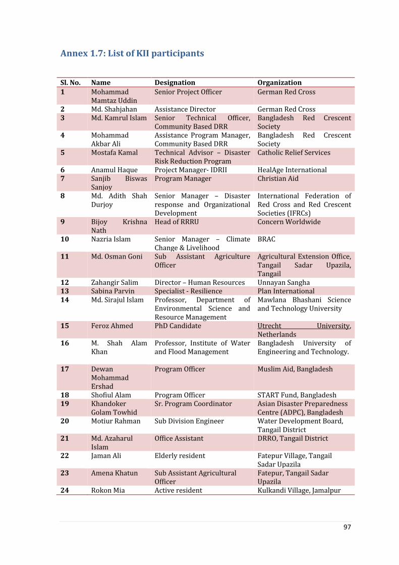
97
Annex 1.7: List of KII participants
Sl. No. Name Designation Organization 1 Mohammad
Mamtaz Uddin Senior Project Officer German Red Cross
2 Md. Shahjahan Assistance Director German Red Cross 3 Md. Kamrul Islam Senior Technical Officer,
Community Based DRR Bangladesh Red Crescent Society
4 Mohammad Akbar Ali
Assistance Program Manager, Community Based DRR
Bangladesh Red Crescent Society
5 Mostafa Kamal Technical Advisor – Disaster Risk Reduction Program
Catholic Relief Services
6 Anamul Haque Project Manager- IDRII HealAge International 7 Sanjib Biswas
Sanjoy Program Manager Christian Aid
8 Md. Adith Shah Durjoy
Senior Manager – Disaster response and Organizational Development
International Federation of Red Cross and Red Crescent Societies (IFRCs)
9 Bijoy Krishna Nath
Head of RRRU Concern Worldwide
10 Nazria Islam Senior Manager – Climate Change & Livelihood
BRAC
11 Md. Osman Goni Sub Assistant Agriculture Officer
Agricultural Extension Office, Tangail Sadar Upazila, Tangail
12 Zahangir Salim Director – Human Resources Unnayan Sangha 13 Sabina Parvin Specialist - Resilience Plan International 14 Md. Sirajul Islam Professor, Department of
Environmental Science and Resource Management
Mawlana Bhashani Science and Technology University
15 Feroz Ahmed PhD Candidate Utrecht University, Netherlands
16 M. Shah Alam Khan
Professor, Institute of Water and Flood Management
Bangladesh University of Engineering and Technology.
17 Dewan Mohammad Ershad
Program Officer Muslim Aid, Bangladesh
18 Shofiul Alam Program Officer START Fund, Bangladesh 19 Khandoker
Golam Towhid Sr. Program Coordinator Asian Disaster Preparedness
Centre (ADPC), Bangladesh 20 Motiur Rahman Sub Division Engineer Water Development Board,
Tangail District 21 Md. Azaharul
Islam Office Assistant DRRO, Tangail District
22 Jaman Ali Elderly resident Fatepur Village, Tangail Sadar Upazila
23 Amena Khatun Sub Assistant Agricultural Officer
Fatepur, Tangail Sadar Upazila
24 Rokon Mia Active resident Kulkandi Village, Jamalpur
Copyright © 2022 FDOKUMEN


![.Noah's Flood WTJ2004[1]](https://static.fdokumen.com/doc/165x107/631c39e73e8acd997705cf6b/noahs-flood-wtj20041.jpg)