DESIGN CONSIDERATIONS FOR A SKYWALK ALONG ...
50
CITY LEVEL PROJECTS DESIGN CONSIDERATIONS FOR A SKYWALK ALONG PRESS ENCLAVE MARG
-
Upload
khangminh22 -
Category
Documents
-
view
3 -
download
0
Transcript of DESIGN CONSIDERATIONS FOR A SKYWALK ALONG ...
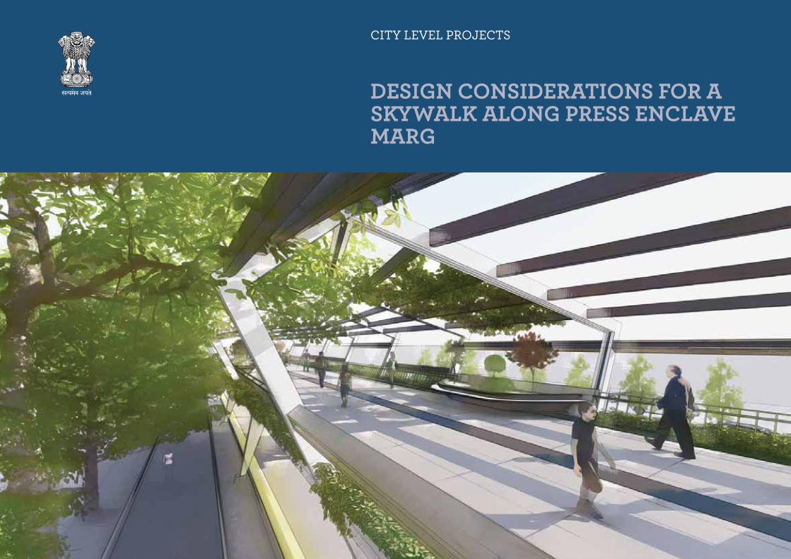
CITY LEVEL PROJECTS
DESIGN CONSIDERATIONS FOR A SKYWALK ALONG PRESS ENCLAVE MARG

Delhi Urban Art Commission
The Delhi Urban Art Commission was set up by an Act of Parliament in 1973
to “advise the Government of India in the matter of preserving, developing
and maintaining the aesthetic quality of urban and environmental design within
Delhi and to provide advice and guidance to any local body in respect of any
project of building operations or engineering operations or any development
proposal which affects or is like to affect the skyline or the aesthetic quality of
the surroundings or any public amenity provided therein”.

Senior ConsultantGoonmeet Singh Chauhan
ConsultantsJoel MichaelMayank Sharma
Delhi Urban Art Commission
Prof. Dr. P.S.N. Rao Chairman
Samir Mathur MemberAbhimanyu Dalal MemberSonali Rastogi Member (till 02.07.2020)Kamran Rizvi Member & Addl. Secretary, Ministry of Housing and Urban Affairs (w.e.f 2.01.2020) Ruby Kaushal Secretary (w.e.f 1.02.2019) Vinod Kumar Secretary (till 31.01.2019)
DUAC Staff
Rajeev Kumar Gaur, Amit Mukherji, Manju Anjali, Siddharth Sagar, Neha Chauhan.
DELHI URBAN ART COMMISSION with gratitude duly acknowledges the valuable contributions of the
following in making this report:
Organisations / Others
Ministry of Urban Development
Delhi Development Authority
Government of National Capital Territory of Delhi
North Delhi Municipal Corporation
East Delhi Municipal Corporation
South Delhi Municipal Corporation
New Delhi Municipal Council
Geospatial Delhi Limited
Delhi Metro Rail Corporation
Delhi Urban Shelter Improvement Board
BSES Rajdhani Power Limited
BSES Yamuna Power Limited
RWA’s and Area Councillors
Google Earth
Preface
*DISCLAIMER*
The city of Delhi, capital of this vast land of diversities, is a city laden with layers of
history, a place where civilizations have lived, prospered and perished over centuries.
The modern city today, built over and around a rich tapestry of heritage, presents
an opportunity at every turn, to allow for co-existence of the past, present and the
future. In order to understand this multidimensional urban spectrum and attempt
to plan the future, various city level studies have been initiated by the DUAC. I
hope that these studies will help the planners of modern day Delhi to carefully
articulate urban space, structure, form and environment and sensitively address
future requirements.
I convey my thanks to all the Consultants and Members of the Commission who
have tirelessly worked on this research project to bring out this document. I also
take this opportunity to place on record my sincere appreciation of the efforts
of Secretary and other staff of DUAC for providing the necessary administrative
support to make this happen.
I fondly hope that the authorities of the local, state and national government
take these studies seriously and implement, in right earnest, the suggestions given
herein.
This report is for academic purposes only and has been prepared on the basis
of information gathered from various sources, in cases without any independent
verification. The report can be adopted and utilized by any Government Authority/
Local Body in the Country and is provided free of cost. The report is not meant to
derive any kind of gain, monetary or otherwise.
Though all efforts have been made to ensure the accuracy of the information
in this report, the same should not be construed as a statement of law or
used for any legal purposes. Delhi Urban Art Commission (DUAC) accepts no
responsibility in relation to the accuracy, completeness, usefulness or otherwise, of
the information contained in the publication. Stakeholders are advised to verify/
check any information with the relevant Government Department(s) and/or other
source(s), and to obtain any appropriate advice before acting on the information
provided in the report.
While adequate measures have been taken to acknowledge the source of the
information used in the report, the nature of the process and the diverse sources
from which information is collected makes it difficult for the Commission to
ascertain whether each piece of information/data impinges upon any third party
intellectual property rights. DUAC shall consequently not be responsible for
any inadvertent and / or bonafide omission of acknowledgement of source of
information.
In no event will the DUAC be liable for any expense, loss or damage including,
without limitation, indirect or consequential loss or damage, or any expense, loss or
damage whatsoever arising out of any person/ stakeholder using or implementing
or relying on any information in this report.
December 2020 Prof. Dr. P.S.N. Rao
Sd/-

Preface
Safe and seamless pedestrian mobility has become a major concern in Delhi. The
possibilities for efficient schemes for uninterrupted, safe pedestrian connections
for zones that have a high vehicular volume, combined with a high pedestrian
traffic flow, varied high intensity developments in close proximity, and availability of
space in the right of way was considered in this study.
The stretch of Press Enclave Marg between the Metro Station and Sub-Central
Business District at Saket had been chosen for this study. There are two large
hospitals, and the Hauz Rani urban village in the connecting space in between. Over
time, spaces for pedestrians got subsumed in other requirements of utility services,
service lanes, signage’s, bus stops, parking and plating zones. It was evident that
continuous pedestrian movement at ground level was unsafe and discontinuous. It
was felt that segregated and defined elevated pedestrian networks which navigate
the multiple layers and land-uses such arterial roads, commercial areas, institutions,
high density residential development, parks, neighborhoods etc. could be an
innovative strategy.
The study is an attempt to identify dedicated pedestrian corridors in the form of
Elevated walkways running parallel to the existing infrastructure which link high-
density neighborhoods to transit junctions and demonstrate their integration with
the existing built infrastructure.
December 2020 Samir MathurCommission Member, DUAC

CO
NT
ENTSContents
1 Introduction 13 1.1 Vision 14 1.2 Aim 14 1.3 Objectives of the Study 14 1.4 Methodology 15 1.5 Scope and Limitations 15 1.6 Case Study 16 1.6.1 Dhaula Kuan Skywalk 16 1.6.2 ITO Skywalk 16 1.6.3 IRC Guidelines 17
2 Site Context 19 2.1 About the Site 20 2.2 Historical Significance 21 2.3 Administrative Framework 22 2.4 Connectivity and Accessibility 24
3 Site Analysis 25 3.1 Land Use study 26 3.2 Street Characteristics 28 3.3 Street Highlights 29 3.4 Major Movement along Press Enclave Marg 30 3.5 Areas of Congestion/Intervention 32 3.6 Inferences 56
4 Design Scheme 57 4.1 Proposed Elevated Walkway Scheme 58
4.1.1 Proposed Site Plan 584.1.2 Entry/Exit Points: Influence Zone 604.1.3 Entry/Exit Points: Escape Distance 62
4.2 Proposed Detail Plans 64 4.3 Walkway Design 86
4.3.1 Structure Design (Option 01) 864.3.2 Structure Design (Option 02) 874.3.3 Walkway Details 884.3.4 Sectional Prototypes 90
4.4 Design Features 92
Bibliography 94
Summary
The study on Pedestrian Connectivity illustrates strategies to make the city
‘accessible’ to its people. Improved accessibility within the city results in the
enhancement of safety, security and health.
As a resource amenity, ‘Elevated Walkways’ are connectors that traverse a variety
of ownerships and environments, linking fragments of the city. These links recognize
multiple values: Recreation, transportation, aesthetic, scenic, environmental
and economic gain. Elevated Walkways provide a platform for improving
neighbourhoods and city-wide needs. Improved accessibility influences standards
of social justice and equity. It also results in an increase in the city’s land value. They
also provide a means to thread diverse city patterns together.
The city and its streets have been taken over by vehicles pushing aside the right of
the people to walk. 42% of the total deaths that took place on city’s roads in 2016
account for those of pedestrians. Delhi pedestrians constituted 600 of the total
1,415 fatal road accidents (DNA, January 2017).
This project aims to support efforts to make the city accessible, create potential
for pedestrians to move without being compromised by vehicles in the road space.
The study explores the city’s layers to define alternate movement domains. It
demonstrates how existing natural and manmade constructs can be organized
together to create a dedicated pedestrian corridor.
The plan includes the utilization of the city’s green lungs (city greens), linking forests
and parks to the city and spatial corridors around precincts to allow movement
of people and non-motorized vehicles. This would provide safe and convenient
connections to parks, natural systems and recreational facilities, and links with
residential areas, civic institutions and businesses.
Highline, New York, USA (claudiasaezfromm.com)
Seoullo 7017, Seoul Skygarden, South Korea (inhabitat.com)
01 introduction

intr
od
uc
tio
n
intr
od
uc
tio
n
14 15CITY LEVEL ProjECTS DESIGN CoNSIDErATIoNS For A SKYWALK ALoNG PrESS ENCLAVE MArG
1.2 Aim
To design a comprehensive Pedestrianization scheme along the Press Enclave Marg in South Delhi. It shall cater to the existing variety of landuses, businesses, residential and greens.
1.3 Objectives of the Study
1. Prioritizing pedestrian comfort by making safe and comfortable zones for walking2. Reduce pedestrian-vehicular conflicts at-grade3. Establish last mile connectivity via exclusive pedestrian corridors4. Reduce dependency on para-transits and non-motorized vehicles5. Make pedestrian routes disable-friendly6. Connect Urban Greens through a network of pedestrian corridors
Delhi is characterized by its extensive and varied green cover. Historically they have formed a connective tissue between the multiple cities that constitute “Delhi” as well as the numerous historical monuments that are found throughout Delhi today.
1.1 Vision
To develop a holistic pedestrian mobility system which will encourage and enhance the pedestrian movement and connectivity. This system shall traverse through the ridge & forest areas, educational institutions, dense residential pockets, commercial and transport hubs and ultimately form corridors of greens, relaxing-points and walking trails.
1.3.1 Approach
1. Minimal built interventions.2. Recognition of selective pedestrian circulation networks.3. The network would be at both grade level and elevated, depending on the urban
fabric of the representative area. 4. It would cater to the following types of areas: High-density Residential Pockets,
Commercial Hubs, Institutional Centres and Transport Hubs.5. Selective reorganization of existing pedestrian circulation networks.
1.4 Methodology
The study will comprise of 3 stages, which are as follows:
1.5 Scope & Limitations
1. Design recommendations shall be provided for the selected stretch only. This could be considered as a prototype/model for future pedestrianization projects in the city.
2. Based on the site specifications, the pedestrian corridor network shall be proposed at 3 levels:• Above Grade• At Grade• Below Grade
3. The design interventions shall be proposed conceptually as a scheme. This shall include the layout of the proposed corridor along with entry/exit points.
4. Volumetric and Traffic characteristics study will not be part of this project.5. The data collected for site analysis is based on site observations and previously
commissioned projects and studies.
1-2: Seun City Walk, South Korea (architizer.com); 3: The Bicycle Snake, Copenhagen, Denmark (architizer.com); 4: The Goods Line, Sydney, Australia (kaowoyexing.com); 5-6: High Line, New York, USA (archfoundation.org, archdaily.com)
1
5
2
4
6
3
Drafting mandate
A mandate shall be drafted which shall include the vision for Delhi and the stakeholders that would benefit from the project. Additionally, a letter of support shall also be released from DUAC to the stakeholders whose areas may be affected by the development of this project.
The second stage shall progress simultaneously with the first. This will mainly comprise of primary study (mapping of the area, photographic studies and identification of issues) and secondary study (previous DUAC studies, national and international examples).
The final stage shall primarily comprise of building a system for executing the project. For this, various consultants and experts in the respective fields shall be consulted to construct this network of elevated and grade-level corridors of green walkways.
Site Mapping
Consultants Consultation
Project Execution
intr
od
uc
tio
n
intr
od
uc
tio
n
16 17CITY LEVEL ProjECTS DESIGN CoNSIDErATIoNS For A SKYWALK ALoNG PrESS ENCLAVE MArG
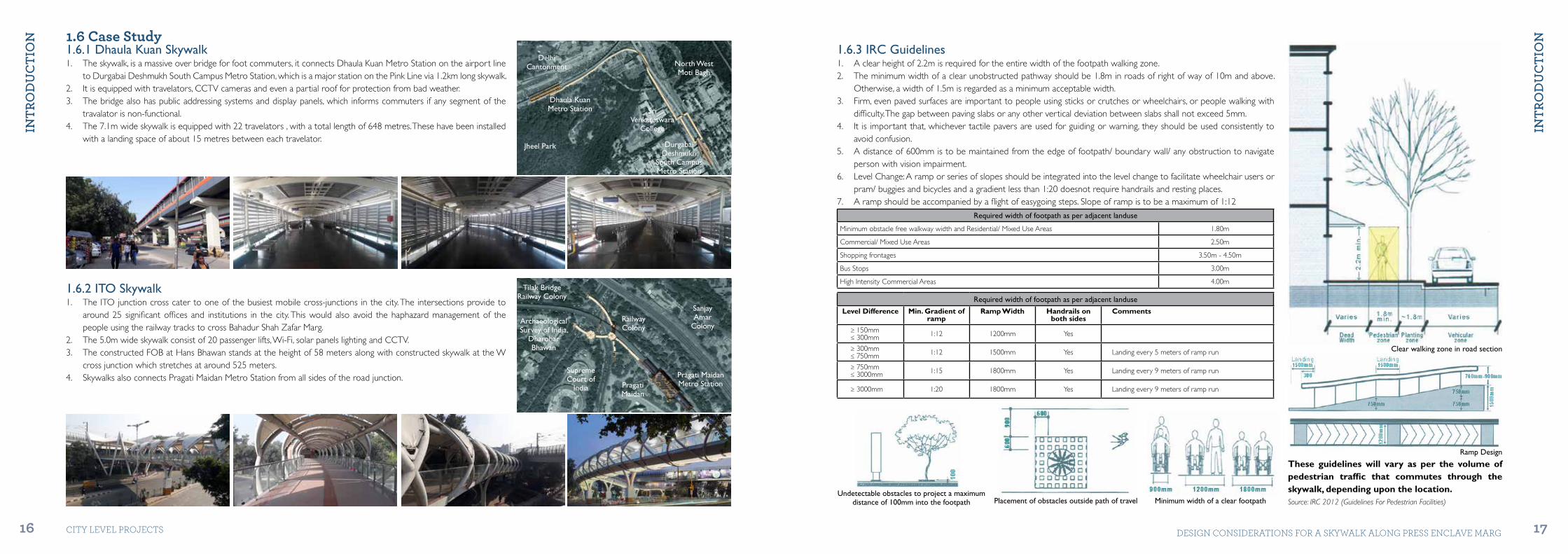
1.6 Case Study1.6.1 Dhaula Kuan Skywalk1. The skywalk, is a massive over bridge for foot commuters, it connects Dhaula Kuan Metro Station on the airport line
to Durgabai Deshmukh South Campus Metro Station, which is a major station on the Pink Line via 1.2km long skywalk.2. It is equipped with travelators, CCTV cameras and even a partial roof for protection from bad weather.3. The bridge also has public addressing systems and display panels, which informs commuters if any segment of the
travalator is non-functional.4. The 7.1m wide skywalk is equipped with 22 travelators , with a total length of 648 metres. These have been installed
with a landing space of about 15 metres between each travelator.
1.6.3 IRC Guidelines1. A clear height of 2.2m is required for the entire width of the footpath walking zone.2. The minimum width of a clear unobstructed pathway should be 1.8m in roads of right of way of 10m and above.
Otherwise, a width of 1.5m is regarded as a minimum acceptable width.3. Firm, even paved surfaces are important to people using sticks or crutches or wheelchairs, or people walking with
difficulty. The gap between paving slabs or any other vertical deviation between slabs shall not exceed 5mm.4. It is important that, whichever tactile pavers are used for guiding or warning, they should be used consistently to
avoid confusion.5. A distance of 600mm is to be maintained from the edge of footpath/ boundary wall/ any obstruction to navigate
person with vision impairment.6. Level Change: A ramp or series of slopes should be integrated into the level change to facilitate wheelchair users or
pram/ buggies and bicycles and a gradient less than 1:20 doesnot require handrails and resting places.7. A ramp should be accompanied by a flight of easygoing steps. Slope of ramp is to be a maximum of 1:12
Required width of footpath as per adjacent landuse
Minimum obstacle free walkway width and Residential/ Mixed Use Areas 1.80m
Commercial/ Mixed Use Areas 2.50m
Shopping frontages 3.50m - 4.50m
Bus Stops 3.00m
High Intensity Commercial Areas 4.00m
Required width of footpath as per adjacent landuse
Level Difference Min. Gradient of ramp
Ramp Width Handrails on both sides
Comments
≥ 150mm≤ 300mm 1:12 1200mm Yes
≥ 300mm≤ 750mm 1:12 1500mm Yes Landing every 5 meters of ramp run
≥ 750mm≤ 3000mm 1:15 1800mm Yes Landing every 9 meters of ramp run
≥ 3000mm 1:20 1800mm Yes Landing every 9 meters of ramp run
1.6.2 ITO Skywalk1. The ITO junction cross cater to one of the busiest mobile cross-junctions in the city. The intersections provide to
around 25 significant offices and institutions in the city. This would also avoid the haphazard management of the people using the railway tracks to cross Bahadur Shah Zafar Marg.
2. The 5.0m wide skywalk consist of 20 passenger lifts, Wi-Fi, solar panels lighting and CCTV.3. The constructed FOB at Hans Bhawan stands at the height of 58 meters along with constructed skywalk at the W
cross junction which stretches at around 525 meters.4. Skywalks also connects Pragati Maidan Metro Station from all sides of the road junction.
These guidelines will vary as per the volume of pedestrian traffic that commutes through the skywalk, depending upon the location.
Durgabai Deshmukh
South CampusMetro Station
Sri Venkateswara
College
North West Moti Bagh
Dhaula KuanMetro Station
Delhi Cantonment
Jheel Park
Pragati Maidan
Supreme Court of
India
Railway Colony
Sanjay Amar
Colony
Tilak Bridge Railway Colony
Archaeological Survey of India,
Dharohar Bhawan
Pragati MaidanMetro Station
Clear walking zone in road section
Source: IRC 2012 (Guidelines For Pedestrian Facilities)
Ramp Design
Minimum width of a clear footpathPlacement of obstacles outside path of travelUndetectable obstacles to project a maximum
distance of 100mm into the footpath

02 SitE contEXt
SitE
co
ntE
Xt
SitE
co
ntE
Xt
20 21CITY LEVEL ProjECTS DESIGN CoNSIDErATIoNS For A SKYWALK ALoNG PrESS ENCLAVE MArG
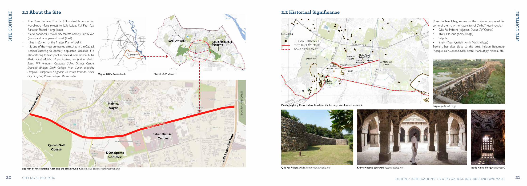
• The Press Enclave Road is 3.8km stretch connecting Aurobindo Marg (west) to Lala Lajpat Rai Path (Lal Bahadur Shastri Marg) (east).
• It also connects 2 major city forests, namely, Sanjay Van (west) and Jahanpanah Forest (East).
• It lies in Zone F of the Master Plan of Delhi.• It is one of the most congested stretches in the Capital.
Besides catering to densely populated localities, it is also catering to transport, medical & commercial hubs.Khirki, Saket, Malviya Nagar, Adchini, Pushp Vihar Sheikh Sarai, PVR Anupam Complex, Saket District Centre, Shaheed Bhagat Singh College, Max Super speciality Hospital, Pushpawati Singhania Research Institute, Saket City Hospital, Malviya Nagar Metro station.
2.1 About the Site
Map of DDA Zones, Delhi
PRESS ENCLAVE MARG
Map of DDA Zone F
SANJAY VAN
Zone F
JAHANPANAHFOREST
JAH
AN
PAN
AH
FO
REST
Lala
Laj
pat
Rai
Pat
h
Malviya Nagar
Saket DistrictCentre
DDA SportsComplex
Qutub GolfCourse
Site Plan of Press Enclave Road and the area around it. (Base Map Source: openstreetmap.org)
2.2 Historical Significance
Press Enclave Marg serves as the main access road for some of the major heritage sites of Delhi. These include:• Qila Rai Pithora (adjacent Qutub Golf Course)• Khirki Mosque (Khirki village)• Satpula• Sheikh Yusuf Qattal’s Tomb (Khirki village)Some other sites close to the area, include Begumpur Mosque, Lal Gumbad, Sarai Shahji Mahal, Bijay Mandal, etc.
Plan highlighting Press Enclave Road and the heritage sites located around it
Qila Rai Pithora Walls (commons.wikimedia.org) Khirki Mosque courtyard (casino-zodiac.org) Inside Khirki Mosque (flickr.com)
Satpula (wikipedia.org)
JAHANPANAHFOREST
MALVIYANAGAR
Qila Rai Pithora
KhidkiMosque
Sheikh Yusuf Qattal’s Tomb
Satpula
SAKET
QUTUB GOLF COURSE
SANJAY VAN
OUTER RING ROAD
AURO
BIN
DO
MAR
G
BRT
ROAD
PRESS ENCLAVE MARG
HERITAGE SITES/WALL
PRESS ENCLAVE MARG
ZONE F BOUNDARY
LEGEND
Aur
obin
do M
arg
SitE
co
ntE
Xt
SitE
co
ntE
Xt
22 23CITY LEVEL ProjECTS DESIGN CoNSIDErATIoNS For A SKYWALK ALoNG PrESS ENCLAVE MArG
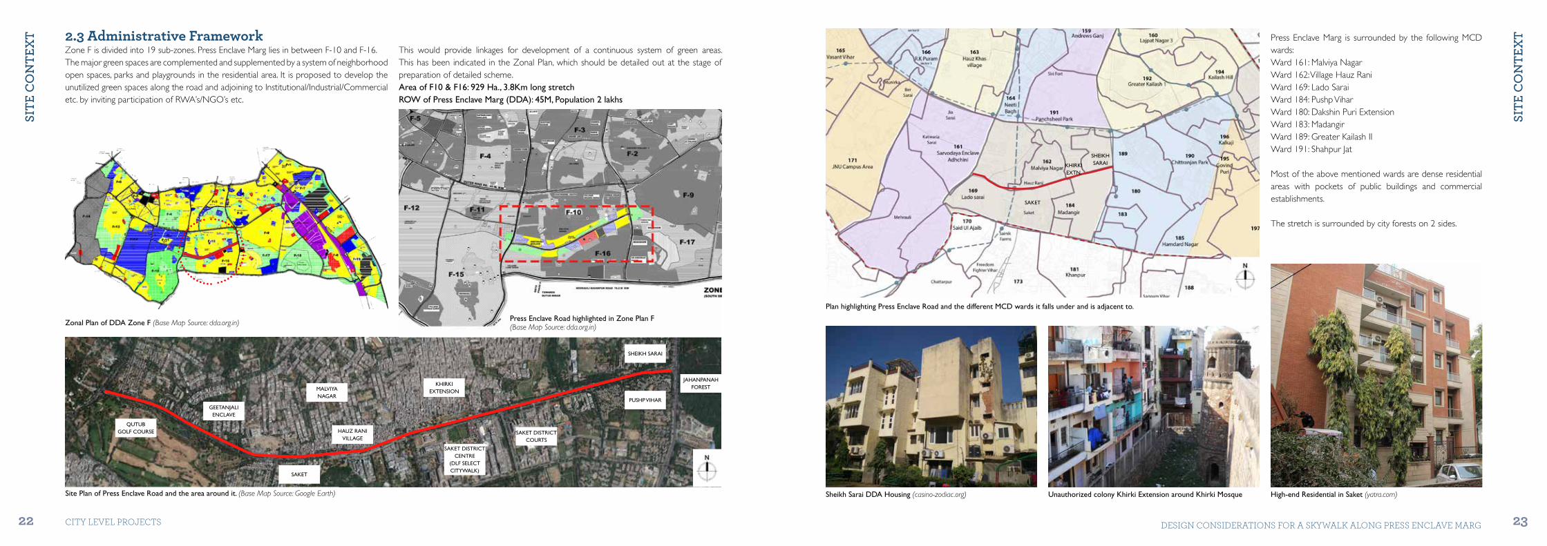
2.3 Administrative FrameworkThis would provide linkages for development of a continuous system of green areas. This has been indicated in the Zonal Plan, which should be detailed out at the stage of preparation of detailed scheme. Area of F10 & F16: 929 Ha., 3.8Km long stretchROW of Press Enclave Marg (DDA): 45M, Population 2 lakhs
Zone F is divided into 19 sub-zones. Press Enclave Marg lies in between F-10 and F-16. The major green spaces are complemented and supplemented by a system of neighborhood open spaces, parks and playgrounds in the residential area. It is proposed to develop the unutilized green spaces along the road and adjoining to Institutional/Industrial/Commercial etc. by inviting participation of RWA’s/NGO’s etc.
Site Plan of Press Enclave Road and the area around it. (Base Map Source: Google Earth)
QUTUBGOLF COURSE
GEETANJALIENCLAVE
MALVIYANAGAR
HAUZ RANIVILLAGE
SAKET
KHIRKI EXTENSION
PUSHP VIHAR
SAKET DISTRICT CENTRE
(DLF SELECT CITYWALK)
SAKET DISTRICT COURTS
SHEIKH SARAI
JAHANPANAHFOREST
Press Enclave Road highlighted in Zone Plan F(Base Map Source: dda.org.in)Zonal Plan of DDA Zone F (Base Map Source: dda.org.in)
Press Enclave Marg is surrounded by the following MCD wards: Ward 161: Malviya Nagar Ward 162: Village Hauz RaniWard 169: Lado SaraiWard 184: Pushp ViharWard 180: Dakshin Puri ExtensionWard 183: MadangirWard 189: Greater Kailash IIWard 191: Shahpur Jat
Most of the above mentioned wards are dense residential areas with pockets of public buildings and commercial establishments.
The stretch is surrounded by city forests on 2 sides.
Plan highlighting Press Enclave Road and the different MCD wards it falls under and is adjacent to.
Sheikh Sarai DDA Housing (casino-zodiac.org) Unauthorized colony Khirki Extension around Khirki Mosque High-end Residential in Saket (yatra.com)
SHEIKHSARAIKHIRKI
EXTN.
SAKET

SitE
co
ntE
Xt
24 CITY LEVEL ProjECTS
2.4 Connectivity
Press Enclave Marg is an important stretch in South Delhi as it connects areas that are significant at the city-level. Road connections include: • Aurobindo Marg (to Gurgaon)• Lal Bahadur Shastri Marg (BRT)• Geetanjali Marg (to Malviya Nagar)• Pramod Mahajan Marg (to PVR Anupam)• Mandir Marg• Shaheed Pankaj Juyal Marg. (to Saket District Court)
Malviya Nagar Metro station of the Yellow Line is situated on the junction of Press Enclave Marg and Pramod Mahajan Marg. Other major Metro stations around the site include:• Saket (future interchange station)• Hauz Khas (interchange station for Yellow line and
Magenta line)• IIT Delhi• Chirag Dilli
DLF Select Citywalk is the main commercial space in this area which attracts large number of visitors from all over the city. Other commercial zones in the vicinity include:• Anupam Complex (PVR Anupam)• Malviya Nagar Central Market• Adhchini• Katwaria Sarai• Saket District CourtsMajor hospitals in this area are Max Super-Speciality Hospital, Saket City Hospital, Pushpawati Singhania Research Institute, Orthonova Hospital, Sitaram Bhartia Institute of Science and Research, etc.
60M ROW
45M ROW (PRESS ENCLAVE MARG)
24M ROW
Malviya Nagar
Hauz Khas
Malviya NagarMarket
IIT
IIT
IIT
Sanjay Van
Sanjay Van
Sanjay Van
Saket DistrictCentre
MaxHospitalAnupam
Complex
Saket
Chirag Dilli
PRESS ENCLAVE MARG
Aurob
indo
Marg
Outer Ring Road
ROAD HIERARCH Y & NETWORK
DELHI METRO NETWORK
COMMERCIAL & SOCIAL ESTABLISHMENTS
PRESS ENCLAVE MARG
MAGENTA LINE METRO
YELLOW LINE METRO
PRESS ENCLAVE MARG
COMMERCIAL
INSTITUTIONAL
LEGEND
LEGEND
LEGEND
Lal B
ahad
ur S
hast
ri M
arg
03 SitE AnALYSiS
SitE
An
ALY
SiS
SitE
An
ALY
SiS
26 27CITY LEVEL ProjECTS DESIGN CoNSIDErATIoNS For A SKYWALK ALoNG PrESS ENCLAVE MArG
3.1 Land-Use Study
The area around Press Enclave Marg can be identified by its low density and green cover. It is mainly comprised of planned, well maintained posh residential localities. This also includes rehabilitation colonies and government housing areas. A significant feature of this area and of Zone F as a whole, is the urban heritage. The first four cities of Delhi namely, Lal Kot, Siri, Tughlakabad and Jahanpanah are located within 3 km radius from Press Enclave Marg. Most of the areas have been planned as envisaged in Master Plan for Delhi 1962.• High income category residential locality: Geetanjali Enclave.• Rehabilitation Colonies: Malviya Nagar• Urban Villages: Hauz Rani, Khirki, Sheikh Sarai
• Unauthorized Colonies: Khirki Extension, Mohalla Johna Panach• This site has the following places to cater with the work force: District Courts. District
Centers at Saket, Government Offices next to Pushp Vihar• There are a total of 3 district centers in Zone F, out of which 1(Saket) is located in this
site. It is also the latest and most popular of the three.• Sports complex: Saket• Health: Max Hospital, Saket City Hospital, Pushpawati Singhania Hospital• Education: Shaheed Bhagat Singh College, College of Vocational Studies, Apeejay
School, Andhra Education Society School, Gyan Bharati School.
34
2
1
5
6 7
9
8
10Landuse Plan of site around Press Enclave Road
LEGEND1. SANJAY VAN
2. GEETANJALI ENCLAVE
3. QUTUB GOLF COURSE
4. QILA RAI PITHORA PARK
5. MALVIYA NAGAR METRO STATION
6. DDA SFS FLATS (BLOCK C SAKET)
7. PRESS ENCLAVE & EKTA APARTMENTS
8. MALVIYA NAGAR
9. HAUZ RANI
10. MAX SUPER SPECIALITY HOSPITAL
11. SAKET CITY HOSPITAL
12. KHIRKI EXTENSION
13. DLF SELECT CITYWALK
14. KHIRKI MOSQUE
15. SHEIKH YUSUF QATTAL’S TOMB
16. SAKET DISTRICT COURT
17. SATPULA
18. SATPULA LAKE
19. COLLEGE OF VOCATIONAL STUDIES
20. SECTOR 7 PUSHP VIHAR
21. PHASE II SKEIKH SARAI
22. SECTOR 7 PUSHP VIHAR
23. JAHANPANAH FOREST
24. PUSHPA BHAWAN
14
13
11
16
17
18
15
12
22
24
20
1921 23
RESIDENTIAL
COMMERCIAL
PUBLIC/SEMI-PUBLIC
FORESTS
PARKS
URBAN VILLAGE
GOVT. BUILDINGS
HERITAGE BUILDINGS
WATERBODIES
PRESS ENCLAVE MARG
MA
ND
IR M
AR
G
SHA
HE
ED
PAN
KA
J JUYA
L M
AR
G
AU
ROBI
ND
O M
ARG
LA
L B
AH
AD
UR
SH
AS
TR
I M
AR
G
GEETANJALI MARG

SitE
An
ALY
SiS
SitE
An
ALY
SiS
28 29CITY LEVEL ProjECTS DESIGN CoNSIDErATIoNS For A SKYWALK ALoNG PrESS ENCLAVE MArG
LOCATION DAILY FOOTFALL
Malviya Nagar Metro station
Saket Metro station
Select City Walk mall
District court Saket
3.2 Street Characteristics
The existing footpath is irregular and discontinuous at many places. At some places it has been totally encroached upon. Hence, the inadequate width does not allow pedestrians to use the footpath effectively.At many places, the carriageway has been compromised too. This is mainly at the stretch from Malviya Nagar metro station to Mandir Marg.
As the vehicles are parked haphazardly, pedestrians are forced to walk on the carriageway causing discomfort to both pedestrian and vehicular traffic and adding to the congestion. On-street parking, in front of Press Enclave Vihar, causes traffic bottle-neck as the effective number of lanes reduces on either side. Dedicated space should be created or earmarked for on-street parking.
The median is continuous along the road, except at junctions. However, the median is not consistent as it ranges from 0.90M wide in front of Hauz Rani village to 2.00M wide near Geetanjali Enclave and Pushp Vihar.The haphazard nature and planning of the area in and around Press Enclave Marg has led to some issues such as trees in the middle of carriageways and footpaths, unnecessary junctions and traffic diversions due to improper delineation of medians.
3.2.2 On-Street Parking
3.2.3 Medians & Pedestrian Refuges
3.2.1 Carriageway & Footpath
Different types of footpath widths and design along Press Enclave Marg.
On-street parking prevalent from Malviya Nagar Metro station to District Courts.
Inconsistent medians and unplanned traffic islands / pedestrian refuges.
3.3 Street Highlights
WHY IS IT CONGESTED?
The road is surrounded by densely populated areas such as Khirki village, Hauz Rani, Saket, Malviya Nagar and Pushp ViharTwo big hospitals - Max Super-Speciality Hospital & Saket City Hospital, Saket district court complex, city’s biggest malls - DLF & Select City Mall and two Metro stations - Malviya Nagar & Saket, are located in and around it.
STREETSCAPE ISSUES
1. No space for pedestrian movement, hawkers/vendors.2. Effective carriage way reduces due to on-street activity
like parking, hawking etc.3. Absence of organised hoardings, signage & street
furniture.4. Infrastructure is below average conditions, i.e. lighting,
electrical poles, etc.
At present, a line of trees on either sides and at the median of Press Enclave Marg are the only landscaping interventions on this road. However, the whole 3.8km stretch boasts of opportunity areas (junctions, metro station, along fort wall, Satpula drain, etc.) where landscaping initiatives could be proposed. Moreover, with the proximity to 2 major city forests of Delhi (Sanjay Van & Jahanpanah Forest), this stretch could act as a major connecting link for a green corridor.
The urban fabric of the area is such that hawking and vending is inevitable. This is mainly near commercial and transportation hubs like Malviya Nagar metro, Select Citywalk, Hauz Rani, etc. This variety in landuse coupled with popularity of these destinations attract various kinds of visitors and hawkers/vendors. Under these circumstances, providing dedicated spaces for hawking/vending shall be a viable solution. These spaces should be strategically placed and intricately designed for maximum utility and minimum obstruction/conflicts.
3.2.4 Landscaping
3.2.5 Vending Spaces
70,000
50,000
80,000
7,000 - 8,000
High potential for landscaping in medians, buffer areas and sidewalks.
Hawkers and vendors in front of Hauz Rani, Select CityWalk and Sheikh Sarai Gurudwara, respectively.

SitE
An
ALY
SiS
SitE
An
ALY
SiS
30 31CITY LEVEL ProjECTS DESIGN CoNSIDErATIoNS For A SKYWALK ALoNG PrESS ENCLAVE MArG
3.4 Major Movement along Press Enclave Marg
With the opening of the magenta and pink lines of the Delhi Metro and the onset of DMRC Phase IV, Zone F will have four interchange stations at INA Market, Lajpat Nagar, Chirag Dilli and Kalkaji. All of these stations are at 2km radius from Press Enclave Marg, hence there will be a significant increase in traffic plying on Press Enclave Marg. In addition to existing movement systems which are already saturated, it is envisaged to consider alternate networks.
Plan showing pedestrian and vehicular movement in and around site.
01
02
03 04
PEDESTRIAN MOVEMENT
VEHICULAR MOVEMENT
BUS STOPS
TAXI / AUTO-RICKSHAW STANDS
CONGESTION AREAS
LEGEND
05
06
0708
02 03 05 06PNB Geetanjali Bus stop in front of Geetanjali Enclave Malviya Nagar Metro junction in front of Saket A-Block bus stop Carriageway narrowing down opposite Saket City Hospital Cars parked on street in front of Khirki Extension
AUROBINDO M
ARG
LAL
BA
HA
DU
R S
HA
STR
I MA
RG
GEETANJALI MARG
PRESS ENCLAVE MARG
SAKET DISTRICT COURTS
SAKET DISTRICT CENTRE
MAX HOSPITAL
MALVIYA NAGAR
MALVIYA NAGARMETRO
STATION
KHIRKI VILLAGE
SATPULA LAKE
QUTUB GOLF COURSE

SitE
An
ALY
SiS
SitE
An
ALY
SiS
32 33CITY LEVEL ProjECTS DESIGN CoNSIDErATIoNS For A SKYWALK ALoNG PrESS ENCLAVE MArG
3.5 Areas of Congestion/Intervention
3.5.1 Stretch 01
• Aurobindo Marg is an arterial road and should be 60M ROW, according to the Master Plan and Zonal Plan.
• Presently, it ranges between 40M - 45M ROW with an 11M wide median (before Press Enclave Marg junction) and 25M - 30M ROW with a 2.5M wide median (after Press Enclave Marg junction).
• Aurobindo Marg is a significant road as it connects Gurugram in Haryana to the whole of South Delhi and beyond. The road later continues as Anuvrat Marg and then Mehrauli-Gurgaon Road (M.G. Road) as part of NH148A.
KEY PLAN
A
A2
A2
B2
B2
A
B
B
Aurobindo Marg slightly narrowing down after Press Enclave Marg junction
Intersection of Aurobindo Marg and Press Enclave Marg
Pedestrian Route Vehicular Route Bus Stop
QutubGolf Course
Adchini
Police Training Academy
Section AA
A1
B1
A3 B3
SECTION BB
Central Median at Aurobindo Marg (towards Qutub Minar)
Footpath adjacent Qila Rai Pithora Wall (towards Qutub Minar)
Wall along Aurobindo Marg (towards AIIMS) Central Median at Aurobindo Marg (towards AIIMS)
A1
A2
B2
A3
B3B1FortWall
QutubGolf Course
Police Training Academy
Adchini
DETAILED PLAN
AURO
BIN
DO
MAR
G
PRESS ENCLAVE MARG

SitE
An
ALY
SiS
SitE
An
ALY
SiS
34 35CITY LEVEL ProjECTS DESIGN CoNSIDErATIoNS For A SKYWALK ALoNG PrESS ENCLAVE MArG
View of the Qutub Golf Course from the median on Press Enclave Marg (towards Pushp Vihar)
View of Police Academy from the median on Press Enclave Marg (towards Aurobindo Marg)
• The section CC depicts an area that caters to a relatively low-density population, surrounded by Qutub Golf Course in the south and the Police Training Academy & Geetanjali Enclave in the north.
• There is no encroachment in this stretch. Except for some taxis parked in the green belt in front of Qutub Golf course, rest of the stretch boasts continuous medians, a 3 lanes carriageway footpaths on each side and adequately wide service lane in the north.
• After Press Enclave Marg junction, Aurobindo Marg slopes up slightly, till Lado Sarai.
KEY PLAN
Pedestrian Route Vehicular Route Bus Stop
C2
C1
Section CC
View of the Police Academy from the median on Press Enclave Marg (towards Pushp Vihar) Press Enclave Marg leading to Aurobindo Marg (towards Aurobindo Marg)
C1 C2
C1 C2
Police Training Academy
QutubGolf Course
Illegal ParkingWrong side on service lanes
Illegal Waiting areasof Auto-Rickshaws
A
A
C
C
B
B
QutubGolf Course
Adchini
Police Training Academy
C1
C2
DETAILED PLAN
AURO
BIN
DO
MAR
G
PRESS ENCLAVE MARG

SitE
An
ALY
SiS
SitE
An
ALY
SiS
36 37CITY LEVEL ProjECTS DESIGN CoNSIDErATIoNS For A SKYWALK ALoNG PrESS ENCLAVE MArG
3.5.2 Stretch 02
• The sections depict an area that cater to a relatively low-density population.• It is surrounded by Qutub Golf Course in the south and Geetanjali Enclave in the
north.• There is no encroachment in this stretch. The stretch boasts continuous medians,
3 lanes on each side, wide footpaths on each side and a wide service lane on the northern side.
• Sections FF - GG, define the transition from a low-density population to a high-density population area.
• The footpath on the southern side narrows down to 2.00M at section FF due to the fort wall.
KEY PLAN Road curving towards Malviya Nagar Metro station
Beside Geetanjali Enclave
Pedestrian Route
Vehicular RouteBus Stop Taxi / Auto stand
F1
F1
E1
E1
Geetanjali Enclave
QutubGolf Course
E
E
F
F
Section EE
Section FF
E1
F1
Geetanjali Enclave
Geetanjali Enclave
QutubGolf Course
Qila Rai Pithora Park
Wrong side on service lanes
Wrong side on service lanes
Illegal Waiting areasof Auto-Rickshaws
Pedestrians walking on carriageway
Pedestrians walking on carriageway
Cars/Cabs parked on footpaths and
buffer areas
Hawkers on footpaths
DETAILED PLAN

SitE
An
ALY
SiS
SitE
An
ALY
SiS
38 39CITY LEVEL ProjECTS DESIGN CoNSIDErATIoNS For A SKYWALK ALoNG PrESS ENCLAVE MArG
3.5.3 Stretch 03
• From Aurobindo Marg to Section GG of Press Enclave Marg, the ROW remains constant at 45M. Section GG onwards the unauthorized colony of Hauz Rani starts affecting the ROW of Press Enclave Marg.
• Malviya Nagar metro station attracts heavy footfall which has led to a number of auto-rickshaw stands and pause-points in the area. It has also created pause-points for taxi services like Uber and Ola.
• This is the only stretch where all modes of transport come together at a junction.• There is encroachment on both sides of the carriageway. Hawkers and vendors have
encroached over the footpaths on Hauz Rani side & vehicles have encroached over the lane (bus lane) in front of Press Enclave Vihar.
KEY PLAN The beginning of Hauz Rani village just after Malviya Nagar Metro
Slip lane entry for auto-rickshaws at Malviya Nagar Metro station
H1
H1
G1
G1
DDA Golf ViewApartments DDA Ekta
Apartments
Malviya Nagar Metro
Hauz Ranivillage
G
H
HG
Section GG
Section HH
G1 G2
H1 H2
DDA Golf ViewApartments
DDA EktaApartments
Malviya Nagar Metro
Hauz Ranivillage
Hauz Rani buildingsin the background
DDA Ekta Apartmentsin the background
Signages blocking footpath space
Encroachment by hawkers
Cars/Cabs parked on bus lane
Hawkers on footpaths
Pedestrian Route
Vehicular RouteBus Stop Taxi / Auto stand
DETAILED PLAN

SitE
An
ALY
SiS
SitE
An
ALY
SiS
40 41CITY LEVEL ProjECTS DESIGN CoNSIDErATIoNS For A SKYWALK ALoNG PrESS ENCLAVE MArG
KEY PLAN
Pedestrian Route
Vehicular RouteBus Stop Taxi / Auto stand
DDA Golf ViewApartments DDA Ekta
Apartments
Malviya Nagar Metro
Hauz Ranivillage
G
H
G
G
Buses lined up at the narrow junction near Malviya Nagar Metro station.
Auto-rickshaws waiting near Malviya Nagar metro exit
G2
G2
H2
H2
Section GH
DDA Golf ViewApartments
DDA EktaApartments
Parked Cars/Cabs and shop items obstructing smooth flow of traffic and pedestrians respectively
Sidewalks at Pramod Mahajan Marg (towards PVR Anupam) Median at Pramod Mahajan Marg (towards PVR Anupam)
GH1 GH2
GH2GH1
DETAILED PLAN
SitE
An
ALY
SiS
SitE
An
ALY
SiS
42 43CITY LEVEL ProjECTS DESIGN CoNSIDErATIoNS For A SKYWALK ALoNG PrESS ENCLAVE MArG
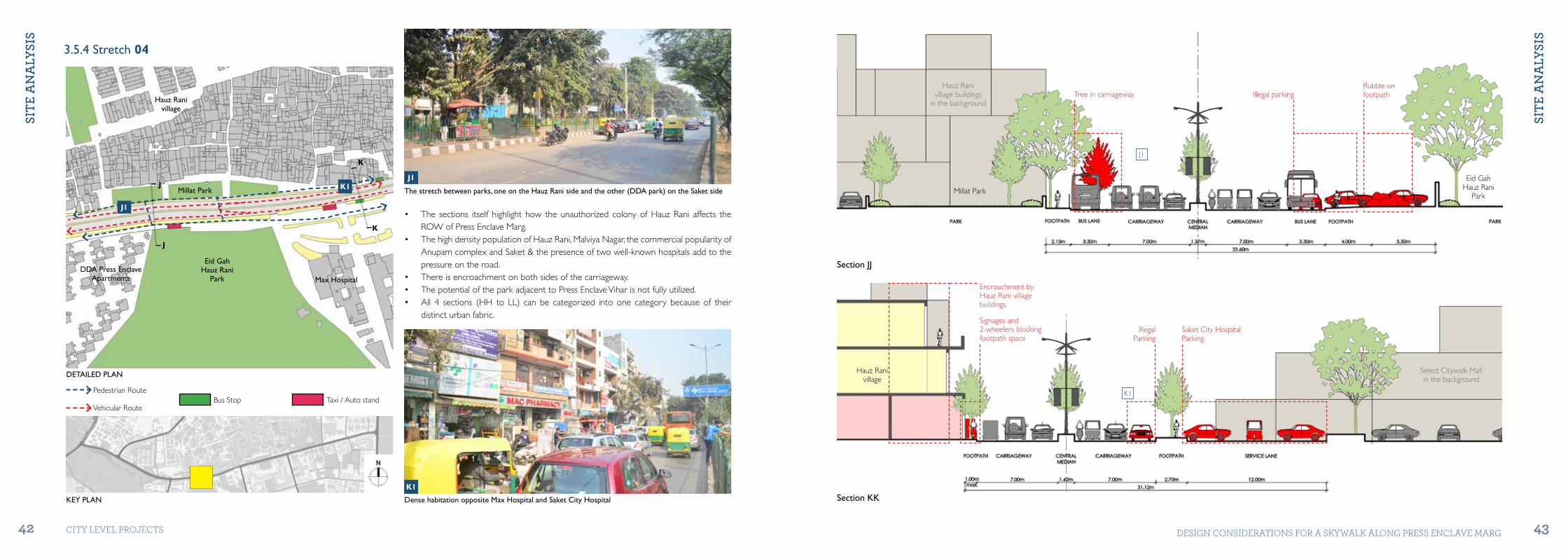
3.5.4 Stretch 04
• The sections itself highlight how the unauthorized colony of Hauz Rani affects the ROW of Press Enclave Marg.
• The high density population of Hauz Rani, Malviya Nagar, the commercial popularity of Anupam complex and Saket & the presence of two well-known hospitals add to the pressure on the road.
• There is encroachment on both sides of the carriageway.• The potential of the park adjacent to Press Enclave Vihar is not fully utilized.• All 4 sections (HH to LL) can be categorized into one category because of their
distinct urban fabric.
KEY PLAN Dense habitation opposite Max Hospital and Saket City Hospital
The stretch between parks, one on the Hauz Rani side and the other (DDA park) on the Saket side
K1
K1J1
J1
Hauz Ranivillage
Millat Park
Eid GahHauz Rani
Park Max HospitalDDA Press Enclave
Apartments
J
K
J
K
Section KK
Section JJ
J1
K1
Select Citywalk Mallin the background
Hauz Ranivillage
Hauz Ranivillage buildings
in the backgroundTree in carriageway
Signages and 2-wheelers blocking footpath space
Encroachment by Hauz Rani village buildings
Saket City HospitalParking
IllegalParking
Illegal parkingRubble onfootpath
Millat Park
Eid GahHauz Rani
Park
Pedestrian Route
Vehicular RouteBus Stop Taxi / Auto stand
DETAILED PLAN

SitE
An
ALY
SiS
SitE
An
ALY
SiS
44 45CITY LEVEL ProjECTS DESIGN CoNSIDErATIoNS For A SKYWALK ALoNG PrESS ENCLAVE MArG
3.5.5 Stretch 05
• For the 2 sections (KK & LL), the ROW reduces down to 21.00M, from 34.00M of the previous 2 sections. This is mainly due to the number of lanes going down from 3 to 2 on each side.
• There is encroachment on both sides of the street.• The carriageway levels are different in some parts of the street.• The service lane on the Select CityWalk side (refer stretch 06 detailed plan) is under-
utilized and mostly closed for public vehicular passage. Such areas could be used to their full potential.
KEY PLAN Low density stretch between Saket District Centre and Khirki village
Road narrows down to 2 lanes on one side due to encroachment by the unauthorized construction
M1
M1 L1
L1
Jamun WalaPark
L
M
M
L
Hauz Ranivillage
Theatre Academy
SaketCity Hospital
DelhiJal Board
Section MM
Section LL
L1
M1
Encroachment on footpath by Pan shop
Encroachment on footpath by Hawkers
Illegal Parking blocking lanes
Cars parked on footpath
Bus lane covered with rubble
Khirki Extn buildings in the background
Jamun Wala Park
Hauz Rani
Park City Walk
Select Citywalk
Pedestrian Route
Vehicular RouteBus Stop Taxi / Auto stand
DETAILED PLAN

SitE
An
ALY
SiS
SitE
An
ALY
SiS
46 47CITY LEVEL ProjECTS DESIGN CoNSIDErATIoNS For A SKYWALK ALoNG PrESS ENCLAVE MArG
3.5.6 Stretch 06
• Press Enclave Road widens to the stipulated ROW of 45M from section MM onward. Section NN onwards, the ROW 45M is maintained. Most of this is due to the protected heritage site of Satpula in the north side and the green areas adjacent to Satpula and Satpula drain.
• This stretch between section MM and NN is particularly interesting in nature as its urban fabric comprises of the famous Saket District Centre (DLF Place, Select Citywalk, Metropolitan Mall, Southern Park, The South Court) on one side and the densely populated Khirki Extension on the other.
• Despite these conflicting urban dynamics, this stretch of Press Enclave Marg maintains an ROW of 40.00M.
• Another additional feature in these sections is the drain that runs along the road till Lal Bahadur Shastri Marg.
• With a heritage site on one side and a residential site on the other, the characteristics of the stretches beyond this point are almost similar to the first set of stretches prior to Malviya Nagar Metro and Hauz Rani village. Unlike the first part of Press Enclave Marg, this part witnesses some encroachment by Juggi Jhopri clusters, especially in front of the Satpula Lake Park.
KEY PLAN
Illegal parking adjacent to Khirki Extn.Disorganized spaces in Khirki Extn.
Unused Service Lane next to Select CitywalkCabs waiting near Select Citywalk
N2
N2
N1
N1
N4
N4
N3
N3N
N
P
N
Jamun WalaPark
Khirki Masjid
Khirki Extension
DLFSelect Citywalk
MetropolitanMall
Drain
Drain
Saket District Centre Park
Section NN
N4
N3N2
NP1 NP2
N1
Cars parked on footpath near Saket District courts
View of Shaheed Pankaj Juyal Marg from Khirki Extn.
Section NP
Cars parked onbus lane
Cars parked onfootpath
Cars parked onfootpath
Cars parked onbus lane
Signages blocking footpath space
Cars parked onfootpath space
Hawkers on footpath
KhirkiExtn.
SelectCity Walk
NP1
NP2
DrainSaket
District CourtsPedestrian Route
Vehicular RouteBus Stop Taxi / Auto stand
DETAILED PLAN

SitE
An
ALY
SiS
SitE
An
ALY
SiS
48 49CITY LEVEL ProjECTS DESIGN CoNSIDErATIoNS For A SKYWALK ALoNG PrESS ENCLAVE MArG
P2
KEY PLAN
P
P
Jamun WalaPark
Khirki Masjid
Khirki Extension
DLFSelect Citywalk
MetropolitanMall
Drain
Drain
Saket District Centre Park
Section PP
Encroachment by Juggi Jhopri huts
Cars parkedon pavement
Cars parked on footpath
Signages blocking footpath space
Khirki Extn. / Satpula Lake Complex
SatpulaDrain
P1 P2 P3 P4
P1
P1
P3 P4
P2
Wider sidewalks adjacent Satpula Lake Park.
Juggi Jhopri Clusters near Satpula Lake Park Entry.
Juggis along the boundary of Satpula Lake Park. Satpula Drain along the carriageway of Press Enclave Marg (opposite Satpula Lake Park)
Pedestrian Route
Vehicular RouteBus Stop Taxi / Auto stand
DETAILED PLAN

SitE
An
ALY
SiS
SitE
An
ALY
SiS
50 51CITY LEVEL ProjECTS DESIGN CoNSIDErATIoNS For A SKYWALK ALoNG PrESS ENCLAVE MArG
3.5.7 Stretch 07
• Sections RR and SS maintain an ROW of 40.00 - 45.00M.• Illegal parking and encroachment is relatively low throughout this stretch.• The green buffer on the Sheikh Sarai side and the drain on the Pushp Vihar side are
under utilized and, thus, could be considered for elevated walkways.• Trees and shrubs along the road are not pruned and maintained properly. Proper
maintenance would add to the aesthetic appeal of the whole stretch.• Like the first part of Press Enclave Marg, this part is also well-shaded during the day
and requires better lighting facility at night for safety & security reasons.
KEY PLAN Bus stop covering almost the whole of Footpath width.
Dense foliage on both sides of the road.
R1
R1
Q1
Q1
Sheikh SaraiInstitution of
Vocational Studies
DMRCLMetro Enclave
Sector 7Pushp Vihar
Satpula Drain
Q
R
R
Q
Section QQ
Section RR
Q1
R1
Encroachment by hawkers/vendors
Bus stop occupying almost full width of footpath
Illegal parking nearPushp Vihar entry
Sheikh Sarai
Sheikh SaraiInstitution of
Vocational Studies
SatpulaDrain
SatpulaDrain
Pedestrian Route
Vehicular RouteBus Stop Taxi / Auto stand
DETAILED PLAN
SitE
An
ALY
SiS
SitE
An
ALY
SiS
52 53CITY LEVEL ProjECTS DESIGN CoNSIDErATIoNS For A SKYWALK ALoNG PrESS ENCLAVE MArG
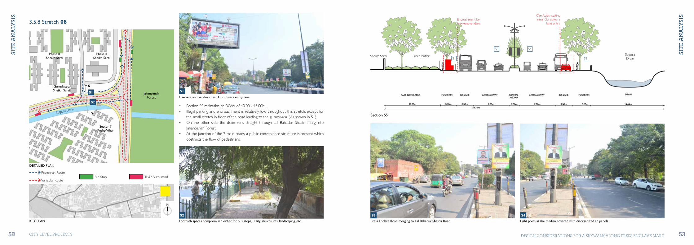
3.5.8 Stretch 08
KEY PLAN Footpath spaces compromised either for bus stops, utility structuures, landscaping, etc.
S2
S2• Section SS maintains an ROW of 40.00 - 45.00M.• Illegal parking and encroachment is relatively low throughout this stretch, except for
the small stretch in front of the road leading to the gurudwara. (As shown in S1)• On the other side, the drain runs straight through Lal Bahadur Shastri Marg into
Jahanpanah Forest.• At the junction of the 2 main roads, a public convenience structure is present which
obstructs the flow of pedestrians.
Hawkers and vendors near Gurudwara entry lane.
S1S1
S
S
Sector 7Pushp Vihar
JahanpanahForest
Phase IISheikh Sarai
Phase IISheikh Sarai
GurudwaraSheikh Sarai
Satpula Drain
Section SS
S2S1
S3 S4
Press Enclave Road merging to Lal Bahadur Shastri Road Light poles at the median covered with disorganized ad panels.
S3 S4
Cars/cabs waiting near Gurudwara
lane entryEncrochment by hawkers/vendors
Green bufferSheikh Sarai SatpulaDrain
Pedestrian Route
Vehicular RouteBus Stop Taxi / Auto stand
DETAILED PLAN

SitE
An
ALY
SiS
SitE
An
ALY
SiS
54 55CITY LEVEL ProjECTS DESIGN CoNSIDErATIoNS For A SKYWALK ALoNG PrESS ENCLAVE MArG
• Lal Bahadur Shastri Marg is an arterial road and is planned to be widened upto 60M ROW, according to the Master Plan and Zonal Plan.
• Presently, it ranges between 40M - 45M with a 0.5M wide median.• Lal Bahadur Shastri Marg is a significant road as it connects major forests of Delhi,
dense residential areas like Khanpur, Madangir, Greater Kailash and was also chosen as the road for BRT system trials.
• The road has existing cycle tracks, there is also a proposal for a Elevated Walkway on this road as well.
KEY PLAN Lal Bahadur Shastri Marg looking towards Ring Road
U1
U1
Lal Bahadur Shastri Marg looking towards Mehrauli-Badarpur Road
T1
T1
T
UU
T
Sector 7Pushp Vihar
JahanpanahForest
Phase IISheikh Sarai
Phase IISheikh Sarai
GurudwaraSheikh Sarai
Satpula Drain
Section UU
Section TT
T1
U1
Auto-rickshaws and motorbikes on cycle track
Auto-rickshaws and motorbikes on cycle track
JahanpanahForest
JahanpanahForest
SheikhSarai
SheikhSarai
Pedestrian Route
Vehicular RouteBus Stop Taxi / Auto stand
DETAILED PLAN
SitE
An
ALY
SiS
56 CITY LEVEL ProjECTS
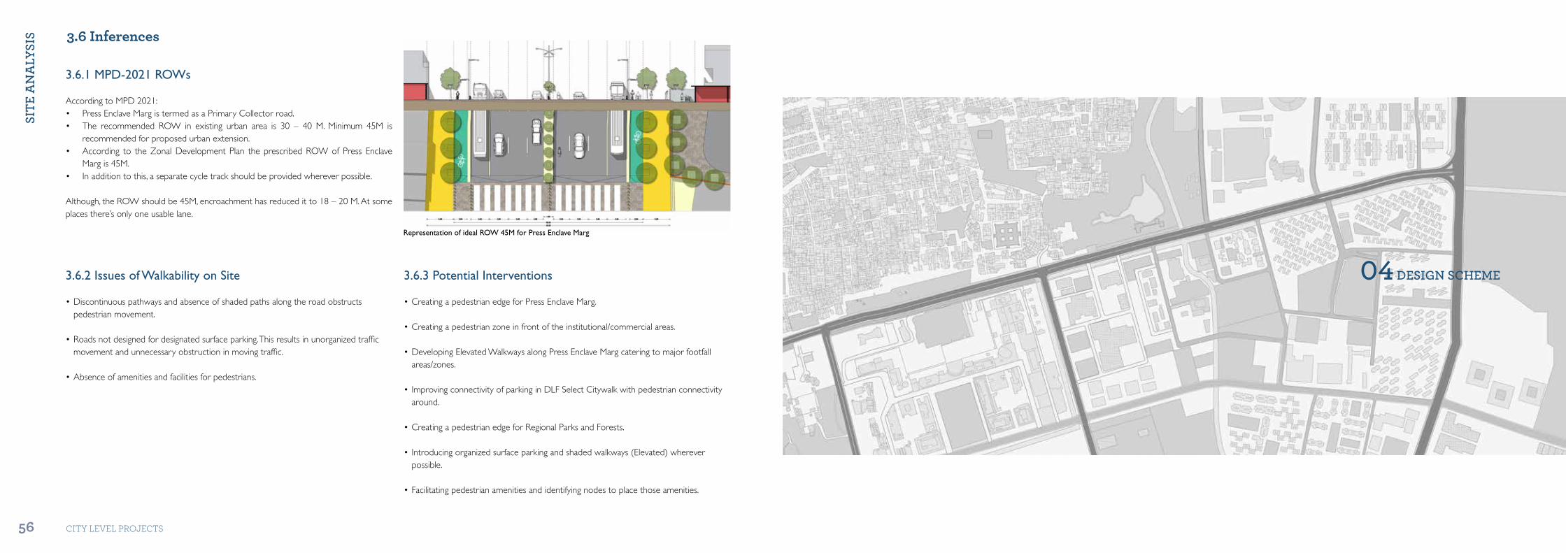
3.6.1 MPD-2021 ROWs
Representation of ideal ROW 45M for Press Enclave Marg
According to MPD 2021:• Press Enclave Marg is termed as a Primary Collector road.• The recommended ROW in existing urban area is 30 – 40 M. Minimum 45M is
recommended for proposed urban extension.• According to the Zonal Development Plan the prescribed ROW of Press Enclave
Marg is 45M.• In addition to this, a separate cycle track should be provided wherever possible.
Although, the ROW should be 45M, encroachment has reduced it to 18 – 20 M. At some places there’s only one usable lane.
3.6.2 Issues of Walkability on Site
•Discontinuouspathwaysandabsenceofshadedpathsalongtheroadobstructspedestrian movement.
•Roadsnotdesignedfordesignatedsurfaceparking.Thisresultsinunorganizedtrafficmovement and unnecessary obstruction in moving traffic.
•Absenceofamenitiesandfacilitiesforpedestrians.
3.6.3 Potential Interventions
•CreatingapedestrianedgeforPressEnclaveMarg.
•Creatingapedestrianzoneinfrontoftheinstitutional/commercialareas.
•DevelopingElevatedWalkwaysalongPressEnclaveMargcateringtomajorfootfallareas/zones.
•ImprovingconnectivityofparkinginDLFSelectCitywalkwithpedestrianconnectivityaround.
•CreatingapedestrianedgeforRegionalParksandForests.
•Introducingorganizedsurfaceparkingandshadedwalkways(Elevated)whereverpossible.
•Facilitatingpedestrianamenitiesandidentifyingnodestoplacethoseamenities.
04 dESiGn ScHEME
3.6 Inferences
dES
iGn
Sc
HEM
E
dES
iGn
Sc
HEM
E
58 59CITY LEVEL ProjECTS DESIGN CoNSIDErATIoNS For A SKYWALK ALoNG PrESS ENCLAVE MArG
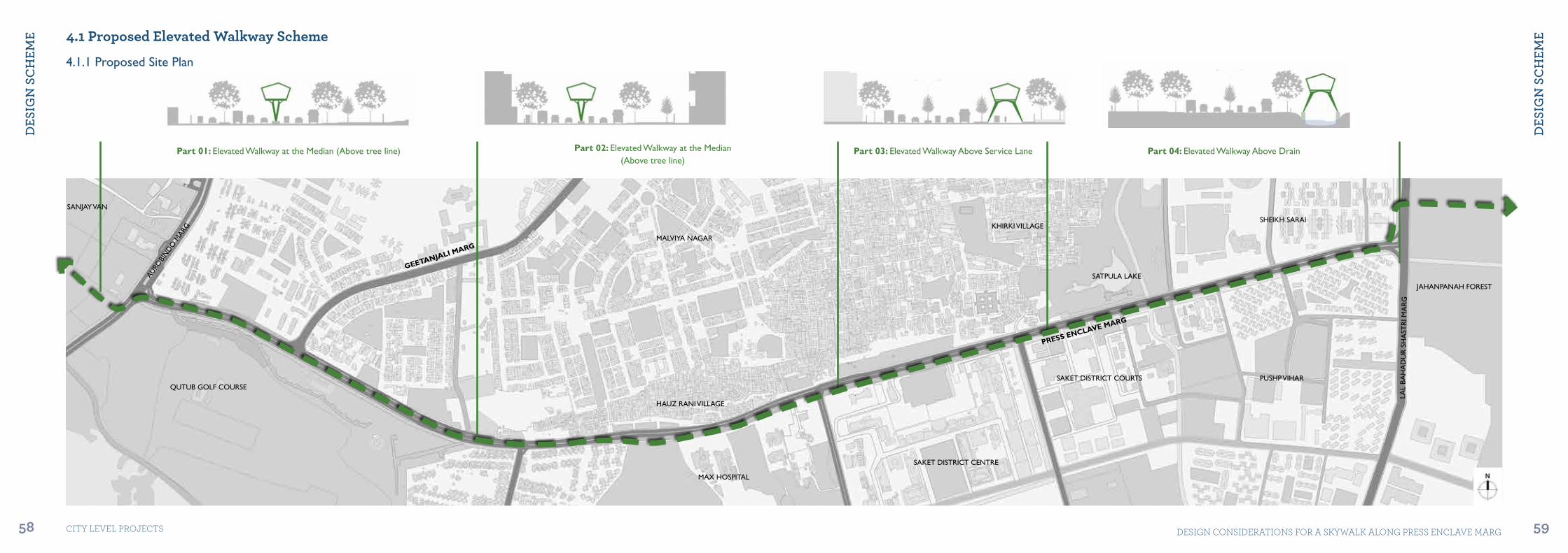
4.1 Proposed Elevated Walkway Scheme
4.1.1 Proposed Site Plan
Part 01: Elevated Walkway at the Median (Above tree line) Part 02: Elevated Walkway at the Median(Above tree line)
Part 03: Elevated Walkway Above Service Lane Part 04: Elevated Walkway Above Drain
AURO
BIN
DO
MAR
G
LAL
BA
HA
DU
R S
HA
STR
I MA
RG
GEETANJALI MARG
PRESS ENCLAVE MARG
SAKET DISTRICT COURTS PUSHP VIHAR
SHEIKH SARAI
JAHANPANAH FOREST
SAKET DISTRICT CENTRE
MAX HOSPITAL
MALVIYA NAGAR
HAUZ RANI VILLAGE
KHIRKI VILLAGE
SATPULA LAKE
QUTUB GOLF COURSE
SANJAY VAN

dES
iGn
Sc
HEM
E
dES
iGn
Sc
HEM
E
60 61CITY LEVEL ProjECTS DESIGN CoNSIDErATIoNS For A SKYWALK ALoNG PrESS ENCLAVE MArG
ELEVATED WALKWAY
LEGEND4.1.2 Entry / Exit points: Influence Zone
Entry/Exit Points of the ‘Elevated Walkway’ system have been provided considering the following parameters:• Daily Footfall in the area.• Vehicle-Pedestrian conflict points identified in previous chapter.• Scope for Integration with other modes of transport.• Major Social and Commercial Centres.
The ‘Influence Zone’ can be defined as a fixed area around an entry/exit point of the elevated walkway system and the people in that area it caters to. In the case of Press Enclave Marg, the proposed system willll cater to the following areas:Lado Sarai, Police Academy, Geetanjali Enclave, Shivalik Vihar, Malviya Nagar (till the market), Malviya Nagar metro, Qutub Golf Course, Qila Rai Pithora Park, Saket (till Anupam complex), Max Hospital, Saket City Hospital, Hauz Rani, parts of Khirki village, Saket District Centre, Saket District Courts, Satpula Monument, Khirki Mosque, Pushp Vihar (Sector 7), Sheikh Sarai (Ph-II), College of Vocational Studies, Pushpawati Eye Hospital.
JUNCTION
PAUSE-POINT
JUNCTION RANGE
PAUSE-POINT RANGE
As far as walkable distance is concerned, the most commonly cited standard is 400m. However, people walk further to faster services. Hence, the distance between each Entry/Exit point is 300 - 400m.
LAL
BA
HA
DU
R S
HA
STR
I MA
RG
GEETANJALI MARG
SAKET DISTRICT COURTS PUSHP VIHAR
SHEIKH SARAI
JAHANPANAH FOREST
SANJAY VAN
SAKET DISTRICT CENTRE
MAX HOSPITAL
MALVIYA NAGAR
HAUZ RANI VILLAGE
KHIRKI VILLAGE
SATPULA LAKE
QUTUB GOLF COURSE
AUROBINDO M
ARG
600m
Ø
PreferedWalking
Standard400m
300m
X

dES
iGn
Sc
HEM
E
dES
iGn
Sc
HEM
E
62 63CITY LEVEL ProjECTS DESIGN CoNSIDErATIoNS For A SKYWALK ALoNG PrESS ENCLAVE MArG
4.1.3 Entry / Exit points: Escape DistanceELEVATED WALKWAY
LEGEND
JUNCTION
PAUSE-POINT
JUNCTION RANGE
PAUSE-POINT RANGE
Entry/Exit Points of the ‘Elevated Walkway’ system has been provided considering the following parameters:• Daily Footfall in the area.• Vehicle-Pedestrian conflict points identified in previous chapter.• Scope for Integration with other modes of transport.• Major Social and Commercial Centres.
Escape Distance is the maximum distance a pedestrian shall traverse in case of an emergency.At any point on the elevated walkway, the maximum distance to the nearest entry/exit point shall not be more than 150m. Hence the the maximum distance between 2 entry/exit points shall not be more than 300m. The intersecting circles in the graphic shown below represent the fact that the planned entry/exit points are within 300m distance with each other.
As far as escape distance is concerned, the most commonly cited standard is 300m. Hence, the distance between each Entry/Exit point has been planned at 300 - 400m distance.
GEETANJALI MARG
SAKET DISTRICT COURTS PUSHP VIHAR
SHEIKH SARAI
JAHANPANAH FOREST
SANJAY VAN
SAKET DISTRICT CENTRE
MAX HOSPITAL
MALVIYA NAGAR
HAUZ RANI VILLAGE
KHIRKI VILLAGE
SATPULA LAKE
QUTUB GOLF COURSE
AUROBINDO M
ARG
300m
ØEscapedistance
150m
LAL
BA
HA
DU
R S
HA
STR
I MA
RG
dES
iGn
Sc
HEM
E
dES
iGn
Sc
HEM
E
64 65CITY LEVEL ProjECTS DESIGN CoNSIDErATIoNS For A SKYWALK ALoNG PrESS ENCLAVE MArG
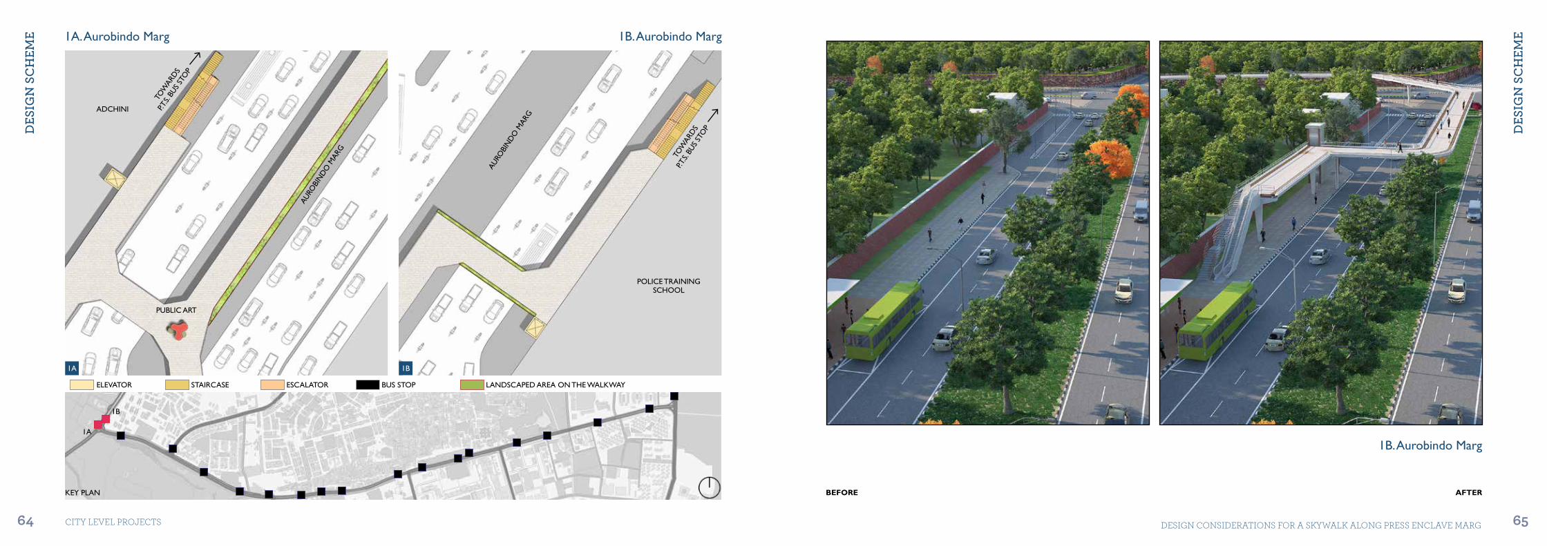
KEY PLAN
1A. Aurobindo Marg 1B. Aurobindo Marg
1B. Aurobindo Marg
AURO
BIN
DO
MAR
G
POLICE TRAINING SCHOOL
ADCHINI
PUBLIC ART
ELEVATOR STAIRCASE ESCALATOR BUS STOP LANDSCAPED AREA ON THE WALKWAY
AURO
BIN
DO
MAR
G
TOW
ARD
S
P.T.S.
BUS
STO
P
TOW
ARD
S
P.T.S.
BUS
STO
P
BEFORE AFTER
1A 1B
1A
1B

dES
iGn
Sc
HEM
E
dES
iGn
Sc
HEM
E
66 67CITY LEVEL ProjECTS DESIGN CoNSIDErATIoNS For A SKYWALK ALoNG PrESS ENCLAVE MArG
BEFORE AFTER
2. Police Training Academy 3. Geetanjali Marg
PRESS ENCLAVE MARG GEE
TAN
JALI
MAR
G
FORTWALL QUTUB
GOLF COURSE
GEETANJALIENCLAVE
POLICE TRAININGSCHOOL
SEATINGSPACE
TOW
ARD
S
GEE
TAN
JALI
BUS
STO
P
TOWARDSP.T.S. BUS STOP
2 3
23
KEY PLAN
ELEVATOR STAIRCASE ESCALATOR BUS STOP LANDSCAPED AREA ON THE WALKWAY
Police Training Academy
dES
iGn
Sc
HEM
E
dES
iGn
Sc
HEM
E
68 69CITY LEVEL ProjECTS DESIGN CoNSIDErATIoNS For A SKYWALK ALoNG PrESS ENCLAVE MArG
KEY PLAN
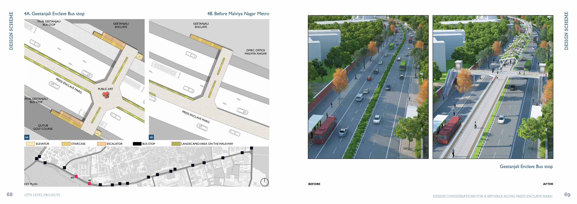
4A. Geetanjali Enclave Bus stop 4B. Before Malviya Nagar Metro
GEETANJALIENCLAVE
GEETANJALIENCLAVE
DMRC OFFICEMALVIYA NAGAR
QUTUBGOLF COURSE
P.N.B. GEETANJALIBUS STOP
P.N.B. GEETANJALIBUS STOP
PUBLIC ART
PRESS ENCLAVE MARG
PRESS ENCLAVE MARG
BEFORE AFTER
4A 4B
4A4B
ELEVATOR STAIRCASE ESCALATOR BUS STOP LANDSCAPED AREA ON THE WALKWAY
Geetanjali Enclave Bus stop

dES
iGn
Sc
HEM
E
dES
iGn
Sc
HEM
E
70 71CITY LEVEL ProjECTS DESIGN CoNSIDErATIoNS For A SKYWALK ALoNG PrESS ENCLAVE MArG
BEFORE AFTER
5. Malviya Nagar Metro 6. Press Enclave Vihar
MALVIYA NAGARMETRO STATION
HAUZ RANIVILLAGE
EKTA VIHARAPARTMENTS
GOLF VIEWAPARTMENTS
MALVIYA NAGARBUS STOP
PRESS ENCLAVEBUS STOP
PRESS ENCLAVEBUS STOP
PUBLICART
PRESS ENCLAVE MARG
PRESS ENCLAVE MARG
5 6
5 6KEY PLAN
ELEVATOR STAIRCASE ESCALATOR BUS STOP LANDSCAPED AREA ON THE WALKWAY
Malviya Nagar Metro
dES
iGn
Sc
HEM
E
dES
iGn
Sc
HEM
E
72 73CITY LEVEL ProjECTS DESIGN CoNSIDErATIoNS For A SKYWALK ALoNG PrESS ENCLAVE MArG
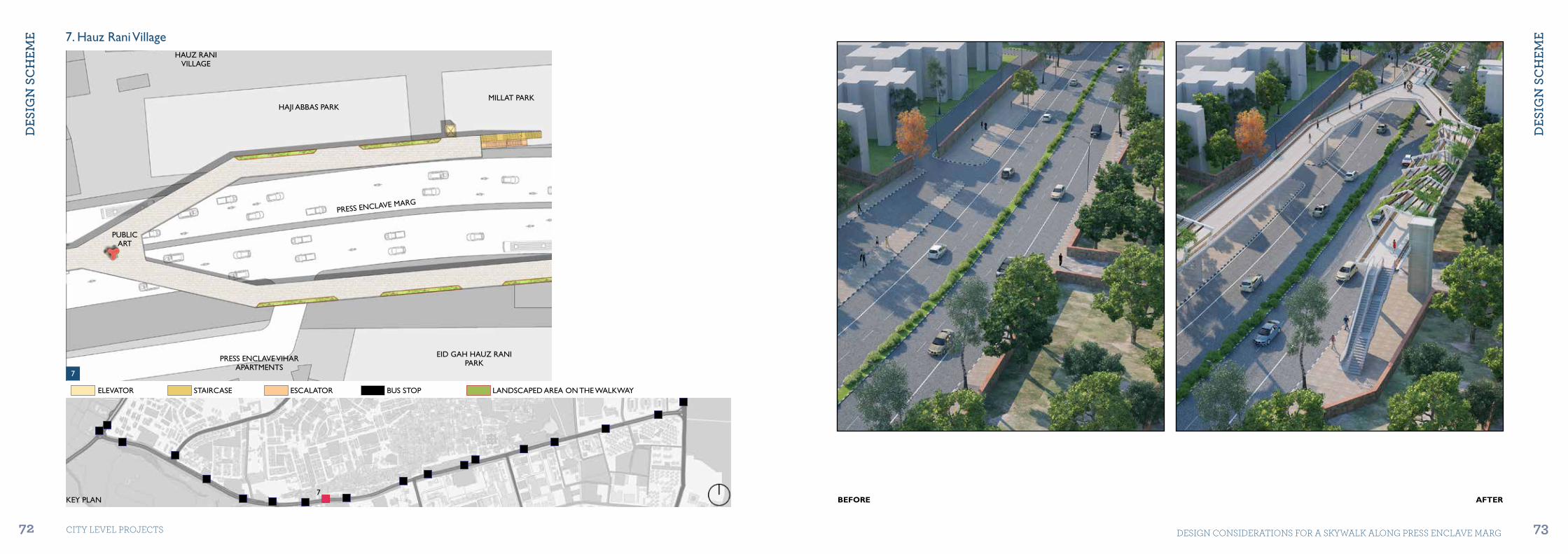
KEY PLAN
ELEVATOR STAIRCASE ESCALATOR BUS STOP LANDSCAPED AREA ON THE WALKWAY
7. Hauz Rani Village
PRESS ENCLAVE MARG
HAJI ABBAS PARK
HAUZ RANIVILLAGE
PUBLICART
EID GAH HAUZ RANI PARK
MILLAT PARK
PRESS ENCLAVE VIHAR APARTMENTS
BEFORE AFTER
7
7

dES
iGn
Sc
HEM
E
dES
iGn
Sc
HEM
E
74 75CITY LEVEL ProjECTS DESIGN CoNSIDErATIoNS For A SKYWALK ALoNG PrESS ENCLAVE MArG
BEFORE AFTER
8. Max Hospital
PRESS ENCLAVE MARG
PUBLICART
EID GAH HAUZ RANI PARK
MAX HOSPITALPARKING
HAUZ RANIVILLAGE
8
8
ELEVATOR STAIRCASE ESCALATOR BUS STOP LANDSCAPED AREA ON THE WALKWAY
KEY PLAN

dES
iGn
Sc
HEM
E
dES
iGn
Sc
HEM
E
76 77CITY LEVEL ProjECTS DESIGN CoNSIDErATIoNS For A SKYWALK ALoNG PrESS ENCLAVE MArG
10. Jamun Vala Park 01
JAMUN VALAPARK
TOWARDS
KHIRKI VILLAGE
BUS STOP
PRESS ENCLAVE MARG
BUS STOPELEVATOR STAIRCASE ESCALATOR LANDSCAPED AREA ON THE WALKWAY
KEY PLAN
9. Saket City Hospital
HAUZ RANIVILLAGE
SAKET CITY HOSPITAL PARKING
PRESS ENCLAVE MARG
BEFORE AFTER
9 10
9
10 Saket City Hospital
dES
iGn
Sc
HEM
E
dES
iGn
Sc
HEM
E
78 79CITY LEVEL ProjECTS DESIGN CoNSIDErATIoNS For A SKYWALK ALoNG PrESS ENCLAVE MArG
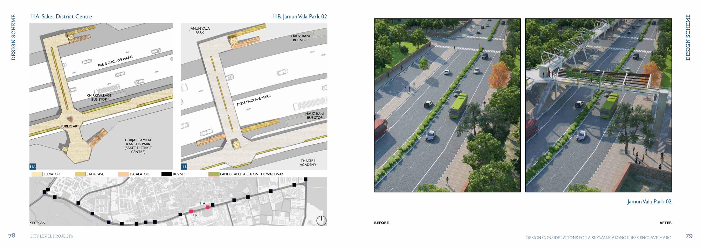
11B. Jamun Vala Park 02
HAUZ RANIBUS STOP
HAUZ RANIBUS STOP
THEATREACADEMY
JAMUN VALAPARK
PRESS ENCLAVE MARG
ELEVATOR STAIRCASE ESCALATOR BUS STOP LANDSCAPED AREA ON THE WALKWAY
KEY PLAN BEFORE AFTER
11A. Saket District Centre
KHIRKI VILLAGEBUS STOP
GURJAR SAMRAT KANISHK PARK
(SAKET DISTRICT CENTRE)
PUBLIC ART
PRESS ENCLAVE MARG
11A 11B
11A
11B
Jamun Vala Park 02
dES
iGn
Sc
HEM
E
dES
iGn
Sc
HEM
E
80 81CITY LEVEL ProjECTS DESIGN CoNSIDErATIoNS For A SKYWALK ALoNG PrESS ENCLAVE MArG
ELEVATOR STAIRCASE ESCALATOR BUS STOP LANDSCAPED AREA ON THE WALKWAY
KEY PLAN
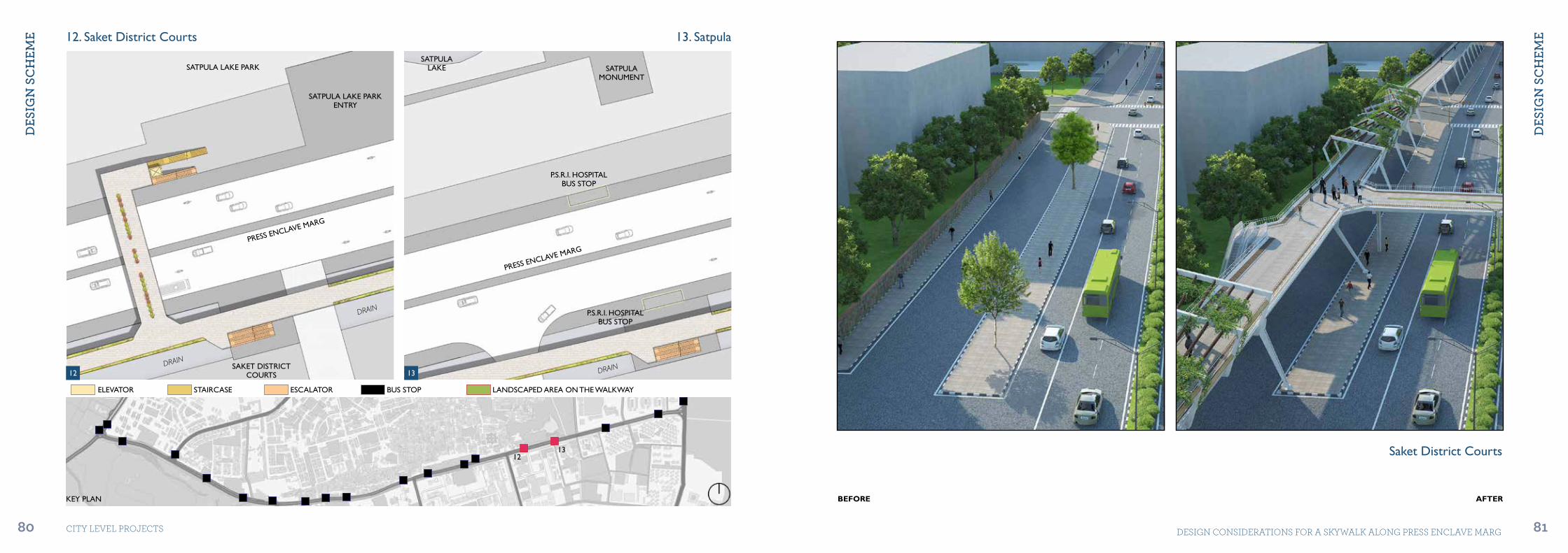
12. Saket District Courts 13. Satpula
SATPULA LAKE PARK
P.S.R.I. HOSPITALBUS STOP
P.S.R.I. HOSPITALBUS STOP
SATPULA LAKE PARKENTRY
SAKET DISTRICT COURTS
SATPULAMONUMENT
SATPULALAKE
PRESS ENCLAVE MARG
PRESS ENCLAVE MARG
DRAIN
DRAIN
DRAIN
BEFORE AFTER
12 13
1213 Saket District Courts
dES
iGn
Sc
HEM
E
dES
iGn
Sc
HEM
E
82 83CITY LEVEL ProjECTS DESIGN CoNSIDErATIoNS For A SKYWALK ALoNG PrESS ENCLAVE MArG
ELEVATOR STAIRCASE ESCALATOR BUS STOP LANDSCAPED AREA ON THE WALKWAY
KEY PLAN BEFORE AFTER
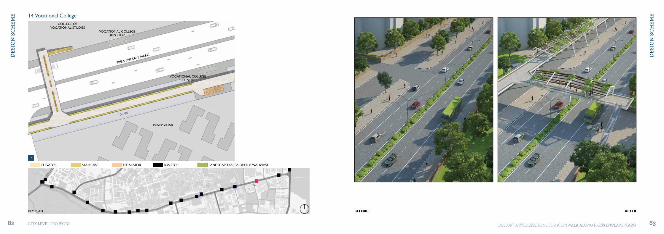
14. Vocational College
VOCATIONAL COLLEGEBUS STOP
VOCATIONAL COLLEGEBUS STOP
COLLEGE OFVOCATIONAL STUDIES
PUSHP VIHAR
PRESS ENCLAVE MARG
DRAIN
14
14

dES
iGn
Sc
HEM
E
dES
iGn
Sc
HEM
E
84 85CITY LEVEL ProjECTS DESIGN CoNSIDErATIoNS For A SKYWALK ALoNG PrESS ENCLAVE MArG
ELEVATOR STAIRCASE ESCALATOR BUS STOP LANDSCAPED AREA ON THE WALKWAY
KEY PLAN
15. Sheikh Sarai 16. Lal Bahadur Shastri Marg
PRESS ENCLAVE MARG
LAL
BA
HA
DU
R S
HA
STR
I
MA
RG
SHEIKH SARAI
PUBLIC ART
JAHANPANAHFOREST
DRAIN
BEFORE AFTER
15 16
15
16
Sheikh Sarai

dES
iGn
Sc
HEM
E
dES
iGn
Sc
HEM
E
86 87CITY LEVEL ProjECTS DESIGN CoNSIDErATIoNS For A SKYWALK ALoNG PrESS ENCLAVE MArG
4.3.1 Structure Design (Option 01) 4.3.2 Structure Design (Option 02)
4.3 Walkway Design
dES
iGn
Sc
HEM
E
dES
iGn
Sc
HEM
E
88 89CITY LEVEL ProjECTS DESIGN CoNSIDErATIoNS For A SKYWALK ALoNG PrESS ENCLAVE MArG
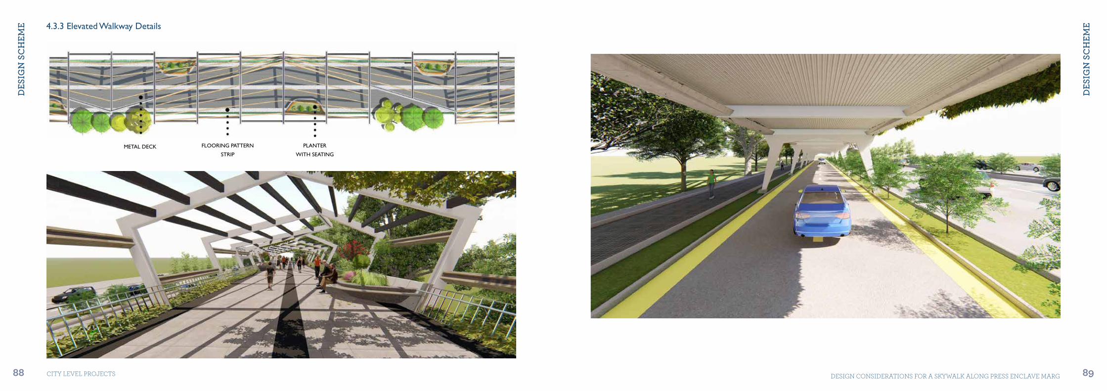
4.3.3 Elevated Walkway Details
METAL DECK FLOORING PATTERN
STRIP
PLANTER
WITH SEATING
dES
iGn
Sc
HEM
E
dES
iGn
Sc
HEM
E
90 91CITY LEVEL ProjECTS DESIGN CoNSIDErATIoNS For A SKYWALK ALoNG PrESS ENCLAVE MArG
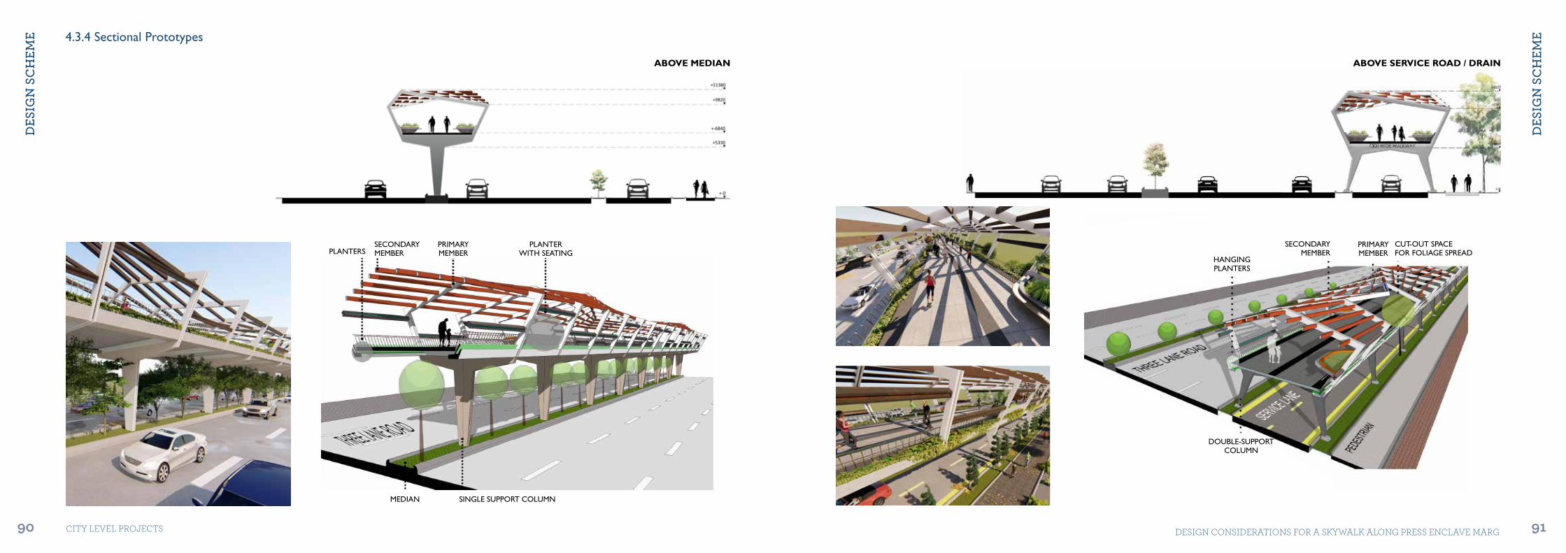
PLANTERWITH SEATING
PRIMARYMEMBER
SINGLE SUPPORT COLUMNMEDIAN
SECONDARYMEMBERPLANTERS
PRIMARYMEMBER
CUT-OUT SPACEFOR FOLIAGE SPREAD
SECONDARYMEMBER
HANGINGPLANTERS
DOUBLE-SUPPORTCOLUMN
ABOVE MEDIAN ABOVE SERVICE ROAD / DRAIN
4.3.4 Sectional Prototypes

dES
iGn
Sc
HEM
E
dES
iGn
Sc
HEM
E
92 93CITY LEVEL ProjECTS DESIGN CoNSIDErATIoNS For A SKYWALK ALoNG PrESS ENCLAVE MArG
4.4 Design Features
Sustainable Features Smart Features Safety and Security Features
Solar power generators mounted on roof and south-facing panels will be able to generate more than 6360KW/Km/day (enough to supply to 2120 households daily). Rainwater can be captured from elevated walkway roofs and diverted to an underground reservoir for future usage. Low voltage, charging points in-built at different pause points can provide charging facilities for users on the go. The tapped solar energy from the elevated walkway roof can be used for the same, thus utilizing local resources. Green wall can act as a buffer to isolate noise pollution from the traffic beneath. Also, it acts as an aesthetic element and helps in creating a cooler and clean microclimate. Plantation of native species, to provide shade from extreme weather conditions. It adds to the aesthetics of the structure by interspersing if with greens at various places.
Source# World Energy Council - 2014 Data | 2nd August, 2018
Provision of public Wi-fi throughout the elevated walkway stretch to enable uninterrupted digital connectivity to users Interactive wayfinding kiosks, help users to navigate their route and explore local areas. For universal accessibility, provision of escalator, elevator and staircases at regular intervals for equitable and intuitive use. Vending kiosks and ATM facilities are proposed at all junctions for easy access. Eating joints and ca-fes to be provided at pause points and junctions. Outdoor sports activities like gym, table tennis, air hockey, etc., can also be provided as recreational facilities in collaboration with private sponsors. Braille, tactile paving to be used to facilitate navigation, espe-cially for differently-abled users.
Panic alarm button to be installed at a regular interval of 50 m. In case of emergency, 150 m should be the maximum distance a person has to traverse to exit the walkway. Emergency calling booths (SOS Box) to be installed at intervals of 100 m Adequate lighting: Well lit areas enable safety and induce a sense of openness. They make the ambience inviting and lively. Full stretch of walkway to be under CCTV camera surveillance.
Source# Inference from the case study of Skygarden, Seoul. Refer page no. 38
bibL
ioG
rApH
Y
94 CITY LEVEL ProjECTS
Bibliography
1. Movement Corridors, Vision for Delhi (South Zone), Delhi Urban Art Commission (DUAC)
2. Good news for Delhi mall-goers: Govt plans mega redesign for Saket road, Faizan Haidar,, Hindustan Times, July 2017.
3. Malviya Nagar, Hauz Rani and Khirki Extension: Site Speciic Design for Ward Number 161, 162, 189 and 191, Delhi Urban Art Commission (DUAC)
4. World Energy Council - 2014 Data, 2nd August 2018.5. Page No. 38, Inference from the Case Study of Skygarden, Seoul.

Delhi Urban Art CommissionCore-6A, Upper Ground Floor, India Habitat Centre, Lodhi Road, New Delhi-110003
Tel: +91-11-24618607, +91-11-24619593Email: [email protected], [email protected] Website: www.duac.org