
DESIGN CONSIDERATIONS FOR A SKYWALK ALONG RING ...
53
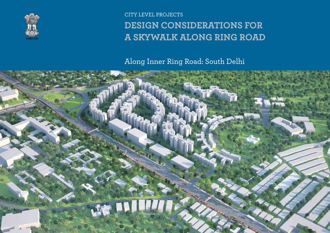
CITY LEVEL PROJECTS DESIGN CONSIDERATIONS FOR A SKYWALK ALONG RING ROAD Along Inner Ring Road: South Delhi
-
Upload
khangminh22 -
Category
Documents
-
view
4 -
download
0
Transcript of DESIGN CONSIDERATIONS FOR A SKYWALK ALONG RING ...
CITY LEVEL PROJECTS
DESIGN CONSIDERATIONS FOR A SKYWALK ALONG RING ROAD
Along Inner Ring Road: South Delhi
Delhi Urban Art Commission
The Delhi Urban Art Commission was set up by an Act of Parliament in 1973
to “advise the Government of India in the matter of preserving, developing
and maintaining the aesthetic quality of urban and environmental design within
Delhi and to provide advice and guidance to any local body in respect of any
project of building operations or engineering operations or any development
proposal which affects or is likely to affect the skyline or the aesthetic quality
of the surroundings or any public amenity provided therein”.
Delhi Urban Art Commission
Prof. Dr. P.S.N. Rao Chairman
Samir Mathur MemberAbhimanyu Dalal MemberSonali Rastogi Member (till 02.07.2020)Kamran Rizvi Member & Addl. Secretary, Ministry of Housing and Urban Affairs (w.e.f 2.01.2020) Ruby Kaushal Secretary (w.e.f 1.02.2019) Vinod Kumar Secretary (till 31.01.2019)
DUAC Staff
Rajeev Kumar Gaur, Amit Mukherji, Manju Anjali, Siddharth Sagar, Neha Chauhan.
Senior ConsultantSatish KhannaSonali Bhagwati
ConsultantsMayank Sharma Joel MichealAarti Mankame Anil Kumar (3d Visualizer)
DELHI URBAN ART COMMISSION with gratitude duly acknowledges the valuable contributions of the
following in making this report:
Organisations / Others
Ministry of Urban Development
Delhi Development Authority
Government of National Capital Territory of Delhi
North Delhi Municipal Corporation
East Delhi Municipal Corporation
South Delhi Municipal Corporation
New Delhi Municipal Council
Geospatial Delhi Limited
Delhi Metro Rail Corporation
Delhi Urban Shelter Improvement Board
BSES Rajdhani Power Limited
BSES Yamuna Power Limited
RWA’s and Area Councillors
Google Earth
Preface
*DISCLAIMER*
The city of Delhi, capital of this vast land of diversities, is a city laden with layers
of history, a place where civilizations have lived, prospered and perished over
centuries. The modern city today, built over and around a rich tapestry of heritage,
presents an opportunity at every turn, to allow for coexistence of the past, present
and the future. In order to understand this multidimensional urban spectrum and
attempt to plan the future, various city level studies have been initiated by the
DUAC. I hope that these studies will help the planners of modern day Delhi to
carefully articulate urban space, structure, form and environment and sensitively
address future requirements.
I convey my thanks to all the Consultants and Members of the Commission who
have tirelessly worked on this research project to bring out this document. I also
take this opportunity to place on record my sincere appreciation of the efforts
of Secretary and other staff of DUAC for providing the necessary administrative
support to make this happen.
I fondly hope that the authorities of the local, state and national government take
these studies seriously and implement, in right earnest, the suggestions given herein.
This report is for academic purposes only and has been prepared on the basis
of information gathered from various sources, in cases without any independent
verification. The report can be adopted and utilized by any Government
Authority/ Local Body in the country and is provided free of cost. The report is
not meant to derive any kind of gain, monetary or otherwise.
Though all efforts have been made to ensure the accuracy of the information
in this report, the same should not be construed as a statement of law or
used for any legal purposes. Delhi Urban Art Commission (DUAC) accepts no
responsibility in relation to the accuracy, completeness, usefulness or otherwise,
of the information contained in the publication. Stakeholders are advised to
verify/check any information with the relevant Government Department(s) and/
or other source(s), and to obtain any appropriate advice before acting on the
information provided in the report.
While adequate measures have been taken to acknowledge the source of
the information used in the report, the nature of the process and the diverse
sources from which information is collected makes it difficult for the Commission
to ascertain whether each piece of information/data impinges upon any third
party intellectual property rights. DUAC shall consequently not be responsible
for any inadvertent and / or bonafide omission of acknowledgement of source of
information.
In no event will the DUAC be liable for any expense, loss or damage including,
without limitation, indirect or consequential loss or damage, or any expense,
loss or damage whatsoever arising out of any person/ stakeholder using or
implementing or relying on any information in this report.
December 2020 Prof. Dr. P.S.N. Rao Chairman, DUAC
Sd/-
Foreword
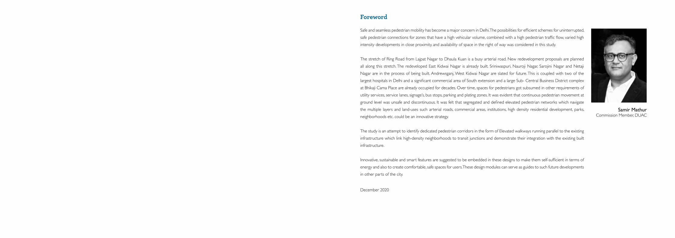
Samir MathurCommission Member, DUAC
Safe and seamless pedestrian mobility has become a major concern in Delhi. The possibilities for efficient schemes for uninterrupted,
safe pedestrian connections for zones that have a high vehicular volume, combined with a high pedestrian traffic flow, varied high
intensity developments in close proximity, and availability of space in the right of way was considered in this study.
The stretch of Ring Road from Lajpat Nagar to Dhaula Kuan is a busy arterial road. New redevelopment proposals are planned
all along this stretch. The redeveloped East Kidwai Nagar is already built. Sriniwaspuri, Nauroji Nagar, Sarojini Nagar and Netaji
Nagar are in the process of being built. Andrewsganj, West Kidwai Nagar are slated for future. This is coupled with two of the
largest hospitals in Delhi and a significant commercial area of South extension and a large Sub- Central Business District complex
at Bhikaji Cama Place are already occupied for decades. Over time, spaces for pedestrians got subsumed in other requirements of
utility services, service lanes, signage’s, bus stops, parking and plating zones. It was evident that continuous pedestrian movement at
ground level was unsafe and discontinuous. It was felt that segregated and defined elevated pedestrian networks which navigate
the multiple layers and land-uses such arterial roads, commercial areas, institutions, high density residential development, parks,
neighborhoods etc. could be an innovative strategy.
The study is an attempt to identify dedicated pedestrian corridors in the form of Elevated walkways running parallel to the existing
infrastructure which link high-density neighborhoods to transit junctions and demonstrate their integration with the existing built
infrastructure.
Innovative, sustainable and smart features are suggested to be embedded in these designs to make them self-sufficient in terms of
energy and also to create comfortable, safe spaces for users. These design modules can serve as guides to such future developments
in other parts of the city.
December 2020
Contents1 Introduction 14
1.1 Elevated walkways around the world 15
1.2 Vision Statement 16
1.3 Existing scenario of pedestrian mobility in Delhi 17
1.4 Pedestrian fatalities in the last decade 18
2 Site Identification 202.1 Road Network : Linkages and connections 21
2.2 Zone details 22
2.3 Stretch identification 23
2.4 Defining the study area 24
3 Stretch 01 (South Ex. to Bhikaji Cama Place) 25Analysis
3.1 Site analysis 26
3.2 Zoning and linkages 28
3.3 Existing- Walkability scenario 30
3.4 Possibilities of upgradation of existing footpaths 32
3.5 Pedestrian footfall analysis 34
3.6 Major nodes and landmarks 36
3.7 Proposal- Connections along the Stretch 38
3.8 Proposed elevated walkway- Defining the footprint 40
3.9 Major roads connections and the influence zone 42
3.10 Connecting to public transport 44
3.11 Emergency escape 46
3.12 Potential junctions along the elevated walkway 48
Proposal
3.13 Proposal along Junctions 50
A. South Extension Junction 50
B. East Kidwai Nagar Junction 54
C. Dilli Haat Junction 58
D. AIIMS Metro Junction 62
E. Safdarjung Junction 65
F. Sarojini Nagar Junction 68
G. Nauroji Nagar Junction 71
4 Stretch 02 (Sriniwaspuri to Lajpat Nagar) 754.1 Site Brief 76
4.2 Major Nodes and Landmarks 80
4.3 Connections along the Stretch 82
4.4 Elevated Walkway Footprint 84
4.5 Major Road Linkages and Influence Zone 86
4.6 Public Transport Linkages 88
4.7 Emergency Escapes 90
4.8 Elevated Walkway with Potential Junctions 92
5 Design Proposal 955.1 Features 96
5.2 Elevated Walkway Design 98
5.3 Few Alternative Facade Elements 101
6 Reference list 102
XIII
DESIGN CONSIDERATIONS FOR A SKYWALK ALONG RING ROAD
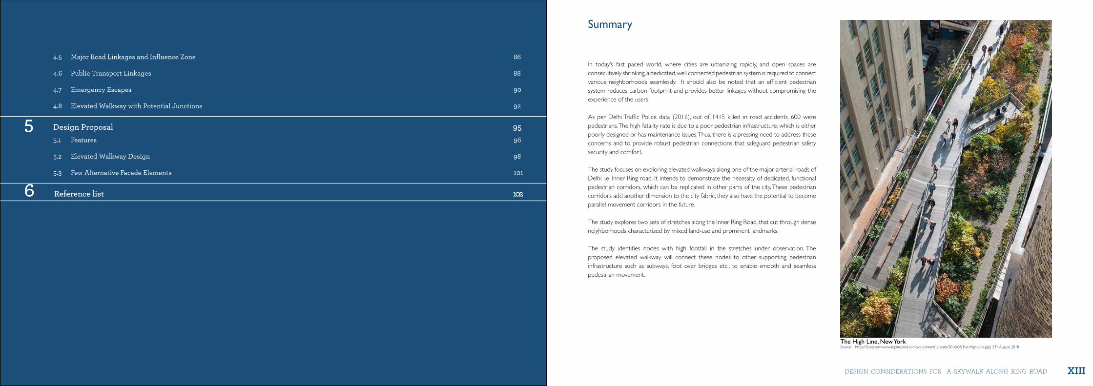
Summary
The High Line, New York Source: https://i3.wp.com/www.topinspired.com/wp-content/uploads/2016/08/The-High-Line.jpg | 23rd August, 2018
In today’s fast paced world, where cities are urbanizing rapidly, and open spaces are consecutively shrinking, a dedicated, well connected pedestrian system is required to connect various neighborhoods seamlessly. It should also be noted that an efficient pedestrian system reduces carbon footprint and provides better linkages without compromising the experience of the users.
As per Delhi Traffic Police data (2016), out of 1415 killed in road accidents, 600 were pedestrians. The high fatality rate is due to a poor pedestrian infrastructure, which is either poorly designed or has maintenance issues. Thus, there is a pressing need to address these concerns and to provide robust pedestrian connections that safeguard pedestrian safety, security and comfort.
The study focuses on exploring elevated walkways along one of the major arterial roads of Delhi i.e. Inner Ring road. It intends to demonstrate the necessity of dedicated, functional pedestrian corridors, which can be replicated in other parts of the city. These pedestrian corridors add another dimension to the city fabric, they also have the potential to become parallel movement corridors in the future.
The study explores two sets of stretches along the Inner Ring Road, that cut through dense neighborhoods characterized by mixed land-use and prominent landmarks.
The study identifies nodes with high footfall in the stretches under observation. The proposed elevated walkway will connect these nodes to other supporting pedestrian infrastructure such as subways, foot over bridges etc., to enable smooth and seamless pedestrian movement.
14 15
INtR
oD
uC
tIo
N
INtR
oD
uC
tIo
N
city level project DeSiGN coNSiDerAtioNS For A SKyWAlK AloNG riNG roAD
IntroductionChapter 1
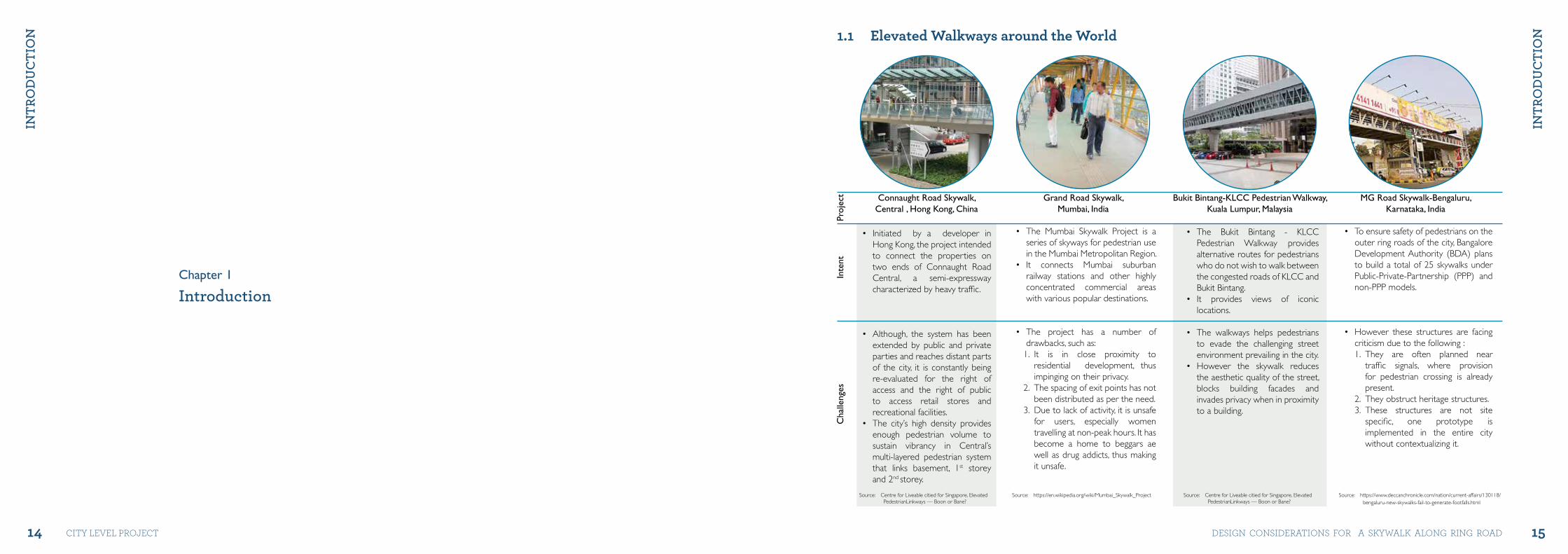
1.1 Elevated Walkways around the World
• The Mumbai Skywalk Project is a series of skyways for pedestrian use in the Mumbai Metropolitan Region.
• It connects Mumbai suburban railway stations and other highly concentrated commercial areas with various popular destinations.
• The project has a number of drawbacks, such as:
1. It is in close proximity to residential development, thus impinging on their privacy.
2. The spacing of exit points has not been distributed as per the need.
3. Due to lack of activity, it is unsafe for users, especially women travelling at non-peak hours. It has become a home to beggars ae well as drug addicts, thus making it unsafe.
• To ensure safety of pedestrians on the outer ring roads of the city, Bangalore Development Authority (BDA) plans to build a total of 25 skywalks under Public-Private-Partnership (PPP) and non-PPP models.
• However these structures are facing criticism due to the following : 1. They are often planned near
traffic signals, where provision for pedestrian crossing is already present.
2. They obstruct heritage structures. 3. These structures are not site
specific, one prototype is implemented in the entire city without contextualizing it.
• Initiated by a developer in Hong Kong, the project intended to connect the properties on two ends of Connaught Road Central, a semi-expressway characterized by heavy traffic.
• Although, the system has been extended by public and private parties and reaches distant parts of the city, it is constantly being re-evaluated for the right of access and the right of public to access retail stores and recreational facilities.
• The city’s high density provides enough pedestrian volume to sustain vibrancy in Central’s multi-layered pedestrian system that links basement, 1st storey and 2nd storey.
• The Bukit Bintang - KLCC Pedestrian Walkway provides alternative routes for pedestrians who do not wish to walk between the congested roads of KLCC and Bukit Bintang.
• It provides views of iconic locations.
• The walkways helps pedestrians to evade the challenging street environment prevailing in the city.
• However the skywalk reduces the aesthetic quality of the street, blocks building facades and invades privacy when in proximity to a building.
Source: Centre for Liveable citied for Singapore, Elevated PedestrianLinkways — Boon or Bane?
Source: https://en.wikipedia.org/wiki/Mumbai_Skywalk_Project Source: https://www.deccanchronicle.com/nation/current-affairs/130118/bengaluru-new-skywalks-fail-to-generate-footfalls.html
Source: Centre for Liveable citied for Singapore, Elevated PedestrianLinkways — Boon or Bane?
Connaught Road Skywalk,Central , Hong Kong, China
Proj
ect
Inte
ntC
halle
nges
Grand Road Skywalk,Mumbai, India
MG Road Skywalk-Bengaluru,Karnataka, India
Bukit Bintang-KLCC Pedestrian Walkway,Kuala Lumpur, Malaysia
16 17
INtR
oD
uC
tIo
N
INtR
oD
uC
tIo
N
city level project DeSiGN coNSiDerAtioNS For A SKyWAlK AloNG riNG roAD
VisionTo provide dedicated pedestrian connections by linking high density neighborhoods to transport systems and enabling uninterrupted and seamless pedestrian movement between destinations.
Objectives Create an efficient pedestrian mobility corridor to ensure a comfortable walking experience with respect to the following parameters:
1.2 Vision Statement
Scope and Limitations 1. Design recommendations shall be proposed for the identified stretches only.2. Volumetric and traffic characteristics study will not be part of this project.3. The data collected for analysis is based on site observations.
1. Prioritize pedestrians • Prioritizing pedestrians before other modes of transport.• Providing smooth and seamless pedestrian networks.
2. Provide a pleasant walking experience • Utilizing the existing infrastructure i.e. footpaths, subways and foot over bridges with required retrofitting.• Safety and security of pedestrians by providing essential elements like lighting, shaded walkways, wayfinding and seating facilities.• Promoting public art in public spaces to create a sense of interest and curiosity.
3. Integrate all modes of transport • Connecting the pedestrian corridor with various transit modes and hubs.• Providing convenient access to transport modes like buses, feeder systems and metro network.
4. Create universal accessibility • Ensuring universal accessibility leading to inclusive planning.
5. Reduce the carbon footprint• Reducing carbon footprint in dense neighbourhoods of the city by encouraging walking.
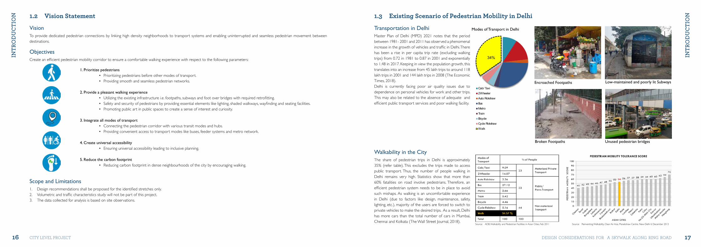
1.3 Existing Scenario of Pedestrian Mobility in Delhi
Transportation in DelhiMaster Plan of Delhi (MPD) 2021 notes that the period between 1981- 2001 and 2011 has observed a phenomenal increase in the growth of vehicles and traffic in Delhi. There has been a rise in per capita trip rate (excluding walking trips) from 0.72 in 1981 to 0.87 in 2001 and exponentially to 1.48 in 2017. Keeping in view the population growth, this translates into an increase from 45 lakh trips to around 118 lakh trips in 2001 and 144 lakh trips in 2008 (The Economic Times, 2018).Delhi is currently facing poor air quality issues due to dependence on personal vehicles for work and other trips. This may also be related to the absence of adequate and efficient public transport services and poor walking facility.
Cab/ Taxi2WheelerAuto RickshawBusMetroTrainBicycleCycle RickshawWalk
34%
Cab/ Taxi2WheelerAuto RickshawBusMetroTrainBicycleCycle RickshawWalk
34%
Walkability in the City The share of pedestrian trips in Delhi is approximately 35% (refer table). This excludes the trips made to access public transport. Thus, the number of people walking in Delhi remains very high. Statistics show that more than 60% fatalities on road involve pedestrians. Therefore, an efficient pedestrian system needs to be in place to avoid such mishaps. As walking is an uncomfortable experience in Delhi (due to factors like design, maintenance, safety, lighting, etc.), majority of the users are forced to switch to private vehicles to make the desired trips. As a result, Delhi has more cars than the total number of cars in Mumbai, Chennai and Kolkata (The Wall Street Journal, 2018).
Source: Reinventing Walkability, Clear Air Asia, Manekshaw Centre, New-Delhi 6 December 2013Source: ADB, Walkability and Pedestrian Facilities in Asian Cities, Feb 2011
Encroached Footpaths Low-maintained and poorly lit Subways
Broken Footpaths Unused pedestrian bridges
Modes of Transport in Delhi
18 19
INtR
oD
uC
tIo
N
INtR
oD
uC
tIo
N
city level project DeSiGN coNSiDerAtioNS For A SKyWAlK AloNG riNG roAD
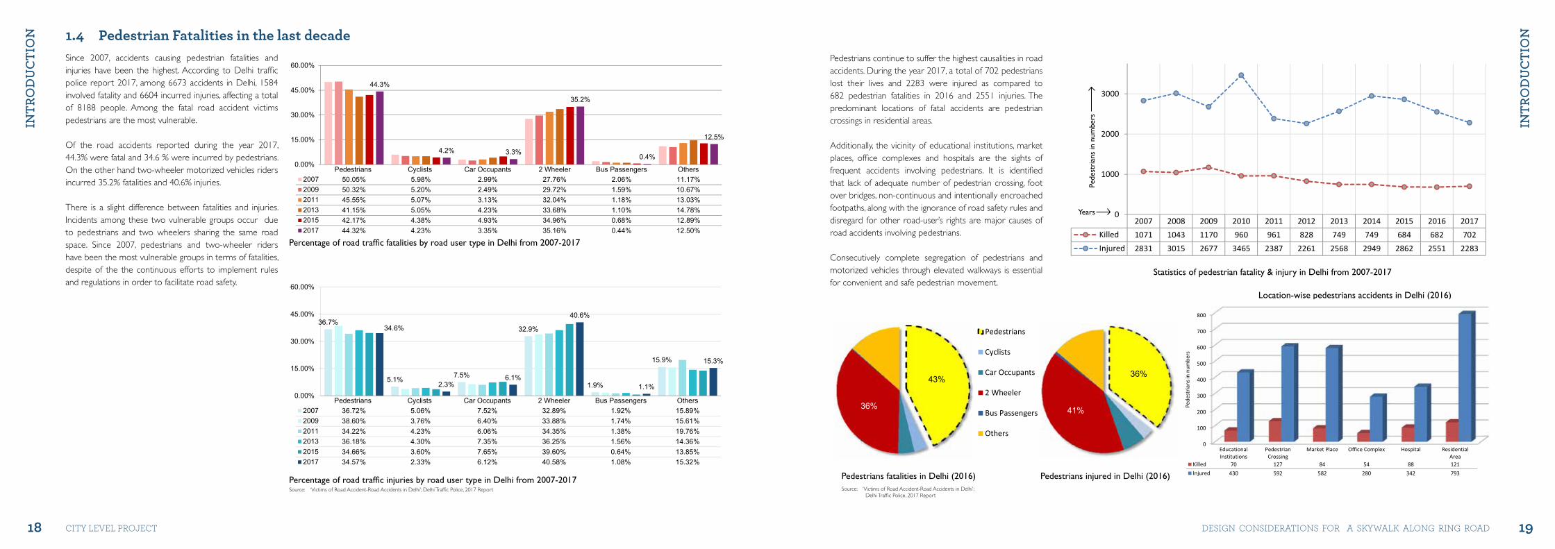
1.4 Pedestrian Fatalities in the last decadeSince 2007, accidents causing pedestrian fatalities and injuries have been the highest. According to Delhi traffic police report 2017, among 6673 accidents in Delhi, 1584 involved fatality and 6604 incurred injuries, affecting a total of 8188 people. Among the fatal road accident victims pedestrians are the most vulnerable.
Of the road accidents reported during the year 2017, 44.3% were fatal and 34.6 % were incurred by pedestrians. On the other hand two-wheeler motorized vehicles riders incurred 35.2% fatalities and 40.6% injuries.
There is a slight difference between fatalities and injuries. Incidents among these two vulnerable groups occur due to pedestrians and two wheelers sharing the same road space. Since 2007, pedestrians and two-wheeler riders have been the most vulnerable groups in terms of fatalities, despite of the the continuous efforts to implement rules and regulations in order to facilitate road safety.
Source: ‘Victims of Road Accident-Road Accidents in Delhi’; Delhi Traffic Police, 2017 Report
44.3%
4.2% 3.3%
35.2%
0.4%
12.5%
0.00%
15.00%
30.00%
45.00%
60.00%
Pedestrians Cyclists Car Occupants 2 Wheeler Bus Passengers Others2007 50.05% 5.98% 2.99% 27.76% 2.06% 11.17%2009 50.32% 5.20% 2.49% 29.72% 1.59% 10.67%2011 45.55% 5.07% 3.13% 32.04% 1.18% 13.03%2013 41.15% 5.05% 4.23% 33.68% 1.10% 14.78%2015 42.17% 4.38% 4.93% 34.96% 0.68% 12.89%2017 44.32% 4.23% 3.35% 35.16% 0.44% 12.50%
Percentage of road traffic fatalities by road user type in Delhi
36.7%
5.1% 7.5%
32.9%
1.9%
15.9%
34.6%
2.3%6.1%
40.6%
1.1%
15.3%
0.00%
15.00%
30.00%
45.00%
60.00%
Pedestrians Cyclists Car Occupants 2 Wheeler Bus Passengers Others2007 36.72% 5.06% 7.52% 32.89% 1.92% 15.89%2009 38.60% 3.76% 6.40% 33.88% 1.74% 15.61%2011 34.22% 4.23% 6.06% 34.35% 1.38% 19.76%2013 36.18% 4.30% 7.35% 36.25% 1.56% 14.36%2015 34.66% 3.60% 7.65% 39.60% 0.64% 13.85%2017 34.57% 2.33% 6.12% 40.58% 1.08% 15.32%
Percentage of road traffic injuries by road user type in Delhi
Percentage of road traffic fatalities by road user type in Delhi from 2007-2017
Percentage of road traffic injuries by road user type in Delhi from 2007-2017
43%
36%
Victims killed in 2016
Pedestrians
Cyclists
Car Occupants
2 Wheeler
Bus Passengers
Others
36%
41%
Victims injured in 2016
Pedestrians
Cyclists
Car Occupants
2 Wheeler
Bus Passengers
Others
Pedestrians fatalities in Delhi (2016) Pedestrians injured in Delhi (2016)
Location-wise pedestrians accidents in Delhi (2016)
Statistics of pedestrian fatality & injury in Delhi from 2007-2017
Pedestrians continue to suffer the highest causalities in road accidents. During the year 2017, a total of 702 pedestrians lost their lives and 2283 were injured as compared to 682 pedestrian fatalities in 2016 and 2551 injuries. The predominant locations of fatal accidents are pedestrian crossings in residential areas.
Additionally, the vicinity of educational institutions, market places, office complexes and hospitals are the sights of frequent accidents involving pedestrians. It is identified that lack of adequate number of pedestrian crossing, foot over bridges, non-continuous and intentionally encroached footpaths, along with the ignorance of road safety rules and disregard for other road-user’s rights are major causes of road accidents involving pedestrians.
Consecutively complete segregation of pedestrians and motorized vehicles through elevated walkways is essential for convenient and safe pedestrian movement.
43%
36%
Victims killed in 2016
Pedestrians
Cyclists
Car Occupants
2 Wheeler
Bus Passengers
Others
36%
41%
Victims injured in 2016
Pedestrians
Cyclists
Car Occupants
2 Wheeler
Bus Passengers
Others
43%
36%
Victims killed in 2016
Pedestrians
Cyclists
Car Occupants
2 Wheeler
Bus Passengers
Others
36%
41%
Victims injured in 2016
Pedestrians
Cyclists
Car Occupants
2 Wheeler
Bus Passengers
Others0
100
200
300
400
500
600
700
800
EducationalInstitutions
PedestrianCrossing
Market Place Office Complex Hospital ResidentialArea
Killed 70 127 84 54 88 121Injured 430 592 582 280 342 793
Pede
stria
ns in
num
bers
Location wise Pedestrian accidents in Delhi for 2016
2007 2008 2009 2010 2011 2012 2013 2014 2015 2016 2017Killed 1071 1043 1170 960 961 828 749 749 684 682 702Injured 2831 3015 2677 3465 2387 2261 2568 2949 2862 2551 2283
0
1000
2000
3000
Pedestrians Killed v/s Injured in Delhi from 2007 to 2017
Source: ‘Victims of Road Accident-Road Accidents in Delhi’; Delhi Traffic Police, 2017 Report
Pede
stri
ans
in n
umbe
rs
Years
21
SItE
IDEN
tIfI
Cat
IoN
DESIGN CONSIDERATIONS FOR A SKYWALK ALONG RING ROAD
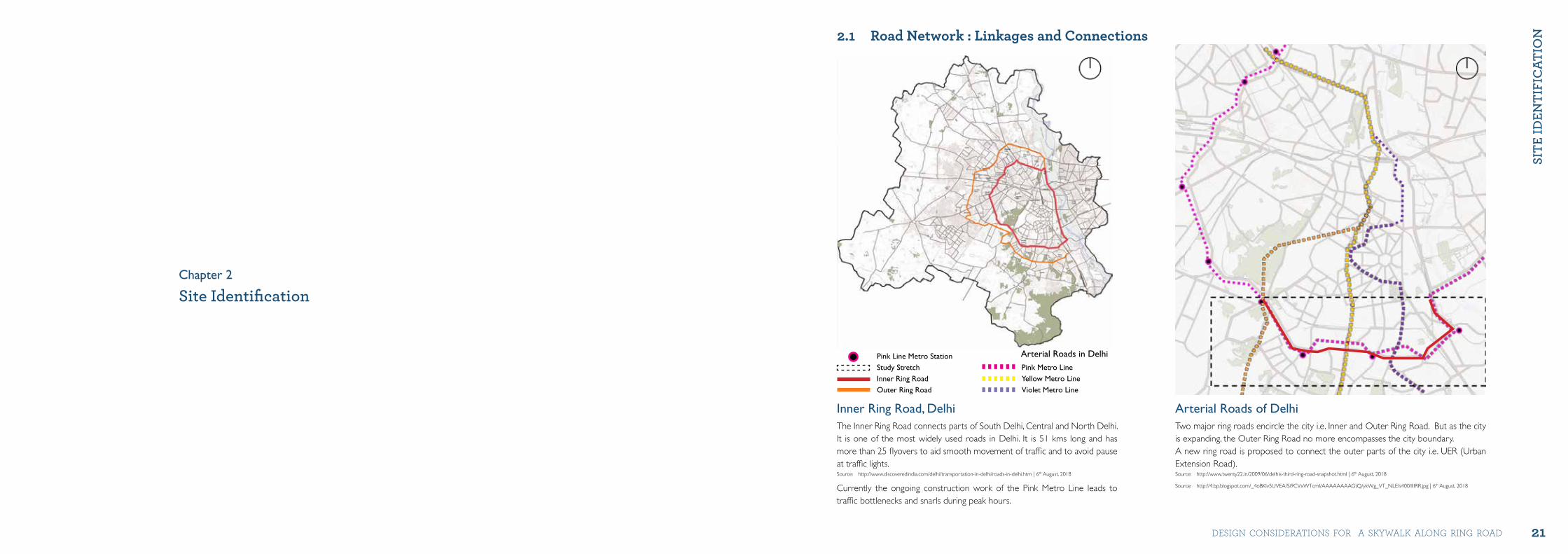
2.1 Road Network : Linkages and Connections
Arterial Roads of DelhiTwo major ring roads encircle the city i.e. Inner and Outer Ring Road. But as the city is expanding, the Outer Ring Road no more encompasses the city boundary. A new ring road is proposed to connect the outer parts of the city i.e. UER (Urban Extension Road).Source: http://www.twenty22.in/2009/06/delhis-third-ring-road-snapshot.html | 6th August, 2018
Source: http://4.bp.blogspot.com/_4oBKlv5UVEA/Si9CVxWTcmI/AAAAAAAAGtQ/ykWg_VT_NLE/s400/IIIRR.jpg | 6th August, 2018
Inner Ring Road, Delhi The Inner Ring Road connects parts of South Delhi, Central and North Delhi. It is one of the most widely used roads in Delhi. It is 51 kms long and has more than 25 flyovers to aid smooth movement of traffic and to avoid pause at traffic lights. Source: http://www.discoveredindia.com/delhi/transportation-in-delhi/roads-in-delhi.htm | 6th August, 2018
Currently the ongoing construction work of the Pink Metro Line leads to traffic bottlenecks and snarls during peak hours.
Pink Line Metro Station Study StretchInner Ring Road Outer Ring Road
Arterial Roads in Delhi
Site IdentificationChapter 2
Pink Metro Line Yellow Metro Line Violet Metro Line
22 23
SItE
IDEN
tIfI
Cat
IoN
SItE
IDEN
tIfI
Cat
IoN
city level project DeSiGN coNSiDerAtioNS For A SKyWAlK AloNG riNG roAD
2.2 Zone Details
Zone D
Zone F
Map showing various neighbourhoods around the study area
Key map highlighting the zones
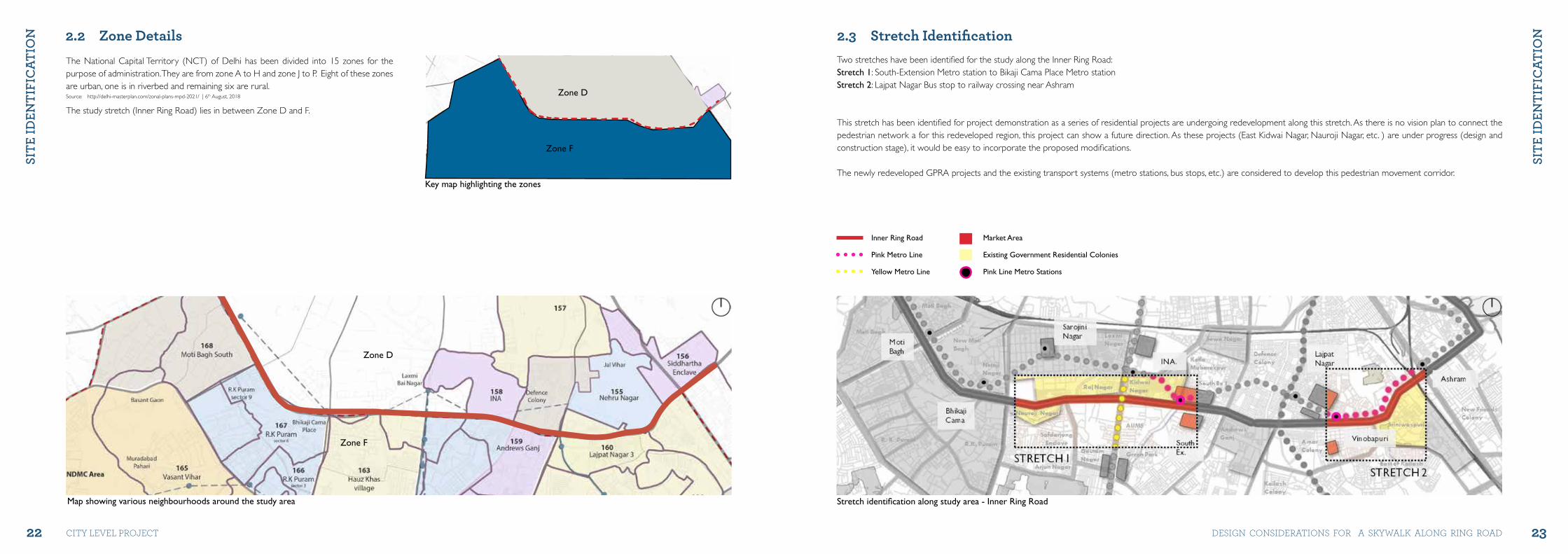
2.3 Stretch Identification Two stretches have been identified for the study along the Inner Ring Road:Stretch 1: South-Extension Metro station to Bikaji Cama Place Metro station Stretch 2: Lajpat Nagar Bus stop to railway crossing near Ashram
This stretch has been identified for project demonstration as a series of residential projects are undergoing redevelopment along this stretch. As there is no vision plan to connect the pedestrian network a for this redeveloped region, this project can show a future direction. As these projects (East Kidwai Nagar, Nauroji Nagar, etc. ) are under progress (design and construction stage), it would be easy to incorporate the proposed modifications.
The newly redeveloped GPRA projects and the existing transport systems (metro stations, bus stops, etc.) are considered to develop this pedestrian movement corridor.
Inner Ring Road
Pink Metro Line
Yellow Metro Line
Market Area
Existing Government Residential Colonies
Pink Line Metro Stations
Stretch identification along study area - Inner Ring Road
Zone D
Zone F
The National Capital Territory (NCT) of Delhi has been divided into 15 zones for the purpose of administration. They are from zone A to H and zone J to P. Eight of these zones are urban, one is in riverbed and remaining six are rural.Source: http://delhi-masterplan.com/zonal-plans-mpd-2021/ | 6th August, 2018
The study stretch (Inner Ring Road) lies in between Zone D and F.
24
SItE
IDEN
tIfI
Cat
IoN
city level project
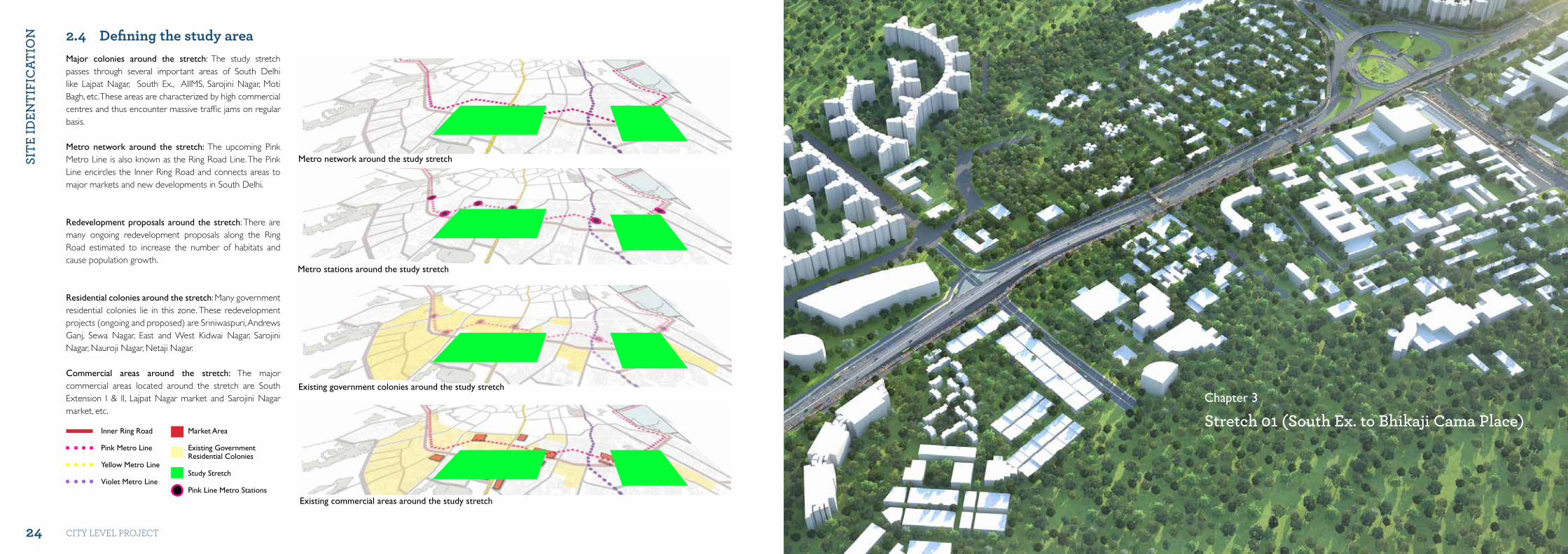
2.4 Defining the study area Major colonies around the stretch: The study stretch passes through several important areas of South Delhi like Lajpat Nagar, South Ex., AIIMS, Sarojini Nagar, Moti Bagh, etc. These areas are characterized by high commercial centres and thus encounter massive traffic jams on regular basis.
Metro network around the stretch: The upcoming Pink Metro Line is also known as the Ring Road Line. The Pink Line encircles the Inner Ring Road and connects areas to major markets and new developments in South Delhi.
Redevelopment proposals around the stretch: There are many ongoing redevelopment proposals along the Ring Road estimated to increase the number of habitats and cause population growth.
Residential colonies around the stretch: Many government residential colonies lie in this zone. These redevelopment projects (ongoing and proposed) are Sriniwaspuri, Andrews Ganj, Sewa Nagar, East and West Kidwai Nagar, Sarojini Nagar, Nauroji Nagar, Netaji Nagar.
Commercial areas around the stretch: The major commercial areas located around the stretch are South Extension I & II, Lajpat Nagar market and Sarojini Nagar market, etc.
Metro network around the study stretch
Metro stations around the study stretch
Existing government colonies around the study stretch
Existing commercial areas around the study stretch
Inner Ring Road
Pink Metro Line
Yellow Metro Line
Violet Metro Line
Market Area
Existing GovernmentResidential Colonies
Study Stretch
Pink Line Metro Stations
Stretch 01 (South Ex. to Bhikaji Cama Place)Chapter 3
26 27
StRE
tCh
01 (
Sou
th E
x. t
o B
hIk
ajI
Ca
ma
PLa
CE)
StRE
tCh
01 (
Sou
th E
x. t
o B
hIk
ajI
Ca
ma
PLa
CE)
city level project DeSiGN coNSiDerAtioNS For A SKyWAlK AloNG riNG roAD
1314
15
16
17
18
19
19
19Inner Ring Road
Landuse plan of stretch 0I
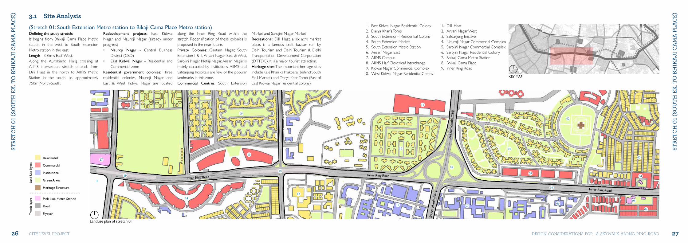
Defining the study stretch: It begins from Bhikaji Cama Place Metro station in the west to South Extension Metro station in the east.Length - 3.3kms East-West. Along the Aurobindo Marg crossing at AIIMS intersection, stretch extends from Dilli Haat in the north to AIIMS Metro Station in the south, i.e. approximately 750m North-South.
Redevelopment projects: East Kidwai Nagar and Nauroji Nagar (already under progress) • Nauroji Nagar - Central Business
District (CBD) • East Kidwai Nagar - Residential and
Commercial zoneResidential government colonies: Three residential colonies, Nauroji Nagar and East & West Kidwai Nagar are located
along the Inner Ring Road within the stretch. Redensification of these colonies is proposed in the near future. Private Colonies: Gautam Nagar, South Extension I & II, Ansari Nagar East & West, Sarojini Nagar, Netaji Nagar. Ansari Nagar is mainly occupied by institutions. AIIMS and Safdarjung hospitals are few of the popular landmarks in this zone.Commercial Centres: South Extension
Market and Sarojini Nagar Market Recreational: Dilli Haat, a six acre market place, is a famous craft bazaar run by Delhi Tourism and Delhi Tourism & Delhi Transportation Development Corporation (DTTDC). It is a major tourist attraction.Heritage sites: The important heritage sites include Kale Khan ka Makbara (behind South Ex. I. Market) and Darya Khan Tomb (East of East Kidwai Nagar residential colony).
3.1 Site Analysis
02
01
03
04
05
04
0607
08
09
10
11
12
1. East Kidwai Nagar Residential Colony2. Darya Khan’s Tomb3. South Extension-I Residential Colony4. South Extension Market5. South Extension Metro Station6. Ansari Nagar East7. AIIMS Campus8. AIIMS Half Cloverleaf Interchange9. Kidwai Nagar Commercial Complex
10. West Kidwai Nagar Residential Colony
11. Dilli Haat12. Ansari Nagar West 13. Safdarjung Enclave14. Nauroji Nagar Commercial Complex15. Sarojini Nagar Commercial Complex16. Sarojini Nagar Residential Colony17. Bhikaji Cama Metro Station18. Bhikaji Cama Place19. Inner Ring Road
KEY MAP
Inner Ring Road
Inner Ring Road
Sri A
urob
indo
Mar
g
Sri A
urob
indo
Mar
g
Residential
Commercial
Institutional
Green Areas
Heritage Structure
Pink Line Metro Station
Road
Flyover
Land
Use
laye
rsTr
ansi
t la
yers
(Stretch 01: South Extension Metro station to Bikaji Cama Place Metro station)
28 29
StRE
tCh
01 (
Sou
th E
x. t
o B
hIk
ajI
Ca
ma
PLa
CE)
StRE
tCh
01 (
Sou
th E
x. t
o B
hIk
ajI
Ca
ma
PLa
CE)
city level project DeSiGN coNSiDerAtioNS For A SKyWAlK AloNG riNG roAD
South Extension Market Dilli Haat - Craft Bazar
East Kidwai Nagar Residential Colony Safdarjung Hospital
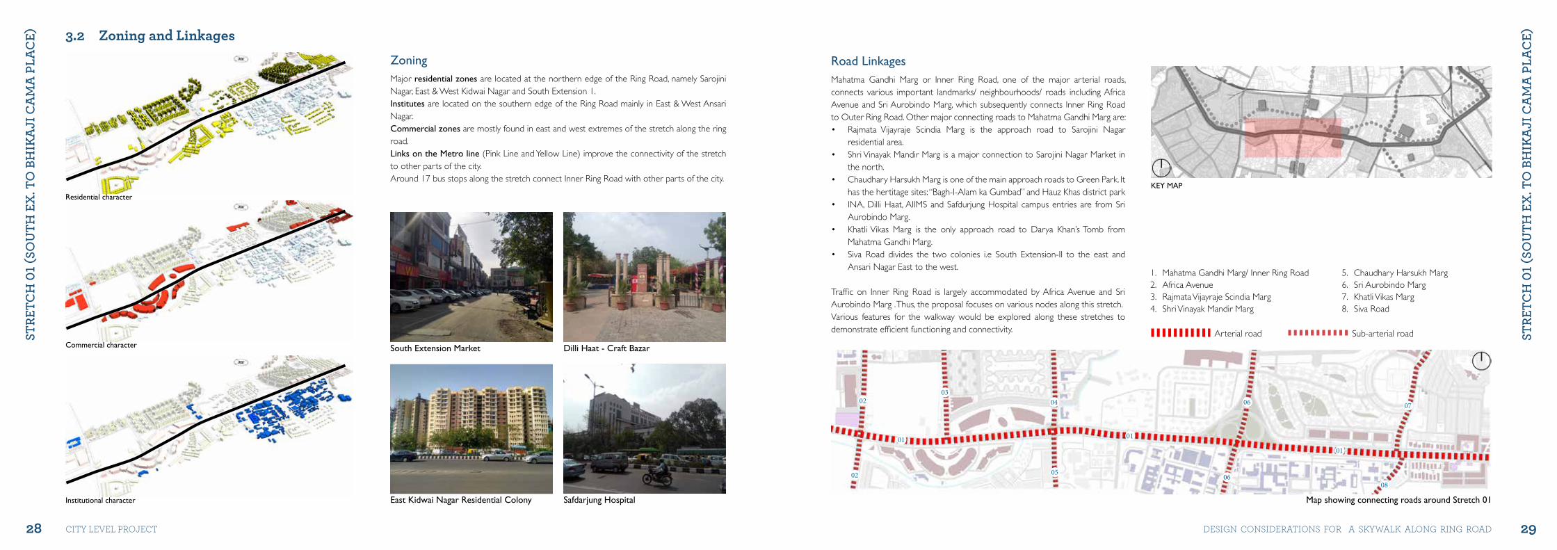
3.2 Zoning and Linkages ZoningMajor residential zones are located at the northern edge of the Ring Road, namely Sarojini Nagar, East & West Kidwai Nagar and South Extension 1.Institutes are located on the southern edge of the Ring Road mainly in East & West Ansari Nagar.Commercial zones are mostly found in east and west extremes of the stretch along the ring road.Links on the Metro line (Pink Line and Yellow Line) improve the connectivity of the stretch to other parts of the city. Around 17 bus stops along the stretch connect Inner Ring Road with other parts of the city.
Residential character
Commercial character
Institutional character
KEY MAP
02
02
0304
05
06
0608
07
01 01
01
1. Mahatma Gandhi Marg/ Inner Ring Road2. Africa Avenue3. Rajmata Vijayraje Scindia Marg4. Shri Vinayak Mandir Marg
5. Chaudhary Harsukh Marg6. Sri Aurobindo Marg7. Khatli Vikas Marg8. Siva Road
Arterial road Sub-arterial road
Road LinkagesMahatma Gandhi Marg or Inner Ring Road, one of the major arterial roads, connects various important landmarks/ neighbourhoods/ roads including Africa Avenue and Sri Aurobindo Marg, which subsequently connects Inner Ring Road to Outer Ring Road. Other major connecting roads to Mahatma Gandhi Marg are:• Rajmata Vijayraje Scindia Marg is the approach road to Sarojini Nagar
residential area.• Shri Vinayak Mandir Marg is a major connection to Sarojini Nagar Market in
the north.• Chaudhary Harsukh Marg is one of the main approach roads to Green Park. It
has the hertitage sites: “Bagh-I-Alam ka Gumbad” and Hauz Khas district park• INA, Dilli Haat, AIIMS and Safdurjung Hospital campus entries are from Sri
Aurobindo Marg.• Khatli Vikas Marg is the only approach road to Darya Khan’s Tomb from
Mahatma Gandhi Marg.• Siva Road divides the two colonies i.e South Extension-II to the east and
Ansari Nagar East to the west.
Traffic on Inner Ring Road is largely accommodated by Africa Avenue and Sri Aurobindo Marg . Thus, the proposal focuses on various nodes along this stretch.Various features for the walkway would be explored along these stretches to demonstrate efficient functioning and connectivity.
Map showing connecting roads around Stretch 01
30 31
StRE
tCh
01 (
Sou
th E
x. t
o B
hIk
ajI
Ca
ma
PLa
CE)
StRE
tCh
01 (
Sou
th E
x. t
o B
hIk
ajI
Ca
ma
PLa
CE)
city level project DeSiGN coNSiDerAtioNS For A SKyWAlK AloNG riNG roAD
KEY MAP
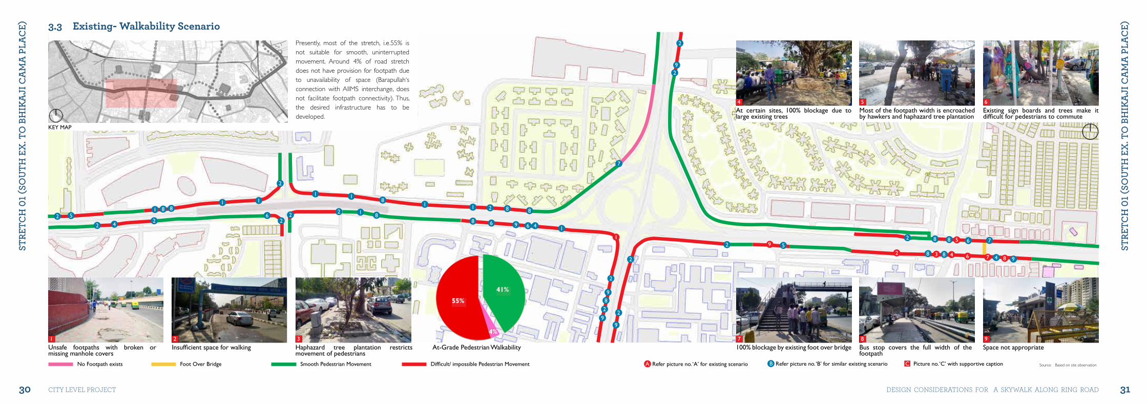
3.3 Existing- Walkability Scenario
Insufficient space for walkingUnsafe footpaths with broken or missing manhole covers
Smooth Pedestrian MovementFoot Over BridgeNo Footpath exists Difficult/ impossible Pedestrian Movement
Haphazard tree plantation restricts movement of pedestrians
31 2
9
9
88 8
8
76
75
4 4322
2
9 5682
7
1
1
1111
111
44
2
22
9
99
8
2
2
2
66
8
88
9 6
88
8
8
2
22
2 1
22
2 5
At-Grade Pedestrian Walkability
Presently, most of the stretch, i.e.55% is not suitable for smooth, uninterrupted movement. Around 4% of road stretch does not have provision for footpath due to unavailability of space (Barapullah‘s connection with AIIMS interchange, does not facilitate footpath connectivity). Thus, the desired infrastructure has to be developed.
100% blockage by existing foot over bridge Bus stop covers the full width of the footpath
Refer picture no. ‘A’ for existing scenario Refer picture no. ‘B’ for similar existing scenario Picture no. ‘C’ with supportive caption
Space not appropriate
Most of the footpath width is encroached by hawkers and haphazard tree plantation
At certain sites, 100% blockage due to large existing trees
Existing sign boards and trees make it difficult for pedestrians to commute
7 8
54
9
C
6
A B Source: Based on site observation
55%
41%
4%
32 33
StRE
tCh
01 (
Sou
th E
x. t
o B
hIk
ajI
Ca
ma
PLa
CE)
StRE
tCh
01 (
Sou
th E
x. t
o B
hIk
ajI
Ca
ma
PLa
CE)
city level project DeSiGN coNSiDerAtioNS For A SKyWAlK AloNG riNG roAD
KEY MAP
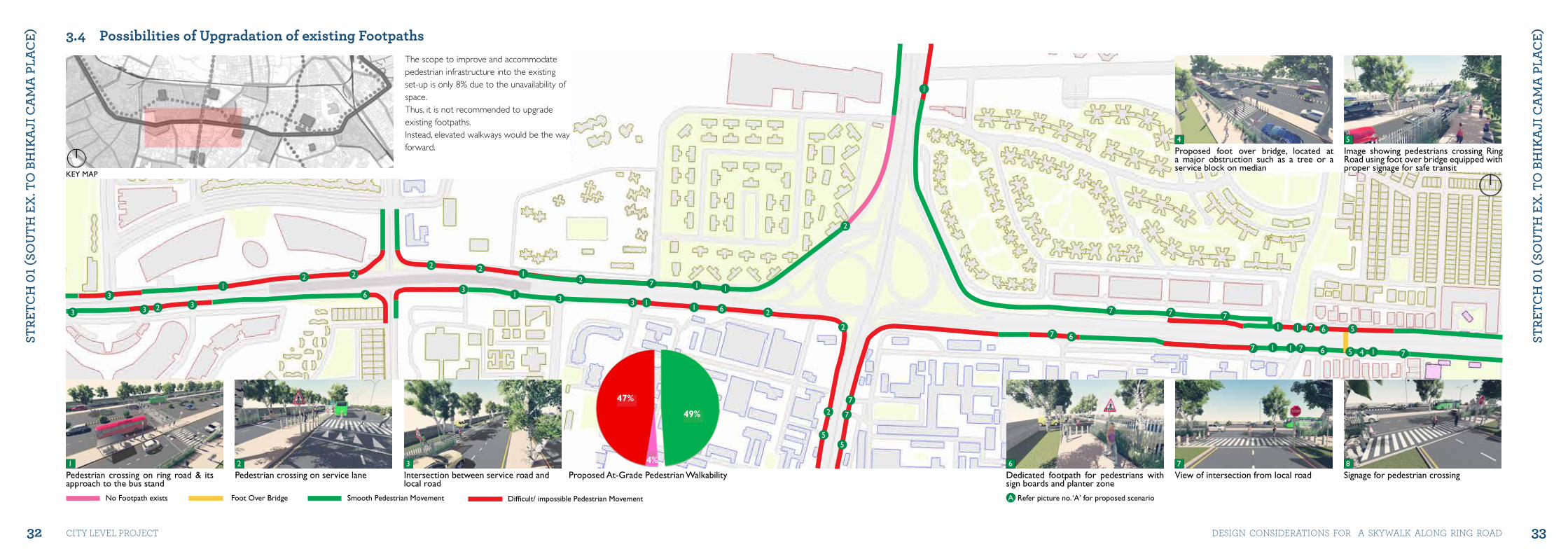
3.4 Possibilities of Upgradation of existing Footpaths
Pedestrian crossing on service lanePedestrian crossing on ring road & its approach to the bus stand
Smooth Pedestrian MovementFoot Over BridgeNo Footpath exists Difficult/ impossible Pedestrian Movement
Intersection between service road and local road
The scope to improve and accommodate pedestrian infrastructure into the existing set-up is only 8% due to the unavailability of space. Thus, it is not recommended to upgrade existing footpaths. Instead, elevated walkways would be the way forward.
31 2
11
1
56
5
7
7
4
7 661
2
2
2
2
222
22
2
7
7
55
61
1
1
1
1
1
6
1
13
3 3
7
3
3 33
1
7 7 7
77
Proposed At-Grade Pedestrian Walkability Dedicated footpath for pedestrians with sign boards and planter zone
View of intersection from local road
Refer picture no. ‘A’ for proposed scenario
Signage for pedestrian crossing
Proposed foot over bridge, located at a major obstruction such as a tree or a service block on median
Image showing pedestrians crossing Ring Road using foot over bridge equipped with proper signage for safe transit
6 7
4
8
5
A
47%
49%
4%
34 35
StRE
tCh
01 (
Sou
th E
x. t
o B
hIk
ajI
Ca
ma
PLa
CE)
StRE
tCh
01 (
Sou
th E
x. t
o B
hIk
ajI
Ca
ma
PLa
CE)
city level project DeSiGN coNSiDerAtioNS For A SKyWAlK AloNG riNG roAD
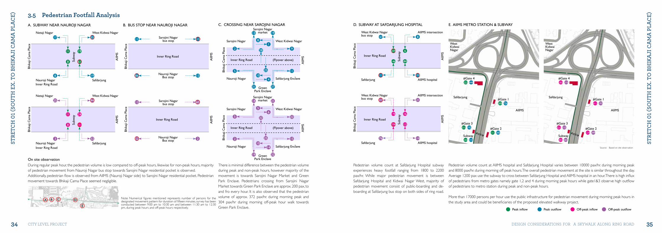
3.5 Pedestrian Footfall Analysis
Bhik
aji C
ama
Plac
eNetaji Nagar
Nauroji Nagar
West Kidwai Nagar
Safdarjung
AIIM
S
Subw
ay
17
8
55
19
11
8
19
61
Bhik
aji C
ama
Plac
e
West Kidwai Nagarbus stop
Safdarjung
AIIMS intersection
AIIMS hospital
AIIM
S
Subw
ay
167
111
8
133
259
146
6
44
During regular peak hour, the pedestrian volume is low compared to off-peak hours, likewise for non-peak hours, majority of pedestrian movement from Nauroji Nagar bus stop towards Sarojini Nagar residential pocket is observed.Additionally, pedestrian flow is observed from AIIMS (Nauroji Nagar side) to Sarojini Nagar residential pocket. Pedestrian movement towards Bhikaji Cama Place seemed negligible.
Pedestrian volume count at AIIMS hospital and Safdarjung Hospital varies between 10000 pax/hr. during morning peak and 8000 pax/hr. during morning off peak hours. The overall pedestrian movement at the site is similar throughout the day. Average 1200 pax use the subway to cross between Safdarjung Hospital and AIIMS hospital in an hour. There is high influx of pedestrians from metro gates namely gate 1,2 and 4 during morning peak hours while gate1&3 observe high outflow of pedestrians to metro station during peak and non-peak hours.
More than 17000 persons per hour use the public infrastructure for pedestrian movement during morning peak hours in the study area and could be beneficiaries of the proposed elevated walkway project.
There is minimal difference between the pedestrian volume during peak and non-peak hours, however majority of the movement is towards Sarojini Nagar Market and Green Park Enclave. Pedestrians crossing from Sarojini Nagar Market towards Green Park Enclave are approx. 200 pax, to and fro every hour. It is also observed that the pedestrian volume of approx. 372 pax/hr. during morning peak and 304 pax/hr during morning off-peak hour walk towards Green Park Enclave.
Pedestrian volume count at Safdarjung Hospital subway experiences heavy footfall ranging from 1800 to 2200 pax/hr. While major pedestrian movement is between Safdarjung Hospital and Kidwai Nagar West, majority of pedestrian movement consist of public-boarding and de-boarding at Safdarjung bus stop on both sides of ring road.
Note: Numerical figures mentioned represents number of persons for the designated movement pattern for duration of fifteen minutes, survey has been conducted between 9:00 am to 10:30 am and between 11:30 am to 12:30 pm, during peak hours and off-peak hours respectively. Off-peak outflowPeak outflow Off-peak inflowPeak inflow
A. SUBWAY NEAR NAUROjI NAGAR B. BUS STOP NEAR NAUROjI NAGAR C. CROSSING NEAR SAROjINI NAGAR E. AIIMS METRO STATION & SUBWAYD. SUBWAY AT SAFDARjUNG HOSPITALBh
ikaj
i Cam
a Pl
ace
Netaji Nagar
Nauroji Nagar
West Kidwai Nagar
Safdarjung
Subw
ay
25
3
94
32
11
8
24
111
AIIM
S
West Kidwai Nagarbus stop
Safdarjung
AIIMS intersection
AIIMS hospital
Bhik
aji C
ama
Plac
e
Subw
ay
337
76
21
118
178
236
16
122
AIIM
S
Inner Ring Road
Inner Ring Road
11 115
86 13
Inner Ring Road
Nauroji NagarBus stop
Sarojini Nagarbus stop
Bhik
aji C
ama
Plac
e
AIIM
S
13 60
52 2
Inner Ring Road
Bhik
aji C
ama
Plac
e
AIIM
S
Nauroji NagarBus stop
Sarojini Nagarbus stop
4
1
25
28
10
8
13
31
19
37
2
5
9
11Bhik
aji C
ama
Plac
e
AIIM
S
Sarojini Nagarmarket
GreenPark Enclave
Inner Ring Road
Sarojini Nagar
Nauroji Nagar
West Kidwai Nagar
Safdarjung Enclave
(Flyover above)
Sarojini Nagarmarket
14
6
25
10
5
14
19
21
5
2Bhik
aji C
ama
Plac
e
AIIM
S
GreenPark Enclave
Inner Ring Road
Sarojini Nagar
Nauroji Nagar
West Kidwai Nagar
Safdarjung Enclave
(Flyover above)
A B C
E
D
#Gate 4
Safdarjung Safdarjung
WestKidwaiNagar
WestKidwaiNagar
AIIMS AIIMS
#Gate 4
#Gate 1 #Gate 1
#Gate 2 #Gate 2
#Gate 3 #Gate 3
Subway Subway
444 216
726 192
300 399
192 153
310
222 183
309 411
111 129
315 321
234 303 303
32
32
15
22
Inner Ring Road
Inner Ring Road
Source: Based on site observation
On site observation
36 37
StRE
tCh
01 (
Sou
th E
x. t
o B
hIk
ajI
Ca
ma
PLa
CE)
StRE
tCh
01 (
Sou
th E
x. t
o B
hIk
ajI
Ca
ma
PLa
CE)
city level project DeSiGN coNSiDerAtioNS For A SKyWAlK AloNG riNG roAD
02
01
03
04
05
04
0607
08
09
10
11
12
1314
15
16
17
1919
18
Subway Connections
Pedestrian Flow
Foot Over Bridge
Bus Stop
Prime Nodes
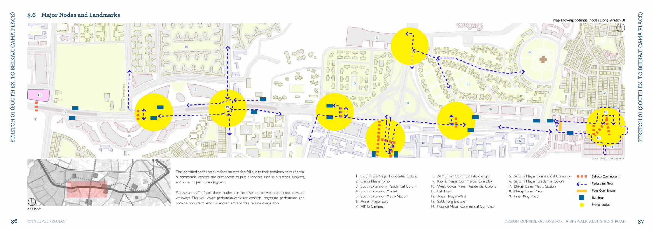
3.6 Major Nodes and Landmarks
The identified nodes account for a massive footfall due to their proximity to residential & commercial centres and easy access to public services such as bus stops, subways, entrances to public buildings, etc.
Pedestrian traffic from these nodes can be diverted to well connected elevated walkways. This will lower pedestrian-vehicular conflicts, segregate pedestrians and provide consistent vehicular movement and thus reduce congestion.
Map showing potential nodes along Stretch 01
KEY MAP
1. East Kidwai Nagar Residential Colony2. Darya Khan’s Tomb3. South Extension-I Residential Colony4. South Extension Market5. South Extension Metro Station6. Ansari Nagar East7. AIIMS Campus
8. AIIMS Half Cloverleaf Interchange9. Kidwai Nagar Commercial Complex
10. West Kidwai Nagar Residential Colony11. Dilli Haat12. Ansari Nagar West 13. Safdarjung Enclave14. Nauroji Nagar Commercial Complex
15. Sarojini Nagar Commercial Complex16. Sarojini Nagar Residential Colony17. Bhikaji Cama Metro Station18. Bhikaji Cama Place19. Inner Ring Road
Source: Based on site observation
38 39
StRE
tCh
01 (
Sou
th E
x. t
o B
hIk
ajI
Ca
ma
PLa
CE)
StRE
tCh
01 (
Sou
th E
x. t
o B
hIk
ajI
Ca
ma
PLa
CE)
city level project DeSiGN coNSiDerAtioNS For A SKyWAlK AloNG riNG roAD
Yellow Line Metro Station
Pink Line Metro Station
Yellow Metro Line
Pink Metro Line
Stretch Boundry
Elevated Walkway Phase-I
Elevated Walkway Phase-II
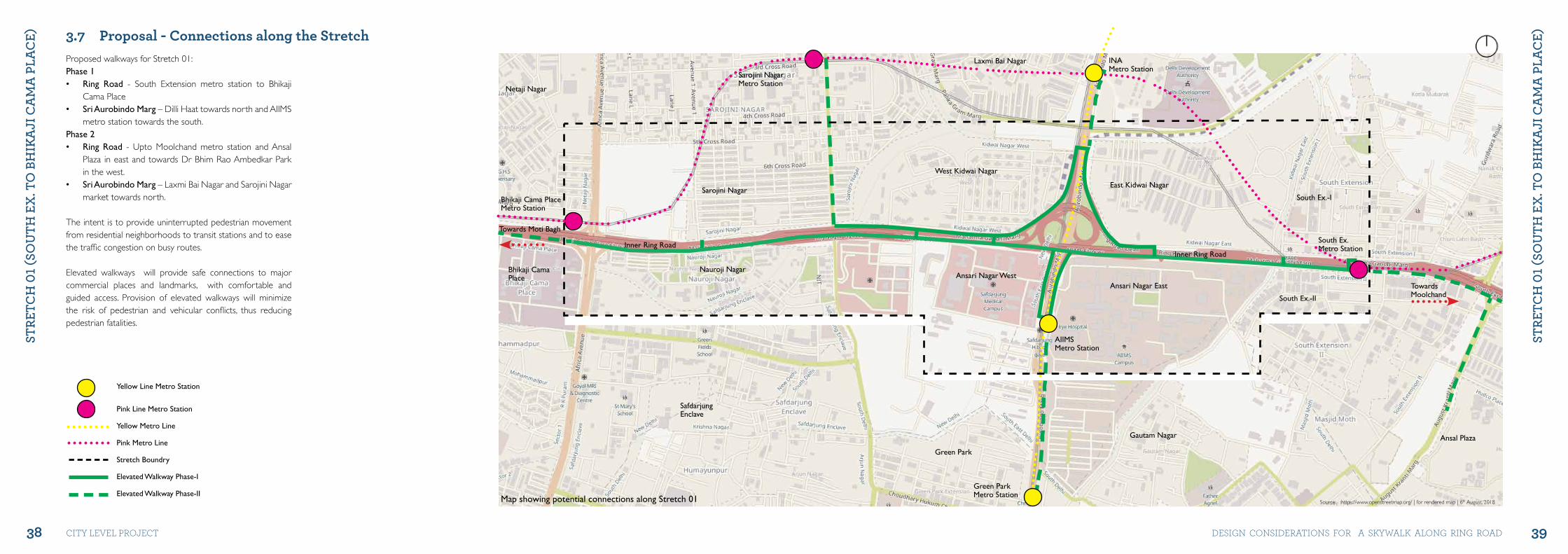
3.7 Proposal - Connections along the Stretch Proposed walkways for Stretch 01: Phase 1 • Ring Road - South Extension metro station to Bhikaji
Cama Place • Sri Aurobindo Marg – Dilli Haat towards north and AIIMS
metro station towards the south. Phase 2 • Ring Road - Upto Moolchand metro station and Ansal
Plaza in east and towards Dr Bhim Rao Ambedkar Park in the west.
• Sri Aurobindo Marg – Laxmi Bai Nagar and Sarojini Nagar market towards north.
The intent is to provide uninterrupted pedestrian movement from residential neighborhoods to transit stations and to ease the traffic congestion on busy routes.
Elevated walkways will provide safe connections to major commercial places and landmarks, with comfortable and guided access. Provision of elevated walkways will minimize the risk of pedestrian and vehicular conflicts, thus reducing pedestrian fatalities.
Map showing potential connections along Stretch 01 Source: https://www.openstreetmap.org/ | for rendered map | 6th August, 2018
Inner Ring Road
Ansari Nagar East
South Ex.Metro Station
West Kidwai Nagar
East Kidwai Nagar
South Ex.-I
South Ex.-II
Ansari Nagar WestNauroji Nagar
Inner Ring Road
SafdarjungEnclave
Sarojini Nagar
Laxmi Bai Nagar INAMetro Station
AIIMSMetro Station
Gautam Nagar
Netaji Nagar
Green Park
Green ParkMetro Station
Towards Moti Bagh
TowardsMoolchand
Ansal Plaza
Sarojini NagarMetro Station
Bhikaji Cama PlaceMetro Station
Bhikaji CamaPlace
40 41
StRE
tCh
01 (
Sou
th E
x. t
o B
hIk
ajI
Ca
ma
PLa
CE)
StRE
tCh
01 (
Sou
th E
x. t
o B
hIk
ajI
Ca
ma
PLa
CE)
city level project DeSiGN coNSiDerAtioNS For A SKyWAlK AloNG riNG roAD
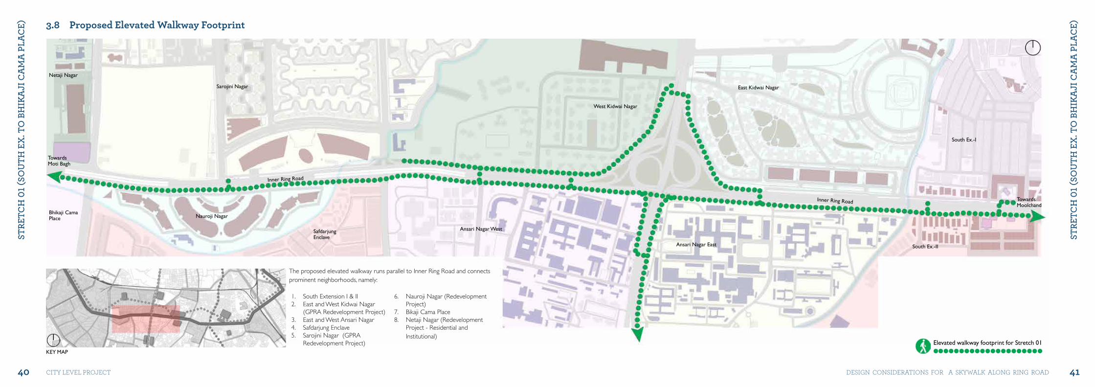
3.8 Proposed Elevated Walkway Footprint
Elevated walkway footprint for Stretch 01
West Kidwai Nagar
East Kidwai Nagar
South Ex.-I
South Ex.-IIAnsari Nagar East
Ansari Nagar West
Nauroji Nagar
Sarojini Nagar
TowardsMoti Bagh
TowardsMoolchand
Bhikaji CamaPlace
Netaji Nagar
SafdarjungEnclave
Inner Ring Road
Inner Ring Road
KEY MAP
1. South Extension I & II 2. East and West Kidwai Nagar
(GPRA Redevelopment Project)3. East and West Ansari Nagar 4. Safdarjung Enclave 5. Sarojini Nagar (GPRA
Redevelopment Project)
6. Nauroji Nagar (Redevelopment Project)
7. Bikaji Cama Place 8. Netaji Nagar (Redevelopment
Project - Residential and Institutional)
The proposed elevated walkway runs parallel to Inner Ring Road and connects prominent neighborhoods, namely:
42 43
StRE
tCh
01 (
Sou
th E
x. t
o B
hIk
ajI
Ca
ma
PLa
CE)
StRE
tCh
01 (
Sou
th E
x. t
o B
hIk
ajI
Ca
ma
PLa
CE)
city level project DeSiGN coNSiDerAtioNS For A SKyWAlK AloNG riNG roAD
02
02
03
04
05
06
06
01 01
08
07
01
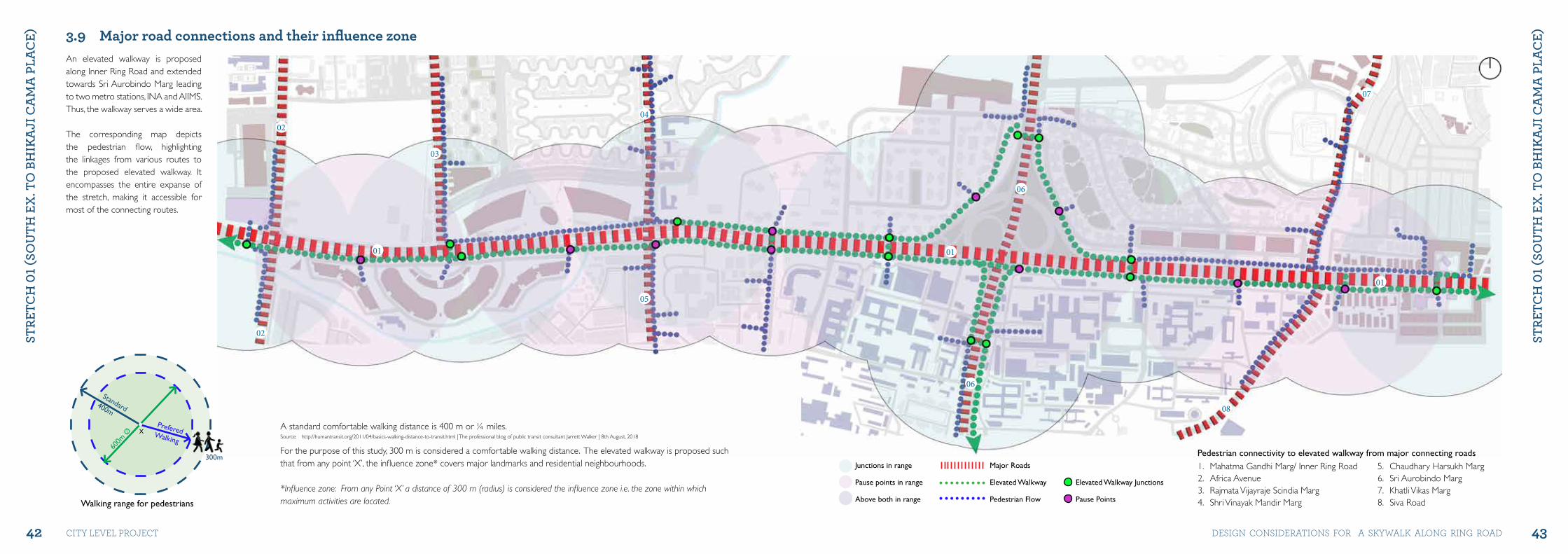
3.9 Major road connections and their influence zone
Major Roads
Elevated Walkway
Pedestrian Flow
Elevated Walkway junctions
Pause Points
junctions in range
Pause points in range
Above both in range
An elevated walkway is proposed along Inner Ring Road and extended towards Sri Aurobindo Marg leading to two metro stations, INA and AIIMS. Thus, the walkway serves a wide area.
The corresponding map depicts the pedestrian flow, highlighting the linkages from various routes to the proposed elevated walkway. It encompasses the entire expanse of the stretch, making it accessible for most of the connecting routes.
1. Mahatma Gandhi Marg/ Inner Ring Road2. Africa Avenue3. Rajmata Vijayraje Scindia Marg4. Shri Vinayak Mandir Marg
5. Chaudhary Harsukh Marg6. Sri Aurobindo Marg7. Khatli Vikas Marg8. Siva Road
Pedestrian connectivity to elevated walkway from major connecting roads
Walking range for pedestrians
600m
Ø
PreferedWalking
Standard400m
300m
XA standard comfortable walking distance is 400 m or ¼ miles. Source: http://humantransit.org/2011/04/basics-walking-distance-to-transit.html | The professional blog of public transit consultant Jarrett Walker | 8th August, 2018
For the purpose of this study, 300 m is considered a comfortable walking distance. The elevated walkway is proposed such that from any point ‘X’, the influence zone* covers major landmarks and residential neighbourhoods.
*Influence zone: From any Point ‘X’ a distance of 300 m (radius) is considered the influence zone i.e. the zone within which maximum activities are located.
44 45
StRE
tCh
01 (
Sou
th E
x. t
o B
hIk
ajI
Ca
ma
PLa
CE)
StRE
tCh
01 (
Sou
th E
x. t
o B
hIk
ajI
Ca
ma
PLa
CE)
city level project DeSiGN coNSiDerAtioNS For A SKyWAlK AloNG riNG roAD
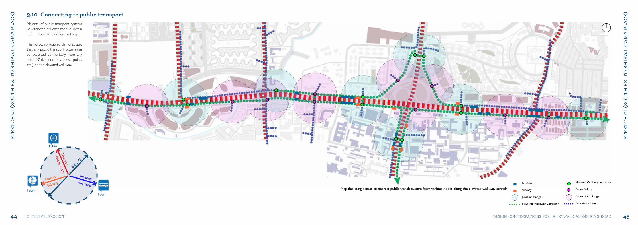
3.10 Connecting to public transport
300m
Ø
NearestBus stop
Nearest
Subway
Nearest
Metro Entry
150m150m
150m
Majority of public transport systems lie within the influence zone i.e. within 150 m from the elevated walkway.
The following graphic demonstrates that any public transport system can be accessed comfortably from any point ‘X’ (i.e. junctions, pause points etc.) on the elevated walkway.
Map depicting access to nearest public transit system from various nodes along the elevated walkway stretch
X
Bus Stop
Subway
junction Range
Elevated Walkway Corridor
Elevated Walkway junctions
Pause Points
Pause Point Range
Pedestrian Flow
46 47
StRE
tCh
01 (
Sou
th E
x. t
o B
hIk
ajI
Ca
ma
PLa
CE)
StRE
tCh
01 (
Sou
th E
x. t
o B
hIk
ajI
Ca
ma
PLa
CE)
city level project DeSiGN coNSiDerAtioNS For A SKyWAlK AloNG riNG roAD
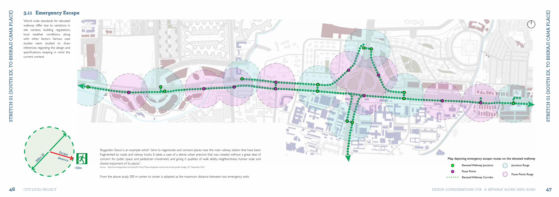
Skygarden, Seoul is an example which “aims to regenerate and connect places near the main railway station that have been fragmented by roads and railway tracks. It takes a case of a dense urban precinct that was created without a great deal of concern for public space and pedestrian movement, and giving it qualities of walk ability, neighborliness, human scale and shared enjoyment of its places”. Source: https://www.theguardian.com/cities/2017/may/19/seoul-skygarden-south-korea-london-garden-bridge | 25th September, 2018
From the above study, 300 m center to center is adopted as the maximum distance between two emergency exits
3.11 Emergency Escape
300m
ØEscape
distance
150m
World wide standards for elevated walkway differ due to variations in site context, building regulations, local weather conditions, along with other factors. Various case studies were studied to draw inferences regarding the design and specifications, keeping in mind the current context.
Elevated Walkway junctions
Pause Points
Elevated Walkway Corridor
junctions Range
Pause Points Range
Map depicting emergency escape routes on the elevated walkway
48 49
StRE
tCh
01 (
Sou
th E
x. t
o B
hIk
ajI
Ca
ma
PLa
CE)
StRE
tCh
01 (
Sou
th E
x. t
o B
hIk
ajI
Ca
ma
PLa
CE)
city level project DeSiGN coNSiDerAtioNS For A SKyWAlK AloNG riNG roAD
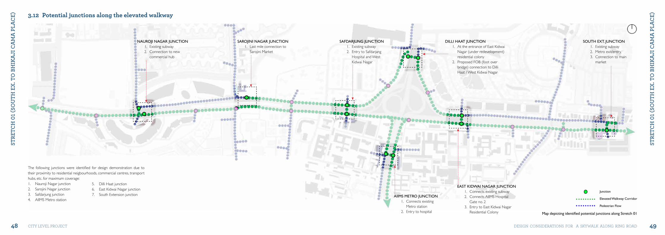
SAROjINI NAGAR jUNCTION1. Last mile connection to
Sarojini Market
NAUROjI NAGAR jUNCTION1. Existing subway2. Connection to new
commercial hub
The following junctions were identified for design demonstration due to their proximity to residential neigbourhoods, commercial centres, transport hubs, etc. for maximum coverage: 1. Nauroji Nagar junction 2. Sarojini Nagar junction3. Safdarjung junction 4. AIIMS Metro station
5. Dilli Haat junction 6. East Kidwai Nagar junction 7. South Extension junction
3.12 Potential junctions along the elevated walkway
SAFDARjUNG jUNCTION1. Existing subway2. Entry to Safdarjang
Hospital and West Kidwai Nagar
DILLI HAAT jUNCTION1. At the entrance of East Kidwai
Nagar (under redevelopment) residential colony
2. Proposed FOB (foot over bridge) connection to Dilli Haat / West Kidwai Nagar
SOUTH EXT. jUNCTION1. Existing subway2. Metro exit/entry3. Connection to main
market
EAST KIDWAI NAGAR jUNCTION1. Connects existing subway2. Connects AIIMS Hospital
Gate no. 23. Entry to East Kidwai Nagar
Residential Colony
AIIMS METRO jUNCTION1. Connects existing
Metro station2. Entry to hospital
junction
Elevated Walkway Corridor
Pedestrian Flow
Map depicting identified potential junctions along Stretch 01
50 51
StRE
tCh
01 (
Sou
th E
x. t
o B
hIk
ajI
Ca
ma
PLa
CE)
StRE
tCh
01 (
Sou
th E
x. t
o B
hIk
ajI
Ca
ma
PLa
CE)
city level project DeSiGN coNSiDerAtioNS For A SKyWAlK AloNG riNG roAD
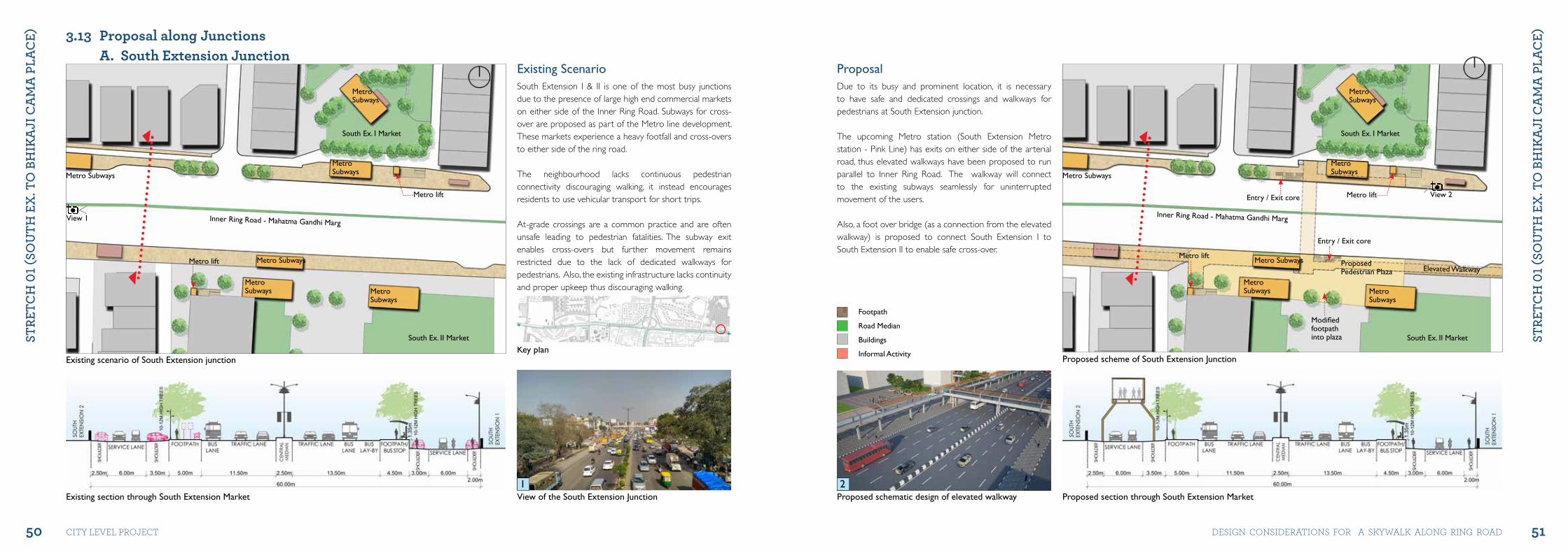
Existing ScenarioSouth Extension I & II is one of the most busy junctions due to the presence of large high end commercial markets on either side of the Inner Ring Road. Subways for cross-over are proposed as part of the Metro line development. These markets experience a heavy footfall and cross-overs to either side of the ring road.
The neighbourhood lacks continuous pedestrian connectivity discouraging walking, it instead encourages residents to use vehicular transport for short trips.
At-grade crossings are a common practice and are often unsafe leading to pedestrian fatalities. The subway exit enables cross-overs but further movement remains restricted due to the lack of dedicated walkways for pedestrians. Also, the existing infrastructure lacks continuity and proper upkeep thus discouraging walking.
A. South Extension Junction
Existing scenario of South Extension junction
Metro Subways
Metro lift
Metro lift
MetroSubways
MetroSubways
Metro Subways
MetroSubways
MetroSubways
South Ex. I Market
South Ex. II Market
Inner Ring Road - Mahatma Gandhi Marg
View of the South Extension junctionExisting section through South Extension Market
View 1
1
3.13 Proposal along Junctions
ProposalDue to its busy and prominent location, it is necessary to have safe and dedicated crossings and walkways for pedestrians at South Extension junction.
The upcoming Metro station (South Extension Metro station - Pink Line) has exits on either side of the arterial road, thus elevated walkways have been proposed to run parallel to Inner Ring Road. The walkway will connect to the existing subways seamlessly for uninterrupted movement of the users.
Also, a foot over bridge (as a connection from the elevated walkway) is proposed to connect South Extension I to South Extension II to enable safe cross-over.
Proposed scheme of South Extension junction
Metro Subways
Metro lift
Metro lift
Elevated Walkway
Entry / Exit core
Entry / Exit core
Modifiedfootpathinto plaza
MetroSubways
MetroSubways
Metro Subways ProposedPedestrian Plaza
MetroSubways
MetroSubways
South Ex. I Market
South Ex. II Market
Inner Ring Road - Mahatma Gandhi Marg
Proposed section through South Extension Market Proposed schematic design of elevated walkway 2
Footpath
Road Median
Buildings
Informal Activity
View 2
Key plan
52 53
StRE
tCh
01 (
Sou
th E
x. t
o B
hIk
ajI
Ca
ma
PLa
CE)
StRE
tCh
01 (
Sou
th E
x. t
o B
hIk
ajI
Ca
ma
PLa
CE)
city level project DeSiGN coNSiDerAtioNS For A SKyWAlK AloNG riNG roAD
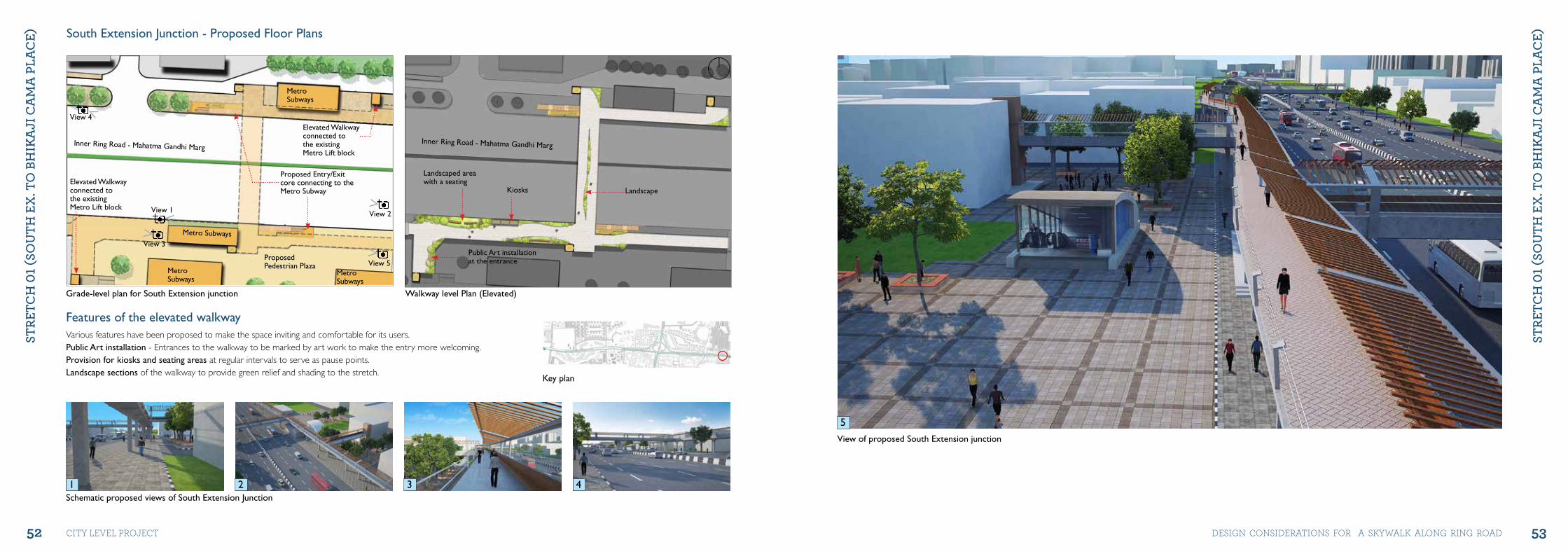
Grade-level plan for South Extension junction Walkway level Plan (Elevated)
Schematic proposed views of South Extension junction
Elevated Walkwayconnected tothe existingMetro Lift block
Landscaped areawith a seating
Public Art installationat the entrance
Kiosks LandscapeElevated Walkwayconnected tothe existingMetro Lift block
Proposed Entry/Exitcore connecting to the Metro Subway
Inner Ring Road - Mahatma Gandhi MargInner Ring Road - Mahatma Gandhi Marg
MetroSubways
MetroSubways
MetroSubways
Metro Subways
ProposedPedestrian Plaza
South Extension junction - Proposed Floor Plans
Key plan
View 2
View 5
View 3
View 1
View 4
Features of the elevated walkwayVarious features have been proposed to make the space inviting and comfortable for its users. Public Art installation - Entrances to the walkway to be marked by art work to make the entry more welcoming. Provision for kiosks and seating areas at regular intervals to serve as pause points. Landscape sections of the walkway to provide green relief and shading to the stretch.
View of proposed South Extension junction
1 32 4
5
54 55
StRE
tCh
01 (
Sou
th E
x. t
o B
hIk
ajI
Ca
ma
PLa
CE)
StRE
tCh
01 (
Sou
th E
x. t
o B
hIk
ajI
Ca
ma
PLa
CE)
city level project DeSiGN coNSiDerAtioNS For A SKyWAlK AloNG riNG roAD
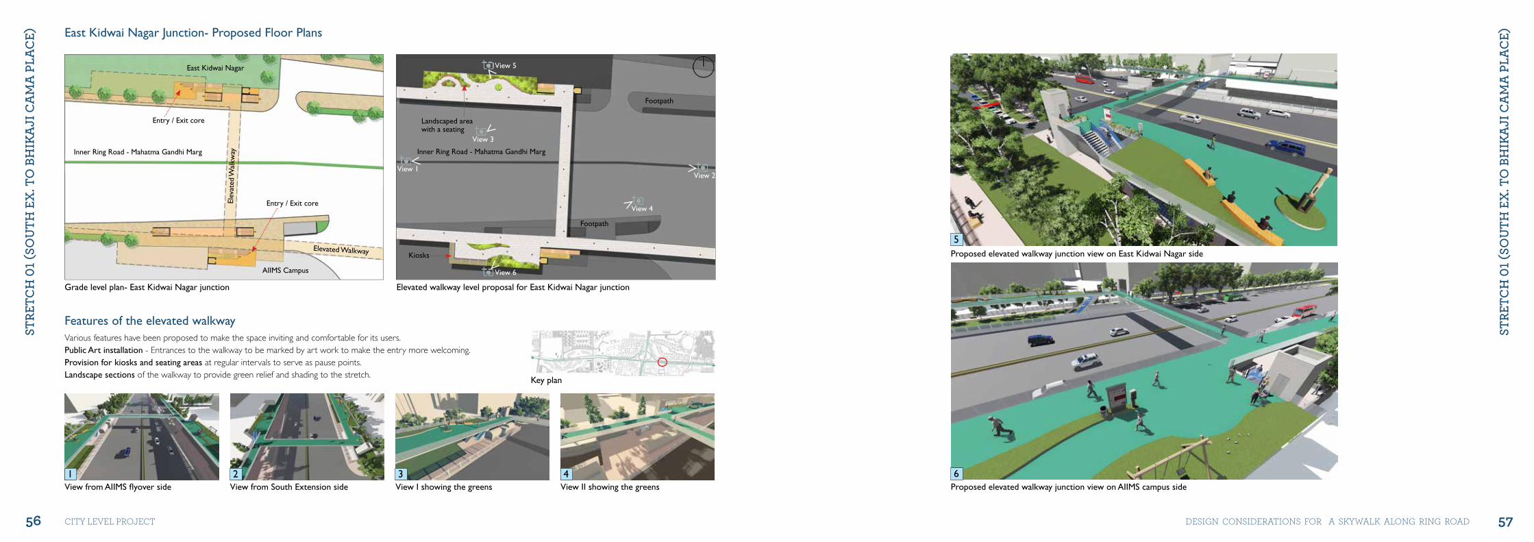
B. East Kidwai Nagar Junction
Existing scenario of East Kidwai Nagar junction
Existing green belt in front of East Kidwai Nagar
East Kidwai Nagar
AIIMS Campus AIIMS Campus
Subway Public Toilet
Flyover
AIIMS OPDCanteen
East Kidwai NagarCommercial Complex
Inner Ring Road - Mahatma Gandhi Marg
Existing section through subway near East Kidwai Nagar on Inner Ring Road
View 1Subway
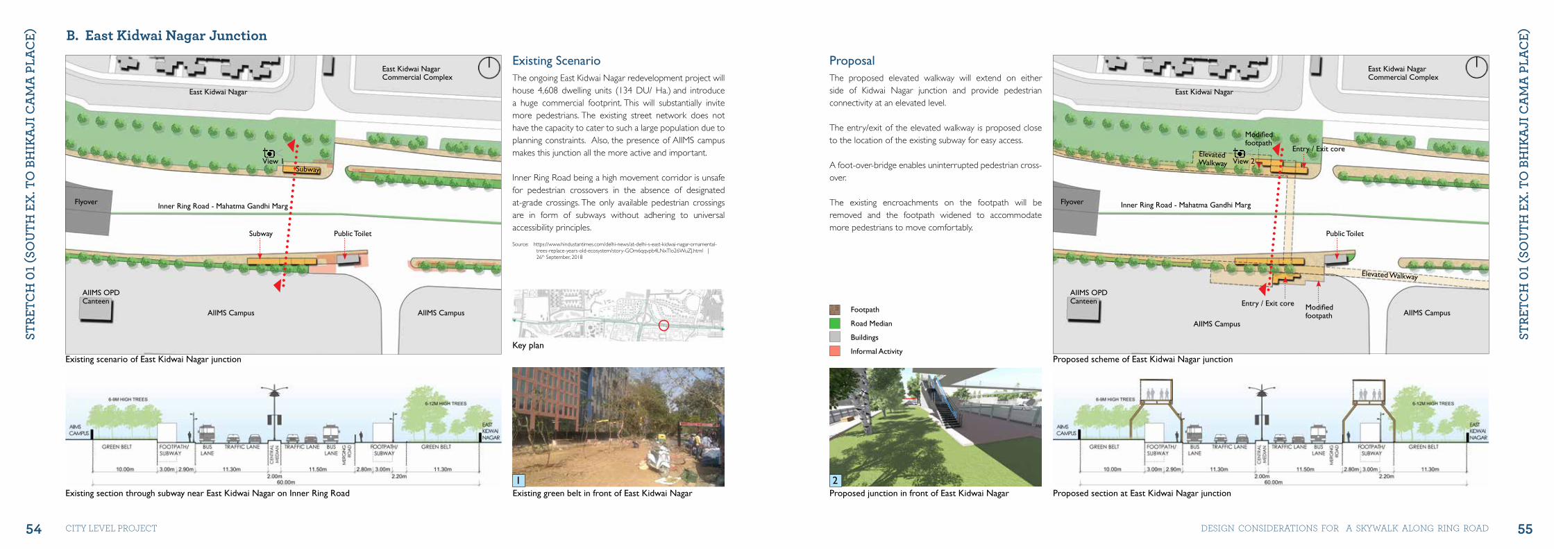
Existing ScenarioThe ongoing East Kidwai Nagar redevelopment project will house 4,608 dwelling units (134 DU/ Ha.) and introduce a huge commercial footprint. This will substantially invite more pedestrians. The existing street network does not have the capacity to cater to such a large population due to planning constraints. Also, the presence of AIIMS campus makes this junction all the more active and important.
Inner Ring Road being a high movement corridor is unsafe for pedestrian crossovers in the absence of designated at-grade crossings. The only available pedestrian crossings are in form of subways without adhering to universal accessibility principles.
Source: https://www.hindustantimes.com/delhi-news/at-delhi-s-east-kidwai-nagar-ornamental-trees-replace-years-old-ecosystem/story-GOm6qqvpb4LNxTlo26WuZJ.html | 26th September, 2018
Proposed scheme of East Kidwai Nagar junction
Proposed junction in front of East Kidwai Nagar
East Kidwai Nagar
AIIMS CampusAIIMS Campus
Public Toilet
Flyover
ElevatedWalkway
Elevated Walkway
AIIMS OPDCanteen
East Kidwai NagarCommercial Complex
Inner Ring Road - Mahatma Gandhi Marg
Entry / Exit core
Entry / Exit core Modifiedfootpath
Modifiedfootpath
Proposed section at East Kidwai Nagar junction
View 2
ProposalThe proposed elevated walkway will extend on either side of Kidwai Nagar junction and provide pedestrian connectivity at an elevated level.
The entry/exit of the elevated walkway is proposed close to the location of the existing subway for easy access.
A foot-over-bridge enables uninterrupted pedestrian cross-over.
The existing encroachments on the footpath will be removed and the footpath widened to accommodate more pedestrians to move comfortably.
1 2
Key plan
Footpath
Road Median
Buildings
Informal Activity
56 57
StRE
tCh
01 (
Sou
th E
x. t
o B
hIk
ajI
Ca
ma
PLa
CE)
StRE
tCh
01 (
Sou
th E
x. t
o B
hIk
ajI
Ca
ma
PLa
CE)
city level project DeSiGN coNSiDerAtioNS For A SKyWAlK AloNG riNG roAD
Grade level plan- East Kidwai Nagar junction Elevated walkway level proposal for East Kidwai Nagar junction
View from AIIMS flyover side View from South Extension side
East Kidwai Nagar
AIIMS Campus
Elev
ated
Wal
kway
Elevated Walkway
Inner Ring Road - Mahatma Gandhi Marg Inner Ring Road - Mahatma Gandhi Marg
Entry / Exit core
Entry / Exit core Landscaped areawith a seating
Kiosks
Footpath
Footpath
View 5
View 6
View 2
View 4
View 1
View 3
East Kidwai Nagar junction- Proposed Floor Plans
Key plan
Features of the elevated walkwayVarious features have been proposed to make the space inviting and comfortable for its users. Public Art installation - Entrances to the walkway to be marked by art work to make the entry more welcoming. Provision for kiosks and seating areas at regular intervals to serve as pause points. Landscape sections of the walkway to provide green relief and shading to the stretch.
Proposed elevated walkway junction view on East Kidwai Nagar side
Proposed elevated walkway junction view on AIIMS campus side
5
61 32 4View I showing the greens View II showing the greens
58 59
StRE
tCh
01 (
Sou
th E
x. t
o B
hIk
ajI
Ca
ma
PLa
CE)
StRE
tCh
01 (
Sou
th E
x. t
o B
hIk
ajI
Ca
ma
PLa
CE)
city level project DeSiGN coNSiDerAtioNS For A SKyWAlK AloNG riNG roAD
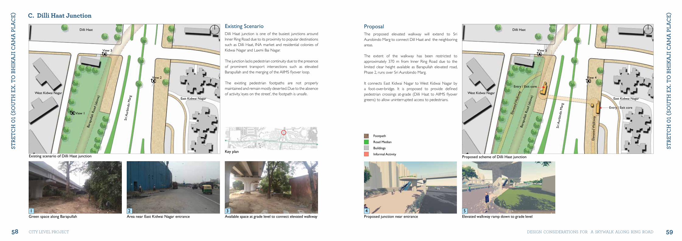
C. Dilli Haat Junction
Existing scenario of Dilli Haat junctionKey plan
East Kidwai Nagar
West Kidwai Nagar
Dilli Haat
Sri A
urbi
ndo
Mar
g
Bara
pulla
h Ro
ad (a
bove
)
Green space along Barapullah Area near East Kidwai Nagar entrance
View 1
View 2
View 3
Existing ScenarioDilli Haat junction is one of the busiest junctions around Inner Ring Road due to its proximity to popular destinations such as Dilli Haat, INA market and residential colonies of Kidwai Nagar and Laxmi Bai Nagar.
The junction lacks pedestrian continuity due to the presence of prominent transport intersections such as elevated Barapullah and the merging of the AIIMS flyover loop.
The existing pedestrian footpaths are not properly maintained and remain mostly deserted. Due to the absence of activity, ‘eyes on the street’, the footpath is unsafe.
Proposed scheme of Dilli Haat junction
East Kidwai Nagar
West Kidwai Nagar
Dilli Haat
Sri A
urbi
ndo
Mar
g
Bara
pulla
h Ro
ad (a
bove
)
Elev
ated
Wal
kway
Elev
ated
Wal
kway
Entry / Exit core
Entry / Exit core
Proposed junction near entrance Elevated walkway ramp down to grade level
View 4
View 5
ProposalThe proposed elevated walkway will extend to Sri Aurobindo Marg to connect Dill Haat and the neighboring areas.
The extent of the walkway has been restricted to approximately 370 m from Inner Ring Road due to the limited clear height available as Barapullah elevated road, Phase 2, runs over Sri Aurobindo Marg.
It connects East Kidwai Nagar to West Kidwai Nagar by a foot-over-bridge. It is proposed to provide defined pedestrian crossings at-grade (Dilli Haat to AIIMS flyover greens) to allow uninterrupted access to pedestrians.
1 2 4 5Available space at grade level to connect elevated walkway3
Footpath
Road Median
Buildings
Informal Activity
60 61
StRE
tCh
01 (
Sou
th E
x. t
o B
hIk
ajI
Ca
ma
PLa
CE)
StRE
tCh
01 (
Sou
th E
x. t
o B
hIk
ajI
Ca
ma
PLa
CE)
city level project DeSiGN coNSiDerAtioNS For A SKyWAlK AloNG riNG roAD
Grade level plan for Dilli Haat junction Elevated walkway level plan for Dilli Haat junction
Dilli Haat junction- Proposed Floor Plans
East KidwaiNagar
East KidwaiNagar
West KidwaiNagar
West KidwaiNagar
Sri A
urbi
ndo
Mar
g
Sri A
urbi
ndo
Mar
g
Bara
pulla
h Ro
ad (a
bove
)
Bara
pulla
h Ro
ad (a
bove
)
Elevated walkway
Entry / Exit core
Entry / Exitcore
Landscaped areawith a seating
Footpath
Footpath
Landscaped areawith a seating
View 7
View 5
View 8
View 6
View 1View 2
View 3
View 4
Sketches of the proposal (I)
Key plan
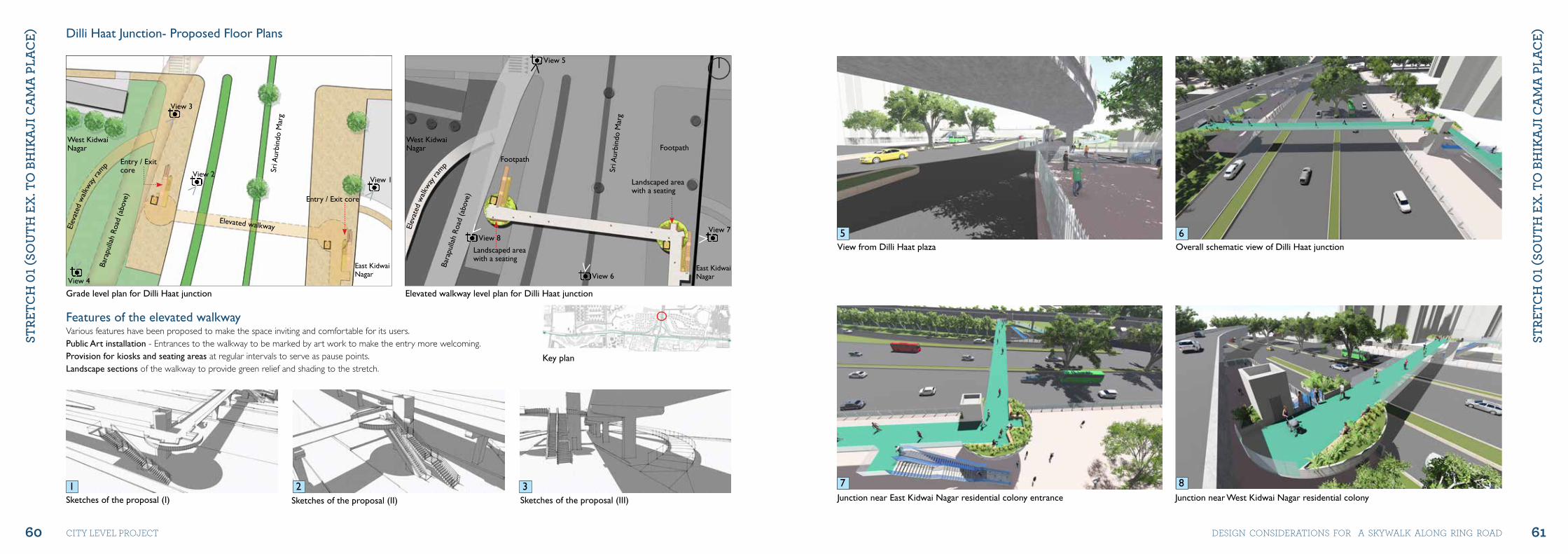
Features of the elevated walkwayVarious features have been proposed to make the space inviting and comfortable for its users. Public Art installation - Entrances to the walkway to be marked by art work to make the entry more welcoming. Provision for kiosks and seating areas at regular intervals to serve as pause points. Landscape sections of the walkway to provide green relief and shading to the stretch.
Elev
ated
walk
way
ramp
Elev
ated
walk
way
ramp
junction near East Kidwai Nagar residential colony entrance
View from Dilli Haat plaza Overall schematic view of Dilli Haat junction
junction near West Kidwai Nagar residential colony
5 6
7 81 32Sketches of the proposal (II) Sketches of the proposal (III)
62 63
StRE
tCh
01 (
Sou
th E
x. t
o B
hIk
ajI
Ca
ma
PLa
CE)
StRE
tCh
01 (
Sou
th E
x. t
o B
hIk
ajI
Ca
ma
PLa
CE)
city level project DeSiGN coNSiDerAtioNS For A SKyWAlK AloNG riNG roAD
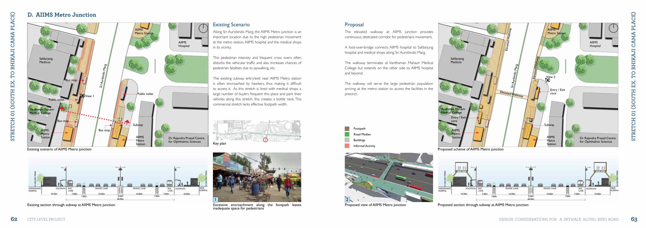
D. AIIMS Metro Junction
Existing scenario of AIIMS Metro junction
Key plan
Bus stop
Bus stop
Bus stop
Public toilet
Public toilet
Subway
AIIMSMetroStation
Dr. Rajendra Prasad Centrefor Ophthalmic Sciences
Vardhman MahavirMedical College
Safdarjang Medicos
AIIMSMetro Station
AIIMSHospital
AIIMSMetroStation
Sri A
urbi
ndo
Mar
g
Existing section through subway at AIIMS Metro junction Excessive encroachment along the footpath leaves inadequate space for pedestrians
View 1
Existing ScenarioAlong Sri Aurobindo Marg, the AIIMS Metro junction is an important location due to the high pedestrian movement at the metro station, AIIMS hospital and the medical shops in its vicinity.
This pedestrian intensity and frequent cross overs often disturbs the vehicular traffic and also increases chances of pedestrian fatalities due to jaywalking, etc.
The existing subway entry/exit near AIIMS Metro station is often encroached by hawkers, thus making it difficult to access it. As this stretch is lined with medical shops, a large number of buyers frequent this place and park their vehicles along this stretch, this creates a bottle neck. This commercial stretch lacks effective footpath width.
Proposed scheme of AIIMS Metro junction
Subway
Dr. Rajendra Prasad Centrefor Ophthalmic Sciences
Vardhman MahavirMedical College
Safdarjang Medicos
AIIMSMetro Station
AIIMSHospital
Sri A
urbi
ndo
Mar
g
Entry / Exitcore
Entry / Exitcore
Elev
ated
Wal
kway
Elev
ated
Wal
kway
Elevated Walkway
Proposed section through subway at AIIMS Metro junctionProposed view of AIIMS Metro junction
View 2
ProposalThe elevated walkway at AIIMS junction provides continuous, dedicated corridor for pedestrians movement.
A foot-over-bridge connects AIIMS hospital to Safdarjung hospital and medical shops along Sri Aurobindo Marg.
The walkway terminates at Vardhaman Mahavir Medical College but extends on the other side to AIIMS hospital and beyond.
The walkway will serve the large pedestrian population arriving at the metro station to access the facilities in the precinct.
1 2
AIIMSMetroStation
AIIMSMetroStation
Footpath
Road Median
Buildings
Informal Activity
64 65
StRE
tCh
01 (
Sou
th E
x. t
o B
hIk
ajI
Ca
ma
PLa
CE)
StRE
tCh
01 (
Sou
th E
x. t
o B
hIk
ajI
Ca
ma
PLa
CE)
city level project DeSiGN coNSiDerAtioNS For A SKyWAlK AloNG riNG roAD
Grade level plan for the AIIMS Metro junction Elevated walkway level plan for the AIIMS Metro junction
AIIMS Metro junction- Proposed Floor Plans
Subway
Sri A
urbi
ndo
Mar
g
Entry / Exitcore
Entry / Exitcore
Elevated WalkwayEl
evat
ed W
alkw
ay
Elev
ated
Wal
kway
Bus stop
Bus stop
Bus
stop
Public toilet
Public toilet
Safdarjang Medicos
Sri A
urbi
ndo
Mar
g
Landscaped areawith a seating
Landscaped areawith a seating
Kiosks
Kiosks
Kiosks
FootpathView 3View 2View 1
Proposed schematic view of AIIMS Metro junctionSafdarjung Hospital side junction AIIMS junction from central median
Key plan
Features at Elevated Walkway level
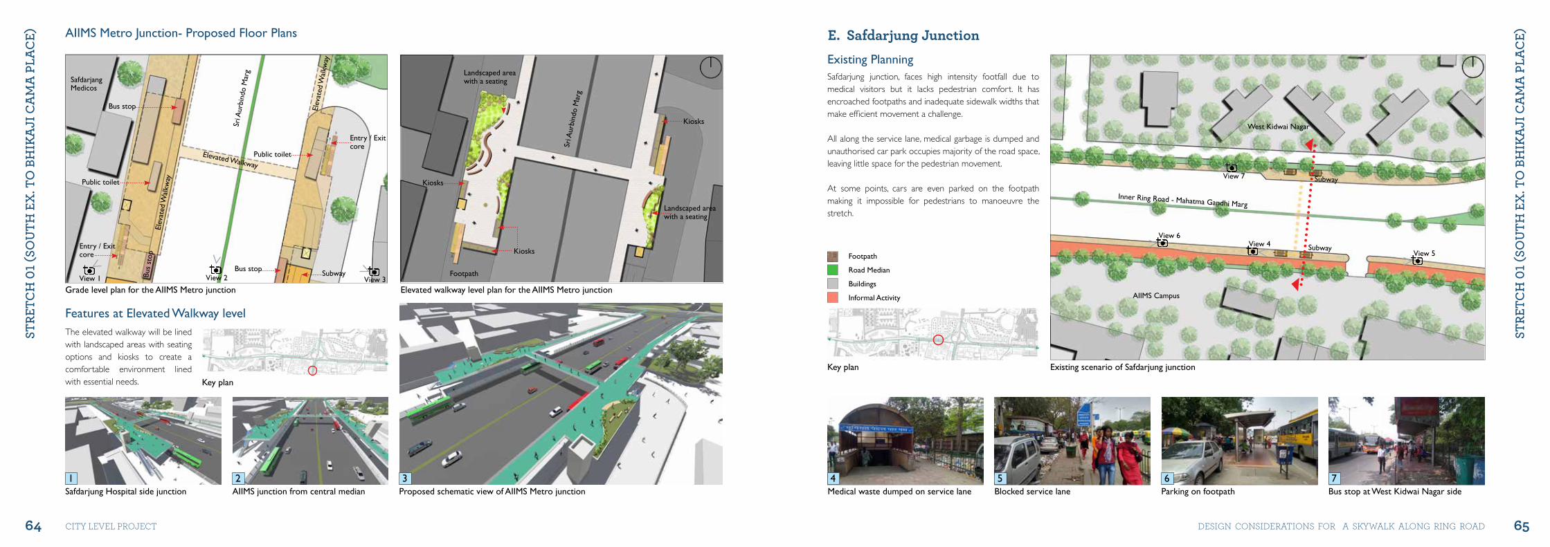
E. Safdarjung Junction
Medical waste dumped on service lane Blocked service lane Parking on footpath Bus stop at West Kidwai Nagar side
Existing scenario of Safdarjung junctionKey plan
West Kidwai Nagar
AIIMS Campus
Subway
Subway
Inner Ring Road - Mahatma Gandhi Marg
View 6
View 5View 4
View 7
Existing PlanningSafdarjung junction, faces high intensity footfall due to medical visitors but it lacks pedestrian comfort. It has encroached footpaths and inadequate sidewalk widths that make efficient movement a challenge.
All along the service lane, medical garbage is dumped and unauthorised car park occupies majority of the road space, leaving little space for the pedestrian movement.
At some points, cars are even parked on the footpath making it impossible for pedestrians to manoeuvre the stretch.
4 5 6 71 32
The elevated walkway will be lined with landscaped areas with seating options and kiosks to create a comfortable environment lined with essential needs.
Footpath
Road Median
Buildings
Informal Activity
66 67
StRE
tCh
01 (
Sou
th E
x. t
o B
hIk
ajI
Ca
ma
PLa
CE)
StRE
tCh
01 (
Sou
th E
x. t
o B
hIk
ajI
Ca
ma
PLa
CE)
city level project DeSiGN coNSiDerAtioNS For A SKyWAlK AloNG riNG roAD
Proposed scheme at Safdarjung junction
West Kidwai Nagar
AIIMS Campus
Inner Ring Road - Mahatma Gandhi Marg
Elevated Walkway
Elevated Walkway
Elev
ated
Wal
kway
Entry / Exitcore
Entry / Exitcore
Existing section at Safdarjung junction Proposed view II of Safdarjung junction
View 1
View 2
View 3 Key plan
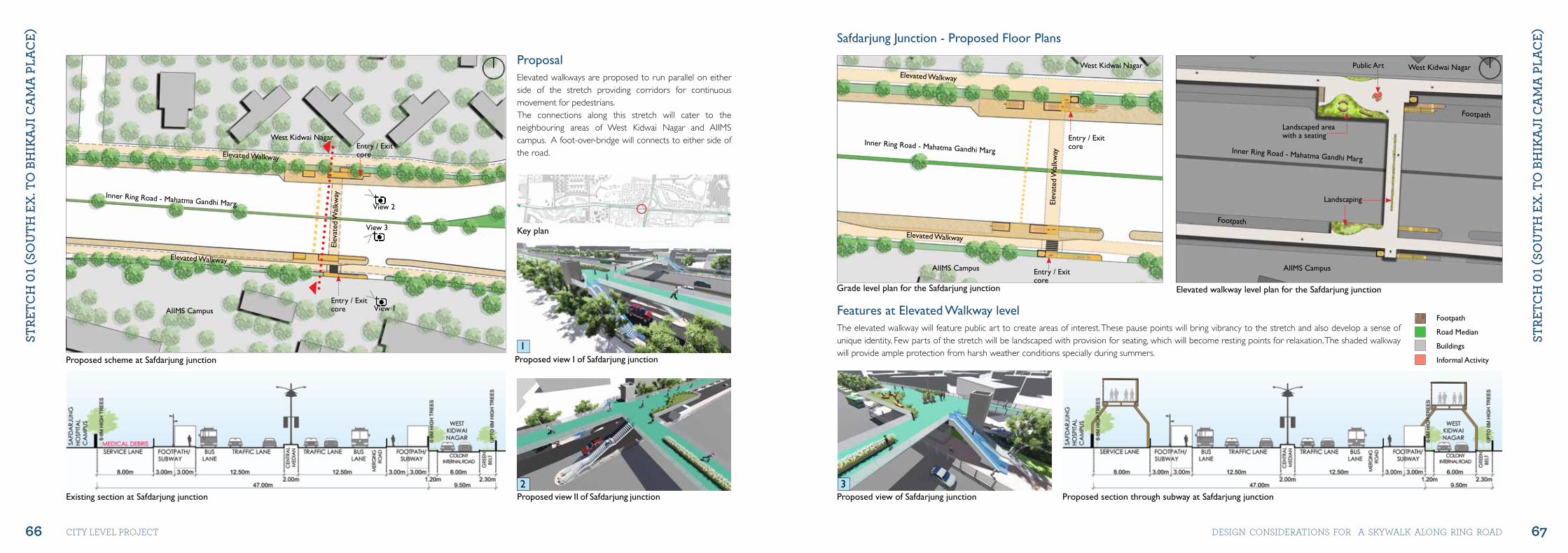
ProposalElevated walkways are proposed to run parallel on either side of the stretch providing corridors for continuous movement for pedestrians. The connections along this stretch will cater to the neighbouring areas of West Kidwai Nagar and AIIMS campus. A foot-over-bridge will connects to either side of the road.
Grade level plan for the Safdarjung junction Elevated walkway level plan for the Safdarjung junction
Safdarjung junction - Proposed Floor Plans
West Kidwai Nagar West Kidwai Nagar
AIIMS Campus AIIMS Campus
Inner Ring Road - Mahatma Gandhi Marg Inner Ring Road - Mahatma Gandhi Marg
Elevated Walkway
Elevated Walkway
Footpath
Footpath
Elev
ated
Wal
kway
Entry / Exitcore
Entry / Exitcore
Landscaped areawith a seating
Public Art
Landscaping
Proposed section through subway at Safdarjung junctionProposed view of Safdarjung junction
Features at Elevated Walkway levelThe elevated walkway will feature public art to create areas of interest. These pause points will bring vibrancy to the stretch and also develop a sense of unique identity. Few parts of the stretch will be landscaped with provision for seating, which will become resting points for relaxation. The shaded walkway will provide ample protection from harsh weather conditions specially during summers.
1
32
Footpath
Road Median
Buildings
Informal ActivityProposed view I of Safdarjung junction
68 69
StRE
tCh
01 (
Sou
th E
x. t
o B
hIk
ajI
Ca
ma
PLa
CE)
StRE
tCh
01 (
Sou
th E
x. t
o B
hIk
ajI
Ca
ma
PLa
CE)
city level project DeSiGN coNSiDerAtioNS For A SKyWAlK AloNG riNG roAD
Inner Ring Road - Mahatma Gandhi Marg
F. Sarojini Nagar Junction
Existing scenario at Sarojini Nagar junction Key plan
Assistant EngineerSub Division 6 Office Dharmshala
Hospital
Shri
Vin
ayak
Man
dir
Mar
g
AIIMS Trauma Center Campus
Flyover
Existing cross section through flyover near Sarojini Nagar junction Proposed site for Sarojini Nagar junction
View 1
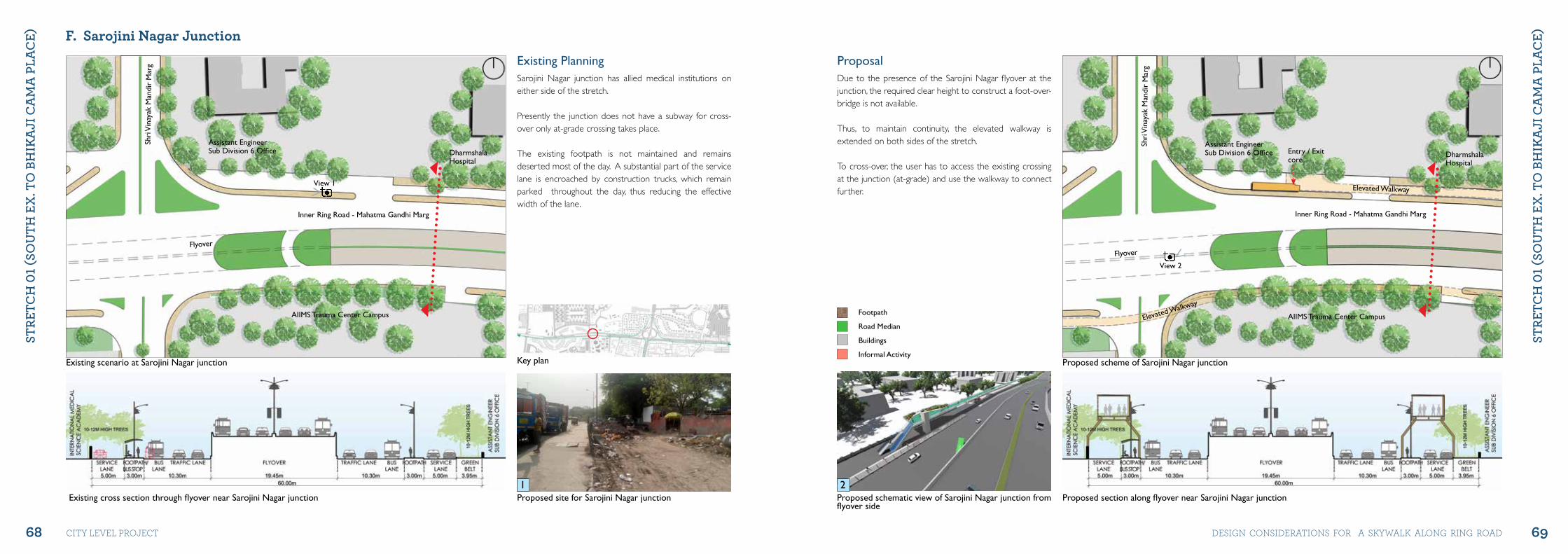
Existing PlanningSarojini Nagar junction has allied medical institutions on either side of the stretch.
Presently the junction does not have a subway for cross-over only at-grade crossing takes place.
The existing footpath is not maintained and remains deserted most of the day. A substantial part of the service lane is encroached by construction trucks, which remain parked throughout the day, thus reducing the effective width of the lane.
Proposed scheme of Sarojini Nagar junction
Assistant EngineerSub Division 6 Office Dharmshala
Hospital
Inner Ring Road - Mahatma Gandhi Marg
Shri
Vin
ayak
Man
dir
Mar
g
AIIMS Trauma Center Campus
Flyover
Elevated Walkway
Elevated Walkway
Entry / Exitcore
Proposed section along flyover near Sarojini Nagar junctionProposed schematic view of Sarojini Nagar junction from flyover side
View 2
ProposalDue to the presence of the Sarojini Nagar flyover at the junction, the required clear height to construct a foot-over-bridge is not available.
Thus, to maintain continuity, the elevated walkway is extended on both sides of the stretch.
To cross-over, the user has to access the existing crossing at the junction (at-grade) and use the walkway to connect further.
1 2
Footpath
Road Median
Buildings
Informal Activity
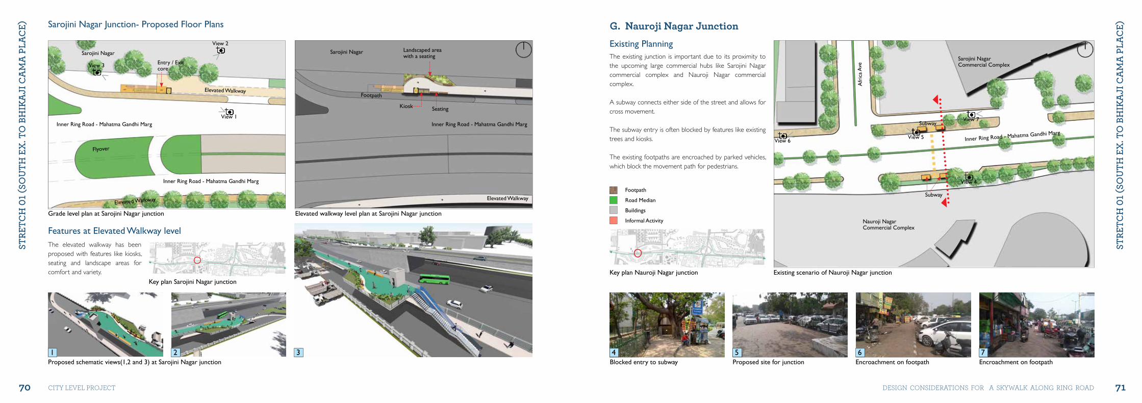
70 71
StRE
tCh
01 (
Sou
th E
x. t
o B
hIk
ajI
Ca
ma
PLa
CE)
StRE
tCh
01 (
Sou
th E
x. t
o B
hIk
ajI
Ca
ma
PLa
CE)
city level project DeSiGN coNSiDerAtioNS For A SKyWAlK AloNG riNG roAD
Grade level plan at Sarojini Nagar junction Elevated walkway level plan at Sarojini Nagar junction
Sarojini Nagar junction- Proposed Floor Plans
Inner Ring Road - Mahatma Gandhi Marg
Inner Ring Road - Mahatma Gandhi Marg Inner Ring Road - Mahatma Gandhi Marg
Flyover
Elevated Walkway
Elevated Walkway
Entry / Exitcore
Footpath
Landscaped areawith a seating
Sarojini NagarSarojini Nagar
Seating Kiosk
Proposed schematic views(1,2 and 3) at Sarojini Nagar junction
View 2
View 3
View 1
Key plan Sarojini Nagar junction
Elevated Walkway
G. Nauroji Nagar Junction
Existing scenario of Nauroji Nagar junctionKey plan Nauroji Nagar junction
Inner Ring Road - Mahatma Gandhi Marg
Sarojini NagarCommercial Complex
Subway
Subway
Nauroji NagarCommercial Complex
Afr
ica
Ave
Encroachment on footpath Encroachment on footpathBlocked entry to subway Proposed site for junction
View 4
View 5View 6
View 7
Existing PlanningThe existing junction is important due to its proximity to the upcoming large commercial hubs like Sarojini Nagar commercial complex and Nauroji Nagar commercial complex.
A subway connects either side of the street and allows for cross movement.
The subway entry is often blocked by features like existing trees and kiosks.
The existing footpaths are encroached by parked vehicles, which block the movement path for pedestrians.
4 5 6 71 32
Features at Elevated Walkway levelThe elevated walkway has been proposed with features like kiosks, seating and landscape areas for comfort and variety.
Footpath
Road Median
Buildings
Informal Activity
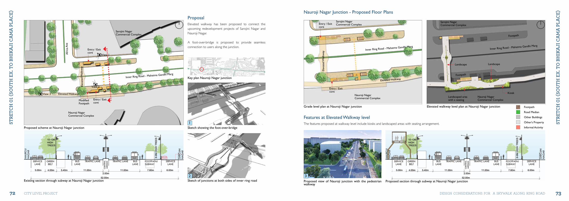
72 73
StRE
tCh
01 (
Sou
th E
x. t
o B
hIk
ajI
Ca
ma
PLa
CE)
StRE
tCh
01 (
Sou
th E
x. t
o B
hIk
ajI
Ca
ma
PLa
CE)
city level project DeSiGN coNSiDerAtioNS For A SKyWAlK AloNG riNG roAD
Proposed scheme at Nauroji Nagar junction
Inner Ring Road - Mahatma Gandhi Marg
Sarojini NagarCommercial Complex
Nauroji NagarCommercial Complex
Afr
ica
Ave
Elevated Walkway
Elev
ated
Wal
kway
Entry / Exitcore
ModifiedFootpath
Entry / Exitcore
Existing section through subway at Nauroji Nagar junction Sketch of junctions at both sides of inner ring road
View 2
View 1
Key plan Nauroji Nagar junction
ProposalElevated walkway has been proposed to connect the upcoming redevelopment projects of Sarojini Nagar and Nauroji Nagar.
A foot-over-bridge is proposed to provide seamless connection to users along the junction.
Grade level plan at Nauroji Nagar junction Elevated walkway level plan at Nauroji Nagar junction
Nauroji Nagar junction - Proposed Floor Plans
Inner Ring Road - Mahatma Gandhi MargInner Ring Road - Mahatma Gandhi Marg
Sarojini NagarCommercial Complex
Sarojini NagarCommercial Complex
Nauroji NagarCommercial Complex Nauroji Nagar
Commercial Complex
Elevated Walkway
Footpath
Footpath
Elev
ated
Wal
kway
Entry / Exitcore
Entry / Exitcore
Landscaped areawith a seating
Landscape Landscape
Kiosk
Proposed section through subway at Nauroji Nagar junctionProposed view of Nauroji junction with the pedestrian walkway
View 3
Features at Elevated Walkway levelThe features proposed at walkway level include kiosks and landscaped areas with seating arrangement.1
2 3
Footpath
Road Median
Other Buildings
Other’s Property
Informal ActivitySketch showing the foot-over-bridge
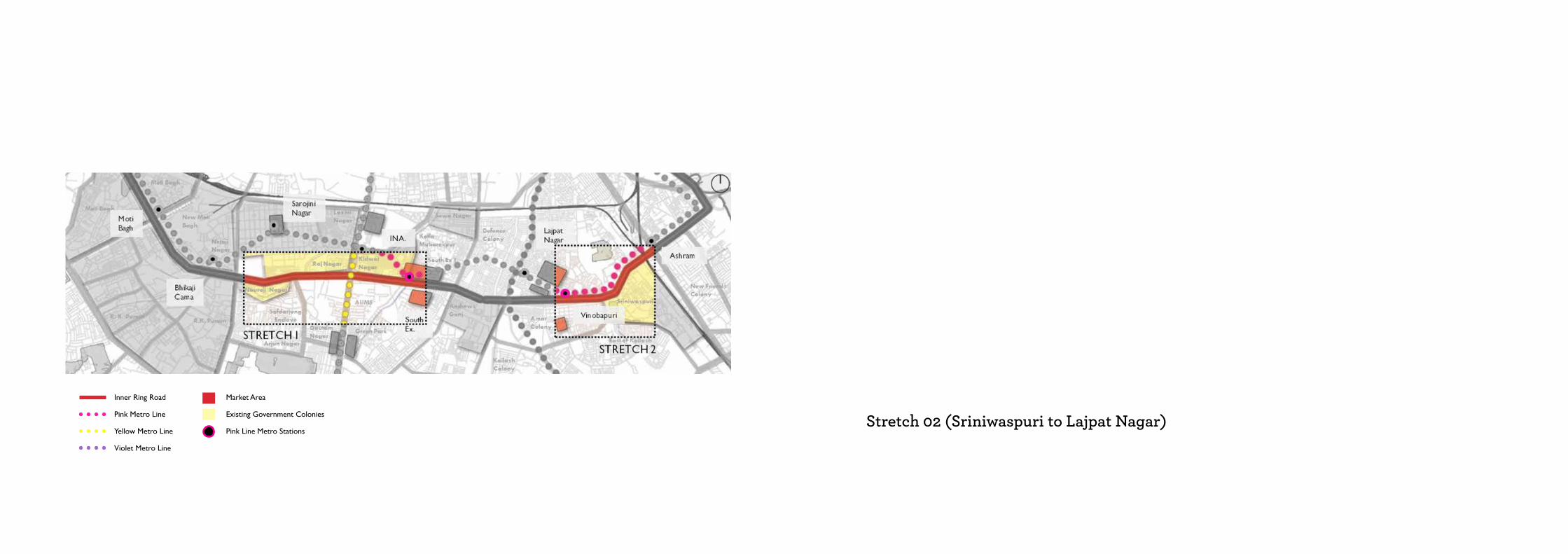
Inner Ring Road
Pink Metro Line
Yellow Metro Line
Violet Metro Line
Market Area
Existing Government Colonies
Pink Line Metro StationsStretch 02 (Sriniwaspuri to Lajpat Nagar)Chapter 4
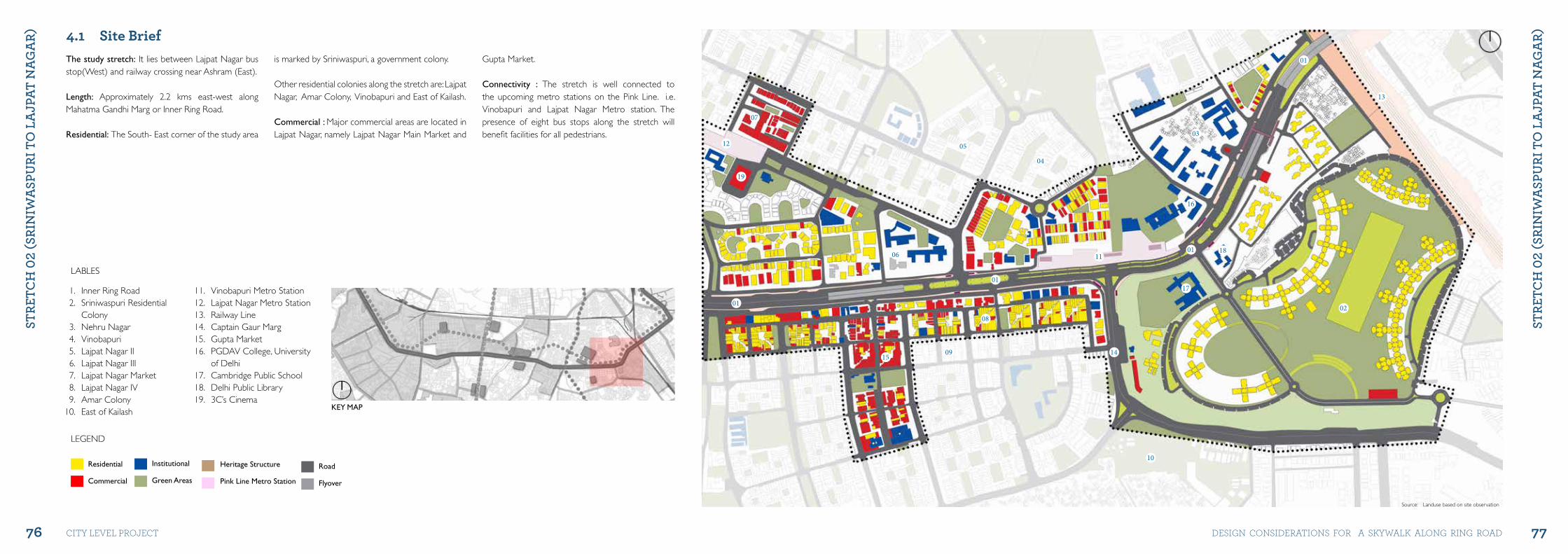
76 77
StRE
tCh
02
(SRI
NIw
aSP
uRI
to
La
jPat
Na
ga
R)
StRE
tCh
02
(SRI
NIw
aSP
uRI
to
La
jPat
Na
ga
R)
city level project DeSiGN coNSiDerAtioNS For A SKyWAlK AloNG riNG roAD
4.1 Site BriefThe study stretch: It lies between Lajpat Nagar bus stop(West) and railway crossing near Ashram (East).
Length: Approximately 2.2 kms east-west along Mahatma Gandhi Marg or Inner Ring Road.
Residential: The South- East corner of the study area
is marked by Sriniwaspuri, a government colony.
Other residential colonies along the stretch are: Lajpat Nagar, Amar Colony, Vinobapuri and East of Kailash.
Commercial : Major commercial areas are located in Lajpat Nagar, namely Lajpat Nagar Main Market and
Gupta Market.
Connectivity : The stretch is well connected to the upcoming metro stations on the Pink Line. i.e. Vinobapuri and Lajpat Nagar Metro station. The presence of eight bus stops along the stretch will benefit facilities for all pedestrians.
LABLES
LEGEND
1. Inner Ring Road2. Sriniwaspuri Residential
Colony3. Nehru Nagar4. Vinobapuri5. Lajpat Nagar II6. Lajpat Nagar III7. Lajpat Nagar Market8. Lajpat Nagar IV9. Amar Colony
10. East of Kailash
11. Vinobapuri Metro Station12. Lajpat Nagar Metro Station13. Railway Line14. Captain Gaur Marg15. Gupta Market16. PGDAV College, University
of Delhi17. Cambridge Public School18. Delhi Public Library19. 3C’s Cinema
KEY MAP
Residential
Commercial
01
13
01
17
16
18
1415
01
02
03
04
05
06
08
07
12
19
11
01
09
10
Source: Landuse based on site observation
Institutional
Green Areas
Heritage Structure
Pink Line Metro Station
Road
Flyover
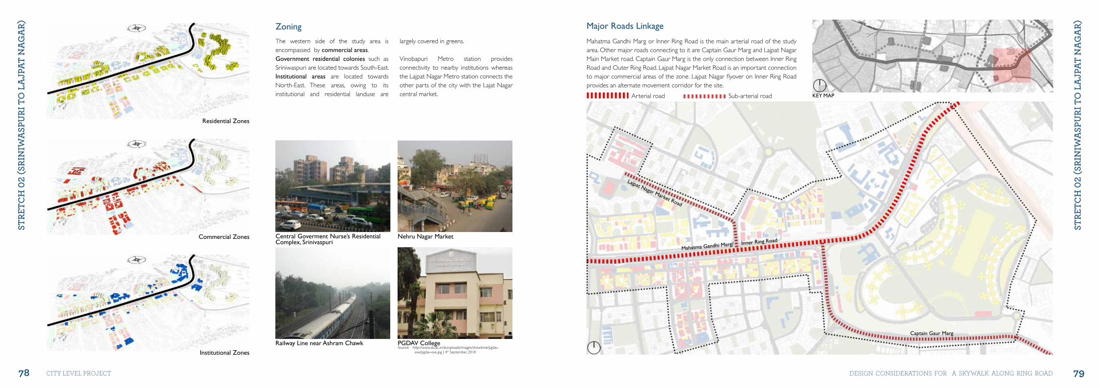
78 79
StRE
tCh
02
(SRI
NIw
aSP
uRI
to
La
jPat
Na
ga
R)
StRE
tCh
02
(SRI
NIw
aSP
uRI
to
La
jPat
Na
ga
R)
city level project DeSiGN coNSiDerAtioNS For A SKyWAlK AloNG riNG roAD
Central Goverment Nurse’s Residential Complex, Srinivaspuri
Nehru Nagar Market
Railway Line near Ashram Chawk PGDAV CollegeSource: http://www.du.ac.in/du/uploads/images/showtime/pgdav-
eve/pgdav-eve.jpg | 4th September, 2018
Residential Zones
Commercial Zones
Institutional Zones
Zoning
The western side of the study area is encompassed by commercial areas. Government residential colonies such as Sriniwaspuri are located towards South-East. Institutional areas are located towards North-East. These areas, owing to its institutional and residential landuse are
largely covered in greens.
Vinobapuri Metro station provides connectivity to nearby institutions whereas the Lajpat Nagar Metro station connects the other parts of the city with the Lajat Nagar central market. KEY MAP
Lajpat Nagar Market Road
Captain Gaur Marg
Mahatma Gandhi Marg/ Inner Ring Road
Major Roads Linkage
Mahatma Gandhi Marg or Inner Ring Road is the main arterial road of the study area. Other major roads connecting to it are Captain Gaur Marg and Lajpat Nagar Main Market road. Captain Gaur Marg is the only connection between Inner Ring Road and Outer Ring Road. Lajpat Nagar Market Road is an important connection to major commercial areas of the zone. Lajpat Nagar flyover on Inner Ring Road provides an alternate movement corridor for the site.
Arterial road Sub-arterial road
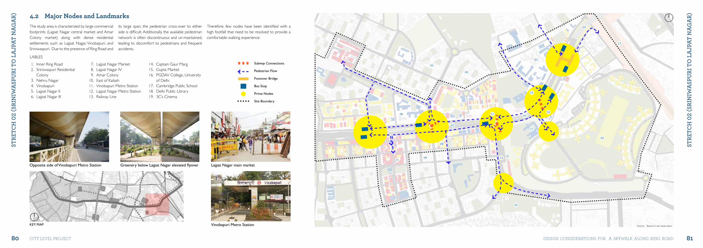
80 81
StRE
tCh
02
(SRI
NIw
aSP
uRI
to
La
jPat
Na
ga
R)
StRE
tCh
02
(SRI
NIw
aSP
uRI
to
La
jPat
Na
ga
R)
city level project DeSiGN coNSiDerAtioNS For A SKyWAlK AloNG riNG roAD
1. Inner Ring Road2. Sriniwaspuri Residential
Colony3. Nehru Nagar4. Vinobapuri5. Lajpat Nagar II6. Lajpat Nagar III
7. Lajpat Nagar Market8. Lajpat Nagar IV9. Amar Colony
10. East of Kailash11. Vinobapuri Metro Station12. Lajpat Nagar Metro Station13. Railway Line
14. Captain Gaur Marg15. Gupta Market16. PGDAV College, University
of Delhi17. Cambridge Public School18. Delhi Public Library19. 3C’s Cinema
LABLES
KEY MAP
07
12
19
01
Subway Connections
Pedestrian Flow
Footover Bridge
Bus Stop
Prime Nodes
Site Boundary
4.2 Major Nodes and Landmarks The study area is characterized by large commercial footprints (Lajpat Nagar central market and Amar Colony market) along with dense residential settlements such as Lajpat Nagar, Vinobapuri, and Sriniwaspuri. Due to the presence of Ring Road and
its large span, the pedestrian cross-over to either side is difficult. Additionally, the available pedestrian network is often discontinuous and un-maintained, leading to discomfort to pedestrians and frequent accidents.
Therefore, few nodes have been identified with a high footfall that need to be resolved to provide a comfortable walking experience.
01
13
01
17
16
18
1415
01
02
03
04
05
06
08
11
09
10
Source: Based on site observationVinobapuri Metro Station
Opposite side of Vinobapuri Metro Station Greenery below Lajpat Nagar elevated flyover Lajpat Nagar main market
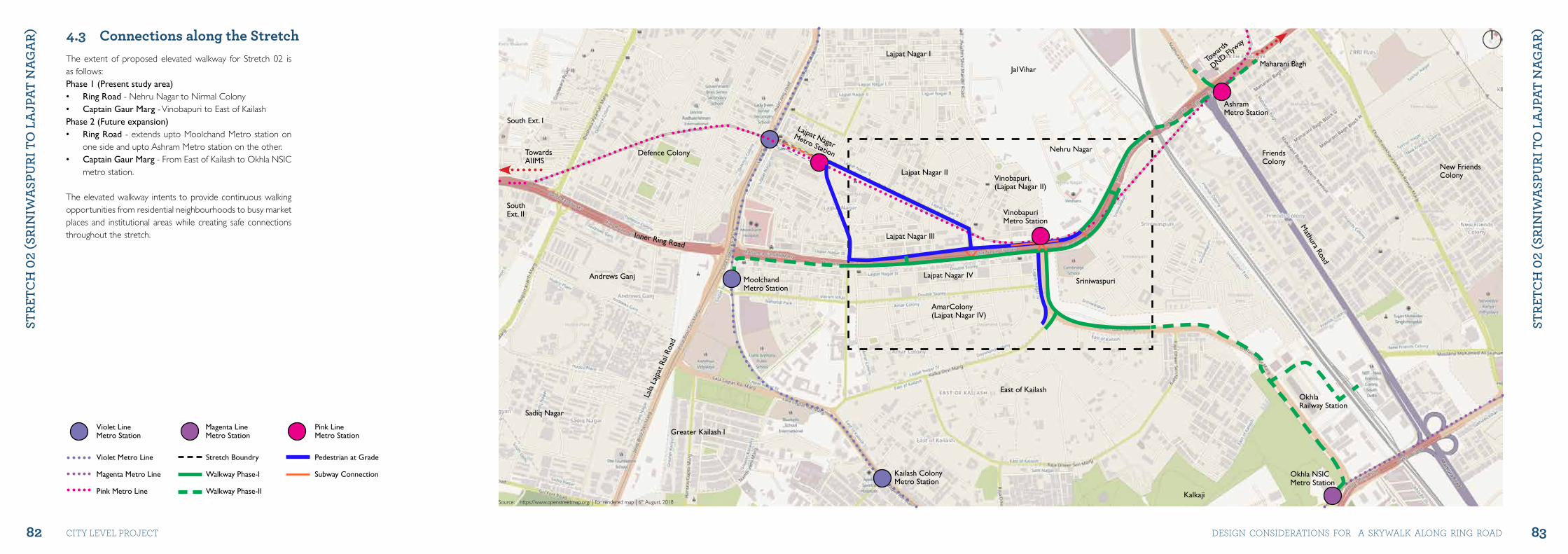
82 83
StRE
tCh
02
(SRI
NIw
aSP
uRI
to
La
jPat
Na
ga
R)
StRE
tCh
02
(SRI
NIw
aSP
uRI
to
La
jPat
Na
ga
R)
city level project DeSiGN coNSiDerAtioNS For A SKyWAlK AloNG riNG roAD
Violet Metro Line
Magenta Metro Line
Pink Metro Line
Violet LineMetro Station
Magenta LineMetro Station
Pink LineMetro Station
Stretch Boundry
Walkway Phase-I
Walkway Phase-II
Pedestrian at Grade
Subway Connection
The extent of proposed elevated walkway for Stretch 02 is as follows: Phase 1 (Present study area)• Ring Road - Nehru Nagar to Nirmal Colony• Captain Gaur Marg - Vinobapuri to East of KailashPhase 2 (Future expansion)• Ring Road - extends upto Moolchand Metro station on
one side and upto Ashram Metro station on the other.• Captain Gaur Marg - From East of Kailash to Okhla NSIC
metro station.
The elevated walkway intents to provide continuous walking opportunities from residential neighbourhoods to busy market places and institutional areas while creating safe connections throughout the stretch.
Source: https://www.openstreetmap.org/ | for rendered map | 6th August, 2018
Inner Ring Road
Mathura Road
Lala
Laj
pat R
ai R
oad
Toward
s
DND Flyw
ay
TowardsAIIMS
MoolchandMetro Station
Kailash ColonyMetro Station
VinobapuriMetro Station
Vinobapuri,(Lajpat Nagar II)
AmarColony(Lajpat Nagar IV)
Nehru Nagar
AshramMetro Station
Maharani Bagh
FriendsColony
New FriendsColony
Okhla NSICMetro Station
OkhlaRailway Station
Kalkaji
Sriniwaspuri
East of Kailash
Greater Kailash I
Andrews Ganj
Defence Colony
South Ext. I
SouthExt. II
Sadiq Nagar
Lajpat Nagar III
Lajpat Nagar II
Lajpat Nagar I
jal Vihar
Lajpat Nagar IV
Lajpat NagarMetro Station
4.3 Connections along the Stretch
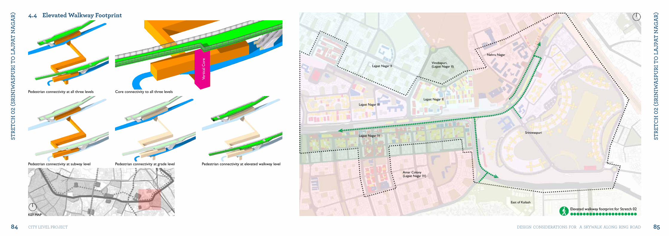
84 85
StRE
tCh
02
(SRI
NIw
aSP
uRI
to
La
jPat
Na
ga
R)
StRE
tCh
02
(SRI
NIw
aSP
uRI
to
La
jPat
Na
ga
R)
city level project DeSiGN coNSiDerAtioNS For A SKyWAlK AloNG riNG roAD
KEY MAP
4.4 Elevated Walkway Footprint
Pedestrian connectivity at all three levels Core connectivity to all three levels
Pedestrian connectivity at subway level Pedestrian connectivity at grade level Pedestrian connectivity at elevated walkway level
Lajpat Nagar IV
Lajpat Nagar III
Lajpat Nagar II
Lajpat Nagar II
East of Kailash
Nehru Nagar
Sriniwaspuri
Vinobapuri,(Lajpat Nagar II)
Amar Colony(Lajpat Nagar IV)
Vert
ical
Cor
e
Elevated walkway footprint for Stretch 02
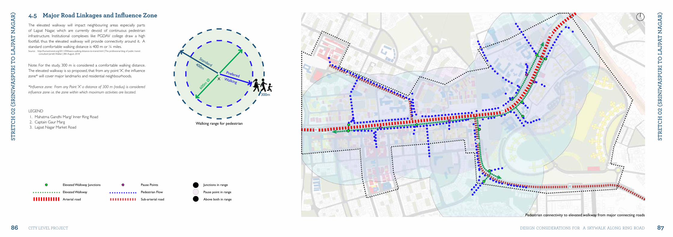
86 87
StRE
tCh
02
(SRI
NIw
aSP
uRI
to
La
jPat
Na
ga
R)
StRE
tCh
02
(SRI
NIw
aSP
uRI
to
La
jPat
Na
ga
R)
city level project DeSiGN coNSiDerAtioNS For A SKyWAlK AloNG riNG roAD
Elevated Walkway junctions
Elevated Walkway
Arterial road
Pause Points
Pedestrian Flow
Sub-arterial road
4.5 Major Road Linkages and Influence Zone
1. Mahatma Gandhi Marg/ Inner Ring Road2. Captain Gaur Marg3. Lajpat Nagar Market Road
600m
Ø
PreferedWalking
Standard400m
300m
The elevated walkway will impact neighbouring areas especially parts of Lajpat Nagar, which are currently devoid of continuous pedestrian infrastructure. Institutional complexes like PGDAV college draw a high footfall, thus the elevated walkway will provide connectivity around it. A standard comfortable walking distance is 400 m or ¼ miles. Source: http://humantransit.org/2011/04/basics-walking-distance-to-transit.html | The professional blog of public transit
consultant Jarrett Walker | 8th August, 2018
Note: For the study, 300 m is considered a comfortable walking distance. The elevated walkway is so proposed, that from any point ‘X’, the influence zone* will cover major landmarks and residential neighbourhoods. *Influence zone: From any Point ‘X’ a distance of 300 m (radius) is considered influence zone i.e. the zone within which maximum activities are located.
X
Pedestrian connectivity to elevated walkway from major connecting roads
01
01
02
02
03
03
01
junctions in range
Pause point in range
Above both in range
LEGEND
Walking range for pedestrian
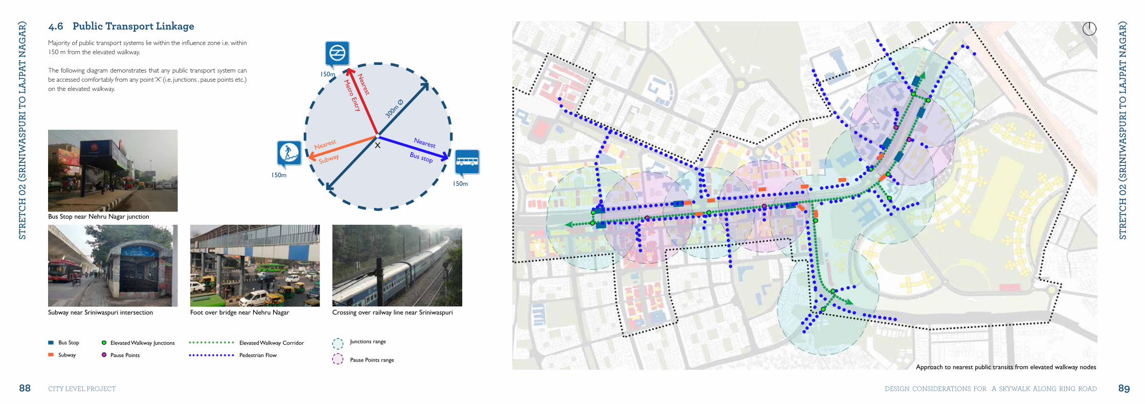
88 89
StRE
tCh
02
(SRI
NIw
aSP
uRI
to
La
jPat
Na
ga
R)
StRE
tCh
02
(SRI
NIw
aSP
uRI
to
La
jPat
Na
ga
R)
city level project DeSiGN coNSiDerAtioNS For A SKyWAlK AloNG riNG roAD30
0m Ø
NearestBus stop
Nearest
Subway
Nearest
Metro Entry
150m150m
150m
4.6 Public Transport Linkage
X
Majority of public transport systems lie within the influence zone i.e. within 150 m from the elevated walkway.
The following diagram demonstrates that any public transport system can be accessed comfortably from any point ‘X’ (i.e. junctions , pause points etc.) on the elevated walkway.
Approach to nearest public transits from elevated walkway nodes
Elevated Walkway junctions
Pause Points
Elevated Walkway Corridor
Pedestrian Flow
junctions range
Pause Points range
Bus Stop
Subway
Bus Stop near Nehru Nagar junction
Subway near Sriniwaspuri intersection Foot over bridge near Nehru Nagar Crossing over railway line near Sriniwaspuri
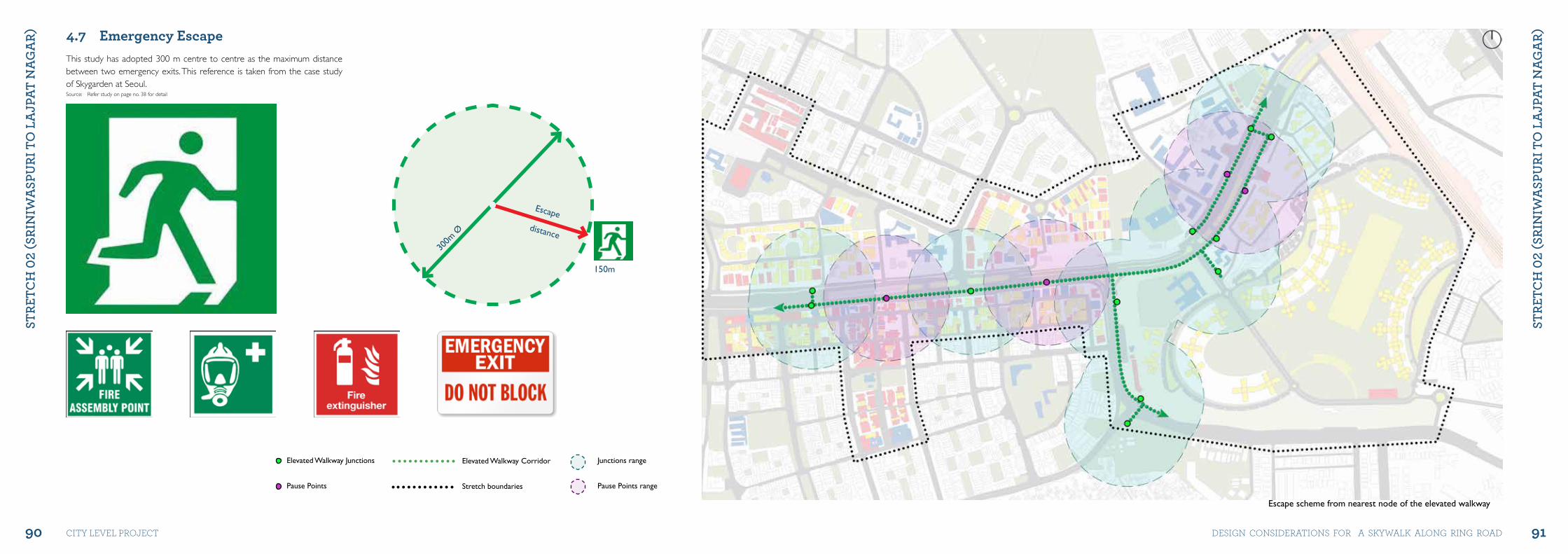
90 91
StRE
tCh
02
(SRI
NIw
aSP
uRI
to
La
jPat
Na
ga
R)
StRE
tCh
02
(SRI
NIw
aSP
uRI
to
La
jPat
Na
ga
R)
city level project DeSiGN coNSiDerAtioNS For A SKyWAlK AloNG riNG roAD
4.7 Emergency Escape
300m
Ø
Escape
distance
150m
This study has adopted 300 m centre to centre as the maximum distance between two emergency exits. This reference is taken from the case study of Skygarden at Seoul.Source: Refer study on page no. 38 for detail
Escape scheme from nearest node of the elevated walkway
Elevated Walkway junctions
Pause Points
Elevated Walkway Corridor
Stretch boundaries
junctions range
Pause Points range
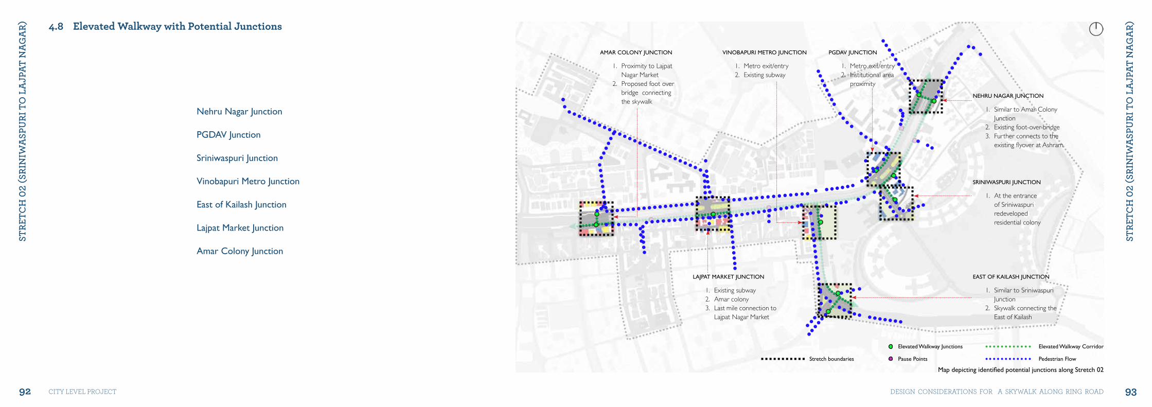
92 93
StRE
tCh
02
(SRI
NIw
aSP
uRI
to
La
jPat
Na
ga
R)
StRE
tCh
02
(SRI
NIw
aSP
uRI
to
La
jPat
Na
ga
R)
city level project DeSiGN coNSiDerAtioNS For A SKyWAlK AloNG riNG roAD
4.8 Elevated Walkway with Potential Junctions
Nehru Nagar junction
PGDAV junction
Sriniwaspuri junction
Vinobapuri Metro junction
East of Kailash junction
Lajpat Market junction
Amar Colony junction
PGDAV jUNCTION
1. Metro exit/entry2. Institutional area
proximity
LAjPAT MARKET jUNCTION
1. Existing subway2. Amar colony3. Last mile connection to
Lajpat Nagar Market
AMAR COLONY jUNCTION
1. Proximity to Lajpat Nagar Market
2. Proposed foot over bridge connecting the skywalk
VINOBAPURI METRO jUNCTION
1. Metro exit/entry 2. Existing subway
SRINIWASPURI jUNCTION
1. At the entrance of Sriniwaspuri redeveloped residential colony
NEHRU NAGAR jUNCTION
1. Similar to Amar Colony Junction
2. Existing foot-over-bridge 3. Further connects to the
existing flyover at Ashram
EAST OF KAILASH jUNCTION
1. Similar to Sriniwaspuri Junction
2. Skywalk connecting the East of Kailash
Map depicting identified potential junctions along Stretch 02
Elevated Walkway junctions
Pause Points
Elevated Walkway Corridor
Pedestrian FlowStretch boundaries
Design ProposalChapter 5
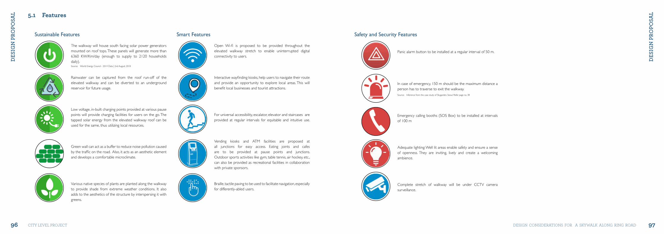
96 97
DES
IgN
PRo
PoSa
L
DES
IgN
PRo
PoSa
L
city level project DeSiGN coNSiDerAtioNS For A SKyWAlK AloNG riNG roAD
The walkway will house south facing solar power generators mounted on roof tops. These panels will generate more than 6360 KW/Km/day (enough to supply to 2120 households daily). Rainwater can be captured from the roof run-off of the elevated walkway and can be diverted to an underground reservoir for future usage. Low voltage, in-built charging points provided at various pause points will provide charging facilities for users on the go. The tapped solar energy from the elevated walkway roof can be used for the same, thus utilizing local resources. Green wall can act as a buffer to reduce noise pollution caused by the traffic on the road. Also, it acts as an aesthetic element and develops a comfortable microclimate. Various native species of plants are planted along the walkway to provide shade from extreme weather conditions. It also adds to the aesthetics of the structure by interspersing it with greens.
Source: World Energy Council - 2014 Data | 2nd August, 2018
Sustainable Features Smart Features
5.1 Features
Open Wi-fi is proposed to be provided throughout the elevated walkway stretch to enable uninterrupted digital connectivity to users. Interactive wayfinding kiosks, help users to navigate their route and provide an opportunity to explore local areas. This will benefit local businesses and tourist attractions. For universal accessibility, escalator, elevator and staircases are provided at regular intervals for equitable and intuitive use. Vending kiosks and ATM facilities are proposed at all junctions for easy access. Eating joints and cafes are to be provided at pause points and junctions. Outdoor sports activities like gym, table tennis, air hockey, etc., can also be provided as recreational facilities in collaboration with private sponsors. Braille, tactile paving to be used to facilitate navigation, especially for differently-abled users.
Panic alarm button to be installed at a regular interval of 50 m. In case of emergency, 150 m should be the maximum distance a person has to traverse to exit the walkway. Emergency calling booths (SOS Box) to be installed at intervals of 100 m
Adequate lighting: Well lit areas enable safety and ensure a sense of openness. They are inviting, lively and create a welcoming ambience. Complete stretch of walkway will be under CCTV camera surveillance.
Safety and Security Features
Source: Inference from the case study of Skygarden, Seoul. Refer page no. 38
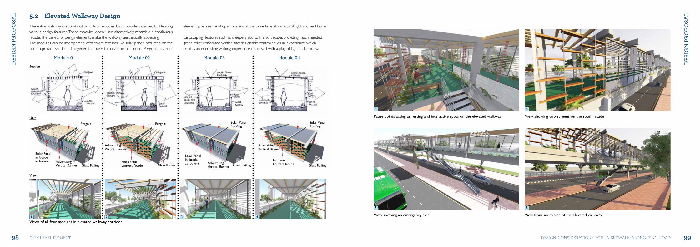
98 99
DES
IgN
PRo
PoSa
L
DES
IgN
PRo
PoSa
L
city level project DeSiGN coNSiDerAtioNS For A SKyWAlK AloNG riNG roAD
Module 01 Module 02 Module 03 Module 04
Section
Unit
View
5.2 Elevated Walkway Design
Views of all four modules in elevated walkway corridor
Solar PanelRoofing
Pergola Pergola Solar PanelRoofing
Solar Panelin facadeas louvers Horizontal
Louvers facade
Horizontal Louvers facade
Solar Panelin facadeas louvers
AdvertisingVertical Banner
AdvertisingVertical Banner
AdvertisingVertical Banner
AdvertisingVertical BannerGlass Railing Glass Railing Glass Railing Glass Railing
The entire walkway is a combination of four modules. Each module is derived by blending various design features. These modules when used alternatively, resemble a continuous façade. The variety of design elements make the walkway aesthetically appealing. The modules can be interspersed with smart features like solar panels mounted on the roof to provide shade and to generate power to serve the local need. Pergolas, as a roof
element, give a sense of openness and at the same time allow natural light and ventilation.
Landscaping features such as creepers add to the soft scape, providing much needed green relief. Perforated vertical facades enable controlled visual experience, which creates an interesting walking experience dispersed with a play of light and shadow.
View showing an emergency exit
Pause points acting as resting and interactive spots on the elevated walkway View showing two screens on the south facade
View from south side of the elevated walkway
5 6
7 8
1 32 4
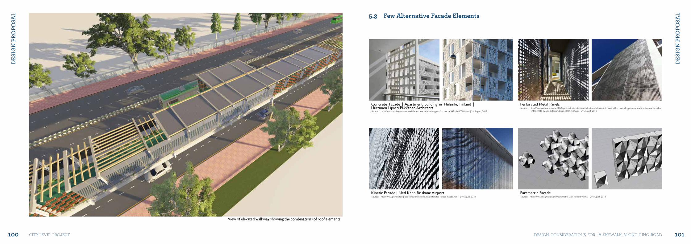
100 101
DES
IgN
PRo
PoSa
L
DES
IgN
PRo
PoSa
L
city level project DeSiGN coNSiDerAtioNS For A SKyWAlK AloNG riNG roAD
View of elevated walkway showing the combinations of roof elements
Concrete Facade | Apartment building in Helsinki, Finland | Huttunen Lipasti Pakkanen Architects
Kinetic Facade | Ned Kahn Brisbane Airport
Perforated Metal Panels
Parametric Facade
Source: http://www.archiexpo.com/prod/rieder-smart-elements-gmbh/product-65431-1430003.html | 2nd August, 2018
Source: http://www.perforated-plate.com/perforatedplate/perforated-kinetic-facade.html | 2nd August, 2018
Source: https://laurenalbanese.com/30028/perforated-metal-in-architecture-exterior-interior-and-furniture-design/decorative-metal-panels-perfo-rated-metal-panels-exterior-design-ideas-modern/ | 2nd August, 2018
Source: http://www.designcoding.net/parametric-wall-student-works/ | 2nd August, 2018
5.3 Few Alternative Facade Elements
Reference listADB, Walkability and Pedestrian Facilities in Asian Cities, Feb 2011, Available at: https://www.adb.org/sites/default/files/publication/28679/adb-wp17-walkability-pedestrian-facilities-asian-cities.pdf
Dabrai Rohit, ‘Twenty22-India on the move’, Available at: http://www.twenty22.in/2009/06/delhis-third-ring-road-snapshot.html | Accessed on August 6, 2018
Delhi-Masterplan.com, ‘Zonal Plan MPD-2021’ Available at: http://delhi-masterplan.com/zonal-plans-mpd-2021/
Delhi Traffic Police, 2017, ‘Chapter 3- Victims of Road Accident, Road Accidents in Delhi’; Available at: https://delhitrafficpolice.nic.in/wp-content/uploads/2018/10/chapter-3.pdf | Accessed on October 8, 2018
Designcoding.net - April 19, 2013; Image available at: http://www.designcoding.net/parametric-wall-student-works/ | Accessed on August 2, 2018
DiscoveredIndia.com - ‘Roads In Delhi’, Available at: http://www.discoveredindia.com/delhi/transportation-in-delhi/roads-in-delhi.htm | Accessed on August 6, 2018
Goswami Sweta -Hindustan Times – June 27, 2018; ‘At Delhi’s East Kidwai Nagar, ‘ornamental’ trees replace years-old ecosystem’, Available at: https://www.hindustantimes.com/delhi-news/at-delhi-s-east-kidwai-nagar-ornamental-trees-replace-years-old-ecosystem/story-GOm6qqvpb4LNxTlo26WuZJ.html
Mariswamy Abilash - January 13, 2018; ‘Bengaluru: New skywalks fail to generate footfalls’, Available at: https://www.deccanchronicle.com/nation/current-affairs/130118/bengaluru-new-skywalks-fail-to-generate-footfalls.html
McLain Sean - December 31, 2014; ‘Stereotyping India’s Cities By Their Car-Lovers’, Available at: https://blogs.wsj.com/indiarealtime/2014/12/31/stereotyping-indias-cities-by-their-car-lovers/
Openstreetmap.org, ‘Rendered Map’, Available at: https://www.openstreetmap.org/ | Accessed on August 10, 2018
Ponting Anna & Lim Vincent -‘Centre for Liveable citied for Singapore, Elevated PedestrianLinkways - Boon or Bane?’, Available at: https://www.clc.gov.sg/docs/default-source/commentaries/elevated-pedestrian.pdf
Reinventing Walkability, Clear Air Asia, Manekshaw Centre, New-Delhi 6 December 2013, Available at: http://www.urbanmobilityindia.in/Upload/Conference/84da59bc-f7ef-419b-a9d4-5b44ba9c77b2.pdf
Seetharaman G, October 06, 2018;’ Why it is difficult to come up with a viable public transport model for all cities’, Available at: https://economictimes.indiatimes.com/news/economy/infrastructure/why-it-is-difficult-to-come-up-with-a-viable-public-transport-model-for-all-cities/articleshow/66101927.cms | Accessed on October 10, 2018
TheGuardian - International Edition – May 19, 2017; ‘A garden bridge that works: how Seoul succeeded where London failed’, Available at: https://www.theguardian.com/cities/2017/may/19/seoul-skygarden-south-korea-london-garden-bridge | Accessed on September 25, 2018
Walker Jarrett- April 24, 2011; ‘The professional blog of public transit’- ‘Access, Basics, Stop Spacing’, Available at: http://humantransit.org/2011/04/basics-walking-distance-to-transit.html
Wikipedia- August 9 2018; Available at: https://en.wikipedia.org/wiki/Mumbai_Skywalk_Project
World Energy Council - 2014 Data, Available at: https://www.worldenergy.org/wp-content/uploads/2014/01/World-Energy-Issues-Monitor-2014.pdf
Secretary
Delhi Urban Art CommissionCore-6A, Upper Ground Floor, India Habitat Centre, Lodhi Road, New Delhi-110003
Tel: +91-11-24618607, +91-11-24619593Email: [email protected], [email protected] Website: www.duac.org