Geophysical Investigation for Aquifer Potential ... - Iiste.org
Journal of Hydrology (2007) 346, 18–32
ava i lab le at www.sc iencedi rec t . com
journal homepage: www.elsevier .com/ locate / jhydro l
Decoupled fresh–saline groundwater circulationof a coastal carbonate aquifer: Spatial patternsof temperature and specific electrical conductivity
Patricia A. Beddows a,*, Peter L. Smart a, Fiona F. Whitaker b,Samantha L. Smith b,1
a School of Geographical Sciences, University of Bristol, Bristol BS8 1SS, UKb Department of Earth Sciences, University of Bristol, Bristol BS8 1RJ, UK
Received 24 September 2006; received in revised form 16 June 2007; accepted 20 August 2007
00do
Te
1
KEYWORDSYucatan;Carbonate aquifer;Submarine groundwaterdischarge;Saline groundwater;Density stratifiedgroundwater;Geothermal convection
22-1694/$ - see front mattei:10.1016/j.jhydrol.2007.08
* Corresponding author. Addl.: +1 905 525 9140; fax: +1E-mail address: Patricia.BePresent address: Nautilus M
r ª 200.013
ress: Sch905 546ddows@inerals
Summary The coastal carbonate aquifer of the eastern Yucatan Peninsula dischargesgroundwaters to the Caribbean Sea. Temperature and specific electrical conductance(SEC) are used as natural tracers to gain new insight into the fresh and saline groundwatercirculation along an 80 km section of the Caribbean coastline. The aquifer is density strat-ified, with a cooler freshwater lens overlying a warmer saline water zone. Non-conduitsites generally have lower temperatures and SEC in the freshwater lens than conduit sites.In conduits <1 km from the coast, there is a very rapid increase in both fresh water tem-perature and SEC indicating very active mixing with the underlying warm saline water.Further inland, the rates of change of SEC and temperature are lower, and conduit mor-phology and network geometry are important controls on salinisation along the conduitflow paths. Turbulent mixing is enhanced by flow around obstacles where the conduitspans the mixing zone (sites 1–4 km inland), but mixing is limited where the conduit isentirely filled with fresh water (sites >4 km inland). Within the shallow saline water zone,temperature decreases exponentially with distance from the coast, with near equilibriumwith the fresh waters reached at �10 km inland, a distance coincident with the knownlimit of conduit development. This pattern is indicative of the progressive cooling of warmseawater moving inland from the coast, a flow direction opposite to that of both the con-ventional freshwater flow entrainment and geothermal convection models of coastal aqui-fer circulation.ª 2007 Elsevier B.V. All rights reserved.
7 Elsevier B.V. All rights reserved.
ool of Geography and Earth Sciences, McMaster University – GSB206, Hamilton, ON, Canada L8S 4K1.0463.gmail.com (P.A. Beddows).Inc., PO Box 1213, Milton, QLD, 4064, Australia.

Decoupled fresh–saline groundwater circulation of a coastal carbonate aquifer 19
Introduction
There is an increasing recognition that groundwater dis-charge to the oceans from the continents is of large magni-tude (Moore, 1996, 1999; Bokuniewicz, 2001; Bokuniewiczet al., 2003). New results using geochemical tracers showthat previous estimates using seepage meters and diffusiongradient models have significantly underestimated the netcontribution. For example, Moore (1996) showed thatgroundwater discharge was 40% that of river discharge alonga segment of the South Carolinian coast. Subsequent studieshave shown that this apparent volume of submarine ground-water discharge is in part due to local recirculation of salinewater at shallow depth but that nonetheless is of great sig-nificance to the redistribution and discharge of nutrientsand other solutes to the near-coast waters (Shaw et al.,1998; Burnett et al., 2003). The term ‘‘submarine estuary’’has been coined by Moore (1999) in recognition of the mag-nitude and geochemical importance of submarine ground-water discharge to land–ocean subterranean exchangeand recirculation along diverse coastlines of the world.Along carbonate coastlines, there is commonly a paucityand even absence of surface river discharge (Bokuniewicz,2001; Bokuniewicz et al., 2003). Thus groundwater dis-charges and the behaviour of the ‘‘submarine estuary’’are of even greater significance than in non-carbonateterrains.
Unconfined coastal aquifers are density stratified, with afresh water lens (FWL) overlying a saline water zone (SWZ).The two water bodies are separated by a mixing zone (MZ).The conventional model for groundwater circulation incoastal aquifers indicates that the more rapid coastwardflow of the FWL entrains a parallel but slower coastwardflow of the shallow SWZ, with a compensatory inflow of sal-ine water at some depth (Henry, 1964). The progressiveentrainment of saline water into the FWL along the flowpath results in a gradual salinisation of the FWL towardsthe coast (Fig. 1).
Early development of this model for coupled fresh–sal-ine groundwater circulation in coastal aquifers was under-taken by Hubbert (1940), Cooper (1959) and Henry (1964).Subsequent studies particularly by Kohout (1965) in Floridademonstrated that in thick carbonate aquifers, the circula-tion of the saline groundwater might be augmented by geo-thermal heating of cold seawater inflowing at depth from
Figure 1 Conventional model of density stratified groundwa-ter circulation in an unconfined coastal aquifer (modified fromHenry, 1964).
the adjacent oceans. Others have considered the possibilitythat saline circulation will be augmented by increases in thedensity of the saline fluids, for instance due to evaporativeconcentration (Adams and Rhodes, 1960; Jones et al.,2002). In addition, differences in sea surface height fromhigh to low temporal frequencies (tidal to seasonal) maydrive shallow saline circulation simply through elevationhead (Dillon et al., 1999; Chanton et al., 2003).
Groundwater flow modelling has broadly supported therole of these head and density dependent drives in enhanc-ing saline circulation. However these models generally onlyconsider homogeneous aquifers or aquifers with equivalentporous medium conditions (Sanford and Konikow, 1989a,b;Jones et al., 2000; Wilson, 2005) whereas carbonates aqui-fers are typically highly heterogeneous with porosity fea-tures from intergranular pores to large caves spanning fiveor more orders of magnitude in size scale (Quinlan et al.,1996; Worthington et al., 2000), and resulting in a strongscale dependence of hydraulic conductivity (Whitaker andSmart, 1997). Wilson (1989) drew attention to the large dis-crepancy in the predicted thickness of FWL in the homoge-neous coupled reactive transport groundwater flow modelof Sanford and Konikow (1989a,b) compared to his fieldobservations in the Yucatan Peninsula. He ascribed the dif-ference in the calculated depth of the MZ to the presence ofcave systems. Such flooded cave systems comprise turbu-lent flow conduits within which complex density dependentflow structures similar to those in open channel flow in sur-face estuaries can be set up. Continuous large magnitudeflows of seawater through conduits traversing the island ofCephalonia (Greece) in the Mediterranean have been welldocumented, with several sites being historically developedas ‘‘sea-mills’’ (Stringfield and LeGrand, 1969; Drogue andSoulios, 1988; Drogue, 1989). In Florida, complex fresh(brackish)–saline groundwater flows occur in a number ofcoastal conduits, including Jewfish Sink, Horseshoe CrabSink, and Crystal Beach Springs, all located on the Gulf coast(Garman and Garey, 2005). However the saline influx inthese sites may in part be induced by over-exploitation ofthe terrestrial fresh groundwaters, altering the relativeland–ocean hydraulic gradients. Drogue and Bidaux (1986)report on the tidal inflow of saline water while the overlyingfresh water continuously discharges from a coastal conduitin a karst aquifer on the Mediterranean coast of France.On the east coast of Andros Is., flow meters deployed inflooded conduits showed flow direction reversals in responseto semi-diurnal tides (Whitaker and Smart, 1990, 1993). Asin surface estuaries, the circulation of fresh and salinegroundwater in such coastal conduit networks developednear sea level can be highly responsive to changing bound-ary conditions, and present complex and non-steady statepatterns with semi-diurnal flow reversal. This may also af-fect interactions between fresh and saline groundwaters,limiting entrainment of saline water by the FWL where flowis concentrated within coastal conduit systems.
In this study we focus on the behaviour of groundwatercirculation in the Yucatan carbonate coastal aquifer. Theflooded caves explored along the Caribbean coast are aparticular focus as they account for 99% or more of thefresh water flux to the ocean in this area (Worthingtonet al., 2000). This spatial concentration of flow within dis-crete features draining to point discharge along the coast
20 P.A. Beddows et al.
complicates the management of water resources and wastedisposal here, and in similar coastal conduit aquifers.
Field area
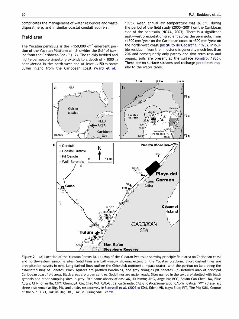
The Yucatan peninsula is the �150,000 km2 emergent por-tion of the Yucatan Platform which divides the Gulf of Mex-ico from the Caribbean Sea (Fig. 2). The thickly bedded andhighly-permeable limestone extends to a depth of �1000 mnear Merida in the north-west and at least �150 m some50 km inland from the Caribbean coast (Ward et al.,
Figure 2 (a) Location of the Yucatan Peninsula. (b) Map of the Yuand north-western sampling sites. Solid lines are bathymetry shoprecipitation isoyets in mm. Long dashed lines outline the Chicxuluassociated Ring of Cenotes. Black squares are profiled boreholes,Caribbean coast field area. Black areas are urban centres. Solid linessymbols and other sampling sites in grey. Site name abbreviations:Abyss; CHN, Chan Ha; CHY, Chemuyil; CM, Chac Mol; CAL-G, Calica Gthree also known as Big, Pit, and Little, respectively in Stoessell et aof the Sun; TBH, Tak Be Ha; TBL, Tak Be Luum; VRD, Verde.
1995). Mean annual air temperature was 26.5 �C duringthe period of the field study (2000–2001) on the Caribbeanside of the peninsula (NOAA, 2003). There is a significanteast–west precipitation gradient across the peninsula, from>1500 mm/year on the Caribbean coast to <500 mm/year onthe north-west coast (Instituto de Geografia, 1973). Insolu-ble residuum from the limestone is generally much less than20% and consequently only patchy and thin terra rosa andorganic soils are present at the surface (Gmitro, 1986).There are no surface streams and recharge percolates rap-idly to the water table.
catan Peninsula showing principle field area on Caribbean coastwing extent of the Yucatan platform. Short dashed lines areb meteorite impact crater, with the portion on land being theand grey triangles pit cenotes. (c) Detailed map of principalare major roads. Sites named in the text are labelled with blackAK, Ak Kimin; ANG, Angelita; BCC, Balam Can Chee; BA, Bluerande; CAL-S, Calica Sumergido; CAL-W, Calica ‘‘W’’ (these lastl. (2002)); EDN, Eden; MB, Maya Blue; PIT, The Pit; SUN, Cenote

Decoupled fresh–saline groundwater circulation of a coastal carbonate aquifer 21
The aquifer is characterised by three scales of porosityfeatures. The porosity of the aquifer matrix is dominatedby primary porosity and the intergranular voids. Averageporosity of the Pleistocene deposits along the Caribbeancoast is 14–23% (Harris, 1984) while as a result of bothlocalised cementation and dissolution of the limestones,cores from older rocks near Merida in the north-west givea much greater range from 4% to 51% for individual sub-sam-ples (mean 22 ± 10%, n = 71; Gonzalez-Herrera, 1984). Frac-tures, joints, and bedding planes are evident in quarries andin the walls of the flooded conduit networks although theseremain poorly characterised. It is clear however, that disso-lution enlarges these structural features to dimensionsallowing for turbulent flow, thus increasing aquifer perme-ability. Borehole video logs in the north-west of the penin-sula reveal dissolution enlarged turbulent flow conduitsmeasuring 0.01–1 m within which swimming troglobitic fishhave been observed (Buckley et al., 1984). Along the Carib-bean coast of the Yucatan peninsula, cave divers have ex-plored an extensive cavernous zone which extends some10–12 km inland from the Caribbean Sea and along an�80 km length of coast from near the town of Puerto More-los in the north, to the Sian Ka’an Biosphere Reserve some10 km south of Tulum (see Fig. 2c). To date, almost700 km of interlinked anastomosing cave passages measur-ing 1–100 m in width have been surveyed in this area (QRSS,2006; Smart et al., 2006). These flooded cave networksfunction hydrologically as large scale conduit systems link-ing the inland recharge area to coastal springs.
The connectivity and hydrogeological importance of thesmall and large scale conduits throughout the peninsulaare well documented by their direct exploration notably inthe Caribbean cavernous zone, but also through hydrogeo-logical characterisations. The peninsula-wide hydraulic gra-dient is exceptionally low, being �5–10 · 10�5 in the centreof the peninsula and along the Caribbean coast (Back andHanshaw, 1970; Marın, 1990; Beddows, 2004) and somewhatlower still at 62 · 10�5 on the north-west coast of the pen-insula (Reeve and Perry, 2000). The conduits also increaseaquifer transmissivity and thus hydrodynamic response tochanging boundary conditions, with 84% of the 30 cm ampli-tude semi-diurnal tidal signal transmitted to free water sur-faces in cenotes at 1 km inland, and 39% at cenotes 6 kminland (Beddows, 1999). Typical of heterogeneous carbon-ate aquifers, the lowest assessed hydraulic conductivity isfrom smaller test scale core samples which may range from100 to 10�2 m/d (Gonzalez-Herrera, 1984). At the interme-diate scale, hydraulic conductivity assessed from pumpingtests and fluctuations in piezometers ranges from 101 to103 m/d (Gonzalez-Herrera, 1984; Marın, 1990; Reeve andPerry, 2000), with a further increase to 104–105 m/d calcu-lated from regional scale numerical modelling focussed onthe north-west of the peninsula (Marın, 1990; Gonzalez-Her-rera, 1992; Gonzalez-Herrera et al., 2002). This notablescale dependence of hydraulic conductivity underlines thevery high permeability and hydrological importance of theturbulent flow conduits, which are only assessed on the larg-est test scales due to their low spatial density, notably inthe interior of the peninsula (Rovey and Cherkauer, 1995;Whitaker and Smart, 1997).
Groundwater access is possible via sinkholes, locallycalled cenotes. The most common type of cenote in the
Caribbean field area is formed by passage roof collapse.These do not necessarily have a directly exposed water sur-face due to accumulation of collapse debris in the mainopening. The second type of cenotes are pit cenotes, whichare most common in the north-west lowland plain of theYucatan peninsula. These are bell-shaped vertical shaftsthat may extend to �100 m below the water table, and aretypified by the classic cenote of Chichen Itza. A particularalignment and higher spatial concentration of pit cenotesforms the Ring of Cenotes that overlies the Chicxulub impactcrater (Perry et al., 1995; Pope et al., 1993). Only a smallnumber of pit cenotes have been found to intersect horizon-tal conduit, and in all cases these conduits are very short(10–100s of metres; Beddows, 2004). The morphological dis-tinction between pit cenotes and those formed by the col-lapse of the roof of a relatively shallow conduit suggeststhat the hydrology of these two cenote types is distinct, withturbulent conduit flow dominating in the horizontally exten-sive cave systems, whilst circulation through pit cenotes mayprincipally be through matrix porosity and smaller non-pen-etrable turbulent flow conduits, and thus more limited.
The field area roughly corresponds to the Regional Munic-ipality of Solidaridad and the so-called ‘‘Riviera Maya’’coastal tourism development zone. In this area the popula-tion was 63,752 in 2000, of which 75% live in the city ofPlaya del Carmen. However, the population growth rate ofthe municipality was 18% per annum over 1990–2000 (INEGI,2000) principally as a result of tourism developments. As ofAugust 2004, there were also 22,946 registered hotel roomsin the municipality (Municipalidad de Solidaridad, 2005).Water demand and sewage production are thus high. Atpresent liquid effluent is commonly pumped into the salinewater below the MZ as per government mandate. Whilst thismay be a common practice in coastal aquifers globally, suchdisposal methods present significant risk in karstified aqui-fers such as the Yucatan. These risks include direct contam-ination of the overlying fresh water aquifer, and nutrientloading of the near-coast waters which may lead to eutro-phication of the world’s second longest barrier reef system(Lapointe et al., 1990; Shinn et al., 1994; Paul et al., 2000,1995, 1997; Dillon et al., 1999, 2000; Ward-Paige et al.,2005). Further planned expansion of tourist numbers cou-pled with an intensive government land development planmean the population is set to increase 10–100 fold in somesettlements over the next 20 years (Municipalidad de Soli-daridad, 2005).
Methods
The temperature and specific electrical conductance (SEC)of water are used here as natural tracers to characterisethe interactions occurring between the FWL, the underlyingSWZ, the ocean water and the carbonate aquifer. SEC scaleslinearly with chloride concentration (salinity) over a widerange, but at values <�4.4 mS/cm there is a greater depen-dence on the extent of carbonate dissolution (Smith, 2004).Over the majority of the range of SEC considered in thisstudy, the SEC is therefore conservative tracer which dem-onstrates the extent of mixing between the fresh carbonategroundwaters and saline water. SEC can also be used todiscriminate between stratified water masses of different

22 P.A. Beddows et al.
density. In contrast, temperature is a non-conservative nat-ural tracer and is used here to elucidate the direction ofgroundwater circulation.
Three types of sites are included in this study. Cave sitesare horizontally extensive and interconnected water filledconduits, including near-coast segments that connectthrough to coastal and submarine springs. These sites arerepresentative of the rapid flow component of the aquiferwhere velocities may achieve kilometres per day (Beddows,1999). Forty-two conduit sites were profiled, all of whichare located within 9 km of the Caribbean coast. Pit cenotesare water filled vertical shafts which are not necessarily di-rectly connected to the cave systems, and groundwaterflows are therefore via intergranular pores, touching vugs,fractures and smaller scale dissolutional conduits (0.01–1 m). Eleven pit cenotes were profiled, of which seven arelocated 3–12 km from the coast, the remaining four pit cen-otes being between 22 and 39 km inland. The third site cat-egory is wells, which includes both boreholes and hand dugwells. Two boreholes were profiled to maximum depths of 7and 29 m. Thirty-four hand-dug wells were sampled of which20 are located <1 km from the coast and the remainder be-tween 1 and 45 km inland. Hand dug wells typically havelarge areas (>1 m2) and extend to only �1 m below thewater table. The results are also subdivided by relative loca-tion to the coast: near-coast sites are situated within 1 kmof the Caribbean coast, cavernous zone sites are situated1–10 km inland, and sites from 10 to 45 km inland wherelarge scale conduit development is less evident are referredto as from the peninsula interior.
Temperature and SEC data were collected over a 32-month period from February 2000 to September 2002. Pitcenotes, wells and boreholes were profiled from the surfaceeither with a WTW LF90 meter or an YSI 600XLM multi-parameter probe, while profiles within flooded caves wereobtained during SCUBA dives using the YSI 600XLM probe.All profiles were obtained with a vertical descent velocityof less than 0.2 m/s to allow for thermal equilibration ofthe probe. The instruments were field calibrated regularlyusing laboratory prepared SEC standards. All electrical con-ductivity data have been temperature adjusted to 25 �C tocalculate the SEC. Water depths are not corrected for fluiddensity differences and are reported relative to the watertable, which is essentially sea level in our study area. Den-sity profiles are calculated using the UNESCO Equation ofState for calculating density of sea water (Fofonoff, 1985).
Fig. 2c shows site locations determined using a Garmin12XL GPS. These locations were plotted on 1:50,000 topo-graphic maps produced by the Instituto Nacional de Estadıs-tica Geografıa e Informatica (INEGI) and the distance inlandperpendicular to the coast was measured to ±50 m for in-land sites, and to ±10 m for locations within sightline ofthe coast. Further details of field methods are provided inBeddows (2004).
Where regression models have been fitted to the data,residuals are calculated. Outlier are identified as points1.5 and 3 interquartile distance away from the mean and re-moved from the regression. The identified outliers are plot-ted and identified in the figures but excluded from theregression calculations. The significance of the differencebetween the slopes of two regression lines is determinedby calculating the t statistic based on the difference be-
tween the slopes, divided by the standard error of the dif-ference (Fowler et al., 1998). A 95% confidence interval isused to determined significance of all relationships unlessotherwise specified.
Results
Water profile structure and stationarity
The stratified aquifer water column is composed of a coolerFWL overlying a warmer SWZ. In the simplest observedwater columns, a thin MZ separates essentially isohalineand isothermal FWL and SWZ (Fig. 3a). However most pro-files include secondary features, such as the upwards mixingof saline water into the base of the FWL evident in the con-duit site Eden (Fig. 3b). The SWZ was profiled to >1 m belowthe base of the MZ in 13 conduits, and 4 pit cenotes, othersbeing too shallow to permit deeper access. The profilesfrom 11 of these 13 conduit sites show that there is a zoneof warmer isohaline saline water 1–5 m thick below the MZ.Below this there is an SEC step across which temperaturealso decreases (Fig. 3b). The SEC step therefore dividesthe SWZ into two sections, here termed the shallow SWZfor the waters between the base of the MZ and above theSEC step, whilst the deep SWZ refers to the watersbelow the SEC step. The difference in SEC at the SEC step(DSECDEEP SWZ–SHALLOW SWZ) is on average 0.59 ± 0.85 mS/cm (n = 17), but this decreases systematically inlandfrom an observed maximum of 3.25 mS/cm in Ak Kimin,0.15 km inland from the coast (Fig. 4). The largest DTDEEPSWZ–SHALLOW SWZ is also in Ak Kimin (0.71 �C), the averagebeing much lower (0.16 ± 0.26 �C, n = 8, excluding conduitsites The Pit and the Blue Abyss for reasons explainedbelow). All profiles are density stable with increasingdensity with depth.
The distinction between the shallow and deep SWZ ismore complicated in two of the conduit sites and all fourof the sampled pit cenotes. In the pit Cenote Angelita,the SWZ is within instrumental resolution isothermal andisohaline to the maximum depth profiled (10 m below theMZ, limited by depth range of YSI sonde). While in the twoconduit sites The Pit, and the Blue Abyss, temperatureand SEC increase progressively with depth. In two of thepit cenotes (Grande and Sumergido, also known as Big andPit, respectively), acute temperature maxima occur withinthe MZ with temperatures 2–4 �C greater than that of theunderlying SWZ. These anomalies, which have been re-ported on elsewhere (Stoessell et al., 2002; Beddowset al., 2004), are contained within the MZ and do not affectrepresentative temperature values drawn from the isother-mal profile segments of the FWL and the SWZ. In the pit cen-ote Chemuyil, there is no observable SEC step but there is apositive temperature anomaly (0.30 �C) identifiable just be-low the base of the exceptionally thin MZ in this site. Thefocus of this study is the shallow SWZ, with the deep SWZdata to be addressed elsewhere. Representative tempera-ture and SEC values characteristic of the FWL and shallowSWZ at each sampling site have been taken from the isother-mal and isohaline profile segments 1–5 m below the base ofthe MZ (see examples Fig. 3) and are used in the followinganalysis.

Figure 3 Profiles of specific electrical conductance (SEC), temperature, and density for (a) cave site ‘‘Cenote of the Sun’’(Sistema Naranjal), July 22, 2001, 5.3 km inland; (b) cave site Eden (Sistema Ponderosa), April 8, 2000, 1.8 km inland. Numbersbeside profiles are the representative values from the isohaline and isothermal segments. White section is the fresh water lens(FWL). Pale grey is the mixing zone (MZ). The saline water zone (SWZ) is stippled.
Figure 4 SEC difference (DSEC) between the shallow SWZ andthe deep SWZ for conduit sites (d) and pit cenotes (n).
Decoupled fresh–saline groundwater circulation of a coastal carbonate aquifer 23
Up to 23 repeat profiles were obtained at four sites overthe 31-month sampling period (February 2000–September2002). The variations in temperature and SEC between therepeat profiles at each site were small relative to the inter-site range (Table 1). In subsequent analysis, the average va-lue is presented for sites with repeat profiles along with thestandard deviation, although the error bars are often smal-ler than the symbol size.
FWL temperatures
The temperature of the FWL in near-coast conduit sites isquite variable but averages 26.49 ± 0.84 �C (n = 11)
(Fig. 5a; Table 2). Temperatures decline inland to25.00 �C at three sites located 1.0–1.2 km from the coastbut there is a large scatter, and a regression of temperaturewith distance inland for the near-coast FWL conduit sites isnot significant. In the cavernous zone (1–10 km), there is asmall (0.3 �C) but significant increase in FWL temperature atthe 99% CI with distance to the furthest inland conduit sitesampled at 8.7 km (TFWL = 0.055x + 24.95, n = 31). Note thatthree conduit sites, Tak Be Ha and Tak Be Luum both at�4.7 km inland and Chan Ha at 8.5 km inland, have anoma-lously low temperatures.
FWL temperatures in near-coast wells have a much largerrange (24.20–29.50 �C) but comparable average(26.59 ± 1.74 �C, n = 18) relative to the temperatures ob-served in near-coast conduit sites. For a given SEC, wellwaters are significantly warmer than conduit waters(Fig. 6). Further inland in the cavernous zone, the FWL tem-perature in wells have high intersite variability and on aver-age are significantly higher than those observed in conduits(average 26.65 ± 1.10 �C for six wells sampled 1–10 km in-land compared with 25.14 ± 0.26 �C for 31 conduit sites 1–10 km inland).
In the pit cenotes located up to 10 km inland (Fig. 5a),there also appears to be a pattern of increasing FWL tem-perature with distance, although Cenote Verde at 5.5 km in-land is a notable outlier with a temperature of only23.89 �C. The number of pit cenote sites sampled is toolimited to be confident in this pattern. Overall (1–45 kminland) there is not a significant relationship between

Table 1 Average, standard deviation (r) and number of repeated observations of temperature and SEC data for the FWL and theshallow SWZ 1–5 m below the mixing zone for four sites
FWL SWZ
Mean r Number Mean r Number
Temperature (�C)Chac Mol 24.88 0.06 6 26.18 0.35 6Balam Can Chee 25.24 0.03 12 27.23 0.15 9Maya Blue 25.39 0.06 22 25.91 0.08 22Eden 24.83 0.04 7 26.31 0.30 8
SEC (mS/cm)Chac Mol 2.77 0.23 5 47.93 2.54 5Balam Can Chee 6.67 0.78 12 50.70 1.03 9Maya Blue 5.13 0.70 23 49.80 1.33 23Eden 7.48 1.31 8 47.65 1.62 9
24 P.A. Beddows et al.
observed water temperature and distance inland in pit cen-otes. The average FWL temperature in pit cenotes(24.79 ± 0.38 �C, n = 10) is significantly lower than that ob-served in inland wells over the same distance of 1–45 km in-land (25.71 ± 0.92, n = 12). They also have a comparableminimum temperature to that observed in conduits �1 kmfrom the coast.
The overall pattern of temperature change in the FWL isthus one of rapid decline from elevated temperatures adja-cent to the coast to a minimum value of �25.0 �C at �1 kminland. Further inland (to �8 km) there is a gradual increasein temperature best displayed for conduit sites, which gen-erally give lower groundwater temperatures than those ob-served in wells, but there is considerable variation betweenindividual sample sites.
FWL SEC
The SEC of the FWL in conduit sites (Fig. 5b) decreasesexponentially with distance inland (SECFWL = 7.26x�0.45,n = 39, r2 = 0.88). Here we consider the data in three seg-ments, including the near-coastal zone (0–1 km) followedby sub-division of the cavernous zone into the outer (1–4 km) and inner (4–10 km) zones for reasons that will beprovided in the discussion. The SEC of the FWL in thenear-coast conduits (<1 km) is elevated and highly variable(18.22 ± 6.62 mS/cm, n = 10), and declines rapidly with dis-tance inland. In the outer cavernous zone between 1 and4 km from the coast, the SEC of the FWL in the conduit sitesdecreases more slowly at a rate of �1.0 mS/cm/km from�6.6 down to 3.9 mS/cm (based on a linear fit ofSECFWL = �1.0x + 7.6, r2 = 0.35, to the 12 observations overthis segment which is significant at the 95% CI). For conduitsites situated from 4 to 10 km inland, the slope of a linear fitis not statistically significant, indicating no further signifi-cant decrease of SEC with distance inland; the averageSEC here is 3.27 ± 0.91 mS/cm (n = 16).
The SEC of the FWL in wells varies systematically withdistance inland in a pattern similar to that seen in conduitsites. The FWL in the near-coast wells is 7.32 ± 0.91 mS/cm (n = 19), which is significantly lower than that observedin the near-coast conduits. The wells located in the cavern-ous zone have lower SEC (2.19 ± 1.19 mS/cm, n = 7) with a
small but not significant further decrease in sites in the pen-insula interior (1.13 ± 0.28, n = 8). Inland of the near-coastzone, the SEC of sampled wells is systematically less thanthat of the conduit sample sites. An exponential fit to allwell data from 0 to 45 km inland yields SECFWL = 3.14x�0.33
(r2 = 0.70; a similar fit is also obtained if only the well data0–10 km is used).
The SEC of the FWL in pit cenotes follows a highly signif-icant (99% CI) linear decline over the interval 1–45 km in-land (SECFWL = �0.04x + 2.53, r2 = 90, n = 10, 1 outlierCenote Verde). The average SEC of pit cenotes in the inte-rior is 1.44 ± 0.36 (n = 5), comparable to that determinedfrom wells.
The SEC of the FWL therefore presents a complex pat-tern. SEC of the FWL in near-coast conduit sites is elevatedand highly variable with salinities approaching �33% of sea-water values in some sites. Further inland from 1 to 4 km,there is a significant decrease in SEC of the FWL in the con-duits, however the rate of SEC decline is insignificant from 4to 10 km inland. Conduit sites generally have higher SECcompared to wells and pit cenotes. The SEC of the FWL inpit cenotes and wells in the cavernous zone is significantlyhigher than in the interior where the average SEC is verylow in both non-conduit types of sample site.
SWZ temperatures
The temperature of the SWZ in the near-coast conduit sitesis 27.38 ± 0.54 �C (n = 7; Fig. 5e) which is not significantlydifferent from the mean annual near-shore Caribbean seatemperature of 27.9 ± 1.6 �C for 2000–2001 from PuertoCalica (Badan Dangan, A., unpublished data). Temperaturesdecrease exponentially inland along the functionTSWZ = 26.57x�0.017, r2 = 0.74, n = 26), the rate of changebeing much greater near the coast than further inland.
The temperature of the SWZ in the five pit cenoteslocated in the cavernous zone (here including CenoteAngelita at 11.7 km inland) lie below the exponential curvefitted to the conduit data. The average temperature is25.25 ± 0.65 �C which is slightly lower than that in theconduit sites (26.07 ± 0.55 �C, n = 19). However, all SWZtemperatures in pit cenotes plot within the 95% CI bandscalculated for the conduit data (not shown), indicating that

Figure 5 Temperature (left) and SEC (right) of the FWL for near-coast (0–1 km) and cavernous zone (1–10 km) sites (panels a andb), and for the FWL of sites into the peninsula interior (0–45 km inland; panels c and d). Temperature (left) and SEC (right) of theshallow SWZ for sites located between 0 and 10 km inland (panels e and f). All data from sampling sites located along the Caribbeancoast: (d) conduit sites; n pit cenotes; (j) wells and boreholes. Error bars plotted for sites with multiple profiles indicate 1standard deviation. Outliers are circled and excluded from regressions.
Decoupled fresh–saline groundwater circulation of a coastal carbonate aquifer 25
the available data is inadequate to substantiate the signifi-cance of this possible difference. Amongst the data, notethat Cenote Verde has a particularly cool SWZ (24.58 �C)consistent with its anomalously cool FWL. The data densityis inadequate to determine any spatial trends with distance.
The temperature decrease evident with distance inlandin the SWZ of conduit sites contrasts with the gentle in-crease in the corresponding FWL temperatures (Fig. 5eand a). There is thus a systematic reduction in the temper-ature difference between the SWZ and the FWL (DTSWZ–FWL)

Figure 7 Temperature difference (DT) between the SWZ andthe FWL in conduits (d) and pit cenotes (n) with distanceinland from the Caribbean Sea.
Table 2 Summary of the average, standard deviation (r) and number of sites for SEC and temperature for FWL and shallow SWZ(�1–5 m below the mixing zone)
FWL SWZ
Distance inland (km) Average r Number Distance inland (km) Average r Number
Temperature (�C)Conduit 0–1 26.49 0.84 11 0–1 27.38 0.54 7
1–10 25.14 0.26 31 1–10 26.07 0.55 19Pit 1–10 24.59 0.39 5 1–10 25.09 0.62 4
10–45 24.99 0.26 5 10–45 25.90 11–45 24.79 0.38 10 1–45 25.25 0.65 5
Well 0–1 26.59 1.74 181–10 26.65 1.10 610–45 25.77 0.81 60–45 26.24 1.51 301–45 25.71 0.92 12
SEC (mS/cm)Conduit 0–1 18.22 6.62 10 0–1 45.10 4.99 8
1–10 4.13 1.51 28 1–10 50.31 0.88 181–4 5.11 1.48 124–10 3.27 0.91 16
Pit 1–10 2.37 0.15 5 1–10 49.62 0.46 410–45 1.44 0.36 5 10–45 49.66 11–45 1.91 0.55 10 1–45 49.63 0.40 5
Well 0–1 7.32 0.91 191–10 2.19 1.19 710–45 1.13 0.28 81–45 1.62 0.97 15
Data is divided by site type and by distance bands relative to the Caribbean coast of the Yucatan Peninsula: the near-coast (0–1 km),cavernous zone (1–10 km) and peninsula interior (10–45 km). See Fig. 5 for plotted data.
Figure 6 SEC versus temperature for conduits (d) and wells( ) located <1 km inland. Solid line indicates mean annual seasurface temperature (SST) for 2000–2001 (Badan Dangon, A.,unpublished data), and dashed line is the mean (±1 standarddeviation) of the FWL temperature for conduit sites located>1 km inland (this study).
26 P.A. Beddows et al.
with distance from the coast, with a DTSWZ–FWL > 1 �C at thecoast which decreases to 0.2 �C in three conduit sites morethan 7.5 km inland (Fig. 7). The DTSWZ–FWL for four pitcenotes sampled at 3.8–5.7 km inland plot within the trend
for the conduit sites (Fig. 7). In the pit Cenote Angelita at11.7 km inland, the DTSWZ–FWL is somewhat greater(0.7 �C). In the region closer to the north-west coast, theDTSWZ–FWL is 1.3 �C in the pit cenote Sabak Ha located79.2 km inland, while it is only 0.1 �C in the pit cenote SantaMaria located 14.5 km inland of the Gulf of Mexico (Iliffe,T.M., unpublished data). In this north-western region, addi-tional DTSWZ–FWL values of 0.5 and 1.0 �C are reported inboreholes located respectively 27.6 and 35.3 km inland(Buckley et al., 1984).

Decoupled fresh–saline groundwater circulation of a coastal carbonate aquifer 27
SWZ SEC
In contrast to the marked decline of SWZ temperatures in-land, the SEC of the SWZ more than 1 km inland is uniformwith an average of 50.31 ± 0.88 mS/cm (n = 18; Fig. 5f). Thisis very similar to the SEC of SWZ water sampled in pit cen-otes (49.63 ± 0.40 mS/cm, n = 5 all located <12 km inland),indicating a water body of relatively constant salinity. Ofnote, the SEC of this water is not significantly different fromthat of near-shore seawater collected in the field area(50.56 ± 0.42 mS/cm, n = 5). However, for conduit sites veryclose to the coast (<200 m), the SEC of SWZ is significantlyless than that of seawater (45.10 ± 4.99 mS/cm, n = 8) witha minimum value of 35.17 mS/cm. Flow in the SWZ at thesesites is highly turbulent and characterised by flow reversalsresulting from tidal fluctuations and storm events (Bed-dows, 2004). We have not obtained any samples of salinewater from the peninsula interior, and are unable to inter-calibrate other workers measurements of SEC with ourown. Further work is needed.
Interpretation
FWL SEC data
The most notable aspect of the SEC of the FWL sampled inconduit sites is the progressive increase from inland sitesat �9 km where SEC values are similar to, but slightly ele-vated compared to those in inland wells and cenotes, tothe very high SEC values in the coastal zone (Fig. 5b).Extrapolation of this relationship suggests that convergenceof the SEC of the FWL for wells and conduit sites would oc-cur at �10–12 km inland, a distance which marks the knownlimits of the major accessible and interconnected cave sys-tems. Over the interval 4–9 km inland, the rate of increaseof SEC within the freshwater flowing through the conduits isinsignificant because the conduits are generally completelyfilled with fresh water, the MZ lying below the elevation ofthe conduit floor. Some limited entrainment of saline andbrackish water into the FWL remains possible via some con-nections to underlying cave levels. At distances less than4 km inland, many conduits have extensive reaches of upto 1 km where the MZ lies within the passage. Within thecaves, the MZ itself is often visible as a sharp reflectiveinterface (halocline) separating the fresh and saline water.Turbulent shear is often present at this density interfacedue to differences in the rate of movement of the overand underlying layers, and is visually manifested in the formof rolling and standing waves. While turbulent shear may belargely responsible for the sharpness of the interface, thismay also in part result from double diffuse convection whichis driven by the presence of warm density stratified salinewater below the interface (Kantha and Clayson, 2000).Our conduit temperature data (Fig. 7) demonstrate pre-cisely such a temperature contrast to be present in the caveconduits, although this difference is smaller inland than atthe coast. Larger scale but more localised mixing is also evi-dent where boulder piles, which are ubiquitous because ofongoing collapse in the conduits (Smart et al., 2006), ob-struct the density stratified flows. Where the coastwardflowing fresh water impinges on the boulders, turbulence
can be seen to cause mixing in the underlying saline watergiving a shimmering effect. The less sharp interface evidentin the SEC profile at Eden compared to that from Cenote ofthe Sun (Fig. 3) almost certainly arises from such physicalmixing caused by the strong freshwater flows and extensivecollapse adjacent to the profiling station in Eden.
In the near-coast zone, the rate of incorporation of sal-ine water into the overlying fresh water is much more rapid,such that at many sites the measured SEC indicates that atrue FWL is absent. Indeed, SEC of the SWZ is also substan-tially less than that of normal seawater in the near-coastconduits. This is the true subterranean estuary zone, whereboth fresh and saline water characteristics have been sub-stantially modified by mixing, but flow remains strongly den-sity stratified. Visual observations within the floodedconduits coupled with instrumental records reveal theoccurrence of strong flows of saline and brackish water inthe near-coast conduits (Beddows, 2004). These are drivenby head differences between the oceans and aquifer associ-ated with the tides, and reverse on a semi-diurnal basis.Rates of mixing will be much higher within the sections ofconduit affected by these large tidal flows than in the con-duits further inland, in which tidally driven fluxes are muchsmaller. The minimum FWL temperatures in conduits ob-served �1 km inland likely indicates the extent of the maintidally flushed zone although pressure effects may extendmuch further inland because of the presence of the conduitnetworks.
The high SEC of the FWL in near-coast conduits is the re-sult of seawater inflows into the conduit networks driven bythe aquifer boundary conditions, and this process is distinctfrom the turbulent sheared mixing between the densitystratified flows in conduits located at intermediate dis-tances 1–4 km inland. The data show no evidence for broadscale salinisation of the FWL in inland conduit sites located>4 km inland, and this is ascribed to the physical isolation ofthese waters from the underlying SWZ. Similarly, rates ofsalinisation in the non-conduit sites in the cavernous zoneand in the interior of the peninsula all maintain low SEC inthe FWL despite the exceptional permeability of theaquifer.
FWL temperatures
The temperature of the FWL measured in both pit cenotesand conduits is significantly less than the mean annual airtemperature of 26.5 �C by �1.5 �C (Fig. 5a). The averageFWL temperature measured in shallow wells >1 km inland,which are known to be affected by direct insolation, is alsosignificantly less than the mean annual air temperature by�0.8 �C. However, Perry et al. (2002) reported significantlyhigher average temperatures for the FWL sampled frompumped and static boreholes and closed cenotes(27.7 ± 0.8 �C, n = 69). For this data, sixty three of the sixtynine sample sites have temperatures greater than the meanannual temperature, and we therefore conclude that theseresults are biased by surface heating and direct insolationeffects in the wells and pump works. Our low FWL temper-atures are surprising as the groundwater temperature in car-bonate aquifers is generally assumed to be equal to themean annual temperature (Ford and Williams, 1989) unless

28 P.A. Beddows et al.
distinct geothermal heating effects occur, resulting in moreelevated temperatures, for instance at hot springs sourcedfrom deep circulation. In effect, the upper few meters ofrocks in the vadose zone thermally damp the short-termseasonal temperature fluctuations. However, transfers ofwater and water vapour through the vadose zone may havea significant impact on rock temperatures because of thehigh latent heat and specific heat capacity of water. Soilsare largely absent over the 0–10 km study zone along theCaribbean coast, and recharge occurs directly into the por-ous limestones of the unsaturated zone. Evaporation fromthe shallow water table may lower rock temperatures be-cause thermal energy is used to supply the latent heat ofevaporation. However, such rocks may also draw energyfrom direct insolation and by downward conduction fromthe surface. Furthermore, much of the Yucatan is forestedwith low tropical forest, and most evaporation will not bedirect from the surface or the canopy, but rather via tran-spiration from the vegetation. Energy for evaporation is inthis case provided by direct insolation on the leaves, andtherefore rock temperatures would not likely be affected.Another possible explanation is that effective recharge ofthe aquifer occurs principally during convective tropicalstorms. The very strong uplift that occurs during suchstorms means that condensation occurs at high elevationswhere the air is cool, and precipitation temperatures maybe significantly less than surface air temperature. We havemeasured rainfall temperatures less than 20 �C duringstorms in the study area, suggesting that cooling by infiltra-tion of cold recharge may be significant. Further work isneeded to confirm this suggestion.
Figure 8 Average temperature with 1 standard deviation(error bars) of Caribbean seawater (d) at a profiling stationoffshore from Cancun measured in 1984–1986 (modified fromMerino, 1997) and mean annual sea temperature measured inPuerto Calica 2000–2001 (h; Badan Dangan, A., unpublisheddata).
FWL: Conduit and non-conduit sites
Temperatures measured in large diameter hand dug wellsare generally higher than those observed in conduit sites be-cause of the effects of direct solar heating (Fig. 5a). This isparticularly evident in the near-coast zone where the watersurface is often very close to the ground surface because ofthe limited depth of the vadose zone, and the wells are of-ten located on exposed beach ridges with no shade (Fig. 6).Furthermore, the two wells in the near-coast zone with rel-atively high SEC (19.1 and 12.9 mS/cm both <0.5 km inland)are both pumped daily, and may possibly be affected by up-coning of brackish and saline water.
In contrast, the FWL SEC of water from hand dug wells inthe cavernous zone and the peninsula interior (1–45 km in-land) is consistently lower than that from conduit sites(Fig. 5b and d). Some of the near-coast wells have similarlylow SEC (1.68, 2.49, and 0.80 mS/cm at 0.15, 0.2, and0.8 km, respectively), which are values comparable to theaverage SEC for all wells >1 km from the coast(1.62 ± 0.97 mS/cm, n = 15). The same water is also sam-pled in pit cenotes located >1 km inland (1.91 ± 0.55 mS/cm, n = 10), and these values are comparable to the 95%CI trimmed average of 1.08 ± 0.36 mS/cm (n = 226) for alarge sampling of groundwaters in the peninsula interiorby Lesser Illades (1976). The wells and pit cenotes are notdirectly connected to the network of conduits, and are thusnot subject to large scale turbulent mixing processes occur-ring in the conduits. The low SEC (<4.4 mS/cm) of the FWL
waters within non-conduit sites indicates their compositionis primarily dominated by limestone dissolution, while thehigher SEC of conduit waters suggests mixing of salinewaters into the FWL is an important process along turbulentflow paths within conduits. The lower SEC in the non-con-duit sites demonstrates the limited role of tidal pumpingand the associated transverse dispersion in mixing salinewater into the FWL outside of the conduits, despite thehighly transmissive conditions of the Caribbean Yucatanaquifer.
The SWZ
The trend of progressive salinisation of the FWL as watermoves coastward is in good agreement with the conven-tional coastal aquifer circulation model. The SEC of theSWZ waters throughout the cavernous zone is essentiallythat of seawater, and shows no evidence for progressivechange in SEC inland. Again this conforms to the conven-tional model. However, the clear and substantial coastwardincrease in SWZ temperatures (Fig. 5e) is not consistentwith this model.
The conventional model would suggest that Caribbeanseawater flows into the peninsula at some depth. However,Caribbean seawater temperature in the upper 50 m is signif-icantly cooler (24.13 ± 2.72 �C, n = 4) than the average SWZin the conduit systems for significant parts of the year,while at 75 m depth the seawater is perennially cooler(21.44 ± 2.97 �C, n = 4, Fig. 8). Such cool Caribbean seawa-ter inflows would be subject to geothermal heating,decreasing their density by increasing their temperatureresulting in a buoyant convective outflow in the upper partof the SWZ completing the ‘‘Kohout’’ convection cell. Max-imum SWZ temperatures resulting from such a convectivecirculation are anticipated in the peninsula interior due toprogressive warming along the flow path, with a progressive

Decoupled fresh–saline groundwater circulation of a coastal carbonate aquifer 29
decline in temperatures towards the coasts. Stein (1995) hasalso suggested a reduced energy flux along platform mar-gins, which would exacerbate this effect. Such a geother-mally driven saline circulation has been proposed for thefield area by Stoessell et al. (2002) based on positive ther-mal anomalies observed within the MZ of three of the largediameter pit cenotes located in the cavernous zone (cenoteslocated at Calica quarry – Grande, ‘‘W’’, and Sumergido,aka Big, Little, and The Pit, respectively) which were alsosampled for this study. The thermal anomalies reported byStoessell et al. (2002) may more simply result from thewidely observed phenomenon of heliothermic heating by di-rect insolation in the open cenote (Kohout et al., 1968; Hu-dec and Sonnenfeld, 1974; Sonnenfeld et al., 1976; Kirklandet al., 1980; Duval and Ludlam, 2001; Labrenz and Hirsch,2001; Strom and Klaveness, 2003; Beddows et al., 2004),and thus not be a true indication of groundwater conditions.Where direct insolation occurs in a water column stabilisedby a significant salinity gradient, the stable stratificationimpedes convective dissipation of heat in the water column.The water temperature thus becomes elevated in the zoneof maximum insolation absorption reaching temperaturesthat naturally frequently exceed 30 �C, and attaining valuesin excess of 90 �C in engineering settings (Kirkland et al.,1980). All profiles obtained in this study including those withthe positive thermal anomalies are density stable due tostep-wise or progressive increases in SEC with depth (e.g.,Fig. 3; Beddows, 2004). Thus convective upwelling in themanner suggested by Stoessell et al. (2002) is unlikely to oc-cur. While the clear spatial pattern of declining SWZ tem-peratures towards the peninsula interior argues againstconvective circulation driven by geothermal heating asbeing significant for SWZ circulation, the persistent temper-ature contrast of 0.05–1 �C observed between the FWL andsaline zone in pit cenotes and boreholes in the north-westinterior of the peninsula may provide evidence of the pres-ence of some limited effect of geothermal heating ongroundwaters (Buckley et al., 1984; Beddows, 2004; Safandaet al., 2005). The SWZ temperature distribution in the Yuca-tan may also be complicated by anomalies in geothermalheat flow in the vicinity of the Chicxulub crater (Wilhelmet al., 2004; Safanda et al., 2005).
The maximum SWZ temperatures increase from a valueclose to that of the overlying FWL at the head of the conduitnetwork (�25.4 �C at �9 km inland) to �28.0 �C in the near-coast sites. The latter temperature is equal to mean annualnear-shore Caribbean sea temperature of 27.9 ± 1.6 �C for2000–2001 from Puerto Calica (Badan Dangan, A., unpub-lished data). We propose that a more plausible explanationof the observed SWZ temperature data than the conven-tional entrainment or geothermally driven circulation sys-tems is that warm near surface Caribbean seawater entersinto the aquifer at the coast, and moves inland along theconduit system, a flow directly opposite to that present inthe FWL. There is thus a progressive reduction of the tem-perature of this warm seawater as it equilibrates to the sig-nificantly lower temperature of the aquifer. The rate oftemperature reduction inland may vary significantly withthe discharge and groundwater velocity of individual con-duits, explaining the considerable scatter evident in(Fig. 5e). On average, the difference between SZW temper-ature and FWL temperature reaches a minimum at �10 km
coincident with the limit of the conduit system and thusthe zone of rapid focussed groundwater circulation. This iseffectively the inner limit of the conduit subterraneanestuary.
The transfer of heat from the shallow saline circulationacross the MZ into the cooler FWL might be expected to givea progressive increase in FWL temperatures as waters movecoastward. In fact the converse is true, there being a smallbut significant increase in FWL temperature (�0.3 �C) to-wards the interior. At present we have no simple explana-tion for this trend. Whilst it might be a statisticalartefact, the parallel trend evident in the data from pit cen-otes suggests that this is unlikely. Another possibility is thatthere may be significant gradients in precipitation withinthe coastal zone, and that the enhanced recharge of coldmeteoric water (�20 �C or less) adjacent to the coast com-pared to in the interior gives a small but significant impacton FWL temperatures (see discussion on FWL and precipita-tion temperature in Section ‘‘FWL temperatures’’).
An implication of the rapid inland flow of Caribbean sea-water below the MZ is that the circulation of the FWL andthe shallow SWZ must be hydrologically decoupled, withbilateral flows of coastward discharging fresh water overly-ing inflowing saline water in places within the same conduit.The DSECSWZ–FWL is generally more than 45 mS/cm, andsuch a high density interface in excess of 0.02 kg/L(Fig. 2) readily allows for sheared flows, while also effec-tively damping vertical movements within the water column(Turner, 1973; Kantha and Clayson, 2000). Similarly, the SECstep delimiting the base of the shallow SWZ, although rela-tively small in comparison to that of the principal MZ, isstill substantial in absolute terms (0.59 ± 0.85 mS/cm,�0.002 kg/L,n = 17; Fig. 4) and thus similarly represents ashear interface across which the shallow and deep salinecirculation may be decoupled. The present data does not al-low for clear statistical discrimination between SWZ tem-peratures and SEC in conduit and non-conduit sites due tothe limited number of pit cenotes sampled at less than12 km inland (n = 5). In general, the temperature of theSWZ in pit cenotes is cooler than the conduit sites. Thismay indicate that pit cenotes are isolated from the pro-posed rapid circulation of seawater through the conduit net-works. This conjecture is consistent with intergranular andsmall scale fissure flows that must dominate the hydrologi-cal flux through these non-conduit sites. The absence ofthe SEC step and the associated temperature decreasedemarcating the transition from the shallow and deep SWZin two of the conduit sites (The Pit and the Blue Abyss) sug-gests that these two sites are not affected by the proposedrapid inland flow of seawater below the MZ, possibly due tothe lack of horizontal passages at and below the depth ofthe MZ which imparts a degree of hydrological isolation.Thus the lower saline groundwater temperatures may arisefrom isolation of pit cenotes and some of the conduit sitesfrom the proposed rapid inflow of warmer seawater.
Conclusions
Direct study of the spatial distribution of SEC and tempera-ture of groundwaters in the cavernous zone along theCaribbean coast of the Yucatan Peninsula has providednew insights into the groundwater circulation in this

30 P.A. Beddows et al.
density-stratified coastal carbonate aquifer. The FWLimmediately adjacent to the coast has elevated SEC dueto the dynamic tidally-induced mixing with the underlyingsaline groundwater. This is most marked in the conduitsites, but also affects non-conduit sites to a variable de-gree. Inland of a �1 km wide near-coast zone, the SEC ofthe FWL decreases progressively in both conduit and non-conduit sites, but generally remains higher in conduit thanin non-conduit sites because of their direct interconnectionto the ocean.
Conduit morphology is a principal control on the rate ofmixing of saline water into the FWL. A high rate of mixingis found in conduit sites 1–4 km inland where shear due todifferential movement of the saline and fresh waters oc-curs, and turbulence is induced by flow through and aroundobstacles that span the depth of the MZ. Further inland (4–10 km) the MZ generally lies below the floor of the con-duits, isolating the FWL in these sites from such direct mix-ing. The change in conduit morphology and geometry, andthus the potential for in-conduit mixing along the flowpath, results in non-linearities in the rate at which SEC ofthe FWL decreases inland. Inland of the dynamic near-coastzone, the FWL temperatures are generally lower but in-crease slightly with distance from the coast, possibly dueto convective warming from the saline zone. Alternately,the reduction in FWL temperature to a minimum at�1 km may reflect higher rates of recharge of cold rainwa-ter near to the coast.
The significant exponential decline in the temperature ofthe shallow SWZ with distance inland can only be explainedby the rapid inflow of shallow Caribbean seawater throughthe conduit system. The temperature data is inconsistentwith the conventional circulation model for coastal aquifersin which there is a parallel coastward flow of fresh and sal-ine groundwaters. This finding indicates that the role ofentrainment in driving flow in the shallow SWZ is very lim-ited. The field data is drawn from an 80 km segment ofcoastline with repeat observations in many sites spanning31 months. The advective circulation of seawater via theconduits is therefore a persistent and spatially extensivefeature along the Caribbean coast of the Yucatan Peninsula,demonstrating the cavernous zone which extends to some�10 km inland to represent a true subterranean estuary.The spatial temperature gradient in the SWZ is opposite tothat anticipated from geothermal-driven circulation. How-ever, the elevation of temperatures in the platform interiorprovides convincing evidence of some limited geothermalconvection, and this may maintain the observed tempera-ture offset between the cooler FWL and the underlyingSWZ. Thus two thermal inputs to the SWZ are identified;advection of warm seawater through the conduit networksand upward convection of geothermal heat. In a subsequentpaper we present flow monitoring and dye tracing data toconfirm the persistence and direction of this shallow sub-mixing zone saline flow system.
There is a consistent difference between the SEC andtemperature of conduit and non-conduit sites, with theFWL in wells and pit cenotes being slightly cooler and lowerSEC than conduit sites at comparable distance inland. Thisaccords with considerably lower flow rates within the aqui-fer matrix, which dominates storage, and much more rapidcirculation within the conduits. The morphology of conduits
and geometry of the conduit network are first order controlson the distribution of groundwater temperature and SECwith distance inland in both the FWL and SWZ.
The influx of seawater beneath the FWL has significantimplications for carbonate digenesis. Inflow of seawatersupersaturated with respect to calcite may result in precip-itation of marine phreatic cements which typify the marginsof many carbonate platforms (James and Ginsburg, 1979). Inaddition seawater is rich in magnesium and, subject to ki-netic limitations, may result in dolomitisation (Machel,2004). The circulation pattern reported here is likely to re-sult in a torroidal dolomite body such as reported on the Lit-tle Bahama Bank by Vahrenkamp and Swart (1994). Indeedwe have previously documented magnesium depletion insaline groundwater in the study area, which is interpretedas indicative of active dolomitisation (Smith et al., 2002;Smith, 2004).
This expansion of our understanding the hydrology ofcoastal carbonate aquifers has particular implications forwater resource protection. The SWZ is commonly used asa receptor of liquid waste along many coastlines of theworld, including the Yucatan Peninsula. The prevailingassumption is that contaminated waters will flow offshoreafter a significant delay of years to decades as predictedby the conventional model for coastal aquifers. Any impactis thus assumed to be limited, and restricted to reefal andother submarine communities. The discovery that shallowsaline flows in conduit aquifers can be directed inland fromthe sea implies that injected waste, particularly buoyantsewage, could potentially contaminate the FWL includingwells and cenotes used as potable water supplies some dis-tance from the coast.
Acknowledgements
We greatly appreciate the support of the Universities UKOverseas Research Studentship (PAB), the University of Bris-tol (University Scholarships to PAB and SLS and Alumni Asso-ciation Awards to PAB, PLS and SLS), the Royal Society(Dudley Stamp Award to PAB), the Royal Geographical Soci-ety (Gilchrist and Ralph Brown Expedition Awards to PLS,and HSBC Grant to FFW), British Cave Research Association(PAB and SLS), the British Sedimentological Research Group(Gill Harwood Award SLS), and Canada Doctoral StudyGrants (PAB & SLS). We thank the Centro Ecologico Akumal,Akumal Dive Shop, Hidden Worlds, Akumal Dive Centre,Municipalidad de Solidaridad, Tulum Dive Centre, and Cen-ote Dive of Tulum for invaluable sponsorship and logisticsupport, and H. Brown, G. Brown, D. Hodge, M. Jasper, A.Kuecha, E. Mallon, L. Patchell, J. Telling and C. Vizl for ded-icated field assistance. We are most grateful for the enthu-siasm and camaraderie of the people and cave divingcommunity of Quintana Roo.
References
Adams, J.E., Rhodes, M.L., 1960. Dolomitisation by seepagerefluxion. American Association of Petroleum Geologists Bulletin44, 1912–1920.
Back, W., Hanshaw, W., 1970. Comparison of chemical hydrogeol-ogy of the carbonate peninsulas of Florida and Yucatan. Journalof Hydrology 10, 330–368.
Decoupled fresh–saline groundwater circulation of a coastal carbonate aquifer 31
Beddows, P.A., 1999. Conduit hydrogeology of a tropical coastalcarbonate aquifer: Caribbean coast of the Yucatan Peninsula.MSc Thesis, McMaster University, 162pp.
Beddows, P.A., 2004. Groundwater hydrology of a coastal conduitcarbonate aquifer: Caribbean coast of the Yucatan Peninsula,Mexico. PhD Thesis, University of Bristol, 303pp.
Beddows, P.A., Smart, P.L., Whitaker, F.F., Smith, S.L., 2004.Heliothermic heating of density stratified groundwater – analternative interpretation to geothermal circulation. GeologicalSociety of America Abstracts with Programs 36, 310.
Bokuniewicz, H., 2001. Toward a coastal ground-water typology.Journal of Sea Research 46, 99–108.
Bokuniewicz, H., Buddemeier, R., Maxwell, B., Smith, C., 2003. Thetypological approach to submarine groundwater discharge(SGD). Biogeochemistry 66, 145–158.
Buckley, D.K., MacDonald, D.M.J., Villasuso, M., Graniel, E.,Vazquez, J., Jimenez, M., 1984. Geophysical logging of a karsticlimestone aquifer for hydrogeological purposes at Merida,Yucatan, Mexico. In: British Geological Survey HydrogeologySeries WD/94/4C.
Burnett, W.C., Bokuniewicz, H., Huettel, M., Moore, W.S., Tanig-uchi, M., 2003. Sources and fluxes of submarine groundwaterdischarge delineated by radium isotopes. Biogeochemistry 66,3–33.
Chanton, J.P., Burnett, W.C., Dulaiova, H., Corbett, D.R., Tanig-uchi, M., 2003. Seepage rate variability in Florida Bay driven byAtlantic tidal height. Biogeochemistry 66, 187–202.
Cooper, H.H., 1959. A hypothesis concerning the dynamic balanceof fresh water and salt water in a coastal aquifer. Journal ofGeophysical Research 64, 461–467.
Dillon, K.S., Corbett, D.R., Chanton, J., Burnett, W.C., Furbish,D.J., 1999. The use of sulfur hexafluoride (SF6) as a tracer ofseptic tank effluent in the Florida Keys. Journal of Hydrology220, 129–140.
Dillon, K.S., Corbett, D.R., Chanton, J., Burnett, W.C., Kump, L.,2000. Bimodal transport of a waste water plume injected intosaline ground water of the Florida Keys. Ground Water 38, 624–634.
Drogue, C., 1989. Continuous inflow of seawater and outflow ofbrackish water in the substratum of the Karstic island ofCephalonia, Greece. Journal of Hydrology 106, 147–153.
Drogue, C., Bidaux, P., 1986. Simultaneous outflow of fresh waterand inflow of sea water in a coastal spring. Nature 322, 361–363.
Drogue, C., Soulios, G., 1988. Absorption of salt-water andoutcoming of brackish water in the Karstic island of Cephalonia(Greece) – a new interpretation. Comptes Rendus de l’Acade-mie des Sciences Serie II 307, 1833–1836.
Duval, B., Ludlam, S.D., 2001. Black water chemocline of mero-mictic Lower Mystic Lake, Massachusetts, USA. InternationalReview of Hydrobiology 86, 165–181.
Fofonoff, N.P., 1985. Physical properties of seawater – a newsalinity scale and equation of state for seawater. Journal ofGeophysical Research – Oceans 90, 3332–3342.
Ford, D.C., Williams, P.W., 1989. Karst Geomorphology andHydrology. Chapman & Hall, London, 601pp.
Fowler, J., Cohen, L., Jarvis, P., 1998. Practical Statistics for FieldBiology. John Wiley & Sons, Chichester, UK, 259pp.
Garman, K.M., Garey, J.R., 2005. Transition of a freshwater karstaquifer to an anoxic marine system. Estuaries 28, 686–693.
Gmitro, D.A., 1986. The interactions of waters with carbonate rockin Yucatan, Mexico. MSc Thesis. Northern Illinois University,111pp.
Gonzalez-Herrera, R.A., 1984. Correlacion de muestras de roca enpozos de la ciudad de Merida. Civil Engineering Thesis, Univers-idad Autonoma de Yucatan, 129pp.
Gonzalez-Herrera, R.A., 1992. Evolution of groundwater contami-nation in the Yucatan Karstic Aquifer. MSc Thesis, University ofWaterloo, 146pp.
Gonzalez-Herrera, R., Pinto, I., Gamboa-Vargas, J., 2002. Ground-water-flow modeling in the Yucatan karstic aquifer, Mexico.Hydrogeology Journal 10, 539–552.
Harris, N.J., 1984. Diagenesis of upper pleistocene strandplainlimestones, northeastern Yucatan Peninsula, Mexico. MSc The-sis, University of New Orleans, 130pp.
Henry, H.R., 1964. Interfaces between salt water and fresh water incoastal aquifers. In: Cooper, H.H., Kohout, F.A., Henry, H.R.,Glover, R.E. (Eds.), Sea Water in Coastal Aquifers. USGS WaterSupply Paper 1613-C, 84pp.
Hubbert, M.K., 1940. The theory of ground-water motion. Journalof Geology 48, 785–944.
Hudec, P.P., Sonnenfeld, P., 1974. Hot brines on Los Roques,Venezuela. Science 185, 440–442.
INEGI Instituto Nacional de Estadıstica Geografıa e Informatica,2000. Resultados Preliminarios del XII Census General dePoblacion y Vivienda 2000 <www.inegi.gob.mx>.
Instituto de Geografia, Universidad Nacional Autonoma de Mexico,1973. Climas: Precipitacion y probabilidad de la lluvia en laRepublica Mexicana y su evaluation: Precipitacion y probabilidadde lluvia en los Estados de Campeche, Yucatan y Quintana Roo.CETENAL – Comision de Estudios del Territorio Nacional, MexicoDF.
James, N.P., Ginsburg, R.N., 1979. Seaward margin of belize barrierand atoll reefs. International Association of SedimentologistsSpecial Publication 3, 191pp.
Jones, G., Whitaker, F., Smart, P., Sanford, W., 2000. Numericalmodelling of geothermal and reflux circulation in EnewetakAtoll: implications for dolomitization. Journal of GeochemicalExploration 69, 71–75.
Jones, G.D., Whitaker, F.F., Smart, P.L., Sanford, W.E., 2002. Fateof reflux brines in carbonate platforms. Geology 30, 371–374.
Kantha, L.H., Clayson, C.A., 2000. Small Scale Processes inGeophysical Fluid Flows. Academic Press, San Diego, CA, 888pp.
Kirkland, D.W., Bradbury, J.P., Dean, W.E., 1980. The heliothermiclake: a direct method of collecting and storing solar energy.USGS Open File Report 80-807, 133pp.
Kohout, F.A., 1965. A hypothesis concerning cyclic flow of saltwater related to geothermal heating in the Floridan aquifer.Transactions of the New York Academy of Sciences 28, 249–271.
Kohout, F.A., Rucker, J.B., Busby, F.R., Mertens, L.E., Caldwell,R.W., Epler, C., 1968. The greenhouse effect on red bacterialwater in a heliothermic Bahamian blue hole. Geological Societyof America Abstracts with Program 21, 163.
Labrenz, M., Hirsch, P., 2001. Physiological diversity and adapta-tions of aerobic heterotrophic bacteria from different depths ofhypersaline, heliothermal and meromictic Ekho Lake (EastAntarctica). Polar Biology 24, 320–327.
Lapointe, B.E., O’Connell, J.D., Garrett, G.S., 1990. Nutrientcouplings between on-site sewage disposal systems, groundwa-ters, and nearshore surface waters of the Florida Keys. Biogeo-chemistry 10, 289–307.
Lesser Illades, J.M., 1976. Estudio hidrogeologico e hidrogeoquim-ico de la Peninsula de Yucatan. Proyecto Conacyt – NSF 704.Secretaria de Recursos Hidraulicos, Direccion de Geohidrologia yZonas Aridas, Mexico, 64pp.
Machel, H.G., 2004. Concepts and models of dolomitisation: acritical reappraisal. Special Publication of the Geological Societyof London 235, 7–63.
Marın, L.E., 1990. Field investigations and numerical simulation ofthe karstic aquifer of northwest Yucatan, Mexico. PhD Thesis,Northern Illinois University, 183pp.
Merino, M., 1997. Upwelling on the Yucatan Shelf: hydrographicevidence. Journal of Marine Systems 13, 1–4.
Moore, W.S., 1996. Large groundwater inputs to coastal watersrevealed by 222Ra enrichments. Nature 380, 612–614.
Moore, W.S., 1999. The Subterranean estuary: a reaction zone ofground water and sea water. Marine Chemistry 65, 111–125.

32 P.A. Beddows et al.
Municipalidad de Solidaridad, 2005. Programa Director de Desarr-ollo Urbano del Centro de Poblacion Tulum 2002–2026 Actual-izacion Marzo de 2005. <www.solidaridad.gob.mx> (downloaded7.11.05).
National Ocean and Atmospheric Administration (NOAA), 2003.National Climate Data Center Archives. <www.ncdc.noaa.gov/oa/ncdc.html>.
Paul, J.H., Rose, J.B., Jiang, S., Kellogg, C., Shinn, E.A., 1995.Occurrence of fecal indicator bacteria in surface waters and thesubsurface aquifer in Key Largo, Florida. Applied and Environ-mental Microbiology 61, 2235–2241.
Paul, J.H., Rose, J.B., Jiang, S.C., Zhou, X.T., Cochran, P., Kellogg,C., Kang, J.B., Griffin, D., Farrah, S., Lukasik, J., 1997. Evidencefor groundwater and surface marine water contamination bywaste disposal wells in the Florida Keys. Water Research 31,1448–1454.
Paul, J.H., McLaughlin, M.R., Griffin, D.W., Lipp, E.K., Rose, J.B.,2000. Rapid movement of wastewater from on-site disposalsystems into surface waters in the Lower Florida Keys. Estuaries23, 662–668.
Perry, E., Marın, L., McClain, J., Velazquez, G., 1995. Ring ofcenotes (sinkholes), northwest Yucatan, Mexico: its hydrogeo-logic characteristics and possible association with the Chicxulubimpact crater. Geology 23, 17–20.
Perry, E., Velazquez-Oliman, G., Marin, L., 2002. The hydrogeo-chemistry of the karst aquifer system of the northern YucatanPeninsula, Mexico. International Geology Review 44, 191–221.
Pope, K.O., Ocampo, A.C., Duller, C.E., 1993. Surficial geology ofthe Chicxulub impact crater, Yucatan, Mexico. Earth, Moon andPlanets 63, 93–104.
QRSS – Quintana Roo Speleological Survey, 2006. Survey andcartography of the underwater caves of Quintana Roo, Mexico.Webmaster J. Coke. <www.caves.org/project/qrss/qrss.htm>(accessed 17.09.06). Last update: 5.09.06.
Quinlan, J.F., Davies, G.J., Jones, S.W., Huntoon, P.W., 1996. Theapplicability of numerical models to adequately characterizeground-water flow in karstic and other triple-porosity aquifers.In: Ritchey, J.D., Rumbaugh, J.O. (Eds.), Subsurface Fluid-Flow(Groundwater and Vadose Zone) Modeling. Special TechnicalPublication of the American Society for Testing and Materials1288. pp. 114–133.
Reeve, A., Perry, E.C., 2000. Hydrogeology and tidal analysis alongthe western north coast of the Yucatan Peninsula, Mexico. In:Hari Krishna, J. et al. (Eds.), Tropical Hydrology and CaribbeanWater Resources: Proceedings of the International Symposiumon Tropical Hydrology and Fourth Caribbean Islands WaterResources Congress. American Water Resources Association,Bethesda, MD, pp. 327–337.
Rovey, C.W., Cherkauer, D.S., 1995. Scale dependency of hydraulicconductivity measurements. Ground Water 33, 769–780.
Safanda, J., Heidinger, P., Wilhelm, H., Cermak, V., 2005. Fluidconvection observed from temperature logs in the karst forma-tion of the Yucatan Peninsula, Mexico. Journal of Geophysicsand Engineering 2, 326–331.
Sanford, W.E., Konikow, L.F., 1989a. Porosity development incoastal carbonate aquifers. Geology 17, 249–252.
Sanford, W.E., Konikow, L.F., 1989b. Simulation of calcite disso-lution and porosity changes in saltwater mixing zones in coastalaquifers. Water Resources Research 25, 655–667.
Shaw, T.J., Moore, W.S., Kloepper, J., Sochaski, M.A., 1998. Theflux of barium to the coastal waters of the southeastern USA: theimportance of submarine groundwater discharge. GeochimicaCosmochimica Acta 62, 3047–3054.
Shinn, E.A., Reese, R.S., Reich, C.D., 1994. Fate and pathways ofinjection-well effluent in the Florida keys. Department of theInterior USGS Open-File Report 94-276, 106pp.
Smart, P.L., Beddows, P.A., Coke, J., Doerr, S., Smith, S.,Whitaker, F.F., 2006. Cave development on the Caribbean
coast of the Yucatan Peninsula, Mexico. In: Harmon, R.,Wicks, C. (Eds.), Karst Geomorphology, Hydrology and Geo-chemistry. Geological Society of America Special Paper 404.pp. 105–128.
Smith, S.L., 2004. The geochemistry and geomicrobiology of asalinity-stratified coastal carbonate aquifer: Yucatan Peninsula,Mexico. PhD Thesis, University of Bristol, 362pp.
Smith, S.L., Whitaker, F.F., Parkes, R.J., Smart, P.L., Beddows,P.A., 2002. The geochemistry and geomicrobiology of salinegroundwaters: Yucatan Peninsula, Mexico. In: Martin, J.B.,Wicks, C.M., Sasowsky, I.D. (Eds.), Hydrogeology and Biologyof Post-Paleozoic Carbonate Aquifers, Karst Waters InstituteSpecial Publication, 7, pp. 135–137.
Sonnenfeld, P., Hudec, P.P., Turek, A., 1976. Stratified heliother-mal brines as metal concentrators. Acta Cientıfica Venezolana27, 190–195.
Stein, C.A., 1995. Heat flow of the earth. In: Global Earth Physics: AHandbook of Physical Constants, AGU Reference Shelf 1.American Geophysical Union, pp. 144–158.
Stoessell, R.K., Coke, J.G., Easley, D.H., 2002. Localized thermalanomalies in haloclines of coastal Yucatan sinkholes. GroundWater 40, 416–424.
Strom, T.E., Klaveness, D., 2003. Hunnebotn: a seawater basintransformed by natural and anthropogenic processes. EstuarineCoastal and Shelf Science, 56.
Stringfield, V.T., LeGrand, H.E., 1969. Relation of sea water tofresh water in carbonate rocks in coastal areas, with specialreference to Florida, USA and Cephalonia (Kephallinia), Greece.Journal of Hydrology 9, 387–404.
Turner, J.S., 1973. Buoyancy Effects in Fluids. Cambridge UniversityPress, Cambridge, UK, 368pp.
Vahrenkamp, V.C., Swart, P.K., 1994. Late Cenozoic dolomites of theBahamas: metastable analogues for the genesis of ancientplatform dolomites. In: Purser, B., Tucker, M., Zenger, Z. (Eds.),Dolomites–Volume inHonour of Dolomieu. Special Publication ofthe International Association of Sedimentologists 21, 133–153.
Ward, W.C., Keller, G., Stinnesbeck, W., Adatte, T., 1995. Yucatansubsurface stratigraphy: implications and constraints for theChicxulub impact. Geology 23, 873–876.
Ward-Paige, C.A., Risk, M.J., Sherwood, O.A., 2005. Reconstructionof nitrogen sources on coral reefs: d15N and d13C in gorgoniansfrom Florida Reef Tract. Marine Ecology Progress Series 296,155–163.
Whitaker, F.F., Smart, P.L., 1990. Active circulation of salineground waters in carbonate platforms: evidence from the GreatBahama Bank. Geology 18, 200–203.
Whitaker, F.F., Smart, P.L., 1993. Circulation of saline groundwater in carbonate platforms – a review and case study from theBahamas. In: Horbury, A.D., Robinson, A.G. (Eds.), Diagenesisand Basin Development. American Association of PetroleumGeology Studies in Geology 36, 113–132.
Whitaker, F.F., Smart, P.L., 1997. Climatic control of hydraulicconductivity of Bahamian limestones. Ground Water 35, 859–868.
Wilhelm, H., Heidinger, P., Safandra, J., Cermak, V., Burkhardt, H.,Popov, Y., 2004. High resolution temperature measurements inthe borehole Yaxcopoil-1, Mexico. Meteoritics and PlanetaryScience 39, 813–819.
Wilson, W.L., 1989. Comment on ‘‘Porosity development in coastalcarbonate aquifers’’. Geology 17, 961–962.
Wilson, A.M., 2005. Fresh and saline groundwater discharge to theocean: a regional perspective. Water Resources Research 41, 1–11, W02016.
Worthington, S.R.H., Ford, D.C., Beddows, P.A., 2000. Porosity andpermeability enhancement in unconfined carbonate aquifers as aresult of solution. In: Klimchouk, A.D., Ford, D.C., Palmer, A.N.,Dreybrodt, W. (Eds.), Speleogenesis: Evolution of Karst Aquifers.National Speleological Society, Huntsville, AL, pp. 463–472.
Copyright © 2022 FDOKUMEN