board of directors/members committee meeting - Southwest ...
Upload
independentCategory
view
0download
0
For permission to copy, contact [email protected] 2002 Geological Society of America 419
GSA Bulletin; April 2002; v. 114; no. 4; p. 419–427; 9 figures; 1 table.
Dolomitization-induced aquifer heterogeneity: Evidence from the upperFloridan aquifer, southwest Florida
Robert G. Maliva*Gordon P. KennedyW. Kirk MartinThomas M. MissimerElizabeth S. OwosinaCamp Dresser & McKee, Inc., 8140 College Parkway, Suite 202, Fort Myers, Florida 33919, USA
J.A.D. DicksonDepartment of Earth Sciences, University of Cambridge, Downing Street, Cambridge CB2 3EQ, UK
ABSTRACT
Large variations in artesian flow andspecific capacity encountered during the in-stallation and testing of a well field com-pleted in the upper Floridan aquifer in Col-lier County, Florida, are related todifferences in dolomite abundance amongwells. The wells produce primarily fromsome thin intervals of fractured crystallineand microsucrosic dolomite that have lim-ited areal extent, as evidenced by a strongboundary effect detected during an aquiferperformance test. Microfacies and stableisotopic composition (d18O 5 1.39‰–1.57‰, d13C 5 0.15‰–1.70‰, Peedee bel-emnite [PDB]) indicate that the dolomiteformed by the replacement of marine lime-stone in marine or brackish pore waters.Dolomite fracturing is likely related to fold-ing that occurred no earlier than the lateMiocene. The upper Floridan aquifer be-haves as a large-scale dual-porosity system,in that the dolomite intervals with high hy-draulic conductivities increase the specificcapacities of some wells. The dolomite in-tervals have little effect on the total volumeof water that can be produced from theaquifer, which is controlled by the sur-rounding lower hydraulic conductivitylimestone. The results of this interdisciplin-ary investigation reveal the high degree ofheterogeneity and unpredictability thatmay occur in carbonate aquifers as the re-sult of diagenesis. Because of uncertaintyover fluid-flow paths, heterogeneities inaquifer hydraulics related to diagenesis
*E-mail: [email protected].
may greatly impact projects requiring re-covery of a specific volume of water, suchas pump-and-treat remediation and aquiferstorage-and-recovery systems.
Keywords: carbonate, diagenesis, dolomite,Florida, hydrology, Miocene.
INTRODUCTION
A basic objective of hydrogeological inves-tigations is the prediction of aquifer behaviorunder different pumping, injection, and natu-ral flow scenarios. Virtually all analytical andnumerical groundwater modeling proceduresinclude, either implicitly or explicitly, as-sumptions on aquifer heterogeneity, the valid-ity of which affects the accuracy of predictivesimulations. Carbonate aquifers in generaltend to have high degrees of heterogeneity be-cause of their relatively high variability in de-positional porosity and permeability and theirsusceptibility to diagenetic alteration, whichcan change profoundly the hydraulic proper-ties of carbonate rock. The most extreme ex-ample of diagenesis controlling aquifer hy-draulics is karstification, where limestonedissolution creates large-scale flow conduits.On a finer scale, carbonate depositional tex-ture has been shown to influence the preser-vation of matrix porosity and permeability inlimestones during burial (e.g., Budd, 2001).
Studies of the relationship between diagen-esis and the porosity and permeability of car-bonate rocks have been based typically oncore plug and probe permeameter data (e.g.,Halley and Schmoker, 1983; Scholle and Hal-ley, 1985; Amthor et al., 1994; Budd, 2001).The limitation of the core plug and probe per-
meameter data is that they provide informa-tion on only the properties of the tested vol-umes of rock, and large-scale aquifer orreservoir hydraulic behavior can only be in-ferred. Actual aquifer testing is necessary toreveal the nature of the aquifer heterogeneity.Fertile ground exists for interdisciplinarystudies in which petrographic, diagenetic, andaquifer testing data are integrated to improveconceptual and quantitative models of carbon-ate aquifer systems, particularly those involv-ing the extent, origin, and controls of aquiferheterogeneity.
Large variations in well yields and specificcapacities that appear to be related to dolo-mitization were recorded between wells dur-ing the construction and testing of a well fieldin the upper Floridan aquifer at the NorthCounty Regional Water Treatment Plant(North County Plant), Collier County, Florida(Fig. 1). A relationship between dolomitiza-tion and high transmissivities in the Floridanaquifer system has been documented previ-ously. For example, fractured dolomites in thelower Floridan aquifer, particularly the so-called ‘‘Boulder Zone’’ of the Oldsmar For-mation (early Eocene) may have extremelyhigh transmissivities (Kohout, 1965, 1967;Vernon, 1970; Puri and Winston, 1974; Miller,1986; Meyers, 1989; Haberfeld, 1991; Safkoand Hickey, 1992; Duerr, 1995; Winston,1995, 1996; Maliva and Walker, 1998) withreported values as high as 2.29 3 106 m2/d(Singh et al., 1983). Dolomitization was a re-gional event in the lower Floridan aquifer,whereas the dolomitization in the upper Flor-idan aquifer was a much more localizedphenomenon.
on June 20, 2015gsabulletin.gsapubs.orgDownloaded from
420 Geological Society of America Bulletin, April 2002
MALIVA et al.
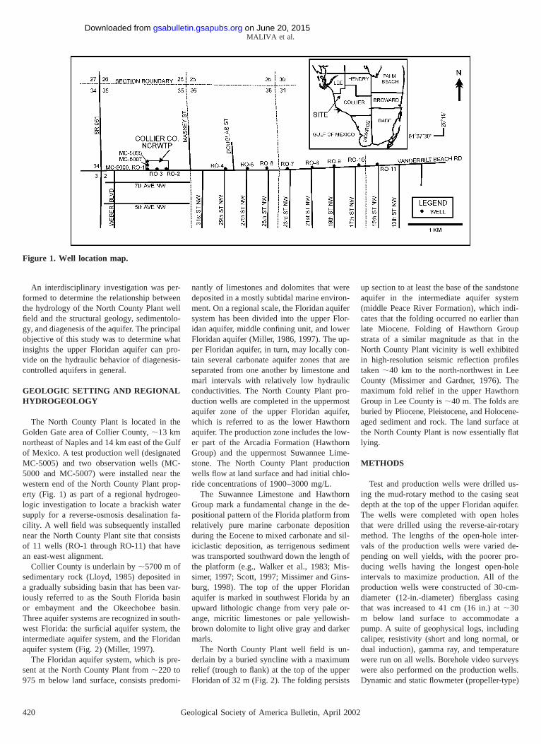
Figure 1. Well location map.
An interdisciplinary investigation was per-formed to determine the relationship betweenthe hydrology of the North County Plant wellfield and the structural geology, sedimentolo-gy, and diagenesis of the aquifer. The principalobjective of this study was to determine whatinsights the upper Floridan aquifer can pro-vide on the hydraulic behavior of diagenesis-controlled aquifers in general.
GEOLOGIC SETTING AND REGIONALHYDROGEOLOGY
The North County Plant is located in theGolden Gate area of Collier County, ;13 kmnortheast of Naples and 14 km east of the Gulfof Mexico. A test production well (designatedMC-5005) and two observation wells (MC-5000 and MC-5007) were installed near thewestern end of the North County Plant prop-erty (Fig. 1) as part of a regional hydrogeo-logic investigation to locate a brackish watersupply for a reverse-osmosis desalination fa-cility. A well field was subsequently installednear the North County Plant site that consistsof 11 wells (RO-1 through RO-11) that havean east-west alignment.
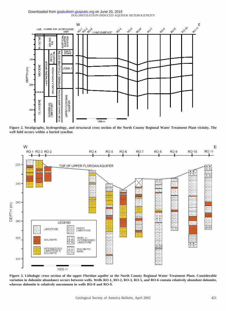
Collier County is underlain by ;5700 m ofsedimentary rock (Lloyd, 1985) deposited ina gradually subsiding basin that has been var-iously referred to as the South Florida basinor embayment and the Okeechobee basin.Three aquifer systems are recognized in south-west Florida: the surficial aquifer system, theintermediate aquifer system, and the Floridanaquifer system (Fig. 2) (Miller, 1997).
The Floridan aquifer system, which is pre-sent at the North County Plant from ;220 to975 m below land surface, consists predomi-
nantly of limestones and dolomites that weredeposited in a mostly subtidal marine environ-ment. On a regional scale, the Floridan aquifersystem has been divided into the upper Flor-idan aquifer, middle confining unit, and lowerFloridan aquifer (Miller, 1986, 1997). The up-per Floridan aquifer, in turn, may locally con-tain several carbonate aquifer zones that areseparated from one another by limestone andmarl intervals with relatively low hydraulicconductivities. The North County Plant pro-duction wells are completed in the uppermostaquifer zone of the upper Floridan aquifer,which is referred to as the lower Hawthornaquifer. The production zone includes the low-er part of the Arcadia Formation (HawthornGroup) and the uppermost Suwannee Lime-stone. The North County Plant productionwells flow at land surface and had initial chlo-ride concentrations of 1900–3000 mg/L.
The Suwannee Limestone and HawthornGroup mark a fundamental change in the de-positional pattern of the Florida platform fromrelatively pure marine carbonate depositionduring the Eocene to mixed carbonate and sil-iciclastic deposition, as terrigenous sedimentwas transported southward down the length ofthe platform (e.g., Walker et al., 1983; Mis-simer, 1997; Scott, 1997; Missimer and Gins-burg, 1998). The top of the upper Floridanaquifer is marked in southwest Florida by anupward lithologic change from very pale or-ange, micritic limestones or pale yellowish-brown dolomite to light olive gray and darkermarls.
The North County Plant well field is un-derlain by a buried syncline with a maximumrelief (trough to flank) at the top of the upperFloridan of 32 m (Fig. 2). The folding persists
up section to at least the base of the sandstoneaquifer in the intermediate aquifer system(middle Peace River Formation), which indi-cates that the folding occurred no earlier thanlate Miocene. Folding of Hawthorn Groupstrata of a similar magnitude as that in theNorth County Plant vicinity is well exhibitedin high-resolution seismic reflection profilestaken ;40 km to the north-northwest in LeeCounty (Missimer and Gardner, 1976). Themaximum fold relief in the upper HawthornGroup in Lee County is ;40 m. The folds areburied by Pliocene, Pleistocene, and Holocene-aged sediment and rock. The land surface atthe North County Plant is now essentially flatlying.
METHODS
Test and production wells were drilled us-ing the mud-rotary method to the casing seatdepth at the top of the upper Floridan aquifer.The wells were completed with open holesthat were drilled using the reverse-air-rotarymethod. The lengths of the open-hole inter-vals of the production wells were varied de-pending on well yields, with the poorer pro-ducing wells having the longest open-holeintervals to maximize production. All of theproduction wells were constructed of 30-cm-diameter (12-in.-diameter) fiberglass casingthat was increased to 41 cm (16 in.) at ;30m below land surface to accommodate apump. A suite of geophysical logs, includingcaliper, resistivity (short and long normal, ordual induction), gamma ray, and temperaturewere run on all wells. Borehole video surveyswere also performed on the production wells.Dynamic and static flowmeter (propeller-type)
on June 20, 2015gsabulletin.gsapubs.orgDownloaded from
Geological Society of America Bulletin, April 2002 421
DOLOMITIZATION-INDUCED AQUIFER HETEROGENEITY
Figure 2. Stratigraphy, hydrogeology, and structural cross section of the North County Regional Water Treatment Plant vicinity. Thewell field occurs within a buried syncline.
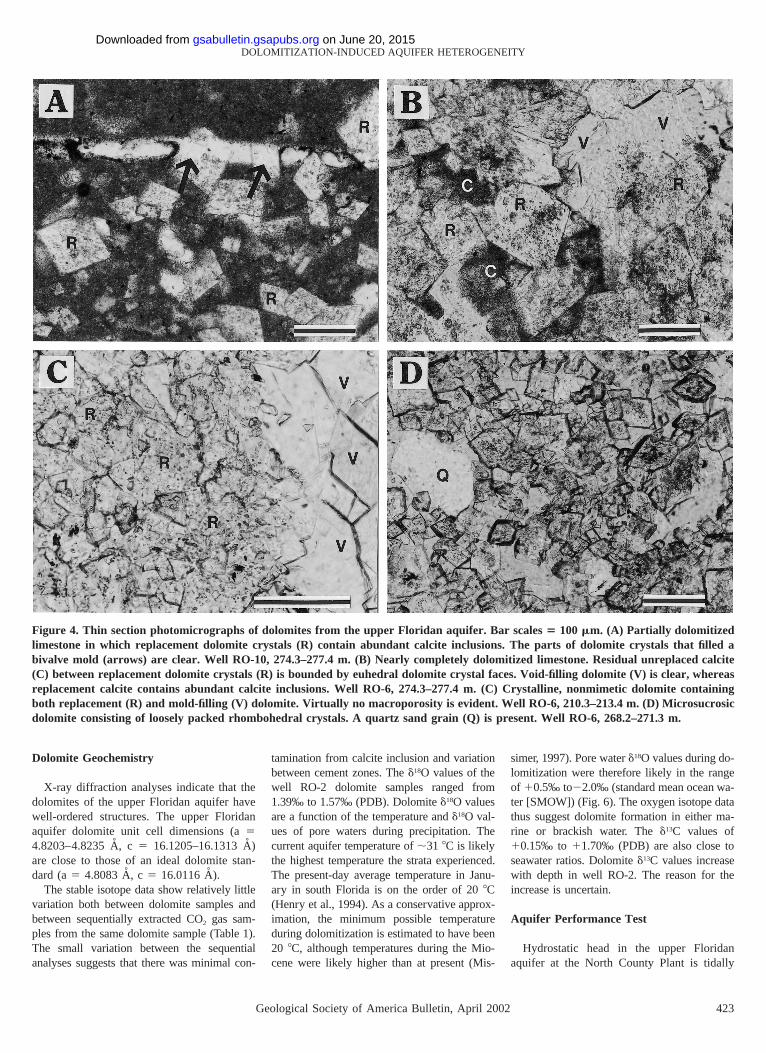
Figure 3. Lithologic cross section of the upper Floridan aquifer at the North County Regional Water Treatment Plant. Considerablevariation in dolomite abundance occurs between wells. Wells RO-1, RO-2, RO-3, RO-5, and RO-6 contain relatively abundant dolomite,whereas dolomite is relatively uncommon in wells RO-8 and RO-9.
on June 20, 2015gsabulletin.gsapubs.orgDownloaded from

422 Geological Society of America Bulletin, April 2002
MALIVA et al.
logs were run on some production wells. Alldepths are reported in meters below land sur-face, which in the North County Plant well-field area has a elevation of ;4 m above theNational Geodetic Vertical Datum (NGVD).
A 72 h aquifer performance test was con-ducted using well MC-5005 as a productionwell and wells MC-5000 and MC-5007 as ob-servation wells. Well MC-5005 was pumpedat a constant rate of 4600 m3/d (850 gal/min)using a centrifugal pump with the dischargewater disposed of in an injection well com-pleted in the lower Floridan aquifer. The topof the injection zone is located ;760 m belowland surface, and confinement is sufficient toprevent impacting test results. Step drawdowntests, consisting of three to five steps with aminimum duration of 60 min, were performedon each production well. Electronic pressuretransducers and a data logger were used tomeasure heads in the observation and produc-tion wells during the aquifer tests.
Cuttings were described in the field duringwell drilling and subsequently examined in thelaboratory using a stereomicroscope. Thinsections of cuttings from wells RO-2, RO-6,and RO-10 were examined for microfaciesand diagenetic minerals and textures usingstandard petrographic techniques. Polishedthin sections of dolomite samples from wellRO-2 were analyzed using cathodoluminesc-ence microscopy and backscattered electronimaging with a scanning electron microscope.Cathodoluminescence microscopy was con-ducted on a cold-cathode instrument with anaccelerating potential of 26 kV, gun current of600 nA, focused beam diameter of 1–10 mm,and air chamber pressure of 0.01–0.05 Torr.
X-ray diffraction (XRD) analysis was per-formed using a Huber Guinier X-ray powderdiffractometer in transmission geometry.Samples were mixed with a silicon internalstandard and ground finely under alcohol.The powder slurry was mounted on Mylarfilm that rotated 20 rpm during analysis toimprove powder statistics and minimize theeffects of uneven distribution of sample pow-der. A computer-controlled point countermeasured radiation counts for 100 sec atstepped diffraction angles of 0.028 2u. The in-strument used CuKa1 radiation at 30 kV, 20MA. Data were recorded directly into a com-puter. Peak characteristics were analyzed us-ing a commercial (Microcal Software, Ltd.)curve-fitting program, ‘‘ORIGIN,’’ and cali-brated against a silicon internal standard. Theprogram CELREF was used to calculate unitcell dimensions from the XRD data.
Bulk-rock dolomite powders, treated withethylenediamenetetraacetic acid (EDTA) to re-move calcite inclusions, were analyzed for
d18O and d13C values at the Godwin Labora-tory (University of Cambridge, Department ofEarth Sciences). A VG Isogas PRISM massspectrometer, using a Micromass Multipreppreparation system, was used with calibrationto the Vienna PDB (VPDB) international stan-dard via National Bureau of Standards (NBS)-19 standard and analytical precision of betterthan 0.08‰. For each sample, the CO2 gasevolved after 6, 12, 18, and 24 h was analyzedseparately. The sequential extraction proce-dure was used because it can often detect thepresence of contamination of the CO2 gasfrom calcite inclusions and isotopic variationswithin the dolomite (zoning).
RESULTS
Limestone and Dolomite Petrography
The upper Floridan aquifer consists primar-ily of fossiliferous limestone and dolomite,with minor amounts of clay, marl, and calcar-eous sandstone and sandy limestone (Fig. 3).The limestones consist mostly of white, yel-lowish-gray, or very pale orange fossiliferouswackestones, in which mollusks (bivalves andgastropods) are the most common grain types.Bivalve shells that were originally both ara-gonitic and calcitic are present, with the for-mer commonly preserved as molds. Othercommon grain types are echinoderm ossicles,foraminifera (benthonic and planktonic), bryo-zoans, coralline algae, and peloids. Very fineto fine-grained quartz and phosphate grainsare present in varying abundances.
Dolomite in the upper Floridan aquifer istypically darker colored than the adjoininglimestone, ranging from pale yellowish-brownto medium yellowish-gray and medium olivegray. Three main types of dolomite are evidentin the cuttings. Most common is a dense,tightly crystalline dolomite that generally hasa low macroporosity and which is referred toas crystalline nonmimetic after the dolomitetextural classification scheme of Dawans andSwart (1988). The crystalline nonmimetic do-lomite commonly contains some moldic poresformed by the dissolution of aragonitic bi-valve shells. Less common is a fossiliferous,microsucrosic dolomite that has a very high($50%) apparent moldic and intercrystallineporosity. Unlithified, silt-sized dolomite (do-losilt) is present in some marl beds at varyingabundances.
The upper Floridan aquifer at the NorthCounty Plant has a complete progression fromundolomitized limestone to limestone partiallyreplaced by scattered dolomite crystals tocomplete replacement with no calcite or ara-gonite remaining. Dolomite crystals formed
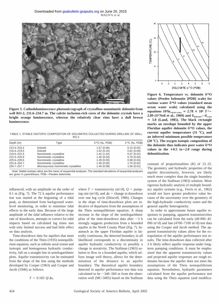
preferentially within the micrite matrix of thelimestone and have a euhedral rhombohedronmorphology (Fig. 4A). Impingement replace-ment (Lucia, 1962) occurred where dolomitecrystals that nucleated within the micrite ma-trix partially replaced adjoining fossils. Thedolomite crystals range up to ;200 mm in di-ameter, with the bulk being #100 mm. Inclu-sions, predominantly #5 mm in diameter orlength, are common in replacement dolomite.The inclusions consist mostly of calcite, as de-termined from Alizarin red staining and back-scattered electron imaging. The calcite inclu-sions may be either evenly distributedthroughout the dolomite or concentrated in thecenter of crystals and surrounded by clearrims. The latter cloudy-centered, clear-rimmedtexture is common in dolomites (e.g., Murray,1964; Sibley, 1980). Parts of dolomite crystalsthat precipitated as mold-filling cement inpores are clear (Fig. 4, A and B). Calcite ce-ment crystals are included in some mold-filling dolomite crystals, which is evidencethat dolomitization postdated both aragonitedissolution and some calcite cementation.
As dolomite abundance increases, euhedralcrystal boundaries give way in abundance tocompromise boundaries (Fig. 4B). Residualareas of micrite are bounded by euhedral crys-tal faces. The final stage of crystalline, non-mimetic dolomite formation is a dense mosaicwith only minor intercrystalline porosity (Fig.4C). Some moldic pores that are lined withdolomite cement may be preserved in thecrystalline dolomite.
The microsucrosic dolomite found in theupper Floridan aquifer consists of looselypacked mosaics of euhedral crystals that typ-ically range in size up to ;100 mm (Fig. 4D).The dolomite rhombs have calcite inclusion–rich cores and clear rims. Microsucrosic do-lomite samples have high intercrystalline po-rosities and apparently large pore throats,which suggests high permeability. A gradationexists between the microsucrosic and crystal-line nonmimetic dolomite, which are textur-ally similar to some Miocene and Pliocene do-lomites from the Bahamas (Dawans andSwart, 1988) and Netherlands Antilles (Sibley,1982). The dolosilt consists of loosely packedrhombohedra that are generally #50 mm indiameter.
Cathodoluminescence petrography revealedzoning in the dolomites of the upper Floridanaquifer. The zoning pattern is not consistentamong samples. Some dolomite crystals havean overall dull brown luminescence with somefaint lighter- and darker-colored bands. Othersamples have bright orange cores and dullrims (Fig. 5).
on June 20, 2015gsabulletin.gsapubs.orgDownloaded from
Geological Society of America Bulletin, April 2002 423
DOLOMITIZATION-INDUCED AQUIFER HETEROGENEITY
Figure 4. Thin section photomicrographs of dolomites from the upper Floridan aquifer. Bar scales 5 100 mm. (A) Partially dolomitizedlimestone in which replacement dolomite crystals (R) contain abundant calcite inclusions. The parts of dolomite crystals that filled abivalve mold (arrows) are clear. Well RO-10, 274.3–277.4 m. (B) Nearly completely dolomitized limestone. Residual unreplaced calcite(C) between replacement dolomite crystals (R) is bounded by euhedral dolomite crystal faces. Void-filling dolomite (V) is clear, whereasreplacement calcite contains abundant calcite inclusions. Well RO-6, 274.3–277.4 m. (C) Crystalline, nonmimetic dolomite containingboth replacement (R) and mold-filling (V) dolomite. Virtually no macroporosity is evident. Well RO-6, 210.3–213.4 m. (D) Microsucrosicdolomite consisting of loosely packed rhombohedral crystals. A quartz sand grain (Q) is present. Well RO-6, 268.2–271.3 m.
Dolomite Geochemistry
X-ray diffraction analyses indicate that thedolomites of the upper Floridan aquifer havewell-ordered structures. The upper Floridanaquifer dolomite unit cell dimensions (a 54.8203–4.8235 A, c 5 16.1205–16.1313 A)are close to those of an ideal dolomite stan-dard (a 5 4.8083 A, c 5 16.0116 A).
The stable isotope data show relatively littlevariation both between dolomite samples andbetween sequentially extracted CO2 gas sam-ples from the same dolomite sample (Table 1).The small variation between the sequentialanalyses suggests that there was minimal con-
tamination from calcite inclusion and variationbetween cement zones. The d18O values of thewell RO-2 dolomite samples ranged from1.39‰ to 1.57‰ (PDB). Dolomite d18O valuesare a function of the temperature and d18O val-ues of pore waters during precipitation. Thecurrent aquifer temperature of ;31 8C is likelythe highest temperature the strata experienced.The present-day average temperature in Janu-ary in south Florida is on the order of 20 8C(Henry et al., 1994). As a conservative approx-imation, the minimum possible temperatureduring dolomitization is estimated to have been20 8C, although temperatures during the Mio-cene were likely higher than at present (Mis-
simer, 1997). Pore water d18O values during do-lomitization were therefore likely in the rangeof 10.5‰ to22.0‰ (standard mean ocean wa-ter [SMOW]) (Fig. 6). The oxygen isotope datathus suggest dolomite formation in either ma-rine or brackish water. The d13C values of10.15‰ to 11.70‰ (PDB) are also close toseawater ratios. Dolomite d13C values increasewith depth in well RO-2. The reason for theincrease is uncertain.
Aquifer Performance Test
Hydrostatic head in the upper Floridanaquifer at the North County Plant is tidally
on June 20, 2015gsabulletin.gsapubs.orgDownloaded from
424 Geological Society of America Bulletin, April 2002
MALIVA et al.
Figure 5. Cathodoluminescence photomicrograph of crystalline-nonmimetic dolomite fromwell RO-2, 231.6–234.7 m. The calcite inclusion-rich cores of the dolomite crystals have abright orange luminescence, whereas the relatively clear rims have a dull brownluminescence.
TABLE 1. STABLE ISOTOPIC COMPOSITION OF DOLOMITES COLLECTED DURING DRILLING OF WELLRO-2
Depth (m) Type d18O (‰, PDB) d13C (‰, PDB)
213.4–216.4 Dolosilt 1.57 (0.06) 0.15 (0.02)216.4–219.5 Dolosilt 1.52 (0.10) 0.62 (0.05)219.5–222.5 Nonmimetic crystalline 1.42 (1.42) 0.57 (0.01)222.5–225.6 Nonmimetic crystalline 1.45 (0.04) 0.79 (0.04)225.6–228.6 Nonmimetic crystalline 1.39 (0.05) 0.98 (0.03)231.6–234.7 Nonmimetic crystalline 1.49 (0.05) 1.70 (0.02)234.7–237.7 Microsucrosic-nonmimetic crystalline 1.49 (0.08) 1.56 (0.01)
Note: Stable isotope ratios are the mean of sequential analyses. The standard deviations of sequential analysesare given in parentheses. PDB—Peedee belemnite.
Figure 6. Temperature vs. dolomite d18Ovalues (Peedee belemnite [PDB] scale) forvarious water d18O values (standard meanocean water scale) calculated using theequations 103lncalcite-water 5 2.78 3 106 T–222.89 (O’Neil et al., 1969) and ddolomite—dwater
5 3.8 (Land, 1985). The black rectanglemarks an envelope bounded by the upperFloridan aquifer dolomite d18O values, thecurrent aquifer temperature (31 8C), andan inferred minimum possible temperature(20 8C). The oxygen isotopic composition ofthe dolomite thus indicates pore water d18Ovalues in the 10.5 to22.0 range duringdolomitization.
influenced, with an amplitude on the order of0.1 m (Fig. 7). The 72 h aquifer performancetest was started at the beginning of a tidalpeak, as determined from background water-level monitoring, in order to minimize tidaleffects in the early data. Because of the largeamplitude of the tidal influence relative to therate of drawdown, attempts to correct for tidalimpacts based on calculated lag times metwith only limited success and had little effecton data analysis.
Time-drawdown data for aquifers that meetthe conditions of the Theis (1935) nonequilib-rium equation, such as infinite areal extent andisotropic and homogenous hydraulic conduc-tivity, fall on a straight line in semilogarithmicplots. Aquifer transmissivity can be estimatedfrom the slope of the line using the methodsdeveloped by Cooper (1963) and Cooper andJacob (1946) as follows:
T 5 0.183 Q/Ds,
where T 5 transmissivity (m2/d), Q 5 pump-ing rate (m3/d), and Ds 5 change in drawdownover one log cycle (Driscoll, 1986). Changesin the slope of time-drawdown plots are in-dicative of departures from the assumptions ofthe Theis nonequilibrium equation. A sharpincrease in the slope of the semilogarithmicplots of the time-drawdown data after ;3 hstrongly suggests production from a boundedaquifer at the North County Plant (Fig. 7). In-asmuch as the upper Floridan aquifer is lat-erally continuous, the detected boundary in alllikelihood corresponds to a discontinuity inaquifer hydraulic conductivity or possibly achange in storativity. The Stallman (1963) so-lution to flow in a bounded aquifer, which uti-lizes image well theory, allows for the deter-mination of the distance to an aquiferboundary. The theoretical aquifer boundarydetected in aquifer performance test data wascalculated to be ;340–560 m from the obser-vation well (MC-5005) based on the Stallman
constant of proportionalities (K) of 15–25.The geometry and hydraulic properties of theaquifer discontinuity, however, are likelymuch more complex than the single boundarysystem of the Stallman (1963) solution. Morerigorous hydraulic analysis of multiple bound-ary aquifer systems (e.g., Ferris et al., 1962)would not have greater predictive value be-cause of the uncertainty over the geometry ofthe high-hydraulic conductivity zones and thegeneral aquifer heterogeneity.
In order to approximate future aquifer re-sponses to pumping, apparent transmissivitiescan be calculated from the early (40 000–45000 m2/d) and late (4700–7100 m2/d) test datausing the Cooper and Jacob method. The ap-parent transmissivity values allow for the ex-trapolation of the aquifer performance test re-sults. The time-drawdown data collected after3 h likely reflect aquifer response under long-term pumping conditions. It must be empha-sized that the apparent transmissivity valuesand projected aquifer responses are rough es-timates because the aquifer does not meet theassumptions of the Theis nonequilibriumequation. Nevertheless, hydraulic parameterscalculated from the aquifer performance testdata using the Theis equation (and modifica-
on June 20, 2015gsabulletin.gsapubs.orgDownloaded from

Geological Society of America Bulletin, April 2002 425
DOLOMITIZATION-INDUCED AQUIFER HETEROGENEITY
Figure 7. Semilogarithmic plots of time-drawdown data from 72 h aquifer-performancetest. Well MC-5005 was pumped at 4600 m3/d and drawdown was recorded in observationwells MC-5000 and MC-5007, which are located 168 m and 45 m, respectively, from theproduction well. The test was started at the beginning of a tidal peak and tidal fluctuationsare evident in the late data. A hydraulic barrier was reached at ;3 h into the test asevidenced by the steepening of the time-drawdown slope.
Figure 8. Drawdown vs. pumping rate plots from step-drawdown tests, which illustratethe very large differences in well performance (specific capacity) between wells.
tions thereof) can be used as initial values inthe development of calibrated numericalmodels.
Step-Drawdown Tests
The step-drawdown test revealed large dif-ferences in specific capacity (SC—well yield/drawdown) among the North County Plantproduction wells (Fig. 8). For example, wellRO-3 produced 15 800 m3/d with 5.9 m ofdrawdown (SC 5 2660 m3/d/m), whereas wellRO-8 produced only 545 m3/d with 5.5 m ofdrawdown (SC 5 99 m3/d/m). There is no ap-parent relationship between well location andspecific capacity. The least productive wells,RO-8 and RO-7, for example, are located nearthe highly productive well RO-6. No relation-ship is evident either between structural po-sition and specific capacity.
Flowmeter Logs
The combination of dynamic flowmeter andcaliper logs can provide information on thelocation of production zones in open-holewells. The dynamic flowmeter log provides
data on flow velocity, and the caliper log canbe used to approximate borehole cross-sectional area. The percentage of the total flowpassing different well depths can be estimated
by multiplying the difference between the dy-namic and static flowmeter logs by the bore-hole cross-sectional area and normalizing thedata for 100% flow in the well casing. Theflowmeter and caliper log data for productionwells RO-10 and RO-11 (Fig. 9) and test wellMC-5000 all show that the bulk (.60%) ofthe flow entered the pumped well from a 1.5m or less section of the aquifer. The thin pri-mary production intervals identified in theflowmeter logs consist of fractured dolomite.The subvertical fractures and associated bore-hole collapse zones are evident in boreholevideo surveys. The fractured intervals can bedetected also in some caliper logs by a sharpincrease in borehole diameters resulting fromborehole collapse during drilling. Preferentialborehole enlargement of fractured dolomitebeds is common in the lower Floridan aquiferof south Florida (Maliva and Walker, 1998,and references therein).
DISCUSSION
The considerable variation in the specificcapacity of production wells at the NorthCounty Plant correlates with dolomite abun-dance (Fig. 6). The three most productive(highest specific capacity) wells (RO-2, RO-3, and RO-6) all contain abundant dolomite.Dolomite is relatively uncommon in the threelowest specific capacity wells (RO-7, RO-8,and RO-9). Contrary to the general pattern,dolomite is not particularly abundant in therelatively high specific capacity well RO-11(Fig. 3). However, fractured dolomite is pre-sent between 260 and 264 m in RO-11, which
on June 20, 2015gsabulletin.gsapubs.orgDownloaded from

426 Geological Society of America Bulletin, April 2002
MALIVA et al.
Figure 9. Plots of percentage of total flow vs. depth obtained from flowmeter and caliperlog for wells RO-10 and RO-11. Both plots show that .60% of the flow entered the wellfrom thin (1–2 m thick) dolomitic intervals.
gives the well its relatively high specificcapacity.
The flowmeter logs indicate that major flowzones in the North County Plant wells occurinvariably within dolomitic intervals. Not alldolomite beds, however, have high hydraulicconductivities. The hydraulic conductivities ofdensely crystalline dolomite beds that are un-fractured are often extremely low in the Flor-idan aquifer system and provide effective ver-tical confinement between aquifer zones(Maliva and Walker, 1998). The high hydrau-lic conductivities of the water-producing do-lomites at the North County Plant are due tofracturing and, in some beds, a microsucrosictexture with associated high matrix porosityand apparent permeability. A potential causeof the fracturing of the upper Floridan aquiferdolomites is the compressional event in lateMiocene that resulted in the folding of themiddle Miocene and older strata (Fig. 2). Do-
lomite beds in the Floridan aquifer system ingeneral have tended to retain open fractures,whereas fractures in the softer limestone bedshave tended to heal (Maliva and Walker,1998). Aquifer heterogeneity in the upperFloridan aquifer at the North County Plant iscontrolled largely by dolomitization as indi-cated by the correlation between dolomiteabundance and the specific capacity of wells.In addition, flowmeter logs show that the prin-cipal flow zones in most wells are dolomiticintervals.
Dolomite intervals with high hydraulic con-ductivities in the upper Floridan aquifer havelimited areal extent to the degree that a bound-ary effect was detected in the aquifer perfor-mance test. The upper Floridan aquifer can beconceptualized as a large-scale dual-porositysystem that consists of three-dimensional bod-ies of highly conductive dolomite enclosedwithin limestones having lower hydraulic con-
ductivities. The total volume of water that canbe produced from the dolomite bodies is lim-ited. The response of the aquifer to pumpingis therefore largely a function of the hydraulicproperties of the limestone adjoining the do-lomite. Dolomitization in the upper Floridanaquifer increases the specific capacities ofsome wells, reducing the number of wells re-quired for a given water production rate, butit has little effect on the total yield of waterthat can safely be produced from the aquiferwithout adverse impacts.
Variations in dolomite abundance do notappear to be related to differences in deposi-tional environment among wells. The carbon-ate mud-bearing (wackestone and packstone)textures and presence of fossils of stenohalineorganisms, such as echinoderms, suggest thatmost of the upper Floridan aquifer limestoneswere deposited in a low-energy, marine envi-ronment in a deep-water ramp setting (Missi-mer, 1997). No significant differences in de-positional microfacies are evident among thenondolomitized and partially and completelydolomitized limestones.
The stable isotope data (calculated pore wa-ter d18O values of 10.5‰ to22.0‰, SMOW)indicate that dolomitization occurred in watersthat were either isotopically close to seawateror mixed seawater and fresh water. Dolomiteabundance in the upper Floridan aquifer waspresumably controlled in some manner by pa-leohydrology, but the nature of the relation-ship is not ascertainable because of the inher-ently limited amount of data available fromthe studied wells. If dolomitization did occurin or near a coastal mixing zone, then it isreasonable to speculate that dolomite bodiesmight be orientated parallel to the shoreline atthe time of dolomitization. Paleogeographicand lithofacies maps for the Miocene suggesta north-south– or northwest-southeast–orientedshoreline (Randazzo, 1997; Scott, 1997). Do-lomite bodies in the upper Floridan aquifermay therefore have a general north-south ornorthwest-southeast orientation. That dolomit-ic intervals are not continuous across theNorth County Plant well field is evidence thatthey do not have an east-west orientation.
CONCLUSIONS
The results of this interdisciplinary inves-tigation illustrate the large variability and un-predictability that may occur in aquifersstrongly affected by diagenesis. During the in-stallation of the North County Plant produc-tion wells it was not possible to predict wellperformance in advance of the drill bit. Acombination of geologic, geophysical, andaquifer-test data can reveal the nature and
on June 20, 2015gsabulletin.gsapubs.orgDownloaded from

Geological Society of America Bulletin, April 2002 427
DOLOMITIZATION-INDUCED AQUIFER HETEROGENEITY
magnitude of diagenesis-induced heterogene-ities in aquifer hydraulics and provide insightsinto general aquifer behavior. In the absenceof a grid of closely spaced wells or other fine-scale subsurface data, however, some aspectsof aquifers will remain indeterminate. Fluid-flow paths and dispersivity, in particular, can-not be accurately evaluated without knowl-edge of the fabric and three-dimensionalgeometry of bodies of high-hydraulic con-ductivity rock within the aquifer. Calibratednumerical models may still be used formeaningful prediction of large-scale aquiferresponses to pumping and other stresses.The accuracy of simulations of diagenesis-controlled aquifers may be limited on the lo-cal scale in the absence of fine-scale hydro-geologic data. Heterogeneities in aquiferhydraulics caused by dolomitization and otherdiagenetic processes, such as dissolution, ce-mentation, and neomorphism, may greatly im-pact projects requiring recovery of a specificvolume of water, such as pump-and-treat re-mediation and aquifer storage-and-recoverysystems. The uncertainty associated with thehydrology of diagenesis-controlled aquifers,once they are identified as such, does not pre-clude modeling of the behavior of such aqui-fers, but rather suggests that there may be sig-nificantly higher errors associated with theresults of predictive simulations.
ACKNOWLEDGMENTS
This manuscript benefited from the thoughtful re-views of Janet Herman, Jonathan Martin, and H.Leonard Vacher. We thank Collier County, Florida,for permission to publish the North County Region-al Water Treatment Plant hydrogeological data col-lected under contract with Camp Dresser & McKee,Inc.
REFERENCES CITED
Amthor, J.E., Mountjoy, E.W., and Machel, H.G., 1994, Re-gional-scale porosity and permeability variations inUpper Devonian Leduc buildups: Implications for res-ervoir development and prediction in carbonates:American Association of Petroleum Geologists Bul-letin, v. 78, p. 1541–1559.
Budd, D.A., 2001, Permeability loss with depth in the Ce-nozoic carbonate platform of west-central Florida:American Association of Petroleum Geologists Bul-letin, v. 85, p. 1253–1272.
Cooper, H.H., Jr., 1963, Type curves for non-steady radial
flow in an infinite leaky artesian aquifer, in Bentall,R., ed., Short-cuts and special problems in aquifertests: U.S. Geological Survey Water-Supply Paper1545-C, p. C48–C55.
Cooper, H.H., Jr., and Jacob, C.E., 1946, A generalizedgraphical method for evaluating formation constantsand summarizing well field history: Eos (Transactions,American Geophysical Union), v. 27, p. 526–534.
Dawans, J.M., and Swart, P.K., 1988, Textural and geo-chemical alterations in late Cenozoic Bahamian do-lomites: Sedimentology, v. 35, p. 385–403.
Driscoll, F.G., 1986, Groundwater and wells (second edi-tion): St. Paul, Minnesota, Johnson Filtration Systems,1089 p.
Duerr, A.D., 1995, Types of secondary porosity of carbon-ate rocks in injection and test wells in southern pen-insular Florida: U.S. Geological Survey Water-Re-sources Investigation Report 94–4013, 78 p.
Ferris, J.G., Knowles, D.B., Brown, R.H., and Stallman,R.W., 1962, Theory of aquifer tests: U.S. GeologicalSurvey Water-Supply Paper 1536-E, p. 69–174.
Haberfeld, J.L., 1991, Hydrogeology of effluent disposalzones, Floridan aquifer, South Florida: Ground Water,v. 29, p. 186–190.
Halley, R.R., and Schmoker, J.W., 1993, High-porosity car-bonate rocks of south Florida: Progressive loss or po-rosity with depth: American Association of PetroleumGeologists Bulletin, v. 67, p. 191–200.
Henry, J.A., Portier, K.M., and Coyne, J., 1994, The climateand weather of Florida: Sarasota, Florida, PineapplePress, 264 p.
Kohout, F.A., 1965, A hypothesis concerning cyclic flowof salt water related to geothermal heating in the Flor-idan aquifer: Transactions of the New York Academyof Sciences, Series II, v. 28, p. 249–271.
Kohout, F.A., 1967, Ground-water flow and the geothermalregime of the Floridan Plateau: Transactions of theGulf Coast Association of Geological Societies, v. 17,p. 339–354.
Land, L.S., 1985, The origin of massive dolomite: Journalof Geological Education, v. 33, p. 112–125.
Lloyd, J.M., 1985, Annotated bibliography of Florida base-ment geology and related regional and tectonic studiesincluding an appendix of Florida deep well data: Flor-ida Geological Survey Information Circular 98, 72 p.
Lucia, F.J., 1962, Diagenesis of a crinoidal sediment: Jour-nal of Sedimentary Petrology, v. 42, p. 848–865.
Maliva, R.G., and Walker, C.W., 1998, Hydrogeology ofdeep-well disposal of liquid wastes in southwest Flor-ida, USA: Hydrogeology Journal, v. 6, p. 538–548.
Meyers, F.W., 1989, Hydrogeology, ground-water move-ment, and subsurface storage in the Floridan aquifersystem in southern Florida: U.S. Geological SurveyProfessional Paper 1403-G, 59 p.
Miller, J.A., 1986, Hydrogeologic framework of the Flori-dan aquifer system in Florida and in parts of Georgia,Alabama, and South Carolina: U.S. Geological SurveyProfessional Paper 1403-B, 91 p.
Miller, J.A., 1997, Hydrogeology of Florida, in Randazzo,A.F., and Jones, D.S., eds., The geology of Florida:Gainesville, University Press of Florida, p. 69–88.
Missimer, T.M., 1997, Late Oligocene to Pliocene evolutionof the central portion of the south Florida platform:Mixing of siliciclastic and carbonate sediments [Ph.D.thesis]: Miami, Florida, University of Miami, 414 p.
Missimer, T.M., and Gardner, R.A., 1976, High-resolutionseismic reflection profiling for mapping shallow aqui-fers in Lee County, Florida: U.S. Geological SurveyWater-Resources Investigation Report 76–45, 30 p.
Missimer, T.M., and Ginsburg, R.N., 1998, Homogenizedcarbonates and siliciclastics in the Tertiary of south-west Florida: Transactions of the Gulf Coast Associ-ation of Geological Societies, v. 48, p. 263–274.
Murray, R.C., 1964, Preservation of primary structures andfabrics in dolomite, in Imbrie, J., and Newell, N., eds.,Approaches to paleoecology: New York, John Wiley,p. 388–403.
O’Neil, J.R., Clayton, R.N., and Mayeda, T.D., 1969, Ox-ygen isotope fractionation in divalent metal carbon-ates: Journal of Chemical Physics, v. 51,p. 5547–5548.
Puri, H.S., and Winston, G.O., 1974, Geologic frameworkof the high transmissivity zones in south Florida: Flor-ida Bureau of Geology Special Publication 20, 97 p.
Randazzo, A.F., 1997, The sedimentary platform of Florida:Miocene to Cenozoic, in Randazzo, A.F., and Jones,D.S., eds., The geology of Florida: Gainesville, Uni-versity Press of Florida, p. 39–56.
Safko, P.S., and Hickey, J.J., 1992, A preliminary approachto the use of borehole data, including television sur-veys, for characterizing secondary porosity of carbon-ate rocks in the Floridan aquifer system: U.S. Geolog-ical Survey Water-Resources Investigation Report91-4168, 70 p.
Scholle, P.A., and Halley, R.B., 1985, Burial diagenesis:Out of sight, out of mind, in Schneidermann, N., andHarris, P.M., eds., Carbonate cements: Society of Eco-nomic Paleontologists and Mineralogists Special Pub-lication 36, p. 309–334.
Scott, T.M., 1997, Miocene to Holocene history of Flor-ida, in Randazzo, A.F., and Jones, D.S., eds., Thegeology of Florida: Gainesville, University Press ofFlorida, p. 57–67.
Sibley, D.F., 1982, The origin of common dolomite fabrics:Clues from the Pliocene: Journal of Sedimentary Pe-trology, v. 52, p. 1087–1100.
Singh, W.P., Eichler, G.E., Sproul, C.R., and Garcia-Ben-gochea, J.I., 1983, Pump testing Boulder Zone aquifer,south Florida: Journal of Hydraulic Engineering, v. 9,p. 1152–1160.
Stallman, R.W., 1963, Type curves for the solution of singleboundary problems, in Bentall, R., ed., Short-cuts andspecial problems in aquifer tests: U.S. Geological Sur-vey Water-Supply Paper 1545-C, p. C45–C47.
Theis, C.V., 1935, The relation between the lowering ofthe piezometric surface and the rate and duration of-discharge of a well using ground water storage:Transactions of the American Geophysical Union,v. 2, p. 519–524.
Vernon, R.O., 1970, The beneficial use of zones of hightransmissivity in the Florida subsurface: Florida Bu-reau of Geology Information Circular 70, 36 p.
Walker, K.R., Shanmugan, G., and Ruppel, S.C., 1983, Amodel for carbonate to terrigenous clastic sequences:Geological Society of America Bulletin, v. 94,p. 700–712.
Winston, G.O., 1995, The Boulder Zone dolomites of Flor-ida, Volume 1. Paleogene and Upper Cretaceous zoneof the southeastern peninsula and the Keys: Coral Ga-bles, Florida, Miami Geological Survey, 70 p.
Winston, G.O., 1996, The Boulder Zone dolomites of Flor-ida, Volume 2. Paleogene zones of southwestern Flor-ida: Coral Gables, Florida, Miami Geological Survey,64 p.
MANUSCRIPT RECEIVED BY THE SOCIETY MARCH 12, 2001REVISED MANUSCRIPT RECEIVED NOVEMBER 27, 2001MANUSCRIPT ACCEPTED NOVEMBER 27, 2001
Printed in the USA
on June 20, 2015gsabulletin.gsapubs.orgDownloaded from

Geological Society of America Bulletin
doi: 10.1130/0016-7606(2002)114<0419:DIAHEF>2.0.CO;2 2002;114, no. 4;419-427Geological Society of America Bulletin
Owosina and J.A.D. DicksonRobert G. Maliva, Gordon P. Kennedy, W. Kirk Martin, Thomas M. Missimer, Elizabeth S. Floridan aquifer, southwest FloridaDolomitization-induced aquifer heterogeneity: Evidence from the upper
Email alerting servicesnew articles cite this article
to receive free e-mail alerts whenwww.gsapubs.org/cgi/alertsclick
SubscribeSociety of America Bulletin
to subscribe to Geologicalwww.gsapubs.org/subscriptions/click
Permission request to contact GSAhttp://www.geosociety.org/pubs/copyrt.htm#gsaclick
this publication do not reflect official positions of the Society.regardless of their race, citizenship, gender, religion, or political viewpoint. Opinions presented inother forums for the presentation of diverse opinions and positions by scientists worldwide, site providing the posting includes a reference to the article's full citation. GSA provides this andbut authors may post the abstracts only of their articles on their own or their organization's Web use in classrooms to further education and science. This file may not be posted to any Web site,subsequent works and to make unlimited copies of items in GSA's journals for noncommercial requests to GSA, to use a single figure, a single table, and/or a brief paragraph of text intheir employment. Individual scientists are hereby granted permission, without fees or further Copyright not claimed on content prepared wholly by U.S. government employees within scope of
Notes
Geological Society of America
on June 20, 2015gsabulletin.gsapubs.orgDownloaded from
Copyright © 2022 FDOKUMEN