D. Micle, L. Măruia, A. Cîntar, O. Bozu, E. Nemeth, A. Stavilă, L. Bolcu, "Non-invasive...
16
Non-invasive archaeological research in the Roman Castrum from Vărădia, „Rovină” (Caraş-Severin County). A topographic and geophysical study Tome XII, Numéro 1 139 Annales d’Université Valahia Targoviste, Section d’Archéologie et d’Histoire, Tome XII, Numéro 1, 2010, p. 139-154 ISSN: 1584-1855 www.annalesfsu.ro Non-invasive archaeological research in the Roman Castrum from Vărădia, „Rovină” (Caraş-Severin County). A topographic and geophysical study Dorel Micle*, Liviu Măruia*, Adrian Cîntar*, Ovidiu Bozu**, Eduard Nemeth***, Andrei Stavilă****, Lavinia Bolcu**** * Department of History, West University of Timisoara, Bd. V. Pârvan, No. 2-4, Timişoara, Timiş County, Romania. ** County Museum of Etnography and Boarder Regiment of Caransebeş,. P-ţa Gen. I. Dragalina, No. 2, Caransebeş, Caraş-Severin County, Romania. *** Department of History, „Babeş-Bolyai” University of Cluj Napoca, Mihail Kogalniceanu Street No. 1, Cluj- Napoca, Cluj County, Romania **** Department of History, West University of Timisoara, Bd. V. Pârvan, No. 2-4, Timişoara, Timiş County, Romania (student teams) Abstract: Non-invasive archaeological research in the Roman Castrum from Vărădia, „Rovină” (Caraş-Severin County). A topographic and geophysical study The historic of the archaeological research of Vărădia locality (Caraş- Severin County) is very complex, as the historiographical debates regarding the archaeological objectives here are older than one century. In 1932, Grigore Florescu conducts an excavation campaign in the „Rovină” (or “Pustă”) point castrum, unveiling the superior part of the path of the fortified wall and a part of the commandment building (Principia). Starting with 1996, Ovidiu Bozu also begins systematic research archaeological campaigns for the „Rovină”/„Pustă” point. Since 1999 Eduard Németh from „Babeş-Bolyai” University of Cluj Napoca, joined the research team. At the end of July 2008 a team from the West University of Timisoara (Dorel Micle, Liviu Măruia and the student Lavinia Bolcu) performs a topographical survey with the total station of the „Rovină” point castrum, and for another week the team performs a geophysical prospection of the same objective. The topographical survey precisely revealed many morphological aspects of the Vărădia „Rovină” castrum as they are visible nowadays on the terrain: oriented on the SSE-NNW direction, exact dimensions (140x160 m), the relevance of the area’s microrelief (the castrum builders speculated a higher terrace located between divagating windings of Caraş River, but which were affected by modern earthworks of territory layout), and the defining of positioning landmarks reporting to present anthropic and natural structures (roads, bridges, canals, etc.). The high precision topographical plans will be used in the future for correct excavation plans layout (sections, cassettes, etc.) for further systematic archaeological research. The results of the magnetometric prospection revealed many aspects and feature with technical and historic nature: a) it allows the correct identification of the archaeological sections excavated in time; b) it allows the identification of structures affected by older archaeological excavations; c) proves the existence of a double enclosure wall; d) it allows the identification of the E tower of the Porta Praetoria; e) it is spectacular the revelation of the stone foundation traces of the centurion houses, and their orientation and dimensions, the barracks that flanked Via Praetoria; f) it allows the observation of anomalies caused by metal presence in the barracks area which could indicate a workshop (Fabrica); g) some curtain towers are also visible on the S, N and W sides; h) it allows the identification of intersecting roads in front of Principia, Via Praetoria and Via Principalis; i) it proves the existence of only one defense ditch, visible on the N side. Key words: GIS, total station, landscape archaeology, field archaeology, magnetometric prospecting
-
Upload
independent -
Category
Documents
-
view
1 -
download
0
Transcript of D. Micle, L. Măruia, A. Cîntar, O. Bozu, E. Nemeth, A. Stavilă, L. Bolcu, "Non-invasive...

Non-invasive archaeological research in the Roman Castrum from Vărădia, „Rovină” (Caraş-Severin County). A topographic and geophysical study
Tome XII, Numéro 1 139
Annales d’Université Valahia Targoviste, Section d’Archéologie et d’Histoire, Tome XII, Numéro 1, 2010, p. 139-154 ISSN: 1584-1855 www.annalesfsu.ro
Non-invasive archaeological research in the Roman Castrum from Vărădia,
„Rovin ă” (Cara ş-Severin County). A topographic and geophysical study
Dorel Micle*, Liviu Măruia*, Adrian Cîntar*, Ovidiu Bozu**, Eduard Nemeth***, Andrei Stavilă****, Lavinia Bolcu****
* Department of History, West University of Timisoara, Bd. V. Pârvan, No. 2-4, Timişoara, Timiş County, Romania. ** County Museum of Etnography and Boarder Regiment of Caransebeş,. P-ţa Gen. I. Dragalina, No. 2, Caransebeş, Caraş-Severin County, Romania. *** Department of History, „Babeş-Bolyai” University of Cluj Napoca, Mihail Kogalniceanu Street No. 1, Cluj-Napoca, Cluj County, Romania **** Department of History, West University of Timisoara, Bd. V. Pârvan, No. 2-4, Timişoara, Timiş County, Romania (student teams) Abstract: Non-invasive archaeological research in the Roman Castrum from Vărădia, „Rovină” (Cara ş-Severin County). A topographic and geophysical study The historic of the archaeological research of Vărădia locality (Caraş-Severin County) is very complex, as the historiographical debates regarding the archaeological objectives here are older than one century. In 1932, Grigore Florescu conducts an excavation campaign in the „Rovină” (or “Pustă”) point castrum, unveiling the superior part of the path of the fortified wall and a part of the commandment building (Principia). Starting with 1996, Ovidiu Bozu also begins systematic research archaeological campaigns for the „Rovină”/„Pustă” point. Since 1999 Eduard Németh from „Babeş-Bolyai” University of Cluj Napoca, joined the research team.
At the end of July 2008 a team from the West University of Timisoara (Dorel Micle, Liviu Măruia and the student Lavinia Bolcu) performs a topographical survey with the total station of the „Rovină” point castrum, and for another week the team performs a geophysical prospection of the same objective.
The topographical survey precisely revealed many morphological aspects of the Vărădia „Rovină” castrum as they are visible nowadays on the terrain: oriented on the SSE-NNW direction, exact dimensions (140x160 m), the relevance of the area’s microrelief (the castrum builders speculated a higher terrace located between divagating windings of Caraş River, but which were affected by modern earthworks of territory layout), and the defining of positioning landmarks reporting to present anthropic and natural structures (roads, bridges, canals, etc.). The high precision topographical plans will be used in the future for correct excavation plans layout (sections, cassettes, etc.) for further systematic archaeological research.
The results of the magnetometric prospection revealed many aspects and feature with technical and historic nature: a) it allows the correct identification of the archaeological sections excavated in time; b) it allows the identification of structures affected by older archaeological excavations; c) proves the existence of a double enclosure wall; d) it allows the identification of the E tower of the Porta Praetoria; e) it is spectacular the revelation of the stone foundation traces of the centurion houses, and their orientation and dimensions, the barracks that flanked Via Praetoria; f) it allows the observation of anomalies caused by metal presence in the barracks area which could indicate a workshop (Fabrica); g) some curtain towers are also visible on the S, N and W sides; h) it allows the identification of intersecting roads in front of Principia, Via Praetoria and Via Principalis; i) it proves the existence of only one defense ditch, visible on the N side. Key words: GIS, total station, landscape archaeology, field archaeology, magnetometric prospecting
Sorin
Sticky Note
Dorel Micle, Liviu Măruia, Adrian Cîntar, Octavian Bozu, Eduard Nemeth, Andrei Stavilă, Lavinia Bolcu, Non-invasive archaeological research in the Roman Castrum from Vărădia, „Rovină” (Caraş-Severin County). A topographic and geophysical study, În: Annales d’Université “Valahia” Târgovişte. Section d’Archéologie et d’Histoire, Tome XII, Numéro 1, 2010, pp. 139–154 (online http://www.annalesfsu.ro/sitero/Tome_XII_no.1/9%20Dorel%20Micle.pdf ).

Dorel Micle, Liviu Măruia, Adrian Cîntar, Ovidiu Bozu, Eduard Nemeth, Andrei Stavilă, Lavinia Bolcu
Tome XII, Numéro 1
Short historic
The historic of the archaeological research of Vărădia locality (Caraş-Severin County) is very complex, as the historiographical debates regarding the archaeological objectives here are older than one century. The main issue was to identify the antique Arcidava, mentioned by Ptolemy in Geographia, III, 8, 4 (V. Pârvan, 1926, p. 81, 262; C. Daicoviciu, 1945, p. 46; R. Vulpe, 1960, p. 557-564; I. H. Crişan, 1977, p. 105-107). Important vestiges were found in the points: „Dealul Chilii” and „Rovină”. In both locations there are Roman castra that were archaeologically investigated starting from the beginning of the XXth century by the curator of Vrsač Museum, the tireless Bódog (Felix) Mileker (B. Mileker, 1897, p. 120-121; B. Mileker, 1906, p. 153-154). In the interwar period, in 1932, Grigore Florescu conducts an excavation campaign in the „Rovină” point castrum, unveiling the superior part of the path of the fortified wall and a part of the commandment building (Principia) (Gr. Florescu, 1934, p. 71-78). More surveys and field research are done in the 1970s on the inferior Caraş River, in Vărădia’s case the focus was on the pluristratified archaeological objective on „Dealul Chilii” (E. Iaroslavschi, Gh. Lazarovici, 1979, p. 452-454). Starting with 1974 until present day, the systematic research of „Dealul Chilii” was done by Ovidiu Bozu and Eugen Iaroslavschi, resulting remarkable results, but most of them still inedited (O. Bozu, E. Iaroslavschi, 1996, p. 123; E. Iaroslavschi, O. Bozu, 2003, p. 295-300). In parallel with this research, starting with 1996, Ovidiu Bozu also begins systematic research archaeological campaigns for the „Rovină”/„Pustă” point. Starting with 1999 Eduard Németh (E. Németh, 2006, p. 689-696; E. Németh, O. Bozu, 2000, p. 112; E. Németh, O. Bozu, 2001, p. 267; E. Németh, O. Bozu, 2002, p. 328-329; E. Németh, O. Bozu, 2005, p. 401-402; E. Németh, O. Bozu, 2005, p. 201-210; A. Ardeţ, E. Iaroslavschi, O. Bozu, 2003, 1, p. 309-315; E. Iaroslavschi, O. Bozu, 2003, p. 297) from „Babeş-Bolyai” University of Cluj Napoca, joined the research team.
At the end of July 2008 a team from the West University of Timisoara (Dorel Micle, Liviu Măruia and the student Lavinia Bolcu) performs a topographical survey with the total station of the „Rovină” point castrum, and for another week the team performs a geophysical prospection of the same objective.
Geographic description
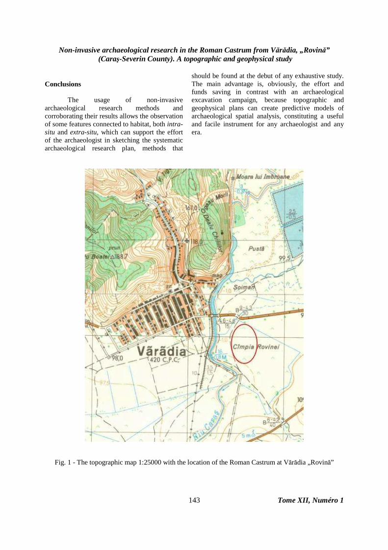
The Roman castrum at Vărădia „Rovină” is placed at 760 meters SE from the Orthodox Church in Vărădia; at 360 meters SE from the bridge over Caraş River on the road DJ 573 B Greoni – Vărădia and at 2.26 kilometers NE from the Orthodox Church in Mercina, at 300 meters E of the left side of Caraş River (fig. 1). The GPS coordinates are: 45.04.44 N, 21.33.07 E and 97.5 meters altitude.
From a geomorphologic point of view, the castrum is placed in the riverside of the Caraş River, on its left side. The Roman military builders speculated an erosion terrace, positioned between more ramble arms of Caraş, so the castrum was protected of floods. Nowadays the initial landscape is radically transformed by land and hidroamelioration works done in the modern age (fig. 2 - The Google Earth image’s technical data: Catalog No.: 1010010003819402, Acquisition date: January 11, 2005, Image center coordinates: Lat/Long: 45.102° N / 21.523° E, Nadir angle: 14°, Azimuth angle: 275°, Satellite sensor: QB02, Stripe: Pan_MS1).
Work methodology First step: The topographical measurements with the Total Station
The Total Station is partially based on a principle used at traditional theodolites, were angles are calculated by vertical and horizontal gradations at 360º. The Total Station uses topographical degrees for its measurements, i.e. 400º for a circle. The station uses a device called EDM (Electronic Distance Measurer) that sends out a laser signal that reflects of the prism after a time interval, which is used to calculate the distance. The Total Station has a built-in microprocessor which automatically collects these angles and distances measurements, calculates the trigonometric equations and converts it to coordinates.
Instead of a supervisor who gathers the data on paper, it is sent to a data collector and it can be

Non-invasive archaeological research in the Roman Castrum from Vărădia, „Rovină” (Caraş-Severin County). A topographic and geophysical study
Tome XII, Numéro 1 141
downloaded to a computer in order to create a tridimensional points structure (x, y, z).
The larger the number of acquired points on site, the more realistic triangulation and more precise 3D representation we get that is closer to terrain reality. Also, the interpolation method used (lagrange, kriging, spline, etc.) can contribute to a better, real representation (fig. 3.).
The topographical survey at Vărădia „Rovină” gathered 1006 points for the 3D mesh and 123 points for the geophysical prospection grid. We used a mixed method, both linear and radial, because the archaeological vestiges elevation was of a maximum of 0.5 and 0.75 meters from the ground and so we needed a thick network of points in order to reveal all terrain features (fig. 4).
From a technical point of view, we were obliged to measure some points outside the site’s surface, having two reasons: a) an archaeological site does not always identify with the relief shape it is found on, that is it may not occupy the whole surface or, the opposite; it may exceed the natural limits of the relief shape that would appear to be habitable (a hill top, a terrace, a peninsula, etc.) and b) the sudden interruption of terrain measured points during the survey at the limit of the antrhopic site, can cause, while computer editing the data, the fake sensation of a dissociate, atypical, unreal relief (deep valleys and sudden high shapes in the nearby which do not exist in reality – this is the case of pints read on the left banc of Caraş (fig. 5) that give the fake sensation of a well profiled terrace on the west side of the castrum because no points were measured in the river bed. Also, the points measured outside the site’s surface are obligatory in order to create the buffer zone, which is the protection area of the objective.
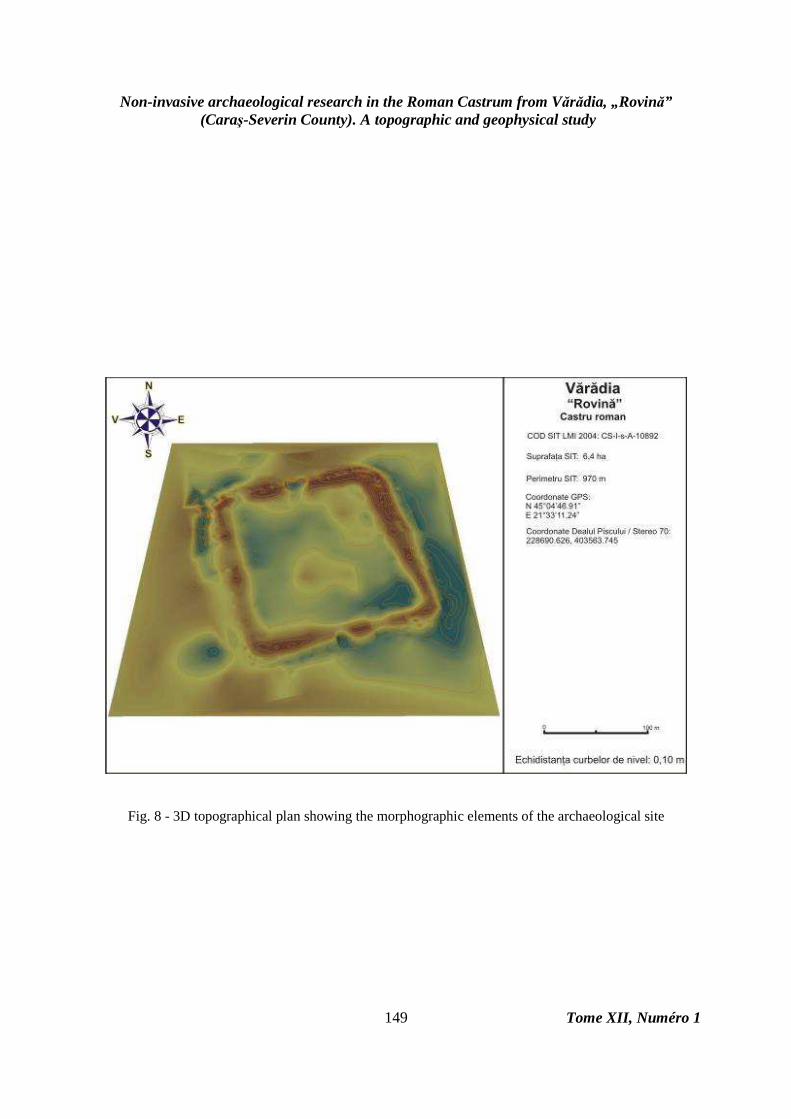
The results of the topographical survey at Vărădia „Rovină” are three types of topographical plans: a 2D topographical plan with contours (fig. 6), a 2D topographical plan with the digital elevation model and contours (fig. 7), and a 3D topographical plan showing the morphographic elements of the archaeological site (fig. 8).
An archaeological specific topographic survey has to follow and detect the morpho-structural elements that have an archaeological connotation (vallum path, ditches, anthropic earthwork, etc.), beside the elements followed by cadastral topography (spatial relations between the objective and the anthropical-natural visible elements – roads, bridges, buildings, agricultural lots, electricity poles, canals, etc.). Only this kind of topographical approach can reveal the relation between the archaeological objective and the micro-relief elements that represented topographical advantages or disadvantages when they built the monument.
Another specific feature is that the field operator carrying the prism has to be a terrain experienced archaeologist in order to discern between initial anthropic elements and ulterior alterations (natural – erosion winding, terrain drift, ram areas, etc.; or anthropic – hidroamelioration works, terracing, vine estate plantation remains, modern war trenches, archaeological poach or authorized archaeological excavations, etc.).
Also, a topographical survey is finalized with a 3D plan of the terrain as a result of GIS editing of terrain data, needed to extract spatial data (vertical terrain profiles, slope analysis, versant exposure analysis, altitude analysis) which constitute elements of geomorphometric and geomorphographic study, specific to interdisciplinary studies analytic archaeology. Also, a 3D plan constitutes the digital elevation model of the terrain and it can be exported to VRML (Virtual Reality Modeling Language) for virtual graphic reconstructions.
The topographical survey precisely revealed many morphological aspects of the Vărădia „Rovină” castrum as they are visible nowadays on the terrain: oriented on the SSE-NNW direction, exact dimensions (140x160 m), the relevance of the area’s microrelief (the castrum builders speculated a higher terrace located between divagating windings of Caraş River, but which were affected by modern earthworks of territory layout), and the defining of positioning landmarks reporting to present anthropic and natural structures (roads, bridges, canals, etc.). The high precision topographical plans will be used in the future for correct excavation plans layout (sections, cassettes, etc.) for further systematic archaeological research.

Dorel Micle, Liviu Măruia, Adrian Cîntar, Ovidiu Bozu, Eduard Nemeth, Andrei Stavilă, Lavinia Bolcu
Tome XII, Numéro 1
142
The second step: Magnetometric prospecting. Fluxgate method
The magnetometric prospection consists in evaluating the magnetic field of the soil, which is influenced by the magnetic properties of the rocks. This method is efficient especially for ferrous metal detection.
For these prospections we frequently use a Cesium gradiometer that assures 11 measurements per second. The sensors are disposed on a device connected to a harness at approximately 0.3 meters of the ground. The measurements are linear with a frequency of 1 meter and the results are saved to a computer. Three persons are needed to handle the equipment (one carries the device and the other two move the grid), but it has the advantage of covering between 6000 and 10000 m² per day. Other magnetometer types are based on protons (they follow the way in which the protons react as they orient to the force lines of the local magnetic field), based on Rubinium or with Gamma radiations.
The “fluxgate” instruments are sensible from a directional point of view and must be config.d as a gradiometer in order to create practical applications. The “fluxgate” instruments are capable of measuring only the vertical component of the magnetic field. This kind of instrument is constantly a subject of “de-calibration”, that is a systematic change in the zero point of the instrument, this takes place with the variation of the external natural factors, and in this case a re-calibration is necessary (J. C Alldred, 1964, p. 15).
Bartington GRAD601 (ArcheoSurveyor- User Manual, 2007), the two sensors version, register data on two lines for each traverse and it reduces the prospection time to half of the time needed for a one-sensor model. The instrument can also be used as a prospection instrument if it is set on parallel or zigzag mode or as a search instrument if using the acoustic part in scanning
mode, in order to localize and mark the path of a pipe, for example, without data saving.
When the instrument is used in prospection mode, the data are stored as a grid, measuring the magnetic variation along a series of spatial lines at 0.25, 0.5 or 1 meter, depending of the desired resolution. The instrument memory can store up to 30 grids of 30x30 meters with a traverse distance of 1 meter and a resolution of 4 readings/meter. The information obtained from the prospection can be downloaded as separate files, so the different grid size is not a problem.
The measured surface was divided depending on the topographic surface, in grids of 20x20 meters with an N-W orientation. The method used was zigzag with a density of 9 readings/meter and a data collection interval of 1 meter between traverses (fig. 9.).
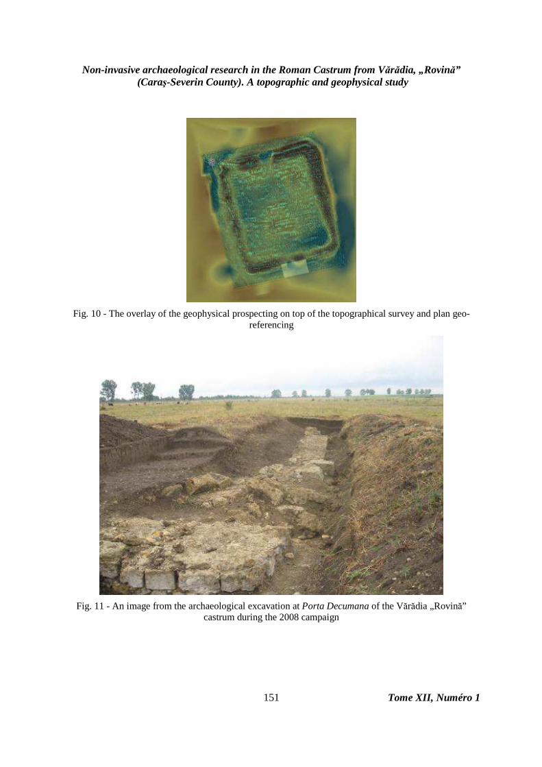
We measured 88 grids which were geo-referenced with the Total Station and they were laid in plan over the topographic survey (fig. 10.). We did not perform measurements in two successive grids in the South gate area (Porta Decumana) as the surface was under systematic archaeological research (fig. 11.).
The results of the magnetometric prospection revealed many aspects and feature with technical and historic nature (fig. 12 and 13): a) it allows the correct identification of the archaeological sections excavated in time and are no longer visible on the ground; b) it allows the identification of structures affected by older archaeological excavations the tried to expose the walls (see Principia); c) proves the existence of a double enclosure wall, especially visible on the S and N sides and also on the round castrum corners; d) it allows the identification of the E tower of the Porta Praetoria; e) it is spectacular the revelation of the stone foundation traces of the centurion houses, and their orientation and dimensions, the barracks that flanked Via Praetoria (it can be visible for the rest of the barracks, but they probably have a wooden foundation - they don’t have such visible traces); f) it allows the observation of anomalies caused by metal presence in the barracks area which could indicate a workshop (Fabrica); g) some curtain towers are also visible on the S, N and W sides; h) it allows the identification of intersecting roads in front of Principia, Via Praetoria and Via Principalis; i) it proves the existence of only one defense ditch, visible on the N side.
Non-invasive archaeological research in the Roman Castrum from Vărădia, „Rovină” (Caraş-Severin County). A topographic and geophysical study
Tome XII, Numéro 1 143
Conclusions
The usage of non-invasive archaeological research methods and corroborating their results allows the observation of some features connected to habitat, both intra-situ and extra-situ, which can support the effort of the archaeologist in sketching the systematic archaeological research plan, methods that
should be found at the debut of any exhaustive study. The main advantage is, obviously, the effort and funds saving in contrast with an archaeological excavation campaign, because topographic and geophysical plans can create predictive models of archaeological spatial analysis, constituting a useful and facile instrument for any archaeologist and any era.
Fig. 1 - The topographic map 1:25000 with the location of the Roman Castrum at Vărădia „Rovină”

Dorel Micle, Liviu Măruia, Adrian Cîntar, Ovidiu Bozu, Eduard Nemeth, Andrei Stavilă, Lavinia Bolcu
Tome XII, Numéro 1
144
Fig. 2 - The satellite image of the Vărădia „Rovină” castrum (Google Earth™ - DigitalGlobe, January 11,
2005)
Fig. 3 - A fictive triangulation example

Non-invasive archaeological research in the Roman Castrum from Vărădia, „Rovină” (Caraş-Severin County). A topographic and geophysical study
Tome XII, Numéro 1 145
Figure 4 - The spreading of the points measured with the Total Station

Dorel Micle, Liviu Măruia, Adrian Cîntar, Ovidiu Bozu, Eduard Nemeth, Andrei Stavilă, Lavinia Bolcu
Tome XII, Numéro 1
146
Fig. 5 - 3D modeling of the topographical survey using kriging interpolation and contours

Non-invasive archaeological research in the Roman Castrum from Vărădia, „Rovină” (Caraş-Severin County). A topographic and geophysical study
Tome XII, Numéro 1 147
Fig. 6. 2D topographical plan with contours

Dorel Micle, Liviu Măruia, Adrian Cîntar, Ovidiu Bozu, Eduard Nemeth, Andrei Stavilă, Lavinia Bolcu
Tome XII, Numéro 1
148
Fig. 7 - 2D topographical plan with the digital elevation model and contours
Non-invasive archaeological research in the Roman Castrum from Vărădia, „Rovină” (Caraş-Severin County). A topographic and geophysical study
Tome XII, Numéro 1 149
Fig. 8 - 3D topographical plan showing the morphographic elements of the archaeological site

Dorel Micle, Liviu Măruia, Adrian Cîntar, Ovidiu Bozu, Eduard Nemeth, Andrei Stavilă, Lavinia Bolcu
Tome XII, Numéro 1
150
Fig. 9 - An image from the magnetometric prospecting at Vărădia „Rovină”
Non-invasive archaeological research in the Roman Castrum from Vărădia, „Rovină” (Caraş-Severin County). A topographic and geophysical study
Tome XII, Numéro 1 151
Fig. 10 - The overlay of the geophysical prospecting on top of the topographical survey and plan geo-
referencing
Fig. 11 - An image from the archaeological excavation at Porta Decumana of the Vărădia „Rovină”
castrum during the 2008 campaign

Dorel Micle, Liviu Măruia, Adrian Cîntar, Ovidiu Bozu, Eduard Nemeth, Andrei Stavilă, Lavinia Bolcu
Tome XII, Numéro 1
152
Fig. 12 - The results of the magnetometric prospecting at Vărădia „Rovină”

Non-invasive archaeological research in the Roman Castrum from Vărădia, „Rovină” (Caraş-Severin County). A topographic and geophysical study
Tome XII, Numéro 1 153
Fig. 13 a, b, c - Details of the magnetometric prospecting at Vărădia „Rovină”
a b c

Dorel Micle, Liviu Măruia, Adrian Cîntar, Ovidiu Bozu, Eduard Nemeth, Andrei Stavilă, Lavinia Bolcu
Tome XII, Numéro 1
154
BIBLIOGRAPHY
ArcheoSurveyor - User Manual, 2007,
Program version 2.4.0.X, DW Consulting Geophysics in Archaeology, Issue 4, Barneveld, Holland.
Ardeţ A., Iaroslavschi E., Bozu O., 2003, Noi ştampile de amforă de la Vărădia, Banatica, 16, 1, p. 309-315.
Bozu O., Iaroslavschi E., 1996, Vărădia – „Dealul Chilii”, jud. Cara ş – Severin, Situri arheologice cercetate în perioada 1982-1992, Brăila, p. 123.
Crişan I. H., 1977, Burebista şi epoca sa, Bucureşti.
Daicoviciu C., 1945, La Transylvanie dans l’Antiquité , Bucureşti.
Florescu Gr., Le camp romain de Arcidava, Istros, 1, 1934, p. 71-78.
Iaroslavschi E., Bozu O., 2003, Raport preliminar privind principalele rezultate ale cercetărilor arheologice din castrul de pământ de pe Dealul Chilii (comuna Vărădia, judeţul Caraş Severin), Banatica, 16, p. 295-300.
Iaroslavschi E., Bozu O., 2003, Raport preliminar privind principalelor rezultate ale cercetărilor arheologice din castrul de pământ de pe Dealul Chilii (comuna Vărădia, judeţul Caraş-Severin), Banatica, 16, 1. p. 297.
Iaroslavschi E., Lazarovici Gh., 1979, Vestigii arheologice din bazinul Caraşului, Acta Musei Napocensis, 16, p. 452-454.
Alldred J. C, A Fluxgate Gradiometer for Archaeological Surveying, Archaeometry, 7, 1964, p. 15.
Mileker B. 1897, Délmagyaroszág regiségletei honfoglalàs ellötti idökböl, vol. I, Temesvár.
Mileker B. 1906, Délmagyaroszág regiségletei honfoglalàs ellötti idökböl, vol. III, Temesvár.
Németh E., 2006, Die neuen Ausgrabungen im Auxiliarkastell von Varadia-Pusta, in Limes XIX. Proceedings of the XIXth International Congress of Roman Frontier Studies, Pécs, Hungary, September 2003, Pécs, p. 689-696.
Németh E., Bozu O., 2000, Vărădia, com. Vărădia, jud. Caraş-Severin, Cronica Cercetărilor Arheologice din România – campania 1999, Bucureşti, p. 112.
Németh E., Bozu O., 2001, Vărădia, com. Vărădia, jud. Caraş-Severin, Cronica Cercetărilor Arheologice din România – campania 2000, Bucureşti, p. 267.
Németh E., Bozu O., 2002, Vărădia, com. Vărădia, jud. Caraş-Severin, Cronica Cercetărilor Arheologice din România – campania 2001, Bucureşti, p. 328-329.
Németh E., Bozu O., 2005, Noile săpături din castrul roman de la Vărădia-Pustă (jud. Caraş-Severin), Banatica, 17, p. 201-210.
Németh E., Bozu O., 2005, Vărădia, com. Vărădia, jud. Caraş-Severin. Punct: Pustă, Cronica Cercetărilor Arheologice din România – campania 2004, Bucureşti, p. 401-402.
Pârvan V., 1926, Getica. O protoistorie a Daciei, Bucureşti.
Vulpe R., 1960, in Omagiu lui Constantin Daicoviciu la împlinirea vârstei de 60 ani, Bucureşti, p. 557-564.