Neotectonics, seismicity and contemporary stress field in Norway – mechanisms and implications
Upload
univ-brestCategory
view
5download
0
ISSN 1069�3513, Izvestiya, Physics of the Solid Earth, 2014, Vol. 50, No. 6, pp. 785–794. © Pleiades Publishing, Ltd., 2014.Original Russian Text © V.A. Sankov, A.V. Lukhnev, A.I. Miroshnitchenko, A.A. Dobrynina, S.V. Ashurkov, L.M. Byzov, M.G. Dembelov, E. Calais, J. Déverchère, 2014, publishedin Fizika Zemli, 2014, No. 6, pp. 70–79.
785
1. INTRODUCTION
The Baikal Basin is the core of the Baikal rift sys�tem and the place of its nucleation, as follows from thestudies of recent decades (Logachev, 2001; Mats et al.,2001). From the standpoint of the tectonophysics offaulting, this segment of the rift system is closest to themature stage of evolution, when the lithosphere is rup�tured throughout its entire thickness and a single mainsuture is formed (Sherman et al., 1991). Accordingly,the kinematics of the motion on this structure bestcorresponds to the kinematics of the blocks separatedby it. Thus, studying the recent kinematics within theBaikal rift is important for establishing the regularitiesof regional geodynamics of the Asian continent. Theknowledge of the parameters of the block motion is anecessary element for elucidating the source of tec�tonic forces that drove the formation of the Baikal rift.
Previously, it was successively suggested to account forthe formation of the Baikal Basin by the model of pas�sive rifting (Molnar and Tapponnier, 1975; Petit et al.,1996; Leonov, 2001, etc), model of active rifting(Logachev and Zorin, 1984), a model that combinedboth mechanisms (Logachev et al., 2000), and thenagain the model of predominant active rifting underthe action of a local mantle source (Zorin and Turu�tanov, 2005; Zorin et al., 2006) or the gravitationalinstability of sediments (Gol’din et al., 2006). To date,a common view on the source of the Baikal rifting hasnot been achieved; however, there is a clear tendencyto converge among the standpoints of the authors whoadhere to the opposite opinions (Logachev, 2001).Additional arguments supporting a particular hypoth�esis can be inferred from the measurements of the con�temporary motions by the methods of satellite geod�
Contemporary Horizontal Movements and Seismicity of the South Baikal Basin (Baikal Rift System)
V. A. Sankova, b, A. V. Lukhneva, A. I. Miroshnitchenkoa, A. A. Dobryninaa, S. V. Ashurkova, L. M. Byzova, M. G. Dembelovc, E. Calaisd, and J. Déverchèree
a Institute of the Earth Crust, Siberian Branch, Russian Academy of Sciences, ul. Lermontova 128, Irkutsk, 664033 Russia
e�mail: [email protected] Irkutsk State University, bul’v. Gagarina 20, Irkutsk, Russia
c Institute of Physical Material Science, Siberian Branch, Russian Academy of Sciences,ul. Sakhyanovoi 8, Ulan�Ude, 670047 Russia
d Ecole Normale Supérieure, Paris, Francee Université de Bretagne Occidentale, Brest, France
Received July 1, 2013
Abstract—The contemporary horizontal movements and deformations in the central and southern parts ofthe Baikal depression are analyzed, and their relationship with contemporary seismicity is studied. Based onthe long�term measurements by the Baikal geodynamical GPS monitoring network, the refined estimate isobtained for the velocity of the divergence of the Siberian and Transbaikalian blocks, which is found to occurin the southeastward direction (130°) at 3.4 ± 0.7 mm per annum. This agrees with the parameters of thelong�term extension component estimated from the geological data and with the direction of extension deter�mined from the seismic data. The distribution of the displacement velocity across the strike of the rift, whichgradually increases from one block to another, suggests a nonrigid behavior of the continental lithosphericplates at the divergent boundary. About 30% (1.0–1.5 mm per annum) of the total increase in the velocity isaccommodated by the Baikal Basin. The strain rate within the trough reaches 3.1 × 10⁻⁸ yr–1 and decreaseson either side across the structure. The character of distribution of the horizontal displacement velocities onthe Baikal divergent boundary between the Eurasian and Amurian plates favors the model of passive rifting.The zones of highly contrasting topography and increased seismicity are localized within the area of contem�porary deformations, and the seismic moment release rate directly depends on the strain rate. Here, the rateof the seismic moment release rate makes up a few percent of the geodetic moment accumulation rate calcu�lated by the approach suggested by Anderson (1979). Based on the coherence between the graphs of the ratesof geodetic moment accumulation and seismic moment release rate by the earthquakes with M ≥ 5.0 duringthe historical and instrumental observation periods, the contemporary seismic hazard for the South BaikalBasin could be assessed at a level of seismic event with M = 7.5–7.6.
DOI: 10.1134/S106935131406007X

786
IZVESTIYA, PHYSICS OF THE SOLID EARTH Vol. 50 No. 6 2014
SANKOV et al.
esy, which have lately become a powerful instrumentfor geodynamical research providing qualitative con�straints for any reconstructions. Besides, these datacan be used for estimating the rates of accumulation ofelastic tectonic energy in the lithosphere for its com�parison with the characteristics of energy release byseismic events.
2. THE NEOTECTONIC STRUCTURE AND SEISMICITY OF THE BAIKAL BASIN
The Baikal Basin is an elongated half�graben in thenortheastern direction, which stretches along the mar�gin of the Siberian Platform. The contrast in the thick�ness and lithospheric properties between the platformand folded region resulted in the concentration ofdeformations along the contact of these structures. Ona more detailed consideration, there are two large sed�imentary basins (the South Baikal and North Baikalbasins) distinguished within the Baikal Basin. Thesetroughs, in turn, comprise a few smaller sedimentarybasins, which are bordered by the faults and separatedby the spurs (Logachev, 2001; Levi et al., 1997,etc.). In the south, the sublatitudinally trending SouthBaikal Basin is bordered by the Obruchev Fault in the
north (Fig. 1). The fault steeply dips south at an angleof 70°; it has strike�slip kinematics with a left�lateralsense of horizontal displacement. Northeast of theorigin of the Angara River, the fault closes this part ofthe basin and extends through the Lake Baikal depres�sion up to the southern outreaches of the Selenga riverdelta. The thickness of the loose sediments in theSouth Baikal Basin reaches 7000 m (Hutchinson et al.,1996). The other branch of the fault runs northeast�ward along the shore of Lake Baikal up to the Cis�Ol’khon block and limits the trough in the west�north�west. This is where the Morskoi (Ol’khon) Faultbranches. It has a NE strike and is traced along a steepunderwater scarp limiting the Cis�Ol’khon andOl’khon blocks and the underwater horst of the Aka�demicheskii Ridge. The zone of the Morskoi Faultcorresponds to the maximal depths of Lake Baikalexceeding 1500 m; the thickness of the sediments inthe northern part of South Baikal Basin, according tothe seismic profiling data, is 8000 m (Hutchinson etal., 1992). The fault steeply dips at an angle of 60–70°in its upper part and flattens up to 35° at a depth of10 km. Various interpretations are suggested for thesedimentary section of the Baikal Basin. Some authorsbelieve that the lower portions of the section compriseMesozoic rocks (Krylov et al., 1995). In the opinion ofthe other researchers, the lower horizons are com�posed of the Paleozoic sedimentary complexes(Suvorov and Mishen’kina, 2005). In the context ofthe further reconstructions, it is important that themaximal vertical displacements and thicknesses of theCenozoic units are confined to the Obruchev andMorskoi faults. The zone of the Primorskii Fault,which borders the Cis�Ol’khon block in the northwest,is far less active: the amplitude of vertical displace�ments on this fault is at most 500 m.
The distribution of the earthquakes' epicenters inthe South Baikal Basin is nonuniform (Fig. 2).According to this distribution, the highest seismicactivity is confined to the two faults mentioned above,i.e., the Obruchev and Morskoi faults (Fig. 1). Thechains of the epicenters, which are more densely con�centrated in the south and are spread over the northernportion of the basin, are traced along the projections ofthe mentioned disjunctives. Besides these chains, thebands of the epicenters are observed closer to the east�ern edge of the basin; probably, these bands trace thesecondary active structures (Suvorov and Tubanov,2008). According to the data of Radziminovich(2002), the distribution of the hypocenters suggests aplanar type of the main faults in the South BaikalBasin and, probably, flattening of the Morskoi Faultwith depth.
A handy parameter for describing the spatial distri�bution of seismic activity is a cumulative seismicmoment ΣМ0 (J). In terms of the source parameters ofan earthquake, seismic moment M0 is determinedthrough the average crustal shear modulus µ, the area
SiberianPlatform
TransbaikalianBlock
104° 106° 108° 110° 112°
104° 106° 108°
54°
52°
50°
54°
52°
NB
SB1
2
3
4
1
2
3
3
2
LNSK 0.6
UZUR 1.4
ANGA 1.8BAYA 0.8 TURK 2.5
IRKT 0.01
LIST 1.1
UDUN 3.2
ULAZ 3.1
HORN 3.1
1
1
KIAT 3.8
Eurasian
Amurian
Lake
Bai
kal
Plate
Plate
Fig. 1. The scheme of the faults and the field of the con�temporary horizontal movements of the Baikal Basinaccording to the measurements at the Baikal GPS moni�toring area in 1994–2007. The thick lines show the mainseismically active faults: (1) Obruchev; (2) Morskoi;(3) North Baikalian; (4) Barguzin. SB and NB stand forthe South Baikal and North Baikal basins, respectively.The vectors of the displacement of the sites relative theSiberian Platform are shown with the 95% confidenceellipses. The permanent observation sites are shown by theasterisks; the field sites are shown by the triangles. Theblack triangles denote the sites of long�term measure�ments; the white triangles correspond to the sites where themeasurements have been conducted for at most four years.The abbreviated names of the sites and the velocities inmm per year are shown near the observations sites. Thedashed lines show profiles 1—3.

IZVESTIYA, PHYSICS OF THE SOLID EARTH Vol. 50 No. 6 2014
CONTEMPORARY HORIZONTAL MOVEMENTS AND SEISMICITY 787
Ae ruptured by the earthquake, and the average slip inthe source D during the earthquake (Brune, 1968):
M0 = µAeD. (1)
It is assumed that, just as in the other regions of theworld (Working…, 1995; Koravos et al., 2003; Panchaet al., 2005, etc.), the seismic moment rate is linkedwith the crustal strain rate.
For calculating the seismic moment of each partic�ular earthquake, we applied the correlation depen�dence between the seismic moment and energy classМ0(Кр) derived for the earthquakes of the Baikal Riftsystem with 9.1 ≤ Kр ≤ 15.7 from the Fourier ampli�tude spectra of the body transverse waves:
= (Dobrynina, 2009).The map of the distribution of the cumulative seismicmoment in the Baikal Basin during the period ofinstrumental seismological observations from 1963 to2008 (the data of the Baikal Division of the Geophys�ical Survey of the Siberian Branch of the RussianAcademy of Sciences) is constructed with 20 × 20 kmaveraging (Fig. 3). The size of the averaging windowwas selected in accordance with the double accuracyof the location of the earthquake’s epicenter, whichcan reach ±10 km for individual seismic events. It canbe seen that the maxima of the released seismicenergy reaching 1018–1019 J follow the axis of thebasin, while on the margins of the structure, the distri�bution is asymmetric: the released energy diminishessignificantly steeper toward the block of the SiberianPlatform than toward the Transbaikalian block.
3. THE CONTEMPORARY HORIZONTAL MOVEMENTS
OF THE SOUTH BAIKAL BASIN
3.1. The Techniques for Measuring the Contemporary Movements
The Baikal geodynamical network, which was setup in 1994, comprises more than 50 sites. It covers thesouthern and central parts of the rift system. The per�manent measurement sites at Irkutsk (IRKU since1994 and IRKT since 1996) and Ulan�Ude (ULANsince 1994 and ULAZ since 1999) serve as the refer�ence points for the Baikal geodynamical network. Thedata at the field points are obtained by the annualmeasurements with dual�frequency GPS receiverswith Ashtech Z12 and Ashtech ZXtreme receivers andGeodetic II, Geodetic III, and Choke Ring antennaswith a recording interval of 30 s during 22–23 h for2–4 days.
The pseudo�range and phase data for each day ofthe measurements were analyzed and processed withthe use of the GAMIT program suite (King and Bock,2000). By applying the double�difference locationalgorithm, we obtained the coordinates of the regionalstations and their increments, satellite ephemerides,13 zenith delays for each station and each day of the
±log 0 0.60M +p1.03 3.17K
measurements, and carrier phase ambiguities. Forfinding the solution, we used the IGS final orbits (pro�vided by the International GNSS Survey), Earth’s ori�entation solutions (provided by the InternationalEarth Rotation and Reference Systems Service,IERS), the tables specifying the dependences of theantenna phase centers on the azimuths and elevationangles of the transmitting satellites, the tables of thesolar and lunar parameters, and all the data recom�mended by IGS. For adjusting our GPS network withthe International Terrestrial Reference System(ITRF2000), we used 18 global IGS stations (ARTU,CHUM, FAIR, GRAZ, IRKT, KIT3, KOKB, NRIL,NVSK, ONSA, POL2, SELE, TIDB, TSKB, ULAB,URUM, and USUD). The adjustment coefficients forstation locations and orbital parameters indepen�dently calculated for each day of the measurementswere combined with the results derived for the globalstations by the Scripps Institution of Oceanography(SIO) and then subjected to processing by the Kalmanfilter (implemented in the GLOBK program package)(Herring et al., 1990). After adjusting the regionalGPS network with the ITRF2000 network, we calculatedthe orientation, translation, and scale transformation ofthe network using the data from the IGS stations.
3.2. The Velocities of the Contemporary Horizontal Movements and Strain Rates
in the South Baikal Basin
Figure 1 demonstrates the results of calculating thevelocity vectors of each point of the Baikal networkwith respect to the Siberian Platform, which is a partof the stable Northern Eurasia. The platform is repre�
SiberianPlatform
TransbaikalianBlock
1
1
2
3
104° 106° 108° 110° 112°
54°
52°
50°104° 106° 108° 110° 112°
54°
52°
50°
4
Fig. 2. The field of the epicenters of the earthquakes in theSouth Baikal Basin in 1960–2007 with Кр ≥ 9 (accordingto the data of the Baikal Division of the Geophysical Sur�vey of the Siberian Branch of the Russian Academy of Sci�ences).

788
IZVESTIYA, PHYSICS OF THE SOLID EARTH Vol. 50 No. 6 2014
SANKOV et al.
sented by three stations: the permanent IRKT stationin the town of Irkutsk and the BAYA and LNSK fieldstations at the Bayandai and Verkholensk villageslocated in the southern part of the Irkutsk amphithe�atre. The previous calculations (Lukhnev et al., 2003;Calais et al., 1998; 2003) were conducted either rela�tive to a single point (IRKT) or relative to NorthernEurasia as a whole. In the first case, the results of thecalculations included, inter alia, an element of net�work rotation around the reference site. This substan�tially affects the velocity values at the remote sites(which are significantly overestimated) and the direc�tions of the vectors. In the second case, when adjustingthe network points located on the different tectonicblocks within Northern Eurasia, the error in the hori�zontal component can be rather high despite theassumed stability of this territory (Gatinskii andRundkvist, 2000). According to the estimates,depending on the length of the analyzed measurementperiod and the sample of the stations selected for char�acterizing the Eurasia, the displacements of the indi�vidual points within North Eurasia vary from 4.6 ± 5.6(Larson et al., 1999) to 0 ± 1 mm per annum (Koganet al., 2000). By specifying the reference system at thepoints located inside the stable cratonic block at a rel�atively short distance from the zone of deformations,we expect to obtain the geologically justified pat�tern of displacements along the margin of the Sibe�rian Platform.
The distribution of the horizontal displacements(Fig. 1) features a fairly good agreement among thevectors located within the Transbaikalian block, whichis a part of the Amurian Plate. At the sites located in
the southern part of the block, where the observationswere conducted for quite a long time, the closest con�sistency between the directions of motion is observed.All the sites coherently move southeast in an averageazimuth of 130°. The directions of the vectors varywithin quite a narrow interval (at most 20°). The max�imal errors in the velocity of lateral displacements(vhor) measure 0.59 mm per annum and 0.51 mm perannum in the latitudinal and longitudinal compo�nents, respectively. The sites located inside the rift onthe western wall of the Baikal Basin (<LIST, ANGA,and UZUR) experience predominantly latitudinaldisplacements at rather low velocities. Overall, the rateof the southeastward displacement of the sitesincreases from the Siberian platform to Transbaikalia(Fig. 4). In the graph, the distance is measured fromthe line of a seismogenic fault that has the maximalamplitude of vertical displacements and accommo�dates the major amount of relative motion of theblocks. In the south of the Baikal Basin, it is theObruchev Fault, and in the central part, it is the Mor�skoi Fault. The rate of the extension slowly increaseswithin the marginal part of the block of the SiberianPlatform; a rapid boost occurs within the Baikal basin;and in Transbaikalia, the growth of the extension rateagain becomes relatively slow. The maximal extensionrate is 3.8 mm per annum (at the KYAT point), and thejump within the Baikal Basin has an amplitude ofabout 1.0–1.5 mm per annum. Previously, wedescribed the block�to�block increase in the velocityof horizontal displacements by the cubic polynomial(Sankov et al., 2009). For easy comparison with thedata measured in the other rift systems and, in partic�
SiberianPlatform
TransbaikalianBlock
104° 106° 108° 110° 112°
54°
52°
50°
1
2
4
1
3
3
2
LNSK 0.6
LIST 1.1
ANGA 1.8BAYA 0.8
IRKT 0.01
1
1
KIAT 3.8
Lake Baikal
104° 106° 108° 110° 112°
54°
52°
50°
UZUR 1.4
UDUN 3.2
TURK 2.5
2
1
ULAZ 3.1
HORN 3.1
N m
2.7E+019
1E+019
1E+018
1E+017
1E+016
1E+015
1E+014
1E+013
1E+012
0
Fig. 3. The map of the cumulative seismic moment for the South Baikal Basin over 1960–2007 for the earthquakes with К ≥ 9.

IZVESTIYA, PHYSICS OF THE SOLID EARTH Vol. 50 No. 6 2014
CONTEMPORARY HORIZONTAL MOVEMENTS AND SEISMICITY 789
ular, in the Ethiopian Rift (Kogan et al., 2012), in thepresent work we used the sigmoid curve for approxi�mating the increase in the divergence velocity of theblocks:
(2)
where is the velocity of displacement of the site inthe direction of maximal extension; is the mini�mal rate of extension; is the maximal rate ofextension; are the x�coordinates of theinflection point of the sigmoid; and ρ is the sigmoidsag factor (Kogan et al., 2012). The second derivativeof this function with respect to the length of the profileyields the one�dimensional (1D) distribution of thestrain rate of lengthening along this profile ( )(Fig. 4). This quantity is maximal inside the BaikalBasin (up to 3.1 × 10⁻⁸ yr–1) and it decreases across thestrike of the rift on both sides of the structure. Thedivergence rate of the blocks of the Siberian Platformand Transbaikalia along the azimuth of 130° is esti�mated at 3.4 ± 0.7 mm per annum.
4. THE RELATIONSHIP BETWEEN THE RATES OF TECTONIC STRAIN ACCUMULATION
AND SEISMIC MOMENT RELEASE
4.1. Instrumental Period
The comparison between the graphs of the strainrate distribution across the strike of the Baikal Basinand the distributions of the released cumulative seis�mic moment along profiles 1–3 (Fig. 3) demonstratesa spatial correspondence between the positions of themaxima and regular decrease of the values on bothsides of the maxima. Despite the significant spa�tiotemporal variations in the seismic energy releaserate, this dependence can be used for forecasting theseismicity during the current seismic cycle on the timeintervals spanning a few dozens of years.
If the deformation of the upper, the brittle part ofthe crust with thickness W is largely elastic and ifbelow this layer it is plastic, then, the deformation ofthe crust overall results in the accumulation of elasticenergy, which can be cast in terms of the moment, assuggested, for example, in (Anderson, 1979; Work�ing…, 1995; etc.) with the use of a simplified form ofKostrov’s equation (Kostgrov, 1975):
= 2μΣW /k, (3)
where is the moment accumulation rate; μ is theaverage shear modulus for the Earth’s crust; W is thethickness of the elastic layer; Σ is the area of the region;
is the horizontal strain rate; and k is the dimension�less coefficient responsible for random orientation ofthe faults within the deformed region.
2 2
maxmin ,
1 expx
d dxx x
= +−⎛ ⎞
+ ⎜ ⎟ρ⎝ ⎠
v
v
v v
xv
minv
maxv
2 2 0d dx
x =
v
ε �
oM� ε �
oM�
ε �
The average shear modulus for the Earth’s crust(μ), which characterizes its elastic properties, is typi�cally assumed to be 3 × 10¹⁰ N m2. As of now, the deter�minations of the depth to the base of the seismogeniclayer in the Baikal Rift are ambiguous since this terri�tory is covered by an insufficiently dense network ofseismic stations. According to the calculations of thehypocentral depths of the earthquakes (Dèverchéreet al., 2001) based on the data from the regional seis�mic stations and a single�layer crustal model, it isshown that the bulk of seismic events occur in thedepth interval from 20 to 30 km. The detailed studiesof the South Baikal earthquake swarm of 1999 led theauthors of (Radziminovich et al., 2005) to the conclu�sion that most of the earthquakes are localized at adepth of up to 27 km. The further investigations in theSouth Baikal Basin with the use of the data from localseismic stations and a layered crustal model based onthe results of deep seismic soundings (Suvorov andTubanov, 2008) established that 90% of the hypo�centers in the crust within the basin are concentratedin the depth interval from 9 to 21 km with a peak num�ber of seismic events at 15–18 km. Thus, we mayassume that the thickness of the seismically active layerbeneath the Baikal Basin is W = 25 km. The length of
200km
100100 2000
1E+17
1E+15
1E+13
(c)
(b)
(a)
200100 100200 0
2000
1000
100200
0
1.0E–08
kmΣM0, N m
1
2
3
m
Main fault
Lak
e B
aika
l
1.5E–08
2.0E–08
2.5E–08
200100 km
6
5
4
3
2
1
Vhor, mm/yrε, yr–1.
TransbaikalianBloc
SiberianPlatform;
KIAT
UDUN
ULAZ HORN
TURK
UZURLIST
IRKTBAYA
LNSK ANGA
130°
Fig. 4. The relationships between the horizontal velocitiesVhor and (a) horizontal strain rates , (b) topography,and (c) cumulative seismic moment ΣМ0 along profiles1–3 across the strike of the South Baikal Basin.
ε �
790
IZVESTIYA, PHYSICS OF THE SOLID EARTH Vol. 50 No. 6 2014
SANKOV et al.
the basin (L1) is about 390 km. The graph of the varia�tions in the strain rate across the strike of the BaikalBasin (Fig. 2) suggests that the width of the zone ofdeformations is L2 = 190 km. According to (Panchaet al., 2006), for the zones of pure extension, it can beassumed that the strain rate is = V2/L2, where V2 isthe divergence velocity of the blocks. In our case, V2 =3.4 ± 0.7 mm per annum. Thus, only the scalar part ofthe geodetic moment is calculated.
The dimensionless coefficient k, which is intro�duced in order to compensate the inability of a set ofrandomly oriented faults to release the stresses(Anderson, 1979), according to the calculations ofChen and Molnar (1977) for Central Asia, is 0.75. Bysubstituting these values in Eq. (3), we obtain that thegeodetic moment rate is = 2.2–3.4 × 10¹⁸ N m/yr.
Comparing the obtained estimate with the seismicmoment release rate during the interval from 1967 to2007 with K > 8, one can see that the latter is M0 = 3.22 ×10¹⁶ N m/yr. During the interval of GPS measure�ments from 1997 to 2007, M0 has insignificantlyincreased to 5.42 × 10¹⁶ N m/yr; however, in bothcases, the seismic moment release rate makes up 1–2.5% of the rate of geodetic moment accumulation.
4.2. Historical Period
The long�term rate of seismic moment release inthe South Baikal Basin is estimated from the catalogsof the earthquakes with M ≥ 5 for the period from 1742to 2007. The catalogs for the studied territory includea few dozens of events whose locations are determinedwith a different degree of reliability. The earthquake of1742 is debatable. In (Solonenko et al., 1977), its mag�nitude is estimated at 7.5 and the epicenter is reportedto within the South Baikal basin. According to the dataof S.I. Golenetskii (1997), there is historical evidenceof three strong earthquakes having occurred that year,
namely, on May 27 (M = 7), June 27 (M = 7 ), and
June 27 (M = 7). The location of the epicenter of thelast event is not known. In the opinion of Chilizubov(2008) and Ivanov et al. (2009), the dates of the paleo�seismic events determined by 14C dating of seis�mogenic deformations in the loose sediments at thejunction of the Obruchev and Main Sayan faults nearthe Kultuk village, as well as the historical data, sug�gest that the strongest earthquake of June 27, 1742
(M = 7 ) was confined to the southwestern termina�
tion of the South Baikal Basin. It can be assumed thatthe earthquake with M = 7 that occurred two hoursafter this event was an aftershock and its epicenter wasalso located within this basin.
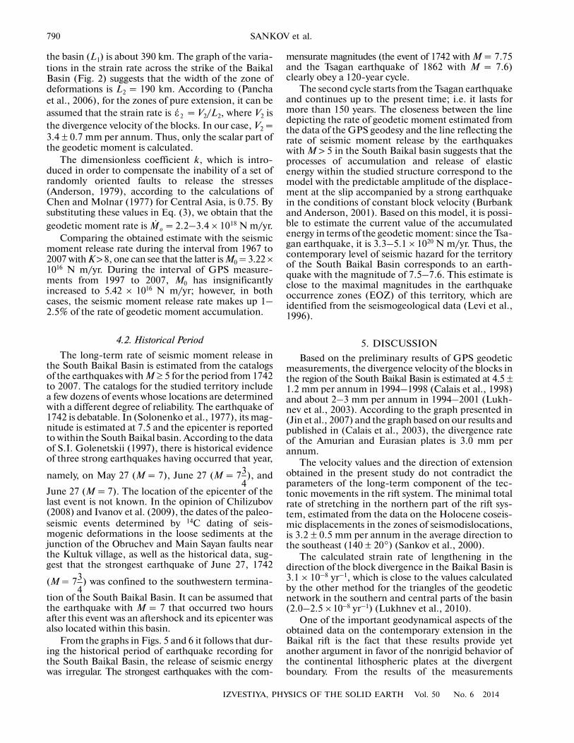
From the graphs in Figs. 5 and 6 it follows that dur�ing the historical period of earthquake recording forthe South Baikal Basin, the release of seismic energywas irregular. The strongest earthquakes with the com�
ε �2
oM�
34
34
mensurate magnitudes (the event of 1742 with M = 7.75and the Tsagan earthquake of 1862 with М = 7.6)clearly obey a 120�year cycle.
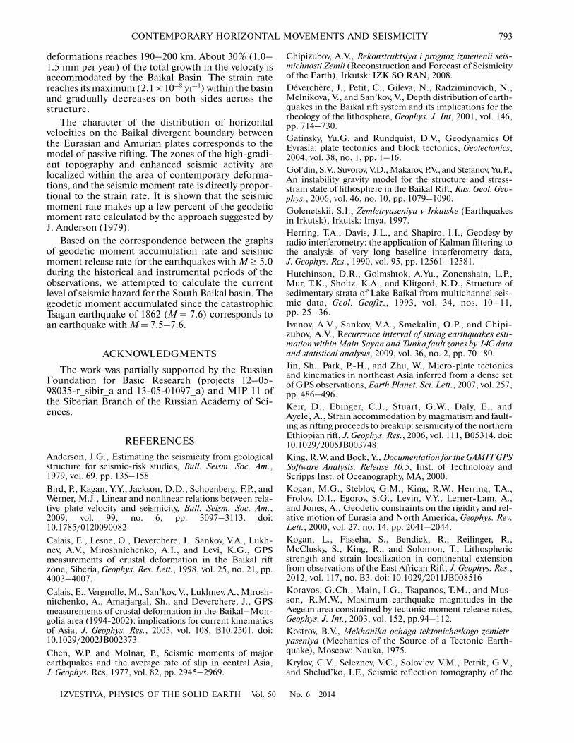
The second cycle starts from the Tsagan earthquakeand continues up to the present time; i.e. it lasts formore than 150 years. The closeness between the linedepicting the rate of geodetic moment estimated fromthe data of the GPS geodesy and the line reflecting therate of seismic moment release by the earthquakeswith M > 5 in the South Baikal basin suggests that theprocesses of accumulation and release of elasticenergy within the studied structure correspond to themodel with the predictable amplitude of the displace�ment at the slip accompanied by a strong earthquakein the conditions of constant block velocity (Burbankand Anderson, 2001). Based on this model, it is possi�ble to estimate the current value of the accumulatedenergy in terms of the geodetic moment: since the Tsa�gan earthquake, it is 3.3–5.1 × 10²⁰ N m/yr. Thus, thecontemporary level of seismic hazard for the territoryof the South Baikal Basin corresponds to an earth�quake with the magnitude of 7.5–7.6. This estimate isclose to the maximal magnitudes in the earthquakeoccurrence zones (EOZ) of this territory, which areidentified from the seismogeological data (Levi et al.,1996).
5. DISCUSSION
Based on the preliminary results of GPS geodeticmeasurements, the divergence velocity of the blocks inthe region of the South Baikal Basin is estimated at 4.5 ±1.2 mm per annum in 1994–1998 (Calais et al., 1998)and about 2–3 mm per annum in 1994–2001 (Lukh�nev et al., 2003). According to the graph presented in(Jin et al., 2007) and the graph based on our results andpublished in (Calais et al., 2003), the divergence rateof the Amurian and Eurasian plates is 3.0 mm perannum.
The velocity values and the direction of extensionobtained in the present study do not contradict theparameters of the long�term component of the tec�tonic movements in the rift system. The minimal totalrate of stretching in the northern part of the rift sys�tem, estimated from the data on the Holocene coseis�mic displacements in the zones of seismodislocations,is 3.2 ± 0.5 mm per annum in the average direction tothe southeast (140 ± 20°) (Sankov et al., 2000).
The calculated strain rate of lengthening in thedirection of the block divergence in the Baikal Basin is3.1 × 10–8 yr–1, which is close to the values calculatedby the other method for the triangles of the geodeticnetwork in the southern and central parts of the basin(2.0–2.5 × 10⁻⁸ yr–1) (Lukhnev et al., 2010).
One of the important geodynamical aspects of theobtained data on the contemporary extension in theBaikal rift is the fact that these results provide yetanother argument in favor of the nonrigid behavior ofthe continental lithospheric plates at the divergentboundary. From the results of the measurements

IZVESTIYA, PHYSICS OF THE SOLID EARTH Vol. 50 No. 6 2014
CONTEMPORARY HORIZONTAL MOVEMENTS AND SEISMICITY 791
(Fig. 4) it follows that the extension captures both themarginal platform area and the western part of theTransbaikalian block. The width of the zone ofdynamic control by the interplate boundary within thestudied segment can be estimated at 200–220 km. Thisestimate is commensurate with the parameters of theextension zone in the central part of the Ethiopian riftderived from the data of similar measurements (Koganet al., 2012). With a divergence rate of the Somali andNubian plates of 9 mm per annum, the maximal rateof the linear strain of lengthening calculated by the sametechnique is, as shown above, about 5.0 × 10⁻⁹ yr–1
(Kogan et al., 2012). In the later work, Saria et al.(2014) presented the results of calculating the distribu�tions of the velocity of horizontal motions across andalong the strikes of all the segments of the East AfricanRift System with the use of the elastic block model.Here, in contrast to (Kogan et al., 2012), the velocityof relative plate motion within the segment of theMain Ethiopian Range is estimated in the quoted workat 4.3 mm per annum (Saria et al., 2014). Based on thecurve of the velocity distribution across this segment ofthe African Rift System, which is cited in that paper,the width of the zone of deformations is about 160–180 km. Very different approaches can be applied forinterpreting the obtained curves of distributions of thevelocity and deformations across the strikes of the rifts.In (Kogan et al., 2012), the deformation curve is inter�preted from the standpoint of regularities of elastovis�cous behavior of the lithosphere under extension,which, in the opinion of the authors, depends on thedegree of the extension and heating. However, it canbe believed that, since the GPS measurements coverthe period of a few dozens of years, which is signifi�cantly shorter than the duration of seismic cycle forthe characteristic earthquake in the region, theobtained curve mainly reflects the regularities in the
accumulation of elastic strains. The shape of the curvein this case strongly depends on the dip angle of themain fault and its locking depth. As of now, it is notpossible to quantify the contribution of the viscoplas�tic part of the deformations in the total deformation;for obtaining the quantitative estimates, it is necessaryto carry out special long�term measurements.
It is remarkable that in the South Baikal Basin, theseismic activity more flatly decreases towards theTransbaikalian block than towards the platform. Themaximum in the deformation curve (Fig. 4) is alsoslightly shifted towards the Transbaikalian block.These facts can be accounted for if we consider the dif�ferences in the strength properties of the correspond�
8.0
7.5
7.0
6.5
6.0
5.5
5.0
4.52020190018801860182017801740 18001760 1840
mag
nit
ude
Time, years
Cycle 1Cycle 2
1742
1920 1940 1960 1980 2000
1769 1862
1959
2008
?
Fig. 5. The time distribution of the historical and instrumentally recorded earthquakes with M ≥ 5 in the South Baikal Basin dur�ing 1742–2008 (according to the data of (Solonenko et al., 1977; Chipizubov, 2008)).
Mo,
×10
13 N
m/y
r
time, years
10
8
6
4
2
20502000190018001700 18501750 1950
M =
7.5
–7.
6
1742 1862 2008
model with
predictable displacement
GPS
Fig. 6. The cumulative graph of seismic energy releasebased on the data on the historical and instrumentallyrecorded earthquakes with M ≥ 5 and the graph of geodeticmoment accumulation according to the GPS data for theSouth Baikal Basin.

792
IZVESTIYA, PHYSICS OF THE SOLID EARTH Vol. 50 No. 6 2014
SANKOV et al.
ing blocks. According to the calculations of Petit andDéverchère (2006), which are based on the gravity andgeothermal data, the strength of the lithosphere of theSayan–Baikal folded area is significantly lower thanthe strength of the lithosphere of the Siberian Plat�form, and this determines the different behavior ofthese structures under extension.
The character of distribution of the velocities ofhorizontal displacements and strains across the strikeof the Baikal rift system provides additional informa�tion for identifying the formation mechanism of therift structures. If the evolution of the studied regionfollowed the scenario of active rifting, the maximum inthe velocity of relative plate motion should haveappeared within the Baikal Basin, while the velocityshould have diminished towards the Transbaikalianblock until the conditions of compression arose(Logachev et al., 2000). This distribution of relativemotion velocities follows from the model where thelithosphere is stretched above the local anomaly at thedepths of the lithospheric mantle (the asthenosphericbulge) due to gravitational instability (Zorin and Turu�tanov, 2005). The same pattern of velocity distributionalso follows from the model of extension due to thegravitational instability of sediments along the bound�ary of the Siberian Platform (Gol’din et al., 2006).According to our data described above, measurementsat the geodynamical monitoring area in Mongolia(Calais et al., 2003), and the data obtained by the Chi�nese land surveyors (Jin et al., 2007), the displacementvelocity (in the perpendicular direction to the BaikalRift) of the sites located 150 to 1000 km farther south�east in the internal parts of the Amurian Plate remainsunchanged. It can be concluded that the kinematics ofthe central part of the Baikal rift corresponds to therifting model with a remote source of the tectonicforces, i.e., to the scenario of passive rifting. Accordingto the model of Molnar and Tapponnier (1975), riftingis caused by intracontinental compression resultingfrom the collision between Indostan and Eurasia andby the extrusion of the Amurian Plate. We suggest adifferent interpretation of the source of southeasternmotion of the Amurian Plate and its break�off fromEurasia (Sankov et al., 2011). We explored the possi�bility of this process to have arisen under the action ofa long branch of a southeastward convective flow in theupper mantle at the slowdown of the heavy continentalmasses of Northern Eurasia with the participation ofthe collision processes. An alternative approach con�siders the influence of the subduction processes thatoccur in the west of the Pacific Ocean on the forma�tion of intracontinental rifts (Calais et al., 2003).
The strain rates of extension across the strike of theBaikal Basin obtained in our study can be compared tothe rates of the contemporary seismotectonic defor�mations estimated from the horizontal component ofthe displacements. According to the data of (Radzim�inovich et al., 2006), this rate is 2.95 × 10⁻⁹ yr–1 withthe extension axis striking in the azimuth of 309°–
315° in the southern part of the basin. The differencein the strain values by the order of magnitude is asso�ciated with the fact that in the quoted paper the widthof the deformation zone is limited to the cross dimen�sion of the basin. Generally, the relationships betweenthe compared parameters agree with the notionaccording to which the seismogenic deformations thatoccurred during a short time interval compared to thelength of the seismic cycle only make up a small frac�tion of the cumulative tectonic deformation.
At the same time, the seismic energy release rate isproportional to the crustal strain rate even on the shorttime scales within the seismic cycle. For example, it isshown in (Bird et al., 2009) that the continental riftsand associated continental transform faults are char�acterized by a linear dependence between the relativeplate velocity and the rate of seismic energy releasecast in terms of the cumulative seismic moment. In theopinion of these authors, the general linearity of thedependence between the studied parameters can sim�plify seismic hazard forecasting within continental riftsystems. The linear dependence of the seismicmoment rate on the strain rate obtained in our studydoes not contradict this statement. However, itappears that, since in both cases the calculations wereconducted for time intervals that are significantlyshorter than the length of the seismic cycle of charac�teristic earthquakes in the continental rifts, the effectsassociated with the strength of the deformed lithos�phere fell out of consideration. Logically, thedeformed lithosphere should control the maximallevel of the accumulated stresses, the time of its accu�mulation, and, correspondingly, the maximal magni�tude of the earthquakes. For example, in the thinned,significantly heated lithosphere of the Ethiopian Riftwith quite high plate convergence velocities, the earth�quakes with magnitudes above 6.5 did not occur dur�ing the last 150 years (Keir et al., 2006).
6. CONCLUSIONS
Based on the long�term measurements at theBaikal geodynamical GPS monitoring area, weobtained the refined estimate for the velocity anddirection of divergence at the boundary between theSiberian (Eurasian Plate) and Transbaikalian(Amurian Plate) lithospheric blocks. It is found thatthese blocks diverge in the southeastern direction(130°) at 3.4 ± 0.7 mm per annum. These estimatescorrespond with the parameters of the long�termextension component determined from the geologicaland geophysical data and with the direction of theextension suggested by the seismological data.
The distribution of the displacement velocityacross the strike of the rift, which gradually increasesfrom the conventionally immobile block towards themobile block, points to the nonrigid behavior of thecontinental lithospheric plates on the divergentboundary. The width of the zone of contemporary
IZVESTIYA, PHYSICS OF THE SOLID EARTH Vol. 50 No. 6 2014
CONTEMPORARY HORIZONTAL MOVEMENTS AND SEISMICITY 793
deformations reaches 190–200 km. About 30% (1.0–1.5 mm per year) of the total growth in the velocity isaccommodated by the Baikal Basin. The strain ratereaches its maximum (2.1 × 10⁻⁸ yr–1) within the basinand gradually decreases on both sides across thestructure.
The character of the distribution of horizontalvelocities on the Baikal divergent boundary betweenthe Eurasian and Amurian plates corresponds to themodel of passive rifting. The zones of the high�gradi�ent topography and enhanced seismic activity arelocalized within the area of contemporary deforma�tions, and the seismic moment rate is directly propor�tional to the strain rate. It is shown that the seismicmoment rate makes up a few percent of the geodeticmoment rate calculated by the approach suggested byJ. Anderson (1979).
Based on the correspondence between the graphsof geodetic moment accumulation rate and seismicmoment release rate for the earthquakes with М ≥ 5.0during the historical and instrumental periods of theobservations, we attempted to calculate the currentlevel of seismic hazard for the South Baikal basin. Thegeodetic moment accumulated since the catastrophicTsagan earthquake of 1862 (М = 7.6) corresponds toan earthquake with М = 7.5–7.6.
ACKNOWLEDGMENTS
The work was partially supported by the RussianFoundation for Basic Research (projects 12–05�98035�r_sibir_a and 13�05�01097_a) and MIP 11 ofthe Siberian Branch of the Russian Academy of Sci�ences.
REFERENCES
Anderson, J.G., Estimating the seismicity from geologicalstructure for seismic�risk studies, Bull. Seism. Soc. Am.,1979, vol. 69, pp. 135–158.
Bird, P., Kagan, Y.Y., Jackson, D.D., Schoenberg, F.P., andWerner, M.J., Linear and nonlinear relations between rela�tive plate velocity and seismicity, Bull. Seism. Soc. Am.,2009, vol. 99, no. 6, pp. 3097–3113. doi:10.1785/0120090082
Calais, E., Lesne, O., Deverchere, J., Sankov, V.A., Lukh�nev, A.V., Miroshnichenko, A.I., and Levi, K.G., GPSmeasurements of crustal deformation in the Baikal riftzone, Siberia, Geophys. Res. Lett., 1998, vol. 25, no. 21, pp.4003–4007.
Calais, E., Vergnolle, M., San’kov, V., Lukhnev, A., Mirosh�nitchenko, A., Amarjargal, Sh., and Deverchere, J., GPSmeasurements of crustal deformation in the Baikal–Mon�golia area (1994�2002): implications for current kinematicsof Asia, J. Geophys. Res., 2003, vol. 108, B10.2501. doi:10.1029/2002JB002373
Chen, W.P. and Molnar, P., Seismic moments of majorearthquakes and the average rate of slip in central Asia,J. Geophys. Res, 1977, vol. 82, pp. 2945–2969.
Chipizubov, A.V., Rekonstruktsiya i prognoz izmenenii seis�michnosti Zemli (Reconstruction and Forecast of Seismicityof the Earth), Irkutsk: IZK SO RAN, 2008.Déverchère, J., Petit, C., Gileva, N., Radziminovich, N.,Melnikova, V., and San’kov, V., Depth distribution of earth�quakes in the Baikal rift system and its implications for therheology of the lithosphere, Geophys. J. Int, 2001, vol. 146,pp. 714–730.Gatinsky, Yu.G. and Rundquist, D.V., Geodynamics OfEvrasia: plate tectonics and block tectonics, Geotectonics,2004, vol. 38, no. 1, pp. 1–16.Gol’din, S.V., Suvorov, V.D., Makarov, P.V., and Stefanov, Yu.P.,An instability gravity model for the structure and stress�strain state of lithosphere in the Baikal Rift, Rus. Geol. Geo�phys., 2006, vol. 46, no. 10, pp. 1079–1090.Golenetskii, S.I., Zemletryaseniya v Irkutske (Earthquakesin Irkutsk), Irkutsk: Imya, 1997.Herring, T.A., Davis, J.L., and Shapiro, I.I., Geodesy byradio interferometry: the application of Kalman filtering tothe analysis of very long baseline interferometry data,J. Geophys. Res., 1990, vol. 95, pp. 12561–12581.Hutchinson, D.R., Golmshtok, A.Yu., Zonenshain, L.P.,Mur, T.K., Sholtz, K.A., and Klitgord, K.D., Structure ofsedimentary strata of Lake Baikal from multichannel seis�mic data, Geol. Geofiz., 1993, vol. 34, nos. 10–11,pp. 25–36.Ivanov, A.V., Sankov, V.A., Smekalin, O.P., and Chipi�zubov, A.V., Recurrence interval of strong earthquakes esti�mation within Main Sayan and Tunka fault zones by 14C dataand statistical analysis, 2009, vol. 36, no. 2, pp. 70–80.Jin, Sh., Park, P.�H., and Zhu, W., Micro�plate tectonicsand kinematics in northeast Asia inferred from a dense setof GPS observations, Earth Planet. Sci. Lett., 2007, vol. 257,pp. 486–496.Keir, D., Ebinger, C.J., Stuart, G.W., Daly, E., andAyele, A., Strain accommodation by magmatism and fault�ing as rifting proceeds to breakup: seismicity of the northernEthiopian rift, J. Geophys. Res., 2006, vol. 111, B05314. doi:10.1029/2005JB003748King, R.W. and Bock, Y., Documentation for the GAMIT GPSSoftware Analysis. Release 10.5, Inst. of Technology andScripps Inst. of Oceanography, MA, 2000.Kogan, M.G., Steblov, G.M., King, R.W., Herring, T.A.,Frolov, D.I., Egorov, S.G., Levin, V.Y., Lerner�Lam, A.,and Jones, A., Geodetic constraints on the rigidity and rel�ative motion of Eurasia and North America, Geophys. Rev.Lett., 2000, vol. 27, no. 14, pp. 2041–2044.Kogan, L., Fisseha, S., Bendick, R., Reilinger, R.,McClusky, S., King, R., and Solomon, T., Lithosphericstrength and strain localization in continental extensionfrom observations of the East African Rift, J. Geophys. Res.,2012, vol. 117, no. B3. doi: 10.1029/2011JB008516Koravos, G.Ch., Main, I.G., Tsapanos, T.M., and Mus�son, R.M.W., Maximum earthquake magnitudes in theAegean area constrained by tectonic moment release rates,Geophys. J. Int., 2003, vol. 152, pp.94–112.Kostrov, B.V., Mekhanika ochaga tektonicheskogo zemletr�yaseniya (Mechanics of the Source of a Tectonic Earth�quake), Moscow: Nauka, 1975.Krylov, C.V., Seleznev, V.C., Solov’ev, V.M., Petrik, G.V.,and Shelud’ko, I.F., Seismic reflection tomography of the

794
IZVESTIYA, PHYSICS OF THE SOLID EARTH Vol. 50 No. 6 2014
SANKOV et al.
Baikal rift basin, Dokl. Rus. Akad. Nauk, 1995, vol. 345,no. 5, pp. 674–677.Larson, K.M., Burgmann, R., Bilham, R., and Freymuel�ler, J.T., Kinematics of the India–Eurasia collision zonefrom GPS measurements, J. Geophys. Res., 1999, vol. 104,no. B1, pp. 1077–1093.Leonov, Yu.G., Continental rifting: Modern Views, Prob�lems, and Solutions, Geotectonics, 2001, vol. 35, no. 2,pp. 81–92.Logatchev, N.A. and Zorin, Yu.A., Evidence and causes ofthe two�stage development of the Baikal rift, Tectonophys�ics, 1987, vol. 143, nos. 1–3, pp. 225–234.Logachev, N.A., Bornyakov, S.A., and Sherman, S.I.,Mechanism of the Baikal Rift Zone formation based onresults of physical modeling, Dokl. Earth Sci., 2000,vol. 373A, no. 6, pp. 980–982.Logachev, N.A., Historic core of the Baikal Rift Zone,Dokl. Earth Sci., 2001, vol. 376, no. 1, pp. 43–47.Lukhnev, A.V., San’kov, V.A., Miroshnichenko, A.I.,Levi, K.G., Bashkuev, Yu.B., Dembelov, M.G., Zalutskii, V.T.,Calais, E., Déverchère, J., Vernol, M., Bekhtur, B., andAmarzhargal, Sh., New data on recent tectonic deforma�tions in the south mountainous framing of the SiberianPlatform, Dokl. Earth Sci., 2003, vol. 389, no. 2,pp. 263–266.Lukhnev, A.V., San’kov, V.A., Miroshnichenko, A.I.,Ashurkov, S.V., and Kale, E., GPS rotation and strain ratesin the Baikal–Mongolia region, Rus. Geol. Geophys., 2010,vol. 51, no. 7, pp. 785–793.Mats, V.D., Ufimtsev, G.F., Mandel’baum, M.M., Alak�shin, A.M., Pospeev, A.V., Shimaraev, M.N., andKhlystov, O.V., Kainozoi Baikal’skoi riftovoi vpadiny: Stro�enie i geologicheskaya istoriya (The Cenozoic of the BaikalRift: Structure and Geological History), Novosibirsk: SORAN, Geo, 2001.Molnar, P. and Tapponnier, P., Cenozoic tectonics of Asia:effects of a continental collision, Science, 1975, vol. 189,pp. 1959–1982.Pancha, A., Anderson, J.G., and Kreemer, C., Comparisonof seismic and geodetic scalar moment rates across theBasin and Range Province, Bull. Seismol. Soc. Am., 2006,vol. 96, no. 1, pp. 11–323. doi: 10.1785/0120040166Petit, C., Déverchère, J., Houdry, F., Sankov, V.A., Melnik�ova, V.I., and Delvaux, D., Present�day stress field changesalong the Baikal rift and tectonic implication, Tectonics,1996, vol. 15, no. 6, pp. 1171–1191.Petit, C. and Déverchère, J., Structure and evolution of theBaikal rift: a synthesis, Geochem. Geophys. Geosys., 2006,vol. 7, Q11016. doi: 10.1029/2006GC001265
Radziminovich, N., Déverchère, J., Melnikova, V.,San’kov, V., and Giljova, N., The 1999 Mw 6.0 earthquakesequence in the southern Baikal rift, Asia, and its seismo�tectonic implications, Geophys. J. Int., 2005, vol. 161,pp. 387–400.
Radziminovich, N.A., Melnikova, V.I., San’kov, V.A., andLevi, K.G., Seismicity and seismotectonic deformations ofthe crust in the Southern Baikal Basin, Izv., Phys. SolidEarth, 2006, vol. 42, no. 11, pp. 904–920.
San’kov, V., Déverchère, J., Gaudemer, Y., Houdry, F., andFilippov, A., Geometry and rate of faulting in the NorthBaikal Rift, Siberia, Tectonics, 2000, vol. 19, no. 4,pp. 707–722.
San’kov, V.A., Parfeevets, A.V., Lukhnev, A.V., Mirosh�nichenko, A.I., and Ashurkov, S.V., Late Cenozoic geody�namics and mechanical coupling of crustal and upper man�tle deformations in the Mongolia–Siberia mobile region,Geotectonics, 2011, vol. 45, no. 5, pp. 378–393.
Saria, E., Calais, E., Stamps, D.S., Delvaux, D., and Hart�nady, C.J.H., Present�day kinematics of the East AfricanRift, J. Geophys. Res., 2014, vol. 119, no.4, pp. 3584–3600.doi: 10.1002/2013JB010901
Solonenko, V.P., Khil’ko, S.D., Khromovskikh, V.S., et al.,W Seismicheskoe raionirovanie Vostochnoi Sibiri i ego geol�ogo�geofizicheskie osnovy (Seismic Zoning of East Siberiaand its Geological–Geophysical Basis), Novosibirsk:Nauka, 1977.
Suvorov, V.D. and Mishen’kina, Z.P., Structure of sedimen�tary cover and basement beneath the South Basin of LakeBaikal inferred from seismic profiling, Rus. Geol. Geophys.,2005, vol. 46, no. 11, pp. 1141–1149.
Suvorov, V.D. and Tubanov, Ts.A., Distribution of localearthquakes in the crust beneath central Lake Baikal, Rus.Geol. Geophys., 2008, vol. 49, no. 8, pp. 611–620.
Working Group on California Earthquake Probabilities,Seismic hazards in southern California: probable earth�quakes, 1994�2024, Bull. Seism. Soc. Am., 1995, vol. 85,pp. 379–439.
Zorin, Yu.A. and Turutanov, E.Kh., Plumes and geodynam�ics of the Baikal Rift Zone, Rus. Geol. Geophys., 2005,vol. 45, no. 7, pp. 669–682.
Zorin, Yu.A., Turutanov, E.Kh., Kozhevnikov, V.M.,Rasskazov, S.V., and Ivanov, A.V., The nature of Cenozoicupper mantle plumes in East Siberis (Russia) and CentralMongolia, Rus. Geol. Geophys., 2006, vol. 46, no. 7,pp. 1046–1059.
Translated by M. Nazarenko
Copyright © 2022 FDOKUMEN