Paleoseismicity in France: Fault trench studies in a region of moderate seismicity
11
Pergamon 1. Geodynamics Vol. 24, Nos 1-I. 207-217, 1997 pp. 8 1997 Elsevier ScienceLtd All rights reserved. Printed in’Great Britain PII: so264-3707(97)oooos-7 0264-3707/97 $17.00+0.00 PALEOSEISMICITY IN FRANCE: FAULT TRENCH STUDIES IN A REGION OF MODERATE SEISMICITY MICHEL SfiBRIER,‘” ABDESSAMAD GHAFIRI’ and JEAN-LOUIS BLES2 ’ URA 1369 CNRS, BPt. 509, Universitt de Paris-Sud, F91405 Orsay Cedex, France * BRGM, 117 av. de Luminy, F13009 Marseille, France (Received 1 December 1995; accepted in revised form 27 November 19%) Abstract-France is a country of moderate to low seismicity with a ten-century record of historical seismicity. Paleoseismicity appears to be the only available tool which is able to extend the record of seismic activity beyond this short time-window. However, moderate to low seismicity should be associated with low slip rates and, thus, geomorphic evidence for detecting active fault traces should be weak, impeding the development of paleoseismic fault studies. To test the paleoseismic method in France, we have developed a programme on paleoseismology during the past few years. First, we performed a critical reappraisal of existing data on French active tectonics, then we selected several suitable sites, and finally we trenched on some sites. Much of the revised evidence from recent and active tectonics was not selected because their origins were either dubious or non-tectonic. In particular, many reported sites from the Alps, seen in moraines, actually correspond to glacial processes (‘glacitectonics’). In addition, some clearly observed scarps could result from gravitational processes such as post-glacial rebound. Among the selected sites, three were studied in detail; they correspond to the Nimes, Moyenne Durance, and Argentera fault zones. The most reliable information was provided by trenching observations on the Moyenne Durance Fault. The trench site exhibited a N35”E-striking knee fold, parallel to the Moyenne Durance Fault, covered unconformably by colluvial deposits. Radiocarbon dates indicate that folding occurred during the latest Pleistocene or earliest Holocene. The observed stratigraphical relations strongly suggest that folding resulted from a single coseismic slip event associated with a strong earthquake of magnitude Mw =6.4-6.9. Our data also indicate long recurrence intervals for such earthquakes, at least of the order of 25 ka. Paleoseismic data collected on the other studied fault zones confirm that nearly Mw=7 events may be generated by French active faults and that the recurrence intervals should be over 10 ka. Thus, the paleoseismic study of active faults is a robust tool to reconstruct seismic history where slip rates are low to moderate; however, specific exploration methods should be developed to localize fault traces more accurately and study hidden faults. 0 1997 Elsevier Science Ltd INTRODUCTION France is a country of moderate to low seismicity with a ten-century record of historical seismicity that shows approximately five major destructive earthquakes (SIRENJZ; Godefroy et *Author to whom correspondence should be addressed. Tel: +33 169 416 142; Fax: +33 160 191 446; e-mail: [email protected] 207
-
Upload
independent -
Category
Documents
-
view
1 -
download
0
Transcript of Paleoseismicity in France: Fault trench studies in a region of moderate seismicity
Pergamon 1. Geodynamics Vol. 24, Nos 1-I. 207-217, 1997 pp.
8 1997 Elsevier Science Ltd All rights reserved. Printed in’Great Britain
PII: so264-3707(97)oooos-7 0264-3707/97 $17.00+0.00
PALEOSEISMICITY IN FRANCE: FAULT TRENCH STUDIES IN A REGION OF MODERATE SEISMICITY
MICHEL SfiBRIER,‘” ABDESSAMAD GHAFIRI’ and JEAN-LOUIS BLES2
’ URA 1369 CNRS, BPt. 509, Universitt de Paris-Sud, F91405 Orsay Cedex, France * BRGM, 117 av. de Luminy, F13009 Marseille, France
(Received 1 December 1995; accepted in revised form 27 November 19%)
Abstract-France is a country of moderate to low seismicity with a ten-century record of historical seismicity. Paleoseismicity appears to be the only available tool which is able to extend the record of seismic activity beyond this short time-window. However, moderate to low seismicity should be associated with low slip rates and, thus, geomorphic evidence for detecting active fault traces should be weak, impeding the development of paleoseismic fault studies. To test the paleoseismic method in France, we have developed a programme on paleoseismology during the past few years. First, we performed a critical reappraisal of existing data on French active tectonics, then we selected several suitable sites, and finally we trenched on some sites. Much of the revised evidence from recent and active tectonics was not selected because their origins were either dubious or non-tectonic. In particular, many reported sites from the Alps, seen in moraines, actually correspond to glacial processes (‘glacitectonics’). In addition, some clearly observed scarps could result from gravitational processes such as post-glacial rebound. Among the selected sites, three were studied in detail; they correspond to the Nimes, Moyenne Durance, and Argentera fault zones. The most reliable information was provided by trenching observations on the Moyenne Durance Fault. The trench site exhibited a N35”E-striking knee fold, parallel to the Moyenne Durance Fault, covered unconformably by colluvial deposits. Radiocarbon dates indicate that folding occurred during the latest Pleistocene or earliest Holocene. The observed stratigraphical relations strongly suggest that folding resulted from a single coseismic slip event associated with a strong earthquake of magnitude Mw =6.4-6.9. Our data also indicate long recurrence intervals for such earthquakes, at least of the order of 25 ka. Paleoseismic data collected on the other studied fault zones confirm that nearly Mw=7 events may be generated by French active faults and that the recurrence intervals should be over 10 ka. Thus, the paleoseismic study of active faults is a robust tool to reconstruct seismic history where slip rates are low to moderate; however, specific exploration methods should be developed to localize fault traces more accurately and study hidden faults. 0 1997 Elsevier Science Ltd
INTRODUCTION
France is a country of moderate to low seismicity with a ten-century record of historical seismicity that shows approximately five major destructive earthquakes (SIRENJZ; Godefroy et
*Author to whom correspondence should be addressed. Tel: +33 169 416 142; Fax: +33 160 191 446; e-mail: [email protected]
207
208 M. Sebrier et al.
al., 1990). Although the source parameters of these earthquakes are still not precisely known, their magnitudes are roughly estimated to be not higher than about M=6 and their destructive effects are commonly attributed to poor building quality. However, we may surmise that moderate to low seismicity should be associated with low slip rates on active faults and thus with rather long recurrence intervals between destructive earthquakes. Consequently, seismic hazard may be difficult to assess from the ten-century time-window that is provided by historical seismicity. Furthermore, this raises the question of whether or not earthquakes of magnitude 6 or more have struck France in the past, and thus will they occur again in the future. Paleoseismicity appears to be the only available tool able to extend the record of seismic activity beyond this short time-window. Nevertheless, geomorphic evidence for detecting active fault traces might be weak, impeding the development of paleoseismic fault studies. In order to verify whether such studies can provide reliable and significant data on seismic sources, a programme on paleoseismology has been developed during the last few years. After a critical reappraisal of existing data on French active tectonics, several suitable sites were selected, mainly in southeastern France, and trenches were excavated at some sites. The most reliable information was provided by trenching on the Moyenne Durance Fault where paleoseismological analysis yields evidence for a Late Pleistocene major seismic event with Mw=6.4-6.9. The same data also suggest long recurrence intervals for such large earthquakes, at least of the order of 25 ka. Paleoseismic data collected on the other studied fault zones confirm that Mw=6.9 events may be generated by French active faults and that recurrence intervals should be longer than 10 ka.
EXISTING DATA ON FRENCH ACTIVE TECTONICS
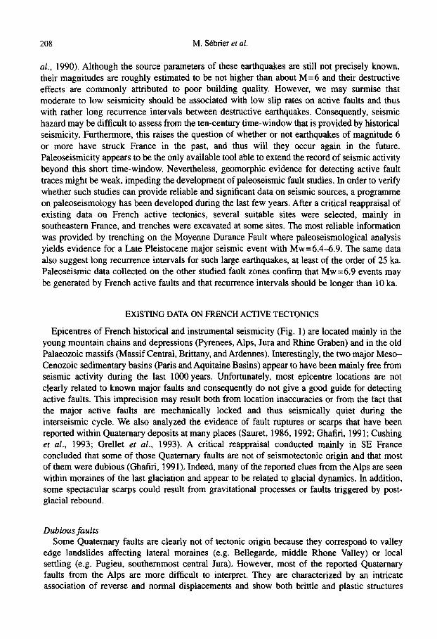
Epicentres of French historical and instrumental seismicity (Fig. 1) are located mainly in the young mountain chains and depressions (Pyrenees, Alps, Jura and Rhine Graben) and in the old Palaeozoic massifs (Massif Central, Brittany, and Ardennes). Interestingly, the two major Meso- Cenozoic sedimentary basins (Paris and Aquitaine Basins) appear to have been mainly free from seismic activity during the last 1000 years. Unfortunately, most epicentre locations are not clearly related to known major faults and consequently do not give a good guide for detecting active faults. This imprecision may result both from location inaccuracies or from the fact that the major active faults are mechanically locked and thus seismically quiet during the interseismic cycle. We also analyzed the evidence of fault ruptures or scarps that have been reported within Quatemary deposits at many places (Sauret, 1986, 1992; Ghafiri, 199 1; Cushing er al., 1993; Grellet et al., 1993). A critical reappraisal conducted mainly in SE France concluded that some of those Quatemary faults are not of seismotectonic origin and that most of them were dubious (Ghafiri, 1991). Indeed, many of the reported clues from the Alps are seen within moraines of the last glaciation and appear to be related to glacial dynamics. In addition, some spectacular scarps could result from gravitational processes or faults triggered by post- glacial rebound.
Dubious faults Some Quatemary faults are clearly not of tectonic origin because they correspond to valley
edge landslides affecting lateral moraines (e.g. Bellegarde, middle Rhone Valley) or local settling (e.g. Pugieu, southernmost central Jura). However, most of the reported Quaternary faults from the Alps are more difficult to interpret. They are characterized by an intricate association of reverse and normal displacements and show both brittle and plastic structures
Paleoseismicity in France 209
deforming morainic deposits (e.g. La Balme de Sillingy, northwest of Annecy; Villard-Meyer, south of Briancon; Saint Pierre de Genebroz, western front of the Chartreuse Massif). This indicates that recent deformation occurred within water-saturated sediments and under pressure conditions such as the vertical stress being non-null. Because these deformations are observed at the surface within deposits of the Last Glacial Epoch, they should have occurred under the weight of ice when ice tongues were still active. Consequently, they are more likely to be the result of glacial dynamics (i.e. ‘glaciotectonics’) than seismic ruptures on active faults. At one locality (Saint Etienne de Crossey, western front of the Chartreuse Massif), a similar pattern of
1000 YEARS HISTORICAL SEISMICITY
- . __. ;I . . -. , 80 +pw -- -. nA
MACROSEISMIC MAGNITUDES
* > = a,0 A 5,5 to 6,0 0 5,ota $5 0 qs to&O l 4,0 to43
Fig. 1. French seismicity during the last 1000 years from the analysis of SIRENE data by Levret et al. (1994, 1996).
210 M. Sebrier et al.
faulting is observed, although the faults are steep, exhibit mainly brittle characteristics, and are seen within outwash deposits localized about 2 km from the frontal morainic arc. Thus, they cannot result directly from glacitectonic process; the pattern of observed faults is very unlikely to be of tectonic origin and could be due to ice block melting. Whatever the origin, the lack of detailed studies by glaciologists at each of these localities does not permit us to select them as sites for paleoseismic studies.
Short-length scarps in the Alps Several conspicuous scarps have been reported in the Alps displacing the post-glacial
topography (Goguel, 1969; Bordet, 1970). These scarps are generally short (cl-2 km) with respect to their heights (> 2 m) so that they could hardly correspond to degraded surface ruptures produced by dip-slip faulting earthquakes. Indeed, their length to height ratios do not fit within the range of seismic faults (Wells and Coppersmith, 1994). Such fault scarps were analyzed at two localities (at Grands Moulins in the Belledone Massif and at Peisey-Nancroix in the Vanoise Massif). At the first example, some seven parallel, upslope-facing, steep, fault scarps occur on both sides of a mountain crest (Ghafiri, 1995). Their normal fault offsets thus suggest that the top of the mountain is subsiding. This fault pattern is classically observed in many mountain ranges and has been interpreted as a product of the gravitational spreading (i.e. sackung) of these mountain ranges (Zischinsky, 1969; Savage and Vames, 1987); typically, the mountain collapses under its own weight towards the surrounding valleys. This collapse may be slow and continuous or sudden and discrete. Scarp morphology may help to discriminate between the two possibilities (Beck, 1968). In the case of sudden formation, earthquake triggering is possible. Although those short-length scarps may be of coseismic origin, they seem unrelated to primary surface faulting (for primary versus second-order surface faulting, see Michetti, 1994). In addition, using sackung structure for paleoseismic analysis is thought to be of doubtful value (Obermeier and Jibson, 1995).
Alternatively, those normal fault scarps could result from post-glacial rebound (e.g. Ego et al., 1996). Indeed, they are parallel to the major glacial valleys and their kinematics indicates that the valleys were uplifted with respect to the surrounding mountain ranges. The unloading resulting from the melting of the ice filling the valleys during the last glacial epoch might account for such short length normal faults. Because the significance of these fault scarps is still being debated, they were not considered as primary goals for paleoseismic study.
Selected sites Taking into account the above limitations, most of the reported clues for French active faults
were not selected because they were considered irrelevant or dubious. We focused, instead, on three structures: the Moyenne Durance, Nimes, and Argentera fault zones, where major crustal- scale faults are known and where evidence for active faulting or seismic activity has been reported. The basic guide line was that large paleoearthquakes are more likely to have occurred along major faults than on small faults. Nevertheless, site selection was complex because no clear geomorphic features of active faulting were observed which could allow us to locate precisely surface fault traces either on aerial photographs or in the field. This lack of evidence to locate active fault traces suggests that either these potentially active faults only produce moderate seismic events beyond the detection potential of paleoseismic methods, or that the climate-controlled rate of landscape evolution is much higher than the tectonic one. This last hypothesis supposes that the active faults are characterized by very long time intervals between
Paleoseismicity in France 211
two successive large earthquakes, so that evidence for surface ruptures is totally degraded. Indeed, the few suitable sites for paleoseismic observations were discovered by chance. This is presently the most critical limitation for the development of paleoseismic studies in France.
PALEOSEISMIC RESULTS
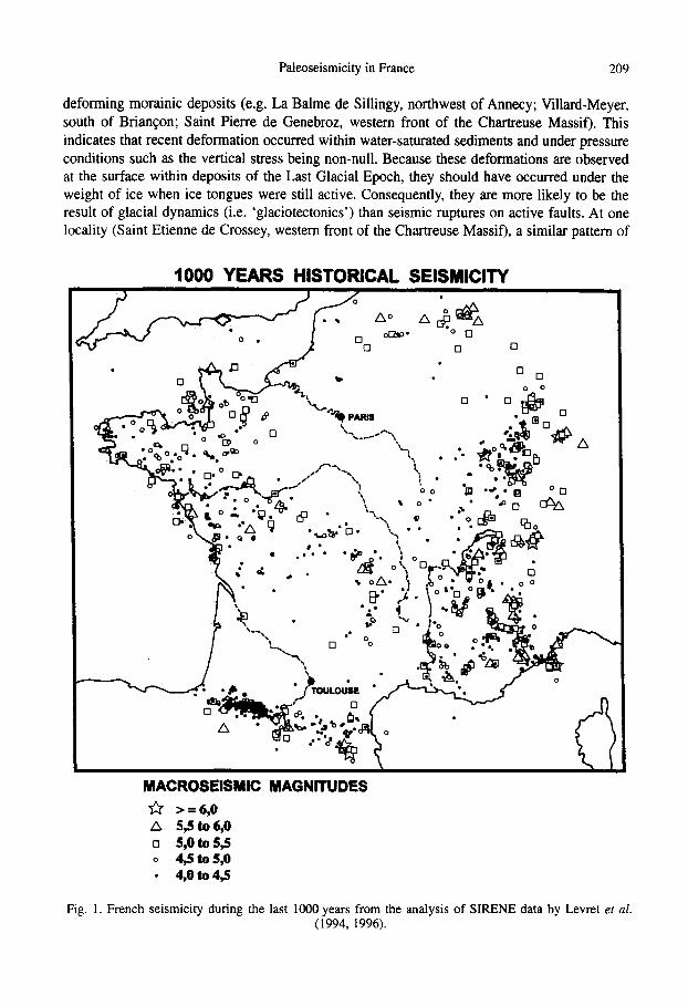
The Moyenne (Middle) Durance Fault The Moyenne Durance Fault System has a mean NNI-SSW orientation and extends
approximately 120 km from Marseille Bay northwards to the Digne Thrust (Fig. 2); further north this fault system might extend to the external crystalline massif of Pelvoux giving a total length of some 200 km. The fault system comprises two main fault zones: the Aix Fault to the south and the Moyenne Durance Fault to the north, linked by a IO-km wide restraining bend in the Jouques area where the Durance River abruptly changes its orientation from SSW to WNW. Kinematic analysis of its youngest deformation structures strongly suggests that the nearly 70-km-long Moyenne Durance Fault is presently a left-lateral transpressive fault zone (Villtger, 1983; Combes, 1984; Terrier, 1991). This major crustal-scale structure affects the Mohorovicic discontinuity and experienced a major tectonic mversion during Miocene times, when its
Fig. 2. Simplified structural sketch map showing the major faults of western Provence and eastern Languedoc (southeastern France). 1: Quatemary; 2: Oligocene and Neogene; 3: Jurassic to Eocene;
4: Peru&n and Triassic: 5: Pre-Triasic substratum.
212 M. Sebrier et al.
Oligocene normal movement down to the west became reverse down to the east (Grellet er al.,
1993). Instrumental seismicity recorded between 1962 and 1994 indicates Mc3.5 events with very shallow foci. However, the French catalogue (SIRENE) of historical seismicity contains four events with I>VII (1509, 1708, 1812, and 1913).
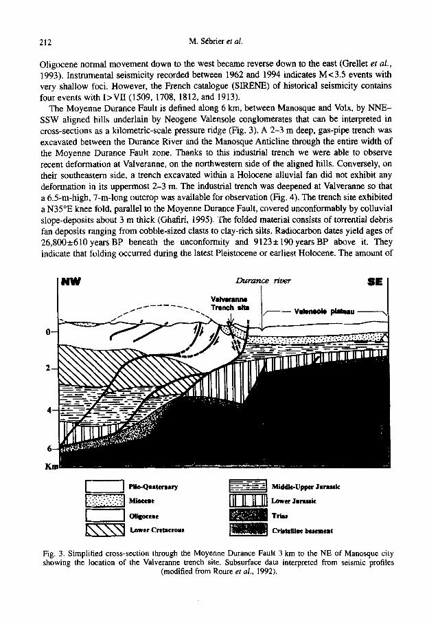
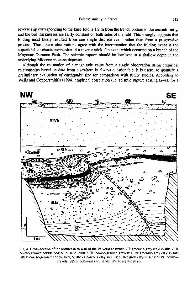
The Moyenne Durance Fault is defined along 6 km, between Manosque and Volx, by NNE- SSW aligned hills underlain by Neogene Valensole conglomerates that can be interpreted in cross-sections as a kilometric-scale pressure ridge (Fig. 3). A 2-3 m deep, gas-pipe trench was excavated between the Durance River and the Manosque Anticline through the entire width of the Moyenne Durance Fault zone. Thanks to this industrial trench we were able to observe recent deformation at Valveranne, on the northwestern side of the aligned hills. Conversely, on their southeastern side, a trench excavated within a Holocene alluvial fan did not exhibit any deformation in its uppermost 2-3 m. The industrial trench was deepened at Valveranne so that a 6.5m-high, 7-m-long outcrop was available for observation (Fig. 4). The trench site exhibited a N35”E knee fold, parallel to the Moyenne Durance Fault, covered unconformably by colluvial slope-deposits about 3 m thick (Ghatiri, 1995). The folded material consists of torrential debris fan deposits ranging from cobble-sized clasts to clay-rich silts. Radiocarbon dates yield ages of 26,8OO-e610 years BP beneath the unconformity and 9123*190 years BP above it. They indicate that folding occurred during the latest Pleistocene or earliest Holocene. The amount of
I WW Durance ricer I
SE I
Middk-Upper Jmassk
Lower Jarauk
Trlu
CrwJJumt LmfemeRt
Fig. 3. Simplified cross-section through the Moyenne Durance Fault 3 km to the NE of Manosque city showing the location of the Valveranne trench site. Subsurface data interpreted from seismic profiles
(modified from Roure er al., 1992).
Paleoseismicity in France 213
reverse slip corresponding to the knee fold is 1.2 m from the trench bottom to the unconformity, and the bed thicknesses are fairly constant on both sides of the fold. This strongly suggests that folding most likely resulted from one single discrete event rather than from a progressive process. Thus, these observations agree with the interpretation that the folding event is the superficial coseismic expression of a reverse stick-slip event which occurred on a branch of the Moyenne Durance Fault. The seismic rupture should be localized at a shallow depth in the underlying Miocene molasse deposits.
Although the estimation of a magnitude value from a single observation using empirical relationships based on data from elsewhere is always questionable, it is useful to quantify a preliminary evaluation of earthquake size for comparison with future studies. According to Wells and Coppersmith’s (1994) empirical correlation (i.e. seismic rupture scaling laws), for a
NW SE
. . . . . - . .: . . .
* . . - . . -sIpb : * *-.:/-:
* . . * - . . . * .
. . . . ’ . *
. . . . . - . * . . *
.
. . . *: .
. * * . . . *
. . *
Fig. 4. Cross-section of the northeastern wall of the Valveranne trench. SI: greenish-grey clayish silts; SIIa: coarse-grained cobble bed; SIIb: sand lends; Sk: coarse-grained gravels; SIId: greenish-grey clayish silts; SIIIa: coarse-grained cobble bed; SIIIb: calcareous clayish silts; SIIIc: grey clayish silts; SIVa: colluvial
gravels; SIVb: colluvial silty sands; SV: Present-day soil.
214 M. Sebrier et al.
given earthquake, the maximum displacement observed at the surface, MD, is related to the magnitude by the following formula:
Mw=a+b*log(MD), with a=6.69&0.04 and b=0.74*0.07 for all faults a=6.52*0.11 and b=0.44*0.26 for reverse faults
Taking into account that ‘a’ and ‘b’ parameters are poorly constrained in the case of reverse faults (Wells and Coppersmith, 1994) and that the Moyenne Durance Fault is considered to be a left-lateral fault zone, we calculated for both possibilities. Assuming an error of at least 10% on the measured displacement of 1.2 m for this paleoseismic event, the magnitude obtained is Mw=6.4-6.9. Thus, the paleoseismic event should have a rupture length ranging between 20 and 30 km for a rupture depth ranging between 10 and 15 km. Obviously, these first estimates should be confirmed by future trenching at other sites. Finally, paleoseismic observations on the Moyenne Durance Fault also support the idea of there being very long recurrence intervals for major earthquakes, that should be at least of the order of 25 ka at the Valveranne site.
Other localities Paleoseismic data collected on other French fault zones confirm that seismic events with
nearly Mw =7 have occurred in France and that their recurrence intervals should be over 10 ka (BRGM er al., 1993; Ghafiri et al., 1993; Granier et al., 1995). The most interesting data were obtained at three localities in Provence (Nimes Fault), Aquitaine Basin (Meilhan) and southernmost Alps (Argentera Fault).
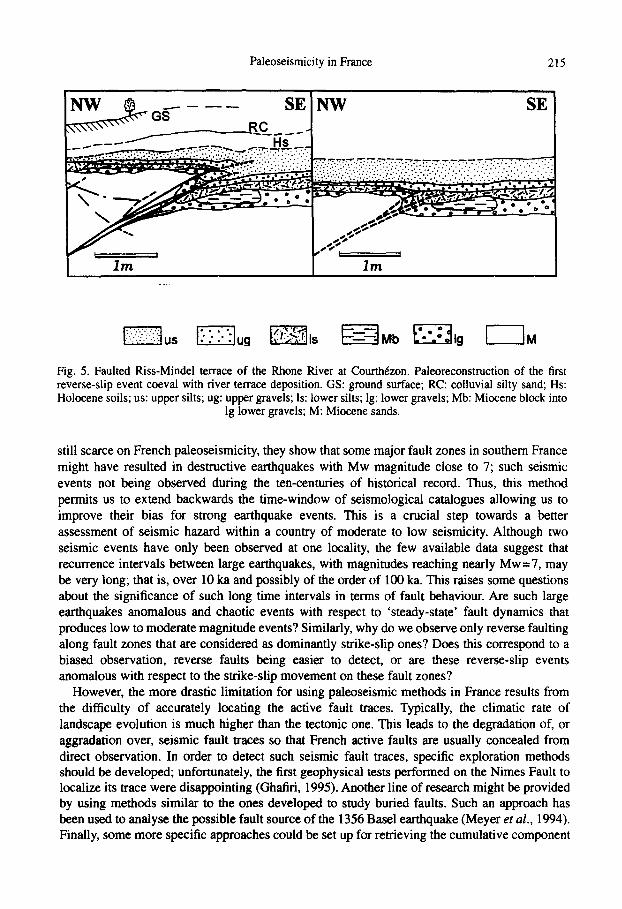
The NE-SW striking Nimes Fault extends over 100 km from northwestern Provence to the Gulf of Lion (Fig. 2). It has undergone a similar tectonic history to the Moyenne Durance Fault (Ghafiri, 1995; Bles er al., 1995). Field observations in the area of Chateauneuf-du-Pape, at Courthezon, demonstrated that a Riss-Mindel river terrace of the Rhone was affected by two reverse slip events (Fig. 5) with 0.3 and 1 .l m vertical throws, respectively (Carbon et al., 1993; Combes et al., 1993; Ghafiri et al., 1995; Bles et al., 1995). Although no radiometric dating is available on this river terrace, these observations indicate that the Nimes Fault was activated twice during the Pleistocene, and that the strongest seismic event should have had a magnitude approximately of the order of Mw = 7.
In the southwestern Aquitaine Basin, at Meilhan, steep reverse faults, striking E-W, have been observed within a Middle Pleistocene terrace of the Adour River; they are interpreted as resulting from the seismic reactivation of the Campagne Anticline propagation fault (Carbon et al., 1994). These data indicate that the southern Aquitaine Basin should be more seismically active than shown by the historical and instrumental seismic records (Fig. 1). This idea leads to the suggestion that the apparent lack of seismic activity within the Paris and Aquitaine Basins is the result of an insufficiently long time-window.
In the southern French Alps, some 50 km north of Nice, exploratory trenching performed at Isola-2000, across the NE-facing scarp of the NW-SE striking Argentera Fault, yields no evidence for major surface rupture during the last 15 ka (Ghafiri, 1995). However, these first conclusions should be confirmed by additional trenches, especially on the Italian side of the Lombardy Pass.
CONCLUSIONS
The first studies carried out on French paleoseismicity indicate that this method is a robust tool to improve the seismic history in countries of low to moderate seismicity. Although data are
Paleoseismicity in France 215
Fig. 5. Faulted Riss-Mindel terrace of the Rhone River at Courthezon. Paleoreconstruction of the first reverse-slip event coeval with river terrace deposition. GS: ground surface; RC: colluvial silty sand; Hs: Holocene soils; us: upper silts; ug: upper gravels; Is: lower silts; lg: lower gravels; Mb: Miocene block into
lg lower gravels; M: Miocene sands.
still scarce on French paleoseismicity, they show that some major fault zones in southern France might have resulted in destructive earthquakes with Mw magnitude close to 7; such seismic events not being observed during the ten-centuries of historical record. Thus, this method permits us to extend backwards the time-window of seismological catalogues allowing us to improve their bias for strong earthquake events. This is a crucial step towards a better assessment of seismic hazard within a country of moderate to low seismicity. Although two seismic events have only been observed at one locality, the few available data suggest that recurrence intervals between large earthquakes, with magnitudes reaching nearly Mw=7, may be very long; that is, over 10 ka and possibly of the order of 100 ka. This raises some questions about the significance of such long time intervals in terms of fault behaviour. Are such large earthquakes anomalous and chaotic events with respect to ‘steady-state’ fault dynamics that produces low to moderate magnitude events? Similarly, why do we observe only reverse faulting along fault zones that are considered as dominantly strike-slip ones? Does this correspond to a biased observation, reverse faults being easier to detect, or are these reverse-slip events anomalous with respect to the strike-slip movement on these fault zones?
However, the more drastic limitation for using paleoseismic methods in France results from the difficulty of accurately locating the active fault traces. Typically, the climatic rate of landscape evolution is much higher than the tectonic one. This leads to the degradation of, or aggradation over, seismic fault traces so that French active faults are usually concealed from direct observation. In order to detect such seismic fault traces, specific exploration methods should be developed; unfortunately, the first geophysical tests performed on the Nimes Fault to localize its trace were disappointing (Ghaflri, 1995). Another line of research might be provided by using methods similar to the ones developed to study buried faults. Such an approach has been used to analyse the possible fault source of the 1356 Base1 earthquake (Meyer et al., 1994). Finally, some more specific approaches could be set up for retrieving the cumulative component
216 M. SCbrier et al.
of the seismic deformation. For example, DEM and satellite imagery should help to develop new methods for finding active fault traces, thus allowing us to apply paleoseismic studies in countries like France of low to moderate seismicity.
Acknowledgemenrs-This work was undertaken within the framework of a scientific contract between BRGM and URA Gdodynamique lnteme et GCophysique (Universit6 de Paris-Sud Otsay). Special thanks are due to Eutizio Vittori and an anonymous reviewer for their constructive and helpful comments.
REFERENCES
Beck A. C. (1968) Gravity faulting as a mechanism of topographic adjustment. New Zealand J. Geol. Geophys. 11, 191-199.
Bles J. L., Ghafiri A., SCbrier M., Sauret B., Terrier M., Godefroy P. and Martin C. (1995) Neotectonics and paleoseismicity in Provence: contribution to the evaluation of seismic hazard. Proceedings of the Fifh International Conference on Seismic Zonation, pp. 1461-1472. Oct. 17-19, 1995, Nice.
Bordet P. (1970) Les failles vivantes du massif des Grands Moulins (Massif cristallin exteme de Belledonne). Gt!ol. Alpine 46,43-47.
BRGM, EDFKEGG, GEO-TER, IPSN/BERSSIN, Universite de Paris Sud (1993) PalC- osismicite et aka sismique: methodes d’etudes et recherches actuelles en France. Ge’ochronique 46,17-2 1.
Carbon D., Combes P., Cushing M. and Granier T. (1993) Enregistrement d’un paleoseisme dans les sediments du Pleistocene sup&ieur dans la vallee du Rhone: essais de quantification de la deformation. Gbol. Alpine 69,33-48.
Carbon D., Combes P., Cushing M., Granier T. and Grellet B. (1994) Rupture de surface post- pleistocbne moyen dans le bassin aquitain. C. R. Acud. Sci, Paris 320(IIa), 311-317.
Combes P. (1984) La tectonique recente de la Provence occidentale: microtectonique, caracteristiques dynamiques et cintmatiques; mtthodologie de zonation tectonique et relations avec la sismicite: Theses 3eme cycle, Univ. Louis Pasteur, Strasbourg.
Combes P., Carbon D., Cushing M., Granier T. and Vaskou P. (1993) Mise en evidence d’un paltoseisme pleistocbne sup&ieur dans la vallee du Rhone: implications sur les connaissances de la sismicid en France, deformation. C. R. Acad. Sci, Paris 317(IIa), 689-696.
Gushing M., Grellet B., Combes P. and Granier T. (1993) Ruptures de surface en France dans le Plio-Quatemaire. 3eme Colloque National de Genie Parasismique, Association FranGuise de Genie Parasismique, St R&my-les-Chevreuse, France, pp. 11-12.
Ego F., Stbrier M., Carey-Gailhardis E. and Beate B. (1996) Do the Billecocha normal faults (Equador) reveal extension due to lithospheric body forces in the norther Andes? Tectorwphysics 265,255-273.
Ghafiri A. (1991) Recherche des indices d’activite des failles envue d’une etude de la paleosismicite dans le SE de la France: Rapport de DEA, Univ. Paris-Sud, Orsay, 81 p.
Ghafiri A. (1995) Paleosismicite de failles actives en contexte de sismicite mode&: application a l’evaluation de l’alea sismique dans le Sud-Est de la France: These Univ. Paris-Sud, Orsay.
Ghafiri A., Sauret B., Rosique T., Blbs J. L. and Sebrier M. (1993) Mise en evidence d’un paleodisme sur la faille de la Moyenne Durance, Colloque Mesures de la Deformation recente et actuelle, Chambtry, 18-19 mai 1993. Gkol. Alpine, Sk Spec. R&s. Coil. 2,24-25.
Godefroy P., Lambert J., Levret A. and Vaskou P (1990) The French macroseismic database ‘SIRENE’, Proceedings XXIInd ESC General Assembly, Barcelona.
Goguel J. (1969) Des failles d’age quaternaire a Peisey (Savoie). Bull. Sot. Gkol. France 7(X1), 35-39.
Granier T., Grellet B., Carbon D., Combes P. and Cushing M. (1995) Paleoseismicity studies in
Paleoseismicity in France 217
France: main results. Proceedings Fifh International Conference on Seismic &nation, pp. 1562-1569. Oct. 17-19, 1995, Nice.
Grellet B., Combes P., Granier T., Philip H. and Mohammadioun B. (1993) Sismotectonique de la France mttropolitaine dans son cadre geologique et geophysique, avec atlas de 23 cartes au 1:4 000 000 et une carte au 1: 1 000 000. Memoire de la Societe’ Geoologique de France 164, 76 p., LDG/CEA.
Levret A., Backe J. C. and Cushing M. (1994) Atlas of macroseismic maps for French earthquakes with their principal characteristics. Natural Hazards 10, 19-46.
Levret A., Cushing M. and Peyridieu G. (1996) Recherche des caracteristiques de se’ismes historiques en France: Atlas with 140 macroseismic maps in 2 volumes. IPSN Publication.
Meyer B., Lacassin R., Brulhet J. and Mouroux B. (1994) The Base1 1356 earthquake: which fault produced it?. Terra Nova 6, 54-63.
Michetti A. M. (1994) Coseismic surface displacement vs. magnitude: relationships from paleoseismological analyses in the central Apennines (Italy). Proceedings of the CRCM ‘93, Kobe, December 6-11, Special Issue. Journal of the Geodetic Society of Japan, pp. 375-380.
Obermeier S. and Jibson R. (1995) Using ground-failure features for paleoseismic analysis. U.S. Geological Survey Open-File Report 94-663.
Roure F., Brun J. P., Coletta B. and Van den Driesche J. (1992) Geometry and kinematics of extensional structures in the Alpine Foreland Basin of southeastern France. J. Struct. Geol. 14,503-5 19.
Sauret B. (1986) Mise en evidence de mouvements ¢s le long de la faille de la Durance (S.S.); deformation des terrasses wurmiennes de Villard-Meyer et de Mont-Dauphin (Hautes Alpes): Note tectonique BRGM/SGN/GEG, 08.86, Marseille.
Sauret B. (1992) Fichier ntotectonique du Sud-Est de la France. BRGM Report, R34885,76 p. Savage W. and Varnes D. (1987) Mechanics of gravitational spreading of steep-sided ridges
(Sackung’). Bull. Int. Assoc. Eng. Geol. 35,31-36. SIRENE, French macroseismic database, BRGM/EDF/lPSN. Terrier M. (1991) Neotectonique de la Provence occidentale (France): vers une analyse
multicritere des deformations recentes. Applications a la classification des strutures sismogtnes: These Univ. Provence, Marseille, Dot. BRGM, 207.
Villeger M. (1983) La nouvelle interpretation de la montagne de Volx (Alpes de Haute Provence). C. R. Acad. Sci., Paris 2!I7, 363-366.
Wells D. L. and Coppersmith K. J. (1994) New empirical relationships among magnitude, rupture length, rupture width, rupture area, and surface displacement. Bull. Seismol. Sot. Am. 84.974-1002.
Zischinsky U. (1969) iiber Sackungen. Rock Mechanics 1,30-52.


![Southern trench. The graves [from Tell el-Farkha, seasons 2008-2010]](https://static.fdokumen.com/doc/165x107/6317057c0f5bd76c2f02be29/southern-trench-the-graves-from-tell-el-farkha-seasons-2008-2010.jpg)