Holocene paleoseismicity of the Tunka fault, Baikal rift, Russia
12
TECTONICS, VOL. 14, NO. 3, PAGES 594-605 , JUNE 1995 Holocene paleoseismicityof the Tunka fault, Baikal riff, Russia James P. McCalpin GEO-HAZ Consulting, Inc., Estes Park, Colorado Vladimir S. Khromovskikh Institute of the Earth's Crust, Irkutsk, Russia Abstract. The Tunka fault is a major normal-oblique transform fault within the NNE trending Baikal rift that displays geomorphic evidence of recurrent Quaternary movement. A flight of six fanhead terraces of the Kyngarga River is displaced by several parallel faultsand has scarps up to 32 m high at Arshan. The main fault zone is exposed in an abandoned gravel quarry about 1 km east of the Kyngarga River. Thirteen radiocarbon dates from the quarry, a shallow trench in a graben,andnaturalstreamcuts constrainthe timing of the latest two or three Holocene paleoearthquakes. The latestearthquake is bracketed by the 1024-1315 calendar years (cal. year) B.P. age of an unfaulted terraceandby the 1947-2179cal. year B.P. age of a soil buried by scarpcolluvium in the graben trench.The penultimate earthquake is also relatively well constrained, assuming that the displacement event slightly younger than 7091-7867cal. year B.P. in theupper quarry exposure is the same as the fissuring event slightly older than 6733-7385 cal. year B.P. in the lower quarry exposure. Evidencefor earlier event(s) between9.2-12.7 ka depends on ambiguous stratigraphic evidence in the lower quarryexposure. On the basis of only the two well-dated earthquakes, the recurrence interval at Arshan may range from 2.9 to 6.8 ka for earth- quakedisplacements of at least 1.3 m or a slip rate of 0.19- 0.44 mm/yr. Intermediate-term (100 ka) and long-term (circa 500 ka) slip rates computed from terrace ageestimates and fault scarp heights are 0.08-0.16 mm/yr and 0.07-0.11 mm/yr, respectively, ratesthat are considerably lower than the late Holocene rate andthe approximately 0.5 mm/yr that might be inferred from the tectonic geomorphology of the Tunka Range front. Introduction The Tunka fault bounds the northern marginof the Tunka Basin, an east-west trending, north tilted grabenabout 125 km long and 30 km wide in the southwestern part of the Baikal rift, Russia (Figure 1). Along the Tunka fault the rangefront of the Tunka Range risesabruptly from approxi- mately800 m to over 3100 m, forming a linear escarpment with abundant faceted spurs. Previousinvestigators [e.g., Lukina, 1989] described tectonic landforms alongthe range Copyright 1995 by the American Geophysical Union. Paper number95TC00837. 0278-7407/95/95TC-00837510.00 front and estimated neotectonic slip rates but did not study any fault zone exposures or dateany individual paleoearth- quakes.During a 6-day field reconnaissance in 1991, we discovered a large fault zone exposure in an abandoned quarryeast of the town of Arshan.This exposure, plus a shallow trench excavated farther to the west, yieldthe first numerical ages that constrain the timing of Holocene paleoearthquakes in this part of the Baikal rift. Sherman [1981, 1992] describes the Tunka fault as a transform fault within the NNE-trending Baikal rift. His reasoning is as follows.The main bounding faults flanking Lake Baikal in the central rift exhibit no evidence of lateral offset, and fault slickenlines and historic seismicity indicate a regional extensiondirection of N 300-35 ø W [Sherman, 1978, p. 38; Mats, 1993]. In a simple kinematicmodel, east-west trendingfaultssuchas the Tunka fault wouldthus be expected to have a large sinistral component [Figure 1]. Several authors[e.g., Sherman,1978, p. 33; Lukina, 1989] claim that the Tunka Fault initially formed in Caledonian time as a dextral-oblique thrust fault, across whichArchean gneisses of the Slyudyank Series were overthrust by rocks of the upper Proterozoic Tunkin Series. In the Cenozoic the sense of slip is inferred to have reversed into a sinistral- oblique normalfault. Vertical displacement on the Tunka fault resulting from Cenozoic rifting has been estimated at 5.0-5.6 km [Lukina, 1989]. The Tunka Basinis underlain by as muchas 3.5 km of intercalated basin fill clastic sediments and basalt flows of Paleocene (?) to Pleistocene age. Several late Quaternary cindercones dot the valley floor [Logatchev and Florensov, 1978, p. 9]. TectonicGeomorphology of the Range Front Geology and Fault Scarps Although the Tunka Range from is heavily forested (Figure2) it exhibits the faceted spurs typicalof rapidly upliftednormalfault footwallblocks [e.g., Wallace, 1978]. Glaciated valleys of theTunka Range aredeeply incised into the faultblock,and terminal moraines typically extend from 0.5 to 4.0 km beyond the range from. Helicopter reconnais- sance andphoto interpretation suggest two ages of moraines (Figure3), a younger setprobably correlative with the late Zyryansk (Sartansk) glaciation of 10-23 ka and an older set that may correlate with the Karginsk or early Zyryansk (Ermakovsk) glaciations of 23-55 ka and58-110 ka [Lukina, 1989]. Age control is based on radiocarbon dating for the two younger glaciations [Alekseev et al., 1984] and on 594
-
Upload
independent -
Category
Documents
-
view
0 -
download
0
Transcript of Holocene paleoseismicity of the Tunka fault, Baikal rift, Russia

TECTONICS, VOL. 14, NO. 3, PAGES 594-605 , JUNE 1995
Holocene paleoseismicity of the Tunka fault, Baikal riff, Russia
James P. McCalpin GEO-HAZ Consulting, Inc., Estes Park, Colorado
Vladimir S. Khromovskikh
Institute of the Earth's Crust, Irkutsk, Russia
Abstract. The Tunka fault is a major normal-oblique transform fault within the NNE trending Baikal rift that displays geomorphic evidence of recurrent Quaternary movement. A flight of six fanhead terraces of the Kyngarga River is displaced by several parallel faults and has scarps up to 32 m high at Arshan. The main fault zone is exposed in an abandoned gravel quarry about 1 km east of the Kyngarga River. Thirteen radiocarbon dates from the quarry, a shallow trench in a graben, and natural streamcuts constrain the timing of the latest two or three Holocene paleoearthquakes. The latest earthquake is bracketed by the 1024-1315 calendar years (cal. year) B.P. age of an unfaulted terrace and by the 1947-2179 cal. year B.P. age of a soil buried by scarp colluvium in the graben trench. The penultimate earthquake is also relatively well constrained, assuming that the displacement event slightly younger than 7091-7867 cal. year B.P. in the upper quarry exposure is the same as the fissuring event slightly older than 6733-7385 cal. year B.P. in the lower quarry exposure. Evidence for earlier event(s) between 9.2-12.7 ka depends on ambiguous stratigraphic evidence in the lower quarry exposure. On the basis of only the two well-dated earthquakes, the recurrence interval at Arshan may range from 2.9 to 6.8 ka for earth- quake displacements of at least 1.3 m or a slip rate of 0.19- 0.44 mm/yr. Intermediate-term (100 ka) and long-term (circa 500 ka) slip rates computed from terrace age estimates and fault scarp heights are 0.08-0.16 mm/yr and 0.07-0.11 mm/yr, respectively, rates that are considerably lower than the late Holocene rate and the approximately 0.5 mm/yr that might be inferred from the tectonic geomorphology of the Tunka Range front.
Introduction
The Tunka fault bounds the northern margin of the Tunka Basin, an east-west trending, north tilted graben about 125 km long and 30 km wide in the southwestern part of the Baikal rift, Russia (Figure 1). Along the Tunka fault the range front of the Tunka Range rises abruptly from approxi- mately 800 m to over 3100 m, forming a linear escarpment with abundant faceted spurs. Previous investigators [e.g., Lukina, 1989] described tectonic landforms along the range
Copyright 1995 by the American Geophysical Union.
Paper number 95TC00837. 0278-7407/95/95TC-00837510.00
front and estimated neotectonic slip rates but did not study any fault zone exposures or date any individual paleoearth- quakes. During a 6-day field reconnaissance in 1991, we discovered a large fault zone exposure in an abandoned quarry east of the town of Arshan. This exposure, plus a shallow trench excavated farther to the west, yield the first numerical ages that constrain the timing of Holocene paleoearthquakes in this part of the Baikal rift.
Sherman [1981, 1992] describes the Tunka fault as a transform fault within the NNE-trending Baikal rift. His reasoning is as follows. The main bounding faults flanking Lake Baikal in the central rift exhibit no evidence of lateral
offset, and fault slickenlines and historic seismicity indicate a regional extension direction of N 300-35 ø W [Sherman, 1978, p. 38; Mats, 1993]. In a simple kinematic model, east-west trending faults such as the Tunka fault would thus be expected to have a large sinistral component [Figure 1]. Several authors [e.g., Sherman, 1978, p. 33; Lukina, 1989] claim that the Tunka Fault initially formed in Caledonian time as a dextral-oblique thrust fault, across which Archean gneisses of the Slyudyank Series were overthrust by rocks of the upper Proterozoic Tunkin Series. In the Cenozoic the sense of slip is inferred to have reversed into a sinistral- oblique normal fault.
Vertical displacement on the Tunka fault resulting from Cenozoic rifting has been estimated at 5.0-5.6 km [Lukina, 1989]. The Tunka Basin is underlain by as much as 3.5 km of intercalated basin fill clastic sediments and basalt flows of
Paleocene (?) to Pleistocene age. Several late Quaternary cinder cones dot the valley floor [Logatchev and Florensov, 1978, p. 9].
Tectonic Geomorphology of the Range Front
Geology and Fault Scarps
Although the Tunka Range from is heavily forested (Figure 2) it exhibits the faceted spurs typical of rapidly uplifted normal fault footwall blocks [e.g., Wallace, 1978]. Glaciated valleys of the Tunka Range are deeply incised into the fault block, and terminal moraines typically extend from 0.5 to 4.0 km beyond the range from. Helicopter reconnais- sance and photo interpretation suggest two ages of moraines (Figure 3), a younger set probably correlative with the late Zyryansk (Sartansk) glaciation of 10-23 ka and an older set that may correlate with the Karginsk or early Zyryansk (Ermakovsk) glaciations of 23-55 ka and 58-110 ka [Lukina, 1989]. Age control is based on radiocarbon dating for the two younger glaciations [Alekseev et al., 1984] and on
594
MCCALPIN AND KHROMOVSKIKH: PALEOSEISMICITY, TUNKA FAULT 595
SCALE .... l , , , , I /
0 I0 •rn
'_FIG. 3 x. -•
River _,•. "x
I [ ! i
o
I I %4/ \ ./- ß / •
• /range
j / _/ ....x • , ,_ , • , / ' front _ - ' / , x \•.,. • / , ',,•i;-' . ' -' ,
, /• ./J /' '1694 x ""'--" • \
"•/ /( I..•. N'""t(.• A -•-- '" -' R i'v _•_ •
.... ,F o
\LAKE BAI KAL
Figure 1. Location map of the Tunka fault. Horizontal line pattern in the Tunka Range shows area above treeline; spot elevations are in meters. Heavy line with hachures indicates the base of the range front and approximate position of fault scarps. Box at right shows area of Figure 3a. K, Khubuiti River; Y, Yekhe-Ger River; B, Bulk River. In the inset, heavy lines schematically show major faults of the Baikal rift, including the Tunka fault (lower left). Long arrows show regional extension direction, after Sherman [1978, 1992]. Faults SW and NE of Lake Baikal should display significant sinistral slip
I
Figure 2. Photograph of the Tunka Range front showing faceted spurs between the Bugatay and Talta Rivers (for location see Figure 3a). Arrows show fault scarps across alluvial fans; dots show base of range front.

596 MCCALPIN AND KHROMOVSKIKH: PALEOSEISMICITY, TUNKA FAULT
thermoluminescence dating for the earliest glaciation [Arkhipov et al., 1982]. Alluvial fans composed of bouldery glacial outwash head at the moraine complexes. Similar fans head at the mouths of unglaciated drainages west of Arshan (Figure 3a).
EXPLANATION . / symbols and map units are identical to I those below except: J "
' I • KYNGA•G•,- • Kyngorgo }-. - --'/•' -
• alluv,01 fan I \ • young
I•1 intermediate I • old J • /
EXPLANATION
well preserved fault scarp -r eroded fault scarp
I•neoment \\ modern
• faceted spur •olluvium glacial • stream
• trimlines channel -
fan alluvium till
!• younger :• younger undiff. older
older /x Precambrian /• gneiss
col luvlum •% debris fan landslide
Only the larger fault scarps that displace Quaternary landforms are mapped on Figure 3a, due to the thick forest cover. The continuous range front scarp between the Bugatay and Zun-Khandagan Rivers (Figure 3a) is 30-50 m high [Lukina, 1989]. Farther west at the mouths of the Khubuiti and Yekhe-Ger Rivers (Figure 1) ground observa- tions [Lukina, 1989, p. 162] describe six parallel fault scarps from 10 to 80 m high with a cumulative down-to-the-south vertical displacement of 200 m. Lukina also cites evidence for sinistral stream deflections at the range front and lateral slip rates between the Khubuiti and Bulk Rivers [Figure 1] of 3-4 mm/yr for the Pleistocene and up to 10 mm/yr for the Holocene. If such high lateral slip rates existed, then latest glacial moraines and fans would be laterally offset at least 100 m. In our brief helicopter reconnaissance we did not observe such large sinistral displacements of range front landforms.
Offset Terraces Near Arshan
A flight of six fanhead terraces of the Kyngarga River is displaced by several parallel fault scarps near Arshan (Figure 4). On the basis of height above modern stream level,.Lukina [1989] correlated these terraces to terraces of the Irkut River, which flows east down the axis of the Tunka Basin (Figure 1). His correlation, if correct, suggests that ages for Irkut River terraces (derived from a combination of radiocarbon and thermoluminescence dating, fossil identifica- tion, and the assumption of constant incision rate) can be
..... .-.-...•:::..•:•:: ..,•.•, ........
.:;: ß .. '.-.......::,.•,.:::•..:•:......:..:...:.: ::*' ..• .... .:
... ...
:: .... ..:::•:.::.•..f•::• .......... ".:: ....;: ......•:::.::: ....
. .:...... •.•:.•:• .......
ß -.:•:::•/•:.;::' ........ :•.•. :..• :::.•' -""•• :..
.... .:.¾'::•:.:' ............... :....:.::-::-:.., •."'•%.,:.....:.•"
. .':•:;.:: .. ..:r•., •...:' •:•:•':'•*• •-.:;:,• .... ::•:.:.•:,;... ..... :: '..-?:;::.:•:::..: ..............
................ :::..... .......................... •ig, re 3. (a) Reconnaissance map o• surficial geology a•d geomo•hology o• the eastern Tu•ka •ault •ear Arsh•. O•ly the largest •ault sca•s are mapped. (b) Photograph o• the range from at Arsh• covering approximately the same area as Figure 3a. Horizomal a•ows mark •ault trace; ve•ical a•ow shows 1ocatio• of the flua• exposure. Bracket shows extem o• the Ey•garga •a•head te•ace complex (Figure 4). Abbreviations are E, Ey•g•ga River; A, Arsha• (s•itarium complex); T, Talta River; B, Bugatay River. Peak labeled •54] m is also show• o• Figure 1.

MCCALPIN AND KHROMOVSKIKH: PALEOSEISMICITY, TUNKA FAULT 597
0 300m x•• 'r- NU M B__ERS I SY_M BOLS X•so ,• 33 toe•roOv•Lt•ge•t n<m, I
• foce of Iorge •/F streom I
foult scorp A•• • terrøce number I -r'l"r'l' srnoll ,ault z c • k•X.•.• I
.'• -r" •
Figure 4. Sketch map of displaced fanhead terraces of the Kyngarga River north of Arshan. Terraces are numbered from 1 (youngest) to 6 (oldest). The modern floodplain (not numbered) is 1.5 m above stream level. All fault scarps face south. Terrace heights along large fault scarps were measured by hand-leveling; heights of terraces farther north are from Lukina [1989]. Location of two scarp profiles shown in Figure 5 is indicated by word "profiles."
applied to the terraces at Arshan, as follows; terrace 1, 10- 23 ka; terrace 2, 23-55 ka; terrace 3, 55-110 ka; terrace 4, 110-180 ka; terrace 5, 180-290 ka; terrace 6, 290-500(?) ka [Alekseev et el., 1984; Nedra, 1974; Arkhipov et el., 1982; Devyatkin, 1981; Lukina, 1984]. However, incision rates may be considerably greater at the active range front than along the Irkut River which flows down the axis of tectonic basins.
As a check on Lukina's [1989] correlations and age estimates, we measured weathering rinds on 50 surface cobbles (10-30 cm diameter) of gneiss on terrace 3 west of the river (due to time limitations extensive rind measuring was not feasible). The mean rind thickness of 4.2+0.9 mm can be compared with rind thicknesses on gneissic clasts from the (somewhat drier) Sierra Nevada Range, California of 2.4+0.7 mm on deposits 15-25 ka and 3.2+0.9 mm on clasts circa 150 ka [Burke and Birkeland, 1979]. Given the greater available moisture at Arshan (mean annual precipi- tation is similar to the 350-500 mm/yr in the Sierra Nevada, but evapotranspiration is lower), it is reasonable to associate the 4.2 mm-thick rinds with deposits of >100 ka. While this single check is not conclusive, it suggests that Lukina's [1989] age estimates may be generally correct.
The large fault scarp east of the Kyngarga River is composed of two closely spaced escarpments separated by a small bench; together the scarp is approximately 32 m high. An isolated remnant of the oldest terrace (6 in Figure 4) is preserved on the upthrown block, whereas the downthrown block is covered by a younger deposit (terrace 3). West of the river the scarp is simpler, comprising only a single fault trace, approximately 9 m high, and fronted by a shallow graben (Figure 5). The vertical surface offset across terraces
3, 4, and 5 is fairly constant (Figure 5) indicating that all 9- 9.5 m of displacement occurred after the formation of terrace 3o A poorly preserved 1.3-m-high scarp across terrace 2 west of the river indicates that 1.3 m vertical
displacement occurred between the deposition of terraces 2 and 1, but a similar offset cannot be seen on the same terrace east of the river due to human disturbances. The
remaining 7.7 m of net vertical displacement on the 9-m scarp evidently occurred between deposition of terraces 3 and 2.
Figure 4 differs from Lukina's previous interpretation in assigning an old age to the 47-m-high remnant of terrace 6 (T6) east of the river. Lukina [1989, p. 161] had correlated this remnant with the T3 surface 32 m lower on the southern
side of the large fault scarp (Figure 4). We believe his interpretation is incorrect for two reasons. First, in Lukina's correlation, his remnant of T3 is 47 m above stream level on the upthrown block east of the river, but the same terrace is only 24 m above the stream in the same structural block on the opposite side of the river. To explain this discrepancy, Lukina postulated the existence of a north trending fault under the active channel of the Kyngarga River that dis- placed the 47-m terrace down by 23 m to the west. Howev- er, this fault apparently only displaced T3 north of the main (east-west trending) fault scarp, because T3 south of the scarp lies at essentially the same elevation on both sides of the river (15 m and 14.5 m above the channel). To accom- plish this piecemeal uplift, a fault would have to rupture on the main east-west fault scarp east of the river and then turn at right angles and continue northward with the same displacement, thus uplifting only the northeast quadrant of the Kyngarga terraces. Such an uplift pattern would be
m S N
....... '"'. .............. f ............ .......... 4 J ................. S0.=....9,.1 m .................................................... 7' . • ........... 'T3 i• ........ .GB...iA...B..E.N.........W•Maxirnurn scarp'slopej
ol...-. ............• angle .... 4Z ...... 1 -4] ........................................ • Tr'e'"ncl• ...................... 1
0 5 10 15 20 25 30 35 40 45 50
Horizontal Distance (m) (:3.
5 10 15 20 25 30 35 40 45 50 55
Horizontal Distance (m) b.
Figure 5. Topographic profiles across the main 9-m-high fault scarp west of the Kyngarga River. SO is the vertical surface offset. (a) Scarp across terrace 4. (b) Scarp across terrace 3. Shaded area shows approximate dimensions of the shallow trench. Profile locations are shown on Figure 4.
598 MCCALPIN AND KHROMOVSKIKH: PALEOSEISMICITY, TUNKA FAULT
Parent Material Horizon Description 0 - •-.• A organic silt
• BW • massive yellow-brown silt ß •':. .:•.. CE gravelly sil• sand 1 - Btl • gray-brown silt, strong
.... -•'•'•'•" Bt21• angular blocky structure •/•/..,,•>•x' •>•1 'light brown silt, moder•e 2 •• Coxb X•XXX •xxxxx angular blocky structure x•xxx•x
•>-'/>-'/•'z'3-' 2Kb2 ve•hardhorizontally •X•X•
•xxxxxx E •xxxx
•XX•X
XX•XX•X
m
m
laminated carbonate, beds 1-2 cm thick; tufa deposit from springs
Stream tufa-cemented pebble and Gravel 3Kb3 cobble gravel; very hard
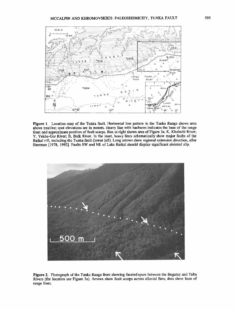
Figure 6. Soil profile developed on terrace 6. The upper 4.8 m include two soils developed on loess and a thick tufa deposit. Soil horizon nomenclature follows Birkeland [1984], Gile [1994], and Soil Conservation Service [1994].
anomalous compared to rupture patterns during historic normal-faulting earthquakes [e.g., $lemmons, 1957; Myers and Hamilton, 1964; Wallace, 1984; Crone et al. , 1987].
Second, the thick, complex soil on T6 is well developed (Figure 6) and suggests considerably greater age than the other lower terraces. Terrace 6 has three distinct soils
containing multiple horizons developed on a loess cap at least 1.7 m thick. The uppermost soil (horizons A-Ck) appears to be Holocene and developed on a recent (post glacial?) loess cap about 0.5 m thick. The underlying soil (horizons Btlb to Coxb) is a truncated older soil composed of textural B horizons roughly 1 m thick underlain by oxidized loessial parent material (horizon Coxb). The parent material of the next lower, carbonate-engulfed horizon (2Kb2) is unknown but was presumably fine-grained because no clasts occur in the laminated tufa. Alternatively, the tufa deposit may represent precipitation of groundwater carbonate on the T6 surface either before or during accumulation of the overlying loess. (For example, the cold springs for which Arshan is widely known currently precipitate tufa throughout the working canal system). By comparison to the 1.7 m of loess on T6, loess on T3 and T4 averages about 20-30 cm in thickness.
On the basis of the apparent antiquity of T6, we propose a different scenario of faulting that does not require the isolated uplift of the NE quadrant of the terraces (Figure 7). After deposition of the T6 surface (< 290-500? ka according to Lukina, [1989]), vertical displacement of 24 m occurred on the main E-W fault trace, now preserved in the two large fault scarps east of the river. In response to these multiple faulting events (and perhaps in response to regional climatic changes, e.g., Bull, [1991]) the river incised into the upthrown (footwall) block and formed T5, T4, and T3. It is unknown whether these terraces are tectonic strath surfaces
or whether they include an aggradational component, but the latter is likely if they were deposited during glacial advanc- es, as were other terraces in southern Siberia [Alekseev et
N a.•-•-• T6 S '1'6 ----- •
c. ' ............... ' ..... --•' .'m T6 .....
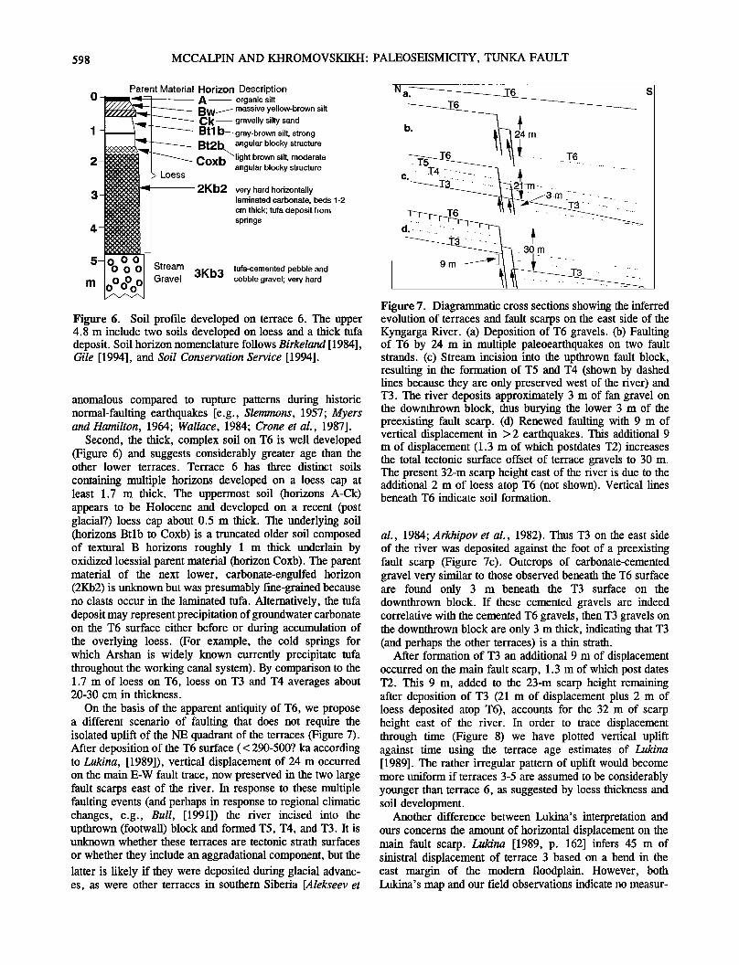
Figure 7. Diagrammatic cross sections showing the inferred evolution of terraces and fault scarps on the east side of the Kyngarga River. (a) Deposition of T6 gravels. (b) Faulting of T6 by 24 m in multiple paleoearthquakes on two fault strands. (c) Stream incision into the upthrown fault block, resulting in the formation of T5 and T4 (shown by dashed lines because they are only preserved west of the river) and T3. The river deposits approximately 3 m of fan gravel on the downthrown block, thus burying the lower 3 m of the preexisting fault scarp. (d) Renewed faulting with 9 m of vertical displacement in > 2 earthquakes. This additional 9 m of displacement (1.3 m of which postdates T2) increases the total tectonic surface offset of terrace gravels to 30 m. The present 32-m scarp height east of the river is due to the additional 2 m of loess atop T6 (not shown). Vertical lines beneath T6 indicate soil formation.
al., 1984; Arkhipov et al., 1982). Thus T3 on the east side of the river was deposited against the foot of a preexisting fault scarp (Figure 7c). Outcrops of carbonate-cemented gravel very similar to those observed beneath the T6 surface are found only 3 m beneath the T3 surface on the downthrown block. If these cemented gravels are indeed correlative with the cemented T6 gravels, then T3 gravels on the downthrown block are only 3 m thick, indicating that T3 (and perhaps the other terraces) is a thin strath.
After formation of T3 an additional 9 m of displacement occurred on the main fault scarp, 1.3 m of which post dates T2. This 9 m, added to the 23-m scarp height remaining after deposition of T3 (21 m of displacement plus 2 m of loess deposited atop T6), accounts for the 32 m of scarp height east of the river. In order to trace displacement through time (Figure 8) we have plotted vertical uplift against time using the terrace age estimates of Lukina [1989]. The rather irregular pattern of uplift would become more uniform if terraces 3-5 are assumed to be considerably younger than terrace 6, as suggested by loess thickness and soil development.
Another difference between Lukina's interpretation and ours concerns the amount of horizontal displacement on the main fault scarp. Lukina [1989, p. 162] infers 45 m of sinistral displacement of terrace 3 based on a bend in the east margin of the modern floodplain. However, both Lukina's map and our field observations indicate no measur-

MCCALPIN AND KHROMOVSKIKH: PALEOSEISMICITY, TUNKA FAULT 599
35
•-' 30- E
v
'E 25- E
o 20-
.•- 15-
o 10- ._
> 5-
T1 0
T6
I0.11 m/kal
T5
0 50 100 150 200 250 300 350 400 450 500
Time (ka)
Figure 8. Cumulative vertical displacement on the main fault scarp as a function of time. Terrace ages are from Lukina [1989, p. 159-160]. The 32-m net displacement of T6 is approximate, since only a single outcrop (not shown on Figure 4) possibly correlative with T6 was observed on the downthrown block. Dotted lines show ranges of long- term vertical uplift rate (0.07-0.11 mm/yr), but these rates do not include any component of horizontal displacement.
able lateral offset of terrace risers between T2/T3 and T3/T4
on the west side of the river. The T3/T4 riser is especially well-preserved west of the river and lateral displacement cannot exceed 2-3 m. The T4/T5 riser on the west side of
the river displays an apparent dextral offset of approximately
100 m, but in the local geomorphic setting such apparent offset is more likely the result of stream deflection into the graben than tectonic offset [e.g., Wallace, 1990]. It is difficult to make 100 m dextral offsets at the terrace com-
plex compatible with the > 100 m sinistral offsets reported by Lukina [1989] on the same fault only a few kilometers farther west. Accordingly, we suspect that the apparent 45 m of sinistral offset on the river's east bank reported by Lukina [1989] is due to stream erosion in the fault zone.
Exposures of the Tunka Fault
The main fault zone is exposed in an abandoned gravel quarry about 1 km east of the Kyngarga River (Figure 3). This quarry was excavated into the > 30 m-high scarp that traverses across a high-level, valleyward sloping geomorphic surface at the base of bedrock faceted spurs (Figure 3b). This surface appears to be an eastern extension of the T6 surface, perhaps onlapped by younger colluvium from the range front. Below the scarp at the quarry, gravel and sand from a large alluvial fan to the east have been deposited up against the scarp in a graben or back-tilted zone. Two exposures were logged in the quarry. The upper exposure was dug into the scarp face itself whereas the lower expo- sure transected a complex graben at the foot of the scarp (Figure 9). In addition, a shallow trench was excavated by V.V. Ruzhich and others (Institute of the Earth's Crust, Irkutsk, Russia) across the 9-m-high fault scarp on T3 west of the Kyngarga River (at the T3 scarp profile location, Figures 4 and 5).
%.
Figure 9. Photograph of the quarry exposures. Vertical distance.between scarp crest and basal graben is approximately 30 m. The upper exposure (box A) is located about midway up the fault scarp. The lower exposure (box B) reveals complex subsidiary faulting in a graben. For scale, note human figures to the. right of horizontal arrows. Area outlined by dashes to the left of box A is the compacted sand zone of the main fault plane described in text.

6OO MCCALPIN AND KHROMOVSKIKH' PALEOSEISMICITY, TUNKA FAULT
Upper Quarry Exposure
The upper quarry cut exposes a hanging wall sequence of slope colluvium, locally derived alluvium, and six interbedded organic layers interpreted as A horizons of former incipient soils (informally numbered from 1 to 6, Figure 10). The nature of deposits differs considerably above versus below soil 6. Below soil 6, deposits are about equally divided between poorly stratified, stow slope colluvium and well-stratified (alluvial?) lenses of sand and subrounded gravel. Occasional angular unconformifies are visible in the well stratified alluvium below soil 6 (e.g at center of fault-bounded block 4, lower right in Figure 10). These unconformities indicate repeated sedimentation and
deformation of the alluvial sequence that predates deposition of the scarp-derived colluvium at this location. Above soil 6 deposits are almost exclusively scarp-derived colluvium that display a slope-parallel clast fabric and contain abundant interbedded soil horizons.
The upper part of the exposure is dominated by a main normal fault zone that separates thickly bedded horizontal sands and gravels of the footwall (not shown on Figure 10) from thinly-bedded alluvium and colluvium of the hanging wall. The main fault plane is marked by a 1-to-3-cm-thick zone of compacted sand that was presumably smeared along the fault by shearing. This sand forms a resistant layer in the unconsolidated deposits, and its preferential weathering has formed decimeter-scale mullions and grooves similar to
• 4 5 6m • R • N IOøE
3590• 13( LU -2724
4210 ñ 17
LU-2731
6890 •: 210 LU-2714
LU-2734 %
%
'•\ %
3770 ñ 50
,LU - 2718
Explanation LITHOLOGIC SYMBOLS
organic so•l horizon
rad,ocarbon sample
stony colluv•um (sand matrix)
angular small pebble gravel
subround sandy pebble gravel
med,um to coarse sand
or,ented clasts near fault
sheared, compacted sand in fault zone
i I
OTHER SYMBOLS
/ subsidiary
faults L} (dashed where obscure)
fault- bounded
blocks of colluvlum I I
o -
o
o o o
, o o o .• • o
o • o
Figure 10. Log of the upper quarry exposure (located in box A on Figure 9). Radiocarbon ages are in •4C years B.P. Explanation of numbers, letters, and stratigraphy is given in text.

MCCALPIN AND KHROMOVSKIKH' PALEOSEISMICITY, TUNKA FAULT 601
those on normal faults in bedrock [e.g., Stewart and Hancock, 1988]. Unfortunately, sheet wash and rill wash have smoothed out the mullions and no unambiguous indica- tors of slip direction are preserved. Immediately overlying the sand zone is a well-defined 5-to-10-cm-thick zone where
clasts in hanging-wall colluvium and alluvium have been aligned by shearing such that long axes parallel the dip of the fault plane. No obliquely oriented clasts were observed that might indicate a large oblique component of slip.
Four subsidiary faults (lettered A-D in Figure 10) diverge from the main fault, displace hanging wall colluvium and alluvium, and form several fault-bounded blocks. The sense of slip on these faults is difficult to interpret because the stratigraphy of the fault-bounded blocks (circled numbers in Figure 10) cannot be correlated across any of the faults. Fault A is the downslope side of a tectonic fissure filled with scarp-derived colluvium (note anomalously steep clast fabric). Fault B is the only fault that displaces units younger than soil 6, but the sense of vertical displacement apparently changes from bottom to top. Fault C apparently warped soil 6 in an antithetic sense by about 20 cm but may also have experienced earlier movement, as did fault D. The inconsis- tent vertical displacements and lack of stratigraphic correla- tion between colluvial blocks suggest a large component of strike-slip displacement on the subsidiary faults, but data are insufficient to quantify the amount of slip. The apparent inconsistency between this stratigraphic evidence for lateral slip and the lack of such evidence on the main fault plane and on the Kyngarga terraces could not be resolved within our limited field time.
Radiocarbon ages were obtained from soils 2-6 (Table 1). Soils 2, 3, 4, and 6 are in stratigraphic succession upslope and north of fault B and yield the correct sequence of increasing ages with depth. Soil 5 was sampled south of Fault B (Figure 10) and yielded an anomalously young age for its inferred position in the stratigraphic sequence, which may indicate that the correlation of soils across fault B is incorrect, and that strike-slip displacement has juxtaposed soils of different age across fault B.
During the most recent displacement event (the MRE), soil 2 was faulted, so the MRE has a maximum age of 3590+130 •4C years B.P. Fault B may also extend into the unit overlying soil 2, so the 3590 year age may not be closely limiting on the MRE. The penultimate displacement event (PE) is expressed by faults A and C, which displace and warp, respectively, soil 6 but do not affect younger units, and by the upside-down pieces of soil 6 incorporated in colluvium beneath soil 4 upslope of faults A and B (Figure 10). The age of the PE is thus bracketed between the age of twice-faulted soil 6 (6890+210 •4C years B.P.) and that of once-faulted soil 4 (5170+150 •4C years B.P.).
Lower Quarry Exposure
The lower quarry exposure displays well-stratified to massive alluvium that presumably accumulated in a tectonic depression at the base of the fault scarp (Figure 11). The gray-green color of some silty beds implies reducing conditions probably associated with sag ponds at the scarp base. Radiocarbon samples from stratigraphically equivalent positions at the base of the cut yield disparate ages of
8830+170 14C years B.P. and 10,470+160 14C years B.P. (Figure i i). if the younger age is correct, almost the entire stratigraphic sequence exposed was deposited, folded, and faulted in only 400 years (between 8420+90 14 C years B.P. and 8830+170 •4C years B.P.). Because such rapid deposi- tion of widely varying lithologies seems unlikely, we suspect that the 10,470+160 •4C years B.P. date is more accurate, although we have no compelling evidence that the younger date is contaminated.
Due to the massive nature of the poorly sorted sandy gravels (distal debris flow deposits?) fault displacements are best identified in the finer-grained silty beds near the base of the cut. Most of these faults display normal slip in the decimeter range, but at the far left side of the cut there are two small vertical displacement reverse faults and a flower structure (at left center) that suggest some component of lateral displacement. No colluvial wedges are preserved in the exposure, which is not surprising given the small displacements on individual faults and the continuous fluvial deposition in this graben. About 1 m beneath the graben surface an upward flaring tectonic fissure disrupts a bed dated at 8420+90 14C years B.P., whereas a soil horizon overlying the fissure fill dated at 6200+150 14C years B.P. (Figure 11). The geometry implies deposition of the 8420- year bed, fissuring, filling of the fissure, covering of the fissure fill, and formation of the soil by 6200 years B.P. The soil horizon is bent downward over the fissure fill, either indicating additional deformation since 6200 years B.P., or sagging of the soil due to compaction of the fissure fill. Several faults (at far left and center in Figure 11) are truncated by an unconformity that is stratigraphically lower than the bed dated at 8420 14C years B.P. These upward truncations suggest that one or more faulting events occurred before 8420 14C years B.P. but after either 8830 or 10,470 14C years B.P. Alternatively, the faults may die out upward or pass into folds, as observed on many faults that have significant lateral displacement [Bonilla and Lienkaemper, 1991].
Trench and Natural Exposures
A shallow trench across the graben west of the river (Figure 5b) yielded two dates that constrain fault timing. The soil overlying latest scarp-derived colluvium provides a minimum limiting age on the latest paleoearthquake of 760+60 •4C years B.P. The soil beneath the tip of the latest colluvial wedge provides a maximum limiting age of 2320+40 14C years B.P. This maximum limiting age is considerably younger than the maximum limiting age on the latest paleoearthquake from the upper quarry exposure (3590+130 14C years B.P.). Local groundwater geochemis- try may have influenced the dates. The modern graben surface at the trench site is underlain by a 30-cm-thick dense travertine deposit that immediately overlies the 760-year buried soil. This travertine indicates that both of the dated
graben-fill soils were saturated for a considerable time with groundwater high in dissolved CaCO3. However, the radiocarbon samples were pretreated with HC1 to dissolve carbonates. Any remaining contamination by "dead" ground- water carbon should have increased the apparent age of the sample, yet sample age is younger (rather than older) than

602 MCCALPIN AND KHROMOVSKIKH: PALEOSEISMICITY, TUNKA FAULT
Table 1. Radiocarbon Aees From the Tunka Fault
Site Laboratory Laboratory Sample CAS, MRC, Corrected Calendar Age, cal No. a Age, 14C Type/ 14C 14C Age, 14C years B.P. f
years B.P.) Thick- years c years d years B.P.) e ness, cm b
Upper quarry exposure
Soil 2 LU-2724 3590+ 130 S/16 704 352 3238+ 130 3757 (3453) 3148
Soil 5 LU-2718 3770+ 50 S/9 396 198 3672+ 50 4283 (4121) 3974
Soil 3 LU-2731 4210+ 170 S/8 352 176 4034+ 170 4946 (4505) 4000
Soil 4 LU-2734 5170+150 S/8 352 176 4994+ 150 6072 (5717) 5423
Soil 5 LU-2714 6890+210 S/12 528 264 6626+210 7867 (7469) 7091
Lower quarry LU-2729 6200 + 150 C - - 6200 + 150 7385 (7155, 7120, exposure -- -- 7087, 7061, 7035)
6733
LU-2719 8420 + 90 C - - 8420 + 90 9522 -- -- (9433,9400,9398)
9214
LU-2713 8830 + 170 C - - 8830 + 170 10,074 (9873) -- -- 9454
LU-2733 10,470 + 160 C - - 10,470 + 160 12,724 (12,385) -- -- 11,821
Seismograph LU-2706 540+60 S/10 440 220 760+60 774 (687) 615 Station -- (LFI-C) trench
LU-2707 2320+40 S/10 440 220 2100+40 2179 (2060) 1947
Unfaulted LU-2710 1210+70 S/3 132 66 1276+70 1315 (1218) 1024 terrace T1 -- (LH-C)
..... •,,, •,,,•,• •-,,, ,'- •nnn. 420 8485 (7666) 6892 L, U -/-, / U'• rg•Uu -J- • ,..i.•g • - - u ;• uM• _,
a Laboratory is at Leningrad University, St. Petersburg, Russia. b S is low organic content soil horizon; C is charcoal. c CAS is the carbon age span of sample. For soils, it is calculated as the sample thickness times the
carbon age trend (assumed to be 4.4 yr/mm, J.P. McCalpin and S.P. Nishenko, Holocene paleoseismicity, temporal clustering, and probabilities of future large (M > 7) earthquakes on the Wasatch fault zone, Utah, submitted to Journal of Geophysical Research, 1995). It assumes that carbon age trend with depth is linear over samapled interval. CAS equals zero for charcoal samples.
MRC is the mean residence correction time, calculated as half of the CAS. e For upper soil contacts, corrected age equals laboratory age minus MRC and provides an estimate
of the radiocarbon age of the soil surface when buried. For lower soil contacts (LHC), it equals laboratory age plus MRC and estimates the inception of soil formation.
f Calendar age is calculated using the CALIB v. 3.03 program of Stuiver and Reimer [1993], using the bidecadal atmospheric calibration data set, CAS= 300 yrs, and lab error multiplier= 2. Ages in parentheses are intercepts of the mean radiocarbon age, flanking values are 1-sigma intercept ages.
the sample from the upper quarry exposure. The main reason for the age discrepancy may be that the upper quarry 14C age is not as closely limiting as is the graben trench 14C age.
Two radiocarbon samples were obtained from unfaulted terrace 1 on the west side of the Kyngarga River to provide a minimum limiting age on the latest paleoearthquake. A sample of detrital charcoal collected approximately 2 m below the terrace surface dated at 6900 +._420 •4C years B.P., and a thin buried organic horizon in overbank silts, collected
from 30-33 cm beneath the T1 surface, dated at 1276+._70 14C years B.P. The younger date provides a close minimum age for the formation of the T1 surface (which is not faulted) and thus a minimum age limit for the MRE. The older gravels beneath the T1 surface (from which the 6900 year date was derived) do not provide a close time constraint on the MRE and may in fact be unconformably overlain by the strath terrace surface of T1.
Because most of our age control is derived from radio- carbon dating of low organic content soils, we attempt to

MCCALPIN AND KHROMOVSKIKH: PALEOSEISMICITY, TUNKA FAULT
Expl ot•on • -- 6200.150 LITHOLOGIC SYMBOLS '"'4L-4b •' •1__.fC..f/• LU-2729 • soil horizon _
' '• -• 8420*90 • ongulor grovel % % ,- •' % • [ ••LU- 2719 • • i • • • • • /• • subround grovel .•'• • ' • ••1 .• •/ /•/ II • •orly- sorted •'•k• - , ••• •/' • • ;[ • ndy g .... I
I, -_- • g ..... groy Slit '% '1 •'l• •' • - ½' •1 ½• • b ....... dy Slit ..•/' ..•, . .-,,
, -1•- • •.•• ,', "•'8•o*,7½'• • , • , '•; %, •'•
" fo H••shed .h .... b ..... ) _ • .... t,col comp .... t of 68 b
6200•150 lob. reportedoge (•46 yrBP) I0 470•160
_ LU-2729 lob no. LU-2755 m• ,j 2 3 5 6 •m6
Figure 11. Log of the lower quarry exposure (located in box B on Figure 9). Radiocarbon ages are in •4C years B.P. Flower structure cited in text is at 3.1 m horizontal, 3.5 m vertical.
603
correct the laboratory ages for the effects of carbon age span (CAS) of the sampled soil increment, mean residence time (MRT) of included carbon, and secular variations in •4C production. A detailed discussion of such correction proce- dures applied to normal fault scarps in the USA is given by Machette et al. [1992, Appendix] and is not repeated here. The CAS- and MRT-corrected radiocarbon ages were then transformed to calendar years via the calibration program of $tuiver and Reimer [1993]. In the following discussion we use only these calendar-corrected ages (cited as __+ 1 sigma limits; see Table 1, far right column) when dating events and calculating slip rates and recurrence times between paleoearthquakes.
Discussion
Holocene Faulting and Slip Rates on the Tunka Fault
Twelve of the 13 radiocarbon ages from four exposures near Arshan are useful in dating the latest two or three Holocene paleoearthquakes (Figure 12). The MRE is constrained by the 1024-1315 cal year B.P. minimum age of unfaulted surface of T1 and by the 1947-2179 cal year B.P. maximum age of the buried soil in the graben trench (assuming that sample is unaffected by groundwater contami- nation). The PE is bracketed by ages of 6733-7385 cal year B.P. (close minimum age) and 9214-9522 cal year B.P. (maximum age) from the lower quarry exposure. The PE in the upper quarry exposure is bracketed by ages of 4000- 4946 cal year B.P. (minimum age, not closely limiting) and 7091-7867 cal year B.P. (close maximum age). Although dated beds cannot be continuously traced between the upper and lower quarry exposures, we speculate (based on the closer of the limiting ages cited above) that the lower quarry fissuring event slightly older than 6733-7385 cal year B.P.
is the same event as the upper quarry faulting event dated as slightly younger than 7091-7867 cal year B.P. If this correlation is correct, then the PE is rather tightly bracketed as older than 6733 cal year B.P. and younger than 7867 cal year B.P (using 1 sigma limits). These inferred
::! ............... t ................. , ............ ...... ..::::'1
-13 upper'quarrylwr. quarry
APE ? i • : .
.
trench terrace I Site of Dated Sample
Figure 12. Diagram showing inferred ages of Holocene paleoearthquakes at Arshan. Open boxes indicate calendar- corrected radiocarbon ages with vertical dimension representing the age range at __+1 standard deviation. Dotted areas show inferred age ranges for paleoearthquakes as constrained by minimum (downward pointing arrows) and maximum (upward pointing arrows) limiting radiocarbon ages (see Table 1). The most recent displacement event (MRE) and penultimate displacement event (PE) are constrained by limiting ages from multiple locations, whereas the antepenultimate displacement event (APE) is constrained only by poorly understood relations at the lower quarry exposure.

604 MCCALPIN AND KHROMOVSKIKH: PALEOSEISMICITY, TUNKA FAULT
paleoearthquakes are both well-expressed in the stratigraphy by truncated soil horizons and filled tectonic fissures.
Evidence for an earlier event (the antepenultimate event, or APE) is equivocal and depends on whether faults in the lower quarry exposure (far left and center, Figure 11) are actually truncated by an unconformity about halfway down the section. If this truncation is real and we accept the 9214- 9522 cal year B.P. and 11,821-12,724 cal year B.P. ages as correct, then an earthquake must be postulated in this time interval. However, the faults in question may also lose displacement upward and pass into folds, as suggested by the abrupt change in dip of strata over the central fault. In a conservative interpretation all the deformation exposed in the lower quarry exposure could be attributed to the MRE and PE without the need for an earlier event.
Vertical slip rates since the deposition of T6 (290-500 ? ka if Lukina [1989] is correct) range from 0.07 to 0.11 mm/yr (Figure 8). These rates are somewhat low compared to those suggested by tectonic geomorphology of the range front. Bull [1984, 1987] indicates that ranges with steep linear fronts, well-developed facets, V-shaped valleys incised into the fault block, and entrenched alluvial fans would fall into his morphologic class 2, which is typically associated with uplift rates of approximately 0.5 mm/yr. Intermediate- term slip rates computed from the 9-m displacement of T3 (55-110 ka?) also yield low slip rates (0.08-0.16 mm/yr). Two explanations are possible for the discrepancy between calculated slip rates and those implied by range front morphology. The first explanation is that slip rates in the past 290-500 (?) ka have been slower than the late Cenozoic slip rate that produced much of the range-front morphology. The second explanation is that the estimated ages of all Kyngarga terraces (based on correlation to the Irkut River) are too old and that the true terrace ages are only a fraction of the ages presumed by Lukina [1989]. One would not necessarily expect rates of fan-head incision by a tributary stream at an active range front to be equal to incision rates of the tnmk Irkut River in the center of a tectonic depres- sion. Decreasing the ages of the faulted terraces would increase the slip rates over the past several hundred kiloyears (Figure 8) and bring the rates closer to the uplift estimates of approximately 0.5 mm/yr which might be inferred from range front tectonic geomorphology.
Paleoearthquake Parameters and Fault Segmentation
Displacements in individual paleoearthquakes can be estimated in general from geomorphic or stratigraphic evidence. The MRE created the 1.3-m-high scarp across T2, and that event may also have been accompanied by a small amount of lateral displacement. Displacement from the PE is partly responsible for the 7.7 m of vertical separation created by faulting between deposition of T2 and T3, but the exact displacement in the PE cannot be estimated from scarp heights. An indirect indicator of vertical slip in the PE is present in the upper quarry exposure. Immediately below soil 4 in the upper part of the cut lies an upside-down piece of soil 6 (at 1.8 m horizontal, 2.2 m vertical in Figure 10). This piece of soil presumably fell from the crest of the PE scarp-free face and was incorporated into the scarp- derived colluvium. The vertical separation between the intact soil 6
in colluvial block 1 and the piece of displaced soil 6 amounts to 0.7 m and provides a minimum estimate for free face height and thus for vertical displacement on this fault strand. Unfortunately neither of these displacement estimates is accurate enough to use in estimating paleoearthquake magnitude, especially considering the unknown amount of lateral slip.
The only well-constrained earthquake recurrence interval is that between the MRE and PE. Using 1-sigma age limits shown graphically in Figure 12, this interval could be as long as 6843 cal years (1024-7867 cal year B.P.) or as short as 4554 cal years (2179-6733 cal year B.P.), with a mean value of 5699 cal years. The apparent recurrence interval between the PE and APE is less well constrained, but using the 1-sigma limits from Figure 12 could be as short as 1347 cal years or as long as 5991 cal years (mean= 3669 cal years).
The Tunka fault was divided into eight geometric sections by Lukina [1989] with section length ranging from 4 to 45 km. The town of Arshan lies at the boundary between two sections, so it is uncertain which section(s) actually ruptured in the MRE and PE. It could be argued that the MRE and PE represent the overlapping ends of ruptures on the sections east and west of Arshan. If this is the case then the
2976-6843 cal years between the MRE and PE does not constitute a true recurrence interval for either section and
only define a minimum recurrence value for each section. The ambiguity concerning paleoearthquake displacement
and recurrence at Arshan is disappointing but expectable given the reconnaissance nature of our study and the location of our key outcrops at a geometric fault section boundary. Future work should involve paleoseismic trenching and dating in the centers of the two adjacent fault sections, with a view toward correlating paleoearthquakes to the two well- dated events at Arshan. Another potentially rewarding endeavor would be to trench the entire 9 m-high fault scarp west of the Kyngarga River to expose evidence of pre- Holocene earthquakes. Finally, the ages of terraces 1 through 6 should be better defined by either relative or numerical dating methods if long-term slip rates are to estimated. Despite the limitations of this brief study, the new exposures and numerical ages do document multiple Holo- cene surface faulting on the Tunka fault with recurrence times (at Arshan) of about 2.9-6.8 ka. This site thus appears to be one of the first in the Baikal rift where individual
paleoearthquakes have been bracketed by multiple radiocar- bon ages.
Acknowledgments. Slava Makarov and Tolya Chipizubov cleaned and logged the lower quarry exposure, while Allen Jones and Matt Novak assisted JPM in logging the upper quarry exposure. We gratefully acknowledge stimulating discussions in the field with S.I. Sherman, V.V. Ruzhich, and E.V. Artyushkov concerning the tectonic setting of the Tunka Basin. Marina Khromitova provided excellent translation services. This cooperative venture was made possible by NSF grant EAR 91-03493 and the National Academy of Sciences US-USSR Exchange Program and by the unflagging support of the Institute of the Earth's Crust under the direction of N.A. Logatchev. This paper benefited from helpful reviews by R.M. Burke and M.N. Machette.

MCCALPIN AND KHROMOVSKIKH: PALEOSEISMICITY, TUNKA FAULT 605
P•eferenccs
Alekseev, M.N., E.V. Devyatkin, and S.A. Arkhipov, Problems of Quaternary geology of Siberia, in Quaternary Geology and Geomor- phology: 27th International Geological Con- gress, Moscow, Reports, vol. 3, (in Russian), pp. 3-12, Nauka, Moscow, 1984.
Arkhipov, S.A., E.V. Devyatkin, and V.N. Shelkoplyas, Correlation of Quaternary glaci- ations of western Siberia, the Gornyi and Mongolian Altai, eastern and western Mongo- lia, in The problem of stratigraphy and paleo- geography of the Siberian Pleistocene, (in Rus- sian)pp. 149-162, Nauka, Novosibirsk, Russia, 1982.
Birkeland, P.W., Soils and Geomorphology, 372 pp., Oxford University Press, New York, 1982.
Bonilla, M.G., and J.J. Lienkaemper, Factors affecting the recognition of faults exposed in exploratory trenches: U.S. Geol. Surv. Bull. 1947, 54 pp. + 1 microfiche, 1991.
Bull, W.B., Tectonic geomorphology, J. Geol. Educ., 32, 310-324, 1984
Bull, W.B., Relative rates of long-term uplift of mountain fronts, in Directions in Paleo- seismology, edited by A.J. Crone and E.M. Omdahl, U.S. Geol. Surv. Open-File Report 87- 673, pp. 192-202, 1987.
Bull, W.B., Geomorphic Responses to Clima- tic Change, 327 pp., Oxford University Press, New York, 1991.
Burke, R.M., and P.W. Birkeland, Reevalua- tion of multiparameter relative dating tech- niques and their application to the glacial sequence along the eastern escarpment of the Sierra Nevada, California, Quat. Res., 11, 21- 51, 1979.
Crone, h.J., M.N. Machette, M.G. Bonilla, J.J. Lienkaemper, K.L. Pierce, W.E. Scott, and R.C. Bucknam, Surface faulting accompanying the Borah Peak earthquake and segmentation of the Lost River fault, central Idaho, Bull. Seismol. Soc. Am., 77, 739-770, 1987.
Devyatkin, E.V., 1981, The Cenozoic of cen- tral Asia--stratigraphy, geochronology, corre- lation, in Russian, Tr. Sovnestnaya Soy. Mong. Nauchno Issled. Geol. Eksped., no. 27, 196 pp., 1981.
Gile, L.H., Soils of an eolian analog of the Leasburg surface, southern New Mexico, Quat. Res., 41, 191-199, 1994.
Logatchev, N.A., and N.A. Florensov, The Baikal system of rift valleys, Tectonophysics, 45, 1-13, 1978.
Lukina, N.V., Rates of erosion in the lower reaches of the Bii River, in Recent Geo- morphological Processes in Altai Kray (ab- stracts of reports), in Russian, pp. 31-32, Altai Division, Geographic Society of the USSR, Biisk, Russia, 1984.
Lukina, N.V., Quaternary faulting on the southwestern flank of the Baykal rift zone, Geotectonics, Eng. Transl., 23,158-167, 1989.
Machette, M.N., S.F. Personius, and A.R. Nelson, Paleoseismology of the Wasatch fault zone: A summary of recent investigations, interpretations, and conclusions, in Assessment of Regional Earthquake Hazards and Risk Along the Wasatch Front, Utah, edited by P.L. Gori and W.W. Hays, U.S. Geol. Surv. Prof. Pap. 1500, A1-A71, 1992.
Mats, V.D., The structure and development of the Baikal rift depression: Earth Sci. Rev., 34, 81-118, 1993.
Myers, W.B., and W. Hamilton, 1964, Defor- mation accompanying the Hebgen Lake earth- quake of August 17, 1959, U.S. Geol. Surv. Prof. Pap. 435, 55-98, 1964.
Nedra, Geochronology of the USSR, vol. 3, Most recent stage (Late Pliocene-Quaternary), in Russian, 360 pp., St. Petersburg, Russia, 1974.
Sherman, S.I. Faults of the Baikal rift zone, Tectonophysics, 45, 31-39, 1978.
Sherman, S.I., Displacements and transform faults of the lithosphere, in Problemy
Razlomnoi Tektoniki (Problems of Fault Tecton- ics), in Russian, pp. 5-26, Nauka, Novosibirsk, 1981.
Sherman, S.I., Faults and tectonic stresses of the Baikal rift zone, Tectonophysics, 208, 297- 307, 1992.
Slemmons, D.B., Geological effects of the Dixie Valley- Fairview Peak, Nevada, earth- quakes of December 16, 1954, Bull. Seismol. Soc. Am., 47, 353-375, 1957.
Soil Conservation Service, Soil Taxonomy, 6th Edition, U.S. Department of Agriculture, Soil Conservation Service, Washington, D.C.
Stewart, I.S., and P.L. Hancock, Normal fault zone evolution and fault scarp degradation in the Aegean region, Basin Res., I, 139-153, 1988.
Stuiver, M., and P.J. Reimer, Extended data base and revised CALIB 3.0 •nC age calibration program, Radiocarbon, 35, 215- 230, 1993.
Wallace, R.E., Geometry and rates of change of fault-generated range fronts, north-central Nevada, U.S. Geol. Surv., J. Res., 6, 637-650, 1978.
Wallace, R.E., Faulting related to the 1915 earthquakes in Pleasant Valley, Nevada, U.S. Geol. Surv. Prof. Pap. 1274-A, 33 pp., 1984
Wallace, R.E., Geomorphic expression, in The San Andreas fault system, California, edited by R.E. Wallace, U.S. Geol. Surv. Prof. Pap. 1515, 15-60, 1990.
V.S. Khromovskikh, Institute of the Earth's Crust, 128 Lermontov Steet, Irkutsk 664033, Russia. (e-mail: [email protected])
J.P. McCalpin, GEO-HAZ Consulting, Inc., P.O. Box 1377, Estes Park, CO 80517. (e-mail: [email protected])
(Received November 8, 1994; revised February 27, 1995; accepted March 2, 1995.)