
Profile of acute poisoning in three health districts of Botswana
Upload
independentCategory
view
0download
0
www.elsevier.com/locate/jafrearsci
Journal of African Earth Sciences 48 (2007) 125–136
Early structural development of the Okavango rift zone, NW Botswana
B.D. Kinabo a,*, E.A. Atekwana b, J.P. Hogan a, M.P. Modisi c,D.D. Wheaton a, A.B. Kampunzu c
a Department of Geological Sciences and Engineering, University of Missouri-Rolla, 129 McNutt Hall, Rolla, MO 65409, USAb Oklahoma State University, Boone Pickens School of Geology, 105 Noble Research Center, Stillwater, OK 74078, USA
c Department of Geology, University of Botswana, Private Bag 0022, Gaborone, Botswana
Received 26 April 2005; received in revised form 2 January 2006; accepted 6 August 2006Available online 23 February 2007
Abstract
Aeromagnetic and gravity data collected across the Okavango rift zone, northwest Botswana are used to map the distribution offaults, provide insights into the two-dimensional shallow subsurface geometry of the rift, and evaluate models for basin formation aswell as the role of pre-existing basement fabric on the development of this nascent continental rift. The structural fabric (fold axesand foliation) of the Proterozoic basement terrane is clearly imaged on both gravity and magnetic maps. The strike of rift-related faults(030–050� in the north and 060–070� in the south) parallels fold axes and the prominent foliation directions of the basement rocks. Thesepre-existing fabrics and structures represent a significant strength anisotropy that controlled the orientation of younger brittle faultswithin the stress regime present during initiation of this rift. Northwest dipping faults consistently exhibit greater displacements thansoutheast dipping faults, suggesting a developing half-graben geometry for this rift zone. However, the absence of fully developedhalf-grabens along this rift zone suggests that the border fault system is not fully developed consistent with the infancy of rifting. Threeen-echelon northeast trending depocenters coincide with structural grabens that define the Okavango rift zone. Along the southeasternboundary of the rift, developing border faults define a 50 km wide zone of subsidence within a larger 150 km wide zone of extensionforming a rift-in-rift structure. We infer from this observation that the localization of strain resulting from extension is occurring mostlyalong the southeastern boundary where the border fault system is being initiated, underscoring the important role of border faults inaccommodating strain even during this early stage of rift development. We conclude that incipient rift zones may provide critical insightsinto the development of rift basins during the earliest stages of continental rifting.� 2007 Elsevier Ltd. All rights reserved.
Keywords: Okavango rift zone; Embryonic rift; Potential field methods; Faults
1. Introduction
Investigations of continental rifts, such as the East Afri-can rift system (EARS), have significantly improved ourunderstanding of rifting and continental breakup (e.g.,Rosendahl, 1987; Ebinger and Casey, 2001; Ebingeret al., 2004; Keranen et al., 2004). For example, in transi-tional continental rift environments (rift-drift stage) borderfaults, which control basin geometry and accommodatemost of the strain during the earliest stages of rifting are
1464-343X/$ - see front matter � 2007 Elsevier Ltd. All rights reserved.
doi:10.1016/j.jafrearsci.2007.02.005
* Corresponding author. Fax: +1 573 341 6935.E-mail address: [email protected] (B.D. Kinabo).
superseded by magmatic processes occurring within a nar-row zone along the axis of the rift (e.g., Ebinger and Casey,2001; Keranen et al., 2004). During this phase of rifting thelithosphere below the rifts is characterized by anomalouslyhigh heat flow and lower seismic wave velocities (e.g.,Ny-blade et al., 2000; Owens et al., 2000; Bastow et al.,2004). Such models are appropriate for processes operatingduring quite advanced stages of continental rift evolution.An important question remains as to what processes oper-ate during the very early stages of continental rifting? Thispaper begins to address this question through a detailedgravity and magnetic investigation of the nascentOkavango rift zone (ORZ) in northwestern Botswana.

126 B.D. Kinabo et al. / Journal of African Earth Sciences 48 (2007) 125–136
The seismically active ORZ serves as a modern day ana-logue for the earliest stages of more evolved continental riftbasins and provides us with a unique opportunity to inves-tigate the early time development stage of continental riftsand address some long-standing questions related to rif-ting. Several authors have suggested that the structuresbounding and linking rift basins are strongly controlledby pre-rift structures, implying that the along-axis segmen-tation of continental rifts is controlled by basement struc-tures (e.g., Rosendahl, 1987; Ring, 1994; Russell andSnelson, 1994; and Morley, 1999a). However, in somecases, rift border faults appear to bear no direct correlationwith the basement fabric (e.g., Ebinger et al., 1987). Thisleads to the suggestion that the development of continentalrifts is controlled by deep-seated structures within the lith-osphere (e.g., Delvaux et al., 1999). Thus, the role of pre-existing/inherited structures on rift development remainsa long standing but important question in the study of con-tinental rifts. In addition, very little is known about theborder fault development and its relationship to basin
Fig. 1. Map of the East African Rift System showing the location
development (e.g., Morley, 2002). Do border faults develop(a) prior to significant basin development; (b) after the basinhas been established; or (c) simultaneously with the basindevelopment? Studies of incipient rifts, such as the ORZmay shed some light on some of the above longstandingquestions on continental rifting.
Although the ORZ represents an ideal location to exam-ine the incipient stages of continental extension, previousscientific investigations have been hampered largelybecause the rift is mostly buried beneath sands of the Kal-ahari Desert. Thus, details of the structural and tectonicdevelopment of the ORZ are limited (e.g., Scholz et al.,1976; McCarthy et al., 1993; Modisi, 2000; Modisi et al.,2000; Gumbricht et al., 2001). This study has circumventedthis problem by employing high resolution aeromagneticand gravity surveys that provides an unprecedented viewof the basement geology and permits us to: (1) evaluatethe role of pre-existing basement fabric on the rift develop-ment, (2) map the distribution of faults and determine theirdisplacements, and (3) provide insights into the 2D shallow
of Okavango rift zone (modified from Kampunzu et al., 1998).

NNgami
Mababe
Ly-C
PK
Th
ORLy
C
MP
21oE
17o S
26oE 17oS
21oE
21o 3
0’S
21o30’S
26oE
G
0 50 100 150Km
Kwando
Zambezi
Fig. 2. Shuttle Radar Topographic Mission-30 (SRTM-30) image of thestudy area (courtesy of Hartnady C.) showing the major rift faults and thetopographic depression. Ngami = Lake Ngami and Ly-C = Liyanti-Chobedepocenter, Th = Thamalakane, K = Kunyere, P = Phuti, C = ChobeFault, OR = Okavango River, and MP = Makgadikgadi Pan.
B.D. Kinabo et al. / Journal of African Earth Sciences 48 (2007) 125–136 127
subsurface geometry and basin development of the ORZ.This information will enable us to compare the early stagesof continental rifting in the ORZ with the more evolvedbranches of EARS to develop a more complete model forthe processes involved in disaggregating continentallithosphere.
2. Tectonic and geologic framework
2.1. East African rift system (EARS)
The East African rift system (EARS) is considered bymany to be a classic example of a continental rift zone(e.g., Chorowicz, 2005 and references there in). Tradition-ally this rift system is divided in two branches, the easternand the western branches (Fig. 1). The >25 to <1 Ma east-ern branch of the rift extends from Afar depression in Ethi-opia in the north through the Kenya and Turkana rifts inKenya, to central Tanzania in the south. The initial riftingprocess in Afar started in Miocene and intensified in Plio-cene (Morley et al., 1999). The younger (<15 Ma) and lessevolved western branch extends from Lake Albert inUganda in the north and into western Tanzania where itis comprised by rift basins such as Lake Tanganyika, LakeRukwa, Lake Nyasa (Malawi) and Dombe and Uremahalf-grabens in Mozambique (Kampunzu et al., 1998).Both the eastern and western branches are segmented alongtheir lengths into a series of asymmetric basins bounded byen echelon curvilinear border faults and high relief. Theindividual rift basins are typically 50–100 km long and40–100 km wide and filled by fluviodeltaic and lacustrinesediments and/or volcanics and volcaniclastics. Individualsegments of each branch of the rift are linked together bytransfer faults/accommodation zones across which rever-sals in basin asymmetry occur (Rosendahl, 1987; Ebinger,1989; Chorowicz, 2005).
2.2. Southwestern branch
The EARS extends to the southwest into Zambia, south-east Congo, and Botswana where it forms a south-westernbranch (e.g., Fairhead and Girdler, 1969; Reeves, 1972; Gir-dler, 1975; Chapman and Pollack, 1977; Ballard et al., 1987;Sebagenzi et al., 1993; Modisi et al., 2000; Sebagenzi andKaputo, 2002). This southwestern branch consists of a net-work of isolated less defined Quaternary rift basins thatare distributed along an approximately 250 km wide corri-dor extending for about 1700 km west of Lake Tanganyikaand Lake Malawi with the Okavango rift zone (ORZ) atits southern terminus (Fig. 1). The rift basins have an averagelength of 100 km in length and they are 40–80 km in width(Modisi et al., 2000). The basins include; Luangwa, Luano,Mweru, Lukusashi, in Zambia, Upemba in DemocraticRepublic of Congo, Kariba in Zimbabwe, and Okavangoin northwest Botswana. The southwestern branch is charac-terized by regional gravity anomalies of�106 to�140 mGaland heat flow values in the range of 53–76 mW/m2 (Seba-
genzi et al., 1993). These authors suggest the regional gravityanomaly is best explained by upwelling of low densityasthenosphere beneath a thining lithosphere (123 km) asthe result of crustal extension associated with rifting.
2.3. Okavango rift zone
The ORZ is developing within a large structural depres-sion, Makgadikgadi–Okavango–Zambezi basin (MOZ)(Fig. 2) which is situated between the 1.7–3.0 Ga CongoCraton to the northwest and the 1.1–1.5 Ga Kalahari Cra-ton to the southeast, and is superimposed on the Ghanzi-Chobe belt, a Proterozoic orogenic province. The MOZbasin is comprised of both alluvial fan deposits and deeperpalaeo-lake sediments in structural depressions or sub-basins (Gumbricht et al., 2001; Ringrose et al., 2002).The MOZ basin is controlled by a series of mainly NE–SW trending faults that form grabens in the underlyingbasement complex and the Karoo sequence (Cooke,1984). Tectonic activity along this trend resulted in upliftalong the Zimbabwe-Kalahari axis (Thomas and Shaw,1991; Moore and Larkin, 2001; Ringrose et al., 2002) anddisplacement along northeast–southwest trending faults.This neotectonic activity resulted in the impoundment ofthe proto Okavango, Kwando, and upper Zambezi riversand the development of the proto Makgadikgadi, Ngamiand Mababe sub-basins (Cooke, 1984) (Fig. 2). Neotec-tonic activity related to the rifting in the ORZ has greatlyinfluenced the geomorphology and drainage patterns ofthe MOZ basin resulting in the formation of the intra-con-tinental Okavango alluvial fan (one of the world’s largest

128 B.D. Kinabo et al. / Journal of African Earth Sciences 48 (2007) 125–136
inland fan/deltas). Although the timing of initial riftingwithin the ORZ is not known, paleoenvironmental recon-struction suggests that feeder rivers promoted extensiveflow beyond the Thamalakane and Kunyere faults circaand beyond 120,000BP into the Makgadikgadi pans(Fig. 2). However, between 120,000BP and �40,000BP ver-
Fig. 3. (a) First vertical derivative anomaly map of the Okavango Rift Zone. Tblack dot. Lines show location of profiles A–A 0, B–B 0 and C–C 0 shown in Figshown as insert 1 in (a). Note the major rift faults trending NE–SW shown bythe depth in meters to the top of the dykes obtained from 3D Euler deconvoP = Phuti, and N = Nare. (c) Ternary magnetic anomaly map of the area showSolid lines show the dip direction of the beds and arrows show the plunge of
tical movements along these rift-related faults caused theimpoundment of the Okavango River and cutting off watersupply to the pans (Ringrose, personal communication).Thus it is possible that the 40,000BP age represents a lowerestimate of when active rifting was initiated within theORZ.
he boxes are areas shown in (b and c). The location of Maun is shown by a. 7. (b) First vertical derivative of the magnetic anomaly map of the area
black lines. The white line denotes profile B–B 0 (Fig. 6), the numbers showlution solution. T = Tsau, L = Lecha, K = Kunyere, Th = Thamalakane,
n as insert 2 in (a). Note the detailed pattern of folding in the basement.folding. Sekaka Shear Zone (SSZ) is shown in white.

B.D. Kinabo et al. / Journal of African Earth Sciences 48 (2007) 125–136 129
3. Data acquisition and processing
3.1. Aeromagnetic data
Aeromagnetic data were acquired in 1996 by the Geolog-ical Survey of Botswana. The flight elevation for the aero-magnetic data was 80 m along north–south lines withspacing of 250 m. The tie lines were east–west and spaced1.25 km apart. The International geomagnetic referencefield model of the core field was subtracted from theobserved total field to get the residual total field and thedata were gridded using minimum curvature technique(Briggs, 1974) with a grid cell size of 62.5 m. First and sec-ond vertical derivative filters were applied to the residualtotal field magnetic data in order to enhance shallow sub-surface anomalies and highlight structural features such asdykes, faults and fold axes (Fig. 3a–c). The depths to thetop of the magnetic sources were estimated using three-dimensional (3D) Euler deconvolution (Thompson, 1982)in order to determine the thickness of the sedimentary fillin the rift basins and to estimate the displacements acrossthe rift faults (e.g., Fig. 3b). A structural index of 1 was useddue to pervasiveness of dykes within the study area. In ourdepth (fault throw) analysis, we have only used solutionswith an error of less than 5%. However, we recognize thatthe structural index used only best approximates featuresresembling the dykes, therefore, our depth estimates may
Fig. 3 (con
have larger errors in areas where dykes are absent and thiscondition is not fulfilled. Azimuths of prominent linear fea-tures (dykes, fractures, faults, and fold axes) in the studyarea were measured from vertical derivative maps. The val-ues obtained were plotted on Rose diagrams to determinethe dominant orientation of structures (Fig. 4).
3.2. Gravity data
The gravity data were acquired by a helicopter aidedsurvey in 1999 on a 7.5 km grid with an acquisitionaccuracy of 0.2 mGal. Tidal, free air and Bouguer correc-tions were applied to the data and the data were griddedwith a grid cell size of 1.84 km using minimum curvaturetechnique (Briggs, 1974) and a Bouguer anomaly map(Fig. 5a) prepared. In addition, 2 3
4D gravity forward mod-
els (e.g., Fig. 5b) were constructed to determine the subsur-face structure of the basin and thickness of the sediments.The models were constructed from the profile extractedfrom the gridded data. The forward models were preparedby approximating the shape, depth and densities that bestfitted the profiles. Depths obtained from Euler deconvolu-tion solutions were used as the initial depth estimates forthe starting gravity models and the initial density valuesused were obtained from Telford et al. (1990) based onthe lithologies underlying the rift basin as discussed inModisi et al. (2000).
tinued)

Fig. 4. Rose diagrams showing plots of the (a) rift faults and (b) basementfold axes within the northern and southern sections of the study area, and(c) dykes and fractures. Note coincident azimuths of rift faults andbasement fold axes.
130 B.D. Kinabo et al. / Journal of African Earth Sciences 48 (2007) 125–136
4. Results
The vertical derivative magnetic anomaly map high-lights the main structural elements of the study area(Fig. 3a). The west–northwest-trending 179 Ma Karoo
dyke swarm (e.g., Fig. 3a and b) are superimposed onnorth-easterly trending folds (e.g., Fig. 3c) and faults ofthe Neoproterozoic Ghanzi-Chobe belt and are cut byyounger faults associated with the rifting. These featuresare discussed in detail in the following sections.
The first vertical derivative map (e.g., Fig. 3a) suggeststhree main fracture orientations are present in the ORZ:(1) northeast–southwest (030–070�), (2) northwest–south-east (310–320�), and (3) westnorthwest–eastsoutheast(290–300�) and are clearly visible on Rose diagrams(Fig. 4a–c). The strike of the main bounding rift relatedfaults are 030–050� in the north of the study area and060–070� in the south (Fig. 4a). The hinge lines for foldswithin the basement also trend 030–040� in the north and060–070� in the south (Fig. 4b). Therefore, basement foldsgradually change orientation from south (060–070�) tonorth (030–050�), which is the same trend followed byfaults associated with the rifting (Fig. 3a).
The 310–320� structures occur within the confines of therift forming a conjugate relationship with the 060–070�faults in the southern part of the rift zone (Fig. 3c), and alsocontrol the distributaries of the Okavango River at the dis-tal ends of the alluvial fan (Modisi, 2000). Field geologicmapping in areas where the basement is exposed in thesoutheastern section of the study area show that the310–320� fractures crosscut the 060–070� foliated trendsin the basement rocks (unpublished data). The 290–300�structures are typically associated with the Okavangodyke swarm and occur only within the area of the dykeswarm.
Structures found within the basement in the study areainclude fold belts in the southern and northern part of thestudy area, with the southern part of the area more per-vasively covered by these basement folds (Fig. 3c). Thedetails in the aeromagnetic map allow us to unravel thenature of the folded basement. By using a combinationof depths obtained from 3D Euler deconvolution solu-tions and magnetic intensity patterns, we observed thatthe basement is characterized by plunging folds. Thehigher magnetic intensity metavolcanic/volcanic rocks(e.g., the Kibaran age Kwegbe volcanics) form the coresof the antiforms and lower magnetic intensity sedimentaryformations occur within the cores of synforms. The abovegeophysical analyses are consistent with the results offield mapping in areas where the basement rocks areexposed.
5. Discussion
5.1. Influence of pre-existing basement fabric
The role of pre-existing structures and fabrics in thebasement in influencing the development of continentalrifts remains considerably variable from continental riftto continental rift. Several authors have suggested thatthe orientation of rift-related faults is strongly controlledby pre-existing basement structures (e.g., McConnell,

Fig. 5. (a) Bouguer gravity anomaly map of the Okavango rift zone. The dashed line shows the location of profile A–A 0 (b). (b) A gravity model overprofile A–A 0 shown in (a). Note the synformal shape of the basin. Depths obtained from gravity model are similar to those obtained from magnetic 3DEuler deconvolution solutions. Lithologic units used in the model are; Aeolian sediments (2.00 g/cc), basement rocks (2.70 g/cc), and mafic intrusion(2.91 g/cc).
B.D. Kinabo et al. / Journal of African Earth Sciences 48 (2007) 125–136 131
1972; Dunbar and Sawyer, 1988; Versfelt and Rosendahl,1989; Ring, 1994; Modisi, 2000; Modisi et al., 2000; Mac-kenzie et al., 2004). In contrast, the Rukwa rift basin inTanzania, and some parts of Turkana rift basin in Kenyawithin the EARS (Morley, 1999a,b) and the mid continentrift in the United States (Atekwana, 1996) are exampleswhere the rift fabric bears no direct relationship to thebasement fabrics. This leads to the suggestion that thedevelopment of continental rifts is controlled by deep-
seated structures within the lithosphere (Delvaux et al.,1999). Some authors (e.g., Versfelt and Rosendahl, 1989;Morley, 1999a,b) have argued that the deviations of riftorientation from pre-rift fabrics are only at local scaleand are caused by discrete, local (isolated) structures.
Within the ORZ, the potential field data show a strongcorrelation between the orientation of basement fabric andrift-related faults. We infer from this observation that thebasement fabric exerted a major influence in the develop-
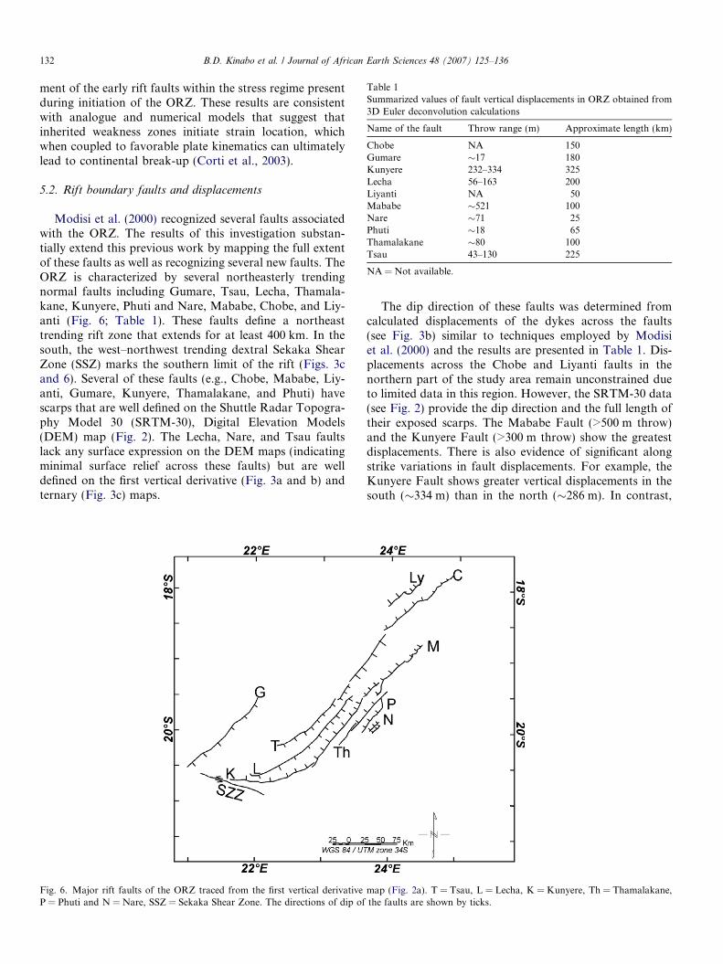
Table 1Summarized values of fault vertical displacements in ORZ obtained from3D Euler deconvolution calculations
Name of the fault Throw range (m) Approximate length (km)
Chobe NA 150Gumare �17 180Kunyere 232–334 325Lecha 56–163 200Liyanti NA 50Mababe �521 100Nare �71 25Phuti �18 65Thamalakane �80 100Tsau 43–130 225
NA = Not available.
132 B.D. Kinabo et al. / Journal of African Earth Sciences 48 (2007) 125–136
ment of the early rift faults within the stress regime presentduring initiation of the ORZ. These results are consistentwith analogue and numerical models that suggest thatinherited weakness zones initiate strain location, whichwhen coupled to favorable plate kinematics can ultimatelylead to continental break-up (Corti et al., 2003).
5.2. Rift boundary faults and displacements
Modisi et al. (2000) recognized several faults associatedwith the ORZ. The results of this investigation substan-tially extend this previous work by mapping the full extentof these faults as well as recognizing several new faults. TheORZ is characterized by several northeasterly trendingnormal faults including Gumare, Tsau, Lecha, Thamala-kane, Kunyere, Phuti and Nare, Mababe, Chobe, and Liy-anti (Fig. 6; Table 1). These faults define a northeasttrending rift zone that extends for at least 400 km. In thesouth, the west–northwest trending dextral Sekaka ShearZone (SSZ) marks the southern limit of the rift (Figs. 3cand 6). Several of these faults (e.g., Chobe, Mababe, Liy-anti, Gumare, Kunyere, Thamalakane, and Phuti) havescarps that are well defined on the Shuttle Radar Topogra-phy Model 30 (SRTM-30), Digital Elevation Models(DEM) map (Fig. 2). The Lecha, Nare, and Tsau faultslack any surface expression on the DEM maps (indicatingminimal surface relief across these faults) but are welldefined on the first vertical derivative (Fig. 3a and b) andternary (Fig. 3c) maps.
Fig. 6. Major rift faults of the ORZ traced from the first vertical derivativeP = Phuti and N = Nare, SSZ = Sekaka Shear Zone. The directions of dip of
The dip direction of these faults was determined fromcalculated displacements of the dykes across the faults(see Fig. 3b) similar to techniques employed by Modisiet al. (2000) and the results are presented in Table 1. Dis-placements across the Chobe and Liyanti faults in thenorthern part of the study area remain unconstrained dueto limited data in this region. However, the SRTM-30 data(see Fig. 2) provide the dip direction and the full length oftheir exposed scarps. The Mababe Fault (>500 m throw)and the Kunyere Fault (>300 m throw) show the greatestdisplacements. There is also evidence of significant alongstrike variations in fault displacements. For example, theKunyere Fault shows greater vertical displacements in thesouth (�334 m) than in the north (�286 m). In contrast,
map (Fig. 2a). T = Tsau, L = Lecha, K = Kunyere, Th = Thamalakane,the faults are shown by ticks.

Fig. 7. Cross-sections constructed from the depths to the top of dykes toshow rift fault throws. Doted lines indicate that the depth extent of fault isnot known. T = Tsau, L = Lecha, K = Kunyere, Th = Thamalakane,P = Phuti and N = Nare. Profile locations are shown in Fig. 2a. Note thatthe effect of the vertical exaggeration on the dip of the faults is ignored inorder to preserve the shape of the basins.
B.D. Kinabo et al. / Journal of African Earth Sciences 48 (2007) 125–136 133
the Thamalakane Fault shows no vertical displacements inthe south and an average displacement of �80 m along thenorthern extension of the fault. We infer from the displace-ments that the Gumare, Tsau, and Lecha faults are south-east dipping normal faults, while the Kunyere,Thamalakane, Phuti, Nare, Mababe, Liyanti, and Chobeare northwest dipping faults (Fig. 6).
Greater displacements consistently occur along thenorthwest dipping normal faults in the southeasternboundary of the rift. This suggests that these northwestdipping faults are accommodating most of the strain withinthe ORZ. With mostly data from the south (Modisi et al.,2000) concluded that the Kunyere Fault was the mainboundary fault of this rift zone. This study confirms thisto be the case only in the southern portion of the rift inthe vicinity of Lake Ngami. Towards the north, displace-ment along the Kunyere Fault wanes and the main dis-placement is recorded along the Mababe Fault makingthe later the main boundary fault within the Mababe Gra-ben (Fig. 2).
The Gumare and Nare faults appear to represent thenorthwest and southeast extent of recognized rift-relatedfaults and define a zone of extension about 150 km wide.However, most of the active subsidence is taking placewithin a zone �50–60 km wide along the southeasternboundary of the rift defined by three main depocenters,L. Ngami, Mababe, and Liyanti-Chobe (Fig. 2). This sug-gests the development of an active rift within a larger riftforming a rift-in rift structure. The limits of the grabensare defined by: (a) the Tsau and Kunyere faults in the L.Ngami area; (b) the Tsau and Mababe faults in the Mab-abe area; and (c) the Chobe and possible extension of theGumare Fault in the Liyanti-Chobe area. It is importantto note that a micro- earthquake study conducted in thisarea in 1974 revealed that seismic activity was largely lim-ited to the southeastern boundary of the rift zone and asso-ciated with the northwest dipping faults (Kunyere,Thamalakane, Mababe, and Chobe) and focused mostlywithin the L. Ngami, Mababe, and Liyanti-Chobe depo-centers/grabens (Scholz et al., 1976). We infer from thisobservation that the localization of strain resulting fromextension is occurring mostly along the southeasternboundary where the border system is being initiated,underscoring the important role of border faults in accom-modating strain even during this incipient stage of riftdevelopment. This interpretation is consistent with theresults of studies that suggest that border faults play adominant role in localizing strain during the early stagesof continental rifting (e.g., Ebinger and Casey, 2001; Ebin-ger et al., 2004; Keranen et al., 2004).
5.3. Basin geometry and development in relation to border
faults
Three schematic cross-sections across the northern, cen-tral, and southern portions of the ORZ, provide insightinto the early geometry of this incipient rift zone (Fig. 7).
Greater subsidence in the ORZ is observed along boththe southern (C–C 0) and northern profiles (A–A 0). Withinthe L. Ngami area (profile C–C 0) the greatest vertical dis-placement occurs along the Kunyere Fault (�334 m) ascompared to the Tsau Fault (�130 m). Within the Mababearea (AA 0), the Mababe Fault shows �521 m of displace-ment compared to the Tsau Fault (�114 m). The presenceof well developed graben structures at Ngami and Mababecan account for this greater accumulation of sediment(Fig. 7). The depth to basement shallows along profile B–B 0 in the central portion of the ORZ. Here the KunyereFault again has a greater displacement (�232 m) comparedto the Tsau Fault (100 m). A graben structure is alsoinferred to underlie the central portion of the rift. We spec-ulate that the presence of the Karoo dyke swarm in thislocation has significantly changed the overall mechanical(strength) properties of the crust and this difference isreflected in the apparent reduction in the amount of crustal

134 B.D. Kinabo et al. / Journal of African Earth Sciences 48 (2007) 125–136
extension and development of the depocenters overlyinggrabens within the ORZ.
The 2D basin geometry and the shallow subsurfacestructure of the rift was also investigated using gravitymodels constructed along three profiles taken perpendicu-lar to the long axis of the rift (Fig. 5). Gravity models yieldsimilar results to the cross-sections constructed on the basisof the magnetic signature of the rift and one example isshown for comparison (Fig. 5b). This negative anomalyhas an intra basin residual positive anomaly with ampli-tude of 5 mGal (Fig. 5b) a feature that is characteristic ofgravity profiles from East Africa (e.g., Baker and Wohlen-berg, 1971). A possible interpretation of this intra basinpositive anomaly is that it is due to a mafic intrusion withinbasement rocks. Alternatively, the anomaly can equally be
Fig. 8. Schematic diagram showing the evolution of the rift zone from a synfearly half-graben stage-development of boundary fault; (c) mature half-grabentransitional stage between (a) and (b) (redrawn from Morley, 2002).
explained in terms of topographic changes (i.e. the presenceof a horst block) within the rift basin. In order to testwhether this intrusion and the associated positive anomalyis deep or shallow seated, upward continuation filters wereapplied to the data at elevations of 1, 2.5, and 5 km. Theupward continuation of data enhances deep-seated features(e.g., a mafic intrusion) at the expense of shallow features.Upward continuation at an elevation of 5 km did not showthe anomaly suggesting that the intrusion is shallow, andmay be more consistent with the presence of a central base-ment horst. On the basis of the gravity model, the shape ofrift basin appears to be a synformal depression with bothflanks raised (Fig. 5b) rather than a half-graben. Half-gra-ben geometry is common of many rift grabens forming theEARS. However, the vertical exaggeration for our models
ormal basin to half-graben. (a) Early rift stage, synformal depression; (b); and (d) late-stage half-graben. Okavango Rift Zone is suggested to be in

B.D. Kinabo et al. / Journal of African Earth Sciences 48 (2007) 125–136 135
may not have the sensitivity to resolve small differences invertical displacements (�100 to �300) typical of the faultsnear L. Ngami where the profile was taken. Morley (2002)has suggested that half-grabens evolve through differentstages (e.g., Fig. 8): (a) an early rift stage characterizedby a synformal depression; (b) an early half-graben stage,where the border fault is being initiated; (c) a maturehalf-graben stage with a well developed border fault; and(d) a late-stage half-graben. Morley’s model suggests thatin basins where basin development precedes significant bor-der fault development, half-grabens evolve from synformaldepressions as the border fault is being initiated (e.g., fromstage a to stage b; Fig. 8). Greater displacements along theNW dipping Kunyere and Mababe faults when comparedto the SE dipping Tsau Fault suggests an early half-grabendevelopment stage (e.g., stage b; Fig. 8) for the ORZ. In theMababe Graben, the Mababe Fault shows more than fourtimes the displacement observed on the SE dipping TsauFault suggesting a more advanced stage of developmentfor this graben compared to the L. Ngami graben. How-ever, we have yet to find evidence supporting the presenceof a fully developed half-graben in the ORZ. This impliesthat the border fault system which includes the Kunyereand Mababe faults may not be fully developed. Thus, wespeculate from this observation that in the ORZ, local bor-der faults and grabens are developing simultaneously andhave yet to link up to establish a master border fault thatcontrols the development of the rift on a regional scale.
6. Conclusion
An aeromagnetic and gravity data analysis of the ORZhas resulted in the following conclusions: (1) the basementfabric played an important role in localizing the develop-ment of faults within the stress regime present during theinitiation of this rift, (2) three en-echelon northeast trendingdepocenters/grabens define the ORZ (L. Ngami, Mababe,and Liyanti-Chobe), (3) this early rift stage is characterizedby a synformal depression to early half-graben stage lackinga well developed border fault system consistent with theearly stages in the evolution of half-grabens, (4) boundaryfaults along the southeastern boundary of the rift accom-modate most of the strain defining a 50 km wide zone ofsubsidence within a larger 150 km wide zone of forming arift-in rift structure. The above observation highlights theimportant role of border faults, even within localizedregions, in accommodating strain even during this incipientstage of rifting.
Acknowledgements
This paper is dedicated to our dear friend and mentor,the late Professor Henri A.B. Kampunzu who was one ofthe original architects of this work. Partial funding for thisproject was provided by the National Science Foundation(NSF-OISE-0217831) and American Chemical Society—Petroleum Research Fund grant no ACS PRF 38595-
AC8. The Geological Survey of Botswana provided gravityand magnetic data. Anthony Buccellato, Mitchell Barklageand Moikwathai Moidaki assisted with the initial prepara-tion of this document. Review comments by Dr. DamienDelvaux, Dr. Eliot Atekwana, and an anonymous reviewerhelped improve the manuscript.
References
Atekwana, E.A., 1996. Precambrian basement beneath the central midcontinent United States as interpreted from potential field imagery.Basement and basins of Eastern North America. Geological Society ofAmerica 308, 33–44, Special Paper.
Baker, B.H., Wohlenberg, J., 1971. Structure and evolution of the Kenyarift valley. Nature 229, 538–542.
Ballard, S., Pollack, H.N., Skinner, N.J., 1987. Terrestrial heat flow inBotswana and Namibia. Journal of Geophysical Research 92, 6291–6300.
Bastow, I.D., Stuart, G.W., Kendall, J.M., Ebinger, C.J., Ayele, A.,Cornwell, D.G., Maguire, P.K.H., 2004. Upper mantle seismicstructure of the Northern Main Ethiopian Rift—a region of incipientcontinental breakup. In: Yirgu, G. et al. (Eds.), Proceedings ofInternational Conference on East Africa Rift System, June 20–24,2004, Addis Ababa. Ethiopian Geoscience and Mineral EngineeringAssociation, Ethiopia, pp. 30–33.
Briggs, I.C., 1974. Machine contouring using minimum curvature.Geophysics 39, 39–48.
Chapman, D.S., Pollack, H.N., 1977. Heat flow and heat production inZambia: evidence for lithosphere thinning in central Africa. Tectono-physics 41, 79–100.
Chorowicz, J., 2005. The East African rift system. Journal of AfricanEarth Sciences 43, 379–410.
Cooke, H.J., 1984. The evidence from northern Botswana of climatechange. In: Vogel, J. (Ed.), Late Cenozoic Palaeoclimates of theSouthern Hemisphere. Balkema, Rotterdam, pp. 265–278.
Corti, G., Van Wijk, J., Bonini, M., Sokoutis, D., Cloetingh, S., Innocenti,F., Manetti, P., 2003. Transition from continental break-up topunctiform seafloor spreading: how fast, symmetric and magmatic.Geophysical Research Letters 30 (12), 1604. doi:10.1029/2003GL01-7374.
Delvaux, D., Fronhoffs, F., Hus, R., Poort, J., 1999. Normal faultsplays and transfer zones in the central part of the Baikal rift basin:insight from digital photography and bathymetry. Bulletin desCentres de Recherches Exploration-Production ELF Aquitaine 22(2), 341–358.
Dunbar, J.A., Sawyer, D.S., 1988. Continental rifting at pre-existinglithospheric weaknesses. Nature 333, 450–452.
Ebinger, C.J., 1989. Tectonic development of the western branch of theEast African Rift System. Geological Society of America Bulletin 101,885–903.
Ebinger, C.J., Casey, M., 2001. Continental breakup in magmaticprovinces: an Ethiopian example. Geology 29 (6), 527–530.
Ebinger, C.J., Rosendahl, B., Reynolds, D., 1987. Tectonic model of theMalawi Rift, Africa. In: Ben-Avraham, Z. (Ed.), Sedimentary Basinswithin the Dead Sea and Other Rift Zones, Tectonophysics 141, pp.215–235.
Ebinger, C., Wolfenden, E., Keir, D., Yirgu, G., Ayele, D., Casey, M.,Waltham, D., EAGLE Working Group, 2004. Incipient continentalbreakup in northern Ethiopian rift: no need for detachment faults. In:Yirgu, G. et al. (Eds.), Proceedings of International Conference onEast Africa Rift System, June 20–24 2004, Addis Ababa. EthiopianGeoscience and Mineral Engineering Association, Ethiopia, pp. 58–60.
Fairhead, J.D., Girdler, R.W., 1969. How far does the rift system extendthrough Africa? Nature 221, 1018–1020.
Girdler, R.W., 1975. The great Bouguer anomaly over Africa. Eos(Transactions, American Geophysical Union) 56, 516–519.

136 B.D. Kinabo et al. / Journal of African Earth Sciences 48 (2007) 125–136
Gumbricht, T., Mc Carthy, T.S., Merry, C.L., 2001. The topography ofthe Okavango Delta, Botswana, and its tectonic and sedimentologicalimplications. Journal of Structural Geology 104, 243–264.
Kampunzu, A.B., Bonhomme, M.G., Kanika, M., 1998. Geochronologyof volcanic rocks and evolution of the Cenozoic Western branch of theEast African rift system. Journal of African Earth Sciences 26, 441–461.
Keranen, K., Klemperer, S.L.The EAGLE Working Group, 2004. 3Dseismic imaging of protoridge axis in the main Ethiopian rift. Geology32 (11), 949–952.
Mackenzie, G.D., Thybo, H., Maguire, P.K.H., Ebinger, C.J.The EAGLEWorking Group, 2004. Evidence for crustal structure influence on theevolution of the main Ethiopian rift. In: Yirgu, G. et al. (Eds.),Proceedings of International Conference on East Africa Rift System,June 20–24 2004, Addis Ababa. Ethiopian Geoscience and MineralEngineering Association, Ethiopia, pp. 130–133.
McCarthy, T.S., Green, R.W., Franey, N.J., 1993. The influence of neo-tectonics on water disposal in the northeastern regions of theOkavango swamps, Botswana. Journal of African of Earth Sciences17 (1), 23–32.
McConnell, R.B., 1972. Geological development of the rift system ofeastern Africa. Geological Society of America Bulletin 83, 2549–2572.
Modisi, M.P., 2000. Fault system of the southeastern boundary of theOkavango Rift, Botswana. Journal of African Earth Sciences 30, 569–578.
Modisi, M.P., Atekwana, E.A., Kampunzu, A.B., Ngwisanyi, T.H., 2000.Rift kinematics during the incipient stages of continental extension:evidence from the nascent Okavango rift basin, northwest Botswana.Geology 28, 939–942.
Moore, A.E., Larkin, P., 2001. Drainage evolution in south-central Africasince the breakup of Gondwana. South African Journal of Geology104, 47–68.
Morley, C.K., 1999a. How successful are analogue models in addressingthe influence of preexisting fabrics on rift structure? Journal ofStructural Geology 21, 1267–1274.
Morley, C.K., 1999b. Influence of preexisting fabrics on rift structure. In:Morley, C.K. (Ed.), Geoscience of Rift Systems—Evolution of EastAfrica. American Association of Petroleum Geologist, Studies inGeology, 44, pp. 151–160.
Morley, C.K., 2002. Evolution of large normal faults: evidence fromseismic reflection data. American Association of Petroleum GeologistBulletin 6, 961–978.
Morley, C.K., Ngenoh, D.K., Ego, J.K., 1999. Introduction to the EastAfrican Rift System. In: Morley, C.K. (Ed.), Geoscience of Rift
Systems—Evolution of East Africa. American Association of Petro-leum Geologists, Studies in Geology, 44, pp. 1–18.
Nyblade, A.A., Owens, T.J., Gurrola, H., Ritsema, J., Langston, C.A.,2000. Seismic evidence for a deep mantle thermal anomaly beneatheast Africa. Geology 28 (7), 599–602.
Owens, T.J., Nyblade, A.A., Gurrola, H., Langston, C.A., 2000. Mantletransitions zone beneath Tanzania, East Africa. Geophysical ResearchLetters 27 (6), 827–830.
Reeves, C.V., 1972. Rifting in the Kalahari? Nature 237, 95–96.Ring, U., 1994. The influence of preexisting structure on the evolution of the
Cenozoic Malawi rift (East African rift system). Tectonics 13, 313–326.Ringrose, S., Kampunzu, A.B., Vink, B., Matheson, W., Downey, W.,
2002. The origin and paleoenvironments of calcareous sediments inMoshaweng dry valley, southeast Botswana. Earth Surface Processesand Landforms 27, 591–611.
Rosendahl, B.R., 1987. Architecture of the continental rifts with specialreference to East Africa. Annual Reviews of Earth and PlanetarySciences 15, 445–503.
Russell, L.R., Snelson, L. 1994. Structural style and tectonic evolution ofthe Albuquerque Basin segment of the Rio Grande Rift, New Mexico,USA. In: Landon, S.M. (Ed.), Interior Rift basins. AmericanAssociation of Petroleum Geologists, 59, pp. 205–258.
Scholz, C.H., Koczynski, T.A., Hutchins, D.G., 1976. Evidence forincipient rifting in southern Africa. Royal Astronomical SocietyGeophysical Journal 44, 135–144.
Sebagenzi, M.N., Kaputo, K., 2002. Geophysical evidences of continentalbreak up in the southeast of the Democratic Republic of Congo andZambia (Central Africa). In: Cloetingh, S.A.P.L., Ben-Avraham, Z.(Eds.), From Continental Extension to Collision: Africa–Europeinteraction, The Dead Sea and Analogue Natural Laboratories.EGU European Geosciences Union, Stephan Mueller Special Publi-cation Series 2, pp. 193–206.
Sebagenzi, M.N., Vasseur, G., Louis, P., 1993. First heat flow densitydeterminations from southeastern Zaire (central Africa). Journal ofAfrican Earth Sciences 16, 413–423.
Telford, W.M., Geldart, L.P., Sherrif, R.E., 1990. Applied Geophysics,second ed. Cambridge University Press, NY, 770p.
Thomas, D.S.G., Shaw, P.A., 1991. The Kalahari Environment. Cam-bridge University Press, Cambridge, UK, 324p.
Thompson, D.T., 1982. EULDPH—a technique for making computer-assisted depth estimates for magnetic data. Geophysics 47, 31–37.
Versfelt, J., Rosendahl, B.R., 1989. Relationships between pre-riftstructure and rift architecture in lakes Tanganyika and Malawi, EastAfrica. Nature 337, 354–357.
Copyright © 2022 FDOKUMEN