Young rift kinematics in the Tadjoura rift, western Gulf of Aden, Republic of Djibouti
20
Young rift kinematics in the Tadjoura rift, western Gulf of Aden, Republic of Djibouti Mohamed A. Daoud, 1,2 Bernard Le Gall, 2 René C. Maury, 2 Joël Rolet, 2 Philippe Huchon, 3 and Hervé Guillou 4 Received 23 September 2009; revised 30 June 2010; accepted 14 September 2010; published 11 January 2011. [1] The Tadjoura rift forms the westernmost edge of the westerly propagating Sheba ridge, between Arabia and Somalia, as it enters into the Afar depression. From struc- tural and remote sensing data sets, the Tadjoura rift is interpreted as an asymmetrical south facing half‐graben, about 40 km wide, dominated by a large boundary fault zone to the north. It is partially filled up by the 1–3 Myr old Gulf Basalts which onlapped the older Somali Basalts along its shallower southern flexural margin. The major and trace element analysis of 78 young onshore lavas allows us to distinguish and map four dis- tinct basaltic types, namely the Gulf, Somali, Goumarre, and Hayyabley Basalts. These results, together with radiometric age data, lead us to propose a revised volca- no‐stratigraphic sketch of the two exposed Tadjoura rift margins and to discriminate and date several distinct fault networks of this oblique rift. Morphological and statisti- cal analyses of onshore extensional fault populations show marked changes in structural styles along‐strike, in a direction parallel to the rift axis. These major fault disturbances are assigned to the arrest of axial fault tip propagation against preexisting discontinuities in the NS‐oriented Arta transverse zone. According to our model, the sinistral jump of rifting into the Asal‐Ghoubbet rift segment results from structural inheritance, in contrast with the en échelon or transform mechanism of propaga- tion that prevailed along the entire length of the Gulf of Aden extensional system. Citation: Daoud, M. A., B. Le Gall, R. C. Maury, J. Rolet, P. Huchon, and H. Guillou (2011), Young rift kinematics in the Tadjoura rift, western Gulf of Aden, Republic of Djibouti, Tectonics, 30, TC1002, doi:10.1029/2009TC002614. 1. Introduction [2] The overall architecture of rift/ridge systems is con- trolled by several physical parameters which interact at various scales of times and space, and usually lead to intricate geometrical configurations. The large‐scale spatial architecture of a propagating rift is known to depend merely on the absolute motions of the bounding plates, and on major lateral discontinuities in the strength of either the upper crust (e.g., inherited structures), or the lower crust (e.g., partial melt zones) [Ziegler and Cloetingh, 2004; Wijns et al., 2005]. At a smaller scale, the segmentation of the spreading axis within the rifted zone itself is commonly assigned to (1) its obliquity to the extension direction and (2) the angle between the axis of individual rift segments and the general trend of the rifted zone [ Abelson and Agnon, 1997]. The resulting complex multiscale rift architecture is typically expressed along the Sheba westerly propagating rift‐drift system (Eastern Afar) by two nearly orthogonal first‐order arms that, in turn, display specific segmented axial patterns (Figures 1a and 1b). Along most of its EW trending path, the Sheba oceanic ridge is sys- tematically offset to the southwest. This offset occurs through either a left stepping ridge‐transform network (up to the Shukra El Sheikh discontinuity [e.g., Manighetti et al., 1997]) or oblique transfer zones with onlapping fault networks, up to the Tadjoura rift (TR) to the west (Figure 1b) [Cochran, 1981; Tamsett and Searle, 1988; Manighetti et al., 1997; Dauteuil et al., 2001]. There, the nearly EW trending axis veers abruptly counterclockwise into the N120°E‐oriented Ghoubbet rift, which is part of a submeridian, and partly emerged, rifted zone encompassing to the north the Asal and Manda Inakir en échelon subrifts (Figure 1b) [Manighetti et al., 1998]. The structural link between the two suborthogonal rift arms in the TR has been variously interpreted, and assigned to either a large‐ scale dextral fault zone, in the prolongation of the NE‐SW Maskali transform fault (Figure 1b) [Ruegg et al., 1980; Arthaud et al., 1980; Gaulier and Huchon, 1991], or to an overlapping fault zone enclosing a network of en échelon structures (Figure 1d) [Manighetti et al., 1997]. [3] The main goal of the present work is to address the mechanism of strain transfer between the Tadjoura and Ghoubbet rifts, with emphasis on the structure of the TR. Our study integrates (1) available seismic and bathymetric offshore data; (2) sampling, geochemical analysis and K/Ar dating of young basalts from the Djibouti Plain, which lead us to propose a new geological map of the southern part of the TR; and (3) structural analyses based on field studies and remote sensing interpretation. These new data allow us to demonstrate that the TR typically displays a half‐graben structure, which recorded a progressive shift of strain toward its inner part during the last 3 Myr. In addition, we propose 1 Institut des Sciences de la Terre, Centre d’Études et de Recherches de Djibouti, Djibouti Ville, Djibouti. 2 Université Européenne de Bretagne, Université de Brest, CNRS, UMR 6538 Domaines Océaniques, IUEM, Plouzané, France. 3 UPMC Université de Paris 6, CNRS, UMR 7193, ISTeP, Paris, France. 4 UMR 1572, LSCE/CEA‐CNRS, Domaine du CNRS, Gif‐sur‐Yvette, France. Copyright 2011 by the American Geophysical Union. 0278‐7407/11/2009TC002614 TECTONICS, VOL. 30, TC1002, doi:10.1029/2009TC002614, 2011 TC1002 1 of 20
-
Upload
sorbonne-universites -
Category
Documents
-
view
1 -
download
0
Transcript of Young rift kinematics in the Tadjoura rift, western Gulf of Aden, Republic of Djibouti

Young rift kinematics in the Tadjoura rift, western Gulf of Aden,Republic of Djibouti
Mohamed A. Daoud,1,2 Bernard Le Gall,2 René C. Maury,2 Joël Rolet,2 Philippe Huchon,3
and Hervé Guillou4
Received 23 September 2009; revised 30 June 2010; accepted 14 September 2010; published 11 January 2011.
[1] The Tadjoura rift forms the westernmost edge of thewesterly propagating Sheba ridge, between Arabia andSomalia, as it enters into theAfar depression. From struc-tural and remote sensing data sets, the Tadjoura rift isinterpreted as an asymmetrical south facing half‐graben,about 40 km wide, dominated by a large boundary faultzone to the north. It is partially filled up by the 1–3 Myrold Gulf Basalts which onlapped the older SomaliBasalts along its shallower southern flexural margin.The major and trace element analysis of 78 youngonshore lavas allows us to distinguish and map four dis-tinct basaltic types, namely the Gulf, Somali, Goumarre,and Hayyabley Basalts. These results, together withradiometric age data, lead us to propose a revised volca-no‐stratigraphic sketch of the two exposed Tadjoura riftmargins and to discriminate and date several distinct faultnetworks of this oblique rift. Morphological and statisti-cal analyses of onshore extensional fault populationsshow marked changes in structural styles along‐strike,in a direction parallel to the rift axis. These major faultdisturbances are assigned to the arrest of axial fault tippropagation against preexisting discontinuities in theNS‐oriented Arta transverse zone. According to ourmodel, the sinistral jump of rifting into theAsal‐Ghoubbetrift segment results from structural inheritance, in contrastwith the en échelon or transform mechanism of propaga-tion that prevailed along the entire length of the Gulfof Aden extensional system. Citation: Daoud, M. A.,B. Le Gall, R. C. Maury, J. Rolet, P. Huchon, and H. Guillou(2011), Young rift kinematics in the Tadjoura rift, western Gulf ofAden, Republic of Djibouti, Tectonics, 30, TC1002,doi:10.1029/2009TC002614.
1. Introduction[2] The overall architecture of rift/ridge systems is con-
trolled by several physical parameters which interact at
various scales of times and space, and usually lead tointricate geometrical configurations. The large‐scale spatialarchitecture of a propagating rift is known to depend merelyon the absolute motions of the bounding plates, and onmajor lateral discontinuities in the strength of either theupper crust (e.g., inherited structures), or the lower crust(e.g., partial melt zones) [Ziegler and Cloetingh, 2004;Wijns et al., 2005]. At a smaller scale, the segmentation ofthe spreading axis within the rifted zone itself is commonlyassigned to (1) its obliquity to the extension direction and(2) the angle between the axis of individual rift segmentsand the general trend of the rifted zone [Abelson andAgnon, 1997]. The resulting complex multiscale riftarchitecture is typically expressed along the Sheba westerlypropagating rift‐drift system (Eastern Afar) by two nearlyorthogonal first‐order arms that, in turn, display specificsegmented axial patterns (Figures 1a and 1b). Along mostof its EW trending path, the Sheba oceanic ridge is sys-tematically offset to the southwest. This offset occursthrough either a left stepping ridge‐transform network (upto the Shukra El Sheikh discontinuity [e.g., Manighettiet al., 1997]) or oblique transfer zones with onlappingfault networks, up to the Tadjoura rift (TR) to the west(Figure 1b) [Cochran, 1981; Tamsett and Searle, 1988;Manighetti et al., 1997; Dauteuil et al., 2001]. There, thenearly EW trending axis veers abruptly counterclockwiseinto the N120°E‐oriented Ghoubbet rift, which is part of asubmeridian, and partly emerged, rifted zone encompassingto the north the Asal and Manda Inakir en échelon subrifts(Figure 1b) [Manighetti et al., 1998]. The structural linkbetween the two suborthogonal rift arms in the TR hasbeen variously interpreted, and assigned to either a large‐scale dextral fault zone, in the prolongation of the NE‐SWMaskali transform fault (Figure 1b) [Ruegg et al., 1980;Arthaud et al., 1980; Gaulier and Huchon, 1991], or to anoverlapping fault zone enclosing a network of en échelonstructures (Figure 1d) [Manighetti et al., 1997].[3] The main goal of the present work is to address the
mechanism of strain transfer between the Tadjoura andGhoubbet rifts, with emphasis on the structure of the TR.Our study integrates (1) available seismic and bathymetricoffshore data; (2) sampling, geochemical analysis and K/Ardating of young basalts from the Djibouti Plain, which leadus to propose a new geological map of the southern part ofthe TR; and (3) structural analyses based on field studies andremote sensing interpretation. These new data allow us todemonstrate that the TR typically displays a half‐grabenstructure, which recorded a progressive shift of strain towardits inner part during the last 3 Myr. In addition, we propose
1Institut des Sciences de la Terre, Centre d’Études et de Recherches deDjibouti, Djibouti Ville, Djibouti.
2Université Européenne de Bretagne, Université de Brest, CNRS, UMR6538 Domaines Océaniques, IUEM, Plouzané, France.
3UPMC Université de Paris 6, CNRS, UMR 7193, ISTeP, Paris, France.4UMR 1572, LSCE/CEA‐CNRS, Domaine du CNRS, Gif‐sur‐Yvette,
France.
Copyright 2011 by the American Geophysical Union.0278‐7407/11/2009TC002614
TECTONICS, VOL. 30, TC1002, doi:10.1029/2009TC002614, 2011
TC1002 1 of 20

Figure
1.Various
typesof
riftsegm
entatio
nalongtheGulfof
Adenplateboundary
betweenArabiaandSom
alia.The
activ
eEW
trending
Gulfof
Aden(Sheba)rift‐driftsystem
evolveswestwardinto
thesuborthogonalGhoub
bet‐Asaland
Manda
Inakirrifts.(a)Plate
kinematic
setting
oftheAfarTripleJunctio
n.Thick
arrowsrepresentplatemotionvectors,
andtheboxindicatesthestudyarea.(b)Mainphysiographicfeatures
ofthewestern
Gulfof
Adenriftsystem
,modified
from
Manighetti
etal.[1997].The
revisedspatialextent
ofonshoreGulfBasalts,as
wellas
theArtatransverse
zone
(shownas
thewhiteNSdomaincentered
ontheArtalocality),are
show
n.(c)Aerom
agnetic
map
oftheTadjouraGulf,from
Manighetti
etal.[1997],with
modifiedonshoreparts.Dashedlin
es(D
1–8)representtransform
faults
offsettin
gmagnetic
segm
ents.Num
bers
referto
specific
magnetic
anom
alies.(d)“O
verlapping
subrift”
model
developedby
Manighetti
etal.
[1997]
toaccountfortherelatio
nships
betweentheTadjouraandGhoubbetrifts.The
innerfloors
oftheriftsareshaded.
DAOUD ET AL.: TADJOURA RIFT KINEMATICS TC1002TC1002
2 of 20

that submeridian structural discontinuities, emplaced at anearly stage of rifting in the Arta transverse zone (Figure 1b)may have locked the westerly propagation of extension inthe TR, hence causing the jump of rift axis southwestwardinto the Ghoubbet subrift.
2. Methodology[4] The 3‐D structure of the TR was first investigated in
map view, and along selected cross sections, by mergingonshore geology with existing offshore data, which includebathymetric maps [Audin, 1999; Dauteuil et al., 2001] andanalog, single channel seismic reflection profiles acquiredduring the TADJOURADEN cruise in 1995. The offshorefault pattern extracted from the bathymetric contour mapshas a relatively low horizontal resolution (150 m) whichdoes not permit quantitative comparisons with onshore faultparameters. Therefore, it was only used here to get anoverview of the entire TR. The deep geometry of a numberof offshore faults has been determined using the TAD-JOURADEN seismic reflection profiles. Onshore fieldstudies have been focused on poorly investigated areas fromthe southern margin of the TR, e.g., the Djibouti Plain, and
the Arta transverse zone, where >3 Myr old volcanics arewidely exposed (Figure 1b). Quantitative analysis of faultparameters (length, azimuth, spacing) was conducted onfault populations extracted from ASTER satellite images(lateral resolution 15 m) and corresponding digital elevationmodels (vertical resolution 7 m). Estimates of vertical dis-placement along each fault were derived from fault scarpgeometry. Seriated topographic profiles across each indi-vidual fault scarp gave the maximum value of displacementat the surface. When the top surface of the footwall upliftedblock was degraded by erosion, the summit‐level envelopewas used as a surface marker to restore the initial footwallgeometry. In any case, vertical throws represent minimumestimates which do not account for possible fault displace-ment at depth. Markers for sense of displacement (striations)are generally not observed along exposed fault surfaceswithin basalts, hence precluding any accurate stress recon-structions to be performed. The age pattern of faultingwithin the TR was established from crosscutting relation-ships of faults with dated volcanic and sedimentarysequences. The structure of the adjoining Ghoubbet rift is
Table 1. Chemical Compositions of Representative Whole Rock Samples of Gulf, Goumarre, Somali, and Hayyabley Basaltsa
Gulf Basalts(Northern margin)
Gulf Basalts(Southern margin) Goumarre Basalts Somali Basalts
HayyableyBasalts
dj18/06 dj03/06 dj18/06 dj45/04 dj38/05 dj60/05 dj43/04b dj07/04aI dj30/04aI dj04/04as dj03/04 dj39/05 dj14/04c dj09/04b dj54/04b
Major Element Oxides (wt %)SiO2 46.30 46.20 45.90 46.10 47.40 47.60 46.50 47.00 48.00 48.00 49.20 48.20 49.86 50.10 47.15TiO2 2.92 2.71 1.98 2.46 2.65 2.78 2.96 3.72 3.62 3.84 3.32 3.42 2.88 2.88 0.93Al2O3 14.35 15.35 15.35 14.55 13.87 14.15 14.20 13.34 13.48 13.25 13.00 13.36 13.85 13.50 16.53Fe2O3* 15.40 14.50 14.20 14.62 16.10 15.95 16.68 15.00 15.25 15.50 15.10 16.15 14.50 14.50 10.35MnO 0.22 0.21 0.21 0.21 0.23 0.24 0.24 0.22 0.23 0.24 0.22 0.25 0.22 0.22 0.17MgO 8.20 7.65 6.75 8.50 6.05 6.10 6.24 5.77 5.17 4.95 4.74 4.89 4.82 4.92 9.45CaO 10.00 10.45 11.00 10.45 10.05 9.80 9.74 10.45 10.00 9.60 9.30 9.50 9.24 9.15 12.9Na2O 2.66 2.67 2.35 2.53 2.71 2.77 2.71 2.86 3.03 3.13 2.90 3.04 3.14 3.22 1.99K2O 0.47 0.34 0.23 0.34 0.53 0.54 0.44 0.71 0.81 0.75 0.86 0.72 0.76 0.67 0.08P2O5 0.42 0.30 0.23 0.34 0.38 0.34 0.38 0.54 0.59 0.53 0.62 0.56 0.41 0.40 0.07LOI −0.83 −0.42 1.54 −0.28 −0.50 −0.46 −0.73 −0.38 −0.31 −0.48 0.41 −0.25 0.05 −0.12 0.46Total 100.11 99.96 99.74 99.82 99.47 99.81 99.36 99.23 99.87 99.31 99.61 99.84 99.72 99.44 100.08
Trace Elements (ppm)Rb 6.90 5.20 2.70 5.00 10.20 6.80 8.30 13.80 16.00 14.90 18.00 11.80 10.30 17.30 1.05Sr 320.00 393.00 317.00 315.00 262.00 264.00 266.00 378.00 378.00 810.00 318.00 330.00 320.00 317.00 154.00Ba 168.00 138.00 119.00 130.00 208.00 158.00 155.00 210.00 223.00 305.00 270.00 290.00 220.00 212.00 34.00Sc 35.00 31.50 37.50 35.00 39.00 38.00 39.00 38.00 33.00 32.00 34.00 35.5 34.5 36.00 45.00V 380.00 350.00 337.00 365.00 405.00 395.00 425.00 460.00 400.00 465.00 405.00 398.00 388.00 395.00 285.00Cr 287.00 207.00 311.00 320.00 94.00 89.00 69.00 130.00 44.00 28.00 28.00 22.00 29.00 29.00 380.00Co 56.00 53.00 57.00 58.00 56.00 51.00 54.00 44.00 43.00 43.00 44.00 43.00 44.00 43.00 51.00Ni 150.00 135.00 153.00 175.00 79.00 71.00 78.00 76.00 48.00 35.00 38.00 24.50 42.00 41.00 198.00Y 34.50 29.50 26.50 33.00 42.00 42.0 42.50 42.50 45.00 44.00 48.50 45.00 42.00 41.50 20.50Zr 190.00 153.00 122.00 160.00 200.00 204.00 195.00 275.00 280.00 293.00 280.00 253.00 256.00 264.00 48.00Nb 25.00 20.20 13.00 18.00 23.00 25.00 22.50 39.50 41.00 45.00 36.50 32.00 31.00 32.00 2.70La 19.50 16.30 13.00 15.40 20.00 21.50 20.00 30.50 34.00 33.50 30.00 28.00 27.50 27.50 2.60Ce 44.00 39.00 31.00 36.00 46.00 49.00 46.00 68.00 76.00 74.00 69.00 63.00 61.00 62.00 7.1Nd 28.00 24.50 20.00 22.50 27.50 29.00 28.00 41.00 45.00 44.00 41.5 37.50 36.00 35.50 5.3Sm 6.70 5.85 4.40 5.70 6.90 6.80 7.10 9.10 9.70 9.50 9.60 8.50 8.10 8.25 2.00Eu 2.2 2.01 1.68 1.96 2.25 2.22 2.3 2.87 3.12 3.01 3.02 2.87 2.56 2.54 0.8Gd 6.7 5.9 5.00 6.10 7.15 7.6 8.00 8.9 10.00 9.50 10.00 9.40 8.60 8.20 2.30Dy 6.35 5.10 4.50 6.00 7.25 7.40 7.40 8.00 8.50 8.30 9.00 7.90 8.00 7.85 3.30Er 3.30 2.70 2.50 3.10 4.00 4.00 4.10 4.00 4.40 4.10 4.70 4.20 4.00 4.00 2.10Yb 3.05 2.55 2.29 2.85 3.73 3.80 3.80 3.47 3.80 3.62 4.00 3.90 3.68 3.66 2.18Th 1.50 0.80 0.80 1.02 2.55 2.55 1.85 3.00 3.40 3.40 3.00 2.75 3.20 3.45 0.10
aSample locations are shown in the auxiliary material, and analytical methods are discussed in the text.
DAOUD ET AL.: TADJOURA RIFT KINEMATICS TC1002TC1002
3 of 20

only briefly discussed here, with reference to publishedworks [Audin et al., 2001].[5] Geochemical analyses (major and trace elements) and
radiometric dating (K/Ar method) have been focused onpoorly known mafic volcanics from the Djibouti Plain, withthe aim of identifying several basaltic units and mappingthem. Major and trace element data on bulk rocks (Table 1)were obtained by Inductively Coupled Plasma–AtomicEmission Spectrometry (ICP‐AES) at IUEM (Institut Uni-versitaire Européen de la Mer), Plouzané. Internationalstandards were used for calibration tests (ACE, BEN, JB‐2,PM‐S and WS‐E). Rb was measured by flame emissionspectroscopy. Relative standard deviations are ±1% for SiO2,
and ±2% for other major elements except P2O5 and MnO(±0.01%), and approximately 5% for trace elements. Theanalytical techniques are described by Cotten et al. [1995].Ar isotopic compositions and K contents of two samples(Table 2) were measured at LSCE, Gif‐sur‐Yvette andIUEM, respectively. Ar analyses were performed using theunspiked technique procedures detailed by Yurtmen et al.[2002] and Guillou et al. [2004]. Ages were calculated usingthe constants recommended by Steiger and Jäger [1977].
3. Spatial and Temporal Distributionof Synrift Volcanism in the Tadjoura Rift3.1. General Rift Setting
[6] The Sheba accretionary ridge within the Gulf of Adenforms, together with the Red Sea and the Ethiopian rift, oneof the three diverging branches of the Afar Triple Junction(Figure 1a). According to magnetic anomaly data, mid-oceanic ridge segments and fracture zones initiated along itseastern part at 17–18 Myr [Leroy et al., 2004; d’Acremontet al., 2006], or possibly at 20 Myr [Fournier et al.,2010], and then propagated westward, obliquely to theN40°E direction of Arabia‐Somalia plate separation[Cochran, 1981] (Figure 1a). Emplacement of incipientoceanic crust at the western tip of the Sheba ridge isrecorded along the ∼EW trending Obock‐Tadjoura Gulf by<2 Myr old paired magnetic anomalies (Figure 1c). Theanomalies partly coincide with the 3–1 Myr Gulf basalticseries which floor the Tadjoura Gulf, and outcrop onshorein its northern (Tadjoura) and southern (Djibouti Plain)margins [Manighetti et al., 1997] (Figure 1b). The EW‐oriented TR‐related structures intersect at high‐angle oldertectono‐magmatic fabrics displaying a submeridian orien-tation in the Mabla (15–11 Myr), Somali (7.2–3.6 Myr), andRibta (3.6 Myr) substratum series, emplaced at an earlierstage of rifting.
[7] The Gulf Basalts are a potentially accurate structuralmarker of the rift history recorded by the TR in the last3 Myr, and it is therefore important to determine their spatialand temporal distribution for a better definition of the TR.That has been attempted by using new geochemical and agedata set obtained on basaltic units in the Djibouti Plain, i.e.,on the southern margin of the TR. Combined with previ-ously published K‐Ar ages, this data set allows us to dis-criminate four recent basaltic units, i.e., the Gulf, Somali,Goumarre, and Hayyabley Basalts, hence allowing signifi-cant revision of the 2‐D map structure of the TR (Figure 2aand Figure S1 in the auxiliary material).1 The two first unitswere already identified by previous authors [Richard, 1979;Gasse et al., 1983, 1985, 1986] from volcano‐stratigraphiccriteria. The various geographical subunits of the Gulf Basaltsdistinguished by these authors have, however, been groupedinto a single volcanic unit because of their identical geo-chemical signatures. Gasse et al. [1983] also noted importantchemical differences between the Hayyabley and GulfBasalts. Finally, although they are younger than the Gulf andSomali Basalts which they crosscut, the Goumarre basaltswere not recognized as a distinct type prior to this study.
3.2. Geochemical Characteristics of the Tadjoura RiftBasalts
3.2.1. Sampling and Classification[8] Seventy eight mafic lavas have been analyzed for
major and trace elements (see Table 1 for representativeanalyses). They include 21 samples from the Gulf Basalts inthe Djibouti Plain, 10 from the same unit north of theTadjoura Gulf, 22 from the Somali Basalts, 16 from theyoung volcanic cones and intrusions of the GoumarreBasalts, and finally 9 from the Hayyabley volcano. Thelocations of these samples are shown in the auxiliarymaterial, except those of the Hayyabley Basalts which aregiven by Daoud et al. [2010]. In addition to this sample set,we have shown, as envelopes in Figures 3a–3d, the fields ofpreviously published analyses of (1) the Gulf Basalts (InitialGulf Basalts) [Richard, 1979; Joron et al., 1980a; Vidalet al., 1991; Deniel et al., 1994], (2) the Asal Basalts[Richard, 1979; Joron et al., 1980b; Vidal et al., 1991;Deniel et al., 1994], and (3) offshore basalts dredged alongthe gulf axis [Barrat et al., 1990, 1993].[9] All the collected samples are basalts, according to the
total alkalies‐silica (TAS) classification scheme of Le Bas
Table 2. New K‐Ar Datings of Two Gulf Basalt Samples From the Wea Paleo‐Valleya
Experiment
Split Weighted Mean
K (wt%) ±1s Mass molten (g) 40Ar* (%)
40Ar* 10−13
(mol/g) ±1s
40Ar* 10−13
(mol/g) ±1sAge
(Myr) ±2s
dj43/04b 7454 0.371 ± 0.004 1.07191 2.434 7.003 ± 0.1067470 « … … … … .. » 1.00241 3.093 7.020 ± 0.105 7.012 ± 0.008 1.09 ± 0.03dj38/05 7257 0.332 ± 0.003 1.09347 2.153 6.949 ± 0.1097273 « … … … … .. » 1.02438 3.088 6.796 ± 0.122 6.882 ± 0.081 1.19 ± 0.04
aSample locations are shown in Figure 2a, and analytical methods are discussed in the text.
1Auxiliary materials are available in the HTML. doi:10.1029/2009TC002614.
DAOUD ET AL.: TADJOURA RIFT KINEMATICS TC1002TC1002
4 of 20

Figure 2
DAOUD ET AL.: TADJOURA RIFT KINEMATICS TC1002TC1002
5 of 20
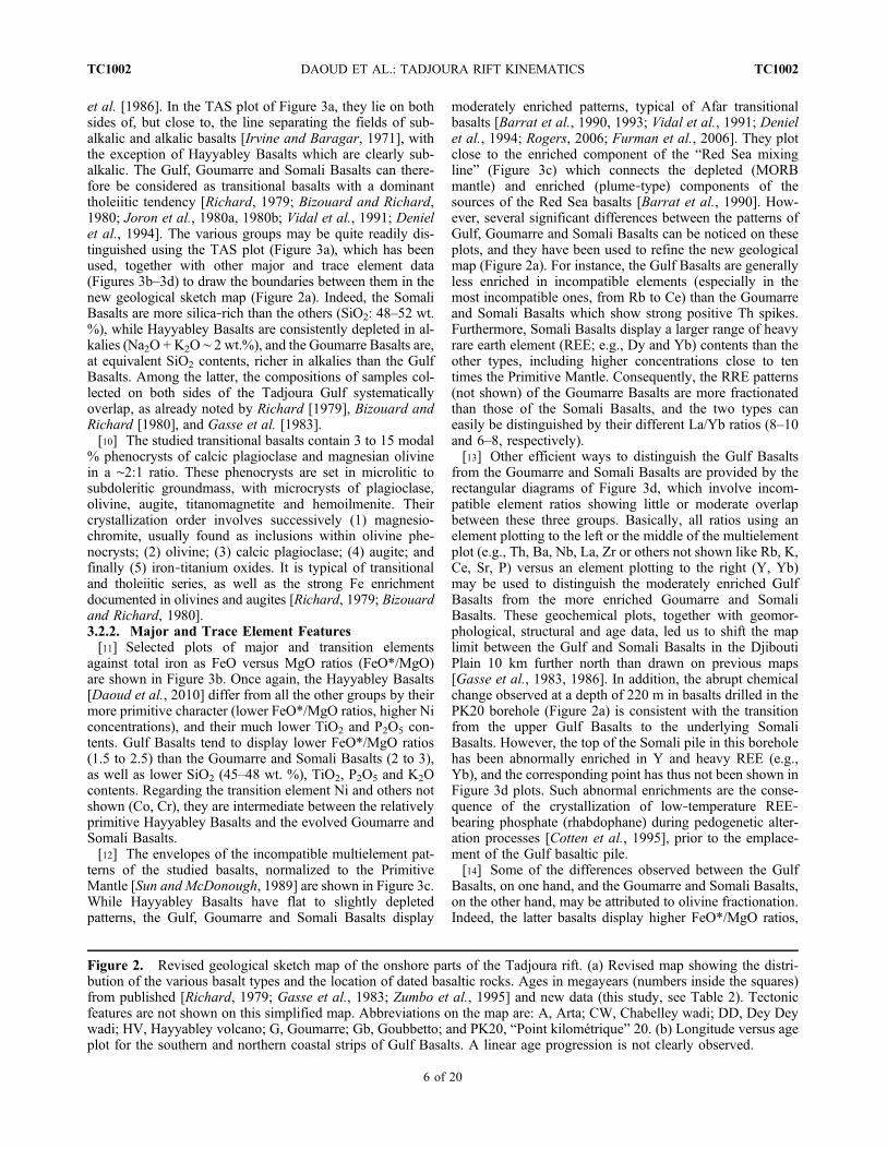
et al. [1986]. In the TAS plot of Figure 3a, they lie on bothsides of, but close to, the line separating the fields of sub-alkalic and alkalic basalts [Irvine and Baragar, 1971], withthe exception of Hayyabley Basalts which are clearly sub-alkalic. The Gulf, Goumarre and Somali Basalts can there-fore be considered as transitional basalts with a dominanttholeiitic tendency [Richard, 1979; Bizouard and Richard,1980; Joron et al., 1980a, 1980b; Vidal et al., 1991; Denielet al., 1994]. The various groups may be quite readily dis-tinguished using the TAS plot (Figure 3a), which has beenused, together with other major and trace element data(Figures 3b–3d) to draw the boundaries between them in thenew geological sketch map (Figure 2a). Indeed, the SomaliBasalts are more silica‐rich than the others (SiO2: 48–52 wt.%), while Hayyabley Basalts are consistently depleted in al-kalies (Na2O + K2O ∼ 2 wt.%), and the Goumarre Basalts are,at equivalent SiO2 contents, richer in alkalies than the GulfBasalts. Among the latter, the compositions of samples col-lected on both sides of the Tadjoura Gulf systematicallyoverlap, as already noted by Richard [1979], Bizouard andRichard [1980], and Gasse et al. [1983].[10] The studied transitional basalts contain 3 to 15 modal
% phenocrysts of calcic plagioclase and magnesian olivinein a ∼2:1 ratio. These phenocrysts are set in microlitic tosubdoleritic groundmass, with microcrysts of plagioclase,olivine, augite, titanomagnetite and hemoilmenite. Theircrystallization order involves successively (1) magnesio-chromite, usually found as inclusions within olivine phe-nocrysts; (2) olivine; (3) calcic plagioclase; (4) augite; andfinally (5) iron‐titanium oxides. It is typical of transitionaland tholeiitic series, as well as the strong Fe enrichmentdocumented in olivines and augites [Richard, 1979; Bizouardand Richard, 1980].3.2.2. Major and Trace Element Features[11] Selected plots of major and transition elements
against total iron as FeO versus MgO ratios (FeO*/MgO)are shown in Figure 3b. Once again, the Hayyabley Basalts[Daoud et al., 2010] differ from all the other groups by theirmore primitive character (lower FeO*/MgO ratios, higher Niconcentrations), and their much lower TiO2 and P2O5 con-tents. Gulf Basalts tend to display lower FeO*/MgO ratios(1.5 to 2.5) than the Goumarre and Somali Basalts (2 to 3),as well as lower SiO2 (45–48 wt. %), TiO2, P2O5 and K2Ocontents. Regarding the transition element Ni and others notshown (Co, Cr), they are intermediate between the relativelyprimitive Hayyabley Basalts and the evolved Goumarre andSomali Basalts.[12] The envelopes of the incompatible multielement pat-
terns of the studied basalts, normalized to the PrimitiveMantle [Sun and McDonough, 1989] are shown in Figure 3c.While Hayyabley Basalts have flat to slightly depletedpatterns, the Gulf, Goumarre and Somali Basalts display
moderately enriched patterns, typical of Afar transitionalbasalts [Barrat et al., 1990, 1993; Vidal et al., 1991; Denielet al., 1994; Rogers, 2006; Furman et al., 2006]. They plotclose to the enriched component of the “Red Sea mixingline” (Figure 3c) which connects the depleted (MORBmantle) and enriched (plume‐type) components of thesources of the Red Sea basalts [Barrat et al., 1990]. How-ever, several significant differences between the patterns ofGulf, Goumarre and Somali Basalts can be noticed on theseplots, and they have been used to refine the new geologicalmap (Figure 2a). For instance, the Gulf Basalts are generallyless enriched in incompatible elements (especially in themost incompatible ones, from Rb to Ce) than the Goumarreand Somali Basalts which show strong positive Th spikes.Furthermore, Somali Basalts display a larger range of heavyrare earth element (REE; e.g., Dy and Yb) contents than theother types, including higher concentrations close to tentimes the Primitive Mantle. Consequently, the RRE patterns(not shown) of the Goumarre Basalts are more fractionatedthan those of the Somali Basalts, and the two types caneasily be distinguished by their different La/Yb ratios (8–10and 6–8, respectively).[13] Other efficient ways to distinguish the Gulf Basalts
from the Goumarre and Somali Basalts are provided by therectangular diagrams of Figure 3d, which involve incom-patible element ratios showing little or moderate overlapbetween these three groups. Basically, all ratios using anelement plotting to the left or the middle of the multielementplot (e.g., Th, Ba, Nb, La, Zr or others not shown like Rb, K,Ce, Sr, P) versus an element plotting to the right (Y, Yb)may be used to distinguish the moderately enriched GulfBasalts from the more enriched Goumarre and SomaliBasalts. These geochemical plots, together with geomor-phological, structural and age data, led us to shift the maplimit between the Gulf and Somali Basalts in the DjiboutiPlain 10 km further north than drawn on previous maps[Gasse et al., 1983, 1986]. In addition, the abrupt chemicalchange observed at a depth of 220 m in basalts drilled in thePK20 borehole (Figure 2a) is consistent with the transitionfrom the upper Gulf Basalts to the underlying SomaliBasalts. However, the top of the Somali pile in this boreholehas been abnormally enriched in Y and heavy REE (e.g.,Yb), and the corresponding point has thus not been shown inFigure 3d plots. Such abnormal enrichments are the conse-quence of the crystallization of low‐temperature REE‐bearing phosphate (rhabdophane) during pedogenetic alter-ation processes [Cotten et al., 1995], prior to the emplace-ment of the Gulf basaltic pile.[14] Some of the differences observed between the Gulf
Basalts, on one hand, and the Goumarre and Somali Basalts,on the other hand, may be attributed to olivine fractionation.Indeed, the latter basalts display higher FeO*/MgO ratios,
Figure 2. Revised geological sketch map of the onshore parts of the Tadjoura rift. (a) Revised map showing the distri-bution of the various basalt types and the location of dated basaltic rocks. Ages in megayears (numbers inside the squares)from published [Richard, 1979; Gasse et al., 1983; Zumbo et al., 1995] and new data (this study, see Table 2). Tectonicfeatures are not shown on this simplified map. Abbreviations on the map are: A, Arta; CW, Chabelley wadi; DD, Dey Deywadi; HV, Hayyabley volcano; G, Goumarre; Gb, Goubbetto; and PK20, “Point kilométrique” 20. (b) Longitude versus ageplot for the southern and northern coastal strips of Gulf Basalts. A linear age progression is not clearly observed.
DAOUD ET AL.: TADJOURA RIFT KINEMATICS TC1002TC1002
6 of 20

Figure
3.Chemical
features
ofyoungmafic
volcanicsfrom
theTadjourarift.(a)Total
alkalies‐silica(TAS)diagram
for
theGulf,Goumarre,S
omali,andHayyabley
Basalts.(b)
Plotsof
SiO
2,T
iO2,K
2O,A
l 2O3,P
2O5,and
NiagainstFeO
*/MgO
ratio
sof
thestudiedbasalts.(c)Multielementpatternsof
thestudiedbasalts.(d)Plotsof
Th/Nb,
Th/Ba,
Th/Yb,
andZr/Y
ratio
sagainstL
a/Ybratio
s.Sym
bolsreferto
oursampleset,whereas
thesolid
,dashed,
anddottedlin
escorrespond
tofields
ofInitial
Gulf,Asal,andGulfaxisbasalts,respectiv
ely,
from
theliterature(see
text
forcorrespondingreferences).
DAOUD ET AL.: TADJOURA RIFT KINEMATICS TC1002TC1002
7 of 20

lower Ni and other compatible transition element contents,and higher SiO2, TiO2, P2O5 and K2O contents than the GulfBasalts (Figure 3b). Olivine fractionation might also accountfor their higher incompatible element contents compared tothe Gulf Basalts (Figure 3c). However, as this process doesnot fractionate appreciably ratios between highly incom-patible elements (e.g., Th/Nb and Th/Ba, Figure 3d), norstrongly modifies the shapes of REE patterns (and conse-quently the La/Yb ratios [Allègre et al., 1977]), it cannotaccount for the differences shown in Figure 3d plots. Thesedifferences might result from variations affecting partialmelting degrees, mantle source heterogeneity, crustal con-tamination, or more likely a combination of these processes[Joron et al., 1980a, 1980b; Barrat et al., 1990, 1993; Vidalet al., 1991; Deniel et al., 1994]. In addition, the differentLa/Yb ratios of the Goumarre and Somali Basalts, whichdisplay nearly equivalent enrichments in most incompatibleelements, might indicate that the former derive from adeeper (i.e., garnet‐bearing) mantle source than the latter, asgarnet incorporates selectively heavy REE.
3.3. Spatial Distribution and Volcano Stratigraphyof Tadjoura Rift Volcanics
[15] The geochemical criteria discussed above, togetherwith field mapping, allows us to propose a revised 2‐D maparrangement of the Gulf Basalts, and consequently of the TR(Figures 2a and 4b). When superimposed on the morpho-logical map of Figure 4a, the map extent of the TR corre-sponds to an approximately 60 × 40 km EW trendingtopographically subdued domain. The onshore part of theTR forms the Northern and Southern Coastal Fault Belts(NCFB and SCFB) in the Tadjoura‐Obock and DjiboutiPlain areas, respectively. The presence of Gulf Basalts in thefloor of the Tadjoura Gulf is argued by dredged samples[Barrat et al., 1990, 1993], and to a lesser extent by theseismic records discussed below.3.3.1. Gulf Basalts in the Northern Onshore Margin[16] In the Tadjoura‐Obock area, the Gulf Basalts occur
in a 15 × 8 km faulted coastal plateau, less than 300 mhigh (NCFB, Figure 4b). The main cartographic unit of theGulf Basalts (the Roueli unit of Gasse et al. [1983, 1985])extends to the north as a 10 × 5 km faulted belt orientedN100°E, which swings to the northeast into a narrowerN50°E strip. The Gulf Basalts lie further south as discreteinliers beneath locally faulted Quaternary alluvial fans,possibly as young as Holocene [Manighetti et al., 1997].Their rapid disappearance west of longitude 42° 50′Emight result from a nearly NS trending paleo‐high, in thenorthern prolongation of the Arta zone (see section 4.3)(Figure 4a).[17] The total thickness of the Gulf Basalts volcanic pile is
estimated to 350 m [Gasse et al., 1985]. Its exposed partis mostly made up of superimposed columnar‐jointed sub-aerial lava flows, the individual thickness of which reachesup to 10 m. A few submarine lava flows have been de-scribed at the mouth of the Sadaï‐Tagarré wadi [Gasse et al.,1983]. The presence of vertical mafic dykes, associated sillsand plug‐type feeder magmatic structures intruding tiltedlava successions NE of Tadjoura confirms the fissural origin
of the entire Gulf Basalts series, but it also rules out itsexclusive origin from offshore vents along the TR axis[Richard, 1979]. The N110°E trend of the onshore feederdykes further indicates, in first approximation, a N20°Edirection of opening, slightly oblique with respect to theinferred N40°E regional tectonic extension [Gaulier andHuchon, 1991].3.3.2. Southern Flank of the TR in the Djibouti Plain[18] According to the geochemical criteria presented above,
the map distribution of Gulf Basalts in the Djibouti Plain(Figure 2a) is more restricted than previously assessed byGasse et al. [1983, 1985]. They are confined to a 10 × 20 kmcoastal faulted plateau which uprises southward, via the EWtrending Ambouli topographic flexure (Figure 4e), to anortherly tilted surface in the 7.2–3.6 Myr Somali Basalts. Tothe east, the Gulf Basalts are overlain by lavas of the ∼1 Myrold Hayyabbley shield volcano [Gasse et al., 1983; Daoudet al., 2010], the main axis of which follows a major N140°Efault scarp bounding the eastern coastal plain to the south-east. The western limit of the Gulf Basalts abuts against theNS‐oriented eastern edge of the Arta reliefs, although theylocally fill up the Wea paleo‐valley (Figure 2a).[19] The Gulf Basalts pile consists of a succession of
subaerial fluid lava flows of fissural origin. Individual flowsare generally less than 10 m thick, and their surfaces showtypical pahoehoe features; their central part often displayscolumnar jointing patterns. Field emplacement criteria (e.g.,deformation of pahoehoe “ropy” surfaces and flow patternsat their base) indicate that they mostly flowed southwardover the Djibouti Plain. Their original vents have not beenrecognized onshore, and therefore are presumably located inthe presently submerged part of the TR. The Gulf Basalt pilereaches a maximum thickness of 220 m in boreholes drilledin the PK20 area to the west (Figures 2a and 4e), wherethey overlie the top of the Somali Basalt pile. The upper-most sequence of Gulf Basalts is exposed in the Ambouli‐Chabelley area to the south (Figure 4e). It includes asuccession of thin (<1 m thick) subaerial lava flows, inter-digitated with conglomeratic alluvial horizons (basalticboulder‐rich facies). The latter probably derived from upliftedreliefs in the Arta and Somali surrounding domains. Theyoung and flat lying Gulf Basalts flows onlap previously tiltedSomali Basalts along the Ambouli flexural zone (Figure 4e).[20] Available K‐Ar and Ar‐Ar ages of Gulf Basalts from
the Djibouti Plain range from 2.8 to 1.5 Myr (Figure 2a)[Richard, 1979; Gasse et al., 1983; Zumbo et al., 1995].This range can be extended to 1.19 Myr and 1.09 Myr(Table 2) taking into account our new results on GulfBasalts flows from the Wea paleo‐valley (Figure 2a). In theWarabor wadi cross section, the Gulf Basalts pile is overlainby the Hayyabley volcano lava flows which yielded ages of1.06 ± 0.09 Myr and 0.93 ± 0.06 Myr [Daoud et al., 2010].The 3.3 Myr old basaltic rocks located to the southeast ofthe Ambouli wadi were previously assigned by Richard[1979] to the Gulf Basalts. Their geochemical features al-low us to consider them as part of the Somali series.Therefore, the revised longitude versus age plots drawn forthe southern and northern Gulf Basalts (Figure 2b) can nolonger be used to support the idea of an age decrease toward
DAOUD ET AL.: TADJOURA RIFT KINEMATICS TC1002TC1002
8 of 20

the west [Richard, 1979; Manighetti et al., 2001; Audinet al., 2004].[21] The approximately 7.2–3.0 Myr old Somali Basalts
[Chessex et al., 1975], which cover most of the Djibouti
Plain south of the Ambouli regional‐scale flexure, forma monotonous and weakly incised plateau (Figures 4a, 4b,and 4e). They likely represent a trap‐like pile, similar to thenearly contemporaneous (8.6–3.8 Myr) Dalha basaltic series
Figure 4
DAOUD ET AL.: TADJOURA RIFT KINEMATICS TC1002TC1002
9 of 20

located northwest of the Djibouti Plain [Marinelli and Varet,1973; Barberi et al., 1975]. In the Holhol area (Figure 2a),the Somali Basalts rest unconformably over tilted, andpartially eroded, rhyolitic sequences of the 15–11 Myr oldMabla series [Black et al., 1975; Zumbo et al., 1995].Because of restricted exposures and difficult access condi-tions, their total thickness and their internal organization arepoorly known. The 30–40 m high sections exposed alongthe Dey Dey wadi (Figure 2a) show up to ten superimposedsubaerial basaltic flows, either columnar‐jointed or showinglava tubes. They range in thickness from 1 to 10 m, and areoften separated by autoclastic breccia levels and/or bystrombolian lapilli horizons up to 1 m thick. A 30 m highcross section near Goumarre volcano (Figure 2a) exposesseven superimposed subaerial basaltic flows, each of them 2to 8 m thick, emplaced toward the north (i.e., in an oppositedirection to that of the Gulf Basalts), according to local fieldcriterions. Mafic dykes crosscutting Somali lavas in theGoubetto area to the west (Figure 2a) consist of ∼1 m thickvertical intrusions, oriented N80–90°E, i.e., slightly obliqueto the N110°E Gulf Basalts feeder dykes.[22] With respect to the intricate swarm of young volca-
noes which punctuate the Djibouti Plain (Figure 2a), specialattention has been paid to three N80°E parallel arrays ofbasaltic vents crosscutting the Somali lavas, and referredhere as to the Goumarre Basalts (from their type locality, i.e.,the Goumarre strombolian lapilli/ash cone, dated at 1.75 Myrby Gasse et al. [1983]). These volcanic corridors, each ofthem a few kmwide, are sharply cut to the east by the N140°Ecoastal scarp. To the west, their tips remain within the So-mali Basalts and do not reach the older substratum series ofthe Ali Sabieh range. In addition to numerous smallstrombolian or maar‐type volcanoes, with maximum heightof approximately 100 m, the Goumarre Basalt seriesincludes various types of intrusions (dykes, sills, plugs),often spatially connected with these volcanoes. The geneticrelationships between Goumarre‐type lavas and their in-ferred magmatic feeders can be observed on aerial photo-graphs of the Dey Dey central corridor in the GoumbourtaAtar strombolian cone area (Figure 2a). There, lava flowsseem to either radiate from small‐scale vents, or diverge onboth sides of N80°E trending fault/fissure structures whichcorrelate in the field with narrow (1–2 m thick) dykes andthicker (15 m) sills crosscutting the Somali Basalts. Most of
the Goumarre Basalts are therefore likely to have beenemitted from transverse fault/dyke corridors, nearly parallelto the present‐day Gulf axis. Published radiometric agesfrom the Goumarre (2.46, 1.84, 1.80, 1.75 Myr) and Nagad(1.69 Myr) cones [Richard, 1979; Gasse et al., 1983] areyounger than those obtained from the Somali Basalts (3.40,3.30, 2.93Myr) [Richard, 1979; Zumbo et al., 1995] (Figure 2a).It is therefore suggested that the Goumarre Basalts wereemplaced during a relatively short time interval, concomi-tantly with the Gulf Basalts, but in a more southern, i.e.,external, position with respect to the TR framework.
4. Half‐Graben Structure of the TadjouraRift[23] The overall 3‐D architecture of the TR is discussed
below, both in terms of map fault arrangement, and cross‐sectional structure, from exposed geology and offshorebathymetric and seismic data set (Figure 4). A quantitativeanalysis of onshore fault populations in the NCFB andSCFB was also performed from ASTER imagery measure-ments. Emphasis is then put on two specific structural fea-tures in the western extremity of the TR, i.e., the Artasumeridian zone and a network of NW‐SE faults, which areboth regarded as key elements for a better understanding ofthe mechanism of strain transfer in the Tadjoura‐Ghoubbettransition rift zone.
4.1. Two‐Dimensional Map Structure
[24] The TR is an approximately 60 × 40 km EW trendingtopographically subdued domain, partly exposed onshore inthe NCFB and SCFB, on both sides of the Tadjoura Gulf(Figures 4a and 4b). Its inner offshore part is dominated tothe north by the N120°E‐oriented Tadjoura rhomb‐shapedtrough which is sinistrally offset from the Obock depressionby approximately 30 km along the right‐lateral Maskalitransform fault system [Arthaud and Choukroune, 1976].The TR is surrounded by highlands involving older rift‐related volcanics of the Mabla (18–11 Myr, in Gasse et al.[1985]), Dalha (8.6–3.8 Myr), Somali (7.2–3.6 Myr), andRibta (3.6 Myr) series. It is dissected by an inhomogen-eously distributed fault pattern, comprising Gulf‐parallel,NW‐SE and NE‐SW structures. The map‐scale sigmoidtrace of the entire fault pattern typically evokes an oblique
Figure 4. Overall structure of the Tadjoura rift. (a) Topography of the TR drawn from a bathymetric contour map (fromAudin [1999], modified) and a SRTM digital elevation model. Dashed lines represent the Maskali transform (MT) and BourOugoul transverse fault systems. Note the strong NS‐oriented structural grain in the Arta zone. The traces of the structuralcross section in Figure 4e and the two interpreted seismic profiles in Figures 4c and 4d are shown. HV represents Hayyableyvolcano. (b) Structural map of the TR obtained (1) by merging onshore geology with offshore bathymetric data set and(2) by using the Gulf Basalts as a rift marker (only drawn onland). Abbreviations on the map are: ATZ, Arta transversezone; HV, Hayyabley volcano; NCFB, Northern Coastal Fault Belt; and SCFB, Southern Coastal Fault Belt. (c and d) Raw(top) and interpreted (bottom) TADJOURADENoffshore seismic profiles (time sections) perpendicular to theNW‐SE‐orientedfault‐controlled Tadjoura inner trough (see traces in Figure 4a). (e) Interpretative structural cross section showing theTadjoura rift as a south facing half‐graben, partly filled up by Gulf Basalts. The elements of the deep structure of theTadjoura rift are conjectural. The geometrical relationships between the underlying Somali and Dalha basalts are extrapo-lated from patterns observed onshore along the Bour Ougoul lineament on the NW flank of the Ali Sabieh antiform (seeFigure 4a for location).
DAOUD ET AL.: TADJOURA RIFT KINEMATICS TC1002TC1002
10 of 20

rift setting. Two high‐density fault zones occur on theeastern parts of the conjugate margins, in the Tadjouratrough and the NCFB to the north, and in the SCFB to thesouth. In the intermediate and less deformed zone, the pre-ferred N60°E alignment of shield‐like volcanoes might becontrolled at depth by Maskali‐type transverse structures(Figure 4b). To the west, the TR narrows markedly, north ofthe Arta transverse zone, where its floor shallows abruptly,up to 100–200 m below sea level, through a submeridianscarp disrupted by an array of isolated NW‐SE faults. TheTR fault system does not extend beyond the Gulf Basalts,e.g., into the substratum series which instead show evi-dence for earlier deformation (see sections 4.2–4.4).
4.2. Half‐Graben Cross‐Sectional Structure
[25] The composite structural cross section in Figure 4e,drawn at high angle with respect to the dominant N110–120°E fault strike in the TR, is calibrated by TADJOUR-ADEN bathymetric and seismic reflection data which havebeen merged with onshore geology. It shows a 35–40 kmwide half‐graben structure, facing the SSW. Its inner anddeeper part is occupied by the Tadjoura trough, which isbounded to the north by a prominent fault system, in-cluding the Tadjoura master fault, and its highly faultedfootwall block, partly exposed in the NCFB. To the south,an approximately 20 km long typical flexural marginshallows gradually southward, up to the Djibouti Plain,where Gulf Basalts are locally dissected by a high‐densityantithetic fault system in the SCFB. The flexure is locallypunctuated by shield volcanoes.[26] The deep structure of the Tadjoura inner trough is
constrained down to about 2 s (two‐way travel time), ordepth of 4–5 km, by selected single‐channel seismicreflection profiles striking NE‐SW, orthogonal to theprominent bathymetric scarps (Figures 4c and 4d). To thenorth, the steep bathymetric scarp, >500 m high and facingthe SSW on the seismic line of Figure 4c, is interpreted asthe upper part of the master fault. High‐amplitude reflectorslying, with an apparent gentle dip, in its immediate hangingwall are reliably correlated with Gulf Basalts dredged fromthe Tadjoura gulf [Barrat et al., 1990, 1993]. Similar seis-mic facies present, with a reduced thickness, in the elevatedfootwall block correlate laterally with onshore Gulf Basaltsin the NCFB (Figure 4b), hence confirming our seismo‐stratigraphic interpretation. The volcanic infill sequencethickens markedly toward the boundary fault, just like syn‐faulting deposits, up to a maximum thickness of 7–800 m.This value is obtained by converting the 0.3 s (two‐waytravel time) measurement, assuming an average seismicvelocity for basalts of 4.5–5.0 km s−1.
4.3. Footwall Block Structures in the NCFB
[27] The deep structure of the footwall block comprises anetwork of closely spaced and dominantly syntheticextensional faults. These structures bound narrow blocksstepping down gradually toward the trough (Figure 4c).The footwall fault system continues onshore into theNCFB, with a marked swing of the dominant fault trendinto a N100°E direction (Figures 4b and 5a) and additional
N20°E and N50°E (Maskali trend) faults. Two submeridianE facing extensional faults (F21 and F22 in Figure 5a), withvertical displacements of 60 m and 50 m, respectively,were also identified. Their crosscutting relationships withthe N100°E fault pattern (either interrupted or not, andwith or without apparent offset) suggest their synchronousdevelopment.[28] Fault patterns are well exposed in the Roueli northern
unit, a feature which permits an accurate geometrical andstatistical analysis of the corresponding fault population.There, Gulf‐parallel faults are partially blanketed to the westby 1.4–0.8 Myr old Quaternary alluvium [Gasse, 1991].Similarly trending faults occur further south through bothinliers of Gulf Basalts and overlying Holocene alluvialdeposits. Two of these faults extend westward acrossMabla acidic volcanics, with minor extensional displace-ment [Manighetti et al., 1997].[29] The dominant N100°E fault set is composed of iso-
lated and highly segmented structures showing curved maptraces (Figure 5a). The measured tip‐to‐tip length of thetotal fault data set (99 data) ranges from 0.4 to 6.0 km, witha peak at 1.2 km, and 90% of length values less than 2.8 km(Figures 6b and 6c). Fault population is homogeneouslydistributed, but with a marked increase of fault spacingwestward (Figure 6d). Individual faults are clustered into4 to 5 major faults facing the south, and causing thedownwarping of the Gulf Basalts toward the gulf axis. Veryfew antithetic structures, with minor associated displace-ment, do occur (e.g., F80 in Figure 5b). Along‐strike var-iations of individual fault profiles are observed on the threeorthogonal cross sections shown in Figure 5b. The hori-zontal surface of most individual footwall blocks suggestsnonrotational structures. The largest throw values (>50 m)systematically occur along the oldest (prealluvium) faults tothe north. However, estimates of throws along the youngest(postalluvium) faults to the south might be underestimatedbecause of syn‐faulting alluvial screes at the foot of somefault scarps. Vertical throw in the oldest fault network to thenorth increases markedly southward from 65 m (F6), 100 m(F4) to >130 m (F8). A comparison of the three topographicsections shows that the total fault‐induced elevation slightlydecreases westward from 310 m (section 1) to 280 m(section 2), and to 200 m (section 3). These along‐strikevariations of cumulate fault displacement are illustrated bythe distribution of throw along some individual structures,such as faults labeled F1–7–19 or F4–16, the tip of which liesclose to the substratum contact to the west.[30] The cumulative bulk extension along three regularly
spaced sections across the fault system (Figure 6a) has beencalculated with a mean fault dip of 60°–70°, similar to thosereported elsewhere in the Afar depression [de Chabalier andAvouac, 1994]. The bulk extension decreases regularly from3.4% to 1.6% westward. Special attention has been paid tothe displacement‐length ratio (D/L), which may supplyinformation about fault growth processes [Cowie and Scholz,1992a, 1992b; Dawers et al., 1993; Manighetti et al., 2001],as a function of either the restricted versus unrestrictednature of the faults [Watterson, 1986; Gillespie et al., 1992],or the mechanical heterogeneity of the stressed medium[Trudgill and Cartwright, 1994; Wojtal, 1994]. D refers to
DAOUD ET AL.: TADJOURA RIFT KINEMATICS TC1002TC1002
11 of 20

maximum displacement and L to fault trace length in mapview. Classical fault growth models predict that displace-ment is maximal at or near the center of the fault anddecreases toward its tips [Cowie and Scholz, 1992a, 1992b].It is also generally accepted that the scaling relationshipbetween L and D is:
D ¼ cLn
where c is a constant and n is a scaling exponent, rangingfrom 0.5 [Fossen and Hesthammer, 1997] to 1.5 [Walshand Watterson, 1988; Gillespie et al., 1992; Dawers etal., 1993; Schlische et al., 1996]. When n = 1, as com-monly accepted [Cowie and Scholz, 1992a, 1992b; Dawerset al., 1993], the above equation corresponds to a linearscaling law. The value of c is an expression of faultdisplacement per length unit. For a linear scaling law (i.e.,
n = 1), c is simply the D/L ratio which characterizes thefault population. In the log‐log plot of maximum faultdisplacement versus length, Schlische et al. [1996] havedefined a best fit linear curve with D = 0.03L.[31] Manighetti et al. [2001] showed that the cumulative
slip distribution along fault systems in the Afar region isrelated to their time‐space growth and propagation history,and they proposed a best fit linear curve with D = 0.04L.These authors indicated that the maximum D/L values arecharacteristic of restricted faults which plot above the D =0.04L line, while unrestricted faults plot below this line. Inthe present work, the D/L ratios calculated for N100°E faults(29 data) are in the range 0.0062–0.15, and thus plot belowor along the line D = 0.04L (excepted one biased value dueto measurement error) (Figure 7a). In agreement with themodel of Manighetti et al. [2001], this feature indicates that
Figure 5. Map distribution and morphological expression of extensional structures in the North CoastalFault Belt. (a) Structural map showing fault traces extracted from ASTER satellite images (vertical res-olution 15 m). Numbers refer to major individual structures. White lines indicate the trace of cross sec-tions in Figure 5b. (b) Three topographic cross sections illustrating changes in fault geometry both along‐strike and perpendicular to the N100°E rift axis. Note the progressive increase of fault scarp size towardthe south within each cross section and toward the west from profiles 1 to 3.
DAOUD ET AL.: TADJOURA RIFT KINEMATICS TC1002TC1002
12 of 20

Figure 6. Geometrical and statistical characteristics of extensional fault networks in the (left) North and(right) South Coastal Fault Belts. (a and e). General 2‐D fault patterns on ASTER images. The traces ofcross sections used for calculating cumulate extension are shown. (b and f). Histograms illustrating thefrequency versus strike of faults. (c and g). Plots of faults length versus strike. (d and h). Average spacingof faults along regularly spaced (1 km apart) profiles through the North and South Coastal Fault Belts.(Traces of the profiles are not drawn).
DAOUD ET AL.: TADJOURA RIFT KINEMATICS TC1002TC1002
13 of 20

the N100°E extensional fault network in the NCFB might beunrestricted.
4.4. Faulted Marginal Flexure in the SCFB
[32] Faulting throughout the half‐graben flexural marginis mainly restricted to the 10 km wide belt of onshore GulfBasalts in the SCFB (Figure 8a). However, a number ofN140°E transverse faults appear to continue offshorethroughout a less deformed area, north and west of the Artazone (see section 4.5).[33] The SCFB fault network displays a much more in-
tricate organization than that described above for the NCFBconjugate margin (Figure 8a). It includes three distinct setsof faults at N100–110°E, N130–140°E, and to a lesserextent N60–70°E (Figure 6f). The dominant N100°E anti-thetic fault pattern (with respect to the Tadjoura masterfault) veers clockwise westward into a ∼5 km wide swarm ofprobably coeval N140°E faults. The map curvature of Gulf‐parallel structures is accompanied by an increasing densityof faults (Figures 6h and 8a), which, accordingly, decreasein length. The majority of fault lengths (80%) are in therange 0.8–2.6 km, with a peak at 1.2 km (Figure 6g), i.e.,quite similar to the values obtained for the northern struc-tures. Most Gulf‐parallel faults are sigmoid or curved inmap view, and the en échelon arrangement of some of them(Figure 8a) might indicate a significant component ofsinistral shearing. However, their dominantly extensionalnature is evidenced on the cross sections of Figure 8b bytypical north dipping morphological scarps which bound anetwork of weakly rotated fault blocks. The entire faultsystem is organized into 2 to 3 first‐order fault blocks withan increasing structural complexity westward, evidenced onprofiles 1 to 4 by (1) a larger number of north dipping faultsof reduced length, and (2) additional minor south dippingfaults, which together delineate second‐order horst‐grabenpatterns (Figure 8b). On each structural section, maximumfault displacement is recorded along the coastal (innermost)
structures, in a way symmetrical to that observed in theNCFB. Cumulate vertical fault displacement perpendicularto fault system increases regularly westward, from 100 m(profile 1) to 250 m (profile 4), and 450 m (profile 5),together with the structural complexity mentioned above.The cumulative extension calculated along six cross sections(Figure 6e) provides low values, in the range 1.4% to 3.8%,with a significant increase westward, such as in the NCFB.The D/L ratios for the Gulf‐parallel structures (93 data) varyfrom 0.0044 to 0.16, and most of them plot below the lineD = 0.04L, as typical unrestricted faults. Higher D/L ratios(>0.04) occur in the westernmost network of extensionalfaults which extend close to the Arta zone. These faults,labeled 1, 2, 4, 6, 7, 21, 29, 40, 95, 116 and 134 on Figure 8a,are likely to correspond to restricted and overdisplacedstructures (Figure 7b).
4.5. Southwestern Edge of the TR and the Arta Zone
[34] Near the western termination of the TR, the width ofthe rifted domain decreases from 40 to less than 10 km,together with the abrupt shallowing of the seafloor west-ward, from 500 m up to 100–200 m below sea level. Thesestructural changes occur through a 2–3 km wide sub-meridian morphological scarp (Figure 9a), in the northernprolongation of the NS trending Arta zone. This offshorescarp is dissected by a series of parallel N120–140°E faults(Figure 8a), with very little bathymetric expression in theseismic line shown on Figure 4d. These faults contribute tothe downthrowing of the seafloor toward the Tadjouratrough to the east. The seismic activity recorded in thewestern extremity of the TR since the 1970s corresponds torelatively shallow earthquakes (<5–6 km deep) withmoderate magnitudes (<3.2) [Doubre, 2004]. These earth-quakes are distributed along NW‐SE‐oriented seismiczones, and the corresponding fault plane solutions indicatedominantly left‐lateral slip along N140° trending structures(Figure 9a) [Lépine et al., 1980; Lépine and Hirn, 1992].
Figure 7. Log‐log plot of maximum fault displacement versus fault length for structures in the (a)North and (b) South Coastal Fault Belts. The straight line corresponds to the best fit correlation (D =0.04L). Open and solid symbols denote unrestricted and restricted (overdisplaced) faults, respectively.In Figure 7b, 10 out of 12 overdisplaced faults are located close to the Arta zone. Corresponding faultnumbers are identical to those shown in Figure 8a.
DAOUD ET AL.: TADJOURA RIFT KINEMATICS TC1002TC1002
14 of 20

Several NW‐SE transverse faults extend further to the SE,onshore, through the Gulf Basalts which cap the SCFB(Figure 9a). There, they form isolated and segmentedstructures, locally outlined by a dense swarm of small vol-canic vents, ∼1 Myr old [Gasse et al., 1983]. They show alonger and more linear map trace than the Gulf‐parallelfaults, with which they usually merge. Transverse faults dipconsistently toward the NE, and their cumulate extensionaldisplacement increases regularly toward the Arta zone, inassociation with the approximately 300 m elevation of thetopography (Figure 9b). Extensional scarp heights measuredalong the major NE facing faults gradually increase west-ward from 20 m and 50 m (profile 7), to 70 m and 80 m(profile 6), and lastly 70 m, 30 m and 90 m (profile 5). TheD/L ratios calculated for transverse faults (21 data) are inthe range 0.0056–0.022, i.e., lower than those of the Gulf‐
parallel faults. The low D/L ratios indicate a deficit of ver-tical displacement with respect to fault length, as typicallydocumented during fault growth processes dominated bylinkage where fault length increases without increasingheight [Cartwright et al., 1995]. This feature is consistentwith the isolated, linear and linked characteristics of thetransverse faults cited above.[35] The sketch structural map in Figure 9a shows that very
few transverse and Gulf‐parallel TR‐related faults crosscutthe >3 Myr old volcanic terranes forming the Arta zone. Inthis area, the 8.6–3.8Myr old Dalha Basalts and the overlyingRibta felsic lavas (3.6 Myr) are involved into a broad, 10 kmwide, upright arched structure, oriented N‐S, i.e., nearlyorthogonal to the E‐W axis of the TR. This Arta anticline isin turn dissected by a dense network of NS‐N20°E fault/fractures, parallel to the anticline axis and locally intruded by
Figure 8. Map distribution and morphological expression of the extensional fault pattern in the SouthCoastal Fault Belt. (a) Structural map from ASTER remote sensing data interpretation. White lines are thetraces of the seven topographic cross sections shown in Figures 8b (profiles 1 to 4) and 9b (profiles 5 to 7).(b). Morpho‐structural NS trending cross sections showing increasing structural complexity toward theArta zone to the west.
DAOUD ET AL.: TADJOURA RIFT KINEMATICS TC1002TC1002
15 of 20

felsic bodies of the Ribta Fm. Most of these submeridianfractures were later reactivated as strike‐slip faults [Arthaudet al., 1980]. From these structural relationships, the Artaanticline is inferred to have formed as a magma‐drivenstructure overlying a felsic intrusion emplaced during the 3.6Myr Ribta event.
4.6. Timing of Faulting in the Tadjoura Rift
[36] The combination of published and new age determi-nations on both sedimentary and volcanic rift sequencesexposed on the onshore margins of the TR supplies temporalconstraints on the sequential development of the Tadjourahalf‐graben during the last 3 Myr. The Gulf‐parallel exten-sional fault network in the two coastal belts shows a relativelyclear age progression depicted on the NS cross‐sectionaldiagram in Figure 10a. As already argued byManighetti et al.[1997], two successive extensional fault sets are evidenced onthe northern flank of the TR, i.e., in the NCFB. The mostexternal faults are postdated by 1.4–0.8 Myr old alluvial fans[Gasse, 1991], while younger similarly trending faults
crosscut Holocene conglomerates further south. A quitesymmetrical age polarity is documented in the southernmargin of the TR, i.e., in the Djibouti Plain, where the oldesttectonic structures are the ∼1.7 Myr old Goumarre tectono‐magmatic lineaments transecting the Somali Basalts.Assuming that these linear structures resulted from extradostensile stress on top of a regional flexure related to theTadjoura half‐graben development suggests a similar age(1.7 Myr) for the onset of faulting along the Tadjoura masterfault to the north. The Somali flexure is postdated by onlap-ping Gulf Basalts (Ambouli section) which are in turndissected by Gulf‐parallel faults, necessarily younger than1.7 Myr, and older than the ∼1 Myr old Hayyabley volcanowhich seals them to the west (Figure 10b). However, youngerGulf‐parallel faults (<1 Myr), in an inner position, crosscutthe northern edge of the Hayyabley volcano. Some of thesefaults likely extend westward into the Ambaddo area, wherethey might have caused the north dipping tilt of 140–120 kaold reef limestones [Gasse et al., 1983]. From the cross‐sectional timing framework in the TR (Figure 10a), it thusappears that the age of faulting increases symmetrically away
Figure 9. Onshore and offshore structural features in the transfer zone between the Tadjoura and theGhoubbet rifts. (a) Structural sketch map showing the nearly underformed nature of the Arta transversezone during recent (<3 Myr) rift stages. Note that most earthquakes and faults cutting through the Stratoidand Gulf basalts avoid the Arta NS trending zone. The earthquake epicenters are from Doubre [2004], andthe focal mechanisms of the 21 December 1978 and 11 August 1978 earthquakes in the Tadjoura Gulf andGhoubbet trough, respectively, are from Lépine and Hirn [1992]. (b) Morpho‐structural sections crossingthe South Coastal Fault Belt, perpendicular to the N140°E transverse fault network (see location in Figure 8a).Numbers refer to faults drawn in the structural map in Figure 8a.
DAOUD ET AL.: TADJOURA RIFT KINEMATICS TC1002TC1002
16 of 20

Figure 10. Kinematics of rift propagation throughout the Tadjoura‐Ghoubbet connection zone.(a) Timing of faulting along a synthetic cross section of the Tadjoura Rift. Despite age uncertainties, a pat-tern of younging of strain is observed from the margins to the inner part of the Tadjoura Rift, indicatingprogressive axial focusing of extension. Abbreviations are: NCFB, Northern Coastal Fault Belt; TMF,Tadjoura master fault; and SCFB, Southern Coastal Fault Belt. (b) Rift kinematic model in the Tadjoura‐Ghoubbet linkage zone, emphasizing the role of inherited submeridian structures in pinning the propaga-tion of the Tadjoura and Ghoubbet rifts. (c) Sketch rift pattern showing a major submeridian discontinuityat the transition zone between two variously trending rift arms of the Aden plate boundary. The shadedarea corresponds to the eastern edge of the Afar magmatic province (the initial 30 Myr old flood basalts ofYemen are not considered). Abbreviations are: A., Arta zone; AS., Ali Sabieh range; GAR, Ghoubbet‐Asal rift; MIR, Manda‐Inakir rift; OR, Obock rift; and TR., Tadjoura rift.
DAOUD ET AL.: TADJOURA RIFT KINEMATICS TC1002TC1002
17 of 20

from the inner rifted zone. The current seismic activity in theoffshore part of the TR [Lépine et al., 1980; Hofstetter andBeyth, 2003] fits our proposed age progression of faulting.
5. Proposed Kinematic Model for the <3 MyrRift Evolution of the TR[37] In response to the regional N40°E extension [Jestin
et al., 1994; de Chabalier and Avouac, 1994; Vigny et al.,2007], the TR developed as a 60 × 40 km south facinghalf‐graben, filled up by a thick pile of syntectonic fissuralGulf Basalts. In map view, the TR rhomb‐shaped structureinvolves a composite network of dominantly extensionalfaults, striking EW (Gulf parallel) and NW‐SE. The lattertrend occurs in the western termination of the TR at thelongitude of approximately 42°45′, i.e., in the northernoffshore prolongation of the Arta zone. The TR‐relatedfaults which exclusively involve the Gulf Basalt–filled half‐graben recorded a complex history within an overall west-erly migration of tectonic activity [Manighetti et al., 1997].The dating of fault‐controlled volcanic activity (Goumarre)across the flexural margin of the TR half‐graben suggeststhat the onset of faulting along the master boundary fault tothe north occurred at 1.7 Myr, concomitantly with activeextension in the Tadjoura inner trough. At this stage, themaster fault might have developed a number of splays intothe footwall uplifted block (NCFB), probably coeval withlocalized antithetic faulting along part of the flexure to thesouth (SCFB). The long‐lived development of the Tadjourahalf‐graben was accompanied by the temporal migrationfrom old structures, in an external position, toward youngerones, closer to the Gulf axis. A similar evolution is reportedfrom the Kenya rift, where a temporally progressive focus ofstrain into a narrow and inner trough has been documented[Baker and Wohlenberg, 1971; Cerling and Powers, 1977;Vétel and Le Gall, 2006]. In addition to cross‐rift migrationof faulting, along‐strike fault propagation also occurred, andresulted in contrasted fault patterns in the NCFB and SCFB.In the NCFB, the amount of displacement decreased regu-larly westward along Gulf‐parallel faults, toward a tip linelocated within the Gulf Basalts. Very few faults extendedbeyond the Gulf Basalts/substratum boundary, across theMabla felsic series (Figure 10b). Small‐scale (a fewhundreds meters wide) jumping rift segments were assumedto occur in the NCFB [Manighetti et al., 1997], where theyturned into a network of en echelon fault swarms whichconnected the TR and the Ghoubbet rifted trough to the SWThese small‐scale rift structures are here regarded as sub-sidiary structures on the northern flank of the TR half‐graben documented in this work.[38] A more intricate fault pattern is present in the western
part of the SCFB. There, the Gulf‐parallel extensional faultsdeviate clockwise, from N90°E to N140°E, whenapproaching the Arta transverse zone. This fault map cur-vature is accompanied by a marked increase of fault densitywestward, together with a decrease of individual faultlength, hence resulting in the above mentioned over-displaced fault pattern.[39] Several factors are known to control D/L, such as
(1) strain regime [Gupta and Scholz, 2000], (2) segmenta-
tion and linkage [Cartwright et al., 1995], (3) materialproperties [Bai and Pollard, 2000] and (4) layer thickness[Soliva et al., 2005]. Manighetti et al. [2001] specificallystated that finite slip‐length profiles of faults in the Afarregion are strongly influenced by the fault propagationhistory. They also argued that restricted faults (D/L > 0.04),resulting from length restriction, formed in response to faultpropagation arrest by a “barrier.” This barrier might berelated to the earlier history of the region. According to thismodel, the high D/L values (>0.04) obtained here for thewesternmost faults in the SCFB likely indicate that theirhorizontal growth was limited, or even stopped to the westby a mechanical barrier, while these faults continued toaccumulate vertical displacement.[40] Structural data suggest that strong submeridian ter-
ranes, including the Arta zone, transect orthogonally thewestern end of the TR (Figure 10b). To the south, theseterranes extend toward the Ali Sabieh anticline [Le Gallet al., 2010]. They are bounded to the east by the so‐calledArta‐Asamo discontinuity, the >60 km long map trace ofwhich is outlined by a variety of structures that indicate itslong‐lived history. To the north, the decrease of verticalmotion along the NW offshore course of the N140°E trans-verse fault network (see Figure 4d) suggests the occurrenceof a stronger substratum offshore the Arta zone. The strongmechanical behavior of the Arta transverse zone duringrecent rifting is also confirmed by (1) the restricted locationof earthquakes and aftershocks linked to the 1978 seismiccrisis in the Tadjoura gulf [Lépine et al., 1980; Lépine andHirn, 1992; Doubre, 2004] (Figure 9a), and (2) the abruptarrest of the EW trending Ghoubbet rift fault networkagainst its NS trending western edge (Figure 10b).[41] Further south, the continuation of the Arta‐Asamo
discontinuity along the eastern flank of the Ali Sabieh anti-cline is deduced from the restricted distribution of the N80°EGoumarre fault‐dyke corridors which do not penetratewestward into the Ali Sabieh substratum series (Figure 10b).The inherited and deep‐seated origin of the Arta‐Asamodiscontinuity is suggested by the NS alignment of Somali(7.2–3.6 Myr) volcanic vents along its inferred map trace(Figure 10b). This discontinuity might have been guided atdepth by a large‐scale Proterozoic fracture zone belongingto the Marda system [Boccaletti et al., 1991].[42] During the recent SE Afar rift history, the Arta pre-
existing submeridian structures are therefore assumed tohave provoked the frontal pinning of axial fault growth inthe TR, and then the lateral jump of rifting in the Ghoubbetarea, in response to inferred higher strength contrast, togetherwith their orthogonal orientation to rift propagation. Thisabrupt change in rift kinematics probably occurred at circa900 ka, when diffuse volcanism and associated faultingstarted in the Asal‐Ghoubbet rift [Manighetti et al., 1998;Audin et al., 2001].
6. Conclusions[43] The major and trace element analysis of young
basalts collected from onland Tadjoura Rift units (especiallyfrom the Djibouti Plain) allows us to distinguish fourdistinct types, namely the Gulf, Somali, Goumarre and
DAOUD ET AL.: TADJOURA RIFT KINEMATICS TC1002TC1002
18 of 20

Hayyabley Basalts. These results, together with new andpreviously published radiometric age data, lead us to pro-pose a revised volcano‐stratigraphic sketch map of thesouthern (SCFB) and northern (NCFB) margins of the TR.With respect to former studies [Richard, 1979; Gasse et al.,1983, 1985, 1986], the Goumarre Basalts (2.46–1.69 Myr)are recognized as a distinct unit and the southern limit of theGulf basalts in the Djibouti Plain is shifted approximately10 km northward. A consequence of this revision is thatthe progressive westerly younging of the Gulf Basaltssuggested by previous authors [Richard, 1979; Manighettiet al., 2001; Audin et al., 2004] for the southern andnorthern borders of the TR is no more supported by thenew longitude versus age trends for these basalts.[44] New structural data based on fieldwork and remote
sensing analysis allow us to interpret the overall structure ofthe TR as an asymmetrical south facing half‐graben, about35 km wide, dominated by a large boundary fault zone tothe north and extending southward as a >20 km long shal-lower flexural margin, partially exposed in the DjiboutiPlain. There, it is locally disrupted by an antithetic southerncoastal fault belt, and by the Goumarre transverse fault‐dikecorridors close to the inflexion point of the Somali Basaltsmonocline. Recent faulting is spatially restricted to the Gulf
Basalts which form two narrow strips on the northern andsouthern margins of the TR.[45] The temporal change of the location of normal faults
toward the inner trough of the half‐graben indicates theprogressive focusing of strain with time within the axial partof the rift. The geometrical and statistical analysis ofonshore fault networks in the southern fault belt shows awesterly increase of strain that is mechanically assigned tothe frontal locking of axial fault tip propagation againstsubmeridian discontinuities in the Arta zone. The arrest offault propagation in the TR lastly resulted in the jump ofrifting into the Ghoubbet‐Asal trough system.
[46] Acknowledgments. This study has been funded by the FrenchEmbassy in Djibouti, and the grant of the first author (M.A.D.) providedby the MAWARI international program managed by the CIFEG, Orléans,France. Analytical expenses were funded by the MAWARI program andUMR 6538 “Domaines Océaniques,” Plouzané. The offshore data reportedhere were obtained aboard the R/V l’Atalante operated by IFREMER. Weespecially thank Dr. Mohamed Jalludin, Director of the Centre d’Etudes etde Recherches de Djibouti, for his interest, scientific discussions, and logis-tic support; Ali Abdillahi for his efficiency in organizing fieldwork logis-tics; and Joseph Cotton, who performed the geochemical analyses. Thedetailed and pertinent comments of three anonymous reviewers and theAssociate Editor helped us considerably to improve the manuscript andto increase its focus.
ReferencesAbelson, B. M., and A. Agnon (1997), Mechanics of
oblique spreading and ridge segmentation, EarthPlanet. Sci. Lett., 148, 405–421, doi:10.1016/S0012-821X(97)00054-X.
Allègre, C. J., M. Treuil, J. F. Minster, B. Minster, andF. Albarède (1977), Systematic use of trace elementin igneous processes. Part 1: Fractional crystalliza-tion processes in volcanic suites, Contrib. Mineral.Petrol., 60, 57–75, doi:10.1007/BF00372851.
Arthaud, F., and P. Choukroune (1976), Mise en évi-dence d’une phase de compression à 3, 5 Ma sépar-ant deux épisodes d’ouverture du rift océanique deTadjoura (T.F.A.I.), C. R. Seances Acad. Sci., Ser. D,283, 13–16.
Arthaud, F., P. Choukroune, and B. Robineau (1980),Evolution structurale de la zone transformanted’Arta (République de Djibouti), Bull. Soc. Geol.Fr., 22, 909–915.
Audin, L. (1999), Pénétration de la dorsale d’Aden dansla dépression Afar entre 20 et 4 Ma, Ph.D. thesis,Univ. Paris 7, Paris.
Audin, L., I. Manighetti, P. Tapponnier, F. Métivier,E. Jacques, and P. Huchon (2001), Fault propaga-tion and climatic control of sedimentation on theGhoubbet rift floor: Insights from the Tadjouradencruise in the western Gulf of Aden, Geophys. J.Int., 144, 391–413, doi:10.1046/j.0956-540x.2000.01322.x.
Audin, L., X. Quidelleur, E. Coulié, V. Courtillot,S. Gilder, I. Manighetti, P. Y. Gillot, P. Tapponnier,and T. Kidane (2004), Paleomagnetism and K‐Arand 40Ar/39Ar ages in the Ali Sabieh area (Republicof Djibouti and Ethiopia): Constraints on the mecha-nism ofAden ridge propagation into southeastern Afarduring the last 10 Myr, Geophys. J. Int., 158(1), 327–345, doi:10.1111/j.1365-246X.2004.02286.x.
Bai, T., and D. D. Pollard (2000), Fracture spacing inlayered rocks: A new explanation based on thestress transition, J. Struct. Geol., 22, 43–57,doi:10.1016/S0191-8141(99)00137-6.
Baker, B. H., and J. Wohlenberg (1971), Structure andevolution of the Kenya Rift Valley, Nature, 229,538–542, doi:10.1038/229538a0.
Barberi, F., G. Ferrara, R. Santacroce, and J. Varet(1975), Structural evolution of the Afar triple junc-tion, in Depression of Ethiopia, vol. 1, edited byA. Pilger and A. Rösler, pp. 38–54, Schweizerbart,Stuttgart, Germany.
Barrat, J. A., B. M. Jahn, J. L. Joron, B. Auvray, andH. Hamdi (1990), Mantle heterogeneity in north-eastern Africa: Evidence from Nd isotopic compo-sitions and hygromagmaphile element geochemistryof basaltic rocks from the Gulf of Tadjoura and South-ern Red Sea regions, Earth Planet. Sci. Lett., 101,233–247, doi:10.1016/0012-821X(90)90156-R.
Barrat, J. A., B. M. Jahn, S. Fourcade, and J. L. Joron(1993), Magma genesis in an ongoing rifting zone:The Tadjoura Gulf, Geochim. Cosmochim. Acta, 57,2291–2302, doi:10.1016/0016-7037(93)90570-M.
Bizouard, H., and O. Richard (1980), Etude de la tran-sition dorsale océanique/rift émergé: Golfe de Tad-joura, Asal, Afar central. Approche pétrographiqueet minéralogique, Bull. Soc. Geol. Fr., 22, 935–943.
Black, R., W. Morton, and D. C. Rex (1975), Block tilt-ing and volcanism within the Afar in light of recentK/Ar date, in Depression of Ethiopia, vol. 1, editedby A. Pilger and A. Rösler, pp. 296–299, Schwei-zerbart, Stuttgart, Germany.
Boccaletti, M., A. Getaneh, and F. Bonavia (1991),The Marda fault zone: A remnant of an incipientaborted rift in the paleo‐African Arabian plate,J. Pet. Geol., 14(1), 79–91, doi:10.1111/j.1747-5457.1991.tb00300.x.
Cartwright, J. A., B. D. Trudgill, and C. Mansfield(1995), Fault growth by segment linkage: An expla-nation for scatter in maximum displacement andtrace length data from the Canyonlands Grabensof SE Utah, J. Struct. Geol., 17(9), 1319–1326,doi:10.1016/0191-8141(95)00033-A.
Cerling, T. E., and D. W. Powers (1977), Paleoriftingbetween the Gregory and Ethiopian rifts, Geology,5, 441–444, doi:10.1130/0091-7613(1977)5<441:PBTGAE>2.0.CO;2.
Chessex, R., M. Delaloye, J. Muller, and M. Weidmann(1975), Evolution of the volcanic region of Ali‐Sabieh (T.F.A.I) in the light of K/Ar age determina-tions, in Depression of Ethiopia, vol. 1, edited by
A. Pilger and A. Rösler, pp. 220–227, Schweizer-bart, Stuttgart, Germany.
Cochran, J. R. (1981), The Gulf of Aden: Structure andevolution of a young ocean basin and continentalma rg i n , J . Geophys . Re s . , 86 , 263–287 ,doi:10.1029/JB086iB01p00263.
Cotten, J., A. Le Dez, M. Bau, M. Caroff, R. Maury,P. Dulski, S. Fourcade, M. Bohn, and R. Brousse(1995), Origin of anomalous rare‐earth elementand yttrium enrichments in subaerially exposedbasalts: Evidence from French Polynesia, Chem.Geol., 119, 115–138, doi:10.1016/0009-2541(94)00102-E.
Cowie, P. A., and C. H. Scholz (1992a), Physical expla-nation for displacement‐length relationship forfaults using a post‐yield fracture mechanics model,J. Struct. Geol., 14, 1133–1148, doi:10.1016/0191-8141(92)90065-5.
Cowie, P. A., and C. H. Scholz (1992b), Displacement‐length scaling relationship for faults using a post‐yieldfracture mechanics model, J. Struct. Geol., 14, 1149–1156, doi:10.1016/0191-8141(92)90066-6.
d’Acremont, E., S. Leroy, M. Maia, P. Patriat, M. O.Beslier, N. Bellahsen, M. Fournier, and P. Gente(2006), Structure and evolution of the eastern Gulfof Aden: Insigths from magnetic and gravity data(Encens Sheba Cruise), Geophys. J. Int., 165,786–803, doi:10.1111/j.1365-246X.2006.02950.x.
Daoud, M. A., J. A. Barrat, R. Maury, R. N. Taylor,B. Le Gall, H. Guillou, J. Cotten, and J. Rolet(2010), A LREE‐depleted component in the Afarplume: Further evidence from Quaternary Djiboutibasalts, Lithos, 114, 327–336, doi:10.1016/j.lithos.2009.09.008.
Dauteuil, O., P. Huchon, F. Quemeneur, and T. Souriot(2001), Propagation of an oblique spreading center:The western Gulf of Aden, Tectonophysics, 332,423–442, doi:10.1016/S0040-1951(00)00295-X.
Dawers, N. H., M. H. Anders, and C. H. Schloz (1993),Fault length and displacement: Scaling laws, Geol-ogy, 21, 1107–1110, doi:10.1130/0091-7613(1993)021<1107:GONFDL>2.3.CO;2.
de Chabalier, J. B., and J. P. Avouac (1994), Kinemat-ics of the Asal rift (Djibouti) determined from the
DAOUD ET AL.: TADJOURA RIFT KINEMATICS TC1002TC1002
19 of 20

deformation of Fieale volcano, Science, 265, 1677–1681, doi:10.1126/science.265.5179.1677.
Deniel, C., P. Vidal, C. Coulon, P. J. Vellutini, andP. Piguet (1994), Temporal evolution of mantlesources during continental rifting: The volcanismof Djibouti (Afar), J. Geophys. Res., 99, 2853–2869, doi:10.1029/93JB02576.
Doubre, C. (2004), Structure et mécanismes des seg-ments de rift volcano‐tectoniques; études de riftsanciens (Ecosse et Islande) et d’un rift actif (Asal‐Ghoubbet), Ph.D. thesis, Univ. du Maine, Le Mans,France.
Fossen, H., and J. Hesthammer (1997), Geometric anal-ysis and scaling relations of deformation bands inporous sandstone, J. Struct. Geol., 19, 1479–1493,doi:10.1016/S0191-8141(97)00075-8.
Fournier, M., et al. (2010), Arabia‐Somalia plate kine-matics, evolution of the Aden‐Owen‐Carlsbergtriple junction, and opening of the Gulf of Aden,J. Geophys. Res., 115, B04102, doi:10.1029/2008JB006257.
Furman, T., J. Bryce, T. Rooney, B. Hana, G. Yirgu,and D. Ayalew (2006), Heads and tails: 30 millionyears of the Afar plume, Geol. Soc. Spec. Publ.,259, 95–119, doi:10.1144/GSL.SP.2006.259.01.09.
Gasse, F. (1991), Tectonic and climatic controls on lakedistribution and environments in Afar from Mioceneto present, in Lacustrine Basin Exploration: CaseStudies and Modern Analogs, Am. Assoc. Petrol.Geol. Mem., vol. 50, edited by B. Katz, pp. 19–41,Am. Assoc. Petrol. Geol., Tulsa, Okla.
Gasse, F., M. Fournier, and O. Richard (1983), Cartegéologique de la République de Djibouti à1:100000, Djibouti, notice explicative, ISERST,Ministère français de la Coopération, Paris.
Gasse, F., M. Fournier, O. Richard, and J. C. Ruegg(1985), Carte géologique de la République deDjibouti à 1:100000, Tadjoura, notice explicative,ISERST, Ministère français de la Coopération,Paris.
Gasse, F., J. Varet, G. Mazet, F. Recroix, and J. C.Ruegg (1986), Carte géologique de la Républiquede Djibouti à 1:100000, Ali Sabieh, notice explica-tive, ISERST, Ministère français de la Coopération,Paris.
Gaulier, J. M., and P. Huchon (1991), Tectonic evolu-tion of Afar triple junction, Bull. Soc. Geol. Fr.,162, 451–464.
Gillespie, P. A., J. J. Walsh, and J. Watterson (1992),Limitation of dimension and displacement datafrom single fault and the consequences for dataanalysis and interpretation, J. Struct. Geol., 14,1157–1172, doi:10.1016/0191-8141(92)90067-7.
Guillou, H., B. Singer, C. Laj, C. Kissel, S. Scaillet, andB. R. Jicha (2004), On the age of the Laschampgeomagnetic event, Earth Planet. Sci. Lett., 227,331–343, doi:10.1016/j.epsl.2004.09.018.
Gupta, A., and C. Scholz (2000), Brittle strain regimetransition in the Afar depression: Implications forfault growth and seafloor spreading, Geology, 28,1087–1090, doi:10.1130/0091-7613(2000)28<1087:BSRTIT>2.0.CO;2.
Hofstetter, R., and M. Beyth (2003), The Afar Depres-sion: Interpretation of the 1960–2000 earthquakes,Geophys. J. Int., 155, 715–732, doi:10.1046/j.1365-246X.2003.02080.x.
Irvine, T. N., and W. R. A. Baragar (1971), A guide tothe chemical classification of the common rocks,Can. J. Earth Sci., 8, 523–548.
Jestin, F., P. Huchon, and J. M. Gaulier (1994), TheSomalia plate and the East African Rift System:Present kinematics, Geophys. J. Int., 116, 637–654, doi:10.1111/j.1365-246X.1994.tb03286.x.
Joron, J. L., M. Treuil, H. Jaffrezic, B. Villemant, andO. Richard (1980a), Géochimie des éléments entraces du volcanisme de l’Afar et de la mégastruc-
ture Mer Rouge‐Afar‐Golfe d’Aden. Implicationspétrogénétiques et géodynamiques, Bull. Soc. Geol.Fr., 22, 945–957.
Joron, J. L., M. Treuil, H. Jaffrezic, and B. Villemant(1980b), Etude géochimique des éléments en tracesdans les séries de roches volcaniques du rift d’Asal.Identification et analyse des processus d’accrétion,Bull. Soc. Geol. Fr., 22, 851–861.
Le Bas, M., R. LeMaitre, A. Streckeisen, and B. Zanettin(1986), A chemical classification of volcanics rocksbased on total alkalin‐silica diagram, J. Petrol., 27(3), 745–750.
Le Gall, B., M. A. Daoud, J. Rolet, R. C. Maury,H. Guillou, and C. Sue (2010), Magma‐driven anti-form structures in the Afar rift: The Ali Sabiehrange, Djibouti, J. Struct. Geol., 32, 843–854,doi:10.1016/j.jsg.2010.06.007.
Lépine, J. C., and A. Hirn (1992), Seismotectonics inthe Republic of Djibouti, linking the Afar Depres-sion and the Gulf of Aden, Tectonophysics, 209,65–86, doi:10.1016/0040-1951(92)90011-T.
Lépine, J. C., J. C. Ruegg, and A. M. Anis (1980), Sis-micité du rift d’Asal—Ghoubbet pendant la crisesismo‐volcanique de novembre 1978, Bull. Soc.Geol. Fr., 22, 809–816.
Leroy, S., et al. (2004), From rifting to drifting in theeastern Gulf of Aden: A complete margin surveycoverage of a young oceanic basin from margin tomargin, Terra Nova, 16, 185–192, doi:10.1111/j.1365-3121.2004.00550.x.
Manighetti, I., P. Tapponnier, V. Courtillot, S. Gruszow,and P. Y. Gillot (1997), Propagation of rifting alongthe Arabia‐Somalia plate boundary: The Gulf ofAden and Tadjoura, J. Geophys. Res., 102, 2681–2710, doi:10.1029/96JB01185.
Manighetti, I., P. Tapponnier, P. Y. Gillot, E. Jacques,V. Courtillot, R. Armijo, J. C. Ruegg, and G. King(1998), Propagation of rifting along the Arabia‐Somalia plate boundary into Afar, J. Geophys.Res., 103, 4947–4974, doi:10.1029/97JB02758.
Manighetti, I., G. C. P. King, Y. Gaudemer, C. Scholz,and C. Doubre (2001), Slip accumulation and lateralpropagation of active normal faults in Afar, J. Geo-phys. Res., 13, 667–696.
Marinelli, G., and J. Varet (1973), Structure et évolutiondu Sud “Horst Danakil”, C. R. Seances Acad. Sci.,Ser. D, 276, 1119–1122.
Richard, O. (1979), Etude de la transition dorsaleocéanique–rift émergé: Le Golfe de Tadjoura(République de Djibouti). Approche géologique,géochronologique et pétrologique, Ph.D. thesis,149 pp., Univ. Paris XI‐Orsay, Paris, France.
Rogers, N. W. (2006), Basaltic magmatism and the geo-dynamics of the East African Rift System, Geol.Soc. Spec. Pub., 259, 77–93, doi:10.1144/GSL.SP.2006.259.01.08.
Ruegg, J. C., J. C. Lépine, and C. Vincent (1980), Sis-micité et micro‐sismicité de la dorsale de Tadjoura,tectonique et frontière de plaques, Bull. Soc. Geol.Fr., 22, 917–923.
Schlische, R. W., S. S. Young, R. V. Ackermann, andA. Gupta (1996), Geometry and scaling relationsof a population of very small rift‐related normalfaults, Geology, 24, 683–686, doi:10.1130/0091-7613(1996)024<0683:GASROA>2.3.CO;2.
Soliva, R., R. A. Schultz, and A. Benedicto (2005),Three‐dimensional displacement‐length scalingand maximum dimension of normal faults in lay-ered rocks, Geophys. Res. Lett., 32, L16302,doi:10.1029/2005GL023007.
Steiger, R. H., and E. Jäger (1977), Subcommission ongeochronology: Convention on the use of decayconstants in geo‐ and cosmochronology, EarthPlanet. Sci. Lett., 36, 359–362, doi:10.1016/0012-821X(77)90060-7.
Sun, S. S., and W. F. McDonough (1989), Chemicaland isotopic systematics of oceanic basalts: Implica-tions for mantle composition and processes, Geol.Soc. Spec. Publ., 42, 313–345, doi:10.1144/GSL.SP.1989.042.01.19.
Tamsett, D., and R. C. Searle (1988), Structure and de-velopment of the midocean ridge plate boundary inthe Gulf of Aden: Evidence from GLORIA side‐scan sonar, J. Geophys. Res., 93, 3157–3178,doi:10.1029/JB093iB04p03157.
Trudgill, B. D., and J. A. Cartwright (1994), Relayramp morphology and normal fault linkages,Canyonland National Park, Utah, Geol. Soc. Am.Bull., 106, 1143–1157, doi:10.1130/0016-7606(1994)106<1143:RRFANF>2.3.CO;2.
Vétel, W., and B. Le Gall (2006), Dynamics of pro-longed continental extension in magmatic rifts:The Turkana Rift case study (North Kenya), Geol.Soc. Spec. Publ., 259, 209–233, doi:10.1144/GSL.SP.2006.259.01.17.
Vidal, P., C. Deniel, P. J. Vellutini, P. Piguet, C. Coulon,J. Vincent, and L. Audin (1991), Changes of mantlesources in the course of a rift evolution: The Afarcase, Geophys. Res. Let t . , 18 , 1913–1916,doi:10.1029/91GL02006.
Vigny, C., J. B. de Chabalier, J. C. Ruegg, P. Huchon,K. Feigl, R. Cattin, L. Asfaw, and K. Khanbari(2007), Twenty‐five years of geodetic measure-ments along the Tadjoura‐Asal rift system, Djibouti,East Africa, J. Geophys. Res., 112, B06410,doi:10.1029/2004JB003230.
Walsh, J. J., and J. Watterson (1988), Analysis of rela-tionship between displacement and dimensions offaults, J. Struct. Geol., 10, 239–247, doi:10.1016/0191-8141(88)90057-0.
Watterson, J. (1986), Fault dimensions, displacementand growth, Pure Appl. Geophys., 124, 365–373,doi:10.1007/BF00875732.
Wijns, C., R. Weinberg, K. Gessner, and L. Moresi(2005), Mode of crustal extension determined byrheological layering, Earth Planet. Sci. Lett., 236,120–134, doi:10.1016/j.epsl.2005.05.030.
Wojtal, S. F. (1994), Fault scaling laws and the tempo-ral evolution of fault systems, J. Struct. Geol., 16,603–612, doi:10.1016/0191-8141(94)90100-7.
Yurtmen, S., H. Guillou, O. Orhan, G. Rowbotham, andR. Westaway (2002), Rate of strike‐slip on theAmanos Fault (Karasu Valley, southern Turkey)constrained by K‐Ar dating and geochemical analy-sis of Quaternary basalts, Tectonophysics, 344,207–246, doi:10.1016/S0040-1951(01)00265-7.
Ziegler, P. A., and S. Cloetingh (2004), Dynamic pro-cesses controlling evolution of rifted basins, EarthSci. Rev., 64, 1–50, doi:10.1016/S0012-8252(03)00041-2.
Zumbo, V., G. Féraud, H. Vellutini, P. Piguet, andJ. Vincent (1995), First 40Ar/39Ar datings on EarlyPliocene to Plio‐Pleistocene magmatic events ofthe Afar‐Republic of Djibouti, J. Volcanol.Geotherm. Res., 65, 281–295, doi:10.1016/0377-0273(94)00107-R.
M. A. Daoud, Institut des Sciences de la Terre,Centre d’Études et de Recherches de Djibouti, B.P.486, Djibouti Ville, Djibouti. ([email protected])
H. Guillou, UMR 1572, LSCE/CEA‐CNRS,Domaine du CNRS, 12 Avenue de la Terrasse,F‐91118 Gif‐sur‐Yvette, France.
P. Huchon, UPMC Université de Paris 6, CNRS,UMR 7193, ISTeP, 4 Place Jussieu, F‐75252 ParisCedex 05, France.
B. Le Gall, R. C. Maury, and J. Rolet, UniversitéEuropéenne de Bretagne, Université de Brest, CNRS,UMR 6538 Domaines Océaniques, IUEM, Place N.Copernic, F‐29280 Plouzané, France.
DAOUD ET AL.: TADJOURA RIFT KINEMATICS TC1002TC1002
20 of 20