Kinematic and sedimentological evolution of the Manyara Rift in northern Tanzania, East Africa
14
Geol. Mag. 142 (4 ), 2005, pp. 355–368. c 2005 Cambridge University Press 355 doi:10.1017/S0016756805000841 Printed in the United Kingdom Kinematic and sedimentological evolution of the Manyara Rift in northern Tanzania, East Africa UWE RING* †, HILDE L. SCHWARTZ ‡, TIMOTHY G. BROMAGE § & CHARLES SANAANE ¶ *Institut f ¨ ur Geowissenschaften, Johannes Gutenberg-Universit¨ at, 55099 Mainz, Germany ‡Department of Earth Sciences, University of California, Santa Cruz, CA 95064, USA §Department of Biomaterials, New YorkUniversity College of Dentistry, New York, NY 10010, USA ¶P.O. Muhimbili University, Box 65453, Dar-es-Salaam, Tanzania (Received 2 March 2004; revised version received 14 February 2005; accepted 17 February 2005) Abstract – We describe the stratigraphical/sedimentological and structural evolution of the Manyara Rift in the Tanzania Divergence Zone, East Africa. The rift-related Manyara Beds on the shoaling side of the Manyara Rift were deposited between < 1.7 and 0.4 Ma and can be separated into a lacustrine lower member and a fluvial upper member. The transition from lacustrine to fluvial sedimentation at ∼ 0.7 Ma appears to be related to a southward shift of major rift faulting. Fault geometry and the kinematics of the faults are consistent with major faulting during NE/E-directed extension. There is also evidence for other extensional directions including radial extension, which might be caused by magmatic activity and/or might reflect oblate strain symmetry where the East African Rift propagated into the Archaean Tanzania Craton and associated termination of rifting caused an increase in the strained area. Keywords: sedimentology, faults, kinematic analysis, extension, East African Rift. 1. Introduction The East African Rift is the most remarkable geomor- phic feature in Africa. It consists of a Western and an Eastern Branch and dissects the entire eastern part of the African lithosphere (Fig. 1). In general, the two branches wrap around the mechanically strong Archaean Tanzanian Craton and follow the less resis- tant Proterozoic mobile belts (McConnell, 1972; Ebinger & Sleep, 1998; Ebinger et al. 1997; Ring, 1994). Unlike most sectors of the East African Rift, the Eyasi and Manyara rifts of northern Tanzania transect the boundary between the Archaean Tanzania Craton and the Proterozoic mobile belts (Foster et al. 1997; Ebinger et al. 1997) (Fig. 1). The Tanzanian rifts are the southern termination of the Eastern Branch of the East African Rift (Fig. 1). The termination of the Eastern Branch is structurally and morphologically expressed by a pronounced splay, the so-called Tanzanian Divergence Zone (Dawson, 1992; Foster et al. 1997; Ebinger et al. 1997). The splaying of the Eastern Branch of the rift resembles the termination of ductile and brittle–ductile shear zones. In contrast to the narrow (∼ 50 km wide) and well-defined Kenyan sector of the rift, the Tanzanian Divergence Zone is approximately 300 to 400 km wide and consists of three separate graben, which are from west to east the Eyasi Rift, the Manyara Rift and the Pangani Rift (Figs 1, 2). In other words, the decrease in strain intensity at the † Author for correspondence: [email protected] termination of the Eastern Branch is associated with an increase in the strained area. It appears that the strong Archaean Tanzania Craton largely restricted fault slip and this resistance caused splaying of the major rift faults of the southward propagating Eastern Rift Branch (Ebinger et al. 1997). The style and timing of volcanism in the Tanzanian Divergence Zone contrasts with that in southern Kenya (Dawson, 1992). Explosive volcanism since about 1.2 Ma in northern Tanzania has no counterpart in southern Kenya (Dawson, 1992; Foster et al. 1997). The unique chemistry and eruptive style of rift volcanism in northern Tanzania appears to be controlled by lateral variations in lithospheric thickness and degree of metasomatism (Ebinger et al. 1997; Nyblade & Brazier, 2002). We present the results of our sedimentological/ stratigraphical/palaeontological work together with structural data from the Manyara and Pangani rifts to constrain the Late Pliocene to Pleistocene tectono- sedimentary development of the North Tanzania Diver- gence Zone more closely. 2. Setting The Eastern Branch of the East African Rift extends from the Afar Triangle in Ethiopia through Kenya into northern Tanzania (Fig. 1), where the Eastern Branch dies out in a diffuse network of graben with little extensional strain (Ring & Betzler, 1995). Volcanism in the Eastern Branch in the Turkana region commenced
Transcript of Kinematic and sedimentological evolution of the Manyara Rift in northern Tanzania, East Africa

Geol. Mag. 142 (4 ), 2005, pp. 355–368. c© 2005 Cambridge University Press 355doi:10.1017/S0016756805000841 Printed in the United Kingdom
Kinematic and sedimentological evolution of the Manyara Riftin northern Tanzania, East Africa
UWE RING*†, HILDE L. SCHWARTZ‡, TIMOTHY G. BROMAGE§ &CHARLES SANAANE¶
*Institut fur Geowissenschaften, Johannes Gutenberg-Universitat, 55099 Mainz, Germany‡Department of Earth Sciences, University of California, Santa Cruz, CA 95064, USA
§Department of Biomaterials, New York University College of Dentistry, New York, NY 10010, USA¶P.O. Muhimbili University, Box 65453, Dar-es-Salaam, Tanzania
(Received 2 March 2004; revised version received 14 February 2005; accepted 17 February 2005)
Abstract – We describe the stratigraphical/sedimentological and structural evolution of the ManyaraRift in the Tanzania Divergence Zone, East Africa. The rift-related Manyara Beds on the shoaling sideof the Manyara Rift were deposited between < 1.7 and 0.4 Ma and can be separated into a lacustrinelower member and a fluvial upper member. The transition from lacustrine to fluvial sedimentationat ∼ 0.7 Ma appears to be related to a southward shift of major rift faulting. Fault geometry and thekinematics of the faults are consistent with major faulting during NE/E-directed extension. There isalso evidence for other extensional directions including radial extension, which might be caused bymagmatic activity and/or might reflect oblate strain symmetry where the East African Rift propagatedinto the Archaean Tanzania Craton and associated termination of rifting caused an increase in thestrained area.
Keywords: sedimentology, faults, kinematic analysis, extension, East African Rift.
1. Introduction
The East African Rift is the most remarkable geomor-phic feature in Africa. It consists of a Western and anEastern Branch and dissects the entire eastern part ofthe African lithosphere (Fig. 1). In general, the twobranches wrap around the mechanically strongArchaean Tanzanian Craton and follow the less resis-tant Proterozoic mobile belts (McConnell, 1972;Ebinger & Sleep, 1998; Ebinger et al. 1997; Ring,1994). Unlike most sectors of the East African Rift, theEyasi and Manyara rifts of northern Tanzania transectthe boundary between the Archaean Tanzania Cratonand the Proterozoic mobile belts (Foster et al. 1997;Ebinger et al. 1997) (Fig. 1).
The Tanzanian rifts are the southern termination ofthe Eastern Branch of the East African Rift (Fig. 1). Thetermination of the Eastern Branch is structurally andmorphologically expressed by a pronounced splay, theso-called Tanzanian Divergence Zone (Dawson, 1992;Foster et al. 1997; Ebinger et al. 1997). The splaying ofthe Eastern Branch of the rift resembles the terminationof ductile and brittle–ductile shear zones. In contrast tothe narrow (∼50 km wide) and well-defined Kenyansector of the rift, the Tanzanian Divergence Zone isapproximately 300 to 400 km wide and consists of threeseparate graben, which are from west to east the EyasiRift, the Manyara Rift and the Pangani Rift (Figs 1, 2).In other words, the decrease in strain intensity at the
†Author for correspondence: [email protected]
termination of the Eastern Branch is associated with anincrease in the strained area. It appears that the strongArchaean Tanzania Craton largely restricted fault slipand this resistance caused splaying of the major riftfaults of the southward propagating Eastern Rift Branch(Ebinger et al. 1997).
The style and timing of volcanism in the TanzanianDivergence Zone contrasts with that in southern Kenya(Dawson, 1992). Explosive volcanism since about1.2 Ma in northern Tanzania has no counterpart insouthern Kenya (Dawson, 1992; Foster et al. 1997). Theunique chemistry and eruptive style of rift volcanismin northern Tanzania appears to be controlled bylateral variations in lithospheric thickness and degree ofmetasomatism (Ebinger et al. 1997; Nyblade & Brazier,2002).
We present the results of our sedimentological/stratigraphical/palaeontological work together withstructural data from the Manyara and Pangani riftsto constrain the Late Pliocene to Pleistocene tectono-sedimentary development of the North Tanzania Diver-gence Zone more closely.
2. Setting
The Eastern Branch of the East African Rift extendsfrom the Afar Triangle in Ethiopia through Kenya intonorthern Tanzania (Fig. 1), where the Eastern Branchdies out in a diffuse network of graben with littleextensional strain (Ring & Betzler, 1995). Volcanism inthe Eastern Branch in the Turkana region commenced

356 U. RING AND OTHERS
Figure 1. Eastern and Western Branch of East African Rift andits relationship to Tanzania Craton and Proterozoic mobile beltsin East Africa.
at ∼25 Ma in the north and ∼15 Ma in southern Kenya(Williams, 1970). Further south, in the region where therift is diverging, volcanic activity began at ∼4–8 Ma(Bagdasaryan et al. 1973; Wilkinson et al. 1986;Dawson, 1992; Foster et al. 1997). The earliest volca-nism, at 8 Ma, was at the Essimingor volcanic centre(Fig. 2b). Whether or not the old ages date the onsetof volcanism in the Manyara Rift is difficult to assessbecause the ages are mainly based on K–Ar dating offine-grained basalts, which must be treated with cau-tion. Volcanic activity at Essimingor lasted until about1 Ma (Dawson, 1992). After ∼4.5 Ma, volcanic acti-vity was transferred to the outer rifts of the TanzanianDivergence Zone with ages of ∼1.8–4.5 Ma forLemagrut and Sadiman (P. C. Manega, unpub. Ph.D.thesis, Univ. Colorado, 1993; Foster et al. 1997) andof ∼1.5–2.5 Ma for Cinderella cone and Loljoro(Wilkinson et al. 1986). In the Manyara Rift, volcanismappears to have migrated southward with ages of ∼1.5–4.9 Ma for the northern Manyara Rift and of ∼0.7–
1.5 Ma for Hanang and Kwaraha (Bagdasaryan et al.1973).
Individual rift basins in northern Tanzania are halfgraben bounded by a faulted rift escarpment on oneside and a flexural warp on the other (Foster et al.1997). Each basin is ∼100 km long and ∼50 km wide(Ebinger et al. 1997) (Fig. 2). The northern Tanzanianrift basins contain only thin sequences of syn-riftvolcanics and sediments (<3 km in thickness) indicat-ing minor extension across the rift basins.
3. Manyara Rift
The 100 km long Manyara Rift Basin has an overallasymmetrical geometry typical of continental rift zones(e.g. Rosendahl, 1987; Ebinger et al. 1993). TheManyara Basin contains Lake Manyara and LakeBurungi and is infilled with Plio-Pleistocene sedimentsand volcanic deposits (Ebinger et al. 1997). The mainborder fault runs along the western margin of LakeManyara and is topographically expressed by a∼500 m high escarpment, which represents a con-tinuation of the main rift escarpment bounding theNatron Basin to the north (Foster et al. 1997) (Fig. 2).(Note: we use the term border fault segment for thegrowth and linkage of faults). The Manyara BorderFault is composed of a single E-dipping fault segmentwith apparent displacement of >1000 m. The Manyaraescarpment is in places decorated by large, poorly sor-ted alluvial fan deposits that contain boulders of up to10 m in diameter (Fig. 3a). The very shallow (less thana few metres deep) saline Lake Manyara is adjacentto the escarpment. The opposite, shoaling side of theManyara Rift is structurally expressed by a W-dippingwarp in basement rocks and minor en echelon stepfaults that dip to the NNE and to the E. Offset on thesefaults is of the order of a few metres to some 100 m.
South of Magugu, the Balangida Basin representsthe southern continuation of the Manyara Rift. Themain escarpment of the Balangida Basin changes striketo approximately NE and is only 200 m high (Fosteret al. 1997). In contrast to the well-defined Manyaraand Natron escarpments, a number of subparallel faultsdefine a ∼20 km wide fault zone at the western marginof the Balangida Basin. Consequently, the Balangidadepression contains few rift sediments (Thomas, 1966;Ebinger et al. 1997) and, in general, the rift floor is madeup of Archaean basement rocks. The eastern margin ofthe Balangida Basin is morphologically indistinct, andto the south of the Balangida Basin the Eastern RiftBranch is marked by a band of seismicity (Nybladeet al. 1996) and minor scarps interpreted to be incipientfaults (Le Gall et al. 2004).
4. Sedimentology, palaeontology and stratigraphy
Sedimentary rocks in the Lake Manyara Basin are ex-posed to the south, north and east of the present lake.

Evolution of the Manyara Rift 357
LakeMagadi
35 E 36 E
TANZANIA
KENYA
37 E
LakeAmboseli
Chiyulu Range
Moshi
Arusha
Lake
Nat
ron
Banagi
4 S
LakeBalangida
Lake Eyasi
3 S
2 S
M a s a i
B l o c k
Lake
Man
yara
50 km
N
Pangani R
ift
Neogene to RecentTuffs
Neogene to RecentLavas
Neogene to RecentSediments
PrecambrianBasement
Fault
Escarpment
Volcanic Cone
Makuyuni
a
MtoWaMbu
Magugu
Yaida
Depre
ssion Lake Burungi
Sadiman
Kerimasi
OldoinyoLengai
Meru
Hanang
MonduliBurko
Basotu Kwaraha
80 kmMosonik
OlduvaiGorge
Lemagrut
Ngorongoro
Oldeani
Kibo
ShiraMawenzi
Essimingor
GelaiTarosero
ShomboleOldoinyoSambu
LakeEyasi
Loolmalasin
Elanairobi
Olmolti
Major Late Pleistocene or Recent volcanic centres
Older volcanoes that continued to erupt in Late Pleistocene or Recent
Areal extent of lava extrusions
Areas of sedimentation
Main active faults
Late Tertiary/Early Pleistocene major volcanic centres
Pliocene - Pleistoceneb c Late Pleistocene
future rift lakes
95-13
95-14
Kitete escarpment
Eyasi
Rift
Man
yara
Rift
Precambrian basement
80 km
Balan
gida
esc
arpm
ent
Man
yara
esc
arpm
ent
Bal
angi
da B
asin
Lake BalangidaLelu
Inferred FaultEngaruka
LakLgarya
e
Figure 2. (a) Geological map of the northern Tanzania and southern Kenya showing the Eyasi Rift in the west, the Manyara Rift and thePangani Rift in the east. Localities mentioned in text and those for fault-slip analysis in Pangani Rift (Fig. 9) are shown. (b) Distributionof Pliocene and Pleistocene volcanic centres, extent of associated lavas, depositional centres and rift faults (after Dawson, 1992).(c) Distribution of Late Pleistocene volcanic centres, extent of associated lavas, depositional centres and rift faults (after Dawson,1992).

358 U. RING AND OTHERS
a b
d
c
e f g
Figure 3. (a) Alluvial fan deposit at Manyara Border Fault north of Mto Wa Mbu; note that some boulders are about 2 m in diametre.(b) Portion of the Manyara Beds showing the approximate location of the contact between the lower and upper members (dashedline). Note the change in slope at the contact; there is also a distinct colour change from grey below the contact to reddish brownabove the contact. (c) Fine-grained lacustrine deposit with articulated cichlid fish remains; lower portion of the lower member of theManyara Beds. Coin for scale is ∼ 2 cm wide. (d) Graded pebble conglomerate in the upper member of the Manyara Beds. Notebookin lower left corner is 11 cm wide. (e) Small-scale fault in lower member of Manyara Beds; note gouge zone. Hammer is 35 cm long.(f) Small-scale fault in upper member of Manyara Beds. Hammer is 35 cm long. (g) Small-scale fault in uppermost part of uppermember of Manyara Beds; gravel to the right is downfaulted against brownish mudstone. Hammer is 31 cm long.

Evolution of the Manyara Rift 359
Previous researchers (Kent, 1942; Schluter, 1994) haveidentified these sediments as palaeo-lake beds. Basedon identification of fish and medium- to large-sizedmammal remains and on lithological correlations withBed II of Olduvai Gorge, Kent (1942) suggested thatthe strata east of the lake, near Makuyuni, are probablyof Early or Middle Pleistocene age.
We recently re-examined the lacustrine sedimentsin the Makuyuni area near the Makuyuni River, on theshoaling side of the Manyara Rift. Here, rift-basin sedi-ments are underlain by volcanic rocks. The lowestunit of the volcanic sequence is an agglomerate ofnephelinitic rocks overlain by nephelinite lavas, whichare in turn overlain by conglomerates containingseveral types of nephelinite, which locally infills under-lying erosional scours (Kent, 1942). Carbonate cementsand microbial rinds on pebbles and cobbles areabundant locally in the conglomerate.
A thin (<3–5 m thick) sequence of brownish sand-stones with intercalated breccias and marls overliesthe volcanic sequence (Fig. 4). This primarily fluvialsection is overlain by fine-grained, laminated, greyish-green deposits, which are thought to represent a Pleisto-cene lacustrine transgression and will be referred to inthis paper as the lower member of the Manyara Beds.The lower member of the Manyara Beds consists ofup to 15 m of distinctively light grey to light greenish-grey mudstones, siltstones, fine-grained sandstones, di-atomites, marls and tuffs (Figs 3b, 4). Vertebrate fossils,particularly remains of fish and medium- to large-sized mammals, occur throughout the lower member.Sedimentary structures, bed geometry, and fossil faunain the lower member suggest that it represents a shoal-ing-upward sequence. Deeper lacustrine facies, includ-ing a laminated mudstone horizon with articulatedfish skeletons (Fig. 3c), dominate the lower 4–6 mof the lower member and likely mark the time of largestextent and greatest depth of palaeo-Lake Manyara.The upper portion of the lower member consistspredominantly of coarser-grained strata. Locally thesecontain cross-bedding with primarily west and north-west palaeocurrent directions, consistent with modernbasinal drainage patterns.
The lower member of the Manyara Beds is exposedfrom 10 km east of Makuyuni to (at least) Mto WaMbu in the northwest, and Magugu to the south (Fig. 2).Near Makuyuni Village, the lower member crops out inthe vicinity of the Makuyuni River and its tributaries.Regional dip is subhorizontal, with the exception oflocal coarse-grained conglomerates and sandstoneswith anomalous primary dips between 15◦ and 20◦.These moderately dipping horizons occur only nearPrecambrian basement outcrops that were probablylacustrine islands during deposition of lower membersediments.
In the sediments of the lower member, 12 fossilsites were explored and a total of 229 fossil specimenswere recovered (Table 1). The species identified are
Figure 4. Generalized stratigraphical column of the ManyaraBeds.

360 U. RING AND OTHERS
Table 1. Fossil sites and identified vertebrate fossils from the lower member of the Manyara Beds
Sites
Taxon Mk 2 Mk 3 Mk 4 Mk 5 Mk 6 Mk 12 Mk 13 Mk 14 Mk 16 Mk 17 Mk 19 TG 1
Artiodactyla x x x xBovidae x x x x x xBovidae, Alcelaphini x x xBovidae, medium Alcelaphini xBovidae, large Alcelaphini x xBovidae, Antilopini xBovidae, Bovini xBovidae, Parmularius xBovidae, Reduncini xBovidae, Tragelaphini x x x x x x xElephantidae x xProboscidea xEquide x x x x xEquidae, Hipparion x x x xEquidae, Equus x x x xGiraffidae xHippopotamidae x x xPrimates, Homininae xx xxxPrimates, Baboon xSuidae xSuidae, Metridiocoerus andrewsi x x xSuidae, N. compactus x xSuidae, Kolpochoerus x x xSuidae, Notochoerus euilus xSuidae, Phacocoerus aethiopicus x xReptilia, Chelonidae xReptilia, Crocodilus x xRhinocerotidae x xPisces, Cichlid x
within the biostratigraphical time frame suggested bySavage & Russell (1983) to be the ‘Earlier Pleistoceneof Africa’, thus having some contemporaneity with theOlduvai Bed II in Tanzania (Kent, 1942). A hominidoccipital fragment and upper central incisor fromthe upper parts of the lower member correspondsin size and morphology to Homo ergaster from theupper parts of the Koobi Fora Formation in Kenya(Brown & Feibel, 1986), which is stratigraphicallyequivalent to the lower parts of Olduvai Bed III.Teeth of suidae species Metridiochoerus compactusand Kolpochoerus aff. majus also suggest that thelower member corresponds with Olduvai Beds II–III(O. Kullmer, pers. comm. 2003). In general, the lowermember of the Manyara Beds may correspond withmiddle to upper Bed II and lower Bed III at Olduvai.(Olduvai Bed II ranges from 1.7 to 1.0/0.7 Ma,whereas Bed III spans an age between 1.0/0.7 Mato 0.4 Ma: Leakey, 1971; Hay, 1976.) Overall, thefossils and their correlation with finds in OlduvaiGorge suggest a crude age of <1.7–0.7 Ma for thelower member of the Manyara Beds. These depositsshow that a lake was present in the Manyara Basinby at least middle Pleistocene time. At its higheststand, the eastern shoreline of palaeo-Lake Manyaralay at least 40 km eastward of the present shoreline,suggesting that the ancient lake was at least fourtimes larger in areal extent than the present LakeManyara.
The lower member is overlain by reddish-brownterrestrial sediments, which were deposited during asubsequent regressive phase and are referred to as theupper member of the Manyara Beds. The transitionfrom dominantly lacustrine to dominantly terrestrialfacies is stratigraphically abrupt and regionally wide-spread. The upper member of the Manyara Bedsconformably overlies the lower member, and the contactis marked by a distinct change in colour, grain sizeand erosional resistivity in the section (Fig. 3b); theuppermost lower member unit is a light grey, poorlyindurated tuff, and is overlain by a light brown,locally very well indurated tuffaceous upper memberconglomerate (Fig. 3d). A marked break in slope alsocommonly occurs at this stratigraphical level (Fig. 4).The upper member strata consist of reddish-brownto buff-coloured mudstones, siltstones, and tuffaceousconglomerates and breccias, representing floodplain,channel and debris flow facies. The section is up to13 m thick and is well exposed northwest of MakuyuniVillage, north of the Mto Wa Mbu Road. Palaeocurrentdirections and regional dip are similar to those in thelower member. The transition from lower to uppermember reflects a shift from dominantly lacustrineto dominantly fluvial sedimentation, resulting fromwestward migration of the eastern shoreline of palaeo-Lake Manyara during Pleistocene times.
Nine fossil sites were discovered and a total of 166vertebrate fossils were collected in the sediments of

Evolution of the Manyara Rift 361
Table 2. Fossil sites and identified vertebrate fossils at these sites from the upper member of the Manyara Beds
Sites
Taxon Mk 7 Mk 8 Mk 9 Mk 10 Mk 11 Mk 15 Mk 18 Mk 20 Mk 21
Artiodatcyla x x xBovidae x x x x x x x xBovidae, Alcelaphini x x x x x xBovidae, Antilopini x x x xBovidae, Bovini x x xBovidae, Hippotragini xBovidae, Reduncini x xBovidae, Tragelaphini x x x x x xCarnivora x xProboscidea x x xEquide x x xEquidae, Equus x x xGiraffa xHippopotamidae xSuidae, x xSuidae, Phacocoerus aethiopicus xReptilia, Crocodilus x x
the upper member of the Manyara Beds (Table 2).The fauna resembles that of the lower portion ofOlduvai Bed III and suggests a dry wooded savannahenvironment with rivers. Biostratigraphical correlationsuggests that Olduvai Bed III and thus the uppermember of the Manyara Beds is Late Pleistocene(∼0.7–0.4 Ma) in age.
Overall, the Manyara Beds are composed of sedi-ments deposited during the Pleistocene development ofthe shallow Manyara Basin. Rift-related faulting andvolcanic activity accompanied and profoundly affec-ted Pleistocene sedimentation, particularly through thecontribution of pyroclastic material to the ManyaraBasin. Although pristine tuffs are rare, the entirePleistocene section is highly tuffaceous. Hence, sedi-mentation rates and vertebrate fossil preservation in theManyara Beds are controlled to a large extent by thetiming and magnitude of Pleistocene volcanism.
5. Structural geology
The basic goal of the structural study was to constrainthe kinematics of rift faulting, its age and the geometricrelationship between the rift faults and pre-existinganisotropies in the Precambrian basement. Strecker,Blisniuk & Eisbacher (1990), Delvaux et al. (1992)and Ring, Betzler & Delvaux (1992) showed a markedchange in the direction of regional extension in theEast African Rift and a major question of this study iswhether this change in rift kinematics is also apparentin the Tanzania Divergence Zone. We analysed thefaults in the Manyara Rift in detail and then did recon-naissance work in the adjacent Pangani Rift for com-parison. As pointed out by Dawson (1992), the Panganiand Eyasi rifts were initiated before Pleistocene times,whereas faulting in the Manyara and Natron rifts issupposed to have started in the Pleistocene (Fig. 2b,c).Therefore, the Pangani and Eyasi rifts should preserveolder faulting increments.
5.a. Pre-rift structure and rift faults
McConnell (1972) showed that the Eastern and Westernbranches of the East African Rift generally followProterozoic mobile belts and avoid the resistantArchaean Tanzania Craton. The common presence ofsteeply dipping foliation planes, fracture sets, shearzones and dyke swarms in the Precambrian basement ofEast Africa is likely to have influenced the developmentof faults and the manner in which they propagatedlaterally.
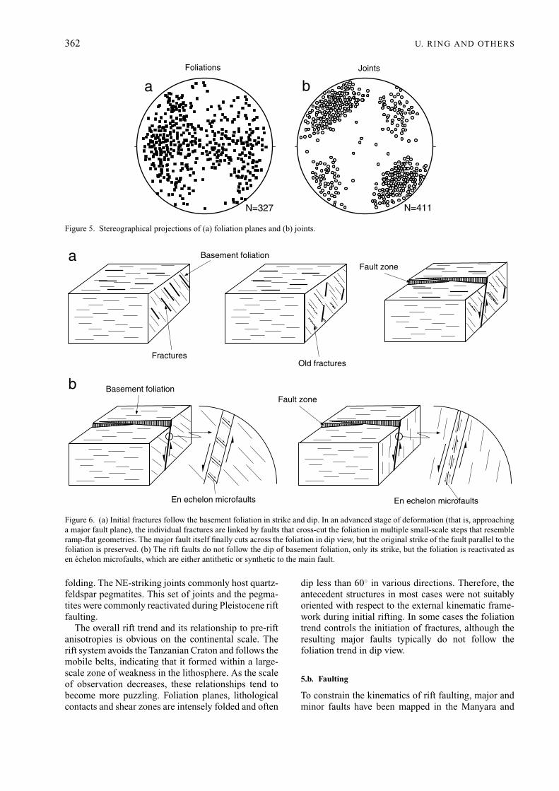
The diffuse pattern of foliation planes in the Manyararegion (Fig. 5a) is due to various phases of folding andthrusting and shows no general geometric relationshipto the Cenozoic rift structures. The rift faults appearto be wholly unrelated to the basement structures.In most regions the foliation and fault planes havedifferent dip angles and dip directions, but in placesdip–slip faults parallel the local strike of major foliationplanes. The processes of foliation reactivation in thiscase are as follows: (a) Initial fractures follow thebasement foliation in strike and dip (Fig. 6a). In anadvanced stage of deformation (that is, approaching amajor fault plane) the individual fractures are linkedby faults that cross-cut the foliation in multiple small-scale steps that resemble ramp-flat geometries. Themajor fault itself finally cuts across the foliation indip view, but the original strike of the fault parallel tothe foliation is preserved (Fig. 6a). (b) Although themajor faults finally cut across the foliation, the latter isreactivated as en echelon microfaults, which are eitherantithetic or synthetic to the main fault (Fig. 6b).
During the late-stage evolution of the Precambrianbasement, systematically oriented subvertical jointsformed (Fig. 5b) which cross-cut all older structures.The joints divide the basement rocks into numeroussegments with a spacing of several decimetres up to afew metres. These joints strike preferentially NE, butalso NW, and appear to be related to late Precambrian
362 U. RING AND OTHERS
N=411N=327
baFoliations Joints
Figure 5. Stereographical projections of (a) foliation planes and (b) joints.
Basement foliationFault zone
En echelon microfaults En echelon microfaults
Basement foliationFault zone
a
b
FracturesOld fractures
Figure 6. (a) Initial fractures follow the basement foliation in strike and dip. In an advanced stage of deformation (that is, approachinga major fault plane), the individual fractures are linked by faults that cross-cut the foliation in multiple small-scale steps that resembleramp-flat geometries. The major fault itself finally cuts across the foliation in dip view, but the original strike of the fault parallel to thefoliation is preserved. (b) The rift faults do not follow the dip of basement foliation, only its strike, but the foliation is reactivated asen echelon microfaults, which are either antithetic or synthetic to the main fault.
folding. The NE-striking joints commonly host quartz-feldspar pegmatites. This set of joints and the pegma-tites were commonly reactivated during Pleistocene riftfaulting.
The overall rift trend and its relationship to pre-riftanisotropies is obvious on the continental scale. Therift system avoids the Tanzanian Craton and follows themobile belts, indicating that it formed within a large-scale zone of weakness in the lithosphere. As the scaleof observation decreases, these relationships tend tobecome more puzzling. Foliation planes, lithologicalcontacts and shear zones are intensely folded and often
dip less than 60◦ in various directions. Therefore, theantecedent structures in most cases were not suitablyoriented with respect to the external kinematic frame-work during initial rifting. In some cases the foliationtrend controls the initiation of fractures, although theresulting major faults typically do not follow thefoliation trend in dip view.
5.b. Faulting
To constrain the kinematics of rift faulting, major andminor faults have been mapped in the Manyara and

Evolution of the Manyara Rift 363
Pangani rifts. The basement, the rift sediments anddated volcanic flows have been structurally investi-gated. The orientation of primary and secondary faultplanes, strike and dip of striations and the sense ofrelative displacement on these planes were mappedin order to determine principal strain axes. The scaleof observation was usually held small (outcrop scale).The brittle fault zones observed in outcrops commonlyare penetratively fractured into an array of blockswhose surfaces have a wide distribution of orientations.Individual blocks are separated by thin, slickensidedsurfaces with fibrous striae, which make these faultzones suitable for brittle strain analysis. Sliding of theblocks past one another along these surfaces accom-modated displacement in the fault zone. The directionand sense of shear on these surfaces can be deducedfrom the orientation of fibres and fractures associatedwith the faults. The fibres have been measured at thecontact of the gouge zones with the country rock andnot within the gouge zone itself where rotations of thefibres may have occurred. Fibre orientations on slick-ensides are usually simple, consistent, and are easilyinterpretable with the geometry of the studied faults at aregional scale. The displacement on the measured faultplanes was generally in the centimetre to decimetrerange. The main argument for relating these minorfaults to the kinematic evolution of major rift faultswas their spatial relationship to the main fault planes.Minor fault planes are generally not found far fromthe main fault planes, so that the increasing numberof secondary faults in the very vicinity of the major riftfaults is thought to imply a genetic link between theminor faults and the major rift faults.
Cataclastic rocks in the vicinity of the main faultshave a rubbly to fragmental appearance and shownumerous mesoscopic brittle faults. The fault planesare characterized by anastomosing clayey gouge layerswith thin (1 mm–10 cm) zones of cataclasite, brecciaand hematite-clay-coated fractured rock. Weakly ori-ented phacoid-shaped tectonic slivers of country rockwithin the fault zone are in the centimetre to decimetrescale. The fault surfaces contain Riedel shears whichcaused lunate and crescentric structures at theirintersections with the fault plane.
In this study, a simple graphical method has beenused to determine principal strain axes (program ‘FaultKinematics’ written by R. Allmendinger). This methodconstructs the principal incremental shortening andextension axes for a given population of faults. Eachpair of axes lies in the movement plane of the fault(that is, a plane perpendicular to the fault plane thatcontains the unit vector parallel to the direction ofaccumulated slip, and the normal vector to the faultplane). Furthermore, each pair of axes makes anglesof 45◦ with each of both vectors, respectively (Fig. 7,bottom right). In order to distinguish between theshortening and extension axes, information on the senseof slip is needed.
5.b.1. Manyara Rift
Kinematic data were collected from the ManyaraBorder Fault near Mto Wa Mbu and from minorfaults on the opposite side of the Manyara Rift at theEssimingor and Burko volcanic centres and betweenMakuyuni and Magugu (Figs 2, 8). The faults alongthe shoaling side of the rift in places cross-cut riftsediments, including the Manyara Beds, and togetherwith data from dated volcanic rocks allow some con-straints to be placed on the timing of rift faulting. Fibreson each slickenside are straight, indicating a singlephase of motion in the studied fault zones.
The data from the Manyara Border Fault depictwidely varying extension directions. Faults in youngalluvial fan deposits a few hundred metres east of themain escarpment and directly at the foot of the escarp-ment resulted from SE-oriented extension (Fig. 7a–e).Data collected in basalt flows exposed in steep valleysthat incise into the main escarpment indicate an E- toNE-oriented extension (Fig. 7f, g). The latter faults cutthrough olivine nephelinites, basalts and trachybasaltsdated at 1.4–3.8 Ma by Bagdasaryan et al. (1973) andappear to be an older fault generation.
Fault-slip data from basement outcrops at theshoaling side of the rift indicate NE-oriented extension(Fig. 7h,i). Faults in the Manyara Beds usually haveimperfectly developed slickensides, probably becausefaulting occurred during sedimentation and affectedunlithified sediments. Syn-sedimentary faulting is alsosuggested by thickness changes of layers across faults.Most of these syn-sedimentary faults strike N–S andNW–SE, and the geometry of the faulted sedimentlayers suggest dip-slip faulting (Fig. 3e). If so, thesefaults resulted from E- to NE-oriented extension. In afew places we were able to carry out fault-slip work.In outcrop 95-15 (Fig. 3f) faulting affected a brownishsiltstone of the upper member of the Manyara Beds.The fault-slip data from this outcrop indicate E–Wextension (Fig. 7j). In outcrop 95-12, a small-scalefault juxtaposes a conglomerate and a brownish loamof the uppermost part of the upper member (Fig. 3g).The data from this fault also indicate E–W extension(Fig. 7k).
Finally, we analysed faults in volcanic rocks fromEssimingor, Burko and southwest of Makuyuni (Fig. 8).Near the volcanic centres of Essimingor and Burko,almost radial dyking can be observed in places. Outcrop95-16 is located where a N-striking transfer faultdissects the NW-striking Kitete Fault. The Burkovolcanic centre is where both faults intersect (Figs 2, 8).Fault-slip data were collected in a nephelinite flow andindicate N–S extension (Fig. 8a). According to Dawson(1992), Burko belongs to the Pleistocene volcaniccentres, and Evans, Fairhead & Mitchell (1971)dated two nephelinites at 1.03±0.04 Ma and 0.91±0.03 Ma. Outcrop 95-17 has a similar tectonic contextalong a smaller-scale NW-striking fault, which is
364 U. RING AND OTHERS
95-1 95-2
95-4 95-795-6
95-895-9 95-10
95-11
95-12
a b c
d e f
g h i
j k95-15
X
Y
Z
X
Y
Z
X
Y
Z
X
YZ
X
Y
Z
X
Y
Z
X
Y
Z
X
Y
Z
X
Y
Z
X
Y
ZX
Y
Z
X
Y
Z
Principal strain directionsfor a fault
Movementplane
95-1
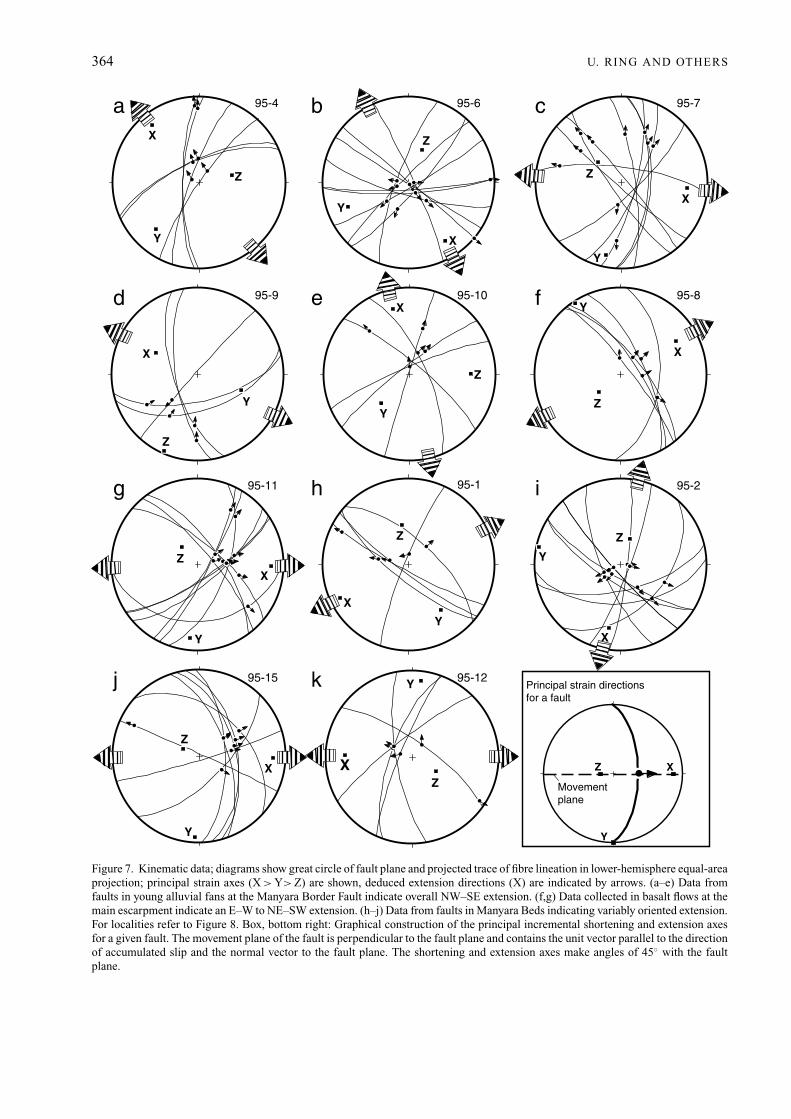
Figure 7. Kinematic data; diagrams show great circle of fault plane and projected trace of fibre lineation in lower-hemisphere equal-areaprojection; principal strain axes (X > Y> Z) are shown, deduced extension directions (X) are indicated by arrows. (a–e) Data fromfaults in young alluvial fans at the Manyara Border Fault indicate overall NW–SE extension. (f,g) Data collected in basalt flows at themain escarpment indicate an E–W to NE–SW extension. (h–j) Data from faults in Manyara Beds indicating variably oriented extension.For localities refer to Figure 8. Box, bottom right: Graphical construction of the principal incremental shortening and extension axesfor a given fault. The movement plane of the fault is perpendicular to the fault plane and contains the unit vector parallel to the directionof accumulated slip and the normal vector to the fault plane. The shortening and extension axes make angles of 45◦ with the faultplane.

Evolution of the Manyara Rift 365
95-19f
X
Y
Z
95-18e
X
Y
Z
95-16 95-395-17 ca b
d 95-5
X
Y
Z
Z
X
Y
X
Y
Z
X
Y
Z
Burko
Essimingor
50 km
NEngarukaBasin
LakeManyaraBasin
Makuyuni
Kitete Fault95-4
95-695-9
95-1095-895-11
95-1
95-2
95-12
95-15
95-7
Legend
Alluvial fan
Manyara Beds
Basement
** **
***
*
*
*
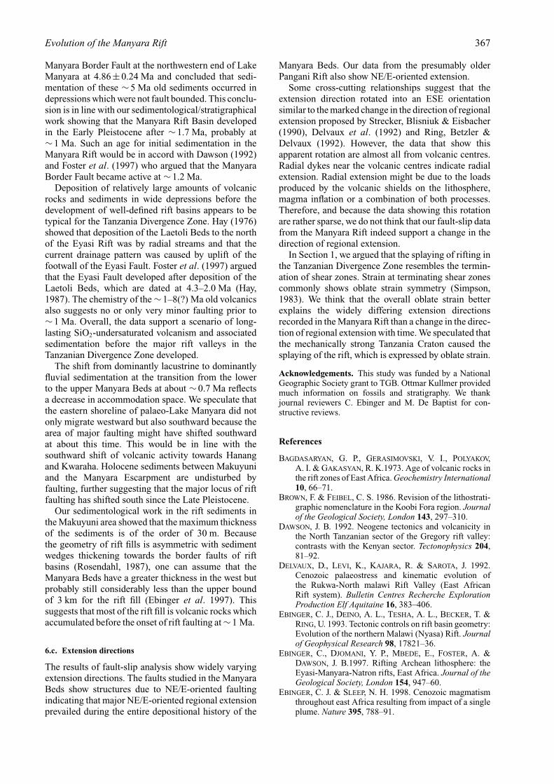
Figure 8. Fault slip data from Essimingor, Burko and basalt flows near Makuyuni. (a) Faults in nephelinite from Burko volcanic centreindicate N–S extension. (b) Outcrop 95-17 in faulted nephelinite shows NE-oriented extension. (c) Fault-slip data from outcrop 95-3indicate ESE extension. (d) Fault-slip data from older fault cutting basalt near Makuyuni indicating NE extension. (e,f ) Secondaryfault strikes NNE and fault-slip data indicate SE extension. Also shown are localities for fault-slip data shown in Figure 7.
dissected by a N-striking transfer fault at Essimingor.Fault-slip data were again collected in faulted nephelin-ite flow and show NE-oriented extension. The youngestso far dated nephelinite flow from Essimingor is 3.2 Ma
old (Evans et al. 1971). East of Burko and Essimingor,the NW-striking faults are cut by N–S faults, and ourfault-slip data from outcrop 95-3 at one of the N–Sfaults indicate SE-oriented extension (Fig. 8c). Near

366 U. RING AND OTHERS
95-1395-14
X
a b
Y
ZX
Y
Z
Figure 9. Fault-slip analysis in Pangani Rift. (a) Data from outcrop 95-14 at border fault zone indicating NE–SW extension.(b) Outcrop 95-13 from younger fault that cuts border fault indicates E–W extension.
Makuyuni, basalts are cut by two faults. One faultstrikes NW, and fault-slip data from this fault showNE extension (Fig. 8d); the other fault strikes NNE andthe fault-slip data indicate SE extension (Fig. 8e,f).
Results of fault-slip analysis show that rift formationwas due to widely varying extension directions. Fromthe geometry of the rift faults in combination with ourdata, it seems that E/NE-oriented extension is dominantand prevailed until and during the deposition of theupper member of the Manyara Beds.
5.b.2. Pangani Rift
Two outcrops were analysed in basement rocks at theeastern border fault of the Pangani Rift. Outcrop 95-14is located in the main fault zone of the NNW-strikingborder fault zone and yielded NE-oriented extension(Fig. 9a). Outcrop 95-13 is a few hundred metres awayfrom 95-14 in a smaller N–S fault zone that cross-cutsthe border fault. Fault-slip data from this younger faultindicate E-oriented extension (Fig. 9b).
6. Conclusions and discussion
The major conclusions of our field study maybesummarized as follows:
(1) The onset of rift faulting was preceded by SiO2-undersaturated volcanism and sediment accumulationin broad depressions.
(2) Formation of the Manyara Rift is manifestedby the deposition of the Manyara Beds, which can beseparated into a lacustrine lower member and a fluvialupper member. Sedimentation commenced <1.7 Ma,probably at ∼1 Ma. The transition from lacustrineto fluviatile sedimentation at ∼0.7 Ma appears to berelated to a southward shift of major rift faulting.
(3) The rift faults show no obvious relationshipsto structures in the basement. The termination of theEastern Branch of the East African Rift and splaying ofthe major rift faults in the Tanzanian Divergence Zoneprobably resulted in oblate strain symmetry. Oblate
symmetry is expressed by widely varying extensiondirections for rift faulting.
6.a. Volcanism and faulting
The relationship between dated rift-related volcanicrocks and rift faults constrains the age of the ManyaraRift to some degree. The basic to ultrabasic, SiO2-undersaturated, primitive lavas of initial rift volcanismerupted between ∼1 and 8(?) Ma and can be explainedas the products of very limited lithospheric stretching,which allowed only a few percent of partial melting.The uppermost and therefore youngest flows at bothEssimingor and Burko are represented by nepheliniteflows, the youngest flow of which has been datedat 0.97 Ma (Evans, Fairhead & Mitchell, 1971). Theflows are always affected by faulting and none of theyoung lava flows have been seen to seal rift faults. Thissuggests a relatively young age (<∼1 Ma) for majorrift-related faulting, a finding that is consistent withFoster et al. (1997).
Olivine nephelinites, basalts and trachybasalts occurat the border fault of the Manyara Rift between LakeManyara and Engaruka. These volcanic rocks rangein age from 0.8 to 3.8 Ma (Bagdasaryan et al. 1973;Foster et al. 1997). The emplacement of all or most ofthese volcanic rocks pre-dated the major phase of riftfaulting. Foster et al. (1997) showed that major faultingaffected basalts >1.2 Ma in age, whereas a flow datedat 1.0±0.1 Ma is controlled by faulting, indicating thatthe development of the border fault of the ManyaraRift occurred at ∼1 Ma. This age probably representsa maximum age for the formation of the lacustrinesediments of the Manyara Rift. Both the Eyasi andPangani rifts are older than ∼2 Ma (Dawson, 1992),indicating that rifting in northern Tanzania propagatedfrom the outer graben towards the centre of the rift.
6.b. Sedimentation and faulting
Foster et al. (1997) dated a basalt in a sequenceof fluvio-lacustrine and volcaniclastic rocks at the
Evolution of the Manyara Rift 367
Manyara Border Fault at the northwestern end of LakeManyara at 4.86±0.24 Ma and concluded that sedi-mentation of these ∼5 Ma old sediments occurred indepressions which were not fault bounded. This conclu-sion is in line with our sedimentological/stratigraphicalwork showing that the Manyara Rift Basin developedin the Early Pleistocene after ∼1.7 Ma, probably at∼1 Ma. Such an age for initial sedimentation in theManyara Rift would be in accord with Dawson (1992)and Foster et al. (1997) who argued that the ManyaraBorder Fault became active at ∼1.2 Ma.
Deposition of relatively large amounts of volcanicrocks and sediments in wide depressions before thedevelopment of well-defined rift basins appears to betypical for the Tanzania Divergence Zone. Hay (1976)showed that deposition of the Laetoli Beds to the northof the Eyasi Rift was by radial streams and that thecurrent drainage pattern was caused by uplift of thefootwall of the Eyasi Fault. Foster et al. (1997) arguedthat the Eyasi Fault developed after deposition of theLaetoli Beds, which are dated at 4.3–2.0 Ma (Hay,1987). The chemistry of the ∼1–8(?) Ma old volcanicsalso suggests no or only very minor faulting prior to∼1 Ma. Overall, the data support a scenario of long-lasting SiO2-undersaturated volcanism and associatedsedimentation before the major rift valleys in theTanzanian Divergence Zone developed.
The shift from dominantly lacustrine to dominantlyfluvial sedimentation at the transition from the lowerto the upper Manyara Beds at about ∼0.7 Ma reflectsa decrease in accommodation space. We speculate thatthe eastern shoreline of palaeo-Lake Manyara did notonly migrate westward but also southward because thearea of major faulting might have shifted southwardat about this time. This would be in line with thesouthward shift of volcanic activity towards Hanangand Kwaraha. Holocene sediments between Makuyuniand the Manyara Escarpment are undisturbed byfaulting, further suggesting that the major locus of riftfaulting has shifted south since the Late Pleistocene.
Our sedimentological work in the rift sediments inthe Makuyuni area showed that the maximum thicknessof the sediments is of the order of 30 m. Becausethe geometry of rift fills is asymmetric with sedimentwedges thickening towards the border faults of riftbasins (Rosendahl, 1987), one can assume that theManyara Beds have a greater thickness in the west butprobably still considerably less than the upper boundof 3 km for the rift fill (Ebinger et al. 1997). Thissuggests that most of the rift fill is volcanic rocks whichaccumulated before the onset of rift faulting at ∼1 Ma.
6.c. Extension directions
The results of fault-slip analysis show widely varyingextension directions. The faults studied in the ManyaraBeds show structures due to NE/E-oriented faultingindicating that major NE/E-oriented regional extensionprevailed during the entire depositional history of the
Manyara Beds. Our data from the presumably olderPangani Rift also show NE/E-oriented extension.
Some cross-cutting relationships suggest that theextension direction rotated into an ESE orientationsimilar to the marked change in the direction of regionalextension proposed by Strecker, Blisniuk & Eisbacher(1990), Delvaux et al. (1992) and Ring, Betzler &Delvaux (1992). However, the data that show thisapparent rotation are almost all from volcanic centres.Radial dykes near the volcanic centres indicate radialextension. Radial extension might be due to the loadsproduced by the volcanic shields on the lithosphere,magma inflation or a combination of both processes.Therefore, and because the data showing this rotationare rather sparse, we do not think that our fault-slip datafrom the Manyara Rift indeed support a change in thedirection of regional extension.
In Section 1, we argued that the splaying of rifting inthe Tanzanian Divergence Zone resembles the termin-ation of shear zones. Strain at terminating shear zonescommonly shows oblate strain symmetry (Simpson,1983). We think that the overall oblate strain betterexplains the widely differing extension directionsrecorded in the Manyara Rift than a change in the direc-tion of regional extension with time. We speculated thatthe mechanically strong Tanzania Craton caused thesplaying of the rift, which is expressed by oblate strain.
Acknowledgements. This study was funded by a NationalGeographic Society grant to TGB. Ottmar Kullmer providedmuch information on fossils and stratigraphy. We thankjournal reviewers C. Ebinger and M. De Baptist for con-structive reviews.
References
BAGDASARYAN, G. P., GERASIMOVSKI, V. I., POLYAKOV,A. I. & GAKASYAN, R. K.1973. Age of volcanic rocks inthe rift zones of East Africa. Geochemistry International10, 66–71.
BROWN, F. & FEIBEL, C. S. 1986. Revision of the lithostrati-graphic nomenclature in the Koobi Fora region. Journalof the Geological Society, London 143, 297–310.
DAWSON, J. B. 1992. Neogene tectonics and volcanicity inthe North Tanzanian sector of the Gregory rift valley:contrasts with the Kenyan sector. Tectonophysics 204,81–92.
DELVAUX, D., LEVI, K., KAJARA, R. & SAROTA, J. 1992.Cenozoic palaeostress and kinematic evolution ofthe Rukwa-North malawi Rift Valley (East AfricanRift system). Bulletin Centres Recherche ExplorationProduction Elf Aquitaine 16, 383–406.
EBINGER, C. J., DEINO, A. L., TESHA, A. L., BECKER, T. &RING, U. 1993. Tectonic controls on rift basin geometry:Evolution of the northern Malawi (Nyasa) Rift. Journalof Geophysical Research 98, 17821–36.
EBINGER, C., DJOMANI, Y. P., MBEDE, E., FOSTER, A. &DAWSON, J. B.1997. Rifting Archean lithosphere: theEyasi-Manyara-Natron rifts, East Africa. Journal of theGeological Society, London 154, 947–60.
EBINGER, C. J. & SLEEP, N. H. 1998. Cenozoic magmatismthroughout east Africa resulting from impact of a singleplume. Nature 395, 788–91.

368 Evolution of the Manyara Rift
EVANS, A. L., FAIRHEAD, J. D. & MITCHELL, J. G. 1971.Potassium-argon ages from the volcanic province ofnorthern Tanzania. Nature 229, 19–20.
FOSTER, A., EBINGER, C., MBEDE, E. & REX, D. 1997.Tectonic development of the northern Tanzanian sectorof the East African Rift System. Journal of theGeological Society, London 154, 689–700.
HAY, R. L. 1976. Geology of Olduvai Gorge. University ofCalifornia Press, 203 pp.
KENT, P. E. 1942. A note on Pleistocene deposits near LakeManyara, Tanganyika. Geological Magazine 79, 72–7.
LEAKEY, M. D. 1971. Olduvai Gorge Vol. 3: Excavationsin Beds I and II, 1960–1963. Cambridge: CambridgeUniversity Press.
LE GALL, B., GERNIGON, L., ROLET, J., EBINGER, C.,GLOAGUEN, R., NILSEN, O., DYPVIK, H., DEFFONTAINES,B. & MRUMA, A. 2004. Neogene-Holocene rift propaga-tion in central Tanzania: Morphostructural and aero-magnetic evidence from the Kilombero area. GeologicalSociety of America Bulletin 116, 490–510.
MCCONNELL, R. B. 1972. Geological development of theRift system in eastern Africa. Geological Society ofAmerica Bulletin 83, 2549–72.
NYBLADE, A. A., BIRT, C., LANGSTON, C. A., OWENS, T. J. &LAST, R. J. 1996. Seismic experiment reveals rifting ofcraton in Tanzania. EOS 77, 520–1.
NYBLADE A. A. & BRAZIER, R. A. 2002. Precambrianlithospheric controls on the development of the EastAfrican rift system. Geology 30, 755–8.
RING, U., BETZLER, C. & DELVAUX, D. 1992. Normalversus strike-slip faulting during rift development inEast Africa: The Malawi rift. Geology 20, 1015–18.
RING, U. & BETZLER, C. 1995. Geology of the Malawi Rift:Kinematic and tectonosedimentary background to theChiwondo beds. Journal of Human Evolution 28, 1–22.
RING, U. 1994. The influence of preexisting crustal aniso-tropies on the evolution of the Cenozoic Malawi rift(East African rift system). Tectonics 13, 313–26.
ROSENDAHL, B. R. 1987. Architecture of continental riftswith special refernce to East Africa. Annual Reviews ofEarth and Planetary Sciences 15, 445–503.
SAVAGE, D. E. & RUSSELL, D. E. 1983. MammaliaPalaeofaunas of the World. Massachusetts: Addison-Wesley Publishing Company.
SCHLUTER, T. 1994. Lake Manyara Basin, Tanzania. InGlobal geological record of lake basins; Volume 1 (edsE. Gierlowski-Kordesch and K. Kelts), pp. 345–8. Worldand Regional Geology Series no. 4.
SIMPSON, C. 1983. Displacement and strain patterns fromnaturally occurring shear zone terminations. Journal ofStructural Geology 5, 497–506.
STRECKER, M. R., BLISNIUK, P. & EISBACHER, G. H. 1990.Rotation of extension direction in the central Kenya rift.Geology 18, 299–302.
THOMAS, C. M. 1966. Hanang. Tanzanian Geological Sur-vey, Quarter Degree Sheet no. 84.
WILKINSON, P., MITCHELL, J. G., CATTERMOLE, P. J. &DOWNIE, C. 1986. Volcanic chronology of the Meru-Kilimanjaro region, Northern Tanzania. Journal of theGeological Society, London 143, 601–5.
WILLIAMS, L. A. J. 1970. The volcanics of the Gregory RiftValley, East Africa. Bulletin of Volcanology 34, 439–65.